conceptual downtown redevelopment plan
TRANSCRIPT
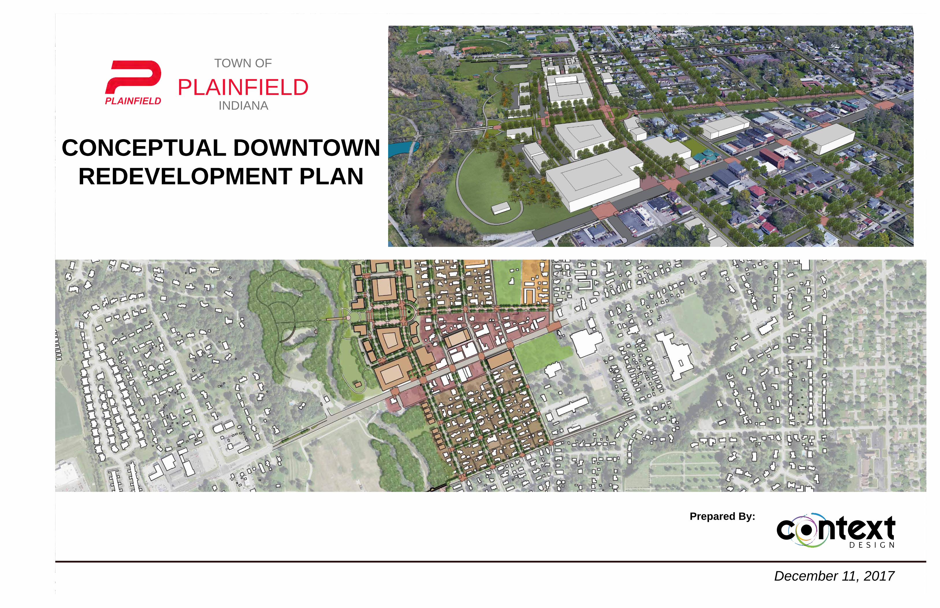
CONCEPTUAL DOWNTOWN REDEVELOPMENT PLAN
TOWN OF
PLAINFIELDINDIANA
Prepared By:
December 11, 2017
Table of Contents
Project Credits................................................................................... 1
History and Context...............................................................................2
Inventory...............................................................................................10
Analysis................................................................................................32
Conceptual Design...............................................................................38
Proposed Conceptual Plan ..................................................................46
Implementation.....................................................................................64
i
CONCEPTUAL DOWNTOWN REDEVELOPMENT PLAN
table of contents
TABLE OF CONTENTS
Planning Credits
Town of Plainfield - Town Council Members• Robin G. Brandgard - President• BillKirchoff-VicePresident• Dan Bridget• Kent McPhail• Lance Angle
Town of Plainfield - Steering Team • Brad DuBois (Executive Director) • Kent McPhail (Council Member) • Jill Sprague (GIS Coordinator) • Scott Slavens (Plan Commission) • Jennifer Andres (Redevelopment Commission) • JeffBanning(President)
Town of Plainfield - Town Staff • Andrew Klinger - Town Manager• Tony Perona - Deputy Town Manager• Tim Belcher - Town Engineer• Joe James - Director of Planning
Town of Plainfield - Stake Holders • Bobby Williams - Owner• Kelly King - Owner• DougHuff-Owner• Brian Church - Property Owner• Neil Church- Property Owner• Julie Callis - General Manager• Rita Fiorentino - Owner• Dennis Gibbs• Luke Waltz - Urban Designer• Brett Davis - Landscape Architect• Nick Crews - Resident• Mark Todisco - School Board Member• Scott Flood - School Board Member• Bill Clendineng - Pastor • JerryVornholt-Owner• Steve Daum - Resident, Real Estate Broker• Chuck Ellis - Resident, Guilford Township Trustee• Mary Chastain - First National Bank• Brad Whicker - Builder• Linda Semler - Resident• Lana Pedigo - Resident
Planning Team • Context Design - Design Consultant
Plan Approved By:
TownofPlainfield-RedevelopmentCommissionMember-Signature
Printed Name Date
TownofPlainfield-RedevelopmentCommissionMember-Signature
Printed Name Date
TownofPlainfield-RedevelopmentCommissionMember-Signature
Printed Name Date
TownofPlainfield-RedevelopmentCommissionMember-Signature
Printed Name Date
TownofPlainfield-RedevelopmentCommissionMember-Signature
Printed Name Date
TownofPlainfield-RedevelopmentCommissionMember-Signature
Printed Name Date
TownofPlainfield-TownManager-Signature
Printed Name Date
TownofPlainfield-RedevelopmentCommissionMember-Signature
Printed Name Date
1
PLANNING CREDITSCONCEPTUAL DOWNTOWN REDEVELOPMENT PLAN
PlannInG cReDIts anD eXecUtIVe sUMMaRY
2
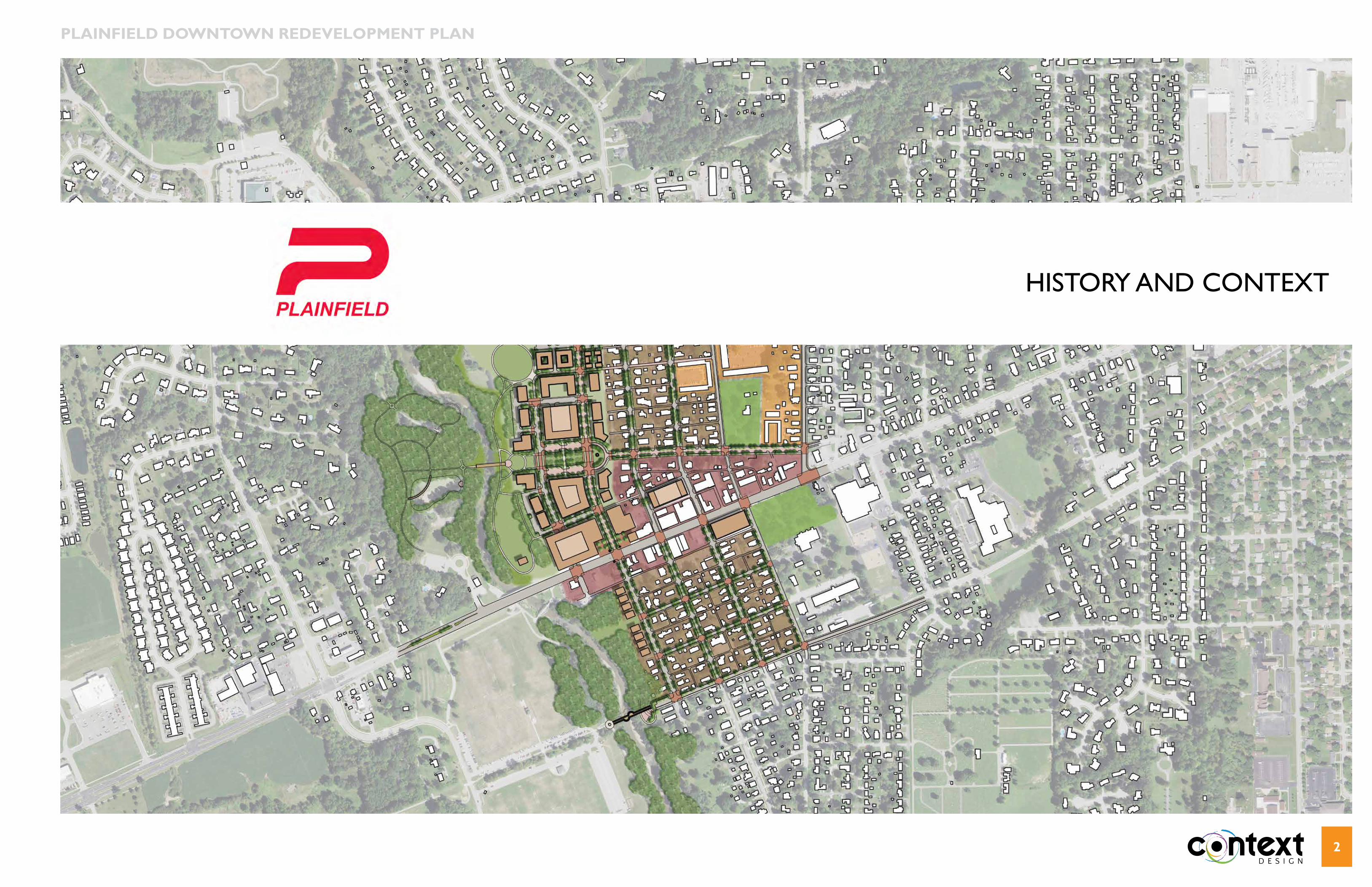
HIstoRY anD conteXt
PLAiNFiELD DOWNTOWN REDEVELOPMENT PLAN
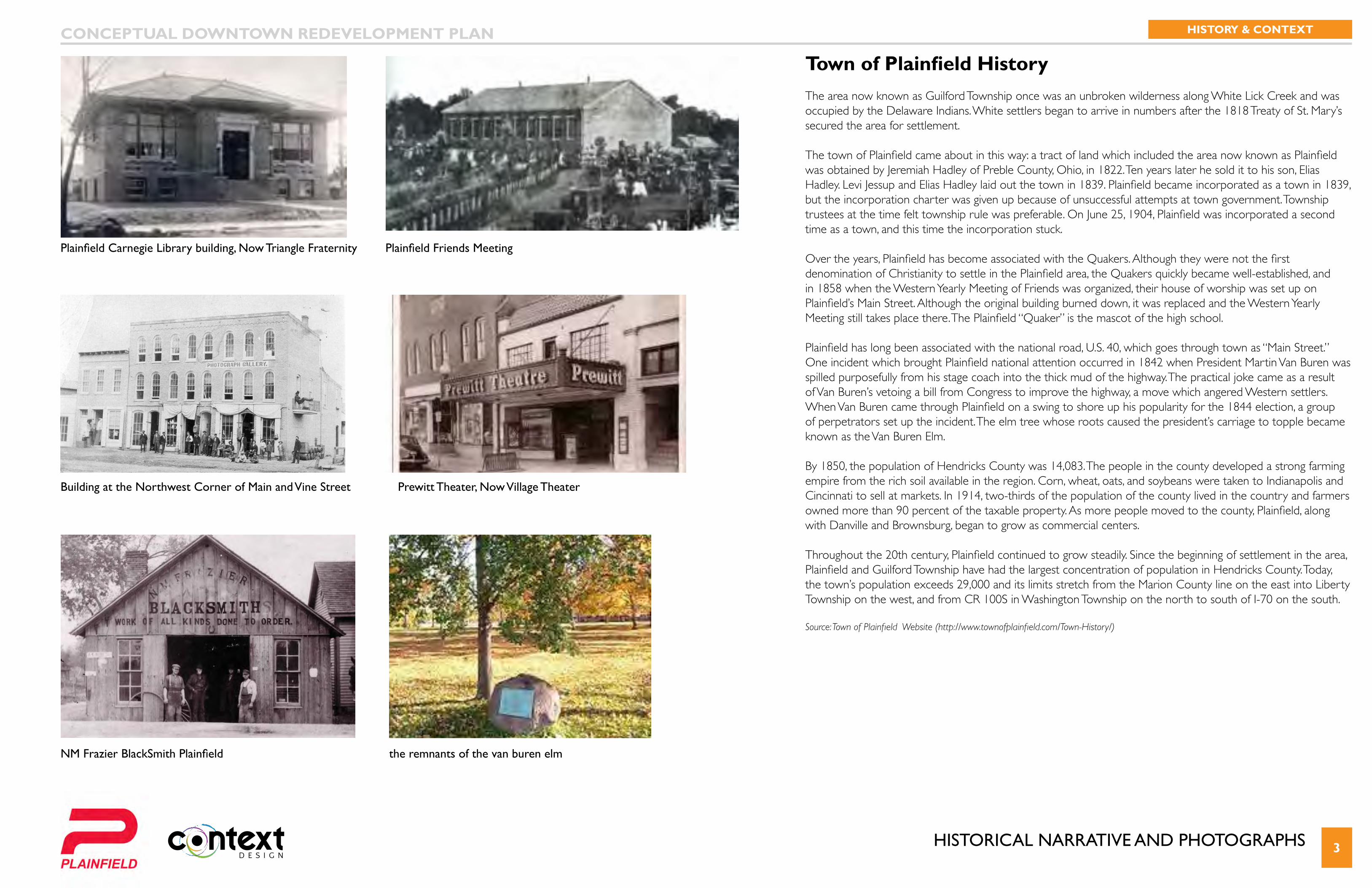
HIstoRIcal naRRatIVe anD PHotoGRaPHs 3
Plainfield Friends Meeting
NM Frazier BlackSmith Plainfield
Plainfield Carnegie Library building, Now Triangle Fraternity
the remnants of the van buren elm
Building at the Northwest Corner of Main and Vine Street Prewitt Theater, Now Village Theater
Town of Plainfield History The area now known as Guilford Township once was an unbroken wilderness along White Lick Creek and was occupied by the Delaware Indians. White settlers began to arrive in numbers after the 1818 Treaty of St. Mary’s secured the area for settlement.
The town of Plainfield came about in this way: a tract of land which included the area now known as Plainfield was obtained by Jeremiah Hadley of Preble County, Ohio, in 1822. Ten years later he sold it to his son, Elias Hadley. Levi Jessup and Elias Hadley laid out the town in 1839. Plainfield became incorporated as a town in 1839, but the incorporation charter was given up because of unsuccessful attempts at town government. Township trustees at the time felt township rule was preferable. On June 25, 1904, Plainfield was incorporated a second time as a town, and this time the incorporation stuck.
Over the years, Plainfield has become associated with the Quakers. Although they were not the first denomination of Christianity to settle in the Plainfield area, the Quakers quickly became well-established, and in 1858 when the Western Yearly Meeting of Friends was organized, their house of worship was set up on Plainfield’s Main Street. Although the original building burned down, it was replaced and the Western Yearly Meeting still takes place there. The Plainfield “Quaker” is the mascot of the high school.
Plainfield has long been associated with the national road, U.S. 40, which goes through town as “Main Street.” One incident which brought Plainfield national attention occurred in 1842 when President Martin Van Buren was spilled purposefully from his stage coach into the thick mud of the highway. The practical joke came as a result of Van Buren’s vetoing a bill from Congress to improve the highway, a move which angered Western settlers. When Van Buren came through Plainfield on a swing to shore up his popularity for the 1844 election, a group of perpetrators set up the incident. The elm tree whose roots caused the president’s carriage to topple became known as the Van Buren Elm.
By 1850, the population of Hendricks County was 14,083. The people in the county developed a strong farming empire from the rich soil available in the region. Corn, wheat, oats, and soybeans were taken to Indianapolis and Cincinnati to sell at markets. In 1914, two-thirds of the population of the county lived in the country and farmers owned more than 90 percent of the taxable property. As more people moved to the county, Plainfield, along with Danville and Brownsburg, began to grow as commercial centers.
Throughout the 20th century, Plainfield continued to grow steadily. Since the beginning of settlement in the area, Plainfield and Guilford Township have had the largest concentration of population in Hendricks County. Today, the town’s population exceeds 29,000 and its limits stretch from the Marion County line on the east into Liberty Township on the west, and from CR 100S in Washington Township on the north to south of I-70 on the south.
Source: Town of Plainfield Website (http://www.townofplainfield.com/Town-History/)
CONCEPTUAL DOWNTOWN REDEVELOPMENT PLAN HISTORY & CONTEXT
PReVIoUs anD cURRent stUDIes 4
Previous and Active Studies(2017) Retail Analysis and Recruitment StudyThis in progress study, is an in-depth analysis of community demographics, retail trends, needs and opportunities. The project team for this study and the downtown team will closely share information to strengthen both studies and plans. The Retail Analysis and Recruitment Study is complimentary to the efforts of the Downtown Redevelopment Plan.
(2016) Franklin Park Master Plan The proposed master plan for Franklin Park diversifies the programming within the park and includes a mix of traditional park amenities and new amenities.
(2016) Plainfield Comprehensive Parks Master PlanThe master plan provides a framework to respond to citizens’ needs and expectations, as well as identifies priorities for the staff to work toward successful implementation.
(2016) Town of Plainfield Comprehensive PlanThe Town of Plainfield Comprehensive Plan includes recommendations at fostering a high quality of life for the Plainfield Community. The plan took an in-depth look at previous plans and included careful analysis of demographics, GIS data, field observation, community workshops, on-line outreach, internal/external data sources, and interview with local stakeholders. The process looked that whole community comprehensively but included the downtown as a focus area that provided recommendations to continue to develop “quality of life” within the downtown core.
(2011) Downtown Parking Study The Plainfield Town Planners provided an inventory of existing parking and documented opportunities for additional parking.
(2011) Sidewalk and Trail Master Plan This plan considers improving the access of its citizens and visitors to sidewalks and trailsto be a top priority. If fully implemented the plan would allow every resident or visitor to Plainfield wouldhave a readily available access to the Town’s sidewalk and trail system and would be able to use thatsystem to reach all other destinations within the community without having to get in a car. (2010) National Register of Town Center Historic DistrictThe Plainfield Town Center Historic includes 177 contributing buildings and was added to the National Registry of Historic Places in 2010. This District is approximately 64 acres in size and is roughly bounded by Lincoln Street to the north, S East Street to the east; Ash Street to the south and Mill Street to the west. The contributing buildings include a mix of residential, commercial and religious structures that show 19th century architecture, including Late Victorian Gothic, Italianate, Queen Anne, and Stick/Eastlake Design. See inventory sheets for Historical District boundary and locations of contributing buildings.
(2004) Plainfield 2025 Comprehensive PlanThe Plainfield 2025 Comprehensive plans has been guiding policy document for the Town of Plainfield for the past decade. The plan focused more on the developing areas of town that are lower density and transportation planning for adequate east-west access through town.
(2003) Plainfield Town Center PlanIn 2002, the Town initiated the Plainfield Town Center Plan to develop the vision to create a “sense of place.” The plan includes existing conditions assessments and recommendations that address downtown district organization and finance, business development, marketing and communication, and physical improvement and maintenance. The planning document also provides design guidelines and targeted action-items to fully implement the town vision. This plan became the catalysis for the National Register of Town Center Historic District and the 2005 U.S. 40 Streetscape Master Plan and improvements.
CONCEPTUAL DOWNTOWN REDEVELOPMENT PLAN HISTORY & CONTEXT
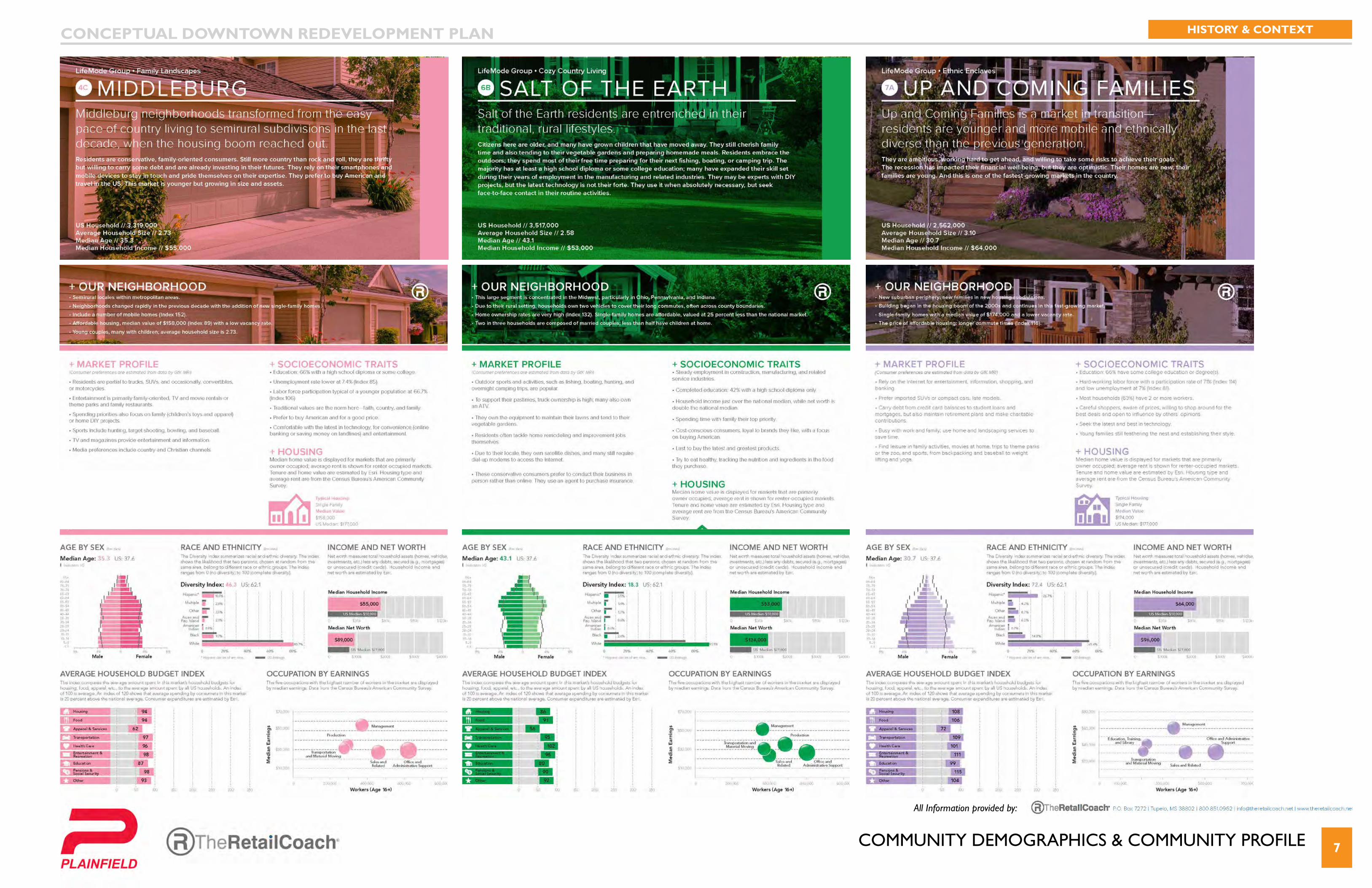
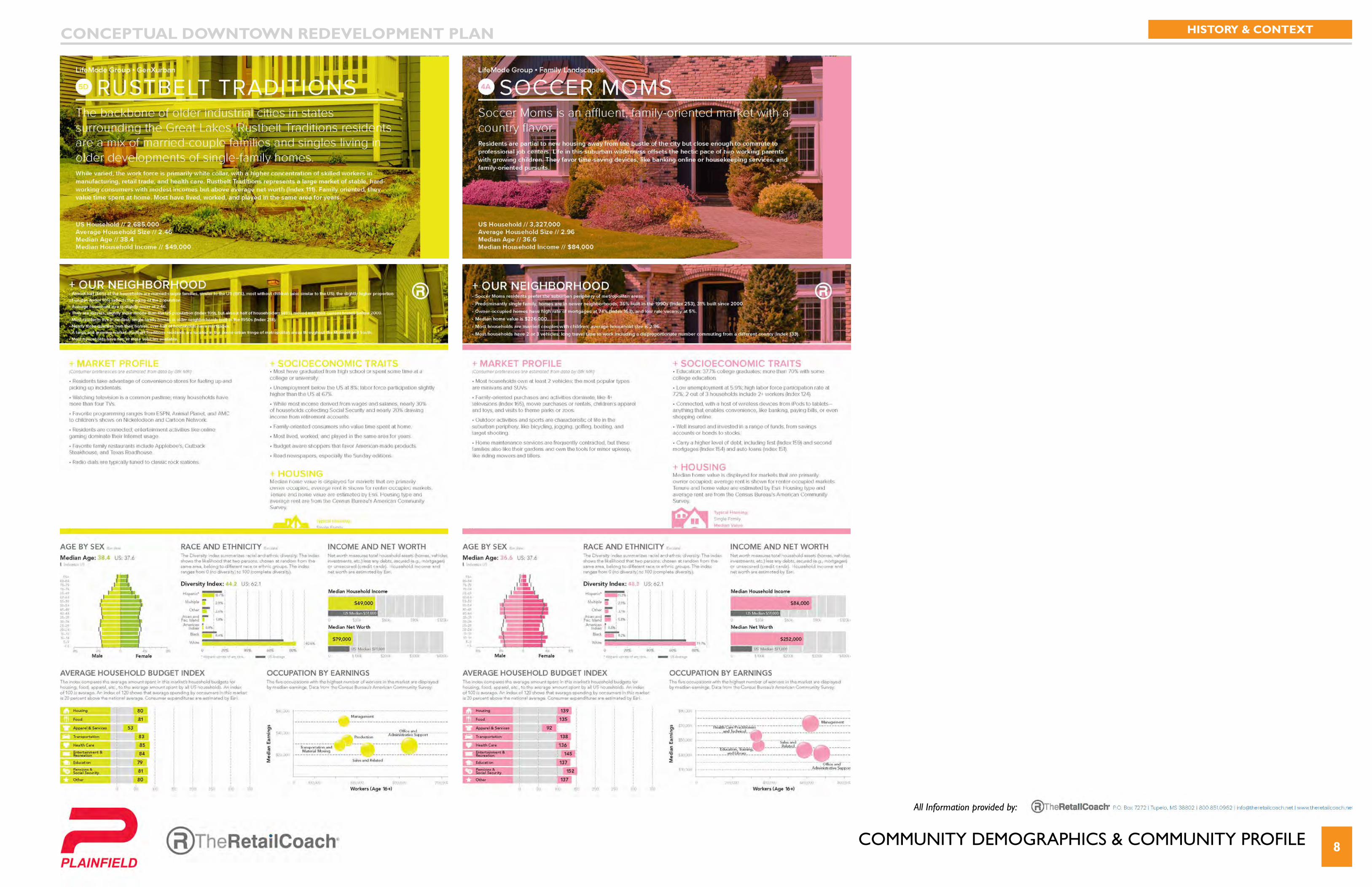
coMMUnItY DeMoGRaPHIcs 5
All Information provided by:
CONCEPTUAL DOWNTOWN REDEVELOPMENT PLAN HISTORY & CONTEXT
coMMUnItY DeMoGRaPHIcs & coMMUnItY PRofIle 6
All Information provided by:
CONCEPTUAL DOWNTOWN REDEVELOPMENT PLAN HISTORY & CONTEXT
coMMUnItY DeMoGRaPHIcs & coMMUnItY PRofIle 7
All Information provided by:
CONCEPTUAL DOWNTOWN REDEVELOPMENT PLAN HISTORY & CONTEXT
coMMUnItY DeMoGRaPHIcs & coMMUnItY PRofIle 8
All Information provided by:
CONCEPTUAL DOWNTOWN REDEVELOPMENT PLAN HISTORY & CONTEXT
10
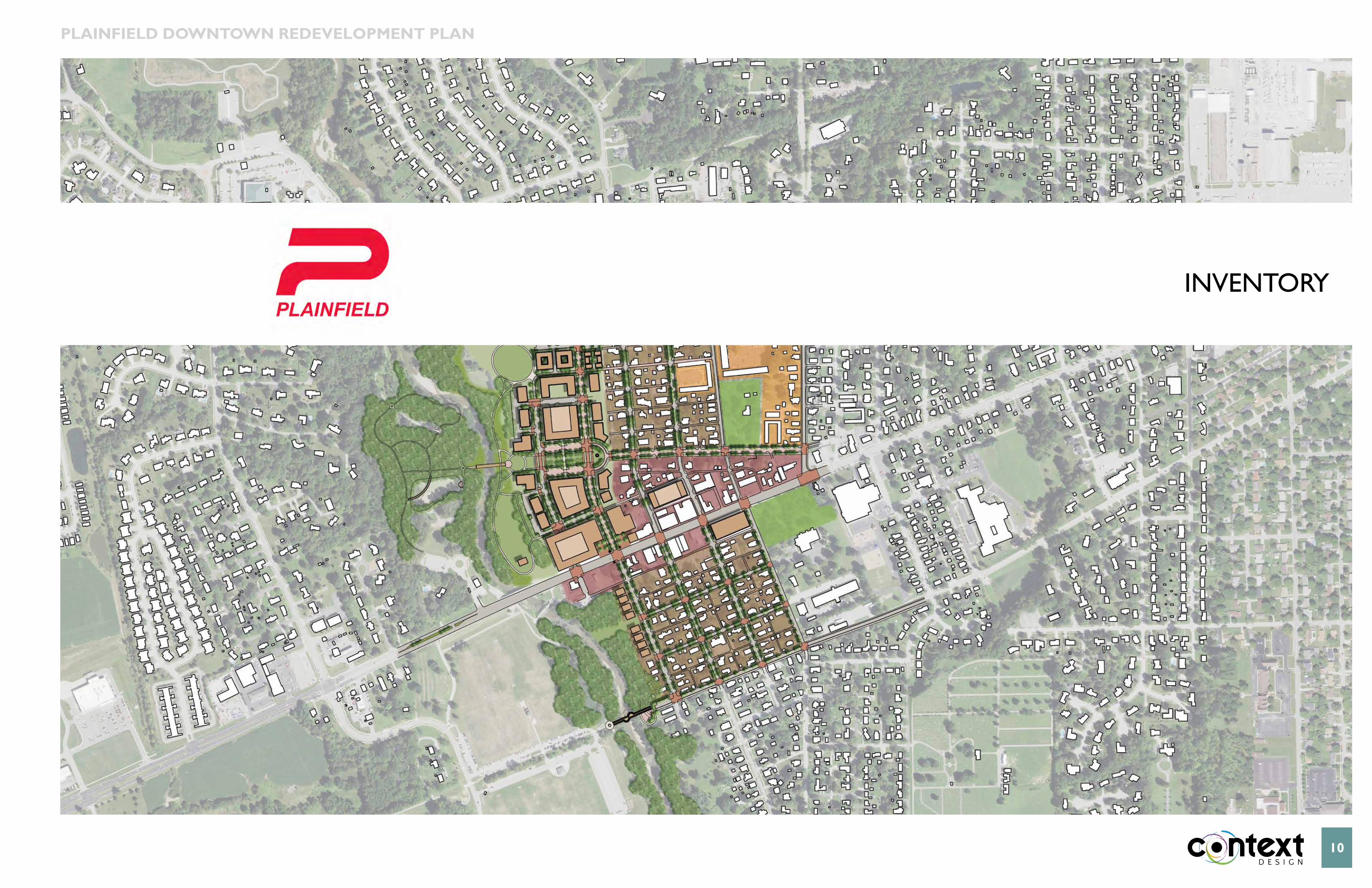
InVentoRY
PLAiNFiELD DOWNTOWN REDEVELOPMENT PLAN
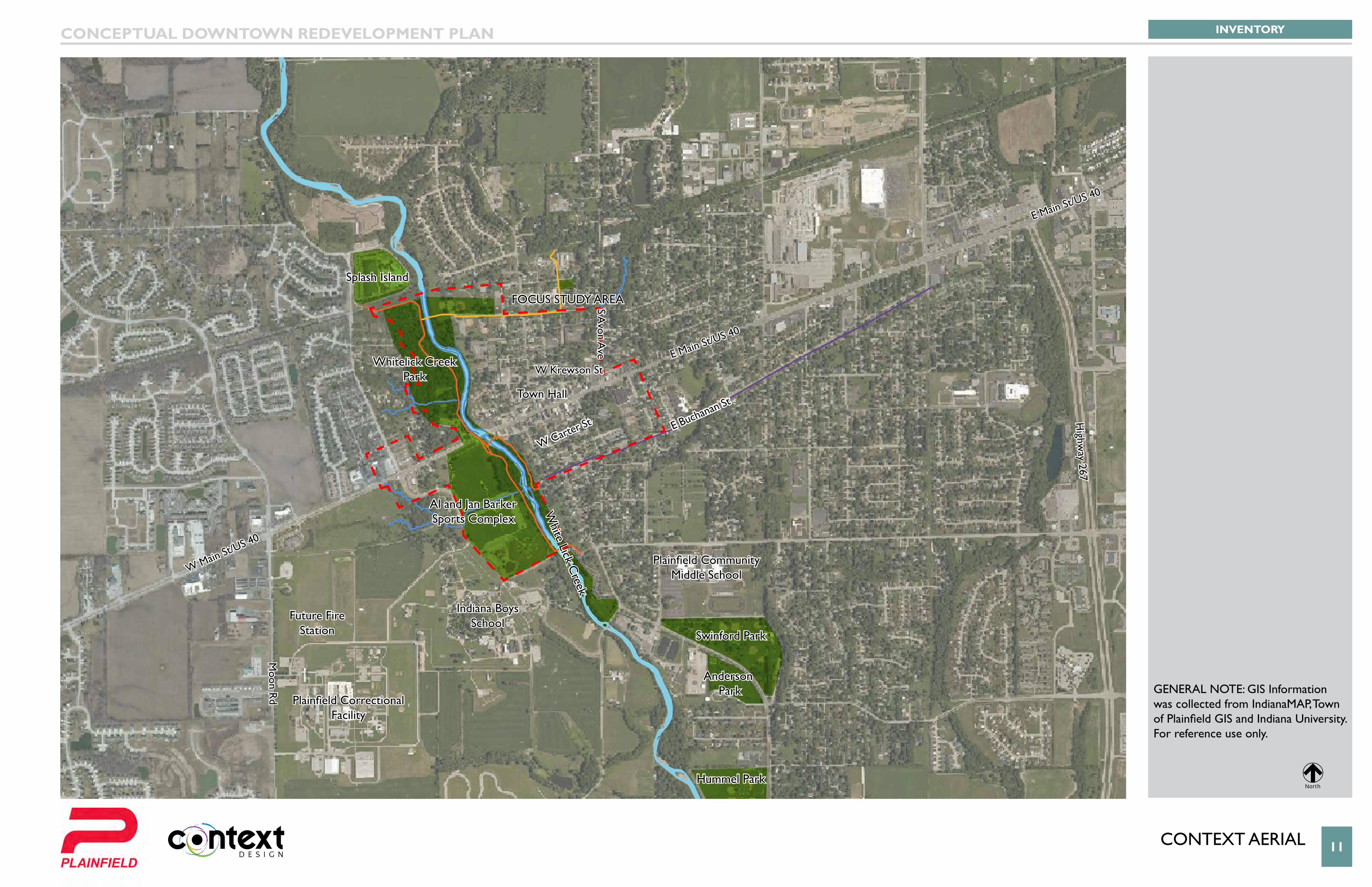
conteXt aeRIal 11
Van Buren Elementary
School
E Main St/US 40
E Main St/US 40
W Main St/US 40
W Krewson St
Splash Island
Whitelick Creek Park
Al and Jan Barker Sports Complex
Swinford Park
Anderson Park
Hummel Park
Indiana BoysSchool
Future FireStation
Plainfield Correctional Facility
Plainfield Community Middle School
Town Hall
focUs stUDY aRea
W Carter St E Buchanan St
S Avon A
ve
Highw
ay 267
White Lick C
reek
Moon R
d
INVENTORYCONCEPTUAL DOWNTOWN REDEVELOPMENT PLAN
0 150' 300' 600'
Scale: 1"=300' North
LEGEND:
GENERAL NOTE: GIS Information was collected from IndianaMAP, Town of Plainfield GIS and Indiana University. For reference use only.
GENERAL NOTE: GIS Information was collected from IndianaMAP, Town of Plainfield GIS and Indiana University. For reference use only.
North
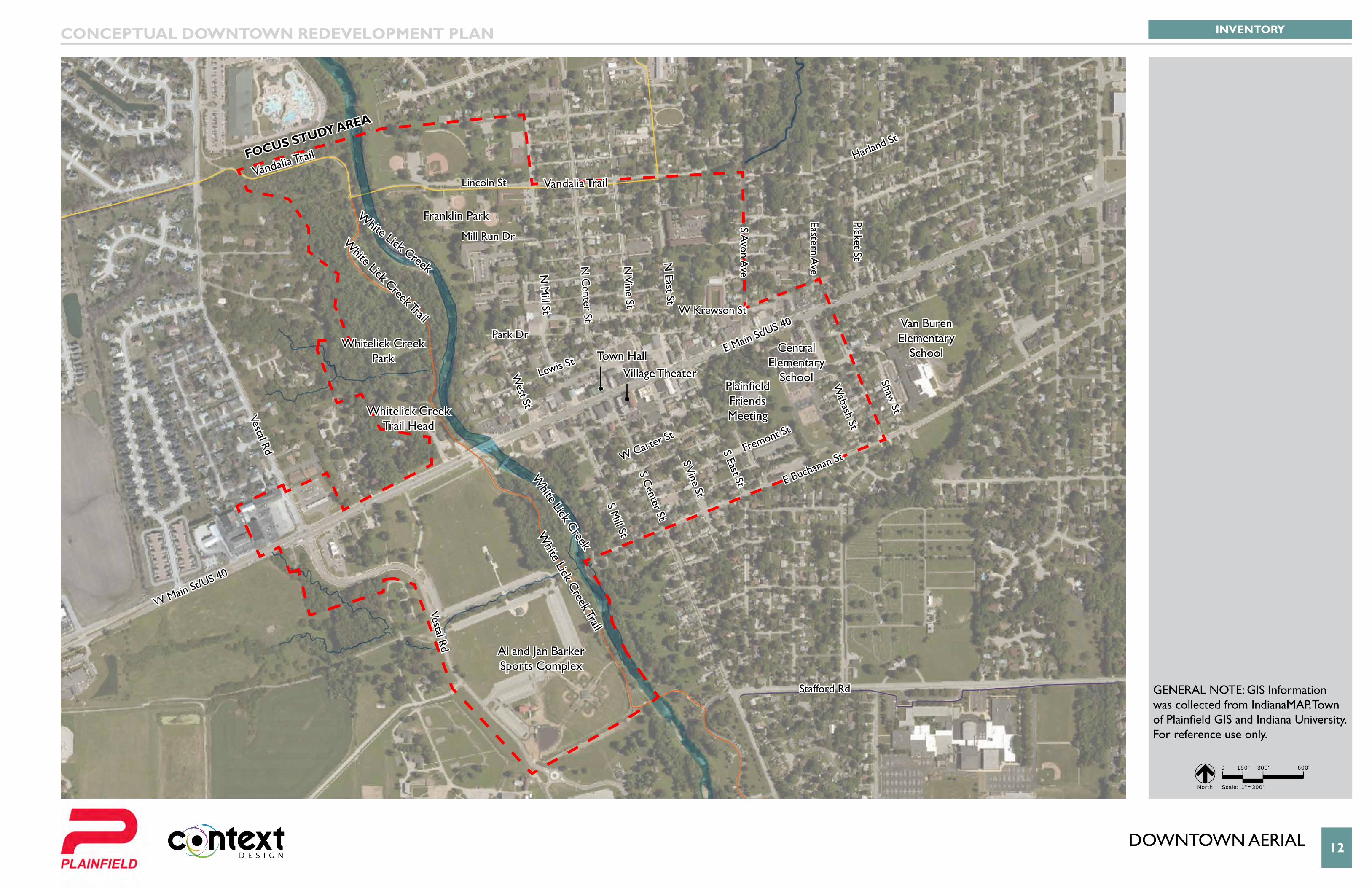
DoWntoWn aeRIal 12
Van Buren Elementary
School
W Krewson St
Mill Run Dr
Lewis St
Park Dr
Lincoln St
White Lick C
reek Trail
White Lick Creek Trail
Vandalia TrailVandalia Trail
W Carter St
Fremont St
E Buchanan St
Stafford Rd
S Mill St
Vestal Rd
Vestal Rd
West St
N M
ill St
N C
enter St
S Center St
S Vine St
N V
ine St
N East St
S Avon A
ve
Eastern Ave
Picket St
White Lick Creek
White Lick Creek
S East St
Wabash St
Shaw St
E Main St/US 40
Harland St
W Main St/US 40
Whitelick Creek Park
Whitelick Creek Trail Head
Franklin Park
Al and Jan Barker Sports Complex
Central Elementary
School
Van Buren Elementary
School
Plainfield Friends Meeting
Town HallVillage Theater
Focus study AreA
INVENTORYCONCEPTUAL DOWNTOWN REDEVELOPMENT PLAN
0 150' 300' 600'
Scale: 1"=300' North
GENERAL NOTE: GIS Information was collected from IndianaMAP, Town of Plainfield GIS and Indiana University. For reference use only.
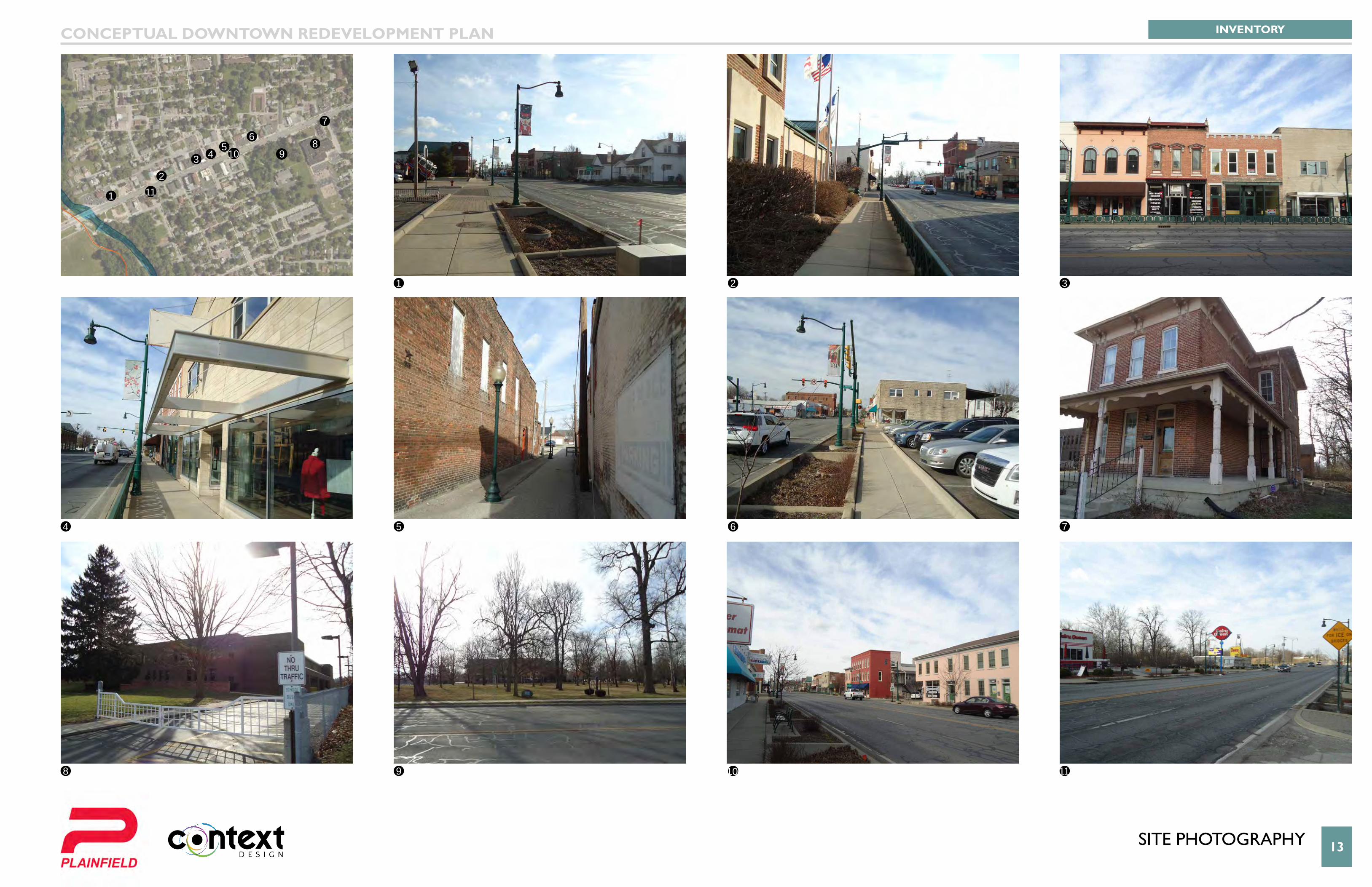
13sIte PHotoGRaPHY
1
1
2
3
7
11
2
6
10
5
9
4
8
3 45
67
8910
11
INVENTORYCONCEPTUAL DOWNTOWN REDEVELOPMENT PLAN
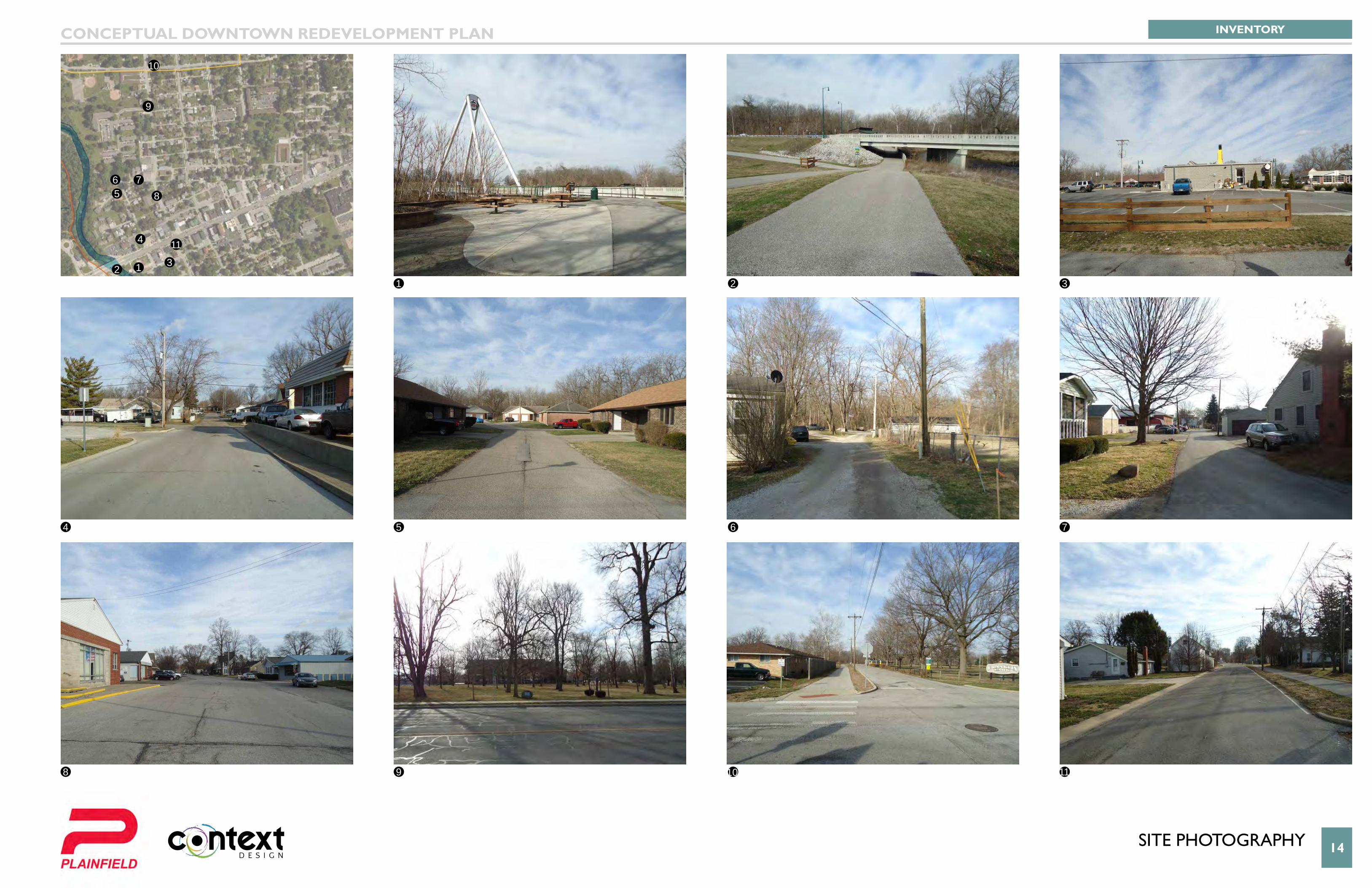
14sIte PHotoGRaPHY
11
23
7
11
2
6
10
5
9
4
8
3
4
56 7
8
9
10
11
INVENTORYCONCEPTUAL DOWNTOWN REDEVELOPMENT PLAN
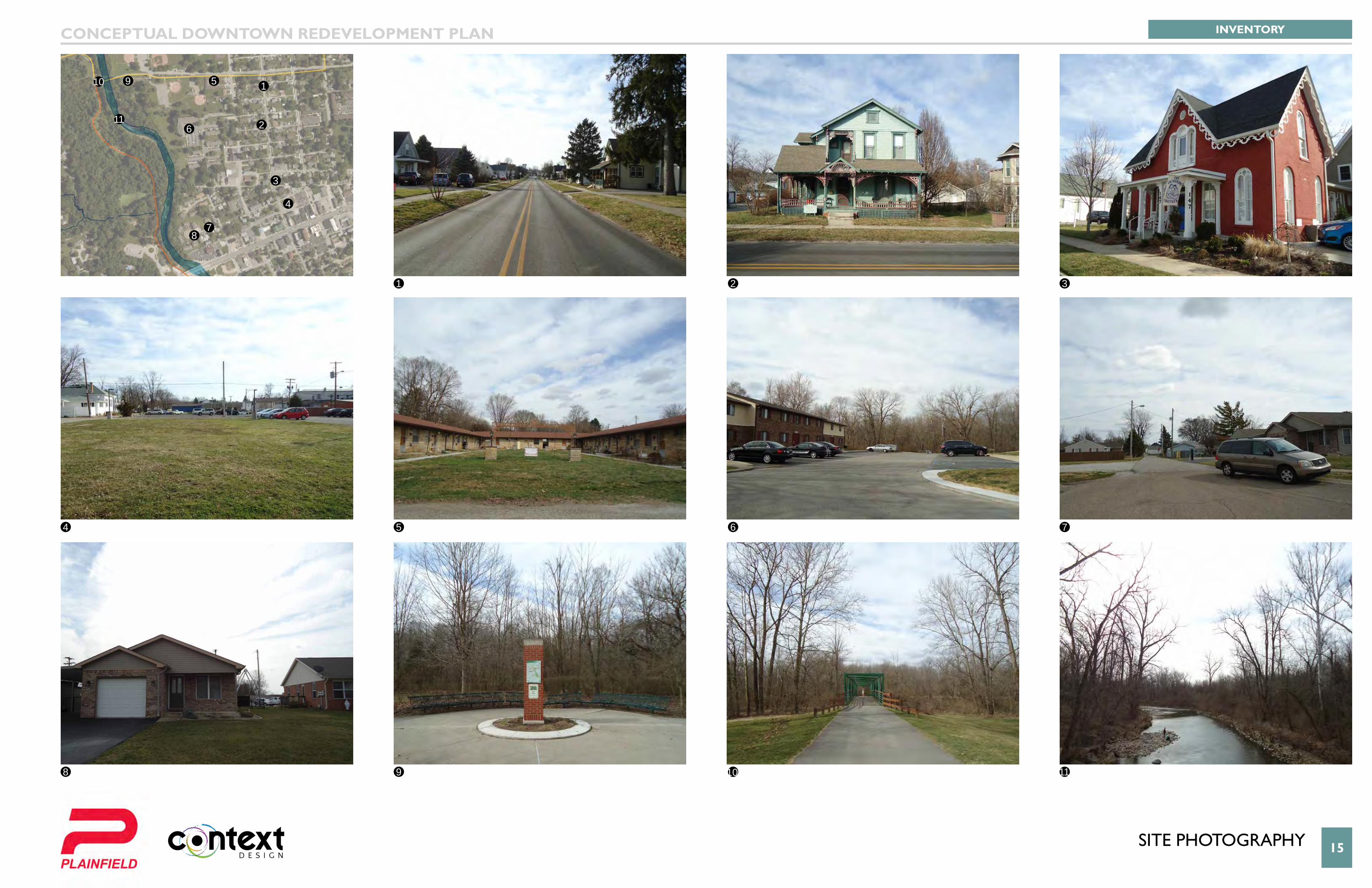
15sIte PHotoGRaPHY
1
1
2
3
7
11
2
6
10
5
9
4
8
3
4
5
6
78
910
11
INVENTORYCONCEPTUAL DOWNTOWN REDEVELOPMENT PLAN
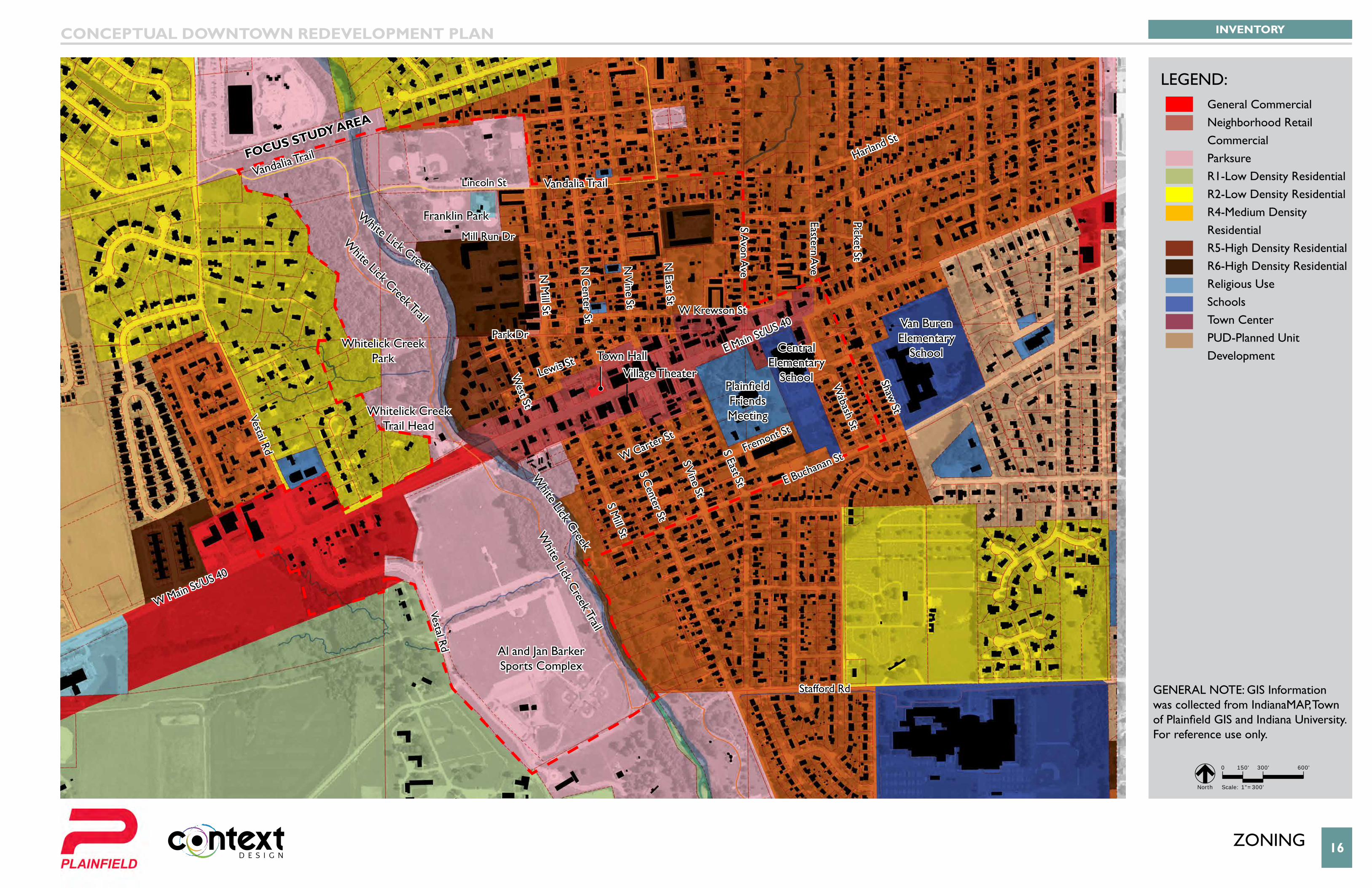
zonInG 16
Van Buren Elementary
School
W Krewson St
Mill Run Dr
Lewis St
Park Dr
Lincoln St
White Lick C
reek Trail
White Lick Creek Trail
Vandalia TrailVandalia Trail
W Carter St
Fremont St
E Buchanan St
Stafford Rd
S Mill St
Vestal Rd
Vestal Rd
West St
N M
ill St
N C
enter St
S Center St
S Vine St
N V
ine St
N East St
S Avon A
ve
Eastern Ave
Picket St
White Lick Creek
White Lick Creek
S East St
Wabash St
Shaw St
E Main St/US 40
Harland St
W Main St/US 40
Whitelick Creek Park
Whitelick Creek Trail Head
Franklin Park
Al and Jan Barker Sports Complex
Central Elementary
School
Van Buren Elementary
School
Plainfield Friends Meeting
Town HallVillage Theater
Focus study AreA
INVENTORYCONCEPTUAL DOWNTOWN REDEVELOPMENT PLAN
0 150' 300' 600'
Scale: 1"=300' North
LEGEND:
GENERAL NOTE: GIS Information was collected from IndianaMAP, Town of Plainfield GIS and Indiana University. For reference use only.
General CommercialNeighborhood Retail CommercialParksureR1-Low Density ResidentialR2-Low Density ResidentialR4-Medium Density ResidentialR5-High Density ResidentialR6-High Density ResidentialReligious UseSchoolsTown CenterPUD-Planned Unit Development
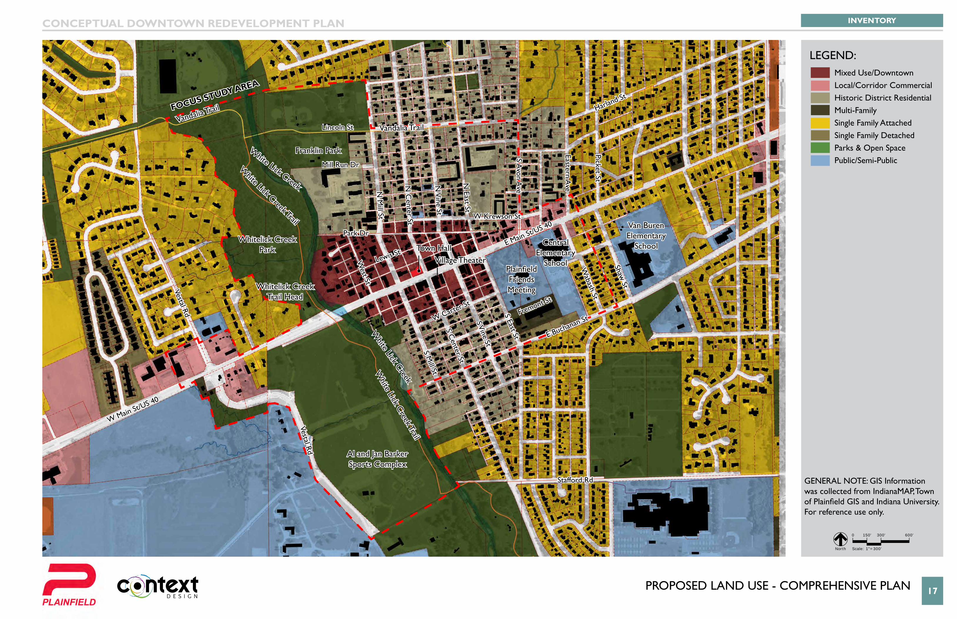
PRoPoseD lanD Use - coMPReHensIVe Plan 17
Van Buren Elementary
School
W Krewson St
Mill Run Dr
Lewis St
Park Dr
Lincoln St
White Lick C
reek Trail
White Lick Creek Trail
Vandalia TrailVandalia Trail
W Carter St
Fremont St
E Buchanan St
Stafford Rd
S Mill St
Vestal Rd
Vestal Rd
West St
N M
ill St
N C
enter St
S Center St
S Vine St
N V
ine St
N East St
S Avon A
ve
Eastern Ave
Picket St
White Lick Creek
White Lick Creek
S East St
Wabash St
Shaw St
E Main St/US 40
Harland St
W Main St/US 40
Whitelick Creek Park
Whitelick Creek Trail Head
Franklin Park
Al and Jan Barker Sports Complex
Central Elementary
School
Van Buren Elementary
School
Plainfield Friends Meeting
Town HallVillage Theater
Focus study AreA
INVENTORYCONCEPTUAL DOWNTOWN REDEVELOPMENT PLAN
0 150' 300' 600'
Scale: 1"=300' North
LEGEND:
GENERAL NOTE: GIS Information was collected from IndianaMAP, Town of Plainfield GIS and Indiana University. For reference use only.
Mixed Use/DowntownLocal/Corridor CommercialHistoric District ResidentialMulti-FamilySingle Family AttachedSingle Family DetachedParks & Open SpacePublic/Semi-Public
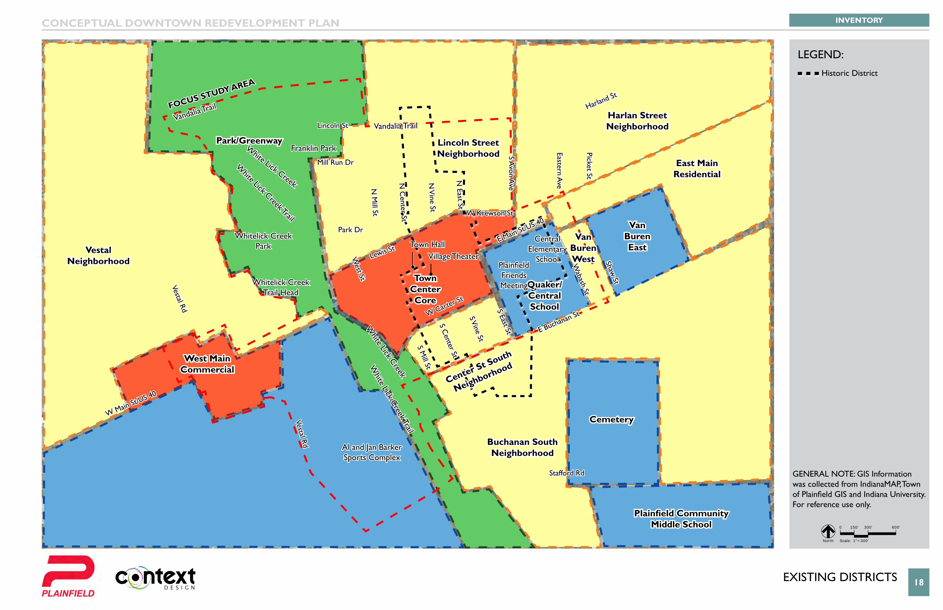
eXIstInG DIstRIcts 18
Van Buren Elementary
School
Lincoln Street Neighborhood
Quaker/Central School
Van Buren East
Cemetery
Plainfield Community Middle School
Center St South
Neighborhood
Buchanan South Neighborhood
Town Center Core
East Main Residential
Harlan StreetNeighborhood
VestalNeighborhood
West Main Commercial
Park/Greenway
Van Buren West
W Krewson St
Mill Run Dr
Lewis St
Park Dr
Lincoln St
White Lick C
reek Trail
White Lick Creek Trail
Vandalia TrailVandalia Trail
W Carter St
E Buchanan St
Stafford Rd
S Mill St
Vestal Rd
Vestal Rd
West St
N M
ill St
N C
enter St
S Center St
S Vine St
N V
ine St
N East St
S Avon A
ve
Eastern Ave
Picket St
White Lick Creek
White Lick Creek
S East St
Wabash St
Shaw St
E Main St/US 40
Harland St
W Main St/US 40
Whitelick Creek Park
Whitelick Creek Trail Head
Franklin Park
Al and Jan Barker Sports Complex
Central Elementary
SchoolPlainfield Friends Meeting
Town HallVillage Theater
Focus study AreA
INVENTORYCONCEPTUAL DOWNTOWN REDEVELOPMENT PLAN
0 150' 300' 600'
Scale: 1"=300' North
LEGEND:
GENERAL NOTE: GIS Information was collected from IndianaMAP, Town of Plainfield GIS and Indiana University. For reference use only.
Historic District
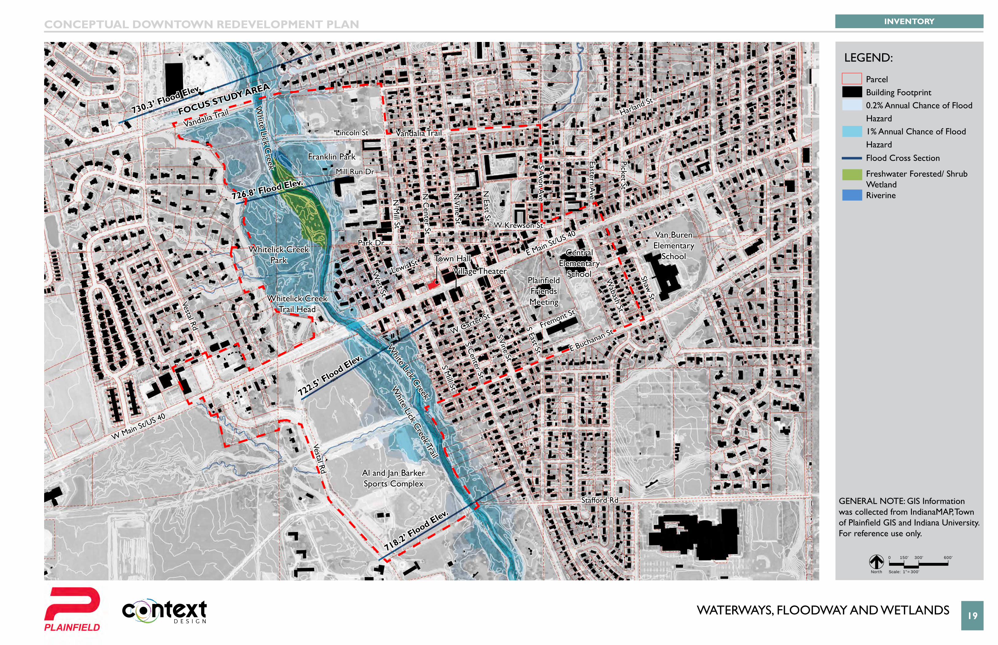
WATERWAYS, FLOODWAY AND WETLANDS 19
Van Buren Elementary
School
726.8’ Flood Elev.
730.3’ Flood Elev.
722.5’ Flood Elev.
718.2’ Flood Elev.
W Krewson St
Mill Run Dr
Lewis St
Park Dr
Lincoln St
White Lick C
reek Trail
Vandalia TrailVandalia Trail
W Carter St
Fremont St
E Buchanan St
Stafford Rd
S Mill St
Vestal Rd
Vestal Rd
West St
N M
ill St
N C
enter St
S Center St
S Vine St
N V
ine St
N East St
S Avon A
ve
Eastern Ave
Picket St
White Lick Creek
S East St
Wabash St
Shaw St
E Main St/US 40
Harland St
W Main St/US 40
Whitelick Creek Park
Whitelick Creek Trail Head
Franklin Park
Al and Jan Barker Sports Complex
Central Elementary
School
Van Buren Elementary
School
Plainfield Friends Meeting
Town HallVillage Theater
Focus study AreA
White Lick C
reek
INVENTORYCONCEPTUAL DOWNTOWN REDEVELOPMENT PLAN
0 150' 300' 600'
Scale: 1"=300' North
LEGEND:
GENERAL NOTE: GIS Information was collected from IndianaMAP, Town of Plainfield GIS and Indiana University. For reference use only.
ParcelBuilding Footprint0.2% Annual Chance of Flood Hazard1% Annual Chance of Flood HazardFlood Cross Section
Freshwater Forested/ Shrub WetlandRiverine
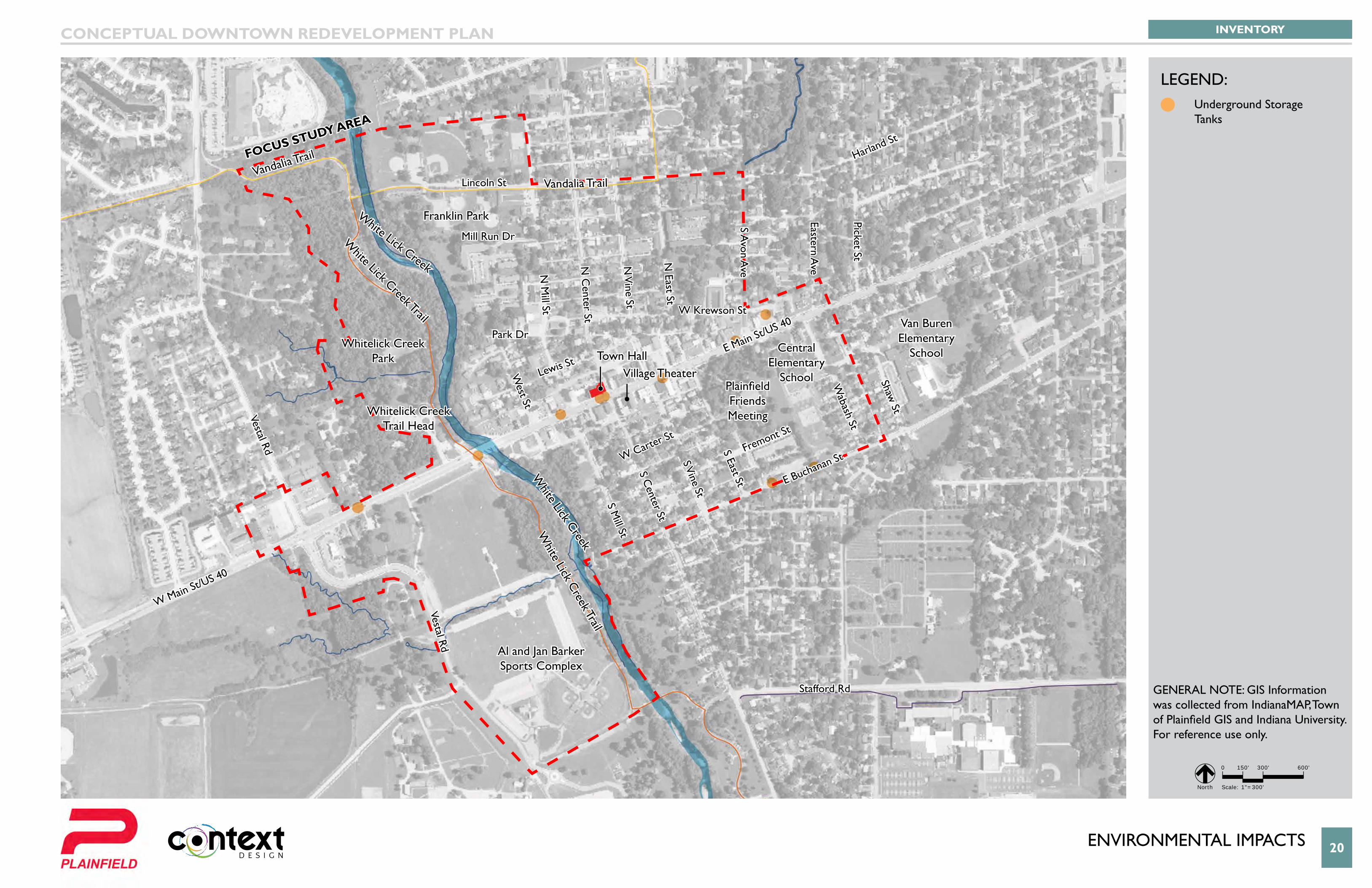
enVIRonMental IMPacts 20
Van Buren Elementary
School
W Krewson St
Mill Run Dr
Lewis St
Park Dr
Lincoln St
White Lick C
reek Trail
White Lick Creek Trail
Vandalia TrailVandalia Trail
W Carter St
Fremont St
E Buchanan St
Stafford Rd
S Mill St
Vestal Rd
Vestal Rd
West St
N M
ill St
N C
enter St
S Center St
S Vine St
N V
ine St
N East St
S Avon A
ve
Eastern Ave
Picket St
White Lick Creek
White Lick Creek
S East St
Wabash St
Shaw St
E Main St/US 40
Harland St
W Main St/US 40
Whitelick Creek Park
Whitelick Creek Trail Head
Franklin Park
Al and Jan Barker Sports Complex
Central Elementary
School
Van Buren Elementary
School
Plainfield Friends Meeting
Town HallVillage Theater
Focus study AreA
INVENTORYCONCEPTUAL DOWNTOWN REDEVELOPMENT PLAN
0 150' 300' 600'
Scale: 1"=300' North
LEGEND:
GENERAL NOTE: GIS Information was collected from IndianaMAP, Town of Plainfield GIS and Indiana University. For reference use only.
Underground Storage Tanks
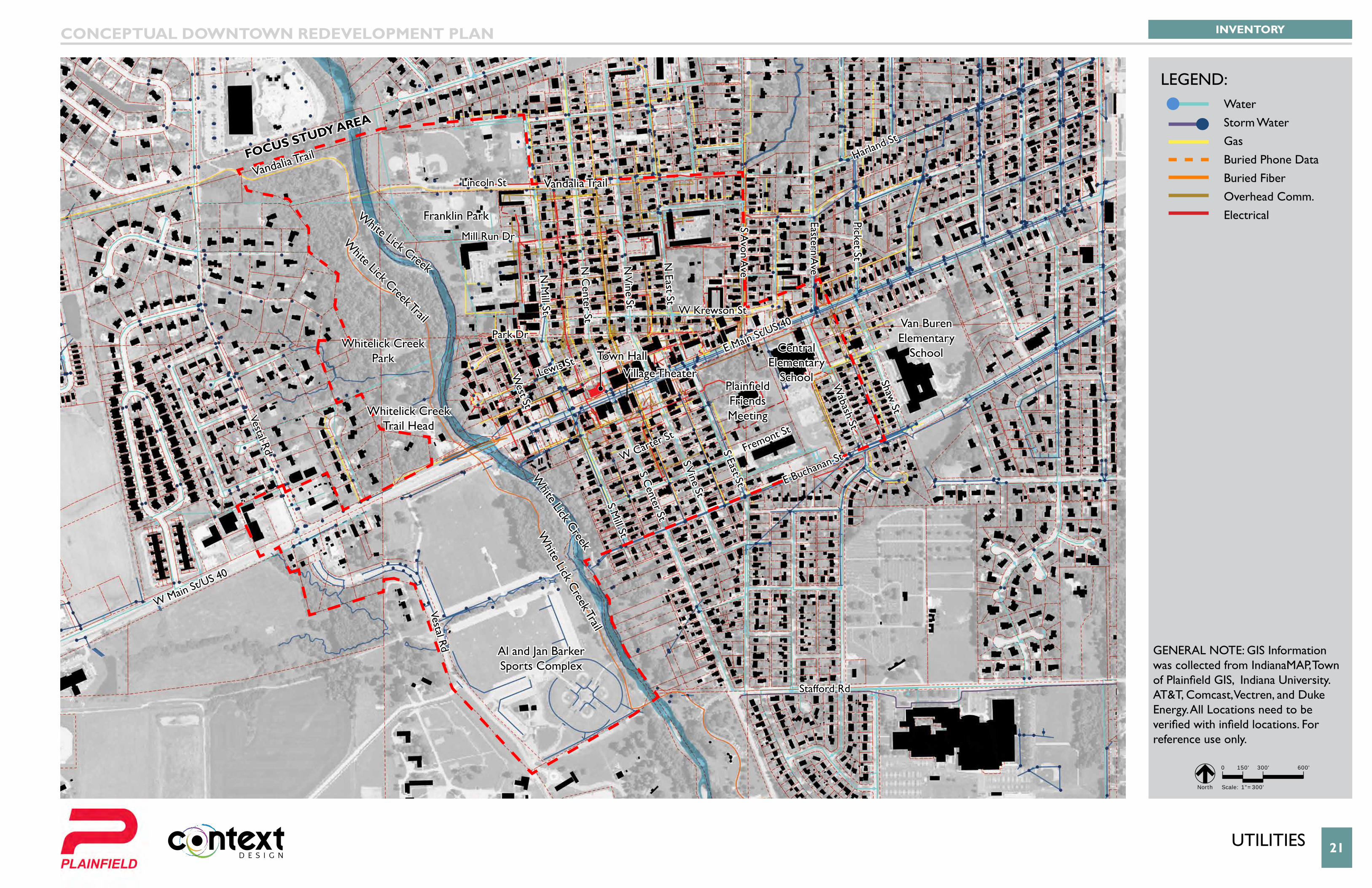
UtIlItIes 21
Van Buren Elementary
School
W Krewson St
Mill Run Dr
Lewis St
Park Dr
Lincoln St
White Lick C
reek Trail
White Lick Creek Trail
Vandalia TrailVandalia Trail
W Carter St
Fremont St
E Buchanan St
Stafford Rd
S Mill St
Vestal Rd
Vestal Rd
West St
N M
ill St
N C
enter St
S Center St
S Vine St
N V
ine St
N East St
S Avon A
ve
Eastern Ave
Picket St
White Lick Creek
White Lick Creek
S East St
Wabash St
Shaw St
E Main St/US 40
Harland St
W Main St/US 40
Whitelick Creek Park
Whitelick Creek Trail Head
Franklin Park
Al and Jan Barker Sports Complex
Central Elementary
School
Van Buren Elementary
School
Plainfield Friends Meeting
Town HallVillage Theater
Focus study AreA
INVENTORYCONCEPTUAL DOWNTOWN REDEVELOPMENT PLAN
0 150' 300' 600'
Scale: 1"=300' North
LEGEND:
GENERAL NOTE: GIS Information was collected from IndianaMAP, Town of Plainfield GIS, Indiana University. AT&T, Comcast, Vectren, and Duke Energy. All Locations need to be verified with infield locations. For reference use only.
WaterStorm WaterGasBuried Phone DataBuried FiberOverhead Comm.Electrical
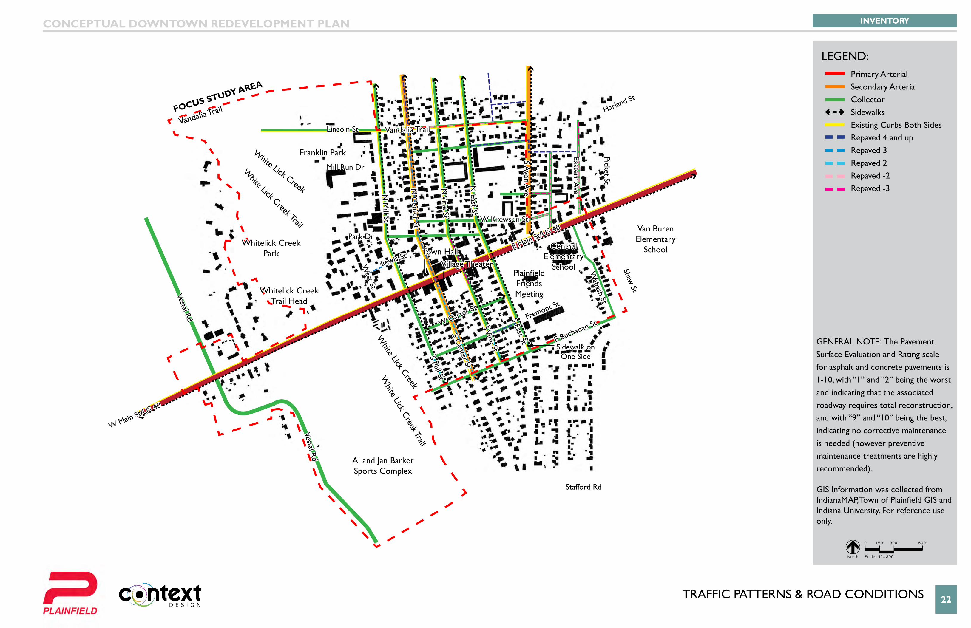
tRaffIc PatteRns & RoaD conDItIons 22
Van Buren Elementary
School
Sidewalk on One Side
W Krewson St
Mill Run Dr
Lewis St
Park Dr
Lincoln St
White Lick C
reek Trail
White Lick Creek Trail
Vandalia TrailVandalia Trail
W Carter St
Fremont St
E Buchanan St
Stafford Rd
S Mill St
Vestal Rd
Vestal Rd
West St
N M
ill St
N C
enter St
S Center St
S Vine St
N V
ine St
N East St
S Avon A
ve
Eastern Ave
Picket St
White Lick Creek
White Lick Creek
S East St
Wabash St
Shaw St
E Main St/US 40
Harland St
W Main St/US 40
Whitelick Creek Park
Whitelick Creek Trail Head
Franklin Park
Al and Jan Barker Sports Complex
Central Elementary
School
Van Buren Elementary
School
Plainfield Friends Meeting
Town HallVillage Theater
Focus study AreA
INVENTORYCONCEPTUAL DOWNTOWN REDEVELOPMENT PLAN
0 150' 300' 600'
Scale: 1"=300' North
LEGEND:Primary ArterialSecondary ArterialCollectorSidewalksExisting Curbs Both SidesRepaved 4 and upRepaved 3Repaved 2Repaved -2Repaved -3
GeneRal note: The Pavement Surface Evaluation and Rating scale for asphalt and concrete pavements is 1-10, with “1” and “2” being the worst and indicating that the associated roadway requires total reconstruction, and with “9” and “10” being the best, indicating no corrective maintenance is needed (however preventive maintenance treatments are highly recommended).
GIS Information was collected from IndianaMAP, Town of Plainfield GIS and Indiana University. For reference use only.
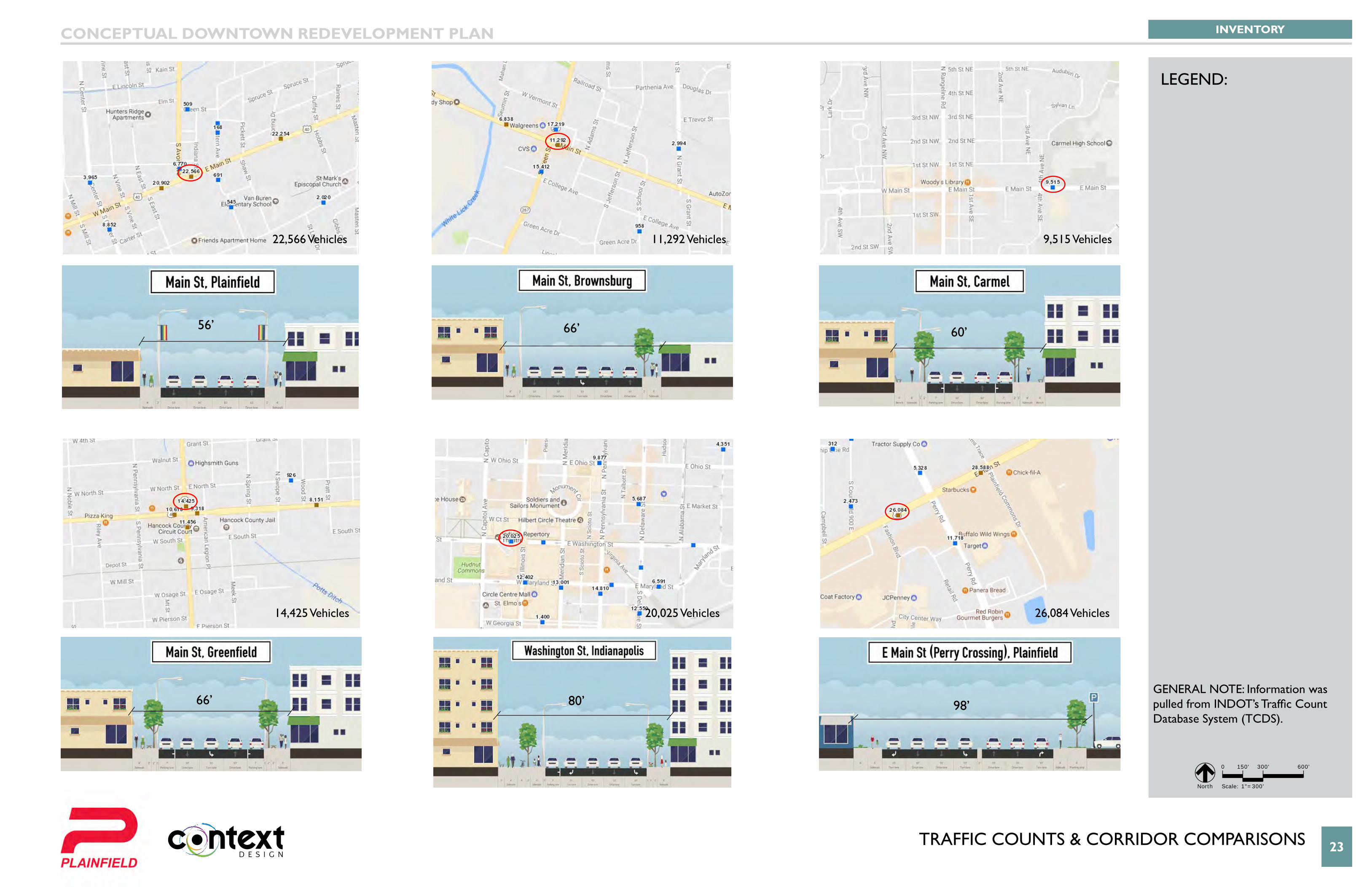
tRaffIc coUnts & coRRIDoR coMPaRIsons 23
TCDS Locations
Short
Continuous
WIM
Located Short
Located Continuous
Located WIM
State Owned
TCDS Locations
Short
Continuous
WIM
Located Short
Located Continuous
Located WIM
State Owned
TCDS Locations
Short
Continuous
WIM
Located Short
Located Continuous
Located WIM
State Owned
TCDS Locations
Short
Continuous
WIM
Located Short
Located Continuous
Located WIM
State Owned
TCDS Locations
Short
Continuous
WIM
Located Short
Located Continuous
Located WIM
State Owned
TCDS Locations
Short
Continuous
WIM
Located Short
Located Continuous
Located WIM
State Owned
Van Buren Elementary
School
22,566 Vehicles
14,425 Vehicles
11,292 Vehicles
20,025 Vehicles
9,515 Vehicles
26,084 Vehicles
56’ 66’ 60’
66’ 80’ 98’
INVENTORYCONCEPTUAL DOWNTOWN REDEVELOPMENT PLAN
LEGEND:
0 150' 300' 600'
Scale: 1"=300' North
GENERAL NOTE: Information was pulled from INDOT’s Traffic Count Database System (TCDS).
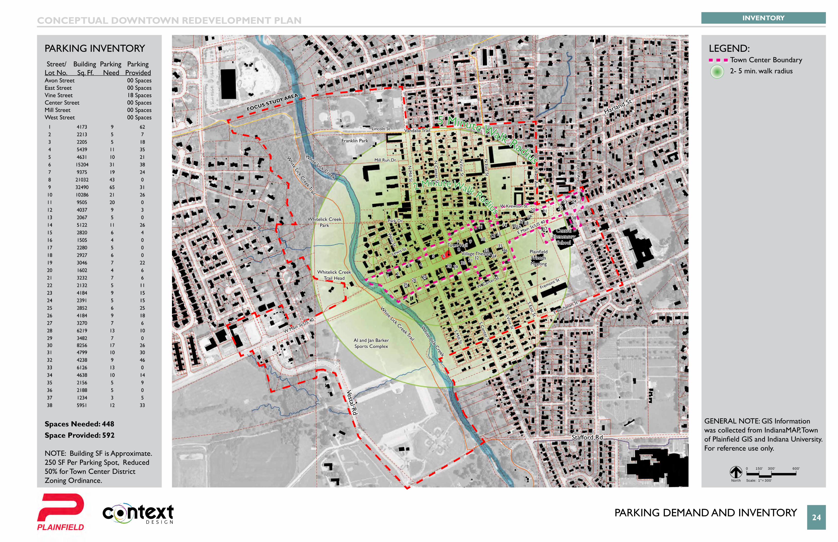
PaRKInG DeManD anD InVentoRY 24
5 Minute Walk Radius
2 Minute Walk Radius
Van Buren Elementary
School
Stafford Rd
Vestal Rd
Harland St
1 2
43
5 6
7
8
9 10
11
12 13
14 15161718
1920 21
2223 24
2526 27
28 2930 31 32 34
3335
36
37
38
W Krewson St
Mill Run Dr
Lewis St
Park Dr
Lincoln St
White Lick Creek Trail
White Lick Creek Trail
Vandalia Trail
W Carter St
Fremont St
E Buchanan St
S Mill St
West St
N M
ill St
N C
enter St
S Center St
S Vine St
N V
ine St
N East St
S Avon A
ve
Eastern Ave
White Lick Creek
White Lick Creek
S East St
Wabash St
E Main St/US 40
W Main St/US 40
Whitelick Creek Park
Whitelick Creek Trail Head
Franklin Park
Al and Jan Barker Sports Complex
Central Elementary
School
Plainfield Friends Meeting
Town Hall
Village Theater
FOCuS STuDy AREA
INVENTORYCONCEPTUAL DOWNTOWN REDEVELOPMENT PLAN
LEGEND:
GENERAL NOTE: GIS Information was collected from IndianaMAP, Town of Plainfield GIS and Indiana University. For reference use only.
0 150' 300' 600'
Scale: 1"=300' North
PaRKInG InVentoRY Street/ Building Parking Parking Lot No. Sq. Ff. Need Provided Avon Street 00 SpacesEast Street 00 SpacesVine Street 18 SpacesCenter Street 00 SpacesMill Street 00 SpacesWest Street 00 Spaces
Spaces Needed: 448 Space Provided: 592 NOTE: Building SF is Approximate. 250 SF Per Parking Spot, Reduced 50% for Town Center District Zoning Ordinance.
Town Center Boundary 2- 5 min. walk radius
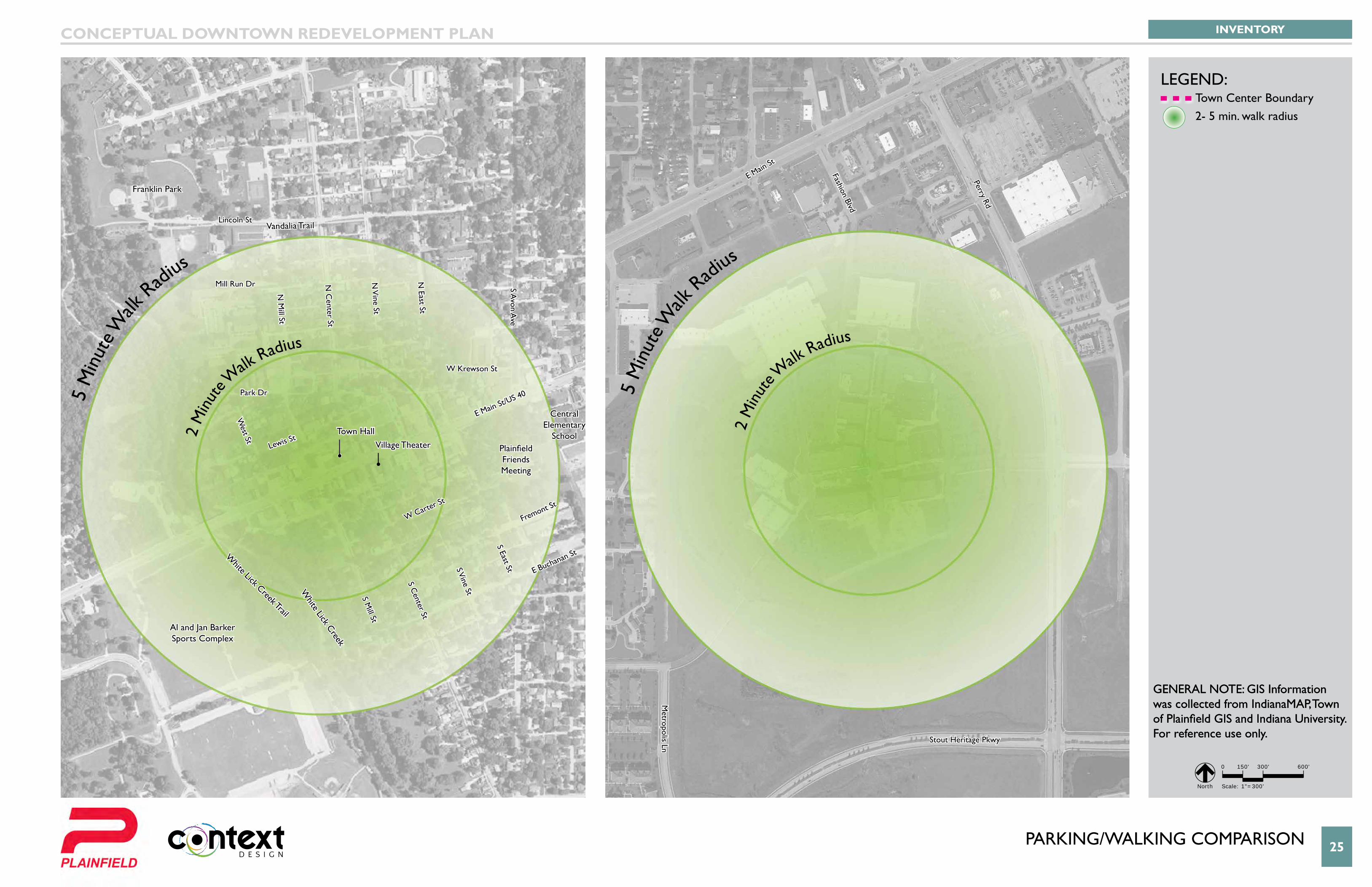
PARKING/WALKING COMPARISON 25
5 M
inut
e Walk
Radi
us
2 M
inut
e Walk
Radius
5 M
inut
e Walk
Radi
us
2 M
inut
e Walk
Radius
Van Buren Elementary
School
W Krewson St
Mill Run Dr
Lewis St
Park Dr
Lincoln St
White Lick Creek Trail
Vandalia Trail
W Carter St
Fremont St
E Buchanan St
S Mill St
West St
N M
ill St
N C
enter St
S Center St
S Vine St
N V
ine St
N East St
S Avon A
ve
Perry Rd
Fashion Blvd
Metropolis Ln
E Main St
Stout Heritage Pkwy
White Lick Creek
S East St
E Main St/US 40
Franklin Park
Al and Jan Barker Sports Complex
Central Elementary
SchoolPlainfield Friends Meeting
Town HallVillage Theater
INVENTORYCONCEPTUAL DOWNTOWN REDEVELOPMENT PLAN
LEGEND:
GENERAL NOTE: GIS Information was collected from IndianaMAP, Town of Plainfield GIS and Indiana University. For reference use only.
0 150' 300' 600'
Scale: 1"=300' North
Town Center Boundary 2- 5 min. walk radius
GENERAL NOTE: GIS Information was collected from IndianaMAP, Town of Plainfield GIS and Indiana University. For reference use only.
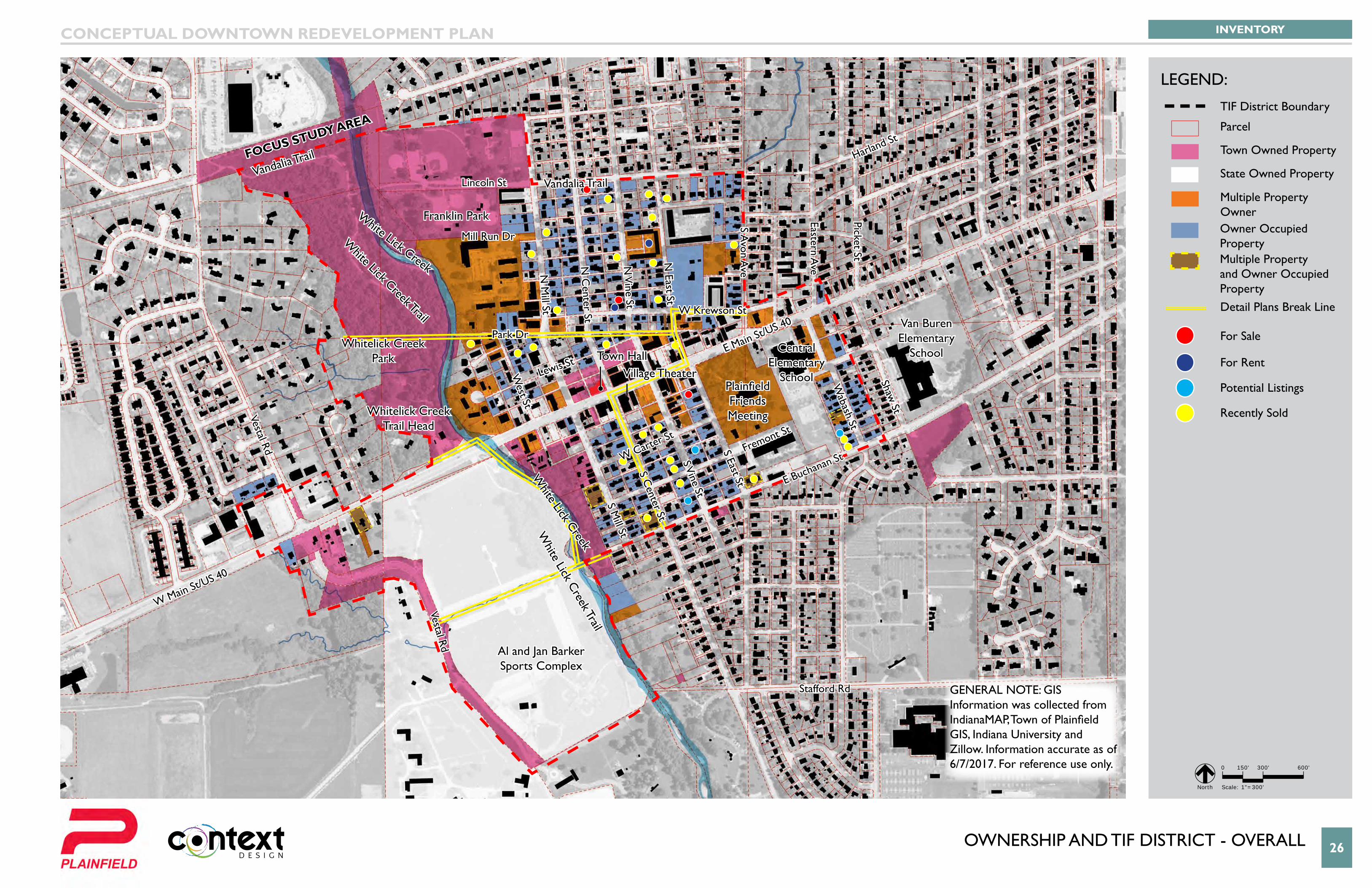
oWneRsHIP anD tIf DIstRIct - oVeRall 26
Van Buren Elementary
School
W Krewson St
Mill Run Dr
Lewis St
Park Dr
Lincoln St
White Lick C
reek Trail
White Lick Creek Trail
Vandalia TrailVandalia Trail
W Carter St
Fremont St
E Buchanan St
Stafford Rd
S Mill St
Vestal Rd
Vestal Rd
West St
N M
ill St
N C
enter St
S Center St
S Vine St
N V
ine St
N East St
S Avon A
ve
Eastern Ave
Picket St
White Lick Creek
White Lick Creek
S East St
Wabash St
Shaw St
E Main St/US 40
Harland St
W Main St/US 40
Whitelick Creek Park
Whitelick Creek Trail Head
Franklin Park
Al and Jan Barker Sports Complex
Central Elementary
School
Van Buren Elementary
School
Plainfield Friends Meeting
Town HallVillage Theater
Focus study AreA
INVENTORYCONCEPTUAL DOWNTOWN REDEVELOPMENT PLAN
0 150' 300' 600'
Scale: 1"=300' North
LEGEND:
TIF District Boundary
Parcel
Town Owned Property
State Owned Property
Multiple Property OwnerOwner Occupied PropertyMultiple Property and Owner Occupied Property
For Sale
For Rent
Potential Listings
Recently Sold
Detail Plans Break Line
GeneRal note: GIs Information was collected from IndianaMAP, Town of Plainfield GIS, Indiana University and Zillow. Information accurate as of 6/7/2017. For reference use only.
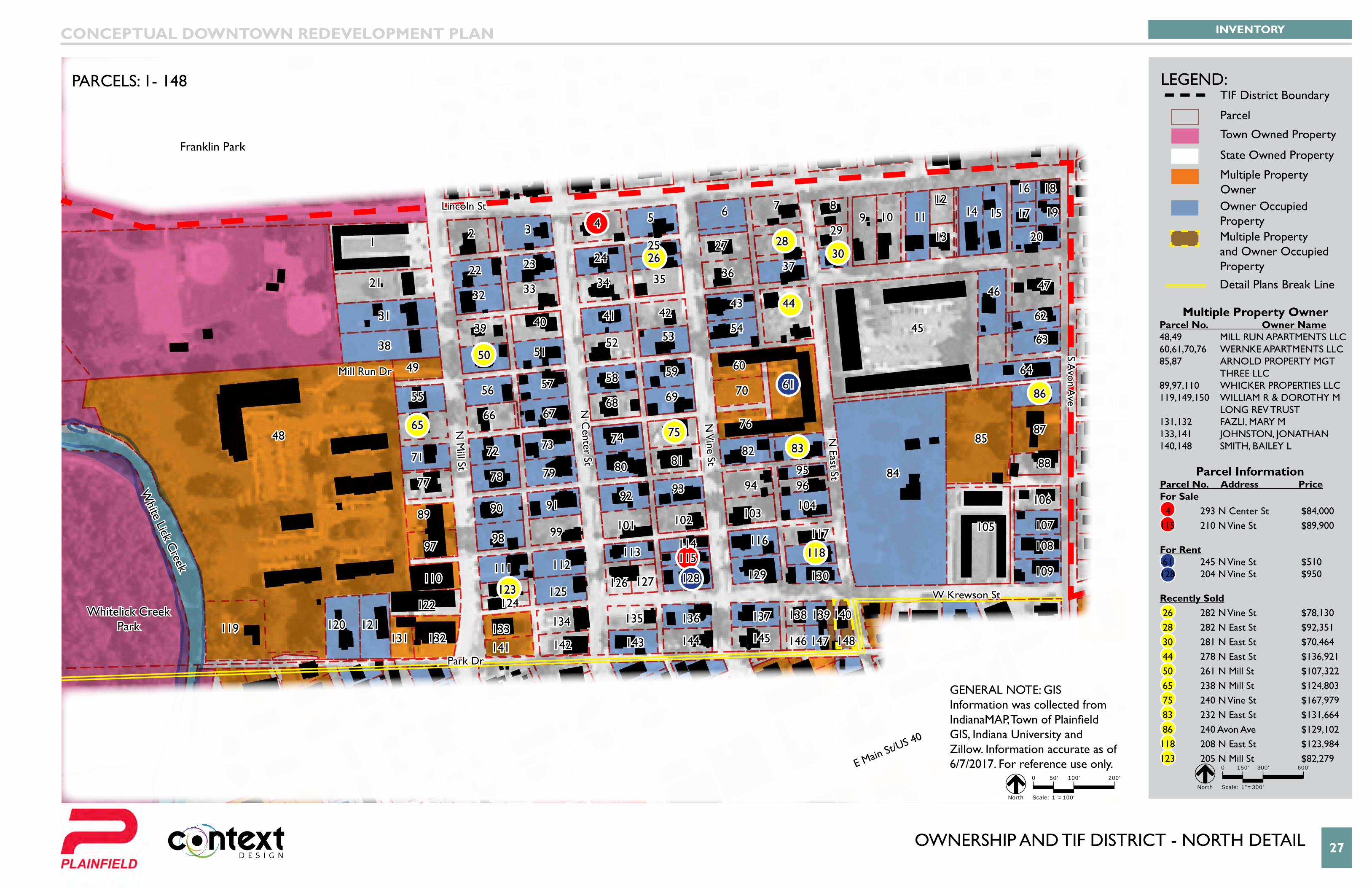
oWneRsHIP anD tIf DIstRIct - noRtH DetaIl 27
Van Buren Elementary
School
E Main St/US 40
W Krewson St
Mill Run Dr
Park Dr
Lincoln St
N M
ill St
N C
enter St
N V
ine St
N East St
S Avon A
ve
White Lick C
reek
Whitelick Creek Park
Franklin Park
13 4 5 6 7 8
9 10 1112
13
14 15
16 18
17 19
2030
31
32 33 34 35 36 37
3839 40 41 42
43 44
45
46 47
48
4950 51
52 5354
55 56 57 58 59 60
61
62
63
64
6566 67
68 69
7271
70
73 74 75
77
76
78 79 80 8182 83
84
85
86
87
88
89 90 9192 93 94
9596
9798 99 101 102 103
104
105
106
107
108
109110111 112
113114115
116 117
118
119 120 121
122123124
125126 127 128 129 130
131 132133
141
134
142
135 136 137
145144143
138 139 140
146 147 148
2122 23 24
2526
27 28292
INVENTORYCONCEPTUAL DOWNTOWN REDEVELOPMENT PLAN
PARCELS: 1- 148 LEGEND:
0 150' 300' 600'
Scale: 1"=300' North
Multiple Property OwnerParcel No. Owner Name48,49 MILL RUN APARTMENTS LLC 60,61,70,76 WERNKE APARTMENTS LLC85,87 ARNOLD PROPERTY MGT tHRee llc89,97,110 WHICKER PROPERTIES LLC119,149,150 WILLIAM R & DOROTHY M lonG ReV tRUst131,132 FAZLI, MARY M133,141 JOHNSTON, JONATHAN140,148 SMITH, BAILEY L
TIF District Boundary
Parcel
Town Owned Property
State Owned Property
Multiple Property Owner
GeneRal note: GIs Information was collected from IndianaMAP, Town of Plainfield GIS, Indiana University and Zillow. Information accurate as of 6/7/2017. For reference use only.
Parcel InformationParcel No. Address PriceFor Sale 4 293 N Center St $84,000115 210 N Vine St $89,900
For Rent 61 245 N Vine St $510128 204 N Vine St $950
Recently Sold 26 282 N Vine St $78,130 28 282 N East St $92,351 30 281 N East St $70,464 44 278 N East St $136,921 50 261 N Mill St $107,322 65 238 N Mill St $124,803 75 240 N Vine St $167,979 83 232 N East St $131,664 86 240 Avon Ave $129,102118 208 N East St $123,984123 205 N Mill St $82,279
Owner Occupied PropertyMultiple Property and Owner Occupied PropertyDetail Plans Break Line
0 50' 100' 200'
Scale: 1"=100' North

oWneRsHIP anD tIf DIstRIct - centeR DetaIl 28
Van Buren Elementary
School
E Main St/US 40
N M
ill St
West St
S Mill St
N C
enter St
N Vine St
N East St
Lewis St
Whitelick Creek Trail Head
Town Hall
Village Theater
W Carter St
Fremont St
E Buchanan St
S East St
S Center St
S Vine St
Al and Jan Barker Sports Complex
149 150151 152 153 154 155 156 157 159
160
162
163
164 165
167168
169
170
166
171
172
173
174175
176
177
178
179
180
181
182
183
184
185
186
187188
189
190
197
191
198
192
193
194
195
196
199
201
202
203
204
225226
227
228 229
230231 232
233
234235
236 237
238
239240 241
242
243
244
245
246
247
248
249
250
251
260
252261
253254
262
263
255
256257 258
266
259
267268
269270
271272
273274
275276277 278
279
283
287
291295
280
284
288
292296
281
285
289
293297
282
286
290
294298
265264
205206 207
208 209 210211
212 213214
215216 217
214
218
219
220 221222
223
224171
161158
INVENTORYCONCEPTUAL DOWNTOWN REDEVELOPMENT PLAN
PARCELS: 149-298 LEGEND:
0 150' 300' 600'
Scale: 1"=300' North
TIF District Boundary
Parcel
Town Owned Property
State Owned Property
Multiple Property Owner
Multiple Property OwnerParcel No. Owner Name119,149,150 WILLIAM R & DOROTHY M lonG ReV tRUst151,33 EARLES, JAMES O159,160 JRJ PROPERTY LLC164,169,21 CHARLES FRANKLIN & JOYCE ANN ROHRER REV lIV tRUst173,174,175, MUSICK, JAMES L & MARY A 185,186,187205,206,207 AVGERINOS, PETE & DEBORA199,212,213 THOMAS L & JUDITH ANN HolzKnecHt faMIlY lIV tRUst228,229 HUFF-RECTOR ENTERPRISES llc263,264 HEALD, WILLIAM E & sUsan K 265,266 PARHAM, TERRY L JR & MelIssa281,282 HATON, ANDRIA M295,296 WALTZ, LUCAS O297,298 GAINES, DENNIS W & sHaRon l
Parcel InformationParcel No. Address PriceRecently Sold 149 403 Park Dr $135,199 171 151 West St $104,901 172 152 N Mill St $131,076 184 131 N Center St $136,497 261 202 S Center St $154,453 295 318 S Center St $140,740
GeneRal note: GIs Information was collected from IndianaMAP, Town of Plainfield GIS, Indiana University and Zillow. Information accurate as of 6/7/2017. For reference use only.
Owner Occupied PropertyMultiple Property and Owner Occupied PropertyDetail Plans Break Line
0 50' 100' 200'
Scale: 1"=100' North
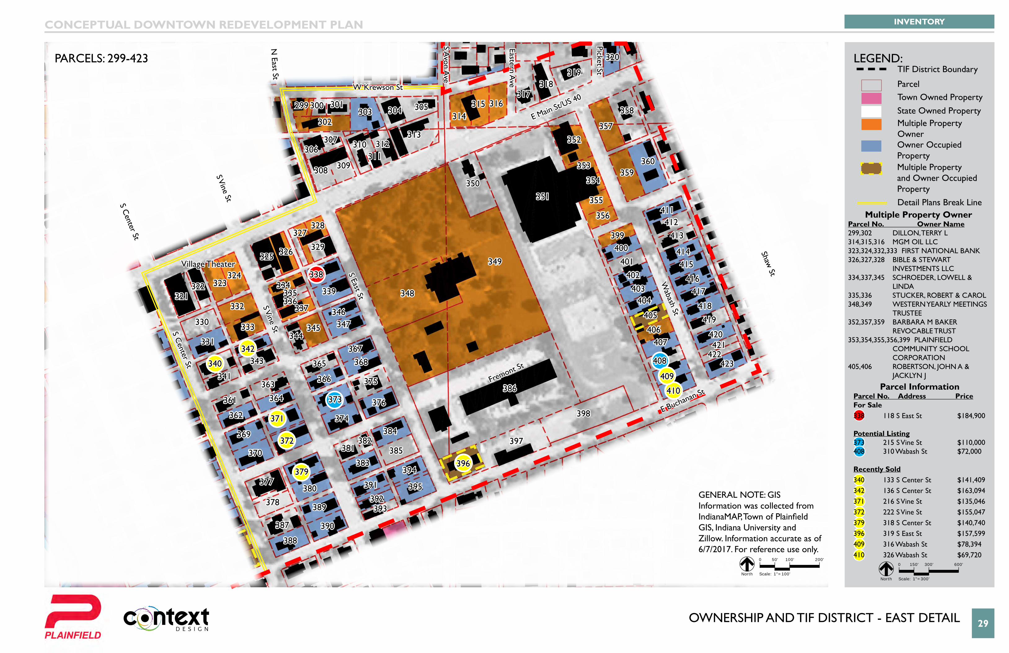
oWneRsHIP anD tIf DIstRIct - east DetaIl 29
Van Buren Elementary
School
E Main St/US 40W Krewson St
Fremont St
E Buchanan St
S Center St
S Center St
S Vine St
S Vine St
S East St
Wabash St
Shaw St
N East St
S Avon A
ve
Eastern Ave
Picket St
Village Theater
299 300 301303 304
302
305
306
309
310313
314315 316
317318
319
320
321322 323
324
325 326
327328
329
330
331
332
333
334335336
337
338
339
340341
342343
344345
346347
348
349
350351
352
353
354
355
356
357
358
359360
361
362
363
364
365
366
367368
369
370
371
372
373
374
375
376
377
378
379
380
381382
383
384
385
386
387
388
389
390
391
392393
394
395
396
397
398
399400
401402
403404
405
406407
408
409
410
411412
413
414415
416417
418
419
420421
422423
307
311
308
312
INVENTORYCONCEPTUAL DOWNTOWN REDEVELOPMENT PLAN
PARCELS: 299-423 LEGEND:
0 150' 300' 600'
Scale: 1"=300' North
TIF District Boundary
ParcelTown Owned PropertyState Owned PropertyMultiple Property Owner
Multiple Property OwnerParcel No. Owner Name299,302 DILLON, TERRY L 314,315,316 MGM OIL LLC323,324,332,333 FIRST NATIONAL BANK 326,327,328 BIBLE & STEWART InVestMents llc334,337,345 SCHROEDER, LOWELL & lInDa335,336 STUCKER, ROBERT & CAROL348,349 WESTERN YEARLY MEETINGS tRUstee352,357,359 BARBARA M BAKER ReVocable tRUst353,354,355,356,399 PLAINFIELD coMMUnItY scHool coRPoRatIon405,406 ROBERTSON, JOHN A & JACKLYN J
GeneRal note: GIs Information was collected from IndianaMAP, Town of Plainfield GIS, Indiana University and Zillow. Information accurate as of 6/7/2017. For reference use only.
Owner Occupied PropertyMultiple Property and Owner Occupied PropertyDetail Plans Break Line
Parcel InformationParcel No. Address PriceFor Sale338 118 S East St $184,900
Potential Listing373 215 S Vine St $110,000408 310 Wabash St $72,000
Recently Sold340 133 S Center St $141,409342 136 S Center St $163,094371 216 S Vine St $135,046372 222 S Vine St $155,047 379 318 S Center St $140,740396 319 S East St $157,599409 316 Wabash St $78,394 410 326 Wabash St $69,720
0 50' 100' 200'
Scale: 1"=100' North
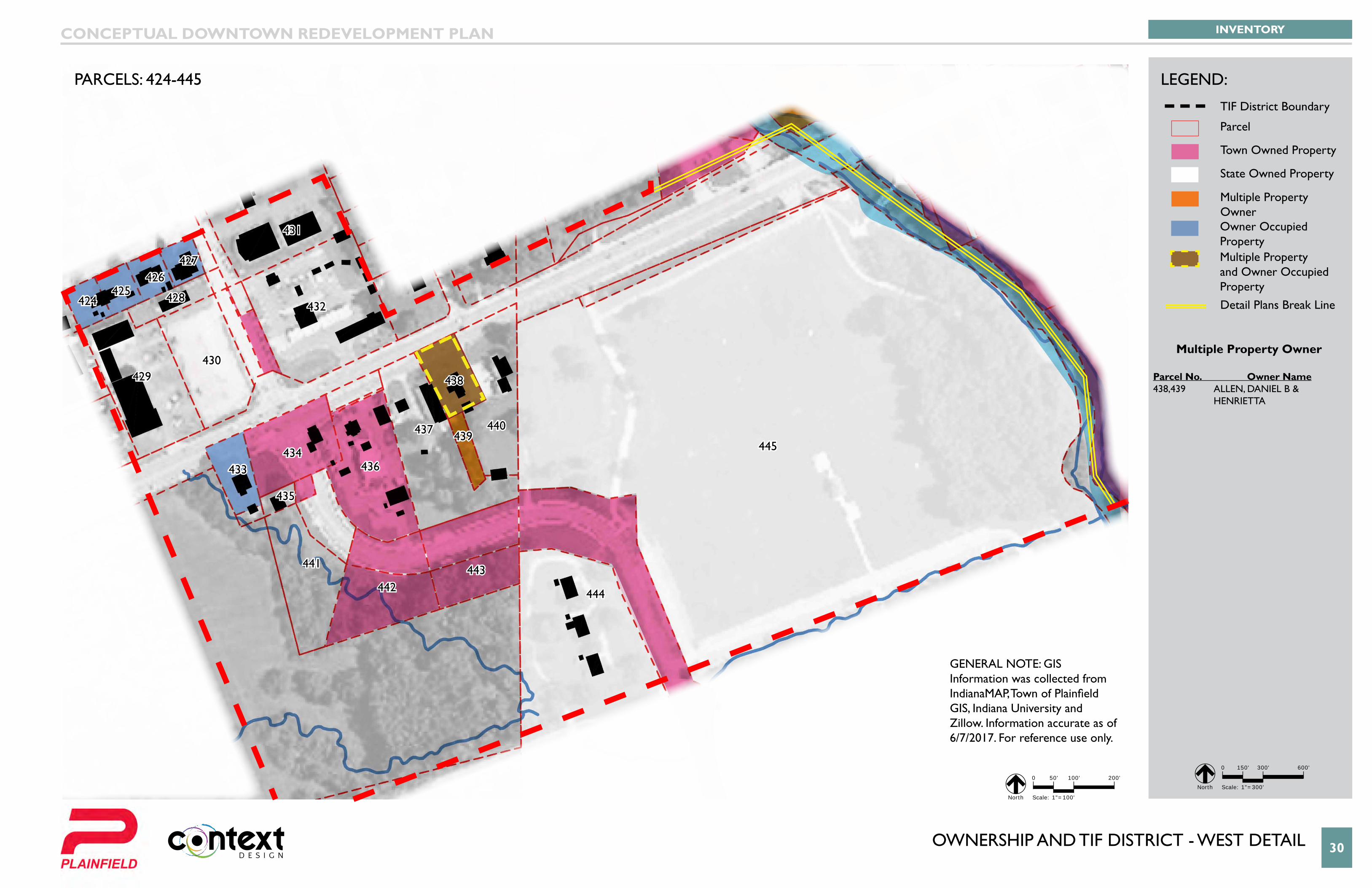
oWneRsHIP anD tIf DIstRIct - West DetaIl 30
Van Buren Elementary
School
424425
426427
428
429430
431
432
433434
435
436
437
438
439440
441
442443
444
445
INVENTORYCONCEPTUAL DOWNTOWN REDEVELOPMENT PLAN
PARCELS: 424-445 LEGEND:
0 150' 300' 600'
Scale: 1"=300' North
TIF District Boundary
Parcel
Town Owned Property
State Owned Property
Multiple Property Owner
GeneRal note: GIs Information was collected from IndianaMAP, Town of Plainfield GIS, Indiana University and Zillow. Information accurate as of 6/7/2017. For reference use only.
Owner Occupied PropertyMultiple Property and Owner Occupied Property
Multiple Property Owner
Parcel No. Owner Name438,439 ALLEN, DANIEL B & HenRIetta
Detail Plans Break Line
0 50' 100' 200'
Scale: 1"=100' North
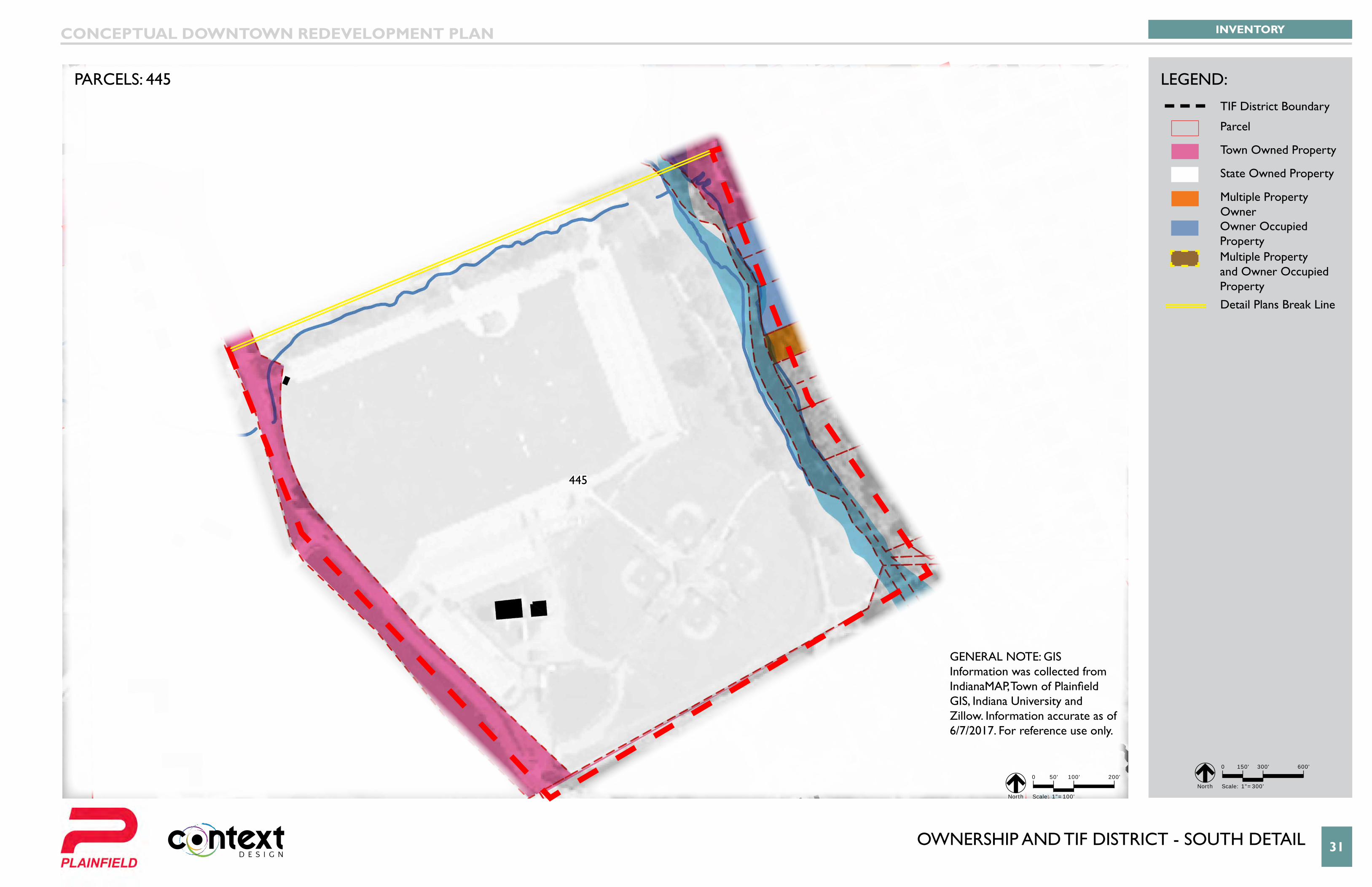
oWneRsHIP anD tIf DIstRIct - soUtH DetaIl 31
Van Buren Elementary
School
445
INVENTORYCONCEPTUAL DOWNTOWN REDEVELOPMENT PLAN
PARCELS: 445 LEGEND:
0 150' 300' 600'
Scale: 1"=300' North
TIF District Boundary
Parcel
Town Owned Property
State Owned Property
Multiple Property Owner
GeneRal note: GIs Information was collected from IndianaMAP, Town of Plainfield GIS, Indiana University and Zillow. Information accurate as of 6/7/2017. For reference use only.
Owner Occupied PropertyMultiple Property and Owner Occupied PropertyDetail Plans Break Line
0 50' 100' 200'
Scale: 1"=100' North
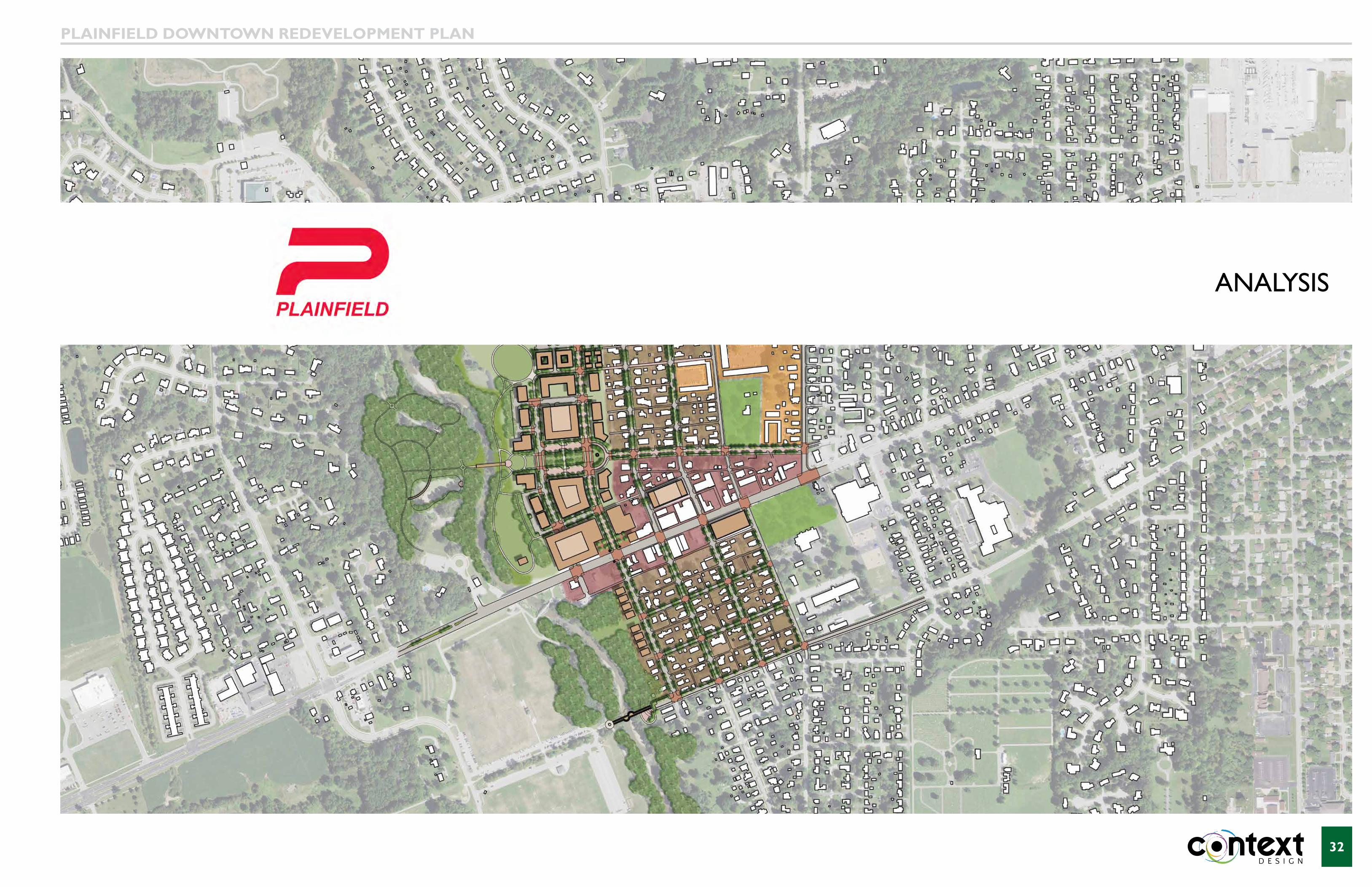
32
analYsIs
PLAiNFiELD DOWNTOWN REDEVELOPMENT PLAN
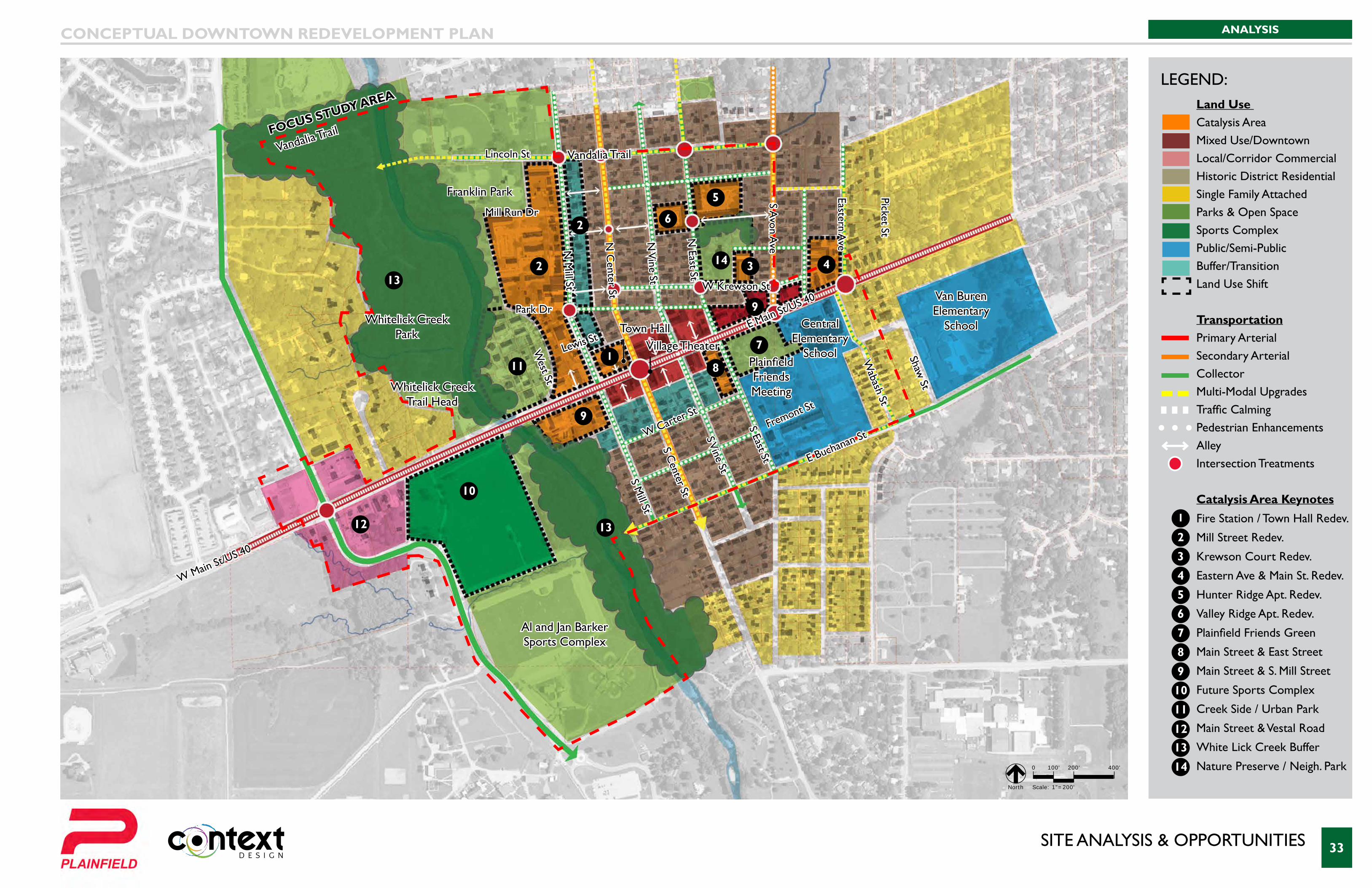
sIte analYsIs & oPPoRtUnItIes 33
Van Buren Elementary
School
W Krewson St
Mill Run Dr
Lewis St
Park Dr
Lincoln St Vandalia TrailVandalia Trail
W Carter St
Fremont St
S Mill St
West St
N M
ill St
N C
enter St
S Center St
S Vine St
N V
ine St
N East St
S Avon A
ve
Eastern Ave
Picket St
S East St
Wabash St
Shaw St
E Main St/US 40
W Main St/US 40
Whitelick Creek Park
Whitelick Creek Trail Head
Franklin Park
Al and Jan Barker Sports Complex
Central Elementary
School
Van Buren Elementary
School
Plainfield Friends Meeting
Town HallVillage Theater
FOCuS STuDy AREA
E Buchanan St
ANALYSISCONCEPTUAL DOWNTOWN REDEVELOPMENT PLAN
LEGEND:
0 100' 200' 400'
Scale: 1"=200' North
Land Use Catalysis AreaMixed Use/DowntownLocal/Corridor CommercialHistoric District ResidentialSingle Family AttachedParks & Open SpaceSports Complex Public/Semi-PublicBuffer/TransitionLand Use Shift
Transportation Primary ArterialSecondary ArterialCollectorMulti-Modal UpgradesTraffic CalmingPedestrian EnhancementsAlleyIntersection Treatments Catalysis Area Keynotes
Fire Station / Town Hall Redev.
Mill Street Redev.
Krewson Court Redev.
Eastern Ave & Main St. Redev.
Hunter Ridge Apt. Redev.
Valley Ridge Apt. Redev.
Plainfield Friends Green
Main Street & East Street
Main Street & S. Mill Street
Future Sports Complex
Creek Side / Urban Park
Main Street & Vestal Road
White Lick Creek Buffer
Nature Preserve / Neigh. Park
1
1
2
2
2
3
3
4
4
5
5
6
6
7
7
8
8
9
9
9
10
12
10
11
11
13
13
1213
14
14
sIte analYsIs - looKInG east 34
Van Buren Elementary
School
1
2
2
3
45
67
89
9
10
11
12
13
13
FOCuS STuDy AREA
N Center St
N Mill St
S Avon Ave
E M
ain
St/U
S 40
Whitelick Creek Park
Plainfield Friends Meeting
Town HallVillage Theater
E Buchanan St
S Center St
S Mill St
White Lick Creek
Lincoln St
ANALYSISCONCEPTUAL DOWNTOWN REDEVELOPMENT PLAN
LEGEND:
12
Land Use Catalysis AreaMixed Use/DowntownLocal/Corridor CommercialHistoric District ResidentialSingle Family AttachedParks & Open SpaceSports Complex Public/Semi-PublicBuffer/TransitionLand Use Shift
Transportation Primary ArterialSecondary ArterialCollectorMulti-Modal UpgradesTraffic CalmingPedestrian EnhancementsAlleyIntersection Treatments Catalysis Area Keynotes
Fire Station / Town Hall Redev.
Mill Street Redev.
Krewson Court Redev.
Eastern Ave & Main St. Redev.
Hunter Ridge Apt. Redev.
Valley Ridge Apt. Redev.
Plainfield Friends Green
Main Street & East Street
Main Street & S. Mill Street
Future Sports Complex
Creek Side / Urban Park
Main Street & Vestal Road
White Lick Creek Buffer
Nature Preserve / Neigh. Park
1
2
3
4
5
6
7
8
9
10
11
1213
14
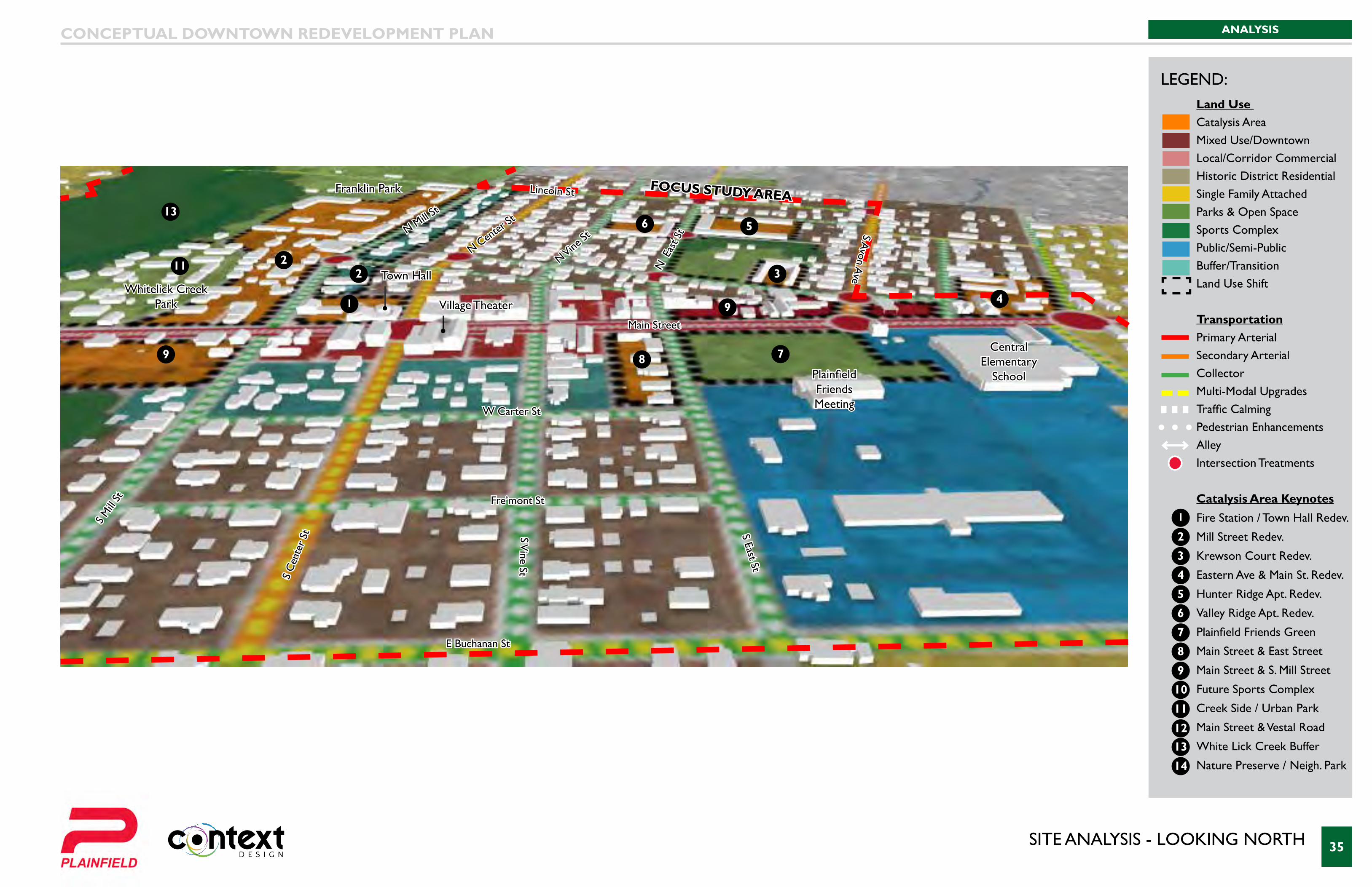
sIte analYsIs - looKInG noRtH 35
Van Buren Elementary
School
1
22 3
4
56
789
9
11
13
FOCuS STuDy AREALincoln St
W Carter St
Fre’mont St
Main Street
E Buchanan St
N Center
St
N Vine St
N E
ast S
t
S C
ente
r St
S Mill
St
N Mill St
S Vine St
S East St
S Avon A
ve
Whitelick Creek Park
Franklin Park
Plainfield Friends Meeting
Central Elementary
School
Town Hall
Village Theater
ANALYSISCONCEPTUAL DOWNTOWN REDEVELOPMENT PLAN
LEGEND:Land Use Catalysis AreaMixed Use/DowntownLocal/Corridor CommercialHistoric District ResidentialSingle Family AttachedParks & Open SpaceSports Complex Public/Semi-PublicBuffer/TransitionLand Use Shift
Transportation Primary ArterialSecondary ArterialCollectorMulti-Modal UpgradesTraffic CalmingPedestrian EnhancementsAlleyIntersection Treatments Catalysis Area Keynotes
Fire Station / Town Hall Redev.
Mill Street Redev.
Krewson Court Redev.
Eastern Ave & Main St. Redev.
Hunter Ridge Apt. Redev.
Valley Ridge Apt. Redev.
Plainfield Friends Green
Main Street & East Street
Main Street & S. Mill Street
Future Sports Complex
Creek Side / Urban Park
Main Street & Vestal Road
White Lick Creek Buffer
Nature Preserve / Neigh. Park
1
2
3
4
5
6
7
8
9
10
11
1213
14
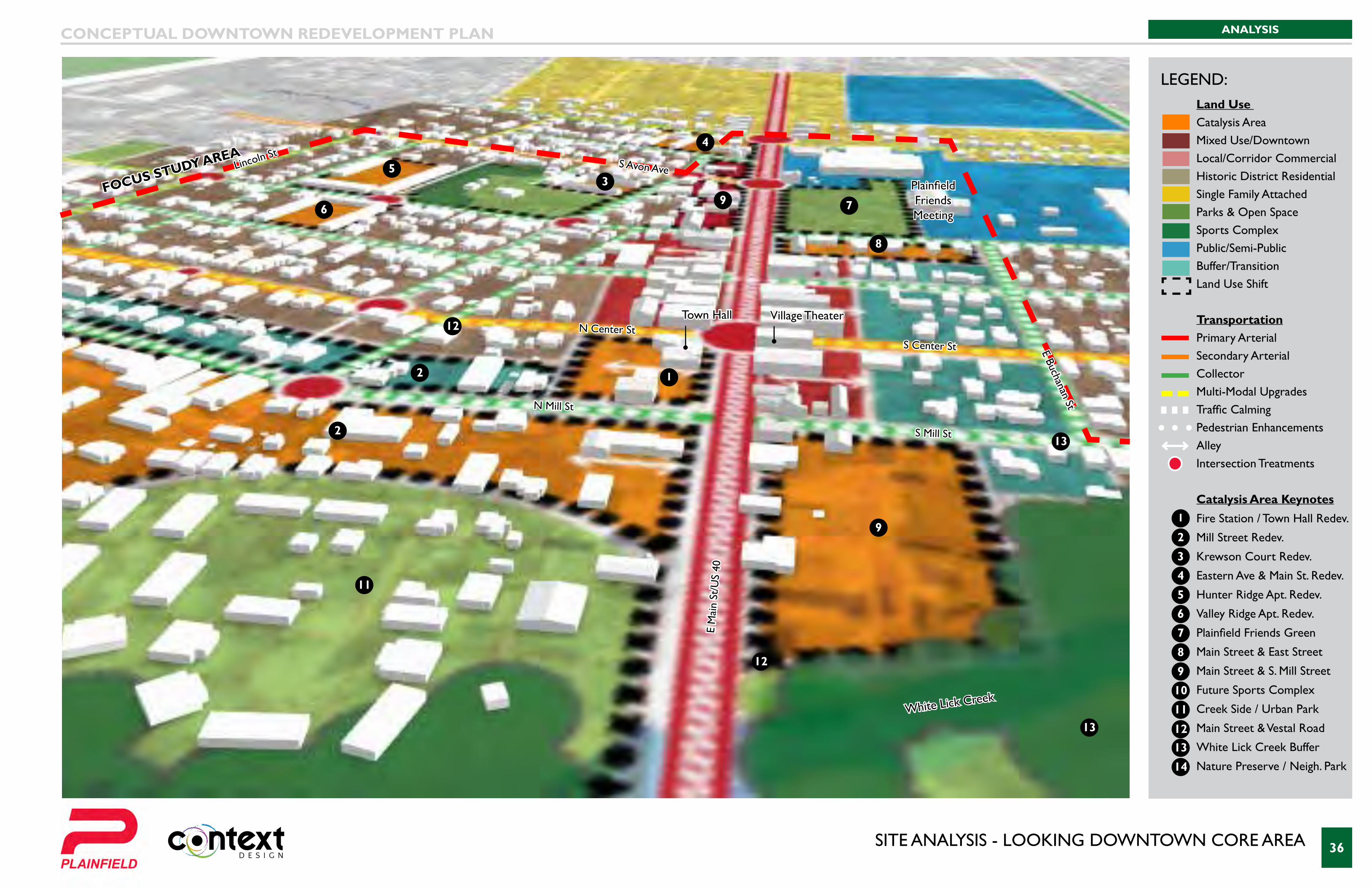
sIte analYsIs - looKInG DoWntoWn coRe aRea 36
Van Buren Elementary
School
12
2
3
4
5
6 7
8
9
9
11
12
13
13
FOCuS STuDy AREA
N Center St
N Mill St
S Avon Ave
E M
ain
St/U
S 40
Plainfield Friends Meeting
Town Hall Village TheaterE Buchanan St
S Center St
S Mill St
White Lick Creek
Lincoln St
ANALYSISCONCEPTUAL DOWNTOWN REDEVELOPMENT PLAN
LEGEND:
12
Land Use Catalysis AreaMixed Use/DowntownLocal/Corridor CommercialHistoric District ResidentialSingle Family AttachedParks & Open SpaceSports Complex Public/Semi-PublicBuffer/TransitionLand Use Shift
Transportation Primary ArterialSecondary ArterialCollectorMulti-Modal UpgradesTraffic CalmingPedestrian EnhancementsAlleyIntersection Treatments Catalysis Area Keynotes
Fire Station / Town Hall Redev.
Mill Street Redev.
Krewson Court Redev.
Eastern Ave & Main St. Redev.
Hunter Ridge Apt. Redev.
Valley Ridge Apt. Redev.
Plainfield Friends Green
Main Street & East Street
Main Street & S. Mill Street
Future Sports Complex
Creek Side / Urban Park
Main Street & Vestal Road
White Lick Creek Buffer
Nature Preserve / Neigh. Park
1
2
3
4
5
6
7
8
9
10
11
1213
14

38
concePtUal DesIGn
CONCEPTUAL DOWNTOWN REDEVELOPMENT PLAN
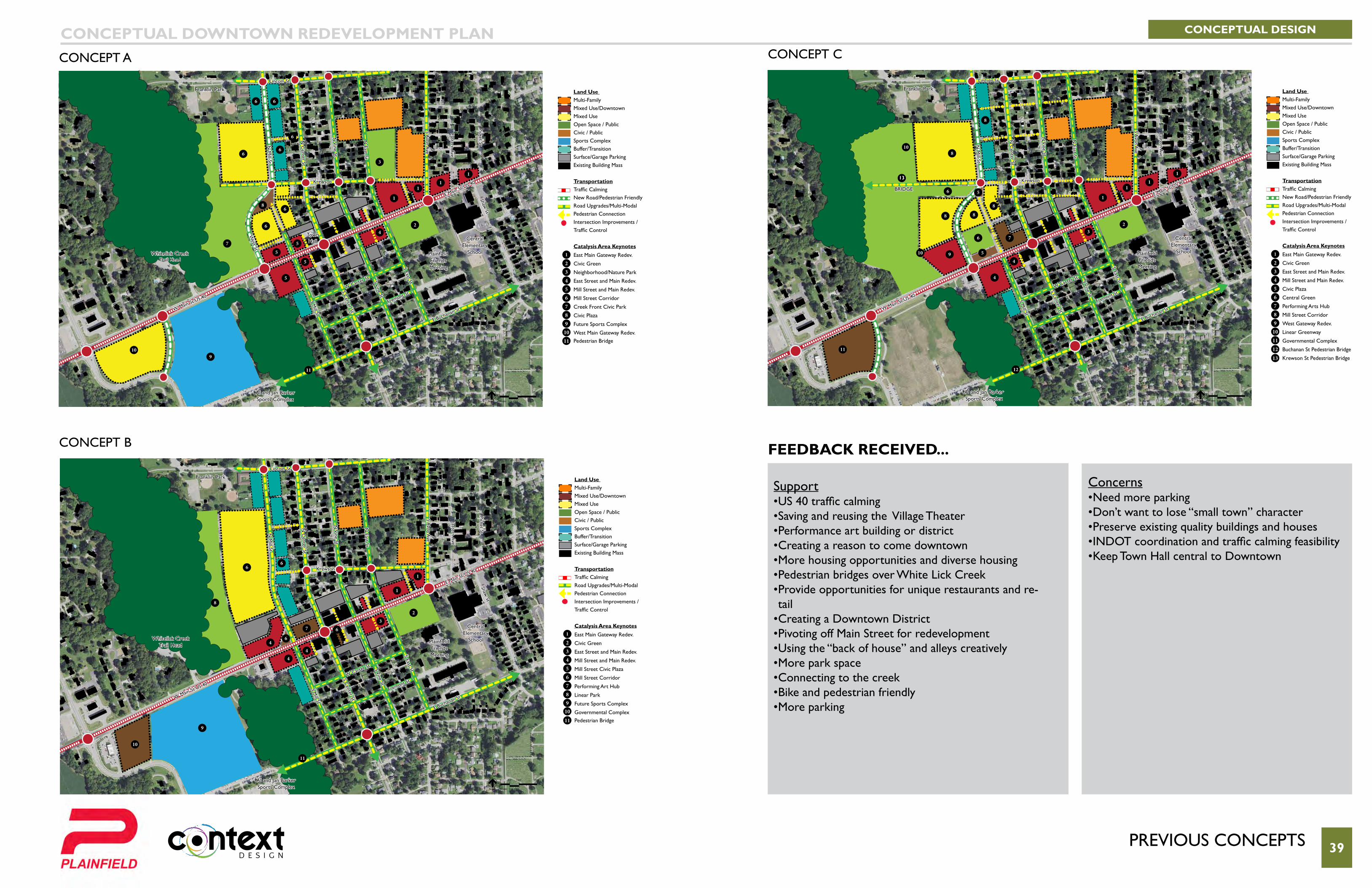
PReVIoUs concePts 39
CONCEPTUAL DESIGNCONCEPTUAL DOWNTOWN REDEVELOPMENT PLANconcePt a concePt c
concePt b
Lincoln St
W Carter St
Fremont St
S Mill St
N M
ill St
N C
enter St
S Center St
S Vine St
N V
ine St
N East St
S Avon A
ve
Eastern Ave
Picket St
S East St
Shaw St
E Main St/US 40
W Main St/US 40
Franklin Park
Al and Jan Barker Sports Complex
Central Elementary
SchoolPlainfield Friends Meeting
E Buchanan St
bRIDGe
13 Krewson
0 50' 100' 200'
Scale: 1"=100' North
5
5
6
6
4
4
7
23
11
12
8
910
10
8 8
8
8
1
11
1
Land Use Multi-FamilyMixed Use/DowntownMixed Use Open Space / PublicCivic / PublicSports Complex Buffer/TransitionSurface/Garage ParkingExisting Building Mass
Transportation Traffic CalmingNew Road/Pedestrian FriendlyRoad Upgrades/Multi-ModalPedestrian ConnectionIntersection Improvements /Traffic Control Catalysis Area Keynotes East Main Gateway Redev.
Civic Green
East Street and Main Redev.
Mill Street and Main Redev.
Civic Plaza
Central Green
Performing Arts Hub
Mill Street Corridor
West Gateway Redev.
Linear Greenway
Governmental Complex
Buchanan St Pedestrian Bridge
Krewson St Pedestrian Bridge
1
23456789
10111213
Krewson
Lincoln St
W Carter St
Fremont St
S Mill St
N M
ill St
N C
enter St
S Center St
S Vine St
N V
ine St
N East St
S Avon A
ve
Eastern Ave
Picket St
S East St
Shaw St
E Main St/US 40
W Main St/US 40
Whitelick Creek Trail Head
Franklin Park
Al and Jan Barker Sports Complex
Central Elementary
SchoolPlainfield Friends Meeting
E Buchanan St
0 50' 100' 200'
Scale: 1"=100' North
1
1
2
3
4
9
11
10
44
6
8
6
7
6
6
Land Use Multi-FamilyMixed Use/DowntownMixed Use Open Space / PublicCivic / PublicSports Complex Buffer/TransitionSurface/Garage ParkingExisting Building Mass
Transportation Traffic CalmingRoad Upgrades/Multi-ModalPedestrian ConnectionIntersection Improvements /Traffic Control Catalysis Area Keynotes East Main Gateway Redev.
Civic Green
East Street and Main Redev.
Mill Street and Main Redev.
Mill Street Civic Plaza
Mill Street Corridor
Performing Art Hub
Linear Park
Future Sports Complex
Governmental ComplexPedestrian Bridge
1
23456789
10
11
Krewson
Lincoln St
W Carter St
Fremont St
S Mill St
West St
N M
ill St
N C
enter St
S Center St
S Vine St
N V
ine St
N East St
S Avon A
ve
Eastern Ave
Picket St
S East St
Shaw St
E Main St/US 40
W Main St/US 40
Whitelick Creek Trail Head
Franklin Park
Al and Jan Barker Sports Complex
Central Elementary
SchoolPlainfield Friends Meeting
Town Hall
E Buchanan St
0 50' 100' 200'
Scale: 1"=100' North
Land Use Multi-FamilyMixed Use/DowntownMixed Use Open Space / PublicCivic / PublicSports Complex Buffer/TransitionSurface/Garage ParkingExisting Building Mass
Transportation Traffic CalmingNew Road/Pedestrian FriendlyRoad Upgrades/Multi-ModalPedestrian ConnectionIntersection Improvements /Traffic Control Catalysis Area Keynotes East Main Gateway Redev.
Civic Green
Neighborhood/Nature Park
East Street and Main Redev.
Mill Street and Main Redev.
Mill Street Corridor
Creek Front Civic Park
Civic Plaza
Future Sports Complex
West Main Gateway Redev.Pedestrian Bridge
15
5
5
5
8
24
3
7
910
11
6
6 6
6
6
6
6
1
11
1
23456789
1011
FEEDBACK RECEIVED...
Support• US 40 traffic calming• Saving and reusing the Village Theater• Performance art building or district• Creating a reason to come downtown• More housing opportunities and diverse housing• Pedestrian bridges over White Lick Creek• Provide opportunities for unique restaurants and re-tail
• Creating a Downtown District• Pivoting off Main Street for redevelopment• Using the “back of house” and alleys creatively• More park space• Connecting to the creek• Bike and pedestrian friendly• More parking
Concerns• Need more parking• Don’t want to lose “small town” character• Preserve existing quality buildings and houses• INDOT coordination and traffic calming feasibility• Keep Town Hall central to Downtown
coMbIneD concePt 40
Van Buren Elementary
School
Krewson St.
New St.
Elm St.
Lincoln St
White Lick Creek Trail
Vandalia Trail
W Carter StFremont St
S Mill St
N M
ill St
N C
enter St
S Center St
S Vine St
N V
ine St
N East St
S Avon Ave
Eastern Ave
Indiana St
Picket St
White Lick Creek
S East St
Wabash St
Shaw St
E Main St/US 40
W Main St/US 40
Whitelick Creek Trail Head
Franklin Park
Al and Jan Barker Sports Complex
Central Elementary School
Plainfield Friends Meeting
Town Hall
Focus study AreA
E Buchanan St
CONCEPTUAL DESIGNCONCEPTUAL DOWNTOWN REDEVELOPMENT PLAN
LEGEND:
0 100' 200' 400'
Scale: 1"=200' North
10
10
8
1211
11
11
2
4
56
7
3
9
1415
16
13
13
13
1
Land Use Redevelopment OpportunityMain Street Infill Opportunity Open Space / Public SpaceSports Complex Buffer/TransitionSurface/Garage ParkingExisting Building Mass
Transportation Traffic CalmingRoad Upgrades/Multi-ModalPedestrian ConnectionIntersection Improvements /Traffic Control Catalysis Area Keynotes
East Main Gateway Redev.
Civic Green
Neighborhood/Nature Park
Avon Ave and Krewson Redev.
Hunters Ridge Redev.
Valley Ridge Redev.
East Street and Main Redev.
Performance Center
Gateway Plaza
East Main Gateway Redev.
Mill Street Corridor Redev.
Mill Run Redev.
Linear Creek Front Park
Future Sports Complex
Main and Vestal Redev.Pedestrian Bridge
1
23456789
10111213
141516
16
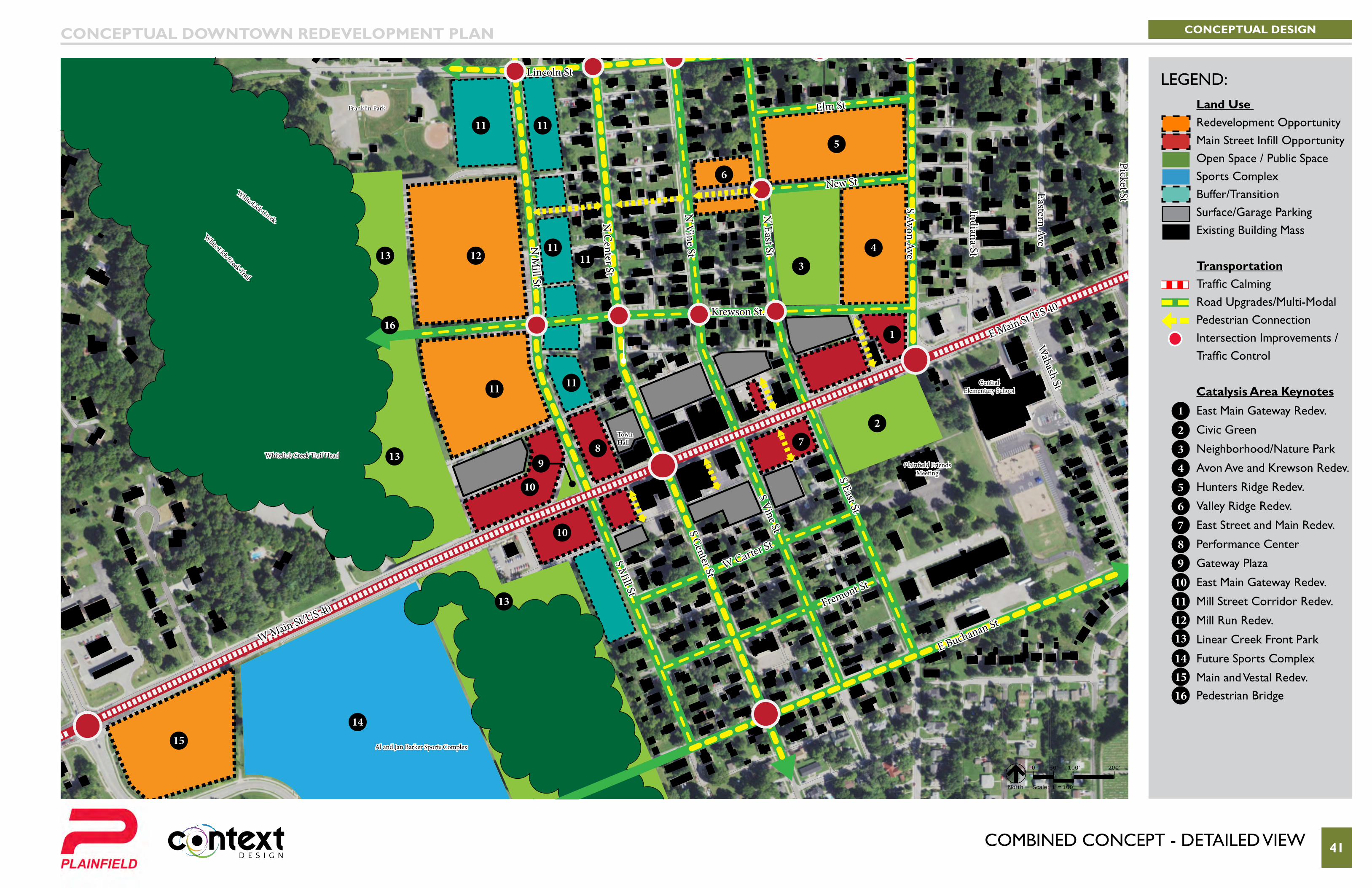
coMbIneD concePt - DetaIleD VIeW 41
Van Buren Elementary
School
Krewson St.
New St
Elm St
Lincoln St
White Lick Creek Trail
W Carter St
Fremont St
S Mill St
N M
ill St
N C
enter St
S Center St
S Vine St
N V
ine St
N East St
S Avon Ave
Eastern Ave
Indiana St
Picket StWhite Lick Creek
S East St
Wabash St
E Main St/US 40
W Main St/US 40
Whitelick Creek Trail Head
Franklin Park
Al and Jan Barker Sports Complex
Central Elementary School
Plainfield Friends Meeting
Town Hall
E Buchanan St
CONCEPTUAL DESIGNCONCEPTUAL DOWNTOWN REDEVELOPMENT PLAN
LEGEND:
0 50' 100' 200'
Scale: 1"=100' North
10
10
8
12 11
1111
11 11
11
2
4
5
6
7
3
9
14
15
13
13
13
1
Land Use Redevelopment OpportunityMain Street Infill Opportunity Open Space / Public SpaceSports Complex Buffer/TransitionSurface/Garage ParkingExisting Building Mass
Transportation Traffic CalmingRoad Upgrades/Multi-ModalPedestrian ConnectionIntersection Improvements /Traffic Control Catalysis Area Keynotes
East Main Gateway Redev.
Civic Green
Neighborhood/Nature Park
Avon Ave and Krewson Redev.
Hunters Ridge Redev.
Valley Ridge Redev.
East Street and Main Redev.
Performance Center
Gateway Plaza
East Main Gateway Redev.
Mill Street Corridor Redev.
Mill Run Redev.
Linear Creek Front Park
Future Sports Complex
Main and Vestal Redev.Pedestrian Bridge
1
23456789
10111213
141516
16
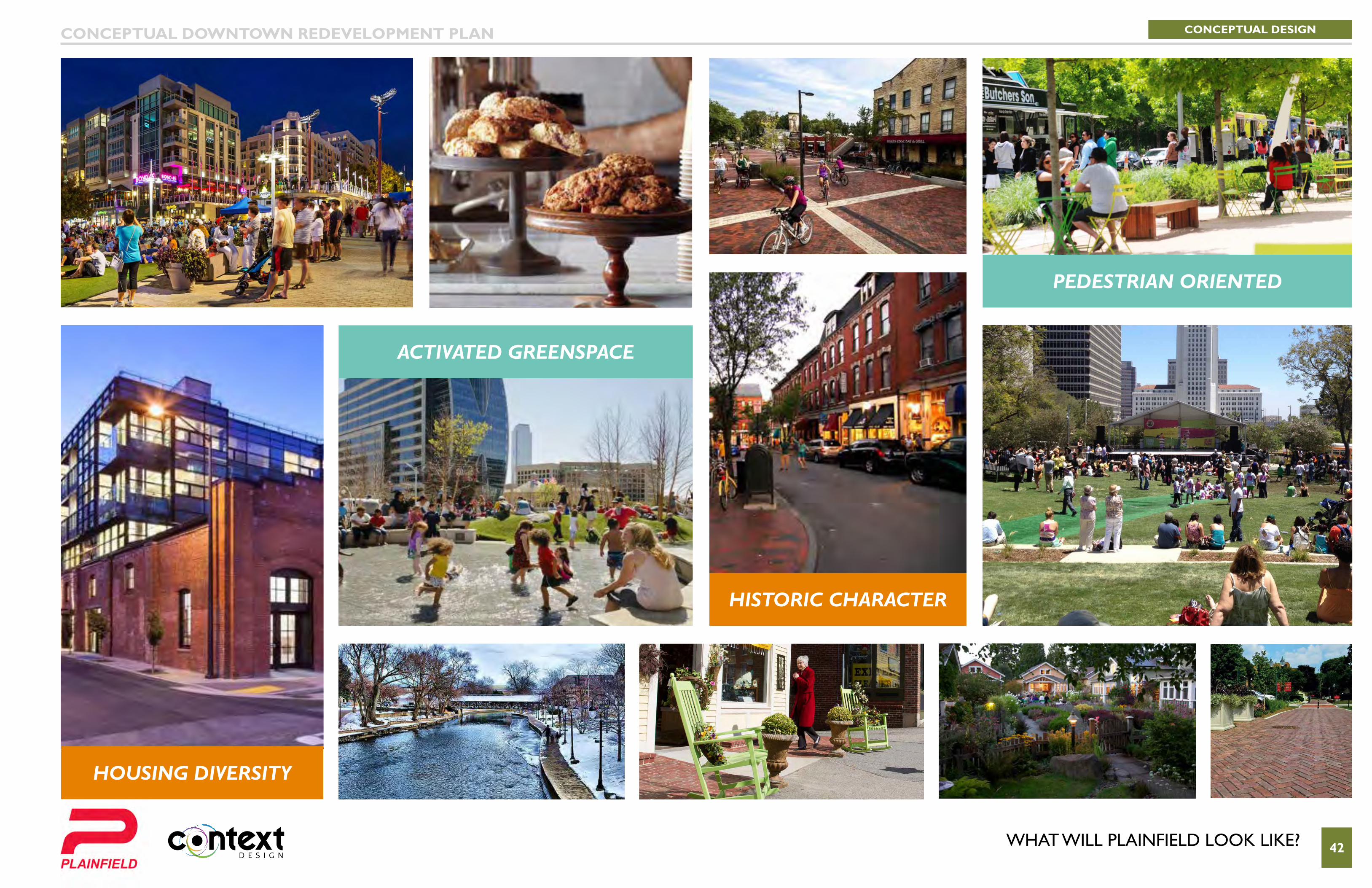
WHat WIll PlaInfIelD looK lIKe? 42
ACTIVATED GREENSPACE
PEDESTRIAN ORIENTED
HISTORIC CHARACTER
HOUSING DIVERSITY
CONCEPTUAL DESIGNCONCEPTUAL DOWNTOWN REDEVELOPMENT PLAN

WHat WIll PlaInfIelD looK lIKe? 43
GOOD FOOD
LIVE MUSIC
PERFORMING ARTS
PUBLIC ART
CONCEPTUAL DESIGNCONCEPTUAL DOWNTOWN REDEVELOPMENT PLAN

WHat WIll PlaInfIelD looK lIKe? 44
COMMUNITY BRANDING
FESTIVALS
SOCIAL MEDIA
POP-UP EVENTS
CONCEPTUAL DESIGNCONCEPTUAL DOWNTOWN REDEVELOPMENT PLAN
46
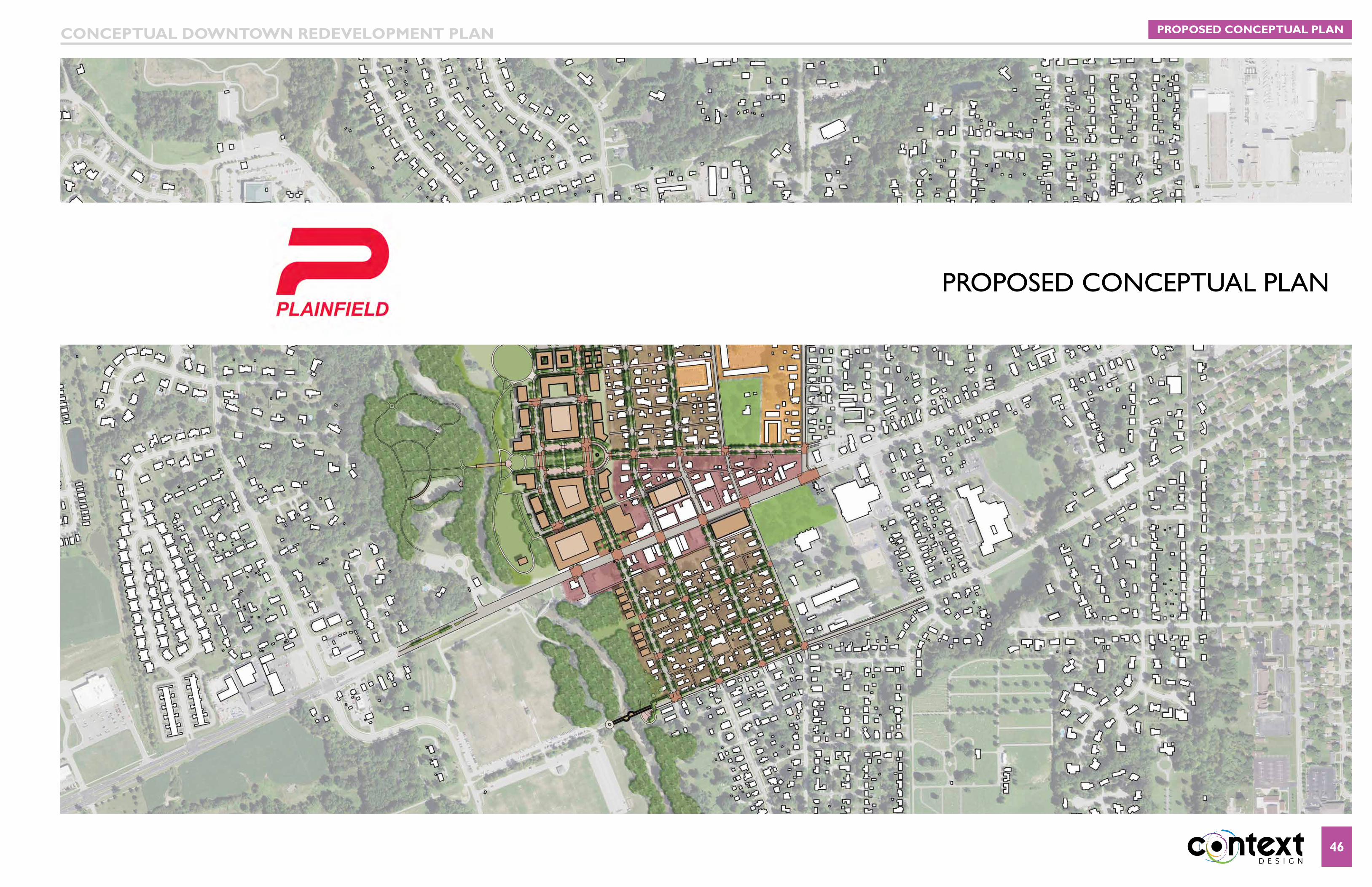
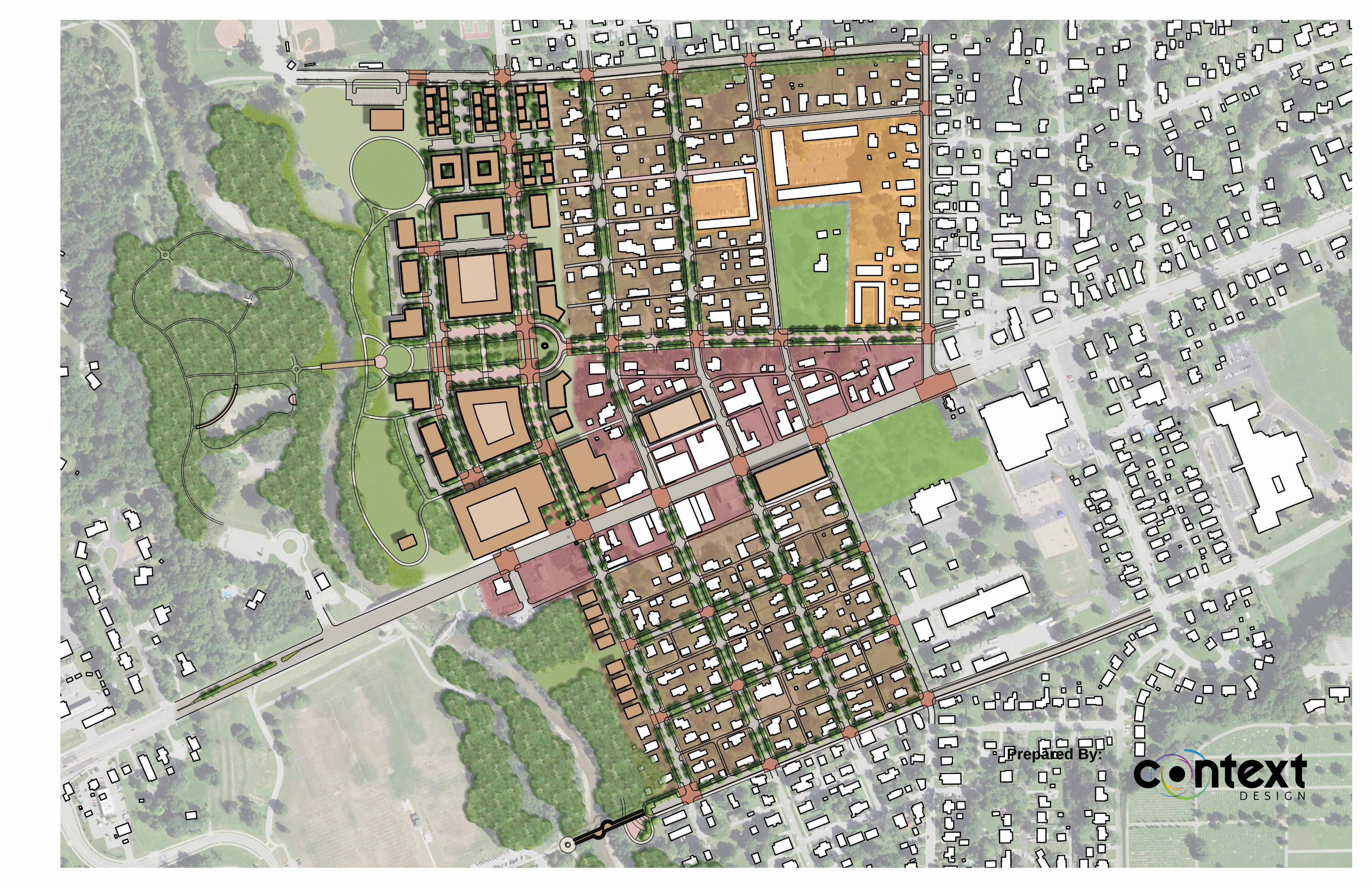
PRoPoseD concePtUal Plan
PROPOSED CONCEPTUAL PLANCONCEPTUAL DOWNTOWN REDEVELOPMENT PLAN
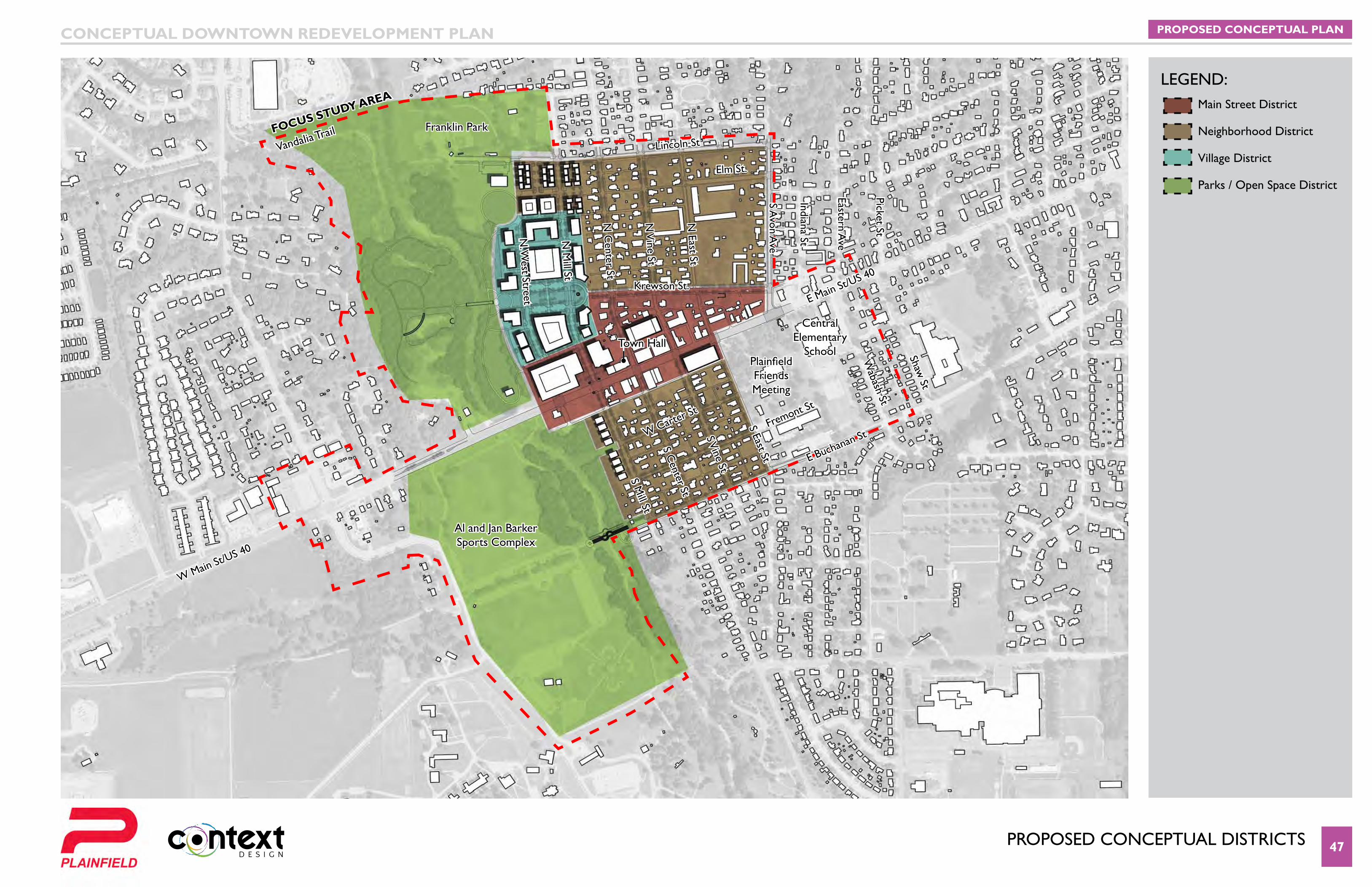
PRoPoseD concePtUal DIstRIcts 47
Van Buren Elementary
School
Krewson St.
Elm St.
Lincoln StVandalia Trail
W Carter St
Fremont St
S Mill St
N M
ill St
N. W
est Street
N C
enter St
S Center St
S Vine St
N V
ine St
N East St
S Avon A
ve
Eastern Ave
Indiana St
Picket St
S East St
Wabash St
Shaw St
E Main St/US 40
W Main St/US 40
Franklin Park
Al and Jan Barker Sports Complex
Central Elementary
SchoolPlainfield Friends Meeting
Town Hall
FOCuS STuDy AREA
E Buchanan St
PROPOSED CONCEPTUAL PLANCONCEPTUAL DOWNTOWN REDEVELOPMENT PLAN
leGenD:Main Street District
Neighborhood District
Village District
Parks / Open Space District
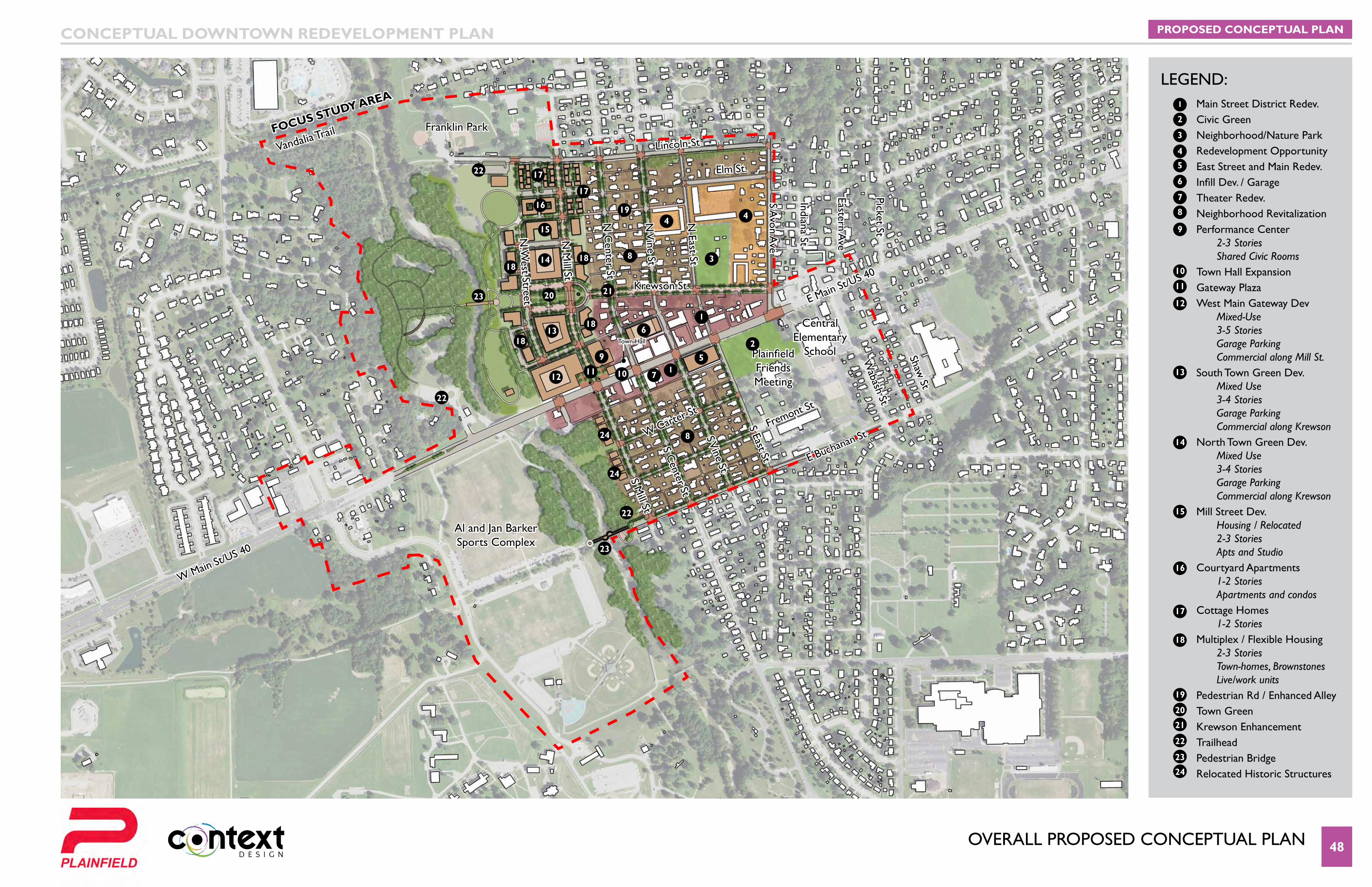
oVeRall PRoPoseD concePtUal Plan 48
Van Buren Elementary
School
Krewson St.
Elm St.
Lincoln St
W Carter St
Fremont St
S Mill St
N M
ill St
N. W
est Street
N C
enter St
S Center St
S Vine St
N V
ine St
N East St
S Avon A
ve
Eastern Ave
Indiana St
Picket St
S East St
Wabash St
Shaw St
E Main St/US 40
W Main St/US 40
Town Hall
E Buchanan St
Vandalia TrailFranklin Park
Al and Jan Barker Sports Complex
Central Elementary
School
FOCuS STuDy AREA
Plainfield Friends Meeting
PROPOSED CONCEPTUAL PLANCONCEPTUAL DOWNTOWN REDEVELOPMENT PLAN
LEGEND:1
1
1
2
2
3
3
4
44
5
5
8
8
8
13
13
14
14
6
6
7
7
9
9
10
10
11
11
15
15
16
16
17
17
17
18
1818
18
18
19
19
20
20
21
21
22
22
22
22
23
23
23
24
24
24
12
12
Main Street District Redev. Civic GreenNeighborhood/Nature ParkRedevelopment OpportunityEast Street and Main Redev.Infill Dev. / GarageTheater Redev.Neighborhood RevitalizationPerformance Center 2-3 Stories Shared Civic RoomsTown Hall ExpansionGateway PlazaWest Main Gateway Dev Mixed-Use 3-5 Stories Garage Parking Commercial along Mill St.South Town Green Dev. Mixed Use 3-4 Stories Garage Parking Commercial along Krewson North Town Green Dev. Mixed Use 3-4 Stories Garage Parking Commercial along Krewson Mill Street Dev. Housing / Relocated 2-3 Stories Apts and Studio Courtyard Apartments 1-2 Stories Apartments and condosCottage Homes 1-2 StoriesMultiplex / Flexible Housing 2-3 Stories Town-homes, Brownstones Live/work units Pedestrian Rd / Enhanced AlleyTown GreenKrewson Enhancement TrailheadPedestrian BridgeRelocated Historic Structures
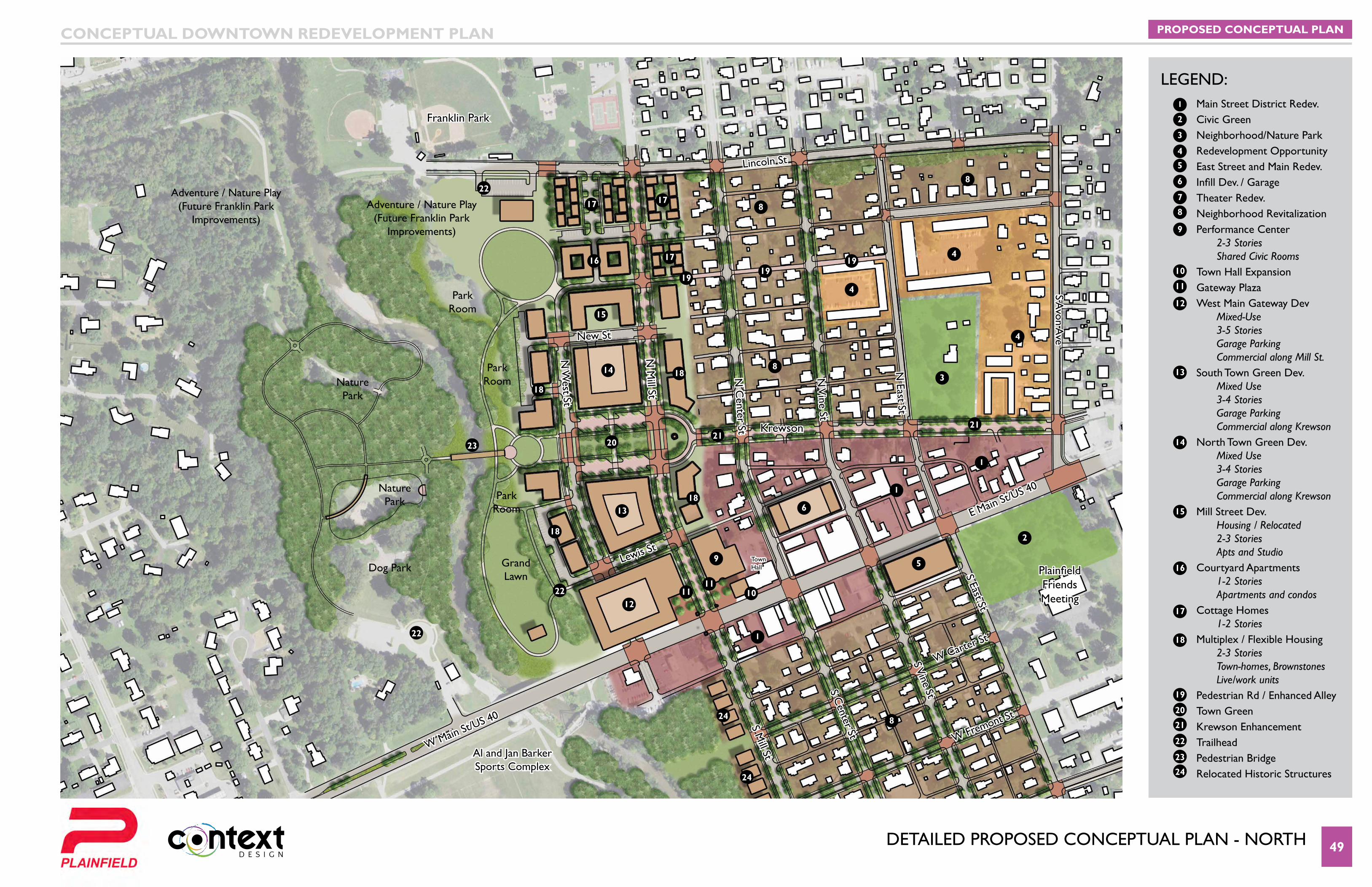
DetaIleD PRoPoseD concePtUal Plan - noRtH 49
Van Buren Elementary
School
Lincoln St
New St
Lewis St
W Carter St
W Fremont St
S Mill St
N M
ill St
N W
est St
N C
enter St
S Center St
S Vine St
N V
ine St
N East St
S Avon A
ve
S East St
E Main St/US 40
W Main St/US 40
Franklin Park
Krewson
Plainfield Friends Meeting
Town Hall
Al and Jan Barker Sports Complex
PROPOSED CONCEPTUAL PLANCONCEPTUAL DOWNTOWN REDEVELOPMENT PLAN
LEGEND:
Dog Park
NaturePark
NaturePark
Adventure / Nature Play (Future Franklin Park
Improvements)
Adventure / Nature Play (Future Franklin Park
Improvements)
Park Room
Park Room
Park Room
Grand Lawn
1
1
1
1
2
2
3
3
4
4
4
4
5
5
8
8
8
8
8
13
13
14
14
6
6
7
9
9
10
10
11
1111
15
15
16
16
17
17 17
17
18
18
18
18
18
19
1919
19
20
20
21
2121
22
22
22
22
23
23
24
24
24
12
12
Main Street District Redev. Civic GreenNeighborhood/Nature ParkRedevelopment OpportunityEast Street and Main Redev.Infill Dev. / GarageTheater Redev.Neighborhood RevitalizationPerformance Center 2-3 Stories Shared Civic RoomsTown Hall ExpansionGateway PlazaWest Main Gateway Dev Mixed-Use 3-5 Stories Garage Parking Commercial along Mill St.South Town Green Dev. Mixed Use 3-4 Stories Garage Parking Commercial along Krewson North Town Green Dev. Mixed Use 3-4 Stories Garage Parking Commercial along Krewson Mill Street Dev. Housing / Relocated 2-3 Stories Apts and Studio Courtyard Apartments 1-2 Stories Apartments and condosCottage Homes 1-2 StoriesMultiplex / Flexible Housing 2-3 Stories Town-homes, Brownstones Live/work units Pedestrian Rd / Enhanced AlleyTown GreenKrewson Enhancement TrailheadPedestrian BridgeRelocated Historic Structures
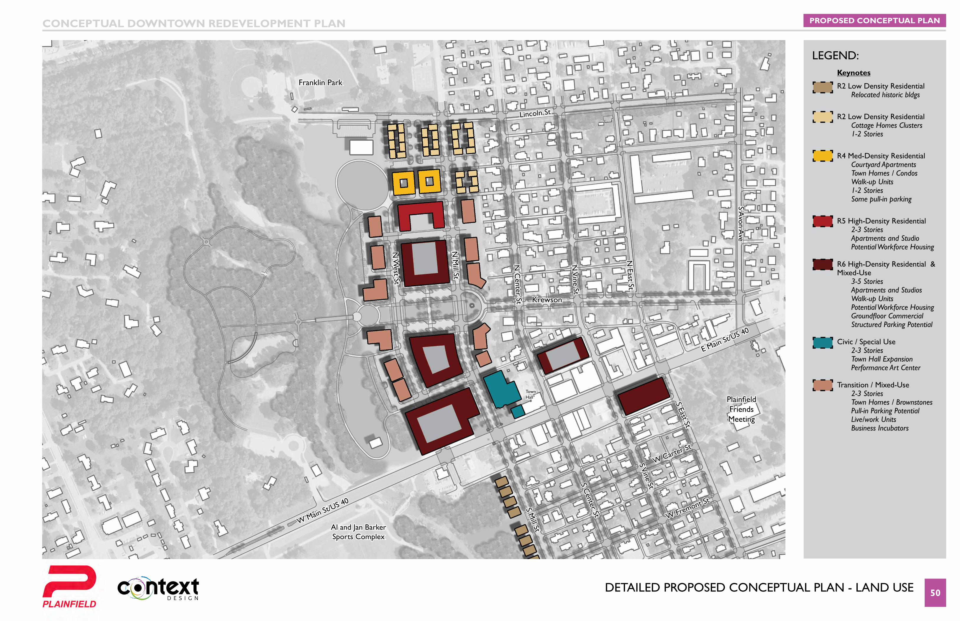
DetaIleD PRoPoseD concePtUal Plan - lanD Use 50
Van Buren Elementary
School
Lincoln St
W Carter St
W Fremont St
S Mill St
N M
ill St
N W
est St
N C
enter St
S Center St
S Vine St
N V
ine St
N East St
S Avon A
ve
S East St
E Main St/US 40
W Main St/US 40
Franklin Park
Krewson
Plainfield Friends Meeting
Town Hall
Al and Jan Barker Sports Complex
PROPOSED CONCEPTUAL PLANCONCEPTUAL DOWNTOWN REDEVELOPMENT PLAN
LEGEND:Keynotes
R2 Low Density Residential Relocated historic bldgs
R2 Low Density Residential Cottage Homes Clusters 1-2 Stories
R4 Med-Density Residential Courtyard Apartments Town Homes / Condos Walk-up Units 1-2 Stories Some pull-in parking
R5 High-Density Residential 2-3 Stories Apartments and Studio Potential Workforce Housing
R6 High-Density Residential & Mixed-Use 3-5 Stories Apartments and Studios Walk-up Units Potential Workforce Housing GroundfloorCommercial Structured Parking Potential
Civic / Special Use 2-3 Stories Town Hall Expansion Performance Art Center
Transition / Mixed-Use 2-3 Stories Town Homes / Brownstones Pull-in Parking Potential Live/work Units Business Incubators
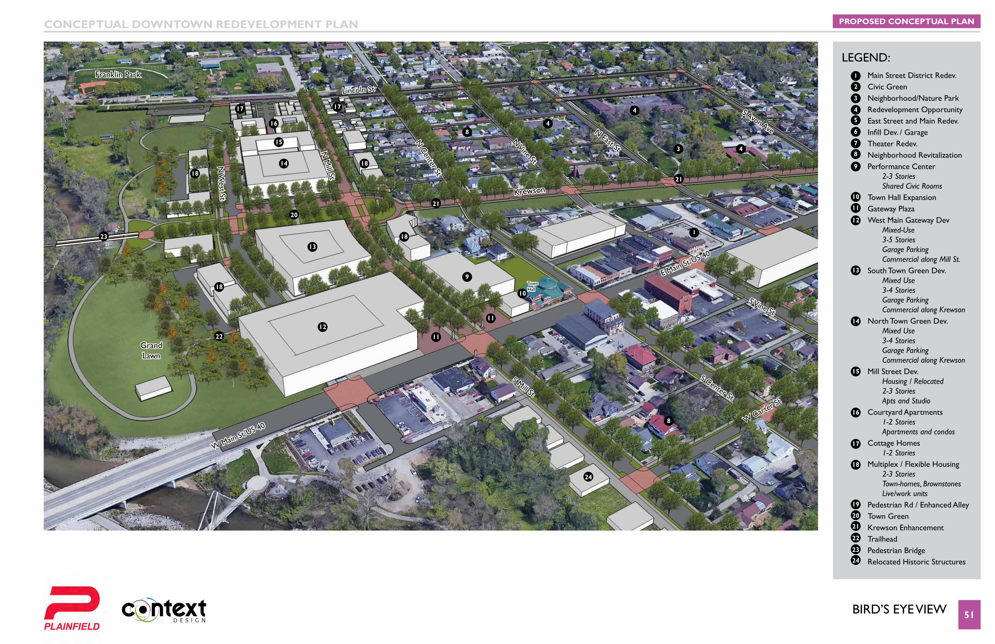
BIRD’S EYE VIEW 51
Van Buren Elementary
School
Lincoln St
W Carter St
S Mill St
N M
ill St
N W
est St
N Center St
S Center St
S Vine St
N Vine St
N East St
S Avon Ave
E Main St/US 40
W Main St/US 40
Franklin Park
Krewson
Town Hall
Grand Lawn
PROPOSED CONCEPTUAL PLANCONCEPTUAL DOWNTOWN REDEVELOPMENT PLAN
LEGEND:1
1
2
3
3
4
4
4
4 5
8
8
8
13
13
14
14
6
7
9
9
10
10
11
11
11
15
15
16
16
17
17 17
18
18
1818
18
19
20
20
21
21
21
22
22
23
23
24
24
12
12
Main Street District Redev. Civic GreenNeighborhood/Nature ParkRedevelopment OpportunityEast Street and Main Redev.Infill Dev. / GarageTheater Redev.Neighborhood RevitalizationPerformance Center 2-3 Stories Shared Civic RoomsTown Hall ExpansionGateway PlazaWest Main Gateway Dev Mixed-Use 3-5 Stories Garage Parking Commercial along Mill St.South Town Green Dev. Mixed Use 3-4 Stories Garage Parking Commercial along Krewson North Town Green Dev. Mixed Use 3-4 Stories Garage Parking Commercial along Krewson Mill Street Dev. Housing / Relocated 2-3 Stories Apts and Studio Courtyard Apartments 1-2 Stories Apartments and condosCottage Homes 1-2 StoriesMultiplex / Flexible Housing 2-3 Stories Town-homes, Brownstones Live/work units Pedestrian Rd / Enhanced AlleyTown GreenKrewson Enhancement TrailheadPedestrian BridgeRelocated Historic Structures
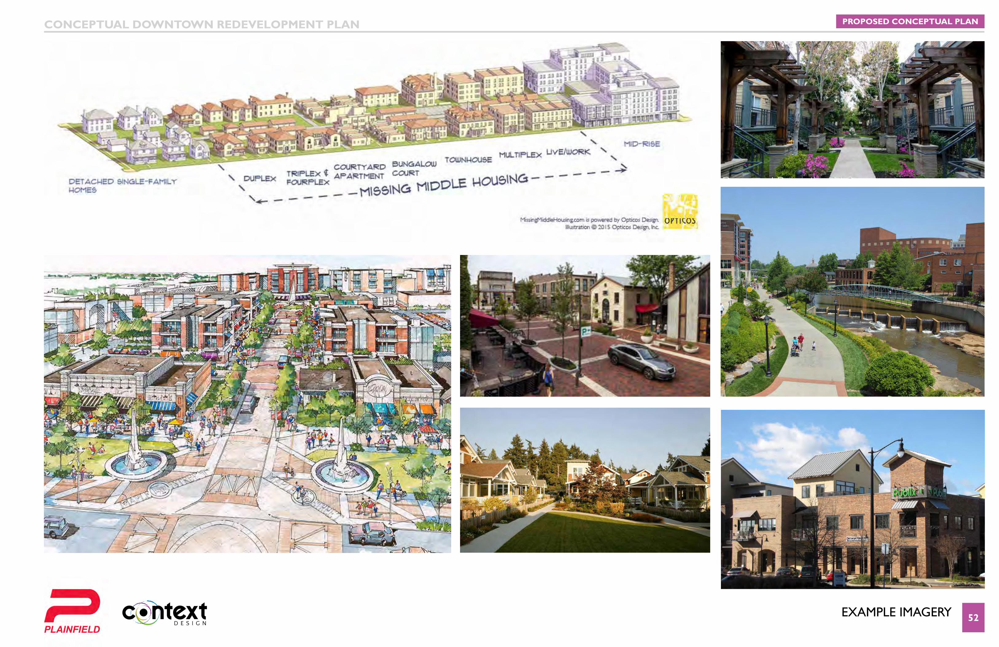
eXaMPle IMaGeRY 52
PROPOSED CONCEPTUAL PLANCONCEPTUAL DOWNTOWN REDEVELOPMENT PLAN
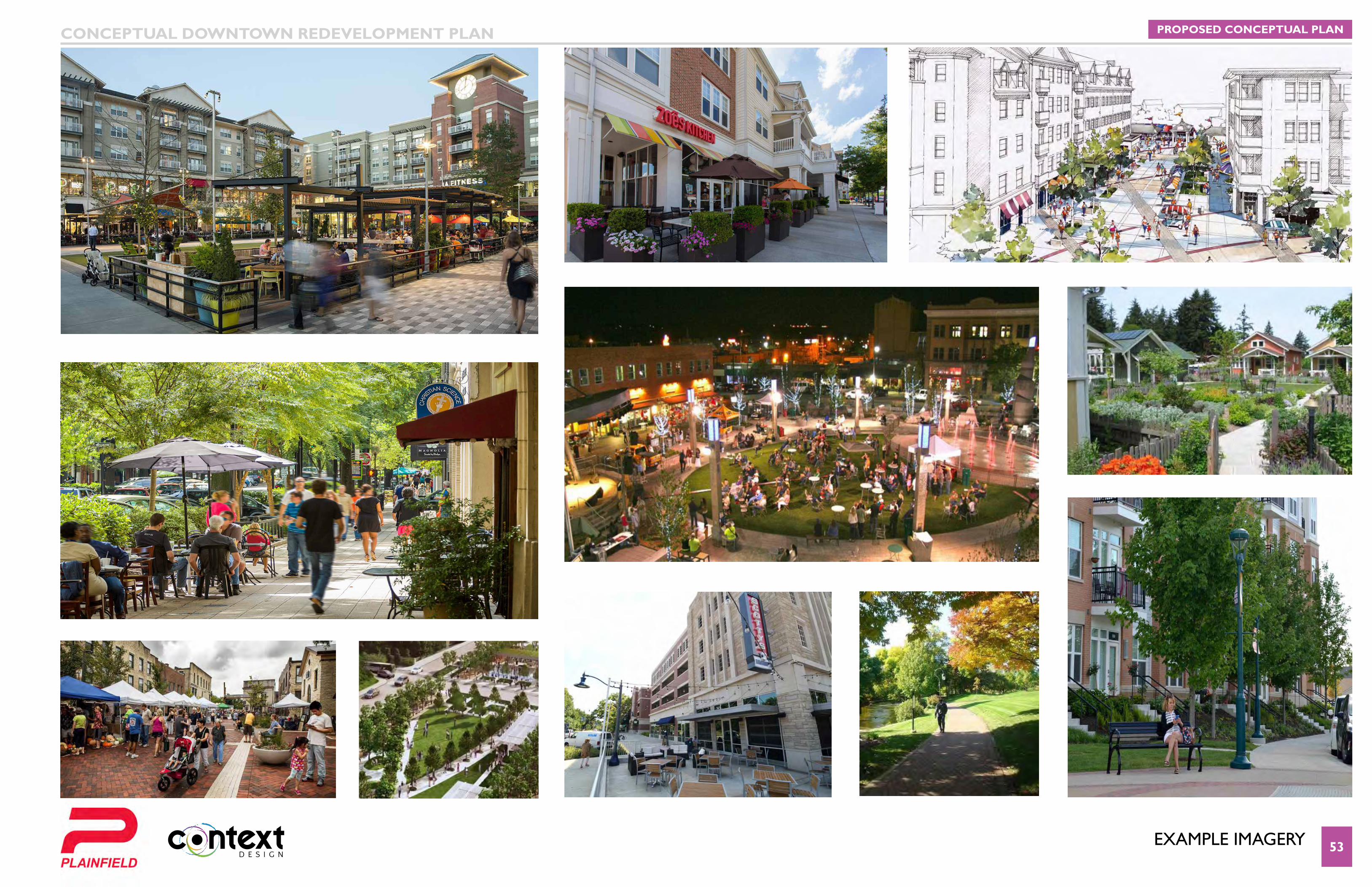
eXaMPle IMaGeRY 53
PROPOSED CONCEPTUAL PLANCONCEPTUAL DOWNTOWN REDEVELOPMENT PLAN
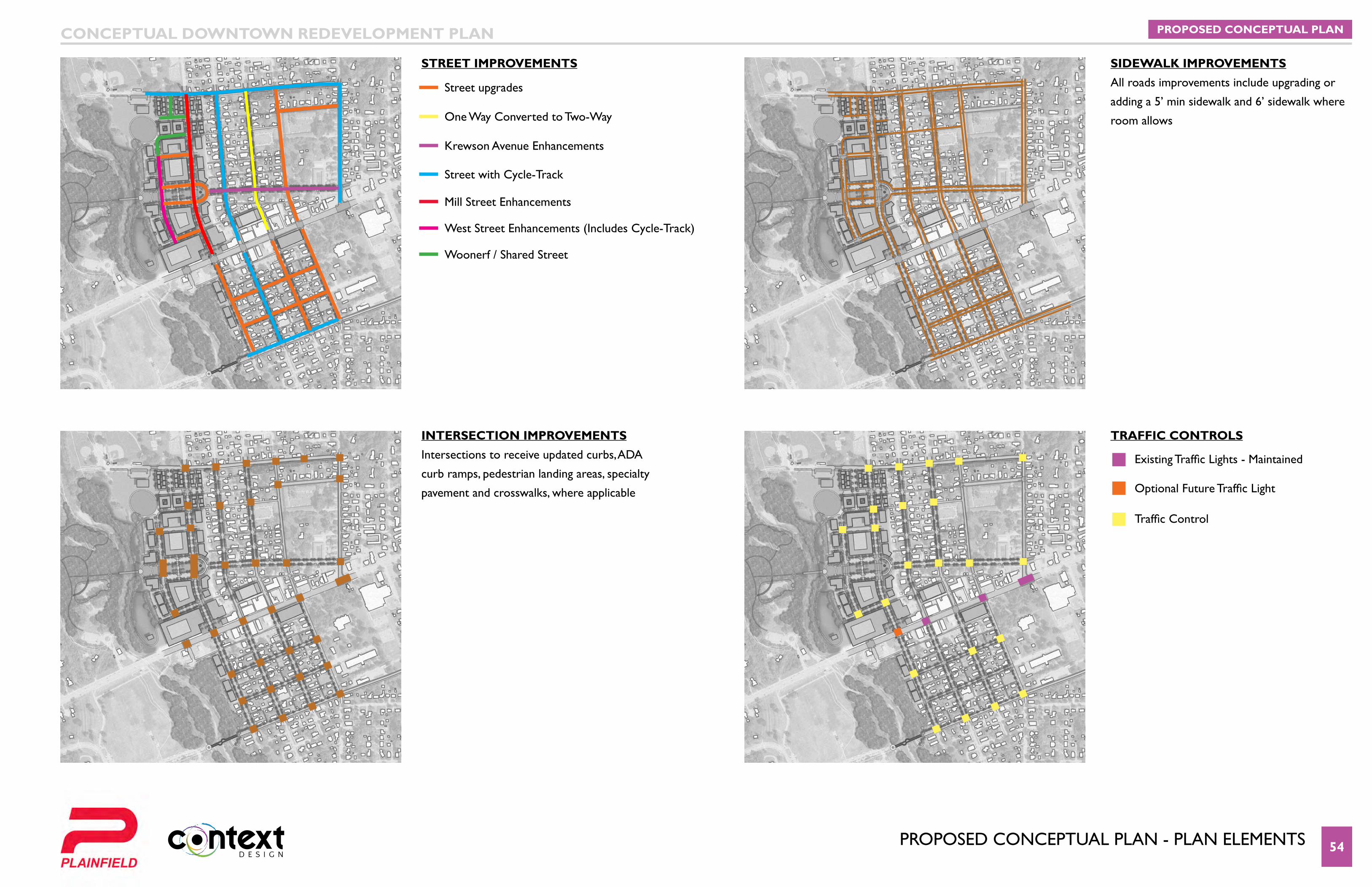
PRoPoseD concePtUal Plan - Plan eleMents 54
PROPOSED CONCEPTUAL PLANCONCEPTUAL DOWNTOWN REDEVELOPMENT PLAN
STREET iMPROVEMENTS SIDEWALK IMPROVEMENTS
All roads improvements include upgrading or
adding a 5’ min sidewalk and 6’ sidewalk where
room allows
iNTERSECTiON iMPROVEMENTS
Intersections to receive updated curbs, ADA
curb ramps, pedestrian landing areas, specialty
pavement and crosswalks, where applicable
TRAFFiC CONTROLS
Existing Traffic Lights - Maintained
Street upgrades
Optional Future Traffic Light
One Way Converted to Two-Way
Krewson Avenue Enhancements
Street with Cycle-Track
Mill Street Enhancements
West Street Enhancements (Includes Cycle-Track)
Woonerf / Shared Street
Traffic Control
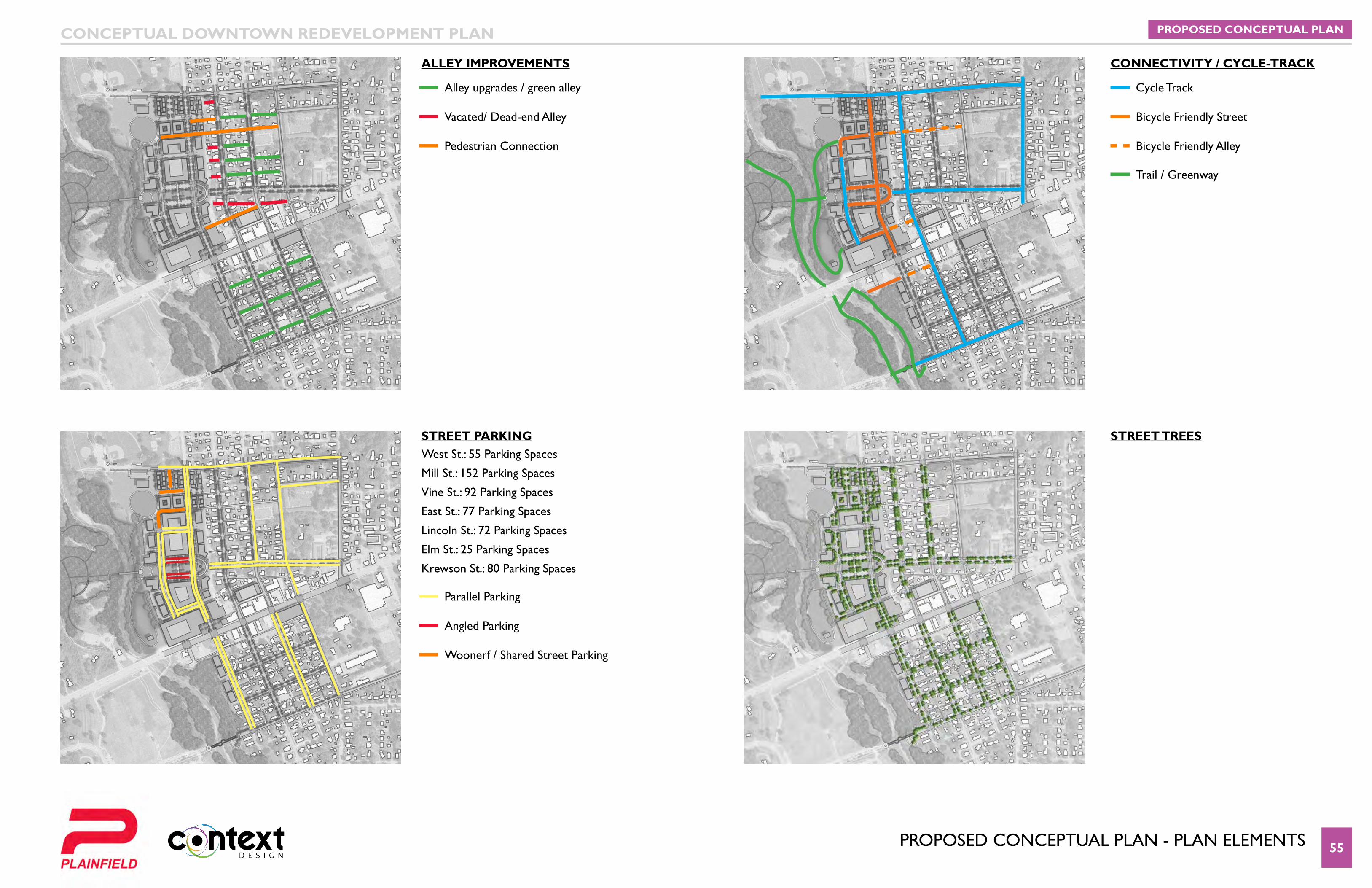
PRoPoseD concePtUal Plan - Plan eleMents 55
PROPOSED CONCEPTUAL PLANCONCEPTUAL DOWNTOWN REDEVELOPMENT PLAN
ALLEy iMPROVEMENTS CONNECTIVITY / CYCLE-TRACK
STREET PARKING West St.: 55 Parking Spaces
Mill St.: 152 Parking Spaces
Vine St.: 92 Parking Spaces
East St.: 77 Parking Spaces
Lincoln St.: 72 Parking Spaces
Elm St.: 25 Parking Spaces
Krewson St.: 80 Parking Spaces
STREET TREES
Alley upgrades / green alley
Parallel Parking
Cycle Track
Vacated/ Dead-end Alley
Angled Parking
Bicycle Friendly Street
Pedestrian Connection
Woonerf / Shared Street Parking
Bicycle Friendly Alley
Trail / Greenway
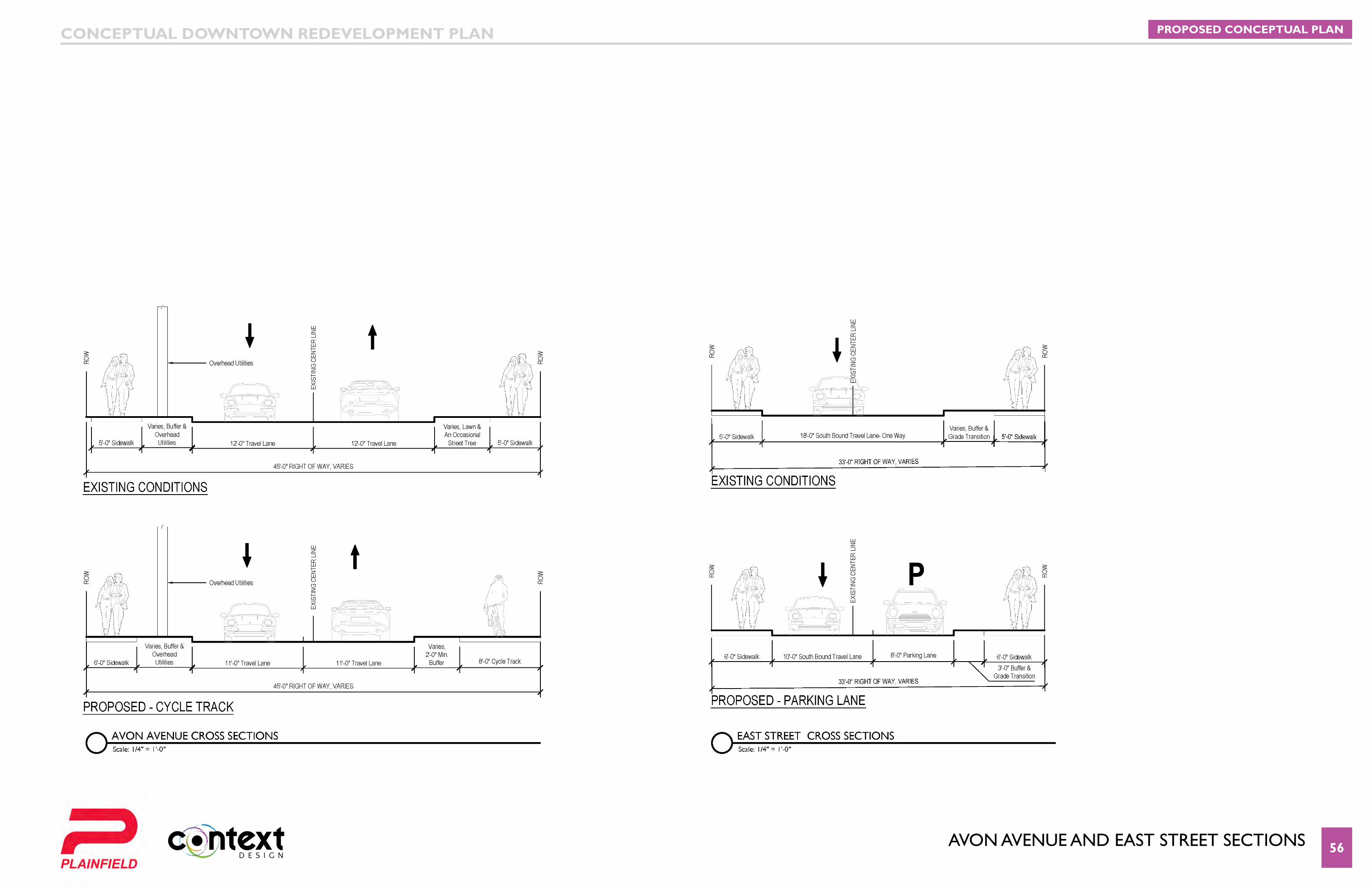
aVon aVenUe anD east stReet sectIons 56
PROPOSED CONCEPTUAL PLANCONCEPTUAL DOWNTOWN REDEVELOPMENT PLAN
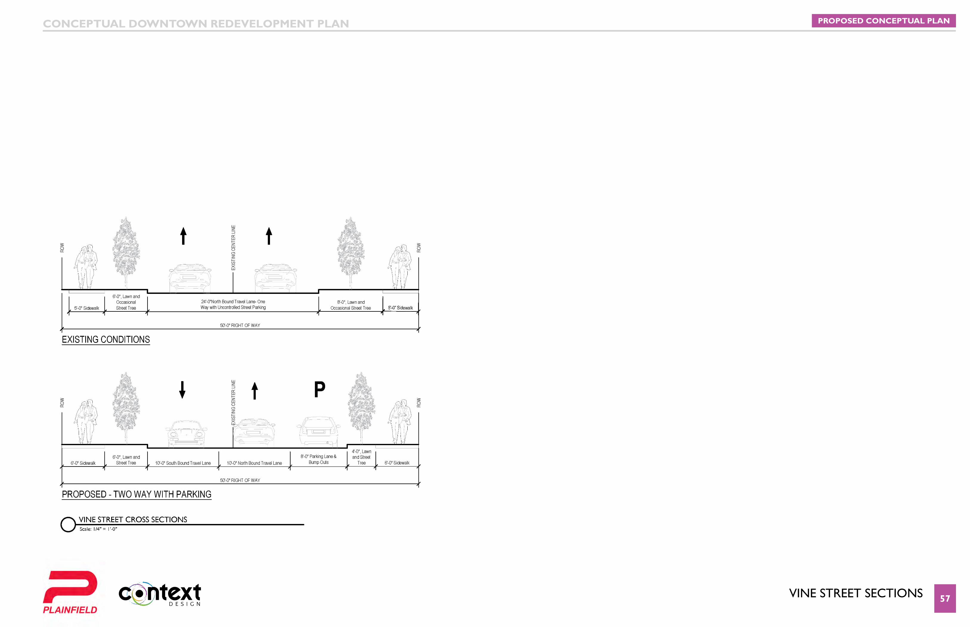
VIne stReet sectIons 57
PROPOSED CONCEPTUAL PLANCONCEPTUAL DOWNTOWN REDEVELOPMENT PLAN
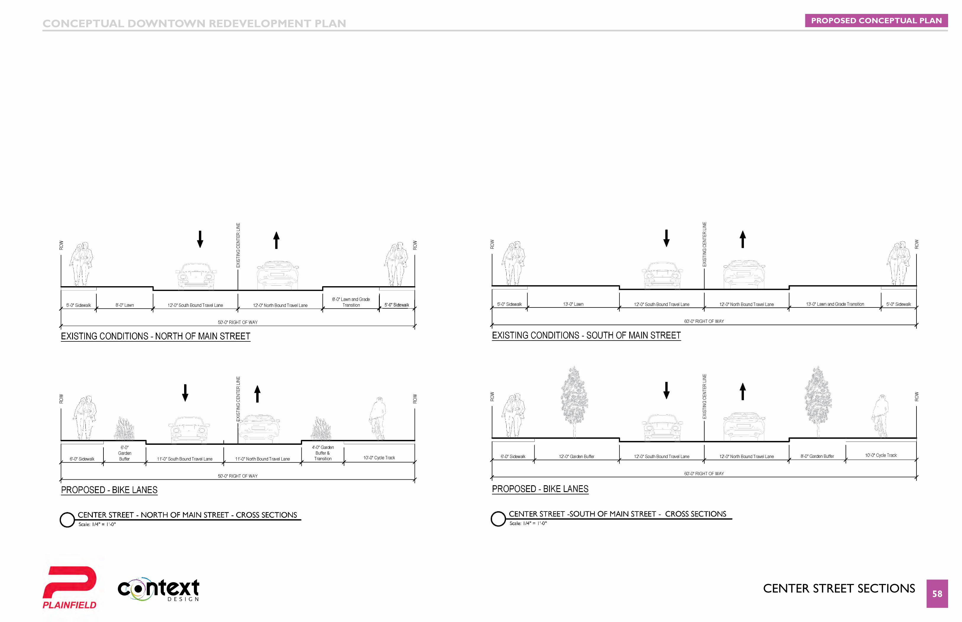
centeR stReet sectIons 58
PROPOSED CONCEPTUAL PLANCONCEPTUAL DOWNTOWN REDEVELOPMENT PLAN
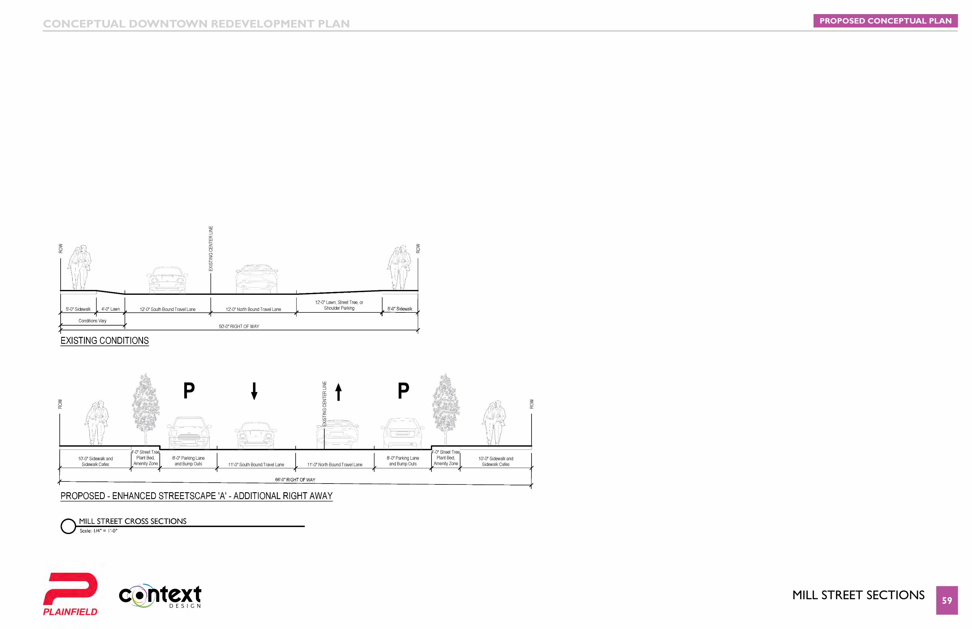
MIll stReet sectIons 59
PROPOSED CONCEPTUAL PLANCONCEPTUAL DOWNTOWN REDEVELOPMENT PLAN
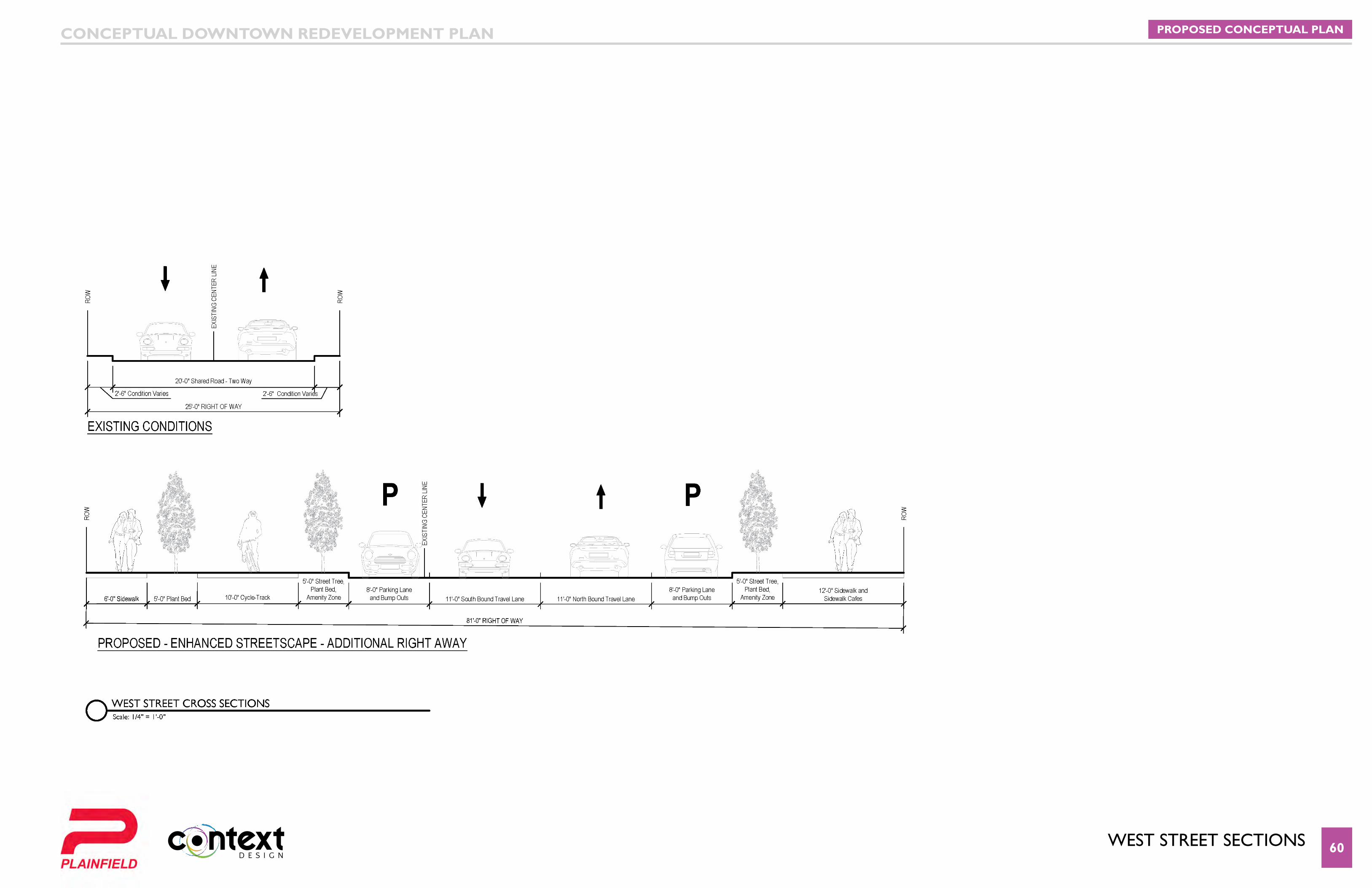
West stReet sectIons 60
PROPOSED CONCEPTUAL PLANCONCEPTUAL DOWNTOWN REDEVELOPMENT PLAN

lIncoln stReet anD KReWson stReet sectIons 61
PROPOSED CONCEPTUAL PLANCONCEPTUAL DOWNTOWN REDEVELOPMENT PLAN
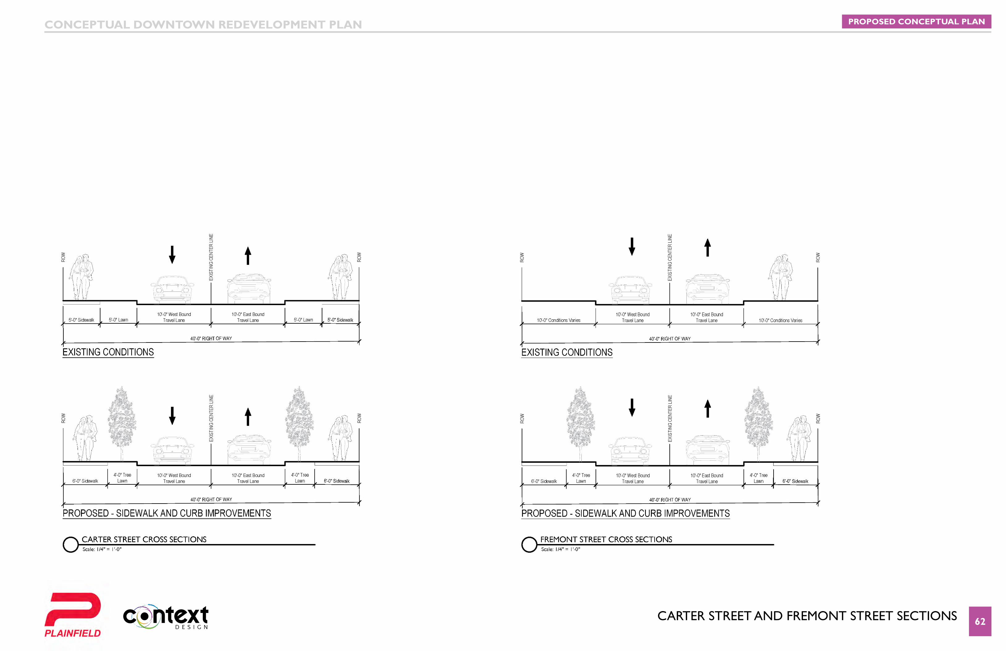
caRteR stReet anD fReMont stReet sectIons 62
PROPOSED CONCEPTUAL PLANCONCEPTUAL DOWNTOWN REDEVELOPMENT PLAN
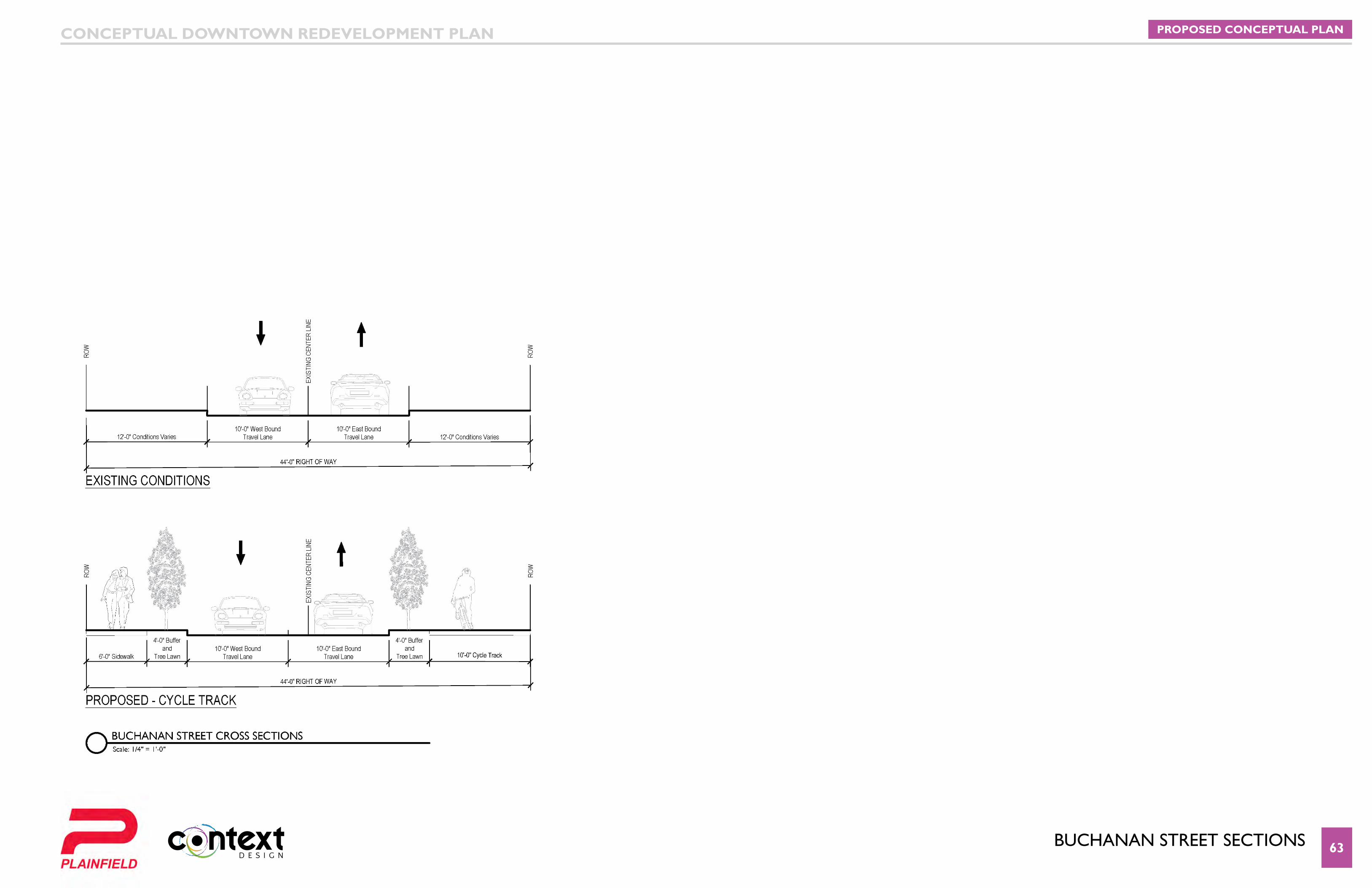
bUcHanan stReet sectIons 63
PROPOSED CONCEPTUAL PLANCONCEPTUAL DOWNTOWN REDEVELOPMENT PLAN
64
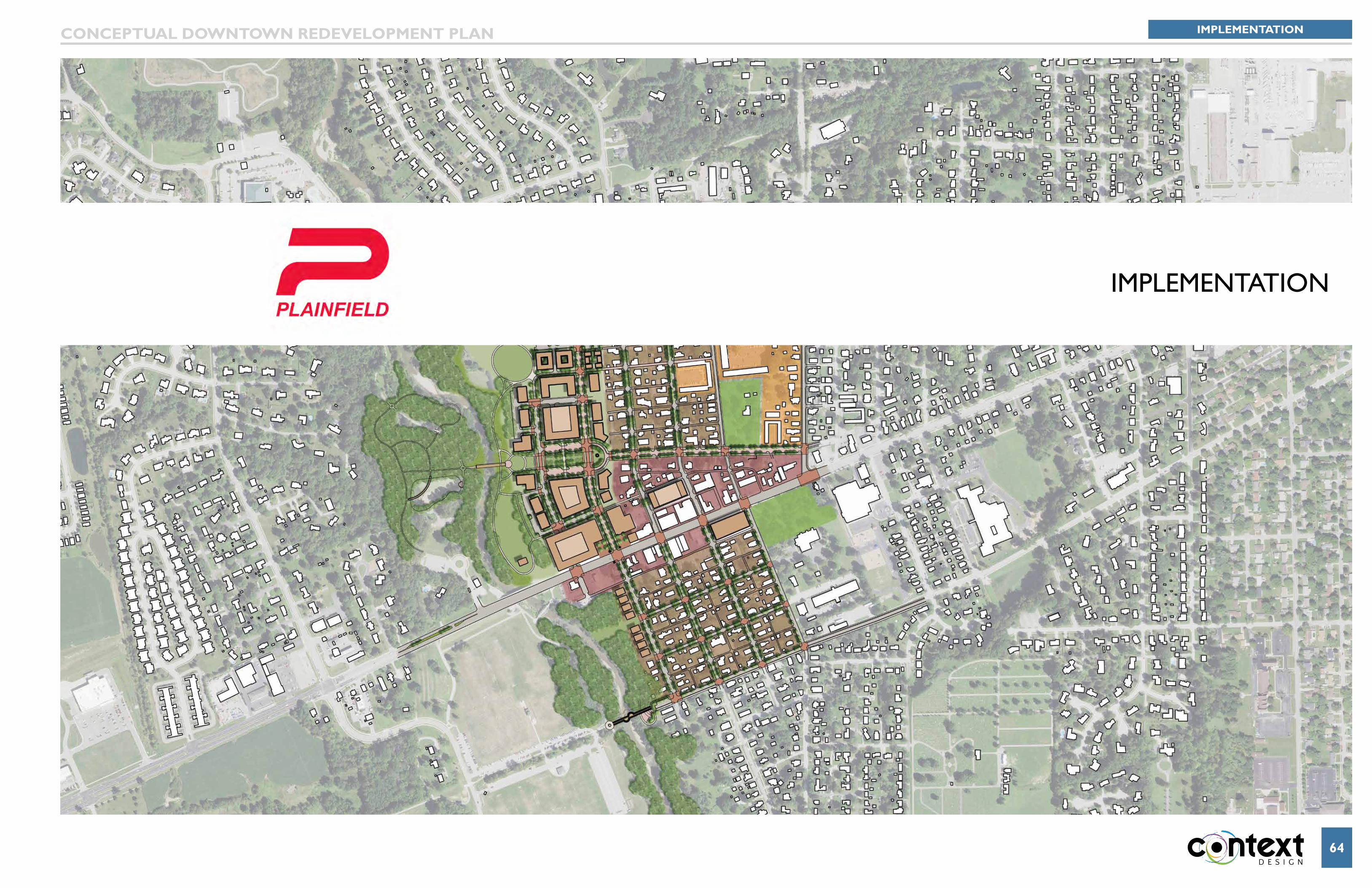
IMPleMentatIon
IMPLEMENTATIONCONCEPTUAL DOWNTOWN REDEVELOPMENT PLAN
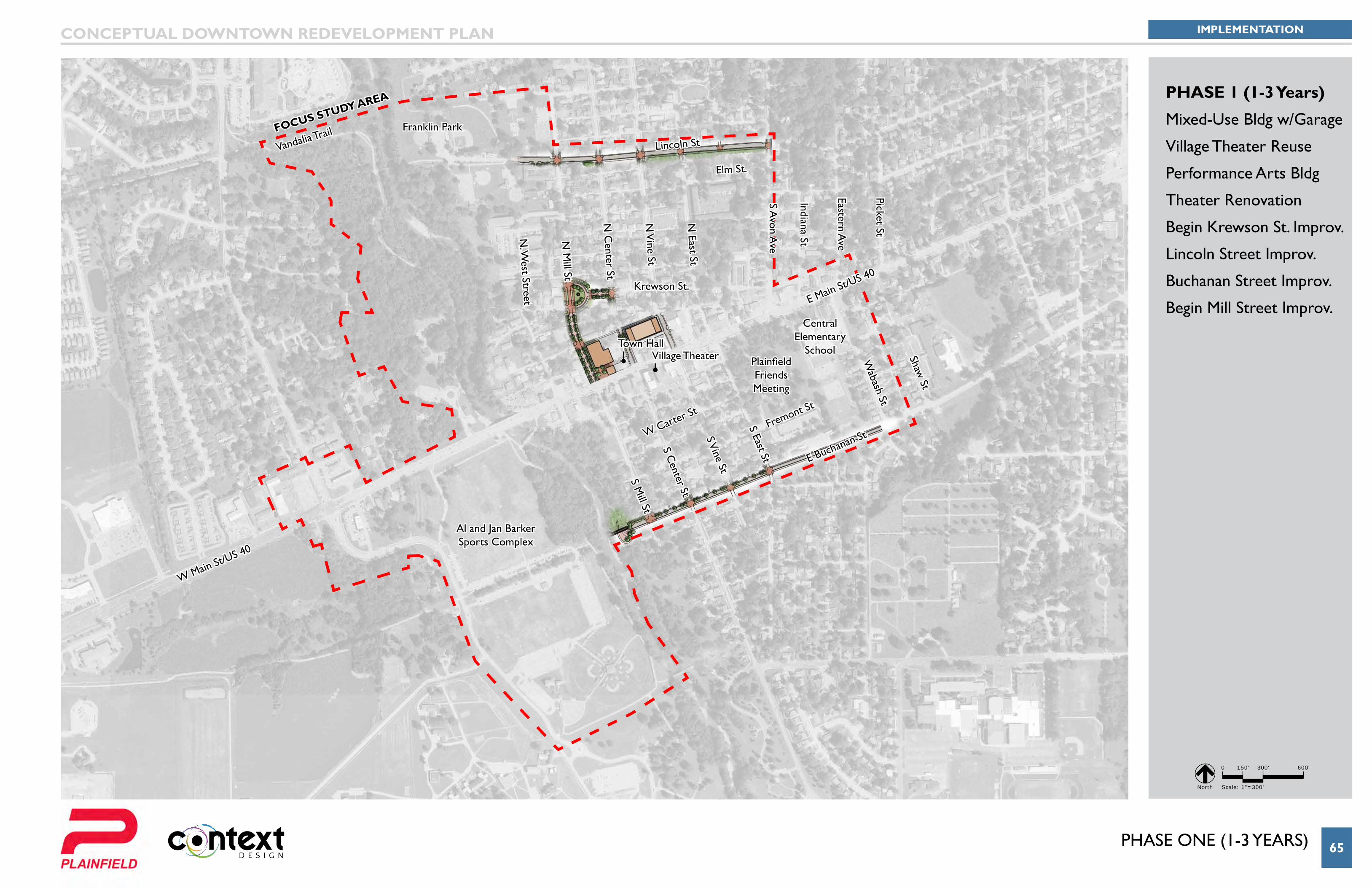
PHASE ONE (1-3 YEARS) 65
Van Buren Elementary
School
Krewson St.
Elm St.
Lincoln StVandalia Trail
W Carter St
Fremont St
S Mill St
N M
ill St
N. W
est Street
N C
enter St
S Center St
S Vine St
N V
ine St
N East St
S Avon A
ve
Eastern Ave
Indiana St
Picket St
S East St
Wabash St
Shaw St
E Main St/US 40
W Main St/US 40
Franklin Park
Al and Jan Barker Sports Complex
Central Elementary
SchoolPlainfield Friends Meeting
Town HallVillage Theater
FOCuS STuDy AREA
E Buchanan St
IMPLEMENTATIONCONCEPTUAL DOWNTOWN REDEVELOPMENT PLAN
0 150' 300' 600'
Scale: 1"=300' North
PHASE 1 (1-3 Years)
Mixed-Use Bldg w/Garage
Village Theater Reuse
Performance Arts Bldg
Theater Renovation
Begin Krewson St. Improv.
Lincoln Street Improv.
Buchanan Street Improv.
Begin Mill Street Improv.
PHase tWo 66
Al and Jan Barker Sports Complex
Central Elementary
SchoolPlainfield Friends Meeting
Town Hall
Van Buren Elementary
School
Krewson St.
Elm St.
Lincoln St
W Carter St
Fremont St
S Mill St
N M
ill St
N. W
est Street
N C
enter St
S Center St
S Vine St
N V
ine St
N East St
S Avon A
ve
Eastern Ave
Indiana St
Picket St
S East St
Wabash St
Shaw St
E Main St/US 40
W Main St/US 40
E Buchanan St
Vandalia TrailFranklin ParkFOCuS STuDy AREA
IMPLEMENTATIONCONCEPTUAL DOWNTOWN REDEVELOPMENT PLAN
0 150' 300' 600'
Scale: 1"=300' North
PHASE 2
Mixed-Use Bldg w/Garage
Finish Krewson St. Impro.
Mill Street Improv.
West Street Improv.
Lewis Street Improv.
Avon Avenue Improv.
Grand Lawn Park
Overlook Park
Town Green
Pedestrian Bridge
Buchanan Street Bridge
PHase tHRee 67
Van Buren Elementary
School
Krewson St.
Elm St.
Lincoln St
W Carter St
Fremont St
S Mill St
N M
ill St
N. W
est Street
N C
enter St
S Center St
S Vine St
N V
ine St
N East St
S Avon A
ve
Eastern Ave
Indiana St
Picket St
S East St
Wabash St
Shaw St
E Main St/US 40
W Main St/US 40
E Buchanan St
Al and Jan Barker Sports Complex
Central Elementary
SchoolPlainfield Friends Meeting
Town Hall
Vandalia TrailFranklin ParkFOCuS STuDy AREA
IMPLEMENTATIONCONCEPTUAL DOWNTOWN REDEVELOPMENT PLAN
0 150' 300' 600'
Scale: 1"=300' North
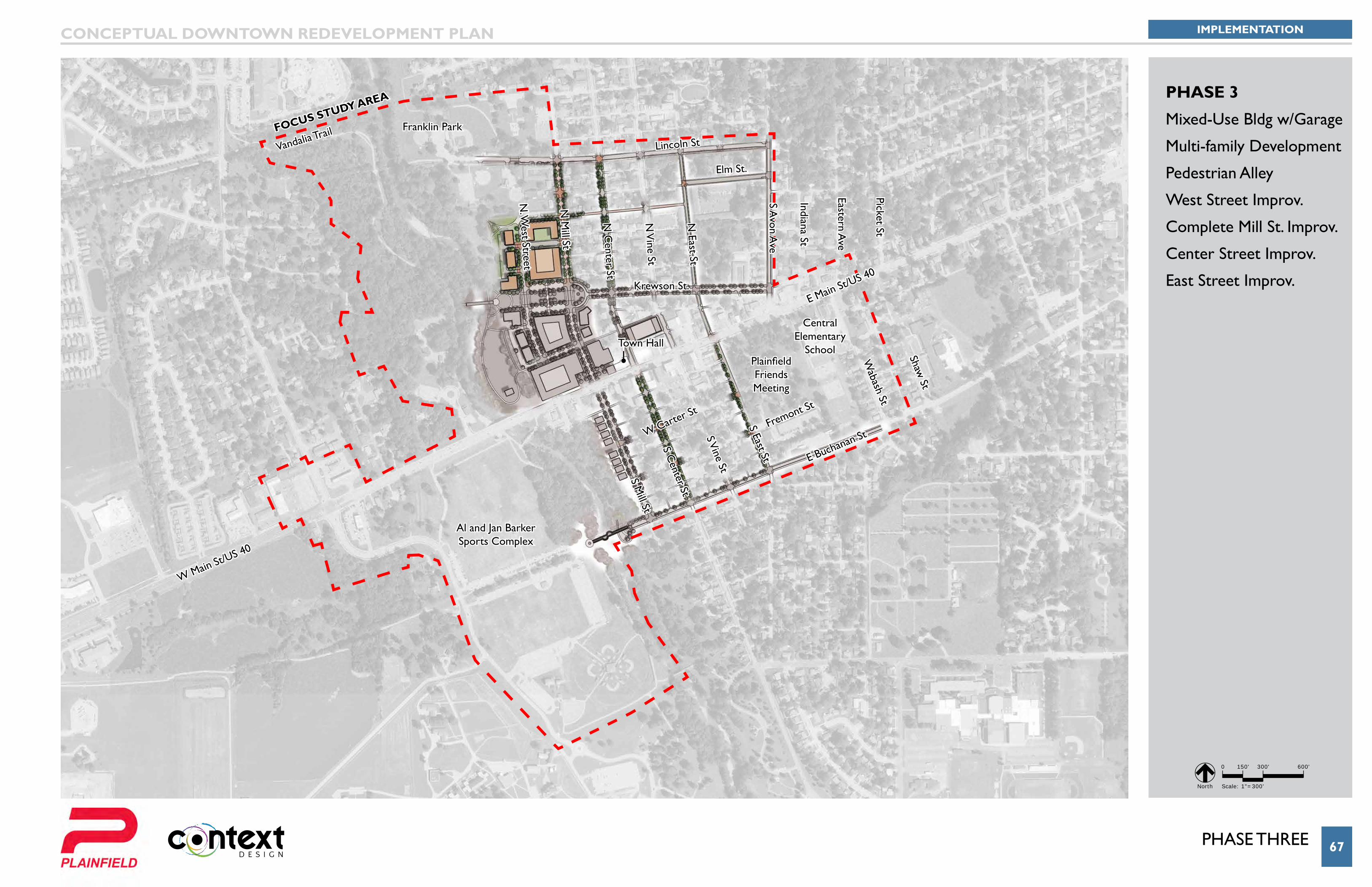
PHASE 3
Mixed-Use Bldg w/Garage
Multi-family Development
Pedestrian Alley
West Street Improv.
Complete Mill St. Improv.
Center Street Improv.
East Street Improv.
PHase foUR 68
Van Buren Elementary
School
Krewson St.
Elm St.
Lincoln St
W Carter St
Fremont St
S Mill St
N M
ill St
N. W
est Street
N C
enter St
S Center St
S Vine St
N V
ine St
N East St
S Avon A
ve
Eastern Ave
Indiana St
Picket St
S East St
Wabash St
Shaw St
E Main St/US 40
W Main St/US 40
Al and Jan Barker Sports Complex
Central Elementary
SchoolPlainfield Friends Meeting
Town Hall
E Buchanan St
Vandalia TrailFranklin ParkFOCuS STuDy AREA
IMPLEMENTATIONCONCEPTUAL DOWNTOWN REDEVELOPMENT PLAN
0 150' 300' 600'
Scale: 1"=300' North
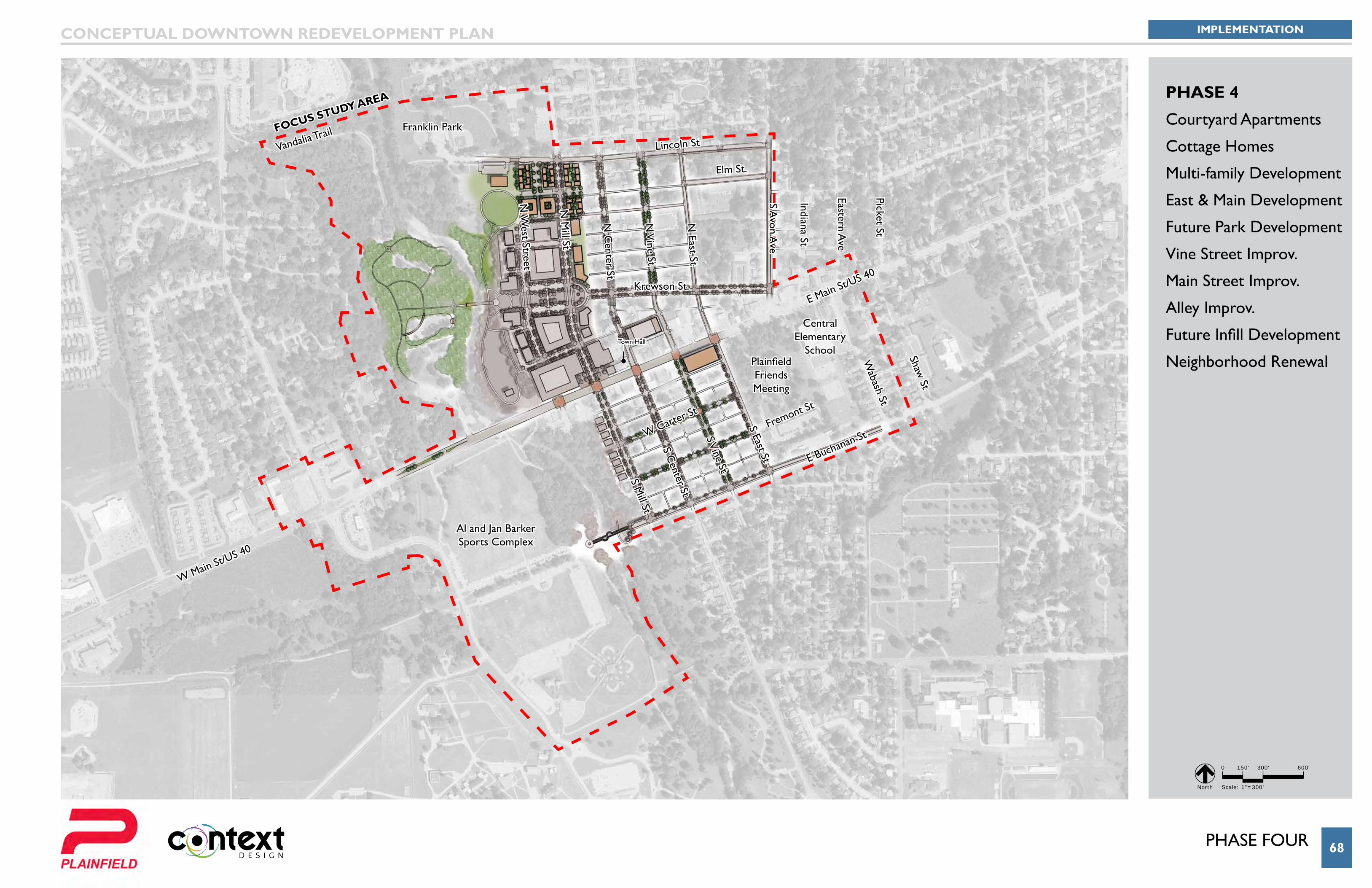
PHASE 4
Courtyard Apartments
Cottage Homes
Multi-family Development
East & Main Development
Future Park Development
Vine Street Improv.
Main Street Improv.
Alley Improv.
Future Infill Development
Neighborhood Renewal
Plan PHasInG 69
IMPLEMENTATIONCONCEPTUAL DOWNTOWN REDEVELOPMENT PLAN
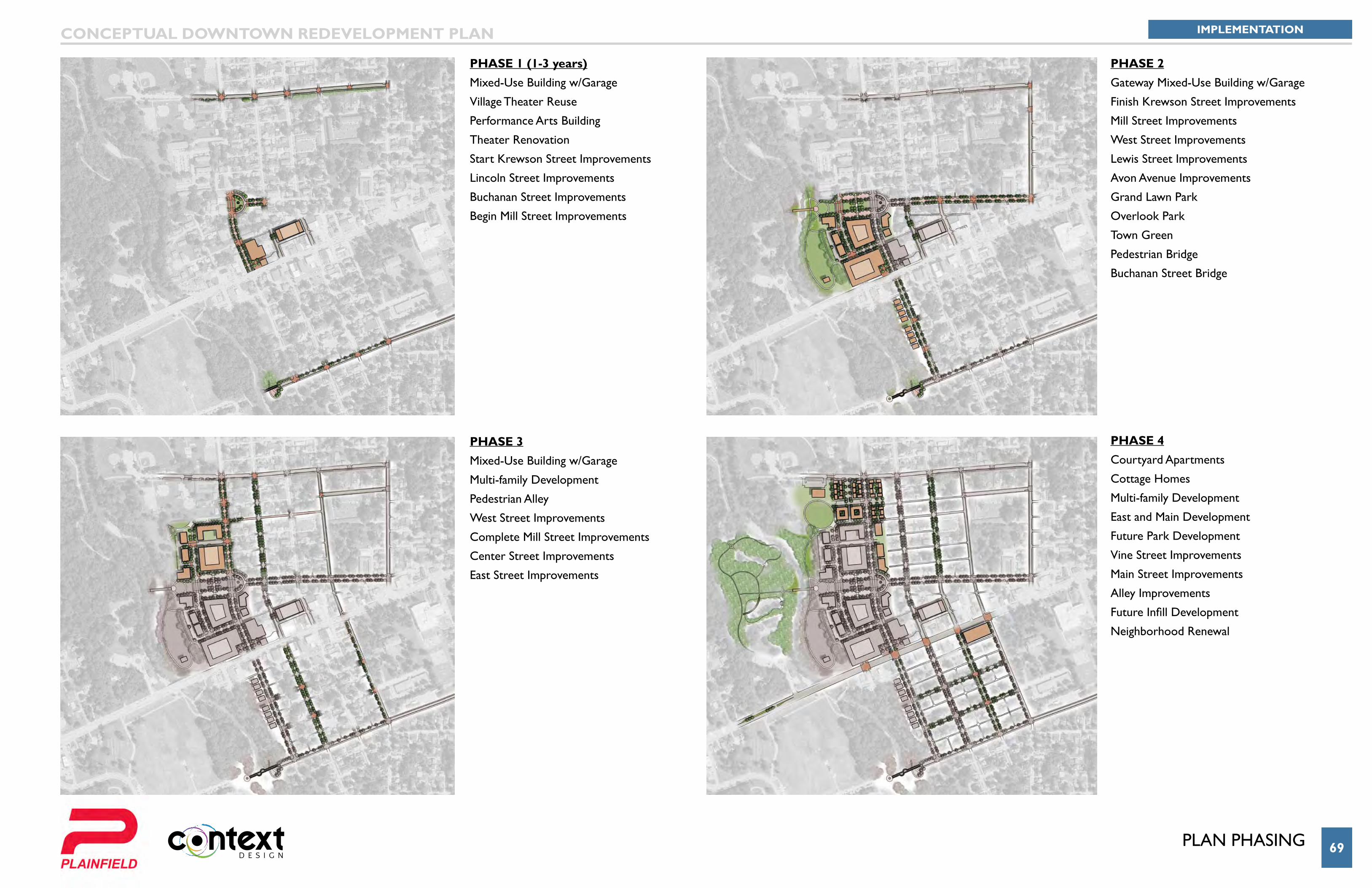
PHASE 1 (1-3 years)Mixed-Use Building w/Garage
Village Theater Reuse
Performance Arts Building
Theater Renovation
Start Krewson Street Improvements
Lincoln Street Improvements
Buchanan Street Improvements
Begin Mill Street Improvements
PHASE 2Gateway Mixed-Use Building w/Garage
Finish Krewson Street Improvements
Mill Street Improvements
West Street Improvements
Lewis Street Improvements
Avon Avenue Improvements
Grand Lawn Park
Overlook Park
Town Green
Pedestrian Bridge
Buchanan Street Bridge
PHASE 3Mixed-Use Building w/Garage
Multi-family Development
Pedestrian Alley
West Street Improvements
Complete Mill Street Improvements
Center Street Improvements
East Street Improvements
PHASE 4Courtyard Apartments
Cottage Homes
Multi-family Development
East and Main Development
Future Park Development
Vine Street Improvements
Main Street Improvements
Alley Improvements
Future Infill Development
Neighborhood Renewal
Prepared By: