chapter six redevelopment concept
TRANSCRIPT

Preferred Redevelopment Alternative
Chapter SixRedevelopment Concept
The preferred r e d e v e l o p m e n t alternative prepared by the Park Hills Dixie Study Task Force focuses includes recommendat ions for the physical r e d e v e l o p m e n t of the landscape, improvements to mobility, changes in land use, improvements to community facilities, and awareness and improvements in green infrastructure practices.
25Park Hills Dixie StudyPHPA
RK
HIL
LS
Dixie Study
Preferred Redevelopment Alternative
Section One -Section One -Preferred Redevelopment AlternativePreferred Redevelopment AlternativeAt the second public meeting, four redevelopment alternatives were presented to gather input and preferences for the redevelopment of the corridor. These alternatives can be reviewed in Appendix A. With public input, the Task Force prepared a preferred redevelopment alternative comprised of components from the four original alternatives to express an ideal development style for the City of Park Hills. This ideal development style is meant to guide Park Hills toward achieving their vision for the future. The preferred alternative was then presented at the fi nal public meeting on September 10, 2009, and modifi cations were made as necessary for the fi nal version presented here as part of this plan.
To help the community visualize how the corridor may redevelop over time, the preferred redevelopment alternative has been divided into two phases. The fi rst phase, as seen in Map 6.1, helps to prioritize some of the fi rst steps of implementation and prioritize where the City should focus its attention during the fi rst several years of implementation. The second phase, as seen in Map 6.2, depicts how the entire corridor may appear after completion of all recommended development.
The Phase One and Phase Two drawings which follow are not intended to be site plans. Rather, these images are intended to help the community visualize they type of development they seek for the future. As development actually occurs, the fi nished development will take shape only after more detailed site and engineering design. The fi rst portion of Section 1 discusses the overarching themes that are seen throughout the entire corridor. The second portion of Section 1 describes the details of the preferred redevelopment alternative in terms of the South Area, the Core Area, and the North Area.

PHPA
RK
HIL
LS
Dixie StudyPark Hills Dixie Study26Preferred Redevelopment Alternative
FIGURE 6.1ABSENCE OF CURBS AND SIDEWALKS ALONG DIXIE HIGHWAY
FIGURE 6.2RECOMMENDED DIXIE HIGHWAY CROSS-SECTION IN PARK HILLS
Overarching Themes
Median In 2006 the Ohio-Kentucky-Indiana Regional Council of Governments (OKI) in partnership with NKAPC prepared and adopted The Dixie Fix study, an overarching plan for the Dixie Highway corridor throughout Kenton County. The plan proposed several recommendations for the thoroughfare, including suggestions for implementation of access management controls where appropriate. Access management is defi ned as a formal, structured program to coordinate and maintain the safe and effi cient use of the arterial street system, while providing necessary vehicular access to adjacent lands. In other words, creating a safer roadway by managing where and how adjoining property is accessed.
Non-traversable medians constitute a primary cornerstone of effective access management plans. These medians limit the location of left turns to strategic locations along the roadway, thus eliminating traffi c confl ict points. Specifi c steps are necessary to create the landscaped median and dedicated turn bays along the Park Hills section of Dixie Highway. The current roadway consists of four travel lanes, two northbound and two southbound, that are ten feet in width. Right-of-way widths along the corridor range from 64 to 70 feet, with an average of 66 feet. The Dixie Fix study
recommends expanding the right of way to 70 feet throughout the corridor to accommodate the proposed roadway changes and added facilities. The study also recommends reducing the number of travel lanes from four to two and creating a landscaped center median that will be approximately 12 feet in width. This median will limit the currently unrestricted left turn movement to identifi ed points along the route.
Currently access is unlimited on the northern side of the roadway due to the absence of a defi ned curb


PHPA
RK
HIL
LS
Dixie Study Park Hills Dixie Study 31Preferred
Redevelopment Alternative
to separate parking and travel lanes. The lack of a defi ned curb allows vehicles to enter and exit the primary roadway in a random manner and may create several potential confl ict points for drivers travelling on the thoroughfare. Unlimited access also negates many of the positive aspects of median construction because some properties may not have left turn access. Driveway and median construction is recommended for properties between the Zachary Lauren Custom Design jeweler and the Fort Mitchell Garage (Figure 6.1). In addition to increasing safety along the roadway, the landscaped median will also serve to beautify the corridor and provide added protection to pedestrians. Figure 6.2 shows the proposed cross-section of Dixie Highway in Park Hills from The Dixie Fix study. The proposed 12 foot median will provide space for tree and landscaping. The space will also serve as a pedestrian sanctuary by allowing a space to wait between the travel lanes for vehicular traffi c to pass when crossing Dixie Highway.
Specifi c recommendations for Phase One of the Preferred Redevelopment Alternative include construction of a raised non-traversable vegetated landscaped median throughout the study area. The median should be 12 feet in width and include street trees that provide adequate visibility for motorists. A cross section view of the median from The Dixie Fix study is provided in Figure 6.2. The potential exists that instead of a raised median that this could be depressed as part of the storm water management efforts for the area. (See Section 2 of this Chapter for further details)
The non-traversable landscaped median will change to an auxiliary left turn lane at full access points where left turns are permitted into properties. Phases One and Two of the preferred alternative show auxiliary left turn lanes as a darker grey lane bordered by yellow striping (Maps 6.1 and 6.2). Turn lanes should be engineered to provide adequate stacking space for left turning vehicles and they should also offer suffi cient space for vehicles that are turning left from properties to wait before joining the fl ow of traffi c. Recommendations concerning the median should be started in Phase One and carried forward into Phase Two of the preferred alternative.
ParkingParking has historically been an issue discussed by commercial property owners along Dixie Highway. A parking study (Interim Report – Chapter 6: Dixie Highway Corridor Parking Survey) was conducted in conjunction with this small area study to address the issue and determine plans for future parking needs. The study found that while some specifi c lots operated at or very close to capacity, a vast majority of parking areas along the corridor were more than adequate for parking demand. Additionally, where some areas experienced high parking volumes, immediately adjacent parking lots were either completely or nearly empty. Differences in parking volumes suggest that congregating parking through the elimination of boundaries between lots could allow for more effi cient parking scenarios. Both Phase One and Two of the preferred alternative recommend implementing congregated parking areas to allow for greater land utilization for buildings and other uses and to support parking on the smallest area possible.
In conjunction with eliminating boundaries between existing parking lots, the study also recommends mixing land uses and attempting to fi nd a mix wherein parking needs vary during the time of day. Mixing uses in this way could allow for more effi cient use of congregated parking areas by alternating business hours between businesses when parking demands are high. An example of this scenario could be a doctor’s offi ce that typically needs more parking during daytime hours, which would use the same lot as a restaurant that requires more parking in the evenings and on weekends.
Along with better serving a mix of uses, congregated parking has other advantages as well. More compact and strategically placed parking areas and buildings tend to make an area friendlier to pedestrians and cyclists because these users do not have to cross vast parking lots to get to a destination. Congregating parking areas can also encourage transit ridership. By limiting the amount of parking and making an area more walkable more users could choose to take public transportation to the redeveloped area.
This study specifi cally recommends reducing the amount of required parking to 3.2 spaces per
PHPA
RK
HIL
LS
Dixie StudyPark Hills Dixie Study32Preferred Redevelopment Alternative
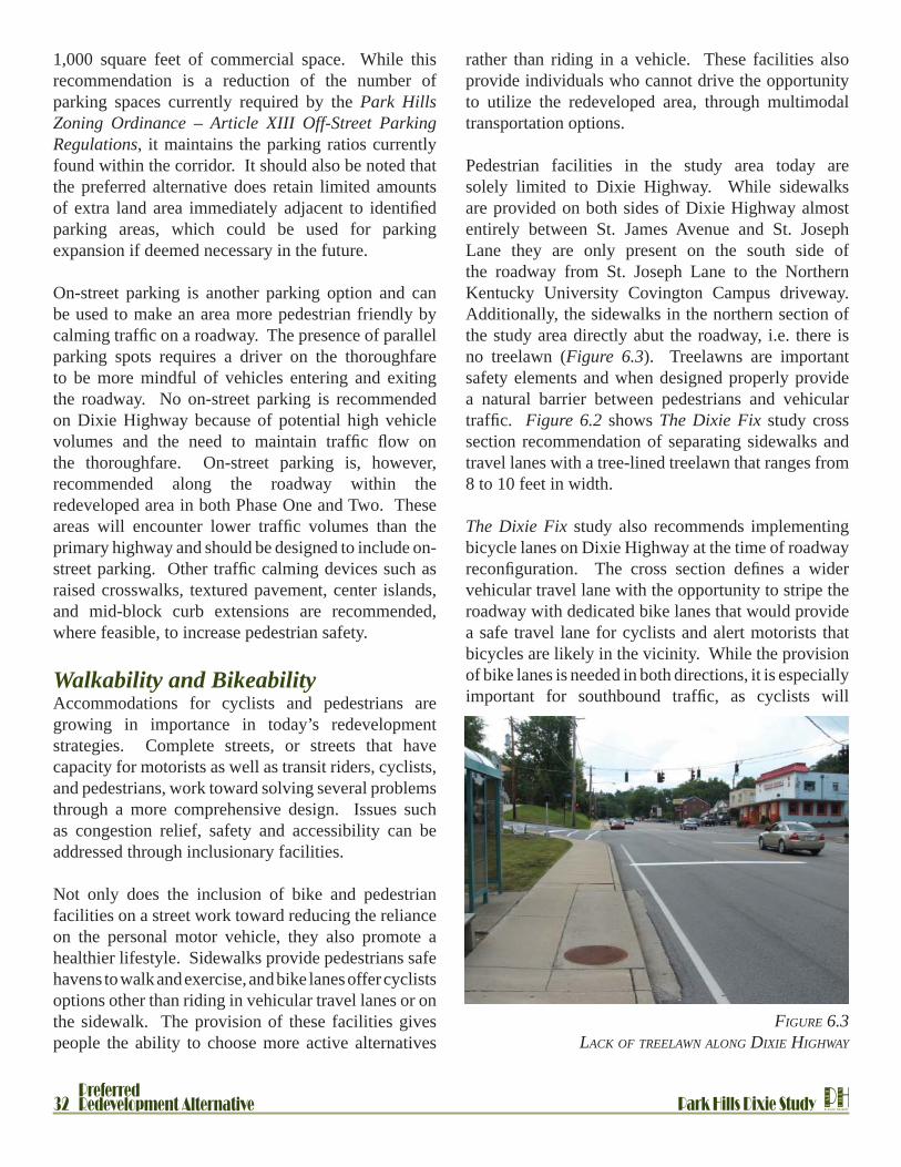
FIGURE 6.3LACK OF TREELAWN ALONG DIXIE HIGHWAY
1,000 square feet of commercial space. While this recommendation is a reduction of the number of parking spaces currently required by the Park Hills Zoning Ordinance – Article XIII Off-Street Parking Regulations, it maintains the parking ratios currently found within the corridor. It should also be noted that the preferred alternative does retain limited amounts of extra land area immediately adjacent to identifi ed parking areas, which could be used for parking expansion if deemed necessary in the future.
On-street parking is another parking option and can be used to make an area more pedestrian friendly by calming traffi c on a roadway. The presence of parallel parking spots requires a driver on the thoroughfare to be more mindful of vehicles entering and exiting the roadway. No on-street parking is recommended on Dixie Highway because of potential high vehicle volumes and the need to maintain traffi c fl ow on the thoroughfare. On-street parking is, however, recommended along the roadway within the redeveloped area in both Phase One and Two. These areas will encounter lower traffi c volumes than the primary highway and should be designed to include on-street parking. Other traffi c calming devices such as raised crosswalks, textured pavement, center islands, and mid-block curb extensions are recommended, where feasible, to increase pedestrian safety.
Walkability and BikeabilityAccommodations for cyclists and pedestrians are growing in importance in today’s redevelopment strategies. Complete streets, or streets that have capacity for motorists as well as transit riders, cyclists, and pedestrians, work toward solving several problems through a more comprehensive design. Issues such as congestion relief, safety and accessibility can be addressed through inclusionary facilities.
Not only does the inclusion of bike and pedestrian facilities on a street work toward reducing the reliance on the personal motor vehicle, they also promote a healthier lifestyle. Sidewalks provide pedestrians safe havens to walk and exercise, and bike lanes offer cyclists options other than riding in vehicular travel lanes or on the sidewalk. The provision of these facilities gives people the ability to choose more active alternatives
rather than riding in a vehicle. These facilities also provide individuals who cannot drive the opportunity to utilize the redeveloped area, through multimodal transportation options.
Pedestrian facilities in the study area today are solely limited to Dixie Highway. While sidewalks are provided on both sides of Dixie Highway almost entirely between St. James Avenue and St. Joseph Lane they are only present on the south side of the roadway from St. Joseph Lane to the Northern Kentucky University Covington Campus driveway. Additionally, the sidewalks in the northern section of the study area directly abut the roadway, i.e. there is no treelawn (Figure 6.3). Treelawns are important safety elements and when designed properly provide a natural barrier between pedestrians and vehicular traffi c. Figure 6.2 shows The Dixie Fix study cross section recommendation of separating sidewalks and travel lanes with a tree-lined treelawn that ranges from 8 to 10 feet in width.
The Dixie Fix study also recommends implementing bicycle lanes on Dixie Highway at the time of roadway reconfi guration. The cross section defi nes a wider vehicular travel lane with the opportunity to stripe the roadway with dedicated bike lanes that would provide a safe travel lane for cyclists and alert motorists that bicycles are likely in the vicinity. While the provision of bike lanes is needed in both directions, it is especially important for southbound traffi c, as cyclists will

PHPA
RK
HIL
LS
Dixie Study Park Hills Dixie Study 33Preferred
Redevelopment Alternative
experience signifi cantly slower speeds while climbing the Dixie Highway hill.
Bicycle and pedestrian facilities should be included in the redeveloped area in addition to the Dixie Highway corridor recommendations. Phase One and Two of the Preferred Redevelopment Alternative display numerous sidewalks crossing the design area, which could accommodate both pedestrians and cyclists in the form of shared-use paths. It should also be noted that shared-use paths are recommended to extend from Dixie Highway to Old State Road along the new vehicular connection and points near CCHS and connecting to Alhambra Court. These paths will provide higher levels of connectivity from Dixie Highway, across the redeveloped area and into the existing neighborhood. Bike parking facilities near new businesses and residential areas are also recommended to be included in any redevelopment scenario.
With an increase in bicycle facilities throughout the corridor and a desire to make Park Hills a bike/pedestrian friendly community, the introduction of a bicycling center may be desired for this area. A center of this type would be served by more secure bicycle parking, shower facilities, a clothes-changing area, and storage. This type of center could also be combined with a transit stop, making the area a prime location for multimodal connectivity throughout the Greater Cincinnati region. Park Hills’ close proximity to Devou Park would then be better positioned to serve as a key entryway for bike and pedestrian traffi c into the park.
Finally, sidewalks should be added to the following neighborhood streets: Arlington Road, South Arlington Road, and St. Joseph Lane. New facilities along these thoroughfares would provide neighborhood access to the core area in the form of safe walkways
for pedestrians. These types of streets, which are residential local streets, do not warrant dedicated bicycle lanes.
LightingLighting throughout the corridor today is predominantly provided by standard cobra head lights attached to utility poles (Figure 6.4). Figure 6.5 demonstrates more decorative lighting on top of the Park Hills monuments at the Arlington Road and Dixie Highway intersection.
New lighting in the corridor should be compatible with the historical character of the area. While Figure 6.5 is historical in nature, some of its features are problematic. The historical fi xture emits omnidirectional light that can glare onto nearby buildings. Care should be taken to choose fi xtures that limit the amount of light that spills onto adjacent buildings, especially in areas where buildings are in close proximity to roadways. The chosen fi xtures should adequately light the roadway and sidewalk areas while limiting glare onto adjoining buildings. Additionally, it is recommended that full cut-off lighting fi xtures be installed to limit the amount of light that emits above the fi xture.
FIGURE 6.5DECORATIVE LIGHTING
FIGURE 6.4COBRA HEAD ILLUMINATION

PHPA
RK
HIL
LS
Dixie StudyPark Hills Dixie Study34Preferred Redevelopment Alternative
FIGURE 6.7VARIOUS RESIDENTIAL ARCHITECTURAL STYLES FOUND WITHIN PARK HILLS
CharacterPark Hills is one of Northern Kentucky’s most unique residential neighborhoods in terms of architectural style and character. Homes in the area were predominantly built in the fi rst half of the 20th Century and are characterized by Tudor and Craftsman styles as demonstrated in Figure 6.6. These neighborhoods, which most characteristically defi ne the architecture and essence of Park Hills, are located on residential streets far from the primary thoroughfare of Dixie Highway. Unfortunately, the location of the these identifying neighborhoods away from Dixie Highway mean a majority of the City’s visitors likely do not experience the historic character of Park Hills. The Task Force expressed an interest in bringing this character to the Dixie Highway corridor as stated in the goals and objectives for this study.
The identifying characteristics of structures found in Park Hills neighborhoods do not currently extend to the Dixie Highway corridor. The corridor itself is characterized by random styles that do not promote a uniform look or feel as demonstrated in Figure 6.7. Historically the corridor was developed with little regard for the architectural style of neighboring structures, which provides for the diverse range of building types in the 0.6 mile length of the study area.
This study recommends implementing corridor-wide design standards for new structures as redevelopment takes place. These standards will work toward creating overarching design elements that tie the corridor together, effectively creating a sense of place along the

PHPA
RK
HIL
LS
Dixie Study Park Hills Dixie Study 35Preferred
Redevelopment Alternative
FIGURE 6.7VARIOUS COMMERCIAL ARCHITECTURAL STYLES ALONG DIXIE HIGHWAY
Dixie Highway corridor in Park Hills. Furthermore, these standards should incorporate architectural characteristics from structures in the Park Hills neighborhoods. Transferring identifying attributes
from neighborhoods to redeveloped areas will move the entire City toward having an overall architectural style and a greater sense of place. More specifi c details about design standards can be found in Chapter 7.

PHPA
RK
HIL
LS
Dixie StudyPark Hills Dixie Study36Preferred Redevelopment Alternative
Details of Preferred Redevelopment AlternativeThe descriptions on the following pages present information on each of the three sections (North, Core and South areas) in order to aid in the understanding of how each piece of the Dixie Highway corridor may redevelop in the future. Like the overall plan presented previously, information on each of these sections is described in two phases of development.
South AreaPhase One• Access and parking will be improved via installation of a landscaped median along the majority of the Dixie
Highway corridor through the City of Park Hills.• There is a gateway opportunity at the vacant lot located on the corner of St. James Avenue and Dixie Highway.
This gateway could take the form of a bus stop/pull off (replica of the trolley stations Park Hills is recognized for), landscaping or signage.
• A land swap between a portion of the parking in front of Covington Catholic High School and a piece of vacant land currently located behind the existing commercial development would provide open, developable land directly on Dixie Highway. There is however, a potential issue with stromwater management on the currently vacant site.
• The current right in right out access for Covington Catholic High School will be closed and access rerouted to the existing traffi c signal at St. Joseph’s Lane.
• New development will begin to occur at the intersection of St. Joseph’s Lane. This area is intended to become a “gateway” to the Core Area.
Phase Two• Development will continue at the intersection of St. Joseph Lane and Dixie Highway further promoting this
area as a gateway to the Core Area.• The new open space in front of Covington Catholic High School created by the potential land swap provides
the opportunity for new development to begin occurring in this area. However, it is important to note that this development should not become the focus of development activities along the corridor; rather, it should only be promoted after the Core Area has been developed.

PHPA
RK
HIL
LS
Dixie Study Park Hills Dixie Study 37Preferred
Redevelopment Alternative
SOUTH AREA PHASE TWO
SOUTH AREA PHASE ONE

PHPA
RK
HIL
LS
Dixie StudyPark Hills Dixie Study38Preferred Redevelopment Alternative
Core AreaPhase One• A full non-signalized access point is added mid-block to help with the consolidation of access points along the
corridor.• Parking and access is consolidated through the implementation of many Dixie Fix study recommendations.• Many existing structures will remain with façade improvements.• New development will be located at the intersection of St. Joseph Lane to help promote this area as a gateway
to the primary Core Area.• A new access road to the fi rst phase of development will connect St. Joseph Lane to Arlington Road.• The bulk of new development in Phase One will occur behind existing structures and adjacent to the new road
which connects St. Joseph Lane to Arlington Road. This new development will include a public space which could be closed off to vehicular access for special events.
• The new development area will also include a pocket of multi family residential structures which will act to buffer the existing single family residential from the new mixed use development.
• Vehicular access will be created from the back of the new development to Old State Road. This access will help to better connect the existing neighborhood and residents to the center of their community.
• The intersections at Arlington Road and South Arlington Road will be realigned to alleviate traffi c incidents in this area.
• The southeastern side of Dixie Highway will begin to see some cohesive development This development could take the form of townhomes or small offi ce type development with parking behind and access from St. Joseph Lane and South Arlington Road.
• A pedestrian connection across Dixie Highway will be constructed mid-block to help promote a more pedestrian friendly environment
• A new public space will be constructed at the intersection of St. Joseph Lane and Dixie Highway.
Phase Two• Redevelopment of existing buildings into new, more cohesive development will take place in Phase Two.
This redevelopment will include a pedestrian mall which will help connect Dixie Highway (and those one the southeastern side of Dixie Highway) to the public gathering space located within the Phase One portion of the preferred redevelopment alternative.

PHPA
RK
HIL
LS
Dixie Study Park Hills Dixie Study 39Preferred
Redevelopment Alternative
CORE AREA PHASE TWOCORE AREA PHASE ONE

PHPA
RK
HIL
LS
Dixie StudyPark Hills Dixie Study40Preferred Redevelopment Alternative
North AreaPhase One• Consolidation of parking and access is the fi rst priority in this portion of the corridor. • Most existing structures are to remain within this phase of redevelopment.• The Dixie Fix study calls for the realignment of the curve into Covington, and phase one of this study follows
that recommendation.• With the realignment of the curve, a street-wall or landscaping should be included at a gateway into the north
end of Park Hills.• The potential exists to utilize a section of abandoned roadway that runs directly behind the Fort Mitchell
Garage up the hill toward Old State Road as either a road and/or pedestrian access.
Phase Two• Over time, new structures set closer to Dixie Highway will help to promote general cohesiveness and
walkability throughout this portion of the corridor.• Realignment and shifting of the curve of Dixie Highway, per recommendation from The Dixie Fix study will
provide improved safety.

PHPA
RK
HIL
LS
Dixie Study Park Hills Dixie Study 41Preferred
Redevelopment Alternative
NORTH AREA PHASE TWO
NORTH AREA PHASE ONE

PHPA
RK
HIL
LS
Dixie StudyPark Hills Dixie Study42 Mobility
FIGURE 6.8SOUTH AREA – PHASE TWO
served under the proposed cross-section through the introduction of dedicated turn lanes at major signalized intersections and access points. Implementation of this cross-section was identifi ed as the highest local priority for Park Hills in The Dixie Fix study.
Additionally, The Dixie Fix study recommends the incorporation of bike lanes along Dixie Highway. These bike lanes are just one component of the bicycle and pedestrian facilities recommended by the Park Hills Dixie Study. Details about bicycling and pedestrian activity throughout the corridor can be found in Section 1 of this Chapter. Specifi c location for new bike and pedestrian facilities can be found within the following subsections.
South AreaIn the section of the corridor between St James Street and St Josephs Lane all major changes to the transportation system occurs in the fi rst phase of redevelopment. See Figure 6.8. The three entrances to the existing businesses on the north side of the road are closed and the full access is provided through the updated road to Covington Catholic High school. The current full access directly to the Sisters of Notre Dame Convent will become right-in/right-out due to the
Section Two - MobilitySection Two - MobilityThe preferred redevelopment alternative for the Park Hills Dixie Study area relies heavily on the recommendations from The Dixie Fix study to address transportation issues within the corridor. The study area for The Dixie Fix study extended approximately eight miles along Dixie Highway from Boone County to the City of Covington. The primary method used by The Dixie Fix study to address both safety and mobility within the corridor is through the implementation of a thorough access management plan to control driveway movements. The Dixie Fix study identifi ed the Park Hills stretch of Dixie Highway as the section of the corridor which would most benefi t from access management and projected nearly a 28 percent reduction in crashes with a proper access management plan. The Preferred Redevelopment Alternative chosen for the Park Hills Dixie Study achieves better access management by reducing the number of driveway openings from 45 to 13 and by visibly separating the driveway/parking access points through the introduction of tree lawns and sidewalks which separate Dixie Highway from designated parking areas.
Another major component of The Dixie Fix study which has been integrated into the Preferred Redevelopment Alternative is the selection of a new cross-section for Dixie Highway. This new cross-section can be seen in Figure 6.2 of this Chapter. The new cross-section transforms the corridor from a four lane highway to a two lane highway with a landscaped median. The proposed cross-section provides adequate capacity for the lower traffi c volumes on this section of Dixie Highway. The new cross-section will also provide traffi c calming and speed reduction benefi ts to better accommodate the retail and school oriented development adjacent to the corridor. Turning traffi c will be better

PHPA
RK
HIL
LS
Dixie Study Park Hills Dixie Study Mobility 43
FIGURE 6.9CORE AREA – PHASE TWO
two. The preferred redevelopment alternative calls for these two intersections to be consolidated into one by realigning Arlington Road to South Arlington Road.
A non signalized full access intersection located between the St. Josephs Lane intersection and the Arlington Road intersection will also access the core development area on the west side of Dixie Highway. Good circulation through the core development on the west side of Dixie Highway is provided by interconnecting parking lots and internal roads.
Along the eastern side of Dixie Highway all direct property access is removed and access is from St Joseph Lane or South Arlington Road into a series of connected parking lots located behind the expected new structures. Circulation for the eastern residential
vegetated median. See “1” in Figure 6.8. The current right-in/right-out access to Covington Catholic High School is removed. A new street connecting Terrace Drive to Dixie Highway at the intersection of St Joseph Lane will also provide access to Covington Catholic High School. In Phase Two a new right-in/right-out access into new developments is located between the Covington Catholic intersection and the St. Josephs intersection. This access reaches the high school through the parking lots of the new development. The intersection at St. James Avenue does not change.
The gateways designated within this section of the corridor could be used to promote alternate modes of transportation. For example, the vacant lot on the corner of St. James Avenue and Dixie Highway could incorporate a replica trolley station to be utilized as a TANK stop.
Core AreaThe section between the St Josephs Lane intersection and the Arlington Road/South Arlington Road intersection will undergo many changes. The intersection of St. Josephs Lane will be converted from a full access three-way intersection to a full access four-way intersection with the building of a new road connecting with Terrace Drive. This road will also serve as one of the two primary access points to the core development area along with the Arlington Road intersection. A new ring road which will run parallel to Dixie Highway will be constructed joining these two intersections in order to provide access to the core, as shown in Figure 6.9 (See “2” in Figure 6.9). The development of the ring road will affect access from the west side of Arlington Road, as residents will no longer have direct access to Dixie Highway, but will instead have access via the ring road.
The confi guration mentioned above eliminates the offset intersection at Arlington Road as called for in The Dixie Fix study. The intersection of Arlington Road and South Arlington Road with Dixie Highway is currently off-set which requires for two traffi c signals spaced less than 100 feet apart. The proximity of these two signals creates a chaotic environment in which drivers often mistakenly run one of the two lights by misinterpreting this area as one intersection rather than

PHPA
RK
HIL
LS
Dixie StudyPark Hills Dixie Study44 Mobility
FIGURE 6.10NORTH AREA – PHASE TWO
area will also be improved by providing an extension of Cecelia Ave from its current terminus at Rosemont Avenue south to St. Joseph lane.
A new ring road will be constructed joining these two intersections in order to provide access to the core, as shown in Figure 6.9. The development of the ring road and the core will affect access from the west side of Arlington Road, as residents will no longer have direct access to Dixie Highway, but will instead have access via the ring road. This confi guration also eliminates the offset intersection at Arlington Road as called for in The Dixie Fix study. Additional indirect access is also proposed for the western residential areas via an extension of Terrace Drive beyond Old State Road, into the rear of the new development area known as the core area. Circulation for the eastern residential area will also be improved by providing an extension of Cecelia Ave from its current terminus at Rosemont Avenue south to St. Joseph Lane.
NorthThe section of the corridor north of Arlington Road/South Arlington Road intersection to the City line undergoes a dramatic reduction in the number of direct access points. See Figure 6.10. The plan calls for four on each side of the road with one each being right-in/right-out only. The alignment of Dixie Highway is also shifted, to the east at the north end of the corridor to reduce the angle of the curve as the highway enters Covington.
Additionally, the Preferred Redevelopment Alternative calls for a newly constructed bike/pedestrian pathway to link Dixie Highway with the Gateway Community and Technical College site at the top of the hill. This new access point could provide non-motorized access for any potential new residents of the site at the top of the hill to the activities along Dixie Highway.

PHPA
RK
HIL
LS
Dixie Study Park Hills Dixie Study Mobility 45
Existing Residential AccessIn addition to consolidating access to the commercial parcels immediately adjacent to Dixie Highway and the proposed cross section, access and circulation for adjacent residential areas have been modifi ed as well. Three existing signalized intersections on Dixie Highway at St. James Avenue/Hilton Drive, St. Joseph Lane and Arlington/South Arlington Road will remain. However, the two intersections at St. Joseph Lane and Arlington Road will also be used to serve as the primary access to the core development area. The intersection at St. Joseph’s Lane will be converted from a full access three-way intersection into a full access four-way intersection.
Overall the proposed access plan for the Park Hills study area should greatly improve both the mobility and safety of the corridor. This is primarily realized by the aggressive access management efforts which
aim to consolidate access points and clearly delineate intended accesses and turning movements. Integration of the retail and residential uses which are adjacent to the corridor will also be furthered by the proposed cross-section which reduces the number of lanes on Dixie Highway and adds a landscaped median. This effort will be furthered through the improved connectivity and circulation patterns brought about by the modifi ed local street network. Finally, the corridor during the development process will be designed to accommodate pedestrian, bicycle and transit users through the implementation of complete street strategies. These users will be served by the bike lanes on Dixie Highway, pedestrian and bicycle access and connectivity to adjoining residential areas, and by existing bus facilities located along Dixie Highway that can be improved with shelters to identify and enhance these locations.

PHPA
RK
HIL
LS
Dixie StudyPark Hills Dixie Study46 Recommended Land Use
FIGURE 6.11CONCEPT DIAGRAM
Section Three - Section Three - Recommended Land UseRecommended Land UseThe recommended land uses for the study area were developed from a concept plan that was discussed and approved by the Task Force in August 2009.
Concept PlanThe concept plan for the study area is based on several elements as described in Chapter 5 and illustrated in Figure 6.11:
• Vision for the area• Market Study• Adjacent land uses• Resident input at public meetings• Land availability• Connectivity and walkability
Land AvailabilityA majority of the land adjacent to Dixie Highway is currently developed with a variety of land uses including institutional, retail sales and service uses, residential and offi ce uses. While all of these are anticipated to redevelop in the future, there are pockets of substantial vacant land available for new development along the corridor. Redevelopment of the corridor is anticipated to occur in two phases as explained in Section 1 of this Chapter.
For discussion purposes the Dixie corridor in the City of Park Hills has been divided into three sections - South, Core, and North as described below:
South AreaThe land immediately adjacent to Dixie Highway, approximately 14 acres on Covington Catholic High School and Notre Dame Academy’s properties, is anticipated to develop as part of Phase Two. Development of these areas is not anticipated in the near future and priority should be given to redevelopment of the Core and North Areas as discussed in this section. It should be noted that, if development were to occur signifi cant topographic issues on the Notre Dame property and appropriate relocation of some parking on the Covington Catholic High School property will need to be addressed. These areas have great visibility along the corridor but the land foreseen to be available for redevelopment is fairly narrow and long, thus lending itself to strip development patterns, which are less than desirable.
Core AreaSignifi cant amounts of vacant land, approximately 8 acres, is located in the Core Area behind the commercial development that includes Reality Tuesday; Snappy Tomato Pizza, Loschiavo’s Produce and Deli, and Zachary and Lauren Jewelers. Adjoining land to the south yields approximately 2.2 acres of vacant land, 1.65 acres of which is owned by the City of Park Hills, on the west side of Dixie Highway immediately adjacent and north of Covington Catholic High School. The total land area within the Core section is approximately 23 acres. This land is anticipated to be the focus of initial redevelopment efforts in Phase One along the corridor as described in Section 1 of this Chapter.

PHPA
RK
HIL
LS
Dixie Study Park Hills Dixie Study Recommended Land Use 47
FIGURE 6.12GARDENS OF PARK HILLS
North AreaThere is no signifi cant vacant land for development within this section along the Dixie Highway corridor. Redevelopment of this area is likely to entail a longer time frame than the Core area because most sites involve redevelopment. The Gateway Community and Technical College land located off of Old State Road and the Northern Kentucky University property located adjacent to the study area within the City of Covington both offer prime redevelopment opportunities.
Recommended Land UseThis section outlines the land uses recommended for the study area. A redevelopment concept plan for the study area is outlined in Chapter 6: Redevelopment Concept.
South Area The south section includes Covington Catholic High School and Notre Dame Academy, the vacant property located on the south side of St. James Avenue and three properties immediately north of St. James Avenue and west of Dixie Highway which is currently occupied by Chef Barone’s Catering and The Gardens of Park Hills (Figure 6.12).
A change in land use is recommended for the property located on the south side of St. James Avenue from residential at 4.1 to 7.0 dwelling units per net acre to other community facilities. This property is currently vacant and is envisioned to be improved with gateway features into the City such as signage, landscaping and possibly an area for TANK busses to pull off as described in Section 1 of this Chapter.
The recommended land use for the three properties immediately north of St. James Avenue and south of the access drive to Covington Catholic High School will remain as commercial retail/service use as identifi ed in the Comprehensive Plan Update: 2006-2020, however as previously noted offi ces will be included in this land use category.
As illustrated in Figure 6.13, both the schools will continue to be identifi ed as other community facilities as they were in the Comprehensive Plan Update: 2006-2026. This plan, however, identifi es that in the long term areas immediately adjacent and on either side of Dixie Highway in front of these schools may transition to commercial retail/service uses that also include offi ces as a component. As discussed in Section 1 of this Chapter, the initial focus of redevelopment along
the corridor is recommended to be in the Core Area. The market analysis cautions the City of Park Hills in attracting or promoting any more intense retail development in the City and concludes that there is a delicate balance of supply and demand to maintain. It is therefore critical that the City focus its initial redevelopment efforts in the core area, where there is potential land available is about the amount, eight acres, suggested by the market analysis. It is strongly recommended that this south area be targeted for redevelopment only after the core area has been established in order to avoid the overabundance of retail which the market analysis cautions against.

PHPA
RK
HIL
LS
Dixie StudyPark Hills Dixie Study48 Recommended Land Use
DIXIE HWY
STJO
SEP
HLN
OLD STATE RD
STJA
MES
AVE
AMSTERDAM RD
WR
IGH
TSU
MM
ITPK
WY
DIXIE HWY
LegendRecommended Land Use
COMMERCIAL RETAIL SERVICE
COMMUNITY FAC
RES 4.1 To 7.0
RES 7.1 To 14
MIXED USE
Parcel Boundary
Study Boundary
Park Hills City Boundary
0 150 300 450 60075Feet
I
Core AreaThe section encompasses properties on either side of Dixie Highway, generally between St. Joseph Lane and Arlington Road, as shown in Figure 6.14.
The land use of properties immediately adjacent to and east of Dixie Highway are recommended to be changed from residential development at a density ranging from 4.1 to 7.0 dwelling units per net acre to mixed use, which includes commercial and residential uses. This area presently is comprised of single-family residential development. This area is topographically challenging as existing structures are located above Dixie Highway on a hillside that almost abuts the roadway. Mixed uses in this area are envisioned to
work with the topography of the area in terms of small scale structures similar to what is currently along this portion of the corridor. This could include small offi ces, retail or residential condominiums. Comments from the public indicate that in this area substantial residential uses are not desirable. Furthermore, the market analysis also projects very minimal increase in residential development within the study area in the next fi ve years. It is important to note that while the market analysis identifi es minimal demand in the near term for residential land uses, new high density and single-family units will be necessary to signifi cantly “refresh” the City’s housing inventory. A few units as part of a mixed-use development in this area could serve to meet this need and still not add too many residential units where they are less desirable.
The land use of properties immediately adjacent to and west of Dixie Highway are recommended to be changed from commercial retail/service uses to mixed use. Expansion of the adjacent Community Facilities is also envisioned as a possible use on property which the study designates as mixed use and which is presentaly located in a residential zoning district. In addition, the land use of properties behind these Dixie Highway properties that lies between these properties and property facing Old State Road is recommended to be changed from residential development at a density ranging from 7.1 to 14.0 dwelling units per net acre to mixed use. This area is strongly recommended to be the focus of initial redevelopment efforts within the study area for a variety of reasons. Primarily because it contains a large area of vacant or sparsely developed land, is centrally located and with improved connectivity to surrounding neighborhoods can serve as a positive catalyst for redevelopment along the remaining length of the corridor. Its central location and the planned connectivity to adjoining residential areas is important to draw residents to the area. Changing the recommended land use of this area to mixed use will provide the fl exibility to redevelop this area with a variety of uses that will contribute to the vitality of the area.
The intersection of St. Joseph’s Lane with Dixie Highway has been identifi ed as a Village Center area where redevelopment could likely begin to occur early. The City currently owns a small parcel, approximately
FIGURE 6.13SOUTH AREA – RECOMMENDED LAND USE


PHPA
RK
HIL
LS
Dixie Study Park Hills Dixie Study Recommended Land Use 51
DIXIE HWY
OLD STATE RD
SA
RLI
NG
TON
RD
CECELIA AVE
RO
SEM
ON
TA
VE
STJO
SEP
HLN
CORAM ST
ALH
AM
BR
AC
T
EXTER DR
MT ALLEN RD
TER
RA
CE
DR
ARLINGTO
NRD
LegendRecommended Land Use
COMMERCIAL RETAIL SERVICE
COMMUNITY FAC
RES 4.1 To 7.0
RES 7.1 To 14
MIXED USE
Parcel Boundary
Study Boundary
Park Hills City Boundary
0 75 150 225 30037.5Feet
I
1.5 acres; in this area and the recommendation to realign Covington Catholic High School’s access as well as construction of the new loop road all prompt the idea to begin development in this area. New development in this area and incorporation of gateway/village center features such as special pavers or signage and landscaping features will help to draw passers by into the core redevelopment area. The existing residential uses and density of 4.1 to 7.0 units per acre are recommended to remain. The residential uses along St. Joseph’s Lane will serve as a barrier limiting commercial activity from moving away from Dixie Highway.
According to the Market Analysis the offi ce market appears to be the least developed of all of the three major land use groups. The study projects a demand
of approximately 13,000 to 24,000 square feet of offi ce space if the City aggressively attempts to recruit employers in Health and Medical Services, Other Business Services, and Social Services categories of offi ce based service businesses. Consumer services in specialized space or retail storeroom venues could contribute to demand for between 6,200 and 8,500 square feet of space in Park Hills.
As previously mentioned, the redevelopment of this core area is anticipated to have signifi cant impact in revitalizing the Dixie Highway corridor. The goals for the redevelopment of the study area as determined by the Task Force and public meeting attendees is to ensure Park Hills’ long-term economic success by creating a corridor that is attractive to new businesses and increase the growth opportunities for existing businesses. The goal is also to provide a variety of uses by including and balancing offi ce, residential, retail, cultural and civic spaces within the study boundary and should include uses with activities which occur in both the daytime and the night.
Considering the goals set forth by the residents of Park Hills of creating a destination that people walk or drive to, it will be crucial to get the right mix of uses. The market analysis is projecting a market for both offi ce and retail uses and so it is important that this area be developed with a mix of both of those uses. While a vertical mix of uses within a single structure could function well, horizontal mixed uses would also lend towards creating a synergy of uses within the core area. The key element for redevelopment of this area would be to obtain the mix of uses with businesses, particularly the retail businesses that provide products and services now underserved in the vicinity. For further information on market potential see the market analysis report that accompanies this plan.
The land use for a portion of this area, to the rear of properties along Aberdeen Road, is also recommended to remain at residential 7.1 to 14.0 dwelling units per net acre. The market analysis suggests that higher densities and attached single-family will be needed to refresh the housing market. The analysis further concludes that medium to high density attached single-family housing units appears to be the only way to add
FIGURE 6.14CORE AREA – RECOMMENDED LAND USE

PHPA
RK
HIL
LS
Dixie StudyPark Hills Dixie Study52 Recommended Land Use
any signifi cant numbers of new housing units to the inventory in Park Hills. Increased residential density in close proximity to the core area will increase the likelihood of residents walking to their destination for goods and services. Retaining a portion of this area for residential development also acts as a good buffer between the residential development on Old State Road/Aberdeen Road and the more intense mixed use development that is anticipated within the Core Area. While the market analysis cautions very limited opportunities for any new housing, it states that it would be desirable to fi nd ways to add new owner-occupied housing to the landscape in Park Hills. This will be increasingly important as the existing housing inventory ages. The market analysis further states that in order to introduce as many new owner-occupied housing units as possible, a medium to high density attached dwelling unit format would be the key; in essence, condominiums. A residential density of 7.1 to 14.0 dwelling units per net acre is hence recommended for a portion of the core area, to allow for condominium projects anticipated by the market analysis of 48 or more units. This would be attractive to younger as well as aging homeowners if the property is adequately supported by on-site management and maintenance personnel.
As stated previously, the core area is recommended to be the focus of initial redevelopment efforts within the study area. In order to create a destination with a sense of place that will be a synergy of activity, it is crucial to get the right mix of uses in a development with a character that is refl ective of the City of Park Hills. To accomplish these goals, as explained in Chapter 7: Implementation, it is recommended that the development of form based zoning and/or design standards be considered for the area.
North AreaThis section includes properties on either side of Dixie Highway north of Arlington Road to the study boundary as shown on Figure 6.15. The land uses recommended by the Comprehensive Plan Update: 2006-2026 includes – commercial offi ce, residential development at a density ranging from 7.1 to 14.0 dwelling units per net acre, commercial retail/service, and physically restrictive development area. The site of Gateway Community and Technical College is recommended for school park land uses.
Two land use changes are recommended for this area. The land use of properties on either side of Dixie Highway and immediately adjacent to it are recommended to be changed to commercial retail/service uses that will include offi ces. This study recommends residential land use at a density of 7.1 to 14.0 dwelling units per net acre for the Gateway Community and Technical College property located at the end of Old State Road.
Existing uses within this section of the Dixie Highway corridor are primarily commercial uses including offi ces and retail sales and service type uses. Intense development along a majority of this section is not anticipated due to the relatively low depth of lots and the adjacent topography. It is anticipated that this area will essentially remain and redevelop in its current form. However, a portion of this area closer to the northern boundary of the study area may have greater redevelopment opportunities due to the potential realignment of Dixie Highway at the curve of the hill as proposed in The Dixie Fix study. There is a good mix of offi ce, retail and service uses within the northern area which with minimal improvements such as façade improvements and landscaping can signifi cantly alter their presence along the Dixie Highway corridor.
The Market Analysis fi nds this portion of the corridor may be suitable for service type uses after redevelopment occurs. These service type uses are defi ned as businesses which serve the local needs of the community. Barber shops and package shipping businesses could be included with these types of businesses. These types of uses may work well for this area based on the minimal lot depths. Service uses are typically those which require a quick in and out and therefore parking is not usually a premium surrounding these businesses.
As explained in Chapter 4, it is anticipated that the Gateway Community and Technical College site will be sold in its entirety for some form of residential development. While a majority of residential development is anticipated in the portion of property that is in the City of Covington, the portion within the City of Park Hills also provides prime land for residential development. The concerns of the City of Park Hills regarding redevelopment of this site are

PHPA
RK
HIL
LS
Dixie Study Park Hills Dixie Study Recommended Land Use 53
DIXIE HWY
OLD STATE RD
AR
LIN
GTO
N R
D
ABERDEEN RD
W PIKE ST
HA
RR
IET
ST
LegendRecommended Land Use
COMMERCIAL RETAIL SERVICE
COMMUNITY FAC
RES 4.1 To 7.0
RES 7.1 To 14
MIXED USE
Parcel Boundary
Study Boundary
Park Hills City Boundary
0 75 150 225 30037.5Feet
I
FIGURE 6.15NORTH AREA – RECOMMENDED LAND USE
primarily focused on access to it and resulting traffi c on City streets now lightly used by the existing school facilities. The City will maintain communication with the City of Covington and work with parties seeking to redevelop this site to minimize traffi c impacts through existing low density residential neighborhoods. One approach that may be taken would be to locate any common community facility type land uses (e.g.
swimming pool, tennis and other recreation uses) that comprise common use areas for residents of the new development on this site so as to help alleviate traffi c through Old State Road. There may be an additional opportunity for developers of this site to share the use and potentially the cost of community facility areas located in Park Hills with the city in some type of public/private joint effort to provide recreation space.

PHPA
RK
HIL
LS
Dixie StudyPark Hills Dixie Study54 Community Facilities and Utilities
FIGURE 6.16COVINGTON CATHOLIC HIGH SCHOOL
the utilities and community facilities, this plan makes a few key recommendations for the improvement of community facilities and utilities with the future development/redevelopment plans.
SchoolsThe students of Covington Catholic High School (Figure 6.16) and Notre Dame Academy, as well as their parents, are potential customers of the redeveloped commercial areas and should be viewed as an important asset to the City. Both schools have expressed desires to expand their campuses. Notre Dame Academy has ample property to expand upon and has already done so with little to no impact on the study area. Covington Catholic High School will need to acquire land to allow for expansion space. One potential site for this expansion is on the north side of their campus. With this in mind the City should work with the school in their expansion efforts to develop a plan of action that benefi ts both parties. One possible solution may be to incorporate adequate parking space in new development adjacent to the school so that it can be shared with the school. Typically school uses and other land uses do not overlap in regards to peak usage times and this would make such sharing of parking potentially feasible. If this can work it may be possible for Covington Catholic High School to reuse some of
Section Four - Community Section Four - Community Facilities and UtilitiesFacilities and UtilitiesCommunity facilities are services and facilities necessary to support the population such as; schools, recreation and open space, fi re and emergency medical service, police protection, library service, and health care. Availability and accessibility to these facilities and services is related to how residents perceive the quality of the community in which they live. Most community facilities are publicly funded and rely on tax based income collected and budgeted by legislative bodies and/or special districts. In the case of Park Hills and this study, however, two important facilities within the study area are private schools that function and provide services similar to public community facilities.
Utilities include sanitary sewer, water, electric, and natural gas service. Storm water is discussed in the Section 5 of this Chapter and encompasses another type of utility. A review of the utilities within and surrounding the immediate study area is intended to ensure that adequate and consistent services are provided to manage anticipated growth and minimize pollution within the planning period. The challenge for community facilities and utilities is to maintain existing facilities and provide a high level of service at a reasonable cost that will support existing and future needs of the community. This Chapter contains information regarding the existing educational, religious, recreation, library, police, and fi re community facilities and utilities that are wholly contained within the study area or are close enough to provide services into the area.
Research throughout the planning process indicates Park Hills, and thus the study area, are adequately supplied with community facilities and utilities. No new facilities are recommended; however, while the study area is adequately served by

PHPA
RK
HIL
LS
Dixie Study Park Hills Dixie Study Community Facilities and Utilities 55
their existing parking for other school facilities. With the students and their parents in mind, the City should try and locate uses suited to their needs close to the schools. This could include youth related destinations such as clothing stores, video game stores, ice cream and snack shops. A coffee shop such as Reality Tuesday’s Café could fi ll market needs of both students and their parents. Another synergy concept with the students as a primary constituent is a sports medicine/rehab facility. This would provide services for the population at large and benefi t from a location close to a large number of students, as well as the aging population of Park Hills.
The study area also includes a portion of the main campus of Gateway Community and Technical College. Gateway Community and Technical College is currently in the process of relocating their facilities into downtown Covington and will become vacant in the near future. The divided parcels in Covington and Park Hills are currently being assembled for sale to a private entity. The assumption at this time gathered from key person interviews is the site will be developed as higher density and/or high end residential.
The potential change of the Gateway Community and Technical College site to residential has sparked concern about an increase in the amount of traffi c on Old State Road and along Amsterdam Road, which has already experienced land slippage issues. This study recommends the City further explore the potential of constructing a road to provide direct access to Dixie Highway immediately behind Fort Mitchell Garage. Currently, there is an unused portion of an old road that had historically been use as a service road connection between Old State Road and Dixie Highway. The potential may exist that this road may be able to be reconstructed to support vehicular traffi c. While there may be some structural issues with this unused access point, it could prove to be a convenient connection to Dixie Highway for a new development and provide for less traffi c through the already established residential area. For further information on this issue, please see Section 2 of this Chapter 6.
Emergency ServicesThe City is currently adequately provided with emergency services. However, the substantial increase
in commercial activity recommended in this plan may require an increase in police and fi re protection along the corridor. With an increase in public gathering spaces within the core area, there is an increased opportunity for both formal and informal gatherings which may demand a need for increased police presence. Additional structures and infrastructure may also warrant increased fi re protection and the need for supplementary fi refi ghting personnel and apparatuses.
UtilitiesCurrently, the area is adequately supplied with utilities. As redevelopment of the area occurs the City should look for opportunities to work with Duke Energy to bury electrical utilities. Existing infrastructure along neighboring streets has the capacity to carry the utility load that currently runs along Dixie Highway. If the opportunity presents itself during any major roadway improvements along Dixie Highway, the City should seek opportunities to shift the backbone load carried along Dixie Highway to neighboring streets and then place the remaining load along Dixie Highway underground.
If major roadway improvements occur along Dixie Highway, the utility companies may be required to move the existing infrastructure at their cost. At that time, Park Hills could seek supplemental funding to offset the additional cost of placing the remaining facilities underground. Burying utility lines during roadway improvements would signifi cantly reduce the City’s cost of going underground because the City would only be required to cover the additional cost, not the entire cost of the move. The Northern Kentucky Water District and Sanitation District No. 1 will also need to be kept informed so they can inspect and replace failing water lines while the area is undergoing redevelopment. Additionally, if the City of Fort Wright is considering going underground with their utilities, Park Hills may want to consider working together to reduce the cost of burying lines along Dixie Highway.
The reduction in impervious surface desired by Sanitation District No. 1 is a means to reduce the amount of storm water entering the combined sewer system. This may be very diffi cult to achieve since the plan calls for an increase in square footage of commercial use. It may be possible to reduce the amount of storm

PHPA
RK
HIL
LS
Dixie StudyPark Hills Dixie Study56 Community Facilities and Utilities
center. If the City intends to encourage a large number of festivals and events in the area it should consider having separate public restroom facilities located close to the public space. Locating these events in this area will enhance the sense that this area is the center of town, the City’s heart. More detailed information about the preferred alternatives can be found in Section 1 of this Chapter.
Religious InstitutionsThe Generations Church, formerly the Covington First Church of the Nazarene, is located in a strategic position between Covington Catholic High School and the neighborhood commercial center. This building is in a good location for a community building and/or parking for both the school and the commercial center. This transition area between the school and the commercial center provides a variety of opportunities some of which are mentioned above. Phase Two of the preferred alternative recommends removal of this particular structure and two new smaller structures are shown in its place. This is one case
FIGURE 6.17TEMPORARY PEDESTRIAN ONLY AREAS
water entering the sewer system by a combination of using rain gardens, bio-retention areas, and green roofs where possible and utilizing green infrastructure techniques. For more information on this issue see Section 5 of this Chapter.
Community Center Public meeting comments and Task Force discussion indicated there is interest in having a community center for the City. These facilities are usually multi purpose in nature and provide a large space for the community to gather. This function fi ts well with the neighborhood Village Center proposed in the core of the study area. The core area depicts a gathering spot that can provide a symbiotic relationship with the commercial activity. Such a facility should be located on the edge of the core area thus placing the facility in close proximity to the commercial activity limiting interference with energy of the commercial area.
Public SpacePublic open space provides a venue for festivals and events that bring enjoyment to area residents and build community identity. The neighborhood commercial center in the core area is the ideal location for these activities. The commercial uses both attract people into the area for events and help provide for attendee’s needs during festivals.
Phase Two of the preferred alternative recommends implementing large permanent pedestrian areas (indicated by the tan and brown areas in Figure 6.17 for public space. While a majority of the outdoor space in these areas is permanently dedicated for public space the areas can be temporarily increased in size with the use of barricades. Figure 6.17 also illustrates how installing temporary barricades (red lines) on the road parallel to Dixie Highway will allow for a larger pedestrian only area (blue line). This larger area could be used for festivals or special events with minimal impact to traffi c and parking.
The public space could be a paved plaza that preferably utilizes pervious pavement, unpaved areas, or a combination of both. Ideally public space will surround and compliment commercial buildings in the Core Area and be in close proximity to the community

PHPA
RK
HIL
LS
Dixie Study Park Hills Dixie Study Community Facilities and Utilities 57
FIGURE 6.18SAINT JOSEPHS CONVENT
potential reuse for the structure. The close proximity to the City’s primary commercial center gives the city another potential synergistic relationship that could bring activity to the City.
where it is important to remember that the preferred redevelopment alternative is the basic idea of how the corridor should redevelop. If, over time it is found that the existing church structure remains a quality and functional space, it could remain. If however, over time this structure becomes obsolete, this study recommends that this piece of the corridor be used as a transitions area between the high school and the main mixed use area.
Saint Josephs Convent (Figure 6.18) likely will not change in any substantial way for the foreseeable future; however, the longevity of convents throughout the county is an issue that will possibly need to be addressed in Park Hills. The facility itself may eventually become vacant and the City should consider what they want to happen with the land and the structure. The grounds and historic structures are quite impressive and could facilitate new tenants in the future through some form of adaptive reuse. Conversion into a hotel with accommodations for retreats, seminars, small conventions and workshops might be one

PHPA
RK
HIL
LS
Dixie StudyPark Hills Dixie Study58 Green Infrastructure
TABLE 6.1IMPERVIOUS SURFACE AREAS
With typical development practices, this ten acre increase in impervious surface has the potential to increase overfl ow volume at the Willow Run outfall by over fi ve million gallons annually. Federal and state regulations require that the volume and frequency of CSOs be substantially reduced. Therefore, development projects that increase the amount of impervious surfaces in the combined sewer service area of Northern Kentucky can make it more diffi cult to comply with these regulations. Based on current estimates developed by SD1, the increased size and capacity of the controls needed to accommodate this ten acre increase could increase the capital cost of those controls by over $1 million.
In response to these facts as well as the overall trend towards more stringent storm water runoff management, SD1 is developing revised storm water regulations for Northern Kentucky that should be in place in 2010. In the combined sewer system area, these regulations would likely require the increased control of storm water runoff volume for storm events up to 0.75-inches. One approach for achieving this control is the use of green infrastructure. While green infrastructure is still relatively new in Northern Kentucky, other areas of the U.S. have been successfully incorporating these features into new development projects for years.
Given the characteristics of this development plan, green infrastructure features that could be applied in the proposed Park Hills Dixie Study include:• Rain gardens / bioretention areas• Storm water planter boxes • Grassed swales • Rain barrels and cisterns• Green roofs• Other Practices
Section Five -Section Five -Green InfrastructureGreen InfrastructureGreen infrastructure is a concept that elevates importance of the natural environment to the level of the built infrastructure, requiring careful consideration and planning. Green infrastructure utilizes land and water that supports native species, maintains natural ecological processes, sustains air and water resources and contributes to the health and quality of life of our citizens. It also includes community initiatives integrating the natural ecosystem with the built environment using elements such as parks, tree lined streets, rain gardens, bio-retention systems and green roofs.
As described in the interim report, the study area is located within a Combined Sewer Overfl ow (CSO) area as defi ned by Sanitation District No. 1. A brief explanation of CSO’s and associated challenges are explained in the Interim Report, which can be found at nkapc.org. In order to alleviate the problem, a focus on green development using various green infrastructure elements is needed.
As described in Section 1 of this Chapter, the redevelopment within the study area is anticipated to occur in two phases. Following are the impervious area acreages under existing conditions and per the recommended redevelopment concept.
As tabulated in Table 6.1, the proposed redevelopment of the 110 acre Park Hills Dixie Study area has been projected to increase the impervious surface by approximately ten acres. A majority of the increase (6.67 acres) is associated with additional pavement (parking lot and roadway) with the remainder coming from increased building area. Storm water runoff from the study area fl ows into combined sewers and is eventually discharged into the Ohio River at the Willow Run combined sewer outfall, located in Covington near the Brent Spence Bridge.

PHPA
RK
HIL
LS
Dixie Study Park Hills Dixie Study Green Infrastructure 59
Rain Gardens / Bioretention AreasThese features are based on the concept of directing storm water runoff into green space areas of the development that are designed to store, infi ltrate, and slow the fl ow rate of runoff. See Figure 6.19. Effective rain garden / bioretention area designs require a consideration of existing soil conditions, the need for engineered soil, plant selection, and overfl ow structure design. Potential locations for rain gardens / bioretention areas in a mixed use development include landscaping areas around parking lots and buildings. A signifi cant area for improved stormwater management and reduction of impervious surfaces is through the construction of a median along the stretch of the Dixie Highway corridor within the City of Park Hills. Such a median should be 12 feet wide depressed and designed to treat stormwater runoffs. Portions of the median could be used for the installation of rain gardens and bioretention areas which will readily store and infi ltrate stormwater runoff from the roadway.
Storm Water Planter BoxesStorm water planter boxes (Figure 6.20) are a specifi c type of bioretention feature that are typically used in projects with space constraints. In this development, planter boxes could be used near buildings and along local roadways and access drives. Dixie Highway
being a busy transportation corridor, the planter boxes can also act as a buffer between the sidewalk and the roadway making pedestrians feel safer.
Grassed SwalesGrassed swales located in public roadway medians and along roadsides offer an alternative to traditional piped storm drainage systems. The proposed median in Dixie Highway has signifi cant potential for providing stormwater management benefi ts. The use of swales in road rights-of-way can be very benefi cial given the relatively large size of these areas combined with the fact that standard, raised medians provide minimal storm water management benefi ts.
Rain Barrels and CisternsRain barrels and cisterns (Figure 6.21) are an effective way to reduce storm water runoff volume in developments with limited open space. Often, the most important factor to consider when using rain barrels / cisterns is the use of the captured water. This water can be used for typical landscaping purposes as well as certain domestic uses such as toilet fl ushing. Because the Dixie Study area includes a ball-fi eld and substantial open space on the Covington Catholic campus, there could be signifi cant potential for irrigation water usage.
FIGURE 6.19RAIN GARDEN/BIORETENTION AREA
FIGURE 6.20STORM WATER PLANTER BOXES

PHPA
RK
HIL
LS
Dixie StudyPark Hills Dixie Study60 Green Infrastructure
Other PracticesIt should be noted that pervious/permeable pavement was discussed by the Task Force and at public meetings as one method to alleviate stormwater fl ows in the study area. Unfortunately, today’s pavement technology combined with the area’s poorly draining soils do not yield a substantial decrease in fl ow. The management practice should be considered as an option if new pavement technology produces better results with the area’s soils.
Green RoofsGreen roofs are an example of green infrastructure that, in certain cases, can be a desirable addition to a building design that provides storm water management benefi ts. See Figure 6.22. Green roofs are mostly widely used for multi-story buildings in areas with limited open space. In addition to managing storm water runoff, green roofs can reduce cooling energy demand and can be designed to serve as a green space amenity for building users.
FIGURE 6.21RAIN BARRELS AND CISTERNS
FIGURE 6.22GREEN ROOF