environmental flows : flood flows
TRANSCRIPT
Water Resources and EnvironmentTechnical Note C.3
The World BankThe World Bank
Environment DepartmentThe World Bank1818 H Street, N.W.Washington, D.C. 20433, U.S.A.www.worldbank.orgFor information on these publications contact theESSD Advisory Service at [email protected] call 202.522.3773
Environment DepartmentThe World Bank1818 H Street, N.W.Washington, D.C. 20433, U.S.A.www.worldbank.orgFor information on these publications contact theESSD Advisory Service at [email protected] call 202.522.3773
Environmental Flows:Flood Flows
Water Resources and EnvironmentTechnical Note C.3
Environmental Flows:Flood Flows
Series EditorsRichard Davis
Rafik Hirji
Series EditorsRichard Davis
Rafik Hirji
26123
Pub
lic D
iscl
osur
e A
utho
rized
Pub
lic D
iscl
osur
e A
utho
rized
Pub
lic D
iscl
osur
e A
utho
rized
Pub
lic D
iscl
osur
e A
utho
rized
Pub
lic D
iscl
osur
e A
utho
rized
Pub
lic D
iscl
osur
e A
utho
rized
Pub
lic D
iscl
osur
e A
utho
rized
Pub
lic D
iscl
osur
e A
utho
rized

WATER RESOURCES
AND ENVIRONMENTTECHNICAL NOTE C.3
Environmental Flows: Flood Flows
The World BankWashington, D.C.
SERIES EDITORS
RICHARD DAVIS, RAFIK HIRJI

2
A. Environmental Issues and LessonsNote A.1 Environmental Aspects of Water Resources ManagementNote A.2 Water Resources Management Policy Implementation: Early Lessons
B. Institutional and Regulatory IssuesNote B.1 Strategic Environmental Assessment: A Watershed ApproachNote B.2 Water Resources Management: Regulatory DimensionsNote B.3 Regulations for Private Sector Utilities
C. Environmental Flow AssessmentNote C.1 Environmental Flows: Concepts and MethodsNote C.2 Environmental Flows: Case StudiesNote C.3 Environmental Flows: Flood FlowsNote C.4 Environmental Flows: Social Issues
D. Water Quality ManagementNote D.1 Water Quality: Assessment and ProtectionNote D.2 Water Quality: Wastewater TreatmentNote D.3 Water Quality: Nonpoint-Source Pollution
E. Irrigation and DrainageNote E.1 Irrigation and Drainage: DevelopmentNote E.2 Irrigation and Drainage: Rehabilitation
F. Water Conservation and Demand ManagementNote F.1 Water Conservation: Urban UtilitiesNote F.2 Water Conservation: IrrigationNote F.3 Wastewater Reuse
G. Waterbody ManagementNote G.1 Groundwater ManagementNote G.2 Lake ManagementNote G.3 Wetlands ManagementNote G.4 Management of Aquatic Plants
H. Selected topicsNote H.1 Interbasin TransfersNote H.2 DesalinationNote H.3 Climate Variability and Climate Change
Water Resources and Environment Technical Notes
Copyright © 2003
The International Bank for Reconstruction and Development/THE WORLD BANK
1818 H Street, N.W., Washington, D.C. 20433, U.S.A.
All rights reserved.
Manufactured in the United States of America
First printing March 2003

3
AuthorMichael C. Acreman
Technical AdviserStephen Lintner
EditorRobert Livernash
Production StaffCover Design: Cathe Fadel
Design and Production:The Word Express, Inc.
NotesUnless otherwise stated,all dollars = U.S. dollars.All tons are metric tons.
Cover photo byDavid Eastburn (MDBC)
Macquarie Marshes, MurrayDarling Basin, Australia
CONTENTSForeword 5
Acknowledgments 7
Introduction 8
Establishing the Appropriateness ofManaged Floods 9
Clear objectives for managed flood releases must bedefined through a study of the ecosystem, economy,and social structure of the floodplain.
Designing Flood Releases 11Designing flood releases requires incorporating the ex-pectations of stakeholders; understanding linkages be-tween floods and the affected ecosystem; definingflood-release options; and understanding the impactsof those options.
Implementation 16Dam outlet structures need to be designed and con-structed or adapted to allow necessary and feasibleflood releases. Pilot flood releases should be made totest the various water-release options.
A Practical Example –The Waza-Logone Floodplain 18
The Waza-Logone Conservation Project in Cameroon,coordinated by IUCN, undertook a wide range of ac-tivities in support of the design and implementation ofmanaged flood releases.
Conclusion 20The appropriateness of managed flood releases willdepend on the relative merits of using water for floodreleases compared to using it for other uses such asirrigation, public/industrial supply, or hydropower. Thisdecision can only be made on a case-by-base basis.
Further Information 20

4
WATER RESOURCES AND ENVIRONMENT • TECHNICAL NOTE C.3
BoxesBox 1. The Senegal valley: a suitable situation for managed flood releases 10Box 2. Mahaweli: a river where flood releases are not applicable 11Box 3. Participatory Rural Appraisal in the Waza-Logone project, Cameroon 12Box 4. Community-based institutions in the Phongolo River 12Box 5. Flood release options for the Tana River, Kenya 14Box 6. Valuation in the Hadejia-Jama’are River Basin, Northern Nigeria 16Box 7. Releasing sediment from Tarbela Dam, Pakistan 17
FiguresFigure 1. Flow chart showing the trade-off between using water for
managed flood releases and for reservoir-based activities 9Figure 2. Relationship between flooded area and fish catch 13
5
ENVIRONMENTAL FLOWS: FLOOD FLOWS
FOREWORD
The environmentally sustainable development andmanagement of water resources is a critical andcomplex issue for both rich and poor countries. Itis technically challenging and often entails difficulttrade-offs among social, economic, and political con-siderations. Typically, the environment is treatedas a marginal issue when it is actually key to sus-tainable water management.
According to the World Bank’s recently approvedWater Resources Sector Strategy, “the environmentis a special ‘water-using sector’ in that most envi-ronmental concerns are a central part of overallwater resources management, and not just a partof a distinct water-using sector” (World Bank 2003:28). Being integral to overall water resources man-agement, the environment is “voiceless” when otherwater using sectors have distinct voices. As a con-sequence, representatives of these other water us-ing sectors need to be fully aware of the importanceof environmental aspects of water resources man-agement for the development of their sectoral in-terests.
For us in the World Bank, water resources man-agement—including the development of surface andgroundwater resources for urban, rural, agriculture,energy, mining, and industrial uses, as well as theprotection of surface and groundwater sources, pol-lution control, watershed management, control ofwater weeds, and restoration of degraded ecosys-tems such as lakes and wetlands—is an importantelement of our lending, supporting one of the es-sential building blocks for sustaining livelihoods andfor social and economic development in general.Prior to 1993, environmental considerations of suchinvestments were addressed reactively and prima-rily through the Bank’s safeguard policies. The 1993Water Resources Management Policy Paper broad-ened the development focus to include the protec-tion and management of water resources in anenvironmentally sustainable, socially acceptable,and economically efficient manner as an emerging
priority in Bank lending. Many lessons have beenlearned, and these have contributed to changingattitudes and practices in World Bank operations.
Water resources management is also a critical de-velopment issue because of its many links to pov-erty reduction, including health, agriculturalproductivity, industrial and energy development,and sustainable growth in downstream communi-ties. But strategies to reduce poverty should not leadto further degradation of water resources␣ or eco-logical services. Finding a balance between theseobjectives is an important aspect of the Bank’s in-terest in sustainable development. The 2001 Envi-ronment Strategy underscores the linkages amongwater resources management, environmentalsustainability, and poverty, and shows how the 2003Water Resources Sector Strategy’s call for usingwater as a vehicle for increasing growth and re-ducing poverty can be carried out in a socially andenvironmentally responsible manner.
Over the past few decades, many nations have beensubjected to the ravages of either droughts or floods.Unsustainable land and water use practices havecontributed to the degradation of the water resourcesbase and are undermining the primary investmentsin water supply, energy and irrigation infrastruc-ture, often also contributing to loss of biodiversity.In response, new policy and institutional reformsare being developed to ensure responsible and sus-tainable practices are put in place, and new predic-tive and forecasting techniques are being developedthat can help to reduce the impacts and managethe consequences of such events. The Environmentand Water Resources Sector Strategies make it clearthat water must be treated as a resource that spansmultiple uses in a river basin, particularly to main-tain sufficient flows of sufficient quality at the ap-propriate times to offset upstream abstraction andpollution and sustain the downstream social, eco-logical, and hydrological functions of watershedsand wetlands.

6
WATER RESOURCES AND ENVIRONMENT • TECHNICAL NOTE C.3
With the support of the Government of the Nether-lands, the Environment Department has preparedan initial series of Water Resources and Environ-ment Technical Notes to improve the knowledgebase about applying environmental managementprinciples to water resources management. TheTechnical Note series supports the implementationof the World Bank 1993 Water Resources Manage-ment Policy, 2001 Environment Strategy, and 2003Water Resources Sector Strategy, as well as theimplementation of the Bank’s safeguard policies.The Notes are also consistent with the MillenniumDevelopment Goal objectives related to environmen-tal sustainability of water resources.
The Notes are intended for use by those withoutspecific training in water resources managementsuch as technical specialists, policymakers andmanagers working on water sector related invest-ments within the Bank; practitioners from bilateral,multilateral, and nongovernmental organizations;and public and private sector specialists interestedin environmentally sustainable water resourcesmanagement. These people may have been trainedas environmental, municipal, water resources, ir-rigation, power, or mining engineers; or as econo-mists; lawyers, sociologists, natural resourcesspecialists, urban planners, environmental planners,or ecologists.
The Notes are in eight categories: environmentalissues and lessons; institutional and regulatory is-sues; environmental flow assessment; water qual-ity management; irrigation and drainage; waterconservation (demand management); waterbodymanagement; and selected topics. The series maybe expanded in the future to include other relevantcategories or topics. Not all topics will be of inter-est to all specialists. Some will find the review ofpast environmental practices in the water sectoruseful for learning and improving their perfor-mance; others may find their suggestions for fur-ther, more detailed information to be valuable; whilestill others will find them useful as a reference onemerging topics such as environmental flow assess-ment, environmental regulations for private waterutilities, inter-basin water transfers and climatevariability and climate change. The latter topics arelikely to be of increasing importance as the WorldBank implements its environment and water re-sources sector strategies and supports the next gen-eration of water resources and environmental policyand institutional reforms.
Kristalina GeorgievaDirector
Environment Department

7
ENVIRONMENTAL FLOWS: FLOOD FLOWS
ACKNOWLEDGMENTS
The Bank is deeply grateful to the Government ofthe Netherlands for financing the production of thisTechnical Note.
This Note is based on research for the World Com-mission on Dams, funded by the United KingdomDepartment for International Development (DFID).
This research was a collaborative undertakingbetween the UK core team and the case studypartners based in various countries around theworld, particularly:
Centre for Ecology & Hydrology, Wallingford:M. Acreman, F. Farquharson, M. McCartney,C. Sullivan
Natural Resources Institute: K. Campbell,N. Hodgson, J. Morton, D. Smith
Liverpool School of Tropical Medicine: M. BirleyGibb Ltd: J. Lazenby, R. Wingfield, D. KnottUniversity of York: E. BarbierSenegal: Mbarack Diop
Zambia: Harry ChabwelaSouth Africa: Charel BrewerKenya: Stephen Njuguna, Clifford MuteroPakistan: Tahir QureshiSri Lanka: H. ManthrithilakeCameroon: Daniel Ngantou, Richard Braund
The research was published as:
Acreman, M.C., F.A.K. Farquharson, M.P. McCartney,C. Sullivan, K. Campbell, N. Hodgson, J. Morton, D.Smith, M. Birley, D. Knott, J. Lazenby, R. Wingfield,and E.B. Barbier. 2000. Managed flood releases fromreservoirs: issues and guidance. Report to DFID andthe World Commission on Dams. Wallingford, UK:Centre for Ecology and Hydrology.
At the World Bank, this Note was reviewed byHans-Olav Ibrekk, Alessandro Palmieri, Tor Ziegler,and Jean-Roger Mercier. We are grateful for theirsuggestions.

8
WATER RESOURCES AND ENVIRONMENT • TECHNICAL NOTE C.3
INTRODUCTION
optimize storage in multi-reservoir systems, andfrom unplanned releases made to prevent dam fail-ures.
Managed floods are not a panacea for downstreamenvironmental problems caused by dams. However,they may be appropriate where downstream wet-land and riparian ecosystems support livelihoods—particularly where alternative livelihood strategiesare limited—or where important biodiversity andbioproductivity need to be maintained.
Technical Notes C.1 to C.4 deal with environmen-tal flows. Although changes in flow will affect wa-ter quality—for example, by increasing or decreasingturbidity—the focus in these Notes is primarily onthe direct effects of flow on the ecological function-ing of rivers and the management of water quan-tity. Note C.1 introduces concepts and methods fordetermining environmental flow requirements forrivers. Note C.2 reviews some important case his-tories. This Note describes the reinstatement of floodreleases from reservoirs for floodplain inundation.It assesses the general appropriateness and feasi-bility of introducing managed floods; considers thedesign of appropriate flood flows, including the op-timum magnitude, duration, frequency and timingof managed floods (given the economic, social, andenvironmental feedbacks and tradeoffs); and dis-
cusses implementing thechosen managed flood op-tion. It concludes with acase study—the Waza-Logone floodplain inCameroon—that illustratesmany of the desirable fea-tures described earlier.Note C.4 addresses thedownstream social issuesarising from changes inflows.
Large dams provide benefits to many people aroundthe world by providing water for hydropower gen-eration, irrigation, and water supply. However, with-out proper provisions being made, these dams canalso cause considerable damage to upstream anddownstream ecosystems. In a few cases, the oper-ating rules for these dams allow for releases tomaintain instream ecosystems. However, almostexclusively, these flows remain within the riverchannel. It is rare for high flows to be released toinundate floodplain and deltaic ecosystems. Yet,when flooded periodically, these floodplain ecosys-tems supply important products (arable land, fish-eries, grazing land), functions (groundwaterrecharge, nutrient cycling) and attributes(biodiversity). For many centuries, floodplain eco-systems have provided economic, social, and envi-ronmental security for rural communities. Floodsare also very important for fish migration and sedi-ment transport. In some cases, managed floods havebeen proposed—and in a few places, implemented—as part of a dam mitigation strategy to restore andconserve wetland ecosystems, which help sustaintraditional livelihoods. Such releases involve a trade-off, since less water will remain in the reservoir forits primary design purposes, such as hydropower,irrigation, or public supply (Figure 1).
In this Note, a managed flood is defined as a con-trolled release of water froma reservoir to inundate a spe-cific area of downstreamfloodplain or river delta torestore and maintain ecologi-cal processes and natural re-sources for dependentlivelihoods. Such releases areundertaken in collaborationwith stakeholders. This is dis-tinct from planned releases totest floodgate operations or to
Pho
to b
y C
urt C
arn
em
ark
, Wo
rld B
ank
Okavango Swamp, Botswana

9
ENVIRONMENTAL FLOWS: FLOOD FLOWS
FIGURE 1.FLOW CHART SHOWING THE TRADE-OFF BETWEEN USING WATER FOR MANAGED FLOOD RELEASES AND FOR RESERVOIR-BASED
ACTIVITIES.
Reservoir DependentLivelihood
OptimizeOverall Benefit
IrrigatedAgriculture
Domestic WaterSupply
Hydropower Industry
Water Remaining In Reservoir
Flood DependentLivelihood
Reservoir DependentLivelihood
FloodplainProducts
FisheriesRecession
AgricultureFloodplain Gr azing
Biodiversity
Flood ReleaseDuration, Timing, Frequency, Extent
Flood ReleaseOptionLegislation
Local & National Laws
Water AvailabilityHydrological Regime Engineering
Reservoir StorageOutlet Structures
Social & EconomicConditions Livelihood
AdaptationTo Dams
Development DrivePolitical Imperative
Objective
Variables
Decisions
Constraints
ESTABLISHING THE APPROPRIATENESS OF MANAGED FLOODS
OBJECTIVES FOR FLOOD RELEASES
Flows to replenish floodplains and associated eco-systems are one of the component environmentalflows described in Technical Note C.1. As with allenvironmental flows, clear objectives for managedflood releases must be defined through a study ofthe ecosystem, economy, and social structure of thefloodplain to ensure that managed floods are com-patible with the livelihood strategies of the flood-plain communities. Consequently, consultation withlocal people is a critical element of flood releases.
Objectives can include flood recession agriculture,fishing, animal husbandry, groundwater recharge,or conservation of biodiversity and bioproductivity
(Box 1). The study must identify both those peoplewho will benefit from flood releases, and those whomay suffer. For existing dams, adaptations to thealtered hydrological regime may mean that releaseof managed floods will not provide significant ben-efits. Objectives must be defined—in the context ofany river basin management plan and national/re-gional policies—and assessed alongside other op-tions for water use, including public water supply,irrigation, navigation, and hydropower.
ENSURING TECHNICAL FEASIBILITY
Three factors are particularly significant for ensur-ing the technical and financial feasibility of man-
10
WATER RESOURCES AND ENVIRONMENT • TECHNICAL NOTE C.3
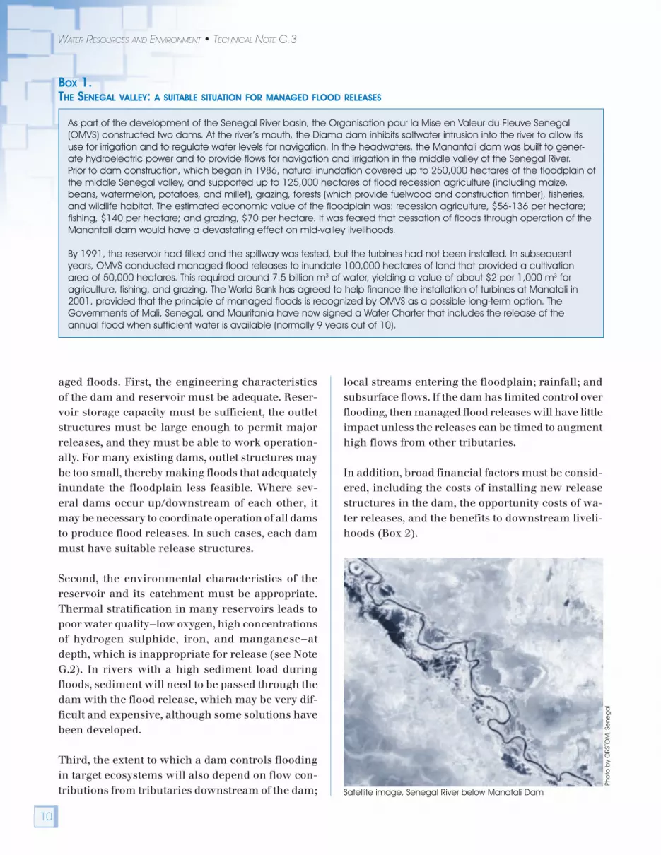
BOX 1.THE SENEGAL VALLEY: A SUITABLE SITUATION FOR MANAGED FLOOD RELEASES
As part of the development of the Senegal River basin, the Organisation pour la Mise en Valeur du Fleuve Senegal(OMVS) constructed two dams. At the river’s mouth, the Diama dam inhibits saltwater intrusion into the river to allow itsuse for irrigation and to regulate water levels for navigation. In the headwaters, the Manantali dam was built to gener-ate hydroelectric power and to provide flows for navigation and irrigation in the middle valley of the Senegal River.Prior to dam construction, which began in 1986, natural inundation covered up to 250,000 hectares of the floodplain ofthe middle Senegal valley, and supported up to 125,000 hectares of flood recession agriculture (including maize,beans, watermelon, potatoes, and millet), grazing, forests (which provide fuelwood and construction timber), fisheries,and wildlife habitat. The estimated economic value of the floodplain was: recession agriculture, $56-136 per hectare;fishing, $140 per hectare; and grazing, $70 per hectare. It was feared that cessation of floods through operation of theManantali dam would have a devastating effect on mid-valley livelihoods.
By 1991, the reservoir had filled and the spillway was tested, but the turbines had not been installed. In subsequentyears, OMVS conducted managed flood releases to inundate 100,000 hectares of land that provided a cultivationarea of 50,000 hectares. This required around 7.5 billion m3 of water, yielding a value of about $2 per 1,000 m3 foragriculture, fishing, and grazing. The World Bank has agreed to help finance the installation of turbines at Manatali in2001, provided that the principle of managed floods is recognized by OMVS as a possible long-term option. TheGovernments of Mali, Senegal, and Mauritania have now signed a Water Charter that includes the release of theannual flood when sufficient water is available (normally 9 years out of 10).
Satellite image, Senegal River below Manatali Dam
Pho
to b
y O
RSTO
M, S
ene
ga
l
aged floods. First, the engineering characteristicsof the dam and reservoir must be adequate. Reser-voir storage capacity must be sufficient, the outletstructures must be large enough to permit majorreleases, and they must be able to work operation-ally. For many existing dams, outlet structures maybe too small, thereby making floods that adequatelyinundate the floodplain less feasible. Where sev-eral dams occur up/downstream of each other, itmay be necessary to coordinate operation of all damsto produce flood releases. In such cases, each dammust have suitable release structures.
Second, the environmental characteristics of thereservoir and its catchment must be appropriate.Thermal stratification in many reservoirs leads topoor water quality—low oxygen, high concentrationsof hydrogen sulphide, iron, and manganese—atdepth, which is inappropriate for release (see NoteG.2). In rivers with a high sediment load duringfloods, sediment will need to be passed through thedam with the flood release, which may be very dif-ficult and expensive, although some solutions havebeen developed.
Third, the extent to which a dam controls floodingin target ecosystems will also depend on flow con-tributions from tributaries downstream of the dam;
local streams entering the floodplain; rainfall; andsubsurface flows. If the dam has limited control overflooding, then managed flood releases will have littleimpact unless the releases can be timed to augmenthigh flows from other tributaries.
In addition, broad financial factors must be consid-ered, including the costs of installing new releasestructures in the dam, the opportunity costs of wa-ter releases, and the benefits to downstream liveli-hoods (Box 2).

11
ENVIRONMENTAL FLOWS: FLOOD FLOWS
BOX 2.MAHAWELI: A RIVER WHERE FLOOD RELEASES ARE NOT APPLICABLE
The Mahaweli Scheme is a comprehensive multipurpose water resource development designed to harness thehydroelectric and irrigation potential of the Mahaweli Ganga, Sri Lanka’s largest and most important river. The river hasbeen utilized and diverted for irrigation purposes since at least the 1st century BC. King Parakrama Badhu 1 (AD 1153-1186) is said to have constructed or restored 165 dams, 3,910 canals, 163 major tanks and 2,376 minor tanks, makingextensive use of the water resources of the Mahaweli Ganga. Today only a fraction of these constructions are stillfunctioning, but they are nevertheless indicative of the old and extensive water diversion and use systems in theMahaweli Ganga. The current Accelerated Mahaweli Development Programme (AMDP) includes the development of320,000 acres of new irrigated land.
Due to their complexity, large and integrated water-use structures such as seen in the Mahaweli basin may not besuitable candidates for managed flood releases. The experience gained from sediment flushing trials conducted inRantembe reservoir by the Mahaweli Authority and Ceylon Electricity Board and Irrigation Department is indicative ofsome of the problems that could be expected if controlled flood releases were to be used in managing the Mahawelisystem.
Rantembe reservoir is silting fast, at about 6 percent per annum, and flushing has been considered as a technicaloption. Flushing of sediment has been carried out twice with a three-year interval. A substantial portion of the outflowfrom Rantembe reservoir moves along irrigation canals downstream. A third flushing event planned for 1999 wascanceled due to problems resulting downstream from siltation in these canals from the earlier flushings. Both old andnew weirs for diversion of water into these irrigation systems were constructed without any regulatory facilities. As a result,sediment-laden water cannot be confined to the main river. Any managed flood release from upstream reservoirs canbe expected to have a similar effect downstream. The cost of converting weirs to regulate flows, together with theextensive logistical and coordination problems associated with managing the releases, have not been calculated, butare likely to be prohibitive.
DESIGNING FLOOD RELEASES
If preliminary screening determines that there couldbe significant benefits from managed flood releases,and it is technically and financially feasible, thenpossible flood releases need to be designed.
STAKEHOLDER AND TECHNICALPARTICIPATION
A key element in defining appropriate flood releasesis to incorporate the expectations of stakeholders forfloodplain inundation. This should begin with iden-tification of the various stakeholders, such as damoperators/owners, local authorities, electricity com-panies, farmers, and—most importantly—downstreamfarmers and communities. Downstream communi-ties—floodplain farmers and residents, includingpastoralists and fisherfolk—should be regarded assubject to significant risk. Getting them involved re-quires a specific and innovative effort. Their cur-rent livelihood strategies, assets, and aspirationsshould be mapped to establish the population at risk.
Many of the techniques commonly included underthe label of “Participatory Rural Appraisal” (suchas village mapping and ranking exercises) may beuseful here, but what is important is a genuine com-mitment to participation, with adequate time andresources (Box 3). Where necessary, the processshould include building and strengthening stake-holder organizations, such as local NGOs, to en-able them to participate fully. The aim is to ensurethat managed floods are compatible with the liveli-hood strategies of the floodplain communities. If lo-cal social structures allow, participation can bestructured through the establishment of a WaterCommittee (Box 4), which can help in deciding onthe magnitude, frequency, duration, and timing offloods, as well as in informing local communitieswhen the flood is coming.
At an early stage, an equally important action is toinitiate data collection to improve understandingof the physical, chemical, biological, and socioeco-

12
WATER RESOURCES AND ENVIRONMENT • TECHNICAL NOTE C.3
BOX 4.COMMUNITY-BASED INSTITUTIONS IN THE PHONGOLO RIVER
In the late 1960s, the Pongolapoort dam was constructed on the Phongolo River in northeast South Africa near itsborders with Swaziland and Mozambique. The reservoir was filled in 1970. It was intended to irrigate 40,000 hectares ofagricultural land for white settlers, with no provision for hydropower generation. There were no assessments of theimpacts of the impoundment on the downstream floodplain, where 70,000 Tembe-Thonga people were dependent onrecession agriculture, fishing, and other wetland resources, or on the biodiversity of the Ndumu game reserve. Whenconstructed, the dam changed the whole flooding regime of the river, which had significant negative impacts onagriculture and fisheries. In addition, few settlers used the irrigation scheme.
In 1978, a workshop was held on the Phongolo floodplain to review the future of irrigation and to minimize the negativeimpacts on the floodplain. This led to a plan for controlled releases to rehabilitate the indigenous agricultural systemand the wildlife. However, initial releases of water from the dam were made at the wrong time of the year, and cropswere either washed away or rotted. In 1987, the South African Department of Water Affairs and Forestry and the localauthorities agreed to experiment with community participation. As a result, water committees were established, repre-senting various user groups, including fisherfolk, livestock keepers, women, and healthworkers (both new primary healthcare workers and traditional herbalists and diviners). They were given the mandate to decide when floodwaters shouldbe released. These committees successfully implemented people’s views, which in turn led to river basin managementthat benefited the floodplain users.
BOX 3.PARTICIPATORY RURAL APPRAISAL IN THE WAZA-LOGONE PROJECT, CAMEROON
Participatory Rural Appraisal (PRA) methods were used in the Logone Floodplain in Northern Cameroon to investigatethe socioeconomic impacts of declining floods. PRA was chosen because of the difficulties of collecting complexinformation on interactions between society and the environment in a participatory way. It was also felt that conven-tional survey methods would fail to capture seasonal variations in an area that was inaccessible by road in the dryseason.
Several PRA methods were used, including:n Participatory mapping was used with both men and women to gather information on land-use, the floodplain
environment and the operation of the villagen Timelines identified key dates in floodplain history; these illuminated the issue of conflicts among farmers, herders,
and fishersn Transect walks were used outside the village to examine natural resource issues, and inside the village to look at
building materials and living conditionsn Ranking was used for problems and productive activitiesn Wealth ranking enabled sampling of households for interview, estimation of human and livestock numbers, and
understanding of local notions of wealthn Semi-structured interviewsn Venn diagrams described relations between groups and institutions within and outside the villagen Resource flow diagrams were used on common property issues, trade, and service deliveryn Feedback to villagers
Despite a relatively short time-scale and constraints such as the lack of an educated woman on the team, theexperience generated a great deal of quantitative and qualitative information. The organizers were also able to set upsimple environmental and socioeconomic monitoring systems that could be run by villagers.
nomic aspects of the reservoir (see Note G.2) andfloodplain and wetlands (see Note G.3). All reportsand data should be made publicly available; estab-lishing a local information center is an excellentway to do this. In addition, implementing organi-
zations need training and awareness building tounderstand and use floodplains wisely. This requiresstrengthened technical skills in ecology, hydrology,engineering, health, economics, social anthropol-ogy, and law.
13
ENVIRONMENTAL FLOWS: FLOOD FLOWS
LINKS BETWEEN FLOODS ANDTHE ECOSYSTEM
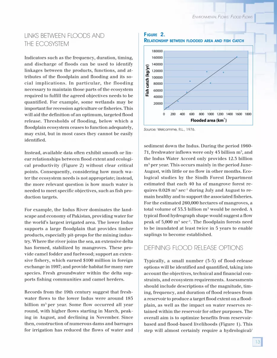
Indicators such as the frequency, duration, timing,and discharge of floods can be used to identifylinkages between the products, functions, and at-tributes of the floodplain and flooding and its so-cial implications. In particular, the floodingnecessary to maintain those parts of the ecosystemrequired to fulfill the agreed objectives needs to bequantified. For example, some wetlands may beimportant for recession agriculture or fisheries. Thiswill aid the definition of an optimum, targeted floodrelease. Thresholds of flooding, below which afloodplain ecosystem ceases to function adequately,may exist, but in most cases they cannot be easilyidentified.
Instead, available data often exhibit smooth or lin-ear relationships between flood extent and ecologi-cal productivity (Figure 2) without clear criticalpoints. Consequently, considering how much wa-ter the ecosystem needs is not appropriate; instead,the more relevant question is how much water isneeded to meet specific objectives, such as fish pro-duction targets.
For example, the Indus River dominates the land-scape and economy of Pakistan, providing water forthe world’s largest irrigated area. The lower Indussupports a large floodplain that provides timberproducts, especially pit-props for the mining indus-try. Where the river joins the sea, an extensive deltahas formed, stabilized by mangroves. These pro-vide camel fodder and fuelwood; support an exten-sive fishery, which earned $100 million in foreignexchange in 1997; and provide habitat for many rarespecies. Fresh groundwater within the delta sup-ports fishing communities and camel herders.
Records from the 19th century suggest that fresh-water flows to the lower Indus were around 185billion m3 per year. Some flow occurred all yearround, with higher flows starting in March, peak-ing in August, and declining in November. Sincethen, construction of numerous dams and barragesfor irrigation has reduced the flows of water and
sediment down the Indus. During the period 1960-71, freshwater inflows were only 43 billion m3, andthe Indus Water Accord only provides 12.3 billionm3 per year. This occurs mainly in the period June-August, with little or no flow in other months. Eco-logical studies by the Sindh Forest Departmentestimated that each 40 ha of mangrove forest re-quires 0.028 m3 sec-1 during July and August to re-main healthy and to support the associated fisheries.For the estimated 260,000 hectares of mangroves, atotal volume of 33.3 billion m3 would be needed. Atypical flood hydrograph shape would suggest a flowpeak of 5,000 m3 sec-1. The floodplain forests needto be inundated at least twice in 5 years to enablesaplings to become established.
DEFINING FLOOD RELEASE OPTIONS
Typically, a small number (3-5) of flood-releaseoptions will be identified and quantified, taking intoaccount the objectives, technical and financial con-straints, and ecosystem requirements. Assessmentsshould include descriptions of the magnitude, tim-ing, frequency, and duration of flood releases froma reservoir to produce a target flood extent on a flood-plain, as well as the impact on water reserves re-tained within the reservoir for other purposes. Theoverall aim is to optimize benefits from reservoir-based and flood-based livelihoods (Figure 1). Thisstep will almost certainly require a hydrological/
FIGURE 2.RELATIONSHIP BETWEEN FLOODED AREA AND FISH CATCH
Source: Welcomme, R.L., 1976.
Flooded area (km )2
Fish
cat
ch (k
g/y
r)
180000
160000
140000
120000
100000
80000
60000
40000
20000
0 200 400 600 800 1000 1200 1400 1600 1800
14
WATER RESOURCES AND ENVIRONMENT • TECHNICAL NOTE C.3
hydraulic model of the floodplain, reservoir, mainchannel, and catchment (Box 5). The “no-flood” op-tion should always be included in the analysis.
Appropriate flows during the non-flood season mustalso be addressed. For example, the Kafue Flatsfloodplain in Zambia is unusual in being directlydownstream of one reservoir (Itezhi-tezhi) and di-rectly upstream of another (Kafue Gorge). The jointoperation of the dams significantly affects floodingin the flats. Under natural conditions, the flats usedto empty almost completely by the end of the dryseason, creating a large recession zone that wasimportant for agriculture, fishing, grazing, andbiodiversity (especially providing habitat for the rarelechwe antelope). Managed flood releases fromItezhi-tezhi have meant little change in the maxi-mum area flooded each year. However, dry seasonreleases from Itezhi-tezhi for hydropower genera-
tion are greater than the flows that would occurnaturally. This increase, combined with storage inKafue Gorge reservoir, has created a larger perma-nently flooded area. The annual minimum floodedarea has increased from 300 km2 to about 1,500 km2.The decrease in difference between dry and wetseason inundation has reduced the flood recessionzone and also resulted in the loss of grazing, tradi-tional flood recession gardening systems, and a de-cline in fisheries.
This highlights both the need for full understand-ing of the interaction between the entire hydrologi-cal regime and the ecological functioning ofthe floodplain and, where more than one dam ex-ists, the importance of coordinating their opera-tion to ensure that flows—including periods of noflow—achieve the objectives agreed between theparties.
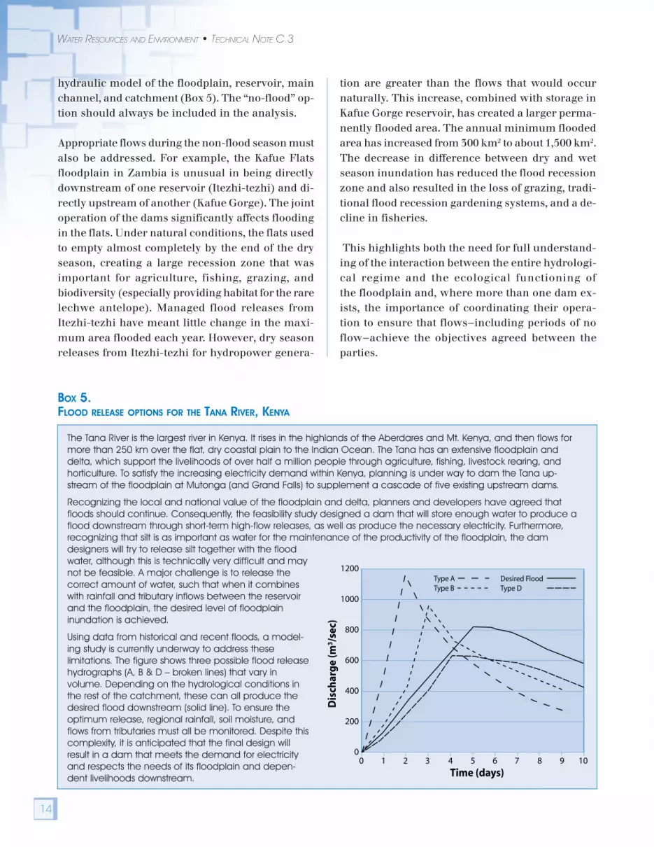
BOX 5.FLOOD RELEASE OPTIONS FOR THE TANA RIVER, KENYA
The Tana River is the largest river in Kenya. It rises in the highlands of the Aberdares and Mt. Kenya, and then flows formore than 250 km over the flat, dry coastal plain to the Indian Ocean. The Tana has an extensive floodplain anddelta, which support the livelihoods of over half a million people through agriculture, fishing, livestock rearing, andhorticulture. To satisfy the increasing electricity demand within Kenya, planning is under way to dam the Tana up-stream of the floodplain at Mutonga (and Grand Falls) to supplement a cascade of five existing upstream dams.
Recognizing the local and national value of the floodplain and delta, planners and developers have agreed thatfloods should continue. Consequently, the feasibility study designed a dam that will store enough water to produce aflood downstream through short-term high-flow releases, as well as produce the necessary electricity. Furthermore,recognizing that silt is as important as water for the maintenance of the productivity of the floodplain, the damdesigners will try to release silt together with the floodwater, although this is technically very difficult and maynot be feasible. A major challenge is to release thecorrect amount of water, such that when it combineswith rainfall and tributary inflows between the reservoirand the floodplain, the desired level of floodplaininundation is achieved.
Using data from historical and recent floods, a model-ing study is currently underway to address theselimitations. The figure shows three possible flood releasehydrographs (A, B & D – broken lines) that vary involume. Depending on the hydrological conditions inthe rest of the catchment, these can all produce thedesired flood downstream (solid line). To ensure theoptimum release, regional rainfall, soil moisture, andflows from tributaries must all be monitored. Despite thiscomplexity, it is anticipated that the final design willresult in a dam that meets the demand for electricityand respects the needs of its floodplain and depen-dent livelihoods downstream. Time (days)
Dis
char
ge
(m3 /s
ec)
0 1 2 3 4 5 6 7 8 9 10
1200
1000
800
600
400
200
0
Type AType B
Desired FloodType D

15
ENVIRONMENTAL FLOWS: FLOOD FLOWS
IMPACTS OF FLOOD OPTIONS
Since a final flooding regime will inevitably be acompromise between different objectives, it is im-portant to assess the impacts of the various flood-ing options, both for floodplain-dependentlivelihoods and for reservoir-dependent livelihoods.A range of impact assessments must therefore beinitiated at an early stage, so that scoping of issuesand collection of data can begin and possible mea-sures to mitigate negative impacts can be defined.In most countries, a formal EIA is a legal require-ment. Impact assessment can take many forms, butenvironment, health, and law are key areas. Thereshould also be direct and participatory assessmentof impacts on livelihoods, using a broad definitionof assets, including social capital. The criteria toevaluate livelihood outcomes should also be de-fined with stakeholder participation.
Additionally, laws may need to be established toregulate natural resource use, as there may be an
influx of people into restored floodplain ecosystems.The adequacy of current laws can be evaluatedthough a legal impact assessment. Managed floodsmay have positive or negative impacts on nutrition,drinking water quality, injury, stress, communal vio-lence, and communicable diseases such as malaria,schistosomiasis, and arboviruses. Thus, the healthimpacts of flood options should also be consideredas part of the assessment.
The assessment must equally include the impactson the reservoir and its dependent activities. Re-leasing water to create a managed flood will nor-mally mean less water for intensive irrigation,hydropower generation and/or water supply. Theseimpacts must be quantified. In some cases, legisla-tion designed to protect downstream communitiesmay prevent those responsible for the dam frommaking managed flood releases. In addition, down-stream communities may have rights to use thewater, which would require compensation.
SELECTING THE BEST FLOOD OPTION
For each option, the monetary and non-monetarycosts and benefits and their distribution among allstakeholders should be estimated (Box 6). Nationalor local economic benefits should not be the onlycriteria on which to make decisions about managedfloods. It is also vital to consider other political, so-cial, historical, and ecological issues, particularlythe rights and welfare of those affected. In manycases, the link between flooding and livelihoods willbe imprecise and understood in only a qualitativeway. A decision should then be made on the mostappropriate option, using a transparent method inwhich stakeholders participate and understand theresults.
Pho
to b
y Ra
fik H
irji,
Wo
rld B
ank
Nyumba ya Mungu Dam, Tanzania
16
WATER RESOURCES AND ENVIRONMENT • TECHNICAL NOTE C.3
BOX 6.VALUATION IN THE HADEJIA-JAMA’ARE RIVER BASIN, NORTHERN NIGERIA
In Northern Nigeria, an extensive floodplain exists where the Hadejia and Jama’are Rivers converge. The floodplainprovides essential income and nutrition benefits in the form of agriculture, grazing resources, non-timber forest prod-ucts, fuelwood, and fishing for local populations. In addition, it helps to recharge the regional aquifer and serves as anessential groundwater source. The maximum extent of flooding has declined from 300,000 ha in the 1960s to around70,000 to 100,000 ha more recently, following the construction of the Tiga and Challawa Gorge dams upstream. Thereare plans for a new dam at Kafin Zaki.
Economic analysis of the Kano River Project (a major irrigation scheme benefiting from the upstream dams) and thefloodplain showed that the net economic benefits of the floodplain (agriculture, fishing, fuelwood) were at least $32 per1000 m3 of water (at 1989 prices). However, the returns from crops grown in the Kano River Project were at most only$1.73 per 1000 m3. When the operational costs are included, the net benefits of the project are reduced to $0.04 per1000 m3.
A combined economic and hydrological analysis was conducted to simulate the impacts of these upstream projectson the flood extent that determines the downstream floodplain area. The economic gains of the upstream waterprojects were then compared to the resulting economic losses to downstream agricultural, fuelwood, and fishingbenefits. Given the high productivity of the floodplain, the losses in economic benefits due to changes in flood extentfor all scenarios are large, ranging from $2.6 million to $24 million. As expected, there is a direct trade-off betweenincreasing irrigation upstream and impacts on the floodplain downstream. Full implementation of all the upstreamdams and large-scale irrigation schemes would produce the greatest overall net losses, around $20 million.These results suggest that the expansion of the existing irrigation schemes within the river basin is uneconomic. Theintroduction of a regulated flooding regime would reduce the scale of this negative balance substantially, to around$15 to $16 million. However, the overall combined value of production from irrigation and the floodplain would still fallwell below the levels experienced if the additional upstream schemes were not constructed.
IMPLEMENTATION
DESIGNING ENGINEERING STRUCTURES
The dam outlet structures will need to be designedand constructed (for new dams) or may need tobe adapted (for existing dams) to allow necessaryand feasible flood releases and sediment delivery.The position of outlets will need to take intoaccount any thermal and associated chemicalstratification in the reservoir. Embankmentsmay need to be constructed on the floodplain toprotect infrastructure—such as houses, roads, andfactories—from flooding or to enhance, control, orreduce inundation in selected areas. However, in-frastructure is still likely to be affected by largenatural flood events, irrespective of any managedflood releases.
Some infrastructure may also be needed to maxi-mize the benefits from the controlled releases. For
example, to make the most of the flooding that doesoccur in the Hadejia-Jama’are River Basin (Box 6),a series of small embankments have been built byfarmers to control the level of water in different partsof the floodplain. Water movement is controlled bysmall, hand-operated sluice gates. Early in the flood-ing season, mesh “gates” are installed, which al-low water in but keep out fish that would eat theyoung growing plants. Once the plants are estab-lished, the mesh is removed to allow fish to spawnand fry to grow in the flooded areas. As the floodsubsides, wooden boards may be put in if floodingneeds to be prolonged.
Further associated structures may also be required,such as fish ladders, sluice gates, or adaptation ofthe spillway to minimize disease vectors. Localhealth centers may need to be stocked with drugsbefore the beginning of each flood season.

17
ENVIRONMENTAL FLOWS: FLOOD FLOWS
RELEASING THE WATER
Where possible, pilot flood releases of various sizescan be made over a period of 2–3 years to determinethe response of the ecosystem and of local commu-nities. If project funds permit, it is best to install real-time monitoring of both precipitation and river flows,and link these data to flood forecasting models. Thishelps define the appropriate release to create therequired inundation, thus optimizing water resourcesallocation between reservoir-dependent livelihoodsand flood-dependent livelihoods. In many cases, itwill be possible to create the desired floodplain in-undation by adding water from a reservoir to a natu-ral small flood rather than trying to create the entireflood from managed reservoir releases.
Floodplain residents need advance warning aboutplanned flood releases to enable them to move live-stock and other vulnerable assets to safe areas. Ide-ally, the coordination mechanisms establishedduring the planning phases to elicit stakeholderviews can be used to disseminate flood warnings.In addition, radio broadcasts, posters, and othermedia may be required to reach all floodplain com-munities. Further awareness development and ca-pacity building exercises can be used to demonstratethe impacts of the new flood regime. When the floodrelease notification program is completed, full re-leases can be made.
In many cases, it will be necessary to liberate sedi-ment from the reservoir as part of the flood re-leases to maintain the structure of downstreamrivers and deltas and the fertility of floodplains.This will also help to prolong the life of the reser-voir by sustaining its storage capacity (Box 7).However, the technique will be of limited valuewith hydropower dams, because it is not possibleto pass high silt loads through hydropower tur-bines.
MONITOR, EVALUATE, AND ADAPTRELEASE PROGRAM
Adequate ecological and socioeconomic monitor-ing will help to assess the effectiveness of flood re-leases in relation to the objectives. It is preferableto decide at an early stage on the indicators ofwhether the objectives are being attained or not.Monitoring should be designed to differentiate be-tween the changes to social and environmental con-ditions caused by flood releases from those arisingfrom other factors. Since the time-scales for eco-logical and social change may be many decades,monitoring should be continued for long periodswith adequate funding. The flood release programcan be modified once the effectiveness of the re-leases becomes apparent.
BOX 7.RELEASING SEDIMENT FROM TARBELA DAM, PAKISTAN
Pakistan’s Tarbela Dam, completed in 1974 as a component of the Indus basin scheme, provides for both irrigationand hydropower. Of the 240,000 tons of sediment entering the reservoir annually, 80 percent is trapped. Unless actionis taken, the steadily declining volume of the reservoir will mean that the facility has a severely diminished value by2030. A technique to flush the sediment through the dam by lowering the reservoir level and releasing high flows for asustained period has been tested recently. These studies have shown that it is possible to maintain a substantial long-term live storage with only a small annual reduction in stored water. The process works effectively when a low reservoirlevel is maintained and the period of flushing is several weeks. The live-storage volume at Tarbela would eventuallysettle at about half its original value. To use this flushing technique to extend the reservoir ’s life, it may be necessary toincrease the capacity of the low-level flow release facilities at the dam.

18
WATER RESOURCES AND ENVIRONMENT • TECHNICAL NOTE C.3
A PRACTICAL EXAMPLE — THE WAZA-LOGONE FLOODPLAIN
The Waza-Logone floodplain in Cameroon is eco-logically and socially suited to flood releases. In thisexample, flood releases from an existing dam werenegotiated in a way that satisfied downstream com-munities dependent on floodplains, as well as thosegroups who used the stored water for irrigation.
The Logone River drains from the Adamoua pla-teau in central Cameroon. Before it joins the ChariRiver, flood water from the river inundates annu-ally a large floodplain, originally around 6,000 km2.This wetland has a high biodiversity with large herdsof giraffe, elephant, lions, and various ungulates.Part of the floodplain is designated as the WazaNational Park, which attracts around 6,000 touristsper year.
In the flood season, the entire floodplain becomesa vast fish nursery. Up to the 1960s, fishing wasthe primary economic activity among the localKotoko people, who could earn $2,000 in fourmonths. The Fulani name for the floodplain isyaérés, which means “dry season pasture.” Annu-ally, some 300,000 cattle and 10,000 sheep and goatsgrazed on the floodplains. Pastures become acces-sible when surrounding savanna grasses witheredand their protein content was depleted. The carry-ing capacity has been estimated at 1–2 cattle perha, compared with 0.2 for surrounding savannah.Floating rice was the main arable crop of the flood-plain, since it has low labour demands and fits wellinto the fishing calendar. Yields were not high, butenough land was available to ensure self-sufficiencyin rice.
The area inundated has been reduced since 1979.This is partly due to climatic factors, but primarilydue to construction of a dam across the floodplain,which created Lake Maga. The lake supplies theSEMRY II irrigation project, where rice is grown.(The dam is adjacent to the river and thus does notstop all flow). There is insufficient flooding to growfloating rice in large areas of the floodplain, andfish yields fell by 90 percent.
The SEMRY rice scheme was not making full useof water stored in Lake Maga. Using the water torehabilitate the floodplain, while retaining enoughto maintain rice production, was a development op-tion. Hydrological, ecological, and socioeconomicstudies suggested that such managed flood releasescould improve fisheries, agriculture, and herding,though much would depend on the available flooddischarges and the response of local people and theirenvironment to renewed flooding. However, re-es-tablishing these flood flows could attract a largeinflux of people, who would over-exploit the areaand thus degrade the rehabilitated resources of thefloodplain.
The Waza-Logone Conservation Project, coordinatedby IUCN, undertook a wide range of activities inthe floodplain and surrounding area over 8 yearsthat highlighted many of the issues discussed inthese Notes. The results of these activities are usedto exemplify the design and implementation of man-aged flood releases.
PRELIMINARY STEPS
The objectives were to restore biodiversity and thelivelihoods of communities—who depend on natu-ral resources of the floodplain—through managedflood releases, while retaining sufficient water inthe reservoir for intensive rice irrigation. Theseobjectives were defined through analyses of the deg-radation of the floodplain ecosystem and of the ef-ficiency of the SEMRY irrigation scheme.
Technical studies were undertaken to assess thecapacity of the outlet structures of the dam, the chan-nels leading from it, and the river embankments.Because the reservoir is shallow, thermal andchemical stratification was not a problem. In addi-tion, the reservoir is “off-line” and does not controlthe entire flow of the river, so sediment release wasnot an issue. Natural inundation of the floodplainresulted from a series of three processes: (1) rainfalling directly onto the floodplain; (2) runoff from
19
ENVIRONMENTAL FLOWS: FLOOD FLOWS
local streams entering the floodplain; and (3) flowsin the Logone River exceeding the capacity of itschannel.
DESIGNING FLOOD RELEASES
The project developed a participatory process thatinvolved relevant national and local authorities,floodplain communities (using Participatory RuralAppraisal), and SEMRY management. Local inter-est groups—concerned with, for example, fisheriesand small-scale rice farming—were establishedwithin local communities. The next step was to es-tablish a water committee with local communityrepresentatives, the SEMRY rice scheme manag-ers, Waza National Park staff, and local authorities.Technical expertise was developed in local institu-tions by involving their staff in the project.
The project team conducted detailed studies of theinteraction between vegetation and flooding. Theseshowed that there was a change from annual toperennial grasses with inundation over a three-yearperiod. The surveys were continued as part of thepilot releases.
A hydrological model of the reservoir, floodplain,main river, and local tributaries was constructedand used in conjunction with ecological and socio-economic models to define flooding options underdry, wet, and very wet conditions.
A preliminary Environmental Impact Assessmentof all flood options was undertaken. Studies of wa-ter-related diseases focused attention on water sup-
ply (wells), sanitation (latrines), and hygiene aware-ness programs, which led to reduced diarrheal dis-eases. The team also assessed the impact ofre-flooding on the operation of the SEMRY ricescheme. Further studies of the health and environ-mental impacts of the full-flood option are planned.
The team also conducted an economic analysis ofvarious flooding options. Re-flooding of 90 percentof the floodplain yielded annual values of $550,000for fisheries, $930,000 for herding, $31,500 for re-cession agriculture, and $60,000 for tourism. Thenet present value over 30 years was 15,000 millionCFA (about $20 million), assuming a discount rateof 4 percent.
IMPLEMENTING THE CHOSEN FLOWS
Changes to the embankments along the main riverand channels feeding the floodplain with water wereplanned and implemented in collaboration withlocal communities. Modifications to the outlet struc-tures of the dam were not required. No embank-ments were necessary to protect the SEMRY ricescheme from flooding.
Pilot flood releases were conducted in 1994 and 1997to determine the response of the ecosystem and oflocal communities. Further test releases from thedam are planned. Hydrological, ecological, socio-logical, and economic monitoring was establishedfor the pilot releases to assess the impacts of flood-ing and the results were used to refine the modelsand flooding options.

20
WATER RESOURCES AND ENVIRONMENT • TECHNICAL NOTE C.3
CONCLUSION
Most river systems throughout the world will havesome element of their ecosystem—such as fish spe-cies that breed on the floodplain or vegetation thatrequires periodic watering—that has evolved to ben-efit from floods. In some cases, the species or land-scapes (particularly those that are rare or endan-gered) may be worth conserving for their own sake.In many other cases, local communities will havedeveloped livelihoods that depend on these floods.These dependencies include subsistence agriculture
in developing countries and sport fishing in devel-oped countries. In principle, therefore, most reser-voirs have a potential for managed flood releases.
The appropriateness of managed flood releases willdepend on the relative merits of using water for floodreleases compared to storing it in the reservoir forirrigation, public/industrial supply, or hydropower.This decision can only be made on a case-by-basebasis.
FURTHER INFORMATION
The following reports provide background infor-mation on managed flood releases:
Acreman, M.C. 2000. Managed flood releases from reser-voirs; issues and guidance. World Commissionon Dams Thematic Review 11.1 Dams Ecosys-tem functions and environmental restoration.World Commission on Dams. Down-loadablefrom www.dams.org or on CD from Earthscan,London, www.earthscan.co.uk
Acreman, M.C., and G.E. Hollis. 1996. Water managementand wetlands in sub-Saharan Africa. Gland, Swit-zerland and Cambridge, UK: IUCN.
Petts, G.E. 1984 Impounded rivers. Chichester, UK : JohnWiley & Sons.
Articles on the subject include:
Junk, W.J., P.B. Bayley, and R.E.Sparks. 1989. “The floodpulse concept in river floodplain systems.” In:Dodge, D.P., ed. Proceedings of the InternationalLarge Rivers Symposium. Honey Harbour,Ontario, September 1986. Canadian Journal ofFisheries and Aquatic Science, special publica-tion, 106: 110–127.
McCartney, M.P., and M.C. Acreman. 2001. “Managed floodreleases as an environmental mitigation option.”International Journal of Hydro-power and Dams.8 (1) : 74–80.
Scudder, T. 1991. “The need and justification for main-taining transboundary flood regimes: The Africacase.” Natural Resources Journal, 31: 75–122.
Welcomme, R.L. 1976. “Some general and theoretical con-siderations on fish yields of African rivers.” Jour-nal of Fisheries Biology, 8: 351–364.