environmental aspects of integrated flood
TRANSCRIPT
a
ENVIRONMENTAL ASPECTS OF INTEGRATED FLOOD MANAGEMENT
CASE STUDIES

The Associated Programme on Flood Management (APFM) is a joint initiative
of the World Meteorological Organization (WMO) and the Global Water Partnership
(GWP).
It promotes the concept of Integrated Flood Management (IFM) as a new
approach to flood management. The programme is financially supported by the
French Ministry of Foreign Affairs and International Development, the National
Water Commission of Mexico (CONAGUA) and the US Agency for International
Development (USAID).
www.floodmanagement.info
The World Meteorological Organization (WMO) is a specialized agency of
the United Nations. It coordinates the activities of the National Meteorological
and Hydrological Services (NMHSs) of 191 Member States and Territories (as of
September 2016) and as such is the centre of knowledge about weather, climate
and water.
www.wmo.int
The Global Water Partnership (GWP) is an international network open to all
organizations involved in water resources management. It was created in 1996 to
foster Integrated Water Resources Management (IWRM)
www.gwp.org
© World Meteorological Organization, 2017
The right of publication in print, electronic and any other form and in any language is reserved by WMO. Short extracts from WMO publications may be reproduced without authorization, provided that the complete source is clearly indicated. Editorial correspondence and requests to publish, reproduce or translate this publication in part or in whole should be addressed to:
Chair, Publications Board World Meteorological Organization (WMO) 7 bis, avenue de la Paix Tel.: +41 (0)22 730 84 03 P.O. Box 2300 Fax: +41 (0)22 730 80 40 CH-1211 Geneva 2, Switzerland e-mail: [email protected]
Note
The designations employed and the presentation of material in this publication do not imply the expression of any opinion whatsoever on the part of the Secretariat of the World Meteorological Organization concerning the legal status of any country, territory, city, or area, or of its authorities, or concerning the delimitation of its frontiers or boundaries.
Acknowledgements
This tool has exploited the works of many organizations and experts, as listed in the references. Acknowledgement is due to the members of the WMO Climate and Water Department and the members of the Technical Support Unit (TSU) of APFM for their competent technical guidance and frank discussions on the issues and for bringing various perspectives into focus.
The contributions of Dr Makoto Hyodo, IDEA Consultants, Inc., Japan (also formerly TSU/APFM) are gratefully acknowledged.

iv
CONTENTS
1 Introduction 1
2 Trinity River Restoration Program, USA 2
2.1 Introduction 2
2.2 Interrelationship between ecosystem services and flood processes 3
2.3 Addressing environmental aspects in flood management: key challenges 7
2.4 Trinity River Restoration Program 7
2.5 Decision-making processes and capacity development 14
3 Channel-widening and open check dam in the Upper Drau River, Austria 16
3.1 Introduction 16
3.2 Interrelationship of ecosystem services and flood processes 17
3.3 Addressing environmental aspects in flood management: key challenges 18
3.4 LIFE project for the Upper Drau River 18
3.5 Decision-making processes and capacity development 26
3.6 The Drau River Vision Symposium 27
4 Integrated sediment management in the Mimikawa River, Japan 28
4.1 Introduction 28
4.2 Interrelationship of ecosystem services and flood processes 30
4.3 Key challenges to addressing environmental aspects in flood management 34
4.4 Integrated sediment management plan for the Mimikawa River Basin 35
4.5 Decision-making processes and capacity development 40
5 Creating a secondary channel in the Waal River under the Room for the River concept, Netherlands 42
5.1 Introduction 42
5.2 Interrelationship of ecosystem services and flood processes 43
5.3 Addressing environmental aspects in flood management: key challenges 44
5.4 Room for the River Programme under the European Water Frame Directive 45
5.5 Decision-making processes and capacity development 54
References & bibliography 56
v
Environmental Case Studies
ABBREVIATIONS & ACRONYMSAEAM Adaptive Environmental Assessment and Management
APFM Associated Programme on Flood Management
CAP/MAR total capacity/mean annual runoff
CAP/MAS total capacity/mean annual inflow sediment
CRIEPI Central Research Institute of Electric Power Industry, Japan
GWP Global Water Partnership
IDT Interdisciplinary Team
IFM Integrated Flood Management
IWRM Integrated Water Resources Management
KEPCO Kyushu Electric Power (Japan)
MLIT Ministry of Land, Infrastructure, Transport and Tourism, Japan
NGO non-governmental organization
RIZA Institute for Inland Water Management and Wastewater Treatment (Netherlands)
RM a river mile from its river mouth
ROD Record of Decision
SAB Science Advisory Board
TAMWG Trinity Adaptive Management Working Group
TMC Trinity Management Council
TRD Trinity River Division
TRRP Trinity River Restoration Program
TSU Technical Support Unit
USFWS US Fish and Wildlife Service
WMO World Meteorological Organization
1
INTRODUCTION
1 INTRODUCTIONIntegrated Flood Management (IFM) addresses issues of human security and sustainable development from the perspective of flood management, within the framework of Integrated Water Resources Management (IWRM). Some of the underlying causes that make it difficult to integrate the growing concerns regarding environmental degradation into sound flood-management practices arise from a communication gap between the various disciplines involved in understanding the varying perspectives of sustainable development (WMO, 2006). The publication Environmental Aspects of Integrated Flood Management was developed in 2006 as part of the Flood Management Policy Series. In an attempt to narrow this communication gap, it presents IFM approaches with special reference to environmental aspects and consists of the following chapters:
— Setting the scene: environment and sustainable development;
— Understanding the basic concepts of the morphology and ecology or rivers and their floodplains;
— Flood processes and ecosystem services: interrelationships;
— Flood-management interventions and ecosystems;
— Factoring environmental considerations in decision-making processes.
It was prepared primarily for flood managers to enable them to understand the range of environmental issues involved in flood management. At the same time, it provides useful information for policymakers, environmental groups and non-governmental organizations (NGOs) and communities to help them assess flood risks in relation to environmental concerns and sustainable development.
As there are no universal criteria to determine environmentally friendly flood-management practices, however, it is crucial to help those stakeholders adopt practices that suit the particular circumstances in a given hydro-climatic, topographical and socioeconomic setting and to follow a rational and balanced approach in addressing environmental issues in flood management. In the approximately 10 years since the issue of the publication in 2006, various projects have been carried out in an effort to balance flood-management objectives and environmental concerns around the world. Now is thus an ideal opportunity to share the good lessons learned to move forward for the outreach processes and translate an IFM concept at the policy level into actual practice at the project and implementation levels in as many countries as possible.
In this publication – Environmental Aspects of IFM: Case Studies – four case studies that have incorporated environmental (ecological) aspects in flood management have been compiled, adopting various approaches, from different parts of the world, as follows:
— Trinity River Restoration Program, USA;
— Channel-widening and open check dam in the Upper Drau River, Austria;
— Integrated sediment management in the Mimi River, Japan;
— Creating a secondary channel in the Waal River under the “Room for the River” concept, Netherlands.
Each case study addresses the following:
— Interrelationship of ecosystem services and flood processes;
— Key challenges to addressing environmental aspects in flood management;
— Decision-making processes involving various stakeholders;
— Capacity development to the maximum possible extent, so that these studies can be linked to the concept of the Flood Management Policy series and can be used as references for adopting balanced approaches to flood management at the project and implementation levels.

2
Environmental Case Studies
2 TRINITY RIVER RESTORATION PROGRAM, USA
2.1 Introduction
The Trinity River in California, USA, begins in the rugged Trinity Alps in north-western California, tumbling through steep canyons and meandering through broad valleys until it joins the Klamath River to flow into the Pacific Ocean (McBain & Trush, Inc., 2000) (Figure 1). It is the largest tributary of the Klamath River, draining an area of approximately 7 770 km2 (3 000 square miles).
Figure 1 — The Trinity River basin and adjacent area in north-western California (US Fish and Wildlife Service USFWS, 1999)
The terrain is predominately mountainous and forested, with elevations ranging from 2 743 m (9 000 ft) above sea level in the headwater areas, to less than 91 m (300 ft) at the confluence with the Klamath River. The majority of the basin (approximately 70%) is under public ownership, including the Trinity Alps Wilderness areas, the Shasta-Trinity National Forest, Six Rivers National Forest, Bureau of Land Management, Bureau of Reclamation, and various state and county entities (USFWS, 1999).
The Hoopa Valley Tribe occupies 373 km2 (144 square miles) of the lower basin, while industrial timber companies and other private landowners make up the remaining portions of the basin. Several geological strata transect the basin, including the Eastern Klamath Subprovince, Central Metamorphic Subprovince, Hayfork Terrain

3
Trinity River Restoration Program, USA
and Galice Formation. Land-use activities in the Trinity include mining, timber-harvesting, road construction, recreation and a limited degree of residential development in certain locations (USFWS, 1999).
Historically, the Trinity River has been well known since the discovery of gold in the late 1840s; gold mining continued until the 1950s. This river once supported large populations of autumn- and spring-run chinook salmon (Oncorhynchus tshawytscha), as well as smaller runs of coho salmon (O. kisutch) and steelhead (O. mykiss) by floods, which refreshed spawning gravels, scoured deep holes and provided clear, cool water. For thousands of years, the Hoopa and Yurok tribes used the fish, plants and animals in and along the Trinity River for subsistence, as well as for cultural, ceremonial and commercial purposes (McBain & Trush, Inc., 2000).
2.2 Interrelationship between ecosystem services and flood processes
In the 1950s, the Trinity and Lewiston Dams were constructed as multi-purpose dams, including flood control as an objective. A plan was executed to increase water supplies in California’s Central Valley in part by transferring water from the Trinity River into the Sacramento River (McBain & Trush, Inc., 2000) (Figure 2).
Figure 2 — Trinity River Division of the Central Valley Project (USFWS, 1999)
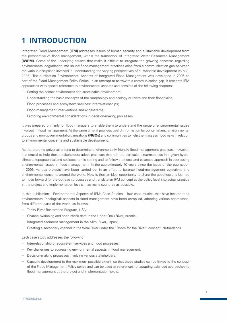
A river’s size and shape (morphology) is determined by the interaction of its flows and sediment (fluvial processes). Prior to the Trinity River Division (TRD) of the Central Valley Project, streamflows varied greatly between and within each year. In a given year, flows could be as low as 2.83 m3/s during the summer to more
4
Environmental Case Studies
than 2 832 m3/s during rare rain-on-snow floods1. When TRD was completed, flows were between 4.25 m3/s and 8.5 m3/s year-round except for occasional storm-response reservoir releases, the largest of which was 410.6 m3/s in 1974. The natural flow variability and sediment supply created a complex and dynamic channel which was beneficial to the fish species salmon and steelhead. As much as 90% of the average annual water yield of the Trinity River, however, was diverted to the Sacramento River basin (see Figure 3) and all sediment (cobble, gravel and sand) that had previously been supplied from the upper watershed was impeded from continuing down the river. The loss of sediment availability, together with flow magnitude and variability, caused changes in the river channel downstream of Lewiston Dam. The most dramatic and obvious change was with riparian vegetation (plants that live near the river). Under natural conditions, high winter and spring flows kept willow and alder from growing too close to the summer low-flow channel. In the absence of high flows, these plants were able to sprout and become established in a thin band along the river’s edge. This dense vegetation traps sand, causing confining riparian berms to form. The berms, reaching 3.7 m (12 ft)2 in height, act as levees to separate the river from its historic gravel/cobble bars and floodplains (McBain & Trush, Inc., 2000).
Figure 3 — Daily mean flow at Lewiston Gage, 1911–2010 (Trinity River Restoration Programme: www.trrp.net/restore/flows/)
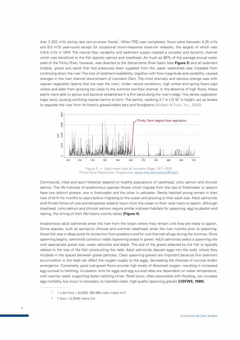
Commercial, tribal and sport fisheries depend on healthy populations of steelhead, coho salmon and chinook salmon. The life histories of anadromous species (those which migrate from the sea to freshwater to spawn) have two distinct phases: one in freshwater and the other in saltwater. Newly hatched young remain in their river of birth for months to years before migrating to the ocean and growing to their adult size. Adult salmonids (soft-finned fishes of cold and temperate waters) return from the ocean to their natal rivers to spawn. Although steelhead, coho salmon and chinook salmon require similar instream habitats for spawning, egg incubation and rearing, the timing of their life-history events varies (Figure 4).
Anadromous adult salmonids enter the river from the ocean where they remain until they are ready to spawn. Some species, such as spring-run chinook and summer steelhead, enter the river months prior to spawning; these fish stay in deep pools for protection from predators and for cool thermal refuge during the summer. Once spawning begins, salmonids construct redds (spawning areas) in gravel. Adult salmonids select a spawning site with appropriate gravel size, water velocities and depth. The size of the gravel selected by the fish is typically related to the size of the fish constructing the redd. Adult salmonids deposit eggs into the redd, where they incubate in the spaces between gravel particles. Clean spawning gravels are important because fine sediment accumulation in the redd can affect the oxygen supply to the eggs, decreasing the chances of survival and/or emergence. Conversely, good sub-gravel flows provide high levels of dissolved oxygen, resulting in increased egg survival to hatching. Incubation time for eggs and egg survival rates are dependent on water temperature, with warmer water supporting faster hatching times. Redd scour, often associated with flooding, can increase egg mortality, but scour is necessary to maintain clean, high-quality spawning gravels (USFWS, 1999).
1 1 cubit foot = 0.0283 168 466 cubic metre (m3)
2 1 foot = 0.3048 metre (m)
5
Trinity River Restoration Program, USA
Figure 4 — Timing and duration of various life-history events for chinook salmon, coho salmon and steelhead in the Trinity River (USFWS, 1999)
The changes to the Trinity River altered the quantity and quality of habitat for salmon and steelhead. The habitat above the dams was lost entirely and the remaining in-river habitat was severely degraded, especially from Lewiston Dam downstream to North Fork Trinity River. Salmon and steelhead depended on the dynamic and alluvial nature of the river (mobile and free to form its bed and banks) for a high-quality habitat. Natural fluvial processes, driven by high flows and adequate coarse sediment supply, created and maintained a complex channel morphology, which provided suitable conditions for adults, eggs, alevins (newly hatched salmon or trout that are still attached to the yolk sac), fry (recently hatched fish), juveniles and smolts (young salmon when they migrate from freshwater to the sea). After construction of the dams, pools used by adults were filled with sand forming shallow habitats. This led to severely altered water temperatures, particularly during the summer season, and reached lethal levels for juveniles and smolts. Another impact of the dams on salmon and steelhead was a change in bank features. Gently sloping banks, necessary for fry and juveniles, were eliminated by riparian berms due to intense vegetation and resultant deposition.
6
Environmental Case Studies
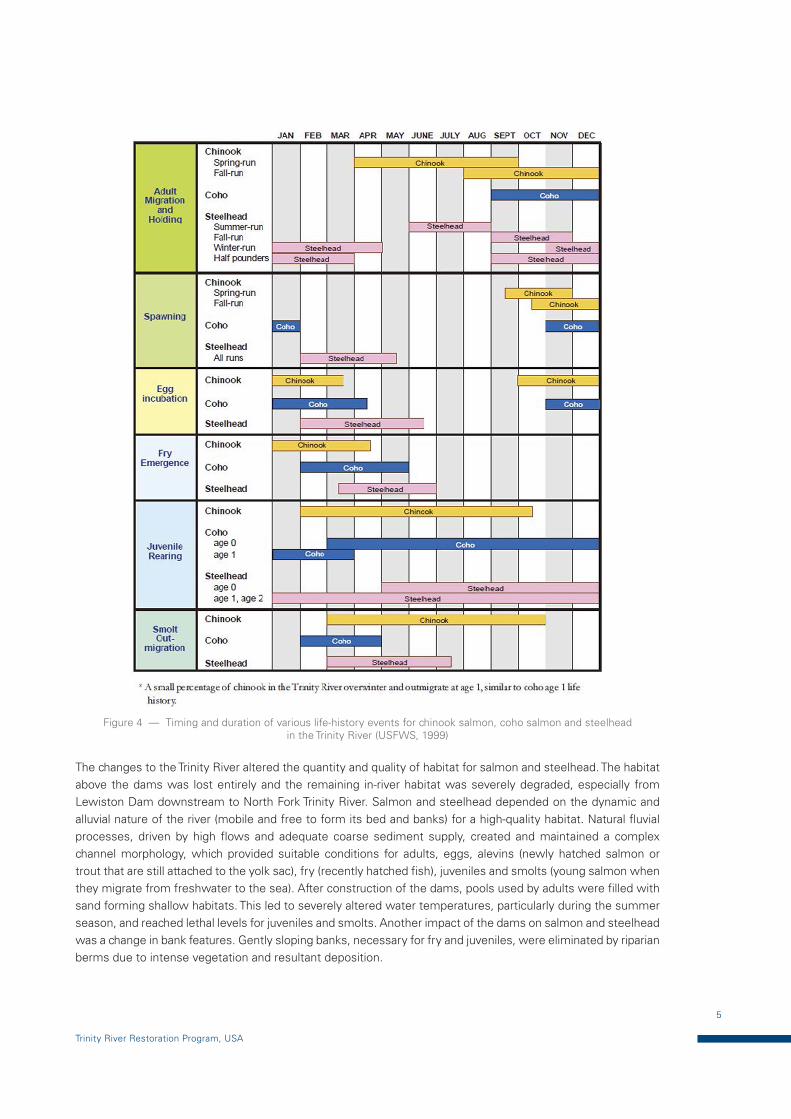
Aerial photos (Figure 5) show how vegetation and deposition developed along the water and terrestrial boundaries before and after construction of Lewiston Dam. The loose gravel bed necessary for spawning was scoured and replaced with sand and thus degraded. Our increasing scientific understanding of the importance of the natural river form and process to salmon and steelhead populations reinforces a recovery strategy that restores those natural conditions (McBain & Trush, Inc., 2000).
Figure 5 — Pre- and post-TRD changes in the Gold Bar, some 10 km downstream of Lewiston Dam (USFWS, 1999)
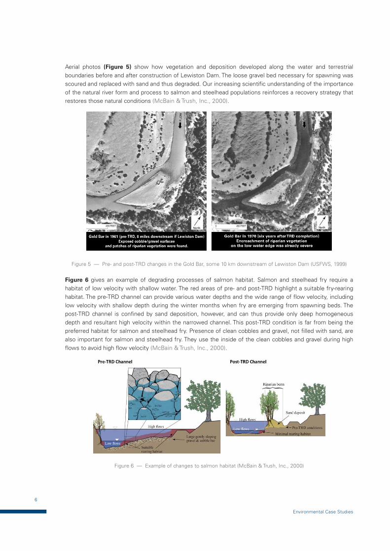
Figure 6 gives an example of degrading processes of salmon habitat. Salmon and steelhead fry require a habitat of low velocity with shallow water. The red areas of pre- and post-TRD highlight a suitable fry-rearing habitat. The pre-TRD channel can provide various water depths and the wide range of flow velocity, including low velocity with shallow depth during the winter months when fry are emerging from spawning beds. The post-TRD channel is confined by sand deposition, however, and can thus provide only deep homogeneous depth and resultant high velocity within the narrowed channel. This post-TRD condition is far from being the preferred habitat for salmon and steelhead fry. Presence of clean cobbles and gravel, not filled with sand, are also important for salmon and steelhead fry. They use the inside of the clean cobbles and gravel during high flows to avoid high flow velocity (McBain & Trush, Inc., 2000).
Figure 6 — Example of changes to salmon habitat (McBain & Trush, Inc., 2000)
7
Trinity River Restoration Program, USA
2.3 Addressing environmental aspects in flood management: key challenges
In order to restore degraded conditions of the Trinity River, USFWS, the Hoopa Valley Tribe and other agencies began studies that culminated in the Trinity River Flow Evaluation Study. This study became the foundation of the Trinity River Restoration Program, which was designed to restore the Trinity River and its populations of salmon, steelhead and other fish and wildlife and was completed in June 1999. Options for restoration were flood release from Trinity Dam, gravel injection directory into the river during high flows, channel-widening, etc. (McBain & Trush, Inc., 2000).
2.4 Trinity River Restoration Program
2.4.1 Overview of the program
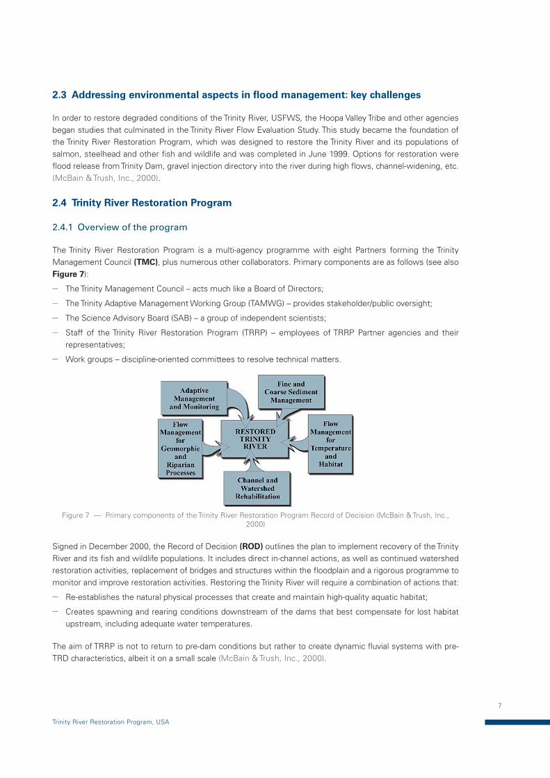
The Trinity River Restoration Program is a multi-agency programme with eight Partners forming the Trinity Management Council (TMC), plus numerous other collaborators. Primary components are as follows (see also Figure 7):
— The Trinity Management Council – acts much like a Board of Directors;
— The Trinity Adaptive Management Working Group (TAMWG) – provides stakeholder/public oversight;
— The Science Advisory Board (SAB) – a group of independent scientists;
— Staff of the Trinity River Restoration Program (TRRP) – employees of TRRP Partner agencies and their representatives;
— Work groups – discipline-oriented committees to resolve technical matters.
Figure 7 — Primary components of the Trinity River Restoration Program Record of Decision (McBain & Trush, Inc., 2000)
Signed in December 2000, the Record of Decision (ROD) outlines the plan to implement recovery of the Trinity River and its fish and wildlife populations. It includes direct in-channel actions, as well as continued watershed restoration activities, replacement of bridges and structures within the floodplain and a rigorous programme to monitor and improve restoration activities. Restoring the Trinity River will require a combination of actions that:
— Re-establishes the natural physical processes that create and maintain high-quality aquatic habitat;
— Creates spawning and rearing conditions downstream of the dams that best compensate for lost habitat upstream, including adequate water temperatures.
The aim of TRRP is not to return to pre-dam conditions but rather to create dynamic fluvial systems with pre-TRD characteristics, albeit it on a small scale (McBain & Trush, Inc., 2000).

8
Environmental Case Studies
2.4.2 Artificial floods
Figure 8 — Flow schedules for five water-year types with a minimum volume of water to be released into the Trinity River (McBain & Trush, Inc., 2000)
9
Trinity River Restoration Program, USA
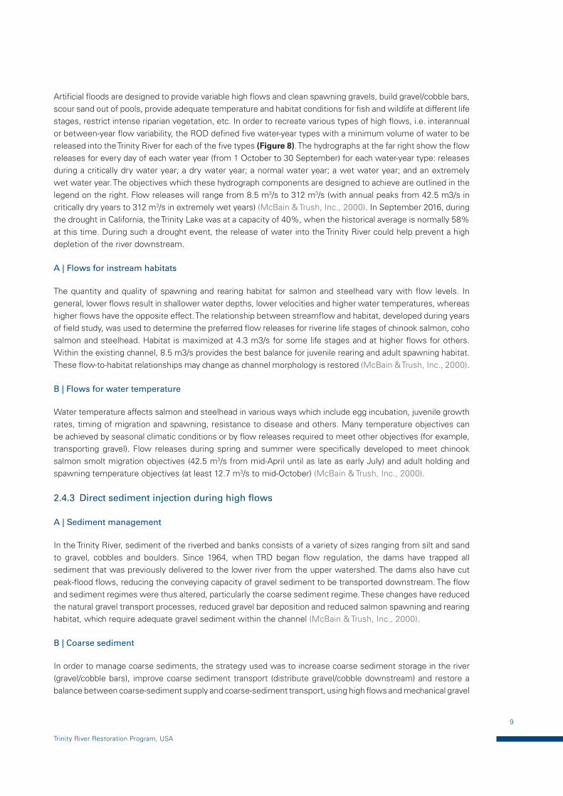
Artificial floods are designed to provide variable high flows and clean spawning gravels, build gravel/cobble bars, scour sand out of pools, provide adequate temperature and habitat conditions for fish and wildlife at different life stages, restrict intense riparian vegetation, etc. In order to recreate various types of high flows, i.e. interannual or between-year flow variability, the ROD defined five water-year types with a minimum volume of water to be released into the Trinity River for each of the five types (Figure 8). The hydrographs at the far right show the flow releases for every day of each water year (from 1 October to 30 September) for each water-year type: releases during a critically dry water year; a dry water year; a normal water year; a wet water year; and an extremely wet water year. The objectives which these hydrograph components are designed to achieve are outlined in the legend on the right. Flow releases will range from 8.5 m3/s to 312 m3/s (with annual peaks from 42.5 m3/s in critically dry years to 312 m3/s in extremely wet years) (McBain & Trush, Inc., 2000). In September 2016, during the drought in California, the Trinity Lake was at a capacity of 40%, when the historical average is normally 58% at this time. During such a drought event, the release of water into the Trinity River could help prevent a high depletion of the river downstream.
A | Flows for instream habitats
The quantity and quality of spawning and rearing habitat for salmon and steelhead vary with flow levels. In general, lower flows result in shallower water depths, lower velocities and higher water temperatures, whereas higher flows have the opposite effect. The relationship between streamflow and habitat, developed during years of field study, was used to determine the preferred flow releases for riverine life stages of chinook salmon, coho salmon and steelhead. Habitat is maximized at 4.3 m3/s for some life stages and at higher flows for others. Within the existing channel, 8.5 m3/s provides the best balance for juvenile rearing and adult spawning habitat. These flow-to-habitat relationships may change as channel morphology is restored (McBain & Trush, Inc., 2000).
B | Flows for water temperature
Water temperature affects salmon and steelhead in various ways which include egg incubation, juvenile growth rates, timing of migration and spawning, resistance to disease and others. Many temperature objectives can be achieved by seasonal climatic conditions or by flow releases required to meet other objectives (for example, transporting gravel). Flow releases during spring and summer were specifically developed to meet chinook salmon smolt migration objectives (42.5 m3/s from mid-April until as late as early July) and adult holding and spawning temperature objectives (at least 12.7 m3/s to mid-October) (McBain & Trush, Inc., 2000).
2.4.3 Direct sediment injection during high flows
A | Sediment management
In the Trinity River, sediment of the riverbed and banks consists of a variety of sizes ranging from silt and sand to gravel, cobbles and boulders. Since 1964, when TRD began flow regulation, the dams have trapped all sediment that was previously delivered to the lower river from the upper watershed. The dams also have cut peak-flood flows, reducing the conveying capacity of gravel sediment to be transported downstream. The flow and sediment regimes were thus altered, particularly the coarse sediment regime. These changes have reduced the natural gravel transport processes, reduced gravel bar deposition and reduced salmon spawning and rearing habitat, which require adequate gravel sediment within the channel (McBain & Trush, Inc., 2000).
B | Coarse sediment
In order to manage coarse sediments, the strategy used was to increase coarse sediment storage in the river (gravel/cobble bars), improve coarse sediment transport (distribute gravel/cobble downstream) and restore a balance between coarse-sediment supply and coarse-sediment transport, using high flows and mechanical gravel
10
Environmental Case Studies
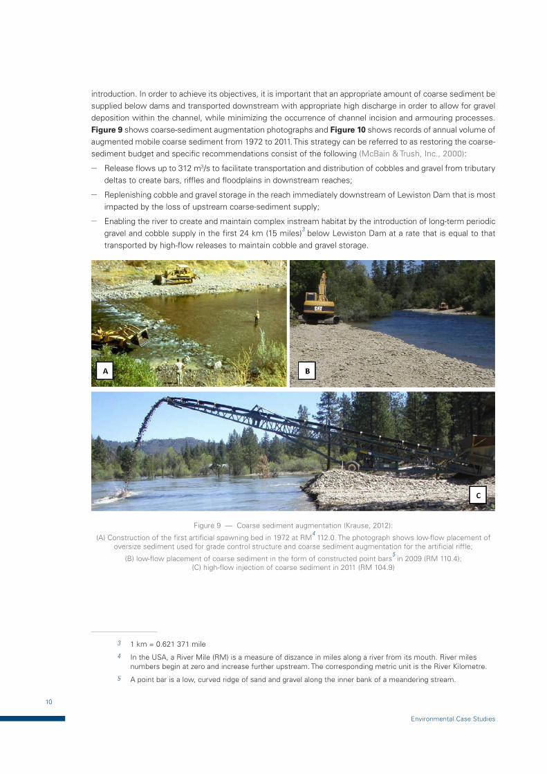
introduction. In order to achieve its objectives, it is important that an appropriate amount of coarse sediment be supplied below dams and transported downstream with appropriate high discharge in order to allow for gravel deposition within the channel, while minimizing the occurrence of channel incision and armouring processes. Figure 9 shows coarse-sediment augmentation photographs and Figure 10 shows records of annual volume of augmented mobile coarse sediment from 1972 to 2011. This strategy can be referred to as restoring the coarse-sediment budget and specific recommendations consist of the following (McBain & Trush, Inc., 2000):
— Release flows up to 312 m3/s to facilitate transportation and distribution of cobbles and gravel from tributary deltas to create bars, riffles and floodplains in downstream reaches;
— Replenishing cobble and gravel storage in the reach immediately downstream of Lewiston Dam that is most impacted by the loss of upstream coarse-sediment supply;
— Enabling the river to create and maintain complex instream habitat by the introduction of long-term periodic gravel and cobble supply in the first 24 km (15 miles)3 below Lewiston Dam at a rate that is equal to that transported by high-flow releases to maintain cobble and gravel storage.
Figure 9 — Coarse sediment augmentation (Krause, 2012):
(A) Construction of the first artificial spawning bed in 1972 at RM4 112.0. The photograph shows low-flow placement of
oversize sediment used for grade control structure and coarse sediment augmentation for the artificial riffle;
(B) low-flow placement of coarse sediment in the form of constructed point bars5 in 2009 (RM 110.4);
(C) high-flow injection of coarse sediment in 2011 (RM 104.9)
3 1 km = 0.621 371 mile
4 In the USA, a River Mile (RM) is a measure of diszance in miles along a river from its mouth. River miles numbers begin at zero and increase further upstream. The corresponding metric unit is the River Kilometre.
5 A point bar is a low, curved ridge of sand and gravel along the inner bank of a meandering stream.
11
Trinity River Restoration Program, USA
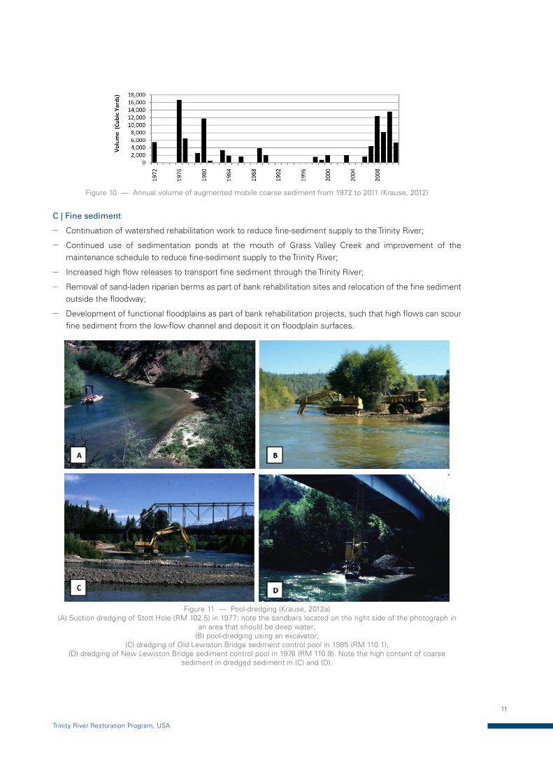
Figure 10 — Annual volume of augmented mobile coarse sediment from 1972 to 2011 (Krause, 2012)
C | Fine sediment
— Continuation of watershed rehabilitation work to reduce fine-sediment supply to the Trinity River;
— Continued use of sedimentation ponds at the mouth of Grass Valley Creek and improvement of the maintenance schedule to reduce fine-sediment supply to the Trinity River;
— Increased high flow releases to transport fine sediment through the Trinity River;
— Removal of sand-laden riparian berms as part of bank rehabilitation sites and relocation of the fine sediment outside the floodway;
— Development of functional floodplains as part of bank rehabilitation projects, such that high flows can scour fine sediment from the low-flow channel and deposit it on floodplain surfaces.
Figure 11 — Pool-dredging (Krause, 2012a) (A) Suction dredging of Stott Hole (RM 102.5) in 1977: note the sandbars located on the right side of the photograph in
an area that should be deep water; (B) pool-dredging using an excavator;
(C) dredging of Old Lewiston Bridge sediment control pool in 1985 (RM 110.1); (D) dredging of New Lewiston Bridge sediment control pool in 1976 (RM 110.9). Note the high content of coarse
sediment in dredged sediment in (C) and (D).
12
Environmental Case Studies
2.4.4 Channel rehabilitation
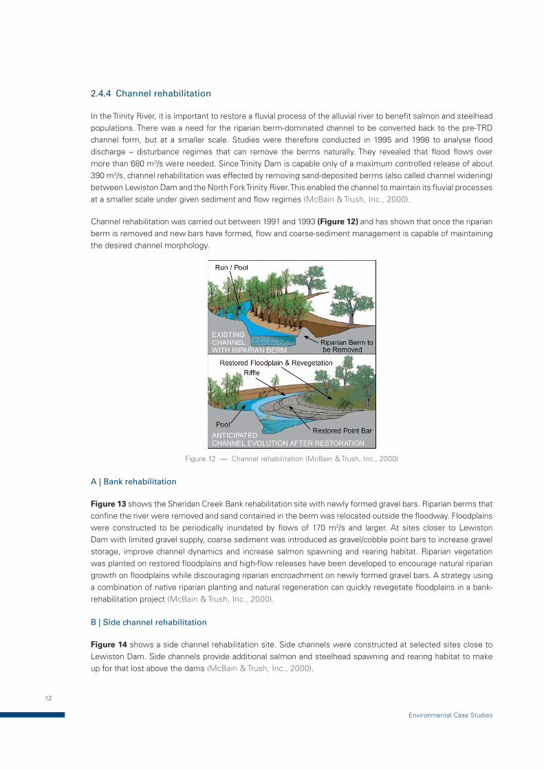
In the Trinity River, it is important to restore a fluvial process of the alluvial river to benefit salmon and steelhead populations. There was a need for the riparian berm-dominated channel to be converted back to the pre-TRD channel form, but at a smaller scale. Studies were therefore conducted in 1995 and 1998 to analyse flood discharge – disturbance regimes that can remove the berms naturally. They revealed that flood flows over more than 680 m3/s were needed. Since Trinity Dam is capable only of a maximum controlled release of about 390 m3/s, channel rehabilitation was effected by removing sand-deposited berms (also called channel widening) between Lewiston Dam and the North Fork Trinity River. This enabled the channel to maintain its fluvial processes at a smaller scale under given sediment and flow regimes (McBain & Trush, Inc., 2000).
Channel rehabilitation was carried out between 1991 and 1993 (Figure 12) and has shown that once the riparian berm is removed and new bars have formed, flow and coarse-sediment management is capable of maintaining the desired channel morphology.
Figure 12 — Channel rehabilitation (McBain & Trush, Inc., 2000)
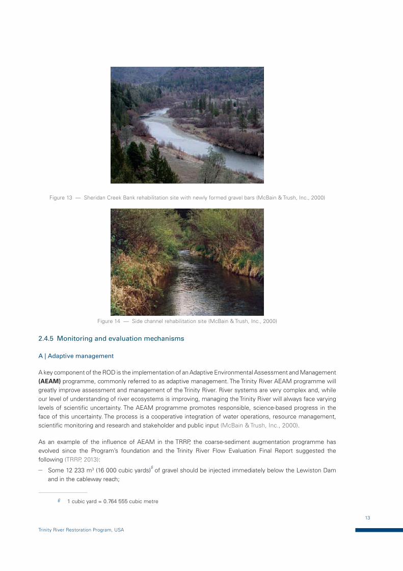
A | Bank rehabilitation
Figure 13 shows the Sheridan Creek Bank rehabilitation site with newly formed gravel bars. Riparian berms that confine the river were removed and sand contained in the berm was relocated outside the floodway. Floodplains were constructed to be periodically inundated by flows of 170 m3/s and larger. At sites closer to Lewiston Dam with limited gravel supply, coarse sediment was introduced as gravel/cobble point bars to increase gravel storage, improve channel dynamics and increase salmon spawning and rearing habitat. Riparian vegetation was planted on restored floodplains and high-flow releases have been developed to encourage natural riparian growth on floodplains while discouraging riparian encroachment on newly formed gravel bars. A strategy using a combination of native riparian planting and natural regeneration can quickly revegetate floodplains in a bank-rehabilitation project (McBain & Trush, Inc., 2000).
B | Side channel rehabilitation
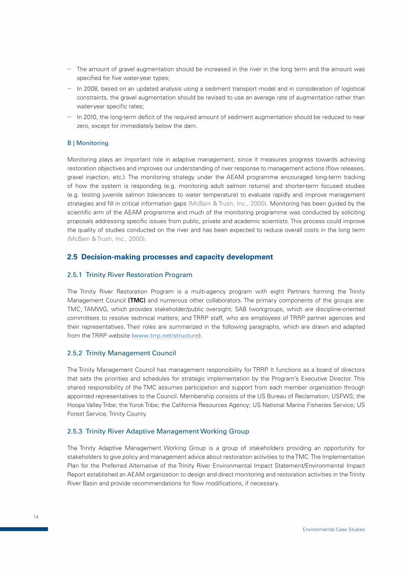
Figure 14 shows a side channel rehabilitation site. Side channels were constructed at selected sites close to Lewiston Dam. Side channels provide additional salmon and steelhead spawning and rearing habitat to make up for that lost above the dams (McBain & Trush, Inc., 2000).
13
Trinity River Restoration Program, USA
Figure 13 — Sheridan Creek Bank rehabilitation site with newly formed gravel bars (McBain & Trush, Inc., 2000)
Figure 14 — Side channel rehabilitation site (McBain & Trush, Inc., 2000)
2.4.5 Monitoring and evaluation mechanisms
A | Adaptive management
A key component of the ROD is the implementation of an Adaptive Environmental Assessment and Management (AEAM) programme, commonly referred to as adaptive management. The Trinity River AEAM programme will greatly improve assessment and management of the Trinity River. River systems are very complex and, while our level of understanding of river ecosystems is improving, managing the Trinity River will always face varying levels of scientific uncertainty. The AEAM programme promotes responsible, science-based progress in the face of this uncertainty. The process is a cooperative integration of water operations, resource management, scientific monitoring and research and stakeholder and public input (McBain & Trush, Inc., 2000).
As an example of the influence of AEAM in the TRRP, the coarse-sediment augmentation programme has evolved since the Program’s foundation and the Trinity River Flow Evaluation Final Report suggested the following (TRRP, 2013):
— Some 12 233 m3 (16 000 cubic yards)6 of gravel should be injected immediately below the Lewiston Dam and in the cableway reach;
6 1 cubic yard = 0.764 555 cubic metre
14
Environmental Case Studies
— The amount of gravel augmentation should be increased in the river in the long term and the amount was specified for five water-year types;
— In 2008, based on an updated analysis using a sediment transport model and in consideration of logistical constraints, the gravel augmentation should be revised to use an average rate of augmentation rather than water-year specific rates;
— In 2010, the long-term deficit of the required amount of sediment augmentation should be reduced to near zero, except for immediately below the dam.
B | Monitoring
Monitoring plays an important role in adaptive management, since it measures progress towards achieving restoration objectives and improves our understanding of river response to management actions (flow releases, gravel injection, etc.). The monitoring strategy under the AEAM programme encouraged long-term tracking of how the system is responding (e.g. monitoring adult salmon returns) and shorter-term focused studies (e.g. testing juvenile salmon tolerances to water temperature) to evaluate rapidly and improve management strategies and fill in critical information gaps (McBain & Trush, Inc., 2000). Monitoring has been guided by the scientific arm of the AEAM programme and much of the monitoring programme was conducted by soliciting proposals addressing specific issues from public, private and academic scientists. This process could improve the quality of studies conducted on the river and has been expected to reduce overall costs in the long term (McBain & Trush, Inc., 2000).
2.5 Decision-making processes and capacity development
2.5.1 Trinity River Restoration Program
The Trinity River Restoration Program is a multi-agency program with eight Partners forming the Trinity Management Council (TMC) and numerous other collaborators. The primary components of the groups are: TMC; TAMWG, which provides stakeholder/public oversight; SAB (workgroups, which are discipline-oriented committees to resolve technical matters; and TRRP staff, who are employees of TRRP partner agencies and their representatives. Their roles are summarized in the following paragraphs, which are drawn and adapted from the TRRP website (www.trrp.net/structure).
2.5.2 Trinity Management Council
The Trinity Management Council has management responsibility for TRRP. It functions as a board of directors that sets the priorities and schedules for strategic implementation by the Program’s Executive Director. This shared responsibility of the TMC assumes participation and support from each member organization through appointed representatives to the Council. Membership consists of the US Bureau of Reclamation; USFWS; the Hoopa Valley Tribe; the Yurok Tribe; the California Resources Agency; US National Marine Fisheries Service; US Forest Service, Trinity County.
2.5.3 Trinity River Adaptive Management Working Group
The Trinity Adaptive Management Working Group is a group of stakeholders providing an opportunity for stakeholders to give policy and management advice about restoration activities to the TMC. The Implementation Plan for the Preferred Alternative of the Trinity River Environmental Impact Statement/Environmental Impact Report established an AEAM organization to design and direct monitoring and restoration activities in the Trinity River Basin and provide recommendations for flow modifications, if necessary.
15
Trinity River Restoration Program, USA
2.5.4 Scientific Advisory Board
Five scientists, recognized as experts in the disciplines of fisheries’ biology, fluvial geomorphology, hydraulic engineering, hydrology, riparian ecology, wildlife biology or aquatic ecology, form an SAB. Each member is appointed by the Executive Director and serves a four-year rotating term.
2.5.5 Workgroups
The Trinity River Restoration Program has a number of collaborative workgroups for addressing technical issues. Workgroup meetings are open to the public and are posted on the TRRP calendar, viewable in the sidebar of the TRRP home page and on the calendar page. Agendas and summaries are available through the General Meeting Materials page or a specific workgroup meeting materials page: Design Team, Fish Workgroup, Flow Workgroup, Gravel Augmentation Workgroup, Interdisciplinary Team (IDT), Physical Workgroup, Watershed Workgroup and Wildlife and Riparian Workgroup.
Results: the TRRP started in December 2000 to implement recovery of the Trinity River and its fish and wildlife populations. Its aim is not to return to pre-dam conditions, but to create dynamic fluvial systems with characteristics of pre-TRD, even though the scale is small. Restoration measures, such as artificial floods, direct sediment injection during high flows and channel rehabilitation, have been continuously carried out as part of adaptive management since 2014 (see TRRP website: www.trrp.net/restore/accomplishments)
For more guidance on reservoir operations, managing flows that optimize the benefits from ecosystems in the floodplains, and socioeconomic activities, see the APFM Tools Series Reservoir Operations and Managed Flows: www.floodmanagement.info/publications/tools/APFM_Tool_05.pdf.
16
Environmental Case Studies
3 CHANNEL-WIDENING AND OPEN CHECK DAM IN THE UPPER DRAU RIVER, AUSTRIA
3.1 Introduction
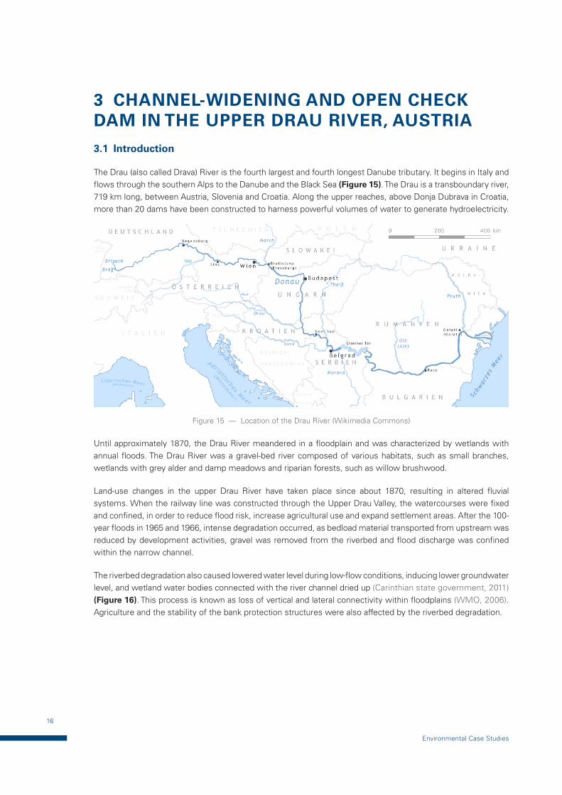
The Drau (also called Drava) River is the fourth largest and fourth longest Danube tributary. It begins in Italy and flows through the southern Alps to the Danube and the Black Sea (Figure 15). The Drau is a transboundary river, 719 km long, between Austria, Slovenia and Croatia. Along the upper reaches, above Donja Dubrava in Croatia, more than 20 dams have been constructed to harness powerful volumes of water to generate hydroelectricity.
Figure 15 — Location of the Drau River (Wikimedia Commons)
Until approximately 1870, the Drau River meandered in a floodplain and was characterized by wetlands with annual floods. The Drau River was a gravel-bed river composed of various habitats, such as small branches, wetlands with grey alder and damp meadows and riparian forests, such as willow brushwood.
Land-use changes in the upper Drau River have taken place since about 1870, resulting in altered fluvial systems. When the railway line was constructed through the Upper Drau Valley, the watercourses were fixed and confined, in order to reduce flood risk, increase agricultural use and expand settlement areas. After the 100-year floods in 1965 and 1966, intense degradation occurred, as bedload material transported from upstream was reduced by development activities, gravel was removed from the riverbed and flood discharge was confined within the narrow channel.
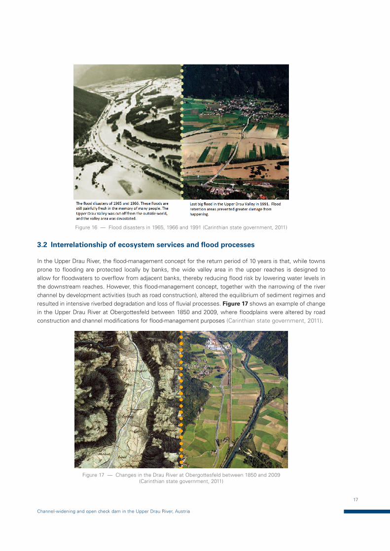
The riverbed degradation also caused lowered water level during low-flow conditions, inducing lower groundwater level, and wetland water bodies connected with the river channel dried up (Carinthian state government, 2011) (Figure 16). This process is known as loss of vertical and lateral connectivity within floodplains (WMO, 2006). Agriculture and the stability of the bank protection structures were also affected by the riverbed degradation.
17
Channel-widening and open check dam in the Upper Drau River, Austria
Figure 16 — Flood disasters in 1965, 1966 and 1991 (Carinthian state government, 2011)
3.2 Interrelationship of ecosystem services and flood processes
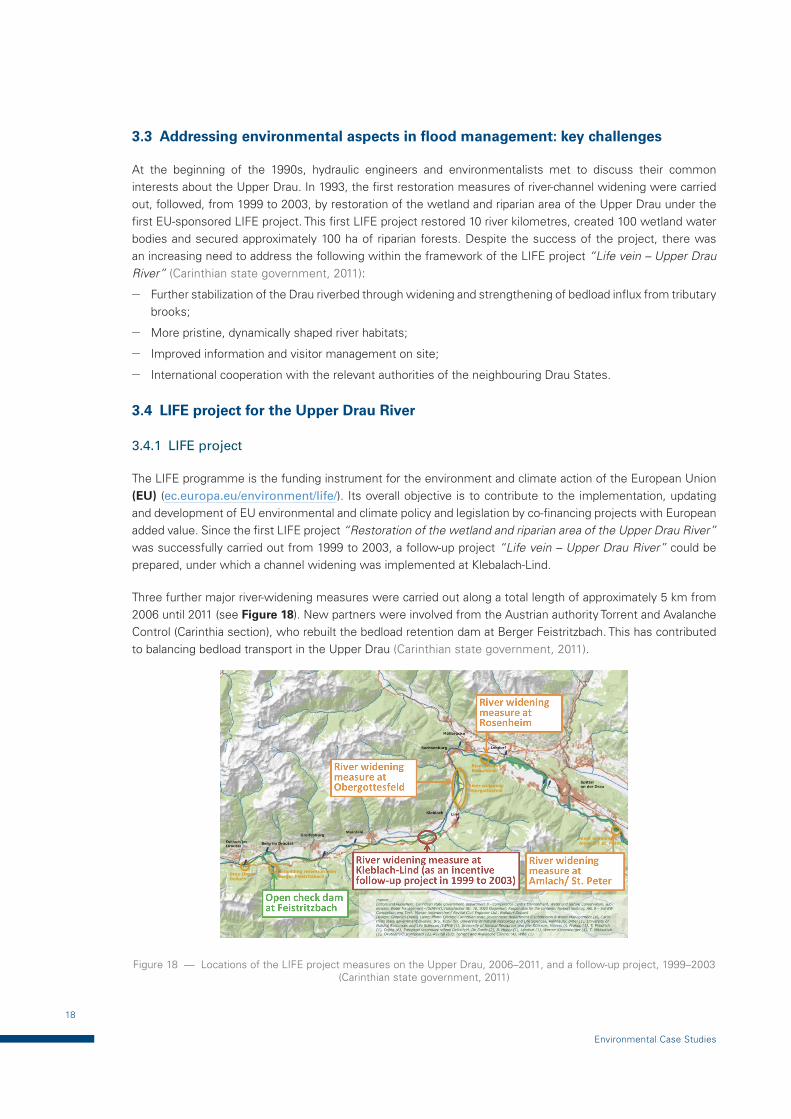
In the Upper Drau River, the flood-management concept for the return period of 10 years is that, while towns prone to flooding are protected locally by banks, the wide valley area in the upper reaches is designed to allow for floodwaters to overflow from adjacent banks, thereby reducing flood risk by lowering water levels in the downstream reaches. However, this flood-management concept, together with the narrowing of the river channel by development activities (such as road construction), altered the equilibrium of sediment regimes and resulted in intensive riverbed degradation and loss of fluvial processes. Figure 17 shows an example of change in the Upper Drau River at Obergottesfeld between 1850 and 2009, where floodplains were altered by road construction and channel modifications for flood-management purposes (Carinthian state government, 2011).
Figure 17 — Changes in the Drau River at Obergottesfeld between 1850 and 2009 (Carinthian state government, 2011)
18
Environmental Case Studies
3.3 Addressing environmental aspects in flood management: key challenges
At the beginning of the 1990s, hydraulic engineers and environmentalists met to discuss their common interests about the Upper Drau. In 1993, the first restoration measures of river-channel widening were carried out, followed, from 1999 to 2003, by restoration of the wetland and riparian area of the Upper Drau under the first EU-sponsored LIFE project. This first LIFE project restored 10 river kilometres, created 100 wetland water bodies and secured approximately 100 ha of riparian forests. Despite the success of the project, there was an increasing need to address the following within the framework of the LIFE project “Life vein – Upper Drau River” (Carinthian state government, 2011):
— Further stabilization of the Drau riverbed through widening and strengthening of bedload influx from tributary brooks;
— More pristine, dynamically shaped river habitats;
— Improved information and visitor management on site;
— International cooperation with the relevant authorities of the neighbouring Drau States.
3.4 LIFE project for the Upper Drau River
3.4.1 LIFE project
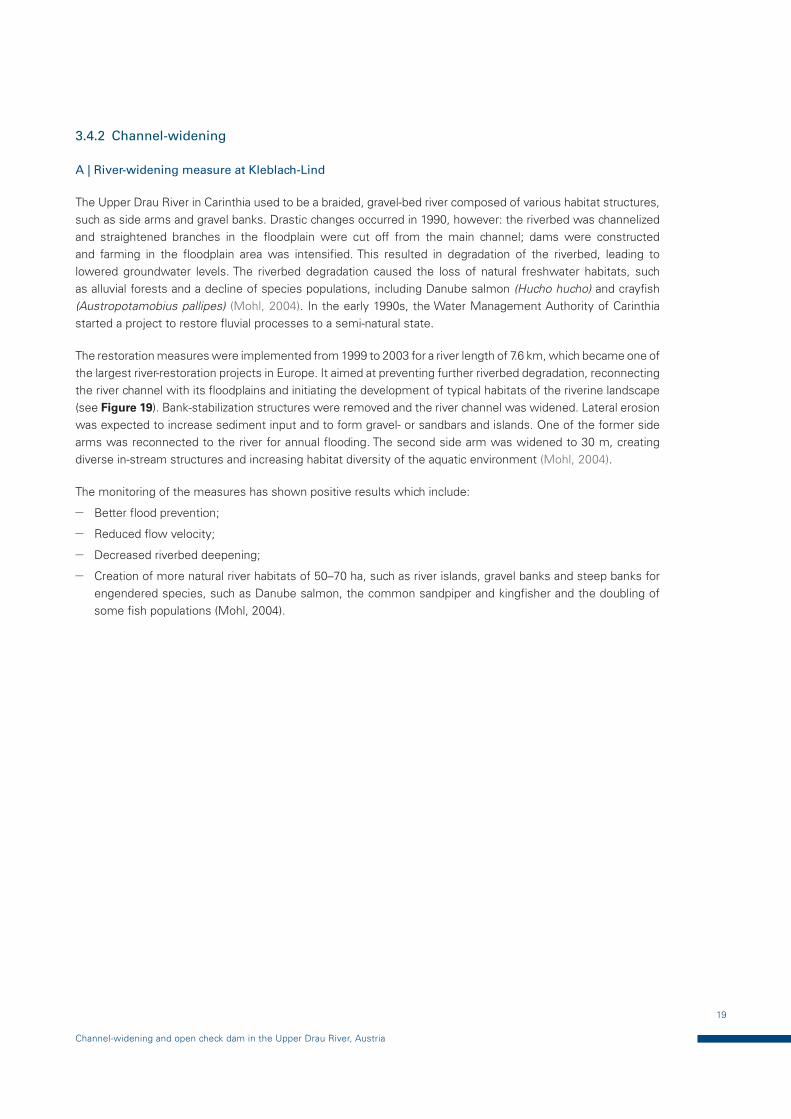
The LIFE programme is the funding instrument for the environment and climate action of the European Union (EU) (ec.europa.eu/environment/life/). Its overall objective is to contribute to the implementation, updating and development of EU environmental and climate policy and legislation by co-financing projects with European added value. Since the first LIFE project “Restoration of the wetland and riparian area of the Upper Drau River” was successfully carried out from 1999 to 2003, a follow-up project “Life vein – Upper Drau River” could be prepared, under which a channel widening was implemented at Klebalach-Lind.
Three further major river-widening measures were carried out along a total length of approximately 5 km from 2006 until 2011 (see Figure 18). New partners were involved from the Austrian authority Torrent and Avalanche Control (Carinthia section), who rebuilt the bedload retention dam at Berger Feistritzbach. This has contributed to balancing bedload transport in the Upper Drau (Carinthian state government, 2011).
Figure 18 — Locations of the LIFE project measures on the Upper Drau, 2006–2011, and a follow-up project, 1999–2003 (Carinthian state government, 2011)
19
Channel-widening and open check dam in the Upper Drau River, Austria
3.4.2 Channel-widening
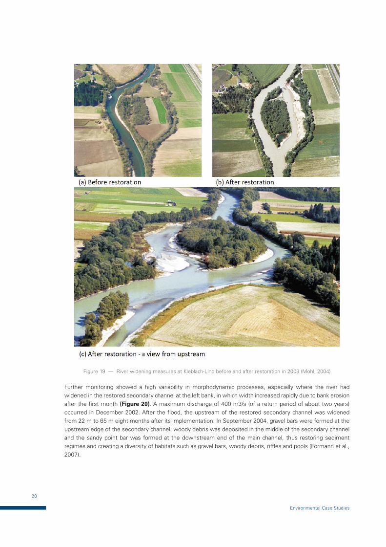
A | River-widening measure at Kleblach-Lind
The Upper Drau River in Carinthia used to be a braided, gravel-bed river composed of various habitat structures, such as side arms and gravel banks. Drastic changes occurred in 1990, however: the riverbed was channelized and straightened branches in the floodplain were cut off from the main channel; dams were constructed and farming in the floodplain area was intensified. This resulted in degradation of the riverbed, leading to lowered groundwater levels. The riverbed degradation caused the loss of natural freshwater habitats, such as alluvial forests and a decline of species populations, including Danube salmon (Hucho hucho) and crayfish (Austropotamobius pallipes) (Mohl, 2004). In the early 1990s, the Water Management Authority of Carinthia started a project to restore fluvial processes to a semi-natural state.
The restoration measures were implemented from 1999 to 2003 for a river length of 7.6 km, which became one of the largest river-restoration projects in Europe. It aimed at preventing further riverbed degradation, reconnecting the river channel with its floodplains and initiating the development of typical habitats of the riverine landscape (see Figure 19). Bank-stabilization structures were removed and the river channel was widened. Lateral erosion was expected to increase sediment input and to form gravel- or sandbars and islands. One of the former side arms was reconnected to the river for annual flooding. The second side arm was widened to 30 m, creating diverse in-stream structures and increasing habitat diversity of the aquatic environment (Mohl, 2004).
The monitoring of the measures has shown positive results which include:
— Better flood prevention;
— Reduced flow velocity;
— Decreased riverbed deepening;
— Creation of more natural river habitats of 50–70 ha, such as river islands, gravel banks and steep banks for engendered species, such as Danube salmon, the common sandpiper and kingfisher and the doubling of some fish populations (Mohl, 2004).
20
Environmental Case Studies
Figure 19 — River widening measures at Kleblach-Lind before and after restoration in 2003 (Mohl, 2004)
Further monitoring showed a high variability in morphodynamic processes, especially where the river had widened in the restored secondary channel at the left bank, in which width increased rapidly due to bank erosion after the first month (Figure 20). A maximum discharge of 400 m3/s (of a return period of about two years) occurred in December 2002. After the flood, the upstream of the restored secondary channel was widened from 22 m to 65 m eight months after its implementation. In September 2004, gravel bars were formed at the upstream edge of the secondary channel; woody debris was deposited in the middle of the secondary channel and the sandy point bar was formed at the downstream end of the main channel, thus restoring sediment regimes and creating a diversity of habitats such as gravel bars, woody debris, riffles and pools (Formann et al., 2007).
21
Channel-widening and open check dam in the Upper Drau River, Austria
Figure 20 — Results of monitoring by digital elevation models showing the morphological changes from 2001 to 2005 (Formann et al., 2007)
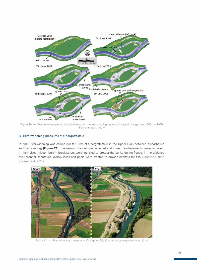
B | River-widening measures at Obergottesfeld
In 2011, river-widening was carried out for 3 km at Obergottesfeld in the Upper Drau between Klebach/Lind and Sachsenburg (Figure 21). The narrow channel was widened and current embankments were removed. In their place, hidden built-in breakwaters were installed to protect the banks during floods. In the widened river channel, tributaries, oxbow lakes and pools were created to provide habitats for fish (Carinthian state government, 2011).
Figure 21 — River-widening measures at Obergottesfeld (Carinthian state government, 2011)
22
Environmental Case Studies
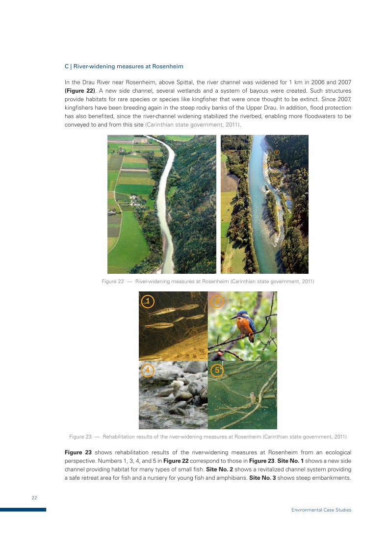
C | River-widening measures at Rosenheim
In the Drau River near Rosenheim, above Spittal, the river channel was widened for 1 km in 2006 and 2007 (Figure 22). A new side channel, several wetlands and a system of bayous were created. Such structures provide habitats for rare species or species like kingfisher that were once thought to be extinct. Since 2007, kingfishers have been breeding again in the steep rocky banks of the Upper Drau. In addition, flood protection has also benefited, since the river-channel widening stabilized the riverbed, enabling more floodwaters to be conveyed to and from this site (Carinthian state government, 2011).
Figure 22 — River-widening measures at Rosenheim (Carinthian state government, 2011)
Figure 23 — Rehabilitation results of the river-widening measures at Rosenheim (Carinthian state government, 2011)
Figure 23 shows rehabilitation results of the river-widening measures at Rosenheim from an ecological perspective. Numbers 1, 3, 4, and 5 in Figure 22 correspond to those in Figure 23. Site No. 1 shows a new side channel providing habitat for many types of small fish. Site No. 2 shows a revitalized channel system providing a safe retreat area for fish and a nursery for young fish and amphibians. Site No. 3 shows steep embankments.

23
Channel-widening and open check dam in the Upper Drau River, Austria
Special attention was paid to creating steep riverbanks in building the side channel system. Steep banks are rare on the Drau River and are especially important as nesting areas for kingfishers. Site No. 4 shows gravel banks, where the rare sandpiper can breed. Site No. 5 shows wetland ponds, where some of the first inhabitants were yellow-bellied toads (Carinthian state government, 2011).
D | River-widening measures at Amlach/St. Peter
In the upper Drau River near Amlach below Spittal, river-channel widening was carried out in 2009 by moving 60 000 m3 of soil and gravel (Figure 24). The result was a widening of the riverbed by 20 m. A new tributary and several wetlands and ponds were created. It is expected that, in the next decades, 2 ha of alluvial forest will be developed. The new, large tributary has created a valuable sanctuary for many types of fish. The new alluvial ponds also serve as nurseries for young fish and amphibians. Recent ecological studies confirmed that species’ abundance of amphibians has increased from one to seven species (Carinthian state government, 2011). Figure 25 shows the results of the river-widening measures at Amlach/St. Peter from an ecological perspective: (a) the new diversity of natural habitats along the tributary branch is a result of the increased amount of water; (b) the great crested newt is a very rare salamander and one of the seven amphibian species now living in the area; and (c) the new tributary serves as a nursery for many young fish of many types.
Figure 24 — River widening measures at Amlach/St. Peter (Carinthian state government, 2011)
(a) (b) (c)
Figure 25 — Results of the river-widening measures at Amlach/St. Peter (Carinthian state government, 2011)
24
Environmental Case Studies
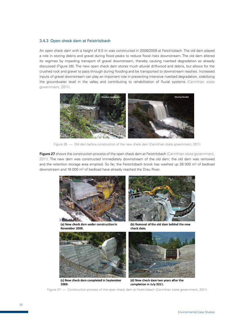
3.4.3 Open check dam at Feistritzbach
An open check dam with a height of 8.5 m was constructed in 2008/2009 at Feistritzbach. The old dam played a role in storing debris and gravel during flood peaks to reduce flood risks downstream. The old dam altered its regimes by impeding transport of gravel downstream, thereby causing riverbed degradation as already discussed (Figure 26). The new open check dam stores much alluvial driftwood and debris, but allows for the crushed rock and gravel to pass through during flooding and be transported to downstream reaches. Increased inputs of gravel downstream can play an important role in preventing intensive riverbed degradation, stabilizing the groundwater level in the valley and contributing to rehabilitation of fluvial systems (Carinthian state government, 2011).
Figure 26 — Old dam before construction of the new check dam (Carinthian state government, 2011)
Figure 27 shows the construction process of the open check dam at Feistritzbach (Carinthian state government, 2011). The new dam was constructed immediately downstream of the old dam; the old dam was removed and the retention storage area emptied. So far, the Feistritzbach brook has washed up 28 000 m3 of bedload downstream and 16 000 m3 of bedload have already reached the Drau River.
Figure 27 — Construction process of the open check dam at Feistritzbach (Carinthian state government, 2011)
25
Channel-widening and open check dam in the Upper Drau River, Austria
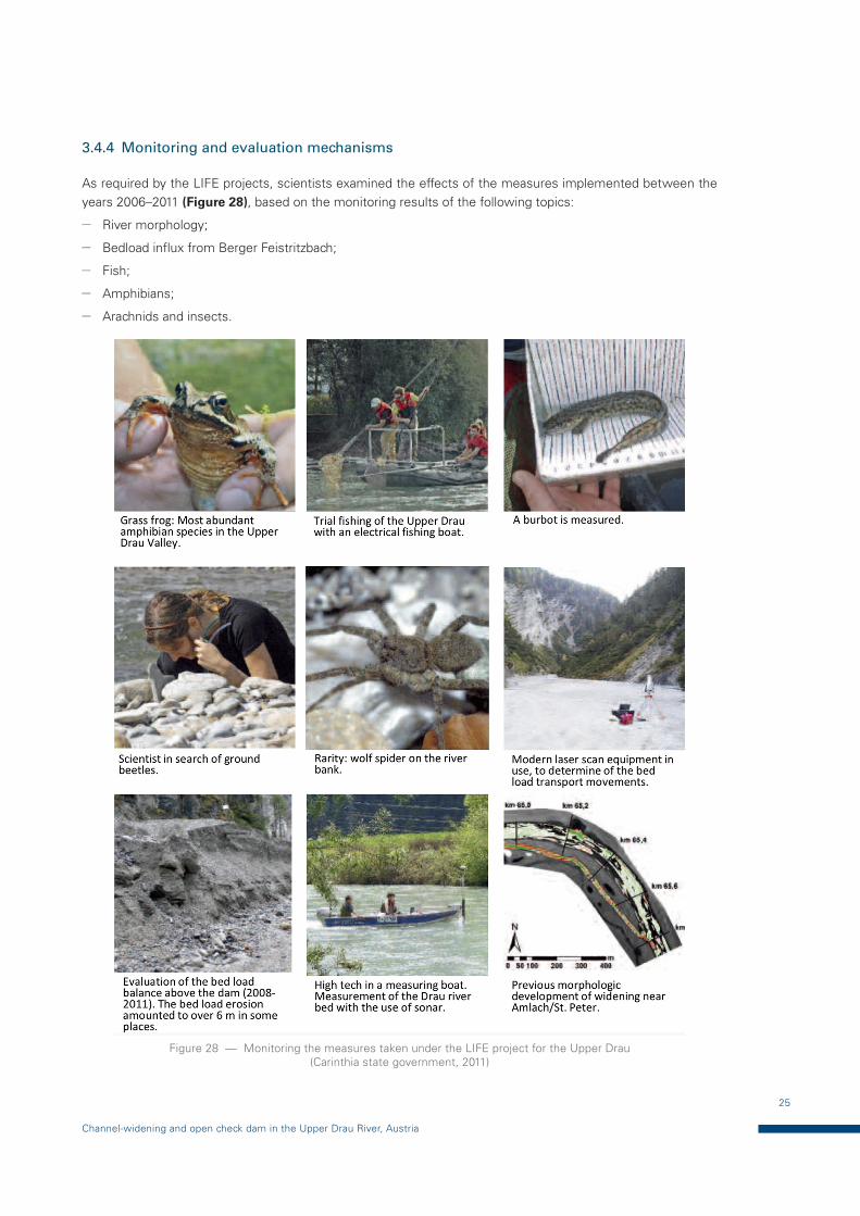
3.4.4 Monitoring and evaluation mechanisms
As required by the LIFE projects, scientists examined the effects of the measures implemented between the years 2006–2011 (Figure 28), based on the monitoring results of the following topics:
— River morphology;
— Bedload influx from Berger Feistritzbach;
— Fish;
— Amphibians;
— Arachnids and insects.
Figure 28 — Monitoring the measures taken under the LIFE project for the Upper Drau (Carinthia state government, 2011)
26
Environmental Case Studies
The monitoring results showed positive effects but, at the same time, identified new challenges to address. Continual riverbed measurements showed that the river-widening measures had contributed to the stabilization of the riverbed of the Drau River. The increased water-retention capacity helps to reduce flood risk downstream. In addition, increased stabilization of the groundwater level plays an important role for the agricultural activities in the river valley (EU, 2013).
The number of amphibian species increased significantly in the restoration areas. For example, in the Amlach/St. Peter area, they increased from one to six species. A set of measures implemented under the LIFE projects was also beneficial for fish. For example, in the Rosenheim area, 14 species were found, including small fish such as the vairone, stone loach, minnow, gibel carp, crucian carp and burbot. Deficiencies also exist, however, primarily in the form of water-level fluctuations and migration obstacles outside the European protected area, implying that basin-scale coordination and management will be needed (Carinthian state government, 2011).
The measures implemented during the project extended habitats for 140 bird species, including 51 red-listed species (EU, 2013). More than 100 species of spiders and ground beetles exist within the project area. Some species were greatly endangered and threatened by extinction, for example the riverbank wolf spiders. Their existence and the increased variety of species in the newly widened stretches could be considered indicators of the success of the projects. In order for these species to be permanently maintained, however, further rehabilitation of fluvial systems will be required (Carinthian state government, 2011).
The open check dam worked satisfactorily by contributing to improving the bedload balance and stabilizing the riverbed and groundwater level. In the first year after rebuilding the dam, however, bedload erosion occurred over 6 m immediately downstream of the dam (Carinthian state government, 2011).
In the secondary plan, recreational activities (hiking, cycling, canoeing, fishing, etc.) also increased in the area, thanks to the project. Access has been improved to concentrate activities next to the river at two suitable places that have been built under the project (e.g. lookout towers, bathing and sunbathing areas and information points for visitors). In addition, access to some ecologically sensitive bankside zones has been restricted (EU, 2013).
3.5 Decision-making processes and capacity development
3.5.1 Decision-making processes
LIFE projects have played an important role in the continued restoration of the Drau River, in partnership with river- and flood-protection authorities and, more recently, the Austrian Service for Torrent and Avalanche Control. An earlier project (LIFE99 NAT/A/006055) ended in 2003 and it was followed by the LIFE Obere Drau II project (2006–2011), which was coordinated by the regional government of Carinthia. This project adopted river-widening and the removal of hydraulic structures and embankments to facilitate riverbank erosion, return a targeted stretch of the river to its former natural structure and create new or reactivated old water meadows (EU, 2013).
Public relations (PR) work was also important for the successful implementation of the project, since it is important for people to see for themselves the positive aspects of their work. Various PR tools were used to raise awareness of the projects for stakeholders such as farmers, local residents, schoolchildren and visitors (EU, 2013). Some of the PR tools used are summarized below:
— LIFE film “Rittlingers Dream – A New Life on the Upper Drava” is a philosophical and scientific reflection about the restoration of the Upper Drava River in Carinthia. It is available, free of charge, in German or English;
— A LIFE Drau postcard with a hologram was prepared to introduce the river-widening work carried out near Amlach/St. Peter. The postcard can be tilted to show the completed work (2010) in contrast to the original state (2006);
27
Channel-widening and open check dam in the Upper Drau River, Austria
— A folding, practical map “People & Nature” in a pocket-sized format. It gives valuable tips for nature-compatible leisure activities and local recreation areas in the Upper Drau River.
3.6 The Drau River Vision Symposium
In September 2008, the Drau River Vision Symposium was organized in which experts in environmental protection and hydraulic engineering from the Drau’s bordering countries – Italy, Austria, Slovenia, Croatia and Hungary – met in Maribor, Slovenia, to exchange their experiences. For two days, participants discussed problems and solutions for flood-protection construction measures, ecological issues and energy efficiency questions. The highlight of the symposium was the signing of the Drau Declaration by the State representatives of the International Commission for the Protection of the Danube. In the declaration, the Drau’s bordering countries committed to a 10-point programme7 for the sustainable management of the Drau River. With the organization of this symposium, this LIFE project contributed to the development of transnational goals and visions for the Drau River (Carinthian state government, 2011).
Results: Under the LIFE project in the upper Drau River, various measures were implemented, such as river-widening measures for addressing balancing sediment regimes at a reach scale in Kleblach-Lind, Obergottesfeld, Rosenheim and Amlach/St. Peter and an open check dam for addressing longitudinal sediment regimes in Feistritzbach. Most measures showed positive results as depicted in Section 3.4. This project also highlighted activities for raising public awareness through developing PR tools, such as a film, postcard and a folding map, by which decision-making processes were facilitated. Another important aspect was an outreach process of a symposium involving countries bordering the Drau River – Italy, Austria, Slovenia, Croatia and Hungary. Sharing information among stakeholders will provide an ideal opportunity for moving forward by adopting an IFM approach at a basin scale.
7 The 10 priorities are available here (p. 21): ec.europa.eu/environment/life/project/Projects/index.cfm?fuseaction=home.showFile&rep=file&fil=LIFE06_NAT_A_000127_LAYMAN.pdf (Carinthia state government, 2011)
28
Environmental Case Studies
4 INTEGRATED SEDIMENT MANAGEMENT IN THE MIMIKAWA RIVER, JAPAN
4.1 Introduction
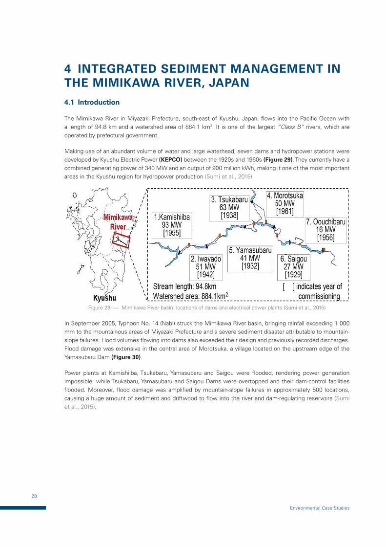
The Mimikawa River in Miyazaki Prefecture, south-east of Kyushu, Japan, flows into the Pacific Ocean with a length of 94.8 km and a watershed area of 884.1 km2. It is one of the largest “Class B” rivers, which are operated by prefectural government.
Making use of an abundant volume of water and large waterhead, seven dams and hydropower stations were developed by Kyushu Electric Power (KEPCO) between the 1920s and 1960s (Figure 29). They currently have a combined generating power of 340 MW and an output of 900 million kWh, making it one of the most important areas in the Kyushu region for hydropower production (Sumi et al., 2015).
Figure 29 — Mimikawa River basin: locations of dams and electrical power plants (Sumi et al., 2015)
In September 2005, Typhoon No. 14 (Nabi) struck the Mimikawa River basin, bringing rainfall exceeding 1 000 mm to the mountainous areas of Miyazaki Prefecture and a severe sediment disaster attributable to mountain-slope failures. Flood volumes flowing into dams also exceeded their design and previously recorded discharges. Flood damage was extensive in the central area of Morotsuka, a village located on the upstream edge of the Yamasubaru Dam (Figure 30).
Power plants at Kamishiiba, Tsukabaru, Yamasubaru and Saigou were flooded, rendering power generation impossible, while Tsukabaru, Yamasubaru and Saigou Dams were overtopped and their dam-control facilities flooded. Moreover, flood damage was amplified by mountain-slope failures in approximately 500 locations, causing a huge amount of sediment and driftwood to flow into the river and dam-regulating reservoirs (Sumi et al., 2015).
29
Integrated sediment management in the Mimikawa River, Japan
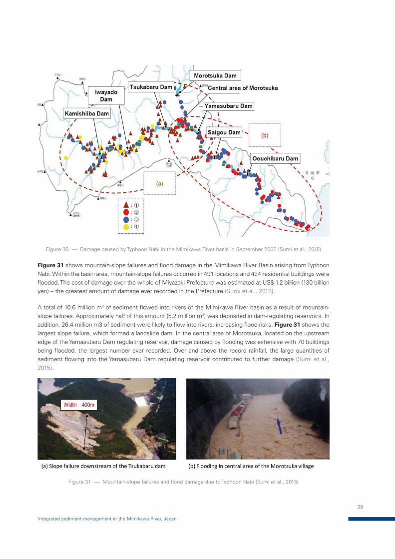
Figure 30 — Damage caused by Typhoon Nabi in the Mimikawa River basin in September 2005 (Sumi et al., 2015)
Figure 31 shows mountain-slope failures and flood damage in the Mimikawa River Basin arising from Typhoon Nabi. Within the basin area, mountain-slope failures occurred in 491 locations and 424 residential buildings were flooded. The cost of damage over the whole of Miyazaki Prefecture was estimated at US$ 1.2 billion (130 billion yen) – the greatest amount of damage ever recorded in the Prefecture (Sumi et al., 2015).
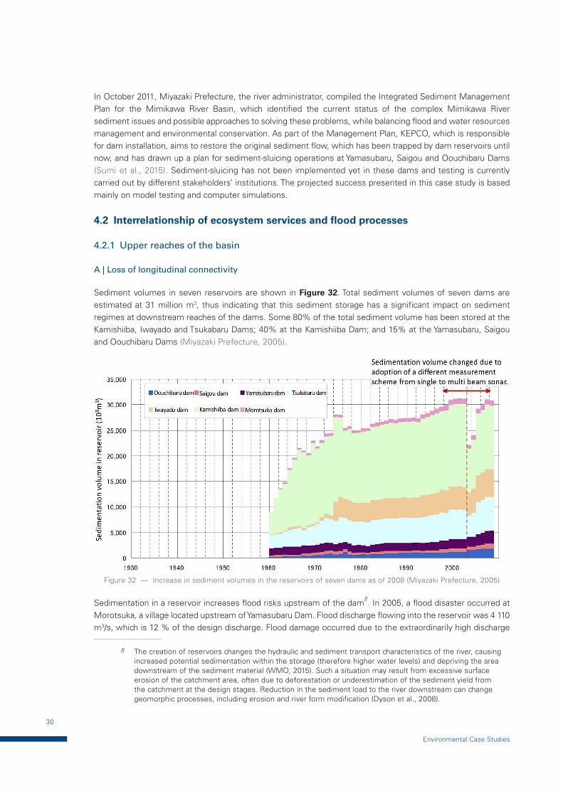
A total of 10.6 million m3 of sediment flowed into rivers of the Mimikawa River basin as a result of mountain-slope failures. Approximately half of this amount (5.2 million m3) was deposited in dam-regulating reservoirs. In addition, 26.4 million m3 of sediment were likely to flow into rivers, increasing flood risks. Figure 31 shows the largest slope failure, which formed a landslide dam. In the central area of Morotsuka, located on the upstream edge of the Yamasubaru Dam regulating reservoir, damage caused by flooding was extensive with 70 buildings being flooded, the largest number ever recorded. Over and above the record rainfall, the large quantities of sediment flowing into the Yamasubaru Dam regulating reservoir contributed to further damage (Sumi et al., 2015).
Figure 31 — Mountain-slope failures and flood damage due to Typhoon Nabi (Sumi et al., 2015)
30
Environmental Case Studies
In October 2011, Miyazaki Prefecture, the river administrator, compiled the Integrated Sediment Management Plan for the Mimikawa River Basin, which identified the current status of the complex Mimikawa River sediment issues and possible approaches to solving these problems, while balancing flood and water resources management and environmental conservation. As part of the Management Plan, KEPCO, which is responsible for dam installation, aims to restore the original sediment flow, which has been trapped by dam reservoirs until now, and has drawn up a plan for sediment-sluicing operations at Yamasubaru, Saigou and Oouchibaru Dams (Sumi et al., 2015). Sediment-sluicing has not been implemented yet in these dams and testing is currently carried out by different stakeholders’ institutions. The projected success presented in this case study is based mainly on model testing and computer simulations.
4.2 Interrelationship of ecosystem services and flood processes
4.2.1 Upper reaches of the basin
A | Loss of longitudinal connectivity
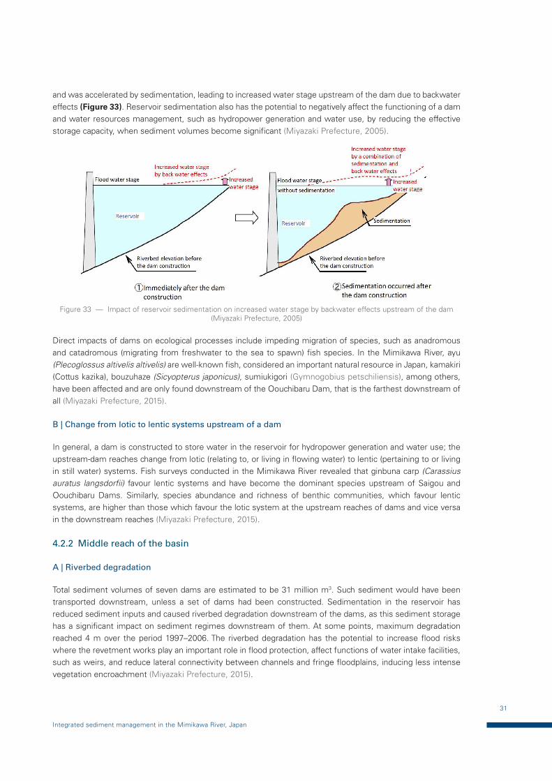
Sediment volumes in seven reservoirs are shown in Figure 32. Total sediment volumes of seven dams are estimated at 31 million m3, thus indicating that this sediment storage has a significant impact on sediment regimes at downstream reaches of the dams. Some 80% of the total sediment volume has been stored at the Kamishiiba, Iwayado and Tsukabaru Dams; 40% at the Kamishiiba Dam; and 15% at the Yamasubaru, Saigou and Oouchibaru Dams (Miyazaki Prefecture, 2005).
Figure 32 — Increase in sediment volumes in the reservoirs of seven dams as of 2008 (Miyazaki Prefecture, 2005)
Sedimentation in a reservoir increases flood risks upstream of the dam8. In 2005, a flood disaster occurred at Morotsuka, a village located upstream of Yamasubaru Dam. Flood discharge flowing into the reservoir was 4 110 m3/s, which is 12 % of the design discharge. Flood damage occurred due to the extraordinarily high discharge
8 The creation of reservoirs changes the hydraulic and sediment transport characteristics of the river, causing increased potential sedimentation within the storage (therefore higher water levels) and depriving the area downstream of the sediment material (WMO, 2015). Such a situation may result from excessive surface erosion of the catchment area, often due to deforestation or underestimation of the sediment yield from the catchment at the design stages. Reduction in the sediment load to the river downstream can change geomorphic processes, including erosion and river form modification (Dyson et al., 2008).
31
Integrated sediment management in the Mimikawa River, Japan
and was accelerated by sedimentation, leading to increased water stage upstream of the dam due to backwater effects (Figure 33). Reservoir sedimentation also has the potential to negatively affect the functioning of a dam and water resources management, such as hydropower generation and water use, by reducing the effective storage capacity, when sediment volumes become significant (Miyazaki Prefecture, 2005).
Figure 33 — Impact of reservoir sedimentation on increased water stage by backwater effects upstream of the dam (Miyazaki Prefecture, 2005)
Direct impacts of dams on ecological processes include impeding migration of species, such as anadromous and catadromous (migrating from freshwater to the sea to spawn) fish species. In the Mimikawa River, ayu (Plecoglossus altivelis altivelis) are well-known fish, considered an important natural resource in Japan, kamakiri (Cottus kazika), bouzuhaze (Sicyopterus japonicus), sumiukigori (Gymnogobius petschiliensis), among others, have been affected and are only found downstream of the Oouchibaru Dam, that is the farthest downstream of all (Miyazaki Prefecture, 2015).
B | Change from lotic to lentic systems upstream of a dam
In general, a dam is constructed to store water in the reservoir for hydropower generation and water use; the upstream-dam reaches change from lotic (relating to, or living in flowing water) to lentic (pertaining to or living in still water) systems. Fish surveys conducted in the Mimikawa River revealed that ginbuna carp (Carassius auratus langsdorfii) favour lentic systems and have become the dominant species upstream of Saigou and Oouchibaru Dams. Similarly, species abundance and richness of benthic communities, which favour lentic systems, are higher than those which favour the lotic system at the upstream reaches of dams and vice versa in the downstream reaches (Miyazaki Prefecture, 2015).
4.2.2 Middle reach of the basin
A | Riverbed degradation
Total sediment volumes of seven dams are estimated to be 31 million m3. Such sediment would have been transported downstream, unless a set of dams had been constructed. Sedimentation in the reservoir has reduced sediment inputs and caused riverbed degradation downstream of the dams, as this sediment storage has a significant impact on sediment regimes downstream of them. At some points, maximum degradation reached 4 m over the period 1997–2006. The riverbed degradation has the potential to increase flood risks where the revetment works play an important role in flood protection, affect functions of water intake facilities, such as weirs, and reduce lateral connectivity between channels and fringe floodplains, inducing less intense vegetation encroachment (Miyazaki Prefecture, 2015).
32
Environmental Case Studies
B | Armoured riverbed
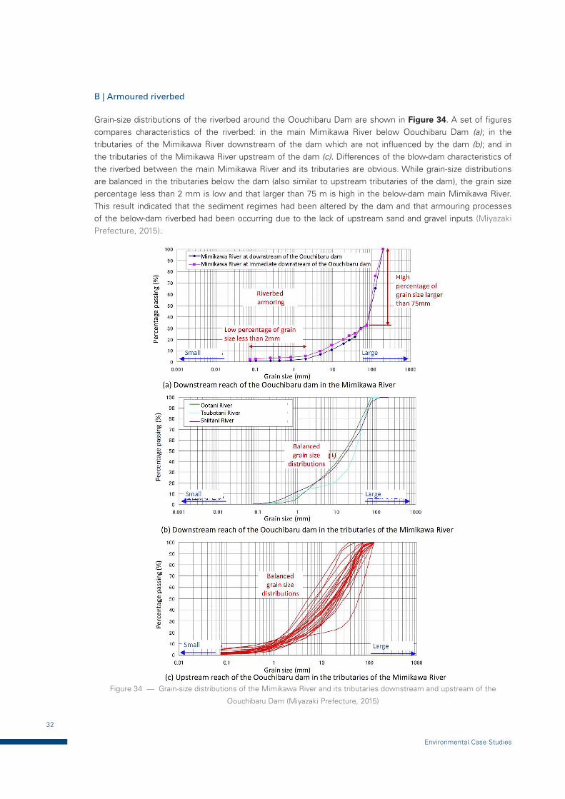
Grain-size distributions of the riverbed around the Oouchibaru Dam are shown in Figure 34. A set of figures compares characteristics of the riverbed: in the main Mimikawa River below Oouchibaru Dam (a); in the tributaries of the Mimikawa River downstream of the dam which are not influenced by the dam (b); and in the tributaries of the Mimikawa River upstream of the dam (c). Differences of the blow-dam characteristics of the riverbed between the main Mimikawa River and its tributaries are obvious. While grain-size distributions are balanced in the tributaries below the dam (also similar to upstream tributaries of the dam), the grain size percentage less than 2 mm is low and that larger than 75 m is high in the below-dam main Mimikawa River. This result indicated that the sediment regimes had been altered by the dam and that armouring processes of the below-dam riverbed had been occurring due to the lack of upstream sand and gravel inputs (Miyazaki Prefecture, 2015).
Figure 34 — Grain-size distributions of the Mimikawa River and its tributaries downstream and upstream of the
Oouchibaru Dam (Miyazaki Prefecture, 2015)

33
Integrated sediment management in the Mimikawa River, Japan
C | Loss of balanced habitat structures
Rivers in general are composed of locations of shallow depth and high velocities (riffles) and deep depth and low velocities (pools). These habitats are created and eliminated under given flow and sediment regimes, as a result of which dynamic habitat structures are formed in the river and its floodplains (Hyodo et al., 2003).
In riffles, algae attached to gravel on the riverbed can grow, since the shallow water allows sunshine to reach the riverbed and promote growth. Benthic communities which eat such attached algae stay in the riffles, which, therefore, can play a role as feeding grounds for fish species and sustain biodiversity in rivers.
On the one hand, pools have low velocity and deep water depth, playing a role as rest area for fish species and as an evacuation area for them when attached by predators (Miyazaki Prefecture, 2015).
Lack of adequate flow and sediment regimes alter river habitat structures and rivers are unable to change dynamically to sustain habitats, including riffles and pools. Riffles composed of sand and gravel with attached algae are important feeding habitats for ayu fish (Plecoglossus altivelis altivelis) and oikawa (Opsariichthys platypus) and as spawning habitats.
Several researches indicated that for desirable spawning habitats, these should be riffles with a riverbed of loose sand and gravel, similar to those for trout and salmon, adequate water quality (high dissolved oxygen and low turbidity), etc. Lack of upstream sediment inputs and resultant degradation and armouring processes of the riverbed, as well as turbidity, negatively affect such fish species, leading to degraded fluvial processes and loss of biodiversity in the Mimikawa River.
A report based on interviews with local communities observes that spawning habitats for ayu have been diminishing (Miyazaki Prefecture, 2015).
4.2.3 Lower reaches of the basin and coastal area
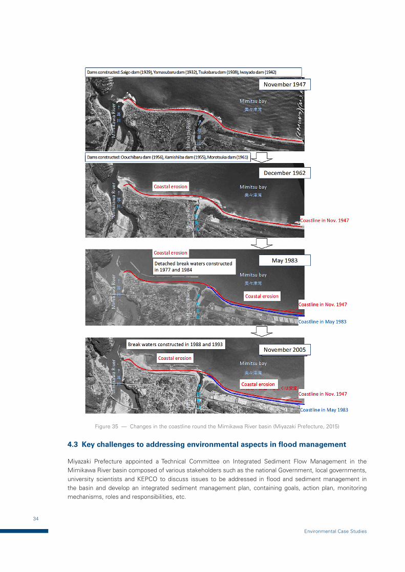
Figure 35 shows historical changes in coastal shorelines around the Mimikawa River delta (from Mimikawa River and south coast of the Ishinami River). Coastal lines in this figure are based on aerial photos. In the coastal area between the Mimikawa River and Ishinami River, costal erosion occurred from 1947 to 1983, but the trend changed to deposition in 1983. In the coastal area to the south of the Ishinami River, however, the trend to coastal erosion continued from 1947 to 1993, but weakened in 1993. In some areas, coastal erosion has been occurring, due to dams and gravel miming being carried out in the Mimikawa River.
From the perspective of flood management, coastal erosion increases flood risks in those areas, as tidal floods and tsunamis directly hit lowland areas adjacent to coastal lines without an adequate buffering area to alleviate powerful floodwaters reaching the adjacent coastal area. From an ecological perspective, the coastal area and river mouth are where freshwater and marine water meet and influence their characteristics by both floods and tidal waves, thus creating a unique ecosystem.
When the coastal area and sandbars round the river mouth are eroded, habitats in favour of such habitats will be negatively affected (Miyazaki Prefecture, 2015).
34
Environmental Case Studies
Figure 35 — Changes in the coastline round the Mimikawa River basin (Miyazaki Prefecture, 2015)
4.3 Key challenges to addressing environmental aspects in flood management
Miyazaki Prefecture appointed a Technical Committee on Integrated Sediment Flow Management in the Mimikawa River basin composed of various stakeholders such as the national Government, local governments, university scientists and KEPCO to discuss issues to be addressed in flood and sediment management in the basin and develop an integrated sediment management plan, containing goals, action plan, monitoring mechanisms, roles and responsibilities, etc.

35
Integrated sediment management in the Mimikawa River, Japan
One of the effective options for sediment management is considered to be the reconstruction of dams. The gates are planned to be partly lowered to allow for sediment transport from up- to downstream during floods. This option is expected to bring fluvial systems back to close to natural ones. Through this option, geomorphological processes including spawning habitats for ayu (Plecoglossus altivelis altivelis), which is an amphidromous fish9, are expected to be restored.
4.4 Integrated sediment management plan for the Mimikawa River Basin
4.4.1 Technical Committee on Integrated Sediment Management
In the wake of the damage caused by Typhoon Nabi, Miyazaki Prefecture – the river administrator –established the Technical Committee on Integrated Sediment Flow Management in the Mimikawa River Basin, in which river-basin stakeholders participated. Rather than focusing on each problem separately, the Prefecture came to a proper understanding of these various sediment-related problems over the entire river basin, including the mountainous areas, dams, the river itself and the coastal areas. With the aim of restoring the original sediment flow, as well as balancing flood control, water usage and environmental conservation, the Prefecture formulated a policy to advance integrated sediment-flow management. In October 2011, the Mimikawa River Basin Integrated Sediment Flow Management Plan was compiled. It identified the work to be carried out and stakeholder roles, with the aim of resolving problems caused by sediment in the basin (Miyazaki Prefecture, 2015).
4.4.2 Restructuring dams for sediment sluicing
KEPCO had frequent discussions with Miyazaki Prefecture, national and academic institutions and basin stakeholders, to draw up an action plan regarding reservoir sedimentation problems which had become increasingly serious. As a result, KEPCO formulated an action plan focusing on sediment-sluicing at Yamasubaru, Saigou and Oouchibaru Dams, with the aim of restoring the original sediment flow, which had hitherto been trapped by dam reservoirs. Sediment-sluicing at dams, which is planned to be carried out at times of river flooding due to typhoons, is the temporary lowering of reservoir water levels to make waterflow of in dam-regulating reservoirs close to the original, natural state of the river, thereby allowing inflow sediment to be transported below the dams (see Figure 36) (Sumi et al., 2015).
Figure 36 — Current and future sediment-sluicing operations (Sumi et al., 2015)
9 Fish which migrate from fresh- to saltwater or from salt- to freshwater at some stage of the life cycle other than the breeding period.

36
Environmental Case Studies
With the existing structure of Yamasubaru and Saigou Dams, it is not possible to effect the necessary drawdown in order to carry out sediment-sluicing. For this reason, sluicing functions are now being added to these dams by partially cutting down their overflow spillway sections without causing structural damage. It will be the first time in Japan that an existing dam, 80 years after commissioning, is modified by the addition of a new sluicing function. For Oouchibaru Dam, which is the farthest downstream, dam height is low; by changing dam operation, sediment-sluicing will be possible with the existing structure, so the dam will not be retrofitted (Sumi et al., 2015).
A | Selection of sediment-management option
In recent years, various countermeasures for sediment-flow management policies have been studied. It has been proposed that using total capacity/mean annual runoff (CAP/MAR) and total capacity/mean annual inflow sediment (CAP/MAS) as parameters, sediment measures can be classified which will assist in selecting an appropriate countermeasure (Figure 37). According to (Sumi et al. 2015), with an increase in CAP/MAR (a decrease in dam-regulating reservoir turnover rate), the appropriate sediment measure will vary between sediment flushing, sediment bypass, sediment sluicing, sediment check dam, excavating and dredging or none if not necessary. The reason for this is that these sediment measures depend largely on the amount of water that can be used for sediment management, which, in turn, depends on the scale of the dam-regulating reservoir.
CAP/MAR and CAP/MAS data for each of the seven dams in the Mimikawa River Basin are incorporated in Figure 37. It can be seen that, compared to Kamishiiba, Tsukabaru and other dams upstream, Yamasubaru, Saigou and Oouchibaru Dams:
— Have low CAP/MAS and therefore have a substantial need for sediment measures;
— Dam-regulating reservoir turnover rate is high (CAP/MAR is low), making sediment flushing and sediment sluicing appropriate.
Based on the analysis, retrofitting of dams for sediment sluicing operation was initiated.
Figure 37 — Selection of sediment-management options and dams in the Mimikawa River basin (Sumi et al., 2015)
B | Evaluation of change in sediment regimes by numerical simulation
In order to evaluate sediment-management measures for dam-regulating reservoirs and river-channel sections, as well as optimal rules for operating sediment measures, it is important to understand sediment regimes of
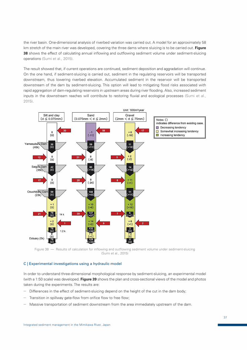
37
Integrated sediment management in the Mimikawa River, Japan
the river basin. One-dimensional analysis of riverbed variation was carried out. A model for an approximately 58 km stretch of the main river was developed, covering the three dams where sluicing is to be carried out. Figure 38 shows the effect of calculating annual inflowing and outflowing sediment volume under sediment-sluicing operations (Sumi et al., 2015).
The result showed that, if current operations are continued, sediment deposition and aggradation will continue. On the one hand, if sediment-sluicing is carried out, sediment in the regulating reservoirs will be transported downstream, thus lowering riverbed elevation. Accumulated sediment in the reservoir will be transported downstream of the dam by sediment-sluicing. This option will lead to mitigating flood risks associated with rapid aggregation of dam-regulating reservoirs in upstream areas during river flooding. Also, increased sediment inputs in the downstream reaches will contribute to restoring fluvial and ecological processes (Sumi et al., 2015).
Figure 38 — Results of calculation for inflowing and outflowing sediment volume under sediment-sluicing (Sumi et al., 2015)
C | Experimental investigations using a hydraulic model
In order to understand three-dimensional morphological response by sediment-sluicing, an experimental model (with a 1:50 scale) was developed. Figure 39 shows the plan and cross-sectional views of the model and photos taken during the experiments. The results are:
— Differences in the effect of sediment-sluicing depend on the height of the cut in the dam body;
— Transition in spillway gate-flow from orifice flow to free flow;
— Massive transportation of sediment downstream from the area immediately upstream of the dam.
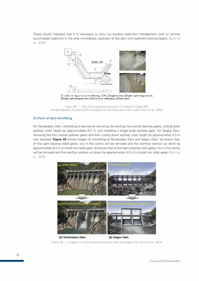
38
Environmental Case Studies
These results indicated that it is necessary to carry out auxiliary sediment management work to remove accumulated sediment in the area immediately upstream of the dam until sediment-sluicing begins (Sumi et al., 2015).
Figure 39 — Plan and cross-sectional views of hydraulic model (left) and photographs of experiment in progress at the Yamasubaru Dam (right) (Sumi et al., 2015)
D | Form of dam retrofitting
For Yamasubaru Dam, retrofitting is planned by removing the existing two central spillway gates, cutting down spillway crest height by approximately 9.3 m, and installing a single large spillway gate. For Saigou Dam, removing the four central spillway gates and then cutting down spillway crest height by approximately 4.3 m was adopted. Figure 40 shows images of retrofitting at Yamasubaru Dam and Saigou Dam: (a) shows that, of the eight existing radial gates, two in the centre will be removed and the overflow section cut down by approximately 9.3 m to install one radial gate; (b) shows that of the eight existing roller gates, four in the centre will be removed and the overflow section cut down by approximately 4.3 m to install two roller gates (Sumi et al., 2015).
Figure 40 — Images of retrofitting at Yamasubaru Dam and Saigou Dam (Sumi et al., 2015)
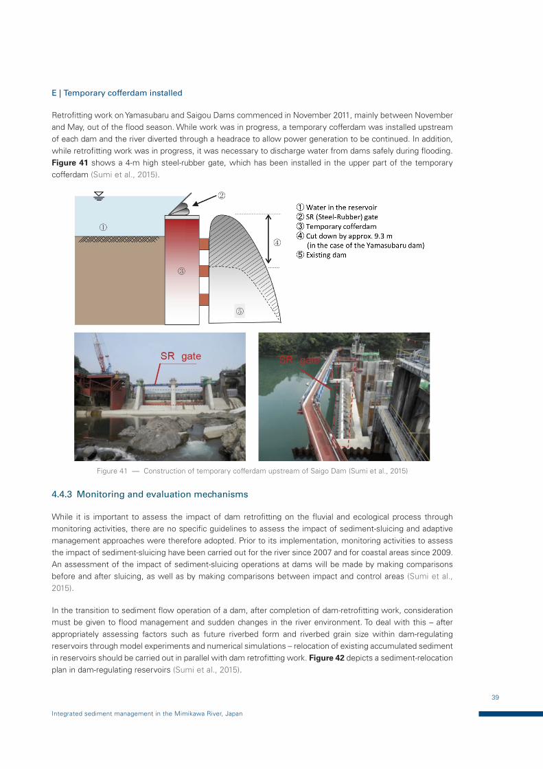
39
Integrated sediment management in the Mimikawa River, Japan
E | Temporary cofferdam installed
Retrofitting work on Yamasubaru and Saigou Dams commenced in November 2011, mainly between November and May, out of the flood season. While work was in progress, a temporary cofferdam was installed upstream of each dam and the river diverted through a headrace to allow power generation to be continued. In addition, while retrofitting work was in progress, it was necessary to discharge water from dams safely during flooding. Figure 41 shows a 4-m high steel-rubber gate, which has been installed in the upper part of the temporary cofferdam (Sumi et al., 2015).
Figure 41 — Construction of temporary cofferdam upstream of Saigo Dam (Sumi et al., 2015)
4.4.3 Monitoring and evaluation mechanisms
While it is important to assess the impact of dam retrofitting on the fluvial and ecological process through monitoring activities, there are no specific guidelines to assess the impact of sediment-sluicing and adaptive management approaches were therefore adopted. Prior to its implementation, monitoring activities to assess the impact of sediment-sluicing have been carried out for the river since 2007 and for coastal areas since 2009. An assessment of the impact of sediment-sluicing operations at dams will be made by making comparisons before and after sluicing, as well as by making comparisons between impact and control areas (Sumi et al., 2015).
In the transition to sediment flow operation of a dam, after completion of dam-retrofitting work, consideration must be given to flood management and sudden changes in the river environment. To deal with this – after appropriately assessing factors such as future riverbed form and riverbed grain size within dam-regulating reservoirs through model experiments and numerical simulations – relocation of existing accumulated sediment in reservoirs should be carried out in parallel with dam retrofitting work. Figure 42 depicts a sediment-relocation plan in dam-regulating reservoirs (Sumi et al., 2015).
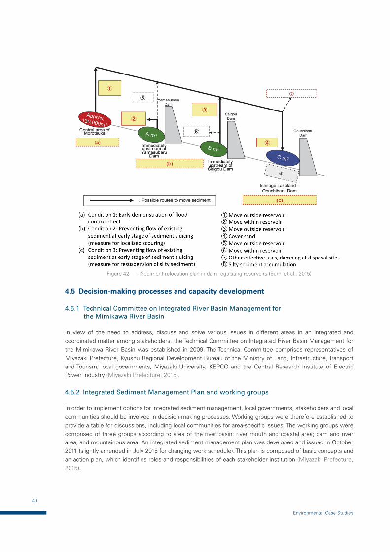
40
Environmental Case Studies
Figure 42 — Sediment-relocation plan in dam-regulating reservoirs (Sumi et al., 2015)
4.5 Decision-making processes and capacity development
4.5.1 Technical Committee on Integrated River Basin Management for the Mimikawa River Basin
In view of the need to address, discuss and solve various issues in different areas in an integrated and coordinated matter among stakeholders, the Technical Committee on Integrated River Basin Management for the Mimikawa River Basin was established in 2009. The Technical Committee comprises representatives of Miyazaki Prefecture, Kyushu Regional Development Bureau of the Ministry of Land, Infrastructure, Transport and Tourism, local governments, Miyazaki University, KEPCO and the Central Research Institute of Electric Power Industry (Miyazaki Prefecture, 2015).
4.5.2 Integrated Sediment Management Plan and working groups
In order to implement options for integrated sediment management, local governments, stakeholders and local communities should be involved in decision-making processes. Working groups were therefore established to provide a table for discussions, including local communities for area-specific issues. The working groups were comprised of three groups according to area of the river basin: river mouth and coastal area; dam and river area; and mountainous area. An integrated sediment management plan was developed and issued in October 2011 (slightly amended in July 2015 for changing work schedule). This plan is composed of basic concepts and an action plan, which identifies roles and responsibilities of each stakeholder institution (Miyazaki Prefecture, 2015).
41
Integrated sediment management in the Mimikawa River, Japan
4.5.3 Monitoring and Evaluation Committee
The Integrated Sediment Management Plan indicated basic concepts, goals and an action plan identifying options and monitoring activities, together with roles and responsibilities of each stakeholder institution. It also addressed the importance of adaptive management approaches to checking the progress of action plan, monitoring results to evaluate whether options work as expected, and assessing whether modification of the plan was needed. For this purpose, a Monitoring and Evaluation Committee on Integrated Sediment Management for the Mimikawa River Basin was established in July 2012 as a subsequent framework of the Technical Committee on Integrated River Basin Management for the Mimikawa River Basin. This Monitoring and Evaluation Committee was composed of multi-disciplinary members of Miyazaki University, Miyazaki Prefecture, local governments, stakeholders, such as the fishery cooperative, and neighbourhood associations, etc. (Miyazaki Prefecture, 2015).
Results: This case study developed an Integrated Sediment Management Plan for the Mimikawa River at a basin scale in 2011 (amended in 2015), involving various stakeholders such as the Miyazaki Prefecture, national government, local governments, university scientists and KEPCO, in order to balance development and environmental conservation. The plan identified goals, an action plan, monitoring mechanisms, roles and responsibilities, etc. to establish an enabling mechanism that would carry out the plan in a coordinated manner as part of adaptive management. Since the plan was developed, a restoration project on restructuring dams for sediment sluicing is being carried out and relevant results have yet to be made public as of 2017. It is expected that not only an integrated approach to sediment management at a basin scale, but also positive results and lessons to be learned will be provided in a few years’ time.
42
Environmental Case Studies
5 CREATING A SECONDARY CHANNEL IN THE WAAL RIVER UNDER THE ROOM FOR THE RIVER CONCEPT, NETHERLANDS
5.1 Introduction
The River Rhine basin is located in north-western Europe with a catchment area of approximately 185 000 km2. The river is about 1 320 km in length and has a mean discharge of some 2 250 m3/s at the Netherlands-German border. Downstream of this border, the Rhine divides into the Waal River and the Pannerdens Canal, which subsequently split into the Nederrijn River and the IJssel River. The discharge of the Waal River holds two thirds of the River Rhine discharge (1 500 m3/s on average), that of the Nederrijn River holds two ninths (500 m3/s) and that of the IJssel River holds the remaining one ninth (250 m3/s). In the Waal and IJssel Rivers, embankments and groynes have been put in place for flood-management and navigation purposes. The embankments serve as flood protection for low-lying areas in the floodplain. The groynes prevent rivers from meandering and maintain enough depth for shipping (Thonon et al., 2007).
The rivers were confined by increasingly higher embankments and settlements close to floodplains behind the embankments, thereby increasing flood risks when a flood exceeded the design discharge for flood protection. At the same time, the area of intensive settlement behind the embankments caused soil subsidence. In addition, under conditions of climate change, the rivers needed to increase the conveying capacity of floodwaters to protect people from flood disasters. In the most unfavourable situation, a dyke breach could put four million Netherlands citizens in danger. The Netherlands Government has been implementing measures to manage flood risks for future floods. The rivers have been, and will be, given more room at 39 locations under the Room for the River Programme. This programme also balances flood-management objectives and environmental conservation (Room for the River, 2010).
In 1993 and 1995, Netherlands rivers experienced extreme water levels, causing dyke breaches and devastating damage. As a consequence, the Government took measures to protect the rivers and people living on the floodplains against flooding (Room for the River, 2013).
An illustrative case study is that of the Garmerensche floodplains of the Waal River, a lower reach of the Rhine in the Netherlands. After a flood event in 1995, a large amount of clay and sand were excavated and secondary channels were created as part of a flood-management project, which included dyke improvement. This project also aimed at creating the natural development of flora and fauna through secondary channels.
A total of 17 partners from provinces, municipalities, water boards and the Ministry of Infrastructure and the Environment (Rijkswaterstaat) are cooperating in the implementation of the Room for the River Programme. The Minister of Transport, Public Works and Water Management bears the overall responsibility for the programme (Room for the River, 2010). Internationally, the Programme collaborates with the neighbouring countries of Belgium, France and Germany for the Rhine, Meuse and Scheldt Rivers. Room for the River has also been sharing this experience with other countries all over the world and highly values the experience obtained from these international exchanges (Room for the River, 2013).
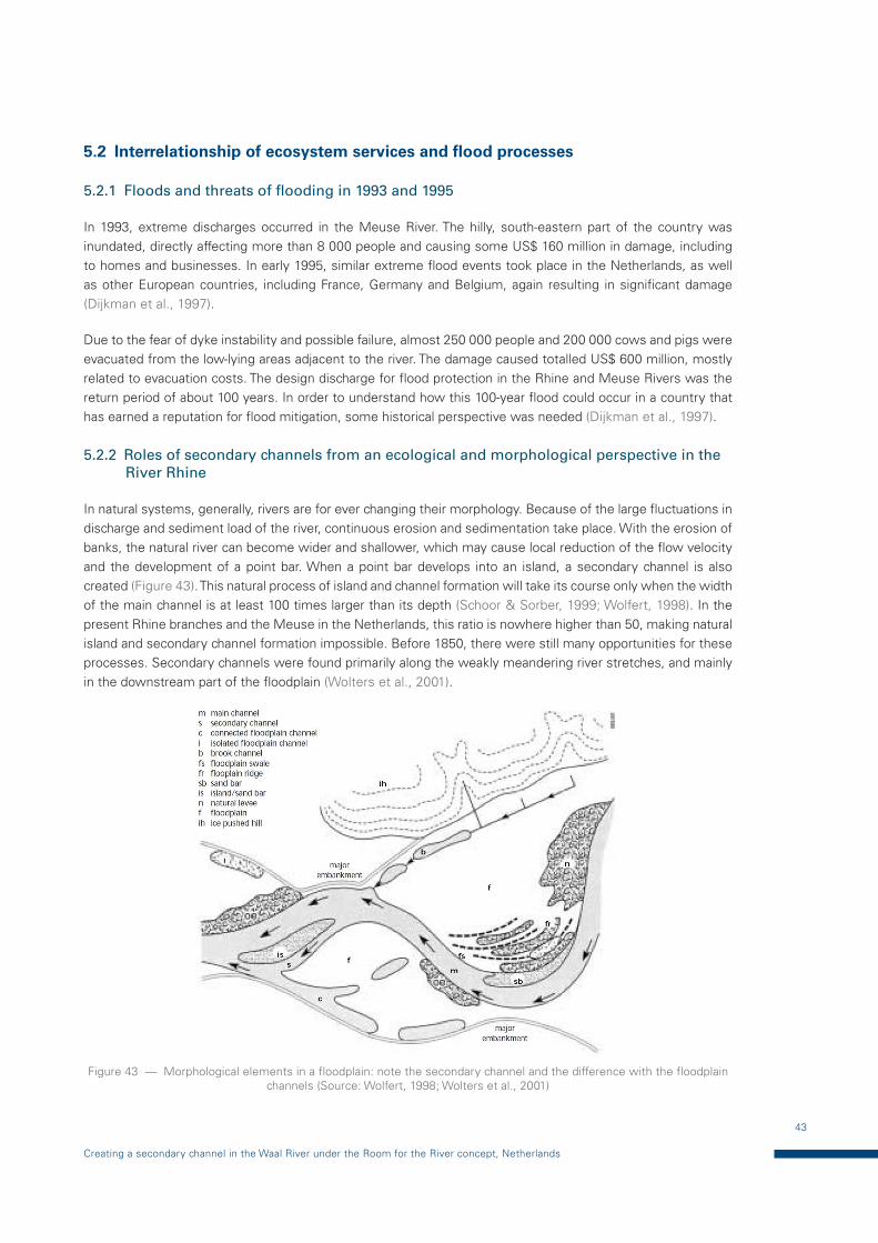
43
Creating a secondary channel in the Waal River under the Room for the River concept, Netherlands
5.2 Interrelationship of ecosystem services and flood processes
5.2.1 Floods and threats of flooding in 1993 and 1995
In 1993, extreme discharges occurred in the Meuse River. The hilly, south-eastern part of the country was inundated, directly affecting more than 8 000 people and causing some US$ 160 million in damage, including to homes and businesses. In early 1995, similar extreme flood events took place in the Netherlands, as well as other European countries, including France, Germany and Belgium, again resulting in significant damage (Dijkman et al., 1997).
Due to the fear of dyke instability and possible failure, almost 250 000 people and 200 000 cows and pigs were evacuated from the low-lying areas adjacent to the river. The damage caused totalled US$ 600 million, mostly related to evacuation costs. The design discharge for flood protection in the Rhine and Meuse Rivers was the return period of about 100 years. In order to understand how this 100-year flood could occur in a country that has earned a reputation for flood mitigation, some historical perspective was needed (Dijkman et al., 1997).
5.2.2 Roles of secondary channels from an ecological and morphological perspective in the River Rhine
In natural systems, generally, rivers are for ever changing their morphology. Because of the large fluctuations in discharge and sediment load of the river, continuous erosion and sedimentation take place. With the erosion of banks, the natural river can become wider and shallower, which may cause local reduction of the flow velocity and the development of a point bar. When a point bar develops into an island, a secondary channel is also created (Figure 43). This natural process of island and channel formation will take its course only when the width of the main channel is at least 100 times larger than its depth (Schoor & Sorber, 1999; Wolfert, 1998). In the present Rhine branches and the Meuse in the Netherlands, this ratio is nowhere higher than 50, making natural island and secondary channel formation impossible. Before 1850, there were still many opportunities for these processes. Secondary channels were found primarily along the weakly meandering river stretches, and mainly in the downstream part of the floodplain (Wolters et al., 2001).
Figure 43 — Morphological elements in a floodplain: note the secondary channel and the difference with the floodplain channels (Source: Wolfert, 1998; Wolters et al., 2001)
44
Environmental Case Studies
Normally, secondary channels slowly silt up upstream and are vegetated; they are connected with the lotic systems (e.g. main channel) during floods. Secondary channels are often characterized by a shallow depth and a low flow velocity as compared to the main channel, therefore providing suitable habitats for many species of fish and macroinvertebrates which favour an area of lentic systems. (Wolters et al., 2001).
5.3 Addressing environmental aspects in flood management: key challenges
A 1995 flood enhanced awareness among the public, policymakers, public administration and water professionals that nature cannot be controlled, requiring a paradigm shift from traditional to new flood-management approaches, creating more space for rivers to discharge their flows. This led to the initiation of the 2.2 billion euro Room for the River Programme, which started its detailed design phase in 2006 and was scheduled for completion by 2015. Objectives of the programme are:
— Improving safety against flooding of riverine areas of the Rhine and Meuse Rivers by accommodating a discharge capacity of 16 000 m3/s for the Rhine River and 3 800 m3/s for the Meuse River;
— Contributing to the improvement of the spatial quality of the riverine area for environmental, aesthetic and recreational values.
At the start of the programme, 39 locations (projects) were selected to create more room for the river through, for example, flood bypass excavation of floodplains, dyke relocation and lowering of groynes (Zvenbergen et al., 2013).
5.3.1 Geographical context: availability of space
Making room for rivers in a strict physical sense requires available space to expand a floodplain by setting back the dykes or diverting water into a bypass area. The presence of dense urban communities or critical infrastructure may preclude the ability to expand a river floodway because relocating these elements would be cost-prohibitive or socially unacceptable and calls for adopting a (river basin) system approach (Zvenbergen et al., 2013).
A | Historical context: flood history (sense of urgency)
The new paradigm of making room for the river in the Netherlands took another decade, after the floods in 1993 and 1995 on the Rhine River, in order to acquire the political will to approve the governmental decision for the Room for the River Programme (Zvenbergen et al., 2013).
B | Cultural and socioeconomic context: legitimacy for integrated river basin management
Historically, up to the 1970s, there was a weak link between river and land management in the Netherlands. The Netherlands has kept its feet dry for centuries, due to successful engineering interventions along the rivers and coast. Driven by the recognition of protecting areas of landscape beauty and the realization that there are limits to heightening river dykes, the first integrated river-management plans were developed in the 1980s. These plans were well received by local stakeholders and the public. They embraced the basic principles of the concept of “making room for the river”, which marked the offset of a transition to a new paradigm in river-basin management. In turn, this provided the legitimacy for the national Government to initiate and further develop the Room for the River Programme (Zvenbergen et al., 2013).
C | Institutional context: multi-level and cross-sector collaboration
In the Netherlands, the polder model of compromise prevails, along with strong top-to-bottom governance to oversee and encourage a coordinated system-wide approach. The engagement of the three governmental
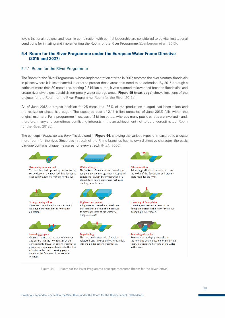
45
Creating a secondary channel in the Waal River under the Room for the River concept, Netherlands
levels (national, regional and local) in combination with central leadership are considered to be vital institutional conditions for initiating and implementing the Room for the River Programme (Zvenbergen et al., 2013).
5.4 Room for the River Programme under the European Water Frame Directive (2015 and 2027)
5.4.1 Room for the River Programme
The Room for the River Programme, whose implementation started in 2007, restores the river’s natural floodplain in places where it is least harmful in order to protect those areas that need to be defended. By 2015, through a series of more than 30 measures, costing 2.3 billion euros, it was planned to lower and broaden floodplains and create river diversions establish temporary water-storage areas. Figure 45 (next page) shows locations of the projects for the Room for the River Programme (Room for the River, 2013a).
As of June 2012, a project decision for 25 measures (86% of the production budget) had been taken and the realization phase had begun. The expected cost of 2.15 billion euros (as of June 2012) falls within the original estimate. For a programme in excess of 2 billion euros, whereby many public parties are involved – and, therefore, many and sometimes conflicting interests – it is an achievement not to be underestimated (Room for the River, 2013b).
The concept “Room for the River” is depicted in Figure 44, showing the various types of measures to allocate more room for the river. Since each stretch of the Rhine branches has its own distinctive character, the basic package contains unique measures for every stretch (RIZA, 2006).
Figure 44 — Room for the River Programme concept: measures (Room for the River, 2013a)
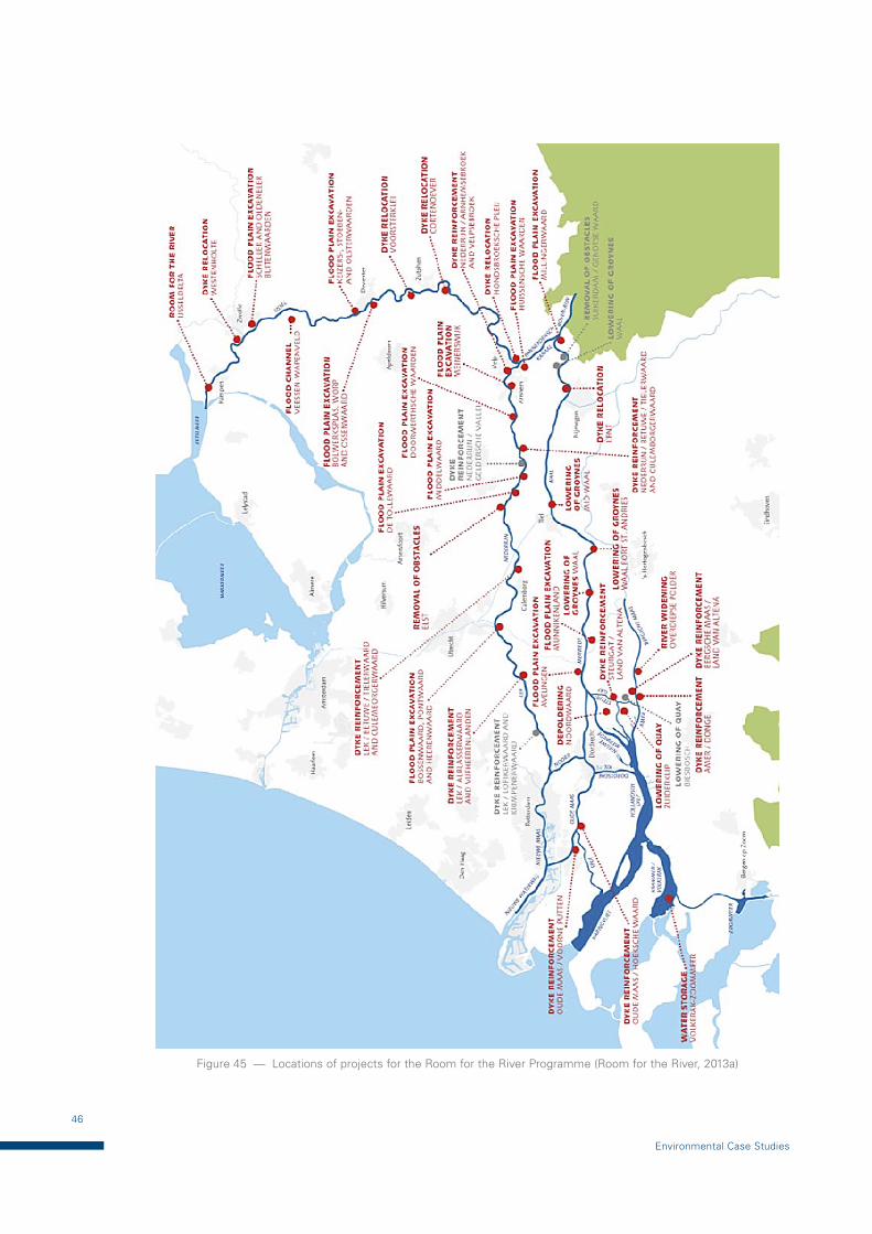
46
Environmental Case Studies
Figure 45 — Locations of projects for the Room for the River Programme (Room for the River, 2013a)
47
Creating a secondary channel in the Waal River under the Room for the River concept, Netherlands
A | Waal
Specially selected for the Waal is the lowering of groynes and the removing of obstacles. These measures are relatively cheap and easy to perform and have a significant impact on water levels. In the Millingerwaard, river forelands will be deepened. Dykes have been displaced at two locations: Lent and Munnikenland (RIZA, 2006).
B | Lower Rhine-Lek
Deepening of forelands along the Pannerden Canal and the Lower Rhine will create more room for the river. The forelands become increasingly narrow in a westerly direction, so this measure will not be as effective in reducing water levels. Strengthening of dykes is therefore the preferred method for the Lek, particularly along the south side. Around Elst, the removal of an obstacle will create more space (RIZA, 2006).
C | IJssel
Wide expanses of foreland border the IJssel, yet only three areas will be deepened. In the other areas, digging activities would damage the natural habitat. At three locations, more space will be created by displacing dykes at Cortenoever, Voorst and Westenholte. A flood channel at Veessen-Wapenveld will give the river an extra course in flood conditions. Enlarging the summer bed in the lower course of the IJssel will allow the water to flow faster into the Ijsselmeer (RIZA, 2006).
D | Lower reaches
In the lower reaches of the Rhine and Meuse, the most significant measures will be the removal of the Noordwaard and Overdiep polders. More space will be created in the Biesbosch by lowering an embankment. At Avelingen, a foreland near the industrial estate will be deepened. The possibility of containing some of the river water in the Volkerak at extremely high discharge levels is under investigation. A great deal of soil will have to be transported as a result of the measures. Some of this soil can be re-used, such as for other work along the river, and some can be sold. Soil that cannot be re-used will be stored in depots. Most of the soil is clean or only slightly contaminated and can be stored in depots specified in the Spatial Planning Key Decision (SPKD) Room for the River. A small portion of the soil is contaminated and will be transported to existing depots adapted for the purpose, such as at IJsseloog. The Government has earmarked more than 2.1 billion euros for implementing the basic package of measures. Alternative or supplementary measures could possibly be carried out at certain locations; ideas for such measures will be worked out by other authorities and market parties. This is under the condition that the objectives of the SPKD Room for the River are realized on time and that the parties concerned can guarantee sufficient financing for the project (RIZA, 2006).
5.4.2 Creating a secondary channel in the Gamerensche floodplain of the Waal River
Secondary channels can no longer develop naturally in the present-day Netherlands rivers; they can only be developed by human intervention. Over the past decade, five secondary channels were made, all along the Waal River (Figure 46). The Gamerensche floodplains are located along the Waal River, a lower reach of the Rhine. After a flood event in 1995, a large amount of clay and sand was excavated and secondary channels were created as part of a flood-management project, including dyke improvement (Baptist and Mosselman, 2002). This project also aimed at creating secondary channels and the natural development of flora and fauna. Characteristics of the three secondary channels west, east and large differ: the west and east channels have a sill at the entrance opening that determines the flow frequency; the larger channel does not have a sill but flows permanently (Baptist and Mosselman, 2002).
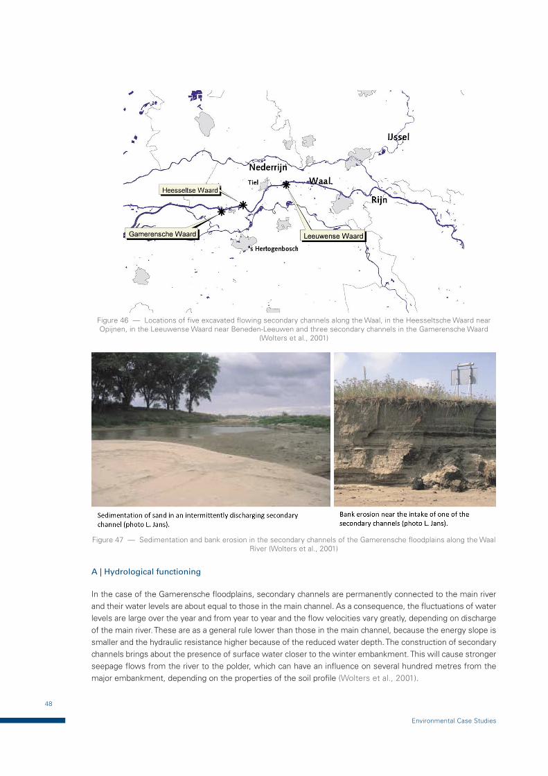
48
Environmental Case Studies
Figure 46 — Locations of five excavated flowing secondary channels along the Waal, in the Heesseltsche Waard near Opijnen, in the Leeuwense Waard near Beneden-Leeuwen and three secondary channels in the Gamerensche Waard
(Wolters et al., 2001)
Figure 47 — Sedimentation and bank erosion in the secondary channels of the Gamerensche floodplains along the Waal River (Wolters et al., 2001)
A | Hydrological functioning
In the case of the Gamerensche floodplains, secondary channels are permanently connected to the main river and their water levels are about equal to those in the main channel. As a consequence, the fluctuations of water levels are large over the year and from year to year and the flow velocities vary greatly, depending on discharge of the main river. These are as a general rule lower than those in the main channel, because the energy slope is smaller and the hydraulic resistance higher because of the reduced water depth. The construction of secondary channels brings about the presence of surface water closer to the winter embankment. This will cause stronger seepage flows from the river to the polder, which can have an influence on several hundred metres from the major embankment, depending on the properties of the soil profile (Wolters et al., 2001).
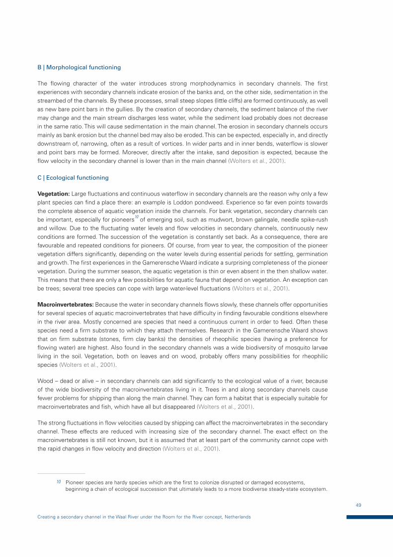
49
Creating a secondary channel in the Waal River under the Room for the River concept, Netherlands
B | Morphological functioning
The flowing character of the water introduces strong morphodynamics in secondary channels. The first experiences with secondary channels indicate erosion of the banks and, on the other side, sedimentation in the streambed of the channels. By these processes, small steep slopes (little cliffs) are formed continuously, as well as new bare point bars in the gullies. By the creation of secondary channels, the sediment balance of the river may change and the main stream discharges less water, while the sediment load probably does not decrease in the same ratio. This will cause sedimentation in the main channel. The erosion in secondary channels occurs mainly as bank erosion but the channel bed may also be eroded. This can be expected, especially in, and directly downstream of, narrowing, often as a result of vortices. In wider parts and in inner bends, waterflow is slower and point bars may be formed. Moreover, directly after the intake, sand deposition is expected, because the flow velocity in the secondary channel is lower than in the main channel (Wolters et al., 2001).
C | Ecological functioning
Vegetation: Large fluctuations and continuous waterflow in secondary channels are the reason why only a few plant species can find a place there: an example is Loddon pondweed. Experience so far even points towards the complete absence of aquatic vegetation inside the channels. For bank vegetation, secondary channels can be important, especially for pioneers10 of emerging soil, such as mudwort, brown galingale, needle spike-rush and willow. Due to the fluctuating water levels and flow velocities in secondary channels, continuously new conditions are formed. The succession of the vegetation is constantly set back. As a consequence, there are favourable and repeated conditions for pioneers. Of course, from year to year, the composition of the pioneer vegetation differs significantly, depending on the water levels during essential periods for settling, germination and growth. The first experiences in the Gamerensche Waard indicate a surprising completeness of the pioneer vegetation. During the summer season, the aquatic vegetation is thin or even absent in the then shallow water. This means that there are only a few possibilities for aquatic fauna that depend on vegetation. An exception can be trees; several tree species can cope with large water-level fluctuations (Wolters et al., 2001).
Macroinvertebrates: Because the water in secondary channels flows slowly, these channels offer opportunities for several species of aquatic macroinvertebrates that have difficulty in finding favourable conditions elsewhere in the river area. Mostly concerned are species that need a continuous current in order to feed. Often these species need a firm substrate to which they attach themselves. Research in the Gamerensche Waard shows that on firm substrate (stones, firm clay banks) the densities of rheophilic species (having a preference for flowing water) are highest. Also found in the secondary channels was a wide biodiversity of mosquito larvae living in the soil. Vegetation, both on leaves and on wood, probably offers many possibilities for rheophilic species (Wolters et al., 2001).
Wood – dead or alive – in secondary channels can add significantly to the ecological value of a river, because of the wide biodiversity of the macroinvertebrates living in it. Trees in and along secondary channels cause fewer problems for shipping than along the main channel. They can form a habitat that is especially suitable for macroinvertebrates and fish, which have all but disappeared (Wolters et al., 2001).
The strong fluctuations in flow velocities caused by shipping can affect the macroinvertebrates in the secondary channel. These effects are reduced with increasing size of the secondary channel. The exact effect on the macroinvertebrates is still not known, but it is assumed that at least part of the community cannot cope with the rapid changes in flow velocity and direction (Wolters et al., 2001).
10 Pioneer species are hardy species which are the first to colonize disrupted or damaged ecosystems, beginning a chain of ecological succession that ultimately leads to a more biodiverse steady-state ecosystem.
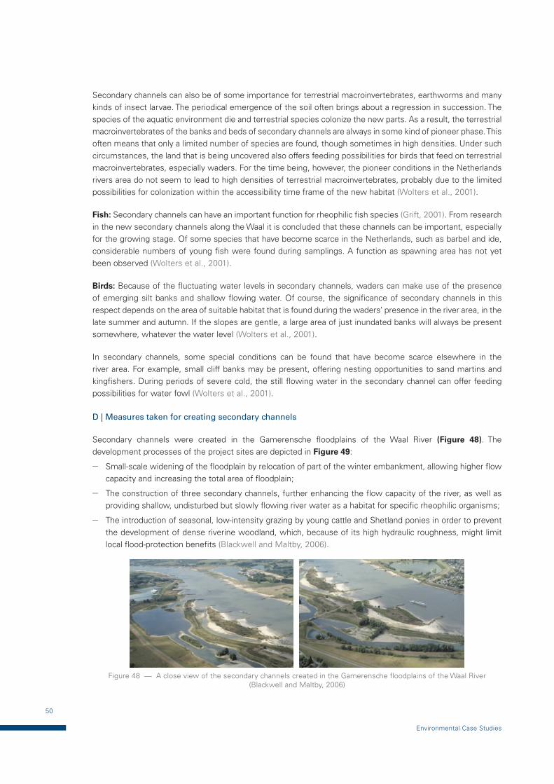
50
Environmental Case Studies
Secondary channels can also be of some importance for terrestrial macroinvertebrates, earthworms and many kinds of insect larvae. The periodical emergence of the soil often brings about a regression in succession. The species of the aquatic environment die and terrestrial species colonize the new parts. As a result, the terrestrial macroinvertebrates of the banks and beds of secondary channels are always in some kind of pioneer phase. This often means that only a limited number of species are found, though sometimes in high densities. Under such circumstances, the land that is being uncovered also offers feeding possibilities for birds that feed on terrestrial macroinvertebrates, especially waders. For the time being, however, the pioneer conditions in the Netherlands rivers area do not seem to lead to high densities of terrestrial macroinvertebrates, probably due to the limited possibilities for colonization within the accessibility time frame of the new habitat (Wolters et al., 2001).
Fish: Secondary channels can have an important function for rheophilic fish species (Grift, 2001). From research in the new secondary channels along the Waal it is concluded that these channels can be important, especially for the growing stage. Of some species that have become scarce in the Netherlands, such as barbel and ide, considerable numbers of young fish were found during samplings. A function as spawning area has not yet been observed (Wolters et al., 2001).
Birds: Because of the fluctuating water levels in secondary channels, waders can make use of the presence of emerging silt banks and shallow flowing water. Of course, the significance of secondary channels in this respect depends on the area of suitable habitat that is found during the waders’ presence in the river area, in the late summer and autumn. If the slopes are gentle, a large area of just inundated banks will always be present somewhere, whatever the water level (Wolters et al., 2001).
In secondary channels, some special conditions can be found that have become scarce elsewhere in the river area. For example, small cliff banks may be present, offering nesting opportunities to sand martins and kingfishers. During periods of severe cold, the still flowing water in the secondary channel can offer feeding possibilities for water fowl (Wolters et al., 2001).
D | Measures taken for creating secondary channels
Secondary channels were created in the Gamerensche floodplains of the Waal River (Figure 48). The development processes of the project sites are depicted in Figure 49:
— Small-scale widening of the floodplain by relocation of part of the winter embankment, allowing higher flow capacity and increasing the total area of floodplain;
— The construction of three secondary channels, further enhancing the flow capacity of the river, as well as providing shallow, undisturbed but slowly flowing river water as a habitat for specific rheophilic organisms;
— The introduction of seasonal, low-intensity grazing by young cattle and Shetland ponies in order to prevent the development of dense riverine woodland, which, because of its high hydraulic roughness, might limit local flood-protection benefits (Blackwell and Maltby, 2006).
Figure 48 — A close view of the secondary channels created in the Gamerensche floodplains of the Waal River (Blackwell and Maltby, 2006)
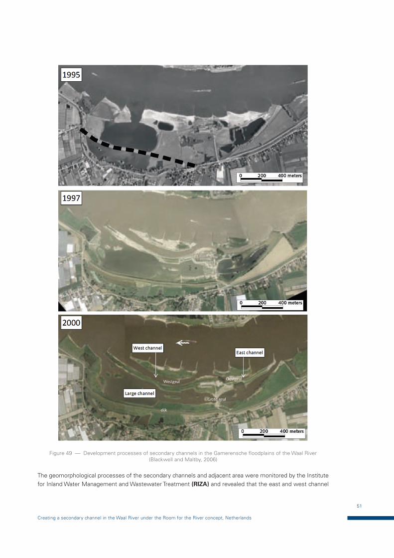
51
Creating a secondary channel in the Waal River under the Room for the River concept, Netherlands
Figure 49 — Development processes of secondary channels in the Gamerensche floodplains of the Waal River (Blackwell and Maltby, 2006)
The geomorphological processes of the secondary channels and adjacent area were monitored by the Institute for Inland Water Management and Wastewater Treatment (RIZA) and revealed that the east and west channel
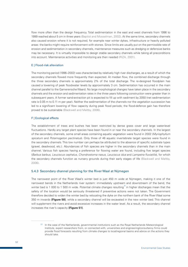
52
Environmental Case Studies
flow more often than the design frequency. Total sedimentation in the east and west channels from 1996 to 1999 reached about 5 cm in three years (Baptist and Mosselman, 2002). At the same time, secondary channels also caused erosion where it is not required, for example near winter dykes, infrastructure or heavily polluted areas: the banks might require reinforcement with stones. Since limits are usually put on the permissible rate of erosion and sedimentation in secondary channels, maintenance measures such as dredging or defensive banks may be necessary. It is virtually impossible to design stable secondary channels while taking all preconditions into account. Maintenance activities and monitoring are then needed (RIZA, 2001).
E | Flood-risk alleviation
The monitoring period (1996–2002) was characterized by relatively high river discharges, as a result of which the secondary channels flowed more frequently than expected. At median flow, the combined discharge through the three secondary channels is approximately 2% of the total discharge. The re-designed floodplain has caused a lowering of peak floodwater levels by approximately 3 cm. Sedimentation has occurred in the main channel parallel to the Gamerensche Waard. No large morphological changes have taken place in the secondary channels and the erosion and sedimentation rates in the three years following construction were greater than in subsequent years. A former sand-extraction pit is expected to fill up with sediment by 2050 (net sedimentation rate is 0.05 m to 0.11 m per year). Neither the sedimentation of the channels nor the vegetation succession has led to a significant lowering of flow capacity during peak flood periods; the flood-defence gain has therefore proved to be sustainable (Blackwell and Maltby, 2006).
F | Ecological effects
The establishment of trees and bushes has been restricted by dense grass cover and large water-level fluctuations. Hardly any target plant species have been found in or near the secondary channels. In the largest of the secondary channels, some small areas containing aquatic vegetation were found in 2002 (Myriophyllum spicatum and Potamogeton pectinatus). Only three of 46 aquatic invertebrate target species were found in the secondary channels. This low number can perhaps be attributed to the absence of specific substrate types (gravel, deadwood, etc.). Abundances of fish species are higher in the secondary channels than in the main channel. Various fish species having a preference for flowing water are found, including five target species (Barbus barbus, Leuciscus cephalus, Chondrostoma nasus, Leuciscus idus and Lampetra fluviatilis), for which the secondary channels function as nursery grounds during their early stages of life (Blackwell and Maltby, 2006).
5.4.3 Secondary channel planning for the River Waal at Nijmegen
The narrowest point of the River Waal’s winter bed is just 450 m wide at Nijmegen, making it one of the narrowest bends in the Netherlands river system: immediately upstream and downstream of the bend, the winter bed is 1 000 to 1 500 m wide. Potential climate changes resulting11 in higher discharges mean that the safety of the location would be seriously threatened if preventive actions were not taken. The Government therefore decided to widen the winter bed by relocating the dyke on the northern bank of the River Waal some 350 m inwards (Figure 50), while a secondary channel will be excavated in the new winter bed. This channel will supplement the rivers and avoid excessive increases in the water level. As a result, the secondary channel increases the river’s capacity (Figure 51).
11 In the case of the Netherlands, governmental institutions such as the Royal Netherlands Meteorological Institute, expert researchers from, or connected with, universities and engineering/consultancy firms could provide flood forecasts resulting from climate changes to local/regional basins and advice on the actions they should take.
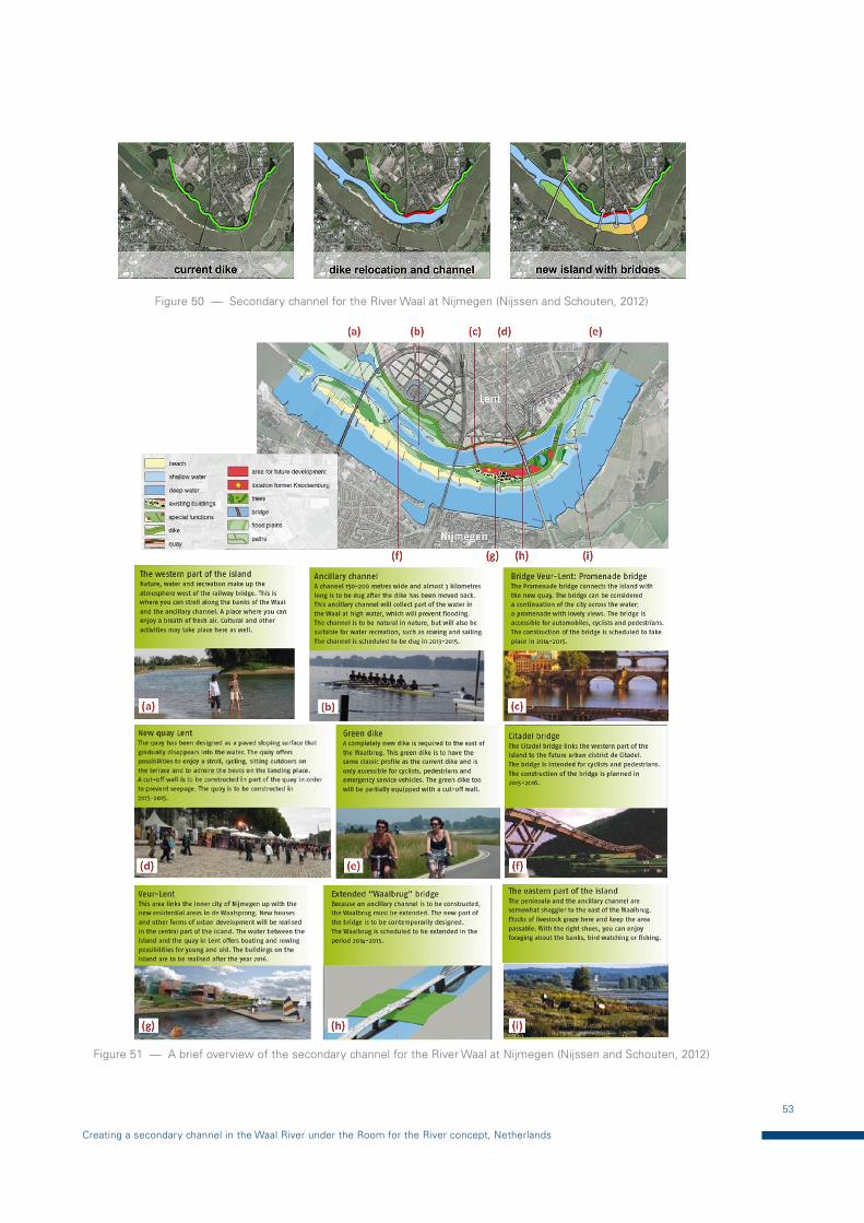
53
Creating a secondary channel in the Waal River under the Room for the River concept, Netherlands
Figure 50 — Secondary channel for the River Waal at Nijmegen (Nijssen and Schouten, 2012)
Figure 51 — A brief overview of the secondary channel for the River Waal at Nijmegen (Nijssen and Schouten, 2012)
54
Environmental Case Studies
A | A drastic measure
The relocation of the dyke at Nijmegen is one of the most controversial measures in the Room for the River Programme, since the northern bank of the River Waal at Nijmegen is not barren land. The village of Lent (also part of the municipality of Nijmegen) stands on the northern bank: the relocation of the dyke would result in the demolition of 50 houses and the disappearance of a number of companies. Moreover, Nijmegen is the oldest city in the Netherlands with historic value: it was founded by the Romans and has an appreciated waterfront. Announcement of the plans subsequently resulted in strong protests, initially from Lent’s inhabitants and, consequently, from the Municipal Executive as well. However, the Government saw no alternative to the necessary relocation of the dyke (Nijssen and Schouten, 2012).
B | Nijmegen embraces the River Waal
The Nijmegen plan is based on the principle that the river will give something back to the city’s inhabitants, even though they first have to give something. The Nijmegen project is unique in that it is in an urban location and, moreover, in an area that is changing rapidly. Both these elements offer tremendous opportunities for the addition of something unique to both the city and the river. The municipality of Nijmegen is now working on the detailing of its Urban River Park plan for a region which combines a range of functions, creates a valuable public area and will serve the city’s inhabitants. Central government and the municipality expect that their plan will receive broad support from the city’s inhabitants (Nijssen and Schouten, 2012).
C | A Threat turned into a great opportunity
In contrast to past decades, when the city turned its back to the river – the river that had given Nijmegen its raison d’être for so long – the city is now gradually turning to face the river again. The Room for the River Programme constitutes the central link in the fulfilment of this ambition. This main project links the various projects around the River Waal and will contribute to the unification of the north and the south. In creating a high-grade public space offering possibilities for recreation, public facilities, an attractive quay, opportunities for water sports and housing, the project will bring the new (northern) and old (southern) parts of Nijmegen together. All these improvements are linked to, and are possibly feasible as a result of, the need to take measures to prevent flooding. The excellence of the plan has also been recognized by the inhabitants of Nijmegen. After years of opposition, the plan was applauded when finally presented to the public in 2009. Despite large sacrifices, people also see the great opportunities the project offers by the creation of a river park, nature development and a new waterfront (Nijssen and Schouten, 2012).
5.5 Decision-making processes and capacity development
The Room for the River Programme has adopted a new (multi-level) governance approach with the collaboration of national, regional and local levels and other stakeholders, in which government agencies in different disciplines (water safety, planning, agriculture, nature) participate. The roles of the national Government in the decision-making processes are to: set the decision frameworks for establishing improved water safety and spatial quality; establish progress; evaluate the quality of designs; and facilitate the regional projects through guidelines providing expert knowledge, community building and, where needed, applying political pressure. The aims of the projects are to formulate plans and designs for making decisions. This approach provided the opportunity for decentralized governments to link local issues, such as new urban developments and the creation of natural and recreational areas (Zevenbergen, 2013).
55
Creating a secondary channel in the Waal River under the Room for the River concept, Netherlands
5.5.1 International cooperation
Several countries in the Rhine and Meuse river basin work closely on flood protection in a collaborative manner and have adopted the Rhine High Water Action Plan (Hoogwateractieplan voor de Rijn). Its objective is to reduce high-water levels by an average of 70 cm12 by 2020. All the countries in these basins are implementing appropriate measures, including those described in the Room for the River Programme. The German state of Nordrhein-Westfalen, the Netherlands province of Gelderland and the Directorate-General for Public Works and Water Management (Rijkswaterstaat, RWS) for the eastern Netherlands studied the effects of extremely high water in the border region. The volume of Rhine water that could eventually reach the Netherlands was also estimated. The three parties then investigated which measures could potentially provide flood protection for both the Netherlands and Germany (RIZA, 2006).
5.5.2 Stakeholders’ participation in the Nijmegen project
Stakeholders and the local community were involved in various ways in developing the plans, including newsletters, information meetings and interactive workshops, where the participants could provide their inputs. Graphics and models demonstrated the effects of measures and facilitated stakeholder participation. The entire planning procedure was subject to the procedures of the Strategic Environmental Assessment and Environmental Impact Assessment. Through their participation and responses to their inputs, stakeholders’ doubts and opposing views were widely addressed and there is currently broad support for the project (Room for the River, 2014).
The Room for the River Programme was set up to guarantee the safety of the Netherlands river delta. Out of a total of 30 projects, the largest is located in Nijmegen – the oldest city of the Netherlands. The project entails the shift of the main dyke 350 m inland in combination with the construction of a new flood channel. Space for the River Waal is effected through the construction of an elongated peninsula between the new secondary channel and the river. The planned dyke shift, however, caused huge social unrest as the enlargement of the riverbed came at the expense of over 50 family homes, agricultural land and industrial property. Creating political support and social understanding became crucial for the success of the dyke shift (Room for the River, 2014).
By using a strategy based on stakeholder participation, the local population was actively involved in the process: their concerns and interests were taken into account and an effective coalition between the public and politicians was formed. The outcome was an integrated development plan, which not only increased the space for the river but also stimulated urban development in, and the ecological value of, the area, both being of great local importance (Room for the River, 2014).
Results: A new urban river park at the heart of the oldest city of the Netherlands was constructed and 150 people moved to safer settlements without any major court cases. No project delay was recorded and expenditure on the project was lower than estimated. Increased water safety for citizens of Nijmegen and communities downstream is ensured. Through a transparent process, open communication, clear agreements, genuine interest in stakeholders’ concerns and interests and attention for the “soft” side of the Room for the River project at Nijmegen, the project team has helped to create a water-management plan that meets the approval of almost all the parties involved. In December 2009, some 250 participants expressed their appreciation for the project’s management team (Room for the River, 2014).
12 This number was determined by the following: 60 cm due to water retention along the Rhine and approximately 10 cm due to water retention in the Rhine catchment (International Commission for the Protection of the Rhine, 2013).
56
Environmental Case Studies
REFERENCES & BIBLIOGRAPHY
B Baptist, M.J. and E. Mosselman, 2002: Biogeomorphological modelling of secondary channels
in the Waal River. In: D. Bousmar and Y. Zech, (eds.), River Flow 2002 Symposium, 773-782, Louvain-la-Neuve, Belgium.
Blackwell, M.S.A. and E. Maltby, 2006: Ecoflood Guidelines – How to Use Floodplains for Flood
Risk Reduction, European Commission. ec.europa.eu/ourcoast/download.cfm?fileID=951
C Carinthian state government, 2011: LIFE project, Life Vein - Upper Drau River, Carinthia’s Largest
Nature Restoration Campaign (2006–2011), EU-Life Programme. ec.europa.eu/environment/life/project/Projects/index.cfm?fuseaction=home.showFile&rep=file&fil=LIFE06_NAT_A_000127_LAYMAN.pdf
D Dijkman, J., R. Klomp and M. Villars, 1997: Flood Management Strategies for the Rivers Rhine
and Meuse in the Netherlands, Destructive Water: Water-Caused Natural Disasters, their Abatement
and Control. Proceedings of the Conference held at Anaheim, California, June 1996, IAHS Publ. No. 239, 371–338. hydrologie.org/redbooks/a239/iahs_239_0371.pdf
Dyson, M., G. Bergkamp and J. Scanlon (eds), 2008: Flow – The Essentials of Environmental
Flows, second edition. International Union for Conservation of Nature, Gland, Switzerland. cmsdata.iucn.org/downloads/e_flow_2003_021_english_versoin.pdf
E EU (European Union), 2013: Best LIFE Nature projects 2012. European Union, ISBN 978-92-79-33177-0. ec.europa.eu/environment/life/publications/lifepublications/bestprojects/documents/bestnat12.pdf
F Formann, E., H.M. Habersack and St. Schober, 2007: Morphodynamic river processes and
techniques for assessment of channel evolution in Alpine gravel bed rivers, Geomorphology 90, 340–
355.
H Hyodo, M., Y. Takemon and T. Sumi, 2013: Need for analyzing spatiotemporal patterns of river-
corridor habitat structure in sediment management. Advances in River Sediment Research. Fukuoka et al. (eds), 1557–1567.
I International Commission for the Protection of the Rhine (ICPR), 2013: The Rhine and
its Catchment: An Overview. Koblenz, Germany. www.iksr.org/fileadmin/user_upload/Dokumente_en/Brochures/IKSR_BRO_210x297_ENG_26.09.13.pdf
K Krause, F., 2012: History of Mechanical Sediment Augmentation and Extraction on the Trinity River,
California, 1912–2011, Bureau of Reclamation, Trinity River Restoration Program, Technical Report TR-
TRRP-2012-2. odp.trrp.net/FileDatabase/Documents/Krause%20(2012)%20History%20of%20mechanical%20sediment%20augmentation%20and%20extraction%201912%20-%202011.Revised1.pdf
57
Creating a secondary channel in the Waal River under the Room for the River concept, Netherlands
M McBain & Trush, Inc., 2000: Trinity River Restoration Program: Summary of the United States
Secretary of the Interior Record of Decision, December 19, 2000. US Bureau of Reclamation Trinity River Restoration Program. www.usbr.gov/mp/ncao/trinity_river/trinity_river_mainstem_brochure.pdf
Michor, K., LIFE Project, LIFE in Upper Drau River. www.alpconv.org/en/newsevents/alpine/life/Documents/Michor.pdf
Miyazaki Prefecture, 2015: Integrated Sediment Management Plan in the Mimikawa River Basin,
Miyazaki Prefecture (in Japanese). www.pref.miyazaki.lg.jp/kasen/shakaikiban/kasen/page00135.html
Mohl, A., 2004: LIFE River Restoration Projects in Austria, 3rd European Conference on River
Restoration 2014, Zagreb, Croatia, 17–21, May 2004. www.ecrr.org/Portals/27/Publications/Proceedings/3rd_ERRC_2004/21_mohl.pdf
N Nijssen, P. and M. Schouten, 2012: Dutch national Room for the River project: Integrated approach
for river safety and urban development, IS.Rivers 2012, A1 – Eaux et Territories/Land and Water. www.graie.org/ISRivers/actes/pdf2012/1A108-265NIJ.pdf
R Regional government of Carinthia: An Overview of Measures – Main focuses of the Life Project
2006–2011. www.life-drau.at/palm-cms/upload_files/Downloads/Folder_Lebensader_Obere_Drau_EN.pdf
RIZA (Institute for Inland Water Management and Wastewater Treatment), 2004: Evaluatie nevengeulen Gamerensche Waard 1996–2002. Ministerie van Verkeer en Watershaat Rijkswaterstaat (in Dutch). wiki.reformrivers.eu/images/0/01/Evaluatie_nevengeulen_Gamerensche_Waard_-.pdf
RIZA (Institute for Inland Water Management and Wastewater Treatment), 2006: Spatial
Planning Key Decision ‘Room for the River’– Investing in the Safety and Vitality of the Dutch River
Basin Region. www.hollandexploringtours.nl/pdf/spacefortheriver.pdf
Room for the River, 2010: Room for the River – a safer and more attractive rivers region. www.dzzp.hr/dokumenti_upload/20100628/dzzp201006281028320.pdf
Room for the River, 2013(a): Dutch Water Programme Room for the River. waterandthedutch.com/wp-content/uploads/2013/08/Room-for-the-River.pdf
Room for the River, 2013(b): Tailor Made Collaboration – A Clever Combination of Process
and Content. In collaboration with UNESCO-IHE. www.unesco-ihe.org/sites/default/files/13270-rvdr-brochure-governance-engels_def-pdf-a.pdf
58
Creating a secondary channel in the Waal River under the Room for the River concept, Netherlands
S
T
U
W
Room for the River, 2014: Room for the River Waal – protecting the city of Nijmegen (2014). Climate-ADAPT, European Climate Adaptation Platform. climate-adapt.eea.europa.eu/viewmeasure?ace_measure_id=4401
Schoor, M.M. and A.M. Sorber, 1999: Morphology, Naturally. RIZA, Arnhem.
Sumi, T., T. Yoshimura, K. Asazaki, M. Kaku, J. Kashiwai and T. Sato, 2015: Retrofitting and
Change in Operation of Cascade Dams to Facilitate Sediment Sluicing in the Mimikawa River Basin. Twenty-fifth International Congress on Large Dams, 17–19 June 2015. Q.99-R.45, 597–616, Stavanger, Norway.
Thonon, I., H. Middelkoop and M. van der Perk, 2007: The influence of floodplain morphology
and river works on spatial patterns of overbank deposition, Netherlands Journal of Geosciences 86-1,
63–75. dspace.library.uu.nl/handle/1874/39617
Trinity River Restoration Program, 2011: Trinity River Restoration Program Overview: Briefing for CVPIA Annual Work Plan Public Meeting, 17 February 2011. www.usbr.gov/mp/cvpia/docs_ reports/meetings/2011/Trinity_Briefing_CVPIA_Feb%202011.pdf
Trinity River Restoration Program, 2013: DRAFT CVPIA Fiscal Year 2014 Annual Work Plan, US
Department of the Interior, Bureau of Reclamation. www.usbr.gov/mp/cvpia/docs_reports/awp/2014/docs/TRRP_all.pdf
USEPA (US Environmental Protection Agency), 2001: Trinity River Total Maximum Daily Load for
Sediment. US Environmental Protection Agency Region IX. www3.epa.gov/region9/water/tmdl/trinity/finaltrinitytmdl.pdf
USFWS (US Fish and Wildlife Service), 1999: Trinity River Flow Evaluation: Final Report. Arcata Fish and Wildlife Office and Hoopa Valley Tribe. www.fws.gov/arcata/fisheries/reports/technical/Trinity_River_Flow_Evaluation_-_Final_Report_Full_Version.pdf
Wolfert, H.P., 1998: Geomorfologische geschiktheid voor nevengeulen, strangen en moerassen in
de riviertrajecten van de Rijntakken (in Dutch), Rapport 621. SC-DLO Wageningen.
Wolters, H.A., M. Platteeuw and M.M. Schoor, 2001: Guidelines for rehabilitation and
management of floodplains, ecology and safety combined. RIZA report: 2001.059, ISSN 1568-234X, Ministry of Transport, Public Works and Water Management, Institute for Inland Water Management and Waste Water Treatment. repository.tudelft.nl/assets/uuid:369fd3b4-5b8d-4cb0-b4d0-3fe1d6757a2e/restgeom_doc6.pdf
WMO (World Meteorological Organization), 2006: Environmental Aspects of Integrated Flood
Management. Flood Management Policy Series No. 3, Associated Programme on Flood Management, WMO-No. 1009. www.floodmanagement.info/publications/policy/ifm_env_aspects/Environmental_Aspects_of_IFM_En.pdf
59
Creating a secondary channel in the Waal River under the Room for the River concept, Netherlands
WMO (World Meteorological Organization), 2015: Reservoir Operations and Managed Flows. Integrated Flood Management Tools Series. WMO, Geneva. www.floodmanagement.info/publications/tools/APFM_Tool_05.pdf
Y Yoshitake, H., T. Yoshimura, M. Kaku, H. Ikemi and Y. Mitani, 2013: Characteristics of sediment
disaster phenomena in Mimikawa River Basin, Advances in River Sediment Research, Fukuoka et al. (eds), 1969–1979.
Z Zvenbergen, C., J. Rijke, S. van Herk, J. Ludy and R. Ashley, 2013: Room for the River:
International Relevance. Water Governance, February 2013. repository.tudelft.nl/islandora/object/uuid:d00a7e29-d089-4f0e-b0eb-5dcf796ab644/datastream/OBJ
GWP Global Secretariat
Linnégatan 87D - PO Box 24177
SE-104 51 Stockholm – Sweden
tél +46 8 1213 86 00
fax +46 8 1213 86 04
email [email protected]
www.gwp.org
Associated Programme on Flood Management
c/o Climate and Water Department
World Meteorological Organization
tel
fax
+41 (0) 22 730 83 58
+41 (0) 22 730 80 43 [email protected] www.floodmanagement.info
World Meteorological Organization
Communications and Public Affairs Office
7 bis, Avenue de la Paix – P.O. Box 2300
CH-1211 Geneva 2 – Switzerland
tel +41 (0) 22 730 83 14/15
fax +41 (0) 22 730 80 27
email [email protected]
www.wmo.int