empowering technologies? introducing participatory
TRANSCRIPT
Empowering Technologies?
Introducing Participatory Geographic Information and Multimedia Systems
in two Indonesian Communities
by
Jon Corbett
B.A., University o f Newcastle Upon Tyne, 1989
M.Sc., University o f Oxford, 1995
A Dissertation Submitted in Partial Fulfillment o f the
Requirements for the Degree of
DOCTOR OF PHILOSOPHY
in the Department o f Geography
We accept this dissertation as conforming to the required standard
Dr. C. P. Ki ervisor (Bèoartment Geography)
Dr. P. Dearden, DepartWteij^l Member (^ p a rtm en t o f Geography)
Dr. C. Wood,y^(IarttTientel Member (Department o f Geography)
____________________Dr. M I Member (Department o f Anthropology)
Dr. T
University)
Examiner (Department o f Geology and Geography, West Virginia
© Jon Corbett, 2003 University o f Victoria All rights reserved.
This dissertation may not be reproduced in whole or in part, by photocopying or other means,without the permission o f the author.
11
Supervisor: Dr. C. P. Keller
ABSTRACT
Inclusion of local knowledge in decision-making is recognized as important for land-use
planning. However, this is prevented by communication constraints. Increasingly local
communities throughout the world are using community mapping and simple Geographic
Information Technologies (GIT) to communicate information about traditional lands to decision
makers. This corresponds to the trend, primarily in North America, for practitioners to apply
Geographic Information Systems (GIS) technologies in public participation settings. Claims have
been made that use o f Public Participation Geographic Information Systems (PPGIS) by
disadvantaged groups can be empowering. However, others claim that PPGIS is disempowering
due to the cost and complexity o f the technologies, inaccessibility o f data, restrictive
representation o f local geographic information, and the low level o f community participation.
The research described in this thesis sets out to contribute to the debate regarding PPGIS
and empowerment. Participatory Geographic Information and Multimedia Systems (PGIMS)
technologies were developed for this project in an attempt to overcome the weaknesses o f PPGIS
described above. A PGIMS project was introduced into two communities in West Kutai,
Indonesia. The PGIMS technologies enabled local communities to gather information using a
digital camera and video camera, and store, manage and access it. A participatory process
ensured that communities made all decisions related to the project and were trained in the
necessary technical skills. Functional PGIMS were created in both participating villages. These
PGIMS were relevant to the communities’ needs to record information for future generations and
communicate information about boundaries and land use to outsiders.
The research question addressed in this thesis was: How does the PGIMS project
empower or disempower local communities? The author developed a working definition of
empowerment to enable evaluation: empowerment is an increase in social influence or political
power. Furthermore the author determined that empowerment is achieved through a combination
o f internal changes in an individual or community as well as external factors. These are defined
as changes in ‘empowerment capacity’.
This thesis presents a framework to structure an analysis o f empowerment. It enabled the
author to examine how four catalysts related to the PGIMS project empowered and
disempowered, as well as increased and decreased empowerment capacity o f the individual and
community. Catalysts included the information contained within the PGIMS, the participatory
process used, the technological skills acquired and the tools applied to develop the PGIMS.
Ill
Qualitative data were gathered in the field using participant observation, semi-structured
interviews and questionnaires. Data were categorised into indicators o f increased or decreased
empowerment and empowerment capacity. These indicators were sorted into the relevant cells of
the framework.
The empowerment framework offered a logical structure to categorize the data and
enable an analysis o f how different components o f the PGIMS project impacted individuals and
communities. It was also useful for differentiating between empowerment and empowerment
capacity impacts. There were weaknesses with the methods and framework. These included the
inability to determine the extent to which the PGIMS project contributed to the observed
indicators relative to other influences; the difficulty o f interpreting the data to create indicators,
and the difficulty o f measuring some indicators or defining their relative importance in the
framework.
This research concluded that the PGIMS project empowered participating individuals and
communities, and also increased their empowerment capacity, but it is difficult to determine how
lasting or significant this is. It also disempowered individuals and communities. Individuals were
more empowered by skills and processes, while communities more empowered by information
and tools. The benefits o f individual empowerment can conflict with community empowerment.
Empowerment in the PGIMS project was highly influenced by pre-existing conditions in
individuals and communities.
Dr. C. P. '"Supervisor (DepaPh lent o f Geography)
Dr. P. Dearden, D epartm ^tal MembcR(Department of Geography)
Dr. C. W ood /6 épartmëntal Member (Department o f Geography)
Dr. M .^ilsoiX^ ^ u t ^ e Membejy(Department o f Anthropology)
Dr. T^/parriS^'Ipdernal Examiner (Department o f Geology and Geography, West Virginia
University)
IV
TABLE OF CONTENTS
ABSTRACT......................................................................................................................... II
TABLE OF CONTENTS................................................................................................. IV
LIST OF FIGURES....................................................................................................... VIII
LIST OF TABLES.............................................................................................................. X
LIST OF PLATES.............................................................................................................XI
LIST OF ACRONYMS...................................................................................................XII
GLOSSARY OF INDONESIAN AND BENUAQ TERMS......................................XIII
ACKNOWLEDGEMENTS............................................................................................XV
DEDICATION.................................................................................................................XVI
CHAPTER ONE: INTRODUCTION................................................................................11.1 EMPOWERING COMMUNITIES TO COMMUNICATE E4E0RM A TI0N .......................I1.2 COMMUNICATING GEOGRAPHIC INFORMATION..........................................................21.3 THE PGIMS PROJECT................................................................................................................... 51.4 THE RESEARCH QUESTION...................................................................................................... 61.5 THESIS STRUCTURE.................................................................................................................... 6
CHAPTER TWO: LOCAL KNOWLEDGE, INFORMATION TECHNOLOGIES AND COMMUNITY PARTICIPATION......................................................................... 8
2.1 LOCAL KNOWLEDGE, ICT AND COMMUNITY PARTICIPATION................................82.1.1.1 Local knowledge defined......................................................................................................102.1.1.2 Importance o f local knowledge............................................................................................122.1.1.3 Why local knowledge is underutilized..................................................................................132.1.2.1 The Information Society.......................................................................................................152.1.2.2 The digital divide..................................................................................................................162.1.2.3 Opportunities and risks o f bridging the digital divide......................................................... 182.1.3.1 Defining community participation........................................................................................192.1.3.2 Levels o f community participation...................................................................................... 202.1.3.3 Critique o f community participation................................................................................... 222.1.3.4 Methods for promoting community participation................................................................232.1.4.1 Defining participatory communication............................................................................... 252.1.4.2 Participatory communication and ICT................................................................................ 262.1.4.3 Participatory communication and video............................................................................. 27
2.2 GEOGRAPHIC INFORMATION, GIT AND COMMUNITY PARTICIPATION 282.2.1.1 Historical context o f geography.......................................................................................... 302.2.1.2 Historical context o f cartography....................................................................................... 312.2.1.3 Community mapping........................................................................................................... 322.2.3.1 The research area o f PPGIS............................................................................................... 372.2.3.2 Technological exclusivity o f GIS......................................................................................... 392.2.3.3 Cost exclusivity o f GIS........................................................................................................ 402.2.3.4 Data exclusivity o f GIS........................................................................................................ 412.2.3.5 Representational exclusivity o f GIS..................................................................................... 422.2.3.6 The way forwardfor GIT.....................................................................................................43
2.3 GIT AND EMPOWERMENT......................................................................................................432.4 THESIS OBJECTIVES.................................................................................................................. 46
CHAPTER THREE: DEVELOPING A FRAMEWORK FOR ANALYSING EMPOWERMENT............................................................................................................47
3.1 DEFINING EMPOWERMENT....................................................................................................473.2 OTHER EMPOWERMENT STUDIES.......................................................................................503.3 THE EMPOWERMENT FRAMEWORK.................................................................................. 54
3.5.7.7 Empowerment o f the individual within the community........................................................ 573.3.7.2 Increasing the empowerment capacity o f the individual..................................................... 573.3.7.3 Receptivity o f the community to individual empowerment.................................................. 593.3.7.4 Empowerment o f the community within the region............................................................. 603.3.1.5 Increasing the empowerment capacity of the community.................................................... 603.3.1.6 Receptivity o f the region to community empowerment........................................................ 623.3.2.1 Information...........................................................................................................................643.3.2.2 Process.................................................................................................................................643.3.2.3 Skills.....................................................................................................................................653.3.2.4 Tools.....................................................................................................................................66
CHAPTER FOUR: RESEARCH METHODS............................................................... 684.1 THEORETICAL BACKGROUND TO RESEARCH METHODS........................................ 684.2 QUALITATIVE TOOLS...............................................................................................................714.3 QUANTITATIVE TOOLS............................................................................................................82
CHAPTER FIVE: RESEARCH SITE............................................................................ 845.1 INDONESIA....................................................................................................................................84
5.7.3.7 The Old Order (1945 -1965) - “Guided Democracy”....................................................... 865.1.3.2 The New Order (1965 - 1999) - “Mandateduniformity”.................................................. 875.1.3.3 The Post New Order (1999 to Present) - Reformasi and regional decentralization 89
5.2 WEST K U TA I.................................................................................................................................935.2.3.1 Before decentralization....................................................................................................... 975.2.3.2 Decentralization...................................................................................................................98
5.3 VILLAGE RESEtLRCH SITES: BENUNG AND TEPULANG.............................................995.3.2.1 Geography..........................................................................................................................1015.3.2.2 Traditional land and resource management..................................................................... 1015.3.2.3 Religion..............................................................................................................................1035.3.2.4 Social structure..................................................................................................................1075.3.2.5 Gender roles.......................................................................................................................1075.3.2.6 The longhouse....................................................................................................................1085.3.3.1 Individualism and community cohesion............................................................................ 1105.3.3.2 Intra and inter community resource conflict..................................................................... I l l5.3.3.3 The state o f adat.................................................................................................................1125.3.4.1 Benung...............................................................................................................................7735.3.4.2 Tepulang.............................................................................................................................777
CHAPTER SIX: DESIGNING, IMPLEMENTING AND EVALUATING THE PGIMS PROJECT........................................................................................................... 121
6.1 DESIGNING THE PGIMS PROJECT...................................................................................... 1216.1.1.1 Creating the initial concept................................................................................................1216.1.1.2 Pilot project........................................................................................................................1226.1.1.3 Equipment choice...............................................................................................................124
6.2 IMPLEMENTING THE PGIMS PROJECT............................................................................. 1266.2.7.7 Introduction to the community...........................................................................................128
VI
6.2.1.2 Community decision-making..............................................................................................1306.2.1.3 Training..............................................................................................................................1336.2.1.4 Information gathering........................................................................................................1366.2.1.5 Information editing and management............................................................................... 1366.2.1.6 Evaluation........................................................................................................................ 1376.2.2.1 Multi-stakeholder dissemination workshop....................................................................... 1376.2.2.2 Multi-stakeholder training workshop................................................................................ 138
6.3 EVALUATING THE PGIM S PROJECT..................................................................................1406.3.1.1 The PGIMS.........................................................................................................................1406.3.1.2 The map-linked PGIMS......................................................................................................1436.3.1.3 Evaluating the map interface as an organisational tool................................................... 1476.3.1.4 Evaluating the map interface as a means o f communicating local spatial information... 1516.3.3.1 Relevance o f PGIMS to future generations....................................................................... 1536.3.3.2 Relevance o f PGIMS to outsiders...................................................................................... 1536.3.4.1 Analysing computer usage in the two villages................................................................... 1556.3.4.2 Evaluating PGIMS sustainability in Benung..................................................................... 1576.3.4.3 Evaluating PGIMS sustainability in Tepulang.................................................................. 1586.3.4.4 Understanding the differences in PGIMS sustainability................................................... 159
6.4 RECOMMENDATIONS FOR FUTURE RESEARCH......................................................... 160
CHAPTER SEVEN: THE PGIMS PROJECT AND EMPOWERMENT...............1627.1 EMPOWERMENT OF THE INDIVIDUAL............................................................................ 163
7.1.1.1 Decreased social influence o f inaccurate informants....................................................... 1647.1.2.1 Increased social influence o f female computer operators................................................. 1657.1.2.2 Increased social influence o f less powerful villagers........................................................ 1667.1.3.1 Increased and decreased social influence o f male computer operators............................167
7.2 CHANGES IN EMPOWERMENT CAPACITY AT THE INDIVIDUAL SCA LE 1687.2.1.1 Increased confidence to communicate information to outsiders....................................... 1687.2.3.1 Increased self-esteem o f computer operators through mastery o f skills............................1697.2.3.2 Increased and decreased self-esteem o f other villagers through access/non-access to training...........................................................................................................................................1707.2.3.3 Increased critical awareness o f computer operators leading to demystification o f popular media..............................................................................................................................................1737.2.3.4 Increased economic opportunity for computer operators................................................. 1737.2.4.1 Increased self-esteem o f villagers from association with tools......................................... 174
7.3 COMMUNITY RECEPTIVITY T O INDIVIDUAL EMPOWERMENT........................... 1757.4 EMPOWERMENT OF THE COMMUNITY........................................................................... 176
7.4.1.1 Increased social influence with regional decision-makers................................................ 1767.4.1.2 Increased social influence with other communities........................................................... 1777.4.4.1 Increased bargaining power with outsiders...................................................................... 178
7.5 CHANGES IN EMPOWERMENT CAPACITY AT THE COMMUNITY SCA LE 1797.5.1.1 Increased community confidence to make statements to outside groups...........................1797.5.1.2 Increased community identity through understanding local history, culture and adat.... 1807.5.1.3 Increased and decreased community ability to own and control information...................1827.5.1.4 Increased and decreased community cohesion between generations through sharing information.....................................................................................................................................1837.5.2.1 Increased and decreased community cohesion among villagers....................................... 1867.5.2.2 Increased ability o f women to organize themselves.......................................................... 1877.5.2.3 Increased and decreased community dependence on external collaborators...................1897.5.3.1 Decreased community cohesion between educated and less-educated.............................1907.5.4.1 Increased community prestige associated with the tools................................................... 1917.5.4.2 Increased and decreased community ability to own and control tools..............................193
7.6 REGIONAL RECEPTIVITY TO COMMUNITY EM POWERMENT............................. 1957.7 CONCLUSIONS ON THE PGIMS PROJECT AND EMPOWERMENT AND AN EVALUATION OF THE EMPOWERMENT FRAMEWORK................................................. 198
vil
7.7.1.1 How significantly did the PGIMS project empower and increase empowerment capacity ........................................................................................................................................................1987.7.1.2 Different catalysts o f empowerment and empowerment capacity were more important than others at different social scales..................................................................................................... 2007.7.1.3 The PGIMS project empowers and disempowers, and raises and lowers empowerment capacity..........................................................................................................................................2027.7.1.4 Individual and community empowerment and raised empowerment capacity can sometimes be in conflict.................................................................................................................................. 2037.7.1.5 Empowerment was experienced differently by different communities...............................2047.7.1.6 Empowerment is dependent on pre-existing conditions in individuals and communities. 2057.7.7.7 Recommendations for future research............................................................................... 2057.7.2.1 Empowerment framework strengths.................................................................................. 2067.7.2.2 Empowerment framework weaknesses.............................................................................. 2077.7.2.3 Recommendations for future research............................................................................... 208
CHAPTER EIGHT: CONCLUSIONS......................................................................... 2108.1 THE PGIMS PROJECT...............................................................................................................2118.2 EMPOWERMENT FRAM EW ORK.........................................................................................2138.3 THE PGIMS PROJECT AND EMPOWERMENT.................................................................215
BIBLIOGRAPHY............................................................................................................ 218
APPENDIX A: HUMAN RESEARCH ETHICS COMMITTEE CONSENT REQUIREMENTS........................................................................................................... 238
APPENDIX B: SEMI STRUCTURED INTERVIEW QUESTIONS......................239
APPENDIX C: LIST OF COMMUNITY MEETINGS AND MULTISTAKEHOLDER WORKSHOPS................................................................................ 241
APPENDIX D: MULTI-STAKEHOLDER WORKSHOP QUESTIONNAIRE. .. 243
APPENDIX E: EQUIPMENT USED TO DEVELOP THE PGIMS........................ 248
APPENDIX F: RULES GOVERNING THE USE OF EQUIPMENT IN BOTH VILLAGES....................................................................................................................... 250
APPENDIX G: INDICATORS OF EMPOWERMENT AND EMPOWERMENT CAPACITY PRESENTED IN THE FRAMEWORK.................................................252
vm
LIST OF FIGURES
Figure 2.1 Amstein’s (1969) eight rungs on the ‘Ladder of Citizen Participation’..........................21
Figure 3.1 Framework for structuring an analysis of empowerment.................................................. 54
Figure 3.2 Empowerment is influenced by empowerment capacity of individuals and the
community...........................................................................................................................................55
Figure 3.3 Empowerment is influenced by the receptivity of the community to individual
empowerment and of the region to community empowerment...................................................57
Figure S.lM ap of Indonesia, showing the location of the island of Borneo...................................... 85
Figure 5.2 RadarSat composite image showing the boundary of West Kutai on the island of
Borneo................................................................................................................................................. 94
Figure 5.3 Map showing location of Tenggarong; the old regional capital; Melak, the new capital;
and the two village research sites, Benung and Tepulang........................................................... 98
Figure 5.4 Map of Benung’s land-use types, boundaries, rivers and administrative units 114
Figure 5.5 Map of Tepulang’s land-use types, boundaries, rivers and administrative un its 118
Figure 6.1 Project timeline shaded areas showing time in the research site.................................... 127
Figure 6.2 Flow diagram of the steps followed in the implementation of the PGIMS project.... 127
Figure 6.3 Simple matrix used to guide community decision-making about information to collect
for the PG IM S................................................................................................................................ 130
Figure 6.4 Benung’s PGIMS map interface (note that this map is not presented at the same scale
as is presented within the PGIMS, where it is much larger)......................................................144
Figure 6.5 A page containing text and photographs linked to Benung’s map interface............... 146
Figure 6.6 A video linked to a page that is linked to Benung’s map interfaee............................ 146
Figure 6.7 Use over time in Benung and Tepulang of Microsoft® Internet Explorer for accessing
files through the map interface....................................................................................................... 149
Figure 6.8 Use over time in Benung and Tepulang o f Microsoft® W indows Explorer for
accessing files directly from the hard drive..................................................................................150
Figure 6.9 Total computer use over time in Benung and Tepulang..................................................155
Figure 7.1 Framework for structuring an analysis of empowerment.................................................162

IX
Figure 7.2 Using the framework to analyse empowerment by catalysts at the different social
scales. Red arrows denote decreased and green arrows denote increased empowerment and
empowerment capacity....................................................................................................................201
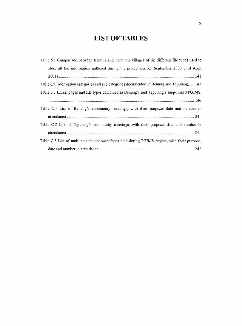
LIST OF TABLES
Table 6.1 Comparison between Benung and Tepulang villages of the different file types used to
store all the information gathered during the project period (September 2000 until April
2001)................................................................................................................................................. 141
Table 6.2 Information categories and sub categories documented in Benung and Tepulang 142
Table 6.3 Links, pages and file types contained in Benung’s and Tepulang’s map-linked PGIMS.
.............................................................................................................................................................146
Table C.l List of Benung’s community meetings, with their purpose, date and number in
attendance......................................................................................................................................... 241
Table C.2 List of Tepulang’s community meetings, with their purpose, date and number in
attendanee......................................................................................................................................... 241
Table C.3 List of multi-stakeholder workshops held during PGIMS project, with their purpose,
date and number in attendance...................................................................................................... 242
XI
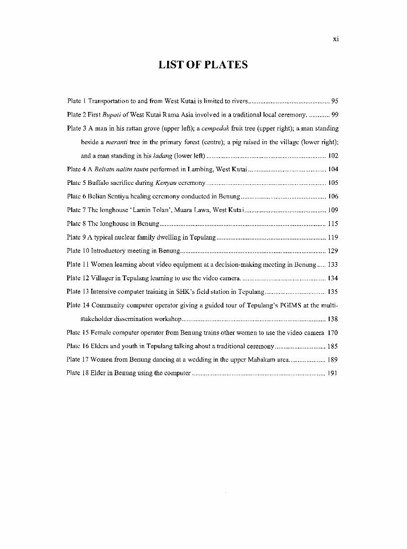
LIST OF PLATES
Plate I Transportation to and from West Kutai is limited to rivers.....................................................95
Plate 2 First Bupati of West Kutai Rama Asia involved in a traditional local ceremony................99
Plate 3 A man in his rattan grove (upper left); a cempedak fruit tree (upper right); a man standing
beside a meranti tree in the primary forest (centre); a pig raised in the village (lower right);
and a man standing in his ladang (lower le ft)............................................................... 102
Plate 4 A Beliatn nalitn tautn performed in Lambing, West K utai................................................. 104
Plate 5 Buffalo sacrifice during Kenyan ceremony............................................................................. 105
Plate 6 Belian Sentiyu healing ceremony conducted in Benung....................................................... 106
Plate 7 The longhouse ‘Lamin Tolan’, Muara Lawa, West K utai.....................................................109
Plate 8 The longhouse in Benung...........................................................................................................115
Plate 9 A typical nuclear family dwelling in Tepulang.....................................................................119
Plate 10 Introductory meeting in Benung..............................................................................................129
Plate 11 Women learning about video equipment at a decision-making meeting in Benung 133
Plate 12 Villager in Tepulang learning to use the video eamera...................................................... 134
Plate 13 Intensive computer training in SHK’s field station in Tepulang...................................... 135
Plate 14 Community computer operator giving a guided tour of Tepulang’s PGIMS at the multi
stakeholder dissemination workshop 138
Plate 15 Female computer operator from Benung trains other women to use the video camera 170
Plate 16 Elders and youth in Tepulang talking about a traditional ceremony............................... 185
Plate 17 Women from Benung dancing at a wedding in the upper Mahakam area........................ 189
Plate 18 Elder in Benung using the com puter..........................................................................191
X ll
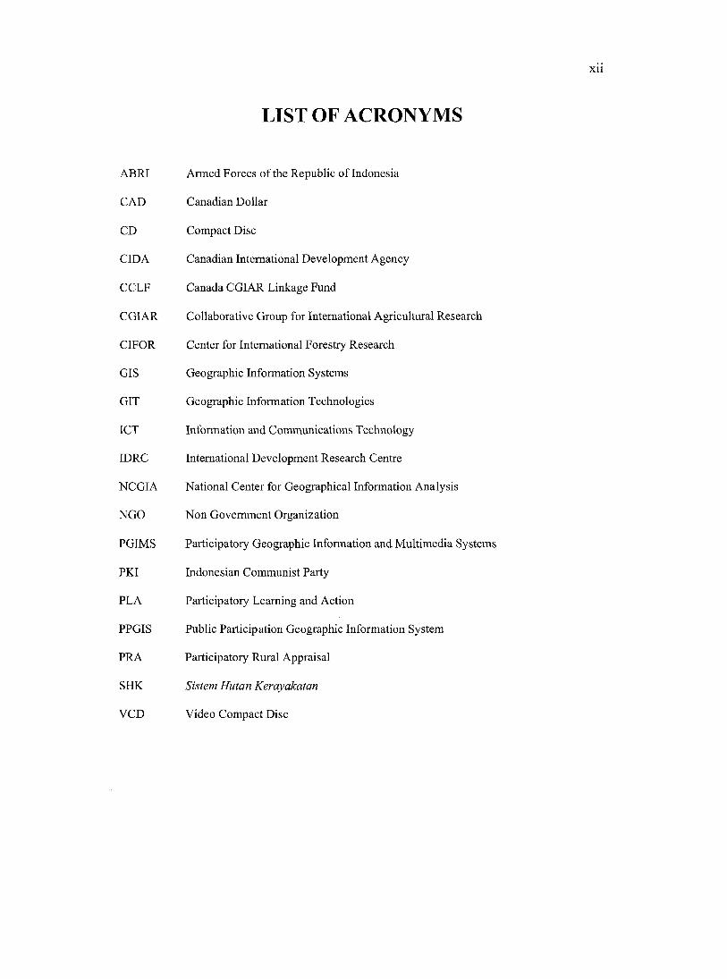
LIST OF ACRONYMS
ABRI Armed F orces of the Republic of Indonesia
CAD Canadian Dollar
CD Compact Disc
CIDA Canadian International Development Agency
CCLF Canada CGIAR Linkage Fund
CGIAR Collaborative Group for International Agricultural Research
CIFOR Center for International Forestry Research
GIS Geographic Information Systems
GIT Geographic Information Technologies
ICT Information and Communications Technology
IDRC International Development Research Centre
NCGIA National Center for Geographical Information Analysis
NGO Non Government Organization
PGIMS Participatory Geographic Information and Multimedia Systems
PKI Indonesian Communist Party
PLA Participatory Learning and Action
PPGIS Public Participation Geographic Information System
PRA Participatory Rural Appraisal
SHK Sistem Hutan Kerayakatan
VCD Video Compact Disc
X lll
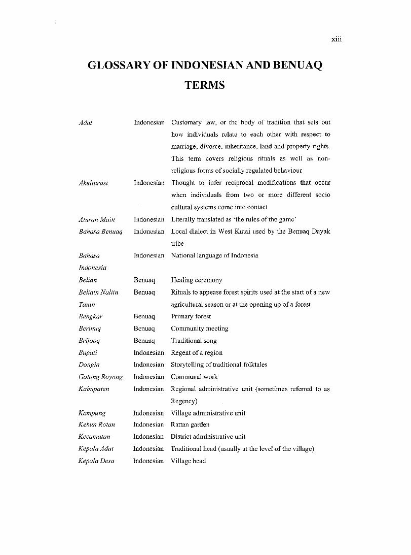
GLOSSARY OF INDONESIAN AND BENUAQ
TERMS
Adat Indonesian Customary law, or the body of tradition that sets out
how individuals relate to each other with respect to
marriage, divorce, inheritance, land and property rights.
This term covers religious rituals as well as non
religious forms of socially regulated behaviour
Akidturasi Indonesian Thought to infer reciprocal modifications that occur
when individuals from two or more different socio
cultural systems come into contact
Aturan Main Indonesian Literally translated as ‘the rules of the game’
Bahasa Benuaq Indonesian Local dialect in West Kutai used by the Benuaq Dayak
tribe
Bahasa Indonesian National language of Indonesia
Indonesia
Belian Benuaq Healing ceremony
Beliatn Nalitn Benuaq Rituals to appease forest spirits used at the start of a new
Tautn agricultural season or at the opening up of a forest
Bengkar Benuaq Primary forest
Berinuq Benuaq Community meeting
Brijooq Benuaq Traditional song
Bupati Indonesian Regent of a region
Dongin Indonesian Storytelling of traditional folktales
Gotong Royong Indonesian Communal work
Kabupaten Indonesian Regional administrative unit (sometimes referred to as
Regency)
Kampung Indonesian Village administrative unit
Kebun Rotan Indonesian Rattan garden
Kecamatan Indonesian District administrative unit
Kepala Adat Indonesian Traditional head (usually at the level o f the village)
Kepala Desa Indonesian Village head
XIV
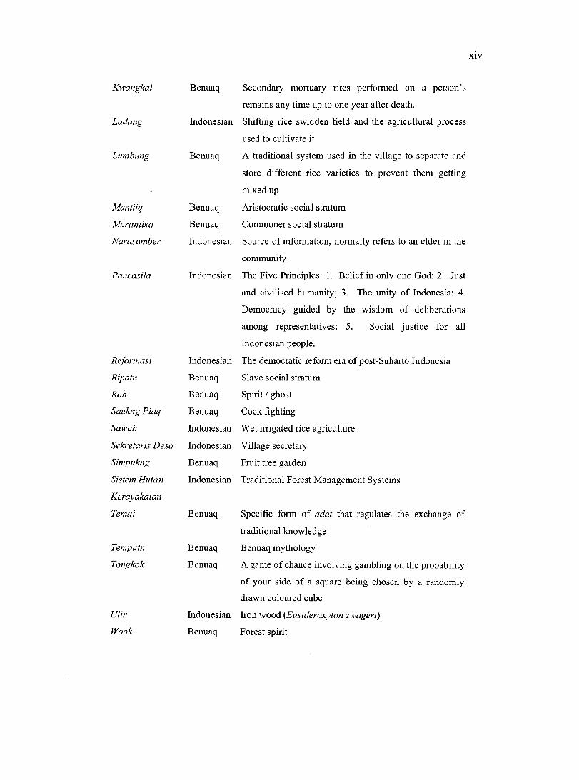
Kwangkai
Ladang
Lumbung
Mantiiq
Marantika
Narasumber
Pancasila
Reformasi
Ripatn
Rah
Saukng Piaq
Sawah
Sekretaris Desa
Simpukng
Sistem Hutan
Kerayakatan
Temai
Temputn
Tongkok
Ulin
Wook
Benuaq Secondary mortuary rites performed on a person’s
remains any time up to one year after death.
Indonesian Shifting rice swidden field and the agricultural process
used to cultivate it
Benuaq A traditional system used in the village to separate and
store different rice varieties to prevent them getting
mixed up
Benuaq Aristocratic social stratum
Benuaq Commoner social stratum
Indonesian Source of information, normally refers to an elder in the
community
Indonesian The Five Principles: 1. Belief in only one God; 2. Just
and civilised humanity; 3. The unity of Indonesia; 4.
Democracy guided by the wisdom of deliberations
among representatives; 5. Social justice for all
Indonesian people.
Indonesian The democratic reform era of post-Suharto Indonesia
Benuaq Slave social stratum
Benuaq Spirit / ghost
Benuaq Cock fighting
Indonesian Wet irrigated rice agriculture
Indonesian Village secretary
Benuaq Fruit tree garden
Indonesian Traditional Forest Management Systems
Benuaq Specific form of adat that regulates the exchange of
traditional knowledge
Benuaq Benuaq mythology
Benuaq A game o f chance involving gambling on the probability
of your side of a square being chosen by a randomly
drawn coloured cube
Indonesian Iron wood (Eusideroxylon zwageri)
Benuaq Forest spirit
XV
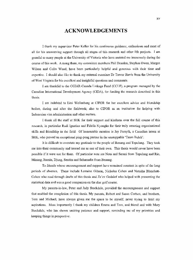
ACKNOWLEDGEMENTS
I thank my supervisor Peter Keller for his continuous guidance, enthusiasm and most of
all for his unswerving support through all stages of this research and other life projects. I am
grateful to many people at the University of Victoria who have assisted me immensely during the
course of this work. Among them, my committee members Phil Dearden, Stephen Owen, Margot
Wilson and Colin Wood, have been particularly helpful and generous with their time and
expertise. I should also like to thank my external examiner Dr Trevor Harris from the University
of West Virginia for his excellent and insightful questions and comments.
I am thankful to the CGIAR-Canada Linkage Fund (CCLF), a program managed by the
Canadian International Development Agency (CIDA), for funding the research described in this
thesis.
I am indebted to Lini Wollenberg at CIFOR for her excellent advice and friendship
before, during and after the fieldwork; also to CIFOR as an institution for helping with
Indonesian visa administration and other matters.
I thank all the staff at SHK for their support and kindness over the full course of this
research, in particular Rudi Ignatius and Fidelis Nyongka for their truly amazing organisational
skills and friendship in the field. Of honourable mention is Jay Forsyth, a Canadian intern at
SHK, who proved an exceptional ping-pong partner in the unstoppable ‘Team Buleh’.
It is difficult to overstate my gratitude to the people of Benung and Tepulang. They took
me into their community and treated me as one of their own. This thesis would never have been
possible if it were not for them. O f particular note are Nota and Serani from Tepulang and Rio,
Minang, Rumin, Djung, Sentitn and Selumudin from Benung.
To friends whose encouragement and support have remained constant in spite of the long
periods of absence. These include Lorraine Gibson, Nicholas Cohen and Natasha Blanchett-
Cohen who read through drafts of this thesis and Ze’ev Gedalof who helped with presenting the
statistical data and was a good companion on the disc golf course.
My parents-in-law, Peter and Judy Stockdale, provided the encouragement and support
that enabled the completion of this thesis. My parents, Robert and Susan Corbett, and brothers,
Tom and Michael, have always given me the space to be myself, never trying to limit my
aspirations. Most importantly I thank my children Emma and Tom, and friend and wife Mary
Stockdale, who has shown untiring patience and support, reminding me of my priorities and
keeping things in perspective.

XVI
DEDICATION
To Mary and her little lambs.
C h a p t e r O n e :
In t r o d u c t io n
1.1 EMPOWERING COMMUNITIES TO COMMUNICATE INFORMATION
The focus of this research is to evaluate how Geographic Information Technologies (GIT)
serve to empower local communities.
In Indonesia, local communities have for many years been removed from decision
making processes related to land use and management as well as other topics (Peluso, 1995;
Runyan, 1998; Gautam et a i, 2000; Chidley, 2002), thereby effectively disempowering them.
Recent decentralization of Indonesian government, bringing increased decision-making
responsibilities to the regional level, has brought decision-makers closer to their constituents both
physically and culturally (Read and Cortesi, 2001). The intention of this change is to provide the
opportunity for improved two-way sharing of information between government and local
communities.
These changes mirror a wider recognition of the need to develop a better understanding
of local knowledge (Roach, 1997; Rahman, 1998; World-Bank, 1998; World-Bank, 1999).
Among other things, it recognizes that local knowledge contains a wealth of important
information about natural resource management practices that are ecologically and culturally
appropriate for their locality and that can make a powerful contribution to land-use planning at
the local level (Carter, 1996; Carter, 1997; Shariffadeen, 2000).
Despite the recognition that local knowledge can contribute positively, it remains an
underutilized resource in natural resource management (Quiroz, 1996) because of communication
constraints between stakeholders (Lawrence and Warren, 1999). The challenge is to find ways
that enable communities to contribute information to the planning process. In order to do this
there is a need to enhance the capacity of local communities to communicate their views and
knowledge and become more meaningfully involved in land use planning and decision-making
(Lawrence and Warren, 1999).
In response to the need for improved information exchange between government and
communities, a number of methodologies have been developed. Some of the more popular
methodologies have used participatory processes for gathering and analyzing information - these
include Participatory Rural Appraisal (PRA) and Participatory Learning and Action (PLA)
(Chambers et al., 1989; Davis-Case, 1990; Pretty et a i, 1995; Chambers, 1997; Abbot et a l,
1998). More recently new Information and Communication Technologies (ICT) are also being
used to facilitate this information exchange (Richardson, 1997; McConnell, 1998; Moetsabi,
1998;Norrish, 1998).
1.2 COMMUNICATING GEOGRAPHIC INFORMATION
Parallel to the wider changes mentioned above, the closely related disciplines of
cartography and geography are contributing processes and Geographic Information Technologies
(GIT) to facilitate the communication of spatial information. Community mapping is a
participatory map-making process that attempts to make information about community lands
visible to outsiders by using the commonly understood and recognized language of cartography
(Peluso, 1995; Poole, 1995b; Carter, 1996; Aberley and George, 1998; Alcorn, 2001).
Community mapping projects have sprung up throughout the world (Momberg et a i, 1994;
Flavelle, 1995; Peluso, 1995; Poole, 1995c; Aberley and George, 1998). Community maps can
pose alternatives to the images of the existing power structures and become a medium of
empowerment (Peluso, 1995) by allowing groups o f people to represent themselves spatially.
Used in this context, community maps have become a powerful tool with which communities can
seek recognition and inclusion in land and natural resource planning and management (Brody,
1981; Fox, 1994; Fox et a l , 1994a; Momberg et a l, 1994; Bird, 1995; Flavelle, 1995; Poole,
1995c). The process of making these maps is also an empowering aetivity that ean often serve to
unify and embolden a eommunity (Aberley, 1993; Flavelle, 1995; Harrington, 1995; Flavelle,
1996; Aberley and George, 1998).
Although community maps are useful and powerful tools for eommunieation they cannot
describe everything there is to know about the land. For this reason they are often supplemented
using the written word. This is an imperfect medium to represent loeal knowledge, espeeially for
traditional people who may be illiterate and aecustomed to eommunieating orally and by using
examples rather than generalities. Johnson (1992) notes that mueh local knowledge about the
land is transmitted in the form of stories and legends that use metaphor and sophistieated
terminology; thus much of the context might be lost if the information is transcribed to written
text. Therefore there is a need for GIT that ean combine the usefulness of maps with other
communication media, such as video, images and audio, which are better at documenting the oral
and visual aspects of local knowledge, as well as its complexity.
One possible tool for recording local knowledge in a more comprehensive manner than
that available to community maps is the new generation of information management software that
uses maps to organize and reference other information, which ean be stored as still images, audio
and video as well as written text. Geographic Information System (GIS) software is one of the
best known and widely used types of information management software because of its usefulness
for land and natural resource management. GIS software ean be distinguished from other
software types by its ability to perform powerful analyses of spatial data. This ability makes GIS
software considerably more costly to purchase and complex to learn to use than other mapping
software.
Within the field of community development in less developed countries until recently
there has been little interest in GIS; as a result there have been few examples of its successful use
at the eommunity level. It has been noted that there are few examples of GIS being pertinent to
local-level needs (Carter, 1996). However, since 1995, substantive research on the theory and
potential of social and community GIS application has begun to emerge (Curry, 1995a; Harris et
a l, 1995; Hock et a l, 1995; Bamdt, 1998; Harris and Weiner, 1998b; Obermeyer, 1998; Stonicb,
1998). This research is primarily involved with studies of communities in North America,
although some relevant commentary and discussion has appeared from other areas in the world
(Fox et a l , 1994b; Harris and Weiner, 1998a; Jordan, 1998; Kyem, 1998; Alcom, 2001; Harris
and Weiner, 2002; Jordan, 2002; Kyem, 2002;). This research field has built up a substantial
following, and is now referred to as Public Participation GIS (PPGIS). Despite a growth in
publications on this topic, however, there remain comparatively few instances of real life usage of
PPGIS (Carver, 2001; Harris and Weiner, 2002).
Claims have been made throughout the literature that various PPGIS approaches, models
and products empower participating communities (see for example the NCGIA speeial session on
Empowerment, Marginalization and Public Participation). There are also those that claim that
PPGIS disempowers communities due to the complexity of the technology, associated high cost,
inaccessibility of data, the inability to use the technology to record diverse ways of understanding
space and a lack of genuine community participation (Goss, 1995; Pickles, 1995; Rundstrom,
1995). Despite these claims, the discourse on PPGIS offers no commonly accepted operational
definition of empowerment (Elwood, 2002; Kyem, 2002), nor does it establish a clear link
between empowerment and PPGIS. The latter is due to a paucity of discussion over the
methodologies and frameworks by which empowerment due to a PPGIS initiative can be
measured and analysed (Howard, 1998).
There is a need for the many definitions of empowerment in the literature to be further
analysed in order to develop a common understanding of its underlying assumptions and
meaning. A clear understanding o f the term will enable the development o f meaningful models
that can be used to measure and analyse empowerment, and prevent the term from being used to
make false claims or to obscure debate about PPGIS application and evaluation. Weiner and
Harris (in preparation) speculate that the “GIS-empowerment-marginalization nexus ... will
likely be one major component of PPGIS research”, in recognition of the importance of this area
of study.
1.3 THE PGIMS PROJECT
This study set out to select an assemblage of GIT and multimedia technologies, as well as
a participatory process for using them, that would overcome the constraints and criticisms of
PPGIS described above. The researcher referred to the product as a Participatory Geographic
Information and Multimedia System (PGIMS). Unlike many PPGIS projects, the PGIMS uses
relatively inexpensive software that is simple to operate. This removes the cost constraints and
the ‘expert driven’ (Harris and Weiner, 1998b) aspects of PPGIS initiatives by enabling
eommunity members to control the technologies themselves. The focus was on enabling
community members to use their own data and represent it in ways of their own choosing. The
researcher developed a participatory process to ensure that community members made all
decisions related to the project and were trained in the necessary technological skills.
A PGIMS acts as a system for managing, referencing and accessing digital information
stored in textual image, video and audio format, using an interactive Cartesian map interface as
the organisational tool. The map gives spatial reference to the attribute multimedia components
and allows the user to navigate through the community’s data; this is a style of information
retrieval referred to as “hyper media” (Aitken and Michel, 1995).
A PGIMS project was introduced into the villages of Benung and Tepulang in the district
o f West Kutai, in the province of East Kalimantan, Indonesia. The villagers are members of the
Dayak Benuaq ethnic group. They are predominantly agriculturalists who, as with most
indigenous ethnic groups on the island o f Borneo, rely on upland swidden rice farming (ladang)
for the production of their staple food crop. They are also dependent upon the surrounding forests
for subsistence and income generating functions (Abdoellah et a l, 1993; Gônner, 2000). The
PGIMS project ran in these two villages from September 2000 until April 2002.
The PGIMS project was established through a research project funded by the CGIAR-
Canada Linkage Fund (CCLF), a program managed by the Canadian International Development
Agency (CIDA). The project involved collaboration between the Spatial Sciences Laboratory,
Department of Geography, University of Victoria, the Sistem Hutan Kerakyatan (SHK) (or
Consortium for Traditional Forest Management Systems), a regionally based Indonesian non
governmental organization (NGO), and the Centre for International Forestry Research (CIFOR),
an international research organisation based in Bogor, Indonesia.
1.4 THE RESEARCH QUESTION
The primary goal of this research was to investigate the assumption made in the literature
that PPGIS and related technologies contribute to the empowerment of marginalized loeal
communities. In doing so the research will set out to answer the question:
How does the PGIMS project empower or disempower local communities?
Wording the question in this way enables a study not only of whether the PGIMS project
empowers or disempowers local communities, but how, or in what way it has this impact. In the
process of answering this research question a working definition of empowerment and a
framework for analysing the impact of the PGIMS project on the participating communities was
developed and applied.
1.5 THESIS STRUCTURE
In this thesis. Chapter Two plaees the research in the context of the relevant literature.
Chapter Three deseribes the development of a working definition of empowerment and presents a
framework used to structure an analysis of the impact of the PGIMS project. Chapter Four
provides a description of the research methods used. Chapter Five describes the research site,
positioning the two villages where the research took place within the wider geography of West
Kutai and Indonesia. Chapter Six discusses the design and implementation of the PGIMS project

and evaluates the content, format, relevance and post-project sustainability of the PGIMS
produced in both villages. Chapter Seven organizes and sorts the research data obtained during
the field work period into the relevant eells of the empowerment framework presented in Chapter
Three for the purpose of analysis and discussion. Finally, Chapter Eight concludes the thesis by
presenting the main findings of the research.
C h a p t e r T w o :
L o c a l K n o w l e d g e , In f o r m a t io n T e c h n o l o g ie s
AND C o m m u n it y P a r t ic ip a t io n
The research outlined in this thesis has connections to a broad range o f fields in both the
academic and practical development literatures. Both of these fields are changing rapidly. This
chapter reviews the relevant literature, highlighting important works in these fields as well as
recent developments.
This chapter begins by exploring the roles of and linkages between local knowledge,
Information and Communication Technologies (ICT) and community participation (Section 2.1).
It then goes on to explore the more specific subject of geographic information, Geographic
Information Technologies (GIT), and community participation (Section 2.2). It concludes with a
review of the debate over how accessible and participatory current GIT initiatives are, and
whether they have the ability to empower local communities (Section 2.3).
2.1 LOCAL KNOWLEDGE, ICT AND COMMUNITY PARTICIPATION
Information is a vital element of decision-making processes. The quality of decisions
made is directly related to the quality of information available (Shariffadeen, 2000).
Communication is another essential element in these processes. Inclusion o f local people and
their knowledge is increasingly seen as pivotal in planning and decision-making processes
(Warren, 1992), especially in relation to natural resource management (Carter, 1997). This is
because of a rapidly growing set of evidence which indicates a strong relationship between local
information and development which is both ecologically and socially sound (Posey, 1985; Carter,
1997). Yet there still remains a lack of meaningful local information in the planning process
(Warren, 1992; Rajasekaran, 1993; Quiroz, 1996).
There is a trend for countries from the South' and people from disadvantaged sectors of
society in the North to be informationally dependent on more advanced nations and sectors of
society (McAnany, 1980). In addition, it is now commonly accepted that local information “is
being lost at an unprecedented rate, and that its preservation, preferably in database form, must
take place as quickly as possible” (National Research Council, 1992 cited in Warren, 1992 p. 46).
So if local information is to play a meaningful role in decision-making and to be of importance to
future generations, there is a growing need to explore and develop mechanisms for documenting
and communicating that information (Gonzalez, 1995).
This section will discuss the nature and importance of communities’ local knowledge,
after which it will investigate some of the technologies and methodologies being used to
document and communicate this information.
2.1.1 Local knowledge
The words ‘information’ and ‘knowledge’ are often used interchangeably. However, the
literature does attempt to define these words and distinguish between them. Information “takes
the shape of structured and formatted data sets that remain passive and inert until used by those
with the knowledge needed to interpret and process them” (David and Foray, 2002 p. 12).
Knowledge is the sense that people make of information; it enables “its possessors with the
capacity for intellectual or manual action” (David and Foray, 2002 p. 12). Knowledge in society
is not objective or static, but is ever-changing and infused with the values and realities faced by
those who have it (Panos, 1998). ‘Knowledge’ used in this context is not just cerebral, but
includes values, beliefs, skills, attitudes and practices (UNDP, 1999). “Knowledge can also be
' Throughout this thesis the terms South and Southern (Lister, 1997) will be used to describe countries that in the literature have previously been referred to as ‘less developed’, ‘underdeveloped’, ‘developing’ or ‘Third World’. Conversely the terms North and Northern will be used to describe countries that are economically and industrially more developed.
10
misinterpreted, manipulated, distorted and controlled [and] is nearly always incomplete” (Panos,
1998 p. 1).
It is interesting that the literature tends to refer to global society as possessing and
eommunicating ‘information’ whereas local communities are considered to possess and
communicate ‘knowledge’. This obscures the existence of a dominant knowledge system in
global society, commonly referred to as western scientific knowledge, by masking its subjective
‘knowledge’ as objective ‘information’. For the sake o f consistency with the literature, however,
this thesis will use the term ‘local knowledge^’ when referring to the information of local
communities.
2.1.1.1 Local knowledge defined
Local knowledge is “unique to a given culture or society. It is the information base
...that facilitates communication and decision-making” (Warren and Rajasekaran, 1993 p. 9). It
is owned and shared collectively within a local community^ (Greaves, 1996). This knowledge
In the literature the concept of local knowledge takes on many different guises; these include indigenous knowledge (IK), traditional knowledge (TK), traditional ecological knowledge (TEK) and farmers’ knowledge (FK). Although there are distinctions between the terms they are used to convey the same general concept. Local knowledge is not the domain of a single group such as indigenous or rural communities (Moralez-Gomez 1997). This thesis will use the term ‘local’ knowledge because it is less restrictive and exclusive compared to terms sueh as ‘indigenous’, ‘traditional’, ‘ecological’ and ‘farmer’.
The term ‘community’ is used frequently to describe many different manifestations of the concept across varying levels and scales. Within the context of this research ‘local community’ is defined as a group of people who regularly associate with one another in one geographic location on the basis of a shared interest, reliance, relations and identity. The local communities referred to in this thesis are defined by space, location and by cultural association. When using this definition the author recognizes that the ‘community’ is not a homogenous entity, but rather an affiliation of individuals, and that “communities are differentiated in terms of status, income and power” (Midgley 1989 p. 35). This thesis refrained from using the term indigenous community in place of local community, although the participating communities are ‘indigenous’ according to the definition of the term as “first occupiers of a territory which has subsequently been overwhelmed by another group of people from a dramatically different technological and cultural background” (de Varennes, 1996 p. 311). This is mainly because ‘indigenous’ is a contentious term in Indonesia, where the dominant ethnic groups such as the Javanese also claim indigenous status.
11
has been aecumulated over time by successive generations. These communities have used this
knowledge to sustain themselves and to maintain their cultural identity (Johnson, 1992).
Local knowledge is commonly derived from empirical observation of the local
environment and trial and error experiments; however, it is not restricted to any one set of issues
(Moralez-Gomez, 1997). It often results in a vast reservoir of information that leads to the
formation of effective self-management systems to govern local resource use (Johnson, 1992;
Grenier, 1998). It is also vital in other local level decision-making processes that direct food
security, human and animal health, education and other activities (Woytek, 1998; World Bank,
2002).
It is important to note that although the roots of local knowledge are often firmly
positioned in the past (de Varennes, 1996) it does not cease to develop (Bains and Hviding,
1992). It is dynamic and continues to adapt to current conditions (Rajasekaran, 1993). This
dynamism makes this knowledge both relevant and applicable. The experiences of older
generations are continuously supplemented by innovation from within the community and the
adaptation of exogenous knowledge and technology that suit existing local circumstances
(Grenier, 1998; UNDP, 1999). This continual metamorphosis over time has meant that it is now
difficult to determine whether technologies, beliefs or views used by a community originated
from the community or were adopted from outside (IIRR, 1996). However, it is argued that the
origins of that knowledge are irrelevant, provided that it is assimilated and seen as locally owned
(Lawas and Tuning, 1996; UNDP, 1999).
All members of a community will have some level of loeal knowledge. The type and
extent o f this knowledge will be dependent on the individual’s own subsistence requirements,
curiosity, societal status and communal duties. Defining factors might be age, gender, socio-
economic status, intellectual capability, profession, education, outside influences and ability to
travel (Johnson, 1992; Grenier, 1998). This results in different types of knowledge existing
simultaneously within a community. These include; common knowledge, held by almost all
12
people in the community; shared knowledge, held by many; and specialized knowledge, held by a
few with special training (IIRR, 1996).
Local knowledge is embedded in community practices, institutions, relationships and
ritual (Woytek, 1998). Much of it is transferred informally; it is usually unwritten (Brush, 1996)
and instead is preserved and communicated orally in the form o f stories, songs, folklore,
proverbs, dances, myths, rituals, community laws, local taxonomy and agricultural practices
(Grenier, 1998). There are also formal traditional systems in place to facilitate the transferral of
some of this knowledge, such as ceremonies, festivals and other processes.
2.1.1.2 Im portance o f local knowledge
Local knowledge is an important factor in helping local communities to maintain their
cultural identity. Preservation of identity is important because “a people without a memory are
not a nation” (Roach, 1997 p. 1). Local knowledge is also important for its users because it
provides a basis for problem solving (Woytek, 1998; Woytek, 2000). Thus it is “ a key element of
the social capital of the poor and constitutes their main asset in their efforts to gain control of
their own lives” (World-Bank, 2002 p. 1) through promoting self-sufficiency and self-
determination of the user group (IIRR, 1996).
Large institutions, sueh as the World Bank and Canadian Federal Government, now view
local knowledge as being important to sustainable development issues, in particular in the area of
natural resource management, because these systems of knowledge contain a wealth of important
empirical knowledge that up until now has been underutilized (Posey, 1985; Posey, 1997; Roach,
1997; Rahman, 1998; World-Bank, 2002; World-Bank, c. 2000). If used in planning processes
local knowledge can help to improve the impact, responsiveness and sustainability of
development assistance (Rajasekaran, 1993).
Local knowledge has been lauded as “an alternative collective wisdom relevant to a
variety of matters at a time when existing norms, values and laws are increasingly called into
13
question” (Berkes 1993, p.6 in Grenier, 1998). Grenier (1998) cites the example of the failed
Green Revolution, a centralised, technically oriented approach to agriculture that caused serious
ecological deterioration and social and economic decline (see also Shiva, 1992). Local
knowledge systems rarely find themselves in situations similar to the Green Revolution because
they have been developed over time to minimise risk, not to maximize profit.
2.1.1.3 Why local knowledge is underutilized
Despite the growing recognition that local knowledge has a positive contribution to make
to sustainable development, it remains an underutilized resource (Quiroz, 1996; Warren and
Rajasaran, 1993; World Bank, 1998, 2002). Five main factors contribute to this.
Firstly, the dominant knowledge system, commonly referred to as western scientific
knowledge, defines the concepts of correctness and progress (Moralez-Gomez, 1997; Pétillon,
1997) and has a monopoly in decision-making processes. This dominant knowledge system
assumes local knowledge to be subordinate (Johnson and Ruttan, 1992). Among other things, it
considers loeal knowledge to be " ‘primitive’, ‘unproductive’ and ‘irrelevant’ ” (Rajasekaran,
1993 p. 2), lacking scientific rigour and validity, and partial and anecdotal in nature (Arce and
Long, 1992; Brodnig and Mayer-Schonberger, 2000). As a result, local knowledge is seldom
incorporated into official decision-making and is often marginalized (Agrawal, 1995).
Consequently local communities who hold this knowledge also become peripheral to core
political processes.
A second limitation is the growing reluctance for local communities to contribute their
information because of concerns about losing control of their knowledge once it is released into
the public domain. The debate over local knowledge and Intellectual Property Rights"^ (IPR) has
‘ Intellectual property rights (IPR) are mechanisms used to protect individual or industrial ‘inventions’. They are legal rights attached to information that prevent others from copying, selling or importing a product without authorization. In practice IPR regimes have evolved into mechanisms that allow corporations to protect markets and to trade technologies among themselves (Grenier 1998).
14
been raging over the past decade. The most common example of this is the development of
medicines and other pharmaeeutical products by companies from traditional medicines derived
from loeal plants (Posey, 1997; Zerda-Sarmiento and Forero-Pineda, 2002). Local people rarely
benefit from these products or see more than a tiny proportion o f the royalties accruing from their
sale. For many traditional eommunities the IPR process has become a reaffirmation of
imperialism, where the laws work to protect the interests of the large corporations at the expense
of the less educated and poor. They believe that, following a legacy of domination o f natural
resources, now the appropriation of knowledge in now beginning without any payment or
acknowledgement to the communities where the knowledge originates (Brush, 1996). This in
turn discourages local communities from wishing to share their information with outside groups.
As Pétillon (1997) states the challenge is to seek ways in whieh loeal people can appropriate,
articulate and share their own knowledge in a way in whieh they maintain control.
A third limitation is that local knowledge is often given meaning and value through its
eultural setting and interpretation (Brodnig and Mayer-Schonberger, 2000). Stevenson (1997)
stated that it is the spiritual dimension of local knowledge that determines how this information is
collected, managed and transmitted and it is this dimension that sets local knowledge apart from a
basic form of knowledge that anyone can acquire through observing and experiencing their
environment over time. As a result local knowledge at times is “providing a world view of which
outsiders are rarely aware, and at best can only incompletely grasp” (Greaves, 1996). This
complicates the codification and recording and therefore communication of this knowledge.
Furthermore, by “being unique to and part of a particular culture of people transferring local
knowledge would render it irrelevant, inappropriate or even harmful” (World-Bank, 1998 p. 13).
This implies that much local knowledge can only be useful and m aintained in-situ.
A fourth limitation results from the lack of suitable communication channels to present
loeal knowledge. Local knowledge is often communicated orally and is represented by hundreds
of different languages. As Warren and Rajasekaran (1993 p. 8) state “in most instances, the
15
knowledge systems.. .have never been recorded systematically in written form, hence they are not
easily accessible... [and] remain invisible.” This makes the collection of local knowledge a
laborious, time-consuming and costly process (Johnson, 1992; Lawas and Luning, 1996) as well
as making it difficult to find a medium of communication that is appropriate for presenting the
information and accessible to an audience external to their community.
A final limitation is that the local languages used to express this knowledge, and the local
communities themselves, are diminishing rapidly (Maundu, 1995; Harmsworth, 1998; WWF,
2000). This accelerating loss (IIRR, 1996; Roach, 1997; Grenier, 1998) is due to correspondingly
rapid changes in the natural environment, as well as economic, political and cultural
transformation (Brush, 1996; IIRR, 1996).
In response to the stated need for improved information exchange between local
communities and decision-making groups, a number of technologies and methodologies have
emerged that encourage and facilitate community involvement in decision-making processes.
The next section will discuss two mechanisms, the use of ICT and community participation.
2.1.2 Using ICT to communicate local knowledge
ICT are becoming increasingly important in the communication of information and local
knowledge between disparate groups.
2.1.2.1 The Information Society
“On an average weekday the New York Times contains more information than any contemporary
o f Shakespeare’s would have acquired in a lifetime. ”
Anonymous in Brown and Duguid, 2000.
In the not so distant past, “lack of information appeared to be one of society’s
fundamental problems” (Brown and Duguid, 2000 p. 12). Over the past decades. Information and
16
Communication Technologies* (ICT) as well as other technologies have enormously increased
the capacity of people to access new information sources and accumulate huge volumes of
information. It has been noted that yesterday’s informational famine has turned into today’s glut
(Brown and Duguid, 2000). The significance of recent advances in information sharing has been
compared to the invention of moveable print in the fifteenth century (Toffler, 1990; Ryder, 1998),
or the transition from an agrarian to an industrial society in the nineteenth century (McPhail,
1981; Siochr, 1997). For this reason the era in which we live is often referred to as the
‘Information Society’ (Siochr, 1997).
2.1.2.2 The digital divide
"Left unchecked, the globalization o f information will widen the gap between developed and
developing countries. It will further distance elites from the general population and it will limit
traditional social and economic development efforts. "
(Rivers-Moore and Hay, 1998)
Not everyone is a member of the Information Society. Although the distribution of ICT
has occurred globally it has been and continues to be a very uneven ‘revolution’ (Byron and
Gagliardi, 1998). The discrepancy between different sectors of society in their ability to access
information through ICT is a phenomenon that has become known as the ‘digital divide’.
This divide does not only exist between Northern and Southern countries. It is also
prevalent within Northern countries, as access to the benefits of these technologies is not equally
available to all sectors of the population (Crampton, 1995; Ernberg, 1999; Keeks, 1999a; Hudson,
1999). In many Southern countries, which because of technological leapfrogging® are developing
* ICT encompass tools such as the telegraph, radio, telephone, fax and most recently the internet.
® In Northern countries “newer versions of technology are often used to upgrade older versions, but in Southern countries where still older versions of technology are often prevalent...the opportunities for
17
their technology base very rapidly (Davison et al., 2000), this internal divide is also becoming
obvious between different sectors within society (Chareonwongsak, 2001). Inequality in access
to information occurs between the traditionally powerful and powerless sectors of society. As
Heeks (1999 p. 8) points out: “the poor will be very unlikely to control ICT...[unless through]
intermediary institutions such as government agencies.” The digital divide is also visible between
urban and rural populations (Sirimane, 1996; Hudson, 1999), as well as between genders
(Lawley, 1993; Rostagnol, 1997; Hudson, 1999). Hafkin and Taggart (2001 p. 9) note that “most
women within developing countries are in the deepest part of the divide, further removed from
the information age than the men whose poverty they share.”
Lack o f access to ICT often results from a physical unavailability of the technologies, a
deficiency in basic infrastructure (particularly electricity) and paucity in the human resources
required to use the technologies. These restrictions are further exacerbated by the cost of training
human resources, as well as purchasing, maintaining and updating the technologies (Byron and
Gagliardi, 1998). Language and cultural issues, highlighted by computer software being
dominated by the English language and designed with a Western audience in mind, are also
significant.
Effective bridging of this digital divide can further be hindered by the national policies of
some states (Scouamec, 1997). Some governments are interested in the benefits of ICT purely
from a maero-eeonomie or teehnical angle (Heeks, 1999a), rather than seeing them as being of
benefit for local communities (Anderson et a l , 1997). The authorities in some countries may also
oppose these technologies for fear of the potential for “cultural colonization” (Byron and
Gagliardi, 1998). It has been noted that in attempting to enhance local communities’ access to
ICT the challenge is often not technical or financial, but political and ideological (Hudson, 1999).
leapfrogging over the successive generations of technology to the most recent version are much greater” Davison et al 2000 p. 2).
18
2.1.2.3 Opportunities and risks o f bridging the digital divide
In today's Information Society, there is a growing eonsensus that the future prosperity
and progress of all countries will depend on how people and governments access, interpret,
communicate and use information (Balit, 1998; World-Bank, 1999). Agenda 21, the Action Plan
of the United Nations Conference on Environment and Development, dedicates a whole chapter
to the role and importance of information for sustainable development^. Agenda 21 states that:
In sustainable development, everyone is a user and provider of information ... The need for information arises at all levels, from that of senior decision-makers at the national and international levels, to the grassroots and individual levels. (United-Nations, 1992)
It has been further noted that the ability to access and share information by less powerful
individuals and groups is absolutely essential if they are not to be further marginalized (Anderson
et at., 1997; Pétillon, 1997; Balit, 1998; Carver, 2001).
For this reason many commentators suggest that local communities should seek
opportunities and mechanisms to contribute their knowledge using new and emerging ICT
(Sirimane, 1996; Balit, 1998). There remains disagreement over the ways in which marginalised
people can best access the opportunities to do so (World-Bank, 1999).
Other commentators view the implications of ICT for the future of human society with
considerable scepticism. Byron and Gagliardi (1998) note that ICT are owned and controlled by
Northern corporations and nations, and that countries of the South are increasingly pressured to:
Develop efficient information accessing and processing capacities so as to avoid marginalization or exclusion. Yet these efforts often breed greater dependency on the North, since poor countries lack the resources to build indigenous information technology infrastructures. (Hawkridge et al., 1990 cited in Byron and Gagliardi, 1998)
’ The concept of ‘sustainable development’ was made popular with the publication of ‘The Bmndtland Report’ the report of the World Commission on Environment and Development in 1987. The Bmndtland Report defined sustainable development as “meeting the needs and aspirations of the present generation without compromising the ability of future generations to meet their needs” (WCED, 1987 p. 14). Since then, the concept of sustainability has become central to development processes throughout the world.
19
Some perceive a threat to democracy from the erosion of national and local culture
caused by global networks, and the corresponding rise in corporate hegemony and “technocratic
consciousness” (Habermas, 1970). The new technologies and information gloss over cultural
difference and collide with existing values to change them. Thus although ICT open channels for
global dialogue, they potentially destroy localism in favour of globalization (Noveck, 2001).
A third criticism is the inappropriateness and irrelevance of introducing ICT to less
developed, largely rural countries. Some people feel that this type of initiative is directed at too
sophisticated a level of consumption rather than at solving the basic socioeconomic problems that
should be a priority of sustainable development (Rahman, 1991).
Despite this criticism most commentators recognize the importance of including marginal
groups in the future applieation of ICT. At any rate, ICT are inereasingly pervasive and are
expanding with a momentum of their own. However, in the enthusiasm for applying these
technologies and exploring their potential it is important to remember that the “focus should be
on people, organisations and proeesses rather than the technologies themselves” (Anderson et al,
1997: Eleetronic Source). The challenge therefore is to introduee and use technologies which are
relevant and suit the needs of loeal eommunities (Richardson, 1997) and to recognize that the
technologies are only tools to facilitate a broader social process (Richardson and Rajasunderam,
1996; Balit, 1998).
2.1.3 Community participation
2.1.3.1 D efin ing com m unity participation
The term 'community participation^’ implies a style of planning and govemanee that
involves and promotes the two-way exchange of information between local communities and
® The term ‘community participation’ has become a ‘container concept’ (Heeks, 1999). It is defined in many different ways, some complementary and some contradictory (Huizer, 1997). In this thesis the term community participation will be used to describe what others refer to as ‘peoples’ participation’ (Clayton et
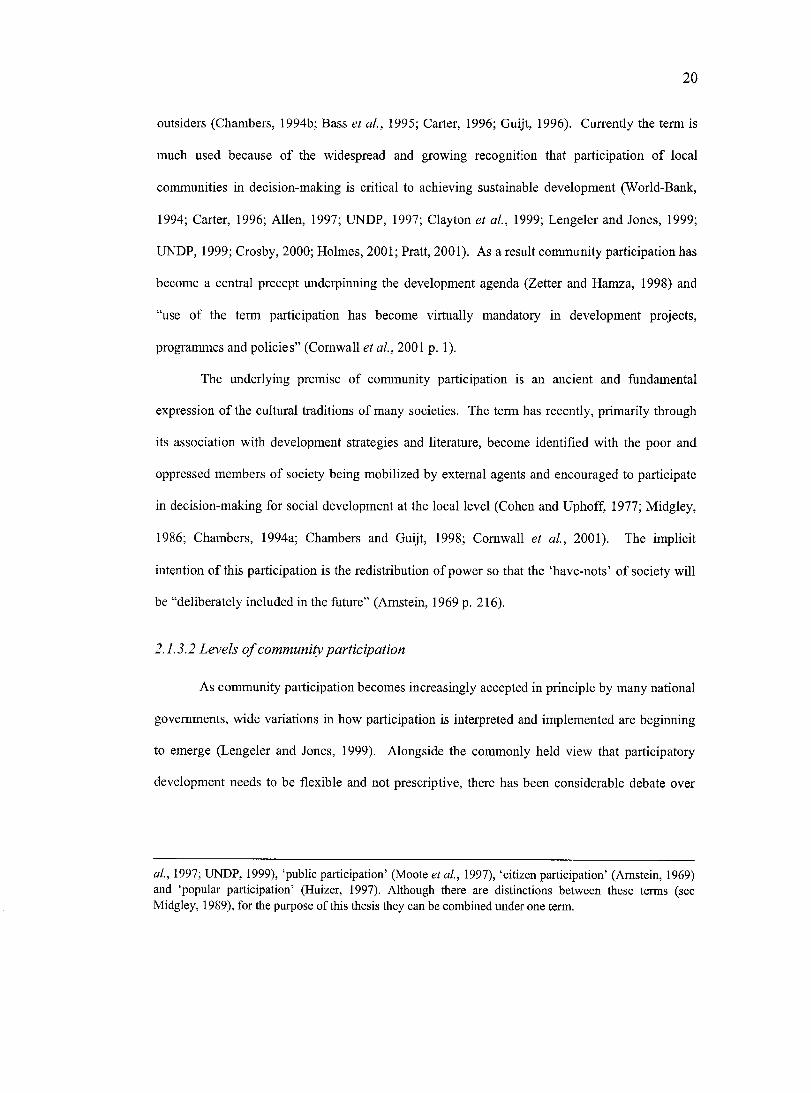
2 0
outsiders (Chambers, 1994b; Bass et al., 1995; Carter, 1996; Guijt, 1996). Currently the term is
much used because of the widespread and growing recognition that participation of local
communities in decision-making is critical to achieving sustainable development (World-Bank,
1994; Carter, 1996; Allen, 1997; UNDP, 1997; Clayton et al., 1999; Lengeler and Jones, 1999;
UNDP, 1999; Crosby, 2000; Holmes, 2001; Pratt, 2001). As a result community participation has
become a central precept underpinning the development agenda (Zetter and Hamza, 1998) and
“use of the term participation has become virtually mandatory in development projects,
programmes and policies” (Cornwall et a i, 2001 p. 1).
The underlying premise of community participation is an ancient and fundamental
expression of the cultural traditions of many societies. The term has recently, primarily through
its association with development strategies and literature, become identified with the poor and
oppressed members of society being mobilized by external agents and encouraged to participate
in decision-making for social development at the local level (Cohen and Uphoff, 1977; Midgley,
1986; Chambers, 1994a; Chambers and Guijt, 1998; Cornwall et a l, 2001). The implicit
intention of this participation is the redistribution of power so that the ‘have-nots’ of society will
be “deliberately included in the future” (Amstein, 1969 p. 216).
2.1.3.2 Levels o f com m unity participation
As community participation becomes increasingly accepted in principle by many national
governments, wide variations in how participation is interpreted and implemented are beginning
to emerge (Lengeler and Jones, 1999). Alongside the commonly held view that participatory
development needs to be flexible and not prescriptive, there has been considerable debate over
at., 1997; UNDP, 1999), ‘public participation’ (Moots et at., 1997), ‘citizen participation’ (Amstein, 1969) and ‘popular participation’ (Huizer, 1997). Although there are distinctions between these terms (see Midgley, 1989), for the purpose of this thesis they can be combined under one term.
21
inconsistent approaches to understanding participation and the existence of variable levels of
meaningfulness and authenticity in its implementation (Amstein, 1969; Pretty, 1995).
Amstein (1969) and later Pretty (1995), have developed diagnostic models that facilitate
an understanding of the significant gradations of participation employed by various agencies and
processes. Amstein (1969) refers to her model as an eight rung ‘ladder of participation’ (see
Figure 2.1).
Citizen control
Delegated power Degrees of citizen power
Partnership
Placation
Consultation Degrees of tokenism
Informing
TherapyNon-participation
Manipulation
Figure 2.1 Arnstein’s (1969) eight rungs on the ‘Ladder of Citizen Participation’
Each mng on the ladder corresponds to the “extent of citizens’ power in determining the
end product” (Amstein, 1969 p. 217) o f a process or program that uses participatory mechanisms.
The bottom two mngs illustrate ‘non-participation’, where participation is used with the intention
of the power holders to manipulate participants. The next set of mngs up the ladder are referred
to as tokenism, where participation is employed but views and ideas are not necessarily acted
upon. The top rungs of the ladder involve citizens taking various degrees of control over
decision-making processes, managerial power and responsibilities. Although the top mng is
22
ambitious, perhaps utopian, it is considered to be a worthy goal for whieh to strive. However,
Legeler and Jones (1999) suggest that different levels of local people’s participation are likely to
be appropriate in different circumstances, and it is certainly not always appropriate to consider
citizen control as the goal.
Amstein’s model provides a useful illustration of the lack of uniformity in participatory
approaches. It also serves to illustrate that community participation is intrinsically linked to the
concept of empowerment.
2.1.3.3 Critique o f com m unity participation
One criticism of the concept of community participation is that its proponents often
portray eommunities as homogenous entities whereas they more usually “suffer from conflicts,
rivalries and factionalism” (Midgley, 1989 p. 35). Often the oppressors are located within the
community (as is particularly the case with gender® equality issues) and it is a mistake to assume
that the process of participation breaks down these existing inequalities (Heeks, 1999b). Indeed
there is some criticism that participatory community development programs have sharpened these
divisions and increased the potential for social conflict by supporting the already strong factions
within the community (Huizer, 1997) who select themselves to participate (Heeks, 1999b;
Cornwall et a l , 2001) in order to serve personal agendas.
A second criticism is of the hypocrisy often attached to the practice of community
participation. As argued in the previous section, one of the core principles of community
participation is the vehement rejection of ‘top-down’, imposed and prescriptive models of
development. Yet by its very nature community participation is an imposed intervention
® Gender is the culturally specific set of characteristics that identifies the social, political and economic roles and behaviour of women and men. Gender, therefore, refers not simply to women or men, but to the dynamic interactions between them and the way this relationship is socially constructed. Like the concepts of class, race and ethnicity, gender is an analytical tool used to better understand social processes (Benjamin and Fancy, 1998; IDRC, 1998).
23
(Midgley, 1986; Harris and Weiner, 2002); furthermore, it is becoming increasingly prescriptive,
standardized and inflexible (Guijt, 1996; Chambers and Guijt, 1998; Holmes, 2001). This is
partly due to the ideals and methods of community participation being “subverted and
neutralized” (Midgley, 1986 p. 37) by the state and large institutions such as the World Bank (see
World-Bank, 1994; World-Bank, 1996). These large institutions seek to standardize the methods
used in community participation into procedures which are replicable and can be applied
universally (Huizer, 1997).
Further criticisms call into question the commitment of participating communities'®
(Midgley, 1986), the eultural and political appropriateness of community participation (Heeks,
1999), and the high time investment (Pratt, 2001) required for the participation of local
communities. Midgley (1989 p. 36) notes that these factors might be the reason why a large
number of participatory programmes fail “to secure [the] indefinite and total involvement” of
local people. However, the criticism that participation is limited because of community apathy
and resistance to change has been challenged (Huizer, 1997). Huizer (1997) states that the issue
is not whether people partieipate but how, or in what form. O f some eoncern, and one that is not
covered extensively in the literature, is whether the orthodoxy of participation is culturally or
politically appropriate (Heeks, 1999b). One certainty is that meaningful success in participation
can only be achieved in a supportive political and cultural environment (Clayton et al., 1999).
2.1.3.4 Methods fo r promoting community participation
Recent discourse on community participation, particularly in the development literature,
has focused less on the theory surrounding the term and more on the mechanisms required to
establish it (Chambers, 1994; Carson et al, 1997; Chambers and Guijt, 1998). This has involved
discussion and analysis of two principal methods, institution building and community organizing.
Dubious commitment is not the sole realm of local communities, state institutions that have been coerced or pressurized into participatory development may also be reticent to participate (see Zetter and Hamza1998).
2 4
One important mechanism used in community participation is institution building.
Institutions, particularly well established and bureaucratic agencies, whether willing or unwilling
to adopt participatory principles (see Zetter and Hamza 1997), are often not set up to
accommodate the participation of local communities in decision-making processes. Often a
precursor to effective participation is to modify, establish or strengthen these institutions and the
procedures they use (Naryan 1990 cited in Allen, 1997) so that they can be more responsive to
local demand (Allen, 1997). It is assumed that institution building leads to good govemanee, a
concept closely tied to community participation (Osmani, 2000). Related to this is the promotion
of political decentralization" by groups such as the World Bank, which aims to establish and
strengthen loeal level decision-making institutions and processes (Midgley, 1986).
The second mechanism used to promote community participation has been the use of
participatory methodologies for gathering and analyzing information. This diverse range of
methods (Cornwall et a l, 2001) includes processes collectively termed Participatory Rural
Appraisal (FRA) and Participatory Learning and Action (PLA) (Chambers et a l, 1989; Davis-
Case, 1990; Pretty et a l, 1995; Chambers, 1997; Abbot et a l, 1998). PRA and PLA bave been
defined as:
A growing family of approaches, methods, attitudes and beliefs that enable people to express and analyze the realities of their lives and conditions, to plan themselves what action to take, and to monitor and evaluate the results. (Chambers, 1997 p. 102)
PRA utilizes an array of participatory tools to involve local people in analyzing, sharing
and taking action on issues that affect them (Pretty, 1995; Pratt, 2001). These primarily involve
the use o f graphic representations created by the community that attempt to legitimize local
" Political decentralization is the process of devolving governance from a centralized core to peripheral regions, towns and villages - it has been promoted as a means of enabling community participation and efficiency, especially in many previously centralized Southern countries. Local officials and politicians are thought to be more accessible and accountable to local communities than national governments. Indonesia is currently going through a period of decentralization.
25
knowledge and promote empowerment (Pretty, 1995). These tools inelude partieipatory mapping
and modeling, institutional diagramming, and trend and change analysis, among others, all of
which are undertaken by local people (Chambers, 1994 p. 1437).
PRA and PLA methods are strongly influenced by Paulo Freire’s writings (Chambers,
1994). Freire (1970) based his views on the belief that every human being was capable of
looking critically at the world, perceiving his/her personal and social reality, and transforming it
through conscious action. Through this process local people could be empowered to act on their
enhanced awareness, to challenge the structures that constrained them and so to improve the
quality o f their lives (Anyaegbunam et a i, 1999). Freire was adamantly opposed to prescription,
calling it one of the basic elements of the ‘top-down’ relationship between oppressors and
oppressed: “Any situation in which some men prevent others from engaging in the process of
inquiry is one of violence. The means used are not important; to alienate men from their own
decision-making is to change them into objects” (Freire, 1970 p. 73).
2.1.4 Participatory communication and ICT
2.1.4.1 D efin ing participa tory com munication
Central to the debate over enabling loeal eommunities to efficiently and meaningfully
participate in decision-making processes is the concept of participatory communication
(Richardson and Rajasunderam, 1996; Richardson, 1997; McConnell, 1998; Moetsabi, 1998;
Norrish, 1998). Participatory communication is intrinsically linked to the broader participation
movement, particularly its use of PRA/PLA processes (Johansson, 1999)
Participatory communication is an inereasingly recognized development process that
focuses on promoting the two way flow of information between loeal eommunities and outside
The methodological approach to applying participatory communication is sometimes referred to as ‘Participatory Rural Communication Appraisal’ (PRCA) (Anyaegbunam et ai, 1999). This shows an ideological link to the broader participatory methodologies (PRA and PLA) mentioned above.
2 6
groups. It is based on bringing different social groups together (Balit, 1998) and facilitating the
sharing of peoples’ culture, attitudes, ideas and local knowledge (Anderson et a l, 1997;
Anyaegbunam et a l , 1999), or any form of information that addresses local communities’ needs
(Anderson et a l, 1997). The intention of participatory communication is to reach consensus
(Balit, 1998) on actions required to improve the quality of life of those communities (McConnell,
1998).
When using participatory communication the ‘techniques’ of communication have not
changed. What have changed profoundly are the “ideologies and philosophies behind the practice
of the techniques’’ (Yoon, 1996). Participatory communication views communities as:
Becoming generators, creators, transformers and users of communication, information, skills and education for their own benefit and for working with outside agencies who can enable and facilitate their moves towards change. (Norrish, 1998: Electronic Source)
Unlike traditional communication methods, participatory communication is not a
technique that can be applied in a series of rigidly defined steps (Rajasunderam, 1997). Rather, it
involves and motivates local communities (Balit, 1998) through encouraging traditional and
interpersonal methods of communication such as street theatre, folk songs, group activities
(Yoon, 1996) as well as more novel forms and uses of ICT (Richardson and Rajasunderam,
1996).
2.1.4.2 Participatory com munication a nd IC T
Measures to enable local communities to access and use ICT have grown rapidly. This
has occurred in response to the recognition that ICT are in the hands of the professionals and not
available to communities who are seen only as recipients of information (Norrish, 1998).
The challenge, as stated by Norrish (1998), is to use those new technologies that rely less
on technical skills and more on sophisticated but easy-to-use equipment. She goes on to say that:
Sueh technologies have enabled non-professionals to become skilled at using media (particularly video), opening up great opportunities for them to have access to, and
2 7
control over, the tools for information and eommunieation generation and exchange. (Norrish, 1998 p. 34)
Despite these claims it has been noted that “there is a worrying laek of empirical
evidence or analysis of the actual experiences and effects of ICT upon poor people’s economic
and social livelihoods’’ (O’Farrell et a l, 2000 p. 1). This is partially because the use of modem
ICT is still the exception rather than the rale in the exchange of local knowledge. What literature
exists is overwhelmingly promotional in nature with few rigorous frameworks for evaluation and
with failure downplayed (O'Farrell et a l , 2000).
2.1.4.3 Participatory com m unication a nd video
Video imagery has until recently remained exclusively in the domain of the professional
user. This monopoly is now breaking down and is being replaced by a continuum of different
groups, using video with various levels of skills and sophistication in response to their changing
needs and eontexts (Norrish, 1998). Using video as a tool of participatory communication has
become popular over the last twenty years and is referred to as participatory video. This
development has been facilitated by technological improvements in video equipment. Video
cameras have become lighter, easier to transport and straightforward to learn and handle. The
videos produced do not need to be processed and the results are easily disseminated (Snowden,
1987). Video has also been recognised as a particularly good tool to use with oral societies and
the illiterate'^ (Snowden, 1987; Satheesh, 1999).
One of the most famous examples of using video for participatory communication is the
‘Fogo Process’ (Yoon, 1996; Scott, 1998). This process was developed by Don Snowden on the
small island of Fogo, off the coast o f Newfoundland, Canada, in the 1980s. He used video within
a village in an attempt to show individuals and groups what they already know. The video
In Asia alone there are 862 million illiterate people (UNESCO, 2003).
28
became a ‘mirror’ with which the community could objectively analyse their own hopes and
problems (Snowden, 1987; Braden, 1997).
2.2 GEOGRAPHIC INFORMATION, GIT AND COMMUNITY
PARTICIPATION
Parallel to wider changes resulting from the ICT revolution, the disciplines of
cartography''* and geography are undergoing similar innovation. These changes are characterised
by advancement in Geographic Information Technologies (G IT )'\ Central to GIT are
Geographic Information Systems (GIS). GIS are popularly described as a series of computer-
based instruments for the collection, storage, retrieval, display and analysis of spatially referenced
data (Aronoff, 1989; Bonham-Carter, 1994).
In recent years GIS software has become more powerful, less expensive and easier to use.
As a result it is proliferating at an unprecedented rate (Obermeyer, 1995). Coming into
widespread use only in the last two decades, GIS are already the basis of a large and still rapidly
growing global industry. The potential of GIS for growth is huge, as Maguire (1991 in Pickles
1995 p. 11) states “it is not fanciful to suggest that by the end of the century GIS will be used
every day by everyone in the developed world for routine applications.”
In its current state GIS is widely used as a tool by government, business and academia,
and less so by local communities. The disproportionate access to GIS by ‘professional’ groups
and organisations has meant that the main focus of research in GIS has been on fine-tuning the
'"“Cartography is the science and technology of analysing and interpreting géographie relationships and communicating the results by means of maps” (Harley, 1989). “Maps are graphic representations that facilitate a spatial understanding of things, concepts, conditions, processes, or events in the human world.” (Harley and Woodward, 1987). Maps are used as tools to represent large quantities of spatial information visually in a synthesized, commonly recognizable and generally acceptable format.
Geographic information technologies (GIT) are new tools for representing and understanding geographic space. They inelude geographic information systems (GIS), geographic positioning systems GPS (a satellite based navigation system), computer assisted cartography and remote sensing (high resolution aerial imagery).
29
technology to suit the current demands of its primary users better. Until recently little attention
has been given to the social, political and philosophical implications of the technology. Since
1995, research has begun to question the prevalent GIS paradigm'® and to examine the potential
for modification o f GIS so that it might be used more effectively by local communities and other
non-professional groups in society (Weiner et al., 2002). This direction has partially been
spurred by realisation of the potential for GIS to assist ordinary people with decision-making and
advocacy. One emerging question from this view is whether the spread of GIS facilitates equal
access to the benefits of geographic information for all groups within society, thus promoting
community empowerment and democratic participation in the resolution o f social problems, or
whether the use of GIS systematically favours certain groups over others (Sheppard, 1995).
Dunn et at. (1997 p. 152) argue that “all geographical information is problematic in its
power of representation and...GIS is merely more so by virtue of its technical power and
mystique.” It is therefore necessary to consider the historical context within which GIS has
developed in order that practitioners be aware of the “danger of creating or reinforcing
dominating discourses” (Aitken and Michel, 1995). This section will discuss the historical
background to GIS by investigating how the discipline of cartography has been inherently
exclusive and able to be used by some sectors of society to claim and maintain power. It will go
on to critique the recent Public Participatory GIS (PPGIS) movement that attempts to address this
inequality of power.
Materials from the National Centre for Geographic Information and Analysis (NCGIA) Varenius Project, in particular their Initiative 19, examine the social implications of how people, space, and environment are represented in GIS.
30
2.2.1 Geographic information
2.2.1.1 H istorical context o f geography
“Geography was a service discipline.. .it served the military and it served the state. But in
the '60s and '70s some of us started to take a line that was anti-capitalist, anti-state, and anti
military” (Harvey in Byles, 2001). This view reflects the views of a growing number of
geography scholars who are now drawing on the discipline’s radical past and have begun to use
cultural politics to re-examine space through a neo-Marxist and radical anarchist lens, in an effort
to take “geography on a turn toward critical intellectual citizenship” (Byles, 2001: Electronic
Source).
Radical geographers in the past include Russian geographer and revolutionary anarchist
Petr Kropotkin. Krapotkin saw geography as a practical enterprise that could render an important
service to society (Baldwin, 1927); he strenuously advocated Geography’s active engagement
with society and obligation to educate students that “we are all brethren, whatever our
nationality.” Krapotkin favoured mutuality, decentralism and community self-government. He
felt that it was the task of the geographer to bring this truth “into the midst of the lies accumulated
by ignorance, presumption and egoism” (Kropotkin, 1885) that was typical of the ideological
domination o f imperialist geography in England in his time (Livingstone, 1992).
The need for Geography to engage in social issues and promote social awareness is once
again being recognised as important within the discipline because current battles over indigenous
peoples land rights, globalization and environmental degradation have brought the debate over
space and place to the forefront again. As Byles (2001) notes whereas history was supposed to be
about chaps and geography about maps, now geography was about chaps, too: “It is about
homeless chaps, hard-up chaps, and downtrodden chaps of all kinds.” In other words the role of
the geographer is to empathise, support and represent these more marginal groups in society.
31
However, cartography and geography also remain closely connected to the military-industrial
complex, particularly through the growth of GIS.
2.2.1.2 Historical context o f cartography
“Cartography ...is never merely the drawing o f maps; it is the making o f worlds ”
Harley, 1990
The view that “maps...convey a sense of authority” (Alcorn, 2001 p. 1) has contributed
to the “premise that mappers engage in an unquestionably ‘scientific’ or ‘objective’ form of
knowledge creation” (Harley, 1989) that represents the ‘truth’ (Coulson, 1977; Dorling, 1998).
However, this misconception has increasingly been questioned by academic discourse seeking to
reveal the subjective and manipulative nature of geographic information and cartographic
communication and questioning the objective and apolitical claims of the scientific model
(Wright, 1942; Harley, 1988; Harley, 1989; Harley, 1990; Harvey, 1990; Monmonier, 1991;
Belyea, 1992; Dahl, 1992; Wood, 1992; Crampton, 1995).
Representation of geographic information, usually through the science of cartography, is
not neutral and is in no way separate from the power relations of society (Livingstone, 1992).
Since the inception of Cartesian map-making, colonial and ruling powers have used maps as a
tool to exert their claims over land (Wood, 1992). These claims have often been made to the
detriment of societies already living on the land (see Brody, 1981; Peluso, 1995; Weiner and
Harris, 1999; Harris and Weiner, 2002). As Hall (1993) states, “with centuries of distance and
historical hindsight, we can see that error and bias, exploitation and colonialism, self serving
centrism and ecological harm can so easily be read into the subsoil of old maps that they may as
well be listed with symbols and explained in the legend” (in Pickles, 1995 p. 21).
32
2.2.1.3 C om m unity m apping
Despite forces which have served to exclude non-experts from map making, a growing
number of local communities and organisations associated with communities have begun to
harness the potential power associated with maps for their own gain. The association between
local communities and their land is one of synergy. They cannot survive materially,
economically or culturally without it (Varese, 1996). Community mapping’’ is a map-making
process that attempts to make the association between land and local communities visible to
outsiders by using the commonly understood and recognized language of cartography (Carter,
1996).
Community mapping projects have sprung up throughout the world (see Poole, 1995c);
from Southeast Asia - specifically Indonesia (Momberg et a l, 1994; Flavelle, 1995; Peluso,
1995), through Central Asia (Jackson et al., 1994; Poffenberger and McGean, 1998), Africa
(Jackson and Bond, 1997; Harris and Weiner, 1998a), Europe (Wright et a l, 1997), North, South
and Central America (Bird, 1995; Brown et al., 1995; Kemp and Brooke, 1995; Toledo-Maya-
Cultural-Council and Toledo-Alcaldes-Association, 1997) to Australasia (Harmsworth, 1998).
Many different types of communities have undertaken mapping projects, ranging from relatively
” In the literature there are a growing number of references to community maps and mapping methodologies. Where examples do exist they are often referred to using different tenns as there is no commonly agreed classification for this type of map. Different terminology includes:
Alternative mapping (Dorling and Fairbaim., 1997; Dorling, 1998);Indigenous peoples (or aboriginal) mapping (Brody, 1981; Rundstrom, 1991; Aberley, 1993; Orlove, 1993; Robinson et al, 1994; Flavelle, 1995; Marozas, 1995; Poole, 1995; Laituri, 1998)); Counter-mapping (Peluso, 1995; Poole, 1995; Kosek, 1998);Bioregional mapping, or community resource mapping (Momberg et al, 1994; Harrington, 1995; Aberley and George, 1998);Participatory mapping for local community development (Freudenberger, 1994; Jaekson et al, 1994; Carter 1996; Jackson and Bond, 1997; Poffenberger and McGean, 1998); and Resource mapping (Rambaldi et al 1998).
The common theme linking these different types of mapping is that the proeess is usually undertaken and led by a group of ‘non-experts’ that are associated with one another on the basis of a shared interest. In this thesis the term ‘community mapping’ provides an all-encompassing definition for these different types of grassroots mapping.
33
prosperous groups in areas of Northern Europe and America (King, 1993; VIDEA, 1998), to local
communities and forest-dwelling indigenous groups in the tropies (Momberg et a l, 1994; Sirait et
a l, 1994; Flavelle, 1995; Peluso, 1995; Poole, 1995a; Flavelle, 1996; Alcorn, 2001).
The popular evolution of eommunity mapping has occurred during the same period and
has moved alongside the academic discourse about mainstream mapping’* and cartography’s
tendency to reflect the interests of the powerful groups in society and maintain existing power
structures (Harley, 1988; Harley, 1989; Wood, 1992; Poole, 1995c; Dorling, 1998). However,
there have been few academic studies that specifically analyze community mapping. What does
exist is primarily eonfined to the grey literature and concerned with case study deseription.
Community maps often represent a socially or culturally distinct understanding of
landseape and include information that is excluded from mainstream maps, whieh usually
represent the views o f the dominant sectors of society. This style of map can therefore pose
alternatives to the languages and images of the existing power structures and become a medium
of empowerment (Peluso, 1995) by allowing local communities to represent themselves spatially.
Community maps often differ considerably from mainstream maps in content, appearance and
methodology. Indicators used to recognize and denote community maps include the following:
• Community mapping is defined by the process of production. Community maps are
planned around a consensus based goal and strategy for use (Aleom, 2001) and made
with input from a whole community in an open and inclusive process (Aberley, 1993;
Flavelle, 1996; Johnson, 1997a). The higher the level of participation by all members of
the community the more beneficial the outcome as the final map will reflect the collective
experience of the group producing the map (Brody, 1981).
• Community mapping is defined by a product that represents the agenda of the
community. It is map production undertaken by eommunities to show information that is
Mainstream mapping is characterized by its emphasis on scientific accuracy, a polished appearance and a one way flow of information (from the expert map producer to the user).
34
relevant and important to the community’s needs and is for use by the community
(Aberley, 1993; Johnson, 1998).
• Community mapping is defined by the content of the maps which depict local knowledge
and information (Flavelle, 1995; Poole, 1995d; Aberley and George, 1998). They contain
the community’s place names, symbols, scales and priority features (Orlove, 1993) and
represent local knowledge systems.
• Community mapping is not defined by the level of compliance with formal cartographic
conventions (Aberley, 1993; Orlove, 1993). Nor are they confined by formal media; a
community map may be a part of a CIS or a drawing in the sand. Whereas regular maps
seek eonformity (Edney, 1993) community maps embrace diversity of presentation and
content. Indeed idiosyncrasy and variety have been encouraged in some cases (Wright et
a/., 1997).
There are four main purposes for initiating a community-mapping project: to increase the
capacity within communities; to allow communities to record and archive local knowledge; to
help communities to draw attention to and communicate important matters internally and to
external agencies; and to enable communities to apply pressure for change. These four points
will be addressed below.
To increase the capacity within communities
Perhaps one of the greatest strengths of community mapping is the ability of the mapping
process itself to help build eommunity cohesion (Alcorn, 2001) through providing a forum that
brings together and unifies a community. When elders share traditional place names and histories
with other members of the community through the map making process it can generate a
resurgence of interest in their local knowledge (Harmsworth, 1998). This can help a community
sustain a sense of place and a connection to the land (Aberley, 1993; Johnson, 1997; Chapin,
1998; Stone, 1998)
35
The mapmaking process can also act as a focus for discussions that will assist with
recognising concerns and issues within the community. Discussions might raise community
awareness about local and regional environmental issues (Flavelle, 1996) or amplify community
capacity to manage and protect lands (Poole, 1995c).
Dnring the course of these discussions a community can formulate a common vision,
which in turn may help to develop an effective community-based plan for future development
(Harrington, 1995). Community mapping is not about being an expert eartographer, but about
community building. Once a eommunity has a elear understanding of its own identity and a
vision for the future it will be in a stronger position to effeetively eommunicate and deal with
external agencies, and it will be more likely to be involved in planning for its own future
(VIDEA, 1998).
To allow communities to record and archive local knowledge
Local communities and indigenous groups are increasingly using community maps as a
means to record and store important local knowledge and eultural information. Under threat from
development and ehange, indigenous groups have used mapping projeets to collect and preserve
cultural histories (Robinson et a l, 1994) and to record the knowledge of their elders about the
land (Flavelle, 1996). This information is being recorded in the fear that it will otherwise be lost
as the older generations pass away and traditional ways of life change (Harmsworth, 1998).
To help communities to communicate important matters to external agencies
Community maps have proved to be an effeetive, legitimate and eonvincing media to
demonstrate to external agencies how a community values, understands and interacts with its
immediate space (Orlove, 1993; Peluso, 1995; Poole, 1995a; Flavelle, 1996; Olive and
Carruthers, 1997; Fox, 1998). They have helped communities to communieate their often “long
but invisible history of managing resourees” (Hitcheock 1996 cited in Alcorn 2001 p. 9). Maps
36
present complex information in a well-understood and easily accessible format. This enables
groups with language and cultural barriers and differences in values to easily communicate and
understand the information presented. In the words of Aberley (1993 p.4) “maps can show a
vision... more clearly than thousands of words.”
To enable communities to apply pressure fo r change
In some cases maps have been used to request ownership over areas of customary land
that have been claimed by the state (Aberley, 1993; Denniston, 1994; Nietschmann, 1995; Kosek,
1998; Sparke, 1998). For example the Gitxsan and Wefsuwet'en First Nation bands in British
Colombia, Canada have used maps in their attempts to have their native sovereignty recognised
by provincial and federal governments (Olive and Carruthers, 1997; Sparke, 1998). Community
maps have become a tool with which communities can seek recognition and inclusion in
governance and decision-making processes, particularly in reference to land and natural resource
management (Aberley, 1994; Fox, 1994; Fox et a l, 1994a; Sirait et a l , 1994). At times they
have also succeeded in empowering grassroots efforts to hold governments accountable. In this
sense, map making is a form of political action (Alcorn, 2001) that is capable of bringing about
change.
There also exist a number of negative impacts from eommunity mapping activities and
products. As well as contributing to community cohesion these maps can also be the agent for
conflict and disagreement, both between different groups within a community and between
different communities. Documenting sensitive information using the community mapping
process might also serve to make that information more vulnerable to exploitation, this is
particularly the case when maps draw attention to valuable natural resources or archaeological
sites.
37
2.2.2 Using GIT to communicate local geographic information
Although community maps are useful and powerful tools for communicating local
knowledge they are limited in describing the complexity and extent o f what is known about the
land. For this reason maps are often supplemented with the written word. This is often an
imperfect medium to represent local knowledge, especially for traditional people who may be
illiterate and accustomed to communicating orally. Johnson (1992) noted that much local
knowledge about the land is transmitted in the form of stories and legends that use metaphor and
sophisticated terminology that might he lost if the information is transcribed. In Northern Canada
Inuit groups believe that the written word fails to capture the depth and power of the spiritual
relationship with the land (Johnson, 1992). There is a need for a tool that can combine the
usefulness of maps with other digital media, such as video, images and audio, which are better at
documenting the oral and visual aspects and the complexities of local knowledge.
Some practitioners argue that GIT, particularly GIS, can help demonstrate the close
relationship between local people and their land by illustrating the multiple dimensions of human-
land relations and as a result are well suited to preserve, revitalize and disseminate local
knowledge (Harmsworth, 1998; Brodnig and Mayer-Schonberger, 2000). These technologies
maintain the benefits of the Cartesian map to organize and reference spatial information and
combine this with the capability of linking to attribute databases and other information in the
form of digital images, audio and video.
2.2.3 Community Participation and GIT
2.2.3.1 The research area o fP P G IS
Since 1995, there has been increasing interest in the use of GIS by local communities and
organisations working with local communities. Research literature covering the theory and
potential o f social and community GIS application is beginning to emerge (Curry, 1995b; Hock et
38
al., 1995; Obermeyer, 1995; Pickles, 1997; Barndt, 1998; Obermeyer, 1998; S tonie h, 1998). This
research area, methodological development and project application is referred to as Public
Participation GIS (PPGIS), which in turn is rooted in the National Center for Geographic
Information and Analysis (NCGIA) initiative ‘GIS in Society’, in particular the NCGIA Varenius
Project which examines “social implications of how people, space and environment are
represented in GIS” (NCGIA, 1995).
This PPGIS discussion is linked to the broader political discussion related to enhancing
local community participation in decision-making and development (Obermeyer, 1995; Peluso,
1995; Abbot et al., 1998; Brodnig and Mayer-Schonberger, 2000). However, Abbot et al. (1998)
note that participation is the least understood component of PPGIS. Dunn et al. (1997 p. 155)
argue that participatory ideals and mechanisms traditionally “reject techniques or technologies
which are complex, expensive or time-consuming.” This argument is further reiterated by Abbott
et al. (1998 p. 12) who state that “the more complex and centralized the technology, the more
likely that others will control the process and use of the product.” These statements imply that
many ICT, including GIS, are in essence inaccessible and therefore of limited value to local
communities.
Despite criticisms Dunn et al. (1997) and Abbott et al. (1998) go on to say these
technologies are potentially a valuable complement to participatory mechanisms. This is taken up
by Harris and Weiner who assert that “Community-Integrated GIS (CIGIS) is a more realistic
objective” (Harris and Weiner, 1998b p. 74). Through CIGIS they propose to increase the
number of people participating in the use of the system. Although recognising that GIS is an
‘expert system’ and is “likely to be agency driven” (p. 74), they argue that it can still be used to
serve the communities interest so they are less peripheral to spatial decision-making processes
and politics. This is similar to the “chauffeur driven” Coastal Spatial Deeision Support System
recommended by Canessa (1997) to assist in multiple stakeholder decision-making processes.
39
If we apply the CIGIS methodology to Amstein’s (1969) ladder o f participation it
appears to lie within the realm of tokenism, but with the potential to slip downwards into non
participation. There is therefore a need to question the significance of the benefits of such a form
of community involvement. Their justification is that by sacrificing elements of community
control (i.e. participation), project success is more likely; however, this view denies the intrinsic
value of the training, education and development of critical awareness that is developed when a
community uses GIS for itself. It has been stressed within the PPGIS literature that central to the
success of all PPGIS projects is the mechanism and form of participation and not the hardware /
software configuration (Jordan, 1998; Jordan, 2002; Weiner et a l , 2002).
Within the PPGIS debate there is recognition that despite the potential benefits of GIS to
suit the needs of documenting and representing community’s local knowledge, the full promise of
this technology has yet to be realised. Four constraints to communities’ use of GIS, including
technological, cost, data and representational exclusivity are discussed below.
2.2.3.2 Technological exclusivity o f GIS
Harris et al. (1995) assert that GIS favours top-down ‘expert’ knowledge developed by
technocrats within hierarchical institutional frameworks. Within the academic discourse there has
been much debate about the positivistic imperialism that GIS imposes (for discussion see
Openshaw, 1991; Taylor and Overton, 1991; Openshaw, 1992; Taylor and Overton, 1992). The
danger, as Harley (1990 p. 13) points out, is that computer technology will remain elitist and that
its publie availability will continue either to be limited or eentrally eontrolled.
This trend has resulted in a situation where the technology, either intentionally or
unintentionally, is being used to distort communication, manipulate others and dominate the
planning context by the use of technical jargon to confuse the opposition, as well as data to
overwhelm them (Aitken and Michel, 1995). Aitken and Michel (1995) give the example of an
40
exquisite and statistically complex set of GIS maps being preferred in a planning process over a
special interest group presenting its concerns via personal narratives.
Technological exclusivity is a major consideration when assessing the capacity of local
communities to operate a GIS. Inability to operate a GIS was one of the major concerns voiced
by community groups using the technology in Minneapolis in the United States (Elwood and
Leitner, 1998). To learn how to use GIS software is a complex task, even for the computer
literate. To involve local communities, especially in the developing world, in the use of such a
tool would be a huge task. There are currently few examples of success in this area. Some work
has heen done on how to incorporate GIS technology into a decision-making process led by non-
GIS trained participants (Harris et al., 1995; Canessa, 1997). However the processes and tools
are often directed or driven by experts (Harris and Weiner, 2002; Kyem, 2002). Central to this
theme of technological exclusivity is the need to develop a process that allows greater
involvement of local communities in the use of GIS - and not just in a token way. This can only
realistically be achieved by reducing the current complexity of GIS operation and providing
training opportunities for local community members (Dunn et al. , 1997).
2.2.3.3 Cost exclusivity o f GIS
One of the main criticisms of local communities using geographic information
technologies is the expense (Yapa, 1991; Dunn et a l , 1997; Abbot et a i , 1998). Communities
cannot afford to buy and maintain sophisticated and expensive computers and software.
Although the prices of computers are falling there are a large number of communities, primarily
in countries in the South, that are limited by the costs. GIS software can be distinguished from
other software types by its ability to perform powerful analyses of spatial data. However, this
ability tends to make GIS considerably more expensive to purchase and complex to learn than
other mapping software.
41
2.2,3.4 Data exclusivity o f GIS
Another major issue is that of access to information in the form of digital data. Gathering
information and converting it to digital format is a time consuming and expensive undertaking.
Because of this, data gathering is increasingly regarded as a commercial activity, and data as a
commodity (Crampton, 1995). These data therefore become owned by the agency involved with
their collection and compilation, even though this information is an example of what economists
refer to as a public good (Sheppard, 1995). The financial cost of these data (which can be high)
means that local communities will often be least able to acquire the information that they require.
Sheppard adds that “the best information is [often the] most expensive, this will tend to create an
information gap between better-off and less well-off social groups” (Sheppard, 1995 p. 13).
Many GIS deny access to all but a few users (Clark, 1998). This is because there are
occasions when the owners of the GIS may be to lose their advantage by distributing this data.
To maintain exclusive rights to a data set is to secure advantage over a competitor who might be
vying for the same resource.
Furthermore as Taylor and Overton, (1991 p. 1088) point out “data do not just exist, they
need to be created.” These data are not created in an économie, social and political vacuum; they
are created by an agency that requires their use for a predetermined “selection of coverages and
attributes, scale, analytical procedures, and the decisions and outcomes arising from these
analyses” (Dunn et a i, 1997). Therefore large quantities of the data that do exist reflect the
desires of the agency that compiled or commissioned their gathering. This may limit their use for
other people.
A GIS is only as useful as the data it stores. Ideally there needs to be a greater
démocratisation of access to data in order to prevent a situation whereby data becomes exclusive
because it is expensive, controlled by a minority group and irrelevant to peoples’ needs.
42
2.2.3.5 Representational exclusivity o f GIS
A final constraint of GIS is that it limits the ability of communities with alternative
perceptions of space to represent their local knowledge. By the very nature of data input and
storage and of spatial representation, a GIS promotes the assumption that all geographic
knowledge is homogenous. It does not take into account that socio-cultural perception o f space is
not a uniform standard and that communities from different societies might view space very
differently. This ‘alternative’ cognitive information may be ‘geographically imprecise’ and lack
the ability to be “expressed comfortably within the “point, line, polygon paradigm” (Harris et a l,
1995 p. 216). Rundstrom argues that local knowledge might possibly be squeezed into a GIS, but
such an attempt will only serve to undermine and devalue that information so that “it becomes a
mere shadow of what it used to be” (Rundstrom, 1995 p. 52) and so separate the knowledge from
the knower.
Rundstrom (1995), takes this argument further and states the impact of Western
technology in non-Western settings make GIS “potentially toxic to human diversity, notably the
diversity of systems for knowing about the world” (p. 45). Fox (1998), a central figure in the
discourse on community mapping, supports Rundstrom’s point by giving the example that in
traditional communities a consequence of mapping territorial boundaries can be to create eonfliet
both within and between villages. As long as boundaries remain fluid and flexible, defined only
in each person’s mental image of the landscape, conflicts between competing interests can be
minimized (Harley, 1988); however, “once the boundaries are mapped and
legitimized...conflicting images of reality cannot be overlooked” (Fox, 1998 p. 5)'®.
Despite these criticisms Mac Chapin (1998) points out that local people have no choice, they are forced to use these tools and suffer the consequences because “either they draw up maps and fight through the political and legal channels to define, claim and legalise their lands, or they lose what they have” (Chapin, 1998 p. 7).
43
2.2.3.6 The w ay fo r w a r d fo r G IT
In response to the weaknesses laid out in the this section, there is a need for GIS
technologies to be simplified, or else abandoned in favour of simpler and cheaper GIT, if they are
to be useful to local communities. There also needs to be an emphasis on the ability of these
technologies to record, manage and store local knowledge and to present it in a manner which
closely represents traditional systems for communicating this knowledge. Overcoming the
constraints described above is the aim of the GIT, namely the technologies associated with
Participatory Geographic Information and Multimedia System (PGIMS) that have been used
specifically for this research. These technologies and the process by which they were
implemented will be discussed again in Chapter Five.
2.3 GIT AND EMPOWERMENT
2.3.1 Background to the PPGIS and empowerment debate
Central to the debate over the role of GIS in society and its ability to assist disadvantaged
groups has been the theme of empowerment. The term has been used extensively throughout the
PPGIS literature (for example see Harley, 1989; Wood, 1992; Aberley, 1993; NCGIA, 1996;
Craig and Elwood, 1998; Heckman, 1998; Laituri, 1998; NCGIA, 1998; Alcorn, 2001; Ghose,
2001; Elwood, 2002; Harris and Weiner, 2002; Kyem, 2002) and has become a main indicator of
the success of a PPGIS project (Weiner et a l, 2002).
A workshop was held in Durham in 1998 to give PPGIS researchers and practitioners the
opportunity to address and debate the strengths and weaknesses of combining participatory
methods and GIS (Dunn et a l, 1997; Rambaldi and Callosa-Tarr, 2001). Empowerment emerged
as a key focus point during the workshop (Abbot et a i, 1998). The NCGIA organised a special
session to follow up the Durham meeting. This session, held in Santa Barbara in October 1998,
was entitled “Empowerment, Marginalization and Public Participation.” Here, participants further
4 4
took up the debate of PPGIS with an explicit emphasis on empowerment. Presenters described a
wide variety of approaches to applying and implementing GIS in a participatory context (Weiner
et a l, 2001). These approaches ranged from the use of demographic information and secondary
data within a standard GIS environment through to a more inclusive involvement of local
communities in GIS initiatives (Harris and Weiner, 1998a; Jordan, 1998; Kyem, 1998; Macnab,
1998). Lacking from all the approaches presented at the workshop was evidence of local
communities being given significant levels of control and ownership over the tools, although this
issue is now beginning to be addressed (Ghose, 2001).
During this NCGIA special session, a theme common to 23 of 3 1 papers presented is the
claim that the communities were empowered by accessing and using GIS technologies. Despite
these claims there was little or no explanation given in these papers as to what was meant by the
term empowerment and how empowerment was to be identified. This lack of clarity has persisted
throughout the PPGIS debate. Elwood (2002), writing four years after the special session, noted
that there remained “a dearth of studies that explicitly conceptualize empowerment in the
examinations of the impacts of GIS” (p. 906). This has led a number of academics to question the
validity of such claims associated with PPGIS initiatives (Kyem, 2002).
2.3.2 Main themes of the PPGIS and empowerment debate
Brodnig and Mayer-Schonberger (2000) suggest that within the PPGIS debate three clear
groups of practitioners and academics emerge. The first represents those in the GIS community
who consider GIS technologies as inherently democratic and empowering, because they allow an
ever increasing number of users to participate in a process of information collection, processing
and dissemination (Harris et al., 1995; Pickles, 1995). By mere association with and involvement
in the use of GIS individuals and communities are empowered. This view dominated the early
stages of PPGIS debate.
45
The second is the growing number of more sceptical and openly critical voices (Goss,
1995; Pickles, 1995; Rundstrom, 1995; Fox, 1998; Rundstrom, 1998). These observers have
started to acknowledge and question the inherent positivism and hegemonic power relations
embedded in GIS (Brodnig and Mayer-Schonberger, 2000). They have emphasized a eoncem
over the claims that GIS is objective and value-neutral, further they have noted that GIS have
emphasized the disproportionate importance of facts and data over knowledge (Weiner et a l,
2001). Further concerns have addressed the issues of cultural incompatibility and noted the
potential for GIS to act as a “tool for epistemological assimilation” (Rundstrom, 1995) and as
“the newest link in a long chain of attempts by Western societies to subsume or destroy
indigenous cultures” (p. 45). Another common concern is the difficulty of access to GIS data and
equipment. “GIS and related tools reinforce... the prevalent positivist and technocratic paradigm.
As a result, those groups in society that are already disadvantaged are further marginalized”
(Brodnig and Mayer-Schonberger, 2000 p. 9).
The third group notes that GIS empowers society’s elites and disenfranchises the weak
via the selective participation of certain groups over others (Yapa, 1991; Obermeyer, 1995;
Pickles, 1995; Harris and Weiner, 1998b; Obermeyer, 1998). This theme is taken up by Harris
and Weiner (1998, 2001) who claim that GIS simultaneously empowers and marginalises. They
provide examples showing that providing communities with greater access to data about their
own area, while a laudable goal for a number of reasons, also increases the capacity for
surveillance of the actions of neighbours, whieh may have negative implications. Empowering
communities through GIS technology can simultaneously disempower traditional leaders of those
communities who are uncomfortable with computer technology. Weiner and Harris (in
preparation) go on to speculate whether the championed PPGIS will empower new technical
elites and thereby act to reinforce an information underclass. They speculate that this “GIS-
empowerment-marginalization nexus ... will likely be one major eomponent of PPGIS research”
(Weiner and Harris, in preparation).
4 6
2.4 THESIS OBJECTIVES
Claims have been made throughout the literature that PPGIS approaches, models and
products empower participating communities. Despite these claims, there is no commonly
accepted operational definition o f the term empowerment and its association with GIT and PPGIS
and other GIT. There is also a paucity of discussion over the mechanisms and frameworks with
whieh it can be identified, observed and measured (Howard, 1998).
This thesis will address this weakness. It will examine the literature and develop a
working definition of the term empowerment. It will then build an analytical framework to help
structure an understanding of empowerment. This will he discussed in Chapter Three. The thesis
will then apply this framework to data collected during the implementation of the PGIMS project
in two Indonesian communities. The results will be presented in Chapter Seven.
4 7
C h a p t e r T h r e e :
D e v e l o p in g a F r a m e w o r k f o r A n a l y s i n g
E m p o w e r m e n t
This chapter outlines the methodology used to address the research question of this thesis; how
does the PGIMS project empower or disempower local communities? It begins with the
development of a working definition of empowerment (Section 3.1). It goes on to discuss other
studies that attempt to evaluate empowerment and shows how they contributed to developing an
analytical framework for the purpose of evaluating the PGIMS project (Section 3.2). Finally, it
presents the framework (Section 3.3).
3.1 DEFINING EMPOWERMENT
Empowerment is a widely used term. Since the 1990s it has been employed by a wide
spectrum o f users in a manner uncritically assumed to be universal (Rocha, 1997). These range
from business management gums and self-help aficionados through to radical citizen groups and
development agencies. Ristock and Pennell (1996 p. 3) draw attention to the way politicians,
bureaucrats and professionals have used the term empowerment to mean nothing more than
individual self assertion. As Cook (1995) notes, the term has suffered from “semantic inflation,
in which it has been used to represent almost anything, and so has come to mean almost nothing.”
However, since its first use in the 1960s, the term has usually been applied across a range
of politicized issues (IRBD, 1996; Rocha, 1997). It has been a core concept in a number of social
movements, including urban planning in depressed areas in North America (Rocha, 1997; Ghose,
2001; Elwood, 2002), gender initiatives and the feminism movement (de Koning, 1995; Parpart,
2000a) and adult education in Latin America (Freire, 1970). In most applications, the term has
48
been used to imply political and social transformation, whereby powerless or marginal
individuals and groups in society attempt to increase their own power base through struggle
against injustice (Swift and Levin, 1987 cited in Dubois and Miley, 1992). As Rappaport (1987
p. 121) suggests, the term empowerment:
Conveys both a psychological sense of personal control or influence and a concern with actual social influence, political power and legal rights. It is a multilevel construct applicable to individual citizens as well as to organizations and communities.
The roots of empowerment lie in the political and philosophical foundations of western culture
that strive to enable individuals to take a meaningful and equal role in démocratie processes and
civil society so that democratic institutions and democracy itself might be sustained (Dubois and
Miley, 1992; IRED, 1996).
Empowerment is often referred to as both an outcome and a process (Dubois and Miley,
1992). The outcome describes the final state; in other words, a certain level of power achieved.
The process of empowerment implies to “gain mastery over” (Rappaport, 1987 p. 121), or
“exercising psychological control over personal affairs, as well as exerting influence over the
course of events in the socio-political arena” (Dubois and Miley, 1992 p. 209). It has been noted
that “empowerment is not an achievement, but it is an ongoing process” (Nanavaty, 2002 p. 5).
The outcome of empowerment entails more than examining individual development or
community solidarity. In order for power structures to be altered and the powerless to gain a
level of control over the distribution of power and decision-making processes in society, there
must be tangible and measurable impacts in the wider political arena (Thomas, 1992; Ristock and
Pennell, 1996) and a visible demonstration of change that the world around is forced to
acknowledge, respond to and accommodate (Rowlands, 1997).
However, the social work literature notes that if power can be freely given it can be just
as easily withdrawn. Therefore the simple handing over of power does not involve a structural
change in power relations, in fact it may hide an attempt to maintain control (Rowlands, 1997).
4 9
Critical to an understanding of empowerment is that this process is undertaken by an individual,
group or community, it is not something done ‘to’ or ‘for’ these social units (IRED, 1996;
Rowlands, 1997).
Thus examining the process of empowerment is important too. In essence the process of
empowerment involves growth and development leading to deliberate efforts to participate in,
share control of and influence social, economic and political events and institutions (CPFP,
1992). Empowerment can take place within individuals or communities and the growth and
development needed at these different social scales to bring about increased influence or power
can take many forms. For example, for an individual the acquirement of new knowledge and
skills may bring about social influence and political power, while for a conununity it might be the
development of a eommon identity and vision (Rappaport, 1987; Parsons, 1991; Thomas, 1992;
Fetterman, 1996; Ristock and Pennell, 1996). There is no generic formula that can be followed in
order to achieve empowerment. The process is multifaceted and multidimensional (Rappaport,
1987); it is “a philosophical orientation, the process emerges and solutions evolve that are
uniquely tailored to each situation” (Dubois and Miley, 1992 p. 210).
From the above we can see that an observed change in power (i.e. ‘community members
participate in a regional decision-making forum’) may not be permanent or meaningful unless it is
linked to some deeper process of change in the condition of an individual, group or community
(i.e. ‘community members are backed up by a common and articulated eommunity vision, and
have the confidence and ability to communicate it’). Thus in this study we end up with not one,
but two important working definitions for the purpose of evaluating the PGIMS project:
1. Empowerment is an increase in social influence or political power. Conversely
disempowerment is a decrease in social influence or political power.
2. Empowerment capacity refers to aspects of the internal condition of an individual or
community that influence their empowerment.
50
3.2 OTHER EMPOWERMENT STUDIES
One of the restrictions to using the term empowerment in a useful way is related to the
level of confidence one can take in the observation and measurement of this phenomenon. As
noted by the Centre for Population and Family Health (CPFP, 1992) the “serious assessment of
empowerment as a result of a particular program or approach is hindered by the lack of tools with
which to document and measure the process.” The challenge remains to translate the ideals of
empowerment and empowerment capacity into a series of recognizable indicators that can be
observed, monitored and perhaps even measured.
Examples from the literamre for characterising and evaluating empowerment do exist (for
a synopsis see Heckman, 1998). Most assessments of empowerment are based on qualitative
interview techniques that look for indicators of empowerment. Indicators are increasingly being
used to measure programme success and are gaining prominence in many development agencies
(Oxaal, 1997; CIDA, c. 1999). Here, indicators are defined as specific/explicit verifiable
measures of change or results brought about by social action or activity; they are standards
against which to measure, assess, and show progress and change over time (USD, 1999). For
example, evaluations of Bangladesh Rural Advancement Committee micro-credit programmes
used indicators to measure women’s empowerment, these included: mobility, economic security,
involvement in major household decisions, political and legal awareness and involvement in
political campaigns (Oxaal, 1997).
More recently, frameworks to categorise and analyse empowerment have begun to
emerge (for examples see Friedmann, 1992; Rocha, 1997; Scheyvens, 1999; Elwood, 2002). For
instance, Scheyvens (1999 p. 247) in her study of the links between ecotourism initiatives and
empowerment offers a framework to examine different kinds of empowerment (each with an
associated set of indicators) at the community scale. Scheyvens (1999) notes that empowerment
manifests itself on four levels: economic empowerment related to equal and lasting economic
51
gains for the local community; psychological empowerment related to the enhanced or eroded
self-esteem of community members; social empowerment related to local community's
equilibrium and cohesion; and political empowerment related to a fair and just political structure.
Three of the levels of Scheyvens's framework are drawn from Friedmann’s (1992)
theoretical work on empowerment, which claims that empowerment involves households gaining
one of three related types of power; he argues that these follow each other in a linear progression
from social to political to psychological power. However, Friedmann’s linear progression is not
backed up with evidence, and it can be argued that these types of power do not invariably follow
such a sequence.
Unlike the other frameworks discussed above, Elwood’s (2002) model was developed
specifically in response to calls in the PPGIS literature for a clearer and more in-depth
understanding of the term empowerment (Brodnig and Mayer-Schonberger, 2000; Elwood, 2002;
Kyem, 2002). Because of its association with PPGIS initiatives Elwood’s research is possibly
most relevant to the research described here. Elwood’s research was involved in urban planning
and neighbourhood revitalization in Minneapolis. Elwood’s (2002) study outlines a
“multidimensional conceptual framework for assessing empowerment (and disempowerment)
...in examining the impacts of GIS use by community based organisations” (Elwood, 2002 p.
905). Her framework draws from propositions made in PPGIS literature as to the mechanisms
through which GIS use negotiates and alters power relations between neighbourhood
organisations and local government institutions. Elwood notes that there are three inter-related
coneeptual groups of empowerment. These are empowerment related to: distributive change,
which refers to outcomes such as increased access to goods and services; procedural change,
which infers shifts in perceived legitimacy of groups; and capacity building, or an increased
ability o f citizens or communities to “take action on their own behalf’ (Elwood, 2002 p. 909).
All of the above frameworks are limited to providing categories of empowerment
outcomes. These categories do not differentiate between empowerment capacity and
52
empowerment, and therefore they do not indicate the relative closeness of each category to actual
power shifts, even though some (i.e. increased access to goods and services) appear less related to
power than others (i.e. changes in perceived legitimacy).
Another criticism of these frameworks is that although they are useful for determining
whether and what type of empowerment has taken place, they are less beneficial in helping to
determine how it has taken place. One way to examine how empowerment has taken place in a
community is to examine empowerment at different social scales. However, Scheyvens’ (1999)
study, although recognising that the communities are not homogeneous units, establishes her
scale o f analysis at the level of the community, and so fails to examine empowerment of the
individual and how this interacts with the wider community. There is also no examination of the
community’s enhanced power in relation to the wider environment outside the community.
Friedmann’s (1992) use of households as the social unit that undergoes empowerment is also
questionable, as it ignores inequalities in power within the household, commonly related to
gender or age. Elwood’s (2002) framework focuses on the power dynamic between the
neighbourhood and local government, it does not clearly examine the way in which
empowerment may occur differently at the individual vs. the neighbourhood level.
Rocha (1997), however, presents an empowerment framework that explicitly examines
empowerment across different social scales. She employs a ladder metaphor similar to Amstein’s
(1969) ladder of participation. The aim of her model was to allow practitioners to “clarify their
goals and methods in their empowerment initiatives’’ (Roeha, 1997 p. 31). Unlike the previous
studies, Rocha’s model shows that empowerment varies between distinct scales because “in a
manner similar to citizen participation, all empowerment is not equal” (Rocha, 1997 p. 31).
Rocha describes five loci, or rungs, across which empowerment is manifested. The loci progress
sequentially along an axis from the individual to the community. The first rung relates to
individual empowerment; by the second rang the individual views themselves as embedded
within a larger context; by the third rung the empowered has accumulated the knowledge and
53
information necessary for community decision-making and action; the fourth rung is referred to
as ‘transformative populism’, this focuses on the process of change within a community in the
context o f eollaborative struggle to alter social, political and/or economic relations; in the fifth
rung the community experiences political power. Roeha notes that:
These models of empowerment are not evaluatively arranged along an axis that characterizes one as less beneficial and one as more beneficial. They are arranged on the ladder based on the intended loeus of their outcomes: from individual to community empowerment. (Roeha, 1997 p. 34)
Rocha believes that empowerment manifests itself differently at each of these different
social scales^” (Rocha, 1997). Rocha’s framework uses McClelland’s (1975) classification of
power whieh describes a range of different power experiences that can include deeply personal
changes to the individual, through to broad political changes at the community level.
Rocha’s model is a conceptual model of a linear progression; it is good for understanding
the dynamics underlying the overall accumulation of empowerment in a community. It is not as
useful for analysing how a specific intervention or project empowers a community. Nonetheless,
this thesis is influenced by Rocha’s (1997) claim that empowerment is experienced differently by
different social levels.
If analysis of empowerment is restricted to looking at the impacts of a project as a whole,
this makes it difficult to apply the lessons learned to other initiatives. This is particularly the case
in evaluating initiatives such as the PGIMS project, whieh employs a complex collection of
technologies and methodologies to enable a community to document, manage and communicate
information. An understanding of the PGIMS project’s influence on empowerment requires that
the project be broken down into its eomponent parts to identify key catalysts or agents of
empowerment. This framework presents four major catalysts. These include the information
contained within the PGIMS, the participatory process employed by the overall project (this will
20 Rocha refers to these social scales as ‘empowerment types’ (Rocha, 1997 p.33).
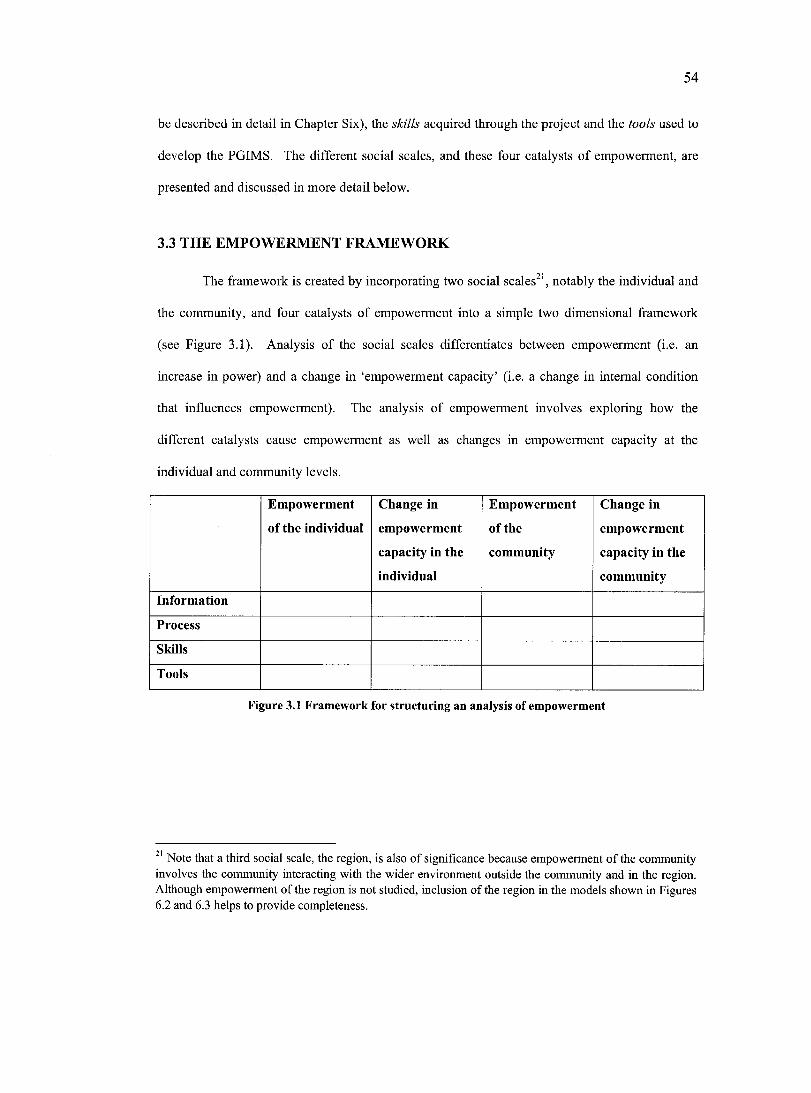
54
be described in detail in Chapter Six), the skills acquired through the project and the tools used to
develop the PGIMS. The different social scales, and these four eatalysts of empowerment, are
presented and diseussed in more detail below.
3.3 THE EMPOWERMENT FRAMEWORK
The framework is ereated by incorporating two social scales^*, notably the individual and
the community, and four catalysts of empowerment into a simple two dimensional framework
(see Figure 3.1). Analysis of the social scales differentiates between empowerment (i.e. an
increase in power) and a change in ‘empowerment capacity’ (i.e. a change in internal eondition
that influences empowerment). The analysis of empowerment involves exploring how the
different eatalysts cause empowerment as well as changes in empowerment capacity at the
individual and community levels.
Empowerment
of the Individual
Change in
empowerment
capacity in the
individual
Empowerment
o f the
community
Change in
empowerment
capacity in the
community
Information
Process
Skills
Tools
Figure 3.1 Framework for structuring an analysis of empowerment
Note that a third social scale, the region, is also of significance because empowennent of the community involves the community interacting with the wider environment outside the community and in the region. Although empowerment of the region is not studied, inclusion of the region in the models shown in Figures 6.2 and 6.3 helps to provide completeness.
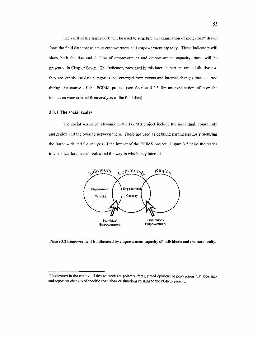
55
Each cell of the framework will be used to structure an examination of indicators'^ drawn
from the field data that relate to empowerment and empowerment capacity. These indicators will
show both the rise and decline of empowerment and empowerment capacity, these will be
presented in Chapter Seven. The indicators presented in this later chapter are not a definitive list,
they are simply the data categories that emerged from events and internal changes that occurred
during the course of the PGIMS project (see Section 4.2.5 for an explanation of how the
indicators were created from analysis of the field data).
3.3.1 The social scales
The social scales of relevance to the PGIMS project include the individual, community
and region and the overlap between them. These are used as defining parameters for structuring
the framework and for analysis of the impact of the PGIMS project. Figure 3.2 helps the reader
to visualize these social scales and the way in which they interact.
Reg/o
Empovwrment / \ Eirpowerment
Capacily \ / Capacity
IrwNdual CommunityEmpowerm ent Empowerment
Figure 3.2 Empowerment is influenced by empowerment capacity of individuals and the community.
^ Indicators in the context of this research are pointers, facts, stated opinions or perceptions that look into and represent changes of specific conditions or situations relating to the PGIMS project.
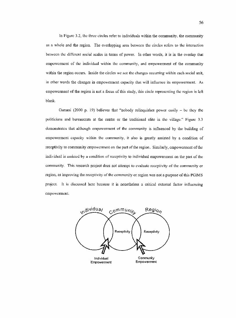
56
In Figure 3.2, the three circles refer to individuals within the community, the community
as a whole and the region. The overlapping area between the circles refers to the interaction
between the different social scales in terms of power. In other words, it is in the overlap that
empowerment of the individual within the community, and empowerment of the community
within the region occurs. Inside the circles we see the changes occurring within each social unit,
in other words the changes in empowerment capacity that will influence its empowerment. As
empowerment of the region is not a focus of this study, this circle representing the region is left
blank.
Osmani (2000 p. 19) believes that “nobody relinquishes power easily - be they the
politicians and bureaucrats at the centre or the traditional elite in the village.” Figure 3.3
demonstrates that although empowerment of the community is influenced by the building of
empowerment capacity within the community, it also is greatly assisted by a condition of
receptivity to community empowerment on the part of the region. Similarly, empowerment of the
individual is assisted by a condition of receptivity to individual empowerment on the part of the
community. This research project does not attempt to evaluate receptivity o f the community or
region, as improving the receptivity of the community or region was not a purpose of this PGIMS
project. It is discussed here because it is nonetheless a critical external factor influencing
empowerment.
Receptivity
Individual Com m unityEmpowwmen* Etrvowennen*
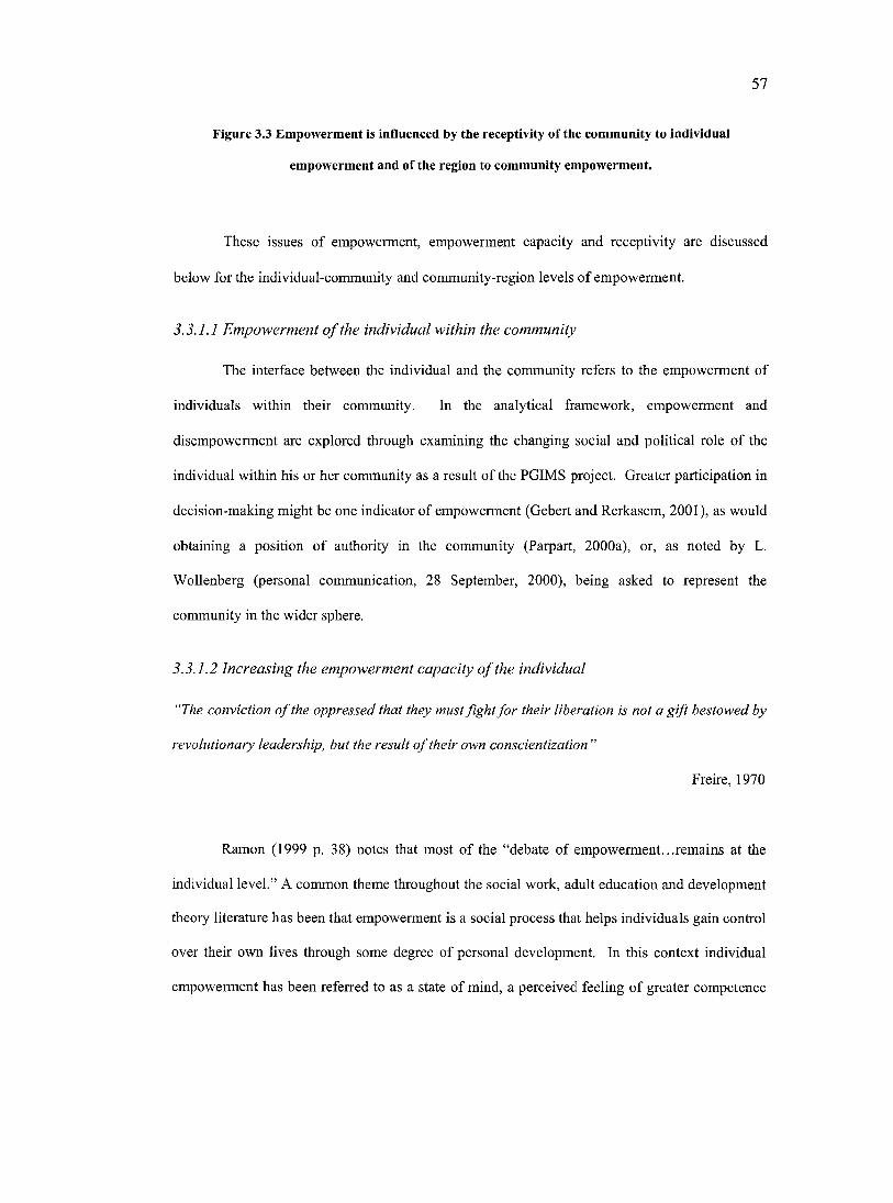
57
Figure 3.3 Empowerment Is Influenced by the receptivity of the community to individual
empowerment and of the region to community empowerment.
These issues of empowerment, empowerment capacity and receptivity are discussed
below for the individual-community and community-region levels of empowerment.
3.3.1.1 Empowerment o f the individual within the community
The interface between the individual and the community refers to the empowerment of
individuals within their community. In the analytical framework, empowerment and
disempowerment are explored through examining the changing social and political role of the
individual within his or her community as a result of the PGIMS project. Greater participation in
decision-making might be one indicator of empowerment (Gebert and Rerkasem, 2001), as would
obtaining a position o f authority in the community (Parpart, 2000a), or, as noted by L.
Wollenberg (personal communication, 28 September, 2000), being asked to represent the
community in the wider sphere.
3.3.1.2 Increasing the empowerment capacity o f the individual
"The conviction o f the oppressed that they must fight fo r their liberation is not a gift bestowed by
revolutionary leadership, but the result o f their own conscientization ”
Freire, 1970
Ramon (1999 p. 38) notes that most of the “debate of empowerment...remains at the
individual level.” A common theme throughout the social work, adult education and development
theory literature has been that empowerment is a social process that helps individuals gain control
over their own lives through some degree of personal development. In this context individual
empowerment has been referred to as a state of mind, a perceived feeling of greater competence
58
or power (Dubois and Miley, 1992) and the ability to “draw on inner strength to take control of a
situation and assert oneself’ (Ristock and Pennell, 1996 p. 3). Empowerment at this level is
related to “increased individual efficacy and the process...of altering the emotional and physical
state of the individual” (Rocha, 1997 p. 34).
This theory of personal development is influenced by Paulo Freire’s theory of Critical
Pedagogy (Freire, 1970) which has emerged as one of the central models used when discussing
and understanding empowerment. The core hypothesis of Critical Pedagogy is that human
liberation from existing exploitation and historical prejudice can be achieved through education
(Barry and Sidaway, 1999; Macdonald and Macdonald, 1999). According to de Koning (1993 p.
34), Freire believed that traditional educational activities do not challenge inequalities in learners’
lives, rather they perpetuate existing inequalities. Freire, while working with illiterate and poor
adults in North Eastern Brazil, developed teaching methods that combine learning to read and
write with looking critically at one’s social situation. The expectation of this approach to
education was that by learning these new skills students would obtain a clearer realization of the
injustices of their own situation. This would lead them to start to take initiatives towards
transforming the society that had previously denied them social and educational opportunity
(Thomas, 1992). Education, viewed in this light, was “primarily a political endeavour” (Wendt,
2001 p. 140). Although Freire does not use the term empowerment explicitly in his original
version of Pedagogy o f the Oppressed he does use the term liberation and notes that this is made
possible through developing critical awareness which leads to critical action. Freire referred to
these processes as concientization (or critical consciousness).
It is important to note that the development of a critical consciousness is not confined to
the development of the skill base and education of the individual, it also involves the ability to
make connections between the personal and political sphere (Miley and Dubois, 1999). Critical
conciousness involves more than simple learning or understanding of facts - it involves an
element of personal reflection that incorporates an understanding of how the individual positions
59
himself or herself in relation to those facts (Higgins, 1994) and subjectively within society.
Critical consciousness involves an ability to deconstruct political practices (Wendt, 2001). A
willingness to be politically radical and attempt to initiate social change is also vital to
empowerment (Barry and Sidaway, 1999).
However, in addition to creating critical consciousness, the knowledge and skills
obtained through education can give the disadvantaged a sense of equality with the ‘educated’
classes in society and help them to overcome the sense of intellectual inferiority that is a powerful
force inhibiting their confidence to assert their own initiatives (Marsden and Oakley, 1990). This
lack of confidence has been called ‘internalised oppression’ (Thomas, 1992; Rowlands, 1997).
New knowledge and skills allow individuals to overcome negative social constructions so that
they see themselves as having the capacity and the right to act and influence decisions (Rowlands,
1997) and the social conditions of their lives (Ristock and Pennell, 1996).
3.3.1.3 Receptivity o f the community to individual empowerment
According to Freire, the main factor in empowerment must be the development of critical
consciousness in the individual. However, empowerment of the individual is also influenced by
the receptivity of the community in which he or she lives. A more egalitarian, open society is
more conducive to individual empowerment than a hierarchical, restricted one. These societal
conditions influence how much difficulty and struggle is involved in the process of individual
empowerment.
This point is recognized by Parpart (2000a) when talking about women’s empowerment
in French West Africa. She describes how, through outsider intervention, women were given
positions on village committees; however, local elites, although in principle supportive of
women’s involvement, continuously dismissed women’s contributions during decision-making.
As a result of existing local power structures, the empowerment of individual women was
curtailed.
60
Parpart speculates that the participatory methods used, with their stress on inclusiveness
and equal voice, were perceived as a threat to the existing hierarchy. This shows that simply
promoting greater participation of marginal groups does not always lead to the desired outcome
of their empowerment. Parpart concludes by stating that much of the writing on empowerment
“too readily assumes participation can overcome deeply embedded material and cultural practices
that legitimate and maintain social inequities” (p. 12). These embedded inequalities can only
change after long periods of community level awareness raising resulting in attitudinal shifts, as
well as institution building that encourages greater participation, as well as changes that occur in
the marginalised individuals themselves.
3.3.1.4 Empowerment o f the community within the region
The interface between the community and the region refers to the role of the community
within the wider geographic region, in the case of this research West Kutai. Empowerment at this
level is explored through examining the relationship between the PGIMS project and the
changing political role of the community. One indicator of empowerment might he the
community reaching a successful outcome in regional decision-making processes. Another might
be an increased ability of the community to control and influence the actions of outsiders that
impact the community.
3.3.1.5 Increasing the empowerment capacity o f the community
Empowerment capacity is not only an individual psychological construct. Barnes (1988)
states that if individuals ean act and interact coherently with one another then the total power
available is considerably increased, and the overall capacity for action is larger and wider ranging
than that of a collection of isolated individuals. This in turn gives greater potential for
empowerment because of the “shared forces and expertise which a group has at its disposal”
(Ramon, 1999 p. 41). Ramon also feels that to gain some control over power structures there
61
must be collective public action; this can only be possible if there is a collective identity and
vision.
In the planning and development literature it is believed that community participation
processes can help create a shared understanding of problems and a vision for positive change, so
strengthening the collective identity of a community (de Koning, 1995; Agyarko, 1998). This in
turn generates the confidence of all members of a group to question and challenge the status quo;
it is therefore seen as leading to the empowerment of the marginalized. As White (1996 p. 8)
states:
The idea of participation as empowerment is that the practical experience of being involved in considering options, making decisions and taking collective action to fight injustice is in itself transformative.
Empowerment became a widely used term in development theory and practice during the
1990s and has now become a key focus area from mainstream institutions such as the World
Bank to the smallest non-govemmental organizations (NGOs) (Parpart, 2000b). It has now
gained such widespread acceptance that it is often being used synonymously with the term
‘community participation’. Rocha (1997) notes that because of the uneertainty around the term
empowerment, citizen participation often serves as a proxy for empowerment. This is because
both the “concepts of empowerment and community participation.. .have their origins in the fight
against poverty” (Barry and Sidaway, 1999 p. 14) and injustice. Their common emphasis has
been on enabling the less powerful sectors in society to gain control over their own lives and
become meaningfully involved in influencing decision-making processes.
Kuno (1998) believes participation and empowerment are the two sides of the same coin
and that empowerment needs to be seen as the ideal output of participatory mechanisms.
However, Agyarko (1998) challenges this assumption by noting participation is not monolithic
and that there are significant gradations, interpretations and variations in the term, he questions
whether indeed all forms lead to empowerment or whether all participatory processes even intend
62
to address power relations. This view is also shared by Amstein (1969) in her ‘ladder of
participation’. Yet she does recognize that citizen participation in its purest sense is citizen power
and is specifically linked with the redistribution of power (Heckman, 1998).
When considering empowerment at the community level it is important to note that
communities are not a homogenous entity. As de Koning (1995) points out much of the
empowerment literature uses broad and abstract categories, such as ‘the poor’ and ‘the
oppressed’. She feels that by treating these groups as a single category and implying that their
path to liberation is the same, this literature fails to reeognize the complexity of empowerment.
For instanee a marginalised community that through participatory mechanisms has been
empowered to take a more successful role in regional decision-making processes might in turn be
marginalising groups within the community, such as women, the youth, the less educated or the
less wealthy. However, participatory mechanisms that take place at the community rather than
the regional level should, with their emphasis on involving marginalised groups, empower these
groups to take part in decision-making. Nonetheless there is the potential for the empowerment
of marginalised groups in a community to lead to increased eonfliet within community, thereby
decreasing a community’s capacity for empowerment at the regional level.
3.3.1.6 Receptivity o f the region to community empowerment
It has been noted that without the institutional support at the regional level, empowerment
becomes limited and temporary (Osmani, 2000). As a result international and national
development efforts have focused on implementing ‘good governance’ programs over recent
years. Indicative of good governance is a government’s willingness to fulfill its democratic
mandate (Navruzov et al., 2000 p. 1). Within this mandate is the need for government to focus on
people’s needs and to facilitate their participation in local decision-making. More specifically, as
noted by the World Bank Group (2002):
63
Governments with authority and resources need to empower local communities through mechanisms that increase citizen access to information, enable inclusion and participation, increase accountability of governments to citizens, and invest in local organizational capacity.
Good governance has partially been approached using decentralization policies.
Decentralization aims to achieve better governance through devolving fiscal, political, and
administrative responsibilities to lower levels of government. The idea behind decentralization is
that moving decision-making closer to people will lead to public sector decisions that better
reflect local needs and priorities (Osmani, 2000). This in turn will lead to greater efficiency in
public expenditures, improved governance, and greater equity.
The World Bank Group’s (2002) statement implies that empowerment will more likely be
attainable through a philosophical commitment and supportive policy environment at the
governmental level than through acts of political mobilization. The aims o f good governance and
decentralisation, however, are by no means automatic or easy to achieve. Although institutions
might appear to be acting for the collective benefit, they may in reality only serve to shape and
reproduce relations of unequal power (Leach et a l, 1997) and remain distrustful of the poor and
their information (Parpart, 2000b).
Unlike the World Bank approach of believing that governments empower communities
Osmani notes that:
Social forces must be created that would compel ...the sharing of power [through] the gradual empowerment of the poor, so that they can convert their numerical strength into genuine bargaining power. (2000 p. 19)
In all likelihood for empowerment to be realized effort is required from both communities and the
regional government.
64
3.3.2 The catalysts
The catalysts refer to the specific elements of the PGIMS project that lead to
empowerment, or changes in empowerment capacity, of individuals and communities. These
catalysts include the information contained within the PGIMS, the participatory processes
employed by the overall project, the skills acquired through the project and the tools used to
develop the PGIMS. These will be discussed in turn below.
3.3.2.1 Inform ation
The explicit link between power and information has been noted (Scoones and
Thompson, 1993; Chambers, 1994a; Brown and Duguid, 2000; Parpart, 2000b). An ability to
communicate one’s own information place individuals, groups and communities in stronger
positions (Yoon, 1996). There has also been a link drawn between communicating spatial
knowledge and power (Harley, 1988; Brodnig and Mayer-Schonberger, 2000; Alcorn, 2001).
In the empowerment framework, the information catalyst refers to the information
gathered during the eourse of the PGIMS project and stored within the villages’ computer. The
information is stored in textual, photographic and video format. The information in the PGIMS
can be categorized in different ways. Categories include for example cultural, documentary,
political, family and commercial information. The framework enables analysis of how the
documentation, control and use of this information contributes to empowerment and changes in
empowerment capacity at the individual and community scales.
3.3.2.2 Process
Jordan (1998) and Dunn et al. (1997) note that empowerment in PPGIS initiatives is most
clearly linked to the requisite participatory process. Jordan, when talking about the use of PPGIS
in Nepal, coneludes:
65
It was found that the emphasis [of the project] had to be firmly on participation rather than technical issues, and a system based approach that actively encouraged participation was found to be the key requirement for a useful PPGIS. (1998 p. 10)
In the empowerment framework, the process catalyst refers to the specific participatory process
used by the PGIMS project and described in Chapter Six (Section 6.2.1). The process employed
was fundamentally participatory in the sense that it invited (not demanded or coerced) and
facilitated the inclusion of all individuals and groups from the two communities (men and
women, old and young, educated and uneducated) to join and lead the PGIMS project. At the
outset of the project the intention was to encourage participatory dialogue and community
decision-making through open forums with the intention that they would enable the entire
community to become involved and contribute to the development of the PGIMS. This
community decision-making ranged from conceptual guidance, in the form of shaping the
organization and content of the PGIMS, through to sharing skills with other community members
in order to capture, manage and store the community’s information in such a way that it can be
incorporated into the PGIMS. The framework examines how the partieipatory process used in the
PGIMS project contributes to empowerment and change in empowerment capacity of the
individuals and communities.
3.3.2.3 Skills
In the Social Work and Further Education literature, empowerment is often described as
an outcome of activities where marginalised groups learn new skills that enable them to operate
more effectively in their immediate environment (Freire, 1970; Barry and Sidaway, 1999;
Macdonald and Macdonald, 1999). This aspect of empowerment has appeared less in the PPGIS
literature, possibly because most PPGIS initiatives are expert-driven and the technological skills
remain in the in the hands of the experts.
6 6
In the empowerment framework, the skills catalyst refers to the new skills acquired by
individual community members and communities as a whole through the training associated with
the PGIMS project. These skills include learning to operate the video and camera equipment as
well as the computer and associated software. The term ‘skills’ refers to the ability to use the
new technologies, it does not refer to how the technologies are used. The framework will
examine how these skills influence empowerment and empowerment capacity at each of the
different social scales.
3.3.2.4 Tools
As information technologies proliferate and become easier to use, attention is being given
to the role of the tools themselves in the empowerment process. Higgins (1994) states that
“anyone expecting to be emancipated by technological hardware, or by a system of hardware,
however structured, is the victim of an obscure belief in progress.” Brodnig and Mayer-
Schonberger (2000 p. 12) cite Krantzberg’s First Law that states “technology is neither good nor
bad, nor is it neutral” which points to the importance of the soeial, political and economic context
of technologies. Yet increasingly the link between the technology, including electronic devices
and software, and empowerment is being noted. This is represented throughout the PPGIS debate
(Johnson, 1997b; Bamdt, 1998; Kyem, 1998; Laituri, 1998; Elwood, 2002) as well as being
promoted by commercial groups^^. Furthermore digital data can be presented in very slick and
impressive ways that can impress and ultimately influence an audience.
In the empowerment framework, the tools catalyst refers to the specific equipment used
during the development of the PGIMS. These include the hardware, notably the computer, video
camera and digital camera, and the software, notably the map interface, video, photograph and
^ While passing through Singapore airport in December 2002 the author noted an advertisement for Acer computers that explicitly made the link between their product and empowerment by showing a young Caucasian male showing the screen of his Acer laptop to a beautiful Hmong hill tribe woman with the caption underneath describing their products as “Empowering People.”

67
text editing programs. The PGIMS project intended that these tools be available to anyone from
the village who wanted training in how to use them. The framework will examine how the tools
in themselves contributed to empowerment.
68
C h a p t e r F o u r :
R e s e a r c h M e t h o d s
This chapter describes the methods used to answer the research question presented in Chapter
One. It will first position this thesis within the wider theoretical debate on research
methodologies (Section 4.1), before discussing the qualitative tools (Section 4.2) and quantitative
tools (Section 4.3) used to gather the data.
4.1 THEORETICAL BACKGROUND TO RESEARCH METHODS
The overall research design and data collection approach were grounded in the broad
methodological field of qualitative research. Qualitative research is described by Kirk and Miller
(1986) as “a particular tradition in social science that fundamentally depends on watching people
in their own territory and interacting with them in their own language, on their own terms” (p. 9).
This leads the researcher to an understanding of the people and the social and cultural contexts
within which they live.
The term qualitative research is used to refer to research that produces “findings not
arrived at by means of statistical procedures or other means of quantification ... [although] some
of the data may be quantified... analysis itself is a qualitative one” (Strauss and Corbin, 1990 p.
17). Kirk and Miller (1986) claim that qualitative research involves a commitment to field
activities, “it does not imply a eommitment to innumeracy” (p. 10). A number of other social
science researchers have noted the importance of quantitative data within the spectrum of tools
available to the qualitative researcher (Yin, 1984; Patton, 1990; Strauss and Corbin, 1990).
Kirk and Miller (1986) go on to note that qualitative research is identified differently by
diverse social sciences, and that among its different interpretations is the research approach of
ethnography. Ethnographic research comes from the discipline of social and cultural
69
anthropology. Ethnography is understood to be a collection of methods, including interviews and
observation, for describing, interpreting, and explaining the social world (LeCompte and Preissle,
1993). Agar (1986) more specifically describes ethnography as being “a social research style that
emphasizes encountering alien worlds and making sense of them” (p. 12). He further notes that
this usually involves an improvisational style to meet situations not of the researcher’s making
and an intensive personal involvement in the area under study (Agar, 1986). An ethnographer is
required to spend a significant amount of time in the field. Thus the role of the author as
researcher is to interpret and make sense of the new world in which the research is located.
Because the research in this thesis is integral to a project that explicitly intended to
empower marginalised communities through the introduction of PGIMS technologies, it also
becomes more specifieally situated in the theoretical area of “Empowerment Research”. This is
research that is “committed to identifying, facilitafing or creating contexts in which heretofore
silent and isolated people...gain understanding, voice and influence over decisions that affect
their lives” (Rappaport, 1990 cited in Ristock and Pennell 1996 p. 2).
Empowerment Research stresses the imperative for a social-change agenda centred on
empowerment over research process (Rappaport, 1987; Ristock and Pennell, 1996). The phrase
‘research as empowerment’ is used to convey the idea that “research itself can be a lived process
of empowerment when it encompasses both a critical analysis of power and the reconstructing of
power so that the latter can be used in a responsible manner” (Ristock and Pennell, 1996 p. 2). In
this thesis, although the aim of empowering participating local communities was explicit
throughout the PGIMS project, the author did not attempt to involve the community directly in a
critical analysis and reconstruction of power. Nonetheless Empowerment Research theory is a
useful concept because it encourages the researcher to be aware of the ethical implications of
conducting research that can shift and even change power differences that are inherent in society
(Ristoek and Pennell, 1996).
70
This includes recognition that the research project might threaten the interests of power-
holders in the communities, who may react unfavourably against the people involved in the
project. Furthermore the project has the ability to profoundly alter relationships and the social
systems within the communities, which can also have unanticipated negative consequences (an
issue raised by Harris and Weiner, 1998).
Ristoek and Pennell (1996) further state that when undertaking Empowerment Research
the researcher needs to “critically analyse their own power and use it responsibly” (p. 8). This
self awareness helps the researcher to understand how they impact, interpret and understand
actions, discussion, decision-making and outcomes (Perrier, 1998). This needs to be done in
recognition of the “unequal power and the exploitative potential inherent in the relationship
between the researcher and researched” (Ristock and Pennell 1996 p. 68). Despite attempts to
overcome power inequalities by immersing oneself in the communities, initiating a project that
aspires to benefit the communities, promoting respect, equality, empathy, and honesty with
participants, the fact remains that the project, at least initially, is dependent on and controlled by
an outsider. As Ristock and Pennell (1996 p. 68) note “power is always present in the complex
reciprocal relationship between the researcher and research participant.”
By the very nature of this research project the relationship between the author and the
community members was automatically imbued with an inequality of power. The author was the
donor of the PGIMS tools as well as the gatekeeper for the skills required to realise the successful
use of these tools. He therefore had a disproportionate level of control over these skills and tools.
Any evaluation of the PGIMS project has to take this imbalance in the relationship into account.
This means to analyse the material, cultural and discursive difference s between the researcher and
the researched with an understanding that the researcher might be perpetuating oppressive power
relations, especially in respect to gender (the author is male), ethnicity (Caucasian) and
educational background (doing a PhD). This self reflection helped to define and guide the
consciously subordinate role that the author played in decision-making during the PGIMS project.
71
a role which is also in line with that expected of an external facilitator in participatory processes
(Chambers, 1994b; Freudenberger, 1994; Pretty et a l, 1995; Chambers, 1997).
Both qualitative and quantitative tools were used to gather information and data for the
purpose of assessing how the PGIMS project empowered or disempowered the participating
communities in this research project. These methods are discussed in more detail below. A
working definition and an analytical framework of empowerment are presented in Chapter Three.
4.2 QUALITATIVE TOOLS
Qualitative data were collected by the field research team, which consisted of the author
as well as research assistants including Fidelis Nyongka, a member of the local NGO SHK
stationed in Tepulang, Maria Minang and Adrianus Rio, two residents from Benung, and Mary
Stockdale, a Canadian gender consultant. Information was collected from members of the two
communities participating in the PGIMS project, key influential informants from around the
region, and participants in two multi-stakeholder workshops held with key regional stakeholder
groups such as government, university, NGOs and community organisations.
Qualitative data gathering tools included participant observation, key informant semi
structured interviews, focus group discussions, gender analysis and questionnaires.
Qualitative data collection processes followed the principles laid down in Participatory
Rural Appraisal (PRA) methodologies (Chambers and Guijt, 1998). These include:
• Observing, listening to and learning from community respondents;
• Not leading, dominating, interfering or interrupting during the data gathering process;
• Giving people time to think or discuss issues before replying; and
• Constantly analysing and questioning - who is being met and heard, what is being seen,
and where and why; and who is not being met and heard, what is not being seen, and
where and why?
72
4.2.1 Participant observation
Participant observation was the principal research method used throughout the project.
Participant observation has been described as a social science method “characterized by a
prolonged period of intense social interaction between the researcher and the subjects, during
which time data, in the form of field notes, are unobtrusively and systematically collected” '*
(Bogdan 1962 cited in Bogdewic, 1992 p. 46). Spradley (1980) describes the participant observer
having a dual purpose, "to engage in activities appropriate to the situation and to observe the
activities, people, and physical aspects of the situation" (p. 54). As a result, the participant
observer is an actively involved participant and, at the same time, trying to be an uninvolved
objective observer.
The term in itself is contradictory as ‘observation’ implies non-involvement, distance,
objectivity and neutrality, whereas in practice this method requires immersion of the researcher in
the other world with the intention “to share and understand the intimate lives of others, if only
temporarily” (Kirby and McKenna, 1989 p. 78). Furthermore, Seale (1993 cited in Perrier, 1998)
notes that during the process of participant observation the researcher is learning from the people
rather than studying them, this requires that trust become an essential element of the research
process.
Participant observation ean circumspectly appear to be too simple to be considered a
research method as it simply validates and refines processes that we use in everyday life.
However, Jorgenson (1989 cited in Bogdewic, 1992) furthers an understanding of the process
when he describes how it is used to: uncover the insider’s viewpoint, understand the here and
now of everyday life, develop interpretive theories, facilitate an open-ended process of inquiry,
generate an in-depth case study approach, allow the researcher to become directly involved in the
This method is rooted in social and cultural anthropology and often attributed to Malinowski’s method of data collection among the Trobriand Islanders.
73
lives of the observed and use direct observation as a primary data gathering device, with the aim
of generating “practical and theoretic truths about human life grounded in the realities of daily
existence” (Bogdewic, 1992 p. 46).
During the ten months that the author spent in the participating villages, he and his
research assistants were involved with daily activities around the villages, including among
others: living, sleeping, cooking, eating and bathing, taking part in sports activities, attending
traditional ceremonies and church services, helping with house construction, and working in the
rice fields and fruit tree gardens. They were also involved with many activities related to the
PGIMS project, particularly at the outset. The author’s observations were recorded in a daily
journal describing events in a chronological order, in a field book and also using a tape recorder.
During the one month that the gender consultant was in the village, a similar proeess was
followed. The consultant, being female, was able to interact with women and observe them in a
way that was not possible for the author.
During the participant observation process, open-ended interviews became a key tool in
information collection. These are defined as opportunistic, often unplanned and informal
exchanges that took place with respondents in varying locations, whether at the spring washing
clothes, on the volleyball court or in people’s homes. Information was gathered about a range of
issues from opinions and suggestions about the PGIMS project through to local gossip and
community concerns. Every member of both participating communities and other people
throughout the region, were considered potential informants. As the research project progressed
and the field research team spent a longer time in the villages, the responses from villagers
became more in depth, frank and interesting.
4.2.2 Semi-structured interviews
Semi-structured interviews were conducted with key informants. Semi-structured
interviews are a data collection technique conducted with a fairly open framework that allows for
7 4
focused, conversational, two-way communication between interviewer and interviewee. They
can be used with a sample of the population both to give and receive specific quantitative and
qualitative information relevant to particular issues (Davis-Case, 1990).
As Davis-Case (1990) notes, semi-structured interviewing is guided only in the sense that
some form of interview guide provides a framework for the interview. Questions are not phrased
ahead of time, and some are created during the interview, allowing both the interviewer and the
person being interviewed the flexibility to respond to and probe specific areas of coneem or
interest. Respondents are also encouraged to ask questions of the interviewer. Interview
techniques involve: probing replies to a question in order to clarify and uncover more layers of
information; asking open-ended rather than leading questions; showing an interest and
enthusiasm in learning from people; having second and third meetings with the same people and
above all else enjoying the research process (Chambers and Guijt, 1998).
As a research tool used in rural communities in Indonesia, semi-struetured interviews
were relatively less threatening for respondents than the use of formal questionnaires. This is
because they encouraged two-way communication. In this way they also served as an extension
tool to inform people about the PGIMS project and to get to know members of the community
better and allow members of the community to become better acquainted with the researcher.
Semi-structured interviews were found to be an important tool to assess empowerment of
individuals as a result o f the PGIMS project.
Key informants were identified as people in the villages “who have special knowledge,
status, or access to observations denied the researcher” (Bogdewic, 1992 p. 57). Gilchrist (1992)
further describes them as individuals who have a special link with the researcher and are able to
teach the researcher. During the PGIMS project key informants with ‘special knowledge’ were
identified as community members with specialist local knowledge about social, cultural and
political characteristics of the community and the region. These people were identified by other
community members. Key informants with ‘status’ are community members who held pivotal
75
power positions in the community. These were identified by their position, such as the village
head (Kepala Desa) or traditional head (Kepala Adai) in the community, or were recognized by
their relatively significant contribution to decision-making outcomes during community meetings,
or were identified as power brokers by other community members. Informants with ‘access to
observations denied the researcher’ included people within the community who were trusted by
the author to give honest responses about developments and issues related to the PGIMS project
within the community. Informants with a ‘special link to the researcher’ referred to community
members who were involved, supportive, had expressed a strong opinion or shown an interest in
the PGIMS project. These informants were identified by their level of involvement in the project
by the author.
Effort was made to interview women as well as men through conscious selection of
women informants and through the use of a female gender consultant as well as a local woman to
interview women in the community. Key informants from outside the village were vital
resources in helping to contextualise the two participating communities in the wider geography
and development in the region. These were identified as people with power positions in the
regional government, including the Regent (Bupati), and other people recognized by local
informants as playing an influential role in the region in respect to social, cultural and political
affairs.
Semi-structured interviews were the most formal qualitative data gathering tool used in
the communities during the research component o f the PGIMS project. They were used from the
middle of the second research field period (February, 2001) through to the end of the research
project (May, 2002). The interviews were not conducted from the beginning of the project in
order to give the villagers time to become adjusted to the researcher and the project in the village,
as well as enable the interviews to be more relaxed and the respondents more accommodating of
the questioning (as also noted by Bogdewic, 1992). The late inception of the interviewing also
enabled the respondents to provide a more informed and critical view of the project. During the
76
course of the PGIMS project, a total of 60 semi-structured interviews were conducted with key
informants from both partnering communities and from the wider region of West Kutai. O f these,
20 were women and 40 were men. Interviews ranged in duration from 45 minutes to 120
minutes. The number of completed interviews, combined with the quality of the responses, was
considered satisfactory to use for in-depth analysis of the PGIMS project.
The approach to using semi-structured interviews was as follows:
• The research team designed a list of key informants and a plan for interviewing them.
• Before each interview, informants were informed verbally of how their data would be
used, and how their rights to their data and to confidentiality would be safeguarded.
Their consent was requested before the interview could proceed. This procedure is
outlined in Appendix A and follows the requirements of the University of Victoria
Human Research Ethics Committee.
• Interviews loosely followed an interview framework that had been designed previously
by the research team. This framework consisted of eight broad questions and
accompanying follow up questions and is described in Appendix B.
• Interviews were recorded on cassette so that the researchers could concentrate on the
questioning and refrain from having to take detailed written notes during the interview.
However, outline notes were taken. Interviews were conducted in Bahasa Indonesia
(which the author speaks fluently) and Bahasa Benuaq (by the research assistants). Later
the interviews were transcribed in full in Bahasa Indonesia. Interviews in the local
dialect, Bahasa Benuaq, were translated to Bahasa Indonesia.
• At the end of each day of interviewing the information was discussed and analyzed
collectively by the research team. Input from local research team members was
important because of their intimate local knowledge of the community and local issues.
It was important to compare the responses they were given with those given to the author.
77
Key themes were examined during these meetings and points from the discussion were
written down.
• The semi-structured interview questions were constantly added to and modified. The
researchers met regularly to identify areas of significance and knowledge gaps, to adapt
the questions and to prioritize the choice of key respondents.
• The overall results of the analysis were occasionally presented to and discussed with
community members.
There were some difficulties in capturing recorded data and transferring it into written
form. Acoustics made for poor quality of audio recording in some meetings, especially in
Benung's longhouse. There were times during the initial investigations when tapes or batteries
ran out, or were not switched on, reinforcing the importance of also taking outline notes during
interviews, rather than relying on memory.
4.2.3 Community meetings and multi-stakeholder workshops
During the PGIMS project, 17 meetings were organized and held in both the participating
communities (5 in Benung and 11 in Tepulang). Two workshops were also held with stakeholders
from throughout the region of West Kutai (see Appendix C for a complete list of the meetings
and workshops held by the PGIMS project). The content and objectives o f some of these
meetings and workshops are also described in more detail in Chapter Six (Section 6.2).
Community meetings were a key source of information during the research component of
the PGIMS project. The meetings and workshops provided an opportunity to discuss and assess
the impact of the PGIMS project on both of the participating communities and the potential of
PGIMS for the wider region.
In research terms these meetings acted as a form of focus group interview. Focus groups
are a social science qualitative research tool used for studying ideas in a group context. “They
provide a means for studying one of the cherished propositions of social science: ‘the whole is
78
greater than the parts’ ” (Morgan, 1988 p. 5). In essence focus groups are a group interview, but
rather than relying on the question/response format of an interview they rely on the interaction
within the group based on topics provided. The hallmark of focus group techniques is the
“explicit use of group interaction to produce data and insights that would be less accessible
without the interaction found in a group” (Morgan, 1988 p. 12).
A total of eleven community meetings were held in Tepulang and six in Benung,
including a meeting specifically for women held in each village, as described in Chapter Six
(Section 6.2.1.2). These meetings were open to all and were attended by between 8 and 61
participants. This style of discussion meeting became an integral part o f the project process. The
meetings usually followed a broad agenda based loosely around several topics. Discussion was
generally ordered and respectful. They provided the opportunity for community involvement and
interaction in decision-making and providing opinions about the project. At the beginning of the
project these village meetings were recorded in their entirety using a video camera or cassette
recorder. Throughout the project detailed notes were also taken during the meetings.
One of the drawbacks of using community meetings as a tool for data gathering was that
they did not provide a setting conducive to the involvement of all participants. Some community
members appeared affected by having to perform, or reveal their opinions and feelings, in such a
public setting. At times the meetings would become monopolised by the loudest participants.
There were times when it also appeared that the author’s presence caused comments to be stifled.
The author speculates that this is due to people feeling that they might be directly offending the
author if they were critical of the PGIMS project. A final key drawback with this style of
discussion meeting is that participants, when particularly animated, would begin to speak Bahasa
Benuaq with the result that the author could not follow the conversation in full. These drawbacks
call into question whether the full extent of information was gathered.
Two multi-stakeholder workshops were held in the regional capital of Melak, these are
discussed in more detail in Chapter Six (Section 6.2.2). During these meetings there were
79
opportunities for question and answer sessions. Also, participants split up into small groups of
five to eight for brainstorming of specific issues related to the PGIMS project. Results from these
group discussions were presented back to the plenary. These meetings were recorded in their
entirety using a video recorder and all the written materials produced in the small group meetings
were photographed using a digital camera.
4.2.4 Questionnaires
Questionnaires were not used in the collaborating communities because of fears that their
formality might intimidate the villagers, as well as doubts concerning the quality of the
information derived from their applieation, due to lower levels of question comprehension and
literaey among older village residents. Since more time was available for data gathering in the
communities, the preferred methods of participant observation, semi-structured interviews and
focus group meetings were used, as described above. However, a questionnaire was applied at
the two multi-stakeholder workshops held during the PGIMS project due to the shortness o f time
available for gathering information on participants’ opinions.
The questionnaire was designed not to be excessively time-consuming. However, it used
a limited number o f open-ended questions to stimulate analysis and to obtain the undirected
opinions of the respondent. These questions were based initially on a review of the literature and
adapted to include the more successful and revealing of the questions used during semi-structured
interviewing in the communities (see Appendix B). The resulting questionnaire consisted of two
sections (the full questionnaire is shown in Appendix D). The first section inquired about
background information including factual questions about the respondent’s age, gender, ethnic
origin and their job status or position in society. It then went on to request information on the
respondent’s level of knowledge of computers and computer software. The second section
contained questions requesting the respondent’s opinions of the information that had been
80
presented in the workshop and of the potential for PGIMS to be applied in a wider regional
setting.
The first occasion at which the questionnaire was applied was at the multi-stakeholder
dissemination workshop held in April, 2001. The workshop was attended by 36 partieipants, 27
of whom completed, or partially completed, the questionnaire^^. The second occasion for
applying the questionnaire was during the one week training workshop held in July, 2001
(described in Section 6.2.2). All 12 of the people trained in this workshop completed the
questionnaire. During this second workshop the first section of the questionnaire was given out at
the beginning of the workshop and the second section at the end.
4.2.5 Analysis of qualitative data
As a result of the multiple methods used, a large quantity of data was collected. These
data were organised, transcribed, eross-checked and analysed both during and after the fieldwork.
Participant observation, the notes taken at community meetings and multi-stakeholder
workshops and the responses in the written questionnaires^® produced data in hand written form.
The recordings of the semi-structured interviews, community meetings and multi-stakeholder
workshops were transcribed directly onto the computer. Of the semi-structured interviews, 57
were fully transcribed and 3 were partially transcribed because much of the content was not
relevant to the research. The recorded meetings and workshops were also partially transcribed for
the same reason. Where necessary, dialogue in the local Bahasa Benuaq was translated by the
research assistants to Bahasa Indonesia.
It is likely that illiteracy was the reason why some participants did not complete the questionnaire.
The questionnaires also produced some numeric data; however, their potential for statistical analysis was limited as the sample populations were 27 and 12. It is recognized that a larger sample size would have enabled the testing of hypotheses, such as statistical analysis of the variability in responses between people of different societal backgrounds and roles.
81
Sometimes the data were contradictory and required cross-checking. Participant
observation and open-ended interviews proved to be particularly important tools for reassessing
situations where formal responses gathered from the semi-structured interviews did not concur
with observed behaviour and emerging events.
The challenge in the analysis phase was in determining what information was important.
The research question was used to narrow down the data and focus on issues related to
empowerment. These issues emerged through categorizing expressions, responses and opinions
from interview data and triangulating and combining them with observed events which could be
used to indicate empowerment. In the end, analysis was not as complex as anticipated. Ristock
and Pennell (1996) suggest a structured approach for developing categories from research
participants’ responses, involving seven steps. These are;
1. Listen closely to what research participants are saying;
2. Compare their statements;
3. Notice interesting and reoccurring themes;
4. Give a name to each theme (categorizing);
5. Check each category against more statements;
6. Clarify each category against the other categories being developed; and
7. Reshape the categories to fit the participants’ statements.
The above approach was used to determine ‘indicator’ categories. Key points were
transcribed from the field notes and other transcribed data into the computer; these were then
colour coded using word-processing software^’. New categories were added as themes emerged.
Some points were double coded (in other words they were representative of several themes). This
method was flexible enough to allow for reordering and rethinking. The investigation initially
began with many codes; these were cut back significantly as analysis progressed. Specific
The author opted not to use any analytic software package, such as NUD*IST, partially because all transcribed data was in Indonesian, adding complexity to the analytical process.
82
categories used to indicate empowerment and empowerment capacity are presented in Chapter
Seven.
4.3 QUANTITATIVE TOOLS
Quantitative data were also gathered during the PGIMS project. These included the
monitoring of the computer usage in both communities and the collection of secondary data on
village demographics.
4.3.1 Computer usage monitoring
FindOut!® computer monitoring software was installed on the computers in both
villages. Computer monitoring provided quantitative data about computer use, such as the time
and date the computer was used, the duration of use, the software being operated and what
information formats (i.e. file types) were being stored on the system. These data were used to
build a profile of how the computers were being operated and to determine a level of importance
associated with a particular program or information format.
Benung’s computer was monitored from November, 2000 until March, 2002. Tepulang
was monitored from March, 2001 until March, 2002^^ Monitoring was not done covertly. Both
communities were informed during a community meeting of the purpose of the software and of
how the data would be used. They were also told that data would be gathered anonymously, as
the purpose was not to profile individuals but rather to assess total computer usage in the
community. Following this, permission to use the software was requested and granted.
FindOut!® generated a large amount of quantitative data. This data was managed and
analysed using Microsoft Access® and Microsoft Excel® software. One problem with the
monitoring software was that the final five months of Benung’s monitoring data and the final four
This discrepancy between the two villages in the monitoring periods was the result of a fault in Tepulang’s computer, causing the first four months of monitoring data to be lost.
83
months of Tepulang’s could not be referenced to specific times and dates because the battery on
the computer motherboard ran out, disabling its clock. For this reason, the data on computer
usage were averaged over the time period in which they were collected, making it impossible to
see what variation had actually occurred over those final months. To understand the variation
observed in the earlier months, information eollected in the author’s field journal proved to be
very useful for cross-referencing data gathered from the computer monitoring software with
events in the field.
4.3.2 Community monograph
Every village secretary in Indonesia maintains a eommunity monograph (monografi) that
contains the basic demographic statistics of each person living in the village. This includes
information about the date of birth, religion, sex, marital status, position in the family, number of
children, education and employment. They provided some useful profiles for comparing
demographics, education levels and migration patterns in both villages.
In both villages the monographs contained obvious gaps and omissions, were rarely
updated and contained inaccurate data, especially when describing the age o f the older members
in the community. Checking the data with the village chief and secretary helped to improve the
reliability of the data. The monograph data were then incorporated into a Microsoft Excel®
spreadsheet for descriptive analysis.
84
C h a p t e r F i v e :
R e s e a r c h S it e
This chapter describes the geographic, social, historical and political environment in which the
research took place. It begins with an overview of Indonesia (Section 5.1); it goes on to discuss
West Kutai, the administrative region in Indonesia where the research project took place (Section
5.2); and then describes Benung and Tepulang, the two villages that participated in this research
project (Section 5.3).
5.1 INDONESIA
5.1.1 Geography
Indonesia is an archipelagic nation of 13,667 islands, an estimated 6000 of which are
inhabited (see Figure 5.1). These include five main islands (Sumatra, Java, Kalimantan,
Sulawesi, and West Papua), two major archipelagos (Nusa Tenggara and Maluku Islands), and
sixty smaller archipelagos (Frederick and Worden, 1993). The capital of Indonesia is Jakarta,
located on Java. The total area claimed by the nation is 7.9 million square kilometres, the bulk
being seas and ocean. The total land area of Indonesia amounts to 1.92 million square kilometres
(Frederick and Worden, 1993).
Indonesia’s climate is classified as a tropical, hot, humid climate. There is little variation
in temperature because of almost uniformly warm waters that surround the archipelago. Through
much of Indonesia the dry season lasts from June to September, and the rainy season from
December to March (Frederick and Worden, 1993).
Indonesia has vast and diverse natural resources, ineluding timber, oil, natural gas,
rubber, palm oil, coal, tin, copper and gold. Since the end of the 1970s, Indonesia has been
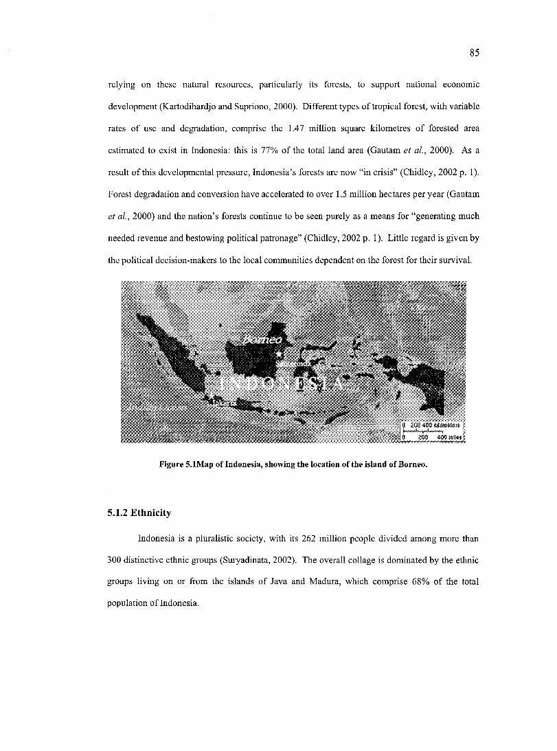
85
relying on these natural resources, particularly its forests, to support national economic
development (Kartodihardjo and Supriono, 2000). Different types of tropical forest, with variable
rates of use and degradation, comprise the 1.47 million square kilometres o f forested area
estimated to exist in Indonesia: this is 77% of the total land area (Gautam et al., 2000). As a
result of this developmental pressure, Indonesia’s forests are now “in crisis” (Chidley, 2002 p. 1).
Forest degradation and conversion have accelerated to over 1.5 million hectares per year (Gautam
et a l, 2000) and the nation’s forests continue to be seen purely as a means for “generating much
needed revenue and bestowing political patronage” (Chidley, 2002 p. 1). Little regard is given by
the political decision-makers to the local communities dependent on the forest for their survival.
0 iOO 400 1------ '- r - '------- -0 ZW W O iW w
Figure S.lMap of Indonesia, showing the location of the island of Borneo.
5.1.2 Ethnicity
Indonesia is a pluralistic society, with its 262 million people divided among more than
300 distinctive ethnic groups (Suryadinata, 2002). The overall collage is dominated by the ethnic
groups living on or from the islands of Java and Madura, which comprise 68% of the total
population of Indonesia.
86
The nation’s religion is primarily Moslem at 87%, followed by Protestant (6%), Catholic
(3)%, Hindu (2%), Buddhist (1%), and other religions (1%) (Frederick and Worden, 1993).
Indonesia officially accepts all five religions listed above; nonetheless, religious tension and
conflict exist in some places.
5.1.3 Political history
Indonesia was under Dutch colonial rule for more than three centuries. The
disadvantages the population suffered at the hands of Dutch rule became the impetus for the
growth of a strong nationalist sentiment in the post independence decades and has in many ways
served to shape the modem political climate in the country (Chareonwongsak, 2001). This
section will outline some of the major developments of Indonesia’s post-independence period.
5.1.3.1 The Old Order (1945 - 1965) - “Guided D em ocracy'’
Indonesia proclaimed independence from the Netherlands on August 17* 1945 and
named Sukarno as the country’s first president. This unilateral proclamation gave rise to the
‘Revolution’, an armed uprising against the Dutch who resisted ceding power, which eventually
led to the formation of the Republic of Indonesia in 1950. The Revolution has become a defining
episode in modem Indonesian history and a powerful element in shaping the new nation’s self
perception and identity (Ricklefs, 2001).
Despite the euphoria of independence won through struggle, the new state faced ethnic,
religious, and social divisions throughout the archipelago. The early 1950s saw experimentation
with parliamentary democracy. This failed and Sukamo replaced it in the 1959-65 period with
‘Guided Democracy’, a form of benevolent dictatorship (Frederick and Worden, 1993). Guided
Democracy was a “fluid system, bom of crisis and constantly changing... that was dominated by
the personality of Sukamo” (Ricklefs, 2001 p. 312). Sukamo had a vast following amongst the
87
peasants, but his power base rested on the support of two antagonistic groups: the Armed Forces
of the Republic of Indonesia (ABRI) and the Indonesian Communist Party (PKJ).
The Guided Democracy phase became one of the more dysfunctional periods in modem
Indonesian history. It ultimately led to national isolationism and ostracism from the global
theatre. Famine ensued, as did general discontent because of obvious and growing levels of
“extravagant cormption and hypocrisy” (Ricklefs, 2001 p.341).
5.1.3.2 The New Order (1965 - 1999) - “M andated uniformity”
In 1965 Major-General Suharto forcibly took power in a bloody coup that led to the
deaths of up to half a million people, mainly people from the PKI and ethnic Chinese
(Chareonwongsak, 2001). Suharto appointed himself as president and established what became
known as Indonesia’s period of ‘New Order’. From the outset he adopted a strong anti
communist stance, legitimised the role of the armed forces in politics and institutionalised the
Pancasila^^ as the ideological foundation of all groups in society; these measures contributed to a
tightly controlled, centralized system.
Friendly ties were restored with Western countries and Japan, and Indonesia began to
accept large amounts of Western and Japanese aid and private investment (Frederick and Worden,
1993). During this period a strategy of national development via industrialized capitalism led to a
period of rapid economic growth and helped dramatically to upgrade the general standard of
living (Ricklefs, 2001). By 1984 Indonesia was able to meet domestic demand for rice
production. The sale of oil and timber has been an important means of generating revenue for
national development. This was particularly important during the initial stages of the New Order
Pancasila: The Five Principles: 1. Belief in only one God; 2. Just and civilised humanity; 3. The unity of Indonesia; 4. Democracy guided by the wisdom of deliberations among representatives; 5. Social justice for all Indonesian people.
88
period when huge price rises during the oil crisis of the 1970s helped to kick start the economy
(Ricklefs, 2001). This economic boom helped foster substantial domestic support.
The disproportional distribution of wealth became a primary restriction to further growth.
The gap between the poor and the rich grew. Such conditions dissatisfied the poor and caused
occasional hostilities. Moreover, migration into big cities increased resulting in a profusion of
slums and crime (Chareonwongsak, 2001).
Groups outside of Indonesia began to question whether Indonesia was economically
viable and had, despite appearances, made real and tangible progress toward development.
Critics argued that the nation was dependent on foreign aid and that only a small and
unproductive elite had enriched itself as a result of modernization policies. The less critical noted
the government’s conservative fiscal management, investment in infrastructure, and concern for
material improvement at the village level (Frederick and Worden, 1993).
People also began to note that the New Order regime had tightened rather than loosened
social hierarchies, preventing significant modernization and social change. The government was
noticeably heavily staffed with military personnel and “its policies were distinctly anti-populist,
intent on improving the New Order’s own position by keeping the village populace sealed off
from change and power” (Frederick and Worden, 1993). The military did not intend to
democratize Indonesia and had minimal respect for human rights and basic freedoms (Frederick
and Worden, 1993). This led critics to believe the New Order was politically unviable because of
its authoritarian and coercive nature.
For a long time, many in Indonesia were “prepared to tolerate much of the corruption and
some of the oppression exercised by the regime because of the benefits” (Ricklefs 2001 p. 366).
However, rising Islamic sensibilities, diminishing foreign support for the despotic administration
due to easing Cold War tensions, and finally a downturn in the economy due to the Asian
financial crisis in 1997 led to the general population rejecting the government through open
89
protest. This resulted in the swift disintegration of the New Order regime and the resignation of
Suharto.
5.1.3.3 The Post New Order (1999 to Present) - Reformasi and regional decentralization
Habibie stepped into the position of interim president on 21 May, 1998. He faced a
population demanding political reform, or Reformasr’ (Budiman et a l, 1999). Although he
implemented a number of reform based policies, there was a popular belief that, because of his
close associations with Suharto, he still represented the remnants of the New Order regime.
Habibie was swiftly replaced by the first democratically elected president Abdurraham Wahid, or
Gus Dur as he is more commonly known.
Unlike previous presidents Gus Dur represented civilian rather than military interests. He
actively attempted to disengage the military from politics (Suryadinata, 2002) and appeared to be
committed to reform. However, he failed to turn around the deepening economic crisis and was
unable to redefine a national identity during this period of tumultuous change. Along with
accusations of cronyism and increasingly open conflict with the nation’s legislative body, these
failures led to his impeachment.
Megawati Sukarnoputri, the daughter of the first president Sukamo, replaced Gus Dur in
July, 2001; she remains in office to this date. Since her coming to power Indonesia has regained
a modicum of political and economic stability. However, the country remains in danger of losing
its reform momentum and is rocked by growing ethnic separatism and religious conflict.
There is little doubt that democratic reform is occurring within Indonesia and that
political power is gradually ebbing away from the Jakarta-based elites. A new, more fragmented
array of influential players, including newly elected politicians, their respective parties, and
bureaucrats, are emerging. This power shift is partly due to sweeping national reform, but also
The term Reformasi is used ubiquitously throughout Indonesia and designates “an ideal state, a process, a clichéd slogan and a state of mind. ..it implies the aspiration of democracy” (Budiman et al., 1999).
90
due in a large part to specific legislation on political decentralization. Law 22/1999 on Regional
Governance and Law 25/1999 on Fiscal Balance between the State and Regions were introduced
by Habibie to redefine the role of government in Indonesian society. These laws were instituted
on January 2001.
The main effect of these laws was to decentralise many key responsibilities, power and
authority from the centre, Jakarta, to the regional level (these regional administrative units are
called kabupaten). This was done with the intention of “cracking open the blockage of an inert
central bureaucracy, curing managerial constipation, giving more direct access for the people to
the government and the government to the people” (Malo, 1997 p. 1). It was hoped that
decentralization would stimulate grassroots participation in regional level development planning
and generate policy that was responsive to local communities needs and aspirations (Achnas,
2001). It is still too early to assess the impact of the poliey.
A more practical reason for decentralization is due to the rising ethnic conflicts,
provincial level secessionist movements and widespread discontent felt throughout Indonesia.
The legacy o f the Dutch colonial period was to create the boundaries of a nation state that ignored
and cut across cultural and ethnic groupings. Since independence a primary goal of politicians
and the army has been to maintain national integrity, foster unity and spread national
consciousness (Kooistra, 2001). This was achieved through introducing common principles such
as the adoption o f Bahasa Indonesia as a common language, the state ideology of Pancasila and a
controlled and manipulative education system and mass media (Leigh, 1999). Despite these
attempts at homogenization it became increasingly obvious to the more marginalized ethnic
groups around the archipelago that these strategies were enriching and reinforcing the dominance
of the Javanese people, who controlled the politics, army and to a large extent business in the
nation.
Within this unstable environment decentralization was considered a way o f appeasing the
regions’ demands for equality and justice, while preventing the nation from fragmenting. To
91
devolve power to provinces (a far larger and potentially powerful administrative unit) was likely
to exacerbate calls for secession. By devolving power to the regions, considered too small to
make such claims, the central government could still maintain elements of control over the nation
as a whole.
Despite the optimistic claims for decentralization, lack of managerial experience and
legal frameworks to handle the shift at the regional level has impeded the transition to devolved
governance. Within this context “Indonesia’s natural resources are now a major flashpoint for
conflicts’’ (Read and Cortesi, 2001 p. 6). There also remains suspicion that powerful vested
interests will prevent the regions from fully realizing the potential of the law’s provisions and that
“under the new law [regions] will simply become the implementers of central government
policies” (Kooistra, 2001 p. 27). There also continues to be fear of ongoing corruption. A survey
conducted in December 2000 by the Centre for Strategic and International Studies in Jakarta
reported from its research that 64% of respondents in their nation wide survey felt corruption was
still a problem (Achnas, 2001). This is in part due to a lingering mindset in the public service
generated and perfeeted during 30 years of New Order rule.
5.1.4 Adat
“The godly laws, revealed in mythical times and transmitted through the generations, form the
corpus o f adat, a set o f rules touching every aspect o f the individual and social life, including
what we call religion. "
Sellato, 1989 p. 36
In a country as ethnically diverse and geographically diffuse as Indonesia it is
unsurprising that a wide variety of local traditions, laws and customs exist. In Indonesia the term
adat is used to encompass this variation. Adat is a complex term that describes customary law, or
the body of tradition that sets out how individuals relate to each other with respect to marriage,
92
divorce, inheritance, land and property rights (Hooker, 1978). The term is also used to cover
“religious rituals as well as non-religious forms of socially regulated behaviour”(Rousseau, 1998
p. 6). Rousseau (1998) goes on to speculate that as a meta-definition adat is “soeially-established
activity.” Like most forms of local knowledge adat is not static, it has evolved through
generations and has been “sustained through practiee and orally...little exists as written
documents” (Chidley, 2002 p. 5).
Adat has been poorly understood and acknowledged under Dutch rule and the successive
post-independence Indonesian governments. As a result it has never been allowed to fit within
the national legal and administrative scheme. This is primarily because claims to adat rights were
perceived as a threat to national unity and development. The 1945 Indonesian Constitution,
drawn up by the first Indonesian president Sukamo, explicitly notes that the state has the right to
“manage all resourees above, below and on the ground for the well being of its entire people”
(Clause 33, Sub-Clause 3). This was further exacerbated by The Basic Forestry Law No. 5/1967
which effectively ratified the national government to ‘control, manage, and administer all state
forest lands’^'. These laws became the foundation for repressive and exploitative measures
imposed during the New Order regime and “underpins all land and natural resources conflicts in
Indonesia today” (Chidley, 2002). Chidley (2002 p. 5) notes “adat forests were claimed as state
lands; adat land and resource tenure were not recognized; adat systems of forest management
were disregarded.”
This severing of the people’s traditional link with their land also helped contribute to a
decline in all facets of adat. As noted in the Congress of Indigenous Peoples of the Archipelago
position statement of 1999, “Indigenous peoples’ understanding and control over our own natural
wealth have been destroyed by policies which enforce social and cultural uniform ity” (Down to
Earth, 2000). It also states that adat beliefs, “which lie at the heart of their understanding of the
Even the recent reworking of the Forestry Act does little to recognize adat or ancestral rights over forest resources on traditional lands.
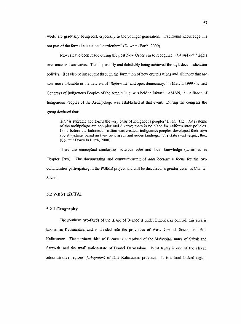
93
world are gradually being lost, espeeially to the younger generation. Traditional knowledge...is
not part of the formal educational curriculum” (Down to Earth, 2000).
Moves have been made during the post New Order era to recognize adat and adat rights
over ancestral territories. This is partially and debatably being achieved through decentralization
policies. It is also being sought through the formation of new organizations and alliances that are
now more tolerable in the new era of 'Reformasi' and open democracy. In March, 1999 the first
Congress of Indigenous Peoples of the Archipelago was held in Jakarta. AMAN, the Alliance of
Indigenous Peoples of the Archipelago was established at that event. During the congress the
group declared that:
Adat is supreme and forms the very basis of indigenous peoples’ lives. The adat systems of the archipelago are complex and diverse; there is no place for uniform state policies. Long before the Indonesian nation was created, indigenous peoples developed their own social systems based on their own needs and understandings. The state must respect this. (Source: Down to Earth, 2000)
There arc conceptual similarities between adat and local knowledge (described in
Chapter Two). The documenting and communicating of adat became a focus for the two
communities participating in the PGIMS project and will be discussed in greater detail in Chapter
Seven.
5.2 WEST KUTAI
5.2.1 Geography
The southern two-thirds of the island of Borneo is under Indonesian control; this area is
known as Kalimantan, and is divided into the provinces of West, Central, South, and East
Kalimantan. The northern third of Borneo is comprised of the Malaysian states of Sabah and
Sarawak, and the small nation-state of Brunei Damssalam. West Kutai is one of the eleven
administrative regions {kabupaten) of East Kalimantan province. It is a land locked region
94
spanning the equator and located upstream along the River Mahakam (see Figure 5.2). The
regional capital of West Kutai is Melak.
Figure 5.2 RadarSat composite image showing the boundary of West Kutai on the island of Borneo
West Kutai is approximately 3.3 million hectares in size and is further divided into 15
subregions {kecamatan) and 205 villages {kampung). O f the total area 1,481,000 hectares is
assigned to production forest, 744,000 hectares to unopened forest and 5,500 hectares to protected
forest. The remaining 932,000 hectares is assigned as non-forest cultivation, which includes
agriculture (KK-KPD, 2001). Agriculture is primarily shifting rice swidden {ladang), although
reeent statistics indicate 34,000 heetares is now being farmed under intensive wet rice (sawah)
(KK-KPD, 2001). West Kutai is highly dependent on its natural resource base. Mining provides
43% of the region’s income and forestry and agriculture 30% (KK-KPD, 2001).
The entire region remains difficult to access from the outside. The primary means of
transport to and from Samarinda, the nearest large urban eentre and eapital city of East
Kalimantan, is by a 20 hour boat journey. A partially metalled road links the region to the outside
world, but it is unusable for a large part of the year because of seasonal flooding and rains. There
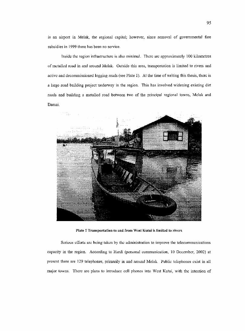
95
is an airport in Melak, the regional capital; however, since removal of governmental fare
subsidies in 1999 there has been no service.
Inside the region infrastructure is also minimal. There are approximately 100 kilometres
of metalled road in and around Melak. Outside this area, transportation is limited to rivers and
active and decommissioned logging roads (see Plate 1). At the time o f writing this thesis, there is
a large road building project underway in the region. This has involved widening existing dirt
roads and building a metalled road between two of the principal regional towns, Melak and
Damai.
Plate 1 Transportation to and from West Kutai is limited to rivers
Serious efforts are being taken by the administration to improve the telecommunications
capacity in the region. According to Hardi (personal communication, 10 December, 2002) at
present there are 129 telephones, primarily in and around Melak. Public telephones exist in all
major towns. There are plans to introduce cell phones into West Kutai, with the intention of
96
having a telephone in every village in the region, without the expense of having to lay telephone
cables. There are also plans to develop a regional television station and to open up an internet
café.
Electricity production using oil fired generators is a relatively new development in the
region. The major towns and some adjoining villages are now on the grid, but in many more
remote villages electricity is still not available.
Recent developments in access to computers in West Kutai have been striking. During
the course of the research project (1999 - 2002) the region went from having virtually no
computer services available to three computer rental/repair shops and four private computer
training schools.
In West Kutai primary schools are available in or close to most villages. Junior and
senior high schools are located in the major towns. However, the quality of the education offered
is not considered to be high. Many families with the financial means send their children to
Samarinda for high school education. In May 2000 a university was established in Melak. At the
time of writing this thesis there were 400 students enrolled in part time courses and 70 members
of the teaching faculty. The rector D. Wilson (personal communication, 8 December, 2002)
states that 50% of these students are government officials.
5.2.2 Ethnicity
The total population of West Kutai stands at 156,423 (KK-PKD, 2001). O f this
population, 90% are Dayak. The term Dayak - literally meaning ‘those of the upriver’ (Hopes et
a l, 1997) - is used to denote collectively all the indigenous ethnic groups who inhabit the inland
areas of the island of Borneo. The Committee for the Development of the Dayaks of East
Kalimantan (PDKT) (personal communication, 10 October, 1999) notes that there are a total of
12 distinct ethnic Dayak groups in West Kutai. The Benuaq and Tunjung, two closely related
ethnic Dayak groups, dominate the downstream and administrative areas of the region.
97
According to M. Hopes (personal communication, 15 July, 2001) these groups have a
disproportionately large influence in the regional and provincial government, and in decision
making mechanisms.
There also exist several transmigration sites comprised of people transferred to this area
in the New Order era; these people are primarily from the islands of Java and Madura. Their sites
tend to be located close to the region’s major towns.
5.2.3 Political history
5 .23 .1 B efore decentralization
During the periods of Dutch colonialism and subsequent eentralized Indonesian
governments, Dayak groups struggled to maintain their traditional culture and their primarily
agricultural and forest-based way of life. From the immediate post-colonial period until January
r ‘, 2001, West Kutai was a part of Kutai, a much larger region administered from Tenggarong, a
town 200 kilometres downstream from Melak (see Figure 5.3). The regional government at this
time was to a large part controlled by the central Jakarta-based government. This government,
staffed mainly by non-Dayak appointees, was physically and culturally far removed from local
Dayak communities. As a result the government did little for the Dayak people, instead
supporting the appropriation of valuable natural resources by the dominant outsider ethnic groups
and economic elites for their own material benefit (see Dove, 1993). The government perceived
Dayaks as backward and actively intervened to ‘develop’ them; for example by supporting
communities to move out of ‘primitive’ traditional longhouse settlements into individual houses
(Conner, 2000).

98
Melak
^ - r Benung" T enggarok^^ —
V‘ ’■" Sam arindaoTepulang ...
KÊÉÉ WÈÊÉÊMKf''' ' ' "
0 mi
Figure 5.3 Map showing location of Tenggarong; the old regional capital; Melak, the new capital; and the two village research sites, Benung and Tepulang
5.2.3.2 D ecentralization
As a result of Law 22/1999 on Regional Governance, Kutai was subdivided into three
regions, of which West Kutai was one. West Kutai was officially created on 1 January, 2001.
This entailed the formation of a whole new regional government and legislative assembly as well
as the mechanisms, infrastructure and regulations needed to ensure they could run effectively.
The new government inherited a non-existent industrial base, an outdated infrastructure and was
desperately short of locally bom public servants with the requisite qualifications and experience.
Despite this, the region’s population was very supportive of the new administration. The main
reason for their enthusiasm was that for the first time their government consisted mainly of
people from their own ethnic groups. The government was physically closer to most o f the
population and could be accessed, lobbied and held accountable for their actions.
On 28 March, 2001, Rama Alexander Asia, a Benuaq Dayak with a strong record of
public service, was instated as the first Bupati or regent of West Kutai, after a sweeping election
victory (see Plate 2). His inaugural ceremony was attended by thousands of people from
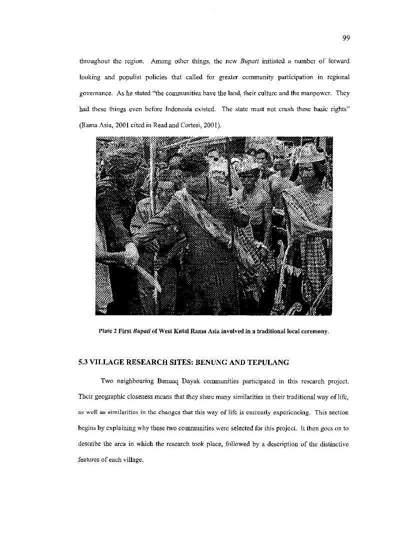
99
throughout the region. Among other things, the new Bupati initiated a number o f forward
looking and populist policies that called for greater community participation in regional
governance. As he stated “the communities have the land, their culture and the manpower. They
had these things even before Indonesia existed. The state must not crush these basic rights”
(Rama Asia, 2001 cited in Read and Cortesi, 2001).
Plate 2 First Bupati of West Kutai Rama Asia involved in a traditionai locai ceremony.
5.3 VILLAGE RESEARCH SITES: BENUNG AND TEPULANG
Two neighbouring Benuaq Dayak communities participated in this research project.
Their geographic closeness means that they share many similarities in their traditional way o f life,
as well as similarities in the ehanges that this way of life is currently experiencing. This section
begins by explaining why these two communities were selected for this project. It then goes on to
describe the area in which the research took place, followed by a description of the distinctive
features of each village.
100
5.3.1 Site choice
From October to December of 1999, visits were made to West Kutai and Malinau, two
regions in the province of East Kalimantan, to identify potential NGOs and communities to
collaborate with in this research project. It soon became apparent that the NGO Sistem Hutan
Kerakyatan (SHK), or the Consortium for the Revitalisation o f Traditional Forest Management
Systems, would be a good partner organisation. SHK is a well-respected institution that has
worked extensively in West Kutai, whereas there is no equivalent NGO working in the region of
Malinau. Many SHK members are themselves Benuaq Dayak from West Kutai; they therefore
understand the local customs and culture, have an appreciation for the challenges faced by the
local communities, and are able to speak the local Bahasa Benuaq. This, plus other social
(Malinau communities were larger and more complex and were experiencing more internal
conflict) and logistical reasons (West Kutai was relatively more accessible) made working in
West Kutai with SHK a logical choice. Discussions with SHK about research plans, combined
with previous experience in working together with the author, led to their agreement to
collaborate in this project. It is recognised by the author that these special relationships described
above do affect the replicability of this research.
The researcher decided to work with two communities in order to have some form of
comparative analysis. The neighbouring villages of Benung and Tepulang were chosen because
they had an existing working relationship with SHK, which has maintained a field station in the
village of Tepulang since 1997. This station was staffed by a SHK field manager, Rudi Ignatius,
a person highly valued in the community and involved in village activities and decision-making
processes. It was anticipated that working in these communities would help to minimize risks of
failure and shorten the time needed for the start-up of the project. To work in ‘new’ communities
would have required a longer process of gaining familiarity and building trust between the
researcher and the communities.
101
Another advantage to working with these villages was that both Benung and Tepulang
already possessed maps of their traditional territories. These maps could be used as base maps
for the PGIMS project, again saving much valuable time for the research team.
Geographically the two villages are located approximately seven kilometres apart.
Culturally they are comprised of people from the same Benuaq Dayak ethnic group; they also
share family links through intermarriage. The many similarities between the two villages were
felt to be an advantage to this research project, as it limited the possible causes of any observed
differences in their responses to the introduction of this project. The most noticeable differences
between the communities are in their dwelling types, demographic composition, educational
levels, political leadership, decision-making process and political representation outside of the
village. These differences will be described in more detail in Section 5.3.4 below.
5.3.2 The Benuaq Dayak culture
5.3.2.1 Geography
The Benuaq are based in a well-defined geographic area in the mid Mahakam region of
West Kutai. The two villages of Benung and Tepulang are located approximately 250 km west o f
the provincial capital Samarinda, close to the River Idaatn, a small tributary of the larger Kedang
Pahu Hulu watershed (see Figure 5.3 above). Compared to some Dayak groups inhabiting the
island of Borneo, the Benuaq are relatively small in numbers. There are no government statistics
on their total numbers, although Rama A. (personal communication, 16 June, 2001) believes the
number to be around 25,000.
5.3.2.2 Traditional land a nd resource m anagem ent
The Benuaq are traditionally rural swidden {ladang) agriculturalists. For many Benuaq,
as indeed for all non-nomadie Dayak groups, rice holds a very prestigious position in their
culture. It is “the source of life and its cycle is heavily accompanied by taboos and rituals”
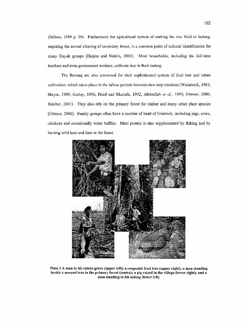
102
(Sellato, 1989 p. 39). Furthermore the agricultural system of making the rice field or ladang,
requiring the annual clearing of secondary forest, is a common point of cultural identification for
many Dayak groups (Herjon and Natalis, 2001). Most households, including the full-time
teachers and even government workers, cultivate rice in their ladang.
The Benuaq are also renowned for their sophisticated system of fruit tree and rattan
cultivation, which takes place in the fallow periods between rice crop rotations (Weinstock, 1983;
Mayer, 1989; Godoy, 1990; Fried and Mustafa, 1992; Abdoellah et a l, 1993; Conner, 2000;
Belcher, 2001). They also rely on the primary forest for timber and many other plant species
(Conner, 2000). Family groups often have a number of head of livestock, including pigs, cows,
chickens and occasionally water buffalo. Meat protein is also supplemented by fishing and by
hunting wild boar and deer in the forest.
Plate 3 A man in his rattan grove (upper left); a cempedak fruit tree (upper right); a man standing beside a meranti tree in the primary forest (centre); a pig raised in the village (lower right); and a
man standing in his ladang (lower left)
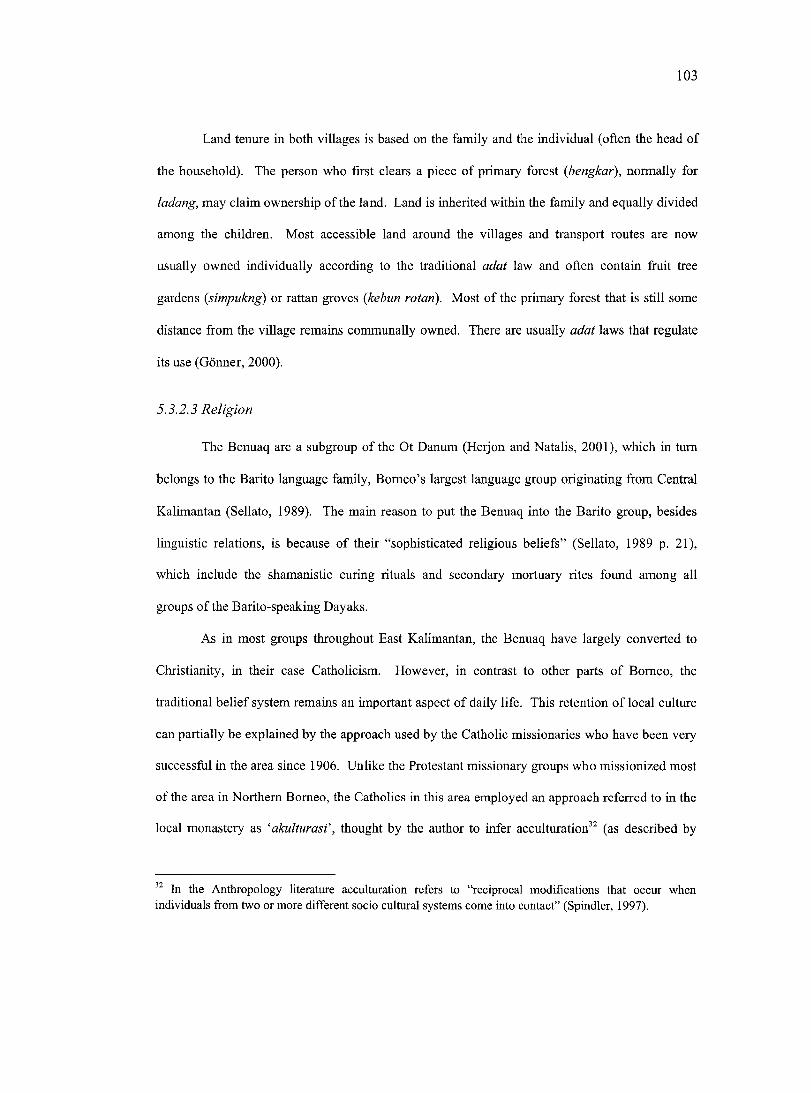
103
Land tenure in both villages is based on the family and the individual (often the head of
the household). The person who first clears a piece of primary forest (bengkar), normally for
ladang, may claim ownership of the land. Land is inherited within the family and equally divided
among the children. Most accessible land around the villages and transport routes are now
usually owned individually according to the traditional adat law and often contain fruit tree
gardens {simpukng) or rattan groves (kebun rotan). Most of the primary forest that is still some
distance from the village remains communally owned. There are usually adat laws that regulate
its use (Conner, 2000).
5.3.2.3 Religion
The Benuaq are a subgroup of the Ot Danum (Herjon and Natalis, 2001), which in turn
belongs to the Barito language family, Borneo’s largest language group originating from Central
Kalimantan (Sellato, 1989). The main reason to put the Benuaq into the Barito group, besides
linguistic relations, is because of their “sophisticated religious beliefs” (Sellato, 1989 p. 21),
which include the shamanistic curing rituals and secondary mortuary rites found among all
groups of the Barito-speaking Dayaks.
As in most groups throughout East Kalimantan, the Benuaq have largely converted to
Christianity, in their case Catholicism. However, in contrast to other parts of Borneo, the
traditional belief system remains an important aspect of daily life. This retention of local culture
can partially be explained by the approach used by the Catholic missionaries who have been very
successful in the area since 1906. Unlike the Protestant missionary groups who missionized most
of the area in Northern Borneo, the Catholics in this area employed an approach referred to in the
local monastery as ‘akulturasf, thought by the author to infer acculturation^^ (as described by
In the Anthropology literature acculturation refers to “reciprocal modifications that occur when individuals from two or more different socio cultural systems come into contact” (Spindler, 1997).
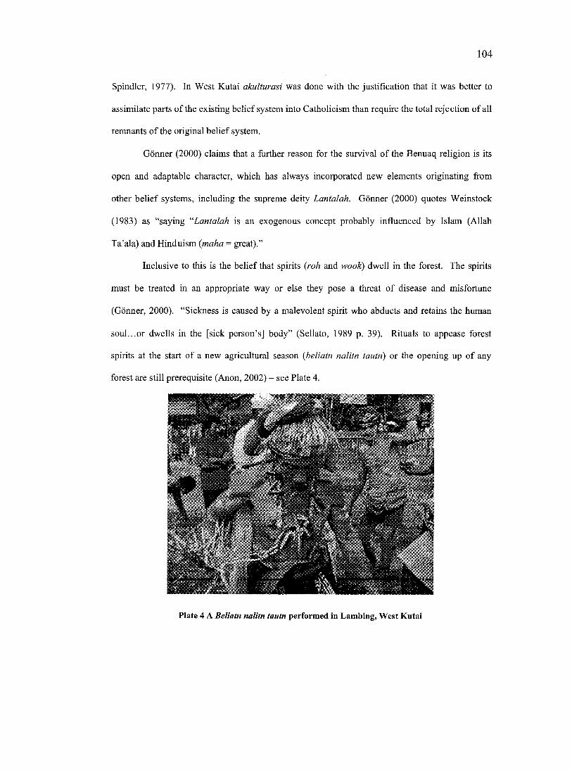
104
Spindler, 1977). In West Kutai akulturasi was done with the justification that it was better to
assimilate parts of the existing belief system into Catholicism than require the total rejection of all
remnants of the original belief system.
Conner (2000) claims that a further reason for the survival of the Benuaq religion is its
open and adaptable character, which has always incorporated new elements originating from
other belief systems, including the supreme deity Lantalah. Conner (2000) quotes Weinstock
(1983) as “saying “Lantalah is an exogenous concept probably influenced by Islam (Allah
Ta’ala) and Hinduism {maha = great).”
Inclusive to this is the belief that spirits (roh and wook) dwell in the forest. The spirits
must be treated in an appropriate way or else they pose a threat o f disease and misfortune
(Conner, 2000). “Sickness is caused by a malevolent spirit who abducts and retains the human
soul...or dwells in the [sick person’s] body” (Sellato, 1989 p. 39). Rituals to appease forest
spirits at the start of a new agricultural season {beliatn nalitn tautn) or the opening up o f any
forest are still prerequisite (Anon, 2002) - see Plate 4.
IPlate 4 A Beliatn nalitn tautn performed in Lambing, West Kutai
105
The Benuaq perform secondary mortuary rites {kwangkai) on a person’s remains any time
up to one year after death. The timing of the ritual depends more on the ability of the family of
the deceased to organize and give an impressive and expensive feast. It is the expense of the
kwangkai in the past that has limited its practice to wealthy families (Sellato, 1989). Besides their
ceremonial focus, including the nightly recitation of myths (temputn^^) (Hopes et al., 1997), the
kwangkai are great social events (Conner, 2000). They attract people from throughout the area,
especially at the time of the final sacrifice of the water-buffalo(s), which can range in number
from 1 to as many as 20 (see Plate 5), where the more valuable the sacrifice, the better the
position of the deceased in the afterworld (Sellato, 1989). Hundreds of guests congregate to
gamble at tongkok?'^ or cock-fighting {saukng piaq) or simply to meet with family and friends.
Conner (2000) notes that much of the previous year’s income is redistributed during these events.
Plate 5 Buffalo sacrifice during Kenyan ceremony
Temputn are myths that recount the history of the world and "the complex and ambivalent relationships that exist between humans and different groups of spirits” (Hopes et al., 1997 p.l). They have been passed between generations. Yet they are not simply narratives, they actively seek to influence outcomes by encouraging the intercession of spirits in real world events. Furthermore they “encapsulate “the most fundamental concepts and beliefs that animate Benuaq.. .Dayak culture” (Hopes et ai, 1997 p.2).
A game of chance involving gambling on the probability of your side of a square being chosen by a coloured cube.
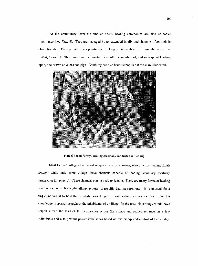
106
At the community level the smaller belian healing ceremonies are also of social
importance (see Plate 6). They are managed by an extended family and shamans often include
close friends. They provide the opportunity for long social nights to discuss the respective
illness, as well as other issues and culminate often with the sacrifice of, and subsequent feasting
upon, one or two chickens and pigs. Gambling has also become popular at these smaller events.
I
Plate 6 Belian Sentiyu healing ceremony conducted in Benung
Most Benuaq villages have resident specialists, or shamans, who practice healing rituals
{belian) while only some villages have shamans capable of leading secondary mortuary
ceremonies {kwangkai). These shamans can be male or female. There are many forms of healing
ceremonies, as each specific illness requires a specific healing ceremony. It is unusual for a
single individual to hold the ritualistic knowledge of most healing ceremonies; more often the
knowledge is spread throughout the inhabitants of a village. In the past this strategy would have
helped spread the load of the ceremonies across the village and reduce reliance on a few
individuals and also prevent power imbalances based on ownership and control of knowledge.
107
These ceremonies are generally quite taxing on the time and energy o f the shaman as they require
almost total dedication to the ceremony for anything from three to fifteen days. Some of the
larger ceremonies, including the kwangkai, can last months (Hopes et al., 1997).
5.3.2.4 Social structure
Traditionally the Benuaq society was divided into three social strata. These were the
mantitq (aristocrats) consisting of the village headman and his core family, who had power and
privileges associated with the title and who ruled what was until post independence Indonesia
autonomous village communities; marantika (commoners) who made up the bulk of the village
population and ripatn (slaves). Slaves were most often bought by the Benuaq for sacrifice, as
traditionally they were less warlike than other groups and they rarely hunted heads like other
Dayak groups throughout Borneo (Sellato, 1989). Today, the family descendency is said to be
only of minor importance, but it is well remembered and occasionally used as an argument during
the election of village chiefs (Conner, 2000).
The traditional leadership of the mantiiq was divided by the Indonesian government into
a dual system consisting of a political leader (kepala desa - literally translated as village head)
and a traditional leader {kepala adat or traditional head). Decisions of public interest are usually
made in village meetings {berinuq), where a consensus is sought through long discussions.
Nevertheless, conflicts remain common in all villages, sometimes reflecting the rivalry between
the kepala desa and the kepala adat (Conner, 2000).
5.3.2.5 G ender roles
In Benuaq communities gender roles can be delineated, but there are numerous
exceptions to this rule. In terms of daily subsistence tasks, men and women are both capable of
undertaking most tasks, even though they may tend to focus on different activities. For example,
men tend to do more of the heavier labour, such as carrying loads or cutting down trees.
108
Generally speaking, women play a larger part than men in subsistenee aetivities such as
cooking, washing, child-rearing, livestock maintenance and rice, vegetable and fruit cultivation
(Golfer, 1997). The main reason for this is that men are more likely to be involved in the cash
economy, whether as laborers for the timber companies or mines, or as growers of cash crops
such as rubber or rattan. Taking work as labourers can keep men away from the community for
long periods of time.
Women do not play as important a role in decision-making as men, although they
regularly also attend community meetings. During meetings that require comments or decision
making, women are often hesitant to contribute and when they do they will often speak some time
after men have already contributed their ideas. This is true even for the educated women,
although they tend to have more confidence than the less educated women.
Women in both communities tend to be more outspoken in domestic/internal decision
making processes involving issues that affect their daily activities, for instance organising
community activities such as belian ceremonies, church activities, or the sale o f livestock or fruit
and vegetables. M. Stockdale (personal communication, 21 February, 2001) noted that when
outsiders come to the community it tends to be the men who address them in the meetings. In
activities that involve informing or negotiating with parties from outside of the village (i.e.
government, NGOs, or logging or mining companies), women will leave the talking to the men.
Although certain women might attend and even contribute to meetings in the village that include
outsiders, they will rarely represent the community outside of the village in a role that requires
decision-making about important matters.
5.3.2.6 The longhouse
In the past, primarily as a form of defensive strategy, many Dayak groups lived in heavily
fortified settlements “developed by a core of kin-related people” (Sellato, 1989 p. 24). These
often took the form of a longhouse, the traditional, although not pervasive, Dayak dwelling.
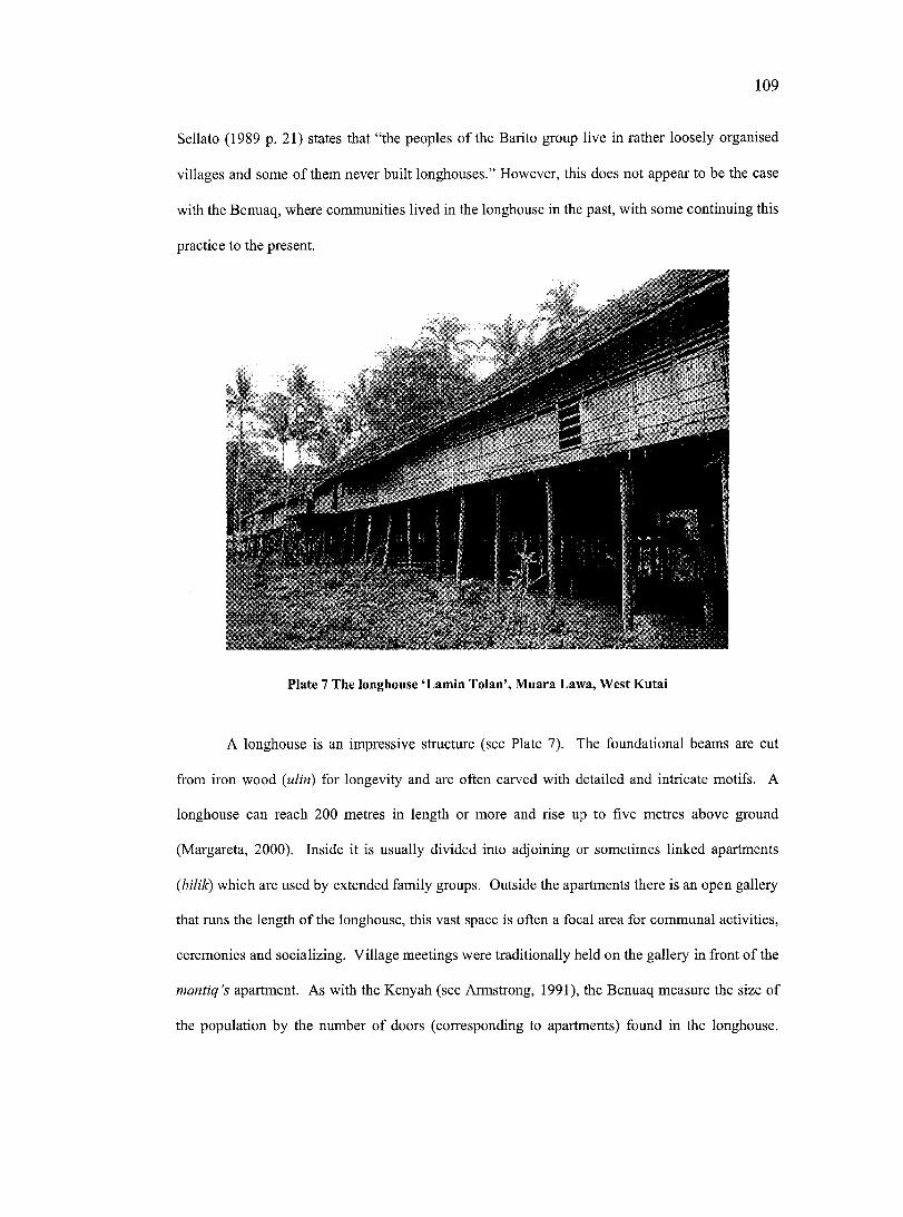
109
Sellato (1989 p. 21) states that “the peoples of the Barito group live in rather loosely organised
villages and some of them never built longhouses.” However, this does not appear to be the case
with the Benuaq, where communities lived in the longhouse in the past, with some continuing this
practice to the present.
Plate 7 The longhouse ‘Lamin Tolan’, Muara Lawa, West Kutal
A longhouse is an impressive structure (see Plate 7). The foundational beams are cut
from iron wood {ulin) for longevity and are often carved with detailed and intricate motifs. A
longhouse can reach 200 metres in length or more and rise up to five metres above ground
(Margareta, 2000). Inside it is usually divided into adjoining or sometimes linked apartments
{bilik) which are used by extended family groups. Outside the apartments there is an open gallery
that runs the length of the longhouse, this vast space is often a focal area for communal activities,
ceremonies and socializing. Village meetings were traditionally held on the gallery in front of the
mantiq’s apartment. As with the Kenyah (see Armstrong, 1991), the Benuaq measure the size of
the population by the number of doors (corresponding to apartments) found in the longhouse.
110
“Each family owns the materials of its apartment and section of gallery, however, the whole
community is responsible for the spiritual welfare of the longhouse” (Sellato, 1989 p. 25).
5.3.3 Cultural change
“No culture is impervious to change. No culture today is as it has always been. A ll cultures
change, and fo r a variety o f reasons ”
Naylor, 1996 p. 1
Naylor (1996 p. 1) states that “in situations of contacts between vastly different types of
culture, new ideas and changing aspirations will insure that change will occur.” The Benuaq
people, as well as other ethnic groups in the region of West Kutai, are currently going through
rapid social and cultural transformation. Within the time period of a single generation there have
been unprecedented changes. These changes are related to the intentional imposition of new
values on these people through the centralized New Order governance system, environmental
change, manipulative edueation systems, religious missionizing and state-controlled media. It is
also due in part to much wider social changes resulting from inception of the cash economy,
globalization and related ideologies. Some of the more prominent changes to Benuaq culture
include a crisis in community cohesion, rising intra and inter community conflict centering on
resources and a decline in practice and respect given to adat - particularly by the younger
generations (Herjon and Natalis, 2001).
5.3.3.1 Individualism a nd com m unity cohesion
Traditionally Benuaq life had a cohesive social organization which allowed for efficient
collective action. This communality manifested itself both ritualistically and through more
practical activities such as shared construction and agricultural harvesting. The community’s
mutual dependency is furthermore symbolised by the nature of the longhouse settlement.
However, individualism is a rising tendency among the Benuaq. People are less prepared to take
I l l
part in communal activities (referred to as gotong royong in Bahasa Indonesia) and less inclined
to share resources and tools, unless a cash payment is made. As Margareta (2000 p. 25) states “it
is not difficult to build a longhouse. The most difficult thing is finding people who are
enthusiastic to work together.”
5.3.3.2 In tra a nd inter com m unity resource conflict
There is little doubt of the profound impact of the introduction of the cash economy in
bringing about change and conflict. This has motivated individuals to place their short term gain
over long term communal objectives. This, combined with a changing political environment, has
led to the current conflict over timber.
During the early pre-colonial trading period of Borneo's history there existed neither the
technology nor the desire to remove timber from the forest. The forest was more valuable in its
pristine state because of the non-timber forest products provided by it. During the New Order
regime however, trees became known as ‘green gold’. Timber was extracted and sold by large
logging companies and the local people realized few of the benefits from its sale.
Due to the authoritarian nature of the state, resistance to this model was dangerous for
local communities. Of importance during this period was that local communities began to realize
the economic value of the timber. They also acquired the technologies and requisite skills to
harvest this timber. During the post New Order period and subsequent transition towards
decentralization many local communities took advantage of the uncertainty regarding the forest
ownership status and began to harvest timber from ancestral lands and to sell this timber into a
newly emergent processing and marketing chain.
The social impacts from this change have been far reaching. Conflict has arisen between
neighbouring communities over boundaries. L. Wollenberg (personal communication 10
September, 2000) noted that previously inter-community boundaries tended to be fuzzy, now
because of the economic implications local communities feel they need to be accurately mapped
112
and enforced. Even so, illegal logging between communities is rampant. Furthermore conflict is
not confined with other communities; it has also spread itself within eommunities. Conflict can
be sparked by individuals laying claim to areas of forest to the exclusion o f other members of the
community. Polarization within a community can also stem from decisions made over how to
divide the income generated from such activities amongst people in the community.
5.3.3.3 The state o f adat
One of the most prevalent cultural changes occurring presently in West Kutai is the
decline in adat institutions and practice. Traditionally amongst the Benuaq, generational
precedence is a determining factor in establishing social authority. “Elders enjoy degrees of
prestige and power from which juniors are excluded” (Hopes et al., 1997 p. 3). Hopes et al.
(1997) go on to state that to a large part this power is institutionalized through possession of
knowledge about adat acquired only after long apprenticeship. However, after 35 years of
repression, adat and the institutions that maintain it have lost support and are not as valued by the
younger generations. This is due in great part to younger generations being heavily influenced by
external value systems (Herjon and Natalis, 2001). Adat ceremonies, including the kwangkai,
have become associated with syndicated gambling and prostitution rackets, demeaning their role
in the eyes of the general public. Belian are still being practiced, but there are very few younger
people, especially if they have a high school edueation or higher, who want to learn the
ceremonies.
Respect for elders has declined because of a more egalitarian view of society; new elites
are emerging in the form of public servants, school teachers, successful business people and
educated youth coming back into the area after being educated downstream. Church is also
filling the role left behind by adat, as they are also effective in initiating collective activities and
are becoming symbols for social identification.
113
Furthermore local languages are miscegenating with Bahasa Indonesia. Brush (1996)
states that “language and culture are repositories of information gained through evolution...[and
they] have incalculable value to present and future generations” (p. 5). Brush (1996) directly
links the loss of language with the loss of knowledge.
There is a growing recognition of these social and cultural changes by the new
administration within West Kutai and regionally operating local NGOs and other community
groups. From this has arisen an apparent willingness to address and resolve these problems. The
government is assisting in re-establishing adat institutions, such as the Dewan Adat, and granting
them substantial decision-making and legislative power. Presently new legislation is being
proposed to remove gambling and prostitution from adat ceremonies and concentrate them in one
area of the region that can be controlled and taxed by the government (Anon, 2002).
5.3.4 Site description
5.3.4.1 Benung
The traditional territory of the village of Benung covers approximately 3,993 hectares.
The area is flat and dominated by lowland dipterocarp forests; other land use types include rice
fields, fruit tree gardens, rattan gardens, rubber plantations and other managed secondary forest.
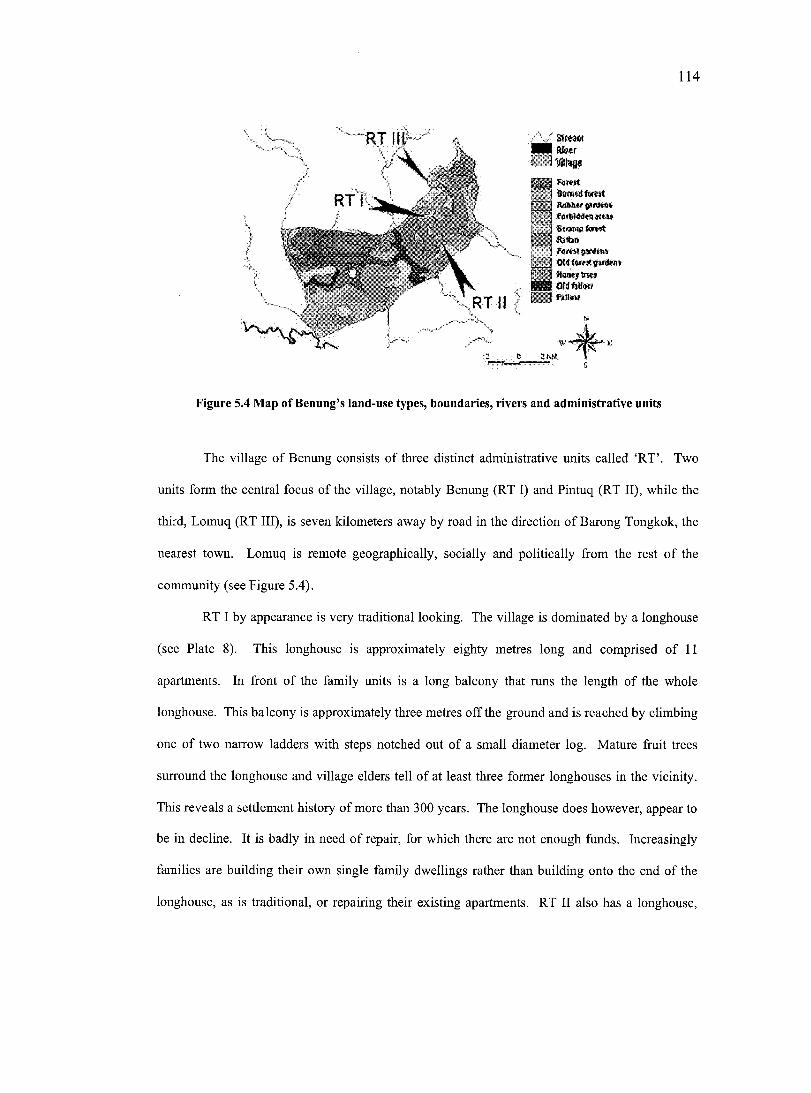
114
-RT I :I N k * r
Ftn«MSmWtnwl
r r l RuMwgiM*#» PuitWdmwM»
I Slump testI Rstb#
fa**#*#**
RTII/
^ Wmwy&w* NN OWWbM*m w*##
Figure 5.4 Map of Benung’s land-use types, boundaries, rivers and administrative units
The village of Benung eonsists of three distinct administrative units called ‘RT’. Two
units form the central foeus of the village, notably Benung (RT I) and Pintuq (RT II), while the
third, Lomuq (RT III), is seven kilometers away by road in the direction o f Barong Tongkok, the
nearest town. Lomuq is remote geographically, socially and politically from the rest o f the
community (see Figure 5.4).
RT I by appearance is very traditional looking. The village is dominated by a longhouse
(see Plate 8). This longhouse is approximately eighty metres long and comprised of II
apartments. In front of the family units is a long balcony that runs the length of the whole
longhouse. This balcony is approximately three metres off the ground and is reached by climbing
one of two narrow ladders with steps notched out of a small diameter log. Mature fruit trees
surround the longhouse and village elders tell of at least three former longhouses in the vicinity.
This reveals a settlement history of more than 300 years. The longhouse does however, appear to
be in decline. It is badly in need of repair, for which there are not enough funds. Increasingly
families are building their own single family dwellings rather than building onto the end of the
longhouse, as is traditional, or repairing their existing apartments. RT II also has a longhouse.
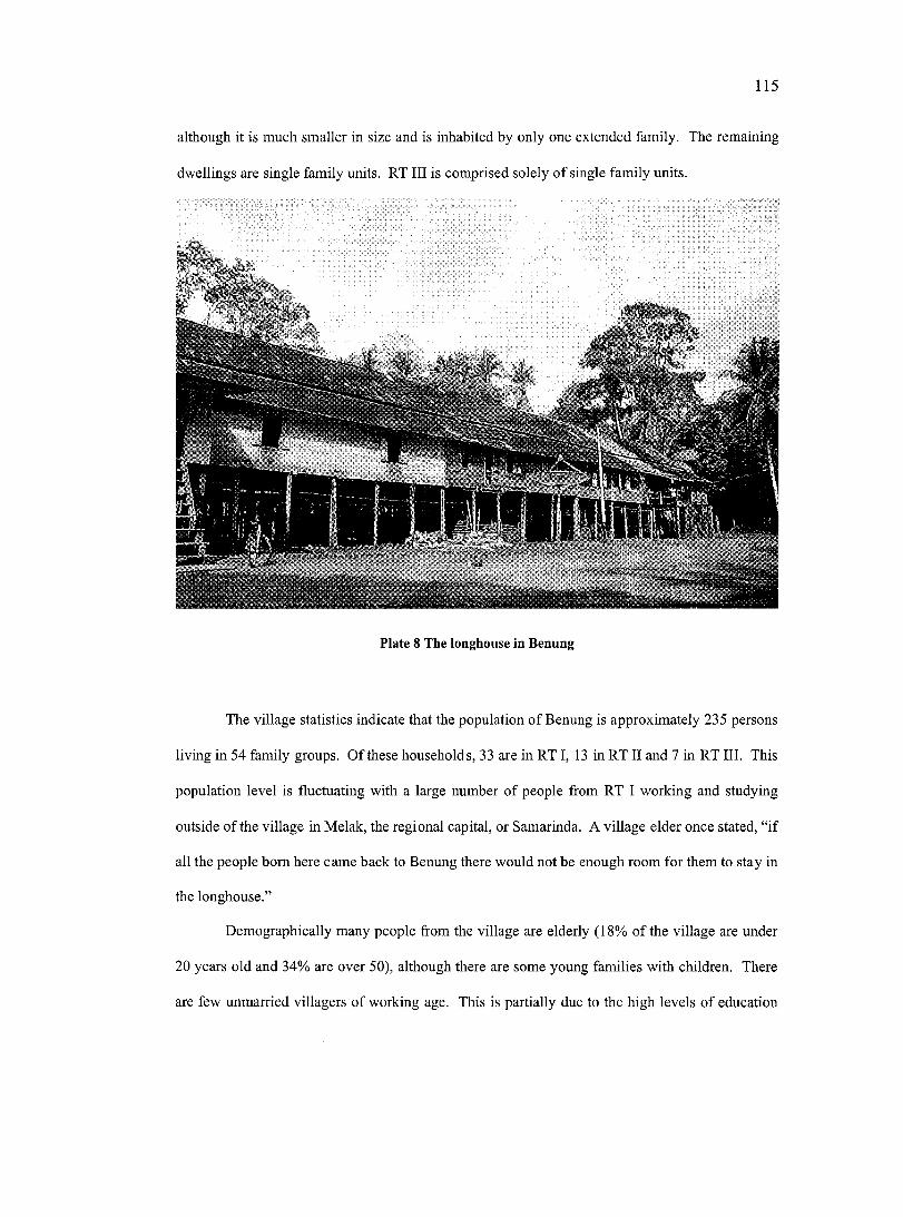
115
although it is much smaller in size and is inhabited by only one extended family. The remaining
dwellings are single family units. RT III is comprised solely of single family units.
I »
Plate 8 The longhouse in Benung
The village statistics indicate that the population o f Benung is approximately 235 persons
living in 54 family groups. Of these households, 33 are in RT I, 13 in RT II and 7 in RT III. This
population level is fluctuating with a large number of people from RT I working and studying
outside of the village in Melak, the regional capital, or Samarinda. A village elder once stated, “if
all the people bom here came back to Benung there would not be enough room for them to stay in
the longhouse.”
Demographically many people from the village are elderly (18% of the village are under
20 years old and 34% are over 50), although there are some young families with children. There
are few unmarried villagers of working age. This is partially due to the high levels of education
116
in the village (43% of people had a high school education and a further 8% had a university
diploma or degree) which have led to many villagers finding work in the regional and provincial
centres (22% of the village were living and working outside of the community in West Kutai and
a further 18% outside of West Kutai in Samarinda and as far away as Java). A number of reasons
can explain the higher importance placed in education. Benung is a longer established village
than Tepulang, and contains more people of aristocratic origin. M. Hopes (personal
communication, 15 November, 2000) believes that it was for this reason that the Dutch
missionaries in pre-independence times focused their education efforts on the children of Benung.
This highly educated population has given Benung considerable political clout for a small
community, as some of the leading political figures regionally and provincially are from the
village.
A difference noticed between the two villages at the time the research project was in the
style of their leadership and decision-making process. In Benung, the Kepala Desa was widely
respected by the community and had been made leader by popular vote. However, in village
meetings, decisions were made in a more traditional rather than democratic manner. The younger
men and the women did not contribute much to the discussion whereas the most senior and
important of the men would be given the opportunity to offer their opinions. In the end, however,
even they would defer to decisions made by their official leader.
The population is comprised almost entirely of Benuaq people (99%), although there is
some intermarriage with people from outside the village, tribe and in a few instanees from other
islands in Indonesia. According to village statistics, 72% are Catholic, 19% are members of
various Protestant churches and 9% were of no religious denomination (these people tended to be
over 50 years in age).
There is an elementary school located on the road between RT I and RT II. The school
serves children ages 7-13 from RT I, RT II and Tepulang. The school is popular among most
families in the village, although some of the more wealthy families send their children away for
117
schooling in Melak, Barong Tongkok and occasionally Samarinda. Many of the school teachers
were bom in either Benung or Tepulang and are already a part of the community.
The electricity grid arrived in the village in mid 1999, approximately three months prior
to the research project commencing. Before that, electricity was confined to a few hours in the
evening, and came from a diesel generator. Electricity is used to pump up water into the
longhouse, for lighting and more recently for watching television and video compact discs
(VCDs). Water is piped in from seven kilometers away. It is taken from above a waterfall and
brought to the village reservoir by gravity flow. Individual families will take water for their
needs directly from the reservoir. During the dry season (from July until September) the pipe
runs dry and villagers have to walk a kilometre to a nearby spring which always has water.
Until recently transport to the village from the regional centres meant a tortuous and
bumpy 12 kilometre journey through the forest. This was mostly by motorcycle, as cars could not
drive up some of the steeper hills, especially after rain. In June 2001 a wide road was bulldozed
into the area. People from the village are happy with the road because they now have better
access to the regional centres to buy and sell goods at the market and access government services
such as health care and high school education. RT I and RT II each have one small shop that
provides the villagers with basic necessities.
5.3.4.2 Tepulang
The traditional territory of the village Tepulang covers approximately 3,097 hectares.
The area is similar to Benung in land use types.
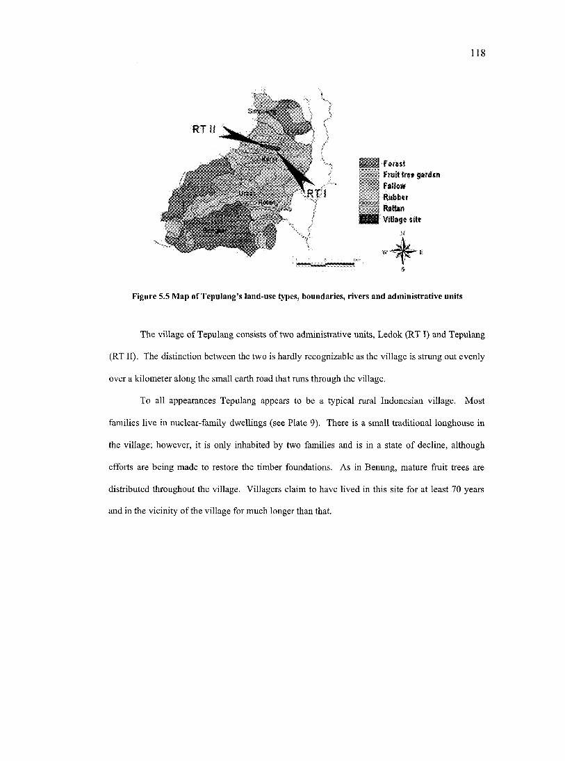
118
; F o re s t Fruittiî® gafd&m F allo w Hubbcr R a tta n VI8#g*
Figure 5.5 Map of Tepulang’s land-use types, boundaries, rivers and administrative units
The village of Tepulang consists of two administrative units, Ledok (RT I) and Tepulang
(RT II). The distinction between the two is hardly recognizable as the village is strung out evenly
over a kilometer along the small earth road that runs through the village.
To all appearances Tepulang appears to be a typical rural Indonesian village. Most
families live in nuclear-family dwellings (see Plate 9). There is a small traditional longhouse in
the village; however, it is only inhabited by two families and is in a state of decline, although
efforts are being made to restore the timber foundations. As in Benung, mature fruit trees are
distributed throughout the village. Villagers claim to have lived in this site for at least 70 years
and in the vicinity of the village for much longer than that.
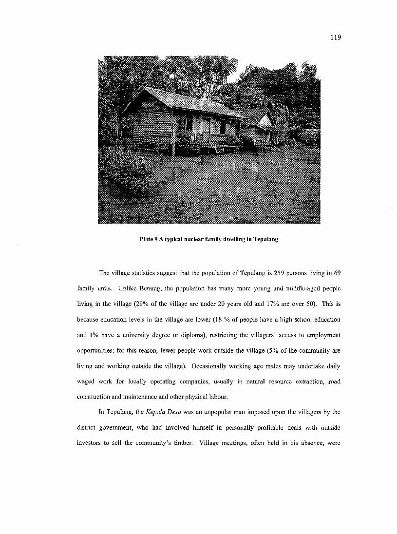
119
Plate 9 A typical nuclear family dwelling in Tepulang
The village statistics suggest that the population of Tepulang is 259 persons living in 69
family units. Unlike Benung, the population has many more young and middle-aged people
living in the village (29% of the village are under 20 years old and 17% are over 50). This is
because education levels in the village are lower (18 % of people have a high school education
and 1% have a university degree or diploma), restricting the villagers’ access to employment
opportunities; for this reason, fewer people work outside the village (5% of the community are
living and working outside the village). Occasionally working age males may undertake daily
waged work for locally operating companies, usually in natural resource extraction, road
construction and maintenance and other physical labour.
In Tepulang, the Kepala Desa was an unpopular man imposed upon the villagers by the
district government, who had involved himself in personally profitable deals with outside
investors to sell the community’s timber. Village meetings, often held in his absence, were
120
marked by strife between different factions. People would freely give their opinions and
decisions were often made, but follow-up was often poor since there was little feeling of
accountability due to a lack of official leadership.
The population is comprised almost entirely of Benuaq people (96%), although there is
some intermarriage with people from outside the village, but no instance with people from other
islands in Indonesia. There are also three groups of protestant missionaries in the village.
According to village statistics, 81% are Catholic, 16% are members of Protestant churches and
3% were of no religious denomination.
Children under the age of thirteen attend elementary school located on the road to
Benung. There is an additional very small school for children under the age of seven in the
village. This is attended solely by children from Tepulang and at the time of writing this thesis
had approximately ten students in attendance.
As in Benung, Tepulang was attached to the electricity grid in mid 1999. The same
improved road that has increased Benung’s access to outside towns also now passes through
Tepulang. Water is a very serious issue in Tepulang. There exist three springs in the village;
however, the village is located on top of a ridge, making it impossible to pipe water by gravity
flow into the village. During the dry season (from July until September) the springs regularly dry
out and water can become very scarce. The villagers at times have to walk four kilometres to a
nearby river to collect water. Attempts have been made to dig wells in the village, but with no
success. There are several small shops in the village that provide basic necessities.
121
C h a p t e r S i x :
D e s i g n i n g , Im p l e m e n t in g a n d E v a l u a t i n g t h e
PGIMS P r o j e c t
A PGIMS project was introduced in the villages of Benung and Tepulang in the district of West
Kutai, East Kalimantan, Indonesia. This chapter will describe how the PGIMS project was
designed (Section 6.1) and implemented (Section 6.2). It will go on to describe and evaluate the
PGIMS project, drawing out some of the differences between the two communities (Section 6.3).
6.1 DESIGNING THE PGIMS PROJECT
6.1.1 Selecting appropriate technologies for creating a PGIMS
6.1.1.1 C reating the initial concept
At the outset of the PGIMS project the researcher intended that information would be
gathered using digital video and camera equipment, stored on a computer, and managed and
accessed using an interactive Cartesian map. The interactive map interface enables the creator to
manage digital multimedia information by referencing it to a particular point, line or polygon on
the map. Thus the map acts as an organisational tool and allows the user to access this
information and so navigate through information associated with the represented geographic area.
GIS software contains the functionality to undertake the above task. However, the
expense of commercial GIS software, the high requirement for training, and the limitations in
support made it necessary to look for options with the functionality mentioned above, but without
the associated drawbacks of GIS software.
122
Hypertext Markup Language^^ (HTML) and more specifically ‘What You See Is What
You Get’ (WYSIWYG) authoring software^® was used. This software can create ‘hotspots’ on a
digital map image so that when the user clicks on an area on the map with their mouse cursor it
will link to and display text or multimedia information related to that site or area. This is a style
of information retrieval referred to as “hyper media” (Aitken and Michel, 1995).
Using WYSIWYG software allows the user to explore digital spatial data through the
interface of a map. However, maps displayed are not georeferenced, they are only visual
depictions. This means that the query and analytical functionality of GIS are sacrificed. The
WYSIWYG software cannot be used to measure distance or area, or execute the buffering and
overlay analytic commands found in GIS. Despite the loss in analytical functionality,
WYSIWYG software still maintained the management, storage, access and presentation
fimctionalities found in GIS software. The decision to use this software was made because it is
cheaper and easier to learn and operate than most GIS packages, and furthermore, the higher
analytical functionality of GIS was inappropriate for the presentation of local knowledge using
multimediafor the PGIMS project. The author speculated that by gaining mastery over the
WYSIWYG software participating communities would be able to take greater eontrol of the
system and therefore o f the information contained within it.
6.1.1.2 P ilo t pro ject
Between January, 1999 and April, 1999 a pilot project was developed in Canada that
combined digital Cartesian maps with multimedia information; this pilot PGIMS represented the
HTML is a simple computer language used to create hypertext (text with embedded hyperlinks) documents that are portable from one platform (operating system) to another. HTML files are simple ASCII text files with codes embedded (indicated by markup tags) to denote fonnatting and hypertext links.
WYSIWYG is Windows interface software commonly used to develop websites by users with no knowledge of HTML code. The software is cheap to purchase, readily available and requires substantially less training when compared with GIS software. Examples of WYSIWYG software include Adobe Pagemill®, Macromedia Dreamweaver® and Microsoft FrontPage®.
123
University of Victoria (UVic) disc golf course” and associated information. The project aimed to
provide a comprehensive and interactive representation of the course as well as allow the author
to gain familiarity with available tools and software. The pilot project linked multimedia imagery
(still photographs, video, 360 degree interactive panoramas and animated maps) to a digital map
of the university. This project was developed as part of a graduate level course ‘Geography
Internet 528: An intermediate level introduction to Geographical Information Systems’ taught by
Dr C. P. Keller at the University of Victoria.
The project was useful in allowing the author to test existing multimedia software and
choose those that were appropriate to PGIMS. It also helped to expose some of the weaknesses
and problems of using multimedia technologies in combination with maps. Firstly, multimedia
files are inherently large. Therefore sharing multimedia files, whether across the internet or using
other storage media, is limited. In order to overcome this weakness the computers to be used by
the PGIMS project would need to have the capability to copy and back-up large files; a compact
disc (CD) burner was considered an appropriate choice for this function. In addition, the
computers would need large quantities of hard-disk storage space. Secondly, to process, edit and
compress video data requires fast computer processing speeds. Computers used by the PGIMS
project therefore required high-end processor chips and large quantities (256 megabytes) of
Random Amplified Memory (RAM). Thirdly, the exponential development of multimedia
technology and software means that systems, software and skills require constant updating for the
user to keep up to the ‘state-of-the-arf. There was no simple solution to overcome this final
weakness.
” The sport of disc golf is similar to its more conventional cousin. Throwing a round shaped disc, a player has to go from the tee to the pin with as few throws as possible.
124
6.1.1.3 Equipment choice
The equipment used in the PGIMS project, both hardware and software, was intentionally
kept as simple as possible (for a full list of equipment and associated costs see Appendix E).
“State-of-the-art” technology was rejected in favour of “state-of-the-market” technology, which is
cheaper, better tested and more reliable.
Computers were built to specification. The hardware choice was based on robustness.
All sound and video chips were hard-wired onto the motherboard to minimize hardware conflicts.
Video and camera equipment was chosen for simplicity of use and durability. This equipment
was digital to enable easy transfer of information to the computer. Wherever possible, equipment
was purchased in Samarinda in order that product warranties could be used easily if needed.
In order to protect the hardware from problems such as dust, insects, lizards^* and
fluctuating electricity, dust covers, gauze across the cooling fan and uninterrupted power supplies
(UPS) were obtained and used.
Through experience gained during the pilot project, software was chosen to be functional
yet user-friendly. An important criterion was the use of software that relied on visual icon
command prompts, rather than text, in order that non-English speakers could better understand
and remember commands. Although the computer did have the more commonly used software
programs installed, such as popular word processing and spreadsheet software, the external
collaborators (notably the author and two members of SHK) offered no formal training in their
operation. The focus of the training was on the WYSIWYG and multimedia software required to
produce a PGIMS.
This was found out the hard way when the power supply on one of the computers blew up after a lizard crawled inside.
125
6.1.2 Designing a participatory methodology for PGIMS
Central to the project design was the philosophy that the communities themselves would
be full participants in the PGIMS project. The communities would not be manipulated or coerced
into taking part. Instead, they would be provided with all the facts and anticipated risks so that
they could make informed and independent decisions over the adoption and use of these new
technologies. This would make it more probable that the communities would develop a PGIMS
that was relevant to their own needs and aspirations.
The project would use a participatory process throughout to ensure that the communities
themselves would undertake all important decision-making, information gathering and
management. Through community decision-making meetings the community would identify:
• their own needs and priorities as to how the PGIMS would be developed and used;
• what information would be incorporated into the PGIMS;
• how the tools would be used and managed, who would take responsibility for them, and
where they would be located in the village;
• who would have initial access to the training and equipment; and
• in what language {Bahasa Benuaq or Bahasa Indonesia) the information would be
documented and presented.
The intention of promoting decision-making at the community level was to enable
openness and interaction among all interested community members and thus prevent the creation
of ‘new exclusion zones’ (Richardson and Rajasimderam, 1997). Actions were planned to ensure
that all major groups in the community, including men and women, young and old, powerful and
less powerful, had access to both the decision-making processes and to the training and
equipment.
Ownership and control of the equipment was intended for the community as a whole.
The equipment would be operated by members of the community; this was not the role of the
126
external project collaborators, who were to act as facilitators and trainers rather than equipment
operators. The aim of the external collaborators would be to enable the communities to create
their own PGIMS and not to lead or influence the process. As a result the external collaborators
worked with the community with the ultimate aim that as the skills of the community members
grew, their reliance on external assistance would lessen.
In the literature many PPGIS projects appear to be a part of a wider development
initiative which has its own objectives (see Heckman, 1998; Ghose, 2001; Elwood, 2002). The
PGIMS project was not a part of a wider initiative. There were no guiding principles as to how,
when and for whose benefit the PGIMS might be used. The effectiveness of PGIMS was
dependent on how well it complemented existing needs and initiatives of the participating
communities. This was considered a strength of the project because it ensured that the villages
were less influenced by the agendas of the external collaborators and allowed them greater
control over how the tools were developed and used. Yet this lack of focused objectives meant
there was an initial confusion and uncertainty over how the tools and skills might be used.
6.2 IMPLEMENTING THE PGIMS PROJECT
6.2.1 Community implementation
The project was planned and implemented collaboratively by members of UVIC, SHK
and CIFOR. The PGIMS project duration was confined by limitations on timing and funding. It
ran in the two participating communities from September 2000 until April 2002 (see Figure 6.1
for a project timeline).
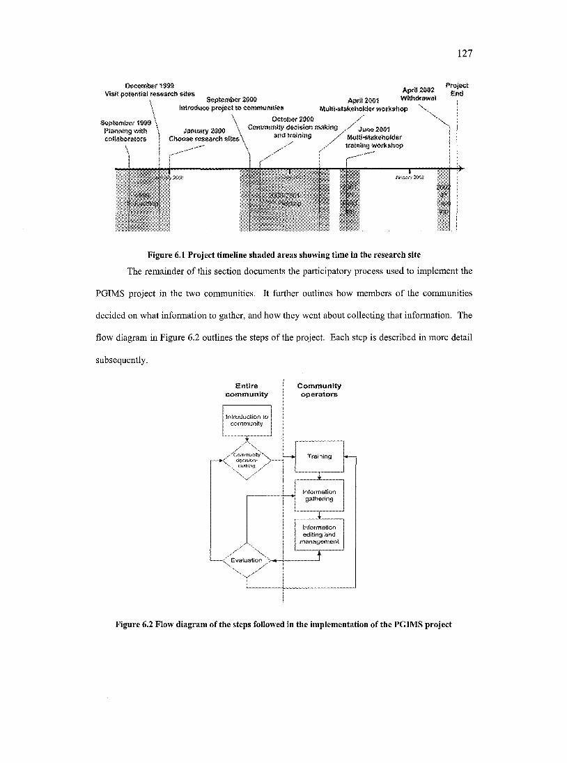
127
Dec«mÉ)er19@9 VWR mwaith *iWm
3#pt«mlM»r 4999 PiMMing wWi eoHabPMlw*
@epMmb*aOW In tfo d u c * t e c o m m u n ié * #
OctolMfZOOO
ApdiaOM ApfU2001 WMhdmwaI ,
MullWak#hoM#fwwk»hop \ |
\ CkmwMwnHy(kx*donntddm@C h o o # # r # # $ w « h » K e * \ andtnWmk#
y
Ju n # 2004 #*W@4t@k*heM*f tmlnlng «ofkahop
1999FieldMp
KKNUM#!#
zooo-mxHz-'Fwicmhp
2004^
Fwk
Figure 6.1 Project timeline shaded areas showing time in the research site
The remainder of this section documents the participatory process used to implement the
PGIMS project in the two communities. It further outlines how members of the communities
decided on what information to gather, and how they went about collecting that information. The
flow diagram in Figure 6.2 outlines the steps of the project. Each step is described in more detail
subsequently.
com m unityCommunityo p era to rs
/CommumtyX., \ making
Evaluation
introduction to com m unity
Training
Informationgathering
informationediting and
m a n a g em en t
Figure 6.2 Flow diagram of the steps followed in the implementation of the PGIMS project
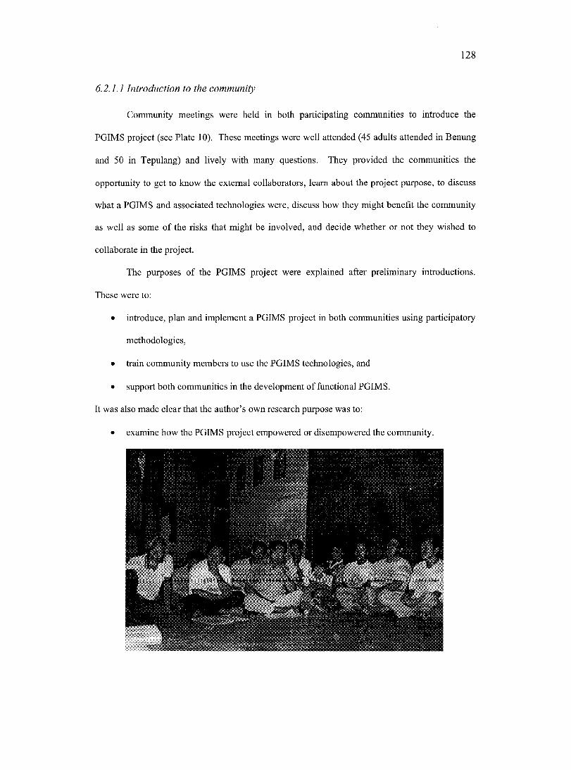
128
6.2.1.1 Introduction to the community
Community meetings were held in both participating communities to introduce the
PGIMS project (see Plate 10). These meetings were well attended (45 adults attended in Benung
and 50 in Tepulang) and lively with many questions. They provided the communities the
opportunity to get to know the external collaborators, learn about the project purpose, to discuss
what a PGIMS and associated technologies were, discuss how they might benefit the community
as well as some of the risks that might be involved, and decide whether or not they wished to
collaborate in the project.
The purposes of the PGIMS project were explained after preliminary introductions.
These were to;
• introduce, plan and implement a PGIMS project in both communities using participatory
methodologies,
• train community members to use the PGIMS technologies, and
• support both communities in the development of functional PGIMS.
It was also made clear that the author’s own research purpose was to:
• examine how the PGIMS project empowered or disempowered the community.
m
129
Plate 10 Introductory meeting in Benung
During these meetings the concept of a PGIMS was introduced. This was illustrated
using the somewhat abstract example of the UVic disc golf course developed during the pilot
project phase. Each of the tools was explained and people in the audience were given the
opportunity to use the digital still camera and video camera.
Loose parameters for use of the communities’ equipment were set, notably that they were
intended to show explicitly the link between the community and their land. Details o f how this
was to be achieved were left up to the community. It was stressed that the villagers would take a
central role in the planning and collecting of information and in using the tools. It was also
stressed that these tools were for everyone in the village, old and young, men and women, and
that each person in the village had something to contribute in the development and use of the
PGIMS. It was suggested that everyone in the village who wanted to learn would be able to use
the camera and video camera because they are not too complex to use. However, because of
limitations in equipment, external collaborators would begin by training just three representatives
from each village in how to operate the computer. It was also explained that the tools would stay
in the village at the end of the project at which time it was hoped that people in the community
would be self-sufficient in using them.
During the meeting examples were given of how the PGIMS might be used by the
communities. These included using the tools to communicate community information to parties
outside the village as well as to compile and manage information for the village’s own internal
use. These uses were illustrated using short dramas^®. Some of the risks of the system were also
discussed during this meeting, especially in relation to maintaining the equipment and protecting
the information contained in the PGIMS. It was made clear during these meetings that this was a
Drama has been used often in PRA methodologies; it is an entertaining and non-threatening way to get important messages across (Yoon, 1996; Stockdale and Corbett, 1997, 1999).
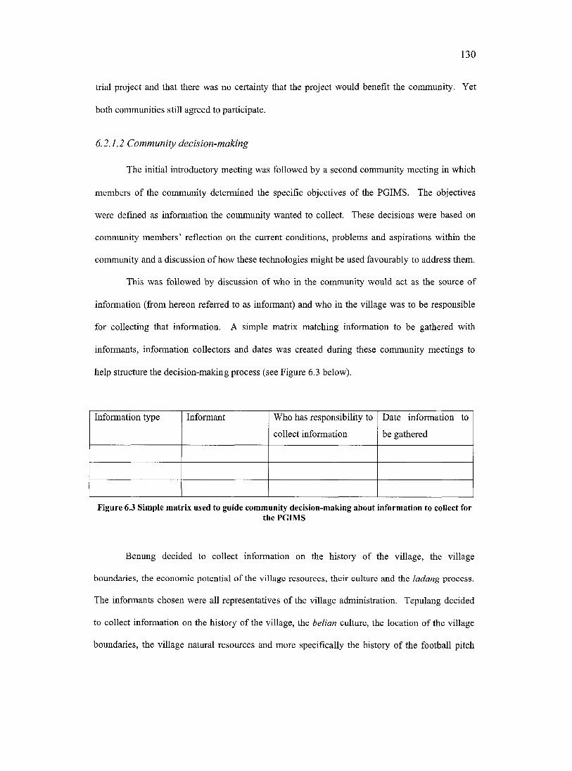
130
trial project and that there was no certainty that the project would benefit the community. Yet
both communities still agreed to participate.
6.2.1.2 Community decision-making
The initial introductory meeting was followed by a second community meeting in which
members of the community determined the specific objectives of the PGIMS. The objectives
were defined as information the community wanted to collect. These decisions were based on
community members’ reflection on the current conditions, problems and aspirations within the
community and a discussion of how these technologies might be used favourably to address them.
This was followed by discussion of who in the community would act as the source of
information (from hereon referred to as informant) and who in the village was to be responsible
for collecting that information. A simple matrix matching information to be gathered with
informants, information collectors and dates was created during these community meetings to
help structure the decision-making process (see Figure 6.3 below).
Information type Informant Who has responsibility to
collect information
Date information to
be gathered
Figure 6.3 Simple matrix used to guide community decision-making about information to collect forthe PGIMS
Benung decided to collect information on the history of the village, the village
boundaries, the economic potential of the village resources, their culture and the ladang process.
The informants chosen were all representatives of the village administration. Tepulang decided
to collect information on the history of the village, the belian culture, the loeation of the village
boundaries, the village natural resources and more specifically the history of the football pitch
131
and how Christianity arrived in the village. The informants chosen were elders in the village; no
members of the village administration were represented.
During this second meeting the villagers also decided who would be trained initially by
the external collaborators in using the PGIMS computer equipment. The next part of the
community meeting was spent choosing three representatives (from hereon referred to as
computer operators) from each village to follow a four-week intensive computer training course.
The criteria set for these village operators by the external collaborators was that at least
one operator must be a woman, they must have the time available to attend the course, and they
must be prepared to organise and subsequently train other members of the community as well as
contribute to creating the PGIMS.
The processes used to choose the operators were very different in the two communities.
In Benung operators put their own names forward (with the exception of the woman
representative who was chosen by the men who had already put their own name forward). The
initial operators were the village head and village secretary. The head subsequently dropped out
because of other commitments and was replaced with a man in his early 30’s with a junior high
school education. The village secretary had primary school education and continued throughout
the training course. The woman operator was in her early 30’s with a high school education.
In Tepulang names were put forward by members of the community; these names were
then discussed and agreed on by all those present in the meeting. They chose two men and one
woman. All were under the age of 25 and had all been senior high school students. In Tepulang
education level emerged as an important determinant of who accessed and used the equipment.
A small follow up meeting was held with the future computer operators to determine a
timetable for the training. Operators from both villages diseussed a number o f points concerning
the training. This included the number of days per week, the number of hours per day and what
time the training was to start in the day. Both groups agreed that the training should take place
five days a week, for three hours a day starting at noon.
132
A number of other village meetings were subsequently held in both villages to discuss the
regulations for using the tools. In Benung a village meeting was called by one o f the village
operators. In the meeting the operators presented some draft regulations. There was little
community discussion and the operators were requested to draw up the final set of regulations,
which they did (see Appendix F).
The people in the Tepulang meeting found it difficult to decide on a set of rules because
there was little point o f reference by which to establish them. The only other communal tool was
the chainsaw. Although it had a set of rules associated with it, these were initially considered
irrelevant to the PGIMS tools. Tepulang had to meet three more times before a set o f regulations
was achieved'*®. The first meeting yielded no results. The second meeting produced a set of
regulations similar to the regulations governing the use of the village chainsaw and were
consequently considered inappropriate. The final meeting produced a satisfactory set of
regulations (see Appendix F). These were typed out, received the signatures of the administrative
bodies in the village and were posted around the village. These rules were considered a work in
progress and could be added to or amended at any time.
Still other community meetings were held to discuss the use of community information,
to deal with problems that arose concerning conflicts between operators, as well as other topics.
Appendix C contains a list of all community meetings and a description of the purpose for which
they were held.
Decision-making meetings exclusively for women were held in both communities in
March, 2001 to encourage their greater involvement in the PGIMS project (see Plate 11). At
these meetings women discussed the information they would like to include in the PGIMS and
then made plans for a following training and information gathering session. There was much
This might be directly linked to the villagers having developed a better understanding of the computer. At the outset the computer was an alien object, by the third meeting in early December, after the computer had been in the village for over two months, members of the community were beginning to understand its uses and the appropriate regulations to govern its use.
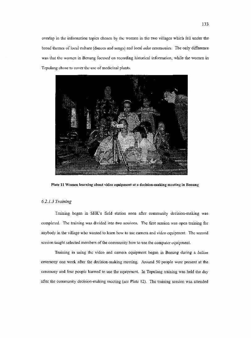
133
overlap in the information topics chosen by the women in the two villages which fell under the
broad themes of local culture (dances and songs) and local adat ceremonies. The only difference
was that the women in Benung focused on recording historical information, while the women in
Tepulang chose to cover the use of medicinal plants.
Plate 11 Women learning about video equipment at a decision-making meeting in Benung
6.2.1.3 Training
Training began in SHK’s field station soon after community decision-making was
completed. The training was divided into two sessions. The first session was open training for
anybody in the village who wanted to learn how to use camera and video equipment. The second
session taught selected members of the community how to use the computer equipment.
Training in using the video and camera equipment began in Benung during a belian
ceremony one week after the decision-making meeting. Around 50 people were present at the
ceremony and four people learned to use the equipment. In Tepulang training was held the day
after the community decision-making meeting (see Plate 12). The training session was attended
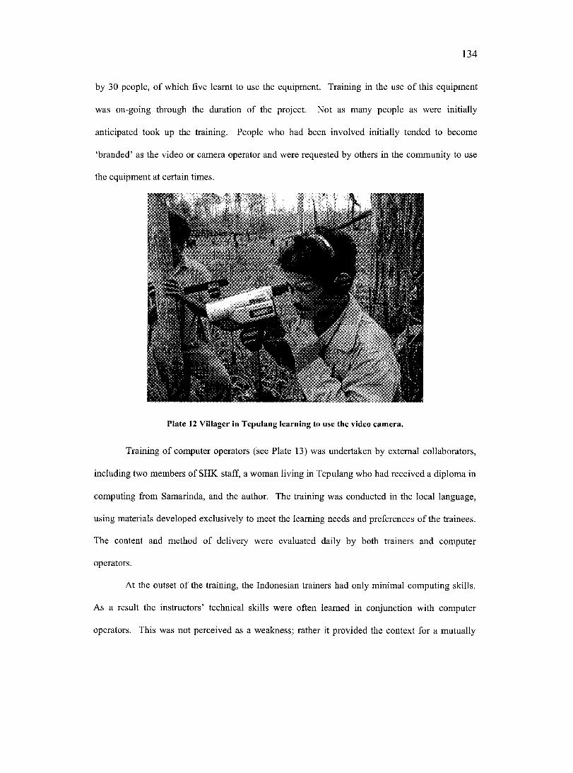
134
by 30 people, of which five learnt to use the equipment. Training in the use o f this equipment
was on-going through the duration of the project. Not as many people as were initially
anticipated took up the training. People who had been involved initially tended to become
‘branded’ as the video or camera operator and were requested by others in the community to use
the equipment at certain times.
Plate 12 Villager in Tepulang learning to use the video camera.
Training of computer operators (see Plate 13) was undertaken by external collaborators,
including two members of SHK staff, a woman living in Tepulang who had received a diploma in
computing from Samarinda, and the author. The training was conducted in the local language,
using materials developed exclusively to meet the learning needs and preferences of the trainees.
The content and method of delivery were evaluated daily by both trainers and computer
operators.
At the outset of the training, the Indonesian trainers had only minimal computing skills.
As a result the instructors’ technical skills were often learned in conjunction with computer
operators. This was not perceived as a weakness; rather it provided the context for a mutually
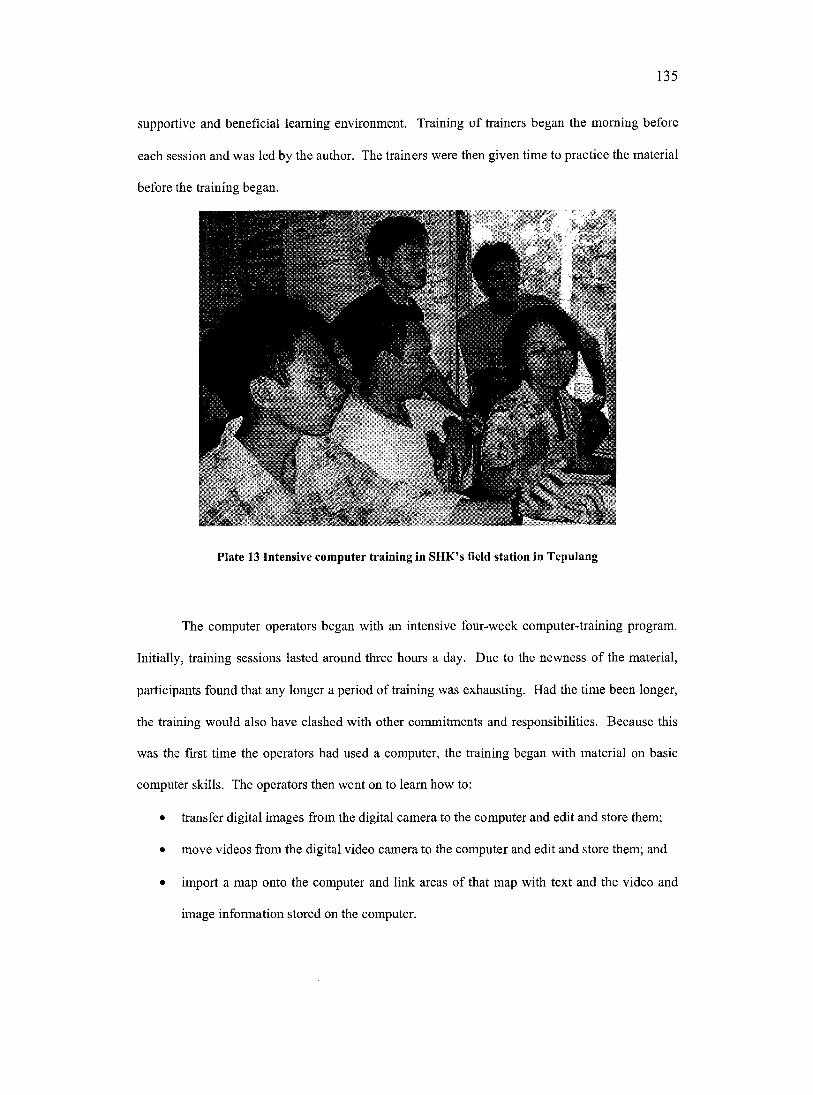
135
supportive and beneficial learning environment. Training of trainers began the morning before
each session and was led by the author. The trainers were then given time to practice the material
before the training began.
Plate 13 Intensive computer training in SHK’s field station in Tepulang
The computer operators began with an intensive four-week computer-training program.
Initially, training sessions lasted around three hours a day. Due to the newness of the material,
participants found that any longer a period of training was exhausting. Had the time been longer,
the training would also have clashed with other commitments and responsibilities. Because this
was the first time the operators had used a computer, the training began with material on basic
computer skills. The operators then went on to leam how to:
• transfer digital images from the digital camera to the computer and edit and store them;
• move videos from the digital video camera to the computer and edit and store them; and
• import a map onto the computer and link areas of that map with text and the video and
image information stored on the computer.
136
The training also had an ongoing focus on equipment maintenance and trouble-shooting skills.
Once the intensive training was complete, formal training for computer operators and
other people interested in the PGIMS project continued over the next ten months. At no point
were the computer operators, or anyone else from the community, paid to participate in the
training or any other part of the PGIMS activities.
The training provided an excellent opportunity for the author to work closely with people
from both communities. The training became a mutual learning venture whereby the author
learned about the people in the two villages, became involved in their lives and ultimately began
to establish a role in both communities.
6.2.1.4 Information gathering
The gathering of information began soon after the communities had decided what types
of information to include in their PGIMS. After the external collaborators had demonstrated the
use and maintenance o f the video and camera equipment they handed over the equipment to the
community. External collaborators provided demand-driven and on-going assistance with the use
of this equipment. This training approach was referred to as Teaming by doing’ and allowed for
skill sharing in a practical and applied manner. This style of training proved very effective.
6.2.1.5 Information editing and management
Early information gathering overlapped with initial intensive computer training, this was
done deliberately so that the computer operators could be trained in video and photographic
editing and file management using information that was relevant and that could be immediately
incorporated into the PGIMS. This meant that almost immediately after the information was
gathered, villagers could access and view the information on the computer.
137
6.2.1.6 Evaluation
Community members would gather frequently to view the PGIMS and diseuss the quality
and content o f the images and video. Suggestions arose from these gatherings about how to
improve the training, the information gathering proeess, the types of information to gather, and
the editing, management and presentation of the information. This evaluation acted as a feedback
loop enabling community members to modify and improve the quality and content of information
being documented and stored within the PGIMS.
6.2.2 Engaging stakeholders
The PGIMS project held two workshops in the regional capital in Melak to present the
results of the PGIMS project to individuals and groups outside of the two partieipating
communities. Both these gatherings provided opportunity to assess, using questionnaires and
focus group discussions, how people outside of the project viewed the use and impact of these
new technologies.
6.2.2.1 Multi-stakeholder dissemination workshop
A multi-stakeholder"^' workshop was held on the April 23, 2001. The purpose of this
workshop were to evaluate the PGIMS as a tool for communieating information between the
communities involved in the project and other stakeholders operating in the region. It was also an
opportunity to gather opinions and perceptions of these stakeholders towards the PGIMS. A
broad cross-section of stakeholders operating in West Kutai were invited (see Plate 14). A total
of 36 participants attended. They represented community members, regional and district
{kabupaten and kecamatan) government, regional legislature, local and provincial universities.
"" A stakeholder is defined as a person, organization or government department that had some interest in learning about the PGIMS project. Stakeholders were either self-selected through having expressed an interest in the project, or else were chosen by the author in conjunction with members of SHK, who already have close dealings with a broad range of groups throughout the region.
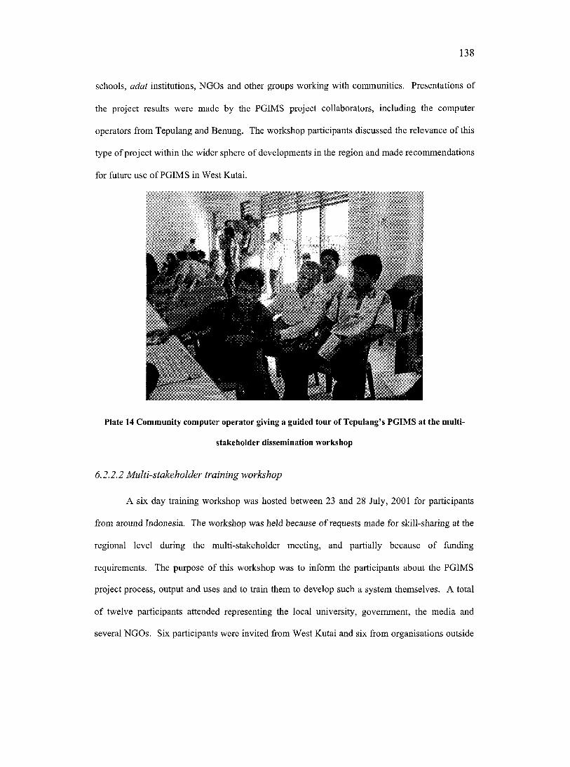
138
schools, adat institutions, NGOs and other groups working with communities. Presentations of
the project results were made by the PGIMS project collaborators, including the computer
operators from Tepulang and Benung. The workshop participants discussed the relevance of this
type of project within the wider sphere of developments in the region and made recommendations
for future use of PGIMS in West Kutai.
Plate 14 Community computer operator giving a guided tour of Tepulang’s PGIMS at the multi
stakeholder dissemination workshop
6.2.2.2 M ulti-stakeholder training workshop
A six day training workshop was hosted between 23 and 28 July, 2001 for participants
from around Indonesia. The workshop was held because of requests made for skill-sharing at the
regional level during the multi-stakeholder meeting, and partially because of funding
requirements. The purpose of this workshop was to inform the participants about the PGIMS
project process, output and uses and to train them to develop such a system themselves. A total
of twelve participants attended representing the local university, government, the media and
several NGOs. Six participants were invited from West Kutai and six from organisations outside
139
the region. There was a high demand from organisations to send participants, with requests being
made from groups that were not invited, and groups that had been invited requesting that more
than one participant from their organization attend the training workshop. All o f the organisations
invited accepted the invitation. Workshop trainers included the author, members of SHK, and
two operators from Benung and Tepulang.
The training workshop introduced the PGIMS process and philosophy. Presentations
were made by computer operators from Benung and Tepulang and discussion held about how
participants might use PGIMS in their own work. The workshop also had a field session for
gathering material that was later used to leam the technological skills required for developing a
PGIMS. Throughout the workshop there was a lot of participant input in the form of
brainstorming, role-playing exercises and question/answer sessions. Each day included a formal
written and oral evaluation.
6.2.3 Project withdrawal
Project withdrawal‘s refers to the point when external collaborators finish their
involvement in the project in the research site. Withdrawal was determined not by the two
communities indicating their readiness to take complete charge o f the PGIMS, but rather by
project timing and funding limitations. However, the timing was considered satisfactory by
people from both communities. The withdrawal was gradually phased in with external
collaborators withdrawing for a period of time and then returning to address specific needs.
A crucial ethical consideration in withdrawal is that of funding. As Richardson and Rajasunderam (1997) point out, short-term projects that take no account of the community’s ability to provide funding once the project is over lead to dead technologies around the world. This research project intentionally did not provide additional funding at the end of its term in the community. This decision was taken in the belief that if the communities tmly valued the tools and the PGIMS, they would be prepared to pay for repairs or modifications required. This sentiment was further expressed by several community members and other notable people in the region.
140
However, withdrawal was not total as SHK continue to work on other projects in both villages,
and the author remains in contact with people from both communities.
6.3 EVALUATING THE PGIMS PROJECT
This section evaluates the PGIMS project. It begins by evaluating the PGIMS map-
interface as a tool for organising and accessing information. The relevance of the information in
the PGIMS for the needs of the community are then assessed, followed by the related topic of the
anticipated sustainability of the PGIMS initiative in the communities after the project ends.
6.3.1 Evaluating the PGIMS map interface
6 .3 .7 .; TTzgfG/M y
Over the 18 month period that the computers were monitored, both communities
documented, produced and stored large quantities of information, some of which was
incorporated into the PGIMS through the map interface and some of which was not. For this
reason the term ‘PGIMS’ was used to define all the information stored on the computer, whereas
‘map-linked PGIMS’ was used to define the subset of that information that was selected to be
linked to the map interface. The information in the PGIMS was managed in both villages using a
simple filing system where video information was contained in one single communal folder and
all other information edited by each computer operator was stored in a folder bearing his or her
name. All the information included in the map-linked PGIMS was in another communal folder.
The types of media used to document the information contained in the PGIMS are broken
down and presented in Table 6.1.
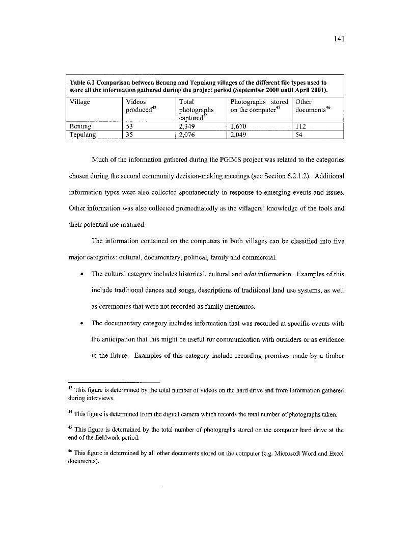
141
Table 6.1 Comparison between Benung and Tepulang villages of the different file types used to store all the information gathered during the project period (September 2000 until April 2001).
Village Videos Total Photographs stored Otherproduced"*^ photographs
captured'^''on the computer'*^ documents'*®
Benung 53 2J49 1,670 112Tepulang 35 2,076 2,049 54
Much of the information gathered during the PGIMS project was related to the categories
chosen during the second community decision-making meetings (see Section 6.2.1.2). Additional
information types were also collected spontaneously in response to emerging events and issues.
Other information was also collected premeditatedly as the villagers’ knowledge of the tools and
their potential use matured.
The information contained on the eomputers in both villages can be classified into five
major categories: cultural, documentary, political, family and commercial.
• The cultural category includes historical, cultural and adat information. Examples of this
include traditional dances and songs, descriptions of traditional land use systems, as well
as ceremonies that were not recorded as family mementos.
• The documentary category includes information that was recorded at specific events with
the anticipation that this might be useful for communication with outsiders or as evidence
in the future. Examples of this category include recording promises made by a timber
This figure is determined by the total number of videos on the hard drive and from information gathered during interviews.
This figure is determined from the digital camera which records the total number of photographs taken.
This figure is determined by the total number of photographs stored on the computer hard drive at the end of the fieldwork period.
This figure is determined by all other documents stored on the computer (e.g. Microsoft Word and Excel documents).
142
merchant, recording an illegal logging activity or recording an important talk given by the
Bupati in the regional capital.
• The political category includes statements made expressing the views of people within
the community with the purpose to mobilise political support for a cause, and/or create
alliances with more powerful stakeholders. Examples of this category include a video
explaining the need of the community to be able to manage their forest areas using
traditional management systems.
• The family category includes recordings made for specific families for sentimental
reasons, such as recordings of weddings, births and funerals. These were made for the
benefit of the families only.
• The commercial category is video information stored and distributed on Video Compact
Disc (VCD). This category includes information from the above categories that were
requested by groups from outside of the village. The operators were paid the sum of
200,000 Rupiah (approximately $40 CAD) per VCD produced.
The information documented in Benung and Tepulang is laid out in Table 6.2.
Table 6.2 Information categories and sub categories documented in Benung and Tepulang.Informationcategories
Information sub-categories
Benung TepulangCultural Healing ceremonies Healing ceremonies
Description of land use types Description of land use typesMythology of forest trees Mythology of forest treesThe ladang or rice cultivation process The ladang or rice cultivation processHistory of the village boundaries History of origins of the villageHistory of way of life before mechanisation
Traditional tenure and land rights
History of mbber plantations in the village and wider region and process of planting and tapping mbber trees
History of village mbber project
Mythology and species found in fruit tree gardens
Description of the primary forest
Local folk dances Description of system for managing rattan
Local folk tales Medicinal plantsFuneral ceremoniesLocal folk songs
143
Documentary Boundary negotiations between communities
Boundary negotiations between communities
Meetings with government Meetings with governmentElection of new Bupati Election of the new Kepala DesaEvidence of illegal logging Meetings with timber investor
Marking the boundary of the conservation forest area
Political Traditional forest management strategy
Views on the need for conservation forests
Discussion of the importance of the primary forest for community livelihoodEco-forestry management strategyHistory of the longhouse leading to discussion of disrepair and the need for funds for revitalisation
Family Family healing ceremony Family healing ceremonyFamily funeral ceremony Location of family simpukngFamily wedding ceremonies
Commercial Contract for the Tourism DepartmentContracts for the regional and district governmentContracts for regional NGOContracts for private events and functions
6.3.1.2 The map-linked PGIM S
From the intensive training session onwards, the communities began to organise some of
the gathered information into a map-linked PGIMS. This was in line with the project’s initial
concept of creating a PGIMS that used an interactive Cartesian map to manage, reference and
retrieve digital information. The PGIMS graphical interfaces for accessing information were
digital maps (saved in GIF format) of the villages’ traditional territories (Figure 6.4). These maps
contained information on the location of the village, the village boundaries and different land use
types'*’. Benung’s map was made in 1996 and Tepulang’s in 1997. Using these pre-existing
maps saved the researcher much valuable time.
Benung’s map contained eleven land use types and Tepulang’s contained six.
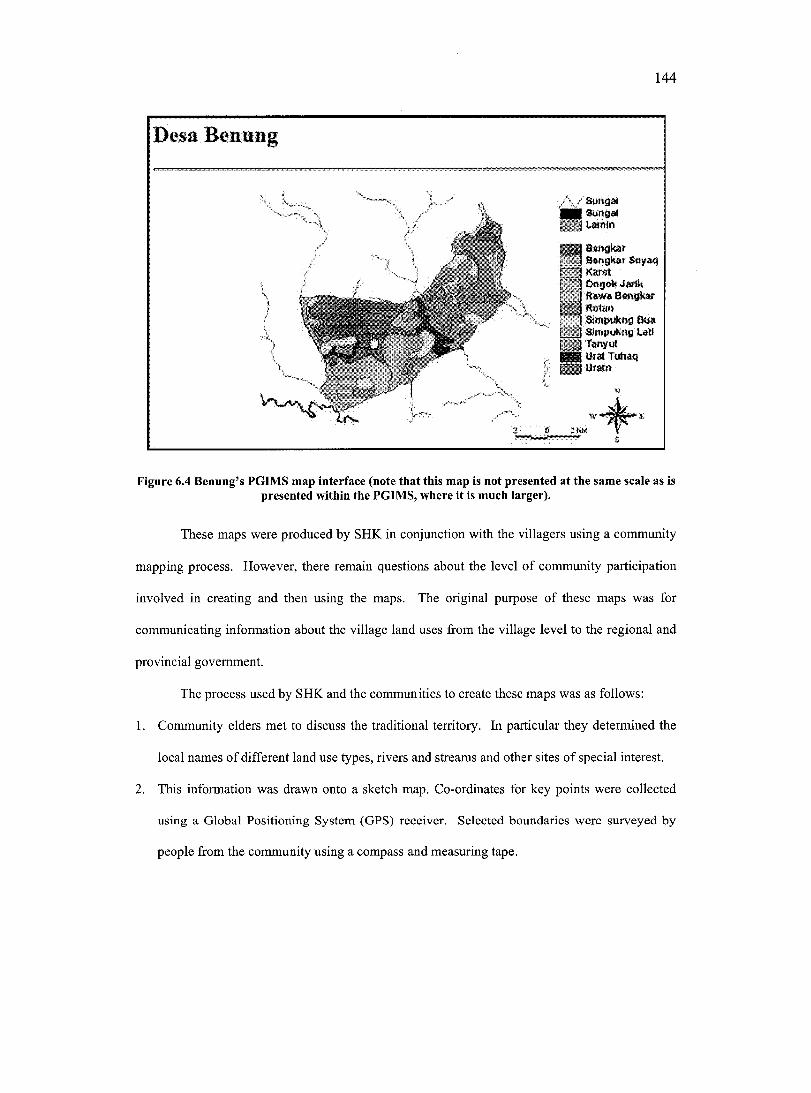
144
I T l I-**"!"Boirjkar Betiykar Soyaq
I Kdr-.t, DngoN Jdrtk I Kswa S engkarRul-Jtl
I o nipukng B uaI 1 Slnipukno l#UI 'Z I Twvvle e i UMi Tuhaq ESBumn
w0 21*
Figure 6.4 Benung’s PGIMS map interface (note that this map is not presented at the same scale as is presented within the PGIMS, where it is much larger).
These maps were produced by SHK in conjunction with the villagers using a community
mapping process. However, there remain questions about the level of community participation
involved in creating and then using the maps. The original purpose of these maps was for
communicating information about the village land uses from the village level to the regional and
provincial government.
The process used by SHK and the communities to create these maps was as follows:
1. Community elders met to discuss the traditional territory. In particular they determined the
local names of different land use types, rivers and streams and other sites of special interest.
2. This information was drawn onto a sketch map. Co-ordinates for key points were collected
using a Global Positioning System (GPS) receiver. Selected boundaries were surveyed by
people from the community using a compass and measuring tape.
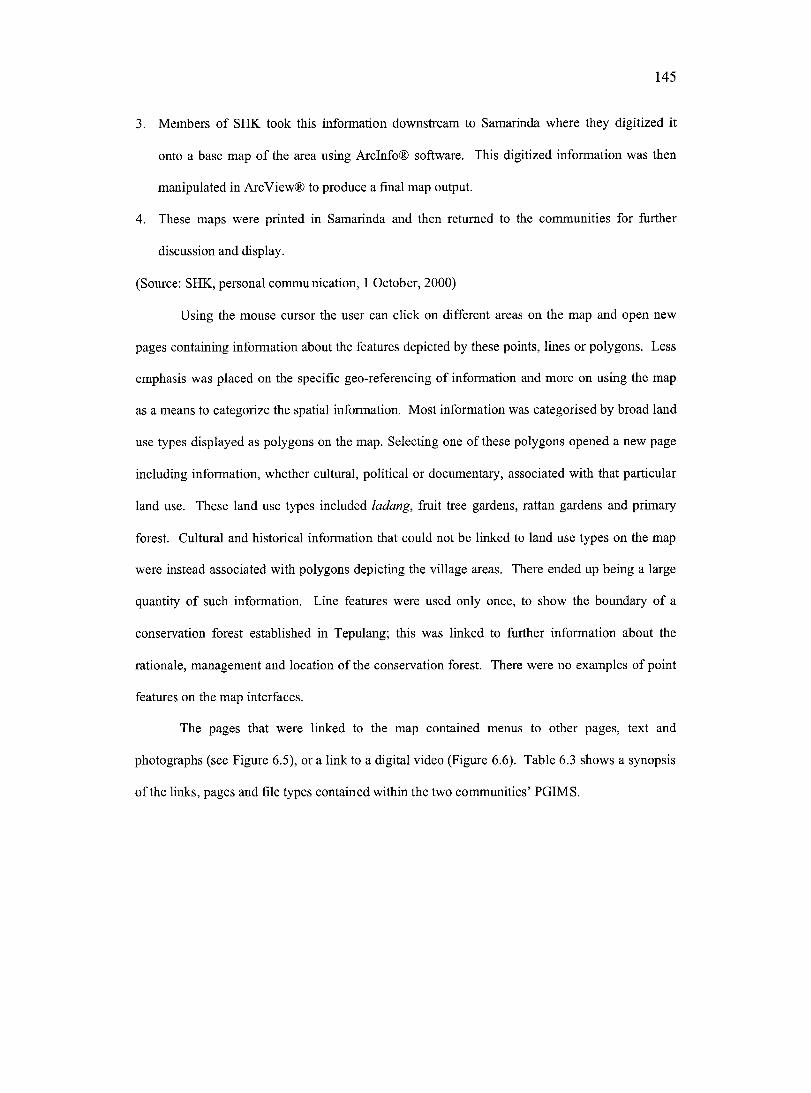
145
3. Members of SHK took this information downstream to Samarinda where they digitized it
onto a base map o f the area using Arclnfo® software. This digitized information was then
manipulated in Arc View® to produce a final map output.
4. These maps were printed in Samarinda and then returned to the communities for further
discussion and display.
(Source: SHK, personal communication, 1 October, 2000)
Using the mouse cursor the user can click on different areas on the map and open new
pages containing information about the features depicted by these points, lines or polygons. Less
emphasis was placed on the specific geo-referencing of information and more on using the map
as a means to categorize the spatial information. Most information was categorised by broad land
use types displayed as polygons on the map. Selecting one of these polygons opened a new page
including information, whether cultural, political or documentary, associated with that particular
land use. These land use types included ladang, fruit tree gardens, rattan gardens and primary
forest. Cultural and historical information that could not be linked to land use types on the map
were instead associated with polygons depicting the village areas. There ended up being a large
quantity of such information. Line features were used only once, to show the boundary of a
conservation forest established in Tepulang; this was linked to further information about the
rationale, management and location of the conservation forest. There were no examples of point
features on the map interfaces.
The pages that were linked to the map contained menus to other pages, text and
photographs (see Figure 6.5), or a link to a digital video (Figure 6.6). Table 6.3 shows a synopsis
of the links, pages and file types contained within the two communities’ PGIMS.
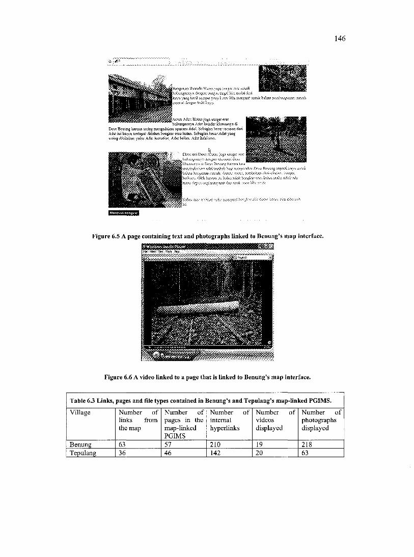
146
|A can Adat Hidaajnge ssagar era.r Imbunganjiya Adst Istkidat khusiîsnya di
Dew Bciiung kxctm wnog mengadakan «pacara Adat. Scbagian W ar ranimn daii Adat BW hmnym terdapat didalam beogkmr atau hiitan, Sebagsaji bcsar Adat yaiig serifjg dhkolcKQ ymAo: Adat kematiaa. Adat bclian, Adat Wmlmn.
EkMwadDwa: juga$
inati mebkat vidio jK&ipa
Menpaat benghar
Figure 6.5 A page containing text and photographs linked to Benung’s map interface.
Q^ Wimlow» Mfutîa Mayiv• A •
Figure 6.6 A video linked to a page that is linked to Benung’s map interface.
Table 6.3 Links, pages and file types contained in Benung’s and Tepulang’s map-linked PGIMS.
Village Number of links from the map
Number o f pages in the map-linked PGIMS
Number o finternalhyperlinks
Number o fvideosdisplayed
Number o fphotographsdisplayed
Benung 63 57 210 19 218Tepulang 36 46 142 20 63
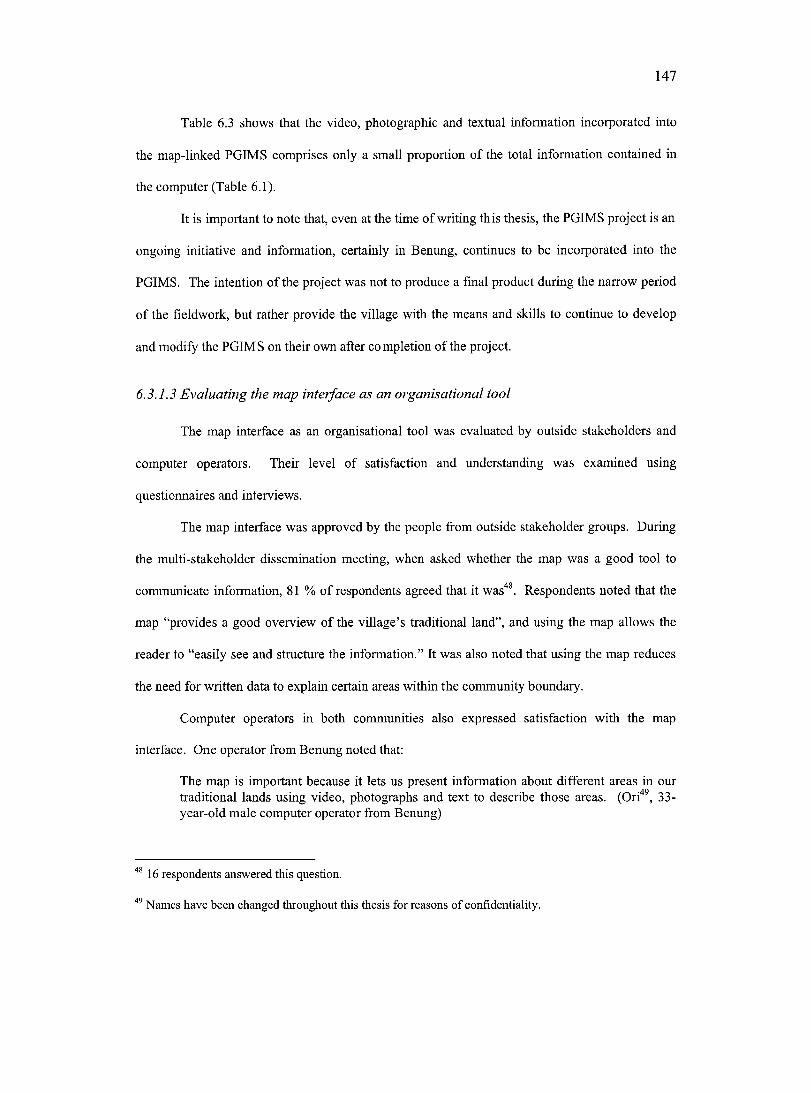
147
Table 6.3 shows that the video, photographie and textual information incorporated into
the map-linked PGIMS comprises only a small proportion of the total information contained in
the computer (Table 6.1).
It is important to note that, even at the time of writing this thesis, the PGIMS project is an
ongoing initiative and information, certainly in Benung, continues to be incorporated into the
PGIMS. The intention of the project was not to produce a final product during the narrow period
of the fieldwork, but rather provide the village with the means and skills to continue to develop
and modify the PGIMS on their own after completion of the project.
6.3.1.3 Evaluating the map interface as an organisational tool
The map interface as an organisational tool was evaluated by outside stakeholders and
computer operators. Their level of satisfaction and understanding was examined using
questionnaires and interviews.
The map interface was approved by the people from outside stakeholder groups. During
the multi-stakeholder dissemination meeting, when asked whether the map was a good tool to
communicate information, 81 % of respondents agreed that it was^. Respondents noted that the
map “provides a good overview of the village’s traditional land”, and using the map allows the
reader to “easily see and structure the information.” It was also noted that using the map reduces
the need for written data to explain certain areas within the community boundary.
Computer operators in both communities also expressed satisfaction with the map
interface. One operator from Benung noted that:
The map is important because it lets us present information about different areas in our traditional lands using video, photographs and text to describe those areas. (Ori'*®, 33- year-old male computer operator from Benung)
^ 16 respondents answered this question.
Names have been changed throughout this thesis for reasons of confidentiality.
148
An operator from Tepulang stated that:
A map is a really good way of managing information, because we can straight away click above the map and see what special information we have associated with that part of the map. I think that the map is really good as a baseline to organise the information. I think that if there was not a map it would be difficult to access the information. (Rado, 25- year-old male computer operator from Tepulang)
He further likened the map to lumbung, a traditional system used in the village to separate
and store different rice varieties to prevent them getting mixed up.
Despite the creation of two functional map-linked PGIMS in the partnering communities,
and favourable outsider and computer operator evaluations of the map interface, other data
showed that the map interface was seldom used by the community members themselves.
Computer monitoring data shows low usage of Microsoft Internet Explorer®; the
software required to access and view the PGIMS through the map interface. Figure 6.7 shows
that use of this software is dependent on the external collaborators’ presence in the village. While
external collaborators are absent from both villages, Internet Explorer® is not used. It should
also be noted that the map-linked PGIMS were put together to be displayed in the multi
stakeholder dissemination workshop on April 23^, 2001. This accounts for the spike in Internet
Explorer® activity seen in Figure 6.7 during April, 2001.
Low use o f Internet Explorer® does not mean that the information contained on the
computer was not being accessed. It implies that the PGIMS map interface was not being used as
the primary system to manage and retrieve that information. Instead, information management
and retrieval was being done through the operating system’s default file manager, namely
Microsoft Windows Explorer^®®. This is supported by the high usage of this program shown in
Figure 6.8.
Care needs to be taken not to confuse Microsoft Windows Explorer® and Microsoft Internet Explorer®.
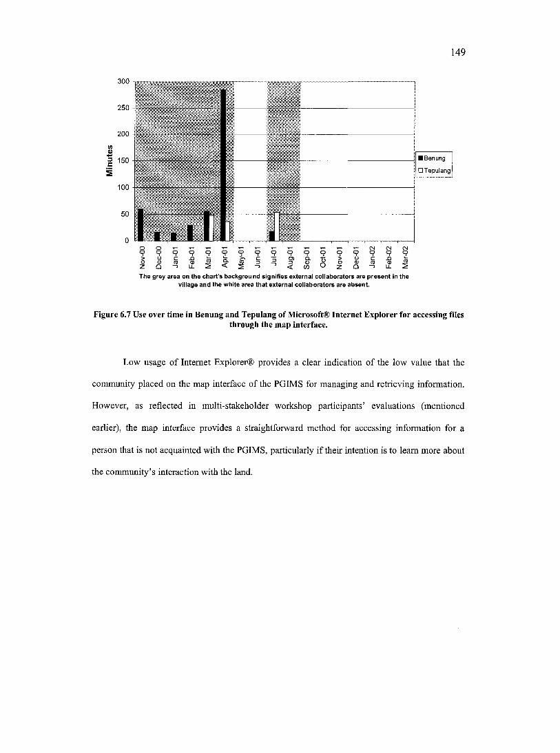
149
300
250
200
■ Benung
O Tepulang= 150 -
100
IO9 § CNO
nCMooo o 9 99 o 9 o o
O) 9 9
The grey area on the chart's backgrou nd signifies external collaborators are present In the village and the white area that external collaborators are absent.
Figure 6.7 Use over time in Benung and Tepulang of Microsoft® Internet Explorer for accessing filesthrough the map interface.
Low usage of Internet Explorer® provides a clear indication of the low value that the
community placed on the map interface of the PGIMS for managing and retrieving information.
However, as reflected in multi-stakeholder workshop participants’ evaluations (mentioned
earlier), the map interface provides a straightforward method for accessing information for a
person that is not acquainted with the PGIMS, particularly if their intention is to leam more about
the community’s interaction with the land.
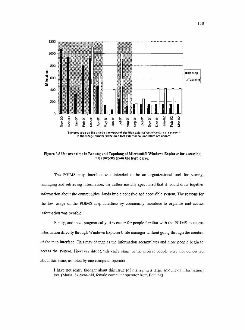
150
1200
1000
800V)SI 600
400
200
1 1
■ Benung
□ Tepulang
O o T— T— T— T— T - ^ T— T— T“ T“ T " CNJ CN CMo o o o o o o o o o o o o o o o o
Z Q - > ü- 2 < S - ’ < w C ' z Q ^ ü- 2
The grey area on the chart's background signifies external collaborators are present in the village and the white area that external collaborators are absent.
Figure 6.8 Use over time in Benung and Tepulang of Microsoft® Windows Explorer for accessingfiles directly from the hard drive.
The PGIMS map interface was intended to be an organizational tool for storing,
managing and retrieving information; the author initially speculated that it would draw together
information about the communities’ lands into a cohesive and accessible system. The reasons for
the low usage of the PGIMS map interface by community members to organise and access
information was twofold.
Firstly, and most pragmatically, it is easier for people familiar with the PGIMS to access
information directly through Windows Explorer® file manager without going through the conduit
of the map interface. This may change as the information accumulates and more people begin to
access the system. However during this early stage in the project people were not concerned
about this issue, as noted by one computer operator:
I have not really thought about this issue [of managing a large amount of information] yet. (Maria, 34-year-old, female computer operator from Benung)
151
Secondly, people in the community do not need a guided tour of their traditional lands in
the same way that an outsider might because they already know these basic facts; the community
users tend to access the information on the computer for more specific purposes that do not
require them to use the map interface.
6.3.1.4 Evaluating the map interface as a means o f communicating local spatial
information
It is interesting to note that when conflicts emerged over village boundaries in Benung,
information in the PGIMS was used successfully to resolve these conflicts, this is discussed in
more detail in Chapter Seven (Section 7.4.1). The resolution of these conflicts was achieved not
by using the map interface of the PGIMS but by using video information on the location of the
boundaries. There are several reasons for this.
Firstly, a number of individuals in Tepulang, including several elders involved in the
creation of the community map, stated that they did not fully understand the map interface. They
found it hard to understand that different colours represented certain land use types and to orient
themselves to the relative distribution of different features on the map. This was perplexing
because the same map, using identical colours and design, created by the community elders was
on public display as a poster in a prominent position in the village meeting hall. However, even
after the similarity between the map on the computer and the map on the wall had been explained
to the elders, they remained confused about the depiction of different land use types on the map.
This confusion might have been because of a mental block related to seeing the map on a
computer screen. Or, this lack of understanding might reflect the fallacy of the assumption that
the Cartesian map offers a universal language (Poole, 1995a; Alcorn, 2001). It also raises
questions about the level of community participation during the initial community mapping
152
activity^’ since participating in creating the map should have contributed to a greater
understanding of it.
Secondly, the multimedia information stored on the computer provided a more culturally
relevant tool for representing and communicating spatial information about the territorial
boundaries than the map interface. The Cartesian map, even though present in the community
and used by outsiders and the government in the region, was not a tool commonly used at the
community level. According to M. Stockdale (personal communication 29 April, 2003), spatial
description is most often given orally, with boundaries described by “talking the boundaries as if
they are walking them.” A similar system of boundary demarcation is used in aboriginal
Australians’ songlines (Chatwin, 1993). The video recording of a walk along the boundaries thus
more closely reflects the traditional way of communicating spatial information.
Harris and Weiner (1998) present a view that can be used to better understand the
significance of the failure of the map interface used by the PGIMS. They note that “a
community-integrated GIS should be capable of incorporating information and knowledge in
alternative forms which are not dependent on the map as the mode of representation” (p. 74).
They further assert that the Cartesian map is just one way of representing geographic information.
Even though the Cartesian map interface was not used by the communities during the external
collaborators’ absence from the villages, this did not mean that the communities were not
collecting and presenting important spatial information about their relationship with the land,
including its boundaries and different land uses. For this reason, the information contained in the
computer as a whole can legitimately be referred to as the communities’ PGIMS, with the words
‘geographic information’ remaining in the title despite the absence of a Cartesian map.
It is recommended that future PGIMS initiatives should make the participatory creation of the base maps an important initial part of the process. In addition to helping people to understand and feel ownership over the map, it will serve as a starting point for discussion of what information associated with the land should be included in the PGIMS.
153
6.3.2 Relevance of PGIMS
6.3.2.1 Relevance o f PGIM S to fu ture generations
Documenting information for future generations was eonsidered important, particularly
by women and elders in the communities. The topies chosen to be reeorded by the women in
both villages focused on local history and culture. In the discussion at meetings, women
eonsidered these to be ‘women’s subjeets’ - subjeets in which they were known to be expert. The
women stated that their aim was to pass traditional, loeal information on to future generations.
Women from both communities decided to record cultural information, such as local songs and
dances. The women in Benung additionally chose to cover historical information on their way of
life in pre-mechanised times (i.e. how water was fetched and riee was processed), while the
women in Tepulang chose to cover the use of medicinal plants.
The desire to record information for future generations was not confined to women. In
Benung an elderly man stated:
1 have been getting old and realise that when I leave a lot of my information will be lost. I have been thinking how am I going to reeord this information for our grandchildren. Now I ean use this tool [PGIMS] to record this information. (Raniq, 60-year-old male elder from Benung)
The importanee of communicating information to the current younger generations within
the eommunity will be diseussed further in Chapter Seven (Section 7.5.1.4).
6.3.2.2 Relevance o f PGIM S to outsiders
Interviews showed that younger and middle aged men in both communities believed that
the PGIMS was most relevant in addressing the entrent problems and issues faeing the
community. This meant using PGIMS to collect, store and present information on eontentious
issues involving land ownership, boundary determination and natural resouree rights and use.
This information was used to successfully resolve disputes with outsiders on two occasions
(Section 7.4.1).
Like the women, men were interested in reeording the village’s history, but the
information gathered was used as the basis for their claims to the village territory, rather than
154
showing a past way of life. In Tepulang community elders stated that they saw the PGIMS as a
useful tool to document village boundaries;
With such a system we can document agreements and keep this as proof. This will be a very important tool for the security of our children and grandchildren; too often people forget about agreements that have been reached. (Kopoe, 67-year-old male elder from Tepulang)
This delineation o f information by gender might be linked to traditional gender roles.
Most interaction with outsiders is dominated by men. Thus all village information intended for
outsiders’ eyes is considered to be men’s information (i.e. knowledge about boundaries). Women
did not choose to cover any of the contemporary conflicts or issues with parties outside the
village, even though in interviews some of them claimed information on such issues were more
important than any of the others. For instance one woman respondent from Benung noted:
The most important information to reeord is about our forests; at the moment there are often problems around the forest, sometimes there are people who want to steal the wood, sometimes there are companies who enter, we don’t want that. (Karo, 36-year-old female resident of Benung)
However, women were willing to be involved with contentious internal issues. For
instance one female computer operator in Benung noted the growing conflict between families in
the village relating to the inheritance of fruit tree gardens. She wanted to begin an initiative that
would agree upon and document the exact boundaries of the gardens so that future generations
would be clear of the exact delineation of the gardens.
6.3.3 Sustainability of the PGIMS in the long term
PGIMS project sustainability is defined as the ability of the partieipating communities to
manage and maintain the equipment and continue to add information to the PGIMS after the
external collaborators have left the village. This is a key indicator o f the relevance and
appropriateness of PGIMS to the community, as well as the success of the training and support.
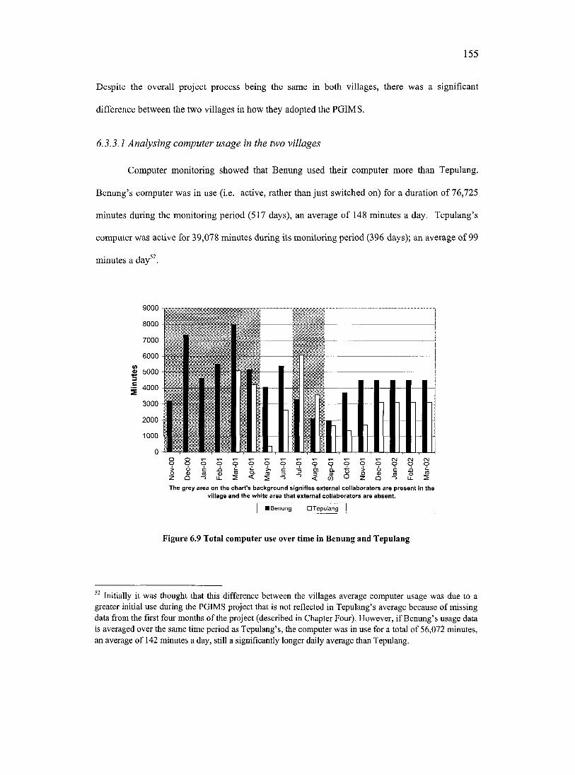
155
Despite the overall project process being the same in both villages, there was a significant
difference between the two villages in how they adopted the PGIMS.
6.3.3.1 Analysing computer usage in the two villages
Computer monitoring showed that Benung used their computer more than Tepulang.
Benung’s computer was in use (i.e. active, rather than just switched on) for a duration of 76,725
minutes during the monitoring period (517 days), an average of 148 minutes a day. Tepulang’s
computer was active for 39,078 minutes during its monitoring period (396 days); an average of 99
minutes a day52
9000 -
8000 -
7000 -
6000 4"
o 5000 -
~ 4000 -
3000 -■
2000 -1
1000 4
0 -,
<DQ & I O
r- CM CM CMO O O O
(0n i lThe grey area on the chart’s background signifies external collaborators are p resen t In the
village and the white area that external co llaborators are absen t.
Û ” l ï
I Benung D T epuiang
Figure 6.9 Total computer use over time in Benung and Tepulang
Initially it was thought that this difference between the villages average computer usage was due to a greater initial use during the PGIMS project that is not reflected in Tepulang’s average because of missing data from the first four months of the project (described in Chapter Four). However, if Benung’s usage data is averaged over the same time period as Tepulang’s, the computer was in use for a total of 56,072 minutes, an average of 142 minutes a day, still a significantly longer daily average than Tepulang.
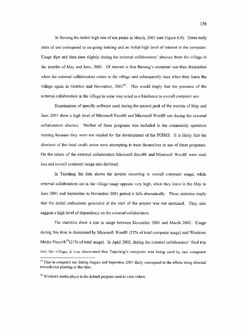
156
In Benung the initial high rate of use peaks in March, 2001 (see Figure 6.9). These early
rates of use eorrespond to on-going training and an initial high level of interest in the computer.
Usage dips and then rises slightly during the external collaborators’ absence from the village in
the months of May and June, 2001. Of interest is that Benung’s computer use then diminishes
when the external collaborators return to the village and subsequently rises when they leave the
village again in Getober and November, 2001^^. This would imply that the presenee of the
external collaborators in the village in some way acted as a hindrance to overall computer use.
Examination of specific software used during the second peak of the months of May and
June 2001 show a high level of Microsoft Excel® and Microsoft Word® use during the external
collaborators absence. Neither of these programs was included in the community operators
training because they were not needed for the development of the PGIMS. It is likely that the
directors of the local credit union were attempting to train themselves in use of these programs.
On the return o f the external eollaborators Microsoft Excel® and Microsoft Word® were used
less and overall computer usage also declined.
In Tepulang the data shows the inverse occurring in overall computer usage; while
external collaborators are in the village usage appears very high, when they leave in the May to
June 2001 and September to November 2001 period it falls dramatically. These statistics imply
that the initial enthusiasm generated at the start of the project was not sustained. They also
suggest a high level of dependency on the external eollaborators.
The statistics show a rise in usage between December 2001 and March 2002. Usage
during this time is dominated by Microsoft Word® (33% of total computer usage) and Windows
Media Player®^'’(21% of total usage). In April 2002, during the external collaborators’ final trip
into the village, it was discovered that Tepulang’s computer was being used by one computer
” Dips in computer use during August and September 2001 likely correspond to the efforts being directed towards rice planting at that time.
Windows media player is the default program used to view videos.
157
operator to watch and copy Video Compact Discs (VCD) rented from a nearby store, thus the
high usage of Windows Media Player® during this time.
This contrasting association between productivity and the presence of external
collaborators is further supported by an analysis of the results showing the chronology of video
production in both villages. In Benung 30 videos, of a total of 53, were produced while the
external collaborators were absent from the village. In Tepulang two videos, of a total of 35,
were produced under similar circumstances. These statistics imply that Benung was more
independent in both their use and application of the computer equipment. Furthermore computer
monitoring data showed that from May 2001 until April 2002, the final two thirds of the
monitoring period, no videos were made in Tepulang.
6.3.3.2 E valuating P G IM S sustainability in Benung
In Benung initial enthusiasm was guarded and it took time for the community to warm to
the PGIMS project. This was possibly because initially:
People in the village think that you [the author] are organizing this to colleet the information for yourself, especially some of the older people in the village. (Duhon, 62- year-old male elder from Benung)
Once the community was more comfortable with the presence of the author in the village and
clearer of the project’s objectives many more people became actively involved. This beeame
obvious by the large number of people who passed through the computer room every day. The
community began proposing new, innovative ways to use the PGIMS beyond those laid out in the
second community meeting. These included recording promises made by the government as well
as other aspects of their culture, such as folk tales (dongin). One elderly woman simply wanted
to record a message for her grandchildren. The community also considered reeording information
about family wills so there could be no dispute over inheritance of belongings:
Straight from the mouth of the person and the computer does not lie! (Setin, 42, Benung)
158
A suggestion was also made to record an interview with the external collaborators as a means of
providing some background information on the project and why it was introduced in this village.
PGIMS sustainability is more assured in Benung. The community continued to add
information to its PGIMS after the external collaborators left the village. This indicated an
independent community vision for the PGIMS, and successful attainment of the requisite skills
and independence. The community also began to sell information to outsiders and so generate
some income for the upkeep of the PGIMS tools. This also provided an additional incentive to
use and maintain the system. When the video camera broke, the community paid 810,000 Rupiah
(approximately $165 CAD) to have it fixed. This indicates that the PGIMS technologies were
considered sufficiently relevant and worthwhile to warrant paying for their maintenance.
6.3.3.3 Evaluating PGIM S sustainability in Tepulang
In Tepulang the PGIMS project began enthusiastically, however, the initial impetus was
not sustained. Conflict between computer operators prevented the transferral of skills to other
people in the community (this will be discussed in more detail in Chapter Seven - Section
7.1.3.1). At the same time the entire community was polarized by a large internal conflict
involving the sale of timber from the village’s traditional territories to an outsider investor. The
PGIMS project was overwhelmed by the frictions caused by this event. During the periods that
external collaborators were absent from the village, computer monitoring data show the
community did not continue to add data to their PGIMS.
Although there were a number of successes with recording and using information in
Tepulang the long-term prognosis is that the PGIMS will not be sustainable. This does not mean
that the computer will no longer be used for word processing and watching VCDs. However, it
will likely no longer be used to record information about the relationship between the land and
the community.
159
6.3.3.4 Understanding the differences in PGIM S sustainability
There are a number of possible explanations for the differences seen between the two
villages in the level of success of tbeir adoption of the PGIMS project.
M. Wilson (personal communication, 3 January, 2001) believes one cause might be the
difference in dwelling patterns. In Benung the community is concentrated in the longbouse
which by its design is more communal than Tepulang. One respondent in Benung noted:
There is little privacy in the longbouse. People come and go between differentapartments at will. (Mudin, 61-year-old male elder from Benung)
The people o f Benung even refer to themselves as one family. This is recognizable during
computer training sessions when people from the village would wander in and get involved with
the training. Yet conflict and other negative relationships do also exist in Benung. In Tepulang
families are already split into nuclear family dwellings and the focus is often on the immediate
family rather than the community as a whole. The communal nature in Benung seemed more
likely to complement the co-operative effort required to develop the PGIMS than the more insular
arrangement in Tepulang.
A second cause might be linked to the demographic differences between the two villages.
There was a higher proportion of older people in Benung than Tepulang (as described in Chapter
Four). This difference becomes apparent every evening, when the people of Benung headed to
the river to wash, whereas in Tepulang they congregated to play soccer or volleyball. This age
difference was reflected in the choice of computer operators from two villages. In Benung they
were older, more mature, organized and effective. In Tepulang they were young and competitive.
A third cause is that successful implementation of PGIMS was ultimately dependent on
the level of support and guidance given by the existing political administration within the village.
As already mentioned Benung’s village head was freely elected, respected and forward looking.
160
although with a tendency for autocracy. In Tepulang the village head, who was appointed by the
district chief, was widely distrusted and unpopular.
A fourth cause might be that the external collaborators spent less time in Benung (three
days a week) because SHK’s field office, the author’s home base, was located in Tepulang. This
might have helped to foster a greater sense of dependency in Tepulang on external assistance for
information processing and storage. External collaborators often provided the stimulus to
organise community meetings and guide the information gathering process in Tepulang, perhaps
stepping in to fill the power vaeuum described above.
In conclusion this study speculates that the sustainability of PGIMS appeared less
dependent on the technologies and skills acquired and more dependent on pre-existing conditions
such as the level of community cohesion, the maturity of the operators and the leadership
provided by the village head versus the external collaborators.
6.4 RECOMMENDATIONS FOR FUTURE RESEARCH
Many aspects of the PGIMS project, other than an examination of its ability to empower
or disempower communities, could have benefited from further exploration. These include :
1. Closer evaluation of how the PGIMS technologies and participatory process could be
improved, particularly examining whether the PGIMS project did manage to overcome the
constraints experienced with other GIT projects, such as complexity, cost, geographic
representation, data issues and level of participation weaknesses.
2. Investigation of factors affecting community members’ comprehension of Cartesian maps.
Such research should compare understanding of maps produced using community mapping
processes with maps produced by outsiders. There is also a need to understand differences in
comprehension o f maps presented on paper and digital maps viewed on a computer screen.
161
3. Examination of how communities traditionally understand and communicate spatial
information, especially information about the boundaries and land uses of the villages; and
how PGIMS converged or conflicted with these mechanisms of information exchange.
4. Examination of how communities traditionally understand and communicate non spatial
forms of local knowledge (e.g. adat), and how the PGIMS converged or conflicted with these
mechanisms of information exchange.
5. Assessment of how age, gender, education and other factors influenced peoples’ opinions of
the importance of different categories of information to be included in the PGIMS, as well as
peoples’ styles of planning, recording and editing information.
6. Assessment of the overall impact of the computers on the communities, looking at how the
communities’ use of the computer was influenced by preconceived notions about computers
and the extent to which these notions conflicted with the purpose of the PGIMS project.
7. Comparative application of a PGIMS project in other oral based traditional societies for
documenting and communicating their relationships with the land. For example interest in
PGIMS has been shown by a number of First Nations groups in Canada. A PGIMS project
implemented in Canada could be compared with the project in Indonesia.
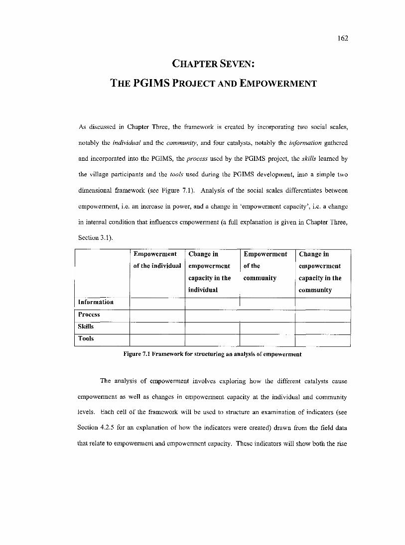
162
C h a p t e r Se v e n ;
T h e PGIMS P r o j e c t a n d E m p o w e r m e n t
As discussed in Chapter Three, the framework is created by incorporating two social scales,
notably the individual and the community, and four catalysts, notably the information gathered
and incorporated into the PGIMS, the process used by the PGIMS project, the skills learned by
the village participants and the tools used during the PGIMS development, into a simple two
dimensional framework (see Figure 7.1). Analysis of the social scales differentiates between
empowerment, i.e. an increase in power, and a change in ‘empowerment capacity’, i.e. a change
in internal condition that influences empowerment (a full explanation is given in Chapter Three,
Section 3.1).
Empowerment
o f the individual
Change in
empowerment
capacity in the
individual
Empowerment
o f the
community
Change in
empowerment
capacity in the
community
Information
Process
Skills
Tools
Figure 7.1 Framework for structuring an analysis of empowerment
The analysis of empowerment involves exploring how the different catalysts cause
empowerment as well as changes in empowerment capacity at the individual and community
levels. Each cell of the framework will be used to structure an examination of indicators (see
Section 4.2.5 for an explanation of how the indicators were created) drawn from the field data
that relate to empowerment and empowerment capacity. These indicators will show both the rise
163
and decline in empowerment and empowerment capacity. The indicators presented in this
chapter are not a definitive list. They are simply the data categories that emerged from events and
internal changes that occurred during the course of the PGIMS project. If the same framework
were applied to a different project different outcomes may emerge. Although each cell
theoretically is used to structure the examination of empowerment as it relates to the PGIMS
project there are cells that are left blank because there were no indicators of that particular
catalyst demonstrating an impact on empowerment and empowerment capacity at that scale (see
Appendix G for examples of indicators derived from the PGIMS project).
This chapter will analyse the research data using the framework presented in Chapter
Three. Section 7.1 explores empowerment of the individual as a result of the four eatalysts:
information, process, skills and tools, and Sections 7.2 and 7.3 examine how this might have been
affected by changes in individuals’ empowerment capacity and the receptivity of the community
to individual empowerment, respectively. Section 7.4 looks at empowerment of the community,
and again Sections 7.5 and 7.6 examine how this might have been affected by changes in
communities’ empowerment capacity and the receptivity of the wider region to community
empowerment, respectively. Section 7.7 discusses the key themes of empowerment that emerge
from this analysis and evaluates the effectiveness of the framework to organize an analysis of
empowerment.
7.1 EMPOWERMENT OF THE INDIVIDUAL
In both communities, individuals closely associated with the project, notably the
computer operators and informants, experienced changes in their social and political roles as a
result o f the PGIMS project. Other individuals in the communities were observed to have not
been affected as significantly.
164
7.1.1 Information
7.1.1.1 Decreased social influence o f inaccurate informants
At the outset of the research the author speculated that the informants whose information
was recorded in the PGIMS project would experience some change in political power or social
influence as a result of having their views heard. However, no-one seemed to gain status through
sharing information; those informants who were already powerful figures in the community only
had their power reinforced and those informants who were less powerful stayed less powerful.
On the other hand, some informants in Tepulang lost status through making inaccurate
and unsanctioned recordings of information. A village elder in Tepulang recorded information
about the location and extent of his fruit tree garden (simpukng). This was done to provide proof
of ownership that might be used to insure its inheritance to his descendents. Others in the village
contested the truth of his claim. They claimed that this elder used the PGIMS to try to validate a
contentious claim to an area of land for his own family’s gain, and as a result the recording was
deleted.
Complaints were also heard when a computer operator in Tepulang, an outsider who had
married into the community, documented information about traditional systems of land use, using
himself as the informant. Villagers stated that it was wrong for him to do this because “he has no
idea about what is true” (Joni, 21-year-old male computer operator from Tepulang). It was
further insinuated that he did not have the right to present information about a community that he
was not originally from.
A number of villagers noted that accuracy of information was important because “even
though the information on the computer is wrong, once it is presented in that way it is considered
to be true” (Kuran, 47-year-old elder from Tepulang). The selection of informants was also
considered important. As one elder in Benung noted:
165
Not everyone is able to give aeeurate information, only the elder generation are capable,and even they are only 90% right! (Nimo, 39-year-old male village administrator fromBenung).
This view is backed up by a woman in Tepulang who states “we have to use information
sources that are correct, they really must know, don’t choose any old person” (Lyn, 35-year-old
female teacher from Tepulang). However, the accuracy of information and legitimacy of
informants is to some extent determined by the powerful members of the community. The above
examples show how individuals who made bids for power through unilaterally recording their
own information were thwarted in their efforts by the rest of the community.
7.1.2 Process
7.1.2.1 Increased social influence o f female computer operators
As part of the participatory process, several interventions were made to increase the
involvement of women in the project. One of these interventions was to request that at least one
of the computer operators in each village was a woman. Both women were empowered through
becoming operators, but to different degrees.
The woman selected from Tepulang was very young, having just returned to the village
after graduating from high school. She did not show a high level of initiative or interest in the
PGIMS throughout the course of the project. This was partly because of conflict that occurred
between operators in Tepulang (this is discussed in more detail in Section 7.2.3.2); it may also
have been because she was intimidated by the fact that all the other operators and the external
collaborators were men. However, she did show leadership in facilitating a women’s meeting,
and people observed that she spoke confidently and authoritatively at that meeting, even though
at general community meetings she would not speak, if she attended the meetings at all.
The woman selected from Benung was married with a young family. She became a very
able and involved member of the computer operator team. As well, she began to be more
166
involved in general community meetings, particularly those related to PGIMS project decision
making. She called and facilitated several community meetings and contributed substantially to
meeting’s outcomes. This was a marked change from her previous role in the community:
Before I was never brave enough to say anything during community meetings. Even when I was a child I could never say anything in front of my class! (Maria, 34-year-old female computer operator from Benung)
However, tensions emerged between this woman and her husband concerning her involvement
with the project. He claimed that the computer training and information collection was detracting
her from domestic chores, and he prevented her from acting as a trainer at the multi-stakeholder
training workshop.
7.1.2.2 Increased social influence o f less powerful villagers
The participatory process used in the project was intended to encourage the participation
of all interested individuals in project decision-making. The impact of this process on people’s
involvement in project decision-making turned out to be quite different in the two communities
(see discussion of community receptivity in Section 7.3).
Some people appeared to benefit from the process. One villager from Benung, an older
man who was not one of the major power brokers in the village, was interested in making a video
on the stages of the ladang process because he felt that future generations might not know about
this part of their culture. Although other villagers clearly did not see this as a priority, he was
persistent and eventually got his way. In his case, the relative openness of the meetings enabled
him to exert some influence that he might not otherwise have had. Several other examples exist
of less powerful individuals promoting their ideas through to acceptance. However, the overall
rise in the influence of less powerful villagers was relatively minor.
167
7.1.3 Skills
7.1.3.1 Increased and decreased social influence o f male computer operators
Several of the male computer operators experieneed a significantly changed social and
political role as a result of the skills acquired from involvement in the project. A young male
computer operator from Benung noted that prior to the PGIMS project:
I was capable of contributing ideas in community meetings, now after being involved with the project I can make decisions for the community. (On, 33-year-old male computer operator from Benung)
This project, combined with other work he was involved in, has led to suggestions that he should
run for the position of village head in the future.
A changed social role is not necessarily one of empowerment. In Tepulang another
young male computer operator was disempowered by his increased skills. He was considered
“too ambitious and put on airs of intelligence” (Lyn, 35, Tepulang). This, plus his efforts to
monopolise the skills and tools, contributed to his marginalization within the community and led
to his resignation as the head of the village advisory committee.
Two other male computer operators did not appear to have been empowered or
disempowered by their new skills. One was already well established in the leadership structure
(village secretary), and the other was young and never became seriously involved in the project.
It is hard to determine how much these changing social roles are a direct and exclusive
result of the PGIMS project or how much they can also be attributed to other influences.
7.1.4 Tools
No examples were observed of the tools used in the PGIMS project either increasing or
decreasing power at the individual scale.
168
7.2 CHANGES IN EMPOWERMENT CAPACITY AT THE INDIVIDUAL SCALE
Changes in capacity for empowerment were noted in individuals in both communities,
including individuals who were computer operators, informants, and community leaders as well
as community members not as closely involved in the project.
7.2.1 Information
7.2.1.1 Increased confidence to communicate information to outsiders
Individuals sometimes appeared to feel an increased sense of confidence when
communicating information through videos, compared to presenting this information directly.
For example a middle-aged male from Tepulang recorded a video piece describing the
importance of the forest for the community and the need for any forestry companies to consult
with the community before starting logging operations. In the video he expressed some strong
opinions about the role of adat, the village’s rights to its forest and the responsibilities of the
regional government with respect to this situation. He explicitly intended for this video to be
shown to the Bupati of West Kutai.
This man is often accused by other members of the community of being opinionated in
the community, yet freezing up when talking to government officials. Because of the informal
nature of the way in which the video was recorded he was very articulate on the video. It allowed
him to state his feelings in a way that he had not been able to in the past because of social
conditioning and the difficulty of expressing views to political leaders. This man described
himself as feeling great pride and wanted to make more recordings.
In this example it was not so much the information itself that increased the man’s
confidence as the fact that he could better present his views in video format.
169
7.2.2 Process
No examples were observed of the participatory process used in the PGIMS project either
raising or diminishing empowerment capacity at the individual scale.
7.2.3 Skills
7.2.3.1 Increased self-esteem o f computer operators through mastery o f skills
There is a connection between social status and mastery of computer skills in West Kutai.
Computers are associated with life in the city and high levels of education and are believed by
many people in both villages to lead to emancipation from the drudgery of rice farming by
increasing the likelihood of obtaining paid office work. Operators from both villages expressed
great satisfaction with having the opportunity to learn to use the tools; one operator described it as
“a gift from God.” This satisfaction was in part due to not having to pay for a computer course
which would be in excess of 700,000 Rupiah (approximately $140 CAD) making it out of the
reach of most villagers.
At the scale of the individual, mastery of the skills needed for using PGIMS technologies
offered a link to empowerment through challenging existing stereotypes and societal roles and
fostering a sense of self-confidence. As one computer operator in Benung noted, “I feel that I
have been taken up a step in life by this project” (On, 33, Benung). Another noted, “before I
could never speak in front of other people, now I am brave enough to be involved and contribute
to the public” (Maria, 34, Benung).
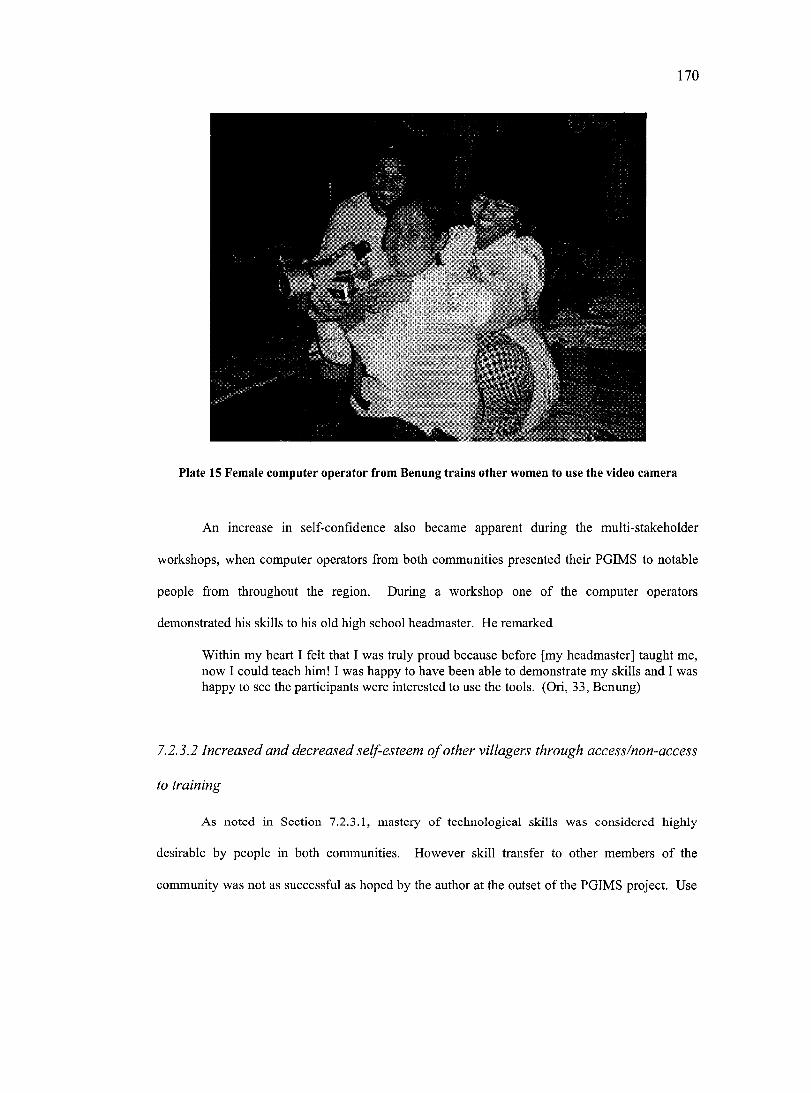
170
:
Plate 15 Female computer operator from Benung trains other women to use the video camera
An increase in self-confidence also became apparent during the multi-stakeholder
workshops, when computer operators from both communities presented their PGIMS to notable
people from throughout the region. During a workshop one of the computer operators
demonstrated his skills to his old high school headmaster. He remarked
Within my heart I felt that I was truly proud because before [my headmaster] taught me, now 1 could teach him! I was happy to have been able to demonstrate my skills and 1 was happy to see the participants were interested to use the tools. (On, 33, Benung)
7.2.5.2 Increased and decreased self-esteem o f other villagers through access/non-access
to training
As noted in Section 7.2.3.1, mastery of technological skills was considered highly
desirable by people in both communities. However skill transfer to other members of the
community was not as successful as hoped by the author at the outset of the PGIMS project. Use
171
of some tools such as the video camera and digital camera were much more widespread through
the villages, but computing skills were restricted to a few.
The concentration of skills in a small number of people led to frustration in others who
wanted to access the tools. This is well summarized by an elder in Tepulang:
There are many benefits from having these tools in the village, but to be really useful there is a great need for more people in the village to be able to use the tools. (Lundin,42-year-old teacher from Tepulang)
These limitations in access were mostly due to the PGIMS project only being able to
install one set of equipment in each corrununity. This led to a bottleneck in the number of people
able to receive training in the PGIMS skills. However, at the outset of the PGIMS project
emphasis was placed on the responsibility of the computer operators to pass on their skills to
other people in the community. This gave other community members high expectations that they
too would receive computer training.
The operators’ level of commitment and approach to training was very different between
the two communities. Benung used an informal method. The computer operators announced that
they were prepared to train others in the community, but would only respond to direct requests.
Demand from other community members was not high, perhaps because of the relatively high
concentration of older people in the community. The operators also had limitations to the time
available to provide training. By the end of the project fieldwork, seven people (in addition to the
operators) had been trained to varying levels by the community operators in Benung, and the
training had been informal and unstructured. Despite this, photographs taken by community
members show a large number of different people using the computer; this would imply a broad
level of interest and ability to use the tools throughout the community. A teacher in Benung who
had been trained to use the computer said:
This project has really helped me take a step forward and has provided a great opportunity to learn new skills. (Beng, 36-year-old male teacher from Benung)
172
In Tepulang a community meeting was held to choose villagers who would attend two
computer training courses given by the three computer operators during the time that the author
was in Canada. Trainees were limited to six people per 10-day course. The first workshop was
completed successfully, but the second failed because of disagreements that grew into an open
conflict between the operators. The failure of the second workshop acted as a watershed in the
interest shown in the PGIMS project by the community in Tepulang. Prior to this enthusiasm was
high and support for the PGIMS project strong throughout the village. After this conflict
surfaced, few people from the community, including the operators, continued to show the same
level of interest in the project.
The main source of disagreement was one operator who was accused by other people in
the community of monopolizing the skills. This operator announced that if people wanted to
learn how to use the computer they would have to pay him between 100,000 and 200,000 Rupiah
($20 - $40 CAD). He also attempted to control use of the computer by other villagers by using it
as often as possible, and by pulling the cables out when not using it in order to prevent other
people in the community from being able to access and use the PGIMS. His actions created
substantial anger in the village, as was expressed by one woman:
If we want to leam to use the computer he is always using it. We are made to feel embarrassed and to feel like beggars. While he still uses the eomputer I cannot be bothered to leam. Better I do not use it rather than fight about it. Many people feel this way. (Lyn, 35, Tepulang)
One of the primary causes for the conflict in Tepulang was that the operator was only
interested in learning the skills for his own benefit. By monopolising the skills this individual
was attempting to gain power over other community members. For this operator, however, the
power was short lived, as the community responded by isolating him and withdrawing from the
project. He, in reaction, resigned from an important administrative position in the community (as
described in Section 7.1.3.1).
173
7.2.5.3 Increased critical awareness o f computer operators leading to demystification o f
popular media
As noted by Richardson (1997), few communities live in total isolation from the outside
world. In terms of external influences, the villages of Benung and Tepulang are reached by,
among other things, television, radio and newspapers. Richardson (1997) further states that there
is a need for people to sharpen their ability to interpret the information reaching them through
these channels.
During the PGIMS project individuals were observed to be showing a more analytical
approach to understanding popular media. While watching the news on the television, a pair of
computer operators began to comment on different shots, cuts and transitions used in a particular
news commentary. Their PGIMS-related skills gave them a new way to analyze the information
and manner in which it is presented on the television. They also commented on how they might
have done a better job at editing and presenting the information. This new awareness that the
popular media was fallible and that their own capabilities and skills were comparable, and
perhaps superior, to that of outsiders is a further indication of how their new skills had given them
an increased confidence in their own abilities.
7.2.3.4 Increased economic opportunity fo r computer operators
It was strongly believed in both communities that learning new, in partieular computer,
skills would “allow the youth to get jobs in companies in the region” (Bensin, 44-year-old male
resident of Tepulang). As a result of the skills learnt during the PGIMS project, two operators,
one from Benung and one from Tepulang, were employed by the regional government. One of
these operators had previously felt that getting this type of work was “beyond my imagination”
(Maria, 34, Benung). Both were explicit about their feelings of pride and betterment, which in
turn are indicative of increased capacity for empowerment.
174
Computer operators who remained in Benung were also able to apply their new
technological skills to moneymaking ventures through recording videos, transferring them to
VCD and selling them outside of the village. Operators were requested to record videos by the
regional government, the Department of Tourism, an NGO and other individuals. In addition to
providing economic benefits, this helped the operators to develop wider networks in the region.
The intention of the training in the PGIMS project was not to focus on job related skills,
especially if they resulted in village operators being hired into the commercial marketplace rather
than remaining in the community in which they were trained. Although the individual may have
increased his or her capacity for employment and empowerment, the community as a whole lost
capacity as they lost a valuable resource for developing the PGIMS and passing on their skills to
others in the community.
7.2.4 Tools
7.2.4.1 Increased self-esteem o f villagers from association with tools
There was some minor evidence that the tools themselves were used by people to increase
their status. Some people on outings from the community would take the digital camera and
video camera with them in order to be seen using them in public places, even if they did not know
how to use them. However, sometimes people operating the tools in public were exposed to
derogatory comments from other community members, such as “here comes the journalist”
(Carop, 24-year-old female resident of Tepulang). This made the person using the tool feel
conspicuous in the eyes of other people in the community, as it implied that they were propping
themselves up through the tools. On the other hand, this comment may have reflected feelings of
envy or jealousy on the part of the person making the comment, indicating that these tools were
indeed associated with enhanced prestige. M. Wilson (personal communication May 2003) notes
that this behaviour is indicative of “levelling mechanisms” used in “simple societies” that strive
175
to keep everyone equal, so that no one rises above others. Techniques used to achieve this level
playing field include gossip, ostracism and sarcasm.
7.3 COMMUNITY RECEPTIVITY TO INDIVIDUAL EMPOWERMENT
Despite the participatory nature of project decision-making, it appeared that other factors
were equally if not more important in ensuring that all community members’ voices were heard.
These included the existence of institutions for overseeing the implementation o f decisions and
the relationship of the computer operators to the other villagers. Without strong governing
institutions and good relations between the operators and the community, the computer operators
were in danger of becoming self-directed ‘technological elites’ in the type described by Harley
(1988).
In Tepulang, the decision-making process appeared superficially to be participatory as
meetings involved input from a broad spectrum of community members. However deeisions
made during community meetings were often not followed through. One reason for this was the
weak leadership of the unpopular Kepala Desa, resulting in the laek of a coordinating body for
overseeing implementation of decisions. Also, the computer operators often ignored the input of
others in the community and made unilateral decisions about the eollection and use of
information.
Despite the Kepala Desa being popular and democratieally elected, Benung was
relatively traditional and exelusive in its decision-making processes. Community meetings often
took place without the participation of the women and youth; consequently decision-making
remained in the hands of a powerful minority. The PGIMS project gave all individuals in the
community the opportunity to become more involved in PGIMS related decision-making;
however, these meetings were still dominated by the community leaders. Nonetheless the
strength of the governing institutions, together with the role o f the computer operators as
176
executors of the decisions of the community, led to greater receptivity in Benung to empowering
individuals in the community, relative to Tepulang.
7.4 EMPOWERMENT OF THE COMMUNITY
This section will examine the impact of the PGIMS project on the communities in respect
to empowerment. This is indicated by an increased ability of the community to influence
decision-making processes and other events within the wider region.
7.4.1 Information
During the PGIMS project there were two prominent examples where information was
used successfully to communicate with groups outside of the village and influence events in the
wider region. Both these examples involved illegal logging on Benung’s traditional lands by
neighbouring villages.
7.4.1.1 Increased social influence with regional decision-makers
The first incident involved multiple incursions by illegal loggers from the neighbouring
village o f Muara Tokong onto Benung’s traditional land. In Benung, a hunting group of young
men discovered the illegal loggers in their forest. The group immediately returned to the village
and informed the village leaders. The leaders gathered together and decided to eonfront the
loggers and record the incident. The next day they returned with the video equipment to where
the illegal logging was taking place.
As the group of leaders approached the logging camp, they saw and recorded evidence of
felled timber. Entering the camp, they gathered together the loggers, who were already known to
the elders, and informed them of the illegality of their operations. The loggers apologised,
offered a weak excuse, and departed that day. The leaders took no further action.
177
Four months later the same group of illegal loggers returned to the forest and began to
fell timber again. The leaders immediately wrote to the local government requesting a meeting,
where they presented the recorded evidence from the previous encounter. The government was
sympathetic and ordered all the felled timber to be returned to Benung. They also threatened the
illegal loggers with severe fines if they encroached again.
7.4.1.2 Increased social influence with other communities
The second incident involved illegal logging by Tepulang on the traditional lands of
Benung. As logging activities increased in the area, the people of Benung and Tepulang decided
it was necessary to document the location of the boundary between the two villages. On a
prearranged day, elders from both villages met and walked the boundary between the two
villages, agreeing on the position of the boundary without conflict. Using a video camera, people
from Tepulang recorded the entire process.
Six months later Tepulang began logging in the vicinity of the boundary between the two
villages. Soon after operations had commenced Benung claimed that the logging operation was
straying onto their territory. A joint village meeting was called. The computer was set up in the
meeting hall and the video taken during the boundary walk was displayed. As a result of the
information contained on the video, the conflict swiftly was resolved, and the logging operations
withdrew from the contentious area leaving the felled timber behind.
Both these examples show the community of Benung using the information gathered as
part of the PGIMS project to resolve conflict with outside groups successfully. However, it
cannot be assumed that these successes indicate a long-term increase in power for local
communities. It is also unlikely that these incidents of themselves will lead to greater
involvement in regional decision-making processes, and even if they should happen it would be
impossible to relate this exclusively to the PGIMS project.
178
7.4.2 Process
No examples were observed of the processes used in the PGIMS project either raising or
diminishing power at the community scale.
7.4.3 Skills
No examples were observed of the skills used in the PGIMS project either raising or
diminishing power at the community scale.
7.4.4 Tools
7.4.4.1 Increased bargaining power with outsiders
Increased bargaining power associated with the project’s tools occurred when a timber
investor came to the village of Tepulang with the intention of purchasing timber from the
community’s traditional forest land. Timber investors are known to verbally offer large sums of
money during the negotiation stage with the villagers; often, at the end of the operations these
high sums are not paid in full.
A village meeting was called in order to negotiate the price for the timber being sold from
Tepulang’s territoiy. Members of the community recorded the meeting using the camera and
video camera. The video operators made a big show of using the equipment in front of the
investor. The investor was noticeably uncomfortable about being recorded and cautious about
promises that he made, and the community felt that the equipment had given them a more
powerful position from which to negotiate a good price for their timber. The community
appeared to be less interested in the recording itself, as the information was never edited or
incorporated into the community’s PGIMS.
It is speculated that the presence of the tools provided the community with some
advantage by representing them as not just simple farmers, but people with access to tools more
179
often used by educated elites. It is unclear how lasting this means of empowerment will be in the
region as these tools lose their novelty value.
7.5 CHANGES IN EMPOWERMENT CAPACITY AT THE COMMUNITY
SCALE
The analysis of empowerment capacity at the community scale explores how groups
within the community, defined by gender, education level and age, as well as the community as a
whole, gained increased empowerment capacity through the PGIMS project.
7.5.1 Information
7.5.1.1 Increased community confidence to make statements to outside groups
The PGIMS project provided communities with a medium for communication that had
previously been unavailable. Benung used their PGIMS to present evidence to outside groups, as
shown in the two examples described in Section 7.4.1. These examples show how information
that was documented by video was taken more seriously by regional government and other
villages than the verbal statements and maps that would have been used previously. This
increased legitimacy of recorded information made Benung more confident about making claims.
As well, the PGIMS was used by Benung to present community views on their vision or
plans for the future. One recording was made to show regional government members at the
multi-stakeholder workshop the community’s ideas on how to log the forest using more
sustainable traditional methods. This occurred soon after the beginning of a pilot project with
SHK on ecosystem-based forest management. Another recording from Benung explained the
importance and history of their longhouse, and ended with a request for funding for its repair.
Previously communities were capable of eommunieating with the government; the
difference is that now they are using novel tools to increase their influence on decision-making
180
processes. Showing information in this way complements the traditional oral system of
communication and furthermore enables villagers to present visual information that might
otherwise be missing. It also bolsters the villagers’ confidence by giving them the means to
prepare a presentation in advance, rather than have to talk directly to people in positions of
power. However, success in influencing decision-makers still depends on the non-technological
ability of community members to interact with these powerful people. As Shiffer (1999 p. 1)
notes “information is only powerful when it is effectively understood by those who use it.” The
information as it stands alone is unlikely to influence outsiders, but it might be useful in
providing communities with support and increased confidence in promoting evidence and plans to
decision-makers.
7.5.1.2 Increased community identity through understanding local history, culture and
adat
In West Kutai traditional leaders recognize the need to reconstruct their local history,
culture and adat (as opposed to local culture, such as songs, dance, folk tales, etc., adat refers to
the Benuaq system of traditional laws for the living of one’s life). An understanding of adat is
recognised as key to restoring a strong sense of Benuaq identity. It is also thought to be key to
understanding the more ecologically sustainable land and resource management system that
traditional Dayak culture was known for.
There are a number of examples of historical and cultural information being recorded,
primarily by the women (described in Chapter Six). There arc also examples of adat being
recorded on the PGIMS, mainly those laws relating to rights over land and resources, the location
of territorial boundaries and the belian and kwangkai ceremonies. One prominent traditional
chief stated:
People need to know about the adat o f their older generations. These days everything isa disaster. Before, things were well organized. If we explore and leam our adat
181
hopefully we can rekindle and use it so we can return to the past conditions. (Ajaw, 85- year-old traditional chief-of-chiefs from Maura Lawa)
Despite recognition of the importance of documenting adat within the community, there
were times when tensions emerged over the use of the PGIMS as a mechanism to record and store
that information. This is because control over who may leam and use adat knowledge is tightly
regulated in Benuaq society. Certain information may only be known by certain people within a
community; as one elder in Benung noted “there are many secrets in this village and systems for
regulating them” (Setin, 42-year-old male teacher from Benung). Information is acquired only
after long apprenticeship and the payment o f expensive gifts. It is then carefully guarded because
power is institutionalized through possession of this knowledge (Hopes et a l, 1997). The
mechanism used to maintain control over this information is called temai:
Temai is the law which determines that we cannot give information to others even if we know it, because if we tell people the knowledge looses its potency. (Salmo, 72-year-old traditional chief from Benung)
This traditional mechanism of knowledge transfer conflicts with the idea proposed by the
PGIMS project, notably that local knowledge needs to be recorded and stored for communal use.
As noted by Scoones and Thompson (1993 p. 2 cited in Parpart, 2000b) “knowledge is not just
ready to be picked like an apple on a tree. It is embedded in social contexts and attached to
different power positions.” The individual wanting to record or contribute information that is
regulated by temai is breaking traditional adat law. Thus when recording information about
traditional medicinal plants in Tepulang, the woman describing the plants was very conscious not
to break the temai attributed to this knowledge; as a result the information gathered was
superficial and incomplete.
However, others disregarded temai to describe some forms of adat knowledge such as the
location of territorial boundaries. They did this in recognition that the information was too
pressing and important to be hidden. They also felt that there is a danger of information being
182
lost if they continue to respect temai, as most youth are unwilling or unable to spend the time and
money necessary to undergo the traditional apprenticeship. Nonetheless the existence of temai
diminishes the potential of the PGIMS as a mechanism for increasing understanding of adat in
the youth and future generations.
7.5.1.3 Increased and decreased community ability to own and control information
Both communities demonstrated a need to balance communicating information with
outsiders with limiting information distribution so that it remains in the control of people in the
village. As noted by one external collaborator
O f most importance is the need to organize the information by having some form of filter. There is information which can be shared widely, because that information will help to strengthen the community, there is also information which is secret and cannot be shared with other people. (Ambon, 42-year-old NGO activist living in Samarinda)
As asserted by Parpart (2000b p. 7) recording information “can disempower if it removes
the ability to control the dissemination of knowledge.” As with the temai system, there appears to
be an explicit relationship between empowerment capacity and the regulatory mechanisms that
the community develop to control and effectively manage information contained within the
PGIMS. The presence and use of these mechanisms indicates that people in the community
remain in control of their information, even though they are adopting new ways of
communicating and storing it.
Both communities developed regulations to control the accessing, copying and
dissemination of information (see Appendix F). Yet these regulations appear only to have been
enforced in Benung. An example of this occurred when representatives from a local NGO
requested a copy of Benung’s PGIMS from the computer operators. Computer operators and
other prominent community members responded that they could not freely distribute the
information before they had discussed the issue in more detail in a community meeting. Despite
pressure the community continued to resist handing over the information until they were satisfied
183
as to how the information was to be used. The restraint shown by Benung is an indicator of
empowerment capacity, but it is difficult to know if this can be directly attributed to the PGIMS
project or to pre-existing levels of empowerment capacity in the community. It does however
show an ability to use traditional social mechanisms to control the information contained within
the PGIMS.
In Tepulang, the PGIMS was treated in an open-access fashion. One young man from the
village stated that:
If people want to see the information that is not a problem, if they want to use the computer without permission that is a problem. (Daro 30-year-old male resident of Tepulang)
Outsiders were observed coming into the community and freely accessing the computer and
information contained within. Despite protestations from some community members, there was
no control exercised within the community to regulate access. This laissez faire attitude might in
part have been because the computer was located in SHK’s field office and not in a neutral
location. The villagers as a result might not have felt true ownership over the PGIMS. This
attitude could also have been related to the tensions concerning monopolization of the skills and
tools. As a backlash to this nobody was prepared to enforce the community’s regulations for fear
of appearing equally monopolistic. This attitude is further indicative of the low value given by
the community members of Tepulang to the information contained in the PGIMS. Unlike in
Benung, the information was not considered important or sensitive enough to warrant its tight
control.
7.5.1.4 Increased and decreased community cohesion between generations through
sharing information
Successive political regimes over the past 30 years have sought an homogenous
Indonesian identity. The resultant monoculturalism has been introduced and reinforced through
184
the education system (Leigh, 1999) and popular media. As a result, a strong Benuaq identity has
been declining primarily through a growing alienation between the youth and elder generations.
This decline is clearly outlined by a young man from Tepulang:
In my village I do not know anything at all about the history of the village. I am not joking; I really know nothing. We are not aware, from a young age we never ask the elder people. The older people also do not have the awareness to tell the generation that follows their own. (Rado, 26-year-old male resident of Tepulang)
Many indigenous groups throughout the world are attempting to reconstruct their identity through
the process of documenting and expressing their cultural information (Davidson-Hunt, 1999).
During the PGIMS project youth in both villages were attracted to learning to use the
technologies. The community elders, however, controlled the local knowledge. Successful
development of the PGIMS therefore required an exchange between these two groups, this
process in turn contributed to strengthening community cohesion as well as identity (see Plate
16).
There is evidence from Benung that the PGIMS project facilitated the transfer of
information between different generations within the community and contributed to greater
community cohesion. One example began with four elders in the computer room watching two
computer operators being trained. The operators were adding information to the PGIMS about
the history of the rubber plantations in the village. Soon the elders began discussing the
development of rubber in the region. The younger people in the room typed their words into the
computer, and together they produced a comprehensive record. There was a feeling of
satisfaction expressed by all participants with the end product. The group agreed to meet again
and make a similar document to describe the history of traditional forest management practices in
the community. This they completed three weeks later.
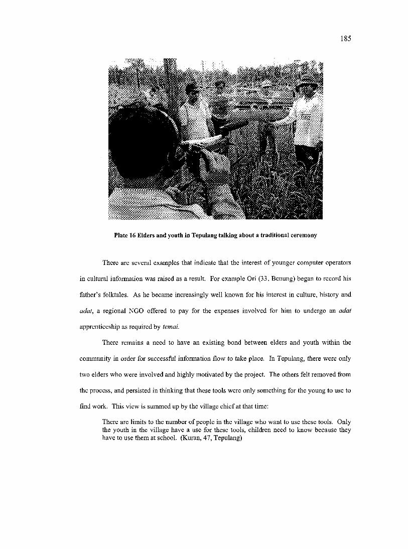
185
Plate 16 Elders and youth in Tepulang talking about a traditional ceremony
There are several examples that indicate that the interest of younger computer operators
in cultural information was raised as a result. For example Ori (33, Benung) began to record his
father’s folktales. As he became increasingly well known for his interest in culture, history and
adat, a regional NGO offered to pay for the expenses involved for him to undergo an adat
apprenticeship as required by temai.
There remains a need to have an existing bond between elders and youth within the
community in order for sueeessful information flow to take place. In Tepulang, there were only
two elders who were involved and highly motivated by the project. The others felt removed from
the process, and persisted in thinking that these tools were only something for the young to use to
find work. This view is summed up by the village chief at that time:
There are limits to the number of people in the village who want to use these tools. Only the youth in the village have a use for these tools, children need to know because they have to use them at school. (Kuran, 47, Tepulang)
186
The result was that the management of the tools was largely left to the youth who ended up using
the computer in an undirected way and without the support of the elders. At the same time some
people from the older generations accused the young operators of documenting information that
was false and asserted that they had no right to be recording this information in the first place. It
was partly because of the emphasis on the youth to manage the tools and implement the PGIMS
process that the project came to a halt in Tepulang. This reflected the dysfunctional state of the
community, where the PGIMS project appeared to further exacerbate pre-existing divisions
between generations.
7.5.2 Process
7.5.2.1 Increased and decreased community cohesion among villagers
A participatory process was considered important for this project because it would ensure
that all groups within the village felt ownership over the PGIMS that was produced, which in turn
would increase community cohesion and unity.
Throughout the course of the PGIMS there was a notable difference between the two
villages in the style of their administration. In Benung, the Kepala Desa was democratically
elected and held the respect of the community. However, decision-making mechanisms were
relatively formal and authoritarian, and turn-out to community meetings, as well as the level of
participation by people at them, was generally low, especially for women. Throughout the
PGIMS project, the village leadership remained in tight control of the proceedings. Nonetheless,
the participatory process eventually led to a more relaxed meeting style where more people made
contributions. Turnout was high at the early PGIMS meetings, probably due to the novelty factor.
However, it continued to stay high throughout the duration o f the project.
This participatory process received positive feedback from community members. As
noted by one computer operator in Benung:
187
I think the process has been good because it has always relied on community meetings. By including as many people as possible, the benefits are spread to many more people. It is very important to engage the community and to be as open as possible, as many projects do not do this; they only visit the village chief. By being open and honest with the village they will be more likely to support the programme. (Ori, 33, Benung)
In Benung, tension between the leadership and others in the village seldom occurred as a result of
this increased participation, mainly because the leaders and the other villagers were generally in
agreement. However, a situation where there was strong but unpopular leadership might have
caused the introduction of more participatory processes to result in an open display of the existing
internal conflict.
In comparison Tepulang exhibited high initial participation as well as high turnout in
community meetings, even by some women. However, the Kepala Desa was a weak, unpopular
man. The PGIMS village meetings, often held in his absence, were marked by strife between
different factions. People would freely give their opinions and decisions would appear to be
made, but follow-up was often poor since there was little feeling of accountability due to a lack of
official leadership and no clear delegation of responsibilities. This was recognized by people in
the community who noted that “the reason that [the PGIMS project] was less successful in
Tepulang was because they are not capable of working together” (Nimo, 39, Benung). By the
end of the project, turnout to meetings was low. The participatory process of this project
therefore was not enough to ensure that community cohesion was increased in Tepulang.
7.5.2.2 Increased ability o f women to organize themselves
Despite encouragement at community meetings for women to contribute, it was still felt
by women interviewed that as a group they were excluded from the PGIMS project. In Benung
women were often absent or noticeably silent at most meetings. As noted by the female computer
operator from Benung;
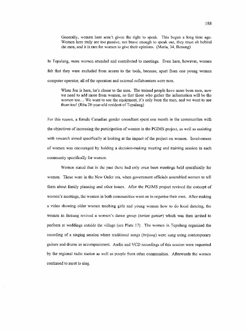
188
Generally, women here aren’t given the right to speak. This began a long time ago. Women here truly are too passive, not brave enough to speak out, they must sit behind the men, and it is rare for women to give their opinions. (Maria, 34, Benung)
In Tepulang, more women attended and contributed to meetings. Even here, however, women
felt that they were excluded from access to the tools, because, apart from one young woman
computer operator, all of the operators and external collaborators were men.
When Jon is here, he’s closer to the men. The trained people have more been men, now we need to add more from women, so that those who gather the information will be the women too... We want to use the equipment, it’s only been the men, and we want to use them too! (Rita 28-year-old resident of Tepulang)
For this reason, a female Canadian gender consultant spent one month in the communities with
the objectives of increasing the participation of women in the PGIMS project, as well as assisting
with research aimed specifically at looking at the impact of the project on women. Involvement
of women was encouraged by holding a decision-making meeting and training session in each
community specifically for women.
Women stated that in the past there had only once been meetings held specifically for
women. These were in the New Order era, when government officials assembled women to tell
them about family planning and other issues. After the PGIMS project revived the concept of
women’s meetings, the women in both communities went on to organise their own. After making
a video showing older women teaching girls and young women how to do local dancing, the
women in Benung revived a women’s dance group (tarian gantaf) which was then invited to
perform at weddings outside the village (see Plate 17). The women in Tepulang organised the
recording of a singing session where traditional songs {brijooq) were sung using contemporary
guitars and drums as accompaniment. Audio and VCD recordings of this session were requested
by the regional radio station as well as people from other communities. Afterwards the women
continued to meet to sing.
189
Plate 17 Women from Benung dancing at a wedding in the upper Mahakam area.
Although the participatory process did not have any noticeable effect on changing the
role of women at general community meetings, it did have notable achievement in helping
women to take a greater role in the project and providing them with an element of influence and
control over the PGIMS development and use. This they used to increase information content
aimed at fostering the community’s sense of cultural identity. It also contributed to improving the
ability of women in both communities to organise themselves. These are indicators of increased
empowerment capacity.
7.5.2.3 Increased and decreased community dependence on external collaborators
Initially, the presence of the external collaborators was necessary for the progress of the
project in the communities. They were the ones to introduce the project and facilitate the initial
process, as well as provide skills and support to the community. Furthermore the external
collaborators were important in attempting to facilitate and mediate between computer operators
when conflict emerged. However one intention of using a participatory process was to enable the
190
community to increasingly take the proeess on for themselves. An important indicator of
increased empowerment capacity is the ability of the community to continue the project
independently after the withdrawal of the external collaborators.
As presented in Chapter Six (Section 6.3.3), the computer monitoring information
showed increasing signs of independence in Benung, this was demonstrated by an increased use
of the PGIMS software during the time the external collaborators were absent from the
conununity. In Tepulang, the computer monitoring data showed that dependency on the presence
of the external collaborators continued to the end of the project. This was further summed up by
a village elder during a final community meeting
We recognize that we will need continuous support from SHK with this tool. (Setui, 44- year-old male resident of Tepulang).
7.5.3 Skills
7.5.3.1 Decreased community cohesion between educated and less-educated
It was observed that the PGIMS skills were monopolized by the better-educated youth in
the village while the less educated were further marginalized. To illustrate this, a young woman
in Tepulang had asked to learn to use the equipment from the outset of the project. After some
time of not meeting the author asked her whether she was still interested; she responded that she
was certainly still interested, but that she could not use the computer because “she was not
schooled.” She was told that this was not a problem, to which she responded;
Maybe it is not a problem for Jon, but it is a problem for some people in the village. (Carop, 24, Tepulang).
The educated elites in the village were preventing her from accessing the tools.
The tools were initially chosen for the simplicity of their use. The computer remained
above the capabilities of some people in the village. However, there were examples of people
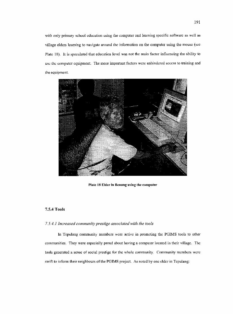
191
with only primary school education using the computer and learning specific software as well as
village elders learning to navigate around the information on the computer using the mouse (see
Plate 18). It is speculated that education level was not the main factor influencing the ability to
use the computer equipment. The more important factors were unhindered access to training and
the equipment.
Plate 18 Eider In Benung using the computer
7.5.4 Tools
7.5.4.1 Increased community prestige associated with the tools
In Tepulang community members were active in promoting the PGIMS tools to other
communities. They were especially proud about having a computer located in their village. The
tools generated a sense of social prestige for the whole community. Community members were
swift to inform their neighbours of the PGIMS project. As noted by one elder in Tepulang:
192
The people from the village are very proud when they talk with outsiders ahout the computer, even if they don’t know how to use it! (Osaq, 43-year-old pastor living in Tepulang)
In Tepulang the tools were used in such a way as to give prominence to the village. A large
regional meeting was held in Melak to discuss the issue of decentralized governance and the
impact on the village level. The villagers representing Tepulang at the meeting decided that they
wanted to record the meeting using the justification that they could then show the results to
people from the community who could not go to the meeting. Duly they recorded the meeting
with much fanfare, and the result was that the village and the PGIMS project received a great deal
of public exposure. Yet on return to the village, there was no interest by the two representatives
who recorded the meeting in showing the video material to the other community members. This
material was soon forgotten and eventually erased. The author believes that the intended
objective of the exercise was to be seen in public using the equipment and that the information
from the meeting was of lesser importance. The individuals undertaking this activity on behalf of
the community felt they had enhanced their social prestige through associating themselves with
these high technology tools.
In Benung the opposite took place. A man originally from the village, now working as a
lawyer in Samarinda, ridiculed the community. This man stated:
The people of Benung are farmers, for what do they need a computer! Better you give them a bush knife (parang) or hoe (cancul), at least they will have use for these tools! (Abu, 5 3-year-old male lawyer living in Samarinda)
As a result computer operators and others supportive of the PGIMS project in the village felt
embarrassed by their involvement in the PGIMS project. This embarrassment however, soon
turned to anger toward the man, who represented the elite of Samarinda and owned a computer
himself. It is possible that the man felt threatened by the villagers using tools which he associated
with his own enhanced prestige.
193
7.14.2 Increased and decreased community ability to own and control tools
The ability of a community to organise itself is an indication of empowerment capacity.
One sign of ability to organise came from the way in which the communities chose to manage
and mobilize resources around the tools. Effective management is an indicator of the
communities taking ownership and showing a level of mastery over tools which are novel and
have the potential to be intimidating to people unused to them.
The management of these tools has both a formal and an informal component. The
formal component refers to the establishment and agreement on institutions and rules that govern
their use. The informal component refers to processes that do not derive from structured
authority but are equally essential to the tools use and management, although they are often not
stated and only become apparent through observation.
Benung was efficient in managing the tools. The computer was meticulously maintained,
the dust screen was always in place, the computer room swept and maintained and the camera and
video equipment kept in a cupboard. All the equipment was kept in a locked room. Village
elders even considered password protecting the information contained within the computer. The
village administration and other power brokers in the community invested time and resources into
managing the use of the tools and locating them in a neutral and accessible location. They also
organized for the electricity bill to be paid by the village through the community tax. This
showed their willingness to pay for the potential benefits derived from the computer^^. They also
oversaw the development of the list of regulations to govern the use o f the tools.
Tepulang were more haphazard in their management of the tools. Nobody in the village
appeared prepared to take responsibility and as a result informal and anarchic management was
the norm. Initially there was reluctance to create a list of regulations due to a feeling that the
Willingness to pay for long term maintenance and upkeep of tools is also indicated by Benung paying for fixing the video camera when broken at the cost of 810,000 Rupiah (approx $165 CAD)
194
tools were open access for everyone in the community. The video and camera equipment were
frequently scattered throughout the village and there appeared to be no centralized or recognized
system for managing the equipment. There also appeared to be little willingness to pay for the
upkeep of the computer. The author believes that one of the main reasons that the computer
remained in SHK’s field office is that nobody in the village was prepared to pay for the electricity
bill if it were stored elsewhere.
This location of the computer in the SHK field office was problematic. Despite having
access to a key, many people in the village were not confident about using the office if there were
no external collaborators or other SHK staff present. One Tepulang inhabitant summed up this
feeling:
I think that there is one important problem that we must address, where the computer will be put. I have said that we need to find a new place. [SHK’s field office] is a place for sleep, eat but not for study. It is therefore not a place to stay a long time. The computer is common property, but while it stays in that place it becomes private. (Osaq, 43, Tepulang)
The location of the computer limited the number of people using the tools freely because they felt
they needed to ask permission to use the tools; this showed that they lacked a sense of ownership
over these tools. On several occasions it was decided in large community meetings to move the
computer, but the initiative was never taken and the computer remained until the end of the
project in the SHK field office. This is indicative of a failure by community members to take
control and ownership of the tools, which in turn seems influenced by the absence of a decision
making body that might authorize and enable this move to take place.
The ability to manage the tools is indicative of empowerment capacity, but it appears
from these examples that this was dependent on pre-existing empowerment capacity within the
community.
195
7.6 REGIONAL RECEPTIVITY TO COMMUNITY EMPOWERMENT
The ability of the two communities to be empowered by the PGIMS project is enhanced
by the current political climate in West Kutai, which is very receptive to requests coming from
the communities. Until recently, local communities in West Kutai were almost completely
removed from decision-making, especially concerning issues related to land use and
management. The current trend of political decentralization (See Chapter Five) has meant that
local officials and politicians are now more open to public involvement in decision-making
processes, as well as more accountable and responsive to the communities they serve.
The receptivity of government and other regional institutions was examined at the multi
stakeholder and training workshops held to promote and provide training for the PGIMS
technologies. Below are some of the participants’ suggestions for use of the PGIMS at the
regional level. These new ways of using PGIMS have implications for the empowerment of
communities.
7.6.1 Adoption of PGIMS by the regional government
Adoption of ICT by local governments throughout the world is becoming increasingly
important because of the growing understanding of the association between these technologies
and economic development and poverty reduction (Wakelin and Shadrach, 2002). This
recognized need for increased ICT use and accessibility is further reflected by the views of people
from the wider region of West Kutai. During the multi-stakeholder workshop, one regional adat
leader noted in reference to the PGIMS project that:
We really need these [PGIMS] tools right now because during the New Order regime wewere the people who were most left behind and also the people who were most helddown. (Multi-stakeholder workshop participant’s quote)
Evidence of the recognition of these views within the political framework of West Kutai
is reflected in two recent policy initiatives, namely the Teknoplan and Pelayanan Prima (Primary
196
Service), both of which seek to improve the inception and spread of ICT use within the region
and to make these tools and assoeiated benefits available to people from all sectors of society,
including rural communities. When the PGIMS made by the two communities were shown to the
regional government in West Kutai, interest was expressed in adopting the PGIMS tools in order
initiate a two-way flow of information between eommunities and the regional government.
Government members saw the PGIMS as an opportunity and mechanism to realize their
Pelayanan Prima policy and to enable information exchange between more remote communities
in the region and the regional centre. As noted by one government official:
At the moment the biggest problem in West Kutai is getting information from the centre [i.e. Melak] to the subdistrict level, let alone the communities. (Government official’s quote)
Overcoming this blockage was recognized as being important because, as the head of the civil
service (personal eommunication, 27 July 2001) stated “information is one of the best ways to
realize the hopes of the people.”
The provision of an information service for remote communities would be useful and
well received by communities. However, members of the regional government seemed focused
on using the PGIMS to suit their own means and objectives, primarily through using it as a
conduit to disseminate and promote their own information. Information types considered
important by the government include providing access to:
Government policies, laws and benefits so that the communities are not wrong in their actions, and so they can protect themselves from outsiders that know the law. (Government official’s quote)
Also it was noted that if people had access to this information by digital means it would greatly
reduce bureaucracy in the government offices. Other information considered useful included
informing Dayak communities of agricultural systems used in Java (systems that have been found
to be ecologically unsustainable for soil types in Borneo) in order that “West Kutai is not left
even further behind” (Government official’s quote). Information flow from the top down can be
197
used to impose views and techniques that might act to the detriment of traditional systems and
culture and maintain existing power relations between the government and local communities.
Receiving information from the community appeared secondary to their objectives and
was considered “too complicated” (Government offieial’s quote). For this reason, a number of
NGO and community representatives emphasized that the information, proeess, skills and tools of
PGIMS should also be controlled at the community level as they will not have the same meaning
if controlled by government, or quasi government institutions; nor is there the same potential for
empowerment of the marginalized communities in the region.
7.6.2 Adoption of PGIMS for regional adat centres
During the multi-stakeholder workshop participants from the wider region asserted that
the PGIMS project at the community level “would not be possible without the help of outsiders”
(Multi-stakeholder workshop participant’s quote). Furthermore participants, particularly those in
positions of power, felt that the PGIMS is misapplied at the community level because there are
“neither the human resources nor infrastmcture to fully appreciate and use the technologies”
(Multi-stakeholder workshop participant’s quote). These arguments were used as justification of
why the PGIMS project ought to be working with the regional institutions, and not on the
community level.
During the multi-stakeholder workshop it was suggested that these sorts of tools should
be developed by Dewan Adat and other regional adat experts as a means of compiling all the adat
from the area. This was suggested partly because adat experts at the workshop criticised some of
the information presented in the PGIMS as being inaccurate and incomplete. This commonly
occurs when adat is discussed among experts because there are a multitude of interpretations of
ceremonies and rituals. The existing adat power brokers’ disagreement served to delegitimize the
information and caused embarrassment to the community presenting the information. However,
this point was challenged by other workshop participants, one o f whom noted:
198
How can we say what information is true? To give an example o f upstream Mahakam, there are several groups of Kenyah. They each have their own individual adat customs for marriage, healing and other things. How can we say that some are right and others are wrong? (Multi-stakeholder workshop participant’s quote)
There is a danger that if these tools are institutionalized within higher decision-making
structures the individual and community will ultimately become more doubting of their own
knowledge because they will be heavily influenced by the information types and standards that
are presented by the ‘experts’. Also, subtle variations that exist between different villages and
districts might be lost. The fact that much community culture, history and adat information is
community specific is one of the strongest arguments for PGIMS heing targeted at the community
as well as the regional level.
7.7 CONCLUSIONS ON THE PGIMS PROJECT AND EMPOWERMENT AND
AN EVALUATION OF THE EMPOWERMENT FRAMEWORK
This final section will summarise the overall findings of the empowerment framework
analysis as well as some of the major themes and constraints to emerge during the project. It will
then diseuss and evaluate the empowerment framework developed in this thesis.
7.7.1 The PGIMS project and empowerment
7.7.1.1 How significantly did the PGIM S project empower and increase empowerment
capacity
There was evidence of the PGIMS project being a factor in empowering individuals as
well as communities, as indicated by several specific incidents. It is difficult to assess to what
extent this increased infiuenee is linked to the novelty factor of the new technologies, which in
itself confers greater prestige to the individuals and communities using the technologies. If the
novelty factor is the main reason for empowerment, then the use o f the tools associated with
199
PGIMS will give these communities only a temporary advantage over the communities that do
not yet possess them.
The PGIMS project appeared to fit into, rather than change, the pre-existing power
structures of the community and region. In itself PGIMS did not lead to structural change within
the communities although there was some increase and decrease in power at the individual level.
Furthermore, there is no evidenee that the PGIMS project facilitated structural change within the
region (an empowerment requisite identified by Thomas, 1992; Ristock and Pennell, 1996),
although the communities experienced some limited success in influencing certain decisions.
However, perhaps it is unrealistic to assume that the PGIMS project in itself is capable of
overcoming “deeply embedded material and cultural practices that legitimate and maintain social
inequities” (Parpart, 2000b).
It is useful to have separated empowerment from empowerment capacity in the analysis,
because it is in the latter category that the potential for the project to empower the communities in
the future can be seen. These internal changes in capacity are likely to be more substantial and
hence more permanent than the direct indicators in empowerment observed in this study.
Observed indicators of increased (and in some cases decreased) individual empowerment
capacity included increased (and decreased) self-esteem, increased critical awareness and
increased economic opportunities. Observed indicators of increased (and in some cases
decreased) community empowerment capacity included increased (and decreased) confidence,
cohesion (between old and young, between more and less powerful), sense of cultural identity,
independence from external collaborators, and ability to own and control information and tools,
as well as the increased ability of women to organise themselves.
2 0 0
7.7.1.2 Different catalysts o f empowerment and empowerment capacity were more
important than others at different social scales
The empowerment framework revealed that different catalysts of empowerment were
more significant than others at different social scales. For an overview of these trends the
information has been put back into the empowerment framework (Appendix G presents the full
list of indicators incorporated into the framework) and summarised in Figure 7.2.
Individuals appear to have been more empowered by the skills learnt and by the
participatory process used. The skills that the individuals acquired helped to alter their social role
within the community and wider region. Combined with this for some people was the influence
of the process which, by ensuring that less powerful people were included (particularly women),
served to increase the influence of these people in project decision-making. However, the skills
increased empowerment capacity whereas the process did not, mainly because skills were
something that individuals obtained for themselves and internalised, whereas the process that
gave them power in project decision-making could just as easily be taken away in other decision
making situations.
At the community level the primary catalysts of empowerment appear to be the
information gathered and the tools used by the PGIMS project, as these were used to increase the
community’s power over outside groups or individuals. These two catalysts were owned and
used by the community as a whole, as opposed to the skills and the process, which only
empowered individuals. The empowerment capacity of the communities, indicated by, among
others, increased cohesion, identity, eonfidence and ability to organise, was increased by the
information, the process and to a lesser extent the tools.
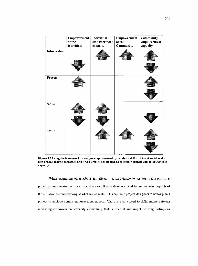
201
Empowerment of the individual
Individualempowermentcapacity
Empowerment of theCommunity
Communityempowermentcapacity
Information
Process
Skills
Tools
Figure 7.2 Using the framework to analyse empowerment by catalysts at the different social scales. Red arrows denote decreased and green arrows denote increased empowerment and empowerment capacity.
When examining other PPGIS initiatives, it is inadvisable to assume that a particular
project is empowering across all social scales. Rather there is a need to analyse what aspects of
the initiative are empowering at what social scale. This can help project designers to better plan a
project to achieve certain empowerment targets. There is also a need to differentiate between
increasing empowerment capacity (something that is internal and might be long lasting) as
202
opposed to increasing empowerment itself (something that may be more visible, but that is likely
to be less long lasting).
7.7.1.3 The PGIM S project empowers and disempowers, and raises and lowers
empowerment capacity
In concurrence with Harris and Weiner (1998b), this research shows and provides clear
examples that PGIMS simultaneously empowers and disempowers people within the two
participating communities, as well as that it empowers and disempowers communities within the
region. This happens in two ways. The first way is through the project impacting individuals or
communities differently. As shown earlier in this chapter, obtaining technological skills
empowered some individuals but disempowered others, depending upon their personalities and
their relationship with the community and to the project. At the community level, the project
contributed to one community developing increased cohesion and ability to organise its
information and tools. However in the other community the project only added to the existing
state of conflict and disorganisation.
The other way was through the PGIMS project only impacting some individuals and
communities, giving them relative power over those that the project did not reach. For example,
obtaining these skills gave the trained individuals an increased sense of self-esteem at the expense
of those who did not get trained, and who consequently felt diminished. It can be assumed that
the increased confidence of the participating communities might also have been at the expense of
neighbouring communities.
In conclusion, any evaluation of how a project empowered an individual or community
should also evaluate how it disempowered others.
203
7.7.1.4 Individual and community empowerment and raised empowerment capacity can
sometimes be in conflict
The benefits of individual empowerment can conflict with community aspirations for
empowerment. Motivations for learning these new technologies are often selfish and not aimed
at empowerment of the community. An elder from Tepulang states:
If people consider this project to be important to them they will become involved. When I say important, I see this from the perspective of economic importance...even though this is important value for history, maybe people still do not consider it to be important for themselves. (Osaq, 43, Tepulang)
This feeling is reinforced by a middle aged man in Benung who states that
Many people think that if it does not help give me rice why should 1 have to busy myself? Why should I be involved if it is for the communal good and not for my personal gain? (Edo, 42-year-old teacher from Benung)
Increased economic opportunities resulting from the new skills contributed to individuals being
hired away from the community, so decreasing the community’s capacity for empowerment.
In Benung the computer operators were motivated for personal and communal reasons.
Their actions were directed by the decisions o f the community, perhaps because o f the more
communal nature in Benung discussed in Chapter Five. As a result, their capacity to take a
greater role in community decision-making as well as to access new economic opportunities was
raised because of the PGIMS project. In Tepulang one individual appeared to be involved in the
project for personal benefit. This motivation hindered the community from benefiting because he
did not want to share his skills with other community members or take direction from the
community. The conflict surrounding the PGIMS project led to the disempowerment of the
operator within the community and overall loss for the community because the full extent of
empowerment capacity of the PGIMS project was never realized.
In the long term, those individuals who worked with their communities benefited more
than those who did not, by gaining rather than losing status in the community. Several examples
2 0 4
that have already been discussed show how the community is still able to exert quite strong
control over individuals who try to act selfishly, such as the operator described above or the
informants who tried to unilaterally record their own information (see Section 7.1.1.1).
7 .7.1.5 Em pow erm ent was experienced differently by different com m unities
Despite the PGIMS project being implemented more or less equally in both communities,
the two communities appear to have been empowered by different catalysts and observed
indicators of empowerment differed greatly between the two.
Benung appears to be empowered by the information that they collected through the
manner in which they used it to influence decision-making processes. It is speculated that this
strategic use of the information was only possible through the pre-existing level o f community
cohesion, and the strength of the governing institutions in the village. The community was
sufficiently high in empowerment capacity that they recognized how the use of the information
could increase their power base. Different catalysts of the PGIMS project, such as the
information, process and skills, served to further increase this empowerment capacity, with none
observed to have had a negative effect.
Conversely Tepulang appeared to be initially empowered by the superficial benefits of
having these new tools located in the village, as they were able to use them in order to increase
their bargaining power with outsiders. Empowerment in Tepulang is based on having the tools
located in the village and the prestige and ‘novelty factor’ associated with this. It is not based on
strategic collection and use o f information with the intention to influence decision-making. It is
unclear how effective or lasting empowerment related to the use of tools in this way will turn out
to be. The low pre-existing empowerment capacity in Tepulang, particularly its low level of
community cohesion and poor ability to organise, meant that these villagers were less able to use
the PGIMS strategically. Different catalysts of the PGIMS project mainly served to decrease
their empowerment capacity further, although there were some exceptions; notably the increased
205
ability of women to organise themselves and the increased cultural identity through learning
about local history, culture and adat.
7.7.1.6 E m pow erm ent is dependent on pre-existing conditions in individuals and
com m unities
Empowerment in the PGIMS project appeared to be significantly affected by pre-existing
conditions within the communities. For example, computer operators who were mature and
committed with good relations with their community were able to become more empowered by
the project than the operators who were more immature, less committed and in conflict with other
members o f the community. Likewise, a community needed to already be cohesive and well
governed in order to take advantage of the PGIMS project and use it in a meaningful and efficient
way that served to increase and consolidate their power. It further appears that PGIMS, if
developed in a community that is fractured and poorly governed, may serve to heighten levels of
disharmony.
In other words the higher the empowerment capacity an individual or a community
already had, the more likely they were to use the PGIMS project to empower themselves. Other
pre-existing conditions not related to empowerment capacity also had a significant effect on the
individuals and communities ability to be empowered by the PGIMS project, such as the conflict
over timber sales taking place in Tepulang at the time of the project.
7 .7.1.7 Recom m endations fo r fu tu re research
The findings of this study are only applicable to the PGIMS project over the short
eighteen month time frame in which it operated in the field. Future research might look at the
application of the PGIMS project in different settings. More specific recommendations for
further research include:
2 0 6
1. Assessing through a longer term study whether observed changes in empowerment eapacity
in the participating communities later contributed to empowerment in decision-making and
the resolution of conflicts. This could be used to assess the permanence of the impact of the
PGIMS project.
2. Examining whether indicators used to represent empowerment and empowerment capacity in
the PGIMS project are observed and eonsidered relevant in other PGIMS or PPGIS
initiatives.
3. Assessing how the observed disempowerment effects on individuals and communities might
have been decreased, and testing this in a new project.
4. Examining in more detail the tensions between empowerment of individuals, groups sueh as
men/women, old/young, edueated/less edueated, and communities as a whole.
5. Examining whether the pre-existing conditions within an individual, community and region,
including pre-existing empowerment capacity, receptivity to empowerment and other factors,
are more influential in enabling empowerment than the PGIMS or PPGIS project itself.
6. Exploring the issue of two-way communication, how could PGIMS be set up to support
information exchange between communities and regional government and what are the
implications for empowerment at the community level.
7.7.2 An evaluation of the empowerment framework
7.7.2.1 Em pow erm ent fra m ew o rk strengths
As noted by Heckman (1998) and Elwood (2002) there are various ways of evaluating
empowerment, eaeh with different goals and methods. The challenge of this thesis was to
develop an analysis of empowerment that showed the impact o f the PGIMS proje ct on individuals
and communities in West Kutai, Indonesia.
2 0 7
The framework presents a clear and logical structure that allowed the author to categorize
the field data and enabled an analysis of empowerment. The framework analysis helped to reveal
that different catalysts of the project were more instrumental in empowering or increasing
empowerment capacity than others at different social scales in the community. It also was useful
for differentiating between increasing power and increasing empowerment capacity.
7.7.2.2 Em pow erm ent fra m ew o rk weaknesses
The weaknesses of the empowerment framework analysis presented in this thesis can be
divided into two categories, those associated with the analysis itself, and those associated with the
use of indicators.
W eaknesses o f the analysis:
1. One area of potential weakness lies in determining to what extent the PGIMS project
catalysts contributed to observed indicators of empowerment capacity or empowerment, as
there may have been other more important external factors influencing the emergence of
these indicators. It might have helped if community members had been more involved in the
definition and analysis of the indicators and the processes behind these indicators.
2. When using the framework it was found that sometimes several catalysts may contribute to
observed indicators of empowerment or empowerment capacity. This makes it difficult to
determine which indicators belong in which cell of the empowerment framework. For
example, the participatory process used in this project empowered the women computer
operators by stipulating that at least one woman should be given the opportunity for training,
but the skills that they were taught could also be said to have empowered them.
3. Similarly, several social scales may be affected by a given catalyst at the same observed
event, again making it difficult to determine in which cell the indicator belongs. The
participatory process can be said to have increased a marginalised individual’s involvement
208
in decision-making; it can also be said to have increased a community’s cohesion through
increasing involvement of marginalised community members.
Weakness o f using indicators
1. The author’s interpretation of the qualitative data might not have been correct when forming
the indicators. Possible causes of bias or error in interpretation include cultural differences,
language constraints, lack of objectivity, and closer associations with certain individuals. It
might have helped if the author had involved community members more directly in the
interpretation of data, although they also have the potential for bias and error.
2. Indicators may be small and internal, making them difficult to observe. Some indicators of
empowerment capacity, such as feelings of self esteem, require delicacy in the questioning of
the researcher and self awareness and articulacy on the part of the respondent.
3. It was sometimes difficult to gauge the relative importance of different indicators, especially
with indicators based on single events or statements.
4. It was also sometimes difficult to determine how permanent the observed indicators of
empowerment or changes in empowerment capacity were, especially since the study took
place over a fairly short period of time.
7.7.2.3 Recom m endations fo r fu tu re research
Further research could explore the potential of the empowerment framework. Further
possibilities include;
1. Examining whether different conclusions are reached if the researcher works together with
community members on interpreting the data to create indicators and analysing the impact of
a PGIMS or PPGIS project using the empowerment framework.
209
2. Testing the usefulness of the framework for analysing the impact o f other projects under
other contexts and environments.
3. Examining the potential application of the framework for monitoring empowerment over the
course of PGIMS or PPGIS projects. Such research could test the framework’s potential as a
tool for enabling projects to set and achieve empowerment objectives, rather than solely as a
tool for evaluation.
2 1 0
C h a p t e r E i g h t :
C o n c l u s io n s
Inclusion of a community’s local knowledge in decision-making is recognized as important for
land use planning. However, its application is prevented by communication constraints between
stakeholders. Increasingly, local communities throughout the world are using community
mapping and GIT to communicate important information about their traditional lands to decision
makers. This corresponds to the recent trend in North America particularly for GIS practitioners
to apply their technologies in public participation settings. Claims have been made that use of
GIS by disadvantaged groups can be empowering. However, others claim that GIS is
disempowering for communities due to constraints associated with the complexity of the
technology, the associated high costs, inaccessibility of data and a restrictive representation of
local geographic information. They also criticize the lack of real community control over the
public participation process. The term empowerment has become important in the introduction of
PPGIS activities and has been used by academics and field practitioners as well as the NCGIA
Initiative 19 to indicate success of PPGIS projects. However, there remains confusion over
defining and using the term empowerment within the context of community use of GIT and
disagreement in how it might be observed and analysed.
This study set out to select and design an assemblage o f GIT and multimedia
technologies, as well as a participatory process for using them, that would overcome the
constraints and criticisms off PPGIS technologies and processes described above. The product of
this process and associated technologies was called a Participatory Geographic Information and
Multimedia System (PGIMS). A PGIMS project was conducted in two communities in West
Kutai, Indonesia. The aim of this project was to introduce a system that would be of benefit for
211
these communities, by enabling them to become more involved in decision-making and
documenting their local knowledge for future generations.
The research then contributed to the debate regarding empowerment and PPGIS by
examining the term and developing a framework to structure its analysis. This study set out to
answer the following research question:
How does the PGIMS project empower or disempower local communities?
This final chapter reflects on the research and ties the major findings together. Section 8.1
offers a summary of the PGIMS project as it was designed and implemented in two communities.
Section 8.2 presents and evaluates the empowerment framework developed to analyse the PGIMS
project’s impact. Section 8.3 sums up the impact of the PGIMS project on the communities in
terms of how it affected empowerment and empowerment capacity.
8.1 THE PGIMS PROJECT
The participating communities were enabled through the PGIMS project to gather
information related to their traditional land and culture, in digital photograph, video and text
format. This information is categorized as cultural (information about local history, culture and
adat), documentary (recordings used to provide proof of an event), political (information about
the communities’ vision, usually intended for outsiders), family (mementos of family events) and
commercial (information from all of the above categories recorded and sold by contract). Some of
this information was managed and accessed using an interactive Cartesian map interface linking
points, lines and polygons on the map with other multimedia information. Thus functional map-
linked PGIMS were created in both participating villages.
Outsiders and computer operators positively evaluated the map interfaee as an organizing
tool and a way of learning about the communities’ relationship with the land. However, computer
monitoring data showed that the map interface was little used by community members as a means
of managing and accessing information. Reasons for this low usage included firstly, that it was
2 1 2
easier for people familiar with the PGIMS to access the information directly using Microsoft
Windows Explorer®, the default file management software; and secondly, local people tended to
want to aeeess specific information for specific reasons, rather than take a guided tour of the
PGIMS via the map interface. It is unclear whether the map interface might have been of greater
importance if there was more information contained on the computer and therefore a greater
necessity for organizing and managing the information.
Furthermore, the eommunity’s maps did not appear to be seen by community members as
being as good as video media for portraying géographie information. This may have been because
some people did not understand how to interpret the Cartesian map, or could no longer recognise
important features on the map after it was transferred to the computer screen. Another reason may
have been that the video recording of a walk along the community’s boundary more closely
reflects the traditional way of orally describing boundaries. For the above reasons, all of the
information contained on the computers beeame referred to as the PGIMS, with the words
‘geographic information’ remaining in the title despite the absence of a Cartesian map.
The PGIMS in both communities was seen by community members as being relevant to
their needs. In particular, elders and women in both eommunities recognized the loss of loeal
knowledge, particularly local history, culture and adat, and used the system to record these types
of information for future generations. Information about boundaries and land uses, evidence of
illegal incursions by other villagers and political statements about the community’s vision for
ecosystem based logging were also documented and successfully communicated by younger and
middle-aged men to outside communities and the district government. Some of this information
was instrumental in the resolution of two disputes involving illegal logging in the traditional lands
of Benung.
PGIMS project sustainability is defined as the ability of the participating communities to
continue to add information to the PGIMS after the external collaborators have left the village
and to continue to manage and maintain the equipment. Benung’s overall computer usage
213
remained high when the external eollaborators were away, and community members continued to
gather video and photographic information and store it on the computer. They also began to think
of new and innovative ways of using the PGIMS. For example, they began to package and sell
information for outsiders and so generate some cash income from the PGIMS technologies. This
provided an additional incentive to use and maintain the system. A strong indieator of
sustainability was Benung’s willingness to pay to repair the video equipment when it was broken.
Long-term sustainability of PGIMS therefore seems quite likely in Benung. Tepulang showed a
significant drop in computer usage while external collaborators were outside the community. A
main cause of this was a conflict that broke out between community members, mainly centered
on the monopolization of the computer skills by one operator. People in Tepulang began to use
the computer for watching VCDs and other tasks not related to the PGIMS project. Sustainability
of the PGIMS project appears less likely in Tepulang.
The sustainability of PGIMS appeared less dependent on technology and related skills
and more on pre-existing conditions such as the level of community cohesion, the maturity of the
operators and the level of leadership provided in the projeet by the village head versus the
external collaborators.
8.2 EMPOWERMENT ERAMEWORK
Empowerment is defined in this thesis as: An increase in social influence or political
power. Empowerment is usually eaused by an internal change in condition in an individual or
community, as well as by external factors. This change in condition is defined in this thesis as a
change in ‘empowerment eapacity’.
A framework was developed to strueture an analysis of empowerment. The framework is
based on the assumption that empowerment is experieneed diversely by different social scales.
Analysis of the social scales differentiated between empowerment and increasing the
‘empowerment capacity’ of the individual or the community. The framework is also based on the
2 1 4
assumption that the empowerment impact of the PGIMS project, as with other PPGIS initiatives,
results from a variety of project components referred to as ‘catalysts’. Four catalysts are
considered relevant to the PGIMS project: the information contained within the PGIMS, the
participatory processes employed, the technological skills acquired through the project, and the
tools used to develop the PGIMS.
The framework introduced in Chapter Seven and summarized in Figure 7.1 helps the
researcher to structure an analysis of how the four catalysts of the PGIMS project empower or
disempower, as well as increase or decrease empowerment capacity, at the individual and
community social scale. Data, gathered during the field research, that were indicative of
empowerment and empowerment capacity were sorted and categorized. These ‘indicators’ were
then incorporated into the appropriate cell in the framework according to the relevant social scale
and catalyst.
The empowerment framework offers a structured approach to categorizing the field data
and enabling an analysis of how the PGIMS project empowered or disempowered individuals and
communities. The analysis helped reveal that certain catalysts of the project were more
instrumental than others in empowering different social scales (see figure 7.2). The framework
was also useful for differentiating the impacts of the project in terms of empowerment versus
changes in empowerment capacity.
There are weaknesses in the framework, both those associated with the analysis, as well
as those associated with the use of indicators. Weaknesses of the analysis included determining
how much the PGIMS catalysts have contributed to observed indicators compared to other factors
exogenous to the PGIMS project. Also, several catalysts may have contributed to observed
indicators of empowerment and empowerment eapacity, or it may be difficult to determine
whether the impact was on the individual or the community. This makes it diffieult sometimes to
decide which indicators belong in which cells o f the framework.
215
Weaknesses of using indieators are that they sometimes may not indicate empowerment
and empowerment capacity, they may be based on incorrect or biased interpretation of the data by
the researcher, and they may be difficult to observe and measure, especially subtle internal
changes in empowerment capacity. It may also sometimes be difficult to gauge the importance or
permanence o f certain indicators.
8.3 THE PGIMS PROJECT AND EMPOWERMENT
It is important to note that the eighteen month period in which the research took place is a
relatively short period and changes relating to the PGIMS project and empowerment that occur in
the future cannot be anticipated. However, the research revealed that the PGIMS did play a role in
both empowering and disempowering individuals and eommunities involved in the projeet. A
number of key themes emerged:
• There was evidence that the PGIMS project empowered the participating individuals and
communities, as shown by several incidents in which they appeared to gain some increased
influence over decision-making. However it is difficult to know how lasting or significant
this impact is, as it may be only due to the novelty of the technologies, and as there is no
evidence of permanent change in the power structures o f individuals in the communities or o f
the communities in the region. There was also evidence that the PGIMS project increased
empowerment capacity in individuals and communities. This indicates that this project has
contributed to future empowerment of these individuals and eommunities.
• At the individual scale, the skills acquired and the participatory processes used had the most
significant impact on empowerment. Empowerment capacity at the individual scale was
raised through acquiring skills, as indicated by increased self-esteem, increased critical
awareness of the influencing role of the popular media and increased economic opportunities.
At the community scale it was the information in the PGIMS and the prestige associated with
having and using the tools that most contributed to empowerment. The empowerment
2 1 6
capacity of communities was increased by the information, the process and to a lesser extent
the tools as indicated by increased community confidence, cohesion, identity, independence
and ability to organize.
As noted by Harris and Weiner (1998b), the PGIMS project both empowered and
disempowered, and increased and decreased empowerment capacity. This occurs both
because the project impacts individuals and communities differently, depending upon other
pre-existing conditions, as well as because the project only impacts some individuals and
communities, giving them relative power over those that the project did not reach.
Benefits o f individual empowerment can conflict with community aspirations for
empowerment. For example, learning new technical skills, although empowering for the
individual, may lead to disempowerment of the eonununity if he or she is hired to work
outside the community as a result. However, those individuals who worked for the
eonununity as well as their own individual benefit appeared to be most empowered by the
project, as they gained rather than lost status within the community.
Despite the PGIMS project being implemented more or less equally in Benung and Tepulang,
the communities were empowered by different catalysts and in different ways. In Benung
community members used the information to communicate to outside parties and influence
decision-making processes. Catalysts such as the information, process and tools all served to
raise Benung’s already high empowerment capacity, with none observed to have had a
negative effect. In Tepulang it was the prestige and power associated with owning and using
the tools that most contributed to empowerment. All four catalysts were observed to decrease
Tepulang’s already low empowerment capacity, although there were several exceptions,
notably the increased ability o f women to organize and the increased sense o f cultural identity
through an increased understanding of culture, history and adat.
2 1 7
• Empowerment is largely dependent upon pre-existing conditions in individuals and
communities. The higher the empowerment capacity an individual or community already had,
the more likely they were to use the PGIMS project to further empower themselves. There
were also other important pre-existing conditions not related to empowerment capacity that
had an effect on an individual’s or a community’s ability to be empowered by the PGIMS
project.
In conclusion, this thesis has shown that the PGIMS project influenced both the
empowerment and empowerment capacity of individuals and communities associated with the
projeet. Furthermore, this research has contributed to advancing an understanding of
empowerment as it relates to PPGIS initiatives, by developing a framework for structuring an
analysis of empowerment in a clear and logical way. This will have application for evaluating and
possibly also monitoring other similar projects in the future.
2 1 8
B ib l io g r a p h y
ABBOT, J., R. CHAMBERS, C. DUNN, T. HARRIS, E. de MERODE, G. PORTER, J. TOWNSENDand D. WEINER (1998). Participatory GIS; Opportunity or Oxymoron? PLA Notes, 33, 27 -33.
ABDOELLAH, O., A. B. LAHJIE, S. S. WANGSADIDJAJA, H. HADIKUSUMAH, J. ISKANDAR and B. SUKMANANTO (1993). Communities and Forest Management in East Kalimantan: Pathway to Environmental Stability’. Berkeley, California, Southeast Asia Sustainable Forest Management Network. Center for Southeast Asia Studies, International and Area Studies, University of California, Berkeley, Number 3.
ABERLEY, D. (1993). Boundaries o f Home: Mapping fo r Local Empowerment. Cabriola Island, B.C.: New Society Publishers.
ABERLEY, D. (1994). Futures by Design. Cabriola Island, B.C.: New Society Publishers.
ABERLEY, D. and M. GEORGE (1998). Introduction to Bioregional Mapping [online]. Available from: http://www.nativemaps.org/Showcase/showcase.html [Accessed April, 2001].
ACHN AS, G. (2001). Enhancing Citizens' Voice in Emerging Indonesia. In: The 3rd Asia Development Forum, Bangkok, Thailand. The World Bank Group.
AGAR, M. (1986). Speaking o f Ethnography. Beverly Hills, CA: SAGE Publications.
AGRAWAL, A. (1995). Dismantling the Divide between Indigenous and Scientific Knowledge. Development and Change, 26, 413-439.
AGYARKO, J. (1998). Participation, Empowennent and Participatory Rural Appraisal: An Illustration with Two Case Studies from Ghana. Social Change Issues and Perspectives, 28 (2), 157 - 170.
AITKEN, S. C. and S. M. MICHEL (1995). Who Contrives the "Real" in GIS? Geographic Information,Planning and Critical Theory. Cartography and Geographic Information Systems, 22 (1), 17-29.
ALCORN, J. B. (2001). Borders, Rules and Governance: Mapping to Catalyse Changes in Policy and Management. London, UK, International Institute for Environment and Development.
ALLEN, W. .1. (1997). Towards Improving the Role of Evaluation within Natural Resource Management R&D Programmes: The Case for 'Learning by Doing'. Canadian Journal o f Development Studies, XVIII (Special Issue Results-based performance reviews and evaluations), 629-643.
ANDERSON, J., L. V. CROWDER, D. DION and W. TRUELOVE (1997). rAg p/"Participatory Communication and Training to Rural Telecentres [online]. Available from: http://www.panasia.org.sg/ius/conf/webdriver7MIvaNCONF_AGEND A_PAGE&cid=l [Accessed May 2003].
ANON (2002). Rangkuman Hasil Semiloka Adat. In: Upaya Penegakan Hukum Adat dan Penguatan Kelembagaan Adat, Barong Tongkok, West Kutai, Indonesia, 03 - 05 April 2002.
2 1 9
ANYAEGBUNAM, C., P. MEFALOPULOS and T. MOETSABI (1999). Participatory RuralCommunication Appraisal Methodology (Prca): The Application of Participatory Approaches to Communication Programme Design and Implementation for Sustainable Human Development.
ARCE, A. and N. LONG (1992). The Dynamics o f Knowledge: Interfaces between Bureaucrats and Peasants in Battlefields o f Knowledge. London, UK; Routledge.
ARMSTRONG, R. (1991). People o f the Same Heart: The Social World o f the Kenyah Badeng. Thesis (PhD). University of Sydney, Sydney, Australia.
ARNSTEIN, S. (1969). A Ladder of Participation. Journal o f the American Planning Association, 35 (4), 216-224.
ARONOFF, S. (1989). Geographic Information Systems : A Management Perspective. Ottawa, Ont:WDL Publications.
BAINS, G. and E. HVIDING (1992). Traditional Environmental Knowledge from the Marovo Area o f the Solomon Islands. Ottawa, Ont: International Development Research Centre.
BALDWIN, R. N. (1927). The Significance o f Kropotkin’s Life and Teaching. Seattle, WA: Vanguard Press, Inc.
BAHT, S. (1998). Listening to Farmers: Communication fo r Participation and Change in Latin America. Rome, Food And Agriculture Organization Of The United Nations.
BARNDT, M. (1998). Public Participation GIS - Barriers to Implementation. Cartography and Geographic Information Systems, 25 (2), 105-112.
BARNES, B. (1988). The Nature o f Power. Oxford, UK: Polity Press, Basil Blackwell Ltd.
BARITY, M. and R. SIDAWAY (1999). Theories of Participation to Social Work Practice. In:Empowerment Practice in Social Work. W. Shera and L. M. Wells. Toronto: Canadian Scholars' Press, 474.
BASS, S., B. DALAL-CLAYTON and J. PRETTY (1995). Participation in Strategies for SustainableDevelopment. Environmental Planning Issues, 7, 1-118.
BELCHER, B. M. (2001). Rattan Cultivation and Livelihoods: The Changing Scenario in Kalimantan. Unasylva, 52 (2001/2).
BEL YEA, B. (1992). Images of Power. Cartographica, 29 (2), 1-9.
BENJAMIN, J. A. and K. FANCY (1998). The Gender Dimensions o f Internal Displacement: Concept Paper and Annotated Bibliography. New York, Office of Emergency Programmes, The United Nations Children's Fund.
BIRD, B. (1995). The Eagle Project: Re-Mapping Canada from an Indigenous Perspective. Cultural Survival Quarterly, 18 (4), 23-24.
BOGDEWIC, S. P. (1992). Participant Observation. In: Doing Qualitative Research. B. F. Crabtree and W. L. Miller. Newbury Park: SAGE Publications, 45 - 69.
2 2 0
BONHAM-CARTER, G. F. (1994), Geographic Information Systems fo r Geoscientists: Modelling with Gis. New York: Pergamon Press.
BRADEN, S. (1997). Representation and Re-Presentation - Participatory Video with Communities. In: Participatory communication: one approach to sustainable development.. On-line conference, November 1997.
BRODNIG, G. and V. MAYER-SCHÔNBERGER (2000). Bridging the Gap: The Role of SpatialInformation Technologies in the Integration of Traditional Environmental Knowledge and Western Science. The Electronic Journal on Information Systems in Developing Countries, 1, 1- 16.
BRODY, H. (1981). Maps and Dreams: Indians and the British Columbia Frontier. New York: Pantheon Books.
BROWN, I. F., A. S. ALENCHANDRE, H. S. Y. SASSAGAWA and M. A. D. AQUINO (1995).Empowering Local Communities in Land-Use Management: The Chico Mondes Extractive Reserve, Acre, Brazil. Cultural Survival Quarterly, 18 (4), 54-57.
BROWN, J. S. and P. DUGUID (2000). The Social Life o f Information. Boston: Harvard Business School Press.
BRUSH, S. B. (1996). Whose Knowledge, Whose Genes, Whose Rights? In: Valuing Local Knowledge: Indigenous People and Intellectual Property Rights. S. B. Brush and D. Stabinsky. Washington D.C.: Island Press.
BUDIMAN, A., B. HATLEY and D. KINGSBURY (1999). Reformasi: Crisis and Change in Indonesia. Clayton, Australia: Monash Asia Institute.
BYLES, J. (2001). The New Geography Reaches Critical Mass: Maps and Chaps [online]. Available from: http://www.villagevoice.com/issues/0131/edbyles.php [Accessed May 2003].
B YRON, I. and R. GAGLIARDI (1998). Communities and the Information Society: The Role o f Information and Communication Technologies in Education [online]. Available from: http://www.idrc.ca/acacia/studies/ir-unesl.htm [Accessed July 2002].
CANESSA, R. (1997). Towards Coastal Spatial Decision Support Systems. Thesis (PliD). University of Victoria, Victoria.
CARTER, D. (1997). Recognizing Traditional Environmental Knowledge. Ottawa, Ont, International Development Research Centre, 21/1.
CARTER, J. (1996). Recent Approaches to Participatory Forest Resource Assessment. Overseas Development Institute.
CARVER, S. (2001). Participation and Geographical Information: A Position Paper. In: ESF-NSF Workshop on Access to Geographic Information and Participatory Approaches Using Geographic Information, Spoleto, 6-8 December 2001.
CHAMBERS, R. (1994a). All Power Deceives. Institute o f Development Studies Bulletin, 25 (2), 14-26.
221
CHAMBERS, R. (1994b). Participatory Rural Appraisal (Fra): Challenges, Potentials and Paradigm. World Development, 22 (10), 1437-54.
CHAMBERS, R. (1997). Whose Reality Counts? Putting the First Last. London, UK: Intermediate Technology Publications.
CHAMBERS, R. and I. GUUT (1998). Pra - Five Years Later Where Are We Now? TT-ggy aWPeople Newsletter, 26/27.
CHAMBERS, R., A. PACEY and L. A. THRUPP (1989). FarTMgrFfrfr.- FaMMgr/MMOvarioM awe/Agricultural Research. London, UK: Intermediate Technology Publications.
CHAREONWONGSAK, K. (2001). The Future Society’ o f Asia. Munich, Center for Applied Policy Research (C.A.P).
CHATWIN, B. (1993). The Songlines. New York: Penguin Books.
CHIDLEY, L. (2002). Forests, People and Rights: A. Special Report. London, UK, Down to Earth.
CIDA (c. 1999). Guide to Gender-Sensitive Indicators. Ottawa, Ont, Canadian International Development Agency.
CLARK, M. J. (1998). GIS - Democracy or Delusion? Environment and Planning A, 30, 303-316.
CLAYTON, A., P. OAKLEY and B. PRATT (1999). Gw;r/g6oot on f New York,United Nations Development Programme.
COHEN, J. andN . UPHOFF (1977). Rural Development Participation: Concepts and Mea,sures fo r Project Design, Implementation and Evaluation. Ithaca: Cornell University.
COLFER, C. J. (1997). Beyond Slash and Bum: Building on Indigenous Management of Borneo's Tropical Rain Forests. Advances in Economic Botany, 11 (1).
COOK, R. J. (1995). Enforcing Women's Rights through Law. Gender and Development, 3 (2), 8-15.
CORNWALL, A., S. MUSYOKl and G. PRATT (2001). g'garcA p/'a AW FracrirmMgM'Reflections on Pra and Participation in Kenya. Sussex, Institute of Development Studies, 131.
COULSON, M. R. C. (1977). Political Truth and the Graphic Image. The Canadian Cartographer, 14 (2), 101- 111 .
CPFP (1992). Measuring Women’s Empowerment: Working Towards More Effective and CulturallySensitive Evaluation o f Women's Development Programmes in the Philippines. Manila, Centre for Population and Family Health.
CRAIG, W. J. and S. A. EL WOOD (1998). How and Why Community Groups Use Maps andGeographic Information. Cartography and Geographic Information Systems, 25 (2), 95-104.
CRAIG, W. J., T. M. HARRIS and D. WEINER (2002). Community Participation and Geographic Information Systems. London ; New York: Taylor & Francis.
222
CRAMPTON, J. (1995). The Ethics of GIS. Cartography and Geographic Information Systems, 22 (1), 84-89.
CROSBY, B. (2000). Participation Revisited: A Managerial Perspective. Washington D.C., Center for Democracy and Governance United States Agency for International Development, 6.
CURRY, M. (1995a). Geographic Information Systems and the Inevitability of Ethical Inconsistency. In: Ground Truth: The Social Implications o f Using Geographic Information Systems. J. Pickles. New York: The Guilford Press, 1-30.
CURRY, M. R. (1995b). Rethinking Rights and Responsibilities in Geographic Information Systems: Beyond the Power of Image. Cartography and Geographic Information Systems, 22 (1), 58-69.
DAHL, E. D. (1992). Commentary: Brian Harley's Influence on Modem Cartography. Cartographica, 29 (2), 62-65.
DAVID, P. A. and D. FORAY (2002). An Introduction to the Economy of the Knowledge Society. International Social Science Journal, 54 (March), 9-23.
DAVIDSON-HUNT, I. (1999). Dwelling and Emkilling: Creating and Pas.ting on Knowledge within Local Eco.tystems. Winnipeg, Natural Resources Institute, University of Manitoba.
DAVIS-CASE, D. A. (1990). The Community's Toolbox: The Idea, Methods and Tools fo r Participatory Asses.sment, Monitoring and Evaluation in Community Forestry. Rome: Food and Agriculture Organization of the United Nations.
DAVISON, R., D. VOGEL, R. HARRIS and N. JONES (2000). Technology Leapfrogging in Developing Countries - an Inevitable Luxury? The Electronic Journal on Information Systems in Developing Countries, 1 (5), 1-10.
DENNISTON, D. (1994). Defending the Land with Maps. IFbfW jMfdic/z, 7 (1), 27-31.
DORLING, D. (1998). Human Cartography: When It Is Good to Map. Environment and Planning A, 30, 277-288.
DORLING, D. and D. FAIILBAIRN (1997). Mapping: Ways o f Representing the World. London, UK: Longman Press.
DOVE, M. R. (1993). A Revisionist View of Tropical Deforestation and Development. Environmental Conservation, 20 (1), 17 - 24.
DOWN-TO-EARTH (2000). Indigenous Communities and Democratic Control. Down to Earth, 46 (August).
DUBOIS, B. and K. K. MILE Y (1992). Social Work: An Empowering Profession. Boston: Allyn and Bacon.
DUNN, C. E., P. J. ATKINS and J. G. TOWNSEND (1997). GIS for Development: A Contradiction in Terms? yfrea, 29 (2), 151-159.
EDNEY, M. (1993). The Patronage of Science and the Creation of Imperial Space: The British Mapping of India, 1799-1843. Cartographica, 30 (1), 61-67.
223
ELWOOD, S. (2002). OIS Use in Community Planning: A Multidimensional Analysis of Empowerment. Environment and Planning A, 34, 905-922.
ELWOOD, S. and H. LEITNER (1998). GIS and Community-Based Planning: Exploring the Diversity of Neighbourhood Perspectives and Needs. Cartography and Geographic Information Systems, 25 (2), 77-88.
ERNBERG, J. (1999). Empowering Coimnimities in the Information Society: An InternationalPerspective. In: The First Mile o f Connectivity. D. Richardson and L. Paisley. Rome: Food And Agriculture Organization O f The United Nations.
TERRIER, J. D. (1998). An Investigation into the Diffusion o f Innovation in Technical and Further Education: Implementing E-Mail through Action Research. Thesis (PhD). Deakin University, Melbourne.
FETTERMAN, D. M. (1996). Empowerment Evaluation: An Introduction to Theory and Practice. In:Empowerment Evaluation: Knowledge and Tools fo r Self-Asse.ssment and Accountability. D. M,. Fetterrnan, S. Kaftarian and A. Wandersman: SAGE Publications.
FLAVELLE, A. (1995). Community-Based Mapping in Southeast Asia. Cultural Survival Quarterly, 18 (4), 72-73.
FLAVELLE, A. (1996). Community Mapping Handbook. Vancouver: Lone Pine Foundation.
FOX, J. (1994). Spatial Information and Ethnoecology: Case Studies from Indonesia, Nepal, and Thailand. Honolulu, East-West Center, University of Hawaii, Environment Series no. 38.
FOX, J. (1998). Mapping the Commons: The Social Context of Spatial Infoimation Technologies. Common Property Resource Digest, May.
FOX, J., J. KRUMMEL, S. YARNASARN, M. EKASINGH and N. PODGER (1994a). Land Use andLandscape Dynamics in Northern Thailand: Assessing Change in Three Upland Watersheds since 1954. In: Spatial Information and Ethnoecology: Case Studies from Indonesia, Nepal, and Thailand. J. Fox. Honolulu: East-West Center, University o f Hawaii, 27-42.
FOX, J., P. YONZON and N. PODGER (1994b). Ramc/ay.- fAmg Gw (oConflicts between Biodiversity and Human Needs. Honolulu, East-West Center, University of Hawaii.
FREDERICK, W. H. and R. L. WORDEN (1993). /Mc/oMayia.- yf Cown/ry Washington D.C.,Federal Research Division, Library of Congress.
FREIRE, P. (1970). Pedagog’ o f the Oppressed. New York: Continuum.
FREUDENBERGER, K. S. (1994). Tree and Land Tenure: Rapid Appraisal Tools. Rome, Food And Agriculture Organization O f The United Nations.
FRIED, S. T. and A. S. MUSTAFA (1992). Social and Economic Aspects o f Rattan Production, Middle Mahakam Region: A Preliminary Study. Samarinda, German Forestry Group, 21.
224
FRIEDMANN, J. (1992). Empowerment: The Politics o f Alternative Development. Cambridge, Massachusetts: Blackwell Publishers.
GAUTAM, M., U. LELE, H. KARTODIHARDJO, A. KHAN, ERWINSYAH and S. RANA (2000). J7ie Challenges o f World Bank Involvement in Forests. Washington D. € ., World Bank.
GEBERT, R. and K. RERKASEM (2001). Community Empowerment in Alternative Development:Prerequisite for Success or Mutually Exclusive Concepts? In: International Conference on the Role o f Alternative Development in Drug Control and Development Cooperation, Berlin and Chiang Mai, September.
GHOSE, R. (2001). Use o f Information Teclmology for Community Empowerment: TransfoimingGeographic Information Systems into Community Information Systems. Transactions in GIS, 5 (2), 141 - 163.
GODOY, R. A. (1990). The Economics of Traditional Rattan Cultivation. Agroforestry Systems, 12, 163- 172.
GÔNNER, C. (2000). Resource Management in a Dayak Benuaq Village: Strategies, Dynamics and Prospects a Case Study from East Kalimantan, Indonesia. Eschborn, Germany, TÔB, TÔB FTWF-20G.
GONZALEZ, R. (1995). Kbs, GIS and Documenting Indigenous Knowledge. Indigenous Knowledge and Development Monitor, 3 (1).
GOSS, J. (1995). Geographic Information Systems and the Inevitability of Ethical Inconsistency. In: Ground Truth: The Social Implications o f Using Geographic Information Systems. J. Pickles.New York: The Guilford Press, 130-170.
GRE AVES, T. (1996). Tribal Rights. In: Valuing Local Kno wledge: Indigenous People and Intellectual Property Rights. S. B. Brush and D. Stabinsky. Washington D.C.: Island Press.
GRENIER, L. (1998). Working with Indigenous Knowledge: A Guide fo r Researchers. Ottawa, Ont: International Development Research Centre.
GUUT, I. (1996). Participation in Natural Resource Management: Blemished Past and Hopeful Future?In: Making Forest Policy Work, Oxford University. Oxford Forestry Institute.
HABERMAS, J. (1970). Toward a Rational Society; Student Protest, Science, and Politics. Boston: Beacon Press.
HAFKIN, N. and N. TAGGART (2001). Gender, Information Technology, and Developing Countries:An Analytic Study, Academy for Educational Development (AED) For the Office of Women in Development Bureau for Global Programs, Field Support and Research: United States Agency for International Development.
HARLEY, J. B. (1988). Maps, Knowledge and Power. In: The Iconography o f Landscape. D. Cosgrove. Cambridge, MA:: Cambridge University Press, 277-312.
HARLEY, J. B. (1989). Deconstructing the Map. Cartographica, 26 (2), 1-20.
225
HARLEY, J. B. (1990). Cartography, Ethics and Social Theory. Cartographica, 27 (2), 1-23.
HARLEY, J. B. and D. WOODWARD (1987). 7%e q/'Car/ogropAy. Chicago: University ofChicago Press.
HARMSWORTH, G. (1998). Indigenous Values and GIS: A Method and a Framework. Indigenous Knowledge and Development Monitor, 6 (3).
HARRINGTON, S. (1995). Giving the Land a Voice: Mapping Our Home Places. Vancouver, B.C.: School o f Community and Regional Planning, University of British Columbia.
HARRIS, T. M. W., DANIEL (2002). Implementing a Community-Integrated Gis: Perspectives fromSouth African Fieldwork. Community Participation and Geographic Information Systems. W. J. Craig, T. M. Harris and 0 . Weiner. London ; New York, Taylor & Francis.
HARRIS, T. and D. WEINER (1998a). Community-Integrated GIS for Land Reform in Mpumalanga Province, South Africa. In: Empowerment, Marginalisation, and Public Participation GIS Meeting, Santa Barbara, CA. National Center for Geographic Information and Analysis.
HARRIS, T. and D. WEINER (1998b). Empowerment, Marginalization, and 'Community-Integrated' GIS. Cartography and Geographic Information Systems, 25 (2), 67-76.
HARRIS, T., D. WEINER, T. WARNER and R. LEVIN (1995). Pursuing Social Goals throughParticipatory Geographic Information Systems. In: Ground Truth: The Social Implications o f Using Geographic Information Systems. J. Pickles. New York: The Guilford Press, 1-30.
HARVEY, D. (1990). The Condition o f Postmodernity, an Inquiry into the Origins o f Cultural Change. Oxford, UK: Blackwell Publishers.
HECKMAN, L. A. (1998). Methodology Matters: Devising a Research Program for Investigating PPGIS in Collaborative Neighborhood Planning. In: Empowerment, marginalization and PPGIS, Santa Barbara, CA. National Center for Geographic Information and Analysis.
HEEKS, R. (1999a). Information and Communication Technologies, Poverty and Development. Manchester, U.K., Institute for Development Policy and Management, 5.
HEEKS, R. (1999b). The Tyranny o f Participation in Information Systems: Learning from Development Projects. University of Manchester, Institute for Development Policy and Management, 4.
HERJON and NATALIS (2001). Laporan HasilKonsultasi Kebudayaan. Bigimg Baru, Rio Tinto Foundation.
HIGGINS, J. W. (1994). Tracing the Vision: A Study o f Community Volunteer Producers, Public Acce.ss Cable Television, and Empowerment. Thesis (PhD). The Ohio State University,
HOCK, B., T. BENNISON and S. SWAFFIELD (1995). Using GIS and Visualisation Techniques for Rural Planning. New Zealand Forestiy (May), 28-32.
HOLMES, T. (200\). A Participatory Approach in Practice: Understanding Fieldworkers' Use o f Participatory Rural Appraisal in Action Aid the Gambia. Sussex, Institute of Development Studies, 123.
226
HOOKER, M. B. (1978). Adat Law in Modem Indonesia. Kuala Lumpur, Malaysia: Oxford University Press.
HOPES, M., MADRAH and KARAAKNG (1997). Temputn: Myths o f the Benuaq and Tunjimg Dayak. Jakarta, Indonesia; Puspa Svvara.
HOWARD, D. (1998). Geographic Information Technologies and Community Planning: SpatialEmpowerment and Public Participation. In: Empowerment, marginalization and PPGIS, Santa Barbara, CA. National Center for Geographic Information and Analysis.
HUDSON, H. (1999). Global Information Infrastracture: The Rural Challenge. In: The First Mile o fConnectivity. D. Richardson and L. Paisley. Rome: Food And Agriculture Organization O f The United Nations.
HUIZER, G. (1997). Participatory Action Research and People's Participation: Introduction and Case Studies [online]. Available from:http://www.fao.org/waicent/faoinfo/sustdev/PPdirect/PPre0030.htm [Accessed May, 2003].
IDRC (1998). Gender and Biodiversity Research Guidelines [online]. Available from: http://www.idrc.ca/biodiversity/tools/genderl__e.cfm#2.0 [Accessed July, 2002].
IIILR (1996). Recording and Using Indigenous Knowledge: A Manual. Manila, Philippines: International Institute of Rural Reconstruction.
USD (1999). Empowering Communities fo r Sustainable Livelihoods. Winnipeg, Canada, International Institute for Sustainable Development.
IRED (1996). People’s Empowerment: Grassroots Experiences in Africa, Asia and Latin America. Geneva, Switzerland, Innovations Et Reseaux Pour Le Development.
JACKSON, B. and D. BOND (1997). Monitoring and Evaluating Collaborative Management o f Natural Resources in Eastern Africa. Tanga, Tanzania, lUCN.
JACKSON, B., M. NURSE and H. B. SINGH (1994). Participatory Mapping for Community Forestry. Rural Development Forestry Network, Network Paper 1.7e (Summer), 1-11.
JOHANSSON, L. (1999). Participatory Video and Pra in Developmertt Plannirig [online]. Available from: http://www.maneno.net/pages/mmabo.html [Accessed May 2003].
JOHNSON, B. (1997a), The Use o f Geogi-aphic Information Systems (Gis) by First Nations [online].Available from: http://www.nativemaps.org/StoriesNewsReviews/Reviews/abstracts/Ben.html [Accessed April].
JOHNSON, B. D. (1997b). The Use o f Geographic hrformation Systems (Gis) by First Nations.Vancouver, School of Community and Regional Planning, University o f British Columbia.
JOHNSON, M. (1992). Lore: Capturing Traditional Environmental Knowledge. Ottawa, Ont.: International Development Research Centre.
2 2 7
JOHNSON, M. and R. RUTTAN (1992). Traditional Environmental Knowledge of the Dene: A Pilot Project. In: Lore: Capturing Traditional Environmental Knowledge. M. Johnson. Ottawa, ON: International Development Research Centre, 190.
JOHNSON, S. M. (1998). The Internet Changes Everything: Revolutionizing Public Participation andAccess to Government Information through the Internet. Administrative Law Review, 50 (2), 277- 337.
JORDAN, G. (2002). Gis for Community Forestry User Groups in Nepal: Putting People before theTechnology. Community Participation and Geographic Information Systems. W. J. Craig, T. M. Harris and D. Weiner. London ; New York, Taylor & Francis.
JORDAN, G. (1998). A Public Participation GIS for Community Forestry User Groups in Nepal: Putting People before Technology. In: Empowerment, Marginalisation, and Public Participation GIS Meeting, Santa Barbara, CA. National Center for Geographic Information and Analysis.
KARTODIHARDJO, H. and A. SUPRIONO (2000). The Impact o f Sectoral Development on Natural Forest Conversion and Degradation: The Case o f Timber and Tree Crop Plantations in Indonesia. Bogor, Indonesia, Center for International Forestry Research.
KEMP, W. B. and L. F. BROOKE (1995). Towards Information Self-Sufficiency: Nunavik Inuit Gather Information on Ecology and Land Use. Cultural Survival Quarterly, 18 (4), 25-28.
KING, A. (1993). Mapping Your Roots: Parish Mapping. In: Boundaries o f Home. D. Aberley. Gabriola Island: New Society Publishers, 31-34.
KIRBY, S. L. and K. MCKENNA (1989). Experience Research Social Change : Methods from the Margins. Toronto: Garamond Press.
KIRK, J. and M. L. MILLER (1986). Reliability and Validity in Qualitative Research. Beverly Hills, CA: SAGE publications.
KK-KPD (2001). Potret Kehutanan Kahupaten Kutai Barat. Melak, Indonesia, Kelompok Kerja Program Kehutanan Daerah.
de KONING, K. D. (1995). Participatory Appraisal and Education for Empowennent. PLA Notes, 24, 34- 37.
KOOISTRA, M . (2001). Indonesia: Regional Conflicts and State Terror. London, M inority Rights Group International.
KOSEK, J. (1998). Mapping Politics. Common Property’ Resource Digest, May.
KROPOTKIN, P. (1885). What Geography Ought to Be. Antipode, pp. 940-956.
KUNO, K. (1998). Community-Based Rehabilitation in South East Asia: Case Studies from Indonesia and Malaysia. Thesis (MA). University of East Anglia, Norwich.
KYEM, P. A. K. (1998). Promoting Local Community Participation in Forest Management through the Application of Geographic Information Systems. An Experience from Southern Ghana. In:
228
Empowerment, Marginalisation, and Public Participation GIS Meeting, Santa Barbara, CA. National Center for Geographic Information and Analysis.
KYEM, P. A. K. (2002). Examining the Community Empowerment Process in Public Participation GIS Applications. In: Public Participation GIS (PPGIS), Rutgers University, New Brunswick, NJ., July 21-23.
KYEM, P. (2002). Promoting Local Community Participation in Forest Management through a PpgisApplication in Southern Ghana. Community Participation and Geographic Information Systems. W. J. Craig, T. M. Harris and D. Weiner. London ; New York, Taylor & Francis.
LAITURI, M. (1998). Marginal Societies and Geographic Information Systems. In: Empowerment,Marginalisation, and Public Participation GIS Meeting, Santa Barbara, CA. National Center for Geographic Information and Analysis.
LAWAS, C. and H. LUNING (1996). Farmers Knowledge and GIS. Indigenous Knowledge and Development Monitor, 4 (I).
LAWLEY, E. L. (1993). Computers and the Communication o f Gender [online]. Available from; http://www.itcs.com/elawley/gender.html [Accessed May, 2003].
LAWRENCE, A. and K. WARREN (1999). Researchable Constraints in Participatory Forest Management: A Survey o f Issues and Options. University of Reading, Forestry Research Programme (FRP) of the Department for International Development.
LEACH, M., R. MEARNS and I. SCOONES (1997). Challenges to Community Based Sustainable Development. Institute o f Development Studies Bulletin.
DECOMPTE, M. and J . PREISSLE (1993). Ethnography and Qualitative Design in Educational Research. San Diego, CA: Academic Press, Inc.
LEIGH, B. (1999). Learning and Knowing Boundaries: Schooling in New Order Indonesia. Journal o f Social Issues in Southeast Asia, 14 (I), 34 - 56.
LENGELER, J. C. and P. S. JONES (1999). Local People's Participation in Biodi versity Assessment.
LISTER, M. (1997). The European Union and the South: Relations with Developing Countries. London, UK: Routledge.
LIVINGSTONE, D. (1992). The Geographers Tradition. Oxford: Blackwells.
MACDONALD, K. and G. MACDONALD (1999). Empowerment: A Critical View. In: Empowerment Practice in Social Work. W. Shera and L. M. Wells. Toronto: Canadian Scholars' Press, 474.
MACNAB, P. (1998). There Must Be a Catch: Participatory GIS in a Newfoundland Fishing Community. In: Empowerment, Marginalisation, and Public Participation GIS Meeting, Santa Barbara, CA. National Center for Geographic Information and Analysis.
MALO, M. (1997). Social Sector Decentralization: The Case o f Indonesia. Ottawa, ON, International Development Research Centre.
MARGARET A (2000). Menmbangunan Rumah Panjang. Kalimantan Review, 57, 25.
229
MAROZAS, B. A. (1995). Enhancing Tribal Integrated Resource Management Plans by Integrating Traditional Knowledge with Geographic Information System Technology. In: Presented at Society fo r Applied Anthropology Meeting, Albuquerque, NM.
MARSDEN, D. and P. OAKLEY (1990). Evaluating Social Development Projects. Oxford: Oxfam.
MAUNDU, P. (1995). Methodology for Collecting and Sharing Indigenous Knowledge: A Case Study. Indigenous Knowledge and Development Monitor, 3 (2).
MAYER, J. (1989). Rattan Cultivation, Family Economy and Land Use: A Case Study from Pasir, East Kalimantan. Samarinda, German Forestry Group, 13.
MCANANY, E. G. (1980). The Role of Information in Communicating with the Rural Poor: SomeReflections. In: Communications in the Rural Third World. E. G. McAnany. New York: Praeger, 222 .
MCCLELLAND, D. C. (1975). Power: The Inner Experience. New York: .lohn Wiley and Sons.
MCCONNELL, S. (1998). Connecting with the Unconnected: Proposing an Evaluation of the Impacts of the Internet on Unconnected Rural Stakeholders. In: The First Mile o f Connectivity. D. Richardson and L. Paisley. Rome: Food And Agriculture Organization Of The United Nations.
MCPHAIL, T. (I98I). Electronic Colonialism: The Future o f International Broadcasting and Communication. London: SAGE Publications.
MIDGLEY, J. (1986). Community Participation: History, Concepts and Controversies. In: Community Participation, Social Development and the State. J. M. e. al. London: Methuen.
MILEY, K. and B. DUBOIS (1999). Empowering Processes for Social Work Practice. In: Empowerment Practice in Social Work, W. Shera and L. M. Wells. Toronto: Canadian Scholars' Press, 474.
MOETSABI, T. (1998). Participatory Approaches for Promoting Rural Connectivity: An Exploration of Issues. In: The First Mile o f Connectivity. D. Richardson and L. Paisley. Rome: Food And Agriculture Organization O f The United Nations.
MOMBERG, F., D. DAMUS, G. LIMBERG and S. PADAN (1994). BaHicÿatof}; Took /o rForest Profiling and Zonation o f Conservation Areas: Experiences from the Kayan Mentarang Nature Reserve, East Kalimantan, Indonesia. Washington DC, WWF Indonesia Programme.
MONMONIER, M. (I99I). How to Lie with Maps. Chicago: The University of Chicago Press.
MOOTE, M., M. MCCLARAN and D. CHICKERING (1997). Theory in Practice: ApplyingParticipatory Democracy Theory to Public Land Planning. Environmental Management, 21 (6), 877-889.
MORALEZ-GOMEZ, D. (1997). Knowledge, Change and the Preservation o f Progress. Ottawa, ON, International Development Research Centre, 21/1.
MORGAN, D. L. (1988). Focus Groups as Qualitative Research. London: SAGE Publications.
NANAVATY, R. (2002). Empowerment Framework: Sewa’S Nine Lessons. In: Presentation to the PREM Panel o f the World Bank, Washington DC, USA, .Tune 24, 2002.
2 3 0
NAVRUZOV, Y., A. ROSE and W. SHELLEY (2000). Role of Partnership in Modern LocalGovernment. In: Eighth Annual Conference o f the Network o f Institutes and Schools o f Public Administration in Central and Eastern Europe (NISPAcee), Budapest, April 13-15, 2000.
NAYLOR, L. (1996). Culture and Change. Westport, USA: Bergin and Garvey.
NCGIA (1995). National Center fo r Geographic Information and Analysis Research Initiatives [online]. Available from: http://www.ncgia.ucsb.edu/overview.html [Aecessed March 2003].
NCGIA (1996). Initiative 19: Gis and Society: The Social Implications o f How People, Space, and Environment Are Represented in Gis [online]. Available from: http://www.geo.wvu.edu/il9/ [Accessed March 2003].
NCGIA (1998). Empowennent, Marginalization and Public Participation Gis [online]. Available from: http://www.ncgia.ucsb.edu/varenius/ppgis/ncgia.html [Accessed March 2003].
NIETSCHMANN, B. (1995). Defending the Miskito Reefs with Maps and Gps. Cultural Survival Quarterly, 18 (4), 34-36.
NORRISH, P. (1998). Radio and Video for Development. In: The First Mile o f Connectivity. D.Richardson and L. Paisley. Rome: Food And Agriculture Organization O f The United Nations.
NOVECK, B. S. (2001). Dimpled-Hanging-Pregnant-Chad.Corn: The Impact o f Internet Technology on Democratic Legitimacy. Munich, Center for Applied Policy Research (C»A*P).
OBERMEYER, N. J. (1995). The Hidden GIS Technocracy. Cartography and Geographic Information Systems, 22 (1), 78-83.
OBERMEYER, N. J. (1998). The Evolution of Public Participation GIS. Cartography and Geographic Information Sy.stems, 25 (2), 65-66.
O'FARRBLL, C., P. NORRISH and A. SCOTT (2000). Information and Communication Technologies for Sustainable Livelihoods. London, Department for International Development (UK) through the Economic and Social Research Unit (ESCOR).
OLIVE, C. and D. CARRUTHERS (1997). Putting Tek into Action: Mapping the Transition [online]. Available from: http://www.nativemaps.org/StoriesNewsReviews/Reviews/abstracts/tek.html [Accessed April].
OPENSHAW, S. (1991). A View on the GIS Crisis in Geography, or, Using GIS to Put Humpty-Dumpty Back Together Again. Environment and Planning A, 23, 621-628.
OPENSHAW, S. (1992). Further Thoughts on Geography and GIS: A Reply. Environment and Planning 24,463-466.
ORLOVE, B. (1993). The Etlmography of Maps: The Cultural and Social Contexts of Cartographic Representation in Peru. Cartographica, 30 (1), 29-45.
OSMANI, S. R. (2000). Participatory Governance, People's Empowennent and Poverty Reduction. In: Fourth World Conference on Women (Beijing) and the World Summit fo r Social Development (Copenhagen).
231
OXAAL, Z. (1997). Empowerment: Swimming into the Mainstream? Brighton, Gender Office of The Swedish International Development Agency (SIDA).
PANGS (1998). Information, Kno wledge and Development. New York, World Bank.
P ARP ART, J. L. (2000a). The Participatory Empowerment Approach to Gender and Development in Africa: Panacea or Illusion? In: Africa seminar at the Centre o f African Studies, Copenhagen, Denmark, 7th November 2000. University of Copenhagen.
PARPART, J. L. (2000b). Rethinking Participatory Empowerment, Gender and Development in a Global/Local World. In: Development: the N eedfor Reflection, Montreal, Canada, 20-23 September, 2000. Centre for Developing-Area Studies, McGill University.
PARSONS, R. J. (1991). Empowerment: Purpose and Practice Principle in Social Work. Social work with groups, 14 (2), 7-21.
PATTON, M. Q. (1990). Qualitative Evaluation and Research Methods. Newbury Park, CA: SAGE Publications.
PELUSO, N. L. (1995). Whose Woods Are These? Counter-Mapping Forest Territories in Kalimantan, Indonesia. Antipode, 27 (4), 383-406.
PÉTILLON, Y. (1997). Emancipation of Less Affluent Groups through the Appropriation of In formation and Knowledge. In: Global Knowledge '97: Knowledge For Development In The Information
Montreal, APRIL 1997.
PICKLES, J. (1995). Representations in an Electronic Age. In: Ground Truth: The Social Implications o f Using Geographiclnformation Systems. J. Pickles. New York: The Guilford Press, 1-30.
PICKLES, J. (1997). Tool or Science? GIS, Technoscience, and the Theoretical Turn. Annals o f the Association o f American Geographers, 87 (2), 363-372.
POFFENBERGER, M. and B. MCGEAN (1998). Village Voices, Forest Choices. Delhi: Oxford University Press.
POOLE, P. (1995a). Geomatics, Who Needs It? Cultural Survival Quarterly, 18 (4).
POOLE, P. (1995b). Guide to the Technology. Cultural Survival Quarterly, 18 (4), 16-18.
POOLE, P. (1995c). Indigenous Peoples, Mapping and Biodiversity Conservation: An Analysis o fCurrent Activities and Opportunities fo r Applying Geomatics Technologies. Washington DC, Biodiversity Support Program, World Wildlife Fund.
POOLE, P. (1995d). Land-Based Communities, Geomatics and Biodiversity Conservation: A Survey of Current Activities. Cultural Survival Quarterly, 18 (4), 74-76.
POSEY, D. (1985). Indigenous Management of Tropical Forest Ecosystems: The Case of the Kayapo Indians of the Brazilian Amazon. Agroforestry Systems, 3, 139-158.
POSEY, D. (1997). Indigenous Knowledge, Biodiversity and International Rights: A Case Study. The Commonwealth Forestry Review, 76 (1), 53-60.
232
PRATT, G. (2001). Practitioners Critical Reflections on Pra and Participation in Nepal. Sussex, Institute of Development Studies, 121.
PRETTY, J. (1995). Participatoiy Learning for Sustainable Agriculture. World Development, 23 (8), 1247-1263.
PRETTY, J. N., I. GUUT, J. THOMPSON and I. SCOONES (1995).A Trainers Guide. London: IIED.
QUIROZ, C. (1996). Local Knowledge Systems Contribute to Sustainable Development. Indigenous Knowledge and Development Monitor, 4(1).
RAHMAN, A. (1991). Communication Technology in Africa: Dependency or Self-Reliance? Africa Media Review, 5 (3), 11-18.
RAHMAN, M. A. (1998). A Participatory Dss to Incorporate Local Knowledge fo r Resource andEnvironmental Management in Developing Countries. Thesis (PhD Comprehensive Examination Paper). University of Waterloo,
RAJASEKARAN, B. (1993). A Framework for Incorporating Indigenous Knowledge Systems intoAgricultural Research, Extension, and Ngos for Sustainable Agricultural Development. Studies in Technology and Social Change, 21.
RAJ A S UNDER AM, C. V. (1997). Vision, Principles and Values: Some Reflections [online]. Available from: http://www.panasia.org.sg/ius/conf/webdriver7MIvaHCONF_AGENDA_PAGE&cid=l [Accessed May 2003].
RAMBALDl, G. and J. CALLOSA-TARR (2001). Participatory 3-D Modeling: Bridging the Gapbetween Communities and GIS Technology. In: Participatory Teclmology Development and Local Knowledge fo r Sustainable Land Use in Southeast Asia, Chiang Mai, Thailand, 6-7 June 2001 .
RAMBALDl, G., M. L. FERNAN and S. V. SIAR (1998). Resource Mapping. In: Participatory Methods in Community-Based Coastal Resource Management. Silang, Cavite, Philippines: International Institute of Rural Reconstruction.
RAMON, S. (1999). Collective Empowerment: Conceptual and Practice Issues. In: Empowerment Practice in Social Work. W. Shera and L, M. Wells. Toronto: Canadian Scholars' Press, 474.
RAPPAPORT, J. (1987). Terms of Empowerment/Exemplars of Prevention: Toward a Theoiy for Commwmty Hsychology. American Journal o f Community Psychology, 15, 121 - 148.
READ, T. and L. CORTESI (2001). Stories at the Forest Edge: The Kemala Approach to Crafting Good Governance and Sustainable Futures. Washington D C., USA: Biodiversity Support Programme.
RICHARDSON, D. (1997). The Internet and Rural and Agricultural Development. Rome, Food And Agriculture Organization O f The United Nations.
RICHARDSON, D. and C. V. RAJASUNDERAM (1996). Training Community Animators asParticipatory Communication for Development Practitioners. In: Participatoiy Development Communication: A West African Agenda. C. V. Rajasunderam. Ottowa: Southbound Press.
233
RICHARDSON, D. and C. V. RAJASUNDERAM (1997). Training Community Animators asParticipatory Communication fo r Development Practitioners. Rome, Food And Agriculture Organization O f The United Nations.
RICKLEFS, M. C. (2001). A History o f Modem Indonesia since C. 1200. Stanford, CA: Stanford University Press.
RISTOCK, J. L. and J. FENNELL (1996). Community Research on Empowerment: Feminist Links and Postmodern Interruptions. Toronto: Oxford University Press.
RIVERS-MOORE, N. and D. HAY (1998). A Community-Based Electronic Environmental Network in the Msunduzi River Catchment: A Review and a Model, IDRC/Acacia Initiative.
ROACH, T. (1997). Ancient Ways Guide Modern Methods [online]. Available from: http://www.idrc.ca/books/reports/V222/ancient.html [Accessed April 2003].
ROBINSON, M., T. GARVIN and G. HODGSON (1994). IFe lAg OwrLant/.- I/ymgParticipatory Action Research. Calgary, Canada:: Arctic Institute of North America, University o f Calgary.
ROCHA, E. M. (1997). A Ladder of Empowerment. Journal o f Planning Education and Research, 17 (31), 31 -44.
ROSTAGNOL, S. (1997). Information and Communication Technologies for the Empowerment of Women.
ROUSSEAU, J. (1998). Kayan Religion: Ritual Life and Religious Reform in Central Borneo. Leifen, HoUand:KITLV Press.
ROWLANDS, J. (1997). Questioning Empowerment : Working with Women in Honduras. Oxford, Atlantic Highlands, N.J. : Oxfam ; Humanities Press International.
RUNDSTROM, R. (1998). Mapping, the White Man's Burden. Common Property Resource Digest, May.
RUNDSTROM, R. A. (1995). CIS, Indigenous Peoples, and Epistemological Diversity. Cartography and Geographic Information Systems, 22 (1), 45-57.
RUNYAN, C. (1998). Indonesia's Discontent. Washington D.C., Worldwatch Institute.
RYDER, M. (1998). Spinning Webs of Significance: Considering Anonymous Communities in Activity Systems. In: Foiitih Congress o f the International Society fo r Cultural Research and Activity Theory, Aarhus, Denmark, June 7-11, 1998.
SATHEESH, P. V. (1999). An Alternative to Literacy: Is It Possible fo r Community Video and Radio to Play This Role. Hydrabad, Deccan Development Society.
SCHEYVENS, R. (1999). Ecotourism and the Empowerment of Local Communities. Tourism Management, 20, 245-249.
SCOONES, 1. and J. THOMPSON (1993). Challenging the Populist Perspective: Rural People'sKnowledge, Agricultural Research and Extension Practice. University of Sussex, Institute of Development Studies.
2 3 4
SCOTT, R. B. (1998). Principles of Participatory Communication in Practice: The Saint John Project. In: The First Mile o f Connectivity. D. Richardson and L. Paisley. Rome: Food And Agriculture Organization O f The United Nations.
SCOUARNEC, F.-P. L. (1997). Thoughts on Public Information, Civil Society Dialogue and GoodGovernment: Legal Framework and National Policies. In: Global Knowledge '97: Knowledge For Development In The Information Age, Montreal, APRIL 1997.
SELLATO, B. (1989). The Hornbill and the Dragon.
SHARIFFADEEN, T. M. A. (2000). Addressing the Information Divide. In: Second Global Knowledge Conference, Kuala Lumpur.
SHEPPARD, E. (1995). GIS and Society: Towards a Research Agenda. Cartography and Geographic Information Systems, 12 (1), 1-16.
SHIFFER, M. J. (1999). Planning Support Systems for Low-Income Communities. In: High Technology and Low-Income Communities: Prospects fo r the Po.sitive Use o f Advanced Information Technology. D. A. Schon, B. Sanyal and W. J. Mitchell. Cambridge MA: MIT Press.
SHIVA, V. (1992). The Violence o f the Green Revolution : Third World Agriculture, Ecology, and Politics: Third World Network.
SIOCHR, S. (1997). The Use and Abuse of tire "Information Society": Reclaiming the Concept? In: 9th MacBride Round Table, Boulder Colorado, October 1st to 2nd 1997.
SIRAIT, M., S. PRASODJO, N. PODGER, A. FLAVELLE and J. FOX (1994). Mapping CustomaryLand in East Kalimantan, Indonesia: A Tool for Forest Management. In: Spatial Information and Ethnoecology: Case Studies from Indonesia, Nepal, and Thailand. J. Fox. Honolulu: Honolulu: East-West Center., 1-14.
SIRIMANE, S. (1996). The Information Technology Revolution: What About the Developing Countries? Ottawa, ON, Canadian International Development Administration, International Development Information Centre, 4.
SNO WDEN, D. (1987). Eyes See; Ears Hear. In: The First Mile o f Connectivity. D. Richardson and L. Paisley. Rome: Food and Agriculture Organisation.
SPARKE, M. (1998). A Map That Roared and an Original Atlas: Canada, Cartography, and the Narration of Nation. Annals o f the Association o f American Geographers, 88 (3), 463-495.
SPINDLER, L. S. (1977). Culture Change and Modernization: Mini Models and Case Studies. Prospect Heights, USA: Waveland Press, Inc.
SPRADLEY, J. R. (1980). Participant Observation. New York: Holt, Rinehart and Wilson.
STEVENSON, M. G. (1997). Ignorance and Prejudice Tlireaten Environmental Assessment. Policy Options (March), 25-28.
STOCKDALE, M. and J. CORBETT (1997). Participatory Inventory. In: Multi-Resource Assessment Strategies. G. Lund. International Union of Forestry Research Organisations, 238.
235
STOCKDALE, M. C. and J. M. CORBETT (1999), Participatory Inventory: A Field Manual Written with Special Reference to Indonesia. Oxford: Oxford University Press.
STOCKDALE, M. C., J. M. CORBETT and T. ADJANG (1996). Evo/waAo»Mapping and Inventory Method. Jakarta, Indonesia, WWF - Indonesia.
STONICH, S. C. (1998). Information Technologies, Advocacy, and Development: Resistance andBacklash to Industrial Shrimp Farming. Cartography and Geographic Information Systems, 25 (2), 113-122.
STILAUSS, A. L. and J. M. COILBIN (1990). Basics o f Qualitative Research : Grounded Theory Procedures and Techniques. Newbury Park, USA: Sage Publications.
SURYADINATA, L. (2002). Elections and Politics in Indonesia. Singapore: Institute of South East Asian Studies.
TAYLOR, P. and M. OVERTON (1991). Further Thoughts on Geography and GIS. Environment and Planning A, 23, 1087-1090.
TAYLOR, P. and M. OVERTON (1992). Further Thoughts on Geography and GIS: A Reply. Environment and Planning A, 24, 463-466.
THOMAS, A. (1992). Non-Governmental Organizations and the Limits to Empowerment. In:Development Policy and Public Action. M. Wuyts, M. Mackintosh and T. Hewitt. Oxford: Oxford University Press, 117-146.
TOFFLER, A. (1990). Power Shift. New York: Bantam Books.
TOLEDO-MAYA-CULTURAL-COUNCIL and TOLEDO-ALCALDES-ASSOCIATION (1997). Maya Atlas: The Struggle to Presence Maya Land in Southern Belize. Berkeley, CA: North Atlantic Books.
UNDP (1997). Indicators o f Sustainable Livelihoods, United Nations Development Program.
UNDP (1999). A Guidebook fo r Field Projects: Participatory Research fo r Sustainable Livelihood. New York, United Nations Development Programme.
UNESCO (2003). World Illiteracy Rates [online]. Available from: http://portal.unesco.org/uis/ [Accessed 4 May, 2003].
UNITED-NATIONS (1992). 27 [online]. Available &om:http://www.un.org/esa/sustdev/documents/agenda21/english/agenda21toc.htm [Accessed 12 April, 2003].
VARENNES, F. D. (1996). Minority Aspirations and the Revival of Indigenous Peoples. International Review o f Education, 42 (4), 309-325.
VARESE, S. (1996). The New Environmentalist Movement of Latin American Indigenous People. In: Valuing Local Knowledge: Indigenous People and Intellectual Property Rights. S. B. Brush and D. Stabinsky. Washington D.C.: Island Press.
VIDEA (1998). On Common Ground. Common Ground Mapping Newsletter (1), 1-2.
236
WAKELIN, O. and B. SHADRACH (2002), Impact Assessment o f Appropriate and InnovativeTechnologies in Enterprise Development. London, Department for International Development.
WARREN, D. M. (1992). Indigenous Knowledge, Biodiversity Conservation and Development. In: International Conference on Conservation o f Biodiversity in Africa: Locallnitlatives and Institutional Roles, Nairobi, Kenya, 30 August - 3 September 1992.
WARREN, D. M. and B. RAJASEKARAN (1993). Putting Local Knowledge to Good Use. International Agricultural Development, 13 (4), 8-1 0.
WCED (1987). Our Common Future: The BruntlandReport. Oxford: Oxford University Press.
WEINER, D. and T. HARRIS (1999). Community-Integrated GTS for Land Reform in South Africa. In: GISOC ’99: An International Conference on Geographic Information and Society, The University of Minnesota, Minneapolis, June 20-22, 1999.
WEINER, D. and I . H ARRIS (in preparation). Community Integrated GIS for Land Reform in South Africa. Urban and Regional Information Association Journal.
WEINER, D., T. M. HARRIS and W. J. CRAIG (2001). Community Participation and GeographicInformation Systems. Spoleto, Italy.
WEINER, D., T. M. HARRIS and W. J. CRAIG (2002). Community Participation and Geographic Information Systems. Community Participation and Geographic Information Systems. W. .1. Craig, T. M. Harris and D. Weiner. London ; New York, Taylor & Francis.
WEINSTOCK, J. A. (1983). Rattan: Ecological Balance in a Borneo Rainforest Swidden. Economic Roiamy, 37 (1), 58-68.
WENDT, R. F. (2001). The Paradox o f Empowerment : Su.spended Power and the Possibility o f Resistance. Westport, USA: Praeger.
WHITE, S. C. (1996). Depoliticising Development: The Uses and Abuses of Participation. Development in Practice, 6 (1), 6 - 15.
WOOD, I). (1992). The Power o f Maps. New York: The Guildford Press.
WORLD-BANK (1994). The World Bank and Participation. Washington D.C., World Bank.
WORLD-B ANK (1996). World Bank Participation Sourcebook. Washington D C., World Bank.
WORLD-BANK (1998). Indigenous Knowledge fo r Development: A Framework for Action, Knowledge and Learning Center, Africa Region, World Bank.
WORLD-BANK (1999). Knowledge for Development. Washington D.C., World Bank.
WORLD-BANK (2002). The Four Elements o f Empowerment [online]. Available from:http://www.worldbank.org/poverty/empowerment/whatis/elements.htm [Accessed 1 October, 2002].
WORLD-BANK (c. 2000). The Exchange o f Indigenous Knowledge [online]. Available from: http://www.worldbank.org/html/afr/ik/exchange.htm [Accessed May 2001].
237
WOYTEK, R. (1998). Indigenous Knowledge for Development: A Framework fo r Action. New York, Knowledge and Learning Center, World Bank.
WOYTEK, R. (2000). Indigenous Knowledge for Development Program. In: Second Global Knowledge Coriference, Kuala Lumpur, 7th March 2000.
WRIGHT, D. J., M. F. GOODCHILD and J. D. PROCTOR (1997). D em ysti# ig the PersistentAmbiguity of GIS as "Tool" Versus "Science". Annals o f the Association o f American Geographers, 87 (2), 346-362.
WRIGHT, J. K. (1942). Map Makers Are Human. Comments on the Subjective in Maps. Geographical Review, 32, 527-544.
WWF (2000). Indigenous and Traditional Peoples o f the World and the Global 2000 Ecoregions. Gland, Switzerland, World Wide Fund for Nature.
YAPA, L. (1991). Is GIS Appropriate Technology? ./oMrna/ o f Geographic Information Systems, 5, 41- 58.
YIN, R. K. (1984). Case Study Research: Design and Methods. London, UK: SAGE Publications.
YOON, C. S. (1996). Participatory Communication for Development. In: Participatory Development Communication: A West African Agenda. G. Bessette and C. V. Rajasunderam. Ottawa, Ont: Southbound Press.
ZERDA-SARMIENTO, A. and C. FORERO-PINEDA (2002). Intellectual Property Rights over Ethnic Communities' Knowledge. International Social Science Journal, 54 (171), 99-114.
ZETTER, R. and M. E. HAMZA (1998). Egypt: The State, Foreign Aid and Community Participation in Urban Shelter Projects. International Planning Studies, 3 (2).
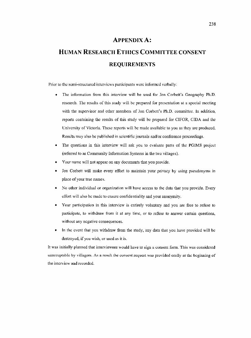
238
A p p e n d i x A :
H u m a n R e s e a r c h E t h ic s C o m m it t e e c o n s e n t
REQUIREMENTS
Prior to the semi-structured interviews participants were informed verbally;
• The information from this interview will be used for Jon Corbett’s Geography Ph.D.
research. The results of this study will be prepared for presentation at a special meeting
with the supervisor and other members of Jon Corbett’s Ph.D. committee. In addition,
reports containing the results of this study will be prepared for CIFOR, CIDA and the
University of Victoria. These reports will be made available to you as they are produced.
Results may also be published in scientific journals and/or conference proceedings.
• The questions in this interview will ask you to evaluate parts of the PGIMS project
(referred to as Community Information Systems in the two villages).
• Your name will not appear on any documents that you provide.
• Jon Corbett will make every effort to maintain your privacy by using pseudonyms in
place of your true names.
• No other individual or organization will have access to the data that you provide. Every
effort will also be made to ensure confidentiality and your anonymity.
• Your participation in this interview is entirely voluntary and you are free to refuse to
participate, to withdraw from it at any time, or to refuse to answer certain questions,
without any negative consequences.
• In the event that you withdraw from the study, any data that you have provided will be
destroyed, if you wish, or used as it is.
It was initially planned that interviewees would have to sign a consent form. This was considered
unacceptable by villagers. As a result the consent request was provided orally at the beginning of
the interview and recorded.
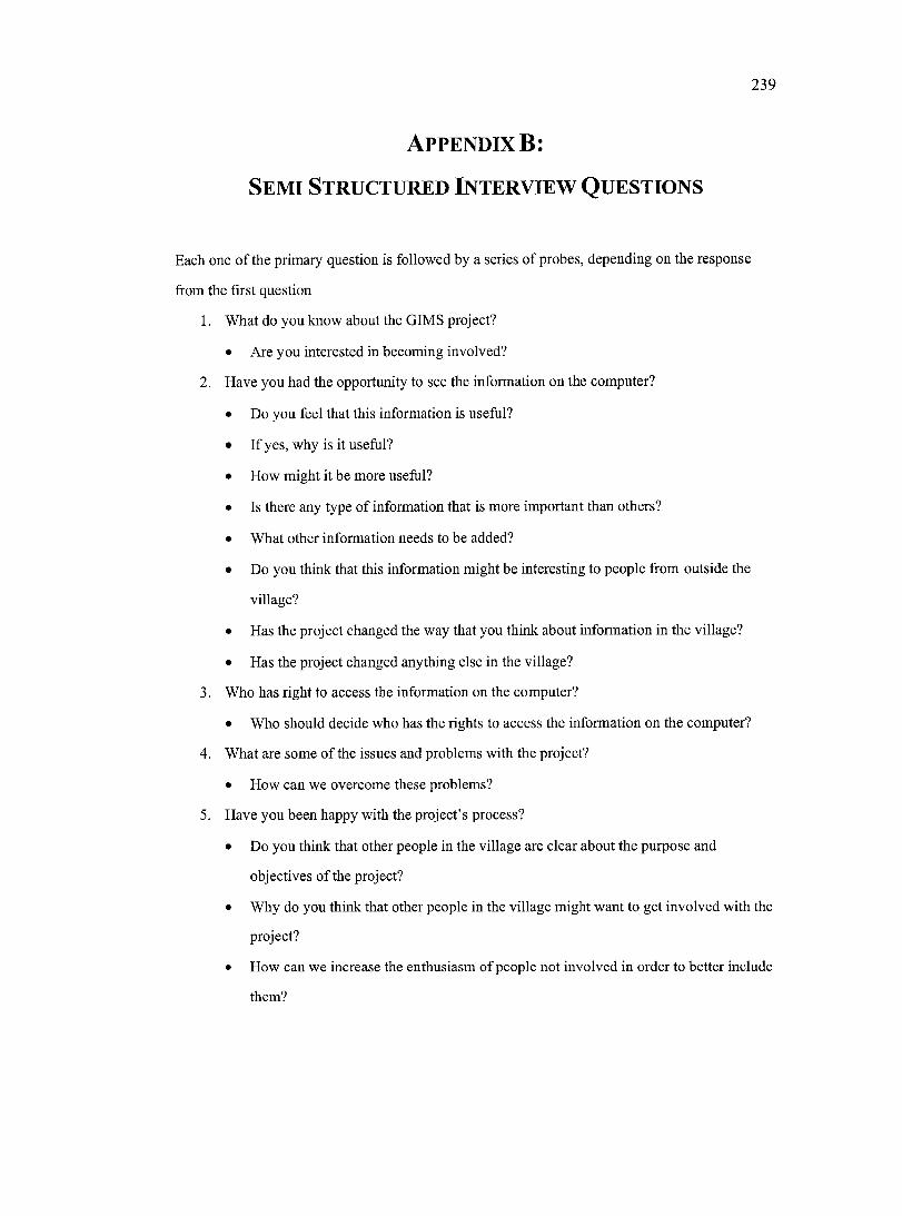
239
A p p e n d ix B:
S e m i S t r u c t u r e d In t e r v i e w Q u e s t io n s
Each one of the primary question is followed by a series of probes, depending on the response
from the first question
1. What do you know about the GIMS project?
• Are you interested in becoming involved?
2. Have you had the opportunity to see the information on the computer?
• Do you feel that this information is useful?
• If yes, why is it useful?
• How might it be more useful?
• Is there any type of information that is more important than others?
• What other information needs to be added?
• Do you think that this information might be interesting to people from outside the
village?
• Has the project changed the way that you think about information in the village?
• Has the project changed anything else in the village?
3. Who has right to access the information on the computer?
• Who should decide who has the rights to access the information on the computer?
4. What are some of the issues and problems with the project?
• How can we overcome these problems?
5. Have you been happy with the project’s process?
• Do you think that other people in the village are clear about the purpose and
objectives of the project?
• Why do you think that other people in the village might want to get involved with the
project?
• How can we increase the enthusiasm of people not involved in order to better include
them?
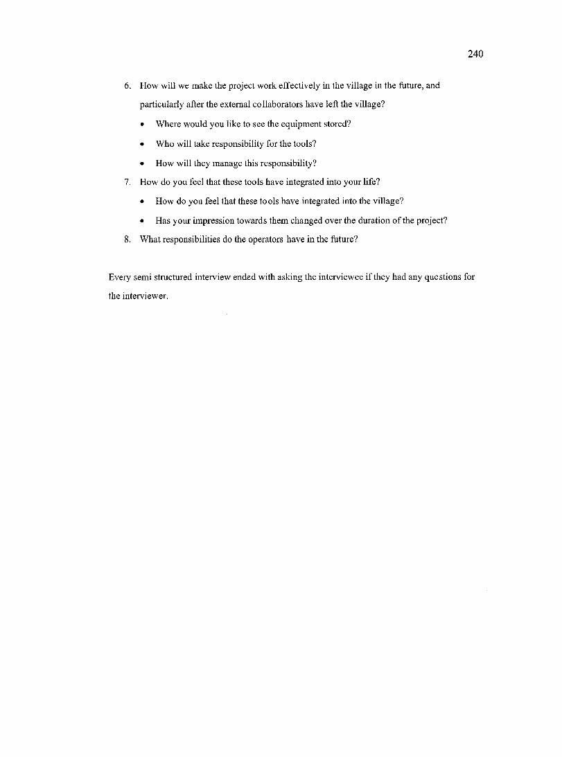
2 4 0
6. How will we make the project work effectively in the village in the future, and
particularly after the external collaborators have left the village?
• Where would you like to see the equipment stored?
• Who will take responsibility for the tools?
• How will they manage this responsibility?
7. How do you feel that these tools have integrated into your life?
• How do you feel that these tools have integrated into the village?
• Has your impression towards them changed over the duration of the project?
8. What responsibilities do the operators have in the future?
Every semi structured interview ended with asking the interviewee if they had any questions for
the interviewer.
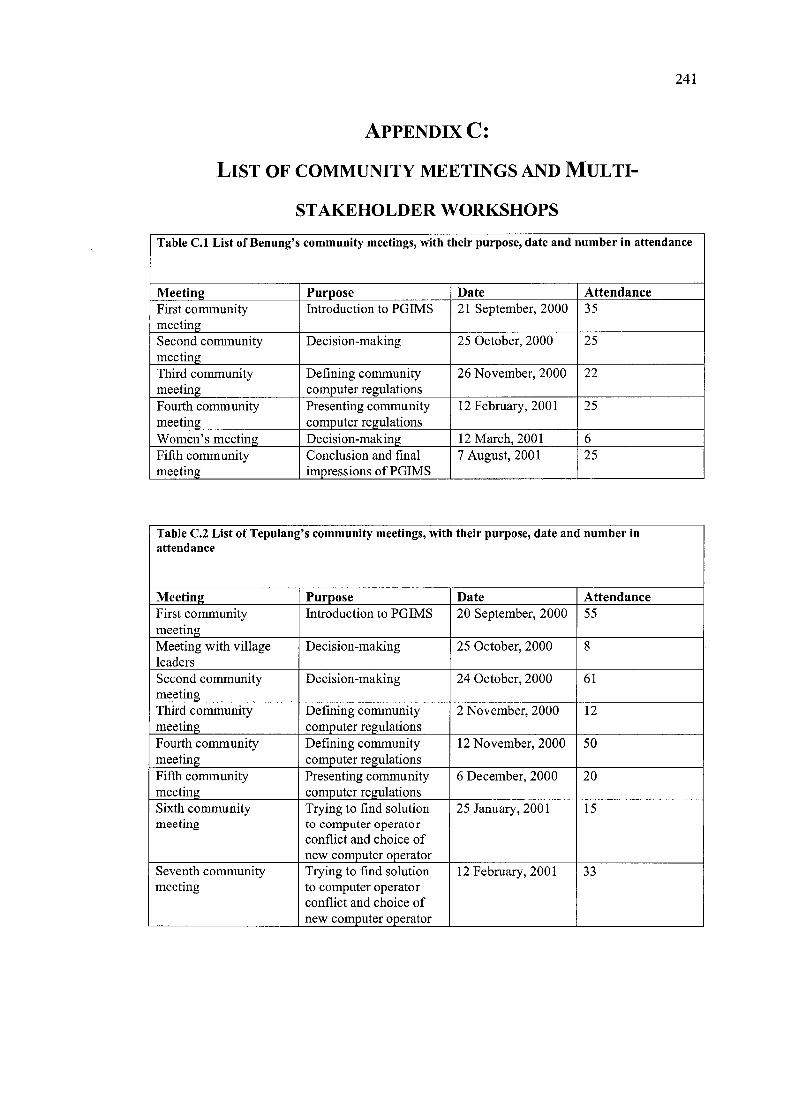
241
A p p e n d i x C:
L is t o f c o m m u n it y m e e t in g s a n d M u l t i
s t a k e h o l d e r WORKSHOPS
Table C.l List of Benung’s community meetings, with their purpose, date and number in attendance
Meeting Purpose Date AttendanceFirst community meeting
Introduetion to PGIMS 21 September, 2000 35
Second community meeting
Deeision-making 25 Oetober, 2000 25
Third eommunity meeting
Defining eommunity eomputer regulations
26 November, 2000 22
Fourth eommunity meeting
Presenting eommunity computer regulations
12 February, 2001 25
Women’s meeting Deeision-making 12 March, 2001 6Fifth eommunity meeting
Conelusion and final impressions of PGIMS
7 August, 2001 25
Table C.2 List of Tepulang’s community meetings, with their purpose, date and number in attendance
Meeting Purpose Date AttendanceFirst community meeting
Introduction to PGIMS 20 September, 2000 55
Meeting with village leaders
Decision-making 25 October, 2000 8
Second community meeting
Decision-making 24 Oetober, 2000 61
Third eommunity meeting
Defining eommunity eomputer regulations
2 November, 2000 12
Fourth eommunity meeting
Defining community computer regulations
12 November, 2000 50
Fifth community meeting
Presenting eommunity computer regulations
6 December, 2000 20
Sixth community meeting
Trying to find solution to computer operator conflict and choice of new eomputer operator
25 January, 2001 15
Seventh eommunity meeting
Trying to find solution to computer operator conflict and choice of new eomputer operator
12 February, 2001 33
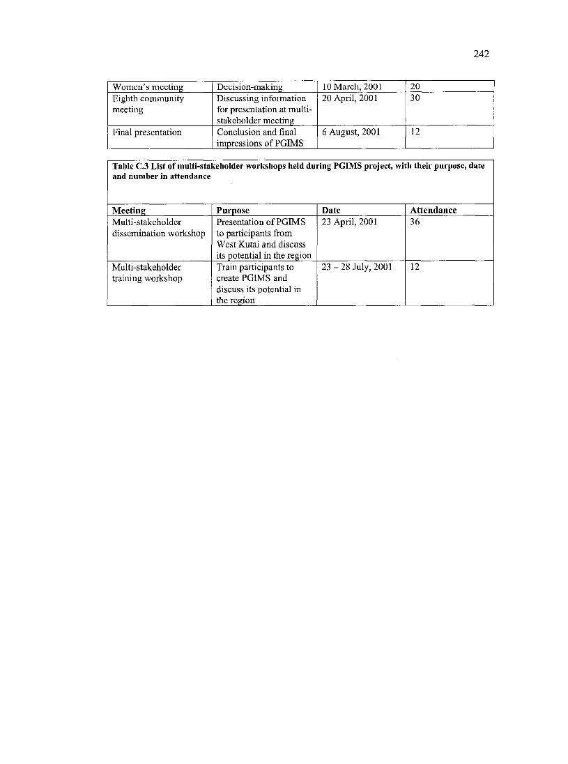
242
Women’s meeting Decision-making 10 March, 2001 20Eighth eommunity meeting
Discussing information for presentation at multistakeholder meeting
20 April, 2001 30
Final presentation Conelusion and final impressions of PGIMS
6 August, 2001 12
Table C.3 List of multi-stakeholder workshops held during PGIMS project, with their purpose, date and number in attendance
Meeting Purpose Date AttendanceMulti-stakeholder dissemination workshop
Presentation of PGIMS to participants from West Kutai and discuss its potential in the region
23 April, 2001 36
Multi-stakeholder training workshop
Train participants to create PGIMS and discuss its potential in the region
2 3 - 2 8 July, 2001 12
243
A p p e n d ix D :
M u l t i - s t a k e h o l d e r w o r k s h o p q u e s t io n n a ir e
Nam e
Place and date o f birth
Last education
Em ploym ent
W ork place
Sec tio n 1
1. Do you use a computer in your workplace or village?
Yes i jfy s s go to number 2)
No {If no go to question 8)
2. For what tasks do you use a computer?
3. What software programs do you use?
2 4 4
4, What information do you share with other people?
5. Do you own your own computer?
Yes Çfy^s go to number 6)
No {If no go to number S)
6. For what tasks do you most often use your private computer?
7. What software programs do you use?
245
Sec tio n 2
8. After seeing the PGIMS, what new things have you learnt? Please comment!
9. What is your opinion of the PGIMS that has been developed in Benung and Tepulang?
10. What information is most important to document in the area that you come from? Why is this information important?
II. What are the uses of documenting this information?
2 4 6
12. What are the strengths of sharing information using the PGIMS method?
13. What are the weaknesses of sharing information using the PGIMS method?
14. What information is most commonly communicated between the regional government and villages in the region? What is the process for communicating this information?
15. In your opinion what is the best way for local communities to incorporate their knowledge, aspirations and ideas into the development of the region?
2 4 7
16. Please comment on whether you feel that the PGIMS is a good method for local communities to communicate their information with groups outside of the village?
17. Do you feel that the map component of the PGIMS is a useful way to manage and communicate information? Please explain your answer.
18. Do PGIMS like the ones that you have seen today have value or use in the area that you are from? Please explain your answer.
19. Do you have any input or opinions or further questions about this research?
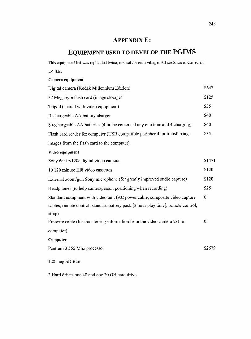
248
A p p e n d ix E:
E q u ip m e n t u s e d t o d e v e l o p t h e PGIMSThis equipment list was replicated twice, one set for each village. All costs are in Canadian
Dollars.
Cam era equipm ent
Digital camera (Kodak Millennium Edition) $647
32 Megabyte flash card (image storage) $ 125
Tripod (shared with video equipment) $35
Rechargeable AA battery charger $40
8 rechargeable AA batteries (4 in the camera at any one time and 4 charging) $40
Flash card reader for computer (USB compatible peripheral for transferring $35
images from the flash card to the computer)
Video equipment
Sony dcr trv 120e digital video camera $1471
10 120 minute HiS video cassettes $120
External zoom/gun Sony microphone (for greatly improved audio capture) $120
Headphones (to help cameraperson positioning when recording) $25
Standard equipment with video unit (AC power cahle, composite video capture 0
cables, remote control, standard battery pack [2 hour play time], remote control,
strap)
Firewire cable (for transferring information from the video camera to the 0
computer)
Com puter
Pentium 3 555 Mhz processor $2679
128 meg SD Ram
2 Hard drives one 40 and one 20 GB hard drive
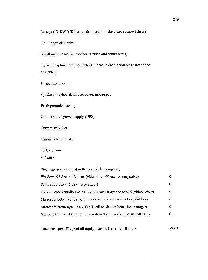
2 4 9
Iomega CD-RW (CD burner also used to make video compact discs)
3.5” floppy disk drive
I-Will main board (with onboard video and sound cards)
Firewire capture card (computer PC card to enable video transfer to the
computer)
17-inch monitor
Speakers, keyboard, mouse, cover, mouse pad
Earth grounded casing
Uninterrupted power supply (UPS)
Current stabiliser
Canon Colour Printer
UMax Scanner
Software
(Software was included in the cost o f the computer)
Windows 98 Second Edition (video driver/Firewire compatible) 0
Paint Shop Pro v. 6.02 (image editor) 0
U-Lead Video Studio Basic SE v. 4.1 later upgraded to v. 5 (video editor) 0
Microsoft Office 2000 (word processing and spreadsheet capabilities) 0
Microsoft FrontPage 2000 (HTML editor, data/information manager) 0
Norton Utilities 2000 (including system doctor and anti virus software) 0
Total cost per village of all equipment in Canadian Dollars $5337
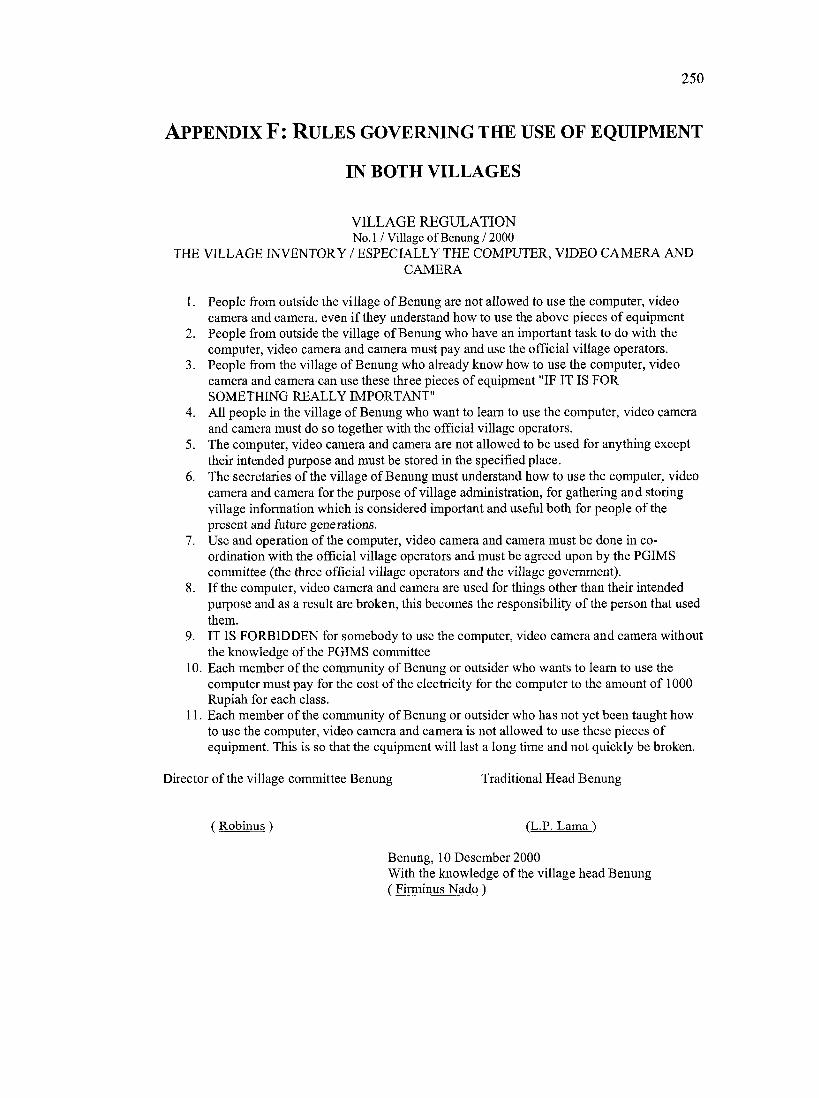
250
A p p e n d i x F : R u l e s g o v e r n in g t h e u s e o f e q u ip m e n t
IN BOTH VILLAGES
V ILLA GE REGU LATION No.l / Village of Benung / 2000
THE VILLAGE INVENTORY / ESPECIALLY THE COMPUTER, VIDEO CAMERA ANDCAMERA
1. People from outside the village o f Benung are not allowed to use the computer, video camera and camera, even if they understand how to use the above pieces of equipment
2. People from outside the village of Benung who have an important task to do with the computer, video camera and camera must pay and use the official village operators.
3. People from the village of Benung who already know how to use the computer, video camera and camera can use these three pieces of equipment "IF IT IS FOR SOMETHING REALLY IMPORTANT"
4. All people in the village of Benung who want to learn to use the computer, video camera and camera must do so together with the official village operators.
5. The computer, video camera and camera are not allowed to be used for anything except their intended purpose and must be stored in the specified place.
6. The secretaries of the village of Benung must understand how to use the computer, video camera and camera for the purpose of village administration, for gathering and storing village information which is considered important and useful both for people of the present and future generations.
7. Use and operation of the computer, video camera and camera must be done in coordination with the official village operators and must be agreed upon by the PGIMS committee (the three official village operators and the village government).
8. If the computer, video camera and camera are used for things other than their intended purpose and as a result are broken, this becomes the responsibility of the person that used them.
9. IT IS FORBIDDEN for somebody to use the computer, video camera and eamera without the knowledge of the PGIMS committee
10. Each member of the community of Benung or outsider who wants to learn to use the computer must pay for the cost of the electricity for the computer to the amount of 1000 Rupiah for each class.
11. Each member of the community of Benung or outsider who has not yet been taught how to use the computer, video camera and camera is not allowed to use these pieces of equipment. This is so that the equipment will last a long time and not quickly be broken.
Director of the village committee Benung Traditional Head Benung
( Robinus ) (L.P. Lama I
Benung, 10 Desember 2000With the knowledge of the village head Benung( Firminus Nado )
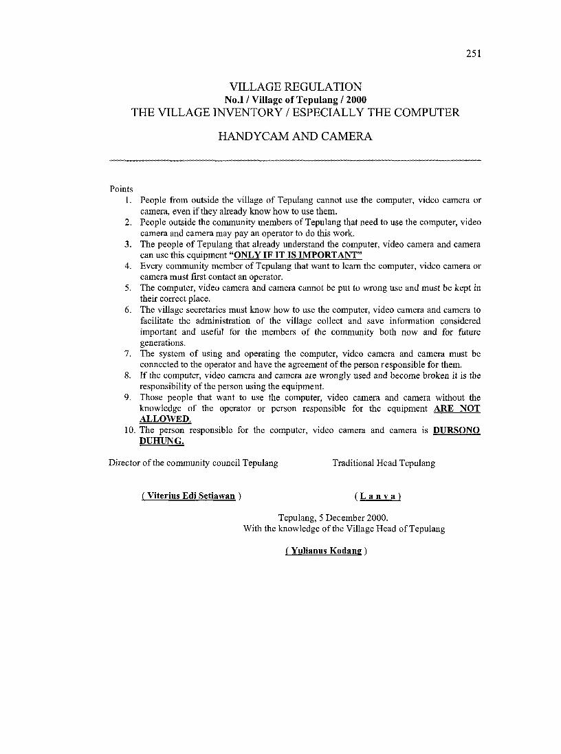
251
VILLAGE REGULATION No.l / Village of Tepulang / 2000
THE VILLAGE INVENTORY / ESPECIALLY THE COMPUTER
HANDYCAM AND CAMERA
Points1. People from outside the village o f Tepulang cannot use the computer, video camera or
camera, even if they already know how to use them.2. People outside the community members of Tepulang that need to use the eomputer, video
camera and eamera may pay an operator to do this work.3. The people o f Tepulang that already understand the computer, video camera and eamera
can use this equipment “ONLY IF IT IS IM PORTANT”4. Every community member of Tepulang that want to learn the eomputer, video eamera or
eamera must first contact an operator.5. The computer, video eamera and camera cannot be put to wrong use and must be kept in
their correct place.6. The village secretaries must know how to use the eomputer, video camera and camera to
facilitate the administration of the village collect and save information considered important and useful for the members of the community both now and for future generations.
7. The system of using and operating the computer, video eamera and eamera must be connected to the operator and have the agreement of the person responsible for them.
8. If the computer, video camera and camera are wrongly used and become broken it is the responsibility of the person using the equipment.
9. Those people that want to use the computer, video camera and camera without the knowledge of the operator or person responsible for the equipment ARE NOT ALLOWED.
10. The person responsible for the computer, video camera and camera is DURSONO DUHUNG.
Director of the eommunity council Tepulang Traditional Head Tepulang
( Viterius Edi Setiawan ) ( L a n y a )
Tepulang, 5 December 2000.With the knowledge of the Village Head of Tepulang
( Yulianus Kodang )
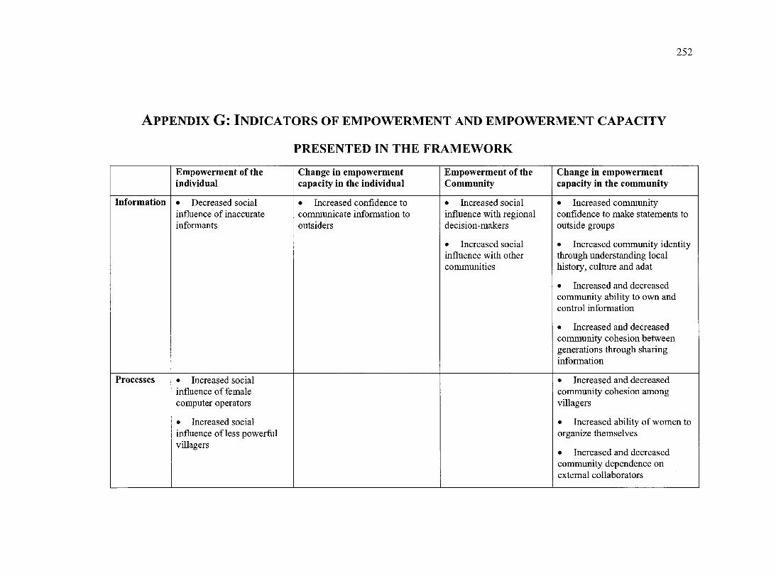
252
A p p e n d ix G: In d ic a t o r s o f e m p o w e r m e n t a n d e m p o w e r m e n t c a p a c i t y
PRESENTED IN THE FRAMEWORK
Em powerment of the individual
Change in em powerm ent capacity in the individual
Em powerm ent of the Community
Change in em powerm ent capacity in the com m unity
Inform ation • Decreased social influence of inaccurate informants
• Increased confidence to communicate information to outsiders
• Increased social influence with regional decision-makers
• Increased social influence with other communities
• Increased community confidence to make statements to outside groups
• Increased community identity through understanding local history, culture and adat
• Increased and decreased community ability to own and control information
• Increased and decreased community cohesion between generations through sharing information
Processes • Increased social influence of female computer operators
• Increased social influence of less powerful villagers
• Increased and decreased community cohesion among villagers
• Increased ability of women to organize themselves
• Increased and decreased community dependence on extemal collaborators
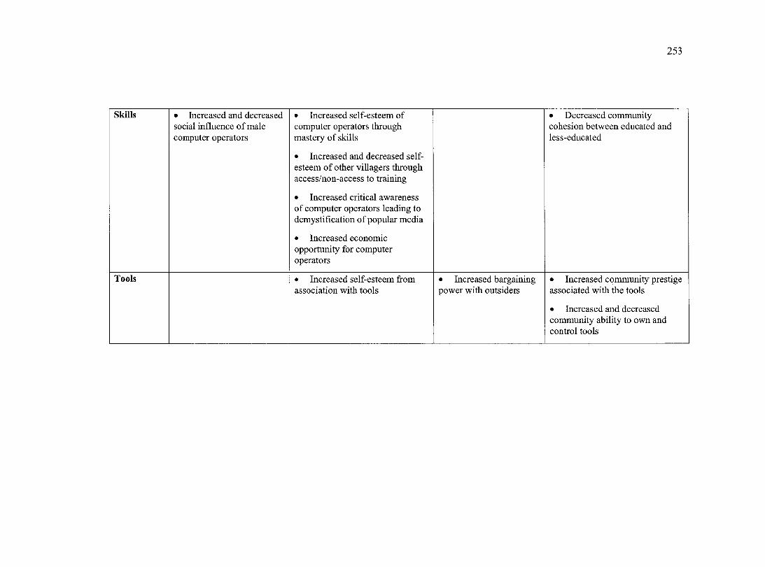
253
Skills • Increased and decreasedsocial influence o f male computer operators
• Increased self-esteem of computer operators through mastery of skills
• Increased and decreased selfesteem o f other villagers through access/non-access to training
• Increased critical awareness of computer operators leading to demystification o f popular media
• Inereased economic opportunity for computer operators
• Decreased community cohesion between educated and less-educated
Tools • Increased self-esteem from association with tools
• Increased bargaining power with outsiders
• Increased community prestige assoeiated with the tools
• Increased and decreased community ability to own and control tools