drop short roman villa, oxfordshire (desktop assessment)
TRANSCRIPT
“Now You See It, Now You Don’t....”
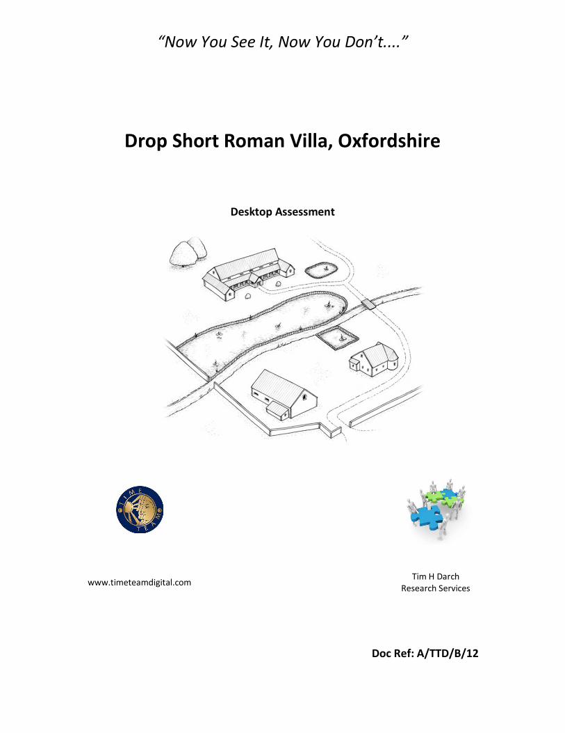
Drop Short Roman Villa, Oxfordshire
Desktop Assessment
www.timeteamdigital.com Tim H Darch Research Services
Doc Ref: A/TTD/B/12

Drop Short Roman Villa, Oxfordshire
Desktop Assessment
Prepared for
Time Team Digital
By
Tim H Darch Research Consultants
DECEMBER 2011
Report Number: A/TTD/B/11 Release Date: 06 December 2011 Version: Final Prepared By: Tim H Darch
i
Copyright Information
Drop Short Roman Villa, Oxfordshire: Desktop Evaluation is licensed by Tim H Darch Research Consultants under a Creative Commons Attribution-ShareAlike 3.0 Unported License. 2011
This report may contain material that is non- Tim H Darch Research Consultants copyright (e.g. Ordnance Survey, British Geological Survey, Crown Copyright), or the intellectual property of third parties, which we are able to provide for limited reproduction under the terms of our own copyright licences, but for which copyright itself is non-transferrable by Tim H Darch Research Consultants. You are reminded that you remain bound by the conditions of the Copyright, Designs and Patents Act 1988 with regard to multiple copying and electronic dissemination of the report.
DISCLAIMER THE MATERIAL CONTAINED IN THIS REPORT WAS DESIGNED AS AN INTEGRAL PART OF A REPORT TO AN INDIVIDUAL CLIENT AND WAS PREPARED SOLELY FOR THE BENEFIT OF THAT CLIENT. THE MATERIAL CONTAINED IN THIS REPORT DOES NOT NECESSARILY STAND ON ITS OWN AND IS NOT INTENDED TO NOR SHOULD IT BE RELIED UPON BY ANY THIRD PARTY. TO THE FULLEST EXTENT PERMITTED BY LAW THE AUTHOR(S) WILL NOT BE LIABLE BY REASON OF BREACH OF CONTRACT NEGLIGENCE OR OTHERWISE FOR ANY LOSS OR DAMAGE (WHETHER DIRECT INDIRECT OR CONSEQUENTIAL) OCCASIONED TO ANY PERSON ACTING OR OMITTING TO ACT OR REFRAINING FROM ACTING IN RELIANCE UPON THE MATERIAL CONTAINED IN THIS REPORT ARISING FROM OR CONNECTED WITH ANY ERROR OR OMISSION IN THE MATERIAL CONTAINED IN THE REPORT. LOSS OR DAMAGE AS REFERRED TO ABOVE SHALL BE DEEMED TO INCLUDE, BUT IS NOT LIMITED TO, ANY LOSS OF PROFITS OR ANTICIPATED PROFITS DAMAGE TO REPUTATION OR GOODWILL LOSS OF BUSINESS OR ANTICIPATED BUSINESS DAMAGES COSTS EXPENSES INCURRED OR PAYABLE TO ANY THIRD PARTY (IN ALL CASES WHETHER DIRECT INDIRECT OR CONSEQUENTIAL) OR ANY OTHER DIRECT INDIRECT OR CONSEQUENTIAL LOSS OR DAMAGE.
ii
Drop Short Roman Villa, Oxfordshire
Desktop Assessment
Contents
Disclaimer and Copyright Statement i Contents ii Acknowledgements iv Summary v 1 INTRODUCTION 1.1 Research Background....................................................................... 1 1.2 Site Location, Topography and Geology......................................... 1 1.3 Historical and Environmental Background..................................... 2 Introduction.......................................................................................... 2 Neolithic (4000-2500 BCE).................................................................. 2 Bronze Age (2500- 600 BCE).............................................................. 3 Iron Age (600BCE-43CE).................................................................... 3 Roman(43CE – 410CE)....................................................................... 4 Anglo-Saxon (410 – 1066CE).............................................................. 4 Post Anglo-Saxon (1066CE – Present)............................................... 5 1.4 Previous Archaeological Work......................................................... 6 2 AIMS AND OBJECTIVES 9 3 METHODS 9 4 DOCUMENTATION 10 4.1 Mapping.............................................................................................. 10 4.2 Geophysical ...................................................................................... 10 4.3 Reports.............................................................................................. 10 5 CONCLUSION 10 6 RECOMMENDATIONS 11 7 BIBLIOGRAPHY 12 List of Figures and Tables Table 1 Known Archaeology within 1Km of Site 15 Table2 Roman Sites centred on Drop Short Villa in the vicinity of Drop Short 16 Figure 1 Site Location Maps 20 Figure 2 Geology 21 Figure 3a Aerial Image (May 2009) 22 Figure 3b Aerial Image (2005) 23 Figure 4 Plan Plot of Site and Archaeology within 1Km 24 Figure 5a Trench Plan from Original Sources Further Prepared by GIS 26 Figure 5b Trench Plan Superimposed on NMR Photo and Marked Crop Marks 26 Figure 5c Trench Plan Superimposed on NMR Photo and Marked Crop Marks 27 Figure 6a Modern OS Maps (1:50000 and 1:25000 Scale) 28 Figure 6b Modern OS Maps (1:10000 and 1:2500 Scale) 29
iii
Figure 7a Historic Mapping (1612 and 1899) 30 Figure 7b Historic Mapping (1912 and 1974) 31 Figure 8a Map showing Recored Roman Burials and Religous 32 Figure 8b Map showing recored Roman Settlement Sites 33 Figure 8c Map showing recored Roman Built Structures 34 Figure 8d Map showing recored Roman Scheduled Sites and Roman Roads 35 Figure 8e Map showing recored Roman Finds 36 Figure 8f Map showing all recored Roman sites 37 Figure 9a 1804 Enclosure Map 38 Figure 9b Full Page Entry from 1804 Enclosure Awards 39 Figure 9c Extract and Interpretation from 1804 Enclosure Awards 40 Figure 10a Doomsday Book Entry (Original) 41 Figure 10b Doomsday Entry (translated and Interpreted) 42 Figure 11 2003 Geophysical Survey (South and Southwest of site) 43
iv
Drop Short Roman Villa, Oxfordshire
Desktop Assessment
Acknowledgements
Much of the work involved in carrying out this projected centred around bringing together a number of sources that had unwittingly provided strong insight into the site, but had not been connected before to bring all the information into one place. This had had the effect of leaving the site with an apparent lack of information, evidence or understanding. In preparing this document I have specifically referred to work from Wessex Archaeological, Oxford Archaeology, Berkshire Records Office and Reading Museum. I must also acknowledgment the ongoing work being carried out by William Wintle who located most of the original documentation relating to the 1966 excavations; several aspects of this report have been confirmed from these documents. Additionally, these documents have complimented the interpretation of the correlated information from unconnected and often outwardly unrelated sources and removed the need to consider tentative information. It is through research and interpretation that the Villa that was found, and then lost, has now started the process of being re-found.
v
Drop Short Roman Villa, Oxfordshire
Desktop Assessment
Summary
In November 2011, it was decided that a desktop evaluation should be carried out on a site known as Drop Short Roman Villa (NGR SU 4942 9389), which lies immediately south of the B4016, approximately 600m west north east of Sutton Courtenay, and 3.5Km south of Abingdon, Oxfordshire. The aim of this assessment is to identify the current publically available information and research, to determine the likely origins and history of the Drop Short Roman Villa site. The remains of a probable Romano-British villa were discovered in 1962 by the farmer, Mr. Fidler, who ploughed up stone foundations and large quantities of Roman bricks, tiles, and pottery. In 1966 an archaeological excavation took place headed by Mr G Thomas of Reading University, on behalf of Berkshire Archaeological Society and Reading Museum. It was suggested at the time from evidence found that the site may contain a significant villa with two wings, additionally coins found at the time indicated a period off use from 1st to 5th century CE. However, for various reasons the records of the excavations seemed to disappear from sight, and it has been suggested that this may have been an agreement with the original land owner in 1966 as a condition of the excavation. In 2011, W. Wintle of Oxford Archaeology in carryout research on the archaeology of the Vale of the White Horse in Oxfordshire, uncovered the original field notes. These were then linked to some work carried out in the 1980’s on the original documentation, which hitherto was unknown about, by David Miles and Grace Scrimgeor of Oxford Archaeology. As a result Drop Short is no longer an unrecorded site, it is now a site that has come back to life, and beckons further investigation. Recent Archaeological investigations in the areas to the south of the site and to the east at Drayton have uncovered significant Anglo Saxon settlements and it is suggested that some of the features identified may be associated with Drop Short Roman Villa, which gives a possible indication of usage beyond Roman into the Anglo Saxon Period if confirmed. It is clear that the area has had some very high status connections over time from the Iron Age Atrebates, through the Roman period, though the Anglo-Saxon times and King Ine, through to King Henry and Empress Matilda, and even into modern times with Lord Asquith. This raises the question is Drop Short high status, and who lived there.
1
Drop Short Roman Villa, Oxfordshire
Desktop Assessment
1. INTRODUCTION
1.1 Project Background
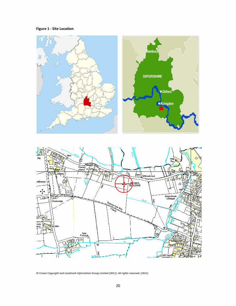
1.1.1. Tim H Darch was requested by Tim Taylor of Time Team Digital, to undertake a Desktop Evaluation of the publically available information and research and ascertain the origin and history of a site at Drop Short, Oxfordshire (hereafter ‘the Site’) (Figure 1).
1.1.2. This report documents the results of this desktop evaluation and presents results that are on the evidence available.
1.2 Site Location, Topography and Geology
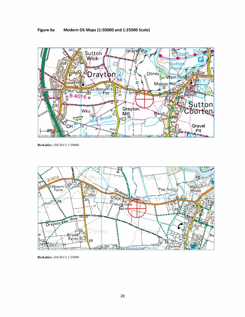
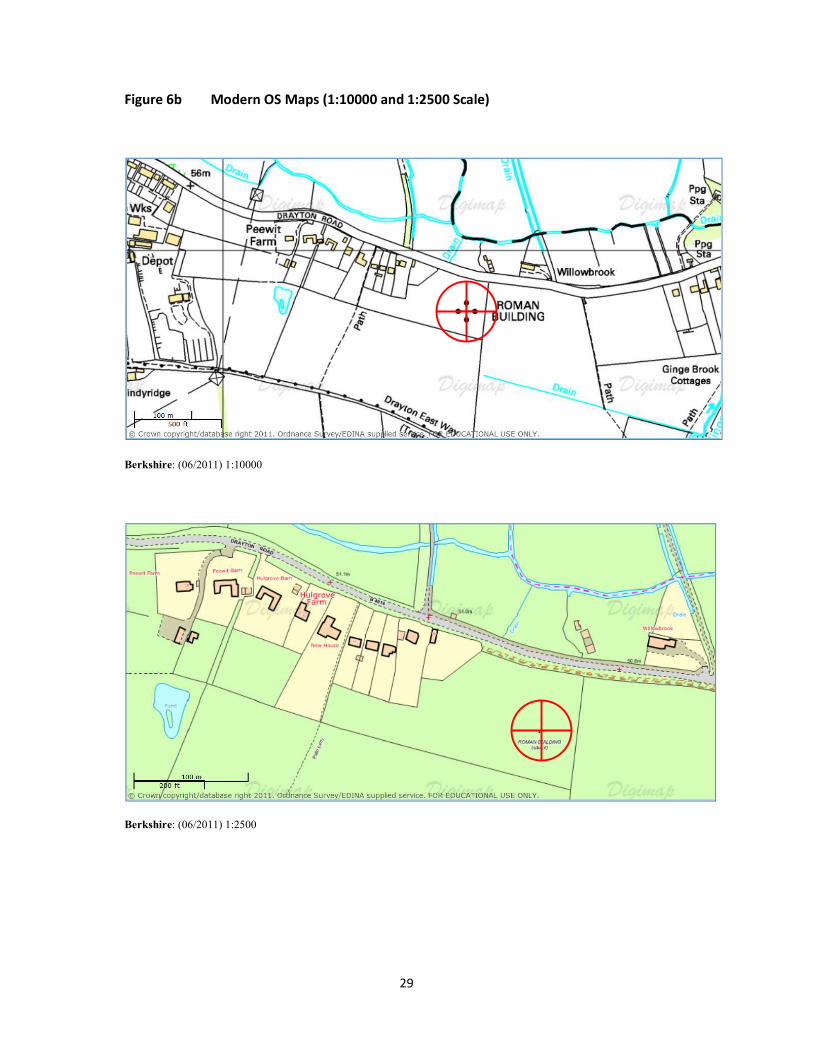
1.2.1 The site is known as Drop Short and lies immediately south of the B4016, approximately 600m west north east of Sutton Courtenay Oxfordshire, 2.0Km East of Drayton, Oxfordshire and 3.5Km south of Abingdon, Oxfordshire, centred on NGR SU 4942 9389.
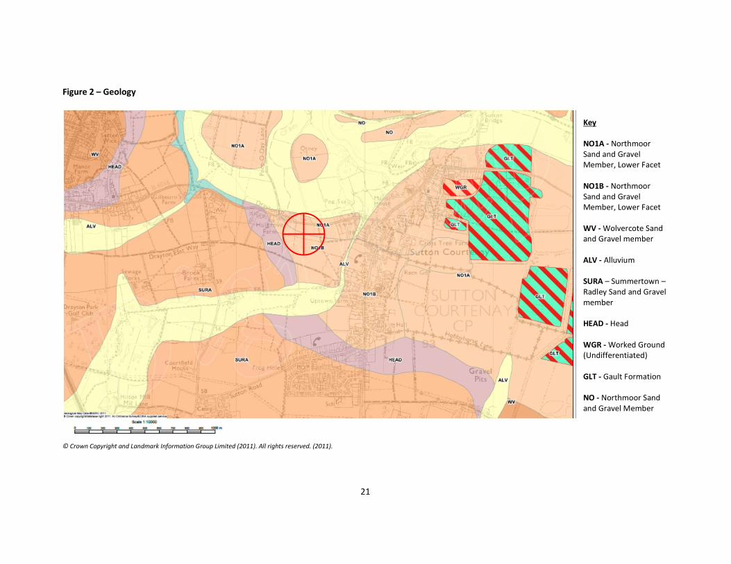
1.2.2 The site lies at a height of 54.25m above Ordnance Datum (aOD). The underlying geology consists of Northmoor Sand and Gravel Member (both Lower and Upper Facets (Figure 2) (British Geological Survey 1981, sheets 253).
1.2.3 The whole area is assessed as being lowland village farmland (OWLS, 2004). The area is characterised by medium to large-sized arable and grass fields. Fields are generally enclosed by a prominent network of tall, thick hawthorn and blackthorn hedges with a dense pattern of Ash, Willow, poplar, dead Elm and Oak trees, particularly bordering roads and country lanes. Roadside hedges are generally intact, but many internal field hedges are fragmented and gappy, particularly where they enclose arable land. There are also a significant number of tree-lined ditches with species such as crack Willow, Ash, Poplar and dead Elm. Small deciduous plantations and trees within villages are also characteristic.
1.2.4 The site is not registered as having any form of environmental protection or designation as defined by DEFRA (2002), though it is understood that the current land owner has a section of the site area in habitat ‘set aside’. Further the site is not is not archaeologically or heritage scheduled, though the site is known to English Heritage, and is recorded on PastScape as Sutton Courtenay Roman Villa (alternative names: Dropshort Roman Villa, Dropshot Roman Villa) Monument Number 234105. (PastScape 2007).
2
1.2.5 The site and associated fields are owned by Mr Robert Allan (Uptown Farm, Sutton
Courtenay). Access to the site has been agreed with Mr Allan, and it has been timed in consultation with him so as to cause minimum disruption.
1.2.6 At this point it must be noted that the correct geographical, social and economic name of the site is DROP SHORT, other incorrect versions exist, such as Drop shot, Dropshort, etc. However, in 1804 the name was recorded as DROP SHORT on the Enclosure/Tithe Apportions, further since 1841 the address, when shown, has been recorded on all census entries as DROP SHORT. Currently the name DROP SHORT is still held by the original cottage associated with the sites name (Drop Short Cottage, 87 Drayton Road).
1.3 Historical and Environmental Background Introduction
1.3.1 The site is based in Oxfordshire, near to Abingdon (formally the county town of Berkshire) and covers an area of approximately 5 Hectares. The immediate wider area has seen human activity from the Neolithic through to modern periods, with areas of settlements and agriculture present and evident. (ARCHI professional, 2011) Neolithic (4000 – 2500BCE)
1.3.2 There is little evidence of activity during the Neolithic Period in the sites immediate area; however over a slightly wider area finds have indicated that activity was present. Barclay et al (2003) speculated that Drayton Cursus, located 500m to the west survived long enough as an earthwork to be respected by a Roman field system, which could have been connected with Drop Short The Curcus has been radiocarbon dated to about 3635-3385BCE and several lithic artefacts (Unassigned) have been found within ¼kms of the Cursus. (Barclay et al, 2003, 8 -9)
1.3.3 Devereux (cited in Bennet, 2008) described how crop marks revealed, “a substantial former cursus immediately to the east of Drayton: its crop marks extend southwest to northeast for a little over a mile, and are 225 feet (68 metres) wide. The cursus has a squared south end, but the northern terminus has not been found. The crop marks are not evident in the middle portion of the cursus, as it was formerly overlaid by a Saxon village. There is a plethora of other crop marks within and around the cursus... The northern section…which has a slightly different orientation to the southern segment, points squarely to the ancient heart of Abingdon.”
1.3.4 Benson and Miles (1974) variously implied that there is evidence in the early Neolithic that the economy was a mixture of mobile pastoralism and hunting but
3
by 1500BCE this was in decline. By middle to late Neolithic small scale farming, with early enclosures acting perhaps as seasonal meeting places were the norm. It is understood that these communities were now increasingly bound to the land they cultivated and much of the history of the succeeding millennia is concerned with the creation of agricultural land and pasture, its maintenance, its allocation, and later its defence in the face of a steadily increasing population.
1.3.5 It is known from flint scatters and other artefacts that settlements developed throughout the county, often on the sites of earlier Mesolithic camps, there are no visible remains of these first farms to be seen today within the immediate area.
Bronze Age (2500- 600 BCE)
1.3.6 The Sites and Monuments Record for Oxfordshire attributes 897 records (monuments, events and findspots) to the Bronze Age, with 42 records specifically to the Middle and Late Bronze Age. These records mask a great diversity in the level of information recorded, from single findspots to major investigations of large areas of prehistoric landscape. Many formally undated cropmark sites probably also date to one of these periods. In addition, many further sites are likely to lie buried beneath alluvium on the floor of the Thames valley and of its tributaries.
1.3.7 Bronze Age settlement sites were excavated by ET Leeds approximately 500m from the site (at what is now the Council Depot at Drayton) in advance of gravel extraction between 1921 and 1937. The Bronze Age settlement consisted of a number of pits and ring ditches and a rectangular ditched enclosure some 750 yards long and 75 yards wide. These enclosures, and a number of probable barrow-circles, are considered by Leeds to be either late Neolithic or Early Bronze Age in date. A cursus was also discovered, (Now called Drayton South Cursus). However, a Roman ditch, part of an adjoining trackway and 2 enclosures, containing 2nd and 3rd century pottery, were discovered in 1980, (Barclay et al 2003, 79) and may indicate Roman activity in the area. It was implied that these Roman features may be associated directly with Drop Short. Iron Age (600BCE – 43CE)
1.3.8 There are no immediate Iron Age associations with the site, and only three in a slightly wider area; these are restricted to coin finds. It is, therefore, not possible to state if the site has any Iron Age connections.
1.3.9 It is, however, important to recognise that the area that the site lies in is in the area known to have been controlled by the Atrebates, who occupied what is now modern Berkshire and Hampshire, along with areas of West Sussex, Western Surrey, and North-East Wiltshire. Closely related to a North-Western Gaulish tribe of the same name, they were at their most powerful in the first and second centuries BCE. The name Atrebates means 'settlers' or 'inhabitants', the Atrebates were one of the more successful and civilised tribes. They traded with the tribes in
4
Europe right up until the Romans conquered Gaul, and saw the conquest as an opportunity to increase their regular trade in fine cloth, hunting dogs and military items. The process worked both ways, enabling them to absorb new ideas, giving them advantages in culture and technology which some of their neighbours did not possess. Their capital was Calleva Atrebatum (the 'place in the woods of the Atrebates', now near Silchester in Hampshire), another tribal centre was at Cunetio (Mildenhall in Wiltshire). (Kessler Associates. 2011)
1.3.10 Closer to the site, it is know that modern Abingdon originated in the Iron Age period where an Oppidum was constructed (late Iron Age defensive enclosure) which was later used by the Romans. (Allen, 1991: 96-97)
Roman(43CE – 410CE)
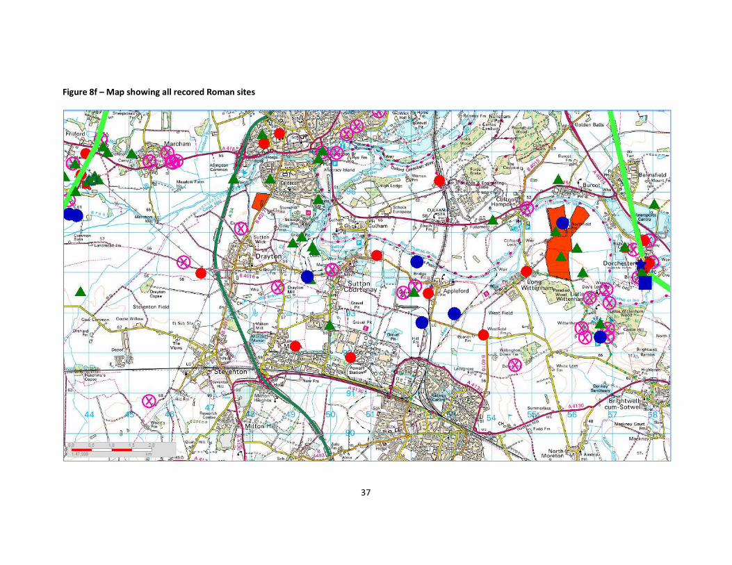
1.3.11 The site lies in an area that has evidence of Roman and Romano-British settlement and from the lack of industial Roman Sites, it can be see that the site may have lain in a broadly agricultural area rather than industrial area. Table 2 lists all known sites within a wider area context, and it is noted that none of the sites indicate industrial activity. The area that the site is in is sandwiched between two known Roman roads, located at Dorchester to the east and Frilford to the west.
1.3.12 The wider area has a large number of settlement site, one town (Dorchester or Dorcic), and a possible fort at Dorchester. At Frilford, to the North West there is evidence of the development of a significant settlement site, where a temple, amphitheatre, numerous settlements and villa developments occur.
1.3.13 Overall the site appears to be largely ‘isolated’ from the main Roman Settlements of the area, (See figures 8a to 8f), this may have significance as to the type and importance of any villa complex located. It is known to have stood on or close to the original route between Dorchester and Frilford, as well as standing on or close to the dry route between Dorchester and Abingdon.
1.3.14 Further discussion from this period can be found in Previous Archaeological Work
below. Anglo-Saxon (410 – 1066CE)
1.3.15 The parishes of Sutton Courtenay and Drayton lie within the hundred of Sutton which is centred on the royal estate at Sutton Courtenay (Hamerow et al. 2007, 116-117). Substantial and significant Anglo-Saxon settlements are known from the near vicinity.
1.3.16 The nearest Saxon settlement (500m distant and now under the Council Depot)) had been previously occupied during the Bronze Age and there was a plentiful scatter of Romano-British pottery, implying that the area had been cultivated during that period. The occupation was noted by chance in the face of a gravel-pit and reported to the Ashmolean Museum. The remains discovered in the course of
5
commercial gravel digging were intermittently explored by the late E. T. Leeds between 1921 and 1937. (Radford. 1957,28)
1.3.17 The village of Sutton was given to Abingdon Abbey by King Ini (688–728), and in 801 Abbot Hrethun gave 100 manentes of land here and £120 to Coenwulf, King of the Mercians, in exchange for Andersey Island. Be this as it may, Sutton remained a royal village until the reign of Henry II (1133 – 1189). (Page and Ditchfield, 1924)
Post Anglo-Saxon (1066CE – Present)
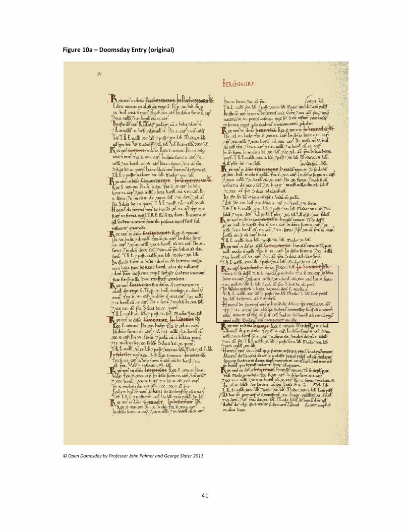
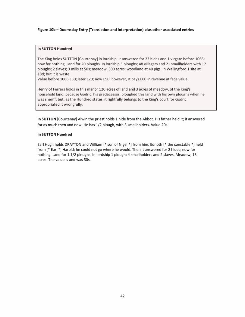
1.3.18 At the time of the Doomsday Book, it is believed that the site would have fallen into the Sutton Hundred, which consisted of 23 hides (c2730 Acres) and 1 virgate (c30 acres common land). Land for 20 ploughs. In lordship 3 ploughs; 48 villagers and 21 smallholders with 17 ploughs; 2 slaves; 3 mills at 50s; meadow, 300 acres; woodland at 40 pigs. Value before 1066 £30; later £20; now £50; however, it pays £60 in revenue at face value. However, as with the custom for the Doomsday book, this was classed as a large Hundred, so associated places were not identified. (See Figure 10a – 10b) Henry of Ferrers holds in this manor 120 acres of land and 3 acres of meadow, of the King's household land, because Godric, his predecessor, ploughed this land with his own ploughs when he was sheriff; but, as the Hundred states, it rightfully belongs to the King's court for Godric appropriated it wrongfully. (Open Doomsday 1999)
1.3.19 Henry de Ferrers (also known as Henri de Ferrières) was a Norman soldier from a noble family who took part in the conquest of England and is believed to have fought at the Battle of Hastings of 1066 and, in consequence, was rewarded with much land in the subdued nation. Henry became a major land holder and was granted 210 manors throughout England and Wales, but notably in Derbyshire and Leicestershire, by King William for his conspicuous bravery and support at Hastings. (Wikipedia 2011)
1.3.20 It is worth pointing out that John Fletcher (1990), argues for the possibility of a royal palace at Sutton (now Sutton Courtenay) being the birth place of Empress Matilda(1101-1169), despite the fact most historians believe she was born in Winchester. To date no confirmatory evidence exists for any location.
1.3.21 The village name of Courtenay derives from the family of that name who took on the manor in about 1177. Sutton was originally one of their major estates, but they inherited important lands in the West Country and their Berkshire home became less significant. They are now the Earls of Devon, and live at Powderham Castle (Devon). It was Reginald Courtenay, a landless young man from a well known family, who first became Lord of Sutton. He had attached himself to Henry of Anjou (later Henry II) and helped negotiate this young man’s way to the English throne which his mother had lost. As a reward, he was given the birthplace of this very woman. She was the Empress Matilda, mentioned previously. (Nash Ford, 2008)
6
1.3.22 The Courtenay power in the village was ended during the Wars of the Roses in 1462 when the Lancastrian Thomas Courtenay was accused of treason, beheaded and his lands and possession forfeited the the Crown. Finally in 1485 Henry VII’s parliament granted the Rectory House and its glebe lands and rectoral rights to the Dean and Chapter of St George’s Chapel, Windsor. The right to appoint the Vicar of Sutton Courtenay is still held by St George’s.
1.3.23 Between 1700 and 1900 the landscape of Berkshire was transformed. The open fields (particularly predominant in the north), common lands and manorial wastes were swept away, to be replaced by small fields surrounded by hedgerows. During these two centuries over half of the county was thus affected. The process which brought about this change is known as enclosure. Legally enclosure means the abolition of rights of common enjoyed by tenants of a manor over some or all of the open lands in a parish, and the redistribution of the land into individual ownership. Practically, it meant the end of strip farming, of common pasture, and of rights over the waste. Physically the change was dramatic. Huge social, economic and technological changes also followed enclosure, the effects of which historians continue to debate. (BRO, 2011)
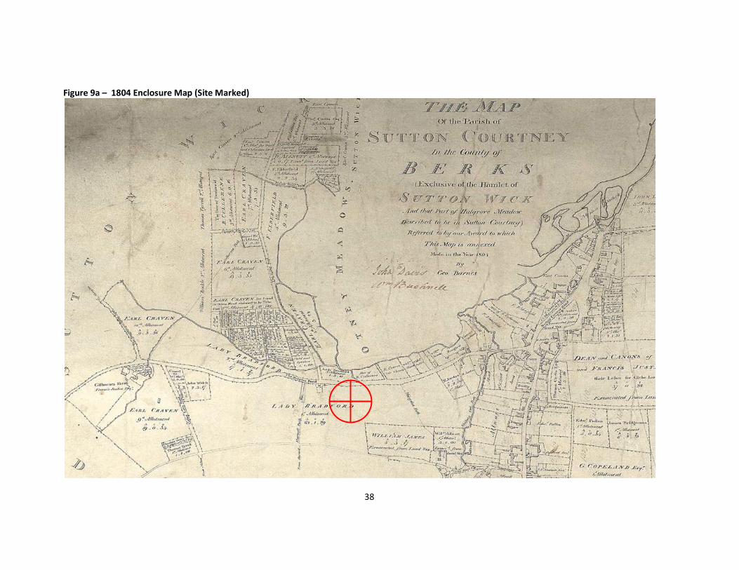
1.3.24 By 1804 the site had already undergone its enclosing as it is recorded as belonging to Lady Elizabeth Bradford; the modern current field system is not evident, (See Figure 9a) However at this time the nearest properties are recorded as Drop Short
1.3.26 Lady Bradford was the widow of the Earl of Bradford (Henry Bridgeman 1725 – 1800). It is understood that from the time of her husband’s retirement until her death in 1806 in Bath, they resided at the Manor in Sutton Courtenay, under the patronage of the Craven Family. (See Figures 9b and 9c).
1.3.26 Until the discovery of the Roman buildings in 1966, little is known about the land and how it was owned/managed, partially due to destruction of certain pertaining records during World War 2, and partly due to modern data protection laws.
1.4 Previous Archaeological Work
1.4.1 In 1962, Mr. Fidler, the landowner, whilst out ploughing, uncovered stone foundations, large quantities of Roman bricks, tiles, and pottery, and evidence of two tessellated floors. (Reading Museum 1962, 118)
1.4.2 In 1966 G. Thomas excavated Drop Short Villa, 0.7km to the east. Reports in the Journal of Roman Studies (1967, 198) and purportedly in the Daily Telegraph (15th August 1966) describe it as a substantial stone-built structure with a mosaic floor and a hypocaust. There was speculation at the time that there may be more than one structure on the site, as Thomas concentrated on chasing the wall structure rather than the floors (Wilson and Wright 1967, 198) Finds recovered during the excavation suggest occupation throughout the Roman period (Hamerow et al. 2007, 114-115). Field ditches visible as cropmarks to the west of the site are likely
7
to belong to an estate associated with this villa (Barclay et al.2003, 23), and two of the ditches excavated by Leeds are also likely to be part of the Drop Short villa estate (Barclay et al. 2003, 23).
1.4.3 A number of small-scale excavations within the wider landscape at Corporation Farm, at the Drayton Highways Depot and around 500m to the north of Leeds’ excavations have also found evidence of Anglo-Saxon settlement and activity (Barclay et al. 2003). In addition, a number of cemetery sites are known, including those at Milton, excavated in the 19th century, which contained the two most richly furnished 7th century burials in the region as well as burials believed to be of 6th century date. Further late 5th/6th century burials have also been identified to the east of Sutton Courtenay, in addition to a number of burials from the 5th to 7th centuries discovered around the settlement at Long Wittenham (Hamerow et al. 2007, 116).
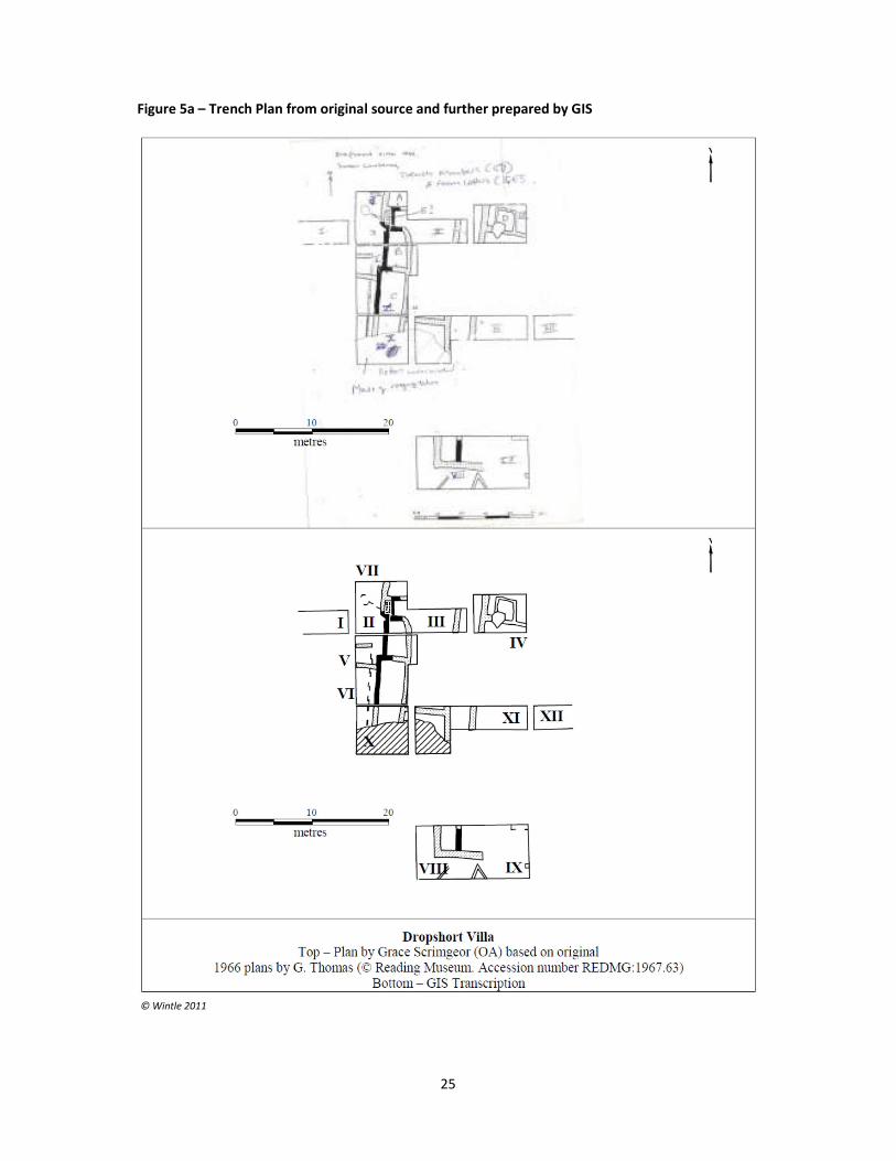
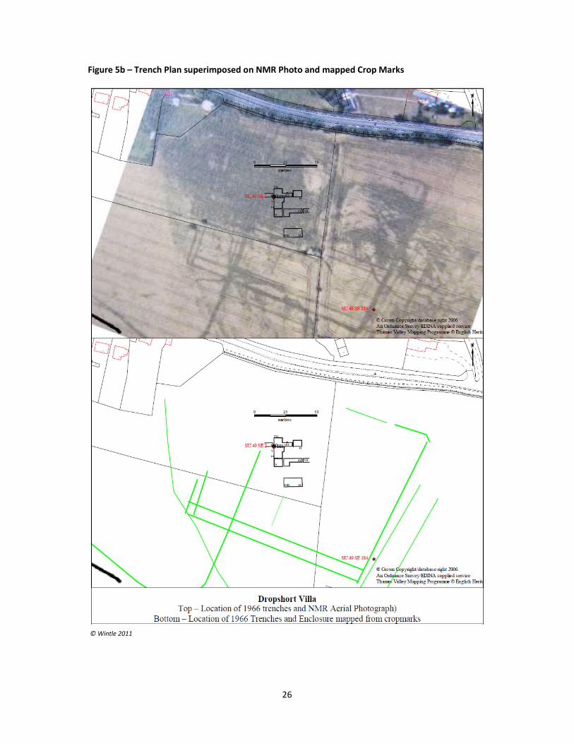
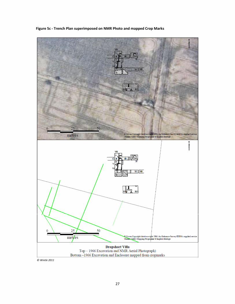
1.4.4 Wintle (2011) has found evidence from some of the original notes that indicate that at least 12 trenches were excavated, exposing significant sections of the structures. One trench (1) contained no features, the next five (2 – 6) were excavated until buildings were reached, and the remaining four (7 – 12) were only partially cleared and much of the original destruction debris remained. Trench 2 corresponded to the initial 1962 discovery of the floors. (See Figure 5a - 5c)
1.4.5 The remains of stone built walls were located in trenches 2, 5, 6 and 12 with possible footings in 8. These together with the traces of robbed trenches enable four rooms to be identified although it is not clear they all belong to the same building or phase. In addition a square room or building of probable wooden construction was excavated in trench 4.
1.4.6 Further remains, ditches and/or robbed out walls were observed in trenches 3 and 8 to 12. Only trenches 2 and 8 had significant quantities of tesserae so decorated floors may have been limited to these areas of the building. Evidence of decoration and elaboration is provided by finds of window glass and at least three wall plasters. However, due to the incomplete excavations and recording the evidence for the overall plan and phasing of the villa is inconclusive.
1.4.7 Excavations in 1981 and 1985-6 around the Drayton North Cursus identified parts of a Romano-British field system, three possible Sunken Floor Buildings as well as a number of post-built structures. However no clear dating could be obtained for any of the structures (Barclay et al. 2003, 104-123).
1.4.8 In 2001-3 Helena Hamerow led phases of fieldwalking, excavation and geophysical survey to the east of Milton Road and to the south of Drayton East Way, falling within the scheduled area. The fields in this area, in contrast to the Site, are currently under arable cultivation and showed evidence of heavy plough damage. There has also been metal-detecting, including known illegal detecting, on the Site for at least the last ten years (Hamerow et al. 2007, 113-4)
8
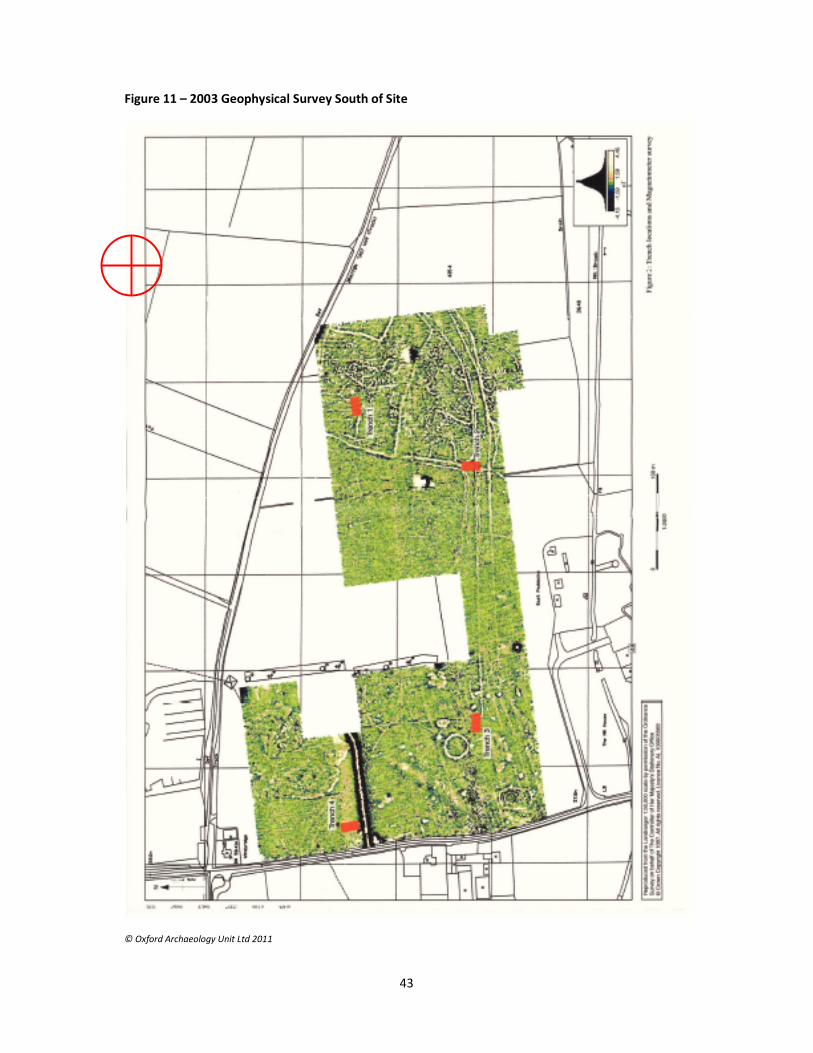
1.4.8 This geophysical survey (See Figure 11) covered a total area of 15.8 hectares. The following discussion is a summary of the survey results (Hamerow et al. 2007, 119- 22), which were published separately (Martin 2004). In general terms, the survey confirmed the presence of the features seen in the aerial photographs, whilst in some areas provided some further detail. The Western third of the survey area showed evidence of very intense levels of activity with a series of sub-rectangular enclosures, some possible droveways and a large number of discrete anomalies. The Central third in contrast was much quieter and this may result from a difference in geology rather than reflecting variation in the level of activity in this area in the past. The Western third, while quieter than the Eastern third, showed a number of interesting features, also visible on the aerial photographs. Immediately to the East of the road was a large rectangular feature, interpreted as a timber-built hall, similar to those seen on the aerial photographs to the West of the road. To the South-East of this was a circular anomaly some 32m in diameter, interpreted as a barrow ditch. Two parallel linear features were recorded in the southern part of the survey area; while the Southernmost one seems to stop, the Northern one appears to turn North, possibly respecting the position of this barrow. To the South-West of this was a similar circular anomaly within an oval enclosure. Parallels at Radley, adjacent to the Abingdon causewayed enclosure, suggest that this enclosure could well be Neolithic in origin (Hamerow et al. 2007, 131).
1.4.9 A metal-detector survey was attempted in conjunction with the fieldwalking, but this had to be abandoned when it became apparent that the field may well have been ‘seeded’ with modern metal items in order to hinder the survey (Hamerow et al. 2007, 119). However, metal finds from the site that have been reported to the Ashmolean Museum include several brooches as well as other personal adornments and fittings dating from the 6th to 7th century. Fourteen separate findspots of late 7th to 8th century sceattas have also been reported. It is thought that much of the metalwork might indicate the presence of a cemetery, while the coins could be evidence of market trading. A human mandible was also found during the fieldwalking but this is, as yet, undated (Hamerow et al. 2007, 171-83).
1.4.10 Four 20x10m trenches were excavated, and the results presented here are summarised from the published report of that excavation (Hamerow et al. 2007, 122-68). Some Early Neolithic activity in the area is indicated, and an apparently isolated Bronze Age grave was discovered. Fieldwalking recovered struck flint from a much wider area, although in common with the results from other material types there was less from the central part of the area. Some residual Late Bronze Age pottery was also found. The mass of linear and discrete features in the eastern part of the site were found to be of Iron Age to Roman date, but continuity or otherwise between the Iron Age and Roman-British phases of use could not be demonstrated. The main enclosure features appear to be Roman in date, although two other linear features, despite only containing Iron Age material, are believed by the authors to be possibly later. The droveway running east - west along the southern part of the survey area was found to be Romano-British. The authors speculate on a possible relationship with the Drop Short Villa.
9
1.4.11 If some of the discrete features revealed by the magnetometer survey do in fact
relate to Sunken Floor Buildings, then taken with the results from the Leed’s excavations this seems to demonstrate a large Anglo-Saxon settlement potentially involved in trading (Hamerow et al. 2007, 183-7) existed to the south and west of Drop Short.
1.4.12 No other relevant archaeological work has been carried out in the immediate area
2 AIMS AND OBJECTIVES
2.1 To undertake a Desktop Evaluation of the publically available information and research, to attempt to determine the publically available information regarding the site known as Drop Short. A brief summary is presented here.
2.2 The evaluation is aimed to ascertain date, character, and extent of the underlying archaeology, with a view to potentially identifying the origin of the site.
2.3 To investigate if the site has origins that preceded the Roman Period.
3 METHODS
3.1 The primary method used was a review of publicly available documents, including grey material. This material is available online and fully in the public domain.
3.2 It is recognised that despite the fact the site has had past archaeological work carried out, those documents are not fully written up and as such much of the understanding is based on rough field notes, comparative topography, information from other written sources (much of which is indirect) structure and locational information.
3.3 Information from the various documents has been researched and interpreted to allow a best estimate as to the history of the site, which in part is based in interpretation.
3.4 It is accepted that this report is based on interpretation and conjecture, and that despite best efforts; parts will need to revised and adapted as ‘hard’ based evidence is produced from the site, such as Geophysical Surveys, Field Walking, and/or excavations.
10
4 DOCUMENTATION
4.1 Mapping
4.1.1 There are no archaeological specific maps of the site as all previous work is still in note form and all photographs are missing at present. Consequently all mapping is based on interpretation and may well contain significant errors.
4.2 Geophysical
4.2.1 It is not believed that any Geophysical Surveys have been carried out on the site, however some surveys have taken place in the vicinity (200m) of the site (see figure 11)
4.2.2 May in 2003, suggested that many of the geophysical items in the northeast sector of the survey show a clear correlation with Drop Short, and may be connected.
4.3 Documents and reports
4.3.1 The original field notes and finds (17 boxes) by Graham Thomas from the 1966 excavations are located in Reading Museum. These were never published.
4.3.2 In the 1980, David Miles of Oxford Archaeology obtained the written and photographic evidence with a view to formally writing up the excavations, however, despite some work being undertaken by Grace Scrimgeor, the report was never written up. Eventually the archive was returned, but the photos were missing. Presumably they still reside in Oxford Archaeologies Archive/Library, but to date elude any attempt to find them.
5
CONCLUSION
5.1 Due to the lack of physical (or geophysical) evidence at Drop Short, much of this conclusion is based on ‘recalled’, ‘anecdotal’ and ‘assumptive’ information drawn from other written sources that refer either directly or more accurately indirectly to the site .
5.2 Archaeological work carried out in the surrounding areas, has indicated that the site may be quite extensive in size, as all indicate that the respective sites are connected to Drop Short. The site may cover a range of periods from Iron Age through to Anglo-Saxon.
5.3 At this stage, without constructive excavation work being carried out in a systematic way, and bases soly on ‘2nd hand information’ conjecture and interpretation, the evidence indication that the site may be a Roman Farming
11
Settlement with Villa, which may have evolved from an earlier Iron Age Farmstead, and which may have fallen into disuse during the Anglo-Saxon period.
5.4 However other questions remain, that until a full investigation take place, will remain unanswered, such as structure, size, location, usage and status.
5.5 The history of the area indicates that the site may lie in an area with very strong
high status (Royal) connections, and there is no reason to not consider that the structure at this site may also be of equal high status.
6 RECOMMENDATIONS
6.1 That a field walking survey be carried out to determine if any finds have been produced at the surface level, by the ploughing, this should also include a detectorist survey for any metallic objects in any spoil should excavations take place.
6.2 That as a matter of urgency a Geophysical survey (suitable for the geology) be carried out, to confirm the layout of the site sites structure and location in reasonable detail, so that decisions can be better informed as to the viability of the site, and to determine if further investigations are warranted
6.3 Following these investigations, it may be necessary to consider a full investigation, or at least an evaluation investigation, to determine the importance of this site.
6.4 Should significant evidence be produced to indicate that the site is of national importance and of significant condition, then the option of scheduling must be considered
12
BIBLIOGRAPHY
Allen , T, 1991 An oppidum at Abingdon, Oxfordshire, South Midlands Archaeology 21, 97-9 Anon. (1962) ‘Archaeological Notes from Reading Museum’, Berkshire Archaeological Journal, vol. 60, pp.114-120. Barclay, A., Lambrick, G., Moore, J. and Robinson, M. (2003) Lines in the Landscape, Cursus monuments in the Upper Thames Valley: excavations at the Drayton and Lechlade cursuses, Oxford, Thames Valley Landscapes Monogr. 15. Benson, D. and Miles, D. (1974) The Upper Thames Valley: An Archaeological Survey of the River Gravels, Oxford, Oxford Archaeology. Benson, D and Miles, D. (1974) ‘Cropmarks near the Sutton Courtenay Saxon Site’, Antiquity 48, 223-6. Croney, A. (1997). Peewit Farm, Sutton Courtenay: An Archaeological Watching Brief for Mr Graham Gibson. Unpublished, Thames Valley Archaeological Services. DEFRA. (2002). Magic Interactive Mapping Service. [online] http://magic.defra.gov.uk/website/magic/ (Accessed 10 November 2011) Bennett, P. (2008) The Northern Antiquarian Stone Circles, Megalithic Remains, Holy Wells & Ancient Sites of the UK. [online] http://megalithix.wordpress.com/category/cursus-monuments/page/2/ (Accessed 19 November 2011) Digital-Documents. (2011) All Known Monuments within 3km of the site. [online] http://www.digital-documents.co.uk/cgi-bin/web-archi.pl?password=******&ARCHIFormNGRLetter=SU&ARCHIFormNGR_x=4942&ARCHIFormNGR_y=9389&distance=3000 (Accessed 10 November 2011) English Heritage. (2007) Sutton Courtenay Roman Villa. [online] http://www.pastscape.org.uk/hob.aspx?hob_id=234105 (Accessed 10 November 2011) Fenner, V.E.P and Dyer, C. (1994) The Thames Valley Project: A Report for The National Mapping Programme, Swindon, RCHME. Fletcher, J. (1990) Sutton Courtenay: The History of a Thameside Village. Sutton Courtenay Press, Sutton Courtenay. GSB Prospection Ltd. (2009) Geophysical Survey Report: Sutton Courtenay, Oxfordshire, unpublished, Videotext Communications.
13
Hamerow, H. (2006) ‘‘Special Deposits’ in Anglo-Saxon Settlements’. Medieval Archaeology. Vol. 50, pp.1 - 30. Hamerow, H., Hayden, C. and Hey, G. (2007) ‘Anglo-Saxon and Earlier Settlement near Drayton Road, Sutton Courtenay’, Berkshire Archaeological Journal, vol.164, pp.109-196. Jope, E.M. (1947) ‘Medieval Pottery in Berkshire’. Berkshire Archaeological Journal vol.50, pp.49 -76. Kessler Associates. (2011). Celtic Kingdoms of the British Isles: Atrebates. [online] http://www.historyfiles.co.uk/KingListsBritain/BritainAtrebates.htm (Accessed 23/11/2011) Leeds, E.T. (1923) ‘A Saxon Village near Sutton Courtenay, Berkshire’, Archaeologia, vol.73, pp.147-92. Leeds, E.T. (1927) ‘A Saxon Village at Sutton Courtenay, Berkshire; second report’, Archaeologia, vol.76, pp.59-80. Leeds, E.T., 1947, A Saxon Village at Sutton Courtenay, Berkshire; third report, Archaeologia, 92, 79-93. Martin, L. (2004) Sutton Courtenay, Oxfordshire, Report on Geophysical Surveys, October 2001-March 2003, English Heritage, Centre for Archaeology Report 73/2004. Mayes, A. (2003) Drayton Road, Sutton Courtenay, Oxfordshire, Post Excavation Assessment and Research Design, Unpublished, Oxford Archaeological Unit Ltd. Nash Ford, D. (2008). History of Sutton Courtenay. [online] http://www.berkshirehistory.com/villages/suttoncourtenay.html (Accessed 22 November 2011) Oxfordshire County Council. (2011) Heritage Search. [online] http://publicapps.oxfordshire.gov.uk/wps/portal/publicapps/!ut/p/c5/hY3LDoIwFEQ_6d5SaO2yRaU1CIoLoRvSGIJNeLgwJv69ENfVmeWZB1hYPLmX793Tz5MboAbLWrahVWIExSxPt2hEKRVNK4qcLLxh7VFoEu2TGMtLHqPRqqgOSiJm0Z_2df0L (Accessed 18 November 2011) Oxfordshire County Council. (2004) Vale of White Horse Landscape Types. [online] http://owls.oxfordshire.gov.uk/wps/wcm/connect/occ/OWLS/Home/Oxfordshire+Districts/Oxfordshire+Districts+-+Landscape+Types/Vale+of+White+Horse+Landscape+Types/ (Accessed 21 November 2011)
14
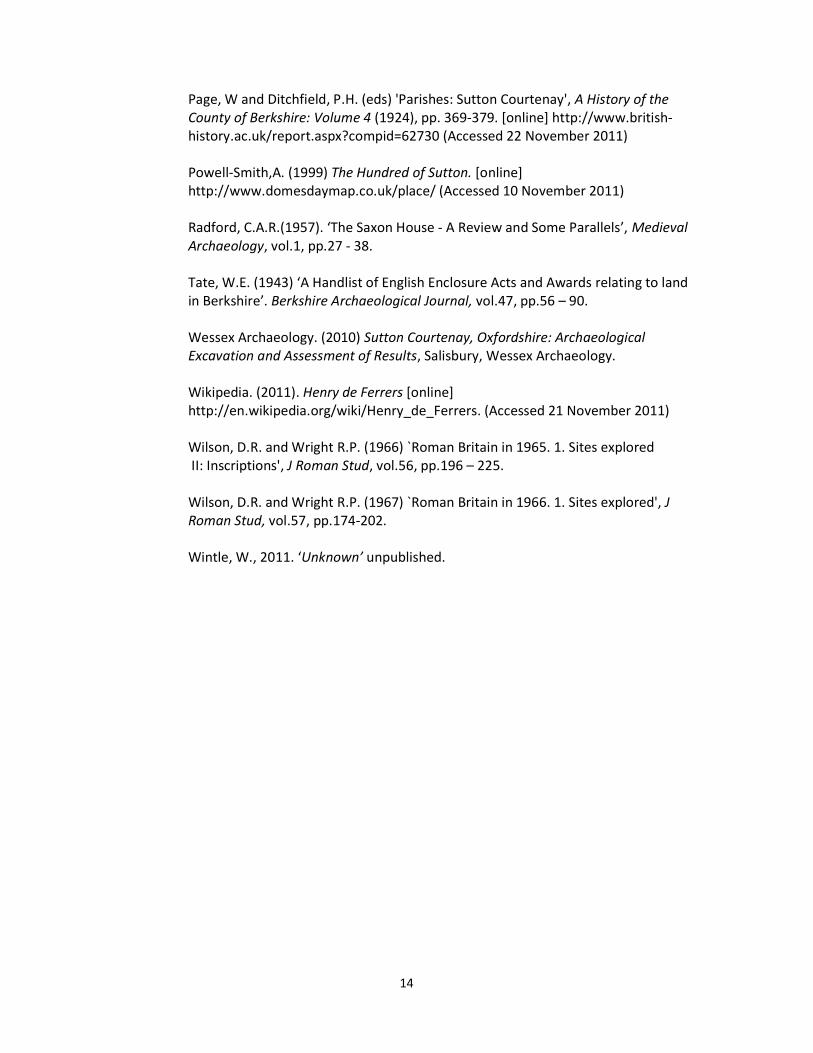
Page, W and Ditchfield, P.H. (eds) 'Parishes: Sutton Courtenay', A History of the County of Berkshire: Volume 4 (1924), pp. 369-379. [online] http://www.british-history.ac.uk/report.aspx?compid=62730 (Accessed 22 November 2011) Powell-Smith,A. (1999) The Hundred of Sutton. [online] http://www.domesdaymap.co.uk/place/ (Accessed 10 November 2011) Radford, C.A.R.(1957). ‘The Saxon House - A Review and Some Parallels’, Medieval Archaeology, vol.1, pp.27 - 38. Tate, W.E. (1943) ‘A Handlist of English Enclosure Acts and Awards relating to land in Berkshire’. Berkshire Archaeological Journal, vol.47, pp.56 – 90. Wessex Archaeology. (2010) Sutton Courtenay, Oxfordshire: Archaeological Excavation and Assessment of Results, Salisbury, Wessex Archaeology. Wikipedia. (2011). Henry de Ferrers [online] http://en.wikipedia.org/wiki/Henry_de_Ferrers. (Accessed 21 November 2011) Wilson, D.R. and Wright R.P. (1966) `Roman Britain in 1965. 1. Sites explored II: Inscriptions', J Roman Stud, vol.56, pp.196 – 225. Wilson, D.R. and Wright R.P. (1967) `Roman Britain in 1966. 1. Sites explored', J Roman Stud, vol.57, pp.174-202. Wintle, W., 2011. ‘Unknown’ unpublished.
15
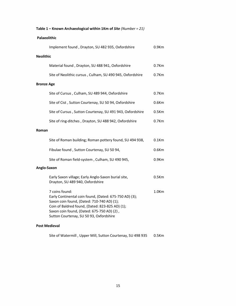
Table 1 – Known Archaeological within 1Km of Site (Number = 21)
Palaeolithic
Implement found , Drayton, SU 482 935, Oxfordshire 0.9Km
Neolithic
Material found , Drayton, SU 488 941, Oxfordshire 0.7Km
Site of Neolithic cursus , Culham, SU 490 945, Oxfordshire 0.7Km
Bronze Age
Site of Cursus , Culham, SU 489 944, Oxfordshire 0.7Km
Site of Cist , Sutton Courtenay, SU 50 94, Oxfordshire 0.6Km
Site of Cursus , Sutton Courtenay, SU 491 943, Oxfordshire 0.5Km
Site of ring-ditches , Drayton, SU 488 942, Oxfordshire 0.7Km
Roman
Site of Roman building; Roman pottery found, SU 494 938, 0.1Km Fibulae found , Sutton Courtenay, SU 50 94, 0.6Km Site of Roman field-system , Culham, SU 490 945, 0.9Km
Anglo-Saxon
Early Saxon village; Early Anglo-Saxon burial site, 0.5Km Drayton, SU 489 940, Oxfordshire 7 coins found: 1.0Km Early Continental coin found, (Dated: 675-750 AD) (3); Saxon coin found, (Dated: 710-740 AD) (1); Coin of Baldred found, (Dated: 823-825 AD) (1); Saxon coin found, (Dated: 675-750 AD) (2) , Sutton Courtenay, SU 50 93, Oxfordshire
Post Medieval
Site of Watermill , Upper Mill, Sutton Courtenay, SU 498 935 0.5Km
16
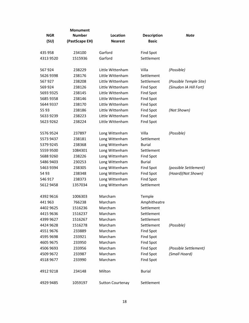
Table 2 - Roman Sites centred on Drop Short Villa in the vicinity of Drop Short
(Sorted by Civil Parish)
NGR Monument
Number Located in Modern Description Note (SU) (PastScape EH) Civil Parish
498 970 233902 Abingdon Settlement 4874 9745 233975 Abingdon Burial
483 974 233979 Abingdon Settlement 4970 9579 233982 Abingdon Settlement Corporation Farm
4835 9722 233996 Abingdon Cemetery 476 963 233998 Abingdon Settlement
485 963 233999 Abingdon Settlement Pits only 498 970 234000 Abingdon Find Spot
497 968 234001 Abingdon Settlement Pits only 5065 9763 238004 Abingdon Find Spot
5040 9743 237922 Abingdon Find Spot 50 97 238007 Abingdon Find Spot (Not Shown)
512 980 238012 Abingdon Find Spot 5130 9806 1239941 Abingdon Burial
5207 9349 238371 Appleford-on-Thames Settlement
5308 9298 1088796 Appleford-on-Thames Villa Appleford 5227 9274 1089252 Appleford-on-Thames Villa (Possible by Crop Marks)
52 93 238312 Appleford-on-Thames Find Spot (Not Shown) 5242 9348 238328 Appleford-on-Thames Burial
5210 9366 238340 Appleford-on-Thames Find Spot Pewter Hoards
5403 9528 238009 Clifton Hampden Settlement (Possible by Crop Marks) 56 96 237906 Clifton Hampden Find Spot (Not Shown)
549 956 237917 Clifton Hampden Find Spot 5566 9631 237874 Clifton Hampden Settlement (Possible VCH Informaion (Extant))
4955 9461 767493 Culham Settlement 4962 9452 1059145 Culham Settlement
527 963 237916 Culham Burial 5015 9695 238006 Culham Find Spot
505 919 238259 Didcot Burial
577 942 238093 Dorchester Town 5804 9569 237909 Dorchester Settlement
5730 9460 238034 Dorchester Settlement
17
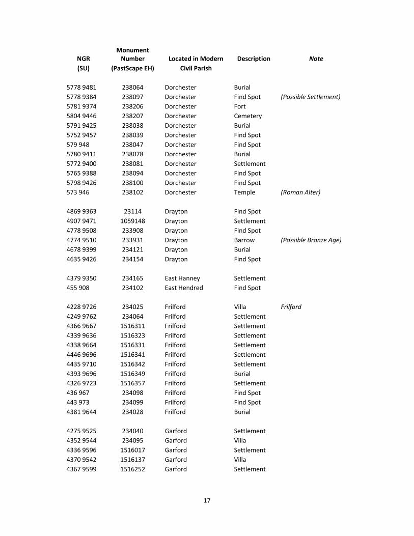
NGR Monument
Number Located in Modern Description Note (SU) (PastScape EH) Civil Parish
5778 9481 238064 Dorchester Burial 5778 9384 238097 Dorchester Find Spot (Possible Settlement)
5781 9374 238206 Dorchester Fort 5804 9446 238207 Dorchester Cemetery
5791 9425 238038 Dorchester Burial 5752 9457 238039 Dorchester Find Spot
579 948 238047 Dorchester Find Spot 5780 9411 238078 Dorchester Burial
5772 9400 238081 Dorchester Settlement 5765 9388 238094 Dorchester Find Spot
5798 9426 238100 Dorchester Find Spot 573 946 238102 Dorchester Temple (Roman Alter)
4869 9363 23114 Drayton Find Spot
4907 9471 1059148 Drayton Settlement 4778 9508 233908 Drayton Find Spot
4774 9510 233931 Drayton Barrow (Possible Bronze Age) 4678 9399 234121 Drayton Burial
4635 9426 234154 Drayton Find Spot
4379 9350 234165 East Hanney Settlement 455 908 234102 East Hendred Find Spot
4228 9726 234025 Frilford Villa Frilford
4249 9762 234064 Frilford Settlement 4366 9667 1516311 Frilford Settlement
4339 9636 1516323 Frilford Settlement 4338 9664 1516331 Frilford Settlement
4446 9696 1516341 Frilford Settlement 4435 9710 1516342 Frilford Settlement
4393 9696 1516349 Frilford Burial 4326 9723 1516357 Frilford Settlement
436 967 234098 Frilford Find Spot 443 973 234099 Frilford Find Spot
4381 9644 234028 Frilford Burial
4275 9525 234040 Garford Settlement 4352 9544 234095 Garford Villa
4336 9596 1516017 Garford Settlement 4370 9542 1516137 Garford Villa
4367 9599 1516252 Garford Settlement
18
NGR Monument
Number Location Description Note (SU) (PastScape EH) Nearest Basic
435 958 234100 Garford Find Spot 4313 9520 1515936 Garford Settlement
567 924 238229 Little Wittenham Villa (Possible)
5626 9398 238176 Little Wittenham Settlement 567 927 238208 Little Wittenham Settlement (Possible Temple Site)
569 924 238126 Little Wittenham Find Spot (Sinudon IA Hill Fort) 5693 9325 238145 Little Wittenham Find Spot
5685 9358 238146 Little Wittenham Find Spot 5644 9337 238170 Little Wittenham Find Spot
55 93 238186 Little Wittenham Find Spot (Not Shown) 5633 9239 238223 Little Wittenham Find Spot
5623 9262 238224 Little Wittenham Find Spot
5576 9524 237897 Long Wittenham Villa (Possible) 5573 9437 238181 Long Wittenham Settlement
5379 9245 238368 Long Wittenham Burial 5559 9500 1084301 Long Wittenham Settlement
5688 9260 238226 Long Wittenham Find Spot 5486 9403 230253 Long Wittenham Burial
5463 9394 238305 Long Wittenham Find Spot (possible Settlement) 54 93 238348 Long Wittenham Find Spot (Hoard)(Not Shown)
546 917 238373 Long Wittenham Find Spot 5612 9458 1357034 Long Wittenham Settlement
4392 9616 1006303 Marcham Temple
441 963 766238 Marcham Amphitheatre 4402 9625 1516236 Marcham Settlement
4415 9636 1516237 Marcham Settlement 4399 9627 1516267 Marcham Settlement
4424 9628 1516278 Marcham Settlement (Possible) 4551 9676 233889 Marcham Find Spot
4595 9698 233921 Marcham Find Spot 4605 9675 233950 Marcham Find Spot
4506 9693 233956 Marcham Find Spot (Possible Settlement) 4509 9672 233987 Marcham Find Spot (Small Hoard)
4518 9677 233990 Marcham Find Spot
4912 9218 234148 Milton Burial
4929 9485 1059197 Sutton Courtenay Settlement
19
NGR Monument
Number Location Description Note (SU) (PastScape EH) Nearest Basic
495 938 1432509 Sutton Courtenay Settlement 4999 9266 234108 Sutton Courtenay Settlement
5115 9443 238262 Sutton Courtenay Burial 5004 9407 238268 Sutton Courtenay Find Spot
50 93 238336 Sutton Courtenay Burial (Not Shown) 518 935 238370 Sutton Courtenay Find Spot Hoard
4942 9389 234105 Sutton Courtenay Villa Drop Short 5215 9426 238322 Sutton Courtenay Villa Penn Copse
Notes The information site used in the preparation of this table is PastScape, which is maintained by English Heritage.
Information was obtained 26 November 2011
This table lists all entries, except where a duplicate appears under a separate record number
Not all sites are show; if the NGR is two figures then these are excluded.
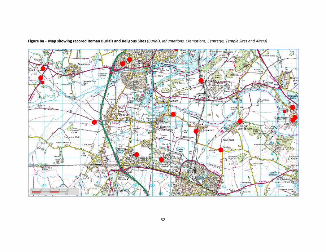
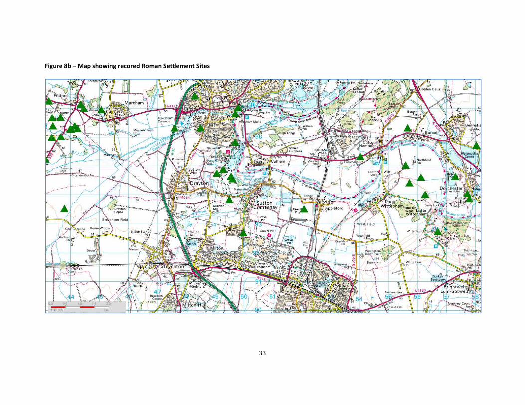
Key to Maps at Figures 8a to 8f
Burial. Inhumation, Cremation or Cemetery Site
Temple or Alter Site
Settlement Site
Villa Site (inc suspect sites)
Fort Site (Dorchester – Dorcic)
Town Site (Dorchester – Dorcic)
Amphitheatre
Scheduled Roman Site Area
Roman Road
Roman Find Site
20
Figure 1 - Site Location
© Crown Copyright and Landmark Information Group Limited (2011). All rights reserved. (2011)
21
Figure 2 – Geology
© Crown Copyright and Landmark Information Group Limited (2011). All rights reserved. (2011).
Key NO1A - Northmoor Sand and Gravel Member, Lower Facet NO1B - Northmoor Sand and Gravel Member, Lower Facet WV - Wolvercote Sand and Gravel member ALV - Alluvium SURA – Summertown – Radley Sand and Gravel member HEAD - Head WGR - Worked Ground (Undifferentiated) GLT - Gault Formation NO - Northmoor Sand and Gravel Member
22
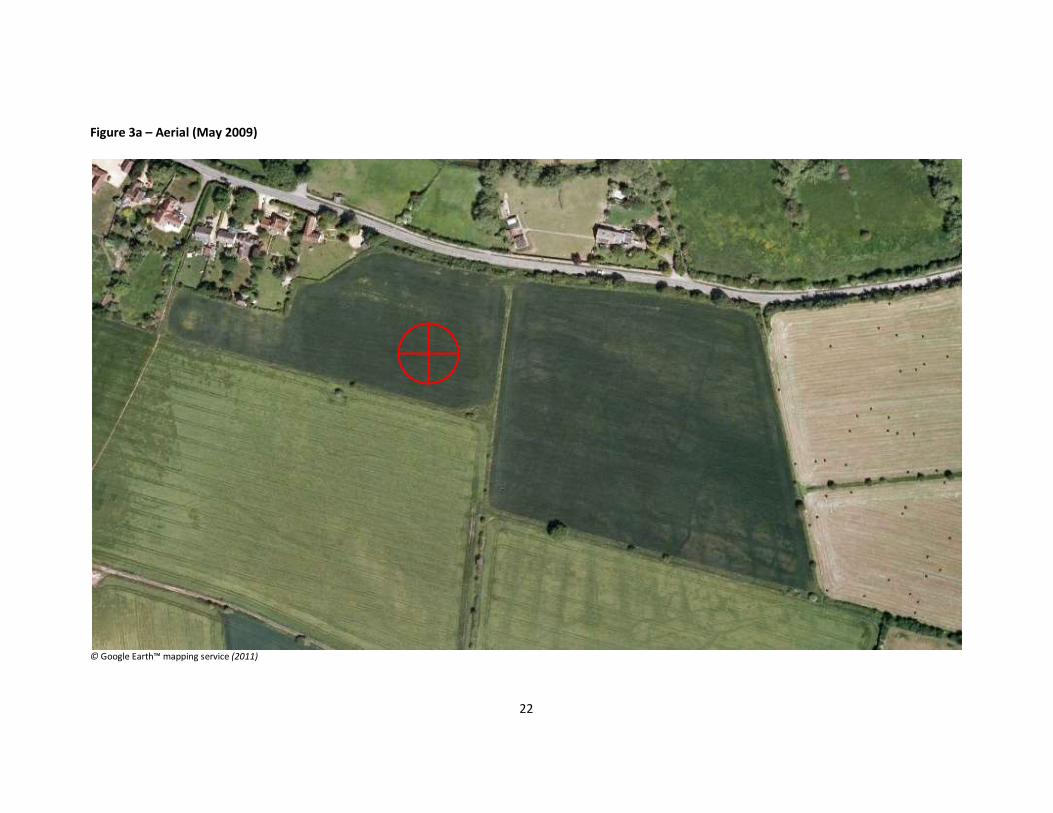
Figure 3a – Aerial (May 2009)
© Google Earth™ mapping service (2011)
23
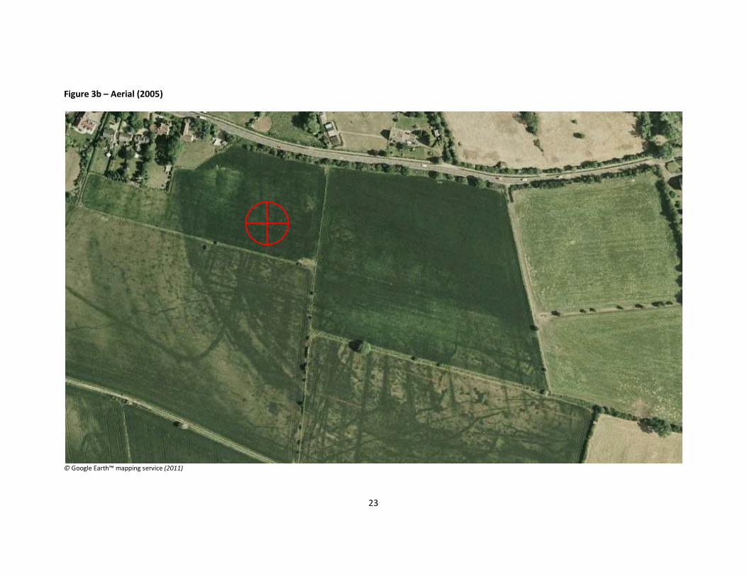
Figure 3b – Aerial (2005)
© Google Earth™ mapping service (2011)
24
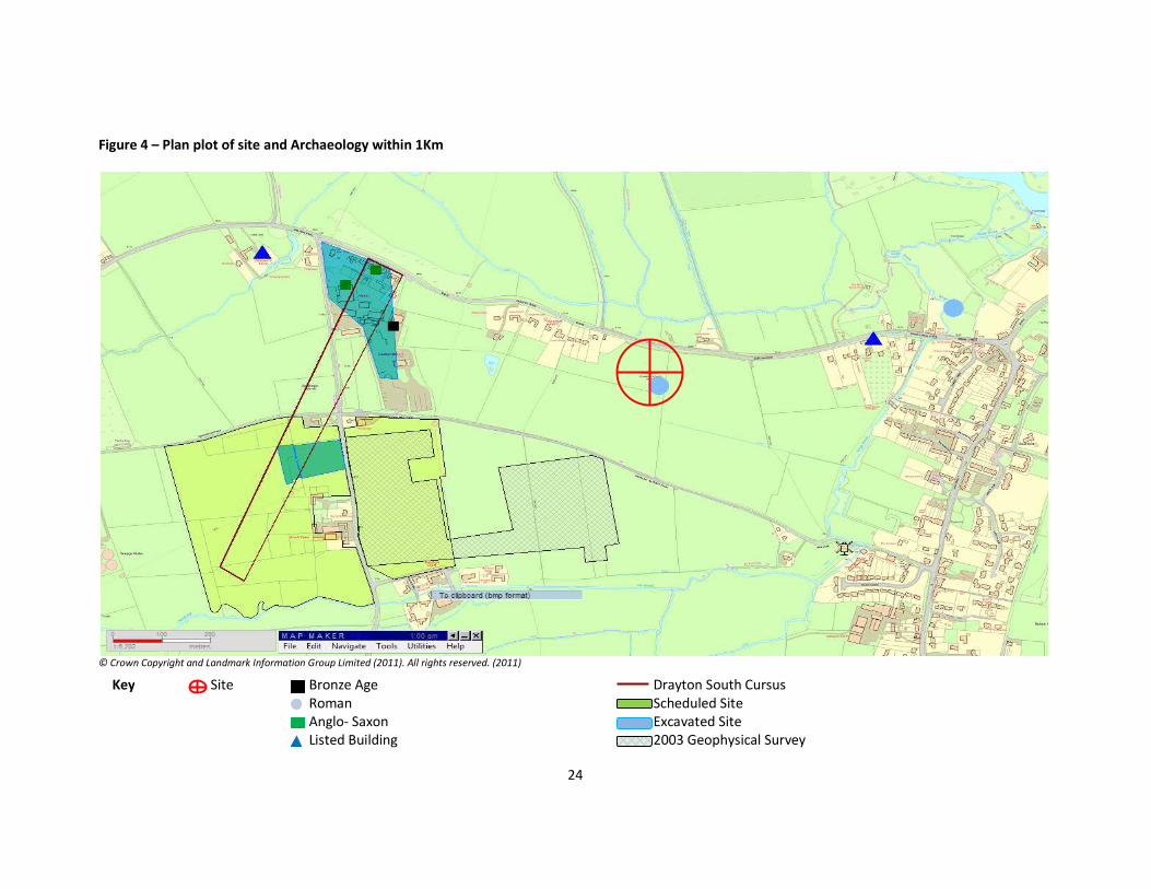
Figure 4 – Plan plot of site and Archaeology within 1Km
© Crown Copyright and Landmark Information Group Limited (2011). All rights reserved. (2011)
Key Site Bronze Age Drayton South Cursus Roman Scheduled Site Anglo- Saxon Excavated Site
Listed Building 2003 Geophysical Survey
25
Figure 5a – Trench Plan from original source and further prepared by GIS
© Wintle 2011
26
Figure 5b – Trench Plan superimposed on NMR Photo and mapped Crop Marks
© Wintle 2011
27
Figure 5c - Trench Plan superimposed on NMR Photo and mapped Crop Marks
© Wintle 2011
28
Figure 6a Modern OS Maps (1:50000 and 1:25000 Scale)
Berkshire: (04/2011) 1:50000
Berkshire: (04/2011) 1:25000
29
Figure 6b Modern OS Maps (1:10000 and 1:2500 Scale)
Berkshire: (06/2011) 1:10000
Berkshire: (06/2011) 1:2500
30
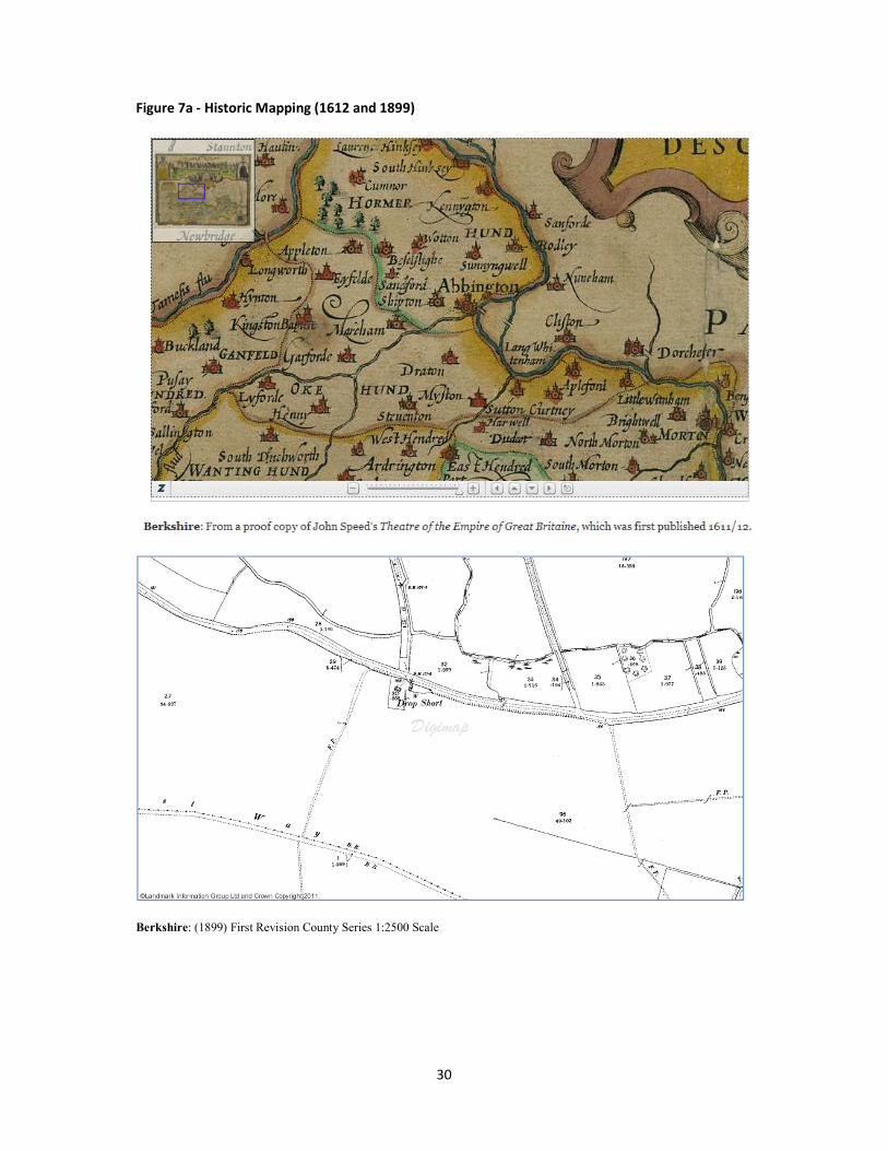
Figure 7a - Historic Mapping (1612 and 1899)
Berkshire: (1899) First Revision County Series 1:2500 Scale
31
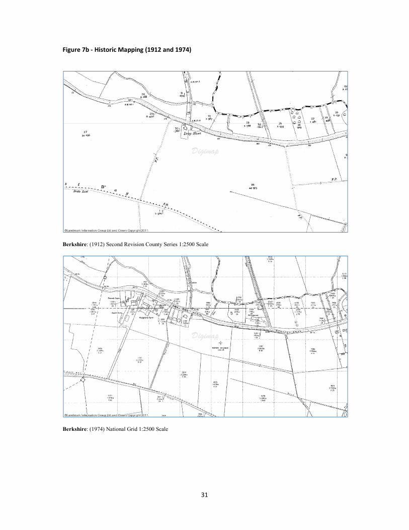
Figure 7b - Historic Mapping (1912 and 1974)
Berkshire: (1912) Second Revision County Series 1:2500 Scale
Berkshire: (1974) National Grid 1:2500 Scale
32
Figure 8a – Map showing recored Roman Burials and Religous Sites (Burials, Inhumations, Cremations, Cemterys, Temple Sites and Alters)
33
Figure 8b – Map showing recored Roman Settlement Sites
34
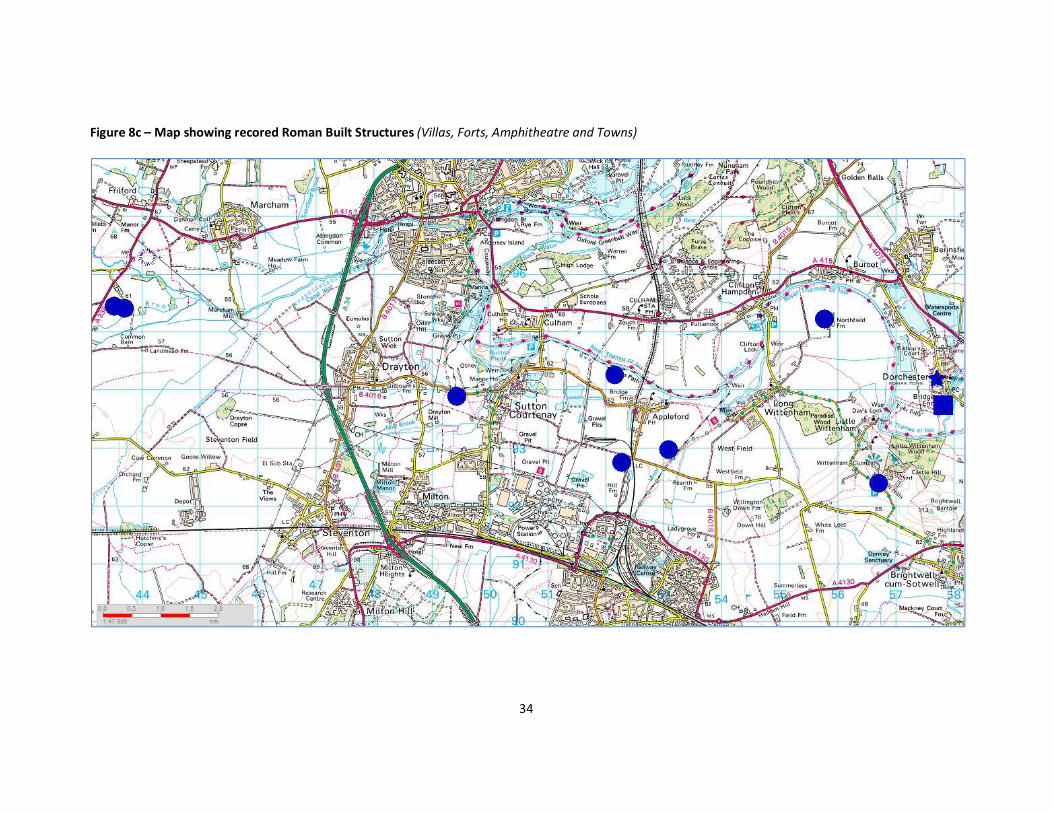
Figure 8c – Map showing recored Roman Built Structures (Villas, Forts, Amphitheatre and Towns)
35
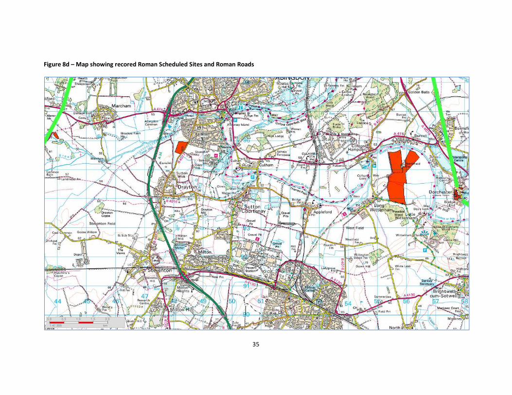
Figure 8d – Map showing recored Roman Scheduled Sites and Roman Roads
36
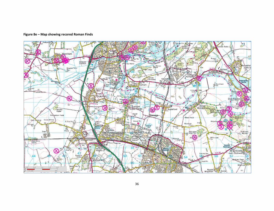
Figure 8e – Map showing recored Roman Finds
37
Figure 8f – Map showing all recored Roman sites
38
Figure 9a – 1804 Enclosure Map (Site Marked)
39
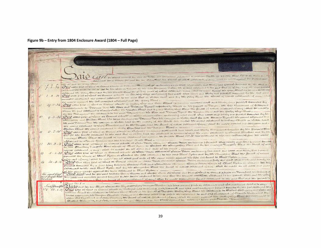
Figure 9b – Entry from 1804 Enclosure Award (1804 – Full Page)
40
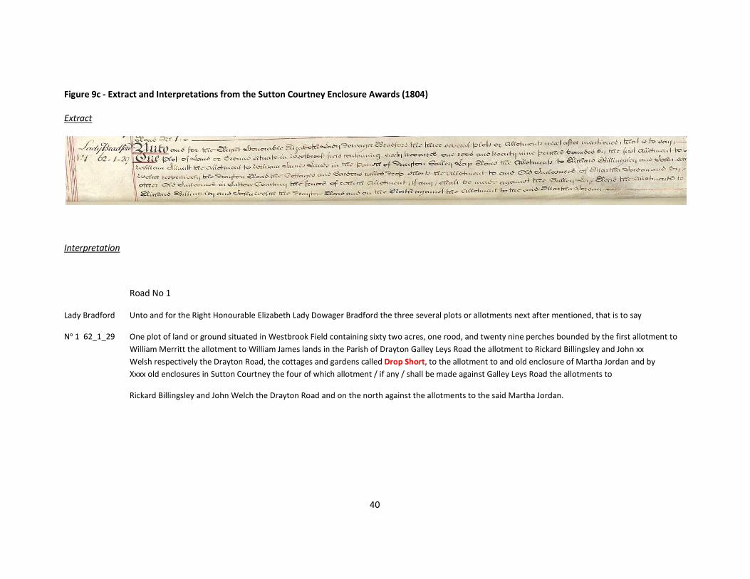
Figure 9c - Extract and Interpretations from the Sutton Courtney Enclosure Awards (1804) Extract
Interpretation
Road No 1
Lady Bradford
No 1 62_1_29
Unto and for the Right Honourable Elizabeth Lady Dowager Bradford the three several plots or allotments next after mentioned, that is to say
One plot of land or ground situated in Westbrook Field containing sixty two acres, one rood, and twenty nine perches bounded by the first allotment to William Merritt the allotment to William James lands in the Parish of Drayton Galley Leys Road the allotment to Rickard Billingsley and John xx Welsh respectively the Drayton Road, the cottages and gardens called Drop Short, to the allotment to and old enclosure of Martha Jordan and by Xxxx old enclosures in Sutton Courtney the four of which allotment / if any / shall be made against Galley Leys Road the allotments to
Rickard Billingsley and John Welch the Drayton Road and on the north against the allotments to the said Martha Jordan.
41
Figure 10a – Doomsday Entry (original)
© Open Domesday by Professor John Palmer and George Slater 2011
42
Figure 10b – Doomsday Entry (Translation and Interpretation) plus other associated entries
In SUTTON Hundred The King holds SUTTON [Courtenay] in lordship. It answered for 23 hides and 1 virgate before 1066; now for nothing. Land for 20 ploughs. In lordship 3 ploughs; 48 villagers and 21 smallholders with 17 ploughs; 2 slaves; 3 mills at 50s; meadow, 300 acres; woodland at 40 pigs. In Wallingford 1 site at 18d; but it is waste. Value before 1066 £30; later £20; now £50; however, it pays £60 in revenue at face value. Henry of Ferrers holds in this manor 120 acres of land and 3 acres of meadow, of the King's household land, because Godric, his predecessor, ploughed this land with his own ploughs when he was sheriff; but, as the Hundred states, it rightfully belongs to the King's court for Godric appropriated it wrongfully.
In SUTTON [Courtenay] Alwin the priest holds 1 hide from the Abbot. His father held it; it answered for as much then and now. He has 1/2 plough, with 3 smallholders. Value 20s.
In SUTTON Hundred Earl Hugh holds DRAYTON and William [* son of Nigel *] from him. Ednoth [* the constable *] held from [* Earl *] Harold; he could not go where he would. Then it answered for 2 hides; now for nothing. Land for 1 1/2 ploughs. In lordship 1 plough; 4 smallholders and 2 slaves. Meadow, 13 acres. The value is and was 50s.
43
Figure 11 – 2003 Geophysical Survey South of Site
© Oxford Archaeology Unit Ltd 2011

44
Notes:

45

Drop Short Roman Villa, Oxfordshire: Desktop Evaluation is licensed by Tim H Darch Research Consultants under a Creative Commons Attribution-ShareAlike 3.0 Unported License. 2011