digital earth 2020: towards the vision for the next decade
TRANSCRIPT
Digital Earth 2020: towards the vision for the next decade1
Max Cragliaa*, Kees de Bieb, Davina Jacksonc, Martino Pesaresia,
Gabor Remetey-Fuloppd, Changlin Wange, Alessandro Annonia, Ling Bianf,
Fred Campbellg, Manfred Ehlersh, John van Genderenb, Michael Goodchildi,
Huadong Guoe, Anthony Lewisj, Richard Simpsonk, Andrew Skidmoreb and
Peter Woodgatel
aEuropean Commission Joint Research Centre, Ispra, Italy; bITC, University of Twente,Enschede, The Netherlands; cD_Citynetwork, Sydney, Australia; dHungarian Association for
Geo-Information (HUNAGI), Budapest, Hungary; eCenter for Earth Observation and DigitalEarth, Chinese Academy of Sciences, Beijing, China; fDepartment of Geography, University atBuffalo, State University of New York, Buffalo, NY, USA; gCanada Centre for Remote Sensing,
Ottawa, ON, Canada; hInstitute for Geoinformatics and Remote Sensing, University ofOsnabruck, Osnabruck, Germany; iDepartment of Geography, Center for Spatial Studies,
University of California, Santa Barbara, CA, USA; jDepartment of Geography andAnthropology, Louisiana State University, Baton Rouge, LA, USA; kNextspace, Auckland, NewZealand; lCooperative Research Center for Spatial Information, Australia and New Zealand
Land Information Council, Canberra, Australia
(Received 10 August 2011; final version received 24 October 2011)
This position paper is the outcome of a brainstorming workshop organised by theInternational Society for Digital Earth (ISDE) in Beijing in March 2011. It arguesthat the vision of Digital Earth (DE) put forward by Vice-President Al Gore 13years ago needs to be re-evaluated in the light of the many developments in thefields of information technology, data infrastructures and earth observation thathave taken place since. The paper identifies the main policy, scientific and societaldrivers for the development of DE and illustrates the multi-faceted nature of anew vision of DE grounding it with a few examples of potential applications.Because no single organisation can on its own develop all the aspects of DE, it isessential to develop a series of collaborations at the global level to turn the visionoutlined in this paper into reality.
Keywords: Digital Earth; spatial data infrastructures; earth observation; GEOSS;geobrowsers; voluntary geographic information
1. Introduction
Thirteen years ago, US Vice-President Al Gore articulated a vision of ‘Digital Earth’
as a multi-resolution, three-dimensional representation of the planet that would
make it possible to find, visualise and make sense of vast amounts of geo-referenced
information on physical and social environments. Such a system would allow users to
navigate through space and time, accessing historical data as well as future
predictions (based for example on environmental models), and would support its
use by scientists, policy-makers and children alike (Gore 1999).
*Corresponding author. Email: [email protected] position paper from the International Society for Digital Earth.
International Journal of Digital Earth,
Vol. 5, No. 1, January 2012, 4�21
ISSN 1753-8947 print/ISSN 1753-8955 online
# 2012 European Union
http://dx.doi.org/10.1080/17538947.2011.638500
http://www.tandfonline.com
At the time, this vision of Digital Earth (DE) seemed almost impossible to
achieve given the requirements it implied about access to computer-processing cycles,
broadband internet, interoperability of systems and above all data organisation,
storage and retrieval. Ten years later, geo-browsing (browsing digital geographic
information (GI) over the web) has brought many of these elements of DE to the
fingertips of hundreds of millions of people worldwide.
Today’s users of the first commercial DE geobrowsers, Google Earth (and
commercial alternatives including Bing and Digital Globe) are benefiting from
innovative ways to organise and present data and from rapid advancements in
hardware, software and data capture and processing. With this in mind, several
authors (Craglia et al. 2008, Goodchild 2008, Grossner et al. 2008, Jackson 2008)
have recently considered the extent to which the original vision had been achieved,
and what gaps still existed that deserved attention.
Since 2009, the International Society for Digital Earth (ISDE) has been reflecting
on the need for a new vision of DE, more in tune with the societal and technological
changes that are expected to evolve exponentially in the current decade and beyond.
From a European perspective, Annoni et al. (2011) identified three areas of
particular interest in Europe:
(1) Developing dynamic information flows of social and environmental interactions
by exploiting new developments in web-enabled sensors, and the opportunities
provided by social networks and citizens’-contributed information.
(2) Establishing DE as a framework for addressing global sustainability research
questions, and as a catalyst for advancing the GI science issues needed to turn
the DE vision into reality.
(3) Raising awareness in Europe of the concept of DE, and coordinating themany activities, projects and funding streams that can contribute to the
development of DE.
These priority areas were discussed at the ISDE Summit in Nessabar in 2010 and
were felt to be generic enough to be included in a more global reflection on a new
vision for DE. With this in mind, the ISDE organised a Vision 2020 brainstorming
workshop in Beijing in March 2011, hosted by the Centre for Earth Observation and
Digital Earth (CEODE) of the Chinese Academy of Sciences. The workshop aimed
to identify the key elements to include in a revised vision for DE. This article is one
of the outcomes of that meeting.
This article is organised as follows: after this brief introduction, Section 2 reviews
the case for developing a new vision of DE to take into account key scientific
questions, emerging societal needs and new opportunities to engage the public more
fully in addressing the big challenges of our time. Section 3 reviews the growing
literature on DE and identifies a range of complementary perspectives on DE that
express its multi-faceted nature. In a networked society, it is unlikely that there will be
only one DE; more likely we will see a series of connected views reflecting a system of
systems logic, and plurality of stakeholder priorities. Section 4 identifies the key
feature of the vision for DE, and Section 5 puts forward three examples of possible
applications of DE in 2020 to reflect global-, regional- and individual-level view-
points. Having sketched out these uses and complementary perspectives, Section 6
International Journal of Digital Earth 5
addresses the all-important issue of the partnerships that need to be established and
cultivated to turn the vision into reality and sustain it in the long term. Section 7
concludes with a summary of key issues and priorities.
2. The case for DE
Goodchild (2008) explored the use case for DE. He argued that it is common practice
in software engineering to build systems based on the analysis of the functionalitiesrequired by users. In the case of geographic information systems (GIS), the
functionalities offered to address the main use cases for data query, analysis and
visualisation. In the case of geobrowsers, however, this approach does not seem to
have been followed. It appears to have been a case of ‘build them and they will come’.
Nevertheless, as Goodchild (2008) argues, this has become a very successful case
because geobrowsers, with their emphasis on visualisation and ease of use appeal to
humans’ spatial thinking, ‘which is one of the fundamental forms of intelligence
needed to function in modern society’. Yet, in a forthcoming paper on the nextgeneration of DE, Goodchild et al. (forthcoming) conclude that despite the progress
of today’s generation of virtual globes they still fall short of Gore’s vision of a DE.
So, if one had to develop a use case for DE in 2020, what would that be? We
frame this question from four points of view articulated below: the world in 2020, the
science case, webs of citizens and sensors and the hierarchy of needs perspective.
2.1. The world in 2020
A number of reports have been published in recent years that try to identify the key
issues and challenges facing us in the coming 10�20 years (Sheate et al. 2007, UNEP
2007, NIC 2008, OECD 2008). From these documents, there seems to be a large
degree of consensus that at the global level we will see an increasing shift in economicwealth and power, particularly towards Brazil, Russia, India and China, resulting in
a multi-polar world, and new challenges for governance and leadership.
Increased world population combined with increased economic wealth will put
major pressures on strategic resources: energy, food and water. A consequence will be
continued (or increased) disparities within countries and across continents (e.g.
potential doubling of people with limited access to fresh food and water), and
potential for conflicts, particularly in the developing countries. Western countries will
not only face their specific challenges related to energy and the environment but willalso be confronted with particular tensions in balancing competitiveness, cohesion,
ageing populations and immigration.
Focusing specifically on the environment, there is a broad consensus that climate
change, loss of biodiversity, water scarcity and the impact of chemicals and carbon
emissions on air quality and public health will continue to be major issues in the next
20�30 years. Nevertheless, working towards a cleaner and more sustainable
environment also provides an opportunity for many countries.
By investing further in information and environmental technologies, it is possiblefor some countries to become exporters of clean technologies and thus turn the
environment into a new engine for competitiveness and growth, rather than a cost as
currently perceived. Embedding environmental perspectives into social and economic
policy requires a more holistic and cross-sectoral way of working, strengthening local
6 M. Craglia et al.
to global interactions and improving scientific understanding. In this respect, greater
transparency about assumptions, shared access to data and better communication of
scientific findings will become critical to gathering and retaining the support of
society and policy-makers.
From these scenarios, the requirements for DE are to provide a framework for
shared global access to information supporting the sustainable use and equitable
distribution of scarce resources across regions and generations. Such a framework
needs to support scientific research, but also public participation in science and in
the strategic choices affecting our planet.
2.2. The science case
One of the most fundamental challenges facing humanity at the beginning of the
twenty-first century is to respond effectively to the global environmental changes
that are threatening humanity. The International Council for Science (ICSU)
articulates this priority as follows:
Over the next decade the global scientific community must take on the challenge ofdelivering to society the knowledge and information necessary to assess the riskshumanity is facing from global change and to understand how society can effectivelymitigate dangerous changes and cope with the change that we cannot manage. We referto this field as ‘global sustainability research.1
Through consultations with more than 1000 scientists from 85 countries in 2009�2010, ICSU has identified five scientific priorities, or Grand Challenges, in global
sustainability research. These Grand Challenges include:
(1) Developing the observation systems needed to manage global and regional
environmental change.
(2) Improving the usefulness of forecasts of future environmental conditions and
their consequences for people.
(3) Recognising key thresholds or non-linear changes to improve our ability to
anticipate, recognise, avoid and adapt to abrupt global environmental change.(4) Determining what institutional, economic and behavioural responses can
enable effective steps towards global sustainability.
(5) Encouraging innovation (coupled with sound mechanisms for evaluation) in
developing technological, policy and social responses to achieve global
sustainability.
ICSU also argued that tackling these grand challenges requires a stronger involvement
and greater integration of the social sciences, health sciences, engineering and
humanities, along with the natural sciences. In other words, there is a strong need to
move from disciplinary research to multi-disciplinary research. Moreover, an effective
response to global environmental change requires not only better science but also more
focused collective action by all stakeholders. This entails two key priorities:
� Communicating science more effectively to close the gap with citizens and
policy-makers.
International Journal of Digital Earth 7
� Engaging the public in the scientific process such as helping monitoring the
environment, reporting observed and perceived changes and impacts for
example via social networks.
The Grand Challenge of developing and maintaining global observation systems is
the scope of the Global Earth Observation System of System (GEOSS) initiative.
GEOSS is being developed through the voluntary efforts of 84 countries and 58
organisations participating in the Group on Earth Observations’ 10-year imple-
mentation plan (2005�2015) (GEO 2005).
A major role of GEO is to promote scientific connections and interoperability
between observation systems to address some of the scientific challenges identified
by ICSU with a particular focus on nine societal benefit areas.2 In particular, GEO is
advancing collaborations across thematic domains, developing a technical infra-
structure with agreed data sharing principles to facilitate access and use of available
resources and building institutional capacity.
Similar initiatives to improve the knowledge base of policy and science are taking
place at national and regional levels through the development of spatial data
infrastructures (SDIs) based on the interoperability of systems, data and services. In
Europe, INSPIRE (EC 2007) is leading the way in building a decentralised
Infrastructure for Spatial Information, while the Global Spatial Data Infrastructures
Association provides a platform to share related experiences in North and South
America, Africa and Asia. The many initiatives in government and science under the
banner of Open Data are also worth mentioning because they are gaining
considerable momentum (see e.g. data.gov in the US, data.gov.uk in Europe, Open
Science Data, the Science Commons and the Open Data challenge http://
opendatachallenge.org/).
Although GEOSS and SDIs are important steps towards coordinating and
sharing earth observation and geographic data, they generally fall short of meeting
the challenges identified by ICSU. To do so, they would need to:
� Include multi-disciplinary models from both physical and social sciences toforecast change, and identify thresholds or ‘tipping points’ leading to non-
reversible change. To make these models understandable and usable across
disciplines would require a major effort in developing semantically rich
descriptions of key concepts and processes, and underpinning assumptions.
� Include scenarios of possible policy responses and frameworks to measure
their likely impact and consequences across environmental, social and
economic domains.
� Include a participatory framework able to engage decision-makers and thepublic in the analysis of scientific evidence and possible scenarios, responses
and impacts across geographical regions and social groups (who wins and
who loses as a result of certain actions or non-actions). The serious
controversy that arose in regard to the apparent certainty of projections
made by some scientists associated with the 2007 report of Intergovernmental
Panel on Climate Change (IPCC) led to major public debate in many
countries. Therefore, the measurement and communication of uncertainty is
also crucial.
8 M. Craglia et al.
Digital Earth should include all of the above to meet the challenge of global
sustainability research. It should also exploit the new opportunities (not foreseen at
the time of the Al Gore speech) offered by the massive deployment of sensors, and
the rise of social networks to develop a truly participative and a near-to-real timenervous system for planet Earth (De Longueville et al. 2010).
2.3. Webs of citizens and sensors
Digital Earth involves multiple stakeholders and actors. While the roles of
environmental and social scientists, technologists and decision-makers are widely
acknowledged, those of citizens in the development, use and management of DE
have yet to be articulated. There are several facets to this important issue, and wesuggest giving priority to the following two:
� Contributions of individuals as providers of data. With over 10 billion social
network accounts in 2010 (50% more than people on Earth) (Silicon.com
2011) (generating for example 65 million Tweets a day, www.twitter.com, and a
store of over 4 billion photographs on Flickr www.flickr.com), the
opportunities to harness this wealth of digital data for a variety of
applications, from emergency management and response to risk assessment,quality of life and environmental monitoring, cannot be ignored (Goodchild
2007). Assessing the quality of this data is an important issue but the
contribution they can make in narrowing the gap between science and the
public is potentially very significant (Ostermann and Spinsanti 2011).
� The impacts of DE on individuals and society. This area includes research and
ethical issues on privacy and confidentiality, openness and transparency
versus security considerations, as well as the measurement of the social,
economic and environmental costs and benefits of the deployment of DE.Research in this area has so far rightly focused on the potential negative
consequences of a digital ‘Big Brother’ scenario, or of actions taking place in
the grey zone that emerges when legal frameworks are unable to keep pace
with rapid technological developments (see for example www.spatiallaw.com).
However, new uses of social networks to mobilise the masses, and foster
political change ought also to be studied in greater depth.
Whilst citizens’ information provides new and exciting opportunities for collabora-tive and participative science, or Science 2.0 (Burgelman et al. 2010), the
development of web-enabled sensors (Klopfer and Simonis 2009, Broering et al.
2010, De Longueville et al. 2010) adds a complementary dimension. During the last
decade, we witnessed a tremendous development and uptake of low-cost minia-
turised sensors and wireless sensor nodes, while standards such as the Open
Geospatial Consortium (OGC) Sensor Web Enablement (Botts et al. 2008) make it
possible to treat equally all sensor-like information. This has led to the concept of the
‘Observation Web’ with observations originating from humans, sensors or numerical(environmental) simulations (Butler 2006).
Integrating the Observation Web with a global system of systems would
contribute to addressing at least part of the scientific challenges identified by
ICSU. In particular, it would allow moving from an essentially static representation
International Journal of Digital Earth 9
of the Earth to one that is dynamic and interactive, and more responsive to the
Grand Challenges. Moreover, integrating the quantitative measurements and
observations from sensors with the richness of qualitative information provided by
citizens, makes it possible not only to assess how the environment is changing butalso how such change is perceived. These dimensions are crucial for the interface
between policy, science and society.
As we consider these developments in a global context we also need to be mindful
of different social and political context, and levels of development. To illustrate this
point, we have developed a DE Index discussed in the following Section.
2.4. DE Index
The DE Index represents the state of digital development of each country. Using the
‘hierarchy of needs’ concept developed by Maslow (1943), we could consider the DE
Index as a measure of ‘digital needs’. The Index is shown in Figure 1. The x-axis has
the rate of energy consumption (based on the DMSP-OLS Night-time Lights Time
Series3) by population, which can be taken as a proxy for dependency on digital
goods and equipment. The y-axis is the rate of Internet penetration reflecting a need
for advanced technology use to strengthen individual opportunities. The y-axis has a
natural log scale to accentuate discrepancies between countries. The hierarchy of theDE Index is interpreted as an inset, with a comparison to Maslow’s hierarchy of
needs.
The curve drawn in Figure 1 separates two areas. A balanced ‘digital’ needs
fulfilment takes place when a country is positioned above the curve (left-top of the
XY-plot): relatively little energy dependency while the use of advanced technology is
comparatively sufficient. Countries below the curve consume high amounts of energy
while the Internet penetration level remains very low. Clear differentiation between
continents regarding their current state in ‘digital’ development is obvious. Africa isonly at the start; Asia, Oceania and Latin America are well ahead, while Europe and
North America have reached a high level in the hierarchy. Within continents, the
status of individual countries often varies considerably, e.g. Asia and the Middle
East.
Considering the mechanisms of the hierarchy of needs, societies will strive to
maintain or improve their current status. Needs fulfilled in respect to ‘digital’
development are well protected and defended, while countries that have not satisfied
such needs will strive to do so after fulfilling their more immediate physical needs.The interdependencies between digital and fundamental human needs, such as
freedom, have become very evident in the early part of 2011 during the uprising in
the Middle East. This also shows that having a relatively low level of the DE Index
such as Libya does not mean that the available Information and Communications
Technologies cannot be used to great effect to mobilise the masses. There is much to
be gained by all countries in the development of DE, providing access and use is
open to all.
The hierarchy proposed earlier can and will have additional higher levels not yetcaptured by the indices used. As new advances take place, new ‘digital’ needs will be
felt. To cope with the increase in complexity of society and the environment, we need
additional sensors, processing capacity and storage to make sense of the complexity
of the information we face. Vice versa, DE will help deliver solutions to these needs
10 M. Craglia et al.
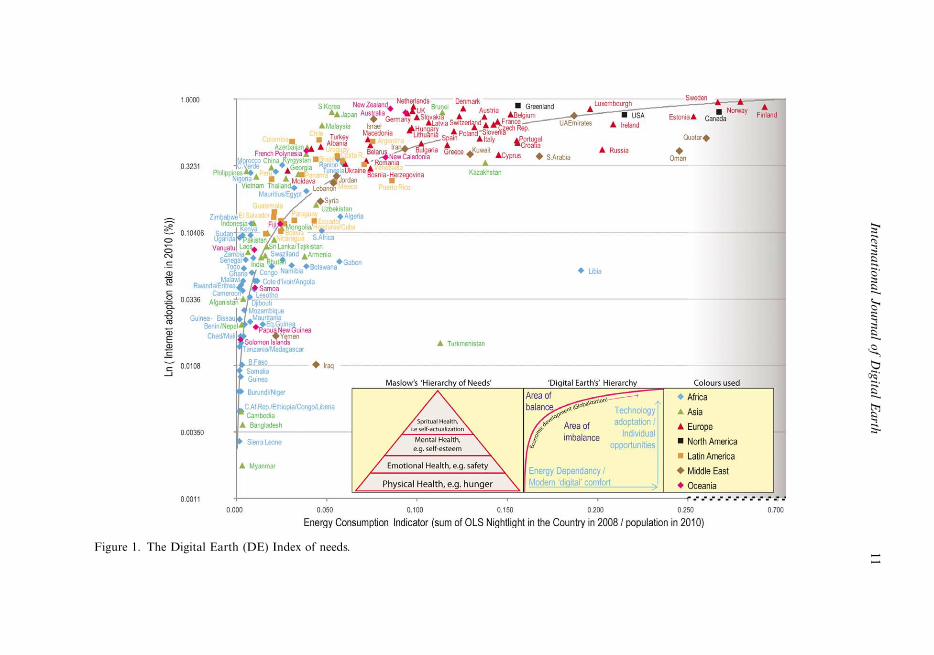
Figure 1. The Digital Earth (DE) Index of needs.
Intern
atio
na
lJo
urn
al
of
Dig
ital
Ea
rth1
1
and will create for us an increased understanding on progress in the pyramid of
‘digital’ needs.
3. Perspectives on DE
The academic literature on DE has been growing steadily in recent years, encouraged
by the ISDE. Since 1999, the ISDE has organised DE Symposia and Summits in
alternate years, and launched in 2008 the International Journal of Digital Earth, now
a highly ranked regular publication for academics interested in this area. Reviewing
the literature on DE, it is possible to discern a few major streams of perspectives.
Digital Earth as a research challenge: in this stream Goodchild (1999) outlines
research issues that arise from the vision of the Gore speech, in the areas of datastructures, indexing schemes, data integration, semantic integration, cartographic
technique and geovisualisation and institutional arrangements. Craglia et al. (2008)
and Annoni et al. (2011) consider the major developments that have taken place in
the 10 years since the Gore speech, and add new topics to the research agenda
identified by Goodchild (1999). These new topics address the opportunities of sensor
webs and volunteered GI in providing dynamic data flows on the state and responses
of the environment.
Digital Earth as an information system: Grossner (2007) and Grossner et al.(2008) define a DE system as: ‘a comprehensive, distributed geographic information
and knowledge organization system’ which would be based on participant systems
that adhere to an agreed set of protocols and standards for data models, data formats
and metadata, allowing it to function as a contributing node in a single, virtual
computing system. This perspective comes close to the system of systems approach
of GEOSS (2005). Similarities with the current work to implement GEOSS can also
be seen in He (1999) reviewing the range of needs and systems being developed by the
Food and Agriculture Organization (FAO), particularly in the context of theInternational Global Observing Strategy.
Digital Earth as a set of applications, and an organising metaphor. The global
features of DE offer potential mainly for environmental applications such as global
climate change environmental protection, disaster management, natural resource
conservation and sustainable economic and social development (ISDE 1999, 2009).
An example of applications related to the land use implications of switching to
renewable energy resources is reported by Strobl (2006), while Fukui (2009) discusses
monitoring glacial lake outburst floods as an example of applications of Digital Asiato assess the impact of global warming. Aside from these applications, Goodchild
(2000) makes the point that DE is a much better metaphor to organise, search and
retrieve the information necessary to understand the Earth phenomena than the office
metaphor of most desktops based on filing cabinets, wastepaper bins and so on.
Digital Earth as a strategic infrastructure is a perspective advocated in China by
for example Guanhua (1999) who focuses in particular on DE for sustainable
development and management of natural resources but also as a catalyst for leap-
frogging development in science and technology. The strategic nature of DE is alsostrongly put forward by Wu and Tong (2008) who argue that it is as strategic as ‘the
atom bomb, hydrogen bomb, and artificial satellites’ (p. 4), while Guo et al. (2010)
argue that ‘possessing DE is equivalent to taking the highest control point in modern
society’ (p. 45). A similar, yet more tactical view of DE is put forward by Goodchild
12 M. Craglia et al.
(2000) who focuses on the concept of DE as a ‘moonshot’ that can motivate and
mobilise cutting-edge research.Counterbalancing these positive perspectives are a few authors who point to the
potential negative aspects of DE like Curry (2000) who argued that GI systems
traditionally had two dimensions: global (geographical) and local (e.g. planning and
advocacy). The emerging debate on DE, like the transition from GI Systems to GI
Science, strengthens the global discourse and reduces the spaces for local voices and
needs to be heard. In a similar vein, Konecny (1999) argued that whilst DE is a
powerful concept, it is important to ensure that all can partake in its development
and use, and that opportunities and threats are recognised and addressed. These
include decentralisation versus recentralisation and control (e.g. manufacturing and
delocalisation), fragmentation of polity versus integration (e.g. online communities),
homogenisation versus diversity (e.g. role of international media homogenising
popular culture versus the assertion of inward-looking local identities).
As shown from this brief review of the literature on DE, there are multiple
perspectives on what DE is or should be. It is unlikely therefore that a single (revised)
vision of DE will capture all perspectives from all stakeholders. There is not going to
be a one-size-fits-all DE, but there will be a series of connected views of DE based on
the same sources of data and offering users different functionalities. Based on the
current social and technological trends and the review of the literature, we can
identify some likely characteristics of the revised vision for DE.
4. What will DE look like?
� It will look like a globe, as the globe is proving to be a very powerfulmechanism for visualisation, and a metaphor for organising the world’s
information. From the globe view it will then be possible to see, in 3-, 4-and
n-dimensions, inside buildings as well as what lies underground and under-
water.
� It will visualise the present physical features of the Earth but also the past
through historical data, and the future based on the outcome of integrated
models. Time will be a critical dimension of understanding and analysis.
Therefore, preservation of our digital past, as well as our present, will be animportant feature.
� It will be dynamic and interactive exploiting the full range of information
flows from sensors and people.
� It will synthetise heterogeneous information and provide metrics of quality
and trust of both data inputs and outputs.
� It will be more participative as people will have a greater say in providing data
but also in interpreting the data and shaping the construction of scientific
‘evidence’, and arguing the pros and cons of different policy choices. As aresult, it will improve our collective understanding of how the Earth works,
and how it may respond to both physical and social interventions.
� It will be not just about space and spatial relations but also about place,
culture and identity, spanning the physical and virtual space. It will thus
emphasise the analysis of networks and flows, and relationships between
International Journal of Digital Earth 13
places (e.g. cultural influences, links established through migratory flows or
history) in addition to the traditional spatial analysis.
� It will be easy and fun to use with different levels of functionality available to
different audiences to find out more about a place or issue, or interact withmodels and parameters.
� It will be an ubiquitous frame of reference as people and an increasing number
of every day objects will be online at all times.
To understand better some of the functionalities that may be required and to help
develop the vision of Digital Earth 2020, it is useful to define a few exemplary use
cases as argued by Goodchild (2008). The section below shows both global examples
of possible applications and common individual-level examples.
5. Examples of use in 2020
5.1. Global examples
5.1.1. Land use change and food production
The year is 2020. Farmers connect to DE to optimise their activity, close chronic
yield gaps through improved management and have better coping mechanisms incase of disasters. The combination of field level weather forecasts, and sensors
constantly measuring moisture and soil composition and acidity has made it possible
to reduce the amounts of pesticides used by 50%. This has reduced significantly
eutrophication, without loss of yield for the farmers. Instant information on markets,
prices and delivery methods allows for rational crop rotation, and improved
conservation of the resource base. Moreover, DE components specifically developed
for farmers have automated some management operations through GPS and GNSS-
based geo-location tools (precision farming), and improved management throughinvestments, loans or barter trade, supported through micro-insurance schemes that
can be subscribed to in a tailored-way. Farmers now use DE services to supply
information on local crop status and yields in exchange for long-term risk-analysis
on price fluctuations in different markets, consultancy from fellow farmers, advice
from market analysts on new trends (e.g. marketing of bio-labelled food), and early
warning on emerging dangers (droughts, fire, flooding, hail and storms, frost,
locusts).
Increased communications and sharing of information among farmers and otheractors in the processing and marketing chain has strengthened local communities
and provided opportunities for better long-term planning. Speculation based on
fragmented information and markets has thus been reduced. DE has enhanced our
options to cater for the basic needs (food) of the ever-increasing global population. It
has successfully helped remove poverty traps by creating safety nets, providing
location and situation-based services, guidance and knowledge-packages, so that
farmers are able to sustain our future.
5.1.2. Global human settlement layer
The year is 2020. A global symbolic representation of the built environment is
available and integrated in the DE. The global human settlement layer (GHSL) is a
14 M. Craglia et al.
multi-scale volumetric information layer describing artificial spaces where people
live, work and enjoy life. Physical components such as buildings, roads and open
spaces are accurately described at each scale from single rooms or apartments, to
rural villages, towns or mega cities and other urbanised regions. The widespread useof Lidar and digital photography has enabled the creation of this global layer in 3D,
so that we can explore all built environments moving from the inside of buildings to
the whole metropolis, including underground infrastructures and utilities. Digital
histories of buildings and cities available in DE also allow navigation through time
(4D), and new planning proposals are regularly debated based on realistic models
portraying the evolution of the city in the future.
Sensor webs (exploiting satellite, aerial, ground and mobile sensors), connected
to advanced pattern recognition algorithms and distributed processing capacities,produce an objective, globally seamless and constantly updated GHSL. Shared
privacy rules protect private spaces, and people and households have the right to
decide if and at which level of detail they are connected to the DE GHSL.
Digital Earth allows different actors at different levels�individuals, families,
organisations or authorities�to elaborate models and strategies concerning safety of
living, travelling or working. At another scale DE allows the planning of collective
rescue or mitigation measures after natural disasters and improved understanding of
the interactions between human artificial spaces and natural environments.Through information, fusion of GHSL with crowd sourcing and mobile
technologies integrated in the DE, it is possible to model the location of people at
any point of space and time and consequently take informed decisions about risks or
opportunities to cross-specific areas during specific events: to take the best escape
route during a flood, or find the best place for communication.
While the knowledge of the physical characteristics of built environments allows
more accurate estimations of damage produced by catastrophic events�tsunamis,
earthquakes, tornados, floods and eruptions�real-time modelling of the populationpresence and movements has made a major difference. In the past, we used to take
strategic decisions based on static population databases such as the Census, which
reflected the resident population count every 10 years, and was therefore always out of
date. Now we know the location of people (e.g. commuters, migrants, business people,
etc.) at different times of day and night, and their use of space and facilities. We have
moved therefore towards a much more dynamic and accurate understanding of the
relationships between built environment and society: anywhere, any time, at any scale.
5.2. Individual examples
The year is 2020. About 3 trillion things (including interoperable sensors, Radio
Frequency IDentification (RFID), tagged objects and products, livestock and 4 out
of the 7 billion humans) are connected to DE, which provides a wide range of cloud-
based infrastructures, services and solution-oriented capabilities. The 4 billion
members of social networks contribute massively to the development and main-
tenance of DE with constant feeds of information, alerts of events and news items.Digital Earth is used at all ages: by children as a learning and play environment,
by teenagers socialising and trending, by adults in their daily and professional life,
and by the senior generation networking in their retirement with friends and family,
and checking their health online maybe more often than necessary.
International Journal of Digital Earth 15

The multiplicity of social networks and the sharing of information globally have
improved the accountability of governments and of multinationals, after a series of
well-publicised citizens mobilisations and consumer boycotts. The Hacker Challenge
has replaced the World Football Cup as the most watched event, and helps to keep in
check novel ways to disrupt DE.
As most objects have become web-enabled, from domestic appliances to buses, it
is now possible to programme and undertake activities in more interactive ways at
home, the office, and on holiday. Energy efficiency, resource optimisation and waste
reduction are key greening principles enabled by this massive deployment of sensors.
Smart paints, for example, have been made compulsory on all new building and self-
regulate to absorb or reflect sunlight and thus optimise temperature control indoors.
The accelerated pace of technological development is a challenge for policy-
makers to ensure that the legislative framework (especially in the interest of the
privacy), and the institutional/organisational response is adequate in protecting
individuals and avoiding threats to society. Protocols on how to subscribe or
unsubscribe to services need constant updating, for example, to ensure that a
guaranteed level of privacy is maintained, if one wishes.
What has changed most since 2011 is that speech has become the main method of
interaction with DE, replacing text on tiny keyboards. Smell is also gaining
popularity particularly for some applications like cookery programmes, and as a
way to convey data quality (bad data smells!). Visualisation is now routinely based
on augmented reality. Looking at a building we can see and hear about its contents,
past history and other useful information like opening hours of commercial
concerns, key items for sale and prices instantly compared with similar products
purchasable in the neighbourhood or online across the world.
Our comments and feedback about places, experiences or transactions go
instantly online (unless we unsubscribe to the service) and contribute to the collective
knowledge. Entering an area we are therefore immersed in a virtual space where
others before us have left digital postings that are available to us if we so wish.
Traceability has also become a key feature. What was common practice in logistic
supply chains has become also the norm for food quality security and control, and
has been extended recently to humans who are routinely tagged with different levels
of accessibility of their signals. Convicted criminals were the first to be tagged with
under skin RFIDs, followed by the military entering operations zones. The debate on
tagging children 0�6 years was lively, and exposed the tensions between the comfort
of digital parental control with the potential slippery slope of tagging everybody at
all times. Some argued that we are traceable anyway via our mobile devices, so what
is the difference? Others warned about the dangers of a Big Brother society. It is not
surprising therefore that the faculties of Digital Ethics have seen a major increase in
the numbers of students who are eager to ensure that DE remains an open and free
space for all peoples across the globe.
6. How to get there
The empowerment of individuals, organisations, governments and society through
the growing ubiquity of DE in all its forms suggests that there is a real value in
establishing a suite of guiding principles and a code of ethics to regulate behaviour.
16 M. Craglia et al.
Implementing the DE vision will be most effective through a global public�private partnership involving four key sectors of society�Research, Government,
Commerce and Communities/Citizens (Civil Society).
During 2010 and 2011, the United Nations Framework Convention on Climate
Change (UN FCCC) began developing the Technology Mechanism that it promised
in the 2009 Copenhagen Accord and 2010 Cancun Agreements. This is intended to
include a Climate Technology Centre based in Europe, a ‘network’, and a
Technology Experts Council to thought-lead both the network and the UN FCCC’s
Conference of the Parties.
For the United Nations, the DE vision represents an important new step forward
from ‘doom and gloom’ scenarios about climate change. These are heavily reliant on
counting emissions, developing reduction targets that member nations are reluctant
to agree to be legally binding, and trading credits from ‘good’ ventures to allow ‘bad’
ventures to continue operating with minimal concern about polluting and damaging
the Earth and its atmosphere.The UN FCCC recently agreed to establish its Technology Mechanism to
‘accelerate climate change solutions’. The approach being taken for DE is to exploit
advanced aero- and geo-spatial technologies (especially remote sensing and imaging)
to rapidly improve the modelling, mapping and simulation of complex environmental
and human systems around the entire planet, as advocated by ICSU. A shared
understanding of the problem and possible solutions is a necessary condition to
increase the opportunity to find acceptable political compromises. In this respect,
DE has a very important role to play as negotiations framework.
United Nations agencies and more than 80 international key organisations have
members that can contribute to implementing the DE vision; but so far mainly in
disparate, disconnected ways. A major effort is therefore required to develop
synergies across the potential stakeholders of DE. In addition to the ISDE, examples
of DE-relevant organisations include:
� The World Council for Science, which is the most active body supporting the
professional development of multi-disciplinary scientists and the promotion of
science to sustain and progress humanity.
� The Group for Earth Observations (GEO), which is already collaborating with
the ISDE, United Nations agencies, and natural environmental systemsorganisations (e.g. the World Meteorological Organisation) to advance the
GEOSS. GEOSS is an important component to implement the DE vision.
� The UN Programme on Global Geospatial Information Management
(GGIM) aims at playing a leading role in setting the agenda for the
development of global geospatial information and to promote its use to
address key global challenges. It provides a forum to liaise and coordinate
among Member States, and between Member States and international
organisations. A United Nations Committee of Experts on GGIM has beenestablished by the Economic and Social Council on 27 July 2011 as the official
UN consultative mechanism on GGIM (http://ggim.un.org/).
Other relevant organisations, from the potential user side, are, for example, the
International Society of City and Regional Planners, the World Business Council for
Sustainable Development, the World Federation of Engineering Organisations and
International Journal of Digital Earth 17
the Institute of Electrical and Electronics Engineers. An important role in the future
may also come to be played by the network of networks special initiative to be
launched at the Eye on Earth Summit taking place in December 2011 under the
sponsorship of the Abu Dhabi government, and the UN Environmental Program(http://www.eyeonearthsummit.org/).
The research needed to underpin the development of DE should be addressed in
partnerships among the large research funding organisations like the National
Science Foundation in the USA, the Chinese Academy of Science and the European
Commission. The key technological innovations are however likely to come from the
private sector, particularly through large industrial companies like Microsoft and
Google, the telecommunications industry and through the collective effort of the
open source community. Not-for-profit organisations like the Gates Foundation andNGOs are also required to ensure accessibility to DE in the developing countries,
and support capacity building.
The key challenge is in communicating the DE vision, and building the strategic
partnerships among the many stakeholder organisations. To build the momentum
and overcome the ‘not invented here’ syndrome a collective effort is necessary in
which every partner can see a benefit. The ISDE has the leading role in building the
alliances needed and coordinating the effort, while a network of communications
companies is needed to promote the DE key advances and achievements and sustainthe momentum.
7. Conclusions
In this article, we argued that the many advances that have taken place in the 13 years
since the original vision of DE require a reappraisal and the articulation of a revised
vision. Key technological developments have been in the evolution of Internet
bandwidth, and in improved visualisation techniques. Equally important have beenthe social developments, with the widespread adoption of social networks as a key
way to communicate and turn citizens into major providers of information. The
implications of these combined developments for politics and society have been
dramatically shown during the Arab Spring in 2011, in which social media have been
central to the mobilisation of millions of people demanding change.
The opportunities for science to exploit these new developments are also very
significant: not only to have access to many more dynamic observations about the
environment from sensors and citizens, but also to involve citizens in theconstruction of scientific evidence and to close the gap between science and society.
With this in mind, we have identified some of the key features that DE should
have by 2020, when most people and things will be on line at all times. This is
potentially creating a paradigmatic shift in the way we relate to each other and with
our surroundings. Hence, we have argued that DE should be a dynamic framework
to share information globally and improve our collective understanding of the
complex relationships between society and the environment we live in. DE should
make it possible to navigate across space and time, connecting the global issues tolocal ones. It should include scientific models to project into the future and help us
all understand how the Earth system works and what are the likely consequences of
our actions or inactions. It should therefore become the framework for negotiating
international accords on the environment but also on acceptable ethical conducts, as
18 M. Craglia et al.
the potential dangers from the development of DE are possibly as big as the
opportunities.Implementing this vision of DE requires a major effort in international
collaboration as well as further advances in science and technology. The latter, as
we have seen in the last 13 years, continue apace. The key challenge is therefore in
developing the framework of governance across multiple stakeholders and the public
to harness these new developments, and direct change so that DE emerges as an open
framework accessible to all to shape the future of our planet. We have the vision, now
let us turn it into reality.
Acknowledgements
This article is largely the outcome of a workshop on next-generation DE held in Beijing inMarch 2011 and hosted by the Center for Earth Observation and Digital Earth. The assistanceof Luke Driskell in taking extensive notes of the discussion is gratefully acknowledged. Thisarticle also benefited from comments on earlier drafts from members of the ISDE ExecutiveCommittee: Mario Hernandez and David Rhind.
Notes
1. http://www.icsu-visioning.org/wp-content/uploads/GrandChallenges_Pre-publication.pdf2. Disasters, Health, Energy, Climate, Agriculture, Ecosystems, Biodiversity, Water and
Weather.3. http://www.ngdc.noaa.gov/dmsp (accessed 4 December 2010).
References
Annoni, A., et al., 2011. A European perspective on Digital Earth. International Journal ofDigital Earth, 4 (4), 271�284.
Botts, M. et al., 2008. OGC sensor web enablement: overview and high level architecture. No.4540, 175�190.
Broering, A., Foerster, T., and Jirka, S., 2010. Interaction patterns for bridging the gapbetween sensor networks and the sensor web. In: Proceedings of 8th IEEE internationalconference on pervasive computing and communications: WoT 2010: first internationalworkshop on the web of things, 29 March�2 April 2010, Mannheim, Germany, IEEE.org,pp. 732�737.
Burgelman, J.C., Osimo, D., and Bogdanowicz, M. 2010. Science 2.0 (change will happen . . .).First Monday [online], 15 (7). Available from: http://firstmonday.org/htbin/cgiwrap/bin/ojs/index.php/fm/article/view/2961/2573 [Accessed 11 August 2011].
Butler, D., 2006. Virtual globes: the web-wide world. Nature, 439, 776�778.Craglia, M., et al., 2008. Next-generation Digital Earth. A position paper from the Vespucci
initiative for the advancement of geographic information science. International Journal ofSpatial Data Infrastructure Research, 3, 146�167.
Curry, M. 2000. Digital Earth, convergence, and the discursive foundations of geographicinformation systems. Lecture given at the conference on data, Department of Architecture,Renssler Polytechnic Institute, Troy, NY. Available from: http://www.geog.ucla.edu/%7Ecurry/Curry_Data_mining.pdf.
De Longueville, B., et al., 2010. Digital Earth\s nervous system for crisis events: real-timeSensor Web enablement of Volunteered Geographic Information. International Journal ofDigital Earth, 3 (3), 242�259.
European Commission, 2007. Directive 2007/2/EC of the European Parliament and ofthe Council of 14 March 2007 establishing an Infrastructure for Spatial Information inthe European Community (INSPIRE) [online]. Luxembourg: Publications Office. Available
International Journal of Digital Earth 19
from: http://eur-lex.europa.eu/LexUriServ/LexUriServ.do?uri�CELEX:32007L0002:EN:NOT [Accessed 12 August 2011].
Fukui, H., 2009. Life on Digital Earth. Highlighting Japan [online] Available from: http://www.gov-online.go.jp/pdf/hlj_ar/vol_0021e/24-25.pdf [Accessed 29 March 2011].
Goodchild, M.F., 1999. Implementing Digital Earth: a research agenda. In: X. Guanhua andY. Chen, eds. Towards Digital Earth: proceedings of the international symposium on DigitalEarth, 29 November�2 December, Beijing, Vol. 1, 21�26.
Goodchild, M.F., 2000. Cartographic futures on a Digital Earth. Cartographic Perspectives,36, 3�11.
Goodchild, M.F., 2007. Citizens as voluntary sensors: spatial data infrastructure in the worldof Web 2.0. International Journal of Spatial Data Infrastructures Research, 2, 24�32.
Goodchild, M.F., 2008. The use cases of digital earth. International Journal of Digital Earth, 1(1), 31�42.
Goodchild, M.F. et al., 2012. Next-generation Digital Earth (forthcoming).Gore, A., 1999. The Digital Earth: understanding our planet in the 21st century.
Photogrammetric Engineering and Remote Sensing, 65 (5), 528.Grossner, K., 2007. Is Google earth ‘‘Digital Earth’’? Defining a vision. Proceedings, 5th
international symposium on Digital Earth [online], Berkeley, CA. Available from: http://citeseerx.ist.psu.edu/viewdoc/download?doi�10.1.1.110.1767&rep�rep1&type�pdf [Acc-essed 30 April 2011].
Grossner, K., Goodchild, M.F., and Clarke, K., 2008. Defining a Digital Earth system.Transactions in GIS, 12 (1), 145�160.
Group on Earth Observaton (GEO) Secretariat, ed. 2005. GEOSS 10-year implementation plan[online]. Geneva: GEO. Available from: http://earthobservations.org/documents/10-Year%20Implementation%20Plan.pdf [Accessed 30 April 2011].
Guanhua, X. 1999. Building the ‘‘Digital Earth’’, promoting China’s and global sustainabledevelopment, Towards Digital Earth�proceedings of the international symposium on DigitalEarth [online]. Available from: http://www.digitalearth-isde.org/cms/upload/2007-04-30/1177882017366.pdf [Accessed 30 April 2011].
Guo, H.D., Liu, Z., and Zhu, L.W., 2010. Digital Earth: decadal experiences and somethoughts. International Journal of Digital Earth, 3 (1), 31�46.
He, C., 1999. Integrated global observing strategy�putting the vision of Digital Earth intoactions by international communities. Towards Digital Earth�Proceedings of the interna-tional symposium on Digital Earth [online]. Science Press. Available from: http://www.digitalearth.cn/readingroom/Class-1/He%20Changchui.doc [Accessed 30 April 2011].
International Society for Digital Earth. 1999. Beijing declaration on Digital Earth 1999[online]. Available from: Annex I in http://www.digitalearth-isde.org/society/bylaws/20.html[Accessed 28 April 2011].
International Society for Digital Earth. 2009. Beijing declaration on Digital Earth 2009[online]. Available from: http://159.226.224.4/isde6en/hykx11.html [Accessed 28 April 2011]
Jackson, D., 2008. D_City: networking the information revolution in planning, designing andmanaging cities. In: C. Johnson, R. Hu, and S. Abedin, eds.. Connecting cities: networks[online]. Sydney: Metropolis Congress, 155�175. Available from: http://www.metropolis.org/sites/default/files/publications/2008/Network-complete.pdf [Accessed 12 August 2011].
Klopfer, M. and Simonis I., eds., 2009. SANY�an open service architecture for sensor networks.SANY Consortium.
Konecny, M., 1999. The Digital Earth: spatial data infrastructures from local to globalconcept. Proceedings of the international symposium on Digital Earth: ‘‘Towards DigitalEarth [online]’’, Science Press. Available from: http://www.digitalearth-isde.org/cms/upload/2007-04-30/1177882108389.pdf [Accessed 28 April 2011].
Maslow, A.H., 1943. A theory of human motivation. Psychological Review, 50 (4), 370�396.National Intelligence Council, 2008. Global trends 2025�a transformed world [online].
Available from: http://www.dni.gov/reports/2025_Global_Trends_Final_Report.pdf [Acc-essed 6 May 2011].
Organization for Economic Cooperation and Development (OECD). 2008. Environmentaloutlook to 2030. Paris; OECD [online]. Available from: www.oecd.org/environment/outlookto2030 [Accessed 6 May 2011].
20 M. Craglia et al.
Ostermann, F.O. and Spinsanti, L. 2011. A conceptual workflow for automatically assessingthe quality of volunteered geographic information for crisis management. In: S. Geertman,W. Reinhardt, and F. Toppen, eds. Proceedings of AGILE 2011, 18�21 April, University ofUtrecht, Utrecht.
Sheate, W., et al., 2007. Research foresight for environment and sustainability [online]. EuropeanEnvironment Agency Copenhagen. Available from http://ew.eea.europa.eu/research/info_resources/reports/Final_Literature_Review_Report_FINNov07_9473.pdf/download [Acc-essed 6 May 2011].
Silicon.com, 2011. Social network accounts outnumber people on earth [online]. Available from:http://www.silicon.com/technology/mobile/2011/04/01/social-network-accounts-outnumber-people-on-earth-39747241/ [Accessed 7 May 2011].
Strobl, J., 2006. A Digital Earth framework for regional autonomy in energy supply [online].Available from: http://www.oosa.unvienna.org/pdf/sap/2006/graz/presentations/02-05.pdf[Accessed 12 May 2011].
United Nations Environment Programme, 2007. Global environment outlook (GEO4) [online].UNEP. Available from: http://www.unep.org/geo/geo4.asp [Accessed 6 May 2011].
Wu, L. and Tong, Q.X. 2008. Framework and development of digital China. Science in ChinaSeries E; Technological Sciences, 51 (Supp), 1�5.
International Journal of Digital Earth 21

Copyright of International Journal of Digital Earth is the property of Taylor & Francis Ltd and its content may
not be copied or emailed to multiple sites or posted to a listserv without the copyright holder's express written
permission. However, users may print, download, or email articles for individual use.