cross-cultural vernacular landscapes of southern arizona
TRANSCRIPT


i
Introduction
Cross-Cultural Vernacular Landscapes of Southern Arizona
A Field Guide for theVernacular Architecture Forum 25th Anniversary Conference
Tucson Arizona2005
Edited by:Laura H. Hollengreen
R. Brooks Jeffery
Conference Sponsors:Preservation Studies, College of Architecture and Landscape Architecture, The
University of ArizonaThe Southwest Center, The University of Arizona
Additional funding for this publication has been provided by:The Robidoux Foundation
The Southwestern Foundation for Education and Historical Preservation
Copyright © 2005 by the Vernacular Architecture Forum. All rights reserved. Essays, articles, and illustrations appearing in this publication may not be reproduced,
in any form, except for classroom and non-commercial use, without permission from the Vernacular Architecture Forum, www.vernaculararchitectureforum.org.

ii
Acknowledgments iv
Table of Maps vii
Foreword (Laura H. Hollengreen) 1
Introduction (R. Brooks Jeffery) 3 Chronology 5
I. Vernacular Landscapes in Context 12
1. Matthew Sterner 15Native American Architecture of Southern Arizona
2. John Messina 27Architecture and Urbanism of the Pimería Alta during the Periods of Spanish Colonization and
Mexican Independence, 1692-1854
3. Anne M. Nequette 43 Architecture of the Territorial Period in Southern Arizona, 1848-1912
4. Josephine Antoinette Hilliard and Matthew Sterner 55Cattle Ranching and Ranch Architecture in Southern Arizona
5. James E. Ayres and Janet H. Parkhurst 71Mining and Mining Towns in Southern Arizona
6. R. Brooks Jeffery 87
20th-Century Residential Landscapes
7. Melissa J. Huber and Michael Lovato 95Traditional Typologies — New Applications
TABLE OF CONTENTS

iii
II. Tour Site Descriptions 104
Thursday Tours
Southern Arizona
8. San Xavier del Bac (John Messina) 109
9. Canoa Ranch (Josephine Antoinette Hilliard) 117
10. Tumacácori (John Messina) 127
11. Patagonia (R. Brooks Jeffery) 133
12. Empire Ranch (Simon Herbert) 141
Friday Tours
13. Mining Towns (Janet Parkhurst and Harris Sobin 149 with the assistance of R. Brooks Jeffery)
14. Downtown Tucson Historic Districts 173
El Presidio (University of Arizona students coordinated by Andrew Gorski) 173
Barrio Viejo (University of Arizona students coordinated by Andrew Gorski) 202
15. Tumamoc Hill and University Indian Ruin (Paul Fish) 219
16. 20th-Centurt Residential Landscapes (R. Brooks Jeffery) 229
Sidebars (R.D. Phares)
Tequila 124 Desert Flora 202 Music 224
Glossary of Terms 246
Selected Bibliography (compiled with the assistance of Tania Messina) 248
Notes on Contributors 250
Index 254

iv
A collaborative enterprise such as the compilation of this volume and the organization of the conference for which it was produced entails the chal-lenge of coordinating the contributions of many people and institutions but also, at the end, the very real pleasure of thanking all those who put their resources, expertise, and time to work for the common cause.
Thanks must go first to the conference organizing committee in Tucson, Arizona, led by R. Brooks Jeffery as Conference Coordinator, John Messina as Conference Vice-Coordinator, Cynthia Lindquist, Conference Planner, Lupita Cruz, Conference Business Manager, and Laura H. Hollengreen, Field Guide Editor. The following members of the commit-tee have also devoted countless hours and unfailing support to the effort; without them, the conference would not have taken place and the Field Guide would not have been published. They are James E. Ayres, Mark Barmann, Susan Bartlett, Catherine Gilman, Andrew Gorski, Simon Herbert, Josephine Antoinette Hilliard, Melissa J. Huber, Michael Lovato, Bill Mackey, Anne M. Nequette, Janet Parkhurst, Matthew Sterner, James Turner, and Stephen Vollmer.
Next, the conference organizing committee wishes to thank the following private property owners for graciously allowing access to their homes for purposes of documentation and again as destinations on the VAF tours: Rocky and Wendy Brittain, Burns and Wald-Hopkins Architects, Chris Carroll and Susan Aiken, John Crow, David and Billie Hardy, Rick Joy, Tom Peterson, Abigail Roanhorse, Ilya Sloan, Tony and Mary-Helen Valdez, Joe and Peggy Wilder, and Emily Wilson. In preparing for the tour of the Downtown Tucson Historic Districts, several University of Arizona students participated in the field work necessary to produce the associated floor plans published in this volume: Julia Arriola, Jessi Faust, Ariel Fisher, Katie Gannon, Lisa Gavioli, Geoffrey Gay, Katrina Ledy, Joy Lyndes, and Davita Mueller.
The following organizations and institutions, and the contact persons named, have made it possible to mount the conference by providing sup-port in any number of ways: Arizona Historical Society, Southern Arizona Division—Deborah Shelton, Acting Director; Arizona State Museum—
ACKNOWLEDGMENTS

v
Paul Fish, Curator of Archaeology; Barrio Viejo Association—Eddie Flores; Bureau of Land Management—Max Witkind and Shela McFarlin, Field Area Manager; City of Tucson Historic Preservation Office—J.T. Fey and Marty McCune; Desert Archaeology Inc.—Homer Thiel, Research Archaeologist and William Doelle, President; Design W, LLC—Arturo Vazquez; Empire Ranch Foundation—Bruce Lehman, Board Member; Franciscan Fathers of San Xavier; Patagonia Public Library—Jeffrey Cooper, Librarian; Patagonia Women’s Club/Cady Hall—Maureen O’Brien, President; Patronato San Xavier—Bunny Fontana, President; Pima County—Robie Pardee, Canoa Ranch Manager, and Linda Mayro, Cultural Resources Manager; El Presidio Historic District Advisory Board—Ilya Sloan; Ryden Architects—Don Ryden; Saint Philip’s in the Hills Episcopal Church—John Kitagawa, Rector; Southwest Center, The University of Arizona—Joe Wilder, Director; Statistical Research Inc.—Jeffery Altschul, President; Tucson Museum of Art—Laurie Rufe, Director; Tumacácori National Historic Park—David Yubeta and Ann Rasor, Superintendent; Vint and Associates, Architects—Bob Vint; Winterhaven Neighborhood Association—Ray Brice; and Preservation Studies Program, College of Architecture and Landscape Architecture, The University of Arizona—R. Brooks Jeffery, Coordinator and Interim Associate Dean.
Last but certainly not least, the committee acknowledges with gratitude the funding support that has been provided by several organizations and institutions: the College of Architecture and Landscape Architecture, The University of Arizona, for conference planning; the Robidoux Foundation, for design and publication of the VAF Field Guide; the Southwest Center, The University of Arizona, for conference planning; the Southwestern Foundation for Education and Historical Preservation, for purchase of reproductions of historic photographs and for production of the maps in the Field Guide; and the Vernacular Architecture Forum for start-up confer-ence planning.

vi
“The Sonoran Desert lies mostly below 3,000
feet at its eastern edge, sloping to sea level near
the Colorado River, crossing it into southern
California, extending southward into both main-
land Mexico and Baja California. It is the only
North American desert with sizable “subtrees”
and treelike cacti, along with numerous deciduous
and evergreen shrubs, and a marvelous variety of
succulents. This particular assemblage of desert
plants has been in place only about four thousand
years. An Egyptian ecologist, seeing the Sonoran
Desert for the first time, exclaimed that this was
not a desert at all but a veritable flower garden.”
Ann Zwinger, The Mysterious Lands

vii
TABLE OF MAPS
Southeastern Arizona Overview 10
Southeastern Arizona Tour Map 106TucsonSan XavierTumacacoriNogalesPatagoniaEmpire RanchTombstoneBisbee/Warren
Tucson Key Map 107Marriott HotelEl PresidioBarrio ViejoHope VI/Santa RosaEl EncantoColonia SolanaBinghamptonCatalina Foothills EstatesWinterhavenTumamoc HillUniversity Indian Ruins
Patagonia Walking Tour 132
Bisbee Walking Tour 166
El Presidio Walking Tour 172
Barrio Viejo Walking Tour 202

viii

1
FOREWORDLaura H. Hollengreen
The purpose of this foreword is to provide some general information about the conven-tions adopted in the following text. It must first be noted that the text is divided into two distinct, albeit related, parts: a first section of essays meant to provide necessary historical and contextual information for the understanding of vernacular landscapes in southern Arizona and a second section of essays supplying detailed descriptions of the sites to be visited on the various tours organized for the Vernacular Architecture Forum conference. The first section is organized largely according to chronology and the differentiation of building types within specific vernacular cultures. For the sec-ond section, we have chosen to indicate the days on which the tours are scheduled in the Table of Contents, for ease of reference on the part of tour participants, but have also endeavored to group the sites geographically, for ease of use by other potential readers in the future. The maps, which have all been commissioned especially for this volume and are printed on a different, heavier stock than the rest of the guide so that they may be found quickly when needed, will doubtless serve as an important means for correlating sites across the region and for understanding their evolution in relation to natural and man-made environments.
Where there are multiple authors who have contributed equally to a given text, their names have been given in democratic, alphabetical order on the Table of Contents and on the first page of the essay; if their contributions are unequal, the names have been given in order according to the weight of the contribution or it is otherwise indicated that one author is subordinate. If differently authored parts of an essay are sufficiently distinct to warrant it, the authors’ names have also been given at the head of the spe-cific sections authored.
Most of the contextual essays and some of the site descriptions include footnote refer-ences to major sources for the topic in question and the reader is urged also to consult the selected bibliography at the end of the volume for further works on topics of inter-est. Where relevant, cross-references to other parts of the volume have been included, so that the reader might easily find other texts which provide fuller coverage of a cer-tain topic. The volume also includes a general chronology, following the introductory essay, and a short glossary of those architectural or historical terms used in the volume that may not be familiar to the reader.

2
The life of the desert lives only by virtue
of adapting itself to the conditions of
the desert … those things that can live
in the desert become stamped after a
time with a peculiar desert character.
The struggle seems to develop in them
special characteristics … more positive,
more insistent … 1

3
To understand the vernacular landscapes of Southern Arizona, it is first necessary to define a context by which the singular building elements, forms, dis-tricts, and landscapes can be viewed and interpreted. Fundamental to this process is the definition of the term “vernacular” as it applies to the built landscape. For the purposes of this essay, I wish to define vernacular in
the broadest possible terms, following J.B. Jackson’s definition of landscape: as cultural expressions of, and defined by, the particular qualities of place.2 Thus, I am applying the term “vernacular” in the linguistic sense to signify the unique language of a people or place as expressed in all the products of a culture, including transformed landscapes, architecture, folk arts, literature, music, food, etc.
The Desert To understand the core qualities of this place, it is necessary to understand the characteristics of the desert environment, and sub-sequently how cultures over time have defined their relationship to it. Geographically, Southern Arizona is situated in the vast Sonoran Desert which extends south into the Mexican states of Sonora and Sinaloa. The Sonoran Desert shares attributes with the other arid regions that, all told, comprise one-fifth of the earth’s surface and contain one-quarter of the world’s population: a) scarcity of water—Southern Arizona receives approximately 11” of rain annually; b) extreme climactic conditions—temperatures typically reach above 110 degrees Fahrenheit in the summer and dip below the freezing mark in the winter; and c) clear-sky conditions that, in addition to producing cloudless days, produce night-sky radiation,
INTRODUCTIONR. Brooks Jeffery

4
Introduction
resulting in vast temperature swings between day and night, averaging some 30-40 degrees in Southern Arizona. What is unique to the Sonoran Desert, however, is that it has two rainy seasons (in contrast to the typical one winter rainy season), each with its distinct characteris-tics. Winter rains (equipatas), from December to February, are gentle cool rains and occasionally bring snow to the region. Summer rains (locally referred to as monsoons, although they feature different characteristics than their Indian Ocean namesake), from July through September, are
thunderstorms that occur almost daily and often produce torrential flooding in the otherwise dry desert rivers and arroyos.
The Sonoran Desert is also characterized mor-phologically as a series of broad, shallow bowls surrounded by extremely tall mountains, reach-ing as high as 9500 feet above sea level, a land-scape typical of the basin and range geography of the American West (fig. 0.1). In Southern Arizona, the tall mountains are referred to as “sky islands,” as they contain unique flora and fauna
Fig. 0.1 – Map of Sonoran Desert showing basin and range topography. Courtesy of Desert Archaeology, Inc
5
Introduction
including evergreen forests and exotic birdlife. Accommodating this harsh desert environment involves an intrinsic understanding of its natural resources and rhythms. Historically, the diverse topography and natural resources of Southern Arizona made it an ideal place to balance seasonal farming in the desert valleys with hunting and gathering practices in the surrounding hills and mountains.
Tucson, like other toponyms, has its etymological roots in the landscape, reinforcing the inextricable link between landscape and the cultural expres-sion of place. The word “Tucson” is derived from the O’odham (formerly called Papago) word chuk
shon, meaning “at the base of the black mountain” later transliterated by the Spanish as “Túc-son.” The black mountain, Sentinal Peak and now called “A” Mountain, is a volcanic lava cone that intersects with the adjacent flood plain of the Santa Cruz River, creating a geological dike that pushes the underground stream channel above the ground surface.
The Tucson basin lies at 2400 feet above sea level and is defined by five mountain ranges (fig. 0.2). The most significant features that influenced human settlement in this arid landscape, howev-er, are the rivers and watercourses that outline the basin as they collect water from mountain runoff. Of these, the perennial Santa Cruz River was also the corridor by which the transportation of people, goods, cultures, and technologies was conducted for millennia, until the end of the 19th century.
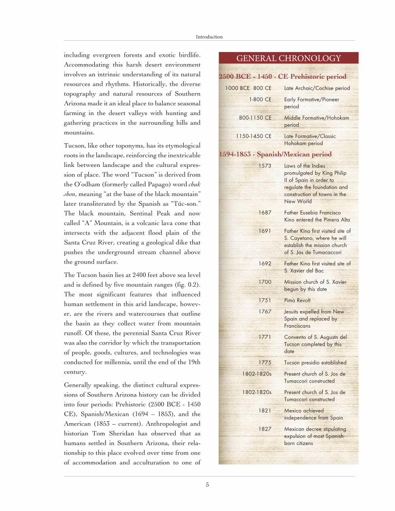
Generally speaking, the distinct cultural expres-sions of Southern Arizona history can be divided into four periods: Prehistoric (2500 BCE - 1450 CE), Spanish/Mexican (1694 – 1853), and the American (1853 – current). Anthropologist and historian Tom Sheridan has observed that as humans settled in Southern Arizona, their rela-tionship to this place evolved over time from one of accommodation and acculturation to one of
2500 BCE - 1450 · CE Prehistoric period
! 2111!CDF!!911!DF! Mbuf!Bsdibjd0Dpdijtf!qfsjpe
! 2.911!DF! Fbsmz!Gpsnbujwf0Qjpoffs!qfsjpe
! 911.2261!DF! Njeemf!Gpsnbujwf0Ipiplbn!qfsjpe
! 2261.2561!DF! Mbuf!Gpsnbujwf0Dmbttjd!Ipiplbn!qfsjpe
1594-1853 · Spanish/Mexican period
! 2684! Mbxt!pg!uif!Joejft!qspnvmhbufe!cz!Ljoh!Qijmjq!JJ!pg!Tqbjo!jo!psefs!up!sfhvmbuf!uif!gpvoebujpo!boe!dpotusvdujpo!pg!upxot!jo!uif!Ofx!Xpsme!
! 2798! Gbuifs!Fvtfcjb!Gsbodjtdp!Ljop!foufsfe!uif!Qjnfsb!Bmub
! 27:2! Gbuifs!Ljop!gjstu!wjtjufe!tjuf!pg!T/!Dbzfubop-!xifsf!if!xjmm!ftubcmjti!uif!njttjpo!divsdi!pg!T/!Kpt!ef!Uvnbdbddpsj
! 27:3! Gbuifs!Ljop!gjstu!wjtjufe!tjuf!pg!T/!Ybwjfs!efm!Cbd
! 2811! Njttjpo!divsdi!pg!T/!Ybwjfs!cfhvo!cz!uijt!ebuf
! 2862! Qjnb!Sfwpmu
! 2878! Kftvjut!fyqfmmfe!gspn!Ofx!Tqbjo!boe!sfqmbdfe!cz!Gsbodjtdbot
! 2882! Dpowfoup!pg!T/!Bvhvtuo!efm!Uvdtpo!dpnqmfufe!cz!uijt!ebuf
! 2886! Uvdtpo!qsftjejp!ftubcmjtife
! 2913.2931t! Qsftfou!divsdi!pg!T/!Kpt!ef!Uvnbddpsj!dpotusvdufe
! 2913.2931t! Qsftfou!divsdi!pg!T/!Kpt!ef!Uvnbddpsj!dpotusvdufe
! 2932! Nfyjdp!bdijfwfe!joefqfoefodf!gspn!Tqbjo
! 2938! Nfyjdbo!efdsff!tujqvmbujoh!fyqvmtjpo!pg!nptu!Tqbojti.cpso!djuj{fot
GENERAL CHRONOLOGY

6
Introduction
Fig. 0.2 – Map of Tucson valley showing geographic features. Courtesy of Desert Archaeology, Inc.
7
Introduction
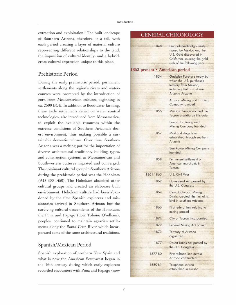
extraction and exploitation.3 The built landscape of Southern Arizona, therefore, is a tell, with each period creating a layer of material culture representing different relationships to the land, the imposition of cultural identity, and a hybrid, cross-cultural expression unique to this place.
Prehistoric PeriodDuring the early prehistoric period, permanent settlements along the region’s rivers and water-courses were prompted by the introduction of corn from Mesoamerican cultures beginning in ca. 2500 BCE. In addition to floodwater farming, these early settlements relied on water control technologies, also introduced from Mesoamerica, to exploit the available resources within the extreme conditions of Southern Arizona’s des-ert environment, thus making possible a sus-tainable domestic culture. Over time, Southern Arizona was a melting pot for the importation of diverse architectural traditions, building types, and construction systems, as Mesoamerican and Southwestern cultures migrated and converged. The dominant cultural group in Southern Arizona during the prehistoric period was the Hohokam (AD 800-1450). The Hohokam absorbed other cultural groups and created an elaborate built environment. Hohokam culture had been aban-doned by the time Spanish explorers and mis-sionaries arrived in Southern Arizona but the surviving cultural descendents of the Hohokam, the Pima and Papago (now Tohono O’odham), peoples, continued to maintain agrarian settle-ments along the Santa Cruz River which incor-porated some of the same architectural traditions.
Spanish/Mexican Period Spanish exploration of northern New Spain and what is now the American Southwest began in the 16th century during which early explorers recorded encounters with Pima and Papago (now
! 2959! Hvbebmvqf.Ijebmhp!usfbuz!tjhofe!cz!Nfyjdp!boe!uif!V/T/!Hpme!ejtdpwfsfe!jo!Dbmjgpsojb-!tqvssjoh!uif!hpme!svti!pg!uif!gpmmpxjoh!zfbs
1853-present • American period
! 2965! Hbetefo!Qvsdibtf!usfbuz!cz!xijdi!uif!V/T/!qvsdibtfe!ufssjupsz!gspn!Nfyjdp-!jodmvejoh!uibu!pg!tpvuifso!Bsj{pob!Bsj{pob!
! ! Bsj{pob!Njojoh!boe!Usbejoh!Dpnqboz!gpvoefe
! 2967! Nfyjdbo!usppqt!wbdbufe!uif!Uvdtpo!qsftjejp!cz!uijt!ebuf/
! ! Tpopsb!Fyqmpsjoh!boe!Njojoh!Dpnqboz!gpvoefe
! 2968! Nbjm!boe!tubhf!mjoft!ftubcmjtife!uispvhi!tpvuifso!Bsj{pob!
! ! Tbo!Ybwjfs!Njojoh!Dpnqboz!gpvoefe
! 2969! Qfsnbofou!tfuumfnfou!pg!Bnfsjdbo!nfsdibout!jo!Uvdtpo
! 2972.2976! V/T/!Djwjm!Xbs
! 2973! Ipnftufbe!Bdu!qbttfe!cz!uif!V/T/!Dpohsftt
! 2975! Dfssp!Dpmpsbep!Njojoh!Ejtusjdu!dsfbufe-!uif!gjstu!pg!jut!ljoe!jo!tpvuifso!Bsj{pob
! 2977! Gjstu!gfefsbm!mbx!sfmbujoh!up!njojoh!qbttfe
! 2982! Djuz!pg!Uvdtpo!jodpsqpsbufe
! 2983! Gfefsbm!Njojoh!Bdu!qbttfe
! 2984! Ufssjupsz!pg!Bsj{pob!pshboj{fe
! 2988! Eftfsu!Mboet!Bdu!qbttfe!cz!uif!V/T/!Dpohsftt
! 2988.91! Gjstu!sbjmspbe!mjof!bdsptt!Bsj{pob!dpotusvdufe
! 2991.92! Ufmfqipof!tfswjdf!ftubcmjtife!jo!Uvdtpo
GENERAL CHRONOLOGY

8
Introduction
Tohono O’odham) tribes in settlements along river floodplains. This region, populated primari-ly by Pima-speaking populations, became known as the Pimería Alta (fig. 2.1), a large geographic area defined by the Pima and Papago settle-ments that occupied the current Mexican state of Sonora and the region of Southern Arizona. The Spanish were responsible for importing into the area new building types, construction technologies, socio-economic institutions, and cultural traditions that are still prevalent today. The Spanish Colonial period in Pimería Alta ended with Mexican independence from Spain in 1821 but its architectonic influences in the region lingered on through the period of Mexican period of control, which ended in 1853 when the United States government purchased the land currently defined as Southern Arizona. Between 1821 and 1853, however, this area was part of the Mexican state of Sonora and although the Spanish and Mexican building typologies had their origins far from the Pimería Alta, they are often referred to as “Sonoran”.
American Period Americans began arriving in what is now Southern Arizona in the 1840s, tempted by the California gold rush and the perceived opportunity for a new life in the American West. The Homestead Act of 1862 encouraged the American population to spread into the unsettled West, allowing even those with little money to lay claim to land and, in the process,“ Americanizing” the territory. Hundreds of people filed claims and pursued livelihoods ranging from ranching and mining to real estate speculation and building construction. Although all of these enterprises contributed to the transformation of the American West, it was mining that symbolized most dramatically the growing American perception of the western landscape as a disposable commodity.
As a minority group, the first generation of American settlers adopted local traditions and assimilated into the local culture. Over the course of the next few decades, however, American settlers slowly transformed Southern Arizona’s cultural identity through the use of tangible cul-tural expressions of their diverse places of origin. When the transcontinental railroad was extended through Southern Arizona in1880, it brought both culture in the form of eastern tastes in every-thing from food and music to architecture and technology and the availability of mass-produced materials, enabling the rapid transformation of Tucson from a Sonoran pueblo to an American town.
In the first half of the 20th century, Tucson saw the rise of land speculation and development, home and car ownership, and the separation of work from home in separate parts of town. Soon, Americans were living in subdivisions that distinguished themselves from areas of Mexican habitation, producing an increasingly segregated town, both ethnically and architecturally. During this period, Tucson, and the Southwest in gener-al, was a destination for tourists seeking to dis-cover the exotic landscape and culture that they had previously only read about. Tourism opera-tors, such as the Harvey Hotel Company, used the region’s unfamiliar architecture as a vehicle to promote a romanticized image of the Southwest.
Just as the eastern states of the U.S. had pro-moted selected historical references beginning in the 19th century with the adoption of English colonial revival styles, promoters and architects in the West extracted architectural characteristics from previous cultures to produce romanticized Spanish Colonial revival styles for the region. None of these styles represented an architectural vocabulary indigenous to the authentic histori-cal building traditions of Tucson and Southern Arizona; instead, they offered a manufactured image which sought to lure new residents and

9
Introduction
cater to recent arrivals by associating new archi-tecture with a generalized southwestern heritage. Even after World War II and lasting until today, regional revival styles dominate the residential suburban landscape, feeding the expectations of newcomers in a region where growth is consid-ered an industry.
Today, however, Tucson’s superficial, image-driv-en “southwestern” cultural identity is slowly being replaced by one that is more responsive to the natural desert environment and more inclusive of the genuine cultural traditions of our past. Essential principles of Southern Arizona’s vernacular built environment are now being applied to contemporary forms, materials, and lifestyles, creating a new “vernacular” expression. Moreover, southern Arizona’s vernacular land-scapes are gradually coming under the protection of a myriad of public landowners, including fed-eral, state, county and tribal agencies, which has caused a transformation of the landscape from one defined by geographic boundaries to one defined by administrative boundaries (fig. 0.3). These public land stewards often have dissimilar missions but are realizing the fundamental need for the preservation of this region’s vernacular built environment, so that current and future gen-erations may continue to find inspiration.
Conclusion The evolution of Southern Arizona’s vernacular landscapes presents a set of cultural fingerprints, each with its own characteristics, but when com-bined forming a place unlike any other. Architect Charles Moore wrote that “to make a place is to make a domain that helps people know where they are, and by extension, who they are.”4 In a parallel phenomenon, cities like Tucson have undergone many attempts to reinvent themselves in order to meet the demands of tourists, new-comers, and economic development. Not unlike the ethic of extraction and exploitation of the
! 2992! Dpqqfs!Rvffo!Njojoh!Dpnqboz!jodpsqpsbufe!
! ! Upxo!pg!Upnctupof!jodpsqpsbufe!boe!nbef!uif!tfbu!pg!Dpdijtf!Dpvouz
! ! Tippu.pvu!bu!uif!PL!Dpssbm!jo!Upnctupof!
! 2993! Hbt-!fmfdusjdjuz-!boe!xbufs!mjoft!ftubcmjtife!jo!Uvdtpo!cz!uijt!ebuf
! 2996! Vojwfstjuz!pg!Bsj{pob-!up!cf!mpdbufe!jo!Uvdtpo-!ftubcmjtife!cz!uif!Bsj{pob!ufssjupsjbm!mfhjtmbuvsf
! 2997! Bqbdif!mfbefs!Hfspojnp!tvssfoefsfe
! 2998! Tdippm!pg!Njoft!)opx!Pme!Nbjo*-!uif!gjstu!Vojwfstjuz!pg!Bsj{pob!cvjmejoh-!dpotusvdufe
/! ! Tfwfsf!fbsuirvblf!iju!Uvdtpo
! 2999! Bsj{pob!boe!Tpvui!Fbtufso!Sbjmspbe!Dpnqboz!jodpsqpsbufe
! 29::! Bvupnpcjmf!jouspevdfe!up!Uvdtpo
! 2:12! Dbmvnfu!boe!Bsj{pob!Njojoh!Dpnqboz!gpvoefe!
! ! Upnctupof!Dpotpmjebufe!Njof!Dpnqboz!gpvoefe
! 2:13! Upxo!pg!Cjtcff!jodpsqpsbufe
! 2:23! Bsj{pob!bdijfwfe!tubufippe
! 2:27! Uvdtpo-!Dpsofmjb-!boe!Hjmb!Cfoe!Sbjmspbe!mjof!gspn!Hjmb!Cfoe!up!uif!njoft!dpnqmfufe
! 2:38! Mbshftu!fwfs!nbtt!pg!dpqqfs!ejtdpwfsfe!jo!Cjtcff
GENERAL CHRONOLOGY

10
Introduction
Fig. 0.3 – Southeastern Arizona showing publicly-owned lands. Courtesy of Desert Archaeology, Inc.

11
Introduction
natural landscape by early settlers in the West, the region’s cultural identity has been constructed and marketed as a com-modity of superficial icons to be packaged into themed expe-riences catering to consumers external to this place. Such a diminution of Tucson’s authenticity as a rich and diverse tell of architectural expressions, also belies the rich diversity of people who have been “stamped … with a peculiar desert character” and who continue not only to explore the traditional vernacular landscapes of Southern Arizona but also to interpret and apply them in new ways that are appropriate for this time and this place.
ENDNOTES
1. John C. van Dyke, The Desert: Further Studies in Natural Appearances
(Baltimore: Johns Hopkins University Press, 1999), 50.
2. J. B. Jackson, The Necessity for Ruins and Other Topics (Amherst:
University of Massachusetts Press, 1980), p. 113.
3. Thomas Sheridan, Arizona: A History (Tucson: The University of
Arizona Press, 1995).
4. Kent Bloomer and Charles Moore, Body, Memory and Architecture (New
Haven: Yale University Press, 1977), p. 31.
“A Sonoran Desert village may receive five inches
of rain one year and fifteen the next. A single
storm may dump an inch and a half in the matter
of an hour on one field and entirely skip another
a few miles away. Dry spells lasting four months
may be broken by a single torrential cloudburst,
then resume again for several more months.
Unseasonal storms, and droughts during the
customary rainy seasons, are frequent enough to
reduce patterns to chaos.”
Gary Nabhan, The Desert Smells Like Rain

SECTION I

VERNACULAR LANDSCAPES
IN CONTEXT

1

15
Southern Arizona has evidence of some of the oldest inhabitants on the North American continent. Evidence for occupation prior to 11,000 years before the present is extensive in the San Pedro Valley, located in the south-eastern corner of the state (fig 0.1). The San Pedro Valley has yielded the single largest concentration of Clovis sites in North America.1 These earliest inhabitants of southern
Arizona almost certainly practiced a nomadic lifestyle, subsisting completely on what they could kill, capture, or collect. Eight Clovis and probable Clovis sites are known from the upper San Pedro Valley. At the sites of Naco, Lehner, Murray Springs, Liekem, and Escapule, evidence of the early hunters has been found in associa-tion with the remains of C olumbian mammoths and other extinct mega-fauna.2 Other sites have generated evidence of additional mammoth or bison kills.
Evidence of Paleoindian remains in the Tucson Basin, however, is sparse. A Clovis presence has been documented only by isolat-ed surface finds, including a projectile point with mixed Clovis and Folsom fluting from the Rattlesnake Pass area of the Tucson Mountains and a Clovis projectile point from a Hohokam site in the Avra Valley.
Whether they represent an adaptation from the Paleoindian period or the introduction of a new population or technology, the inhabi-tants of southern Arizona to follow the Paleoindian people are gen-erally referred to as the Archaic (this is also sometimes referred to as the Cochise culture). The Archaic period was significant in that it provided an intermediate step between the hunting cultures of the
NATIVE AMERICANARCHITECTURE
OF SOUTHERN ARIZONAMatthew Sterner

Native American Architecture of Southern Arizona
16
preceding Paleoindian period and the succeeding agricultural and pottery producing cultures of the Southwest. Mixed hunting and collecting of wild plant foods is the unquestioned subsistence pattern of Cochise peoples, although the relative importance of animal and plant foods in the econ-omy remains poorly understood.
The development of houses and associated stor-age facilities in the late Archaic period suggests a greater degree of stability than in preceding times. Although structures have been recorded at Middle Archaic sites, Late Archaic pit houses are more formally constructed and occur with greater frequency. Late Archaic houses are gen-erally small, roughly oval in shape, and measure 3 by 2.75 m. in size, with a single interior hearth and one or more bell-shaped storage pits (fig. 1.1). Often, these houses have no visible point
of entry. Interior postholes suggest that a dome-shaped construction of arched poles formed the roof. Archaic pit houses are typically small com-pared to later ceramic-period structures. The development of Late Archaic facilities should not be interpreted as indicating the end of sea-sonal movements to exploit varied resources. Ethnographic data suggests that below-ground storage facilities such as the large, bell-shaped storage pits of the San Pedro Cochise culture coincide directly with the need to hide stored resources when the storage location was periodi-cally abandoned.3 That such storage pits occur at archaeological sites lacking houses reinforces this notion.4 The available evidence suggests that late Archaic houses occur at locations close to the San Pedro River or to impermanent water channels, rather than at mountain locations.
Fig. 1.1 – Late Archaic period house in the San Simon area. Courtesy of Statistical Research Inc.

Native American Architecture of Southern Arizona
17
In the Tucson Basin, there is no evidence of human habitation before 1000 BCE. Between 1000 BCE and 800 CE, the Late Archaic is defined by an increase in the prehistoric popula-tion, the adoption of agriculture, and the emer-gence of large settlements representing the begin-nings of sedentary village life. Prior to this time, subsistence was based on a hunting and gathering strategy, requiring a high degree of mobility and little need for formalized housing clusters. It is now apparent that agriculture, specifically the cultivation of maize, beans, and squash, was a sig-nificant part of the economy early in Late Archaic times, although the settlement system continued to include many sites devoted to hunting and gathering. Low-elevation, riverine areas were the focus of the earliest agricultural efforts, owing as much to the diversity of wild plant foods avail-able in the immediate vicinity as to the perennial presence of water. The actual importance of agriculture in Late Archaic subsistence is still unclear, but evidence for irrigation ditches and canals dating to 1000–900 BCE at the Costello-King site5 and Las Capas6 suggests a significant commitment to agriculture at a very early time.
The floodplains of the middle Santa Cruz Valley have yielded evidence of multi-seasonal, if not year-round, occupation during the Late Archaic period. Settlements consisting of several hun-dred pit structures have been found, although it is generally difficult to determine how many features at these sites are contemporaneous and how many represent a repeated use of the same location. Whatever the extent of contempora-neity, these sites show evidence of a distinctive architectural style, a diversity of activities, and a planned arrangement of features that suggests a significant degree of sedentism. The same char-acteristics, combined with an apparent functional dichotomy between large and small houses, at a number of Late Archaic sites, indicates a degree of social complexity not seen in earlier periods.
Formative Period (1–1400 CE)The trends toward increased sedentism, depen-dence on agriculture, and refinement of adap-tive strategies first seen in Late Archaic times continued through the Formative period. In the Tucson Basin, as elsewhere in the Southwest, the distinction between Late Archaic and Formative culture is initially one of degree, accompanied by the wholesale adoption of pottery. The distinction is amplified by features such as the increased sophistication of pottery forms and uses, con-struction of larger and more formal dwellings, and a steady increase in the size and number of long-term settlements.
Early Formative Period (also referred to as Pioneer Period) sites, characterized by plain and red ware pottery, emerged in many areas of south-central Arizona. The architecture at these sites is variable, with shallow, informal Archaic-type houses co-existing with larger, more formal houses of variable shape. The houses with pre-served entryways were characterized by incurv-ing walls forming flanking elements for the entry and associated with heavy plastered pillars to either side. This construction gave the houses a distinctive, bean-shaped appearance (fig. 1.2).
The Hohokam cultural pattern that appeared in the Tucson Basin at the start of the Middle Formative period (800–1150 CE), whatever its means of introduction, had clear affiliations with developments elsewhere in Arizona, particularly the Phoenix Basin to the north and the San Pedro Valley to the east. Dramatic changes occurred in settlement patterns, and there were notable innovations in ceremonial architecture, mortuary ritual, and material culture. Traditionally known as the Colonial period (800–1000 CE), the first two centuries of the Middle Formative saw settle-ments grow in size and concentrate increasingly along the floodplains of the major streams and the adjacent river terraces. Long-term habitation

Native American Architecture of Southern Arizona
18
sites were characterized by semi-subterranean (pit) houses, often rectangular in shape and fea-turing distinctive entryways (fig. 1.3).
The next two and a half centuries, traditionally known as the Sedentary period (900–1150 CE), represented the height of prehistoric settlement in the Tucson Basin. Information concerning the Sedentary Period in the Tucson Basin is far great-er than for any other portion of the Hohokam sequence. A distinctive local cultural system had clearly developed, with large village sites showing internal differentiation in the form of precincts. A typical precinct consisted of several domestic structures, a common courtyard, associated trash mounds and borrow areas, and sometimes a cem-
etery. Subsistence and manufacturing activities were more diverse than in earlier periods.
Considerable variability in pit house architecture attests to functional and social differentiation among Sedentary settlements. Pit structures and more formally constructed pit houses continued from the preceding period. Typically not fully rectangular in plan, pit houses were provid-ed with entries, peripheral posts, and variable arrangements of interior roof supports. There are other houses, however, with square, oval, bean-shaped, and nearly circular forms that evi-dently also served as habitations (fig. 1.4). Floor areas vary widely in pit house structures during this period. At the Tanque Verde Wash site (AZ BB:13:68) in the eastern Tucson Basin, pit hous-
Fig. 1.2 – Plan and profile of Feature 139 at the Houghton Road site. Courtesy of Statistical Research Inc.

Native American Architecture of Southern Arizona
19
es ranged from 10.1 m2 to 31.4 m2 in floor area.7 Entry orientation, floor facilities, and floor arti-fact assemblages also varied.
The Late Formative period (1150–1450 CE), tra-ditionally called the Classic period in Hohokam chronologies, began with the collapse of the Hohokam regional system and the disappearance of some distinctively Hohokam features such as the ball court. Major architectural changes also occurred at this time. Puddled-earth buildings, contiguous rectangular rooms constructed on the ground surface, and compound walls enclosing habitation areas became the norm. Late in the Classic period, a reduction in the population of
the Tucson Basin is evident, and a limited num-ber of major settlements emerged, suggesting a more intensive nucleation of the basin’s popula-tion. A declining water table, the result of envi-ronmental deterioration and a possible source of conflict between major settlements, may have contributed to the general decline. After 1450, the Classic period version of Hohokam culture ceased to exist in the Tucson Basin.8
Domestic house types described by Isabel Kelly and others encompass much of the existing architectural variation.9 The “standing wall” type was a rectangular, above-ground structure built of puddled adobe walls; roof support patterns
Fig. 1.3 – Plan and profile of Canada del Oro phase pit house at the Hodges Ruin. Courtesy of Statistical Research Inc.

Native American Architecture of Southern Arizona
20
varied and access was either through doorways or attached entries (fig. 1.5a). The “slant wall” type was a semi-subterranean structure, rectan-gular in shape with rounded corners (fig. 1.5b). Walls were sloping rather than upright and were plastered; entries were attached and lacked steps. Although the adobe-walled room was not preva-lent until the late Classic period, the adobe-lined pit house type continued to be occupied contem-poraneously with surface rooms.
There is considerable variability within each cate-gory of Classic period architecture. In the Marana area, the rooms at Muchas Casas (AZ AA:12:368) were solid, coursed adobe, lacking post or cob-ble reinforcement.10 Semi-subterranean puddled adobe structures in the Picacho Mountains area varied in construction: some houses were built of solid adobe (fig. 1.6) while others were reinforced with posts.
Contiguous room blocks, both with and with-out enclosing compound walls, were initially constructed during the first half of the Classic period, during the middle Tanque Verde Phase.11 It cannot be stated with any certainty wheth-er the appearance of compounds reflects tem-poral, functional, or social factors. Compound enclosures appear at widely dispersed locations within the Tucson Basin and ceramic collections suggest contemporaneity with non-compound habitations.
Adobe-walled structures were the most common late Classic architectural form in the Picacho Mountains area. Both solid-wall and post-rein-forced constructions were used. Simple doors in the walls and level, covered entries provided access.12 Surface stick-and-mud structures also occur. Puddled adobe footings of minimal depth were used in these rectangular structures and
Fig. 1.4 – Rincon phase habitation structures at the West Branch site. Courtesy of Statistical Research Inc.

Native American Architecture of Southern Arizona
21
mud was packed around the posts supporting the superstructure. Simple wall entries were the most common form.
Non-domestic architecture also changed dramat-ically in the Classic period, with most platform mounds constructed in the early Classic period. The platform mound at Marana was built and used most intensively during this time. The platform mound at the University Indian Ruin (AZ BB: 9:33) (see the tour site description) was evidently constructed during the late Classic period and this site provides much of the extant information for domestic architecture at this time. Contiguous rooms of post-reinforced puddled adobe, coursed adobe, or alternating layers of cobbles and adobe form the village portion of the settlement. Contiguous houses with massive puddled adobe walls constructed during the late
Classic intruded into earlier, early Classic period pit house structures. Enclosures built around the late Classic constructions served as retaining walls and were filled with earth. On the mound surface additional contiguous massive-walled adobe rooms were built. Finally, the mound was enclosed by a compound wall.
Protohistoric BackgroundA link between the prehistoric Hohokam people of the Tucson Basin and the Native Americans living in the region at the time of Spanish contact has not been definitively established, but there were undoubtedly major cultural continuities between prehistoric and protohistoric times, par-ticularly in subsistence strategies. The Jesuit priests who first ventured into what is now northern Sonora and southern Arizona found
Fig. 1.5 – Classic period house types at the Hodges Ruin: (a) standing wall structure; (b) slant-wall structure. Courtesy of Statistical Research Inc.

Native American Architecture of Southern Arizona
22
it occupied by the Pimas altos (upper Pima), a collective name for a variety of groups speak-ing closely related Piman languages. One such group, known as the Sobaipuri, lived in a series of settlements along the Santa Cruz and San Pedro Rivers and practiced a primarily seden-tary, agricultural way of life. Another group, the Papago (now known as the Tohono O’odham), lived in the desert region west of the Santa Cruz Valley and practiced a more nomadic way of life that was heavily dependent on wild plant foods.13 There was regular interaction between the two groups, and the subsistence strategy of one was always at least a subsistence option for the other, if not a significant supplement. In this sense, the Sobaipuri and the Papago were heirs to the same
subsistence tradition, but had come to emphasize different parts of it in correspondence with their respective environments.
There were two large Sobaipuri villages along the Santa Cruz River in the vicinity of modern Tucson. One was known as Bac, the eventual location of the Jesuit mission San Xavier del Bac. The other was a settlement of uncertain name located along the Santa Cruz River near its confluence with the Rillito River. Distributed along the river between the two large villages were four smaller settlements called rancherías by the Spanish. The relatively dense concentration of people in the area was likely associated with an intensive agricultural subsistence strategy but
Fig. 1.6 – Puddled adobe-walled structure at the Brady Wash site. Courtesy of Statistical Research Inc.

Native American Architecture of Southern Arizona
23
may also have been a response to the growing threat of Apache raiding from the north and east.14 The agricultural methods of the Sobaipuri, which included both canal irrigation and ak chin
farming (diverting water from canyon mouths onto fields), were probably not substantially dif-ferent from those practiced prehistorically.
Archaeological evidence of the Sobaipuri in the Tucson Basin is minimal and poorly understood, which contributes to the lack of information regarding the demise of the Hohokam culture and the nature of its descendants. A lack of both chronometric data and a cohesive framework for interpreting protohistoric material culture like-wise hinders understanding of the transition from prehistory to the historical period in the Tucson Basin.15 Using ethno-historic evidence, however, we can likely formulate a picture of the archi-tectural landscape that was typical of Sobaipuri settlements. The villages were likely composed of a number of household complexes, each com-prising several structures (both residential and storage) and activity areas used by a single nucle-ar or extended family.16 Most of the structures employed a traditional post-and-beam structural system, apparently adopting techniques that were ubiquitous throughout prehistory. In addition to enclosed wall structures, ramada (wall-less) structures likely became more commonplace during this period.
SummaryPrehistoric architecture in southern Arizona rep-resents a marriage of form and function, with function responding predominantly to the often harsh environmental conditions of the region. Nearly all prehistoric dwellings were functional adaptations designed to minimize the effects of the desert environment. Semi-subterranean houses took advantage of the cooling effects of the thermal mass of the earth itself while the later development of massive puddled adobe-walled
structures utilized locally available materials to mitigate the effects of intense summer heat above ground. Subterranean storage pits also took advantage of the cooling effects of the earth to preserve foodstuffs and other perishable materi-als. The later development of the ramada struc-ture provided protection from the intense sum-mer heat while providing sometimes expansive work areas shaded from the sun.
ENDNOTES
1. Linda S. Cordell, Prehistory of the Southwest (New York:
Academic Press, 1984), 140.
2. Stephanie M. Whittlesey, Richard Ciolek-Torrello,
and Matthew A. Sterner, Southern Arizona: The Last 12,000
Years: A Cultural-Historic Overview for the Western Army
National Guard Aviation Training Site (Tucson: Statistical
Research, Inc., 1994), 45.
3. W. H. Wills, Early Prehistoric Agriculture in the American
Southwest (Santa Fe: School of American Research Press,
1988), 39.
4. Ric Windmiller, “The Late Cochise Culture in
the Sulphur Spring Valley, Southeastern Arizona:
Archaeology of the Fairchild Site,” The Kiva 39 (1973):
131–169.
5. Joseph A. Ezzo and William L. Deaver, Watering the
Desert: Data Recovery at the Late Archaic Costello-King Site,
Pima County, Arizona (Tucson: Statistical Research, Inc.,
1998).
6. Jonathan B. Mabry, “Las Capas and Early Irrigation
Farming,” Archaeology Southwest 13 (1999), 14.
7. Mark D. Elson, Archaeological Investigations at the Tanque
Verde Wash Site, A Middle Rincon Settlement in the Eastern
Tucson Basin (Tucson: Institute for American Research,
1986), 61–102.
8. Robert B. Neily, Richard Ciolek-Torrello, and Matthew
A. Sterner, “Previous Research and Culture History,” in
Investigations at Sunset Mesa, ed. Richard Ciolek-Torrello,

Native American Architecture of Southern Arizona
24
Edgar K. Huber, and Robert B. Neily (Tucson: Statistical
Research, Inc., 1999), 23–44.
9. Isabel T. Kelly, James Officer, and Emil Haury, The
Hodges Ruin: A Hohokam Community in the Tucson Basin
(Tucson: University of Arizona Press, 1978), 11–12.
10. Todd W. Bostwick, “A Descriptive Summary of the
Excavation Results at Locus D, AZ AA:12:2(ASU),
Muchas Casas,” in Field Investigations at the Marana
Community Complex, ed. T. Kathleen Henderson (Tempe:
Office of Cultural Resource Management, Arizona State
University, 1987), 85–119.
11. Henry D. Wallace and James P. Holmlund, “The
Classic Period in the Tucson Basin,” The Kiva 49 (1994):
167–194.
12. Richard S. Ciolek-Torrello and David H. Greenwald,
“Architecture and House Function,” in Hohokam Settlement
Along the Slopes of the Picacho Mountains, Tucson Aqueduct
Project 6, ed. Richard Ciolek-Torrello and David R.
Wilcox (Flagstaff: Museum of Northern Arizona, 1988),
121–164.
13. Susan A. Brew and Bruce B. Huckell, “A Protohistoric
Piman Burial and a Consideration of Piman Burial
Practices,” The Kiva 52 (1987): 163–191, and William
H. Doelle, “The Tucson Basin During the Protohistoric
Period,” The Kiva 49 (1984): 195–211.
14 Doelle, “The Tucson Basin During the Protohistoric
Period,”195–211.
15. Neily et al., “Previous Research and Culture
History,” 23–44, and John C. Ravesloot and Stephanie
M. Whittlesey, “Inferring the Protohistoric Period in
Southern Arizona,” in The Archaeology of the San Xavier
Bridge Site (AZ BB:13:14), Tucson Basin, Southern Arizona,
ed. John C. Ravesloot (Tucson: University of Arizona,
Arizona State Museum, 1987),
16. Janet H. Strittmatter, Historic, Vernacular Dwellings
of the Tohono O’Odham and Akimel O’Odham (Ms. on file,
Statistical Research, Inc., 1998), 8.

Native American Architecture of Southern Arizona
25
“They call themselves O’odham. The word means
“People,” but it means more than that. It also
means Those Who Emerged from the Earth. It
means sand, or dry earth, endowed with human
quality. The O’odham, or Papagos, as we call
them, are of the earth. But it is of earth in a land
of little rain. That is their essence. It is the secret
of their life. They are the desert people.”
Bernard Fontana, Of Earth and Little Rain

26
2

27
During the period of Spanish colonization in the ter-ritory that is now southern Arizona and northwest Sonora, Mexico, four institutions—the mission system, the military, ranching, and mining—were responsible for European-initiated architecture and urbanism. Because of frequent attacks by Apaches, as well as occasion-al insurrections by local Pima Indians, most ranches
and mining communities were either unable to develop fully or were destroyed during periods of hostility. Therefore, there is scant, if any, above-ground physical evidence of domestic or mining architecture built during the Spanish colonial period in the area of southern Arizona. Thus, much of what we know about the architecture of the period comes from religious and military sites (fig. 2.1).
Presidios, military garrisons, were built by the Spanish along the Santa Cruz and San Pedro Rivers to protect the religious missions and other interests of the Crown. These military compounds were almost always dismantled at some point and relocated for tactical or political purposes. Portable materials were thus often recycled at other locations, and, as in the case of Tucson, housing later developed on the site of the former fort. It is principally through archaeological evidence, written accounts, and a few rare maps that we are able to deduce the built form of these Spanish frontier forts. In contrast, mission communities, and especially their churches, have experienced an amazing degree of physical surviv-al, in spite of indigenous rebellions, Apache raids, and the destruction caused by time and neglect. There are two extant colonial-era mission
ARCHITECTURE AND URBANISM OF THE PRIMERÍA ALTA DURING
THE PERIODS OF SPANISH COLONIZATION AND MEXICAN
INDEPENDENCE, 1692 - 1854John Messina

Architecture and Urbanism of the Pimería Alta during the Periods of Spanish Colonization and Mexican Independence, 1692 - 1854
28
Fig 2.1 - Map of the Northern Pimería Alta indicating missions, presidios and other settlements during the Spanish colonial period. Courtesy of Desert Archaeology Inc.

Architecture and Urbanism of the Pimería Alta during the Periods of Spanish Colonization and Mexican Independence, 1692 - 1854
29
churches in southern Arizona and no less than five in northwest Sonora, Mexico. That these churches have survived past hostilities, neglect, revolutions, and shifting political boundaries is close to miraculous.
The SettingAlthough the Spanish military, missionaries, and a few ranchers had advanced well into Sonora, Mexico by the middle part of the 17th century, it was not until 1687 that a Jesuit priest by the name of Eusebio Francisco Kino entered the territory known as the Pimería Alta, the land of the upper Pima Indians.1 Roughly speaking, the Pimería Alta runs north to the Gila River, south to just below the Rio Magdalena in Sonora, Mexico, east to the San Pedro River which pass-es close to Tombstone, Arizona, and west almost as far as the Colorado River at the Arizona-California border.
The Spanish Crown’s primary purpose in financ-ing missionary activity on the far northern fron-tier was to have the indigenous people not only converted to Christianity but also made into productive citizens of Spain. The Spanish mon-archy wanted to turn the native people into pro-ducers of commodities that would provide food and other necessary items that were required to support the military, as well as the miners and ranchers who would be following the missionar-ies’ trails. The mines and ranches would in turn produce wealth, a portion of which would be sent to the Royal Treasury in Spain.
When Kino entered the territory of the “Pimas,” he found scattered settlements of indigenous people living in relatively small groups along river and stream beds, where they could engage in flood water agriculture (see also Matthew Sterner’s essay). During the drier winter season they would move their camps to higher elevations in the nearby mountains where there was game
to be hunted, as well as the availability of spring water. Because the groups were forced to move with the seasons, their architecture was light and ephemeral, unlike that of the pueblos in the northern portions of the American Southwest. It was typically constructed of cactus ribs or mes-quite branches and mud. According to anthropol-ogist Bernard Fontana,
[Pima] architecture, moreover, was dry—a practical
consideration in an arid land. And structures were
practical in another way. To build them was not labor
intensive and to give them up, either permanently or
temporarily, caused no great sacrifice to individual or
community. [The Pimas], who slept and cooked out of
doors except in inclement weather, rested lightly upon
their landscape.2
The Pimas in the vicinity of present day Tucson called themselves the Tohono O’odham, which means “Desert (Tohono) People (O’odham)”. Their architecture at the time of Spanish entry into the region was, as stated above, of dry construction, made with locally available materials and expend-able. Early Spanish settlers and missionaries adopted this type of construction for their own shelter before turning to a more permanent adobe technology.
In contrast to Hohokam use of puddled adobe, the Spanish use of adobe is as a sun-dried earthen brick composed of clay, silt and sand. Its origins are open to debate; however, there are adobe ruins in Iraq dating back 6000 years. Adobe construction has been used in the American Southwest since the early to middle 1600s when the Spanish began building settlements in north-ern New Mexico. Around the same period, Jesuit missionaries were utilizing the material in the construction of simple hall style churches at mis-sion sites along the Rio Sonora in the territory just east of the Pimería Alta. By the latter part of the 17th century, later arriving Jesuits were building mission churches and ancillary buildings out of adobe in the area of what is now southern

Architecture and Urbanism of the Pimería Alta during the Periods of Spanish Colonization and Mexican Independence, 1692 - 1854
30
Arizona. Gradually, Spanish settlers in their need for shelter constructed with locally available materials, turned to adobe for their houses, ani-mal shelters and other building needs. The orig-inal architecture of Spanish Colonial settlements such as Santa Fe, Albuquerque, El Paso and Tucson were all constructed of adobe.
The MissionsMission communities in the Pimería Alta were often attacked, both by rebellious local Pimas and by marauding Apaches. Thus, the constant threat of hostility informed early mission architecture and planning as much as program, climate, and availability of materials. The early Jesuit church-es were built with thick adobe block walls and few windows. Generally, openings with the exception of the entrance were placed high above the level of a horseback rider. Vigas, or roof joists, were made either of cottonwood found along the river banks or pine from nearby mountains. Savinas, or slats, made of cactus ribs were laid across the vigas, and then twelve to eighteen inches of soil was placed on this substrate for insulation and rain protection. The campanario, or belfry, if there was one, functioned not only as housing for the mission bell but also as a lookout perch for spotting any advancing war party. The interiors were well decorated with evocative religious art in the form of paintings and dressed figures of the Virgin Mary and saints. A choir loft, sacris-ty, and baptistry were other standard elements. Hall churches of this description were built at almost all of the frontier missions between 1700 and 1767, the year of the Jesuits’ expulsion from New Spain.
Father Kino and his fellow Jesuit missionaries were the first Europeans to build permanent set-tlements in the Pimería Alta. Kino’s best known mission is at Bac, originally a Piman-speaking village located on the Santa Cruz River approx-imately seven miles south of present-day down-
town Tucson. Bac or Wa:k was the Piman word for “where the water emerges from its under-ground flow”. Kino had named the site after San Francisco Xavier, thus the mission’s name of San Xavier del Bac. He first visited the site in 1692 and it has been reported that he began a church building there in 1700; however, no archaeolog-ical evidence of this building has been found. The first known church for the mission was a flat-roofed, hall-type adobe structure begun around 1756 under the leadership of a Father Alonso Espinosa (see tour site description). This type of church building, with a relatively narrow width-to-length ratio, was common throughout the region.
The site plan of San Xavier del Bac followed the basic planning principles for mission com-pounds that had been passed down from central Mexico over several centuries, albeit in modest version due to the frontier location and limited resources. The church is the principal structure; attached to its east side was a single story con-
vento, or residence, for the clergy (fig. 2.2). The convento eventually was expanded and ancillary structures for the storage of grain and the hous-ing of animals, as well as for workshops, were built to the north and northwest, thus forming two courtyards. (During the latter part of the last century, new housing for staff and visitors replaced the earlier structures on the northwest corner of the complex.) A small burial ground and mortuary chapel were constructed on the west side shortly after the church was completed. The Indians lived in simple shelters close by and there would have been gardens for the daily food requirements of the mission. In spite of the poten-tial for frequent attacks by Apaches, there is no indication that Mission San Xavier del Bac was ever surrounded by a wall or stockade. However, artists’ sketches from as far back as 1848 do indi-cate the current atrio, or walled forecourt, with a single arched gate.

Architecture and Urbanism of the Pimería Alta during the Periods of Spanish Colonization and Mexican Independence, 1692 - 1854
31
Approximately seven miles down the Santa Cruz River from San Xavier (the Santa Cruz River flows north to the Gila River), and across from present-day downtown Tucson, is the site of the former Mission San Agustín del Tucson (fig. 2.3). By 1771, the native Pimans had completed a convento under the supervision of a Franciscan priest, Francisco Garces. By the following year, a church was under construction. The convento was constructed of adobe, and is reported to have had rounded lookout towers at the corners.
Initially, this was the site of a Pima settlement, visited and named San Cosmé de Tucsón by Father Kino approximately seventy years earlier. However, it was not until after the Jesuit expul-sion in 1767 that substantial construction began and the name was changed to San Agustín. The name Tucson was derived from the Piman place name schookson or stjukson, meaning “at the base of black mountain”.3 The black mountain referred to is the conical hill southwest of downtown Tucson, now known as “A” Mountain.
Fig. 2.2 – Birds-eye view Mission San Xavier, 1923. Foreground structures are Tohono O’odham houses and ramadas. In the background are agricultural fields. Courtesy of Arizona Historical Society/Tucson (AHS 10412)

Architecture and Urbanism of the Pimería Alta during the Periods of Spanish Colonization and Mexican Independence, 1692 - 1854
32
San Agustín was never a permanently staffed mission but was a visita, or secondary mission, to San Xavier del Bac, the cabecera or primary mis-sion. A visita did not have a resident priest but was visited by priests from the nearest cabecera on a regular basis. Nevertheless, photographs and sketches dating back to the middle of the
19th century show a relatively large two-story adobe convento building that is assumed to have been used for administrative and storage pur-poses (fig. 2.4). This structure also served as a fortress during Apache attacks. The mission site was fortified with an earthen breastwork in the center (later a perimeter wall) and had a granary, workshops, and gardens and orchards, in addi-tion to the church and adjacent burial ground. A system of acequias, or irrigation ditches, delivered water from the nearby Santa Cruz River to the agricultural plots.
Approximately fifty miles south of Tucson on the Santa Cruz River is the mission site of San José de Tumacácori, now a National Historic Park administered by the United States National Park Service (see tour site description). In 1691, when Father Kino first visited what was then a Piman village on the east side of the river, he blessed the site with the name San Cayetano. By 1753, San Cayetano had been moved to the opposite side of the river and the name changed to San José (fig. 2.5). The Jesuits built a hall church on the site, and that structure was used until the current church, which was begun around 1802, replaced it in the 1820s. A cloistered convento was con-structed on the east side of the church, and a mortuary chapel and cemetery to the north. The complex contained the usual residence for priests, as well as workshops, corrals, and classrooms for religious instruction. Of all the missions in the Pimería Alta, Tumacácori offers the best extant example of frontier mission planning.
Two other mission sites in the vicinity of Tubac, Los Santos Angeles de Quevavi and San Cayetano de Calabasas, are presently only small adobe ruins and are closed to the public. The former was a staffed mission (cabecera) while the latter was a visita. Originally, Quevavi was the princi-pal mission in the area, Tumacácori being only a visita. But Apache attacks proved too formidable and around 1770 the role of the cabecera was
Fig. 2.3 – Map of Mission visita San Agustín produced in 1862 under the supervision of Major
David Fergusson, United States Army commander of the Tucson
Presidio. Courtesy of Desert Archaeology Inc.

Architecture and Urbanism of the Pimería Alta during the Periods of Spanish Colonization and Mexican Independence, 1692 - 1854
33
shifted to Tumacácori, then closer to a presidio. Calabazas remained a visita until shortly before Mexico’s independence from Spain in 1821. By then it had been taken over by new settlers and gradually converted to a working ranch, later becoming an American military post and custom station.4
There are other mission sites with extant church-es in the portion of the Pimería Alta locat-ed in Mexico. Originally, all of the sites were Piman settlements, but they are now Mexican towns, and all but one, San Antonio Paduano del Oquitoa, have Franciscan churches built on the sites of original Jesuit missions. Oquitoa, although it has a Franciscan period facade and interior triumphal arch, is a traditional Jesuit hall church of the Pimería Alta with its thick adobe walls, narrow nave, exposed vigas and flat roof. By contrast, Franciscan churches were often con-structed with fired rather than sun-dried adobe,
had vaulted roofs, wider width-to-length ratios, and more decorated facades.
Shortly after Mexico’s successful revolt against Spanish rule in 1821, the mission system began to collapse. During the last days of 1827, Mexico passed a decree that called for the expulsion of most Spanish-born citizens, and the Franciscan missionaries were not excluded. By 1830, there were only four missionaries remaining in the whole of the Pimería Alta and the mission prop-erties were being mismanaged by mostly cor-rupt civil administrators. Although there were attempts by a few sympathetic officials to salvage the mission system, their efforts proved futile. In 1843, San Xavier del Bac was described as desolate:
Many of the burnt bricks are disintegrating, with the
lime mortar washing out between them … The mission
residence has eleven rooms [and] four are roofed with
Fig. 2.4 – The convento of the Mission Visita San Agustín as photographed at the latter part of the 19th century by A.S. Reynolds. Courtesy of Arizo-na Historical Society/Tucson (AHS 2535)

Architecture and Urbanism of the Pimería Alta during the Periods of Spanish Colonization and Mexican Independence, 1692 - 1854
34
massive crossbeams supported by heavy upright timbers.
One or the other beam is broken, and as the saguaro ribs
they support are rotting, the entire roof is coming down.
The communal agricultural lands of the mission are no
longer cultivated and lie barren.5
The mission system never recovered in the Pimería Alta, and it wasn’t until a half century later that secular governments, clergy, and con-cerned citizens, both in Mexico and the United States, sponsored preservation and restoration efforts on behalf of some of the extant churches.
The PresidiosFollowing in the wake of the missions, although much fewer in number, were the Spanish presid-ios. During the second half of the 18th century there were no less than three Spanish presidios in what now is southern Arizona (fig. 2.1): Santa Cruz de Terrenate (1776-1780) on the San Pedro River, Tubac (1751-1776 and 1787-1821), and Tucson (1776-1821). To the south, in present day Sonora, Mexico, there were even more presidios, with three being less than a half-day horseback ride from the present border. The principal task of these military outposts was to protect the mis-
Fig. 2.5 – Site plan of Mission San José de Tumacácori as revealed from extant structures and archaeological investigations. The mis-sion church is outlined in bold black, and the museum/visitor center/gardens complex at the lower left of the map were constructed during the 1930s by the National Park Service. Courtesy of the National Park Service.

Architecture and Urbanism of the Pimería Alta during the Periods of Spanish Colonization and Mexican Independence, 1692 - 1854
35
sions, as well as local ranchers and miners, from Apaches and rebellious Pimas. In reality, it was practically impossible to provide much assistance to most ranches and mining communities due to their scattered locations. In addition to serving for defense, the northernmost presidios were established in order that the Spanish could more firmly take symbolic possession of their northwest territories, in the context of possible expansionist ambitions on the part of the French in Louisiana,
the English in the Floridas and Canada, and even the Russians to the far northwest.
San Ignacio del Tubac, only about 40 miles south of San Xavier del Bac on the Santa Cruz River, was an early presidio, and the first one in Spanish Arizona. The Urrutia map, drawn in 1766, almost two decades after the presidio’s beginnings, shows it to be more of a settlement than a traditional fort (fig. 2.6). There appear to be no fortifications, but only a collection of scattered buildings with no apparent order. (It is reported that a stockade
Fig. 2.6 – Map of the presidio of San Ignacio del Tubac drawn in 1766 by Joseph Urrutia, a Spanish cartographer. Notice the agricultural fields between the Rio de Tubac, now the Santa Cruz River, and the settlement structures. Also, at the time of this map, there appears to be little, if any, fortifications. Within ten years of the creation of this map, the presidio was moved to present-day Tucson. Courtesy of British Museum and the Arizona State Museum.

Architecture and Urbanism of the Pimería Alta during the Periods of Spanish Colonization and Mexican Independence, 1692 - 1854
36
wall was later constructed.) The largest structure is purported to have been a guardhouse and com-mandant’s residence. A chapel lay nearby, as did clusters of small barracks. The buildings were likely constructed of adobe with vigas of cot-tonwood and mud roofs. Settlers seemed to live in close proximity, and their fields lay between the settlement and the Santa Cruz River. There would have been acequias, or irrigation ditches, delivering water to the crops of corn, wheat and beans. As can be seen in the Urrutia map, Tubac was situated at a crossroads. The north-south road led from Bac to Tumacácori, and the east-west route led from the Altar Valley of Sonora, Mexico, where there was another presidio and several missions, to a visita at Sonoita to the east (fig. 2.1). These routes continued to expand in all four directions. The north-south route became a segment of New Spain’s westernmost Camino Real, and it was from Tubac, in 1775, that Juan Bautista de Anza led a group of Spaniards to found the city of San Francisco.
Because of its lack of significant fortifications, the presidio at Tubac was difficult to defend. At the same time, the mission at Bac was under constant attack by Apaches. In 1775, Hugo O’Conor, the military commander of northern New Spain, made the decision to move the Tubac Presidio north to present-day Tucson. However, the Tubac garrison was reestablished in 1787 and was occupied by a small contingent of Spanish troops until Mexican independence in 1821. Tubac was never totally or permanently aban-doned by settlers; therefore, it qualifies as the oldest continually occupied Spanish settlement in Arizona.
By the mid-1700s, the mission of San Xavier del Bac, together with its visita at San Agustín de Tucson, was perceived by the Spanish as more strategically important than Tubac. This area some 50 miles north of Tubac was thought to be important in protecting the Gila River route to
Fig. 2.7 – Map of Spanish missions and the presidio in the vicinity of present day Tucson. The name of the mission San Cosmé de Tucson, named by the Jesuit missionary Eusebio Kino, was changed by the Franciscans to San Agustín de Tucson. San Agustín de Oiaur, also named by Kino, currently exists only as archaeological evidence. Sentinel Peak, a prominent geographic feature on the western range of the Tucson Basin, is now known as “A” Mountain. Courtesy of Desert Archaeology Inc.

Architecture and Urbanism of the Pimería Alta during the Periods of Spanish Colonization and Mexican Independence, 1692 - 1854
37
California and a better defensive position to resist Apache raids. More than likely, there was also a strategy to prevent the Pimas in the area from rebelling as they had done in 1751. Therefore, an official decision was made in 1775 to relo-cate the presidio to a site on the east side of the Santa Cruz River, almost opposite of the existing fortified mission visita. This position allowed control of the river corridor, as well as having the advantage of a high observation post on Black Mountain, later referred to as Sentinel Peak (and now called “A” Mountain). Construction of the presidio moved along slowly. At first there was only a wooden palisade, if any fortifications at all; the adobe walls were not completed until 1783. There was a small spring, el ojito, just south of the presidio’s location, a fact that probably played no small part in the choice of the site (fig. 2.7).
Normally, a Spanish presidio followed the model of Roman military colonies or castra. The best understanding of the Tucson Presidio’s final plan can be gleaned from a map drawn in 1862, approximately six years after Mexican troops turned over the fort to the United States mili-tary (fig. 3.1) (see tour site description). In this map, the result of a survey ordered by a Major David Fergusson, Commander of the District of Western Arizona, the adobe perimeter wall, which would have been three feet wide at its base, ten to twelve feet high, and approximately 600 feet long on each side, seems to have vanished. The boundaries of the presidio are defined by numerous discrete buildings that originally must have backed up to the high, thick wall. There are two ill-defined plazas shown, La Plaza Militar and La Plaza de las Armas, separated by several large structures and an east-west street, Calle de la Guárdia. The presidio would have contained the usual barracks, adjacent to the perimeter wall, office quarters, stables and other buildings for animals, and a chapel, since the military, as per Spanish policy, would have been kept separate,
as much as possible, from the mission across the river and its Indian population.
In 1853, with the signing of the Gadsden Purchase, or El Tratado de La Mesilla as it is called in Mexico, the territory between the Gila River and the current international border became United States territory. By 1856, Mexican troops had vacated the Tucson Presidio, leaving it under American control. Although they departed, their Presidio of San Agustín del Tucson became the nucleus of a new city in the Sonoran Desert.
Secular SettlementsBecause of the Pimería Alta’s frontier location and its distance from the center of Spanish, and later Mexican, power in Central Mexico, urban settlement patterns did not precisely and con-sistently follow the model laid out in 1573 by Philip II of Spain. His mandate, based on Roman planning principles and known as the “Law of the Indies,” prescribed, among other things, how new towns in Spanish colonies were to be built. Central plazas with surrounding arcaded build-ings, placement of the principal church, and grids of narrow, shaded streets in hot climates radiat-ing from the plaza were all clearly spelled out in the “Laws”. A few towns in northwest Mexico followed these mandates reasonably well, consid-ering their remote locations and, in some cases, irregular topography. Alamos, once a wealthy silver mining community in the southern part of Sonora, has a plaza surrounded by remarkable arcaded buildings, as well as a stately church and narrow, shaded streets (fig. 2.8). However, as one proceeds further from the plaza, the grid dis-solves into a more organic plan that displays more respect to nature and expediency than to the will of the Spanish Crown.
Hermosillo, Mexico, the capital of the state of Sonora and initially settled in 1741, contains a beautiful cathedral (constructed in the early 20th

Architecture and Urbanism of the Pimería Alta during the Periods of Spanish Colonization and Mexican Independence, 1692 - 1854
38
Fig. 2.9 – Map of Hermosillo, Sonora, circa 1895. The principal plaza and the cathedral are located on the left side of the map. Notice that even at this early period of the city’s development, diagonal street patterns and much larger blocks already were violating the original pattern and urban scale. During the early part of the 20th century, a railroad right-of-way bisects diagonally parts of the grid thereby compounding the damage. Drawn by José Velásquez, courtesy of Eloy Méndez Sainz, El Colegio de Sonora.
Fig. 2.8 – Plan of Alamos, Sonora, a 17th century Mexican mining town, only a one-day drive from Tucson. A traditional plaza and church are shown in the center-right of the map. The less dense area in the center is the hill, Cerro de Guadalupe. The long rectangle, center-left, is the Alameda, or public park. Drawn by John Messi-na and Lei Jin, Southwest Center, The University of Arizona.

Architecture and Urbanism of the Pimería Alta during the Periods of Spanish Colonization and Mexican Independence, 1692 - 1854
39
century) facing a fine principal plaza, and streets advancing away from the plaza forming grids of blocks with low adobe-walled row houses (figs. 2.9 and 2.10). But, like so many towns and cities in northern Mexico, the grid rapidly erodes away from the center as a result of the natural topog-raphy, and the increased size of blocks, as well as streets and railroad tracks slashing through the original layout at non-conforming angles. Nevertheless, one still feels Hermosillo to be a Latin city, even toward the outskirts, because of the predominantly low-rise but high-density land use, not to mention the rarified urban street life and graphic scenography of many buildings. Unfortunately, though, as one reaches the fringes of the city in the area of the periférico (surrounding roadway loop) all of this interest breaks down
into a kind of irrational congestion of industri-al slums and extremely pedestrian-unfriendly streets—the opposite of the inner city. Here, the northern Mexican city has learned its North American neighbor’s worst habits.
In the case of Tucson, while the presidio was constructed as a relatively compact village, both soldiers and civilians built houses outside its walls, albeit close by, during both the Spanish and Mexican periods. Tucson even had a pub-lic plaza just a few blocks south of the fort that became the civic center of the Mexican commu-nity, especially after a church was placed on its eastern side during the 1860s.6 At this time, the urban form was still open, especially away from the major east-west and north-south streets, but a strong street-fronting density of row houses was
Fig. 2.10 – Principal Plaza and Cathedral in Hermosillo, Sonora. The recently restored plaza appears as it did at the time the Cathedral was built in the early part of the 20th century. True to the principles of the Laws of the Indies, a municipal palace, or government building, faces the plaza on the opposite side from the Cathedral. Courtesy of John Messina, Southwest Center, The University of Arizona

Architecture and Urbanism of the Pimería Alta during the Periods of Spanish Colonization and Mexican Independence, 1692 - 1854
40
beginning to develop along those principal lanes (for later 19th century Tucson history see also Anne M. Nequette’s essay) .
Anglos coming through Tucson, however, were for the most part not positively impressed by its built form. A traveling journalist by the name of Ross Browne, visiting in 1864, commented as follows:
… [the traveler] emerges to find himself on the verge of
the most wonderful scatteration of human habitation his
eye ever beheld—a city of mud boxes, dingy and dilap-
idated, cracked and baked into a composite of dust and
filth; littered about with broken corrals, sheds, bake-ov-
ens, carcasses of dead animals, and broken pottery; bar-
ren of verdure. Parched, naked, and grimly desolate in the
glare of a southern sun.
With the departure of Hispanic authority in 1856 and the arrival of Anglo-Saxon Americans in greater numbers, along with the railroad in 1880, the architecture and urbanism of Tucson meta-morphosed into hybrid forms reflecting both cul-tures. The prejudicial view of Hispanic building practices held by many Anglo-Americans in the late 19th century and first half of the 20th cen-tury, along with neglect, has caused almost all of Tucson’s Spanish and Mexican period architec-ture to vanish. Refreshingly, in southern Arizona today, much of this prejudicial attitude toward the Spanish architectural heritage has vanished in turn. The problem now is that Hispanic period architecture is being emulated to a fault, with superficial pastiches appearing in countless housing developments and commercial centers. Fortunately, there remain numerous examples of Sonoran domestic architecture from the period immediately following the Gadsden Purchase, and these extant structures provide a much more authentic reading of Tucson’s cultural heritage.
ENDNOTES
1. Pima was the name bestowed by the Spanish on
the indigenous people occupying scattered settlements
throughout the west-central section of northwest Mexico.
These people spoke a mutually understandable language
and so the Spanish grouped them into one linguistic base.
When the Jesuit missionary Eusebio Francisco Kino
arrived in what is now northwest Sonora, Mexico and
southern Arizona, he referred to the people he encoun-
tered there as Pimas Altos or northern Pimas in order to
distinguish them from those living further to the south
in the same region; correspondingly, their territory was
called the “Pimería Alta”. See Bernard L. Fontana, “The
O’odham,” in James E. Officer et al., eds., The Pimería
Alta (Tucson: The Southwestern Mission Research
Center, 1996), 19.`
2. Ibid., 25-26.
3. C. L. Sonnichsen, Tucson, The Life and Times of an
American City (Norman: University of Oklahoma Press,
1982, 1987), 7.
4. Officer et. al., eds., The Pimería Alta, 85 – 90.
5. Kieran McCarty, ed., A Frontier Documentary, Sonora and
Tucson 1821 – 1848 (Tucson: The University of Arizona
Press, 1997), 89.
6. For an interesting perspective on the social-political
aspects of an Hispanic plaza in a community that was
rapidly becoming anglicized see Abigail Van Slyck,
“What the Bishop Learned,” Journal of Arizona History 39/2
(Summer 1998): 121-40.
7. J. Ross Browne, Adventures in Apache Country: A Tour
Through Arizona and Sonora (Tucson: The University of
Arizona Press), 132-133.
8. During a period of “urban renewal” in the early 1970s,
the civic and business leadership of Tucson maneuvered
to build a large convention center (or as it is euphemisti-
cally called, the Tucson Community Center), in an area
south of downtown where hundreds of adobe houses
occupied by Mexicans and Chinese stood. Given that the
mass demolition the project entailed took place on the
site of some of Tucson’s first dwellings, it is highly likely
that some colonial and Mexican period structures were

Architecture and Urbanism of the Pimería Alta during the Periods of Spanish Colonization and Mexican Independence, 1692 - 1854
41
lost. For an excellent discussion of what was lost and
the damage done to the urban core of Tucson, see Juan
Gomez-Novy and Stefanos Polyzoides, “A Tale of Two
Cities: The Failed Urban Renewal of Downtown Tucson
in the Twentieth Century,” Journal of the Southwest 45/1-2,
special architectural issue, ed. John Messina (Spring/
Summer 2003): 87-119.

42
3

43
The architecture that much of southern Arizona identifies as territo-rial is usually rectangular in plan, having thick, smooth adobe walls, with small vertical openings, and crowned by a pitched metal roof. This is intriguing, not only because the form encapsulates a second major cultural change to occur in southern Arizona, but its appeal to contemporary Tucsonans suggests that it has “present value”.1 Arizona became a territory of the United States through two treaties with Mexico: northern Arizona was acquired in 1848 by means of the Treaty of Guadalupe-Hidalgo, with the area south of the Gila River gained through the Gadsden Purchase of 1853 (fig. 3.1). Both treaties were part of the larger land acquisition policy of the Federal government in the 19th century. For historians, architects, and pres-ervationists, the use of the singular term “territorial” is too narrow, in that it binds a multi-phased cultural transformation to a singular geo-political and temporal moment.
Indeed, it is the clash between a well-established New World Hispanic or Indio-Hispanic culture and the different culture of newly arrived citizens of the United States, with their essentially antithetical world view, that resulted in a period of great cultural and architec-tural change. This transformation is most apparent at the scale of the neighborhood and city, but it is also visible in building form, mate-rial, and smaller constructional or ornamental details.2 Whereas the Hispanic conception of the city was primarily social and therefore communal and spatial, the “rugged individualism” of “Americans”3 is seen in the physical and expressive separation of structures.
The architecture of this period in Southern Arizona can be seen as having two principal phases, separated by the arrival of the railroad
ARCHITECTURE OF THE TERRITORIAL PERIOD IN
SOUTHERN ARIZONA (1848-1912)
Anne M. Nequette

Architecture of the Territorial Period in Southern Arizona (1848-1912)
44
in the 1880s. In turn, each of those phases can be subdivided. Before the arrival of the railroad, the responses of the native Pima, the Spanish, and the Mexicans to the Sonoran desert landscape were similar in their use of local materials to build communal structures for shelter and shade. Although they didn’t know it at the time, their architectural responses were strikingly similar to those of the ancient Hohokam and Salado from the 13th and 14th centuries.4 The new American settlers, many of them arriving by railroad them-selves, brought an entirely different vision, fueled by their connection to a much larger network of cultures, commerce, and technology.
The first phase of architectural transformation was marked by modification through addition to existing Mexican or Sonoran structures, the sec-ond through hybridization, i.e., the use of elements from both cultural groups, followed by substi-
tution of American materials, building forms, or land use patterns and finally by assimilation into the larger architectural movements occurring in the United States. The following brief discussion of the Territorial period in Southern Arizona will tend to focus on Tucson, as it not only had the greatest population and longest period of settle-ment in the region, but also preserves to this day numerous extant examples of this complex archi-tectural transformation.
American Territorial Perod: Pre-railroad (1848-1880)Architectural transformation in Tucson begins with the first generation of Americans arriving in the 1850’s. Although a few Americans arrived as early as 1826 in search of fur, it was the 1849 California gold rush that brought them through Tucson in large numbers. English was the com-mon language, and those of English descent prob-ably formed the largest ethnic group, but there were Germans, Italians, and French as well. It is unlikely that any of these early wanderers settled
Fig. 3.1 – Map of Western United States, 1848-1853. Although most of the land now comprising the western United States was surrendered by Mexico at the end of the Mexican-American War as part of the 1848 Treaty of Guadalupe-Hidalgo, Tucson lies in the area south of the Gila River which was added later through the Gadsden Purchase of 1853. Cour-tesy of Desert Archaeology Inc.

Architecture of the Territorial Period in Southern Arizona (1848-1912)
45
permanently; rather, settlement took place at the time of the Gadsden Purchase.
The first American settlers found an agrarian center spanning the flowing Santa Cruz River, a dominant linear feature in the landscape marked by brilliant cottonwoods and mesquite trees. The most formidable structures were the Mission San Xavier del Bac, seven miles south, the visita known as San Cosmé or San Agustín, on the west side of the Santa Cruz River, and the presidio on the east side. The majority of the settlers were single males who married into local Mexican fam-ilies and adopted the established architecture of their new home.5 Due to continued attacks by the Apaches, Tucson’s population of fewer than 500 was confined to an area in and around the presi-dio. Growth occurred along the original Calle Real (soon renamed Main Avenue) into the areas that are today Downtown and the Barrio Viejo. Mail and stage lines were established in 1857, followed by the permanent settlement of American mer-chants by 1858 making Tucson a commercial and transportation center on the route to California.
The urban landscape from 1848 until ca. 1861 maintained the Hispanic land use pattern, with the adobe façade of the house or commercial building set at the street line, side walls shared with neighbors, and private space positioned at the back of the house or interior of the block. The basic component of this system was the sala or room used for all functions and in all types of buildings. A good example of this is the Telles Block (see tour site description). At the scale of the building, these structures are also essentially Sonoran in character. Built of adobe, the most available, economical, and climactically reason-able form of construction, they employed timber to support the weight of an insulating earthen roof. Timbers were obtained by cutting down trees on the local river banks until that supply was depleted or, if funds permitted, hauling tall,
straight pines from the Santa Rita and Santa Catalina Mountains.
The American Civil War (1861-1865) brought tremendous change to Tucson. With the transfer of troops from southern Arizona to battlegrounds in the East, the settlement was so vulnerable to continued Apache attacks that population severely declined. When some of the Union forces returned in 1862, Major David Fergusson was charged with protecting the fatigued town and documenting land ownership in order to settle disputes among Hispanics and Americans. The map he had produced, the first surviving such representation of the settlement of Tucson, indicates the location of the presidio walls with a dashed line (fig. 3.2). A few structures stand along that line, with many others spread out to the south and west in spite of the threat of Apache raids.
Two pieces of federal legislation had a tremen-dous impact on the development of western settlements such as Tucson: the 1862 Homestead Act created a system of land ownership that guaranteed titles, both for new claims and those pre-existing from the Spanish and Mexican peri-ods. Anyone who was willing to pay a nominal fee and build and occupy a simple structure could acquire 160 acres of land located in the “public domain,” as long it was unencumbered by pre-vious claims. The purpose of this policy, as with all previous land policies initiated by the United States was to use population as the major invest-ment to “Americanize,” and thereby secure, the entire western portion of the country. The 1877 Desert Land Act increased the allotments from 160 to 640 acres, thus creating a boom in cattle ranching, farming, and land speculation. Of the hundreds of people who filed claims, most were dependent for their livelihoods on new residents: i.e., growth had become an industry.
With the close of the Civil War in 1865, the most significant obstacle to growth in Tucson was the

Architecture of the Territorial Period in Southern Arizona (1848-1912)
46
Fig. 3.2 - Fergusson Map, 1862. This is the earliest map of Tucson. It illustrates not only the placement of contiguous buildings at the street line that define streets and plazas, but also locates the original presidial area in the upper portion of the map. Courtesy of Desert Archaeology Inc.

Architecture of the Territorial Period in Southern Arizona (1848-1912)
47
continued Apache resistance. Pacification efforts were only partially successful, requiring the pres-ence of the military which was now re-located to the southeast edge of the settlement in the mili-tary plaza. The influx of new settlers, including Americans of African descent, bolstered growth in the old presidial core, resulting in a cohesive neighborhood.
Buildings began to include minor modifications to the existing Sonoran structures, from piece-meal additions of new materials and forms to larger additions of roofs and porches. The result-ing ‘Transformed Sonoran’ structures benefitted from the thermal properties of their thick adobe walls and roofs. The flat roof with its protective parapet was often used as a place to sleep in the summertime or from which to defend against Apache attacks. For the very few who could afford it, the occasional freight wagon loads of construction materials such as milled lumber, tin, and even brick, set their dwellings apart.
Without written or other documentation, it can be very difficult to know when additions were made to preexisting structures. For example, one of the most distinctive ornamental elements in Tucson is the Greek Revival pediment above doors or win-dows, as seen in the 1864 Sam Hughes House. It is possible that the Charles O. Brown House was built before 1860, and that the new coat of stucco with faux quoins at the corners was part of the 1868 remodel. The wood-framed roof seen on the 1877 Verdugo House was obviously added to it after initial construction because the canales or rainwater spouts needed for the original flat roof were simply left in place.
The 1870s was a period of tremendous growth with a major shift in the conception of the urban landscape evident on the town plan surveyed and patented by S.W. Foreman in 1872 (fig. 3.3). Growth and cultural diversity are evident in the number of new businesses, hotels, churches, and parks that were established following incorpo-
ration of the town in 1871. Germans, English, Mexicans, French, Chinese, native Papago and Manso Apache, African-Americans, Catholics, Protestants and Jews all contributed to the com-mercial and social life of the frontier town.6 There were plenty of saloons and two red-light districts,
Fig. 3.3 – Foreman Map, 1872, showing the emerging American grid.

Architecture of the Territorial Period in Southern Arizona (1848-1912)
48
plus three parks for family entertainment, one of which provided restaurants and spaces for play-ing billiards, bowling, and dancing. The Plaza de la Mesilla, adjacent to the cathedral, was the town’s principal social space.
Unlike the Hispanic model of urban form in which the contiguous vertical walls of adjacent buildings defined the streets, Tucson’s new and larger grid of 400-foot square blocks, separated by 80’ wide streets and 27’ wide alleys,7 was based on the American traditions of William Penn and clearly served as a device for the democratic division of land. Not evident on the Foreman plan but embedded within it was a desire to separate each building from its neighbors and to place it back from the street (fig. 3.4). Although most commer-cial and residential activities in Tucson still took place within the adobe blocks and the social space of the street, there was already one exception. In 1878 the first Protestant (Presbyterian) church was built as a free-standing, French Gothic struc-ture facing the Plaza de las Armas, in distinct contrast to the Sonoran architecture surrounding it. It is probable that one other change began to occur: as parks became the center of social activ-ities for Americans, fewer social functions for all Tucsonans took place at the Plaza de la Mesilla.
American Territorial Period: Post-Railroad (1880-1914)By far the most significant impact on southern Arizona during the Territorial period was the arrival of the railroad in the1880s. Not only did the railroad bring a tremendous influx of Americans with Eastern tastes in everything from food to architecture, but it also brought large quantities of mass-produced building materials and new technologies, causing the relatively rapid transformation of Tucson from Sonoran pueblo to American town. The city’s infrastructure kept pace, with telephone service available in 1880-81 and gaslights, electricity and water by 1882, by which time Tucson’s population had surpassed 7,000 persons. The railroad tracks cut a diag-onal line across the northeast quadrant of the township, creating a barrier and at the same time drawing development away from the presidial center (fig. 3.5).
A primary desire of many new citizens was to employ recognizable symbols of their member-ship in a new cultural group, yet recognition of the benefits of the Hispanic urban pattern and the use of adobe walls led to a general hybridization of forms and materials at the time of construc-
Fig. 3.4 – Typical Sonoran and American blocks. The Spanish urban typology included attached row houses with a contiguous street façade protecting the communal inner-block courtyard. In contrast, the American model included large yards surrounding detached houses with no common area. This contrast distinguishes the Spanish and American urban morphologies of defining open space versus defining objects, respectively. Courtesy of Mark Barmann

Architecture of the Territorial Period in Southern Arizona (1848-1912)
49
Fig. 3.5 – Roskruge Map, 1893. With exception of the railroad, the one-mile street grid that was adopted at the time of township incorporation, is ordered to the cardinal points and neatly engulfs the existing settlement. This grid became the model for subsequent growth. Courtesy of Arizona Historical Society/Tucson

Architecture of the Territorial Period in Southern Arizona (1848-1912)
50
tion. Thus individual structures and the cityscape of this period is considered Transitional. Most homes were still built of adobe but might not have been sited at the street line or have shared a wall with a neighbor. The more elaborate expressions of Americanism included use of the gable roof and porches, placed either at the front of the house, providing a private outdoor area, or in the back for sleeping. The best examples of this type in Tucson are the Kruttschnitt House, now El Presidio Bed & Breakfast, built before 1886 with an 1899 addition, the Valdez house and the 1878 Blenman house with its 1890s addition.
Territorial architecture throughout southern Arizona incorporated national vernacular (or “folk”) house types that became popular after the arrival of the railroad. These vernacular house types may be identified by certain mor-phological characteristics, including the building footprint (e.g., rectangular, square, L-shaped, or T-shaped) and roof type (e.g., gable, hipped, or pyramidal). Variations on standard building plans included the hall-and-parlor house (typical-ly two rooms wide and one room deep) (fig. 3.6), the massed-plan house (typically two rooms deep, a varying number of rooms wide), the pyramidal cottage (a square plan of four rooms covered by a pyramidal roof), and the four-square plan (a
two-story variation of the pyramidal cottage). Variations of the pyramidal roof include the slightly ridged pyramid, the truncated pyramidal (with a flat plane on top), and the gable-on-hip pyramid, which often contains louvered grills at the gable ends to facilitate ventilation (fig. 3.7). As constructed in southern Arizona, these types of vernacular housing incorporated locally available building materials, including adobe and brick, and construction techniques such as wood frame construction.
As was the case in both the Hispanic and the new American model, major public buildings such as courthouses or churches were distinct objects in the urban landscape, thus making the order of the town comprehensible. For example, the Second Pima County Courthouse, built in 1881 is both completely freestanding and in an imported style.8 Bishop Salpointe, arriving in 1880, spear-headed the construction of a Catholic school and the new adobe cathedral, Saint Augustine, built on the Plaza de la Mesilla, from then on known as Church Plaza.
By 1886, when the Apache leader Geronimo finally surrendered, the worst of the Apache wars were over, allowing Tucson to become the major commercial and urban center of southern
Fig. 3.6 – Hall-and-parlor side gable house type with a drop shed porch and rear addition, School Hill, Bisbee. Courtesy of R. Brooks Jeffery

Architecture of the Territorial Period in Southern Arizona (1848-1912)
51
Arizona. The University of Arizona, considered an undesirable appropriation from the territorial legislature, was awarded to Tucson in 1885. Its 40 acres of land donated by two gamblers in 1886 were located inconveniently about one mile from the railroad station, but nevertheless encouraged growth in that direction for the next two decades. In 1887, the first campus building, the School of Mines, now called Old Main, was built. Its eclec-tic mixture of vernacular and historical refer-ences, with deep porches on all sides, made it an unlikely but appropriate model for architecture in Tucson.
The next recognizable change occurred both in buildings and at the scale of the street. The new idiom is characterized as American Territorial9
because it can be seen in structures that are recognizably related to the Transformed Sonoran in their use of simple geometry, massive walls, porches, and a gable roof, but which substitute brick for adobe and, with only one exception, are free-standing buildings, again signaling associa-tion with “civilized” culture. The best examples include the 1890 Olcott House, Old Main, the 1907 Valencia House, and the 1909 Brick Row Houses.
Although the urban landscape of Tucson during the 1880s and 1890s is mostly the result of addi-tion and hybridization, the loss of three key features—water supply, streetscapes, and the plaza—is significant. In 1887, a severe earth-quake not only severely damaged what remained of the Convento (see John Messina’s essay) but created a fissure in the ground which caused sur-face water to sink into an underground aquifer. This led to a destructive cycle of damming and bank erosion, finally resulting in the deterioration of the agricultural floodplain.
Streetscapes began to lose cohesion as more private homes followed the pattern of placement set back from the street, creating gaps in street frontages like missing teeth in a smile. Such homes used yards and porches to create zones of separation between public and private.
In hindsight, the loss of Church Plaza, the largest and most prominent Hispanic social space in the city, seems inevitable, considering the combina-tion of Americans’ cultural bias towards com-merce and land values and the facts of the urban geography (fig. 3.8). Not only did the city per-ceive the plaza to be “unoccupied land available for public use”.10 but in addition the only struc-tures—a row of commercial adobes—forming
Fig. 3.7 – Gable-on-hip pyramidal cottage house type with a louvered roof vent and entry porch carved out of the square plan, Barrio Viejo, Tucson.Courtesy of R. Brooks Jeffery

Architecture of the Territorial Period in Southern Arizona (1848-1912)
52
the north edge of the plaza and facing into it thus had their backs turned to Congress Street, the primary thoroughfare between the railroad depot at the eastern end of town and the stage line to the west.11 When Church Plaza devolved into the backyard of the booming commercial activities along Congress Street,12 Bishop Salpointe decid-ed not only to relocate, but to break with the past by building the new Saint Augustine in 1896 in Romanesque Revival style.
Conclusion
By the final years preceding Arizona statehood in 1912, the transformation of Tucson’s urban land-scape from one that was primarily Hispanic to one that was identifiably American was complete. The universal adoption of building placement at the center of the lot, rejection of adobe, and popularity of formal eclecticism and revivalism reflect demographic and cultural assimilation. Many of the stylistic expressions seen throughout the Eastern United States (for instance, Queen
Anne and Neoclassical) and those invented in the southwestern United States (California Mission and Spanish Colonial Revivals) were present. The work of Henry Trost, an architect who moved to Tucson from Chicago in 1899, includes a Transformed Sonoran building with fluted col-umns, a Mission Revival mansion, a Neoclassical Scottish Rite (Masonic) Cathedral, Wrightian- or Prairie Style-inspired houses with Sullivanesque ornament, and a brilliant homage to San Xavier del Bac in the form of a fraternal clubhouse. The best examples are the 1898 Steinfeld Mansion, the 1902-3 Second Owl’s Club (see map of El Presidio), and the Scottish Rite Cathedral.
Both the urban and architectural models from the period just after the arrival of the rail-road, identified as either Transformed Sonoran or Transitional, include the best of both Hispanic and American cultures. Buildings were constructed of local materials. Labor and material costs were shared as houses formed rows. Each structure
Fig. 3.8 – Sanborn Insurance Map, 1883. In this map detail, the Hispanic preference for street-abutting buildings with open space in the center of the small blocks and social plazas is evident. In addition, a written description of the function of each building illustrates the interwoven character of the urban fabric that included a variety of residential options and commercial and social services. The majority of the corner buildings were commercial activities such as ‘bakery, grocery, butcher, saloon,etc’ while the residential types included, ‘hotel, boarding house, dwelling, tenement, etc.’ Courtesy of Arizona Historical Society/Tucson

Architecture of the Territorial Period in Southern Arizona (1848-1912)
53
responded directly to the desert climate by pro-viding insulation, shade, through ventilation, and micro-climates. Lighter materials were used for roofing, shade structures, windows or doors, and floors. Neighborhoods were comprehensible and walkable. The thick, solid walls of the row hous-es and shops lining the streets provided shade and acoustic insulation. Shops and services were integral with neighborhood houses. The distinc-tion between the neighborhood fabric and civic structures was also apparent. The Territorial settlement pattern offered a rich social-spatial context, in which outdoor streets and plazas were the locus of society and commerce and courtyards provided cool micro-climates and private spaces.
ENDNOTES
1. Kevin Lynch, What Time is This Place? (Cambridge,
Mass.: MIT Press, 1972), 55-57. This idea comes from
Lynch via Nina Veregge (see following note). The rele-
vant chapter in Lynch is “On the Presence of the Past”
(pp. 29-64). Lynch advocates the identification of core
values that may serve as points for discussion about pres-
ervation and new development.
2. Nina Veregge, “Transformations of Spanish Urban
Landscape in the American Southwest, 1821-1900,”
Journal of the Southwest 35/4 (Winter 1993): 371-459.
3. Felipe Fernandez-Armesto, The Americas: A Hemispheric
History (New York: The Modern Library, 2003), 5-6. The
difficulty here is in the use of “American” to refer to the
United States only.
4. Julian D. Hayden, Excavations, 1940, at University
Indian Ruin, Tucson, Arizona (Tucson: National Park
Service CCC, U. S. Department of the Interior, and the
University of Arizona, 1957), 177-78 and 203. For exam-
ple, Hohokam puddled adobe and lime plaster.
5. U. S. Bureau of the Census, Federal Census – Territory
of New Mexico and Territory of Arizona. Excerpts from the
Decennial Federal Census, 1860, for Arizona County in the
Territory of New Mexico. This is the earliest census, and
although it cannot be used to prove facts for the years
before 1860, it can suggest certain demographic trends
to that point.
6. U. S. Bureau of the Census, Federal Census – Territory
of New Mexico and Territory of Arizona. Excerpts from the
Decennial Federal Census, 1870, for the Territory of Arizona.
This census lists 5,809 persons as “foreign born” inhabi-
tants of Arizona by place of birth—the largest group from
Mexico (74.8%), followed by Great Britain and Ireland
(11.8%), Germany (6.5%), ‘British America’ (2.4%),
and France (1.18%), among the 20 countries listed. The
“native” population is 3,849 from 35 states and 1,353 from
4 of the 12 territories, but does not distinguish Native
Americans (“Papago” or “Pimas Altos”) or ethnicity per
se. The census categories were “white,” “colored,” and
“foreign born”.
7. These are approximate figures based on measurements
taken from Sanborn Fire Maps.
8. Juan Gomez-Novy and Stefanos Polyzoides, “A Tale
of Two Cities: The Failed Urban Renewal of Downtown
Tucson in the Twentieth Century,” Journal of the Southwest
45/1-2 (Spring/Summer 2003), 90.
9. In the 1980’s these structures were called “Anglo-
Territorial,” “Anglo-Brick,” or “American-Brick”. These
terms were probably one legacy of the attempt to brush
aside, disguise, or eradicate Hispanic values beginning in
the 1880s.
10. Abigail A. Van Slyck, “What the Bishop Learned:
The Importance of Claiming Space at Tucson’s Church
Plaza,” Journal of Arizona History 39/2 (Summer 1998),
131.
11. Sanborn Fire Map, 1883, and George Hand’s Map of
Tucson, 1870-1880.
12. Van Slyck, “What the Bishop Learned,” 134.

54
4

55
The cattle business like any other business has undergone many
changes, especially in the last century. There were many phases
through which the industry passed, the cattle kingdom, the
cattle drives, open range, fenced range, the first railroads, water
rights to the few streams, wells and windmills, and finally the
modern truck. All this combined with the elements of nature, the
heat, drought, diseases, wind and extreme cold to say nothing
of cattle rustling and thieves, has given the cattleman his share of excitement
and challenge. The cattleman’s life has indeed painted a colorful chapter
of American history. —Betty Accomazzo, Arizona National Ranch
Histories, vol. II
European conquerors, missionaries, and settlers brought the first cattle to the New World. The climate and environment of Spain and Pimería Alta were sufficiently similar that animals and humans readily adapted. Since the Spanish and English were most success-ful in transplanting their cultures to the Americas, it was their cattle types and practices that most influenced New World cattle-raising. In Arizona these two influences met and blended in a particular historical pattern.1 Jay J. Wagoner notes that the extension of the Mexican encomienda system2 into northern New Spain was made possible by the introduction of cattle and horses.3
The arrival of Father Eusebio Francisco Kino into the Pimería Alta in 1691 heralded the beginning of historic ranching in Arizona.4 Kino developed a stock ranch at the mission of Nuestra Senora de los Dolores in present-day Sonora, which by 1700 was furnish-ing herds for the cabeceras and visitas that Kino established (see John Messina’s essay). Kino’s visits to Piman ranches were more than journeys seeking converts. At many of the rancherias Kino left herds of cattle and horses to establish the beginnings of stock ranches.5 Wagoner notes the irony of the introduction of the horse:
CATTLE RANCHING AND RANCH ARCHITECTURE IN SOUTHERN ARIZONA
Josephine Antoinette Hilliard
and Matthew Sterner
Cattle Ranching and Ranch Architecture in Southern Arizona
56
it made possible the Apache raiding system that later became the scourge of ranching and farm-ing communities throughout southern Arizona.6 Although the mission system temporarily faltered with the death of Kino in 1711, the mission settle-ments he founded continued their ranching and agricultural practices.
Agricultural communities were also established around the presidios that were built by the Spanish in the eighteenth century. Although few sources specifically mention the agricultural efforts of the presidios, it is obvious that ranch-ing and farming were essential to the existence of these outposts. Some supplies were sent from Mexico, but these were most often restricted to weapons, personnel, and official communica-tions. Livestock was imported to the presidios from Mexico but deliveries were too sporadic to sustain post personnel. The colonization of Alta California, north of the present U.S.-Mexico border, was greatly enhanced by the ability of Arizona ranches to supply beef cattle. The native Yuman uprising of 1781 affected the growing cattle industry by ending the supply of livestock to California.7
Mexican Ranching and FarmingThe Mexican war of independence (1821) brought the development of great haciendas based on Spanish land grants originally made for the purpose of mining (fig. 4.1). In the Santa Cruz watershed, Tomas and Ignacio Ortiz obtained two grants from the governor of Sinaloa and Sonora, at Canoa and Arivaca respective-ly, for the purpose of raising cattle and horses. To the south at Buenavista (just north of the present international boundary) was the ranch of the Tuveras. Other large grants include San Rafael de la Sanja of the Romeros and San Jose de Sonoita. Along the San Pedro River and its tributaries lay the vast lands of the Elias family, including San Ignacio del Babocomari,
Agua Prieta, and the San Juan de las Boquillas y Nogales grants. The Elias family also grazed cattle on the Los Nogales de Elias grant in the Santa Cruz Valley.8 The Babocomari ranch was described in 1851 as the largest in Sonora, with over 40,000 head of cattle grazing its ranges.9 The San Bernardino ranch occupied land in southern Arizona and Sonora. The land was obtained by grant in 1822 specifically in order to create a buffer against the Apaches but the ranch was abandoned already by the 1830s.
Secularization of the mission system enabled some individuals to purchase more land. When Mexican President Santa Anna declared that temporal lands be sold, Don Francisco Alenadro Aguilar, the brother-in-law of Sonora gover-nor Manuel Gandara, purchased the Calabasas, Guevavi, and Potrero mission lands at auction.10 The Mexican expansion of the early 19th century thus enabled the re-occupation of eighteenth-cen-tury mission and visita lands. Like the Spanish before them, Mexican ranchers were driven out by constant threat of Apache raids. According to Wagoner, the decade of the 1820s was reasonably peaceful.11 By the 1830s, however, raiding had been stepped up and no petitions for land grants were filed after 1831. Abandoned cattle reverted to a wild state and were scattered or killed by Apaches. Wild cattle were systematically exploit-ed by Mexican hunters who sold the tough beef to military personnel.12
The California gold rush created new demand for beef to supply the increasing number of miners. Cattle from the east were driven over the south-ern route to California despite the continuing threat of Apache attack. Many footsore and skin-ny animals were abandoned along the way, but thousands of cattle finally reached California. So many cattle reached the California markets that by 1855 the price of beef had fallen to $6 or $7 per head from the $300 to $500 per head price of 1848.13

Cattle Ranching and Ranch Architecture in Southern Arizona
57
American Ranching and FarmingWhen the Gadsden Purchase of 1853 transferred rich mineral deposits and excellent grazing lands into United States hands, interest in southern Arizona revived. The establishment of forts in the 1850s brought a semblance of protection to local residents and small ranches and farms began to expand in the Sonoita Valley and along the Santa Cruz and San Pedro River valleys. Fritz Contzen was a German immigrant who served in the Texas Rangers and joined Major W. H. Emory’s party surveying the boundary estab-
lished by the Gadsden Purchase treaty. Contzen elected to stay in Arizona and established Rancho Punta de Agua south of San Xavier in 1855. Sometime between 1854 and 1856, he opened the San Xavier mine southwest of the ranch. The ranch was also a stop on the Guaymas to Tucson stage route. Following a devastating Apache raid, Contzen stopped ranching and made a living buy-ing horses and feed from the Tohono O’odham and selling it in turn to the Butterfield Overland Mail. Rancho Punta de Agua was later acquired by the Elias family. The Gila Apache raid that helped spark the infamous massacre of Aravaipa
Fig. 4.1 - Map of major ranches in southern Arizona. Courtesy of Desert Archaeology Inc.

Cattle Ranching and Ranch Architecture in Southern Arizona
58
Apache at Camp Grant was made on the Punta de Agua ranch. The ranch apparently was includ-ed in the San Xavier Reservation created in 1874 but was abandoned in 1877.14
William Oury was also one of the many new immigrants into the area who established a ranch along the Santa Cruz River during the 1850s. Oury came to Arizona in 1856 by way of Texas, where he fought first in the battle of the Alamo before it fell to Santa Anna and later in the battle of San Jacinto.15 After a failed excursion to the California gold fields, Oury settled in Tucson. He was one of the first to import fine-breed cattle into Arizona.16 Constant theft and killing of the stock by marauding Apaches, however, forced Oury to abandon his ranch and try his hand at a more urban enterprise, as well as at local pol-itics.17
Another pioneer of the 1850s was Pete Kitchen. Kitchen came from Kentucky to pursue ranching and farming in Arizona and established a large operation just north of the Gadsden Purchase boundary in southern New Mexico Territory. W. C. Eaton identifies Kitchen as one of the first large-scale ranchers to provide produce and meat across the entire territory.18 Kitchen first occu-pied the Canoa Ranch between 1855 and 1862 and later the Potrero Ranch near Nogales, which he fortified against Apache attacks. As Apache raids increased throughout the territory during the Civil War years, Kitchen’s ranch was the only place to afford even a semblance of security in an otherwise hostile environment. He tenaciously hung on, even though the Apaches killed his employees, stole his stock, and shot his pigs with arrows.19
Early ranches were held by right of first occu-pation: a rancher secured the claim by earliest settlement or by purchasing such right from a preceding occupant.20 Claims could be “jumped” if ranches were left unattended. Because most of the territory was open range, branding of live-
stock was necessary. Brands were registered with the Livestock Sanitary Board. By 1870, there were only slightly more than 5,000 cattle in all of Arizona Territory. Prices of agricultural prod-ucts and beef were high. Most of the cattle were driven to the military posts and reservations from Texas, California, Oregon, and Idaho.21
It was the final subjugation of the Apaches following Geronimo’s surrender in 1886 that brought ranching back to the territory. There was a great expansion in cattle ranching between 1876 and 1880. According to Patricia Stein, the numbers of cattle grew as a direct function of the demand for beef by the military posts, most of which had sprung up in response to the Apache depredations of the 1870s.22 Supplying the forts became a lucrative enterprise for ranchers and freighters, who were known to be seldom above defrauding the military. The first permanent ranch for cattle raising in Arizona was that of Colonel Henry C. Hooker, founded in 1872. Hooker’s ranch furnished the army with beef for many years. In 1876, Canadian-born Walter L. Vail and Englishman H.R. Hislop began to acquire ranch land in the Empire Mountain area, which eventually grew into the Empire Land and Cattle Company (Empire Ranch). Acquisitions by the company between 1876 and 1890 includ-ed land in what are now Pima, Santa Cruz, and Cochise counties.23 Except for a large herd of Texas cattle on Hooker’s Sierra Bonita Ranch near Willcox, most cattle in Arizona territory were Mexican cattle in small herds handled by Mexican vaqueros.
The linking of Arizona Territory to the rest of the country by rail, beginning in 1880, meant that cattle could be imported from Texas and elsewhere in ever larger numbers and without the undesirable effects to the animals typically associated with long drives. Grazing was essen-tially unregulated at this time. Mortality among cattle was high, and a drop in beef prices added

Cattle Ranching and Ranch Architecture in Southern Arizona
59
to the disaster. The cruelest blow dealt to Arizona ranchers was the increase of 25 percent in the railroad tariff in 1890. In protest against what they perceived to be price gouging, southern Arizona cattlemen boycotted the railroad and returned to overland drives.24
Despite the overgrazing of the rangelands and the railroad tariffs, a period of unprecedented growth along the Santa Cruz River followed the arrival of the railroad. Settlement spread far north and south of the growing urban center of Tucson, and into the Avra Valley to the west. Farming and ranching became the predominant activities in these rural areas. By 1885, cattle were being exported to California. Cattlemen weathered droughts and other unfavorable conditions, but prices were maintained. The greatest and most noticeable improvements in the herds came in the 1880s with the introduction of Herefords, which were found to be most suitable for arid climate.25 Among the early breeders were Colin Cameron of the San Rafael Ranch and Colonel Hooker. Further improvements to cattle were consistently made through systematic breeding and culling. As a result, the livestock industry flourished during the 1890s cattle production in Arizona peaking in 1891 with 720,000 head of cattle.26
During the twentieth century, simple open-range ranching that had prevailed for two centuries in southern Arizona was replaced by a compli-cated business enterprise whose higher produc-tion costs required greater capital investment. Although cattlemen profited from the World War I boom and by 1920 the urban development of California was creating an important new mar-ket for Arizona beef, some of the large ranches began to dissolve. The industry recovered after a general agricultural depression in 1920–1921, but overproduction combined with the effects of the depression forced the sale of many large ranch holdings. The Chiricahua Cattle Company bought the Empire Ranch in 1928 and sold
off portions of it in subsequent years.27 The nationwide drought of 1934 dealt a devastating blow to the Arizona cattle industry. Arizona was declared a drought state and the Drought Relief Program provided reasonable prices for beef as well as an opportunity to cull herds. When the drought finally ended, the cattle industry recovered fairly quickly. The Arizona Livestock Production Credit Association provided loans to stockmen and many of them participated in the Soil Conservation Range Benefit Program designed to encourage range improvement and regeneration.28
Development of the Vernacular LandscapeIn 1870 Raphael Pumpelly wrote that most ranches were located near rivers for ease of obtaining water with temporary adobe huts serv-ing as houses.29 The Santa Cruz Valley was the center of the first American occupation. By 1880, most of the old Mexican ranch sites had been reestablished. To the west were isolated ranch-es along the Arivaca Creek, the adjacent mesa lands and foothills having been mostly untouched before 1880.
The second general area of occupation was east of the Santa Rita Mountains—a broad rolling tract of land bounded by the Sierra Colorada (Empire Mountains) on the north, the Whetstone Mountains on the east, and the Patagonia and Huachuca chains on the south. While possessing few streams, there was permanent water at the base of the Santa Rita Mountains. It was here in 1880 the Empire Ranch grazed over 5,000 cattle and the Cienega Ranch about 1,000 head along with 23,000 sheep.30 Edward Vail described the Cienega region around Pantano as being a suc-cession of meadows thickly covered with sacaton and salt grass, while the valleys of the Sonoita and the Babocomari had natural reservoirs. By 1880 the San Pedro Valley had scattered herds from

Cattle Ranching and Ranch Architecture in Southern Arizona
60
Sonora to the Gila River. Two large ranches were those of John H. Slaughter at Mule Pass and the Babocomari Ranch on the tributary of the same name. Slaughter was to later purchase the San Bernardino Mexican land grant on the Arizona-Sonora border, east of present-day Douglas.
The Sulphur Springs Valley west of the Dos Cabezas and Chiricahua Mountains was a third center of settlement (fig. 4.2). The valley, measur-ing about 20 miles wide and 50 to 60 miles long, was known as “Playa de los Pimas” in Spanish records. It was here in 1872 that Colonel Hooker established the Sierra Bonita Ranch on rolling valley and mesa land.
The deterioration of Arizona’s ranges was con-temporaneous with the development of ranching as an industry. The primary objective of cattle-men up to 1885 was large herds; overstocking was the inevitable result of unrestricted use of
the federal range for grazing purposes. Combined with such practices as the deliberate burning of riparian brush and cropping of natural grasses for hay, unregulated grazing had the net effect of the destruction of range grass and increased runoff, resulting in severe erosion of the land and an extension of the dry season. The severe sum-mer drought of 1885 resulted in a high mortality among cattle.31 Two effects of the 1880s depres-sion on the cattle industry were the consolidation of small holdings into large cattle companies and the development of artificial water sources. The Tombstone Land and Cattle Company, the Arivaca Land and Cattle Company, and the Sierra Bonita Land and Cattle Company were three of the larger consolidated companies in southern Arizona. Wells were dug, natural tanks enhanced, and water from springs was piped to bring water closer to the grasslands.32
Fig. 4.2 - Sulphur Springs Valley, typical of the basin and range geography of southeastern Arizona that made cattle ranching a viable enterprise. Courtesy of Bob Sharp

Cattle Ranching and Ranch Architecture in Southern Arizona
61
The Evolution of Ranch ArchitectureRanches are true vernacular landscapes incorpo-rating a variety of building types and features in a holistic environment associated with the ranch-ing enterprise (fig. 4.3). It is the land itself that unifies the environment, defining a cultural as well as physical landscape unique to this region and the historical traditions that created it. The architecture of the ranch was influenced by the culture of the builder and by the time and place of the construction. In southern Arizona the influences were primarily those of the Spanish colonists and, following the Civil War, of the Anglo-Americans.33
The dominant forms of the Spanish colonial ranch can be traced back to Spain. The charac-teristics of style and building methods employed in Andalusia and neighboring areas were easily transported to regions of Nueva España similar in terrain and climate. The land and resources determined the type of structures that developed on the northern frontier. Clay and mud became the principal building materials, the length of available wooden roof beams determined room scale, and the climate and the needs of defense controlled the style and type of wall openings.
The model ranch environment is derived from the hacienda that the Spanish brought to the New World. By the end of the Mexican period the haci-enda had become part of the vernacular architec-ture of the region. On a hacienda, the main house served as the focal point and other buildings—the chapel, a school, storehouses, workshops, corrals, and bunkhouses for ranch personnel—spread out around it like a small town. The ranch house served as the primary residence of the ranch owner and often served as the business office or ranch headquarters. The Sonoran hacienda ranch house repeated the massing and geometric simplicity of earlier Spanish and Mexican houses, with a flat roof constructed of wood (vigas and latillas) and mud, a central zaguán, and small win-dows with grillwork.
Within the hacienda model of a self-contained community, bunkhouses often mimicked ranch house buildings, although they were typically simpler in form and construction. Corrals, barns and storage sheds, specialized structures for the management of the cattle, were utilitarian in char-acter and typically built for longevity with simple, locally available materials, primarily wood and adobe. Windmills are also a prominent feature on the ranch landscape, providing power to pump
Fig. 4.3 – Ranch environments are composed of a variety of individual features, from ranch houses and barns to corrals and windmills. Courtesy of R. Brooks Jeffery.

Cattle Ranching and Ranch Architecture in Southern Arizona
62
water in isolated areas. The water is often stored in large water tanks and then distributed for domestic, animal and agricultural use.34
Finally, fences are one of the character-defining features of a ranch landscape, used to demarcate a boundary and to limit movement (fig. 4.4). The presence of fencing on ranches distinguishes the later period of ranching from the early Spanish, Mexican, and pioneer American periods; ear-lier cattle were left to graze on the open range without fencing. The most common fence is the barbed wire fence, with the wire strung between metal or wooden poles. Other fencing materials include logs, exhibiting an abundance of avail-able wood, in which planks in various lengths are laid on top of one another between two vertical log posts.35
Early American Ranches in the Spanish/Mexican TraditionEarly American ranchers adopted many of the features of Spanish/Mexican building traditions, perhaps out of convenience or necessity. Adobe was the most common building material (fig. 4.5). There are many ranches displaying tradi-tional Spanish/Mexican building forms, includ-ing the Babocomari Ranch (1887), the Bellota Ranch (1890), the Pete Kitchen Ranch (1867), the Tanque Verde Ranch (1870), and the Sierra Bonita Ranch (1872).
Fig. 4.4 – Fence, Canoa Ranch. Courtesy of R. Brooks Jeffery
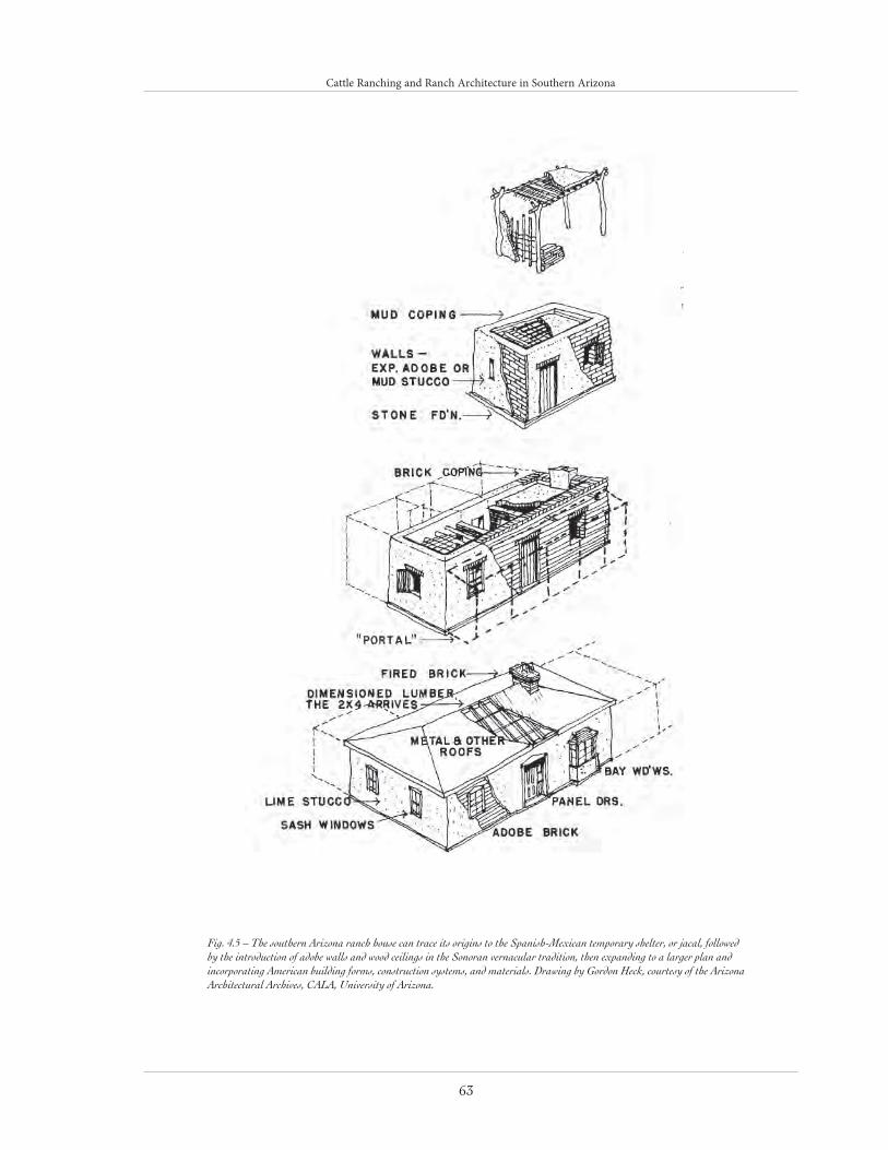
Cattle Ranching and Ranch Architecture in Southern Arizona
63
Fig. 4.5 – The southern Arizona ranch house can trace its origins to the Spanish-Mexican temporary shelter, or jacal, followed by the introduction of adobe walls and wood ceilings in the Sonoran vernacular tradition, then expanding to a larger plan and incorporating American building forms, construction systems, and materials. Drawing by Gordon Heck, courtesy of the Arizona Architectural Archives, CALA, University of Arizona.

Cattle Ranching and Ranch Architecture in Southern Arizona
64
Pete Kitchen Ranch (1867)
Pete Kitchen began the building of the adobe ranch house in the upper Santa Cruz Valley in 1867. The valley was a principal trail for maraud-ers headed for Mexico. Kitchen needed to create a place that could offer protection to his family, ranch hands, cattle, and hogs.
Of Spanish-Mexican frontier style, the ranch house was built on a hill overlooking a thousand acres of agricultural land (fig. 4.6). The home-stead consisted of four rooms, of which three were contiguous along a north-south axis and the fourth projecting westward from the north end of the house. The walls of the ranch house were twenty-one inches thick providing a good defense against attack. Only the south and central rooms had windows. Floors were of packed earth. The roof was flat with a surrounding parapet three to four feet in height, again offering protection from attacks and also as an outdoor sleeping area.
To the west of the house was a patio formed by the “L” and a wall enclosing a small amount of land. Within the patio was a sixty-foot deep
well. Outbuildings were located outside the patio wall: an adobe bunkhouse, smokehouses, vats for rendering lard, corrals to prevent the beef cattle, horses, and mules from being stampeded during Apache raids, and a commissary where employ-ees could draw supplies.
Kitchen sold the ranch in 1883. Numerous alter-ations have been made since. The greatest change came with additions in 1947. An “L” was added to the northeast to balance the original westward extension. At the same time the southern end of the house was expanded and a long covered porch, or portal, with tiled roof and floor, was added along the eastern façade.
Sierra Bonita Ranch (1872)
On Henry Clay Hooker’s 250,000-acre Sierra Bonita Ranch, begun in 1872, was a fully articu-lated hacienda, elegantly furnished and equipped with modern conveniences but also designed to endure a long siege. The house was U-shaped and built around a long, rectangular courtyard, or patio, with the fourth side was defined by a
Fig. 4.6 – Pete Kitchen Ranch (Por-trero Homestead), 1915, illustrating
the Spanish-Mexican building forms transformed to incorporate
American building traditions. Cour-tesy of Arizona Historical Society/
Tucson (AHS 3646).

Cattle Ranching and Ranch Architecture in Southern Arizona
65
wall beyond which stood numerous outbuildings. Consideration was given to the fact the Sulphur Springs Valley location lay on a trail to Mexico used by the White Mountain and other Apache groups. As a result, the exterior walls of the ranch house were sixteen feet high and twenty inches thick. As a means of defense a parapet surrounded the roofs of the three room blocks. Additionally, according to family tradition, the original openings all faced the patio with access from the outside provided by a gate in the wall of the courtyard. A portal circled three sides of the patio shielding the windows and offering shade. Within the courtyard were a well, windmill, water storage tank, and root cellar. Inside, the house was spacious with each major room having its own fireplace.
Beyond the patio lay a stable, workroom, and storage areas. The stable included skylights, as well as doors opening to the courtyard. Space was provided for the carriages, seventeen horses, box stalls for the stallions, and a tack room.36 A large adobe corral, reportedly capable of holding three thousand head of cattle, was located south-west of the main house. Other corrals, made of adobe and plank wood, held horses. Near the
enclosures was a rarity: a barn built mostly of wood, with a gable roof. To the north stood a large adobe corral for storing hay. There were also paddocks, a gristmill, blacksmith’s shop, a large slaughterhouse, quarters for forty-odd ranch hands, and a half-mile horse track. There were large kitchen gardens irrigated by two wells and an acequia running across the valley. Two large ponds were built to water the herds.
Later American Ranches in the “American” StyleIt was not until the flood of American settlers after the Civil War that any marked change in southern Arizona ranch architecture occurred. With the arrival of the Southern Pacific Railroad by the 1880s, new building materials and imple-ments could be imported. The availability of brick and dimensioned lumber allowed ranches to ignore local traditions and build “American” styled buildings.
San Rafael Ranch (1900)
The ranch house of the 600,000-acre San Rafael Ranch shows the break from the Spanish-
Fig. 4.7 –San Rafael ranch house. Courtesy of Arizona Historical Society/Tucson (AHS 52661)

Cattle Ranching and Ranch Architecture in Southern Arizona
66
Mexican tradition most clearly (fig. 4.7). Built for Colin Cameron in 1900 as primarily a stand-alone building, it exhibits West Indies and French colo-nial origins. This headquarters house, the fourth one built on the ranch, was described at the time of its construction as “the finest ranch house ever seen on a cattle ranch.”37
The exterior showed a strong French colonial influence. Bricks for the exterior walls were fired in kilns built on the property, while the exterior doors and trim were of California redwood. The house is three stories tall, with a full basement elevating the main floor, a dominating hip roof, and a wide veranda wrapping around the entire ground floor. The ranch house served dual-pur-poses—ranch headquarters in the basement and family dwelling above. Entrance was at the east end, opening onto a long hall. Family life centered on the central hall-living room.
In 1909, Cameron sold the ranch to William C. Greene, the copper magnate with mine holdings in Cananea, Mexico. The house became sim-ply a ranch headquarters building. Most of the outbuildings were leveled, leaving only the barn and machine shop. The ranch is now part of the Arizona State Parks system but is not presently open to the public.
Later American Ranches: Hybrid FormsAs was the case with residential construction in urban areas, between the poles of the different architectural idioms described above were a num-ber of hybrid forms that often combined adobe wall construction with hipped roofs that extend-ed over the walls as porches. These hybrids are sometimes referred to as “Territorial” in style, but they are more precisely styles in flux, as many of the ranchers had roots in other places and adapted the traditions they inherited with those of southern Arizona. Examples of these
hybrids include the Faraway Ranch (1888) and the San Bernardino Ranch (1887-88). Ranches such as Canoa (1876) and Empire (1876) evolved over time and reflect the changing architectural forms and stylistic elements of various periods in ranch architecture.38 For detailed discussions of Empire Ranch and Canoa Ranch, see the tour site descriptions.
Faraway Ranch (1888)
Influenced by the arrival of the railroad, the late 1880s saw a developing breakdown of regional style in southern Arizona ranch architecture. A prime example is the Faraway Ranch near Dos Cabezas, southwest of Willcox in the Chiricahua Mountains. Faraway Ranch is a bridge between Spanish-Mexican and 19th century Anglo styles, containing elements of both.
Its ranch house was the first country residence in southern Arizona to have more than a single story. Within it, owner Neil Erickson’s skill as a carpenter and craftsman and the influence of Eastern pattern books and building manuals are apparent in many details. Since dimensioned lumber was now available, wooden door jambs, window sashes, window sills, and cabinetwork were crafted in a fashion reminiscent of those in Eastern dwellings.
The ranch is an historical district within the Chiricahua National Monument.
San Bernardino Ranch (1887-1888)
The original land grant of the San Bernadino Ranch awarded to Lieutenant Ignacio Pérez spanned the present international border, encom-passing 75,000 acres in Cochise County (Arizona) and northeastern portion of Sonora (Mexico). A home and ranch headquarters covered two to three acres, occupying the former site of a Spanish presidio.39 Slaughter bought 65,000 acres of the San Bernardino land grant in 1886. Soon afterwards he erected a small adobe house with

Cattle Ranching and Ranch Architecture in Southern Arizona
67
adjoining stables and outbuildings. The following year these structures were destroyed in an earth-quake felt throughout northern Sonora. The new building complex was built on a rise overlooking the valley (fig. 4.8).
San Bernardino with its massive roof, broad verandas, and interior spaciousness reflects Slaughter’s Louisiana and southern Texas back-ground. A cedar shake roof and a porch that wound around the west, south, and east sides dominated the new main building. The posts were of milled lumber, most likely ordered from a mail-order catalogue. The front door, facing west, opened onto a five-foot wide hallway, which ran the length of the house and divided it into north and south sections, not unlike the “dog-run” houses of Texas. The northern section was the longest with the kitchen at the far end. The Slaughter Ranch was not as defensive as earlier
ranch complexes. The Apache wars had ended in 1886, although problems with bandits remained. All the rooms except the pantry contained win-dows. Doors in the kitchen and at both ends of the hallway opened to the outside.
On the west side behind the house could be found a small stone building for vegetables, meat, and cheeses. Beside it was a stone commissary and general store, and beyond it an adobe bunkhouse for the Mexican ranch hands and quarters for the Chinese cook.40 Nearby was a “dog-run” plan schoolhouse, each section having its own chim-ney. Beyond these immediate structures were barns and granaries, workshops, a blacksmith’s shop, and post office. The ranch included six hundred acres of farmland with ten artesian wells and a large pond, or stock tank. It was a self-con-tained community.
Fig. 4.8 –San Bernardino ranch house. Courtesy of Arizona Historical Society/Tucson (AHS 3805)
Cattle Ranching and Ranch Architecture in Southern Arizona
68
Evidence of the schoolhouse and some of the farther outbuildings no longer exists. The rest remain fairly well intact. The ranch is currently operated as the Johnson Historical Museum of the Southwest and the San Bernardino National Wildlife Refuge.
ConclusionRanch houses were called home by some of the wealthiest and most prominent Arizonans of the late 19th century. They illustrate an unbroken evolutionary chain from the Spanish-Mexican vernacular to the architect-designed ranch house. Between the ranch house that Pete Kitchen built on Potrero Creek in 1867 and the 1935 “Big House” at Canoa (see the tour site description) there existed a world of difference in comfort, security, and refinement.
Cattle ranching spans three hundred years of Arizona history. The sites discussed here reflect only the last half of the period. The large ranches are disappearing. Of the seven described, five are now in public ownership. Pima County holds three additional ranches and is in the process of acquiring another from the City of Tucson.
As unique combinations of vernacular architec-ture and the landscape which that architecture colonized, ranches have played a critical role in the evolution of cultural identity in southern Arizona and in the Southwest generally.
ENDNOTES
1. Most of the information in this section was obtained
from J. J. Wagoner, “History of the Cattle Industry
in Southern Arizona, 1540-1940,” University of Arizona
Bulletin: Social Science Bulletin 23/2 (1952), and William
Collins, “Cattle Ranching in Arizona, 1540-1950,”
National Register of Historic Places Multiple Property
Documentation, unpublished draft (Phoenix: Arizona
State Historic Preservation Office, 2002).
2. The encomienda system entailed tributary labor that was
required of native populations to their Spanish overlords.
3. Wagoner, “History of the Cattle Industry,” 5-7.
4. Herbert E. Bolton, The Padre on Horseback: A Sketch of
Eusebio Francisco Kino (San Francisco: Sonoran Press,
1932), 64.
5. Idem, Kino’s Historical Memoir of Pimeria Alta, 1683–1711,
vol. 2 (Berkeley: University of California Press, 1948).
6. Wagoner, “History of the Cattle Industry,” 7.
7 Ibid., 22.
8. See Henry P. Walker and Don Bufkin, Historic Atlas of
Arizona (Norman: University of Oklahoma Press, 1986),
15, for a comprehensive map of Spanish and Mexican
land grants.
9. Wagoner, “History of the Cattle Industry,” 25.
10. Bernard L. Fontana, Calabasas of the Rio Rico (The
Smoke Signal, 1971), 76, and Wagoner, “History of the
Cattle Industry in Southern Arizona, 1540-1940,” 26.
11. Wagoner, “History of the Cattle Industry,” 27.
12. Idem, “Overstocking of the Ranges in Southern
Arizona during the 1870s and 1880s,” Arizoniana (1961),
28.
13. Wagoner, “History of the Cattle Industry,” 30.
14. Randall H. McGuire, Rancho Punta de Agua (Tucson:
Arizona State Museum Contribution to Highway Salvage
Archaeology No. 45, 1979), 5–10.
15. Richard S. Ciolek-Torrello and Jeffrey A. Homburg,
Cultural Resources Surveys and Overviews of the Rillito River
Drainage Area, Pima County, Arizona (Tucson: Statistical
Research, Inc., 1990), 124.
16. Wagoner, “History of the Cattle Industry,” 34.
17. Ciolek-Torrello and Homburg, Cultural Resources
Surveys and Overviews of the Rillito River Drainage Area, 124.
18. W. C. Eaton, “Frontier Life in Southern Arizona
1858–1861,” Southwestern Historical Quarterly (1933).
19. Jay J. Wagoner, Early Arizona: Prehistory to Civil War
(Tucson: University of Arizona Press, 1975), 169, 468.

Cattle Ranching and Ranch Architecture in Southern Arizona
69
20. Patricia Stein, “Historical Resources of the Northern
Tucson Basin,” in The Northern Tucson Basin Survey: Research
Direction and Background Studies, ed. John H. Madsen, Paul
R. Fish, and Suzanne K. Fish (Tucson: Arizona State
Museum Archaeological Series 182, 1993), 36.
21. Wagoner, “History of the Cattle I ndustry,” 36–37.
22. Stein, “Historical Resources of the Northern Tucson
Basin,” 36.
23. Bert Haskett, “Early History of the Cattle Ranching
Industry in Arizona,” Arizona Historical Review (1935), and
Bruce A. Jones and Richard Ciolek-Torrello, Caverns,
Quarries, and Campsites: Land Use among the Prehistoric and
Historic Occupants of Colossal Cave Preservation Park, Pima
County, Arizona (Tucson: Statistical Research, Inc., 1991),
46.
24. Wagoner, “History of the Cattle Industry,” 41–46.
25. Ibid., 50.
26. Jones and Ciolek-Torrello, Caverns, Quarries, and
Campsites, 46.
27. Ibid., 47.
28. Wagoner, “History of the Cattle Industry,” 56–62.
29. Raphael Pumpelly, Across America and Asia (New York:
Leypolt and Holt, 1870), 7; quoted in Wagoner, “History
of the Cattle Industry,” 32.
30. Gordon, 10th Census, 95; quoted in Wagoner,
“History of the Cattle Industry,” 41.
31. With drastic losses facing them, a group of cattlemen
headed by Dan Ming met at Willcox to prey for rain
as a general air of discouragement fell upon the territo-
ry. Will C. Barnes, “Cowpunching Forty Years Ago,”
(address before the Twenty-fifth Annual Convention of
the Arizona Cattle Growers’ Association), Weekly Market
Report and News Letter, 10/6 (February 10, 1931); quoted in
Wagoner, “History of the Cattle Industry,”45.
32. Wagoner, “History of the Cattle Industry,”47–48.
33. Most of the information in this section was obtained
from Janet Stewart, Arizona Ranch Houses: Southern
Territorial Styles, 1867-1900, Historical Monograph 2,
ed. John Bret Harte (Tucson: The Arizona Historical
Society, 1974).
34. Collins, “Cattle Ranching in Arizona,” 84, 88.
35. Ibid., 86-87.
36. Jessie P. Hooker, letter to Stewart (February 3,
1969); quoted in Stewart, Arizona Ranch Houses, 37.
37. The Arizona Republican (November 10, 1900).
38. Collins, “Cattle Ranching in Arizona,” 72.
39. Rex C. Gerald, Spanish Presidios of the Late Eighteenth
Century (Santa Fe: Museum of New Mexico, 1968), 14,
21, drawing on 29; quoted in Stewart, Arizona Ranch
Houses, 65.
40. Ben Williams, letter to Stewart (July 23, 1968), quot-
ed in Stewart, Arizona Ranch Houses, 71.
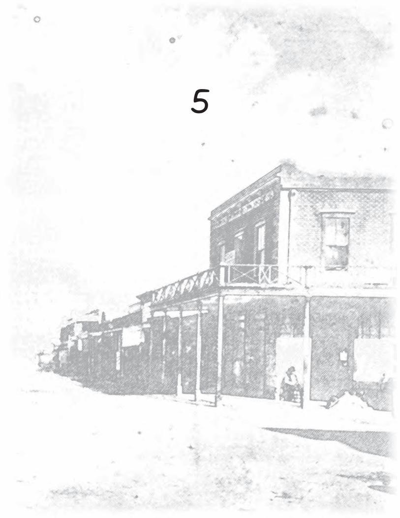
70
5
71
At the time of the Gadsden Purchase in 1853-1854, min-ing was quickly becoming a major part of economic activity in the newly acquired part of Arizona south of the Gila River (fig. 5.1). Mining had a long history in the area beginning in the Spanish period and valuable minerals became an increasing draw for enterprising individuals who wanted to “strike it rich.”
One of the earliest silver bonanzas discovered was at Arizonac in northern Sonora near the present town of Nogales in 1736. Large slabs or chunks of silver were found on or near the surface. This fortuitous find was an impetus to other prospecting activities and mine development throughout the region.1
In 1783, a Spanish Royal Ordinance promulgated changes to the 1584 Royal Ordinance that had set out rules for mining in the New World. Among other provisions, the 1783 rules required the posting of a mining claim notice, a practice continued in the U.S. mining law of 1872, which is still in force today.2
Several areas of southern Arizona were mined, often sporadical-ly, during the 1700s. Among these were locations in the Santa Rita Mountains south of Tucson; the Guevavi area near Nogales, Arizona; and the Arivaca area southwest of Tucson. These miner-al-rich sites were actively exploited before the Pima Revolt of 1751, but the precise locations of most of the mines is currently unknown. Most evidence of this early, small-scale mining effort was undoubt-edly destroyed by later mining.3
The 1751 revolt by the indigenous population against the Spaniards led to a slow-down in mining activity in southern Arizona. Sporadic mining activities resumed in the 1760s and 1770s, although there was probably some prospecting and ore removal continuing from the 1750s. After the mid-1760s, Apache raiding parties increasingly
MINING AND MINING TOWNS IN SOUTHERN ARIZONA
James E. Ayres
and Janet H. Parkhurst

Mining and Mining Towns in Southern Arizona
72
hindered mining at sites away from the centers of population. Placer deposits also were exploited during the eighteenth century. Quijotoa and the Babocomarí Valley, now the Altar Valley, were being mined in 1774 and 1777, respectively.4
In the early years of the 19th century, efforts were rekindled at many of the productive 18th-century mines. With the demise of the Spanish govern-ment in Mexico and the birth of the Mexican Republic in 1821, however, mining in what is now southern Arizona seems to have nearly ceased. There are several reasons for this state of affairs, including the near disintegration of the Mexican national government after 1821, increased Apache raids, and related difficulties with supply and communications from the south.5
During the 1840s, a few military and govern-ment-sponsored expeditions from the United States passed through what later became the Gadsden Purchase. For the first time, Americans
obtained an in-depth overview of northern Sonora, its people, mineral resources, economy, and problems. In 1848, the California gold rush caught the world’s attention, and, not surprising-ly, what is now southern Arizona became a pre-ferred route to the gold fields for many easterners and southerners.6
In 1853 and 1854, the Gadsden Purchase Treaty was negotiated and ratified between the United States and Mexico. The United States acquired 29,640 square miles south of the Gila River in this transaction. With this important acquisition came renewed interest in the mineral resources of the region. Even before negotiations for the Purchase were concluded, a few adventuresome souls had moved into the area from the United States in search of silver and gold.
After the Purchase was concluded, two important parties of explorers arrived, both from California. One, the Arizona Mining and Trading Company,
Fig. 5.1 – Mining Towns in Southern Arizona. Courtesy of Desert Archaeology Inc.

Mining and Mining Towns in Southern Arizona
73
was organized in 1854; the other, the Sonora Exploring and Mining Company, was created in 1856. These companies represented the first organized American mining enterprise in the Purchase. The lack of water, the costs of ship-ping ore to be processed, and ultimately the low quality of the ore brought an end to these mining operations.7
The late 1850s was a boom period for mine exploration and development, but the Civil War brought this exuberance to a quick end. With most of the U.S. Army moving east, the Apache were able to increase their raids. Ultimately, many of southern Arizona’s mines, ranches, and small communities had to be abandoned because of them.
In 1863, the Territory of Arizona was organized, and new rules for mining were created by the legislature. Many of these rules resembled those of the Spanish Royal Ordinance of 1783. In 1864, the Cerro Colorado Mining District, the first of its kind in southern Arizona, was created.8
When the first federal law relating to mining was passed in 1866, Arizona replaced its 1864 law with a revised law shortly afterwards. These laws established rules for mining generally and, more specifically, for claim location, time to develop a mine, and the process for gaining title to the claim.9
When the Civil War ended in 1865, Arizona mining was in a shambles, but the influx of war veterans and the earlier return of the U.S. Army gradually brought life back to the territory. Over the next 20 years, 15 army posts were established, as was the reservation system for managing the Native American population. As a result, prospecting and mine development flourished and expanded to levels previously only dreamed about.
The absence of an efficient transportation system to the outside world, other than the stage and
freight lines, kept mining somewhat in check until construction of the first railroad across Arizona in 1877-1880. The Southern Pacific Railroad allowed easier outside access; enabled the shipment of large mining machinery, related equipment, and supplies into southern Arizona; and provided a means to ship raw ore, or par-tially processed ore, to smelters elsewhere in the country. Tucson, because of its central location and the development of railroad facilities, quickly became the center from which equipment and goods were shipped to outlying mines.
Successful mines established before the arrival of the railroad were able to expand operations, acquire new and larger-scale technologies, and more quickly get a product to market. This is true even though most of the mines were not adjacent to the railroad; indeed, some were many miles from it. The construction of a second railroad, the New Mexico and Arizona Railroad, from Benson on the Southern Pacific Railroad southwest to Nogales on the Mexican border, in 1882 opened up further opportunities for mines in southern Arizona.10
From the 1870s to about World War I, tens of thousands of mine claims were located across southern Arizona, and thousands of mines were developed or redeveloped. Some of these were mineral deposits that had been discovered and worked by Spaniards and Mexicans. Among the best known were mines at Harshaw, Arivaca, Greaterville, Quijotoa, Mowry, Oro Blanco, Ajo, Twin Buttes, Silver Bell, Gunsight, Tombstone, Bisbee, Empire, Mammoth, Rosemont, Helvetia, and the Sierritas. Very few mines were worked continuously for extended periods. Most would prosper until the rich ore played out or the limit-ed capital was expended. Then, after a period of time—and with new capital, new technologies, or new owners, or all three—work would begin anew, only to repeat the process eventually.

Mining and Mining Towns in Southern Arizona
74
The long-term trend in mining in southern Arizona can be characterized by increasing con-solidation and concentration of holdings by fewer and fewer companies and thus by larger-scaled operations, the use of more heavy equipment and machinery, the mining of lower quality ore, and a reduction in the numbers of people in the work force.
For the most part, the mines were located in the approximately 25 major isolated mountain ranges within the basin and range physiographic prov-ince of southern Arizona. The mines were includ-ed within a few dozen mining districts throughout the area; there were 22 districts in Pima County alone. The districts had well-defined boundaries and were created under the requirements of state and federal laws.11
It is impossible, as well as unnecessary, to men-tion all of the important and largely successful mines of the late 19th and 20th centuries in south-ern Arizona. Instead, three of the large, success-ful, long-lived mining operations in the area, Ajo, Tombstone, Bisbee and Warren will be highlight-ed. In addition to their historical development, the cultural features of these communities will be discussed.
In Hard Places, cultural geographer Richard V. Francaviglia portrays mining landscapes as truly distinctive cultural landscapes: “hard places” with features like unfamiliar building types and vast open-pits that speak of environmental abuse, pragmatism, and exploitation.12 Ajo, Tombstone, Bisbee, and Warren, Arizona can thus be studied as cultural landscapes. The visual character of each historic mining district is determined by its site, layout, and architecture, plus the legacy of distinct processes described by Francaviglia: dif-ferentiation, stratification, and homogenization.
The mining landscapes in question lie within or near low, desert scrub-clad mountains of south-ern Arizona. Ajo, Tombstone, and Warren occu-
py relatively flat sites while Bisbee is located in steep mountainous terrain. All four show variable degrees of land modification caused by mining activity. While Tombstone’s underground mines which tunnel beneath mountains are less visible, the huge open-pit copper mines, leach dumps, and tailing ponds of the Warren and Ajo mining districts make an enormous visual impact. The layout or the street pattern and property parcel arrangement of each community varies great-ly, principally due to topography and historic ownership (fig. 5.2). Architecture comprises the “built environment” - the buildings, structures, and objects - in these mining landscapes. Boldly profiled industrial architecture, impressive com-mercial and institutional buildings, as well as a hierarchy of residential types are found to a greater or lesser degree in each community.
According to Francaviglia, mining landscapes are the result of several processes that help give them a distinctive look. One process, differentia-tion, is a geographic expression of technological, economic, and social factors seen in land use patterns. Industry is the dominant factor and the community serves it. Stratification, the pro-cess by which people are divided into classes or social strata, is seen especially in the location of residences and the hierarchy of housing types. Homogenization is the tendency to standardize building under single mining company owner-ship with the result of greater visual uniformity.13 These processes can be applied, to a greater or lesser extent, to the four mining communities to be profiled.
AjoLying in the Little Ajo Mountains, the copper mines of Ajo are located in western Pima County about 129 miles west of Tucson. As mentioned, the Ajo Mining District deposits were worked on a small scale in the 18th century and later, at the ratification of the Gadsden Purchase Treaty,

Mining and Mining Towns in Southern Arizona
75
by Peter R. Brady and his party. Brady’s compa-ny, the Arizona Mining and Trading Company, was the first incorporated mining company in
Arizona. When the rich and easily obtainable ore was played out, the venture came to an end.14
The mines remained quiet for the next 40 years or so, although other mines were being developed
in the general area after about 1870. Limited mining occurred in the Ajo area in the 1890s, and in 1908, the Randall Mines Co. took over the mines.15 In 1910, John C. Greenway became the general manager of the Calumet and Arizona Mining Company; he opened the New Cornelia open pit mine in 1917 (fig. 5.3).16
The first shipment of electrolytic copper was made in 1918. After World War I, the com-pany was hard pressed to keep operating, primarily because the price of copper had declined. To survive, the New Cornelia, which had been partially owned by the Calumet and Arizona company after 1911, became wholly owned by it in 1929. This company in turn merged with Phelps Dodge in 1931. The Great Depression led to a suspension of work in 1932. Work resumed in 1934, and the mine operated continuously until its closure in 1985.17
Ajo has a unique layout and architecture and is an excellent example of the processes of differ-entiation, stratification, and homogenization described by Francaviglia. There is no doubt that mining built this town, once the nation’s third largest producer of copper, given the inescapable presence of the enormous pit, slag heaps, smelter, tailing ponds, and cluster of corrugated metal buildings. A consider-able support community, eventually having a population of around 6,000, was required to extract and process its copper ore.18 A 1964 aerial photograph illustrates striking land use differentiation within a small area in the Ajo District (fig. 5.4).
Fig. 5.2 – Comparison of mining town layouts: Tombstone, a standard gridiron plan; Bisbee, an organic plan; and Warren, a professionally designed plan based on the City Beautiful movement. Courtesy of Desert Archaeology after Janet Parkhurst.

Mining and Mining Towns in Southern Arizona
76
Fig. 5.4 - Ajo Pit, Phelps Dodge Co.,1964. This oblique aerial illustrates differentiation in a mining landscape. Courtesy of Arizona Historical Society/Tucson (AHS 41332)
Fig. 5.3 - New Cornelia Mine Smelter, Ajo, Arizona. Courtesy of Arizona Historical Society/Tucson Tucson (BN 204416)

Mining and Mining Towns in Southern Arizona
77
Ajo was a “model company town,” a type of widely-publicized industrial community that developed through enlightened planning and socially responsible town management, serving as a model by example. Around 1914, Minnesota architects William M. Kenyon and Maurice F. Maine designed a community zoned into discrete sections including the mine and socially stratified “American Townsite,” “Mexican Townsite,” and “Indian Townsite.” (The latter two were demol-ished for expansion of the pit). Exemplifying homogenization, American Townsite included a radial, symmetrical, City Beautiful street layout and adoption of Spanish Colonial Revival style for the major buildings and houses. (Phelps Dodge also built hundreds of less inspiring, uni-form residences in later Ajo subdivisions.) Social stratification in American Townsite, today a National Register district, occurred in an obvious hierarchy of housing types. Large, architect-de-signed, hilltop residences once built for the gener-
al manager and mine superintendent symbolically overlooked the mine and town. Similar but less pretentious residences once housing foremen, etc. appeared in the level splayed plat. The balance of houses, lower in quality and in less desirable locations, once served the miners themselves.19
TombstoneOne of the most famous of Arizona’s silver min-ing locales is the Tombstone Mining District in the Tombstone Hills in Cochise County. In addi-tion to its productive silver mines in the late 19th century, much of its notoriety stems from the feud between the Earps and Doc Holliday and the Clantons and McLowerys and the subsequent shoot-out at the OK Corral 1881.20
Tombstone began with the location of a silver claim by Edward Schiefflin in 1877 (fig. 5.5). In 1878, Schiefflin, with his brother Al and Richard Gird, located additional claims, includ-
Fig. 5.5 - Grand Central Mill & Mining Co., 1881, showing Tombstone’s mining origins. Courtesy of Arizona Historical Society/Tucson (AHS 42005)

Mining and Mining Towns in Southern Arizona
78
ing the famous Toughnut, Lucky Cuss, and Goodenough.21
The Tombstone townsite was laid out in 1879 about a mile from Schiefflin’s camp and was incorporated and made the seat of Cochise County in 1881. At that time, the population had skyrocketed to about 7,000, approximately the same size as Tucson. The camp enjoyed about 10 years of very active and productive life before the onset of a slow decline.22
In the 1880s, problems with flooding in the mines began to occur. In 1886-1887, the surface works of the Grand Central and Contention mines burned, causing their massive pumping opera-tions to come to a halt. As a result, much of the mining in the district came to a close, because the richest ore was below water.23 In 1901, several mines were combined to form the Tombstone Consolidated Mine Company (fig. 5.6), which made another effort to pump water out of the mines. By 1903, as much as 4,200,000 gallons were being pumped daily.24
Additional pumping problems occurred in 1907. In 1909, because of an accident, the pumps failed in the main mines. Despite attempts to solve the water crisis, Tombstone Consolidated was forced
to declare bankruptcy in 1911, and its holdings were sold to Phelps Dodge in 1914.25
Phelps Dodge tried to restart the mines, but gave up in 1918. Small-scale sporadic mining, mostly by lessees, has taken place in the Tombstone dis-trict ever since.26
Unlike the other towns under discussion, Tombstone doesn’t “read” as an obvious part of a mining landscape but it can be studied for its layout and its architecture. Tombstone Townsite (1880) and its 19th-century subdivisions had a simple surveyor-designed grid plan (fig. 5.2). Fostering extraordinary land speculation, the grid was a natural choice for such a location in spite of several major washes and rather hilly terrain. This vernacular platting tradition was imported to territorial Arizona by settlers famil-iar with its “principles” from other parts of the United States.27
The former silver mining boomtown is well known today as a tourist town that has capi-talized on its bawdy, violent, frontier-outpost history. Visitors viewing a restored OK Corral and an array of false-front buildings with showy signs and fake porches on Allen Street learn rel-atively little of Tombstone’s mining history. The
Fig. 5.6 – Tombstone Consol-idated Mining & Milling Co., Tombstone, Arizona, 1908. Courtesy of Arizona Historical Society/Tucson (AHS 28306)

Mining and Mining Towns in Southern Arizona
79
commercial core, a six-block district, has been re-created to represent the 1880s, a preservation interpretation based on myth generated by com-mercialism (fig. 5.7).28 Tombstone does feature several institutional buildings that have been preserved properly: e.g., the two-story, brick City Hall, the Courthouse, and St. Paul’s Episcopal Church. In addition, it has a zone of historic residences with a good representation of Anglo-American vernacular types, many of which are built of adobe.
BisbeeThe towns of Bisbee and Warren both lie in the Warren Mining District in the Mule Mountains in Cochise County. Silver deposits were first discovered here in 1877, and a mining camp was established in the summer of 1880 at the confluence of Tombstone Canyon and what later
became known as Brewery Gulch. Silver quickly became of secondary interest when huge deposits of copper ore were discovered.29
The famous Copper Queen Mining Company was incorporated in 1881, and its mine, the Copper Queen, became the leading mining operation in Bisbee for many decades.30 The Copper Queen was acquired by the Phelps Dodge Corporation in 1884, and gradually the company was able to acquire other important mining properties in the area.31
In the late 1880s, Bisbee had a population of about 500; by 1900, it had increased to about 6,000 persons. The community expanded up both sides of every adjacent canyon to create a very high-density environment, with the main com-mercial section located at the mouth of Brewery Gulch.32
Fig. 5.7 - Tombstone, 1881. A view of Allen Street, Tombstone’s main commercial district. Courtesy of Arizona Historical Society/Tucson (AHS 60672)

Mining and Mining Towns in Southern Arizona
80
In 1901, the Calumet and Arizona Mining Company was organized. This company, which owned over 170 claims, quickly became a serious rival of the Copper Queen. In 1927, miners in its Campbell shaft hit the largest mass of copper ore ever found in Bisbee.33 The Copper Queen com-pany merged with the Calumet and Arizona firm in 1931 and thus acquired most of the important mining properties it did not already own.
World War II gave new life to Bisbee mining, which continued more or less unabated until 1975, when mining in the Lavender Pit ceased.34
Bisbee is noteworthy for its striking site, layout, and architecture and how it historically exempli-fied stratification. The Warren Mining District produced its minerals from a sizeable ore-bear-ing tract of land that resulted in two joined, terraced, open-pit projects, the Sacramento Hill Pit (fig. 5.8), begun in 1917, and the much larger scale Lavender Pit, begun in 1952. Part of this once prolific district and located near the pit, Old Bisbee today is the highest, most historic of eleven distinct but related settlements. At an
average elevation of 5,300 feet, Bisbee includes most features of a prosperous, early 20th-century, Anglo-American mining hill town representing Arizona’s late territorial years and the Depression era.35
Site topography strongly influenced the layout of Bisbee, a community that developed organ-ically on and within the slopes of narrow can-yons forming clefts in the Mule Mountains (fig. 5.9). The terracing used to construct the pits also characterizes the hillsides of the residential settlement. Because of the steepness of its site, Bisbee has features like retaining walls, stairs, bridges, and flood channels among its prominent infrastructure. Along with sidewalks and road paving projects, many of these features were built as part of the WPA 1938 Bisbee Campaign. In Bisbee’s distinct, socially stratified neighbor-hoods, strong ethnic or class identities became associated with topography through the names given to certain hills or canyons. While company management clustered on prominent hillside or hilltop locations with names like Quality Hill, smaller, simpler housing for mine workers was
Fig. 5.8 Sacramento Pit, Bisbee, c.1890. Courtesy of Arizona Historical Society/Tucson (AHS 496)

Mining and Mining Towns in Southern Arizona
81
found in modest neighborhoods in less desirable locations.36
Near the pits, abandoned although imposing industrial structures of reinforced concrete, wood, and corrugated metal still stand. In Old Bisbee, densely-concentrated, contiguous com-mercial buildings in a National Register district around Tombstone Canyon abut several nar-row streets, principally Main Street and lower Brewery Gulch. Interspersed on prominent sites among the business blocks are several, institu-tional buildings that house much of the commu-nity’s governmental, educational and religious activity.37 The bulk of Bisbee’s residential devel-opment, mostly vernacular, covers an area adja-cent to and many times larger than the commer-cial core district.38
WarrenLocated on the upper reaches of a broad, gently sloping, alluvial fan southeast of the Lavender Pit Mine and the town of Bisbee, Warren is noteworthy for its historic layout and residen-tial uniformity based on City Beautiful prin-ciples. Although short-lived, this early twenti-eth-century movement had a strong influence on the direction of urban planning in the United States. In January 1906, under the auspices of the Calumet and Arizona Mining Company, the Warren Realty and Development Co. hired the team of Warren H. Manning, a nationally famous landscape architect and city planner, to design the townsite plan, buildings, and houses. Manning drew up a City Beautiful plan that was both axial and formal, with radiating and diago-
Fig. 5.9 - Bird’s-eye view of Bisbee illustrating how Old Bisbee is a hilltown built on terraces. Courtesy of Arizona Historical Society/Tucson (AHS 56124)

Mining and Mining Towns in Southern Arizona
82
nal boulevards providing distant views or closed by an architectural focal point. Apparently, the radial layout of Washington D.C., recently refur-bished under City Beautiful guidelines, provided the inspiration for this distant town set in the Arizona desert. As a stylistic theme chosen for the townsite, the Bungalow contributed to the concept of architectural unity, a basic tenet of the City Beautiful ideal.39
On a relatively open site, professionally-planned Warren (fig. 5.2) is a marked contrast to the nearby hilltown of Bisbee which is congested and was haphazardly developed. Warren features a long Vista Park flanked on either side by wide, tree-lined boulevards, spacious lots and a pre-dominance of California Bungalows (fig. 5.10). Originally built in an idyllic setting with pan-oramic views of the Mule Mountains and natural desert features, the community is now dwarfed to
Fig. 5.10 – Warren, row of trees in front of bungalows along Vista Park showing
City Beautiful planning, 2004. Courtesy of Janet Parkhurst
Fig. 5.11 – Warren, Arthur Douglas House at upper end
of Vista park with leach dump behind, 2004. Courtesy of
Janet Parkhurst

Mining and Mining Towns in Southern Arizona
83
its north by the rise of Leach Dump No. 7 (fig. 5.11), one of the most impressive topographic features in the Warren Mining District.40
Summary
In sum, Ajo, Tombstone, Bisbee, and Warren, Arizona, are communities that are integral parts of mining cultural landscapes, each with a dis-tinctive site, layout, and architecture tempered by historic processes that determined land use, residential location, standardization of structures, and so forth. The integrity of Ajo, Bisbee, and Warren as historic cultural landscapes remains strong while Tombstone has practically lost its mining community identity.
ENDNOTES
1. James E. Officer, “Mining in Hispanic Arizona: Myth
and Reality,” in History of Mining in Arizona, ed. J. Michael
Canty and Michael N. Greeley (Tucson: Mining Club of
the Southwest Foundation, 1991), 2: 5.
2. John C. Lacy, “Early History of Mining in Arizona.
Acquisition of Mineral Rights 1539-1866,” in History
of Mining in Arizona, ed. J. Michael Canty and Michael
N. Greeley (Tucson: Mining Club of the Southwest
Foundation, 1987), 1: 5.
3. Officer, “Mining in Hispanic Arizona, “ 5.
4. Ibid., 5-6. David D. Rabb and Clement K. Chase,
“History of Mineral Processing in Arizona,” in History
of Mining in Arizona, 1: 179. Kieran McCarty, Desert
Documentary. The Spanish Years, 1767-1821, Historical
Monograph No. 4 (Tucson: Arizona Historical Society,
1976), 32.
5. McCarty, Desert Documentary, 86; Officer, “Mining in
Hispanic Arizona,” 2: 7.
6. James E. Officer, Hispanic Arizona, 1536-1856 (Tucson:
University of Arizona Press, 1987), 219, 243-45.
7. Ibid., 279; Lacy, “Early History of Mining in Arizona,”
1: 6. Michael N. Greeley, “The Early Influence of Mining
in Arizona,” in History of Mining in Arizona, 1: 15-16.
8. Lacy, “Early History of Mining in Arizona,” 1: 7-10.
9. Ibid., 10.
10. David F. Myrick, Railroads of Arizona, Volume I: The
Southern Roads (Berkeley: Howell-North Books, 1975),
264-69.
11. Stanton B. Keith, Index of Mining Properties in Pima
County, Arizona, Bulletin 189, The Arizona Bureau of
Mines (Tucson: University of Arizona, 1974), 8-9.
12. Richard V. Francaviglia, Hard Places. Reading the
Landscape of America’ Historic Mining Districts (Iowa City:
University of Iowa Press, 1991).
13. Ibid., 66, 99, 116.
14. Workers of the Writers’ Program (compilers), The
WPA Guide to 1930s Arizona(Tucson: University of Arizona
Press, 1989), 50, 90. Keith, Index of Mining Properties in
Pima County, 8-9.
15. Myrick, Railroads of Arizona, 1: 398.
16. Ibid., 398, 403.
17. Myrick, Railroads of Arizona, 1: 409-414; Keith, Index
of Mining Properties in Pima County, 9; Tucson-Pima Public
Library Infoline (16 Oct 2004).
16 Lynn Bailey, Bisbee: Queen of the Copper Camps (Tucson:
Westernlore Press, 1983), 11-20.
17 Ibid., 26.
18. Janet H. Parkhurst, “Ajo Townsite Historic District,”
National Register Nomination (October 2001), sec. 7: 1.
18. Janet H. Parkhurst, “Ajo Townsite Historic District,”
National Register Nomination (October 2001), sec. 7: 1.
19. Ibid., sec. 8: 1, 37.
20. Workers of the Writers’ Program, The WPA Guide to
1930s Arizona, 244
21. Myrick, Railroads of Arizona, 1: 443
22. Workers of the Writers’ Program, The WPA Guide to
1930s Arizona, 244.
23. Ibid. 245.
24. Myrick, Railroads of Arizona, 1: 455.

Mining and Mining Towns in Southern Arizona
84
25. Ibid., 1: 457-458; Workers of the Writers’ Program,
The WPA Guide to 1930s Arizona, 245.
26. Myrick, Railroads of Arizona, 1: 462.
27. Johns & Strittmatter Inc., “Historic Resources
Inventory and Report of Tombstone, Arizona,” Report for
the Arizona State Historic Preservation Office, Arizona
State Parks, (Phoenix, June 1996), chap. 2: 4.
28. Francaviglia, Hard Places, 177-178.
29 Lynn Bailey, Bisbee: Queen of the Copper Camps (Tucson:
Westernlore Press, 1983), 11-20.
30. Ibid., 26.
31. Myrick, Railroads of Arizona, 1: 177; Bailey, Bisbee:
Queen of the Copper Camps, 25.
32. Bailey, Bisbee: Queen of the Copper Camps, 55, 73-74.
33. Ibid., 42, 45.
34. Ben T. Traywick, Bisbee is the Name (Tombstone: Red
Marie’s Bookstore, 1988), 17. Myrick, Railroads of Arizona,
1: 252.
35. Harris Sobin, “Old Bisbee Historical Residential
District, Cochise County, Arizona,” National Register
Nomination (Draft) (September 2004), sec. 7: 1, sec 8:
11.
36. Ibid., sec. 7: 2, 3, 7.
37. Marjorie H. Wilson, Janet Stewart, James Garrison,
Billy G. Garrett, and Thomas S. Rothweiler, “Bisbee
Historic District,” National Register Nomination (1980),
sec. 7: 1.
38. Sobin, “Old Bisbee Historical Residential District,”
sec. 7: 8, 9.
39. Woodward Architectural Group, “Warren: The City
Beautiful,” Historic Resources Inventory and Report
(1993), 25, 27.
40. Francaviglia, Hard Places, 22, 24.

Mining and Mining Towns in Southern Arizona
85

86
6

87
Both before and after World War I (1914-1918), Americans suffering from respiratory diseases, and in particular, tuberculosis, came to Arizona and Tucson for treatment in its dry, warm climate, building Tucson’s reputation as a destination for “health seekers.” The rush of people with respiratory ailments, known as “lungers,” was accommodated by sites throughout Tucson known
as “tent cities.” Because lungers were feared, they were prevented from renting accommodations in town; that, in turn, led to zoning and building regulations that increased ventilation and restricted the amount of land which a house could occupy, all in attempts to prevent the spread of disease.
Tucson, and the West in general, was also a destination for tourists seeking to discover the exotic landscape and culture that they had only read about before. Personal travel, now dominated by the automobile, increased tremendously after World War I. Tourism operators, such as the Harvey Hotel Company, catered to those in search of the exotic quality of the Southwest and used its unfa-miliar architecture as a vehicle to promote a romanticized image. Just as the eastern states had selected historic references in the use of English Colonial Revival styles beginning in the 19th cen-tury, promoters and architects in the West extracted architectural characteristics from previous cultures to produce romanticized revival styles for this region. This romantic revival movement was crystallized in and disseminated by the 1915 Panama-California Exposition in San Diego, whose buildings (in today’s Balboa Park), designed by Bertrand Goodhue, Richard Requa, and others pro-moted the Spanish Colonial Revival style as an appropriate regional architectural expression. Other architects, including Mary Colter and John Gaw Meem, defined similarly romantic expressions for other regions of the Southwest. The Exposition also marks a shift
20TH-CENTURY RESIDENTIAL LANDSCAPES
R. Brooks Jeffery

20th-Century Residential Landscapes
88
in Tucson’s cultural and architectural inspiration from the East and Midwest to California (fig. 6.1).
Up until 1920, Tucson was the largest and most important set-tlement in Arizona due to its dominance in the five “C’s” of the Arizona economy: copper, cattle, cotton, citrus, and climate. Now a health destination for the ailing, Tucson had to change its negative image to attract new residents, businesses, and the economic pros-perity associated with them. In 1922, the Tucson Sunshine Climate Club was formed to promote the attractions of southern Arizona for the benefit of local merchants and hotelkeepers. Tourism and boosterism became an important factor in the growth and prosper-ity of Tucson and soon were represented by the phenomenon of winter visitors.
Fig. 6.1 – Architectural styles such as the Spanish Colonial Revival and the Pueblo Revival were used in the 1920s and 1930s to associate new subdivision developments with a romanticized image of the area’s Hispanic heritage. Courtesy of R. Brooks
Jeffery

20th-Century Residential Landscapes
89
Subdivision development in Tucson, outside the city limits, was ram-pant (fig. 6.2). The original 1872 grid street pattern expanded to the north and east, away from the original townsite, with the University as a primary destination for urban growth. Transportation had an increasing impact on growth and subdivision development in Tucson. Developments previously outside the perceived limits of the town were becoming not only accessible but desirable as an escape from the growing automobile congestion of the urbanized center. During the boom years of the 1920s, great portions of the desert were subdivided in anticipation of continuing high demand for residential subdivisions. Winter visitors often bought second homes in Tucson in many of these exclusive subdivisions. By the mid-1930s, the 1929 stock market crash had put the real estate market into a tailspin except for the very wealthy, who continued to come to Tucson.
Fig. 6.2 – Plan of Tucson, c1925. By the end of the 1920s, Tucson’s suburban residen-tial development spread east and north of downtown, encompassing the University of Arizona, while the subdivision layouts continued the gridiron patterns established by the original township map of 1872. Courtesy of the Arizona Architectural Archives, CALA, University of Arizona.

20th-Century Residential Landscapes
90
The orthogonal grid, formerly associated with equitable land distribution, now became associat-ed with middle class living standards, with small lots and equally small houses, some as small as 900 square feet. Beginning in 1915, subdivisions were developed with deed restrictions intended to ensure property values through exclusivity. As a way of distinguishing affluent neighbor-hoods from those of the middle class, alternatives to the gridiron subdivision layout were intro-duced by California developers and architects. In 1928 alone, three innovative subdivisions were planned that began to attract the affluent to Tucson: El Encanto Estates, Colonia Solana, and the Catalina Foothills Estates (see tour site descriptions).
Each of these subdivisions was designed to provide a unique environment and became a model for subsequent subdivision development. Although unique, each subdivision incorporated common elements: curvilinear street patterns in direct contrast to the existing gridiron standard, protection of the existing landscape and its use as a marketing tool, promotion of a romantic image of Tucson’s relationship to its Spanish heritage, and deed restrictions which controlled home-ownership, minimum construction costs, and the architectural expression of individual residences. In a city where new residents arrived constantly, land and houses increasingly became speculative commodities, bought and sold as the promise of future growth increased their value. Real estate entrepreneurs purchased large tracts of land, developed services, built houses without specific clients, and sold them with a marketing strategy associating the architecture with an ideal image of Tucson.
In these subdivision developments a supervi-sory architect was hired to oversee adherence to architectural control standards. Residential architects and builders during this time contin-ued to promote revivalist architectural styles,
especially the Spanish Colonial, Mission, and Pueblo revival styles. These styles all portrayed traditions external to Tucson’s cultural heritage, but were nonetheless accepted as examples of a generic Southwestern architectural vocabulary dictating the architectural expression of Tucson’s residential architecture.
The attached, screened sleeping porches of the previous generation of houses were built into the new house forms as exterior living rooms and became referred to as “Arizona rooms.” The mid-1930s also brought the introduction of mechanical cooling systems to Tucson. Houses were retrofitted with evaporative, or swamp, coolers which added humidity and thus lowered the temperature during the dry summer months, although many residents continued to sleep out-doors or on sleeping porches. These innovations, especially as they continued to be refined, result-ed in a lower number of residents leaving Tucson during the summer and depressed the market for compact houses, which coincided with subdivi-sion developments encouraging larger, rambling house plans. The impact of the automobile on our culture also elevated the visibility of the garage from that of a detached shed facing the back alley to that of an attached and integral piece of the overall street facade composition.
After World War II, Tucson was marked by new economic and political factors which began to determine the appearance of Tucson’s residential built environment. The war and Tucson’s Davis-Monthan airbase introduced to the city thou-sands of men who, in their desire to start a new life after the war, returned to Tucson as perma-nent residents. People flooded into Tucson, and Arizona generally, for its warm climate, inexpen-sive living, and new employment opportunities.
Urban development during the late 1940s rapidly extended beyond the corporate limits of Tucson. Subdivisions prematurely platted in the 1920s north and east of the urban core were now con-

20th-Century Residential Landscapes
91
sumed by expansive growth. The restrictions on building during the war had left a profound hous-ing shortage, which, combined with an exploding population, made Tucson a haven for land devel-opers, real estate agents, architects, and builders who flocked to its growth industry, construction.
As in earlier periods, new centers of development drew the population away from the city core (fig. 6.3). Low-density, semi-rural housing, the absence of city taxes, and relaxed county building standards encouraged continued development beyond the perceived geographic boundaries of the Tucson Basin. Initial development north of the Rillito River expanded and made for denser
inhabitation of the Catalina Foothills. A new corridor of development consolidated northward along the alignment of US Highways 89 and 80 (Oracle Road), overtaking an area known for its citrus groves. Low-density suburban develop-ment spilled over the eastern watercourse, the Pantano Wash, and began to consume most of the available land in the basin. Land development, however, was not continuous, but rather adhered to a “leap-frog” approach, avoiding expensive open land in favor of pushing further outward, thus encroaching upon the fragile ecosystems of the eastern, northern, and western foothills of the basin.
Fig. 6.3 – Aerial view of eastern Tucson subdivisions, c1950. Post-World War II development in Tucson was characterized by low-density suburban sprawl throughout the Tucson basin. “Leapfrog” land development pushed Tucson’s growth outward, left behind undeveloped infill tracts of land, and began encroaching on the fragile ecosystems of the valley’s edges. Courtesy of Arizona Historical Society/Tucson (PC 177 #1170)

20th-Century Residential Landscapes
92
By 1950, two-thirds of Tucson’s metropolitan population lived outside the city limits and was under the jurisdiction of Pima County planning. Aggressive annexation policies between 1952 and 1960 under Mayor Don Hummel added 61.4 square miles to the City of Tucson, resulting in a city population surpassing 200,000 and an imme-diate expansion of the tax base. After 1960, how-ever, annexation programs met with considerable resistance from residents outside the city limits as annexation meant tax increases to cover the cost of urban services such as police, fire, public transportation, water, and power.
Pima County had limited authority to control and guide the urbanization process taking place outside the city limits until 1949 when the state established a zoning authority in the state’s two largest counties, Maricopa and Pima, for the purpose of regulating and controlling land use. In 1959, a comprehensive regional transportation study was conducted which led to a 1965 proposal to improve the arterial street system and included plans for an extensive system of parkways and freeways to accommodate needs predicted by 1980. During public hearings in 1970, Tucsonans not only opposed the projected system of free-ways or limited access roads but also the notion of continued growth inherent in the plan’s popula-tion and land use projections. This has been con-sidered the initial rallying point for the formation of a no- or limited-growth philosophy in Tucson, as prospects of exploding community expansion fueled intense public debate. Controlled growth ultimately was viewed as unattainable because municipal government ruled it illegal to deny building permits for new construction, thus pro-tecting the community from potentially adverse effects on its economic health.
The once inexhaustible supply of low cost, peripheral land gradually became limited, which, combined with high interest rates in the 1980s, slowed development in Tucson. Area plans, such
as the Rincon Area Plan, held the line against sprawl, but other areas, such as the original 1928 Catalina Foothills Estates development, passed up their opportunity to renew initial deed restric-tions limiting density. Tucson’s surrounding foot-hills, whose lush desert was once a marketing tool, were increasingly despoiled by demand for denser development whose character was not unlike that of any other suburban development. Although some regulatory incentives promoted urban infill on vacant land and encouraged the re-use and renovation of older dwellings within the central city core, these infill programs were eventually discontinued. People continued to move further out, destroying more of the natural desert each year.
The corollary to Tucson’s peripheral urban sprawl was its attempt to revitalize its downtown through federally assisted urban renewal pro-grams. Federal funds, through the US Housing Act of 1954 and the Model Cities Act of 1966, were made available to “attack decay and blight” in American cities and “revitalize” downtown areas. Boosters of this proposal argued that the solution to the drain on economic viability downtown was the development of government and community infrastructure that would rein-vigorate commercial and retail interests. Major demolition took place between 1967 and 1970, with the removal of 250 buildings, the original presidial Plaza de las Armas, and the Plaza de la Mesilla, and the displacement of hundreds of people representing generations of Hispanic, African-American, and ethnic Chinese families who had occupied downtown neighborhoods. Replacing these structures and spaces over the next 10 years was a city and county government office complex that now dominates the western portion of downtown Tucson. Beyond working hours, however, the redeveloped area failed to draw people back to downtown as it lacked the

20th-Century Residential Landscapes
93
diversity of activities that would have sustained it as a cultural center.
The architectural expression of Tucson directly after the war was affected by two phenomena: the incorporation of Modernism as a national architectural movement and federally insured home loans. Modern architecture brought new materials and forms, but contrasted sharply to the revivalist architectural expression still prevalent in Tucson at that time. By the 1970s, however, Modern stylistic expressions were so disliked that many were demolished or revamped to appear more “Southwestern,” as Tucson reverted to an idea of itself that was a romantic, and, in most cases, superficial interpretation of its Spanish heritage.
Tucson’s post-war housing boom was also greatly influenced by the emergence of federally-insured housing loans provided by the Federal Housing Administration (FHA). To ensure building value, the FHA required builders to follow design stan-dards that began to dictate not only construction materials and building processes but also the basic house form. These standards encouraged the use of prefabricated materials and stream-lined the production of houses within a sub-division development. Houses were built with production-line efficiency with separate crews moving down a row of plots to pour the concrete floor slab and erect wood frame or concrete block walls and pre-manufactured roof trusses, with other crews for finish work. These houses also blended the characteristics of the emerg-ing open-interior Ranch house prototype from California, appliance-filled and oriented to the outdoors, a prototype that conformed well to the FHA guidelines by including features such as outdoor patios with sliding glass doors. Cheap energy and the availability of residential air-con-ditioning systems expanded development in the desert Southwest and encouraged a neglect of the environment as a significant influence in building
design. The advent of the ranch house and its suburban neighborhood signaled a major cultural shift in America, and in Tucson. Houses became more introverted; front porches were traded for back patios; automobiles supplanted pedestrians; and television replaced conversation.
The same FHA financing options available to individual homebuyers were also available to building companies, enabling them to enter the marketplace as residential developers. Builders and bankers quickly became the driving forces in shaping the bland and repetitive architectur-al appearance of residential subdivisions. Out-of-town builders and developers colonized the Tucson Basin with an architectural expression that was a generic image of the greater Southwest promotable to an emerging transient homeowner who didn’t stay long enough to understand the complexity of Tucson’s cultural and architectur-al heritage. These developers didn’t care about Tucson’s sense of community, but rather its fertile housing market.
Tucson’s 20th-century residential landscapes, therefore, represent an evolution of land-use attitudes, regulatory controls, and typological and stylistic expressions. These landscapes also play an important role in conveying Tucson’s ever-changing cultural identity.
(this text was largely excerpted from Anne M. Nequette and R. Brooks Jeffery, A Guide to
Tucson Architecture [Tucson: University of Arizona Press, 2002])

94
7

95
Pre-20th century vernacular architecture in southern Arizona developed as a direct response to a distinct set of extreme conditions. The hot, dry climate, remote location, and confluence of vastly different cultures pro-duced an architectural language that is both unique and specific to this region and highly logical in its formula-tion of building layouts and utilization of materials. The
cultural composition of the region before the arrival of the railroad consisted of a fairly balanced mix of Native American, Spanish, and American peoples that promoted a free exchange of cultural traditions. In the late 19th and early 20th centuries the cultural makeup of the region was greatly altered by the influx of Americans who came west with the railroad. Their mass migration resulted in a distinctly American cultural hegemony, dominating most of the new buildings executed in the 20th century. New technologies and a desire to compete for viability with more firmly established American cities in the east resulted in the development of a building stock that became increasingly out of touch with the conditions that had led to the evolution of the region’s unique vernacular architec-ture.
In the late 20th century, a shift in societal values began to occur, largely spurred by the energy crisis of the 1970s and rising aware-ness of the value of cultural diversity. The shift was towards a more resource- and place-conscious architecture. The extremes of Tucson’s location made it a perfect place for re-examination of the architectural logic inherent in traditional building materials and types. A revival of traditional materials and methods, including adobe and rammed earth construction, was matched by an abun-dance of passive solar designs.1 Architects, including Arthur Brown and Judith Chafee who were trained as modernists, and Bob Vint and Rick Joy of the current generation, began experimenting with appropriate responses to the desert environment.
TRADITIONAL TYPOLOGIES—NEW APPLICATIONS
Melissa J. Huber and Michael Lovato

Traditional Typologies—New Applications
96
Typologies
Siting and Orientation
There are a number of climactic factors that influence design in the desert. The best control to mitigate these factors has long been consideration of site and orientation in building plan. For example, site selection and orientation influence the intensity and duration of radiant energy reaching the building envelope.2 Likewise, an elongated floor plan can introduce additional natural light and cross ventilation throughout the building while the narrow rooms create small interior spaces that maximize the benefits of pas-sive solar design.3 Tucson Modernist Arthur Brown integrated these approaches to siting, orientation, and floor plan in his 1946 Rosenberg House. The house is long and narrow with all rooms along the north side of an east-west axis. Floor-to-ceiling glazing covers the entire 100’ of the southern facade to maximize the ben-efits of direct sunlight in the winter, while overhangs and metal louvers shade the glass from the summer sun.4
Shading Devices
The success of much of the region’s built environment can be judged by how well it deals with extreme amounts of sun. Due to the high temperatures of the region, the difference in thermal comfort between shade and direct sunlight can be significant. Hence, one of the most effective architectural tools to increase thermal comfort is
Fig. 7.1 – A traditional ramada in use at the San Xavier del
Bac near Tucson. The structure stays put while the user moves
with the shade. Courtesy of Michael Lovato

Traditional Typologies—New Applications
97
a simple shading device. Good shade can be provided with something as basic as a well-placed tree or canopy.
Shading devices are used primarily in two different ways. The first is the overhead shade device, used to cre-ate comfortable outdoor spaces. Perhaps the most well known regional example of this type of shading device is the ramada (fig. 7.1), a structure utilized by both Native Americans and the Spanish. Ramadas, like those built by the Hohokam in the Tucson Basin after 450 CE, were typ-ically open on all sides and constructed of sturdy wooden posts and beams with a roof of saguaro ribs and brush to provide shade.5 A model form for desert architecture, the ramada offers both cross ventilation as well as shade while allowing hot air to escape through the open weave of the roof.6
In her 1975 Ramada House (for this and most of the other buildings mentioned here, see tour site descriptions), architect Judith Chafee used the classic form of a ramada to cover the building completely, thus merging the build-ing with a distinctly Modern vocabulary into the Sonoran landscape (fig. 7.2). In all of her work Chafee sought to “respect the desert rather than modify it and interpret the regional building traditions rather than imitate their surface motifs.”7 None of her works fulfills this aspiration more dramatically than the Ramada House. In addition to endowing the house with a beautiful quality of light, the ramada serves the very practical purpose of lowering the
Fig. 7.2 – Ramada House, Tucson by Judith Chafee, 1975 uses a large ramada structure to provide a blanket of shade over the body of the house. Courtesy of Michael Lovato

Traditional Typologies—New Applications
98
heat load on the house. With the dominance of the ramada form, the building seems as much influenced by the native village as by the Modern box.
Arthur Brown fused the age-old concept of the shade structure with modern technology in his 1952 Ball/Paylore house (fig. 7.3). The main living space is designed as a hexagon with the three southern-most faces fully glazed. A small overhang protects the glazing from direct sunlight in the hottest summer months and a unique two-segment revolving sunshade can be moved along a track that wraps around the southern portion of the house. As needed, the shades can be placed either in front of the central living area or at the sides to shade the bedrooms.8
Shading devices can also be used to shade building open-ings and walls from direct sunlight in order to lower solar gain. These types of shading devices are placed either horizontally or vertically, depending on the orientation of the building on the site. Deep overhangs or awnings are the most prevalent form of this kind of shading device in the Southwest and date back to Anasazi dwellings, which took advantage of cliff overhangs to protect buildings from direct sunlight. In the Spanish tradition, portales, or porches, were utilized to minimize the heat gain walls might experience during the summer months.9 Today, overhangs are one of the most common devices in Tucson for mediating the sun. In the design of 120 housing units for the Hope VI Santa Rosa project, Poster-Frost Associates incorporated canopies (fig. 7.4) to provide shaded transi-
Fig. 7.3 – Ball/Paylore House, Tucson by Arthur Brown, 1952 utilizes movable shading devices to allow for maximum solar control. Courtesy of Michael Lovato

Traditional Typologies—New Applications
99
tional spaces and to protect the buildings from direct sunlight.
Natural Ventilation
In the hot climate of the desert, buildings also rely on natural ventilation to keep living spaces comfortable. One of the most significant passive ventilation forms that developed to meet this need is the zaguán, or breezeway, and patio com-bination introduced by the Spanish. Air moves through a broad central hall that connects the front entrance of a building to a central courtyard or patio. Rooms flank either side of the zaguán and are cooled by natural cross-ventilation. The courtyard space complements the passive cooling strategy of the zaguán and provides a communal area to be used for outdoor living. Open to the sky, the courtyard may be filled with plants and shade that cool the air, creating a microclimate that provides ventilation and fresh air to the liv-ing spaces.10
Architects Bob Vint and Corky Poster have translated these forms into the modern adobe residence. Built in the Sonoran tradition, the Hardy Residence and Guest House by Vint combines passive solar design with a zaguán that connects the front entrance to a rear patio space. Likewise, Poster chose a traditional form for the Wilder House, carefully using shade and courtyard forms in conjunction with traditional materials and mechanical systems.
Thermal Mass
Another way in which regional builders have protected their dwellings from excessive heat gain is through the use of materials and wall con-struction methods that possess beneficial thermal properties. The concept of thermal mass is one of the most useful tools that Tucson builders have employed since the Native American period. Greater thermal mass allows a structure to absorb heat from the sun slowly throughout the day and
Fig. 7.4 – Hope VI Santa Rosa, Tucson by Poster Frost Associates, 2003 uses canopies to provide a shaded transition between interior and exterior and to lower solar gain. Courtesy of Michael Lovato.

Traditional Typologies—New Applications
100
release it slowly throughout the night. The aridity of the desert produces a daily temperature swing of as much as 30 degrees, making thermal mass very practical as an enclosure strategy.11
Materiality
Earth has been used as a building material for thousands of years. In the prehistoric Southwest, thermal mass could be created by constructing thick walls of damp earth built layer upon layer until the necessary height was attained, produc-ing what is known as coursed or puddled adobe.12 In building types from the late 17th century, Spanish settlers in the region imported the tech-nique of constructing walls from adobe blocks bonded with mud mortar of similar composition. Traditional adobe blocks were composed of clay and sand mixed with water, the stability of which was intrinsic to the clay-to-sand ratio of the native soil, and might also have included straw or grass added as a binder.13 Adobe walls are generally very thick and possess very high ther-mal mass. The most prevalent examples of this type of adobe block construction are the Sonoran
row houses of the historic El Presidio and Barrio Viejo neighborhoods.
Adobe continues to be an ideal building material for desert residences because of its high ther-mal mass. Modern adobe is typically stabilized with Portland cement or asphalt. Unfortunately, adobe production is labor intensive and relatively few people have experience with the material. This has made the cost of adobe prohibitive for many. However, adobe has inspired a number of alternatives over the years. Burnt adobe, or adobe quemado, is fired adobe block that is a more stable alternative to traditional adobe block.14 Its stabilized condition allows it to be laid by masons in the same way as traditional clay brick. Slump block, also popular in the region, is a type of concrete masonry unit that is allowed to slump before completely curing, in order to create a modern block that is visually similar to native adobe but without the advantage of thermal mass. Slump block was used heavily in the post-war housing boom to create mass-produced homes that referred to the traditional buildings of the region. Clay brick has relatively high thermal mass if used in two courses and was a prominent
Fig. 7.5 – Rick Joy Studio, Tucson by Rick Joy, 2000
echoes the massing and texture of the adobe buildings that
surround the building through the use of rammed earth and weathered steel. Courtesy of
Michael Lovato

Traditional Typologies—New Applications
101
component in Tucson’s early 20th-century built landscape.
Rammed earth provides yet another material with high thermal mass that has been used throughout the world for centuries and regionally by the Hohokam. Modern rammed earth is a mixture of soils and a small amount of Portland cement and is packed either by hand or by hydraulic tampers. It is very expressive in form due to its rough texture and the striations formed by the tamping process.15 Rammed earth’s monolithic appearance and its high thermal mass make it an appropriate material for the cultural and cli-mactic conditions of southern Arizona. Rammed earth has been popularized in this region by the highly publicized work of architect Rick Joy. It can best be witnessed in his Convent Avenue Studios and Rick Joy Studio (fig. 7.5). In these two projects, Joy successfully uses rammed earth construction to create a forward-thinking archi-tecture that blends with and enhances its historic surroundings in the Barrio Viejo, one of Tucson’s oldest neighborhoods. As with adobe, however, the high cost of rammed earth construction, due to increased labor and material in the form work, has limited its use in the region.
Finally, straw bale is another material that is relatively new to southern Arizona but has been used in other regions for hundred of years. Straw bale construction uses the bales as masonry units, and can be either load-bearing or infill. Straw is highly insulative and, as straw bales are an agri-cultural waste product, it is inexpensive to pro-cure. Although straw bales are not a traditional component of building in this region, they suc-cessfully mix with native materials such as mud and lime, as evidenced by the historic use of loose straw as a binder in earthen blocks and plasters.16 One of Tucson’s most avid proponents of straw bale construction is architect Paul Weiner. His Harding House is a simple straw bale construc-tion that reflects the historic transitional style
with a square form, corner porch, pyramidal roof, simple window and door openings, and a plaster finish.17 The house fits seamlessly into its historic context.
More modern materials inspired by adobe con-struction include Rastra block and the Integra wall system. Rastra blocks have a hollow core and are made of recycled polystyrene and Portland cement. Because the blocks contain recycled polystyrene, they are much lighter than tradition-al concrete blocks, and can be laid by virtually anyone. After laying the blocks, the voids are filled in with cement and tied together with steel reinforcing for lateral support.18 These blocks are good insulators, but possess little thermal mass. A local example of Rastra block construction is the studio of architects Luis Ibarra and Teresa Rosano in the Grant Rd./Glenn St. neighbor-hood. Integra block is another material that is gaining popularity in the area. The Integra wall system comprises concrete masonry units that are typically open at both ends. Reducing the web in the core of each block minimizes thermal bridging.19 Integra block was used by Arthur Perkins for the design of 15th Street Studios, a small infill-housing complex that includes live/work spaces for artists and private and public courtyards.
In the Spanish Colonial period, the roofs of adobe structures were composed of timber beams, called vigas, supporting cactus rib lathing, called latillas. The lathing was covered with a layer of read-ily available earth. However, due to material instability, imported alternatives such as milled lumber and sheet metal were later welcomed. Corrugated galvanized iron, referred to locally as “tin” and pitched roofs became more effec-tive choices for waterproof roofing at the end of the 19th century.20 The increased expense of resources, both economically and environmental-ly, makes a return to timber roofs impractical.21 Because of its durability and aesthetic qualities,

Traditional Typologies—New Applications
102
the use of sheet metal has experienced a renewed popularity. While the Wilder House mentioned above uses corrugated tin as a traditional roofing material, the Barrio Metalico complex designed by Rob Paulus has taken it a step further (fig. 7.6). All of the free-standing, loft-style units are faced with corrugated metal.
Despite differences of materials, techniques, and design methodologies, the architects discussed here are united by the realization that archi-tecture and place are inexorably linked. As it becomes more evident that our natural and cul-tural resources are not infinite, more architects will come to embrace local materials and tradi-tions. These Tucson architects are innovators precisely because they have been willing to look
past the often superficial thrill of “newness” to traditional, undeservedly neglected materials and techniques that help to create an architecture in harmony with the specific local conditions of cli-mate and culture.
ENDNOTES
1. Anne M. Nequette and R. Brooks Jeffery, A Guide to
Tucson Architecture (Tucson: University of Arizona Press,
2002), 38.
2. James D. Miller, “Landscape Architecture for Arid
Zones,” Desert Housing: Balancing Experience and Technology
for Dwelling in Hot Arid Zones (Tucson: University of
Arizona, Office of Arid Lands Studies, 1980), 17.
Fig. 7.6 – Barrio Metalico, Tucson by Rob Paulus, 2004 reflects its industrial setting through the use of salvaged galvanized steel panels that give way to a finer metal finish on the individual loft interiors. Courtesy of Michael Lovato

Traditional Typologies—New Applications
103
3. Robert Vint, Vernacular Housing Design and Technology: A
Guide to Building in the U.S. Southwest (US Department of
Housing and Urban Development, Draft of forthcoming
publication), 74.
4. Helen J. Kessler, “In the Solar Vanguard,” Fine
Homebuilding (October/November 1982), 29.
5, Nequette and Jeffery, A Guide to Tucson Architecture, 267.
6, Vint, Vernacular Housing Design and Technology, 27-28.
7. Allen Freeman, “Reinterpreting Regionalism: Arizona,”
Architecture Record (March 1984), 113.
8. Caroline S. Murray, “For Two Busy People: A $16,225
House for a Difficult Climate,”
House Beautiful (October 1962), 201.
9. Vint, Vernacular Housing Design and Technology, 74.
10. Ibid., 71.
11. Ibid., 110.
12. Nequette and Jeffery, A Guide to Tucson Architecture,
268.
13. de Teel Patterson Tiller, “Preservation of Historic
Adobe Buildings,” Preservation Briefs 5 (1978).
14. Vint, Vernacular Housing Design and Technology, 111-112.
15 Ibid., 115.
16 Ibid., 121.
17 Nequette and Jeffery, A Guide to Tucson Architecture,
122.
18 “Rastra: The Environmentally Friendly Solution,”
http://www.rastra.net/rastracom/web-site/index2.htm.
19 “Integra Wall Systems,” http://www.integrawall.com.
20 Vint, Vernacular Housing Design and Technology, 63.
21 Ibid., 138.

104
SECTION II

105
TOUR SITE DESCRIPTIONS

106

107

108
8

109
With a loan of 7,000 pesos from a Spanish settler, the construction of the current mission church of San Xavier del Bac, a superb example of frontier Baroque architecture, was begun in approx-imately 1781 by Father Juan Bautista Velderrain, a Basque Franciscan (fig. 8.1). The church was completed in 1797 under Father Juan Bautista Llorens. The Franciscans, who had replaced the Jesuits in the Pimería Alta upon the latter’s expulsion from New Spain in 1767, at first made use of an existing adobe-walled, flat-roofed church, with side chapels, built around 1760 and locat-ed just west of the current structure. During the early 1800s, the earlier church was demolished, and some of its materials were used in the construction of the existing convento wing located on the
SAN XAVIER DEL BACJohn Messina
Fig. 8.1 – Mission church San Xavier del Bac from the southwest. Courtesy of John Messina, Southwest Center, University of Arizona.

San Xavier del Bac
110
east side of the present church. The eastern bell tower was never complet-ed, probably due to lack of funds.
The master builder, or maestro albañil, of the current church was Ignacio Gaona who also is known to have built another church in the Pimería Alta at the mission site of Caborca, Sonora.1 Construction labor was provided by Tohono O’odham Indians and the decorative sculptures and paintings were crafted by artisans, brought from Central Mexico, whose names have long since been lost. The exterior walls of San Xavier, as the church at Bac is generally called by Tucsonans, is constructed of an outer and inner layer of low-fired clay bricks with rubble stone and lime slurry filling the core of each wall. The walls bear on rubble stone foundations, also grouted with a lime-and-sand mortar.
There are two lime-plastered towers, only one with a dome and lantern, flanking the decorative, earth-toned facade. The west tower is approxi-mately 80’ in height. An unusual feature for the Pimería Alta is the balco-ny protruding from above the entrance portal, as well as the two smaller flanking balconies at the second level of each tower. Since the central balcony can be accessed from the choir loft, it may have been used as a
Fig. 8.2 – Facade of San Xavier del Bac showing sculpted frontispiece surround-
ing the portal.Courtesy of Courtesy of R. Brooks Jeffery
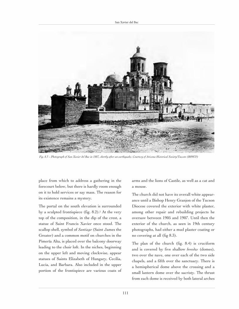
San Xavier del Bac
111
place from which to address a gathering in the forecourt below, but there is hardly room enough on it to hold services or say mass. The reason for its existence remains a mystery.
The portal on the south elevation is surrounded by a sculpted frontispiece (fig. 8.2).2 At the very top of the composition, in the dip of the crest, a statue of Saint Francis Xavier once stood. The scallop shell, symbol of Santiago (Saint James the Greater) and a common motif on churches in the Pimería Alta, is placed over the balcony doorway leading to the choir loft. In the niches, beginning on the upper left and moving clockwise, appear statues of Saints Elizabeth of Hungary, Cecilia, Lucia, and Barbara. Also included in the upper portion of the frontispiece are various coats of
arms and the lions of Castile, as well as a cat and a mouse.
The church did not have its overall white appear-ance until a Bishop Henry Granjon of the Tucson Diocese covered the exterior with white plaster, among other repair and rebuilding projects he oversaw between 1905 and 1907. Until then the exterior of the church, as seen in 19th century photographs, had either a mud plaster coating or no covering at all (fig 8.3).
The plan of the church (fig. 8.4) is cruciform and is covered by five shallow bovedas (domes), two over the nave, one over each of the two side chapels, and a fifth over the sanctuary. There is a hemispherical dome above the crossing and a small lantern dome over the sacristy. The thrust from each dome is received by both lateral arches
Fig. 8.3 – Photograph of San Xavier del Bac in 1887, shortly after an earthquake. Courtesy of Arizona Historical Society/Tucson (B89870)

San Xavier del Bac
112
and the exterior walls. The total interior length from the entrance to the rear of the sanctuary is approximately 99’. The nave is 21.5’ wide and the transept arms are approximately 20’ deep feet and 21.5’ wide. The height of the nave, from the floor to the highest point of the flat domes, is 34’, that from the floor to the apex of the dome over the crossing is slightly more than 53’.
The interior of San Xavier, arguably the most spectacular aspect of the church, is richly dec-orated with brightly painted relief sculpture, wall paintings, and statuary (fig 8.5). According to historian Bernard Fontana, more than one
hundred saints, the Virgin Mary, and no less than 182 angels are present within the building. The church is further adorned with painted por-traits as well as scenes depicting the history of Christianity from the Old Testament until the late 16th century, when the Turkish fleet was defeated by Christian forces in the naval battle of Lepanto.
Islamic influence can also be found throughout the church. For example, the motif of a lam-brequin, or drapery fringe, with small bells and pomegranates, is painted on the side walls just below the high cornice that runs along the nave.
Fig. 8.4 – Plan of San Xavier del Bac drawn in 1940 for the Historic American Building Survey .North is to the right. Courtesy of Historic American Build-ings Survey, Library of Congress

San Xavier del Bac
113
This type of image represents the decoration used at the entrance to the tents of powerful Arab chiefs, and the pomegranate is an Islamic sym-bol connoting royalty. The scallop shell, while symbolizing both Saint James and the Christian pilgrimage to Santiago de Compostela, also rep-resents the haj, or Muslim holy trip to Mecca.3
The main altarpiece, or retablo mayor, represents a conception of heaven with the Virgin Mary of the Immaculate Conception standing in the upper niche and Saint Francis Xavier at the center of the composition (fig 8.6). Flanking these fig-ures, in clockwise order beginning at the upper left, are Saints Peter, Paul, Andrew, and either Simon or John the Evangelist. At the peak of the composition is God the Father, flanked by
Cain on the left and Abel on the right. Pilasters with stacked sections including the inverted obe-lisk-like elements known as estípites, indicators of the Mexican Ultra-baroque style, frame these figures, even though Neoclassicism has already taken hold in Central Mexico at the time of San Xavier’s construction.
The eastern transept arm contains a statue of the Mater Dolorosa, the Sorrowing Mother of Christ, in the central niche of the lower level. Directly above are figures of the Virgin Mary (again) on the left and Saint John on the right. Flanking these statues, in clockwise order beginning from upper left, are Saint Benedict, the Moor of Palermo, the Blessed Bernardino of Feltre, Saint Anthony of Padua, and Saint Didacus Diego of
Fig. 8.5 – Interior of San Xavier del Bac, looking toward the altar. Courtesy of John Messina, Southwest Center, University of Arizona.

San Xavier del Bac
114
Alcala. At the very top of the retablo, from left to right, are Saints Elizabeth of Portugal, Clare of Asssisi, and Elizabeth of Hungary. Once again, estípite pilasters frame the figures.
The western transept arm, known as the Chapel of the Ecce Homo, includes a statue of the thorn-crowned Christ, as well as eleven saints and two large paintings on the south side. The lower paint-ing depicts Our Lady of the Pillar with Saint James the Greater kneeling. Located in the oval frame at the far left of the upper tier of this chapel is a relief of Saint Gertrude. She and three other female saints in this transept arm have had their faces and hands over painted in brown in order to give them the appearance of being Indian. A statue of Saint Dominic is positioned in the middle of the north wall. At his feet is a dog carved from wood, representing the members of the Dominican Order who were known as “the hounds of the Lord.”
The experience of seeing the mission church San Xavier from a distance across the mesquite- and saguaro-filled landscape can only be equaled by the experience of entering the narthex under the compression of the choir loft, and then witnessing, for the first time, the polychromatic adornment that radiates from the walls and ceiling of the church. The magnificent sculptural presence of San Xavier del Bac in the Sonoran Desert landscape, its interior spaces, and its extraordinary decorative sculpture were used as a means to awe the indigenous people of the region into an acceptance of the mission system and Christianity.
Since 1993, both the exterior surfaces and interior decoration of San Xavier have been undergoing stabilization and restoration.
Fig. 8.6 – Interior of San Xavier del Bac showing the re-tablo mayor. Courtesy of John Messina, Southwest Center, University of Arizona.

San Xavier del Bac
115
The harmful cement plaster and other impermeable coatings used during the 20th century are being removed and a traditional protective covering of lime and sand plaster, along with a bonding agent of nopal cactus, is being applied to all walls, roofs, and domes. The workers whom you may see high up on the exterior scaffolding are from the Morales Construction Company, a family business that has been maintaining San Xavier for several gener-ations.
Today the mission church San Xavier del Bac serves as a parish church on the Tohono O’odham Reservation, where it continues to astonish both native and non-native alike with its beauty and spiritual presence. It is cur-rently listed on the National Register of Historic Places.
ENDNOTES
1 Mardith Schuetz-Miller and Bernard L. Fontana, “Mission Churches of Northern
Sonora” in The Pimería Alta, ed. James E. Officer, et al. (Tucson: Southwestern Mission
Research Center, 1996), 90-95.
2, It must be noted that the identification of the iconography of San Xavier’s decoration,
inside and out, that is presented here is based on the extraordinary research of anthropol-
ogist and historian, Bernard L. Fontana. See “Biography of a Desert Church: The Story
of Mission San Xavier del Bac,” The Smoke Signal 3 (1996, revised) and “The Hidden
Artwork of Mission San Xavier,” Arizona Highways (October 2003): 18-33.
3. Jorge Olvera, “San Xavier Del Bac: Spanish Mission or Moslem Mosque?” Dove of
the Desert (Winter, 1989).
“… the Mission of San Xavier del Bac, the “white dove of the desert,”
is, without quibble, the most beautiful man-made object in America
Deserta. Whoever dubbed it “the Queen of Sonora” must have known
that no one would dare quarrel—unlike the stately gothic piles that
elbow for pre-eminence as “the cathedral of the Fen-land” in my
ancestral part of England, San Xavier del Bac is without equals or
rivals, even among the other mission foundations of Padre Kino.”
Reyner Banham, Scenes In America Deserta

116
Fig. 9.1 – Aerial view, Canoa Ranch looking east with the Santa Cruz River in the near back-ground. © Adriel Heisey, (AZ 13-5469-27)
9

117
La Canoa is part of the history of land grant claims in the Southwest.1 The initial land grant, San Ignacio de la Canoa, was made to Tomás and Ignacio Ortiz. In 1820 the two brothers initiated their claim to Canoa according to prevailing Spanish land law. On December 15, 1821, in Arizpe, Sonora, the Ortiz brothers made a successful bid, although no copy of an original title has been found.
It has been theorized that no title was issued because of the over-throw of the Spanish government in Mexico in 1821 or that the title may have been issued but later lost in a fire in Tubac, as claimed by an Ortiz heir.2
Frederick Maish and Thomas Driscoll purchased La Canoa from Ortiz heirs in 1876. Little is known of Driscoll. Maish came to Arizona in 1869 and shortly afterwards entered into partnership with Driscoll. An 1890s letterhead proudly announced the partners as “proprietors of the Canoa, Fresnal and Deep Well Ranches, and Canoa and Buena Vista Land Grants.”3
In order to establish claim to Canoa, Maish and Driscoll filed an initial Petition of Claimants and in February 1880 its approval was recommended. For years Congress failed to act. Finally, in 1893 the Canoa Claim was referred to the U. S. Court of Private Land Claims. Two maps were introduced. Both supported a claim of almost 47,000 acres, rather than the original four sitos,4 and a mandate dated October 1897 awarded 46,696 acres to Maish and Driscoll. It was later reversed, with a final award of 17,208 acres being confirmed on February 15, 1899.
The present Canoa Ranch headquarters lies a mile north of the original La Canoa site at the terminus of the canal that had been planned to bring water to Tucson. In October 1887 articles of incorporation for the Canoa Canal Company stated the plan “to
CANOA RANCHJosephine Antoinette Hilliard

Canoa Ranch
118
construct a main canal from a point on the Santa Cruz River . . . on or near the southern boundary of the Mexican Land Claim known as the ‘Canoa’ and from there in a northerly direction down the Santa Cruz Valley and to the City of Tucson . . .”5
Development of ranch operations during the Manning eraIn 1912, Levi H. Manning purchased the Canoa land grant. Four years later he sold the north-ern half of the land to Intercontinental Rubber Company for a wartime experiment in the raising of guayole as a substitute for rubber. He was able to acquire lands adjacent to the southern por-tion to bring the ranch lands to 100,000 acres or 500,000 acres when private land, state trust lands,
and federal grazing permits in the Santa Cruz and Altar valleys were totaled. Manning began a sci-entific breeding program to improve the quality of the cattle on the ranch, introducing purebred Hereford bulls into his cattle herd.
In 1921, Levi Manning’s son, Howell Manning, Sr., took over management of the ranch. Irrigation was installed for growing crops; two pit silos were built, each holding 2,500 tons of feed; and the range was fenced and a program of pasture rotation implemented. The Canoa became known for its fine Arabian horses. At its peak the ranch employed 40-45 ranch hands with ten families liv-ing permanently on the ranch. It had a school for ranch children, a blacksmith shop, welding shop, barns, sheds, corrals, and 1,200 acres of irrigated
Fig. 9.2 – Site plan, Canoa Ranch. Courtesy of Poster Frost Associates, Inc.
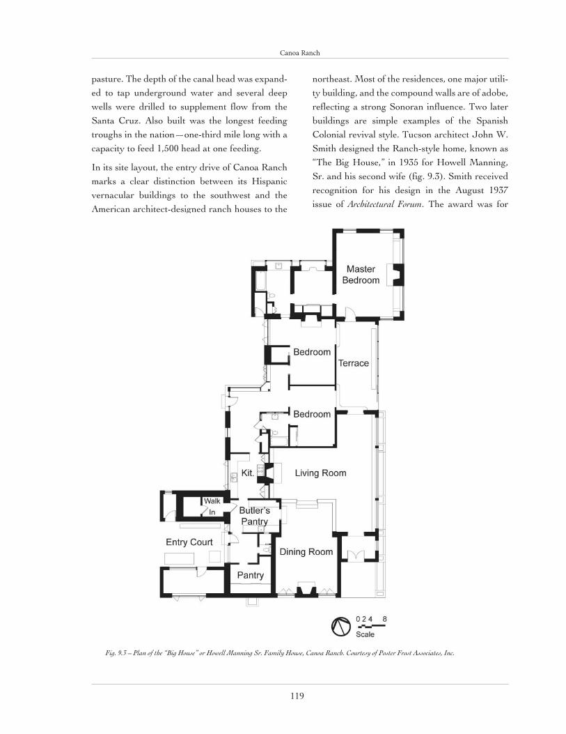
Canoa Ranch
119
pasture. The depth of the canal head was expand-ed to tap underground water and several deep wells were drilled to supplement flow from the Santa Cruz. Also built was the longest feeding troughs in the nation—one-third mile long with a capacity to feed 1,500 head at one feeding.
In its site layout, the entry drive of Canoa Ranch marks a clear distinction between its Hispanic vernacular buildings to the southwest and the American architect-designed ranch houses to the
northeast. Most of the residences, one major utili-ty building, and the compound walls are of adobe, reflecting a strong Sonoran influence. Two later buildings are simple examples of the Spanish Colonial revival style. Tucson architect John W. Smith designed the Ranch-style home, known as “The Big House,” in 1935 for Howell Manning, Sr. and his second wife (fig. 9.3). Smith received recognition for his design in the August 1937 issue of Architectural Forum. The award was for
Fig. 9.3 – Plan of the “Big House” or Howell Manning Sr. Family House, Canoa Ranch. Courtesy of Poster Frost Associates, Inc.

Canoa Ranch
120
the creative use of glass in the narrow glazed terrace on the east face (fig. 9.4).
The building has white-painted, stuccoed, adobe walls and wood shake gabled roofs. A shed extension incorporates the vestibule and terrace. The main south entry has a pair of tongue-in-groove plank doors. The kitchen entry and breakfast room entries have original single-panel, single-light doors. Windows are wood frame, fixed, or casement types. Unique, large, single-pane casements flank the marble-clad fireplace on the south wall in the sunken dining room. Likewise, the focus of the T-shaped living room is the west wall central fireplace. Alterations may have created the unusual shape of the living room as seen today. The wood tongue-and-groove flooring of the extension does not match the original. Possible post-1935 additions include the pair of gable-roofed extensions by the west kitchen entrance. Accessible from the kitchen and secured by six-inch thick wooden doors is a walk-in refrigerator/freezer, which has two rooms. The inaccessible second extension has large picture windows.
Facing the “Big House” is a second primary residence, known as the “Long House.” It was formed from an original bedroom wing to which communal, food preparation, and utility spaces were added around an enclosed courtyard (fig. 9.5). The house was built in two stages. The two sons of Howell Manning, Sr. occupied the rectan-gular, gable-roofed, two-bedroom, one bathroom building incorpo-rated into the south wing of the present house. An early photograph
Fig 9.4 - The “Big House” or Howell Manning Sr. Family House, Canoa Ranch, published in Architectural Forum (August 1937). Courtesy of Statistical Research Inc.

Canoa Ranch
121
shows the original building had a shed-roofed east porch supported by rustic tree posts (fig. 9.6).
According to Deezie Manning-Catron, in 1948 a second wing was designed by Smith to create a functional residence for her and her new husband, Howell Manning, Jr. The addition included a breezeway connection, living-dining room, kitchen, and utility room. The former porch was enclosed to create a sunroom as well as an interior passageway. A dressing room and outdoor storage space were added adjacent to the north bedroom. The construction was configured to enclose a west courtyard. Interior partitions were
Fig. 9.5 – Plan of the “Long House” or Howell Manning, Jr. Family House, Canoa Ranch. Courtesy of Poster Frost Associates, Inc.
Fig 9.6 - The “Long House” or Howell Manning Jr. Family House, Canoa Ranch prior to the 1947 remodeling. Courtesy of Louise Manning-Catron.

Canoa Ranch
122
largely adobe. The main entry is into the narrow breezeway, which features matching door assem-blies on the east and west walls. Each assemblage consists of a pair of double doors, custom made on the ranch by Frank Robles,6 with an upper and lower glass panel and wood spindles built inside the glass, plus flanking sidelights. There is a tri-part transom above. The windows are steel sash and include picture, casement, and bay types. An exposed diagonal beam spans between corners of the living room and dining room walls. Exposed, heavy, rough-sawn, ceiling framing members appear in both spaces. These timbers are pine from Mt. Lemmon, north of Tucson.7
A variety of architectural styles was employed in the ancillary buildings and structures. The adobe buildings evidencing a linear plan and flat facade and roof have been influenced by a strong Sonoran history. That they also make use of industrial elements introduced by settlers from the eastern United States classifies them as “Transitional.” The foreman’s residence is a prime example. Later pitched-roof employees’ dwellings are examples of American vernacular types built of adobe, while the guesthouse and an employ-ee’s residence exhibit elements of the Spanish Colonial Revival style. Most of what stands today appear to be the work of Howell Manning, Sr., who became ranch manager in 1924 and owner
in 1935. In 1937 the barn and other livestock-re-lated buildings apparently burned to the ground.8
The foreman’s house dates from the Levi Manning era or earlier with 18-inch thick, 15-foot high adobe walls speaking of the Sonoran-influenced Transitional style. On a long, linear plan, the stuccoed adobe building contains a living room, kitchen, and two bedrooms; it appears in Caton MacTavish’s 1925 article as one of sever-al free-standing, “Mexican style” headquarters buildings. Two fireplaces, located in the living room and master bedroom, provide the only heat. Lacking internal passageways, the building is often mistaken for a bunkhouse. A photograph in the MacTavish article shows a typical ramada, supported by 8”-diameter tree trunks and roofed with thatch of native plants, on the north side of the building. The screened, shed-roofed porch with its concrete floor is a later addition. The bunkhouse, built between 1948 and 1955, is a marked departure in its use of burnt adobe. On a linear plan with side gables, it features a corru-gated metal roof with overhang, steel casement windows with concrete lintels and sills, and two front doors.
One of the earliest buildings is the blacksmith shop and schoolhouse (fig. 9.7).9 This Transitional building is a U-shaped structure composed of spaces arranged in linear fashion around a shed-
Fig. 9.7 – Blacksmith shop and schoolhouse, Canoa Ranch. The structure on the left is probably the school. Courtesy of Poster Frost Associates, Inc.
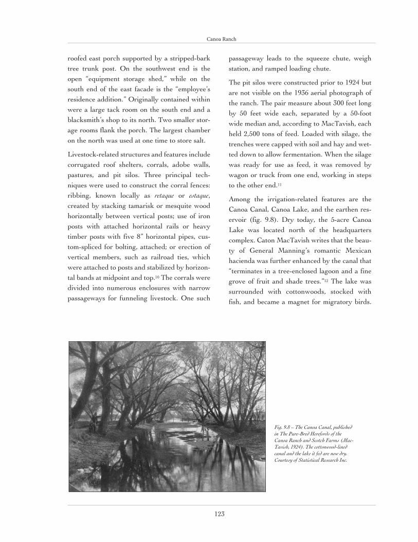
Canoa Ranch
123
roofed east porch supported by a stripped-bark tree trunk post. On the southwest end is the open “equipment storage shed,” while on the south end of the east facade is the “employee’s residence addition.” Originally contained within were a large tack room on the south end and a blacksmith’s shop to its north. Two smaller stor-age rooms flank the porch. The largest chamber on the north was used at one time to store salt.
Livestock-related structures and features include corrugated roof shelters, corrals, adobe walls, pastures, and pit silos. Three principal tech-niques were used to construct the corral fences: ribbing, known locally as retaque or estaque, created by stacking tamarisk or mesquite wood horizontally between vertical posts; use of iron posts with attached horizontal rails or heavy timber posts with five 8” horizontal pipes, cus-tom-spliced for bolting, attached; or erection of vertical members, such as railroad ties, which were attached to posts and stabilized by horizon-tal bands at midpoint and top.10 The corrals were divided into numerous enclosures with narrow passageways for funneling livestock. One such
passageway leads to the squeeze chute, weigh station, and ramped loading chute.
The pit silos were constructed prior to 1924 but are not visible on the 1936 aerial photograph of the ranch. The pair measure about 300 feet long by 50 feet wide each, separated by a 50-foot wide median and, according to MacTavish, each held 2,500 tons of feed. Loaded with silage, the trenches were capped with soil and hay and wet-ted down to allow fermentation. When the silage was ready for use as feed, it was removed by wagon or truck from one end, working in steps to the other end.11
Among the irrigation-related features are the Canoa Canal, Canoa Lake, and the earthen res-ervoir (fig. 9.8). Dry today, the 5-acre Canoa Lake was located north of the headquarters complex. Caton MacTavish writes that the beau-ty of General Manning’s romantic Mexican hacienda was further enhanced by the canal that “terminates in a tree-enclosed lagoon and a fine grove of fruit and shade trees.”12 The lake was surrounded with cottonwoods, stocked with fish, and became a magnet for migratory birds.
Fig. 9.8 – The Canoa Canal, published in The Pure-Bred Herefords of the Canoa Ranch and Scotch Farms (Mac-Tavish, 1924). The cottonwood-lined canal and the lake it fed are now dry. Courtesy of Statistical Research Inc.

Canoa Ranch
124
The construction date of the lake is uncertain, but the canal which emptied into the lake was built in 1893 or 1894. A little over one mile long and 50 feet wide and lined with numerous gates and turnouts, it was originally intended to con-tinue to Tucson thirty miles away. A 2,500-foot extension of the canal is visible on the 1935 aerial photograph. The extension was apparently used to carry water to agricultural fields. The head of the canal was excavated into a low river ter-race south of the headquarters in order to tap a water-bearing soil layer that had been recognized as a reliable source of water since at least the 18th century. Julius S. Andrews, builder of the canal, states that it was 26’ deep at its head, gradually tapering to 2’deep.13 With the building of later projects in the area of the canal head it is difficult to tell where the ground surface was in the 1890s, but today the apparent canal head is 20’ below the highest surrounding ground.
In the intervening years the property has under-gone several changes in ownership. After Howell Manning, Jr. died in an automobile accident in 1951, his father, Howell, Sr., divided up and sold off most of the ranch. Like much property in the West the land has been bought and sold by corporations for speculative rather than ranching purposes. Pima County holds the remaining core of 4,600 acres.
ENDNOTES
1. Much of the information about Canoa Ranch present-
ed here was gleaned from the following sources: Caton
MacTavish’s The Pure-bred Herefords of the Canoa Ranch and
Scotch Farms Tucson, Arizona 1924 (Los Angeles: Young &
McAllister, 1924); newspaper articles; Richard Willey’s
“La Canoa: A Spanish Land Grant Lost and Found,”
Smoke Signal 38 (Fall 1979): 154-72; Diana Hadley’s “La
Canoa: From Land Grant to Political Football,” SMRC-
Newsletter 34/123 (Summer 2000); and Janet Parkhurst.
2. Richard R. Willey, “La Canoa,” 154.
3. F. Maish and Annie Maish Ochoa files, Arizona
Historical Society, Tucson; quoted in Willey, “La Canoa,”
162.
4. Four sitos = four square leagues = 17,353.84 acres.
5. B. Sachs Collection, Arizona Historical Foundation,
Arizona State University Hayden Library, Tempe, item
1680; quoted in Willey, “La Canoa,” 164.
6. According to Deezie Manning-Catron.
7. Ibid.
8. “Canoa Ranch Headquarters Historic District, Pima
County, Arizona,” National Register of Historic Places
Multiple Property Documentation, sec. 7: 5.
9. Ibid., sec. 7: 16.
10. Ibid., sec. 7: 18.
11. Ibid., sec. 7: 20.
12. MacTavish, Pure-Bred Herefords, 35.
13. “Canoa Ranch Headquarters Historic District,” sec.
7: 19-20.
14. See Hadley article.

Canoa Ranch
125
Tequila
Tequila may be one of the most misconstrued of all libations. Infamous for the lick, suck, and slam ritual of salt, lime, and a shot glass, tequila is actually intended to be sipped and savored. What’s more, the process of tequila’s cre-ation is every bit as imbued with history and tradition as that of wine or whiskey. So that you may truly enjoy tequila to the fullest, a brief overview of its origins and outcomes is in order.
Mexico is home to 136 species of a desert plant called agave, or maguey, a suc-culent identified by the fleshy, pointed leaves rising from its center. Mezcal is the distilled liquor of any agave. Tequila is mezcal produced from the fermented must of the blue agave (agave azul tequilana weber) and it takes its name from the highland region of central Mexico where it originated.
The ripeness of the blue agave is determined by the estimation of a jimador, a person whose primary focus is the heart of the agave, called the piña, which can weigh up to 200 pounds. Once in an agave’s lifetime, it produces a flowering stem called a quiote that rises 25 to 40 feet into the air. By then, the agave is well past its prime for tequila production because the sugars that ferment into alcohol have been used up to produce the quiote. However, if harvested too soon, the piña will lack sufficient sugars.
At just the right moment, then, the jimador harvests the piñas and sends them off to the distillery where they are chopped and roasted until their starches turn into sugars. Subsequently, the roasted piñas are crushed and placed in fermenting vats. A yeast reci-pe, secret to each distiller, is then added to convert the sugars into alcohol, a process akin to that which occurs when brewing beer.
Like wine, tequila may be evaluated on many levels: aroma, appearance, texture, and taste are key elements in appraising any tequila. There are some general distinctions and clas-sifications to assist anyone interested in increasing their appreciation for tequila. The two varieties of Tequila are Tequila 100% Agave which is composed of only 100% blue agave juices and must be bottled at the distillery in Mexico and the more commonplace variety of tequila which requires only 51% of its composition to be blue agave juices and which may be exported to other countries for bottling.
Within either variety, there are four types. Tequila Blanco is clear in color and is often quite potent, having been bottled straight from the still. It is intended to be enjoyed straight up. Joven or Abocado is Tequila Blanco augmented with colorings and flavors that give it a gold-en hue. If margaritas are on the menu, this is the variety to use. Reposado is Tequila that has been stored in white oak casks for up to one year, lending this variety a milder flavor. Añejo Tequila has a darker color and a oak-like flavor from being stored in casks for more than a year, sometimes considerably more.
For a treat, or as a test, find a quality Tequila Blanco. Pour it into a small glass, or caballito, at room temperature. Leave the salt and lime on the table. Then, over invigorating conver-sation or in the evening hum of a desert sunset, sip the history, exactitude, and delectation shimmering in this silver brew.
Sources: http://www.itequila.org/ and http://www.crt.org.mx/

126
10

127
Approximately fifty miles south of Tucson on the Santa Cruz River is the mission site of San José de Tumacácori, now a National Historic Park. In 1691, when the Jesuit missionary Eusebio Kino first visited what was then a Piman village on the east side of the Santa Cruz, he blessed the site with the name San Cayetano. By 1753, San Cayetano had been moved
to the opposite side of the river and the name changed to San José. Just ten years prior to their expulsion from New Spain in 1767, the Jesuits completed an adobe hall church on the site, and that struc-ture was used until the current church, which was begun in 1802 by later Franciscan residents, replaced it in the 1820s. A cloistered convento building was constructed on the east side of the church, as was a mortuary chapel and cemetery to the north. The complex contained the usual residence for priests, as well as workshops, corrals, and classrooms for religious instruction. Of all the missions in the Pimería Alta, Tumacácori offers the best extant example
TUMACÁCORIJohn Messina
Fig. 10.1 – Mission church San José de Tumacácori as seen from the southwest. The adobe ruin to the right of the church is part of the original convento complex. Courtesy of John Messina, South-west Center, University of Arizona.

128
Tumacácori
of frontier mission planning. Two other mission
sites in the vicinity, Quevavi and Calabasas, pre-serve only relatively small adobe ruins. San José de Tumacácori was originally a visita to Quevavi, the cabecera or mission with a resident priest.
Stepping out from the north side of the muse-um-visitor’s center one can’t help but be taken by the sight of the mission church across the hard-packed field (fig. 10.1). The rather free neo-classical facade appears strangely unrelat-ed to the overscaled tower base that encloses a relatively diminutive baptistery (fig. 10.2). All of the parts—the double tiers of columns and architraves supporting a broken equilateral tri-angle, topped by a semi-circular crest—come together as in some postmodern composition. The entry portal is partially surrounded by a heavy Romanesque-like arch. As with other mission churches in the Pimería Alta, the builders of this church apparently took liberties with their limit-ed knowledge of architectural history.
A Franciscan priest, Narciso Gutiérrez, laid out the current church in a cruciform shape with the intention that the nave, sanctuary, and transept arms would be vaulted and that there would be a dome over the crossing. Father Guitiérrez was able to execute only a small part of his design—the walls up to seven feet in height—before he died in 1820. Because of limited funds, his succes-sor, Juan Bautista Estelric, assisted by a maestro
albañl, or master builder, from Zacatecas, simpli-fied the original plan by eliminating the transept (fig. 10.3). However, Father Estelric and his maestro, Félix Antonio Bustamante, were able to raise the walls an additional seven feet. Estelric’s successor, Father Ramón Liberós, completed the structure, but not without additional simplifica-tion. He covered the nave with a more typical flat, viga-supported roof, instead of the originally pro-posed vault and eliminated the dome from over the crossing, placing it instead over the sanctuary. A triumphal arch separates the sanctuary from the nave. Surprisingly, considering the scarcity
Fig. 10.2 – Façade of Mission church San José de Tumacácori. Courtesy of John Messina, Southwest Center, University of Arizona.

129
Tumacácori
Fig. 10.3 – Plan of Mission church San José de Tumacácori drawn in 1937 for the Historic American Buildings Survey. North is to the right. Courtesy of Historic American Buildings Survey, Library of Congress.

130
Tumacácori
Fig. 10.4a & b – Section draw-ings, Mission church San José de
Tumacácori drawn in 1937 for the Historic American Buildings Survey. Transverse section (top)
through the sanctuary and sacris-ty; longitudinal section (bottom)
through the nave. Courtesy of Historic American Buildings Survey, Library of Congress.

131
Tumacácori
of funds, Father Liberós also had a vault built over the sacristy. It appears that the single tower was never finished.
As built, the interior of the church, from entrance to the rear of the sanctuary, is approximately 90’ long (fig. 10.4 a-b). The nave is 17’ wide, and the ceiling is 24’ high. The side walls are 5’ thick, having been built wide enough to receive the thrust of the vault that was originally planned. There are sections at the base of the tower where the walls are as much as 9’ thick. The walls are built of a mixture of both sun-dried adobes and fired bricks. Given the relative softness of the former, the church has required constant preservation on the part of the National Park Service. During the middle of the 18th century, much of Tumacácori’s religious art was taken by faithful Indians to San Xavier in order to protect it from raiding Apaches. Several of the statues are currently installed in San Xavier’s side chapels.
Historical descriptions and drawings of Tumacácori, as well as archaeological evi-dence, indicate that directly east of the church there was once a cloister courtyard surrounded by arcades and rooms. A partial adobe ruin, referred to as the conven-
to, remains today on the rise to the right of the church. North of the “convento,” one can see vestiges of the foundations of former structures. Directly behind the church is a cemetery where Indians were buried, as well as an unfinished circular mortuary chapel. To the east side of this chapel are the stabilized walls of another 19th century structure. Since the federal mandate for Tumacácori is stabilization and preservation, not restoration or reconstruction, little has been done to the church and ancillary structures other than re-roofing the nave and restoring the upper facade. There are no current plans to exceed this level of care.
Tumacácori was initially established as a National Monument in 1908 and is cur-rently administered by the United States National Park Service. The museum/visitor center, with its planted patio, was built with adobe walls in 1937. Many of the center’s historicizing architectural features, such as the shell motif over the main entrance and the carved corbels and beamed ceiling in the lobby, are derived from details of other mission churches in the Pimería Alta that were surveyed on a National Park Service expedition in 1935. The main entry doors were patterned on those at the mission church at San Ignacio de Cabórica in Sonora and were crafted by Civilian Conservation Corps carpenters at Bandelier National Monument in New Mexico.
(this text has been compiled from Nicholas J. Bleser, Tumacácori: From Rancheria
to National Monument [Tucson: Southwestern Parks and Monuments Association, n.d.], Mardith Schuetz-Miller and Bernard L. Fontana, “Mission Churches of Northern Sonora” in The Pimería Alta, ed. James E. Officer, et al. (Tucson: Southwestern Mission Research Center, 1996), and Buford Pickens, ed. The
Missions of Northern Sonora: A 1935 Field Documentation [Tucson: University of Arizona Press, 1993])

132
11
Fig. 11.1 – Patagonia’s town plan was laid out on either side of the railroad tracks whose right-of-way is now a public common. Courtesy of Desert Archaeology Inc. after Don Ryden & Associates

133
Straddling Sonoita Creek, Patagonia is a microcosm of the various rural town architectural typologies that existed in southern Arizona at the end of the 19th century. It was first established to support mining (including the Mowry and Harshaw mines) as well as ranching operations in the lush grasslands surround-ing the town. After the railroad arrived, Patagonia
became a regional center, serving as a stockyard for the export of cattle and an ore-loading dock for the silver, lead, zinc, and copper that had been discovered in the mountains nearby. In addition, Patagonia represents the vision of a single man, Rollin Richardson, who, as the town’s real-estate magnate, controlled its development and character as a middle-class company town.
Gradually, the pre-manufactured goods imported by rail trans-formed the architectural language of the small town. Its archi-tecture represents various types of national folk architecture, including gable-roofed, hall-and-parlor, and pyramidal-roofed four-square houses, built primarily of adobe.
1. Cady Hall/Patagonia Public Library, 346 Duquesne Street
Built in stages between 1901 and 1912 by John H. Cady, this building originally housed the Patagonia Hotel and contained a restaurant, saloon, and meeting hall that was a gathering place for dances, town meetings, and other social and civic events. In 1957, the Patagonia Women’s Club founded the library and began using the hall space. In 1990, a restoration project was begun to repair the southeast facade, porch, windows, doors,
PATAGONIAR. Brooks Jeffery

Patagonia
134
Fig. 11.2 – Plan of Cady Hall and the Patagonia Public Library, 2004 showing the recent library addition (right ) and original Patagonia Hotel buildings (left). Courtesy of Arturo Vazquez, Design W, LLC

Patagonia
135
and the interior of the hall. A new library reading room was added to the northeast in 1995, sensi-tively replicating the size and form of the original hall. A restoration of the former hotel wing, which had been used more recently as apartments, was also conducted at that time.
Cady Hall is an example of territorial period building typologies, illustrating the transition from Sonoran to American building traditions. It is a one-story, L-shaped building consisting of a square main hall, the original dining room/hall
facing southeast (onto Duquesne Street) and, to the northwest, a kitchen and four additional rooms making up a wing of the original hotel. The four rooms were originally built as eight rooms that, to support the building’s current use as a library, were opened up into larger reading rooms and offices. To the rear of the hall, on the northwest side, there was originally an open porch with a shed roof; it was enclosed during the 1950s to create a kitchen foyer and bathroom. The two chimneys of the hall, one in the middle
of the southwest wall and the other in the middle of the northeast wall, were both restored after the originals were demolished down to the roof line at some unknown time in the past.
The building has three roof types: the square hall has a truncated pyramidal roof topped by a restored balustrade, the former hotel wing has a gable roof corresponding to its rectangular floor plan, and the front porch, forming the hotel’s facade facing Duquesne Street, has a dropped hip roof. The current entry vestibule between
the original hall and new library portion to the northeast was formerly a porch with shed roof attached to the hall. Shed roof extensions also cover the two wooden porches of the former hotel wing—the northwest one is now an enclosed corridor housing computer workstations—that provided access to the hotel rooms on both sides of the building.
The lime-plastered adobe walls of both original buildings are 20” thick, constructed of a dou-ble row of ten-inch adobe blocks in common
Fig. 11.3 – Exterior, Cady Hall, Patagonia showing the Hall building with a pyramidal roof form, the entry to the current Patagonia Public Library with the shed roof (formerly a porch to the former Patagonia Hotel) and the new library reading room to the right, also with a pyramidal roof. Courtesy of Andrew Gorski.

Patagonia
136
use during the period of the building’s construction. The foundation comprises stone with lime mortar. The flooring of the main hall is two layers of tongue-and-groove maple over fir. The floors of the library wing are also of wood with the exception of one room that has concrete. Each of the four rooms in the former hotel wing has two doors and two windows, corresponding to two of the original eight hotel rooms. The wood frame roof of the hall is constructed of 2x4 rafters with spacing as wide as 32” on-center and was originally shingled, then covered with corrugated metal to match that of the former hotel wing. The current metal roofs were added during the building restoration project of the early 1990s.
2. Valenzuela House, 289 Duquesne Street
A classic two-story four-square house with a truncated pyramidal roof topped with a balustrade. The house is construct-ed of unplastered adobe that is slowly eroding due to the effects of weather, as is revealed in the blurring of mortar lines and the now protruding door and win-dow frames whose alignment reveals the original depth of the wall surface prior to erosion. Particularly evident is the effect of rainwater falling from the roof onto the wall surfaces prior to the installation of the gutter system, as seen in the more pronounced horizontal bands of erosion. The wood frame roof retains its original wood shake shingle sheathing. There is physical evidence on the street façade of a second floor porch that also shaded the ground floor but no photos have been found to confirm its form and character.
Fig. 11.4 – Valenzuela House, Patagonia. Courtesy of R. Brooks Jeffery

Patagonia
137
3. Train Depot, Naugle & Third Avenues
Built in 1900 by the New Mexico & Arizona Railroad as a freight house and train depot, this building demonstrated the company’s belief in Patagonia’s potential as a center for mining and cattle operations in southeastern Arizona. The rectangu-lar building is a vernacular inter-pretation of the picturesque cottage style defined by A. J. Downing, with simple wooden brackets supporting a projecting hipped roof above the level of the first floor and breaking up the scale of the depot’s two-story ele-ment. Also consistent with this style is the use of wood frame construction with board-and-batten sheathing. The interior has been greatly modified to accommodate the building’s current use as the Patagonia City Hall.
4. Majalca Residence, 170 N. Third Avenue
This classic pyramidal cottage has a one-story, four-square plan with a front porch addition covered by a dropped hip roof matching the form of the roof of the main house. The house is constructed of exposed adobe with wood frame roofing members and porch structure, all covered with corrugated metal. The double-hung windows are tall and thin, as was typi-cal of the territorial period in Arizona, and constructed of imported milled lumber.
Fig. 11.5 – Train Depot, Patagonia, Courtesy of Andrew Gorski.
Fig. 11.6 – Majalca Residence, Patagonia. Courtesy of R. Brooks Jeffery

Patagonia
138
5. Mellor Residence, 191 N. Third Avenue
Similar to the Majalca Residence, the Mellor Residence is a pyrami-dal cottage constructed of exposed adobe block with a wood frame roof. Where it differs is in the use of a wrap-around wooden porch that not only provides outdoor living space but also to a certain extent protects the exposed adobe walls from the effects of rain and sun. The roof dormers appear not to be original but there is no evidence to indicate when they were added.
6. Laguna Adobe Shed, 322 Sonoita Avenue
This shed, attached to the residence at 314 Sonoita, was originally a detached residence embodying the gable-front type of vernacu-lar dwellings. It is two rooms wide and two rooms deep with its main entry facing the street under the high-pitched gable roof. The structure is built of adobe block resting on stone foundations with a wood frame floor and roof, the latter sheathed in corrugated metal.
Fig. 11.7 – Mellor Residence, Patagonia. Courtesy of R. Brooks Jeffery
Fig. 11.8 – Laguna Adobe Shed, Patagonia. Courtesy of R. Brooks Jeffery

Patagonia
139
7. Mesquite Grove Gallery, 361 McKeown Avenue
Formerly a residence, this house is an example of the gable-and-wing, or L-shaped vernacular dwelling type with three principal rooms and subse-quent additions to the rear. The principal gable faces the street and the wing is set back parallel to the street providing space at the crux of the “L” for an attached wood frame porch with a dropped shed roof typical of the house type. The walls are constructed of adobe block on stone foundations with a wood frame roof and wooden flooring.
8.
Duquesne House Bed & Breakfast
The Duquesne House was formerly a boarding house for miners coming into town for the weekend from the surrounding mines. The plan resembles the traditional cellular form of the Sonoran rowhouse with five bays, each two rooms deep and facing outwards to either side of the long facade. The oversized gable roof is an awkward attempt to marry the Sonoran plan with American roof forms; over the bays, the roof has a high pitch sheltering storage attics, over the living room part of the bed & breakfast, the roof shel-ters a large two-story interior space. The 24” thick walls are constructed of adobe block with a wood frame roof originally covered by wooden shingles and now sheathed in corrugated tin.
Fig. 11.9 – Mesquite Grove Gal-lery, Patagonia, Courtesy of R.
Brooks Jeffery
Fig. 11.10 (below) – Duquesne House Bed & Breakfast, Pa-tagonia. Courtesy of R. Brooks Jeffery

140
Fig. 12.1 – Site Plan of Empire Ranch. Courtesy of Statistical Research Inc. from Majewski, Teresita et al. Adaptive-Reuse Plan for the Empire Ranch Head-quarters. Statistical Research, Inc. Tucson, AZ. Technical Report
12
141
The Empire Ranch Headquarters centers on the Empire Ranch House, the home of the Vail and Boice families during their respective tenures on the ranch and, from the beginning, the focus of the working life of the ranch (fig. 12.1). A simple four-room adobe house had already been constructed (between 1871 and 1874) by the time Walter Vail purchased the property in 1876.
The Empire Ranch House was expanded several times over the years, first by Vail and his partners, then by the Vail descendants. The Boices later repaired and remodeled the house as their fam-ily and business grew, but the basic layout remained essentially unchanged. Today, the Empire Ranch House—some 29 rooms of it—still reflects, to a remarkable degree, the lives of the many people who lived and worked on the ranch over the more than 130 years of its operation.
Because of the vernacular and organic growth patterns of construc-tion at Empire Ranch, the building histories have been collected from a variety of sources—written, oral, photographic, and physi-cal—in a complex process that awaits completion. For this reason, individual room histories for the Ranch House have yet to be fully researched and documented, and the same can be said of the his-tories of the outbuildings. The following information is based on research performed to date, and summarizes the building histories from these sources.
EMPIRE RANCHSimon Herbert

Empire Ranch
142
Fig. 12.2 – Floor Plan of Main Ranch House, Empire
Ranch. Courtesy of Sta-tistical Research Inc. from
Majewski, Teresita et al. Adaptive-Reuse Plan for the
Empire Ranch Headquar-ters. Statistical Research,
Inc. Tucson, AZ. Technical Report

Empire Ranch
143
Ranch House The Ranch House (A on site plan)represents a complex, interconnected collection of vernacular buildings that were constructed to meet a wide variety of changing conditions (fig. 12.2). In the 1870s and early 1880s, buildings were construct-ed under some of the most difficult frontier condi-tions. By the 1940s and 1950s, the Ranch House was being upgraded with modern conveniences such as natural gas, electrical power supplied by power lines instead of generators, lush gardens, and even a swimming pool.
Original Ranch House (Rooms 1-7): Edward Nye Fish probably constructed the original adobe building between 1871 and 1874, and this formed the nucleus of what was to become a complex of connected buildings that are collectively called the Empire Ranch House (fig. 12.3). The almost square adobe building had a flat, compacted earth roof covering its four rooms and the divided central breezeway, sometimes referred to by the Spanish term as a zaguán. The breezeway was
oriented on a north-south axis with two rooms to either side. A large, north-facing doorway pro-vided the only access into the rooms and corral on the south. Cattle and horses could be kept in the corral under the watchful eye of the ranchers, an arrangement designed to discourage Apache raids. In these early years, there were no perma-nent doors or windows. It is interesting to note that by the time the compacted earth roof had been covered with a pitched roof in 1887, there was a total of 13 layers of built-up earth, various-ly compacted. (This was discovered during repair work in 2001–2002.)
Rear Addition (Rooms 10–14 and 17), Foreman’s Quarters (Rooms 8 and 9), and Cowboy Cook’s Wing (Adobe, Rooms 15, 16, and 18): In 1876, Fish sold the ranch to Walter Vail and Henry Hislop, who continued to expand ranch activi-ties. With expansion came the need to add living space, and more adobe rooms were added on to the south side of the original building between 1878 and 1884. These rooms continued the inward and protective orientation of the earliest
Fig. 12.3 – Ranch House from the west, ca. 1880. The original flat roofs of the Fish House and the adjoining Rear Addition are shown. The area around the house is fenced..Courtesy of Empire Ranch Foundation/Laura (Dusty) Vail Ingram/Bureau of Land Management (Image # A413-1)

Empire Ranch
144
rooms because Apache raids were still a possibili-ty. These additions also had flat, compacted-earth roofs. By now, doors and windows had been installed in the original building. The additions retained their flat earthen roofs until about 1890, when they were also covered with a pitched roof (figs. 12.4 and 12.5).
Victorian Addition (Rooms 19–23 and 29): Probably planned and built at the same time (ca. 1878) as the Rear Addition, the adobe Victorian
Addition was first called the Harvey House, for one of the Empire Ranch partners, John Harvey, who built the two-room house (Rooms 22 and 23) for his new wife. The house eventually grew to include Rooms 19, 20, 21, and 29. The orienta-tion and the lack of internal doors connecting to the other parts of the buildings were most likely intended to provide some separation between the married couple and the unmarried men at the ranch. When Harvey left in 1881, Walter Vail’s new bride, Margaret, purchased the house from Harvey. Other spaces were added. The space between the bay window and the Rear Addition was enclosed to become Room 21, openings were
made into the Rear Addition in 1896–1895, and a bathroom (Room 29) was added by 1925.
When Frank “Pancho” Boice became the sole owner of the ranch in 1951, Rooms 19–23 of the Victorian Addition were substantially remodeled. Decorative Victorian elements were removed or covered over, and some fenestration was changed to modern units, including the bay window. The kitchen (Room 17) was upgraded to include mod-ern fixtures, decor, and appliances.
(Note: Eric Means’s investigative work on the ranch house is responsible for revealing many of the answers regarding construction sequence.)
Children’s Addition (Rooms 24–28): This ca. 1886 addition consists of a wood frame building moved to the site. A small shed-roofed porch on the west side was replaced by a screened porch (Room 28) in 1924 or 1925.
In general, many of the wood floors in the Ranch House were replaced with concrete (ca. 1917-25) when it was discovered that skunks were nesting in the subfloor spaces. In ca. 1948, cement stucco over chicken wire was applied to the exterior adobe walls.
Fig. 12.4 – View of the ranch from the northeast, c1890. The original Fish portion of the house now has a gable roof, as do Rooms 16 and 18 (the cook’s quarters). In the foreground stands a horse, thought to belong to Edward Vail. Courtesy of Empire Ranch Foundation/Laura (Dusty) Vail Ingram/Bureau of Land Management (Image # A413-1)

Empire Ranch
145
Outbuildings Adobe Hay Barn (G on site plan): Built in ca. 1880 when there was still some concern about Apache raids, this barn may have served origi-nally to protect valuable livestock, particularly horses, from theft. The main entrance to the barn was originally in its north wall, as photos from the 1880s attest, but around 1900 this entrance and the windows on that wall were closed up and a new entrance was opened in the east wall. These changes probably took place after the barn was damaged in a fire. A large opening for a sliding door was later made in the south wall.
In photographs from the 1880s, a large water tank is shown adjacent to the west end of the barn. It was still there in photographs from 1937, but was removed before the 1950s. A concrete
wall constructed sometime between 1920 and 1930 extends from the northeast wall of the barn to the Children’s Addition. Emergency measures to stabilize the Hay Barn began in 2003 and are still underway as of late 2004.
Grove House (T): Possibly dating back to the Fish era (early 1870s), this is a small adobe build-ing now occupied by a ranch hand who works for the Donaldsons, the current ranchers.
Stone Corral (B): Originally used to house the ranch’s stallions (until ca. 1929), this stone and wood corral later served as a woodshed (until 1969) housing a gas-powered saw for cutting firewood. The concrete foundation dates from the 1950s, when repairs were made to correct an outward-leaning wall. The Stone Corral was restored in 2002.
Fig. 12.5 – Ladies and cook in the patio, ca. 1885. A pitched roof is being constructed over the cook’s quarters (Rooms 16 and 18). It is interesting to note that nearly all of the doorways on the right were later changed to windows, as the orientation and use of the building changed.Courtesy of Empire Ranch Foundation/Laura (Dusty) Vail Ingram/Bureau of Land Management (Image # A300-062)

Empire Ranch
146
Hired Man’s House (N): This small, two-room adobe building (ca. 1906–1920) was constructed for a Mexican-American couple who worked on the ranch, and was later made available to other ranch workers and their families. Just south of the house is a small, steel-cable reinforced con-crete structure that may have been the base for a stock tank.
South Barn (I): Built in ca. 1920-21 to house horses, this barn was later used as a shop to store windmill-related and other tools. In the 1940s, it was changed and modified for the shooting of a Hollywood film.
Shed and Feed Barn (H): Built in ca. 1928, this wooden building is also known as the Covered Feed Troughs.
Tack Room (C): This wooden structure of uncer-tain date was also known as the Saddle Shed between 1928 and 1969.
Fountain (E) and Swimming Pool (F): Located in the garden between the Ranch House and Adobe Barn, these concrete features dating to about the 1940s were an important part of both the physical and cultural landscapes at the ranch. The pool was filled in during the 1990s for safety reasons.
Loading Chute (D): This wooden feature was built in the 1950s for loading and unloading sad-dle horses that were trucked to other parts of the ranch where they would be used.
Fig. 12.6 – Vaqueros, lady, and children in front of the cook’s quarters, ca. 1890. Careful comparison of historical photographs, show numerous alterations being made to the buildings over time to meet the ever-changing needs and conditions of the Empire Ranch. Courtesy of Empire Ranch Foundation/Laura (Dusty) Vail Ingram/Bureau of Land Management (Image # A300-037)

Empire Ranch
147
Old Huachuca House, Caretaker’s House (Q): This wood frame and stucco house was possibly moved from Fort Huachuca and therefore was likely built before 1950. It may become the future visitors’ center for the Empire Ranch.
Water Tank (L) and Windmill (M): In the 1950s, this water tank, located south of the Adobe Hay Barn, replaced the original water tank locat-ed just to the west of the Barn. It is still in use. The windmill, a Dempster No.12, is no longer used to pump water, but was recently restored to its original appearance and repaired to function by the Bureau of Land Management (BLM).
New Ranch House (S): This structure from ca. 1950 is now a part-time Bureau of Land Management (BLM) Field Station.
Shed (J) and Shop (K). These utilitarian build-ings of unknown date were used for storage and workshop space.
Adaptive-Reuse PlansWhile the Empire Ranch is listed in the National Register of Historic Places at the State level of significance, it is hoped that it will be elevated to national-level status before implementation of the adaptive-reuse plan. Still, finding the best approach for reusing buildings at the Empire Ranch poses certain challenges, given its long history. The recommended period of significance extends from the early 1870s to the present, so no one period of history can be easily highlighted in isolation from the others. The layering of histori-cal events and architectural construction will like-ly be interpreted from a present-day viewpoint, with few changes or alterations being made. This approach would also discourage attempts to make all parts of the ranch fit an early appearance.
Future visitors to the Empire Ranch will need help in understanding how the ranch grew and changed over time, and to this end, it is planned that the ranch become the Empire Ranch Western
Heritage and Education Center. This center will interpret the ranch’s rich history and that of ranching activities generally in southeastern Arizona. At the same time, ranching operations will continue under a grazing permit from the BLM, thus continuing a strong tradition on this land. These continued ranching activities will be paramount to visitor’s experience of the ranch. With the rise of heritage tourism, Empire Ranch could well become a focal point for any visitor seeking to experience the American West.
The current primary objective is to stabilize the ranch building and outbuilding shells while planning for their long-term reuse. Eventually, the current limited-use house shell will be trans-formed into a fully stable historic house shell that can be used for museum interpretation. A hierarchy of significance based on current integ-rity will drive the decision-making process as to which spaces will likely be restored or adaptively reused. The outbuildings were, and still are, an important part of the ranch operations, and their future use will be determined using the same cri-teria applied to the main Ranch House.
Landscaping is also considered an important aspect of the ranch history and garden spaces will be designed and replanted to reflect a particular time period or periods. The garden area to the south of the Children’s Addition may be connect-ed to a reopened entry in the large Adobe Hay Barn, which could serve as a gathering place for meetings and other events.
Finally, site planning will optimize and pre-serve the outstanding views around the ranch, and visitors will be routed to the main Empire Ranch House from a visitors’ center in the Old Huachuca House, or Caretaker’s House. Design and implementation of the plan will take several more years to achieve.

148
13
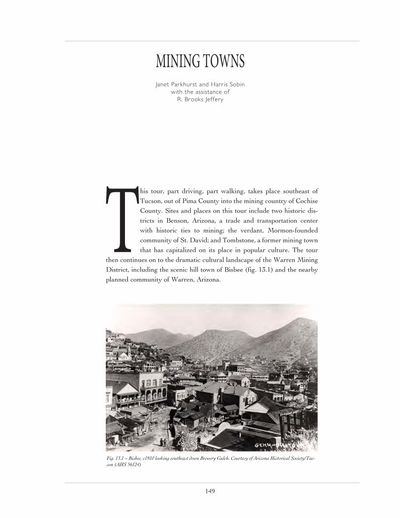
149
This tour, part driving, part walking, takes place southeast of Tucson, out of Pima County into the mining country of Cochise County. Sites and places on this tour include two historic dis-tricts in Benson, Arizona, a trade and transportation center with historic ties to mining; the verdant, Mormon-founded community of St. David; and Tombstone, a former mining town that has capitalized on its place in popular culture. The tour
then continues on to the dramatic cultural landscape of the Warren Mining District, including the scenic hill town of Bisbee (fig. 13.1) and the nearby planned community of Warren, Arizona.
MINING TOWNSJanet Parkhurst and Harris Sobin
with the assistance of
R. Brooks Jeffery
Fig. 13.1 – Bisbee, c1910 looking southeast down Brewery Gulch. Courtesy of Arizona Historical Society/Tuc-son (AHS 56124)

Mining Towns
150
Benson Benson has served since its inception as a transportation link, a role that began with a stage depot prior to 1880, the year in which the Southern Pacific Railroad arrived. The railroad fostered Benson’s economic growth in significant ways (fig 13.2). The community was a passenger clearing house for southeastern Arizona and it served nearby mines and the mining towns of Clifton and Bisbee. Mining products were sent via wagon train to Benson to be shipped by rail. Benson became a hub city with the arrival of two additional railroads, the New Mexico and Arizona Railroad in 1882 and the Arizona Southeastern Railroad in 1894. Railroad traffic created a need for retail trades and services, hotels, saloons, livery stables, merchandising establishments, restaurants, and housing.1
When the Southern Pacific Railroad redirected its major route to Tucson in 1910, Benson experienced a temporary decline. However, in the 1920s Benson again became an important transportation junction point owing to its location on Federal Route 80 (now State Route 80), the national highway connecting Washington, D.C. to San Diego. Today’s Route 80 is one and the same as Benson’s Main Street” or 4th Street. Owing to improvements in irrigation technology, ranching and agriculture brought additional growth and change to Benson. In addition, in 1922 the Apache
Fig. 13.2 – Benson town plan with referenced areas highlighted. Courtesy of Desert Archaeology Inc.

Mining Towns
151
Powder Company, a nitroglycerin explosives manufacturing plant, opened a few miles southeast of Benson and greatly stimulated the economy.
Railroad Historic District
This National Register-listed district (1880-1910) reflects the city’s railroad era. It is located just north of the rail-road tracks on E. 3rd Street near the site of the recently re-created freight and passenger depot. The district con-sists of ten residences (fig. 3.3) and one hotel.
The simplest structures are vernacular frame dwellings like the front-gabled “shotgun” example at 223 E. 3rd St.
The Colonial Revival style Hotel Arnold (fig. 3.4), 253 E. 3rd Street, was allegedly built around 1879 by a retired engineer and his wife, Mr. and Mrs. Arnold A. McGinnis, to accommodate railroad employees, passengers, com-mercial travelers and salespeople. The Double Roofed House, 285 E. 3rd St., is the largest known example of its type in Arizona and a unique example of the Colonial Revival Style (fig. 13.5). The double-roofing technique was used to provide insulation from the heat. The Roadmaster’s House, 305 E. 3rd St., is the only remaining example of a large Queen Anne style house in Benson, somewhat modified. Strongly associated with the railroad, this residence is one of Benson’s most significant buildings. The roadmaster’s role was to repair and maintain the railroad tracks and right-of-way.
Apache Powder Historic Residential District
Fig. 13.3 – Railroad District streetscape showing pyramidal dwelling, Ben-son. Courtesy of Janet Parkhurst.
Fig. 13.4 – Hotel Arnold, Benson. Courtesy of Janet Parkhurst.
Fig. 13.5 – Double-Roofed House, Benson. Courtesy of Janet Parkhurst.

Mining Towns
152
This district is associated with Benson’s 1920s era. In 1922, Charles Mills, founder of the for-mer Valley National Bank, built the Apache Powder Company near Benson. At one time, this company, known today as Apache Nitrogen Products, Inc., was the largest independent pro-ducer of nitroglycerin explosives in the United States. Apache, whose stockholders were the mines, was able to produce powder at a much lower cost than companies elsewhere, thereby stimulating the local economy. Apache employed hundreds of people, even during the Depression.
This residential district was built on land pur-chased in 1925 by the company for its manage-ment personnel and comprises nine residences and a park (figs. 13.6 and 13.7). Listed in the National Register in 1994, the district has good examples of styles popular in the 1920s. There are six front-gabled residences in the Craftsman Bungalow style. Two typical Bungalows can be seen at 143 and 189 W. 6th St. A Mission Revival-influenced building, which once served as Evacuation Hospital No. 1 for the company, can be found at 201 W. 6th St. The house at 243 W. 6th St. is a good example of the Spanish Colonial Revival style.
(The preceding text about Benson has been excerpted from City of Benson’s “Benson Historic Walking Tour” [1995].)
St. DavidDeparting Benson, the tour crosses the San Pedro River just before St. David, eight miles away along Route 80. St. David was founded by Mormons in 1877, and today, as no doubt his-torically, it is a community of small farmsteads. Mormonism was an agrarian movement and the most successful of all 19th century religious utopias founded in the United States. Mormons endeavored to build stable, orderly, exclusive agricultural communities that embodied the vir-
Fig. 13.6 – Typical Apache Powder District bungalow, Benson. Courtesy of Janet Parkhurst.
Fig. 13.7 – Apache Park, Benson. Courtesy of Janet Parkhurst.
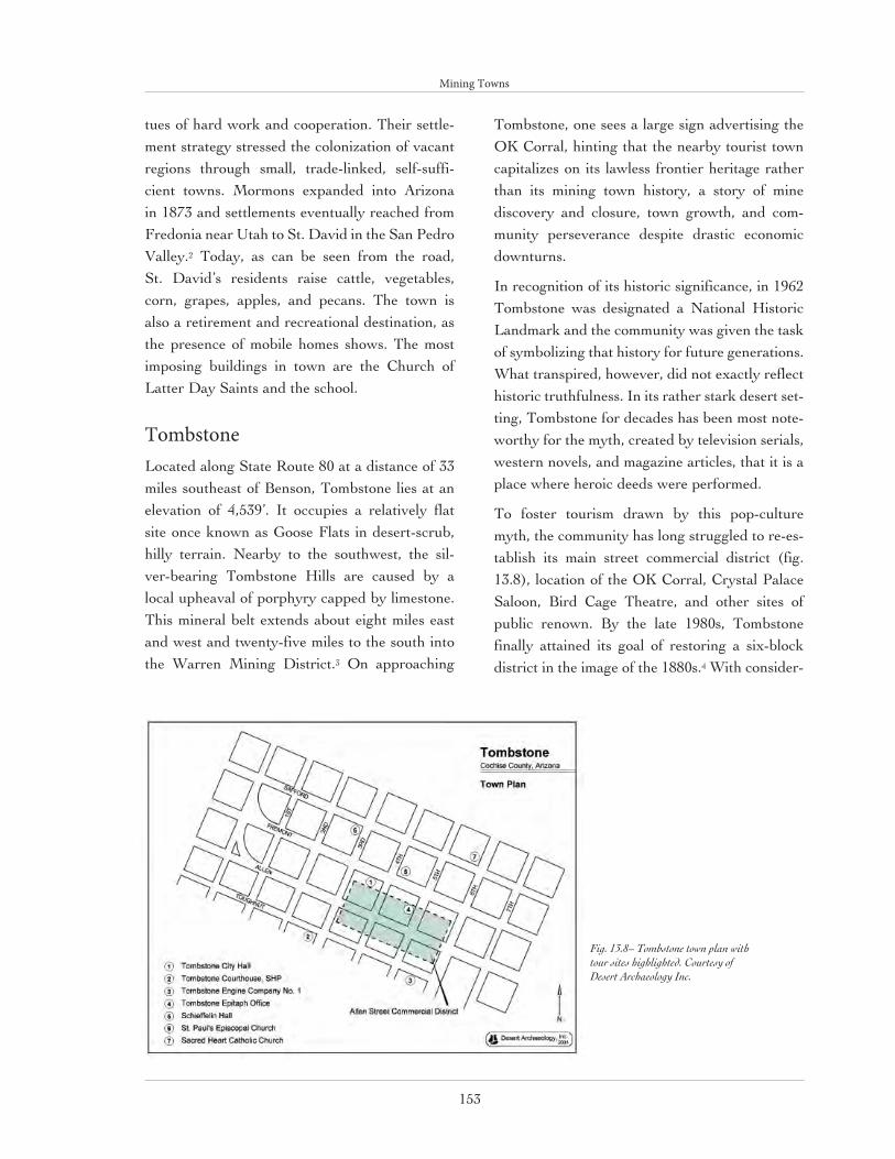
Mining Towns
153
tues of hard work and cooperation. Their settle-ment strategy stressed the colonization of vacant regions through small, trade-linked, self-suffi-cient towns. Mormons expanded into Arizona in 1873 and settlements eventually reached from Fredonia near Utah to St. David in the San Pedro Valley.2 Today, as can be seen from the road, St. David’s residents raise cattle, vegetables, corn, grapes, apples, and pecans. The town is also a retirement and recreational destination, as the presence of mobile homes shows. The most imposing buildings in town are the Church of Latter Day Saints and the school.
TombstoneLocated along State Route 80 at a distance of 33 miles southeast of Benson, Tombstone lies at an elevation of 4,539’. It occupies a relatively flat site once known as Goose Flats in desert-scrub, hilly terrain. Nearby to the southwest, the sil-ver-bearing Tombstone Hills are caused by a local upheaval of porphyry capped by limestone. This mineral belt extends about eight miles east and west and twenty-five miles to the south into the Warren Mining District.3 On approaching
Tombstone, one sees a large sign advertising the OK Corral, hinting that the nearby tourist town capitalizes on its lawless frontier heritage rather than its mining town history, a story of mine discovery and closure, town growth, and com-munity perseverance despite drastic economic downturns.
In recognition of its historic significance, in 1962 Tombstone was designated a National Historic Landmark and the community was given the task of symbolizing that history for future generations. What transpired, however, did not exactly reflect historic truthfulness. In its rather stark desert set-ting, Tombstone for decades has been most note-worthy for the myth, created by television serials, western novels, and magazine articles, that it is a place where heroic deeds were performed.
To foster tourism drawn by this pop-culture myth, the community has long struggled to re-es-tablish its main street commercial district (fig. 13.8), location of the OK Corral, Crystal Palace Saloon, Bird Cage Theatre, and other sites of public renown. By the late 1980s, Tombstone finally attained its goal of restoring a six-block district in the image of the 1880s.4 With consider-
Fig. 13.8– Tombstone town plan with tour sites highlighted. Courtesy of Desert Archaeology Inc.

Mining Towns
154
able re-building, porch and boardwalk addition, etc., the resulting restoration is a romanticized one. Focused solely on tourism, the district has lost its true identity. The commercial center com-pletely ignores the community that such a town center once served; gone are the post office, drug store and types of shops once used by the citizens of Tombstone.5
Allen Street Commercial District
The first tour stop will be near Tombstone’s Allen Street Commercial District (fig. 13.9). Originally developed by entrepreneurs, this small historic core consisted largely of modest, false-front, one- or two-part commercial blocks with dominant storefronts; these were block types found else-where in America at the time. Many were built of adobe. Tombstone’s speculative commercial district was concentrated largely on Allen Street, its “Main Street” between 3rd St. and 6th St., and the streets that cross Allen. Today’s restored com-mercial district is included on the tour largely as an example of romanticized historic preservation driven by popular culture.
Tombstone does feature several nearby, historic institutional buildings of merit. Not built on Allen Street, they include the two-story, brick City Hall, Tombstone Courthouse, Engine Company No. 1, St. Paul’s Episcopal Church, and Sacred Heart Catholic Church. A good example of a commercial building is the Tombstone Epitaph Newspaper building on Fifth Street. Also, in 1996, 90 mostly residential, historic resources located in the historic grid plats were invento-ried by Johns & Strittmatter Inc. Most of these properties are modest, single-story residences of stuccoed adobe, wood siding-sheathed frame, or stuccoed frame construction. Most of the prop-erties pertain to the Anglo-American tradition with a good representation of vernacular types including hall-and-parlor, pyramidal, and gable-front-and-wing cottages. They are concentrated
on the blocks north of Fremont Street and west of Third Street.
1. Tombstone City Hall
Tombstone City Hall, on the south side of Fremont Street between Third and Fourth Streets, served as the government seat after it was built in 1882. In its early days, the building also housed the jail and firehouse. The building features unusual Italianate detailing.
2. Tombstone Courthouse
On Toughnut St. is the imposing, Italianate style Tombstone Courthouse (fig. 13.10). It was designated a State Historic Park in 1959. Built in 1882 at a cost of nearly $50,000, the stylish building symbolized law and stability. It housed the sheriff, recorder, treasurer, and board of supervisors. The jail was located at the rear. In 1904, the building was enlarged by an addition to the rear in the same style. When Bisbee became county seat in 1929, use of the building declined. In 1946 an ill-fated hotel conversion attempt badly damaged the building’s integrity. After the building was deeded to Arizona State Parks in 1959, the state undertook major restoration and renovation work.
3. Tombstone Engine Company No. 1
Tombstone Engine Company No. 1 is also locat-ed on the south side of Toughnut Street, between Fifth and Sixth Streets (fig. 13.11). It is a plas-tered adobe, vernacular building with a simple, sculpted parapet and a typical, large, centrally-lo-cated door. Tombstone’s first fire department was organized in 1880 and this building followed in 1881. The building has suffered damage due to its location on unstable ground over mine shafts but restoration efforts have been able to keep it intact. Today it is the Tombstone Senior Citizen Center.
4. Tombstone Epitaph Office

Mining Towns
155
Fig. 13.9 – Allen Street Commercial District, Tombstone. Courtesy of Janet Parkhurst.
Fig. 13.10 – Tombstone Courthouse. Courtesy of Janet Parkhurst.
Fig. 13.11 – Tombstone Engine Co. No. 1. Courtesy of Janet Parkhurst.

Mining Towns
156
Fig. 13.12 – Tombstone Epitaph Office. Courtesy of Janet Parkhurst.
Fig. 13.13 – St. Paul’s Episcopal Church, Tombstone Courtesy of Janet Parkhurst.

Mining Towns
157
Around 1930 the Tombstone Epitaph, the community’s first newspaper, moved into the Tombstone Epitaph Office (fig. 13.12). This building had been a miner’s union hall. The Epitaph, established by John Clum on May 1, 1880, is published to this day, although it is now produced else-where. The building is a modest vernacular type known as the one-part commercial block, a type that is one-story with a prominent street-level storefront and a space for signage above. The large storefront windows and glazed transom band above are typical.
5. Shieffelin Hall
Located on the northeast corner of Fremont and Fourth Streets, Schieffelin Hall was built in 1881 by Albert Schieffelin, the brother of pioneer miner Edward Schieffelin. This sturdy, two-story, plastered adobe building housed an auditorium and four rooms on its first floor. The second floor was used by various Masonic orders.6 It is still used for city council meetings, film showings, plays, and variety performanc-es. The building has a very simple, side-gabled vernacular form with a prominent wall gable on its primary facade.
6. St. Paul’s Episcopal Church
On the southwest corner of Safford and Third Streets is St. Paul’s Episcopal Church, a Gothic Revival style building that opened for worship in June 1882 (fig. 13.13). Allegedly, it is the oldest Protestant church in Arizona still on its original site and used for its original pur-pose. Its founding is associated with the seminarian Endicott Peabody, who later founded and headed the famous Groton School for boys.7 Like many of early Tombstone’s buildings, it was built of adobe. The bell tower was later rebuilt of brick. It still retains its original stained glass windows, woodwork, and some light fixtures.
7. Sacred Heart Catholic Church
Sacred Heart Catholic Church is located on the northeast corner of Safford and Sixth Streets. The first church constructed in Tombstone still stands in the complex. It is a simple, two-story adobe building built in 1881 that later became the rectory. In 1882, a larger wooden church was constructed on the premises. In 1947, a modern church was added, and the two original buildings were retained for other functions. The complex is listed in the National Register of Historic Places.
(Some of the preceding has been excerpted from Tales of Tombstone
(2004), a publication of the Tombstone Chamber of Commerce. Discussions of style and vernacular type are by the author.)
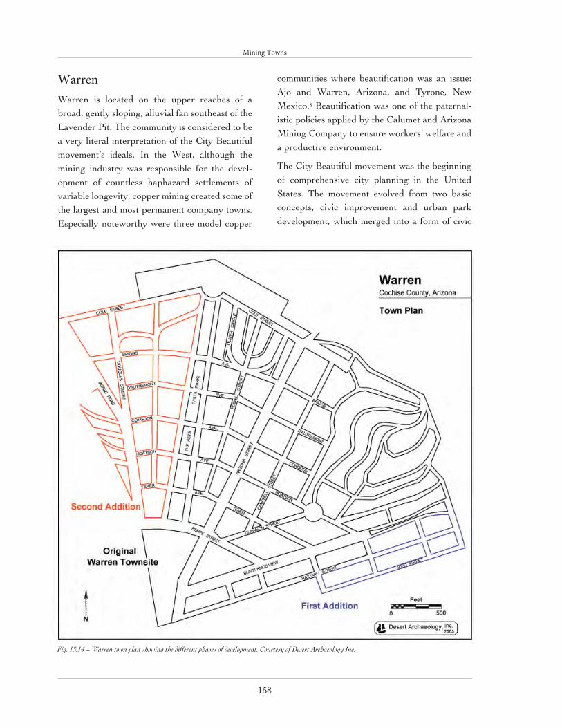
Mining Towns
158
WarrenWarren is located on the upper reaches of a broad, gently sloping, alluvial fan southeast of the Lavender Pit. The community is considered to be a very literal interpretation of the City Beautiful movement’s ideals. In the West, although the mining industry was responsible for the devel-opment of countless haphazard settlements of variable longevity, copper mining created some of the largest and most permanent company towns. Especially noteworthy were three model copper
communities where beautification was an issue: Ajo and Warren, Arizona, and Tyrone, New Mexico.8 Beautification was one of the paternal-istic policies applied by the Calumet and Arizona Mining Company to ensure workers’ welfare and a productive environment.
The City Beautiful movement was the beginning of comprehensive city planning in the United States. The movement evolved from two basic concepts, civic improvement and urban park development, which merged into a form of civic
Fig. 13.14 – Warren town plan showing the different phases of development. Courtesy of Desert Archaeology Inc.

Mining Towns
159
idealism that swept the nation in the period 1899-1920. The City Beautiful movement combined a romantic aesthetic with underlying comprehen-sive qualities of utilitarianism, social responsibili-ty, and unity. City Beautiful aesthetics linked nat-ural beauty, naturalistic construction, and classi-cism. Site layouts were commonly Neoclassical in their axiality and formality.9
Vista Park
The formal core of Warren’s City Beautiful plan is dominated by a central north-south axis, embraced on either side by nearly symmetrical, radiating roadways and boulevards (fig. 13.14). The central axis, closed on the north by the for-mer mining company general manager’s mansion and on the south by a baseball park, is formed by seven-block-long, 160’-wide Vista Park, flanked on either side by 60’-wide, tree-lined boule-vards.10 Located at a higher elevation, charac-teristic of social stratification, and serving as the northern focal point of Vista Park, is the Walter Douglas House, a mansion built in 1908 and designed by noteworthy architect Henry Trost of Tucson/El Paso. In the Mission Revival style, it is constructed of reinforced concrete. Most of Warren’s larger, historic, managerial class resi-dences are located at this end of the townsite.
Arizona Street
The bulk of the community’s commercial and administrative buildings are located on Arizona Street, a side thoroughfare two blocks east of the principal park axis. In contrast to that at Ajo, the Warren town center occupies a second-ary location and has never filled in significant-ly. Unlike Bisbee’s densely packed commercial heart, Warren’s center lacks the feeling of a once vibrant hub of activity.
BisbeeBisbee, Arizona is located in the southeastern portion of the state, seven miles from the interna-tional border with Mexico. Nestled in a narrow valley of the Mule Mountains, it lies at an ele-vation of 5,300’. The City of Bisbee today con-stitutes a linear pattern of eleven related but dis-crete settlements situated along a broadly curving nine-mile portion of State Highways 80 and 92. Like other mining towns in the American West, Bisbee developed in isolation from other urban centers but quickly became a large community; in fact, it was Arizona’s largest community in the first decade of the 20th century and is still the county seat.
Unlike Ajo, Tubac, and other mining towns of the Southwest, Bisbee has no record of Native American or Spanish mining. Bisbee’s original, and until World War II, only, reason for existence was mining, and its mining history is intertwined with that of the Phelps Dodge mining company. Most of Bisbee’s mineral production came from a tract of ore-bearing land, two by three miles in surface area, and 4,000 feet deep. From this small area, nearly 8 billion pounds of copper, 355 mil-lion pounds of zinc, 324 million pounds of lead, 100 million ounces of silver, 8 eight million ounc-es of gold, and 11 million pounds of manganese were produced from its origins in the late 1870s until the end of operations in 1981.
The oldest of the eleven Bisbee settlements, now known as “Old Bisbee,” is scattered over the steep mountainsides in a pattern reflective of the rapid, organic growth of mining towns in the American West. In contrast to Ajo, Phelps-Dodge’s other large mining operation in southern Arizona, Bisbee was never a company town, although the Phelps-Dodge Company sponsored most of its civic institutions and public architec-ture. Throughout its history of intensive min-ing activity, Bisbee’s geographic features were

Mining Towns
160
manipulated and exploited to suit the pragmatic needs of the mining operations. As an example of this transformation of Bisbee’s physical land-scape, its major, man-made topographic feature, the nearby Lavender Pit Mine, was created by literally removing a 900’mountain, Sacramento Hill, from the landscape, and then excavating a hole in the ground through open pit mining. This is what Richard Francaviglia calls a “classic land-scape of subtraction,” a place where a total of 380 millions tons of material was removed.11
Bisbee’s settlement was guided by the limitations of its natural setting expanding upwards along the drainageways of the two canyons, Mule Gulch and Brewery Gulch, that intersect at the area of mining activities. A trail following the line of Mule Gulch was called Tombstone Canyon Road as it led to Tombstone, Bisbee’s closest urban neighbor. In the late 1890s and early 1900s after both fire and flood ravaged Bisbee’s early central business district along an unpaved Main Street, brick and concrete construction replaced the earlier wood frame buildings.
From the early 1880s, Brewery Gulch developed as a secondary commercial district. The lower end of the Gulch, where it flows into Tombstone Canyon, evolved into a dense concentration of activity on both sides of the street, with restau-rants, breweries, newspaper offices, Bisbee’s stock exchange, and the town’s first lumber-yard. By 1890, the street had further developed into Bisbee’s tenderloin district, which included saloons, gambling houses, opium dens, rooming houses, and houses of prostitution. The street boasted the reputation of being “the liveliest spot between El Paso and San Francisco.”
Residential Development
The Infrastructure of Hillside Development: Terraces, Retaining Walls, and Stairs
Typically, Bisbee’s commercial or public build-ings were constructed on or near the relatively flat areas at the floors of canyons. Except for this development on the level but limited canyon floors, Bisbee was built on sloping terrain. Once the relatively flat canyon floors were all taken up, builders had to climb higher to find land on which to build, and residential buildings were typically constructed on sloping, less desirable land.
Early on, Bisbee builders realized that, without modification, steeply pitched sites were all but impossible to use as home sites. At this point, builders adopted the technique of terracing the hillsides, excavating a series of long “benches” into the slope of each hill at regular vertical intervals and using retaining walls at each “step” between levels (fig. 13.15). Thus the layout of sloping residential areas was conceptualized and carried out in three dimensions: these areas were laid out as much vertically, or “in section,” as they were horizontally, or “in plan.” This approach is analogous to that of underground mining in “drifts,” (regularly spaced parallel horizontal tunnels) or that of open pit mining in “benches” (regularly spaced horizontal terraces). It comes as no surprise that this type of useful technology transfer took place in the context of city building in the mining community of Bisbee.
The oldest retaining walls still standing in Bisbee are made of stone with the most beautiful and durable examples built by miners who were imported from Cornwall, the only region of the world known for this level of beauty and pre-cision in its stone walls. Another early type of retaining wall is the “cribbed” timber wall similar to the timber-framed bulkheads used in under-
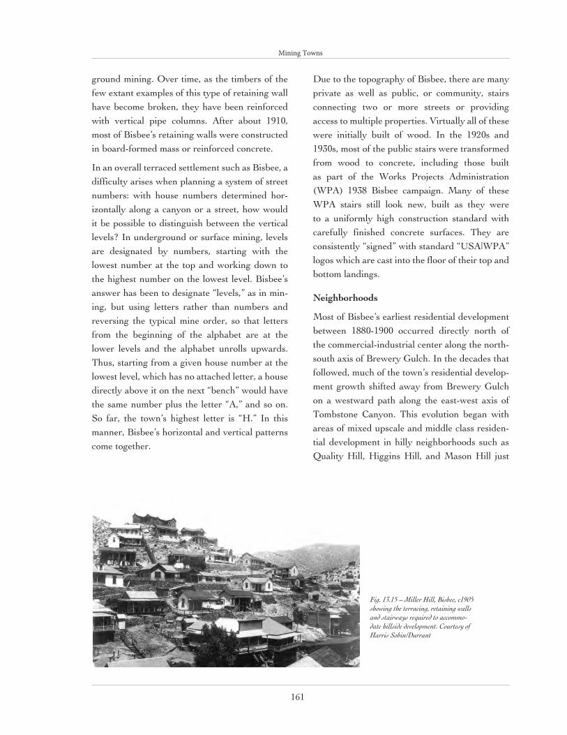
Mining Towns
161
ground mining. Over time, as the timbers of the few extant examples of this type of retaining wall have become broken, they have been reinforced with vertical pipe columns. After about 1910, most of Bisbee’s retaining walls were constructed in board-formed mass or reinforced concrete.
In an overall terraced settlement such as Bisbee, a difficulty arises when planning a system of street numbers: with house numbers determined hor-izontally along a canyon or a street, how would it be possible to distinguish between the vertical levels? In underground or surface mining, levels are designated by numbers, starting with the lowest number at the top and working down to the highest number on the lowest level. Bisbee’s answer has been to designate “levels,” as in min-ing, but using letters rather than numbers and reversing the typical mine order, so that letters from the beginning of the alphabet are at the lower levels and the alphabet unrolls upwards. Thus, starting from a given house number at the lowest level, which has no attached letter, a house directly above it on the next “bench” would have the same number plus the letter “A,” and so on. So far, the town’s highest letter is “H.” In this manner, Bisbee’s horizontal and vertical patterns come together.
Due to the topography of Bisbee, there are many private as well as public, or community, stairs connecting two or more streets or providing access to multiple properties. Virtually all of these were initially built of wood. In the 1920s and 1930s, most of the public stairs were transformed from wood to concrete, including those built as part of the Works Projects Administration (WPA) 1938 Bisbee campaign. Many of these WPA stairs still look new, built as they were to a uniformly high construction standard with carefully finished concrete surfaces. They are consistently “signed” with standard “USA|WPA” logos which are cast into the floor of their top and bottom landings.
Neighborhoods
Most of Bisbee’s earliest residential development between 1880-1900 occurred directly north of the commercial-industrial center along the north-south axis of Brewery Gulch. In the decades that followed, much of the town’s residential develop-ment growth shifted away from Brewery Gulch on a westward path along the east-west axis of Tombstone Canyon. This evolution began with areas of mixed upscale and middle class residen-tial development in hilly neighborhoods such as Quality Hill, Higgins Hill, and Mason Hill just
Fig. 13.15 – Miller Hill, Bisbee, c1905 showing the terracing, retaining walls and stairways required to accommo-date hillside development. Courtesy of Harris Sobin/Durrant

Mining Towns
162
west of the center. Growth then continued during the subsequent decades with more middle and working class neighborhoods developing in the same westerly direction as far as the lower slopes of the Mule Mountains.
In early Bisbee, residential areas and individual houses were usually linked by dirt ramps and trails, or the occasional wood stair. Neighborhoods or areas with which residents identified their homes in Bisbee were often denominated in terms of the most prominent nearby topographical feature, usually a hill or a canyon. Topography helped define these neighborhoods to such an extent that, by the turn of the century, at least 13 topo-graphically defined and distinct neighborhoods existed (fig. 13.16). Also at that time, residential streets began to appear, particularly in those more hilly parts of town located above the rela-tively flat canyon bottoms. Even with the advent of streets, most residential addresses remained
associated with named hills or canyons, rather than with streets or roads.
Up through 1904, when the Bisbee smelter closed down following the start-up of a new smelter at Douglas, 15 miles away, the air quality in Bisbee was the direct cause of numerous respiratory-re-lated deaths. Thereafter, air quality in Bisbee (and especially in Tombstone Canyon) improved noticeably and within a few years residential development of Tombstone Canyon began to catch up with that of Brewery Gulch. Another factor that increased upper Tombstone Canyon’s residential desirability was the creation of a trol-ley line in 1908 and a decreased risk of flooding after completion of Mule Gulch Channel in 1912.
Over time, many of Bisbee’s hills or canyons acquired distinct ethnic or class identities, includ-ing Irish, Italian, Cornish, Mexican, and Serbian; as Richard Shelton remarks, “the ravines often marked barriers that were more than topograph-ical.”12 Francaviglia has identified this phenome-
Fig. 13.16 – Map of named hills, now residential neighborhoods, Bisbee. Courtesy of Harris Sobin/Durrant.
Mining Towns
163
non as “stratification,” a process common in the development of mining landscapes by which the houses of mining company managers, superin-tendents, geologists, and bosses are identifiable by their size, explicit stylistic expression, and their location in identifiable enclaves on a hillside or hilltop location (see the essay by James E. Ayres and Janet H. Parkhurst). In contrast, mine workers lived in less prominent neighborhoods or sections of town; their dwellings share mor-phological characteristics, including building and roof forms, with the higher-class residences but lack the applied styling of selected ornamental details, often imported from other locations. The similarities that are observable can be attributed to the existence of a limited palette of house types available to both classes. Also, with the exception of techniques borrowed from mining engineering, Bisbee lacked access to more than a very basic level of expertise in building construction. Other than during the brief boom periods in Bisbee, most owners were unable to afford anything beyond the kind of simple, functional buildings that typified the town’s major period of growth from the mid-1880s to the late 1920s.
These factors led to the clustered, village-like appearance of the Quality Hill/Higgins Hill/Mason Hill area of Bisbee in the areas west of Castle Rock and south of Tombstone Canyon which were built up in the 1895-1905 period (see tours 1 and 2). Some houses were constructed with pyramidal or hipped roofs, while others were larger versions of the earlier gable-front-and-wing or cross-gable house. Another group of such larger houses was constructed along upper Tombstone Canyon Road during the 1915-1925 period. As building sites along Tombstone Canyon itself began to fill up, lower middle class and working class development continued up into the smaller canyons radiating from it. The lower ends of each of these smaller canyons ran into Tombstone Canyon. These “side” canyons
include Moon, Spring, Star, Art, and Wood Canyons. Along each one, development typical-ly began at the base, along Tombstone Canyon itself, then climbed uphill; the smaller houses of lesser quality, at or near the less accessible top of the canyon, were often owned or inhabited by the poorest working class residents. The rate of con-struction in Bisbee declined after 1916 because of a declining population and very few new struc-tures of any kind were built after about 1930.
A number of varied working class or lower mid-dle class pocket communities existed. Examples include the neighborhood of laundresses and their families, mostly Irish, who lived and worked on Laundry Hill. Other examples include the two Mexican/Mexican-American ethnic enclaves off upper Tombstone Canyon: Spring Canyon and Star Canyon. Still other such Hispanic precincts were Chihuahua Hill, just to the east of and over-looking the business district, and the Zacatecas Canyon area at the northernmost end of Brewery Gulch. Other ethnic enclaves included a Serbian area on the hillside above central OK Street.
Residential Typologies
Bisbee is a textbook for the study of vernacu-lar “folk” house typologies during an important period of development at the end of the 19th and beginning of the 20th centuries (see the discussion in Anne M. Nequette’s essay). These vernacular buildings are classified by “building type” based on footprint (e.g., rectangular versus L-shaped or other more complex floor plan types) and roof type (e.g., gabled, hipped, or flat). The morpho-logical types are based on the appearance of the buildings as seen from the street.
While most of Bisbee’s residential building stock presents examples of national folk vernacular architecture, many other buildings reflect design trends that prevailed at the time of their construc-tion; they may be described as partially “styled,” for example through detailing which reflects a

Mining Towns
164
recognized historic architectural style. Although architects were rarely involved in Bisbee building projects, styles nonetheless infiltrated the vernac-ular via plans or elevations that appeared in mag-azines or pattern books. For example, no fully realized examples of the Queen Anne/American Victorian style can be found in Bisbee, but a large number of side-gabled vernacular examples are extant, with porches supported by classically derived turned columns and decorative “ginger-bread” spindlework or with decoratively shingled gable-ends, features typical of the Queen Anne style. Among the varied stylistic influences are Queen Anne, Craftsman, Neo-Classical Revival, Spanish Colonial/Mission Revival, and Gothic Revival.
In the 2003 survey done of Bisbee’s residential architecture, 74 distinct building types were found, representing variations on standard ver-nacular nomenclature. The larger categories of gable and pyramidal types represent the majority of vernacular building types found in Bisbee (fig. 13.17). Morphologically speaking, four of these vernacular types, the side-gabled, the gable-front, the gable-front-and wing (or L-house), and the
cross-gable (or T-house), can all be classified as variations on or combinations of basic rectangular volumes topped by a gabled or pitched roof. The simpler, single volume varieties appear typically earlier in time. The more complex, intersecting, or multiple-volume varieties typically appear later. All represent simple, gable-topped forms that are relatively economical to construct. While other typological groupings exist in Bisbee, including bungalow, shed-roofed, flat-roofed, I-houses, and even Sonoran houses, their representation in the overall residential landscape is minor.
Building Materials and Construction TechnologiesAs is the case with many Arizona cities and towns, the use of different building materials and building techniques in Bisbee coincided with different periods in the town’s development. The earliest surviving structures are of adobe or stone, corresponding to the earliest stages of Bisbee’s development, from 1878 to about 1895. Finished lumber put in its appearance soon after the begin-ning of this earliest stage of the area’s history, first competing with adobe, and then replacing
Fig. 13.17 – Hipped- and pyramidal-roofed houses,
Higgins Hill, Bisbee. Courte-sy of R. Brooks Jeffery

Mining Towns
165
it. By 1895, adobe was no longer used in Bisbee, except for a few houses in ethnically Hispanic neighborhoods. During the era of expansion from 1884 to 1916, and following a series of major fires in the business district, brick became available in Bisbee, but was seldom used in the residential areas due to cost and is most visible in the com-mercial district. Bisbee’s residential stock was largely wood frame due to the cost of delivering materials to steep sites and to existing construc-tion skills.
Wood/Frame Construction
The majority of construction in the residential areas of Bisbee is wood frame construction, most of which is sheathed in some type of horizontal clapboarding. The clapboards might be of wide, narrow, or standard (4-inch) width. From the evidence of older photographs of Bisbee build-ings, the earliest type of clapboarding utilized appears to have been the narrow type. In this style of sheathing, each actual component board is five inches wide, but is milled to give the appearance of two narrow, separate boards, each
two inches high. The style is sometimes referred to as a “false bevel drop” style of sheathing.
There is evidence that there was at least one local source for “precut” houses in Bisbee: Lemuel Shattuck’s lumber-yard, located at 68 Brewery Avenue, advertised precut houses for sale prior to 1900. This follows the national trend established by companies such as Sears Roebuck which sold “mail order” houses from 1895 to at least 1940. Unfortunately, identifying examples of these houses will require more research.
Box Construction
The terms “box” and “single wall construction” are both used to describe a technique of frameless vertical-plank construction (fig. 13.18). Box con-struction is not identified as a clearly differentia-ble residential building technique in the manuals customarily used to identify American houses (e.g., V. & L. McAlester). To date, American vernacular architecture studies dealing with box construction have mostly documented the appearance of this phenomenon in the southern states. These studies stress that “box” construc-tion provided a simple means of building small
Fig. 13.18 – Drawing of typical “box” house construction, Bisbee. Note the vertical boards nailed to perimeter sills, with vertical joints sealed with battens (upper walls) or horizontal siding (below). Window openings are made either with or without framing. Note the absence of conventional studs or sheathing. From Mitchell, Brown and Swanda. Courtesy of Harris Sobin/Durrant after Mitchell, Brown and Swanda

Mining Towns
166
houses quickly and economically. None to date has dealt with its appearance in Arizona.
While Bisbee’s very earliest structures were of canvas or adobe, once transportation was suffi-ciently improved, power-sawn planks and boards became available. Bisbee historian William Newkirk calls the modest working-class houses of Bisbee ca. 1884 “shacks,” not houses, and goes on to state that “the most common construc-tion material was vertical siding of rough lum-ber,” presumably referring to box construction. Photographic analysis also suggests that box construction was the earliest mode of building in wood, and that, after adobe, its wood was the earliest material used in Bisbee.
This kind of construction in Bisbee using wooden planks did without all of the usual posts, studs, blocking, and bracing used in typical wall fram-ing. Instead it used vertical 12”-wide rough-sawn boards which were butted tightly together to form load-bearing walls and were nailed into wooden sill and plate members. The joints between these nominal 1” by 12” (3/4” x 11”) boards were sealed with narrow wooden battens, typically of 7/8” x 2” or 2-5/8” dimensions. In Bisbee, most of these battens were simple rectangles in cross section, but elegant profiled examples can occasionally be seen in the earliest examples, for instance using pairs of mirrored Roman Cyma Reversa molding profiles on the two edges.
(This text was largely excerpted from Durrant/Harris Sobin, Old Bisbee Historic Residential Survey [2002] and Wilson, et al., “National Register Nomination for Bisbee Historic District [Central Business District]” [1980])
ToursThe following tours are intended to introduce the reader to the variety of vernacular buildings described above. With the exception of public accessible buildings, the buildings listed may be
viewed from the exterior only. Please respect the privacy of the residents.
Tour 1 – Higgins Hill
(from St. Patrick’s Church, proceed up Quarry Canyon Avenue–passing the Mission Revival Loretto Academy—to O’Hare and Oak Avenues, then go back on Quarry Canyon Avenue to the church)
Higgins Hill offers a comprehensive collection of gable and pyramidal house types including the following outstanding examples:
1. 310 O’Hare Ave: This is a classic wood framed, two-story, four-square house with a raised first floor and a two-story porch at its front facade, the top floor of which has been enclosed. It also has a shed dormer with diamond-pane fenestration.
2. 314 O’Hare Ave: This is a mass-plan house with a wood framed, gambrel-roofed structure, and a front porch recessed along part of its width. An octagonal dormer and a gabled dormer at front are connected by a shed dormer.
3. 319 O’Hare Ave: This wood frame house com-bines the five-room pyramidal subtype with the gable-on-hip roof variant (fig. 13.20). With this configuration, the front porch is recessed into one half of the facade, creating an asymmetrical front which is easily mistaken for a partially enclosed full-width porch. The “missing room,” equal to the porch in depth, is then added at the rear of the building, on the same side of the plan as the recessed porch.
4. 400a O’Hare St: This is an example of a house sheathed in wooden clapboards of the standard width.
5. 405 Oak Ave: A classic Craftsman Bungalow.
6. 315 Oak Ave: Except for a small shed roof addition at the rear, this wood frame house is a good example of the archetypal four-room plan

Mining Towns
167
type. The pyramidal roof is truncated, and the house has a full-width hipped porch on the street facade (albeit with unfortunate wrought iron supports). Detailing is very basic; the roofing is rolled asphalt, covering original shakes.
7. 316 Oak Ave: The three-story Brophey House was built in 1900 with an L-shape plan. As man-ager of the Bisbee branch of the Copper Queen Company Store, Michael Brophy held an import-ant position in turn-of-the-century Bisbee. In this house, the re-entrant corner space between the building’s two wings was originally filled with a fully enclosed one-story space, surround-ed on two sides by a hipped-roof porch. When compared to earlier, simpler gabled types, this composition, with its visual complexity and over-all asymmetry, establishes a clearly intentionally picturesque image. Queen Anne influence is seen in the detailing, e.g., in the turned porch columns, the decorative wood en shakes in the gable ends, and a large bay window in the gable facing the street.
8. 306 Oak Ave: This early brick house, con-structed in 1895, is an example of a pyrami-dal cottage but with some uncommon features, including cross-gable dormers on each side of the roof and a raised main floor. The house also has a full-width shed-roofed porch at its street facade, supported by Queen Anne Style turned columns. The entry is emphasized by a brickwork bay at the front door, which suggests that the house may have the unusual feature of a center hall plan.
9. 302a Quarry Canyon: This L-shaped, two-sto-ry, wood frame house was designed in 1905 by one of Bisbee’s early architects, Frederick Hurst. Hurst initially came to Bisbee as an architect for Phelps-Dodge, later going into local practice on his own. Since the house was built on a relatively small site, it was designed with a more compact footprint, including a two-story open porch at its north side. It, too, shares the Queen Anne detail-ing of the other L-shaped houses on Higgins Hill,
Fig. 13.20 – 319 O’Hare Ave, Higgins Hill; an example of a gable-on-hip roof type with a front porch integrated within the roof form.Courtesy of R. Brooks Jeffery

Mining Towns
168
including a large bay window at the raised first floor.
Tour 2 – Quality Hill
(from St. Patrick’s Church, proceed down Quarry Canyon Avenue to the Art Deco Cochise County Courthouse and Ledge Avenue, then take Cross Avenue to Quality Hill Road and back down to the church)
Quality Hill was the site of many prominent civic and residential buildings, as well as a number of WPA stairways.
10. Cochise County Courthouse. Designed by Tucson architect Roy Place in 1930-31, this is a classic example of Depression-era Art Deco public architecture, from the facade compo-sition to the intricate artwork reflecting the copper themes of once prosperous Bisbee (fig. 13.21). Make sure you go inside the building to see the extent of decorative detailing through-out the public spaces.
11. Bisbee Women’s Club, on the SW cor-ner of Ledge Ave. and Cross Ave.: The club building, designed in 1902 by local architect Frederick Hurst, is a long hip-roofed rectangle, with details such as the projecting rafters, a hip-roofed entry porch, and a hipped dormer window borrowed from the Craftsman style.
12. Quality Hill Road Plaza, located at the top of Cross Ave.: This informal paved space was once known as Queen Place in recognition of the important role played by the Copper Queen Consolidated Mining Company as developer of housing for its elite. The space still functions as an informal center for the Quality Hill Neighborhood. Company-built houses that face onto Quality Hill Plaza include the Sherman House, the Johnson House, and the Presbyterian Manse, or church rectory.
13. WPA Stairways: Other Quality Hill resi-dences can be seen by walking on one of two
Fig. 13.21 – Cochise County Courthouse.Courtesy of R. Brooks Jeffery.

Mining Towns
169
WPA stairways. The first, Quality Hill Walk (Site No. 685), leads from Quality Hill Rd. down to Ledge Ave., near the Cochise County Courthouse, and past a cluster of wood frame houses (fig. 13.22). The second, and longer, stairway leads from the upper extension of Ledge Ave. all the way down to Tombstone Canyon Rd. near the upper end of the commer-cial district and Tour 3.
Tour 3 – Commercial District
(from the Bisbee Mining and Historical Museum on Main Street, proceed up to Howell Avenue around the YWCA to Shearer Avenue to Subway Street to Tombstone Canyon Road, then return to Main Street and go back to the Museum; another group of commercial and civic buildings can be found up Brewery Gulch Road, OK Street, and Naco Road)
Bisbee has a still-viable, well-developed, dense commercial core, largely concentrated in its canyon zone. This district features a remark-able array of early 20th-century, ornament-ed, false-front, two-part commercial blocks built of brick and stone. Along Bisbee’s nar-row, curving, inclined streets, these buildings form dense-walled streetscapes that give a “European” impression.
14. Bisbee Mining & Historical Museum (for-merly the Copper Queen Consolidated Mining Company General Office Building), located on Copper Queen Plaza: This 1897 building is Bisbee’s oldest extant public structure. The two-story brick building contains restrained Queen Anne stylistic references common to that era.
15. Copper Queen Hotel, 7-13 Howell Ave.: Constructed in 1902 by the Copper Queen Consolidated Mining Company, this four-story brick and stucco hotel was built to resemble an Italian villa. It housed visiting company
Fig. 13.22 – Quality Hill Walk, one of many WPA stairways in Bisbee. Courtesy of R. Brooks Jeffery

Mining Towns
170
executives and other guests deserving of quality accommodations.
16. YWCA Building, 28 Howell Ave.: This four-story, brick and wood frame building was commissioned by Phelps Dodge in 1916 to pro-vide Bisbee women with a venue to nurture the town’s fledgling civilized society.
17. YMCA Building, 39 Opera Ave.: This 1905 brick structure is a marriage of Italian Villa and Neoclassical Revival architectural styles whose decorative features have undergone many alter-ations.
18. Allen Building, 57a Subway: This is a unique two-part commercial building constructed in 1908 of gypsum block and stone (fig. 13.23).
19. Main Street Commercial Buildings, 1-67 Main St.: Along the Main Street/Tombstone Canyon Road corridor is a grouping of commer-cial buildings designed between 1902 and 1910 and reflecting Bisbee’s early economic prosperity. They are primarily one- and two-part commercial buildings with a variety of nationally recognized stylistic elements including, in the case of those designed by Tucson/El Paso architect Henry Trost, reflections of the geometrical and natural-istic ornamental motifs of Louis Sullivan, Trost’s architectural mentor.
20. Copper Queen (formerly Phelps Dodge) Library & Post Office Building, 6-8 Main St.: Designed in 1906 by Bisbee architect Fredrick Hurst, this three-story concrete and gypsum block building still houses the post office on the ground floor, a large reading room on the second floor, and the library on the third floor. Neoclassical and rusticated elements constitute the only form of stylistic references. The oddly scaled facade is defined by tall arches and porch-es on the upper floors.
21. Phelps Dodge Mercantile Store, 5 Copper Queen Plaza: This 1939 Streamline Moderne
Fig. 13.23 – Allen Building, showing how a two-part commercial build-ing type accommodates the topography of Bisbee’s commercial district. Courtesy of R. Brooks Jeffery

Mining Towns
171
building reflecting the stylistic trends of its day, replaced the previous company store on the site, which had been destroyed by fire. The interior has been severely altered, but some aspects of the original spatial and decorative quality still remain.
22. The Brewery (Muheim Block), 13-17 Brewery Ave.: Built in 1905, this two-story brick building housed numerous occupants including saloons, restaurants, a hotel, and the Bisbee Stock Exchange. The building, with its corner entrance, has Neoclassical Revival facade elements, as well as an interior with its original pressed metal ceil-ing and old stock boards.
23. Pythian Castle, 29-33 OK St.: Designed in 1904 as a fraternal lodge for the Knights of Pythias, the building boasts a highly decorated facade capped with a clock tower.
24. Naco Road Buildings: Extending southeast from Bisbee’s commercial core is a series of build-ings that housed a variety of civic functions. They include the 1910 Lyric Theatre, the 1902 former City Hall/Fire Station, a rusticated concrete building with a small belfry, and the 1910 former Sheriff’s Office, a Neoclassical Revival building whose two-story facade is defined by four large columns.
ENDNOTES
1. Janet H. Strittmatter, “Arizona’s Vernacular
Dwellings,” Master’s Thesis (University of Arizona,
1998), chap. 9: 20.
2. Ibid., chap. 9: 10.
3. Johns & Strittmatter Inc., “Historic Resources
Inventory and Report of Tombstone, Arizona,” Report for
the Arizona State Historic Preservation Office, Arizona
State Parks, (Phoenix, June 1996), chap. 2: 1.
4. Lynn R. Bailey, “Too Tough to Die”–The Rise, Fall
and Resurrection of a Silver Camp; 1878 to 1990 (Tucson:
Westernlore Press, 2004), 330, 334.
5. Interview with James Garrison, State Historic
Preservation Officer and co-author, together with Billy
G. Garrett, of “Plan for the Creation of a Historic
Environment in Tombstone, Arizona” (1972), a preserva-
tion plan (2004).
6. Bailey, “Too Tough to Die,” 88.
7. Ibid., 112, 348.
8. Janet H. Parkhurst, “Ajo Townsite Historic District,”
National Register Nomination, produced by Old Pueblo
Archaeology Center and Janet H. Strittmatter Inc.
(October 2001), sec. 8: 8.
9. Ibid., sec. 8: 15.
10. Woodward Architectural Group, “Warren: The City
Beautiful,” Historic Resources Inventory and Report
(1993), 27.
11. Richard V, Francaviglia, Richard V., Hard Places.
Reading the Landscape of America’ Historic Mining Districts
(Iowa City: University of Iowa Press, 1991), 22.
12 Richard Shelton, Going Back to Bisbee (Tucson:
University of Arizona Press, 1992), 164.

172
14

173
EL PRESIDIO
The origins of the El Presidio district lie in the estab-lishment of the Presidio San Agustín del Tucson in 1775 on the eastern edge of the Santa Cruz River floodplain (a topographical depression that can still be seen when looking west from Main Avenue), in order to complement the existing mission visita on the west side of the river floodplain. After the Mexican garrison
left Tucson in 1856, the Presidio was occupied by soldiers of the United States but by 1862 it had been abandoned and left to the ravages of weather, neglect, and the pillaging of Tucsonans looking for building materials. The El Presidio neighborhood, as it is today, grew north along Main (formerly the Calle Real) and Granada Avenues, with most of the structures dating to between ca. 1860 and 1920. Part of the neighborhood was long referred to as “Snob Hollow,” due to the number of affluent Americans who built dis-tinctive houses contrasting sharply with the Sonoran rowhouses of Meyer and Court Avenues. The neighborhood was officially desig-nated as “El Presidio” on the National Register of Historic Places in 1976. The El Presidio neighborhood clearly reveals the urban and architectural transformation from Sonoran to American block and building typologies that took place at the turn of the 20th cen-tury. This contrast can best be seen at the junction of the Sonoran Stevens-Duffield House (site 18) and the American Corbett House (site 19). Although the Tucson Museum of Art building is a heavy presence in this residential-scaled neighborhood, the Museum has become an accomplished steward of some of the neighborhood’s oldest buildings comprising the Museum’s Historic Block.
DOWNTOWN TUCSON HISTORIC DISTRICTS
University of Arizona Preservation Studies Students
coordinated by Andrew Gorski

El Presidio
174
1. Franklin Residence, 402 N. Main Avenue
This American territorial house was built in 1898 by prominent Tucson lawyer Selim Franklin and his wife Henrietta Herring Franklin, who was responsible for the house’s design. The house is distinguished by its placement far back from the street in contrast not only to the Sonoran rowhouse typology but even to some of its American contemporaries. The olive trees located throughout the property, as well as other specimens planted on the grounds of the University of Arizona campus, were imported in the early 1900s from the Mediterranean by Dr. Robert Forbes, an early University horticulturalist. The original house was fully carpeted and con-tained a parlor, dining room, two bedrooms, a study, one-and-a-half baths and a kitchen on the ground floor, with a coal chute and a nanny’s quarters in the cellar. The original parlor had a cove ceiling, built in 1906, that was replaced by the fake beam ceiling seen today. The wood in this room was originally dark mahogany with a stem wall bookcase and an archway into the room from the foyer. The south wall of the study had a chimney in the center and two windows on each side. The house was originally designed with an attached front porch facing the street. Soon after construction, a rear sleeping porch was added; recently, it was expanded and enclosed. The southwest section of the house was added in 1947 by architect Art Brown. The house is built on a limestone foundation with plastered double brick walls and a ridge pyramidal wooden roof. Lumber brought in from Pasadena California is still visible in the beams and floor joists of the cellar.
Fig. 14.1 – Exterior, Franklin House, looking
southwest. Courtesy Andrew Gorski
Fig. 14.2 (far right) – Plans, Franklin House,
Courtesy Preservation Studies, CALA, University
of Arizona

El Presidio
175

El Presidio
176
2. Second Owl’s Club, 378 N. Main Avenue (exterior only)
Like the first Owl’s Club (see Steinfeld Mansion), this 1902 two-story, stylistically eclectic building was designed by Henry Trost who mixed Mission Revival and Sullivanesque ornamentation. Trost incorporated playful references to several Tucson vernacular traditions: immense, oversized canales, typical of Sonoran row houses; a sculpted facade, reminiscent of that of San Xavier; and images of local flora and fauna. The building was renovated in 1985 and the façade completely reconstructed from historic photos by plaster sculptor Rob Boucher after vandal-ism had reduced the building to a ruin.
Fig. 14.3 – Exterior, Second Owl’s Club. Courtesy R. Brooks Jeffery
3. Wilder Residence, 350 N. Main Avenue
This contemporary house, designed in 1991 by Corky Poster, represents the application of tradi-tional Sonoran building principles to new build-ing: rooms are arranged around an outdoor courtyard and high ceilings and thick adobe wall construction appear throughout. The original house had an L-shaped plan with the court-yard facing southeast, the optimal orientation to enhance winter solar gain for passive heating. In 1999, Bob Vint designed an addition, creating a shady northern courtyard and porch for use during the hot summers. The system of court-yards enhances cross-ventilation and the evapo-
rative cooling system moves large volumes of air through the house. Both portions of the house have walls of exposed, stabilized adobe blocks with smooth gypsum plaster on the interiors. The floors are of exposed colored concrete, and the flat roof is constructed of recycled wood. The 1999 addition was designed around a pair of large glazed doors and wrought-iron reja, or grillwork, that became a prominent feature of the entry court. The addition has radiant floor heat with in-slab piping linked to a residential water heater.

El Presidio
177
Fig. 14.4 – Plan, Wilder House. Courtesy Preservation Studies, CALA, University of Arizona
Fig. 14.5 – Exterior, Wilder House, looking east. Courtesy R. Brooks Jeffery

El Presidio
178
4. Verdugo Residence, 317-325 N. Main Avenue(exterior only)
This 1877 house is an excellent example of the transformed Sonoran row house in which the original flat roof with canales was covered with a framed hipped roof, representing the arriv-al of the railroad and the availability of economical building materials. The Greek Revival trimwork also indicates the local influence of national design trends, again a consequence of Tucson’s new rail connections. Noteworthy on this house is the American approach to its addition, which is placed directly behind the original house. If the house had remained true to its Sonoran typological roots, its growth would have taken place along the street line, ultimately creating an envelope around an interior courtyard.
Fig. 14.6 – Exterior, Verdugo Residence. Courtesy R. Brooks Jeffery

El Presidio
179
5. Steinfeld Mansion (Owl’s Club), 300 N. Main Avenue (exterior and rear courtyard only)
Designed in 1898 by Henry Trost as a residence for the thirteen bachelors who comprised the original fraternal Owl’s Club, this two-story building reveals Trost’s stylistic preference for combining Mission Revival forms with Sullivanesque detailing. The one-story public street facade contrasts sharply with the intimate space of the shaded rear courtyard, whose fountain and wall openings serve to cool the building using humidity and natural ventilation. Oval attic vents and deep overhangs also help to ventilate the attic space and keep the building cool, working not unlike the traditional O’odham ramada. The 1978 restoration by Gresham Larson Associates repaired much of the Sullivanesque ornamentation, among other treatments, and earned the architectural firm a design award.
Fig. 14.7 – Exterior, Steinfeld Mansion. Courtesy R. Brooks Jeffery
Fig. 14.8 – Rear courtyard, Steinfeld Mansion. Courtesy R. Brooks Jeffery

El Presidio
180
6. El Presidio Bed & Breakfast (Kruttschnitt House), 297 N. Main Avenue (exterior only)
Beneath the 1899 Victorian dress of this building is a traditional Sonoran row house, built sometime before 1886 with thick adobe walls, a flat roof, and a central zaguán. The transformation of roof form and the addi-tion of porches and ornamentation illustrate the evo-lution of stylistic preferences by Tucsonans as a result of the arrival of the railroad, which exposed them to national trends in building design and aesthetics, as well as their desire to “Americanize” inherited Sonoran building types. A major restoration in 1980 by Paul Weiner brought this transformed Sonoran house to its present glory.
Fig. 14.9 – Exterior, El Presidio Bed & Breakfast. Courtesy R. Brooks Jeffery

El Presidio
181
7. Olcott Residence, 234 N. Main Avenue (exterior only)
This detached house, built in 1890 by contractor Arthur Jacobson, is a compact four-square house with an L-shaped corner porch carved out under a pyramidal roof. It was the first house on the west side of Main Avenue to take advantage of the steep slope toward the Santa Cruz River floodplain, making pos-sible two stories on the west side (rear) of the house. Unlike its Sonoran counterparts made of adobe, this house is constructed of exposed clay brick, expressing its adherence to American material preferences.
Fig. 14.10 – Exterior, Olcott House. Courtesy of R. Brooks Jeffery

El Presidio
182
8. Valdez Residence, 234 N. Meyer Avenue
This transformed Sonoran rowhouse, built in ca. 1880, is symmetrical in plan with a central zaguán that runs the depth of the building and from which all of the residence’s rooms were accessed. As was typical of the Sonoran plan, there were two access points to the original house, one facing the street and the other, in the rear, facing what was originally the interior of the block but is now an alley. At an unknown date, the original flat roof was capped with a wood frame pyramidal roof and a front porch was added to the west facade with a dropped, hipped roof, chamfered posts, and scrollwork brackets. Francisco Valdez, grandfa-ther of current owner Tony Valdez, purchased the house in 1921. At that time, the kitchen was located in the southeast corner of the house with a wood-burning stove. A porch on the south side of the house burned down around 1940 and was replaced in 1981 by an enclosed addition. In 1950 electrical work was done throughout the house. In 1960, with funding from a City of Tucson grant, numerous repairs were carried out, including replacement of the pyramidal roof materials with plywood and shingles. The current owners believe the original floor may have been dirt; there is now a 3’ crawl space under the wood floor. Some of the windows punctuating the north and east facades may once have been doors. The Queens Wreath vine that currently grows on the porch trellis is a common ornamental plant frequently used in early Tucson landscapes.

El Presidio
183
Fig. 14.11 – Plan, Valdez Resi-dence. Courtesy of Preservation Studies, CALA, University of Arizona
Fig. 14.12 – Exterior, Valdez Residence, looking southeast. Courtesy of R. Brooks Jeffery

El Presidio
184
9. North Meyer Avenue rowhouses (exterior only)
These transformed Sonoran rowhouses, built between 1860 and 1880, create an almost continuous street facade as a reminder of the original Sonoran urban block typology. Originally, each building had a flat roof but those roofs have since been replaced by gable roof forms of various pitches, heights, and materials.
Fig. 14.13 – Exterior, North Meyer Avenue rowhouses. Courtesy of R. Brooks Jeffery
10. Residence, 378 N. Meyer Avenue
Although the chronological details are unclear, it is known that this one-and-a-half story, L-shaped, gable-roofed house was built in three stages. The first stage, dating to the 1880’s and closest to the street, consists of a large main room with 21” thick adobe block walls, viga-and-plank roof, and a wooden floor of 1” slats. The second stage added three rooms (one now almost completely eroded away) to the east of the main room. Their walls were constructed of 12” adobe blocks with a wooden ceiling of beaded slats and 3” wood slat flooring. The third and final stage included an attached guesthouse to the south of the main building with 9” thick adobe exterior walls, wood frame interior walls, and a lath-and-plaster ceiling. The framed roof structure of the third stage can be seen from inside the rooms. The second level is not accessible, as it is not structurally stable.

El Presidio
185
Fig. 14.14 – Plan, 378 North Meyer Avenue. Courtesy of Preservation Studies, CALA, University of Arizona
Fig. 14.15– Exterior, 378 North Meyer Avenue, looking northeast. Courtesy of R. Brooks Jeffery

El Presidio
186
Fig. 14.16 – Plan, Carrillo/Sloan Residence. Courtesy of Preservation Studies, CALA, University of Arizona
Fig. 14.17 – Exterior, Carrillo/Sloan Residence, looking northeast. Courtesy of R. Brooks Jeffery

El Presidio
187
11. Carrillo/Sloan Residence, 382 N. Meyer Avenue
This house was built around 1880 by Leopoldo Carrillo, son of one of Tucson’s prominent early entrepreneurs of the same name. The elder Carrillo developed Carrillo Gardens, later known as the Elysian Grove, an early recreation destina-tion with a lake, stage, and beer garden located directly east of the present-day Barrio Viejo. The house represents the transitional period of architectural expression with Sonoran character-istics—building placement on the front property line, 24” thick adobe block walls, flat roofs, and high interior spaces—combined with American characteristics such as building additions set back from the front property line and to the rear of the property as well as an attached front porch. Recent repairs to the exterior walls revealed that the house had been built in four stages, probably expanding as the family grew. The present living room may correspond to the original 1880 house, with the dressing room and bedroom added shortly thereafter, as well as a covered outdoor kitchen. Later additions to the east included a dining room and indoor kitchen. The skylight in the dining room gives a sense of the height of the original ceilings and the exposed vigas. In the early 1900s, the brick foyer, bedroom, and interior bathroom were added. The Sloan family has owned the property since 1977 during which
time they have lived in a constant state of resto-ration and discovery. Excavation of an old well in the backyard unearthed champagne bottles, oyster shells, caper bottles, Chinese pottery, an ink well, fragments of clay water jugs, a porcelain doll’s head and arm, a penny whistle and marbles, evidence of an earlier family with a boy and girl. The backyard garden is one of the many eclectic gardens of El Presidio.
12. Infill Construction, 418-426 (north side) and 421-425 (south side) N. Meyer-Court Avenue (exterior only)
Constructed by City of Tucson architect Joe Comello in 2004, this demonstration infill proj-ect involved the looping together of Meyer and Court Avenues, creating a edge wall of stabilized adobe against busy Sixth Street and providing an opportunity to create new architecture respectful of El Presidio’s vernacular expressions. The two rectangular buildings incorporate formal and detail elements from the existing neighborhoods. The south building is one story tall toward the existing neighborhood and the north building has a tall one-story facade facing Meyer Avenue and a two-story facade facing away from the neigh-borhood, creating a salt-box roof form.
Fig. 14.18 – Exterior, 418-426 N. Meyer-Court Avenue. Courtesy R. Brooks Jeffery
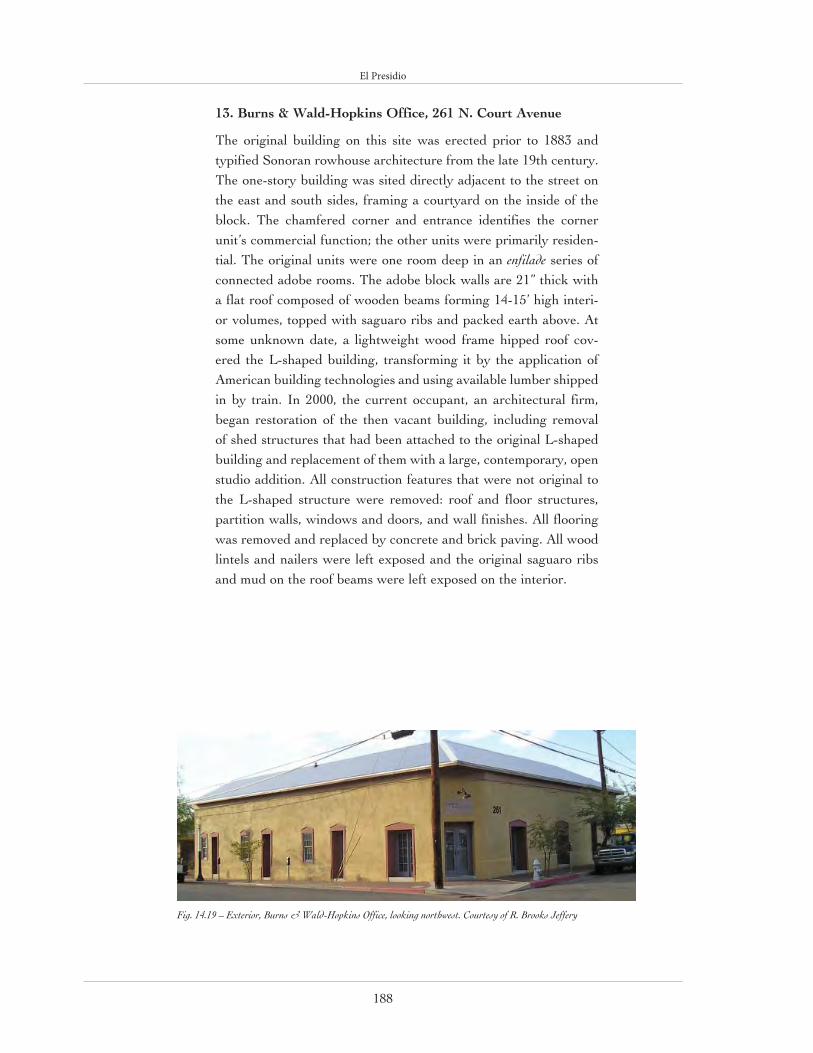
El Presidio
188
13. Burns & Wald-Hopkins Office, 261 N. Court Avenue
The original building on this site was erected prior to 1883 and typified Sonoran rowhouse architecture from the late 19th century. The one-story building was sited directly adjacent to the street on the east and south sides, framing a courtyard on the inside of the block. The chamfered corner and entrance identifies the corner unit’s commercial function; the other units were primarily residen-tial. The original units were one room deep in an enfilade series of connected adobe rooms. The adobe block walls are 21” thick with a flat roof composed of wooden beams forming 14-15’ high interi-or volumes, topped with saguaro ribs and packed earth above. At some unknown date, a lightweight wood frame hipped roof cov-ered the L-shaped building, transforming it by the application of American building technologies and using available lumber shipped in by train. In 2000, the current occupant, an architectural firm, began restoration of the then vacant building, including removal of shed structures that had been attached to the original L-shaped building and replacement of them with a large, contemporary, open studio addition. All construction features that were not original to the L-shaped structure were removed: roof and floor structures, partition walls, windows and doors, and wall finishes. All flooring was removed and replaced by concrete and brick paving. All wood lintels and nailers were left exposed and the original saguaro ribs and mud on the roof beams were left exposed on the interior.
Fig. 14.19 – Exterior, Burns & Wald-Hopkins Office, looking northwest. Courtesy of R. Brooks Jeffery

El Presidio
189
Fig. 14.20 – Plan, Burns & Wald-Hopkins Office. Courtesy of Burns & Wald-Hopkins

El Presidio
190
Fig. 14.21 – A 1954 aerial photograph
of downtown Tucson marked with the
approximate location of the Tucson presidio
wall. The upper right-hand corner is the northeast corner
tower site. Courtesy of Desert Archaeology,
Inc.
Fig. 14.22 – The adobe foundations of
the northeast tower of the Tucson Presidio (c 1782-1856) lie over a
Hohokam pitstructure (c 900). Courtesy of Desert Archaeology,
Inc.

El Presidio
191
14. Northeast Corner Presidio Wall, West Washington Street near Church Street
Excavations on the northeast corner of the Tucson Presidio (fig. 14.21) in 2002-2003 uncovered the adobe block foundations of the northeast tower and the eastern exterior wall (fig. 14.22) which aligned with previous-ly discovered segments in the Pima County Courthouse courtyard. The square corner tower was originally 50’-long on each side and stood 20’ high while the outer wall was originally 22’ wide and stood 10-12’ tall. Soldiers stood on a wooden walkway inside the 20’-tall tower and could fire their muskets down the length of the wall. Excavations inside the corner of the fort revealed postholes from a Hohokam ramada and numerous trash-filled pits that yielded Native American and Mexican pottery (fig. 14-23), animal bones, and plant remains allowing archaeologists to conjecture as to what domestic life was like in the presidio (fig. 14.24). The City of Tucson plans to recreate the corner tower and adjacent walls, offset from their original location. A glass enclosure will display a section of the tower wall and an underlying Hohokam pit structure. The adjacent City-owned Residence at 190-196 N. Court Avenue (Site 15) will house displays and artifacts found at the site.
Fig. 14.23 – Mexican majolica sherds from the Tucson Presidio, dating to c 1775-1850s. Courtesy of Desert Archaeology, Inc.
Fig. 14.24 – A reconstruction of a Presidio dwelling interior based on recent archaeological findings. Drawing by Robert Ciaccio, cour-tesy of Desert Archaeology, Inc.

El Presidio
192
15. Residence, 190-196 N. Court Avenue
Originally constructed in the 1860s and occupied by a typical Mexican-American family, this adobe house is characteristic of the Sonoran rowhouse type. Its facade was built flush against the edge of Court Avenue with a large courtyard located in the rear of the house where wells and privies were located and cooking, washing, and other activities took place. Constructed of thick, plastered adobe walls, the house began as a single row of three rooms, each with a door flanked by a pair of win-dows opening onto Court Avenue. Doors were present in corresponding positions on the opposite side of the house, opening onto the rear courtyard, where a second row of rooms was later added. Although later modified into a hipped roof with corrugated metal, the original roof of the house was had flat, constructed of vigas and saguaro ribs and then covered with packed earth. Located near the northeast corner of Tucson’s historic Presidio fortress, this house was purchased by the City of Tucson and has recently been restored for adap-tive use as part of the Presidio wall park showcas-ing Tucson’s Spanish and Mexican origins.

El Presidio
193
Fig. 14.25 – Exterior, Residence, 190-196 N. Court Avenue, looking southeast. Courtesy of Preservation Studies, CALA, University of Arizona
Fig. 14.26 – Plan, Residence, 190-196 N. Court Avenue. Courtesy of Preservation Studies, CALA, University of Arizona

El Presidio
194
16. Old Town Artisans (Telles Block), 201 N. Meyer Avenue
This complex of buildings exemplifies the evolution of one of the oldest buildings in Tucson. It began as a series of Sonoran row-house cells (evident as early as the 1862 Fergusson Map) growing incrementally along Telles Street, then by 1883 turning the corner onto Meyer Avenue, thus forming an “L”. By 1919, the building was transformed by the addition of a pitched roof over the origi-nal flat roof and by 1957 with the addition of a row of rooms on the interior of the courtyard that is still present today. With the exception of a few contemporary wood frame interior partitions, the entire complex is constructed of adobe block walls support-ing a series of flat roofs made of a variety of available materials, including vigas, dimensioned lumber, saguaro ribs, and wood from barrels and packing crates. The height of the original structure was lower than it is today. If you look carefully on the interior, you can see the line between the original and later wall heights, as well as a variety of wall finishes including exposed adobe, plaster, and even applied wallpaper. The grade changes by several feet throughout the building, with steps and ramps from room to room. In the 1890s the City of Tucson graded all the streets surrounding the oldest part of Tucson, moving the finished grade down by a few feet. There are steps from the exterior sidewalk into the structure in order to accommodate the drop in elevation. Sometime in the 20th century, a basement was dug out under one of the southern rooms of the complex, perhaps as a store for alcohol during Prohibition (not an uncommon practice in Tucson). The interior courtyard, made lush by trees and other plantings, is one of the most pleasant outdoor spaces in Tucson, providing an example of how intimate courtyard spaces can offer a climactic and psychological respite in hot climates.
Fig. 14.27 – Exterior, Old Town Artisans (Telles Block), looking northeast. Courtesy R. Brooks Jeffery

El Presidio
195
Fig. 14.28 – Plan, Old Town Artisans (Telles Block). Courtesy of Preservation Studies, CALA, University of Arizona

El Presidio
196
17. Casa Cordova, 171-177 N. Meyer Avenue (open during Saturday night banquet)
Casa Cordova is the oldest intact structure in the El Presidio neighborhood, with the southern portions dating to before 1848. This building is an example of the early Sonoran row-house typical of the barrios that extended from this site south along Meyer Avenue to the present-day Barrio Viejo. Although this building has lost its adjacent structures, it would originally have shared a continuous facade abutting the street. A zaguán connects the street to a courtyard at the interior of the block, defined by the L-shaped plan of five rooms and featuring a well, adobe oven, ramada, and privy. The adobe block walls are 24” thick and support a roof structure made of pine and mesquite vigas, saguaro rib latillas, and topped by a 12” layer of packed earth. A cloth manta was typically attached beneath the 11’-high ceilings to catch dirt that worked its way through from the roof. (A replica manta is presently installed in one of the rooms.) Rainwater drained off the roof through metal spouts (canales) that extend far beyond the vertical wall surface in order to avoid splash erosion on the exposed adobe wall. The floors were originally dirt and were dampened frequently and pounded to make them smooth and hard. Corner fireplaces were common and present in many of the rooms. Due to the scarcity of wood for long-span lintels, windows were kept to a minimum and were originally barred with saguaro ribs or mesquite and covered with rawhide, as window glass was not available in Tucson until the 1860s. The structure was modified in the late 19th and early 20th centuries by the addition of a wood frame roof laid over the original roof which has since been removed. Also at that time, the exterior was plastered with lime to protect the adobe from erosion and infiltration of water. Another erosion protection treatment was the placement of fired clay brick coping on the top of the parapet walls and the placement of a wainscot of ashlar on the street facade to prevent rainwater cascading from the canales from eroding the base of the exterior wall. In 1973 Casa Cordova was restored by E.D. Herreras as a museum house to represent an 1870s Tucson adobe house. In 1996, the adobe walls were stabilized by Bob Vint, architect, and Eric Means, contractor. Today, the building is under the stewardship of the Tucson Museum of Art.

El Presidio
197
Fig. 14.29 – Casa Cordova looking west. Courtesy R. Brooks Jeffery
Fig. 14.30 – Plan, Casa Cordova. Courtesy Preservation Studies, CALA, University of Arizona

El Presidio
198
18. Fish-Stevens-Duffield House, 119-163 N. Main Avenue (open during Saturday night banquet)
This massive adobe structure (220’ long and 20’ high) comprises three sepa-rate family homes that are conjoined. Alhough not proven by archaeological evidence, the alignment of the street facade appears to coincide with that of the original presidio wall, suggesting that the exterior wall utilized remnants of the presidio wall a decade after the Mexican troops had left the garrison. The northern portion of this structure (Stevens-Duffield) was built in 1865, followed by the southern portion (Fish) in 1868. Although all the original prop-erty owners were Americans, they fol-lowed local customs by building in the Sonoran tradition, evident in the build-ing’s placement close to the street (or taking advantage of the existing rem-nants of the former presidio wall), 24”-thick adobe block walls, and high ceil-ings of saguaro cactus ribs on mesquite wood beams topped by packed earth. A later addition to the Fish House created a wide “U,” forming a courtyard on the east side of the building. The ceilings in the Fish House include packing crates from Edward Fish’s store. The central section between the Fish and Stevens-Duffield houses was enclosed in 2002 by Tucson architect Jim Gresham, forming a new entrance to the Tucson Museum of Art. Historic and contemporary forms are made complementary by the use of similar scale, proportion, and wall texture but are also distinguished by the non-alignment of the exterior walls, materials, and details.
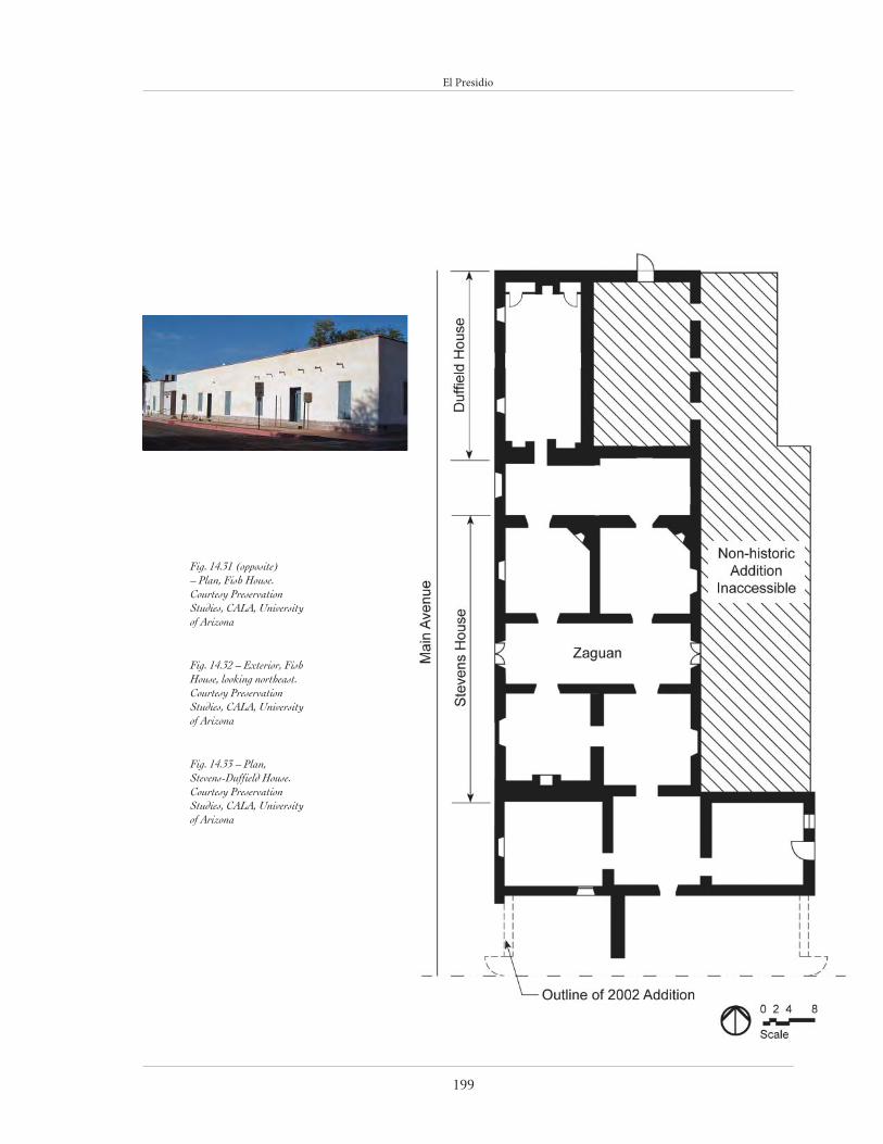
El Presidio
199
Fig. 14.31 (opposite) – Plan, Fish House. Courtesy Preservation Studies, CALA, University of Arizona
Fig. 14.32 – Exterior, Fish House, looking northeast. Courtesy Preservation Studies, CALA, University of Arizona
Fig. 14.33 – Plan, Stevens-Duffield House. Courtesy Preservation Studies, CALA, University of Arizona

El Presidio
200
19. Corbett House, 179 N. Main Avenue (open during Saturday night banquet)
Built in 1906-1907 by J. Knox Corbett, owner of a local lumber supply company, Corbett House is an early 20th-century clay brick and timber structure designed and built in the Mission Revival style by the architectural firm Holmes & Holmes. This is one of the first professionally designed houses in Tucson, sitting back from the street with a wide arched front porch, capped by a gently sloping hipped roof and flanked by matching hipped roofs of clay tile. The extensive wall openings under the eaves were designed to ventilate the attic space and keep the house cool. A wood frame screened porch sep-arated the house from the rear patio, but was later removed when exposed brick columns were erected to support the porch roofs. There are a total of fourteen rooms in the U-shaped house, and the major ones were paneled in ash. The house was provided with leaded panes for windows and French doors, lending a light and decorative quality to the building, characteristic of the Craftsman era. Sliding pocket doors, typical of that era as well, opened the living room to the dining room, and the latter to the outdoor courtyard. Common to the emerging American house types in Tucson was the addition of a light frame, screened sleeping porch, in lieu of the Sonoran rowhouse tradition of sleeping in the courtyard during the hot summer months when the body of the house was too hot. These sleeping porches were either integrated within the roof form, as is the case here, or form a shed-roofed extension to the rear of the house. The house has a full basement, with a water-cooled, forced air heat exchanger (one of Tucson’s first residential air conditioning systems, installed in ca. 1945) and the original coal-fired gravity flow furnace, which was later converted to use with oil and then gas.
Fig. 14.34 – Exterior, Corbett House, looking east. Courtesy Preservation Studies, CALA, University of Arizona
Fig. 14.35 – Plans, Corbett House. Courtesy Preser-vation Studies, CALA, University of Arizona

El Presidio
201

Barrio Viejo
202
Desert Flora
The Sonora Desert is home to some of the world’s most majestic and intriguing flora. The arid conditions of the region have forced plants to adopt unique methods of sustenance and defense. The most recognized example is, of course, the saguaro cactus. The saguaro is a very patient plant, growing only about an inch a year. This slow growth allows it to stay stal-wart as it eventually reaches up to fifty feet in height, making it the most distinctive of desert plants. One way to gauge the age of a saguaro is by counting its arms: if the large succulent has more five arms, it is estimated to be at least two hundred years old. Throughout the cool nights of May and June, the buds arranged at the ends of the saguaro’s arms blossom
into the Arizona state flower. The saguaro also produces a fruit in the fall that was once an important food source for the
indigenous peoples of the region and that continues to be served as special treat to this day.
If the saguaro is the visible symbol of the Sonora Desert, then the creosote bush is its olfactory repre-
sentative. After a thundercloud cleansed the desert, a wonderful, unmistakable scent suffuses the
atmosphere: the scent of a freshly rain-washed creosote bush. The creosote is an evergreen shrub contending for survival with countless other species of vegetation. Its small, pointed leaves have evolved in such a way as to con-serve water and dissipate heat. The sweet, pun-gent odor of the bush is activated when water mixes with the oil in its leaves. The creosote is a tough, hardscrabble bush that nonetheless pro-vides the desert with one of its most captivating sensory experiences.
Creosote may be the most sensual of desert shrubs, but the mesquite is the most populous and possibly the most popular. The useful mesquite has been a source of food, food flavoring, and firewood from time immemorial. For natives of the Southwest, the mesquite pod was a nutritional staple from which tea, syrup, and a ground meal called pinole was made. The bark of the mesquite was utilized in basketry and medicinal remedies. Mesquite continues to be
useful to this day; in particular, with its smokeless, slow-burning wood, mesquite is favored as a savory
charcoal for barbecuing.
Another visually distinctive desert plant is the palo verde tree. Its green bark and branches easily identify it. In fact, palo verde means green wood (or stick) in Spanish. There are two main species of the tree in the Southwest; the blue palo verde requires a good amount of water to survive and so can be found primarily along side arroyos and washes, whereas the foothill palo verde has a wider habitat. The foothill variety also grows more slowly and lives longer
(sometimes up to 400 years). Both trees can photosynthesize sun-light through their bark, a useful trait when they drop their leaves during the warm seasons or full branches to combat drought. In its flowering season, the palo verde adds a vibrant splash of color to the desert as multitudes of yellow flowers blossom on its branches.
Source: http://www.desertusa.com/

Barrio Viejo
203
BARRIO VIEJOThe Barrio Viejo is composed of a number of other smaller barrios, each with its distinctive cultural and architectural identity. The majority of the Barrio Viejo was built between the 1860s and the 1920s and it is a survivor of the 1967 urban renewal demolition that erased the Sonoran rowhouse neighborhoods north of Cushing Street and on the current site of the Tucson Community Center. In the last decade of the 19th century, the core neighborhood was called Barrio Libre because it was a “free district” outside the city’s jurisdiction. Many of the Mexican residents were families of ranchers living in homes in town to be near church, community, and schools. Among the residents were business people and professionals, but they were mostly laborers, bakers, blacksmiths, saloon-keepers, and shopkeepers. After the completion of the railroad, Chinese immigrants moved into the neighborhood and opened restaurants, laun-dries, and markets. It is still an area of Hispanic cultural and architectural traditions according to which the street becomes a social space that is clearly defined by a continuous wall formed by contiguous adobe houses at the front property line. This early form, in which residences lined the block perimeter and commercial functions were sited at the corners of the block, was then transformed by the arrival of non-Hispanic Americans. While the majority of early buildings are of the Sonoran rowhouse type, later American houses illustrate adoption of national stylistic trends and the creation of Territorial-period hybrids.
20. El Tiradito, 221 S. Main Avenue
El Tiradito, Spanish for “the little castaway,” refers to the site of a mur-dered man; it became a place for Mexican-Americans to say a prayer for the man’s soul and to make a wish (it is also called the “wishing shrine”).
Fig. 14.36 – El Tiradito, looking west. Courtesy R. Brooks Jeffery

Barrio Viejo
204
The actual location of the incident, and the first shrine, is in the middle of present-day Simpson Street, just west of S. Meyer Avenue. The current location, designated in 1894, is very near the artesian spring called “El Ojito” on the road to the original Mission San Agustín. This new site was deeded to the city in 1927 and it was in that year that the Tucson City Council chose to make one version of the many legends associated with the shrine official. The U-shaped adobe wall that serves as a backdrop to the shrine was designed in 1940 by E.D. Herreras and constructed by the National Youth Administration.
21. Hardy Residence, 585 S. Main Avenue
This contemporary house, designed in 1997 by Vint & Associates and executed by Michael Keith, general con-tractor, and Eric Means, adobe mason, was one of the first infill construction projects in the southern part of Barrio Viejo. Its scale, proportions, massing, and materi-als are designed to fit within the surrounding streetscape as an expression of the Sonoran architectural tradition. The house is placed close to the street, and extends to the side lot lines. The interior rooms are gathered around a courtyard serving as private outdoor space at the center of the house and providing cooling to the house by evap-oration. The courtyard is surrounded by a corredor, a tall covered porch, providing shade in the summer but high enough to permit winter sun to enter the interior for passive heating. A central breezeway, or zaguán, con-nects the corredor and courtyard with the street-front entrance. The adobe construction, the other component of Sonoran building traditions present in this house, uses stabilized adobe blocks to form load-bearing walls, exposed on both the interior and exterior. The floors are made of exposed colored concrete, and the roof is framed with recycled timbers and ceiling planks from old barns. French doors salvaged from a demolished hotel open on to the central courtyard. The adjacent, detached guest house has a telescoping or shotgun plan, a single bay wide with the rooms aligned in a row perpendicular to the street but aligned so that every room has a south-fac-ing window, ideal for passive solar gain.

Barrio Viejo
205
Fig. 14.37 – Exterior, Hardy House, looking east. Courtesy R. Brooks Jeffery
Fig. 14.38 – Plan, Hardy House. Courtesy Preservation Studies, CALA, University of Arizona

Barrio Viejo
206
22. Crow Residence, 901 S. Meyer Avenue
This pyramidal cottage reflects the transition from the Sonoran row-house type (in its site placement and adobe construction) to the variety of American “folk” house types (in its freestanding, four-square plan and pyramidal roof), widespread exposure to which was first made possible by the railroad. The house first appears on the 1919 Sanborn Fire Insurance map, although the construction materials and methods indicate a construction date closer to the turn-of-the-century. The pyramidal roof is of the gable-on-hip type with a small louvered gable vent. Its earlier wooden shakes were replaced by corrugated metal during the 1990 construction of an addition. The interior wooden plank ceilings are original, as are the floors in all but the front room, which
Fig. 14.39 – Exterior, Crow Residence, looking southeast. Courtesy R. Brooks Jeffery
Fig. 14.40 – Plan, Crow Residence. Courtesy Preservation Studies, CALA, University of Arizona

Barrio Viejo
207
has since had radiant heating installed. New doors and double-paned windows have been added but the original locations of the apertures were maintained. The wooden plank closets in the front and back room are recent additions. The CMU structure behind the main house, built in the 1950s after a sewer line was installed, marks the location of the orig-inal outhouse. The bedroom and garage addition, built in the late 1990s by current owner John Crow, is constructed of traditional, modern, and recycled materials and provides a contrast to the original building.
23. Meyer Avenue Project, S. Meyer Avenue between 18th and 19th Streets (exterior only)
This infill development, begun in 1989 and completed in 2003, includes fifteen single-family residential units that express the stylistic diversity of the surrounding Barrio Viejo neighborhood. Using previously vacant lots, the developer, Rammed Earth Development, built a variety of rammed earth houses, including a duplex, two triplexes, and a number of detached units. Although designed for individual clients, in their layout and close proximity the houses ensure an interactive community like that of the Barrio. The project site was designed with the minimum allowable street width and the units with shallow setbacks, interior pati-os and courtyards, and off-street garages. The buildings also incorporate traditional use of heavy mass building blocks with light wooden porch additions sporting tin roofs and canales, all building elements found in the adjacent Barrio Viejo.
Fig. 14.41 – Exterior, Meyer Avenue Project, looking southeast. Courtesy R. Brooks Jeffery

Barrio Viejo
208
Fig. 14.42 – Plan, Brittain Residence. Courtesy Preservation Studies, CALA, University of Arizona
Fig. 14.43 – Exterior, Brittain Residence, looking east. Courtesy of Rocky Brittain

Barrio Viejo
209
24. Brittain Residence, 571-581 S. Meyer Avenue
This rambling set of buildings was built some time between 1871, which is the first recorded sale of the property, and 1909, when it shows up in its entirety (with the exception of the new bathrooms) on the Sanborn maps. The house consists of a string of rooms edging the north and east property lines, enclosing a central courtyard. It differs from a typical Sonoran rowhouse in that it does not close off the courtyard from the street. The complex is typically constructed of adobe block with adobe and lime plaster. Originally, most of the structures had earthen roofs which were later covered with wood-frame gable, hip and shed roofs probably in the late 1800s. Judging from wall thickness and materials, the north-eastern room appears to be one the first rooms constructed. Wood details, such as window trim and porch additions indicate the gradual incor-poration of American stylistic preferences after the arrival of the railroad. The bath house was constructed with concrete block sometime after the 1949 Sanborn map. The Brittains purchased the property in 1982, at which time the courtyard was bare with six two-room apartments sur-rounding it. During their initial stabilization and rehabilitation work with a Federal grant some of
the walls collapsed when the original plaster was removed. New adobes were cast and sun-dried in the courtyard to reconstruct these walls. Since then, the Brittains have repaired, remodeled and refurbished the complex into their own residence, an office and three apartments. The porches and the landscape have been added including the dirt storage bins in the driveway for repairing adobe walls as needed.
25. Cushing Street Bar, 343-353 W. Cushing Street (lunch venue)
Originally built as a residence in 1869, this building was converted into a store in 1880. The corner entry and the chamfered wall are typical indications of a commercial establishment in the Sonoran urban design tradition. Although more apparent in larger Spanish Colonial cities, the chamfered corner allows a smooth transition from one street to the next and more space for casual conversation at the corner entry. A 1973 addition by architect Harris Sobin included an extension of the building along Meyer Avenue and a small patio and restaurant amenities, all created using forms, materials, and details compatible with those of the original structure.
Fig. 14.44 – Exterior, Cushing Street Bar. Courtesy R. Brooks Jeffery

Barrio Viejo
210
26. Valencia House and Brick Row Houses, 432-446 S. Convent Avenue (exterior only)
Both of these buildings were designed by pioneer Tucson architect Henry Jaastad in 1907 and 1909, respectively, and show the hybrid products of this period of transition between the Sonoran and American building traditions. The Valencia House on the corner has a single layer of clay brick that envelops an earlier adobe building in the American Territorial idiom with a pyramidal roof form. The second, four-unit rowhouse build-ing adheres to the Sonoran tradition of a contin-uous facade but is constructed of fired clay brick walls and has the wood frame hipped roof of the American tradition.
27. Convent Avenue Studios, 469 S. Convent Avenue
An interesting juxtaposition of old and new characterizes this complex of three loft studios designed in 1997 by architect Rick Joy. The orig-
inal site was an abandoned Sonoran rowhouse with the street facade wall as the only viable rem-nant. This wall was preserved as a contributing feature of the Barrio Viejo streetscape; behind it three detached, wedge-shaped, one-and-a-half-story apartments were constructed, oriented so as to create intimate courtyard spaces for each. Although not complying with traditional Sonoran site planning principles, the distinctly contem-porary construction, invisible from the street, responds to the vernacular building material palette of the Barrio through the use of earth-en walls and oxidized corrugated metal for the shed roofs and other details. Supported on con-crete foundation stem walls, the non-reinforced, exposed rammed earth walls are approximately 24” thick, cast monolithically in standard con-crete slip forms. The earthen mix on this project combined soils from three different sources in the Tucson area, chosen for their color and structural integrity and blended with a small amount of iron
Fig. 14.45 – Exterior, Valencia House and Brick Row Houses. Courtesy R. Brooks Jeffery

Barrio Viejo
211
Fig. 14.46 – Site Plan, Convent Avenue Studios (facing Convent Avenue) and Rick Joy Studio (facing Rubio Alley). Courtesy Andrew Gorski after Rick Joy.
Fig. 14.47 – Typical unit plan, Convent Avenue Studios. Courtesy Andrew Gorski after Rick Joy.

Barrio Viejo
212
Fig. 14.48 – Exterior, Convent Avenue Studios from the street. Courtesy of Bill Timmerman
Fig. 14.49 – Exterior, typical unit, Convent Avenue Studios. Courtesy of Bill Timmerman

Barrio Viejo
213
oxide pigment and 3% Portland cement. This proj-ect has won Joy much acclaim, not only because of his creative use of traditional materials, but also as a precedent for the reclamation of an abandoned property in an historic neighborhood.
Fig. 14.50 – Interior, typical unit, Convent Avenue Studios. Courtesy of Bill Timmerman

Barrio Viejo
214
Fig. 14.51 – Plan, Rick Joy Studio. Courtesy Andrew Gorski after Rick Joy.
Fig. 14.52 – Interior, Rick Joy Studio. Courtesy of Bill Timmerman

Barrio Viejo
215
28. Rick Joy Studio, 400 S. Rubio Alley
Sitting on the lot behind the Convent Avenue Studios, Joy’s architectural office exploits the use of both traditional and contemporary building materials. The property is defined at its edges by 14’-high rammed earth walls that enclose a narrow 60’ courtyard on the north and form a sin-gle-room work studio on the south. In the studio, a floor-to-ceiling north-facing glass wall admits the natural light reflected off the south-facing wall of the courtyard. The 22’-wide, 60’-long, and 11’-tall studio space is divided into three zones: a confer-ence area with a skylight that floods light onto the exposed rammed earth wall; the work area; and the service area divided by a single maple wall. The bathroom is actually interpolated within the 3’-thick west wall of the building. There is a poetic balance in the building’s minimalist use of forms, materials, and details reflecting those of Tucson’s vernacular traditions, as well as those of the imme-diate Barrio Viejo context.
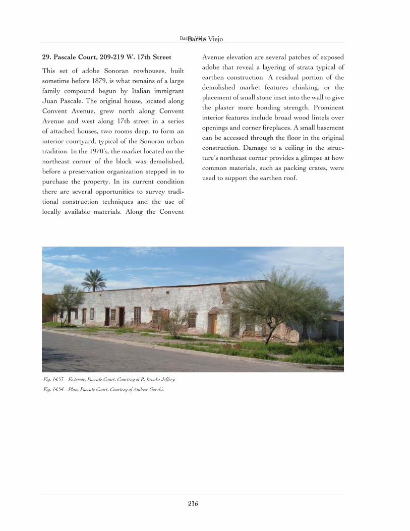
Barrio Viejo
216
29. Pascale Court, 209-219 W. 17th Street
This set of adobe Sonoran rowhouses, built sometime before 1879, is what remains of a large family compound begun by Italian immigrant Juan Pascale. The original house, located along Convent Avenue, grew north along Convent Avenue and west along 17th street in a series of attached houses, two rooms deep, to form an interior courtyard, typical of the Sonoran urban tradition. In the 1970’s, the market located on the northeast corner of the block was demolished, before a preservation organization stepped in to purchase the property. In its current condition there are several opportunities to survey tradi-tional construction techniques and the use of locally available materials. Along the Convent
Avenue elevation are several patches of exposed adobe that reveal a layering of strata typical of earthen construction. A residual portion of the demolished market features chinking, or the placement of small stone inset into the wall to give the plaster more bonding strength. Prominent interior features include broad wood lintels over openings and corner fireplaces. A small basement can be accessed through the floor in the original construction. Damage to a ceiling in the struc-ture’s northeast corner provides a glimpse at how common materials, such as packing crates, were used to support the earthen roof.
<?>
Barrio Viejo
Fig. 14.53 – Exterior, Pascale Court. Courtesy of R. Brooks Jeffery
Fig. 14.54 – Plan, Pascale Court. Courtesy of Andrew Gorski.

Barrio Viejo
217<?>
Barrio Viejo

218
15
219
This archaeological tour focuses on the residential and ceremonial architecture of two key prehispanic villages located in urban Tucson. Ongoing, inter-disciplinary research on the prehistoric Hohokam in the Tucson Basin is focused on such topics as land use and landscape as the interface between societies and their environments, and the societal
institutions developed for the organization of population and territory under conditions of growing political complexity. The two villages of Tumamoc Hill and University Indian Ruin represent a very early and a very late portion of the Hohokam archaeological sequence, respectively. Tumamoc Hill is a unique hilltop site that was occupied during the Early Agricultural Period (500 BCE - 1 CE) and the Early Ceramic Tortolita phase (400-600 CE). University Indian Ruin was a large central village inhabited by farmers who cultivated a hinterland of dispersed areas during the last centuries before Spanish contact.
Tumamoc HillRising 700’ above the floodplain in central Tucson, Tumamoc Hill is a flat-topped peak of the volcanic Tucson Mountains on the western edge of the Santa Cruz River (fig. 15.1). It supports a rich variety of Sonoran Desert upland vegetation, including saguaros and leguminous trees. A prominent Tucson
TUMAMOC HILL AND UNIVERSITY INDIAN RUIN
Paul Fish

Tumamoc Hill and University Indian Ruin
220
landmark, Tumamoc Hill is one of the most extensive, massively built, and complexly organized cerros de trincheras settlements in southern Arizona. This Spanish term is applied to an unusual kind of site marked by location atop a hill and linear walls and terraces, together with other stone constructions (fig. 15.2). Such features are concentrated at the summit of Tumamoc Hill and include mas-sive encircling walls and terraces, an elaborate trail system, smaller terraces, more than 125 circular to rectangular stone outlines (most indicating the remains of houses), and an extensive array of rock art. The hilltop situation of the Tumamoc Hill village was unique among contemporary settlements in the Tucson Basin. Locations near permanent water sources along the intermittent Santa Cruz River were preferred and densely occupied.
Massive stone terraces and walls around the top of the hill were constructed prior to 100 CE. These represent the earliest known “public” architecture in Arizona, in that they are of a scale requir-ing sustained communal labor for building. Several centuries later during the Tortolita phase, the Tumamoc Hill summit became the location of a large village with more than 100 houses for early farmers who had recently begun to make and use pottery on a regular basis. These houses had stone foundations of dry masonry and domed superstructures constructed of poles from trees such as desert willow, woven brush, and packed earth (fig. 15.3). Early
Fig. 15.1 – Bird’s-eye view of Tumamoc Hill showing sweeping view of the Tucson Basin. © Adriel Heisey, AZ11-4345-28

Tumamoc Hill and University Indian Ruin
221
Fig. 15.2 – Map of Tumamoc Hill archaeology showing the compounds, plazas and encircling walls. Courtesy of Phillip O. Leckman, Center for Applied Spatial Analysis, University of Arizona.
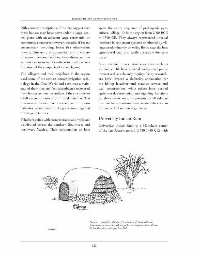
Tumamoc Hill and University Indian Ruin
222
20th-century descriptions of the site suggest that these houses may have surrounded a large cen-tral plaza with an adjacent large ceremonial or community structure; however, decades of recent construction including forest fire observation towers, University observatories, and a variety of communication facilities have disturbed the summit locales so significantly as to preclude con-firmation of these aspects of village layout.
The villagers and their neighbors in the region used some of the earliest known irrigation tech-nology in the New World and corn was a main-stay of their diet. Artifact assemblages recovered from houses and on the surface of the site indicate a full range of domestic and ritual activities. The presence of obsidian, marine shell, and turquoise indicates participation in long distance regional exchange networks.
Trincheras sites with stone terraces and walls are distributed across the southern Southwest and northwest Mexico. Their construction on hills
spans the entire sequence of prehispanic agri-cultural village life in the region from 2000 BCE to 1500 CE. They always represented unusual locations in settlement systems dominated by vil-lages predominantly on valley floors near the best agricultural land and easily accessible domestic water.
Since colonial times, trincheras sites such as Tumamoc Hill have spurred widespread public interest well as scholarly inquiry. Many research-ers have favored a defensive explanation for the hilltop locations and massive terrace and wall constructions, while others have posited agricultural, ceremonial, and signaling functions for these settlements. Proponents on all sides of the trincheras debates have made reference to Tumamoc Hill in their arguments.
University Indian RuinUniversity Indian Ruin is a Hohokam center of the late Classic period (1350-1450 CE) with
Fig. 15.3 – Conjectured drawing of Tumamoc Hill house with stone foundations and a woven brush and packed earth superstructure. Drawn by Ron Beckwith, courtesy of Paul Fish.

Tumamoc Hill and University Indian Ruin
223
ceremonial public architecture in the form of an earthen platform mound that served as an ele-vated base for adobe buildings (fig. 15.4). The site is located in the Indian Ridge neighborhood about seven miles east of downtown Tucson, near the confluence of the Rillito Creek and Pantano Wash. A former archaeology student donated a portion (13 acres) of the site to the University of Arizona in 1933. Under a cooperative agreement between the University, Pima County, and the Civilian Conservation Corps (CCC), the site was opened to the public for several years for a self-guided tour of the ruins and excavation areas. During the 1930s, the site was operated as an “outdoor” laboratory. Numerous excavations in both the platform mound precinct and residential
areas were conducted first as University field schools and later as a CCC work project. An his-toric home and other constructions by the CCC are included in the inventory of cultural resources for the site.
University Indian Ruin was a prominent, central place in the late prehispanic settlement pattern of the eastern Tucson Basin. The boundaries of this important village extended well beyond the present-day 13 acre preserve and it was the only settlement in the area with public or ceremonial architecture in addition to adobe dwellings. This village served as the public focal point for a much larger community of interrelated and dispersed populations living in numerous surrounding ham-lets and small villages.
Fig. 15.4 – University Indian Ruin site plan showing recorded prehispanic architectural features. Courtesy of Paul Fish

Tumamoc Hill and University Indian Ruin
224
Fig. 15.5 – University Indian Ruin wall and room construction in isometric plan (top) and room section (bottom).Courtesy of South-western Parks and Monuments Association

Tumamoc Hill and University Indian Ruin
225
Prehispanic inhabitants of University Indian Ruin lived in clusters of conjoined rect-angular adobe rooms (fig. 15.5) within walled compounds. Their use of pine and fir timbers for roof beams permits precise dating of the by means of dendrochronology. Tree ring dates from charred vigas recovered during previous excavations indicate major construction during the late 14th century. The reported discovery of a Spanish colonial majolica ceramic bowl on the floor of one room raises the intriguing pos-sibility that University Indian Ruin was still occupied or at least still had standing architecture in the early 1700s.
The Classic Period was a time of increasingly dense populations aggregated into larger villages and communities. The maximum extent of the University Indian Ruin village cannot be determined because of modern urban development. However, a well-studied and mapped Classic Period platform mound site in the northern Tucson Basin contained between 35 and 40 residential compounds distributed across a 3 square-kilometer village area. In this case, the village population is estimated to have been between 800 and 1200 people. It is likely that the population of the University Indian Ruin village equaled or surpassed this number.
Massive adobe walls approximately 8’ in height enclosed each residential compound and platform mound precinct at University Indian Ruin (15.6). These walls are believed to reflect the architectural demarcation of social groups rather than having served a defensive function. The transition to the Classic Period around 1200 CE witnessed a major shift in the ideological basis for territorial integration and the appearance of walled compounds is correlated with these changes. In contrast to the
Fig. 15.6 – University Indian Ruin wall types showing different earthen binders.Courtesy of Southwestern Parks and Monuments Association

Tumamoc Hill and University Indian Ruin
226
unrestricted approach to ball courts and plazas characteristic of previous Hohokam time periods, platform mounds and their precincts were first surrounded by palisades and finally by massive enclosure walls with internal divisions. Mound ritual became more centralized than ever before, while the performers and observers of communal events in mound precincts became a more exclu-sive subset of the population as a whole.
Adobe walled compounds represent an equally dramatic change in residential organization. Prior to the Classic Period, the standard domestic unit comprised a small group of 4 to 6 pit houses around a common courtyard with no enclo-sure wall. By jointly enclosing their dwellings, members of a compound tangibly demarcated a distinctive and shared social identity. Compound walls likely reflected the increasing social dif-ferentiation and organizational complexity of Classic Period society. They provided a measure of privacy, secrecy, and control for compound members, especially with regard to the accumu-lation of resources and stores. The walls would have effectively shielded all kinds of economic, political, and ritual interactions and negotiations from public scrutiny.
Current ResearchUniversity Indian Ruin and Tumamoc Hill are both now owned by the University of Arizona. University Indian Ruin is on the National Register of Historic Places and the archaeological remains at Tumamoc Hill are clearly eligible for the National Register. These properties present individual and unique preservation and man-agement challenges to the University. A major goal of a new state-of-the-art mapping program is to provide detailed spatial information to the University’s Historic Preservation Committee to assist in the management of these highly signifi-cant archaeological remains.

Tumamoc Hill and University Indian Ruin
227
Southwestern Music
The Southwest is home to a musical tradition unlike any in the world. Although the influences have, at times, come from familiar lineages, the end product is unique and instantly recognizable. Waila, norteño, and mariachi are just three examples of the musical melee of the Southwest.
Waila is a raw and culturally important strain of music that moves the feet as well as the heart. Pronounced WHY-la, waila is a word the Tohono O’odham people adapted from the Spanish word for dance, baile. Spend an afternoon at Tucson’s annual springtime Waila Festival and you’ll see why. For no matter how full you have stuffed yourself with the traditional O’odham delicacies, the polka-like beat and wheezing violin of waila musicians are impossible to resist.
Waila found its genesis in early fiddle bands, inspired by the sounds of Europe and northern Mexico. Fully instrumental, the music is created pri-marily by violins and accordions. However, it is also quite common to find alto saxophones carrying a tune or a drum machine mastering the down-beat. Waila is sometimes known as “chicken scratch” music, having earned the nickname from the way the Tohono O’odham kick up their heels while dancing to waila tunes. In fact, dance is an integral part of waila music. Waila dances are all performed while rotating in a counter-clockwise manner around the floor. There are several varieties of waila dancing, all derived from an amalgamation of European and Native American dance traditions including the Bohemian watersaw and a variety of the Scottish and German schottische called the chote.
Norteño music, so named because it developed in Northern Mexico, emerged from Texan and Germanic musical styles in the 1900s. German immigrants brought breweries, miners, and the diatonic accordion to the Spanish-influenced Mexican culture. The whirling hum of the diatonic button accordion became the signature sound of norteño music. Guitars began to accompany accordionists in the 1930s, and by late 1950s and early 1960s, even more instruments had been added to the combo. Today, the most common instruments in a norteño group, or conjunto, are the accordion, bass guitar, electric bass, string bass, and drums. The music has maintained its popularity in many parts of the region, including Tucson, home of the Norteño Music Festival, which occurs every August.
No survey of southwestern roots music would be complete without acknowl-edging the famous mariachis. The mariachi tradition originated in the south-ern part of the state of Jalisco in Mexico during the 19th century, evoking notions of the troubadour singing songs of romance, heroism, revolution, deceit, and death. The brightly spangled bands were composed most fre-quently of violins, guitars, and vihuelas. More recently, mariachis have bor-rowed from jazz and Cuban music, adding the trumpet and giving the music a characteristic sound as brazen as the colors of the musicians’ traditional costumes. Mariachi music is now played in such far-flung locals as Japan and Europe. But you need not travel so far. Several restaurants in Tucson feature mariachi music throughout the week.
Source: http://www.elearn.arizona.edu/msw/

228
16

229
Tucson’s 20th century residential landscapes represent an evolution of land-use attitudes, regulatory con-trols, and typological and stylistic expressions. These landscapes also play an important role in conveying Tucson’s struggles throughout the 20th century to cater to a residential consumer market of newcomers driven by a certain commodified image of the south-
west. From the principles of the City Beautiful Movement to those of New Urbanism, Tucson presents an evolution of national subdi-vision design trends that increasingly expresses the authentic iden-tity—environmental, cultural, and political—of this place.
20TH-CENTURY RESIDENTIAL LANDSCAPES
R. Brooks Jeffery
Fig. 16.1 – Aerial, Catalina Foothills Estates, c1940 showing St. Philips Plaza in the middle ground. Courtesy of Arizona Historical Society/Tucson (PC177-F90-449)

20th-Century Residential Landscapes
230
HOPE VI Santa RosaHOPE VI Santa Rosa was completed in 2003 after a decade-long planning process with the intent of replacing the sterile and socially outdated public housing development that had previously occu-pied the site. The HOPE VI Santa Rosa project traces its origins to the Community Development Plan for Greater Santa Rosa authored by Corky Poster and students at the University of Arizona. This grass-roots planning document was adopted by the City of Tucson in 1994, which then used it as the basis for a successful HOPE VI planning grant that, in 1997, resulted in a $14.6 million grant from the US Department of Housing and Urban Development. In addition to the develop-ment of numerous amenities aimed at improving the quality of life for low-income families in the surrounding Santa Rosa neighborhood, the HOPE VI project includes on-site development
of 60 new units of public housing, mixed with 60 new units of market rate rental housing.
Poster Frost Associates, the project’s master planner and architect, incorporated site utiliza-tion patterns, building forms, and elements from the surrounding Mexican/Sonoran vernacular building types, providing an appropriate vocabu-lary that integrates this new construction into the existing context (fig. 16.2). Rather than the sur-face application of clichéd historical details, Hope VI Santa Rosa applies traditional typologies at a variety of scales, from the development of inte-grated streetscapes and attached dwelling units to the incorporation of specific features from the adjacent Barrio Viejo neighborhood, such as the corrugated metal wrap-around canopies, creating a visual link between the new development and its historic context.
Fig. 16.2 – Hope VI Block Plan & Elevation Plan and elevation, typical dwelling block, Hope VI development. Courtesy of Poster Frost Associates

20th-Century Residential Landscapes
231
El Encanto and Colonia Solana Es-tatesDesigned in 1928 as distinct suburban neighbor-hoods, the adjacent subdivisions of El Encanto Estates and Colonia Solana were southwestern variants of the planned Suburban Movement and marked a dramatic shift in subdivision design in Tucson.
The Suburban Movement, founded in the Natural Parks tradition and the City Beautiful Movement, sought to promote appealing, cohe-sive environments in residential communities by including a planned system of circulation, a system of parks, and the attractive placement of buildings. Suburbs designed according to these principles were planned for cities all around the United States, including Riverside, Illinois (1869), Forest Hills Park, New York (1909), the Country Club District of Kansas City, Missouri (1913-33), and Shaker Heights, Ohio (early 1920s).
Geographically, both subdivisions were defined by two main streets, Broadway Boulevard which extends east from downtown Tucson, and Country Club Road, named for the location of Tucson’s first country club on the southwestern corner of the intersection of the two streets. It was an ideal location for an elite suburban resort and recreational community, with a golf course and public park forming the southern and eastern boundaries of Colonia Solana and the El Conquistador Resort Hotel, Tucson’s most luxurious hotel at the time, bordering El Encanto Estates on the east.
Both subdivisions were characterized by fea-tures and amenities that were being introduced for the first time in an attempt to attract an elite residential clientele that would distinguish these communities from the gridiron subdivisions that dominated Tucson’s post-railroad development. Tucson was a thriving city during this period and
contained a group of prosperous families, in addi-tion to well-to-do winter visitors, affluent health seekers, and transplanted retirees.
Characteristics such as curvilinear street lay-outs, irregular lots, regional revival architectural styles, and attractive landscaping were derived from Surburan Movement ideals. Deed restric-tions were also part of the marketing of these subdivisions, ensuring the enforcement of zoning controls, building setbacks, house size, house height, minimum building cost requirements, and the approval of architectural review boards. Both communities made use of Spanish words, not only in the subdivision names (El Encanto = “The Enchanted”; Colonia Solana = “Sunny Colony”), but also in the street names, in order to evoke a romantic association with Tucson’s Spanish heritage. Ironically, the deed restrictions adopted by both developments prohibited people “not of White or Caucasian race” from living there (including restrictions against Mexicans, Blacks, Asians and Jews).
The deed restrictions created at the incorporation of both subdivisions dictated that the architec-ture be designed in southwestern styles with all designs inspected by a supervisorial architect. The southwestern architectural styles of these neighborhoods reflect what were the prevailing styles throughout Tucson during the period. A strong California influence can be seen in these styles, but with local variations, including the Spanish Colonial Revival and Pueblo Revival styles. Many of the homes were built by promi-nent Tucson architects of the day.
With these two subdivisions, developers soon dis-covered that non-gridiron street patterns, south-western architecture, and formally landscaped or desert landscaped lots with comprehensive deed restrictions appealed strongly to home buyers. These early subdivisions provided alternatives to the norm, creating a sense of community through the harmonious integration of buildings and land-

20th-Century Residential Landscapes
232
scape. Prominent agents of innovation in Tucson, El Encanto Estates and Colonia Solana imple-mented comprehensive community planning in Tucson and influenced the development of other Tucson suburban communities such as Catalina Foothills Estates (1928), Catalina Vista (1940) and Winterhaven (1948).
El Encanto Estates
El Encanto Estates consists of a formal, symmet-rical street pattern, designed in the neoclassical tradition with equally formal landscaped lots, large lawns, and non-native vegetation (fig. 16.3). In the context of an increasingly competitive development market in which each subdivision was attempting to distinguish itself from the oth-ers, El Encanto Estates’ founder, W.E. Guerin, wanted to create a unique environment of privacy and peace, set apart from the surrounding Tucson gridiron subdivisions.
El Encanto Estates was designed in 1928 by the Engineering Service Corporation of Los Angeles, California. The original subdivision plan incor-porates a circular, geometric pattern with a cen-trally located park and six tributary streets that radiate away from the center and either meet the arterial streets of the city at the periphery of the subdivision or end in cul-du-sacs within it. The central park is circular, comprising 0.74 acres of land, with a collection of desert plants ringed by slender fan palms. In contrast to Colonia Solana where new desert plants were brought in to supplement the existing natural environment, the desert vegetation in El Encanto is contained within the formal layout of the park.
The original plan called for the streets to be lined with palm trees, evidence of the California influ-ence in the design as well as a tendency to use non-native, and even exotic, plantings. Although some native landscaping does exist, non-native landscaping dominates the entire residential com-munity, whose atmosphere is as a result to be
associated more with the Midwest or California than with the Arizona desert. In addition to its vegetation, the landscape is defined by property walls, hedges, and roadside curbing, all imple-mented to reinforce the continuity of the street pattern and the formal division of the properties.
Colonia Solana
Colonia Solana was designed in 1928 by Stephen Child, a nationally known and highly respected landscape architect who had studied under Frederick Law Olmsted, Jr. at Harvard University. Olmsted’s father is considered the patriarch of landscape architecture and he designed the first of the American suburban communities, Riverside, Illinois, while his son designed Forest Hills Gardens, New York.
The plan of Colonia Solana shares many of the characteristics of Olmsted’s design for Riverside and it followed the precepts of the Suburban Movement through the use of natural land forms and the preservation of native vegetation and wildlife (fig.16.4). Nature and the rural landscape were seen throughout as positive values which would enrich human life.
Stephen Child described the main features of Colonia Solana as typical desert country with a gentle slope and containing one major and two minor arroyos. Rather than filling the washes, or dry stream beds, as was typically done, Child wished to emphasize them and make them influ-ence the design. He stressed the importance of creating “Arroyo Chico Parque” as a parkway some 250’ wide and half a mile long with parallel roads and footpaths and native desert plants of all kinds, since the original desert growth was sparse. He felt that Colonial Solana would thus contain the “desert beauty than many now ride miles to see” and he set aside 9.4 of its 160 acres for parks and open space.

20th-Century Residential Landscapes
233
Child also proposed that site landscaping in the subdivision, as well as its architecture, be regu-lated by a “jury”. In addition to native tree spe-cies planted in the arroyo, including palo verde, greasewood, and mesquite, cacti were also used, including saguaro, ocotillo, barrel cactus, chol-la, prickly pear, and others. Child thought this sampling of native desert vegetation within the subdivision would be an unusual and welcome amenity. Moreover, as the properties were devel-oped, most homeowners added natural land-scaping similar to that found in Colonia Solana’s open spaces, reinforcing a sense of cohesiveness throughout the neighborhood. The street sys-tem delimits generous one-acre, non-rectilinear, landscaped lots that provide desirable building sites, mostly with north/south orientations. The narrow, 16’-wide, uncurbed streets are also used for site drainage.
One of the principal features of the Colonia Solana landscape today was initially its worst eyesore: the El Conquistador Water Tower.
The water tower was a necessary piece of urban infrastructure, intended to supply water to the growing resort hotel, golf course, and elite res-idential subdivisions. Originally unmasked and utilitarian in appearance, it was sheathed in a Spanish Colonial Revival envelope in 1929 and has become a prominent landmark contributing to Colonia Solana’s residential landscape.
Although modest compared to Riverside, Colonia Solana is a skillfully designed subdivision that embodied a new approach to the suburban com-munities made possible by the growing popu-larity of the automobile, beginning in the 1920s. Moreover, with the development of Colonia Solana, desert vegetation began to be recognized as a positive element in local landscape design, in contrast to the then-dominant desire to use non-native plants in order to create an oasis in the desert.
(text excerpted from National Register of Historic Places Nomination for Colonia Solana Historic District [Phoenix: Arizona State Parks,
Fig. 16.3 – El Encanto Estates Subdivision Plan. Courte-sy of Arizona Architectural Archives, CALA, University of Arizona.
Fig. 16.4 – Colonia Solana Subdivision Plan. Courtesy of Arizona Architectural Archives, CALA, University of Arizona

20th-Century Residential Landscapes
234
1989] and National Register of Historic Places Nomination for El Encanto Estates Historic District [Phoenix: Arizona State Parks, 1988])
BinghamptonBinghampton is a 584-acre residential/agricultur-al enclave located just north of the Tucson city limits in the flat, active floodplain on the north side of the Rillito River and south of the pro-truding foothills of the Catalina Mountains (fig. 16.5). It is geographically and culturally distinct from the adjacent low-density, upscale residential foothills development to the north and the higher density urban development to the south.
Despite increasing encroachment by residential and commercial development, the area has been in continuous rural use, from its founding as a Mormon agrarian settlement in 1898 through the post-Mormon era of small ranches and farms that can still be seen today. Once a lush, natural ripar-
ian habitat of cottonwood, alder, sycamore, wil-low, and walnut, the area was greatly modified by its Mormon settlers beginning in 1898. Divided into large, 20- and 40-acre rectilinear tracts, and watered by an extensive ditch irrigation system, the area was transformed into a patchwork of cultivated crops and orchard and dairy pasture fields—with the exception of a 40-acre Latter Day Saints cemetery on the northeast corner of the district. Irrigation-intensive agricultural practices typically gave way to less water inten-sive uses such as horse culture, small livestock culture, or horticulture. Many of the once fertile agricultural fields are now retired but they still contribute to the overall scale and feeling of the rural landscape.
Mormons have been a part of the cultural land-scape of Arizona since the 1870s, establishing small agrarian communities where they could practice their religion freely. By the mid-1880s,
Fig. 16.5 – Aerial photograph, Binghampton rural landscape, 1990. Courtesy of Pima County

20th-Century Residential Landscapes
235
there were two dozen towns, with a total popu-lation of 3,000, successfully established along the Little Colorado River in northern Arizona, form-ing part of the Mormon Corridor from Fredonia near the Utah border down into Chihuahua and Sonora, Mexico. The Mormon agricultural pres-ence in the Tucson area dates to 1898 and lasted into the first decades of the twentieth century. The first parcel purchased by Mormons was the 60-acre Davidson Ranch whose pyramidal-cot-tage is a prominent landmark of vernacular archi-tecture amidst contemporary development. The population of Binghampton grew, especially after an influx of Mormon refugees from Mexico, and in 1916 an additional 60 acres were purchased on the south side of the Rillito River where a tradi-tional Mormon town plan was laid out. This area, for many years a self-contained community of Mormons, began to lose its identity after World War II, when it was absorbed into the surround-ing city.
Today, it is usually by automobile that one sees the features of Binghampton’s rural vernacular landscape: pecan orchards, horse pastures, open fields, secluded tree-shaded residences, stone retaining walls, post and rail fences, and tree-lined drives.
(text excerpted from National Register of Historic Places Nomination for Binghampton Rural Historic Landscape [Phoenix: Arizona State Parks, 2002]).
Catalina Foothills EstatesThe Catalina Foothills Estates, one of southern Arizona’s earliest master-planned communities, was the creation of Tucson real estate entre-preneur and builder John Murphey and his business partner and wife, Helen Murphey. The Murpheys had dreams of building the kind of res-idential communities that would attract wealthy clients from the East to the desert resort city
of Tucson. In 1927, the Murpheys hired Swiss architect Josias Joesler to interpret their vision of elite communities and buildings that adopt-ed the various historical revival styles popular in other parts of the West. Joesler’s extensive travels, combined with his thorough education in both the technical and artistic aspects of architec-ture provided the Murpheys with just the palette of styles needed to build their vision.
In 1928, at a combined homestead and federal land auction, the Murpheys purchased 7,000 acres of land in the foothills of the Catalina Mountains north of the Rillito River (fig 16.1); the area was four miles north of Tucson’s city lim-its at the time. They sought to emulate a Mexican village of haciendas, complete with church and plaza; their success may be measured by the prominent and affluent clientele attracted to Catalina Foothills Estates, then and today. Much of the current popularity of Catalina Foothills Estates is due to the establishment of original deed restrictions that controlled the development of the community and preserved the stunning foothills topography, views, and natural vegeta-tion, thus attesting to the importance of natural landscaping in the overall marketing of an estate community in the desert. In addition, every aspect of the development process was controlled by Murphey, from land purchase, lot placement, and water distribution to architectural design by Joesler and construction by Murphey’s building company.
Joesler, as supervisory architect, controlled the architectural design as well as the surveying of each property, which at the time averaged over 4 acres. He took advantage of the topography by laying out the home sites based on their views, a principle which he later refined in the design of each individual house. The houses were larger and more luxurious than those in town, conform-ing to their large, hilly lots and taking into con-sideration the increased demand for larger houses

20th-Century Residential Landscapes
236
in unique settings to satisfy an affluent clientele of newcomers.
The majority of houses in Catalina Foothills Estates were designed in Spanish Colonial Revival style. They were usually centered around a patio or pool, with low-pitched, tiled roofs, smooth stucco or burnt adobe walls, sculpted wooden members, and ornamental ironwork, all crafted with a sense of antiquity which enhanced the style. The use of arches, breezeways, and pati-os also represented the outdoor lifestyle adver-tised by the Murpheys to attract Easterners to Tucson. The sprawling lots and equally sprawling plans distinguished Joesler’s foothills homes from those in the city. These linear, “ranch” houses became larger and more linear with the concur-rent improvement of mechanical air handling sys-tems, whereas smaller systems required a more compact plan.
As they began the development of Catalina Foothills Estates as a premier residential commu-nity, the Murpheys also envisioned a village cen-ter that emulated those of the Mexican towns to which they had often traveled. Named St. Philip’s Plaza, this town center (fig 16.6) would com-prise a church (St. Philip’s in the Hills Episcopal Church), a tea room/gift shop (El Merendero), the Catalina Foothills Estates sales office, the offices of the Murphey Building Company,
Joesler’s studio, and a studio for the prominent painter Hutton Webster, all surrounding a plaza in the form of a “U”. From Joesler’s architecture representing a rustic interpretation of the Spanish Colonial Revival style to the sense of permanence implied by a town center meeting the necessi-ties of both spiritual and human sustenance, St. Philip’s Plaza was a showcase for what Catalina Foothills Estates as a whole intended to be.
Murphey’s development drove Tucson’s expan-sion northward and other low-density foot-hills developments soon transformed the entire Catalina foothills into an affluent residential area. Unfortunately, much of the original rural char-acter of Catalina Foothills Estates has been lost. The deed restrictions established by Murphey in 1928 were not renewed when they expired in 1978, causing a gradual, but profound, change in the residential landscape. Home sites shrank from a minimum of 4 acres to a quarter of an acre, thus denuding the foothills desert of the lush vegeta-tion that was its original marketing asset. After Joesler’s death in 1956, his integrated design approach and supervisory control was succeeded by an eclectic potpourri of styles, forms, materi-als, and scales that unequivocally distinguishes the two periods of architectural development.
In particular, the second half of the 20th cen-tury produced a broad array of Modern homes
Fig. 16.6 – St. Philip’s in the Hills Episcopal Church and Plaza, 1940. Courtesy of the Arizona Architectural Archives, CALA, University of Arizona.

20th-Century Residential Landscapes
237
in Catalina Foothills Estates that rejected the romanticism of Joesler’s earlier residences. One of the most prominent of these homes is the Ramada House designed by Judith Chafee in 1975 (figs. 16.7 and 16.8) The 3,800 sq. ft. residence has quickly become iconic of critical regionalism, a design philoso-phy that combines the tenets of modernism with the wisdom of
Fig. 16.7 – Exterior, Ramada House. Courtesy of Glen Allison
Fig. 16.8 – Plan, Ramada House. Courtesy of Andrew Gorski after plan published in Architectural Record (February 1979)

20th-Century Residential Landscapes
238
vernacular architecture. Chafee applied this phi-losophy to Tucson’s desert landscape, which she referred to as the “region of the mindful heart”. The Modernist-inspired floor plan, combining the formal grid of the ramada’s support posts with the more fluid, earth-hugging masonry walls of the house below it, is oriented east-west on three levels, following the slope of the site. The posts pierce the house, providing a continuous internal reference to the structure outside. A direct refer-ence to the traditional O’odham shade structure, the ramada is constructed of round vertical poles and closely-spaced 2’ x 4’ timbers form the hor-izontal lattice. It is positioned to filter the light falling on the southern entry facade and responds to seasonal changes in the position of the sun, providing protection from the high summer sun and welcoming in the rays of the low winter sun. As in its traditional use, the elevated shade struc-ture of the ramada also creates a channel of air below, and in this case between it and the build-ing, through which air is drawn by the natural foothill breezes. The power of the ramada as the dominant design feature of the house is its direct response to the climate as well as the vernacular traditions of the region.
(this text was largely excerpted from R. Brooks Jeffery, et al., Joesler & Murphey: An Architectural
Legacy for Tucson [Tucson: City of Tucson Planning Department, 1994] and Anne M. Nequette and R. Brooks Jeffery, A Guide to Tucson Architecture
[Tucson: University of Arizona Press, 2002])
WinterhavenBegun in 1949, this post-World War II subdivi-sion is distinguished by broad, curving principal streets, landscaping mostly of grass lawns, deep setbacks, and a unified architectural expression of the ranch house typology (fig. 16.9). Although designed by civil engineer Tony Blanton, the character and image of Winterhaven was dictated by its developer, C.B. Richards, a native of Ohio.
Richards wanted the new neighborhood to be designed along the lines of those in the Midwest, convinced that this kind of design would endow the residents of the neighborhood with what he felt were the wholesome values of middle-class Midwesterners. He was especially inspired by the planned community of Shaker Heights near Cleveland.
To fulfill his goals and to foster a sense of com-munity among residents, Richards established the Winterhaven Water and Development Company, a water district cooperative with three private wells that still operates independently of the City of Tucson, as well as deed restrictions that pro-moted grass lawns and mature evergreen trees, creating an oasis of “otherness” in the Tucson desert. In addition to ensuring the integration of landscape features as part of the overall character of the development, Richards borrowed other features from successful earlier subdivisions, including curvilinear streets, irregularly shaped lots, and an architectural review process, in this case administered by neighborhood residents.
Visually, Winterhaven’s ranch houses suggest a single period of construction, as determined by the relatively short period of subdivision build-out (the eight years between 1949 and 1957) and by an architectural consistency of ranch house styles due to the neighborhood’s review process.
The Ranch House in Winterhaven
The modern ranch-style house is an icon of middle-class suburban life and became the dom-inant housing type after World War II. Its initial development is credited primarily to California architect Cliff May (1908-1989). May rejected the direction in which modern architecture was heading and decided to design homes based upon a romanticized vision of nineteenth-century California ranches. He was drawn to this style of architecture because he felt that it promoted familial closeness. Ranch homes designed by May

20th-Century Residential Landscapes
239
are characterized by a low, horizontal, and ram-bling form and the use of natural materials that he felt integrated the home into the land, providing in addition a connection between the indoors and outdoors, which he saw as a hallmark of the western lifestyle.
Many ranch homes were constructed with housing loans insured by the Federal Housing Administration (FHA). The FHA dictated that builders follow prescribed guidelines that were meant to ensure quality construction. These guidelines also shaped the basic form of the home and encouraged highly efficient, standardized designs. The style of home that best fit the FHA’s standards was May’s modern ranch-style house. Unfortunately, the adoption of Cliff May’s ranch home by the FHA and its widespread emulation
by other builders, meant that ranch-style homes built during the post-war housing boom soon lost many of May’s skillful refinements. The standard ranch home configuration continued to be long, horizontal, and rambling and was easily accom-modated by large lots in suburban neighbor-hoods. The large lots associated with sprawling suburbanization were made attractive because of easy access by automobile. The intimate connec-tion between the ranch house and the automobile is expressed in the prominent inclusion of inte-grated carports, or garages, on the front facades of many homes.
In Winterhaven, the ranch-style homes are strik-ingly consistent in their general characteristics. They are typically one-story, with horizontal massing facing the street, and feature asymmetri-
Fig. 16.9 - Winterhaven Subdivision Plan. Courtesy of Ray Brice, Winterhaven Neighborhood Association.

20th-Century Residential Landscapes
240
cal facades with gable roofs (fig. 16.10 and 16.11). The typical Winterhaven ranch house has a deep front yard that contributes to the neighborhood streetscape and is complemented by a private walled backyard with a covered patio directly adjacent to the house and accessible from the living or family rooms. The detached houses are each placed on the center of the lot with attached or integrated carports (there were originally no garages in Winterhaven), often with ventilated, or open, side panels. The plan is either rectangu-lar or L-shaped, enveloping a front entry porch, with distinct public (living, dining, and family room) and private (bedroom) zones. With little
exception, the Winterhaven homes all have three bedrooms with either one or two baths. Typical of the ranch house type, the kitchen often opens up to the dining room space with a high counter in lieu of a solid partition wall. Almost all the homes comprise exposed brick construction, with a few incorporating burnt adobe (a material specific to Tucson) laid on a concrete slab at grade. Most of the ranch houses have large picture windows facing the street, as well as metal casement win-dows, and wide entry porches that are typically integrated within the roof form.
Fig. 16.10 – Plan, typical Ranch house type, Winterhaven. Courtesy of the Arizona Architectural Archives, CALA, University of Arizona
Fig. 16.11 – Exterior, typical Ranch house type, Winterhaven. R. Brooks Jeffery

20th-Century Residential Landscapes
241
Variations on the traditional Ranch House typol-ogy in Winterhaven include the Modern Ranch, which is distinguished by corner, floor-to-ceiling, or ribbon windows, and the Transverse Ranch, which is distinguished by having its narrow side (gable end) facing the street (fig. 16.12). The Transverse Ranch house type features an
attached carport along one side of the home under an integrated, low-pitched, roof form (fig. 16.13). Curiously, the entry does not face the street, but opens into either the carport (as in the Wilson Residence) or a low-walled side patio on the opposite side of the house from the carport. The dominant sloping roof form is often exposed
Fig. 16.12 – Plan, Wilson Residence, Winterhaven. Courtesy of the Arizona Architectur-al Archives, CALA, University of Arizona
Fig. 16.13 – Exterior, Wilson Residence, Winterhaven, representing a variation on the ranch house type, the “transverse ranch”, where the gable side faces the street but the carport is still incorporated within the roof form. R. Brooks Jeffery

20th-Century Residential Landscapes
242
on the interior and is carried throughout the Transverse Ranch house, as can be seen in the Wilson Residence, with a finished cedar plank ceiling and interior partition walls that do not extend all the way to it. The use of high windows adjacent to the ceiling also permits views of the extension of the roof to the exterior, embodying the modern ideal of transparency between interi-or and exterior, which may also be perceived in the spatial continuity between adjacent interior rooms achieved by means of floating vertical, hor-izontal, or, as in this case, sloping planes.
A notable expression of Winterhaven’s strong sense of community is the annual Festival of Lights, a Christmas light display of individual homes and trees that dates back to the neighbor-hood’s founding in 1949 and today attracts large crowds of people.
(text largely excerpted from National Register of Historic Places Nomination for Winterhaven Historic District, draft copy [Phoenix: Arizona State Parks, 2004])
Catalina VistaLike Winterhaven, the Catalina Vista subdivision integrated curvilinear street patterns into the established grid pattern of Tucson’s suburban development (fig. 16.14). Catalina Vista also developed during the heyday of the ranch house type with wide lots, broad-facing street facades, and carports displaying the family automobile, all integrated into a suburban streetscape. In addition, Catalina Vista employed City Beautiful suburban amenities such as small neighborhood parks, traffic roundabouts, and landscape medi-ans as boulevard dividers and screens hiding arterial street traffic. With the exception of the central neighborhood park lawn, landscaping as a contributing streetscape element was restricted to a desert palette of palm trees, cactus, and gravel.
Catalina Vista was formerly a 19th-century homestead comprising a quarter section of land and later a gentleman’s ranch, Rancho Santa Catalina. In 1940, the Hardy & Stonecypher Real Estate Company purchased the property
Fig. 16.14 – Catalina Vista subdivision plan. Courtesy of Don Ryden and Associates

20th-Century Residential Landscapes
243
for development and gave it a name derived from that of the original ranch. During this period of time, Tucson’s growth had caught up with this previously remote site outside the city limits, making it a viable property for platting as a res-idential subdivision. World War II slowed, but did not stop, construction; however, the majority of home sites were developed between 1946 and 1962, reflecting a significant shift in preferred architectural styles for homes in Tucson. In con-trast to practices at the other subdivisions high-lighted in this tour, Catalina Vista’s architectural character was not governed by a review process. Thus, houses in Catalina Vista represent a variety of architectural styles from Period Revival to the more popular Ranch House and even combina-tions of the two.
Catalina Vista is also home to a set of houses by pioneer Tucson modernist architect, Arthur Brown, who rejected revival styles and chal-lenged himself to design “without style”. Brown is credited as Tucson’s first “solar architect,” consciously attempting to integrate passive solar
elements into his work. The Ball/Paylore House, designed in 1952, is typical of his response to cli-mate, as well as to the needs of his clients. Phyllis Ball and Patricia Paylore were both librarians at the University of Arizona and they found the typical house for the average American family unsuitable for two independent adults who want to share a home. Moreover, they were intent on “avoiding the trite, conventional and the dull” that they found in most of the homes that were being built in the early 1950s. The plan resem-bles a winged bird (fig. 16.15). The core of the house—living room, kitchen, dining room, and library—is contained within a hexagonal plan with a brick fireplace at the center supporting wooden beams that radiate out to the exterior walls. The bedrooms are placed to either side of the core, like wings, with the north-facing entry inconspicuously accessed through a carport. The southern three faces of the hexagon open up via glass walls to a patio beyond, which has movable corrugated aluminum shade screens on a track at the outer edge of the patio slab (fig 16.16). These
Fig. 16.15 – Ball/Paylore House plan. Mike Lovato after plan published in House Beautiful (October 1962).
Fig. 16.16 – Ball/Paylore House, revolving sky-shade being demonstrated by Phyllis Ball, original owner in 1955. Courtesy of Gordon Brown

20th-Century Residential Landscapes
244
lightweight “sky shades” were invented by Brown using conventional hardware to allow the occupants to control the daily and seasonal solar gain in the house and they are still functioning today.
(text largely excerpted from National Register of Historic Places Nomination for Catalina Vista Historic District [Phoenix: Arizona State Parks, 2003] and Nequette and Jeffery, A Guide to Tucson Architecture)

20th-Century Residential Landscapes
245

246
Note: those terms of Spanish origin which have passed into common parlance in English have not been italicized below.
acequia (Spanish, from Arabic): a water channel or ditch used to divert water from rivers and arroyos for daily use and irrigation
adobe (Spanish, from Arabic): most commonly used to refer to large, molded, and sun-dried blocks of clayey mud and water, sometimes also incorporating a binder such as manure or straw; also used for the mud mixture itself when used as mortar or for building walls, as in puddled adobe, which is set in “puddles” and left to dry, eventually building up to form a wall—in contrast to adobe masonry which uses blocks set in mor-tar and is often covered by a mud plaster made water resistant through the addition of caliche, a naturally occurring calcium deposit found in local soil, or lime
adobe quemado (Spanish): burnt adobe
ak chin farming: farming made possible by the diversion of water from canyon mouths onto cul-tivated fields
arroyo (Spanish): a desert wash, dry except after rainfall, when it can become a torrential river
atrio (Spanish): a walled forecourt before a church
cabecera (Spanish): a primary mission complex
campanario (Spanish): a church belfry
canal(es) (Spanish): a rolled-tin pipe or channel used to drain water from adobe roofs in Sonoran structures; it projects through the parapet of the roof and often has a flared opening with orna-mental pieces perpendicular to the opening
convento (Spanish): a residence for clergy serving a mission church
hacienda (Spanish): a large estate; also the main dwelling of such an estate
latilla(s) (Spanish): slender wooden poles or twigs, such as saguaro ribs or ocotillo branches, placed across vigas and upon which an earthen roof is applied in traditional Sonoran construc-tion
portal(es) (Spanish): a doorway, gate, entrance hall, or colonnaded passageway
presidio (Spanish): a walled garrison containing living quarters and various types of buildings
pueblo (Spanish): a settlement, town, or people; may refer to both traditional Native American communities and Spanish Colonial new towns
ramada (Spanish): a post-and-beam shade struc-ture open on all four sides and covered with light-weight brush and sometimes mud
GLOSSARY OF TERMS

247
retablo (Spanish): a decorative structure of wood or plaster behind or above an altar in Spanish Colonial churches whose purpose was to form a frame for holy statues and paintings of religious figures; often elaborately painted in rich colors and gold leaf
sala (Spanish): the living room or parlor; in Sonoran row houses, it is the basic multi-purpose unit of interior space
savina(s) (Spanish): see latilla.
viga(s) (Spanish): round or rectangular wooden beams used to support a flat roof; sometimes projecting beyond the supporting walls and thus exposed on the exterior
visita (Spanish): a secondary mission complex; similar to a mission but without a resident priest
zaguán (Spanish, from Arabic): a covered entrance hall leading from the street into a courtyard; eventually such halls were enclosed, creating a spacious semi-public room from which other rooms were entered
(most of this information was excerpted from the list of terms in Anne M. Nequette and R. Brooks Jeffery, A Guide to Tucson Architecture [Tucson: University of Arizona Press, 2002])

248
Non-fictionAbbey, Edward. Beyond the Wall: Essays From the
Outside. New York: Henry Holt, 1984.
_____Desert Solitaire: A Season In the Wild. New York: Ballantine Books, 1990.
Alcock, John. Sonoran Desert Spring. Chicago: University of Chicago Press, 1998.
Bahr, Donald and Julian Hayden. The Short Swift
Time of Gods On Earth. Berkeley: University of California Press, 1994.
Bailey, Lynn R. “Too Tough to Die”—The Rise,
Fall and Resurrection of a Silver Camp; 1878 to 1990. Tucson: Westernlore Press, 2004.
Banham, Reyner. Scenes In America Deserta. Salt Lake City: Gibbs M. Smith, 1982; Cambridge: MIT Press, 1989.
Bowden, Charles. Blue Desert. Tucson: University of Arizona Press, 1988.
_____Killing the Hidden Waters. Austin: University of Texas Press, c1977, 2003.
Childs, Craig. The Secret Knowledge of Water:
Discovering the Essence of the American Desert. Seattle: Sasquatch Books, 2000.
Dobyns, Henry F. Spanish Colonial Tucson: A
Demographic History. Tucson: University of Arizona Press, 1976.
Fontana, Bernard. Biography of a Desert Church:
The Story of Mission San Xavier del Bac. Tucson: The
Smoke Signal, published by the Tucson Corral of the Westerners, 1996.
_____Of Earth and Little Rain. Tucson: University of Arizona Press, 1989.
Francaviglia, Richard V. Hard Places. Reading
the Landscape of America’s Historic Mining Districts. Iowa City: University of Iowa Press, 1991.
Griffith, James S. Beliefs and Holy Places: A Spiritual
Geography of the Pimería Alta. Tucson: University of Arizona Press, 1992.
______Hecho a Mano: The Traditional Arts of Tucson’s
Mexican-American Community. Tucson: University of Arizona Press, 2000.
______A Shared Space: Folklife in the Arizona-Sonora
Borderlands. Logan: Utah State University Press, 1995.
______Southern Arizona Folk Arts. Tucson: University of Arizona Press, 1988.
Hayes, Alden. A Portal to Paradise. Tucson: University of Arizona Press, 1999.
RECOMMENDED READING LISTCompiled by Tania Messina

249
Martin, Patricia Preciado. Beloved Land: An Oral
History of Mexican Americans in Southern Arizona. Tucson: University of Arizona Press, 2004.
McCarty, Kieran. Desert Documentary: The Spanish
Years, 1767 – 1821. Tucson: Arizona Historical Society, 1976.
_____A Frontier Documentary: Sonora and Tucson,
1821 – 1848. Tucson: University of Arizona Press, 1997.
Nabhan, Gary Paul. The Desert Smells Like Rain:
A Naturalist in Papago Indian Country. Tucson: University of Arizona Press, c1982, 2002.
_____Gathering the Desert. Tucson: University of Arizona Press, 1987.
Nequette, Anne M. and R. Brooks Jeffery. A
Guide to Tucson Architecture. Tucson: University of Arizona Press, 2002.
O’Connor, Sandra Day and H. Alan Day. Lazy
B: Growing Up on a Cattle Ranch in the American
Southwest. New York: Random House, 2002.
Officer, James E. Hispanic Arizona, 1536 – 1856. Tucson: University of Arizona Press, 1987.
_____et al. The Pimería Alta. Tucson: The Southwestern Mission Research Center, 1996.
Polzer, Charles W. Tucson: A Short History. Tucson: Southwestern Mission Research Center, 1986.
Reid, Jefferson and Stephanie Whittlesey. The
Archaeology of Ancient Arizona. Tucson: University of Arizona Press, 1997.
Robinson, Cecil. No Short Journeys: The Interplay of
Cultures in the History and Literature of the Borderlands. Tucson: University of Arizona Press, 1992.
Schultheis, Rob. The Hidden West: Journeys in the
American Outback. San Francisco: North Point Press, 1983.
Schwantes, Carlos A. Bisbee—Urban Outpost on
the Frontier. Tucson: University of Arizona Press, 1992.
Sheridan, Thomas E. Los Tucsonenses: The
Mexican Community in Tucson, 1854-1941. Tucson: University of Arizona Press, 1986.
Sonnichsen, C.L. Tucson: The Life and Times of an
American City. Norman: University of Oklahoma Press, 1987.
Stewart, Janet Ann. Arizona Ranch Houses:
Southern Territorial Styles, 1867-1900. Tucson: Arizona Historical Society/University of Arizona Press, 1974; 1987.
Van Dyke, John C. The Desert. Salt Lake City: Peregrine Smith, 1987.
_____The Open Spaces: Incidents of Nights and Days
under the Blue Sky. Salt Lake City: University of Utah Press, 1991.
Wilbur-Cruce, Eva Antonia. A Beautiful Cruel
Country. Tucson: University of Arizona Press, 1987.
Zwinger, Ann Haymond. The Mysterious Lands.
Tucson: University of Arizona Press, 1996.
FictionBaylor, Byrd. Yes Is Better Than No. New York: Charles Scribner’s Sons, 1977.
Hayes, J.M. The Grey Pilgrim. Phoenix: Poisoned Pen Press, 2000.
Lowell, Susan. Ganado Red. Minnesota: Milkweed Editions, 1988.
McCarthy, Cormac. The Crossing. New York: Vintage, 1995.
Vea, Alfredo Jr. La Maravilla. New York: Plume 1994.

250
James E. Ayres is a historical archaeologist and historian currently serving as an Adjunct Lecturer in the Department of Anthropology at the University of Arizona, and as President of the Arizona Archaeological and Historical Society. He is a member of the Editorial Advisory Committee of the journal Historical Archaeology, is an Advisor Emeritus of the National Trust for Historic Preservation, and is listed on the Register of Professional Archaeologists. He is also a former President and member of the Board of Directors of the Society for Historical Archaeology, former Chairman of the Tucson-Pima County Historical Commission, a former member of the Board of Directors of the Arizona Historical Society, and a former State Historic Preservation Officer of Arizona.
Paul R. Fish is a Professor in the Department of Anthropology at the University of Arizona and Curator of Archaeology at the Arizona State Museum. His areas of archaeological special-ization include prehispanic settlement patterns and political and social organization in lowland South America as well as in the arid United States Southwest and northwest Mexico. His current research examines the cyclical emergence of complex leadership strategies in middle range societies, among both the intensive agricultural
societies of the Sonoran Desert and early fisher-men along the southern coast of Brazil.
Catherine Gilman has been a Mapping Specialist with Desert Archaeology, Inc. for fourteen years. She has moved steadily away from field work and toward air conditioning and now spends her days at computers loaded with Autodesk/ESRI prod-ucts (CAD/GIS) and their increasingly necessary counterparts, Adobe Acrobat and Photoshop. Her aim in life is to make accurate and precise geo-referenced material attractive and instructive as well.
Andrew Gorski is a graduate student at the University of Arizona pursuing degrees in Architecture and Landscape Architecture. His recent work includes the development of mainte-nance guidelines for historic buildings at Petrified Forest National Park in Arizona and the installa-tion of a cistern to harvest rainwater at a residence in Nogales, Mexico. He received a Bachelor’s Degree in Environmental Design from Miami University in Oxford, Ohio.
Simon Herbert joined Statistical Research, Inc., Tucson, as its Historic Preservation Specialist in June 2004. He is currently working with the team responsible for making repairs to Empire Ranch, a historic property near Sonoita, Arizona that is
NOTES ON CONTRIBUTORS

251
now owned by the Bureau of Land Management; the team is also overseeing implementation of an adaptive reuse plan for the ranch. Between 1994 and 2000, Mr. Herbert was an Associate Professor in the nationally recognized Building Preservation and Restoration program of Belmont Technical College in Ohio. In 2000, he became the first director of the Arkansas Institute for Building Preservation Trades located at Phillips Community College, University of Arkansas, in Helena, Arkansas. He holds a Master of Science in Historic Preservation from the University of Pennsylvania and a Bachelor of Arts degree in Industrial Design from Ravensbourne College of Art in Kent, England.
Josephine Antoinette Hilliard is a longtime res-ident of the Southwest and is proud to call herself an University of Arizona “Aggie.” Her love for ranching and open spaces comes from a family pre-Revolutionary War farm in Pennsylvania and a ranch in Texas. She holds a Master of Arts in Historic Preservation from Goucher College and is an original recipient of a newly established research fellowship from the Arizona Historical Society for her project of chronicling, through photography, the disappearing vernacular archi-tecture of Arizona cattle and sheep ranches.
Laura H. Hollengreen is not an expert in the architecture of the Southwest but an eager col-laborator with those of her colleagues who are. She was trained as a medievalist art historian with degrees from Princeton University (A.B.) and the University of California (M.A., Ph.D.). She has taught at the University of Arizona for eight years, first as a part-time Adjunct Lecturer in the School of Architecture and the School of Art and, since Fall 2000, as an Assistant Professor of History and Theory in the School of Architecture. Her publications to date deal with a diverse array of subjects: architectural represen-tation, the urbanism of French Gothic cathedral towns, the pedagogy of architectural thesis work,
and manuscript representations of violence in the context of medieval anti-Semitism.
Melissa J. Huber is a Conservation Assistant in the Preservation Division of the Arizona State Museum. She received her B.A. in Art History from Arizona State University and is currently a student of Preservation Studies at the University of Arizona. Born and raised in the Arizona desert, she is particularly interested in issues pertaining to arid climates, earthen and vernacular architec-ture, and the adaptive reuse of historic structures.
R. Brooks Jeffery is Coordinator of Preservation Studies at the University of Arizona where he teaches in the College of Architecture and Landscape Architecture. Jeffery has spent his career documenting, interpreting, and publicizing the significance of built environments throughout the world, including the Middle East, Spain, Latin America, and the U.S. Southwest. His pub-lications include “From Azulejos to Zaguanes: The Islamic Legacy in the Built Environment of Hispano-America,” Journal of the Southwest (2003); A Guide to Tucson Architecture (2002), co-authored with Anne M. Nequette; Joesler & Murphey: An
Architectural Legacy for Tucson (1994); and Yemen: A
Culture of Builders (1989). In addition to his teach-ing and research, Jeffery serves as a member of the University of Arizona Historic Preservation Advisory Committee, Tucson Community Design Academy, Arizona Historic Sites Review Committee, and the Vernacular Architecture Forum.
Michael Lovato is a graduate student at the University of Arizona studying architecture and preservation. He received a Bachelor’s of Science in Architecture from the University of Michigan in 2003. During the summer following his grad-uation, he was involved with the Heidelberg Project, a neighborhood-wide art installation in inner-city Detroit focusing on community aware-ness. He is presently working with fellow stu-

252
dent Andrew Gorski on developing historically sympathetic maintenance guidelines for Petrified Forest National Park in Arizona. In 2004 he was a student ambassador to the Vernacular Architecture Forum conference in Harrisburg, Pennsylvania.
John Messina holds a Master of Architecture degree from MIT, and is a research architect with the Southwest Center and the School of Architecture of the University of Arizona. He teaches a course on the Sonoran Desert region, as well as a design studio on the adaptive reuse of existing structures. His research is centered on the architecture and urbanism of the Greater Southwest, including northwest Mexico. His cur-rent investigations are focused on the silver min-ing town of Alamos, Sonora, as well as on issues of contemporary architectural production in arid zones. In addition to his academic affiliations, he maintains an architectural practice in Tucson, Arizona, concentrating on projects at a neighbor-hood scale that allow for experimentation with construction materials and tectonic assembly.
Tania Messina earned a degree in English from Louisiana State University and is now a free-lance writer. For ten years she owned Coyote’s Voice Books, a Tucson bookstore specializing in literature and architecture.
Anne M. Nequette is a full-time Lecturer in the School of Architecture at the University of Arizona, teaching History/Theory and Design Studio courses. She practiced architecture for ten years in Tucson following the completion of her M.Arch. degree from Princeton University in 1986. Her book A Guide to Tucson Architecture (2002), co-authored with R. Brooks Jeffery, is a comprehensive guide to buildings and spaces in Tucson, with examples from the earliest pit structure to work completed in 2000. Her cur-rent research centers on a comparative study of sustainable architectural practices for hot/arid
climates, using case studies from the American Southwest, Australia, and Spain.
Janet H. Parkhurst is an Arizona-registered architect and president of Janet H. Strittmatter Inc., a firm specializing in historic preserva-tion. Ms. Parkhurst obtained her Bachelor and Master of Architecture degrees from the College of Architecture, University of Arizona. Her 1998 master’s thesis, entitled “Arizona’s Vernacular Dwellings,” provided an illustrated compen-dium of historic Native American, Hispanic, and Euro-American dwelling types and now serves as a context study for the State Historic Preservation Office in Phoenix. For the first ten years of her practice, she was secretary of Johns & Strittmatter Inc., a design/build firm specializing in new construction and develop-ment projects as well as historic preservation. At present, she works in association with Ralph Comey Architects as a preservation consultant for archaeologists whose clients are government agencies and private parties. Her current projects include HABS documentation, National Register Nominations, and historic building condition assessments.
Ron Phares is a professional writer and nov-elist living in Tucson. Native to the state, he has from day one been influenced by the geo-graphical and cultural power of this place. Currently, he works as a Managing Editor with Access Communications, publisher of Today, the newspaper of the Greater Phoenix Chamber of Commerce, and of AZ Tourist News.
Harris Sobin is an architect and educator engaged in the architectural history of the U.S. Southwest and the history of the Modern Movement. While Professor of Architecture at the University of Arizona (1970-2000), he co-directed a study of Tucson’s Barrio Historico (1971) and taught electives including “The Architecture of the Arid Region” and “The Art and Architecture of Le Corbusier”. Professor Sobin directed historic dis-
253
trict surveys in Florence, Arizona (1973-77) and Mesa, Arizona (1996-98), and co-directed the historic residential district survey of Old Bisbee, Arizona (2002). He prepared National Register Nominations for the Old Bisbee residential dis-trict (2004) and Florence Townsite (1982), and was historic rehabilitation architect for projects in Florence (Gila Chapel), Bisbee (St. Patrick’s Church), and Vaucluse, France (an 1850 mag-nanerie).
Matthew Sterner is a senior project director working for Statistical Research, Inc., a for-profit cultural resources management firm with offices in Tucson, Arizona; Redlands, California; and Burnaby, British Columbia. Mr. Sterner has spent more than twenty years as an archaeol-ogist and historian, most recently specializing in the field of historical archaeology. With over seventy-five publications, he is well versed in the unique and diverse history of southern Arizona.

254
A
Acequias, 32, 36Adobe and adobe construction, 20-21, 29-33, 36-37,
40, 43, 45, 47-48, 50-53, 59, 62-67, 79, 95, 99-101, 103, 119-120, 122-123, 127-128, 131, 133, 135-139, 141, 143-147, 154, 157, 164-166, 176, 180-181, 184, 187-188, 190-192, 194, 196, 198, 203-204, 206, 209-210, 216, 223, 225-226, 236, 240, 246, 250
Earth construction, 101 Earthen blocks, 101 Earthen or earth roof, 45, 143, 216, 246 Earth walls, 210, 215 Puddled, 20-23, 29, 53, 100, 246 Puddled-earth, 19 Rammed, 95, 100-101, 207, 210, 215Ajo, 73-77, 83, 158-159, 171Alamos, Sonora, 37-38, 252Allen Building, Bisbee 170Allen Street, Tombstone 78-79, 154-155Apache Powder District, Benson 152Arid Regions and Climate Arid climate, 59 Aridity of the desert, 100 Arid Land, 29 Arid landscape, 5 Arid Regions, 3 Arid United States Southwest, 250 Arid Zones, 102, 252 Desert environment, 3, 5, 7, 9, 23, 95 Hot Arid Zones, 102Arizona Street, Warren, 159Arthur Douglas House, 82
B
Babocomari Ranch, 56, 60, 62Ball courts, 226Ball/Paylore House, Tucson, 98, 243Bellota Ranch, 62Benson, 73, 149-153Binghampton, Tucson, 234-235Bisbee, 9, 50, 73-75, 79-84, 149-150, 154, 159-171,
249, 253Bisbee Mining & Historical Museum, 169Bisbee Stock Exchange, 171Bisbee Women’s Club, 168Box Construction, 165-166Brick and brick construction Brick(s), 29, 33, 47, 50-51, 65-66, 79, 100, 110,
131, 154, 157, 160, 165, 167, 169-171, 174, 181, 187-188, 196, 200, 210, 240, 243
Brick construction, 240Brick Row Houses, Tucson, 51, 210Brittain Residence, Tucson, 208-209Brown, Arthur 95-96, 98, 243Bungalow(s), 82, 152, 164, 167Burns & Wald-Hopkins Architects, 188-189
C
Cabecera, 32, 128, 246Cactus (as building material) Cactus rib lathing, 101 Cactus ribs, 29-30, 198 Ocotillo, 233 Prickly pear, 233 Saguaro rib, 196Cady Hall/Patagonia Public Library, Patagonia, 133-
135Comello, Joe, 187Canals, 17Carrillo/Sloan Residence, Tucson, 186-187Casa Cordova, Tucson, 196-197Catalina Foothills Estates, Tucson, 90, 92, 229, 232,
235-237Catalina Vista, Tucson, 232, 242-244Chafee, Judith, 95, 97, 237Charles O. Brown House, Tucson, 47Cienega Ranch, 60City Beautiful, 75, 77, 81-82, 84, 158-159, 171, 229,
231, 242City Beautiful Movement, 75, 158-159, 229, 231Civilian Conservation Corps (CCC), 53, 131, 223Cochise County Courthouse, Bisbee, 168-169Colonia Solana, Tucson, 90, 231-233Company towns, 158Convent Avenue Studios, Tucson, 101, 210-213,
215Convento, Tucson, 5, 30-33, 51, 110, 127, 131, 246Copper Queen Hotel, Bisbee, 170Copper Queen Library & Post Office, Bisbee, 170Copper Queen Mining Company, 9, 79-80, 168-170Corbett House, Tucson, 173, 200Courtyard, 18, 30, 48, 53, 64-65, 99, 176, 178-179,
188, 191-192, 194, 196, 198, 200, 204, 207, 209-210, 215-216, 226, 247
Courtyard space(s), 65, 99, 194, 210Crow Residence, Tucson, 206Cushing Street Bar, Tucson, 209
D
Double Roofed House, Benson, 151Duquesne House Bed & Breakfast, Patagonia, 139
E
El Encanto Estates, Tucson, 90, 231-234El Presidio Bed & Breakfast, Tucson, 50, 180El Tiradito, Tucson, 203
F
Faraway Ranch, 66Fencing, 62Fish-Stevens-Duffield House, Tucson, 198
<?>
INDEX
255
Four-square plan, 50, 137, Four-square houses, 133, 136, 166, 181, 206 Frame Construction, 50, 137, 154, 165 Timbers, 33, 45, 122, 161, 204, 225, 238 Wood, 50, 61-63, 65, 81, 93, 114, 120, 122-123,
136-139, 144-145, 147, 154, 160-163, 165-167, 169-170, 174, 176, 182, 184, 188, 194, 196, 198, 200, 202, 209-210, 216, 247
Franklin Residence, Tucson, 174
G
Gable roof, 50-51, 65, 135, 138-139, 144, 184Guevavi, 56, 71
H
Hacienda(s), 56, , 61-62, 64, 123, 235, 246Hall churches, 30,32-33,127Hall-and-parlor, 50Hardy Residence/House, Tucson, 99, 101, 204-205Herreras, E. D., 196, 204Hermosillo, Sonora 37-39Higgins Hill, Bisbee, 161, 163-164, 166-168Hipped, 50, 66, 137, 163, 167-168, 178, 182, 188,
192, 200, 210 Hip roof, 66, 135, 137Hodges Ruin, Tucson, 19, 21, 24Hope VI Santa Rosa, Tucson, 98-99, 230Hotel Arnold, Benson, 151Hurst, Frederick 167-168, 170Hybrid Forms, 40, 66
I
Integra wall system, 101Irrigation, 17, 23, 32, 36, 118, 150, 222, 234, 246
J
Jaastad, Henry 210Joesler, 235-238, 251Joesler, Josias, 235Joy, Rick, 95, 100-101, 210-211, 214-215
K
Kino, Father Eusebio Francisco, 5, 29-32, 36, 40, 55-56, 68, 115, 127
L
L-shaped plan, 176, 196 L-house, 164 L-shape, 167 L-shaped, 50, 135, 139, 163, 167-168, 176, 181, 184, 188, 196, 240Laguna Adobe Shed, Patagonia, 138
Latillas, 61, 101, 196Lime and lime plaster Lime mortar, 33, 136 Lime plaster, 53, 110, 135, 209Lyric Theatre, Bisbee, 171
M
Main Street Commercial Buildings, Bisbee, 170Majalca Residence, Patagonia, 137-138Mass-plan house, 166 Massed-plan house, 50Means, Eric, 144, 196, 204Mellor Residence, Pataginia, 138Mesquite Grove Gallery, Pataginia, 139Meyer Avenue Project, 207Mormons and Mormon Buliding, Mormons, 152-153, 234-235 Mormon Corridor, 235 Mormon-founded, 149 Mormonism, 152Muchas Casas, 20, 24Murphey, John and Helen John Murphey. 235 Helen Murphey, 235 Murphey(s), 235-236, 238, 251
N
Naco Road Buildings, Bisbee, 171North Meyer Avenue Rowhouses, Tucson, 184Northeast Corner Presidio Wall, Tucson, 191
O
Olcott House/Residence, Tucson, 51, 181Old Main, Tucson, 9, 51Old Town Artisans, Tucson, 194-195
P
Pascale Court, Tucson, 216Patagonia, 59, 132-139Patagonia City Hall, 137Patagonia Hotel, 133-135Patagonia Public Library, 133-135Paulus, Rob, 102Phelps Dodge Mercantile Store, Bisbee, 171Pit houses/structures, 18-19Platform mounds, 21, 226Plaza(s), 37-40, 46-48, 50-53, 92, 168-169, 171,
221-222, 226, 229, 235-236Portrero Homestead, 64Poster, Corky, 99, 176, 230Poster Frost Associates, 99, 118-119, 121-122, 230Punta de Agua, 57-58, 68
<?>
INDEX

256
Pyramidal, 50-51, 101, 135-138, 151, 154, 163-164, 166-167, 174, 181-182, 206, 210 Pyramidal cottage, 50-51, 137-138, 167, 206 Pyramidal types, 164 Pyramidal-roofed, 133, 164Pythian Castle, 171
Q
Quality Hill, Bisbee, 80, 161, 163, 168-169Quevavi, 32, 128Quijotoa, 72-73
R
Railroad(s), 7-9, 38-40, 44, 48-52, 55, 59, 65-66, 73, 83-84, 95, 123, 132-133, 137, 150-151, 178, 180, 203, 206, 209 Railroads of Arizona, 83-84Railroad Historic District, Benson, 151Ramada House, Tucson, 97, 237Ramadas, 31, 97Rancheria(s), 23, 56, 131Rick Joy Studio, 100-101, 211, 214-215
S
Sacred Heart Catholic Church, Tombstone, 154, 157San Agustín, Tucson, 31-33, 36-37, 45, 173, 204San Bernardino Ranch, 56, 60, 66, 68San José de Tumacácori, 32, 34, 127-130San Rafael Ranch, 59, 65 San Rafael, 56Savina(s), 30, 247Schieffelin Hall, Tombstone, 157Second Owl’s Club, Tucson, 52, 176Shed roofs, 209-210Shed, 50, 90, 120, 123, 135, 138-139, 146-147, 166-167, 188, 209-210Sierra Bonita Ranch, 58, 60, 62, 64Sonora, 3, 7-8, 22, 27, 29, 34, 36-40, 55-56, 60, 66-67, 71-73, 110, 115, 117, 131, 202, 235, 249, 252St. David, 149, 152-153St. Patrick’s Church, Bisbee, 166, 168, 253St. Paul’s Episcopal Church, Tombstone, 79, 154, 156-157St. Philip’s in the Hills Episcopal Church, Tucson, 236Steinfeld Mansion, Tucson, 52, 176, 179
T
T-shaped plan T-house, 164 T-shaped, 50, 120Tanque Verde Ranch, Tucson, 62Telles Block, Tucson, 45, 194-195Tombstone, 9, 29, 61, 73-75, 77-79, 81, 83-84, 149, 153-157, 160-163, 169-171
Tombstone City Hall, 154Tombstone Courthouse, 154-155Tombstone Engine Company No. 1, 154Tombstone Epitaph Offi ce, 156-157Train Depot, Patagonia, 137Trincheras, 220, 222Trost, Henry 52, 159, 170, 176, 179Tubac, 32, 34-36, 117, 159Tucson, 5-9, 11, 15, 17-24, 27, 29-41, 44-53, 57-59, 64-65, 67-69, 71, 73, 75-81, 83-84, 87-93, 95-103, 111, 115, 117-119, 122, 124, 127, 131, 140, 142, 149-150, 159, 168, 170-171, 173-174, 176, 178, 182, 187, 190-192, 194, 196, 198, 200, 203-204, 210, 215, 219-220, 223, 225, 227, 229-232, 234-236, 238, 240, 242-244, 247-253Tumacacori, 32, 34, 127-130
U
U-shaped (plan), 64, 122, 200, 204
V
Valdez Residence, Tucson, 182-183Valencia House, Tucson, 51, 210Valenzuela House, Patagonia, 136Verdugo Residence, Tucson, 178 Verdugo House, 47Vigas, 30, 33, 36, 61, 101, 187, 192, 194, 196, 225, 246Vint & Associates, 204Vint, Robert (Bob) 95, 99, 102-103, 176, 196Visita, 32-33, 36-37, 45, 55-56, 128, 173, 247Vista Park, 82, 159
W
Walter Douglas House, 159Warren, 74-75, 79-84, 149, 153, 158-159, 171Weiner, Paul, 101, 180Wilder Residence, Bisbee Women’s Club, 168, 176 Wilder House, 99, 101, 177Wilson Residence, 241-242Winterhaven, 232, 238-242Works Progress Administration (WPA), 80, 83-84, 161, 168-169
Y
YMCA Building, Bisbee, 170YWCA Building, Bisbee, 170
Z
Zaguan, 61, 99, 143, 180, 182, 196, 204, 247
<?>
INDEX
