craigieburn west psp - aws
TRANSCRIPT
onemilegrid.com.au 56 Down Street, Collingwood, VIC 3066 (03) 9939 8250
Craigieburn West PSP Traffic and Transport
Expert Evidence Statement to Panel
190690PAN001C-F.docx
15 April 2021
Craigieburn West PSP Traffic and Transport 190690PAN001C-F.docx 15 April 2021
Page 2
onemilegrid ABN: 79 168 115 679
(03) 9939 8250
56 Down Street
COLLINGWOOD, VIC 3066
www.onemilegrid.com.au
DOCUMENT INFORMATION
Prepared for Victorian Planning Authority
File Name 190690PAN001C-F.docx Report Date 15 April 2021
Prepared by Ross Hill Reviewed by Stuart Valentine & Martin
Kropiewnicki
Signature
Signature
© One Mile Grid Pty Ltd. This document has been prepared by onemilegrid for the sole use and benefit of the
client as per the terms of engagement. It may not be modified or altered, copied, reproduced, sold or
transferred in whole or in part in any format to any person other than by agreement. onemilegrid does not
assume responsibility or liability to any third party arising out of use or misuse of this document.
Craigieburn West PSP Traffic and Transport 190690PAN001C-F.docx 15 April 2021
Page 3
CONTENTS
1 PLANNING PANELS VICTORIA GUIDE TO EXPERT EVIDENCE ................................................ 4
2 INTRODUCTION............................................................................................................ 6
3 CRAIGIEBURN WEST PRECINCT STRUCTURE PLAN .............................................................. 6
4 EXISTING CONDITIONS ................................................................................................. 8 4.1 Area Context .......................................................................................................................... 8 4.2 Adjacent PSP Areas ............................................................................................................. 10 5 TRAFFIC MODELLING .................................................................................................. 11 5.1 Background .......................................................................................................................... 11 5.2 Modelling Inputs .................................................................................................................. 11 5.3 Traffic Impact ....................................................................................................................... 12 5.4 Findings ................................................................................................................................. 13 6 RESPONSE TO SUBMISSIONS ........................................................................................ 14 6.1 Overview ............................................................................................................................... 14 6.2 Timing for the Duplication of Mickleham Road ................................................................ 14 6.3 Matters Pertaining to the Traffic Model ............................................................................. 15 6.3.1 Use of VITM Modelling ......................................................................................................... 15 6.3.2 Assumed Lot Yield ................................................................................................................ 15 6.3.3 Traffic Generation Rates ..................................................................................................... 16 6.3.4 Traffic Directional Splits........................................................................................................ 16 6.3.5 Traffic Distribution ................................................................................................................. 16 6.3.6 Through Traffic Growth ........................................................................................................ 17 6.4 Matters Pertaining to the Road Hierarchy ......................................................................... 17 6.5 Location of Intersections along Mickleham Road ........................................................... 17
FIGURES
Figure 1 Craigieburn West PSP ............................................................................................................ 7 Figure 2 Aerial Imagery Site Context- Aerial Dated 13 October 2019 ........................................... 9 Figure 3 Site Context .......................................................................................................................... 10 Figure 4 Proposed Connector Boulevard Road ............................................................................. 13
APPENDICES
APPENDIX A TRANSPORT IMPACT ASSESSMENT ................................................................................. 18
APPENDIX B TRANSPORT IMPACT ASSESSMENT – ADDENDUM 1 .......................................................... 19
Craigieburn West PSP Traffic and Transport 190690PAN001C-F.docx 15 April 2021
Page 4
1 PLANNING PANELS VICTORIA GUIDE TO EXPERT EVIDENCE
In accordance with the Planning Panels Victoria, Guide to Expert Evidence, my qualifications,
experience and expertise to provide my opinions on this matter are summarised below:
Name: Ross Brendan Hill
Address: 56 Down Street
Collingwood
Victoria 3066
Professional
Qualifications: Bachelor of Engineering (Civil), RMIT University 1996
Professional
Registration:
VicRoads Accredited Senior Road Safety Auditor
Professional
Experience: Director, onemilegrid, 2014 – present
Associate, Cardno, 2007 – 2014
Associate, Grogan Richards, 2005 – 2007
Senior Traffic Engineer, Grogan Richards, 1997 – 2005
Traffic Engineer, City of Monash, 1996 - 1997
Areas of Expertise: Car parking and traffic engineering design and compliance.
Traffic advice and assessment of land use and development proposals to
local and state planning authorities, government agencies, corporations
and developers for a variety of projects including low, medium & high
density residential, commercial, retail, industrial, institutional, service
orientated and mixed-use projects.
Preparation of static traffic models, intersection design and analysis for
residential subdivisions.
Preparation and presentation of expert evidence before VCAT and
Planning Panels.
Expertise to
Prepare this
Report:
My professional qualifications, training and experience over a number of
years on all forms of development qualifies me to comment on the car
parking and traffic implications of the proposal.
Relationship to
the Applicant: I do not have any private or business relationship with the applicant.
Craigieburn West PSP Traffic and Transport 190690PAN001C-F.docx 15 April 2021
Page 5
Instructions: I have been requested by Harwood Andrews, representing Victorian
Planning Authority to provide my expert opinions in relation to the traffic
engineering matters relevant to the Craigieburn West Precinct Structure
Plan.
Facts, Matters,
and Assumptions
Relied Upon:
Relevant Exhibition Documentation for the Craigieburn West PSP
Traffic related submissions received by 21 parties
Transport Impact Assessment prepared by onemilegrid (9 November
2020)
Transport Impact Assessment – Addendum 1 prepared by onemilegrid (1
April 2021)
Case study data held by onemilegrid
Department of Transport (VicRoads) historical traffic volume data
Identity of Persons
Undertaking the
Work:
Ross Hill, Director onemilegrid (BE Civil)
Assisted by: Stuart Valentine, Associate onemilegrid (BE Civil)
Martin Kropiewnicki, Project Engineer onemilegrid (BE Civil)
I have made all the inquiries that I believe are desirable and appropriate and that no matters of
significance which I regard as relevant have to my knowledge been withheld from the Panel.
____________________________
Ross Hill
Director – Senior Traffic Engineer
onemilegrid
Craigieburn West PSP Traffic and Transport 190690PAN001C-F.docx 15 April 2021
Page 6
2 INTRODUCTION
My name is Ross Hill and I am a Director at onemilegrid where I practise as a traffic engineer.
I have been requested by Harwood Andrews on behalf of the Victorian Planning Authority to
undertake an assessment of the traffic engineering submissions that have been raised as part of the
Craigieburn West PSP, and present expert evidence on these matters to Planning Panels Victoria.
My firm has previously undertaken traffic modelling work for the Craigieburn West PSP, and I was
responsible for overseeing this work. The original traffic engineering assessment report prepared by
my firm is included in Appendix A, while a supplementary addendum report is included as
Appendix B, and I adopt these reports as part of this evidence statement.
In the course of preparing this statement, I have reviewed the submissions, reviewed the traffic
modelling previously undertaken by my firm, and assessed the traffic implications of the proposed
Craigieburn West PSP.
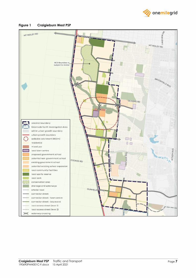
3 CRAIGIEBURN WEST PRECINCT STRUCTURE PLAN
The Craigieburn West Precinct Structure Plan (PSP) has been prepared by the Victorian Planning
Authority (VPA) in consultation with Hume City Council and other authorities, to guide the
development of the land within the Craigieburn West area.
The PSP has been prepared to identify (amongst other things) the future transport network including
roads, public transport, and active transport, with due consideration of broader planning
outcomes.
A view of the proposed Craigieburn West PSP area, reproduced from the draft PSP documentation,
is provided in Figure 1.
Craigieburn West PSP Traffic and Transport 190690PAN001C-F.docx 15 April 2021
Page 7
Figure 1 Craigieburn West PSP
Craigieburn West PSP Traffic and Transport 190690PAN001C-F.docx 15 April 2021
Page 8
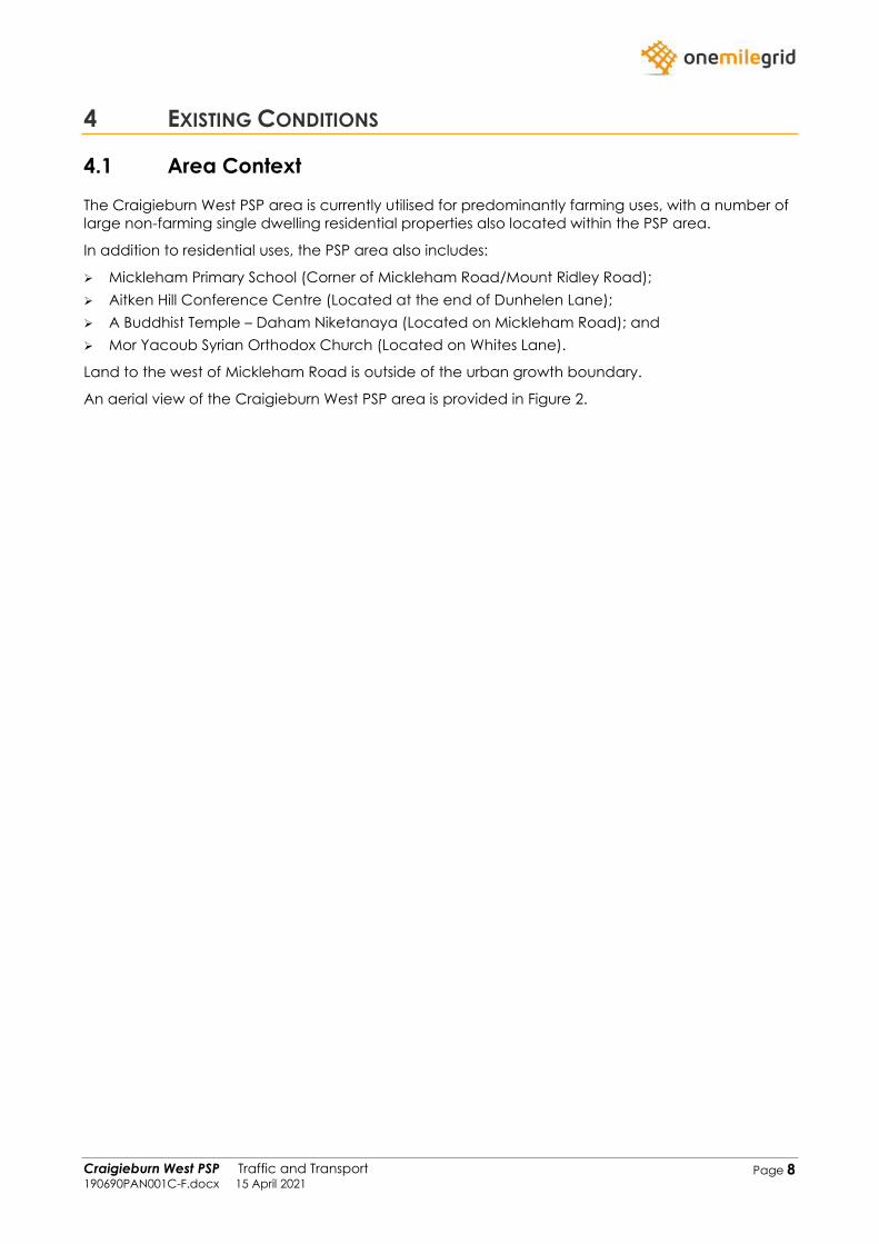
4 EXISTING CONDITIONS
4.1 Area Context
The Craigieburn West PSP area is currently utilised for predominantly farming uses, with a number of
large non-farming single dwelling residential properties also located within the PSP area.
In addition to residential uses, the PSP area also includes:
➢ Mickleham Primary School (Corner of Mickleham Road/Mount Ridley Road);
➢ Aitken Hill Conference Centre (Located at the end of Dunhelen Lane);
➢ A Buddhist Temple – Daham Niketanaya (Located on Mickleham Road); and
➢ Mor Yacoub Syrian Orthodox Church (Located on Whites Lane).
Land to the west of Mickleham Road is outside of the urban growth boundary.
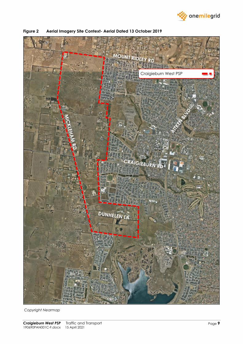
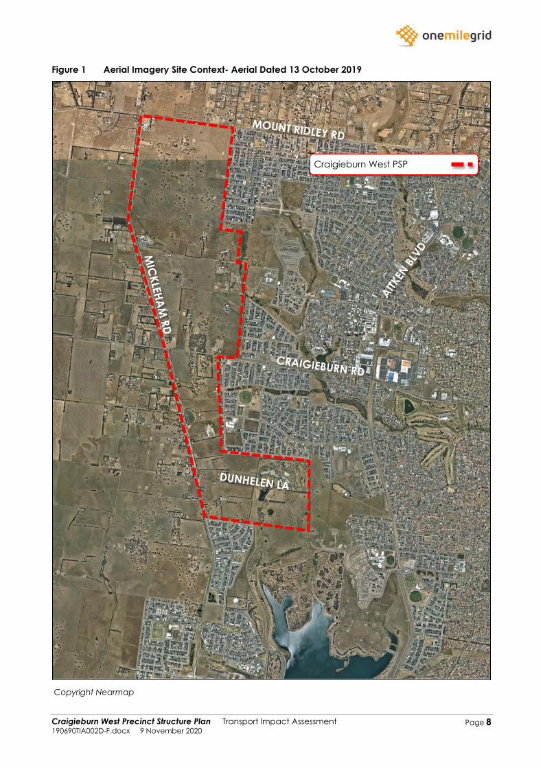
An aerial view of the Craigieburn West PSP area is provided in Figure 2.
Craigieburn West PSP Traffic and Transport 190690PAN001C-F.docx 15 April 2021
Page 9
Figure 2 Aerial Imagery Site Context- Aerial Dated 13 October 2019
Copyright Nearmap
Craigieburn West PSP
Craigieburn West PSP Traffic and Transport 190690PAN001C-F.docx 15 April 2021
Page 10
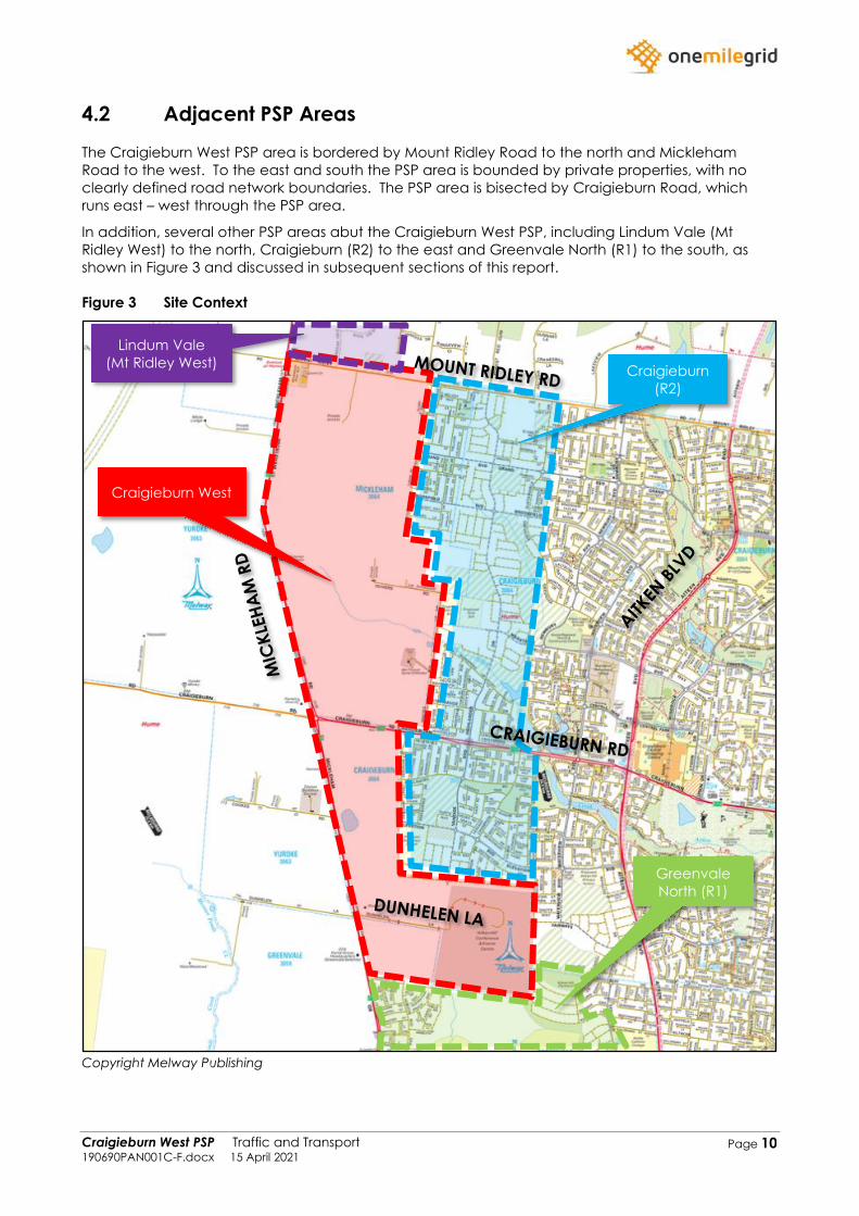
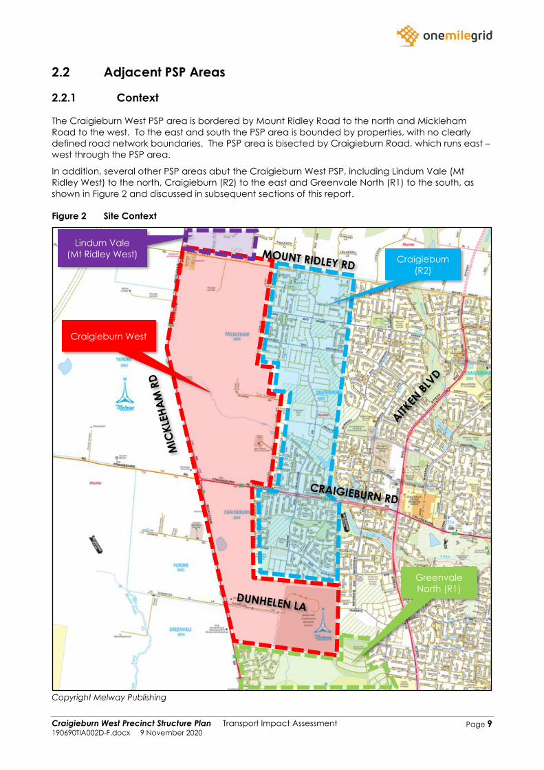
4.2 Adjacent PSP Areas
The Craigieburn West PSP area is bordered by Mount Ridley Road to the north and Mickleham
Road to the west. To the east and south the PSP area is bounded by private properties, with no
clearly defined road network boundaries. The PSP area is bisected by Craigieburn Road, which
runs east – west through the PSP area.
In addition, several other PSP areas abut the Craigieburn West PSP, including Lindum Vale (Mt
Ridley West) to the north, Craigieburn (R2) to the east and Greenvale North (R1) to the south, as
shown in Figure 3 and discussed in subsequent sections of this report.
Figure 3 Site Context
Copyright Melway Publishing
Craigieburn
(R2)
Greenvale
North (R1)
Craigieburn West
Lindum Vale
(Mt Ridley West)
Craigieburn West PSP Traffic and Transport 190690PAN001C-F.docx 15 April 2021
Page 11
5 TRAFFIC MODELLING
5.1 Background
In 2020, my firm prepared a Transport Impact Assessment for the Craigieburn West Precinct
Structure Plan (Ref: 190690TIA002D-F) at the request of the Victorian Planning Authority.
As part of the Transport Impact Assessment, a traffic model was prepared for the PSP area to assess
the capability of the internal road network to accommodate traffic volumes anticipated to be
generated by the future development of the PSP. The Transport Impact Assessment identified the
expected future daily volumes on the internal road network, though did not make any
recommendations in this regard.
Subsequent to the submission of the abovementioned report, the draft Craigieburn West PSP
document was released for public consultation. Upon review, it was identified that the residential
lot yield assessed did not in accord with the residential yield that was ultimately considered within
the PSP document. Subsequently, my firm updated the traffic model and prepared an addendum
(Ref: 190690LET001D-F) which was to be read in conjunction with the Transport Impact Assessment.
As part of this additional work, my firm was requested to review the resulting daily traffic volumes,
and make recommendations with regard to road cross-sections based on the modelled volumes.
These recommendations are included within the addendum report, and have been generally
adopted by the VPA.
The original traffic engineering assessment report is included as Appendix A of this report, while the
addendum is included as Appendix B.
It should be noted that the traffic model attempts to determine future road volumes over a long-
term period, relying on a variety of assumptions related to traffic generation, future road network
improvements, and the destinations of residential traffic. In reality we know that traffic conditions
can alter considerably over time based on unforeseen circumstances, or large transport projects
which had previously not been planned for. For example, the increased use of in-car navigational
aids is expected to have resulted in broad changes to traffic distributions, whilst the recent and
ongoing shift to working-from-home is expected to result in long-lasting changes to traffic patterns
and traffic generation associated with employment trips. Similarly, the construction of the
Suburban Rail Loop will likely cause considerable changes to on-road traffic conditions in the area
surrounding the proposed loop, though would not have been contemplated in any modelling
undertaken in the areas.
Noting the above, traffic modelling is simply a tool which can be utilised to assist in the design and
assessment of a proposed road network, though should not be used without sound engineering
judgement.
An overview of the traffic model is provided below.
5.2 Modelling Inputs
The traffic model was prepared in order to determine future traffic volumes along the internal and
surrounding road network. The traffic model output the generated and resultant traffic volumes for
both interim (2031) and ultimate (2046) conditions and considered the following as appropriate:
➢ Existing traffic volumes based on tube counts commissioned by my firm;
➢ Major road network improvements as identified by the Department of Transport;
➢ Traffic generation of surrounding PSPs based on existing traffic reports for the adjacent PSP
areas;
➢ Base conditions traffic growth based on the Department of Transport (VicRoads) historical traffic
volume data;
➢ Proposed land uses within Craigieburn West PSP (approximately 8,230 residential lots);
Craigieburn West PSP Traffic and Transport 190690PAN001C-F.docx 15 April 2021
Page 12
➢ Traffic generations rates for Craigieburn West PSP based on case study data held by my firm
(7 vehicle movements per day for medium density residential lots and 9 vehicle movements per
day for standard density lots); and
➢ External traffic distributions for Craigieburn West PSP based on Victorian Integrated Survey of
Travel and Activity (VISTA) data.
Further details on the above inputs are provided within the Transport Impact Assessment and
addendum provided in Appendix A and Appendix B respectively.
I consider the methodology and assumptions of the assessments (outlined above) to be an
appropriate approach to estimate the future traffic volumes along the internal road network. It is
noted that this approach allows for a granular assessment of localised traffic generation, which is
beneficial when determining appropriate local road connections and configurations.
5.3 Traffic Impact
The updated traffic model projects that the Craigieburn West PSP will result in a total traffic
generation of 70,310 vehicle movements per day, with 10% (7,031 vehicle movements) expected to
occur during both the AM and PM peak hours. This traffic would be distributed within the internal
and external road network.
The generated and resultant traffic volumes for both the interim and ultimate scenarios are
provided in the addendum in Appendix B.
Noting the updated residential yield and resulting increase in traffic generated, my firm also
recommended an updated road hierarchy for the PSP which was included in the addendum. The
updated road hierarchy was designed to better align the theoretical capacity of roads with the
traffic volumes they would be expected to carry. These adjustments to the road hierarchy involved
both upgrades and downgrades to road classifications as appropriate.
Of importance, the following roads had their road classifications upgraded/downgraded:
➢ Elevation Boulevard – West of North-South Connector Boulevard 1: Upgraded from Connector
Street to Connector Boulevard;
➢ Vantage Boulevard – North of Fairways Boulevard: Upgraded from Connector Street to
Connector Boulevard;
➢ Fairways Boulevard – West of Vantage Boulevard: Upgraded from Connector Street to
Connector Boulevard;
➢ North-South Connector Boulevard 1 – South of Craigieburn Road: Downgraded from Connector
Boulevard to Connector Street;
➢ North-South Connector Boulevard 2 – South of Dunhelen Lane: Downgraded from Connector
Boulevard to Connector Street; and
➢ East-West Connector Road 1 - Upgraded from Connector Street to Connector Boulevard.
I consider that the above changes to the road hierarchy will better align the intended function of
these roads with the traffic volumes projected.
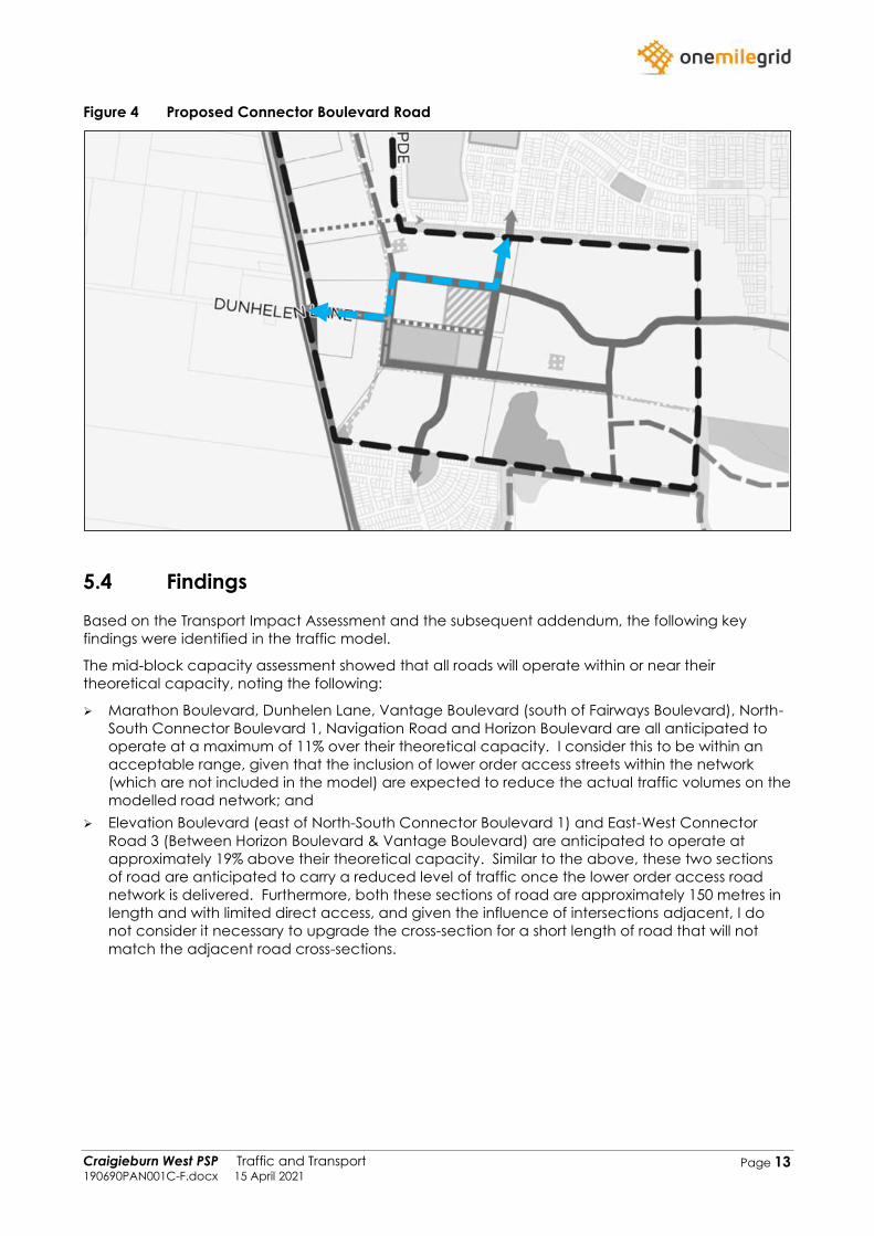
Importantly, Vantage Boulevard (north of Fairways Boulevard) and Fairways Boulevard (west of
Vantage Boulevard) are proposed to be upgraded to a Connector Boulevard to better facilitate
traffic from the Craigieburn West PSP and through traffic from outside of the PSP. This upgrade will
provide a continuous higher-order road connection from the Craigieburn West PSP boundary
(Vantage Boulevard) and Mickleham Road, as shown in Figure 4.
Craigieburn West PSP Traffic and Transport 190690PAN001C-F.docx 15 April 2021
Page 13
Figure 4 Proposed Connector Boulevard Road
5.4 Findings
Based on the Transport Impact Assessment and the subsequent addendum, the following key
findings were identified in the traffic model.
The mid-block capacity assessment showed that all roads will operate within or near their
theoretical capacity, noting the following:
➢ Marathon Boulevard, Dunhelen Lane, Vantage Boulevard (south of Fairways Boulevard), North-
South Connector Boulevard 1, Navigation Road and Horizon Boulevard are all anticipated to
operate at a maximum of 11% over their theoretical capacity. I consider this to be within an
acceptable range, given that the inclusion of lower order access streets within the network
(which are not included in the model) are expected to reduce the actual traffic volumes on the
modelled road network; and
➢ Elevation Boulevard (east of North-South Connector Boulevard 1) and East-West Connector
Road 3 (Between Horizon Boulevard & Vantage Boulevard) are anticipated to operate at
approximately 19% above their theoretical capacity. Similar to the above, these two sections
of road are anticipated to carry a reduced level of traffic once the lower order access road
network is delivered. Furthermore, both these sections of road are approximately 150 metres in
length and with limited direct access, and given the influence of intersections adjacent, I do
not consider it necessary to upgrade the cross-section for a short length of road that will not
match the adjacent road cross-sections.
Craigieburn West PSP Traffic and Transport 190690PAN001C-F.docx 15 April 2021
Page 14
6 RESPONSE TO SUBMISSIONS
6.1 Overview
As part of the Craigieburn West PSP approval process, the draft PSP documents and background
reports were issued for public and stakeholder consultation on 17th November 2020 for a one-month
period. During this period, a total of 42 submissions were received by the VPA which included 21
submissions in regard to the traffic related aspects. The main traffic related issues could be
categorised into the following:
➢ Timing for the duplication of Mickleham Road;
➢ Matters pertaining to the traffic model and methodology;
➢ Matters pertaining to the proposed road hierarchy; and
➢ Location of intersections along Mickleham Road.
A summary of the abovementioned issues and my opinions on these matters are provided below.
6.2 Timing for the Duplication of Mickleham Road
A total of 11 submissions were received which flagged the existing traffic issues with Mickleham
Road and highlighted that these traffic issues will be exacerbated with the additional traffic from
the Craigieburn West PSP. As a result, all of these 11 submissions requested that Mickleham Road
be duplicated (or commitment made to the duplication) before development begins within the
Craigieburn West PSP.
In response to the above, it is noted that Mickleham Road is located outside of the PSP boundary
and is an arterial road under the management of the Department of Transport (DoT). Therefore,
any upgrades are subject to the funding and approval by the Department of Transport.
Nevertheless, as outlined within the Transport Impact Assessment prepared by my firm, Mickleham
Road is slated to be duplicated to two traffic lanes in each direction and then ultimately will be
widened again to provide three traffic lanes in each direction. The required road reserve has
already been acquired by the Department of Transport for the majority of the PSP’s frontage to
Mickleham Road to facilitate the interim and ultimate duplication works.
Furthermore, and importantly, it should be noted that the development and approval of the PSP
will not result in immediate increases in traffic in the area. More so, the PSP is designed as a long-
term strategic planning document which will allow for the development of the Craigieburn West
area over an extended period, and any development proposal will still require independent
assessment of traffic impacts. Considering typical timeframes for development (including
subdivision design, planning, approval, infrastructure construction, dwelling construction, etc), it
would be unlikely that the Craigieburn West area would experience any considerable
development within 3 or 4 years from approval and gazettal of the PSP. Further, development is
expected to occur gradually, and over multiple frontages, distributing the traffic generation to
multiple connecting roads, and at the same time, creating additional road links and connections.
With the land area required for duplication already available, and noting the typical timeframes for
development within a PSP area even after gazettal of a PSP, I consider that committal to the
duplication of Mickleham Road is not critical to the approval of the Craigieburn West PSP, and
approval of the Craigieburn West PSP may actually assist in prioritising the upgrade of Mickleham
Road.
Craigieburn West PSP Traffic and Transport 190690PAN001C-F.docx 15 April 2021
Page 15
6.3 Matters Pertaining to the Traffic Model
Several submissions received by the VPA had various queries with the traffic model that was
prepared by my firm. I have separated each of these concerns and my responses to each below.
6.3.1 Use of VITM Modelling
Several submissions questioned using my firms in-house traffic modelling software in lieu of VITM
modelling.
VITM is generally considered to be the appropriate modelling tool for large scale regional area
modelling, or for corridor modelling, where the provision of new arterial roads can create traffic
distribution changes over a wider area, or various arterial road options are being tested. Whilst
commonly used for reviewing traffic volumes on a local road network, and even intersection
turning movements, VITM may not provide reliable results to this level of detail.
In the case of the Craigieburn West PSP, the arterial road network has been predetermined and is
existing, and the modelling exercise is predominantly related to internal local roads, and locally
generated traffic, with few through traffic routes provided. Consequently, a fine grain model
based on local catchment areas and specific traffic routes is considered to be appropriate.
The model used is a static traffic generation and distribution model, with manually assigned traffic
routes based on engineering judgement and assessment, and was the basis of my firm’s
appointment by the VPA to undertake the traffic modelling for the PSP.
It is able to be interrogated to determine the origins and destinations of the resulting traffic volumes,
and is considered to provide a suitable tool for the prediction of high-level future traffic volumes,
and an assessment of the (predominantly local) road network proposed as part of the PSP.
It is acknowledged that inconsistencies related to previous modelling (undertaken by others) and
the resulting road network in surrounding PSP areas, required manual adjustments to the model,
though again, this is considered to be appropriate for a small-scale model such as that required for
Craigieburn West.
I therefore believe the chosen traffic modelling method is sufficient to determine the local traffic
volumes within the Craigieburn West PSP.
6.3.2 Assumed Lot Yield
Several submissions had raised queries with the previously adopted residential lot yield, which was
based on an area of 600 m2 per lot and resulted in a total of 6,153 residential lots delivered as part
of the Craigieburn West PSP.
As mentioned earlier in my evidence, my firm has issued an addendum to our original Transport
Impact Assessment which adopted the following residential yield.
➢ Standard density residential – 18.5 dwellings / net developable hectare
➢ Medium density residential (within walkable catchment) – 26.5 dwellings / net developable
hectare
Based on the above residential yield, it is anticipated that approximately 8,230 residential lots will
be delivered as part of the Craigieburn West PSP. My firms traffic model has been updated with
the revised residential yield and is included in the addendum.
Craigieburn West PSP Traffic and Transport 190690PAN001C-F.docx 15 April 2021
Page 16
6.3.3 Traffic Generation Rates
Concerns were raised with our traffic generation rate of 9 vehicle movements per day per
residential lot. These concerns were further emphasised with no case study data provided to
support this traffic generation rate.
As mentioned earlier in my evidence, my firm has issued an addendum to our original Transport
Impact Assessment which adopted the following traffic generation rates for the two types of
residential developments.
➢ Standard density residential – 9 vehicles movements per day / lot
➢ Medium density residential (within walkable catchment) – 7 vehicles movements per day / lot
I note that the above traffic generation rates are generally industry standard traffic generation
rates for outer suburban areas, with some allowance for other traffic generators such as schools,
retail areas etc. Whilst case study data is available to support slightly lower rates, these are all
dependant on the area and therefore I consider the above rates to be both conservative and
appropriate.
6.3.4 Traffic Directional Splits
Several submissions raised queries with the adopted traffic directional splits, which consisted of an
inbound/outbound ratio split of 30:70 in the AM peak and 60:40 in the PM peak. These concerns
were further emphasised as no case study data was provided in the assessment to support this
traffic distribution split.
I note that the above traffic distribution split is generally an industry standard traffic distribution rate
for residential subdivisions. Importantly though, it should be recognised that adoption of alternative
directional splits would have little impact on the findings of the assessment in terms of road
hierarchy, as the recommendations are based on daily two-way volumes as opposed to peak
hourly volumes.
6.3.5 Traffic Distribution
Submissions questioned aspects of the adopted traffic distribution, which included 9% internal trips
and the appropriateness of the chosen VISTA travel survey results.
In relation to the latter, the VISTA travel survey results were utilised to identify the typical trip purpose
for residentially generated traffic (such as shopping, education, employment, etc), which enabled
a more comprehensive analysis of the likely destinations of traffic generated from each of the
defined residential areas within the Craigieburn West area. I can confirm that the VISTA traffic
distribution that was adopted was for outer Melbourne which I consider appropriate for the
Craigieburn West PSP.
In regard to the internal traffic distribution, the distribution was calculated by manually assigning
trips based on the ultimate land uses within the PSP area, in the surrounding areas, and the broader
Melbourne metropolitan area, including schools, employment, shopping and recreational areas.
The internal distribution of 9% is generally in accordance with the industry standard rate of 10% for
internal trips for residential areas.
Craigieburn West PSP Traffic and Transport 190690PAN001C-F.docx 15 April 2021
Page 17
6.3.6 Through Traffic Growth
Submissions questioned aspects of the traffic growth along Craigieburn Road and non-arterial
roads within the vicinity.
In regard to the traffic growth along Craigieburn Road, review of Department of Transport
(VicRoads) historical traffic volume data for Craigieburn Road suggests that traffic volumes have
risen from approximately 11,800 vehicles per day in 2001 to approximately 17,600 vehicles per day
in 2015. This data shows that the traffic volumes have had a growth rate of approximately 3%
(compounding) over the last 14 years, which is what my firm had adopted in our Transport Impact
Assessment.
In regard to the non-arterial roads, it is noted that we have only adopted the 1% traffic growth for
non-arterial roads to the north of Craigieburn Road (Marathon Boulevard, Brookfield Boulevard and
Grand Boulevard) where we did not rely on any existing modelling. Aerial imagery shows this area
is still under residential development, and considering the relatively low volume of existing traffic
along these roads it is considered that the 1% traffic growth is appropriate.
In regard to traffic growth along Mickleham Road and within the Craigieburn R2 PSP (south of
Craigieburn Road), the traffic volumes from the previous PSP traffic reports were adopted with no
additional growth applied.
6.4 Matters Pertaining to the Road Hierarchy
Several submissions had raised concerns with the proposed road hierarchy for the Craigieburn West
PSP. I note that the majority of these queries were in relation to several roads carrying traffic
volumes significantly over their theoretical capacity.
As mentioned earlier in my evidence, my firm has issued an addendum to our original Transport
Impact Assessment which provided a recommendation for a revised road hierarchy which is
designed to align road classifications with the traffic volumes they are anticipated to carry. This
involved both upgrades and downgrade to road classifications previously considered where
appropriate.
The updated mid-block capacity assessment shows that all roads will operate within or near their
theoretical capacity within an appropriate margin of area. Whilst Elevation Boulevard (east of
North-South Connector Boulevard 1) and East-West Connector Road 3 (Between Horizon Boulevard
& Vantage Boulevard) are expected to operate at approximately 19% above their theoretical
capacity, given their short sections of road (150 metres each), I consider this to be acceptable.
6.5 Location of Intersections along Mickleham Road
Several submissions requested additional left-on/left-out intersections along Mickleham Road.
In this regard, it should be recognised that the proposed signalised intersections along Mickleham
Road are generally spaced in accordance with VPA and DoT guidelines with approximately
400 metres between intersections. Furthermore, the majority of the intersections to the south of
Craigieburn Road are appropriately located to provide east-west connections between the
existing roads within Craigieburn R2 PSP and Mickleham Road.
Additional left-in/left-out intersections to Mickleham Road are not required to be shown on the PSP
and will referred to the Department of Transport at the subdivision approval stage.
.
Craigieburn West PSP Traffic and Transport 190690PAN001C-F.docx 15 April 2021
Page 18
Appendix A Transport Impact
Assessment
onemilegrid.com.au 56 Down Street, Collingwood, VIC 3066 (03) 9939 8250
Craigieburn West Precinct Structure Plan Transport Impact Assessment
190690TIA002D-F.docx
9 November 2020
Craigieburn West Precinct Structure Plan Transport Impact Assessment 190690TIA002D-F.docx 9 November 2020
Page 2
onemilegrid ABN: 79 168 115 679
(03) 9939 8250
56 Down Street
COLLINGWOOD, VIC 3066
www.onemilegrid.com.au
DOCUMENT INFORMATION
Prepared for Victorian Planning Authority
File Name 190690TIA002D-F.docx Report Date 9 November 2020
Prepared by Martin Kropiewnicki &
Stuart Valentine Reviewed by Ross Hill
Signature
Signature
© One Mile Grid Pty Ltd. This document has been prepared by onemilegrid for the sole use and benefit of the
client as per the terms of engagement. It may not be modified or altered, copied, reproduced, sold or
transferred in whole or in part in any format to any person other than by agreement. onemilegrid does not
assume responsibility or liability to any third party arising out of use or misuse of this document.
Craigieburn West Precinct Structure Plan Transport Impact Assessment 190690TIA002D-F.docx 9 November 2020
Page 3
EXECUTIVE SUMMARY
onemilegrid has been requested by the Victorian Planning Authority (VPA) to prepare a Transport
Impact Assessment for the Craigieburn West Precinct Structure Plan.
The Craigieburn West PSP is located along the Urban Growth Boundary within the City of Hume.
The PSP area comprises approximately 565 hectares and is bound by Mount Ridley Road to the
north and Mickleham Road to the west. The PSP area is bisected by Craigieburn Road, which runs
east-west through the proposed PSP.
In addition, several other PSP areas abut the proposed PSP, including Lindum Vale (Mt Ridley West)
to the north, Craigieburn (R2) to the east and Greenvale North (R1) to the south.
onemilegrid has previously undertaken an existing conditions assessment of the study area which
analysed the existing transport networks within the vicinity.
A traffic model has been prepared for the study area considering the anticipated land uses as
provided by the VPA and the Future Urban Structure Plan. In addition, the traffic model took into
consideration the neighbouring PSP developments and any major road network improvements
expected in the future.
The traffic model was used to provide an estimate of future traffic volumes along adjoining arterial
roads and local roads within the PSP area.
Craigieburn West Precinct Structure Plan Transport Impact Assessment 190690TIA002D-F.docx 9 November 2020
Page 4
CONTENTS
EXECUTIVE SUMMARY ......................................................................................................................... 3
1 INTRODUCTION............................................................................................................ 7
2 EXISTING CONDITIONS ................................................................................................. 7 2.1 Area Context .......................................................................................................................... 7 2.2 Adjacent PSP Areas ............................................................................................................... 9 2.2.1 Context ................................................................................................................................... 9 2.2.2 Craigieburn (R2) ................................................................................................................... 10 2.2.3 Lindum Vale (Mt Ridley West) ............................................................................................ 11 2.2.4 Greenvale North (R1) .......................................................................................................... 12 2.3 Other Notables Uses ............................................................................................................ 13 2.4 Traffic Volumes ..................................................................................................................... 14 2.4.1 Intersection Counts .............................................................................................................. 16 2.4.2 Tube Counts ......................................................................................................................... 18
3 CRAIGIEBURN WEST PSP OVERVIEW ............................................................................. 19 3.1 General ................................................................................................................................. 19 3.2 Vehicular Access ................................................................................................................. 21 3.3 Road Network....................................................................................................................... 21 3.3.1 Arterial Roads ....................................................................................................................... 21 3.3.2 Local Roads .......................................................................................................................... 22 3.3.3 Overall Road Network ......................................................................................................... 23 3.4 Pedestrian and Bicycle Network........................................................................................ 25 3.5 Public Transport .................................................................................................................... 27
4 TRAFFIC MODEL ........................................................................................................ 28 4.1 Overview ............................................................................................................................... 28 4.2 Major Road Network Improvements ................................................................................. 30 4.3 Traffic Growth ....................................................................................................................... 31 4.3.1 Traffic Generation of Surrounding PSPs ............................................................................. 31 4.3.2 Through Traffic Growth ........................................................................................................ 36 4.4 Future Base Case Traffic Volumes ...................................................................................... 36 4.4.1 Overview ............................................................................................................................... 36 4.4.2 Interim (10 Year Horizon) ..................................................................................................... 37 4.4.3 Ultimate (25 Year Horizon) .................................................................................................. 38 4.5 Proposed Land Uses ............................................................................................................ 39 4.6 Traffic Generation ................................................................................................................ 40 4.6.1 Residential ............................................................................................................................ 40 4.6.2 Other Uses ............................................................................................................................. 40 4.7 Traffic Distribution ................................................................................................................. 41 4.7.1 Trip Purpose Distribution ...................................................................................................... 41 4.7.2 Directional Distribution ........................................................................................................ 41 4.8 Generated Traffic Volumes ................................................................................................. 42 4.9 Resultant Traffic Volumes .................................................................................................... 42 4.10 Traffic Impact ....................................................................................................................... 43 4.10.1 Arterial Road Intersections .................................................................................................. 43 4.10.2 Midblock Capacity Assessment ......................................................................................... 43
5 CONCLUSIONS AND RECOMMENDATIONS .................................................................... 45
Craigieburn West Precinct Structure Plan Transport Impact Assessment 190690TIA002D-F.docx 9 November 2020
Page 5
TABLES
Table 1 Survey Summary ................................................................................................................... 14 Table 2 Traffic Volume and Speed Surveys .................................................................................... 18 Table 3 Proposed Land Uses ............................................................................................................ 39 Table 4 Anticipated Peak Hour Traffic Generation ....................................................................... 40 Table 5 Trip Purpose Distribution ...................................................................................................... 41 Table 6 Adopted Directional Traffic Distribution ............................................................................ 41 Table 7 Our Roads: Connecting People – Road Characteristics ................................................ 43 Table 8 Mid-Block Capacity Assessment ........................................................................................ 44
FIGURES
Figure 1 Aerial Imagery Site Context- Aerial Dated 13 October 2019 ........................................... 8 Figure 2 Site Context ............................................................................................................................ 9 Figure 3 Craigieburn (R2) Road Network Connections ................................................................. 10 Figure 4 Lindum Vale (Mt Ridley West) Road Network Connections ........................................... 11 Figure 5 Greenvale North (R1) Road Network Connections ......................................................... 12 Figure 6 Notable Uses ........................................................................................................................ 13 Figure 7 Survey Locations .................................................................................................................. 15 Figure 8 Existing Traffic Volumes – AM Peak Hour (8:00am – 9:00am) ......................................... 16 Figure 9 Existing Traffic Volumes – PM Peak Hour (3:30pm – 4:30pm) .......................................... 17 Figure 10 Draft Craigieburn West PSP ................................................................................................ 20 Figure 11 PSP Road Network and Intersections ................................................................................ 24 Figure 12 Proposed Pedestrian and Bicycle Network ...................................................................... 26 Figure 13 Public Transport Provision .................................................................................................... 27 Figure 14 Traffic Model ......................................................................................................................... 29 Figure 15 Major Road Network Improvements ................................................................................. 30 Figure 16 Interim Traffic Volumes from Lindum Vale and Merrifield West PSP .............................. 31 Figure 17 Ultimate Traffic Volumes from Lindum Vale and Merrifield West PSP ............................ 32 Figure 18 Aston Estate Ultimate Traffic Volumes ............................................................................... 33 Figure 19 Ultimate Traffic Volumes from Craigieburn R2 PSP .......................................................... 34 Figure 20 Future Turning Movements - Vantage Boulevard / Craigieburn Road ......................... 34 Figure 21 Traffic Zones – Extract from Ashton Traffic Services Report ............................................. 35
Craigieburn West Precinct Structure Plan Transport Impact Assessment 190690TIA002D-F.docx 9 November 2020
Page 6
APPENDICES
APPENDIX A FUTURE BASE CONDITIONS DAILY VOLUMES - INTERIM .................................................... 46
APPENDIX B FUTURE BASE CONDITIONS DAILY VOLUMES – ULTIMATE .................................................. 48
APPENDIX C GENERATED DAILY VOLUMES – INTERIM ........................................................................ 50
APPENDIX D GENERATED DAILY VOLUMES – ULTIMATE ...................................................................... 52
APPENDIX E RESULTANT DAILY VOLUMES – INTERIM .......................................................................... 54
APPENDIX F RESULTANT DAILY VOLUMES – ULTIMATE ........................................................................ 56
Craigieburn West Precinct Structure Plan Transport Impact Assessment 190690TIA002D-F.docx 9 November 2020
Page 7
1 INTRODUCTION
onemilegrid has been requested by Victorian Planning Authority to undertake a Transport Impact
Assessment of the proposed Craigieburn West Precinct Structure Plan.
A traffic model has been prepared to allow all major intersections proposed to be designed to
accommodate traffic volumes anticipated to be generated by future development within the
area.
As part of this assessment the study area has been inspected with due consideration of the PSP
area and surrounding precincts, traffic data has been sourced and relevant background reports
have been reviewed.
2 EXISTING CONDITIONS
2.1 Area Context
The Craigieburn West PSP area is currently utilised for predominantly farming uses, with a number of
large non-farming single dwelling residential properties also located within the PSP area.
In addition to residential uses, the PSP area also includes:
➢ Mickleham Primary School (Corner of Mickleham Road/Mount Ridley Road);
➢ Aitken Hill Conference Centre (Located at the end of Dunhelen Lane);
➢ A Buddhist Temple – Daham Niketanaya (Located on Mickleham Road); and
➢ Mor Yacoub Syrian Orthodox Church (Located on Whites Lane).
Land to the west of Mickleham Road is outside of the urban growth boundary.
An aerial view of the Craigieburn West PSP area is provided in Figure 1.
Craigieburn West Precinct Structure Plan Transport Impact Assessment 190690TIA002D-F.docx 9 November 2020
Page 8
Figure 1 Aerial Imagery Site Context- Aerial Dated 13 October 2019
Copyright Nearmap
Craigieburn West PSP
Craigieburn West Precinct Structure Plan Transport Impact Assessment 190690TIA002D-F.docx 9 November 2020
Page 9
2.2 Adjacent PSP Areas
2.2.1 Context
The Craigieburn West PSP area is bordered by Mount Ridley Road to the north and Mickleham
Road to the west. To the east and south the PSP area is bounded by properties, with no clearly
defined road network boundaries. The PSP area is bisected by Craigieburn Road, which runs east –
west through the PSP area.
In addition, several other PSP areas abut the Craigieburn West PSP, including Lindum Vale (Mt
Ridley West) to the north, Craigieburn (R2) to the east and Greenvale North (R1) to the south, as
shown in Figure 2 and discussed in subsequent sections of this report.
Figure 2 Site Context
Copyright Melway Publishing
Craigieburn
(R2)
Greenvale
North (R1)
Craigieburn West
Lindum Vale
(Mt Ridley West)
Craigieburn West Precinct Structure Plan Transport Impact Assessment 190690TIA002D-F.docx 9 November 2020
Page 10
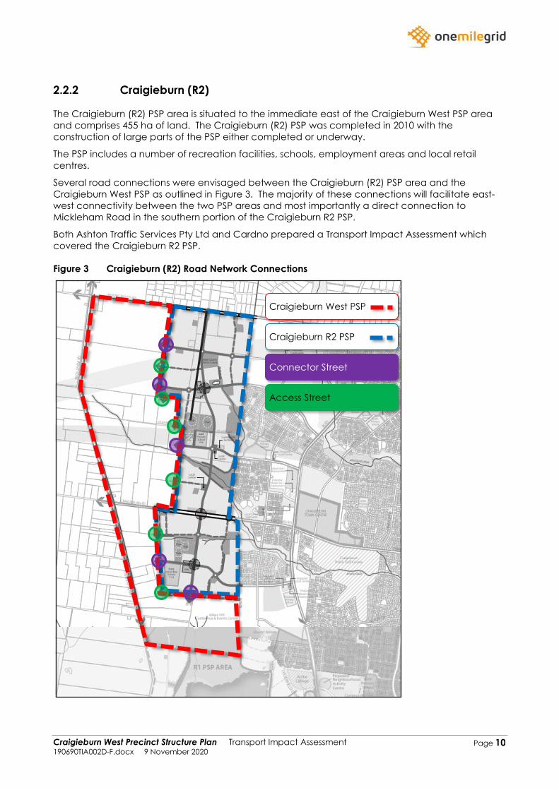
2.2.2 Craigieburn (R2)
The Craigieburn (R2) PSP area is situated to the immediate east of the Craigieburn West PSP area
and comprises 455 ha of land. The Craigieburn (R2) PSP was completed in 2010 with the
construction of large parts of the PSP either completed or underway.
The PSP includes a number of recreation facilities, schools, employment areas and local retail
centres.
Several road connections were envisaged between the Craigieburn (R2) PSP area and the
Craigieburn West PSP as outlined in Figure 3. The majority of these connections will facilitate east-
west connectivity between the two PSP areas and most importantly a direct connection to
Mickleham Road in the southern portion of the Craigieburn R2 PSP.
Both Ashton Traffic Services Pty Ltd and Cardno prepared a Transport Impact Assessment which
covered the Craigieburn R2 PSP.
Figure 3 Craigieburn (R2) Road Network Connections
Craigieburn West PSP
Craigieburn R2 PSP
Connector Street
Access Street
Craigieburn West Precinct Structure Plan Transport Impact Assessment 190690TIA002D-F.docx 9 November 2020
Page 11
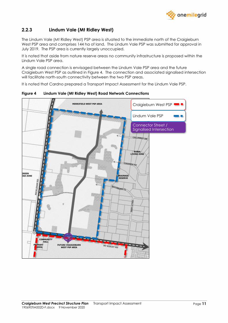
2.2.3 Lindum Vale (Mt Ridley West)
The Lindum Vale (Mt Ridley West) PSP area is situated to the immediate north of the Craigieburn
West PSP area and comprises 144 ha of land. The Lindum Vale PSP was submitted for approval in
July 2019. The PSP area is currently largely unoccupied.
It is noted that aside from nature reserve areas no community infrastructure is proposed within the
Lindum Vale PSP area.
A single road connection is envisaged between the Lindum Vale PSP area and the future
Craigieburn West PSP as outlined in Figure 4. The connection and associated signalised intersection
will facilitate north-south connectivity between the two PSP areas.
It is noted that Cardno prepared a Transport Impact Assessment for the Lindum Vale PSP.
Figure 4 Lindum Vale (Mt Ridley West) Road Network Connections
Craigieburn West PSP
Lindum Vale PSP
Connector Street / Signalised Intersection
Craigieburn West Precinct Structure Plan Transport Impact Assessment 190690TIA002D-F.docx 9 November 2020
Page 12
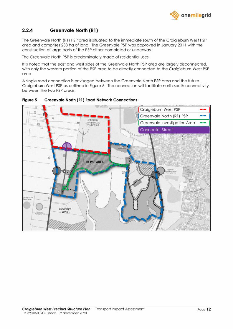
2.2.4 Greenvale North (R1)
The Greenvale North (R1) PSP area is situated to the immediate south of the Craigieburn West PSP
area and comprises 238 ha of land. The Greenvale PSP was approved in January 2011 with the
construction of large parts of the PSP either completed or underway.
The Greenvale North PSP is predominately made of residential uses.
It is noted that the east and west sides of the Greenvale North PSP area are largely disconnected,
with only the western portion of the PSP area to be directly connected to the Craigieburn West PSP
area.
A single road connection is envisaged between the Greenvale North PSP area and the future
Craigieburn West PSP as outlined in Figure 5. The connection will facilitate north-south connectivity
between the two PSP areas.
Figure 5 Greenvale North (R1) Road Network Connections
Craigieburn West PSP
Greenvale North (R1) PSP
Greenvale InvestigationArea
Connector Street
Craigieburn West Precinct Structure Plan Transport Impact Assessment 190690TIA002D-F.docx 9 November 2020
Page 13
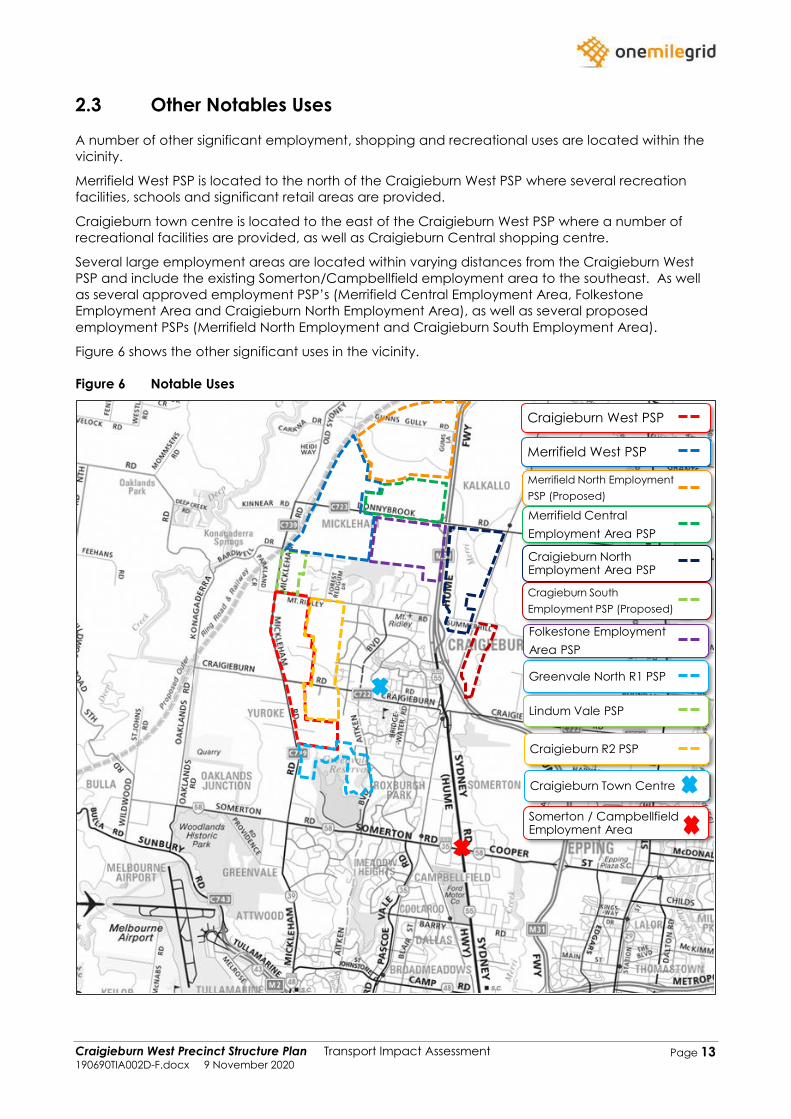
2.3 Other Notables Uses
A number of other significant employment, shopping and recreational uses are located within the
vicinity.
Merrifield West PSP is located to the north of the Craigieburn West PSP where several recreation
facilities, schools and significant retail areas are provided.
Craigieburn town centre is located to the east of the Craigieburn West PSP where a number of
recreational facilities are provided, as well as Craigieburn Central shopping centre.
Several large employment areas are located within varying distances from the Craigieburn West
PSP and include the existing Somerton/Campbellfield employment area to the southeast. As well
as several approved employment PSP’s (Merrifield Central Employment Area, Folkestone
Employment Area and Craigieburn North Employment Area), as well as several proposed
employment PSPs (Merrifield North Employment and Craigieburn South Employment Area).
Figure 6 shows the other significant uses in the vicinity.
Figure 6 Notable Uses
Craigieburn West PSP
Merrifield West PSP
Merrifield North Employment
PSP (Proposed)
Merrifield Central
Employment Area PSP
Craigieburn North Employment Area PSP
Cragieburn South
Employment PSP (Proposed)
Folkestone Employment
Area PSP
Craigieburn Town Centre
Somerton / Campbellfield Employment Area
Greenvale North R1 PSP
Lindum Vale PSP
Craigieburn R2 PSP
Craigieburn West Precinct Structure Plan Transport Impact Assessment 190690TIA002D-F.docx 9 November 2020
Page 14
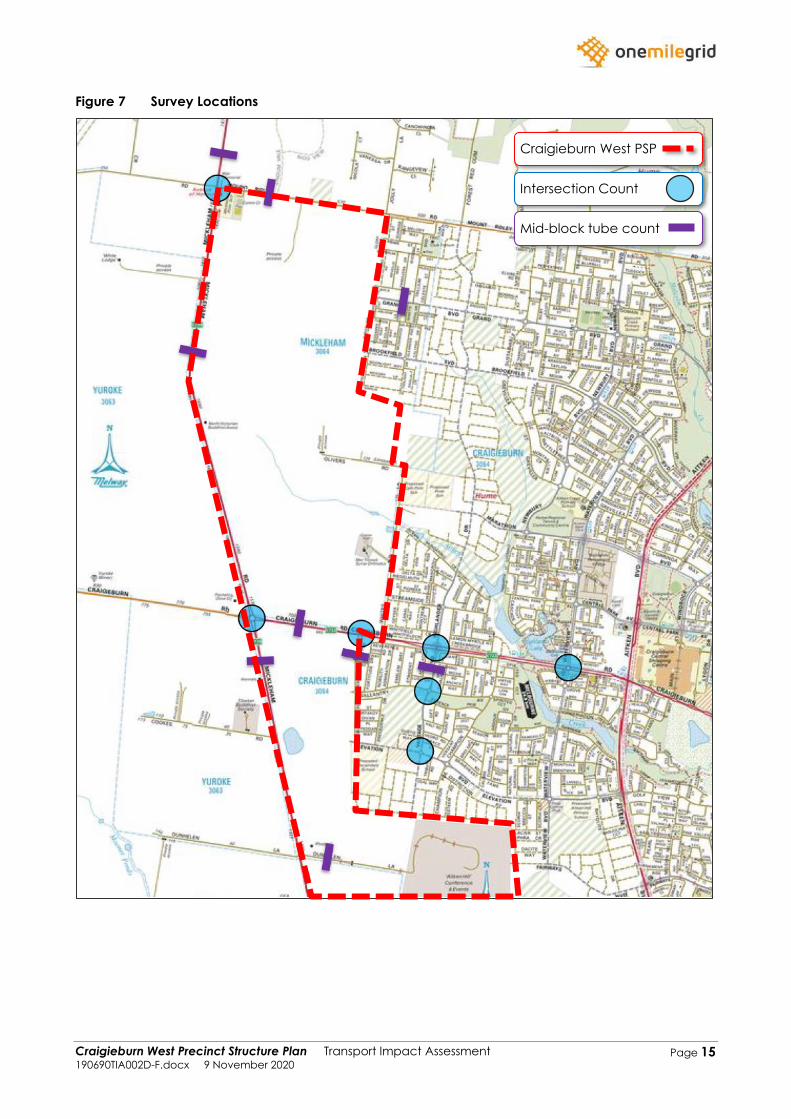
2.4 Traffic Volumes
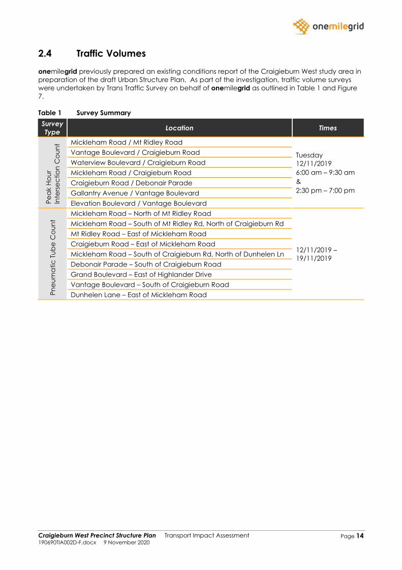
onemilegrid previously prepared an existing conditions report of the Craigieburn West study area in
preparation of the draft Urban Structure Plan. As part of the investigation, traffic volume surveys
were undertaken by Trans Traffic Survey on behalf of onemilegrid as outlined in Table 1 and Figure
7.
Table 1 Survey Summary
Survey
Type Location Times
Pe
ak H
ou
r
Inte
rse
ctio
n C
ou
nt Mickleham Road / Mt Ridley Road
Tuesday
12/11/2019
6:00 am – 9:30 am
&
2:30 pm – 7:00 pm
Vantage Boulevard / Craigieburn Road
Waterview Boulevard / Craigieburn Road
Mickleham Road / Craigieburn Road
Craigieburn Road / Debonair Parade
Gallantry Avenue / Vantage Boulevard
Elevation Boulevard / Vantage Boulevard
Pn
eu
ma
tic
Tu
be
Co
un
t
Mickleham Road – North of Mt Ridley Road
12/11/2019 –
19/11/2019
Mickleham Road – South of Mt Ridley Rd, North of Craigieburn Rd
Mt Ridley Road – East of Mickleham Road
Craigieburn Road – East of Mickleham Road
Mickleham Road – South of Craigieburn Rd, North of Dunhelen Ln
Debonair Parade – South of Craigieburn Road
Grand Boulevard – East of Highlander Drive
Vantage Boulevard – South of Craigieburn Road
Dunhelen Lane – East of Mickleham Road
Craigieburn West Precinct Structure Plan Transport Impact Assessment 190690TIA002D-F.docx 9 November 2020
Page 15
Figure 7 Survey Locations
Craigieburn West PSP
Intersection Count
Mid-block tube count
Craigieburn West Precinct Structure Plan Transport Impact Assessment 190690TIA002D-F.docx 9 November 2020
Page 16
2.4.1 Intersection Counts
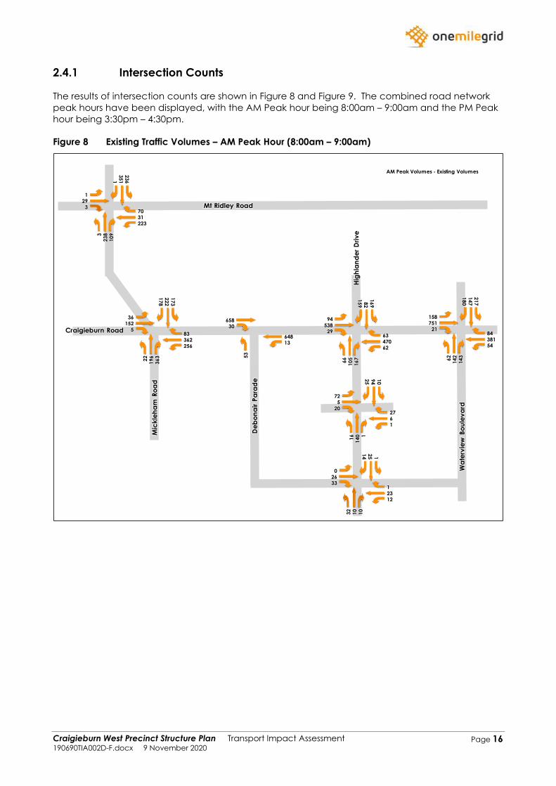
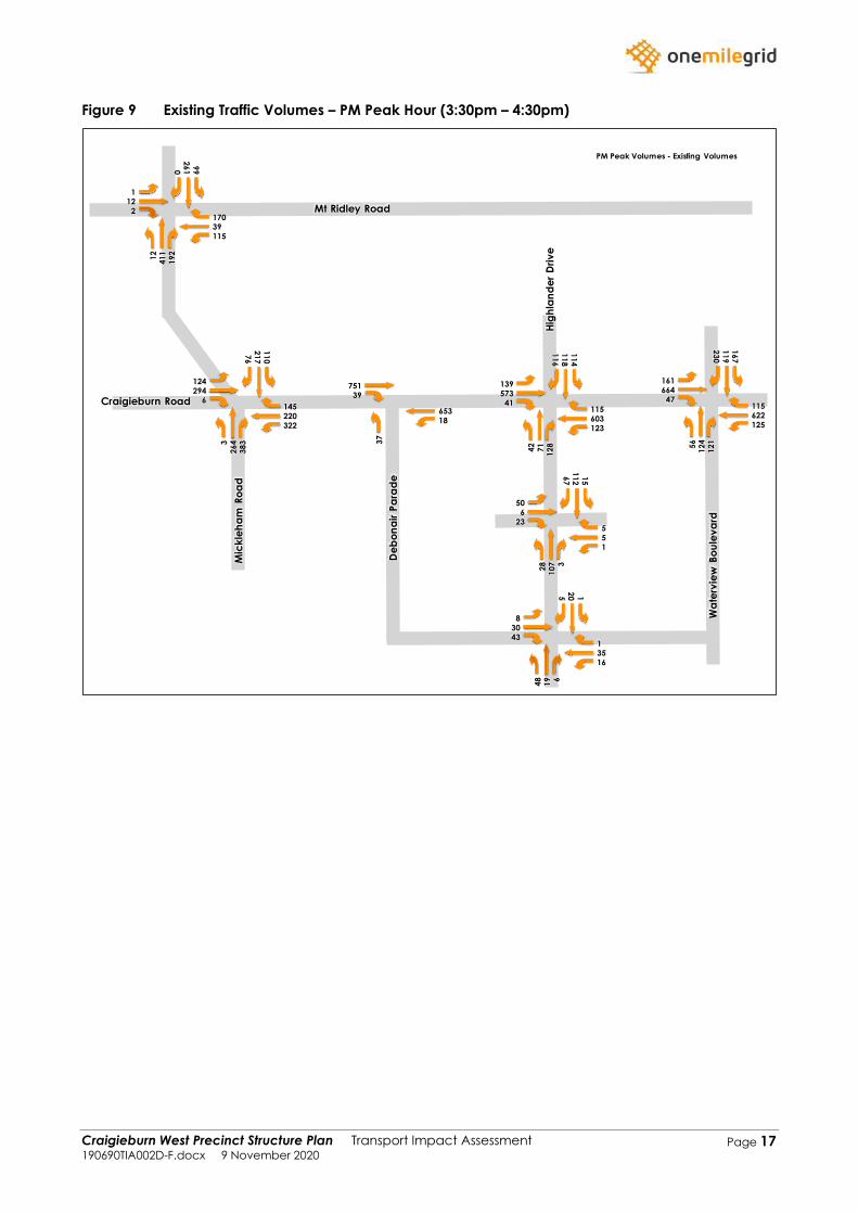
The results of intersection counts are shown in Figure 8 and Figure 9. The combined road network
peak hours have been displayed, with the AM Peak hour being 8:00am – 9:00am and the PM Peak
hour being 3:30pm – 4:30pm.
Figure 8 Existing Traffic Volumes – AM Peak Hour (8:00am – 9:00am)
AM Peak Volumes - Existing Volumes
62470
6329
538
94
15
98
21
69
16
71
05
66
25636283
5
152
36
17
82
22
17
3
36
31
96
22
223
3170
3
291
13
51
23
6
10
92
383
1
6
2720
5
72
25
94
10
11
40
16
1223
133
26
0
14
25 1
10
10
32
13
648
30658
53
5438184
21751
158
18
01
47
21
7
14
31
42
62
Mt Ridley Road
Craigieburn Road
Mic
kle
ha
m R
oa
d
De
bo
na
ir P
ara
de
Hig
hla
nd
er
Dri
ve
Wa
terv
iew
Bo
ule
va
rd
Craigieburn West Precinct Structure Plan Transport Impact Assessment 190690TIA002D-F.docx 9 November 2020
Page 17
Figure 9 Existing Traffic Volumes – PM Peak Hour (3:30pm – 4:30pm)
PM Peak Volumes - Existing Volumes
123603
11541
573
139
11
61
18
11
4
12
87
14
2
322220145
6
294
124
76
21
71
10
38
32
643
115
39170
2
121
02
61
99
19
24
11
12
1
5
523
6
50
67
11
21
5
31
07
28
1635
143
30
8
52
0 1
61
94
8
18
653
39751
37
125622115
47664
161
23
01
19
16
7
12
11
24
56
Mt Ridley Road
Craigieburn Road
Mic
kle
ha
m R
oa
d
De
bo
na
ir P
ara
de
Hig
hla
nd
er
Dri
ve
Wa
terv
iew
Bo
ule
va
rd
Craigieburn West Precinct Structure Plan Transport Impact Assessment 190690TIA002D-F.docx 9 November 2020
Page 18
2.4.2 Tube Counts
The results of the tube count surveys are provided in Table 2.
Table 2 Traffic Volume and Speed Surveys
Road Direction Traffic Volume
(vpd)
85th Percentile
Speed (km/h)
Mickleham Road – North of Mount Ridley
Road Two-Way 11,410 81
Mickleham Road – South of Mount Ridley
Road, North of Craigieburn Road Two-Way 12,167 87
Mount Ridley Road – East of Mickleham
Road Two-Way 7,948 77
Craigieburn Road – East of Mickleham
Road Two-Way 19,301 78
Mickleham Road – South of Craigieburn
Road, North of Dunhelen Lane Two-Way 17,732 78
Debonair Parade – South of Craigieburn
Road Two-Way 1,534 54
Grand Boulevard – East of Highlander
Drive Two-Way 2,876 47
Vantage Boulevard – South of
Craigieburn Road Two-Way 5,321 60
Dunhelen Lane – East of Mickleham
Road Two-Way 182 58
Craigieburn West Precinct Structure Plan Transport Impact Assessment 190690TIA002D-F.docx 9 November 2020
Page 19
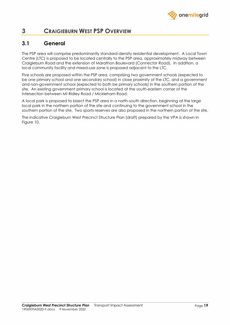
3 CRAIGIEBURN WEST PSP OVERVIEW
3.1 General
The PSP area will comprise predominantly standard-density residential development. A Local Town
Centre (LTC) is proposed to be located centrally to the PSP area, approximately midway between
Craigieburn Road and the extension of Marathon Boulevard (Connector Road). In addition, a
local community facility and mixed-use zone is proposed adjacent to the LTC.
Five schools are proposed within the PSP area, comprising two government schools (expected to
be one primary school and one secondary school) in close proximity of the LTC, and a government
and non-government school (expected to both be primary schools) in the southern portion of the
site. An existing government primary school is located at the south-eastern corner of the
intersection between Mt Ridley Road / Mickleham Road.
A local park is proposed to bisect the PSP area in a north-south direction, beginning at the large
local park in the northern portion of the site and continuing to the government school in the
southern portion of the site. Two sports reserves are also proposed in the northern portion of the site.
The indicative Craigieburn West Precinct Structure Plan (draft) prepared by the VPA is shown in
Figure 10.
Craigieburn West Precinct Structure Plan Transport Impact Assessment 190690TIA002D-F.docx 9 November 2020
Page 20
Figure 10 Draft Craigieburn West PSP
Craigieburn West Precinct Structure Plan Transport Impact Assessment 190690TIA002D-F.docx 9 November 2020
Page 21
3.2 Vehicular Access
The PSP area will largely be accessed via the existing arterial road network that runs adjacent and
through the site. Craigieburn Road bisects the PSP area in an east-west alignment, whilst
Mickleham Road runs along the PSP’s western boundary, and Mt Ridley Road runs along the PSP’s
northern boundary. Access from the internal road network to the arterial road network will be as
follows:
➢ Connector Roads – Signalised Intersections
➢ Access Streets – Left-in / Left-out
Additional access opportunities to the Craigieburn West PSP will be facilitated by the extension of
the existing roads from the adjacent PSPs which will run through the site, as described in the
sections below.
A view of the PSP access arrangements is shown in Figure 11 on page 24.
3.3 Road Network
The PSP road network has been designed generally in accordance with the principles set out in the
Guidance for Planning Road Networks in Growth Areas handbook (VicRoads, 2015).
Further details of the network planning and design are presented below.
3.3.1 Arterial Roads
The PSP area will generally be serviced and accessed by the existing arterial road network as
described above. Craigieburn Road, Mickleham Road and Mt Ridley Road are all slated to be
duplicated to cater for additional traffic anticipated to be generated by the proposed Craigieburn
West PSP, other adjacent PSPs, and general growth in the surrounding area.
3.3.1.1 Craigieburn Road
At the time of this report, Major Road Projects Victoria (MRPV) had commenced detailed designs
to upgrade Craigieburn Road with a divided carriageway and an extra traffic lane in each
direction between Mickleham Road and the Hume Highway. When this upgrade is complete,
Craigieburn Road will have four lanes west of Whites Lane, and six lanes to the east. The upgrade
will also provide new traffic lights at Waterview Boulevard to the east, upgraded intersections at
Vantage Boulevard and Aitken Boulevard, a central median preventing right turns at Debonair
Parade and new walking and cycling paths. Information made available by MRPV shows that
construction is expected to commence in late 2020. Furthermore, Craigieburn Road is slated to be
widened again in the future to ultimately provide three traffic lanes along its length.
3.3.1.2 Mickleham Road
Mickleham Road has a road reserve of 59.6 metres and currently has a single carriageway that
provides for one traffic lane in each direction.
When traffic exceeds its current two lane capacity, Mickleham Road is to be duplicated to provide
two traffic lanes in each direction separated by a central median.
In the ultimate, Mickleham Road is to be widened again to provide three traffic lanes in each
direction.
Craigieburn West Precinct Structure Plan Transport Impact Assessment 190690TIA002D-F.docx 9 November 2020
Page 22
3.3.1.3 Mt Ridley Road
Mt Ridley Road has a road reserve of 40 metres and currently has a single carriageway that
provides for one traffic lane in each direction.
When traffic exceeds its current two lane capacity, Mt Ridley Road is to be duplicated to provide
two traffic lanes in each direction separated by a central median, with a shared path on both sides
of the road.
In the ultimate, Mt Ridley Road is to be widened again to provide three traffic lanes in each
direction.
3.3.2 Local Roads
Within the PSP area, key local roads have been nominated as local access streets, connector
roads or boulevard connector roads, based on a range of factors including strategic network
needs, access requirements, safety, and residential amenity. An overview of the local road
network is provided below.
3.3.2.1 Connector Roads
Several connector roads from the neighbouring PSPs will be extended and run through the PSP
area, as well as new connector roads to ensure a permeable and connected road network to the
higher-order arterial roads.
A new north-south boulevard connector road in a north-south alignment is proposed through the
PSP from Elevation Boulevard to Mt Ridley Road, where it will continue as a through road into the
Lindum Vale PSP.
Marathon Boulevard, Grand Boulevard and Brookfield Boulevard will be extended from the
Craigieburn R2 PSP and intersect with the north-south boulevard connector road.
Elevation Boulevard will be extended from the Craigieburn R2 PSP and provide a direct connection
to Mickleham Road.
In addition, two east-west aligned connector roads are proposed in the northern portion of the PSP
to provide additional connections to Mickleham Road.
A new interconnected connector road network is proposed in the southern portion of the PSP
which will provide permeability in the area. The network will consist of both connector road and
boulevard connector road cross-sections.
Vantage Boulevard and Fairway Boulevard will be extended from the Craigieburn R2 PSP and
continue through the southern portion of the proposed PSP and connect with the new connector
road network.
Horizontal Boulevard will be extended from the Greenvale North PSP and connect with the new
connector road network.
Dunhelen Lane will be upgraded to have a boulevard connector road cross-section and connect
Mickleham Road with the new connector road network.
3.3.2.2 Local Access Streets
Several key local access streets are also shown within the PSP area to provide access to higher-
order roads and provide for an interconnected and continuous network of streets within and
between different precincts. Whilst not shown in the PSP plans, additional lower order access
streets will be provided to provide access to individual dwellings and provide further permeability
throughout the site.
Craigieburn West Precinct Structure Plan Transport Impact Assessment 190690TIA002D-F.docx 9 November 2020
Page 23
3.3.3 Overall Road Network
A view of the PSP road network is shown in Figure 11 which includes details of the road hierarchy
and intersection configurations.

Craigieburn West Precinct Structure Plan Transport Impact Assessment 190690TIA002D-F.docx 9 November 2020
Page 24
Figure 11 PSP Road Network and Intersections
1
3
4
6
X
X X
X
T
T
PSP Area
Arterial Road
Connector Road
Boulevard Connector Road
Access Street
Signalised Intersection
Signalised T-Intersection
Left-in/Left-out
Roundabout
X
T
L
T
R
R
R
R
R
R
R
R
R
R
R
R R
R R
R
R
X
L
L
Craigieburn West Precinct Structure Plan Transport Impact Assessment 190690TIA002D-F.docx 9 November 2020
Page 25
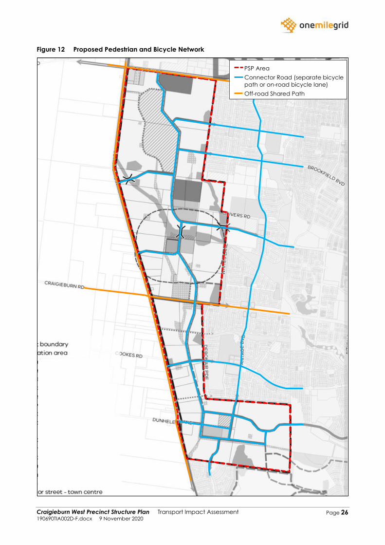
3.4 Pedestrian and Bicycle Network
The proposed Craigieburn West PSP layout provides a network of pedestrian and shared-user paths
throughout.
All connector roads are proposed with either an off-road bicycle path on one side of the road or
on-road bicycle lanes on both sides of the road.
All arterial roads are proposed with either an off-road bicycle path and separate footpath on both
sides of the road or an off-road shared path on both sides of the road. Craigieburn Road which is
currently in the process of having detailed designs prepared for the road is anticipated to have off-
road shared paths on both sides of the road.
Footpaths will be provided along both sides of all connector and access roads.
The proposed internal pedestrian and bicycle network will connect with the pedestrian and bicycle
network located to the north (Lindum Vale PSP), east (Craigieburn R2 PSP) and south (Greenvale
North PSP).
The provision of the above footpaths, bicycle lanes and shared-user paths is expected to
comfortably accommodate all pedestrian and cyclist movements through the Craigieburn West
PSP.
The proposed pedestrian and bicycle network is shown in Figure 12.
Craigieburn West Precinct Structure Plan Transport Impact Assessment 190690TIA002D-F.docx 9 November 2020
Page 26
Figure 12 Proposed Pedestrian and Bicycle Network
1
3
4
6
PSP Area
Connector Road (separate bicycle
path or on-road bicycle lane)
Off-road Shared Path
Craigieburn West Precinct Structure Plan Transport Impact Assessment 190690TIA002D-F.docx 9 November 2020
Page 27
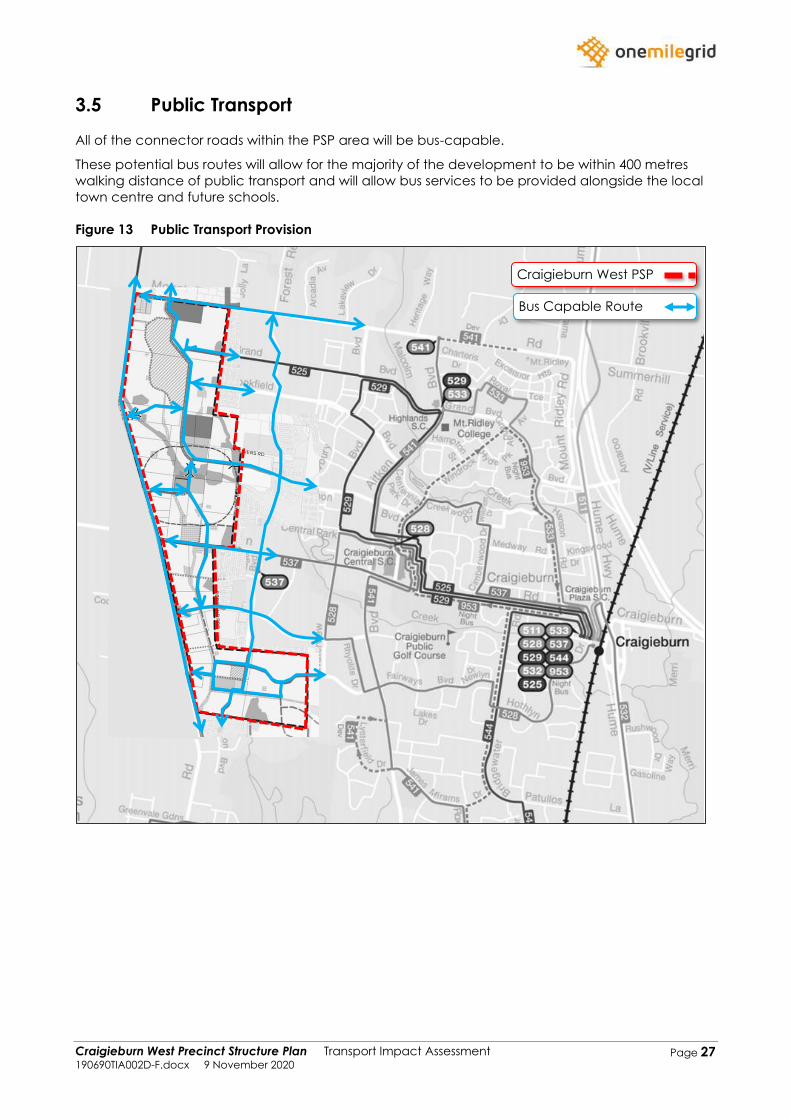
3.5 Public Transport
All of the connector roads within the PSP area will be bus-capable.
These potential bus routes will allow for the majority of the development to be within 400 metres
walking distance of public transport and will allow bus services to be provided alongside the local
town centre and future schools.
Figure 13 Public Transport Provision
Craigieburn West PSP
Bus Capable Route
Craigieburn West Precinct Structure Plan Transport Impact Assessment 190690TIA002D-F.docx 9 November 2020
Page 28
4 TRAFFIC MODEL
4.1 Overview
In order to determine future traffic volumes generated by development of the Craigieburn West
PSP, and their respective impacts on the surrounding road network, a traffic model was developed
taking account of the following:
➢ Existing traffic volumes;
➢ Major road network improvements;
➢ Traffic generation of surrounding PSPs;
➢ Base conditions traffic growth;
➢ Proposed land uses;
➢ Traffic generations rates; and
➢ External traffic distributions.
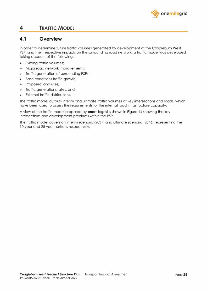
The traffic model outputs interim and ultimate traffic volumes at key intersections and roads, which
have been used to assess the requirements for the internal road infrastructure capacity.
A view of the traffic model prepared by onemilegrid is shown in Figure 14 showing the key
intersections and development precincts within the PSP.
The traffic model covers an interim scenario (2031) and ultimate scenario (2046) representing the
10-year and 25-year horizons respectively.
Craigieburn West Precinct Structure Plan Transport Impact Assessment 190690TIA002D-F.docx 9 November 2020
Page 29
Figure 14 Traffic Model
-
1
3
4
6
2
3
4
5
6
8
9
10
7
1
PSP Area
Road
Precinct
Key Intersection
1
1
1
3
2
4
7
6
5
8 9
10
11
12
14
15
16
13
17
18 19
Craigieburn West Precinct Structure Plan Transport Impact Assessment 190690TIA002D-F.docx 9 November 2020
Page 30
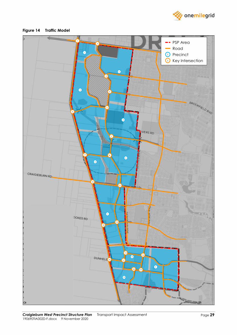
4.2 Major Road Network Improvements
As noted above, the traffic model has been prepared for both the interim (2031) and ultimate
(2046) scenarios due to the significant improvements expected to the external road network by the
year 2046. The major improvements to the external road network which will have a significant
impact on traffic volumes in the vicinity include the following:
➢ Extension of Aitken Boulevard from Mt Ridley Road to Donnybrook Road (likely to be
constructed in the interim). It is noted that Aitken Boulevard is expected to be extended further
north towards Wallan in the future;
➢ Extension of Aitken Boulevard from Somerton Road to the Western Ring Road;
➢ Construction of the Outer Metropolitan Ring Road (understood to be accessed via
interchanges at Craigieburn Road and Donnybrook Road further north); and
➢ Construction of the Melbourne Airport Link to connect the Outer Metropolitan Ring Road with
Sunbury Road (Tullamarine Freeway).
The above road improvements will provide additional road connections throughout the vicinity
which is expected to significantly reduce the through traffic volumes along Mickleham Road.
A view of the above road improvements is shown in Figure 15.
Figure 15 Major Road Network Improvements
Craigieburn
West PSP
Aitken
Boulevard
Outer
Metropolitan
Ring Road
Melbourne
Airport Link
Aitken
Boulevard
Craigieburn West Precinct Structure Plan Transport Impact Assessment 190690TIA002D-F.docx 9 November 2020
Page 31
4.3 Traffic Growth
4.3.1 Traffic Generation of Surrounding PSPs
A summary of the impacts of each PSP is outlined below.
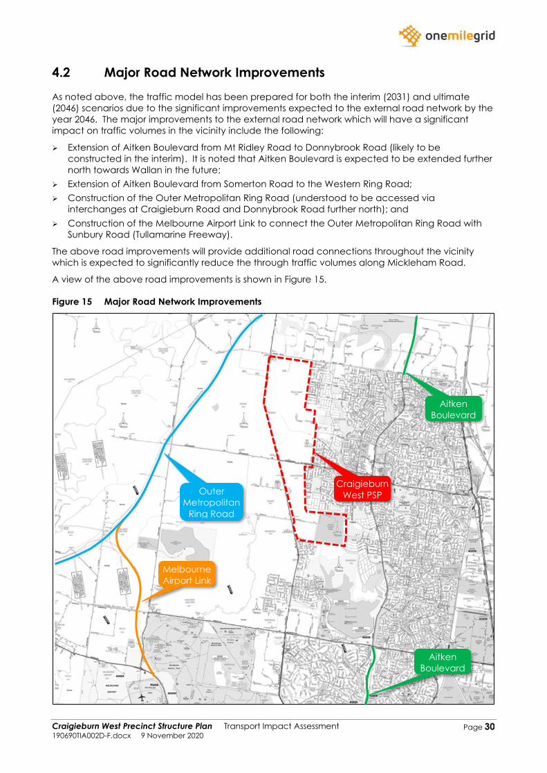
4.3.1.1 Merrifield West PSP and Lindum Vale PSP
The Lindum Vale PSP is located on the northern side of Mt Ridley Road, adjacent to the subject site.
In 2014, Cardno prepared a Transport Impact Assessment for the Lindum Vale PSP which took into
consideration the Lindum Vale PSP, as well as the development of Merrifield West PSP which is
located further north of the site, which had a traffic model prepared for the interim and ultimate
scenarios by SMEC in 2012.
Reference is made to the traffic model that was prepared for both these PSPs for both the interim
and ultimate scenarios. The traffic reports prepared for both PSPs took into consideration the
construction of the Outer Metropolitan Ring Road, extension of Aitken Boulevard, as well as the
delivery of multiple employment areas in the north (Merrifield Employment Park and Folkestone
Employment Park) which reduces the need for residents to drive south towards the Melbourne CBD
and other employment areas for work compared to expected distributions based on existing land
use distribution around the area.
It is noted that all traffic generated by the Lindum Vale PSP which is travelling south or west is
required to travel south via Mickleham Road, and therefore under ultimate conditions, a portion of
this traffic is expected to travel west along Craigieburn Road to use the Outer Metropolitan Ring
Road, which wouldn’t be the case in the interim scenario.
The expected traffic volumes at the intersections of Mickleham Road / Mt Ridley Road and Mt
Ridley Road / Marathon Boulevard as a result of the Lindum Vale and Merrifield West PSP is
provided below, reproduced from the modelling undertaken for the Merrifield West and Lindum
Vale PSPs.
Figure 16 Interim Traffic Volumes from Lindum Vale and Merrifield West PSP
19 959 47
347 10541
66
32
436
6
22
15
Mickleham Road
Mickleham Road
Mt R
idle
y R
oa
d
Mt
Rid
ley
Ro
ad
PM Peak
AM Peak
6 347 66
959 43615
47
32
105
19
8
41
N
385 27 385
2 110
66
120
6
120
27
11
Marathon Boulevard
Marathon Boulevard
Mt R
idle
y R
oa
d
Mt
Rid
ley
Ro
ad
PM Peak
AM Peak
120 2 66
27 611
102
27
1
385
120
10
N
Craigieburn West Precinct Structure Plan Transport Impact Assessment 190690TIA002D-F.docx 9 November 2020
Page 32
Figure 17 Ultimate Traffic Volumes from Lindum Vale and Merrifield West PSP
4.3.1.2 Craigieburn R2 PSP
The Craigieburn R2 PSP is located along the Craigieburn West PSP’s eastern boundary. Ashton
Traffic Services Pty Ltd prepared a traffic model of the PSP for Growth Areas Authority (now
Victorian Planning Authority) in February 2010. In addition, Cardno prepared a Transport Impact
Assessment for the Aston Estate (located within the Craigieburn R2 PSP) in November 2010 which
included traffic modelling for the entire Craigieburn R2 PSP area. It is noted that the Cardno traffic
report used the traffic volumes modelled within the Ashton Traffic Services report as a ‘base’ before
further refining the projected volumes.
The modelling undertaken is of significance to the Craigieburn West PSP as the following roads
assessed in the modelling connect through into the Craigieburn West PSP area:
➢ Gallantry Avenue;
➢ Elevation Boulevard;
➢ Riverglen Drive; and
➢ Vantage Boulevard.
4.3.1.2.1 Cardno Traffic Report
Noting the additional information Cardno was provided regarding the internal road network of the
Craigieburn R2 PSP, it will be used for projected volumes within the area due to the additional level
of detail and refinement to the Ashton Traffic Services model. The daily through volumes along
Vantage Boulevard and Elevation Boulevard did not differentiate by more than 4% between the
Cardno and Ashton Traffic Services traffic report.
Figure 18 shows the ultimate traffic volumes from the Aston Estate modelling undertaken by
Cardno.
19 1161 251
228 20841
74
32
913
6
22
15
Mickleham Road
Mickleham Road
Mt R
idle
y R
oa
d
Mt
Rid
ley
Ro
ad
PM Peak
AM Peak
6 256 74
1137 60815
251
32
208
19
8
41
N
366 41 370
15 3024
271
292
15
66
267
14
Marathon Boulevard
Marathon Boulevard
Mt R
idle
y R
oa
d
Mt
Rid
ley
Ro
ad
PM Peak
AM Peak
66 15 271
41 1514
370
267
30
366
292
24
N
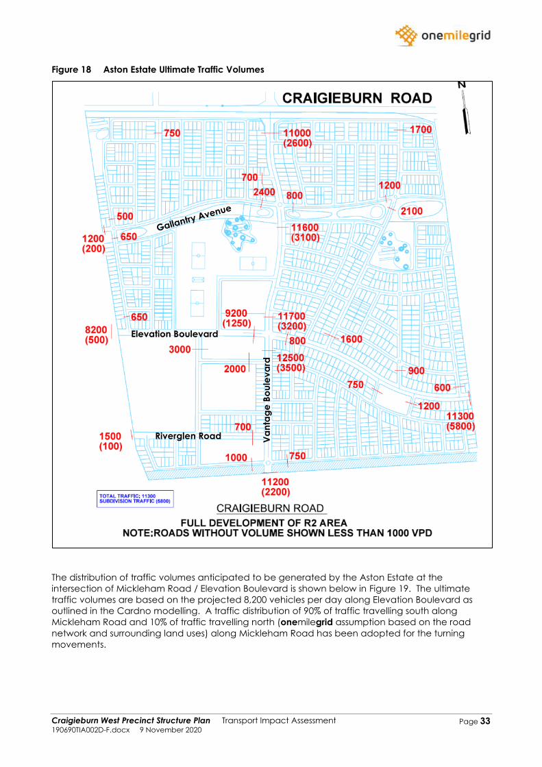
Craigieburn West Precinct Structure Plan Transport Impact Assessment 190690TIA002D-F.docx 9 November 2020
Page 33
Figure 18 Aston Estate Ultimate Traffic Volumes
The distribution of traffic volumes anticipated to be generated by the Aston Estate at the
intersection of Mickleham Road / Elevation Boulevard is shown below in Figure 19. The ultimate
traffic volumes are based on the projected 8,200 vehicles per day along Elevation Boulevard as
outlined in the Cardno modelling. A traffic distribution of 90% of traffic travelling south along
Mickleham Road and 10% of traffic travelling north (onemilegrid assumption based on the road
network and surrounding land uses) along Mickleham Road has been adopted for the turning
movements.
Elevation Boulevard
Riverglen Road Va
nta
ge
Bo
ule
va
rd
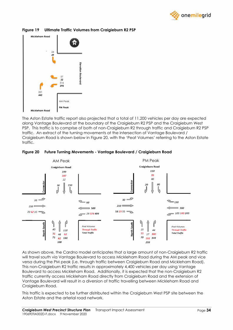
Craigieburn West Precinct Structure Plan Transport Impact Assessment 190690TIA002D-F.docx 9 November 2020
Page 34
Figure 19 Ultimate Traffic Volumes from Craigieburn R2 PSP
The Aston Estate traffic report also projected that a total of 11,200 vehicles per day are expected
along Vantage Boulevard at the boundary of the Craigieburn R2 PSP and the Craigieburn West
PSP. This traffic is to comprise of both of non-Craigieburn R2 through traffic and Craigieburn R2 PSP
traffic. An extract of the turning movements at the intersection of Vantage Boulevard /
Craigieburn Road is shown below in Figure 20, with the ‘Peat Volumes’ referring to the Aston Estate
traffic.
Figure 20 Future Turning Movements - Vantage Boulevard / Craigieburn Road
As shown above, the Cardno model anticipates that a large amount of non-Craigieburn R2 traffic
will travel south via Vantage Boulevard to access Mickleham Road during the AM peak and vice
versa during the PM peak (i.e. through traffic between Craigieburn Road and Mickleham Road).
This non-Craigieburn R2 traffic results in approximately 4,400 vehicles per day using Vantage
Boulevard to access Mickleham Road. Additionally, it is expected that the non-Craigieburn R2
traffic currently access Mickleham Road directly from Craigieburn Road and the extension of
Vantage Boulevard will result in a diversion of traffic travelling between Mickleham Road and
Craigieburn Road.
This traffic is expected to be further distributed within the Craigieburn West PSP site between the
Aston Estate and the arterial road network.
0 24
0 221
57
516
Mickleham Road
Mickleham Road
Ele
va
tion
Bo
ule
va
rd
PM Peak
AM Peak
0 49
0 442
32
295
N
AM Peak PM Peak
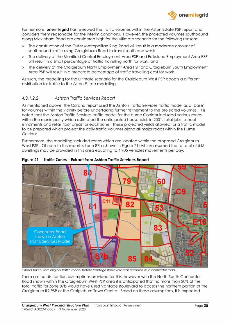
Craigieburn West Precinct Structure Plan Transport Impact Assessment 190690TIA002D-F.docx 9 November 2020
Page 35
Furthermore, onemilegrid has reviewed the traffic volumes within the Aston Estate PSP report and
considers them reasonable for the interim conditions. However, the projected volumes southbound
along Mickleham Road are considered high for the ultimate scenario for the following reasons:
➢ The construction of the Outer Metropolitan Ring Road will result in a moderate amount of
southbound traffic using Craigieburn Road to travel south and west;
➢ The delivery of the Merrifield Central Employment Area PSP and Folkstone Employment Area PSP
will result in a small percentage of traffic travelling north for work; and
➢ The delivery of the Craigieburn North Employment Area PSP and Craigieburn South Employment
Area PSP will result in a moderate percentage of traffic travelling east for work.
As such, the modelling for the ultimate scenario for the Craigieburn West PSP adopts a different
distribution for traffic to the Aston Estate modelling.
4.3.1.2.2 Ashton Traffic Services Report
As mentioned above, the Cardno report used the Ashton Traffic Services traffic model as a ‘base’
for volumes within the vicinity before undertaking further refinement to the projected volumes. It is
noted that the Ashton Traffic Services traffic model for the Hume Corridor included various zones
within the municipality which estimated the anticipated households in 2031, total jobs, school
enrolments and retail floor areas for each zone. These projected yields allowed for a traffic model
to be prepared which project the daily traffic volumes along all major roads within the Hume
Corridor.
Furthermore, the modelling included zones which are located within the proposed Craigieburn
West PSP. Of note to this report is Zone 87b (shown in Figure 21) which assumed that a total of 545
dwellings may be provided in this area equating to 4,905 vehicles movements per day.
Figure 21 Traffic Zones – Extract from Ashton Traffic Services Report
Extract taken from original traffic model before Vantage Boulevard was recoded as a connector road.
There are no distribution assumptions provided for this, however with the North-South Connector
Road shown within the Craigieburn West PSP area it is anticipated that no more than 20% of the
total traffic for Zone 87b would have used Vantage Boulevard to access the northern portion of the
Craigieburn R2 PSP or the Craigieburn Town Centre. Based on these assumptions, it is expected
Connector Road
shown in Ashton
Traffic Services Model
Craigieburn West Precinct Structure Plan Transport Impact Assessment 190690TIA002D-F.docx 9 November 2020
Page 36
that the future traffic volumes along Vantage Boulevard are required to be reduced by
approximately 980 vehicles per day if including this area within the Craigieburn West PSP traffic
model.
4.3.2 Through Traffic Growth
For the purposes of a conservative analysis, a growth rate of 1% per year (compound) has been
applied to several non-arterial roads within the vicinity of the site over a 10-year period (interim)
and 25-year period (ultimate), equivalent to a 10.5% and 28.2% increase in traffic volumes
respectively along the non-arterial roads. The traffic growth has been applied to the east-west
aligned connector roads in the northern portion of the site. Whilst no growth was applied to
Vantage Boulevard and Elevation Boulevard in the southern portion of the site where the Cardno
(Aston Estate) traffic volumes were used.
In addition, a growth rate of 3% per year (compound) has been applied to Craigieburn Road traffic
volumes over a 10-year period (interim) and 25-year period (ultimate), equivalent to a 34.4% and
109.4% increase in traffic volumes respectively. Whilst the Mickleham Road and Mt Ridley Road
projected traffic volumes were based on the Lindum Vale PSP.
It is acknowledged that a growth rate of 4% was adopted for earlier modelling forecasts, however
since those previous assessments updated traffic surveys were undertaken to capture traffic
volume growth generated by development along the Craigieburn Road corridor.
Additional modelling may need to be undertaken to understand the impact of the Outer
Metropolitan Ring Road on Craigieburn Road, however that is considered to be outside the scope
of the Craigieburn West PSP. For the purposes of this assessment it is considered that the growth
rates adopted make allowance for traffic volumes to increase with the connection of Craigieburn
Road to the Outer Metropolitan Ring Road to the west of Mickleham Road, near Oaklands Road.
It is expected that the Merrifield West PSP and Lindum Vale PSP traffic models that were outlined
above sufficiently capture the anticipated future traffic volumes along Mickleham Road and Mt
Ridley Road and therefore these volumes will be used for the ‘base case’ for arterial roads within
the northern portion of the site.
4.4 Future Base Case Traffic Volumes
4.4.1 Overview
onemilegrid has used the traffic reports outlined above and the expected traffic growth within the
area to model the future traffic conditions within the vicinity for both the interim and ultimate
conditions.
The assumptions and expected future traffic volumes are presented below.
Craigieburn West Precinct Structure Plan Transport Impact Assessment 190690TIA002D-F.docx 9 November 2020
Page 37
4.4.2 Interim (10 Year Horizon)
The following assumptions have been made for the interim conditions:
➢ Through volumes along the internal road network have been included for the connector roads
within the southern portion of the site, generally bounded by Mickleham Road, Craigieburn
Road, and the Aston Estate. Currently, due to the incomplete nature of the road network
between the Aston Estate and Mickleham Road, vehicles from the Aston estate are required to
travel north to Craigieburn Road or use Aitken Boulevard which is located further east of the site
to access Mickleham Road, whilst the through roads within the southern portion of the
Craigieburn West PSP will provide for a direct connection between the Aston estate and
Mickleham Road, and the ‘base case’ scenario makes allowances for these volumes to be
redistributed;
➢ A reduction of 980 vehicles per day was applied to the abovementioned through traffic along
Vantage Boulevard due to a portion of the Craigieburn West PSP (Zone 87b) being accounted
for within the Ashton Traffic Services model;
➢ Any additional through volumes along new connector roads in the northern portion of the site
(north of Craigieburn Road) are expected to be negligible. Vehicles wishing to travel south
along Mickleham Road are able to travel south along Vantage Boulevard to Craigieburn Road
to access Mickleham Road, which is expected to be favoured over the less direct east-west
connections proposed within the Craigieburn West PSP;
➢ The through volumes previously modelled along Elevation Boulevard have been adopted for
Elevation Boulevard, and have been applied to the intersection with Mickleham Road;
➢ The through volumes for Elevation Boulevard have also been applied to Dunhelen Lane, and
have been applied to the intersections with Mickleham Road. It is noted that Dunhelen Lane is
expected to gain access to Vantage Boulevard via a signalised intersection and therefore a
large portion of traffic wishing to access Mickleham Road will continue south along Vantage
Boulevard and gain access to Mickleham Road via Destination Drive;
➢ Provision has been made for additional through volumes along Fairways Boulevard (200 vehicles
per hour during the AM and PM peak);
➢ The traffic movements modelled at the intersections of Mickleham Road / Mt Ridley Road and
Mt Ridley Road / Marathon Boulevard as part of the Lindum Vale and Merrifield West PSP have
been adopted with no changes to traffic distributions;
➢ A 34.4% increase (3% for 10 years) has been applied to all existing through movements and
turning movements along Craigieburn Road;
➢ After the above growth was applied to Craigieburn Road, a reduction of 4,400 vehicles per day
was applied to the daily volumes (and proportionately peak hour volumes) between
Craigieburn Road (west of Vantage Boulevard) and Mickleham Road (north of Dunhelen Lane)
to account for traffic utilise Vantage Boulevard for travel between Craigieburn Road and
Mickleham Road;
➢ The through volumes along the northern portion of Mickleham Road (north of Craigieburn
Road) have been calculated using the turning movements under interim conditions at
Mickleham Road / Mt Ridley Road which were provided as part of the Lindum Vale PSP; and
➢ The Mickleham Road through movements at the intersection of Mickleham Road / Craigieburn
Road have been calculated by removing the turning movements (the surveyed turning
movements plus 34% growth) from the through movements identified from the Lindum Vale PSP
modelling.
Based on the above, the anticipated daily traffic volumes in the vicinity under interim conditions
without the Craigieburn West PSP development is attached in Appendix A.
Craigieburn West Precinct Structure Plan Transport Impact Assessment 190690TIA002D-F.docx 9 November 2020
Page 38
4.4.3 Ultimate (25 Year Horizon)
Generally, the same assumptions have been made for both interim and ultimate conditions,
however with the below minor modifications for the ultimate conditions:
➢ A 20% reduction in the proportion of traffic accessing the Aston Estate via the intersection of
Elevation Boulevard / Mickleham Road and Dunhelen Lane / Mickleham Road has been
applied compared to the interim scenario. The reduction in traffic volumes is to account for the
additional employment opportunities provided to the north and east of the Craigieburn R2 PSP
which are anticipated to reduce the number of vehicles from the Aston Estate travelling south
along Mickleham Road. Furthermore, it is expected that the construction of the Outer
Metropolitan Ring Road would reduce the distribution of traffic from the Aston Estate to
Mickleham Road, with vehicles instead using Craigieburn Road to access the Outer
Metropolitan Ring Road when required;
➢ A 109.4% increase (3% for 25 years) has been applied to all existing through movements and
turning movements along Craigieburn Road, on top of the surveyed traffic volumes;
➢ After the above growth was applied to Craigieburn Road, a reduction of 4,400 vehicles per day
was applied to the daily volumes (and proportionately peak hour volumes) between
Craigieburn Road (west of Vantage Boulevard) and Mickleham Road (north of Dunhelen Lane)
to account for traffic utilise Vantage Boulevard for travel between Craigieburn Road and
Mickleham Road;
➢ The traffic movements modelled under ultimate conditions at the intersections of Mickleham
Road / Mt Ridley Road and Mt Ridley Road / Marathon Boulevard as part of the Lindum Vale
and Merrifield West PSP have been adopted with no modifications to distributions;
➢ The through volumes along the northern portion of Mickleham Road (north of Craigieburn
Road) have been calculated using the turning movements under ultimate conditions at
Mickleham Road / Mt Ridley Road which were provided as part of the Lindum Vale PSP; and
➢ The Mickleham Road through movements at the intersection of Mickleham Road / Craigieburn
Road have been calculated by removing the turning movements (the surveyed volumes plus
109.4% growth) from the through movements.
Based on the above, the anticipated daily traffic volumes in the vicinity under ultimate conditions
without the Craigieburn West PSP development is attached in Appendix B.
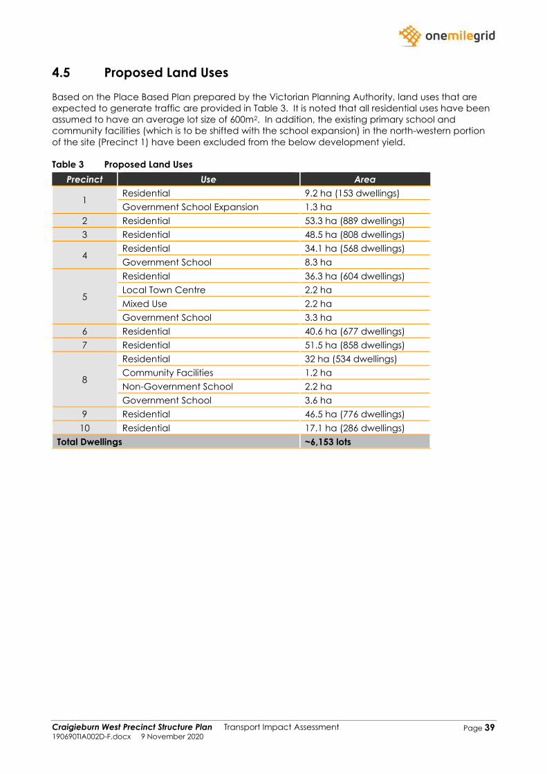
Craigieburn West Precinct Structure Plan Transport Impact Assessment 190690TIA002D-F.docx 9 November 2020
Page 39
4.5 Proposed Land Uses
Based on the Place Based Plan prepared by the Victorian Planning Authority, land uses that are
expected to generate traffic are provided in Table 3. It is noted that all residential uses have been
assumed to have an average lot size of 600m2. In addition, the existing primary school and
community facilities (which is to be shifted with the school expansion) in the north-western portion
of the site (Precinct 1) have been excluded from the below development yield.
Table 3 Proposed Land Uses
Precinct Use Area
1 Residential 9.2 ha (153 dwellings)
Government School Expansion 1.3 ha
2 Residential 53.3 ha (889 dwellings)
3 Residential 48.5 ha (808 dwellings)
4 Residential 34.1 ha (568 dwellings)
Government School 8.3 ha
5
Residential 36.3 ha (604 dwellings)
Local Town Centre 2.2 ha
Mixed Use 2.2 ha
Government School 3.3 ha
6 Residential 40.6 ha (677 dwellings)
7 Residential 51.5 ha (858 dwellings)
8
Residential 32 ha (534 dwellings)
Community Facilities 1.2 ha
Non-Government School 2.2 ha
Government School 3.6 ha
9 Residential 46.5 ha (776 dwellings)
10 Residential 17.1 ha (286 dwellings)
Total Dwellings ~6,153 lots
Craigieburn West Precinct Structure Plan Transport Impact Assessment 190690TIA002D-F.docx 9 November 2020
Page 40
4.6 Traffic Generation
4.6.1 Residential
It is generally accepted that single dwellings on a lot in outer suburban areas may generate traffic
at up to 10 vehicle trips per day, whilst in areas with good public transport, and for higher density
dwellings, lower traffic generation rates are often recorded.
Considering the anticipated size of the lots within proposed PSP (~600m2) and the proximity of the
site to the existing bus network which is expected to be extended into the site, it is anticipated that
the proposed development may generate up to 9 vehicle trips per day per lot, with 10% of trips
occurring during both the AM and PM peak hours. It is noted that this includes internal trips within
the PSP where following full development of the area, a number of schools, recreational facilities
and retail precincts are expected.
It is noted that both the SMEC traffic report for the Merrifield West PSP and Cardno traffic report for
the Lindum Vale PSP adopted 8.5 vehicles per lot. Whilst Ashton Traffic Services adopted a rate of 9
vehicles per lot when modelling the Craigieburn R2 PSP.
Application of the above traffic generation rates to the anticipated 6,153 lots expected to be
provided as part of the Craigieburn West PSP is expected to generate up to approximately 55,380
vehicle trips per day, and approximately 5,538 vehicle trips per hour during both the AM and PM
peak.
Traffic volumes generated by residential uses is typically tidal, with the majority of movements
generated during the AM peak hour occurring in the outbound direction and the majority of
movements during the PM peak hour occurring in the inbound direction.
For the purposes of this assessment, the following directional splits will be adopted:
➢ AM peak hour: 70% outbound, 30% inbound; and
➢ PM peak hour: 40% outbound, 60% inbound.
The peak hour traffic volumes anticipated to be generated by the residential component of the
Craigieburn West PSP are outlined in Table 4.
Table 4 Anticipated Peak Hour Traffic Generation
Period Outbound Inbound Two-Way
AM Peak Hour 3,877 1,661 5,538
PM Peak Hour 2,215 3,323 5,538
4.6.2 Other Uses
The proposed Craigieburn West PSP includes a variety of other uses including five schools, a Local
Town Centre, a mixed-use zone, community facilities, local parks and local sports reserves.
onemilegrid and other traffic consultants generally consider the use of a higher traffic generation
rate for the residential uses to be the more conservative and the appropriate approach in regard
to traffic generation for new PSPs especially where no large employment precincts are provided
(as is the case with the Craigieburn West PSP). The adoption of a higher rate for the residential
component acknowledges that a high proportion of movements associated with uses such as the
town centre and community facilities are internal trips, and in terms of modelling, the movement is
allocated to the residential use rather than the destination to save double counting.
The possible exception to this is the school uses, which are likely to draw a larger proportion of
external trips than the other non-residential uses. Traffic volumes generated by school uses are
generally best expressed as a function of student numbers, and such information is not available at
this stage. Nevertheless, it is noted that the residential traffic generation rates adopted for the
Craigieburn West Precinct Structure Plan Transport Impact Assessment 190690TIA002D-F.docx 9 November 2020
Page 41
Craigieburn West PSP and neighbouring residential developments include the proportion of traffic
associated with movements to and from education uses. This is discussed further in the following
section of this report.
4.7 Traffic Distribution
4.7.1 Trip Purpose Distribution
Travel data sourced from the Victorian Integrated Survey of Travel and Activity (VISTA) indicates the
following trip purpose distributions (as a proportion of total daily trips) for typical households, as
outlined in Table 5. These distributions have been adopted in the Craigieburn West PSP traffic
model.
Table 5 Trip Purpose Distribution
Purpose AM Peak PM Peak Daily
Work 52% 45% 40%
Shopping 6% 18% 20%
Education 28% 11% 9%
Recreation 2% 5% 6%
Other 12% 21% 25%
4.7.2 Directional Distribution
Considering the location of the proposed PSP in relation to the public transport facilities, schools,
recreation and retail and employment precincts, the directional distribution shown in Table 6 has
been adopted.
Table 6 Adopted Directional Traffic Distribution
Origin/Destination Percentage1 Notable Uses
North 14.5% Merrifield Employment Park / Folkestone Employment Park /
Mickleham Town Centre / Regional Victoria
South 32.7% Tullamarine Employment Area / Inner Melbourne / Western
Ring Road Access
East 39.4%
Craigieburn Town Centre / Craigieburn Employment PSP /
Craigieburn Train Station / Craigieburn R2 PSP /
Campbellfield Employment Area / Roxburgh Train Station /
Alternative Western Ring Road Access
West 4.4% Sunbury
Internal 9% 1Daily Percentage. AM peak and PM peak vary slightly
It is expected that the traffic generated by the Craigieburn West PSP will be distributed onto both
the arterial and connector road network. An overview of the likely inbound and outbound travel
routes is provided below.
Craigieburn West Precinct Structure Plan Transport Impact Assessment 190690TIA002D-F.docx 9 November 2020
Page 42
4.7.2.1 North
Northbound traffic is expected to be relatively evenly distributed on both Mickleham Road and
Marathon Boulevard. Marathon Boulevard runs through Lindum Vale PSP and the Merrifield West
PSP and therefore provides direct access to a number of schools, employment and retail precincts.
Therefore, it is anticipated that the majority of residents within the northern portion of the
Craigieburn West PSP will utilise Marathon Boulevard, whilst residents in the southern portion of the
PSP will use Mickleham Road.
4.7.2.2 South
All southbound traffic is expected to utilise Mickleham Road in the interim. However, with the
delivery of the Outer Metropolitan Ring Road a portion of the southbound traffic is expected to
travel west along Craigieburn Road to access the Outer Metropolitan Ring Road which will then
connect to the Tullamarine Freeway.
4.7.2.3 East
Eastbound traffic is expected to be evenly distributed along the connector roads and Craigieburn
Road when travelling to different Craigieburn precincts. Vehicles travelling outside of the
Craigieburn precinct are expected to utilise Craigieburn Road or a connector road before
connecting to another arterial road.
4.7.2.4 West
In the interim, the majority of dwellings located to the north Craigieburn Road will travel west along
Craigieburn Road, whilst dwellings located to the south of Craigieburn Road travel south along
Mickleham Road.
In the ultimate, it is expected that all westbound traffic will utilise Craigieburn Road to access the
Outer Metropolitan Ring Road.
4.8 Generated Traffic Volumes
Based on the above, the expected daily traffic volumes generated by the Craigieburn West PSP in
the interim scenario is provided in Appendix C. Whilst the expected daily traffic volumes generated
in the ultimate scenario is provided in Appendix D.
4.9 Resultant Traffic Volumes
The resultant daily traffic volumes in the interim and ultimate scenario is provided in Appendix E and
Appendix F respectively.
Craigieburn West Precinct Structure Plan Transport Impact Assessment 190690TIA002D-F.docx 9 November 2020
Page 43
4.10 Traffic Impact
4.10.1 Arterial Road Intersections
Arterial-arterial intersections and arterial-connector road intersections are expected to be planned
and designed generally in accordance with the Guidance for Planning Road Networks in Growth
Areas handbook (VicRoads, 2015). The PSP will make adequate provision for intersection land take
in accordance with the handbook. Detailed design of intersection layouts would generally be
undertaken at the time of delivery.
4.10.2 Midblock Capacity Assessment
The VPA PSP Guideline – PSP Note – Our Roads: Connecting People (August 2011) provides
appropriate road classifications and threshold volumes for existing and future roads.
The road types and their indicative daily threshold as outlined in the document are summarised in
Table 7.
Table 7 Our Roads: Connecting People – Road Characteristics
Element Access Street - Level 2 Connector Street Secondary Arterial Arterial
Traffic Volume 2000-3000 vpd 3000-7000 vpd 12,000 – 40,000 >30,000
In addition to the above, VPA has provided the recommended traffic volumes for a Boulevard
Connector Road which is 7,000 – 12,000 vehicles per day.
An assessment of the anticipated ultimate traffic volumes along the proposed road network is
provided in Table 8 overleaf.
The results provided in Table 8 show that Mickleham Road and Craigieburn are expected to carry
up to approximately 49,000 and 33,000 vehicles per day respectively which are both in
accordance of their theoretical capacity of an arterial road. Mt Ridley Road is expected to carry
approximately 16,000 vehicles per day which is well below of its target vehicle capacity of >30,000
vehicles per day.
The mid-block capacity assessment also show that the majority of connector roads are expected
to operate within their respected connector street capacity of 3,000-7,000 vehicles per day, except
for Elevation Boulevard, Fairways Boulevard, East-West Connector Road 1 and East-West Connector
Road 3. These four connector roads are anticipated to carry between 7,300 and 8,800 vehicles per
day which is slightly higher than the theoretical capacity of a connector road (3,000 – 7,00 vehicles
per day). Furthermore, Vantage Boulevard is anticipated to carry 11,100 vehicles day which is
significantly higher than the target traffic volumes (3,000 - 7,000 vehicles per day).
Dunhelen Lane, North-South Connector Boulevard 1 and North-South Connector Boulevard 2 are
both expected to operate of their theoretical capacity for a Connector Boulevard which is 7,000-
12,000 vehicles per day.
Gallantry Boulevard, Candlebark Drive and Navigation Road are all best described as Access
Street – Level 2 and are expected to operate within their theoretical capacity of 2000-3000 vehicles
per day.
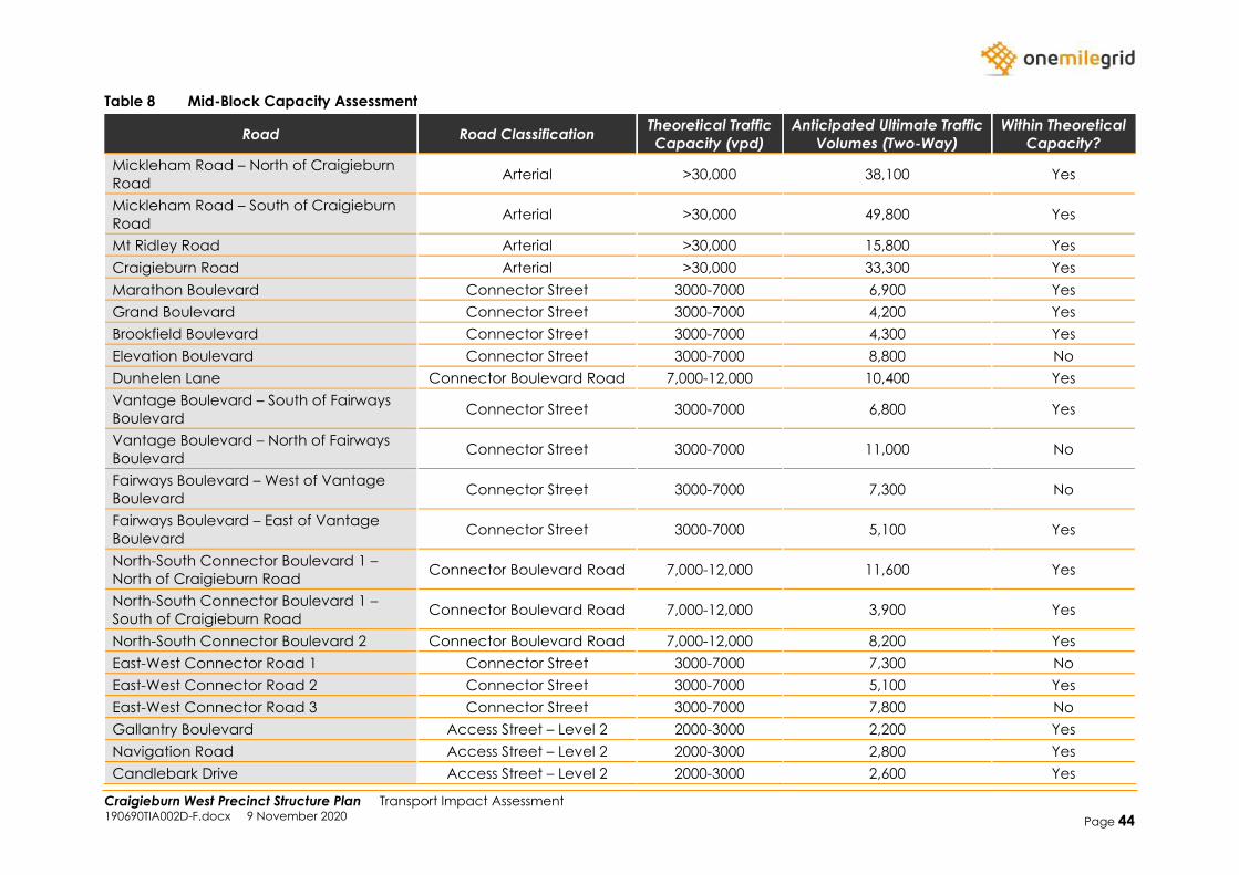
Craigieburn West Precinct Structure Plan Transport Impact Assessment 190690TIA002D-F.docx 9 November 2020 Page 44
Table 8 Mid-Block Capacity Assessment
Road Road Classification Theoretical Traffic
Capacity (vpd)
Anticipated Ultimate Traffic
Volumes (Two-Way)
Within Theoretical
Capacity?
Mickleham Road – North of Craigieburn
Road Arterial >30,000 38,100 Yes
Mickleham Road – South of Craigieburn
Road Arterial >30,000 49,800 Yes
Mt Ridley Road Arterial >30,000 15,800 Yes
Craigieburn Road Arterial >30,000 33,300 Yes
Marathon Boulevard Connector Street 3000-7000 6,900 Yes
Grand Boulevard Connector Street 3000-7000 4,200 Yes
Brookfield Boulevard Connector Street 3000-7000 4,300 Yes
Elevation Boulevard Connector Street 3000-7000 8,800 No
Dunhelen Lane Connector Boulevard Road 7,000-12,000 10,400 Yes
Vantage Boulevard – South of Fairways
Boulevard Connector Street 3000-7000 6,800 Yes
Vantage Boulevard – North of Fairways
Boulevard Connector Street 3000-7000 11,000 No
Fairways Boulevard – West of Vantage
Boulevard Connector Street 3000-7000 7,300 No
Fairways Boulevard – East of Vantage
Boulevard Connector Street 3000-7000 5,100 Yes
North-South Connector Boulevard 1 –
North of Craigieburn Road Connector Boulevard Road 7,000-12,000 11,600 Yes
North-South Connector Boulevard 1 –
South of Craigieburn Road Connector Boulevard Road 7,000-12,000 3,900 Yes
North-South Connector Boulevard 2 Connector Boulevard Road 7,000-12,000 8,200 Yes
East-West Connector Road 1 Connector Street 3000-7000 7,300 No
East-West Connector Road 2 Connector Street 3000-7000 5,100 Yes
East-West Connector Road 3 Connector Street 3000-7000 7,800 No
Gallantry Boulevard Access Street – Level 2 2000-3000 2,200 Yes
Navigation Road Access Street – Level 2 2000-3000 2,800 Yes
Candlebark Drive Access Street – Level 2 2000-3000 2,600 Yes
Craigieburn West Precinct Structure Plan Transport Impact Assessment 190690TIA002D-F.docx 9 November 2020
Page 45
5 CONCLUSIONS AND RECOMMENDATIONS
Considering the analysis presented above, it is concluded that:
➢ The Craigieburn West PSP has a total area of approximately 565 ha and abuts the Lindum Vale
(Mt Ridley West) PSP to the north, Craigieburn (R2) PSP to the east, and Greenvale North (R1)
PSP to the south;
➢ A draft Place Based Plan has been prepared for the area which contemplates developing the
area for predominately standard-density residential development, as well as providing a Local
Town Centre, schools, community facilities and local parks;
➢ Based on an average lot size of 600m2, it is assumed that approximately 6,153 lots may be
provided within the PSP area;
➢ The PSP area will primarily be accessed via the existing arterial road network that runs adjacent
and through the site (Craigieburn Road, Mickleham Road and Mt Ridley Road). Secondary
access opportunities will be provided via the extension of existing roads from the adjacent PSPs
which will run through the proposed PSP area;
➢ The Lindum Vale PSP, which abuts the northern boundary, has had a traffic model prepared for
interim (2031) and ultimate (2046) conditions, whilst the Craigieburn R2 PSP, which abuts the
eastern boundary, has had a traffic model prepared for what can be considered interim
conditions;
➢ A traffic model has been prepared for the Craigieburn West PSP where the future base
conditions were based on the abovementioned traffic modelling as well as external growth
along the arterial and connector roads within the vicinity;
➢ A traffic generation rate of 9 vehicle trips per day per lot (with 10% of trips occurring during the
AM and PM peak hour) was adopted for the residential component. Application of these rates
results in the PSP area generating 55,380 vehicle trips per day inclusive of 5,538 vehicle trips per
hour during the AM and PM peaks;
➢ It has been assumed that the AM peak hour will consist of 70% outbound movements and 30%
inbound movements. Whilst the PM peak hour will consist of 40% outbound movements and
60% inbound movements;
➢ The trip purpose traffic distribution has been based on the Victorian Integrated Survey of Travel
and Activity (VISTA) which specifies different percentages for work, shopping, education,
recreation, and other purposes. Furthermore, the directional distribution was based on existing
and future uses within the vicinity;
➢ The mid-block capacity assessment shows that all roads will operate within or near their
theoretical capacity, except for Vantage Boulevard which is expected to carry volumes
significantly higher than the theoretical capacity for a connector road. It is noted that all
previous modelling undertaken by other traffic engineering consultants showed that Vantage
Boulevard will carry volumes in excess of its theoretical capacity.
Craigieburn West Precinct Structure Plan Transport Impact Assessment 190690TIA002D-F.docx 9 November 2020
Page 46
Appendix A Future Base Conditions Daily
Volumes - Interim
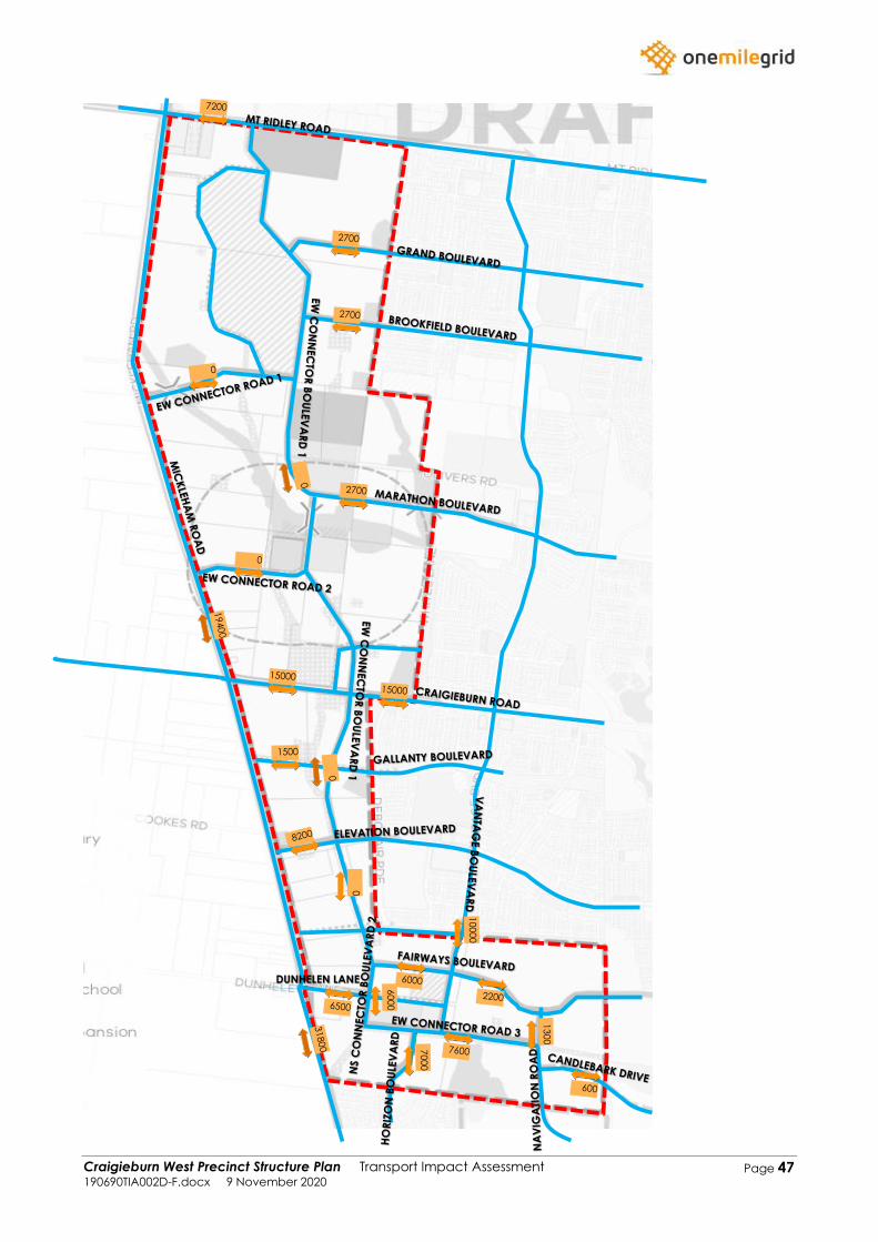
Craigieburn West Precinct Structure Plan Transport Impact Assessment 190690TIA002D-F.docx 9 November 2020
Page 47
DUNHELEN LANE
Craigieburn West Precinct Structure Plan Transport Impact Assessment 190690TIA002D-F.docx 9 November 2020
Page 48
Appendix B Future Base Conditions Daily
Volumes – Ultimate
Craigieburn West Precinct Structure Plan Transport Impact Assessment 190690TIA002D-F.docx 9 November 2020
Page 49
DUNHELEN LANE
Craigieburn West Precinct Structure Plan Transport Impact Assessment 190690TIA002D-F.docx 9 November 2020
Page 50
Appendix C Generated Daily Volumes –
Interim
Craigieburn West Precinct Structure Plan Transport Impact Assessment 190690TIA002D-F.docx 9 November 2020
Page 51
DUNHELEN LANE
Craigieburn West Precinct Structure Plan Transport Impact Assessment 190690TIA002D-F.docx 9 November 2020
Page 52
Appendix D Generated Daily Volumes –
Ultimate
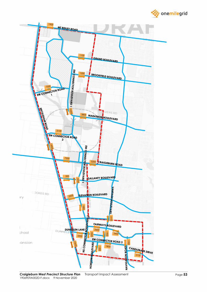
Craigieburn West Precinct Structure Plan Transport Impact Assessment 190690TIA002D-F.docx 9 November 2020
Page 53
DUNHELEN LANE

Craigieburn West Precinct Structure Plan Transport Impact Assessment 190690TIA002D-F.docx 9 November 2020
Page 54
Appendix E Resultant Daily Volumes –
Interim

Craigieburn West Precinct Structure Plan Transport Impact Assessment 190690TIA002D-F.docx 9 November 2020
Page 55
DUNHELEN LANE
Craigieburn West Precinct Structure Plan Transport Impact Assessment 190690TIA002D-F.docx 9 November 2020
Page 56
Appendix F Resultant Daily Volumes –
Ultimate

Craigieburn West Precinct Structure Plan Transport Impact Assessment 190690TIA002D-F.docx 9 November 2020
Page 57
DUNHELEN LANE
Craigieburn West PSP Traffic and Transport 190690PAN001C-F.docx 15 April 2021
Page 19
Appendix B Transport Impact
Assessment – Addendum 1
Craigieburn West PSP Transport Impact Assessment – Addendum 1 190690LET001D-F.docx 1 April 2021
ABN: 79 168 115 679
56 Down Street
COLLINGWOOD, VIC 3066
www.onemilegrid.com.au
Page 1
1 April 2021
Victorian Planning Authority
Via email: [email protected]
Attention: James Paull
Craigieburn West PSP Transport Impact Assessment – Addendum 1
Dear James,
onemilegrid has previously prepared a Transport Impact Assessment (ref: 190690TIA002D-F) for the
Craigieburn West PSP.
Following the preparation of the above referenced Transport Impact Assessment, the draft
Craigieburn West PSP document was prepared and released for public consultation. Of
importance, the document provides guidelines in regard to the recommended residential densities
within the Craigieburn West PSP.
A revised traffic model has since been prepared to reflect the different residential yields considered
in the PSP compared to those previously assessed in the Transport Impact Assessment report.
Recommended revisions to the road hierarchy have also been devised and are discussed in this
document, which is to be read in conjunction with and as an addendum to the previously
prepared Transport Impact Assessment report.
Revised Traffic Model
Residential Lot Yield
Table 1 provides a comparison of the residential lot yields assessed under the previously prepared
report, and the revised lot yields adopted for this updated assessment. It should be noted that
there have also been minor updates to what has been considered as ‘developable area’ between
the earlier and amended models.
Table 1 Residential Yield
Previous Assessment Amended Assessment
Lot Yield
Adopted 600 m2 per lot
Standard density residential – 18.5 dwellings / net
developable hectare
Medium density residential (within walkable
catchment) – 26.5 dwellings / net developable
hectare
Total Lots 6,153 8,230
Craigieburn West PSP Transport Impact Assessment – Addendum 1 190690LET001D-F.docx 1 April 2021
Page 2
The residential densities adopted in this updated assessment are in accordance with the densities
provided within the draft Craigieburn West PSP document and results in an average of 20 dwellings
/ net developable hectare. The revised modelling assesses a net developable area (NDA) of
414 hectares, with a summary of the residential component expected to generate traffic provided
in Table 2. A map showing the locations of these precincts is provided as Figure 14 of the previously
prepared Transport Impact Assessment (ref: 190690TIA002D-F).
Table 2 Proposed Residential Uses
Precinct Residential Type Area
1 Standard Density 10 ha (187 dwellings)
2 Standard Density 57.5 ha (1,063 dwellings)
3 Standard Density 52.9 ha (978 dwellings)
4 Standard Density 24.6 ha (456 dwellings)
Medium Density 14.2 ha (377 dwellings)
5 Standard Density 11.6 ha (215 dwellings)
Medium Density 28 ha (743 dwellings)
6 Standard Density 14.1 ha (260 dwellings)
Medium Density 29.4 ha (780 dwellings)
7 Standard Density 58.4 ha (1,080 dwellings)
8 Standard Density 41.7 ha (771 dwellings)
9 Standard Density 52.2 ha (965 dwellings)
10 Standard Density 19.4 ha (359 dwellings)
Total Dwellings ~8,234 lots (6,334 standard
density / 1,900 medium density)
Traffic Generation
The updated model assesses a traffic generation rate of 9 vehicle movements per day for each
standard density lot, as was the case within the Transport Impact Assessment. Medium density lots,
particularly in walkable areas close to amenities, generate lower traffic volumes than standard
density lots. As such a traffic generation rate of 7 movements per day has been adopted for each
medium density lot.
Application of these traffic generation rates results in a total traffic generation of 70,310 vehicle
movements per day, with 10% (7,031 vehicle movements) expected to occur during both the AM
and PM peak hours.
Adopting the same directional splits as per the Transport Impact Assessment results in the AM and
PM peak traffic volumes summarised in Table 3 below.
Table 3 Anticipated Peak Hour Traffic Generation
Period Outbound Inbound Two-Way
AM Peak Hour 4,921 2,109 7,030
PM Peak Hour 2,812 4,218 7,030
Craigieburn West PSP Transport Impact Assessment – Addendum 1 190690LET001D-F.docx 1 April 2021
Page 3
Generated and Resultant Traffic Volumes
The updated generated and resultant daily traffic volumes are attached to this letter.
These volumes are based on the traffic distributions presented in Section 4.7 of the Transport Impact
Assessment report, and include traffic growth from the surrounding areas as discussed in Section 4.4
of the Transport Impact Assessment Report.
Updated Road Hierarchy
Noting the updated traffic volumes, it is recommended that the road hierarchy is updated to
replicate that shown in Figure 1.
A mid-block capacity comparison between the previously proposed road network and the
recommended road network is provided in Table 4 with the anticipated ultimate daily traffic
volumes. Corresponding street names are shown on the enclosed traffic volume diagrams.
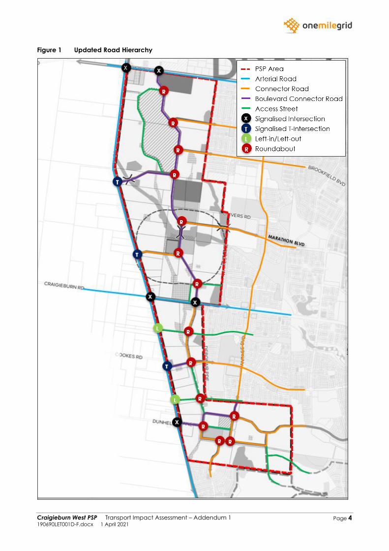
Craigieburn West PSP Transport Impact Assessment – Addendum 1 190690LET001D-F.docx 1 April 2021
Page 4
Figure 1 Updated Road Hierarchy
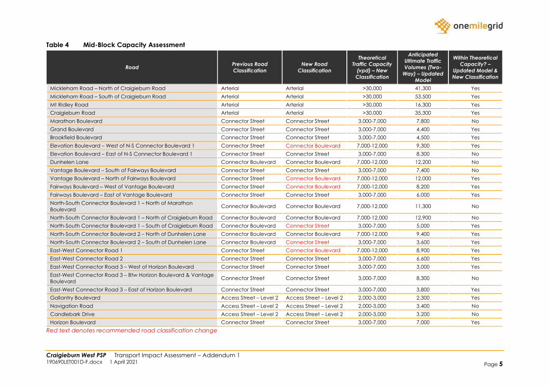
Craigieburn West PSP Transport Impact Assessment – Addendum 1 190690LET001D-F.docx 1 April 2021 Page 5
Table 4 Mid-Block Capacity Assessment
Road Previous Road
Classification
New Road
Classification
Theoretical
Traffic Capacity
(vpd) – New
Classification
Anticipated
Ultimate Traffic
Volumes (Two-
Way) – Updated
Model
Within Theoretical
Capacity? –
Updated Model &
New Classification
Mickleham Road – North of Craigieburn Road Arterial Arterial >30,000 41,300 Yes
Mickleham Road – South of Craigieburn Road Arterial Arterial >30,000 53,500 Yes
Mt Ridley Road Arterial Arterial >30,000 16,300 Yes
Craigieburn Road Arterial Arterial >30,000 35,300 Yes
Marathon Boulevard Connector Street Connector Street 3,000-7,000 7,800 No
Grand Boulevard Connector Street Connector Street 3,000-7,000 4,400 Yes
Brookfield Boulevard Connector Street Connector Street 3,000-7,000 4,500 Yes
Elevation Boulevard – West of N-S Connector Boulevard 1 Connector Street Connector Boulevard 7,000-12,000 9,300 Yes
Elevation Boulevard – East of N-S Connector Boulevard 1 Connector Street Connector Street 3,000-7,000 8,300 No
Dunhelen Lane Connector Boulevard Connector Boulevard 7,000-12,000 12,200 No
Vantage Boulevard – South of Fairways Boulevard Connector Street Connector Street 3,000-7,000 7,400 No
Vantage Boulevard – North of Fairways Boulevard Connector Street Connector Boulevard 7,000-12,000 12,000 Yes
Fairways Boulevard – West of Vantage Boulevard Connector Street Connector Boulevard 7,000-12,000 8,200 Yes
Fairways Boulevard – East of Vantage Boulevard Connector Street Connector Street 3,000-7,000 6,000 Yes
North-South Connector Boulevard 1 – North of Marathon
Boulevard Connector Boulevard Connector Boulevard 7,000-12,000 11,300 No
North-South Connector Boulevard 1 – North of Craigieburn Road Connector Boulevard Connector Boulevard 7,000-12,000 12,900 No
North-South Connector Boulevard 1 – South of Craigieburn Road Connector Boulevard Connector Street 3,000-7,000 5,000 Yes
North-South Connector Boulevard 2 – North of Dunhelen Lane Connector Boulevard Connector Boulevard 7,000-12,000 9,400 Yes
North-South Connector Boulevard 2 – South of Dunhelen Lane Connector Boulevard Connector Street 3,000-7,000 3,600 Yes
East-West Connector Road 1 Connector Street Connector Boulevard 7,000-12,000 8,900 Yes
East-West Connector Road 2 Connector Street Connector Street 3,000-7,000 6,600 Yes
East-West Connector Road 3 – West of Horizon Boulevard Connector Street Connector Street 3,000-7,000 3,000 Yes
East-West Connector Road 3 – Btw Horizon Boulevard & Vantage
Boulevard Connector Street Connector Street 3,000-7,000 8,300 No
East-West Connector Road 3 – East of Horizon Boulevard Connector Street Connector Street 3,000-7,000 3,800 Yes
Gallantry Boulevard Access Street – Level 2 Access Street – Level 2 2,000-3,000 2,300 Yes
Navigation Road Access Street – Level 2 Access Street – Level 2 2,000-3,000 3,400 No
Candlebark Drive Access Street – Level 2 Access Street – Level 2 2,000-3,000 3,200 No
Horizon Boulevard Connector Street Connector Street 3,000-7,000 7,000 Yes
Red text denotes recommended road classification change
Craigieburn West PSP Transport Impact Assessment – Addendum 1 190690LET001D-F.docx 1 April 2021
Page 6
As shown above, the majority of roads are expected to operate within their theoretical capacity
except for several short sections of road.
In regard to Marathon Boulevard, Dunhelen Lane, Vantage Boulevard (south of Fairways
Boulevard), North-South Connector Boulevard 1, Navigation Road and Horizon Boulevard, these
roads are all anticipated to operate at a maximum of 11% over their theoretical capacity. This is
considered to be within an acceptable range, given that the inclusion of lower order access streets
within the network (which have not been modelled) is expected to reduce the actual traffic
volumes on the modelled road network, and considering typical margins of error for large scale
modelling such as that undertaken as part of this study, and from previous modelling undertaken
by others.
Furthermore, Elevation Boulevard (east of North-South Connector Boulevard 1) and East-West
Connector Road 3 (Between Horizon Boulevard & Vantage Boulevard) are both operating at
approximately 19% above their theoretical capacity, these sections of roads are approximately 150
metres long and it is not considered appropriate to provide an upgraded cross-section for these
sections of road. Again, these roads are anticipated to carry lower volumes once the lower order
access road network is designed and delivered.
Conclusions
Considering the updated traffic model and road hierarchy presented above, and the analysis
presented in the report, it is concluded that:
➢ The Craigieburn West PSP has a total area of approximately 565 ha and abuts the Lindum Vale
(Mt Ridley West) PSP to the north, Craigieburn (R2) PSP to the east, and Greenvale North (R1)
PSP to the south;
➢ A draft Place Based Plan has been prepared for the area which contemplates developing the
area for predominately standard-density residential development, as well as providing a Local
Town Centre, schools, community facilities and local parks;
➢ Based on densities of 18.5 dwellings per net developable hectare for standard density lots and
26.5 dwellings per net developable hectare for medium density lots, with an average of
20 dwellings per net developable hectare, approximately 8,230 lots may be provided within the
PSP area;
➢ The PSP area will primarily be accessed via the existing arterial road network that runs adjacent
and through the site (Craigieburn Road, Mickleham Road and Mt Ridley Road). Secondary
access opportunities will be provided via the extension of existing roads from the adjacent PSPs
which will run through the proposed PSP area;
➢ The Lindum Vale PSP, which abuts the northern boundary, has had a traffic model prepared for
interim (2031) and ultimate (2046) conditions, whilst the Craigieburn R2 PSP, which abuts the
eastern boundary, has had a traffic model prepared for what can be considered interim
conditions;
➢ A traffic model has been prepared for the Craigieburn West PSP where the future base
conditions were based on the abovementioned traffic modelling as well as external growth
along the arterial and connector roads within the vicinity;
➢ A traffic generation rate of 9 vehicle trips per day per lot (with 10% of trips occurring during the
AM and PM peak hour) was adopted for the standard density residential component. Whilst a
traffic generation rate of 7 vehicle movements per dwelling was adopted for the medium
density residential component. Application of these rates results in the PSP area generating
70,310 vehicle trips per day inclusive of 7,031 vehicle trips per hour during the AM and PM peaks;
➢ It has been assumed that the AM peak hour will consist of 70% outbound movements and 30%
inbound movements. Whilst the PM peak hour will consist of 40% outbound movements and
60% inbound movements;
➢ The trip purpose traffic distribution has been based on the Victorian Integrated Survey of Travel
and Activity (VISTA) which specifies different percentages for work, shopping, education,
Craigieburn West PSP Transport Impact Assessment – Addendum 1 190690LET001D-F.docx 1 April 2021
Page 7
recreation, and other purposes. Furthermore, the directional distribution was based on existing
and future uses within the vicinity;
➢ The mid-block capacity assessment shows that all roads will operate within or near their
theoretical capacity, except for Elevation Boulevard (east of North-South Connector Boulevard
1) and East-West Connector Road 3 (Between Horizon Boulevard & Vantage Boulevard).
Nevertheless, considering these are short sections of road, and that actual traffic volumes are
expected to reduce as a result of the inclusion of lower order access streets, this is considered
appropriate.
Please do not hesitate to contact the undersigned, or Stuart Valentine on (03) 9982 9765 or at
[email protected], should you wish to discuss the above.
Yours sincerely
Ross Hill
Director - Senior Engineer
onemilegrid
m: 0410 526 917
d: (03) 9982 9725
P/R: Ross Hill/Stuart Valentine
att: Generated and Resulted Daily Traffic Volumes
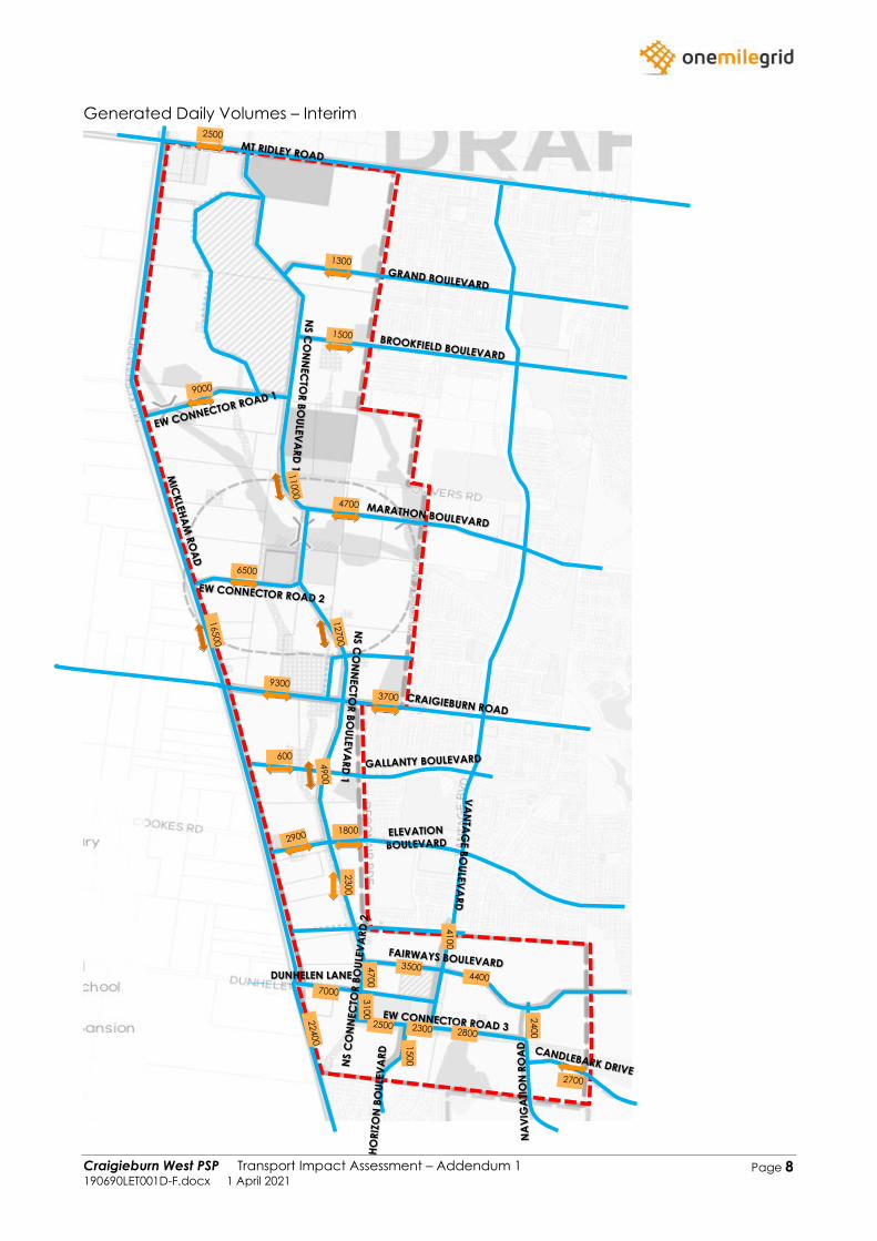
Craigieburn West PSP Transport Impact Assessment – Addendum 1 190690LET001D-F.docx 1 April 2021
Page 8
Generated Daily Volumes – Interim
DUNHELEN LANE

Craigieburn West PSP Transport Impact Assessment – Addendum 1 190690LET001D-F.docx 1 April 2021
Page 9
Generated Daily Volumes – Ultimate
DUNHELEN LANE
NS C
ON
NEC
TOR
BO
ULE
VA
RD
1

Craigieburn West PSP Transport Impact Assessment – Addendum 1 190690LET001D-F.docx 1 April 2021
Page 10
Resultant Daily Volumes – Interim
DUNHELEN LANE
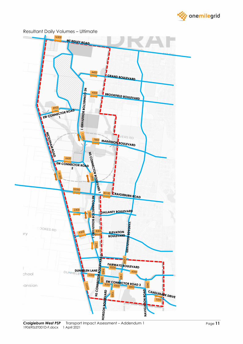
Craigieburn West PSP Transport Impact Assessment – Addendum 1 190690LET001D-F.docx 1 April 2021
Page 11
Resultant Daily Volumes – Ultimate
DUNHELEN LANE
NS C
ON
NEC
TOR
BO
ULE
VA
RD
1