comparison of sedimentation and occupation histories inside and outside rock shelters, keep‐river...
TRANSCRIPT
Comparison of Sedimentation and
Occupation Histories Inside and Outside
Rock Shelters, Keep-River Region,
Northwestern Australia
I.A.K. Ward,1,* R.L.K. Fullagar,2 T. Boer-Mah,2 L.M. Head,3
P.S.C. Taçon,4 and K. Mulvaney5
117 Brickfield Cottages, Somerleyton, NR32 5QW, United Kingdom2Department of Archaeology, University of Sydney, NSW 2006, Australia3GeoQUEST Research Centre, School of Earth and Environmental Sciences,
University of Wollongong, NSW 2522, Australia4School of Arts, Griffith University, PMB 50 Gold Coast Mail Centre, QLD
9726, Australia5Aboriginal Areas Protection Authority, Darwin, NT 0800, Australia
This paper compares archaeological evidence of Aboriginal occupation inside rock shelters andoutside in adjacent sand sheets, focusing on two locations in the Keep-River region, north-western Australia. Luminescence and radiocarbon dating reveal that occupation sequencesinside rock shelters are generally younger (� 10,000 yr B.P.) than outside (� 18,000 yr B.P.).Differences in occupation chronology and artifact assemblages inside and outside rock shel-ters result from depositional and postdepositional processes and shifts in site function. Anincrease in regional sedimentation rate from 10 cm/ka–1 in the Pleistocene to 20 cm/ka–1 in theHolocene may account for late buildup of sediments within rock shelters, increased artifactaccumulation, and reduced postdepositional disturbance in some settings. More intense useof rock shelters in the Late Holocene is indicated from a change in hunting technology andgreater production of rock art. The results indicate that some cultural interpretations might beflawed unless archaeological evidence from rock-shelter and open-site excavations is inte-grated. © 2006 Wiley Periodicals, Inc.
INTRODUCTION
In many parts of the world, rock shelters provide a fundamental source of archae-ological evidence because they act to contain occupation debris in a relatively lim-ited area. Dating the human use or occupation of such sites is, however, often prob-lematic because of the complexity of sedimentation (Farrand, 2001), includingpotential human disturbance of sedimentation (Stockton, 1973; Hughes and Lampert,1977; Villa and Courtin, 1983; Theunissen et al., 1998; Walthall, 1998).
Geoarchaeology: An International Journal, Vol. 21, No. 1, 1–27 (2006)© 2006 Wiley Periodicals, Inc.Published online in Wiley Interscience (www.interscience.wiley.com). DOI:10.1002/gea.20087
*Corresponding author; E-mail: [email protected].
Rock shelters are a common focus of archaeological study in Australia, eventhough it has been inferred from some ethnographic and archaeological data that theywere less frequently occupied than open camp sites (Smith and Sharp, 1993;
WARD ET AL.
GEOARCHAEOLOGY: AN INTERNATIONAL JOURNAL, VOL 21, NO. 1 DOI: 10.1002/GEA2
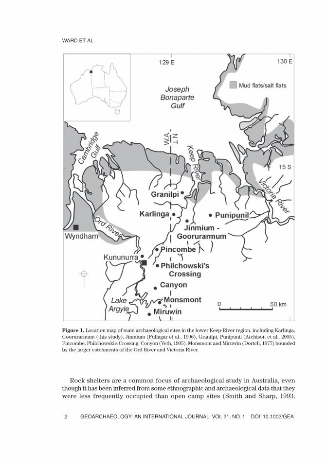
Figure 1. Location map of main archaeological sites in the lower Keep-River region, including Karlinga,Goorurarmum (this study), Jinmium (Fullagar et al., 1996), Granilpi, Punipunil (Atchison et al., 2005),Pincombe, Philchowski’s Crossing, Conyon (Veth, 1995), Monsmont and Miruwin (Dortch, 1977) boundedby the larger catchments of the Ord River and Victoria River.
Lourandos and David, 1998). However, Attenbrow (2002, p. 105; 2004) questioned thearchaeological perspective that expects Aboriginal people to have lived under shel-ter in open sites, and argued that around the coast in the Sydney sandstone country,they did commonly live in caves and rock shelters. Apart from any differences insite use, the preservation of cultural material inside and outside rock shelters areunlikely to be similar because they each have a distinct suite of sedimentary processesthat act to control the nature of preservation (Farrand, 2001; Ward and Larcombe,2003). There is also a clear bias that has favored the dating of archaeological depositsfrom rock shelters over those from open deposits, and inadequate sampling of open-site occupation currently constrains interpretations of settlement history in Australianarchaeology (Ulm, 2004; Ward, 2004). There have been only a few comparative stud-ies of cultural deposits or of sedimentary processes inside and well outside the drip-line of rock shelters (e.g., Morwood, 1981; Jones and Johnson, 1985; Morwood etal., 1995; Boer-Mah, 2002) so that understanding of site formation and settlementhistory remains incomplete.
A general assumption is that rock shelters and caves provide better conditions forpreservation and recovery of intact archaeological deposits than open sites (Walthall,1998; Ulm, 2004). Excavations outside Devil’s Lair, a limestone cave in southwesternAustralia, provided an occupation history spanning about 19,000 years (Dortch,1986), compared with a deep sequence inside the cave now thought to span at least43,000 years (Turney et al., 2001). However, whether longer depositional sequencesare actually better preserved inside or outside rock shelters may depend on cultural,sedimentological, and postdepositional processes (Farrand, 2001; Attenbrow, 2002,2004; Ward, 2004; Ward et al., in press).
This case study of the lower catchment of the Keep River, northern Australia(Figure 1), questions the assumption that rock shelters necessarily provide betterpreservation conditions or longer records of human occupation than open sandyenvironments. Previous research in the Keep-River region has indicated that thereare major discrepancies between the apparent age of some rock shelter and adjacentsand-sheet deposits (cf. Fullagar et al., 1996; Roberts et al., 1998, 1999; Galbraith etal., 1999) and between the subsurface archaeological sequences and the painted andengraved rock art (Watchman, 1999; Taçon et al., 2003). These discrepancies high-light the need to identify the spatial and temporal scales of deposition in rock shel-ters and adjacent sand sheets, and to determine how rock art sequences are linked,if at all, with subsurface archaeological remains. In this article, we focus on twoarchaeologically rich site complexes, Karlinga and Goorurarmum, and compare the“inside” (rock shelter) and “outside” (sand plain) records of deposition and distur-bance. We attempt to distinguish cultural, sedimentological, and postdepositionalprocesses to assess the implications for interpreting long-term changes in site func-tion and settlement history.
STUDY AREA
The Keep-River region (Figure 1) is situated in the subtropical monsoonal regionof northern Australia. In the lower catchment area, dissected plateau rise about
DOI: 10.1002/GEA GEOARCHAEOLOGY: AN INTERNATIONAL JOURNAL, VOL 21, NO. 1
INSIDE AND OUTSIDE ROCK SHELTERS
3
200 m above the alluvial plains, which generally lie less than 20 m ASL. The envi-ronment includes estuaries and coastal floodplains, open woodlands (dominated byEucalyptus spp., Tristania, Grevillea, Banksia spp.), tall-grass covered (Poaceae
spp.) sandy plains, and rugged hills of quartzite, sandstone, and conglomerate. Themodern sand sheets represent the latest Quaternary phase of alluvial sedimentationin northern Australia (Roberts, 1991; Nanson et al., 1993; Ward et al., in press). Tounderstand archaeological site formation, a sampling program was undertaken in rockshelters, adjacent sand sheets, and nearby creeks, which has provided a more detailedanalysis of the geomorphological and paleoenvironmental context (Ward et al., inpress) and regional chronology (Ward, 2004).
More than 600 archaeological and other Aboriginal sites in the East-Kimberleyregion have been recorded in State databases and published documents, and demon-strate ongoing Aboriginal attachment to this landscape (Fullagar, 1996; Fullagar andHead, 1999). Recorded open sites in the Keep-River area include several stone quar-ries and stone-artifact scatters that are indicative of ancient tool making and camp-sites. Rock paintings and engravings account for more than 85% of the recorded sitesin the immediate study area (Legune 4767, 1:100,000 map sheet) and are most com-mon in rugged sandstone hills and rocky outcrops.
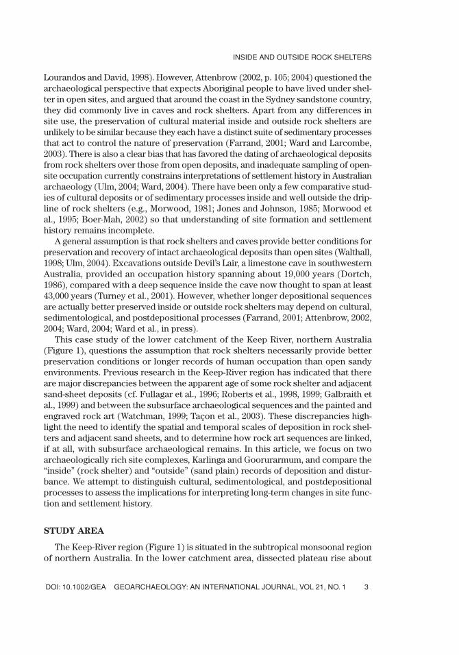
In this study, primary focus is on two site complexes, Goorurarmum and Karlinga,(Figure 2), but we also refer to three nearby locations: Jinmium, Granilpi, andPunipunil (Fullagar et al., 1996; Leslie, 2000; Atchison et al., 2005). Goorurarmumlies approximately 1 km to the southeast of Jinmium at the same relative elevationof ~50 m ASL (Figure 2). The escarpment there peaks at ~85 m, and dips gently to
WARD ET AL.
GEOARCHAEOLOGY: AN INTERNATIONAL JOURNAL, VOL 21, NO. 1 DOI: 10.1002/GEA4
Figure 2. Location of archaeological excavations and auger transects around the three main archaeologicalsites of Jinmium, Goorurarmum, and Karlinga.
the southeast to form a northwest-facing amphitheatre around the sand sheet, on thenortheast side of which is a large rock shelter. The Karlinga escarpment is situatedabout 10 km to the northeast of Goorurarmum (Figure 2). The escarpment rangearound Karlinga is one of the highest in the landscape, peaking at around 180 m ASL,but the elevation above the main rock shelter (the largest recorded in the lowerKeep-River region) is only 75 m.
Rock art is an integral part of the archaeological record in this region and is animportant indicator of site function. Taçon et al. (1997, 1999, 2003) describe a five-phase engraving sequence, and a seven-phase sequence for pigment and wax art.Briefly, the oldest art sequences are represented by cupule engravings (� 10,000 yrB.P.) and purple-red pigment art (Watchman et al., 2000; Taçon et al., 2003). The lat-ter includes paintings resembling Bradshaw (“Gwion Gwion”) figures of the westKimberley (Taçon et al., 1999) that are probably Holocene but older than about 4000yr B.P. (Watchman, 2001; Bednarik, 2002). Direct dating of oxalate-crusts formedover cupules in some rock shelters gives minimum ages ranging from 2280 yr B.P. to4320 yr B.P. (Watchman et al., 2000; Watchman, 2001). The youngest (� 150 yr B.P.)art sequences are represented by scratched figures and by figures done in beeswaxand charcoal (Taçon et al., 2003).
The stone tool record in the Keep-River region is also predominantly Holocene inage. The earliest uniface and bifacial stone points were associated ethnographicallywith hunting, ceremony, and exchange in northwestern Australia (Akerman et al.,2002) and have been dated to around 4000 yr B.P. (Bowdler and O’Connor, 1991, p.53), although they may appear earlier in Arnhem Land (Jones and Johnson, 1985;Hiscock, 1993) and later in the East Kimberley (Fullagar et al., 1996; Akerman et al.,2002; Atchison et al., 2005). In northern Australian archaeological sequences, evi-dence of stone point production provides a rough chronological marker for similartechnological changes that, in other places in Australia, have been linked with cli-mate change, resource distribution, and Aboriginal responses to a more risky envi-ronment (Hiscock, 2002).
METHODS
To evaluate and integrate archaeological evidence from sand sheets and rockshelters, we examined variability in sedimentation, site use, and postdepositionalmodification. Site function refers to the nature of human activities around the site(including inside and outside rock shelters), and this was interpreted generally basedon stone artifacts, ochre, rock-art sequences, and other archaeological components.Of primary interest here is the focus of habitation and the relative abundance offlaked stone artifacts in rock shelters compared with open sites, which was meas-ured in terms of number and weight of artifacts per unit of sediment. Postdepositionalmodification here refers mainly to human and faunal bioturbation.
At Goorurarmum, two pits were archaeologically excavated: Goor-2 in the mainrock shelter and Goor-1 approximately 25 m away at the base of a 2-m scree slopein the adjacent sand sheet (Figure 2). Archaeological pits were also excavated atthree separate locations in the Karlinga complex: Karl-1 and Karl-2 in rock shelters
DOI: 10.1002/GEA GEOARCHAEOLOGY: AN INTERNATIONAL JOURNAL, VOL 21, NO. 1
INSIDE AND OUTSIDE ROCK SHELTERS
5
of the main Karlinga escarpment, and Karl-3 on the open sand sheet about 500 mfrom a low, sandstone outcrop (Figure 2). The main rock-shelter site (Karl-1) is sep-arated from the surrounding sand sheet by a 10-m-high scree slope. The second rock-shelter site (Karl-2) is located about 200 m from the main rock shelter, in a terraceelevated ~80 m above the sand sheets (Figure 2). The locations of the Goor-1 and Karl-3 sand-sheet excavations were chosen from a preliminary augering investigation,which identified them as the deepest deposits close to the escarpments. Significantly,stone artifacts were absent on the surface at these locations, although they are acommon surface feature in eroding parts of the sandy plains and adjacent landforms.In addition to the excavations, auger transects of the sand sheets were undertakenbetween Jinmium and Goorurarmum, and around Karlinga. Coring was achieved todepths up to 6 m (the length of the auger), or until encountering either a pisolitic hori-zon, bedrock, or the water table.
Variations in stone artifact size, morphology, and cortex distribution can provideinformation about stages of manufacture and reduction of particular raw materialsat different locations (Andrefsky, 1998). All excavated sediments were dry sieved inthe field using 2-mm and 4-mm nested aluminum sieves, and were further sievedand sorted in the laboratory. Stone (and glass) artifacts were sorted by raw material,reduction type, and completeness. For whole flakes, attributes including size, shape,and platform type (a platform is a surface from which a flake was detached) werealso recorded. Frequencies were measured by weight and by number per liter ofsediment in each excavation unit. Descriptions of the archaeological assemblages aregiven by Boer-Mah (2002).
Both thermoluminescence (TL) and optically stimulated luminescence (OSL)techniques were used for age determinations of sediments from the sand sheets andthe rock-shelter sites; for the latter, OSL was usually preferred due to concerns aboutincomplete bleaching. Samples were taken from the excavation pits only after allarchaeological investigation and sampling had been completed. For consistencywith previous luminescence dating in the region (Fullagar et al., 1996; Spooner, 1998,Roberts et al., 1998, 1999; Galbraith et al., 1999; McCoy et al., 2000), TL and OSLanalyses used the 90–125-mm quartz fraction and similar laboratory methods.Thermoluminescence methods follow those of Fullagar et al. (1996). Optically stim-ulated luminescence methods derive from Galbraith et al. (1999) but follow the mostrecent and robust protocol of single-aliquot-regenerative-dose (SAR) outlined byMurray and Wintle (2000) and modified from Murray and Roberts (1998).
Radiocarbon samples were prepared using acid-extraction methods detailed byBird et al. (1999) and dated by AMS radiocarbon dating at Waikato and AustralianNuclear Science Technology Organization (ANSTO) laboratories. In general, theradiocarbon chronologies are preferred for the rock shelters because of concernsregarding insufficient bleaching of sediments in the rock shelters (Ward et al., inpress). Conversely, the luminescence chronologies are seen as more reliable for thewell-bleached sand-sheet sites because fluctuating water tables make radiometric 14Cages unreliable beyond depths of 150 cm (Fifield et al., 2001; Ward, 2004). Wherethere is a choice, it is suggested that the OSL age provides a more accurate estimateof depositional ages than the TL ages (Ward et al., in press). Sediment descriptions,
WARD ET AL.
GEOARCHAEOLOGY: AN INTERNATIONAL JOURNAL, VOL 21, NO. 1 DOI: 10.1002/GEA6
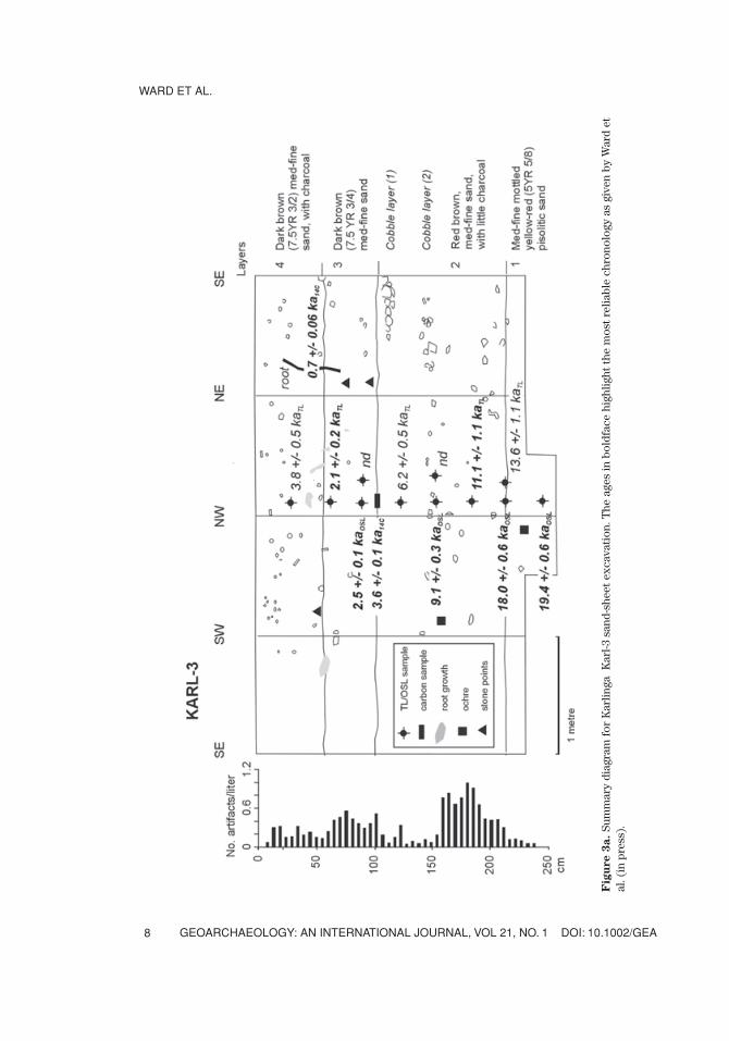
age determinations, and artifact densities are summarized for each of the sand-sheet(Figure 3a) and rock-shelter (Figure 3b, 3c) excavations at Karlinga, and for thesand-sheet and rock-shelter (Figure 4b) excavation at Goorurarmum. Readers arereferred to Ward et al. (in press) for more detailed site descriptions.
RESULTS
Basic analyses of rock-shelter and sand-sheet sediments indicate that while there aresome differences between the Goorurarmum and Karlinga site areas, there is little strati-graphic or sedimentological differentiation within any one site. Typically, sedimentsfrom rock-shelter excavation pits and sand-sheet auger cores comprise unconsolidatedcharcoal-enriched surface sands overlying slightly more compact sands, which them-selves overlie rubble and/or a bedrock base. There is no clear demarcation of occupa-tion events, or well-defined features, such as organic residues or hearths. The lack ofclearly defined strata is typical of sandy sediments across northern Australia (Davidson,1935; Dortch, 1977; Ward and Larcombe, 2003). Even where there are identifiable colorchanges within deposits (e.g., Jones and Johnson, 1985; Allen and Barton, 1990), the rela-tionship between these and individual depositional events is not always clear.
In the absence of well-defined anthropogenic features or strata, chronostratigra-phy based on absolute-age estimates provides the main evidence of depositionalevents, three of which are recognized here: (a) sand-sheet horizons betweenGoorurarmum and Jinmium with a maximum age of about 100,000 yr B.P., (b) sandsheets closer to the Gooruarmum and Karlinga escarpments with a maximum age ofabout 20,000 yr B.P., and (c) rock-shelter sites with Holocene deposits (see alsoFigure 12, Ward et al., in press). These three depositional events permit the identi-fication of different processes of cultural, sedimentological, and postdepositionalchange in the lower Keep-River catchment.
Sand-Sheet Sedimentation History (100,000–20,000 yr B.P.)
The sand-sheet sediments range from moderately sorted, medium-fine (~220 µm)uniform red sands (2.5YR 4/6) near the Goorurarmum escarpment, to slightly coarser(~280 µm) mottled red (10R 4/6) to orange-yellow sands (5YR 4/6) and occasionalpisolitic sands between Jinmium and Goorurarmum, to more coarse (~360 µm) andleached yellow sands (7.5YR 3/2–5YR 4/6) near the Karlinga escarpment. These colordifferences are indicative of variations in the level of the water table across the Keep-River region. The otherwise similar sandy sediments reflect the consistent source(mostly quartz sandstones), transport (runoff, mass wasting, sheet flow), weather-ing (which preserves only resistant inorganic minerals), and secondary mixingprocesses (particularly by termites).
The oldest dated sequence occurs in the thick red sand sheets betweenGoorurarmum and Jinmium, with an age of 76,000 yr B.P. obtained from the base ofthe 6-m-long auger (Table I). These results are in broad agreement with previousage determinations of the sand sheets around Jinmium of 103,000 � 14,000 yr B.P.at 5-m depth (Fullagar et al., 1996) and indicate that the bulk of the present sand
DOI: 10.1002/GEA GEOARCHAEOLOGY: AN INTERNATIONAL JOURNAL, VOL 21, NO. 1
INSIDE AND OUTSIDE ROCK SHELTERS
7
WARD ET AL.
GEOARCHAEOLOGY: AN INTERNATIONAL JOURNAL, VOL 21, NO. 1 DOI: 10.1002/GEA8
Fig
ure 3
a.
Sum
mar
y di
agra
m f
or K
arlin
ga K
arl-3
san
d-sh
eet
exca
vati
on. T
he a
ges
in b
oldf
ace
high
light
the
mos
t re
liabl
e ch
rono
logy
as
give
n by
War
d et
al. (
in p
ress
).
DOI: 10.1002/GEA GEOARCHAEOLOGY: AN INTERNATIONAL JOURNAL, VOL 21, NO. 1
INSIDE AND OUTSIDE ROCK SHELTERS
9
Fig
ure 3
b.
Sum
mar
y di
agra
m f
or K
arlin
ga K
arl-1
roc
k-sh
elte
r ex
cava
tion
. The
age
s in
bol
dfac
e hi
ghlig
ht t
he m
ost
relia
ble
chro
nolo
gy a
s gi
ven
by W
ard
etal
. (in
pre
ss).
WARD ET AL.
GEOARCHAEOLOGY: AN INTERNATIONAL JOURNAL, VOL 21, NO. 1 DOI: 10.1002/GEA10
Fig
ure 3
c.
Sum
mar
y di
agra
m f
or K
arlin
ga K
arl-2
roc
k-sh
elte
r ex
cava
tion
. The
age
in b
oldf
ace
high
light
s th
e m
ost
relia
ble
chro
nolo
gy a
s gi
ven
by W
ard
etal
. (in
pre
ss).
DOI: 10.1002/GEA GEOARCHAEOLOGY: AN INTERNATIONAL JOURNAL, VOL 21, NO. 1
INSIDE AND OUTSIDE ROCK SHELTERS
11
Fig
ure 4
a.
Sum
mar
y di
agra
m fo
r G
ooru
rarm
um G
oor-
1 sa
nd-s
heet
exc
avat
ion.
The
age
s in
bol
dfac
e hi
ghlig
ht th
e m
ost r
elia
ble
chro
nolo
gy a
s gi
ven
by W
ard
et a
l. (i
n pr
ess)
.
WARD ET AL.
GEOARCHAEOLOGY: AN INTERNATIONAL JOURNAL, VOL 21, NO. 1 DOI: 10.1002/GEA12
Fig
ure 4
b.
Sum
mar
y di
agra
m fo
r G
ooru
rarm
um G
oor-
2 ro
ck-s
helt
er e
xcav
atio
n. T
he a
ges
in b
oldf
ace
high
light
the
mos
t rel
iabl
e ch
rono
logy
as
give
n by
War
det
al.
(in
pres
s).
sheets have accumulated in the past 75,000–100,000 years. This age range is consis-tent with the estimates of 230,000–100,000 yr B.P. for the sand sheets dated in ArnhemLand by Roberts (1991). No microdebitage or other artifacts have been found in anyauger samples of this age, notwithstanding that these thick sand sheets have neverbeen excavated archaeologically.
DOI: 10.1002/GEA GEOARCHAEOLOGY: AN INTERNATIONAL JOURNAL, VOL 21, NO. 1
INSIDE AND OUTSIDE ROCK SHELTERS
13
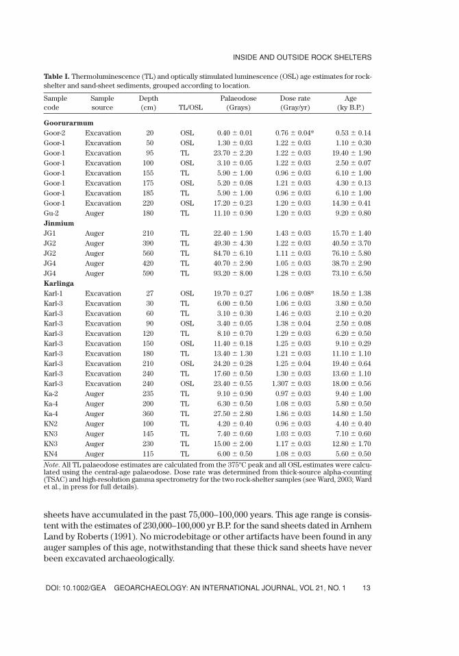
Table I. Thermoluminescence (TL) and optically stimulated luminescence (OSL) age estimates for rock-shelter and sand-sheet sediments, grouped according to location.
Sample Sample Depth Palaeodose Dose rate Agecode source (cm) TL/OSL (Grays) (Gray/yr) (ky B.P.)
Goorurarmum
Goor-2 Excavation 20 OSL 0.40 � 0.01 0.76 � 0.04* 0.53 � 0.14Goor-1 Excavation 50 OSL 1.30 � 0.03 1.22 � 0.03 1.10 � 0.30Goor-1 Excavation 95 TL 23.70 � 2.20 1.22 � 0.03 19.40 � 1.90Goor-1 Excavation 100 OSL 3.10 � 0.05 1.22 � 0.03 2.50 � 0.07Goor-1 Excavation 155 TL 5.90 � 1.00 0.96 � 0.03 6.10 � 1.00Goor-1 Excavation 175 OSL 5.20 � 0.08 1.21 � 0.03 4.30 � 0.13Goor-1 Excavation 185 TL 5.90 � 1.00 0.96 � 0.03 6.10 � 1.00Goor-1 Excavation 220 OSL 17.20 � 0.23 1.20 � 0.03 14.30 � 0.41Gu-2 Auger 180 TL 11.10 � 0.90 1.20 � 0.03 9.20 � 0.80Jinmium
JG1 Auger 210 TL 22.40 � 1.90 1.43 � 0.03 15.70 � 1.40JG2 Auger 390 TL 49.30 � 4.30 1.22 � 0.03 40.50 � 3.70JG2 Auger 560 TL 84.70 � 6.10 1.11 � 0.03 76.10 � 5.80JG4 Auger 420 TL 40.70 � 2.90 1.05 � 0.03 38.70 � 2.90JG4 Auger 590 TL 93.20 � 8.00 1.28 � 0.03 73.10 � 6.50Karlinga
Karl-1 Excavation 27 OSL 19.70 � 0.27 1.06 � 0.08* 18.50 � 1.38Karl-3 Excavation 30 TL 6.00 � 0.50 1.06 � 0.03 3.80 � 0.50Karl-3 Excavation 60 TL 3.10 � 0.30 1.46 � 0.03 2.10 � 0.20Karl-3 Excavation 90 OSL 3.40 � 0.05 1.38 � 0.04 2.50 � 0.08Karl-3 Excavation 120 TL 8.10 � 0.70 1.29 � 0.03 6.20 � 0.50Karl-3 Excavation 150 OSL 11.40 � 0.18 1.25 � 0.03 9.10 � 0.29Karl-3 Excavation 180 TL 13.40 � 1.30 1.21 � 0.03 11.10 � 1.10Karl-3 Excavation 210 OSL 24.20 � 0.28 1.25 � 0.04 19.40 � 0.64Karl-3 Excavation 240 TL 17.60 � 0.50 1.30 � 0.03 13.60 � 1.10Karl-3 Excavation 240 OSL 23.40 � 0.55 1.307 � 0.03 18.00 � 0.56Ka-2 Auger 235 TL 9.10 � 0.90 0.97 � 0.03 9.40 � 1.00Ka-4 Auger 200 TL 6.30 � 0.50 1.08 � 0.03 5.80 � 0.50Ka-4 Auger 360 TL 27.50 � 2.80 1.86 � 0.03 14.80 � 1.50KN2 Auger 100 TL 4.20 � 0.40 0.96 � 0.03 4.40 � 0.40KN3 Auger 145 TL 7.40 � 0.60 1.03 � 0.03 7.10 � 0.60KN3 Auger 230 TL 15.00 � 2.00 1.17 � 0.03 12.80 � 1.70KN4 Auger 115 TL 6.00 � 0.50 1.08 � 0.03 5.60 � 0.50
Note. All TL palaeodose estimates are calculated from the 375ºC peak and all OSL estimates were calcu-lated using the central-age palaeodose. Dose rate was determined from thick-source alpha-counting(TSAC) and high-resolution gamma spectrometry for the two rock-shelter samples (see Ward, 2003; Wardet al., in press for full details).
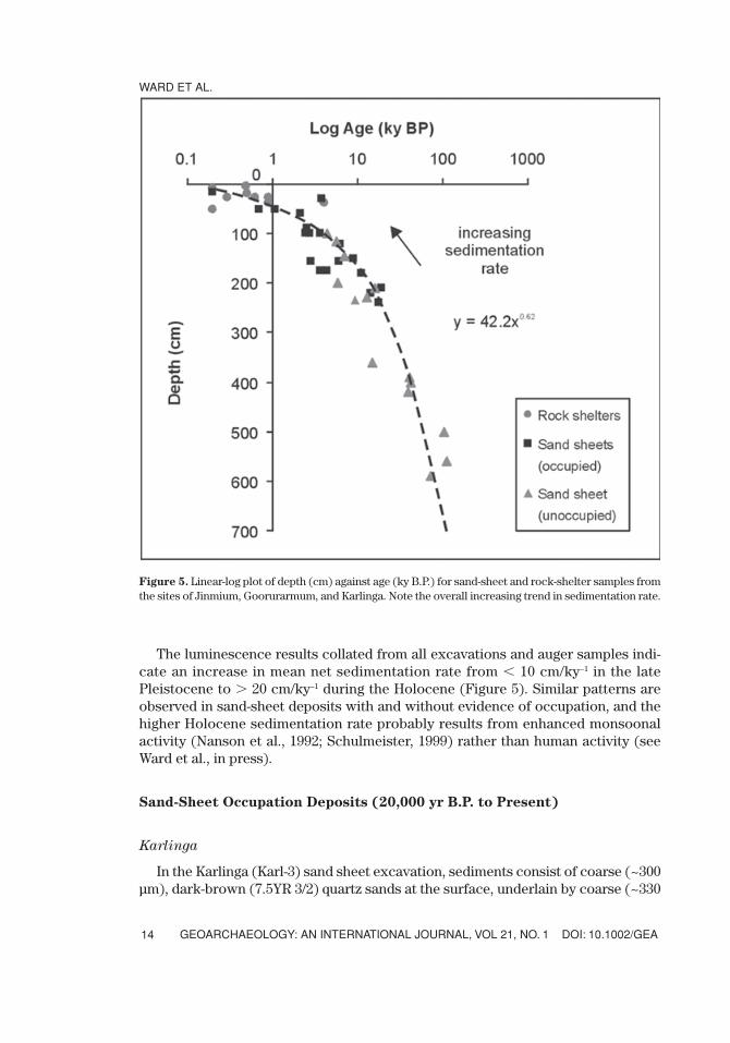
The luminescence results collated from all excavations and auger samples indi-cate an increase in mean net sedimentation rate from � 10 cm/ky–1 in the latePleistocene to � 20 cm/ky–1 during the Holocene (Figure 5). Similar patterns areobserved in sand-sheet deposits with and without evidence of occupation, and thehigher Holocene sedimentation rate probably results from enhanced monsoonalactivity (Nanson et al., 1992; Schulmeister, 1999) rather than human activity (seeWard et al., in press).
Sand-Sheet Occupation Deposits (20,000 yr B.P. to Present)
Karlinga
In the Karlinga (Karl-3) sand sheet excavation, sediments consist of coarse (~300µm), dark-brown (7.5YR 3/2) quartz sands at the surface, underlain by coarse (~330
WARD ET AL.
GEOARCHAEOLOGY: AN INTERNATIONAL JOURNAL, VOL 21, NO. 1 DOI: 10.1002/GEA14
Figure 5. Linear-log plot of depth (cm) against age (ky B.P.) for sand-sheet and rock-shelter samples fromthe sites of Jinmium, Goorurarmum, and Karlinga. Note the overall increasing trend in sedimentation rate.
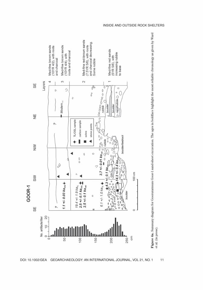
µm) mottled yellow (5YR 4/6) and orange sands, with coarse (~300 µm), dark red(2.5YR 3/6) pisolitic material at the base of the 250-cm excavation pit (Figure 3a).Discrete rubble layers, comprising (imbricated?) cobbles 5–10-cm thick, were encoun-tered at depths of 100 cm and 155 cm (Figure 3a). These cobble layers were notfound in any adjacent profiles and may be significant boundary markers (Robbins etal., 2000), reflecting a change in deposition, an isolated lag deposit, or possibly ananthropogenic feature.
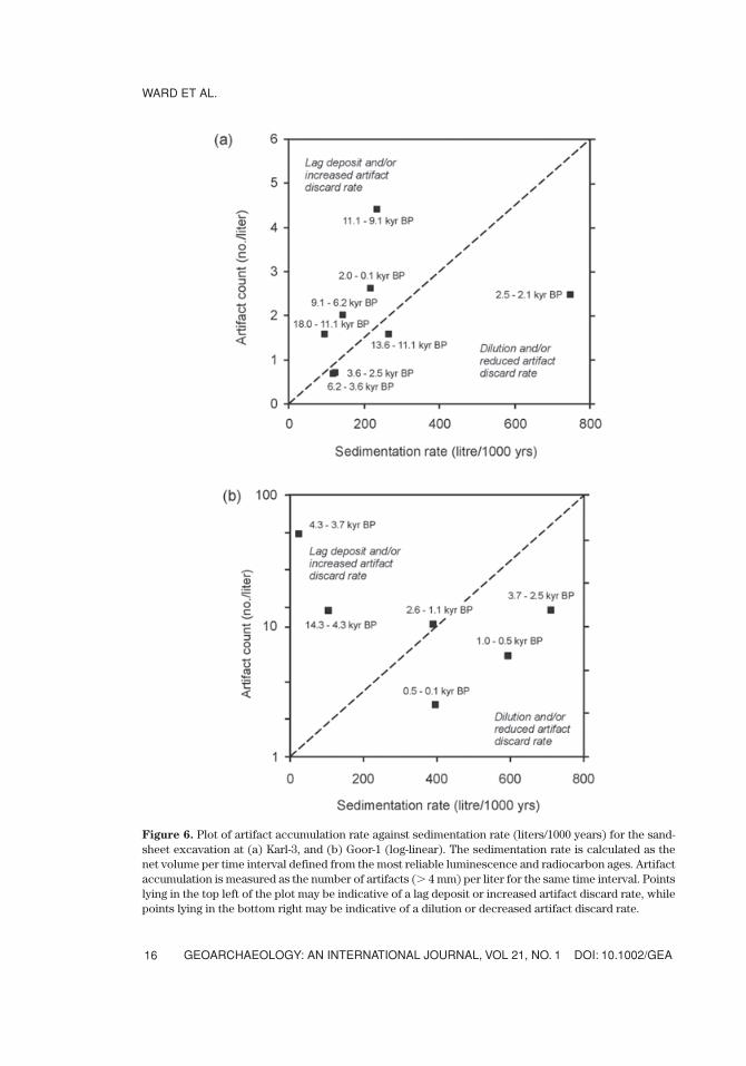
The excavation contained 973 flaked-stone artifacts (22% are whole flakes) ofwhich less than half accumulated since 3600 yr B.P. (Table III). Quartzite makes up84% raw material for the whole flakes at Karl-3, with chert (6.5%) and quartz (6%) dom-inating the remainder. The site also contains eight (33.8 g) stone points, and 15 piecesof red and yellow ochre (Table III). Ochre appears from the earliest levels in both opensites but is more abundant in the modern (� 1000 yr) period. The first appearanceof a unifacial stone point is dated between 2100 yr B.P. and 2500 yr B.P. (OSL), andthe first bifacial point is dated between 2500 yr B.P. (OSL) and 3680 yr B.P. (6 ). Thedeepest artifacts were found at a depth of 240 cm, just below sediments dated by OSLat 18,000 yr B.P. and 19,400 yr B.P. (Table III). Due to observed fluctuating watertables below 150 cm, the radiocarbon age of 2810 � 40 yr B.P. (OZG340) at 155 cmin the same profile is considered unreliable (Ward, 2004; Fifield et al., 2001). Thereis a general positive correlation between sediment accumulation rate and artifact con-centration (number of artifacts per liter) at this site (Figure 6a). However, between11,100 yr B.P. and 9100 yr B.P. there is a relative increase in artifact accumulation and,conversely, between 2500 yr B.P. and 2100 yr B.P., a relative decrease in artifact accu-mulation (Figure 6a).
Goorurarmum
Sediments within the Goorurarmum amphitheatre are moderately sorted, medium-fine (~220 µm) quartz sands that overlie an indurated horizon or bedrock. The sand-sheet excavation (Goor-1) reveals a profile with little stratigraphic differentiation.Sediments comprise medium-fine (~200 µm) quartz sands, with colors ranging fromred-brown (10YR 4/2 to 7.5YR 5/4) near the surface to increasingly red (5YR 5/6)towards the bedrock/rubble base at about 240-cm depth (Figure 4a). The darkerhue and color near the surface probably results from recent burning. The lowermostsediments in the Goor-1 excavation provide an OSL age of ~14,000 yr B.P. at 250cm (Table I).
The Goor-1 excavation contained 3562 flaked stone artifacts (16% are wholeflakes), the majority of which accumulated since 3600 yr B.P. (Table III). Quartzite(78%) is again the predominant raw material for the whole flakes alongside chert(9%) and quartz (3%). The site also contained 9 stone points and 16 pieces (66.1 g)of red and white ochre (Table III). The first appearance of unifacial and bifacial stonepoints in this sequence is also around 2500 yr B.P. Although peaks in artifact accu-mulation rates are not synchronous, the stone technologies at both open sites are gen-erally similar. The correlation between sediment accumulation rate and artifact accu-mulation rate is less clear at this site (Figure 6b). The highest rate of artifact
DOI: 10.1002/GEA GEOARCHAEOLOGY: AN INTERNATIONAL JOURNAL, VOL 21, NO. 1
INSIDE AND OUTSIDE ROCK SHELTERS
15
WARD ET AL.
GEOARCHAEOLOGY: AN INTERNATIONAL JOURNAL, VOL 21, NO. 1 DOI: 10.1002/GEA16
Figure 6. Plot of artifact accumulation rate against sedimentation rate (liters/1000 years) for the sand-sheet excavation at (a) Karl-3, and (b) Goor-1 (log-linear). The sedimentation rate is calculated as thenet volume per time interval defined from the most reliable luminescence and radiocarbon ages. Artifactaccumulation is measured as the number of artifacts (� 4 mm) per liter for the same time interval. Pointslying in the top left of the plot may be indicative of a lag deposit or increased artifact discard rate, whilepoints lying in the bottom right may be indicative of a dilution or decreased artifact discard rate.
accumulation occurs after 2600 yr B.P. (Figure 6b), with a relative increase in arti-fact accumulation between 14,300 yr B.P. and 3700 yr B.P. (Figure 6b).
Rock-Shelter Occupation Deposits (10,000 yr B.P. to Present)
Karlinga
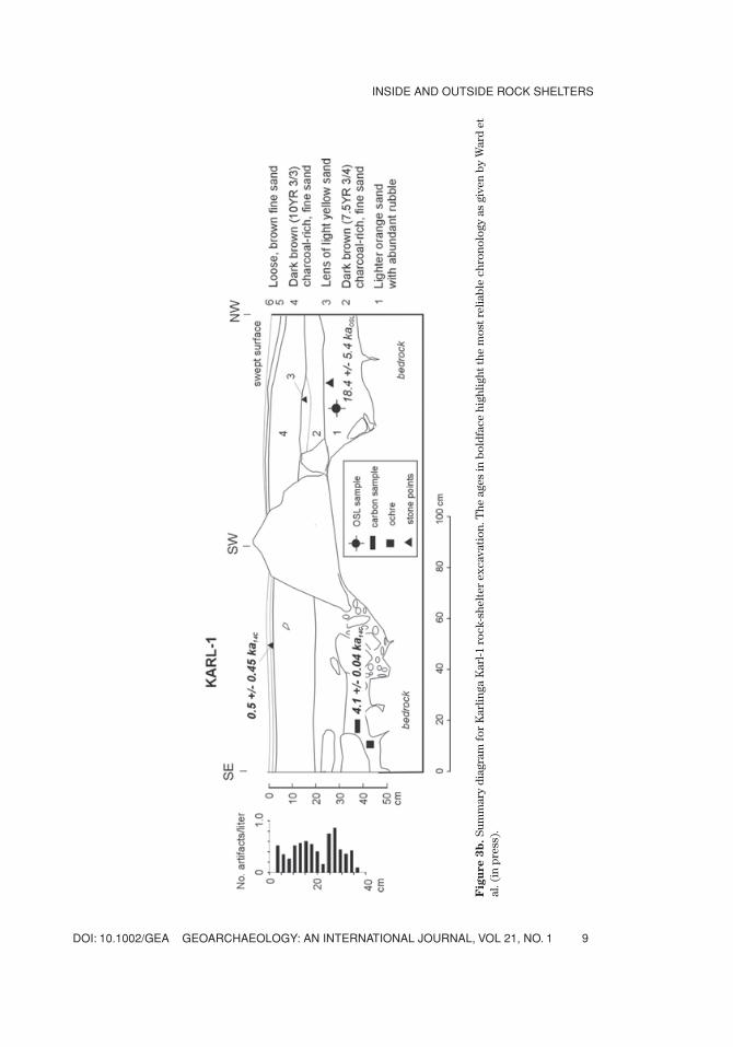
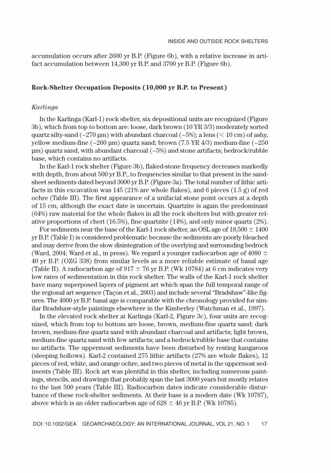
In the Karlinga (Karl-1) rock shelter, six depositional units are recognized (Figure3b), which from top to bottom are: loose, dark brown (10 YR 3/3) moderately sortedquartz silty-sand (~270 µm) with abundant charcoal (~5%); a lens (� 10 cm) of ashy,yellow medium-fine (~260 µm) quartz sand; brown (7.5 YR 4/3) medium-fine (~250µm) quartz sand, with abundant charcoal (~5%) and stone artifacts; bedrock/rubblebase, which contains no artifacts.
In the Karl-1 rock shelter (Figure 3b), flaked-stone frequency decreases markedlywith depth, from about 500 yr B.P., to frequencies similar to that present in the sand-sheet sediments dated beyond 3000 yr B.P. (Figure 3a). The total number of lithic arti-facts in this excavation was 145 (21% are whole flakes), and 6 pieces (1.5 g) of redochre (Table III). The first appearance of a unifacial stone point occurs at a depthof 15 cm, although the exact date is uncertain. Quartzite is again the predominant(64%) raw material for the whole flakes in all the rock shelters but with greater rel-ative proportions of chert (16.5%), fine quartzite (14%), and only minor quartz (2%).
For sediments near the base of the Karl-1 rock shelter, an OSL age of 18,500 � 1400yr B.P. (Table I) is considered problematic because the sediments are poorly bleachedand may derive from the slow disintegration of the overlying and surrounding bedrock(Ward, 2004; Ward et al., in press). We regard a younger radiocarbon age of 4080 �40 yr B.P. (OZG 338) from similar levels as a more reliable estimate of basal age(Table II). A radiocarbon age of 917 � 76 yr B.P. (Wk 10784) at 6 cm indicates verylow rates of sedimentation in this rock shelter. The walls of the Karl-1 rock shelterhave many superposed layers of pigment art which span the full temporal range ofthe regional art sequence (Taçon et al., 2003) and include several “Bradshaw”-like fig-ures. The 4000 yr B.P. basal age is comparable with the chronology provided for sim-ilar Bradshaw-style paintings elsewhere in the Kimberley (Watchman et al., 1997).
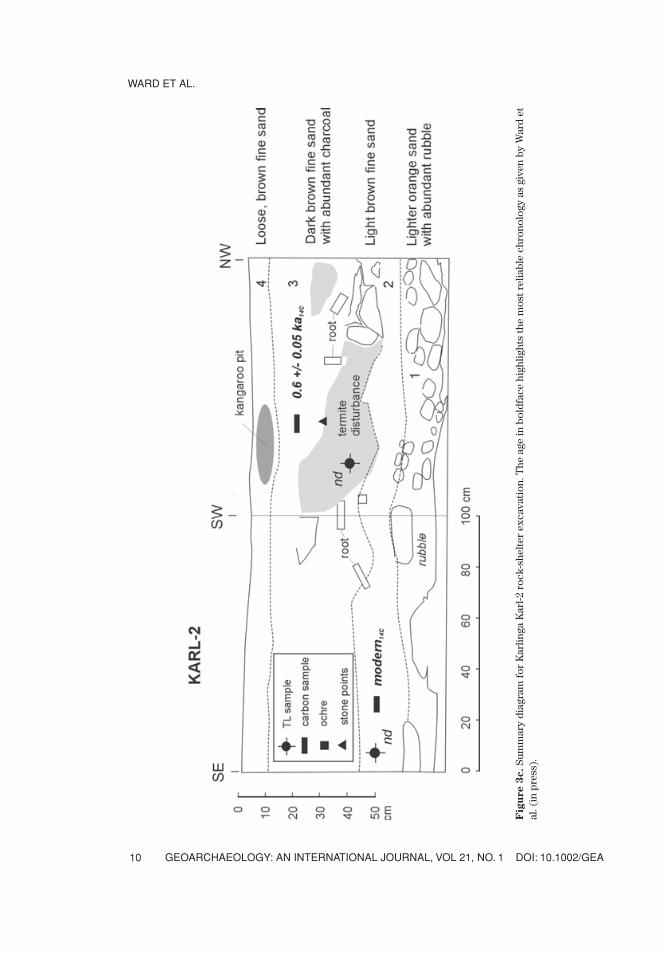
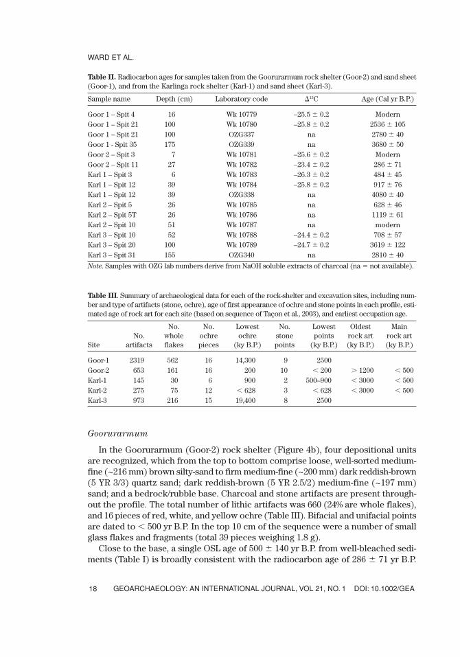
In the elevated rock shelter at Karlinga (Karl-2, Figure 3c), four units are recog-nized, which from top to bottom are loose, brown, medium-fine quartz sand; darkbrown, medium-fine quartz sand with abundant charcoal and artifacts; light brown,medium-fine quartz sand with few artifacts; and a bedrock/rubble base that containsno artifacts. The uppermost sediments have been disturbed by resting kangaroos(sleeping hollows). Karl-2 contained 275 lithic artifacts (27% are whole flakes), 12pieces of red, white, and orange ochre, and two pieces of metal in the uppermost sed-iments (Table III). Rock art was plentiful in this shelter, including numerous paint-ings, stencils, and drawings that probably span the last 3000 years but mostly relatesto the last 500 years (Table III). Radiocarbon dates indicate considerable distur-bance of these rock-shelter sediments. At their base is a modern date (Wk 10787),above which is an older radiocarbon age of 628 � 46 yr B.P. (Wk 10785).
DOI: 10.1002/GEA GEOARCHAEOLOGY: AN INTERNATIONAL JOURNAL, VOL 21, NO. 1
INSIDE AND OUTSIDE ROCK SHELTERS
17
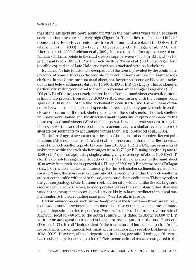
Goorurarmum
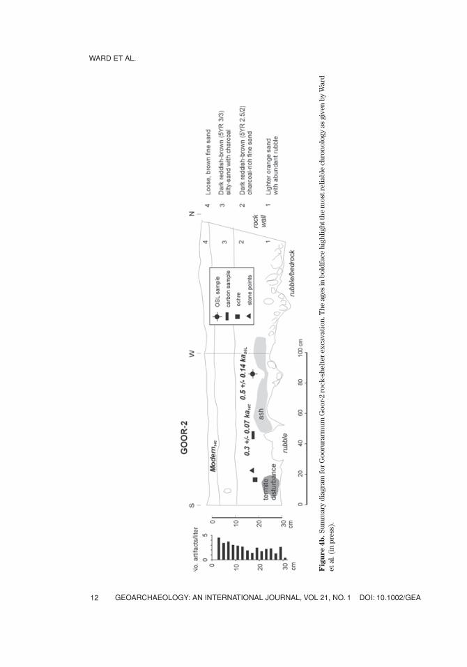
In the Goorurarmum (Goor-2) rock shelter (Figure 4b), four depositional unitsare recognized, which from the top to bottom comprise loose, well-sorted medium-fine (~216 mm) brown silty-sand to firm medium-fine (~200 mm) dark reddish-brown(5 YR 3/3) quartz sand; dark reddish-brown (5 YR 2.5/2) medium-fine (~197 mm)sand; and a bedrock/rubble base. Charcoal and stone artifacts are present through-out the profile. The total number of lithic artifacts was 660 (24% are whole flakes),and 16 pieces of red, white, and yellow ochre (Table III). Bifacial and unifacial pointsare dated to � 500 yr B.P. In the top 10 cm of the sequence were a number of smallglass flakes and fragments (total 39 pieces weighing 1.8 g).
Close to the base, a single OSL age of 500 � 140 yr B.P. from well-bleached sedi-ments (Table I) is broadly consistent with the radiocarbon age of 286 � 71 yr B.P.
WARD ET AL.
GEOARCHAEOLOGY: AN INTERNATIONAL JOURNAL, VOL 21, NO. 1 DOI: 10.1002/GEA18
Table III. Summary of archaeological data for each of the rock-shelter and excavation sites, including num-ber and type of artifacts (stone, ochre), age of first appearance of ochre and stone points in each profile, esti-mated age of rock art for each site (based on sequence of Taçon et al., 2003), and earliest occupation age.
No. No. Lowest No. Lowest Oldest Main No. whole ochre ochre stone points rock art rock art
Site artifacts flakes pieces (ky B.P.) points (ky B.P.) (ky B.P.) (ky B.P.)
Goor-1 2319 562 16 14,300 9 2500Goor-2 653 161 16 200 10 � 200 � 1200 � 500Karl-1 145 30 6 900 2 500–900 � 3000 � 500Karl-2 275 75 12 � 628 3 � 628 � 3000 � 500Karl-3 973 216 15 19,400 8 2500
Table II. Radiocarbon ages for samples taken from the Goorurarmum rock shelter (Goor-2) and sand sheet(Goor-1), and from the Karlinga rock shelter (Karl-1) and sand sheet (Karl-3).
Sample name Depth (cm) Laboratory code �13C Age (Cal yr B.P.)
Goor 1 – Spit 4 16 Wk 10779 –25.5 � 0.2 ModernGoor 1 – Spit 21 100 Wk 10780 –25.8 � 0.2 2536 � 105Goor 1 – Spit 21 100 OZG337 na 2780 � 40Goor 1 - Spit 35 175 OZG339 na 3680 � 50Goor 2 – Spit 3 7 Wk 10781 –25.6 � 0.2 ModernGoor 2 – Spit 11 27 Wk 10782 –23.4 � 0.2 286 � 71Karl 1 – Spit 3 6 Wk 10783 –26.3 � 0.2 484 � 45Karl 1 – Spit 12 39 Wk 10784 –25.8 � 0.2 917 � 76Karl 1 – Spit 12 39 OZG338 na 4080 � 40Karl 2 – Spit 5 26 Wk 10785 na 628 � 46Karl 2 – Spit 5T 26 Wk 10786 na 1119 � 61Karl 2 – Spit 10 51 Wk 10787 na modernKarl 3 – Spit 10 52 Wk 10788 –24.4 � 0.2 708 � 57Karl 3 – Spit 20 100 Wk 10789 –24.7 � 0.2 3619 � 122 Karl 3 – Spit 31 155 OZG340 na 2810 � 40
Note. Samples with OZG lab numbers derive from NaOH soluble extracts of charcoal (na � not available).
(Table II). Within the Goor-2 rock shelter there are many cupule engravings datingto at least 1200 years (Taçon et al., 2003, p. 3) as well as more recent paintings andstencils. Although the Goorurarmum area lacks the Bradshaw figures found atKarlinga, both localities reflect previously identified sequences spanning � 3000 yrB.P. to present (Taçon et al., 1997, 1999, 2003).
DISCUSSION
Chronological Comparison of Rock-Shelter and Sand-Sheet Sequences
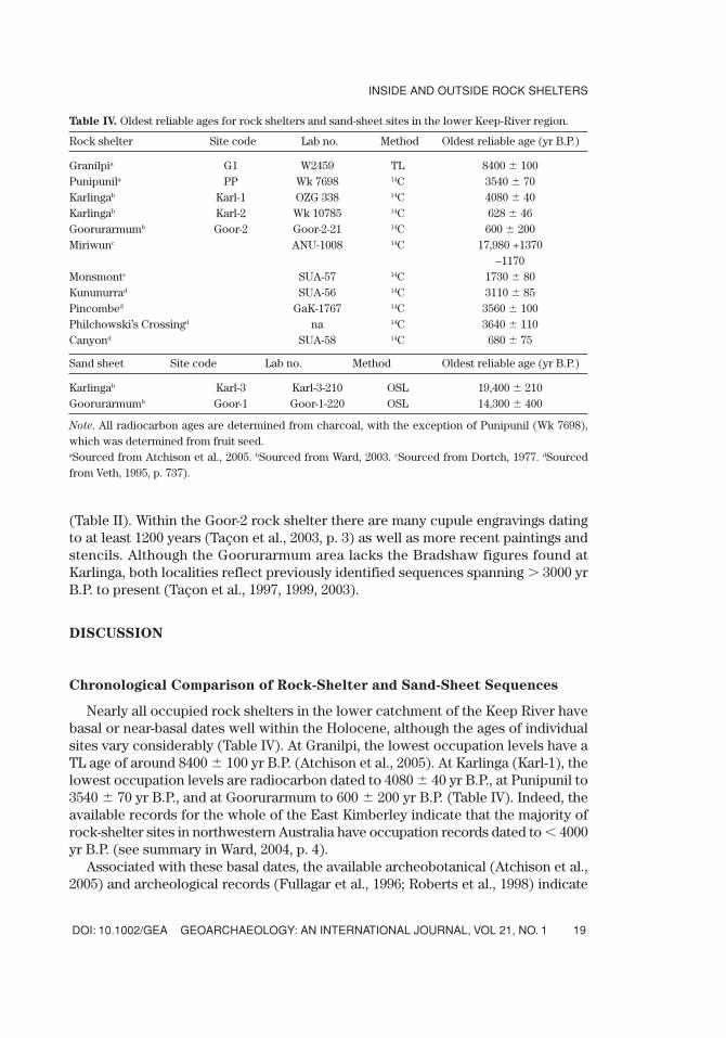
Nearly all occupied rock shelters in the lower catchment of the Keep River havebasal or near-basal dates well within the Holocene, although the ages of individualsites vary considerably (Table IV). At Granilpi, the lowest occupation levels have aTL age of around 8400 � 100 yr B.P. (Atchison et al., 2005). At Karlinga (Karl-1), thelowest occupation levels are radiocarbon dated to 4080 � 40 yr B.P., at Punipunil to3540 � 70 yr B.P., and at Goorurarmum to 600 � 200 yr B.P. (Table IV). Indeed, theavailable records for the whole of the East Kimberley indicate that the majority ofrock-shelter sites in northwestern Australia have occupation records dated to � 4000yr B.P. (see summary in Ward, 2004, p. 4).
Associated with these basal dates, the available archeobotanical (Atchison et al.,2005) and archeological records (Fullagar et al., 1996; Roberts et al., 1998) indicate
DOI: 10.1002/GEA GEOARCHAEOLOGY: AN INTERNATIONAL JOURNAL, VOL 21, NO. 1
INSIDE AND OUTSIDE ROCK SHELTERS
19
Table IV. Oldest reliable ages for rock shelters and sand-sheet sites in the lower Keep-River region.
Rock shelter Site code Lab no. Method Oldest reliable age (yr B.P.)
Granilpia G1 W2459 TL 8400 � 100Punipunila PP Wk 7698 14C 3540 � 70Karlingab Karl-1 OZG 338 14C 4080 � 40Karlingab Karl-2 Wk 10785 14C 628 � 46Goorurarmumb Goor-2 Goor-2-21 14C 600 � 200Miriwunc ANU-1008 14C 17,980 +1370
–1170Monsmontc SUA-57 14C 1730 � 80Kununurrad SUA-56 14C 3110 � 85Pincombed GaK-1767 14C 3560 � 100Philchowski’s Crossingd na 14C 3640 � 110Canyond SUA-58 14C 680 � 75
Sand sheet Site code Lab no. Method Oldest reliable age (yr B.P.)
Karlingab Karl-3 Karl-3-210 OSL 19,400 � 210Goorurarmumb Goor-1 Goor-1-220 OSL 14,300 � 400
Note. All radiocarbon ages are determined from charcoal, with the exception of Punipunil (Wk 7698),which was determined from fruit seed.aSourced from Atchison et al., 2005. bSourced from Ward, 2003. cSourced from Dortch, 1977. dSourcedfrom Veth, 1995, p. 737).
that stone artifacts are more abundant within the past 4000 years when sedimentaccumulation rates are relatively high (Figure 5). The earliest unifacial and bifacialpoints in the Keep-River region are from Jinmium and are dated to 3000 yr B.P.(Akerman et al., 2000) and ~1700 yr B.P., respectively (Fullagar et al., 1996: 764;Akerman et al., 2002; Atchison et al., 2005). In this study, the first appearance of uni-facial and bifacial points in the sand sheets range between � 3680 yr B.P. and � 2100yr B.P. and before 900 yr B.P. in the rock shelters. Taçon et al. (2003) also argue for apossible expansion of Late-Holocene rock art associated with rock shelters.
Evidence for late-Pleistocene occupation of the area is provided by the continuouspresence of stone artifacts in the sand sheets near the Goorurarmum and Karlinga rockshelters. In the Goorurarmum sand sheet, the lowermost stone artifacts and ochreoccur just below sediments dated to 14,300 � 400 yr B.P. (OSL age). This evidence isparticularly striking compared to the much younger archaeological sequence (600 �200 yr B.P.) of the adjacent rock shelter. In the Karlinga sand-sheet excavation, stoneartifacts are present from about 19,000 yr B.P., contrasting with the younger basalages (� 4100 yr B.P.) of the two rock-shelter sites, Karl-1 and Karl-2. These differ-ences between rock shelter and open-site chronologies may partly result from theelevated location of the rock shelter sites above the sand sheets. The rock shelterswill have more limited and localized sediment inputs and outputs compared to themore exposed sand sheets (Ward et al., in press). In some circumstances, it may benecessary for the sand-sheet sediments to accumulate to a similar level as the rockshelters for sediments to accumulate within them (e.g., Morwood et al., 1995).
The inferred age of occupation for the site of Jinmium is also complex. Recent pub-lications (Atchison et al., 2005; Ward et al., in press) argue that the earliest occupa-tion of the rock shelter is probably less than 10,000 yr B.P. The OSL age estimates ofsediments within the rock shelter ranges from 22,700 yr B.P. using single aliquots to1200 yr B.P. (central-age) using single grains, giving an average of about 10,000 yr B.P.(for the complete range, see Roberts et al., 1998). An excavation in the sand sheet10 m away from rock shelter provided a TL age of 8500 yr B.P. near the base (Fullagaret al., 1996), which, unlike the chronology for the rock-shelter sediments, has not beenrevised. Thus, the average maximum age of the sediments within the rock shelter isat least comparable with that of the adjacent sand-sheet sediments. This may reflectthe geomorphology of the Jinmium rock shelter site, which, unlike the Karlinga andGoorurarmum rock shelters, is incorporated within the sand plain rather than ele-vated in the escarpment above it, and is more likely to have a sediment input and out-put similar to the surrounding sand plain (Ward et al., in press).
Certain environments, such as the floodplains of the lower Keep River, are unlikelyto show continuous sediment accumulation because of the episodic nature of flood-ing and deposition in this region (e.g., Woodroffe, 1993). The former riverine site ofMiriwun, located ~80 km to the south (Figure 1), is dated to about 18,000 yr B.P.with a chronological hiatus and subsequent reoccupation in the mid-Holocene(Dortch, 1977). It is difficult to identify the true nature of human occupation from arecord that is discontinuous, both spatially and temporally (see also Holdaway et al.,1998, 2002). However, alluvial deposition, including periodic flooding at Miriwun,has resulted in better accumulation of Pleistocene cultural remains compared to the
WARD ET AL.
GEOARCHAEOLOGY: AN INTERNATIONAL JOURNAL, VOL 21, NO. 1 DOI: 10.1002/GEA20
lower catchment of the Keep River, where sediment is predominantly distributedby sheet flow (Ward et al., in press). The different chronologies between the sand-sheets and rock-shelter sites highlights the importance of sampling a range of sedi-mentary environments in a study area to ensure reliable interpretations of natural andcultural site formation (Allen and Barton, 1990; Attenbrow, 2002, 2004; Ulm, 2004;Ward, 2004; Ward et al., in press).
Postdepositional Disturbance
A comprehensive review of the influence of physical and biogenic processes onarchaeological site formation and landscape evolution is given by Johnson et al.(2002) and more specifically for Australia by Ward and Larcombe (2003) andAttenbrow (2004). These reviews argue the importance of recognizing natural dis-turbance processes and the scales over which they overlap with other depositionalprocesses at archaeological sites. Disturbance processes may be quite localized, andmay account for the inverted dates within the Karl-2 rock shelter and the surface sed-iments of the Karl-3 excavation. In the Keep-River region, the major biogenic agentsof disturbance are burrowing organisms (especially termites) and humans.
In the Keep-River region, the presence of faunal disturbance, particularly inrock-shelter sites, is evident from goanna burrows, kangaroo hollows (e.g., Figure3c), termite mounds, and tunnel castings (e.g., Figure 4b) within the buried sed-iments. Readers are referred to McBeaty (1990) for a study of termite distur-bance on archaeological site formation. Published rates of sediment disturbancecaused by termite reworking are about 2.5 cm/ka–1 (Holt et al., 1980; Colin et al.,2001), which, if applied to the Keep-River region, would give an error of � 25%and � 12%, respectively, on Pleistocene and Holocene sedimentation rates. Hence,chronological resolution should be better in Holocene sequences than inPleistocene sediments.
The presence of human disturbance is indicated by campfires (e.g., Figure 4b), treeclearing for paper-bark bedding, caching of equipment, and rock alignments to divertrunoff. Rock shelters with evidence of repeated human visitation, evident from themultiple layers of rock art, are also likely to be prone to human disturbance of theirdeposits. Such disturbance may be deliberate (e.g., burying or caching human remains,building fire pits, and clearing occupation debris) or unintentional (e.g., treadage).In the Keep-River region, the uppermost 20 cm or so that is likely to have beenaffected by recent human (and/or faunal) disturbance in the rock shelters coversaround 500 years (cf. Hughes and Lampert, 1977, p. 136). Thus, studies aimed atdetermining small-scale processes are severely limited in their resolution in many ofthese younger rock-shelter sequences.
Changes in Site Use
The general correlation between increased artifact number and increased sedi-mentation rate in the sand sheets (Figure 6a, b) highlights the important considera-tion of sedimentation rate when evaluating the intensity of site use (see also Farrand,
DOI: 10.1002/GEA GEOARCHAEOLOGY: AN INTERNATIONAL JOURNAL, VOL 21, NO. 1
INSIDE AND OUTSIDE ROCK SHELTERS
21
2001; Ward and Larcombe, 2003). These plots help distinguish changes in the rate ofartifact accumulation that may reflect natural or cultural processes; for example:
1. Unusually high artifact concentrations and low rates of sediment accumula-tion may be indicative of a lag deposit and/or increased artifact discard rates—in the Karlinga sand-sheet excavation, only the lower cobble layer reflectsthis trend.
2. Unusually low artifact concentrations and high rates of sediment accumula-tion may be indicative of dilution and/or a reduced rate of artifact discard.
Factors which influence preservation, such as water-table fluctuations, are alsoimportant. For example, in the Jinmium excavation, Atchison et al. (2005) argued thatdecreased abundance of fruit seeds with depth, together with their increased degree ofweathering, reflected preservation factors rather than the actual onset of human activ-ity. In rock shelters, a primary control upon the surface occurrence of artifacts is gen-erally low sedimentation rates (Figure 5) and relatively sheltered environmental con-ditions. Secondary influences include cultural processes, such as discard and cleaning(Morwood, 1981), and natural processes, such as removal through runoff (Schick, 1987).
While differences in artifact accumulation may be due, in part, to sedimentary orpostdepositional processes, more subtle differences in the nature of the stone tech-nology may provide further important information about site use. At both Karlinga andGoorurarmum, the stone technology and other archaeological components describedfor the rock-shelter and sand-sheet excavations indicate similar technologies, at leastduring the Late Holocene. The stone-tool data indicate that point production occurredat both the rock-shelter and open sites. In both the sand-sheet and rock-sheltersequences, the stone platforms are predominantly plain, indicating that only a late stageof reduction was taking place. Early stages of reduction may have occurred in differentparts of the landscape, such as the chert and quartzite quarry located at Bungyalaapproximately 15 km northeast of Goorurarmum (Fullagar and Head, 1999, p. 329).Locations of silcrete and quartzite close to Keep River and Sandy Creek have coresand flaking debris associated with early stages of point production, as do more dis-tant locations in the Kimberley (Akerman et al., 2002). This pattern of technologicalorganization is evident in other parts of northern Australia (Jones and Johnson, 1985,p. 199). This study demonstrates that activities are not limited to rock shelters and thatarchaeological material may be found in adjacent open areas as well as in distantlocations, even where there is no surface indication of buried artifacts.
Overall, the number of whole flakes is greater in the sand sheets than in the rockshelter (Table III), possibly reflecting frequency of site use and/or preservation.Interestingly, in the Karlinga sand-sheet excavation, the total number of artifacts,including whole flakes, is greater before ~3600 yr B.P., whereas in the Goorurarmumsand-sheet excavation, the total number of artifacts is greater after this date. One inter-pretation is that this reflects location of different sites (but not different site types)within the lower catchment of the Keep River at different periods.
However, within the last millennium, artifacts and whole flakes were present ingreater quantities in the Goorurarmum rock shelter than in the open site, and the num-ber of stone points, glass, and ochre (also present in more colors) were present in
WARD ET AL.
GEOARCHAEOLOGY: AN INTERNATIONAL JOURNAL, VOL 21, NO. 1 DOI: 10.1002/GEA22
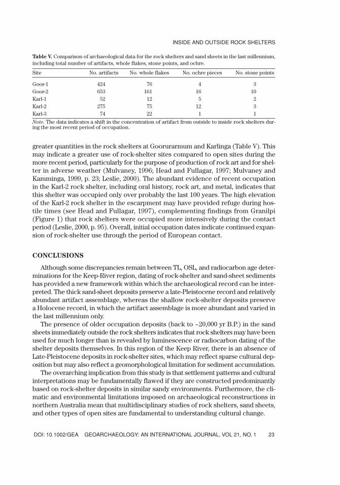
greater quantities in the rock shelters at Goorurarmum and Karlinga (Table V). Thismay indicate a greater use of rock-shelter sites compared to open sites during themore recent period, particularly for the purpose of production of rock art and for shel-ter in adverse weather (Mulvaney, 1996; Head and Fullagar, 1997; Mulvaney andKamminga, 1999, p. 23; Leslie, 2000). The abundant evidence of recent occupationin the Karl-2 rock shelter, including oral history, rock art, and metal, indicates thatthis shelter was occupied only over probably the last 100 years. The high elevationof the Karl-2 rock shelter in the escarpment may have provided refuge during hos-tile times (see Head and Fullagar, 1997), complementing findings from Granilpi(Figure 1) that rock shelters were occupied more intensively during the contactperiod (Leslie, 2000, p. 95). Overall, initial occupation dates indicate continued expan-sion of rock-shelter use through the period of European contact.
CONCLUSIONS
Although some discrepancies remain between TL, OSL, and radiocarbon age deter-minations for the Keep-River region, dating of rock-shelter and sand-sheet sedimentshas provided a new framework within which the archaeological record can be inter-preted. The thick sand-sheet deposits preserve a late-Pleistocene record and relativelyabundant artifact assemblage, whereas the shallow rock-shelter deposits preservea Holocene record, in which the artifact assemblage is more abundant and varied inthe last millennium only.
The presence of older occupation deposits (back to ~20,000 yr B.P.) in the sandsheets immediately outside the rock shelters indicates that rock shelters may have beenused for much longer than is revealed by luminescence or radiocarbon dating of theshelter deposits themselves. In this region of the Keep River, there is an absence ofLate-Pleistocene deposits in rock-shelter sites, which may reflect sparse cultural dep-osition but may also reflect a geomorphological limitation for sediment accumulation.
The overarching implication from this study is that settlement patterns and culturalinterpretations may be fundamentally flawed if they are constructed predominantlybased on rock-shelter deposits in similar sandy environments. Furthermore, the cli-matic and environmental limitations imposed on archaeological reconstructions innorthern Australia mean that multidisciplinary studies of rock shelters, sand sheets,and other types of open sites are fundamental to understanding cultural change.
DOI: 10.1002/GEA GEOARCHAEOLOGY: AN INTERNATIONAL JOURNAL, VOL 21, NO. 1
INSIDE AND OUTSIDE ROCK SHELTERS
23
Table V. Comparison of archaeological data for the rock shelters and sand sheets in the last millennium,including total number of artifacts, whole flakes, stone points, and ochre.
Site No. artifacts No. whole flakes No. ochre pieces No. stone points
Goor-1 424 76 4 3Goor-2 653 161 16 10Karl-1 52 12 5 2Karl-2 275 75 12 3Karl-3 74 22 1 1
Note. The data indicates a shift in the concentration of artifact from outside to inside rock shelters dur-ing the most recent period of occupation.
Funding for this research was provided by the Australian Research Council (Grant no. A5990597). Facilitiesand supervision for OSL sample processing were willingly and expertly provided by Dr. Jon Olley (C.S.I.R.O.,Canberra) and Dr. Bert Roberts (UoW). Sample processing and analysis for TL was undertaken by Dr. DavidPrice, and radiocarbon dating was undertaken by Dr. John Head (deceased). We gratefully acknowledge BethWhite, who provided initial analyses of stone artifacts, and George Susino (University of Wollongong), whoexamined auger samples for microdebitage. We also acknowledge the assistance of Dr. Jenny Atchison andDr. Alan Watchman in the field and sincerely thank the Marralam Aborginal Community (in particular, BiddySimon and Paddy Carlton) for permitting access to their land and for allowing us to use facilities at theiroutstation. Thanks to Dr. Piers Larcombe for his helpful comments on the revised version of the manu-script. Thanks also to Prof. Dr. E. Arthur Bettis III, and the anonymous reviewer for their comments.
REFERENCES
Akerman, K., Fullagar, R., & van Gijn, A. (2000). Weapons and Wunan: Production, function and exchangeof spear points from the Kimberley, northwestern Australia. Australian Aboriginal Studies, No. 1, 13–42.
Allen, H., & Barton, G. (1990). Ngarradji Warde Djobkeng: White cockatoo dreaming and the prehistoryof Kakadu. Sydney: University of Sydney.
Andrefsky, W. (1998). Lithics: Macroscopic approaches to analysis. Cambridge, Cambridge University Press.Atchison, J., Head, L., & Fullagar, R. (2005). Archaeobotany of fruit seed processing in a monsoon savanna
environment: Evidence from the Keep River region, Northern Territory, Australia. Journal ofArchaeological Science, 32, 167–181.
Attenbrow, V.J. (2002). Sydney’s Aboriginal past. Investigating the archaeological and historical records.Sydney: University of NSW Press.
Attenbrow, V.J. (2004). What’s changing—population size or land use: The archaeology of Upper MangroveCreek, Sydney Basin. Terra Australis, No. 21. Canberra, Australia: Pandanus Press.
Bednarik, R.G. (2002). The dating of rock art: A critique. Journal of Archaeological Science 29, 1213–1233.Bird, M.I., Ayliffe, L.K., Fifield, L.K., Turney, C.S.M., Cresswell, R.G., Barrows, T.T., et al. (1999). Radiocarbon
dating of ‘old’ charcoal using a wet oxidation-stepped combustion procedure. Radiocarbon, 41, 127–140.Boer-Mah, T.S. (2002). Beyond the dripline: Comparison of rockshelters and excavated open sites in the
Keep River Region, Northern Territory, Australia. Unpublished master’s thesis, University of Sydney,Sydney, Australia.
Bowdler, S., & O’Connor, S. (1991). The dating of the Australian small tool tradition, with new evidencefrom the Kimberley, W.A. Australian Aboriginal Studies, 1, 53–62.
Cahen, D., & Moeyersons, J. (1977). Subsurface movements of stone artifacts and their implications forthe prehistory of Central Africa. Nature, 266, 812–815.
Colin, F., Gurarus, E., Bourles, D., Braucher, R., Brown, E., Aran, R., et al. (2001). The application of in-situ produced 10Be to the study of Australian stone line induced by termites. AGU Fall MeetingSupplementary Abstract, B22F-03. Eos Transactions, 82, 47.
David, B. (2002). Landscapes, rock-art and the dreaming: An archaeology of preunderstanding. London:Leicester University Press.
Davidson, D.S. (1935). Archaeological problems of northern Australia. Journal of the Royal AnthropologicalInstitute of Great Britain and Ireland, 65, 145–184.
Dortch, C. (1977). Early and late stone industrial phases in Western Australia. In R.V.S. Wright (Ed.),Change, evolution and complexity (pp. 104–132). Canberra: Australian Institute of Aboriginal Studies.
Dortch, C.E. (1986). Excavations outside the former (North) entrance to Devil’s Lair, southwesternAustralia. Australian Archaeology, 23, 62–69.
Farrand, W.R. (2001). Sediments and stratigraphy in rockshelters and caves: A personal perspective onprinciples and pragmatics. Geoarchaeology, 16, 537–557.
Fifield, L.K., Bird, M.I., Turney, C.S.M., Hausladen, P.A., Santos, G.M., & di Tada, M.L. (2001). Radiocarbondating of the human occupation of Australia prior to 40 ka – success and pitfalls. Radiocarbon, 43(2B),1139–1145.
Fullagar, R. (1996). Archaeological and heritage resources. Ord River stage II irrigation scheme, NorthernTerritory. Unpublished report for CCNT, Darwin, Australian Museum Business Services, Sydney.
WARD ET AL.
GEOARCHAEOLOGY: AN INTERNATIONAL JOURNAL, VOL 21, NO. 1 DOI: 10.1002/GEA24
Fullagar, R., & Head, L. (1999). Aboriginal landscapes of the northwest Northern Territory, Australia. In R.Layton, P. Ucko, & D. Austin (Eds.), Frontiers of landscape archaeology (pp. 322–335). London: Routledge.
Fullagar, R.L.K., Price, D.M., & Head, L.M. (1996). Early human occupation of northern Australia:Archaeology and thermoluminescence dating of Jinmium rock-shelter, Northern Territory. Antiquity,70, 751–773.
Galbraith, R.F., Roberts, R.G., Laslett, G.M., Yoshida, H., & Olley, J.M. (1999). Optical dating of single andmultiple grains of quartz from Jinmium rock shelter, Northern Australia: Part I, Experimental designand statistical models. Archaeometry, 41, 339–364.
Head, L., & Fullagar, R. (1997). Hunter-gatherer archaeology and postoral contact: Perspectives from thenorthwest Northern Territory, Australia. World Archaeology, 28, 418–428.
Hiscock, P. (1993). Interpreting the vertical distribution of stone points within Nauwilabila 1, ArnhemLand. The Beagle. Records of the Northern Territory Museum of Arts and Sciences, 10, 173–178.
Hiscock, P. (2002). Pattern and context in the Holocene proliferation of backed artifacts in Australia. InR.G. Elston & S.L. Kuhn (Eds.), Thinking small: Global perspectives on microlithization (pp. 163–177),Archaeological Papers of the American Anthropological Association (AP3A, No. 12). Washington, DC:American Anthropological Association.
Holdaway, S., Witter, D., Fanning, P., Musgrave, R., Cochrane, G., Doelman, T., et al. (1998). New approachesto open site spatial archaeology in Sturt National Park, New South Wales. Archaeology in Oceania, 33, 1–19.
Holdaway, S., Fanning, P., Jones, M., Shiner, J., Witter, D., & Nicholls, G. (2002). Variability in the chronol-ogy of Late Holocene Aboriginal occupation on the arid margin of southeastern Australia. Journal ofArchaeological Science, 29, 351–363.
Holt, J.A., Coventry, R.J., & Sinclair, D.F. (1980). Some aspects of the biology and pedological significanceof mound-building termites in a red and yellow earth landscape near Charters Towers, northQueensland. Australian Journal of Soil Research, 18, 97–109.
Hughes, P.J., & Lampert, R.J. (1977). Occupational disturbance and types of archaeological deposit.Journal of Archaeological Science, 4, 135–140.
Johnson, D.L., Mandel, R.D., Leach, J.D., & Petraglia, M. (2002). Formation processes in regional per-spective. Geoarchaeology, 17(1), 3–5.
Jones, R., & Johnson, I. (1985). Deaf Adder Gorge: Lindner Site, Nauwalabila I. In R. Jones (Ed.),Archaeological research in Kakadu NP (pp. 165–227). Special Publication 13. Sydney, Australia: NewSouth Wales National Parks and Wildlife Service.
Leslie, F. (2000). Defining Aboriginal-European interaction in the Keep River region, NT: Rockshelters, rock-art, and historical records. Unpublished master’s thesis, University of Sydney, Sydney, Australia.
Lourandos, H., & David, B. (1998). Comparing long-term archaeological and environmental trends: NorthQueensland, arid and semi-arid Australia. The Artifact, 21, 105–112.
McBeaty, S. (1990). Consider the humble termite: Termites as agents of post-depositional disturbance atAfrican archaeological sites. Journal of Archaeological Science, 17, 111–144.
McCoy, D.G., Prescott, J.R., & Nation, R.J. (2000). Some aspects of single-grain luminescence dating.Radiation Measurements, 32, 859–864.
Morwood, M.J. (1981). Archaeology of the Central Queensland Highlands: The stone component.Archaeology in Oceania, 16, 1–52.
Morwood, M.J., Hobbs, D.R., & Price, D.M. (1995). Excavations at Sandy Creek 1 and 2. Tempus, 3, 71–85.Mulvaney, K.J. (1996). What to do on a rainy day: Reminiscences of Mirriuwung and Gadjerong artists. Rock
Art Research, 13, 3–20.Mulvaney, J., & Kamminga, J. (1999). Prehistory of Australia. Sydney: Allen & Unwin.Murray, A.S., & Roberts, R.G. (1998). Measurement of the equivalent dose in quartz using regenerative-
dose single-aliquot protocol. Radiation Measurements, 29, 503–515.Murray, A.S., & Wintle, A.G. (2000). Luminescence dating of quartz using an improved single-aliquot regen-
erative protocol. Radiation Measurements, 32, 57–73. Nanson, G.C., Price, D.M., & Short, S.A. (1992). Wetting and drying of Australia over the past 300 ka.
Geology, 20, 791–794.Nanson, G.C., East, T.J., & Roberts, R.G. (1993). Quaternary stratigraphy, geochronology and evolution
of the Magela Creek catchment in the monsoon tropics of northern Australia. Sedimentary Geology,83, 277–302.
DOI: 10.1002/GEA GEOARCHAEOLOGY: AN INTERNATIONAL JOURNAL, VOL 21, NO. 1
INSIDE AND OUTSIDE ROCK SHELTERS
25
Robbins, L.H., Murphy, M.L., Brook, G.A., Ivester, A.H., Campbell, A.C., Klein, R.G., et al. (2000).Archaeology, palaeoenvironment, and chronology of the Tsodilo Hills White Paintings Rock Shelter,Northwest Kalahari, Botswana. Journal of Archaeological Science, 27, 1085–1113.
Roberts, R.G. (1991). Sediment budgets and Quaternary history of the Magela Creek catchment, tropicalNorthern Australia. Unpublished doctoral dissertation, University of Wollongong, Australia.
Roberts, R., Bird, M., Olley, J., Galbraith, R., Lawson, E., Laslett, G., et al. (1998). Optical and radiocarbondating at Jinmium rock shelter, northern Australia. Nature, 393, 358–362.
Roberts, R.G., Galbraith, R.F., Olley, J., Yoshida, H., & Laslett, G.M. (1999). Optical dating of single and mul-tiple grains of quartz from Jinmium rock shelter, northern Australia: Part II, Results and implications.Archaeometry, 41, 365–395.
Schick, K.D. (1987). Experimentally-derived criteria for assessing hydrological disturbance of archaeo-logical sites. In D.T. Nash & M.D. Petraglia (Eds.), Natural formation processes and the archaeologi-cal record (pp. 86–107). BAR International Series 352. Oxford: British Archaeological Reports.
Schulmeister, J. (1999). Australasian evidence for mid-Holocene climate change implies precessionalcontrol of Walker Circulation in the Pacific. Quaternary International, 57/58, 81–91.
Smith, M.A., & Sharp, N.D. (1993). Pleistocene sites in Australia, New Guinea and Island Melanesia:Geographic and temporal structure of the archaeological record. In M.A. Smith, M. Spriggs, & B.Fankenhauser (Eds.), Sahul in review: The Archaeology of Australia, New Guinea and Island Melanesia(pp. 37–59). Canberra: Australian National University Press.
Spooner, N.A. (1998). Human occupation at Jinmium, northern Australia, 116,000 years ago or much less?Antiquity, 72, 173–178.
Stockton, E. (1973). Shaw’s Creek Shelter: Human displacement of artifacts and its significance. Mankind,9, 112–117.
Taçon, P.S.C., Fullagar, R., Ouzman, S., & Mulvaney, K. (1997). Cupule engravings from Jinmium-Granilpi(northern Australia) and beyond: Exploration of a widespread and enigmatic class of rock markings.Antiquity, 71, 942–965.
Taçon, P.S.C., Mulvaney, K., Fullagar, R., & Head, L. (1999). ‘Bradshaws’—An eastern province? Rock ArtResearch 16, 127–129.
Taçon, P.S.C., Mulvaney, K., Ouzman, S., Fullagar, R., Carlton, P., & Head, L. (2003). Changing ecologicalconcerns in the rock-art subject matter of north Australia’s Keep River region. Before Farming, 4, 1–14.
Theunissen, R., Balme, J., & Beck, W. (1998). Headroom and human trampling: Cave ceiling height determinesthe spatial patterning of artefacts at Petzkes Cave northern New South Wales. Antiquity, 72, 80–89.
Turney, C.S.M., Bird, M.I., Fifield, L.K., Roberts, R.G., Smith, M.A., Dortch, C.E., et al. (2001). Early humanoccupation at Devil’s Lair, southwestern Australia 50,000 years ago. Quaternary Research, 55, 3–13.
Ulm, S. (2004). Themes in the Archaeology of Mid-to-Late Holocene Australia. In T. Murray (Ed.),Archaeology from Australia (pp. 187–208). Australian Scholarly Publication. Melbourne: CambridgeUniversity Press.
Veth, P. (1995). Aridity and settlement in northwest Australia. Antiquity, 69, 733–746.Villa, P., & Courtin, J. (1983). The interpretation of stratified sites: A view from underground. Journal of
Archaeological Science, 10, 267–281.Walthall, J.A. (1998). Rockshelters and hunter–gatherer adaptation to the Pleistocene/Holocene bound-
ary. American Antiquity, 63, 223–238.Ward, I.A.K. (2003). Lost in the sands of time: Geoarchaeology of the Keep River region, Northern Territory,
Australia. Unpublished doctoral dissertation, University of Wollongong, Australia.Ward, I. (2004). Comparative records of occupation in the Keep River region, eastern Kimberley, and
northwestern Australia. Australian Archaeology, 59, 1–9.Ward, I., & Larcombe, P. (2003). A process-orientated approach to archaeological site formation: Application
to semi-arid northern Australia. Journal of Archaeological Science, 30, 1223–1236.Ward, I.A.K., Nanson, G.C., Head, L.M., Fullagar, R.L.K., Price, D.M., & Fink, D. (in press). Late Quaternary
landscape evolution in the Keep River Region, northwestern Australia. Quaternary Science Reviews,24, 1906–1922
Watchman, A. (1999). A review of the history of dating rock varnish. Earth Science Reviews, 49, 261–279.Watchman, A. (2001). Wargata Mina to Gunbilmurrung: The direct dating of Australian rock art. In A.
Anderson, I. Lilley, & S. O’Connor (Eds.), Histories of old ages: Essays in honour of Rhys Jones (pp.
WARD ET AL.
GEOARCHAEOLOGY: AN INTERNATIONAL JOURNAL, VOL 21, NO. 1 DOI: 10.1002/GEA26
315–325). Canberra: Centre for Archaeological Research and Pandanus Books, the Australian NationalUniversity.
Watchman, A., Walsh, G.L., Morwood, M.J., & Tuniz, C. (1997). AMS radiocarbon age estimates for earlyrock paintings in the Kimberley, N.W. Australia: Preliminary results. Rock Art Research, 14, 18–26.
Watchman, A., Taçon, P., Fullagar, R., & Head, L. (2000). Minimum ages for pecked rock markings fromJinmium, northwestern Australia. Archaeology in Oceania, 35, 1–10.
Woodroffe C.D. (1993). Late Quaternary evolution of coastal and lowland riverine plains of SoutheastAsia and northern Australia, an overview. Sedimentary Geology, 83, 163–175.
Received July 1, 2004Accepted for publication March 3, 2005
DOI: 10.1002/GEA GEOARCHAEOLOGY: AN INTERNATIONAL JOURNAL, VOL 21, NO. 1
INSIDE AND OUTSIDE ROCK SHELTERS
27