coastal management codifier's note: 15a ncac 07 was
TRANSCRIPT
CHAPTER 07 - COASTAL MANAGEMENT
Codifier's Note: 15A NCAC 07 was transferred and recodified from 15 NCAC 07 effective November 1, 1989,
pursuant to G.S. 143B-279.1.
SUBCHAPTER 07A - ORGANIZATION AND DUTIES
15A NCAC 07A .0101 DIVISION OF COASTAL MANAGEMENT
(a) The purpose of the Division of Coastal Management is to provide staff support to the Secretary of the
Department of Environment and Natural Resources, the Coastal Resources Commission, and the Coastal Resources
Advisory Council in the administration of the Coastal Area Management Act of 1974 and North Carolina's
participation in the Federal Coastal Zone Management Act of 1972. The Director of the Division of Coastal
Management serves as executive secretary to the Coastal Resources Commission.
(b) The Division of Coastal Management's main office is located at 400 Commerce Avenue, Morehead City, NC
28557.
History Note: Authority G.S. 113A-107(b);
Eff. February 1, 1976;
Amended Eff. June 1, 2005; May 1, 1990; April 1, 1979; December 1, 1976;
Pursuant to G.S. 150B-21.3A, rule is necessary without substantive public interest Eff. March 6,
2018.
15A NCAC 07A .0102 COASTAL RESOURCES COMMISSION
History Note: Authority G.S. 113A-124;
Eff. February 1, 1976;
Amended Eff. April 1, 1979;
Repealed Eff. November 1, 1984.
15A NCAC 07A .0103 COMMITTEES
History Note: Authority G.S. 113A-124;
Eff. February 1, 1976;
Repealed Eff. December 1, 1976.
15A NCAC 07A .0104 COASTAL RESOURCES ADVISORY COUNCIL
History Note: Authority G.S. 113A-105;
Eff. February 1, 1976;
Amended Eff. April 1, 1979;
Repealed Eff. November 1, 1984.
SUBCHAPTER 07B – STATE GUIDELINES FOR LAND USE PLANNING
SECTION .0100 - INTRODUCTION TO LAND USE PLANNING
15A NCAC 07B .0101 PURPOSE
History Note: Authority G.S. 113A-110; 113A-124;
Eff. February 1, 1976;
Amended Eff. November 1, 1984; July 1, 1984; September 1, 1979;
RRC Objection due to lack of necessity Eff. December 21, 1995;
Amended Eff. February 1, 1996;
Repealed Eff. August 1, 2002.
15A NCAC 07B .0102 OBJECTIVES
15A NCAC 07B .0103 POLICIES
15A NCAC 07B .0104 STANDARDS
History Note: Authority G.S. 113A-107(a);
Eff. February 1, 1976;
Amended Eff. April 1, 1979;
Repealed Eff. September 1, 1979.
SECTION .0200 - LAND USE PLAN
15A NCAC 07B .0201 CONTENTS OF THE LAND USE PLAN
History Note: Authority G.S. 113A-107(a); 113A-124;
Eff. February 1, 1976;
Amended Eff. November 1, 1989; July 1, 1984; September 1, 1979;
RRC Objection due to ambiguity Eff. December 21, 1995;
Amended Eff. February 1, 1996;
Repealed Eff. August 1, 2002.
15A NCAC 07B .0202 EXECUTIVE SUMMARY
15A NCAC 07B .0203 INTRODUCTION
History Note: Authority G.S. 113A-107(a); 113A-124;
Eff. January 1, 1996;
Repealed Eff. August 1, 2002.
15A NCAC 07B .0204 GOALS AND OBJECTIVES
History Note: Authority G.S. 113A-107(a); 113A-124;
RRC Objection due to ambiguity and lack of necessity Eff. December 21, 1995;
Eff. February 1, 1996;
Repealed Eff. August 1, 2002.
15A NCAC 07B .0205 RELATIONSHIP OF POLICIES AND LAND CLASSIFICATION
History Note: Authority G.S. 113A-107(a); 113A-124;
Eff. September 1, 1979;
Amended Eff. July 1, 1984;
Repealed Eff. January 1, 1996.
15A NCAC 07B .0206 DATA COLLECTION AND ANALYSIS
History Note: Authority G.S. 113A-107(a); 113A-124;
Eff. February 1, 1976;
Amended Eff. December 1, 1991; May 1, 1990; November 1, 1989; July 1, 1984;
RRC Objection due to ambiguity and lack of necessity Eff. December 21, 1995;
Recodified from 15A NCAC 7B .0202 Eff. January 1, 1996;
Amended Eff. February 1, 1996;
Repealed Eff. August 1, 2002.
15A NCAC 07B .0207 PRESENT CONDITIONS
History Note: Authority G.S. 113A-107(a); 113A-124;
RRC Objection due to ambiguity and lack of necessity Eff. December 21, 1995;
Eff. February 1, 1996;
Repealed Eff. August 1, 2002.
15A NCAC 07B .0208 CONTENTS OF LAND USE PLAN
History Note: Authority G.S. 113A-110; 113A-124;
Eff. November 1, 1984;
Repealed Eff. January 1, 1996.
15A NCAC 07B .0209 CONTENTS OF THE EXECUTIVE SUMMARY
History Note: Authority G.S. 113A-110; 113A-124;
Eff. November 1, 1984;
Repealed Eff. January 1, 1996.
15A NCAC 07B .0210 CONSTRAINTS
15A NCAC 07B .0211 ESTIMATED DEMANDS
History Note: Authority G.S. 113A-107(a); 113A-124;
RRC Objection due to ambiguity and lack of necessity Eff. December 21, 1995;
Eff. February 1, 1996;
Repealed Eff. August 1, 2002.
15A NCAC 07B .0212 POLICY STATEMENTS
History Note: Authority G.S. 113A-107(a); 113A-124;
Eff. February 1, 1976;
Amended Eff. December 1, 1991; November 1, 1989; March 1, 1988; March 1, 1985;
RRC Objection due to lack of statutory authority, ambiguity and lack of necessity Eff. December
15, 1995;
Recodified from 15A NCAC 7B .0203 Eff. January 1, 1996;
Amended Eff. February 1, 1996;
Repealed Eff. August 1, 2002.
15A NCAC 07B .0213 LAND CLASSIFICATION
History Note: Authority G.S. 113A-107(a); 113A-124;
Eff. February 1, 1976;
Amended Eff. November 1, 1989; July 1, 1984; September 1, 1979;
RRC Objection due to ambiguity and lack of necessity Eff. December 21, 1995;
Recodified from 15A NCAC 7B .0204 Eff. January 1, 1996;
Amended Eff. February 1, 1996;
Repealed Eff. August 1, 2002.
15A NCAC 07B .0214 INTERGOVERNMENTAL COORDINATION AND IMPLEMENTATION
History Note: Authority G.S. 113A-107(a); 113A-124;
Eff. February 1, 1976;
Amended Eff. July 1, 1984;
Recodified from 15A NCAC 7B .0206 Eff. January 1, 1996;
Amended Eff. January 1, 1996;
Repealed Eff. August 1, 2002.
15A NCAC 07B .0215 PUBLIC PARTICIPATION
History Note: Authority G.S. 113A-107(a); 113A-124;
Eff. February 1, 1976;
Amended Eff. November 1, 1989; July 1, 1984;
RRC Objection due to lack of statutory authority, ambiguity and lack of necessity Eff. December
21, 1995;
Recodified from 15A NCAC 7B .0207 Eff. January 1, 1996;
Amended Eff. February 1, 1996;
Repealed Eff. August 1, 2002.
15A NCAC 07B .0216 PLAN REVIEW AND APPROVAL
History Note: Authority G.S. 113A-110; 113A-124;
Eff. November 1, 1984;
Recodified from 15A NCAC 7B .0210 Eff. January 1, 1996;
Amended Eff. January 1, 1996;
Repealed Eff. August 1, 2002.
SECTION .0300 - GUIDELINES FOR PROPOSED AREAS OF ENVIRONMENTAL CONCERN
15A NCAC 07B .0301 INTRODUCTION
15A NCAC 07B .0302 COASTAL WETLANDS: GENERAL
15A NCAC 07B .0303 COASTAL WETLANDS: LOW TIDAL MARSHLAND
15A NCAC 07B .0304 COASTAL WETLANDS: OTHER COASTAL MARSHLAND
15A NCAC 07B .0305 ESTUARINE WATERS
15A NCAC 07B .0306 RENEWABLE RESOURCE AREAS: WATERSHEDS OR AQUIFERS:
GENERAL
15A NCAC 07B .0307 WATERSHEDS OR AQUIFERS: SMALL SURFACE WATER SUPPLIES
15A NCAC 07B .0308 SPECIAL AQUIFER AREAS: OUTER BANKS AND BARRIER ISLANDS
15A NCAC 07B .0309 FRAGILE: HISTORIC OR NATURAL RESOURCES AREAS: GENERAL
15A NCAC 07B .0310 EXISTING NATIONAL OR STATE PARKS
15A NCAC 07B .0311 COMPLEX NATURAL AREAS
15A NCAC 07B .0312 AREAS THAT SUSTAIN REMNANT SPECIES
15A NCAC 07B .0313 AREAS CONTAINING UNIQUE GEOLOGICAL FORMATIONS
15A NCAC 07B .0314 HISTORIC PLACES
15A NCAC 07B .0315 REGISTERED NATURAL LANDMARKS
15A NCAC 07B .0316 AREAS SUBJECT TO PUBLIC RIGHTS: GENERAL
15A NCAC 07B .0317 AREAS SUBJECT TO PUBLIC RIGHTS: CERTAIN PUBLIC TRUST AREAS
15A NCAC 07B .0318 NATURAL HAZARD AREAS: GENERAL
15A NCAC 07B .0319 SAND DUNES ALONG THE OUTER BANKS
15A NCAC 07B .0320 OCEAN BEACHES AND SHORELINES (ON THE OUTER BANKS)
15A NCAC 07B .0321 COASTAL FLOODPLAINS
15A NCAC 07B .0322 EXCESSIVE EROSION AREAS: GENERAL
15A NCAC 07B .0323 EXCESSIVE EROSION AREAS: COASTAL INLET LANDS
15A NCAC 07B .0324 EXCESSIVE EROSION AREAS: OCEAN ERODIBLE AREAS
15A NCAC 07B .0325 EXCESSIVE EROSION AREAS: ESTUARINE AND RIVER ERODIBLE AREAS
15A NCAC 07B .0326 DEVELOPMENT STANDARDS APPLICABLE TO ALL AECS
History Note: Authority G.S. 113A-107(a);
Eff. February 1, 1976;
Amended Eff. April 23, 1979; April 1, 1979;
Repealed Eff. September 1, 1979.
SECTION .0400 - LAND USE PLAN AMENDMENT PROCESS
15A NCAC 07B .0401 LAND USE PLAN AMENDMENT
15A NCAC 07B .0402 PUBLIC HEARING REQUIRED
15A NCAC 07B .0403 NOTICE TO COASTAL RESOURCES COMMISSION
15A NCAC 07B .0404 WAIVER OF FORMAL REVIEW BY THE CRC
15A NCAC 07B .0405 CONSISTENCY AND ADOPTION
15A NCAC 07B .0406 STANDARDS FOR WAIVER OF FORMAL REVIEW
History Note: Authority G.S. 113A-110; 113A-124;
Eff. May 10, 1978;
Amended Eff. July 1, 1984;
RRC Objection due to lack of statutory authority and necessity Eff. December 21, 1995;
Amended Eff. February 1, 1996; January 1, 1996; November 1, 1989; September 1, 1988; July 1,
1984;
Repealed Eff. August 1, 2002.
SECTION .0500 - LAND USE PLAN UPDATE PROCESS
15A NCAC 07B .0501 UPDATE REQUIRED
15A NCAC 07B .0502 PURPOSE OF UPDATE
15A NCAC 07B .0503 DATA COLLECTION AND ANALYSIS
15A NCAC 07B .0504 AMENDMENTS TO MAPS
15A NCAC 07B .0505 FORMAT OF PLAN UPDATE
History Note: Authority G.S. 113A-107(a); 113A-124;
Eff. September 1, 1979;
RRC Objection due to lack of statutory authority and ambiguity Eff. December 21, 1995;
Amended Eff. February 1, 1996; January 1, 1996; July 1, 1984;
Repealed Eff. August 1, 2002.
15A NCAC 07B .0506 REVIEW AND APPROVAL
History Note: Authority G.S. 113A-107(a); 113A-124;
Eff. January 1, 1996;
Repealed Eff. August 1, 2002.
15A NCAC 07B .0507 OFFICIAL COPY OF PLAN
History Note: Authority G.S. 113A-107(a); 113A-124;
Eff. September 1, 1979;
Amended Eff. November 1, 1989;
Recodified from 15A NCAC 7B .0506 Eff. January 1, 1996;
Amended Eff. January 1, 1996;
Repealed Eff. August 1, 2002.
SECTION .0600 - INTRODUCTION
15A NCAC 07B .0601 AUTHORITY
This Subchapter establishes the rules that local governments shall follow in developing and adopting a land use plan
or comprehensive plan, hereinafter referred to as "the plan", that meets the Coastal Resources Commission's (CRC)
planning requirements.
History Note: Authority G.S. 113A-107(a); 113A-110; 113A-124;
Eff. August 1, 2002;
Pursuant to G.S. 150B-21.3A, rule is necessary without substantive public interest Eff. August 22,
2015;
Amended Eff. February 1, 2016.
15A NCAC 07B .0602 EXAMPLES
History Note: Authority G.S. 113A-107(a); 113A-110; 113A-124;
Eff. August 1, 2002;
Expired Eff. September 1, 2015 pursuant to G.S. 150B-21.3A.
SECTION .0700 – LAND USE PLANNING REQUIREMENTS
15A NCAC 07B .0701 PLANNING OPTIONS
(a) Each county within the coastal area may prepare and adopt a land use plan or comprehensive plan, hereinafter
referred to as "the plan", that meets the planning requirements adopted by the Coastal Resources Commission
(CRC). The CRC shall prepare and adopt a plan that meets the CRC's planning requirements as set forth in Rule
.0702 of this Section for each county that chooses not to prepare and adopt a plan. Municipalities may develop
individual plans that meet the CRC's requirements if:
(1) the county delegates this authority to the municipality; or
(2) the CRC grants this authority upon written request from a municipality that is enforcing its zoning
ordinance, its subdivision regulations and the State Building Code within its jurisdiction.
(b) A county shall accept a municipality's locally adopted policies and implementation actions for inclusion in the
county plan for the municipality's jurisdiction if requested to do so by any municipality not preparing its own plan.
Inclusion of a municipality's adopted policies and implementation actions shall occur either at the time of county
plan preparation or a subsequent county plan amendment. The municipality's policies and implementation actions
are limited to its jurisdiction and may differ from the county's policies and implementation actions.
(c) Municipalities may seek certification as set forth in Rule .0803 of this Subchapter for these plans if all
requirements found in this Subchapter and G.S. 113A-110 are met.
History Note: Authority G.S. 113A-107(a); 113A-110; 113A-124;
Eff. August 1, 2002;
Readopted Eff. February 1, 2016.
15A NCAC 07B .0702 LAND USE PLAN ELEMENTS
(a) Organization of the Plan. The land use plan or comprehensive plan, hereinafter referred to as "the plan", shall
include a matrix that shows the location of the required elements as set forth in this Rule.
(b) Community Concerns and Aspirations. The purpose of this element is to provide an understanding of the
underlying planning needs and desires of the community to support the land use and development policies included
in the plan. This element shall include:
(1) Significant existing and emerging conditions: The plan shall describe the dominant growth-related
conditions that influence land use, development, water quality, and other environmental concerns
in the planning area.
(2) Key issues: The plan shall describe the land use and development topics most important to the
future of the planning area. This description shall include public access, land use compatibility,
infrastructure carrying capacity, natural hazard areas, water quality, and may also include local
areas of concern as described in Subparagraph (d)(2) (Land Use Plan Management Topics) of this
Rule.
(3) A community vision: The vision shall describe the general physical appearance and form that
represents the local government's plan for the future. It shall include objectives to be achieved by
the plan and identify changes that may be needed to achieve the planning vision as determined by
the local government.
(c) Existing and Emerging Conditions. The purpose of this element is to provide a sound factual basis necessary to
support the land use and development policies included in the plan. It shall describe the following:
(1) Population, Housing, and Economy. The plan shall include discussion of the following data and
trends:
(A) Population:
(i) Permanent population growth trends using data from the two most recent
decennial Censuses;
(ii) Current permanent and seasonal population estimates;
(iii) Key population characteristics, including age and income, and
(iv) Thirty year projections of permanent and seasonal population in five-year
increments.
(B) Housing stock: The plan shall include an estimate of current housing stock, including
permanent and seasonal units, tenure, and types of units (single-family, multifamily, and
manufactured).
(C) Local economy: The plan shall describe employment by major sectors and community
economic activity.
(2) Natural systems. The plan shall describe the natural features and discuss the environmental
conditions of the planning jurisdiction to include:
(A) Natural features as follows.
(i) Areas of Environmental Concern (AECs) as set forth in 15A NCAC 07H;
(ii) Soil characteristics, including limitations for septic tanks, erodibility, and other
factors related to development;
(iii) Environmental Management Commission (EMC) water quality classifications
(SC, SB, SA, HQW, and ORW) and related use support designations located at
http://portal.ncdenr.org/web/q/ps/csu/classifications and provided at no fee; and
Division of Marine Fisheries (DMF)shellfish growing areas and water quality
conditions located at http://portal.ncdenr.org/web/mf/shellfish-sanitation-and-
recreational-water-quality and provided at no fee;
(iv) Flood and other natural hazard areas;
(v) Storm surge areas;
(vi) Non-coastal wetlands, including forested wetlands, shrub-scrub wetlands and
freshwater marshes;
(vii) Water supply watersheds or wellhead protection areas;
(viii) Primary nursery areas;
(ix) Environmentally fragile areas, such as wetlands, natural heritage areas, areas
containing endangered species, prime wildlife habitats, or maritime forests; and
(x) Additional natural features or conditions identified by the local government.
(B) Environmental conditions. The plan shall provide an assessment of the following
environmental conditions and features:
(i) Water quality:
(I) Status and changes of surface water quality, including impaired streams
from the most recent N.C. Division of Water Resources Basin Planning
Branch Reports, Clean Water Act 303(d) List, and other comparable
data;
(II) Current situation and trends on permanent and temporary closures of
shellfishing waters as determined by the Report of Sanitary Survey by
the Shellfish Sanitation and Recreational Water Quality Section of the
N.C. Division of Marine Fisheries;
(III) Areas experiencing chronic wastewater treatment system malfunctions;
and
(IV) Areas with water quality or public health problems related to non-point
source pollution.
(ii) Natural hazards:
(I) Areas subject to recurrent flooding, storm surges and high winds; and
(II) Areas experiencing significant shoreline erosion as evidenced by the
presence of threatened structures or public facilities.
(iii) Natural resources:
(I) Environmentally fragile areas (as defined in Sub-Part (c)(2)(A)(ix) of
this Rule) or areas where resource functions are impacted as a result of
development; and
(II) Natural resource areas that are being impacted or lost as a result of
incompatible development. These may include, but are not limited to
the following: coastal wetlands, protected open space, and agricultural
land.
(3) Existing Land Use and Development. The plan shall include a map and descriptions of the
following:
(A) Existing land use patterns, which may include the following categories: Residential,
commercial, industrial, institutional, public, dedicated open space, vacant, agriculture,
and forestry. Land use descriptions shall include estimates of the land area allocated to
each land use and characteristics of each land use category.
(B) Historic, cultural, and scenic areas designated by a state or federal agency or by local
government.
(4) Community Facilities. The plan shall evaluate existing and planned capacity, location, and
adequacy of community facilities that serve the community's existing and planned population and
economic base; as well as those that protect important environmental factors such as water quality;
and that guide land development in the coastal area. The evaluation shall include:
(A) Public and private water supply and wastewater systems. The plan shall describe existing
public and private systems, including existing condition and capacity. It shall describe
any documented overflows, bypasses, or other problems that may degrade water quality
or constitute a threat to public health as documented by the Division of Water Resources
(DWR). It shall indicate future needs based on population projections. The plan shall
include a map of existing and planned service areas.
(B) Transportation systems. The plan shall include a map of the existing and planned
multimodal systems and port and airport facilities. It shall describe any highway
segments deemed by the North Carolina Department of Transportation (NCDOT) as
having unacceptable service as documented in the most recent NCDOT Transportation
and/or Thoroughfare Plan. It shall describe highway facilities on the current
thoroughfare plan or facilities on the current transportation improvement plan. It shall
describe the impact of existing facilities on land use patterns.
(C) Stormwater systems. The plan shall describe the existing public stormwater management
system. It shall identify existing drainage problems and water quality issues related to
point-source discharges of stormwater runoff.
(d) Future Land Use. This element of the plan is intended to guide the development and use of land in a manner
that achieves the goals of the Coastal Area Management Act through local government land use and development
policies, including a future land use map. This element shall include:
(1) Policies.
(A) Community Concerns and Aspirations and Existing and Emerging Conditions shall be
considered in the development of local government plan policies as required in Rule
.0702(b) and (c) of this Section.
(B) Policies shall be consistent with the goals of the CAMA, shall address the Land Use Plan
Management Topics set forth in Subparagraph (d)(2) of this Rule, and comply with all
state and federal rules.
(C) Policies that exceed use standards and permitting requirements found in Subchapter 7H,
State Guidelines for Areas of Environmental Concern, shall be identified in the plan.
(2) Land Use Plan Management Topics. The purposes of the CRC management topics are to ensure
that plans support the goals of the CAMA, define the CRC's expectations for land use policies, and
provide a basis for plan review and certification by the CRC. In addition to the management
topics outlined below, plans may also include policies to address local areas of concern. Each
management topic includes two components: a management goal and planning objectives.
(A) Public Access:
(i) Management Goal: Maximize public access to the beaches and the public trust
waters of the coastal region.
(ii) Planning Objectives: The plan shall include policies that address access needs
and opportunities, with strategies to develop public access and provisions for all
segments of the community, including persons with disabilities. Oceanfront
communities shall establish access policies for beach areas targeted for
nourishment.
(B) Land Use Compatibility:
(i) Management Goal: Ensure that development and use of resources or
preservation of land balance protection of natural resources and fragile areas
with economic development, avoids risks to public health, safety, and welfare.
(ii) Planning Objectives: The plan shall include policies that characterize future land
use development patterns and establish mitigation criteria and concepts to
minimize conflicts.
(C) Infrastructure Carrying Capacity:
(i) Management Goal: Ensure that public infrastructure systems are sized, located,
and managed so the quality and productivity of AECs and other fragile areas are
protected or restored.
(ii) Planning Objectives: The plan shall include policies that establish service
criteria and ensure improvements minimize impacts to AECs and other fragile
areas.
(D) Natural Hazard Areas:
(i) Management Goal: Conserve and maintain barrier dunes, beaches, flood plains,
and other coastal features for their natural storm protection functions and their
natural resources giving recognition to public health, safety, and welfare issues.
(ii) Planning Objectives: The plan shall include policies that establish mitigation and
adaptation concepts and criteria for development and redevelopment, including
public facilities, and that minimize threats to life, property, and natural resources
resulting from erosion, high winds, storm surge, flooding, or other natural
hazards.
(E) Water Quality:
(i) Management Goal: Maintain, protect, and where possible enhance water quality
in all coastal wetlands, rivers, streams, and estuaries.
(ii) Planning Objectives: The plan shall include policies that establish strategies and
practices to prevent or control nonpoint source pollution and maintain or
improve water quality.
(3) Future land use map. The plan shall include a map that depicts the policies for growth and
development, and the desired future patterns of land use and land development with consideration
given to natural system constraints and infrastructure. The plan shall include map designations
with descriptions of land uses and development.
(e) Tools for Managing Development. The purpose of this element is to describe the management tools and actions
the local government will use to implement the plan. This element shall include:
(1) Guide for land use decision-making. The plan shall describe the role of the plan policies,
including the future land use map, in local decisions regarding land use and development.
(2) Development program. The plan shall describe the community's development management
program, including local ordinances, codes, other plans and policies.
(3) Action plan and implementation schedule. The plan shall describe the actions that will be taken
by the local government to implement policies that meet the CRC's management topic goals and
objectives. It shall specify the fiscal year(s) in which each action is anticipated to start and finish.
It shall describe the specific steps the local government plans to take to implement the policies,
including the adoption and amendment of local ordinances, other plans, and special projects. The
action plan shall be used to prepare the implementation status report for the plan.
History Note: Authority G.S. 113A-102; 113A-107(a); 113A-110; 113A-111; 113A-124;
Eff. August 1, 2002;
Amended Eff. April 1, 2003;
Readopted Eff. February 1, 2016.
SECTION .0800 –LAND USE PLAN AND AMENDMENT REVIEW AND CERTIFICATION
15A NCAC 07B .0801 STATE REVIEW AND COMMENT ON DRAFT PLAN
The Division of Coastal Management shall review all draft land use plans or comprehensive plans, hereinafter
referred to as plans, for consistency with the CRC's requirements for plans prior to local adoption, as set forth in
Rule .0702 of this Subchapter. The Division shall provide written notice to the CRC, other State and Federal
Agencies, and adjacent jurisdictions (including non-CAMA areas and if applicable, out of state areas) that the plan is
available for review and comment. The review period shall be 30 calendar days and shall begin upon receipt of a
plan accepted as complete by the Division, as set forth in Rule .0702 of this Subchapter. The Division shall provide
written comments to the local government within 45 calendar days after the end of the review period.
History Note: Authority G.S. 113A-106; 113A-107;
Eff. February 1, 2016.
15A NCAC 07B .0802 PUBLIC HEARING AND LOCAL ADOPTION REQUIREMENTS
(a) Notice of Public Hearing. The local government shall provide the Secretary or his or her designee written notice
of the public hearing for local adoption and a copy of the proposed land use plan or comprehensive plan, hereinafter
referred to as "the plan", or amendment no less than five business days prior to publication of a public hearing
notice. The public hearing notice shall include, as set forth in Rule .0803(a)(2) of this Section, disclosure of the
public's opportunity to provide written comment to the Secretary following local adoption of the plan.
(b) Final Plan Content. The final plan or amendment shall be adopted by the elected body of each participating local
government.
(c) Transmittal to the Division for Certification. The local government shall provide the Executive Secretary of the
CRC or his or her designee the locally adopted plan, a certified statement of the local government adoption action,
and documentation that it has followed the public hearing process required in G.S. 113A-110.
(d) For joint plans originally adopted by each participating jurisdiction, each government retains its sole and
independent authority to make amendments to the plan as it affects its jurisdiction.
History Note: Authority G.S. 113A-107(a); 113A-110; 113A-124;
Eff. August 1, 2002;
Amended Eff. January 1, 2007; February 1, 2006;
Readopted Eff. February 1, 2016;
Amended Eff. February 1, 2019.
15A NCAC 07B .0803 CERTIFICATION AND USE OF THE PLAN
(a) Certification of Plans and Amendments: This Rule outlines the certification procedures and conditions for
locally adopted land use plans or comprehensive plans, hereinafter referred to as "the plan," or plan amendments.
The procedures shall be as follows:
(1) The Division District Planner shall submit a written report to the CRC, or qualified employee of
the Department pursuant to G.S. 113A-124(c)(9), on the locally adopted plan or amendment and
either recommend certification or identify how the plan or amendment does not meet the
procedures and conditions for certification as set forth in Subparagraph (a)(3) of this Rule.
(2) The public shall have an opportunity to submit written objections or comments on the locally
adopted plan or amendment prior to certification pursuant to G.S. 113A-110(e). Written objections
or comments shall be received by the Division no more than 30 calendar days after local adoption
of the plan or amendment. Written objections shall be limited to the criteria for certification as
defined in Subparagraph (a)(3) of this Rule, and shall identify the specific plan elements that are
opposed. Written objections or comments shall be sent by the Division to the local government
submitting the plan or amendment. Written objections or comments shall be considered in the
certification of the local plan or amendment.
(3) The CRC or qualified employee of the Department, pursuant to G.S. 113A-124(c)(9), shall certify
plans and amendments following the procedures and conditions specified in this Rule, and that the
plans and amendments meet the following conditions:
(A) are consistent with the Coastal Area Management Act G.S. 113A-110;
(B) are consistent with the rules of the CRC;
(C) do not violate State or federal law; and
(D) contain policies that address each management topic as set forth in Rule .0702(d)(2) of
this Subchapter.
(4) If the plan or amendment does not meet certification requirements, the applicant shall be informed
by the Division of Coastal Management within 45 calendar days regarding how the plan or
amendment does not meet the procedures and conditions for certification.
(b) Copies of the Plan. Within 90 calendar days of certification of the plan or an amendment, the local government
shall provide one printed and one digital copy of the plan to the Division. Amendments shall be incorporated in all
copies of the plan. The dates of local adoption, certification, and amendments shall be published on the cover.
(c) Use of the Plan. Once certified, the plan shall be utilized in the review of the CAMA permits in accordance with
G.S. 113A-111. Local governments shall have the option to exercise their enforcement responsibility by choosing
from the following:
(1) Local administration: The local government reviews the CAMA permits for consistency with the
plan;
(2) Joint administration: The local government identifies policies, including the future land use map
and implementation actions that will be used by the Division for the CAMA permit consistency
reviews or;
(3) Division administration: The Division reviews the CAMA permits for consistency with the plan
policies, including the future land use map and implementation actions.
(d) Plan updates and Amendments. Local governments shall determine the scope, timing, and frequency of plan
updates and amendments.
History Note: Authority G.S. 113A-107(a); 113A-110; 113-111; 113A-124;
Eff. August 1, 2002;
Amended Eff. April 1, 2008; September 1, 2006;
Readopted Eff. February 1, 2016;
Amended Eff. February 1, 2019.
15A NCAC 07B .0804 REQUIRED PERIODIC IMPLENTATION STATUS REPORTS
Jurisdictions with a locally adopted and certified land use plan shall submit an Implementation Status Report to the
Division of Coastal Management every two years from the date of initial certification by the CRC. This report shall
be based on implementation actions that meet the CRC's Management Topic goals and objectives, as indicated in the
action plan pursuant to Rule .0702(e)(3) of this Subchapter. The Implementation Status Report shall also identify:
(1) All local, state, federal, and joint actions that have been undertaken successfully to implement its
certified land use plan;
(2) Any actions that have been delayed and the reasons for the delays;
(3) Any unforeseen land use issues that have arisen since certification of the land use plan; and
(4) Consistency of existing land use and development ordinances with current land use plan policies.
History Note: Authority G.S. 113A-106; 113A-107;
Eff. February 1, 2016.
SECTION .0900 – CAMA LAND USE PLAN AMENDMENTS
15A NCAC 07B .0901 CAMA LAND USE PLAN AMENDMENTS
History Note: Authority G.S. 113A-107(a); 113A-110; 113A-124;
Eff. August 1, 2002;
Amended Eff. November 1, 2009; February 1, 2006;
Expired Eff. September 1, 2015 pursuant to G.S. 150B-21.3A.
SUBCHAPTER 7C - GRANT CRITERIA AND PROCEDURES FOR FIRST-PHASE
COASTAL RESOURCES PLANNING
SECTION .0100 - PURPOSE AND APPLICATION PROCEDURE
15A NCAC 07C .0101 PURPOSE
15A NCAC 07C .0102 SUBMISSION OF COUNTY APPLICATIONS
15A NCAC 07C .0103 SUBMISSION OF ELIGIBLE CITY APPLICATIONS
History Note: Authority G.S. 113A-112; 113A-124;
Eff. February 1, 1976
Amended Eff. April 23, 1979; April 1, l979;
Repealed Eff. May 20, 1980.
SECTION .0200 - CONTENTS OF APPLICATIONS FOR PLANNING ASSISTANCE
15A NCAC 07C .0201 APPLICATION CONTENTS
15A NCAC 07C .0202 APPLICATION: ADDRESS
History Note: Authority G.S. 113A-112; 113A-124;
Eff. February 1, 1976;
Amended Eff. April 1, 1979;
Repealed Eff. May 20, 1980.
SECTION .0300 - GRANT CRITERIA: ADMINISTRATION: AND ASSISTANCE
15A NCAC 07C .0301 CRITERIA
15A NCAC 07C .0302 GRANTS ADMINISTRATION NOTICE OF APPROVAL OR DISAPPROVAL
15A NCAC 07C .0303 THE CONTRACT AGREEMENT
15A NCAC 07C .0304 PAYMENT
15A NCAC 07C .0305 REGIONAL OFFICE ASSISTANCE
History Note: Authority G.S. 113A-112; 113A-124;
Eff. February 1, 1976;
Amended Eff. April 1, 1979;
Repealed Eff. May 20, 1980.
SUBCHAPTER 7D - GENERAL STANDARDS OF REVIEW FOR LAND USE PLANS
15A NCAC 07D .0101 PURPOSE
15A NCAC 07D .0102 CONTENTS OF LAND USE PLAN
15A NCAC 07D .0103 CONTENTS OF THE EXECUTIVE SUMMARY
15A NCAC 07D .0104 SUBSTANCE OF PLAN AND REVIEW
History Note: Authority G.S. 113A-110;
Eff. February 1, 1976;
Amended Eff. May 20, 1980;
Repealed Eff. November 1, 1984.
15A NCAC 07D .0105 STANDARD FORMAT FOR LAND USE PLAN
History Note: Authority G.S. 113A-110;
Eff. February 1, 1976;
Repealed Eff. May 20, 1980.
SUBCHAPTER 7E - CRITERIA FOR LOCAL ENFORCEMENT AND IMPLEMENTATION PLANS
SECTION .0100 - GENERAL AUTHORITY; POLICY; AND PROVISIONS
15A NCAC 07E .0101 PURPOSE
15A NCAC 07E .0102 CHANGEOVER DATE
15A NCAC 07E .0103 LOCAL PERMIT-LETTING AGENCIES
15A NCAC 07E .0104 DEFINITIONS
History Note: Authority G.S. 113A-116; 113A-117; 113A-118(a); 113A-124(c); 113A-125(a),(b);
Eff. March 5, 1976;
Amended Eff. June 1, 1984; April 1, 1979;
Repealed Eff. November 1, 1984.
15A NCAC 07E .0105 PERMIT ISSUANCE AND TRANSFER
History Note: Authority G.S. 113A-124(c)(5); 113A-118(c); 113A-119(a);
Eff. October 15, 1981;
Repealed Eff. November 1, 1984.
SECTION .0200 - REQUIREMENTS OF THE LOCAL PROGRAM
15A NCAC 07E .0201 CONTENT OF PLAN
15A NCAC 07E .0202 ALLOCATION OF AUTHORITY
15A NCAC 07E .0203 PERMIT OFFICER
15A NCAC 07E .0204 MINOR DEVELOPMENT PERMIT APPLICATIONS
15A NCAC 07E .0205 CONSIDERATION OF APPLICATION BY THE PERMIT OFFICER
15A NCAC 07E .0206 MANDATORY NOTICE
15A NCAC 07E .0207 EXPEDITED REVIEW OF APPLICATIONS FOR MINOR DEVELOPMENT
15A NCAC 07E .0208 DISPOSITION OF APPLICATION FOR MINOR DEVELOPMENT
15A NCAC 07E .0209 LETTER OF INTENT
History Note: Authority G.S. 113A-116; 113A-117; 113A-119(a),(b); 113A-119(c);
113A-120(a); 113A-121(b),(c); 113A-124(a)(5),(c),(c)(5);
Eff. March 5, 1976;
Amended Eff. June 1, 1984; August 1, 1983; July 1, 1982; June 9, 1981;
Repealed Eff. November 1, 1984.
SECTION .0300 - ADOPTION OF LOCAL PLAN AND REVIEW BY THE COMMISSION
15A NCAC 07E .0301 ADOPTION
15A NCAC 07E .0302 PUBLIC HEARING AND NOTICE REQUIRED PRIOR TO ADOPTION
15A NCAC 07E .0303 COMMISSION REVIEW AND ACCEPTANCE OF THE LOCAL PLAN
History Note: Authority G.S. 113A-116; 113A-117(b),(c); 113A-124(c)(5);
Eff. March 5, 1976;
Repealed Eff. November 1, 1984.
SECTION .0400 - QUASI-JUDICIAL HEARING: APPEAL OF LOCAL DISPOSITION
15A NCAC 07E .0401 PARTIES
15A NCAC 07E .0402 PROCEDURE
15A NCAC 07E .0403 APPEAL PENDING
15A NCAC 07E .0404 ADJUDICATED ISSUES
History Note: Authority G.S. 113A-121(d); 113A-122(a); 113A-124(c)(5);
Eff. March 5, 1976;
Repealed Eff. November 1, 1984.
SECTION .0500 - ENFORCEMENT OF THE PROGRAM
15A NCAC 07E .0501 INJUNCTIVE RELIEF
15A NCAC 07E .0502 KNOWING: WILLFUL VIOLATION IS A MISDEMEANOR
15A NCAC 07E .0503 PENALTY
15A NCAC 07E .0504 CONTINUED VIOLATION
15A NCAC 07E .0505 NOTICE
History Note: Authority G.S. 113A-113(b)(3)(i); 113A-114(a);
113A-124(c)(5); 113A-126(b),(c);
Eff. March 5, 1976;
Amended Eff. April 1, 1979;
Repealed Eff. November 1, 1984.
SECTION .0600 - AMENDMENT OF LOCAL IMPLEMENTATION AND ENFORCEMENT PLAN
15A NCAC 07E .0601 NOTICE AND PUBLIC HEARING REQUIREMENTS
15A NCAC 07E .0602 COASTAL RESOURCES COMMISSION APPROVAL
History Note: Authority G.S. 113A-124(c)(5);
Eff. March 5, 1976;
Repealed Eff. November 1, 1984.
SECTION .0700 - FAILURE TO ENFORCE AND ADMINISTER PLAN
15A NCAC 07E .0701 SANCTION FOR VIOLATIONS BY THE LOCAL PERMIT-LETTING AGENCY
15A NCAC 07E .0702 WHEN AN ACTION EXCEEDS THE LOCAL AUTHORITY
History Note: Authority G.S. 113A-117(d); 113A-118(e); 113A-120(c); 113A-124(c)(5);
Eff. March 5, 1976;
Repealed Eff. November 1, 1984.
SUBCHAPTER 7F - INTERIM AREAS OF ENVIRONMENTAL CONCERN
SECTION .0100 - COASTAL WETLANDS
15A NCAC 07F .0101 DEFINITION
15A NCAC 07F .0102 SCOPE OF DEFINITIONS
History Note: Authority G.S. 113A-113(b)(1); 113A-114(a);
113-230(a); 113A-124(c)(5);
Eff. August 1, 1976;
Repealed Eff. April 1, 1982.
SECTION .0200 - ESTUARINE WATERS
15A NCAC 07F .0201 DEFINITION
15A NCAC 07F .0202 BOUNDARY DESCRIPTION
History Note: Authority G.S. 113A-113(b)(2); 113A-114(a);
113A-124(c)(5); 113-229(n)(2);
Eff. August 1, 1976;
Amended Eff. April 1, 1979;
Repealed Eff. April 1, 1982.
SECTION .0300 - WATERSHEDS OR AQUIFERS
15A NCAC 07F .0301 SMALL SURFACE WATER SUPPLIES
15A NCAC 07F .0302 PUBLIC WATER SUPPLY AREAS
History Note: Authority G.S. 113A-113(b)(3)(i); 113A-114(a); 113A-124(c)(5);
Eff. August 1, 1976;
Amended Eff. April 1, 1979;
Repealed Eff. April 1, 1982.
SECTION .0400 - FRAGILE OR HISTORIC AREAS
15A NCAC 07F .0401 EXISTING NATIONAL OR STATE PARKS
15A NCAC 07F .0402 COMPLEX NATURAL AREAS: GENERAL
15A NCAC 07F .0403 AREAS THAT SUSTAIN REMNANT SPECIES
15A NCAC 07F .0404 UNIQUE GEOLOGIC FORMATIONS
15A NCAC 07F .0405 HISTORIC PLACES
History Note: Authority G.S. 113A-113(b)(4)(i); 113A-113(b)(4)(viii);
113A-114(a); 113A-124(c)(5);
Eff. August 1, 1976;
Repealed Eff. April 1, 1982.
SECTION .0500 - CERTAIN PUBLIC TRUST AREAS
15A NCAC 07F .0501 DESCRIPTION
15A NCAC 07F .0502 DEFINITIONS
History Note: Authority G.S. 113A-113(b)(5); 113A-114(a); 113A-124(c)(5);
Eff. August 1, 1976;
Repealed Eff. April 1, 1982.
SECTION .0600 - NATURAL HAZARD AREAS
15A NCAC 07F .0601 FRONTAL DUNES ALONG THE OUTER BANKS
15A NCAC 07F .0602 OCEAN BEACHES AND SHORELINES
15A NCAC 07F .0603 COASTAL INLET LANDS
15A NCAC 07F .0604 OCEAN ERODIBLE AREAS
15A NCAC 07F .0605 ESTUARINE AND RIVER ERODIBLE AREAS
History Note: Authority G.S. 113A-113(b)(6)(i),(ii),(iv); 113A-114(a); 113A-124(c)(5);
Eff. August 1, 1976;
Repealed Eff. April 1, 1982.
SUBCHAPTER 7G - NOTICE REQUIREMENT OF THE INTERIM AREA OF
ENVIRONMENTAL CONCERN PROGRAM
SECTION .0100 - PURPOSE AND LEGAL AUTHORITY
15A NCAC 07G .0101 PURPOSE
15A NCAC 07G .0102 LEGAL AUTHORITY
History Note: Authority G.S. 113A-114(e); 113A-124(c)(5);
Eff. August 1, 1976;
Repealed Eff. April 1, 1982.
SECTION .0200 - DEFINITIONS AND EXCLUSIONS RELATING TO THE TERM DEVELOPMENT
15A NCAC 07G .0201 DEVELOPMENT
15A NCAC 07G .0202 CERTAIN HIGHWAY ACTIVITIES EXCLUDED
15A NCAC 07G .0203 CERTAIN WORK BY RAILROADS OR UTILITIES EXCLUDED
15A NCAC 07G .0204 CERTAIN OTHER WORK BY UTILITIES AND OTHERS EXCLUDED
15A NCAC 07G .0205 MOST AGRICULTURAL ACTIVITIES EXCLUDED
15A NCAC 07G .0206 EMERGENCY MAINTENANCE OR REPAIRS EXCLUDED
15A NCAC 07G .0207 THE CONSTRUCTION OF ACCESSORY BUILDINGS EXCLUDED
15A NCAC 07G .0208 CERTAIN CLASSES NOT REQUIRING NOTICE
15A NCAC 07G .0209 ALL OTHER ACTIVITIES CLASSIFIED AS DEVELOPMENT
History Note: Authority G.S. 113A-103(a); 113A-103(5)(a); 113A-103(5)(b)(i),(ii),(iii),(iv),(v),(vi);
113A-103(5)(c); 113A-114(a)(e); 113A-118(d)(1); 113A-124(c)(5);
Eff. August 1, 1976;
Amended Eff. April 1, 1979;
Repealed Eff. April 1, 1982.
SECTION .0300 - PRIOR DEVELOPMENT EXCLUDED FROM REQUIREMENTS OF THIS
RULEMAKING
15A NCAC 07G .0301 PRIOR DEVELOPMENT EXCLUDED FROM REQUIREMENTS
15A NCAC 07G .0302 APPROVED ZONING PERMITS
History Note: Authority G.S. 113A-103(5)(b)(vii),(viii),(ix);
113A-114(e); 113A-124(c)(5);
Eff. August 1, 1976;
Repealed Eff. April 1, 1982.
SECTION .0400 - NOTICE TO THE COASTAL RESOURCES COMMISSION REQUIRED
15A NCAC 07G .0401 GENERALLY
15A NCAC 07G .0402 NOTICE BY STATE AGENCY
15A NCAC 07G .0403 NOTICE BY LOCAL AGENCY
15A NCAC 07G .0404 NOTICE BY DEVELOPER
15A NCAC 07G .0405 LOCATION OF CRC FOR PURPOSE OF RECEIPT OF NOTICE
History Note: Authority G.S. 113A-114(e); 113A-124(c)(5); 113A-126(c)(5);
Eff. August 1, 1976;
Amended Eff. April 1, 1979;
Repealed Eff. April 1, 1982.
SECTION .0500 - ENFORCEMENT
15A NCAC 07G .0501 CRIMINAL ACTION
15A NCAC 07G .0502 CIVIL ACTION: INJUNCTIVE RELIEF
15A NCAC 07G .0503 CIVIL ACTION: MONEY PENALTIES
History Note: Authority G.S. 113A-126(a),(c),(d);
Eff. August 1, 1976;
Amended Eff. April 1, 1979;
Repealed Eff. April 1, 1982.
SUBCHAPTER 07H - STATE GUIDELINES FOR AREAS OF ENVIRONMENTAL CONCERN
SECTION .0100 - INTRODUCTION AND GENERAL COMMENTS
15A NCAC 07H .0101 INTRODUCTION
15A NCAC 07H .0102 CAMA PROVISIONS FOR AECS
15A NCAC 07H .0103 SELECTION OF PROPOSED AREAS FOR AEC DESIGNATION
History Note: Authority G.S. 113A-101; 113A-102; 113A-102(a); 113A-106; 113A-107; 113A-113(a);
113A-118; 113A-124; 113A-124(c)(5);
Eff. September 9, 1977;
Amended Eff. December 1, 1985;
Expired Eff. April 1, 2018 pursuant to G.S. 150B-21.3A.
15A NCAC 07H .0104 APPLICATION OF EROSION RATE SETBACK FACTORS
(a) Development on lots created on or after June 1, 1979 shall utilize the current erosion rate setback factor in the
calculation of the development setback pursuant to 15A NCAC 07H .0304. If application of the current erosion rate
setback factor in the calculation of the development setback would preclude the placement of permanent buildings,
then the erosion rate in effect at the time that the lot was created may be utilized in the calculation of the
development setback, provided that the development:
(1) shall comply with the current erosion rate setback factor to the maximum extent possible;
(2) is located at the landward most position of the lot without violating local zoning requirements;
(3) shall extend no further oceanward than the landward-most adjacent building; and
(4) shall be no more than 2,000 square feet in total floor area.
(b) Development on lots created prior to June 1, 1979 shall comply with the provisions of 15A NCAC 07H .0309(b)
and (c).
History Note: Authority G.S. 113A-107; 113A-113; 113A-124;
Eff. September 15, 1979;
Amended Eff. August 1, 2010; April 1, 2004; April 1, 1997; April 1, 1995; May 1, 1990;
November 1, 1988; September 1, 1988;
Readopted Eff. July 1, 2020.
15A NCAC 07H .0105 EFFECTIVE DATE OF RULE AMENDMENTS
Unless explicitly stated otherwise, the Coastal Resources Commission guidelines for Areas of Environmental
Concern and local land use plans in effect at the time of permit decision shall be applied to all development
proposals covered by this Subchapter.
History Note: Authority G.S. 113A-107; 113A-124;
Eff. December 1, 1982;
Readopted Eff. July 1, 2020.
15A NCAC 07H .0106 GENERAL DEFINITIONS
The following definitions apply whenever these terms are used in this Chapter:
(1) "Normal High Water" is the ordinary extent of high tide based on site conditions such as presence
and location of vegetation which has its distribution influenced by tidal action, and the location of
the apparent high tide line.
(2) "Normal Water Level" is the level of water bodies with less than six inches of lunar tide during
periods of little or no wind. It can be determined by the presence of such physical and biological
indicators as erosion escarpments, trash lines, water lines, marsh grasses, and barnacles.
(3) Unless specifically limited, the term "structures" includes, but is not limited to, buildings, bridges,
roads, piers wharves and docks (supported on piles), bulkheads, breakwaters, jetties, mooring
pilings and buoys, pile clusters (dolphins), navigational aids, and elevated boat ramps.
(4) "Mining" is defined as:
(a) the breaking of the surface soil in order to facilitate or accomplish the extraction or
removal of mineral, ores, or other solid matter;
(b) any activity or process constituting all or part of a process for the extraction or removal of
minerals, ores, soils, and other solid matter from their original Location; or
(c) the preparation, washing, cleaning, or other treatment of minerals, ores, or other solid
matter so as to make them suitable for commercial, industrial, or construction use.
This definition applies regardless of whether the mining activity is for a commercial or
noncommercial purpose, and regardless of the size of the affected area. Activities such as
vibracoring, box coring, surface grab sampling, and other drilling and sampling for geotechnical
testing, mineral resource investigations, or geological research are not considered mining.
Excavation of mineral resources associated with the construction or maintenance of an approved
navigation project in accordance with 15A NCAC 7B .0200 of this Chapter is not considered
mining.
(5) "Wind Energy Facility" means the turbines, accessory buildings, transmission facilities, and any
other equipment necessary for the operation of the facility that cumulatively, with any other wind
energy facility whose turbines are located within one-half mile of one another, have a rated
capacity of three megawatts or more of energy.
History Note: Authority G.S. 113A-102; 113A-107;
Eff. June 1, 1995;
Amended Eff. February 1, 2011; August 1, 1998; October 1, 1996;
Readopted Eff. July 1, 2020.
SECTION .0200 – THE ESTUARINE AND OCEAN SYSTEMS
15A NCAC 07H .0201 ESTUARINE AND OCEAN SYSTEM CATEGORIES
Included within the estuarine and ocean system are the following AEC categories:
(a) estuarine waters;
(b) coastal wetlands;
(c) public trust areas; and
(d) estuarine and public trust shorelines.
Each of the AECs is either geographically within the estuary or, because of its location and nature, may affect the
estuarine and ocean system.
History Note: Authority G.S. 113A-113(b)(1); 113A-113(b)(2); 113A-113(b)(5); 113A-113(b)(6)b; 113A-124;
Eff. September 9, 1977;
Amended Eff August 1, 2000; August 1, 1998;
Readopted Eff. July 1, 2020.
15A NCAC 07H .0202 SIGNIFICANCE OF THE SYSTEMS APPROACH IN ESTUARIES
History Note: Authority G.S. 113A-107(a); 113A-107(b); 113A-124;
Eff. September 9, 1977;
Amended Eff. August 1, 1998;
Expired Eff. April 1, 2018 pursuant to G.S. 150B-21.3A.
15A NCAC 07H .0203 MANAGEMENT OBJECTIVE OF THE ESTUARINE AND OCEAN SYSTEM
It is the objective of the Coastal Resources Commission to conserve and manage estuarine waters, coastal wetlands,
public trust areas, and estuarine and public trust shorelines, as an interrelated group of AECs, so as to safeguard and
perpetuate their biological, social, economic, and aesthetic values and to ensure that development occurring within
these AECs is compatible with natural characteristics so as to minimize the likelihood of significant loss of private
property and public resources. Furthermore, it is the objective of the Coastal Resources Commission to protect
present common-law and statutory public rights of access to the lands and waters of the coastal area.
History Note: Authority G.S. 113A-102(b)(1); 113A-102(b)(4); 113A-107(a); 113A-107(b); 113A-124;
Eff. September 9, 1977;
Amended Eff. August 1, 2000; October 1, 1993; September 1, 1985;
Readopted Eff. July 1, 2020.
15A NCAC 07H .0204 AECS WITHIN THE ESTUARINE AND OCEAN SYSTEM
History Note: Authority G.S. 113A-107(a); 113A-107(b); 113A-124;
Eff. September 9, 1977;
Amended Eff. August 1, 1998;
Expired Eff. April 1, 2018 pursuant to G.S. 150B-21.3A.
15A NCAC 07H .0205 COASTAL WETLANDS
(a) Definition. "Coastal Wetlands" are defined as any salt marsh or other marsh subject to regular or occasional
flooding by tides, including wind tides, that reach the marshland areas through natural or artificial watercourses,
provided this does not include hurricane or tropical storm tides. Regular or occasional flooding shall be established
through field indicators, including the observation of tidal water on the site, changes in elevation, presence of
periwinkle (littoraria spp.), presence of crab burrows, staining, or wrack lines. Coastal wetlands may contain one or
more of the following marsh plant species:
(1) Cord Grass (Spartina alterniflora);
(2) Black Needlerush (Juncus roemerianus);
(3) Glasswort (Salicornia spp.);
(4) Salt Grass (Distichlis spicata);
(5) Sea Lavender (Limonium spp.);
(6) Bulrush (Scirpus spp.);
(7) Saw Grass (Cladium jamaicense);
(8) Cat-tail (Typha spp.);
(9) Salt Meadow Grass (Spartina patens);or
(10) Salt Reed Grass (Spartina cynosuroides).
The coastal wetlands AEC includes any contiguous lands designated by the Secretary of DEQ pursuant to G.S. 113-
230(a).
(b) Significance. The unique productivity of the estuarine and ocean system is supported by detritus (decayed plant
material) and nutrients that are exported from the coastal wetlands. Without the wetlands, the high productivity
levels and complex food chains typically found in the estuaries could not be maintained. Additionally, coastal
wetlands serve as barriers against flood damage and control erosion between the estuary and the uplands.
(c) Management Objective. It is the objective of the Coastal Resources Commission to conserve and manage coastal
wetlands so as to safeguard and perpetuate their biological, social, economic and aesthetic values, and to coordinate
and establish a management system capable of conserving and utilizing coastal wetlands as a natural resource
necessary to the functioning of the entire estuarine system.
(d) Use Standards. Suitable land uses are those consistent with the management objective in this Rule. First priority
of use shall be allocated to the conservation of existing coastal wetlands. Secondary priority of coastal wetland use
shall be given to those types of development activities that require water access and cannot function elsewhere.
Unacceptable land uses include restaurants, businesses, residences, apartments, motels, hotels, trailer parks, parking
lots, private roads, highways, and factories. Acceptable land uses include utility easements, fishing piers, docks,
wildlife habitat management activities, and agricultural uses such as farming and forestry drainage as permitted
under North Carolina's Dredge and Fill Law, G.S. 113-229, or applicable local, state, and federal laws.
In every instance, the particular location, use, and design characteristics shall be in accord with the general use
standards for coastal wetlands, estuarine waters, and public trust areas described in Rule .0208 of this Section.
(e) Alteration of Coastal Wetlands. Alteration of coastal wetlands includes mowing or cutting of coastal wetlands
vegetation whether by mechanized equipment or manual means. Alteration of coastal wetlands by federal or state
resource management agencies as a part of planned resource management activities is exempt from the requirements
of this Paragraph. Alteration of coastal wetlands shall be governed according to the following provisions:
(1) Alteration of coastal wetlands shall be exempt from the permit requirements of the Coastal Area
Management Act (CAMA) when conducted in accordance with the following criteria:
(A) Coastal wetlands may be mowed or cut to a height of no less than two feet, as measured
from the coastal wetland substrate, at any time and at any frequency throughout the year;
(B) Coastal wetlands may be mowed or cut to a height of no less than six inches, as measured
from the coastal wetland substrate, once between each December 1 and March 31;
(C) Alteration of the substrate is not allowed;
(D) All cuttings or clippings shall remain in place as they fall;
(E) Coastal wetlands may be mowed or cut to a height of no less than six inches, as measured
from the coastal wetland substrate, to create an access path four feet wide or less on
waterfront lots without a pier access; and
(F) Coastal wetlands may be mowed or cut by utility companies as necessary to maintain
utility easements.
(2) Coastal wetland alteration not meeting the exemption criteria of this Rule shall require a CAMA
permit. CAMA permit applications for coastal wetland alterations are subject to review by the
North Carolina Wildlife Commission, North Carolina Division of Marine Fisheries, U.S. Fish and
Wildlife Service, and National Marine Fisheries Service in order to determine whether or not the
proposed activity will have a significant adverse impact on the habitat or fisheries resources.
History Note: Authority G.S. 113A-107; 113A-113(b)(1); 113A-124;
Eff. September 9, 1977;
Amended Eff. September 1, 2016; November 1, 2009; August 1, 1998; October 1, 1993; May 1,
1990; January 24, 1978;
Readopted Eff. July 1, 2020.
15A NCAC 07H .0206 ESTUARINE WATERS
(a) Definition. "Estuarine Waters" are defined in G.S. 113A-113(b)(2) to include all the waters of the Atlantic
Ocean within the boundary of North Carolina and all the waters of the bays, sounds, rivers and tributaries thereto
seaward of the dividing line between coastal fishing waters and inland fishing waters. The boundaries between
inland and coastal fishing waters are set forth in an agreement adopted by the Wildlife Resources Commission and
the Department of Environment and Natural Resources and in the most current revision of the North Carolina
Marine Fisheries Regulations for Coastal Waters, codified at 15A NCAC 3Q .0200.
(b) Significance. Estuarine waters are the dominant component and bonding element of the entire estuarine and
ocean system, integrating aquatic influences from both the land and the sea. Estuaries are among the most
productive natural environments of North Carolina. They support the valuable commercial and sports fisheries of the
coastal area which are comprised of estuarine dependent species such as menhaden, flounder, shrimp, crabs, and
oysters. These species must spend all or some part of their life cycle within the estuarine waters to mature and
reproduce. Of the 10 leading species in the commercial catch, all but one are dependent on the estuary.
This high productivity associated with the estuary results from its unique circulation patterns caused by tidal energy,
fresh water flow, and shallow depth; nutrient trapping mechanisms; and protection to the many organisms. The
circulation of estuarine waters transports nutrients, propels plankton, spreads seed stages of fish and shellfish,
flushes wastes from animal and plant life, cleanses the system of pollutants, controls salinity, shifts sediments, and
mixes the water to create a multitude of habitats. Some important features of the estuary include mud and sand flats,
eel grass beds, salt marshes, submerged vegetation flats, clam and oyster beds, and important nursery areas.
Secondary benefits include the stimulation of the coastal economy from the spin off operations required to service
commercial and sports fisheries, waterfowl hunting, marinas, boatyards, repairs and supplies, processing operations,
and tourist related industries. In addition, there is considerable nonmonetary value associated with aesthetics,
recreation, and education.
(c) Management Objective. To conserve and manage the important features of estuarine waters so as to safeguard
and perpetuate their biological, social, aesthetic, and economic values; to coordinate and establish a management
system capable of conserving and utilizing estuarine waters so as to maximize their benefits to man and the estuarine
and ocean system.
(d) Use Standards. Suitable land and water uses shall be those consistent with the management objectives in this
Rule. Highest priority of use shall be allocated to the conservation of estuarine waters and their vital components.
Second priority of estuarine waters use shall be given to those types of development activities that require water
access and use which cannot function elsewhere such as simple access channels; structures to prevent erosion;
navigation channels; boat docks, marinas, piers, wharfs, and mooring pilings.
In every instance, the particular location, use, and design characteristics shall be in accord with the general use
standards for coastal wetlands, estuarine waters, and public trust areas described in Rule .0208 of this Section.
History Note: Authority G.S. 113A-107(a); 113A-107(b); 113A-113(b)(2); 113A-124;
Eff. September 9, 1977;
Amended Eff. August 1, 1998; October 1, 1993; November 1, 1991; May 1, 1990; October 1,
1988;
Readopted Eff. July 1, 2020.
15A NCAC 07H .0207 PUBLIC TRUST AREAS
(a) Definition. "Public trust areas" are all waters of the Atlantic Ocean and the lands thereunder from the mean high
water mark to the seaward limit of state jurisdiction; all natural bodies of water subject to measurable lunar tides and
lands thereunder to the normal high water or normal water level; all navigable natural bodies of water and lands
thereunder to the normal high water or normal water level as the case may be, except privately-owned lakes to
which the public has no right of access; all water in artificially created bodies of water containing public fishing
resources or other public resources which are accessible to the public by navigation from bodies of water in which
the public has rights of navigation; and all waters in artificially created bodies of water in which the public has
acquired rights by prescription, custom, usage, dedication, or any other means. In determining whether the public
has acquired rights in artificially created bodies of water, the following factors shall be considered:
(1) the use of the body of water by the public;
(2) the length of time the public has used the area;
(3) the value of public resources in the body of water;
(4) whether the public resources in the body of water are mobile to the extent that they can move into
natural bodies of water;
(5) whether the creation of the artificial body of water required permission from the state; and
(6) the value of the body of water to the public for navigation from one public area to another public
area.
(b) Significance. The public has rights in these areas, including navigation and recreation. In addition, these areas
support commercial and sports fisheries, have aesthetic value, and are important resources for economic
development.
(c) Management Objective. To protect public rights for navigation and recreation and to conserve and manage the
public trust areas so as to safeguard and perpetuate their biological, economic and aesthetic value.
(d) Use Standards. Acceptable uses shall be those consistent with the management objectives in Paragraph (c) of
this Rule. In the absence of overriding public benefit, any use which jeopardizes the capability of the waters to be
used by the public for navigation or other public trust rights which the public may be found to have in these areas
shall not be allowed. The development of navigational channels or drainage ditches, the use of bulkheads to prevent
erosion, and the building of piers, wharfs, or marinas are examples of uses that may be acceptable within public trust
areas, provided that such uses shall not be detrimental to the public trust rights and the biological and physical
functions of the estuary. Projects which would directly or indirectly block or impair existing navigation channels,
increase shoreline erosion, deposit spoils below normal high water, cause adverse water circulation patterns, violate
water quality standards, or cause degradation of shellfish waters are considered incompatible with the management
policies of public trust areas. In every instance, the particular location, use, and design characteristics shall be in
accord with the general use standards for coastal wetlands, estuarine waters, and public trust areas described in Rule
.0208 of this Section.
History Note: Authority G.S. 113A-107(a); 113A-107(b); 113A-113(b)(5); 113A-124;
Eff. September 9, 1977;
Amended Eff. February 1, 2006; October 1, 1993;
Readopted Eff. July 1, 2020.
15A NCAC 07H .0208 USE STANDARDS
(a) General Use Standards
(1) Uses that are not water dependent shall not be permitted in coastal wetlands, estuarine waters, and
public trust areas. Restaurants, residences, apartments, motels, hotels, trailer parks, private roads,
factories, and parking lots are examples of uses that are not water dependent. Uses that are water
dependent include: utility crossings, wind energy facilities, docks, wharves, boat ramps, dredging,
bridges and bridge approaches, revetments, bulkheads, culverts, groins, navigational aids, mooring
pilings, navigational channels, access channels and drainage ditches;
(2) Before being granted a permit, the CRC or local permitting authority shall find that the applicant
has complied with the following standards:
(A) The location, design, and need for development, as well as the construction activities
involved shall be consistent with the management objective of the Estuarine and Ocean
System AEC (Rule .0203 of this subchapter) and shall be sited and designed to avoid
significant adverse impacts upon the productivity and biologic integrity of coastal
wetlands, shellfish beds, submerged aquatic vegetation as defined by the Marine
Fisheries Commission, and spawning and nursery areas;
(B) Development shall comply with State and federal water and air quality rules, statutes and
regulations;
(C) Development shall not cause irreversible damage to documented archaeological or
historic resources as identified by the N.C. Department of Cultural resources;
(D) Development shall not increase siltation;
(E) Development shall not create stagnant water bodies;
(F) Development shall be timed to avoid significant adverse impacts on life cycles of
estuarine and ocean resources; and
(G) Development shall not jeopardize the use of the waters for navigation or for other public
trust rights in public trust areas including estuarine waters.
(3) When the proposed development is in conflict with the general or specific use standards set forth
in this Rule, the CRC may approve the development if the applicant can demonstrate that the
activity associated with the proposed project will have public benefits as identified in the findings
and goals of the Coastal Area Management Act, that the public benefits outweigh the long range
adverse effects of the project, that there is no reasonable alternate site available for the project, and
that all reasonable means and measures to mitigate adverse impacts of the project have been
incorporated into the project design and shall be implemented at the applicant's expense. Measures
taken to mitigate or minimize adverse impacts shall include actions that:
(A) minimize or avoid adverse impacts by limiting the magnitude or degree of the action;
(B) restore the affected environment; or
(C) compensate for the adverse impacts by replacing or providing substitute resources.
(4) "Primary nursery areas" are defined as those areas in the estuarine and ocean system where initial
post larval development of finfish and crustaceans takes place. They are usually located in the
uppermost sections of a system where populations are uniformly early juvenile stages. Primary
nursery areas are designated and described by the N.C. Marine Fisheries Commission (MFC) and
by the N.C. Wildlife Resources Commission (WRC);
(5) "Outstanding Resource Waters" (ORW) are defined as those estuarine waters and public trust
areas classified by the N.C. Environmental Management Commission (EMC). In those estuarine
waters and public trust areas classified as ORW by the EMC no permit required by the Coastal
Area Management Act shall be approved for any project which would be inconsistent with
applicable use standards adopted by the CRC, EMC, or MFC for estuarine waters, public trust
areas, or coastal wetlands. For development activities not covered by specific use standards, no
permit shall be issued if the activity would, based on site specific information, degrade the water
quality or outstanding resource values; and
(6) Beds of "submerged aquatic vegetation" (SAV) are defined as those habitats in public trust and
estuarine waters vegetated with one or more species of submergent vegetation. These vegetation
beds occur in both subtidal and intertidal zones and may occur in isolated patches or cover
extensive areas. In either case, the bed is defined by the Marine Fisheries Commission. Any rules
relating to SAVs shall not apply to non-development control activities authorized by the Aquatic
Weed Control Act of 1991 (G.S. 113A-220 et seq.).
(b) Specific Use Standards
(1) Navigation channels, canals, and boat basins shall be aligned or located so as to avoid primary
nursery areas, shellfish beds, beds of submerged aquatic vegetation as defined by the MFC, or
areas of coastal wetlands except as otherwise allowed within this Subchapter. Navigation
channels, canals and boat basins shall also comply with the following standards:
(A) Navigation channels and canals may be allowed through fringes of regularly and ir-
regularly flooded coastal wetlands if the loss of wetlands will have no significant adverse
impacts on fishery resources, water quality or adjacent wetlands, and if there is no
reasonable alternative that would avoid the wetland losses;
(B) All dredged material shall be confined landward of regularly and irregularly flooded
coastal wetlands and stabilized to prevent entry of sediments into the adjacent water
bodies or coastal wetlands;
(C) Dredged material from maintenance of channels and canals through irregularly flooded
wetlands shall be placed on non-wetland areas, remnant spoil piles, or disposed of by a
method having no significant, long-term wetland impacts. Under no circumstances shall
dredged material be placed on regularly flooded wetlands. New dredged material disposal
areas shall not be located in the buffer area as outlined in 15A NCAC 07H .0209(d)(10);
(D) Widths of excavated canals and channels shall be the minimum required to meet the
applicant's needs but not impair water circulation;
(E) Boat basin design shall maximize water exchange by having the widest possible opening
and the shortest practical entrance canal. Depths of boat basins shall decrease from the
waterward end inland;
(F) Any canal or boat basin shall be excavated no deeper than the depth of the connecting
waters;
(G) Construction of finger canal systems are not allowed. Canals shall be either straight or
meandering with no right angle corners;
(H) Canals shall be designed so as not to create an erosion hazard to adjoining property.
Design may include shoreline stabilization, vegetative stabilization, or setbacks based on
soil characteristics; and
(I) Maintenance excavation in canals, channels and boat basins within primary nursery areas
and areas of submerged aquatic vegetation as defined by the MFC shall be avoided.
However, when essential to maintain a traditional and established use, maintenance
excavation may be approved if the applicant meets all of the following criteria:
(i) The applicant demonstrates and documents that a water-dependent need exists
for the excavation;
(ii) There exists a previously permitted channel that was constructed or maintained
under permits issued by the State or Federal government. If a natural channel
was in use, or if a human-made channel was constructed before permitting was
necessary, there shall be evidence that the channel was continuously used for a
specific purpose;
(iii) Excavated material can be removed and placed in a disposal area in accordance
with Part (b)(1)(B) of this Rule without impacting adjacent nursery areas and
submerged aquatic vegetation as defined by the MFC; and
(iv) The original depth and width of a human-made or natural channel shall not be
increased to allow a new or expanded use of the channel.
(2) Hydraulic Dredging
(A) The terminal end of the dredge pipeline shall be positioned at a distance sufficient to
preclude erosion of the containment dike and a maximum distance from spillways to
allow settlement of suspended solids;
(B) Dredged material shall be either confined on high ground by retaining structures or
deposited on beaches for purposes of renourishment if the material is suitable in
accordance with the rules in this Subchapter, except as provided in Part (G) of this
Subparagraph;
(C) Confinement of excavated materials shall be landward of all coastal wetlands and shall
employ soil stabilization measures to prevent entry of sediments into the adjacent water
bodies or coastal wetlands;
(D) Effluent from diked areas receiving disposal from hydraulic dredging operations shall be
contained by pipe, trough, or similar device to a point waterward of emergent vegetation
or, where local conditions require, below normal low water or normal water level.
(E) When possible, effluent from diked disposal areas shall be returned to the area being
dredged;
(F) A water control structure shall be installed at the intake end of the effluent pipe.
(G) Publicly funded projects shall be considered by review agencies on a case-by-case basis
with respect to dredging methods and dredged material disposal in accordance with
Subparagraph (a)(3) of this Rule; and
(H) Dredged material from closed shellfish waters and effluent from diked disposal areas
used when dredging in closed shellfish waters shall be returned to the closed shellfish
waters.
(3) Drainage Ditches
(A) Drainage ditches located through any coastal wetland shall not exceed six feet wide by
four feet deep (from ground surface) unless the applicant shows that larger ditches are
necessary;
(B) Dredged material derived from the construction or maintenance of drainage ditches
through regularly flooded marsh shall be placed landward of these marsh areas in a
manner that will insure that entry of sediment into the water or marsh will not occur.
Dredged material derived from the construction or maintenance of drainage ditches
through irregularly flooded marshes shall be placed on non-wetlands wherever feasible.
Non-wetland areas include relic disposal sites;
(C) Excavation of new ditches through high ground shall take place landward of an earthen
plug or other methods to minimize siltation to adjacent water bodies; and
(D) Drainage ditches shall not have a significant adverse impact on primary nursery areas,
productive shellfish beds, submerged aquatic vegetation as defined by the MFC, or other
estuarine habitat. Drainage ditches shall be designed so as to minimize the effects of
freshwater inflows, sediment, and the introduction of nutrients to receiving waters.
Settling basins, water gates and retention structures are examples of design alternatives
that may be used to minimize sediment introduction.
(4) Nonagricultural Drainage
(A) Drainage ditches shall be designed so that restrictions in the volume or diversions of flow
are minimized to both surface and ground water;
(B) Drainage ditches shall provide for the passage of migratory organisms by allowing free
passage of water of sufficient depth; and
(C) Drainage ditches shall not create stagnant water pools or changes in the velocity of flow.
(5) Marinas. "Marinas" are defined as any publicly or privately owned dock, basin or wet boat storage
facility constructed to accommodate more than 10 boats and providing any of the following
services: permanent or transient docking spaces, dry storage, fueling facilities, haulout facilities
and repair service. Excluded from this definition are boat ramp facilities allowing access only,
temporary docking and none of the preceding services. Expansion of existing facilities shall
comply with the standards of this Subparagraph for all development other than maintenance and
repair necessary to maintain previous service levels. Marinas shall comply with the following
standards:
(A) Marinas shall be sited in non-wetland areas or in deep waters (areas not requiring
dredging) and shall not disturb shellfish resources, submerged aquatic vegetation as
defined by the MFC, or wetland habitats, except for dredging necessary for access to
high-ground sites. The following four alternatives for siting marinas are listed in order of
preference for the least damaging alterative; marina projects shall be designed to have the
highest of these four priorities that is deemed feasible by the permit letting agency:
(i) an upland basin site requiring no alteration of wetland or estuarine habitat and
providing flushing by tidal or wind generated water circulation or basin design
characteristics;
(ii) an upland basin site requiring dredging for access when the necessary dredging
and operation of the marina will not result in significant adverse impacts to
existing fishery, shellfish, or wetland resources and the basin design shall
provide flushing by tidal or wind generated water circulation;
(iii) an open water site located outside a primary nursery area which utilizes piers or
docks rather than channels or canals to reach deeper water; and
(iv) an open water marina requiring excavation of no intertidal habitat, and no
dredging greater than the depth of the connecting channel.
(B) Marinas that require dredging shall not be located in primary nursery areas nor in areas
which require dredging through primary nursery areas for access. Maintenance dredging
in primary nursery areas for existing marinas shall comply with the standards set out in
Part (b)(1)(I) of this Rule;
(C) To minimize coverage of public trust areas by docks and moored vessels, dry storage
marinas shall be used where feasible;
(D) Marinas to be developed in waters subject to public trust rights (other than those created
by dredging upland basins or canals) for the purpose of providing docking for residential
developments shall be allowed no more than 27 square feet of public trust areas for every
one linear foot of shoreline adjacent to these public trust areas for construction of docks
and mooring facilities. The 27 square feet allocation does not apply to fairway areas
between parallel piers or any portion of the pier used only for access from land to the
docking spaces;
(E) To protect water quality in shellfishing areas, marinas shall not be located within areas
where shellfish harvesting for human consumption is a significant existing use or
adjacent to such areas if shellfish harvest closure is anticipated to result from the location
of the marina. In compliance with 33 U.S. Code Section 101(a)(2) of the Clean Water Act
and North Carolina Water Quality Standards (15A NCAC 02B .0200) adopted pursuant
to that section, shellfish harvesting is a significant existing use if it can be established that
shellfish have been regularly harvested for human consumption since November 28, 1975
or that shellfish are propagating and surviving in a biologically suitable habitat and are
available and suitable for harvesting for the purpose of human consumption. The
Division of Coastal Management shall consult with the Division of Marine Fisheries
regarding the significance of shellfish harvest as an existing use and the magnitude of the
quantities of shellfish that have been harvested or are available for harvest in the area
where harvest will be affected by the development;
(F) Marinas shall not be located without written consent from the leaseholders or owners of
submerged lands that have been leased from the state or deeded by the State;
(G) Marina basins shall be designed to promote flushing through the following design
criteria:
(i) the basin and channel depths shall gradually increase toward open water and
shall never be deeper than the waters to which they connect; and
(ii) when possible, an opening shall be provided at opposite ends of the basin to
establish flow-through circulation;
(H) Marinas shall be designed so that the capability of the waters to be used for navigation or
for other public trust rights in estuarine or public trust waters are not jeopardized while
allowing the applicant access to deep waters;
(I) Marinas shall be located and constructed so as to avoid adverse impacts on navigation
throughout all federally maintained channels and their boundaries as designated by the
US Army Corps of Engineers. This includes mooring sites (permanent or temporary);
speed or traffic reductions; or any other device, either physical or regulatory, that may
cause a federally maintained channel to be restricted;
(J) Open water marinas shall not be enclosed within breakwaters that preclude circulation
sufficient to maintain water quality;
(K) Marinas that require dredging shall provide areas in accordance with Part (b)(1)(B) of
this Rule to accommodate disposal needs for future maintenance dredging, including the
ability to remove the dredged material from the marina site;
(L) Marina design shall comply with all applicable EMC requirements (15A NCAC 02B
.0200) for management of stormwater runoff. Stormwater management systems shall not
be located within the 30-foot buffer area outlined in 15A NCAC 07H .0209(d);
(M) Marinas shall post a notice prohibiting the discharge of any waste from boat toilets and
listing the availability of local pump-out services;
(N) Boat maintenance areas shall be designed so that all scraping, sandblasting, and painting
will be done over dry land with collection and containment devices that prevent entry of
waste materials into adjacent waters;
(O) All marinas shall comply with all applicable standards for docks and piers, shoreline
stabilization, dredging and dredged material disposal of this Rule;
(P) All applications for marinas shall be reviewed by the Division of Coastal Management to
determine their potential impact to coastal resources and compliance with applicable
standards of this Rule. Such review shall also consider the cumulative impacts of marina
development in accordance with G.S. 113A-120(a)(10); and
(Q) Replacement of existing marinas to maintain previous service levels shall be allowed
provided that the development complies with the standards for marina development
within this Section.
(6) Piers and Docking Facilities.
(A) Piers shall not exceed six feet in width. Piers greater than six feet in width shall be
permitted only if the greater width is necessary for safe use, to improve public access, or
to support a water dependent use that cannot otherwise occur;
(B) The total square footage of shaded impact for docks and mooring facilities (excluding the
pier) allowed shall be eight square feet per linear foot of shoreline with a maximum of
2,000 square feet. In calculating the shaded impact, uncovered open water slips shall not
be counted in the total. Projects requiring dimensions greater than those stated in this
Rule shall be permitted only if the greater dimensions are necessary for safe use, to
improve public access, or to support a water dependent use that cannot otherwise occur.
Size restrictions shall not apply to marinas;
(C) Piers and docking facilities over coastal wetlands shall be no wider than six feet and shall
be elevated at least three feet above any coastal wetland substrate as measured from the
bottom of the decking;
(D) A boathouse shall not exceed 400 square feet except to accommodate a documented need
for a larger boathouse and shall have sides extending no farther than one-half the height
of the walls and covering only the top half of the walls. Measurements of square footage
shall be taken of the greatest exterior dimensions. Boathouses shall not be allowed on lots
with less than 75 linear feet of shoreline. Size restrictions do not apply to marinas;
(E) The total area enclosed by an individual boat lift shall not exceed 400 square feet except
to accommodate a documented need for a larger boat lift;
(F) Piers and docking facilities shall be single story. They may be roofed but shall not be
designed to allow second story use;
(G) Pier and docking facility length shall be limited by:
(i) not extending beyond the established pier or docking facility length along the
same shoreline for similar use. This restriction does not apply to piers 100 feet
or less in length unless necessary to avoid unreasonable interference with
navigation or other uses of the waters by the public;
(ii) not extending into the channel portion of the water body; and
(iii) not extending more than one-fourth the width of a natural water body, or human-
made canal or basin. Measurements to determine widths of the water body,
canals or basins shall be made from the waterward edge of any coastal wetland
vegetation that borders the water body. The one-fourth length limitation does not
apply in areas where the U.S. Army Corps of Engineers, or a local government
in consultation with the Corps of Engineers, has established an official pier-head
line. The one-fourth length limitation shall not apply when the proposed pier is
located between longer piers or docking facilities within 200 feet of the
applicant's property. However, the proposed pier or docking facility shall not be
longer than the pier head line established by the adjacent piers or docking
facilities, nor longer than one-third the width of the water body.
(H) Piers or docking facilities longer than 400 feet shall be permitted only if the proposed
length gives access to deeper water at a rate of at least 1 foot each 100 foot increment of
length longer than 400 feet, or, if the additional length is necessary to span some
obstruction to navigation. Measurements to determine lengths shall be made from the
waterward edge of any coastal wetland vegetation that borders the water body;
(I) Piers and docking facilities shall not interfere with the access to any riparian property and
shall have a minimum setback of 15 feet between any part of the pier or docking facility
and the adjacent property owner's areas of riparian access. The line of division of areas of
riparian access shall be established by drawing a line along the channel or deep water in
front of the properties, then drawing a line perpendicular to the line of the channel so that
it intersects with the shore at the point the upland property line meets the water's edge.
The minimum setback provided in the rule may be waived by the written agreement of
the adjacent riparian owner(s) or when two adjoining riparian owners are co-applicants. If
the adjacent property is sold before construction of the pier or docking facility
commences, the applicant shall obtain a written agreement with the new owner waiving
the minimum setback and submit it to the permitting agency prior to initiating any
development of the pier. Application of this Rule may be aided by reference to the
approved diagram in 15A NCAC 07H .1205(t) illustrating the rule as applied to various
shoreline configurations. Copies of the diagram may be obtained from the Division of
Coastal Management. When shoreline configuration is such that a perpendicular
alignment cannot be achieved, the pier shall be aligned to meet the intent of this Rule to
the maximum extent practicable as determined by the Director of the Division of Coastal
Management; and
(J) Applicants for authorization to construct a pier or docking facility shall provide notice of
the permit application to the owner of any part of a shellfish franchise or lease over which
the proposed dock or pier would extend. The applicant shall allow the lease holder the
opportunity to mark a navigation route from the pier to the edge of the lease.
(7) Bulkheads
(A) Bulkhead alignment, for the purpose of shoreline stabilization, shall approximate the
location of normal high water or normal water level;
(B) Bulkheads shall be constructed landward of coastal wetlands in order to avoid significant
adverse impacts to the resources;
(C) Bulkhead backfill material shall be obtained from an upland source approved by the
Division of Coastal Management pursuant to this Section, or if the bulkhead is a part of a
permitted project involving excavation from a non-upland source, the material so
obtained may be contained behind the bulkhead;
(D) Bulkheads shall be permitted below normal high water or normal water level only when
the following standards are met:
(i) the property to be bulkheaded has an identifiable erosion problem, whether it
results from natural causes or adjacent bulkheads, or it has unusual geographic
or geologic features, e.g. steep grade bank, which will cause the applicant
unreasonable hardship under the other provisions of this Rule;
(ii) the bulkhead alignment extends no further below normal high water or normal
water level than necessary to allow recovery of the area eroded in the year prior
to the date of application, to align with adjacent bulkheads, or to mitigate the
unreasonable hardship resulting from the unusual geographic or geologic
features;
(iii) the bulkhead alignment will not adversely impact public trust rights or the
property of adjacent riparian owners;
(iv) the need for a bulkhead below normal high water or normal water level is do-
cumented by the Division of Coastal Management; and
(v) the property to be bulkheaded is in a non-oceanfront area.
(E) Where possible, sloping rip-rap, gabions, or vegetation shall be used rather than
bulkheads.
(8) Beach Nourishment
(A) Beach creation or maintenance may be allowed to enhance water related recreational
facilities for public, commercial, and private use consistent with the following:
(i) Beaches may be created or maintained in areas where they have historically
been found due to natural processes;
(ii) Material placed in the water and along the shoreline shall be clean sand and free
from pollutants. Grain size shall be equal to that found naturally at the site;
(iii) Beach creation shall not be allowed in primary nursery areas, nor in any areas
where siltation from the site would pose a threat to shellfish beds;
(iv) Material shall not be placed on any coastal wetlands or submerged aquatic
vegetation as defined by MFC;
(v) Material shall not be placed on any submerged bottom with significant shellfish
resources as identified by the Division of Marine Fisheries during the permit
review; and
(vi) Beach construction shall not create the potential for filling adjacent navigation
channels, canals or boat basins.
(B) Placing unconfined sand material in the water and along the shoreline shall not be
allowed as a method of shoreline erosion control;
(C) Material from dredging projects may be used for beach nourishment if:
(i) it is first handled in a manner consistent with dredged material disposal as set
forth in this Rule;
(ii) it is allowed to dry prior to being placed on the beach; and
(iii) only that material of acceptable grain size as set forth in Subpart (b)(8)(A)(ii) of
this Rule is removed from the disposal site for placement on the beach. Material
shall not be placed directly on the beach by dredge or dragline during
maintenance excavation.
(D) Beach construction shall comply with State and federal water quality standards;
(E) The renewal of permits for beach nourishment projects shall require an evaluation by the
Division of Coastal Management of any adverse impacts of the original work; and
(F) Permits issued for beach nourishment shall be limited to authorizing beach nourishment
only one time.
(9) Groins
(A) Groins shall not extend more than 25 feet waterward of the normal high water or normal
water level unless a longer structure is justified by site specific conditions and by an
individual who meets any North Carolina occupational licensing requirements for the
type of structure being proposed and approved during the application process;
(B) Groins shall be set back a minimum of 15 feet from the adjoining riparian lines. The
setback for rock groins shall be measured from the toe of the structure. This setback may
be waived by written agreement of the adjacent riparian owner(s) or when two adjoining
riparian owners are co-applicants. Should the adjacent property be sold before
construction of the groin commences, the applicant shall obtain a written agreement with
the new owner waiving the minimum setback and submit it to the permitting agency prior
to initiating any development of the groin;
(C) Groins shall pose no threat to navigation;
(D) The height of groins shall not exceed one foot above normal high water or normal water
level;
(E) No more than two structures shall be allowed per 100 feet of shoreline unless the
applicant provides evidence that more structures are needed for shoreline stabilization.
(F) "L" and "T" sections shall not be allowed at the end of groins; and
(G) Riprap material used for groin construction shall be free from loose dirt or any other
pollutant and of a size sufficient to prevent its movement from the site by wave and
current action.
(10) "Freestanding Moorings".
(A) A "freestanding mooring" is any means to attach a ship, boat, vessel, floating structure or
other water craft to a stationary underwater device, mooring buoy, buoyed anchor, or
piling as long as the piling is not associated with an existing or proposed pier, dock, or
boathouse;
(B) Freestanding moorings shall be permitted only:
(i) to riparian property owners within their riparian corridors; or
(ii) to any applicant proposing to locate a mooring buoy consistent with a water use
plan that is included in either the local zoning or land use plan.
(C) All mooring fields shall provide an area for access to any mooring(s) and other land
based operations that shall include wastewater pumpout, trash disposal and vehicle
parking;
(D) To protect water quality of shellfishing areas, mooring fields shall not be located within
areas where shellfish harvesting for human consumption is a significant existing use or
adjacent to such areas if shellfish harvest closure is anticipated to result from the location
of the mooring field. In compliance with Section 101(a)(2) of the Federal Water Pollution
Control Act, 33 U.S.C. 1251 (a)(2), and North Carolina Water Quality Standards adopted
pursuant to that section, shellfish harvesting is a significant existing use if it can be
established that shellfish have been regularly harvested for human consumption since
November 28, 1975 or that shellfish are propagating and surviving in a biologically
suitable habitat and are available and suitable for harvesting for the purpose of human
consumption. The Division of Marine Fisheries shall be consulted regarding the
significance of shellfish harvest as an existing use and the magnitude of the quantities of
shellfish that have been harvested or are available for harvest in the area where harvest
will be affected by the development;
(E) Moorings shall not be located without written consent from the leaseholders or owners of
submerged lands that have been leased from the state or deeded by the State;
(F) Moorings shall be located and constructed so as to avoid adverse impacts on navigation
throughout all federally maintained channels. This includes mooring sites (permanent or
temporary), speed or traffic reductions, or any other device, either physical or regulatory,
which may cause a federally maintained channel to be restricted;
(G) Open water moorings shall not be enclosed within breakwaters that preclude circulation
and degrade water quality in violation of EMC standards;
(H) Moorings and the associated land based operation design shall comply with all applicable
EMC requirements for management of stormwater runoff;
(I) Mooring fields shall have posted in view of patrons a notice prohibiting the discharge of
any waste from boat toilets or any other discharge and listing the availability of local
pump-out services and waste disposal;
(J) Freestanding moorings associated with commercial shipping, public service or temporary
construction or salvage operations may be permitted without a public sponsor;
(K) Freestanding mooring buoys and piles shall be evaluated based upon the arc of the swing
including the length of the vessel to be moored. Moorings and the attached vessel shall
not interfere with the access of any riparian owner nor shall it block riparian access to
channels or deep water, which allows riparian access. Freestanding moorings shall not
interfere with the ability of any riparian owner to place a pier for access;
(L) Freestanding moorings shall not be established in submerged cable or pipe crossing areas
or in a manner that interferes with the operations of an access through any bridge;
(M) Freestanding moorings shall be marked or colored in compliance with U.S. Coast Guard
and the WRC requirements and the required marking maintained for the life of the
mooring(s); and
(N) The type of material used to create a mooring must be free of pollutants and of a design
and type of material so as to not present a hazard to navigation or public safety.
(11) Filling of Canals, Basins and Ditches - Notwithstanding the general use standards for estuarine
systems as set out in Paragraph (a) of this Rule, filling canals, basins and ditches shall be allowed
if all of the following conditions are met:
(A) the area to be filled was not created by excavating lands which were below the normal
high water or normal water level;
(B) if the area was created from wetlands, the elevation of the proposed filling does not
exceed the elevation of said wetlands so that wetland function will be restored;
(C) the filling will not adversely impact any designated primary nursery area, shellfish bed,
submerged aquatic vegetation as defined by the MFC, coastal wetlands, public trust right
or public trust usage; and
(D) the filling will not adversely affect the value and enjoyment of property of any riparian
owner.
(12) "Submerged Lands Mining"
(A) Development Standards. Mining of submerged lands shall meet all the following
standards:
(i) The biological productivity and biological significance of mine sites, or borrow
sites used for sediment extraction, shall be evaluated for significant adverse
impacts and a protection strategy for these natural functions and values provided
with the State approval request or permit application;
(ii) Natural reefs, coral outcrops, artificial reefs, seaweed communities, and
significant benthic communities identified by the Division of Marine Fisheries
or the WRC shall be avoided;
(iii) Mining shall avoid significant archaeological resources as defined in Rule .0509
of this Subchapter; shipwrecks identified by the Department of Cultural
Resources; and unique geological features that require protection from
uncontrolled or incompatible development as identified by the Division of
Energy, Mineral, and Land Resources pursuant to G.S. 113A-113(b)(4)(g);
(iv) Mining activities shall not be conducted on or within 500 meters of significant
biological communities identified by the Division of Marine Fisheries or the
WRC, such as high relief hard bottom areas. "High relief" is defined for this Part
as relief greater than or equal to one-half meter per five meters of horizontal
distance;
(v) Mining activities shall be timed to minimize impacts on the life cycles of
estuarine or ocean resources; and
(vi) Mining activities shall not affect potable groundwater supplies, wildlife,
freshwater, estuarine, or marine fisheries.
(B) Permit Conditions. Permits for submerged lands mining may be conditioned on the
applicant amending the mining proposal to include measures necessary to ensure
compliance with the provisions of the Mining Act and the rules for development set out
in this Subchapter. Permit conditions shall also include:
(i) Monitoring by the applicant to ensure compliance with all applicable
development standards; and
(ii) A determination of the necessity and feasibility of restoration shall be made by
the Division of Coastal Management as part of the permit or consistency review
process. Restoration shall be necessary where it will facilitate recovery of the
pre-development ecosystem. Restoration shall be considered feasible unless,
after consideration of all practicable restoration alternatives, the Division of
Coastal Management determines that the adverse effects of restoration outweigh
the benefits of the restoration on estuarine or ocean resources. If restoration is
determined to be necessary and feasible, then the applicant shall submit a
restoration plan to the Division of Coastal Management prior to the issuance of
the permit.
(C) Dredging activities for the purposes of mining natural resources shall be consistent with
the development standards set out in this Rule;
(D) Mitigation. Where mining cannot be conducted consistent with the development
standards set out in this Rule, the applicant may request mitigation approval under 15A
NCAC 07M .0700; and
(E) Public Benefits Exception. Projects that conflict with the standards in this Subparagraph,
but provide a public benefit, may be approved pursuant to the standards set out in
Subparagraph (a)(3) of this Rule.
(13) "Wind Energy Facilities"
(A) An applicant for the development and operation of a wind energy facility shall provide:
(i) an evaluation of the proposed noise impacts of the turbines to be associated with
the proposed facility;
(ii) an evaluation of shadow flicker impacts for the turbines to be associated with
the proposed facility;
(iii) an evaluation of avian and bat impacts of the proposed facility;
(iv) an evaluation of viewshed impacts of the proposed facility;
(v) an evaluation of potential user conflicts associated with development in the
proposed project area; and
(vi) a plan regarding the action to be taken upon decommissioning and removal of
the wind energy facility. The plan shall include estimates of monetary costs,
time frame of removal and the proposed site condition after decommissioning.
(B) Development Standards. Development of wind energy facilities shall meet the following
standards in addition to adhering to the requirements outlined in Part (a)(13)(A) of this
Rule:
(i) Natural reefs, coral outcrops, artificial reefs, seaweed communities, and
significant benthic communities identified by the Division of Marine Fisheries
or the WRC shall be avoided;
(ii) Development shall not be sited on or within 500 meters of significant biological
communities identified by the Division of Marine Fisheries or the WRC, such as
high relief hard bottom areas. High relief is defined for this standard as relief
greater than or equal to one-half meter per five meters of horizontal distance;
(iii) Development shall not cause irreversible damage to documented archeological
resources including shipwrecks identified by the Department of Cultural
Resources and unique geological features that require protection from
uncontrolled or incompatible development as identified by the Division of
Energy, Mineral, and Land Resources pursuant to G.S. 113A-113(b)(4)(g);
(iv) Development activities shall be timed to avoid significant adverse impacts on
the life cycles of estuarine or ocean resources, or wildlife;
(v) Development or operation of a wind energy facility shall not jeopardize the use
of the surrounding waters for navigation or for other public trust rights in public
trust areas or estuarine waters; and
(vi) Development or operation of a wind energy facility shall not interfere with air
navigation routes, air traffic control areas, military training routes or special use
airspace and shall comply with standards adopted by the Federal Aviation
Administration and codified under 14 CFR Part 77.13.
(C) Permit Conditions. Permits for wind energy facilities may be conditioned on the applicant
amending the proposal to include measures necessary to ensure compliance with the
standards for development set out in this Rule. Permit conditions may include monitoring
to ensure compliance with all applicable development standards; and
(D) Public Benefits Exception. Projects that conflict with these standards, but provide a
public benefit, may be approved pursuant to the standards set out in Subparagraph (a)(3)
of this Rule.
History Note: Authority G.S. 113A-107(b); 113A-108; 113A-113(b); 113A-124;
Eff. September 9, 1977;
Amended Eff. February 1, 1996; April 1, 1993; February 1, 1993; November 30, 1992;
RRC Objection due to ambiguity Eff. March 21, 1996;
Amended Eff. August 1, 2012(see S.L. 2012-143, s.1.(f)); February 1, 2011; August 1, 2010;
June 1, 2010; August 1, 1998; May 1, 1996;
Readopted Eff. July 1, 2020.
15A NCAC 07H .0209 COASTAL SHORELINES
(a) Description. The Coastal Shorelines category includes estuarine shorelines and public trust shorelines.
(1) Estuarine shorelines AEC are those non-ocean shorelines extending from the normal high water
level or normal water level along the estuarine waters, estuaries, sounds, bays, fresh and brackish
waters, and public trust areas as set forth in an agreement adopted by the Wildlife Resources
Commission and the Department of Environmental Quality [described in Rule .0206(a) of this
Section] for a distance of 75 feet landward. For those estuarine shorelines immediately contiguous
to waters classified as Outstanding Resource Waters (ORW) by the Environmental Management
Commission (EMC), the estuarine shoreline AEC shall extend to 575 feet landward from the
normal high water level or normal water level, unless the Coastal Resources Commission
establishes the boundary at a greater or lesser extent following required public hearing(s) within
the affected county or counties.
(2) Public trust shorelines AEC are those non-ocean shorelines immediately contiguous to public trust
areas, as defined in Rule 07H .0207(a) of this Section, located inland of the dividing line between
coastal fishing waters and inland fishing waters as set forth in that agreement and extending 30
feet landward of the normal high water level or normal water level.
(b) Significance. Development within coastal shorelines influences the quality of estuarine and ocean life and is
subject to the damaging processes of shore front erosion and flooding. The coastal shorelines and wetlands
contained within them serve as barriers against flood damage and control erosion between the estuary and the
uplands. Coastal shorelines are the intersection of the upland and aquatic elements of the estuarine and ocean
system, often integrating influences from both the land and the sea in wetland areas. Some of these wetlands are
among the most productive natural environments of North Carolina and they support the functions of and habitat for
many valuable commercial and sport fisheries of the coastal area. Many land-based activities influence the quality
and productivity of estuarine waters. Some important features of the coastal shoreline include wetlands, flood plains,
bluff shorelines, mud and sand flats, forested shorelines and other important habitat areas for fish and wildlife.
(c) Management Objective. All shoreline development shall be compatible with the dynamic nature of coastal
shorelines as well as the values and the management objectives of the estuarine and ocean system. Other objectives
are to conserve and manage the important natural features of the estuarine and ocean system so as to safeguard and
perpetuate their biological, social, aesthetic, and economic values; to coordinate and establish a management system
capable of conserving and utilizing these shorelines so as to maximize their benefits to the estuarine and ocean
system and the people of North Carolina.
(d) Use Standards. Acceptable uses shall be those consistent with the management objectives in Paragraph (c) of
this Rule. These uses shall be limited to those types of development activities that will not be detrimental to the
public trust rights and the biological and physical functions of the estuarine and ocean system. Every effort shall be
made by the permit applicant to avoid or minimize adverse impacts of development to estuarine and coastal systems
through the planning and design of the development project. Development shall comply with the following
standards:
(1) All development projects, proposals, and designs shall preserve natural barriers to erosion,
including peat marshland, resistant clay shorelines, and cypress-gum protective fringe areas
adjacent to vulnerable shorelines.
(2) All development projects, proposals, and designs shall limit the construction of impervious
surfaces and areas not allowing natural drainage to only so much as is necessary to service the
primary purpose or use for which the lot is to be developed. Impervious surfaces shall not exceed
30 percent of the AEC area of the lot, unless the applicant can demonstrate, through innovative
design, that the protection provided by the design would be equal to or exceed the protection by
the 30 percent limitation. Redevelopment of areas exceeding the 30 percent impervious surface
limitation shall be permitted if impervious areas are not increased and the applicant designs the
project to comply with the rule to the maximum extent feasible.
(3) All development projects, proposals, and designs shall comply with the following mandatory
standards of the North Carolina Sedimentation Pollution Control Act of 1973:
(A) All development projects, proposals, and designs shall provide for a buffer zone along the
margin of the estuarine water that is sufficient to confine visible siltation within 25
percent of the buffer zone nearest the land disturbing development.
(B) No development project proposal or design shall propose an angle for graded slopes or
fill that is greater than an angle that can be retained by vegetative cover or other
erosion-control devices or structures.
(C) All development projects, proposals, and designs that involve uncovering more than one
acre of land shall plant a ground cover sufficient to restrain erosion within 30 working
days of completion of the grading; unless the project involves clearing land for the
purpose of forming a reservoir later to be inundated.
(4) Development shall not have a significant adverse impact on estuarine and ocean resources.
Significant adverse impacts include development that would directly or indirectly impair water
quality increase shoreline erosion, alter coastal wetlands or Submerged Aquatic Vegetation
(SAV), deposit spoils waterward of normal water level or normal high water, or cause degradation
of shellfish beds.
(5) Development shall not interfere with existing public rights of access to, or use of, navigable waters
or public resources.
(6) No public facility shall be permitted if such a facility is likely to require public expenditures for
maintenance and continued use, unless it can be shown that the public purpose served by the
facility outweighs the required public expenditures for construction, maintenance, and continued
use.
(7) Development shall not cause irreversible damage to valuable, historic architectural or
archaeological resources as documented by the local historic commission or the North Carolina
Department of Natural and Cultural Resources.
(8) Established common-law and statutory public rights of access to the public trust lands and waters
in estuarine areas shall not be eliminated or restricted. Development shall not encroach upon
public accessways nor shall it limit the use of the accessways.
(9) Within the AECs for shorelines contiguous to waters classified as ORW by the EMC, no CAMA
permit shall be approved for any project that would be inconsistent with rules adopted by the
CRC, EMC or MFC for estuarine waters, public trust areas, or coastal wetlands. For development
activities not covered by specific use standards, no permit shall be issued if the activity would,
based on site-specific information, degrade the water quality or outstanding resource values.
(10) Within the Coastal Shorelines category (estuarine and public trust shoreline AECs), new
development shall be located a distance of 30 feet landward of the normal water level or normal
high water level, with the exception of the following:
(A) Water-dependent uses as described in Rule 07H .0208(a)(1) of this Section;
(B) Pile-supported signs (in accordance with local regulations);
(C) Post- or pile-supported fences;
(D) Elevated, slatted, wooden boardwalks exclusively for pedestrian use and six feet in width
or less. The boardwalk may be greater than six feet in width if it is to serve a public use
or need;
(E) Crab Shedders, if uncovered with elevated trays and no associated impervious surfaces
except those necessary to protect the pump;
(F) Decks/Observation Decks limited to slatted, wooden, elevated and unroofed decks that
shall not singularly or collectively exceed 200 square feet;
(G) Grading, excavation and landscaping with no wetland fill except when required by a
permitted shoreline stabilization project. Projects shall not increase stormwater runoff to
adjacent estuarine and public trust waters;
(H) Development over existing impervious surfaces, provided that the existing impervious
surface is not increased;
(I) Where application of the buffer requirement would preclude placement of a residential
structure with a footprint of 1,200 square feet or less on lots, parcels and tracts platted
prior to June 1, 1999, development shall be permitted within the buffer as required in
Subparagraph (d)(10) of this Rule, providing the following criteria are met:
(i) Development shall minimize the impacts to the buffer and reduce runoff by
limiting land disturbance to only so much as is necessary to construct and
provide access to the residence and to allow installation or connection of
utilities, such as water and sewer; and
(ii) The residential structure development shall be located a distance landward of the
normal high water or normal water level equal to 20 percent of the greatest
depth of the lot. Existing structures that encroach into the applicable buffer area
may be replaced or repaired consistent with the criteria set out in 15A NCAC
07J .0201 and .0211; and
(J) Where application of the buffer requirement set out in Subparagraph (d)(10) of this Rule
would preclude placement of a residential structure on an undeveloped lot platted prior to
June 1, 1999 that are 5,000 square feet or less that does not require an on-site septic
system, or on an undeveloped lot that is 7,500 square feet or less that requires an on-site
septic system, development shall be permitted within the buffer if all the following
criteria are met:
(i) The lot on which the proposed residential structure is to be located, is located
between:
(I) Two existing waterfront residential structures, both of which are within
100 feet of the center of the lot and at least one of which encroaches
into the buffer; or
(II) An existing waterfront residential structure that encroaches into the
buffer and a road, canal, or other open body of water, both of which are
within 100 feet of the center of the lot;
(ii) Development of the lot shall minimize the impacts to the buffer and reduce
runoff by limiting land disturbance to only so much as is necessary to construct
and provide access to the residence and to allow installation or connection of
utilities;
(iii) Placement of the residential structure and pervious decking shall be aligned no
further into the buffer than the existing residential structures and existing
pervious decking on adjoining lots;
(iv) The first one and one-half inches of rainfall from all impervious surfaces on the
lot shall be collected and contained on-site in accordance with the design
standards for stormwater management for coastal counties as specified in 15A
NCAC 02H .1005. The stormwater management system shall be designed by an
individual who meets applicable State occupational licensing requirements for
the type of system proposed and approved during the permit application process.
If the residential structure encroaches into the buffer, then no other impervious
surfaces shall be allowed within the buffer; and
(v) The lots shall not be adjacent to waters designated as approved or conditionally
approved shellfish waters by the Shellfish Sanitation Section of the Division of
Marine Fisheries of the Department of Environmental Quality.
(e) The buffer requirements in Paragraph (d) of this Rule shall not apply to Coastal Shorelines where the EMC has
adopted rules that contain buffer standards.
(f) Specific Use Standards for ORW Coastal Shorelines.
(1) Within the AEC for estuarine and public trust shorelines contiguous to waters classified as ORW
by the EMC, all development projects, proposals, and designs shall limit the built upon area in the
AEC to no more than 25 percent or any lower site specific percentage as adopted by the EMC as
necessary to protect the exceptional water quality and outstanding resource values of the ORW,
and shall:
(A) provide a buffer zone of at least 30 feet from the normal high water line or normal water
line; and
(B) otherwise be consistent with the use standards set out in Paragraph (d) of this Rule.
(2) Single-family residential lots that would not be buildable under the low-density standards defined
in Subparagraph (f)(1) of this Rule may be developed for single-family residential purposes so
long as the development complies with those standards to the maximum extent possible.
(g) Urban Waterfronts.
(1) Definition. Urban Waterfronts are waterfront areas, not adjacent to ORW, in the Coastal
Shorelines category that lie within the corporate limits of any municipality duly chartered within
the 20 coastal counties of the state. In determining whether an area is an urban waterfront, the
following criteria shall be met:
(A) the area lies wholly within the corporate limits of a municipality; and
(B) the area has a central business district or similar commercial zoning classification where
there are mixed land uses, and urban level services, such as water, sewer, streets, solid
waste management, roads, police and fire protection, or in an area with an industrial or
similar zoning classification adjacent to a central business district.
(2) Significance. Urban waterfronts are recognized as having cultural, historical and economic
significance for many coastal municipalities. Maritime traditions and longstanding development
patterns make these areas suitable for maintaining or promoting dense development along the
shore. With proper planning and stormwater management, these areas may continue to preserve
local historical and aesthetic values while enhancing the economy.
(3) Management Objectives. To provide for the continued cultural, historical, aesthetic and economic
benefits of urban waterfronts. Activities such as in-fill development, reuse and redevelopment
facilitate efficient use of already urbanized areas and reduce development pressure on surrounding
areas, in an effort to minimize the adverse cumulative environmental effects on estuarine and
ocean systems. While recognizing that opportunities to preserve buffers are limited in highly
developed urban areas, they are encouraged where practical.
(4) Use Standards:
(A) The buffer requirement pursuant to Subparagraph (d)(10) of this Rule shall not apply to
development within Urban Waterfronts that meets the following standards:
(i) The development shall be consistent with the locally adopted land use plan;
(ii) Impervious surfaces shall not exceed 30 percent of the AEC area of the lot.
Impervious surfaces may exceed 30 percent if the applicant can demonstrate,
through a stormwater management system design, that the protection provided
by the design would be equal to or exceed the protection by the 30 percent
limitation. The stormwater management system shall be designed by an
individual who meets any North Carolina occupational licensing requirements
for the type of system proposed and approved during the permit application
process. Redevelopment of areas exceeding the 30 percent impervious surface
limitation shall be permitted if impervious areas are not increased and the
applicant designs the project to comply with the intent of the rule to the
maximum extent feasible; and
(iii) The development shall meet all state stormwater management requirements as
required by the EMC;
(B) Non-water dependent uses over estuarine waters, public trust waters and coastal wetlands
shall be allowed only within Urban Waterfronts as set out below.
(i) Existing structures over coastal wetlands, estuarine waters or public trust areas
may be used for commercial non-water dependent purposes. Commercial, non-
water dependent uses shall be limited to restaurants and retail services.
Residential uses, lodging and new parking areas shall be prohibited.
(ii) For the purposes of this Rule, existing enclosed structures may be replaced or
expanded vertically provided that vertical expansion does not exceed the
original footprint of the structure, is limited to one additional story over the life
of the structure, and is consistent with local requirements or limitations.
(iii) New structures built for non-water dependent purposes are limited to pile-
supported, single-story, unenclosed decks and boardwalks, and shall meet the
following criteria:
(I) shall provide for enhanced public access to the shoreline;
(II) may be roofed, but shall not be enclosed by partitions, plastic sheeting,
screening, netting, lattice or solid walls of any kind;
(III) shall require no filling of coastal wetlands, estuarine waters or public
trust areas;
(IV) shall not extend more than 20 feet waterward of the normal high water
level or normal water level;
(V) shall be elevated at least three feet over the wetland substrate as
measured from the bottom of the decking;
(VI) shall have no more than six feet of any dimension extending over
coastal wetlands;
(VII) shall not interfere with access to any riparian property and shall have a
minimum setback of 15 feet between any part of the structure and the
adjacent property owners' areas of riparian access. The line of division
of areas of riparian access shall be established by drawing a line along
the channel or deep water in front of the properties, then drawing a line
perpendicular to the line of the channel so that it intersects with the
shore at the point the upland property line meets the water's edge. The
minimum setback provided in the rule may be waived by the written
agreement of the adjacent riparian owner(s) or when two adjoining
riparian owners are co-applicants. Should the adjacent property be sold
before construction of the structure commences, the applicant shall
obtain a written agreement with the new owner waiving the minimum
setback and submit it to the permitting agency prior to initiating any
development;
(VIII) shall be consistent with the US Army Corps of Engineers setbacks
along federally authorized waterways;
(IX) shall have no significant adverse impacts on fishery resources, water
quality or adjacent wetlands and there shall be no alternative that would
avoid wetlands. Significant adverse impacts include the development
that would impair water quality standards, increase shoreline erosion,
alter coastal wetlands or Submerged Aquatic Vegetation (SAV),
deposit spoils waterward of normal water level or normal high water
level, or cause degradation of shellfish beds;
(X) shall not degrade waters classified as SA or High Quality Waters or
ORW as defined by the EMC;
(XI) shall not degrade Critical Habitat Areas or Primary Nursery Areas as
defined by the NC Marine Fisheries Commission; and
(XII) shall not pose a threat to navigation.
History Note: Authority G.S. 113A-107(b); 113A-108; 113A-113(b); 113A-124;
Eff. September 1, 1977;
Amended Eff. April 1, 2001; August 1, 2000; August 3, 1992; December 1, 1991; May 1, 1990;
October 1, 1989;
Temporary Amendment Eff. October 15, 2001 (exempt from 270 day requirement-S.L. 2000-142);
Temporary Amendment Eff. February 15, 2002 (exempt from 270 day requirement-S.L. 2001-
494);
Amended Eff. April 1, 2019; March 1, 2010; April 1, 2008; August 1, 2002;
Readopted Eff. July 1, 2020.
SECTION .0300 - OCEAN HAZARD AREAS
15A NCAC 07H .0301 OCEAN HAZARD CATEGORIES
The Ocean Hazard categories of AECs encompass the natural hazard areas along the Atlantic Ocean shoreline
where, because of their vulnerability to erosion or other adverse effects of sand, wind, and water, uncontrolled or
incompatible development could endanger life or property. Ocean hazard areas include beaches, frontal dunes, inlet
lands, and other areas in which geologic, vegetative and soil conditions may subject the area to erosion or flood
damage.
History Note: Authority G.S. 113A-107(a); 113A-107(b); 113A-113(b)(6a); 113A-113(b)(6b); 113A-113(b)(6d);
113A-124;
Eff. September 9, 1977;
Readopted Eff. December 1, 2020.
15A NCAC 07H .0302 SIGNIFICANCE OF THE OCEAN HAZARD CATEGORY
(a) Hazards associated with ocean shorelines are due to the constant forces exerted by waves, winds, and currents
upon the unstable sands that form the shore. During storms, these forces are intensified and can cause changes in the
bordering landforms and to structures located on them. Ocean hazard area property is in the ownership of a large
number of private individuals as well as several public agencies and is used by a vast number of visitors to the coast.
Ocean hazard areas are critical due to both the severity of the hazards and the intensity of interest in these areas.
(b) The location and form of the various hazard area landforms, in particular the beaches, dunes, and inlets, are in a
permanent state of flux, responding to meteorologically induced changes in the wave climate. For this reason, the
siting of development on and near these landforms shall be subject to the provisions in this Section in order to avoid
their loss or damage. The flexible nature of these landforms presents hazards to development situated immediately
on them and offers protection to the land, water, and structures located landward of them. The value of each
landform lies in the particular role it plays in affording protection to life and property. Development shall not
diminish the energy dissipation and sand storage capacities of the landforms essential to the maintenance of the
landforms' protective function.
History Note: Authority G.S. 113A-107(a); 113A-107(b); 113A-113(b)(6a); 113A-113(b)(6b); 113A-113(b)(6d);
113A-124;
Eff. September 9, 1977;
Amended Eff. October 1, 1992;
Readopted Eff. December 1, 2020.
15A NCAC 07H .0303 MANAGEMENT OBJECTIVE OF OCEAN HAZARD AREAS
(a) The CRC recognizes that absolute safety from the destructive forces of the Atlantic Ocean shoreline is an
impossibility for development located adjacent to the coast. The loss of life and property to these forces, however,
can be greatly reduced by the proper location and design of structures and by care taken in prevention of damage to
natural protective features particularly primary and frontal dunes. Therefore, it is the CRC's objective that
development in ocean hazard areas shall be sited to minimize danger to life and property and achieve a balance
between the financial, safety, and social factors that are involved in hazard area development.
(b) The rules set forth in this Section shall further the goals set out in G.S. 113A-102(b), to minimize losses to life
and property resulting from storms and long-term erosion, prevent encroachment of permanent structures on public
beach areas, preserve the natural ecological conditions of the barrier dune and beach systems, and reduce the public
costs of development within ocean hazard areas, and protect common-law and statutory public rights of access to
and use of the lands and waters of the coastal area.
History Note: Authority G.S. 113A-107(b); 113A-113(b)(6) a.; 113A-113(b)(6) b.;113A-113(b)(6)d.; 113A-124;
Eff. September 9, 1977;
Amended Eff. October 1, 1992; December 1, 1991; September 1, 1985; February 2, 1981;
Readopted Eff. December 1, 2020.
15A NCAC 07H .0304 AECS WITHIN OCEAN HAZARD AREAS
The ocean hazard AECs contain all of the following areas:
(1) Ocean Erodible Area. This is the area where there exists a substantial possibility of excessive
erosion and significant shoreline fluctuation. The oceanward boundary of this area is the mean low
water line. The landward extent of this area is the distance landward from the first line of stable
and natural vegetation as defined in 15A NCAC 07H .0305(a)(5) to the recession line established
by multiplying the long-term annual erosion rate times 90; provided that, where there has been no
long-term erosion or the rate is less than two feet per year, this distance shall be set at 180 feet
landward from the first line of stable and natural vegetation. For the purposes of this Rule, the
erosion rates are the long-term average based on available historical data. The current long-term
average erosion rate data for each segment of the North Carolina coast is depicted on maps entitled
"North Carolina 2019 Oceanfront Setback Factors & Long-Term Average Annual Erosion Rate
Update Study" and approved by the Coastal Resources Commission on February 28, 2019 (except
as such rates may be varied in individual contested cases or in declaratory or interpretive rulings).
In all cases, the rate of shoreline change shall be no less than two feet of erosion per year. The
maps are available without cost from any Local Permit Officer or the Division of Coastal
Management on the internet at http://www.nccoastalmanagement.net.
(2) Inlet Hazard Area. The inlet hazard areas are natural-hazard areas that are especially vulnerable to
erosion, flooding, and other adverse effects of sand, wind, and water because of their proximity to
dynamic ocean inlets. This area extends landward from the mean low water line a distance
encompassing that area within which the inlet migrates, based on statistical analysis, and shall
consider such factors as previous inlet territory, structurally weak areas near the inlet, and external
influences such as jetties, terminal groins, and channelization. The areas on the maps identified as
Inlet Hazard Areas included in the report entitled INLET HAZARD AREAS, The Final Report
and Recommendations to the Coastal Resources Commission, 1978, as amended in 1981, by Loie
J. Priddy and Rick Carraway are incorporated by reference and are hereby designated as Inlet
Hazard Areas, except for:
(a) the location of a former inlet which has been closed for at least 15 years;
(b) inlets that due to shoreline migration, no longer include the current location of the inlet;
and
(c) inlets providing access to a State Port via a channel maintained by the United States
Army Corps of Engineers.
In all cases, the Inlet Hazard Area shall be an extension of the adjacent ocean erodible areas and in
no case shall the width of the inlet hazard area be less than the width of the adjacent ocean
erodible area. This report is available for inspection at the Department of Environmental Quality,
Division of Coastal Management, 400 Commerce Avenue, Morehead City, North Carolina or at
the website referenced in Item (1) of this Rule.
(3) Unvegetated Beach Area. Beach areas within the Ocean Hazard Area where no stable and natural
vegetation is present may be designated as Unvegetated Beach Areas on either a permanent or
temporary basis as follows:
(a) An area appropriate for permanent designation as an Unvegetated Beach Area is a
dynamic area that is subject to rapid unpredictable landform change due to wind and
wave action. The areas in this category shall be designated following studies by the
Division of Coastal Management. These areas shall be designated on maps approved by
the Coastal Resources Commission and available without cost from any Local Permit
Officer or the Division of Coastal Management on the internet at the website referenced
in Item (1) of this Rule.
(b) An area that is unvegetated as a result of a hurricane or other major storm event may be
designated by the Coastal Resources Commission as an Unvegetated Beach Area for a
specific period of time, or until the vegetation has re-established in accordance with 15A
NCAC 07H .0305(a)(5). At the expiration of the time specified or the re-establishment of
the vegetation, the area shall return to its pre-storm designation.
(c) The Commission designates as temporary unvegetated beach areas those oceanfront areas
of:
(i) Surf City and North Topsail Beach in which the vegetation line as shown on the
United States National Oceanic and Atmospheric Administration imagery dated
September 17, 2018 was destroyed as a result of Hurricane Florence in
September 2018; and
(ii) Oak Island in which the vegetation line as shown on the United States National
Oceanic and Atmospheric Administration and Geological Survey imagery dated
August 4, 2020 was destroyed as a result of Hurricane Isaias in August 2020.
The designation AEC boundaries can be found on the Division's website at
https://files.nc.gov/ncdeq/Coastal%20Management/GIS/unvegetated_beach_aec.pdf and
https://files.nc.gov/ncdeq/Coastal%20Management/GIS/unveg_beachAEC_Oak_Island.zi
p. This designation shall continue until such time as the stable and natural vegetation has
reestablished, or until the area is permanently designated as an unvegetated beach area
pursuant to Sub-Item (3)(a) of this Rule.
(4) State Ports Inlet Management Area. These are areas adjacent to and within Beaufort Inlet and the
mouth of the Cape Fear River, providing access to a State Port via a channel maintained by the
Unites States Army Corps of Engineers. These areas are unique due to the influence of federally-
maintained channels, and the critical nature of maintaining shipping access to North Carolina's
State Ports. These areas may require specific management strategies not warranted at other inlets
to address erosion and shoreline stabilization. State Ports Inlet Management Areas shall extend
from the mean low water line landward as designated on maps approved by the Coastal Resources
Commission and available without cost from the Division of Coastal Management, and on the
internet at the website at
https://files.nc.gov/ncdeq/Coastal%20Management/GIS/state_port_aec.pdf.
History Note: Authority G.S. 113A-107; 113A-107.1; 113A-113; 113A-124;
Eff. September 9, 1977;
Amended Eff. December 1, 1993; November 1, 1988; September 1, 1986; December 1, 1985;
Temporary Amendment Eff. October 10, 1996;
Amended Eff. April 1, 1997;
Temporary Amendment Eff. October 10, 1996 Expired on July 29, 1997;
Temporary Amendment Eff. October 22, 1997;
Amended Eff. April 1, 2020; July 1, 2016; September 1, 2015; May 1, 2014; February 1, 2013;
January 1, 2010; February 1, 2006; October 1, 2004; April 1, 2004; August 1, 1998;
Readopted Eff. December 1, 2020;
Amended Eff. September 1, 2021.
15A NCAC 07H .0305 GENERAL IDENTIFICATION AND DESCRIPTION OF LANDFORMS
(a) This Paragraph describes natural and man-made features that are found within the ocean hazard area of
environmental concern.
(1) Ocean Beaches. Ocean beaches are lands consisting of unconsolidated soil materials that extend
from the mean low water line landward to a point where either:
(A) the growth of vegetation occurs; or
(B) a distinct change in slope or elevation alters the configuration of the landform, whichever
is farther landward.
(2) Nearshore. The nearshore is the portion of the beach seaward of mean low water that is
characterized by dynamic changes both in space and time as a result of storms.
(3) Primary Dunes. Primary dunes are the first mounds of sand located landward of the ocean beaches
having an elevation equal to the mean flood level (in a storm having a one percent chance of being
equaled or exceeded in any given year) for the area plus six feet. Primary dunes extend landward
to the lowest elevation in the depression behind that same mound of sand commonly referred to as
the "dune trough".
(4) Frontal Dunes. The frontal dune is the first mound of sand located landward of ocean beaches that
has stable and natural vegetation present.
(5) Vegetation Line. The vegetation line refers to the first line of stable and natural vegetation, which
shall be used as the reference point for measuring oceanfront setbacks. This line represents the
boundary between the normal dry-sand beach, which is subject to constant flux due to waves,
tides, storms and wind, and the more stable upland areas. The vegetation line is generally located
at or immediately oceanward of the seaward toe of the frontal dune or erosion escarpment. The
Division of Coastal Management or Local Permit Officer shall determine the location of the stable
and natural vegetation line based on visual observations of plant composition and density. If the
vegetation has been planted, it may be considered stable when the majority of the plant stems are
from continuous rhizomes rather than planted individual rooted sets. Planted vegetation may be
considered natural when the majority of the plants are mature and additional species native to the
region have been recruited, providing stem and rhizome densities that are similar to adjacent areas
that are naturally occurring. In areas where there is no stable and natural vegetation present, this
line may be established by interpolation between the nearest adjacent stable natural vegetation by
on-ground observations or by aerial photographic interpretation.
(6) Static Vegetation Line. In areas within the boundaries of a large-scale beach fill project, the
vegetation line that existed within one year prior to the onset of project construction shall be
defined as the "static vegetation line". The "onset of project construction" shall be defined as the
date sediment placement begins, with the exception of projects completed prior to the original
effective date of this Rule, in which case the award of the contract date will be considered the
onset of construction. A static vegetation line shall be established in coordination with the
Division of Coastal Management using on-ground observation and survey or aerial imagery for all
areas of oceanfront that undergo a large-scale beach fill project. Once a static vegetation line is
established, and after the onset of project construction, this line shall be used as the reference point
for measuring oceanfront setbacks in all locations where it is landward of the vegetation line. In all
locations where the vegetation line as defined in this Rule is landward of the static vegetation line,
the vegetation line shall be used as the reference point for measuring oceanfront setbacks. A static
vegetation line shall not be established where a static vegetation line is already in place, including
those established by the Division of Coastal Management prior to the effective date of this Rule. A
record of all static vegetation lines, including those established by the Division of Coastal
Management prior to the effective date of this Rule, shall be maintained by the Division of Coastal
Management for determining development standards as set forth in Rule .0306 of this Section.
Because the impact of Hurricane Floyd in September 1999 caused significant portions of the
vegetation line in the Town of Oak Island and the Town of Ocean Isle Beach to be relocated
landward of its pre-storm position, the static line for areas landward of the beach fill construction
in the Town of Oak Island and the Town of Ocean Isle Beach, the onset of which occurred in
2000, shall be defined by the general trend of the vegetation line established by the Division of
Coastal Management from June 1998 aerial orthophotography.
(7) Beach Fill. Beach fill refers to the placement of sediment along the oceanfront shoreline. Sediment
used solely to establish or strengthen dunes shall not be considered a beach fill project under this
Rule. A "large-scale beach fill project" shall be defined as any volume of sediment greater than
300,000 cubic yards or any storm protection project constructed by the U.S. Army Corps of
Engineers.
(8) Erosion Escarpment. The normal vertical drop in the beach profile caused from high tide or storm
tide erosion.
(9) Measurement Line. The line from which the ocean hazard setback as described in Rule .0306(a) of
this Section is measured in the unvegetated beach area of environmental concern as described in
Rule .0304(3) of this Section. In areas designated pursuant to Rule .0304(3)(b) of this Section, the
Division of Coastal Management shall establish a measurement line by:
(A) determining the average distance the pre-storm vegetation line receded at the closest
vegetated site adjacent to the area designated by the Commission as the unvegetated
beach AEC; and
(B) mapping a line equal to the average recession determination in Part (A) of this
Subparagraph, measured in a landward direction from the first line of stable and natural
vegetation line on the most recent pre-storm aerial photography in the area designated as
an unvegetated beach AEC.
(10) Development Line. The line established in accordance with 15A NCAC 07J .1300 by local
governments representing the seaward-most allowable location of oceanfront development. In
areas that have development lines approved by the CRC, the vegetation line or measurement line
shall be used as the reference point for measuring oceanfront setbacks instead of the static
vegetation line, subject to the provisions of Rule .0306(a)(2) of this Section.
(b) For the purpose of public and administrative notice and convenience, each designated minor development
permit-letting agency with ocean hazard areas may designate, subject to CRC approval in accordance with the local
implementation and enforcement plan as defined in 15A NCAC 07I .0500, an identifiable land area within which the
ocean hazard areas occur. This designated notice area shall include all of the land areas defined in Rule .0304 of this
Section. Natural or man-made landmarks may be considered in delineating this area.
History Note: Authority G.S. 113A-107; 113A-113(b)(6); 113A-124;
Eff. September 9, 1977;
Amended Eff. December 1, 1992; September 1, 1986; December 1, 1985; February 2, 1981;
Temporary Amendment Eff. October 10, 1996;
Amended Eff. January 1, 1997;
Temporary Amendment Eff. October 10, 1996 Expired on July 29, 1997;
Temporary Amendment Eff. October 22, 1997;
Amended Eff. April 1, 2020; April 1, 2016; April 1, 2008; August 1, 2002; August 1, 1998;
Readopted Eff. December 1, 2020.
15A NCAC 07H .0306 GENERAL USE STANDARDS FOR OCEAN HAZARD AREAS
(a) In order to protect life and property, all development not otherwise specifically exempted or allowed by law or
elsewhere in the Coastal Resources Commission's rules shall be located according to whichever of the following is
applicable:
(1) The ocean hazard setback for development shall be measured in a landward direction from the
vegetation line, the static vegetation line, or the measurement line, whichever is applicable.
(2) In areas with a development line, the ocean hazard setback shall be set in accordance with
Subparagraphs (a)(3) through (9) of this Rule. With the exception of those types of development
defined in 15A NCAC 07J .1301(d), in no case shall new development be sited seaward of the
development line. In areas with a Static Line Exception approved in accordance with 15A NCAC
07J .1200 and a Development Line approved in accordance with 15A NCAC 07J .1300, the
petitioner shall notify the Division of Coastal Management which one of the two approaches will
be utilized and applied to the entire large-scale project area as defined in 15A NCAC 07H
.0305(a)(7).
(3) In no case shall a development line be created or established on State-owned lands or oceanward
of the mean high water line or perpetual property easement line, whichever is more restrictive.
(4) The ocean hazard setback shall be determined by both the size of development and the shoreline
long term erosion rate as defined in Rule .0304 of this Section. "Development size" is defined by
total floor area for structures and buildings or total area of footprint for development other than
structures and buildings. Total floor area includes the following:
(A) The total square footage of heated or air-conditioned living space;
(B) The total square footage of parking elevated above ground level; and
(C) The total square footage of non-heated or non-air-conditioned areas elevated above
ground level, excluding attic space that is not designed to be load-bearing.
Decks, roof-covered porches, and walkways shall not be included in the total floor area unless
they are enclosed with material other than screen mesh or are being converted into an enclosed
space with material other than screen mesh.
(5) With the exception of those types of development defined in 15A NCAC 07H .0309, no
development, including any portion of a building or structure, shall extend oceanward of the ocean
hazard setback. This includes roof overhangs and elevated structural components that are
cantilevered, knee braced, or otherwise extended beyond the support of pilings or footings. The
ocean hazard setback shall be established based on the following criteria:
(A) A building or other structure less than 5,000 square feet requires a minimum setback of
60 feet or 30 times the shoreline erosion rate, whichever is greater;
(B) A building or other structure greater than or equal to 5,000 square feet but less than
10,000 square feet requires a minimum setback of 120 feet or 60 times the shoreline
erosion rate, whichever is greater;
(C) A building or other structure greater than or equal to 10,000 square feet but less than
20,000 square feet requires a minimum setback of 130 feet or 65 times the shoreline
erosion rate, whichever is greater;
(D) A building or other structure greater than or equal to 20,000 square feet but less than
40,000 square feet requires a minimum setback of 140 feet or 70 times the shoreline
erosion rate, whichever is greater;
(E) A building or other structure greater than or equal to 40,000 square feet but less than
60,000 square feet requires a minimum setback of 150 feet or 75 times the shoreline
erosion rate, whichever is greater;
(F) A building or other structure greater than or equal to 60,000 square feet but less than
80,000 square feet requires a minimum setback of 160 feet or 80 times the shoreline
erosion rate, whichever is greater;
(G) A building or other structure greater than or equal to 80,000 square feet but less than
100,000 square feet requires a minimum setback of 170 feet or 85 times the shoreline
erosion rate, whichever is greater;
(H) A building or other structure greater than or equal to 100,000 square feet requires a
minimum setback of 180 feet or 90 times the shoreline erosion rate, whichever is greater;
(I) Infrastructure that is linear in nature, such as roads, bridges, pedestrian access such as
boardwalks and sidewalks, and utilities providing for the transmission of electricity,
water, telephone, cable television, data, storm water, and sewer requires a minimum
setback of 60 feet or 30 times the shoreline erosion rate, whichever is greater;
(J) Parking lots greater than or equal to 5,000 square feet require a setback of 120 feet or 60
times the shoreline erosion rate, whichever is greater;
(K) Notwithstanding any other setback requirement of this Subparagraph, a building or other
structure greater than or equal to 5,000 square feet in a community with a static line
exception in accordance with 15A NCAC 07J .1200 requires a minimum setback of 120
feet or 60 times the shoreline erosion rate in place at the time of permit issuance,
whichever is greater. The setback shall be measured landward from either the static
vegetation line, the vegetation line, or measurement line, whichever is farthest landward;
and
(L) Notwithstanding any other setback requirement of this Subparagraph, replacement of
single-family or duplex residential structures with a total floor area greater than 5,000
square feet, and commercial and multi-family residential structures with a total floor area
no greater than 10,000 square feet, shall be allowed provided that the structure meets the
following criteria:
(i) the structure was originally constructed prior to August 11, 2009;
(ii) the structure as replaced does not exceed the original footprint or square footage;
(iii) it is not possible for the structure to be rebuilt in a location that meets the ocean
hazard setback criteria required under Subparagraph (a)(5) of this Rule;
(iv) the structure as replaced meets the minimum setback required under Part
(a)(5)(A) of this Rule; and
(v) the structure is rebuilt as far landward on the lot as feasible.
(6) If a primary dune exists in the AEC on or landward of the lot where the development is proposed,
the development shall be landward of the crest of the primary dune, the ocean hazard setback, or
development line, whichever is farthest from vegetation line, static vegetation line, or
measurement line, whichever is applicable. For existing lots, however, where setting the
development landward of the crest of the primary dune would preclude any practical use of the lot,
development may be located oceanward of the primary dune. In such cases, the development may
be located landward of the ocean hazard setback, but shall not be located on or oceanward of a
frontal dune or the development line. The words "existing lots" in this Rule shall mean a lot or
tract of land that, as of June 1, 1979, is specifically described in a recorded plat and cannot be
enlarged by combining the lot or tract of land with a contiguous lot or tract of land under the same
ownership.
(7) If no primary dune exists, but a frontal dune does exist in the AEC on or landward of the lot where
the development is proposed, the development shall be set landward of the frontal dune, ocean
hazard setback, or development line, whichever is farthest from the vegetation line, static
vegetation line, or measurement line, whichever is applicable.
(8) If neither a primary nor frontal dune exists in the AEC on or landward of the lot where
development is proposed, the structure shall be landward of the ocean hazard setback or
development line, whichever is more restrictive.
(9) Structural additions or increases in the footprint or total floor area of a building or structure
represent expansions to the total floor area and shall meet the setback requirements established in
this Rule and 15A NCAC 07H .0309(a). New development landward of the applicable setback
may be cosmetically, but shall not be structurally, attached to an existing structure that does not
conform with current setback requirements.
(10) Established common law and statutory public rights of access to and use of public trust lands and
waters in ocean hazard areas shall not be eliminated or restricted. Development shall not encroach
upon public accessways, nor shall it limit the intended use of the accessways.
(11) Development setbacks in areas that have received large-scale beach fill as defined in 15A NCAC
07H .0305 shall be measured landward from the static vegetation line as defined in this Section,
unless a development line has been approved by the Coastal Resources Commission in accordance
with 15A NCAC 07J .1300.
(12) In order to allow for development landward of the large-scale beach fill project that cannot meet
the setback requirements from the static vegetation line, but can or has the potential to meet the
setback requirements from the vegetation line set forth in Subparagraphs (a)(1) and (a)(5) of this
Rule, a local government, group of local governments involved in a regional beach fill project, or
qualified "owners' association" as defined in G.S. 47F-1-103(3) that has the authority to approve
the locations of structures on lots within the territorial jurisdiction of the association and has
jurisdiction over at least one mile of ocean shoreline, may petition the Coastal Resources
Commission for a "static line exception" in accordance with 15A NCAC 07J .1200. The static line
exception shall apply to development of property that lies both within the jurisdictional boundary
of the petitioner and the boundaries of the large-scale beach fill project. This static line exception
shall also allow development greater than 5,000 square feet to use the setback provisions defined
in Part (a)(5)(K) of this Rule in areas that lie within the jurisdictional boundary of the petitioner,
and the boundaries of the large-scale beach fill project. If the request is approved, the Coastal
Resources Commission shall allow development setbacks to be measured from a vegetation line
that is oceanward of the static vegetation line under the following conditions:
(A) Development meets all setback requirements from the vegetation line defined in
Subparagraphs (a)(1) and (a)(5) of this Rule;
(B) Development setbacks shall be calculated from the shoreline erosion rate in place at the
time of permit issuance;
(C) No portion of a building or structure, including roof overhangs and elevated portions that
are cantilevered, knee braced, or otherwise extended beyond the support of pilings or
footings, extends oceanward of the landward-most adjacent building or structure. When
the configuration of a lot precludes the placement of a building or structure in line with
the landward-most adjacent building or structure, an average line of construction shall be
determined by the Division of Coastal Management on a case-by-case basis in order to
determine an ocean hazard setback that is landward of the vegetation line, a distance no
less than 30 times the shoreline erosion rate or 60 feet, whichever is greater;
(D) With the exception of swimming pools, the development defined in Rule .0309(a) of this
Section shall be allowed oceanward of the static vegetation line; and
(E) Development shall not be eligible for the exception defined in Rule .0309(b) of this
Section.
(b) No development shall be permitted that involves the removal or relocation of primary or frontal dune sand or
vegetation thereon that would adversely affect the integrity of the dune. Other dunes within the ocean hazard area
shall not be disturbed unless the development of the property is otherwise impracticable. Any disturbance of these
other dunes shall be allowed only to the extent permitted by 15A NCAC 07H .0308(b).
(c) Development shall not cause irreversible damage to historic architectural or archaeological resources as
documented by the local historic commission, the North Carolina Department of Natural and Cultural Resources, or
the National Historical Registry.
(d) Development shall comply with minimum lot size and set back requirements established by local regulations.
(e) Mobile homes shall not be placed within the high hazard flood area unless they are within mobile home parks
existing as of June 1, 1979.
(f) Development shall comply with the general management objective for ocean hazard areas set forth in 15A
NCAC 07H .0303.
(g) Development shall not interfere with legal access to, or use of, public resources, nor shall such development
increase the risk of damage to public trust areas.
(h) Development proposals shall incorporate measures to avoid or minimize adverse impacts of the project. These
measures shall be implemented at the applicant's expense and may include actions that:
(1) minimize or avoid adverse impacts by limiting the magnitude or degree of the action;
(2) restore the affected environment; or
(3) compensate for the adverse impacts by replacing or providing substitute resources.
(i) Prior to the issuance of any permit for development in the ocean hazard AECs, there shall be a written
acknowledgment from the applicant to the Division of Coastal Management that the applicant is aware of the risks
associated with development in this hazardous area and the limited suitability of this area for permanent structures.
The acknowledgement shall state that the Coastal Resources Commission does not guarantee the safety of the
development and assumes no liability for future damage to the development.
(j) All relocation of structures shall require permit approval. Structures relocated with public funds shall comply
with the applicable setback line and other applicable AEC rules. Structures, including septic tanks and other
essential accessories, relocated entirely with non-public funds shall be relocated the maximum feasible distance
landward of the present location. Septic tanks shall not be located oceanward of the primary structure. All relocation
of structures shall meet all other applicable local and state rules.
(k) Permits shall include the condition that any structure shall be relocated or dismantled when it becomes
imminently threatened by changes in shoreline configuration as defined in 15A NCAC 07H .0308(a)(2)(B). Any
such structure shall be relocated or dismantled within two years of the time when it becomes imminently threatened,
and in any case upon its collapse or subsidence. However, if natural shoreline recovery or beach fill takes place
within two years of the time the structure becomes imminently threatened, so that the structure is no longer
imminently threatened, then it need not be relocated or dismantled at that time. This permit condition shall not affect
the permit holder's right to seek authorization of temporary protective measures allowed pursuant to 15A NCAC
07H .0308(a)(2).
History Note: Authority G.S. 113A-107; 113A-113(b)(6); 113A-124;
Eff. September 9, 1977;
Amended Eff. December 1, 1991; March 1, 1988; September 1, 1986; December 1, 1985;
RRC Objection due to ambiguity Eff. January 24, 1992;
Amended Eff. March 1, 1992;
RRC Objection due to ambiguity Eff. May 21, 1992;
Amended Eff. February 1, 1993; October 1, 1992; June 19, 1992;
RRC Objection due to ambiguity Eff. May 18, 1995;
Amended Eff. August 11, 2009; April 1, 2007; November 1, 2004; June 27, 1995;
Temporary Amendment Eff. January 3, 2013;
Amended Eff. September 1, 2017; February 1, 2017; April 1, 2016; September 1, 2013;
Readopted Eff. December 1, 2020;
Amended Eff. December 1, 2021.
15A NCAC 07H .0307 USE STANDARDS FOR OCEAN HAZARD AREAS: EXCEPTIONS
History Note: Authority G.S. 113A-107(a); 113A-107(b); 113A-113(b)(6)a; 113A-113(b)(6)b; 113A-113(b)(6)d;
Eff. September 9, 1977;
Amended Eff. January 24, 1978;
Repealed Eff. September 15, 1979.
15A NCAC 07H .0308 SPECIFIC USE STANDARDS FOR OCEAN HAZARD AREAS
(a) Ocean Shoreline Erosion Control Activities:
(1) Use Standards Applicable to all Erosion Control Activities:
(A) All oceanfront erosion response activities shall be consistent with the general policy
statements in 15A NCAC 07M .0200.
(B) Permanent erosion control structures may cause significant adverse impacts on the value
and enjoyment of adjacent properties or public access to and use of the ocean beach, and,
therefore, unless specifically authorized under the Coastal Area Management Act, are
prohibited. Such structures include bulkheads, seawalls, revetments, jetties, groins and
breakwaters.
(C) Rules concerning the use of oceanfront erosion response measures apply to all oceanfront
properties without regard to the size of the structure on the property or the date of its
construction.
(D) Shoreline erosion response projects shall not be constructed in beach or estuarine areas
that sustain substantial habitat for fish and wildlife species, as identified by natural
resource agencies during project review, unless mitigation measures are incorporated into
project design, as set forth in Rule .0306(h) of this Section.
(E) Project construction shall be timed to minimize adverse effects on biological activity.
(F) Prior to completing any erosion response project, all exposed remnants of or debris from
failed erosion control structures must be removed by the permittee.
(G) Permanent erosion control structures that would otherwise be prohibited by these
standards may be permitted on finding by the Division that:
(i) the erosion control structure is necessary to protect a bridge that provides the
only existing road access on a barrier island, that is vital to public safety, and is
imminently threatened by erosion as defined in Part (a)(2)(B) of this Rule;
(ii) the erosion response measures of relocation, beach nourishment or temporary
stabilization are not adequate to protect public health and safety; and
(iii) the proposed erosion control structure will have no adverse impacts on adjacent
properties in private ownership or on public use of the beach.
(H) Structures that would otherwise be prohibited by these standards may also be permitted
on finding by the Division that:
(i) the structure is necessary to protect a state or federally registered historic site
that is imminently threatened by shoreline erosion as defined in Part (a)(2)(B) of
this Rule;
(ii) the erosion response measures of relocation, beach nourishment or temporary
stabilization are not adequate and practicable to protect the site;
(iii) the structure is limited in extent and scope to that necessary to protect the site;
and
(iv) a permit for a structure under this Part may be issued only to a sponsoring public
agency for projects where the public benefits outweigh the significant adverse
impacts. Additionally, the permit shall include conditions providing for
mitigation or minimization by that agency of significant adverse impacts on
adjoining properties and on public access to and use of the beach.
(I) Structures that would otherwise be prohibited by these standards may also be permitted
on finding by the Division that:
(i) the structure is necessary to maintain an existing commercial navigation channel
of regional significance within federally authorized limits;
(ii) dredging alone is not practicable to maintain safe access to the affected channel;
(iii) the structure is limited in extent and scope to that necessary to maintain the
channel;
(iv) the structure shall not have significant adverse impacts on fisheries or other
public trust resources; and
(v) a permit for a structure under this Part may be issued only to a sponsoring public
agency for projects where the public benefits outweigh the significant adverse
impacts. Additionally, the permit shall include conditions providing for
mitigation or minimization by that agency of any significant adverse impacts on
adjoining properties and on public access to and use of the beach.
(J) The Commission may renew a permit for an erosion control structure issued pursuant to a
variance granted by the Commission prior to 1 July 1995. The Commission may
authorize the replacement of a permanent erosion control structure that was permitted by
the Commission pursuant to a variance granted by the Commission prior to 1 July 1995 if
the Commission finds that:
(i) the structure will not be enlarged beyond the dimensions set out in the permit;
(ii) there is no practical alternative to replacing the structure that will provide the
same or similar benefits; and
(iii) the replacement structure will comply with all applicable laws and with all rules,
other than the rule or rules with respect to which the Commission granted the
variance, that are in effect at the time the structure is replaced.
(K) Proposed erosion response measures using innovative technology or design shall be
considered as experimental and shall be evaluated on a case-by-case basis to determine
consistency with 15A NCAC 07M .0200 and general and specific use standards within
this Section.
(2) Temporary Erosion Control Structures:
(A) Permittable temporary erosion control structures shall be limited to sandbags placed
landward of mean high water and parallel to the shore.
(B) Temporary erosion control structures as defined in Part (A) of this Subparagraph may be
used to protect only imminently threatened roads and associated right of ways, and
buildings and their associated septic systems. A structure is considered imminently
threatened if its foundation, septic system, or right-of-way in the case of roads, is less
than 20 feet away from the erosion scarp. Buildings and roads located more than 20 feet
from the erosion scarp or in areas where there is no obvious erosion scarp may also be
found to be imminently threatened when site conditions, such as a flat beach profile or
accelerated erosion, increase the risk of imminent damage to the structure.
(C) Temporary erosion control structures shall be used to protect only the principal structure
and its associated septic system, but not appurtenances such as pools, gazebos, decks or
any amenity that is allowed under Rule .0309 of this Section as an exception to the
erosion setback requirement.
(D) Temporary erosion control structures may be placed waterward of a septic system when
there is no alternative to relocate it on the same or adjoining lot so that it is landward of
or in line with the structure being protected.
(E) Temporary erosion control structures shall not extend more than 20 feet past the sides of
the structure to be protected except to align with temporary erosion control structures on
adjacent properties, where the Division has determined that gaps between adjacent
erosion control structures may result in an increased risk of damage to the structure to be
protected. The landward side of such temporary erosion control structures shall not be
located more than 20 feet waterward of the structure to be protected, or the right-of-way
in the case of roads. If a building or road is found to be imminently threatened and at an
increased risk of imminent damage due to site conditions such as a flat beach profile or
accelerated erosion, temporary erosion control structures may be located more than 20
feet waterward of the structure being protected. In cases of increased risk of imminent
damage, the location of the temporary erosion control structures shall be determined by
the Director of the Division of Coastal Management or the Director's designee in
accordance with Part (A) of this Subparagraph.
(F) Temporary erosion control structures may remain in place for up to eight years for a
building and its associated septic system, a bridge or a road. The property owner shall be
responsible for removal of any portion of the temporary erosion control structure exposed
above grade within 30 days of the end of the allowable time period.
(G) An imminently threatened structure or property may be protected only once, regardless of
ownership, unless the threatened structure or property is located in a community that is
actively pursuing a beach nourishment project, or an inlet relocation or stabilization
project in accordance with Part (H) of this Subparagraph. Existing temporary erosion
control structures may be permitted for additional eight-year periods provided that the
structure or property being protected is still imminently threatened, the temporary erosion
control structure is in compliance with requirements of this Subchapter, and the
community in which it is located is actively pursuing a beach nourishment or an inlet
relocation or stabilization project in accordance with Part (H) of this Subparagraph. In the
case of a building, a temporary erosion control structure may be extended, or new
segments constructed, if additional areas of the building become imminently threatened.
Where temporary structures are installed or extended incrementally, the time period for
removal under Part (F) or (H) of this Subparagraph shall begin at the time the initial
erosion control structure was installed. For the purpose of this Rule:
(i) a building and its septic system shall be considered separate structures,
(ii) a road or highway may be incrementally protected as sections become
imminently threatened. The time period for removal of each contiguous section
of temporary erosion control structure shall begin at the time that the initial
section was installed, in accordance with Part (F) of this Subparagraph.
(H) For purposes of this Rule, a community is considered to be actively pursuing a beach
nourishment or an inlet relocation or stabilization project in accordance with G.S. 113A-
115.1 if it:
(i) has been issued an active CAMA permit, where necessary, approving such
project; or
(ii) has been identified by a U.S. Army Corps of Engineers' Beach Nourishment
Reconnaissance Study, General Reevaluation Report, Coastal Storm Damage
Reduction Study, or an ongoing feasibility study by the U.S. Army Corps of
Engineers and a commitment of local or federal money, when necessary; or
(iii) has received a favorable economic evaluation report on a federal project; or
(iv) is in the planning stages of a project designed by the U.S. Army Corps of
Engineers or persons meeting applicable State occupational licensing
requirements and initiated by a local government or community with a
commitment of local or state funds to construct the project or the identification
of the financial resources or funding bases necessary to fund the beach
nourishment, inlet relocation or stabilization project.
If beach nourishment, inlet relocation or stabilization is rejected by the sponsoring
agency or community, or ceases to be actively planned for a section of shoreline, the time
extension is void for that section of beach or community and existing sandbags are
subject to all applicable time limits set forth in Part (F) of this Subparagraph.
(I) Once a temporary erosion control structure is determined by the Division of Coastal
Management to be unnecessary due to relocation or removal of the threatened structure, it
shall be removed to the maximum extent practicable by the property owner within 30
days of official notification from the Division of Coastal Management regardless of the
time limit placed on the temporary erosion control structure. If the temporary erosion
control structure is determined by the Division of Coastal Management to be unnecessary
due to the completion of a storm protection project constructed by the U.S. Army Corps
of Engineers, a large-scale beach nourishment project, or an inlet relocation or
stabilization project, any portion of the temporary erosion control structure exposed
above grade shall be removed by the property owner within 30 days of official
notification from the Division of Coastal Management regardless of the time limit placed
on the temporary erosion control structure.
(J) Removal of temporary erosion control structures is not required if they are covered by
sand. Any portion of the temporary erosion control structure that becomes exposed above
grade after the expiration of the permitted time period shall be removed by the property
owner within 30 days of official notification from the Division of Coastal Management.
(K) The property owner shall be responsible for the removal of remnants of all portions of
any damaged temporary erosion control structure.
(L) Sandbags used to construct temporary erosion control structures shall be tan in color and
three to five feet wide and seven to 15 feet long when measured flat. Base width of the
temporary erosion control structure shall not exceed 20 feet, and the total height shall not
exceed six feet, as measured from the bottom of the lowest bag.
(M) Soldier pilings and other types of devices to anchor sandbags shall not be allowed.
(N) Existing sandbag structures may be repaired or replaced within their originally permitted
dimensions during the time period allowed under Part (F) or (G) of this Subparagraph.
(3) Beach Nourishment. Sand used for beach nourishment shall be compatible with existing grain size
and in accordance with Rule .0312 of this Section.
(4) Beach Bulldozing. Beach bulldozing (defined as the process of moving natural beach material
from any point seaward of the first line of stable vegetation to create a protective sand dike or to
obtain material for any other purpose) is development and may be permitted as an erosion
response if the following conditions are met:
(A) The area on which this activity is being performed shall maintain a slope of adequate
grade so as to not endanger the public or the public's use of the beach and shall follow the
pre-emergency slope as closely as possible. The movement of material utilizing a
bulldozer, front end loader, backhoe, scraper, or any type of earth moving or construction
equipment shall not exceed one foot in depth measured from the pre-activity surface
elevation;
(B) The activity shall not exceed the lateral bounds of the applicant's property unless he has
permission of the adjoining land owner(s);
(C) Movement of material from seaward of the mean low water line will require a CAMA
Major Development and State Dredge and Fill Permit;
(D) The activity shall not increase erosion on neighboring properties and shall not have an
adverse effect on natural or cultural resources;
(E) The activity may be undertaken to protect threatened on-site waste disposal systems as
well as the threatened structure's foundations.
(b) Dune Establishment and Stabilization.
(1) Any new dunes established shall be aligned to the greatest extent possible with existing adjacent
dune ridges and shall be of the same configuration as adjacent natural dunes.
(2) Existing primary and frontal dunes shall not, except for beach nourishment and emergency
situations, be broadened or extended in an oceanward direction.
(3) Adding to dunes shall be accomplished in such a manner that the damage to existing vegetation is
minimized. The filled areas shall be replanted or temporarily stabilized until planting can be
completed.
(4) Sand used to establish or strengthen dunes shall be of the same general characteristics as the sand
in the area in which it is to be placed.
(5) No new dunes shall be created in inlet hazard areas.
(6) Sand held in storage in any dune, other than the frontal or primary dune, shall remain on the lot or
tract of land to the maximum extent practicable and may be redistributed within the Ocean Hazard
AEC provided that it is not placed any farther oceanward than the crest of a primary dune, if
present, or the crest of a frontal dune.
(7) No disturbance of a dune area shall be allowed when other techniques of construction can be
utilized and alternative site locations exist to avoid dune impacts.
(c) Structural Accessways:
(1) Structural accessways shall be permitted across primary or frontal dunes so long as they are
designed and constructed in a manner that entails negligible alteration of the primary or frontal
dune. Structural accessways shall not be considered threatened structures for the purpose of
Paragraph (a) of this Rule.
(2) An accessway shall be considered to entail negligible alteration of primary or frontal dunes
provided that:
(A) The accessway is exclusively for pedestrian use;
(B) The accessway is a maximum of six feet in width;
(C) Except in the case of beach matting for a local, State, or federal government's public
access, the accessway is raised on posts or pilings of five feet or less depth, so that
wherever possible only the posts or pilings touch the dune. Where this is deemed by the
Division of Coastal Management to be impossible due to any more restrictive local, State,
or federal building requirements, the structure shall touch the dune only to the extent
necessary. Beach matting for a local, State, or federal government's public access shall be
installed at grade and not involve any excavation or fill of the dune; and
(D) Any areas of vegetation that are disturbed are revegetated as soon as feasible.
(3) An accessway that does not meet Part (2)(A) and (B) of this Paragraph shall be permitted only if it
meets a public purpose or need which cannot otherwise be met and it meets Part (2)(C) of this
Paragraph. Public fishing piers are not prohibited provided all other applicable standards of this
Rule are met.
(4) In order to preserve the protective nature of primary and frontal dunes a structural accessway
(such as a "Hatteras ramp") may be provided for off-road vehicle (ORV) or emergency vehicle
access. Such accessways shall be no greater than 15 feet in width and may be constructed of
wooden sections fastened together, or other materials approved by the Division, over the length of
the affected dune area. Installation of a Hatteras ramp shall be done in a manner that will preserve
the dune's function as a protective barrier against flooding and erosion by not reducing the volume
of the dune.
(5) Structural accessways may be constructed no more than six feet seaward of the waterward toe of
the frontal or primary dune, provided they do not interfere with public trust rights and emergency
access along the beach. Structural accessways are not restricted by the requirement to be landward
of the FLSNV as described in Rule .0309(a) of this Section.
(d) Building Construction Standards. New building construction and any construction identified in .0306(a)(5) of
this Section and 15A NCAC 07J .0210 shall comply with the following standards:
(1) In order to avoid danger to life and property, all development shall be designed and placed so as to
minimize damage due to fluctuations in ground elevation and wave action in a 100-year storm.
Any building constructed within the ocean hazard area shall comply with relevant sections of the
North Carolina Building Code including the Coastal and Flood Plain Construction Standards and
the local flood damage prevention ordinance as required by the National Flood Insurance Program.
If any provision of the building code or a flood damage prevention ordinance is inconsistent with
any of the following AEC standards, the more restrictive provision shall control.
(2) All building in the ocean hazard area shall be on pilings not less than eight inches in diameter if
round or eight inches to a side if square.
(3) All pilings shall have a tip penetration greater than eight feet below the lowest ground elevation
under the structure. For those structures so located on or seaward of the primary dune, the pilings
shall extend to five feet below mean sea level.
(4) All foundations shall be designed to be stable during applicable fluctuations in ground elevation
and wave forces during a 100-year storm. Cantilevered decks and walkways shall meet the
requirements of this Part or shall be designed to break-away without structural damage to the main
structure.
History Note: Authority G.S. 113A-107(a); 113A-107(b); 113A-113(b)(6)a.,b.,d.; 113A-115.1; 113A-124;
Eff. June 1, 1979;
Temporary Amendment Eff. June 20, 1989, for a period of 180 days to expire on December 17,
1989;
Amended Eff. August 3, 1992; December 1, 1991; March 1, 1990; December 1, 1989;
RRC Objection Eff. November 19, 1992 due to ambiguity;
RRC Objection Eff. January 21, 1993 due to ambiguity;
Amended Eff. March 1, 1993; December 28, 1992;
RRC Objection Eff. March 16, 1995 due to ambiguity;
Amended Eff. April 1, 1999; February 1, 1996; May 4, 1995;
Temporary Amendment Eff. July 3, 2000; May 22, 2000;
Amended Eff. April 1, 2019; May 1, 2013; July 1, 2009; April 1, 2008; February 1, 2006; August
1, 2002;
Readopted Eff. December 1, 2020;
Amended Eff. December 1, 2021.
15A NCAC 07H .0309 USE STANDARDS FOR OCEAN HAZARD AREAS: EXCEPTIONS
(a) The following types of development shall be permitted seaward of the oceanfront setback requirements of Rule
.0306(a) of this Section if all other provisions of this Subchapter and other state and local regulations are met:
(1) campsites;
(2) driveways and parking areas with clay, packed sand, or gravel;
(3) elevated decks not exceeding a footprint of 500 square feet;
(4) beach accessways consistent with Rule .0308(c) of this Section;
(5) unenclosed, uninhabitable gazebos with a footprint of 200 square feet or less;
(6) uninhabitable, single-story storage sheds with a foundation or floor consisting of wood, clay,
packed sand or gravel, and a footprint of 200 square feet or less;
(7) temporary amusement stands consistent with Section .1900 of this Subchapter;
(8) sand fences; and
(9) swimming pools.
In all cases, this development shall be permitted only if it is landward of the vegetation line or static vegetation line,
whichever is applicable; involves no alteration or removal of primary or frontal dunes which would compromise the
integrity of the dune as a protective landform or the dune vegetation; has overwalks to protect any existing dunes; is
not essential to the continued existence or use of an associated principal development; is not required to satisfy
minimum requirements of local zoning, subdivision or health regulations; and meets all other non-setback
requirements of this Subchapter.
(b) Where application of the oceanfront setback requirements of Rule .0306(a) of this Section would preclude
placement of permanent substantial structures on lots existing as of June 1, 1979, buildings shall be permitted
seaward of the applicable setback line in ocean erodible areas and State Ports Inlet Management Areas, but not inlet
hazard areas or unvegetated beach areas, if each of the following conditions are met:
(1) The development is set back from the ocean the maximum feasible distance possible on the
existing lot and the development is designed to minimize encroachment into the setback area;
(2) The development is at least 60 feet landward of the vegetation line or static vegetation line,
whichever is applicable;
(3) The development is not located on or in front of a frontal dune, but is entirely behind the landward
toe of the frontal dune;
(4) The development incorporates each of the following design standards, which are in addition to
those required by Rule .0308(d) of this Section.
(A) All pilings shall have a tip penetration that extends to at least four feet below mean sea
level;
(B) The footprint of the structure shall be no more than 1,000 square feet, and the total floor
area of the structure shall be no more than 2,000 square feet. For the purpose of this
Section, roof-covered decks and porches that are structurally attached shall be included in
the calculation of footprint;
(C) Driveways and parking areas shall be constructed of clay, packed sand or gravel except in
those cases where the development does not abut the ocean and is located landward of a
paved public street or highway currently in use. In those cases concrete, asphalt, or
turfstone may also be used;
(D) No portion of a building's total floor area, including elevated portions that are
cantilevered, knee braced or otherwise extended beyond the support of pilings or
footings, may extend oceanward of the total floor area of the landward-most adjacent
building. When the geometry or orientation of a lot precludes the placement of a building
in line with the landward most adjacent structure of similar use, an average line of
construction shall be determined by the Division of Coastal Management on a case-by-
case basis in order to determine an ocean hazard setback that is landward of the
vegetation line, static vegetation line or measurement line, whichever is applicable, a
distance no less than 60 feet.
(5) All other provisions of this Subchapter and other state and local regulations are met. If the
development is to be serviced by an on-site waste disposal system, a copy of a valid permit for
such a system shall be submitted as part of the CAMA permit application.
(c) The following types of water dependent development shall be permitted seaward of the oceanfront setback
requirements of Rule .0306(a) of this Section if all other provisions of this Subchapter and other state and local
regulations are met:
(1) piers providing public access; and
(2) maintenance and replacement of existing state-owned bridges, and causeways and accessways to
such bridges.
(d) Replacement or construction of a pier house associated with an ocean pier shall be permitted if each of the
following conditions is met:
(1) The ocean pier provides public access for fishing and other recreational purposes whether on a
commercial, public, or nonprofit basis;
(2) Commercial, non-water dependent uses of the ocean pier and associated pier house shall be
limited to restaurants and retail services. Residential uses, lodging, and parking areas shall be
prohibited;
(3) The pier house shall be limited to a maximum of two stories;
(4) A new pier house shall not exceed a footprint of 5,000 square feet and shall be located landward of
mean high water;
(5) A replacement pier house may be rebuilt not to exceed its most recent footprint or a footprint of
5,000 square feet, whichever is larger;
(6) The pier house shall be rebuilt to comply with all other provisions of this Subchapter; and
(7) If the pier has been destroyed or rendered unusable, replacement or expansion of the associated
pier house shall be permitted only if the pier is being replaced and returned to its original function.
(e) In addition to the development authorized under Paragraph (d) of this Rule, small scale, non-essential
development that does not induce further growth in the Ocean Hazard Area, such as the construction of single family
piers and small scale erosion control measures that do not interfere with natural oceanfront processes, shall be
permitted on those non-oceanfront portions of shoreline that exhibit features characteristic of an Estuarine Shoreline.
Such features include the presence of wetland vegetation, and lower wave energy and erosion rates than in the
adjoining Ocean Erodible Area. Such development shall be permitted under the standards set out in Rule .0208 of
this Subchapter. For the purpose of this Rule, small scale is defined as those projects which are eligible for
authorization under 15A NCAC 07H .1100, .1200 and 15A NCAC 07K .0203.
(f) Transmission lines necessary to transmit electricity from an offshore energy-producing facility may be permitted
provided that each of the following conditions is met:
(1) The transmission lines are buried under the ocean beach, nearshore area, and primary and frontal
dunes, all as defined in Rule .0305 of this Section, in such a manner so as to ensure that the
placement of the transmission lines involves no alteration or removal of the primary or frontal
dunes; and
(2) The design and placement of the transmission lines shall be performed in a manner so as not to
endanger the public or the public's use of the beach.
(g) Existing stormwater outfalls as of the last amended date of this rule within the Ocean Hazard AEC that are
owned or maintained by a State agency or local government, may be extended oceanward subject to the provisions
contained within 15A NCAC 07J .0200. Outfalls may be extended below mean low water and may be maintained in
accordance with 15A NCAC 07K .0103. Shortening or lengthening of outfall structures within the authorized
dimensions, in response to changes in beach width, is considered maintenance under 15A NCAC 07K .0103. Outfall
extensions may be marked with signage and shall not prevent pedestrian or vehicular access along the beach. This
Paragraph does not apply to existing stormwater outfalls that are not owned or maintained by a State agency or local
government.
History Note: Authority G.S. 113A-107(a); 113A-107(b); 113A-113(b)(6)a; 113A-113(b)(6)b; 113A-113(b)(6)d;
113A-124;
Eff. February 2, 1981;
Amended Eff. April 1, 2020; June 1, 2010; February 1, 2006; September 17, 2002 pursuant to S.L.
2002-116; August 1, 2000; August 1, 1998; April 1, 1996; April 1, 1995; February 1, 1993;
January 1, 1991; April 1, 1987;
Readopted Eff. December 1, 2020.
15A NCAC 07H .0310 USE STANDARDS FOR INLET HAZARD AREAS
(a) Inlet Hazard Areas of Environmental Concern as defined by Rule .0304 of this Section are subject to inlet
migration, rapid and severe changes in watercourses, flooding and strong tides. Due to this extremely hazardous
nature of the Inlet Hazard Areas, all development within these areas shall be permitted in accordance with the
following standards:
(1) All development in the inlet hazard area shall be set back from the first line of stable natural
vegetation a distance equal to the setback required in the adjacent ocean hazard area;
(2) Permanent structures shall be permitted at a density of no more than one commercial or residential
unit per 15,000 square feet of land area on lots subdivided or created after July 23, 1981;
(3) Only residential structures of four units or less or non-residential structures of less than 5,000
square feet total floor area shall be allowed within the inlet hazard area, except that access roads to
those areas and maintenance and replacement of existing bridges shall be allowed;
(4) Established common-law and statutory public rights of access to the public trust lands and waters
in Inlet Hazard Areas shall not be eliminated or restricted. Development shall not encroach upon
public accessways nor shall it limit the intended use of the accessways;
(5) All other rules in this Subchapter pertaining to development in the ocean hazard areas shall be
applied to development within the Inlet Hazard Areas.
(b) The inlet hazard area setback requirements shall not apply to the types of development exempted from the ocean
setback rules in 15A NCAC 07H .0309(a), nor, to the types of development listed in 15A NCAC 07H .0309(c).
(c) In addition to the types of development excepted under Rule .0309 of this Section, small scale development that
does not induce further growth in the Inlet Hazard Area, such as the construction of single-family piers and small
scale erosion control measures that do not interfere with natural inlet movement, may be permitted on those portions
of shoreline within a designated Inlet Hazard Area that exhibit features characteristic of Estuarine Shoreline. Such
features include the presence of wetland vegetation, lower wave energy, and lower erosion rates than in the
adjoining Ocean Erodible Area. Such development shall be permitted under the standards set out in Rule .0208 of
this Subchapter. For the purpose of this Rule, small scale is defined as those projects which are eligible for
authorization under 15A NCAC 07H .1100, .1200 and 07K .0203.
History Note:
Authority G.S. 113A-107; 113A-113(b); 113A-124;
Eff. December 1, 1981;
Emergency Rule Eff. September 11, 1981, for a period of 120 days to expire on January 8, 1982;
Temporary Amendment Eff. October 30, 1981, for a period of 70 days to expire on January 8,
1982;
Amended Eff. April 1, 1999; April 1, 1996; December 1, 1992; December 1, 1991; March 1, 1988;
Readopted Eff. December 1, 2020.
15A NCAC 07H .0311 INSTALLATION AND MAINTENANCE OF SAND FENCING
(a) Sand fencing may only be installed for the purpose of building sand dunes by trapping windblown sand, for the
protection of the dune(s) and vegetation (planted or existing).
(b) Sand fencing shall not impede existing public access to the beach, recreational use of the beach, or emergency
vehicle access. Sand fencing shall not be installed in a manner that impedes or restricts established common law and
statutory rights of public access and use of public trust lands and waters.
(c) Sand fencing shall not be installed in a manner that impedes, traps or otherwise endangers sea turtles, sea turtle
nests or sea turtle hatchlings. CAMA permit applications for sand fencing shall be subject to review by the Wildlife
Resources Commission and the U.S. Fish and Wildlife Service in order to determine whether or not the proposed
design or installation will have an adverse impact on sea turtles or other threatened or endangered species.
(d) Non-functioning, damaged, or unsecured sand fencing shall be removed by the property owner.
(e) Sand fencing shall not be placed on the wet sand beach area.
History Note: Authority G.S. 113A-107; 113A-113(b)(6);
Eff. August 1, 2002;
Readopted Eff. December 1, 2020.
15A NCAC 07H .0312 TECHNICAL STANDARDS FOR BEACH FILL PROJECTS
Placement of sediment along the oceanfront shoreline is referred to in this Rule as "beach fill." Sediment used solely
to establish or strengthen dunes shall conform to the standards contained in 15A NCAC 07H .0308(b). Sediment
used to re-establish state-maintained transportation corridors across a barrier island breach in a disaster area as
declared by the Governor is not considered a beach fill project under this Rule. Beach fill projects including beach
nourishment, dredged material disposal, habitat restoration, storm protection, and erosion control may be permitted
under the following conditions:
(1) The applicant shall characterize the recipient beach according to the following methodology.
Initial characterizations of the recipient beach shall serve as the baseline for subsequent beach fill
projects:
(a) Characterization of the recipient beach is not required for the placement of sediment
directly from and completely confined to a cape shoal system, or maintained navigation
channel or associated sediment basins within the active nearshore, beach or inlet shoal
system. For purposes of this Rule, "cape shoal systems" include Frying Pan Shoals at
Cape Fear, Lookout Shoals at Cape Lookout, and Diamond Shoals at Cape Hatteras;
(b) Sediment sampling and analysis shall be used to capture the spatial variability of the
sediment characteristics including grain size, sorting and mineralogy within the natural
system;
(c) Shore-perpendicular transects shall be established for topographic and bathymetric
surveying of the recipient beach. Topographic and bathymetric surveying shall occur
along a minimum of five shore-perpendicular transects evenly spaced throughout the
entire project area with spacing not to exceed 5,000 feet (1,524 meters) in the shore-
parallel direction. Each transect shall extend from the frontal dune crest seaward to a
depth of 20 feet (6.1 meters) or to the shore-perpendicular distance 2,400 feet (732
meters) seaward of mean low water, whichever is in a more landward position. Elevation
data for all transects shall be compliant with Standards of Practice for Land Surveying in
North Carolina pursuant to 21 NCAC 56 .1600. These Rules are hereby incorporated by
reference, including subsequent amendments;
(d) Along each transect, at least one sample shall be taken from each of the following
morphodynamic zones where present: frontal dune, frontal dune toe, mid berm, mean
high water (MHW), mid tide (MT), mean low water (MLW), trough, bar crest and at
even depth increments from 6 feet (1.8 meters) to 20 feet (6.1 meters) or to a shore-
perpendicular distance 2,400 feet (732 meters) seaward of mean low water, whichever is
in a more landward position. The total number of samples taken landward of MLW shall
equal the total number of samples taken seaward of MLW;
(e) For the purpose of this Rule, "sediment grain size categories" are defined as "fine" (less
than 0.0625 millimeters), "sand" (greater than or equal to 0.0625 millimeters and less
than 2 millimeters), "granular" (greater than or equal to 2 millimeters and less than 4.76
millimeters) and "gravel" (greater than or equal to 4.76 millimeters and less than 76
millimeters). Each sediment sample shall report percentage by weight of each of these
four grain size categories;
(f) A composite of the simple arithmetic mean for each of the four grain size categories
defined in Sub-Item (1)(e) of this Rule shall be calculated for each transect. A grand
mean shall be established for each of the four grain size categories by summing the mean
for each transect and dividing by the total number of transects. The value that
characterizes grain size values for the recipient beach is the grand mean of percentage by
weight for each grain size category defined in Sub-Item (1)(e) of this Rule;
(g) Percentage by weight calcium carbonate shall be calculated from a composite of all
sediment samples. The value that characterizes the carbonate content of the recipient
beach is a grand mean calculated by summing the average percentage by weight calcium
carbonate for each transect and dividing by the total number of transects;
(h) The number of sediments greater than or equal to one inch (25.4 millimeters) in diameter,
and shell material greater than or equal to three inches (76 millimeters) in diameter shall
be differentiated and calculated through visual observation of an area of 10,000 square
feet centered on each transect, and between mean tide level (MTL) and the frontal dune
toe within the beach fill project boundaries. A simple arithmetic mean shall be calculated
for both sediments and shell by summing the totals for each across all transects and
dividing by the total number of transects, and these values shall be considered
representative of the entire project area, and referred to as the "background" values for
large sediment and large shell material;
(i) Beaches that received sediment prior to the effective date of this Rule shall be
characterized in a way that is consistent with Sub-Items (1)(a) through (1)(h) of this Rule
and may use data collected from the recipient beach prior to the addition of beach fill
where data are available, and in coordination with the Division of Coastal Management;
and
(j) All data used to characterize the recipient beach shall be provided in digital and hardcopy
format to the Division of Coastal Management upon request.
(2) Characterization of borrow areas is not required if completely confined to a cape shoal system. For
the purposes of this Rule, "cape shoal systems" include the Frying Pan Shoals at Cape Fear,
Lookout Shoals at Cape Lookout, and Diamond Shoals at Cape Hatteras. The applicant shall
characterize the sediment to be placed on the recipient beach according to the following
methodology:
(a) The characterization of borrow areas including submarine sites, upland sites, and dredged
material disposal areas shall be designed to capture the spatial variability of the sediment
characteristics including grain size, sorting and mineralogy within the natural system or
dredged material disposal area;
(b) The characterization of borrow sites may include historical sediment characterization data
where available and collected using methods consistent with Sub-Items (2)(c) through
(2)(g) of this Rule, and in coordination with the Division of Coastal Management.
(c) Seafloor surveys shall measure elevation and capture acoustic imagery of the seafloor.
Measurement of seafloor elevation shall cover 100 percent, or the maximum extent
practicable as determined in consultation with the Division of Coastal Management, of
each submarine borrow site and use survey-grade swath sonar (e.g. multibeam or similar
technologies). Seafloor imaging without an elevation component (e.g. sidescan sonar or
similar technologies) shall also cover 100 percent, or the maximum extent practicable, of
each site. Because shallow submarine areas can provide technical challenges and physical
limitations for acoustic measurements, seafloor imaging without an elevation component
may not be required for water depths less than 10 feet (3 meters). Alternative elevation
surveying methods for water depths less than 10 feet (3 meters) may be evaluated on a
case-by-case basis by the Division of Coastal Management. Elevation data shall be tide-
and motion-corrected and compliant with Standards of Practice for Land Surveying in
North Carolina pursuant to 21 NCAC 56 .1600. Seafloor imaging data without an
elevation component shall also be compliant with Standards of Practice for Land
Surveying in North Carolina pursuant to 21 NCAC 56 .1600. For offshore dredged
material disposal sites, only one set of imagery without elevation is required. Sonar
imaging of the seafloor without elevation is also not required for borrow sites completely
confined to maintained navigation channels, and for sediment deposition basins within
the active nearshore, beach or inlet shoal system;
(d) Geophysical imaging of the seafloor subsurface shall be used to characterize each borrow
site. Because shallow submarine areas can pose technical challenges and physical
limitations for geophysical techniques, subsurface data may not be required in water
depths less than 10 feet (3 meters), and the Division of Coastal Management shall
evaluate these areas on a case-by-case basis. Subsurface geophysical imaging shall not be
required for borrow sites completely confined to maintained navigation channels, and for
sediment deposition basins within the active nearshore, beach or inlet shoal system, or
upland sites. All final subsurface geophysical data shall use accurate sediment velocity
models for time-depth conversions and be compliant with Standards of Practice for Land
Surveying in North Carolina pursuant to 21 NCAC 56 .1600;
(e) With the exception of upland borrow sites, sediment sampling of all borrow sites shall
use a vertical sampling device no less than 3 inches (76 millimeters) in diameter.
Characterization of each borrow site shall use no fewer than five evenly spaced cores or
one core per 23 acres (grid spacing of 1,000 feet or 305 meters), whichever is greater.
Characterization of borrow sites completely confined to maintained navigation channels
or sediment deposition basins within the active nearshore, beach or inlet shoal system
shall use no fewer than five evenly spaced vertical samples per channel or sediment
basin, or sample spacing of no more than 5,000 linear feet (1,524 meters), whichever is
greater. Two sets of sampling data (with at least one dredging event in between) from
maintained navigation channels or sediment deposition basins within the active
nearshore, beach or inlet shoal system, or offshore dredged material disposal site
(ODMDS) may be used to characterize material for subsequent nourishment events from
those areas if the sampling results are found to be compatible with Sub-Item (3)(a) of this
Rule. Vertical sampling shall penetrate to a depth equal to or greater than permitted
dredge or excavation depth or expected dredge or excavation depths for pending permit
applications. Because shallow submarine areas completely confined to a maintained
navigation channel or associated sediment basins within the active nearshore, beach or
inlet shoal system can pose technical challenges and physical limitations for vertical
sampling techniques, geophysical data of and below the seafloor may not be required in
water depths less than 10 feet (3 meters), and shall be evaluated by the Division of
Coastal Management on a case-by-case basis;
(f) Grain size distributions shall be reported for all sub-samples taken within each vertical
sample for each of the four grain size categories defined in Sub-Item (1)(e) of this Rule.
Weighted averages for each core shall be calculated based on the total number of samples
and the thickness of each sampled interval. A simple arithmetic mean of the weighted
averages for each grain size category shall be calculated to represent the average grain
size values for each borrow site. Vertical samples shall be geo-referenced and digitally
imaged using scaled, color-calibrated photography;
(g) Percentage by weight of calcium carbonate shall be calculated from a composite sample
of each core. A weighted average of calcium carbonate percentage by weight shall be
calculated for each borrow site based on the composite sample thickness of each core.
Carbonate analysis is not required for sediment confined to maintained navigation
channels or associated sediment deposition basins within the active nearshore, beach or
inlet shoal system; and
(h) All data used to characterize the borrow site shall be provided in digital and hardcopy
format to the Division of Coastal Management.
(3) Compliance with these sediment standards shall be certified by an individual licensed pursuant to
Chapter 89C or 89E of the N.C. General Statutes. Sediment compatibility shall be determined
according to the following criteria:
(a) Sediment completely confined to the permitted dredge depth of a maintained navigation
channel or associated sediment deposition basins within the active nearshore, beach or
inlet shoal system shall be considered compatible if the average percentage by weight of
fine-grained (less than 0.0625 millimeters) sediment is less than 10 percent;
(b) The average percentage by weight of fine-grained sediment (less than 0.0625 millimeters)
in each borrow site shall not exceed the average percentage by weight of fine-grained
sediment of the recipient beach characterization plus five percent;
(c) The average percentage by weight of granular sediment (greater than or equal to 2
millimeters and less than 4.76 millimeters) in a borrow site shall not exceed the average
percentage by weight of coarse-sand sediment of the recipient beach characterization plus
10 percent;
(d) The average percentage by weight of gravel (greater than or equal to 4.76 millimeters and
less than 76 millimeters) in a borrow site shall not exceed the average percentage by
weight of gravel-sized sediment for the recipient beach characterization plus five percent;
(e) The average percentage by weight of calcium carbonate in a borrow site shall not exceed
the average percentage by weight of calcium carbonate of the recipient beach
characterization plus 15 percent; and
(f) Techniques that take incompatible sediment within a borrow site or combination of sites
and make it compatible with that of the recipient beach characterization shall be
evaluated on a case-by-case basis by the Division of Coastal Management.
(4) Excavation and placement of sediment shall conform to the following criteria:
(a) In order to protect threatened and endangered species, and to minimize impacts to fish,
shellfish and wildlife resources, no excavation or placement of sediment shall occur
within the project area during any seasonal environmental moratoria designated by the
Division of Coastal Management in consultation with other State and Federal agencies,
unless specifically approved by the Division of Coastal Management in consultation with
other State and Federal agencies. The time limitations shall be established during the
permitting process and shall be made known prior to permit issuance; and
(b) The total sediments with a diameter greater than or equal to one inch (25.4 millimeters),
and shell material with a diameter greater than or equal to three inches (76 millimeters) is
considered incompatible if it has been placed on the beach during the beach fill project, is
observed between MTL and the frontal dune toe, and is in excess of twice the background
value of material of the same size along any 10,000 square feet section of beach within
the beach fill project boundaries. In the event that more than twice the background value
of incompatible material is placed on the beach, it shall be the permittee's responsibility
to remove the incompatible material in coordination with the Division of Coastal
Management and other State and Federal resource agencies.
History Note: Authority G.S. 113-229; 113A-102(b)(1); 113A-103(5)(a); 113A-107(a); 113A-113(b)(5); 113A-
113(b)(6); 113A-118; 113A-124;
Eff. February 1, 2007;
Amended Eff. August 1, 2014; September 1, 2013; April 1, 2008;
Readopted December 1, 2020;
Amended Eff. September 1, 2021.
15A NCAC 07H .0313 USE STANDARDS FOR STATE PORTS INLET MANAGEMENT AREAS
(a) Development within State Ports Inlet Management Areas are defined by Rule .0304 of this Section in
accordance with the standards in this Rule.
(b) All development in the State Ports Inlet Management Areas shall be set back from the first line of stable and
natural vegetation, static vegetation line, or measurement line at a distance in accordance with Rule .0305(a)(5) of
this Section, except for development exempted under Rule .0309 of this Section.
(c) Notwithstanding the use standards for temporary erosion control structures described in Rule .0308(a)(2) of this
Section, a local government or State government agencies may apply for a permit to seek protection of an
imminently threatened frontal or primary dune, public and private structures and infrastructure within a State Ports
Inlet Management Area. For the purpose of this Rule, a frontal or primary dune, structure, or infrastructure shall be
considered imminently threatened in a State Ports Inlet Management Area if:
(1) its foundation, septic system, right-of-way in the case of roads, or waterward toe of the dune is
less than 20 feet away from the erosion scarp;
(2) site conditions, such as flat beach profile or accelerated erosion, increase the risk of imminent
damage to the structure as determined by the Director of the Division of Coastal Management;
(3) the frontal or primary dune or infrastructure will be imminently threatened within six months as
certified by persons meeting all applicable State occupational licensing requirements; or
(4) the rate of erosion from the erosion scarp or shoreline within 100 feet of the infrastructure,
structure, frontal or primary dune was greater than 20 feet over the preceding 30 days.
Permit applications to protect property where no structures are imminently threatened require consultation with the
US Army Corps of Engineers.
(d) Temporary erosion control structures constructed by a local or state government shall have a base width not
exceeding 20 feet, and a height not to exceed six feet. Individual sandbags shall be tan in color and be a minimum of
three feet wide and seven feet in length when measured flat.
(e) Established common-law and statutory public rights of access to the public trust lands and waters in State Ports
Inlet Management Areas shall not be eliminated or restricted. Development shall not encroach upon public
accessways nor shall it limit the intended use of the accessways.
(f) Except where inconsistent with the above standards, all other rules in this Subchapter pertaining to development
in the ocean hazard areas shall be applied to development within the State Ports Inlet Management Areas.
(g) In addition to the types of development excepted under Rule .0309 of this Section, small-scale, non-essential
development that does not induce further growth in the State Ports Inlet Management Areas, such as the construction
of single-family piers and small-scale erosion control measures that do not interfere with natural inlet movement,
may be permitted on those portions of shoreline within a designated State Ports Inlet Management Area that exhibit
features characteristic of Estuarine Shoreline. Such features include the presence of wetland vegetation, lower wave
energy, and lower erosion rates than in the adjoining Ocean Erodible Area. Such development shall be permitted
under the standards set out in Rule .0208 of this Subchapter. For the purpose of this Rule, small-scale is defined as
those projects which are eligible for authorization under 15A NCAC 07H .1100 and .1200.
History Note: Authority G.S. 113A-107; 113A-107.1; 113A-113; 113A-124;
Eff. April 1, 2020.
SECTION .0400 - PUBLIC WATER SUPPLIES
15A NCAC 07H .0401 PUBLIC WATER SUPPLY CATEGORIES
Public water supply AECs include the following categories: valuable small surface water supply watersheds and
public water supply well fields.
History Note: Authority G.S. 113A-107(a); 113A-107(b); 113A-113(b)(3)a; 113A-124;
Eff. September 9, 1977;
Readopted Eff. June 1, 2021.
15A NCAC 07H .0402 SIGNIFICANCE
(a) These vulnerable, critical water supplies, if degraded, could adversely affect public health or require substantial
monetary outlays by affected communities for alternative water source development.
(b) Uncontrolled development within the designated boundaries of a watershed or well field site could cause
significant changes in runoff patterns or water withdrawal rates that may adversely affect the quantity and quality of
the raw water supply. Also, incompatible development could adversely affect water quality by introducing a wide
variety of pollutants from homes, businesses, or industries, either through subsurface discharge, surface runoff, or
seepage into the vulnerable water supply.
History Note: Authority G.S. 113A-107(a); 113A-107(b); 113A-113(b)(3)a; 113A-124;
Eff. September 9, 1977;
Pursuant to G.S. 150B-21.3A, rule is necessary without substantive public interest Eff. March 6,
2018.
15A NCAC 07H .0403 MANAGEMENT OBJECTIVE FOR PUBLIC WATER SUPPLIES
The CRC objective in regulating development within critical water supply areas is the protection and preservation of
public water supply well fields and A-II streams and to coordinate and establish a management system capable of
maintaining public water supplies so as to perpetuate their values to the public health, safety, and welfare.
History Note: Authority G.S. 113A-107(a); 113A-107(b); 113A-113(b)(3)a; 113A-124;
Eff. September 9, 1977;
Pursuant to G.S. 150B-21.3A, rule is necessary without substantive public interest Eff. March 6,
2018.
15A NCAC 07H .0404 AECS WITHIN PUBLIC WATER SUPPLIES
History Note: Authority G.S. 113A-107(a); 113A-107(b); 113A-113(b)(3)a; 113A-124;
Eff. September 9, 1977;
Amended Eff. May 1, 1990; November 1, 1984; January 24, 1978;
Repealed Eff. June 1, 2021.
15A NCAC 07H .0405 SMALL SURFACE WATER SUPPLY WATERSHEDS
(a) Description. Small surface water supply watersheds are catchment areas situated only within the coastal area
which contain a water body classified as WS-III by the Environmental Management Commission. These bodies of
water serve as supply for drinking, culinary, or food processing purposes.
(b) Use Standards. The CRC or local permitting officer shall approve a CAMA permit upon finding that the project
is in accord with the following standards:
(1) Ground absorption sewage disposal systems shall be located a minimum of 100 feet from WS-III
surface waters.
(2) A national pollution discharge elimination system (NPDES) permit shall be secured if required.
(3) Land-disturbing activities including land clearing, grading, and surfacing shall be in compliance
with the mandatory standards of G.S. 113A-57.
(c) Designated Small Surface Water Supply Watersheds AECs shall follow the standards set forth in this Paragraph.
The Fresh Pond located between Kill Devil Hills and Nags Head on Bodie Island and adjacent catchment area.
(1) The lake is approximately one-quarter mile west of the U.S. 158 bypass.
(2) To protect the water quality of Fresh Pond, the construction of septic tanks and other sources of
pollution shall be regulated as follows:
(A) Within 500 feet, horizontal distance of the edge of the pond, no construction of sewers,
septic tanks nitrification fields or other possible sources of pollution shall be permitted.
(B) Between the distances of 500 feet and 1200 feet from the edge of the pond, construction
of septic tank systems shall be limited to one single septic tank system serving a single
family residence not to exceed four bedrooms or its equivalent volume of sewage, on a
lot or tract of land not less than 40,000 square feet.
History Note: Authority G.S. 113A-107(a); 113A-107(b); 113A-113(b)(3)a; 113A-124;
Eff. September 9, 1977;
Amended Eff. May 1, 1990; September 1, 1988; November 1, 1984; February 18, 1980;
Readopted Eff. June 1, 2021.
15A NCAC 07H .0406 PUBLIC WATER SUPPLY WELL FIELDS
(a) Description. Public water supply well fields are areas of well-drained sands that extend downward from the
surface into the shallow ground water table that supplies the public with potable water. These surficial well fields are
confined to a definable geographic area identified by the North Carolina Department of Environmental Quality and
can be found at
https://ncdenr.maps.arcgis.com/apps/webappviewer/index.html?id=26f4e2b3140f4e58825e48781ccebf5e.
(b) Use Standards. Development within these AECs shall be consistent with the following standards:
(1) No ground absorption sewage disposal or subsurface pollution injection systems shall be placed
within the designated AEC boundary except to replace systems existing as of July 24, 1987;
(2) Development shall not limit the quality or quantity of the public water supply or the amount of
rechargeable water;
(3) The development shall not cause salt water intrusion or result in the discharge of contaminants, as
defined in 15A NCAC 02L .0202, into standing or groundwater; and
(4) Groundwater absorption sewage treatment systems may also be used within the AEC boundary if
the following provisions are met:
(A) the system is serving development on a lot that was platted as of July 24, 1987;
(B) there is no other viable method of waste treatment for the permittable development of
such lot;
(C) there is no space outside the boundaries of the AEC on the lot upon which the treatment
system could be located; and
(D) the Environmental Health Section of the North Carolina Department of Health and
Human Services, prior to the permit decision by the Division of Coastal Management
under G.S. 113A-118, 113A-119, and 113A-120, reviews and approves the proposed
system as complying with existing rules.
(c) Designated public water supply well field. The CRC has designated Cape Hatteras Well Field as a public water
supply well field which shall be subject to the use standards as set out in Paragraph (b) of this Rule. The County of
Dare is supplied with raw water from a well field located south of N.C. 12 on Hatteras Island between Frisco and
Buxton. The area of environmental concern is bounded by a line located 1,000 feet from the centerlines of three
tracts. The first tract is identified as "well field" on maps entitled "Cape Hatteras Wellfield Area of Environmental
Concern" approved by the Coastal Resources Commission on July 24, 1987, and extends approximately 12,000 feet
west from Water Association Road. The second tract is conterminous with the first tract, is identified as "future well
field" on said maps and extends approximately 8,000 feet to the east of Water Association Road. The third tract is
identified as "future well field" on said maps and extends approximately 6,200 feet along the National Park Service
boundary east of Water Association Road. A map of the Cape Hatteras Well Field AEC is available from the
Division of Coastal Management, 400 Commerce Avenue, Morehead City, NC 28557.
History Note: Authority G.S. 113A-107(a); 113A-107(b); 113A-113(b)(3)a.; 113A-124; 113A-124(c)(8);
Eff. September 9, 1977;
Amended Eff. December 1, 1997; April 1, 1995; May 1, 1990; October 1, 1987;
November 1, 1984;
Readopted Eff. June 1, 2021.
SECTION .0500 - NATURAL AND CULTURAL RESOURCE AREAS
15A NCAC 07H .0501 GENERAL
The fourth and final group of AECs is gathered under the heading of fragile coastal natural and cultural resource
areas and is defined as areas containing environmental, natural or cultural resources of more than local significance
in which uncontrolled or incompatible development could result in major or irreversible damage to natural systems
or cultural resources, scientific, educational, or associative values, or aesthetic qualities.
History Note: Authority G.S. 113A-107(a); 113A-107(b); 113A-113(b)(4e) to (b)(4g);
113A-124;
Eff. September 9, 1977;
Amended Eff. June 1, 1979.
15A NCAC 07H .0502 SIGNIFICANCE
(a) Fragile coastal natural resource areas are generally recognized to be of educational, scientific, or cultural value
because of the natural features of the particular site. These features in the coastal area serve to distinguish the area
designated from the vast majority of coastal landscape and therein establish its value. Such areas may be key
components of systems unique to the coast which act to maintain the integrity of that system.
(b) Areas that contain outstanding examples of coastal processes or habitat areas of significance to the scientific or
educational communities are a second type of fragile coastal natural resource area. These areas are essentially
self-contained units or "closed systems" minimally dependent upon adjoining areas.
(c) Finally, fragile areas may be particularly important to a locale either in an aesthetic or cultural sense.
(d) Fragile coastal cultural resource areas are generally recognized to be of educational, associative, scientific,
aesthetic, or cultural value because of their special importance to our understanding of past human settlement of and
interaction with the coastal zone. Their importance serves to distinguish the designated areas as significant among
the historic architectural or archaeological remains in the coastal zone, and therein established their value.
History Note: Authority G.S. 113A-107(a),(b); 113A-113(b)(4e) to (b)(4g); 113A-124;
Eff. September 9, 1977;
Amended Eff. June 1, 1979.
15A NCAC 07H .0503 NOMINATION AND DESIGNATION PROCEDURES
(a) Special Designation Process. The nomination and designation of a coastal complex natural area, a unique
coastal geologic formation, a coastal area that sustains remnant species, a significant coastal archaeological resource,
or a significant coastal historic architectural resource area of environmental concern shall follow the procedures set
forth in this Rule and in GS 113A-115.
(b) Nomination. An area may be nominated by any person or group at any time for Coastal Resources Commission
(CRC) consideration. Nominations may, for example, be made by citizens, interest groups, local governments, or
state and federal agencies. Nominations shall be on a standard form and shall be submitted to the Division of
Coastal Management (DCM). The nomination shall include information relating to the location, size, importance,
ownership, and uniqueness of the proposed site. Nomination forms are available from the Division of Coastal
Management.
(c) Preliminary Evaluation. After receipt of a nomination, the Division of Coastal Management shall conduct a
preliminary evaluation of the proposed site. The land owner, local government, and CRC and CRAC members in
whose jurisdiction the site is located shall be informed of the proposed nomination. Representatives of these groups
shall meet to discuss the proposed nomination and shall complete a preliminary evaluation within 60 days after
receipt of the nomination. Various protection methods shall be examined to determine if AEC designation is
appropriate.
(d) CRC Endorsement. A report on the preliminary evaluation shall be presented to the CRC so that it may
determine whether to endorse the evaluations and proceed with a more detailed analysis of the site. This report shall
be made at the first CRC meeting after the preliminary evaluation is completed. All parties involved in the
nomination and preliminary evaluation shall be informed, in writing, of the Commission's decision to proceed or not
to proceed with a detailed review of the site in question. For sites that do not receive CRC endorsement for detailed
review, recommendations for some other form of protection may be discussed with the landowner. Other forms of
protection include, registry with the North Carolina Natural Heritage Program, conservation easement to a public
agency or to a local conservation foundation, donation or acquisition of title, or other strategies.
(e) Detailed Review. A detailed review of the proposed site shall be initiated under DCM supervision after CRC
endorsement. This shall include the development of a management plan, if applicable, or site specific use standards.
Opportunity shall be given to local government officials, interest groups, and those with scientific expertise to
comment on the specific biological/physical or cultural values of the site together with appropriate management
strategies to safeguard the values identified. This review shall be completed within 90 days, starting from the date
of the official CRC endorsement. At the conclusion of this review, the report on the detailed review shall be
presented to the CRC for their consideration.
(f) Public Hearing. If, after receiving the detailed review, the CRC decides to consider formal designation of the
site as an AEC and adopt the particular management plan or use standards developed, a public hearing or hearings
shall be conducted and notice of hearing published and distributed in accordance with the requirements of G.S.
113A-115 and G.S. 150B-21.2. Copies of the site description and of any proposed rules shall be made available for
public inspection at the county courthouse in each affected county and at the Morehead City Office of the Division
of Coastal Management. At the hearing(s) the CRC shall present the documentation and recommendations in
support of the designation decision.
(g) Formal Designation. After consideration of all comments, the Commission shall make its final judgment. If the
site is designated as an AEC, the CRC shall also adopt a management strategy or use standards applicable to the
AEC.
History Note: Authority G.S. 113A-107(a),(b); 113A-113(b)(4)e,f,g, and h; 113A-124;
Eff. September 9, 1977;
Amended Eff. June 1, 2005; May 1, 1988; May 1, 1985; February 1, 1982; June 1, 1979.
15A NCAC 07H .0504 AECS WITHIN CATEGORY
The description, significance, and management objectives for each AEC (coastal complex natural areas, coastal
areas that sustain remnant species, unique coastal geologic formations, significant coastal architectural resources,
and significant coastal historic architectural resources) within the grouping of fragile coastal natural and cultural
resource areas follows in Rules .0505, .0506, .0507, .0509, and .0510 of this Section.
History Note: Authority G.S. 113A-107(a),(b); 113A-113(b)(4) e., f., g., and h.; 113A-124;
Eff. September 9, 1977;
Amended Eff. December 1, 1991; June 1, 1979.
15A NCAC 07H .0505 COASTAL AREAS THAT SUSTAIN REMNANT SPECIES
(a) Description. Coastal areas that sustain remnant species are those areas that support native plants or animals
determined to be rare or endangered (synonymous with threatened and endangered), within the coastal area. Such
places provide habitats necessary for the survival of existing populations or communities of rare or endangered
species within the coastal area. Determination will be made by the Commission based upon the listing adopted by
the North Carolina Wildlife Resources Commission or the federal government listing; upon written reports or
testimony of experts indicating that a species is rare or endangered within the coastal area; and upon consideration
of written testimony of local government officials, interest groups, and private land owners.
(b) Significance. The continued survival of certain habitats that support native plants and animals in the coastal
area is vital for the preservation of our natural heritage and for the protection of natural diversity which is related to
biological stability. These habitats and the species they support provide a valuable educational and scientific
resource that cannot be duplicated.
(c) Management Objective. To protect unique habitat conditions that are necessary to the continued survival of
threatened and endangered native plants and animals and to minimize land use impacts that might jeopardize these
conditions.
History Note: Authority G.S. 113A-107(a),(b); 113A-113(b)(4)f; 113A-124;
Eff. September 9, 1977.
15A NCAC 07H .0506 COASTAL COMPLEX NATURAL AREAS
(a) Description. Coastal complex natural areas are defined as lands that support native plant and animal
communities and provide habitat qualities which have remained essentially unchanged by human activity. Such
areas may be either significant components of coastal systems or especially notable habitat areas of scientific,
educational, or aesthetic value. They may be surrounded by landscape that has been modified but does not
drastically alter conditions within the natural area. Such areas may have been altered by human activity and/or
subject to limited future modifications, e.g. the placement of dredge spoil, if the CRC determines that the
modifications benefit the plant or animal habitat or enhance the biological, scientific or educational values which
will be protected by designation as an AEC.
(b) Significance. Coastal complex natural areas function as key biological components of natural systems, as
important scientific and educational sites, or as valuable scenic or cultural resources. Often these natural areas
provide habitat suitable for threatened or endangered species or support plant and animal communities
representative of pre-settlement conditions. These areas help provide a historical perspective to changing natural
habitats in the coastal area and together are important and irreplaceable scientific and educational resources. The
CRC may determine significance of a natural area by consulting the Natural Heritage Priority List maintained by the
Natural Heritage Program within the Division of Parks and Recreation. The CRC will establish a standing
committee, composed of two or more members of the CRC, one or more members of the CRAC, and three or more
members of the Natural Area Advisory Committee, to evaluate areas not included in the Natural Heritage Priority
List.
(c) Management Objectives. The management objectives of this Rule are to protect the features of a designated
coastal complex natural area in order to safeguard its biological relationships, educational and scientific values, and
aesthetic qualities. Specific objectives for each of these functions shall be related to the following policy statement
either singly or in combination:
(1) To protect the natural conditions or the sites that function as key or unique components of coastal
systems. The interactions of various life forms are the foremost concern and include sites that are
necessary for the completion of life cycles, areas that function as links to other wildlife areas
(wildlife corridors), and localities where the links between biological and physical environments
are most fragile.
(2) To protect the identified scientific and educational values and to ensure that the site will be
accessible for related study purposes.
(3) To protect the values of the designated coastal complex natural area as expressed by the local
government and citizenry. These values should be related to the educational and aesthetic
qualities of the feature.
History Note: Authority G.S. 113A-107(a),(b); 113A-113(b)(4)e; 113A-24;
Eff. September 9, 1977;
Amended Eff. October 1, 1988; February 1, 1982.
15A NCAC 07H .0507 UNIQUE COASTAL GEOLOGIC FORMATIONS
(a) Description. Unique coastal geologic formations are defined as sites that contain geologic formations that are
unique or otherwise significant components of coastal systems, or that are especially notable examples of geologic
formations or processes in the coastal area. Such areas will be evaluated by the Commission after identification by
the State Geologist.
(b) Significance. Unique coastal geologic areas are important educational, scientific, or scenic resources that would
be jeopardized by uncontrolled or incompatible development.
(c) Management Objectives. The CRC's objective is to preserve unique resources of more than local significance
that function as key physical components of natural systems, as important scientific and educational sites, or as
valuable scenic resources. Specific objectives for each of these functions shall be related to the following policy
statements either singly or in combination:
(1) To ensure that the designated geologic feature will be able to freely interact with other
components of the identified systems. These interactions are often the natural forces acting to
maintain the unique qualities of the site. The primary concern is the relationship between the
geologic feature and the accompanying biological component associated with the feature. Other
interactions which may be of equal concern are those relating the geologic feature to other
physical components, specifically the relationship of the geologic feature to the hydrologic
elements; ground water and surface runoff.
(2) To ensure that the designated geologic feature or process will be preserved for and be accessible to
the scientific and educational communities for related study purposes.
(3) To protect the values of the designated geologic feature as expressed by the local government and
citizenry. These values should be related to the educational and aesthetic qualities of the feature.
(d) Designation. The Coastal Resources Commission hereby designates Jockey's Ridge as a unique coastal
geologic formation area of environmental concern. The boundaries of the area of environmental concern shall be as
depicted on a map approved by the Coastal Resources Commission on December 4, 1987, and on file with the
Division of Coastal Management. This area includes the entire rights of way of US 158 Bypass, SR 1221 (Sound
Side Road), Virginia Dare Trail, and Conch Street where these roads bound this area. Jockey's Ridge is the tallest
active sand dune along the Atlantic Coast of the United States. Located within the Town of Nags Head in Dare
County, between US 158 and Roanoke Sound, the Ridge represents the southern extremity of a back barrier dune
system which extends north along Currituck Spit into Virginia. Jockey's Ridge is an excellent example of a medano,
a large isolated hill of sand, asymmetrical in shape and lacking vegetation. Jockey's Ridge is the largest medano in
North Carolina and has been designated a National Natural Landmark by the U.S. Department of the Interior.
(e) Use Standards. Jockey's Ridge. Development within the Jockey's Ridge AEC shall be consistent with the
following minimum use standards:
(1) Development which requires the removal of greater than ten cubic yards of sand per year from the
area within the AEC boundary shall require a permit;
(2) All sand which is removed from the area within the AEC boundary in accordance with 7H
.0507(e)(1) shall be deposited at locations within the Jockey's Ridge State Park designated by the
Division of Coastal Management in consultation with the Division of Parks and Recreation;
(3) Development activities shall not significantly alter or retard the free movement of sand except
when necessary for the purpose of maintaining or constructing a road, residential/commercial
structure, accessway, lawn/garden, or parking area.
History Note: Authority G.S. 113A-107(a),(b); 113A-113(b)(4)g.; 113A-124;
Eff. September 9, 1977;
Amended Eff. March 1, 1988.
15A NCAC 07H .0508 USE STANDARDS
Permits for development in designated fragile coastal natural or cultural resource areas will be approved upon
finding that:
(1) The proposed design and location will cause no major or irreversible damage to the stated values
of a particular resource. One or more of the following values must be considered depending upon
the stated significance of the resource:
(a) Development shall preserve the values of the individual resource as it functions as a
critical component of a natural system.
(b) Development shall not adversely affect the values of the resource as a unique scientific,
associative, or educational resource.
(c) Development shall be consistent with the aesthetic values of a resource as identified by
the local government and citizenry.
(2) No reasonable alternative sites are available outside the designated AEC.
(3) Reasonable mitigation measures have been considered and incorporated into the project plan.
These measures shall include consultation with recognized authorities and with the CRC.
(4) The project will be of equal or greater public benefit than those benefits lost or damaged through
development.
(5) Use standards will not address farming and forestry activities that are exempted in the definition of
development (G.S. 113A-103(5)a.4).
History Note: Authority G.S. 113A-107(a),(b); 113A-113(b)(4e) to (b)(4h); 113A-124;
Eff. September 9, 1977;
Amended Eff. February 1, 1982; June 1, 1979.
15A NCAC 07H .0509 SIGNIFICANT COASTAL ARCHAEOLOGICAL RESOURCES
(a) Description. Significant coastal archaeological resources are defined as areas that contain archaeological
remains (objects, features, and/or sites) that have more than local significance to history or prehistory. Such areas
will be evaluated by the North Carolina Historical Commission in consultation with the Commission as part of the
procedure set forth in Rule .0503 of this Section.
(b) Significance. Significant coastal archaeological resources are important educational, scientific, or aesthetic
resources. Such resources would be jeopardized by uncontrolled or incompatible development. In general,
significant archaeological resources possess integrity of location, design, setting, workmanship, materials, and
association and:
(1) are associated with events that have made a significant contribution to the broad patterns of
history; or
(2) are associated with the lives of persons significant in history; or
(3) embody the distinctive characteristics of a type, period, or method of construction, or represent a
significant and distinguishable entity whose components may lack individual distinction; or
(4) have yielded, or may be likely to yield, information important in history or prehistory.
(c) Management Objectives. The CRC's objective is to conserve coastal archaeological resources of more than
local significance to history or prehistory that constitute important scientific sites, or are valuable educational,
associative, or aesthetic resources. Specific objectives for each of these functions shall be related to the following
policy statements either singly or in combination:
(1) to give the highest priority to the development of a preservation management plan to provide
long-term, effective management of the archaeological resource; only that development which
would have minimal adverse effects on the archaeological resource will be acceptable;
(2) to conserve significant archaeological resources, including their spatial and structural context and
characteristics through in-situ preservation and/or scientific study;
(3) to insure that the designated archaeological resource, or the information contained therein, be
preserved for and be accessible to the scientific and educational communities for related study
purposes;
(4) to protect the values of the designated archaeological resource as expressed by the local
government and citizenry; these values should be related to the educational, associative, or
aesthetic qualities of the resource.
(d) General Use Standards.
(1) Significant concentrations of archaeological material, preferably reflecting a full range of human
behavior, should be preserved in-situ for future research by avoidance during planned construction
activities. Areas for avoidance should be selected only after sufficient archaeological
investigations have been made. See Subparagraph (d)(2)(B) of this Rule to determine the nature,
extent, conditions and relative significance of the cultural deposits. Three avoidance measures
should be considered, preferably in combination:
(A) incorporation of "no impact" spaces in construction plans such as green spaces between
lots;
(B) definition of restrictions limiting specific types of ground disturbing activities;
(C) donation of preservation easements to the state or, upon approval by the N.C. Division of
Archives and History, a legitimate historic preservation agency or organization.
(2) Any activities which would damage or destroy the fragile contents of a designated site's surface or
subsurface shall be expressly prohibited until an archaeological investigation and subsequent
resource management plan has been implemented. Such investigation and management plan shall
be developed in full consultation with the North Carolina Division of Archives and History. In
this way, potentially damaging or destructive activities (e.g., construction, roads, sewer lines,
land-scaping) may be managed both during initial phases of construction and after the
development is completed. Such archaeological investigations shall comply with the following
criteria:
(A) all archaeological work will be conducted by an experienced professional archaeologist;
(B) initial archaeological investigations conducted as part of the permit review process will
be implemented in three parts: Phase I, a reconnaissance level investigation to determine
the nature and extent of archaeological materials over the designated area; Phase II, an
intensive level investigation which represents a direct outgrowth of Phase I findings and
through systematic data recovery assesses the potential importance of identified
concentrations of archaeological materials; Phase III, mitigation of adverse effects to
recognized areas of importance. Evaluations of research potential will be made and
prioritized in order of importance, based upon the status of previous research in the area
and the integrity of the remains;
(C) an archaeological research design will be required for all archaeological investigations.
All research designs will be subject to the approval of the North Carolina Division of
Archives and History prior to conducting the work. A research proposal must allow at
least 30 days for review and comment by the North Carolina Division of Archives and
History;
(D) data will be collected and recorded accurately and systematically and artifacts will be
curated according to accepted professional standards at an approved repository.
(e) Designations. The Coastal Resources Commission hereby designates Permuda Island as a significant coastal
archaeological resource area of environmental concern. Permuda Island is a former barrier island located within
Stump Sound in southwestern Onslow County. The island is 1.2 miles long and .1 - .25 miles wide. Archaeological
evidence indicates earliest occupation from the Middle Woodland Period (300 B.C. - 800 A.D.) through the late
Woodland Period (800 A.D. - 1650 A.D.) and historic occupations predating the Revolutionary War.
Archaeological remains on the island consist of discrete shell heaps, broad and thick layers of shell midden,
prehistoric refuse pits and postholes, as well as numerous ceramic vessel fragments and well-preserved animal bone
remains. The resources offer extensive research opportunities.
History Note: Authority G.S. 113A-107(a); 113A-107(b); 113A-113(b)(4h); 113A-124;
Eff. June 1, 1979;
Amended Eff. October 1, 1988; January 1, 1985.
15A NCAC 07H .0510 SIGNIFICANT COASTAL HISTORIC ARCHITECTURAL RESOURCES
(a) Description. Significant coastal historic architectural resources are defined as districts, structures, buildings,
sites or objects that have more than local significance to history or architecture. Such areas will be evaluated by the
North Carolina Historical Commission in consultation with the Commission as part of the procedure set forth in
Rule .0503 of this Section.
(b) Significance. Significant coastal historic architectural resources are important educational, scientific,
associative, or aesthetic resources. Such resources would be jeopardized by uncontrolled or incompatible
development. In general, significant historic architectural resources possess integrity of design, setting,
workmanship, materials, and association and:
(1) are associated with events that have made a significant contribution to the broad patterns of
history; or
(2) are associated with the lives of persons significant in history; or
(3) embody the distinctive characteristics of a type, period, or method of construction, or represent a
significant and distinguishable entity whose components may lack individual distinction; or
(4) have yielded, or may be likely to yield, information important in history.
(c) Management Objectives. The CRC's objective is to conserve coastal historic architectural resources of more
than local significance which are valuable educational, scientific, associative or aesthetic resources. Specific
objectives for each of these functions shall be related to the following policy statements either singly or in
combination:
(1) to conserve historic architectural resources as a living part of community life and development,
including their structural and environmental characteristics, in order to give a sense of orientation
to the people of the state;
(2) to insure that the designated historic architectural resource be preserved, as a tangible element of
our cultural heritage, for its educational, scientific, associative or aesthetic purposes;
(3) to protect the values of the designated historic architectural resource as expressed by the local
government and citizenry; these values should be related to the educational, scientific, associative
or aesthetic qualities of the resource.
History Note: Authority G.S. 113A-107(a); 113A-107(b); 113A-113(b)(4h); 113A-124;
Eff. June 1, 1979.
SECTION .0600 - DEVELOPMENT STANDARDS APPLICABLE TO ALL AECS
15A NCAC 07H .0601 NO VIOLATION OF ANY RULE
No development shall be allowed in any AEC which would result in a contravention or violation of any rules,
regulations, or laws of the State of North Carolina or of local government in which the development takes place.
History Note: Authority G.S. 113A-107(a),(b); 113A-124;
Eff. September 9, 1977.
15A NCAC 07H .0602 POLLUTION OF WATERS
No development shall be allowed in any AEC which would have a substantial likelihood of causing pollution of the
waters of the state in which shellfishing is an existing use to the extent that such waters would be officially closed to
the taking of shellfish. This rule shall also apply to development adjacent to or within closed shellfish waters when
a use attainability study of those waters documents the presence of a significant shellfish resource in an area that
could be expected to be opened for shellfishing given reasonable efforts to control the existing sources of pollution.
History Note: Authority G.S. 113A-107(a),(b); 113A-124;
Eff. September 9, 1977;
Amended Eff. July 1, 1987.
15A NCAC 07H .0603 MINIMUM ALTITUDES
No development involving airspace activity shall be allowed in any AEC which would result in violation of
minimum altitude standards adopted by the Federal Aviation Administration and codified at 14 CFR Part 91.79.
Future amendments by the Federal Aviation Administration shall be deemed to be incorporated into this Rule
pursuant to G.S. 150B-14(c) unless the Commission objects within 90 days of publication of the action in the
Federal Register. Upon objection by the Commission to a change, the Commission shall initiate rule-making
proceedings on incorporation of the amendment into this Rule. The amendment will not be incorporated into this
Rule pending a rule-making hearing and final action by the Commission on the proposed amendment.
History Note: Authority G.S. 113A-107(a),(b);
Eff. March 1, 1990.
15A NCAC 07H .0604 NOISE POLLUTION
Except as required for safe aircraft takeoff and landing operations, airspace activity associated with coastal
development shall not impose an increase in average noise exceeding 10 dBA above background levels. Noise
measurements shall be normalized Ldn as set forth by the Environmental Protection Agency in its report
550/9-74-004 entitled Information on Levels of Environmental Noise Requisite to Protect the Public Health and
Welfare with an Adequate Margin of Safety. The maximum noise level associated with any single event shall not
exceed 85 dBA. These limits shall not apply where noise impacts are confined to surface areas owned or controlled
by the project's proponent. Any noise monitoring required to ensure compliance with this Rule shall be the
responsibility of the proponent.
History Note: Authority G.S. 113A-107(a),(b);
Eff. March 1, 1990.
SECTION .0700 - TECHNICAL APPENDIX 1: DEFINITIONS FOR PUBLIC TRUST AREAS
15A NCAC 07H .0701 MEAN HIGH WATER
15A NCAC 07H .0702 MEAN WATER LEVEL
History Note: Authority G.S. 113A-107(a),(b); 113A-113(b)(5);
Eff. September 9, 1977;
Repealed Eff. November 1, 1984.
SECTION .0800 - TECHNICAL APPENDIX 2: OCEAN HAZARD AREAS
15A NCAC 07H .0801 PHYSICAL PROCESSES IN OCEAN HAZARD AREAS
15A NCAC 07H .0802 DYNAMIC EQUILIBRIUM
15A NCAC 07H .0803 BEACHES
15A NCAC 07H .0804 SAND DUNES
15A NCAC 07H .0805 SEDIMENT TRANSPORT
15A NCAC 07H .0806 INLETS
15A NCAC 07H .0807 WASHOVER AREAS
History Note: Authority G.S. 113A-107(a),(b); 113A-113(b)(6)a,(b)(6)b; (b)(6)d;
Eff. September 9, 1977;
Repealed Eff. November 1, 1984.
SECTION .0900 - TECHNICAL APPENDIX 3: INLET LANDS
15A NCAC 07H .0901 IDENTIFICATION PROCEDURE FOR INLET LANDS
15A NCAC 07H .0902 DESIGNATION OF NON-STABILIZED INLETS
History Note: Authority G.S. 113A-107(a),(b); 113A-113(b)(6)d;
Eff. September 9, 1977;
Amended Eff. January 24, 1978;
Repealed Eff. September 15, 1979.
SECTION .1000 - TECHNICAL APPENDIX 4: PUBLIC WATER SUPPLIES
15A NCAC 07H .1001 SMALL SURFACE WATER SUPPLY WATERSHEDS
15A NCAC 07H .1002 PUBLIC WATER SUPPLY WELL FIELDS
15A NCAC 07H .1003 BIBLIOGRAPHY
History Note: Authority G.S. 113A-107(a),(b); 113A-113(a),(b)(3)a;
Eff. September 9, 1977;
Amended Eff. February 18, 1980;
Repealed Eff. November 1, 1984.
SECTION .1100 - GENERAL PERMIT FOR CONSTRUCTION OF BULKHEADS AND RIPRAP
REVETMENTS FOR SHORELINE PROTECTION IN ESTUARINE AND PUBLIC TRUST WATERS
AND OCEAN HAZARD AREAS
15A NCAC 07H .1101 PURPOSE
A permit for construction of bulkheads and riprap revetments under this Section shall allow the construction of
bulkheads and riprap revetments for shoreline protection in the public trust waters and estuarine waters AECs
subject to the procedures outlined in Subchapter 07J, Section .1100 and according to the Rules in this Section. This
permit shall not apply to shoreline protection along the oceanfront or to waters and shorelines adjacent to the Ocean
Hazard AEC with the exception of those shorelines that feature characteristics of the Estuarine Shoreline AEC. Such
features include the presence of wetland vegetation, lower wave energy, and lower erosion rates than the adjoining
Ocean Erodible Area.
History Note: Authority G.S. 113A-107(a); 113A-107(b); 113A-113(b); 113A-118.1; 113A-124; 113-229;
Eff. March 1, 1984;
Amended Eff. July 1, 2009; April 1, 2003;
Readopted Eff. April 1, 2022.
15A NCAC 07H .1102 APPROVAL PROCEDURES
(a) An applicant for a General Permit under this Subchapter shall contact the Division of Coastal Management and
request approval for development.
(b) The applicant shall provide:
(1) provide site location, dimensions of the project area, and the applicant's name and address,
confirmation that the applicant has obtained a written statement, signed by the adjacent riparian
property owners indicating that they have no objections to the proposed work; or
(2) confirmation that the applicant has notified adjacent riparian property owners by certified mail of
the proposed work. The notice shall instruct adjacent property owners to provide written
comments on the proposed development to DCM within 10 days of receipt of the notice and
indicate that no response shall be interpreted as no objection. DCM shall review all comments and
determine, based on their relevance to the potential impacts of the proposed project, if the
proposed project can be approved by a General Permit. If DCM determines that the project
exceeds the guidelines established by the General Permit process provided in 15A NCAC 07J
.1100, DCM shall notify the applicant that an application for a major development permit shall be
required.
(c) No work shall begin until an on-site meeting is held with the applicant and a DCM representative so that the
proposed alignment may be marked. A General Permit to proceed with the proposed development shall be issued if
the DCM representative finds that the application meets all the requirements of this Rule. Construction of the
bulkhead or riprap revetment shall be completed within 120 days of the issuance of the general permit or the
authorization shall expire and it shall be necessary to re-examine the structure alignment to determine if the general
permit may be reissued.
History Note: Authority G.S. 113A-107(a); 113A-107(b); 113A-113(b); 113A-118.1; 113A-124; 113A-118;
113A-120; 113-229;
Eff. March 1, 1984;
Amended Eff. July 1, 2009; October 1, 2007; September 1, 2006; January 1, 1990; December 1,
1987;
Readopted Eff. April 1, 2022.
15A NCAC 07H .1103 PERMIT FEE
The applicant shall pay a permit fee of two hundred dollars ($200.00) for riprap revetments sited at or above normal
high water or normal water level, or a permit fee of four hundred dollars ($400.00) for riprap revetments sited below
normal high water or normal water level. The applicant shall pay a permit fee of four hundred dollars ($400.00) for
bulkheads. Permit fees shall be paid by check or money order payable to the Department.
History Note: Authority G.S. 113A-107; 113A-113(b); 113A-118.1; 113A-119; 113-119.1; 113A-124; 113-229;
Eff. March 1, 1984;
Amended Eff. October 5, 2009; September 1, 2006; August 1, 2000; March 1, 1991;
Readopted Eff. April 1, 2022.
15A NCAC 07H .1104 GENERAL CONDITIONS
(a) This permit authorizes only the construction of bulkheads and riprap revetments conforming to the standards in
this Section.
(b) Individuals shall allow authorized representatives of the Department of Environmental Quality to make
inspections at any time in order to ensure that the activity being performed under authority of this general permit is
in accordance with the terms and conditions prescribed herein.
(c) There shall be no interference with the use of the waters by the public by the existence of the bulkhead or the
riprap revetment authorized herein. Bulkheads and riprap revetments authorized in this Section shall not interfere
with the established or traditional rights of navigation of the waters by the public.
(d) This permit shall not be applicable to proposed construction where the Division of Coastal Management has
determined, based on an initial review of the application, that notice and review pursuant to G.S. 113A-119 is
necessary because there are unresolved questions concerning the proposed activity's impact on adjoining properties
or on water quality, air quality, coastal wetlands, cultural or historic sites, wildlife, fisheries resources, or public trust
rights.
(e) This permit shall not eliminate the need to obtain any other required State, local, or federal authorization.
(f) Development carried out under permit set forth in this Section shall be consistent with all State, federal, local
requirements, and local land use plans current at the time of authorization.
Development carried out under the permit set forth in this Section shall be consistent with all State, federal, local
requirements, and local land use plans current at the time of authorization.
History Note: Authority G.S. 113A-107(a); 113A-107(b); 113A-113(b); 113A-118.1; 113A-124; 113-229;
Eff. March 1, 1984;
Amended Eff. May 1, 1990; December 1, 1987;
RRC Objection due to ambiguity Eff. May 19, 1994;
Amended Eff. July 1, 2009; August 1, 1998; July 1, 1994;
Readopted Eff. April 1, 2022.
15A NCAC 07H .1105 SPECIFIC CONDITIONS
(a) Along shorelines void of wetland vegetation:
(1) New bulkheads shall have an average approximation of normal high water or normal water level.
The bulkhead position shall not exceed a distance of five feet waterward of normal high water or
normal water level at any point along its alignment.
(2) New bulkheads or riprap revetments on shorelines within manmade upland basins, canals, and
ditches, shall be positioned so as not to exceed an average distance of two feet and maximum
distance of five feet waterward of normal high water or normal water level.
(3) When replacing an existing bulkhead, the new alignment shall be positioned so as not to exceed a
maximum distance of two feet waterward of the current bulkhead alignment. To tie into a like
structure on the adjacent property, replacement bulkhead position shall not exceed a maximum
distance of five feet waterward of the current bulkhead alignment. When replacing a bulkhead
where lands landward of the bulkhead were lost in the last year, bulkheads shall be positioned a
maximum of two feet waterward of the original or existing alignment.
(4) Riprap revetments shall be positioned so as not to exceed a maximum distance of 10 feet
waterward of the normal high water or normal water level at any point along its alignment.
(b) Along shorelines with wetland vegetation, bulkheads and riprap revetments shall be positioned so that all
construction is to be accomplished landward of such vegetation.
(c) Bulkheads shall be constructed of vinyl, steel sheet pile, concrete, stone, timber, or other materials approved by
the Division of Coastal Management.
(d) Riprap revetments shall be constructed of granite, marl, concrete without exposed rebar, or other materials
approved by the Division of Coastal Management.
(e) Revetment material shall be free from loose dirt or other materials not approved by the Division of Coastal
Management.
(f) Revetment material shall be of size approved by the Division of Coastal Management to prevent movement of
the material from the site by wave action or currents.
(g) Construction design for riprap revetments shall take into consideration the height of the area to be protected i.e.,
bulkhead height, escarpment height, water depth, and the alignment shall allow for a slope no flatter than three feet
horizontal per one foot vertical and no steeper than 1½ feet horizontal per one foot vertical.
(h) All backfill material shall be obtained from an upland source pursuant to 15A NCAC 07H .0208. The bulkhead
or riprap revetment shall be constructed prior to any backfilling activities and shall be structurally tight so as to
prevent seepage of backfill materials through the structure.
(i) No excavation, grading or fill shall be permitted except for that which may be required for the construction of
the bulkhead or riprap revetment. This permit shall not authorize any excavation waterward of the approved
alignment.
(j) Runoff from construction shall not increase the amount of suspended sediments in adjacent waters.
Sedimentation and erosion control devices, measures, or structures shall be implemented to ensure that eroded
materials do no enter adjacent wetlands, watercourses and property, e.g. silt fence, diversion swales or berms, sand
fence, etc.
(k) If one contiguous acre or more of property is to be excavated or filled, an erosion and sedimentation control plan
shall be filed with and approved by the Division of Energy, Mineral, and Land Resources, or local government
having and a delegated program prior to commencing the land-disturbing activity.
(l) For the purposes of these Rules, the Atlantic Intracoastal Waterway (AIWW) is considered a natural shoreline.
(m) Construction authorized by this general permit shall be limited to a maximum shoreline length of 500 feet.
History Note: Authority G.S. 113A-107(a); 113A-107(b); 113A-113(b); 113A-118.1; 113A-124; 113-229;
Eff. March 1, 1984;
Amended Eff. August 1, 2012 (see S.L. 2012-143, s.1.(f)); July 1, 2009; April 1, 2005; December
1, 1991; January 1, 1989; December 1, 1987;
Readopted Eff. April 1, 2022.
SECTION .1200 - GENERAL PERMIT FOR CONSTRUCTION OF PIERS AND DOCKING FACILITIES:
IN ESTUARINE AND PUBLIC TRUST WATERS AND OCEAN HAZARD AREAS
15A NCAC 07H .1201 PURPOSE
A permit under this Section shall allow the construction of piers and docking facilities, including pile supported or
floating, in the Estuarine and Public Trust Waters AECs and construction of piers and docks within Coastal Wetland
AECs according to the authority provided in Subchapter 07J .1100 and according to the rules in this Section. This
permit shall not apply to oceanfront shorelines or to waters and shorelines adjacent to the Ocean Hazard AEC with
the exception of those shorelines that feature characteristics of the Estuarine Shoreline AEC. Such features include
the presence of wetland vegetation, lower wave energy, and lower erosion rates than the adjacent Ocean Erodible
Area.
History Note: Authority G.S. 113A-107(a); 113A-107(b); 113A-113(b); 113A-118.1; 113A-124;
Eff. March 1, 1984;
Amended Eff. July 1, 2009; April 1, 2003;
Readopted Eff. December 1, 2021.
15A NCAC 07H .1202 APPROVAL PROCEDURES
(a) An applicant for a General Permit under this Subchapter shall contact the Division of Coastal Management and
request approval for development.
(b) The applicant shall provide:
(1) the site location, dimensions of the project area and name, and his or her address; and
(2) confirmation that a written statement has been obtained signed by the adjacent riparian property
owners indicating that they have no objections to the proposed work; or
(3) confirmation that the adjacent riparian property owners have been notified by certified mail of the
proposed work. The notice shall instruct adjacent property owners to provide any comments on the
proposed development in writing for consideration by permitting officials to the Division of
Coastal Management within 10 days of receipt of the notice and indicate that no response will be
interpreted as no objection. Division staff shall review all comments and determine, based on their
relevance to the potential impacts of the proposed project, if the proposed project can be approved
by a General Permit. If Division staff finds that the comments are worthy of more in-depth review,
the Division shall notify the applicant that he or she must submit an application for a major
development permit.
(c) No work shall begin until an on-site meeting is held with the applicant and a Division of Coastal Management
representative to review the proposed development. A permit to to proceed with the proposed development shall be
issued if the Division representative finds that the application meets all the requirements of this Subchapter.
Construction shall be completed within 120 days of the issuance of the general permit or the authorization shall
expire and it shall be necessary to re-examine the proposed development to determine if the general permit may be
reissued.
(d) Any modification or addition to the permitted project shall require prior approval from the Division of Coastal
Management.
History Note: Authority G.S. 113A-107(a); 113A-107(b); 113A-113(b); 113A-118.1; 113A-124;
Eff. March 1, 1984;
Amended Eff. October 1, 2007; August 1, 1998; January 1, 1990;
Readopted Eff. December 1, 2021.
15A NCAC 07H .1203 PERMIT FEE
The applicant shall pay a permit fee of two hundred dollars ($200.00) by check or money order payable to the
Department.
History Note: Authority G.S. 113A-107; 113A-113(b); 113A-118.1; 113A-119; 113-119.1; 113A-124;
Eff. March 1, 1984;
Amended Eff. September 1, 2006; August 1, 2000; March 1, 1991;
Readopted Eff. December 1, 2021.
15A NCAC 07H .1204 GENERAL CONDITIONS
(a) Piers and docking facilities authorized by the general permit set forth in this Section shall be for the exclusive
use of the land owner or occupant and shall not be leased, rented, or used for any commercial purpose. Piers and
docking facilities shall provide docking space for no more than two boats. Docking facilities providing docking
space for more than two boats shall be reviewed through the major permitting process due to their greater potential
for adverse impacts and, therefore, are not authorized by this general permit, excluding the exceptions described in
Rule .1205 of this Section.
(b) Individuals shall allow representatives of the Department of Environmental Quality to make inspections at any
time in order to ensure that the activity being performed under the authority of the general permit set forth in this
Section is in accordance with the terms and conditions prescribed herein.
(c) There shall be no interference with navigation or use of the waters by the public through the existence of piers
and docking facilities.
(d) The permit set forth in this Section shall not be applicable to proposed construction where the Department
determines that the proposed activity will endanger adjoining properties or significantly affect historic, cultural,
scenic, conservation or recreation values, identified in G.S. 113A-102 and G.S. 113A-113(b)(4).
(e) The permit set forth in this Section does not eliminate the need to obtain any other required State, local, or
federal authorization.
(f) Development carried out under the permit set forth in this Section shall be consistent with all State, federal, local
requirements, and local land use plans current at the time of authorization.
History Note: Authority G.S. 113A-107(a); 113A-107(b); 113A-113(b); 113A-118.1; 113A-124;
Eff. March 1, 1984;
Amended Eff. May 1, 1990;
RRC Objection due to ambiguity Eff. May 19, 1994;
Amended Eff. August 1, 2014; July 1, 2009; August 1, 1998; July 1, 1994;
Readopted Eff. December 1, 2021.
15A NCAC 07H .1205 SPECIFIC CONDITIONS
(a) Piers and docking facilities may extend or be located up to a maximum of 400 feet waterward from the normal
high water line or the normal water level, whichever is applicable.
(b) Piers and docking facilities shall not extend beyond the established pier length along the same shoreline for
similar use. This restriction shall not apply to piers and docking facilities 100 feet or less in length unless necessary
to avoid interference with navigation or other uses of the waters by the public such as blocking established
navigation routes or interfering with access to adjoining properties as determined by the Division of Coastal
Management. The length of piers and docking facilities shall be measured from the waterward edge of any wetlands
that border the water body.
(c) Piers and docking facilities longer than 200 feet shall be permitted only if the proposed length gives access to
deeper water at a rate of at least one foot at each 100 foot increment of pier length longer than 200 feet, or if the
additional length is necessary to span some obstruction to navigation. Measurements to determine pier and docking
facility lengths shall be made from the waterward edge of any coastal wetland vegetation that borders the water
body.
(d) Piers shall be no wider than six feet and shall be elevated at least three feet above any coastal wetland substrate
as measured from the bottom of the decking.
(e) The total square footage of shaded impact for docks and mooring facilities (excluding the pier) allowed shall be
8 square feet per linear foot of shoreline with a maximum of 800 square feet. In calculating the shaded impact,
uncovered open water slips shall not be counted in the total.
(f) The maximum size of any individual component of the docking facility authorized by this general permit shall
not exceed 400 square feet.
(g) Docking facilities shall not be constructed in a designated Primary Nursery Area with less than two feet of water
at normal low water level or normal water level under the general permit set forth in this Section without prior
approval from the Division of Marine Fisheries or the Wildlife Resources Commission.
(h) Piers and docking facilities located over shellfish beds or submerged aquatic vegetation as defined by the
Marine Fisheries Commission may be constructed without prior consultation from the Division of Marine Fisheries
or the Wildlife Resources Commission if the following two conditions are met:
(1) Water depth at the docking facility location is equal to or greater than two feet of water at normal
low water level or normal water level; and
(2) The pier and docking facility is located to minimize the area of submerged aquatic vegetation or
shellfish beds under the structure as determined by the Division of Coastal Management.
(i) Floating piers and floating docking facilities located in Primary Nursery Areas, over shellfish beds, or over
submerged aquatic vegetation shall be allowed if the water depth between the bottom of the proposed structure and
the substrate is at least 18 inches at normal low water level or normal water level.
(j) Docking facilities shall have no more than six feet of any dimension extending over coastal wetlands and shall
be elevated at least three feet above any coastal wetland substrate as measured from the bottom of the decking.
(k) The width requirements established in Paragraph (d) of this Rule shall not apply to pier structures in existence
on or before July 1, 2001 when structural modifications are needed to prevent or minimize storm damage. In these
cases, pilings and cross bracing may be used to provide structural support as long as they do not extend more than
two feet on either side of the principal structure. These modifications shall not be used to expand the floor decking
of platforms and piers.
(l) Boathouses shall not exceed a combined total of 400 square feet and shall have sides extending no further than
one-half the height of the walls as measured in a downward direction from the top wall plate or header and only
covering the top half of the walls. Measurements of square footage shall be taken of the greatest exterior
dimensions. Boathouses shall not be allowed on lots with less than 75 linear feet of shoreline.
(m) The area enclosed by a boat lift shall not exceed 400 square feet.
(n) Piers and docking facilities shall be single story. They may be roofed but shall not allow second story use.
(o) Pier and docking facility alignments along federally maintained channels shall also meet Corps of Engineers
regulations for construction pursuant to Section 10 of the Rivers and Harbors Act of 1899 (33 U.S.C. 403).
(p) Piers and docking facilities shall in no case extend more than 1/4 the width of a natural water body, human-
made canal, or basin. Measurements to determine widths of the water body, human-made canals, or basins shall be
made from the waterward edge of any coastal wetland vegetation which borders the water body. The 1/4 length
limitation shall not apply when the proposed pier and docking facility is located between longer structures within
200 feet of the applicant's property. However, the proposed pier and docking facility shall not be longer than the pier
head line established by the adjacent piers and docking facilities nor longer than 1/3 the width of the water body.
(q) Piers and docking facilities shall not interfere with the access to any riparian property, and shall have a
minimum setback of 15 feet between any part of the pier and docking facility and the adjacent property lines
extended into the water at the points that they intersect the shoreline. The minimum setbacks provided in this
Paragraph may be waived by the written agreement of the adjacent riparian owner(s), or when two adjoining riparian
owners are co-applicants. Should the adjacent property be sold before construction of the pier commences, the
applicant shall obtain a written agreement with the new owner waiving the minimum setback and submit it to the
Division of Coastal Management prior to initiating any development of the pier or docking facility. The line of
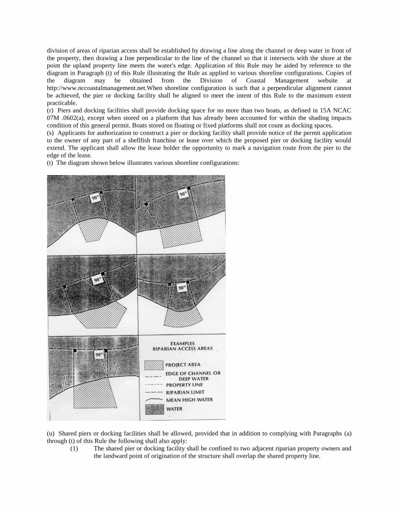
division of areas of riparian access shall be established by drawing a line along the channel or deep water in front of
the property, then drawing a line perpendicular to the line of the channel so that it intersects with the shore at the
point the upland property line meets the water's edge. Application of this Rule may be aided by reference to the
diagram in Paragraph (t) of this Rule illustrating the Rule as applied to various shoreline configurations. Copies of
the diagram may be obtained from the Division of Coastal Management website at
http://www.nccoastalmanagement.net.When shoreline configuration is such that a perpendicular alignment cannot
be achieved, the pier or docking facility shall be aligned to meet the intent of this Rule to the maximum extent
practicable.
(r) Piers and docking facilities shall provide docking space for no more than two boats, as defined in 15A NCAC
07M .0602(a), except when stored on a platform that has already been accounted for within the shading impacts
condition of this general permit. Boats stored on floating or fixed platforms shall not count as docking spaces.
(s) Applicants for authorization to construct a pier or docking facility shall provide notice of the permit application
to the owner of any part of a shellfish franchise or lease over which the proposed pier or docking facility would
extend. The applicant shall allow the lease holder the opportunity to mark a navigation route from the pier to the
edge of the lease.
(t) The diagram shown below illustrates various shoreline configurations:
(u) Shared piers or docking facilities shall be allowed, provided that in addition to complying with Paragraphs (a)
through (t) of this Rule the following shall also apply:
(1) The shared pier or docking facility shall be confined to two adjacent riparian property owners and
the landward point of origination of the structure shall overlap the shared property line.
(2) Shared piers and docking facilities shall be designed to provide docking space for no more than
four boats.
(3) The total square footage of shaded impact for docks and mooring facilities shall be calculated
using Paragraph (e) of this Rule and in addition shall allow for combined shoreline of both
properties.
(4) The property owners of the shared pier shall not be required to obtain a 15-foot waiver from each
other as described in Paragraph (q) of this Rule as is applies to the shared riparian line for any
work associated with the shared pier, provided that the title owners of both properties have
executed a shared pier agreement that has become a part of the permit file.
(5) The construction of a second access pier or docking facility not associated with the shared pier
shall not be authorized under the general permit set forth in this Section.
History Note: Authority G.S. 113A-107(a); 113A-107(b); 113A-113(b); 113A-118.1; 113A-124;
Eff. March 1, 1984;
Amended Eff. December 1, 1991; May 1, 1990; March 1, 1990;
RRC Objection due to ambiguity Eff. March 18, 1993;
Amended Eff. August 1, 1998; April 23, 1993;
Temporary Amendment Eff. December 20, 2001;
Amended Eff. August 1, 2014; July 1, 2009; April 1, 2003;
Readopted Eff. December 1, 2021.
SECTION .1300 – GENERAL PERMIT TO CONSTRUCT BOAT RAMPS ALONG ESTUARINE AND
PUBLIC TRUST SHORELINES AND INTO ESTUARINE AND PUBLIC TRUST WATERS
15A NCAC 07H .1301 PURPOSE
A permit under this Section shall allow for the construction of boat ramps along estuarine and public trust shorelines
and into estuarine and public trust waters AECs according to the authority provided in Subchapter 07J .1100 and
according to the Rules in this Section. This permit shall not apply to oceanfront shorelines or to waters and
shorelines adjacent to the Ocean Hazard AEC with the exception of those shorelines that feature characteristics of
the Estuarine Shoreline AEC. Such features include the presence of wetland vegetation, lower wave energy, and
lower erosion rates than the adjacent Ocean Erodible Area.
History Note: Authority G.S. 113A-107(a); 113A-107(b); 113A-113(b); 113A-118.1; 113A-124;
Eff. March 1, 1984;
Amended Eff. April 1, 2003; August 1, 2000.
15A NCAC 07H .1302 APPROVAL PROCEDURES
(a) An applicant for a General Permit under this Subchapter shall contact the Division of Coastal Management and
request approval for development. The applicant shall provide information on site location, dimensions of the
project area, and his name and address.
(b) The applicant shall provide:
(1) confirmation that a written statement has been obtained signed by the adjacent riparian property
owners indicating that they have no objections to the proposed work; or
(2) confirmation that the adjacent riparian property owners have been notified by certified mail of the
proposed work. The notice shall instruct adjacent property owners to provide written comments
on the proposed development to the Division of Coastal Management within ten days of receipt of
the notice, and, indicate that no response shall be interpreted as no objection. DCM staff shall
review all comments and determine, based on their relevance to the potential impacts of the
proposed project, if the proposed project can be approved by a General Permit. If DCM staff
determines that the project exceeds the guidelines established by the General Permit Process,
DCM shall notify the applicant that he must submit an application for a major development
permit.
(c) No work shall begin until an on-site meeting is held with the applicant and appropriate Division of Coastal
Management representative so that the proposed boat ramp alignment may be appropriately marked. Written
authorization to proceed with the proposed development may be issued during this visit. Construction of the boat
ramp structure shall be completed within 120 days of this visit or the general authorization shall expire.
History Note: Authority G.S. 113A-107(a); 113A-107(b); 113A-113(b); 113A-118.1; 113A-124;
Eff. March 1, 1984;
Amended Eff. August 1, 2007; September 1, 2006; January 1, 1990.
15A NCAC 07H .1303 PERMIT FEE
The applicant shall pay a permit fee of two hundred dollars ($200.00) by check or money order payable to the
Department.
History Note: Authority G.S. 113A-107; 113A-113(b); 113A-118.1; 113A-119; 113A-119.1; 113A-124;
Eff. March 1, 1984;
Amended Eff. September 1, 2006; August 1, 2000; March 1, 1991.
15A NCAC 07H .1304 GENERAL CONDITIONS
(a) Structures authorized by this permit shall be non-commercial boat ramps constructed of acceptable material and
conforming to the standards herein.
(b) Individuals shall allow authorized representatives of the Department of Environment and Natural Resources to
make periodic inspections at any time deemed necessary in order to be sure that the activity being performed under
authority of this general permit is in accordance with the terms and conditions prescribed herein.
(c) There shall be no unreasonable interference with navigation or public use of the waters during or after
construction.
(d) This permit will not be applicable to proposed construction where the Department has determined, based on an
initial review of the application, that notice and review pursuant to G.S. 113A-119 is necessary because there are
unresolved questions concerning the proposed activity's impact on adjoining properties or on water quality; air
quality; coastal wetlands; cultural or historic sites; wildlife; fisheries resources; or public trust rights.
(e) This permit does not eliminate the need to obtain any other required state, local, or federal authorization.
(f) Development carried out under this permit must be consistent with all local requirements, AEC rules, and local
land use plans current at the time of authorization.
History Note: Authority G.S. 113A-107(a); 113A-107(b); 113A-113(b); 113A-118.1; 113A-124;
Eff. March 1, 1984;
Amended Eff. May 1, 1990;
RRC Objection due to ambiguity Eff. May 19, 1994;
Amended Eff. August 1, 1998; July 1, 1994.
15A NCAC 07H .1305 SPECIFIC CONDITIONS
(a) Boat ramps shall be no wider than 15 feet and shall not extend more than 20 feet waterward of the normal high
water level or normal water level.
(b) Excavation and ground disturbing activities above and below the normal high water level or normal water level
will be limited to that absolutely necessary to establish adequate ramp slope and provide a ramp no greater in size
than specified by this general permit.
(c) Placement of fill materials below normal high water level, or normal water level, will be limited to the ramp
structure and any associated riprap groins. Boat ramps may be constructed of concrete, wood, steel, clean riprap,
marl, or any other suitable equivalent materials approved by the Division of Coastal Management. No coastal
wetland vegetation shall be excavated or filled at any time during construction.
(d) The permit set forth in this Section allows for up to a six-foot wide launch access dock (fixed or floating)
immediately adjacent to a new or existing boat ramp. The length shall be limited to the length of the permitted boat
ramp (with a maximum length of 20 feet waterward of the normal high water level or normal water level). No
permanent slips are authorized by this permit.
(e) Groins shall be allowed as a structural component on one or both sides of a new or existing boat ramp to reduce
scouring. The groins shall be limited to the length of the permitted boat ramp (with a maximum length of 20 feet
waterward of the normal high water level or normal water level).
(f) The height of sheetpile groins shall not exceed one foot above normal high water level or normal water level and
the height of riprap groins shall not exceed two feet above normal high water level or normal water level.
(g) Riprap groins shall not exceed a base width of five feet.
(h) Material used for groin construction shall be free from loose dirt or any other pollutant. Riprap material must be
of sufficient size to prevent its movement from the approved alignment by wave action or currents.
(i) "L" and "T" sections shall not be allowed at the end of groins.
(j) Groins shall be constructed of granite, marl, concrete without exposed rebar, timber, vinyl sheet pile, steel sheet
pile, or other suitable equivalent materials approved by the Division of Coastal Management.
(k) Boat ramps and their associated structures authorized under this permit shall not interfere with the access to any
riparian property and shall have a minimum setback of 15 feet between any part of the boat ramp or associated
structures and the adjacent property owners' areas of riparian access. The minimum setbacks provided in the rule
may be waived by the written agreement of the adjacent riparian owner(s), or when two adjoining riparian owners
are co-applicants. Should the adjacent property be sold before construction of the boat ramp or associated structures
commences, the applicant shall obtain a written agreement with the new owner waiving the minimum setback and
submit it to the Division of Coastal Management prior to initiating any development of the boat ramp or associated
structures authorized under this permit.
History Note: Authority G.S. 113A-107(a); 113A-107(b); 113A-113(b); 113A-118.1; 113A-124;
Eff. March 1, 1984;
Amended Eff. August 1, 2014.
SECTION .1400 - GENERAL PERMIT FOR CONSTRUCTION OF GROINS IN ESTUARINE AND
PUBLIC TRUST WATERS AND OCEAN HAZARD AREAS
15A NCAC 07H .1401 PURPOSE
A permit under this section shall allow the construction of groins in the estuarine and public trust waters AECs
according to the authority provided in Subchapter 07J .1100 and according to the rules in this Section. This general
permit shall not apply to the oceanfront shorelines or to waters and shorelines adjacent to the Ocean Hazard AEC
with the exception of those shorelines that feature characteristics of the Estuarine Shoreline AEC. Such features
include the presence of wetland vegetation, lower wave energy, and lower erosion rates than the adjacent Ocean
Erodible Area.
History Note: Authority G.S. 113A-107(a); 113A-107(b); 113A-113(b); 113A-118.1; 113A-124(c);
Eff. March 1, 1984;
Temporary Amendment Eff. December 1, 2002;
Amended Eff. February 1, 2009; August 1, 2004; April 1, 2003.
15A NCAC 07H .1402 APPROVAL PROCEDURES
(a) An applicant for a General Permit under this Subchapter shall contact the Division of Coastal Management and
request approval for development. The applicant shall provide information on site location, dimensions of the
project area, and the applicant’s name and address.
(b) The applicant shall provide:
(1) confirmation that a written statement has been obtained signed by the adjacent riparian property
owners indicating that they have no objections to the proposed work; or
(2) confirmation that the adjacent riparian property owners have been notified by certified mail of the
proposed work. The notice shall instruct adjacent property owners to provide written comments
on the proposed development to the Division of Coastal Management within 10 days of receipt of
the notice. The notice shall also indicate that no response shall be interpreted as no objection. The
Division of Coastal Management shall review all comments and determine, based on their
relevance to the potential impacts of the proposed project, if the proposed project can be approved
by a General Permit. If the Division of Coastal Management determines that the project exceeds
the rules established by the General Permit process, the applicant shall be notified that an
application for a major development permit shall be required.
(c) No work shall begin until an on-site meeting is held with the applicant and a Division of Coastal Management
representative so that the proposed groin alignment can be marked. Written authorization to proceed with the
proposed development shall be issued during this visit. Construction shall be completed within 120 days of the
issuance of the permit or the authorization shall expire and it shall be necessary to re-examine the alignment to
determine if the general authorization may be reissued.
(d) Any modification or addition to the authorized project shall require prior approval from the Division of Coastal
Management.
History Note: Authority G.S. 113A-107(a); 113A-107(b); 113A-113(b); 113A-118.1; 113A-124;
Eff. March 1, 1984;
Amended Eff. February 1, 2009; October 1, 2007; August 1, 2004; May 1, 1990; January 1, 1990.
15A NCAC 07H .1403 PERMIT FEE
The applicant shall pay a permit fee of two hundred dollars ($200.00) by check or money order payable to the
Department.
History Note: Authority G.S. 113A-107; 113A-113(b); 113A-118.1; 113A-119; 113A-119.1; 113A-124;
Eff. March 1, 1984;
Amended Eff. September 1, 2006; August 1, 2000; March 1, 1991.
15A NCAC 07H .1404 GENERAL CONDITIONS
(a) Structures authorized by a general permit in this Section shall be timber, sheetpile, or riprap groins conforming
to the standards in this Rule.
(b) Individuals shall allow authorized representatives of the Department of Environment and Natural Resources to
make periodic inspections at any time deemed necessary in order to ensure that the activity being performed under
authority of this general permit is in accordance with the terms and conditions prescribed herein.
(c) The placement of groins authorized in this Rule shall not interfere with the established or traditional rights of
navigation of the waters by the public.
(d) This permit shall not be applicable to proposed construction where the Division of Coastal Management has
determined, based on an initial review of the application, that notice and review pursuant to G.S. 113A-119 is
necessary because there are unresolved questions concerning the proposed activity's impact on adjoining properties
or on water quality; air quality; coastal wetlands; cultural or historic sites; wildlife; fisheries resources; or public
trust rights.
(e) This permit shall not eliminate the need to obtain any other required state, local, or federal authorization.
(f) Development carried out under this permit shall be consistent with all local requirements, AEC rules, and local
land use plans current at the time of authorization.
History Note: Authority G.S. 113A-107(a); 113A-107(b); 113A-113(b); 113A-118.1; 113A-124;
Eff. March 1, 1984;
Amended Eff. May 1, 1990;
RRC Objection due to ambiguity Eff. May 16, 1994;
Amended Eff. August 1, 1998; July 1, 1994;
Temporary Amendment Eff. December 1, 2002;
Amended Eff. February 1, 2009; August 1, 2004.
15A NCAC 07H .1405 SPECIFIC CONDITIONS
(a) Groins shall be perpendicular to the shoreline and shall not extend more than 25 feet waterward of the normal
high water or normal water level.
(b) Riprap groins shall not exceed a base width of 10 feet.
(c) Groins shall be set back at least 15 feet from the riparian access dividing line as measured from the closest point
of the structure. This setback may be waived by written agreement of the adjacent riparian owner(s) or when two
adjoining riparian owners are co-applicants. Should the adjacent property be sold before construction of the groin
commences, the applicant shall obtain a written agreement with the new owner waiving the minimum setback and
submit it to the Division of Coastal Management prior to initiating any development of the groin.
(d) The height of sheetpile groins shall not exceed one foot above normal high water or the normal water level and
the height of riprap groins shall not exceed two feet above normal high water or the normal water level.
(e) Material used for groin construction shall be free from loose dirt or any other pollutant. Groin material must be
of sufficient size to prevent its movement from the site by wave action or currents.
(f) Structure spacing shall be two times the groin length as measured from the centerline of the structure. Spacing
may be less than two times the groin length around channels, docking facilities, boat lifts, or boat ramps and when
positioned to prevent sedimentation or accretion in a particular area.
(g) "L" and "T" sections shall not be allowed at the end of groins.
(h) Groins shall be constructed of granite, marl, concrete without exposed rebar, timber, vinyl sheet pile, steel sheet
pile or other suitable equivalent materials approved by the Division of Coastal Management.
History Note: Authority G.S. 113A-107(a); 113A-107(b); 113A-113(b); 113A-118.1; 113A-124;
Eff. March 1, 1984;
Temporary Amendment Eff. December 1, 2002;
Amended Eff. February 1, 2009; August 1, 2004.
SECTION .1500 - GENERAL PERMIT FOR EXCAVATION WITHIN OR CONNECTING TO EXISTING
CANALS, CHANNELS, BASINS, OR DITCHES IN ESTUARINE WATERS, PUBLIC TRUST WATERS,
AND COASTAL SHORELINE AECS
15A NCAC 07H .1501 PURPOSE
This permit for excavation within or connecting to existing canals, channels, basins, or ditches in estuarine waters,
public trust waters and coastal shoreline AECs shall allow excavation within existing canals, channels, basins, and
ditches in estuarine and public trust waters for the purpose of maintaining water depths and creating new boat basins
from non-wetland areas that will be used for private, non-commercial activities. This general permit is also subject
to the procedures outlined in Subchapter 07J .1100.
History Note: Authority G.S. 113A-107(a),(b); 113A-113(b); 113A-118.1; 113-229(cl);
Eff. July 1, 1984;
Amended Eff. July 1, 2015; December 1, 1987.
15A NCAC 07H .1502 APPROVAL PROCEDURES
(a) The applicant for a general permit for excavation within or connecting to existing canals, channels, basins, or
ditches in estuarine waters, public trust waters and coastal shoreline areas of environmental concern shall contact the
Division of Coastal Management and request approval for development. Applicants shall provide their name and
address, the site location, and the dimensions of the project area.
(b) The applicant must provide:
(1) A written statement signed by the adjacent riparian property owners indicating that they have no
objections to the proposed work; or
(2) Certified mail return receipts (or copies thereof) indicating that the adjacent riparian property
owners have been notified by certified mail of the proposed work. Such notice should instruct
adjacent property owners to provide any comments on the proposed development in writing for
consideration by permitting officials to the Division of Coastal Management within ten days of
receipt of the notice, and indicate that no response will be interpreted as no objection.
(c) DCM staff will review the permit request and comments and determine, based on the potential impacts of the
proposed project, whether the proposed project complies with the requirements of this Section and can be approved
by a General Permit. If DCM staff finds that the proposed project does not comply with the requirements of this
Section, the applicant will be notified that they must submit an application for a major development permit in
accordance with 15A NCAC 07J .0200.
(d) No work shall begin until an onsite meeting is held with the applicant and a Division of Coastal Management
representative to inspect and mark the proposed area of excavation and spoil disposal. Written authorization to
proceed with the proposed development may be issued during this site visit. All excavation shall be completed
within 120 days of the date of permit issuance.
History Note: Authority G.S. 113A-107(a),(b); 113A-113(b); 113A-118.1; 113-229(cl);
Eff. July 1, 1984;
Amended Eff. July 1, 2015; January 1, 1990; December 1, 1987.
15A NCAC 07H .1503 APPLICATION FEE
The applicant shall pay a permit fee of two hundred dollars ($200.00) for maintenance excavation of 100 cubic yards
or less or four hundred dollars ($400.00) for maintenance excavation of 100 to 1,000 cubic yards. Permit fees shall
be paid by check or money order payable to the Department.
History Note: Authority G.S. 113A-107; 113A-113(b); 113A-118.1; 113A-119; 113A-119.1; 113A-124;
Eff. July 1, 1984;
Amended Eff. September 1, 2006; August 1, 2000; March 1, 1991.
15A NCAC 07H .1504 GENERAL CONDITIONS
(a) Individuals shall allow representatives of the Division of Coastal Management to make periodic inspections at
any time necessary to ensure that the activity being performed under authority of this general permit for excavation
within or connecting to existing canals, channels, basins, or ditches in estuarine waters, public trust waters and
coastal shoreline areas of environmental concern, is in accordance with the terms and conditions set forth in this
Section.
(b) This general permit shall not be applicable to proposed maintenance excavation when the Division determines
that the proposed activity will adversely affect adjacent property.
(c) This permit shall not be applicable to proposed construction where the Division has determined, based on an
initial review of the application, that notice and review pursuant to G.S. 113A-119 is necessary because there are
unresolved questions concerning the proposed activity's impact on adjoining properties or on water quality; air
quality; coastal wetlands; cultural or historic sites; wildlife; fisheries resources; or public trust rights.
(d) No new basins shall be allowed that result in closure of shellfish waters according to the closure policy of the
Division of Marine Fisheries, 15A NCAC 18A .0911.
(e) This permit shall not eliminate the need to obtain any other required state, local, or federal authorization, nor to
abide by regulations adopted by any federal or other state agency.
(f) Development carried out under this permit shall be consistent with all local requirements, AEC rules, and local
Land Use Plans current at the time of authorization.
History Note: Authority G.S. 113A-107(a),(b); 113A-113(b); 113A-118.1; 113-229(cl);
Eff. July 1, 1984;
Amended Eff. May 1, 1990; December 1, 1987;
RRC Objection due to ambiguity Eff. May 19, 1994;
Amended Eff. July 1, 2015; August 1, 1998; July 1, 1994.
15A NCAC 07H .1505 SPECIFIC CONDITIONS
Proposed maintenance excavation shall meet each of the following specific conditions to be eligible for
authorization by this general permit.
(1) New basins shall be allowed only when they are located entirely in highground and join existing
man-made canals or basins.
(2) New basins shall be no larger than 50' in either length or width and no deeper than the waters they
join.
(3) New basins shall be for the private non-commercial use of the land owner.
(4) Maintenance excavation shall involve the removal of no more than 1,000 cubic yards of material
as part of a single and complete project.
(5) All excavated material shall be placed entirely on high ground above the mean high tide or
ordinary high water line, and above any marsh or other wetland.
(6) All spoil material shall be stabilized or retained so as to prevent any excavated material from
re-entering the surrounding waters, marsh or other wetlands.
(7) The proposed project shall not involve the excavation of any marsh, submerged aquatic vegetation
(as defined at 15A NCAC 03I .0101 by the Marine Fisheries Commission), or other wetlands.
(8) Maintenance excavation shall not exceed the original dimensions of the canal, channel, basin or
ditch and in no case be deeper than 6 feet below mean low water or ordinary low water, nor deeper
than connecting channels.
(9) Proposed excavation shall not promote or provide the opportunity for a change to a public or
commercial use at the time of project review.
(10) Maintenance excavation as well as excavation of new basins shall not be allowed within or with
connections to primary nursery areas without prior approval from the Division of Marine Fisheries
or Wildlife Resources Commission (whichever is applicable).
(11) Bulkheads shall be allowed as a structural component on one or more sides of the permitted basin
to stabilize the shoreline from erosion.
(12) The bulkhead shall not exceed a distance of two feet waterward of the normal high water or
normal water level at any point along its alignment.
(13) Bulkheads shall be constructed of vinyl or steel sheet pile, concrete, stone, timber, or other
suitable materials approved by the Division of Coastal Management. Approval of other suitable
materials shall be based upon the potential environmental impacts of the proposed material.
(14) All backfill material shall be obtained from an upland source pursuant to 15A NCAC 07H .0208.
The bulkhead shall be constructed prior to any backfilling activities and shall be structurally tight
so as to prevent seepage of backfill materials through the structure.
(15) Construction of bulkhead authorized by this general permit in conjunction with bulkhead
authorized under 15A NCAC 07H .1100 shall be limited to a combined maximum shoreline length
of 500 feet.
History Note: Authority G.S. 113A-107(a),(b); 113A-113(b); 113A-118.1; 113-229(cl);
Eff. July 1, 1984;
Amended Eff. July 1, 2015; September 1, 1988; December 1, 1987.
SECTION .1600 - GENERAL PERMIT FOR THE INSTALLATION OF AERIAL AND SUBAQUEOUS
UTILITY LINES WITH ATTENDANT STRUCTURES IN COASTAL WETLANDS: ESTUARINE
WATERS: PUBLIC TRUST WATERS AND ESTUARINE SHORELINES
15A NCAC 07H .1601 PURPOSE
A permit under this Section shall allow for the installation of utility lines both aerially and subaqueously in the
coastal wetland, estuarine water, public trust areas and estuarine and public trust shoreline AECs according to the
authority provided in Subchapter 7J .1100 and according rules in this Section. This general permit shall not apply to
the ocean hazard AECs.
History Note: Authority G.S. 113-229(c1); 113A-107(a)(b); 113A-113(b); 113A-118.1;
Eff. March 1, 1985;
Amended Eff. August 1, 2000; August 1, 1998.
15A NCAC 07H .1602 APPROVAL PROCEDURES
(a) The applicant must contact the Division of Coastal Management and complete an application form requesting
approval for development. The applicant shall provide information on site location, dimensions of the project area,
and his name and address.
(b) The applicant must provide:
(1) confirmation that a written statement has been obtained signed by the adjacent riparian property
owners indicating that they have no objections to the proposed work; or
(2) confirmation that the adjacent riparian property owners have been notified by certified mail of the
proposed work. Such notice should instruct adjacent property owners to provide any comments on
the proposed development in writing for consideration by permitting officials to the Division of
Coastal Management within ten days of receipt of the notice, and, indicate that no response will be
interpreted as no objection. DCM staff will review all comments and determine, based on their
relevance to the potential impacts of the proposed project, if the proposed project can be approved
by a General Permit. If DCM staff finds that the comments are worthy of more in-depth review,
the applicant will be notified that he must submit an application for a major development permit.
(c) No work shall begin until an on-site meeting is held with the applicant and appropriate Division of Coastal
Management representative so that the utility line alignment can be appropriately marked. Written authorization to
proceed with the proposed development will be issued during this visit. Construction on the utility line must begin
within twelve months of this visit or the general authorization expires.
History Note: Authority G.S. 113A-107(a)(b); 113A-113(b); 113A-118.1; 113A-229(cl);
Eff. March 1, 1985;
Amended Eff. January 1, 1990.
15A NCAC 07H .1603 PERMIT FEE
The applicant shall pay a permit fee of four hundred dollars ($400.00) by check or money order payable to the
Department.
History Note: Authority G.S. 113-229(c1); 113A-107; 113A-113(b); 113A-118.1; 113A-119; 113A-119.1;
Eff. March 1, 1985;
Amended Eff. September 1, 2006; August 1, 2000; March 1, 1991.
15A NCAC 07H .1604 GENERAL CONDITIONS
(a) Utility lines for the purpose of this general permit or any pipes or pipelines for the transportation of potable
water, domestic sanitary sewage, natural gas, and any cable, line, or wire for the transmission, for any purpose, of
electrical energy, telephone and telegraph messages, and radio and television communication.
(b) There must be no resultant change in preconstruction bottom contours. Authorized fill includes only that
necessary to backfill or bed the utility line. Any excess material must be removed to an upland disposal area.
(c) The utility line crossing will not adversely affect a public water supply intake.
(d) The utility line route or construction method will not disrupt the movement of those species of aquatic life
indigenous to the waterbody.
(e) Individuals shall allow authorized representatives of the Department of Environment, Health, and Natural
Resources to make periodic inspections at any time necessary to ensure that the activity being performed under
authority of this general permit is in accordance with the terms and conditions prescribed herein.
(f) This general permit will not be applicable to proposed construction where the Department has determined, based
on an initial review of the application, that notice and review pursuant to G.S. 113A-119 is necessary because there
are unresolved questions concerning the proposed activity=s impact on adjoining properties or on water quality; air
quality; coastal wetlands; cultural or historic sites; wildlife; fisheries resources; or public trust rights.
(g) This permit does not eliminate the need to obtain any other required state, local, or federal authorization, nor, to
abide by regulations adopted by any federal or other state agency.
(h) Development carried out under this permit must be consistent with all local requirements, AEC guidelines, and
local Land Use Plans current at the time of authorization.
History Note: Authority G.S. 113-229(c1); 113A-107(a)(b); 113A-113(b); 113A-118.1;
Eff. March 1, 1985;
Amended Eff. May 1, 1990;
RRC Objection due to ambiguity Eff. May 19, 1994;
Amended Eff. August 1, 1998; July 1, 1994.
15A NCAC 07H .1605 SPECIFIC CONDITIONS
Proposed utility line installations must meet each of the following specific conditions to be eligible for authorization
by this general permit:
(1) All domestic sanitary sewer line requests must be accompanied by a statement of prior approval
from the NC Division Water Quality.
(2) All spoils which are permanently removed must be placed on a high ground disposal site and
stabilized so as not to return to waters, marsh or other wetlands.
(3) Any additional backfill material required must be clean sand or rock free of organic matter.
(4) Cuts through wetlands must be minimized.
(5) Finished grades or subaqueous or wetland crossing must be returned to preproject contours.
(6) There can be no work within any productive shellfish beds.
(7) No excavation or filling activities will be permitted between April 1 and September 30 of any year
within any designated primary nursery area.
(8) Subaqueous lines must be placed at a depth of six feet below the project depth of federal projects.
In other areas they will be installed at a minimum depth of two feet below the bottom contour.
(9) The minimum clearance for aerial communication lines or any lines not transmitting electricity
will be 10' above the clearance required for bridges in the vicinity.
(10) The minimum clearance for aerial electrical transmission lines shall be consistent with those
established by the US Army Corps of Engineers and US Coast Guard.
(11) The installation of a utility line on pipe bents or otherwise above the elevation of mean high or
mean ordinary water must be of sufficient height to allow for traditional navigation in the water
body. Additionally the utility line must not interfere with the waterflow of normal or flood waters.

(12) Natural gas lines must not exceed 11 inches in diameter.
History Note: Authority G.S. 113-229(c1); 113A-107(a)(b); 113A-113(b); 113A-118.1;
Eff. March 1, 1985;
Amended Eff. August 1, 1998.
SECTION .1700 - GENERAL PERMIT FOR EMERGENCY WORK REQUIRING A CAMA AND/OR A
DREDGE AND FILL PERMIT
15A NCAC 07H .1701 PURPOSE
This permit allows work necessary to protect property or prevent further damage to property caused by a sudden or
unexpected natural event or structural failure which imminently endangers life or structure. For the purposes of this
general permit, major storms such as hurricanes, northeasters, or southwesters may be considered a sudden
unexpected natural event although such storms may be predicted and publicized in advance.
History Note: Authority G.S. 113-229(cl); G.S. 113A-107(a),(b); 113A-113(b); 113A-118.1;
Eff. November 1, 1985;
Readopted Eff. July 1, 2022.
15A NCAC 07H .1702 APPROVAL PROCEDURES
(a) Any person wishing to undertake development in an area of environmental concern necessary to protect life or
endangered structures will notify the Division of Coastal Management or Local Permit Office (LPO) when a
possible emergency situation exists.
(b) The applicant may qualify for approval of work described in this permit after an onsite inspection by the LPO or
Division of Coastal Management Field Consultant and upon his or her findings that the proposed emergency work
requires a CAMA or Dredge and Fill permit. The LPO shall issue the permit if the required emergency measures
constitute minor development in accordance with G.S. 113A-118(2).
(c) Once the LPO or Consultant determines that the applicant's proposed project may qualify for an emergency
permit, he or she shall consult with the applicant and assist him or her in preparing an application. The applicant
shall include a sketch showing existing conditions and the proposed work.
(d) The applicant for an emergency permit shall take all reasonable steps to notify adjacent riparian landowners of
the application, and prior to receiving a permit will certify by signing the permit the following:
(1) that a copy of the application and sketch has been served on all adjacent riparian landowners, or if
service of a copy was not feasible, that the applicant has explained the project to all adjacent
riparian landowners;
(2) that the applicant has explained to all adjacent riparian landowners that they have a right to oppose
the issuance of a permit by filing objections with the local CAMA permit officer or with the
Secretary of the Department of Environmental Quality; and
(3) that, as to adjacent riparian landowners not contacted, the applicant has made a reasonable attempt
to contact them and furnish them with the required information.
(e) All work authorized by this general permit will cease after thirty days from the date of issuance.
History Note: Authority G.S. 113-229(cl); 113A-107(a),(b); 113A-113(b); 113A-118.1;
Eff. November 1, 1985;
Amended Eff. May 1, 1990;
Readopted Eff. July 1, 2022.
15A NCAC 07H .1703 PERMIT FEE
The agency shall not charge a fee for permitting work necessary to respond to emergency situations except in the
case when a temporary erosion control structure is used. In those cases, the applicant shall pay a permit fee of four
hundred dollars ($400.00) by check or money order made payable to the Department.
History Note: Authority G.S. 113-229(cl); 113A-107(a),(b); 113A-113(b); 113A-118.1; 113A-119;
Eff. November 1, 1985;
Amended Eff. September 1, 2006; August 1, 2002; March 1, 1991; October 1, 1993;
Readopted Eff. July 1, 2022.
15A NCAC 07H .1704 GENERAL CONDITIONS
(a) Work permitted by means of an emergency general permit shall be subject to the following limitations:
(1) No work shall begin until an onsite meeting is held with the applicant and a Division of Coastal
Management representative so that the scope of the proposed emergency work can be delineated.
(2) No work shall be permitted other than that which is necessary to protect against or reduce the
imminent danger caused by the emergency, to restore the damaged property to its condition
immediately before the emergency, or to re-establish public facilities or transportation corridors.
(3) Any permitted temporary erosion control projects shall be located no more than 20 feet waterward
of the imminently threatened structure or the right-of way in the case of roads, except as provided
under 15A NCAC 07H .0308. If a building or road is found to be imminently threatened and at
increased risk of imminent damage due to site conditions, such as a flat beach profile or
accelerated erosion, temporary erosion control structures may be located more than 20 feet
waterward of the structure being protected. In cases of increased risk of imminent damage, the
location of the temporary erosion control structures shall be determined by the Director of the
Division of Coastal Management or the Director's designee.
(4) Fill materials used in conjunction with emergency work for storm or erosion control shall be
obtained from an upland source. Excavation below MHW in the Ocean Hazard AEC may be
allowed to obtain material to fill sandbags used for emergency protection.
(5) This emergency general permit allows the use of oceanfront erosion control measures for all
oceanfront properties without regard to the size of the existing structure on the property or the date
of construction.
(b) Individuals shall allow authorized representatives of the Department of Environmental Quality to make
inspections to ensure that the activity being performed under authority of this emergency general permit is in
accordance with these Rules.
(c) Development shall not jeopardize the use of the waters for navigation or for other public trust rights in public
trust areas including estuarine waters.
(d) This permit shall not be applicable to proposed construction where the Department has determined, based on an
initial review of the application, that notice and review pursuant to G.S. 113A-119 is necessary because there are
unresolved questions concerning the proposed activity's impact on adjoining properties or on water quality, air
quality, coastal wetlands, cultural or historic sites, wildlife, fisheries resources, or public trust rights.
(e) This permit does not eliminate the need to obtain any other state, local, or federal authorization.
(f) Development carried out under this permit must be consistent with all local requirements, CAMA rules, and
local land use plans, storm hazard mitigation, and post-disaster recovery plans current at the time of authorization.
History Note: Authority G.S. 113-229(cl); 113A-107(a),(b); 113A-113(b); 113A-118; 113A-118.1;
Eff. November 1, 1985;
Amended Eff. December 1, 1991; May 1, 1990;
RRC Objection due to ambiguity Eff. May 19, 1994;
Amended Eff. April 1, 2019; May 1, 2010; August 1, 1998; July 1, 1994;
Readopted Eff. July 1, 2022.
15A NCAC 07H .1705 SPECIFIC CONDITIONS
(a) Temporary Erosion Control Structures in the Ocean Hazard AEC.
(1) Permittable temporary erosion control structures shall be limited to sandbags placed landward of
mean high water and parallel to the shore.
(2) Temporary erosion control structures as defined in Subparagraph (1) of this Paragraph may be
used to protect only imminently threatened roads and associated right of ways, and buildings and
their associated septic systems. A structure is considered imminently threatened if its foundation,
septic system, or right-of-way in the case of roads is less than 20 feet away from the erosion scarp.
Buildings and roads located more than 20 feet from the erosion scarp or in areas where there is no
obvious erosion scarp may also be found to be imminently threatened when the Division
determines that site conditions, such as a flat beach profile or accelerated erosion, increase the risk
of imminent damage to the structure.
(3) Temporary erosion control structures shall be used to protect only the principal structure and its
associated septic system, but not appurtenances such as pools, gazebos, decks or any amenity that
is allowed under 15A NCAC 07H .0309 as an exception to the erosion setback requirement.
(4) Temporary erosion control structures may be placed waterward of a septic system when there is no
alternative to relocate it on the same or adjoining lot so that it is landward of or in line with the
structure being protected.
(5) Temporary erosion control structures shall not extend more than 20 feet past the sides of the
structure to be protected except to align with temporary erosion control structures on adjacent
properties, where the Division has determined that gaps between adjacent erosion control
structures may result in an increased risk of damage to the structure being protected. The landward
side of such temporary erosion control structures shall not be located more than 20 feet waterward
of the structure to be protected or the right-of-way in the case of roads. If a building or road is
found to be imminently threatened and at increased risk of imminent damage due to site conditions
such as a flat beach profile or accelerated erosion, temporary erosion control structures may be
located more than 20 feet waterward of the structure being protected. In cases of increased risk of
imminent damage, the location of the temporary erosion control structures shall be determined by
the Director of the Division of Coastal Management or the Director's designee.
(6) Temporary erosion control structures may remain in place for up to eight years for a building and
its associated septic system, or a bridge or a road. The property owner shall be responsible for
removal of any portion of the temporary erosion control structure exposed above grade within 30
days of the end of the allowable time period.
(7) For purposes of this Rule, a community is considered to be actively pursuing a beach nourishment
or an inlet relocation or stabilization project if it:
(A) has an active CAMA permit, where necessary, approving such project;
(B) has been identified by a U.S. Army Corps of Engineers' Beach Nourishment
Reconnaissance Study, General Reevaluation Report, Coastal Storm Damage Reduction
Study, or an ongoing feasibility study by the U.S. Army Corps of Engineers and a
commitment of local or federal money, when necessary; or
(C) has received a favorable economic evaluation report on a federal project; or
(D) is in the planning stages of a project designed by the U.S. Army Corps of Engineers or
persons meeting applicable State occupational licensing requirements and initiated by a
local government or community with a commitment of local or state funds to construct
the project or the identification of the financial resources or funding bases necessary to
fund the beach nourishment or inlet relocation or stabilization project.
If beach nourishment, inlet relocation or stabilization is rejected by the sponsoring agency or
community, or ceases to be actively planned for a section of shoreline, the time extension is void
for that section of beach or community and existing sandbags shall be subject to all applicable
time limits set forth in Subparagraph (6) of this Paragraph.
(8) Once a temporary erosion control structure is determined by the Division of Coastal Management
to be unnecessary due to relocation or removal of the threatened structure, it shall be removed by
the property owner to the maximum extent practicable within 30 days of official notification from
the Division of Coastal Management, regardless of the time limit placed on the temporary erosion
control structure. If the temporary erosion control structure is determined by the Division of
Coastal Management to be unnecessary due to the completion of a storm protection project
constructed by the U.S. Army Corps of Engineers, a large scale beach nourishment project, or an
inlet relocation or stabilization project, any portion of the temporary erosion control structure
exposed above grade shall be removed by the permittee within 30 days of official notification by
the Division of Coastal Management regardless of the time limit placed on the temporary erosion
control structure.
(9) Removal of temporary erosion control structures is not required if they are covered by sand. Any
portion of a temporary erosion control structure that becomes exposed above grade after the
expiration of the permitted time period shall be removed by the property owner within 30 days of
official notification from the Division of Coastal Management.
(10) The property owner shall be responsible for the removal of remnants of all portions of any
damaged temporary erosion control structure.
(11) Sandbags used to construct temporary erosion control structures shall be tan in color and 3 to 5
feet wide and 7 to 15 feet long when measured flat. Base width of the structure shall not exceed 20
feet, and the total height shall not exceed 6 feet, as measured from the bottom of the lowest bag.
(12) Soldier pilings and other types of devices to anchor sandbags shall not be allowed.
(13) Excavation below mean high water in the Ocean Hazard AEC may be allowed to obtain material
to fill sandbags used for emergency protection.
(14) An imminently threatened structure may be protected by a temporary erosion control structure
only once regardless of ownership, unless the threatened structure is located in a community that
is actively pursuing a beach nourishment project, an inlet relocation or stabilization project in
accordance with Subparagraph (7) of this Paragraph. Existing temporary erosion control structures
may be permitted for additional eight-year periods provided that the structure being protected is
still imminently threatened, the temporary erosion control structure is in compliance with
requirements of this Subparagraph, and the community in which it is located is actively pursuing a
beach nourishment or an inlet relocation or stabilization project in accordance with Subparagraph
(7) of this Paragraph. In the case of a building, a temporary erosion control structure may be
extended, or new segments constructed, if additional areas of the building become imminently
threatened. Where temporary structures are installed or extended incrementally, the time period for
removal under Subparagraph (6) or (7) of this Paragraph shall begin at the time the initial erosion
control structure is installed. For the purpose of this Rule:
(A) a building and its associated septic system shall be considered as separate structures; and
(B) a road or highway shall be allowed to be incrementally protected as sections become
imminently threatened. The time period for removal of each contiguous section of
sandbags shall begin at the time that section is installed in accordance with Subparagraph
(6) or (7) of this Paragraph.
(15) Existing temporary erosion control structures may be repaired or replaced within their originally
permitted dimensions during the time period allowed under Subparagraph (6) or (7) of this
Paragraph.
(b) Erosion Control Structures in the Estuarine Shoreline, Estuarine Waters, and Public Trust AECs. Work
permitted by this Rule shall be subject to the following limitations:
(1) The erosion control structure shall be located no more than 20 feet waterward of the imminently
threatened structure. If a building or road is found to be imminently threatened and at increased
risk of imminent damage due to site conditions such as a flat shore profile or accelerated erosion,
temporary erosion control structures may be located more than 20 feet waterward of the structure
being protected. In cases of increased risk of imminent damage, the location of the temporary
erosion control structures shall be determined by the Director of the Division of Coastal
Management or the Director's designee.
(2) Fill material used in conjunction with emergency work for storm or erosion control in the
Estuarine Shoreline, Estuarine Waters, and Public Trust AECs shall be obtained from an upland
source.
(c) Protection, Rehabilitation, or Temporary Relocation of Public Facilities or Transportation Corridors. This permit
authorizes only the immediate protection or temporary rehabilitation or relocation of existing public facilities. Long-
term stabilization or relocation of public facilities shall be consistent with local governments' post-disaster recovery
plans and policies which are part of their Land Use Plans.
(1) Work permitted by this general permit shall be subject to the following limitations:
(A) no work shall be permitted other than that which is necessary to protect against or reduce
the imminent danger caused by the emergency or to restore the damaged property to its
condition immediately before the emergency;
(B) the erosion control structure shall be located no more than 20 feet waterward of the
imminently threatened structure or the right-of-way in the case of roads. If a public
facility or transportation corridor is found to be imminently threatened and at increased
risk of imminent damage due to site conditions such as a flat shore profile or accelerated
erosion, temporary erosion control structures may be located more than 20 feet
waterward of the facility or corridor being protected. In cases of increased risk of
imminent damage, the location of the temporary erosion control structures shall be
determined by the Director of the Division of Coastal Management or the Director's
designee in accordance with Subparagraph (a)(1) of this Rule;
(C) any fill materials used in conjunction with emergency work for storm or erosion control
shall be obtained from an upland source except that dredging for fill material to protect
public facilities or transportation corridors shall be considered in accordance with
standards in 15A NCAC 07H .0208; and
(D) all fill materials or structures associated with temporary relocations which are located
within Coastal Wetlands, Estuarine Water, or Public Trust AECs shall be removed after
the emergency event has ended and the area restored to pre-disturbed conditions.
History Note: Authority G.S. 113-229(cl); 113A-107(a),(b); 113A-113(b); 113A-115.1; 113A-118.1;
Eff. November 1, 1985;
Amended Eff. April 1, 1999; February 1, 1996; June 1, 1995;
Temporary Amendment Eff. July 3, 2000; May 22, 2000;
Amended Eff. April 1, 2019; May 1, 2013; May 1, 2010; August 1, 2002;
Readopted Eff. July 1, 2022.
SECTION .1800 - GENERAL PERMIT TO ALLOW BEACH BULLDOZING IN THE OCEAN HAZARD
AEC
15A NCAC 07H .1801 PURPOSE
The general permit to allow beach bulldozing in the Ocean Hazard AEC will allow beach bulldozing needed to
reconstruct or repair dune systems, including Primary Dunes and Frontal Dunes as defined in Rule .0305 of this
Subchapter. For the purpose of this General Permit, "beach bulldozing" is defined as the process of moving natural
beach material from any point seaward of the first line of stable vegetation to repair damage to frontal or primary
dunes. This general permit is subject to the procedures outlined in Subchapter 07J, Section .1100 and shall apply
only to the Ocean Erodible AEC. This general permit shall not apply to the Inlet Hazard AEC.
History Note: Authority G.S. 113-229(c1); 113A-107; 113A-113(b); 113A-118.1;
Eff. December 1, 1987;
Amended Eff. September 1, 2016;
Readopted Eff. April 1, 2022.
15A NCAC 07H .1802 APPROVAL PROCEDURES
(a) An applicant for a General Permit under this Subchapter shall contact the Division of Coastal Management and
request approval for development.
(b) The applicant shall provide:
(1) the site location, dimensions of the project area, and their name and address;
(2) Confirmation that a written statement has been obtained signed by the adjacent riparian property
owners indicating that they have no objections to the proposed work; or
(3) confirmation that the adjacent riparian property owners have been notified by certified mail of the
proposed work. The notice shall instruct adjacent property owners to provide any comments on the
proposed development in writing for consideration by permitting official to the Division of
Coastal Management within 10 days of receipt of the notice and indicate that no response wil be
interpreted as no objection. Division staff shall review all comments and determine, based on their
relevance to the potential impacts of the proposed project, if the proposed project can be approved
by a General Permit. If Division staff determines that the project exceeds the guidelines
established by the General Permit process provided in 15A NCAC 07J .1100, Division staff shall
notify the applicant that they must submit an application for a major development permit.
(c) No work shall begin until an on-site meeting is held with the applicant and DCM representative. All bulldozing
shall be completed within 30 days of the date of permit issuance.
History Note: Authority G.S. 113-229(c1); 113-229(c2); 113A-107; 113A-113(b); 113A-118.1;113A-120;
Eff. December 1, 1987;
Amended Eff. September 1, 2016; January 1, 1990;
Readopted Eff. April 1, 2022.
15A NCAC 07H .1803 PERMIT FEE
The applicant shall pay a permit fee of four hundred dollars ($400.00) by check or money order payable to the
Department.
History Note: Authority G.S. 113-229(c1); 113A-107; 113A-113(b); 113A-118.1; 113A-119; 113A-119.1;
Eff. December 1, 1987;
Amended Eff. September 1, 2006; August 1, 2000; March 1, 1991;
Readopted Eff. April 1, 2022.
15A NCAC 07H .1804 GENERAL CONDITIONS
(a) This General Permit shall not be applicable to proposed construction where the Division of Coastal Management
has determined, based on an initial review of the application, that notice and review pursuant to G.S. 113A-119 is
necessary because there are unresolved questions concerning the proposed activity's impact on adjoining properties
or on water quality, air quality, coastal wetlands, cultural or historic sites, wildlife, fisheries resources, or public trust
rights. If a shipwreck is unearthed, all work shall stop immediately and the Division of Coastal Management shall be
contacted.
(b) This General Permit shall not eliminate the need to obtain any other required State, local, or federal
authorization.
(c) Development carried out under a permit as set forth in this Section shall be consistent with all State, federal and
local requirements, and local Land Use Plans in effect at the time of authorization.
History Note: Authority G.S. 113-229(c1); 113A-102(b)(4)(e); 113A-107;113A-113(b); 113A-118.1;
Eff. December 1, 1987;
Amended Eff. May 1, 1990;
RRC Objection due to ambiguity Eff. May 19, 1994;
Amended Eff. September 1, 2016; August 1,1998; July 1, 1994;
Readopted Eff. April 1, 2022.
15A NCAC 07H .1805 SPECIFIC CONDITIONS
(a) The area where beach bulldozing is being performed shall maintain a slope that follows the pre-project slopes as
closely as possible so as not to endanger the public or the public's use of the beach. The movement of material by a
bulldozer, front-end loader, backhoe, scraper, or any type of earth moving or construction equipment shall not
exceed one foot in depth measured from the pre-activity surface elevation.
(b) The activity shall not exceed the lateral bounds of the applicant's property without the written permission of the
adjoining landowner(s).
(c) The permit shall not authorize movement of material from seaward of the mean low water line.
(d) Adding sand to dunes shall be accomplished in such a manner that, based on site specific conditions, the tools
used, what vegetation is existing, and how much vegetation is buried, the damage to existing vegetation by burial is
minimized. Upon completion of the project, the fill areas shall be replanted with native vegetation, such as Sea Oats
(Uniola paniculata), or if outside the planting season, shall be stabilized with sand fencing until planting can occur.
(e) In order to minimize adverse impacts to nesting sea turtles, no bulldozing shall occur within the period of April
1 through November 15 of any year without the approval of the Division of Coastal Management, in coordination
with the North Carolina Wildlife Resources Commission, the United States Fish and Wildlife Service, and the
United States Army Corps of Engineers, that the work can be accomplished without significant adverse impact to
sea turtle nests or suitable nesting habitat.
(f) If one contiguous acre or more of oceanfront property is to be excavated or filled, an erosion and sedimentation
control plan shall be filed with and approved by the Division of Energy, Mineral, and Land Resources, or local
government having jurisdiction. This plan must be approved prior to commencing the land disturbing activity.
History Note: Authority G.S. 113-229(c1); 113A-107; 113A-113(b); 113A-118.1;
Eff. December 1, 1987;
Temporary Amendment Eff. September 2, 1998;
Amended Eff. September 1, 2016; August 1, 2012 (see S.L. 2012-143, s.1.(f)); August 1, 2000;
Readopted Eff. April 1, 2022.
SECTION .1900 – GENERAL PERMIT TO ALLOW FOR TEMPORARY STRUCTURES WITHIN THE
ESTUARINE AND OCEAN SYSTEMS AECS
15A NCAC 07H .1901 PURPOSE
A permit under this Section shall allow for the placement of temporary structures within the estuarine and ocean
systems AECs according to the provisions provided in 15A NCAC 07J .1100 and according to the rules in this
Section.
History Note: Authority G.S. 113-229(c1); 113A-107(a)(b); 113A-113(b); 113A-118.1;
Eff. March 1, 1989;
Amended Eff. April 1, 2020; August 1, 2000;
Readopted Eff. July 1, 2022.
15A NCAC 07H .1902 APPROVAL PROCEDURES
(a) The applicant shall contact the Division of Coastal Management at the address provided in 15A NCAC 07A
.0101 and complete an application requesting approval for development. For temporary structures associated with
scientific research, permit applicants shall be lead investigators on behalf of accredited educational institutions, or
state or federal agencies.
(b) If a temporary structure is to be located less than 400 feet waterward of normal high water or normal water
level, or within the established pier head line as determined by the Division of Coastal Management, the applicant
shall provide:
(1) a written statement signed by the adjacent riparian property owners indicating that they have no
objections to the proposed work; or
(2) confirmation that the adjacent riparian property owners have been notified by certified mail of the
proposed work. Such notice should instruct adjacent property owners to provide any comments on
the proposed development in writing for consideration by permitting officials to the Division of
Coastal Management within ten days of receipt of the notice, and indicate that no response will be
interpreted as no objection. DCM staff will review all comments and determine, based on their
relevance to the potential impacts of the proposed project, if the proposed project can be approved
by a General Permit. If DCM determines that the project exceeds the conditions established by this
General Permit, DCM shall notify the applicant that a Major Permit application shall be required.
(c) No work shall begin until an onsite meeting is held with the applicant and a Division of Coastal Management
representative to inspect and mark the site of construction of the proposed development. Temporary structures
authorized by this General Permit may remain in place for a maximum of one year from the date of issuance. The
project site shall be restored to pre-development conditions and all structures shall be removed within one year of
permit issuance, or by the date specified with the General Permit.
History Note: Authority G.S. 113-229(cl); 113A-107(a)(b); 113A-113(b); 113A-118.1;
Eff. March 1, 1989;
Amended Eff. April 1, 2020; January 1, 1990;
Readopted Eff. July 1, 2022.
15A NCAC 07H .1903 PERMIT FEE
The applicant shall pay a permit fee of two hundred dollars ($200.00) by check or money order payable to the
Department.
History Note: Authority G.S. 113-229(c1); 113A-107; 113A-113(b); 113A-118.1; 113A-119; 113A-119.1;
Eff. March 1, 1989;
Amended Eff. September 1, 2006; August 1, 2000; March 1, 1991;
Readopted Eff. July 1, 2022.
15A NCAC 07H .1904 GENERAL CONDITIONS
(a) Temporary structures for the purpose of this general permit are those which are constructed or installed within
the estuarine and ocean system AECs and because of their dimensions or functions cannot be authorized by another
General Permit within this Subchapter.
(b) There shall be no encroachment oceanward of the first line of stable vegetation within the ocean hazard AEC
except for the placement of auxiliary structures such as signs, fences, posts, or pilings.
(c) There shall be no fill or excavation activity below normal high water or normal water level.
(d) This permit shall not be applicable to proposed development where the Division of Coastal Management
determines that the proposed activity would endanger adjoining properties or significantly affect historic, cultural,
scenic, conservation, or recreation value, identified in G.S. 113A-102 and G.S. 113A-113(b)(4).
(e) Individuals shall allow authorized representatives of the Department of Environmental Quality to make periodic
inspections at any time necessary to ensure that the activity being performed under authority of this general permit is
in accordance with the terms and conditions prescribed herein.
(f) This permit does not eliminate the need to obtain any other state, local or federal authorization, nor, to abide by
rules or regulations adopted by any federal, state, or local agency.
(g) Development carried out under this permit shall be consistent with all local requirements and local land use
plans current at the time of authorization.
History Note: Authority G.S. 113-229(c1); 113A-107(a)(b); 113A-113(b); 113A-118.1;
Eff. March 1, 1989;
Amended Eff. May 1, 1990; March 1, 1990;
RRC Objection due to ambiguity Eff. May 19, 1994;
Amended Eff. April 1, 2020; August 1, 1998; July 1, 1994;
Readopted Eff. July 1, 2022.
15A NCAC 07H .1905 SPECIFIC CONDITIONS
Proposed temporary structures shall meet each of the following specific conditions to be eligible for authorization by
the general permit:
(1) All aspects of the structure shall be removed and the site returned to pre-project conditions at the
expiration of this general permit.
(2) There shall be no work within any productive shellfish beds without authorization from the
Division of Marine Fisheries.
(3) The proposed structure shall not involve the disturbance of any marsh, submerged aquatic
vegetation, or other wetlands including excavation or filling of these areas.
(4) The proposed activity shall not disrupt navigation and transportation channels and shall be marked
to prevent being a hazard to navigation.
(5) The proposed structure shall not impede public access or other public trust uses.
(6) The proposed structure shall not be habitable.
(7) There shall be no disturbance of existing dunes.
(8) Temporary structures authorized by this permit shall not individually or cumulatively exceed 100
square meters in size.
(9) Structures shall not be constructed in a designated Primary Nursery Area without approval from
the Division of Marine Fisheries or the Wildlife Resources Commission.
History Note: Authority G.S. 113-229(c1); 113A-107(a)(b); 113A-113(b); 113A-118.1;
Eff. March 1, 1989;
Amended Eff. April 1, 2020; May 1, 1990;
Readopted Eff. July 1, 2022.
SECTION .2000 - GENERAL PERMIT FOR AUTHORIZING MINOR MODIFICATIONS AND REPAIR
TO EXISTING PIER/MOORING FACILITIES IN ESTUARINE AND PUBLIC TRUST WATERS AND
OCEAN HAZARD AREAS
15A NCAC 07H .2001 PURPOSE
A permit under this Section shall allow for reconfiguration, minor modifications, repair and improvements to
existing pier and mooring facilities in estuarine waters and public trust areas according to the authority provided in
Subchapter 07J .1100 of this Chapter and according to the rules in this Section. This permit shall not apply to
oceanfront shorelines or to waters and shorelines adjacent to the Ocean Hazard AEC with the exception of those
shorelines that feature characteristics of the Estuarine Shoreline AEC. Such features include the presence of wetland
vegetation, lower wave energy, and lower erosion rates than the adjacent Ocean Erodible Area.
History Note: Authority G.S. 113A-107; 113A-118.1;
Eff. October 1, 1993;
Amended Eff. April 1, 2003.
15A NCAC 07H .2002 APPROVAL PROCEDURES
(a) An applicant for a General Permit under this Subchapter shall contact the Division of Coastal Management and
request approval for development. The applicant shall provide information on site location, dimensions of the
project area, and his/her name and address.
(b) The applicant shall provide:
(1) a dated plat(s) showing existing development and the proposed development; and
(2) confirmation that:
(A) a written statement has been obtained and signed by the adjacent riparian property
owners indicating that they have no objections to the proposed work; or
(B) the adjacent property owners have been notified by certified mail of the proposed work.
The notice shall instruct adjacent property owners to provide any comments on the
proposed development in writing for consideration by permitting officials to the Division
of Coastal Management within ten days of receipt of the notice, and, indicate that no
response will be interpreted as no objection.
(c) DCM staff shall review all comments. If DCM determines that the comments are relevant to the potential
impacts of the proposed project and the permitting issues raised by the comments are worthy of more detailed
review, DCM shall notify the applicant that he/she must submit an application for a major development permit.
(d) Approval of individual projects shall be acknowledged in writing by the Division of Coastal Management and
the applicant shall be provided a copy of this Section. Construction authorized by this permit shall be completed
within 120 days of permit issuance or the general authorization expires and a new permit shall be required to begin
or continue construction.
History Note: Authority G.S. 113A-107; 113A-118.1;
Eff. January 1, 1994;
Amended Eff. August 1, 2007.
15A NCAC 07H .2003 PERMIT FEE
The applicant shall pay a permit fee of two hundred dollars ($200.00) by check or money order payable to the
Department.
History Note: Authority G.S. 113A-107; 113A-118.1; 113A-119.1;
Eff. October 1, 1993;
Amended Eff. September 1, 2006; August 1, 2000.
15A NCAC 07H .2004 GENERAL CONDITIONS
(a) Structures authorized by this permit shall conform to the standards herein.
(b) Individuals shall allow authorized representatives of the Department of Environment and Natural Resources to
make periodic inspections at any time deemed necessary in order to be sure that the activity being performed under
the authority of this general permit is in accordance with the terms and conditions prescribed herein.
(c) There shall be no unreasonable interference with navigation or use of the waters by the public by the existence
of piers or mooring pilings.
(d) This permit will not be applicable to proposed construction where the Department has determined, based on an
initial review of the application, that notice and review pursuant to G.S. 113A-119 is necessary because there are
unresolved questions concerning the proposed activity's impact on adjoining properties or on water quality; air
quality; coastal wetlands; cultural or historic sites; wildlife; fisheries resources; or public trust rights.
(e) This permit does not eliminate the need to obtain any other required state, local, or federal authorization.
(f) Development carried out under this permit must be consistent with all local requirements, AEC rules, and local
land use plans current at the time of authorization.
(g) This general permit will not be applicable where the Department determines that the proposed modification will
result in closure of waters to shellfishing under rules adopted by the Commission for Public Health.
History Note: Authority G.S. 113A-107; 113A-118.1;
Eff. January 1, 1994;
Amended Eff. August 1,1998.
15A NCAC 07H .2005 SPECIFIC CONDITIONS
(a) All proposed work must be carried out within the existing footprint of the development with no increase in the
number of slips nor any change in the existing use. "Existing footprint" is defined as the area delineated by the outer
most line of tie pilings, ends of piers, and upland basin or area within an enclosing breakwater, whichever is greater.
(b) Modifications to piers and mooring facilities shall not interfere with the access to any riparian property, and
shall have a minimum setback of 15 feet between any part of the pier(s) or piling(s) and the adjacent property lines
extended into the water at the points that they intersect the shoreline. The minimum setbacks provided in the rule
may be waived by the written agreement of the adjacent riparian owner(s), or when two adjoining riparian owners
are co-applicants. Should the adjacent property be sold before construction of the pier(s) or piling(s) commences,
the applicant shall obtain a written agreement with the new owner waiving the minimum setback and submit it to the
Division of Coastal Management prior to initiating any development. The line of division of areas of riparian access
shall be established by drawing a line along the channel or deep water in front of the property, then drawing a line
perpendicular to a line of the channel so that it intersects with the shore at the point the upland property line meets
the water's edge. When shoreline configuration is such that a perpendicular alignment cannot be achieved, the pier
shall be aligned to meet the intent of this rule to the maximum extent practicable.
History Note: Authority G.S. 113A-107; 113A-118.1;
Eff. October 1, 1993.
SECTION .2100 - GENERAL PERMIT FOR CONSTRUCTION OF SHEETPILE SILL FOR SHORELINE
PROTECTION IN ESTUARINE AND PUBLIC TRUST WATERS AND OCEAN HAZARD AREAS
15A NCAC 07H .2101 PURPOSE
A general permit pursuant to this Section shall allow the construction of offshore parallel sheetpile sills, constructed
from timber, vinyl, or steel sheetpiles for shoreline protection in conjunction with existing or created coastal
wetlands. This permit shall only be applicable in public trust areas and estuarine waters according to authority
provided in 15A NCAC 07J .1100 and according to the procedures and conditions outlined in this subchapter. This
permit shall not apply to oceanfront shorelines or to waters and shorelines adjacent to the Ocean Hazard AEC with
the exception of those shorelines that feature characteristics of Estuarine Shorelines. Such features include the
presence of wetland vegetation, lower wave energy, and lower erosion rates than in adjoining Ocean Erodible Area.
History Note: Authority G.S. 113A-107; 113A-118.1;
Eff. June 1, 1994;
Amended Eff. February 1, 2009; April 1, 2003; August 1, 2000.
15A NCAC 07H .2102 APPROVAL PROCEDURES
(a) An applicant for a General Permit under this Subchapter shall contact the Division of Coastal Management and
request approval for development. The applicant shall provide information on site location, dimensions of the
project area, and the applicant's name and address.
(b) The applicant shall provide:
(1) confirmation that a written statement has been obtained signed by the adjacent riparian property
owners indicating that they have no objections to the proposed work; or
(2) confirmation that the adjacent riparian property owners have been notified by certified mail of the
proposed work. The notice shall instruct adjacent property owners to provide written comments
on the proposed development to the Division of Coastal Management within 10 days of receipt of
the notice, and, indicate that no response shall be interpreted as no objection. The Division of
Coastal Management shall review all comments and determine, based on their relevance to the
potential impacts of the proposed project, if the proposed project can be approved by a General
Permit. If the Division of Coastal Management determines that the project exceeds the rules
established by the General Permit Process, DCM shall notify the applicant that an application for a
major development permit shall be required.
(c) No work shall begin until an on-site meeting is held with the applicant and a Division of Coastal Management
representative so that the proposed sill alignment may be marked. Written authorization to proceed with the
proposed development shall be issued if the Division representative finds that the application meets all the
requirements of this Subchapter. Construction of the sill shall be completed within 120 days of the issuance of the
permit or the general authorization shall expire and it shall be necessary to re-examine the alignment to determine if
the general authorization may be reissued.
History Note: Authority G.S. 113A-107; 113A-118.1;
Eff. June 1, 1994;
Amended Eff. February 1, 2009; October 1, 2007; September 1, 2006; August 1, 2000.
15A NCAC 07H .2103 PERMIT FEE
The applicant shall pay a permit fee of two hundred dollars ($200.00). This fee shall be paid by check or money
order made payable to the Department.
History Note: Authority G.S. 113A-107; 113A-118.1; 113A-119.1;
Eff. June 1, 1994;
Amended Eff. September 1, 2006; August 1, 2000.
15A NCAC 07H .2104 GENERAL CONDITIONS
(a) This permit authorizes only the construction of sills conforming to the standards herein.
(b) Individuals shall allow authorized representatives of the Department of Environment and Natural Resources to
make periodic inspections at any time deemed necessary in order to ensure that the activity being performed under
authority of this general permit is in accordance with the terms and conditions prescribed herein.
(c) The placement of sills authorized in this Rule shall not interfere with the established or traditional rights of
navigation of the water by the public.
(d) This permit shall not be applicable to proposed construction where the Division of Coastal Management has
determined, based on an initial review of the application, that notice and review pursuant to G.S. 113A-119 is
necessary because there are unresolved questions concerning the proposed activity's impact on adjoining properties
or on water quality; air quality; coastal wetlands; cultural or historic sites; wildlife; fisheries resources; or public
trust rights.
(e) This permit shall not eliminate the need to obtain any other required state, local, or federal authorization.
(f) Development carried out under this permit shall be consistent with all local requirements, AEC rules, and local
land use plans current at the time of authorization.
History Note: Authority G.S. 113A-107; 113A-118.1;
RRC Objection due to ambiguity Eff. May 19, 1994;
Eff. July 1, 1994;
Amended Eff. February 1, 2009; August 1, 1998.
15A NCAC 07H .2105 SPECIFIC CONDITIONS
(a) The sill shall be positioned no more than 20 feet waterward of the normal high water or normal water level or 20
feet waterward of the waterward edge of existing wetlands at any point along its alignment. For narrow waterbodies
(canals, creeks, etc.) the sill alignment shall not be positioned offshore more than one sixth (1/6) the width of the
waterbody.
(b) Sills authorized under this General Permit shall be allowed only in waters that average less than three feet in
depth along the proposed alignment as measured from the normal high water or normal water level.
(c) Where the Division of Coastal Management staff determine that insufficient wetland habitat exists along the
permittee's shoreline to provide adequate shoreline stabilization, the permittee shall be required to plant appropriate
wetland species landward of the sill structure as directed by the Division of Coastal Management staff.
(d) Construction authorized by this general permit shall be limited to a maximum length of 500 feet.
(e) The sill shall be constructed with an equal gap between each sheathing board totaling at least one inch of open
area every linear foot of sill. The sill shall have at least one five-foot opening at every 100 feet. The sill sections
shall be staggered and overlap as long as the five-foot separation between sections is maintained. Overlapping
sections shall not overlap more than 10 feet.
(f) The height of the sill shall not exceed six inches above normal high water or the normal water level.
(g) Offshore sill sections shall be set back 15 feet from the riparian access dividing line. The line of division of
riparian access shall be established by drawing a line along the channel or deep water in front of the property, then
drawing a line perpendicular to the line of the channel so that it intersects with the shore at the point the upland
property line meets the water's edge. The set back may be waived by written agreement of the adjacent riparian
owner(s) or when the two adjoining riparian owners are co-applicants. Should the adjacent property be sold before
construction of the sill begins, the applicant shall obtain a written agreement with the new owner waiving the
minimum setback and submit it to the Division of Coastal Management prior to initiating any construction of the
sill.
(h) Sills shall be marked at 50-foot intervals with yellow reflectors extending at least three feet above mean high
water.
(i) No backfill of the sill or any other fill of wetlands, estuarine waters, public trust areas, or highground is
authorized by this general permit.
(j) No excavation of the shallow water bottom, any wetlands, or high ground is authorized by this general permit.
(k) The sill shall be constructed of vinyl or steel sheet pile, formed concrete, timber, or other suitable equivalent
materials approved by the Division of Coastal Management.
(l) Perpendicular sections, return walls, or sections that would enclose estuarine waters or public trust areas shall
not be allowed under this permit.
(m) The permittee will maintain the sill in good condition and in conformance with the terms and conditions of this
permit or the remaining sill structure shall be removed within 90 days of notification from the Division of Coastal
Management.
History Note: Authority G.S. 113A-107; 113A-118.1;
Eff. June 1, 1994;
Amended Eff. February 1, 2009; August 1, 2000.
SECTION .2200 – GENERAL PERMIT FOR CONSTRUCTION OF FREESTANDING MOORINGS AND
BIRD NESTING POLES IN ESTUARINE WATERS AND PUBLIC TRUST AREAS AND OCEAN
HAZARD AREAS
15A NCAC 07H .2201 PURPOSE
A general permit pursuant to this Section shall allow the construction of freestanding moorings and bird nesting
poles in the estuarine waters and public trust areas AECs according to the procedures provided in 15A NCAC 07J
.1100 and according to the rules in this Section. This permit shall not apply to waters adjacent to oceanfront
shorelines or to waters and shorelines adjacent to the Ocean Hazard AEC with the exception of those shorelines that
feature characteristics of the Estuarine Shoreline AEC. Such features include the presence of wetland vegetation,
lower wave energy, and lower erosion rates than the adjacent Ocean Erodible Area.
History Note: Authority G.S. 113A-107; 113A-118.1;
Eff. February 1, 1996;
Amended Eff. January 1, 2018; April 1, 2003.
15A NCAC 07H .2202 APPROVAL PROCEDURES
(a) An applicant for a General Permit under this Subchapter shall contact the Division of Coastal Management and
request approval for development pursuant to Paragraph (b) of this Rule.
(b) The applicant shall provide:
(1) information on site location, dimensions of the project area, and applicant name and address;
(2) a dated plat(s) showing existing and proposed development; and
(3) evidence that:
(A) a written statement has been obtained and signed by the adjacent riparian property
owners indicating that they have no objections to the proposed work; or
(B) the adjacent riparian property owners have been notified by certified mail of the proposed
work. The notice shall instruct adjacent property owners to provide any comments on the
proposed development in writing for consideration by permitting officials to the Division
of Coastal Management within 10 calendar days of receipt of the notice, and, indicate that
no response shall be interpreted as no objection. Division of Coastal Management staff
shall review all comments. If the Division of Coastal Management determines that:
(i) the comments are relevant to the potential impacts of the proposed project; and
(ii) the Division of Coastal Management shall review all comments and determine,
based on their relevance to the potential impacts of the proposed project, if the
proposed project may be approved by a General Permit. If the Division of
Coastal Management determines that the project exceeds the guidelines
established by the General Permit process provided in 15A NCAC 07J .1100,
the Division shall notify the applicant that an application for a major
development permit shall be required.
(c) Approval of individual projects shall be acknowledged in writing by the Division of Coastal Management and
the applicant shall be provided a copy the rules of this Section. Construction authorized by this permit shall be
completed within 120 days of permit issuance or the general authorization expires and a new permit shall be
required to begin or continue construction.
History Note: Authority G.S. 113A-107; 113A-118.1;
Eff. February 1, 1996;
Amended Eff. January 1, 2018; August 1, 2007.
15A NCAC 07H .2203 PERMIT FEE
The applicant shall pay a permit fee of two hundred dollars ($200.00). This fee shall be paid by check or money
order made payable to the Department.
History Note: Authority G.S. 113A-107; 113A-118.1; 113A-119; 113A-119.1;
Eff. February 1, 1996;
Amended Eff. September 1, 2006; August 1, 2000.
15A NCAC 07H .2204 GENERAL CONDITIONS
(a) A "freestanding mooring" is any means to attach a ship, boat, vessel, floating structure, or other water craft to a
stationary underwater device, mooring buoy, buoyed anchor, or piling (as long as the piling is not associated with an
existing or proposed pier, dock, or boathouse).
(b) A "bird nesting pole" is any pole or piling erected, with a platform on top, for the purpose of attracting birds for
nesting.
(c) Freestanding moorings and bird nesting poles authorized by this permit shall be for the exclusive use of the
riparian landowner(s) in whose name the permit is issued, and shall not provide either leased or rented moorings or
any other commercial services.
(d) There shall be no unreasonable interference with navigation or use of the waters by the public by the existence
of freestanding moorings or bird nesting pole authorized by this permit.
(e) This general permit may not be applicable to proposed construction when the Department determines that the
proposal might affect the quality of the human environment or endanger adjoining properties. In those cases,
individual permit applications and review of the proposed project shall be required according to 15A NCAC 07J.
(f) Development carried out under this permit shall be consistent with all local requirements, AEC rules, and local
land use plans current at the time of authorization.
(g) Individuals shall allow authorized representatives of the Department of Environmental Quality to make
inspections in order to be sure that the activity being performed under the authority of this general permit is in
accordance with the terms and conditions prescribed herein.
History Note: Authority G.S. 113A-107; 113A-118.1;
Eff. February 1, 1996;
Amended Eff: January 1, 2018.
15A NCAC 07H .2205 SPECIFIC CONDITIONS
(a) Freestanding moorings and bird nesting poles may be located up to a maximum of 400 feet from the mean high
water line, or the normal water line, whichever is applicable.
(b) Freestanding moorings and bird nesting poles along federally maintained channels must meet US Army Corps
of Engineers guidelines.
(c) Freestanding moorings in no case shall extend more than 1/4 the width of a natural water body or man-made
canal or basin.
(d) Freestanding mooring buoys and piles shall be evaluated based upon the arc of the swing including the vessel to
be moored. Moorings and the attached vessel shall not interfere with the access to any riparian property, and shall
thhave a minimum setback of 15 feet from the adjacent property lines extended into the water at the points that they
intersect the shoreline. The minimum setbacks provided in this Rule may be waived by the written agreement of the
adjacent riparian owner(s), or when two adjoining riparian owners are co-applicants. Should the adjacent property be
sold before construction commences, the applicant shall obtain a written agreement with the new owner waiving the
minimum setback and submit it to the Division of Coastal Management prior to initiating any development of
freestanding moorings. The line of division of areas of riparian access shall be established by drawing a line along
the channel or deep water in front of the property, then drawing a line perpendicular to the line of the channel so that
it intersects with the shore at the point the upland property line meets the water's edge.
(e) The total number of docking or mooring facilities to be authorized by this General Permit shall not exceed two
per property.
(f) Bird nesting poles shall be limited to one per property. Any proposal to change the location of a permitted bird
nesting pole shall require additional authorization from the Division of Coastal Management.
(g) Freestanding moorings and bird nesting poles shall not interfere with shellfish franchises or leases. Applicants
for authorization to construct freestanding moorings and bird nesting poles shall provide notice of the permit
application to the owner of any part of a shellfish franchise or lease over which the proposed installation would
extend.
(h) Freestanding moorings shall not be constructed in a designated Primary Nursery Area as defined in 15A NCAC
07H .0208(a)(4) with less than two feet of water at normal low water level or normal water level under the General
Permit set forth in this Section without prior approval from the Division of Marine Fisheries or the Wildlife
Resources Commission.
(i) Freestanding moorings located over shellfish beds or submerged aquatic vegetation (as defined by the Marine
Fisheries Commission) may be constructed without prior consultation from the Division of Marine Fisheries or the
Wildlife Resources Commission if the following two conditions are met:
(1) water depth at the freestanding mooring location is equal to or greater than two feet of water at
normal low water level or normal water level; and
(2) the freestanding mooring is located to minimize the area of submerged aquatic vegetation or
shellfish beds impacted under the structure as determined by the Division of Coastal Management.
(j) Freestanding moorings and bird nesting poles shall not be established in submerged utility crossing areas or in a
manner that interferes with the operation of an access through any bridge.
(k) Freestanding moorings and bird nesting poles shall be marked or colored for the life of the mooring(s) in
compliance with G.S. 75A-15 and the applicant shall contact the U.S. Coast Guard and N.C. Wildlife Resource
Commission to ensure compliance. Permanent reflectors shall be attached to the structure in order to make it more
visible during hours of darkness or inclement weather.
(l) Freestanding moorings shall bear owner's name, vessel State registration numbers or U.S. Customs
Documentation numbers. Required identification shall be legible for the life of the mooring(s).
(m) The type of material used to anchor a proposed mooring buoy(s) shall be non-polluting and of sufficient weight
and design to anchor the buoy and vessel.
(n) Mooring buoys authorized by this General Permit shall be a minimum 12" in diameter or otherwise be designed
to be recognized and not present a hazard to navigation.
(o) The platform located at the apex of the bird nesting pole shall not exceed 3'x 3' and shall not have sides.
(p) This permit does not relieve the permit holder of the responsibility to ensure that all other State and Federal
permit requirements are met prior to implementation of the project, including G.S. 113A-107(a), G.S. 113A-
118(d)(1) or G.S. 113A-120(b1)(4).
History Note: Authority G.S. 113A-107; 113A-118.1;
Eff. February 1, 1996;
Amended Eff. January 1, 2018.
SECTION .2300 - GENERAL PERMIT FOR REPLACEMENT OF EXISTING BRIDGES AND
CULVERTS IN ESTUARINE WATERS, ESTUARINE AND PUBLIC TRUST SHORELINES, PUBLIC
TRUST AREAS, AND COASTAL WETLANDS
15A NCAC 07H .2301 PURPOSE
A general permit for replacement of existing bridges and culverts in estuarine waters, estuarine and public trust
shorelines, public trust areas, and coastal wetlands shall be obtained pursuant to the rules in 15A NCAC 7J .1100
and this Section to replace existing bridges and culverts in estuarine water, estuarine and public trust shorelines,
public trust areas and coastal wetland AECs.
History Note: Authority G.S. 113A-107; 113A-118.1; 113A-124;
Eff. June 1, 1996;
Amended Eff. August 1, 2000.
15A NCAC 07H .2302 APPROVAL PROCEDURES
(a) The applicant shall contact the Division of Coastal Management (Division) and provide:
(1) information on site location, project description, and his or her name, address and telephone
number;
(2) a dated plat(s) showing existing and proposed development; and
(3) confirmation that:
(A) a written statement has been obtained and signed by the adjacent riparian property
owners indicating that they have no objections to the proposed work; or
(B) the adjacent riparian property owners have been notified by certified mail of the proposed
work. Such notice shall instruct adjacent property owners to provide any comments on
the proposed development in writing for consideration by permitting officials to the
Division of Coastal Management within 10 days of receipt of the notice and indicate that
no response shall be interpreted as no objection. Division staff shall review all
comments. If the Division determines that:
(i) the comments are relevant to the potential impacts of the proposed project; and
(ii) the permitting issues raised by the comments require a more detailed review,
then the Division shall notify the applicant that he or she shall be required to
submit an application for a major development permit.
(b) Approval of individual projects shall be acknowledged in writing by the Division of Coastal Management and
the applicant shall be provided a copy of this Section. Construction authorized by this permit shall be completed
within two years of permit issuance or the general authorization shall expire and a new permit shall be required to
begin or continue construction. For North Carolina Department of Transportation projects identified in the
Transportation Improvement Program this permit shall not expire pursuant to G.S. 136-44.7B.
(c) No work shall begin until an onsite meeting is held with the applicant and a Division of Coastal Management
representative. Written authorization to proceed with the proposed development shall be issued during this visit if
the Division representative finds that the application meets all the requirements of this Subchapter.
History Note: Authority G.S. 113A-107; 113A-118.1; 113A-124;
Eff. June 1, 1996;
Amended Eff. May 1, 2010.
15A NCAC 07H .2303 PERMIT FEE
The applicant shall pay a permit fee of four hundred dollars ($400.00). This fee shall be paid by inter-departmental
fund transfer, check or money order made payable to the Department of Environment and Natural Resources.
History Note: Authority G.S. 113A-107; 113A-118.1; 113A-119; 113A-119.1; 113A-124;
Eff. June 1, 1996;
Amended Eff. May 1, 2010; September 1, 2006; August 1, 2000.
15A NCAC 07H .2304 GENERAL CONDITIONS
(a) Projects authorized by this permit shall be demolition, removal, and replacement of existing bridges and culverts
along the existing alignment and conforming to the standards in this Rule. This permit shall be applicable only to
single bridge and culvert projects and shall not authorize temporary fill causeways or temporary bridges that may be
associated with bridge replacement projects.
(b) The permittee shall allow authorized representatives of the Department of Environment and Natural Resources
(Department) to make periodic inspections at any time deemed necessary in order to ensure that the activity being
performed under authority of this general permit is in accordance with the terms and conditions prescribed in this
Rule.
(c) This general permit shall not be applicable to proposed construction where the Department determines that
authorization may be warranted, but that the proposed activity might significantly affect the quality of human
environment or unnecessarily endanger adjoining properties.
(d) This general permit shall not be applicable to proposed construction where the Department determines that the
proposed activity would have significant adverse impacts on water quality or historic, cultural, scenic, fisheries, or
recreational resources.
(e) This permit shall not eliminate the need to obtain any other required state, local, or federal authorization.
(f) Development carried out under this permit shall be consistent with all local requirements, AEC rules, and local
land use plans.
(g) This permit shall not apply to projects that require work channels.
(h) Review of individual project requests shall be coordinated with the Division of Marine Fisheries (DMF) and the
Wildlife Resources Commission (WRC). This may result in a construction moratorium during periods of significant
biological productivity or critical life stages as determined by the WRC and DMF.
(i) Development under this permit shall be carried out within Department of Transportation (DOT) right-of-ways or
on lands under the ownership of the applicant in the case of a non-DOT project.
(j) Bridge and culvert replacements shall be designed to minimize any adverse impacts to potential navigation or
use of the waters by the public.
(k) This permit shall apply only to projects involving replacement of bridges and culverts currently serving their
intended function.
History Note: Authority G.S. 113A-107; 113A-118.1; 113A-124;
Eff. June 1, 1996;
Amended Eff. May 1, 2010.
15A NCAC 07H .2305 SPECIFIC CONDITIONS
(a) This general permit is applicable to bridge replacement projects spanning no more than 400 feet of estuarine
water, public trust area, and coastal wetland AECs.
(b) Existing roadway deck width shall not be expanded to create additional lanes, with the exception that an existing
one lane bridge may be expanded to two lanes where the Department of Environment and Natural Resources
determines that authorization is warranted and the proposed project does not significantly affect the quality of the
human and natural environment or unnecessarily endangers adjoining properties.
(c) Replacement of existing bridges with new bridges shall not reduce vertical or horizontal navigational clearances.
(d) All demolition debris shall be disposed of landward of all wetlands and the normal water level (NWL) or normal
high water (NHW) level (as defined in 15A NCAC 07H .0106), and shall employ soil stabilization measures to
prevent entry of sediments in the adjacent water bodies or wetlands.
(e) Bridges and culverts shall be designed to allow passage of anticipated high water flows.
(f) Measures sufficient to restrain sedimentation and erosion shall be implemented at each site.
(g) Bridge or culvert replacement activities involving excavation or fill in wetlands, public trust areas, and estuarine
waters shall meet the following conditions:
(1) Replacing bridges with culverts shall not be allowed in primary nursery areas as defined by the
Marine Fisheries or Wildlife Resources Commissions.
(2) The total area of public trust area, estuarine waters, and wetlands to be excavated or filled shall not
exceed 2,500 square feet except that the coastal wetland component shall not exceed 750 square
feet.
(3) Culverts shall not be used to replace bridges with open water spans greater than 50 feet.
(4) There shall be no temporary placement or double handling of excavated or fill materials within
waters or vegetated wetlands.
(5) No excavated or fill material shall be placed in any wetlands or surrounding waters outside of the
alignment of the fill area indicated on the work plat(s).
(6) All excavated materials shall be confined above NWL or NHW and landward of any wetlands
behind dikes or other retaining structures to prevent spill-over of solids into any wetlands or
surrounding waters.
(7) No bridges with a clearance of four feet or greater above the NWL or NHW shall be allowed to be
replaced with culvert(s) unless the culvert design maintains the existing water depth, vertical
clearance and horizontal clearance.
(8) If a bridge is being replaced by a culvert(s) then the width of the waterbody shall not be decreased
by more than 40 percent.
(9) All pipe and culvert inverts placed within the Public Trust or the Estuarine Waters AECs shall be
buried at least one foot below normal bed elevation to allow for passage of water and aquatic life.
Culverts placed in wetlands are not subject to this requirement.
History Note: Authority G.S. 113A-107; 113A-118.1; 113A-124;
Eff. June 1, 1996;
Amended Eff. May 1, 2010.
SECTION .2400 - GENERAL PERMIT FOR PLACEMENT OF RIPRAP REVETMENTS FOR WETLAND
PROTECTION IN ESTUARINE AND PUBLIC TRUST WATERS
15A NCAC 07H .2401 PURPOSE
The general permit for placement of riprap revetments for wetland protection in estuarine and public trust waters
shall allow the placement of riprap revetments immediately adjacent to and waterward of the wetland toe. This
permit shall only be applicable in public trust areas and estuarine waters according to authority provided in 15A
NCAC 07J .1100 and according to the rules in this Section. This permit shall not apply to oceanfront shorelines or
to waters and shorelines adjacent to the Ocean Hazard AEC with the exception of those portions of shoreline that
feature characteristics of Estuarine Shorelines. Such features include the presence of wetland vegetation, lower
wave energy, and lower erosion rates than in the adjoining Ocean Erodible Area.
History Note: Authority G.S. 113A-107; 113A-118.1;
Eff. August 1, 2000;
Amended Eff. February 1, 2009; April 1, 2003.
15A NCAC 07H .2402 APPROVAL PROCEDURES
(a) An applicant for a General Permit under this Subchapter shall contact the Division of Coastal Management and
request approval for development. The applicant shall provide information on site location, dimensions of the
project area, and the applicant's name and address.
(b) The applicant shall provide:
(1) confirmation that a written statement has been obtained signed by the adjacent riparian property
owners indicating that they have no objections to the proposed work; or
(2) confirmation that the adjacent riparian property owners have been notified by certified mail of the
proposed work. The notice shall instruct adjacent property owners to provide any comments on
the proposed development in writing for consideration by permitting officials to the Division of
Coastal Management within 10 days of receipt of the notice, and, indicate that no response shall be
interpreted as no objection. The Division of Coastal Management shall review all comments and
determine, based on their relevance to the potential impacts of the proposed project, if the
proposed project can be approved by the General Permit process. If not, the applicant shall be
notified that an application for a major development permit shall be required.
(c) No work shall begin until an on-site meeting is held with the applicant and a Division of Coastal Management
representative so that the structure location can be marked. Written authorization to proceed with the proposed
development shall be issued during this visit. Construction of the structure shall be completed within 120 days of the
issuance of the permit or the general authorization expires and it shall be necessary to re-examine the alignment to
determine if the general authorization may be reissued.
History Note: Authority G.S. 113A-107; 113A-118.1;
Eff. August 1, 2000;
Amended Eff. February 1, 2009; October 1, 2007.
15A NCAC 07H .2403 PERMIT FEE
The applicant shall pay a permit fee of two hundred dollars ($200.00). This fee shall be paid by check or money
order made payable to the Department.
History Note: Authority G.S. 113A-107; 113A-118.1; 113A-119.1;
Eff. August 1, 2000;
Amended Eff. September 1, 2006.
15A NCAC 07H .2404 GENERAL CONDITIONS
(a) This permit authorizes only the construction of wetland protection structures conforming to the standards herein.
(b) Individuals shall allow authorized representatives of the Department of Environment and Natural Resources to
make periodic inspections at any time deemed necessary in order to ensure that the activity being performed under
authority of this general permit is in accordance with the terms and conditions prescribed herein.
(c) The placement of riprap revetments authorized in this Rule shall not interfere with the established or traditional
rights of navigation of the waters by the public.
(d) This permit shall not be applicable to proposed construction where the Division of Coastal Management has
determined, based on an initial review of the application, that notice and review pursuant to G.S. 113A-119 is
necessary because there are unresolved questions concerning the proposed activity's impact on adjoining properties
or on water quality; air quality; coastal wetlands; cultural or historic sites; wildlife; fisheries resources; or public
trust rights.
(e) This permit shall not eliminate the need to obtain any other required state, local, or federal authorization.
(f) Development carried out under this permit shall be consistent with all local requirements, AEC Guidelines, and
local land use plans current at the time of authorization.
History Note: Authority G.S. 113A-107; 113A-118.1;
Eff. August 1, 2000;
Amended Eff. February 1, 2009.
15A NCAC 07H .2405 SPECIFIC CONDITIONS
(a) This general permit shall only be applicable along shorelines possessing wetlands, which exhibit an identifiable
escarpment.
(b) The structure shall be constructed of granite, marl, riprap, concrete without exposed rebar, or other suitable
equivalent materials approved by the Division of Coastal Management.
(c) The height of the erosion escarpment shall not exceed three feet.
(d) The riprap shall be placed immediately waterward of the erosion escarpment.
(e) The riprap revetment shall be positioned so as not to exceed a maximum of six feet waterward of the erosion
escarpment at any point along its alignment with a slope no flatter than three feet horizontal per one foot vertical and
no steeper than one and one half feet horizontal per one foot vertical.
(f) The riprap shall be positioned so as not to exceed a maximum of six inches above the elevation of the adjacent
wetland substrate or escarpment.
(g) Where the Division of Coastal Management determines that insufficient wetland vegetation exists along the
permittee's shoreline to provide adequate shoreline stabilization, the permittee shall be required to plant appropriate
wetland vegetation landward of the riprap revetment as directed by the Division of Coastal Management.
(h) Construction authorized by this general permit will be limited to a maximum length of 500 feet.
(i) No backfill or any other fill of wetlands, submerged aquatic vegetation, estuarine waters, public trust areas, or
highground areas is authorized by this general permit.
(j) No excavation of the shallow water bottom, any wetlands, or high ground is authorized by this general permit.
(k) Riprap material used for revetment construction shall be free from loose dirt or any pollutant and be of a size
sufficient to prevent its movement from the site by wave action or currents.
(l) If the crossing of wetlands with mechanized or non-mechanized construction equipment is necessary, temporary
construction mats shall be utilized for the area(s) to be crossed. The temporary mats shall be removed immediately
upon completion of construction of the riprap structure.
(m) The permittee shall maintain the structure in good condition and in conformance with the terms and conditions
of this permit or the remaining riprap revetment shall be removed within 90 days of notification from the Division of
Coastal Management.
History Note: Authority G.S. 113A-107; 113A-118.1;
Eff. August 1, 2000;
Amended Eff. February 1, 2009.
SECTION .2500 - EMERGENCY GENERAL PERMIT, TO BE INITIATED AT THE DISCRETION OF
THE SECRETARY OF THE DEPARTMENT OF ENVIRONMENT AND NATURAL RESOURCES FOR
REPLACEMENT OF STRUCTURES, THE RECONSTRUCTION OF PRIMARY OR FRONTAL DUNE
SYSTEMS, AND THE MAINTENANCE EXCAVATION OF EXISTING CANALS, BASINS, CHANNELS,
OR DITCHES, DAMAGED, DESTROYED, OR FILLED IN BY HURRICANES OR TROPICAL STORMS,
PROVIDED ALL REPLACEMENT, RECONSTRUCTION AND MAINTENANCE EXCAVATION
ACTIVITIES CONFORM TO ALL CURRENT STANDARDS
15A NCAC 07H .2501 PURPOSE
Following damage to coastal North Carolina due to hurricanes or tropical storms, the Secretary may, based upon an
examination of the extent and severity of the damage, implement any or all provisions of this Section. Factors the
Secretary may consider in making this decision include, but are not limited to, severity and scale of property
damage, designation of counties as disaster areas, reconnaissance of the impacted areas, or discussions with staff,
state, or federal emergency response agencies. This permit shall allow for:
(1) the replacement of structures that were located within the estuarine system or public trust Areas of
Environmental Concern and that were destroyed or damaged beyond 50 percent of the structures
value as a result of any hurricane or tropical storm;
(2) a one time per property fee waiver for the reconstruction or repair by beach bulldozing of
hurricane or tropical storm damaged frontal or primary dune systems; and
(3) a one time per property fee waiver for maintenance dredging activities within existing basins,
canals, channels, and ditches. Structure replacement, dune reconstruction, and maintenance
excavation activities authorized by this permit shall conform with all current use standards and
regulations. The structural replacement component of this general permit shall only be applicable
where the structure was in place and serving its intended function at the time of the impacting
hurricane or storm, and shall not apply within the Ocean Hazard System of Areas of
Environmental Concern (AEC) or waters adjacent to these AECs with the exception of those
portions of shoreline that feature characteristics of Estuarine Shorelines. Such features include the
presence of wetland vegetation, lower wave energy, and lower erosion rates than in the adjoining
Ocean Erodible Area.
History Note: Authority G.S. 113A-107; 113A-118.1;
Temporary Adoption Eff. October 2, 1999;
Temporary Adoption Expired on July 28, 2000;
Eff. April 1, 2001;
Readopted Eff. July 1, 2022.
15A NCAC 07H .2502 APPROVAL PROCEDURES
(a) The applicant must contact the Division of Coastal Management and request approval for structural replacement,
dune reconstruction, or maintenance excavation.
(b) The applicant shall provide:
(1) the site location, dimensions of the project area including shoreline length, a description of the
repair, replacement, reconstruction, or maintenance excavation needed, and his or her name and
address. In the case of structural replacements, any additional documentation confirming the
existence of the structure prior to the hurricane or tropical storm, such as surveys, previous
permits, photographs or videos; and
(2) Description of the extent of repair, replacement, reconstruction, or maintenance excavation
needed, including dimensions and shoreline length.
(c) For projects involving the excavation or filling of any area of estuarine water, the applicant must provide
confirmation that the adjacent riparian property owners have been notified by certified mail of the proposed work.
Such notice shall instruct adjacent property owners to provide any comments on the proposed development in
writing for consideration by permitting officials to the Division of Coastal Management within 10 days of receipt of
the notice, and, indicate that no response shall be interpreted as no objection. Division staff shall review all
comments and determine, based on their relevance to the potential impacts of the proposed project, if the proposed
project can be approved by a General Permit. If Division staff finds that the comments are worthy of more in-depth
review, the Division shall notify the applicant that he or she shall submit an application for a major development
permit.
(d) No work shall begin until a meeting is held with the applicant and a Division of Coastal Management
representative to review the proposed development. A permit to proceed with the proposed development may be
issued during this meeting if the Division representative finds that the application meets all the requirements of this
Subchapter.
(e) Replacement, reconstruction, or maintenance excavation activities must be completed within one year of each
activation by the Secretary of this general permit.
(f) Authorizations under this General Permit shall not be issued more than one year following each activation by the
Secretary of this general permit.
History Note: Authority G.S. 113A-107; 113A-118.1;
Temporary Adoption Eff. October 2, 1999;
Temporary Adoption Expired on July 28, 2000;
Eff. April 1, 2001;
Readopted Eff. July 1, 2022.
15A NCAC 07H .2503 PERMIT FEE
The standard permit fee of two hundred dollars ($200.00) has been waived for this General Permit.
History Note: Authority G.S. 113A-107; 113A-118.1;
Temporary Adoption Eff. October 2, 1999;
Temporary Adoption Expired on July 28, 2000;
Eff. April 1, 2001;
Amended Eff. September 1, 2006;
Readopted Eff. July 1, 2022.
15A NCAC 07H .2504 GENERAL CONDITIONS
(a) This permit shall only become available following a written statement by the Secretary that, based upon
hurricane or tropical storm related damage, implementation of the provisions of this Section are warranted.
(b) Based upon an examination of the specific circumstances following a specific hurricane or tropical storm, the
Secretary may choose to activate any or all of the components of this Section. The Secretary may also limit the
geographic service area of this permit.
(c) This permit authorizes only the replacement of damaged or destroyed structures, the reconstruction of frontal or
primary dunes, and maintenance excavation activities conforming to the standards described in this Section.
(d) This permit does not authorize the replacement of any structure within any Ocean Hazard Area of
Environmental Concern, with the exception of those portions of shoreline within the Ocean Hazard AEC that feature
characteristics of Estuarine Shorelines. Such features include the presence of wetland vegetation, lower wave
energy, and lower erosion rates than in the adjoining Ocean Erodible Area.
(e) Individuals shall allow authorized representatives of the Department of Environmental Quality to make
inspections at any time in order to be sure that the activity being performed under authority of the general permit set
forth in this Section is in accordance with the terms and conditions prescribed herein.
(f) The permit set forth in this Section shall not be applicable to proposed construction where the Department
determines that the proposed activity would endanger adjoining properties or significantly affect historic, cultural,
scenic, conservation, or recreational values identified in G.S. 113A-102 and G.S 113A-113(b)(4).
(g) This permit does not eliminate the need to obtain any other required State, local, or federal authorization.
(h) This permit does not preclude an individual from applying for other authorizations for structure replacement that
may be available under the Coastal Area Management Act and the Rules of the Coastal Resources Commission.
However, application fees for any such authorization shall not be waived or deferred.
History Note: Authority G.S. 113A-107; 113A-118.1;
Temporary Adoption Eff. October 2, 1999;
Temporary Adoption Expired on July 28, 2000;
Eff. April 1, 2001;
Readopted Eff. July 1, 2022.
15A NCAC 07H .2505 SPECIFIC CONDITIONS
(a) The replacement of a damaged or destroyed structure shall take place within the footprint and dimensions that
existed immediately prior to the damaging hurricane or tropical storm. No structural enlargement or additions shall
be allowed.
(b) Structure replacement, dune reconstruction, and maintenance excavation authorized by this permit shall conform
to the existing use standards and regulations for exemptions, minor development permits, and major development
permits, including general permits. These use standards include, but are not limited to:
(1) 15A NCAC 07H .0208(b)(6) for the replacement of docks and piers;
(2) 15A NCAC 07H .0208(b)(7) for the replacement of bulkheads and shoreline stabilization
measures;
(3) 15A NCAC 07H .0208(b)(9) for the replacement of wooden and riprap groins;
(4) 15A NCAC 07H .1500 for maintenance excavation activities; and
(5) 15A NCAC 07H .1800 for beach bulldozing in the Ocean Hazard AEC.
(c) The replacement of an existing dock or pier facility, including associated structures, marsh enhancement
breakwaters, or groins shall be set back 15 feet from the adjoining property lines and the riparian access dividing
line. The line of division of riparian access shall be established by drawing a line along the channel or deep water in
front of the property, then drawing a line perpendicular to the line of the channel so that it intersects with the shore
at the point the upland property line meets the water's edge. Application of this Rule may be aided by reference to
the approved diagram in 15A NCAC 07H .1205, illustrating the rule as applied to various shoreline configurations.
Copies of the diagram may be obtained from the Division of Coastal Management. When shoreline configuration is
such that a perpendicular alignment cannot be achieved, the pier shall be aligned to meet the intent of this Rule to
the maximum extent practicable. The setback may be waived by written agreement of the adjacent riparian owner(s)
or when the two adjoining riparian owners are co-applicants. Should the adjacent property be sold before
replacement of the structure begins, the applicant shall obtain a written agreement with the new owner waiving the
minimum setback and submit it to the Division of Coastal Management prior to initiating any construction of the
structure.
History Note: Authority G.S. 113A-107; 113A-118.1;
Temporary Adoption Eff. October 2, 1999;
Temporary Adoption Expired on July 28, 2000;
Eff. April 1, 2001;
Amended Eff. September 1, 2016;
Readopted Eff. July 1, 2022.
SECTION .2600 – GENERAL PERMIT FOR CONSTRUCTION OF MITIGATION BANKS AND IN-LIEU
FEE MITIGATION PROJECTS
15A NCAC 07H .2601 PURPOSE
The general permit in this Section shall allow for the construction of mitigation banks and in-lieu fee mitigation
projects. This permit shall be applicable only for activities resulting in net increases in aquatic resource functions
and services. These activities include:
(1) restoration;
(2) enhancement;
(3) establishment of tidal and non-tidal wetlands and riparian areas;
(4) restoration and enhancement of non-tidal streams and other non-tidal open waters; and
(5) rehabilitation or enhancement of tidal streams, tidal wetlands, and tidal open waters.
This permit shall not apply within the Ocean Hazard System of Areas of Environmental Concern (AEC) or waters
adjacent to these AECs with the exception of those portions of shoreline within the Inlet Hazard Area AEC that
feature characteristics of Estuarine Shorelines. Such features include the presence of wetland vegetation, lower
wave energy, and lower erosion rates than in the adjoining Ocean Erodible Area.
History Note: Authority G.S. 113A-107; 113A-118.1;
Eff. October 1, 2004;
Amended Eff. October 1, 2014.
15A NCAC 07H .2602 APPROVAL PROCEDURES
(a) The applicant shall contact the Division of Coastal Management and request approval for development. The
applicant shall provide information in writing on site location, a mitigation plan outlining the proposed mitigation
activities, and the applicant's name and address.
(b) The applicant shall provide either confirmation that a written statement has been obtained and signed by the
adjacent riparian property owners indicating that they have no objections to the proposed work, or confirmation that
the adjacent riparian property owners have been notified by certified mail of the proposed work. Such notices shall
instruct adjacent property owners to provide any comments on the proposed development in writing for
consideration to the Division of Coastal Management within 10 days of receipt of the notice and indicate that no
response shall be interpreted as no objection.
(c) The Division of Coastal Management shall review all comments received from adjacent property owners and
determine, based on their relevance to the potential impacts of the proposed project, if the proposed project meets
the requirements of the rules in this Section.
(d) No work shall begin until a meeting is held with the applicant and the Division of Coastal Management and
written authorization to proceed with the proposed development is issued in compliance with this Rule.
Construction of the mitigation site shall start within 365 days of the issue date of the general permit or the general
permit shall expire and it shall be necessary to re-examine the proposed development for any changes to determine if
the general permit shall be reissued.
History Note: Authority G.S. 113A-107; 113A-118.1;
Eff. October 1, 2004;
Amended Eff. October 1, 2014.
15A NCAC 07H .2603 PERMIT FEE
The applicant shall pay a permit fee of four hundred dollars ($400.00). This fee shall be paid by check or money
order made payable to the Department.
History Note: Authority G.S. 113A-107; 113A-118.1; 113A-119.1;
Eff. October 1, 2004;
Amended Eff. September 1, 2006.
15A NCAC 07H .2604 GENERAL CONDITIONS
(a) The permit in this Section authorizes only those activities associated with the construction of mitigation banks
and in-lieu fee mitigation projects.
(b) Individuals shall allow representatives of the Department of Environment and Natural Resources to make
periodic inspections at any time deemed necessary in order to be sure that the activity being performed under
authority of this general permit is in accordance with the terms and conditions of the rules of this Section.
(c) There shall be no interference with navigation or use of the waters by the public. No attempt shall be made by
the permittee to prevent the use by the public of all navigable waters at or adjacent to the development authorized
pursuant to the rules of this Section.
(d) This permit shall not be applicable to proposed construction where the Division of Coastal Management has
determined, based on an initial review of the application, that notice and review pursuant to G.S. 113A-119 is
necessary because there are unresolved questions concerning the proposed activity's impact on adjoining properties
or on water quality, air quality, coastal wetlands, cultural or historic sites, wildlife, fisheries resources, or public trust
rights.
(e) At the discretion of the Division of Coastal Management, review of individual project requests shall be
coordinated with the Department of Environment and Natural Resources to determine if a construction moratorium
during periods of significant biological productivity or critical life stages of fisheries resources is necessary to
protect those resources.
(f) This permit shall not eliminate the need to obtain any other required state, local, or federal authorization.
(g) Development carried out under this permit shall be consistent with all local rules, regulations, laws, or land use
plans of the local government in which the development takes place.
History Note: Authority G.S. 113A-107; 113A-118.1;
Eff. October 1, 2004;
Amended Eff. October 1, 2014.
15A NCAC 07H .2605 SPECIFIC CONDITIONS
(a) The general permit in this Section shall be applicable only for the construction of mitigation banks or in-lieu fee
mitigation projects.
(b) No excavation or filling of any submerged aquatic vegetation shall be authorized by this general permit.
(c) The crossing of wetlands in transporting equipment shall be avoided or minimized to the maximum extent
practicable. If the crossing of wetlands with mechanized or non-mechanized construction equipment is necessary,
track and low pressure equipment or temporary construction mats shall be utilized for the area(s) to be crossed. The
temporary mats shall be removed immediately upon completion of construction.
(d) No permanent structures shall be authorized by this general permit, except for signs, fences, water control
structures, or those structures needed for site monitoring or shoreline stabilization.
(e) This permit does not convey or imply approval of the suitability of the property for compensatory mitigation for
any particular project. The use of any portion of the site as compensatory mitigation for future projects shall be
determined in accordance with applicable regulatory policies and procedures.
(f) The development authorized pursuant to this general permit shall result in a net increase in coastal resource
functions and values.
(g) The entire mitigation bank or in-lieu fee project site shall be protected in perpetuity in its mitigated state through
conservation easement, deed restriction or other appropriate instrument attached to the title for the subject property
and shall be owned by the permittee or its designee.
(h) The Division of Coastal Management shall be provided copies of all monitoring reports prepared by the
permittee or its designee for the authorized mitigation bank or in-lieu fee project site.
(i) If water control structures or other hydrologic alterations are proposed, such activities shall not increase the
likelihood of flooding any adjacent property.
(j) Appropriate sedimentation and erosion control devices, measures or structures such silt fences, diversion swales
or berms, sand fences, etc. shall be implemented to ensure that eroded materials do not enter adjacent wetlands,
watercourses and property.
(k) If one or more contiguous acre of property is to be graded, excavated or filled, the applicant shall submit an
erosion and sedimentation control plan with the Division of Energy, Mineral, and Land Resources, Land Quality
Section. The plan shall be approved prior to commencing the land-disturbing activity.
(l) All fill material shall be free of any pollutants, except in trace quantities.
History Note: Authority G.S. 113A-107; 113A-118.1;
Eff. October 1, 2004;
Amended Eff. October 1, 2014; August 1, 2012 (see S.L. 2012-143, s.1.(f)).
SECTION .2700 – GENERAL PERMIT FOR THE CONSTRUCTION OF MARSH SILLS
15A NCAC 07H .2701 PURPOSE
A general permit under this Section shall allow for the construction of marsh sills for wetland enhancement and
shoreline stabilization in estuarine and public trust waters as set out in 15A NCAC 07J .1100 and according to the
rules in this Section. Marsh sills are defined as sills that are shore-parallel structures built in conjunction with
existing, created, or restored wetlands. This general permit shall not apply within the Ocean Hazard System AECs or
waters adjacent to these AECs with the exception of those portions of shoreline within the Inlet Hazard Area AEC
that feature characteristics of Estuarine Shorelines. Such features include the presence of wetland vegetation, lower
wave energy, and lower erosion rates than in the adjoining Ocean Erodible Area.
History Note: Authority G.S. 113A-107; 113A-118.1;
Temporary Adoption Eff. June 15, 2004;
Eff. April 1, 2005;
Temporary Amendment Eff. April 1, 2019;
Amended Eff. July 1, 2019.
15A NCAC 07H .2702 APPROVAL PROCEDURES
(a) An applicant for a General Permit under this Subchapter shall contact the Division of Coastal Management and
request approval for development. The applicant shall provide information on site location, dimensions of the
project area, and applicant name and address.
(b) The applicant shall provide:
(1) confirmation that a written statement has been obtained signed by the adjacent riparian property
owners indicating that they have no objections to the proposed work; or
(2) confirmation that the adjacent riparian property owners have been notified by certified mail of the
proposed work. The notice shall instruct adjacent property owners to provide any comments on
the proposed development in writing for consideration by permitting officials to the Division of
Coastal Management within 10 days of receipt of the notice, and, indicate that no response will be
interpreted as no objection.
(c) DCM staff shall review all comments and determine, based on their relevance to the potential impacts of the
proposed project, if the proposed project can be approved by a General Permit.
(d) No work shall begin until an on-site meeting is held with the applicant and a Division of Coastal Management
representative to review the proposed development. Written authorization to proceed with the proposed
development shall be issued if the Division representative finds that the application meets all the requirements of
this Subchapter. Construction shall be completed within 120 days of the issuance of the general authorization or the
authorization shall expire and it shall be necessary to re-examine the proposed development to determine if the
general authorization may be reissued.
History Note: Authority G.S. 113A-107; 113A-118.1;
Temporary Adoption Eff. June 15, 2004;
Eff. April 1, 2005;
Amended Eff. October 1, 2007.
15A NCAC 07H .2703 PERMIT FEE
The applicant shall pay a permit fee of two hundred dollars ($200.00). This fee shall be paid by check or money
order made payable to the Department.
History Note: Authority G.S. 113A-107; 113A-118.1; 113A-119.1;
Temporary Adoption Eff. June 15, 2004;
Eff. April 1, 2005;
Amended Eff. September 1, 2006.
15A NCAC 07H .2704 GENERAL CONDITIONS
(a) Structures authorized by a permit issued pursuant to this Section shall be marsh sills conforming to these Rules.
(b) Individuals shall allow authorized representatives of the Department of Environmental Quality (DEQ) to make
periodic inspections at any time deemed necessary in order to ensure that the activity being performed under
authority of this general permit is in accordance with the terms and conditions prescribed in these Rules.
(c) The placement of marsh sills authorized in these Rules shall not interfere with the established or traditional
rights of navigation of the waters by the public.
(d) This permit shall not be applicable to proposed construction where the Department has determined, based on an
initial review of the application, that notice and review pursuant to G.S. 113A-119 is necessary because there are
unresolved questions concerning the proposed activity's impact on adjoining properties or on water quality, air
quality, coastal wetlands, cultural or historic sites, wildlife, fisheries resources, or public trust rights.
(e) This permit does not eliminate the need to obtain any other required state, local, or federal authorization.
(f) Development carried out under this permit shall be consistent with all local requirements, AEC Guidelines as set
out in 15A NCAC 07H .0200, and local land use plans current at the time of authorization.
History Note: Authority G.S. 113A-107; 113A-118.1;
Temporary Adoption Eff. June 15, 2004;
Eff. April 1, 2005;
Temporary Amendment Eff. April 1, 2019;
Amended Eff. July 1, 2019.
15A NCAC 07H .2705 SPECIFIC CONDITIONS
(a) A general permit issued pursuant to this Section shall be applicable only for the construction of marsh sill
structures built in conjunction with existing, created, or restored wetlands. Planted wetland vegetation shall consist
only of native species.
(b) The landward edge of the sill shall be positioned no greater than 30 feet waterward of the normal high water or
normal water level or five feet waterward of the existing wetlands, whichever distance is greater.
(c) The permittee shall maintain the authorized sill, including wetlands and tidal inundation, in conformance with
the terms and conditions of this permit, or the remaining sill structures shall be removed within 90 days of
notification of noncompliance from the Division of Coastal Management.
(d) The height of sills shall not exceed 12 inches above normal high water, normal water level, or the height of the
adjacent wetland substrate, whichever is higher.
(e) Sill construction authorized by this permit shall be limited to a maximum length of 500 feet.
(f) The sills shall have at least one five-foot opening every 100 feet and may be staggered, overlapped or left open
as long as the five-foot separation between sections is maintained. Overlapping sections shall not overlap more than
10 feet. Deviation from these opening requirements shall be allowable following coordination with the N.C.
Division of Coastal Management.
(g) The sill structure shall not exceed a slope of a one and a half foot horizontal distance over a one foot vertical
rise. The width of the structure on the bottom shall not exceed 12 feet.
(h) For water bodies narrower than 150 feet, no portion of the structures shall be positioned offshore more than one
sixth (1/6) the width of the waterbody.
(i) The sill shall not be within a navigation channel or associated setbacks marked or maintained by a state or
federal agency.
(j) The sill shall not interfere with leases or franchises for shellfish culture.
(k) All structures shall have a minimum setback distance of 15 feet between any parts of the structure and the
adjacent property owner's riparian access corridor, unless either a signed waiver statement is obtained from the
adjacent property owner or the portion of the structure within 15 feet of the adjacent riparian access corridor is
located no more than 25 feet from the normal high or normal water level. The riparian access corridor line is
determined by drawing a line parallel to the channel, then drawing a line perpendicular to the channel line that
intersects with the shore at the point where the upland property line meets the water's edge, as defined in 15A
NCAC 07H .1205(t). Additionally, the sill shall not interfere with the exercise of riparian rights by adjacent property
owners, including access to navigation channels from piers, or other means of access.
(l) Sills shall be marked at 50-foot intervals with yellow reflectors extending at least three feet above normal high
water or normal water level and must be maintained for the life of the structure.
(m) If the crossing of wetlands with mechanized construction equipment is necessary, temporary construction mats
shall be utilized for the areas to be crossed. The temporary mats shall be removed upon completion of the
construction of the sill structure. Material used to construct the sill shall not be stockpiled on existing wetlands or in
open water unless contained in a containment structure supported by construction mats.
(n) Sedimentation and erosion control measures shall be implemented to ensure that eroded materials do not enter
adjacent wetlands or waters.
(o) No excavation or filling, other than that necessary for the construction and bedding of the sill structure, is
authorized by this general permit.
(p) Sills shall not be constructed within any native submerged aquatic vegetation. If submerged aquatic vegetation
is present within a project area, a submerged aquatic vegetation survey shall be completed during the growing
season of April 1 through September 30. All sills shall have a minimum setback of 10 feet from any native
submerged aquatic vegetation.
(q) Sills shall not be constructed within any habitat that includes oyster reefs or shell banks. All sills shall have a
minimum setback of 10 feet from any oysters, oyster beds, or shell banks.
(r) No excavation of the shallow water bottom or any wetland is authorized by this general permit.
(s) The sill material shall consist of clean rock, marl, oyster shell, or masonry materials such as granite or broken
concrete, or other similar materials that are approved by the N.C. Division of Coastal Management. Sill material
shall be free of loose sediment or any pollutant, including exposed rebar. The sill material shall be of sufficient size
and slope to prevent its movement from the approved alignment by wave or current action.
History Note: Authority G.S. 113A-107; 113A-118.1;
Temporary Adoption Eff. June 15, 2004;
Eff. April 1, 2005;
Amended Eff. August 1, 2012 (see S.L. 2012-143, s.1.(f));
Temporary Amendment Eff. April 1, 2019;
Amended Eff. July 1, 2019.
SUBCHAPTER 07I - SECRETARY'S GRANT CRITERIA AND PROCEDURES FOR LOCAL
IMPLEMENTATION AND ENFORCEMENT PROGRAMS UNDER THE COASTAL AREA
MANAGEMENT ACT
SECTION .0100 - PURPOSE
15A NCAC 07I .0101 AUTHORITY
History Note: Authority G.S. 113A-112; 113A-124;
Eff. December 10, 1977;
Amended Eff. June 1, 2006; May 1, 1990;
Expired Eff. April 1, 2018 pursuant to G.S. 150B-21.3A.
15A NCAC 07I .0102 POLICY
The purpose of these criteria is to establish the means and procedures by which local governments may request and
receive the funds necessary to implement locally developed Coastal Area Management Act implementation and
enforcement programs. These provisions are designed to ensure that no local government will have to forego the
assumption of permit-letting authority because of inadequate local finances or to severely burden its local budget in
order to undertake a Coastal Area Management Act local implementation and enforcement program. These
provisions are designed to ensure that localities will be treated uniformly yet equitably with the goal that two
localities in similar situations will be similarly treated.
History Note: Authority G.S. 113A-112; 113A-124;
Eff. December 10, 1977;
Amended Eff. August 1, 1978;
Pursuant to G.S. 150B-21.3A, rule is necessary without substantive public interest Eff. March 6,
2018.
SECTION .0200 - POLICY AND STANDARDS
15A NCAC 07I .0201 VALUE OF COASTAL RESOURCES
15A NCAC 07I .0202 MULTI-UNIT PROGRAMS
History Note: Authority G.S. 113A-112; 113A-124;
Eff. December 10, 1977;
ARRC Objection Lodged March 15, 1990;
Expired Eff. April 1, 2018 pursuant to G.S. 150B-21.3A.
15A NCAC 07I .0203 ELIGIBILITY: FUNDING LEVEL
History Note: Authority G.S. 113A-112; 113A-124;
Eff. December 10, 1977;
Repealed Eff. August 1, 1978.
15A NCAC 07I .0204 LOCAL ORDINANCE REQUIRED
Each local government applying for an implementation and enforcement grant shall have adopted local ordinance(s)
necessary to give effect to the local implementation and enforcement plan that has been approved by the
Commission for its jurisdiction.
History Note: Authority G.S. 113A-112; 113A-124;
Eff. December 10, 1977.
15A NCAC 07I .0205 ACCOUNTABILITY
In general, local governments that are subgrantees of federal and state funds administered by the Department of
Environment, Health, and Natural Resources will be subject to accounting techniques and procedures similar to
those applicable to the Department of Environment, Health, and Natural Resources as grantee of federal funds
administered by the National Oceanic and Atmospheric Administration. More specifically, the requirements of
General Statutes and standards generally applicable to local governments, Federal Management Circulars 74-4 and
74-7, and National Oceanic and Atmospheric Administration administrative grants standards will be observed.
These standards and regulations are the same as those applicable to Coastal Area Management Act land use planning
grants.
History Note: Authority G.S. 113A-112; 113A-124;
Eff. December 10, 1977;
Amended Eff. May 1, 1990; May 20, 1980;
Pursuant to G.S. 150B-21.3A, rule is necessary without substantive public interest Eff. March 6,
2018.
15A NCAC 07I .0206 FUTURE FUNDING
History Note: Authority G.S. 113A-112; 113A-124;
Eff. December 10, 1977;
Amended Eff. June 1, 2006; May 1, 1990;
Expired Eff. April 1, 2018 pursuant to G.S. 150B-21.3A.
SECTION .0300 - APPLICATION PROCEDURES
15A NCAC 07I .0301 APPLICATION FORM
History Note: Authority G.S. 113A-112; 113A-124;
Eff. December 10, 1977;
Repealed Eff. August 1, 1978.
15A NCAC 07I .0302 APPLICATION PROCESS
(a) An application form is not required for local governments having entered into previous agreements with the
Department for reimbursement under this Rule. Local governments without previous agreements shall contact the
Division of Coastal Management at 400 Commerce Avenue, Morehead City, NC 28557.
(b) The geographic jurisdiction shall be the same as identified in the local Implementation and Enforcement
Program. Where two or more local governments are combined for grant administration, a written statement to this
effect shall be submitted to the Division of Coastal Management and signed by local officials.
(c) Based on the availability of state or federal funds, agreements shall be renewed on an annual basis. The grant
year runs from July 1 through June 30, and local governments may receive amendments to their contracts after the
end of each grant year updating the previous agreements.
History Note: Authority G.S. 113A-112; 113A-124;
Eff. December 10, 1977;
Amended Eff. June 1, 2005; October 1, 1988; October 1, 1982; May 20, 1980.
15A NCAC 07I .0303 RESERVED
15A NCAC 07I .0304 RESERVED
History Note: Authority G.S. 113A-112; 113A-124;
Eff. December 10, 1977;
Amended Eff. October 1, 1982; August 1, 1978;
Repealed Eff. August 1, 1988.
15A NCAC 07I .0305 GRANT ADMINISTRATION
(a) Reimbursement shall be made quarterly upon submittal of composite records after the last day of the last month
of the relevant quarter. Composite records will include each applicant's name, the date of the application, the date of
public notice, the relevant AEC type, the permit decision, the decision date and any vouchers for training expenses,
special projects or other documents as required by the contract between the locality and the Department of
Environment and Natural Resources.
(b) Grant Contract. Prior to the disbursement of funds, the locality and the Department shall become parties to a
contract.
History Note: Authority G.S. 113A-112; 113A-124;
Eff. August 1, 1978;
Amended Eff. June 1, 2006; May 1, 1990; November 1, 1984; October 1, 1982; May 20, 1980.
15A NCAC 07I .0306 GRANT CONDITIONS
(a) All contracts shall provide notice of any conditions which affect the quarterly grant payments.
(b) At a minimum, the following conditions will apply:
(1) Per permit reimbursements will only be made after certification is received by the secretary (from
the local permit officer) that all CAMA standards have been observed when the permitted activity
is completed;
(2) Final quarterly payment for a given fiscal year will be withheld pending receipt by the secretary of
an annual permit summary, said summary to consist of a description of all permits processed in the
locality by the applicant's name, address, date of application, AEC type, permit decision, and
decision date;
(3) Quarterly verification from the relevant field office/CAMA field consultant specified in the
contract that the following permit information has been received for each permit processed in the
quarter:
(A) one copy of the permit application mailed to the appropriate field consultant or field
office of the Division of Coastal Management within five working days of acceptance by
the local government,
(B) one copy of the legal notice associated with the application,
(C) one copy of the final decision and any associated permit conditions;
(4) Approval of any special project necessitates compliance with conditions deemed necessary by the
secretary to ensure compliance with the standards and policies of this Subchapter.
(c) No quarterly payment will be made until all applicable grant conditions are met. Local governments not
meeting the timetable specified in Subparagraph (b)(3) of this Rule will not be reimbursed for the permits in
question.
History Note: Authority G.S. 113A-124;
Eff. May 20, 1980;
Amended Eff. May 1, 1990; June 12, 1981.
SECTION .0400 - GENERALLY APPLICABLE STANDARDS
15A NCAC 07I .0401 PROGRAM COSTS
(a) Costs associated with the management of a local Implementation and Enforcement Program shall be recovered
on a per permit basis unless specified elsewhere in this Rule.
(b) The per permit reimbursement rate has been set in consideration of local costs, such as salaries, office supplies,
copying, mailing and telephone use, and funds made available to the Division of Coastal Management. These rates
are set as follows:
(1) All county permit-letting authorities are eligible to receive seventy-five dollars ($75.00) for each
processed permit.
(2) All municipal permit-letting authorities are eligible to receive fifty-five dollars ($55.00) for each
processed permit.
(3) For multi-unit programs involving a county and a municipality, the higher county rate applies;
however, programs involving two or more municipalities shall use the municipal rate.
(4) Follow-up inspections are required when the permitted activity is completed, and such inspections
shall be documented on a form provided by the Division; the follow-up inspection fee received by
all local governments is set at forty dollars ($40.00).
(c) Training costs for Local Permit Officers (LPOs) at the Department of Environment and Natural Resources
annual training session are limited to a maximum two hundred dollars ($200.00/LPO) for up to three LPOs per local
government upon submittal of proper receipts. No funds will be provided for attendance at Coastal Resources
Commission meetings.
History Note: Authority G.S. 113A-112; 113A-124;
Eff. December 10, 1977;
Amended Eff. July 1, 2013; May 1, 1990; October 1, 1982; May 20, 1980; August 1, 1978.
15A NCAC 07I .0402 INELIGIBLE ACTIVITIES
(a) Costs not associated with CAMA permit letting are not eligible for reimbursement.
(b) The following costs are presumed not to be eligible:
(1) the costs of local appeal,
(2) attorneys fees,
(3) bookkeeping or accountant costs,
(4) fines and penalties.
History Note: Authority G.S. 113A-112; 113A-124;
Eff. December 10, 1977;
Amended Eff. August 1, 1978.
15A NCAC 07I .0403 COMPUTATIONS
History Note: Authority G.S. 113A-112; 113A-124;
Eff. December 10, 1977;
Repealed Eff. August 1, 1978.
15A NCAC 07I .0404 DESIGNATED LOCAL OFFICIAL
History Note: Authority G.S. 113A-112; 113A-124;
Eff. December 10, 1977;
Amended Eff. August 1, 1978;
Repealed Eff. November 1, 1984.
15A NCAC 07I .0405 PERMIT PROJECTIONS
History Note: Authority G.S. 113A-112; 113A-124;
Eff. December 10, 1977;
Amended Eff. August 1, 1978;
Repealed Eff. October 1, 1982.
15A NCAC 07I .0406 APPLICATION FEES
The application fees collected by the locality shall be used only to defray the administrative costs associated with the
processing of a CAMA minor permit development application. Deficits resulting from administrative costs
exceeding amounts received from application fees shall be recovered from permit reimbursements. The application
fee shall be consistent with 15A NCAC 07J .0204(b)(6)(B).
History Note: Authority G.S. 113A-112; 113A-119; 113A-124;
Eff. December 10, 1977;
Amended Eff. July 1, 2013; October 1, 1982; May 20, 1980; August 1, 1978.
15A NCAC 07I .0407 GRANT CONSISTENCY
The application shall be consistent with the local implementation and enforcement plan adopted by the locality and
approved by the Coastal Resources Commission.
History Note: Authority G.S. 113A-112; 113A-124;
Eff. December 10, 1977;
Pursuant to G.S. 150B-21.3A, rule is necessary without substantive public interest Eff. March 6,
2018.
15A NCAC 07I .0408 GRANT ADMINISTRATION
History Note: Authority G.S. 113A-112; 113A-124;
Eff. December 10, 1977;
Amended Eff. October 1, 1982; May 20, 1980; August 1, 1978;
Repealed Eff. November 1, 1984.
SECTION .0500 - LOCAL IMPLEMENTATION AND ENFORCEMENT PLANS
15A NCAC 07I .0501 PURPOSE
The Coastal Area Management Act authorizes, but does not require, a city or county in the coastal area to act as a
permit-letting agency for minor development permits in areas of environmental concern. These Rules establish the
criteria for preparation of local implementation and enforcement plans by local governments. Before a local
government can become a permit-letting agency, a plan consistent with these criteria must be submitted to the
Coastal Resources Commission for approval. These criteria are provided to assist local government in:
(1) establishing procedures to be followed in developing local implementation and enforcement
programs;
(2) establishing the scope and coverage of said programs;
(3) establishing minimum standards to be prescribed in said programs;
(4) establishing staffing requirements of permit-letting agencies;
(5) establishing permit-letting procedures;
(6) establishing priorities of regional and statewide concern;
(7) establishing that the program is consistent with the land use plan.
History Note: Authority G.S. 113A-117; 113A-124(c);
Eff. November 1, 1984;
Amended Eff. December 1, 1991;
Pursuant to G.S. 150B-21.3A, rule is necessary without substantive public interest Eff. March 6,
2018.
15A NCAC 07I .0502 DEFINITIONS
(a) All definitions set out in G.S. 113A - 100 through - 128 apply herein.
(b) The following definitions apply whenever these words appear in this Section:
(1) City. The word "city" means any of the incorporated cities within the 20 coastal counties.
(2) County. The word "county" means any one of the 20 counties in the coastal area.
(3) Land Use Plan. The term "land use plan" refers to the plan prepared by local government for
submission to the Coastal Resources Commission pursuant to Part 2 of the Coastal Area
Management Act.
(4) Local Management Program. The term "local management program" means the local
implementation and enforcement program of a coastal city or county that has expressed an
intention (as described in G.S. 113A-117) to administer a permit program for minor development
in areas of environmental concern located within such county or city.
(5) Local Permit Officer. The term "local permit officer" refers to the locally designated official who
will administer and enforce the minor development permit program in areas of environmental
concern and all parts of the land-use plan which the local government may wish to enforce over
the entire planning area.
(6) Management Plan (Plan). The term "management plan" refers to the written description of the
management program which shall be submitted to the Coastal Resources Commission.
(7) Secretary. The word "Secretary" refers to the Secretary of Environment and Natural Resources.
History Note: Authority G.S. 113A-116; 113A-117; 113A-124(c);
Eff. November 1, 1984;
Amended Eff. June 1, 2006; May 1, 1990;
Pursuant to G.S. 150B-21.3A, rule is necessary without substantive public interest Eff. March 6,
2018.
15A NCAC 07I .0503 ADOPTION
Each local permit-letting agency submitting a letter of intent before July 1, 1976 must adopt a management plan
before July 1, 1977. A local permit-letting agency submitting a letter of intent later than two years after July 1, 1974,
must adopt a management plan within the time stated by the Commission upon receipt of a letter of intent.
History Note: Authority G.S. 113A-116; 113A-117(b);
Eff. November 1, 1984;
Pursuant to G.S. 150B-21.3A, rule is necessary without substantive public interest Eff. March 6,
2018.
15A NCAC 07I .0504 RECORD OF HEARINGS AND COMMENTS
Each permit-letting agency must compile and maintain a complete record of the public hearing on its proposed
management plan and comments received pursuant to G.S. 113A-117. The record of the public hearing, written
comment, and any documentation filed with the local permit-letting agency as to the proposed management plan
must:
(1) consist of a written account from the minutes or transcribed from an electronic recording, and all
written documents;
(2) remain open for 15 days after the hearing;
(3) be available to the Commission upon request.
History Note: Authority G.S. 113A-117(b); 113A-124(c)(5);
Eff. November 1, 1984.
15A NCAC 07I .0505 CONTENT OF PLAN
(a) The plan for the local implementation and enforcement program shall include the following elements:
(1) the geographic extent of jurisdiction of the local management program;
(2) a description of the criteria to be used in choosing the permit officer;
(3) methods of permit processing and coordinating procedures;
(4) methods for identifying and taking into account projects and impacts of regional, state and
national concern;
(5) a copy of all existing or proposed local ordinances relating to zoning and land use in areas of
environmental concern or any other relevant subject in order that the Commission may determine:
(A) whether there is sufficient authority to enforce the program described in the local
management plan;
(B) whether any local ordinances are inconsistent with the approved land use plan. No plan
will be approved for any county or city if the Commission determines either that the local
government unit lacks sufficient authority to enforce the program or that the local
government unit has an ordinance or ordinances inconsistent with its land use plan.
(b) The plan may also include the following elements for the remainder of the zoning jurisdiction of the county or
city:
(1) a copy of all local ordinances relating to land use or any other subject relevant to land use;
(2) procedures for assuring consistency of governmental actions with the approved land use plan for
the entire jurisdiction.
(c) The remaining rules within this Section provide criteria which shall act as guidelines for cities and counties in
drafting the local management plan describing their local management program.
History Note: Authority G.S. 113A-117; 113A-124(c);
Eff. November 1, 1984.
15A NCAC 07I .0506 ALLOCATION OF AUTHORITY
(a) A county may establish permit-letting authority for any city or part thereof that lies within said county if such
city does not submit a letter of intent to the Coastal Resources Commission or states to the Coastal Resources
Commission its intent not to become a local permit-letting agency.
(b) A city management plan shall be limited to its corporate boundaries and to any extra-territorial zoning area over
which it may have established control at the time it requested authority to act as a permit-letting agency or over
which it later gains control.
(c) A county implementation and enforcement plan shall be limited to areas not covered by any city plans unless the
county acts as the permit-letting agency for a city or cities. A county shall begin such duties only after the county's
implementation and enforcement plan has been amended to include such areas.
(d) In any city in which neither the city nor the county elects to become the permit-letting agency, the secretary
shall have that duty.
(e) Only the Department of Environment and Natural Resources shall issue a permit for major development.
History Note: Authority G.S. 113A-117(b); 113A-124(c)(5);
Eff. November 1, 1984;
Amended Eff. June 1, 2006; May 1, 1990.
15A NCAC 07I .0507 LOCAL PERMIT OFFICER
(a) The local plan shall designate an existing official or create a new position for an official who shall receive,
review and take all appropriate action as to applications for minor development permits. The locality shall inform
the Department of all permit officers who will implement or enforce the local management plan.
(b) The plan shall specify the job requirements as mandated by these criteria.
(c) The permit officer shall attend the department's training course within one year of his appointment. The officer
shall also attend those regular regional work sessions held by the Department to inform and coordinate the activities
of the local permit officers in each region.
(d) In order to continue to process permits in a timely fashion and to avoid the issuance of passive grants, eligible
permit-letting agencies shall immediately notify the Commission in writing when the local permit officer resigns or
is for any reason unable to perform his or her duties.
(e) This notice shall indicate the method or methods by which the locality will continue to process permits in a
thorough and timely fashion. Such methods can include, but are not limited to, the following:
(1) The appointment of a temporary local permit officer (LPO) until such time as a permanent
replacement is selected.
(2) The appointment of one or more LPO(s).
(3) Evidence that an agreement exists between the locality and another appropriate agency for the
assumption of the permit program.
(4) A formal request that the secretary assume the permit function for the locality.
(f) From date of receipt and acceptance of application and/or decision on an application, the local permit officer
must within five workings days mail and/or submit copies of same to the appropriate field consultant or the nearest
field office of the Division of Coastal Management.
(g) The permit officer shall, on a quarterly basis, summarize for the commission the receipt and disposition of all
permit applications for the immediately preceding quarter.
History Note: Authority G.S. 113A-121(b); 113A-117; 113A-124;
Eff. November 1, 1984;
Amended Eff. May 1, 1990.
15A NCAC 07I .0508 CONSIDERATION OF APPLICATION BY PERMIT OFFICER
(a) The method of consideration of minor development permit requests by the permit officer must be uniform in
application and must be set out in writing and available for public inspection. The permit officer shall use only
forms approved by the Commission in its handling of any minor development permit application.
(b) The local management plan shall specify the procedures which will be followed in the handling and
consideration of all applications for a minor development permit, including appropriate response to receipt of an
application for a major development permit.
(c) The permit officer shall maintain a record of all applications, correspondence, public notices, responses from
public notices, and a copy of his final disposition for all permit applications whether issued or denied.
(d) The permit officer, in his handling of all minor development permit applications, must use a numbering system
which will be developed by the Commission in consultation with local government.
(e) It is the policy of the Coastal Resources Commission to allow local government the greatest flexibility in
coordinating minor development permits with all other local permits and approvals. The Commission requires,
however, that the plan eventually submitted state how this coordination will be accomplished.
History Note: Authority G.S. 113A-124(c)(5);
Eff. November 1, 1984.
15A NCAC 07I .0509 NOTICE OF CIVIL ACTION
Local permit officers shall notify the Division of Coastal Management of any civil action undertaken by or against
them under the Coastal Area Management Act as soon as they become aware of such action.
History Note: Authority G.S. 113A-117; 113A-126(b);
Eff. November 1, 1984;
Amended Eff. June 1, 2006; May 1, 1990.
15A NCAC 07I .0510 COMMISSION REVIEW AND ACCEPTANCE OF THE LOCAL PLAN
The local management plan adopted by any local permit-letting agency must be submitted to the Commission for
review. The Commission will evaluate the proposed local management plan as required in G.S. 113A-117(c) and
will assess the plan in terms of the local land use plan, the CAMA Land Use Planning Guidelines described in 15A
NCAC 7B .0100, the Coastal Area Management Act and these rules.
History Note: Authority G.S. 113A-117(c); 113A-124;
Eff. November 1, 1984;
Amended Eff. October 1, 1988.
15A NCAC 07I .0511 COMMITMENT TO ADOPT LOCAL MANAGEMENT PLAN AS ORDINANCE
The local governing body shall enter into a commitment to accept the local management plan as part of the city or
county code of ordinances within a three-month period.
History Note: Authority G.S. 113A-117(c); 113A-124(c)(5);
Eff. November 1, 1984.
SECTION .0600 - AMENDMENT OF LOCAL MANAGEMENT PLAN
15A NCAC 07I .0601 NOTICE AND PUBLIC HEARING REQUIREMENT
Amendment of the local management plan shall follow the notice and public hearing requirements set forth in the
Coastal Area Management Act and these Rules pertaining to the adoption of the original program.
History Note: Authority G.S. 113A-117(b);
Eff. November 1, 1984;
Amended Eff. December 1, 1991.
15A NCAC 07I .0602 COASTAL RESOURCES COMMISSION APPROVAL
An amendment of a local plan shall be submitted to the Coastal Resources Commission for approval in the same
manner in which the original management plan is submitted.
History Note: Authority G.S. 113A-124(c)(5);
Eff. November 1, 1984.
SECTION .0700 - FAILURE TO ENFORCE AND ADMINISTER PLAN
15A NCAC 07I .0701 SANCTION FOR VIOLATIONS BY THE LOCAL PERMIT-LETTING AGENCY
(a) When the local permit-letting agency fails to administer or enforce the local management plan submitted to the
Commission and approved by it, the Commission shall:
(1) notify the local permit-letting agency in writing that it is in violation of the provisions of its local
management plan and specify the grounds for such charges of violations;
(2) inform the local permit-letting agency of specific deficiencies in administration and enforcement;
(3) inform the local permit-letting authority of its opportunity to request a hearing before the
Commission at which time it may make any presentation or present any arguments relevant to the
issue raised in the Commission letter to the local agency. The Commission may at its sole
discretion hear from any other affected person at the hearing.
(b) If the conditions are not remedied or corrected within 90 days after receipt of commission notification of such
violation, the Commission shall assume the duties of the local permit-letting agency until the local permit-letting
agency indicates to the Commission in writing its willingness and/or ability to perform in conformance with its
approved local management plan. Any changes in circumstances affecting the agency's willingness and/or ability to
properly administer the local management plan also shall be substantiated in writing to the Commission.
History Note: Authority G.S. 113A-117(d); 113A-124;
Eff. November 1, 1984.
15A NCAC 07I .0702 WHEN AN ACTION EXCEEDS THE LOCAL AUTHORITY
When the local permit-letting agency exceeds the scope and extent of its authority, which is limited to consideration
of applications proposing minor development as defined in the Coastal Area Management Act, that action shall be
null, void and of no effect. The determinations of the commission shall be binding on the local permit-letting
agency as to questions of such jurisdiction.
History Note: Authority G.S. 113A-118(e); 113A-120(c); 113A-124(c)(5);
Eff. November 1, 1984.
SUBCHAPTER 07J - PROCEDURES FOR PROCESSING AND ENFORCEMENT OF MAJOR AND
MINOR DEVELOPMENT PERMITS, VARIANCE REQUESTS, APPEALS FROM PERMIT DECISIONS,
DECLARATORY RULINGS, AND STATIC LINE EXCEPTIONS
SECTION .0100 - DEFINITIONS
15A NCAC 07J .0101 STATUTORY DEFINITIONS
All definitions set out in G.S. 113A-100 through -128 and in G.S. 113-229 apply herein.
History Note: Authority G.S. 113-229; 113A-103(5)(a); 113A-118; 113A-124;
Eff. March 15, 1978;
Amended Eff. November 1, 1984;
Pursuant to G.S. 150B-21.3A, rule is necessary without substantive public interest Eff. March 6,
2018.
15A NCAC 07J .0102 GENERAL DEFINITIONS
The following definitions apply whenever these words are used in this Subchapter:
(1) "Areas of Environmental Concern" (AECs) means geographic areas within the coastal area which
the Coastal Resources Commission chooses to designate for special environmental and land use
regulations. The types of areas which may be designated as AECs are described in G.S.
113A-113. Areas which have already been designated are defined in 15A NCAC 7H, "State
Guidelines for Areas of Environmental Concern."
(2) "Department" (DENR) means the North Carolina Department of Environment and Natural
Resources.
(3) "Excavation Project" means any moving, digging, or exposing of bottom materials, marshland
substrate or root or rhizome matter in the estuarine waters, tidelands, marshlands and state-owned
lakes, regardless of the equipment or method used.
(4) "Filling Project" means the placing of any materials in estuarine waters, tidelands, marshlands and
state-owned lakes so as to raise the elevation of the area upon which the material is placed.
Structure placement does not constitute a filling or excavation project. The placement of shell
material specifically for the purpose of oyster culture also shall not be considered a filling project.
(5) "Local Management Program" means the local implementation and enforcement program of a
coastal city or county that has undertaken to administer a permit program for minor development
in areas of environmental concern located within such city or county.
(6) "Local Permit Officer" refers to the locally designated official who will administer and enforce the
minor development permit program in areas of environmental concern and all parts of the land use
plan which the local government may wish to enforce over the entire planning area.
(7) "Division" means the Division of Coastal Management.
(8) "Permit" refers to CAMA major development permits, CAMA minor development permits and
dredge and fill permits unless the context clearly indicates otherwise.
(9) "Secretary" refers to the Secretary of Environment and Natural Resources.
History Note: Authority G.S. 113-229; 113A-116; 113A-117; 113A-118;
Eff. March 15, 1978;
Amended Eff. June 1, 2006; April 1, 1997; May 1, 1990; November 1, 1984.
SECTION .0200 - APPLICATION PROCESS
15A NCAC 07J .0201 PERMIT REQUIRED
After March 1, 1978, every person wishing to undertake any development in an area of environmental concern shall
obtain a permit from the Department, in the case of a major development or dredge and fill permit, or from the local
permit officer, in the case of a minor development permit, unless such development is exempted by the Commission.
History Note: Authority G.S. 113-229; 113A-118; 113A-124;
Eff. March 15, 1978;
Amended Eff. November 1, 1984.
15A NCAC 07J .0202 PERMIT APPLICATIONS
(a) Any person seeking to obtain a permit for a major development and/or dredge and fill project is required to file
with the Department an application completed in accordance with 15A NCAC 07J .0204(b)(1) through (7).
(b) Any person seeking to obtain a permit for a minor development project is required to file with the local permit
officer a completed application form as adopted and approved by the Coastal Resources Commission and in
accordance with the minor permit provisions in 15A NCAC 07J .0204.
(c) Regardless of whether any advice or information was provided by other persons, including department officials,
the applicant is responsible for the accuracy and completeness of the information provided in the application.
History Note: Authority G.S. 113-229; 113A-119; 113A-124(b);
Eff. March 15, 1978;
Amended Eff. December 1, 1985; May 1, 1985; November 1, 1984; November 1, 1983;
Pursuant to G.S. 150B-21.3A, rule is necessary without substantive public interest Eff. March 6,
2018.
15A NCAC 07J .0203 PREPARATION OF WORK PLATS
(a) General. Project plans or work plats must include a top or planview, a cross-sectional view, and a location map.
All plats must have the standard north arrow. North should be at the top of the plat. The prints must be neat and
sufficiently clear to permit photographic reproduction. Originals are preferred as copies are often found to be
unacceptable. The applicant should use as few sheets as necessary to show clearly what is proposed. Work plats
must be accurately drawn to scale. A scale of 1" = 200' or less is normally required in order that project detail can
be easily understood.
(b) Details of Work Plats
(1) Topview or Planview Plats. Such drawings must show existing and proposed features such as
dune systems, shorelines, creeks, marshlands, docks, piers, bulkheads, excavated areas, fill areas,
type and location of sewage treatment facilities and effluent outlets. Existing water depths must
be indicated using mean low water as base or zero. These can be shown either as contours or spot
elevation. Care should be used in indicating which features are existing and which are proposed.
Property boundaries, as they appear on the deed, and the names of adjacent property owners must
be shown on the detailed plat. The work plat must clearly show any areas to be excavated and
exact locality for disposal of the excavated material. When fill material is to be placed behind a
bulkhead or dike, the plan must be sufficiently detailed to show the exact location of such
bulkheads or dikes, and the adequacy of the bulkhead or dike to confine the material. Drawings
must indicate approximate mean low and mean high water lines and the presence of marsh in the
area of proposed work. In areas where the difference in daily low and high tides is less than six
inches, only an average water level must be indicated.
(2) Cross-Section Drawing. A cross-sectional diagram showing depth and elevation of proposed work
relative to existing ground level -- mean low and mean high water line must be included in the
plan. The mean low water must be the reference for water depths and land elevations (i.e., mean
low water should be depicted as "Elevation 0.0 MLW"). First floor elevations relative to mean sea
level must be shown for any proposed buildings.
(3) Location Map. A map of small scale showing the location of the proposed work is also required.
The location map must provide adequate information to locate the project site.
(4) Title of Drawing. Each drawing must have a simple title block to identify the project or work, and
shall include name of applicant, date the plat was prepared, and scale of the plat. The date of any
revisions must be clearly noted. The applicant must also include the name of the person who drew
the plat.
(c) Applications are often made for permits to authorize projects that have a portion of the development outside
Areas of Environmental Concern. Some information concerning plans for development outside AECs is necessary to
determine compatibility with the local Land Use Plan and to be reasonably sure that such development will not
adversely impact AECs. Therefore, any application for a CAMA or Dredge and Fill permit shall include, at a
minimum, the following information:
(1) detailed information on any development located in or directly impacting an AEC;
(2) a plat showing the entire tract of land to be developed and possible access or roadway locations;
(3) maps or statements concerning the location of wetlands within the project area to the extent that a
wetlands examination has been made by a private consultant or government agency. Each
developer of a project is urged, for his own protection and planning, to procure such information
prior to submission for a CAMA permit;
(4) a narrative description of the proposed development that shall include, at a minimum, the
following information:
(A) the character of the development (i.e. residential, commercial, recreational, etc.);
(B) the maximum number of residential living units that will be permitted;
(C) the maximum acreage that will be utilized for non-residential purposes;
(D) a statement as to whether wastewater treatment is to be by municipal system, septic tank,
or other on-site treatment system. A general description of any on-site treatment system
shall be included;
(E) a statement that access, as required by all land use regulations, is available through the
site to the Area of Environmental Concern without crossing any Section +404= wetland
or, if such a crossing is required, a statement that said crossing is properly authorized. If
the site contains significant wetlands, such statement may be required from a qualified
private consultant or government agency, based on an examination of the property by
such private consultant or government agency. The CAMA permit when issued may be
conditioned upon the procurement of any required wetlands permit, if the need for such is
disclosed by such statement;
(5) any maps or plans that have been prepared to meet other regulatory requirements such as
stormwater management and sedimentation and erosion control.
Following review of the permit application, including the aforementioned supporting data (Subparagraphs 1-5), a
permit may be issued conditioned upon compliance with the development parameters provided in the narrative
statement accompanying the application. Any subsequent violation of these narrative standards as incorporated
within the permit shall be a permit violation. No subsequent permit, permit modification, or other agency approval
shall be required for any subsequent work performed outside the Area of Environmental Concern as long as such
work is within the parameters described in the narrative statement presented with the permit, and included in the
permit conditions. Any subsequent change in the development which changes the parameters of the narrative,
statement shall be submitted to the staff, but no new permit or permit modification shall be required unless staff
finds that the changes would have reasonable expectation of adversely affecting an Area of Environmental Concern
or rendering the project inconsistent with Local Land Use Plans. Nothing in this Rule would prohibit an applicant
from proceeding with work outside an AEC that cannot reasonably be determined to have a direct adverse impact on
the AEC while a permit application for work in the AEC is pending provided that all other necessary local, state, and
federal permits have been obtained.
History Note: Authority G.S. 113A-119; 113A-124;
Eff. March 15, 1978;
Amended Eff. July 1, 1989.
15A NCAC 07J .0204 PROCESSING THE APPLICATION
(a) On receipt of a CAMA major development and/or dredge and fill permit application by the Department, a letter
shall be sent to the applicant acknowledging receipt.
(b) Application processing shall begin when an application is accepted as complete. Before an application will be
accepted as complete, the following requirements must be met;
(1) a current application form must be submitted;
(2) all questions on the application form must be completed or the letters "N/A" must be placed in
each section that does not apply;
(3) an accurate work plan as described in 15A NCAC 7J .0203 herein must be attached to all CAMA
major development and/or dredge and fill permit applications;
(4) a copy of a deed or other instrument under which the applicant claims title must accompany a
CAMA major development and/or dredge and fill permit application;
(5) notice to adjacent riparian landowners must be given as follows:
(A) Certified return mail receipts (or copies thereof) indicating that adjacent riparian
landowners (as identified in the permit application) have been sent a copy of the
application for the proposed development must be included in a CAMA major
development and/or dredge and fill permit application. Said landowners have 30 days
from the date of notification in which to comment. Such comments will be considered by
the Department in reaching a final decision on the application.
(B) For CAMA minor development permits, the applicant must give actual notice of his
intention to develop his property and apply for a CAMA minor development permit to all
adjacent riparian landowners. Actual notice can be given by sending a certified letter,
informing the adjoining property owner in person or by telephone, or by using any other
method which satisfies the Local Permit Officers that a good faith effort has been made
to provide the required notice;
(6) the application fee must be paid as set out in this Subparagraph:
(A) Major development permit - Application fees shall be in the form of a check or money
order payable to the Department. The application fee for private, non-commercial
development shall be two hundred fifty dollars ($250.00). The application fee for a
public or commercial project shall be four hundred dollars ($400.00).
(B) Minor development permit - Application fees shall be in the form of a check or money
order payable to the permit-letting agency in the amount of one hundred dollars
($100.00). Monies so collected may be used only in the administration of the permit
program;
(7) any other information the Department or local permit officer deems necessary for a review of the
application must be provided. Any application not in compliance with these requirements will be
returned to the applicant along with a cover letter explaining the deficiencies of the application
and will not be considered accepted until it is resubmitted and determined to be complete and
sufficient. If a local permit officer receives an application for a permit that the local permit officer
lacks authority to grant, the permit officer shall return the application with information as to how
the application may be properly considered; and
(8) for development proposals subject to review under the North Carolina Environmental Policy Act
(NCEPA), G.S. 113A-100 et. seq., the permit application will be complete only on submission of
the appropriate environmental assessment document.
(c) Upon acceptance of a major development and/or dredge and fill permit as complete, the Department shall send a
letter to the applicant setting forth the data on which acceptance was made.
(d) If the application is found to be incomplete or inaccurate after processing has begun or if additional information
from the applicant is necessary to adequately assess the project, the processing shall be terminated pending receipt
of the necessary changes or necessary information from the applicant. During the pendency of any termination of
processing, the permit processing period shall not run. If the changes or additional information significantly alters
the project proposal, the application shall be considered new and the permit processing period will begin to run from
that date.
(e) Any violation occurring at a proposed project site for which an application is being reviewed shall be processed
according to the procedures in 15A NCAC 7J .0408 - 0410. If the violation substantially altered the proposed
project site, and restoration is deemed necessary, the applicant shall be notified that processing of the application
will be suspended pending compliance with the notice of required restoration. Satisfactory restoration of any
unauthorized development that has substantially altered a project site is deemed necessary to allow a complete
review of the application and an accurate assessment of the project's potential impacts. The applicant shall be
notified that permit processing has resumed, and that a new processing deadline has been established once the
required restoration has been deemed satisfactory by the Division of Coastal Management or Local Permit Officer.
(f) If during the public comment period a question is raised as to public rights of access across the subject property,
the Division of Coastal Management shall examine the access issue prior to making a permit decision. Any
individual or governmental entity initiating action to judicially recognize a public right of access must obtain a court
order to suspend processing of the permit application. Should the parties to legal action resolve the issue, permit
processing shall continue.
History Note: Authority G.S. 113-229; 113A-119; 113A-119.1; 113A-122(c); 113A-124;
Eff. March 15, 1978;
Amended Eff. November 1, 1991; March 1, 1991; July 1, 1990; July 1, 1989;
Temporary Amendment Eff. September 2, 1998;
Temporary Amendment Expired June 28, 1999;
Amended Eff. August 1, 2000.
15A NCAC 07J .0205 ACCEPTANCE OF AN APPLICATION
History Note: Authority G.S. 113A-118(c); 113A-122(a);
Eff. March 15, 1978;
Amended Eff. August 1, 1983; May 1, 1983;
Repealed Eff. November 1, 1983.
15A NCAC 07J .0206 PUBLIC NOTICE OF THE PROPOSED DEVELOPMENT
Within a reasonable time after receiving an application for a major development permit, a significant modification to
an application for a major permit, or an application to modify substantially a previously issued major permit, the
Division of Coastal Management shall issue public notice of the proposed development as provided in G.S.
113A-119(b). Any citizen or group will, upon request, be promptly sent a copy of the application upon payment of a
reasonable fee to cover costs of copying, handling, and posting.
History Note: Authority G.S. 113A-119(b);
Eff. March 15, 1978;
Amended Eff. January 1, 1990; October 1, 1988; November 1, 1983.
15A NCAC 07J .0207 AGENCY REVIEW/COMMENTS: MAJOR DEVELOPMENT/DREDGE AND
FILL
(a) In order to determine the impact of the proposed project, the Department shall prepare a field report on each
major development and/or dredge and fill permit application accepted for processing. Such report shall be prepared
after an on-site investigation is made, preferably in the presence of the applicant or his agent. The report will
include such topics as project location, environmental setting, project description and probable environmental
impact but will not include recommendations of the office.
(b) The Department will circulate major development permit applications to the several state review agencies
having expertise in the criteria enumerated in G.S. 113A-120.
(c) The Department will circulate dredge and fill permit applications to the several state review agencies having
expertise in those matters enumerated in G.S. 113- 229(e) (1) - (5).
(d) Each reviewing agency may make an independent analysis of the application and submit recommendations and
comments to the Department. Such recommendations and comments will be considered by the Department in taking
action on a permit application.
(e) Each reviewing agency may request additional information (including Stormwater Management Plans) from the
applicant through the Division of Coastal Management if such information is deemed necessary for a thorough and
complete review of the application. The applicant will be notified of the requirement for additional information and
permit processing will be suspended according to 15A NCAC 7J .0204(d).
(f) The Division of Coastal Management is one of the state agencies that comments on dredge and fill project
applications. In its role as a commenting agency the Division will use criteria in 15A NCAC 7H and local land use
plans to assess whether to recommend permit issuance, permit issuance with conditions, or permit denial. Other
commenting state agencies will make assessments, in accordance with Paragraph (c) of this Rule.
History Note: Authority G.S. 113-229; 113A-124(a)(1);
Eff. March 15, 1978;
Amended Eff. July 1, 1989; October 1, 1988; September 1, 1985; November 1, 1984.
15A NCAC 07J .0208 PERMIT CONDITIONS
(a) Each of the several state review agencies may submit specific recommendations regarding the manner in which
the requested work should be carried out and suggest reasonable limitations on the work in order to protect the
public interest with respect to the factors enumerated in G.S. 113A-120 and/or G.S. 113-229(c). The several state
review agencies also may submit specific recommendations regarding limitations to be placed on the operation
and/or maintenance of the completed project, as necessary to ensure continued protection of the public interest with
respect to those factors. Such limitations may be recommended by the Department or commission to be imposed on
the project in the form of "permit conditions". Upon the failure of the applicant to appeal a permit condition, the
applicant will be deemed to have amended his permit to conform to the conditions imposed by the Department.
Compliance with operational and/or maintenance conditions must continue for the life of the project.
(b) The local permit officer may condition a minor development permit upon amendment of the proposed project to
take whatever measures may be reasonably necessary to protect the public interest with respect to the factors
enumerated in G.S. 113A-120. The applicant must sign the conditioned grant as an indication of amendment of the
proposed project in a manner consistent with the conditions set out by the local permit officer before the permit shall
become effective.
(c) Failure to comply with permit conditions constitutes a violation of an order of the Commission under G.S.
113A-126.
History Note: Authority G.S. 113A-120(b); 113A-124(a)(1); 113A-124(c)(5);
Eff. March 15, 1978;
Amended Eff. March 1, 1985; November 1, 1984.
15A NCAC 07J .0209 ISSUANCE OF PERMITS
(a) The Commission hereby delegates to the department the authority to issue or deny CAMA permits. The
decision to issue or deny the permit will be based on the applicable criteria set forth in G.S. 113A-120, the
applicable standards for development set forth in 15A NCAC, Subchapters 7H and 7M, and any other applicable
rules adopted by the Commission. The Department may condition issuance of permits on such conditions as are
considered necessary to ensure compliance with the applicable criteria and standards. The Department's decisions to
grant or deny CAMA permits may be appealed as provided in G.S. Chapter 150B, G.S. 113A-121.1, and 15A
NCAC 7J Section .0300.
(b) The Department will make a final decision with respect to a dredge and fill permit application as provided in
G.S. 113-229(e) upon considering the field investigation report, the comments of all interested state agencies, the
comments of adjacent riparian landowners and the comments of other interested parties. The Department's decisions
to grant or deny dredge and fill permits may be appealed as provided in G.S. Chapter 150B, G.S. 113-229, and 15A
NCAC 7J Section .1000.
(c) In cities and counties that have developed local management programs, applications for minor development
permits shall be considered by the local permit officer. The decision to issue or deny the permit will be based on the
applicable criteria set forth in G.S. 113A-120, the applicable standards for development set forth in 15A NCAC,
Subchapters 7H and 7M, and any other applicable rules adopted by the Commission. The local permit officer may
condition issuance of a permit on such conditions as are considered necessary to ensure compliance with applicable
criteria and standards. A city's or county's decision to grant or deny a CAMA minor development permit may be
appealed as provided in G.S. Chapter 150B, G.S. 113A-121.1, and 15A NCAC 7J Section .0300.
History Note: Authority G.S. 113-229; 113A-118(c); 113A-122(c); 113A-124;
Eff. March 15, 1978;
Amended Eff. October 1, 1988; November 1, 1984; September 6, 1979; March 5, 1979.
15A NCAC 07J .0210 REPLACEMENT OF EXISTING STRUCTURES
Replacement of structures damaged or destroyed by natural elements, fire or normal deterioration is considered
development and requires CAMA permits. Replacement of structures shall be permitted if the replacements is
consistent with current CRC rules. Repair of structures damaged by natural elements, fire or normal deterioration is
not considered development and shall not require CAMA permits. The CRC shall use the following criteria to
determine whether proposed work is considered repair or replacement.
(1) NON-WATER DEPENDENT STRUCTURES. Proposed work is considered replacement if the
cost to do the work exceeds 50 percent of the market value of an existing structure immediately
prior to the time of damage or the time of request. Market value and costs are determined as
follows:
(a) Market value of the structure does not include the value of the land, value resulting from
the location of the property, value of accessory structures, or value of other
improvements located on the property. Market value of the structure shall be determined
by the Division based upon information provided by the applicant using any of the
following methods:
(i) appraisal;
(ii) replacement cost with depreciation for age of the structure and quality of
construction; or
(iii) tax assessed value.
(b) The cost to do the work is the cost to return the structure to its pre-damaged condition,
using labor and materials obtained at market prices, regardless of the actual cost incurred
by the owner to restore the structure. It shall include the costs of construction necessary
to comply with local and state building codes and any improvements that the owner
chooses to construct. The cost shall be determined by the Division utilizing any or all of
the following:
(i) an estimate provided by a North Carolina licensed contractor qualified by
license to provide an estimate or bid with respect to the proposed work;
(ii) an insurance company's report itemizing the cost, excluding contents and
accessory structures; or
(iii) an estimate provided by the local building inspections office.
(2) WATER DEPENDENT STRUCTURES. The proposed work is considered replacement if it
enlarges the existing structure. The proposed work is also considered replacement if:
(a) in the case of fixed docks, piers, platforms, boathouses, boatlifts, and free standing
moorings, more than 50 percent of the framing and structural components (beams,
girders, joists, stringers, or pilings) must be rebuilt in order to restore the structure to its
pre-damage condition. Water dependent structures that are structurally independent from
the principal pier or dock, such as boatlifts or boathouses, are considered as separate
structures for the purpose of this Rule;
(b) in the case of boat ramps and floating structures such as docks, piers, platforms, and
modular floating systems, more than 50 percent of the square feet area of the structure
must be rebuilt in order to restore the structure to its pre-damage condition;
(c) in the case of bulkheads, seawalls, groins, breakwaters, and revetments, more than 50
percent of the linear footage of the structure must be rebuilt in order to restore the
structure to its pre-damage condition.
History Note: Authority G.S. 113A-103(5)b.5.; 113A-107(a),(b);
Eff. July 1, 1990;
Amended Eff. August 1, 2007.
15A NCAC 07J .0211 NON-CONFORMING DEVELOPMENT
A non-conforming structure is any structure within an AEC other than Ocean Hazard and Inlet Hazard AECs that is
inconsistent with current CRC rules, and, was built prior to the effective date(s) of the rule(s) with which it is
inconsistent. Replacement of such structures shall be allowed when all of the following criteria are met:
(1) the structure will not be enlarged beyond its original dimensions;
(2) the structure will serve the same or similar use;
(3) there are no practical alternatives for replacing the structure to provide the same or similar benefits
in compliance with current rules; and
(4) the structure will be rebuilt so as to comply with current rules to the maximum extent possible.
History Note: Authority G.S. 113A-107(a),(b);
Eff. July 1, 1990;
Amended Eff. December 1, 1991.
SECTION .0300 - HEARING PROCEDURE
15A NCAC 07J .0301 WHO IS ENTITLED TO A CONTESTED CASE HEARING
(a) Under G.S. 113A-121.1(a), only the following persons are entitled to appeal a permit decision by filing a
petition for a contested case hearing as provided in 15A NCAC 07J .0302:
(1) any applicant for a minor or major development permit; and
(2) the Secretary in the case of a decision by a local official on a minor development permit.
(b) Under G.S. 113A-121.1(b), persons other than those entitled to a contested case hearing on a permit decision
under Paragraph (a) of this Rule may file a request for such a hearing with the Chairman of the Coastal Resources
Commission. The hearing request shall be filed with the Director, Division of Coastal Management, Department of
Environment and Natural Resources (DENR), 400 Commerce Avenue, Morehead City, NC 28557, and a copy
thereof shall be filed with the Attorney General's Office, 9001 Mail Service Center, Raleigh, NC 27699-9001. The
Commission hereby delegates to the Chairman the authority to determine whether persons other than those entitled
to a hearing shall be granted a hearing. The Chairman shall grant a hearing upon finding that the criteria in G.S.
113A-121.1(b) have been satisfied. A person whose hearing request is granted may file a petition for a contested
case hearing as provided in 15A NCAC 07J .0302. A denial of a request for a hearing may be appealed as provided
in G.S. 113A-121.1(b).
History Note: Authority G.S. 113-229; 113A-118(c); 113A-121.1; 113A-122; 113A-124;
Eff. March 15, 1978;
Amended Eff. July 1, 1990; October 1, 1988; November 1, 1984;
RRC Objection due to lack of Statutory Authority Eff. February 20, 1992;
Amended Eff. March 31, 1992;
RRC Objection due to lack of Statutory Authority Eff. March 19, 1992;
Amended Eff. June 1, 2005; April 1, 1992.
15A NCAC 07J .0302 PETITION FOR CONTESTED CASE HEARING
(a) Any person who is entitled or authorized to appeal a permit decision under Rule .0301(a) may file a petition for
a contested case hearing with Office of Administrative Hearings, 6714 Mail Service Center, Raleigh NC 27699-
6714. The petition shall be filed within 20 days of the permit decision being appealed as provided in G.S. 113A-
121.1(a).
(b) Any person who has been granted a hearing by the Chairman of the Coastal Resources Commission under Rule
.0301(b) may file a petition for a contested case hearing with the Office of Administrative Hearings, 6714 Mail
Service Center, Raleigh, NC 27699-6714. The petition shall be filed within 20 days after the Chairman's decision
on the hearing request as provided in G.S. 113A-121.1(b).
(c) Any petition shall conform to the requirements of G.S. 150B-23. A copy of the petition shall be served on the
Director, Division of Coastal Management, 400 Commerce Avenue, Morehead City NC 28557, and on the Attorney
General's Office, 9001 Mail Service Center, Raleigh, NC 27699-9001. If a minor development permit is appealed, a
copy of the petition shall also be served on the local permit officer. Failure to file any petition within the time
period in G.S. 113A-121.1 (a) and (b) constitutes a waiver of the opportunity for a contested case hearing.
(d) Upon the request of the Director, the local permit officer shall submit a certified copy of the entire record of any
minor permit decision which is being appealed to the Director. The record shall include the elements indicated in
15A NCAC 07I .0508(c).
History Note: Authority G.S. 113-229; 113A-118(c); 113A-121.1; 113A-122; 113A-124;
Eff. March 15, 1978;
Amended Eff. July 1, 1990; October 1, 1988; November 1, 1984; July 1, 1982;
RRC Objection due to lack of Statutory Authority Eff. February 20, 1992;
Amended Eff. March 31, 1992;
RRC Objection due to lack of Statutory Authority Eff. March 19, 1992;
Amended Eff. June 1, 2005; April 1, 1992.
15A NCAC 07J .0303 CONTESTED CASE HEARING PROCEDURES
(a) All contested case hearings shall be heard before an administrative law judge assigned by the Office of
Administrative Hearings.
(b) All contested case hearings shall be governed by the procedures in Article 3 of Chapter 150B of the General
Statutes and in Title 26 North Carolina Administrative Code except to the extent and in the particulars that Chapters
113 and 113A of the General Statutes make specific provision to the contrary.
History Note: Authority G.S. 113-229; 113A-122(b); 113A-124;
Eff. March 15, 1978;
Amended Eff. January 1, 1989; November 1, 1984; July 1, 1982; October 15, 1981;
Pursuant to G.S. 150B-21.3A, rule is necessary without substantive public interest Eff. March 6,
2018.
15A NCAC 07J .0304 VENUE
History Note: Authority G.S. 113A-124(c)(5); 150B-24;
Eff. March 15, 1978;
Amended Eff. July 1, 1982;
Repealed Eff. August 1, 1988.
15A NCAC 07J .0305 BURDEN OF PROOF
The burden of proof at any hearing on a permit appeal shall be as provided in G.S. 113A-122(b)(7).
History Note: Authority G.S. 113A-122(b)(7);
Eff. March 15, 1978;
Amended Eff. October 1, 1988; July 1, 1982; March 30, 1979;
Pursuant to G.S. 150B-21.3A, rule is necessary without substantive public interest Eff. March 6,
2018.
15A NCAC 07J .0306 ACTION PENDING FINAL DISPOSITION
Pending the final disposition of a hearing allowed under these rules, no action shall be taken which would be
unlawful in the absence of an issued CAMA development and/or dredge and fill permit. In cases where the request
for a hearing has been denied under Rule .0301(b), development authorized by the permit may be undertaken unless
prohibited by an order of the superior court.
History Note: Authority G.S. 113A-121.1(d) and (e);
Eff. March 15, 1978;
Amended Eff. July 1, 1989; October 1, 1988; July 1, 1982;
Pursuant to G.S. 150B-21.3A, rule is necessary without substantive public interest Eff. March 6,
2018.
15A NCAC 07J .0307 PRE-HEARING CONFERENCES
15A NCAC 07J .0308 PRESENTATION OF EVIDENCE
15A NCAC 07J .0309 CONDUCT OF THE HEARING
15A NCAC 07J .0310 PROCEDURES FOR APPLICATION HEARINGS: NO PARTIES APPEAR
15A NCAC 07J .0311 POST HEARING PROCEDURES
History Note: Authority G.S. 113A-121(b)(4)(11); 113A-122(b)(3)(4)(8)(9); 113A-122(c)(5); 113A-124(c)(4)(5);
150B-25,24;
Eff. March 15, 1978;
Repealed Eff. July 1, 1982.
15A NCAC 07J .0312 SETTLEMENT
(a) Whenever possible, the Commission encourages the resolution of disputes over the grant or denial of CAMA
permits and dredge and fill permits.
(b) The Commission hereby delegates to the director the authority to enter into settlements of appeals concerning
CAMA permits and dredge and fill permits prior to the time the administrative law judge opens the hearing on the
permit appeal. The director may enter into a settlement without the Commission's approval. Such a settlement shall
not be considered a final commission decision, but shall be subject to appeal pursuant to G.S. 113A-121.1 and G.S.
113-229(f). The Department shall provide public notice of any settlement entered into prior to the opening of the
administrative hearing in the same manner as it provides public notice of permit decisions.
(c) The Commission further delegates to the director the authority to enter into negotiations concerning the
settlement of any permit appeal after the opening of the hearing on it. Any settlement after the opening of the
hearing on an appeal must be submitted to the Commission for adoption or rejection. All parties to a proposed
settlement agreement shall waive the time limitation in G.S. 113A-122(c) so as to prevent the decision being
appealed from becoming effective before the Commission's consideration of the proposed settlement. The
Commission's adoption of any settlement shall constitute a final commission decision under G.S. 113A-123.
History Note: Authority G.S. 113A-120; 113A-122; 113A-124;
Eff. April 1, 1987;
Amended Eff. July 1, 1989; October 1, 1988.
SECTION .0400 - FINAL APPROVAL AND ENFORCEMENT
15A NCAC 07J .0401 FINAL DECISION
15A NCAC 07J .0402 CRITERIA FOR GRANT OR DENIAL OF PERMIT APPLICATIONS
History Note: Authority G.S. 113-229; 113A-118(c); 113A-120(a)(b), and (c); 113A-122(b); 113A-122(b)(10);
113A-122(c); 113A-124;
Eff. March 15, 1978;
Amended Eff. January 1, 1992; July 1, 1989; October 1, 1988; September 1, 1988; November 1,
1984; November 1, 1983; August 1, 1983;
Expired Eff. April 1, 2018 pursuant to G.S. 150B-21.3A.
15A NCAC 07J .0403 DEVELOPMENT PERIOD/COMMENCEMENT/CONTINUATION
(a) New dredge and fill permits and CAMA permits, excepting beach bulldozing when authorized through issuance
of a CAMA minor permit, shall expire on December 31 of the third year following the year of permit issuance.
(b) CAMA minor permit authorizing beach bulldozing shall expire 30 days from the date of permit issuance.
Following permit expiration, the applicant may request an extension in accordance with Rule .0404(a) of this
Section.
(c) Development After Permit Expiration. Any development undertaken after permit expiration shall be considered
unpermitted and shall constitute a violation of G.S. 113A-118 or G.S. 113-229. Any development undertaken after
permit expiration shall require either a new permit, or extension of the original permit according to 15A NCAC 07J
.0404 with the exception of Paragraph (e) of this Rule.
(d) Commencement of Development in Ocean Hazard AEC. No development shall begin until the oceanfront
setback requirement can be met in accordance with 15A NCAC 07H .0306. When the permit holder or an individual
receiving an exception to the permit requirement is ready to begin development, they shall arrange an onsite meeting
with the Division of Coastal Management or Local Permitting Officer to determine the oceanfront setback. This
setback determination shall replace the one completed at the time the permit was processed and approved and
development shall begin within of 60 days from the date of that meeting. In the case of a shoreline change that alters
the location of the permitted development a new setback determination may be required. To determine if a new
setback is required, additional coordination with the Division of Coastal Management or Local Permitting Officer
shall be required. Upon completion of the measurement, the Division of Coastal Management or Local Permitting
Officer will issue a written statement to the permittee certifying the same.
(e) Continuation of Development in the Ocean Hazard AEC. Once permitted development has begun, development
in the Ocean Hazard AEC may continue beyond the authorized development period if, in the opinion of the Division
of Coastal Management or Local Permitting Officer, substantial progress has been made and is continuing according
to customary and usual building standards and schedules. Substantial progress is defined as beginning with the
placement of foundation pilings, and proof of the local building inspector's certification that the installed pilings
have passed a floor and foundation inspection.
(f) Any permit that has been stayed as a result of litigation shall be extended at the permit holder's written request
for a period equivalent to the period of permit suspension, but not to exceed the development period authorized
under Paragraph (a) of this Rule.
History Note: Authority G.S. 113A-118; 113A-124(c)(8);
Eff. March 15, 1978;
Amended Eff. August 1, 2002; April 1, 1995; July 1, 1989; March 1, 1985; November 1, 1984;
Readopted Eff. August 1, 2021.
15A NCAC 07J .0404 DEVELOPMENT PERIOD EXTENSION
(a) For CAMA minor permits authorizing beach bulldozing, the permit holder may request a one-time 30-day
permit extension. No additional extensions shall be granted after the 30-day extension has expired. Notwithstanding
this Paragraph, the permit holder may apply for another minor permit authorizing beach bulldozing following
expiration of the 30-day permit extension.
(b) Where no development has been initiated during the development period, the Division of Coastal Management
or Local Permit Officer shall extend the authorized development period for no more than two years upon receipt of a
signed and dated request from the applicant containing the following:
(1) a statement of the intention of the applicant to complete the work.
(2) a statement of the reasons why the project will not be completed before the expiration of the
current permit;
(3) a statement that there has been no change of plans since the issuance of the original permit other
than changes that would have the effect of reducing the scope of the project or previously
approved permit modifications;
(4) notice of any change in ownership of the property to be developed and a request for transfer of the
permit, if appropriate; and
(5) a statement that the project is in compliance with all conditions of the current permit.
Where substantial development, either within or outside the AEC, has begun and is continuing on a permitted
project, the permitting authority shall grant as many two year extensions as necessary to complete the initial
development. For the purpose of this Rule, "substantial development" shall be deemed to have occurred on a project
if the permittee can show that development has progressed beyond basic site preparation, such as land clearing and
grading, and construction has begun and is continuing on the primary structure or structures authorized under the
permit. For purposes of residential subdivision, installation of subdivision roads consistent with an approved
subdivision plat shall constitute substantial development. Renewals for maintenance and repairs of previously
approved projects may be granted for periods not to exceed 10 years.
(c) When an extension request has not met the criteria of Paragraph (b) of this Rule, the Division of Coastal
Management may circulate the request to the commenting State resource agencies along with a copy of the original
permit application. Commenting State resource agencies will be given three weeks in which to comment on the
extension request. Upon the expiration of the commenting period the Division of Coastal Management will notify
the applicant of its actions on the extension request.
(d) Notwithstanding Paragraphs (b) and (c) of this Rule, an extension request may be denied on making findings as
required in either G.S. 113A-120 or G.S. 113-229(e). Changes in circumstances or in development standards shall be
considered and applied by the Division of Coastal Management in making a decision on an extension request.
(e) The applicant for a major development extension request shall submit, with the request, a check or money order
payable to the Department in the sum of one hundred dollars ($100.00).
(f) Modifications to extended permits may be considered pursuant to 15A NCAC 07J .0405.
History Note: Authority G.S. 113A-119; 113A-119.1; 113A-124(c)(8);
Eff. March 15, 1978;
Amended Eff. August 1, 2002; August 1, 2000; April 1, 1995; March 1, 1991; March 1, 1985;
November 1, 1984;
Readopted Eff. August 1, 2021.
15A NCAC 07J .0405 PERMIT MODIFICATION
(a) A permit holder may modify their permitted major development and/or dredge and fill project only after
approval by the Division of Coastal Management. In order to modify a permitted project the permit holder shall
make a written request to the Division of Coastal Management showing the proposed modifications. Minor
modifications may be shown on the existing approved application and plat. Modification requests which, in the
opinion of the Division of Coastal Management are major shall require a new application. Modification requests are
subject to the same processing procedure applicable to original permit applications. A permit need not be circulated
to all agencies commenting on the original application if the Commission determines that the modification is so
minor that circulation would serve no purpose.
(b) Modifications to a permitted project that are imposed or made at the request of the U.S. Army Corps of
Engineers or other federal agencies shall be approved by the Division of Coastal Management under provisions of
this Rule dealing with permit modification procedures.
(c) Modifications of projects for the benefit of private waterfront property owners that meet the following criteria
shall be considered minor modifications and shall not require a new permit application, but shall be approved under
the provisions of Paragraph (a) of this Rule:
(1) for bulkheads:
(A) bulkhead shall be positioned so as not to extend more than an average distance of two
feet waterward of the mean high water and in no place shall the bulkhead be more than
five feet waterward of the mean high water contour;
(B) all backfill must come from an upland source;
(C) no marsh area may be excavated or filled;
(D) work must be undertaken because of the necessity to prevent loss of private residential
property due to erosion;
(E) the bulkhead must be constructed prior to any backfilling activities;
(F) the bulkhead must be constructed so as to prevent seepages of backfill materials through
the bulkhead; and
(G) the bulkhead may not be constructed in the Ocean Hazard AEC;
(2) for piers, docks and boathouses:
(A) the modification or addition shall not be within 150 feet of the edge of a
federally-maintained channel;
(B) the structure, as modified, must be 200 feet or less in total length offshore;
(C) the structure, as modified, must not extend past the four feet mean low water contour line
(four feet depth at mean low water) of the waterbody;
(D) the project as modified, must not exceed six feet in width;
(E) the modification or addition must not include an enclosed structure; and
(F) the project shall continue to be used for private, residential purposes;
(3) for boatramps:
(A) the project, as modified, shall not exceed 10 feet in width and 20 feet offshore; and
(B) the project shall continue to be used for private, residential purposes.
(d) An applicant may modify his permitted minor development project only after approval by the local
permit-letting authority. In order to modify a permitted project the applicant must make a written request to the local
minor permit-letting authority showing in detail the proposed modifications. The request shall be reviewed in
consultation with the appropriate Division of Coastal Management field consultant and granted if all of the
following provisions are met:
(1) the size of the project is expanded less than 20 percent of the size of the originally permitted
project;
(2) a signed, written statement is obtained from all adjacent riparian property owners indicating they
have no objections to the proposed modifications;
(3) the proposed modifications are consistent with all local, State, and federal standards and local
Land Use Plans in effect at the time of the modification requests; and
(4) the type or nature of development is not changed.
Failure to meet this Paragraph shall necessitate the submission of a new permit application.
(e) The applicant for a major permit modification shall submit with the request a check or money order payable to
the Department in the sum of one hundred dollars ($100.00) for a minor modification and two hundred fifty dollars
($250.00) for a major modification.
History Note: Authority G.S. 113A-119; 113A-119.1; 113-229;
Eff. March 15, 1978;
Amended Eff. August 1, 2000; March 1, 1991; August 1, 1986; November 1, 1984;
Readopted Eff. August 1, 2021.
15A NCAC 07J .0406 PERMIT ISSUANCE AND TRANSFER
(a) Upon the approval of an application and the issuance of the permit, the permit shall be delivered to the applicant,
or to any person designated by the applicant to receive the permit, by hand, first class mail or any means.
(b) Anyone holding a permit shall not assign, transfer, sell, or otherwise dispose of a permit to a third party, unless
approval is granted by the Director of the Division of Coastal Management pursuant to Paragraph (c) of this Rule.
(c) A permit may be transferred to a new party at the discretion of the Director of the Division of Coastal
Management upon finding each of the following:
(1) a written request from the new owner or developer of the involved properties;
(2) a deed, a sale, lease, or option to the proposed new party showing the proposed new party as
having the sole legal right to develop the project;
(3) that the applicant transferee will use the permit for the purposes for which it was issued;
(4) no change in conditions, circumstances, or facts affecting the project;
(5) no change or modification of the project as proposed in the original application.
(d) A person aggrieved by a decision of the Director as to the transfer of a permit may request a declaratory ruling
by the Coastal Resources Commission as per 15A NCAC 07J .0600.
(e) The applicant for a permit transfer shall submit with the request a check or money order payable to the
Department in the sum of one hundred dollars ($100.00).
History Note: Authority G.S. 113A-118(c); 113A-119(a); 113A-119.1; 113A-124(c)(8);
Eff. March 15, 1978;
Amended Eff. August 1, 2000; March 1, 1991; March 1, 1990; October 15, 1981;
Readopted Eff. June 1, 2021.
15A NCAC 07J .0407 PROJECT MAINTENANCE: MAJOR DEVELOPMENT/DREDGE AND FILL
(a) No project previously requiring a major development or dredge and fill permit shall be maintained after the
expiration of the authorized development period without approval from the Division of Coastal Management.
Permits may contain provisions that allow the applicant to maintain the project after its completion. Persons wishing
to maintain a project beyond the development period and whose permit contains no maintenance provision shall
apply for a maintenance permit. This Rule does not apply to maintenance required by rule or by permit condition.
(b) Maintenance Request. Persons desiring to initiate maintenance work on a project pursuant to the maintenance
provisions of an existing permit shall file a request two weeks prior to the initiation of maintenance work with:
Department of Environmental Quality
Division of Coastal Management
400 Commerce Avenue
Morehead City, NC 28557
(c) Such requests shall include:
(1) the name and address of the permittee;
(2) the number of the original permit;
(3) a description of proposed changes;
(4) in the case of a dredge and fill maintenance request, a statement that no dimensional changes are
proposed;
(5) a copy of the original permit plat with cross-hatching indicating the area to be maintained, any
area to be used as spoil, and the estimated amount of material to be removed; and
(6) the date of map revision and the applicant's signature shown anew on the original plat.
(d) Conditions for Maintenance. All work undertaken pursuant to the maintenance provisions of a permit shall
comply with the following conditions:
(1) Maintenance work under a major development permit shall be limited to activities which are
within the exemptions set forth by the Commission.
(2) Maintenance under a dredge and fill permit shall be limited to excavation and filling which is
necessary to maintain the project dimensions as found in the original permit.
(3) Maintenance work is subject to all the conditions included in the original permit.
(4) Spoil disposal shall be in the same locations as authorized in the original permit, provided that the
person requesting the authority to maintain a project may request a different spoil disposal site if
he or she first serves a copy of the maintenance request on all adjoining landowners.
(5) The maintenance work is subject to any conditions determined by the Department to be necessary
to protect the public interest with respect to the factors enumerated in G.S. 113A-120 or G.S.
113-229.
(e) The Division of Coastal Management may suspend or revoke the right to maintain a project in whole or in part
upon a finding:
(1) that the project area has been put to a different use from that indicated in the original permit
application;
(2) that there has been a change in the impacts associated with the permitted development affecting
coastal resources listed in G.S. 113A-113 or G.S. 113A-120(a) that would justify denial of a
permit; or
(3) that there has been a violation of any of the terms or conditions of the original permit.
(f) Grant or Denial of Maintenance Request
(1) Upon receipt of a complete maintenance request the Division of Coastal Management shall
determine if there are grounds for revocation or suspension of the applicant's right to maintain
based on the criteria in Paragraph (e) of this Rule. If there are grounds for revocation or
suspension the applicant shall be notified of the suspension or revocation by certified mail, return
receipt requested setting forth the findings on which the revocation or suspension is based.
(2) If the Division of Coastal Management determines that the right to maintain should not be revoked
or based on the criteria in Paragraph (e) of this Rule, a letter shall be issued which shall authorize
the applicant to perform maintenance work. The letter shall set forth the terms and conditions
under which the maintenance work is authorized.
(3) If the maintenance request discloses changes in the dimensions of the original project, the Division
of Coastal Management shall notify the applicant that a permit modification or renewal shall be
required pursuant to the procedure set out in 15A NCAC 07J .0404 and .0405.
(4) Appeal of the Division of Coastal Management action under this Section shall be in accordance
with 15A NCAC 07J .0302.
History Note: Authority G.S. 113A-103(5)c; 113A-120(b); 113A-124(c)(8);
Eff. March 15, 1978;
Amended Eff. June 1, 2005; December 1, 1991; May 1, 1990; March 1, 1985; November 1, 1984;
Readopted Eff. August 1, 2021.
15A NCAC 07J .0408 VIOLATION OF A PERMIT
History Note: Authority G.S. 113A-126;
Eff. March 15, 1978;
Amended Eff. January 25, 1980;
Repealed Eff. August 1, 1989.
15A NCAC 07J .0409 CIVIL PENALTIES
(a) Purpose and Scope. This Rule provides the procedures and standards governing the assessment, remission,
settlement, and appeal of civil penalties assessed by the Coastal Resources Commission and the Director pursuant to
G.S. 113A-126(d).
(b) Definitions. The terms used in this Rule shall be as defined in G.S. 113A-103 and as follows:
(1) "Act" means the Coastal Area Management Act of 1974, G.S. 113A-100 through 134.
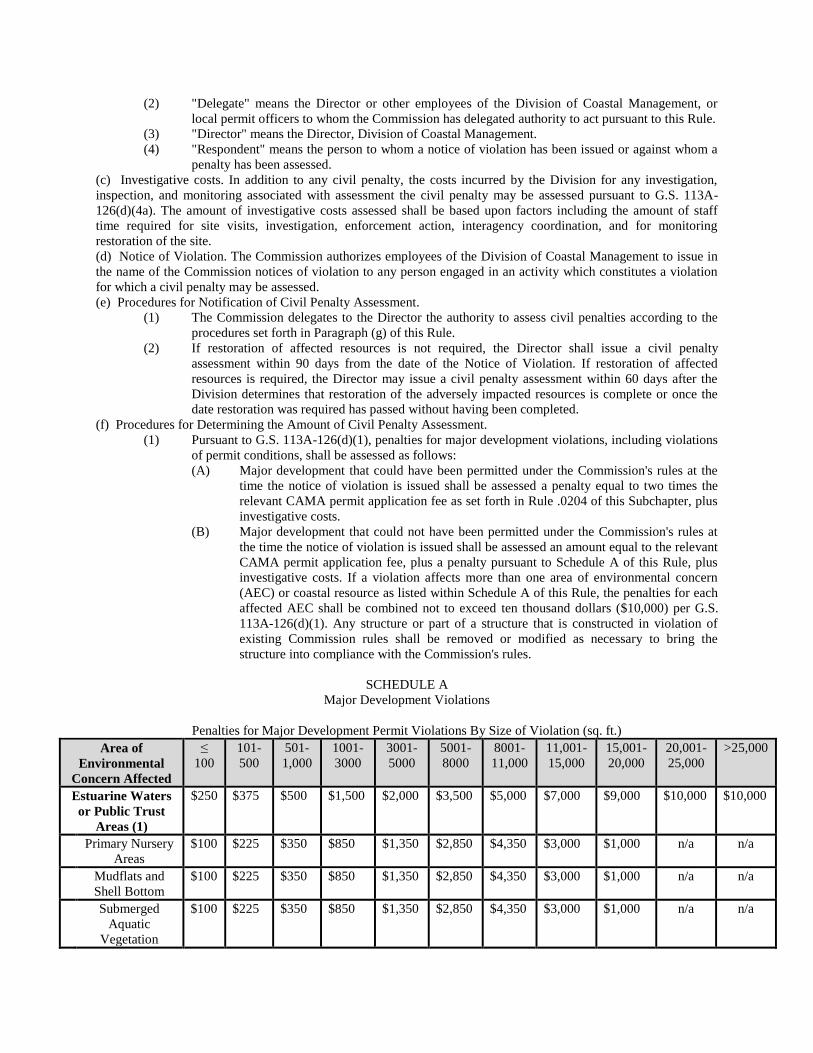
(2) "Delegate" means the Director or other employees of the Division of Coastal Management, or
local permit officers to whom the Commission has delegated authority to act pursuant to this Rule.
(3) "Director" means the Director, Division of Coastal Management.
(4) "Respondent" means the person to whom a notice of violation has been issued or against whom a
penalty has been assessed.
(c) Investigative costs. In addition to any civil penalty, the costs incurred by the Division for any investigation,
inspection, and monitoring associated with assessment the civil penalty may be assessed pursuant to G.S. 113A-
126(d)(4a). The amount of investigative costs assessed shall be based upon factors including the amount of staff
time required for site visits, investigation, enforcement action, interagency coordination, and for monitoring
restoration of the site.
(d) Notice of Violation. The Commission authorizes employees of the Division of Coastal Management to issue in
the name of the Commission notices of violation to any person engaged in an activity which constitutes a violation
for which a civil penalty may be assessed.
(e) Procedures for Notification of Civil Penalty Assessment.
(1) The Commission delegates to the Director the authority to assess civil penalties according to the
procedures set forth in Paragraph (g) of this Rule.
(2) If restoration of affected resources is not required, the Director shall issue a civil penalty
assessment within 90 days from the date of the Notice of Violation. If restoration of affected
resources is required, the Director may issue a civil penalty assessment within 60 days after the
Division determines that restoration of the adversely impacted resources is complete or once the
date restoration was required has passed without having been completed.
(f) Procedures for Determining the Amount of Civil Penalty Assessment.
(1) Pursuant to G.S. 113A-126(d)(1), penalties for major development violations, including violations
of permit conditions, shall be assessed as follows:
(A) Major development that could have been permitted under the Commission's rules at the
time the notice of violation is issued shall be assessed a penalty equal to two times the
relevant CAMA permit application fee as set forth in Rule .0204 of this Subchapter, plus
investigative costs.
(B) Major development that could not have been permitted under the Commission's rules at
the time the notice of violation is issued shall be assessed an amount equal to the relevant
CAMA permit application fee, plus a penalty pursuant to Schedule A of this Rule, plus
investigative costs. If a violation affects more than one area of environmental concern
(AEC) or coastal resource as listed within Schedule A of this Rule, the penalties for each
affected AEC shall be combined not to exceed ten thousand dollars ($10,000) per G.S.
113A-126(d)(1). Any structure or part of a structure that is constructed in violation of
existing Commission rules shall be removed or modified as necessary to bring the
structure into compliance with the Commission's rules.
SCHEDULE A
Major Development Violations
Penalties for Major Development Permit Violations By Size of Violation (sq. ft.)
Area of
Environmental
Concern Affected
≤
100
101-
500
501-
1,000
1001-
3000
3001-
5000
5001-
8000
8001-
11,000
11,001-
15,000
15,001-
20,000
20,001-
25,000
>25,000
Estuarine Waters
or Public Trust
Areas (1)
$250 $375 $500 $1,500 $2,000 $3,500 $5,000 $7,000 $9,000 $10,000 $10,000
Primary Nursery
Areas
$100 $225 $350 $850 $1,350 $2,850 $4,350 $3,000 $1,000 n/a n/a
Mudflats and
Shell Bottom
$100 $225 $350 $850 $1,350 $2,850 $4,350 $3,000 $1,000 n/a n/a
Submerged
Aquatic
Vegetation
$100 $225 $350 $850 $1,350 $2,850 $4,350 $3,000 $1,000 n/a n/a
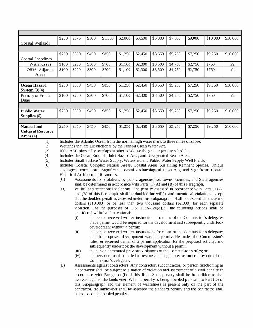
Coastal Wetlands $250 $375 $500 $1,500 $2,000 $3,500 $5,000 $7,000 $9,000 $10,000 $10,000
Coastal Shorelines $250 $350 $450 $850 $1,250 $2,450 $3,650 $5,250 $7,250 $9,250 $10,000
Wetlands (2) $100 $200 $300 $700 $1,100 $2,300 $3,500 $4,750 $2,750 $750 n/a
ORW- Adjacent
Areas
$100 $200 $300 $700 $1,100 $2,300 $3,500 $4,750 $2,750 $750 n/a
Ocean Hazard
System (3)(4)
$250 $350 $450 $850 $1,250 $2,450 $3,650 $5,250 $7,250 $9,250 $10,000
Primary or Frontal
Dune
$100 $200 $300 $700 $1,100 $2,300 $3,500 $4,750 $2,750 $750 n/a
Public Water
Supplies (5)
$250 $350 $450 $850 $1,250 $2,450 $3,650 $5,250 $7,250 $9,250 $10,000
Natural and
Cultural Resource
Areas (6)
$250 $350 $450 $850 $1,250 $2,450 $3,650 $5,250 $7,250 $9,250 $10,000
(1) Includes the Atlantic Ocean from the normal high water mark to three miles offshore.
(2) Wetlands that are jurisdictional by the Federal Clean Water Act.
(3) If the AEC physically overlaps another AEC, use the greater penalty schedule.
(4) Includes the Ocean Erodible, Inlet Hazard Area, and Unvegetated Beach Area.
(5) Includes Small Surface Water Supply, Watershed and Public Water Supply Well Fields.
(6) Includes Coastal Complex Natural Areas, Coastal Areas Sustaining Remnant Species, Unique
Geological Formations, Significant Coastal Archaeological Resources, and Significant Coastal
Historical Architectural Resources.
(C) Assessments for violations by public agencies, i.e. towns, counties, and State agencies
shall be determined in accordance with Parts (1)(A) and (B) of this Paragraph.
(D) Willful and intentional violations. The penalty assessed in accordance with Parts (1)(A)
and (B) of this Paragraph. shall be doubled for willful and intentional violations except
that the doubled penalties assessed under this Subparagraph shall not exceed ten thousand
dollars ($10,000) or be less than two thousand dollars ($2,000) for each separate
violation. For the purposes of G.S. 113A-126(d)(2), the following actions shall be
considered willful and intentional:
(i) the person received written instructions from one of the Commission's delegates
that a permit would be required for the development and subsequently undertook
development without a permit;
(ii) the person received written instructions from one of the Commission's delegates
that the proposed development was not permissible under the Commission's
rules, or received denial of a permit application for the proposed activity, and
subsequently undertook the development without a permit;
(iii) the person committed previous violations of the Commission's rules; or
(iv) the person refused or failed to restore a damaged area as ordered by one of the
Commission's delegates.
(E) Assessments against contractors. Any contractor, subcontractor, or person functioning as
a contractor shall be subject to a notice of violation and assessment of a civil penalty in
accordance with Paragraph (f) of this Rule. Such penalty shall be in addition to that
assessed against the landowner. When a penalty is being doubled pursuant to Part (D) of
this Subparagraph and the element of willfulness is present only on the part of the
contractor, the landowner shall be assessed the standard penalty and the contractor shall
be assessed the doubled penalty.
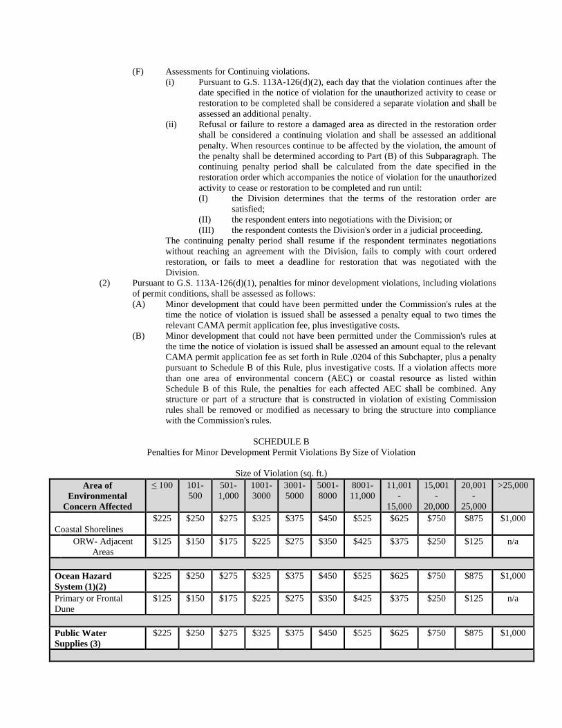
(F) Assessments for Continuing violations.
(i) Pursuant to G.S. 113A-126(d)(2), each day that the violation continues after the
date specified in the notice of violation for the unauthorized activity to cease or
restoration to be completed shall be considered a separate violation and shall be
assessed an additional penalty.
(ii) Refusal or failure to restore a damaged area as directed in the restoration order
shall be considered a continuing violation and shall be assessed an additional
penalty. When resources continue to be affected by the violation, the amount of
the penalty shall be determined according to Part (B) of this Subparagraph. The
continuing penalty period shall be calculated from the date specified in the
restoration order which accompanies the notice of violation for the unauthorized
activity to cease or restoration to be completed and run until:
(I) the Division determines that the terms of the restoration order are
satisfied;
(II) the respondent enters into negotiations with the Division; or
(III) the respondent contests the Division's order in a judicial proceeding.
The continuing penalty period shall resume if the respondent terminates negotiations
without reaching an agreement with the Division, fails to comply with court ordered
restoration, or fails to meet a deadline for restoration that was negotiated with the
Division.
(2) Pursuant to G.S. 113A-126(d)(1), penalties for minor development violations, including violations
of permit conditions, shall be assessed as follows:
(A) Minor development that could have been permitted under the Commission's rules at the
time the notice of violation is issued shall be assessed a penalty equal to two times the
relevant CAMA permit application fee, plus investigative costs.
(B) Minor development that could not have been permitted under the Commission's rules at
the time the notice of violation is issued shall be assessed an amount equal to the relevant
CAMA permit application fee as set forth in Rule .0204 of this Subchapter, plus a penalty
pursuant to Schedule B of this Rule, plus investigative costs. If a violation affects more
than one area of environmental concern (AEC) or coastal resource as listed within
Schedule B of this Rule, the penalties for each affected AEC shall be combined. Any
structure or part of a structure that is constructed in violation of existing Commission
rules shall be removed or modified as necessary to bring the structure into compliance
with the Commission's rules.
SCHEDULE B
Penalties for Minor Development Permit Violations By Size of Violation
Size of Violation (sq. ft.)
Area of
Environmental
Concern Affected
≤ 100 101-
500
501-
1,000
1001-
3000
3001-
5000
5001-
8000
8001-
11,000
11,001
-
15,000
15,001
-
20,000
20,001
-
25,000
>25,000
Coastal Shorelines $225 $250 $275 $325 $375 $450 $525 $625 $750 $875 $1,000
ORW- Adjacent
Areas
$125 $150 $175 $225 $275 $350 $425 $375 $250 $125 n/a
Ocean Hazard
System (1)(2)
$225 $250 $275 $325 $375 $450 $525 $625 $750 $875 $1,000
Primary or Frontal
Dune
$125 $150 $175 $225 $275 $350 $425 $375 $250 $125 n/a
Public Water
Supplies (3)
$225 $250 $275 $325 $375 $450 $525 $625 $750 $875 $1,000
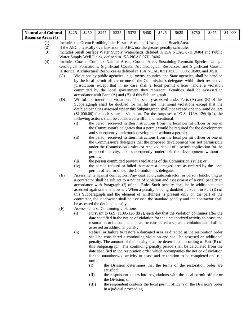
Natural and Cultural
Resource Areas (4)
$225 $250 $275 $325 $375 $450 $525 $625 $750 $875 $1,000
(1) Includes the Ocean Erodible, Inlet Hazard Area, and Unvegetated Beach Area.
(2) If the AEC physically overlaps another AEC, use the greater penalty schedule.
(3) Includes Small Surface Water Supply Watersheds, defined in 15A NCAC 07H .0404 and Public
Water Supply Well Fields, defined in 15A NCAC 07H .0406.
(4) Includes Coastal Complex Natural Areas, Coastal Areas Sustaining Remnant Species, Unique
Geological Formations, Significant Coastal Archaeological Resources, and Significant Coastal
Historical Architectural Resources as defined in 15A NCAC 07H .0505, .0506, .0509, and .0510.
(C) Violations by public agencies , e.g., towns, counties, and State agencies, shall be handled
by the local permit officer or one of the Commission's delegates within their respective
jurisdictions except that in no case shall a local permit officer handle a violation
committed by the local government they represent. Penalties shall be assessed in
accordance with Parts (A) and (B) of this Subparagraph.
(D) Willful and intentional violations. The penalty assessed under Parts (A) and (B) of this
Subparagraph shall be doubled for willful and intentional violations except that the
doubled penalties assessed under this Subparagraph shall not exceed one thousand dollars
($1,000.00) for each separate violation. For the purposes of G.S. 113A-126(d)(2), the
following actions shall be considered willful and intentional:
(i) the person received written instructions from the local permit officer or one of
the Commission's delegates that a permit would be required for the development
and subsequently undertook development without a permit;
(ii) the person received written instructions from the local permit officer or one of
the Commission's delegates that the proposed development was not permissible
under the Commission's rules, or received denial of a permit application for the
proposed activity, and subsequently undertook the development without a
permit;
(iii) the person committed previous violations of the Commission's rules; or
(iv) the person refused or failed to restore a damaged area as ordered by the local
permit officer or one of the Commission's delegates.
(E) Assessments against contractors. Any contractor, subcontractor, or person functioning as
a contractor shall be subject to a notice of violation and assessment of a civil penalty in
accordance with Paragraph (f) of this Rule. Such penalty shall be in addition to that
assessed against the landowner. When a penalty is being doubled pursuant to Part (D) of
this Subparagraph and the element of willfulness is present only on the part of the
contractor, the landowner shall be assessed the standard penalty and the contractor shall
be assessed the doubled penalty.
(F) Assessments of Continuing violations.
(i) Pursuant to G.S. 113A-126(d)(2), each day that the violation continues after the
date specified in the notice of violation for the unauthorized activity to cease and
restoration to be completed shall be considered a separate violation and shall be
assessed an additional penalty.
(ii) Refusal or failure to restore a damaged area as directed in the restoration order
shall be considered a continuing violation and shall be assessed an additional
penalty. The amount of the penalty shall be determined according to Part (B) of
this Subparagraph. The continuing penalty period shall be calculated from the
date specified in the restoration order which accompanies the notice of violation
for the unauthorized activity to cease and restoration to be completed and run
until:
(I) the Division determines that the terms of the restoration order are
satisfied;
(II) the respondent enters into negotiations with the local permit officer or
the Division; or
(III) the respondent contests the local permit officer's or the Division's order
in a judicial proceeding.
The continuing penalty period shall resume if the respondent terminates negotiations
without reaching an agreement with the local permit officer or the Division, fails to
comply with court ordered restoration, or fails to meet a deadline for restoration that was
negotiated with the local permit officer or the Division.
(g) Reports to the Commission. Action taken by the Director shall be reported to the Commission at the next
regularly scheduled Commission meeting. Such reports shall include information on the following:
(1) respondent(s) against whom penalties have been assessed;
(2) respondent(s) who have paid a penalty, requested remission, or requested an administrative
hearing;
(3) respondent(s) who have failed to pay; and
(4) cases referred to the Attorney General for collection.
(h) Settlements. The Commission hereby delegates to the Director the authority to enter into a settlement of an
appeal of a civil penalty at any time prior to the issuance of a decision by the administrative law judge in a contested
case under G.S. 150B-23, and shall not require the approval of the Commission. Any settlement agreement proposed
subsequent to the issuance of a decision by the administrative law judge in a contested case under G.S. 150B-23
shall be submitted to the Commission for approval.
History Note: Authority G.S. 113A-124; 113A-124(c)(8); 113A-126(d);
Eff. January 24, 1980;
ARRC Objection August 18, 1988;
Amended Eff. January 1, 1989; November 1, 1986; November 1, 1984;
ARRC Objection Lodged Eff. January 18, 1991;
Amended Eff. September 1, 2019; February 1, 2008; July 1, 1991; June 1, 1991;
Readopted Eff. June 1, 2021.
15A NCAC 07J .0410 RESTORATION/MITIGATION
Any violation involving development that is inconsistent with rules for development within AECs, i.e. wetland fill,
improper location of a structure, shall result in a notice of restoration from the Secretary or its delegate or a local
government. The notice shall describe the extent of restoration necessary to recover lost resources, or to prevent
further resource damage and a time for its completion. Failure to complete the restoration described in the notice
may result in a court order as described in G.S. 113-126(a) and (b). Failure to act to complete the required
restoration may be determined to constitute a separate violation, according to G.S. 113-126(d)(2), subject to the
penalties in Rule .0409 of this Section. Any resources that cannot be recovered by restoration of the affected site
shall be replaced in compliance with the goals of the Commission's mitigation policy described in 15A NCAC 07M
.0701.
History Note: Authority G.S. 113A-126; 113A-124(c); 113A-124(c)(8);
Eff. July 1, 1985;
Readopted Eff. August 1, 2021.
SECTION .0500 - GENERAL PERMITS
15A NCAC 07J .0501 DEVELOPMENT INITIATED PRIOR TO MARCH 1, 1978
History Note: Authority G.S. 113A-118.1;
Eff. April 12, 1978;
Amended Eff. December 1, 1991;
Expired Eff. April 1, 2018 pursuant to G.S. 150B-21.3A.
15A NCAC 07J .0502 UNCONTESTED PERMIT APPLICATIONS
History Note: Authority G.S. 113A-124(c)(5);
Eff. April 12, 1978;
Amended Eff. September 11, 1978;
Repealed Eff. September 6, 1979.
SECTION .0600 - DECLARATORY RULINGS AND PETITIONS FOR RULEMAKING
15A NCAC 07J .0601 DECLARATORY RULINGS: GENERALLY
At the request of any person aggrieved, as defined in G.S. 150B-2(6), the Coastal Resources Commission may issue
a declaratory ruling as provided in G.S. 150B-4.
History Note: Authority G.S. 113A-124; 150B-4;
Eff. June 1, 1979;
Amended Eff. October 1, 1992; October 1, 1988;
Pursuant to G.S. 150B-21.3A, rule is necessary without substantive public interest Eff. March 6,
2018.
15A NCAC 07J .0602 PROCEDURE FOR REQUESTING DECLARATORY RULINGS
(a) All requests for a declaratory ruling shall be filed with the Director, Division of Coastal Management,
Department of Environment and Natural Resources (DENR), 400 Commerce Avenue, Morehead City NC 28557,
and also the Attorney General's Office, 9001 Mail Service Center, Raleigh NC 27699-9001. All requests shall
include the following: the aggrieved person's name and address; the rule, statute or order for which a ruling is
desired; and a statement as to whether the request is for a ruling on the validity of a rule or on the applicability of a
rule, order or statute; and certified mail receipts showing the request was sent to the owners of property adjacent to
the property that is the subject of the declaratory ruling.
(b) A request for a ruling on the applicability of a rule, order, or statute shall include a description of the factual
situation on which the ruling is to be based. A request for a ruling on the validity of a commission rule shall state
the aggrieved person's reasons for questioning the validity of the rule. A person may ask for both types of rulings in
a single request. A request for a ruling shall include or be accompanied by:
(1) a statement of facts proposed for adoption by the Commission; and
(2) a draft of the proposed ruling.
History Note: Authority G.S. 113A-124; 150B-4;
Eff. June 1, 1979;
Amended Eff. June 1, 2005; October 1, 1992; November 1, 1991; July 1, 1990; May 1, 1990.
15A NCAC 07J .0603 PROCEDURES: CONSIDERING REQUESTS FOR DECLARATORY RULINGS
(a) The Commission hereby delegates to the Chairman the authority to grant or deny requests for declaratory rulings
and to determine whether notice of the declaratory ruling request should be provided to anyone other than the
adjacent property owners. The Division of Coastal Management shall review each request for a declaratory ruling
and shall prepare a recommendation for the Chairman as to whether the Commission should consent to issue a ruling
or whether for good cause the request for a declaratory ruling should be denied. The Chairman shall deny a request
for declaratory ruling on finding that:
(1) the requesting party, any other directly affected persons, and the Division of Coastal Management
cannot agree on a set of undisputed facts sufficient to support a meaningful ruling;
(2) the matter is the subject of a pending contested case hearing; or
(3) no genuine controversy exists as to the application of a statute or rule to a proposed project or
activity.
(b) After consenting to issue a ruling, the Commission shall place the declaratory ruling on the agenda for its next
regularly scheduled meeting. The Commission shall provide notice of the declaratory ruling proceeding to the
requesting party, the adjacent property owners and other persons to whom the Commission decides to give notice no
less than 10 days before the date for which the declaratory ruling is set. The requesting party and other persons to
whom the Commission decides to give notice shall be allowed to submit written comments concerning the
proposed declaratory ruling.
(c) If a ruling is to be issued, the Chairman shall decide whether notice should be given to persons other than the
party requesting the ruling and the adjacent property owners. In making such a decision, the Commission shall
consider such factors as: whether additional public participation would aid the Commission in reaching a decision;
whether any persons have requested in writing to be notified of proposed declaratory rulings; whether the property
or personal rights of other persons might be directly affected by the requested ruling; and whether the proposed
ruling would affect the application and interpretation of a rule in which other persons might be interested. All
persons receiving notice of the declaratory ruling, including all members of the public who respond to a published
notice of the proposed ruling, may submit written comments to the Commission concerning the proposed
declaratory ruling pursuant to Paragraph (b) of this Rule at least five days prior to the date of the proposed ruling; all
such comments shall be provided to the Commission and shall be included in the record of the declaratory ruling.
(d) Unless the Department waives the opportunity to be heard, it shall be a party to any request for declaratory
ruling. The requesting party and the Department shall each be allowed 30 minutes to present oral arguments to the
Commission. Neither party may offer testimony or conduct cross-examination before the Commission. The
declaratory ruling shall be determined on the basis of the statement of undisputed facts submitted by the parties.
(e) The Commission will keep a record of each declaratory ruling, which will include at a minimum the following
items:
(1) the request for a ruling;
(2) any written comments by interested parties;
(3) the statement of undisputed facts on which the ruling was based;
(4) any transcripts of oral proceedings, or, in the absence of a transcript, a summary of all arguments;
(5) any other matter considered by the Commission in making the decision; and
(6) the declaratory ruling together with the reasons therefore.
(f) A declaratory ruling is binding on the Commission and the person requesting it unless it is altered or set aside by
the court. The Commission may not retroactively change a declaratory ruling, but nothing in this Section prevents
the Commission from prospectively changing a ruling.
(g) A declaratory ruling is subject to judicial review in the same manner as an agency final decision or order in a
contested case. Unless the requesting party consents to the delay, failure of the Commission to issue a ruling on the
merits within 60 days of the request for such ruling shall constitute a denial of the request as well as a denial of the
merits of the request and shall be subject to judicial review.
History Note: Authority G.S. 113A-124; 150B-4;
Eff. June 1, 1979;
Amended Eff. October 1, 1992; October 1, 1988.
15A NCAC 07J .0604 FEDERAL ACTIVITIES
(a) At the request of any federal agency or of any state or local co-sponsor of a federal project with the written
concurrence of the federal agency, the Commission shall issue a declaratory ruling concerning the consistency of a
proposed federal activity with North Carolina's coastal management statutes and regulations unless the Chairman
determines that no genuine controversy exists as to the application of a statute or rule to a proposed federal activity.
(b) The request for ruling shall include:
(1) a statement identifying the rule, statute or order at issue;
(2) certified mail receipts indicating that notice of the request for ruling was sent to the owners of
property adjacent to the property on which the proposed federal activity will take place;
(3) a statement of facts proposed for adoption by the Commission and any documentary evidence
supporting the proposed statement of facts;
(4) a draft of the proposed ruling;
(5) a statement indicating that the Division of Coastal Management has preliminarily determined that
the project may be inconsistent with a coastal management statute or regulation; and
(6) a statement identifying the factual issues in dispute between the Department and the federal
agency.
(c) The Commission shall provide notice of the declaratory ruling proceeding to the adjacent property owners and
to persons who have requested notice of proposed rulings. Notice shall be published in a newspaper of general
circulation in the area of the proposed federal activity 10 days prior to the Commission's consideration of the
declaratory ruling. Any person may submit written comments on the proposed declaratory ruling at least five days
prior to the date the Commission will consider the declaratory ruling; such comments shall be provided to the
Commission and shall be included in the record of the declaratory ruling.
(d) The parties to a declaratory ruling shall be allowed 30 minutes to present oral arguments to the Commission.
Unless the Division of Coastal Management waives the opportunity to be heard, it shall be a party to any request for
declaratory ruling. No party may offer testimony or conduct cross-examination before the Commission.
History Note: Authority G.S. 113A-124; 150B-4;
Eff. November 30, 1992.
15A NCAC 07J .0605 PETITIONS FOR RULEMAKING
(a) Any person wishing to request the adoption, amendment, or repeal of a rule shall make this request in a petition
addressed to the Division of Coastal Management. The petition shall specify it is filed pursuant to G.S. 150B-20
and shall contain the following information:
(1) either a draft of the proposed rule or a summary of its contents;
(2) a statement of reasons for adoption of the proposed rule(s);
(3) a statement of the effect on existing rules or orders;
(4) any data in support of the proposed rule(s);
(5) a statement of the effect of the proposed rule on existing practices; and
(6) the name and address of the petitioner.
(b) The petition will be placed on the agenda for the next regularly scheduled commission meeting, if received at
least four weeks prior to the meeting, and the director shall prepare a recommended response to the petition for the
Commission's consideration. Petitions will be considered in accordance with the requirements of G.S. 150B-20.
History Note: Authority G.S. 113A-124; 150B-20;
Eff. January 1, 1989;
Amended Eff. October 1, 1992.
SECTION .0700 – PROCEDURES FOR CONSIDERING VARIANCE PETITIONS
15 NCAC 07J .0701 VARIANCE PETITIONS
(a) Any person whose application for a CAMA major or minor development permit has been denied or issued with
condition(s) that the person does not agree with may petition for a variance from the Commission by means of the
procedure described in this Section. Before filing a petition for a variance from a rule of the Commission, the
person must seek relief from local requirements restricting use of the property, and there must not be pending
litigation between the petitioner and any other person which may make the request for a variance moot.
(b) The procedure in this Section shall be used for all variance petitions except when:
(1) the Commission determines that more facts are necessary; or
(2) there are controverted facts that are necessary for a decision on the variance petition.
(c) Variance petitions shall be submitted on forms provided by the Department of Environment and Natural
Resources. The following information shall be submitted before a variance petition is considered complete:
(1) the case name and location of the development as identified on the denied permit application;
(2) a copy of the deed to the property on which the proposed development would be located;
(3) a copy of the permit application and denial for the development in question;
(4) the date of the petition, and the name, address, and phone number of the petitioner and his or her
attorney, if applicable;
(5) a complete description of the proposed development, including a site drawing with topographical
and survey information;
(6) a stipulation that the proposed project is inconsistent with the rule from which the petitioner seeks
a variance;
(7) notice of the variance petition sent certified mail, return receipt requested to the adjacent property
owners and persons who submitted written comments to the Division of Coastal Management or
the Local Permit Officer during the permit review process and copies of the documents which
indicate that the certified mail notices were received or that deliveries were attempted;
(8) an explanation of why the petitioner believes that the Commission should make the following
findings, all of which are necessary for a variance to be granted:
(A) that unnecessary hardships would result from strict application of the development rules,
standards, or orders issued by the Commission;
(B) that such hardships result from conditions peculiar to the petitioner's property such as the
location, size, or topography of the property;
(C) that such hardships did not result from actions taken by the petitioner; and
(D) that the requested variance is consistent with the spirit, purpose and intent of the
Commission's rules, standards or orders; will secure the public safety and welfare; and
will preserve substantial justice.
(9) a proposed set of stipulated facts, for staff's consideration, containing all of the facts relied upon in
the petitioner's explanation as to why he meets the criteria for a variance; and
(10) proposed documents, for the staff's consideration, that the petitioner wants the Commission to
consider.
(d) Petitions shall be mailed to the Director of the Division of Coastal Management, Department of Environment
and Natural Resources, 400 Commerce Avenue, Morehead City NC 28557 and to Air and Natural Resources
Section, Environmental Division, Attorney General's Office, 9001 Mail Service Center, Raleigh, NC 27699-9001.
(e) A variance petition shall be considered by the Commission at a scheduled meeting. Petitions shall be scheduled
in chronological order based upon the date of receipt of a complete variance petition by the Division of Coastal
Management. A complete variance petition, as described in Paragraph (c) of this Rule, shall be received by the
Division of Coastal Management at least six weeks in advance of a scheduled Commission meeting to be considered
by the Commission at that meeting. If the petitioner seeks to postpone consideration of his or her variance request,
the request shall be treated as though it was filed on the date petitioner requested postponement and scheduled for
hearing after all then pending variance requests.
(f) Written notice of a variance hearing or Commission consideration of a variance petition shall be provided to the
petitioner and the permit officer making the initial permit decision.
History Note: Authority G.S. 113A-120.1; 113A-124;
Eff. December 12, 1979;
Amended Eff. December 1, 1991; May 1, 1990; March 1, 1988, February 1, 1983;
Temporary Amendment Eff. December 20, 2001;
Temporary Amendment Expired October 12, 2002;
Temporary Amendment Eff. December 1, 2002;
Amended Eff. March 1, 2009; June 1, 2005; August 1, 2004.
15A NCAC 07J .0702 STAFF REVIEW OF VARIANCE PETITIONS
(a) The Division of Coastal Management, as staff to the Commission, shall review petitions to determine whether
they are complete according to the requirements set forth in Rule .0701. Incomplete petitions and a description of
the deficiencies shall be returned to the petitioner. Complete variance petitions shall be scheduled for the
appropriate Commission meeting.
(b) The staff and the petitioner shall determine the facts that are relevant to the Commission's consideration of the
variance petition. For all facts upon which staff and the petitioner agree, a document entitled Stipulated Facts shall
be prepared and signed by both parties.
(c) After the facts agreed upon by the petitioner and staff, the staff shall prepare a written recommendation which
shall be submitted to the Commission before the petition is considered. The staff recommendation shall include:
(1) a description of the property in question;
(2) a description of how the use of the property is restricted or otherwise affected by the applicable
rules;
(3) the Stipulated Facts;
(4) staff's position on whether the petition meets or does not meet each of the requirements for a
variance; and
(5) petitioner's position on each of the variance criteria.
Copies of the staff recommendation shall be provided to the petitioner and the permit officer making the initial
permit decision at the same time as it is provided to the Commission. If the Stipulated Facts are not agreed upon at
least four weeks prior to a scheduled Coastal Resources Commission meeting, the variance petition shall be
considered at the next scheduled Commission meeting.
(d) If the staff determines that agreement cannot be reached on sufficient facts on which to base a variance decision,
the petition shall be considered by means of an administrative hearing to determine the relevant facts.
History Note: Authority G.S. 113A-120.1; 113A-124;
Eff. December 12, 1979;
Amended Eff. December 1, 1991; May 1, 1990; October 1, 1988; March 1, 1988;
Temporary Amendment Eff. December 20, 2001;
Temporary Amendment Expired October 12, 2002;
Temporary Amendment Eff. December 1, 2002;
Amended Eff. July 3, 2008; August 1, 2004.
15A NCAC 07J .0703 PROCEDURES FOR DECIDING VARIANCE PETITIONS
(a) The Commission may review the variance petition and staff recommendation and hear oral presentation by the
petitioner, if any, in full session or may appoint a member or members to do so. In cases where a member or
members are appointed, they shall report a summary of the facts and a recommended decision to the Commission.
(b) The Commission or its appointed member or members shall be provided with copies of the petition, the
stipulated facts, and the staff recommendation before considering the petition.
(c) At the Commission's request, staff shall orally describe the petition to the Commission or its appointed
member(s) and shall present comments concerning whether the Commission should make the findings necessary for
granting the variance. The petitioner shall also be allowed to present oral arguments concerning the petition. The
Commission may set time limits on such oral presentations.
(d) The final decision of the Commission may be made at the meeting at which the matter is heard or in no case
later than the next scheduled meeting. The final decision shall be transmitted to the petitioner by certified mail,
return receipt requested within 30 days of the meeting at which the Commission reached its decision. In the event
that the Commission cannot reach a final decision because it determines that more facts are necessary, it shall
remand the matter to staff and the petitioner with instructions for the parties to either agree to the necessary fact(s)
or to request a hearing in the Office of Administrative Hearings.
(e) Final decisions concerning variance petitions shall be made by concurrence of a majority of a quorum of the
Commission.
(f) To grant a variance, the Commission must affirmatively find each of the four factors listed in G.S. 113A-
120.1(a).
(1) that unnecessary hardships would result from strict application of the development rules,
standards, or orders issued by the Commission;
(2) that such hardships result from conditions peculiar to the petitioner's property such as location,
size, or topography;
(3) that such hardships did not result from actions taken by the petitioner; and
(4) that the requested variance is consistent with the spirit, purpose and intent of the Commission's
rules, standards or orders; will secure the public safety and welfare; and will preserve substantial
justice.
History Note: Authority G.S. 113A-120.1;
Eff. December 12, 1979;
Amended Eff. December 1, 1991; March 3, 1981;
Temporary Amendment Eff. December 20, 2001;
Temporary Amendment Expired October 12, 2002;
Temporary Amendment Eff. December 1, 2002;
Amended Eff. March 1, 2009; August 1, 2004.
SECTION .0800 - DREDGE AND FILL: PERMIT PROCESSING PROCEDURE: STANDARD
15A NCAC 07J .0801 DEFINITIONS
15A NCAC 07J .0802 APPLICATION FORMS
15A NCAC 07J .0803 PREPARATION OF WORK PLATS: GENERAL
15A NCAC 07J .0804 PREPARATION OF WORK PLATS: SPECIFIC
15A NCAC 07J .0805 ADJACENT RIPARIAN LANDOWNER NOTIFICATION
15A NCAC 07J .0806 APPLICATION PROCESSING
15A NCAC 07J .0807 FIELD INVESTIGATION
15A NCAC 07J .0808 AGENCY REVIEW AND COMMENTS
15A NCAC 07J .0809 CRITERIA FOR PROJECT PLANNING AND EVALUATION
15A NCAC 07J .0810 FINAL ACTION
15A NCAC 07J .0811 NOTICE OF DENIAL
15A NCAC 07J .0812 APPEAL OF DEPARTMENTAL ACTION
15A NCAC 07J .0813 PERMIT ISSUANCE AND TRANSFER
15A NCAC 07J .0814 PERMIT EXPIRATION
15A NCAC 07J .0815 PERMIT RENEWAL
15A NCAC 07J .0816 PERMIT MODIFICATION
15A NCAC 07J .0817 PERMIT CONDITIONS
15A NCAC 07J .0818 PROJECT MAINTENANCE
15A NCAC 07J .0819 MAINTENANCE REQUEST
15A NCAC 07J .0820 CONDITIONS FOR MAINTENANCE
15A NCAC 07J .0821 GRANT OR DENIAL OF MAINTENANCE REQUEST
15A NCAC 07J .0822 VIOLATION OF PERMIT
History Note: Authority G.S. 113A-118(c); 113A-119(a); 113A-124(c)(5); 113-229;
Eff. February 1, 1976;
Amended Eff. January 1, 1984; August 1, 1983; October 15, 1981; August 30, 1980;
Repealed Eff. July 1, 1989.
SECTION .0900 - DREDGE AND FILL: EMERGENCY PERMIT PROCEDURE
15A NCAC 07J .0901 PURPOSE
15A NCAC 07J .0902 DEFINITIONS
15A NCAC 07J .0903 INITIATION OF EMERGENCY PROCESS: ON-SITE INVESTIGATION
15A NCAC 07J .0904 PROCEDURES FOR EXEMPTING EMERGENCY MAINTENANCE: REPAIRS
15A NCAC 07J .0905 APPLICABILITY OF EMERGENCY CAMA: DREDGE AND FILL PERMITS
15A NCAC 07J .0906 PREPARATION OF EMERGENCY PERMIT APPLICATION
15A NCAC 07J .0907 NOTIFICATION OF ADJACENT RIPARIAN LANDOWNERS
History Note: Authority G.S. 113A-103(5)b.5; 113A-118 1.c.; 113-229 (e1);
Eff. February 1, 1976;
Amended Eff. December 1, 1985; August 1, 1983; September 8, 1980; July 31, 1980;
Repealed Eff. July 1, 1989.
15A NCAC 07J .0908 REVIEW AND ISSUANCE OF EMERGENCY PERMIT
15A NCAC 07J .0909 LIMITATION OF EMERGENCY WORK
History Note: Authority G.S. 113A-118 1.c.; 113A-119; 113A-229(e1);
Eff. September 8, 1980;
Amended Eff. December 1, 1985; September 1, 1983; August 1, 1983;
Repealed Eff. July 1, 1989.
SECTION .1000 - DREDGE AND FILL: REVIEW HEARING PROCEDURES
15A NCAC 07J .1001 WHO IS ENTITLED TO HEARING
15A NCAC 07J .1002 PARTIES
15A NCAC 07J .1003 PROCEDURES
History Note: Authority G.S. 113-229; 150B, Article 3; 150B-26;
Eff. February 1, 1976;
Amended Eff. December 1, 1982; August 30, 1980;
Repealed Eff. July 1, 1989.
15A NCAC 07J .1004 HEARING OFFICER
15A NCAC 07J .1005 REQUEST FOR HEARING
15A NCAC 07J .1006 TIME FOR HEARING
15A NCAC 07J .1007 VENUE
15A NCAC 07J .1008 PARTIES
15A NCAC 07J .1009 INTERVENTION
15A NCAC 07J .1010 NOTICE
15A NCAC 07J .1011 HEARING OPEN TO PUBLIC
15A NCAC 07J .1012 PRE-HEARING CONFERENCE
15A NCAC 07J .1013 SIMPLIFICATION OF ISSUES
15A NCAC 07J .1014 STIPULATIONS
15A NCAC 07J .1015 SUBPOENAS
15A NCAC 07J .1016 DEPOSITIONS AND DISCOVERY
15A NCAC 07J .1017 BURDEN OF PROOF
15A NCAC 07J .1018 NO EX PARTE COMMUNICATION: EXCEPTIONS
15A NCAC 07J .1019 PRESENTATION OF EVIDENCE
15A NCAC 07J .1020 CONDUCT OF THE HEARING
15A NCAC 07J .1021 POST HEARING PROCEDURE
15A NCAC 07J .1022 DECISION
15A NCAC 07J .1023 RECORD OF DEPARTMENT ACTION AND HEARING
15A NCAC 07J .1024 JUDICIAL REVIEW
History Note: Authority G.S. 113-229; 150B-23 through 150B-28;
150B-31 through 150B-36; 150B-43;
Eff. February 1, 1976;
Amended Eff. August 30, 1980; January 1, 1979;
Repealed Eff. December 1, 1982.
SECTION .1100 - GENERAL PERMIT PROCEDURE
15A NCAC 07J .1101 PURPOSE
The purpose of this Section is to establish a procedure for issuing general permits for development having
insignificant impacts on areas of environmental concern and which should not require public review and comment.
These Rules are established according to G.S. 113A-118.1 and G.S. 113-229(C)(1) and will apply to projects
requiring either Dredge and Fill and/or CAMA Major or Minor development permits. The CRC may, after following
the procedures set forth in these Rules, issue general permits for certain catagories of development which require
Dredge and Fill and/or CAMA Major or Minor development permits. After a general permit is issued, individual
activities falling within these categories may be further authorized by the procedures set forth in these Rules.
History Note: Authority G.S. 113A-107; 113A-118.1; 113-229(c1);
Eff. September 1, 1983;
Amended Eff. December 1, 1991;
Pursuant to G.S. 150B-21.3A, rule is necessary without substantive public interest Eff. March 6,
2018.
15A NCAC 07J .1102 CATEGORIES OF DEVELOPMENT
The Commission shall include as candidates for general permits only those activities that are substantially similar in
nature that cause only minimal adverse environmental impacts when performed separately, and that will have only a
minimal adverse cumulative effect on the environment. In identifying these categories, the Commission shall
consider:
(1) the size of the development;
(2) the impact of the development on areas of environmental concern;
(3) how often the class of development is carried out;
(4) the need for on-site oversight of the development; and
(5) the need for public review and comment on individual development projects.
History Note: Authority G.S. 113A-107; 113A-118.1; 113A-124(c)(5); 113-229(c)(1);
Eff. September 1, 1983;
Pursuant to G.S. 150B-21.3A, rule is necessary without substantive public interest Eff. March 6,
2018.
15A NCAC 07J .1103 DESIGNATION PROCEDURES
The staff shall prepare all information needed to establish each category of general permit. This may include a
generic description of the development, anticipated cumulative impacts, projected number of individual projects,
and permit histories. The staff shall prepare a draft permit to include a clear and accurate description of the
development to be authorized, implementation or processing procedures, general conditions, and special conditions.
The draft permit shall be reviewed and issued according to provisions in in G.S. 113A-107.
Recommendations for consideration of specific activities for inclusion in a general permit category may be made in
writing to the Commission by any individual, organization, or agency. The Commission will assign the request to
the staff for evaluation according to the procedures of this Rule within 90 days of its receipt.
History Note: Authority G.S. 113A-107; 113A-118.1; 113A-124(c)(5); 113-229(c)(1);
Eff. September 1, 1983;
Pursuant to G.S. 150B-21.3A, rule is necessary without substantive public interest Eff. March 6,
2018.
15A NCAC 07J .1104 PERMIT MODIFICATION
The Commission may modify at any time any category of general permit. Modification shall be made according to
the provisions of G.S. 113A-107. The Commission may also revoke any general permit at any time according to the
provisions of G.S. 113A-107 if it is determined that the permit is no longer in the public interest.
History Note: Authority G.S. 113A-107; 113A-118.1; 113A-124(c)(5); 113-229(c)(1);
Eff. September 1, 1983;
Pursuant to G.S. 150B-21.3A, rule is necessary without substantive public interest Eff. March 6,
2018.
15A NCAC 07J .1105 APPLICATION PROCEDURES
Authorization to initiate development covered by the general permit shall comply with the procedures outlined in
each permit. The procedures shall be established to explain in detail the application process, notification
requirements, and permit fees.
History Note: Authority G.S. 113A-107; 113A-118.1; 113-229(c2);
Eff. September 1, 1983;
Readopted Eff. December 1, 2021.
15A NCAC 07J .1106 PERMIT CONDITIONS
Each general permit shall have a set of general and specific conditions. Additionally, the Division of Coastal
Management may add conditions to each instrument of authorization if necessary to protect the public interest. The
Division of Coastal Management may, on a case-by-case basis, override the general permit and require an individual
application and review if this individual review is deemed to be in the public interest. Provisions for individual
review by State agencies of requests for general permit authorization may be made for each category if this review is
deemed necessary to protect coastal resources or other aspects of public interest.
History Note: Authority G.S. 113A-107; 113A-118.1; 113-229(c2); 113-229(e); 113A-120(b);
Eff. September 1, 1983;
Readopted Eff. December 1, 2021.
15A NCAC 07J .1107 PERMIT COMPLIANCE
All development authorized through the general permit must be done in compliance with all conditions listed on the
permit. Development undertaken without a Coastal Area Management Act or Dredge and Fill permit or in violation
of permit conditions or failure to comply with operational permit conditions shall be a violation subject to the
penalties set out in G.S. 113A-126 or G.S. 113-229.
History Note: Authority G.S. 113A-107; 113A-118.1; 113-229(c2);
Eff. September 1, 1983;
Amended Eff. March 1, 1985;
Readopted Eff. December 1, 2021.
15A NCAC 07J .1108 GENERAL PERMIT REVIEW
The Commission shall review each category of general permit on an annual basis. This review shall include
compilation and evaluation of the number of projects approved in each category and the impacts of these projects.
The Commission may modify or revoke any permit subject to this review according to the provisions of Rule .1104
of this Section. A written summary of this review shall be sent to each state and federal agency included in the
normal permit review process.
History Note: Authority G.S. 113A-107; 113A-118.1; 113-229(c1);
Eff. September 1, 1983;
Amended Eff. December 1, 1991;
Pursuant to G.S. 150B-21.3A, rule is necessary without substantive public interest Eff. March 6,
2018.
SECTION .1200 – STATIC AND VEGETATION LINE EXCEPTION PROCEDURES
15A NCAC 07J .1201 REQUESTING THE STATIC LINE EXCEPTION
(a) A petitioner subject to a static vegetation line pursuant to 15A NCAC 07H .0305 may petition the Coastal
Resources Commission for an exception to the static vegetation line in accordance with the provisions of this
Section. A "petitioner" shall be defined as:
(1) Any local government;
(2) Any group of local governments involved in a regional beach fill project;
(3) Any qualified homeowner's association defined in G.S. 47F-1-103(3) that has the authority to
approve the locations of structures on lots within the territorial jurisdiction of the association, and
has jurisdiction over at least one mile of ocean shoreline; or
(4) A permit holder of a large-scale beach fill project.
(b) A petitioner shall be eligible to submit a request for a static vegetation line exception after the completion of
construction of the initial large-scale beach fill project(s) as defined in 15A NCAC 07H .0305 that required the
creation of a static vegetation line(s). For a static vegetation line in existence prior to the effective date of this Rule,
the award-of-contract date of the initial large-scale beach fill project, or the date of the aerial photography or other
survey data used to define the static vegetation line, whichever is most recent, shall be used in lieu of the completion
of construction date.
(c) A static vegetation line exception request applies to the entire static vegetation line within the jurisdiction of the
petitioner, including segments of a static vegetation line that are associated with the same large-scale beach fill
project. If multiple static vegetation lines within the jurisdiction of the petitioner are associated with different large-
scale beach fill projects, then the static vegetation line exception in accordance with 15A NCAC 07H .0306 and the
procedures outlined in this Section shall be considered separately for each large-scale beach fill project.
(d) A static vegetation line exception request shall be made in writing by the petitioner. A complete static
vegetation line exception request shall include the following:
(1) A summary of all beach fill projects in the area for which the exception is being requested
including the initial large-scale beach fill project associated with the static vegetation line,
subsequent maintenance of the initial large-scale projects(s) and beach fill projects occurring prior
to the initial large-scale projects(s). To the extent historical data allows, the summary shall include
construction dates, contract award dates, volume of sediment excavated, total cost of beach fill
project(s), funding sources, maps, design schematics, pre-and post-project surveys and a project
footprint;
(2) Plans and related materials including reports, maps, tables and diagrams for the design and
construction of the initial large-scale beach fill project that required the static vegetation line,
subsequent maintenance that has occurred, and planned maintenance needed to achieve a design
life providing no less than 30 years of shore protection from the date of the static line exception
request. The plans and related materials shall be designed and prepared by the U.S. Army Corps of
Engineers or persons meeting applicable State occupational licensing requirements for said work;
(3) Documentation, including maps, geophysical, and geological data, to delineate the planned
location and volume of compatible sediment as defined in 15A NCAC 07H .0312 necessary to
construct and maintain the large-scale beach fill project defined in Subparagraph (d)(2) of this
Rule over its design life. This documentation shall be designed and prepared by the U.S. Army
Corps of Engineers or persons meeting applicable State occupational licensing requirements for
said work; and
(4) Identification of the financial resources or funding sources necessary to fund the large-scale beach
fill project over its design life.
(e) A static vegetation line exception request shall be submitted to the Director of the Division of Coastal
Management, 400 Commerce Avenue, Morehead City, NC 28557. Written acknowledgement of the receipt of a
completed static vegetation line exception request, including notification of the date of the meeting at which the
request will be considered by the Coastal Resources Commission, shall be provided to the petitioner by the Division
of Coastal Management.
(f) The Coastal Resources Commission shall consider a static vegetation line exception request no later than the
second scheduled meeting following the date of receipt of a complete request by the Division of Coastal
Management, except when the petitioner and the Division of Coastal Management agree upon a later date.
History Note: Authority G.S. 113A-107; 113A-113(b)(6); 113A-124;
Eff. March 23, 2009;
Amended Eff. April 1, 2016;
Readopted Eff. September 1, 2021.
15A NCAC 07J .1202 REVIEW OF THE STATIC LINE EXCEPTION REQUEST
(a) The Division of Coastal Management shall prepare a written report of the static line exception request to be
presented to the Coastal Resources Commission. This report shall include:
(1) A description of the area affected by the static line exception request;
(2) A summary of the large-scale beach fill project that required the static vegetation line as well as
the completed and planned maintenance of the project(s);
(3) A summary of the evidence required for a static line exception; and
(4) A recommendation to grant or deny the static line exception.
(b) The Division of Coastal Management shall provide the petitioner requesting the static line exception an
opportunity to review the report prepared by the Division of Coastal Management no less than 10 days prior to the
meeting at which it is to be considered by the Coastal Resources Commission.
History Note: Authority G.S. 113A-107; 113A-113(b)(6); 113A-124;
Eff. March 23, 2009;
Readopted Eff. September 1, 2021.
15A NCAC 07J .1203 PROCEDURES FOR APPROVING THE STATIC LINE EXCEPTION
(a) At the meeting at which the static line exception is considered by the Coastal Resources Commission, the
following shall occur:
(1) The Division of Coastal Management shall orally present the report described in 15A NCAC 07J
.1202.
(2) A representative for the petitioner may provide written or oral comments about the static line
exception request. The Chairman of the Coastal Resources Commission may limit the time
allowed for oral comments in open session based upon the number of speakers wishing to speak.
(3) Additional parties may provide written or oral comments about the static line exception request.
The Chairman of the Coastal Resources Commission may limit the time allowed for oral
comments in open session based upon the number of speakers wishing to speak.
(b) The Coastal Resources Commission shall authorize a static line exception request if the request contains the
information required and meets the criteria presented in 15A NCAC 07J .1201(d)(1) through (d)(4). The final
decision of the Coastal Resources Commission shall be made at the meeting at which the matter is heard or in no
case later than the next scheduled meeting. The final decision shall be transmitted to the petitioner by registered mail
within 10 business days following the meeting at which the decision is reached.
(c) The decision to authorize or deny a static line exception is a final agency decision and is subject to judicial
review in accordance with G.S. 113A-123.
History Note: Authority G.S. 113A-107; 113A-113(b)(6); 113A-124;
Eff. March 23, 2009;
Readopted Eff. September 1, 2021.
15A NCAC 07J .1204 REVIEW OF THE LARGE-SCALE BEACH-FILL PROJECT AND APPROVED
STATIC LINE EXCEPTIONS

(a) Progress Reports. The petitioner that received the static line exception shall provide a progress report to the
Coastal Resources Commission every five years from date the static line exception is authorized. The progress
report shall address the criteria defined in 15A NCAC 07J .1201(d)(1) through (d)(4) and be submitted in writing to
the Director of the Division of Coastal Management, 400 Commerce Avenue, Morehead City, NC 28557. The
Division of Coastal Management shall provide the petitioner with written acknowledgement of the receipt of a
completed progress report, including notification of the meeting date at which the report will be presented to the
Coastal Resources Commission.
(b) The Coastal Resources Commission shall review a static line exception authorized under 15A NCAC 07J .1203
every five years from the initial authorization in order to renew its findings for the conditions defined in 15A NCAC
07J .1201(d)(2) through (d)(4). The Coastal Resources Commission shall also consider the following conditions:
(1) Design changes to the initial large-scale beach fill project defined in 15A NCAC 07J .1201(d)(1)
provided that the changes are designed and prepared by the U.S. Army Corps of Engineers or
persons meeting applicable State occupational licensing requirements for the work;
(2) Design changes to the location and volume of compatible sediment, as defined by 15A NCAC
07H .0312, necessary to construct and maintain the large-scale beach fill project defined in 15A
NCAC 07J .1201(d)(2), including design changes defined in this Rule provided that the changes
have been designed and prepared by the U.S. Army Corps of Engineers or persons meeting
applicable State occupational licensing requirements for the work; and
(3) Changes in the financial resources or funding sources necessary to fund the large-scale beach fill
project(s)defined in 15A NCAC 07J .1201(d)(2). If the project has been amended to include
design changes defined in this Rule, then the Coastal Resources Commission shall consider the
financial resources or funding sources necessary to fund the changes.
(c) The Division of Coastal Management shall prepare a written summary of the progress report and present it to the
Coastal Resources Commission no later than the second scheduled meeting following the date the report was
received, except when a later meeting is agreed upon by the local government or community submitting the progress
report and the Division of Coastal Management. This written summary shall include a recommendation from the
Division of Coastal Management on whether the conditions defined in 15A NCAC 07J .1201(d)(1) through (d)(4)
have been met. The petitioner submitting the progress report shall be provided an opportunity to review the written
summary prepared by the Division of Coastal Management no less than 10 days prior to the meeting at which it is to
be considered by the Coastal Resources Commission.
(d) The following shall occur at the meeting at which the Coastal Resources Commission reviews the static line
exception progress report:
(1) The Division of Coastal Management shall orally present the written summary of the progress
report as defined in this Rule.
(2) A representative for the petitioner may provide written or oral comments relevant to the static line
exception progress report. The Chairman of the Coastal Resources Commission may limit the time
allowed for oral comments in open session based upon the number of speakers wishing to speak.
(3) Additional parties may provide written or oral comments relevant to the static line exception
progress report. The Chairman of the Coastal Resources Commission may limit the time allowed
for oral comments in open session based upon the number of speakers wishing to speak.
History Note: Authority G.S. 113A-107; 113A-113(b)(6); 113A-124;
Eff. March 23, 2009;
Readopted Eff. September 1, 2021.
15A NCAC 07J .1205 REVOCATION AND EXPIRATION OF THE STATIC LINE EXCEPTION
(a) The static line exception shall be revoked if the Coastal Resources Commission determines, after the review of
the petitioner's progress report identified in 15A NCAC 07J .1204, that any of the criteria under which the static line
exception is authorized, as defined in 15A NCAC 07J .1201(d)(2) through (d)(4), are not being met.
(b) The static line exception shall expire at the end of the design life of the large-scale beach fill project defined in
15A NCAC 07J .1201(d)(2), including subsequent design changes to the project as defined in 15A NCAC 07J
.1204(b).
(c) In the event a progress report is not received by the Division of Coastal Management five years from either the
static line exception or the previous progress report, the static line exception shall be revoked automatically at the
end of the five-year interval defined in 15A NCAC 07J .1204(b) for which the progress report was not received.
(d) The revocation or expiration of a static line exception shall be a final agency decision and is subject to judicial
review in accordance with G.S. 113A-123.
History Note: Authority G.S. 113A-107; 113A-113(b)(6); 113A-124;
Eff. March 23, 2009;
Readopted Eff. September 1, 2021.
15A NCAC 07J .1206 LOCAL GOVERNMENTS AND COMMUNITIES WITH STATIC
VEGETATION LINES AND STATIC LINE EXCEPTIONS
A list of static vegetation lines in place for petitioners and the conditions under which the static vegetation lines
exist, including the date(s) the static line was defined, shall be maintained by the Division of Coastal Management.
A list of static line exceptions in place for petitioners and the conditions under which the exceptions exist, including
the date the exception was granted, the dates the progress reports were received, the design life of the large-scale
beach fill project and the potential expiration dates for the static line exception, shall be maintained by the Division
of Coastal Management. Both the static vegetation line list and the static line exception list shall be available for
inspection at the Division of Coastal Management, 400 Commerce Avenue, Morehead City, NC 28557.
History Note: Authority G.S. 113A-107; 113A-113(b)(6); 113A-124;
Eff. March 23, 2009;
Readopted Eff. September 1, 2021.
SECTION .1300 – DEVELOPMENT LINE PROCEDURES
15A NCAC 07J .1301 REQUESTING THE DEVELOPMENT LINE
(a) Any local government, group of local governments involved in a regional beach fill project, or qualified owner's
association with territorial jurisdiction over an area that is subject to ocean hazard area setbacks pursuant to 15A
NCAC 07H .0305 may petition the Coastal Resources Commission for a development line for the purpose of siting
oceanfront development in accordance with the provisions of this Section. A "qualified owner's association" is an
owner's association, as defined in G.S. 47F-1-103(3), that has authority to approve the locations of structures on lots
within the territorial jurisdiction of the association and has jurisdiction over at least one mile of ocean shoreline.
(b) A development line request shall apply to the entire large-scale project area as defined in 15A NCAC 07H
.0305(a)(7) and, at the petitioner's request, may be extended to include the entire oceanfront jurisdiction or legal
boundary of the petitioner.
(c) In determining where to position a requested development line, the petitioner shall use an adjacent neighbor
sight-line approach, resulting in an average line of structures. In areas where the seaward edge of existing
development is not linear, the petitioner may determine an average line of construction on a case-by-case basis. In
no case shall a development line be established seaward of the most seaward structure within the petitioner's
oceanfront jurisdiction.
(d) The following types of development shall be permitted seaward of the development line if all other provisions of
this Subchapter and other State and local regulations are met:
(1) campsites;
(2) beach accessways consistent with 15A NCAC 07H .0308(c);
(3) unenclosed, uninhabitable gazebos with a footprint of 200 square feet or less;
(4) uninhabitable, single-story storage sheds with a foundation or floor consisting of wood, clay,
packed sand or gravel, and a footprint of 200 square feet or less;
(5) temporary amusement stands, consistent with 15A NCAC 07H .1900; and
(6) sand fences consistent with 15A NCAC 07H .0311.
In all cases, this development shall be permitted only if it is landward of the vegetation line, measurement line, or
static vegetation line, whichever is applicable; involves no alteration or removal of primary or frontal dunes that
would compromise the integrity of the dune as a protective landform or the dune vegetation; has overwalks to
protect any existing dunes; is not essential to the continued existence or use of an associated principal development,
such as septic systems and utilities; and is not required to satisfy minimum requirements of local zoning,
subdivision, and health regulations.
(e) An existing structure that is oceanward of an approved development line may remain in place until damaged
greater than 50 percent in accordance with Rule .0210 of this Subchapter. At that time it may only be replaced
landward of the development line and shall meet the applicable ocean hazard setback requirements as defined in
15A NCAC 07H .0306(a).
(f) A request for a development line or amendment shall be made in writing by the petitioner and submitted to the
CRC by sending the written request to the Director of the Division of Coastal Management. A complete request
shall include the following:
(1) A detailed survey of the development line using on-ground observation and survey or aerial
imagery along the oceanfront jurisdiction or legal boundary, including;
(A) The development line, static vegetation line, mean high water line, and any other
information necessary for a review of the petitioner's proposed development line, such as
a pre-nourishment project mean high water line, local ordinances, or easements; and
(B) Surveyed development line spatial data in a geographic information systems (GIS) format
referencing North Carolina State Plane North American Datum 83 US Survey Foot, to
include Federal Geographic Data Committee (FGDC) compliant metadata;
(2) All local regulations associated with the development line;
(3) A record of local adoption of the development line by the petitioner; and
(4) Documentation of incorporation of a development line into local ordinances or rules and
regulations of an owner's association.
(g) Once a development line is approved by the Coastal Resources Commission, only the petitioner may request a
change or reestablishment of the position of the development line.
(h) A development line request shall be submitted to the Director of the Division of Coastal Management, 400
Commerce Avenue, Morehead City, NC 28557. Written acknowledgement of the receipt of a completed
development line request, including notification of the date of the meeting at which the request will be considered by
the Coastal Resources Commission, shall be provided to the petitioner by the Division of Coastal Management.
(i) The Coastal Resources Commission shall consider a development line request no later than the second scheduled
meeting following the date of receipt of a complete request by the Division of Coastal Management, unless the
petitioner and the Division of Coastal Management agree upon a later date.
History Note: Authority G.S. 113A-107; 113A-113(b)(6); 113A-124;
Eff. April 1, 2016;
Amended Eff. September 1, 2017;
Readopted Eff. September 1, 2021;
Amended Eff. December 1, 2021.
15A NCAC 07J .1302 PROCEDURES FOR APPROVING THE DEVELOPMENT LINE
(a) At the meeting at which the development line request is considered by the Coastal Resources Commission, the
following shall occur:
(1) A representative for the petitioner shall orally present the request described in Rule .1301 of this
Section. The Chairman of the Coastal Resources Commission may limit the time allowed for oral
presentations in open session based upon the number of speakers wishing to present.
(2) Additional persons may provide written or oral comments relevant to the development line
request. The Chairman of the Coastal Resources Commission may limit the time allowed for oral
comments in open session based upon the number of speakers wishing to speak.
(b) The Coastal Resources Commission shall approve a development line request if the request contains the
information required and meets the standards set forth in Rule .1301 of this Section.
(c) The final decision of the Coastal Resources Commission shall be made at the meeting at which the matter is
heard or in no case later than the next scheduled meeting. The final decision shall be transmitted to the petitioner by
registered mail within 10 business days following the meeting at which the decision is reached.
(d) The decision to authorize or deny a development line is a final agency decision and is subject to judicial review
in accordance with G.S. 113A-123.
History Note: Authority G.S. 113A-107; 113A-113(b)(6); 113A-123; 113A-124;
Eff. April 1, 2016;
Readopted Eff. September 1, 2021.
15A NCAC 07J .1303 LOCAL GOVERNMENTS AND COMMUNITIES WITH DEVELOPMENT
LINES
A list of development lines in place for petitioners and any conditions under which the development lines exist in
accordance with 15A NCAC 07J .1300, including the date(s) the development lines were approved, shall be
maintained by the Division of Coastal Management. The list of development lines shall be available for inspection at
the Division of Coastal Management, 400 Commerce Avenue, Morehead City, NC 28557, during business hours or
on the Division's website nccoastalmanagement.net.
History Note: Authority G.S. 113A-107; 113A-113(b)(6); 113A-124;
Eff. April 1, 2016;
Readopted Eff. September 1, 2021.
SUBCHAPTER 07K - ACTIVITIES IN AREAS OF ENVIRONMENTAL CONCERN WHICH DO NOT
REQUIRE A COASTAL AREA MANAGEMENT ACT PERMIT
SECTION .0100 - ACTIVITIES NOT CONSIDERED DEVELOPMENT
15A NCAC 07K .0101 STATUTORY EXCEPTIONS FROM THE DEFINITION OF DEVELOPMENT
No permit shall be required for those activities set out in G.S. 113A-103(5)(b)(1) - (9) as exclusions from the
definition of development.
History Note: Authority G.S. 113A-103; 113A-118;
Eff. March 29, 1978;
Amended Eff. November 1, 1984; March 1, 1980; March 30, 1979;
Readopted Eff. November 1, 2021.
15A NCAC 07K .0102 SMALL DITCHES NOT CONSIDERED DEVELOPMENT
History Note: Authority G.S. 113A-103(5)(a); 113A-118(a);
Eff. March 29, 1978;
Repealed Eff. November 1, 1984.
15A NCAC 07K .0103 MAINTENANCE AND REPAIR
(a) "Maintenance and "repairs" are specifically excluded from the definition of "development" under the conditions
and in the circumstances set out in G.S. 113A-103(5)(b)(5). Individuals required to take such measures within an
AEC shall contact the local CAMA representative for consultation before beginning work.
(b) Beach bulldozing, defined as the process of moving natural beach material from any point seaward of the first
line of stable vegetation, for the purpose of preventing damage to imminently threatened structures as defined in
15A NCAC 07H .0308(a), by the creation of protective sand dunes shall qualify for an exclusion under G.S.
113A-103(5)(b)(5) subject to the following limitations:
(1) The area where this activity is being performed must maintain a slope that follows the pre-
emergency slope as closely as possible so as not to endanger the public or hinder the public's use
of the beach. All mechanically disturbed areas shall be graded smooth of ruts and spoil berms that
are perpendicular to the shoreline. The movement of material utilizing a bulldozer, front-end
loader, back hoe, scraper, or any type of earth moving or construction equipment shall not exceed
one foot in depth measured from the surface elevation;
(2) The activity shall not exceed the lateral bounds of the applicant's property without written
permission of adjoining landowners;
(3) Movement of material from seaward of the mean low water line shall not be permitted under this
exemption;
(4) The activity shall not increase erosion on neighboring properties and shall not have a significant
adverse impact on natural or cultural resources; and
(5) The activity may be undertaken to protect threatened on-site waste disposal systems as well as the
threatened structure's foundations.
(c) Redistribution of sand that results from storm overwash or aeolian transport around buildings, pools, roads,
parking areas and associated structures is considered maintenance so long as the sand remains within the Ocean
Hazard AEC. Individuals proposing such activities shall consult with the Division of Coastal Management or the
local permit officer to determine whether the proposed activity qualifies for the exclusion under G.S.
113A-103(5)(b)(5).
History Note: Authority G.S. 113A-103(5)(b)(5); 113A-118(a);
Eff. November 1, 1984;
Amended Eff. March 1, 1985;
RRC Objection Eff. January 18, 1996 due to ambiguity;
Amended Eff. February 1, 2019; March 1, 1996;
Readopted Eff. November 1, 2021.
SECTION .0200 - CLASSES OF MINOR MAINTENANCE AND IMPROVEMENTS WHICH SHALL BE
EXEMPTED FROM THE CAMA MAJOR DEVELOPMENT PERMIT REQUIREMENT
15A NCAC 07K .0201 GENERAL GUIDELINES
History Note: Authority G.S. 113A-103(5)(c); 113A-118(a);
Eff. March 29, 1978;
Amended Eff. November 1, 1984;
Expired Eff. April 1, 2018 pursuant to G.S. 150B-21.3A.
15A NCAC 07K .0202 EXEMPTION: PROJECTS REQUIRING DREDGE: FILL: STATE EASEMENT
The following classes of minor maintenance and improvement are exempted from the major development permit
requirement:
(1) In-Place Maintenance of Previously-Permitted Projects. These projects are ones for which a
dredge and fill permit or State easement has been issued and which, though the existing project
may be enlarged, are undertaken for maintenance purposes. Projects falling into this category shall
be exempted from the CAMA major development permit if:
(a) project dimensions remain the same as or are no greater than 20 percent of those
dimensions authorized under the previously permitted project;
(b) the project is for similar purposes as those of the previously-permitted project; and
(c) a change of conditions in the area, or additional comments from State or federal review
agencies do not indicate that the action would cause negative impacts to the environment
or adjacent property owners.
(2) Additions/Modifications to Previously Permitted Projects. These projects are ones already in place
and permitted that will be added on to or modified in some fashion. Projects falling into this
category shall be exempted from the CAMA major-development permit if:
(a) for bulkheads:
(i) Bulkhead must be positioned so as not to extend more than an average distance
of two feet waterward of the mean high water contour; in no place shall the
bulkhead be more than five feet waterward of the mean high water contour;
(ii) All backfill comes from an upland source;
(iii) No marsh area is excavated or filled;
(iv) Work is undertaken to prevent loss of private residential property due to erosion;
(v) The bulkhead is constructed prior to any backfilling activities;
(vi) The bulkhead is constructed so as to prevent seepage of backfill materials
through the bulkhead; and
(vii) The bulkhead is not constructed in the Ocean Hazard AEC.
(b) for piers, docks, and boathouses:
(i) The modification or addition is not within 150 feet of the edge of a
federally-maintained channel;
(ii) The structure, as modified, is 200 feet or less in total length offshore; or
(iii) The structure, as modified, does not extend past the four feet mean low water
contour line (four feet depth at mean low water) of the waterbody; and
(iv) The project as modified will not exceed six feet width; and
(v) The modification or addition does not include an enclosed structure; and
(vi) The project will continue to be used for private, residential purposes.
(c) for boat ramps:
(i) The project, as modified, would not exceed 10 feet in width and 20 feet
offshore; and
(ii) The project will continue to be used for private, residential purposes.
History Note: Authority G.S. 113A-103(5)(c); 113A-118(a);
Eff. March 29, 1978;
Amended Eff. July 1, 1981;
Readopted Eff. November 1, 2021.
15A NCAC 07K .0203 PRIVATE BULKHEADS: RIPRAP AND PIERS EXEMPTED
History Note: Authority G.S. 113A-103(5)c; 113A-118(a);
Eff. March 29, 1978;
Amended Eff. August 1, 2000; August 1, 1998; May 3, 1993; December 1, 1991; May 1, 1990;
July 1, 1987;
Repealed Eff. August 1, 2002.
15A NCAC 07K .0204 EXEMPTIONS FOR PROJECTS REQUIRING AIR QUALITY PERMIT
Modification to Existing Sources or Control Devices. Projects in this category are modifications to facilities or
control devices that upgrade existing capacities or are intended to meet air quality standards. Projects falling into
this category shall be exempted from the CAMA major development permit if:
(1) The modification is limited to upgrading existing capabilities or to meet air quality standards; or
(2) The modification involves installation of additional abatement devices necessary to meet air
quality standards; and
(3) The modification does not involve land-disturbing activities or necessitate surface or subsurface
disposal of water.
History Note: Authority G.S. 113A-103(5)(c); 113A-118(a);
Eff. March 29, 1978;
Readopted Eff. November 1, 2021.
15A NCAC 07K .0205 EXEMPTIONS FOR PROJECTS REQUIRING THE NPDES
(a) Projects requiring the National Pollution Discharge Elimination System permit are those that will discharge
wastewater from an outlet, point source, or disposal system into the surface waters of the State.
(b) Modification of Existing Facilities. Projects in this category are those facilities that undergo modification to
meet effluent limitations set forth in 15A NCAC 02B .0404, which is hereby incorporated by reference, including
subsequent amendments. Projects falling into this category will be exempted from the CAMA major development
permit if:
(1) Modifications are for the purpose of upgrading facilities to meet current effluent limitation
standards;
(2) Modifications are for the purpose of improving existing capacities or providing back up units for
existing capacities;
(3) The modification is for treating waste load types similar to those in the previously permitted
activity; or
(4) The final discharge flow that may be associated with the modification remains the same as the
discharge flow permitted before modification; and
(5) No additional acreage is necessary for land disposal of dewatered wastes or does not require
subsurface pollutant injection; and
(6) No significant land-disturbing activity is involved.
History Note: Authority G.S. 113A-103(5)(c); 113A-118(a);
Eff. March 29, 1978;
Readopted Eff. November 1, 2021.
15A NCAC 07K .0206 AGRICULTURAL AND FORESTRY DITCHES EXEMPTED
(a) Ditches used for agricultural or forestry purposes with maximum dimensions equal to or less than six feet (top
width) by four feet deep are exempted from the CAMA permit requirement.
(b) All ditches with maximum dimensions greater than six feet by four feet will require a permit.
(c) Width and depth dimensions of all ditches will be measured at the ground level.
History Note: Authority G.S. 113A-103(5)(a); 113A-118(a);
Eff. November 1, 1984;
Readopted Eff. November 1, 2021.
15A NCAC 07K .0207 STRUCTURAL ACCESSWAYS OVER FRONTAL DUNES EXEMPTED
(a) The North Carolina Coastal Resources Commission exempts from the CAMA permit requirement all structural
pedestrian accessways, including beach matting installed by a local, State, or federal government to provide public
access over primary and frontal dunes when such accessways can be shown to meet the following criteria:
(1) The accessway shall not exceed six feet in width and shall be for private residential or for public
access to an ocean beach. This exemption does not apply to accessways for commercial use or for
motor-powered vehicular use.
(2) The accessway shall be constructed so as to make no alterations to the frontal dunes that are not
necessary to construct the accessway. This means that the accessway shall be constructed over the
frontal dune without any alteration of the dunes. In no case shall the dune be altered so as to
diminish its capacity as a protective barrier against flooding and by not reducing the volume of the
dune. Driving of pilings into the dune or a local, State, or federal government's use of beach
matting for public access that is installed at grade and involves no excavation or fill shall not be
considered alteration of a frontal dune for the purposes of this Rule.
(3) The accessway shall conform with any applicable local or State building code standards.
(4) Structural accessways may be constructed no more than six feet seaward of the waterward toe of
the frontal or primary dune, provided they do not interfere with public trust rights and emergency
access along the beach. Structural accessways are not restricted by the requirement to be landward
of the First Line of Stable and Natural Vegetation as described in 15A NCAC 07H .0309(a).
(5) Damaged, non-functioning, or portions of accessways that become non-compliant with
Subparagraph (4) of this Paragraph shall be removed by the property owner.
(b) Before beginning any work under this exemption the CAMA local permit officer or Department of
Environmental Quality representative shall be notified of the proposed activity to allow on-site review of the
proposed accessway. Notification can be by telephone, in person, or in writing and must include:
(1) name, address, and telephone number of landowner and location of work including county and
nearest community; and
(2) the dimensions of the proposed structural accessway.
History Note: Authority G.S. 113A-103(5)c;
Eff. November 1, 1984;
Amended Eff. December 1, 1991; May 1, 1990;
Readopted Eff. August 1, 2021;
Amended Eff. December 1, 2021.
15A NCAC 07K .0208 SINGLE FAMILY RESIDENCES EXEMPTED
(a) All single family residences constructed within the Coastal Shorelines Area of Environmental Concern that are
more than 40 feet landward of normal high water or normal water level, and involve no land disturbing activity
within the 40 feet buffer area are exempted from the CAMA permit requirement as long as this exemption is
consistent with all other applicable CAMA permit standards and local land use plans and rules in effect at the time
the exemption is granted.
(b) This exemption allows for the construction of a generally shore perpendicular access to the water, provided that
the access shall be no wider than six feet. The access may be constructed out of materials such as wood, composite
material, gravel, paver stones, concrete, brick, or similar materials. Any access constructed over wetlands shall be
elevated at least three feet above any wetland substrate as measured from the bottom of the decking.
(c) Within the AEC for estuarine shorelines contiguous to waters classified as Outstanding Resource Waters
(ORW), no CAMA permit shall be required if the proposed development is a single-family residence that has a built
upon area of 25 percent or less and is at least 40 feet from waters classified as ORW.
(d) Before beginning any work under this exemption, the CAMA local permit officer or the Department of
Environmental Quality representative shall be notified of the proposed activity to allow on-site review. Notification
may be by telephone at (252) 808-2808, in person, or in writing to the North Carolina Division of Coastal
Management, 400 Commerce Ave., Morehead City, NC 28557. Notification shall include:
(1) the name, address, and telephone number of the landowner and the location of the work, including
the county, nearest community, and water body; and
(2) the dimensions of the proposed project, including proposed landscaping and the location of normal
high water or normal water level.
(e) In eroding areas, this exemption shall apply only when the local permit officer has determined that the house has
been located the maximum feasible distance back on the lot but not less than forty feet.
(f) Construction of the structure authorized by this exemption shall be completed by December 31 of the third year
of the issuance date of this exemption.
History Note: Authority G.S. 113A-103(5)c;
Eff. November 1, 1984;
Amended Eff. February 1, 2019; May 1, 2015; December 1, 2006; December 1, 1991; May 1,
1990; October 1, 1989;
Readopted Eff. August 1, 2021.
15A NCAC 07K .0209 EXEMPTION / ACCESSORY USES / MAINTENANCE REPAIR /
REPLACEMENT
(a) Accessory buildings customarily incident to an existing structure are excluded from the definition of
development if the work does not involve filling, excavation, or the alteration of any sand dune or beach as set out in
G.S. 113A-103(5)(b)(6). Accessory buildings are subordinate in size and purpose to the principal structure and do
not require, or consist of the expansion of the existing structure as defined by an increase in footprint or total floor
area of the existing structure. A building with a footprint of 100 square feet or less is considered an accessory
building as long as it is customarily incident to and subordinate in size and purpose to the principal structure.
Buildings of a larger size may be considered accessory buildings if necessary for customary use.
(b) Accessory uses as described in Paragraph (a) of this Rule and that are required to support the existing dominant
use, but not within the exclusion set out in G.S. 113A-103(5)(b)(6) and that require no plumbing, electrical, or other
service connections and do not exceed 200 square feet are exempt from the CAMA minor development permit
requirement if they meet the criteria set out in Paragraph (d) of this Rule.
(c) Any structure, or part thereof, consistent with this Chapter may be maintained, repaired, or replaced, in a similar
size and location as the existing structure without requiring a permit, unless the repair or replacement would be in
violation of the criteria set out in Paragraph (d) of this Rule. This exemption applies to those projects that are not
within the exclusion for maintenance and repairs as set out in G.S. 113A-103(5)(b)(6), Rule .0103 of this Subchapter
and Rule 07J .0210.
(d) In order to be eligible for the exemptions described in Paragraphs (b) and (c), of this Rule, the proposed
development activity must meet the following criteria:
(1) the development must not disturb a land area of greater than 200 square feet on a slope of greater
than 10 percent;
(2) the development must not involve removal, damage, or destruction of threatened or endangered
animal or plant species;
(3) the development must not alter naturally or artificially created surface drainage channels;
(4) the development must not alter the land form or vegetation of a frontal dune;
(5) the development must not be within 30 feet of normal water level or normal high water level; and
(6) the development must be consistent with all applicable use standards and local land use plans in
effect at the time the exemption is granted.
History Note: Authority G.S. 113A-103(5); 113A-111; 113A-118(a); 113A-120(a)(8);
Eff. November 1, 1984;
Amended Eff. August 1, 2007; March 1, 2006; July 1, 2004; August 1, 2002; August 1, 2000;
Readopted Eff. November 1, 2021.
15A NCAC 07K .0210 NOMINATION CATEGORIES EXCLUDED: MINOR PERMIT EXEMPTION
The minor development permit exemptions in this Section are not applicable to the "Areas That Sustain Remnant
Species," as defined in 15A NCAC 07H .0505, "Complex Natural Areas," as defined in 15A NCAC 07H .0506, and
"Unique Geologic Formations," as defined in 15A NCAC 07H .0507 categories of areas of environmental concern.
History Note: Authority G.S. 113A-103(5)(c); 113A-118(a);
Eff. November 1, 1984;
Readopted Eff. November 1, 2021.
15A NCAC 07K .0211 JOCKEY'S RIDGE AEC
All development in the Jockey's Ridge area of environmental concern designated pursuant to 15A NCAC 07H .0507
that is not within any other designated area of environmental concern shall be exempt from CAMA major and minor
permit requirements provided it does not involve the removal of more than ten cubic yards of sand per year from the
area within the AEC boundary.
History Note: Authority G.S. 113A-103(5)c.;
Eff. March 1, 1988;
Readopted Eff. November 1, 2021.
15A NCAC 07K .0212 INSTALLATION AND MAINTENANCE OF SAND FENCING
Sand fences that are installed and maintained subject to the following criteria are exempt from the permit
requirements of the Coastal Area Management Act:
(1) Sand fencing may only be installed for the purpose of: building sand dunes by trapping wind
blown sand or the protection of the dune(s) and vegetation (planted or existing).
(2) Sand fencing shall not impede existing public access to the beach, recreational use of the beach, or
emergency vehicle access. Sand fencing shall not be installed in a manner that impedes or restricts
established common law and statutory rights of public access and use of public trust lands and
waters.
(3) Sand fencing shall not be installed in a manner that impedes, traps, or otherwise endangers sea
turtles, sea turtle nests or sea turtle hatchlings.
(4) Non-functioning, damaged, or unsecured sand fencing shall be removed by the property owner
upon discovery.
(5) Sand fencing shall be constructed from evenly spaced thin (approximately 1 to 1 ½ inches wide)
wooden vertical slats connected with twisted wire, no more than 5 feet in height. Wooden posts or
stakes no larger than 2" X 4" or 3" diameter shall support sand fencing.
(6) Location. Sand fencing shall be placed as far landward as possible to avoid interference with sea
turtle nesting, existing public access, recreational use of the beach, and emergency vehicle access.
(a) Sand fencing shall not be placed on the wet sand beach area;
(b) Sand fencing installed parallel to the shoreline shall be located no farther waterward than
the crest of the frontal or primary dune; or
(c) Sand fencing installed waterward of the crest of the frontal or primary dune shall be
installed at an angle no less than 45 degrees to the shoreline. Individual sections of sand
fence shall not exceed more than 10 feet in length and shall be spaced no less than seven
feet apart, and shall not extend more than 10 feet waterward of the following locations,
whichever is most waterward, as defined in 15A NCAC 07H .0305: the first line of stable
natural vegetation, the toe of the frontal or primary dune, or erosion escarpment of frontal
or primary dune; and
(d) Sand fencing along public accessways may equal the length of the accessway, and may
include a 45 degree funnel on the waterward end. The waterward location of the funnel
shall not exceed 10 feet waterward of the locations identified in Sub-Item (6)(c) of this
Item.
History Note: Authority G.S. 113A-103(5)(c);
Eff. August 1, 2002;
Readopted Eff. November 1, 2021.
15A NCAC 07K .0213 SINGLE FAMILY RESIDENCES EXEMPTED FROM THE CAMA PERMIT
REQUIREMENTS WITHIN THE HIGH HAZARD FLOOD AREA OF
ENVIRONMENTAL CONCERN
History Note: Authority G.S. 113A-103(5)(a); 113A-113(b)(6); 113A-118(d)(2); 113A-119.1;
Eff. August 1, 2002;
Repealed Eff. September 1, 2015.
SECTION .0300 - CLASSES OF MINOR MAINTENANCE AND IMPROVEMENTS WHICH SHALL BE
EXEMPTED FROM THE CAMA MINOR DEVELOPMENT PERMIT REQUIREMENT
15A NCAC 07K .0301 APPLICATION OF GENERAL STANDARDS
15A NCAC 07K .0302 CRITERIA FOR EXEMPTION: MINOR DEVELOPMENT PERMIT
15A NCAC 07K .0303 ACCESSORY USES EXCLUDED
15A NCAC 07K .0304 REPAIR OR REPLACEMENT
15A NCAC 07K .0305 EMERGENCY MAINTENANCE AND REPAIR
15A NCAC 07K .0306 NOMINATION CATEGORIES EXCLUDED: MINOR DEVELOPMENT
EXEMPT
History Note: Legislative Objection Lodged Eff. December 16, 1980;
Filed as an Emergency Amendment [(b)] Eff. November 13, 1980, for a Period of 50 Days
to Expire on January 2, 1981;
Filed as an Emergency Amendment [(b)] Eff. September 4, 1980, for a Period of 120 Days
to Expire on January 2, 1981;
Statutory Authority G.S. 113A-103(5)(b)(c); 113A-111; 113A-118(a); 113A-120;
Eff. March 29, 1978;
Amended Eff. April 22, 1980; March 1, 1980;
Emergency Amendment [(b)] Expired Eff. January 2, 1981;
Amended Eff. February 1, 1983;
Repealed Eff. November 1, 1984.
15A NCAC 07K .0307 PRIVATE BULKHEADS: RIPRAP: AND PIERS EXEMPTED
15A NCAC 07K .0308 STRUCTURAL ACCESSWAYS OVER FRONTAL DUNES EXEMPTED
History Note: Authority G.S. 113A-103(5)(c);
Eff. July 6, 1978.
Amended Eff. February 1, 1983;
Repealed Eff. November 1, 1984.
15A NCAC 07K .0309 SINGLE FAMILY RESIDENCES EXEMPTED
History Note: Authority G.S. 113A-103(5)(c);
Eff. February 1, 1983;
Repealed Eff. November 1, 1984.
SECTION .0400 - CLASSES OF FEDERAL AGENCY ACTIVITIES EXEMPTED FROM THE PERMIT
REQUIREMENT
15A NCAC 07K .0401 MAINTENANCE OF FEDERAL NAVIGATION CHANNELS
(a) Operation and maintenance of all federal navigation channels subject to the authority of the US Army Corps of
Engineers are hereby granted an exemption from the CAMA permit requirement. Activities exempted by this
requirement must be consistent with the Coastal Area Management Act (CAMA) and the rules of this Chapter to the
maximum extent practicable as set forth in 15 CFR 930.32.
(b) For the purposes of this Section, operation and maintenance activities shall mean only those activities that allow
for navigation over existing water courses and that take place within authorized project dimensions as defined in
project documents. Such activities may include hydraulic pipeline dredging, sidecast dredging, mechanical dredging,
disposition of dredged materials, and activities necessary to accomplish dredging, such as laying pipes to move
material from the dredging site to the disposal area.
History Note: Authority G.S. 113A-103(5)(c);
Eff. June 18, 1979;
Amended Eff. September 6, 1979;
Readopted Eff. November 1, 2021.
15A NCAC 07K .0402 FEDERAL AGENCY ACTIVITIES EXEMPTED
All federal agency development activities in areas of environmental concern are hereby granted an exemption from
the CAMA permit requirement.
History Note: Authority G.S. 113A-103(5)(c)
Eff. June 18, 1979;
Amended Eff. April 22, 1980; September 6, 1979;
Readopted Eff. November 1, 2021.
SUBCHAPTER 07L - LOCAL PLANNING AND MANAGEMENT GRANTS
SECTION .0100 – PURPOSE AND AUTHORITY
15A NCAC 07L .0101 AUTHORITY
15A NCAC 07L .0102 PURPOSE
History Note: Authority G.S. 113A-112; 113A-124;
Eff. September 1, 1978;
Amended Eff. March 1, 2016; August 1, 2002; October 1, 1991; June 1, 1980;
Repealed Eff. July 1, 2017.
SECTION .0200 – GENERAL STANDARDS
15A NCAC 07L .0201 ELIGIBLE APPLICANTS
15A NCAC 07L .0202 PRIORITIES FOR FUNDING
15A NCAC 07L .0203 ELIGIBLE PROJECTS
15A NCAC 07L .0204 PROJECT DURATION
15A NCAC 07L .0205 CONSISTENCY WITH PLANS AND GUIDELINES
15A NCAC 07L .0206 RELATION TO OTHER FUNDING
History Note: Authority G.S. 113A-112; 113A-124;
Eff. September 1, 1978;
Amended Eff. November 1, 1984; June 1, 1982; March 13, 1981; June 1, 1980;
Repealed August 1, 2002.
SECTION .0300 – APPLICATION PROCESS
15A NCAC 07L .0301 APPLICATION FORM
15A NCAC 07L .0302 SUBMITTAL
15A NCAC 07L .0303 PROCEDURE FOR PRELIMINARY APPROVAL OR DISAPPROVAL
15A NCAC 07L .0304 ASSISTANCE IN COMPLETING APPLICATIONS
History Note: Authority G.S. 113A-112; 113A-124;
Eff. September 1, 1978;
Amended Eff. October 1, 1991; May 1, 1990; November 1, 1984; June 1, 1982; March 13, 1981;
June 1, 1980;
Repealed August 1, 2002.
SECTION .0400 – GRANT ADMINISTRATION
15A NCAC 07L .0401 CONTRACT AGREEMENT
15A NCAC 07L .0402 ACCOUNTABILITY
15A NCAC 07L .0403 PAYMENT
15A NCAC 07L .0404 PROGRESS REPORTS AND GRANT MONITORING
15A NCAC 07L .0405 PROJECT COMPLETION REPORT
History Note: Authority G.S. 113A-112; 113A-124;
Eff. September 1, 1978;
Amended Eff. March 13, 1981; June 1, 1980; September 1, 1978;
Repealed August 1, 2002.
SECTION .0500 - GENERAL STANDARDS
15A NCAC 07L .0501 ELIGIBLE APPLICANTS
(a) Applications for grants for local planning and management funds may be made by the following:
(1) Coastal Counties as defined in CAMA; and
(2) Municipalities within coastal counties.
(b) Two or more eligible applicants may submit a joint application for funds to carry out jointly sponsored or
regional projects.
History Note: Authority G.S. 113A-112; 113A-124;
Eff. August 1, 2002;
Pursuant to G.S. 150B-21.3A, rule is necessary without substantive public interest Eff. March 6,
2018.
15A NCAC 07L .0502 CONSISTENCY WITH PLANS AND RULES
History Note: Authority G.S. 113A-112; 113A-124;
Eff. August 1, 2002;
Repealed Eff. March 1, 2016.
15A NCAC 07L .0503 PRIORITIES FOR FUNDING PLANNING AND MANAGEMENT PROJECTS
(a) The Department of Environmental Quality (DEQ) program provides funding for coastal planning and
management projects to assist local governments in the 20 counties as defined in G.S. 113A-103(2) in the refining
and implementing of plans and management strategies for their coastal resources. In funding local planning and
management grants, DEQ shall select projects that address Coastal Resources Commission (CRC) management
goals pursuant to 15A NCAC 07B .0702(d)(2) or topics contained within Subparagraphs (a)(1) through (6) of this
Rule. Priority management topics shall be designated on an annual basis following consultation with the CRC.
Projects may include education and outreach, planning efforts, improvements in intergovernmental coordination,
research or studies, and the development of local ordinances. Projects shall be focused on coastal resources or
issues, related to coastal concerns, and shall not violate State or Federal law. Projects selected for funding shall
further the CRC's goals for the following designated topics:
(1) Public Access: Maximize public access to the beaches and the public trust waters of the coastal
region.
(2) Land Use Compatibility: Ensure that development and use of resources or preservation of land
balance protection of natural resources and fragile areas with economic development, avoid risks
to public health, safety, and welfare.
(3) Infrastructure Carrying Capacity: Ensure that public infrastructure systems are sized, located, and
managed so the quality and productivity of AECs and other fragile areas are protected or restored.
(4) Natural Hazards: Conserve and maintain barrier dunes, beaches, flood plains, and other coastal
features for their natural storm protection function and their natural resources giving recognition to
public health, safety, and welfare issues.
(5) Habitat Enhancement: Maintain, protect, and enhance coastal habitats.
(6) Other Topics or Special Issues: developed areas and working waterfronts, urban waterfront
revitalization, economic growth and development, redevelopment and revitalization, recreation
and tourism, historic and cultural resources, public trust rights, water use and water quality,
stormwater management, erosion control, shoreline protection and management, open space, parks
and recreation, storm recovery, farmland preservation and management, stakeholder and citizen
participation, and transportation.
(b) DEQ shall take into consideration the following factors listed in order of importance to establish priorities for
individual projects:
(1) a project's contribution towards meeting CRC's prioritized management topics and associated
management goals pursuant to 15A NCAC 07B .0702(d)(2) or topics contained in Subparagraphs
(a)(1) through (6) of this Rule;
(2) the extent to which the project includes measures of environmental protection beyond the Areas of
Environmental Concern (AEC) standards of Subchapter 15A NCAC 07H;
(3) the applicant's urgency of need;
(4) the history of applicant's implementation of planning and management grant program activities, if
any;
(5) the feasibility of completion of the project as described by the applicant;
(6) the applicant's experience with land use planning and implementation projects, as well as present
management and administrative capabilities as described by the applicant;
(7) the applicability of the project to other coastal area municipalities and counties; and
(8) the geographic distribution of applicants.
(c) Matching fund requirements are based on the North Carolina Department of Commerce's Tier designations, as
outlined by G.S. 143B-437.08. Local government contributions for planning and management projects shall be at
least 25 percent of the project costs. However, Tier 1 designated counties and their respective municipalities shall
have a local government contribution of at least 10 percent of the project costs. At least one half of the local
contribution shall be cash match; the remainder may be in-kind match.
(d) Any local government whose plan is not certified by the CRC due to failure to meet the criteria listed in 15A
NCAC 07B or that has not submitted the most recent required periodic Implementation Status Report as described in
15A NCAC 07B .0804, shall not receive further funding under this program until these inconsistencies are corrected.
History Note: Authority G.S. 113A-112; 113A-124;
Eff. August 1, 2002;
Amended Eff. July 1, 2017; March 1, 2016.
15A NCAC 07L .0504 ELIGIBLE PROJECTS
History Note: Authority G.S. 113A-112; 113A-124;
Eff. August 1, 2002;
Repealed Eff. March 1, 2016.
15A NCAC 07L .0505 SCOPING OF PLANNING NEEDS
15A NCAC 07L .0506 PUBLIC PARTICIPATION
15A NCAC 07L .0507 MINIMUM CAMA LAND USE PLANNING AND FUNDING REQUIREMENTS
15A NCAC 07L .0508 STATE TECHNICAL ASSISTANCE, REVIEW AND COMMENT ON
PRELIMINARY DRAFT PLAN
15A NCAC 07L .0509 INTERGOVERNMENTAL COORDINATION
15A NCAC 07L .0510 PUBLIC HEARING AND LOCAL ADOPTION REQUIREMENTS
15A NCAC 07L .0511 REQUIRED PERIODIC IMPLEMENTATIONAL STATUS REPORTS
15A NCAC 07L .0512 SUSTAINABLE COMMUNITIES COMPONENT OF T HE PLANNING
PROGRAM
15A NCAC 07L .0513 PROJECT DURATION
15A NCAC 07L .0514 RELATION TO OTHER FUNDING
History Note: Authority G.S. 113A-112; 113A-124;
Eff. August 1, 2002;
Repealed Eff. March 1, 2016.
SECTION .0600 - APPLICATION PROCESS
15A NCAC 07L .0601 APPLICATION FORM
15A NCAC 07L .0602 ASSISTANCE IN COMPLETING APPLICATIONS AND SUBMITTAL
15A NCAC 07L .0603 PROCEDURE FOR APPROVAL AND DISAPPROVAL
History Note: Authority G.S. 113A-112; 113A-124;
Eff. August 1, 2002;
Repealed Eff. March 1, 2016.
SECTION .0700 - GRANT ADMINISTRATION
15A NCAC 07L .0701 CONTRACT AGREEMENT
15A NCAC 07L .0702 PROGRESS REPORTS AND GRANT MONITORING
15A NCAC 07L .0703 PAYMENT
15A NCAC 07L .0704 PROJECT COMPLETION REPORT
15A NCAC 07L .0705 ACCOUNTABLILITY
History Note: Authority G.S. 113A-112; 113A-124;
Eff. August 1, 2001;
Repealed Eff. March 1, 2016.
SUBCHAPTER 7M - GENERAL POLICY GUIDELINES FOR THE COASTAL AREA
SECTION .0100 - PURPOSE AND AUTHORITY
15A NCAC 07M .0101 AUTHORITY
History Note: Authority G.S. 113A-102(b); 113A-107; 113A-124;
Eff. March 1, 1979;
Repealed Eff. November 1, 1984.
15A NCAC 07M .0102 PURPOSE
History Note: Authority G.S. 113A-102(b); 113A-107; 113A-124;
Eff. March 1, 1979;
Expired Eff. April 1, 2018 pursuant to G.S. 150B-21.3A.
SECTION .0200 - SHORELINE EROSION POLICIES
15A NCAC 07M .0201 DECLARATION OF GENERAL POLICY
It is hereby declared that the general welfare and public interest require that development along the ocean and
estuarine shorelines be conducted in a manner that avoids loss of life, property and amenities. It is also
declared that protection of the recreational use of the shorelines of the state is in the public interest. In order to
accomplish these public purposes, the planning of future land uses, reasonable rules and public expenditures
should be created or accomplished in a coordinated manner so as to minimize the likelihood of damage to
private and public resources resulting from recognized coastal hazards.
History Note: Authority G.S. 113A-102(b); 113A-107; 113A-124; 16 U.S.C. Sec. 1453 (12);
Eff. March 1, 1979;
RRC Objection due to lack of necessity Eff. October 17, 1991;
Amended Eff. March 1, 1992.
15A NCAC 07M .0202 POLICY STATEMENTS
(a) Pursuant to Section 5, Article 14 of the North Carolina Constitution, proposals for shoreline erosion response
projects shall avoid losses to North Carolina's natural heritage. All means should be taken to identify and develop
response measures that will not adversely affect estuarine and marine productivity. The public right to use and
enjoy the ocean beaches must be protected. The protected uses include traditional recreational uses (such as
walking, swimming, surf-fishing, and sunbathing) as well as commercial fishing and emergency access for beach
rescue services. Private property rights to oceanfront properties including the right to protect that property in ways
that are consistent with public rights should be protected.
(b) Erosion response measures designed to minimize the loss of private and public resources to erosion should be
economically, socially, and environmentally justified. Preferred response measures for shoreline erosion shall
include but not be limited to AEC rules, land use planning and land classification, establishment of building setback
lines, building relocation, subdivision regulations and management of vegetation.
(c) The replenishment of sand on ocean beaches can provide storm protection and a viable alternative to allowing
the ocean shoreline to migrate landward threatening to degrade public beaches and cause the loss of public facilities
and private property. Experience in North Carolina and other states has shown that beach restoration projects can
present a feasible alternative to the loss or massive relocation of oceanfront development. In light of this
experience, beach restoration and sand renourishment and disposal projects may be allowed when:
(1) Erosion threatens to degrade public beaches and to damage public and private properties;
(2) Beach restoration, renourishment or sand disposal projects are determined to be socially and
economically feasible and cause no significant adverse environmental impacts;
(3) The project is determined to be consistent with state policies for shoreline erosion response and
state use standards for Ocean hazard and Public Trust Waters Areas of Environmental Concern
and the relevant rules and guidelines of state and federal review agencies.
When the conditions set forth in this Paragraph can be met, the Coastal Resources Commission supports, within
overall budgetary constraints, state financial participation in Beach Erosion Control and Hurricane Wave Protection
projects that are cost-shared with the federal government and affected local governments pursuant to the federal
Water Resources Development Act of 1986 and the North Carolina Water Resources Development Program (G.S.
143-215.70-73).
(d) The following are required with state involvement (funding or sponsorship) in beach restoration and sand
renourishment projects:
(1) The entire restored portion of the beach shall be in permanent public ownership;
(2) It shall be a local government responsibility to provide adequate parking, public access, and
services for public recreational use of the restored beach.
(e) Temporary measures to counteract erosion, such as the use of sandbags and beach pushing, should be allowed,
but only to the extent necessary to protect property for a short period of time until threatened structures may be
relocated or until the effects of a short-term erosion event are reversed. In all cases, temporary stabilization
measures must be compatible with public use and enjoyment of the beach.
(f) Efforts to permanently stabilize the location of the ocean shoreline with seawalls, groins, shoreline hardening,
sand trapping or similar protection devices shall not be allowed except when the project meets one of the specific
exceptions set out in 15A NCAC 7H .0308.
(g) The State of North Carolina will consider innovative institutional programs and scientific research that will
provide for effective management of coastal shorelines. The development of innovative measures that will lessen or
slow the effects of erosion while minimizing the adverse impacts on the public beach and on nearby properties is
encouraged.
(h) The planning, development, and implementation of erosion control projects will be coordinated with appropriate
planning agencies, affected governments and the interested public. Maximum efforts will be made by the state to
accommodate the interest of each interested party consistent with the project's objectives. Local, state, and federal
government activity in the coastal area should reflect an awareness of the natural dynamics of the ocean front.
Government policies should not only address existing erosion problems but should aim toward minimizing future
erosion problems. Actions required to deal with erosion problems are very expensive. In addition to the direct costs
of erosion abatement measures, many other costs, such as maintenance of projects, disaster relief, and infrastructure
repair will be borne by the public sector. Responses to the erosion should be designed to limit these public costs.
(i) The state will promote education of the public on the dynamic nature of the coastal zone and on effective
measure to cope with our ever changing shorelines.
History Note: Authority G.S. 113A-102(b); 113A-107; 113A-124; 16 U.S.C. Sec. 1453 (12);
Eff. March 1, 1979;
Amended Eff. March 1, 1985;
RRC Objection due to lack of necessity and unclear language Eff. October 17, 1991;
Amended Eff. March 1, 1992;
RRC Objection due to ambiguity and lack of necessity Eff. March 16, 1995;
Amended Eff. May 4, 1995.
SECTION .0300 - SHOREFRONT ACCESS POLICIES
15A NCAC 07M .0301 DECLARATION OF GENERAL POLICY
(a) The public has traditionally and customarily had access to enjoy and freely use the ocean beaches and estuarine
and public trust waters of the coastal region for recreational purposes and the State has a responsibility to provide
continuous access to these resources. It is the policy of the State to foster, improve, enhance, and ensure access to
the public beaches and waters of the 20-county coastal region as described in G.S. 113A-103(2). The Coastal
Resources Commission shall ensure that access is consistent with rights of private property owners and the
concurrent need to protect important coastal natural resources such as sand dunes and coastal marsh vegetation.
(b) The State has created the Public Beach and Coastal Waterfront Access Program for the purpose of acquiring,
improving, and maintaining waterfront recreational property at intervals throughout the coastal region for public
access to these public trust resources as described in G.S. 113A-134.1.
(c) In addition, some properties, due to their location, are subject to severe erosion so that development is not
possible or due to the requirements of 15A NCAC 7H .0306. In these cases, a public purpose as described in G.S.
113A-134.1(b) may be served by the donation or acquisition of these properties for public access.
(d) The primary purpose of the public access program is to provide funds to acquire, develop, or maintain land for
public access, including parking as authorized by G.S. 113A-134.3(c). Boating and fishing facilities are eligible for
funding under the Public Beach and Coastal Waterfront Access Program provided that pedestrian access is also
incorporated in the design of the facility.
History Note: Authority G.S. 113A-124; 113A-134.1; 113A-134.3;
Eff. March 1, 1979;
Amended Eff. February 1, 2009; January 1, 1998; March 1, 1988; March 1, 1985; July 1, 1982;
Readopted Eff. September 1, 2021.
15A NCAC 07M .0302 DEFINITIONS
As used in this Section, the Public Beach and Coastal Waterfront Access Program is to provide public access to the
public trust beaches and waters as defined in 15A NCAC 07H .0305(a)(1) and 15A NCAC 07H .0207(a) in the 20
coastal counties described in G.S. 113A-103(2).
(1) "Beach" is defined as described in 15A NCAC 07H .0305(a)(1).
(2) "Coastal Waterfront Access" includes the acquisition and improvement of properties located in the
20-county area under the Coastal Area Management Act (CAMA) jurisdiction as described in G.S.
113A-103(2) that are adjacent or proximate to coastal waterways to which the public has rights of
access or public trust rights.
(3) "Handicapped Accessible" is defined as meeting the standards of the State Building Code for
handicapped accessibility.
(4) "Improvements" are facilities that are added to promote public access at an access site. Common
improvements include dune crossovers, piers, boardwalks, litter receptacles, parking areas,
restrooms, gazebos, boat ramps, canoe/kayak launches, bicycle racks, and foot showers.
(5) "Inlet Beach Access" includes the acquisition and improvement of properties located within Inlet
Hazard Areas as defined in 15A NCAC 07H .0304(2).
(6) "Local Access Sites" include those public access points that offer no facilities. These accessways
provide only a dune crossover or pier, if needed, litter receptacles, and public access signs.
Vehicle parking is not available at these access sites. However, bicycle racks may be provided by
local governments.
(7) "Maintenance" is the upkeep and repair of public access sites and their facilities in such a manner
that public health and safety is ensured. Where the local government uses or has used access funds
administered by the Division of Coastal Management (DCM), the local government shall provide
operation and maintenance of the facility for the useful life of that facility as set forth in the
individual grant contract.
(8) "Multi-regional Access Sites" are larger than regional accessways but smaller than State parks.
Such facilities may be undertaken and constructed with the involvement and support of State and
local government agencies. Multi-regional accessways provide parking for a minimum of 80
vehicles, restrooms with indoor showers and changing rooms, and concession stands.
(9) "Neighborhood Access Sites" includes those public access areas offering parking for 5 to 25
vehicles, a dune crossover or pier, litter receptacles, and public access signs. Restroom facilities
may be installed.
(10) "Ocean Beach Access" includes the acquisition and improvement of properties adjacent or
proximate to the Atlantic Ocean for parking and public passage to the oceanfront.
(11) "Public Trust Areas" is defined in 15A NCAC 07H .0207(a).
(12) "Regional Access Sites" are of such size and offer such facilities that they serve the public from
throughout an island or community including day visitors. These sites provide parking for 25 to 80
vehicles, restrooms, a dune crossover, pier, foot showers, litter receptacles, and public access
signs.
(13) "Urban Waterfront Access Projects" improve public access to deteriorating urban waterfronts.
Such projects include the establishment or rehabilitation of boardwalk areas, shoreline
stabilization measures such as the installation or rehabilitation of bulkheads, and the placement or
removal of pilings for the purpose of public safety and increased access and use of the urban
waterfront.
History Note: Authority G.S. 113A-124; 113A-134.3;
Eff. March 1, 1979;
Amended Eff. February 1, 2009; January 1, 1998; March 1, 1988; March 1, 1985; July 1, 1982;
Readopted Eff. September 1, 2021.
15A NCAC 07M .0303 STANDARDS FOR PUBLIC ACCESS
(a) Beach nourishment projects undertaken with public funds shall include provisions for public access and parking
within the boundaries of the project to achieve public use and benefit of these areas.
(b) Public access projects funded through the Public Beach and Coastal Waterfront Access Program shall be
consistent with public access policies contained in the local government's land use plan as required in 15A NCAC
07B .0702(d)(3)(A) and its local waterfront access plan, or a local recreation plan that addresses public access.
(c) Local governments with public access sites funded by the Division of Coastal Management pursuant to G.S.
113A-134.3 may charge user fees as long as those fees are used exclusively for operation and maintenance, or
provision of new public access. Local governments shall include biannual accounting reports for fees generated by
Public Beach and Coastal Waterfront Access Program funded access sites. Biannual accounting reports shall be
submitted to the Director of the Division of Coastal Management by June 30 of the year in which it is due.
Accounting reports may be included in Biannual LUP Implementation Status Reports under 15A NCAC 07B .0804.
(d) Land acquired with Public Beach and Coastal Waterfront Access grant funds shall be dedicated in perpetuity for
public access and benefit of the general public. The dedication shall be recorded in the property records by the
grantee. Any lease or easement agreement shall extend at least 25 years. If land acquired or improved with access
grant funds is sold or otherwise disposed of, the local government shall reimburse the State at a percentage equal to
the proportion of access grant funds provided for the original purchase at current market value at the time of sale.
History Note: Authority G.S. 113A-124; 113A-134.1; 113A-134.3; 153A-277(a); 160A-314(a);
Eff. March 1, 1979;
Amended Eff. March 1, 1988; March 1, 1985; July 1, 1982;
RRC Objection due to lack of necessity and unclear language Eff. October 17, 1991;
Amended Eff. February 1, 2009; August 1, 2007; January 1, 1998; March 1, 1992;
Readopted Eff. September 1, 2021.
15A NCAC 07M .0304 LOCAL PARTICIPATION REQUIREMENTS: BEACH ACCESS PROGRAM
15A NCAC 07M .0305 MANDATORY PUBLIC NOTICE
History Note: Authority G.S. 113A-124; 113A-134.3;
Eff. July 1, 1982;
Amended Eff. May 1, 1990; March 1, 1988; March 1, 1985
Repealed Eff. January 1, 1998.
15A NCAC 07M .0306 LOCAL GOVERNMENT AND STATE INVOLVEMENT IN ACCESS
(a) Coastal waterfront access in the 20-county coastal region is a concern of local, State, and national importance.
Local governments have responsibility for the selection of public access sites within their jurisdiction. Access shall
be based on identified needs as stated in land use plans pursuant to 15A NCAC .0702(d)(2)(A) and local waterfront
access plans.
(b) A local government may, through its land use plan:
(1) identify access needs and develop local policy to pursue access funding;
(2) develop a local access plan; and
(3) solicit access sites through corporate assistance.
(c) An access plan shall identify needs and opportunities for public access, determine access and facility
requirements, establish standards, and develop project design plans or guidelines by site. An access plan shall
consider both financial resource availability (such as grants, impact fees, or hotel/motel tax revenues) and
construction timing. It shall establish priorities for the development of access plans and devise a system for annual
evaluation of the plan.
(d) Local governments may also include provisions in local ordinances that require access for waterfront
developments or require payment in lieu of access for non-water dependent subdivisions.
(e) Dedicated street ends may be acceptable for accessways.
(f) The Division of Coastal Management has primary responsibility for administering the Public Beach and Coastal
Waterfront Access Program. Subject to the availability of funds, the Division of Coastal Management shall annually
solicit pre-application proposals from local governments and shall select competitive projects for application
submittal. Projects from these final applications shall be selected for funding based on criteria in Rule .0307 of this
Section.
(g) The Division of Coastal Management may use available funds on a non-competitive basis to plan for and
provide public access through acquisition of improvements. Prior to expending funds, the Division of Coastal
Management shall hold a public meeting or hearing at a regularly scheduled meeting of the Commission to discuss
its proposal. Members of the public shall be invited to comment to the Coastal Resources Commission for 60 days
prior to the expenditure of non-competitive money by the Division of Coastal Management.
(h) The Division of Coastal Management shall ensure all projects funded through the Public Beach and Coastal
Waterfront Access Program are operated and maintained for access purposes.
History Note: Authority G.S. 113A-124; 113A-134.3;
Eff. January 1, 1998;
Amended Eff. February 1, 2009; August 1, 2007;
Readopted Eff. September 1, 2021.
15A NCAC 07M .0307 ELIGIBILITY, SELECTION CRITERIA AND MATCHING REQUIREMENTS
(a) Any local government in the 20-county coastal region having ocean beaches or estuarine or public trust waters
within its jurisdiction may apply for access funds for the development of beach or coastal waterfront access facilities
with associated improvements. Boat ramps, or canoe/kayak launch areas may also be developed provided that the
access facilities incorporate pedestrian access to coastal waters.
(b) Eligible projects include:
(1) Land acquisition, including acquisition of unbuildable lots as described in G.S. 113A-134.3(a);
(2) Local access sites;
(3) Neighborhood access sites or improvements;
(4) Regional access sites or improvements;
(5) Multi-regional access sites or improvements;
(6) Urban waterfront development access projects;
(7) Reconstruction or relocation of existing, damaged facilities;
(8) Reconstruction or replacement of facilities; and
(9) Offsite parking areas servicing access sites within the local government's jurisdiction.
(c) The following criteria shall be used to select projects that may receive financial assistance:
(1) The applicant demonstrates a need for the project due to a high demand for public access and
limited availability within the local government jurisdiction.
(2) The project is identified in the local land use plan or local access plan;
(3) The applicant has not received previous assistance from the Public Beach and Coastal Waterfront
Access Program grant program or the applicant has received assistance and demonstrated its
ability to complete previous projects with funds from the grant program;
(4) The applicant's commitment of matching funds exceeds the required local share of the total project
cost provided in Paragraphs (d) and (e) of this Rule;
(5) The project proposal includes multiple funding sources; and
(6) The project location includes donated land with physical limitations, or it has been deemed
unbuildable as described in G.S. 113A-134.3(a).
(d) The North Carolina Department of Commerce's Tier designations, as outlined by G.S. 143B-437.08 shall be
used to determine the economic status of counties. Land acquisition, including acquisition of unbuildable lots, shall
include a local government contribution of at least 15 percent of the acquisition cost, except for Tier 1 and Tier 2
counties as designated by the N.C. Department of Commerce, and their respective municipalities, which shall have a
contribution of at least 10 percent. At least one-half of the local contribution shall be cash match, the remainder may
be in-kind match.
(e) Local government contributions for access site improvements shall be at least 25 percent of the project costs,
except for Tier 1 and Tier 2 designated counties and their respective municipalities, which shall have a local
government contribution of at least 10 percent of the project costs. At least one half of the local contribution shall be
cash match; the remainder may be in-kind match.
(f) Federal and other State funds may be used as the local government cash contribution, provided such funds are
not already being used as matching funds for other State programs.
(g) Multi-phase projects shall be considered on their own merits within the pool of applications being reviewed in
any year.
History Note: Authority G.S. 113A-124; 113A-134.3;
Eff. January 1, 1998;
Amended Eff. February 1, 2009; September 1, 2007; August 1, 2000;
Readopted Eff. September 1, 2021.
15A NCAC 07M .0308 PUBLIC INVOLVEMENT/NOTICE
Prior to submitting its final application for a public access grant in accordance with 15A NCAC 07M .0306(f) from
the Division of Coastal Management, the local government shall hold a public meeting or hearing to discuss its
proposal. The local government shall consider public comments prior to its decision to apply for funds from the
State.
History Note: Authority G.S. 113A-124; 113A-134.3;
Eff. January 1, 1998;
Readopted Eff. September 1, 2021.
15A NCAC 07M .0309 COMPLIANCE WITH THE NORTH CAROLINA ENVIRONMENTAL POLICY
ACT
History Note: Authority G.S. 113A-2; 113A-124;
Eff. July 1, 1990;
Recodified from .0306 Eff. January 1, 1998;
Amended Eff. January 1, 1998;
Expired Eff. April 1, 2018 pursuant to G.S. 150B-21.3A.
SECTION .0400 - COASTAL ENERGY POLICIES
15A NCAC 07M .0401 DECLARATION OF GENERAL POLICY
(a) It is hereby declared that the general welfare and public interest require that reliable sources of energy be made
available to the citizens of North Carolina. It is further declared that the development of energy facilities and energy
resources within the state and in offshore waters can serve important regional and national interests. However,
unwise development of energy facilities or energy resources can conflict with the recognized and equally important
public interest that rests in conserving and protecting the valuable land and water resources of the state and nation,
particularly coastal lands and waters. Therefore, in order to balance the public benefits of necessary energy
development with the need to:
(1) protect valuable coastal resources; and
(2) preserve access to and utilization of public trust resources, the planning of future uses affecting
both land and public trust resources,
the exercise of regulatory authority, and determinations of consistency with the North Carolina Coastal Management
Program shall assure that the development of energy facilities and energy resources shall avoid significant adverse
impact upon vital coastal resources or uses, public trust areas and public access rights.
(b) Exploration for the development of offshore and Outer Continental Shelf (OCS) energy resources has the
potential to affect coastal resources. The Federal Coastal Zone Management Act of 1972, as amended, requires that
leasing actions of the federal government be consistent to the maximum extent practicable with the enforceable
policies of the federally approved North Carolina Coastal Management Program, and that exploration, development
and production activities associated with such leases comply with those enforceable policies. Enforceable policies
applicable to OCS activities include all the provisions of this Subchapter as well as any other applicable federally
approved components of the North Carolina Coastal Management Program. All permit applications, plans and
assessments related to exploration or development of OCS resources and other relevant energy facilities shall
contain sufficient information to allow analysis of the consistency of all proposed activities with these Rules.
History Note: Authority G.S. 113A-102(b); 113A-107; 113A-124;
Eff. March 1, 1979;
Amended Eff. November 3, 1997 pursuant to E.O. 121, James B. Hunt Jr., 1997;
Temporary Amendment Eff. July 8, 1999; December 22, 1998;
Amended Eff. February 1, 2011; August 1, 2000.
15A NCAC 07M .0402 DEFINITIONS
(a) "Impact Assessment" is an analysis which discusses the potential environmental, economic and social
consequences, including cumulative and secondary impacts, of a proposed major energy facility. At a minimum, the
assessment shall include the following and for each of the following shall discuss and assess any effects the project
will have on the use of public trust waters, adjacent lands and on the coastal resources, including the effects caused
by activities outside the coastal area:
(1) a discussion of the preferred sites for those elements of the project affecting the use of public trust
waters, adjacent lands and the coastal resources:
(A) In all cases where the preferred site is located within an area of environmental concern
(AEC) or on a barrier island, the applicant shall identify alternative sites considered and
present a full discussion [in terms of Subparagraphs (a)(2) through (9) of this Rule] of the
reasons why the chosen location was deemed more suitable than another feasible
alternate site;
(B) If the preferred site is not located within an AEC or on a barrier island, the applicant shall
present evidence to support the proposed location over a feasible alternate site;
(C) In those cases where an applicant chooses a site previously identified by the state as
suitable for such development and the site is outside an AEC or not on a barrier island,
alternative site considerations shall not be required as part of this assessment procedure;
(2) a discussion of the economic impacts, both positive and negative, of the proposed project. This
discussion shall focus on economic impacts to the public, not on matters that are purely internal to
the corporate operation of the applicant. No proprietary or confidential economic data shall be
required. This discussion shall include analysis of likely adverse impacts upon the ability of any
governmental unit to furnish necessary services or facilities as well as other secondary impacts of
significance;
(3) a discussion of potential adverse impacts on coastal resources, including marine and estuarine
resources and wildlife resources, as defined in G.S. 113-129;
(4) a discussion of potential adverse impacts on existing industry and potential limitations on the
availability of, and accessibility to, coastal resources, including beach compatible sand and water,
for future use or development;
(5) a discussion of potential significant adverse impacts on recreational uses and scenic,
archaeological and historic resources;
(6) a discussion of potential risks to human life or property;
(7) a discussion of the impacts on the human environment including noise, vibration and visual
impacts;
(8) a discussion of the procedures and time needed to secure an energy facility in the event of severe
weather conditions, such as extreme wind, currents and waves due to northeasters and hurricanes;
(9) other specific data necessary for the various state and federal agencies and commissions with
jurisdiction to evaluate the consistency of the proposed project with relevant standards and
guidelines;
(10) a plan regarding the action to be taken upon the decommissioning and removal of the facility and
related structures. The plan shall include an estimate of the cost to decommission and remove the
energy facility including a discussion of the financial instrument(s) used to provide for the
decommissioning and the removal of the structures that comprise the energy facility. The plan
shall also include a proposed description of the condition of the site once the energy facility has
been decommissioned and removed.
(11) a specific demonstration that the proposed project is consistent with relevant local land use plans
and with guidelines governing land uses in AECs.
Any impact assessment for a proposed major energy facility shall include a discussion of the items described in
Subparagraphs (a)(1) through (11) of this Rule for the associated energy exploration or development activities
including all foreseeable assessments of resource potential, including the gathering of scientific data, exploration
wells, and any delineation activities that are likely to follow development, production, maintenance and
decommissioning.
(b) "Major energy facilities" are those energy facilities which because of their size, magnitude or scope of impacts,
have the potential to affect any land or water use or coastal resource of the coastal area. For purposes of this
definition, major energy facilities shall include, but are not necessarily limited to, the following:
(1) Any facility capable of refining petroleum products;
(2) Any terminals (and associated facilities) capable of handling, processing, or storing petroleum
products or synthetic gas;
(3) Any petroleum storage facility that is capable of storing 15 million gallons or more on a single
site;
(4) Gas, coal, oil or nuclear electric generating facilities 300 MGW or larger;
(5) Wind energy facilities, including turbines, accessory buildings, transmission facilities and other
equipment necessary for the operation of a wind generating facility that cumulatively, with any
other wind energy facility whose turbines are located within one-half mile of one another, are
capable of generating three megawatts or larger;
(6) Thermal energy generation;
(7) Major pipelines 12 inches or more in diameter that carry petroleum products or synthetic gas;
(8) Structures, including drillships and floating platforms and structures relocated from other states or
countries, located in offshore waters for the purposes of energy exploration, development or
production; and
(9) Onshore support or staging facilities related to offshore energy exploration, development or
production.
(c) "Offshore waters" are those waters seaward of the state's three-mile offshore jurisdictional boundary in which
development activities may impact any land or water use or natural resource of the state's coastal area.
History Note: Authority G.S. 113A-102(b); 113A-107; 113A-124;
Eff. March 1, 1979;
Amended Eff. October 1, 1988;
Amended Eff. November 3, 1997 pursuant to E.O. 121, James B. Hunt Jr., 1997;
Temporary Amendment Eff. July 8, 1999; December 22, 1998;
Amended Eff. March 1, 2011; August 1, 2000.
15A NCAC 07M .0403 POLICY STATEMENTS
(a) The placement and operations of major energy facilities in or affecting the use of public trust waters and
adjacent lands or coastal resources of North Carolina shall be done in a manner that allows for protection of the
environment and local and regional socio-economic goals as set forth in the local land-use plan(s) and state
guidelines in 15A NCAC 07H and 07M. The placement and operation of such facilities shall be consistent with
state rules and statutory standards and shall comply with local land use plans and with use standards for
development within AECs, as set forth in 15A NCAC 07H.
(b) Proposals, plans and permit applications for major energy facilities to be located in or affecting any land or
water use or coastal resource of the North Carolina coastal area shall include a disclosure of all costs and benefits
associated with the project. This disclosure shall be prepared at the earliest feasible stage in planning for the project
and shall be in the form of an impact assessment as defined in 15A NCAC 07M .0402 prepared by the applicant. If
appropriate environmental documents are prepared and reviewed under the provisions of the National
Environmental Policy Act (NEPA) or the North Carolina Environmental Policy Act (NCEPA), this review will
satisfy the definition of "impact assessment" if all issues listed in this Rule are addressed and these documents are
submitted in sufficient time to be used to review state permit applications for the project or subsequent consistency
determinations.
(c) Local governments shall not unreasonably restrict the development of necessary energy facilities; however, they
may develop siting measures that will minimize impacts to local resources and to identify potential sites suitable for
energy facilities. This section shall not limit the ability of a city or county to plan for and regulate the siting of a
wind energy facility in accordance with land-use regulations authorized under Chapter 160A and Chapter 153A of
the General Statutes. Wind energy facilities constructed within the planning jurisdiction of a city or county shall
demonstrate compliance with any local ordinance concerning land use and any applicable permitting process.
(d) Energy facilities that do not require shorefront access shall be sited inland of the shoreline areas. In instances
when shoreline portions of the coastal zone area are necessary locations, shoreline siting shall be acceptable only if
it can be demonstrated that there are no significant adverse impacts to coastal resources, public trust waters, and the
public's right to access and passage will not be unreasonably restricted, and all reasonable mitigating measures have
been taken to minimize impacts to AECs. Whether restrictions or mitigating measures are reasonable shall be
determined after consideration of, as appropriate, economics, technical feasibility, aerial extent of impacts,
uniqueness of impacted area, and other relevant factors.
(e) The scenic and visual qualities of coastal areas shall be considered and protected as important public resources.
Energy development shall be sited and designed to provide maximum protection of views to and along the ocean,
sounds and scenic coastal areas, and to minimize the alteration of natural landforms.
(f) All energy facilities in or affecting the use of public trust waters and adjacent lands or coastal resource shall be
sited and operated so as to comply with the following criteria:
(1) Activities that could result in significant adverse impacts on resources of the coastal area,
including marine and estuarine resources and wildlife resources, as defined in G.S. 113-129, and
significant adverse impacts on the use of public trust waters and adjacent lands in the coastal area
shall be avoided unless site specific information demonstrates that each such activity will result in
no significant adverse impacts on the use of public trust waters and adjacent lands or coastal
resources;
(2) For petroleum facilities, necessary data and information required by the state for state permits and
federal consistency reviews, pursuant to 15 CFR part 930, shall assess the risks of petroleum
release or spills, evaluate possible trajectories, and enumerate response and mitigation measures
employing the best available technology to be followed in the event of a release or spill. The
information must demonstrate that the potential for petroleum release or spills and ensuing
damage to coastal resources has been minimized and shall factor environmental conditions,
currents, winds, and inclement events such as northeasters and hurricanes, in trajectory scenarios.
For facilities requiring an Oil Spill Response Plan, this information shall be included in such a
plan;
(3) Dredging, spoil disposal and construction of related structures that are likely to have significant
adverse impacts on the use of public trust waters and adjacent lands or coastal resources shall be
minimized, and any unavoidable actions of this sort shall minimize damage to the marine
environment;
(4) Damage to or interference with existing or traditional uses, such as fishing, navigation and access
to public trust areas, and areas with high biological or recreational value such as those listed in
Subparagraphs (f)(10)(A) and (H) of this Rule, shall be avoided to the extent that such damage or
interference is likely to have significant adverse impacts on the use of public trust waters and
adjacent lands or coastal resources;
(5) Placement of structures in geologically unstable areas, such as unstable sediments and active
faults, shall be avoided to the extent that damage to such structures resulting from geological
phenomena is likely to have significant adverse impacts on the use of public trust waters, adjacent
lands or coastal resources;
(6) Procedures necessary to secure an energy facility in the event of severe weather conditions, such
as extreme wind, currents and waves due to northeasters and hurricanes, shall be initiated
sufficiently in advance of the commencement of severe weather to ensure that significant adverse
impacts on the use of public trust waters, adjacent lands and coastal resources shall be avoided;
(7) Significant adverse impacts on federally listed threatened or endangered species shall be avoided;
(8) Major energy facilities are not appropriate uses in fragile or historic areas, and other areas
containing environmental or natural resources of more than local significance, as defined in G.S.
113A-113(b)(4), such as parks, recreation areas, wildlife refuges, and historic sites;
(9) No energy facilities shall be sited in areas where they pose a threat to the integrity of the facility
and surrounding areas, such as ocean front areas with high erosion rates, areas having a history of
overwash or inlet formation, and areas in the vicinity of existing inlets;
(10) In the siting of energy facilities and related structures, significant adverse impacts to the following
areas shall be avoided:
(A) areas of high biological significance, including offshore reefs, rock outcrops, hard bottom
areas, sea turtle nesting beaches, coastal wetlands, primary or secondary nursery areas or
spawning areas and essential fish habitat areas of particular concern as designated by the
appropriate fisheries management agency, oyster sanctuaries, submerged aquatic
vegetation as defined by the Marine Fisheries Commission, colonial bird nesting areas,
and migratory bird routes;
(B) tracts of maritime forest in excess of 12 contiguous acres and areas identified as eligible
for registration or dedication by the North Carolina Natural Heritage Program;
(C) crossings of streams, rivers, and lakes except for existing readily-accessible corridors;
(D) anchorage areas and port areas;
(E) artificial reefs, shipwrecks, and submerged archaeological resources;
(F) dump sites;
(G) primary dunes and frontal dunes;
(H) established recreation or wilderness areas, such as federal, state and local parks, forests,
wildlife refuges and other areas used in a like manner;
(I) military air space, training or target area and transit lanes;
(J) cultural or historic sites of more than local significance; and
(K) segments of Wild and Scenic River System.
(11) Construction of energy facilities shall occur only during periods of lowest biological vulnerability.
Nesting and spawning periods shall be avoided; and
(12) If facilities located in the coastal area are abandoned, habitat of value equal to or greater than that
existing prior to construction shall be restored as soon as practicable following abandonment. For
abandoned facilities outside the coastal area, habitat in the areas shall be restored to its
preconstruction state and functions as soon as practicable if the abandonment of the structure is
likely to have significant adverse impacts on the use of public trust waters, adjacent lands or
coastal resources.
History Note: Authority G.S. 113A-102(b); 113A-107; 113A-124;
Eff. March 1, 1979;
Amended Eff. April 1, 1992;
Amended Eff. November 3, 1997 pursuant to E.O. 121, James B. Hunt Jr., 1997;
Temporary Amendment Eff. July 8, 1999; December 22, 1998;
Amended Eff. February 1, 2011; August 1, 2000.
SECTION .0500 - POST-DISASTER POLICIES
15A NCAC 07M .0501 DECLARATION OF GENERAL POLICY
It is hereby declared that the general welfare and public interest require that all state agencies coordinate their
activities to reduce the damage from coastal disasters. As predisaster planning can lay the groundwork for better
disaster recovery, it is the policy of the State of North Carolina that adequate plans for post-disaster reconstruction
should be prepared by and coordinated between all levels of government prior to the advent of a disaster.
History Note: Authority G.S. 113A-102; 113A-107; 113A-120; 113A-124(c);
Eff. October 1, 1982;
Pursuant to G.S. 150B-21.3A, rule is necessary without substantive public interest Eff. March 6,
2018.
15A NCAC 07M .0502 DEFINITIONS
History Note: Authority G.S. 113A-102; 113A-107; 113A-120; 113A-124(c);
Eff. October 1, 1982;
Expired Eff. April 1, 2018 pursuant to G.S. 150B-21.3A.
15A NCAC 07M .0503 POLICY STATEMENTS
(a) The lead responsibility for directing all disaster warning, evacuation and relief activities lies with the Secretary
of the Department of Crime Control and Public Safety. The North Carolina Coastal Management Program will
assist the Department of Crime Control and Public Safety in preparing plans and providing services to disaster areas.
(1) The Coastal Resources Commission (hereafter referred to as "Commission") will establish
procedures for streamlining permit procedures for post-disaster reconstruction.
(2) The Division of Coastal Management (hereinafter referred to as "Division") will provide staff
support to Crime Control and Public Safety as requested. Types of assistance which may prove
helpful are assistance with damage assessment, participation at the disaster assistance center, and
advice and assistance to State and federal public assistance offices.
(3) The Commission will require that local governments include disaster planning activities in their
land use plans.
(b) The most effective and cost-efficient manner of dealing with natural disasters is mitigation. The Commission
hereby establishes guidelines for planning to mitigate the effects of natural disasters.
(1) The Commission will advise the North Carolina Building Code Council and the Federal Insurance
Administration on standards for development in coastal hazard areas.
(2) The Commission will establish guidelines for local governments to establish reconstruction plans
which contain:
(A) local plans and policies pertaining to desired relocation of public and private
development;
(B) local policies pertaining to desired relocation of roads and utilities such as water, sewer,
and electricity;
(C) local plans for possible public acquisition of hazardous areas, if desirable for public
access or use;
(D) a detailed inventory of structures in hazardous areas to assist in determining damage;
(E) a list of property owners and addresses to assist in notifying of damage;
(F) local disaster plans shall be coordinated with mitigation plans prepared for the Federal
Emergency Management Agency; and
(G) city and county plans shall be coordinated within counties and with adjoining
jurisdictions.
(3) The Commission and office will advise the Department of Transportation and all public utilities as
to the applicable policies and standards for development in areas where roads, bridges, water and
sewer lines and other utilities are to be reconstructed or replaced. These policies include:
(A) Before damaged utilities and/or roads are rebuilt, the locations of existing easements and
rights-of-ways in relation to new and future shorelines shall be assessed both as to their
future safety from storm and erosion damage and their relationship to future development
patterns.
(B) Within easements and rights-of-way, utilities and/or roads should be placed as far
landward as practicable.
(C) If existing easements and rights-of-ways are too close to the shoreline to be safely used,
new easements and rights-of-ways that are freer from coastal hazards shall be sought.
(D) If existing easements and rights-of-ways are too close to the shoreline to safely allow
development seaward of them, the easements and rights-of-ways should be relocated
landward unless there is public open-space acquisition of these lands.
(E) All utilities and roads shall be rebuilt according to sound coastal engineering practices
and to the standards listed in (b)(6)(A) in this Rule to assure that damages from storms
are minimized.
(4) The Commission and office will notify agencies responsible for public works projects that dunes,
berms, and other flood control structures shall be rebuilt only in line with local plans.
(5) Temporary emergency housing should be located outside of hazardous areas.
(6) All repair and rebuilding of private and public structures shall be done in a safe and sound manner.
(A) All reconstruction shall comply with the standards of the Guidelines for Areas of
Environmental Concern, North Carolina Building Code (including wind resistant
standards), the National Flood Insurance Program and local reconstruction plans.
(B) If land is resubdivided, all lots shall allow adequate room for construction under the
standards listed in this Rule.
(7) If located in areas desirable for public access or use, lots upon which structures have been
destroyed should be acquired for public use.
(A) Local governments should establish policies in their local land use plans for public
acquisition of highly vulnerable areas for public access and use in their land use plans.
(B) The Federal Emergency Management Agency and other state and federal agencies should
provide monies for public acquisition rather than continuing to fund rebuilding in high
hazard areas.
History Note: Authority G.S. 113A-119; 113A-124(b);
Eff. October 1, 1982;
Amended Eff. May 1, 1990.
SECTION .0600 - FLOATING STRUCTURE POLICIES
15A NCAC 07M .0601 DECLARATION OF GENERAL POLICY
It is hereby declared that the general welfare and public interest require that floating structures to be used for
residential or commercial purposes not infringe upon the public trust rights nor discharge into the public trust waters
of the coastal area of North Carolina.
History Note: Authority G.S. 113A-102; 113A-107; 113A-108; 113A-118; 113A-120(a)(8);
113A-124(c)(5);
Eff. July 1, 1983.
15A NCAC 07M .0602 DEFINITIONS
(a) A boat is a vessel or watercraft of any type or size specifically designed to be self-propelled, whether by engine,
sail, oar, or paddle or other means, which is used to travel from place to place by water.
(b) A "floating structure" is any structure, not a boat, supported by a means of flotation, designed to be used without
a permanent foundation, which is used or intended for human habitation or commerce. A structure will be
considered a floating structure when it is inhabited or used for commercial purposes for more than thirty days in any
one location. A boat may be deemed a floating structure when its means of propulsion has been removed or
rendered inoperative and it contains at least 200 square feet of living space area.
History Note: Authority G.S. 113A-102; 113A-107; 113A-108; 113A-118; 113A-120(a)(8);
113A-124(c)(5);
Eff. July 1, 1983.
15A NCAC 07M .0603 POLICY STATEMENTS
(a) It is the policy of the State of North Carolina that floating structures shall not be allowed or permitted within the
public trust waters of the coastal area except in permitted marinas.

(b) All floating structures shall be in conformance with local regulations for on-shore sewage treatment.
History Note: Authority G.S. 113A-102; 113A-107; 113A-108; 113A-118; 113A-120(a)(8);
113A-124(c)(5);
Eff. July 1, 1983.
SECTION .0700 - MITIGATION POLICY
15A NCAC 07M .0701 DECLARATION OF GENERAL POLICY
(a) It is the policy of the State of North Carolina to require that adverse impacts to coastal lands and waters be
mitigated or minimized through proper planning, site selection, compliance with standards for development, and
creation or restoration of coastal resources. Coastal ecosystems shall be protected and maintained as complete and
functional systems by mitigating the adverse impacts of development as much as feasible by enchancing, creating,
or restoring areas with the goal of improving or maintaining ecosystem function and areal proportion.
(b) The CRC shall apply mitigation requirements as defined in this Section consistent with the goals, policies and
objectives set forth in the Coastal Area Management Act for coastal resource management and development.
Mitigation shall be used to enhance coastal resources and offset any potential losses occurring from approved and
unauthorized development. Proposals to mitigate losses of coastal resources shall be considered only for those
projects shown to be in the public interest, as defined by the standards in 15A NCAC 7M .0703, and only after all
other reasonable means of avoiding or minimizing such losses have been exhausted.
History Note: Authority G.S. 113A-102(b); 113A-107; 113A-113; 113A-120(a); 113A-124;
Eff. January 1, 1984;
Amended Eff. September 1, 1985.
15A NCAC 07M .0702 DEFINITIONS
For the purposes of this policy statement mitigation is defined as the enhancement, creation, or restoration of coastal
resources to maintain the characteristics and processes of coastal ecosystems such as natural biological productivity,
habitat and species diversity, physical integrity, water quality and aesthetics.
History Note: Authority G.S. 113A-102(b); 113A-107; 113A-113; 113A-120(a); 113A-124;
Eff. January 1, 1984.
15A NCAC 07M .0703 MITIGATION CANDIDACY
(a) The CRC may approve a development project for mitigation candidacy if the applicant can demonstrate that all
of the following criteria can be met:
(1) there is no reasonable or prudent alternate design or location for the project that would avoid the
losses to be mitigated;
(2) the entire project for which the permit is requested is dependent upon being located within or in
close proximity to public trust waters and coastal wetlands;
(3) benefits to the public interest will clearly outweigh the long range adverse effects to the
environment. A benefit to the public interest may be established by a project which has been
clearly shown to be the least damaging alternative and which:
(A) if publicly funded creates benefits of national or state importance. This category may
include but is not limited to public roadways, navigation projects, state ports, and projects
designed to provide public access to the water;
(B) if privately funded provides increased access opportunities available to the general public
for free or for a nominal fee, or provides significant economic benefits to the state or
community in accord with the local land use plan;
(4) all reasonable means and measures to lessen the impacts of the project have been incorporated into
the project design.
(b) Mitigation may also be the basis for CRC approval for projects which cannot meet all the criteria of 15A NCAC
7M .0703(a) if the CRC determines that public benefits of the project and enhancement and protection of the
environment overwhelmingly outweigh environmental losses.
(c) Mitigation candidacy may be considered by the CRC during the permit processing time prescribed in 15A
NCAC 7J .0204, in accordance with the procedures set out in 15A NCAC 7J .0600 concerning declaratory rulings.
The applicant may request a declaratory ruling on the applicability of the mitigation policy as set forth in 15A
NCAC 7M .0703(a) provided that the applicant agrees that the permit processing time period will not run during the
pendency of the declaratory ruling consideration. If a declaratory ruling is to be issued pursuant to the applicant's
request, a public meeting will be held to discuss the proposed project and to assist the Commission in obtaining the
information necessary to make the declaratory ruling, and to receive comments from the public prior to presenting
the ruling request to the Commission. Information concerning the proposed mitigation may also be introduced at the
meeting. CRC approval of the mitigation candidacy is binding on the Commission and the person requesting it, in
accordance with 15A NCAC 7J .0603(e).
History Note: Authority G.S. 113A-102(b); 113A-107; 113A-113; 113A-120(a); 113A-124;
Eff. January 1, 1984;
Amended Eff. September 1, 1985.
15A NCAC 07M .0704 POLICY STATEMENTS
(a) The following forms of mitigation are ranked in order of preference:
(1) Enhancement of coastal resources with created or restored systems determined to be potentially
more productive of the resources characteristic of unaltered North Carolina ecosystems than those
destroyed.
(2) Creation or restoration of an area of similar ecological utility and potential biological value than
that destroyed or altered.
(3) Creation or restoration of an area with a desirable but different ecological function or potential
than that destroyed or altered.
(4) The following forms of mitigation will be considered even though they do not meet the definition
in 15A NCAC 7M .0702. They are actions which by themselves shall not be deemed adequate to
offset habitat losses, but may be used in combination with Subparagraphs (a) (1) through (3) to
achieve the stated goal of these Rules.
(A) Acquisition for public ownership of unique and ecologically important systems not
protected by state and/or federal regulatory programs. The type of impacts to be
mitigated and the quality of the area to be acquired will be considered on a case-by-case
basis.
(B) Transfer of privately owned lands subject to state and federal regulatory control into
public ownership.
(C) Provisions of funds for research or for management programs.
(D) Increased public access for recreational use.
(b) Mitigation proposals may be the basis for approval of a development which is otherwise in conflict with general
or specific use standards set forth in 15A NCAC 7H .0208. If a development represents no significant loss to coastal
resources, the mitigation proposal must be on-site, or proximate thereto, and must be designed to enhance the coastal
environment.
(c) Mitigation proposals to offset losses associated with publicly funded projects shall be reviewed by the staff with
the sponsoring agency and incorporated into project plans.
(d) Approved mitigation proposals for all categories of development shall become a part of permit conditions
according to G.S. 113A-120(b) and thereby subject to enforcement authority pursuant to G.S. 113A-126 and shall be
memorialized in a mitigation agreement which will constitute a contract between the applicant and the CRC.
(e) Those projects consistent with the review criteria for permit approval shall be exempt from mitigation
requirements.
History Note: Authority G.S. 113A-102(b); 113A-107; 113A-113; 113A-120(a); 113A-124;
Eff. January 1, 1984.
15A NCAC 07M .0705 REVIEW PROCEDURES
Initial denials of mitigation candidacy, pursuant to the procedures of 15A NCAC 7M .0703(c), and permit denials,
based on inconsistency with 15A NCAC 7H .0208, which are to be offset by mitigation proposals shall be reviewed
by the CRC through the appeal procedures set forth in 15A NCAC 7J .0300.
History Note: Authority G.S. 113A-102(b); 113A-107; 113A-113; 113A-120(a); 113A-124;
Eff. January 1, 1984;

Amended Eff. November 1, 1984.
SECTION .0800 - COASTAL WATER QUALITY POLICIES
15A NCAC 07M .0801 DECLARATION OF GENERAL POLICIES
(a) The waters of the coastal area are a valuable natural and economic resource of statewide significance.
Traditionally these waters have been used for such activities as commercial and recreational fishing, swimming,
hunting, recreational boating, and commerce. These activities depend upon the quality of the waters. Due to the
importance of these activities to the quality of life and the economic well-being of the coastal area, it is important to
ensure a level of water quality which will allow these activities to continue and prevent further deterioration of water
quality. It is hereby declared that no land or water use shall cause the degradation of water quality so as to impair
traditional uses of the coastal waters. To the extent that statutory authority permits, the Coastal Resources
Commission will take a lead role in coordinating these activities.
(b) It is further recognized that the preservation and enhancement of water quality is a complex issue. The
deterioration of water quality in the coastal area has many causes. The inadequate treatment of human wastes, the
improper operation of boats and their sanitation devices, the creation of increased runoff by covering the land with
buildings and pavement and removing natural vegetation, the use of outdated practices on fields and woodlots and
many other activities impact the water quality. Activities outside the coastal area also impact water quality in the
coastal area. Increases in population will continue to add to the water quality problems if care is not taken in the
development of the land and use of the public trust waters.
(c) Protection of water quality and the management of development within the coastal area is the responsibility of
many agencies. It is hereby declared that the general welfare and public interest require that all state, federal and
local agencies coordinate their activities to ensure optimal water quality.
History Note: Authority G.S. 113A-102(b); 113A-107; 113A-124; 16 U.S.C. s. 1453(12);
Eff. November 1, 1985.
15A NCAC 07M .0802 POLICY STATEMENTS
(a) All of the waters of the state within the coastal area have a potential for uses which require optimal water
quality. Therefore, at every possible opportunity, existing development adjacent to these waters shall be upgraded to
reduce discharge of pollutants.
(b) Basinwide management to control sources of pollution both within and outside of the coastal area which will
impact waters flowing into the rivers and sounds of the coastal area is necessary to preserve the quality of coastal
waters.
(c) The adoption of methods to control development so as to eliminate harmful runoff which may impact the sounds
and rivers of the coastal area and the adoption of best management practices to control runoff from undeveloped
lands is necessary to prevent the deterioration of coastal waters.
History Note: Authority G.S. 113A-102(b); 113A-107; 113A-124; 16 U.S.C. s. 1453(12);
Eff. November 1, 1985;
Amended Eff. October 1, 1988.
SECTION .0900 - POLICIES ON USE OF COASTAL AIRSPACE
15A NCAC 07M .0901 DECLARATION OF GENERAL POLICY
History Note: Authority G.S. 113A-102(b); 113A-107; 16 U.S.C. Sec. 1453 (12);
Eff. March 1, 1990;
RRC Objection due to lack of necessity Eff. October 17, 1991;
Amended Eff. March 1, 1992;
Expired Eff. April 1, 2018 pursuant to G.S. 150B-21.3A.
15A NCAC 07M .0902 POLICY STATEMENTS
(a) It is the policy of the State of North Carolina that access corridors free of special use airspace designations shall
be preserved along the length of the barrier islands and laterally at intervals not to exceed 25 miles to provide
unobstructed access both along the coastline and from inland areas to the coast. Such access corridors shall extend
from the surface to an altitude of 6000 feet above sea level except where communication and radar services allow
positive aircraft control at lower altitudes.
(b) Development of aviation-related projects and associated airspace management practices shall, to the maximum
extent practicable, facilitate use of aircraft by local, state and federal government agencies for purposes of resource
management, law enforcement and other activities related to the public health, safety and welfare. In any case,
access to restricted areas shall be provided on a periodic basis for routine enforcement flights and access shall be
provided on an emergency basis when required to respond to an immediate threat to public health and safety.
History Note: Authority G.S. 113A-102(b); 113A-107;
Eff. March 1, 1990.
SECTION .1000 - POLICIES ON WATER AND WETLAND BASED TARGET AREAS FOR MILITARY
TRAINING ACTIVITIES
15A NCAC 07M .1001 DECLARATION OF GENERAL POLICY
The use of water and wetland-based target areas for military training purposes may result in adverse impacts on
coastal resources and on the exercise of public trust rights. The public interest requires that, to the maximum extent
practicable, use of such targets not infringe on public trust rights, cause damage to public trust resources, violate
existing water quality standards or result in public safety hazards.
History Note: Authority G.S. 113A-102(b); 113A-107;
Eff. March 1, 1990.
15A NCAC 07M .1002 POLICY STATEMENTS
(a) It is the policy of the State of North Carolina that all public trust waters subject to surface water restrictions
pursuant to 33 USCS 3 for use in military training shall be opened to commercial fishing at established times
appropriate for harvest of the fisheries resources within those areas.
(b) Where laser weaponry is used, the area of restricted surface waters shall be at least as large as the recommended
laser safety zone.
(c) Water quality shall be tested periodically in the surface water restricted areas surrounding such targets and
results of such testing shall be reported to the Department.
History Note: Authority G.S. 113A-102(b); 113A-107;
Eff. March 1, 1990.
SECTION .1100 - POLICIES ON BENEFICIAL USE AND AVAILABILITY OF MATERIALS
RESULTING FROM THE EXCAVATION OR MAINTENANCE OF NAVIGATIONAL CHANNELS
15A NCAC 07M .1101 DECLARATION OF GENERAL POLICY
Certain dredged material disposal practices may result in removal of material important to the sediment budget of
ocean and inlet beaches. This may, particularly over time, adversely impact important natural beach functions
especially during storm events and may increase long term erosion rates. Ongoing channel maintenance
requirements throughout the coastal area also lead to the need to construct new or expanded disposal sites as existing
sites fill. This is a financially and environmentally costly undertaking. In addition, new sites for disposal are
increasingly harder to find because of competition from development interests for suitable sites. Therefore, it is the
policy of the State of North Carolina that material resulting from the excavation or maintenance of navigation
channels be used in a beneficial way wherever practicable.
History Note: Authority G.S. 113A-107;
Eff. October 1, 1992.
15A NCAC 07M .1102 POLICY STATEMENTS
(a) Clean, beach quality material dredged from navigation channels within the active nearshore, beach, or inlet
shoal systems must not be removed permanently from the active nearshore, beach or inlet shoal system unless no
practicable alternative exists. Preferably, this dredged material will be disposed of on the ocean beach or shallow
active nearshore area where environmentally acceptable and compatible with other uses of the beach.
(b) Research on the beneficial use of dredged material, particularly poorly sorted or fine grained materials, and on
innovative ways to dispose of this material so that it is more readily accessible for beneficial use is encouraged.
(c) Material in disposal sites not privately owned shall be available to anyone proposing a beneficial use not
inconsistent with Paragraph (a) of this Rule.
(d) Restoration of estuarine waters and public trust areas adversely impacted by existing disposal sites or practices
is in the public interest and shall be encouraged at every opportunity.
History Note: Authority G.S. 113A-107;
Eff. October 1, 1992.
SECTION .1200 - POLICIES ON OCEAN MINING
15A NCAC 07M .1201 DECLARATION OF GENERAL POLICY
(a) The Atlantic Ocean is designated a Public Trust Area Of Environmental Concern (AEC) out to the three-mile
state jurisdictional boundary; however, the ocean environment does not end at the state/federal jurisdictional
boundary. Mining activities impacting the federal jurisdiction ocean and its resources can, and probably would, also
impact the state jurisdictional ocean and estuarine systems and vice-versa. Therefore, it is state policy that every
avenue and opportunity to protect the physical ocean environment and its resources as an integrated and interrelated
system will be utilized.
(b) The usefulness, productivity, scenic, historic and cultural values of the state's ocean waters will receive the
greatest practical degree of protection and restoration. No ocean mining shall be conducted unless plans for such
mining include reasonable provisions for protection of the physical environment, its resources, and appropriate
reclamation or mitigation of the affected area as set forth and implemented under authority of the Mining Act (G.S.
74-48) and Coastal Area Management Act (G.S. 113A-100).
(c) Mining activities in state waters, or in federal waters insofar as the activities affect any land, water use or natural
or historic resource of the state waters, shall be done in a manner that provides for protection of those resources and
uses. The siting and timing of such activities shall be consistent with established state standards and regulations and
shall comply with applicable local land use plan policies, and AEC use standards.
History Note: Authority G.S. 113A-102; 113A-103; 113A-107;
Eff. August 1, 1998.
15A NCAC 07M .1202 POLICY STATEMENTS
(a) Impacts from mining activities involving dredging, blasting, or other methods of excavation, spoil disposal, or
construction of related structures that can be expected to affect the physical ocean environment or its resources shall
be identified and minimized. Any significant unavoidable damages from these actions shall be mitigated under the
procedures set out in 15A NCAC 7M .0700.
(b) Damage to or interference with existing or traditional public trust uses, such as fishing, navigation, or access to
public trust areas, or areas with high biological, historical archaeological, or recreational value are activities that
significantly affect land or water uses or natural resources of the coastal area. Damage to or interference with
existing or traditional public trust uses shall be minimized.
(c) Offshore reefs, rock outcrops, hard bottom areas, and other significant living resource habitat shall be avoided
unless it can be demonstrated that the mining activity will not significantly adversely affect these resources, land or
water uses or the natural resources of the coastal area, or unless their existing biological functions can be sustained
through mitigation.
History Note: Authority G.S. 113A-102; 113A-107;
Eff. August 1, 1998.
SUBCHAPTER 7N - COASTAL ENERGY IMPACT PROGRAM GRANTS
SECTION .0100 - PURPOSE AND AUTHORITY
15A NCAC 07N .0101 AUTHORITY
15A NCAC 07N .0102 PURPOSE
History Note: Authority G.S. 113-3; 113-8; 113-14.1; 113-16; 113-20; 113A-112; 113A-124;
143B-276; 143B-277;
Eff. November 20, 1979;
Amended Eff. July 2, 1980;
Repealed Eff. November 1, 1984.
SECTION .0200 - GENERAL STANDARDS
15A NCAC 07N .0201 ELIGIBLE APPLICANTS
15A NCAC 07N .0202 CRITERIA FOR FUNDING
15A NCAC 07N .0203 PRIORITIES FOR FUNDING
15A NCAC 07N .0204 ELIGIBLE PROJECTS
15A NCAC 07N .0205 CEIP ADVISORY BOARD
15A NCAC 07N .0206 PROJECT DURATION
15A NCAC 07N .0207 CONSISTENCY WITH PLANS AND GUIDELINES
15A NCAC 07N .0208 RELATION TO OTHER FUNDING
History Note: Authority G.S. 113-3; 113-8; 113-14.1; 113-16; 113-20; 113A-112; 113A-124;
143B-276; 143B-277;
Eff. November 20, 1979;
Amended Eff. July 2, 1980;
Repealed Eff. November 1, 1984.
SECTION .0300 - APPLICATION PROCESS
15A NCAC 07N .0301 APPLICATION FORM
15A NCAC 07N .0302 SUBMITTAL
15A NCAC 07N .0303 PROCEDURE FOR PRELIMINARY APPROVAL OR DISAPPROVAL
History Note: Authority G.S. 113-3; 113-8; 113-14.1; 113-16; 113-20; 113A-112; 113A-124;
143B-276; 143B-277;
Eff. November 20, 1979;
Amended Eff. July 2, 1980;
Repealed Eff. November 1, 1984.
SECTION .0400 - GRANT ADMINISTRATION
15A NCAC 07N .0401 CONTRACT AGREEMENT
15A NCAC 07N .0402 ACCOUNTABILITY
15A NCAC 07N .0403 PAYMENT
15A NCAC 07N .0404 PROGRESS REPORTS AND GRANT MONITORING
15A NCAC 07N .0405 PROJECT COMPLETION REPORT
History Note: Authority G.S. 113A-112; 113A-124;
Eff. November 20, 1979;
Repealed Eff. November 1, 1984.
SUBCHAPTER 07O - NORTH CAROLINA COASTAL RESERVE
SECTION .0100 - GENERAL PROVISIONS
15A NCAC 07O .0101 STATEMENT OF PURPOSE
The principal purposes of the North Carolina Coastal Reserve and supporting programs are to:
(1) preserve coastal ecosystems representative of the various biogeographic regions and typologies in
North Carolina and to make them available for continuous future study of the processes, functions,
and influences which shape and sustain the coastal ecosystems;
(2) provide new information on coastal ecosystem processes to decisionmakers as a basis for the
promotion of management of coastal resources;
(3) provide a focal point for educational activities that increase the public awareness and
understanding of coastal ecosystems, effects of humans on them, and the importance of coastal
systems to the state and the Nation;
(4) accommodate traditional uses, and other uses of the Reserve as long as they do not disturb the
Reserve environment and are compatible with the research and educational activities within the
Reserve components.
History Note: Authority G.S. 113-3; 113-8; 113A-129.2; 143B-10;
Eff. July 1, 1986;
Amended Eff. April 1, 1988;
Readopted Eff. February 1, 2022.
15A NCAC 07O .0102 DEFINITIONS AS USED IN THIS SUBCHAPTER
Definitions as used in this Subchapter are:
(1) "Coastal Reserve" or "Reserve" means those coastal land and water areas, which include land and
water portions of an estuary and adjacent transitional areas and uplands, set aside as a natural field
laboratory and classroom to be maintained in their natural state to provide for long-term
opportunities for research, education and compatible traditional uses and enjoyment of natural and
scenic beauty. The Coastal Reserve includes the North Carolina National Estuarine Research
Reserve. Coastal Reserve components are identified in 15A NCAC 07O .0105.
(2) "Estuary" means that part of a river or stream or body of water having unimpaired connection with
the open sea, where sea water is measurably diluted with fresh water derived from land drainage.
(3) "Traditional uses" means public trust uses as defined in G.S. 1-45.1, including fishing, hunting,
navigation, and recreation.
History Note: Authority G.S. 113-3; 113-8; 113A-129.2; 143B-10;
Eff. July 1, 1986;
Amended Eff. April 1, 1988;
Pursuant to G.S. 150B-21.3A, rule is necessary without substantive public interest Eff. August 19,
2017;
Amended Eff. February 1, 2022.
15A NCAC 07O .0103 RESPONSIBILITIES: DUTIES OF THE COASTAL RESERVE PROGRAM
The Coastal Reserve Program of the Division of Coastal Management shall be responsible for managing and
protecting the North Carolina Coastal Reserve; promoting and coordinating research and educational programs at
the components while allowing for compatible traditional uses; maintaining a management plan for the Reserve;
maintaining cooperative agreements with scientific, educational, and resource management agencies and private
citizens that will assist in the management of the Reserve; and providing new information on coastal processes to
coastal management decisionmakers.
History Note: Authority G.S. 113-3; 113-8; 113A-129.1-3; 143B-10;
Eff. July 1, 1986;
Amended Eff. April 1, 1988;
Readopted Eff. February 1, 2022.
15A NCAC 07O .0104 STATE AND LOCAL COASTAL RESERVE ADVISORY COMMITTEES
Advisory committees shall be established for each Reserve component and shall advise Reserve staff regarding
program activities and component management. Members of the committees shall include researchers, educators,
managers, partner agencies and organizations, and citizens that use or are affected by the Reserve and its
components. The committees shall be appointed by the Secretary of the Department of Environmental Quality.
History Note: Authority G.S. 113-3; 113-8; 113A-129.2; 143B-10;
Eff. July 1, 1986;
Amended Eff. May 1, 1990; April 1, 1988;
Readopted Eff. February 1, 2022.
15A NCAC 07O .0105 RESERVE COMPONENTS
(a) The North Carolina Coastal Reserve includes the following components:
(1) Zeke's Island;
(2) Rachel Carson;
(3) Currituck Banks;
(4) Masonboro Island;
(5) Permuda Island;
(6) Buxton Woods;
(7) Bald Head Woods;
(8) Kitty Hawk Woods;
(9) Bird Island; and
(10) Emily and Richardson Preyer Buckridge.
The North Carolina National Estuarine Research Reserve includes components in Subparagraphs (a)(1) - (4) of this
Rule.
(b) Detailed boundary maps for each component are maintained and available for inspection at the Division of
Coastal Management, 400 Commerce Avenue, Morehead City NC 28557.
History Note: Authority G.S. 113-3; 113-8; 113A-129.2; 113A-129.3; 143B-10;
Eff. July 1, 1986;
Amended Eff. February 1, 2006; April 1, 1999; August 1, 1991; April 1, 1988;
Pursuant to G.S. 150B-21.3A, rule is necessary without substantive public interest Eff. August 19,
2017;
Amended Eff. February 1, 2022.
SECTION .0200 - MANAGEMENT: USE AND PROTECTION OF THE NORTH CAROLINA COASTAL
RESERVE
15A NCAC 07O .0201 MANAGEMENT PLAN
The Division of Coastal Management shall prepare a management plan for the Reserve. The management plan shall
contain policies for research, education, natural resource management, and traditional uses at each component and
can be found at https://deq.nc.gov/about/divisions/coastal-management/nc-coastal-reserve/about-
reserve/management-plans. The Secretary of the Department of Environmental Quality shall approve the
management plan and its revisions. The Division of Coastal Management shall seek input from the local advisory
committees, the Coastal Resources Commission, and the public on revisions to the management plan. The Division
of Coastal Management shall monitor and manage Reserve components and report to the Secretary violations of the
approved plan and any other situations that may be harmful to the natural resources of the Reserve.
History Note: Authority G.S. 113-3; 113-8; 113A-129.2; 113A-129.3; 143-341; 143-342; 143B-10;
Eff. July 1, 1986;
Amended Eff. May 1, 1990; April 1, 1988;
Readopted Eff. February 1, 2022.
15A NCAC 07O .0202 RESERVE USE REQUIREMENTS
The following use requirements shall apply to the lands and waters within the boundaries of the components of the
Reserve:
(1) The natural character of the Reserve shall be maintained.

(2) Traditional uses within each component shall be allowed to continue as long as the activities are
consistent with 15A NCAC 07O .0101(4). Incompatible traditional uses are prohibited and shall
include:
(a) fishing, hunting, or trapping activities not allowed by federal, state, and local rules;
(b) target shooting; and
(c) mechanical clam dredging.
(3) Disturbing a research or natural resource monitoring project or research equipment in place at the
Reserve that is authorized by the Division of Coastal Management is prohibited.
(4) Camping or any form of habitation on the uplands or wetlands of the Reserve is prohibited except
on the uplands at the Masonboro Island Reserve, where camping is allowed for no more than two
consecutive nights.
(5) Fires are prohibited except at the Masonboro Island Reserve on sand at least 15 feet from
vegetation.
(6) Disturbing or removing any live animals, except those allowed by local or state hunting, trapping,
and fishing rules as they apply to the Reserve, or vegetation, fungi, or cultural resources within the
Reserve unless such action is part of a research or educational project authorized by the Division
of Coastal Management is prohibited.
(7) Persons wishing to engage in scientific research and monitoring, or collection of natural and
cultural materials for scientific purposes within the Reserve shall secure written authorization from
the Division of Coastal Management prior to beginning said activity. Written authorization does
not eliminate the need to obtain any other federal, state, or local authorization, nor to abide by
regulations adopted by any federal, state, or local agency. Application for authorization shall be
made by contacting Reserve staff at the Division of Coastal Management.
(8) Producing noise disruptive to local wildlife or the aesthetic enjoyment of the Reserve as a natural
area is prohibited.
(9) Conducting or engaging in acts or uses which are detrimental to the maintenance of the Reserve in
its natural condition is prohibited including, disturbances of the soil, mining, commercial or
industrial uses, timber harvesting, ditching and draining, and deposition of waste materials.
(10) The following requirements pertain to littering, dumping, deposition, and pollution:
(a) Leaving any personal property unattended within the boundaries of any Reserve
component longer than 24 hours is prohibited, at which point it shall be considered litter
in accordance with G.S. 14-399 and subject to removal at the owner's expense. Owner
may also be subject to prosecution.
(b) Abandoning or allowing to be abandoned any vessels of any kind within the boundaries
of any Reserve component is prohibited. Vessels not removed within 30 days shall be
considered litter in accordance with G.S. 14-399 and subject to removal at the owner's
expense. Owner may also be subject to prosecution.
(c) Disposing of any litter, as described in G.S. 14-399, within the boundaries of any Reserve
component is prohibited.
(d) Dumping, depositing, placing, or allowing to be abandoned any autos, appliances, trash,
debris, garbage, shell, or discarded material(s) of any kind within the boundaries of any
Reserve component is prohibited.
(e) Conducting or engaging in activities that pollute any land, wetland, stream, creek, or
other body of water within the boundaries of any Reserve component is prohibited, in
accordance with G.S. 75A-10, 76-40.
(11) The following requirements pertain to vehicles and parking:
(a) Motorized vehicles as defined in G.S. 20-4.01(23) are prohibited within the boundaries of
any Reserve component while not engaged in a Reserve-based activity, Reserve business,
or an activity authorized by the Division of Coastal Management.
(b) Motorized vehicles are prohibited outside of designated corridors within the boundaries
of Reserve components where vehicles are allowed for upland transportation according to
the management plan.
(c) Allowing a motorized vehicle to block traffic, gates, driveways, or emergency vehicle
access is prohibited.
(d) Parking a motorized vehicle within the boundaries of any Reserve component overnight,
or allowing a motorized vehicle to remain anywhere within the boundaries of any
Reserve component unattended or abandoned for longer than 12 hours is prohibited,
except at the Currituck Banks Reserve parking lot where there is a 2 hour limit.
(e) The Division or its agents may immobilize or tow any motorized vehicle that is in
violation of this Rule at the owner's expense.
(f) Non-motorized vehicles are prohibited where the use of the vehicle will damage natural
resources and on pedestrian trails not designated for this use.
(12) The Division staff and its authorized agents are exempt from this Rule when engaged in
management activities, such as incorporation of natural materials, beneficial use of dredged
materials, or other engineering practices that protect, restore, or enhance the natural character of
the Reserve.
History Note: Authority G.S. 113-3; 113-8; 113-264; 113A-129.2; 143B-10;
Eff. July 1, 1986;
Amended Eff. April 1, 1999; December 1, 1991; April 1, 1988;
Readopted Eff. February 1, 2022.
15A NCAC 07O .0203 SPECIAL ACTIVITY AUTHORIZATION
The following Items shall apply to special activity authorization within the boundaries of the components of the
Reserve:
(1) Written authorization is required for organized events, commercial activities, and other special
activities or uses within the boundaries of any Reserve component not included in the primary
uses of research, education, and compatible traditional uses.
(2) A request for written authorization shall be made by contacting Reserve staff at the Division of
Coastal Management. Written authorization does not eliminate the need to obtain any other
federal, state, or local authorization, nor to abide by regulations adopted by any federal, state, or
local agency.
(3) A request for written authorization shall be made a minimum of 30 days prior to and up to one
year in advance of the activity or use. The request shall include:
(a) the name, address, and phone number of the applicant;
(b) the name of the organization (if any);
(c) the name, address, and phone number of a contact person;
(d) the date, time, duration, nature, and location of the proposed activity or use;
(e) the estimated number of persons expected to participate;
(f) the equipment to be used during the activity; and
(g) other information necessary to allow for evaluation of an application.
(4) The Reserve Manager or designee shall provide written authorization unless one or more of the
following apply:
(a) A prior request for a written authorization for a similar activity or use has been made and
granted; and the activities or uses authorized by the written authorization do not allow
multiple activities or uses of that location during the same timeframe;
(b) The activity or use will threaten the health, safety, and welfare of persons using the
Reserve;
(c) The activity or use is of such a nature or duration that it cannot be conducted or
performed in the location due to:
(i) the potential for damage to the Reserve or facilities;
(ii) interference with research or education programs, or site management activities
of the Reserve;
(iii) disturbance of wildlife, habitats, or other natural features of the Reserve; or
(iv) burden placed on public agencies by the activity;
(d) The activity or use conflicts with the principal purposes of the Reserve as defined in 15A
NCAC O70 .0101; or
(e) The activity or use does not comply with the Reserve use requirements found in Rule
.0202 of this Subchapter, dedicated nature preserve letters of allocation under G.S. 143B
Article 2 Part 42 Nature Preserves Act, or would constitute a violation of other applicable
law or regulation.
(5) The written authorization may contain conditions consistent with protection and use of the
Reserve for the purposes for which it is operated.
(6) The authorized user shall not transfer or assign authorization, or grant any part of an authorized
use, to any person not indicated on the written authorization request.
(7) If a request is denied, the applicant shall be informed in writing, with the reason(s) for the denial.
(8) Participants engaged in activities authorized under this Rule shall also be subject to the rules of
this Subchapter.
(9) A written authorization only authorizes uses or activities that conform to the terms contained in
the authorization or in applicable federal, state, and local rules and laws. Violation of the terms
and conditions of a written authorization, including engaging in any activities or uses not
expressly authorized, shall result in revocation of the authorization by the Division of Coastal
Management. Violations shall be subject to any other civil penalties prescribed by law. Violations
may also be subject to criminal penalties.
History Note: Authority G.S. 113-3; 113-8; 113-264; 113A-129.2; 113A-129.3; 143B-10;
Eff. February 1, 2022.