churchtown farm
TRANSCRIPT
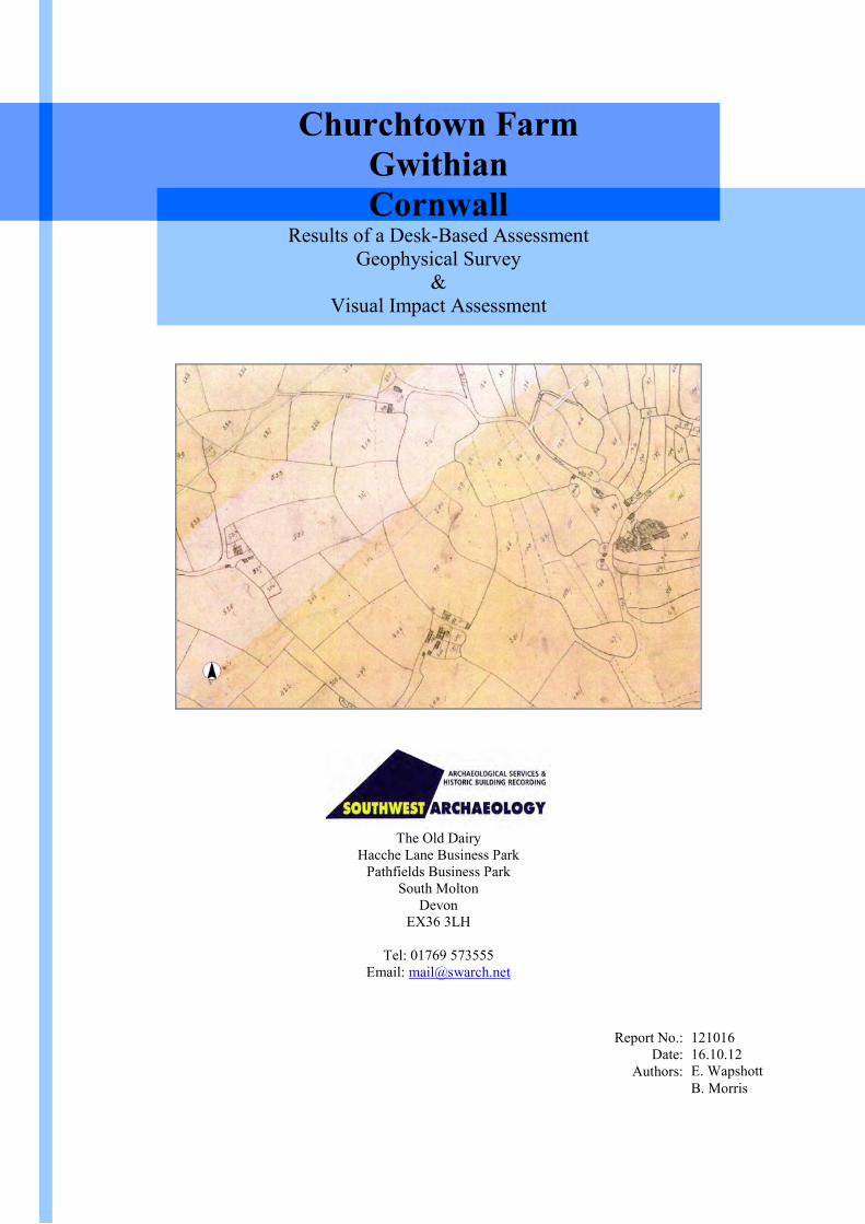
Churchtown FarmGwithianCornwall
Results of a Desk-Based AssessmentGeophysical Survey
&Visual Impact Assessment
The Old DairyHacche Lane Business Park
Pathfields Business ParkSouth Molton
DevonEX36 3LH
Tel: 01769 573555Email: [email protected]
Report No.:Date:
Authors:
12101616.10.12E. WapshottB. Morris

Churchtown Farm, Gwithian, Cornwall
South West Archaeology 2
Churchtown Farm, Gwithian,Cornwall
Results of a Desk-Based Assessment,Geophysical Survey &
Visual Impact Assessment
For
Tom Worboys
of
Pineapple Rural Consultancy
By
SWARCH project reference: CGF12National Grid Reference: SW594409CC Planning Reference: pre-planningProject Director: Colin HumphreysDesk-Based Assessment: B. Morris; E. WapshottFieldwork Managers: B. MorrisProject Officer: E. WapshottFieldwork: E. WapshottReport: B. Morris; E. WapshottReport Editing: B. MorrisResearch: B. Morris; E. WapshottGraphics: B. Morris; E. Wapshott
October 2012
South West Archaeology Ltd. shall retain the copyright of any commissioned reports, tender documents or other project documents,under the Copyright, Designs and Patents Act 1988 with all rights reserved, excepting that it hereby provides an exclusive licence tothe client for the use of such documents by the client in all matters directly relating to the project as described in the Written Scheme ofInvestigation.

Churchtown Farm, Gwithian, Cornwall
South West Archaeology 3
Summary
This report presents the results of a desk-based assessment, geophysical survey and visual impactassessment carried out by South West Archaeology Ltd. (SWARCH) at Churchtown Farm, Gwithian,Cornwall, in advance of the construction of a single wind turbine.
The proposed development site lies within an area of Anciently Enclosed Land (AEL), which thedocumentary record suggests lay within an open strip field system that survived well into the 19th century.The geophysical survey identified a large number of geophysical anomalies near the base of the proposedturbine, which include a sub-ovoid enclosure, relict field boundaries and linears associated with theadjacent Scheduled Monument.
The visual impact assessment concluded that the proposed wind turbine will have a substantive visualimpact on the immediate area. The turbine will sit high up to the east of the village of Gwithian,overlooking both the village and bay to the west, which includes a significant number of recordedarchaeological sites and heritage assets. Local blocking within the village will result in a generalassessment of negative/moderate to negative/substantial, with a neutral impact on some buildings due to thelocal blocking. The adjacent Scheduled Monument will not be affected by the turbine, as it shows only as acrop mark and thus any impact on this heritage asset must be assessed as neutral. Further afield, althoughthe turbine will be visible from such places as St. Ives, Camborne and Gwinear, it is at such a distance thatany direct impact by the turbine on the settlements and associated heritage assets must be assessed asnegative/minor to negative/moderate. The high frequency of other wind turbines within the 10km zone – inmuch less sympathetic locations with regard to heritage assets (Carwin Rise, Trewinnard Manor etc.) –should be considered to lessen the individual impact of the proposed Churchtown Farm turbine. However,issues of cumulative impact must be considered.
Churchtown Farm, Gwithian, Cornwall
South West Archaeology 4
Contents Page No.
List of Illustrations 5
List of Appendices 5
Acknowledgements 5
1.0 Introduction 6
2.0 Desk-Based Assessment and Cartographic Analysis 8
1.1.1. The 1699 Gascoyne Map of Cornwall 81.1.2. Basset Estate Map 1737 81.1.3. The Ordnance Survey 1” Map 91.1.4. The 1839 Gwithian Tithe Map 91.1.5. The 1st and 2nd Edition Ordnance Survey Map 11
3.0 Summary of the Geophysical Survey 14
4.0 Site Inspection and Visual Impact Assessment 17
4.1. The Site Inspection 17
4.2. Results of the Viewshed Analysis 20
4.3. Field Verification of ZTV 21
4.4. Likely Impacts of the Proposed Development 22
4.4.1. Types and Scale of Impact 224.4.2. Scale and Duration of Impact 234.4.3. Statements of Significance of Heritage Assets 24
4.5. Assessment of Impact 26
4.5.1. Impacts on Potential Archaeological Sites within the Development Area 264.5.2. Impact on the Setting of Surrounding Key Heritage Assets (within 5km) 274.5.3. Impact on the Setting of Surrounding Key Heritage Assets (10km radius) 344.5.4. Impact on the Setting of Surrounding Key Heritage Assets (15km radius) 37
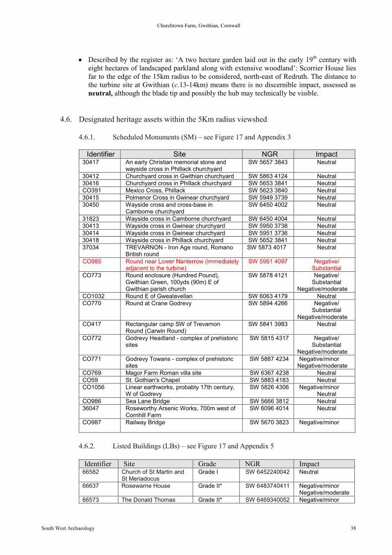
4.6. Designated heritage assets within the 5Km radius viewshed 38
4.6.1. Scheduled Monuments (SM) 384.6.2. Listed Buildings (LBs) 38
4.7. Designated heritage assets within the 10km radius viewshed 40
4.7.1. Scheduled Monuments (SM) 404.7.2. Listed Buildings (LBs) 404.7.3. Parks and Gardens (PGs) 41
4.8. Impacts on Historic Landscape Character 41
5.0 Archaeological Mitigation Strategy 44
6.0 Conclusion 44
7.0 Bibliography and References 47
Churchtown Farm, Gwithian, Cornwall
South West Archaeology 5
List of Illustrations
Coverplate: Extract from the 1699 map of Cornwall by Joel Gascoyne Page No.
Figure 1: Regional Location. 7Figure 2: Extract from the 1699 Gascoyne Map of Cornwall. 8Figure 3: Extract from map and schedule of Basset lands in Tehidy Manor, in Gwithian parish, 1737. 8Figure 4: The Ordnace Survey 1” scale map. 9Figure 5: Gwithian tithe map 1839. 9Figure 6: The 1st Edition Ordnance Survey Map, c.late 1880s. 11Figure 7: The 1906-8 2nd Edition Ordnance Survey map. 11Figure 8: Shade plot of the processed gradiometer data. 14Figure 9: Interpretation of the processed data. 15Figure 10: Local cropmarks, with the interpretation of the geophysical survey results. 16Figure 11: View of the sub-rectangular field in which the proposed turbine will be located. 18Figure 12: The complex of steel-framed buildings, haulage yard and pylons etc. south-east of the site. 18Figure 13: The extant turbine that stands directly south of the site on the opposing hill. 19Figure 14: The other extant turbine that stands east of the site; viewed from the west. 19Figure 15: View of the north-west corner of the extensive PV farm south-east of the proposed turbine site. 20Figure 16: ZTV supplied by Pineapple Rural Consultancy Ltd. showing the areas with visibility to the turbine. 21Figure 17: Map of known archaeological and historical sites within 5km of the site. 22Figure 18: Map of known archaeological and historical sites within 5-10km of the site. 23Figure 19: ZTV out to 15km, showing the location of Registered Parks and Gardens. 24Figure 20: Non-verified photomontage showing the view from adjacent Scheduled Monument (CO985). 27Figure 21: View to the turbine site from within the churchyard. 29Figure 22: Non-verified photomontage showing the view from St Gothian’s Chapel. 29Figure 23: Non-verified photo-montage showing the view from the Godrevy Headland. 30Figure 24: Non-verified photomontage showing the view from the edge of the World Heritage Mining Site. 32Figure 25: View across Copperhouse Pool to Phillack, showing both St Elwyn and St Phillack Churches. 33Figure 26:View from the foundry district of Hayle, immediately adjacent to theviaduct. 34Figure 27: Non-verified photomontage showing the view from St Ives Harbour. 35Figure 28: Diagram showing the cumulative impact of turbines within the 5-10km radius. 43Figure 29: Photograph taken in the 1880s by John Gibson of Penzance. 46Figure 30: Photograph showing the extensive sand mining work still being carried out in Gwithian bay in 1987. 46
List of Appendices
Appendix 1: Project Design 47Appendix 2: Key HER entries 50Appendix 3: Scheduled Monuments within 5km 56Appendix 4: Schedule Monuments within 5-10km 65Appendix 5: Listed Building Texts (Grade I and Grade II*) 72Appendix 6: Registered Parks and Gardens 106Appendix 7: Turbine Cumulative Impact Map for Cornwall 110Appendix 8: List of jpegs on the CD Rom at the rear of this report 111
Acknowledgements
Thanks are due to:Mr Anthony James (the Owner) for accessTom Worboys (the Agent)The staff of the Cornwall Record Office, TruroThe staff of the Cornish Studies Library, Redruth

Churchtown Farm, Gwithian, Cornwall
South West Archaeology 6
1.0 Introduction
Location: Churchtown FarmParish: Gwinear-GwithianDistrict: Penwith DistrictCounty: CornwallNGR: SW594409
1.1. Project Background
This report presents the results of a desk-based assessment, geophysical survey and visualimpact assessment carried out by South West Archaeology Ltd. (SWARCH) at ChurchtownFarm, Gwithian, Cornwall. It also summarizes the results of a geophysical survey carried outby Substrata (Report no: 120813). The work was commissioned by Tom Worboys of PineappleRural Consultancy (the Client) as part of the pre-planning process, in order to investigate andrecord any archaeological features and material potentially affected by the installation of a500kw wind turbine on the site and across the length of the cable run. The report is designed topresent the results of the various surveys to aid the future planning application for the same.These works were carried out in accordance to a Project Design (Appendix 1) drawn up inconsultation with the Cornwall Council Historic Environment Planning Advice Officer(HEPAO) Phil Markham.
1.2. Archaeological Background
The turbine lies within Anciently Enclosed Land (AEL) and is located immediately to the westof a Scheduled Ancient Monument (Scheduled Monument CO985: Round near LowerNanterrow): a ploughed-down round visible only as a cropmark (HER 37033). The cropmarksof further undesignated enclosures lie immediately to the north, east and south (HER 53582-5);these are assumed to be contemporary with the Iron Age/Romano-British settlement. Twofurther Scheduled rounds lie within 1km to the south-west (HER 37034, 53549). The remainsof a post-medieval mine lie c.400m to the east at Higher Nanterrow Farm (HER 53579). In thevalley of the Red River to the south lies the important Bronze Age and early medieval site ofGwithian (HER 37049), extensively excavated in the 1950-60s. Connerton (located 1.5km tothe south) was the original administrative centre for the Hundred of Connerton (now WestPenwith). This is a landscape of high archaeological potential, and contains significant remainsof Prehistoric, Romano-British and early medieval settlement and landuse. Details of the abovementioned key HER entries can be found in Appendix 4.
1.3. Topographical and Geological Background
Gwithian is a coastal village in west Cornwall, England, United Kingdom. It is situated threemiles (5 km) northeast of Hayle and four miles (6.5 km) east of St Ives, Cornwall across StIves Bay. Gwithian is in the civil parish of Gwinear-Gwithian. In the former Manor ofConnerton, part of the ‘hundred’ of Penwith. The turbine site is located on a raised spur of landwhich projects from Trevarnon Moor to the south. The site overlooks the Red river valley, tothe south-west and gives distant views across St Ives bay, to the west. The bedrock on theturbine site is of the Mylor Slate Formation, of siltstone and slate, with to the west along thecoast banding of the Porthtowan Formation, of mudstone and sandstone (British GeologicalSurvey 2012).
Churchtown Farm, Gwithian, Cornwall
South West Archaeology 7
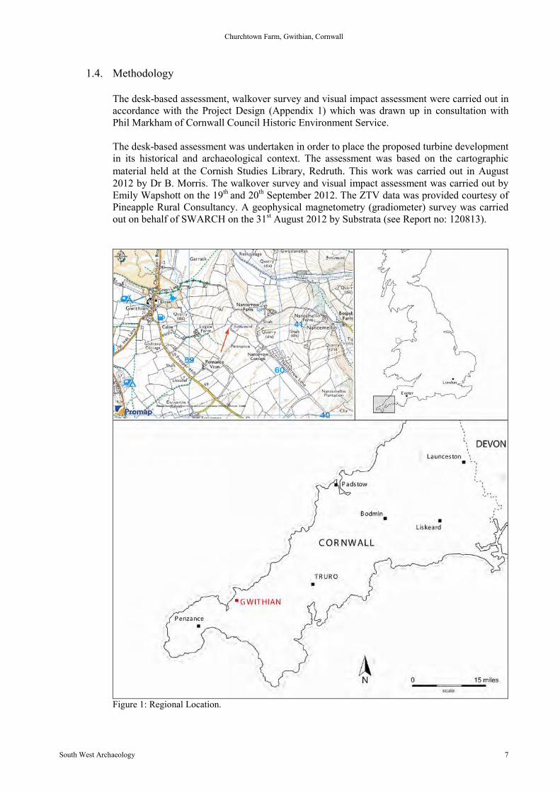
1.4. Methodology
The desk-based assessment, walkover survey and visual impact assessment were carried out inaccordance with the Project Design (Appendix 1) which was drawn up in consultation withPhil Markham of Cornwall Council Historic Environment Service.
The desk-based assessment was undertaken in order to place the proposed turbine developmentin its historical and archaeological context. The assessment was based on the cartographicmaterial held at the Cornish Studies Library, Redruth. This work was carried out in August2012 by Dr B. Morris. The walkover survey and visual impact assessment was carried out byEmily Wapshott on the 19th and 20th September 2012. The ZTV data was provided courtesy ofPineapple Rural Consultancy. A geophysical magnetometry (gradiometer) survey was carriedout on behalf of SWARCH on the 31st August 2012 by Substrata (see Report no: 120813).
Figure 1: Regional Location.
Churchtown Farm, Gwithian, Cornwall
South West Archaeology 8
2.0 Desk-Based Assessment and Cartographic Analysis
2.1. Cartographic Analysis
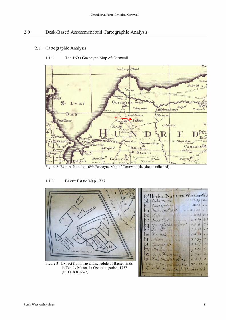
1.1.1. The 1699 Gascoyne Map of Cornwall
Figure 2: Extract from the 1699 Gascoyne Map of Cornwall (the site is indicated).
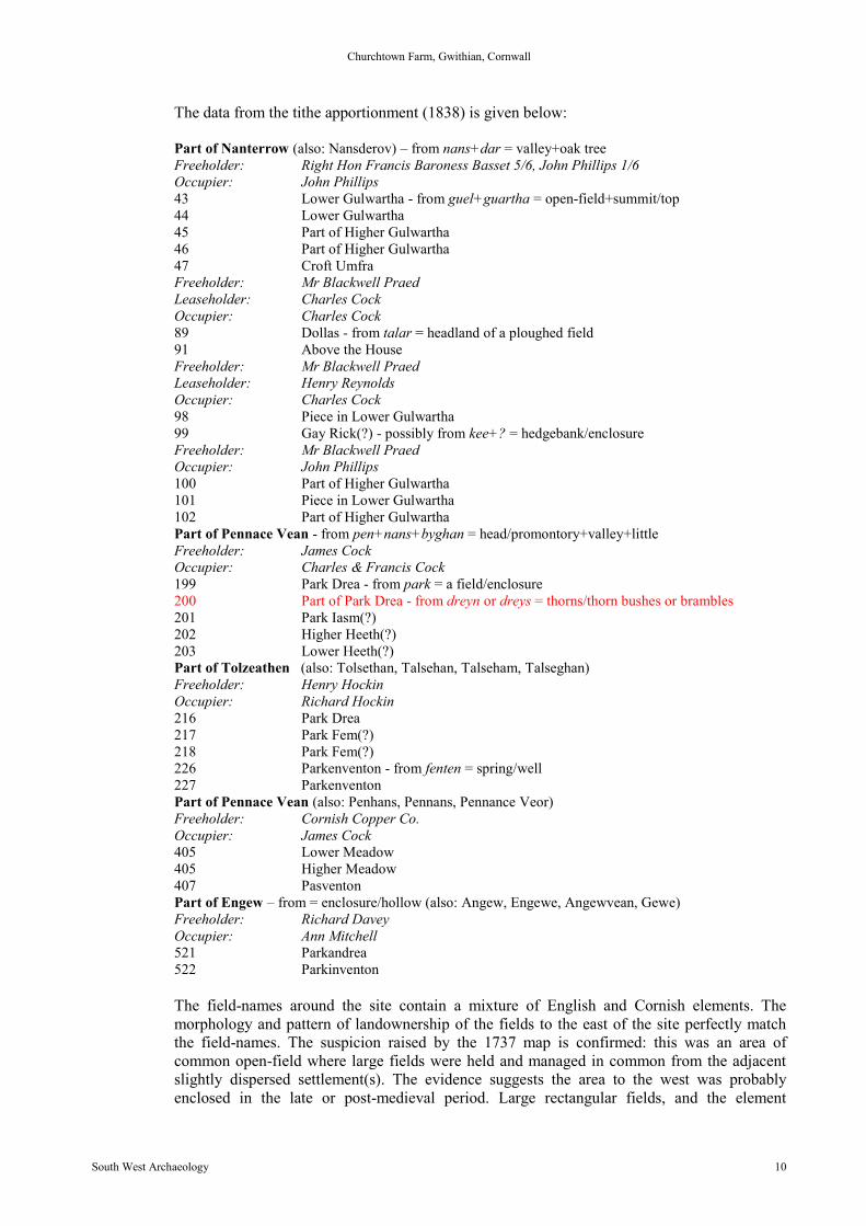
1.1.2. Basset Estate Map 1737
Figure 3: Extract from map and schedule of Basset landsin Tehidy Manor, in Gwithian parish, 1737(CRO: X101/5/2).

Churchtown Farm, Gwithian, Cornwall
South West Archaeology 9
This estate map is highly schematic and, by comparison with the tithe information, lies slightlyto the east of the proposed development. However, the use of the field name Stitches, and thehighly fragmented nature of the holding, suggests these lands lay within a common open-fieldsystem.
1.1.3. The Ordnance Survey 1” Map
Figure 4: The Ordnance Survey 1” scale map (sheet 31) (the site is indicated) (CRO).
The early Ordnance Survey maps lack detail, but do show that the site lies within enclosedland, between three settlements or farms: Angew and two marked Nancevean.
1.1.4. The 1839 Gwithian Tithe Map
Figure 5: Gwithian tithe map 1839 (the site of the proposed turbine is indicated) (CSL).
Churchtown Farm, Gwithian, Cornwall
South West Archaeology 10
The data from the tithe apportionment (1838) is given below:
Part of Nanterrow (also: Nansderov) – from nans+dar = valley+oak treeFreeholder: Right Hon Francis Baroness Basset 5/6, John Phillips 1/6Occupier: John Phillips43 Lower Gulwartha - from guel+guartha = open-field+summit/top44 Lower Gulwartha45 Part of Higher Gulwartha46 Part of Higher Gulwartha47 Croft UmfraFreeholder: Mr Blackwell PraedLeaseholder: Charles CockOccupier: Charles Cock89 Dollas - from talar = headland of a ploughed field91 Above the HouseFreeholder: Mr Blackwell PraedLeaseholder: Henry ReynoldsOccupier: Charles Cock98 Piece in Lower Gulwartha99 Gay Rick(?) - possibly from kee+? = hedgebank/enclosureFreeholder: Mr Blackwell PraedOccupier: John Phillips100 Part of Higher Gulwartha101 Piece in Lower Gulwartha102 Part of Higher GulwarthaPart of Pennace Vean - from pen+nans+byghan = head/promontory+valley+littleFreeholder: James CockOccupier: Charles & Francis Cock199 Park Drea - from park = a field/enclosure200 Part of Park Drea - from dreyn or dreys = thorns/thorn bushes or brambles201 Park Iasm(?)202 Higher Heeth(?)203 Lower Heeth(?)Part of Tolzeathen (also: Tolsethan, Talsehan, Talseham, Talseghan)Freeholder: Henry HockinOccupier: Richard Hockin216 Park Drea217 Park Fem(?)218 Park Fem(?)226 Parkenventon - from fenten = spring/well227 ParkenventonPart of Pennace Vean (also: Penhans, Pennans, Pennance Veor)Freeholder: Cornish Copper Co.Occupier: James Cock405 Lower Meadow405 Higher Meadow407 PasventonPart of Engew – from = enclosure/hollow (also: Angew, Engewe, Angewvean, Gewe)Freeholder: Richard DaveyOccupier: Ann Mitchell521 Parkandrea522 Parkinventon
The field-names around the site contain a mixture of English and Cornish elements. Themorphology and pattern of landownership of the fields to the east of the site perfectly matchthe field-names. The suspicion raised by the 1737 map is confirmed: this was an area ofcommon open-field where large fields were held and managed in common from the adjacentslightly dispersed settlement(s). The evidence suggests the area to the west was probablyenclosed in the late or post-medieval period. Large rectangular fields, and the element
Churchtown Farm, Gwithian, Cornwall
South West Archaeology 11
dreys/dreyn, all suggest this area was not primarily an arable landscape. Unusually, the titheapportionment did not include land-use data. The turbine is to be located in the small squarefield numbered 200 (part of Park Drea).
Note that the Nancevean of the 1” maps is now shown as Pennance Vean.
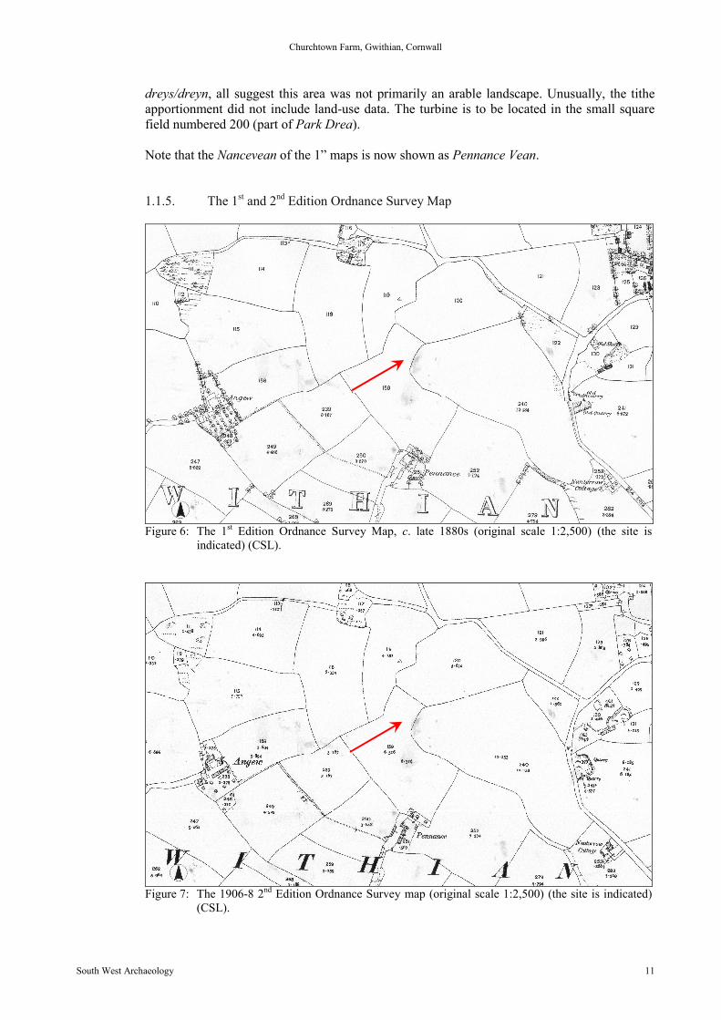
1.1.5. The 1st and 2nd Edition Ordnance Survey Map
Figure 6: The 1st Edition Ordnance Survey Map, c. late 1880s (original scale 1:2,500) (the site isindicated) (CSL).
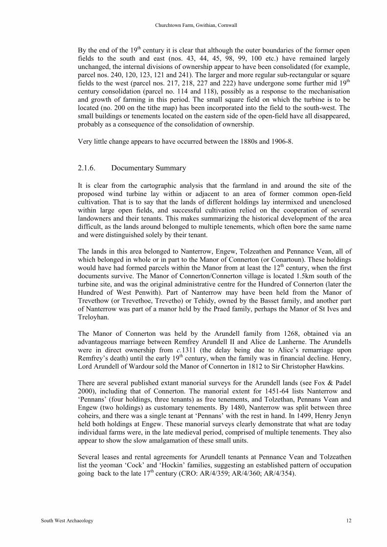
Figure 7: The 1906-8 2nd Edition Ordnance Survey map (original scale 1:2,500) (the site is indicated)(CSL).
Churchtown Farm, Gwithian, Cornwall
South West Archaeology 12
By the end of the 19th century it is clear that although the outer boundaries of the former openfields to the south and east (nos. 43, 44, 45, 98, 99, 100 etc.) have remained largelyunchanged, the internal divisions of ownership appear to have been consolidated (for example,parcel nos. 240, 120, 123, 121 and 241). The larger and more regular sub-rectangular or squarefields to the west (parcel nos. 217, 218, 227 and 222) have undergone some further mid 19th
century consolidation (parcel no. 114 and 118), possibly as a response to the mechanisationand growth of farming in this period. The small square field on which the turbine is to belocated (no. 200 on the tithe map) has been incorporated into the field to the south-west. Thesmall buildings or tenements located on the eastern side of the open-field have all disappeared,probably as a consequence of the consolidation of ownership.
Very little change appears to have occurred between the 1880s and 1906-8.
2.1.6. Documentary Summary
It is clear from the cartographic analysis that the farmland in and around the site of theproposed wind turbine lay within or adjacent to an area of former common open-fieldcultivation. That is to say that the lands of different holdings lay intermixed and unenclosedwithin large open fields, and successful cultivation relied on the cooperation of severallandowners and their tenants. This makes summarizing the historical development of the areadifficult, as the lands around belonged to multiple tenements, which often bore the same nameand were distinguished solely by their tenant.
The lands in this area belonged to Nanterrow, Engew, Tolzeathen and Pennance Vean, all ofwhich belonged in whole or in part to the Manor of Connerton (or Conartoun). These holdingswould have had formed parcels within the Manor from at least the 12th century, when the firstdocuments survive. The Manor of Connerton/Connerton village is located 1.5km south of theturbine site, and was the original administrative centre for the Hundred of Connerton (later theHundred of West Penwith). Part of Nanterrow may have been held from the Manor ofTrevethow (or Trevethoe, Trevetho) or Tehidy, owned by the Basset family, and another partof Nanterrow was part of a manor held by the Praed family, perhaps the Manor of St Ives andTreloyhan.
The Manor of Connerton was held by the Arundell family from 1268, obtained via anadvantageous marriage between Remfrey Arundell II and Alice de Lanherne. The Arundellswere in direct ownership from c.1311 (the delay being due to Alice’s remarriage uponRemfrey’s death) until the early 19th century, when the family was in financial decline. Henry,Lord Arundell of Wardour sold the Manor of Connerton in 1812 to Sir Christopher Hawkins.
There are several published extant manorial surveys for the Arundell lands (see Fox & Padel2000), including that of Connerton. The manorial extent for 1451-64 lists Nanterrow and‘Pennans’ (four holdings, three tenants) as free tenements, and Tolzethan, Pennans Vean andEngew (two holdings) as customary tenements. By 1480, Nanterrow was split between threecoheirs, and there was a single tenant at ‘Pennans’ with the rest in hand. In 1499, Henry Jenynheld both holdings at Engew. These manorial surveys clearly demonstrate that what are todayindividual farms were, in the late medieval period, comprised of multiple tenements. They alsoappear to show the slow amalgamation of these small units.
Several leases and rental agreements for Arundell tenants at Pennance Vean and Tolzeathenlist the yeoman ‘Cock’ and ‘Hockin’ families, suggesting an established pattern of occupationgoing back to the late 17th century (CRO: AR/4/359; AR/4/360; AR/4/354).

Churchtown Farm, Gwithian, Cornwall
South West Archaeology 13
The Manor of St Ives and Treloyhan was owned others by the Praed family who also ownedthe Manors of Trembethow, Towednack, Zennor, Marazion, Redruth and Trengwainton. Deedsand rental documents are held by the CRO from the later 15th century onwards for the variousPraed holdings. The Manor of St Ives and Treloyhan was sold in c.1807/08 to Sir ChristopherHawkins (Lysons 1814) by William Praed and James Blackwell Praed. Some elements of thePraed family estate must have been retained as documents held by the CRO suggest rents fromparts of the Towednack and Zennor Manors continued to be collected until 1840. Field nos. 89-102 (part of Nanterrow) on the tithe map may represent an element of the retained lands, as thefreeholder is named as a Mr Blackwell Praed.
Sir Christopher Hawkins was from a wealthy Cornish family who resided at Trewithern,having migrated to Cornwall in the mid 16th century to avoid the religious conflicts of the time.Sir Christopher Hawkins died in 1829, his death igniting a family feud between his brotherJohn Hawkins and his nephew Henry Hawkins. Part of the Manor of St Ives (including Lelantand Towdeknack) was put up for sale by the Court of Chancery. Despite the family disputeJohn Hawkins inherited the Manor of Connerton and the Hawkins family seat at Trewithern.The Manor of Connerton and the hundred and liberties of Penwith were separate from theDuchy of Cornwall and gave the Lord of the Manor’s special rights and privileges, but alsocame with additional duties (listed as in the 15th century: to do common suit to the court andmill of the manor; to act as reeve if so elected; to act as a conventionary tenant of the manor; torepair and maintain the property) and John Hawkins, who was a Fellow of the Royal Societyand a founder member of the Royal Horticultural Society sold the estate in 1832 to FrancisPaynter and his cousin John Paynter, Francis being a solicitor and Hundred of Penwith judge,from Penzance.
In 1838 Nanterrow Farm freehold was owned in part by Right Hon. Francis Baroness Basset.The Basset family is believed to have originated in the midlands, acquiring estates in Cornwallthrough marriages in the reign of Henry II in the mid-late 12th century. This connection appearsto be through the marriage of Thomas, Baron Basset of Hedendon, Oxfordshire and Adeliza deDunstanville. The ancestors of Adeliza, held the Manor of Tehidy, from the 11th century.Frances Basset, 2nd Baroness Basset (1781-1855) was born in London and was the only childof Francis Basset, 1st Baron de Dunstanville and Basset and his first wife. Unusually, Franceswas a Baroness in her own right, created as such by a special remainder in her father’s will. Asa result, following her father's death in 1835 she succeeded to the barony of Basset and theBasset estates in both Cornwall and Buckinghamshire. Frances died herself not long after in1855, at Tehidy, at the age of seventy-four. She had never married and her estates passed to theoffspring of a cousin, but the Baronetcy became extinct with her passing. The last of the Bassetfamily, Frances was buried in Illogan church.
Interestingly Frances Basset’s father, Baron Basset and Lord Dunstanville (a Whig MP) was apolitical rival of Christopher Hawkins (a Tory MP) and they fell out over charges of briberyand a duel was fought between the two men (fellow bouroughmongers) in 1810, although theyboth survived. Only two years later Sir Christopher bought the Manor of Connerton, makinghim a joint freeholder of the holding of Nanterrow with Francis Basset. Could we tentativelysuggest the political battles played out in the House of Commons were being echoed in theacquisition of land? Perhaps the survival of the open-field system with fragmented freeholderownership as depicted on the Gwithian tithe map reflects the unwillingness of these two men tocountenance agricultural rationalisation.
Churchtown Farm, Gwithian, Cornwall
South West Archaeology 14
3.0 Summary of the Geophysical Survey
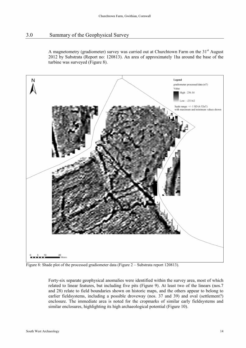
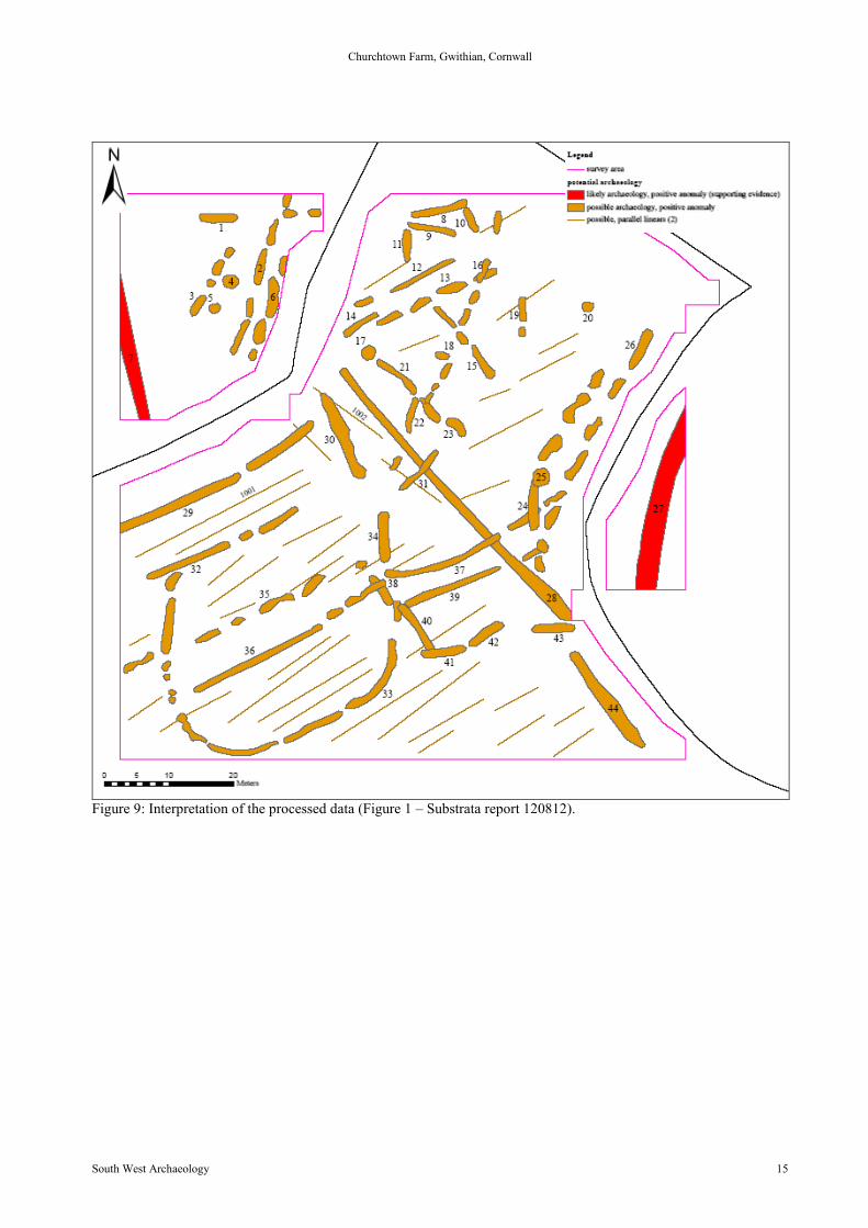
A magnetometry (gradiometer) survey was carried out at Churchtown Farm on the 31st August2012 by Substrata (Report no: 120813). An area of approximately 1ha around the base of theturbine was surveyed (Figure 8).
Figure 8: Shade plot of the processed gradiometer data (Figure 2 – Substrata report 120813).
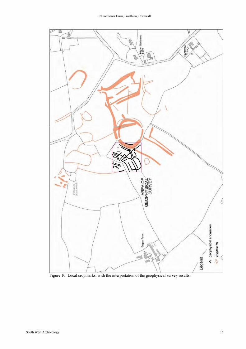
Forty-six separate geophysical anomalies were identified within the survey area, most of whichrelated to linear features, but including five pits (Figure 9). At least two of the linears (nos.7and 28) relate to field boundaries shown on historic maps, and the others appear to belong toearlier fieldsystems, including a possible droveway (nos. 37 and 39) and oval (settlement?)enclosure. The immediate area is noted for the cropmarks of similar early fieldsystems andsimilar enclosures, highlighting its high archaeological potential (Figure 10).
Churchtown Farm, Gwithian, Cornwall
South West Archaeology 15
Figure 9: Interpretation of the processed data (Figure 1 – Substrata report 120812).
Churchtown Farm, Gwithian, Cornwall
South West Archaeology 16
Figure 10: Local cropmarks, with the interpretation of the geophysical survey results.

Churchtown Farm, Gwithian, Cornwall
South West Archaeology 17
4.0 Site Inspection and Visual Impact Assessment
4.1. The Site Inspection
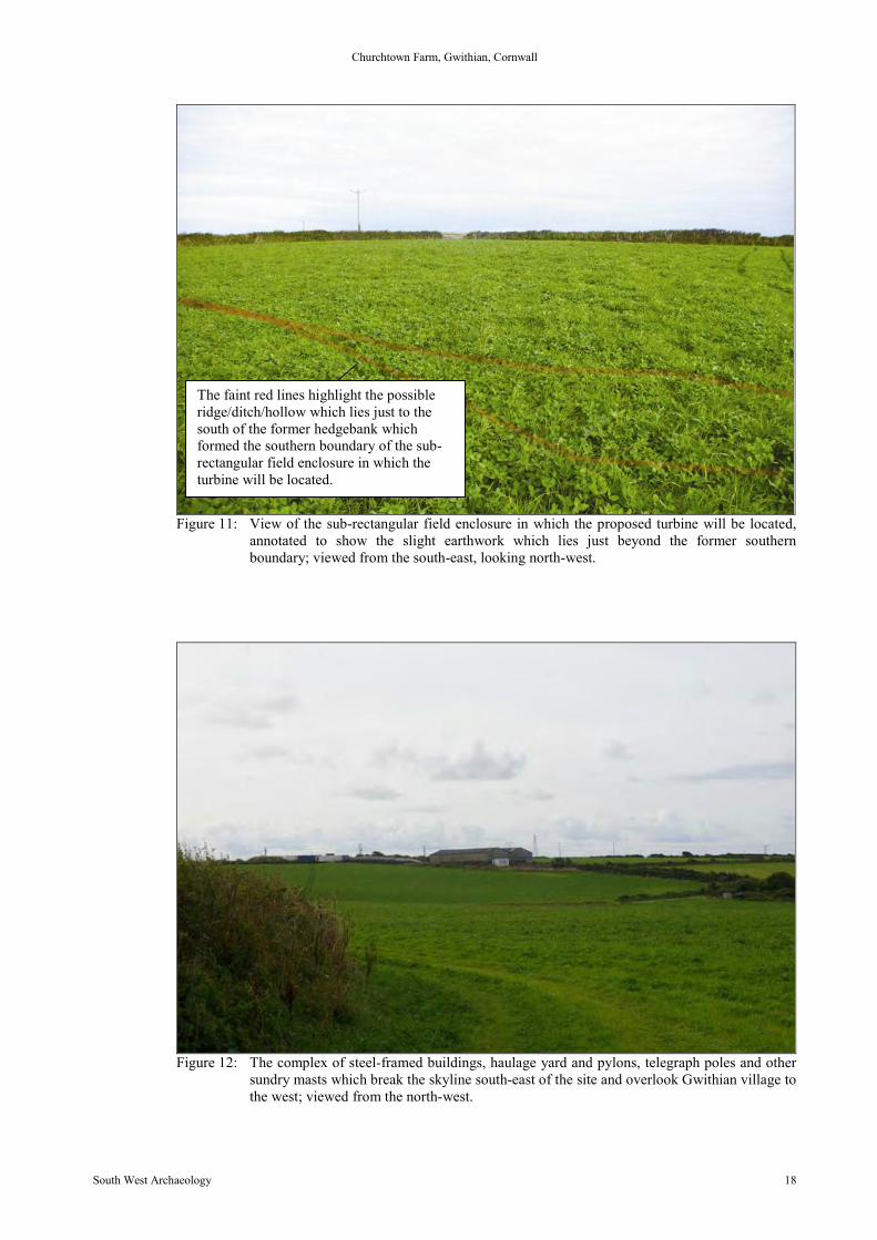
A site walkover and inspection was made on 20th September 2012. The weather was overcastbut dry, with high cloud cover, darkening to the west, but visibility was generally good. Thefield in which the wind turbine is to be placed was under crop, but accessible via a track to thefield edge. The owner Mr James accompanied the inspector and explained the exact locationand nature of the turbine and the visible settlements and features within the viewshed. The siteis set within a small sub-rectangular adjunct of a larger field, formerly a small separateenclosure recorded on the 1840s tithe map. The eastern, northern and western boundaries areof stone-built hedgebanks surmounted with stunted wind-blown trees and shrubs. The fieldedges are obscured by weeds and appear to slope up slightly to the hedgebanks; decades ofploughing have modified the original contours of the field. Within the sub-rectangular formerenclosure there are no visible or obvious earthworks or archaeological features; slight ridgingis evident but is attributed to ploughing, which the owner (Mr James) states has occurred formost of 20th and 21st century. The area was walked and no topsoil finds were recovered. Justbelow the former southern boundary of the former sub-rectangular enclosure there appears tobe a slight ridge, dividing the field into two parts; this cannot be attributed to the removedhedgebank as it is too far south (Figure 11). Within the larger part of the main field there isalso a very slight raised area, perhaps a natural knoll or geological feature, but just possibly aplatform. This raised area lies south-west of the proposed turbine location, towards the fieldboundary; this possible feature is very ephemeral and identification is subjective at best.
Two further extant turbines were observed during the site inspection; one directly opposite thesite (Figure 13) and adjacent to a small dwelling, and another just over the hedgebank to theeast also visible from the site (Figure 14). Both turbines appear to be considerably smaller insize and wattage than the one proposed for the site, but establish a precedent for turbineswithin the immediate location. To the south-east and within the same holding there is a largecomplex of modern steel-framed buildings (Figure 12) and areas of hardcore which form ahaulage yard and agricultural buildings; these also lie on a slope leading to the west andoverlook the village of Gwithian. In the wider area there is a noted concentration of pylons andtelegraph poles, most visibly at the apex of the shallow hills rising from the bay; thesedominate the skyline above Gwithian village. Mobile phone masts and other extant structureswhich breach the skyline were also observed in and around the immediate location of the site.Within a 2km of the site, but not directly visible from the field, is a newly-erected turbine of asimilar size and directly comparable to the proposed development; this is at Carwin Rise on theoutskirts of the town of Hayle. South-east of the site and beyond the haulage yard there is a PVfarm (Figure 15) covering several hectares, which dominates the view to the north and north-west.
Churchtown Farm, Gwithian, Cornwall
South West Archaeology 18
Figure 11: View of the sub-rectangular field enclosure in which the proposed turbine will be located,annotated to show the slight earthwork which lies just beyond the former southernboundary; viewed from the south-east, looking north-west.
Figure 12: The complex of steel-framed buildings, haulage yard and pylons, telegraph poles and othersundry masts which break the skyline south-east of the site and overlook Gwithian village tothe west; viewed from the north-west.
The faint red lines highlight the possibleridge/ditch/hollow which lies just to thesouth of the former hedgebank whichformed the southern boundary of the sub-rectangular field enclosure in which theturbine will be located.
Churchtown Farm, Gwithian, Cornwall
South West Archaeology 19
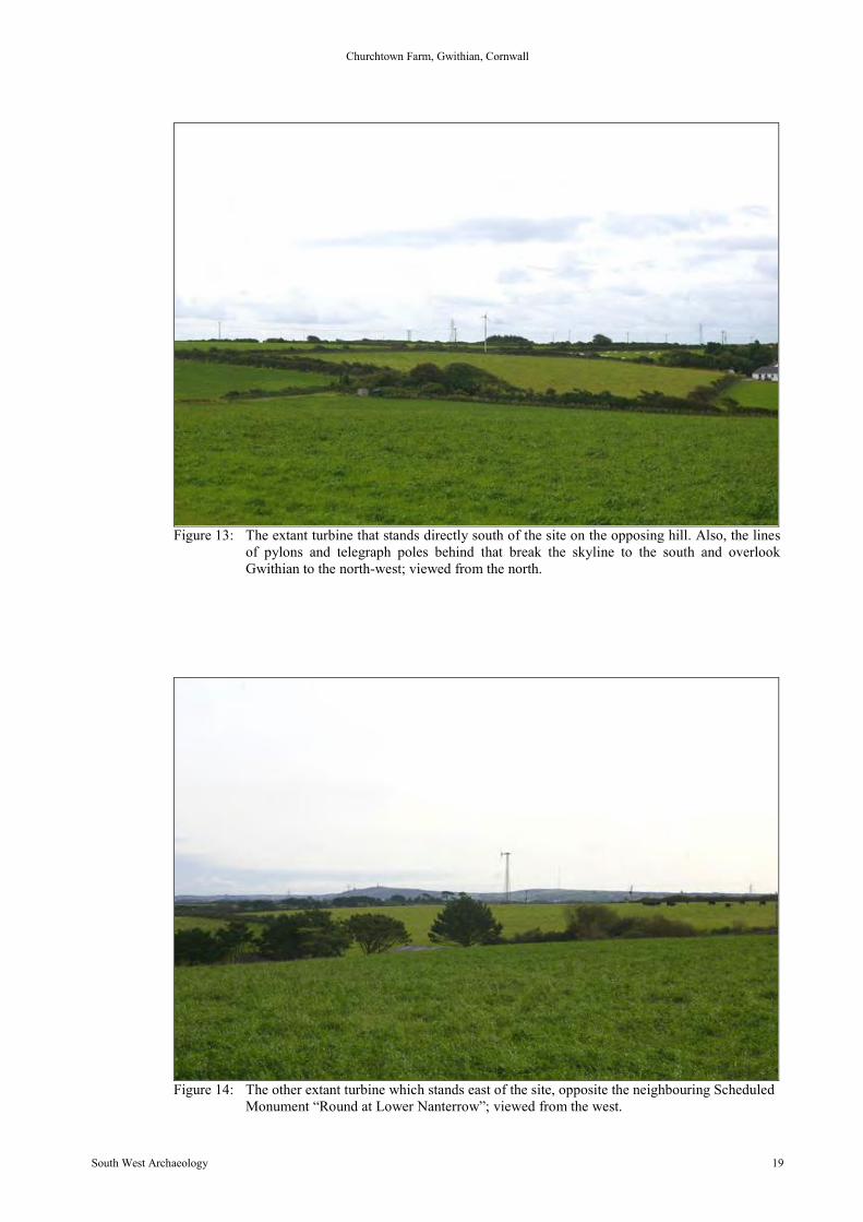
Figure 13: The extant turbine that stands directly south of the site on the opposing hill. Also, the linesof pylons and telegraph poles behind that break the skyline to the south and overlookGwithian to the north-west; viewed from the north.
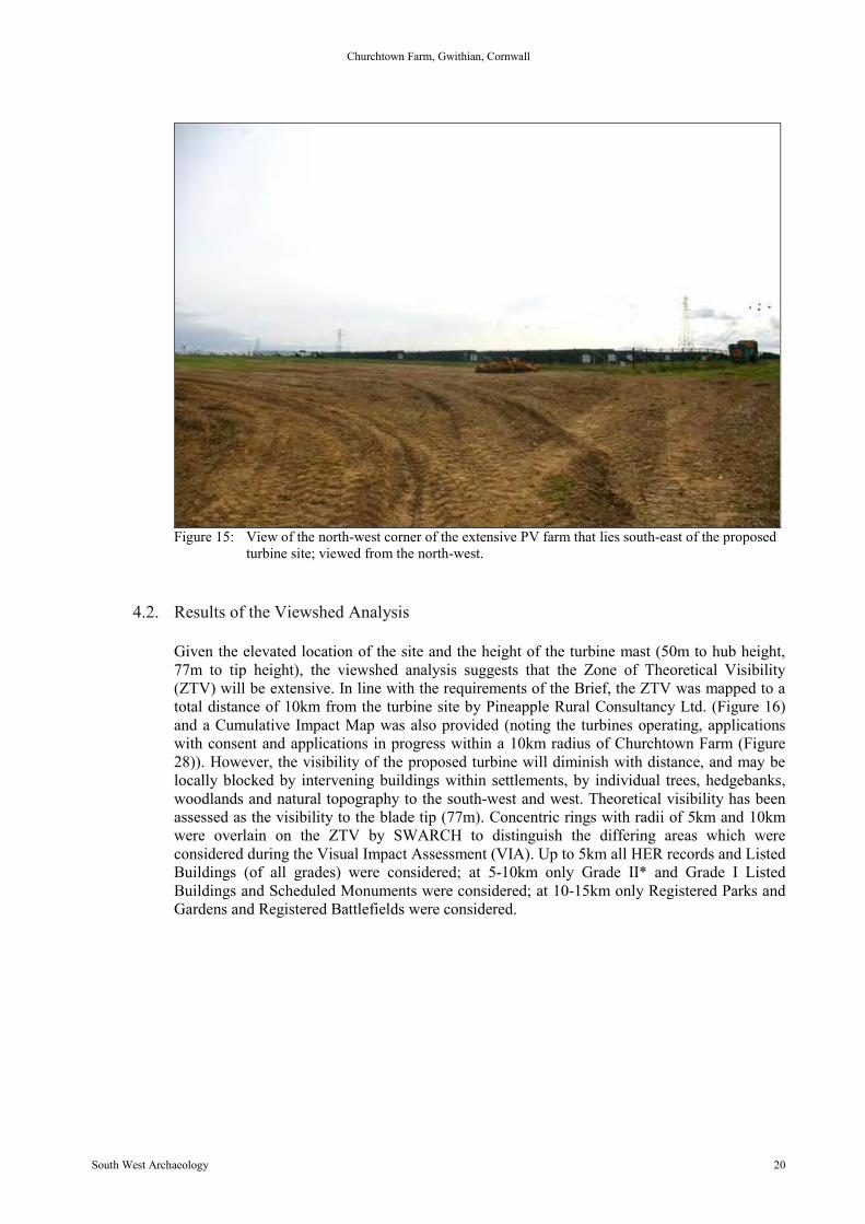
Figure 14: The other extant turbine which stands east of the site, opposite the neighbouring ScheduledMonument “Round at Lower Nanterrow”; viewed from the west.
Churchtown Farm, Gwithian, Cornwall
South West Archaeology 20
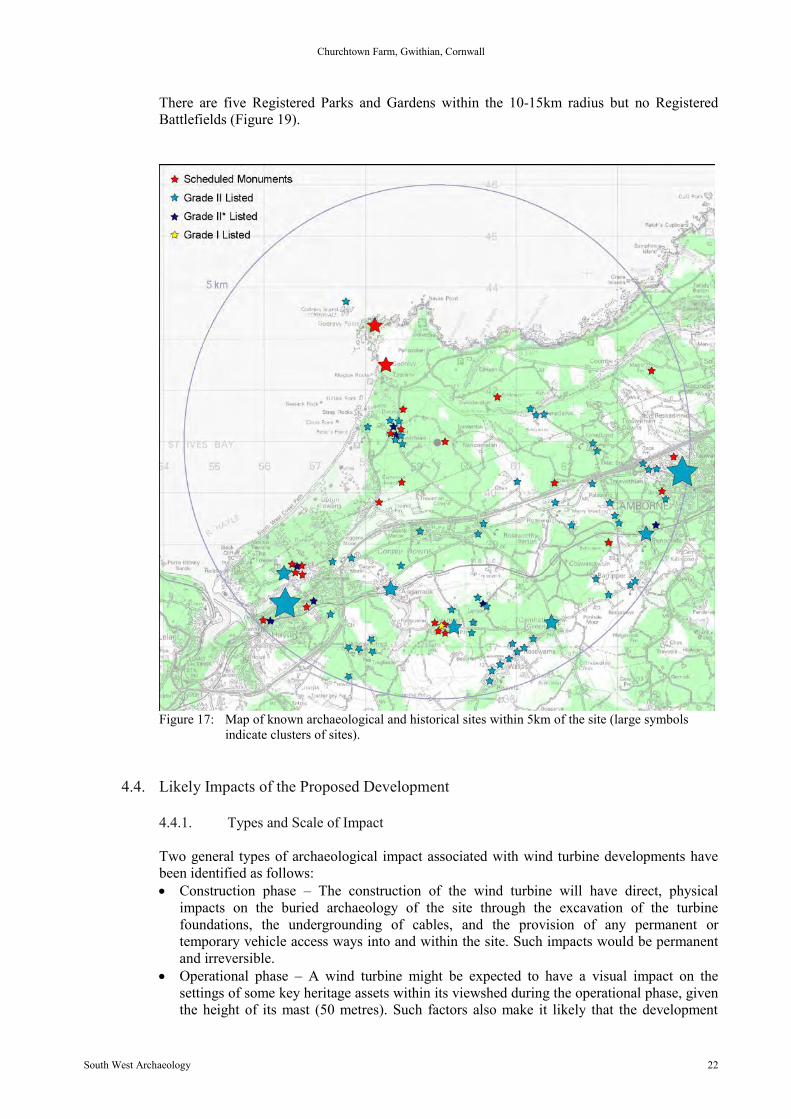
Figure 15: View of the north-west corner of the extensive PV farm that lies south-east of the proposedturbine site; viewed from the north-west.
4.2. Results of the Viewshed Analysis
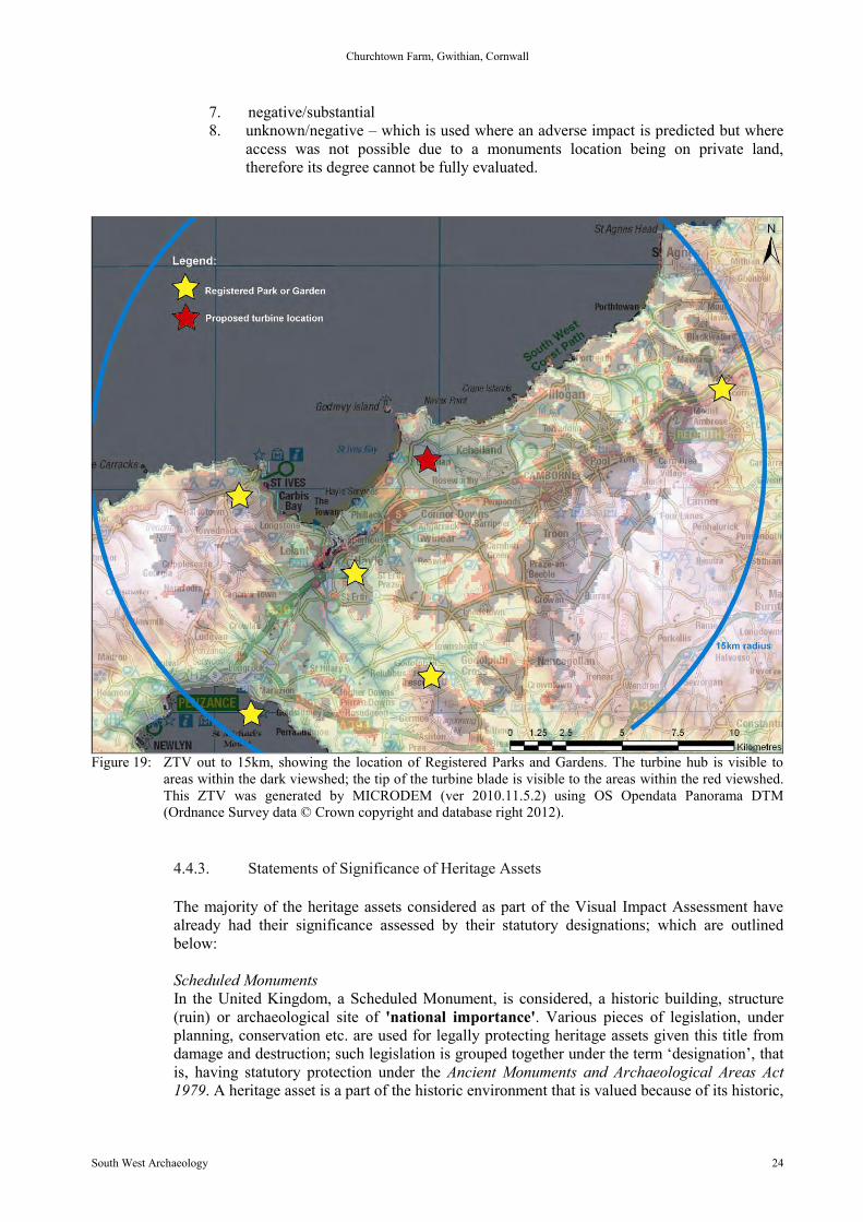
Given the elevated location of the site and the height of the turbine mast (50m to hub height,77m to tip height), the viewshed analysis suggests that the Zone of Theoretical Visibility(ZTV) will be extensive. In line with the requirements of the Brief, the ZTV was mapped to atotal distance of 10km from the turbine site by Pineapple Rural Consultancy Ltd. (Figure 16)and a Cumulative Impact Map was also provided (noting the turbines operating, applicationswith consent and applications in progress within a 10km radius of Churchtown Farm (Figure28)). However, the visibility of the proposed turbine will diminish with distance, and may belocally blocked by intervening buildings within settlements, by individual trees, hedgebanks,woodlands and natural topography to the south-west and west. Theoretical visibility has beenassessed as the visibility to the blade tip (77m). Concentric rings with radii of 5km and 10kmwere overlain on the ZTV by SWARCH to distinguish the differing areas which wereconsidered during the Visual Impact Assessment (VIA). Up to 5km all HER records and ListedBuildings (of all grades) were considered; at 5-10km only Grade II* and Grade I ListedBuildings and Scheduled Monuments were considered; at 10-15km only Registered Parks andGardens and Registered Battlefields were considered.

Figure 16: ZTV supplied by Pineapple Rural Consultancy Ltd. showing the areas with visibility to theturbine highlighted in green (dark green: to hub; light green: to blade tip).
4.3. Field Verification of ZTV
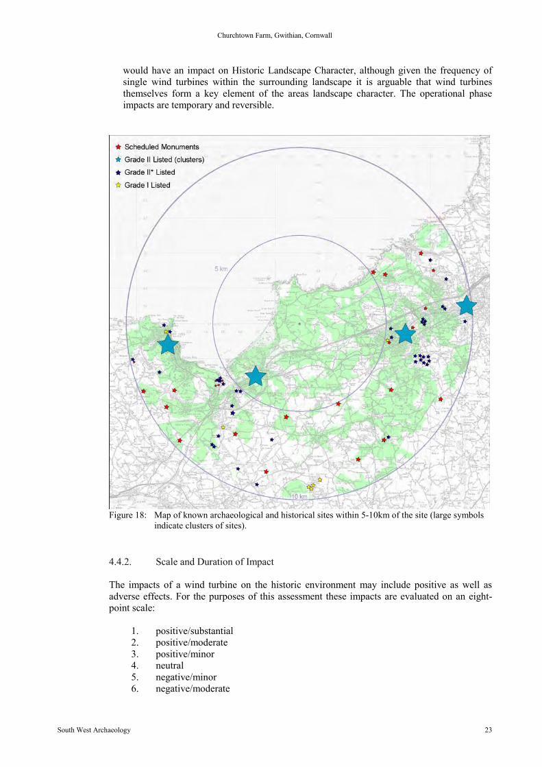
On the whole, the ZTV mapping was found to be a fairly accurate representation of the likelyintervisibility between the proposed wind turbine and the surrounding landscape out to 5km,10km and 15km, together with the heritage assets that encompasses. However, some smallelement of local blocking was found within the 5km area, produced by hedges, trees andbuildings where they occur within groups and clusters, such as the villages of Gwithian,Gwinear, St Erth and in the settlement of Hayle. Intervisibility with the proposed wind turbinewas confirmed for some of the Listed buildings at Gwithian, most notably, and despite somelocal blocking provided by a modern farmhouse, the Grade II * Methodists Chapel atGwithian. The most significant heritage assets defined by geographical proximity andreferenced in the Project Design by HEPAO Phil Markham are the village of Gwithian and anumber of adjacent cropmarks (enclosures of Iron-Age or Romano-British date); alsoreferenced is Connerton and the former ‘Hundred’, which is referred to extensively in the desk-based study. Adjacent to the site and immediately to the west is a Scheduled Monument(Scheduled Monument CO985). There are 15-20 other Scheduled Monuments within a 5kmradius, with over 100 Scheduled Monuments within a 10km radius (Figure 17 and Figure 18).
Churchtown Farm, Gwithian, Cornwall
South West Archaeology 22
There are five Registered Parks and Gardens within the 10-15km radius but no RegisteredBattlefields (Figure 19).
Figure 17: Map of known archaeological and historical sites within 5km of the site (large symbolsindicate clusters of sites).
4.4. Likely Impacts of the Proposed Development
4.4.1. Types and Scale of Impact
Two general types of archaeological impact associated with wind turbine developments havebeen identified as follows: Construction phase – The construction of the wind turbine will have direct, physical
impacts on the buried archaeology of the site through the excavation of the turbinefoundations, the undergrounding of cables, and the provision of any permanent ortemporary vehicle access ways into and within the site. Such impacts would be permanentand irreversible.
Operational phase – A wind turbine might be expected to have a visual impact on thesettings of some key heritage assets within its viewshed during the operational phase, giventhe height of its mast (50 metres). Such factors also make it likely that the development
Churchtown Farm, Gwithian, Cornwall
South West Archaeology 23
would have an impact on Historic Landscape Character, although given the frequency ofsingle wind turbines within the surrounding landscape it is arguable that wind turbinesthemselves form a key element of the areas landscape character. The operational phaseimpacts are temporary and reversible.
Figure 18: Map of known archaeological and historical sites within 5-10km of the site (large symbolsindicate clusters of sites).
4.4.2. Scale and Duration of Impact
The impacts of a wind turbine on the historic environment may include positive as well asadverse effects. For the purposes of this assessment these impacts are evaluated on an eight-point scale:
1. positive/substantial2. positive/moderate3. positive/minor4. neutral5. negative/minor6. negative/moderate
Churchtown Farm, Gwithian, Cornwall
South West Archaeology 24
7. negative/substantial8. unknown/negative – which is used where an adverse impact is predicted but where
access was not possible due to a monuments location being on private land,therefore its degree cannot be fully evaluated.
Figure 19: ZTV out to 15km, showing the location of Registered Parks and Gardens. The turbine hub is visible toareas within the dark viewshed; the tip of the turbine blade is visible to the areas within the red viewshed.This ZTV was generated by MICRODEM (ver 2010.11.5.2) using OS Opendata Panorama DTM(Ordnance Survey data © Crown copyright and database right 2012).
4.4.3. Statements of Significance of Heritage Assets
The majority of the heritage assets considered as part of the Visual Impact Assessment havealready had their significance assessed by their statutory designations; which are outlinedbelow:
Scheduled MonumentsIn the United Kingdom, a Scheduled Monument, is considered, a historic building, structure(ruin) or archaeological site of 'national importance'. Various pieces of legislation, underplanning, conservation etc. are used for legally protecting heritage assets given this title fromdamage and destruction; such legislation is grouped together under the term ‘designation’, thatis, having statutory protection under the Ancient Monuments and Archaeological Areas Act1979. A heritage asset is a part of the historic environment that is valued because of its historic,
Churchtown Farm, Gwithian, Cornwall
South West Archaeology 25
archaeological, architectural or artistic interest; those of national importance have extra legalprotection through designation.
Important sites have been recognised as requiring protection since the late 19th century, whenthe first ‘schedule’ or list of monuments was compiled in 1882. The conservation andpreservation of these monuments was given statutory priority over other land uses under thisfirst schedule. County Lists of the monuments are kept and updated by the Department forCulture, Media and Sport. In the later 20th century sites are identified by English Heritage (oneof the Government’s advisory bodies) of being of national importance and included in theschedule. Under the current statutory protection any works required on or to a designatedmonument can only be undertaken with a successful application for Scheduled MonumentConsent. There are 19,000-20,000 Scheduled Monuments in England.
Listed BuildingsA Listed building is an occupied dwelling or standing structure which is of special architecturalor historical interest. These structures are found on the Statutory List of Buildings of SpecialArchitectural or Historic Interest. The status of Listed buildings is applied to 300,000-400,000buildings across the United Kingdom. Recognition of the need to protect historic buildingsbegan after the Second World War, where significant numbers of buildings had been damagedin the county towns and capitals of the United Kingdom. Buildings that were considered to beof ‘architectural merit’ were included. The Inspectorate of Ancient Monuments supervised thecollation of the list, drawn up by members of two societies: The Royal Institute of BritishArchitects and the Society for the Protection of Ancient Buildings. Initially the lists were onlyused to assess which buildings should receive government grants to be repaired and conservedif damaged by bombing. The Town and Country Planning Act 1947 formalised the processwithin England and Wales, Scotland and Ireland following different procedures. Under the1979 Ancient Monuments and Archaeological Areas Act a structure cannot be considered aScheduled Monument if it is occupied as a dwelling, making a clear distinction in the treatmentof the two forms of heritage asset. Any alterations or works intended to a Listed Building mustfirst acquire Listed Building Consent, as well as planning permission. Further phases of‘listing’ were rolled out in the 1960s, 1980s and 2000s; English Heritage advise on the listingprocess and administer the procedure, in England, as with the Scheduled Monuments.
Some exemption is given to buildings used for worship where institutions or religiousorganisations have their own permissions and regulatory procedures (such as the Church ofEngland). Some structures, such as bridges, monuments, military structures and some ancientstructures may have Scheduled Monument status as well as Listed Building status. Warmemorials, milestones and other structures are included in the list and buildings from the firstand middle half of the 20th century are also now included as the 21st century progresses and theneed to protect these buildings or structures becomes clear. Buildings are split into variouslevels of significance; Grade I, being most important; Grade II* the next; with Grade II statusbeing the most widespread. English Heritage Classifies the Grades as:
Grade I buildings of exceptional interest, sometimes considered to be internationallyimportant (forming only 2.5% of Listed buildings).
Grade II* buildings of particular importance, nationally important, possibly with someparticular architectural element or features of increased historical importance; morethan mere special interest (forming only 5.5% of Listed buildings).
Grade II buildings that are also nationally important, of special interest (92% of all Listedbuildings).
Other buildings can be Listed as part of a group, if the group is said to have ‘group value’ or ifthey provide a historic context to a Listed building, such as a farmyard of barns, complexes ofhistoric industrial buildings, service buildings to stately homes etc. Larger areas and groups ofbuildings which may contain individually Listed buildings and other historic homes which are
Churchtown Farm, Gwithian, Cornwall
South West Archaeology 26
not Listed may be protected under the designation of ‘conservation area’, which imposesfurther regulations and restrictions to development and alterations, focusing on the generalcharacter and appearance of the group.
Parks and GardensCulturally and historically important ‘man-made’ or ‘designed’ landscapes, such as parks andgardens are currently “listed” on a non-statutory basis, included on the ‘Register of HistoricParks and Gardens of special historic interest in England’ which was established in 1983 andis, like Listed Buildings and Scheduled Monuments, administered by English Heritage. Sitesincluded on this register are of national importance and there are currently 1,600 sites on thelist, many associated with stately homes of Grade II* or Grade I status. Emphasis is laid on‘designed’ landscapes, not the value of botanical planting; sites can include town squares andprivate gardens, city parks, cemeteries and gardens around institutions such as hospitals andgovernment buildings. Planned elements and changing fashions in landscaping and forms are amain focus of the assessment.
4.5. Assessment of Impact
4.5.1. Impacts on Potential Archaeological Sites within the Development Area
Ground disturbance associated with the installation of supports for the wind turbine, theconcrete base pad and posts to carry the cabling or ancillary works during the constructionphase could result in permanent, irreversible loss of below-ground remains of archaeologicalfeatures within the development area, or of elements of these. The works, expected to bedeeper than current topsoil levels, will affect any buried cut features.
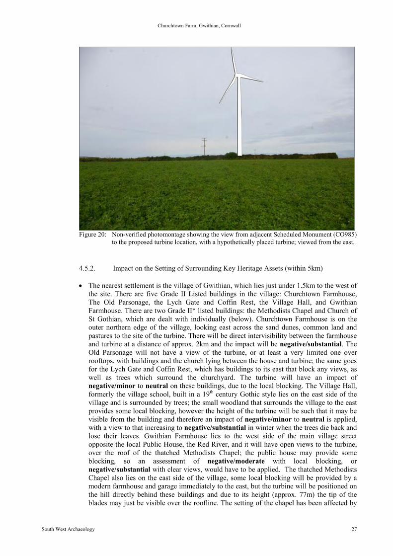
The geophysical survey identified a number of potential archaeological features within thedevelopment area, some of which are likely to be agricultural in origin and medieval or post-medieval date (see Figure 8 and Figure 9); however, the sub-ovoid enclosure south-west of theproposed turbine site may be of Prehistoric, Romano-British or early-medieval date, and thelinear features that cross into the sub-rectangular enclosure and wider fieldscape may beassociated with the adjacent Scheduled Monument, a Prehistoric ‘round’(CO985) (Figure 10).The impact of the construction phase of the turbine would be permanent and irreversible onthe buried archaeology immediately beneath the turbine site, and along the short length ofunderground cable run; the sub-ovoid enclosure will be outside the immediate constructionarea and with careful manoeuvring could be spared damage during this phase. The proposedover-head/above-ground carriage of the electric cabling, will, however minimise the impact ofthe project on the buried archaeology of the wider site area, reducing the impact on the cablerun to temporary and reversible. Within the area there are numerous Historic EnvironmentRecords (HER) and National Mapping Program (NMP) records of cropmarks and otherfeatures mostly identified from aerial photographs; many of these are ‘rounds’, such as atPennance and Tolzeathan (HER nos.: 37033, 53582, 53584, 53585). These will not be directlyimpacted by the construction phase of the turbine but during its operational lifetime the turbinewill possibly affect their wider setting. The limited 25 year cycle of the turbines operationalphase will limit all negative or positive impacts to temporary/reversible.
Churchtown Farm, Gwithian, Cornwall
South West Archaeology 27
Figure 20: Non-verified photomontage showing the view from adjacent Scheduled Monument (CO985)to the proposed turbine location, with a hypothetically placed turbine; viewed from the east.
4.5.2. Impact on the Setting of Surrounding Key Heritage Assets (within 5km)
The nearest settlement is the village of Gwithian, which lies just under 1.5km to the west ofthe site. There are five Grade II Listed buildings in the village: Churchtown Farmhouse,The Old Parsonage, the Lych Gate and Coffin Rest, the Village Hall, and GwithianFarmhouse. There are two Grade II* listed buildings: the Methodists Chapel and Church ofSt Gothian, which are dealt with individually (below). Churchtown Farmhouse is on theouter northern edge of the village, looking east across the sand dunes, common land andpastures to the site of the turbine. There will be direct intervisibility between the farmhouseand turbine at a distance of approx. 2km and the impact will be negative/substantial. TheOld Parsonage will not have a view of the turbine, or at least a very limited one overrooftops, with buildings and the church lying between the house and turbine; the same goesfor the Lych Gate and Coffin Rest, which has buildings to its east that block any views, aswell as trees which surround the churchyard. The turbine will have an impact ofnegative/minor to neutral on these buildings, due to the local blocking. The Village Hall,formerly the village school, built in a 19th century Gothic style lies on the east side of thevillage and is surrounded by trees; the small woodland that surrounds the village to the eastprovides some local blocking, however the height of the turbine will be such that it may bevisible from the building and therefore an impact of negative/minor to neutral is applied,with a view to that increasing to negative/substantial in winter when the trees die back andlose their leaves. Gwithian Farmhouse lies to the west side of the main village streetopposite the local Public House, the Red River, and it will have open views to the turbine,over the roof of the thatched Methodists Chapel; the public house may provide someblocking, so an assessment of negative/moderate with local blocking, ornegative/substantial with clear views, would have to be applied. The thatched MethodistsChapel also lies on the east side of the village, some local blocking will be provided by amodern farmhouse and garage immediately to the east, but the turbine will be positioned onthe hill directly behind these buildings and due to its height (approx. 77m) the tip of theblades may just be visible over the roofline. The setting of the chapel has been affected by
Churchtown Farm, Gwithian, Cornwall
South West Archaeology 28
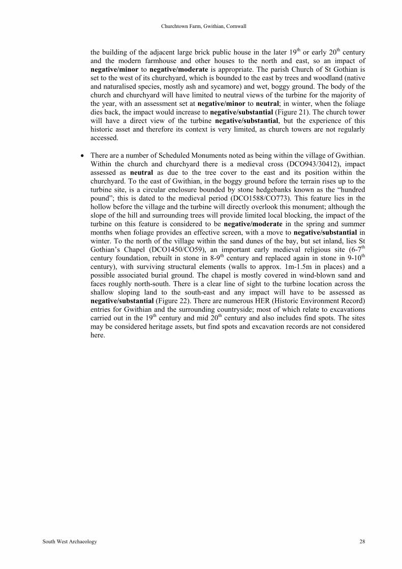
the building of the adjacent large brick public house in the later 19th or early 20th centuryand the modern farmhouse and other houses to the north and east, so an impact ofnegative/minor to negative/moderate is appropriate. The parish Church of St Gothian isset to the west of its churchyard, which is bounded to the east by trees and woodland (nativeand naturalised species, mostly ash and sycamore) and wet, boggy ground. The body of thechurch and churchyard will have limited to neutral views of the turbine for the majority ofthe year, with an assessment set at negative/minor to neutral; in winter, when the foliagedies back, the impact would increase to negative/substantial (Figure 21). The church towerwill have a direct view of the turbine negative/substantial, but the experience of thishistoric asset and therefore its context is very limited, as church towers are not regularlyaccessed.
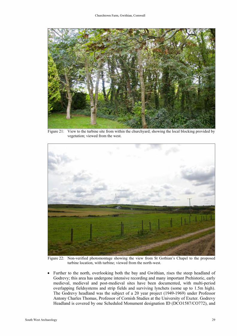
There are a number of Scheduled Monuments noted as being within the village of Gwithian.Within the church and churchyard there is a medieval cross (DCO943/30412), impactassessed as neutral as due to the tree cover to the east and its position within thechurchyard. To the east of Gwithian, in the boggy ground before the terrain rises up to theturbine site, is a circular enclosure bounded by stone hedgebanks known as the “hundredpound”; this is dated to the medieval period (DCO1588/CO773). This feature lies in thehollow before the village and the turbine will directly overlook this monument; although theslope of the hill and surrounding trees will provide limited local blocking, the impact of theturbine on this feature is considered to be negative/moderate in the spring and summermonths when foliage provides an effective screen, with a move to negative/substantial inwinter. To the north of the village within the sand dunes of the bay, but set inland, lies StGothian’s Chapel (DCO1450/CO59), an important early medieval religious site (6-7th
century foundation, rebuilt in stone in 8-9th century and replaced again in stone in 9-10th
century), with surviving structural elements (walls to approx. 1m-1.5m in places) and apossible associated burial ground. The chapel is mostly covered in wind-blown sand andfaces roughly north-south. There is a clear line of sight to the turbine location across theshallow sloping land to the south-east and any impact will have to be assessed asnegative/substantial (Figure 22). There are numerous HER (Historic Environment Record)entries for Gwithian and the surrounding countryside; most of which relate to excavationscarried out in the 19th century and mid 20th century and also includes find spots. The sitesmay be considered heritage assets, but find spots and excavation records are not consideredhere.
Churchtown Farm, Gwithian, Cornwall
South West Archaeology 29
Figure 21: View to the turbine site from within the churchyard; showing the local blocking provided byvegetation; viewed from the west.
Figure 22: Non-verified photomontage showing the view from St Gothian’s Chapel to the proposedturbine location, with turbine; viewed from the north-west.
Further to the north, overlooking both the bay and Gwithian, rises the steep headland ofGodrevy; this area has undergone intensive recording and many important Prehistoric, earlymedieval, medieval and post-medieval sites have been documented, with multi-periodoverlapping fieldsystems and strip fields and surviving lynchets (some up to 1.5m high).The Godrevy headland was the subject of a 20 year project (1949-1969) under ProfessorAntony Charles Thomas, Professor of Cornish Studies at the University of Exeter. GodrevyHeadland is covered by one Scheduled Monument designation ID (DCO1587/CO772), and
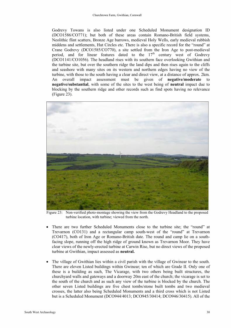
Churchtown Farm, Gwithian, Cornwall
South West Archaeology 30
Godrevy Towans is also listed under one Scheduled Monument designation ID(DCO1586/CO771); but both of these areas contain Romano-British field systems,Neolithic flint scatters, Bronze Age barrows, medieval Holy Wells, early medieval rubbishmiddens and settlements, Hut Circles etc. There is also a specific record for the “round” atCrane Godrevy (DCO1585/CO770), a site settled from the Iron Age to post-medievalperiod, and for linear features dated to the 17th century west of Godrevy(DCO1141/CO1056). The headland rises with its southern face overlooking Gwithian andthe turbine site, but over the southern ridge the land dips and then rises again to the cliffsand seashore with many sites on its western and northern edges having no view of theturbine, with those to the south having a clear and direct view, at a distance of approx. 2km.An overall impact assessment must be given of negative/moderate tonegative/substantial, with some of the sites to the west being of neutral impact due toblocking by the southern ridge and other records such as find spots having no relevance(Figure 23).
Figure 23: Non-verified photo-montage showing the view from the Godrevy Headland to the proposedturbine location, with turbine; viewed from the north.
There are two further Scheduled Monuments close to the turbine site; the “round” atTrevarnon (CO131) and a rectangular camp south-west of the “round” at Trevarnon(CO417), both of Iron Age or Romano-British date. The round and camp lie on a south-facing slope, running off the high ridge of ground known as Trevarnon Moor. They haveclear views of the newly-erected turbine at Carwin Rise, but no direct views of the proposedturbine at Gwithian, impact assessed as neutral.
The village of Gwithian lies within a civil parish with the village of Gwinear to the south.There are eleven Listed buildings within Gwinear; ten of which are Grade II. Only one ofthese is a building as such, The Vicarage, with two others being built structures, thechurchyard walls and gateways and a doorway 20m east of the church; the vicarage is set tothe south of the church and as such any view of the turbine is blocked by the church. Theother seven Listed buildings are five chest tombs/stone built tombs and two medievalcrosses, the latter also being Scheduled Monuments and a third cross which is not Listedbut is a Scheduled Monument (DCO944/4013; DCO945/30414; DCO946/30415). All of the
Churchtown Farm, Gwithian, Cornwall
South West Archaeology 31
items contained within the churchyard, including the churchyard wall, will have an impactassessment of neutral from the turbine, as the church and its historic churchyard aresurrounded by trees and there is a tall Cornish hedgebank with mature trees which lines thelane which enters the village by the church. The church itself, St Winnear, will have animpact of negative/minor to neutral for the main body of the building, with an impact ofnegative/moderate for its tower which will have distant views of the turbine, at a distanceof approx. 3.9km.
To the north-east of the turbine site, within a 5km radius of the turbine lies the Roman Villasite at Magor Farm, in the parish of Illogan. However, though the viewshed to the south andsouth/west and west is open, to the north and east the ground rises and it is not consideredthat the turbine will have any significant effect (neutral) on a site at a 4.5-5km distance.The “round” at Gwealavellan Farm also lies to the north-east and will also not have a viewof the turbine, due to the topography.
The southern and western portions of Camborne and Pool lie within 5km of the turbine;within the Camborne locality there are approximately 110 Listed structures or buildings, themajority of Grade II status. The Grade I and Grade II* buildings have been consideredindependently due to their significance; the Grade II buildings have been assessed as agroup with general views taken towards the turbine site.
There is one Grade I Listed building in Camborne: the Church of St Martin and StMeriadocus, which will not have direct views of the turbine due to significant localblocking. Also, the 19th and 20th century spread and industrial remains within and aroundthe town have already irretrievably altered the surroundings of this important religiousbuilding and any further impact from the turbine is considered to be neutral. There is alsoa Scheduled Monument in Camborne, a wayside medieval cross, now in the churchyard; theimpact is assessed as neutral, due to its setting within the churchyard.
There are three Grade II* Listed buildings within Camborne: Rosewarne House, the DonaldThomas Centre (former Literary Institute) and Trevithick's Cottage, at Penponds to thesouth-west of Camborne. The buildings within Camborne will have local blockingpreventing clear and direct views to the turbine. However, for the southern and westernportions of the town there are views to the coast, Gwithian and the turbine site; giving awider impact to the town of negative/moderate to negative/minor, as it will be at adistance of 3-4km across the townscape. Trevithick’s Cottage at Penponds will have limitedviews to the turbine at a distance of 4-5km, which will draw an assessment ofnegative/minor.
There are 1067 Grade II Listed buildings in Camborne. Technically the south-west portionof Camborne and Pool does have views of the turbine site at a distance of c.3-4km. Therewill be elements of local blocking between the streets of 19th century semi-detached orterraced houses, and overall an impact of negative/moderate on the townscape must beapplied. However the significant 19th and 20th century industrial waste and abandoned minebuildings around the edges of the town have a far greater detrimental impact on the townand by comparison the impact of the wind turbine may be lessened to negative/minor.
Churchtown Farm, Gwithian, Cornwall
South West Archaeology 32
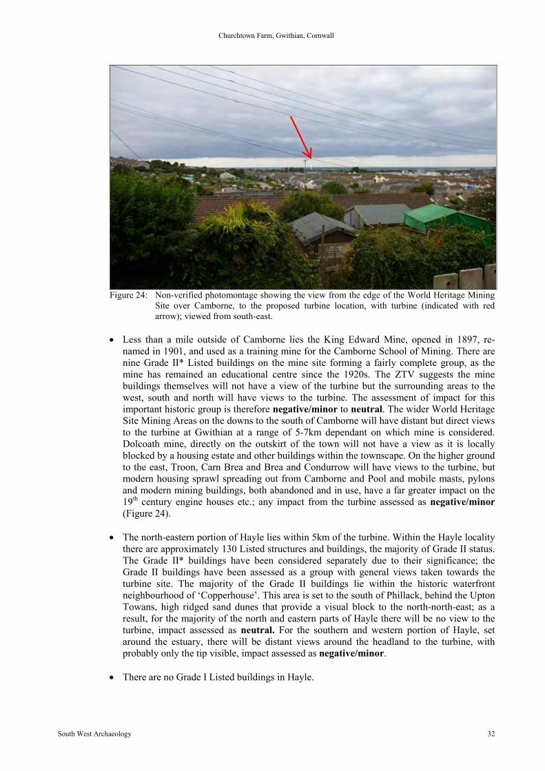
Figure 24: Non-verified photomontage showing the view from the edge of the World Heritage MiningSite over Camborne, to the proposed turbine location, with turbine (indicated with redarrow); viewed from south-east.
Less than a mile outside of Camborne lies the King Edward Mine, opened in 1897, re-named in 1901, and used as a training mine for the Camborne School of Mining. There arenine Grade II* Listed buildings on the mine site forming a fairly complete group, as themine has remained an educational centre since the 1920s. The ZTV suggests the minebuildings themselves will not have a view of the turbine but the surrounding areas to thewest, south and north will have views to the turbine. The assessment of impact for thisimportant historic group is therefore negative/minor to neutral. The wider World HeritageSite Mining Areas on the downs to the south of Camborne will have distant but direct viewsto the turbine at Gwithian at a range of 5-7km dependant on which mine is considered.Dolcoath mine, directly on the outskirt of the town will not have a view as it is locallyblocked by a housing estate and other buildings within the townscape. On the higher groundto the east, Troon, Carn Brea and Brea and Condurrow will have views to the turbine, butmodern housing sprawl spreading out from Camborne and Pool and mobile masts, pylonsand modern mining buildings, both abandoned and in use, have a far greater impact on the19th century engine houses etc.; any impact from the turbine assessed as negative/minor(Figure 24).
The north-eastern portion of Hayle lies within 5km of the turbine. Within the Hayle localitythere are approximately 130 Listed structures and buildings, the majority of Grade II status.The Grade II* buildings have been considered separately due to their significance; theGrade II buildings have been assessed as a group with general views taken towards theturbine site. The majority of the Grade II buildings lie within the historic waterfrontneighbourhood of ‘Copperhouse’. This area is set to the south of Phillack, behind the UptonTowans, high ridged sand dunes that provide a visual block to the north-north-east; as aresult, for the majority of the north and eastern parts of Hayle there will be no view to theturbine, impact assessed as neutral. For the southern and western portion of Hayle, setaround the estuary, there will be distant views around the headland to the turbine, withprobably only the tip visible, impact assessed as negative/minor.
There are no Grade I Listed buildings in Hayle.
Churchtown Farm, Gwithian, Cornwall
South West Archaeology 33
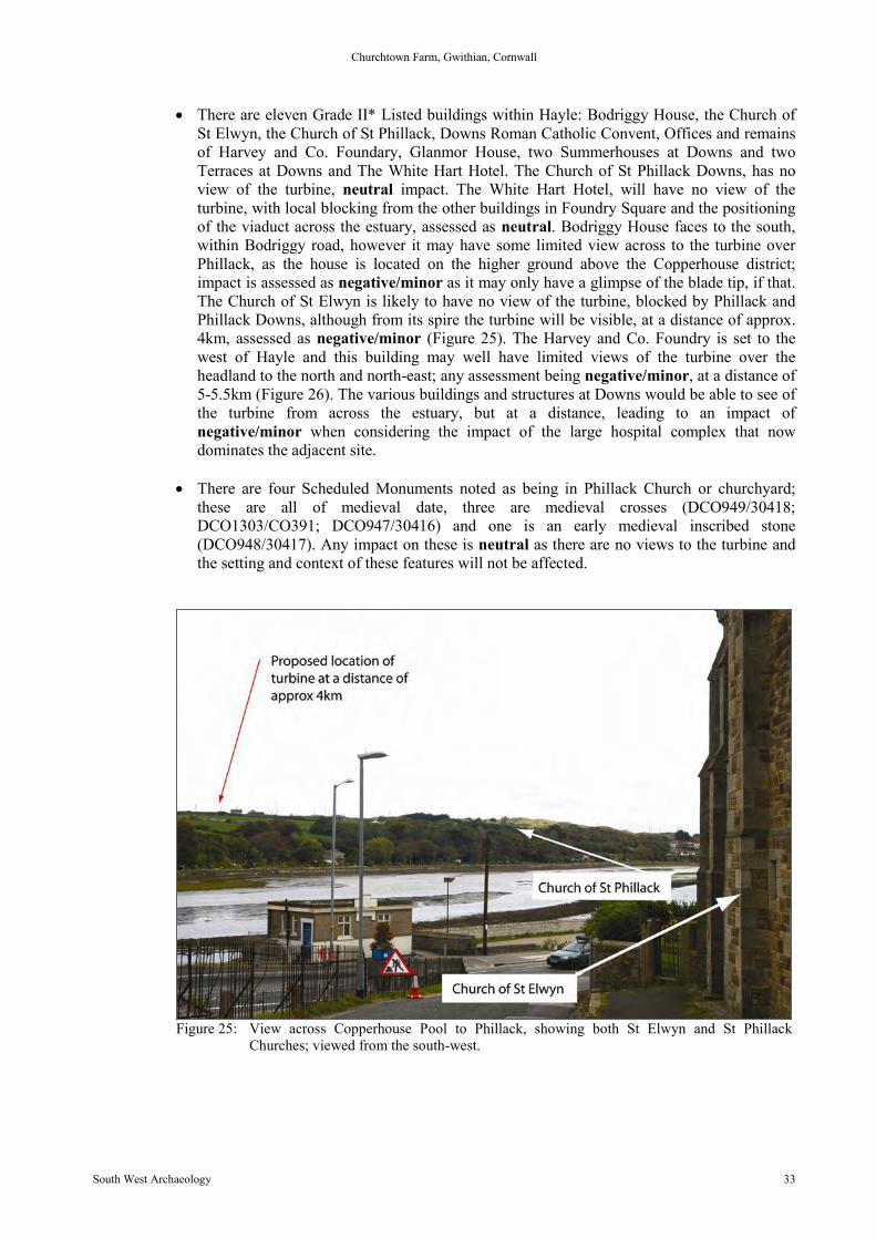
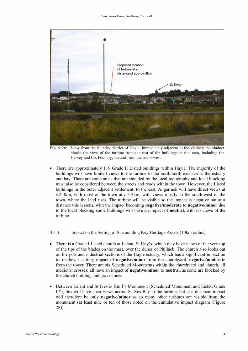
There are eleven Grade II* Listed buildings within Hayle: Bodriggy House, the Church ofSt Elwyn, the Church of St Phillack, Downs Roman Catholic Convent, Offices and remainsof Harvey and Co. Foundary, Glanmor House, two Summerhouses at Downs and twoTerraces at Downs and The White Hart Hotel. The Church of St Phillack Downs, has noview of the turbine, neutral impact. The White Hart Hotel, will have no view of theturbine, with local blocking from the other buildings in Foundry Square and the positioningof the viaduct across the estuary, assessed as neutral. Bodriggy House faces to the south,within Bodriggy road, however it may have some limited view across to the turbine overPhillack, as the house is located on the higher ground above the Copperhouse district;impact is assessed as negative/minor as it may only have a glimpse of the blade tip, if that.The Church of St Elwyn is likely to have no view of the turbine, blocked by Phillack andPhillack Downs, although from its spire the turbine will be visible, at a distance of approx.4km, assessed as negative/minor (Figure 25). The Harvey and Co. Foundry is set to thewest of Hayle and this building may well have limited views of the turbine over theheadland to the north and north-east; any assessment being negative/minor, at a distance of5-5.5km (Figure 26). The various buildings and structures at Downs would be able to see ofthe turbine from across the estuary, but at a distance, leading to an impact ofnegative/minor when considering the impact of the large hospital complex that nowdominates the adjacent site.
There are four Scheduled Monuments noted as being in Phillack Church or churchyard;these are all of medieval date, three are medieval crosses (DCO949/30418;DCO1303/CO391; DCO947/30416) and one is an early medieval inscribed stone(DCO948/30417). Any impact on these is neutral as there are no views to the turbine andthe setting and context of these features will not be affected.
Figure 25: View across Copperhouse Pool to Phillack, showing both St Elwyn and St PhillackChurches; viewed from the south-west.
Churchtown Farm, Gwithian, Cornwall
South West Archaeology 34
Figure 26: View from the foundry district of Hayle, immediately adjacent to the viaduct; the viaductblocks the view of the turbine from the rest of the buildings in this area, including theHarvey and Co. Foundry; viewed from the south-west.
There are approximately 119 Grade II Listed buildings within Hayle. The majority of thebuildings will have limited views to the turbine to the north/north-east across the estuaryand bay. There are some areas that are shielded by the local topography and local blockingmust also be considered between the streets and roads within the town. However, the Listedbuildings in the outer adjacent settlement, to the east, Angarrack will have direct views atc.2-3km, with most of the town at c.3-4km, with views mostly to the south-west of thetown, where the land rises. The turbine will be visible so the impact is negative but at adistance this lessens, with the impact becoming negative/moderate to negative/minor dueto the local blocking some buildings will have an impact of neutral, with no views of theturbine.
4.5.3. Impact on the Setting of Surrounding Key Heritage Assets (10km radius)
There is a Grade I Listed church at Lelant, St Uny’s, which may have views of the very topof the tips of the blades on the mast, over the dunes of Phillack. The church also looks outon the port and industrial sections of the Hayle estuary, which has a significant impact onits medieval setting; impact of negative/minor from the churchyard, negative/moderatefrom the tower. There are six Scheduled Monuments within the churchyard and church, allmedieval crosses; all have an impact of negative/minor to neutral, as some are blocked bythe church building and gravestones.
Between Lelant and St Ives is Knill’s Monument (Scheduled Monument and Listed GradeII*); this will have clear views across St Ives Bay to the turbine, but at a distance; impactwill therefore be only negative/minor as so many other turbines are visible from themonument (at least nine or ten of those noted on the cumulative impact diagram (Figure28)).

Churchtown Farm, Gwithian, Cornwall
South West Archaeology 35
Within 10km of the turbine lies the historic port town of St Ives. Within the locality of StIves there are approximately 250 Listed structures or buildings, the majority of Grade IIstatus. The Grade I and Grade II* buildings have been considered separately due to theirsignificance; the Grade II buildings have been assessed as a group with general views takentowards the turbine site. St Ives is also a conservation area.
St Ives lies approx 7.5km across the bay from Gwithian and the proposed turbine site. Thewide shallow bay north-west of the turbine gives clear and open views to St Ives and theturbine will be visible, both from the harbour and the upper portion of the town (Figure 27).St Ia, the parish church, is set back from the harbour and within the heart of the old port,and local blocking from the surrounding buildings will be such that the turbine will not bevisible, impact neutral. However, from the harbour and old town further up the valley,clear views of the proposed turbine would mean an impact of negative/minor.
There are approximately 242 Grade II Listed buildings within St Ives parish. The majorityof these buildings will have direct views to the turbine to the south, east and south-eastacross St Ives Bay. St Ives curves around the bay, facing down the Hayle River estuarytowards the direction of the turbine, giving clear and direct views to the site at a distance ofc.6-7km. There will naturally be elements of local blocking within the town itself, with thenarrow winding historic streets running roughly east-west up from the port. However, thedirect views across the water can only be considered to be of negative impact to the outlookof the town and its conservation area and Listed buildings; therefore the impact isconsidered to be negative/minor, tempered by the distance to the turbine site.
Figure 27: Non-verified photomontage showing the view from St Ives Harbour, to the proposed turbinelocation, with turbine marked by red arrow; viewed from the west.
Above St Ives on the higher ground there are a number of Scheduled Monuments andListed buildings, most notably the ‘Culver House’ (CO119); any impact on these will benegative/minor to neutral, as at a distance of over 8km it is unlikely the turbine will makeany difference to the setting of any monuments or buildings.
Churchtown Farm, Gwithian, Cornwall
South West Archaeology 36
Porthmeor Pilchard Cellars lie on the north coast, around the headland to the west, and theturbine will not be visible. The village of St Erth lies just over 6km from the turbine site. Atits heart lies the Grade I Church of Saint Erth. Although land to the east, west and a smallarea immediately north of the village have views to the turbine, the church is locallyblocked within the settlement and, as the ZTV demonstrates, cannot see the turbine. Thereis a possibility that the turbine may be glimpsed from the square church tower, but thiscould not be confirmed. Impact assessed as neutral.
There are a number of Grade II* Listed buildings in the St Erth locality: Trewinnard Manorand outbuildings and Tredrea Manor Farmhouse; Trelissick Manor, Farmhouse and Cottageand Gear and Kerrow Farmhouse. A turbine has received planning consent for erection atTrewinnard Manor, which also directly overlooks Tredrea. This will have significantlymore impact on these buildings than a turbine c.8-9km away. There is also an operatingturbine at Tregethas Farm, less than 1km to the west of these historic houses. Impact fromthe Gwithian Churchtown Farm would be neutral to negative/minor as the turbine will beclearly visible at a distance.
Trelissick Manor is situated in an area that is indicated to have a view of the turbine site.However, between the turbine and Trelissick farm lies both the busy town of Hayle and theA30, a main trunk route. There are also applications with consent for turbines atHowldrevel and 16 Carwin Rise, c.2-3km to the east and north-east, as well as that atTrewinnard 1km to the south-west. There is also another application for a turbine atNanpusker Farm 3km to the north-east. All of these factors make the addition of a turbine ata distance of c.7km fairly low on the impact scale: assessed as negative/minor.
Gear and Kerrow Farmhouse lies just south of St Erth Praze; it is also Grade II*. To thenorth-east are the above-mentioned consented turbines at Howldrevel and Lemin and to thewest the turbine at Trewinnard. The turbine at 7-8km away at Gwithian should not impactvery heavily on the historic building and the local topography should block any views:impact neutral.
Castle Kayle is an important ‘round’, presumed to be of Iron Age date, with a singlesurviving rampart which rises to a height of approximately 3m in places; it is positionedeast of St Erth Praze, on the way to Leedstown. At this distance there are some limitedviews to the turbine, but the ‘round’ is on private land and cannot be visited; adjacent andsurrounding views were assessed and an impact of negative/minor to neutral isappropriate.
Within the very outer edge of the 10km radius (9-10km) lies the Grade I Listed buildingGodolphin house and other associated Grade I structures (Godolphin tin works, stables,forecourt, mounting block and service buildings). The distance between the house andturbine makes any impact neutral, with no direct intervisibility, and local blocking from thetrees within the parkland and local topography. The wider parkland setting does have viewsof the turbine with an impact of negative/minor.
Within the outer area of 10-15km lies the Grade I Listed St Germoe’s church and the GradeI sedilia building, St Germoe’s chair; neither will have any direct views to the turbine site atthe distance of 14-15km, impact assessed as neutral.
Pengersick Castle is also on the very outer edges of the 15km maximum radius ofconsideration for the VIA. It is of Grade I status and there are also adjacent Grade II*outbuildings. Neither group of buildings will have any direct views to the turbine site at thedistance of 15km: impact assessed as neutral.

Churchtown Farm, Gwithian, Cornwall
South West Archaeology 37
The above three building groups are all within the locality of the village of Breage whichalso has a Grade I church, the Church of St Breaca. There will be no direct views to theturbine site at the distance of c.14-15km: impact assessed as neutral.
There are twenty medieval crosses within a 5-10km radius of the proposed turbine. Ten ofthese are now within churchyards, many having been moved there in the 19th century. Thiscollation and curatorial attitude to the scattered wayside crosses marked the change inattitudes to religion and to historical items, with the rise of the antiquarian movement in the18th and 19th centuries. The ten crosses that have been placed in the churchyards have losttheir original context and they all have local blocking from the church, foliage andsurrounding burials and the buildings or communities within which the church is situated.Any impact from the turbine on these crosses at a distance of 5-10km will be neutral.
4.5.4. Impact on the Setting of Surrounding Key Heritage Assets (15km radius)
There are five sites on the Register of Historic Parks and Gardens within the 15km radius ofthe site at Churchtown Farm Gwithian. They are: The Barbara Hepworth Sculpture Garden,at St Ives; Downes, south-west of Hayle; Godolphin, near the hamlet of Townshend and StMichaels Mount in Mounts Bay (see Appendix 6).
Described by the register as: ‘A mid-late 20th century garden created by Dame BarbaraHepworth as a setting for a group of her own sculptures’; the Barbara Hepworth Sculpturegarden lies on a slope above St Ives, west of the harbour and has far-reaching views acrossSt Ives Bay to the south and east. The turbine will be visible from the garden, as the land atGwithian slopes away from the turbine site to the west across the dunes giving clear viewsboth ways across the bay. The sculpture garden and the majority of St Ives were highlightedby the ZTV as having intervisbility with the turbine. There is therefore a negative impact,however, the distance is approximately 6-7km and at that distance the turbine will be arelatively small shape on the horizon and should not impact significantly on the garden. Thegarden also has some local blocking from mature trees which frame the views of the bay.The impact has been assessed as negative/minor.
Described by the register as: ‘Late 19th century gardens laid out by John Dando Sedding tosurround a small country house designed by Edmund Sedding’; Downes lies south-west ofHayle on a small hill with wide expansive views to the north and west across St Ives Bayand towards the Hayle estuary. There will be limited views to the turbine, at something of adistance and therefore the impact will be assessed as negative/moderate, as the setting andcontext of the garden is part of its value.
Described by the register as: ‘Formal gardens and ornamental orchards dating from the 15th
century with earlier elements, together with a late medieval deer park and a 16th centurydeer course surrounding a late 15th century mansion’; Godolphin lies far to the south, withinthe River Hayle valley. Local blocking caused by the 15th century house, large mature treesand the distance of 9-10km to the turbine site means there is no discernible impact, howeverwithin the wider parkland which extends to over 200 hectares there will be distant views tothe turbine to the west, overall impact is assessed as neutral to negative/minor.
Described by the register as: ‘Mid 18th - 19th century terraced gardens and pleasure groundsaround a medieval island fortress which was remodelled in the 18th and 19th century’; StMichael’s Mount lies far to the south, in Mounts Bay. The distance to the turbine site atGwithian (c.13-14km) and the intervening landmass of Cornwall, means there is nodiscernible impact, assessed as neutral, although from the top of St Michaels Mount theblade tip is visible, but at such a long distance that any impact is negative/minor.
Churchtown Farm, Gwithian, Cornwall
South West Archaeology 38
Described by the register as: ‘A two hectare garden laid out in the early 19th century witheight hectares of landscaped parkland along with extensive woodland’: Scorrier House liesfar to the edge of the 15km radius to be considered, north-east of Redruth. The distance tothe turbine site at Gwithian (c.13-14km) means there is no discernible impact, assessed asneutral, although the blade tip and possibly the hub may technically be visible.
4.6. Designated heritage assets within the 5Km radius viewshed
4.6.1. Scheduled Monuments (SM) – see Figure 17 and Appendix 3
Identifier Site NGR Impact30417 An early Christian memorial stone and
wayside cross in Phillack churchyardSW 5657 3843 Neutral
30412 Churchyard cross in Gwithian churchyard SW 5863 4124 Neutral30416 Churchyard cross in Phillack churchyard SW 5653 3841 NeutralCO391 Mexico Cross, Phillack SW 5623 3840 Neutral30415 Polmenor Cross in Gwinear churchyard SW 5949 3739 Neutral30450 Wayside cross and cross-base in
Camborne churchyardSW 6450 4002 Neutral
31823 Wayside cross in Camborne churchyard SW 6450 4004 Neutral30413 Wayside cross in Gwinear churchyard SW 5950 3738 Neutral30414 Wayside cross in Gwinear churchyard SW 5951 3736 Neutral30418 Wayside cross in Phillack churchyard SW 5652 3841 Neutral37034 TREVARNON - Iron Age round, Romano
British roundSW 5873 4017 Neutral
CO985 Round near Lower Nanterrow (immediatelyadjacent to the turbine)
SW 5951 4097 Negative/Substantial
CO773 Round enclosure (Hundred Pound),Gwithian Green, 100yds (90m) E ofGwithian parish church
SW 5878 4121 Negative/Substantial
Negative/moderateCO1032 Round E of Gwealavellan SW 6063 4179 NeutralCO770 Round at Crane Godrevy SW 5894 4266 Negative/
SubstantialNegative/moderate
CO417 Rectangular camp SW of TrevarnonRound (Carwin Round)
SW 5841 3983 Neutral
CO772 Godrevy Headland - complex of prehistoricsites
SW 5815 4317 Negative/Substantial
Negative/moderateCO771 Godrevy Towans - complex of prehistoric
sitesSW 5887 4234 Negative/minor
Negative/moderateCO769 Magor Farm Roman villa site SW 6367 4238 NeutralCO59 St. Gothian's Chapel SW 5883 4183 NeutralCO1056 Linear earthworks, probably 17th century,
W of GodrevySW 5826 4306 Negative/minor
NeutralCO986 Sea Lane Bridge SW 5666 3812 Neutral36047 Roseworthy Arsenic Works, 700m west of
Cornhill FarmSW 6096 4014 Neutral
CO987 Railway Bridge SW 5670 3823 Negative/minor
4.6.2. Listed Buildings (LBs) – see Figure 17 and Appendix 5
Identifier Site Grade NGR Impact66582 Church of St Martin and
St MeriadocusGrade I SW 6452240042 Neutral
66637 Rosewarne House Grade II* SW 6483740411 Negative/minorNegative/moderate
66573 The Donald Thomas Grade II* SW 6469340052 Negative/minor

Churchtown Farm, Gwithian, Cornwall
South West Archaeology 39
Identifier Site Grade NGR ImpactCentre Negative/moderate
66598 Trevithick's Cottage Grade II* SW 6373638908 Negative/moderate70260 Bodriggy House Grade II* SW 5656037636 Negative/minor
Negative/moderate70209 Church of St Elwyn Grade II* SW 5591137573 Negative/minor
70219 Church of St Phillack Grade II* SW 5653538421 Neutral70266 Downs, Roman Catholic
ConventGrade II* SW 5556036730 Negative/minor
70270 Summerhouse atApproximately 120Metres North of theDowns
Grade II* SW 5553336849 Negative/minor
70268 Summerhouse atApproximately 20 MetresNorth East of the Downs
Grade II* SW 5557736760 Negative/minor
70269 Terrace Walls atApproximately 40 MetresNorth of the Downs
Grade II* SW 5554136780 Negative/minor
70267 Terrace WallsImmediately North of theDowns
Grade II* SW 5552936744 Negative/minor
70274 Glanmor House Grade II* SW 5551036579 Negative/minor
70201 Former Offices andRemains of Foundry ofHarvey and Company
Grade II* SW 5582237164 Negative/minorNeutral
70197 The White Hart Hotel Grade II* SW 5586137095 Negative/minorNeutral
66549 Assay Office Approx.20Metres South West ofCount House at KingEdward Mine
Grade II* SW 6631938902 Negative/minorNeutral
66555 Calciner with AttachedChimney to South ofDressing Plant at KingEdward Mine
Grade II* SW 6638538895 Negative/minorNeutral
66547 Count House andAttached Smith's Shop atKing Edward Mine
Grade II* SW 6631938929 Negative/minorNeutral
66553 Dressing Plant Attachedto South Side of Stampsat King Edward Mine
Grade II* SW 6639338899 Negative/minorNeutral
66548 Dry House and AttachedCarpenter's ShopImmediately to East ofCount House (Etc) atKing Edward Mine
Grade II* SW 6633538947 Negative/minorNeutral
66552 Stamps Engine Houseand Attached StampsApprox 75 Metres South-East of Count House atKing Edward Mine
Grade II* SW 6638338917 Negative/minorNeutral
66551 Survey OfficeApproximately 100Metres South of CountHouse at King EdwardMine
Grade II* SW 6636138879 Negative/minorNeutral
66550 Timber-Cutting Buildingand Office Approx.20Metres South of CountHouse at King EdwardMine
Grade II* SW 6633938917 Negative/minorNeutral
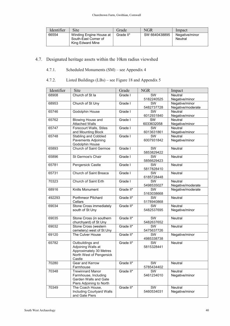
Churchtown Farm, Gwithian, Cornwall
South West Archaeology 40
Identifier Site Grade NGR Impact66554 Winding Engine House at
South-East Corner ofKing Edward Mine
Grade II* SW 6640438895 Negative/minorNeutral
4.7. Designated heritage assets within the 10km radius viewshed
4.7.1. Scheduled Monuments (SM) – see Appendix 4
4.7.2. Listed Buildings (LBs) – see Figure 18 and Appendix 5
Identifier Site Grade NGR Impact68908 Church of St Ia Grade I SW
5182240525NeutralNegative/minor
68953 Church of St Uny Grade I SW5482737728
Negative/minorNegative/moderate
65746 Godolphin House Grade I SW6012931840
NeutralNegative/minor
65762 Blowing House andAttached Walls
Grade I SW6033632058
NeutralNegative/minor
65747 Forecourt Walls, Stilesand Mounting Block
Grade I SW6013631861
NeutralNegative/minor
65748 Stabling and CobbledPavements AdjoiningGodolphin House
Grade I SW6007931842
NeutralNegative/minor
65893 Church of Saint Germoe Grade I SW5853829422
Neutral
65896 St Germoe's Chair Grade I SW5856629423
Neutral
65781 Pengersick Castle Grade I SW5817828410
Neutral
65731 Church of Saint Breaca Grade I SW6185728448
Neutral
70323 Church of Saint Erth Grade I SW5498535027
NeutralNegative/moderate
68916 Knills Monument Grade II* SW5163038668
Negative/moderate
492293 Porthmeor PilchardCellars
Grade II* SW5178940868
Neutral
69034 Stone Cross immediatelysouth of St Uny
Grade II* SW5482537695
NeutralNegative/minor
69035 Stone Cross (in southernchurchyard) of St Uny
Grade II* SW5482637652
Neutral
69032 Stone Cross (westerncemetery) west of St Uny
Grade II* SW5475637726
Neutral
69120 The Culver House Grade II* SW4985338738
Negative/minor
65782 Outbuildings andAdjoining Walls atApproximately 30 MetresNorth West of PengersickCastle
Grade II* SW5815328441
Neutral
70280 Gear and KerrowFarmhouse
Grade II* SW5785434402
Neutral
70348 Trewinnard ManorFarmhouse, IncludingGarden Walls and GatePiers Adjoining to North
Grade II* SW5461234010
NeutralNegative/minor
70349 The Coach House,Including Courtyard Wallsand Gate Piers
Grade II* SW5460534031
NeutralNegative/minor
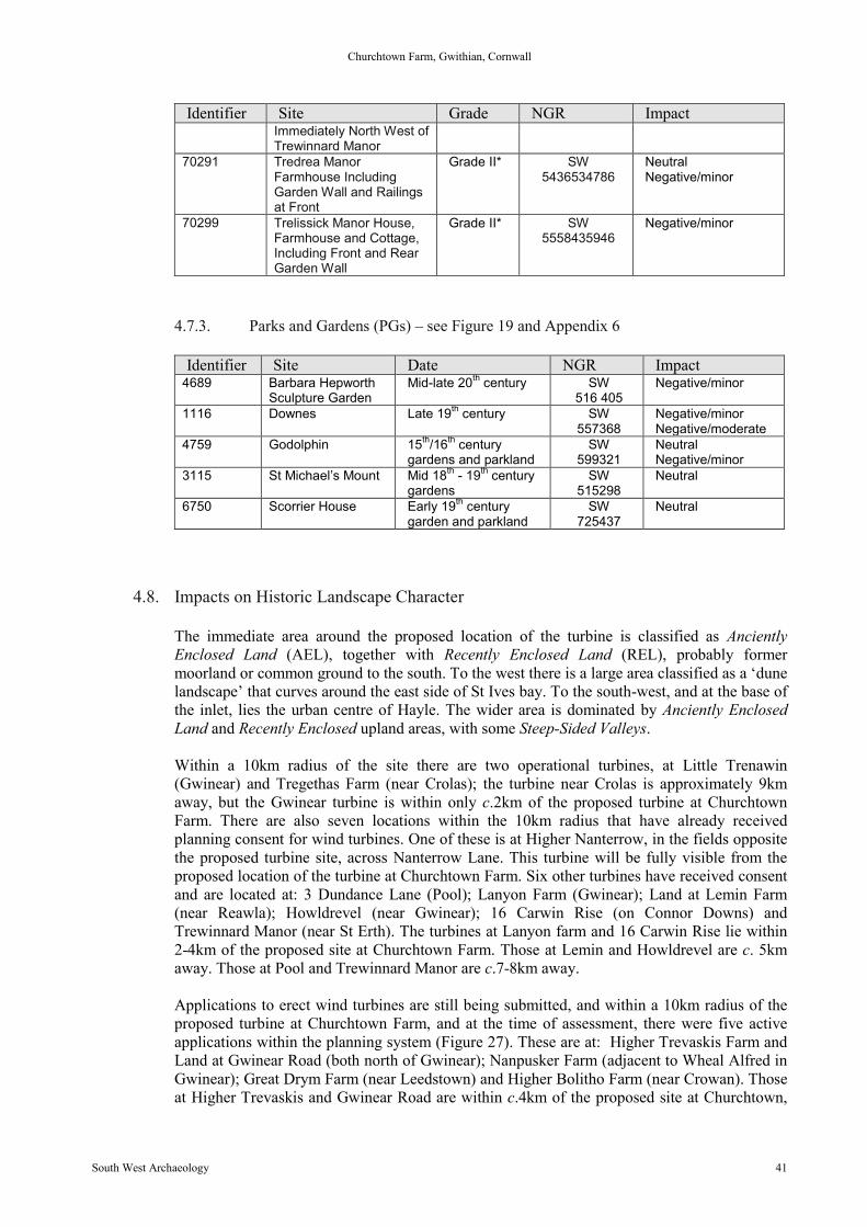
Churchtown Farm, Gwithian, Cornwall
South West Archaeology 41
Identifier Site Grade NGR ImpactImmediately North West ofTrewinnard Manor
70291 Tredrea ManorFarmhouse IncludingGarden Wall and Railingsat Front
Grade II* SW5436534786
NeutralNegative/minor
70299 Trelissick Manor House,Farmhouse and Cottage,Including Front and RearGarden Wall
Grade II* SW5558435946
Negative/minor
4.7.3. Parks and Gardens (PGs) – see Figure 19 and Appendix 6
Identifier Site Date NGR Impact4689 Barbara Hepworth
Sculpture GardenMid-late 20th century SW
516 405Negative/minor
1116 Downes Late 19th century SW557368
Negative/minorNegative/moderate
4759 Godolphin 15th/16th centurygardens and parkland
SW599321
NeutralNegative/minor
3115 St Michael’s Mount Mid 18th - 19th centurygardens
SW515298
Neutral
6750 Scorrier House Early 19th centurygarden and parkland
SW725437
Neutral
4.8. Impacts on Historic Landscape Character
The immediate area around the proposed location of the turbine is classified as AncientlyEnclosed Land (AEL), together with Recently Enclosed Land (REL), probably formermoorland or common ground to the south. To the west there is a large area classified as a ‘dunelandscape’ that curves around the east side of St Ives bay. To the south-west, and at the base ofthe inlet, lies the urban centre of Hayle. The wider area is dominated by Anciently EnclosedLand and Recently Enclosed upland areas, with some Steep-Sided Valleys.
Within a 10km radius of the site there are two operational turbines, at Little Trenawin(Gwinear) and Tregethas Farm (near Crolas); the turbine near Crolas is approximately 9kmaway, but the Gwinear turbine is within only c.2km of the proposed turbine at ChurchtownFarm. There are also seven locations within the 10km radius that have already receivedplanning consent for wind turbines. One of these is at Higher Nanterrow, in the fields oppositethe proposed turbine site, across Nanterrow Lane. This turbine will be fully visible from theproposed location of the turbine at Churchtown Farm. Six other turbines have received consentand are located at: 3 Dundance Lane (Pool); Lanyon Farm (Gwinear); Land at Lemin Farm(near Reawla); Howldrevel (near Gwinear); 16 Carwin Rise (on Connor Downs) andTrewinnard Manor (near St Erth). The turbines at Lanyon farm and 16 Carwin Rise lie within2-4km of the proposed site at Churchtown Farm. Those at Lemin and Howldrevel are c. 5kmaway. Those at Pool and Trewinnard Manor are c.7-8km away.
Applications to erect wind turbines are still being submitted, and within a 10km radius of theproposed turbine at Churchtown Farm, and at the time of assessment, there were five activeapplications within the planning system (Figure 27). These are at: Higher Trevaskis Farm andLand at Gwinear Road (both north of Gwinear); Nanpusker Farm (adjacent to Wheal Alfred inGwinear); Great Drym Farm (near Leedstown) and Higher Bolitho Farm (near Crowan). Thoseat Higher Trevaskis and Gwinear Road are within c.4km of the proposed site at Churchtown,

Churchtown Farm, Gwithian, Cornwall
South West Archaeology 42
the site at Nanpusker being c.6-7km away with the two at Higher Bolitho and Great Drym sitesbeing c.9-10km.
In relative terms, many of the operational or proposed wind turbines have a far greater impacton the setting of local and regional heritage assets, and that might be considered to lessen theimpact of the proposed Churchtown Farm turbine on the wider Historic Landscape. In fact, itcould be considered that the sheer number of operational, consented or proposed turbines will,if they do not already, form an integral part of the character of the landscape in West Cornwall(See Figure 27 and Appendix 7).
However, the indirect cumulative impact on the heritage assets in the immediate area must alsobe considered: specifically, the consented application at Higher Nanterrow Farm. A ScheduledMonument (CO985: Round near Lower Nanterrow) lies between the two proposed turbines,with further enclosures in the surrounding fields. These are presumed to be associated andcontemporary with the Iron-Age/Romano-British settlement (HER 53582-5) forming acohesive relict landscape from this period. It should be stressed, however, that these aremarked only by cropmarks, with little or no surviving presence at ground level and the directimpact of the proposed turbine on the buried archaeology will be restricted. The monument andother heritage assets lie within a landscape that also contains the remnants of fossilised open-field system (the surviving curving field boundaries to the east). One turbine would beconsidered to have a negative impact on the Historic Character of the landscape and the settingof nearby Gwithian, which includes an important Bronze Age and early medieval settlement.Two almost adjacent turbines on opposing hills may be considered to create a cumulativeimpact of negative/substantial, completely altering the location and setting of the heritageassets within the immediate area for the lifetime of their operation. It must be rememberedhowever, that a turbine is only considered to run for 25 years and this would lessen any overallimpact assessment to temporary/reversible.
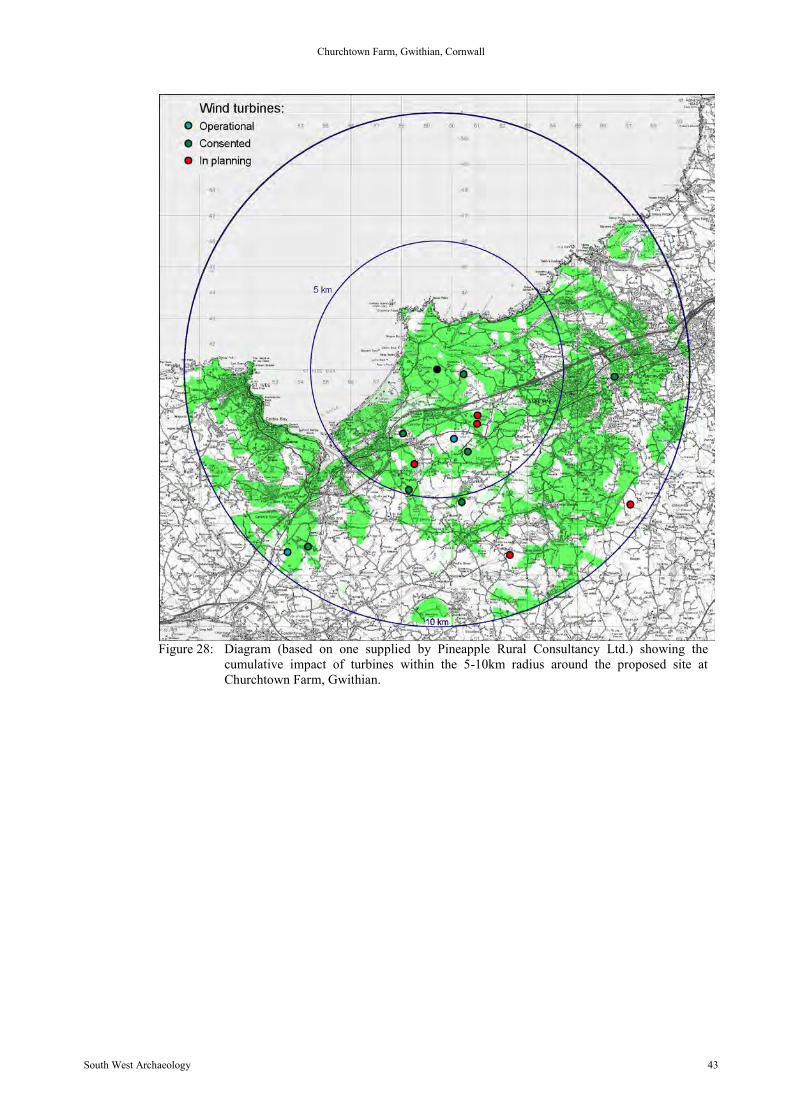
Churchtown Farm, Gwithian, Cornwall
South West Archaeology 43
Figure 28: Diagram (based on one supplied by Pineapple Rural Consultancy Ltd.) showing thecumulative impact of turbines within the 5-10km radius around the proposed site atChurchtown Farm, Gwithian.
5.0 Archaeological Mitigation Strategy
It is recommended that all groundworks associated with the construction of the turbine shouldbe monitored. However, the fact that the cable will be carried on poles across the field to thegrid contact point will limit the need for groundworks to the immediate vicinity of the turbine.
6.0 Conclusion
The turbine will impact on the buried archaeology (mitigation discussed above) and the impacton the setting of the adjacent Scheduled Monument (CO985) will be minimal as the monumentseemingly has no surface presence, assessed as neutral (Figure 11). The impact to ScheduledMonuments within a 10km radius is such that although any impact is negative by nature itsextent is minimised by distance to the site, reducing to negative/moderate or negative/minor.A large number of the Scheduled Monuments affected are ‘wayside’ stone crosses of medievaldate, many of which were relocated to churchyards in the 18th and 19th centuries; they wereoften moved by antiquarians who, with a growing appreciation of their historic value, werekeen to save these historic features from destruction. However, this does mean the originalsetting of these monuments has been lost and cannot be quantified. Many ScheduledMonuments are ‘rounds’, a Cornwall-specific form of enclosed settlement, often survivingonly as cropmarks or shallow earthworks. Any impact on these important Prehistoric, earlymedieval or medieval heritage assets will be negative, but those examples located relativelyclose to the turbine are assessed as either neutral impact due to local blocking or naturaltopography, or survive as cropmarks only. Another large group of Scheduled Monuments arethe 18th and 19th century engine houses and mine structures, collectively designated as a WorldHeritage Site to the south of Camborne, Redruth and Pool. These are by their nature oftenassociated with abandoned modern mine buildings or heavily disturbed locations and contexts.These important and cohesive historic landscapes are set at a distance of 4-5km from theturbine site (Figure 23) and although an impact must duly be considered, its extent is temperedby the number of other turbines in the wider western Cornish landscape (Figure 28 andAppendix 7).
The turbine at Gwithian will undoubtedly have some impact upon the village of Gwithian andits surrounding landscape; any assessment will have to be given as negative/substantial. Thevillage contains a number of Listed structures, many of which will not have direct views of theturbine due to the clustering of buildings and wooded areas to the east of the settlement (Figure21). The two main points of concern are the Grade II* Methodists Chapel and St Gothian’sChurch; both of which may have some limited views of the turbine once constructed. However,neither has a clear and direct view and consequently it is felt the impact of the turbine is lesssignificant than would be expected on these important heritage assets. The impact of theturbine on the village as a whole will be negative, as it sits on a hill overlooking the settlement,but there are a wide range of landscape factors which it is felt would minimise the impact ofthe turbine. Within 1km of the proposed turbine, industrial developments such as an HGVhaulage yard and an extensive PV farm (Figure 15) have already been erected. From theturbine site there are two smaller turbines already erected and operating (Figure 13 and Figure14), and from the opposite hill the 500kw turbine at Carwin Rise can be seen. In the distance,
Churchtown Farm, Gwithian, Cornwall
South West Archaeology 45
other turbines are visible both to north-east, west and south. The lines of pylons and telegraphpoles which serve the communities of Hayle, Camborne, Pool and Redruth cross the wider areaand the presence of these and other features such as mobile phone masts have becomesomething of a characteristic feature in the 21st century western Cornish landscape. Theerection of the turbine will be followed by the removal of the majority of the telegraph polesthat run along the skyline to the east of the community, placing them on the lower slopes; thiswill focus and minimise the impact to the turbine location only. In the wider area, the towns ofHayle, Camborne, Redruth, Pool etc. all have considerably more detrimental 20th centuryindustrial and mining operations in and around their historic centres, which grew up in the 19th
century on the back of the mining industry in the county. These communities and theirlandscape are built on the exploitation of mineral resources of the area; the new movement towind energy is a continuation of this trend.
The landscape around the settlement of Gwithian would appear to be an unchanging rural idyllwith a focus on agriculture and fishing, but the 20th century history of the area is quite theopposite: this is a dynamic and evolving landscape which has been exploited to a far widerextent than may initially seem obvious. In the early to mid 19th century, the now quiet andpeaceful bay was home to the tin mine Wheal Confidence. The site is now mostly concealed byshifting sand, but scattered remains can still be seen, noted as ‘widespread traces of two mineworkings involving shafts, at least one engine house, areas of metallic slag, a whim-roundsocketed stone, part of an H piece and industrial debris in areas centred SW584418 andSW583419’ (http://www.pastscape.org.uk/hob.aspx?hob_id=425147#aRt). The river whichflows into the bay was known as the ‘Red River’ due to the high quantities of ore and metaldissolved in the waters.
After the Second World War, industrial-scale extraction of sand occurred in Gwithian bay(1950s-1980s), on the Gwithian and Godrevy Towans (dunes); the sand was shipped to,amongst other places, Plymouth, to help rebuild after the bombing raids of the 1940s. Theextraction of sand was such that it completely altered the appearance of the area. A photographfrom the 1880s (Figure 29), with the ruins of St Gothian’s Chapel in the foreground, showslarge sand dunes behind rising beyond the road and even the chimney of Wheal Confidenceengine house, further out in the bay. The sand extraction continued well into the late 20th
century (Figure 30), following which much of the land was returned to dunes, part of which isa wildlife reserve with the inland areas used by the James family (owners of ChurchtownFarm) as winter pasture for their cattle. However, before the land was returned to agriculturethere was a proposal to build a nuclear power plant here, put forward by the Central ElectricityGenerating Board (CEGB). Gwithian was eventually (1980s) rejected for geological reasons asfirm ground could not be found (Stan Openshaw 1986). Much of this landscape has thereforebeen sculpted and changed by man in the last 200 years and the erection of a turbine could beseen as in keeping with this evolution and ongoing disparity of land use, between rural andindustrial, in the immediate area around Gwithian.
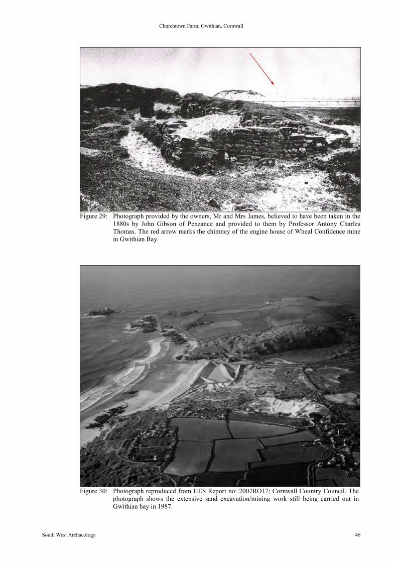
Churchtown Farm, Gwithian, Cornwall
South West Archaeology 46
Figure 29: Photograph provided by the owners, Mr and Mrs James, believed to have been taken in the1880s by John Gibson of Penzance and provided to them by Professor Antony CharlesThomas. The red arrow marks the chimney of the engine house of Wheal Confidence minein Gwithian Bay.
Figure 30: Photograph reproduced from HES Report no: 2007RO17; Cornwall Country Council. Thephotograph shows the extensive sand excavation/mining work still being carried out inGwithian bay in 1987.
Churchtown Farm, Gwithian, Cornwall
South West Archaeology 47
7.0 Bibliography and References
Published Sources:
Lewis, S 1848: A Topographical Dictionary of England 7th edition.
Soil Survey of England and Wales 1983: Legend for the 1:250,000 Soil Map of England andWales (a brief explanation of the constituent soil associations).
Stan Openshaw 1986: Nuclear Power; Siting and Safety: Routledge.
Unpublished Sources:
British Geological Society 2012: Geology of Britain Viewerhttp://maps.bgs.ac.uk/geologyviewer_google/googleviewer.html accessed 05.09.12
Wikisource Free Online Library – Dictionary of National Biography, 1885-1900, Volume 03,Basset of Cornwall (1885) by Walter Hawken Tregellashttp://en.wikisource.org/wiki/Basset_of_Cornwall_(DNB00) accessed 06.09.12
English Heritage - Register of Historic Parks and Gardens of special historic interest inEngland http://www.english-heritage.org.uk/caring/listing/registered-parks-and-gardensaccessed 12.09.12
English Heritage – Statutory List of Buildings of Special Architectural or Historic Interesthttp://www.english-heritage.org.uk/caring/listing/listed-buildings accessed 12.09.12
English Heritage – The National Heritage List for England http://www.english-heritage.org.uk/caring/listing/scheduled-monuments accessed 12.09.12
Historic Environment Service (Projects); Jacqueline A Nowakowski BA, FSA,MIFA ; -Excavations of a Bronze Age landscape and a post- Roman industrial settlement 1953 -1961, Gwithian, Cornwall Assessment of key datasets (2005 - 2006) VOLUME I; ReportNo: 2007RO17; Cornwall County Councilhttp://ads.ahds.ac.uk/catalogue/adsdata/arch-756-1/dissemination/pdf/2007_assessment_report/Assessment_Report_on_excavations_at_Gwithian_volume_I.pdf accessed 11.10.12 and 12.10.12
http://www.ordnancesurvey.co.uk/oswebsite/products/os-opendata.html
http://www.cornwall.gov.uk/default.aspx?page=22352
Churchtown Farm, Gwithian, Cornwall
South West Archaeology 48
Appendix 1
PROJECT DESIGN FOR DESK-BASED RESEARCH, GEOPHYSICAL SURVEY AND VISUALIMPACT ASSESSMENT ON LAND AT CHURCHTOWN FARM, GWITHIAN, CORNWALL
Location: Churchtown Farm, Gwithian, Cornwall TR27 5BXParish: Gwinear-Gwithian CPCounty: CornwallNGR: SW594409Planning Application ref: Pre-applicationProposal: 500kw Wind turbineDate: 31.07.2012
1.0 INTRODUCTION1.1 This document forms a Project Design (PD) which has been produced by South West Archaeology Limited (SWARCH) at
the request of Tom Worboys of Pineapple Rural Consultancy (the Client). It sets out the methodology for desk-basedresearch, a visual impact assessment and archaeological magnetometer survey, and for related off site analysis andreporting at Churchtown Farm, Gwithian, Cornwall. The PD and the schedule of work it proposes has been drawn up inconsultation with the Cornwall Council Historic Environment Planning Advice Officer (HEPAO) (Phil Markham).
2.0 ARCHAEOLOGICAL BACKGROUND2.1 The site lies on a spur of land projecting from Trevarnon Moor to the south, overlooking the valley of the Red River and the
northern part of St Ives Bay. The turbine lies within Anciently Enclosed Land (AEL) and is located immediately to the west ofa scheduled ancient monument: a ploughed-down round visible only as a cropmark (HER 37033). The cropmarks of furtherundesignated enclosures lie immediately to the north, east and south (HER 53582-5); these are assumed to becontemporary with the Iron Age/Romano-British settlement. Two further scheduled rounds lie within 1km to the south-west(HER 37034, 53549). The remains of a post-medieval mine lie c.400m to the east at Higher Nanterrow Farm. In the valley ofthe Red River to the south lies the important Bronze Age and early medieval site of Gwithian (HER 37049), extensivelyexcavated in the 1950-60s. Connerton (located 1.5km to the south) was the original administrative centre for the Hundred ofConnerton (now West Penwith). This is a landscape of high archaeological potential, and contains significant remains ofPrehistoric, Romano-British and early medieval settlement and landuse.
3.0 AIMS3.1 The principal objectives of the work will be to:
3.1.1 Undertake a desk-based assessment of the site;3.1.2 Undertake an archaeological magnetometer survey;3.1.3 Identify and assess the significance of the likely landscape and visual impacts of the proposed development
through the use of view-shed-analysis;3.1.4 Assess the direct visual effects of the proposed development upon specific landscape elements and historic
assets through the use of photo-montages, including views from key features looking toward the development site,and showing scale images of the proposed turbine superimposed thereon;
3.1.5 Produce a report containing the results of the desk-based research, the geophysical survey and the visual impactassessment;
3.1.6 Inform whether an archaeological evaluation or further archaeological recording of any potential buried remains isrecommended or mitigation proposals.
4.0 METHOD4.1 Desk-based Assessment:
The programme of work shall include an element of desk-based research to place the development site into itshistoric andarchaeological context. This work will include of map regression based on the Ordnance Survey maps and the Tithe Map(s)and Apportionments. An examination will also be made of records and aerial photographs held by the HER. In addition, it willinvolve the examination of other known relevant cartographic, documentary and photographic sources held by the CornwallRecord Office, Cornwall Studies Library, the Courtney Library and the County Historic Environment Service..
4.2 Geophysical Survey:A geophysical (Gradiometry) survey will be undertaken, consisting of an area of one hectare centred on the location of theturbine base (see attached plan). There will be no cable trench; the site is close to existing elements of the National Grid andthe cable will be carried above ground on telegraph poles.4.2.1 The work will be undertaken according to the following standards and codes of practice:
Institute for Archaeologists (undated) IfA house style, [Online], Available:http://www.archaeologists.net/sites/default/files/node-files/ifa_house_style.pdfInstitute for Archaeologists (2011) Standard and guidance archaeological geophysical survey. Reading:Author [Online], Available: http://www.archaeologists.net/sites/default/files/node-files/Geophysics 2010.pdfInstitute for Archaeologists (2009) Code of conduct. Reading: Author [Online], Available:http://www.archaeologists.net/sites/default/files/node-files/code_conduct.pdfInstitute for Archaeologists (2008) Code of approved practice for the regulation of contractual arrangements inarchaeology. Reading: Author [Online], Available:http://www.archaeologists.net/sites/default/files/node-files/ifa_code_practice.pdfSchmidt, A. (2002) Geophysical Data in Archaeology: A Guide to Good Practice, ADS series of Guides to GoodPractice. Oxford: Oxbow Books [Online], Available: http://guides.archaeologydataservice.ac.uk/
4.3 Visual Impact Assessment (VIA):4.3.1 A viewshed analysis resulting in a Zone of Theoretical Visibility (ZTV) has already been undertaken by the client
and this will be used during the archaeological VIA.4.3.2 Historic assets that fall within the VIA will be assessed on the basis of their intrinsic importance and the potential
impact of the development. This will include: all designated and undesignated heritage assets within 5km of thesite; all Grade I and II* Listed structures and scheduled ancient monuments within 10km of the site; and all
Churchtown Farm, Gwithian, Cornwall
South West Archaeology 49
registered parks/gardens and significant un/designated archaeological landscapes within 15km of the site. Anabbreviated list of these heritage assets will be included as an appendix within the report.
4.3.3 Significant historic assets and monument groups will be identified and visited to assess the impact on their settingand photomontages produced in accordance with the Landscape Institute and Institute of EnvironmentalAssessment “Guidelines for Landscape and Visual Impact Assessment” 2nd Edition 2002. This will be used toproduce a statement of significance for those heritage assets potentially impacted upon by the development.
4.3.4 The likely impact will be assessed using the methods outlined in Cornwall Historic Environment Projectsvisual assessment reports.
5.0 REPORT5.1 A report will be produced and will include the following elements:
5.1.1 A report number;5.1.2 A location map, copies of the view shed analysis mapping, a map or maps showing assets referred to in the text
and copies of historic maps and plans consulted shall be included, with the boundary of the development siteclearly marked in red on each. All plans will be tied to the national grid;
5.1.3 A concise non-technical summary of the project results;5.1.4 The aims and methods adopted in the course of the investigation;5.1.5 A discussion of the archaeological findings in terms of both the site specific aims and the desk based research;5.1.6 Any specialist reports and assessments commissioned;5.1.7 A copy of the HEPAO brief and this PD will be included as an appendix.
5.2 The full report shall be submitted within three months of completion of fieldwork. The report will be supplied to the HES onthe understanding that one of these copies will be deposited for public reference in the HER. A copy will be provided to theHES in digital ‘Adobe Acrobat’ PDF format.
6.0 ARCHIVE DEPOSITION6.1 An ordered and integrated site archive will be prepared in accordance with: Management of Research Projects in the
Historic Environment (MoRPHE) English Heritage 2006 upon completion of the project. The requirements for archive storageshall be agreed with the Royal Cornwall Museum.
6.2 Where there is only a documentary archive this will be deposited with the Cornwall Record Office.6.3 A copy of the report will be supplied to the National Monuments Record (NMR) Swindon.6.4 A summary of the contents of the archive shall be supplied to the HEPAO.6.5 The archaeological contractor will undertake the English Heritage/ads online access to the index of archaeological
investigations (OASIS).7.0 MONITORING7.1 The HEPAO will monitor the work and will be kept regularly informed of progress.7.2 Notification of the start of work shall be given preferably in writing to the HEPAO at least one week in advance of its
commencement.7.3 Any variations to the WSI shall be agreed with the HEPAO, preferably in writing, prior to them being carried out.8.0 PERSONNEL
The project will be managed by Colin Humphreys; the geophysical survey will be undertaken by Substrata, the desk-basedresearch and the visual impact assessment will be carried out by SWARCH personnel with suitable expertise andexperience. Relevant staff of CCHES will be consulted as appropriate. Where necessary, appropriate specialist advice willbe sought (see list of consultant specialists in Appendix 1 below).
Deb Laing-TrengoveSouth West Archaeology Ltd the Old Dairy, Hacche Lane Business Park, Pathfields Business Park, South Molton, Devon EX36 3LHTelephone: 01769 573555 email: [email protected]
List of specialistsBuilding recording Richard Parker 11 Toronto Road, St James, Exeter. EX4 6LE, Tel: 07763 248241Conservation Alison Hopper Bishop The Royal Albert Memorial Museum Conservation service, [email protected] and Helena Jaeschke 2 Bydown Cottages, Swimbridge, Barnstaple, EX32 0QD, Tel: 01271 830891,[email protected],comCuratorial Thomas Cadbury Curator of Antiquities Royal Albert Memorial Museum, Bradninch Offices, Bradninch Place, GandyStreet, Exeter, EX4 3LS Tel: 01392 665356Alison Mills The Museum of Barnstaple and North Devon, The Square, Barnstaple, North Devon, EX32 8LN, Tel: 01271 346747BoneHuman Professor Chris Knusel, University of Exeter, Tel: 01392 722491, [email protected] Wendy Howard, Department of Archaeology, Laver Building, University of Exeter, North Park Road, Exeter EX4 4QE
Tel: 01392 269330, [email protected] Dr Martin Tingle Higher Brownston, Brownston, Modbury, Devon, PL21 OSQ [email protected]/OrganicWood identification Dana Challinor Tel: 01869 810150 [email protected] macro-fossils Julie Jones [email protected] analysis Ralph Fyfe Room 211, 8 Kirkby Place, Drake Circus, Plymouth, Devon, PL4 8AAPotteryPrehistoric Henrietta Quinnell, 39D Polsloe Road, Exeter EX1 2DN, Tel: 01392 433214Roman Alex Croom, Keeper of Archaeology
Tyne & Wear Archives & Museums, Arbeia Roman Fort and Museum, Baring Street, South Shields,Tyne and Wear NE332BBTel: (0191) 454 4093 [email protected]
Medieval John Allen, Exeter Archaeology, Custom House, The Quay, Exeter, EX2 4AN, Tel: 01392 665918Post Medieval Graham Langman, Exeter, EX1 2UF, Tel: 01392 215900, [email protected]
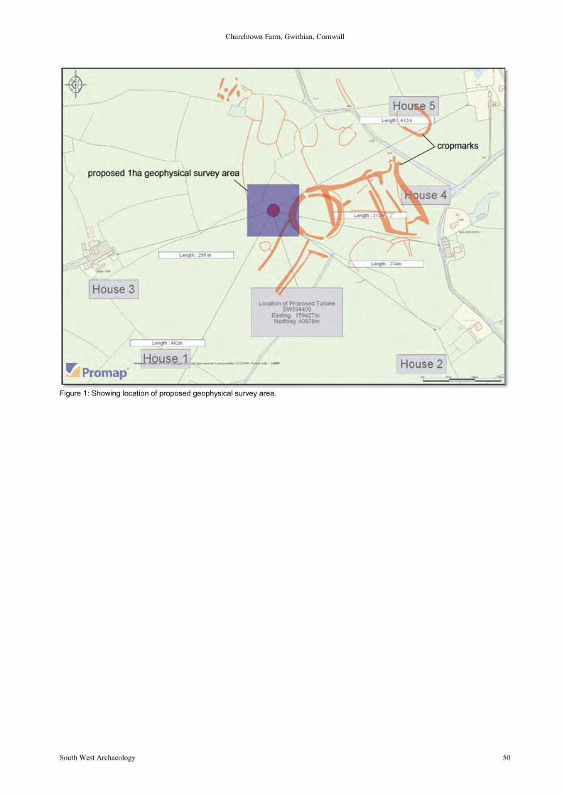
Churchtown Farm, Gwithian, Cornwall
South West Archaeology 50
Figure 1: Showing location of proposed geophysical survey area.
Churchtown Farm, Gwithian, Cornwall
South West Archaeology 51
Appendix 2
Scheduled Monuments within 5km
1. DesigUID: DCO948 Type: Scheduled Monument Status: ActivePreferred Ref National Ref OCN_part30417 1016163Name: AN EARLY CHRISTIAN MEMORIAL STONE AND A WAYSIDE CROSS IN PHILLACK CHURCHYARD, SOUTH EAST OFTHE CHURCHGrade: Date Assigned: 24/09/1997 Amended: Revoked:Legal DescriptionThe monument includes an early Christian memorial stone and a medieval wayside cross situated to the south east of the church inPhillack churchyard on the north coast of west Cornwall. The early Christian memorial stone survives as an upright granite shaft 1.56mhigh. It measures 0.53m wide at the base, tapering to 0.38m wide at the top, and is 0.24m thick at the base widening to 0.39m at thetop. The principal faces of the memorial stone are orientated east-west. The inscription is very worn and is incised down the westprincipal face. The inscription has been read as `CLOTUALI MOBRATTI' which translates as `the stone of Clotualus, son of Mobrattus'.The name Clotualus is of Celtic origin; the name Mobrattus is of Irish origin. Simple pillar stones with a memorial on them date from thefifth century to the 11th century; the Irish name suggests a fifth to eighth century date, and the style of the script suggests an eighthcentury date for this stone. This early Christian memorial stone was found in 1856 when the church was being rebuilt. It had been builtinto the foundations near the south eastern corner of the chancel. By 1858 the stone had been moved into its present location, outsidethe vestry. The medieval wayside cross is located to the south of the early Christian memorial stone. This cross survives as an uprightgranite shaft with a round `wheel' head. The overall height of the cross is 1.43m. The principal faces are orientated east-west. Thehead measures 0.42m wide and is 0.24m thick. The west principal face bears a relief equal limbed cross, with splayed ends to thelimbs, the lower limb extending down onto the top of the shaft. The top of the head has been straightened, truncating the top of theupper limb. The east face is not visible as the cross is located close to the wall of the vestry building. The historian Langdon in 1896recorded that this wayside cross was reused as a gatepost at the entrance to Bodriggy Farm, 0.75km south of Phillack church, andthat in the late 19th century the cross was reused as a doorpost at the entrance to the schoolyard at Phillack, before being removed tothe churchyard at Phillack in 1910. The metalled surface of the footpath to the north and west of the cross and memorial stone, thearea of concrete footpath to the south of the cross and the drain between the cross and the memorial stone, where they fall within themonument's protective margin, are excluded from the scheduling, although the ground beneath these features is included. The earlyChristian memorial stone has survived well, with most of its inscription complete and legible. The inscription itself is of importance froma period generally lacking in such historical references. Its reuse in the building material of the church reflects the continuity of use ofPhillack churchyard as a burial place from the eighth century to the present day. Also its reuse in the church, and its re-erection in thechurchyard in the 19th century reflects the changing attitudes to religion and their impact on the local landscape. The wayside crossalso survives well, its reuse and removal illustrates well the changing attitudes to religion and their impact on the local landscape sincethe medieval period.LocationGrid Reference: Centroid SW 5657 3843 (MBR: 7m by 7m)Map sheet: SW53NE Area (Ha): 0.00Associated Monuments31815 Building: PHILLACK - Medieval cross31822 Monument: PHILLACK - Early Medieval inscribed stone
2. DesigUID: DCO943 Type: Scheduled Monument Status: ActivePreferred Ref National Ref OCN_part30412 1017801Name: CHURCHYARD CROSS IN GWITHIAN CHURCHYARDGrade: Date Assigned: 24/09/1997 Amended: Revoked:LocationGrid Reference: Centroid SW 5863 4124 (MBR: 10m by 10m)Map sheet: SW54SE Area (Ha): 0.01Associated Monuments105798 Monument: GWITHIAN - Medieval cross
3. DesigUID: DCO947 Type: Scheduled Monument Status: ActivePreferred Ref National Ref OCN_part30416 1016162Name: CHURCHYARD CROSS IN PHILLACK CHURCHYARD, SOUTH OF THE CHURCHGrade: Date Assigned: 24/09/1997 Amended: Revoked:LocationGrid Reference: Centroid SW 5653 3841 (MBR: 7m by 7m)Map sheet: SW53NE Area (Ha): 0.00Associated Monuments31814 Building: PHILLACK - Medieval cross
4. DesigUID: DCO1587 Type: Scheduled Monument Status: ActivePreferred Ref National Ref OCN_partCO772 1004260Name: Godrevy Headland - complex of prehistoric sitesLocationGrid Reference: Centroid SW 5815 4317 (MBR: 340m by 487m)Map sheet: SW54SE Area (Ha): 9.28Associated Monuments
Churchtown Farm, Gwithian, Cornwall
South West Archaeology 52
37000 Monument: GODREVY - Romano British field system37068 Monument: GWITHIAN, SITE GB - Bronze Age barrow37068.10 Monument: GWITHIAN, SITE GB - Mesolithic lithic scatter37068.20 Find Spot: GWITHIAN, SITE GB - Neolithic findspot37068.40 Find Spot: GWITHIAN, SITE GB - Undated findspot37068.50 Find Spot: GWITHIAN, SITE GB - Romano British findspot53559 Monument: GODREVY COVE - Modern battery53561 Monument: GODREVY FARM - Medieval field system
5. DesigUID: DCO1586 Type: Scheduled Monument Status: ActivePreferred Ref National Ref OCN_partCO771 1004259Name: Godrevy Towans - complex of prehistoric sitesCuratorial NotesScheduled Monument Consent dated 22 Feb 2011 for transect line of 17 cores. Scheduled Monument Consent dated 30 April 2011 foradditional power and hand auger coring further ground penetrating radar survey and for a 2 x 2m excavation trench to refine thestratigraphy in the meadow to the west of the Bronze Age occupation area. University of Reading 25-28 June 2012 additional coringalong the transect line defined in 2011. University of Reading 11-17 July 2012 excavation of the trench in the area of the field system.Ground Penetrating Radar will be undertaken June, July August 2012 non-invasive technique, presumably the equipment has built inGPS.LocationGrid Reference: Centroid SW 5887 4234 (MBR: 921m by 659m)Map sheet: SW54SE Area (Ha): 28.76Associated Monuments166320 Monument: GODREVY - C19 firing range37012 Monument: SAND COT - Medieval holy well37044 Find Spot: GWITHIAN, SITE GRR - Mesolithic findspot37049 Monument: GWITHIAN, SITE GM/I - Early Medieval midden, Early Medieval settlement37049.21Monument: GWITHIAN, SITE GM/I - Early Medieval hut circle37049.22Monument: GWITHIAN, SITE GM/I - Early Medieval hut circle37049.23 Monument: GWITHIAN, SITE GM/I - Early Medieval hut circle37049.30 Monument: GWITHIAN, SITE GM/I - Early Medieval house37049.40 Find Spot: GWITHIAN, SITE GM/I - Romano British findspot37049.51 Find Spot: GWITHIAN, SITE GM/I - Early Medieval findspot37049.52 Find Spot: GWITHIAN, SITE GM/I - Early Medieval findspot37050 Monument: GWITHIAN, SITE GM/II - Bronze Age occupation site37051 Monument: GWITHIAN, SITE GM/III - Early Medieval occupation site37052 Monument: GWITHIAN, SITE GM/IV - Early Medieval midden37053 Monument: GWITHIAN, SITE GM/V - Bronze Age barrow37054 Monument: GWITHIAN, SITE GM/IX - Bronze Age settlement37054.10 Monument: GWITHIAN, SITE GM/IX - Bronze Age cup marked stone, Bronze Age oven, Bronze Age hut circle37054.20 Monument: GWITHIAN, SITE GM/IX - Bronze Age hearth37054.30 Monument: GWITHIAN, SITE GM/IX - Bronze Age granary37054.40 Monument: GWITHIAN, SITE GM/IX - Bronze Age field system37055 Monument: GWITHIAN, SITE GM/X - Neolithic occupation site, Bronze Age settlement37055.21 Monument: GWITHIAN, SITE GM/X - Neolithic hearth, Bronze Age hut circle37055.22 Monument: GWITHIAN, SITE GM/X - Bronze Age hearth, Bronze Age hut circle37055.23 Monument: GWITHIAN, SITE GM/X - Bronze Age hearth, Bronze Age hut circle37055.24 Monument: GWITHIAN, SITE GM/X - Bronze Age midden37055.25 Monument: GWITHIAN, SITE GM/X - Bronze Age cairn37055.26 Monument: GWITHIAN, SITE GM/X - Bronze Age cairn37055.27 Monument: GWITHIAN, SITE GM/X - Bronze Age field system37056 Monument: GWITHIAN, SITE GM/XI - Bronze Age barrow37058 Monument: GWITHIAN, SITE GM/XIII - Bronze Age barrow37060 Monument: GWITHIAN, SITE GM/XV - Neolithic occupation site, Bronze Age occupation site37061 Monument: GWITHIAN, SITE GM/XVI - Bronze Age enclosure37062 Monument: GWITHIAN, SITE GM/XX - Early Medieval field system37063 Monument: GWITHIAN, SITE GM/XXI - Early Medieval field system37063.10 Monument: GWITHIAN, SITE GM/XXI - Bronze Age field system37064 Monument: GWITHIAN, SITE GM/VII - Early Medieval occupation site37065 Monument: GWITHIAN, SITE GM/VIII - Early Medieval occupation site37067 Monument: GWITHIAN, SITE GM/XXII - Early Medieval midden37070 Monument: GWITHIAN, SITE GH - Romano British field system37071 Monument: GWITHIAN, SITE GO - Undated occupation site37072 Monument: GWITHIAN, SITE GE - Undated occupation site37078 Monument: GWITHIAN, SITE GW - Bronze Age field system37080 Find Spot: GODREVY TOWANS - Bronze Age findspot53575 Monument: GODREVY TOWANS - Post Medieval prospecting pit
6. DesigUID: DCO1141 Type: Scheduled Monument Status: ActivePreferred Ref National Ref OCN_partCO1056 1007284Name: Linear earthworks, probably 17th century, W of GodrevyLocationGrid Reference: Centroid SW 5826 4306 (MBR: 180m by 278m)
Churchtown Farm, Gwithian, Cornwall
South West Archaeology 53
Map sheet: SW54SE Area (Ha): 0.68Associated Monuments37037 Monument: GODREVY GREEN - Post Medieval linear earthwork
7. DesigUID: DCO1584 Type: Scheduled Monument Status: ActivePreferred Ref National Ref OCN_partCO769 1003111Name: Magor Farm Roman villa siteLocationGrid Reference: Centroid SW 6367 4238 (MBR: 111m by 138m)Map sheet: SW64SW Area (Ha): 0.98Associated Monuments26553 Monument: MAGOR - Iron Age/Romano British round, Romano British villa26663 Monument: MAGOR - Medieval chapel
8. DesigUID: DCO1303 Type: Scheduled Monument Status: ActivePreferred Ref National Ref OCN_partCO391 1004454Name: Mexico Cross, PhillackLocationGrid Reference: Centroid SW 5623 3840 (MBR: 10m by 10m)Map sheet: SW53NE Area (Ha): 0.01Associated Monuments31859 Building: MEXICO - Medieval cross
9. DesigUID: DCO946Type: Scheduled Monument Status: ActivePreferred Ref National Ref OCN_part30415 1016161Name: POLMENOR CROSS IN GWINEAR CHURCHYARD, 12M NORTH OF THE CHURCHGrade: Date Assigned: 24/09/1997 Amended: Revoked:LocationGrid Reference: Centroid SW 5949 3739 (MBR: 5m by 5m)Map sheet: SW53NE Area (Ha): 0.00Associated Monuments29556 Monument: POLMENOR CROSS - Medieval cross
10. DesigUID: DCO1733 Type: Scheduled Monument Status: ActivePreferred Ref National Ref OCN_partCO987 1007304Name: Railway BridgeLocationGrid Reference: Centroid SW 5670 3823 (MBR: 18m by 10m)Map sheet: SW53NE Area (Ha): 0.01Associated Monuments110784 Building: PHILLACK - Post Medieval bridge
11. DesigUID: DCO1322 Type: Scheduled Monument Status: ActivePreferred Ref National Ref OCN_partCO417 1004468Name: Rectangular camp SW of Trevarnon RoundLocationGrid Reference: Centroid SW 5841 3983 (MBR: 292m by 249m)Map sheet: SW53NE Area (Ha): 4.05Associated Monuments31829 Monument: CARWIN ROUND - Romano British enclosure
12. DesigUID: DCO14968 Type: Scheduled Monument Status: ActivePreferred Ref National Ref OCN_part36047 1021418 MPP22/AA08086/1Name: Roseworthy Arsenic Works, 700m west of Cornhill FarmGrade: Date Assigned: 22/01/2010 Amended: Revoked:Legal DescriptionThe monument includes a C19 and early C20 arsenic works which was operated by the English Arsenic Company between 1897 and1926. The arsenic works stands in the bottom of a valley formed by an unnamed tributary of the Red River and its associated flueleads up the side of the east facing slope terminating in a substantial chimney. The arsenic works was built during the 1850’s andappear on the 1876 edition of the Ordnance Survey map. In 1889 the manager was Captain Josiah Thomas and in 1919, 35 tons ofarsenical pyrities and 1,492 tons of arsenic were produced. Arsenic refining ceased in 1926 when the English Arsenic Companyabandoned the operation. The structural remains of the arsenic works include a series of eleven stone and brick built conjoinedcondensing chambers, a shaft calciner in which the arsenic was heated, the truncated remnants of the refining building and a largedetached building situated within the northern part of the complex. Leading from the condensing chambers is a stone builtunderground flue which leads for 250m to a large tapering stone and brick chimney standing on the hillslope above and to the west ofthe calciner. Waste material from the refining process was dumped to the north where an elongated irregular shaped mound survives.Modern fences and track surfaces are excluded from the scheduling, but the ground below them is included.Designating Organisation: English HeritageLocation
Churchtown Farm, Gwithian, Cornwall
South West Archaeology 54
Grid Reference: Centroid SW 6096 4014 (MBR: 262m by 210m)Map sheet: SW64SW Area (Ha): 0.58Associated Monuments26591 Building: ROSE IN THE VALLEY - Post Medieval arsenic works
13. DesigUID: DCO1585 Type: Scheduled Monument Status: ActivePreferred Ref National Ref OCN_partCO770 1004258Name: Round at Crane Godrevy, GodrevyLocationGrid Reference: Centroid SW 5894 4266 (MBR: 205m by 197m)Map sheet: SW54SE Area (Ha): 3.05Associated Monuments37066 Monument: CRANE GODREVY - Iron Age round, Romano British round, Medieval settlement37066.10 Monument: CRANE GODREVY - Iron Age round, Romano British round37066.20 Monument: CRANE GODREVY - Medieval settlement37066.21 Monument: CRANE GODREVY - Medieval building37066.30 Monument: CRANE GODREVY - Medieval longhouse37066.40 Monument: CRANE GODREVY - Medieval house, Post Medieval house53569 Monument: CRANE GODREVY - Medieval enclosure53569.10Monument: CRANE GODREVY - Medieval house53570 Monument: CRANE GODREVY - Medieval field system
14. DesigUID: DCO1127 Type: Scheduled Monument Status: ActivePreferred Ref National Ref OCN_partCO1032 1004608Name: Round E of GwealavellanLocationGrid Reference: Centroid SW 6063 4179 (MBR: 104m by 78m)Map sheet: SW64SW Area (Ha): 0.62Associated Monuments26589 Monument: GWEALAVELLAN - Iron Age round, Romano British round
15. DesigUID: DCO1588 Type: Scheduled Monument Status: ActivePreferred Ref National Ref OCN_partCO773 1004261Name: Round enclosure (Hundred Pound), Gwithian Green, 100yds (90m) E of Gwithian parish churchGrade: Date Assigned: Amended: Revoked:LocationGrid Reference: Centroid SW 5878 4121 (MBR: 53m by 51m)Map sheet: SW54SE Area (Ha): 0.21Associated Monuments31804.11 Monument: GWITHIAN - Medieval enclosure, Medieval pound
16. DesigUID: DCO1732 Type: Scheduled Monument Status: ActivePreferred Ref National Ref OCN_partCO985 1007303Name: Round near Lower NanterrowLocationGrid Reference: Centroid SW 5951 4097 (MBR: 83m by 83m)Map sheet: SW54SE Area (Ha): 0.55Associated Monuments37033 Monument: TOLZETHAN - Iron Age/Romano British round
17. DesigUID: DCO14925 Type: Scheduled Monument Status: ActivePreferred Ref National Ref OCN_partCO986 CO986Name: Sea Lane BridgeDesignating Organisation: English HeritageLocationGrid Reference: Centroid SW 5666 3812 (MBR: 25m by 25m)Map sheet: SW53NE Area (Ha): 0.03Associated Monuments31974 Building: HAYLE - Post Medieval bridge
18. DesigUID: DCO1450 Type: Scheduled Monument Status: ActivePreferred Ref National Ref OCN_partCO59 1006700Name: St Gothian's ChapelLocationGrid Reference: Centroid SW 5883 4183 (MBR: 32m by 21m)Map sheet: SW54SE Area (Ha): 0.04
19. DesigUID: DCO981Type: Scheduled Monument Status: ActivePreferred Ref National Ref OCN_part
Churchtown Farm, Gwithian, Cornwall
South West Archaeology 55
30450 1018490Name: WAYSIDE CROSS AND CROSS-BASE IN CAMBORNE CHURCHYARD, 10M SOUTH WEST OF THE CHURCHGrade: Date Assigned: 18/09/1998 Amended: Revoked:LocationGrid Reference: Centroid SW 6450 4002 (MBR: 10m by 10m)Map sheet: SW64SW Area (Ha): 0.01Associated Monuments26626 Monument: CAMBORNE - Early Medieval cross26627 Monument: CAMBORNE - Medieval cross
20. DesigUID: DCO982Type: Scheduled Monument Status: ActivePreferred Ref National Ref OCN_part31823 1018491Name: WAYSIDE CROSS IN CAMBORNE CHURCHYARD, 10M WEST OF THE CHURCHGrade: Date Assigned: 18/09/1998 Amended: Revoked:LocationGrid Reference: Centroid SW 6450 4004 (MBR: 5m by 5m)Map sheet: SW64SW Area (Ha): 0.00
21. DesigUID: DCO944Type: Scheduled Monument Status: ActivePreferred Ref National Ref OCN_part30413 1016160Name: WAYSIDE CROSS IN GWINEAR CHURCHYARD, 5M NORTH OF THE CHURCHGrade: Date Assigned: 24/09/1997 Amended: Revoked:LocationGrid Reference: Centroid SW 5950 3738 (MBR: 6m by 5m)Map sheet: SW53NE Area (Ha): 0.00Associated Monuments29564 Monument: GWINEAR - Medieval cross
22. DesigUID: DCO945Type: Scheduled Monument Status: ActivePreferred Ref National Ref OCN_part30414 1016409Name: WAYSIDE CROSS-HEAD IN GWINEAR CHURCHYARD, EAST OF THE CHURCHGrade: Date Assigned: 24/09/1997 Amended: Revoked:Legal DescriptionThe monument includes a medieval wayside cross-head situated to the east of the church at Gwinear in west Cornwall. The cross-head, which is listed Grade II, is visible as a round or `wheel' head, 0.52m across, with the principal faces orientated east-west. Theeast face bears an equal limbed cross set within a foliate shaped bead. The west face is plain; the sides slope inwards to form a pointat the centre of this face. The upper shaft is buried in the ground. The gothic style of the foliate bead around the outer edge of the headsuggests that this cross-head is a late example of a wayside cross. The two gravestones to the north west of the cross-head and thegravel surface of the footpath to the west, where they fall within the cross's protective margin, are excluded from the scheduling,although the ground these features beneath is included. This cross has survived well despite the loss of its shaft and base. It is a rareexample of a wheel headed cross decorated with a gothic style motif. Its erection in the churchyard at Gwinear demonstrates well thechanging attitudes to religion and their impact on the local landscape since the medieval period.LocationGrid Reference: Centroid SW 5951 3736 (MBR: 6m by 6m)Map sheet: SW53NE Area (Ha): 0.00Associated Monuments31876 Monument: GWINEAR - Medieval cross
23. DesigUID: DCO949Type: Scheduled Monument Status: ActiveName: WAYSIDE CROSS-HEAD IN PHILLACK CHURCHYARD, SOUTH WEST OF THE CHURCHPreferred Ref National Ref OCN_part30418 1016154Grade: Date Assigned: 24/09/1997 Amended: Revoked:LocationGrid Reference: Centroid SW 5652 3841 (MBR: 7m by 7m)Map sheet: SW53NE Area (Ha): 0.00Associated Monuments31812 Monument: PHILLACK - Medieval cross
HER Number: 37034 (DOC 1184?)Name: TREVARNON - Iron Age round, Romano British roundSummaryThe severely ploughed down remains of a round measuring 60m by 40m with an outer enclosure fossilised by field hedges.Grid Reference: SW 5873 4017Parish: Gwinear Gwithian, Penwith, CornwallProtected StatusScheduled Monument CO131: Trevarnon Round, GwithianOther Statuses/Codes: none recordedMonument TypesROUND (Iron Age - 800 BC to 42 AD)ROUND (Romano British - 43 AD to 409 AD)Full description
Churchtown Farm, Gwithian, Cornwall
South West Archaeology 56
Trevarnon Round is an extensive elliptical earthwork consisting of a bank and ditch, with an annex to the north-east, which is sited tothe south of Gwithian village (b1). It is shown on the OS map of 1908 (b2) and was scheduled in 1958. The OS surveyed the site at1:2500 in 1962. The earthwork has been severely mutilated by ploughing. In the north-west a 34m length of bank averages 2.0m high,and the north-west and south-west sides consist of a scarp 0.5m high (h1). It is shown on the OS maps of 1963 (b3) and 1974 (b6). Itis likely that more than one phase of construction is represented, with surrounding hedges of enormous width, one 3.0m across thetop. Another separates the round on its north-west side from the large ditch, 2.7m to 3.0m deep (b4). Thomas in 1965 lists the site andrecords the extant remains of a round (b5). The round was visited by Sheppard in 1980 who reports that the extant north bank hassloping sides and is covered by small bushes. The east bank is partly covered by brambles (h2, b7). The site is visible on airphotographs (p1, p2) and was plotted as part of the NMP. The photos show an inner, four-sided, univallate polygonal enclosure,measuring 60m by 40m, encircled by a curving slighter ditch along the eastern side of its circuit. A second outer enclosure, measuring150m by 80m, partially fossilised in existing field hedges in the north, north-west, and south-west, is also visible as a crop mark ditch.A further enclosure (53550) is appended to the south-west side of the outer enclosure.Site history:
1: 1962. QUINNELL, NV / OS2: 1980. SHEPPARD, PA / DOESources / Further Reading[1] SCO3885 - Bibliographic reference: Lysons, D & S. 1814. Magna Britannia. VOL III, CORNWALL, 130p1 SCO14884 - Cornwall Photo Record: NMR. 1968. MAL 5268/211. ABP.[2] SCO4051 - Bibliographic reference: Ordnance Survey. 1900s. 2nd Edition 6 Inch Map.p2 SCO16807 - Cornwall Photo Record: NMR. 1983. SW5840/1. ABP.[3] SCO4045 - Cartographic materials: Ordnance Survey. 1970s. 1:10,000 Map.[4] SCO4628 - Bibliographic reference: Thomas, AC. 1964. Minor Sites in the Gwithian Area. CA No 3. VOL 3, 38-39[5] SCO4617 - Bibliographic reference: Thomas, AC. 1965. Gwithian Checklist. CA No 4. VOL 4, 75[6] SCO4045 - Cartographic materials: Ordnance Survey. 1970s. 1:10,000 Map.[7] SCO5181 - Bibliographic reference: Sheppard, PA (for DOE). 19--. Scheduled Monument Description. HBMC / English
Heritage.Related records37034.10 Parent of: TREVARNON - Undated findspot (Find Spot)

Churchtown Farm, Gwithian, Cornwall
South West Archaeology 57
Appendix 3
Scheduled Monuments within 5-10km
1. DesigUID: DCO1402 Type: Scheduled Monument Status: ActiveName: Carvannel cliff castlePreferred Ref National Ref OCN_partCO519 1004390LocationGrid Reference: Centroid SW 6348 4396 (MBR: 97m by 49m)Map sheet: SW64SW Area (Ha): 0.22Associated Monuments26605 Monument: CRANE CASTLE - Iron Age cliff castle
2. DesigUID: DCO1308 Type: Scheduled Monument Status: ActivePreferred Ref National Ref OCN_partCO396 1004458Name: Carwynnen burial chamberLocationGrid Reference: Centroid SW 6501 3721 (MBR: 29m by 20m)Map sheet: SW63NE Area (Ha): 0.06Associated Monuments35111 Monument: CARWYNNEN - Neolithic chambered tomb
3. DesigUID: DCO1174 Type: Scheduled Monument Status: ActivePreferred Ref National Ref OCN_partCO117 1006688Name: Castle Kayle (earthwork), PhillackLocationGrid Reference: Centroid SW 5833 3565 (MBR: 107m by 132m)Map sheet: SW53NE Area (Ha): 1.09Associated Monuments31787 Monument: CASTLE KAYLE - Iron Age/Romano British round
4. DesigUID: DCO957Type: Scheduled Monument Status: ActivePreferred Ref National Ref OCN_part30426 1017628Name: CHURCHYARD CROSS 25M SOUTH OF ST UNY'S CHURCH, LELANTGrade:Date Assigned: 08/12/1997Amended:LocationGrid Reference: Centroid SW 5482 3769 (MBR: 10m by 10m)Map sheet: SW53NWArea (Ha): 0.01Associated Monuments31063 Building: LELANT - Early Medieval cross, Medieval cross
5. DesigUID: DCO1408 Type: Scheduled Monument Status: ActivePreferred Ref National Ref OCN_partCO528 1004395Name: Cross 140yds (130m) E of Pendarves FarmLocationGrid Reference: Centroid SW 6469 3788 (MBR: 10m by 10m)Map sheet: SW63NWArea (Ha): 0.01
6. DesigUID: DCO1185 Type: Scheduled Monument Status: ActivePreferred Ref National Ref OCN_partCO136 1006666Name: Cross in forecourt of Methodist Chapel, Chapel StreetLocationGrid Reference: Centroid SW 6469 3995 (MBR: 5m by 5m)
7. DesigUID: DCO1407 Type: Scheduled Monument Status: ActivePreferred Ref National Ref OCN_partCO527 1003049Name: Cross in recreation groundLocationGrid Reference: Centroid SW 6410 3986 (MBR: 10m by 10m)Map sheet: SW63NWArea (Ha): 0.01DesigUID: DCO1407Name: Cross in recreation groundAssociated Monuments29624 Monument: CAMBORNE - Medieval cross
Churchtown Farm, Gwithian, Cornwall
South West Archaeology 58
8. DesigUID: DCO1263 Type: Scheduled Monument Status: ActivePreferred Ref National Ref OCN_partCO30 1006720Name: Hayle Inscribed StoneLegal DescriptionA pillar stone with its face roughly squared and flattened. It is embedded in the face of a bank in the public gardens at the west end ofthe railway viaduct at Hayle. These form part of the scarp of Carnsew Castle, a promontory fortress now practically destroyed. Thestone was found in 1843 near its present position about four feet below the surface. The inscription in several horizontal lines and is indebased Roman characters. It is supposed to date from the fifth century.Curatorial NotesVictoria County History, Cornwall, Vol I, 420. Pl II 10.Hubner Inscriptiones Brittaniae ChristianaeRomilly Allen in Archaeologia Cambrensis Ser V Vol XIILocationGrid Reference: Centroid SW 5564 3716 (MBR: 5m by 5m)Map sheet: SW53NE Area (Ha): 0.00
9. DesigUID: DCO1583 Type: Scheduled Monument Status: ActivePreferred Ref National Ref OCN_partCO768 1004257Name: Round in North Cliff Plantation 800yds (730m) NW of Tehidy HospitalLocationGrid Reference: Centroid SW 6433 4375 (MBR: 52m by 51m)Map sheet: SW64SW Area (Ha): 0.21Associated Monuments26677 Monument: NORTH CLIFF PLANTATION - Iron Age round, Romano British round
10. DesigUID: DCO991Type: Scheduled Monument Status: ActivePreferred Ref National Ref OCN_part31832 1018574Name: SEA LANE CROSS, LELANTGrade:Date Assigned: 21/01/1999Amended:LocationGrid Reference: Centroid SW 5422 3661 (MBR: 10m by 10m)Map sheet: SW53NWArea (Ha): 0.01
11. DesigUID: DCO14901 Type: Scheduled Monument Status: ActivePreferred Ref National Ref OCN_partCO914 1005456Name: Sea-mark, Lighthouse HillDesignating Organisation: English HeritageLocationGrid Reference: Centroid SW 6550 4563 (MBR: 10m by 10m)Map sheet: SW64NE Area (Ha): 0.01Associated Monuments25002 Monument: PORTREATH - Post Medieval day mark
12 DesigUID: DCO961Type: Scheduled Monument Status: ActivePreferred Ref National Ref OCN_part30430 1018157Name: WAYSIDE CROSS 40M WEST OF ST UNY'S CHURCH, LELANTGrade:Date Assigned: 19/03/1998Amended:LocationGrid Reference: Centroid SW 5478 3772 (MBR: 10m by 10m)Map sheet: SW53NWArea (Ha): 0.01Associated Monuments31060 Building: LELANT - Medieval cross
13. DesigUID: DCO960Type: Scheduled Monument Status: ActivePreferred Ref National Ref OCN_part30429 1018156Name: WAYSIDE CROSS 65M WEST OF ST UNY'S CHURCH, LELANTLocationGrid Reference: Centroid SW 5475 3772 (MBR: 5m by 5m)Map sheet: SW53NWArea (Ha): 0.00Associated Monuments31062 Building: LELANT - Medieval cross
14. DesigUID: DCO959Type: Scheduled Monument Status: ActivePreferred Ref National Ref OCN_part30428 1017630

Churchtown Farm, Gwithian, Cornwall
South West Archaeology 59
Name: WAYSIDE CROSS 70M SOUTH OF ST UNY'S CHURCH, LELANTGrade:Date Assigned: 08/12/1997Amended:LocationGrid Reference: Centroid SW 5482 3765 (MBR: 10m by 10m)Map sheet: SW53NWArea (Ha): 0.01Associated Monuments31065 Building: LELANT - Medieval cross
15. DesigUID: DCO1008 Type: Scheduled Monument Status: ActivePreferred Ref National Ref OCN_part31850 1016749Name: WAYSIDE CROSS AND CROSS-BASE IMMEDIATELY NORTH EAST OF THE DONALD THOMAS DAYCARE
CENTRE, 180M EAST OF ST MERIADOC AND ST MARTIN'S CHURCHGrade:Date Assigned: 12/07/1999Amended:LocationGrid Reference: Centroid SW 6470 4005 (MBR: 10m by 10m)Map sheet: SW64SW Area (Ha): 0.01
16. DesigUID: DCO989Type: Scheduled Monument Status: ActivePreferred Ref National Ref OCN_part31830 1018572Name: WAYSIDE CROSS IN LELANT LANE, 670M NORTH WEST OF ST UNY'S CHURCHGrade:Date Assigned: 21/01/1999Amended:LocationGrid Reference: Centroid SW 5417 3788 (MBR: 10m by 10m)Map sheet: SW53NWArea (Ha): 0.01
17. DesigUID: DCO1009 Type: Scheduled Monument Status: ActivePreferred Ref National Ref OCN_part31851 1016750Name: WAYSIDE CROSS IN ST JOHN'S CHURCHYARD, TRESLOTHANGrade:Date Assigned: 16/04/1999Amended:LocationGrid Reference: Centroid SW 6507 3781 (MBR: 10m by 10m)Map sheet: SW63NE Area (Ha): 0.01Associated Monuments35260 Monument: TRESLOTHAN - Medieval cross
18. DesigUID: DCO1272 Type: Scheduled Monument Status: ActivePreferred Ref National Ref OCN_partCO32 1006722Name: Beersheba LongstoneLocationGrid Reference: Centroid SW 5251 3712 (MBR: 10m by 10m)Map sheet: SW53NWArea (Ha): 0.01Associated Monuments31050 Monument: BEERSHEBA - Neolithic standing stone, Bronze Age standing stone
19. DesigUID: DCO14969 Type: Scheduled Monument Status: ActivePreferred Ref National Ref OCN_part36048 1021419Name: BETTY ADIT TAILINGS WORKS, 170M SOUTH WEST OF HARLEY FARMLegal DescriptionThe monument includes a C20 tin tailings works known as Betty Adit or Brea Adit together with an earlier leat and reservoir associatedwith the nearby Dolcoath Mine. The tailings works is situated on a revetted terrace immediately above the west of the Red River. Thesite lies within the Cornwall and West Devon Mining Landscape World Heritage Site. The visible remains are mainly associated withthe 1920’s tailings works and include a series of buddles, frames, settling pits and concrete machine plinths. The Robert Symons’ mapof 1850 shows a building and the Dolcoath leat in the area. An Ordnance Survey map for 1880 depicts the least and a reservoir wherethe building once stood. The 1907 Ordnance Survey map illustrates a radical change in the level of activity within the area, with theappearance of the large primary settling tanks and a series of interconnected leats and channels. The next available Ordnance Surveymap dated 1967-75, shortly after the works were abandoned and shows less detail than is currently know to survive. The visibleremains are considered to relate to the period of working between 1928 and 1962 carried out under the name Brea Tin Streams byEwart Dawden. No trace of the 1880’s Dolcoath leat and reservoir are visible on the site; but because the area has seen considerablebuild up of material they will survive below the later deposits. Tailings works were built downstream of most of the major Cornish minesand were built to reprocess wastes from their larger neighbours. They are essentially independent dressing floors involved solely withthe extraction of black tin (Cassisterite) from material that had already been processed on at least one occasion. The works rely on

Churchtown Farm, Gwithian, Cornwall
South West Archaeology 60
water for dressing purposes and the actual processing was carried out using a series of interconnected settling tanks and buddles. AtBetty Adit, a complete set of tanks, round frames and buddles of different types survive together with machinery plinths, leats andchannels. The raw material entered the works in suspension and flowed into the primary settling tanks in the southern part of themonument. From here it passed through a series of buddles, frames and smaller tanks until by the time it reached the lower northernpart of the site much of the tin had been removed.Designating Organisation: English HeritageLocationGrid Reference: Centroid SW 6659 3979 (MBR: 92m by 173m)Map sheet: SW63NE Area (Ha): 0.42
20. DesigUID: DCO1490 Type: Scheduled Monument Status: ActivePreferred Ref National Ref OCN_partCO661 1004355Name: Cairn 150yds (140m) W of Little CarnaquiddenLocationGrid Reference: Centroid SW 4761 3546 (MBR: 24m by 24m)Map sheet: SW43NE Area (Ha): 0.04Associated Monuments31515 Monument: LITTLE CARNAQUIDDEN - Bronze Age cairn
21. DesigUID: DCO1602 Type: Scheduled Monument Status: ActivePreferred Ref National Ref OCN_partCO79 1006704Name: Carn Brea CastleLocationGrid Reference: Centroid SW 6863 4080 (MBR: 731m by 485m)Map sheet: SW64SE Area (Ha): 21.97Associated Monuments171065 Monument: CARN BREA - Prehistoric artefact scatter18163 Monument: CARN BREA - Neolithic tor enclosure, Iron Age hillfort18163.10 Find Spot: CARN BREA - Mesolithic findspot18163.21 Monument: CARN BREA - Neolithic settlement18163.22 Monument: CARN BREA - Neolithic tor enclosure18163.23 Monument: CARN BREA - Neolithic settlement18163.24 Monument: CARN BREA - Neolithic occupation site, Neolithic hearth18163.25 Monument: CARN BREA - Neolithic field system18163.34 Find Spot: CARN BREA - Bronze Age findspot18163.41 Monument: CARN BREA - Iron Age hillfort18163.42 Monument: CARN BREA - Iron Age hut circle, Iron Age settlement18163.43 Monument: CARN BREA - Iron Age field system18163.47 Find Spot: CARN BREA - Iron Age findspot18163.51 Monument: CARN BREA - Romano British occupation site18163.53 Find Spot: CARN BREA - Romano British findspot18163.55 Find Spot: CARN BREA - Romano British findspot18163.59 Find Spot: CARN BREA - Romano British findspot18163.71 Monument: CARN BREA - Medieval castle, Medieval chapel, Post Medieval beacon18163.72 Monument: CARN BREA - Medieval deer park18163.82 Monument: CARN BREA - Post Medieval well18163.83 Monument: CARN BREA - Post Medieval pillow mound18163.84 Monument: CARN BREA - Post Medieval commemorative monument18163.85 Monument: CARN BREA - Post Medieval folklore site40532 Monument: SOUTH CARN BREA - Post Medieval mine54536 Monument: CARN BREA - Post Medieval adit54537 Monument: CARN BREA - Post Medieval quarry54540 Monument: CARN BREA - Undated field boundary54542 Monument: CARN BREA - Post Medieval extractive pit, Post Medieval stone working site
22. DesigUID: DCO1026 Type: Scheduled Monument Status: ActivePreferred Ref National Ref OCN_part31871 1019169Name: CHURCHYARD CROSS AND WAYSIDE CROSS IN ST ERTH'S CHURCHYARDGrade:Date Assigned: 07/09/2000Amended:Legal DescriptionThe monument, which falls into two separate areas of protection, includes a medieval churchyard cross and a wayside cross situatedin St Erth's churchyard in west Cornwall, to the south east of the church. The churchyard cross is 1.01m high and survives as a roundor `wheel' head mounted on a rectangular granite base. The head measures 0.66m in diameter and 0.23m thick, and forms an equallimbed cross with expanded ends to the limbs, the ends of the limbs joined by an outer ring. The spaces between the limbs are fullypierced by four holes. The principal faces are orientated east-west, and are both decorated. The east face displays five round raisedbosses, one at the centre, the others marking the four limbs of the cross. The west face bears a figure of Christ in high relief with armsoutstretched; the figure terminates at the waist. The cross head is cemented into a rectangular granite cross base which measures0.66m north-south by 0.7m east-west and is 0.35m high. This cross is Listed Grade II. A cross, probably this one, was first mentionedas being in St Erth's churchyard in 1838. The local antiquarian, Blight, illustrated it in 1856, and the historian, Langdon, illustrated it in1896. Both these illustrations show the face displaying the bosses facing to the west. By 1953 the head had been turned around so
Churchtown Farm, Gwithian, Cornwall
South West Archaeology 61
that the bosses now face east. This cross with its figure of Christ on one side and bosses on the other displays similar characteristicsto the early tenth century crosses on the Penwith peninsula, centred around St Buryan and the early medieval monastery there. Thewayside cross survives as an upright granite shaft with a round, `wheel' head cemented on to a modern three stepped granite base.The west side of the top step has metal letters `GILBART' on it. The cross head measures 0.52m in diameter by 0.24m thick and hasprincipal faces orientated east-west. The west face displays a relief figure of Christ with outstretched arms, His head inclined to thenorth and feet apart and out-turned. A bead extends from the feet around the outer edge of the head. The east face bears a Latincross in relief with a narrow bead around the outer edge of the head. This face has been fractured on the top of the head and the northside of the shaft. The shaft measures 0.31 high, 0.29m wide and 0.26m thick. All four corners of the shaft are chamfered. Theantiquarian, Blight, noted this cross at Battery Mill, 0.5km south west of St Erth, in 1856. The historian, Langdon, illustrated the cross ina garden wall at the mill in 1896. He also recorded that the cross had been found nearby around 1860 and had been built into the wallfor its preservation. When Mr Gilbart, the owner of the mill, died in the 1890s the cross was removed to the churchyard and placed ona modern base over his rave. The surface of the gravel footpath to the south and west, the lamp-post to the south, the vault to thenorth and the gravestone to the north west of the churchyard cross, and the gravestones to the north, south, east and west of thewayside cross are excluded from the scheduling where they fall within the monument's 2m protective margin, although the groundbeneath all these features is included. The cross in St Erth's churchyard survives reasonably well as a good example of a four holedcross with unusual decoration of a type found on a group of crosses around St Buryan, the site of an early medieval monastery. It isbelieved that these crosses date to the tenth century. The wayside cross survives as a good example of a `wheel' headed cross. Thediscovery of this cross, its incorporation into a wall and later removal to the churchyard in the 19th century demonstrates well thechanging attitudes to religion and their impact on the local landscape since the medieval period.LocationGrid Reference: Centroid SW 5498 3505 (MBR: 21m by 80m)Map sheet: SW53NWArea (Ha): 0.01Associated Monuments29166 Monument: ST ERTH - Medieval cross31072 Monument: ST ERTH - Early Medieval/Medieval cross
23. DesigUID: DCO1724 Type: Scheduled Monument Status: ActivePreferred Ref National Ref OCN_partCO975 1001729Name: Crowan Beacon - two burial cairnsLocationGrid Reference: Centroid SW 6643 3505 (MBR: 37m by 57m)Map sheet: SW63NE Area (Ha): 0.14Associated Monuments35237.20 Monument: CROWAN BEACON - Bronze Age cairn
24. DesigUID: DCO1176 Type: Scheduled Monument Status: ActivePreferred Ref National Ref OCN_partCO119 1006690Name: Culver House, Higher BussowLocationGrid Reference: Centroid SW 4985 3873 (MBR: 20m by 20m)Map sheet: SW43NE Area (Ha): 0.03
25. DesigUID: DCO1114 Type: Scheduled Monument Status: ActivePreferred Ref National Ref OCN_part32988 1021323Name: EAST POOL MINEGrade:Date Assigned: 03/09/2004Amended:LocationGrid Reference: Centroid SW 6738 4173 (MBR: 282m by 379m)Map sheet: SW64SE Area (Ha): 0.73Associated Monuments162804.10 Building: EAST POOL - Post Medieval engine house162804.20 Building: EAST POOL - Modern engine house162804.30 Building: EAST POOL - Modern engine house
26. DesigUID: DCO1139 Type: Scheduled Monument Status: ActivePreferred Ref National Ref OCN_partCO1052 1007282Name: Enclosures E of GurlynLocationGrid Reference: Centroid SW 5727 3240 (MBR: 213m by 338m)Map sheet: SW53SE Area (Ha): 4.83Associated Monuments169403 Find Spot: BOSENCE - Prehistoric findspot29420 Monument: BOSENCE - Iron Age/ Romano British round29420.01 Monument: BOSENCE - Iron Age/Romano-British round56462 Monument: BOSENCE - Prehistoric field system, Early Medieval field system, Undated field system
27. DesigUID: DCO1723 Type: Scheduled Monument Status: ActivePreferred Ref National Ref OCN_partCO974 1001728

Churchtown Farm, Gwithian, Cornwall
South West Archaeology 62
Name: Hangman's BarrowLocationGrid Reference: Centroid SW 6733 3666 (MBR: 25m by 25m)Map sheet: SW63NE Area (Ha): 0.05Associated Monuments35239 Monument: HANGMANS BARROW - Bronze Age cairn35240 Monument: HANGMANS BARROW - Bronze Age standing stone
28. DesigUID: DCO756Type: Scheduled Monument Status: ActivePreferred Ref National Ref OCN_part24273 1007964Name: MEDIEVAL WAYSIDE CROSS AT WHITECROSS, NEAR CROWLASGrade:Date Assigned: 18/01/1994Amended:LocationGrid Reference: Centroid SW 5248 3439 (MBR: 10m by 10m)Map sheet: SW53SW Area (Ha): 0.01
29. DesigUID: DCO1146 Type: Scheduled Monument Status: ActivePreferred Ref National Ref OCN_partCO1061 1004610Name: Nancegollan Mine engine houseLocationGrid Reference: Centroid SW 6399 3233 (MBR: 39m by 49m)Map sheet: SW63SW Area (Ha): 0.09Associated Monuments29547.01 Building: NANCEGOLLAN - Post Medieval engine house
30. DesigUID: DCO1649 Type: Scheduled Monument Status: ActivePreferred Ref National Ref OCN_partCO873 1003117Name: Northern engine houses, Grenville United MinesLocationGrid Reference: Centroid SW 6679 3888 (MBR: 67m by 82m)Map sheet: SW63NE Area (Ha): 0.20Associated Monuments162775.10 Building: GRENVILLE UNITED - Post Medieval engine house162775.20 Building: GRENVILLE UNITED - Post Medieval engine house35302.01 Monument: WHEAL GRENVILLE - Post Medieval engine house35302.02 Monument: WHEAL GRENVILLE - Post Medieval engine house
31. DesigUID: DCO772Type: Scheduled Monument Status: ActivePreferred Ref National Ref OCN_part24289 1017348Name: PENBEAGLE CROSSGrade:Date Assigned: 16/07/1999Amended:LocationGrid Reference: Centroid SW 5078 3988 (MBR: 10m by 10m)Map sheet: SW53NWArea (Ha): 0.01Associated Monuments31006 Monument: PENBEAGLE - Medieval cross
32. DesigUID: DCO1128 Type: Scheduled Monument Status: Active
Preferred Ref National Ref OCN_partCO1036 1007295Name: Round SE of PortreathLocationGrid Reference: Centroid SW 6642 4497 (MBR: 136m by 141m)Map sheet: SW64SE Area (Ha): 1.49Associated Monuments18002 Monument: NANCE - Iron Age round, Romano British round25022 Find Spot: NANCE - Prehistoric findspot54425 Monument: NANCE - Undated field system
33. DesigUID: DCO1650 Type: Scheduled Monument Status: ActivePreferred Ref National Ref OCN_partCO874 1004246Name: Southern engine houses, Grenville United MinesLocationGrid Reference: Centroid SW 6665 3857 (MBR: 63m by 51m)Map sheet: SW63NE Area (Ha): 0.17
Churchtown Farm, Gwithian, Cornwall
South West Archaeology 63
Associated Monuments162775.30 Building: GRENVILLE UNITED - Post Medieval engine house35302.03 Monument: WHEAL GRENVILLE - Post Medieval engine house, Post Medieval stamping mill
34. DesigUID: DCO806Type: Scheduled Monument Status: ActivePreferred Ref National Ref OCN_part26241 1010845Name: ST ERTH CHURCHTOWN CROSSGrade:Date Assigned: 03/01/1995Amended:LocationGrid Reference: Centroid SW 5507 3513 (MBR: 5m by 5m)Map sheet: SW53NE Area (Ha): 0.00Associated Monuments31917 Monument: ST ERTH - Medieval cross
35. DesigUID: DCO1177 Type: Scheduled Monument Status: ActivePreferred Ref National Ref OCN_partCO12 1006752Name: The Nine Maidens stone circleLocationGrid Reference: Centroid SW 6831 3653 (MBR: 29m by 29m)Map sheet: SW63NE Area (Ha): 0.07Associated Monuments35134 Monument: NINE MAIDENS DOWNS - Neolithic / Bronze Age stone circle
36. DesigUID: DCO1118 Type: Scheduled Monument Status: ActivePreferred Ref National Ref OCN_part35822 1021240Name: THE TOLGUS ARSENIC WORKS 80M SOUTH EAST OF EAST TOLGUS HOUSEGrade:Date Assigned: 22/12/2003Amended:LocationGrid Reference: Centroid SW 6899 4303 (MBR: 87m by 90m)Map sheet: SW64SE Area (Ha): 0.19Associated Monuments18039 Monument: TOLGUS - Post Medieval calciner
37. DesigUID: DCO1205 Type: Scheduled Monument Status: ActivePreferred Ref National Ref OCN_partCO179 1006657 bName: Three crosses at ClowanceLocationGrid Reference: Centroid SW 6348 3504 (MBR: 252m by 574m)Map sheet: SW63NWArea (Ha): 0.02Associated Monuments29468 Monument: CLOWANCE - Medieval cross29523 Monument: CLOWANCE - Medieval cross35175 Monument: CLOWANCE - Medieval cross
38. DesigUID: DCO1268 Type: Scheduled Monument Status: ActivePreferred Ref National Ref OCN_partCO31 1006721Name: Trencrom CastleGrade:Date Assigned:Amended:LocationGrid Reference: Centroid SW 5178 3620 (MBR: 139m by 181m)Map sheet: SW53NWArea (Ha): 1.92Associated Monuments164608 Monument: TRENCROM - Neolithic artefact scatter, Bronze Age artefact scatter31136 Monument: TRENCROM CASTLE - Neolithic tor enclosure, Iron Age hillfort31136.10 Monument: TRENCROM CASTLE - Bronze Age barrow, Iron Age hut circle31136.20 Monument: TRENCROM CASTLE - Iron Age hut circle31136.30 Monument: TRENCROM CASTLE - Iron Age hut circle31136.40 Monument: TRENCROM CASTLE - Iron Age hut circle31136.50 Monument: TRENCROM CASTLE - Iron Age hut circle31136.60 Find Spot: TRENCROM CASTLE - Iron Age findspot31136.70 Find Spot: TRENCROM CASTLE - Prehistoric findspot
39. DesigUID: DCO1529 Type: Scheduled Monument Status: ActivePreferred Ref National Ref OCN_part
Churchtown Farm, Gwithian, Cornwall
South West Archaeology 64
CO706 1004341Name: Two round barrows on Trendrine HillLocationGrid Reference: Centroid SW 4787 3875 (MBR: 26m by 38m)Map sheet: SW43NE Area (Ha): 0.06Associated Monuments31257 Monument: TRENDRINE HILL - Neolithic barrow, Bronze Age barrow31258 Monument: TRENDRINE HILL - Bronze Age cairn31259 Monument: TRENDRINE HILL - Bronze Age barrow
40. DesigUID: DCO958Type: Scheduled Monument Status: ActivePreferred Ref National Ref OCN_part30427 1017629Name: WAYSIDE CROSS 2M SOUTH OF ST UNY'S CHURCH, LELANTGrade:Date Assigned: 08/12/1997Amended:LocationGrid Reference: Centroid SW 5481 3772 (MBR: 5m by 5m)Map sheet: SW53NWArea (Ha): 0.00Associated Monuments31232 Monument: LELANT - Medieval cross
41. DesigUID: DCO998Type: Scheduled Monument Status: ActivePreferred Ref National Ref OCN_part31840 1016461Name: WAYSIDE CROSS ON WHITCROSS HILL, IMMEDIATELY NORTH OF SEAVIEW TERRACEGrade:Date Assigned: 16/11/1998Amended:LocationGrid Reference: Centroid SW 6745 3974 (MBR: 11m by 10m)
42. DesigUID: DCO887Type: Scheduled Monument Status: ActivePreferred Ref National Ref OCN_part29224 1015064Name: CHURCHYARD CROSS IN ST ILLOGAN CHURCHYARDGrade:Date Assigned: 12/11/1996Amended:LocationGrid Reference: Centroid SW 6712 4403 (MBR: 10m by 10m)Map sheet: SW64SE Area (Ha): 0.01Associated Monuments105860 Building: ILLOGAN - Medieval cross
43. DesigUID: DCO1024 Type: Scheduled Monument Status: ActivePreferred Ref National Ref OCN_part31869 1019167Name: WAYSIDE CROSS IMMEDIATELY SOUTH OF ST TOWENNICUS' CHURCHGrade:Date Assigned: 07/06/2000Amended:LocationGrid Reference: Centroid SW 4870 3807 (MBR: 5m by 5m)Map sheet: SW43NE Area (Ha): 0.00
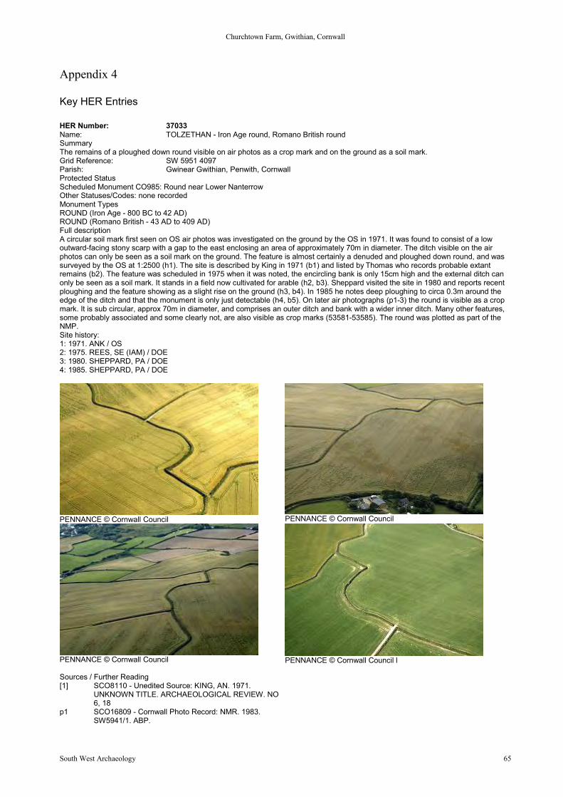
Churchtown Farm, Gwithian, Cornwall
South West Archaeology 65
Appendix 4
Key HER Entries
HER Number: 37033Name: TOLZETHAN - Iron Age round, Romano British roundSummaryThe remains of a ploughed down round visible on air photos as a crop mark and on the ground as a soil mark.Grid Reference: SW 5951 4097Parish: Gwinear Gwithian, Penwith, CornwallProtected StatusScheduled Monument CO985: Round near Lower NanterrowOther Statuses/Codes: none recordedMonument TypesROUND (Iron Age - 800 BC to 42 AD)ROUND (Romano British - 43 AD to 409 AD)Full descriptionA circular soil mark first seen on OS air photos was investigated on the ground by the OS in 1971. It was found to consist of a lowoutward-facing stony scarp with a gap to the east enclosing an area of approximately 70m in diameter. The ditch visible on the airphotos can only be seen as a soil mark on the ground. The feature is almost certainly a denuded and ploughed down round, and wassurveyed by the OS at 1:2500 (h1). The site is described by King in 1971 (b1) and listed by Thomas who records probable extantremains (b2). The feature was scheduled in 1975 when it was noted, the encircling bank is only 15cm high and the external ditch canonly be seen as a soil mark. It stands in a field now cultivated for arable (h2, b3). Sheppard visited the site in 1980 and reports recentploughing and the feature showing as a slight rise on the ground (h3, b4). In 1985 he notes deep ploughing to circa 0.3m around theedge of the ditch and that the monument is only just detectable (h4, b5). On later air photographs (p1-3) the round is visible as a cropmark. It is sub circular, approx 70m in diameter, and comprises an outer ditch and bank with a wider inner ditch. Many other features,some probably associated and some clearly not, are also visible as crop marks (53581-53585). The round was plotted as part of theNMP.Site history:1: 1971. ANK / OS2: 1975. REES, SE (IAM) / DOE3: 1980. SHEPPARD, PA / DOE4: 1985. SHEPPARD, PA / DOE
PENNANCE © Cornwall Council PENNANCE © Cornwall Council
PENNANCE © Cornwall Council
Sources / Further Reading[1] SCO8110 - Unedited Source: KING, AN. 1971.
UNKNOWN TITLE. ARCHAEOLOGICAL REVIEW. NO6, 18
p1 SCO16809 - Cornwall Photo Record: NMR. 1983.SW5941/1. ABP.
PENNANCE © Cornwall Council l

Churchtown Farm, Gwithian, Cornwall
South West Archaeology 66
[2] SCO4618 - Bibliographic reference: Thomas, AC. 1971.Gwithian Checklist Additions. CA No 10. VOL 10, 108
p2 SCO17815 - Cornwall Photo Record: CAU. 1989.F18/11. ABP.
[3] SCO8308 - Unedited Source: REES, SE. 1975. AM 7.p3 SCO17985 - Cornwall Photo Record: CAU. 1989.
F25/17. ABP.[4] SCO5181 - Bibliographic reference: Sheppard, PA (for
DOE). 19--. Scheduled Monument Description. HBMC /English Heritage.
[5] SCO5181 - Bibliographic reference: Sheppard, PA (forDOE). 19--. Scheduled Monument Description. HBMC /English Heritage.
PENNANCE © Cornwall Council
HER Number: 53582Name: PENNANCE - Prehistoric field systemSummary - not yet availableGrid Reference: SW 5968 4092Parish: Gwinear Gwithian, Penwith, CornwallProtected Status: None recordedOther Statuses/Codes: none recordedMonument TypesFIELD SYSTEM (Prehistoric - 500000 BC to 42 AD)Full descriptionThe fragmentary remains of a mixed rectilinear and curvilinear field system are visible as a series of crop mark ditches on airphotographs (p1) and were plotted as part of the NMP. The boundaries are more irregular and of slighter form than the rectilinearboundaries of Medieval fields 53581. In places the boundaries of this system are on a different alignment to those of 53581 and theyare likely to be associated with Iron Age/Romano-British round 37033. In the south eastern sector of the system there is a smallunivallate enclosure, 10m x 8m, incorporated into the fields, and just to the north of this is a probable pit c. 5m in diameter. The precisefunction of neither of these features is certain from the air photo evidence but their presence is consistent with a prehistoric orRomano-British date.Sources / Further Readingp1 SCO16809 - Cornwall Photo Record: NMR. 1983. SW5941/1. ABP.p2 SCO17984 - Cornwall Photo Record: CAU. 1989. F25/16-21. ABP.
HER Number: 53583Name: PENNANCE - Prehistoric enclosureSummaryA small polygonal enclosure, 15m by 12m, with a possible entrance in the north east, is visible as a faint cropmark ditch on aerialphotographs.Grid Reference: SW 5941 4090Parish: Gwinear Gwithian, Penwith, CornwallProtected Status: None recordedOther Statuses/Codes: none recordedMonument TypesENCLOSURE? (Prehistoric - 500000 BC to 42 AD)Full descriptionA small polygonal enclosure, 15m by 12m, with a possible entrance in the north east, is visible as a faint cropmark ditch on aerialphotographs (p1) and was plotted as part of the NMP. Although the function of this enclosure is uncertain, it is likely to be associatedwith the nearby round 37033, and date from the Iron Age/Romano-British period.Sources / Further Readingp1 SCO16811 - Cornwall Photo Record: NMR. 1983. SW5941/1-7. ABP.
HER Number: 53584Name: PENNANCE - Prehistoric enclosureSummaryA univallate polygonal enclosure, 30m by 20m, with north east facing entrance, is visible as a cropmark ditch on aerial photographs.
Churchtown Farm, Gwithian, Cornwall
South West Archaeology 67
Grid Reference: SW 5957 4111Parish: Gwinear Gwithian, Penwith, CornwallProtected Status: None recordedOther Statuses/Codes: none recordedMonument TypesENCLOSURE (Prehistoric - 500000 BC to 42 AD)Full descriptionA univallate polygonal enclosure, 30m by 20m, with north east facing entrance, is visible as a cropmark ditch on aerial photographs(p1-p3) and was plotted as part of the NMP. It is associated with field system 53585 and probably with round 37033, dating from theIron Age/Romano-British period. Its function is uncertain, but it may be a small enclosed settlement.Sources / Further Readingp1 SCO16808 - Cornwall Photo Record: NMR. 1983. SW5940/4&5. ABP.p2 SCO16812 - Cornwall Photo Record: NMR. 1983. SW5941/2&7. ABP.p3 SCO17984 - Cornwall Photo Record: CAU. 1989. F25/16-21. ABP.
HER Number: 53585Name: PENNANCE - Prehistoric field systemSummary - not yet availableGrid Reference: SW 5945 4115Parish: Gwinear Gwithian, Penwith, CornwallProtected Status: None recordedOther Statuses/Codes: none recordedMonument TypesFIELD SYSTEM (Prehistoric - 500000 BC to 42 AD)Full descriptionA series of five irregular, conjoined enclosures, probably forming the remains of a field system, are visible as faint crop mark ditches onair photographs (p1&2) and were plotted as part of the NMP. The system is associated with enclosure 53584, and probably with IronAge/Romano-British round 37033.Sources / Further Readingp1 SCO16810 - Cornwall Photo Record: NMR. 1983. SW5941/1-7. 2.p2 SCO17984 - Cornwall Photo Record: CAU. 1989. F25/16-21. ABP.
HER Number: 37034Name: TREVARNON - Iron Age round, Romano British roundSummaryThe severely ploughed down remains of a round measuring 60m by 40m with an outer enclosure fossilised by field hedges.Grid Reference: SW 5873 4017Parish: Gwinear Gwithian, Penwith, CornwallProtected StatusScheduled Monument CO131: Trevarnon Round, GwithianOther Statuses/Codes: none recordedMonument TypesROUND (Iron Age - 800 BC to 42 AD)ROUND (Romano British - 43 AD to 409 AD)Full descriptionTrevarnon Round is an extensive elliptical earthwork consisting of a bank and ditch, with an annex to the north-east, which is sited tothe south of Gwithian village (b1). It is shown on the OS map of 1908 (b2) and was scheduled in 1958. The OS surveyed the site at1:2500 in 1962The earthwork has been severely mutilated by ploughing. In the north-west a 34m length of bank averages 2.0m high, and the north-west and south-west sides consist of a scarp 0.5m high (h1). It is shown on the OS maps of 1963 (b3) and 1974 (b6). It is likely thatmore than one phase of construction is represented, with surrounding hedges of enormous width, one 3.0m across the top. Anotherseparates the round on its north-west side from the large ditch, 2.7m to 3.0m deep (b4).Thomas in 1965 lists the site and records the extant remains of a round (b5). The round was visited by Sheppard in 1980 who reportsthat the extant north bank has sloping sides and is covered by small bushes. The east bank is partly covered by brambles (h2, b7).The site is visible on air photographs (p1, p2) and was plotted as part of the NMP. The photos show an inner, four-sided, univallatepolygonal enclosure, measuring 60m by 40m, encircled by a curving slighter ditch along the eastern side of its circuit. A second outerenclosure, measuring 150m by 80m, partially fossilised in existing field hedges in the north, north-west, and south-west, is also visibleas a crop mark ditch. A further enclosure (53550) is appended to the south-west side of the outer enclosure.Site history:1: 1962. QUINNELL, NV / OS2: 1980. SHEPPARD, PA / DOESources / Further Reading[1] SCO3885 - Bibliographic reference: Lysons, D & S. 1814. Magna Britannia. VOL III, CORNWALL, 130p1 SCO14884 - Cornwall Photo Record: NMR. 1968. MAL 5268/211. ABP.[2] SCO4051 - Bibliographic reference: Ordnance Survey. 1900s. 2nd Edition 6 Inch Map.p2 SCO16807 - Cornwall Photo Record: NMR. 1983. SW5840/1. ABP.[3] SCO4045 - Cartographic materials: Ordnance Survey. 1970s. 1:10,000 Map.[4] SCO4628 - Bibliographic reference: Thomas, AC. 1964. Minor Sites in the Gwithian Area. CA No 3. VOL 3, 38-39[5] SCO4617 - Bibliographic reference: Thomas, AC. 1965. Gwithian Checklist. CA No 4. VOL 4, 75[6] SCO4045 - Cartographic materials: Ordnance Survey. 1970s. 1:10,000 Map.[7] SCO5181 - Bibliographic reference: Sheppard, PA (for DOE). 19--. Scheduled Monument Description. HBMC / English
Heritage.Related records37034.10 Parent of: TREVARNON - Undated findspot (Find Spot)

Churchtown Farm, Gwithian, Cornwall
South West Archaeology 68
Images
TREVARNON © Cornwall Council TREVARNON © Cornwall Council
TREVARNON © Cornwall Council TREVARNON © Cornwall Council
TREVARNON © Cornwall Council TREVARNON © Cornwall Council
TREVARNON © Cornwall Council TREVARNON ROUND: Cropmark © Cornwall Council
HER Number: 53549Name: TREVARNON - Prehistoric roundSummaryA curvilinear feature 110m in length, consisting of three ditches and two banks visible as a cropmark on air photographs.Grid Reference: SW 593 400Parish: Gwinear Gwithian, Penwith, CornwallProtected Status: None recordedOther Statuses/Codes: none recorded
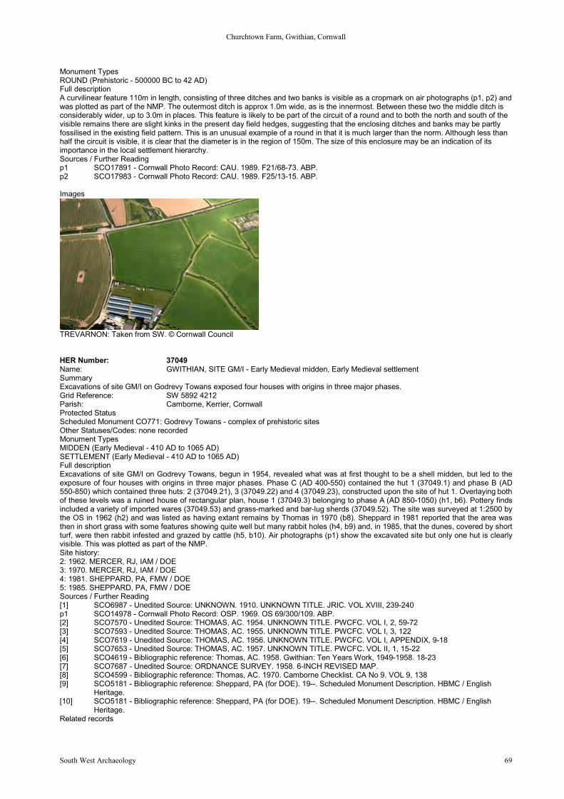
Churchtown Farm, Gwithian, Cornwall
South West Archaeology 69
Monument TypesROUND (Prehistoric - 500000 BC to 42 AD)Full descriptionA curvilinear feature 110m in length, consisting of three ditches and two banks is visible as a cropmark on air photographs (p1, p2) andwas plotted as part of the NMP. The outermost ditch is approx 1.0m wide, as is the innermost. Between these two the middle ditch isconsiderably wider, up to 3.0m in places. This feature is likely to be part of the circuit of a round and to both the north and south of thevisible remains there are slight kinks in the present day field hedges, suggesting that the enclosing ditches and banks may be partlyfossilised in the existing field pattern. This is an unusual example of a round in that it is much larger than the norm. Although less thanhalf the circuit is visible, it is clear that the diameter is in the region of 150m. The size of this enclosure may be an indication of itsimportance in the local settlement hierarchy.Sources / Further Readingp1 SCO17891 - Cornwall Photo Record: CAU. 1989. F21/68-73. ABP.p2 SCO17983 - Cornwall Photo Record: CAU. 1989. F25/13-15. ABP.
Images
TREVARNON: Taken from SW. © Cornwall Council
HER Number: 37049Name: GWITHIAN, SITE GM/I - Early Medieval midden, Early Medieval settlementSummaryExcavations of site GM/I on Godrevy Towans exposed four houses with origins in three major phases.Grid Reference: SW 5892 4212Parish: Camborne, Kerrier, CornwallProtected StatusScheduled Monument CO771: Godrevy Towans - complex of prehistoric sitesOther Statuses/Codes: none recordedMonument TypesMIDDEN (Early Medieval - 410 AD to 1065 AD)SETTLEMENT (Early Medieval - 410 AD to 1065 AD)Full descriptionExcavations of site GM/I on Godrevy Towans, begun in 1954, revealed what was at first thought to be a shell midden, but led to theexposure of four houses with origins in three major phases. Phase C (AD 400-550) contained the hut 1 (37049.1) and phase B (AD550-850) which contained three huts: 2 (37049.21), 3 (37049.22) and 4 (37049.23), constructed upon the site of hut 1. Overlaying bothof these levels was a ruined house of rectangular plan, house 1 (37049.3) belonging to phase A (AD 850-1050) (h1, b6). Pottery findsincluded a variety of imported wares (37049.53) and grass-marked and bar-lug sherds (37049.52). The site was surveyed at 1:2500 bythe OS in 1962 (h2) and was listed as having extant remains by Thomas in 1970 (b8). Sheppard in 1981 reported that the area wasthen in short grass with some features showing quite well but many rabbit holes (h4, b9) and, in 1985, that the dunes, covered by shortturf, were then rabbit infested and grazed by cattle (h5, b10). Air photographs (p1) show the excavated site but only one hut is clearlyvisible. This was plotted as part of the NMP.Site history:2: 1962. MERCER, RJ, IAM / DOE3: 1970. MERCER, RJ, IAM / DOE4: 1981. SHEPPARD, PA, FMW / DOE5: 1985. SHEPPARD, PA, FMW / DOESources / Further Reading[1] SCO6987 - Unedited Source: UNKNOWN. 1910. UNKNOWN TITLE. JRIC. VOL XVIII, 239-240p1 SCO14978 - Cornwall Photo Record: OSP. 1969. OS 69/300/109. ABP.[2] SCO7570 - Unedited Source: THOMAS, AC. 1954. UNKNOWN TITLE. PWCFC. VOL I, 2, 59-72[3] SCO7593 - Unedited Source: THOMAS, AC. 1955. UNKNOWN TITLE. PWCFC. VOL I, 3, 122[4] SCO7619 - Unedited Source: THOMAS, AC. 1956. UNKNOWN TITLE. PWCFC. VOL I, APPENDIX, 9-18[5] SCO7653 - Unedited Source: THOMAS, AC. 1957. UNKNOWN TITLE. PWCFC. VOL II, 1, 15-22[6] SCO4619 - Bibliographic reference: Thomas, AC. 1958. Gwithian: Ten Years Work, 1949-1958. 18-23[7] SCO7687 - Unedited Source: ORDNANCE SURVEY. 1958. 6-INCH REVISED MAP.[8] SCO4599 - Bibliographic reference: Thomas, AC. 1970. Camborne Checklist. CA No 9. VOL 9, 138[9] SCO5181 - Bibliographic reference: Sheppard, PA (for DOE). 19--. Scheduled Monument Description. HBMC / English
Heritage.[10] SCO5181 - Bibliographic reference: Sheppard, PA (for DOE). 19--. Scheduled Monument Description. HBMC / English
Heritage.Related records
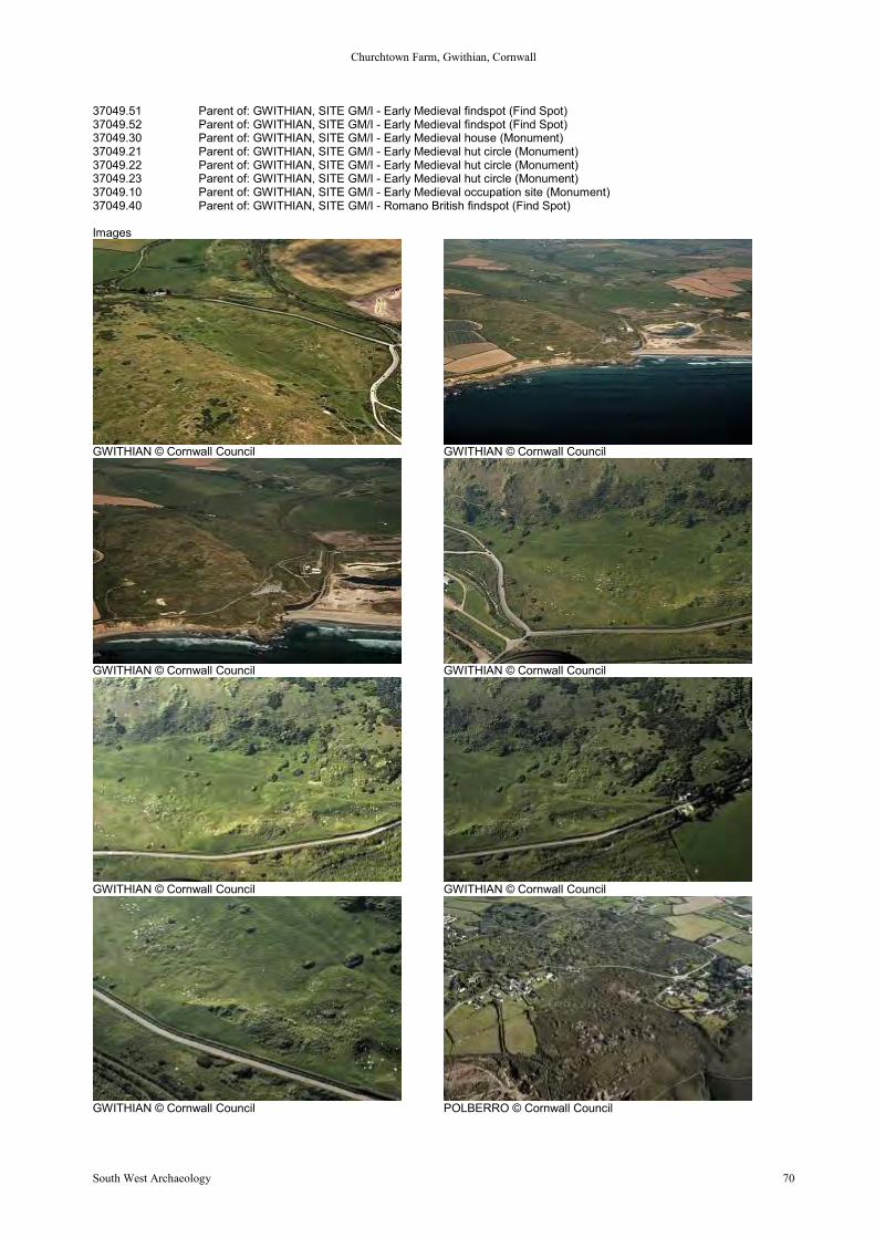
Churchtown Farm, Gwithian, Cornwall
South West Archaeology 70
37049.51 Parent of: GWITHIAN, SITE GM/I - Early Medieval findspot (Find Spot)37049.52 Parent of: GWITHIAN, SITE GM/I - Early Medieval findspot (Find Spot)37049.30 Parent of: GWITHIAN, SITE GM/I - Early Medieval house (Monument)37049.21 Parent of: GWITHIAN, SITE GM/I - Early Medieval hut circle (Monument)37049.22 Parent of: GWITHIAN, SITE GM/I - Early Medieval hut circle (Monument)37049.23 Parent of: GWITHIAN, SITE GM/I - Early Medieval hut circle (Monument)37049.10 Parent of: GWITHIAN, SITE GM/I - Early Medieval occupation site (Monument)37049.40 Parent of: GWITHIAN, SITE GM/I - Romano British findspot (Find Spot)
Images
GWITHIAN © Cornwall Council GWITHIAN © Cornwall Council
GWITHIAN © Cornwall Council GWITHIAN © Cornwall Council
GWITHIAN © Cornwall Council GWITHIAN © Cornwall Council
GWITHIAN © Cornwall Council POLBERRO © Cornwall Council
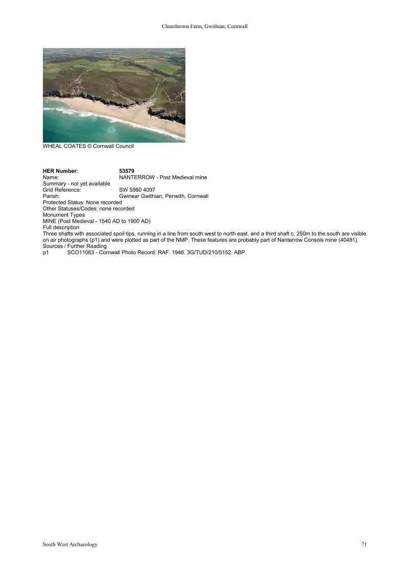
Churchtown Farm, Gwithian, Cornwall
South West Archaeology 71
WHEAL COATES © Cornwall Council
HER Number: 53579Name: NANTERROW - Post Medieval mineSummary - not yet availableGrid Reference: SW 5980 4097Parish: Gwinear Gwithian, Penwith, CornwallProtected Status: None recordedOther Statuses/Codes: none recordedMonument TypesMINE (Post Medieval - 1540 AD to 1900 AD)Full descriptionThree shafts with associated spoil tips, running in a line from south west to north east, and a third shaft c. 250m to the south are visibleon air photographs (p1) and were plotted as part of the NMP. These features are probably part of Nanterrow Consols mine (40481).Sources / Further Readingp1 SCO11063 - Cornwall Photo Record: RAF. 1946. 3G/TUD/210/5152. ABP.
Churchtown Farm, Gwithian, Cornwall
South West Archaeology 72
Appendix 5
Listed Buildings
Grade I Listed Buildings
Church of St Martin and St Meriadocus, CamborneGrade: IDate Listed: 1 December 1951English Heritage Building ID: 66582OS Grid Reference: SW6452240042OS Grid Coordinates: 164522, 40042Latitude/Longitude: 50.2134, -5.3019Locality: CamborneCounty: CornwallCountry: EnglandPostcode: TR14 7JUThere is also a scheduled monument, Wayside Cross and Cross-Base in Camborne Churchyard, 10m South West of the Church, atthe same location as this building or very close to it. This may be related in some way or possibly a different name for the samestructure.Listing TextParish church. Mostly late C15 in one build, but incorporating some fabric of smaller earlier C15 church; restored and enlarged in1878. Dressed granite, slate roofs. West tower; nave and chancel in one, with north and south aisles and additional south aisle of1878, under a 4-span roof. The 3- stage tower has setback buttresses, a 2-centred arched west door with hollow-chamfered surroundand hoodmould, a similarly arched 4-light window with Perpendicular tracery, weathered bands to the slightly set back upper stages, asmall lancet in the north side of the 2nd stage, a 3- light traceried belfry window in each side of the 2nd stage, and an embattledparapet with corner pinnacles. The 5-bay north aisle has a plinth with moulded coping, a buttress between the 1st and 2nd bays, aTudor- arched doorway between the 4th and 5th bays with 2 orders of moulding in a square-headed moulded surround with ahoodmould, 5 Tudor-arched mullioned windows each of 4 pointed arched lights with cavetto mullions, hollow spandrels, surroundmoulded in 2 orders, and hoodmould curved round the head; to the left of that in the 1st bay is an earlier and smaller window with a flatTudor arched head, 4 trefoil lights, moulded surround, and simple hoodmould; the west end has a 4-light window like the others, andthe east end has a 4-centred arched window of 5 cinquefoil lights with a hoodmould and a weathered sill-band. The chancel, whichprojects, has a large 5-light east window matching those of the north aisle. The original south aisle has a 2-centred arched westwindow of 4 cinquefoil lights with tracery in the head, and a 4-centred arched east window of 5 cinquefoil lights; the added south aislehas large 5-light traceried east and west windows, and its south side has a gabled porch to the 1st bay with 4- centred arched doorwayincorporating C15 semi-octagonal jambs with brattished caps, a sundial over the door lettered "Hora Pars Vitae" and dated 1793, and4 windows each of 3 cinquefoil lights with Perpendicular tracery in the head. Interior: 7-bay arcades to nave and chancel with Cornishpiers, horizontal carved leaves on the caps, and 4-centred arches with cavetto and roll moulding (imitated by the added aisle); restoredarch-braced collar-truss roofs; in chancel, a simple aumbry and piscina, and a fine marble tripartite reredos in classical style, withCommandment Tables in shouldered panels under an open pediment, flanked by Lords Prayer and Creed in lugged panels underswan-neck pediments, lettered medallions in the dado stating that it was given by Samuel Percival of Pendarves in 1761; side wallshave dado made of fine late medieval carved bench ends; in altar, a C10 altar slab from Chapel Ia, Troon, with keyed border andinscription including the name Leuiut; late medieval oak pulpit with carved panels and coat of arms; several fine wall monuments, esp.William Pendarves (d.1683), Sir William Pendarves (d.1726), Anne Acton (d.1780), Mrs Grace Percival (d.1763), founder of CharitySchool in Camborne; in tower, large painted panels including Charles I 1643 letter to the County of Cornwall (dated 1736).Listing NGR: SW6452340046Source: English Heritage
Blowing House and Attached Walls at Approximately 10m NE of Blowing House Cottage, BreageGrade: IDate Listed: 14 September 1984English Heritage Building ID: 65762OS Grid Reference: SW6033632058OS Grid Coordinates: 160336, 32058Latitude/Longitude: 50.1401, -5.3555Locality: BreageCounty: CornwallCountry: EnglandPostcode: TR13 9REListing TextBlowing house (building where tin was smelted with a forced draught) and attached remains of another ruinous blowing house. C16and C17 with some C19 alterations. The key buildings of the Godolphin family tin works. The earlier walls are of coursed graniterubble, the later of random rubble; granite lintels, that in the north gable end (to the furnace) finely dressed and above it an early C19brick stack. Scantle slate roof with gable ends. Adjoining to the north, walls 1-2m high of another building, open to the east. The earlierand larger building to the north is rectangular on plan and roofless. Its north gable end contains an upright hearth and lockerarrangement similar to Dartmoor blowing houses. This gable end was subsumed by the later and smaller blowing house built onto it tothe north; this building is also rectangular. Its doorway is at the south end of the east wall which is possibly of late C18 or early C19construction re-using several inscribed (bound?) stones. The back (ancient) wall aligns with the corresponding wall of the earlierblowing house and thus the leat (existing in part) only needed a short extension. However, it is the north gable end which is ofexceptional interest. On the outside is a large granite lintel whose lower edge is shaped to a double undulation in order to receive thebarrels of two bellows. The opening below is splayed and has a granite sill. The inner opening is very small and retains a piece of irongrill. Two bellows would have stood in a frame outside and immediately north of the building operated by a small water wheel via acam shaft and counterweights. Within the building a temporary furnace (called the 'castle') was built and in this the black tin (powdered
Churchtown Farm, Gwithian, Cornwall
South West Archaeology 73
ore) was melted by charcoal fire raised to temperature by the alternating mechanical bellows. These structures are part of theGodolphin tin works, a site which includes remains of the stamps, leat system, buddles etc. Richard Carew records that Sir FrancisGodolphin (1534 - 1608) innovated the processes of tin production, including blowing, with the assistance of a German mineral expert.Here two blowing houses survive, the earlier with a Dartmoor type hearth and, built onto it, a later blowing house with a moresophisticated hearth similar to those illustrated in 'De Re Metalica'. Whether or not the second is substantially Sir Francis's blowinghouse (as is likely) the two illustrate his profitable improvement. No other substantial remains of blowing houses are known to survivein Cornwall and none of the Dartmoor ones is so complete. This must be a building of the greater value to industrial archaeology.Sources: De Re Metalica by Georgius Agricola 1556; Survey of Cornwall by Richard Carew 1602; Natural History of Cornwall byWilliam Borlase 1758; Transaction of the Devonshire Assoc. (Worth); S. E. and J. Schofield.Listing NGR: SW6033632058 Source: English Heritage
Church of Saint Breaca, BreageGrade: IDate Listed: 10 July 1957English Heritage Building ID: 65731OS Grid Reference: SW6185728448OS Grid Coordinates: 161857, 28448Latitude/Longitude: 50.1083, -5.3320Locality: BreageCounty: CornwallCountry: EnglandPostcode: TR13 9PDListing TextParish church. Incorporating part of pre C15 chancel but mostly rebuilt by and reconsecrated in 1466 (Church Guide) with south porchadded soon after and north and south transept are possibly later C15; restored in 1891. Granite ashlar walls with mostly granitedressings. Dry Delabole slate roofs over the nave/chancel and over the parallel roofs of the north and south aisles, all with granitecoped gable ends. The nearly flat roofs of the porch, transepts and tower (hidden by embattled parapets) are presumably sheathed inlead. Large ashlar stack clasping north west corner of north transept. Plan: nave/chancel (with chancel roof stepped down) west tower,north and south aisles are all of one build taking 6 years 1460-1466 (Church Guide); chancel incorporates earlier fabric. The southporch was probably added next and finally the north and south transepts just west of the rood screen which are probably late C15. Therestoration in 1891 involved re-roofing the nave/chancel and repair or reconstruction of the aisle roofs. Probably old fittings removed atthe same time. 3-stage tower with plinth and set back weathered corner buttresses with set-offs, strings dividing stages, carved headgargoyles under cornice of embattled parapet and crocketted corner pinnacles over blind-panelled embattled turrets. The bracket-moulded west doorway is 4-centred with carved spandrels and label stops terminating at plinth moulding level; C19 door. The traceried4-light granite window directly over the doorway is C15 Perpendicular with hoodmould as are all the other windows in the church butthere is variation in the detail. 2nd stage is blind but the upper stage has slate louvred 3-light traceried window to each side. North aislehas 4-light window at west gable end and Slight window at east gable end. The north wall has 2 windows close together left of thenorth transept and 2 windows wider spaced right of the transept with moulded 4-centred doorway between. The windows havecinquefoil headed lights and cusped tracery. These windows are similar to the chancel east window and the south and west windowsof the south aisle. The other windows are uncusped, untraceried except for traceried east windows of aisle with steep 4-centred archedlights under shallow 4-centred arches. The windows of both transepts are without hoodmoulds. The leaded glazing is eitherrectangular or latticed panes but some windows have both types. The north transept has 4-light north window, 3-light east window and4-centred arched doorway towards the angle in the west wall. The east gable end of the chancel projects and has 3-light Perpendicularwindow with cusping in the tracery. Pre C15 plinth and other masonry. C17 inscribed former chest tomb slate attached to south wall ofchancel. The east gable ends of the north and south aisles have 5-light Perpendicular windows with uncusped tracery. The south aisle3-light south windows are similar to the chancel window: one window left of the porch; 2 windows between the porch and the southtransept and 2 windows right of the transept with blocked 4-centred arched Godolphin family door between. The south transept hassimilar windows to the north transept: 4-light south window and 3-light east window. The porch has weathered set back buttresses withset-offs like the tower. Over the doorway is a sundial dated 1795. The doorway is late Perpendicular with panelled octagonal jambs(compare doorways of churches at St Just in Roseland, Mylor, Budock, Gunwalloe, and the resited courtyard doorway at GodolphinHall qv.) The moulded inner doorway is like the north doorway with 4-centred arch and square hoodmould(suggesting that the porch is later than the aisle). Studded, probably C17, 2 panel door. Interior has much C15 timberwork: ceiledwagon roofs with carved bosses over the aisles; coffered ceiling with cross braced panels and carved bosses over the north aisle anda moulded beam and some moulded joists to the tower ceiling. There is a 7- bay arcade with standard A (Pevsner) type piers on eitherside of the nave/chancel and moulded basket arches between. The tower arch is carried on octagonal panelled jambs. Incorporatedinto windows in the south wall right (east) of the transept and the east window of the south transept is some medieval glass; holy waterstoup with convex sided arched head in the porch and a curious corbel with dogs tooth and fluted decoration over the left handrespond of the north transept arch.Murals: Arguably the most remarkable C15 features however are the fine painted murals on the north and south walls including a verystriking figure of Saint Christopher on the left of the north doorway. Fittings: mostly C19 including round granite font with round cornershafts in the Norman manner; traceried oak rood screen; reredos; oak choir stalls and pews; free standing cast iron candelabra;traceried granite tower screen (given as a memorial to James Jewill Hill). Earlier fittings include: in the north west corner of the northaisle, a Roman milestone bearing the name of Emperor Cassianus Posthumus (260-268 A.D.) found a few hundred yards from thechurch in 1924 (Church Guide); a probably C14 stone representing the crucifixion in the Godolphin Chapel, found by the coast nearTremearne (Church Guide); and a painted copy of a letter from Charles I 1643, at 'Sudly' Castle. Monuments: the east end of the southaisle is the burial place of the Godolphin family and is known as the Godolphin Chapel; suspended from iron wall brackets are 3helmets with wooden replicas of dolphin crests; (Dolphins are the principal feature of the family crest). In the chancel is a slate to JohnGoode of Methleth with an incised coat of arms incorporating a goose and 3 doves; on the south wall a pedimented monument withurn to Peter James, died 1850 aged 76; 3 memorial windows with coloured glass to the members of the Carter family. The glass in thewest window of the south aisle given by the parishioners in 1863 to commemorate the marriage of Albert Edward, Prince of Wales toAlexandra, Princess of Denmark. This church, despite being reputably of 1 build, has some curious design changes and anomalies.The east windows of the aisles, the transept windows, the porch doorway and the tower arch are in a later Perpendicular style. Anotherexplanation might be that there was a clear distinction being made architecturally to use the more traditional style for the moreimportant ecclesiastical parts of the church and using the modern style for the lay entrances and the chapels. For whatever reason theresult is a remarkably complete C15 building. The only serious change since built (excluding the loss of all the C15 and C16 fittings) is
Churchtown Farm, Gwithian, Cornwall
South West Archaeology 74
the replacement of the nave and chancel roofs in the C19. Fortunately, the practice of skinning the walls of plaster, so popular withVictorian architects, did not take place at Breage and the painted murals that survive are some of the best examples in Cornwall andfor that matter in England.Listing NGR: SW6185728459 Source: English Heritage
Forecourt Walls, Stiles and Mounting Block, BreageGrade: IDate Listed: 26 August 1987English Heritage Building ID: 65747OS Grid Reference: SW6013631861OS Grid Coordinates: 160136, 31861Latitude/Longitude: 50.1382, -5.3581Locality: BreageCounty: CornwallCountry: EnglandPostcode: TR13 9REListing TextForecourt walls, stiles and mounting block at Godolphin House (qv). C17. Granite rubble with dressed granite quoins, jambs andcopings. 2 parallel walls projecting forward from the principal front of Godolphin House and forming 2 sides of the forecourt. At a shortdistance from the house, each wall is interrupted by a stile in the form of a stone cattle grid between 2 stone benches (seats re-used inC17). Their cheeks and backs stop the forecourt walls at a right angle. Outside the forecourt and built onto its east wall and stile is anearly C19 double privy with symmetrical ashlar front (east) with 2 doorways. It has a hipped scantle slate roof. Against the outside faceof the west forecourt wall and near the stile on this side, a large mounting block of 6 steps (qv Stables and Cobbled Pavements). Thewalls have steep sided copings with roll ridges (qv Pengelly Barton Farmhouse, Breage). Within the court there is a wide strip ofcobbling immediately in front of the house and another running from it to the west stile - remains of a radiating pattern which alsoconnected to the lodges. Sources : William Borlase Antiquities and Natural History of Cornwall. Drawing also by Borlase, RIC libary,Truro.Listing NGR: SW6013631861 Source: English Heritage
Godolphin House, BreageGrade: IDate Listed: 10 July 1957English Heritage Building ID: 65746OS Grid Reference: SW6012931840OS Grid Coordinates: 160129, 31840Latitude/Longitude: 50.1380, -5.3582Locality: BreageCounty: CornwallCountry: EnglandPostcode: TR13 9REThere is also a scheduled monument with a similar name, Side and King's Garden at Godolphin House, at the same location as thisbuilding or very close to it. This is probably the same structure or related to it in some way.Listing TextCountry house. Circa late C15, probably incorporating earlier work; extended considerably C16; remodelled and extended mid C17;some C18 alterations; greatly reduced to south and east circa 1805 followed by modification as a farmhouse. Seat of the Godolphinfamily for many generations; reduced by the Dukes of Leeds. Granite, chiefly ashlar, some rubble and some render, all with granitedressings. Steep scantle slate roofs mostly with parapets and hipped ends except for gable over porch to west and also truncated wingon east flank. Various chimney types including 2 early C17 crenellated and 4 mid C17 corniced. Many C16-C18 crested ridge tiles.Plan : 2 storeys. Roughly U-shaped round a courtyard on a gentle slope up to the south, the result of reducing a large and complexhouse built round 2 or more courtyards. The hall ran east-west parallel to the north front on the far side of the principal court. A well-defined (north-south) axis runs from the entrance across this court, through the site of the screens passage, across a vanished rearcourtyard to the site of the back gate. The antiquity of this axis, running off-centre across the early house, is shown by the applicationof a symmetrical front by the start of the C16. The early hall and through-passage generated and modified the subsequentdevelopment of the plan. The house is approached from the north through a C17 forecourt (qv) which once incorporated 2 earliertowers. The present C17 entrance (north) block is built over earlier end blocks (perhaps towers also) and connecting curtain wall.Central entrance gate but, in order to achieve external symmetry, the range overlaps on the east flank. Principal courtyard has paralleleast and west ranges and is closed by a wall to the south. The east block, of about 1500 had parlours on the ground floor with servicepassage added under catslide roof on its east (rear) in late C18. The whole range extends beyond the north wall in post 1805 formincluding the kitchen. The parallel west block is an early C17 remodelling of a smaller arrangement of several periods. On the first floorat the far south end the great chamber (King's Room) runs east-west with a small porch off it to the north-east leading into a walledgarden (King's Garden qv). The south block of this principal courtyard is represented only by the front wall of the hall (right) and hallporch. Beyond the hall again to the south, lay a large rear domestic court. Parallel to the hall at the far south limit of the house anotherrange including the back gate and returning on the east a range perhaps containing a long gallery once existed. The main stair was atthe north-west corner of the rear court leading directly from the hall to the great chamber. Off the east side of this court, and probablyseparated from it by a wall, lay a service court of which only part of the supposed Bakehouse (qv) remains. North of the house at alittle distance was the deer park and immediately east remains of extensive C17 gardens. The site of the (probably free-standing)chapel is not known. (dedicated to Our Lady and reputedly licensed 1300). Overall 11 window entrance front of remarkable design.Wider bay spacing defines end blocks under hipped roofs which once had finials (remains in west roofspace). Plinth and battlementedparapet continuous. The 7 bays between are supported on a colonnade (still called the 'piazza' by some locally) of 6 stout taperingmonolithic approximately Tuscan columns between 2 half-columns and standing on a stylobate of 2 steps. Flat keystoned lintelsbetween with surprisingly advanced fascia detail. Between the colonnade and end blocks 2 C17 lead rainwater pipes, the pipeheadswith double-headed eagle and dolphin (arms and crest of the family). The roof over the centre section is C19 and supercedes a largelead flat (structure survives mostly) punctuated by 2 tall thin chimney shafts with cornice caps of which only the tops now show. Theeast flank of this block was re-fenestrated circa 1805; tripartite hornless sash window with square granite mullions to the ground floorand similar Venetian window above, both with much crown glass; 1805 demolition left the facing toothed to the south. The west flank of
Churchtown Farm, Gwithian, Cornwall
South West Archaeology 75
the north block faces the stable yard (qv); ground floor 2-light mullioned window restored and above perhaps similar, but blocked early.The return and back walls within the colonnade are probably a C16 refacing of earlier semi-defensive work. The returns each have apistol loop enfilading the gate. Before the C17 alterations the wall at the back was a curtain and there are remains of stairs to the wall-walk at either end on the south face. The central gate was clearly built as a frontispiece and based on a hazy recollection of that atCollacombe, Lamerton, Devon (qv) giving it a date of circa 1580. A 4 centred moulded arch of conventional pattern is flanked by 2cylindrical attached columns with multiple-moulded capitals and bases standing on pedestals. Above, the capitals become bases forshort upper column lengths also terminating in capitals of which another floats over the crown of the arch. On either side of this,outsized guttae prove that more existed above, including a Doric frieze (see the proper one at Collacombe). Contemporary oak gatesornamented with pilasters and cornices, their tops forming a big scallop shell; wicket in right leaf. Through this gate another colonnadeis found mirroring the first. The C17 rooms above are thus supported on a spine wall and 2 colonnades - a design both daring andprobably unique. The pre-existing east block of the courtyard laps this north block covering 1½ columns and a window above, showingthat a plan to make the courtyard larger and symmetrical was abandoned (perhaps at the Civil War). The courtyard face of the eastblock has 3 bays irregularly spaced with circa 1500 4 light mullioned windows on the ground floor and C17 3-light mullioned windowsabove. All have hoods, those to the ground floor have 4-centred heads. The right hand ground floor windows light the Dining Room,which has one regular sized and one very tall window (north) with a king mullion. C18 timber modillion eaves cornice (at which time theface seems to have been rendered and blocked out). Some 1985 repair and reconstruction on first floor. This block continues as acirca 1805 single bay remodelling south of the courtyard with modillion cornice made to match and ashlar front of two 3 light re-usedmullioned windows and a re-used 4 centred doorway. The south wall of the courtyard is the face of the hall range with the first floorremoved and parapet lowered in 1805. Left hand end is blind and largely rebuilt. The hall porch pre-dates the remainder and isprobably C15 work. It now projects very little, but the plinth of the right hand return runs back a further 2 metres (now below ground).The doorway was replaced with a late C15 arch with blind- panelled jambs similar to those in the south porches of Breage and manylocal churches (- so perhaps from the chapel?). To the right of this the C16 symmetrical 3 window front of the hall (almost absorbingthe porch) : a 2-light mullioned window on either side of a similar 4-light window with king mullion (there were identical but half-heightwindows above). The early C17 courtyard 2:1:1 bay face of the west block has a rubble plinth with remains of early pebble-dashedrender, labelled string courses and C20 plain parapet (originally battlemented). The third bay from the left projects slightly. Windows toground floor service rooms are small with 2 lights. The sills of the 2 to the right are lowered (that in the projecting bay was converted toa door in C19). The far left hand window was replaced (?1805) by a re-used and modified 4 centred doorway. C20 leaded lights exceptearly C19 timber lights with glazing bars to first floor right window. The rainwater pipe and pipehead are C20 copies. The rear (west)face of the west block is irregular and the stable range abuts to the left (north) forming one side of a private garden (King's Garden qv).Adjoining this is the small slightly projecting 3 storey porch of the King's Room; early C17 with chamfered flat-headed door up steps, 2-light mullioned window (less the mullion) above and small single-light attic window; right again 2 large 3-light mullioned windows mirrorthose at the east (courtyard) end of the room; below them, 2 C17 cellar ventilators with relieving arches; the roof is hipped with plainparapet (C20), once crenellated the right return has a re-used single light window to the cellar and a copied rainwater pipe withpipehead. Right again and thus set back is a 2-storey roofed wall and return; to the west a central wide segmental-headed mid C18staircase window and on the (south) return a ground floor window.The rear (south) elevation is entirely the result of C19 demolitions; left is the King's Room with hipped and sprocketted roof, rebuiltsouth wall with first floor door up stone steps with C20 porch and ground floor right a re-used C17 chamfereddoorway with panelled door; copied pipehead. To the right the rear of the hall front, and porch with C19 buttresses (except that to leftof porch, which is its earlier return wall) and wall close the courtyard. Far east is the hipped end of the east block, blind and with rebuiltC17 kitchen chimney. Rear of the east block is an outshut in 2 phases: the left part is C19, the result of demolition and rebuilding; therubble walling is broken only by C19 scullery window at the south end with a C20 window above both casements. Right of this is asection of ashlar facing and between the two a double straight joint perpetuates a vanished wall projecting east (site of stair off DiningRoom?). Right of this late C18 2 window ashlar front; strange 2-light windows with voussoirs and re-used mullions fitting underkeystones; original leaded lights and casements. Under the right hand window a doorway with overlight and probably original door,then right again a small C19 introduced ground floor window. Here, in the angle where the north block overlaps to the east is a C19block with re-used 2-light mullioned window built after 1805 demolitions. Raised up mid C20 with hipped slate roof with two re-used 2-light oak: mullioned windows from demolished Red Lion Hotel, Truro. Interior : Work of circa 1500 survives notably in the principalground floor parlour (now, Dining Room) in the east block. The ceiling of framed intersecting beams, richly moulded with vine trails,bosses and leaves at the intersections and moulded joists is possibly the best of its date in the county. The north wall has a C19fireplace with 3-centred arch surrounded by linenfold panelling probably contemporary with the room. Between the windows a cast ironplaque of royal arms of Henry VIII, intended as a fireback but with C19 colours. The chamber above has remains of original roof of 4bays with 4 surviving carved arch-braced trusses, carved wallplate and pockets for 3 threaded purlins (a waggon vault-like hybrid),revealed and repaired 1985. C17 fireplace the chamber north has slight remains of contemporary roof. Of the C16 no roofs or floorssurvive, and few other elements. There are considerable C17 remains however, including the large 3-centred kitchen fireplace, oncedouble but adapted C19. The west block contains the great chamber, of considerable size (traditionally called the King's Room). Theceiling is canopied all round with two C17 pendants of ornamental plasterwork. It is a very plain C18 re-working including a modillioncornice, C17 pattern not known. There are 2 alcoves or bays symmetrically off the main room to north-east and north-west, the formerwith early C17 cornice, frieze and pattae. On the south wall a large and fine early C17 oak overmantle re-used over a door. Thesuperstructure is supported on paired approximately Ionic columns with amulets and pineappling standing on patterned pedestals.They support a deep pulvinated and scaled frieze with matching smaller columns and round arches set back above forming 3 largeniches separated by rusticated splats. Within were 3 marquetry shields that to the left charged with the arms of Godolphin, to the rightSidney and centre Godolphin impaling Sidney - for the marriage of Sir William Godolphin and Thomasina Sidney in 1604. The inlay ismissing from all but the left hand shield. A deep gadrooned frieze with a wide cornice-board on hart's-tongue brackets complete it. Thisovermantle was restored to the house in the mid C20. The fireplace in the King's Room is large with roll and cavetto mouldings anddiabolo stops. A similar one exists in the next room north, which also has a C17 frieze of ornamental plasterwork frieze of big flowerswith tapestry rail below. The roof over this block is also C17, part with cambered collars and notched-lap joints. The north (front) blockpreserves much of its mid C17 roof; over the west end block trenched purlins and at the apex the principals and hip rafters aremorticed into the stub of a vanished finial. The east end block roof seems to be a C18 replacement. Between the 2 a long mid C19pine roof of low pitch built over the cross-beams and joists (some circa 1500 re-used) of the original flat lead roof. The north block alsopreserves parts of its mid C17 floor structures. The library (traditionally called the Godolphin Room) has another frieze of ornamentalplasterwork and a mid C17 chamfered granite fireplace lies hidden behind early C18 Delft tiles of sea creatures surrounded by a pineovermantle with pilasters flanking a bolection-moulded panel with articulated cornice. Another chamfered fireplace over the colonnade,Of the C18 is the Adam-style mantelpiece in the Sitting Room (first floor east end block) with dado and 1 of a pair of 6 panel doorssurviving from circa 1805 (the other replaced C20 by a mahogany door from Pendarves). On the ground floor in the east block, theBreakfast Room has part late C18 and part early C19 pine panelling with box-cornice; the back stairs (north-east corner of east block)

Churchtown Farm, Gwithian, Cornwall
South West Archaeology 76
was built in the C19 re-using 3 earlier balustrades : C18 Chinese Chippendale, late C17 bobbin-turned and circa 1604 splat balusters(see King's Room overmantle). The overmantle in the entrance hall is from St Ives and the fireplace reconstructed, Few of Cornwall'sgreat houses survive to this extent. Godolphin shows consistently fine quality work from 1500, 1600 and 1650. One of the unansweredpuzzles is the similarity of the Dining Room in its disposition to a hall - perhaps explained by use as both parlour and private diningroom from the start. The front of the house is an ingenious and original design and a surprising compliment to the earlier work which itretains. Far though the house is from the capital, the Godolphins were courtiers from the time of Sir William (1510-75) to the SecondEarl (mid C18) and this may explain the ambitious attempts. By tradition Charles II, when Prince of Wales, stayed here. Sydney, FirstEarl of Godolphin (who was born here) reached highest as Queen Anne's Lord Treasurer. This is one of Cornwall's most importanthouses both historically and architecturally, a house developed through many periods and styles combined harmoniously and littlealtered since the early C19. Sources : William Borlase drawing and engraving for Antiquities and Natural History of Cornwall 1754CRO; W Borlase drawing of Godolphin from painted panelling at Pengersick Castle, (qv) CRO; Estate map 1786 CRO; letter FrancisGodolphin to John Evelyn, Bodleian Library, Oxford; verbal information S E Schofield via/and John Schofield; Guide to house.Listing NGR: SW6012931840 Source: English Heritage
Pengersick Castle, BreageGrade: IDate Listed: 10 July 1957English Heritage Building ID: 65781OS Grid Reference: SW5817828410OS Grid Coordinates: 158178, 28410Latitude/Longitude: 50.1064, -5.3833Locality: BreageCounty: CornwallCountry: EnglandPostcode: TR20 9SJThere is also a scheduled monument with a similar name, Pengersick Castle and associated building platform, at the same location asthis building or very close to it. This is probably the same structure or related to it in some way.Listing TextFortified manor house. Circa 1510 with earlier remains; annex 1927-28; repaired and annex altered 1968. Probably built for WilliamWorth of Worth in Devon (initials on label stops) and improved by Milliton family (of Meavey, Devon); in decline from second half C16.Snecked granite rubble with granite dressings and quoins, some volcanic rock re-used; battlemented parapet concealing chimneys; flatasphalt roof to tower, flat lead roof to turret, dry slate on annex. Plan : although there is documentary evidence for a house here fromat least C13, the building to which the surviving remains belonged was almost entirely newly built circa 1510. The site is the bottom ofa small shallow valley and the entrance was on the (uphill) east side. There were 2 approximately rectangular courtyards, a large one(now garden) of stabling and ancillary buildings to the east and a smaller domestic one (now farmyard) adjoining to the west and offsetso that the north walls were continuous. The existing tower, at the external angle between the 2 courtyards, defended the house fromthe south-west (towards the shore). Its principal (east) front was set forward into the east court to confront the visitor, the dominant andmost prestigious element of the house. Abutting it to the right was the hall range, entered through a 2 storey porch (doorway removedto Pengersick Farmhouse qv) with, right again, the open hall stopping just short of the northern curtain wall. The tower and hall madeup the front of the house proper, the hall block being common to both courtyards. Beyond it lay the domestic courtyard with a backgate probably at the north end of the west range. Again, the northern boundary seems to have been a curtain wall and there was asmall block (possibly a tower) at the north-west corner (Barn and adjoining wall at Pengersick Farm qv), of which much remains.Nothing is known of the rest, but the kitchen and service could have made up a far west range with accommodation returning thesouth. Of all this the only surviving elements are the tower itself and, in the east court, part of the west end of the south range(Outhouse, Pengersick Castle qv), sections of the west wall of the east range and fragments of walling from the north side; of the westcourt, the base of the north- west block and parts of the north curtain remain. The tower has its own external door to the north, makingit virtually independent. On plan there is a single square room at each stage with the square newel stair turret extruded diagonally fromthe north-east corner. The 4 storey tower is battered with plinth, string course at second floor and battlemented parapet; east(principal) front is single bay and lapping it, projecting forward of the right corner, a square battered stair turret reaching above rooflevel. The ground floor has a pair of dumbell-shaped gun-loops immediately above the plinth with 3 matching 4-light mullionedwindows lighting the floors above, the lowest set at a safe height. These are casement-moulded with king-mullions and 4- centredheads to the lights, the lowest without a hood mould (allowing for enfilading from stair). Above this the second floor window has a hoodand that at the top a hood and labels each with serif 'w'; 2 granite water spouts. The single bay stair turret has 4 matching casement-moulded mullioned windows, 2 below the string and 2 at wider intervals above; the bottom window has a pistol loop just below the silland off-centre. All leaded lights of 1928. It is a well-organised elevation, domestic but strict with adequate provision for defence. Rightof this a 2 storey 3 bay annex of 1928 with slate roof and right gable stack; early worked stones used indiscriminately. Off-centre right1968 kitchen door with 3 equally spaced single light windows over. The hall range used to join onto the north face of the tower; roofweatherings survive; in front the 2 window annex gable end and above to the right at third floor level only a 2-light mullioned window(without casement mouldings). The single bay stair turret projects forward lapping the left corner and plinth, string and parapetcontinue across it. The door is in the turret up 2 steps (originally 1); a tall 4-centred outer arch with a fat roll moulding stops on double-offset plinth blocks. Set back within this arch a second smaller order of roll moulding frames the 4-centred doorway itself with frondspandrels and a blank tympanum. The intrados of the outer arch is cut away for a defensive slot at the crown; to the left a pistol loup.Above 4 matching 2-light casement-moulded mullioned windows at unequal spacing with a small ventilator to right towards the top. Onthe west and south faces the string course and parapet continue but the plinth is a simple set-off. The west wall has 2 dumbell-shapedgun-loops to the ground floor, a small defensive single light window to the first floor with a small ventilator far right, small ventilator ateither end on the second floor and a 2- light casement-moulded mullioned window towards the right at the top floor; 2 granitewater spouts. The south face again has 2 dumbell gun-loops on the ground floor, a very small defensive window far left on the firstfloor, blind second floor and 2- light casement-moulded mullioned window left of the top floor. The plinth returnsfrom the east and the offset returns from the west; where the 2 meet curtain wall of the east courtyard abutted. Interior : this tower isseen as a self-contained refuge, equivalent to a castle keep. The 4 rooms within progress upwards from completely defensivebasement to completely domestic third floor; each floor offsets so that they become larger. The base of the stair forms a lobby (originalpaved floor) inside the door, which has drawn-bar holes; this space has several purposes and is carefully thought out with access topistol loup by the door and under the stair as well as access to the basement gun room. This is approached through 4-centred hollowchamfered arch and down 3 original steps; short 4 centred vault through the thickness of the wall (and on floors above too). Thebasement floor is of 1968. The north wall has one and remains of another keeping hole and was otherwise unpierced until access to
Churchtown Farm, Gwithian, Cornwall
South West Archaeology 77
the annex in 1927. The other 3 walls each have 2 round arched embrasures (those to east must have been reached by a firing step).Some parts of these sills are of 1968, but much is original with evidence for the sill steps allowing elevation of small-calibre guns (e.g.falconets. They are not suited to use with hand guns). The newel stair is well made. Its windows have relieving arches, curved granitelintels and sills; below the first to the east a pistol loop. The drum walls retain original pointing, keyed for plaster which was apparentlynever applied. The only means of access to the rest of the house is by a small 2 doored lobby. Between them a defensive slotaccessible from the first floor room (?parlour) and aligned on some vanished ascent up to the Tower from the hall; the outer doorheadmutilated 1927. The first floor room is entered through a 4-centred multi-moulded doorway with draw bar and bolt holes on the insideand embrasure for the lobby slot in right reveal. 2 original chamfered beams with complex finial stops, the rest of the ceiling 1968. Atcentre of the south wall a moulded 4-centred fireplace and to its right a very small defensive window in depressed 4-centred reveal.Centre of the west wall another small defensive window in a tall 4-centred reveal and in the south-west corner Tudor arch to a privy inthe wall thickness with ventilator and keeping hole (its doorway re-uses moulded stones from the mid, C15 house). On the stair up thenext window has a drop slot in the sill for defence of the outside door. The door to the second floor room is 4-centred with a single thickroll moulding and inventively-resolved stops. This room has large areas of blank wall and is probably the site of the painted panellingrecorded by Borlase. It commemorated the marriage of William Milliton and Honour Godolphin (approximately 1535) and a portrait ofthem (over the fireplace?) was flanked by a schematic view of Godolphin and an accurate view of Pengersick (drawn from near theentrance gate with the east court added in false perspective). Centre of the west wall is a 3 centred fireplace with roll and cavettomouldings undulating at centre of the lintel over a knob (motif from ogival form eg Trecarrel, Lezant qv). To left a very small defensivewindow and far right a privy off as below but with the door set formed slightly due to inadequate wall thickens. 2 original beams withlarge chamfers and bar stops. The third floor room has a smaller 3-centred fireplace in the north wall and a window in each wall.Because of the reduced wall thickness, the privy for this floor is a minimal one off the stair (with a ventilator). Access to the roof is fromthe top of the turret where an interesting stepped compartment was partially reconstructed in 1968. It has 2 keeping holes and 2windows, so it was probably intended for accommodation of the lookout. The stair roof is an incorrect restoration (1968). Investigationrevealed no evidence for a cross beam, only of stout joists. The roof is now flat, but may have been pyramidal originally. Wide stoneparapet walks: and ashlar chimney shafts behind the central merlons north, south and west (slate caps C20). The battlements areclearly defensive and each sill has a pocket for a hand gun fork. Access to the turret roof was by ladder; battlements to west north andeast but the south was originally open and infilled (later C16?) with a flat-coped wall when the range of firearms rendered the positionvulnerable. Within the annex loft, plaster marks and stone weatherings; on the first floor, the mutilated connecting door to the tower.There is no parallel to this building in the south-west (except perhaps a putative towers at Trerice). The need for short term defence ona site so vulnerable from the south coast at a time of constant threat from French and Spanish raids is obvious, but the form that thehouse took as a consequence is original. There is a well recorded history; in 1335 Henry 'Le Fort' Pengersick was excommunicated forwounding a priest. In 1526 John Milliton was implicated in the disappearance of valuables from the wreck of the King of Portugal's shipSan Antonio. On the death of William Millton in 1556 the estate was divided among his 7 daughters and the castle declined into ruinthereafter. Sources : Drawing of panelling by William Borlase CRO; Drawing by Buckler, Bodleian Library, Oxford; various printsincluding those by Buck (mid C18) and Hooper (early Cl9): information from John Schofield.Listing NGR: SW5817828410 Source: English Heritage
Stabling and Cobbled Pavements Adjoining Godolphin House, BreageGrade: IDate Listed: 26 August 1987English Heritage Building ID: 65748OS Grid Reference: SW6007931842OS Grid Coordinates: 160079, 31842Latitude/Longitude: 50.1380, -5.3589Locality: BreageCounty: CornwallCountry: EnglandPostcode: TR13 9REListing TextStables with fodder store at Godolphin Rouse (qv). Circa early C17 or possibly late C16. Granite moorstone rubble with granitedressings; scantle slate roof with re-used C17 and C18 crested clay ridge tiles; coped gable end with kneelers and finial to west andabutment with house to east. Long range with access only from front (north) face. Ground floor has 2 long equal compartmentsflanking small central compartment. Layout of first floor similar with access lobby at intermediate level over centre compartment.Overall symmetrical front each half of which is also symmetrical about its doorway. Small central basket-arched doorway to the firstfloor, which is placed half way up and approached via stone steps (re-used). It is set within 4 small single light windows, 2 to each floorlighting the central compartments. To either side identical arrangements of larger 4-centred chamfered doorways at ground floor levelflanked by 3-light mullioned windows. Above the doorways, late C19 loading doors replacing 2-light mullioned windows similar to thosewhich still flank them, all equally spaced along the range (far right hand mullion missing). Pigeon holes below eaves. The gable (west)end has central first floor single light window. Rear wall west half has 1 small ventilator window, range of bee boles and pigeon holesat eaves. East half rebuilt in C19: 4 dormer windows introduced 1950s. Interior : The roof retains some trusses with halved lap-dovetailjointed collars and threaded purlins. Central lobby has framed partitions each with central chamfered square-headed doorwayapproached by a few steps (C19 replacements), (this secure and central first floor compartment, or the one below it, must have beenthe tack room). Floor structure at west end has chamfered cross beams with runout stops, lesser chamfered axial beams and joists allvisible. The floor to the east has chamfered cross beams only, and could be a little later. In all 3 ground floor compartments there arecobbled floors with drainage runnels. No early fittings survive, though some late C19 loose box divisions exist at the west end. There isa wide slightly raised cobbled pavement with a granite kerb along the front of the building and returning at a right angle along the westside of the east forecourt wall reduced to a narrow strip at the north end (qv forecourt walls). This is the finest stable of its periodexisting in the county. An engraving in William Borlase's Antiquities and Natural History of the County of Cornwall could suggest a roofof thatch or shingles in the mid C18.Listing NGR: SW6007931842 Source: English Heritage
St Germoe's Chair, GermoeGrade: IDate Listed: 26 August 1987English Heritage Building ID: 65896
Churchtown Farm, Gwithian, Cornwall
South West Archaeology 78
OS Grid Reference: SW5856629423OS Grid Coordinates: 158566, 29423Latitude/Longitude: 50.1157, -5.3785Locality: GermoeCounty: CornwallCountry: EnglandPostcode: TR20 9QXListing TextDetached sedilia building. Probably circa early C13. Dressed granite front and architectural features, otherwise granite rubble. Scantleslate roof with gable ends. Plan: single-cell parallelogram plan with 2-bay open arcade to the front gable end and a stone benchagainst the inside of the rear wall with 3 niches to the back formed by a blind 3 bay arcade, the central niche is slightly hollowed. Theleft hand side wall is built into the bank and adjoins the churchyard walls qv. It is possible that the whole structure is a later medievalconstruction using earlier elements. 2-bay gable ended front: open pointed arched arcade carried on round Romanesque imposts andround central column; the responds are engaged half columns; moulded bases and capitals with annulet rings; straight chamferedarches. At the apex of the gable is a probably C12 carved head. Interior has a moulded granite bench along the rear wall and abovethe bench is a 3-bay blind arcade with roll moulded pointed arches springing from 2 tapered round columns and from the side walls asreponds. The columns have tapered-in bases with roll mouldings and the capitals are tapered out with annulet ring mouldings. Abovethe slightly taller and wider middle arch is a probably C13 carved crowned head. St Germoe's chair is a remarkable and uniquebuilding whether it is mostly original or a later imaginative use of C12 and C13 architectural features.Listing NGR: SW5856729424 Source: English Heritage
Church of Saint Germoe, GermoeGrade: IDate Listed: 10 July 1957English Heritage Building ID: 65893OS Grid Reference: SW5853829422OS Grid Coordinates: 158538, 29422Latitude/Longitude: 50.1157, -5.3789Location: Germoe, Cornwall TR20 9QXLocality: GermoeCounty: CornwallCountry: EnglandPostcode: TR20 9QXListing TextParish church. Possibly pre-Norman and C12 fonts, parts of south wall possibly C12, chancel, south transept and porch probably C13or C14, remodelled and extended in the C15 with west tower north aisle and north transept. Some re-roofing in 1860, restored 1891.Granite ashlar tower, otherwise granite rubble with granite dressings for windows, doorways and copings. Scantle slate roofs withcoped gable ends, Gothic style C19 bellcote over the rood position, large embattled stone lateral stack over the west wall of the northtransept/vestry. Plan: probably originally nave and chancel, becoming cruciform in the C13 or C14 with north and south transepts anda south porch. In the C15 the north wall and transept demolished and north aisle, north transept (vestry) and west tower added.Several periods of C19 repair including much re-roofing circa 1860 and a restoration of 1891 probably included new gable copings tothe east, west and north gables and a new chancel east window. Roofs repaired and reslated circa 1950-52. Complete C15 3-stageunbuttressed west tower with strings dividing diminishing stages; embattled parapet with crocketted corner pinnacles. Complexmoulded 4-centred west doorway with square hoodmould with carved oak leaf label stops, 3-light traceried window over; blind secondstage and 3-light traceried window with lowered or pierced slate lights to the upper stage. Under the parapet are 2 carved gargoyles toeach side and the panelled pinnacles rise from carved angel corbels. North aisle: original C15 Perpendicular windows those to gableends with tracery, ei1clr window within a 4-centred arch; all 3-light windows except the 4-light east window. North wall has 1 windowleft of the north transept and 2 windows with doorway between on the right. The moulded doorway has a steep 4-centred arch. C18door. The north transept has a C15 4-light traceried window in the gable end and some reused C13 or C14 trefoil-headed tracery in thewall below. The chancel gable projects beyond the north aisle gable: C19 Perpendicular style 3-light traceried window over 4 blindpanels; the central light is wider. South wall is blind left of the porch; between the porch and the south transept is a curious probablyC14 3-light flat-headed window with trefoil-headed lights and quatrefoils to the tracery; to the right of the south transept a single lightC13 or C14 window with a trefoil head. The south transept and south porch have their original probably C14 gable copings. Thetransept gable window is C14 flat-headed with 3 Moorish arched lights, possibly remodelled; C15 square hoodmould and relieving archover. In the east wall is a C14 2-light window with trefoil-headed lights. In the west wall a single light window with a possibly C12round-arched head. The porch has its original carved kneeler stones and gable crucifix. The kneelers are thought to representlongtailed monkeys. The porch doorway and the inner doorway of the south wall are probably C14, moulded with pointed arches.There are stone benches at the side of the porch and the inner wall plaster has been stripped revealing a few ancient stone fragments.Interior : C12 carved head and 2 C13 or C14 in the south transept; probably C14 east impost to the 2-bay arcade between the naveand south transept (otherwise C19 in Perpendicular style); C13 or C14 trefoil-headed holy water stoup on the left (east) of the southdoorway; original granite ring hanging right of the doorway; C15 4-centred tower arch over moulded imposts; C15 4-bay standard A(Pevsner) arcade with moulded stilted arches between the nave/chancel and north aisle; C15 4-centred arch over standard A(Pevsner) imposts between the north aisle and north transept; C15 4-centred arched doorway to granite newel stair to former rood atthe right (east) of the north transept arch (the transept is offset slightly to the east to include the stair turret thickness); evidence for aformer probably C15 priests doorway in the south wall of the chancel; carved granite intrados to the C15 east window of the northaisle; C19 collar rafter roofs incorporating carved fragments of former C15 wagon roofs; the chancel roof, circa 1850, is of panelledpolygonal vault construction (apparently originally taller than the nave roof); mostly C19 coloured Ambetti glass in the windows withsome C20 replacement and C19 sedilia with piscine in the chancel. The church walls have been stripped of plaster and repointed andpainted in the C20. Fittings: Cll font with irregular round bowl with 3 carved heads over a round shaft carried on a possibly reused pierbase; C12 font bowl with cable moulding lying in the south transept; C17 oak table used as altar; C18 painted wall text boards; 3 bellsin the tower dated 1753 with the founders mark (a bell) and 2 with the founders initials (AR): circa early C20 pulpit: memorial to JamesPlomer Lemon (church warden) died 1887 and his wife Henrietta, died 1903, erected by their only son James Frederick Lemon. TheChurch of Saint Germoe is unusual in Cornwall having some C14 architectural features; however the C15 tower and other C15features are also very fine. Particularly interesting are the south gable copings and the carved monkey corbels. Sources : Churchguide, Pevsner.
Churchtown Farm, Gwithian, Cornwall
South West Archaeology 79
Listing NGR: SW5854129427 Source: English Heritage
Church of Saint Erth, St ErthGrade: IDate Listed: 14 January 1988English Heritage Building ID: 70323OS Grid Reference: SW5498535027OS Grid Coordinates: 154985, 35027Latitude/Longitude: 50.1645, -5.4321Locality: St ErthCounty: CornwallCountry: EnglandPostcode: TR27 6HPThere is also a scheduled monument, Churchyard Cross and Wayside Cross in St Erth's Churchyard, at the same location as thisbuilding or very close to it. This may be related in some way or possibly a different name for the same structure. Listing TextParish church. C15 restored in 1747 by Vicar Collins, partly rebuilt in 1872-3 using much of the original material. Granite ashlar towerand south porch, otherwise granite rubble with granite dressings. Grouted scantle slate roofs with granitecoped gable ends. Plan: Nave/chancel ; west tower ; north aisle, south aisle with chapel at east end and south porch.Exterior: Complete circa early C15 3-stage embattled unbuttressed west tower with original west doorway and 1 original 3-lighttraceried louvred windows to the upper stage. North aisle was mostly rebuilt in the C19 but the windows are C15, including 5-lighttraceried window to the east gable end. Chancel gable end projects and has C19 5-light window. South aisle has 5-light C15 window toeast gable end, otherwiseC19 copies incorporating some C15 masonry. Fine late C15 porch has large 4-centredarched doorway withits moulded arch carried on octagonal panelled jambs with heavy moulded bases and caps. Slender weathered buttress on either sideof the doorway and2 similar buttresses to each side wall. The upper stage of each buttress has blind Trefoil-headed panels. Over thedoorway is a shaped-headed sundial dated 1820.Interior: C15 features: steep 2-centred tower arch; rood stair with doorway (northwall); 6-bay arcades between the nave/chancel and aisles with standard A (Pevsner)piers and 4-centred arches (carved capitals tonorth arcade, moulded capitals to south arcade); fine wagon roofs with much original timber (aisles and porch) with carved bosses.The roof over the Trewinnard chapel (east end of south aisle) has cross-braced panels and guttering. This chapel was restored in 1913and it is possible that much of the timber was replaced then, or at the 1872-3 restoration. Walls have C19 plaster. Fittinos: Normanbowl incorporated into late C19 Norman style font; C17 painted copy of letter from King Charles I; painted Arms of King George I;otherwise C19 andC20 fittings including copy of C15 rood screen; copies of late medieval bench ends; organ by W Sweetland of Bathdated 1881 and carved oak alter reredos of 1903 (in memory of Nicholas and Julieine Harvey).Monuments: Stone wall monument toDavies Giddy (1767-1839) of Tredrea, qv, and a1912 memorial window in south wall to the Hawkins family of Trewinnard qv. Sources:Church guide; Kelly's directories.Listing NGR: SW5498935026 Source: English Heritage
Church of St Ia, St IvesGrade: IDate Listed: 4 June 1952English Heritage Building ID: 68908OS Grid Reference: SW5182240525OS Grid Coordinates: 151822, 40525Latitude/Longitude: 50.2126, -5.4799Locality: St IvesCounty: CornwallCountry: EnglandPostcode: TR26 1ADThere is also a scheduled monument, Churchyard Cross in St Ia's Churchyard, at the same location as this building or very close to it.This may be related in some way or possibly a different name for the same structure.Listing TextBuilt from 1410 to 1434 as a Chapel-of-Ease. Comprising, nave, north and south aisles, west tower; an outer south aisle was addedcirca 1500. The nave is seven bays and the aisles are the same length. Arcades of four-centred-arches, the capitals to the southarcades are carved with grapes and vine-leaves. Wagon roofs with original carved timber. The tower has four stages, buttresses setaway from corners and pinnacles projected on corbels. Several C15 carved bench ends, in chancel ate two completed benches. Pulpitmade up of bench ends. C15 monument, brass. Font of possibly C14, granite, circular bowl with carved angels at corners.Listing NGR: SW5183140524 Source: English Heritage
Church of St Uny, St IvesGrade: IDate Listed: 4 June 1952English Heritage Building ID: 68953OS Grid Reference: SW5482737728OS Grid Coordinates: 154827, 37728Latitude/Longitude: 50.1887, -5.4361Locality: St IvesCounty: CornwallCountry: EnglandPostcode: TR26 3DYThere is also a scheduled monument, Wayside Cross 2m South of St Uny's Church, Lelant, at the same location as this building orvery close to it. This may be related in some way or possibly a different name for the same structure.Listing TextSome 12th century Norman remains, the rest mostly Perp, though with much post-Reformation repair. Restored by J.D. Sedding,1872-3.Materials: Granite and mixed rubble, slate roofs. Plan: Nave and chancel in one, with six-bay arcades to north and south aisles.Aisles and chancel of equal length at the east end. Exterior: The nave is low, of squared and coursed grey stone, with windows underfour-centred arches. The tracery is Perp in style, but probably mostly Victorian. The south porch is good Perp, with the outer arch
Churchtown Farm, Gwithian, Cornwall
South West Archaeology 80
flanked by forward-facing buttresses, and two slim pinnacled shafts attached to both the north and south side walls. In the gable is astatuary niche (now with a sundial). There is a good inner doorcase, with square label and daggers in the spandrels. The tower isrobust and plain, with diagonal buttresses, embattled parapet, tall pinnacles and three-light Perp bell openings. The west face has aplain doorway with a small three-light window above. On the north side is a polygonal stair turret. The north aisle was at some pointlengthened to overlap the tower. Its west window tracery was replaced by Sedding, as was much in the north aisle. The churches eastface has three almost even gables, with two big sloped masses of stone against the chancel and the angle of the north aisle: evidenceof post-Reformation attempts to strengthen the structure against encroaching sands. Interior: The interior appears spacious because ofthe full-length arcades of six arches. The arcades are mostly Perp, with piers of four fat clustered shafts with angled fillets between.The arches are wave-or hollow-moulded. However, the second arch from west on the north side is Norman, of stepped round profile,and capitals with a band of fluting. Opposite (south arcade) a capital with twining foliage, probably 15th century, and similar capitals tothe eastern responds. The stairs and upper door to a former rood loft survive in the north aisle wall. The wagon-vaulted roofs arelargely of 1872-3, with some re-used bosses. Principal Fixtures: The altar is of 1902, with rails of 1903. In the south chapel is aJacobean communion table, and an early 20th century oak reredos, formerly in the chancel. The 12th or 13th century font has anoctagonal bowl on a heavy central stem surrounded by completely plain pillars. It was reinstated from a local farmyard in 1889. Thepulpit is of 1887, by J.P. St Aubyn. This and the stalls are of oak. Pine benches in the nave, 1872-3. Framed board with a painted letterof commendation from Charles I to the county of Cornwall (1643). East window to the Tyringham family by M.C. Farrar Bell, 1973.Vestry window by Hardman, typical patterned glass c. 1850s, with saints in the tracery. In the north aisle are two windows of 1949, anda Neo-Perp oak screen of 1911, formerly screening the chancel. At the west end of the south aisle are two characteristically Cornishslate tablets: to Stephen Pawley, 1635, and William Praed, 1620, the latter depicting shell-headed niches containing flowers andmemento mori, with the kneeling family in the centre. The sundial over the porch is unusual for including a figure of Death, supportingthe gnomon. Subsidiary Features: Low churchyard walls probably 18th or early 19th century, including blocks made of compressedblack slag from the copper works across the Hayle estuary. History: St Uny was granted in 1150 to Tywardreath Priory, and in 1272 tothe Bishop of Exeter. The Norman church probably consisted of a nave and chancel, a north aisle, and possibly a tower. The northarcade was part-renewed, perhaps to match that of a new south aisle, in the late 14th or 15th century: the tradition of a reconsecrationon February 2, 1424 lacks documentary support. The present west tower is also late Medieval. By c. 1520, the port and church were'overpressed with sandes' (Leland). By 1679, the church had partially collapsed under the weight of drifting sand (one of several onthis coast), and the curate vacated his nearby house. Repairs began in 1727, and a gallery was added in 1751. The growth ofNonconformity reduced the number of communicants to twelve by 1812. Tracery in the north aisle was renewed in 1845. Gale damageto the roofs in 1872 prompted a restoration by J.D. Sedding, costing £1,179, and J.P. St Aubyn added fittings in 1887-9.Sources:Culver, J., A Short History of St Uny and his Church (2003).Pevsner, N. and Radcliffe, E., The Buildings of England, Cornwall (1970).Incorporated Church Building Society (ICBS) Archive, Lambeth Palace library, file 07512 (www.churchplansonline.org).Reasons for Designation: The church of St Uny, St Ives, is designated at Grade I for the following principal reasons:* A medieval church of some presence, exposed on a sandy headland above the Hayle estuary, and highly characteristic of Cornishchurches.* Part of the Norman north arcade survives, and a font of the 12th or 13th century* Perpendicular tower, south aisle, porch and reworked nave arcades* Restoration by J.D. Sedding, sensitive as usual, and part of a long history of decline and renewal.* Varied fittings including slate monument of 1620, and Victorian and 20th century stained glass.Source: English Heritage
Church of Saint Hilary, St HilaryGrade: IDate Listed: 10 June 1954English Heritage Building ID: 70042OS Grid Reference: SW5504631298OS Grid Coordinates: 155046, 31298Latitude/Longitude: 50.1311, -5.4289Locality: St HilaryCounty: CornwallCountry: EnglandPostcode: TR20 9DQThere is also a scheduled monument, Early Christian Memorial Stone and Cross Slab in St Hilary's Churchyard, at the same locationas this building or very close to it. This may be related in some way or possibly a different name for the same structure.Listing TextParish church. C13 tower, otherwise rebuilt in 1855 by William White {following a fire in 1853). Granite and elvan rubble with granitedressings. Dry scantle slate roofs with replica C17 or earlier crested clay ridge tiles. Plan: C13 west tower; the remainder of the churchwas rebuilt in 1855 including nave/chancel with lantern over the crossing; slightly shorter north and south aisles; very shallow northand south transepts and deep south porch. Early English style. Exterior: North doorway reused from old church: 4-centred arch,hoodmould and moulded jambs over scrolled stops. Sundial, dated 1787 to H. Bond over the porch doorway. West tower is complete:tapered 2-stage tower surmounted by tall broach spire with statue of Saint Hilary to south east face of spire; weathered cornerbuttresses to lower stage, roll moulded corners above; pointed west doorway moulded to both sides; small west window with some oldglass, 2-light Y -traceried louvred 2-light windows to bell floor, gargoyles under parapet and small vents to the spire and weather vane.The C 19 parts of the church are unaltered with Y-traceried windows and trefoil headed lights. Interior: C14 pointed tower arch overmoulded octagonal-on-plan imposts; unaltered C19 structure including 5 bay arcades with pointed arches carried on slender piersbetween the nave and aisles; 3-bay arcades between the chancel and aisles; arch braced roofs with cusped ashlaring and lantern overthe crossing.- Fittings: C4 Roman milestone with tribute to the Emperor Constantine, C13 granite font used as piscina, C14 statue ofSaint Anne; C17 carving of Saint Joseph; C19 granite font; altar and choir stalls painted by Ernest Proctor, Annie Walker, HaroldHarvey; Norman Garstin, Harold Knight, Alathea Garstin and Gladys Hynes {all painters of the Newlyn School) reredos in Lady Chapelpainted by Ernest Proctor; parclose screen in north aisle painted by Joan Manning Saunder when aged between 10 and 12; and otherworks by artists of The Newlyn School. In 1932 there was a raid on the church when altars and images were damaged. This wasfollowing a court order after objections had been made about the form of services carried out by Father Bernard Walke. Sources:Church guide; Kellys Directories; Saint Hilary of Cornwall by Horace Keast.Listing NGR: SW5504831298 Source: English Heritage
Churchtown Farm, Gwithian, Cornwall
South West Archaeology 81
Church of Saint Winnear, Gwinear-GwithianGrade: IDate Listed: 14 January 1988English Heritage Building ID: 70118OS Grid Reference: SW5949737370OS Grid Coordinates: 159497, 37370Latitude/Longitude: 50.1874, -5.3705Locality: Gwinear-GwithianCounty: CornwallCountry: EnglandPostcode: TR27 5JZThere is also a scheduled monument, Wayside Cross-Head in Gwinear Churchyard, East of the Church, at the same location as thisbuilding or very close to it. This may be related in some way or possibly a different name for the same structure.Listing TextParish church. Base of Norman font and some Norman carved heads reused; chancel probably C13; otherwise C15 except for northaisle which is C16, built by the Arundell family. Most windows and the roof structure renewed in the C19. Granite ashlar tower and partof north wall, otherwise granite and elvan rubble with granite dressings. Dry Delabole slate roofs with gable ends. Plan: C13 chancel,otherwise C15 or C16. Nave/chancel ; west tower, north aisle and porch ; later parallel north aisle or chapel and south aisle. Exterior:virtually complete C15 3-stage embattled west tower with set-back buttresses, pinnacles at the corners and external stair turret north ofthe north-west corner ; 2 centred west doorway with 3-light window over ; 2-light louvres to the middle stage and 3-light windows withslate louvres to the upper stage. C15 north and south doorways with Tudor roses to the spandrels of the 4-centred arches. C15 orearly C16 north porch doorway has moulded jambs and imposts surmounted by a steep 4-centred arch. Beside this is a C16 doorwaywith outer and inner arch to the Arundell chapel. Chancel east window is circa late C13 with intersecting tracery C15 or early C16windows and blocked priest's doorway to south aisle ; remodelled C15 window to south wall of nave ; otherwise the windows are C19,mostly in the Perpendicular style. Interior: pointed tower arch ; 6-bay arcade between nave/chancel and north aisle with C15 standardA (Pevsner) piers for the 2 western bays and presumably C16 octagonal piers for the other 4 bays, all with carved capitals ; C15 4-bayarcade, between nave/chancel and south aisle, with standard A (Pevsner) piers and moulded capitals. C16 3-bay arcade withoctagonal piers between north aisle and far north aisle (The Arundell Chapel). Plastered walls and C19 wagon roofs except for C15wagon roof over chancel. Fittings: ancient granite cross fragment with carved crucifixion. Norman font base with chevron carving,surmounted by fat green elvan round shaft and octagonal granite bowl dated 1772 ; base of C15 rood screen with carved ogee-headedpaired panels between heavily carved muntins; cast-iron fire back dated 1588 with initials IFC ; octagonal C19 pulpit incorporating 5C16 carved ogee arch-headed panels ; painted letter from Charles I ; otherwise C19 fittings. Monuments: marble wall monument toElizabeth Arundell, wife of John Arundell of-Sithney and daughter of Thomas Lanyon of Gwinear, died 1683 aged 36.Listing NGR: SW5950237370Source: English Heritage
Grade II* Listed Buildings
Outbuildings and Adjoining Walls at Approximately 30 Metres North West of Pengersick Castle,BreageGrade: II*Date Listed: 26 August 1987English Heritage Building ID: 65782OS Grid Reference: SW5815328441OS Grid Coordinates: 158153, 28440Latitude/Longitude: 50.1067, -5.3837Locality: BreageCounty: CornwallCountry: EnglandPostcode: TR20 9SJListing TextPart of Pengersick Castle, converted to farm building with first floor granary and adjoining wall to right. C16 with some latermodifications and granary added mid- late C19. Granite rubble with granite dressings and quoins, Delabole slate roof with gable ends.The basis of the plan is a small stoutly-built approximately square 3-storey block or tower facing south. It is the only other substantialremainder of Pengersick Castle (qv) and is probably co-eval (early C16). Its outer west and north walls formed the far north-westcorner of the castle's west (domestic) courtyard extending south and east as curtains, linking this block or tower with the otherbuildings of the courtyard. The wall which abutted to the south seems to have contained a gate, while that running east to the hall stillsurvives with lean-tos against it. This little building is almost complete to ceiling height and its features support its use as the porter's orgate-keeper's lodging. In the south-west corner remains of the drum of a newel stair giving access to the floors above and to a parapetwalk over the gate; next to this a pistol loop and next again the doorway; a small fireplace in the back wall. The first floor was altered inthe later C19 but includes a small window to the south and a pistol loop to the east. It is reached by C19 stone steps and door on thewest face. The second floor is now entirely C19 and extends the building north over the bank as a granary with access in the back walland a small casement- moulded single light window to the east (probably re-used).South front: 3 storeys, gable ended with irregularfenestration; ground floor door far right with 3 centred head but jambs rebuilt wider and quoined; left of this a pistol loop and left againa small single light casement-moulded window to stair position (possibly re-used). First floor centre a similar single light window andabove right a C19 loading door; in the gable pigeon holes 4, 3 and 2 with re-used piece of mid-C15 window tracery in apex. The highwall adjoining right now serves as a retaining wall for part of its height. It was partly rebuilt in C17 or C18 and reputedly formed thesouth side of a pound atone time. Against south face a late lean-to store and on far right returning south aC19 shippon on the site ofthe mediaeval hall. Interior : has late C19 carpentry, original stair drum and ground floor fireplace with chamfered lintel. This group ofbuildings, though altered in the C19, are an important remnant of Pengersick Castle deserving further research. Sources : Mid C19engraving of Castle by Buck; investigations by John Schofield.Listing NGR: SW5815328441Source: English Heritage
Churchtown Farm, Gwithian, Cornwall
South West Archaeology 82
Gear and Kerrow Farmhouse, St ErthGrade: II*Date Listed: 14 January 1988English Heritage Building ID: 70280OS Grid Reference: SW5785434402OS Grid Coordinates: 157854, 34402Latitude/Longitude: 50.1601, -5.3916Locality: St ErthCounty: CornwallCountry: EnglandPostcode: TR27 6EQListing TextFarmhouse. Circa early C18. Roughly-faced coursed killas with dressed granite quoins and lintel course. Steep dry Delabole slate rooflaid in diminishing courses. Brick chimneys over the gable ends. Cast-iron ogee-section gutters. Plan: Double depth plan with 2 equal-sized parlours at the front flanking a wide central entrance hall leading to stair hall between kitchen (rear left) and pantry (rear right).C19 stable wing adjoining on the left. Exterior: 2-Storeys. Symmetrical 5 window east south east front with wide central doorway.Lintels over ground floor openings are incised to resemble voussoirs. Coved eaved cornice. Original door and windows: 6-panel doorwith panels glazed in the C20; 18-pane hornless sashes with wide glazing bars and much original crown glass. C20 windows at rear.Interior: Much of the original carpentry and joinery survives including: 3-panel doors with fielded panels; bowtell-moulded beams torear rooms; dog-leg stair with bobbin-turned balusters; window shutters and 3 moulded ceiling cornices to both parlours; archwaybetween entrance hall and stair hall; and in right hand parlour: fielded dado panelling; 2 semi-circular-on-plan niches and 2 concentricovals with torus mouldings to the ceiling. Roof structure not inspected but said to be probably original. Gear and Kerrow Farmhouse isbuilt within a Romano-British camp and possibly occupies a site which has been continuously occupied since. This farmhouse isunusually complete for its date and the front with its original door and windows is particularly notable. Compare Tredrea q.v., also in StErthparish.Listing NGR: SW5785434402Source: English Heritage
The Coach House, Including Courtyard Walls and Gate Piers Immediately North West of Trewinnard Manor, St ErthGrade: II*Date Listed: 14 January 1988English Heritage Building ID: 70349OS Grid Reference: SW5460534031OS Grid Coordinates: 154605, 34031Latitude/Longitude: 50.1554, -5.4368Locality: St ErthCounty: CornwallCountry: EnglandPostcode: TR27 6JXListing TextCoach house with former servant's accommodation, adjoining stables, mounting block and front courtyard walls and entrance gatepiers. Circa mid C18 but rear wing may be older. Built for the Hawkins family. Granite rubble with granite dressings. Main steep roof isgrouted scantle slate (asbestos slate on rear slope) with hip at either end and central pedimented gable at the front. Some C18 crestedridge tiles survive on this roof and on roof of former stables set back on left. Rear wing has steep roof at lower level, replaced withasbestos slate; other roofs are grouted scantle slate. Brick chimneys at either end, over cross wall, left of middle and over cross wall ofrear wing. Chamfered wooden lintels over openings of rear wing. Plan: Overall irregular reversed h-plan. Front range is a symmetrical3:2:3 bay plan with 2 central coachhouse broken forward and identical 2-room-plan servants’ accommodation on either side withentrance lobbies between the rooms. Adjoining at an angle to the rear, left of middle, is a 2-room-plan service wing, possibly originallypartly stables. At right angles left of the rear left-hand corner of the wing is a single-storey pair of stables. Adjoining the right-hand sideof the coach house range is an C18 single storey stables with rear openings. Circa early C19 stables behind. Exterior: 2-storeys.Symmetrical 3:2:3 bay north-east front with granite ashlar plinth. Middle bays are broken forward and surmounted by a mouldedtriangular pediment. Pair of wide carriage doorways have round arches with projecting keystones springing from a plain band. Left andright of the coach houses are identical 3 window fronts with central doorways. Taller ground floor window, flat arches with projectingkeystones. Old panelled doors with overlights. Original C18 hornless sashes with thick glazing bars to 3 openings in the left-hand front(over doorway and right of doorway). The other windows are horned copies with thin glazing bars. Integral stables adjoin on the right-hand side of this front and there is a mounting block at the junction. Rear wing has 3 window south east front and has C18 12-pane2-light casement window at first floor left. Interior: Left-hand bays only inspected. This part is largely intact with most ofits C18 carpentry and joinery including 2-panel doors. A C17 lead-coated cannon ball was found during repairs. Surrounding arectangular cobbled courtyard at the front are the original C18 rubble walls with granite copings. At the north west side is a widegateway with square-on- plan gate piers with moulded caps. A fine early C18 coach, known as 'The Trewinnard Coach' is preserved inTruro Museum. The coach is reputed to have been bought by the Hawkins family from a Spanish ambassador and used until 1777.From then it was stored in this building until 1919 when it was restored by Messrs. Fuller and Co. of Bristol.Sources: Truro Museum.Listing NGR: SW5460534031Source: English Heritage
Tredrea Manor Farmhouse Including Garden Wall and Railings at Front, St ErthGrade: II*Date Listed: 14 January 1988English Heritage Building ID: 70291OS Grid Reference: SW5436534786OS Grid Coordinates: 154365, 34786Latitude/Longitude: 50.1621, -5.4406
Churchtown Farm, Gwithian, Cornwall
South West Archaeology 83
Locality: St ErthCounty: CornwallCountry: EnglandPostcode: TR27 6HDListing TextManor house including adjoining garden walls and railings at front. C17, largely or possibly wholly rebuilt circa 1750 for Henry Davies.Granite ashlar front, otherwise granite rubble with granite dressings and incorporating some C17 dressedgranite fragments; some slatehanging to gables. Asbestos slate and grouted scantle slate roofs with gable ends except for hipped roofover stair and half hip, far right. Brick chimneys over the gable ends. Cast iron ogee gutters. Plan: Overall irregular plan: 2 parlours atthe front with wide entrance hall between leading to projecting stair hall wing. Behind the left-hand room is a lean- to dovecote withexternal access; behind the right-hand room is an axial passage linked to a one-room-plan wing set back on the right and wide servicewing at right angles behind the right-hand corner. This wing contains a large kitchen, dairy and rear entrance hall. Adjoining to the leftof the rear left-hand corner of this wing is a washhouse with former service accommodation in the roof space. Exterior: 2-Storeys.Symmetrical 5 window south south east front with central doorway. Granite ashlar with deeper granite quoins; flat arches withprojecting keystones and modillioned eaves cornice. Circa mid-late C19 door with flush-beaded bottom panels and 9 panes above lockrail. Old open-fronted gable-ended brick porch. 2 original 12-pane hornless sashes with thick glazing bars at first floor right, otherwisecirca early C19 copies with thinner glazing bars. 3 other C18 windows survive at the first floor of the right-hand side of the house: 12-pane sash (right hand wall of small wing) 24-pane 3-light casement (right hand wall of outshut between wings) and 8-pane light (frontwall of rear wing over doorway). Other windows are mostly C19 hornless sashes with glazing bars including 2 groups of 3 sashesdivided by mullions to wide opening to kitchen and chamber over in left-hand wall of service wing. C19 panelled doors to entrances atrear. All the elevations of the house are interesting and unspoiled. Interior: Much of the original C18 carpentry, joinery and plasterworksurvives including: dog-leg stair with closed string, moulded handrail and column turned balusters; 6-panel doors with 2 of the panelsforming a wide lock rail and fine plaster ceiling in the right hand parlour divided by double bands into round central panel with leafcarved central rose and corner panels with arabesques in shallow relief. First floor and roof structure not inspected but said to beoriginal. Adjoining the small wing on the right and returning for a short distance to the front is a low rubble wall with old dowelledrailings above. The posts have urn finials. Tredrea was once the home of a family of the same name, in the C17 owned by the StAubyns who leased it to a Matthew Phillips. One of his daughters married Mr John Davies, younger brother of Henry Davies ofBosence. The Davies line led by marriage to Davies Giddy MP who took the name of Gilbert in 1824. Davies Gilbert wrote theParochial History of Cornwall (1838). He also was a mathematician and helped Jonathan Hornblower in his work on designing pumpsand other mining machinery. Tredrea is an interesting example of a small C18 manor house, fashionable at the front, traditional at therear and largely unaltered since the C18. Compare Gear and Kerrow Farmhouse qv, nearby. Sources: Parochial History of Cornwall,Davies Gilbert, 1838 ; Hichens and Davies. (Information taken from extracts supplied by the occupier).Listing NGR: SW5436534786Source: English Heritage
Trelissick Manor House, Farmhouse and Cottage,Including Front and Rear Garden Wall, Summer House, G, St ErthGrade: II*Date Listed: 14 January 1988English Heritage Building ID: 70299OS Grid Reference: SW5558435946OS Grid Coordinates: 155584, 35946Latitude/Longitude: 50.1730, -5.4243Locality: St ErthCounty: CornwallCountry: EnglandPostcode: TR27 6HEListing TextManor house (now 2 houses) and adjoining cottage, including front and rear garden walls, summer house, gate piers and gate.Medieval on a pre-Conquest site, remodelled in 1668 for the Paynter family and in the C18, and extended circa earlyC19. Granite rubble walls with granite dressings. Steep roofs with gable ends except for hipped end, far right: grouted scantle slateover the front range, otherwise concrete tiles. C17 granite ashlar stacks with moulded entablature at: gable ends left and rear (overexternal chimney breast); over cross wall between house and farmhouse and external lateral stack over left-hand wall of rear range.Plan: L-shaped plan plus 2-room-plan C19 cottage set back on left ; lean-to pantry or dairy left of kitchen and C19 butler’s pantry atright-hand side of rear wing. Original plan and later medieval plan largely replaced by C17 plan incorporating parts of the earlier house.Front range is 5 rooms long. Rear wing (at right angles behind the left-hand side) has stair hall, back parlour and large kitchen (atrear). A quadrant-on-plan link turret (smaller plan to first floor) projects from the inner angle between the 2 principal ranges. The left-hand part of the front range is taller (as is the wing behind) and contains a principal parlour with principal chamber over. Both roomshave fine circa late C17 features. There is a cross passage on the right of the parlour and this leads to a passage on the right-handside of the rear wing. The front wall for most of its length to the right of the passage is enormously thick (about 1.2 metres) and there isa ragged joint in the wall part of the way along this. There is also a joint in the right-hand wall of the wing, and the left-hand wall of thewing (C17 or earlier) continues to become the left-hand side of a granary q.v., added in the C19. There are some C17 carved stonefragments in the courtyard (rear left) including 2 columns, possibly from a former porch or colonnade. A datestone 1668 is reset intothe front (north wall) of the cottage. Exterior: 2-storeys. Slightly irregular 6 window south front with rear wall of cottage set back on theleft. The 2 bays on the left are taller and the second from left first floor window is blocked. The 2 ground floor windows are circa lateC17 2- light chamfered windows with granite transoms and mullions. First floor left-hand window and similar C20 copies in right-handside of the front are wooden mullioned windows-with transoms. The old window and 3 similar windows in the rear wing are possiblyC17. Narrow doorway (right of granite windows) is cut through a medieval wall. Right of the doorway is a circa late C18 16-panecasement window and similar window over in former wider opening. The mullioned windows contain probably C19casements. Between the right-hand windows is a C20 window probably in former doorway position. Rear wing has some circa late C1830-pane sashes and later copies in left- hand wall and old ledged doors. The cottage has a symmetrical 3 window north front withoriginal sashes. Right of the doorway is a reset datestone with 1668 in relief. There are reused C17 chamfered lintels over theopenings, here and in other parts of the house. Interior: Largely unaltered since the C18 and early C19 and contains some goodquality circa late C17 features including: complex inner mouldings to all the transommed windows (including wooden linings to thegranite windows); moulded ceiling with central carved oval and bolection-moulded dado panelling in the best parlour; bolection-
Churchtown Farm, Gwithian, Cornwall
South West Archaeology 84
moulded chimney-piece and plaster barrel ceiling with moulded cornices in the chamber over the parlour; 2 C17 doors and ogee-moulded ceiling beams in room right of the parlour. C18 features include dado panelling with moulded chair rails and some doors withH L hinges. The stairs are probably circa early C19: dog leg with closed string, rectangular balusters and chamfered newel. Inside thestair cupboard is some Gothic style wall paper presumably pre-dating the stair. The butler’s pantry contains its original fittings includinga dresser. Roof structures (not inspected) are presumably circa late C17 or early C18. Rubble walls with slate copings enclose 2rectangular gardens at the front. The left-hand garden has lower granite coped wall at the front ramped up at the sides and has somelow box planting at the sides (possibly a continuation of a tradition). The right-hand garden was probably an orchard and has a 2-storey summer house (or apple loft) in the front left-hand corner with granite steps leading up to the upper floor from the left-handgarden. There are rubble walls enclosing 2 rectangular courtyards at the rear. Left-hand courtyard has rear gateway with granitemonolithic piers and circa early C19 iron gate. James Paynter of Trelissick was the man who proclaimed James II as king. Trelissickwas later the property of the Hearle family and in the C19 was rented by William Harvey (1805-1893) (youngest son of John Harveyand nephew of Henry Harvey, 1775- 1850) from Fancis Hearle Rodd. After the death of Henry Harvey, William took an active interestin the running of the family firm, Harvey and Co. This house has some unusual and interesting features: the transomed mullionedwindows are unique in this part of Cornwall; the quadrant-on-plan projections in the angle between the main ranges of the house maybe communicating passages on the ground and first floor and may never have contained stairs from one floor to the other . Sources:The Harveys of Hayle by Edmund Vale; The Cornishman's House by V M and F J Chesher;Listing NGR: SW5558435946Source: English Heritage
Trewinnard Manor Farmhouse, Including Garden Walls and Gate Piers Adjoining to North, St ErthGrade: II*Date Listed: 14 January 1988English Heritage Building ID: 70348OS Grid Reference: SW5461234010OS Grid Coordinates: 154612, 34010Latitude/Longitude: 50.1552, -5.4367Locality: St ErthCounty: CornwallCountry: EnglandPostcode: TR27 6JXListing TextManor house, including garden walls and gate piers adjoining to north. Circa early C18, possibly incorporating remains of older house.Granite rubble with granite dressings. Steep hipped grouted scantle slate roofs with brick chimneys over thecross walls between the reception rooms and over the right-hand end. Some cast-iron ogee gutters. Plan: L-shaped plan plusprojection to rear reception room carried on squat piers stones. The main range is double depth and 3 rooms long with parlour, left;hall, middle; and kitchen on lower ground, right. Behind the parlour is a back parlour with projecting window bay; stair hall behind halland back kitchen or dairy behind kitchen. Built forward on the left is a 2-storey-over-basement cross wing containing a large parlourand another stair hall behind. Exterior: 2-storeys plus attic lit by 2 hipped dormers at rear. 2:2:2: bay south east front plus end of crosswing built forward on the left. Flat arches over openings. There is a room behind each pair of bays. Central entrance bays haveprincipal doorway under the right-hand window. Right-hand bays fronting the kitchen, have windows at a lower level. The return wall ofthe wing forms another bay with ground floor entrance. Original doors, doorcases and windows. Main doorway has pair of glazeddoors with arch-headed glazing and round panes in the 2 spandrels. Over the doorway is a shell hood carried on consoles. Otherdoorway has doorcase with panelled pilasters and pediment with later fire insurance plaque. Door has 9 panes above lock rail and a 6-pane overlight. The 18-pane windows to this front and most of the other windows to the house are original C18 hornless sashes withwide glazing bars with internal ovolo mouldings. Left-hand front has 12-pane sashes and 2 light chamfered granite mullions to thebasement as plinth. (There is another similar mullioned window at the rear under the stair window). First floor windows are C18 6-pane casements. Rear has C18 2-panel door and original sashes except for horned replacement right of the doorway. Projectingwindow bay on the right is carried on squat piers (like a granary) and has a modillioned eaves cornice. C18 sash to the middle andanother in the left-hand side wall. Set into the right-hand wall of the house on the first floor there is a remarkable oriel window withmoulded granite base (presumably C17 but resited). The window itself is later replacement. Towards the rear from this window is ajoint indicating that either the rear rooms were added at some time circa early C18 or that this end of the house is retained from theolder house. Interior: Unaltered C18 interior in all parts of the house inspected. The C18 features include chimney-pieces, woodenpanelling, ceiling cornices ; doors and doorcases in the 4 reception rooms and stair halls and 2 stairs with turned balusters. The mainstair is an open well and has moulded closed string and bolection mouldings to the panelling under. The wall panelling in the hall andstair hall is raised and fielded. The kitchen is also unspoiled and largely unaltered since the C18.First floor rooms and roof structure notinspected but presumably also original (C18).Low C18 rubble walls adjoin north corner of house, with hog's-back granite coping andtall square on-plan granite monolithic gate piers with moulded caps. The walls are quadrant on plan beyond the gateway and linked toa taller terrace wall at right- angles which has small gateway with similar piers and granite steps down to the lower level from the frontgarden of the house. The low walls are surmounted by old wooden railings with turned finials. The pair of gates are ramped up at thesides to pairs of hanging stiles. Turned finials. In the C17 Trewinnard was the home of the Trewinnard family; in the C18, C19 andearly C20, of the Hawkins family. The early C18 Trewinnard coach survives in Truro Museum. Trewinnard is one of the most completehouses of circa the early C18 in this part of Cornwall and retains a wealth of original features. The C18 sash windows that survive areparticularly rare and important. Compare Tredrea q.v., and Gear and Kerrow Farmhouse, also in St Erth parish.Listing NGR: SW5461234010Source: English Heritage
Knill's Monument, Worvas, St IvesGrade: II*Date Listed: 4 June 1952English Heritage Building ID: 68916OS Grid Reference: SW5163038668OS Grid Coordinates: 151630, 38668Latitude/Longitude: 50.1958, -5.4814Locality: St IvesCounty: Cornwall
Churchtown Farm, Gwithian, Cornwall
South West Archaeology 85
Country: EnglandPostcode: TR26 2QWListing Text1782. A tall granite pyramid, originally intended as a mausoleum for his remains by John knill, one time Mayor of St Ives. Now servesas a landmark and a centre of a memorial ceremony held every five years.Listing NGR: SW5163038668Source: English Heritage
Porthmeor Pilchard Cellars and Studios, St IvesGrade: II*Date Listed: 2 June 2004English Heritage Building ID: 492293OS Grid Reference: SW5178940868OS Grid Coordinates: 151789, 40868Latitude/Longitude: 50.2156, -5.4806Locality: St IvesCounty: CornwallCountry: EnglandPostcode: TR26 1NGListing TextA complex of artists' studios, with pilchard curing cellars below, and two former fishermen's houses (13 and 15 Back Road West). Thebuildings date from the early and late C19, with further studios constructed circa 1900; the cellars incorporate part of Smeaton's seawall of circa 1760-80. The buildings are of two storeys with attics and cellars. MATERIALS: The buildings are constructed from amixture of granite and blue elvan rubble, part rendered, some concrete mass walling, and some timber-framed studios. The roofs areof grouted scantle slates, some covered in bitumen, with brick stacks. PLAN: The buildings are constructed around a courtyard, andover four levels; there are pilchard cellars on the ground floor to the north, set directly onto Porthmeor Beach, with some former netlofts and some purpose-built artists' studios above; there are two fishermen's cottages to the south facing onto Back Road West.EXTERIOR: The elevation to Back Road West presents a stuccoed range, in three parts. The first is a three-bay range set back anddown from the street, behind a low wall, with a loft door at first-floor level, six-over-six sash windows and paired entrance doors to theground floor, set under a shallow-pitched roof, beyond which runs a ramp leading down to the cellars below. Next is a pair of cottages(13 & 15 Back Road West), a three-bay range, with a mixture of two-over-two and six-over-six sash windows, full dormers and pairedcentral doorways. To the east, set slightly back, is a similar three-bay range with an external timber staircase leading to a loft door onthe first floor. The inner courtyard has a mixture of buildings with elevations variously in granite rubble, render and slate hanging, withsash windows and stairs to the first floor studios. The rear elevation is directly on to Porthmeor Beach. The lower courses are the late-C18 sea wall, with later, regular door openings for the fish cellars, now partially blocked to create small windows. Above these are fivebays each with large, multi-paned studio windows. There are various skylights, and the western end has two tile-hung hipped dormersto the attic studios. INTERIOR: There are four separate fish cellars in the lower ground floor, two of which retain concrete brine tanksfor salting pilchards. The main cellar is very large, with uprights supporting the floors and partitions above made from iron water pipesreused from local mines, and very long timber beams apparently re-used from ships. There is a trapdoor remaining between one of thecellars and the studio above, which was originally a net loft. The cellars are still in use by fishermen. Above, there is a complex ofartists' studios, of various sizes, some of which were formerly net lofts, converted to or constructed as studios from the 1880s to themid-C20. They have exposed timber roofs and a variety of walling, including timber framing and mass concrete. The central studioswere created from a single large studio constructed in the 1890s, with wide and high king-post roofs and large, multi-paned windowsoverlooking the beach. The eastern range is occupied largely by the St Ives School of Painting, with a large studio at first floor level,and another studio below, with offices to the ground floor, occupying what was formerly a pair of cottages fronting the street. Theoffices retain some evidence of their former domestic use, including a timber fireplace surround and small cast-iron range, togetherwith some C19 joinery and doors, one with coloured margin glazing. SOURCES: J Ferguson, Pilchard Seine Fishery of St Ives: reportfor the St Ives Old Cornwall Society (2002) 17-18 David Tovey, Pioneers of St Ives at Home and Abroad (1889-1914) (2008) BenTufnell, On the Very Edge of the Ocean: The Porthmeor Studios and Painting in St Ives (2007) HISTORY: Before the mid-C18, thearea above Porthmeor Beach had not been developed, its potential limited by quantities of wind-blown sand. It had been in casual useby fishermen for net drying and mending, rope walks and other associated work. The renowned civil engineer John Smeaton, FRS(1724-1792), often regarded as the father of civil engineering, was called in to design improvements to the town and harbour, whichincluded a sea wall along the whole of Porthmeor Beach. Recent research shows that this was constructed in the period 1762-82. Thebuilding of the wall allowed the expansion of St Ives in the early C19, a time when the fishing industry which was the bedrock of thetown's economy was becoming industrialised, with ever-larger scale works growing up. A wide range of large fish cellars, net works,rope works and ancillary trades were built to the north of Back Lane. The earliest buildings on this site were constructed by 1811, usingthe sea wall as their foundation and external wall to the north. This was a small cellar, probably used for cooperage rather than fishprocessing, which was leased to the Bolitho family, who ran a fish curing business in the town throughout the C19. Further cellars, withnet lofts over, followed through the course of the C19, and much of the fabric of these buildings survives in the existing buildings. Bythe later C19, the fishing industry in St Ives was beginning a marked and permanent decline; tourism, and alongside it the rise of theartistic community were becoming increasingly important. More and more old net lofts and stores were converted for use as artists'studios, including the old buildings at Porthmeor. The first artist's studio on the site was Studio 8, created from a net loft in 1885/6 bythe painter Howard Butler, who rented the studio and the right to add a skylight. Three additional studios had been built by 1890, alongthe eastern side. In around 1895, another major construction phase took place: the fish cellars were partly rebuilt, and fitted with largeconcrete tanks for the curing of pilchards; and new walls were built at first floor level using mass concrete, to create further studiospace. The 1895 scheme appears to have been designed specifically as artists' studios, with fish cellars below. There were associatedalterations to the older central and eastern ranges, with the latter being raised in height by two floors. The new studios can be clearlyidentified - four were rented out at £10 each in 1898 (Studios 1-4), and another at £25. This large studio, (now Studios 5-7) was thedomain of Julius Olsson, a marine painter who was inspired by the views over Porthmeor Beach from the studios. It seems likely thathe had some part in commissioning this studio, if not more of the complex, because he opened a School of Painting that year, andadvertisements for the School indicate that a studio was available in case of poor weather. Olsson became a successful painter whorose to national prominence, becoming a Royal Academician (RA) in 1920. He was at the heart of a group of established artists in StIves, all of whom occupied studios in the Porthmeor complex. There he opened his school of painting, with Louis Grier, teaching plein-air painting on the broad beach below the studios. Although Olsson had moved on from the studios by 1907, his work had set the tonefor all the artists who followed; the school was attended by many who went on to become key figures in the colony of artists in the
Churchtown Farm, Gwithian, Cornwall
South West Archaeology 86
town, and rose to national significance, such as John Anthony Park and Borlase Smart. The school played a key role in the earlydevelopment of the group, and the emphasis on plein-air painting strongly influenced the particular type of work created there. Theyears between the wars saw the studios occupied, but without the major figures and bustling painting school of the pre-war years. In1938 Borlase Smart and Leonard Fuller set up the St Ives School of Painting in the Porthmeor Studios. The school was an immediatesuccess attracting students from all parts of the United Kingdom, and abroad. In 1939, the painter Ben Nicholson moved to St Ives withhis wife, the sculptor Barbara Hepworth, taking over Studio 5 at Porthmeor. These two, together with Bernard Leach (who had set uphis pottery in 1920) were to form the nucleus of a modern art movement based on St Ives, which would achieve an internationalreputation within only a few years. Leonard Fuller and Borlase Smart were sympathetic to new ideas and welcomed newcomers to thecolony; they invited Nicholson and Hepworth and, later, other younger artists to join the St Ives Society of Artists, which the men hadfounded. In 1948, the Porthmeor studios and fishermen's cellars were put up for sale. There was considerable concern among theartists, since the number of studios available in the town had dwindled from over 100 to just thirty-eight. With the aid of fundraising andan Arts Council grant, the studios were secured by the newly-created Borlase Smart Memorial Trust, and they continued to providespace for new generations of significant artists. Many important works from the 1950s by artists now known as the 'Middle Generation'were produced by long-standing occupants of the Porthmeor Studios, notably Patrick Heron, (who had moved into Ben Nicholson'sformer studio), Terry Frost and Wilhelmina Barns-Graham. Their reputation grew as St Ives artists' works gained national prominencein the Festival of Britain and, subsequently, international recognition through touring exhibitions and links with New York which werelargely fostered by Patrick Heron. The St Ives School of Painting is still operating from the site, and the studios are fully occupied.Studio 5 is now reserved for the Artist in Residence at the Tate, whose opening of their St Ives gallery in the 1990s was a clearrecognition of the national significance of painting in St Ives in the C19 and C20. Uniquely, the artists continue to work alongsidefishermen, who still occupy the pilchard cellars as stores and shelters for the storage and repair of nets. REASONS FORDESIGNATION: Porthmeor Studios and pilchard cellars and 13 and 15 Back Road West are designated at Grade II*, for the followingprincipal reasons:* The artists' studios were created from the 1880s by painters including Julius Olsson, since which time they havebeen occupied by a series of internationally-renowned artists whose work is intimately linked to St Ives* Artists including BenNicholson, Sir Terry Frost, Wilhelmina Barns-Graham and Patrick Heron have spent long periods working in the studios and are clearlyidentified with this site * All these artists are well-represented in national and international collections, and are primarily known for thework they made at St Ives, as part of the mid-C20 movement known as the St Ives school * The studios have been relatively littlealtered since their construction, and although they are not of great architectural interest, are invested with more than special historicinterest through their long and intimate association with the artists who worked here throughout the C20 * The pilchard cellarsincorporate a good deal of fabric from the early C19, and represent a rare and well-preserved survival of an industrial-scale fish-processing site of the period; they are still in use by fishermen for storage and the repair of nets* The juxtaposition of the fish cellarsand the artists' studios clearly demonstrates how the decline in the fishing industry in this part of Cornwall was overtaken by newindustries in the early C20, and adds to its claims to special interest * Nos 13 and 15 Back Road West, though forming part of thesame complex and with some interconnecting fabric, are domestic dwellings which are of lesser interest than the studios and pilchardcellars, though they are still of special interest in the national contextSource: English Heritage
Stone Cross in Churchyard, Immediately South of St Uny's Church, St IvesGrade: II*Date Listed: 4 June 1952English Heritage Building ID: 69034OS Grid Reference: SW5482537695OS Grid Coordinates: 154825, 37694Latitude/Longitude: 50.1884, -5.4361Locality: St IvesCounty: CornwallCountry: EnglandPostcode: TR26 3DYThere is also a scheduled monument, Wayside Cross 70m South of St Uny's Church, Lelant, at the same location as this building orvery close to it. This may be related in some way or possibly a different name for the same structure.Listing TextTall unpierced wheelhead and chamfered shaft. On oath face a St Andrews cross with central boss. AM.Listing NGR: SW5482537695Source: English Heritage
Stone Cross in Furthermost Southern Churchyard South of St Uny's Church, St IvesGrade: II*Date Listed: 4 June 1952English Heritage Building ID: 69035OS Grid Reference: SW5482637652OS Grid Coordinates: 154826, 37651Latitude/Longitude: 50.1880, -5.4360Locality: St IvesCounty: CornwallCountry: EnglandPostcode: TR26 3DYListing TextTall unpierced and chamfered shaft, On one face, a wide-lidoed Latin cross in relief. AM.Listing NGR: SW5482637652Source: English Heritage
Stone Cross in Western Cemetery(At Crossing of Paths) West of St Uny's Church, St IvesGrade: II*Date Listed: 4 June 1952English Heritage Building ID: 69032
Churchtown Farm, Gwithian, Cornwall
South West Archaeology 87
OS Grid Reference: SW5475637726OS Grid Coordinates: 154756, 37725Latitude/Longitude: 50.1887, -5.4371Locality: St IvesCounty: CornwallCountry: EnglandPostcode: TR26 3DYThere is also a scheduled monument, Wayside Cross 65m West of St Uny's Church, Lelant, at the same location as this building orvery close to it. This may be related in some way or possibly a different name for the same structure.Listing TextTall unpierced wheelhead and shaft, with edge beading on both sides. On one face, a large figure of Christ, in relief. On the other facea Latin cross in relief. AM.Listing NGR: SW5475637726Source: English Heritage
The Culver House, St IvesGrade: II*Date Listed: 4 June 1952English Heritage Building ID: 69120OS Grid Reference: SW4985338738OS Grid Coordinates: 149853, 38738Latitude/Longitude: 50.1957, -5.5063Locality: St IvesCounty: CornwallCountry: EnglandPostcode: TR26 3AHThere is also a scheduled monument, Culver House, Higher Bussow, at the same location as this building or very close to it. This maybe related in some way or possibly a different name for the same structure.Listing TextA medieval dovecote standing isolated in a field. A squat circular building of uncoursed rubble approximately 15 ft in diameter and 15 fthigh, with a flat conical roof of stone. AM.Listing NGR: SW4985338738Source: English Heritage
Bodriggy House, Including Front Garden Walls, HayleGrade: II*Date Listed: 14 January 1988English Heritage Building ID: 70260OS Grid Reference: SW5656037636OS Grid Coordinates: 156560, 37636Latitude/Longitude: 50.1886, -5.4118Locality: HayleCounty: CornwallCountry: EnglandPostcode: TR27 4LHListing TextHouse, including parallel former service range at rear and garden walls in front. Incorporating C17 or earlier remains but presenthouse largely or wholly rebuilt circa 1718, extended slightly circa late C19. Granite ashlar front, otherwise painted rubble. Steep dryDelabole slate roof with tall brick chimneys over the gable ends and a tall gabled brick lateral stack over the middle of the original rearwall. Plan: Overall U-shaped plan house with 3 large rooms at the front with large central hall and incorporating earlier wings at rightangles to rear, left and right and returning from the rear left-hand side of the right-hand wing parallel to the main house. Victorian wingadded at right of right hand rear wing. Classical style with archaic features. Exterior: 2-storeys. Symmetrical 7 window front with centraldoorway. Plinth, flat arches and moulded mid-floor string which steps up as hoodmould over doorway. Circa early C19 door andwindows. Panelled door with overlight and original C18 fanlight above. C20 distyle wooden porch with round-arched hood withmoulded cornice linked to the capitals of the columns. 12-pane hornless sashes. Left-hand wall of rear left hand wing has pair of C1818-pane sashes to large ground floor opening. Wealth of panelled doors with fielded panelling; fielded panelled window shutters (andsome early C19 shutters); some eared chimney-pieces and probably C18 roof structures (not inspected).Interior: retains most of itsearly C18 features including: fine open-well open-string stair with scrolled tread ends, column-turned balusters, moulded rampedhandrail and dado with raised and fielded panelling; canopied ceiling over stair with dentilled lower cornice and central oval withwinged putto blowing a pipe, moulded ceiling cornices in other rooms including chambers, another central oval in right-hand room; Theoriginal C18 stair tower is behind the left-hand side of the hall and there is an outshut behind the hall and the right-hand room(extended circa later C18). There is a probably former 2-storey porch (at rear left of the deeper right-hand wing) which has a C17chamfered doorway. C19 rubble walls parallel to front and at left hand side linked to house at front and rear. Low wall parallel to fronthas square-edged granite copings and square-on-plan granite monolithic piers. Higher wall at left has scantle slate coping. Rear wallhas C17 chamfered granite doorway. Bodriggy was one of the large estates that surrounded the estuary of the River Hayle before thetown of Hayle proper came into being. The estate is known to have been in the hands of the family of Bodriggy as early as 1181.During the last 800 years its ownership has passed into different families only twice. Once the home of Merchant Curnow, the Westfamily (of engineering note) and the Ellis family of the Hayle Brewery. Historical information extracted from notes supplied by HayleTown Council.Listing NGR: SW5656037636Source: English Heritage
Churchtown Farm, Gwithian, Cornwall
South West Archaeology 88
Church of St Elwyn, HayleGrade: II*Date Listed: 14 January 1988English Heritage Building ID: 70209OS Grid Reference: SW5591137573OS Grid Coordinates: 155911, 37573Latitude/Longitude: 50.1878, -5.4208Locality: HayleCounty: CornwallCountry: EnglandPostcode: TR27 4BTListing TextParish church for newly-formed Peel parish. 1886-1888 by John Sedding (his last work). Roughly dressed granite brought to courseand granite dressings. Dry Delabole slate roofs. Coped gable end to main roof, polygonal-ended roof to chapel(north east corner) and octagonal spire over tower. Cast-iron rain water heads dated 1887 and 1888. Plan: Nave/chancel under oneroof ; north tower ; shallow north and south aisles ; Lady chapel over schoolroom north of chancel ; vestry and origin in pair of southtransepts and south porch. Predominantly Gothic style. Exterior: Corner buttresses and buttressed bays, lancets or shouldered-headedwindows. Nave has large pointed-arched 3-light window openings (carried overinternal arcades between nave and aisles) blind except for centre lights of 4 of the bays. Chancel east gable end has large pointedarch enclosing pair of stepped 3- light windows with central rose window over. West gable end has 5-light traceried window withbuttressed central light and coloured glass. 3-stage tower is square with buttressed corners up to machicolated parapet (at eaves levelof nave) and octagonal on plan above with octagonal stair turret at the north-west corner. Upper stages divided by string. Top stagehas 2-light windows to alternate sides and embattled and machicolated parapet surmounted by octagonal spire. Interior: Lofty naveand chancel separated from aisles by 6-bay arcades of roundarches carried on fat round piers : wagon roofs ; gallery to tower bay. Unaltered. Fittings font in Norman style with corner shafts andround bowl with blind Perpendicular style tracery ; organ ; panelled reredos ; original choir stalls and pews. Monuments: memorial westwindow to : Frank Harvey (1840-1926) ; Anne his wife 1844- 1932 and William Hosburgh M.A. 1835-1927.Listing NGR: SW5591137573Source: English Heritage
Church of St Phillack (St Felicitas), HayleGrade: II*Date Listed: 14 January 1988English Heritage Building ID: 70219OS Grid Reference: SW5653538421OS Grid Coordinates: 156535, 38421Latitude/Longitude: 50.1956, -5.4126Locality: HayleCounty: CornwallCountry: EnglandPostcode: TR27 5AEThere is also a scheduled monument, An Early Christian Memorial Stone and a Wayside Cross in Phillack Churchyard, South East ofthe Church, at the same location as this building or very close to it. This may be related in some way or possibly a different name forthe same structure.Listing TextParish church. C12 font bowl, C15 tower, otherwise rebuilt circa 1856-1857. Granite ashlar tower otherwise granite and elvan rubblewith granite dressings. Dry scantle slate roofs with granite coped gable ends ; pyramidal slate roof to tower and octagonal stonechimney over south gable of vestry and a similar chimney slightly to the west. Plan: Originally probably a cruciform plan with north andsouth transepts ; in the C15 extended with north aisle and west tower and in circa 1886 all except the west tower was demolished andrebuilt in Early English style to its present plan comprising C15 west tower, nave/chancel, north aisle and vestry at north east corner,south transept, south aisle and south porch. Exterior: Virtually complete C15 3-stage embattled west tower with set-back cornerbuttresses to the lower stages and strings dividing the stages including a tall plinth. Original steep 4-centred arched doorway possiblyreset in the C19 ; original 3-light traceried window over the original 3-light traceried windows with slate louvred lights to the upperstage ; 2 original crocketted corner pinnacles and 2 pinnacles replaced in the C19 (the original ones are in the churchyard south of thetower). The C19 parts of the church are unaltered and have the original doors and windows with cusped lancets. The east window ofthe south aisle has intersecting Y- traceried lights. In the angle between the tower and the south porch is a medieval tomb lid withcabled ornament (possibly pre-conquest) ; in the porch gable is a reset chi-rho stone possibly C5 and in the north gable of the vestry isa C12 carved head. Interior: Norman fragment incorporated into the north wall ; C15 4-centred tower arch with moulded responds ;C19 transept from the nave and chancel ; earthenware roof floor tiles and arch-braced roofs. C15 carved fragments in porch. Fittings:C19 retooled Norman font bowl on C19 replica base ; resited Norman alter slab with incised crosses ; C12 or C13 tomb lid set into theeast wall of the vestry, otherwise C19 fittings. In the pulpit and organ frame are incorporated some C15 carved oak fragments from theformer roof. Sources: Phillack Church by Charles Thomas, M.A., F.S.A.Listing NGR: SW5653538421Source: English Heritage
Downs (Roman Catholic Convent, Part of St Michaels Hospital), HayleGrade: II*Date Listed: 14 January 1988English Heritage Building ID: 70266OS Grid Reference: SW5556036730OS Grid Coordinates: 155560, 36730Latitude/Longitude: 50.1801, -5.4252Locality: HayleCounty: Cornwall
Churchtown Farm, Gwithian, Cornwall
South West Archaeology 89
Country: EnglandPostcode: TR27 4HYListing TextSmall country house, now used as a nursing convent, including front courtyard walls gate piers and gates. Circa 1880 extended in1902 and again early C20. Built for Mr Rawlings and designed by E. and J.D. Sedding. Rock-faced elvan brought to course and granitedressings. Steep dry Delabole slate roofs with projecting eaves rafters and granite coped gable ends. Crested clay ridge tiles. Externalstone lateral stacks with shaped tops and one stack has blind battlements. Gable end stack to kitchen wing. Plan: Irregular plan with 4principal rooms, each with a gable-ended front, ranged around a central T-shaped on-plan entrance hall and stair hall. The short axisof the entrance hall is approached by a porch in the front (east) angle ; this leads to a vestibule and then to a 2-storey axial-entrancehall and stair hall with another entrance and porch in the angle behind the principal right-hand wing. A lower service wing adjoins theleft-hand side of the front. Extended circa early C20 with 2-storey wing at rear left and single-storey infill wing between this and originalservice wing. Slightly later single-storey wing (with memorial plaque to Lizzie S. Brooke) adjoins at right angles to the front, left of theporch ; and a church built 1927 (not included) adjoins at the rear left side. Tudor Gothic style. Exterior: 2 storeys. Similarly detailedfronts have plinths, moulded strings under first floor sills, hoodmoulds, and relieving arches over ground floor windows and all gableend windows. Most windows have transoms ; the principal windows have cusped- headed lights and most of these have foiled tracery.All the windows have their original leaded glazing. Louvred ventilators to the gables. Principal 1:1:1 bay east entrance front has originalgable end projecting forward on the left and side wall of principal wing on the right. Integral hipped lean-to porch in the angle with 4-light timber-framed gabled bay window over. Porch has 4-centred arched doorway on the right and 2 light traceried window on the left.The bay window, has pargetted plasterwork in the panels between the braced framing, moulded sill, trefoil-headed lights, quarterfoiltracery and arch-braced king post on corbel to a gable with a brattished barge board with central pendant. Lower central panel underwindow has a later crucifix of the Daughters of The Cross of Liege. Original wing on left has 3 light window to middle of first floor ;ground floor has circa early C20 gable-ended wing in front. Far left is original lower service wing with 4-centred arched doorway. Rightof the porch is 2-light window to first floor and further right a lateral stack offset at first floor level and partly carried on moulded corbels.North garden front has gable end of principal wing on the left, side wall of one of 2 parallel gable-ended wings set back on the right andgable-ended porch in the angle. Principal gable has 2-storey gabled bay window with 4 lights to the front and 2-light sidelights to the1st floor window. All have cinquefoil-headed lights and quatrefoil tracery. Porch has bracket-arched window to the front and ornateframed gable end with central bell-cote. Over the porch is a 3-light window lighting the stair landing, and on the right a 3-stage lateralstack lateral stack surmounted by pair of square shafts linked by a recessed half-column. Right-hand return wall of principal wing has4-light window with cinquefoil headed lights to ground floor; former doorway over, originally leading to a balcony, and single-lightwindow, far right. Principal 3-light stair window is in the south wall of the house and has trefoil headed lights and tracery. Interior: haswealth of Tudor Gothic detail and is virtually unaltered since built. Stair hall has dog-leg stair with closed string, square-on-plan columnbalusters and fluted newels with ball finials and moulded pendants. A timber framed oriel (now a cupboard) carried on corbelsoverlooks the stair. Principal parlour has fluted panelling, fine Gothic style ceiling and 4-centred arched chimney piece. Throughout thehouse are original panelled doors (some with 4-centred arches, some with architraves), plaster ceiling cornices and old or originalfittings. Slate-coped courtyard walls at the front are pierced by wide gateway, right of middle and ogee-headed doorway through theright-hand wall into the gardens. Original gate is panelled and has pierced arches. The Downs was bought by Miss Francis E. Ellis in1901 and extended by her in 1902 so that the extension and part of the house could be used as a convent named St Theresa'sconvent who founded St. Michael's Hospital on land bought by Miss Ellis in 1904. A memorial statue of St. Michael (q.v.) was erectedto her memory in 1933. Sources: Historical information provided by Sister Patricia, the Sister Superior and by Hayle Town Council.Listing NGR: SW5556036730Source: English Heritage
Former Offices and Remains of Foundry of Harvey and Company, HayleGrade: II*Date Listed: 29 April 1983English Heritage Building ID: 70201OS Grid Reference: SW5582237164OS Grid Coordinates: 155822, 37164Latitude/Longitude: 50.1841, -5.4218Locality: HayleCounty: CornwallCountry: EnglandPostcode: TR27 4HHThere is also a scheduled monument, Hayle Inscribed Stone, at the same location as this building or very close to it. This may berelated in some way or possibly a different name for the same structure.Listing TextFoundry office and remains of foundry. Late C18 and early-mid C19; built by Harvey and Company; altered late C20. Stuccoed stoneand boarded timber frame. Hipped grouted scantle slate roof. Brick axial stack. Slate-hung clock turret left of centre with mouldedeaves cornice to pyramidal roof with gablet over each clock face. PLAN: L-shaped on plan main office range incorporating C18foundry entrance, furnaces and limekiln; rear right-hand [SW] wing added in early-mid C19 as drawing office. EXTERIOR: 2 storeys. 4-window north front with large round-arched carriage doorway under the right-hand window. Window to each centre bay, blind left handbay (ground floor). Original 12-pane hornless sashes to first floor (including left-hand return). Circa early C20 windows to ground flooropenings. Left-hand return wall has wide shop window. At rear weatherboarded drawing office wing raised on iron posts and with large12-pane sash windows. INTERIOR: Substantial remains of part of original C18 foundry, including remains of a furnace, a lime kiln andpart of original yard with cobbles and drain. Small part of original office, but mainly pre-1845 offices and in rear wing pre-1888 drawingoffice supported on cast-iron posts. Two large iron-plated armoured strong rooms supported on cast-iron piers and with cast-ironpanelled doors and another strong room made of Barlow rails. Granite cantilevered stairs to office with cast-iron balustrade. Tiledlavatories. Part of the first floor of the main range has been removed. King-post roof over main front range. Clock in turret over mainrange made in 1893 by John H. West of Hayle, has illuminated dial.Listing NGR: SW5582237164Source: English Heritage
Churchtown Farm, Gwithian, Cornwall
South West Archaeology 90
Glanmor House, HayleGrade: II*Date Listed: 14 January 1988English Heritage Building ID: 70274OS Grid Reference: SW5551036579OS Grid Coordinates: 155510, 36579Latitude/Longitude: 50.1787, -5.4258Locality: HayleCounty: CornwallCountry: EnglandPostcode: TR27 4HYListing TextHouse. Circa 1862. Built for Harvey and Co for their transport manager. Stuccoed walls. Hipped grouted scantle slate roofs with centralvalley and linked across the garden front. Projecting eaves with cast iron ogee gutters. Chamfered stuccoed grouped chimney shaftsat rear left, over right-hand wall, over cross wall of lower service wing, right, and towards rear, far right. Plan: Unaltered double depthplan with 2-rooms-wide reception area of the house on the left and shallower plan 2-rooms-wide service area on the right. Main househas central hallway leading to stair hall and axial passage behind right-hand room; 2 linked reception rooms to garden front, left, andanother reception room behind axialpassage, 2 storey bay windows to garden front and at rear right. At rear left is a large bay window/conservatory. Later lean-toconservatory added to service end at rear. Classical style. Exterior: 2-storeys. Similar stucco details to each front: plinth; giantengaged panelled corner pilaster; rusticated courses to ground floor; vermiculated first floor band under sills; moulded sills; mouldedarchitraves and panelled frieze under eaves cornice. Reception block has original hornless sashes with plate glass, service wing hasoriginal hornless sashes with glazing bars. Symmetrical 3 window entrance front with original central porch and lower 3 window servicewing set back on the right. Porch is approximately Tuscan distyle in antae with round headed windows between the square columnsand central doorway with original door and overlight. Entablature has moulded brackets to the cornice and there is an ornate parapetwith pierced balustrade over.2-bay garden front: 2-storey canted bay windows with pilaster mullions and round archlights to the groundfloor; moulded brackets to the cornices under the first floor sills and moulded cornices to the windows above. Rear has similar details2-storey bay window on the left and large canted 5-light bay with pilaster mullions and entablature on the right. Service wing has widemid-floor band and moulded architraves to the windows. Interior: Complete interior with cast-iron stair balustrade by Harvey and Co;original doors, architraves and door furniture; chimney-pieces; and fine plasterwork ceilings with possibly the original colour scheme(repainted early C20).Listing NGR: SW5551036579Source: English Heritage
Summerhouse at Approximately 120 Metres North of the Downs, HayleGrade: II*Date Listed: 14 January 1988English Heritage Building ID: 70270OS Grid Reference: SW5553336849OS Grid Coordinates: 155533, 36849Latitude/Longitude: 50.1811, -5.4256Locality: HayleCounty: CornwallCountry: EnglandPostcode: TR27 4HYListing TextSummerhouse in planned garden. Circa 1880. Built for Mr Rawlings and designed by E and J D Sedding. Dressed elvan brought tocourse with granite dressings. Dry Delabole slate roof with granite coped gable ends. Crested clay ridge tiles. Plan: Single cell planwith 2-bay arcaded opening at the front and single span arched opening to each side. Gothic style with Tuscan columns. Exterior:single storey. Symmetrical south front with central 2-bay pointed-arched arcade with steep gabled over. The arches are carried onTuscan responds and central column. Louvred ventilator to gable. The side walls have central chamfered doorways and are alsosurmounted by gables with central ventilators. Interior: Single unaltered plastered interior with steps down from the front, stone benchat the rear and blind oculus over.Listing NGR: SW5553336849Source: English Heritage
Summerhouse at Approximately 20 Metres North East of the Downs, HayleGrade: II*Date Listed: 14 January 1988English Heritage Building ID: 70268OS Grid Reference: SW5557736760OS Grid Coordinates: 155577, 36760Latitude/Longitude: 50.1803, -5.4250Locality: HayleCounty: CornwallCountry: EnglandPostcode: TR27 4HYListing TextSummerhouse in planned garden. Circa 1880. Built for Mr Rawlings and designed by E. and J.D. Sedding. Granite rubble with granitedressings. Half-hipped dry Delabole slate roof with projecting eaves rafters. Crested clay ridge tiles. Plan: Single-cell plan with orielwindow projecting from the left-hand (north) side. Tudor Gothic style details. Exterior: Single storey. Symmetrical 2 window west frontwith central doorway approached by wide flight of 7 stone steps with plain stone balustrades. Original doors and windows. 4-centredarched doorway with double doors with lozenges to bottom panels and glazed top panels. 3-light windows with transoms to thenarrower sidelights and cusped and traceried heads. A 5-light timber framed gabled window with round-headed lights projects from theleft-hand (north) wall. The oriel is carried on the rear stone wall of the summerhouse on one side and a stanchion at the other corner.
Churchtown Farm, Gwithian, Cornwall
South West Archaeology 91
All the windows have their original leaded glazing. Interior: not inspected. Sources: Notes provided by Hayle Town Council.Listing NGR: SW5557736760Source: English Heritage
Terrace Walls at Approximately 40 Metres North of the Downs, HayleGrade: II*Date Listed: 14 January 1988English Heritage Building ID: 70269OS Grid Reference: SW5554136780OS Grid Coordinates: 155541, 36780Latitude/Longitude: 50.1805, -5.4255Locality: HayleCounty: CornwallCountry: EnglandPostcode: TR27 4HYListing TextTerrace walls to planned garden. Circa 1880. Built for Mr. Rawlings and designed by E. and J. D. Sedding. Granite and elvan rubblewith granite dressings. Plan: Retaining wall at front of rectangular terrace and surmounted by low parapet. Aligned with north doorwayof the Downs q.v. is a double flight of steps. Walls are surmounted by low parapet with chamfered coping. The steps are in 2 flightswith 6 steps to the lower flight and 5 steps to the upper flight. Flanking the steps are plain rubble balustrades with moulded copingterminating in ashlar square-on-plan piers or newel posts with moulded caps. Source: Notes provided by Hayle Town Council.Listing NGR: SW5554136780Source: English Heritage
Terrace Walls Immediately North of the Downs, HayleGrade: II*Date Listed: 14 January 1988English Heritage Building ID: 70267OS Grid Reference: SW5552936744OS Grid Coordinates: 155529, 36744Latitude/Longitude: 50.1802, -5.4256Locality: HayleCounty: CornwallCountry: EnglandPostcode: TR27 4HYListing TextTerrace walls to planned garden. Circa 1880. Built for Mr. Rawlings and designed by E. and J.D. Sedding. Granite and elvan rubblewith granite dressings. Plan: Walls at front and rear of a rectangular terrace immediately north of The Downs. Aligned with the northdoorway of the house are 2 flights of steps: a short flight through the rear terrace wall and a flight of 8 steps down to the next levelfrom the front wall; at the west end of the terrace are 2 more flights of steps. The main flight of steps has a plain stone balustrade ateither side with projecting chamfered copings; the ashlar square-on-plan terminal piers or newel posts have moulded caps. Front wallof the terrace is pierced at intervals by a balustrade of trefoil-headed 4-centred arches. Chamfered copings. Sources: Notes providedby Hayle Town Council.Listing NGR: SW5552936744Source: English Heritage
The White Hart Hotel, HayleGrade: II*Date Listed: 14 January 1988English Heritage Building ID: 70197OS Grid Reference: SW5586137095OS Grid Coordinates: 155861, 37095Latitude/Longitude: 50.1835, -5.4212Locality: HayleCounty: CornwallCountry: EnglandPostcode: TR27 4HQListing TextPublic house. Circa 1838. Built for Henry Harvey, brother-in-law of Richard Trevithick. Stuccoed walls. Scantle slate roof behindstuccoed parapet. Stuccoed chimneys over the side walls, left. Plan: rectangular plan 2 rooms wide and 3 rooms deep. 2 equalreception rooms at the front flanking a central entrance hall leading to a large stair hall behind the right-hand room. Classical style.Exterior: 3 storeys. Stuccoed elevations with classical detail. Rusticated courses at ground floor with stucco flat arches. North entrancefront has the central doorway within a panelled stucco porch. Original pair of doors with latticed glazing and original fanlight withscrolled detail. Corners of the front are panelled pedestals carrying a giant order of clasping square fluted columns as antae to the 3bays of the upper floors with 4 engaged giant round columns, the whole surmounted by a Tuscan entablature and a parapet with anopen pediment at the middle with central round plaque. The columns are a kind of debased Roman Doric with an Egyptian influenceto the design of the capitals First floor windows have moulded hoods on carved consoles. The side elevations have eared architravesto the first-floor windows with aprons under the sills. All the windows (except ground floor left of east elevation) are original hornlesssashes with glazing bars. The west elevation has a tall round headed stair window. Interior: partly inspected. Entrance hall and stairhall have their original architectural details, including arches, plaster cornices and a fine open well stair with the mahogany handrailcurving down to form the newel post. This building is erected on the site of the former Penpol pool (blamed by Henry Harvey for thespreading of cholera in the town). Sources: John B. Carter for the Trevithick Society ; Richard Trevithick by James Hodge ; TheHarveys of Hayle by Edmund Vale.Listing NGR: SW5586137095Source: English Herita
Churchtown Farm, Gwithian, Cornwall
South West Archaeology 92
Assay Office Approx.20 Metres South West of Count House at King Edward Mine, CamborneGrade: II*Date Listed: 12 September 1989English Heritage Building ID: 66549OS Grid Reference: SW6631938902OS Grid Coordinates: 166319, 38902Latitude/Longitude: 50.2039, -5.2761Locality: CamborneCounty: CornwallCountry: EnglandPostcode: TR14 9ALListing TextAssay Office, now store. Probably late C19, altered. Weather-boarded east front and south end, otherwise uncoursed rubble,corrugated sheet roof. Small rectangular single-storey 3-bay building with double garage doors to the 1st bay, doorways to the 2nd and3rd bays, a 2-light window between these (part boarded) and a fixed 8-pane window to the 3rd bay. Cut-down chimney on ridge atjunction of 2nd and 3rd bays. Small opening in rear wall. Interior not inspected. Part of a uniquely complete set of turn-of- the-centurymine buildings on this site. Reference: A.W.Brooks, op.cit.Listing NGR: SW6631938902Source: English Heritage
Calciner with Attached Chimney to South of Dressing Plant at King Edward Mine, CamborneGrade: II*Date Listed: 12 September 1989English Heritage Building ID: 66555OS Grid Reference: SW6638538895OS Grid Coordinates: 166385, 38895Latitude/Longitude: 50.2039, -5.2751Locality: CamborneCounty: CornwallCountry: EnglandPostcode: TR14 9ANListing TextCalciner, now store. Built by Camborne School of Mines in 1904; altered. Uncoursed granite rubble with quoins, slurried slate roof,brick chimney stack. Small rectangular plan on east-west axis, with chimney attached at west end. Single storey; deeply recessedwindow in south wall; hipped roof. Flue at ground level, wrapped round south west corner to arched opening in south side of chimney,under repair at time of survey (1988). Weather- boarded lean-to addition at east end. The item forms part of a uniquely complete set ofturn-of-the-century tin mining buildings on this site. Reference: A.W.Brooks, op.cit.Listing NGR: SW6639038878Source: English Heritage
Count House and Attached Smith's Shop at King Edward Mine, CamborneGrade: II*Date Listed: 12 September 1989English Heritage Building ID: 66547OS Grid Reference: SW6631938929OS Grid Coordinates: 166319, 38929Latitude/Longitude: 50.2041, -5.2761Locality: CamborneCounty: CornwallCountry: EnglandPostcode: TR14 9ALListing TextCount house and attached smith's shop, now offices. Late C19, altered. Pebble-dashed render probably on rubble, corrugated sheetroofs. Rectangular plan with smith's shop attached at right-hand end of count house. Two storeys, 2+2 bays, both elementssymmetrical; the count house has a central panelled door protected by an added lean-to porch, 2 windows at ground floor with alteredglazing and 2 blocked windows above, and a hipped roof without chimneys; attached at the left end is a lean-to store. The smith's shopto the right, which is slightly lower, has a wide central doorway, 2 windows on each floor with altered glazing, and a hipped roof with achimney to the right-hand side wall. Rear and interior not of special interest. History: originally belonged to South Condurrow Mine,acquired c.1897 by Camborne School of Mines, re-named King Edward Mine in 1901, and now part of a uniquely complete set of minebuildings at this site. Reference: A.W.Brooks "King Edward Mine, West Cornwall, 1897-1921", Camborne School of Mines Journal,198-.Listing NGR: SW6631938929Source: English Heritage
Dressing Plant Attached to South Side of Stamps at King Edward Mine, CamborneGrade: II*Date Listed: 12 September 1989English Heritage Building ID: 66553OS Grid Reference: SW6639338899OS Grid Coordinates: 166393, 38899Latitude/Longitude: 50.2039, -5.2750Locality: CamborneCounty: CornwallCountry: EnglandPostcode: TR14 9AN
Churchtown Farm, Gwithian, Cornwall
South West Archaeology 93
Listing TextDressing plant. Built c.1902 by Camborne School of Mines, extended 1905. Timber frame with corrugated galvanised sheet cladding tothe sides, corrugated asbestos sheet roof. Large rectangular plan under 3-span roof on east-west axis, Single storey; triple-gabledwest front with a door between the 1st and 2nd gables; skylights in roof. Formerly housed Buss Table, Frue Vanner, buddle, etc. Theitem forms part of an uniquely complete set of turn-of-the-century tin mining buildings on this site. Reference: A.W.Brooks,op.cit.Listing NGR: SW6638538892Source: English Heritage
Dry House and Attached Carpenter's Shop Immediately to East of Count House (Etc) at King Edward Mine, CamborneGrade: II*Date Listed: 12 September 1989English Heritage Building ID: 66548OS Grid Reference: SW6633538947OS Grid Coordinates: 166335, 38947Latitude/Longitude: 50.2043, -5.2759Locality: CamborneCounty: CornwallCountry: EnglandPostcode: TR14 9ALListing Text"Dry" house (or miners' changing room) with attached carpenter's shop, now store (?). Late C19, altered. Pebble-dashed renderprobably on rubble, corrugated sheet roofs on 2 levels. Both elements rectangular in plan, the carpenter's shop smaller. The dry is 2storeys and 4 bays, with a doorway to the 1st bay and a lean-to porch added to the 3rd; the 2 windows at ground floor have alteredglazing, that in the 1st bay at 1st floor is a 12- pane sash and the others are 6-pane top-hung casements. The carpenter's shop to theright is one storey and 3 bays, with altered openings. Interior not inspected. History: originally belonged to South Condurrow Mine,acquired c.1897 by Camborne School of Mines, re-named King Edward Mine in 1901, and now part of a uniquely complete set of turn-of-the-century mine buildings on this site. Reference: A.W.Brooks, op.cit.Listing NGR: SW6634138950Source: English Heritage
Stamps Engine House and Attached Stamps Approx 75 Metres South-East of Count House at King Edward Mine, CamborneGrade: II*Date Listed: 12 September 1989English Heritage Building ID: 66552OS Grid Reference: SW6638338917OS Grid Coordinates: 166383, 38917Latitude/Longitude: 50.2041, -5.2752Locality: CamborneCounty: CornwallCountry: EnglandPostcode: TR14 9ANListing TextStamps engine house and associated stamps. Built by Camborne School of Mines in 1902, slightly altered, and restoration in progressat time of survey (1988). Weather-boarded timber frame and corrugated galvanized sheet, with roofs of slurried slate and corrugatedsheet respectively. The engine house, which is on higher ground than the stamps but attached to it at the north-east corner, and on aparallel axis, is rectangular in plan and single-storeyed; its gabled and symmetrical 3-bay north facade has a central porch with a doorin the left side, two 6-pane windows in the front, and mono-pitched roof, rectangular windows with 2-pane top-hung casementopenings above 6 fixed panes, and projecting weather-boarded verge to the roof; the east side has 2 matching windows. Attached tothe west side, and set back, is the tall north gable wall of the stamps, which is also weather-boarded, and has a central doorway at ahigh level; its high west side has symmetrical fenestration, with a 9-pane fixed window at each end of the ground floor and a similar butmore closely-spaced pair of windows at a higher level. Interior: the engine house walls are lined with vertical pine boarding, with adado, but the former 90-hp compound engine has been removed; in the other part, however, the original 5-head set of Fraser andChalmers Californian stamps in a heavy timber frame, purchased from the Paris Exhibition in 1900, is still in situ. The item is theprincipal element in an uniquely complete set of turn-of- the-century tin mining buildings on this site. Reference: A.W.Brooks, op.cit.Listing NGR: SW6638338917Source: English Heritage
Survey Office Approximately 100 Metres South of Count House at King Edward Mine, CamborneGrade: II*Date Listed: 12 September 1989English Heritage Building ID: 66551OS Grid Reference: SW6636138879OS Grid Coordinates: 166361, 38879Latitude/Longitude: 50.2037, -5.2755Locality: CamborneCounty: CornwallCountry: EnglandPostcode: TR14 9ALListing TextSurvey office, now lecture room. Built by Camborne School of Mines c.1899. Weather-boarded timber frame on concrete plinth,slurried slate roof with red ridge tiles. Rectangular plan on east-west axis. Single storey, 5 bays; each side wall has large rectangularwindows with 2 top-hung casement openings above 8 fixed panes; modern flat-roofed additions at each end are not of special interest.The item forms part of a uniquely complete set of turn-of-the-century tin mining buildings on this site. Reference: A.W.Brooks, op.cit.Listing NGR: SW6636138879Source: English Heritage
Churchtown Farm, Gwithian, Cornwall
South West Archaeology 94
Timber-Cutting Building and Office c.20m South of Count House at King Edward Mine, CamborneGrade: II*Date Listed: 12 September 1989English Heritage Building ID: 66550OS Grid Reference: SW6633938917OS Grid Coordinates: 166339, 38917Latitude/Longitude: 50.2040, -5.2758Locality: CamborneCounty: CornwallCountry: EnglandPostcode: TR14 9ALListing TextTimber-cutting building, stores and office. Built by Camborne School of Mines between 1900 and 1909; restoration in progress at timeof survey (1988). Mostly weather-boarded timber frame, but with some brick, raised on a concrete plinth, and with slurried slate roofson slightly differing levels. L-shaped plan composed of timber cutting range on east-west axis, with office forming south wing at westend. All single storey; the western half of the main range, of 7 bays facing north, has a doorway in the 7th bay and large 6-panewindows in the other bays; at the left end the coped gable of a fire-proof cross wall breaks through the roof, and beyond this is onemore bay in matching style; to the east of this a lower continuation of the range, containing the stores, has a similar cross wall breakingthrough the roof, and the only openings are 2 low-set small square windows beyond this. The office wing, of 3 bays, has 3 windows inthe side walls, and the entrance in the south gable by a raised doorway at the right-hand corner, with double-doors approached by aflight of concrete steps. Rear: 4-bay addition in angle, parallel with main range, with a door to the 1st bay and 2-light windows, roofhipped at west end; a doorway to each part of the stores, with 12-pane windows. Interior not inspected. The item forms part of auniquely complete set of turn-of-the-century tin mining buildings on this site. Reference: A.W.Brooks, op.cit.Listing NGR: SW6633938917Source: English Heritage
Winding Engine House at South-East Corner of King Edward Mine, CamborneGrade: II*Date Listed: 12 September 1989English Heritage Building ID: 66554OS Grid Reference: SW6640438895OS Grid Coordinates: 166404, 38895Latitude/Longitude: 50.2039, -5.2749Locality: CamborneCounty: CornwallCountry: EnglandPostcode: TR14 9APListing TextWinding engine house (or whim), now derelict. Late C19. Uncoursed granite rubble with quoins, bob wall of large dressed blocks, brickarches to windows; now roofless. Rectangular plan with bob wall to the north, chimney attached at south-west corner, and boiler houseat west side to north of chimney. The bob wall has a round-headed opening with granite voussoirs and keystone, and the south andeast walls have round-headed windows on 2 levels. The tapered cylindrical chimney has lost its brick upper stage and now terminatesbelow roof level. Attached to the west side is the former boiler house, a long rectangular single-storey building on a north-south axis, ofsimilar materials but with a slurried slate roof, and inserted garage doors in the south gable wall. History: probably built by SouthCondurrow Mine Company before 1897 when the site was acquired by Camborne School of Mines. The item forms part of a uniquelycomplete set of turn-of-the-century tin mining buildings on this site. Reference: A.W.Brooks, op.cit.Listing NGR: SW6640438895Source: English Heritage
Rosewarne House, CamborneGrade: II*Date Listed: 1 December 1951English Heritage Building ID: 66637OS Grid Reference: SW6483740411OS Grid Coordinates: 164837, 40411Latitude/Longitude: 50.2169, -5.2977Locality: CamborneCounty: CornwallCountry: EnglandPostcode: TR14 8LLListing TextNow known as Gladys Holman House. Large house, latterly a residential home. Circa 1815, for the Harris family (copper mining andsmelting); restored 1911 by H.M.Holman. Granite ashlar, slate roof. H-plan formed by main range with short projecting and longreceding wings. Greek Revival style. Two storeys and 1:3:1 bays, symmetrical, the outer bays projected as short pedimented wings;plinth with central 3-bay span of 6 steps, 1st floor band, moulded cornice and coped blocking course, banded clasping pilasters to thecorners. The recessed 3-bay centre is spanned by a porch in the form of a Doric colonnade tetrastyle in antis with fluted columns,triglyph frieze and mutule cornice, its roof forming a balcony protected by an elegant wrought-iron balustrade of intersecting circles withGreek-key standards; under this porch is a segmental-headed doorway with panelled double doors and traceried overlight, flanked bytall 15-pane sashed windows; above it are 3 windows, the 1st furnished with a glazed door and the others with 12-pane sashes; allthese openings with plain reveals. The wings have tall 15-pane sashed windows at ground floor in shallow round-headed recesses, 12-pane sashes above, and the corners of their pediments are decorated with angled anthemions. Ridge chimneys on the wings. The leftreturn wall has inter alia a 2-storey bow with tall 18-pane sashed windows. The right-hand return wall of 1:5:1 bays, the centrebreaking forwards slightly, with raised quoins and no band, has windows with raised keystones, those at ground floor of the centrebeing French windows and the 4th and 5th of these altered, and the others sashed, with glazing bars; plain frieze, moulded cornice,and parapet with anthemion upstands. To the rear of this wing is a large quadrantal single-storey conservatory of 9 bays with flat-faced

Churchtown Farm, Gwithian, Cornwall
South West Archaeology 95
piers, full-height 21-pane sashed windows, plain frieze, moulded cornice and low parapet with anthemion upstands; and at the apex ofits shallow conical roof, a wide lantern. Interior: cubic entrance hall with front and rear screens of polished red granite Corinthiancolumns distyle in antis, with moulded plaster capitals and elaborate entablature and cornice carried round; marble floor withgeometrical patterns, granite fireplace with fluted Doric semicolumns; beyond this hall, a fine geometrical staircase with delicatescrolled wrought-iron balusters; panelled doors with Greek key decoration; between the principal rooms in the south wing, a smallmusic room with fan-shaped acoustic ceiling.Listing NGR: SW6483740411Source: English Heritage
The Donald Thomas Centre, with Forecourt Railings, CamborneGrade: II*Date Listed: 1 December 1951English Heritage Building ID: 66573OS Grid Reference: SW6469340052OS Grid Coordinates: 164693, 40052Latitude/Longitude: 50.2136, -5.2995Locality: CamborneCounty: CornwallCountry: EnglandPostcode: TR14 8EQThere is also a scheduled monument, Cross in forecourt of Methodist Chapel, Chapel Street, at the same location as this building orvery close to it. This may be related in some way or possibly a different name for the same structure.Listing TextLiterary Institute, now social centre. 1842, enlarged 1852; altered. Granite ashlar, slate roof. T-plan formed by hall at right-angles to thestreet flanked by small wings; plus later extensions to the rear. Greek Revival style. All single storey, but the hall much taller,presenting a giant Doric portico, distyle in antis, with triglyph frieze and mutule pediment, protecting a central doorway with simplepedimented surround and 2 round- headed windows with moulded architraves and keystones, and glazing with coloured marginpanes. The wings, at right-angles to the hall, each have clasping corner pilasters, a sashed window with sill-band and shoulderedarchitrave (4- and 12-paned respectively), and entablature with simplified triglyphs and guttae; their gable walls are pedimented, with atriglyph frieze. Forecourt enclosed by simple spear railings with wrought-iron gates. To the rear of the right-hand (north) wing is aformer lecture hall, added in 1852, which is stuccoed, with vermiculated quoins and surrounds to openings, a tripartite window to the1st portion, and a round-headed doorway with a shallow porch, flanked by tall round-headed windows on a high level. Interior altered.History: Camborne Literary Institute founded in 1829, this building erected on site given by Richard Vivyan and formerly occupied by1st Methodist chapel in Camborne.Listing NGR: SW6469340052Source: English Heritage
Trevithick's Cottage, CamborneGrade: II*Date Listed: 29 October 1965English Heritage Building ID: 66598OS Grid Reference: SW6373638908OS Grid Coordinates: 163736, 38908Latitude/Longitude: 50.2029, -5.3122Locality: CamborneCounty: CornwallCountry: EnglandPostcode: TR14 0QGListing TextAlso known as Higher Penponds Farm Cottage. Farmhouse, now house. C18, altered. Whitewashed killas rubble and brick, thatchedroof, brick chimneys. L-plan formed by 2-unit main range with stable attached at right-hand end, and short rear wing to the left. Twolow storeys and 2 bays; symmetrical; central doorway protected by modern gabled porch, 2 square windows on each floor, all of 6panes with lay bars only; gable chimneys. Stable continued to the right, of killas and granite rubble with slate roof, has a centraldoorway with loading door over it. The left gable wall of the house has a bronze plaque attached at 1st floor recording that theengineer Richard Trevithick (1771-1833) lived here. Rear has modern lean-to addition in angle with wing. Interior: parlour to right ofdoor is fully panelled, with a dado of horizontal boards, dado rail, and vertical boarding with moulded muntins, fireplace with architraveincluding fluted columns, and basket-arched alcove with keystone; kitchen to left has rectangular fireplace with timber lintel. The item isnow a National Trust property.Listing NGR: SW6373638908Source: English Heritage
Ennys Farmhouse, St HilaryGrade: II*Date Listed: 9 October 1987English Heritage Building ID: 70028OS Grid Reference: SW5589132693OS Grid Coordinates: 155891, 32693Latitude/Longitude: 50.1440, -5.4180Locality: St HilaryCounty: CornwallCountry: EnglandPostcode: TR20 9BZListing TextFarmhouse. C17 or earlier, remodelled and enlarged circa early-mid C18. Granite rubble with granite dressings. Scantle slate roofswith gable ends. Stone stacks over gable ends; large lateral stone stack over rear of right hand room and brick
Churchtown Farm, Gwithian, Cornwall
South West Archaeology 96
stack over gable end of rear wing. Plan: now an overall irregular T-shaped plan. Remains of C17 or earlier house to far right, (nowdairy) and C17 rear wall of right hand reception room with formerly external lateral fireplace. In the C18 the left-hand end of the housewas mostly rebuilt and extended to create asymmetrical 2 room plan house with stair hall behinda central entrance hall and a back kitchen was built or remodelled from a C17 wing at right angles behind the right hand room. Theformer through passage of the C17 house and part of the former hall was remodelled as a dairy with a fireplace incorporating a C17roll moulded jambstone and a chamfered jambstone. The probably circa early C17 front doorway inscribed HMM 1688 is still in situ.Circa later C18 or early C19 an outshut was added behind the left hand room. Exterior : 2 storeys. Symmetrical 5 window south-eastfront with central doorway plus lower dairy front right with C17 doorway. C18 doorway has C18 or early C19 6- panel door withgeometric glazed overlight. The windows are circa late C18 or early C19 12-pane sashes with much crown glass. Coving over the firstfloor windows and C17 ovolo moulded beams reused as lintels. The C17 doorway has cavetto and ovolo moulding and crossed dicestops. Stair hall has a tall 6 over 9-pane hornless sash. Service wing has 2 original C18 12-pane hornless sashes with wide glazingbars internally ovolo moulded (ground floor right-hand wall), otherwise later sashes. Interior : C17 features : part of a roof truss set intothe right-hand gable end of the taller part of the house and at a much lower level than the main roof back wall of hall with hall fireplacein original position; and reused jambstones to dairy fireplace. C18 features : most of the original circa mid C17 structure, carpentry,joinery and plasterwork survives including : stone flags to entrance and stair hall open-well closed string stair with column-on-vaseturned balusters; moulded cornices to ground floor of stair hall and entrance hall; eared doorcases and 6-panel doors to receptionrooms; full panelling and modillioned cornice to right hand room; plaster modillioned cornice to left-hand room; ceiling cornices to rearchamber of service wing; 2-panel doors to chambers; C20 reconstructed plaster barrel ceiling to central front chamber and ceilingbeams with straight chamfers and run-out stops to kitchen. Otherwise C19 features including a fine circa late C19 chimneypiece in C18style in the right hand room, fitted to C17 hall fireplace. Ennys was the home of the Millet family in the C17 and C18 (see MilletMonument qv., St Hilary churchyard). An interesting house exemplifying clearly the way in which it was often the practice to retain partof the earlier house in C18 rebuilds. Ennys incorporates vestiges of former C17 house of high quality and retains most features of thefine C18 house which largely replaced it.Listing NGR: SW5589132693Source: English Heritage
Tregembo Farmhouse, St HilaryGrade: II*Date Listed: 9 October 1987English Heritage Building ID: 70035OS Grid Reference: SW5699431781OS Grid Coordinates: 156994, 31781Latitude/Longitude: 50.1362, -5.4020Locality: St HilaryCounty: CornwallCountry: EnglandPostcode: TR20 9DDListing TextFarmhouse. Circa -mid C17, remodelled late C17 and remodelled slightly in the circa mid C18. Granite rubble with granite dressings.Mostly scantle slate roofs with granite ashlar stacks over the gable ends, some asbestos slate to left hand wing. Some C17 handmadecrested clay ridge tiles. Plan: U-shaped plan to front with stair hall left of middle of the main range and partly within kitchen wing atright angles behind the stair hall, plus another shallow wing in the form of a first floor room carried on 2-bay open colonnade thecolumns reused behind the right hand side. The front wings at right angles to either side of the front are of equal depth, each with 1room plan. The left hand wing has a ground and first floor parlour. The right hand wing has a former stair tower on the right betweenlarge kitchen with enormous fireplace with large oven to the ground floor and chamber/parlour over. There is a service stair to the rightof the middle room of the main range. Except for the front and rear kitchens, all the rooms are large (some later divided) and seem tohave been parlours or principal chambers. The attic is approached by both stairs, the main stair rising to the roof space as if to asecond storey originally. All the roofs seen are C18 or later and it is probable that the original roof space was for servants quarters andsecondary chambers. The attic floors are carried on C17 cross beams. It is possible that the circa early-mid C17 Doric colonnade wasformerly part of a central feature at the front of the house, possibly carrying a range closing the U-shaped plan at the front (compareGo dolphin House qv. and Pendeen Manor qv). There is a reused chamfered quoin in the left corner of the right-hand wing which isevidence of some rebuilding. There was also once a bothy at right angles to this wing on the right. The surviving present plan is mostlyC17 fabric and part may incorporate earlier walls. There is some C18 or C19 rebuilding to the right hand wall of the rear kitchen, to theright-hand wall of the main range of the house and possibly to the rear wall of the main range. Exterior : 2 storeys. Regular 1:2:1 bayfront facing roughly west. The first and last bays are the gable ends of 2 deep wings at right angles to the front both with 1 windowfronts facing into the courtyard. The main range front has doorway left and ground and first floor windows right. All the windowopenings facing into the front courtyard are wide but were formerly wider probably when fitted originally with granite mullionedwindows, now spanned by oak lintels (some, if not all, of which are reused ship's timbers) and fitted with C19 or later sashes. The dooris C18 with panels and with circa mid-late C18 Chinoiserie-glazed top panel. The gable end of left-hand wing has 2 original chamferedsingle-light windows to the ground floor (one either side of the fireplace). The rear gable end of the same wing has the outer frame of aformer 2-light window with stooling for a central mullion. Another original C17 3-light window complete with mullions survives to the lefthand wall of the rear kitchen wing and to the first floor towards the right is a C18 12- pane 2-light casement with thick glazing bars. Tothe ground floor of the back wall are 2 chamfered openings, one of them a former doorway, possibly in situ, and there is a similarchamfered doorway with diagonal stops in the right hand wall of the front kitchen wing. The stair hall is partly in the rear wing andaccess to its first landing is through a doorway in the left hand wall of this wing, fitted with 2 bolection moulded outer doors protectedby a hood and with a C18 inner door with wide glazing bars to the glazed upper panel (the front door also has a C18 inner door).Interior : virtually all the structure, carpentry, joinery and the architectural features are C17 or C18. Circa mid-C17 features : chamferedgranite fireplace in the front left hand room (with unfinished tooling to the chamfer of the lintel); the fireplace of the front kitchen withdressed granite domed oven; ovolo-moulded ceiling cross beams with ogee-tongue stops, probably throughout but some with circalate C17 plaster cornices added and some hidden by C18 or later flat ceilings, and an ovolo- moulded doorframe with bar and tonguestops. Circa late C17 features : fine open- well stair with closed string, heavy column-turned balusters and turned finials and pendantsto panelled newels (the upper flight is oak grained, possibly original); fielded and bolection moulded panelling and chimneypiece torear right hand room and chimneypieces to front chamber in right hand wing, rear chamber of left-hand wing, to the chamber over therear kitchen; and a fine bolection-moulded panelled room to the front left chamber with very robust torus moulded central oval with bayleaf carving. C18 features : many or 3-pane doors and moulded ceiling cornices, chair rails and an early complete circa mid-C18

Churchtown Farm, Gwithian, Cornwall
South West Archaeology 97
panelled room to ground floor left wing with dentils to the moulded cornice. The site of this house is possibly pre-Conquest. There isreference to an Edw' Berner before 1083 and the name Tregembo has been variously spelt including Tregebri and Tregember. A circa1800 cupboard has the name William Borlase written on a label, possibly a descendant of the Borlase family of which William Borlasethe C18 antiquarian was a member. Sources : Mr Tomlin, present occupier (1986). A fine C17 house with high quality C17 and C18features. The colonnade, though probably resited, is particularly interesting (compare Godolphin House qv. Breage parish andPendeen Manor Farmhouse, St Just parish).Listing NGR: SW5699431781Source: English Heritage
The Church of St Piran and St Michael, PerranuthnoeGrade: II*Date Listed: 10 June 1954English Heritage Building ID: 70010OS Grid Reference: SW5375229551OS Grid Coordinates: 153752, 29551Latitude/Longitude: 50.1149, -5.4458Locality: PerranuthnoeCounty: CornwallCountry: EnglandPostcode: TR20 9NHListing TextParish church. Some Norman fabric and font, mostly rebuilt circa 1470 and much restored and partly rebuilt in 1883. Granite ashlartower, otherwise granite rubble with granite or freestone dressings. Dry Delabole slate roofs. Plan : nave/chancel (partly C12), C15tower, C15 north aisle, C12 south transept (mostly rebuilt in 1883) and circa C14 porch (largely rebuilt in 1883). Exterior : 3-stage C15tower with original Perpendicular door and windows: strings dividing stages; embattled parapet with corner pinnacles; louvred bellchamber windows and clockface (1913) to east window. North aisle: C15 Perpendicular windows and doorway except for C19 eastwindow. C19 chancel window and C19 windows to south aisle and transept. Norman south doorway with 3 carved heads to thehoodmould. Interior : possibly C12 transept arch on octagonal responds; C15 tower arch; C15 4- bay arcade; C15 rood stairs; C19 wallplaster and C19 wagon roofs. Fittings : C12 square granite font; 1740 oak pulpit on granite base; George III painted coat of arms(dated 1814); 1926 rood screen choir stalls and reredos in Perpendicular style; some coloured glass. Monuments : marble wallmonuments to : Humphry Cole of Marazion, died 1775 aged 43 and Phillis his wife, died 1800 aged 67; and to Christopher Cole RN,Knight Commander of the Bath, Colonel of Marines D.C.L., 1770-1836, also others of the same family.Listing NGR: SW5375229551Source: English Heritage
Acton Castle, PerranuthnoeGrade: II*Date Listed: 9 October 1987English Heritage Building ID: 70006OS Grid Reference: SW5515228445OS Grid Coordinates: 155152, 28445Latitude/Longitude: 50.1055, -5.4256Locality: PerranuthnoeCounty: CornwallCountry: EnglandPostcode: TR20 9PFListing TextCountry house. Circa 1775, extended later C18 and again circa late C19. Built for John Stackhouse, the eminent botanist. 'Granite andelvan ashlar with dressed granite details. Grouted hipped scantle slate roofs behind embattled parapets. Dressed granite embattledchimneys over projecting corner piers. Plan: central original 2-room plan 3-storey over service basement block with central large stairhall between the rooms. Circa later C18 identical .2 storey 2-rooms wide wings were added at either side, each wing with octagonalrooms far right and far left. All built in similar classical style but with battlements and other medieval style details. Circa late C19,service rooms were added behind the original block and at about the same time a circular stair tower, with granite newel stair, wasadded behind the right hand wing. Exterior : 3 storeys over basement main block flanked by 2-storey wings. 2:3:2 bays south front, thecentral 3 bays and the clasping turrets are broken forward and rise above the parapet with battlements (the sides, and the rear similarto the front but now partly concealed by C19 range). The wings have canted front bays, far left and right. Granite ashlar basement asplinth, elvan ashlar above; mid-floor bands to parts that are broken forward and to the wings and a moulded cornice to the embattledparapet over the central block. The wings have battlements which survive over the octagonal bays only. Tripartite windows to all bays,those of the main block unaltered with original granite mullions supporting the springing for flat arches over the middle lights. Originalhornless sashes to the first floor. The wings have iron casements in openings with sills lowered circa 1930s and replaced granitemullions. Flanking the windows of the bays are blind cruciform pistol loops, and these are also in the other faces of the octagonal ends.There are small window openings (cut in the C20) to the front of the wings on either side of the main block; ground and first floor leftand first floor right. Interior : Original stair and complete C18 room left of the entrance, C18 floors, probably C18 roof structure andsome other C18 features including panelled doors. The stair has open well and open string with slender column-turned balusters andramped mahogany handrail. The left-hand room has panelled walls, a ceiling cornice with triglyphs and an eared Adam stylechimneypiece. In the right hand room is a circa mid-C19 moulded ceiling cornice with robust egg and dart over bead and reel andcarved trailing band. Linking the first floor rooms at the rear of the stair hall is an axial passage with a circa late C19 barrel vaultedceiling with bold ribs. The ground floor rooms of the wings are now large rooms. John Stackhouse used this house as a laboratory forhis research into marine life particularly seaweed and it is possible that the wings were built to be used for this purpose. Acton Castleis similar to The Manor Office (formerly Trevelyan House qv., Marazion and Tregenna Castle qv. St Ives, by John Wood the Youngerall of circa 1775 and possibly by the same architect).Listing NGR: SW5515228445Source: English Heritage
Lanyon Farmhouse, Including Front Garden Area Wall, Gwinear-Gwithian

Churchtown Farm, Gwithian, Cornwall
South West Archaeology 98
Grade: II*Date Listed: 14 January 1988English Heritage Building ID: 70099OS Grid Reference: SW6034237794OS Grid Coordinates: 160342, 37794Latitude/Longitude: 50.1916, -5.3590Locality: Gwinear-GwithianCounty: CornwallCountry: EnglandPostcode: TR27 5LHListing TextFarmhouse, front garden walls and gate-piers. Datestone on porch, 1668, possibly earlier core. Built for the Lanyon family. Graniteashlar front, otherwise granite rubble with granite dressings. Asbestos slate roofs with gable ends, 2 lateralbrick chimneys over rear wall and external stone stack at right hand gable end. Plan: Overall irregular T shaped plan plus 2 storeyporch left of middle at front; stair hall in outshut at rear of former through passage and later service wing at right angles behind theroom to the right of the porch. There are now 4 rooms in the single depth main front range; the two rooms left of the porch wereprobably originally a large hall (now a kitchen and small parlour) and the two equal-sized rooms right of the porch were probably bothparlours. Exterior: 2 storeys. Regular 3:1:4 bay north front: 2 storey porch left of middle dated 1668 with coped gable end and withscrolled kneelers; moulded basket-arched doorway; 3-light mullioned window over the doorway rising partly into the gable; squarehoodmoulds and Lanyon coat of arms over the doorway with motto: VIVE VT VIVAS. The right-hand ground floor window opening hasa flat arch with voussoirs. There is 1 C18 sash with wide glazing bars in the 2nd from right first floor opening, the other windows arecirca early C19 sashes, all with 12 panes. Interior: plain interior with earlier features probably hidden; C18 panelled inner porchdoorway; circa 1900 stair. There was a C17 or C18 plaster ceiling in the right-hand room until a few years ago (since fallen). First floorand roof structure not inspected. Rubble garden walls enclose on 2 sides a rectangular garden at the front. Aligned with the porchdoorway is gateway with dressed granite monolithic piers.Listing NGR: SW6034237794Source: English Heritage
Methodist Chapel, Gwinear-GwithianGrade: II*Date Listed: 14 January 1988English Heritage Building ID: 70133OS Grid Reference: SW5863141166OS Grid Coordinates: 158631, 41166Latitude/Longitude: 50.2211, -5.3851Locality: Gwinear-GwithianCounty: CornwallCountry: EnglandPostcode: TR27 5BXListing TextNonconformist (Wesleyan chapel). Circa 1810. MATERIALS: painted rubble and cob walls, the lifts of the cob clearly visible; wheat-reed thatched hipped roof. PLAN: small rectangular aisle-less plan with gallery at the rear (west) end and doorway to the north wall.EXTERIOR: single-storey elevations. North entrance front has late C19 horned sash with coloured margin panes set high up on the leftand doorway with [ate C19 door. Similar windows near centre of opposite wall and to centre of east end. INTERIOR: not inspected butformer list description notes: "simple interior with plain plastered walls and canopied ceiling. C19 panelled gallery front with covedcornice rostrum with choir stalls at either side and 2 flights of steps, otherwise much renewed in the C20". FITTINGS: replaced in 1959.Now the only original thatched Methodist chapel left in Cornwall, very much in the mould of nonconformist vernacular buildings of theOld Dissent such as the Quaker Meeting House at Come-to-Good, Kea. In a national context, this survives as a very rare andoutstanding example in the vernacular tradition. Bibliography 2826 Gwithian (Charles Thomas), 1964.Listing NGR: SW5863141166Source: English Heritage
Church of Saint Gothian, Gwinear-GwithianGrade: II*Date Listed: 14 January 1988English Heritage Building ID: 70130OS Grid Reference: SW5863541263OS Grid Coordinates: 158635, 41263Latitude/Longitude: 50.2220, -5.3851Locality: Gwinear-GwithianCounty: CornwallCountry: EnglandPostcode: TR27 5BXThere is also a scheduled monument, Round enclosure (Hundred Pound), Gwithian Green, 100yds (90m) E of Gwithian parish church,at the same location as this building or very close to it. This may be related in some way or possibly a different name for the samestructure.Listing TextParish church. C13 font (retooled in the C19), C15 tower, otherwise mostly rebuilt by Edmund Sedding in 1865-1866 but incorporatingparts of the 1782 chancel. Granite ashlar tower, otherwise granite rubble with granite dressings. Dry Delabole slate roof with copedgable ends and cruciform finials. Plan: Originally a cruciform plan, then extended with a south aisle and west tower in the C15 and thechancel was rebuilt in 1782. In the C19 most of the church, except for the tower and parts of the chancel, was demolished and rebuiltto its earlier cruciform plan with C15 west tower, nave, slightly narrower chancel, north and south transepts and south porch. The C19parts are in the Early English style. Elements of the C15 arcade are reused in the lych gate q.v. Exterior: unaltered C15 embattled 3-stage west tower with original doorway and window openings. The tower is unbuttressed with plinth and strings dividing the stage. Theparapet has angel corner gargoyles and the turrets carrying the pinnacles are enriched with carved panelled decoration. 4-centred

Churchtown Farm, Gwithian, Cornwall
South West Archaeology 99
west doorway with 3-light window over. Louvred 3-light windows to the upper stage. The C19 nave, chancel and transept windows arecusped lancets or have simple tracery. The east chancel window has coloured glass. North doorway and south porch doorway ispossibly C15 but retooled in the C19. Interior: C15 tower arch, otherwise C19 in Early English style with chancel arch carried on impostcorbels ; sedilia, piscina and credence niche in the chancel (possibly copies of originals) and C19 roof structure incorporating somecarved C15 oak fragments from Pillack church roof over the chancel. Plastered walls. Fittings: possibly C13 font bowl on C19 shaftsand base ; village stocks ; C19 pews and other fittings. Sources: Gwithian, by Charles Thomas, 1964.Listing NGR: SW5863541263Source: English Heritage
Vogue Beloth Methodist Church with Forecourt Walls and Railings, IlloganGrade: II*Date Listed: 12 September 1989English Heritage Building ID: 66765OS Grid Reference: SW6771143426OS Grid Coordinates: 167711, 43426Latitude/Longitude: 50.2451, -5.2594Locality: IlloganCounty: CornwallCountry: EnglandPostcode: TR16 4EUListing TextWesleyan chapel, now Methodist Church. Dated 1866 in gable. Killas rubble brought to courses, with granite dressings, slate roof.Rectangular plan on north-south axis, 2x3 bays, gable to road. Two storeys; the symmetrical 2-bay gabled facade has a large round-headed doorway in the centre with quoined jambs, large stepped voussoirs and raised keystone, double doors with round-headedpanels, and fanlight with radiating glazing bars; flanking the doorway are very tall round-headed sashed windows with radiating glazingbars and surrounds which match the doorway; the gable, above a hollow-moulded cornice, contains a large panel with concavecorners and raised lettering:-WESLEYAN CHAPEL1866 The 3-bay side walls have 12-pane sashed windows on both floors; the rearhas a short extension on a lower level. Interior: not inspected, but understood to have a horseshoe gallery with panelled front, and achoir gallery at the rear. The forecourt gates and railings have 4 short square granite piers, the central pair carrying a semicircularhooped wrought-iron lamp-support with twists in the sides and scrolls flanking the vacant lamp-holder, and spear-headed gates andrailings, with dog-bars in the gates; the path from the gateway to the door has pebble paving with a wheel pattern and lettering.Listing NGR: SW6771143426 Source: English Heritage
Carpenters Shop, Workshops and Forge at Robinsons Shaft, South Crofty Mine, Carn BreaGrade: II*Date Listed: 27 October 1999English Heritage Building ID: 478601OS Grid Reference: SW6674641230OS Grid Coordinates: 166746, 41230Latitude/Longitude: 50.2250, -5.2715Locality: Carn BreaCounty: CornwallCountry: EnglandPostcode: TR15 3PWListing TextCarpenters' shop, sawmill, workshop and forge. 1903-10. Weatherboard over timber frame to east elevation, killas rubble to westelevation; corrugated sheet roofs, with brick rear stack to forge. EXTERIOR: The carpenters' shop, sawmill, workshop and forge formsa long rectangular-plan range to the W of the shaft with a short central wing to the E, rebuilt in concrete blocks to the S section (theformer forde area), which has a louvred ridge; various windows including some 10/10-pane sashes. Plank doors, including one part-glazed sliding door to east projecting wing. INTERIOR: Composite trusses. Forge reported to contain some original plant. HISTORY:This part of the South Crofty Mine was re-organised between 1900 and 1908, and the current buildings represent the mine as it was by1914, with the loss of the 1903-6 miners' dry to the S side. The steam engine was moved here from Tregurtha Downs. It includes thepaired engine houses for pumping and winding, the compressor house and its chimney, and the extensive workshop provision for themine. The persistence of mining into the C20 in the Camborne/Redruth area has resulted in a number of extraordinarily well-preservedcomplexes such as Taylor's Shaft at East Pool, King Edward mine and the Tolgus tailings works. This is the most complete survivingpart of the South Crofty workings, the last working tin mine in Europe which closed in 1998, remarkable for its degree of preservation ina national context and with a range of buildings including the engine house and boiler house (qqv) which are strongly representative ofC19 and early C20 mine workings. (Trounson, J, Mining in Cornwall, Vol.1, 1985).Listing NGR: SW6674641230Source: English Heritage
Boiler House Immediately to North East of Pump Engine House to Robinsons Shaft at South Crofty Mine, Carn BreaGrade: II*Date Listed: 12 September 1989English Heritage Building ID: 66717OS Grid Reference: SW6679741256OS Grid Coordinates: 166797, 41256Latitude/Longitude: 50.2252, -5.2708Locality: Carn BreaCounty: CornwallCountry: EnglandPostcode: TR15 3PWListing TextBoiler house to pump engine. Probably 1903; altered and extended. Uncoursed killas rubble, with some patching in concrete block,brick arches to windows; corrugated sheet roof to east range and slate roof to west range. Rectangular plan with parallel ranges on
Churchtown Farm, Gwithian, Cornwall
South West Archaeology 100
north-south axis, with pumping engine house (qv) attached to south. East range of one-and-a-half storeys, approx. 3 bays; largegarage doors inserted in 2nd bay (replacing former semicircular arch), blocked semicircular arches to left and right (the 2nd containinga doorway), and remains of 2 of the former 3 round-headed windows above. Single-storey west elevation retains two round-archedsashes with glazing bars. INTERIOR: retains softwood trusses. Despite some alteration, this boiler house relates to an outstandinggroup of early C20 buildings around Robinson'sShaft. The persistence of mining into the C20 in the Camborne/Redruth area, however,has resulted in a number of extraordinarily well-preserved complexes which are strongly representative of key aspects of this industrywhich have not survived in other earlier and more altered contexts, most notably Taylor's Shaft at East Pool, King Edward mine, theTolgus tailings works and this complex of buildings around Robinson's Shaft. This part of the South Crofty Mine was re-organisedbetween 1900 and 1908, and the current buildings represent the mine as it was by 1914, with the loss of the 1903-6 miners' dry to theS side. The steam engine was moved here from Tregurtha Downs. It includes the paired engine houses for pumping and winding, thecompressor house and its chimney, and the extensive workshop provision for the mine.Listing NGR: SW6679741256Source: English Heritage
Chimney Stack Approx. 30 Metres East of Pump Engine House at Taylor's Shaft of New East Pool Mine, Carn BreaGrade: II*Date Listed: 9 April 1975English Heritage Building ID: 66734OS Grid Reference: SW6744241895OS Grid Coordinates: 167442, 41895Latitude/Longitude: 50.2312, -5.2622Locality: Carn BreaCounty: CornwallCountry: EnglandPostcode: TR15 3LSListing TextChimney stack to pump engine house, now redundant. 1922, for East Pool and Agar Ltd mine. Coursed squared granite and red brickwith white brick lettering. Tapered cylindrical form, very tall, with no cornice to the stone stage, brick upper stage with verticallyarranged lettering in white brick "EPAL" (=East Pool Agar Limited). Forms group with engine house (q.v.).Listing NGR: SW6744241895Source: English Heritage
Compressor House, Chimney, Whim Engine House and Electricity Substation at Robinsons Shaft, South Cr, Carn BreaGrade: II*Date Listed: 27 October 1999English Heritage Building ID: 478599OS Grid Reference: SW6674641280OS Grid Coordinates: 166746, 41280Latitude/Longitude: 50.2254, -5.2716Location: Carn Brea, Cornwall TR15 3PWLocality: Carn BreaCounty: CornwallCountry: EnglandPostcode: TR15 3PWListing TextWhim engine house (1908), and compressor house, chimney and electricity sub-station (1909). Killas rubble with granite and brickdressings, and corrugated sheet roofs. PLAN: Pumping shaft has single-depth engine house (qv) and boiler house(qv) to the E, whimengine house, compressor house, chimney and electricity sub-station to the N, and long carpenters' shop and workshops (qv) closinga yard to the W. EXTERIOR: Whim engine house has four raised windows to E side with timber lintels, including blocked one aboveinserted garage door to the left, S gable rebuilt in concrete block, N gable in two parts, that to the right narrower, with a single window,W wall windowless with an entrance to the left facing ruins of former boiler house. Compressor house has granite quoins and brickupper section to side walls, round-arched sash to E side and S gable, gable with oculi to top; W side has round-arched doorway andflanking windows, without joinery. Matching construction to sub-station, which has round-arched openings to N and W sides. free-standing chimney, truncated, of coursed rubble. INTERIOR: Compressor house has a softwood roof with iron tension rods anddiagonal wood struts, and evidence of a traveller crane. HISTORY: This part of the South Crofty Mine was re-organised between 1900and 1908, and the current buildings represent the mine as it was by 1914, with the loss of the 1903-6 miners' dry to the S side. Thesteam engine was moved here from Tregurtha Downs. It includes the paired engine houses for pumping and winding, the compressorhouse and its chimney, and the extensive workshop provision for the mine. The persistence of mining into the C20 in theCamborne/Redruth area has resulted in a number of extraordinarily well-preserved complexes such as Taylor's Shaft at East Pool,King Edward mine and the Tolgus tailings works. This is the most complete surviving part of the South Crofty workings, the lastworking tin mine in Europe which closed in 1998, remarkable for its degree of preservation in a national context and with a range ofbuildings including the engine house and boiler house (qqv) which are strongly representative of C19 and early C20 mine workings.(Trounson, J, Mining in Cornwall, Vol.1, 1985)Listing NGR: SW6674641280Source: English Heritage
Pump Engine House at Taylor's Shaft of New East Pool Mine, Carn BreaGrade: II*Date Listed: 9 April 1975English Heritage Building ID: 66733OS Grid Reference: SW6741641881OS Grid Coordinates: 167416, 41881Latitude/Longitude: 50.2311, -5.2626Locality: Carn BreaCounty: Cornwall

Churchtown Farm, Gwithian, Cornwall
South West Archaeology 101
Country: EnglandPostcode: TR15 3QJListing TextPump engine house, now National Trust museum. Dated 1924 on keystone of driver's window; built by East Pool and Agar Ltd mine;slightly altered, and restored. Coursed squared granite, window arches of brick, wooden shuttering to beam opening and cantileveredsteel-frame bob platform, slate roof. Rectangular plan on north-south axis, with bob wall to south, altered pumping plant in shaft in frontof bob wall. Four stages, with round-headed openings including the driver's window in the bob wall, which has granite ashlar voussoirswith a raised keystone inscribed "1924", and radiating glazing bars; a large raised cylinder door in the rear wall with glazed andpanelled door and matching side windows all under a semicircular fanlight with radiating glazing bars; and various sashed windowswith radiating glazing bars. The bob-plat at the front is divided in the centre where the front of the beam is coupled to the plunger of thepump. Interior: contains 90-inch cylinder engine designed in 1892 by Nicholas Trestrail with 52½ ton beam made by Harvey & Co.Ltdat Hayle, originally at Carn Brea Mine and purchased second-hand for use here; and all associated controls, etc. History: very late andfine example of traditional Cornish engine house, constructed at new shaft sunk in 1922 to enable old workings of East Pool Mine toresume production after a fall of ground in 1921 had destroyed 2 other shafts; continued working until 1953; the shaft is still used aspart of the drainage system of South Crofty Mine. Forms group with its associated chimney stack (q.v.)Listing NGR: SW6741641881Source: English Heritage
Pump Engine House to Robinsons Shaft at South Crofty Mine, Carn BreaGrade: II*Date Listed: 12 September 1989English Heritage Building ID: 66716OS Grid Reference: SW6679641244OS Grid Coordinates: 166796, 41244Latitude/Longitude: 50.2251, -5.2708Locality: Carn BreaCounty: CornwallCountry: EnglandPostcode: TR15 3PWListing TextPump engine house to tin mine. 1903, slightly altered. Uncoursed killas rubble with granite quoins, bob wall of large dressed graniteblocks, window arches of brick, wooden shuttering to the bob opening, slate roof; brick upper stage to chimney. Rectangular plan oneast-west axis, with bob wall to west, chimney attached at north-east corner adjacent to boiler house (qv). Three stages, with round-headed openings: the rear wall has a large raised cylinder doorway with central glazed and panelled door and matching side windowsall under a semicircular fanlight with radiating glazing bars, one matching window on each floor above, and immediately to the right ofthe doorway the tapered cylindrical chimney stack with moulded brick cornice to the stone stage and cut-down brick stage also with acornice; the south side wall has 2 similar windows at ground floor and one on each floor above, and there is a blocked segmental-headed window above and to the right of that at 1st floor; the north side has similar fenestration; the bob wall has a driver's window atground floor and rectangular bob opening at the top from which the engine beam projects (though the former bob-plat has beenremoved). The interior is still fully equipped with 80-inch cylinder Cornish beam engine and all its associated controls, apparently in thecondition in which it ceased working in 1955: the engine, which is dated 1854 and came from Tregurtha Downs Mine near Marazion,has a cast-iron cylinder base decorated with intersecting Gothic arcading, with a moulded cornice and short stout fluted "columns"surrounding the massive mounting bolts, and the beam has raised lettering: "SANDYS VIVIAN CO HAYLE 1854"; the staircase has aclosed string and slender turned balusters. Apart from the missing bob-plat, an exceptionally complete survival of its type which iscomparable only to the engine house at Taylor's Shaft, East Pool, Camborne and forms part of an exceptionally well-preserved groupof mine buildings on this site .Reference: J.Trounson Mining in Cornwall Volume One (1985). Bibliography 3498 Mining in Cornwall (j Trounson), 1980, Vol. 1Listing NGR: SW6679641244Source: English Heritage
Nance Farmhouse, IlloganGrade: II*Date Listed: 1 December 1951English Heritage Building ID: 66744OS Grid Reference: SW6693644321OS Grid Coordinates: 166936, 44321Latitude/Longitude: 50.2528, -5.2708Locality: IlloganCounty: CornwallCountry: EnglandPostcode: TR16 4SWListing TextDower house, now farmhouse. Earlier C18 and earlier, slightly altered. Sandstone ashlar facade, otherwise uncoursed sandstonerubble with granite quoins, scantle slate roof. Double-pile plan formed by 2 single-depth ranges of different builds, the later added toand covering most of the front of the earlier. The south front, facing into higher ground, is architecturally 2-storeyed over a basementwhich is actually at ground level, and a symmetrical 5-bay composition in classical style, with raised quoins; the central entrance,approached by a bridge over the basement area, has a doorway with a 6-panelled door and Gibbs surround in low relief, with aprominent keystone and a pediment, the basement has a doorway beneath the bridge and 4 square windows with replaced 4-panesashes, the ground floor has tall 12-pane sashed windows, and the 1st floor has square 6-pane sashes (all these with thick glazingbars); and all these windows have flat-arched heads with raised pendent keystones. Hipped roof to the front range with projectingeaves, and extruded side-wall chimney stacks finished with modern brick. Lean-to addition at left end. The earlier rear range is of 2storeys with attics, and is longer (with a 6th bay to the west); the left (eastern) half has a doorway in the 3rd bay, two 12-pane sashedwindows to the left and 4 above, a reduced window to the right, inserted garage doors in the right-hand half and irregular fenestrationincluding a small horizontal-sliding sash window beneath the eaves, and a dormer window. Interior: the front range contains anexceptionally fine C18 staircase in an open well from the basement to the 1st floor and a very unusual flying flight to the attic, with

Churchtown Farm, Gwithian, Cornwall
South West Archaeology 102
bolection moulded soffits to the steps, an open string, scrolled brackets, columnar newels, 2 twisted and turned balusters per tread,and a ramped moulded handrail; the basement has a room in the rear range (the "apostles room") with 11 painted panels of theapostles, and in the front range a wide segmental-arched fireplace at the west end and a rectangular fireplace at the east end dividedto make a cloam oven; the ground floor of the front range has doorways with C18 pedimented architraves with pulvinated friezes anddentils, and a drawing room with fine contemporary decoration including a fireplace with shouldered surround and swan-neckpedimented overmantel panel, shouldered architraves to 4 doorways (that to the right of the fireplace containing a coved cupboard withfluted sides and scalloped coving), moulded plaster cornice and rococo ceiling decoration; and a small dining room to the eastdecorated in similar style. History: said to have been built for a daughter of the Basset family of Tehidy, wife of John Collins, Rector ofIllogan.Listing NGR: SW6693644321Source: English Heritage
Church of Saint Crewen, CrowanGrade: II*Date Listed: 10 July 1957English Heritage Building ID: 65854OS Grid Reference: SW6458334495OS Grid Coordinates: 164583, 34495Latitude/Longitude: 50.1636, -5.2976Locality: CrowanCounty: CornwallCountry: EnglandPostcode: TR14 9NBListing TextParish church. C15, incorporating some earlier fragments, much restored in 1872 by J.P. St Aubyn; porch and south vestry transeptprobably later. Principally granite ashlar with mostly C19 Perpendicular style granite windows. Porch and south transept are rock-facedgranite brought to course. Dry Delabole slate roofs with gable ends, chancel gable coped. Stone chimney with paired round shafts overtransept gable. Plan : nave/chancel under one roof, west tower, north aisle with rood stair projection, south aisle, C19 south vestrytransept and south porch. The tower survives virtually complete and unaltered but the rest of the church was heavily restored in 1872by J.P. St Aubyn. The C15 arcade and the principal plan layout survives. Fine C15 west tower of 3 stages, moulded plinth and stringsdividing stages of diminishing width, embattled parapet with corner pinnacles. Bracket-moulded C15. 4-centred arched doorway with 3-light Perpendicular window over. Clockface to south wall of second stage and a 3-light slate louvred traceried Perpendicular window toeach side of the upper stage. Small slit window on north wall for stair in north- west corner. North aisle : 2-light west window withquatrefoil tracery. Old slender weathered buttress at either side with ancient carved head over each. 3 heavily traceried windows to thenorth wall, one left of the rood stair turret and 2 on the right. Left of the left hand window is a narrower blocked 4-centred archedwindow opening. Old slender weathered buttress on the right of this opening with carved head over and wide C19 buttress on the left.There is a knitted joint near the left hand corner and a datestone (1746) over, possibly when the gable end was rebuilt. 3-light C19traceried east window. Chancel gable projects beyond the vestry transept left, and north aisle gable, right. C19 traceried east windowand 2-light north window. There is a fragment of Norman masonry built into the south east corner. The south aisle has a transeptreturning at the right hand end and a porch on the far left; 2 traceried 3-light windows between and relieving arches of original narroweropenings over. Transept has 3-light traceried south gable end window. Porch has moulded 4-centred arched doorway. Inner doorway.Interior : between the nave and north aisle is a C15 7-bay standard A (Pevsner) arcade with steep 4-centred arches between. Steep 4-centred arched doorways to the rood stair, tower arch, trefoil headed aumbry in the St Aubyn chapel (east end of north aisle).Otherwise the features are C19: arch braced windbraced roof structures and C19 glass in the C19 windows. Fittings : curious repairedcirca late mediaeval square granite font with round bowl with roll moulded cornice and corners, and with pieces of new stonework setin; C19 column of 4 engaged shafts standing on a freely carved square-on-plan base with entwined figures, set into a C19 octagonalgranite slab. Otherwise C19 fittings: polygonal pulpit on granite base, parclose screen between chancel and north aisle, paintedmosaic reredos depicting the Last Supper, granite sedilia with polished granite shafts in the south wall of the chancel and severalcoloured glass memorial windows (see monuments). Monuments : in the north aisle are some ancient reset brasses circa 1400-1599and some fine stone monuments to members of the St Aubyn family including: Geoffrey St Aubyn, c.1400, Geoffrey St Aubyn and wife,c.1490, and Thomas St Aubyn and wife, C.1550 (Pevsner). The brasses (3) are reset in slate and difficult to decipher. The stonemonuments are C17, C18 and C19. The C17 wall monument has a male and female figure within a Baroque aedicule with an openand broken pediment and Godolpin coat of arms, below is an inscribed slab to Francis Godolphin of Treneneage Esquire buried 4thFebruary 1652, who married Anne, daughter of Richard Carew of Anthony. 2 C18 monuments: a limestone chest with moulded base,recessed square carved corner columns, panelled sides and moulded black marble lid to Sir John St Aubyn of Clowance, Baronet,died 1714 aged 45 and a fine marble wall monument Ionic aedicule with triangular pediment with dentilled cornice; framed within are 2cherubs with trophies and a central urn, Adam influence. Below is an inscribed plaque to Sir John St Aubyn, baronet 1726-1772. Of theC19 is a marble wall monument carried on enormous consoles with inscribed plaque between to Sir John St Aubyn of Clowance,Baronet, 1758-1739, above is a mourning female figure in Grecian dress leaning on an urn. Another marble Ionic aedicule with a dovein the typanum of the pediment, on the north wall (west end), commemorates the restoration and reopening on the feast of SaintJames 1872. Credits to : J W Johns, vicar; T W Paynter, curate; Abraham and W Carah, church wardens; J P St Aubyn, Architect; WCarah and W Edwards, builders. Initials I H S at the bottom. Several memorial windows including: west window of south aisle, given byGeorge Hickman Johns BA in memory of his wife and west window of north aisle to Henry Jenkin of Kerthen, 1860. This church hassuffered from a severe C19 restoration, with a fine C15 tower and there are some good quality monuments.Listing NGR: SW6458334495Source: English Heritage
Churchtown Farm, Gwithian, Cornwall
South West Archaeology 103
Appendix 6
Registered Parks and Gardens
1. Barbara Hepworth Sculpture GardenDescription: The following is from the English Heritage Register of Parks and Gardens of Special Historic Interest.
A mid- and late 20th-century garden created by Dame Barbara Hepworth as a setting for a group of her ownsculptures. The Barbara Hepworth Sculpture Garden is situated on Barnoon Hill, a minor residential road in St Ives,about 250 metres west of the harbour. The site, which occupies about 0.1 hectares, is bounded to the east byBarnoon Hill, and to the north by a further minor road, Ayr Lane. To the west the site adjoins the grounds of TrewynHouse, a mid or late 19th century house, from which it is separated by timber fences and trellis planted with ivy andother climbing plants. The southern boundary is formed by a mid-20th-century road, Trewyn Hill, which was formedfrom an existing service drive (Ordnance Survey 1908) when the grounds of Trewyn House were divided and sold in1949. The south, east, and north boundaries are marked by high stone walls with rustic stone coping which serve toretain the garden above the level of the surrounding land which slopes steeply from west to east. The garden itselfslopes gently from north-west to south-east, revealing views east and south above the roofs of adjacent properties toSt Ives Bay, the tower of the parish church, and houses to the south in St Ives. These views are framed by maturetrees within the garden and on its boundary; those to the south are also framed by trees growing in the adjacentTrewyn Subtropical Gardens, a mid-20th century public garden created from part of the grounds of Trewyn House(Pring 1996).
REFERENCESB Hepworth, A Pictorial Autobiography (1970)Some Statements by Barbara Hepworth (1977)S Pring, The Glorious Gardens of Cornwall (1996), p 53D E Pett, The Parks and Gardens of Cornwall (1998), p 53Register Review for Cornwall, (English Heritage 1998)A Guide to the Barbara Hepworth Museum and Sculpture Garden, guidebook, (Tate St Ives, nd)A Horticultural Guide to the Barbara Hepworth Sculpture Garden, guidebook, (Tate St Ives, nd)MapsGarden plans published in guidebookOS 6" to 1 mile: 2nd edition published 1908Description written: October 2000Edited: April 2001
Grid reference: SW516 405
Map reference: [ EPSG:27700] 1516, 405
Periods: MID 20TH CENTURY
Subjects: GARDEN
SCULPTURE
Identifiers: [ PGDP] Record ID - 4689
2. DownesDescription: The following is from the English Heritage Register of Parks and Gardens of Special Historic Interest.
Late 19th century gardens laid out by John Dando Sedding to surround a small country house designed by EdmundSedding. The Downes is situated west of Trelissick Road to the south-west of the centre of Hayle. The site, occupyingabout 2.25 hectares, is bounded to the north and east by drives, while to the south it adjoins domestic and otherproperties. To the west it adjoins open ground from which it is separated by walls, hedges, and fences. The Downesstands on a small hill commanding a fine prospect. To the north lies St Ives' Bay, while to the north-west there areviews across the Hayle estuary to the church of St Uny Lelant and Knill's Monument; to the west beyond the estuarystand the granite hills, Trecrom and Trink.
REFERENCESThe British Architect, (16 December 1887), pp 282, 480-481J D Sedding, Garden-Craft Old and New (1891)Gardeners' Chronicle, i (1898), pp 217, 219-220B Elliott, Victorian Gardens (1986), p 164D Ottewill, The Edwardian Garden (1989), pp 32-34The Cornish Garden, (1994), p 66J Cornwall Garden Trust, (1996), p 19D E Pett, The Parks and Gardens of Cornwall (1998), pp 62-63IllustrationsT Raffles Davison, The geometrical garden (published in British Architect (1887), pl 16)Engraving, View from the Lower Garden (published in British Architect (1887), pl 16)
Churchtown Farm, Gwithian, Cornwall
South West Archaeology 104
J D Sedding, perspective view of the central axis of the gardens (published in Sedding 1891)NOTE: Since the above was written it has become apparent that the architect for the house was in fact EdmundHarold Sedding (1863 - 1921), son of Edmund Sedding (1836 - 1868) and nephew of John Dando Sedding.
Description written: September 2000Amended: October 2000Edited: October 2001
Grid reference: SW557368
Map reference: [ EPSG:27700] 1557, 368
Periods: LATE 19TH CENTURY
Subjects: GARDEN
RESIDENTIAL CARE HOME
Identifiers: [ PGDP] Record ID - 1116
3. GodolphinDescription: The following is from the English Heritage Register of Parks and Gardens of Special Historic Interest.
Formal gardens and ornamental orchards dating from the 15th century with earlier elements, together with a latemedieval deer park and a 16th century deer course surrounding a late 15th century mansion. Godolphin lies about0.5 kilometres north-west of the hamlet of Godolphin Cross, south of a minor road which runs north-west fromGodolphin Cross to the hamlet of Townshend some 1.25 kilometres north-west on the B3280. The 210 hectare sitecomprises about 3.5 hectares of gardens and orchards, and some 206 hectares of former deer park, woodland, andlandscaped tin workings and agricultural land which formerly lay within the deer park. The site is bounded to thesouth-west, south, and south-east by a park pale adjacent to Rocky Lane, Great Work mine, and properties inGodolphin Cross. To the east, stone walls and a short stretch of deer fence on the road leading from GodolphinCross to Townshend form the boundary, while to the north and north-east the River Hayle, traditional hedge banks,and a minor track north of the ornamented mine spoil form the boundary. To the north-west and west the site isenclosed by a minor road leading south from Godolphin Bridge to Trescowe Common, and by a series of late 18thcentury and early 19th century enclosures. The late medieval park extended beyond the present site boundary as faras the River Hayle about 500 metres to the north-west. The site rises south from the River Hayle to Godolphin Hillabout 1 kilometre south-west of the house, with mixed woodland concentrated in the river valley and around thehouse, and with heathland on the slopes of the former deer park on Godolphin Hill. From the hill there are wideviews across the site and beyond in all directions.
REFERENCESJ Taylor, Wandering to see the Wonders of the West (1649, repr 1967), p 19W Borlase, The Natural History of Cornwall (1758), pl xiiJ Leland, The Itinerary of John Leland the Antiquary, (J Chandler ed, 1993), p 16D and S Lysons, Magna Britannia iii, (1814), p 70F W L Stockdale, Excursion through Cornwall (1824)J Roy Instit Cornwall 9.4, (1889), pp 465-470Country Life, 38 (25 December 1915), pp 869-874; no 19 (12 May 1994), pp 76-79; no 42 (20 October 1994), p 40C Henderson, Essays in Cornish History (1935), p 162A S Oates, Around Helston in the Old Days (1950), p 16N Pevsner, The Buildings of England: Cornwall (1951), pp 60-61J H Harvey (ed), The Itineraries of William Worcestre (1969), pp 20-21Godolphin: report on the historic landscape (Cornwall Gardens Trust 1992)Godolphin: A Survey of the Landscape (Debois Landscape Survey Group 1994)N Cooper and M J Fletcher, Godolphin (RCHME Report 1997)P C Herring, An Archaeological and Historical Assessment of Godolphin, Breage (Cornwall Archaeological Unit1997).J Schofield, Godolphin, Architectural History of the House; The Garden Evidence to Date, (draft reports 1999)MapsGreat Map of the West, 1538J Norden, Map of Kerrier Hundred, c 1597 (Cornwall Record Office)J Gascoyne, A Map of the County of Cornwall, 1699T Martyn, A New and Accurate Map of the County of Cornwall, 1748Estate plan, 1786 (RH210), (Cornwall Record Office)Plan of Godolphin Mine, 1824 (MRO R81), (Cornwall Record Office)Tithe map for Breage parish, 1839 (Cornwall Record Office)Plan of Godolphin gardens and farmstead, 1:200, RCHME 1996 [in Cooper and Fletcher 1997]OS Surveyor's Drawing, 2" to 1 mile, c 1808OS Old Series, 1" to 1 mile, published 1813OS 25" to 1 mile: 1st edition published 18762nd edition published 1906IllustrationsW Borlase, Godolphin, view of the house from the north, May 1746 (Z19/16/1), (Devon Record Office)W Borlase, copy of C16 painting of Godolphin from the north, c 1750 (Penzance Library)
Churchtown Farm, Gwithian, Cornwall
South West Archaeology 105
Archival itemsThe Godolphin archives, comprising records from mid C17 to late C18, including the late C18 estate plan, are held atthe Cornwall Record Office.The Duke of Leeds' archives (late C18 to mid C20) are held by the Royal Institution of Cornwall.Photograph of the north front of Godolphin, c 1870 (private collection)Photograph of the north front of Godolphin, c 1900 (Royal Cornwall Museum)Aerial photographs, 1979 (National Monuments Record, Swindon)Aerial photographs, 1987 (Cornwall Archaeological Unit)
Description written: February 1999Amended: March 1999, April 1999Edited: October 2001
Grid reference: SW599321
Map reference: [ EPSG:27700] 1599, 321
Periods: 15TH CENTURY
Subjects: GARDEN
HOUSE
Identifiers: [ PGDP] Record ID - 4759
4.St Michael's MountDescription: The following is from the English Heritage Register of Parks and Gardens of Special Historic Interest.
Mid 18th and 19th century terraced gardens and pleasure grounds around a medieval island fortress which wasremodelled in the 18th and 19th century. St Michael's Mount is an island linked to the mainland by a tidalcauseway, which lies in Mount's Bay some 1 kilometre east of Penzance and about 0.25 kilometres south of thevillage of Marazion. The site, of about 9 hectares, comprises some 6 hectares of gardens and pleasure grounds,and about 3 hectares of other land adjacent to the harbour which includes a small cemetery. The Mount risessteeply from rocky coasts to the south, east, and west, with areas of exposed rock below the buildings on the levelsummit. The slope to the north is less steep and descends to an area of level ground to the north and north-east onwhich the village and harbour is constructed. The site enjoys extensive marine views to the south-west, south, andsouth-east, while to the north-east Penzance and Marazion are significant features in an otherwise agriculturallandscape. To the east, the west coast of the Lizard peninsular is visible.
REFERENCESJ Norden, Speculi Britannia Pars: Cornwall (2nd edn 1728)W Borlase, Antiquities Historical and Monumental of the County of Cornwall (1769)D and S Lysons, Magna Britannia iii, (1814)F Hitchens and S Drew, The History of Cornwall i, (1816), pp 326Gardener's Magazine, (1833), p 543The British Architect, (16 December 1887)Country Life, 56 (1 November 1924), pp 672-679; (8 November 1924), pp 714-720; no 22 (3 June 1993), pp 84-87N Pevsner and E Radcliffe, The Buildings of England: Cornwall (2nd edn 1970), pp 193-195J Roy Instit Cornwall, (1971), p 208; (1981), p 345St Michael's Mount Illustrated History and Guide, guidebook, (2nd edn 1978)M Girouard, The Victorian Country House (1979), pp 419, 441The Garden, (June 1989), pp 271-275P Herring, An Archaeological Evaluation of St Michael's Mount, (Cornwall Archaeological Unit 1993)D E Pett, The Parks and Gardens of Cornwall (1998), pp 45-46T Gray, Travellers' Tales (2000), p 19MapsSt Michael's Mount and Mount's Bay, c 1515 (British Library Cotton MS Augustus Ii 34)Plan of St Michael's Mount, 1834 (private collection)Plan of St Michael's Mount, 1843 (private collection)OS 6" to 1 mile: 1st edition published 1876
2nd edition published 1909OS 25" to 1 mile: 1st edition published 1876
2nd edition published 1908
IllustrationsJ Norden, St Michael's Mount from the north, c 1580 (in Norden 1728)S and N Buck, The North View of St Michael's Mount, in the County of Cornwall, 1734 (private collection)S and N Buck, The East View of St Michael's Mount, in the County of Cornwall, 1734 (private collection)W Borlase, St Michael's Mount from the north-east (in Borlase 1769)W Borlase, Drawing of the Castle, St Michael's Mount from the north, mid C18 (private collection)W Borlase, Drawing of the Castle, St Michael's Mount from the west, mid C18 (private collection)J Farington, View of St Michael's Mount from the west, 1813 (Royal Institution of Cornwall)
Archival itemsW Borlase, Draft letter to Dr Oliver, August 1731 (letter book 1,
Churchtown Farm, Gwithian, Cornwall
South West Archaeology 106
Morrab Library, Penzance)Collection of 121 C19 and C20 photographs of St Michael's Mount (Royal Institution of Cornwall)Richards Collection of photographic plates, including views of buildings and gardens at St Michael's Mount (MorrabLibrary, Penzance)
Description written: September 1999Amended: October 2000, March 2001Edited: October 2001
Grid reference: SW515298
Map reference: [ EPSG:27700] 1510, 290
Period/Subjects: - TERRACED GARDEN
19TH CENTURY -
Identifiers: [ PGDP] Record ID - 3115
5. Scorrier HouseDescription: A two hectare garden laid out in the early 19th century with eight hectares of landscaped parkland along with
extensive woodland. Important pinetum planted by William Lobb in the late 19th century in one of the 3 walledgardens. This garden is not open to the public.
Grid reference: SW725437
Map reference: [ EPSG:27700] 1725, 437
Periods: MID 19TH CENTURY
Subjects: COUNTRY ESTATE
BOTHY
BOTHY
CONSERVATORY
GREENHOUSE
GROTTO
FOLLY
DRIVE
HA-HA
HERBACEOUS BORDER
KNOT GARDEN
LAWN
TREE FEATURE
TREE BELT
URN
STABLE YARD
GATEHOUSE
DAIRY
Identifiers: [ PGDP] Record ID - 6750
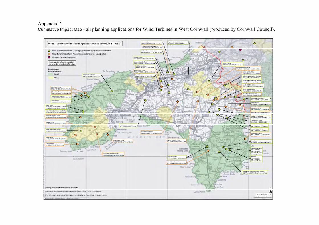
Appendix 7Cumulative Impact Map - all planning applications for Wind Turbines in West Cornwall (produced by Cornwall Council).

Appendix 8
List of jpegs contained on CD Rom at the rear of this report
PhotoNumber
Description From Scale
1 View across turbine site to north/north-east boundary S -2 View across turbine site to north/north-west boundary, gate to adjacent field SE -3 View across turbine site to western boundary E -4 View across turbine site to south-western boundary, with the village of Gwithian just visible
across the fields and St Ives across the bay to the far westENE -
5 View across from turbine site to the newly-erected turbine to the south, adjacent to a smallcottage
N -
6 View across from turbine site to the complex of agricultural buildings, to the south-east NW -7 View across turbine site to eastern boundary W -8 View across turbine site to north/north-eastern boundary SW -9 View across turbine site S -10 View up eastern boundary of turbine site, showing stone-built hedgebank SW -11 View of large telegraph pole in south-east corner of site, against hedgebank which divides
the site from the adjacent Scheduled MonumentNW -
12 View of electricity lines crossing the turbine site SE -13 As above NE -14 View of complex of agricultural buildings NW -15 View of turbine to south of site N -16 View from adjacent Scheduled Monument up to turbine site, with telegraph poles ENE -17 View to turbine to east of site W -18 View across adjacent Scheduled Monument showing little or no surface remains S -19 View to Gwithian, from further to the south of the turbine field. E -20 View within haulage yard towards turbine site. SE -21 View of nearby photovoltaic unit on the same holding as the turbine site NW -22 View of another nearby turbine at Carwin Rise N -23 View to turbine site from within Gwithian churchyard (St Gothian’s Church) W -24 View of historic buildings and Listed cottages in Gwithian which are blocked by the church
and buildings to the east of the villageSE -
25 View from the Grade II* Listed Chapel in Gwithian, to the turbine site, showing local blocking W -26 View from the Scheduled Monument, St Gothian’s Chapel, north of Gwithian, to the turbine
siteNW -
27 View from western edge of Godrevy headland, showing how the headland rises and willblock views to the turbine
NW -
28 View from the ridge to the south of Godrevy headland, to the turbine site, also showing thelarge photovoltaic unit
N -
29 As above N -30 View from St Elwyn’s Church in Hayle, to Phillack and beyond towards the turbine site SW -31 View from Foundary district of Hayle, across to Copperhouse and the turbine site beyond SW -32 View from St Uny’s Church in Lelant across the Hayle estuary to the turbine site WSW -33 View from St Ives Harbour to the turbine site across the bay W -34 View from the upper district of St Ives, to the turbine site across the bay W -35 View from within the settlement of St Erth, just outside the churchyard, towards the turbine
siteSW -
36 View to the turbine site across the roofs of Camborne from the edge of the World HeritageMining Site
SE -
The Old DairyHacche Lane Business Park
Pathfields Business ParkSouth Molton
DevonEX36 3LH
Tel: 01769 573555Email: [email protected]