characterization of aquifers and hydrochemistry in volcanic
TRANSCRIPT
Advisor: Tenalem Ayenew (prof.)
By: Mekdes Nigatie Enideg
June 2012
Characterization of Aquifers and Hydrochemistry
in Volcanic Terrain of Central Ethiopia
A Thesis Submitted to the School of Graduate Studies of Addis Ababa
University in Partial Fulfillment of the Requirements for the Degree of
Masters of Science in Hydrogeology
Tarmaber basalt Spring
ADDIS ABABA UNIVERSITY
SCHOOL OF GRADUATE STUDIES
DEPARTMENT OF EARTH SCIENCES
Characterization of Aquifers and Hydrochemistry in the Volcanic Terrain
Central Ethiopia
By: Mekdes Nigatie Endge
A Thesis Submitted to the School of Graduate Studies of Addis Ababa University in Partial
Fulfillment of the Requirements for the Degree of Master of Science in Hydrogeology
Approved by the board of examiners
Tigistu Haile (Ph.D) ___________________________________________
Head of the Department and Chair man
Tenalem Ayenew (prof.) ________________________________________
Advisor
Seifu Kebede (Ph.D) ____________________________________________
Internal examiner
GezhegnYirgu (prof.) ____________________________________________
Internal examiner
June, 2012
Table of Contents
List of Figures .............................................................................................................................................. iv
List of Tables ................................................................................................................................................ v
List of Plates ................................................................................................................................................. v
Acknowledgments ........................................................................................................................................ vi
Acronyms .................................................................................................................................................... vii
Abstract ...................................................................................................................................................... viii
CHAPTER 1 .................................................................................................................................................... 1
INTRODUCTION ............................................................................................................................................. 1
1.1. Background ........................................................................................................................................ 1
1.2. Objectives of the Study ...................................................................................................................... 3
1.3. Significance of the Study ................................................................................................................... 3
1.4. Research Methodology ...................................................................................................................... 3
1.5. Literature Review ............................................................................................................................... 4
CHAPTER 2 .................................................................................................................................................... 6
DESCCRIPTION OF THE STUDY AREA ............................................................................................................. 6
2.1. Location .............................................................................................................................................. 6
2.2 Geomorphology .................................................................................................................................. 7
2.2.1. Blue Nile-Jema-Muger-Guder River Gorges and low elevation area ......................................... 7
2.2.2. The Central Plateau ..................................................................................................................... 7
2.2.3. Entoto-Chelelka-Guragudda-Wechecha-Chilmo Mountains ...................................................... 8
2.3. Climates and Hydrology ................................................................................................................... 10
2.3.1. Climate ...................................................................................................................................... 10
2.3.2. Hydrology ................................................................................................................................. 11
CHAPTER 3 .............................................................................................................................................. 14
GEOLOGY ................................................................................................................................................. 14
3.1 Regional Geology ............................................................................................................................. 14
3.2. Local Geology .................................................................................................................................. 15
3.2.1. Mesozoic Sedimentary Rocks ................................................................................................... 16
3.2.2. Tertiary volcanic Rocks ............................................................................................................ 18
3.2.3. Quaternary volcanic rock and sediments .................................................................................. 22
3.2.3.1. Quaternary Volcanic rocks ..................................................................................................... 22
3. 2.3.2. Quaternary Lacustrine and Alluvial Deposits ....................................................................... 23
CHAPTER 4 .................................................................................................................................................. 26
HYDROGEOLOGY ......................................................................................................................................... 26
4.1 Hydro Geological Classification /Characterization ............................................................................ 26
4.1.1 Qualitative Parameters ............................................................................................................... 27
4.1.2. Quantitative Parameters ............................................................................................................ 27
4.2. Aquifer classification of the area ..................................................................................................... 28
4.2.1. Extensive and highly productive porous aquifer ....................................................................... 28
4.2.2. Extensive and Highly Productive Fissured and Karast Aquifer ................................................ 28
4.2.3. Extensive and Highly Productive Fissured Aquifer .................................................................. 29
4.2.4. Extensive and Moderately Productive Porous Aquifer ............................................................. 31
4.2.5. Extensive and Moderately Productive Fissured Aquifer........................................................... 32
4.2.6. Low Productive Aquifer ............................................................................................................ 33
4.2.7. Aquiqulid .................................................................................................................................. 34
4.3. Determination of Aquifer Parameters from Pumping Test Data ...................................................... 35
4.4. Ground Water Potential (Aquifer potential) .................................................................................... 37
4.5. Hydrogeological Structures .............................................................................................................. 38
4.6. Aspects of groundwater recharge and discharge .............................................................................. 40
4.6.1. Ground Water Recharge ............................................................................................................ 40
4.6.2. Ground Water Discharge .......................................................................................................... 41
4.7. Ground Water Flow System ............................................................................................................. 45
CHAPTER 5 .............................................................................................................................................. 48
HYDROCHEMISTRY ...................................................................................................................................... 48
5.1. General ............................................................................................................................................. 48
5.2. Groundwater Sampling .................................................................................................................... 48
5.3. Physical Parameters ......................................................................................................................... 50
5.3.1. Hydrogen-Ion Activity (PH) ..................................................................................................... 50
5.3.2. Electrical conductance (EC) ...................................................................................................... 51
5.3.3. Alkalinity and Acidity ............................................................................................................... 53
5.3.4. Hardness .................................................................................................................................... 54
5.3.5. Total Dissolved Solids .............................................................................................................. 55
5.4. Cations and Anions .......................................................................................................................... 58
5.4.1. Sodium Ion (Na)........................................................................................................................ 58
5.4.2. Calcium Ions ............................................................................................................................. 59
5.4.3. Magnesium Ion (Mg2) ............................................................................................................... 59
5.4.4. Potassium Ion (K+) .................................................................................................................... 60
5.4.5. Bicarbonate ions (HCO3 2- ) ........................................................................................................ 60
5.4.6. Sulfate ion (SO42-
) .................................................................................................................... 60
5.4.7. Chloride (Cl-) ............................................................................................................................ 61
5.4.8. Fluoride Ion (F-) ........................................................................................................................ 61
5.4.9. Nitrate (NO3) ............................................................................................................................ 62
5.5. Classification of Natural Waters ...................................................................................................... 63
5.5.1. Classification Based on Aquachem Software ........................................................................... 64
5.5.2. Graphical presentation of hydro geochemical Facies ............................................................... 67
5.6. Hydrochemistry of Surface Water ................................................................................................... 70
5.7. Aquifer Systems and Hydrochemistry of ground water .................................................................. 72
5.7.1. Hydrochemistry of Groundwater in Volcanic Aquifers problem .............................................. 72
5.7.2. Hydrochemistry of Groundwater in Mesozoic and Quaternary Sediments .............................. 73
5.8. Quality of water for public use ........................................................................................................ 75
CHAPTER 6 .................................................................................................................................................. 77
CONCLUSIONS AND RECOMMENDATIONS ................................................................................................. 77
6.1. Conclusions ...................................................................................................................................... 77
6.2. Recommendations ............................................................................................................................ 79
References .................................................................................................................................................. 81
Annex-1: Selected Lithologic logs .......................................................................................................... - 1 -
Annex 2: Location of boreholes and Depth of the wells. ....................................................................... - 10 -
Annex 3: Location of springs and discharge .......................................................................................... - 13 -
Annex 4: Pumping test data result ......................................................................................................... - 15 -
Annex 5: Chemical data of Hand Dug Wells ......................................................................................... - 22 -
Annex 6: Chemical data of boreholes .................................................................................................... - 23 -
Annex 7: Chemical data of springs ........................................................................................................ - 33 -
List of Figures
Figure 1: Location map of the study area ..................................................................................................... 6
Figure 2: geomorphology map of the area .................................................................................................... 9
Figure 3: Drainage pattern of the area ........................................................................................................ 12
Figure 4: Mean monthly runoff Blue Nile near Kessi (1956-2004). .......................................................... 13
Figure 5: Mean monthly runoff Awash River near Ginchi, Mugher and Berga River (1993-2004). ...... 13
Figure 6: Geological map of the area Combined from Ethiopian geology and ABGREP Report WWDSE
(2008) .................................................................................................................................................. 25
Figure 7: Hydrogeological map of the area, combined from Ethiopian hydrogeology and ABGREP
Report WWDSE (2008). ..................................................................................................................... 35
Figure 8: Transmissivity and specific capacity data points ........................................................................ 37
Figure 9 : Discharge map of the study area ................................................................................................ 42
Figure 10: Location maps of Boreholes and springs ................................................................................... 45
Figure 11: Ground level contour lines and the general ground water flow ................................................. 47
Figure 12: Location of water sample points ................................................................................................ 49
Figure13: Map showing distribution PH of area ......................................................................................... 51
Figure 14: Relation between TDS and EC of natural water samples. ......................................................... 52
Figure 15 : TDS vs. RA plot ....................................................................................................................... 53
Figure 16: Map showing TDS distribution of the area area ........................................................................ 57
Figure 17: Fluoride distributions of natural waters. .................................................................................... 62
Figure 18: Map showing Nitrate distribution of the study area .................................................................. 63
Figure 19: Piper plot of Hand dug wells ..................................................................................................... 68
Figure 20: Piper plots of deep wells............................................................................................................ 69
Figure 21: Piper plots of shallow wells ...................................................................................................... 69
Figure 22: Piper plots of springs ................................................................................................................. 70
Figure 23: Piper plot diagram of surface water. .......................................................................................... 71
Figure 24: Piper plot diagram of natural water on volcanic aquifers ......................................................... 73
Figure 25: Piper plot diagram of natural water on Mesozoic sediments springs and Borehole .................. 74
Figure 26: Piper plot diagram of natural water in quaternary sediments, alluvial and elluvial, (Boreholes,
springs, and Dug wells). ...................................................................................................................... 75
List of Tables
Table 1: General Climatic Regions of Ethiopia .......................................................................................... 10
Table 2: Mean climatic elements at key stations ........................................................................................ 11
Table 3: Classification of the water sample of the area by hardness .......................................................... 54
Table 4: Water classification based on TDS (Freeze & Cherry (1979) ...................................................... 56
Table 5: statistics valves of 405 water point‟s chemistry in the study area. ............................................... 58
Table 6: the hydro chemical type in the study area. .................................................................................... 65
Table 7: Chemical data of rivers ................................................................................................................. 71
List of Plates
Plate 1 : Thick lower sandstone exposure at Blue Nile gorge. .................................................................... 16
Plate 2: Contact between Tertiary volcanic and upper sandstone at Zigawedem river gorge. .................... 18
Plate 3: Fracture developed on Tarmaber basalt (left) and spring on it (right) ........................................... 30
Acknowledgments
First of all, I offer my deeply felt thanks to God for being with me from the very beginning to the
end of my carrier. I also wholeheartedly thank Pro. Tenalem Ayenew, my advisor and instructor,
for his unreserved advice, strict follow up and kind provision of all required materials.
I would also like to take this opportunity to thank Earth Science Department members
particularly Dr. Tigistu Haile Department Head of Earth Science Department and Dr.Seifu
Kebede.Their advice, valuable suggestions, knowledge share and general support were crucial to
the improvement and completion of this study.
I would like to thank Tilhune Azagegn, for his advice; follow up, facilitation of the post graduate
study and for everything.
My thanks also go to the Amhara National Regional State Water Resources Development Bureau
for sponsering my study at Addis Ababa University.
I also thank organizations: Water Work Design and Supervision Enterprise, Ministry of Water
Resources, Geological Survey of Ethiopia and Ethiopian Meteorological Agency for providing
the required secondary data.
A special note of appreciation is reserved to my department friends: Debele, Misganaw Kassie,
Seid Adem, Tadesse Hunduma and Wale for always being there to help me to improve my thesis.
Ato Adugna Guade, Linger Ayele, and Yones mulugeta also deserve my appreciation for their
uninterrupted advice and editing my thesis.
A am also indebted to the contributions of my all-time friends, Melaku Tesfa, Desalgn,
Serkalem, Moges, Mesrak, Bekle, Almitu Adane, Webalem, Wolella not only for their input in
my thesis but also for their advice and encouragements from the bottom of their heart.
I extend my most sincere gratitude and thanksto my brothers: Workenh Nigatie and Brihanu
Nigatie, Mesay Tesfay for their uninterrupted help and advice.
Finally, a special word of thanks is reserved for Zewde berku for her patience, support, and
encouragement when I needed it most.
Acronyms
AAU: Addis Ababa University
AAWS: Addis Ababa Water and Sewerage Authority
ABGREP: Adaa-Becho Groundwater Resource Evaluation Project
GSE: Geological Survey of Ethiopian
MoWR: Ministry of Water Resources
RA: Residual Alkalinity
TDS: Total Dissolved Substances
WHO: World Health Organization
WWDE: Water Well Drilling Enterprise
WWDSE: Water Works Design and Supervisor Enterprise
BH: Bore Hole
CSP: Cold Spring
EC: Electrical conductivity
E-W: East-West
HDW: Hand Dug Well
M.a.b.sl: Meter above Sea Level
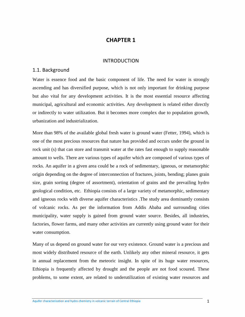
Abstract
This thesis work aimed to characterizing the different aquifer systems and their hydrochemistry
of volcanic aquifer in central Ethiopia which encompasses Upper Awash, Jema, Mugher and
Guder River basins surrounding the city of Addis Ababa.The area can be divided in to three
geomorphologic features (zones): central gentle slopes and plateau, western, northwestern and
northeastern deep gorges of Blue Nile, Guder, Muger and Jema rivers and low elevation area,
and elevated picks of mountains and ridges. The main rainy season of the study area is from
June to September. The recent Quaternary deposits, Quaternary basalt, Tertiary basalts,
ignimbrites, rhyolites, trachytes and Mesozoic sediments are the stratigraphy of the area from
youngest to oldest. The hydrogeological classification is done using qualitative and quantitative
approaches. On the basis of hydrogeological characteristics of lithologic units and different data
collected from different organization, the classification leads to different aquifers and aquiclud.
High productive porous aquifers of sandstone (T=100-500 m2/d, Q=5-25l/s). High productive
fissured and/or karst aquifers of limestone (T= 50-100 m2/d Q=2-5 l/s). High productive fissured
aquifers of Tertiary and Quaternary basalt (T=100-500 m2/d, Q=5-25 l/s). Moderate productive
fissured aquifers of Aiba basalt Lower ignimbrite and aphanitic to Medium grained vesicular
trachyte and trachy basalt (T=50-100 m2/d, Q=2-5 l/s), Moderate productive porous aquifers of
sandstone and Quaternary deposits, (T=50-100 m2/d, Q=2-5 l/s) Low productive aquifers of
Entoto rhyolite and trchyte ( T=1-10 m2/d and Q=0.05 l/s) and aquiclud or minor aquifers with
limited ground water resources. Moreover, different types of maps and their analysis result
indicate widely variable aquifer characteristics. Hydro chemical data shows that evolution of
major ions, such as Na, K, Ca, Mg, SO4, NO3 and HCO3 and analyze some physical parameters
PH, TDS and Conductivity, water types. The result shows that the dominant water type is
bicarbonate especially Ca-Mg-HCO3, Ca-Na-HCO3 and Ca-HCO3. The water quality analysis
mad based on Florid, Chloride, Nitrate and Total Dissolved Solids (TDS) results approved the
potential of groundwater contamination in the area. Generally the ground water of the area is
suitable for domestic use. However, there are also exceptions which are susceptible for pollution
and needs proper follow up of its quality.
.
Aquifer characterization and hydro chemistry in volcanic terrain of Central Ethiopia 1
CHAPTER 1
INTRODUCTION
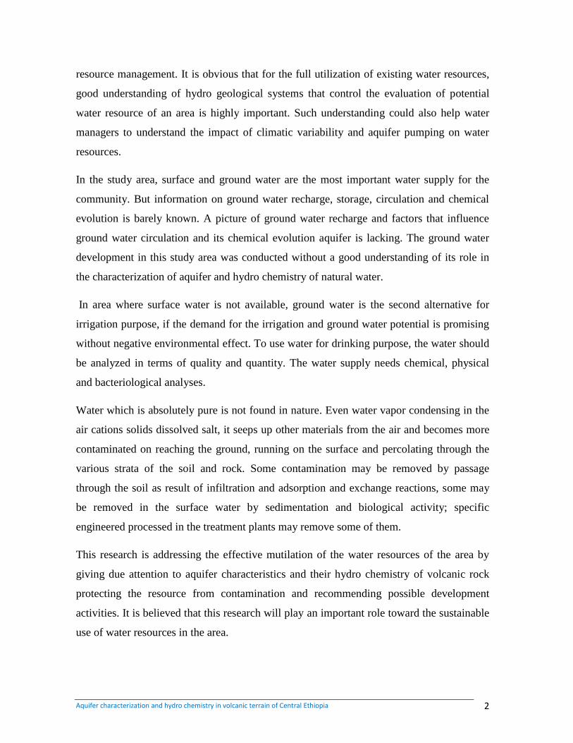
1.1. Background
Water is essence food and the basic component of life. The need for water is strongly
ascending and has diversified purpose, which is not only important for drinking purpose
but also vital for any development activities. It is the most essential resource affecting
municipal, agricultural and economic activities. Any development is related either directly
or indirectly to water utilization. But it becomes more complex due to population growth,
urbanization and industrialization.
More than 98% of the available global fresh water is ground water (Fetter, 1994), which is
one of the most precious resources that nature has provided and occurs under the ground in
rock unit (s) that can store and transmit water at the rates fast enough to supply reasonable
amount to wells. There are various types of aquifer which are composed of various types of
rocks. An aquifer in a given area could be a rock of sedimentary, igneous, or metamorphic
origin depending on the degree of interconnection of fractures, joints, bending; planes grain
size, grain sorting (degree of assortment), orientation of grains and the prevailing hydro
geological condition, etc. Ethiopia consists of a large variety of metamorphic, sedimentary
and igneous rocks with diverse aquifer characteristics .The study area dominantly consists
of volcanic rocks. As per the information from Addis Ababa and surrounding cities
municipality, water supply is gained from ground water source. Besides, all industries,
factories, flower farms, and many other activities are currently using ground water for their
water consumption.
Many of us depend on ground water for our very existence. Ground water is a precious and
most widely distributed resource of the earth. Unlikely any other mineral resource, it gets
in annual replacement from the meteoric insight. In spite of its huge water resources,
Ethiopia is frequently affected by drought and the people are not food scoured. These
problems, to some extent, are related to underutilization of existing water resources and
Aquifer characterization and hydro chemistry in volcanic terrain of Central Ethiopia 2
resource management. It is obvious that for the full utilization of existing water resources,
good understanding of hydro geological systems that control the evaluation of potential
water resource of an area is highly important. Such understanding could also help water
managers to understand the impact of climatic variability and aquifer pumping on water
resources.
In the study area, surface and ground water are the most important water supply for the
community. But information on ground water recharge, storage, circulation and chemical
evolution is barely known. A picture of ground water recharge and factors that influence
ground water circulation and its chemical evolution aquifer is lacking. The ground water
development in this study area was conducted without a good understanding of its role in
the characterization of aquifer and hydro chemistry of natural water.
In area where surface water is not available, ground water is the second alternative for
irrigation purpose, if the demand for the irrigation and ground water potential is promising
without negative environmental effect. To use water for drinking purpose, the water should
be analyzed in terms of quality and quantity. The water supply needs chemical, physical
and bacteriological analyses.
Water which is absolutely pure is not found in nature. Even water vapor condensing in the
air cations solids dissolved salt, it seeps up other materials from the air and becomes more
contaminated on reaching the ground, running on the surface and percolating through the
various strata of the soil and rock. Some contamination may be removed by passage
through the soil as result of infiltration and adsorption and exchange reactions, some may
be removed in the surface water by sedimentation and biological activity; specific
engineered processed in the treatment plants may remove some of them.
This research is addressing the effective mutilation of the water resources of the area by
giving due attention to aquifer characteristics and their hydro chemistry of volcanic rock
protecting the resource from contamination and recommending possible development
activities. It is believed that this research will play an important role toward the sustainable
use of water resources in the area.
Aquifer characterization and hydro chemistry in volcanic terrain of Central Ethiopia 3
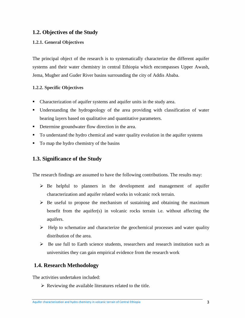
1.2. Objectives of the Study
1.2.1. General Objectives
The principal object of the research is to systematically characterize the different aquifer
systems and their water chemistry in central Ethiopia which encompasses Upper Awash,
Jema, Mugher and Guder River basins surrounding the city of Addis Ababa.
1.2.2. Specific Objectives
Characterization of aquifer systems and aquifer units in the study area.
Understanding the hydrogeology of the area providing with classification of water
bearing layers based on qualitative and quantitative parameters.
Determine groundwater flow direction in the area.
To understand the hydro chemical and water quality evolution in the aquifer systems
To map the hydro chemistry of the basins
1.3. Significance of the Study
The research findings are assumed to have the following contributions. The results may:
Be helpful to planners in the development and management of aquifer
characterization and aquifer related works in volcanic rock terrain.
Be useful to propose the mechanism of sustaining and obtaining the maximum
benefit from the aquifer(s) in volcanic rocks terrain i.e. without affecting the
aquifers.
Help to schematize and characterize the geochemical processes and water quality
distribution of the area.
Be use full to Earth science students, researchers and research institution such as
universities they can gain empirical evidence from the research work
1.4. Research Methodology
The activities undertaken included:
Reviewing the available literatures related to the title.
Aquifer characterization and hydro chemistry in volcanic terrain of Central Ethiopia 4
Reviewing the available previous works in the basins.
Collecting boreholes and springs data from different organization. To make a map
of the distribution of water points, potential of aquifer and ground water level
contour line for reconstruction of the ground water flow direction.
Pumping test data and geological log of the well from the study area were collected
from different organization
Data processing: the help of Aquachem 3.4, Arcgis 9.3, Global Mapper-12, Sulfer-8
and other computer codes to make easy of bulk data management and facilitate the
analysis, and interpretation of results.
Collecting and analyzing of seasonal water chemistry of ground water and surface
water from existing data base and some primary water sample.
Understanding and mapping of the geologic and hydro geologic set-ups
1.5. Literature Review
The area has been studied by various authors; however, most of the studies were
concentrated at the southern part of the study area. The northern part is poorly studied.
Some of the works conducted in the area are described below.
Abenezer Kefeni (2007). Hydrogeochemical Evaluation in the Ambo-Weliso area.
Unpublished MSc thesis, AAU.
Andarge Yitbarek (2010). Hydrogeological and Hydro geochemical Framework of
Complex Volcanic System in the Upper Awash River Basin, Central Ethiopia. University
of Poitiers, France, unpublished, PhD. Thesis.
Berhau Melaku (1982). Investigating the General Hydrogeology of the Upper Awash
Valley Which Includes, the Akaki River Catchment
Berhan Gizaw (2002). Carried out Detailed Assessments on the Hydro chemical and
Environmental Investigation of Addis Ababa Region.
Esayas Tilahun (2008). Hydro chemical and Characterization of Natural Water in Addis
Ababa Area, Unpublished MSc thesis, AAU
Aquifer characterization and hydro chemistry in volcanic terrain of Central Ethiopia 5
Tesfay cherent (1993). The Volcanic Rocks of Addis Ababa were characterized by
extensive aquifer with fracture permeability and moderate productivity.
Fanuel’s Seyoum (2007). Aquifer Characterization of Addis Ababa and the Adjacent
High land.
Tilahun’s Azagegn (2008). Findings reveal the Hydro Geochemical Characterization of
Aquifer ystems in Upper Awash and Adjacent plateau using geochemical modeling and
isotope hydrology.
Water work design and super vision enterprise (WWDSE), (2008). worked on
evaluation of water resources of the adda‟a and Becho plains ground water basin for
irrigation development project.
Bisrat Lema and Amaha Athnafu (2007). Conducted Hydrogeological mapping of south
eastern part of the Jema river basin.
The technical hydro geological report of Addis Ababa (2010). Deals the hydro
geological description of different litho logical unites ground water occurrence and hydro
chemical interpretation of ground and surface water points.
Tamiru Alemayehu et al. (2005). Hydro geochemical and lake level changes in the
Ethiopia rift, hydrogeology journal.
Seifu Kebede et al. (2004). Groundwater Recharge, Circulation and Geochemical
Evolution in the Source Region of the Blue Nile River, Applied Geochemistry.
Aquifer characterization and hydro chemistry in volcanic terrain of Central Ethiopia 6
CHAPTER 2
DESCCRIPTION OF THE STUDY AREA
2.1. Location
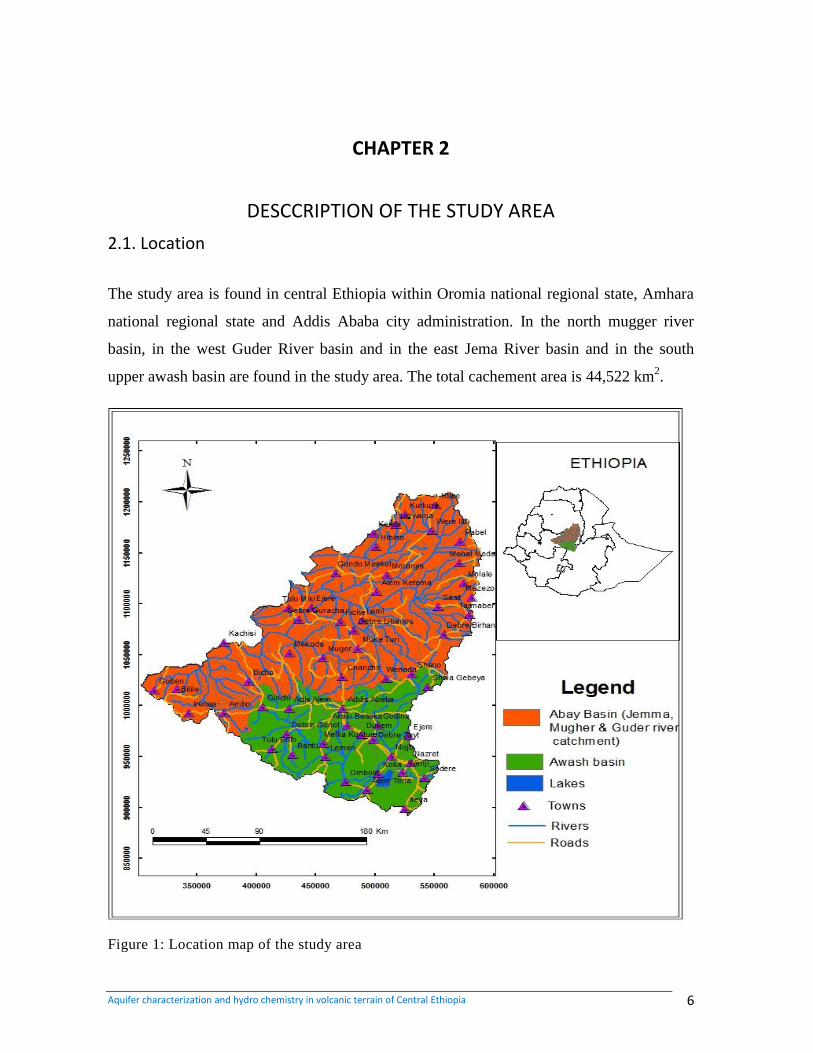
The study area is found in central Ethiopia within Oromia national regional state, Amhara
national regional state and Addis Ababa city administration. In the north mugger river
basin, in the west Guder River basin and in the east Jema River basin and in the south
upper awash basin are found in the study area. The total cachement area is 44,522 km2.
Figure 1: Location map of the study area
Aquifer characterization and hydro chemistry in volcanic terrain of Central Ethiopia 7
2.2 Geomorphology
The morphology of the study area is bordered in the east by Adaa-Becho, in the north by
Jema, Muger river gorges, in the west by Guder River and in the south by mt. ziquala and
koka dam. Inside the study area, there are voluminous ridges of acidic volcanic locations
in which some of them are highly affected by recent faulting, like Entoto, Wochcha, Fori,
Bedegebaba, Menogsha, Guji and many others.
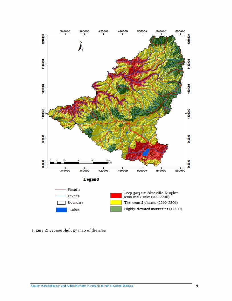
There is high elevation variation within the study area ranging from 700-3500 m.a.s.l. The
area can be divided into three geomorphic zones based on variation in elevation,
morphological setting and topographic setting.
2.2.1. Blue Nile-Jema-Muger-Guder River Gorges and low elevation area
This physiographic zone covers the north eastern, the north western and southern part of
the map area. It is characterized by development of deep gorges; steep slope and
escarpment of the Blue Nile, Jema, Muger, and Guder Rivers. The elevation ranges from
700-2200 m.a.s.l. The lowest altitude of the zone is recorded inside Blue-Nile River at the
north western part of the area which is about 700 M.a.s.l. This zone is dominated by
quaternary sediments at the bottom, Mesozoic sediments as the escarpments and tertiary
volcanic specially basalt which is hexagonal columnar joints at the top part. The drainage
system is dendritic and with a number of perennial and intermittent rivers forming deep
gorges.
2.2.2. The Central Plateau
This physiographic zone covers wide area of map. It is characterized by flat plain covered
by recent deposit, gently slopes, and undulating terrain covered by tertiary volcanic rocks
basalt and ignimbrite and quaternary basalt and sediments. The altitude ranges from 2200-
2800 m.a.s.l. The region is desiccated by some big river and small streams such as Awash,
holeta, duber, aleltiu, legedadi and sokoro. In this zone, there is numerous numbers of
lineaments and most of them have NE-SW alignment. The drainage pattern shows parallel
Aquifer characterization and hydro chemistry in volcanic terrain of Central Ethiopia 8
to dendritic. Most of the rivers in this zone flow to the Blue Nile basin and the rest flow to
Awash basin.
2.2.3. Entoto-Chelelka-Guragudda-Wechecha-Chilmo Mountains
This region is located in the south eastern, south western and northern part of the study area
at Entoto, chelelka, guraguda (near Fiche), wechecha and chilmo (north of ginchi) areas.
This region forms dominantly E-W and N-S trending ridges and mountains picks of tertiary
volcanic (basalt, trachyte, trachy basalt, rhyolite and ignimbrite). The altitude of this zone
is greater than 2800 and reaches up to 3400 m a.s.l. on Chelelkaa and Entoto riges. The
maximum altitude is 3500 m.a.s.l at Gura Guda mountain picks. This zone forms especially
Entoto and Chilmo mountain ridges, the surface water divide between Blue Nile and
Awash River basin.
Aquifer characterization and hydro chemistry in volcanic terrain of Central Ethiopia 9
Figure 2: geomorphology map of the area
Aquifer characterization and hydro chemistry in volcanic terrain of Central Ethiopia 10
2.3. Climates and Hydrology
2.3.1. Climate
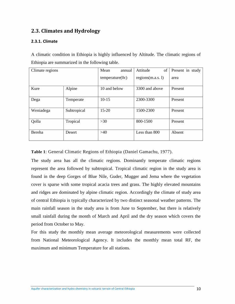
A climatic condition in Ethiopia is highly influenced by Altitude. The climatic regions of
Ethiopia are summarized in the following table.
Climate regions Mean annual
temperature(0c)
Attitude of
regions(m.a.s. l)
Present in study
area
Kure Alpine 10 and below 3300 and above Present
Dega Temperate 10-15 2300-3300 Present
Weniadega Subtropical 15-20 1500-2300 Present
Qolla Tropical >30 800-1500 Present
Bereha Desert >40 Less than 800 Absent
Table 1: General Climatic Regions of Ethiopia (Daniel Gamachu, 1977).
The study area has all the climatic regions. Dominantly temperate climatic regions
represent the area followed by subtropical. Tropical climatic region in the study area is
found in the deep Gorges of Blue Nile, Guder, Mugger and Jema where the vegetation
cover is sparse with some tropical acacia trees and grass. The highly elevated mountains
and ridges are dominated by alpine climatic region. Accordingly the climate of study area
of central Ethiopia is typically characterized by two distinct seasonal weather patterns. The
main rainfall season in the study area is from June to September, but there is relatively
small rainfall during the month of March and April and the dry season which covers the
period from October to May.
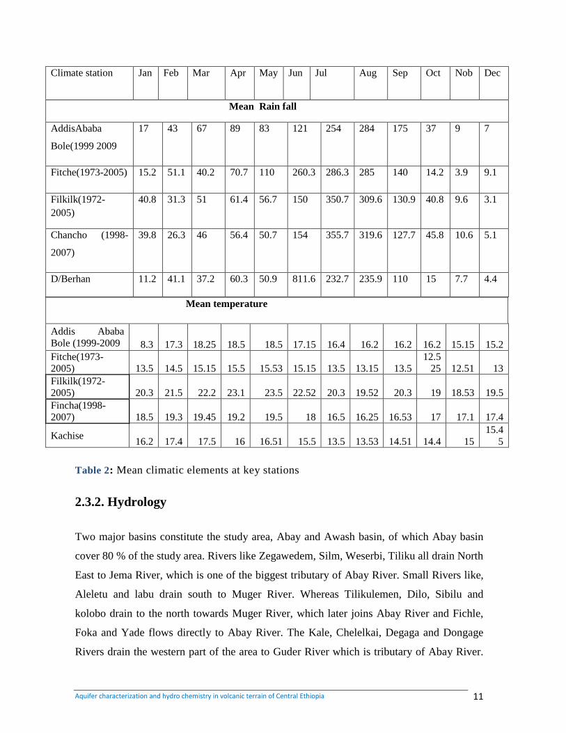
For this study the monthly mean average meteorological measurements were collected
from National Meteorological Agency. It includes the monthly mean total RF, the
maximum and minimum Temperature for all stations.
Aquifer characterization and hydro chemistry in volcanic terrain of Central Ethiopia 11
Climate station Jan Feb Mar Apr May Jun Jul Aug Sep Oct Nob Dec
Mean Rain fall
AddisAbaba
Bole(1999 2009
17 43 67 89 83 121 254 284 175 37 9 7
Fitche(1973-2005) 15.2 51.1 40.2 70.7 110 260.3 286.3 285 140 14.2 3.9 9.1
Filkilk(1972-
2005)
40.8 31.3 51 61.4 56.7 150 350.7 309.6 130.9 40.8 9.6 3.1
Chancho (1998-
2007)
39.8 26.3 46 56.4 50.7 154 355.7 319.6 127.7 45.8 10.6 5.1
D/Berhan 11.2 41.1 37.2 60.3 50.9 811.6 232.7 235.9 110 15 7.7 4.4
Mean temperature
Addis Ababa
Bole (1999-2009 8.3 17.3 18.25 18.5 18.5 17.15 16.4 16.2 16.2 16.2 15.15 15.2
Fitche(1973-
2005) 13.5 14.5 15.15 15.5 15.53 15.15 13.5 13.15 13.5
12.5
25 12.51 13
Filkilk(1972-
2005) 20.3 21.5 22.2 23.1 23.5 22.52 20.3 19.52 20.3 19 18.53 19.5
Fincha(1998-
2007) 18.5 19.3 19.45 19.2 19.5 18 16.5 16.25 16.53 17 17.1 17.4
Kachise 16.2 17.4 17.5 16 16.51 15.5 13.5 13.53 14.51 14.4 15
15.4
5
Table 2: Mean climatic elements at key stations
2.3.2. Hydrology
Two major basins constitute the study area, Abay and Awash basin, of which Abay basin
cover 80 % of the study area. Rivers like Zegawedem, Silm, Weserbi, Tiliku all drain North
East to Jema River, which is one of the biggest tributary of Abay River. Small Rivers like,
Aleletu and labu drain south to Muger River. Whereas Tilikulemen, Dilo, Sibilu and
kolobo drain to the north towards Muger River, which later joins Abay River and Fichle,
Foka and Yade flows directly to Abay River. The Kale, Chelelkai, Degaga and Dongage
Rivers drain the western part of the area to Guder River which is tributary of Abay River.
Aquifer characterization and hydro chemistry in volcanic terrain of Central Ethiopia 12
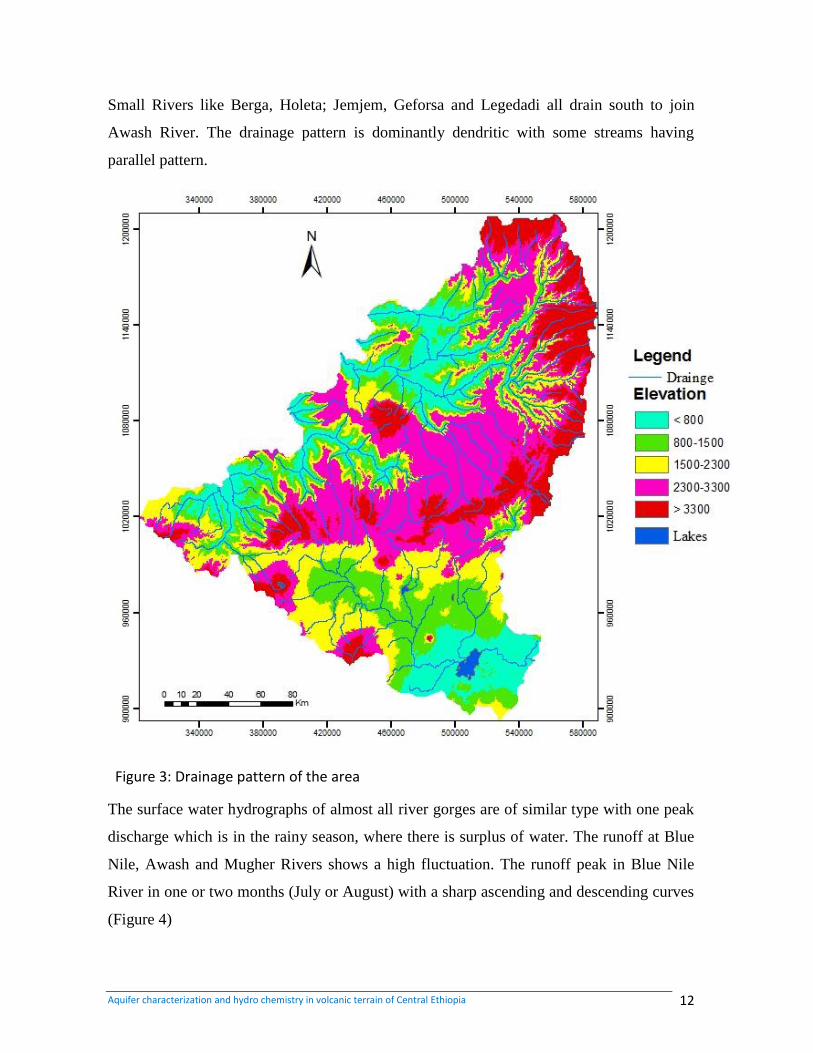
Small Rivers like Berga, Holeta; Jemjem, Geforsa and Legedadi all drain south to join
Awash River. The drainage pattern is dominantly dendritic with some streams having
parallel pattern.
Figure 3: Drainage pattern of the area
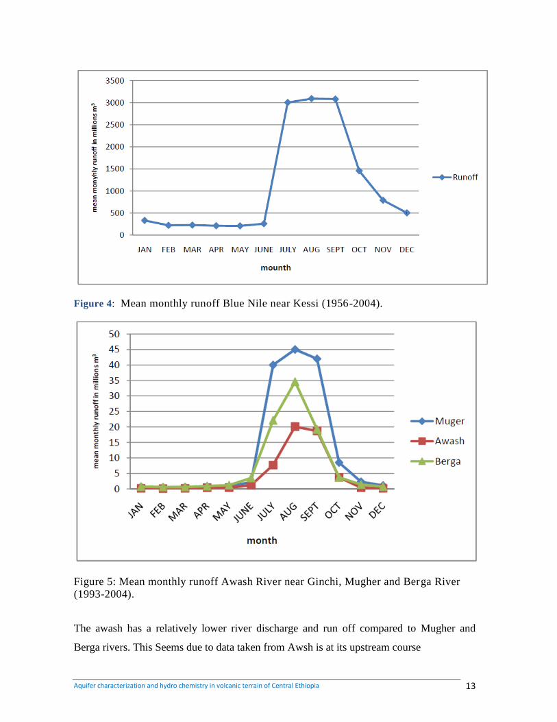
The surface water hydrographs of almost all river gorges are of similar type with one peak
discharge which is in the rainy season, where there is surplus of water. The runoff at Blue
Nile, Awash and Mugher Rivers shows a high fluctuation. The runoff peak in Blue Nile
River in one or two months (July or August) with a sharp ascending and descending curves
(Figure 4)
Aquifer characterization and hydro chemistry in volcanic terrain of Central Ethiopia 13
Figure 4: Mean monthly runoff Blue Nile near Kessi (1956-2004).
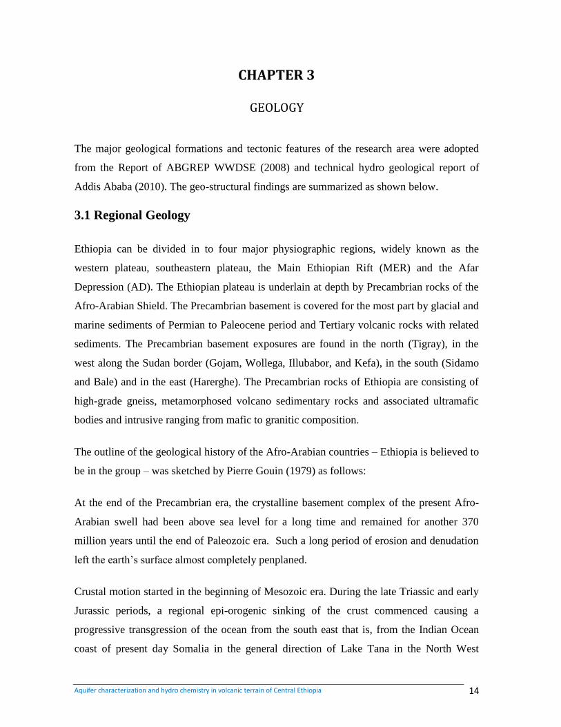
Figure 5: Mean monthly runoff Awash River near Ginchi, Mugher and Berga River
(1993-2004).
The awash has a relatively lower river discharge and run off compared to Mugher and
Berga rivers. This Seems due to data taken from Awsh is at its upstream course
Aquifer characterization and hydro chemistry in volcanic terrain of Central Ethiopia 14
CHAPTER 3
GEOLOGY
The major geological formations and tectonic features of the research area were adopted
from the Report of ABGREP WWDSE (2008) and technical hydro geological report of
Addis Ababa (2010). The geo-structural findings are summarized as shown below.
3.1 Regional Geology
Ethiopia can be divided in to four major physiographic regions, widely known as the
western plateau, southeastern plateau, the Main Ethiopian Rift (MER) and the Afar
Depression (AD). The Ethiopian plateau is underlain at depth by Precambrian rocks of the
Afro-Arabian Shield. The Precambrian basement is covered for the most part by glacial and
marine sediments of Permian to Paleocene period and Tertiary volcanic rocks with related
sediments. The Precambrian basement exposures are found in the north (Tigray), in the
west along the Sudan border (Gojam, Wollega, Illubabor, and Kefa), in the south (Sidamo
and Bale) and in the east (Harerghe). The Precambrian rocks of Ethiopia are consisting of
high-grade gneiss, metamorphosed volcano sedimentary rocks and associated ultramafic
bodies and intrusive ranging from mafic to granitic composition.
The outline of the geological history of the Afro-Arabian countries – Ethiopia is believed to
be in the group – was sketched by Pierre Gouin (1979) as follows:
At the end of the Precambrian era, the crystalline basement complex of the present Afro-
Arabian swell had been above sea level for a long time and remained for another 370
million years until the end of Paleozoic era. Such a long period of erosion and denudation
left the earth‟s surface almost completely penplaned.
Crustal motion started in the beginning of Mesozoic era. During the late Triassic and early
Jurassic periods, a regional epi-orogenic sinking of the crust commenced causing a
progressive transgression of the ocean from the south east that is, from the Indian Ocean
coast of present day Somalia in the general direction of Lake Tana in the North West
Aquifer characterization and hydro chemistry in volcanic terrain of Central Ethiopia 15
Ethiopia.This downward crystal movement, associated with a sedimentation process,
started a cycle of marine transgression and recession of Mesozoic sea. Within this large
epi-continental sea, extensive layers of sediments were deposited to form hundreds of
meters of rocks consisting of sandstone, shale, gypsum, limestone and other varieties of
sedimentary rocks.
The crustal movement was reversed into the upward motion during the late Jurassic period,
which brought the crust‟s surface up to sea level by marine regression in late Cretaceous
period. The regional uplift resulted in wide spread crustal fracturing during the early
Tertiary period. The crystalline and sedimentary rock layers were fissured mostly along or
in the vicinity of the zone of maximum uplift, thus allowing outpouring of molten lava to
cover the older rock layers.
Major fault displacement along the Rift Valley was initiated during middle Tertiary period.
Subsidence of large crystal blocks along steeply inclined fault zones created grabben type
depressions along the rift valley and at Lake Tana. Significant volcanic activity was
associated with the formation of grabben and young volcanic rocks cover the old Tertiary
volcanic in many depressions.
Present day tectonic activity occurs along the Rift Valley as evidenced by numerous
earthquakes. More recent volcanism, associated with tectonic activity, had been
concentrated within this structure along the edge of the adjoining plateau. The geological
setting of the study area and its vicinity is representative of:
The Mesozoic era transgression and regression event depositions of sediments, like Adigrat
sandstone, which rests uncomfortably on the crystalline basement rock, Abay beds
composed of gypsum and shale units, Antalo Limestone which conformably overly the
Abay beds, Amba Aradam sandstone; Tertiary and Quaternary volcanic units includes:
The Blue Nile basalts, Amba Aiba basalt, Alaji rhyolites, Tarmaber basalt and Rift
volcanic.
3.2. Local Geology
Various lithologic units ranging from:
Aquifer characterization and hydro chemistry in volcanic terrain of Central Ethiopia 16
Mesozoic sedimentary succession;
Tertiary age groups of acidic and basic volcanic rocks;
Quaternary age groups of acidic and basic volcanic rocks and lacustrine and alluvial
deposits;
3.2.1. Mesozoic Sedimentary Rocks
According to the geological studies conducted so far, the Mesozoic sedimentary rock
formations are further classified into four major classes as shown below from older to
younger.These are Adigrat Sandstone (lower sand stone), Abay Beds, Antalo Limestone
and Amba Aradam Sandstone. There are outcrops of the Mesozoic sediments in different
parts of the study area which includes northern extreme part in Guder, Muger, Jema,
Debrelibanos areas and in central zone in Ambo and Kela areas.
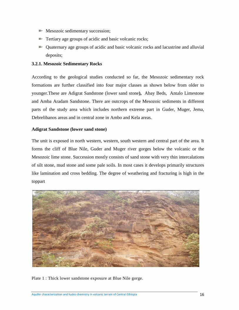
Adigrat Sandstone (lower sand stone)
The unit is exposed in north western, western, south western and central part of the area. It
forms the cliff of Blue Nile, Guder and Muger river gorges below the volcanic or the
Mesozoic lime stone. Succession mostly consists of sand stone with very thin intercalations
of silt stone, mud stone and some pale soils. In most cases it develops primarily structures
like lamination and cross bedding. The degree of weathering and fracturing is high in the
toppart
Plate 1 : Thick lower sandstone exposure at Blue Nile gorge.
Aquifer characterization and hydro chemistry in volcanic terrain of Central Ethiopia 17
Abay Beds (gohatsion formation)
This formation is mainly exposed in the northern, central and north eastern part of the study
area following the Blue Nile, Jema and Muger river valley forming steep slope cliff.
Assiged (2007) mentioned that the nature of the contact with overlying limestone is sharp
while with the underlying sand stone is gradational.
This formation composed mainly of gypsum and mud stone. There is an intercalation of
lime stone at the base and shale towards the top (Assiged, 2007). It is slightly too
moderately weathered and compact. The dominant types of rocks in this formation are mud
stone, silt stone and shale. However, there are multiple beds of different intercalations. It
exhibits high degree of weathering. The main structures are laminations, cross laminations,
ripple marks and bedding.
Lime stone (Antalo Lime stone)
[
This unit is exposed in the Northern, Northeastern, and Central and western parts of the
area. It is mainly out crop at the Blue Nile, Jema and Muger river valleys. Most of the time
lime stone forms cliffs. However at some places it shows gently sloping ridge. The contact
with the underlying mud stone formation is gradational which is marked by silt stone layers
followed by calcareous silt stone, silty lime stone and gradually to lime stone. However, the
contact with the underlying gypsum unit is sharp (Assiged, 20007). This formation is
characterized by alternating beds of Marl. There are also shale intercalations which are
frequent towards the bottom. At places, higher degree of weathering is observed, the
precipitation of the secondary materials such as calcite and silica are observed along
fractures and weak zones. Assiged (2007) mentioned that the petrography study indicated
that this lime stone has a range of texture from mud stone to wack stone and pack stone.
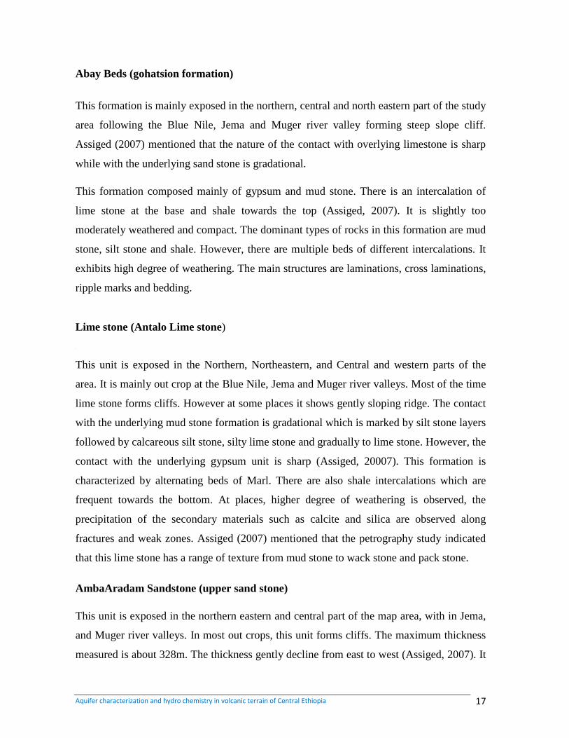
AmbaAradam Sandstone (upper sand stone)
This unit is exposed in the northern eastern and central part of the map area, with in Jema,
and Muger river valleys. In most out crops, this unit forms cliffs. The maximum thickness
measured is about 328m. The thickness gently decline from east to west (Assiged, 2007). It
Aquifer characterization and hydro chemistry in volcanic terrain of Central Ethiopia 18
has a sharp and unconformable contact with overlying basalt while with the underlying unit
it has gradational contact. The sand stone unit exhibits wide range of compositional
variation ranging from the top part yellow color, well stored, medium grained to red color,
conglomerate cross bedded sand stone at the middle. The bottom part is dominated by
jointed, fine grained white sand stone. This unit is slightly weathered at the top and highly
weathered at the bottom. In general it exhibits coarsening up ward sequence.
Plate 2: Contact between Tertiary volcanic and upper sandstone at Zigawedem river gorge.
3.2.2. Tertiary volcanic Rocks
Tertiary volcanic rocks are divided into Paleogene and Neogene age sequences.
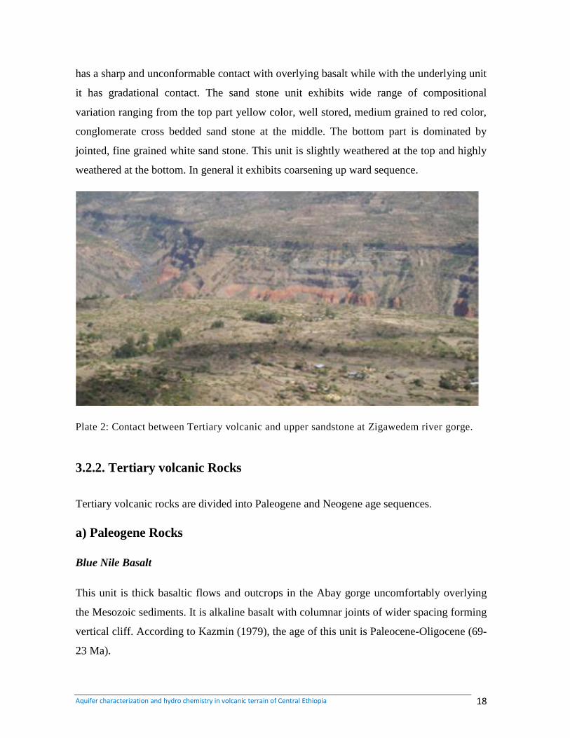
a) Paleogene Rocks
Blue Nile Basalt
This unit is thick basaltic flows and outcrops in the Abay gorge uncomfortably overlying
the Mesozoic sediments. It is alkaline basalt with columnar joints of wider spacing forming
vertical cliff. According to Kazmin (1979), the age of this unit is Paleocene-Oligocene (69-
23 Ma).
Aquifer characterization and hydro chemistry in volcanic terrain of Central Ethiopia 19
AmbaAiba Basalt
This unit is exposed in northern and central parts of the map area in river valleys and
canyons. It mainly forms steep slope cliffs and sometimes gentle slope. The contact with
the underlying sand stone is characterized by abrupt nature. On the other hand there is a red
limonite of 3 meter thickness at contact with the overlying pyroclastic (Assiged, 2006)
In this unit there is vertical compositional variation. The top of part is made up of columnar
Jointed, cliff forming, and relatively fresh aphanitic basalt. In general this basalt is
characterized by well-developed columnar Joints with hexagonal faces, and cliff forming.
The maximum thickness measured is about 350 meter around shenhea-cheka locality
(Assiged, 2007)
Ashangi Basalt
The Asangi basalt is exposed in the northern part of the area representing the oldest fis
sural flood basalt next to the Blue Nile basalt volcanism in the northwestern plateau. It is
strongly weathered, crushed and predominantly consisting of alkaline basalts with inter
bedded pyroclastic and rare rhyolites and is commonly injected by dolerite sills and dykes.
According to Kazmin (1979) the age of this unit is Eocene-Oligocene (55-24 Ma).
Alaji Rhyolite
This unit is exposed in the northern central part of the study area area. It is consisting of
rhyolites, ignimbrites and subordinate trachytes. Obsidian bearing rhyolites are common in
the study area. The obsidian composition at Segnogebeya area gives rise to the dark gray
color. The age of this rock unit is Miocene, 33-15Ma (Kazmin, 1979).
B) Neogene Rocks
Addis Ababa Basalt
Aquifer characterization and hydro chemistry in volcanic terrain of Central Ethiopia 20
This unit is mapped by Kebede and Tadess (1990) at 1:25,000 scales and the basalts area
classified in to different units based on their texture and compositions. For the purpose of
the present mapping scale they are mapped as one unit. This unit is fine to coarse grained
basalt composed of olivine and plagioclase phenocrysts. In most part of the outcropped
area it is relatively thin (20m) lava flow overlying the ignimbrite. The age of the Addis
Ababa basalt is 7.5-4.5 Ma (Chernet et al. 1998 and Morton et al. 1979).
Addis Ababa Ignimbrite
This Ignimbrite is outcropped in most part of the plane area around Addis Ababa and the
Becho plane. It is composed of welded tuff (ignimbrite) and non-welded pyroclastics fall
(Ash and tuff). It is grayish to white color and when welded it exhibits fiamme textures,
elongated rock fragments of various color. Around the Legadadi plane and melka kunture
area the thickness of this unit reaches up to 200m (exploration drill data). In the Becho
plane area it is covered by thin 5-7m thick residual soil developed from the same rock. The
age of this unit is 5.11-3.26 Ma (Morton et al. 1979).
Nazeret Unit
This unit is mainly exposed in the southeastern part of the area mapped area and forms rift
floor. It consists of a sequence of welded per alkaline rhyolitic ignimbrite. The unit
comprises numerous rhyolitic and trachytic domes. Rock fragments and crystals, generally
broken, are abundant; alkali feldspars, quartz and amphiboles are the most common
crystals. The age of this unit is 5.4 to 3.11 Ma (Morton et al. 1979).
Akaki Basalt
This unit is outcropped at Daleti, Abasamuel Dam, Akaki and Dukem area. It is coarse
grained porphyritic olivine basalt. It is highly vesicular basalt and at places the vesicles
were filled by carbonate minerals. It is consisting of scoria and spatter cones with
associated lava flows. Both the basalt and scoria is quarried for construction around Akaki
and Dukem area. The thickness of this unit around Akaki is 202m (exploration drilling
data). The age of the Akaki basalt is 2.9-2.0 Ma (Chernet et al. 1998 and Morton et al,
1979).
Aquifer characterization and hydro chemistry in volcanic terrain of Central Ethiopia 21
Olivine- plagioclasephyric basalt (TarmaberMegzezebasalt)
This basalt is exposed in southern, central, and northern part of the map area. It mainly
forms gentle slope plateau lands resulted from fissural eruption. In some localities
extensive ridges and mountains (such as Cheleka Mountains and chilmo) are also observed.
It is observed to overlying uncomfortably over upper sand stone and conformably on the
lower ignimbrite. It exhibits stratified layers with varies compositions and structures. The
layers are fine to very coarse grained, aphanitic to porphyritic and sometimes very coarse
grained porphyritic and vesicular basalt, intense fracturing, columnar jointing and spheroid
weathering are very common features.
C) Central Volcanoes Unit
Entoto Rhyolite and trachyte
The Entoto mixed rocks are found in the southern eastern part of map area. This unit
constitutes rhyolite, trachyte, ignimbrite, pyroclastic rocks and sediments. All the rocks are
highly weathered and jointed with few layers of agglomerate at some places. There is a red
backed soil development at the contact with the under lying basalt. This lithological unit is
highly affected by joints trending E-W and N 29o. It forms high mountain chain called
Entoto trending E-W (Assiged, 2007)
Aphanitic to medium grained vesicular Trachyte (Wechecha-Furi-yere Trachyte and
Trachy basalt).
This formation is exposed in south western and south eastern part of the map area. It is
found over lying tertiary basalt marked by a thick paleosoil and it is also occurred by
forming big mountains such as Furi, wechecha and yerer. It has aphanitic to medium
grained texture with vesicular varieties mostly at it is lower part. Mostly the trachyte and
the trachy basalt are found alternatively layered with the trachyte being dominant. At its
lower part it shows columnar jointing and is affected by two sets of joints (Assiged, 2007).
Tulu Rie Basalt
Aquifer characterization and hydro chemistry in volcanic terrain of Central Ethiopia 22
This unit is outcropped in the southeastern part of the mapped area and forms NE trending
escarpments. It is lava flow coarse grained basalt with olivine and plagioclase phenocrysts
with rare clinopyroxene. The age of this rock is 2.7 to 1.44 Ma.
Chefa Donsa Unit
The ChefaDonsa volcanic rocks units are outcropped at the east, north east, south and west
extreme parts of Debrezeyt. They are consisting of fall deposits (ash, tuff and pumice) and
poorly welded ignimbrites of rhyolitic composition. At places in the Dukem and Mojo river
valleys they are observed under the lacustrine deposit. The age of this unit ranges 2.24 to
1.71 Ma (Morton et al. 1979). This unit is covered by patches of Quaternary olivine basalt.
3.2.3. Quaternary volcanic rock and sediments
3.2.3.1. Quaternary Volcanic rocks
This unit is exposed in south eastern and north eastern part of map area. The southern part
is dominantly olivine basalt. In most case out crops in boulder form, vesicles filled by
secondary materials area observed. It forms mainly ridges with maximum thickness
measured about 50 meters (Assiged, 2007).
The northern part is dominantly trachyte and trachy basalt having aphanitic and porphyritic
texture. It is exposed forming topographically high domes and stains at Gara, Guda,
Degeem and yabeno. In this unit, sheeted and layered flow structure is observed at the top
of the dome and it‟s oriented in E-W direction. With shallow dip angle (22o/35
0) (Assiged,
2006).
Weliso Ambo Basalts
This unit is outcropped at the western and northern extreme parts of the mapped area. It is a
lava flow composed of porphyritic basalt with large crystals of plagioclase, olivine and
pyroxene, basalt breccia‟s and minor tuff. In the area of Weliso it is scoraceous basalt.
Aquifer characterization and hydro chemistry in volcanic terrain of Central Ethiopia 23
Ziquala Trachyte
Ziquala trachyte is isolated, well preserved cone standing about 1300m from the
surrounding plane area, located in the southern part of the study area. It has a summit
caldera 1.5 km wide and partially filled by water. The Ziquala trachyte is coarse grained
and petro graphically composed of an orthoclase, sanadine, minor clinopyroxene,
phenocrysts and glassy alkali feldspar groundmass. The age of the Ziquala trachyte is 1.28-
0.85 Ma (Morton et al., 1979).
Bede Gebaba Volcano Units
This unit is a circular volcanic complex outcropped north of the Ziquala Mountain with
maximum elevation of 400m above the surrounding plane. Its morphology dominated by
the occurrence of several coalescent caldera structures. Spatter cones and basaltic lava
flows belonging to younger Bishoftu Volcanics are present in the central part of the
volcanic complex. Pumice and lavas show a composition ranging from rhyolites to minor
trachyte. According to Gasperon et al (1993), the lava contains microphenocrysts and rare
phenocrysts and quartz as well as scattered plagioclase and clinopyroxene set in glassy to
microcrystalline groundmass.
Bishoftu Volcanic Unit
[[[[[[[[
This unit forms a NNE trending belt outcropping mainly in the central flat areas of
Debrezeyt. In the Bishoftu Volcanic spatter and cinder cones with associated tabular
basaltic lavas flows and phreatomagmatic deposits are distinguished. The basalt is vesicular
and coarse grained with olivine phenocrysts. The phreatomagmatic deposits are mainly
consisting of surges and highly fragmented deposits associated with maars and tuff ring.
3. 2.3.2. Quaternary Lacustrine and Alluvial Deposits
Lacustrine Deposits
The lacustrine deposit is particularly distinguished in the Adaa plain of the Lakes region.
They are fine grained deposits, thinly stratified and often contained volcanic matrix; whose
Aquifer characterization and hydro chemistry in volcanic terrain of Central Ethiopia 24
thickness ranges from 5 to 8m. More thickness is reported in the groundwater well drilling
reports. In these successions volcanic layers are frequent and become predominant and
coarse grained near by the maars.
Alluvial Cover
The alluvial cover mainly out cropped above the Tertiary Volcanics on the plateaus and
Becho Plain and the alluvial unit is deposited in northern, north eastern and western parts
of the study area along Jema, and Muger river valleys. Its texture varies from sand to silt
size.
Aquifer characterization and hydro chemistry in volcanic terrain of Central Ethiopia 25
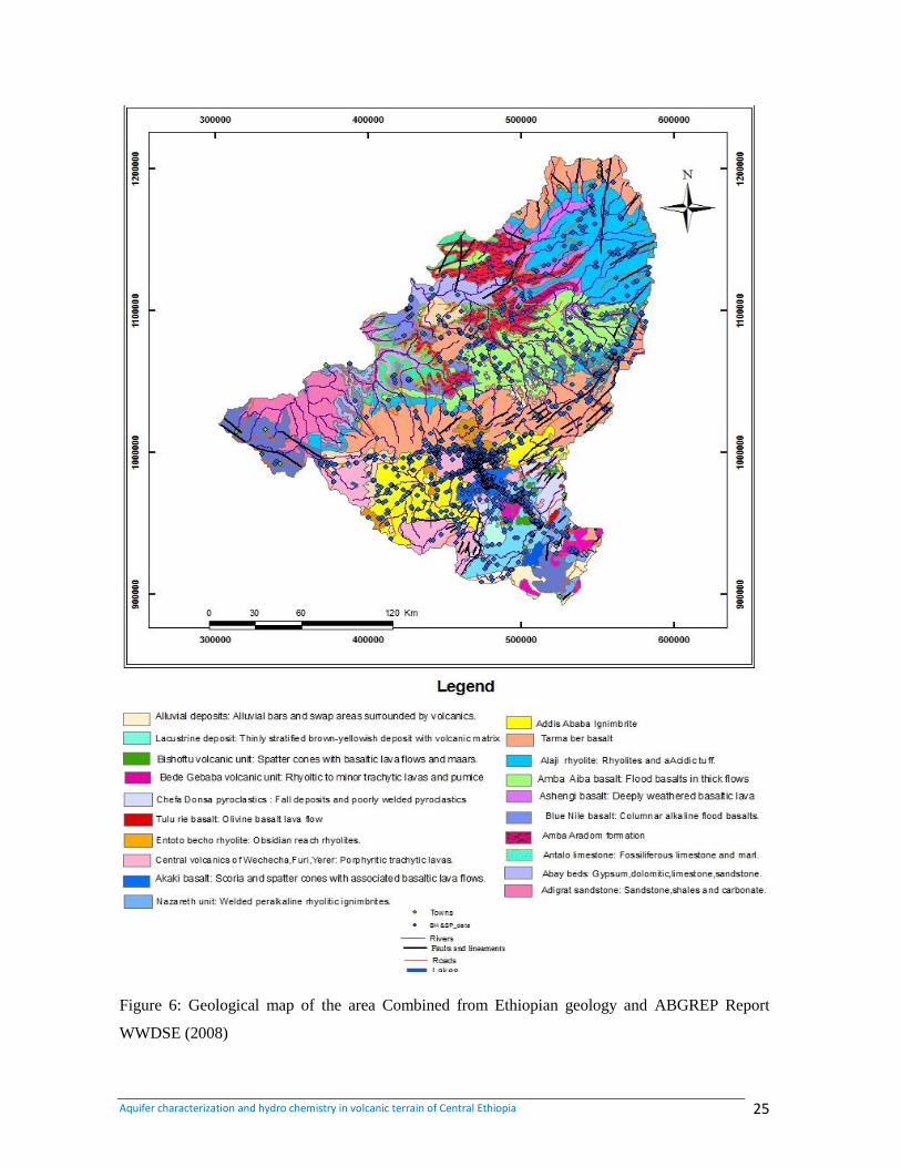
Figure 6: Geological map of the area Combined from Ethiopian geology and ABGREP Report
WWDSE (2008)
Aquifer characterization and hydro chemistry in volcanic terrain of Central Ethiopia 26
CHAPTER 4
HYDROGEOLOGY
Hydrogeology can be defined as the study of ground water with particular emphasis given
to its chemistry, mode of circulation and relation to geology environment (Davis &
DeWiest, 1996). The occurrence of ground water is mainly influenced by lithology,
geological structures, and geomorphology and climate conditions. Lithology, geological
structures and geomorphologic setting of the area strongly influence the quantity, quality
and movement of groundwater. Since the climate condition throughout the area seems
uniform, it has the same effect through the entire area. The geology of the area provides
usable ground water and good transmission of rainfall to recharge aquifers, which produce
springs and feed perennial rivers. Fractures, joints and weathering surfaces of different
lithological units play a vital role in facilitating the infiltration amount and rate and also
ground water flow.
The majority of productive aquifers are characterized by their high degree of weathering
and intense fracturing. Fractured volcanic rocks and karst limestone are the major potential
rock units for storage and movement of ground water. In addition, the intergranular pour
spaces of sandstone and alluvium also have significant role in occurrence of ground water.
The main recharge for ground water of the area is precipitation, although surface water and
Perennial River and streams are also act as local recharges.
4.1 Hydro Geological Classification /Characterization
The classifications of different lithological units are made based on hydro geological
characterization of various rock types. This classification is also based on existing data.
This study used the qualitative and quantitative parameter to classify the hydro geological
unites in to aquifer/aquitards system. Since the quantitative parameters such as
permeability, transmissivity, aquifer thickness and yield are not sufficient to make
classifications, it is obligatory to assess the qualitative parameters in order to achieve on
Aquifer characterization and hydro chemistry in volcanic terrain of Central Ethiopia 27
complete classification. The qualitative classification is based on the ground water point
data and pump test data, the major hydro geological units are characterization into pours,
fissured and/or karst permeability and impermeability rocks.
4.1.1 Qualitative Parameters
Hydro geological units with porous permeability
The ground water is available in the porous of unconsolidated sediments. The quaternary
alluvium and Mesozoic sand stone represent dominantly the porous materials. The ground
water availability and flow is mostly dependent on grain size, sorting, cementing material
and thickness of deposition.
Hydro geological units with fissured permeability
Most of the tertiary volcanic and Mesozoic limestone has fissured characteristics of
permeability. The weathered and fractured surfaces play a significant role in ground water
accumulation and flow. Majority of the tertiary volcanic are highly jointed and fractured
but they are filled by secondary filling materials, which are a barrier for ground water flow.
The lime stone of the study area has dominant character of karst permeability. Fractures
and joints of limestone though dissolution of minerals by water lead to the karst formation.
The degree of interconnection and the type of karstifcation tends to influence occurrence
and flow of ground water.
Hydro geological units with impermeable nature
The fresh, massive and very limited fractures surfaces give the very low permeability and
limited ground water occurrence characteristics. Mesozoic sediments of Mugger mudstone,
siltstone and Gohatsion formation have such characteristics.
4.1.2. Quantitative Parameters
The quantitative data division of lithological units is based on the hydrogeological
characteristics of various rock types, such as permeability, aquifer thickness and yield
obtained from different organizations.
Aquifer characterization and hydro chemistry in volcanic terrain of Central Ethiopia 28
4.2. Aquifer classification of the area
Based on the above qualitative and quantitative hydrological criteria and geomorphologic
setting the different lithological units are classified in the following aquifer and aquiclud
system.
4.2.1. Extensive and highly productive porous aquifer
This hydrological unit is exposed in the Blue Nile and Guder River gorges localized
western the study area. E.g Mesozoic sand stone, the lower sand stone occurs by forming
cliffs on the escarpment of Blue Nile and Guder River as well as their tributaries. While the
Paleozoic sand stone forms gently sloping and undulating terrain inside the gorges. The
hydraulic property of this aquifer is mainly characterized by the thickness of variation of
the formation, grain assortment and size, cementing material, the availability of primary
pour spaces, extent and degree of weathering and also the presence of well-developed
fractures. Mesozoic sand stone possess both primary and secondary permeability for
ground water movement and occurrence. The main water bearing horizon is constituted by
interstitial spaces. In addition, the ground water occurrence and movement is governed by
secondary fractures and joints which enhanced the porosity and permeability. However, in
some places precipitates from percolating water readily close such pour spaces and reduces
the permeability of the aquifers. In the study area the bedding plains of Mesozoic sand
stone are dipping towards flow direction of rivers and gorges, where many springs follow
such pattern. The presence of conglomeratic layers in the lower sand stone indicates as
positive impact on the hydraulic property of the aquifer. According to GSE this formation
has ranges of aquifer parameters of: T=100-500 m2/d, Q=5-25l/s.
4.2.2. Extensive and Highly Productive Fissured and Karast Aquifer
This hydro geological unit is localized in northwestern and western parts of the map area at
Blue Nile, Guder, and Mugger River valleys (E.g. Antalo lime stone). The Antalo
limestone possess both primary and secondary porosities but the productivity of this unites
is highly dependent on the secondary porosity (fractures). Fractures, joints and karsts are
the common features. That plays a significant role in ground water occurrence and
Aquifer characterization and hydro chemistry in volcanic terrain of Central Ethiopia 29
movement. The surface of Antalo limestone is the study area is highly fractured and jointed
and they are sources of several springs.
Circulation of water through these fractures and joints enlarges the openings increase
permeability and tends to create karast features. Thus the development of karst is the result
of solution and leaching of lime stone through interaction by acidic rain water. These
cavities found below the water table yield. Permanent springs with good discharge. The
Antalo lime stone forms deep aquifers in the gorges of Jema and Muger, through karst goes
to deeper. However, there are springs emerging in hill side of Jema and Muger gorges
through fractures and at the contact with shale or underling gypsum (T= 50-100 m2/d Q=2-
5 l/s).
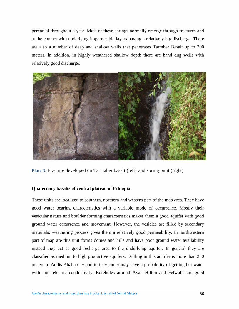
4.2.3. Extensive and Highly Productive Fissured Aquifer
(Olivine –plagioclase phyric basalt (Tarmaber basalt)
Quaternary basalts of central Ethiopia
This aquifer is exposed in central, northern and southern plateau and covers most part of
the study area. It forms plateau and undulating terrain with elevated ridges, central
volcanoes. This formation has T=100-500 m2/d, Q=5-25 l/s.
Olivine_ plagioclase physical basalt (Tarmabermegzeze basalt)
This unit possesses very good secondary porosity and permeability. The scoraceous lava
flow nature of unit is highly favorable for ground water storage and movement. The
permeability is highly dependent on the degree and depth of fracturing and occurrence of
joints development on Tarmaber basalt gives to the good hydraulic property of the aquifer.
Most fractures due to faulting are responsible for emerging of many springs. In some places
the development of thick soil act as good recharging media to his aquifer by hold the
precipitating water which will percolate later through fractures to the aquifer. Columnar
joints developed on Tarmaber basalt act as ground water discharge features at topographic
breaks when enhanced by weathering. The vesicular and scoraceous nature of this basalt
gives to its high water bearing characteristics. The ground water manifestation of this
aquifer occurs as spring, borehole, and dug well. The springs from this aquifer are almost
Aquifer characterization and hydro chemistry in volcanic terrain of Central Ethiopia 30
perennial throughout a year. Most of these springs normally emerge through fractures and
at the contact with underlying impermeable layers having a relatively big discharge. There
are also a number of deep and shallow wells that penetrates Tarmber Basalt up to 200
meters. In addition, in highly weathered shallow depth there are hand dug wells with
relatively good discharge.
Plate 3: Fracture developed on Tarmaber basalt (left) and spring on it (right)
Quaternary basalts of central plateau of Ethiopia
These units are localized to southern, northern and western part of the map area. They have
good water bearing characteristics with a variable mode of occurrence. Mostly their
vesicular nature and boulder forming characteristics makes them a good aquifer with good
ground water occurrence and movement. However, the vesicles are filled by secondary
materials; weathering process gives them a relatively good permeability. In northwestern
part of map are this unit forms domes and hills and have poor ground water availability
instead they act as good recharge area to the underlying aquifer. In general they are
classified as medium to high productive aquifers. Drilling in this aquifer is more than 250
meters in Addis Ababa city and to its vicinity may have a probability of getting hot water
with high electric conductivity. Boreholes around Ayat, Hilton and Felwuha are good
Aquifer characterization and hydro chemistry in volcanic terrain of Central Ethiopia 31
representatives for such phenomena. This aquifer is recharged by direct perception and
small rivers and its recharge the under lying ignimbrite.
4.2.4. Extensive and Moderately Productive Porous Aquifer
This hydro geological unit exposed by scattering in the northern, eastern, central, western
and southern part of the area. The formation has (T=50-100 m2/d, Q=2-5 l/s) (GSE report).
It comprises:
Quaternary deposit (alluvium and Elluvium)
Upper sand stone
Quaternary deposits
The Quaternary alluvium is exposed along the river valleys of Jema, and muger and also in
old river depressions, at the base of mountains. This unit is one of the most important
sources of shallow ground water. It has relatively good permeability and productivity, since
the texture ranges from sand to coarse gravel with loose and undifferentiated grains. The
alluvial sediments are mostly recharged by infiltration from perennial rivers and streams. In
some places the grains of the sediments show poor sorting resulting in a very low
productivity. The alluvial fans at the bottom of mountains show good porosity and
permeability and are extracted by shallow dug wells for community water supply. The
permeability porosity and their thickness of the alluvial fans decrease away from the
mountain. There are a number of dug wells and few shallow wells drilled these units for the
purpose of community water supply. There are also some perennial springs emerging from
the alluvium depositions at salayish locality inside Jema River gorge having discharge 5 l/s.
The elluival soils of the plateau are represented by silty to clay soil. There are numerous
dug wells that gain water from these units but during dry seasons the water level of dug
wells will decrease and become dry, due to the evaporation of shallow ground water.
Amba Aradam Sand stone (Upper sand stone)
This hydro geological unit is situated in deep gorge of Jema, and Muger rivers. It has both
primary and secondary porosities. But the main water bearing part is constituted by
interstitial spaces. It is holding capacity is determined by the degree of consolidation and
Aquifer characterization and hydro chemistry in volcanic terrain of Central Ethiopia 32
assortment, grain size and cementation. This joint does not have important role in the
occurrence and movement of ground water due to the presence of infilling secondary
materials and poor interconnection. The recharge from the overlying tertiary volcanic rocks
percolated through the pours of the interstices and emerges as spring at the contact with the
underlying Muger mud stone. Most of the ground water points are springs that come out at
the contact with impermeable mud stone. There were neither shallow nor deep wells. This
reason could be due to the rugged topographic and cliff forming nature of the unit.
4.2.5. Extensive and Moderately Productive Fissured Aquifer
This unit is exposed in south eastern, north eastern and western part of the map. It forms
plateau and localized ridges in the south eastern and cliffs in the escarpment of gorges.
These formation has (T=50-100 m2/d Q=2-5 l/s).
Aiba Abia basalt
Lower ignimbrite
Aphanitic to medium grained vesicular trachyte and trachy basalt
AbiaAbiaBasalt
The intensive fracturing and highly weathered surface are major features for ground water
bearing character of this aquifer. The vertical joints with hexagonal faces are enhanced by
irregular sets of fractures which facilitate the ground water flow. Potential yield of this
aquifer varies throughout its out crop. This is due to the variation in the frequency, intensity
and distribution of the fracturing system. In addition, mode of occurrence and topographic
setting also affects the yield of many springs within this effects the yield of many springs
within this aquifer.
However, there are primary porosities such as vesicles and cracking joints the permeability
would be very low and have very little role in ground occurrence and movement. This is
due to the poor interconnection of vesicles which will reduce the ground water movement
and occurrence. So the primary porosity of abia basalt has very little input in the
productivity of the aquifer. However, in some places the cracking joints are enhanced by
Aquifer characterization and hydro chemistry in volcanic terrain of Central Ethiopia 33
weathering and fractures with farther increased the vertical permeability. Such phenomena
lead to the availability of few springs at river canyons and gorges. Spring at Wedenbi
Ensarro locality with dry season discharge of 2.5 l/s emerged from columnar cracking
joints and weathered surface is a good example. The potential water bearing horizon of this
unit is concentrated to the fractured and weathered surfaces. Springs at locality of Dahana,
Jegolo Gendeberet and CisoAbabuGuduru are resulted from such phenomena. Most of the
springs emerge through these fractures at the topographic breaks.
Aphanitic to medumgraind vesicular trachyte and trachy basalt (wechecha-yere-foru
trachyte and tracky basalt) /lower ignimbrite
This unit is localized to wechecha and yerer are forming ridges and domes. The hydraulic
conductivity, permeability and storativity of this unit are very low, since there are no well-
developed fractures and joints that are use full for ground water occurrence. But, there are
springs at Wechech Mountain with mean dry season discharge of 2.7 l /s. The ignimbrite
layer, most of the time covers the plateau area and acts as a confine layers for the
underlying basalt aquifer. Many deep wells penetrate this unit shows massive and poorly
fractured lithology. But, very near to the ridges and domes, the thickness of the formation
increases and it may be difficult to penetrate in to deeper aquifers. The qualitative and
quantitative evaluation shows moderate permeability and water bearing capacity.
4.2.6. Low Productive Aquifer
This aquifer comprises:
Inter layers of ignimbrite, welded tuff & Ash
Entoto rhyolite &trachyte
Aphanitic to porphyritic trachyte
These hydro geological units are localized to southern part of the study area at Entoto
locality, north of Addis Ababa. These formation have T=1-10 m2/d and Q=0.05 l/s. It forms
steep slope ridges and a relatively localized flat terrain .This unit is highly weathered at the
top part while massive and fresh at the lower part. But occasionally vertically developed
fractures are seen in rhyolite and trachyte inters beds. This fracture in combination with
weathering surface tends to give the water bearing characteristics of the aquifer. In some
Aquifer characterization and hydro chemistry in volcanic terrain of Central Ethiopia 34
places the occurrence of tuff interconnection holds water from precipitation and leads to the
appearance of spring with low yield through the pore space. The discharges of springs from
this aquifer at localities of Entoto Mariam, Gebrechefie and Yenguswuha range from 0.5 to
0.05 l/s.
There are also a number of springs with relatively small discharge coming out through
fractures and weathered part of rhyolite and trachyte. Almost all springs are located on hill
side and emerged as topographic break. Most of the precipitating water leaves the area as
run off with very little infiltration due to the sleep slope topographic nature of the Entoto
ridge. As result, there is little ground water stored except the appearance of small yielding
springs.
This low productivity aquifer serves as a recharge zone to the Addis Ababa city aquifers
(quaternary and tertiary basalt and lower Ignimbrite). But at the foot of the ridge there is a
possibility of ground water occurrence along the manifestation of NS fault line. The
borehole drilled along these faults have an artesian nature with very high yield of 100 l/s
(reported by WWDSE; 2008, Ada Becho ground water potential evaluation project). Since
the well has multi layered aquifer, the probable main aquifer would be the underling basalt.
But, the tendency of drilling anther bore hole could be risky due to the topographic setting
and shallow circulation of ground water. In general these units act as both recharge and
discharge area. However it‟s recharging characteristics to the surrounding aquifer is more
significant and act as a surface water divide between Blue Bile and Awash basins.
4.2.7. Aquiqulid
This unite is exposed in the western, north western, central and south eastern part of the
study area. The hydraulic properties, permeability and transmissivity of this unit are very
poor, since there are no well-developed fractures and dissolution cavities that are useful for
ground water occurrence. But, it acts as in permeable layer and responsibility for
occurrence of the springs at the contact with overlying limestone in Muger gorge and its
tributaries. It comprised of Abay beds, Chefe Donsa Pyroclastics and Nazareth unit
(Welded ignimbrites).
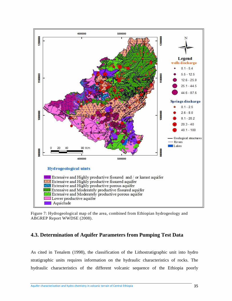
Aquifer characterization and hydro chemistry in volcanic terrain of Central Ethiopia 35
Figure 7: Hydrogeological map of the area, combined from Ethiopian hydrogeology and
ABGREP Report WWDSE (2008).
4.3. Determination of Aquifer Parameters from Pumping Test Data
As cited in Tenalem (1998), the classification of the Lithostratigraphic unit into hydro
stratigraphic units requires information on the hydraulic characteristics of rocks. The
hydraulic characteristics of the different volcanic sequence of the Ethiopia poorly
Aquifer characterization and hydro chemistry in volcanic terrain of Central Ethiopia 36
understood. Data on specific capacity and transmissivity values have been obtained from
existing boreholes.
Transmissivity of an aquifer measures how much water can be transmitted horizontally. It
is the product of the hydraulic conductivity times and the thickness of the aquifer (Driscoll,
1986).Transmissivity (T) is a hydraulic parameter of an aquifer that is known employed in
most groundwater flow equations to understand the flow dynamics and is generally
estimated from pumping tests (Freeze & Cherry, 1979). Spatially variable aquifer
parameters are often available, yet appropriate data that covers wide area uniformly are
lacking due to the fact that the cost of performing a large number of aquifer tests is
relatively expensive and time consuming. Thus, simple and inexpensive parameter
estimation methods that may cover extensive areas are often preferred.
In fact such approaches require quantification of one or more easily measurable aquifer
parameters. One such aquifer parameter that is easy to measure is the specific capacity (Sc)
of a well, which is the ratio of pumping rate (Q) to drawdown (s) in the well. The fact that
Sc is correlated with hydraulic-flow properties (Theis, 1963) can simplify parameter
estimation mainly because Sc values are more abundant in groundwater databases than
values of T or hydraulic conductivity (K), and offer another approach to estimate hydraulic
parameters of aquifers. Most of the formation shows a wide variation in transmissivity
values. These variations indicate complex geological and hydro geological situation of the
area. The volcanic sequence of the area exhibits a similar wide range of variation in
transmissivity. Because of variations in the degree of fracturing a marked heterogeneity in
aquifer characteristics exists both laterally and with depth in the study area.
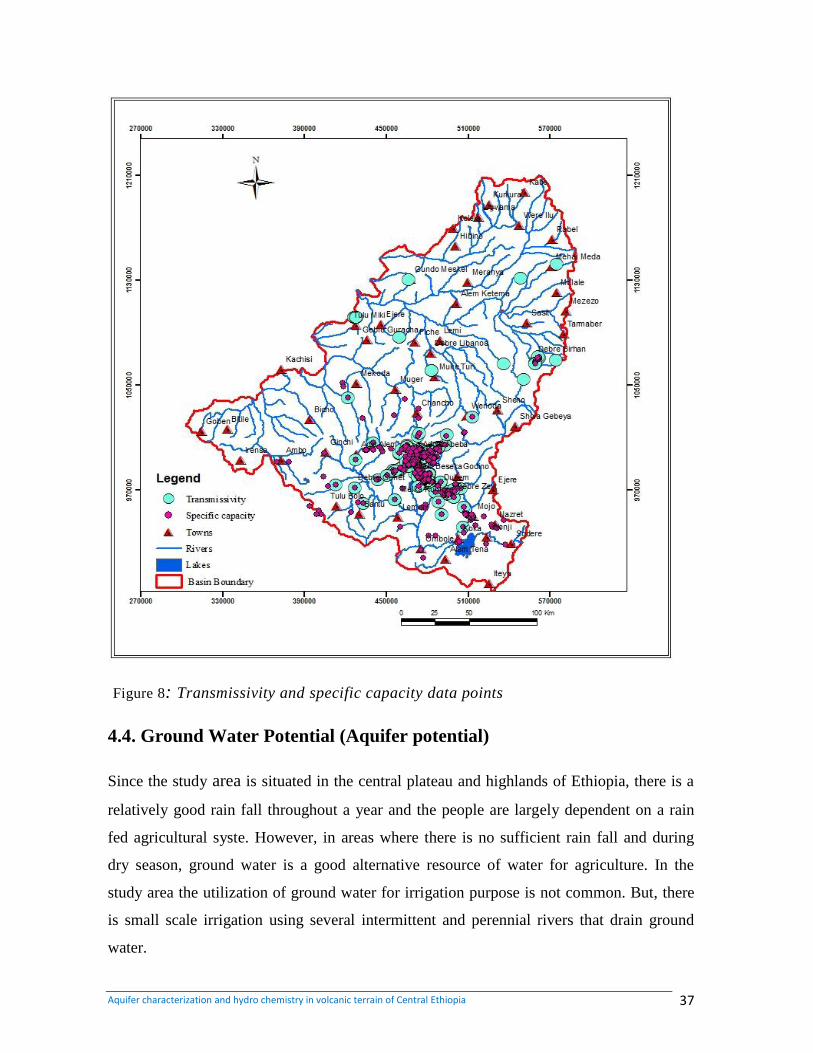
Aquifer characterization and hydro chemistry in volcanic terrain of Central Ethiopia 37
Figure 8: Transmissivity and specific capacity data points
4.4. Ground Water Potential (Aquifer potential)
Since the study area is situated in the central plateau and highlands of Ethiopia, there is a
relatively good rain fall throughout a year and the people are largely dependent on a rain
fed agricultural syste. However, in areas where there is no sufficient rain fall and during
dry season, ground water is a good alternative resource of water for agriculture. In the
study area the utilization of ground water for irrigation purpose is not common. But, there
is small scale irrigation using several intermittent and perennial rivers that drain ground
water.
Aquifer characterization and hydro chemistry in volcanic terrain of Central Ethiopia 38
It is also hard to say the development of ground water for community water supply is
sufficient. There is a shortage in community water supply even in towns. There fore it is
better the ground water potential in terms of hand dug wells, drilled deep wells and spring
development.
Potential of aquifer in Sedimentary Rocks should be done by spring development. Since
this aquifers and sand stone and lime stone are out cropped in deep gorges of rivers and
occur as ridges. Potential of aquifers in volcanic Rocks are mainly based on spring
development drilling of shallow and deep well. Spring development is best in the areas
where there is appearance of spring due to topographic break. Development of Aquifers in
Alluvial/ Eluvium sediment is mainly based on hand dug wells and shallow wells. The
alluvium and windiest of deep gorges and the alluvium deposition of the plateau area are
drained by direct precipitation, recharge from small intermittent and perennial streams. The
ground water circulation in this aquifer is shallow. So digging of hand dug wells is the best
way for small community water supply.
4.5. Hydrogeological Structures
Structural features, such as fractures, joints and faults, the geometrical properties of the
geologic system produced by deformation or crystallization (Freeze, 1979), may provide
secondary hydrological properties to the various rock bodies, notably increased water
transmissivity .
The hydrological structure describes the configuration of aquifers within the geological
environment. It determines the ground water circulation from the recharge area, along
percolation and circulation pathways (ground water reservoir) to the drainage area. The
North part of the area is structurally simple and occasionally tectonized whereas the
southern part of the counry is highly tectonized and is complex in structure since its
vicinity to the main Ethiopia Rift margin. The main structures encountered in the area are
Faults Joints, Lineaments and dikes.
Aquifer characterization and hydro chemistry in volcanic terrain of Central Ethiopia 39
Faults
There are few normal faults in the area. They are mainly found in north eastern, north
western and southern part of the area. The dominant faults are those associated with the
MER trending NE-SW faults. They are also N-S and S-W faults. They cut Mesozoic,
sedimentary and tertiary Basalts. The NE-SW and N-S faults are act as good ground water
conduits in the north western and southern part the study area.
Lineament
The major lineaments in the study area trend NE-SW lineaments being dominant in the
area and they are parallel to the structures of the rift or the rift margin. Most of the
lineaments follow trend of linear of ridges, mountains and mainly river valleys and streams.
The length of lineaments varies from few meters to about 12km. (Assiged, 2006; Matebie
meten et al. 2007).
Joints
Joints are widely observed in tertiary basalts and upper sand stone. The E-W and NW
trending joints are more common on the upper sand stone. Most of the joints are filled by
secondary material such as calcite, iron oxide and silica and feldspar. The occurrence of
many springs at the foot of the former and thermal water along the latter may indicate the
conductive nature of this fault.
Dykes
These features are more observable in northern and central part of the area cutting the
basalt Mesozoic unites. They are parallel and oriented in the NE direction with maximum
width about 2 meters (Assiged, 2006). Its composition varies from pyroxene phyric to
aphanitic and vesicular basalt. In general, dykes are barrier to ground water circulation but
in relative term, the surface of basic dykes is fractured and slightly weathered. As
aftermath, dykes may have some contribution for ground water circulation.
Aquifer characterization and hydro chemistry in volcanic terrain of Central Ethiopia 40
4.6. Aspects of groundwater recharge and discharge
4.6.1. Ground Water Recharge
The major source of recharge to the ground water is highly sloping plains of the study area.
In addition, different perennial rivers and streams of the area recharge the local ground
water. Most of the hand dug wells and shallow wells placed along the rivers and streams
are recharged by such condition in dry season. The locality deposited alluvium along the
Jema and Muger Rivers are recharged by corresponding Rivers. The highly elevated areas
of Entoto, wechecha, chilmo, chelelka and other locally developed ridges are the possible
source of recharges to the ground water of adjacent plateau and hill foot aquifers.
There are three types of recharge
Direct recharge: water added to the groundwater reservoir in excess of soil moisture deficit
sand evapotranspiration, by direct vertical percolation of precipitation through the
unsaturated zone.
Indirect recharge: it is percolation to the water table following runoff and localization in
Joints, as ponding in low lying areas or through the beds of surface water sources such as
Rivers, Lakes and Reservoirs.
Localized recharge: resulting from horizontal surface concentrations of water in the
absence of well-defined channels.
Assessment of the mechanism and amount of recharge is fundamental for sustainable
groundwater resources utilization and management. However, estimating the different
recharge processes is not simple. It requires understanding the various processes that affect
recharge and quantifying the spatial and temporal variability. Unfortunately, there is no
direct means of measuring groundwater recharge at regional and sub-regional level.
Recharge estimation requires accounting the different factors. These include:
Topography and geology
Precipitation (intensity, duration, spatial distribution)
Runoff and ponding of water
Aquifer characterization and hydro chemistry in volcanic terrain of Central Ethiopia 41
Rivers (rivers flowing into and leaving out of the area under consideration, rivers
Gaining water from or losing water to the aquifer, etc.).
Soil zone (nature of the soil, depth, hydraulic parameters, variability of the spatially
and with depth, rooting depth of the soil, and cracking of soil on drying out or
swelling due to wetting)
Unsaturated zones between soil and aquifer (flow mechanism through unsaturated
zone, zones with different hydraulic conductivity, etc.)
Ability of aquifer to accept water and variation of aquifer condition with time
All the three types of recharge can be identified in the region. However, direct recharge
and indirect recharge from rivers are the most important ones.
4.6.2. Ground Water Discharge
Ground water discharge areas are located on gently sloping and undulating plateau, inter
mountain depression and at the middle and bottom of high cliffs of deep gorges. In most
places, the ground water discharge areas are indicated by the appearance of springs. A lot
of springs emerge at the weathered and fractured parts of topographic break, inter mountain
depressions and high cliff of deep gorges. It is observed that the discharge of this
groundwater is due to the presence of thin impermeable layers in the middle or the
discharge top parts of ridges different, in hydraulic conductivity resulting from lithological
variation along cliff variation in the extent of weathering of the same rock along cliff and
variation in degree and extent of fracturing. Generally, low areas can be considered as
discharge area. But, there also some exceptions such as in highly elevated Entoto ridges
where the appearance of springs is common. This is most probable due to the above
mentioned reasons. So it should be emphasized that the topographically of this ground
water is due to the presence of thin impermeable layers in the middle or elevated ridges can
also act as discharge areas in addition to their recharge media.
Discharge map (fig 10) for different aquifers based on the analysis of existing data as well
as those gathered for the research. The data for characterization of aquifers requires
intensive data collection on: lithology, static and dynamic water levels, screen leangth, total
draw dawn, etc. for the confined and semi confined aquifers.
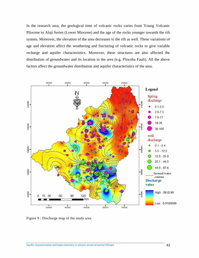
Aquifer characterization and hydro chemistry in volcanic terrain of Central Ethiopia 42
In the research area, the geological time of volcanic rocks varies from Young Volcanic
Pliocene to Alaji Series (Lower Miocene) and the age of the rocks younger towards the rift
system. Moreover, the elevation of the area decreases to the rift as well. These variations of
age and elevation affect the weathering and fracturing of volcanic rocks to give variable
recharge and aquifer characteristics. Moreover, these structures are also affected the
distribution of groundwater and its location in the area (e.g. Fliwoha Fault). All the above
factors affect the groundwater distribution and aquifer characteristics of the area.
Figure 9 : Discharge map of the study area
Aquifer characterization and hydro chemistry in volcanic terrain of Central Ethiopia 43
Some important water points
A total of 1152 water points out of which 879 boreholes, 269 springs and foure surface
waters are found in the study area. (Annex 2)
Springs
Most of the springs are located at hill side of deep gorges and ridges and slop breaks of
undulating plateau. However, they are also some springs located at the flat land. The
springs of the area are dominantly depression and fracture type. There are also springs with
contact and karst nature. In most places the occurrence of springs follows the NE-SW and
N-S trending faults and lineaments. They are found almost all types of lithologic unit with
high variation in discharge. In the Hydro geological Reports of Addis Ababa map sheet
NC-10 (2010), field inventory and reported data shows that the discharge in dry season
period shows wide variation ranging between 0.05-35 l/s on basaltic aquifers, 0.01-1.5 l/s
on ignimbrite, trachyte, rhyolite aquifers, 0.01-2.5 l/s for alluvial and elluival sediments
and 0.02-40 l/s for Mesozoic lime stone and sand stone. Most of the springs at gentle
sloping plateau and flat lands covered by high productive basalt aquifers are developed for
community use.
Borehole
Almost all Boreholes drilled in the study area have water bearing units of basalt and
ignimbrite/trachyte aquifers. Most of the bore holes have a total depth from 50 meters to
504 meters. The deepest Boreholes drilled penetrating fractured basalt and ignimbrite are
concentrated around Addis Ababa city. Unfortunately on the central and north eastern
plateau of the area shallow wells are dominant, but there are some deep wells drilled by
WWDSE with promising yield on those areas. Collected data shows that the yield of
boreholes increases as depth increases. In thermal water zone of Felwuha associated with
the NE-SW trending fault which across Addis Ababa city, there are a number of wells with
depth ranging from 90-300 meters. They are used for the bathing purpose. The well log
data shows those boreholes penetrate the fracture basalt and encountered hot hotter after 50
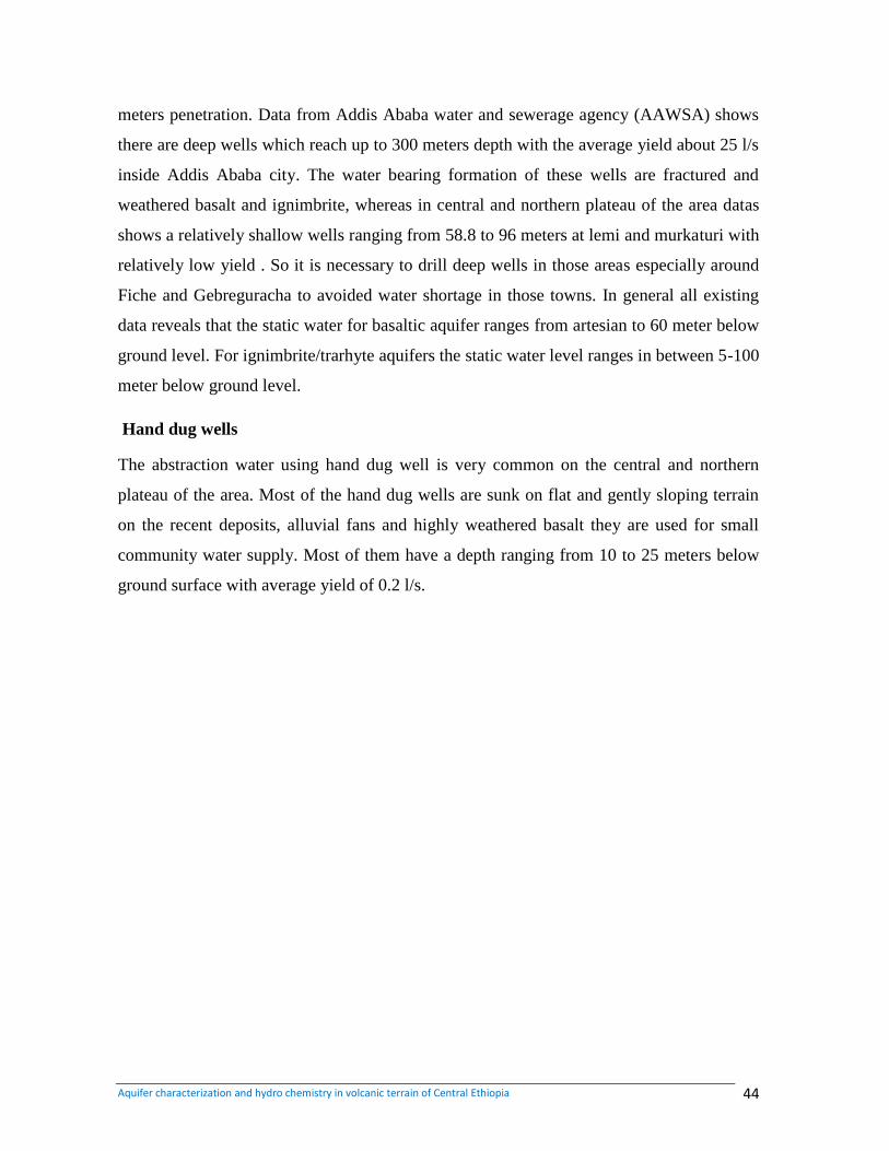
Aquifer characterization and hydro chemistry in volcanic terrain of Central Ethiopia 44
meters penetration. Data from Addis Ababa water and sewerage agency (AAWSA) shows
there are deep wells which reach up to 300 meters depth with the average yield about 25 l/s
inside Addis Ababa city. The water bearing formation of these wells are fractured and
weathered basalt and ignimbrite, whereas in central and northern plateau of the area datas
shows a relatively shallow wells ranging from 58.8 to 96 meters at lemi and murkaturi with
relatively low yield . So it is necessary to drill deep wells in those areas especially around
Fiche and Gebreguracha to avoided water shortage in those towns. In general all existing
data reveals that the static water for basaltic aquifer ranges from artesian to 60 meter below
ground level. For ignimbrite/trarhyte aquifers the static water level ranges in between 5-100
meter below ground level.
Hand dug wells
The abstraction water using hand dug well is very common on the central and northern
plateau of the area. Most of the hand dug wells are sunk on flat and gently sloping terrain
on the recent deposits, alluvial fans and highly weathered basalt they are used for small
community water supply. Most of them have a depth ranging from 10 to 25 meters below
ground surface with average yield of 0.2 l/s.
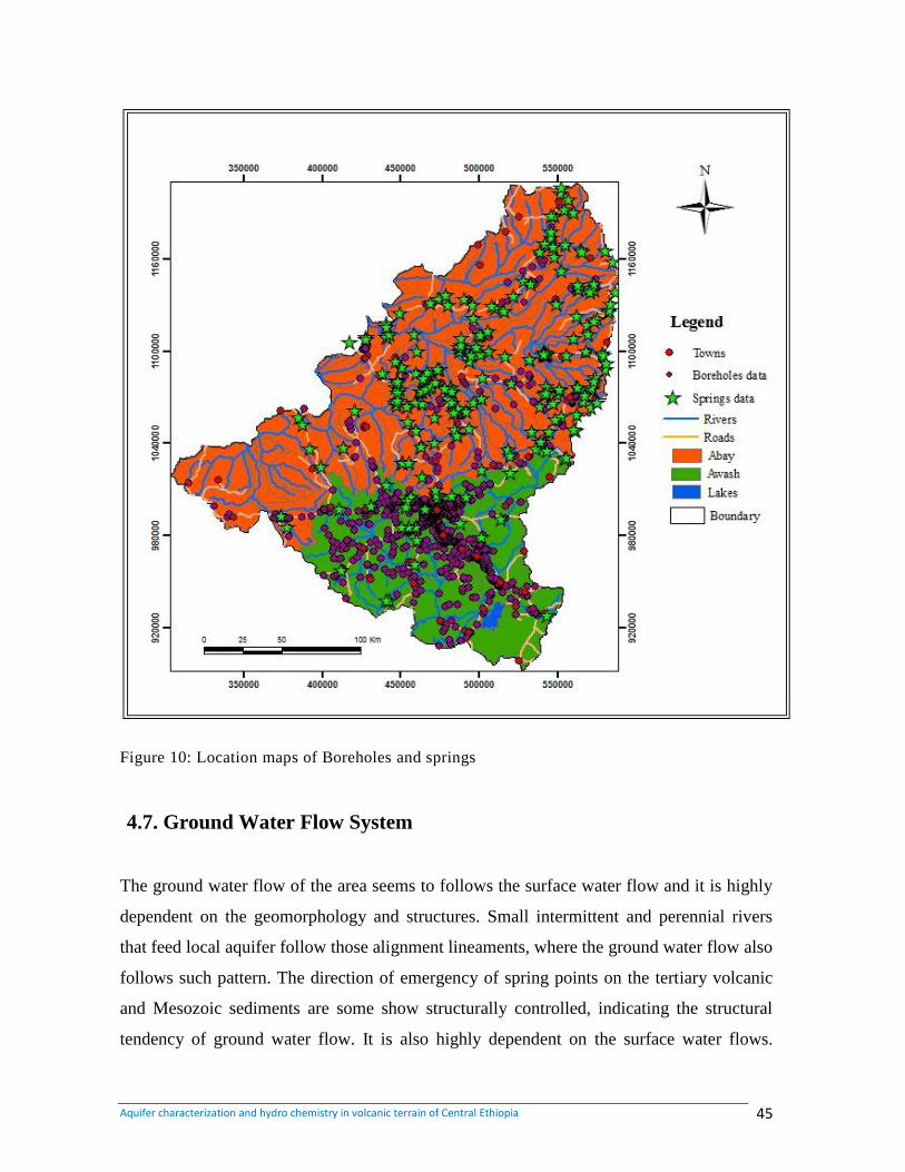
Aquifer characterization and hydro chemistry in volcanic terrain of Central Ethiopia 45
Figure 10: Location maps of Boreholes and springs
4.7. Ground Water Flow System
The ground water flow of the area seems to follows the surface water flow and it is highly
dependent on the geomorphology and structures. Small intermittent and perennial rivers
that feed local aquifer follow those alignment lineaments, where the ground water flow also
follows such pattern. The direction of emergency of spring points on the tertiary volcanic
and Mesozoic sediments are some show structurally controlled, indicating the structural
tendency of ground water flow. It is also highly dependent on the surface water flows.
Aquifer characterization and hydro chemistry in volcanic terrain of Central Ethiopia 46
Variation in hydraulic conductivity of different rocks can also cause local deviations to the
ground water flow. Hence there is complicated local ground water flow direction, due to
the above mentioned factors. The general ground flow direction of the area shows two
patterns as there is a contribution of two major basins (Abay and Awash basins). The
ground water flow direction in plateau area of Abay basin tends to be toward North East
and North West direction. In the Awash basin, the Southern part of the study area, the flow
is towards the south to Akaki well field and main Ethiopia rift (MER). The trachyte,
ryholite and ignimbrite ridges of Entoto, Ankorcha and Wechecha dominantly the basin
mountain chains of chilmu, where the major E-W trending lineament which act as ground
water as well as surface water divide between Blue Nile and Awash basins but there is a
hypothesis of ground flow recharge flow Blue Nile basin to Awash basin through becho
plain and legedade area (WWDS, 2008)
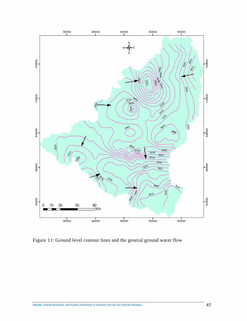
Aquifer characterization and hydro chemistry in volcanic terrain of Central Ethiopia 47
Figure 11: Ground level contour lines and the general ground water flow
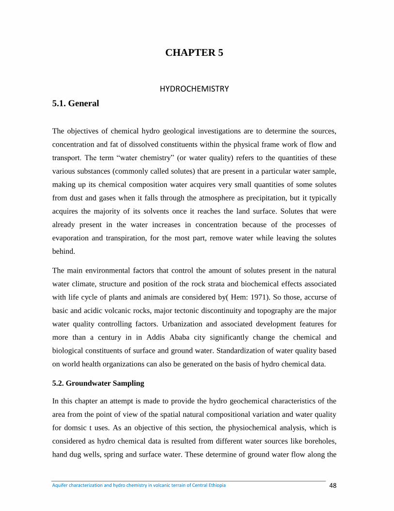
Aquifer characterization and hydro chemistry in volcanic terrain of Central Ethiopia 48
CHAPTER 5
HYDROCHEMISTRY
5.1. General
The objectives of chemical hydro geological investigations are to determine the sources,
concentration and fat of dissolved constituents within the physical frame work of flow and
transport. The term “water chemistry” (or water quality) refers to the quantities of these
various substances (commonly called solutes) that are present in a particular water sample,
making up its chemical composition water acquires very small quantities of some solutes
from dust and gases when it falls through the atmosphere as precipitation, but it typically
acquires the majority of its solvents once it reaches the land surface. Solutes that were
already present in the water increases in concentration because of the processes of
evaporation and transpiration, for the most part, remove water while leaving the solutes
behind.
The main environmental factors that control the amount of solutes present in the natural
water climate, structure and position of the rock strata and biochemical effects associated
with life cycle of plants and animals are considered by( Hem: 1971). So those, accurse of
basic and acidic volcanic rocks, major tectonic discontinuity and topography are the major
water quality controlling factors. Urbanization and associated development features for
more than a century in in Addis Ababa city significantly change the chemical and
biological constituents of surface and ground water. Standardization of water quality based
on world health organizations can also be generated on the basis of hydro chemical data.
5.2. Groundwater Sampling
In this chapter an attempt is made to provide the hydro geochemical characteristics of the
area from the point of view of the spatial natural compositional variation and water quality
for domsic t uses. As an objective of this section, the physiochemical analysis, which is
considered as hydro chemical data is resulted from different water sources like boreholes,
hand dug wells, spring and surface water. These determine of ground water flow along the
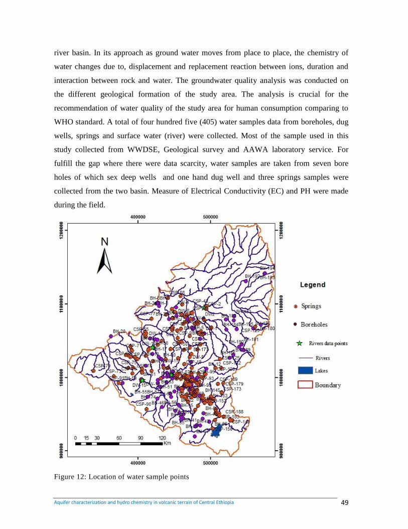
Aquifer characterization and hydro chemistry in volcanic terrain of Central Ethiopia 49
river basin. In its approach as ground water moves from place to place, the chemistry of
water changes due to, displacement and replacement reaction between ions, duration and
interaction between rock and water. The groundwater quality analysis was conducted on
the different geological formation of the study area. The analysis is crucial for the
recommendation of water quality of the study area for human consumption comparing to
WHO standard. A total of four hundred five (405) water samples data from boreholes, dug
wells, springs and surface water (river) were collected. Most of the sample used in this
study collected from WWDSE, Geological survey and AAWA laboratory service. For
fulfill the gap where there were data scarcity, water samples are taken from seven bore
holes of which sex deep wells and one hand dug well and three springs samples were
collected from the two basin. Measure of Electrical Conductivity (EC) and PH were made
during the field.
Figure 12: Location of water sample points
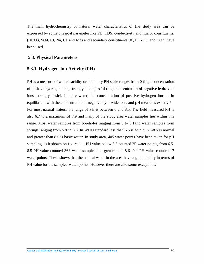
Aquifer characterization and hydro chemistry in volcanic terrain of Central Ethiopia 50
The main hydrochemistry of natural water characteristics of the study area can be
expressed by some physical parameter like PH, TDS, conductivity and major constituents,
(HCO3, SO4, Cl, Na, Ca and Mg) and secondary constituents (K, F, NO3, and CO3) have
been used.
5.3. Physical Parameters
5.3.1. Hydrogen-Ion Activity (PH)
PH is a measure of water's acidity or alkalinity PH scale ranges from 0 (high concentration
of positive hydrogen ions, strongly acidic) to 14 (high concentration of negative hydroxide
ions, strongly basic). In pure water, the concentration of positive hydrogen ions is in
equilibrium with the concentration of negative hydroxide ions, and pH measures exactly 7.
For most natural waters, the range of PH is between 6 and 8.5. The field measured PH is
also 6.7 to a maximum of 7.9 and many of the study area water samples lies within this
range. Most water samples from boreholes ranging from 6 to 9.1and water samples from
springs ranging from 5.9 to 8.8. In WHO standard less than 6.5 is acidic, 6.5-8.5 is normal
and greater than 8.5 is basic water. In study area, 405 water points have been taken for pH
sampling, as it shown on figure-11. PH value below 6.5 counted 25 water points, from 6.5-
8.5 PH value counted 363 water samples and greater than 8.6- 9.1 PH value counted 17
water points. These shows that the natural water in the area have a good quality in terms of
PH value for the sampled water points. However there are also some exceptions.
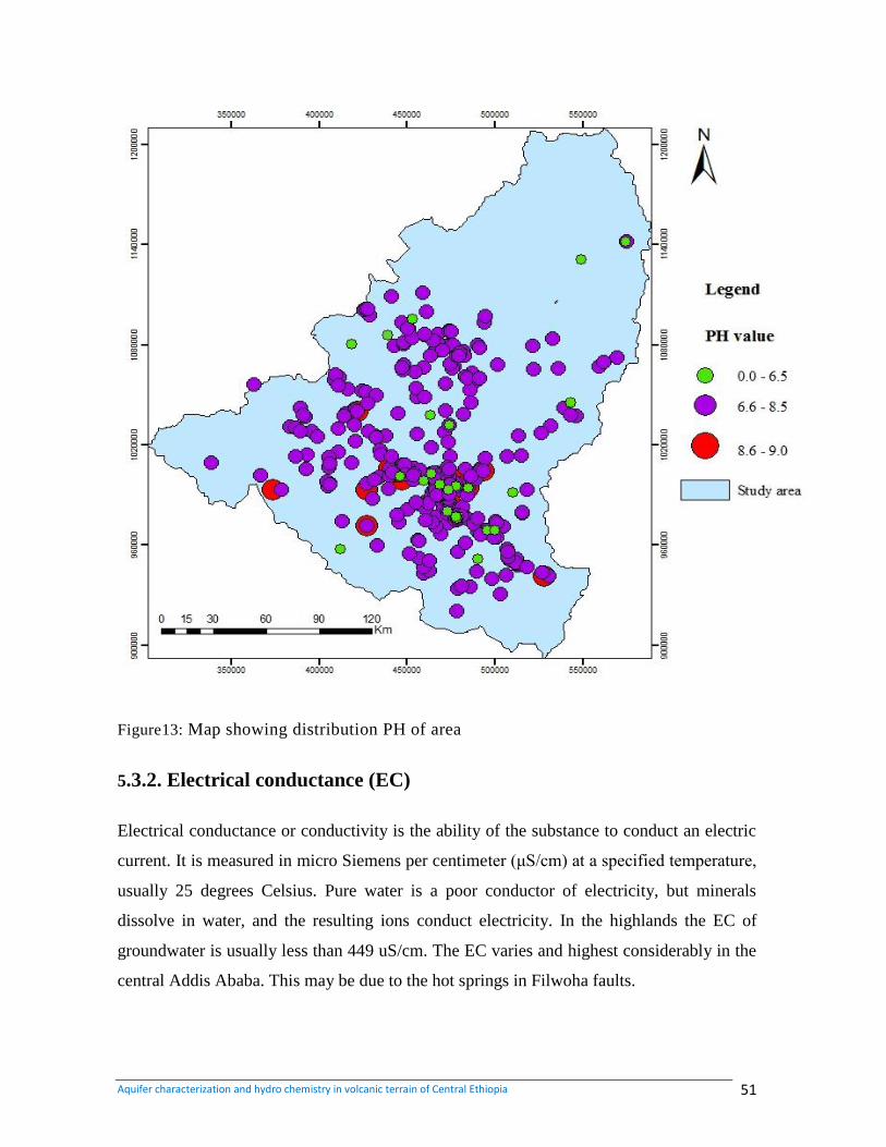
Aquifer characterization and hydro chemistry in volcanic terrain of Central Ethiopia 51
Figure13: Map showing distribution PH of area
5.3.2. Electrical conductance (EC)
Electrical conductance or conductivity is the ability of the substance to conduct an electric
current. It is measured in micro Siemens per centimeter (μS/cm) at a specified temperature,
usually 25 degrees Celsius. Pure water is a poor conductor of electricity, but minerals
dissolve in water, and the resulting ions conduct electricity. In the highlands the EC of
groundwater is usually less than 449 uS/cm. The EC varies and highest considerably in the
central Addis Ababa. This may be due to the hot springs in Filwoha faults.
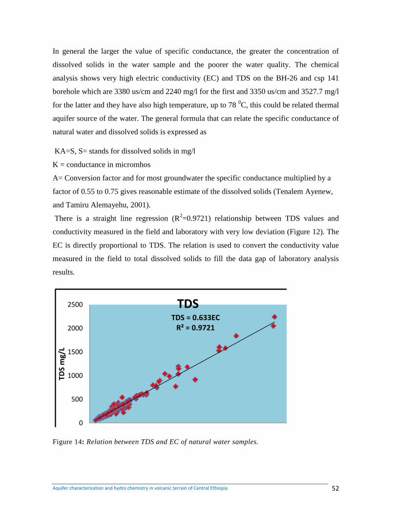
Aquifer characterization and hydro chemistry in volcanic terrain of Central Ethiopia 52
In general the larger the value of specific conductance, the greater the concentration of
dissolved solids in the water sample and the poorer the water quality. The chemical
analysis shows very high electric conductivity (EC) and TDS on the BH-26 and csp 141
borehole which are 3380 us/cm and 2240 mg/l for the first and 3350 us/cm and 3527.7 mg/l
for the latter and they have also high temperature, up to 78 0C, this could be related thermal
aquifer source of the water. The general formula that can relate the specific conductance of
natural water and dissolved solids is expressed as
KA=S, S= stands for dissolved solids in mg/l
K = conductance in micromhos
A= Conversion factor and for most groundwater the specific conductance multiplied by a
factor of 0.55 to 0.75 gives reasonable estimate of the dissolved solids (Tenalem Ayenew,
and Tamiru Alemayehu, 2001).
There is a straight line regression (R2=0.9721) relationship between TDS values and
conductivity measured in the field and laboratory with very low deviation (Figure 12). The
EC is directly proportional to TDS. The relation is used to convert the conductivity value
measured in the field to total dissolved solids to fill the data gap of laboratory analysis
results.
TDS = 0.633EC R² = 0.9721
0
500
1000
1500
2000
2500
0 500 1000 1500 2000 2500 3000 3500 4000
TDS
mg/
L
EC mg/l
TDS
Figure 14: Relation between TDS and EC of natural water samples.
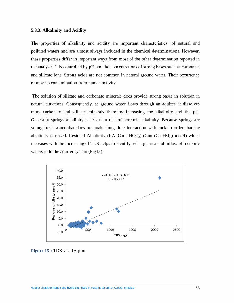
Aquifer characterization and hydro chemistry in volcanic terrain of Central Ethiopia 53
5.3.3. Alkalinity and Acidity
The properties of alkalinity and acidity are important characteristics‟ of natural and
polluted waters and are almost always included in the chemical determinations. However,
these properties differ in important ways from most of the other determination reported in
the analysis. It is controlled by pH and the concentrations of strong bases such as carbonate
and silicate ions. Strong acids are not common in natural ground water. Their occurrence
represents contamination from human activity.
The solution of silicate and carbonate minerals does provide strong bases in solution in
natural situations. Consequently, as ground water flows through an aquifer, it dissolves
more carbonate and silicate minerals there by increasing the alkalinity and the pH.
Generally springs alkalinity is less than that of borehole alkalinity. Because springs are
young fresh water that does not make long time interaction with rock in order that the
alkalinity is raised. Residual Alkalinity (RA=Con (HCO3)-(Con (Ca +Mg) meq/l) which
increases with the increasing of TDS helps to identify recharge area and inflow of meteoric
waters in to the aquifer system (Fig13)
Figure 15 : TDS vs. RA plot
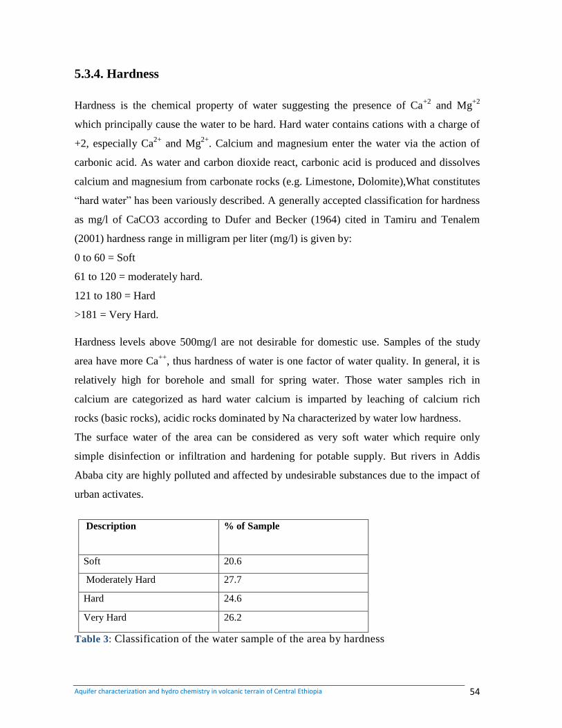
Aquifer characterization and hydro chemistry in volcanic terrain of Central Ethiopia 54
5.3.4. Hardness
Hardness is the chemical property of water suggesting the presence of Ca+2
and Mg+2
which principally cause the water to be hard. Hard water contains cations with a charge of
+2, especially Ca2+
and Mg2+
. Calcium and magnesium enter the water via the action of
carbonic acid. As water and carbon dioxide react, carbonic acid is produced and dissolves
calcium and magnesium from carbonate rocks (e.g. Limestone, Dolomite),What constitutes
“hard water” has been variously described. A generally accepted classification for hardness
as mg/l of CaCO3 according to Dufer and Becker (1964) cited in Tamiru and Tenalem
(2001) hardness range in milligram per liter (mg/l) is given by:
0 to 60 = Soft
61 to 120 = moderately hard.
121 to 180 = Hard
>181 = Very Hard.
Hardness levels above 500mg/l are not desirable for domestic use. Samples of the study
area have more Ca++
, thus hardness of water is one factor of water quality. In general, it is
relatively high for borehole and small for spring water. Those water samples rich in
calcium are categorized as hard water calcium is imparted by leaching of calcium rich
rocks (basic rocks), acidic rocks dominated by Na characterized by water low hardness.
The surface water of the area can be considered as very soft water which require only
simple disinfection or infiltration and hardening for potable supply. But rivers in Addis
Ababa city are highly polluted and affected by undesirable substances due to the impact of
urban activates.
Description
% of Sample
Soft 20.6
Moderately Hard 27.7
Hard 24.6
Very Hard 26.2
Table 3: Classification of the water sample of the area by hardness
Aquifer characterization and hydro chemistry in volcanic terrain of Central Ethiopia 55
5.3.5. Total Dissolved Solids
TDS: Total Dissolved Solids include all the solid substance in solution. The amount of
dissolved solids can be determined from the weight of the dry residue remaining after
evaporation of the volatile portion of the water sample (usually at 180 oC) or may be
calculated if the concentration of major ions is known (Hem, 1992).TDS can have
important effects on the taste of drinking water. The field measured value ranges from
191.25 to 801 in mg/l. The total dissolved solid (TDS) of different samples from different
geological unit ranges from 34 to 3527.7 mg/l which shows a big variation indicating the
impact of different rock types to water chemistry. The lowest TDS value is observed in
springs at the Entoto ridge (csp-16, csp- 17, csp-20 and csp-21), Annex 6. Since the Entoto
ridge is a recharge area, very shallow groundwater circulation and short period of
settlement time leads to poor rock-water interaction. The highest TDS value is associated to
the faulting zones and where there is high tendency of dissolution in sedimentary rocks,
especially in limestone. A fault that trends NE-SW pass through Addis Ababa city is
responsible for the appearance of hot springs at „Felwuha‟ with very high TDS (BH-26 and
CSP141).
In general, the concentration of alkaline earth metals, Ca and Mg gradually decreases when
the ground water becomes rich in TDS. In the contrary, the concentration of the alkaline
metals, Na and K increases with the increase of TDS.Very low value of the Ca/Na ratio is
the characteristics of the thermal aquifers and those aquifers with considerable amount of
clay and paleosole intercalations in the weathered and fractured scoraceous basalt aquifers.
A higher ratio, in the contrary, is attributed to the groundwater from basaltic or if acidic,
they are located on the fault line that could serve as a conduit for the water to come from
the deep lower basaltic aquifer that underlay the penetrated acidic unit.
In addition, the TDS concentration of the area shows high dependency on the altitude. TDS
of Water samples increase from the plateau area towards the river gorges and relatively low
lands. Generally topographically high areas with high rainfall show low TDS than low
topographic area with low rain fall. Because high attitude is recharge area.
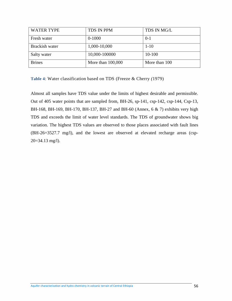
Aquifer characterization and hydro chemistry in volcanic terrain of Central Ethiopia 56
WATER TYPE TDS IN PPM TDS IN MG/L
Fresh water 0-1000 0-1
Brackish water 1,000-10,000 1-10
Salty water 10,000-100000 10-100
Brines More than 100,000 More than 100
Table 4: Water classification based on TDS (Freeze & Cherry (1979)
Almost all samples have TDS value under the limits of highest desirable and permissible.
Out of 405 water points that are sampled from, BH-26, sp-141, csp-142, csp-144, Csp-13,
BH-168, BH-169, BH-170, BH-137, BH-27 and BH-60 (Annex, 6 & 7) exhibits very high
TDS and exceeds the limit of water level standards. The TDS of groundwater shows big
variation. The highest TDS values are observed to those places associated with fault lines
(BH-26=3527.7 mg/l), and the lowest are observed at elevated recharge areas (csp-
20=34.13 mg/l).
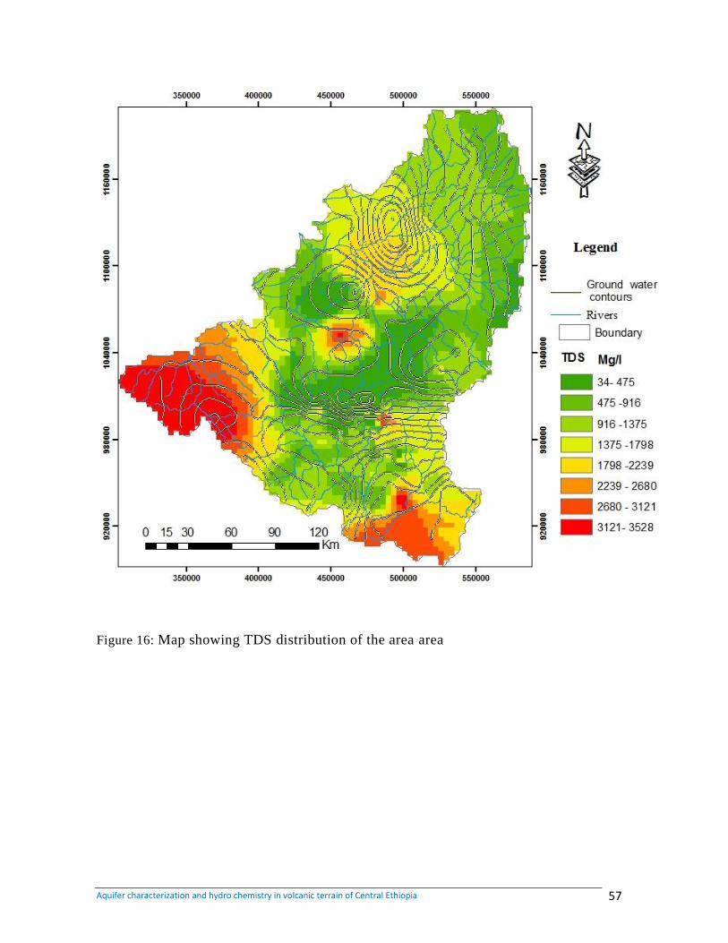
Aquifer characterization and hydro chemistry in volcanic terrain of Central Ethiopia 57
Figure 16: Map showing TDS distribution of the area area
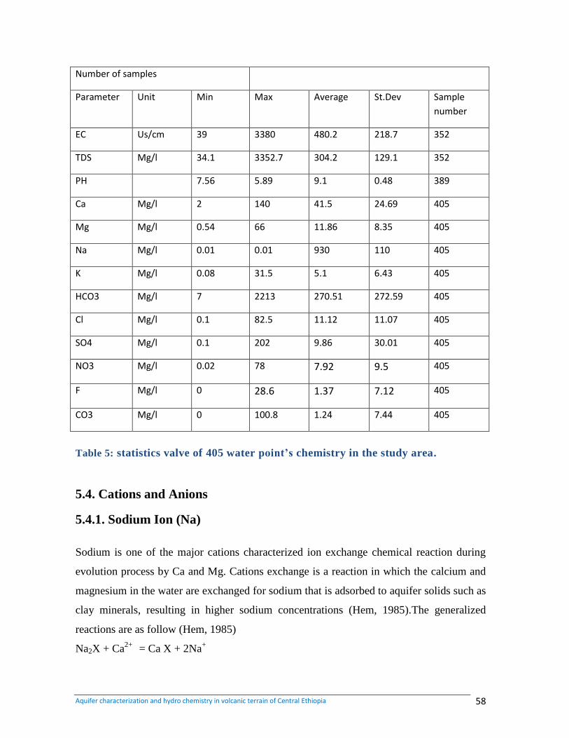
Aquifer characterization and hydro chemistry in volcanic terrain of Central Ethiopia 58
Number of samples
Parameter Unit Min Max Average St.Dev Sample
number
EC Us/cm 39 3380 480.2 218.7 352
TDS Mg/l 34.1 3352.7 304.2 129.1 352
PH 7.56 5.89 9.1 0.48 389
Ca Mg/l 2 140 41.5 24.69 405
Mg Mg/l 0.54 66 11.86 8.35 405
Na Mg/l 0.01 0.01 930 110 405
K Mg/l 0.08 31.5 5.1 6.43 405
HCO3 Mg/l 7 2213 270.51 272.59 405
Cl Mg/l 0.1 82.5 11.12 11.07 405
SO4 Mg/l 0.1 202 9.86 30.01 405
NO3 Mg/l 0.02 78 7.92 9.5 405
F Mg/l 0 28.6 1.37 7.12 405
CO3 Mg/l 0 100.8 1.24 7.44 405
Table 5: statistics valve of 405 water point’s chemistry in the study area.
5.4. Cations and Anions
5.4.1. Sodium Ion (Na)
Sodium is one of the major cations characterized ion exchange chemical reaction during
evolution process by Ca and Mg. Cations exchange is a reaction in which the calcium and
magnesium in the water are exchanged for sodium that is adsorbed to aquifer solids such as
clay minerals, resulting in higher sodium concentrations (Hem, 1985).The generalized
reactions are as follow (Hem, 1985)
Na2X + Ca2+
= Ca X + 2Na+
Aquifer characterization and hydro chemistry in volcanic terrain of Central Ethiopia 59
Na2 X + Mg2+ = Mg X + 2Na+, Where X = aquifer solid
The WHO guideline value for sodium in drinking water is 200 mg/l. Many surface waters
have below 50 mg/l. However, ground water concentrations frequently exceed 50 mg/l;
Sodium is commonly measured where the water is to be used for drinking or agricultural
purposes, particularly for irrigation.
The sodium concentration in almost all water samples in the study area is below the
maximum desirable and permissible level of the standards with the exception of (BH-26
csp-141, and csp-142). The high concentration of sodium of these boreholes and springs are
associated with the NE-SW running fault. The surface water in the study area shows
normal concentration of sodium ion (23 Awash mg/l to 9 mg/l Holeta and Lega Robi).
5.4.2. Calcium Ions
Calcium is an essential constitute of many igneous rock minerals, especially of the chain
silicates pyroxene and amphibole and feldspars. The plagioclase feldspar group of minerals
represents mixture in various proportions of the end members‟ albite NaAlSi3O8. The
concentration generally is low, however mainly because the rate of decomposition of most
igneous minerals is low. It is represented
CaAl2Si2O8+ H2O + 2H+ = Al2Si2O8 (OH) 4 Ca
2+
In the study area the calcium concentration varies 140 mg/l Menilik School (BH-86) to the
concentration of Holota-town new (BH-51). Surface waters have Concentration ranging
from 48 awash to 10mg/l lega Robi.
5.4.3. Magnesium Ion (Mg2)
In igneous rocks, the magnesium is typically a major constitute of the dark colored
ferromagnesian minerals. Specially, these include olivine, the pyroxenes, the amphiboles
and the dark-colored micas, along with various less common species. The magnesium ion
Mg2+
will normally be the predominant form of magnesium in solution in natural water.
The ion pair MgSO4 (aq) has about the same stability as the species CaSO4 (aq), and
magnesium complex with carbonate or bicarbonate have approximately the same stability
Aquifer characterization and hydro chemistry in volcanic terrain of Central Ethiopia 60
as the similar species of calcium. In the 400 sampled boreholes Holeta/ welmera, 66 mg/l
Mg2+
is the maximum concentration and the minimum concentration was found Filwuha/
Addis Ababa and Red Fox Flowers, koka area is (0.5mg/l). In sampled springs, magnesium
concentration varies from 39 mg/l Gonji, (Csp9) to 0.5 mg/l AA-Water lll Testwell-B9
(csp106). The surface water concentration of Mg2+
fluctuates from 66 mg/l Holet River to
11 Awash River.
5.4.4. Potassium Ion (K+)
The principal potassium minerals of silicate rocks are the feldspars orthoclase and
microcline (KAlSiO8), the micas and the feldspathoid leucite (KAlSi2O6). The potassium
feldspar is resistant to attack by water. In dilute natural water in which the sum of sodium
and potassium is less than 10 mg/l, it is not unusual for the potassium concentration to
equal or even exceed the sodium concentration. In the study area 382 sodium and
potassium samples from water supply wells, springs and surface water shows that the
concentration of Na+ (mg/l) is greater than concentration of K
+ (mg/l) in all sampled data.
5.4.5. Bicarbonate ions (HCO3 2- )
The presence of carbonates and bicarbonate influences the hardness and alkalinity of water.
The weathering of rocks contributes carbonate and bicarbonate salts. The relative amounts
of carbonates, bicarbonate and carbonic acid in pure water are related to the PH. As result
of the weathering process, combined with PH range of surface waters, bicarbonate is the
dominant anion in most surface waters. In study area, the maximum bicarbonate ion
concentration is 2213 mg/l in Filwuha; Addis Ababa concentration (HBH-26). Springs
have bicarbonate concentration of 2198 mg/l D/Z-Health College (Csp-142). In the surface
water; bicarbonate ion concentration varies between 262 mg/l in Awash River to 157 mg/l
in Holeta River.
5.4.6. Sulfate ion (SO42-
)
Sulfate concentrations are associated with type of Lithology and pollution from surface
water. There are high concentrations of sulfate at springs and wells which emerged at the
Aquifer characterization and hydro chemistry in volcanic terrain of Central Ethiopia 61
contact between limestone, shale and gypsum intercalation. This is due to the high sulfate
dissolving from gypsum. In the study area, wells have the highest sulfate ion concentration
is 129.9mg/l AA-Water lll Testwell-B9 (BH-99). In springs, the maximum concentration
of sulfate is 202 mg/l merhabit (Csp43) and surface water bodies ranges from 64 mg/l Jema
to 2 mg/l Lega Robi rives.
5.4.7. Chloride (Cl-)
[
Chloride is known by its conservative nature in the chemical evolution process and good
indicator of the relative age of ground water compare to other major ions .The high
chloride concentration is associated with type of Lithology and pollution from surface
water. The concentration of chloride is relatively high in densely populated areas of Addis
Ababa area. High chloride concentrations in groundwater show contamination from pit
Latrines, waste disposals. In the investigated area, the chloride concentration for almost all
samples taken from groundwater is under range of the limit of the standard, chloride ion
ranging from 82.5 to 0.1 mg/l in wells, 64.7 to 0.1 mg/l in sprigs and 441 to 1in Rivers.
5.4.8. Fluoride Ion (F-)
The fluoride concentration of natural water in the study area shows almost uniform with
small variations. In some parts especially in the rift zone and samples from some boreholes
which are associated with fault Zones show higher fluoride concentration than the normal
drinking water standard. The higher concentration of fluoride in the study area is associated
with recent acidic volcanic (Berhanu Gizaw 1996). High Fluoride concentration, up to
28.6mg/l in central and rift zones associated with thermal waters. Very low fluoride
concentration is observed in plateau zone waters. In the study area, the maximum
concentration of fluoride ion is 28.6 mg/l Filwuha/ Addis Ababa (BH-26), and 27.6mg/l
Alem Gena-Dika (Sp141) in springs. The concentration of these ions is in significant in
surface water.
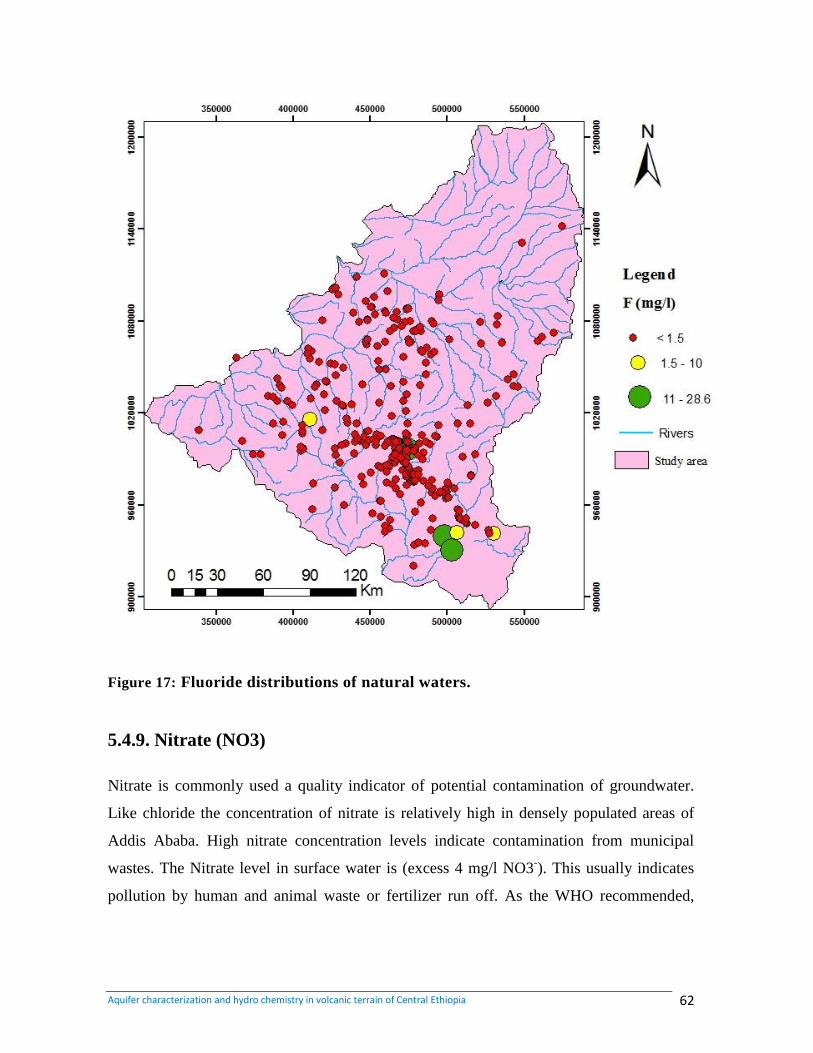
Aquifer characterization and hydro chemistry in volcanic terrain of Central Ethiopia 62
Figure 17: Fluoride distributions of natural waters.
5.4.9. Nitrate (NO3)
Nitrate is commonly used a quality indicator of potential contamination of groundwater.
Like chloride the concentration of nitrate is relatively high in densely populated areas of
Addis Ababa. High nitrate concentration levels indicate contamination from municipal
wastes. The Nitrate level in surface water is (excess 4 mg/l NO3-). This usually indicates
pollution by human and animal waste or fertilizer run off. As the WHO recommended,
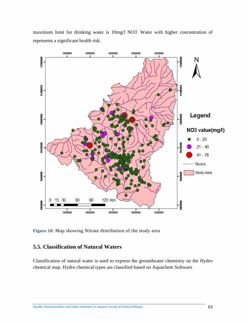
Aquifer characterization and hydro chemistry in volcanic terrain of Central Ethiopia 63
maximum limit for drinking water is 10mg/l NO3- Water with higher concentration of
represents a significant health risk.
Figure 18: Map showing Nitrate distribution of the study area
5.5. Classification of Natural Waters
Classification of natural water is used to express the groundwater chemistry on the Hydro
chemical map. Hydro chemical types are classified based on Aquachem Software
Aquifer characterization and hydro chemistry in volcanic terrain of Central Ethiopia 64
5.4.1. Classification Based on Aquachem Software
The ion concentration in most of the water samples is dependent on elevation, litho logy,
structures and climatic conditions. The high concentration of chloride and sulfate is
observed in river gorges and in association with faults. In addition to these, litho logy of the
area has a significant effect on the concentration of chloride, sulfate and sodium. The
presence of high Concentration of chloride, sulfate and sodium shows a complex process of
rock-water interaction and ion exchange. The predominant water types in Ethiopia based
on the dominant anions which are bicarbonate, sulfate, and chloride types (Tesfaye, 1993).
In general, the classification of water samples of the area based on the Aquachem software
analysis is made as follows based on the Aquachem software analysis.
Bicarbonate Water (HCO3)
The analysis shows that the dominant water type of the study area is bicarbonate type. The
Presence of this water type shows fast hydro geological regime and lithologically
homogeneous Aquifers with a relatively high amount of rain fall. The cat ion groups
associated with bicarbonate are Ca, Ca-Mg, Ca-Mg-Na, Ca-Na-Mg, Ca-Na, Mg-Ca, Na-Ca
and Na-Ca- Mg.
Bicarbonate Sulfate Water (HCO3-SO4)
This water type is dominated in river gorges of Jema and Muger where there is gypsum
intercalation in sedimentary succession. The high sulfate concentration results from the
dissolution of gypsum through water circulation. There is also a high concentration of
sulfate in water samples drilled along fault lines such as HBH-26 and BH-99. Springs that
emerge from rhyolite and trachyte rocks of Entoto ridge have a relatively high sulfate.
Water samples from springs Csp-53 and Csp-104 exhibit such kind of water type. In
addition, the high concentrations of toxic and pollutant minerals such as nitrate are
observed from few groundwater samples. The occurrence nitrate bicarbonate water is
limited in the study area. Out of 405 water samples three samples, three samples (csp- 21,
Csp-62, Csp-72) shows bicarbonate nitrate type and only one sample (Csp-65) has nitrate
type. The springs are found on Entoto ridge at Gutoweserbi locality near Eleas Church, the
highlands of Jeldu and near Chilimo Mountain. Since they are found on recharge zone and
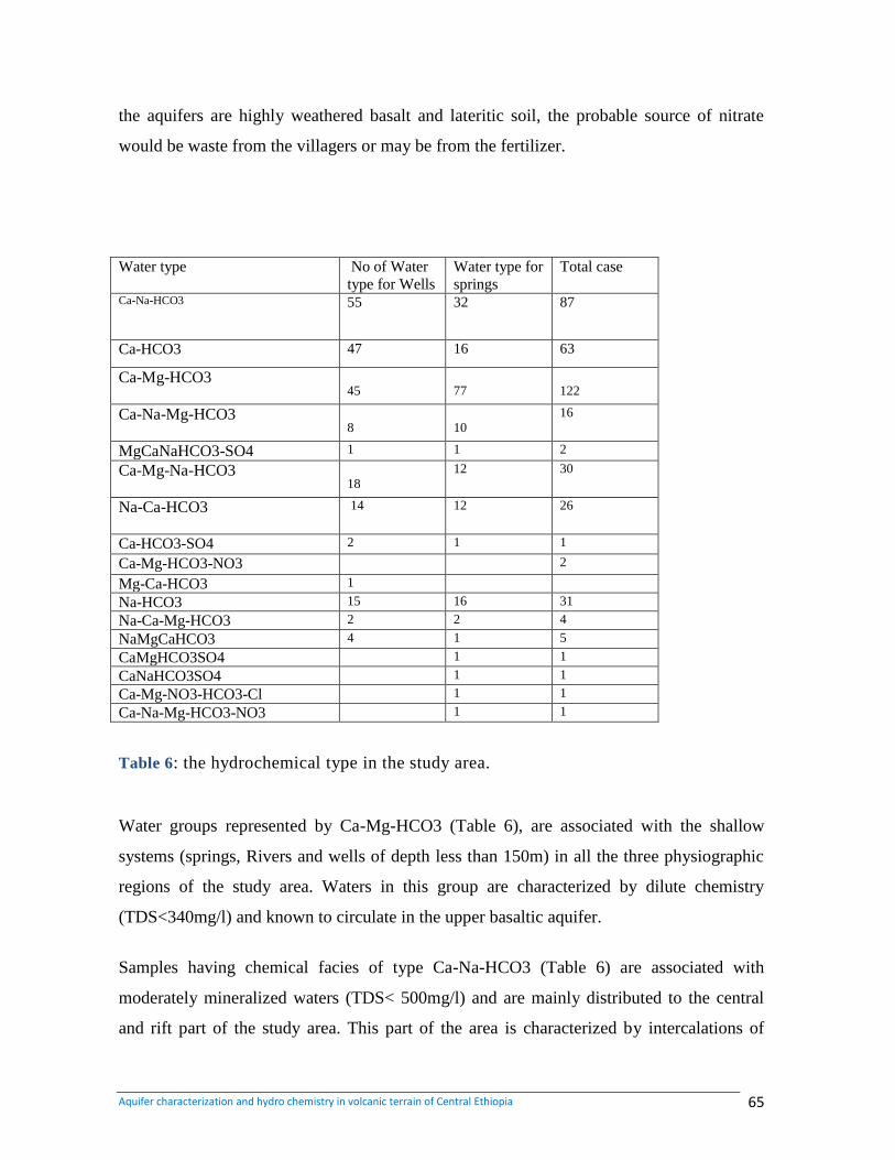
Aquifer characterization and hydro chemistry in volcanic terrain of Central Ethiopia 65
the aquifers are highly weathered basalt and lateritic soil, the probable source of nitrate
would be waste from the villagers or may be from the fertilizer.
Water type No of Water
type for Wells
Water type for
springs
Total case
Ca-Na-HCO3 55 32 87
Ca-HCO3 47 16 63
Ca-Mg-HCO3
45
77
122
Ca-Na-Mg-HCO3
8
10
16
MgCaNaHCO3-SO4 1 1 2
Ca-Mg-Na-HCO3
18
12 30
Na-Ca-HCO3 14 12 26
Ca-HCO3-SO4 2 1 1
Ca-Mg-HCO3-NO3 2
Mg-Ca-HCO3 1
Na-HCO3 15 16 31
Na-Ca-Mg-HCO3 2 2 4
NaMgCaHCO3 4 1 5
CaMgHCO3SO4 1 1
CaNaHCO3SO4 1 1
Ca-Mg-NO3-HCO3-Cl 1 1
Ca-Na-Mg-HCO3-NO3 1 1
Table 6: the hydrochemical type in the study area.
Water groups represented by Ca-Mg-HCO3 (Table 6), are associated with the shallow
systems (springs, Rivers and wells of depth less than 150m) in all the three physiographic
regions of the study area. Waters in this group are characterized by dilute chemistry
(TDS<340mg/l) and known to circulate in the upper basaltic aquifer.
Samples having chemical facies of type Ca-Na-HCO3 (Table 6) are associated with
moderately mineralized waters (TDS< 500mg/l) and are mainly distributed to the central
and rift part of the study area. This part of the area is characterized by intercalations of
Aquifer characterization and hydro chemistry in volcanic terrain of Central Ethiopia 66
acidic volcanics (rhyolites, ignimbrites, tuff, trachytes and Pyroclastics), where water
systems are tapping the weathered and fractured rocks rich in Ca- and Na- plagioclases
which could be responsible to have such water chemistry.
The other facies groups are the Na-Ca-HCO3 type waters and are mainly encountered in
two different physiographic regions, the plateau and the rift part of the study area (Table 6).
In the plateau part of the study area these waters are associated with deep wells having a
diluted chemistry (TDS<235mg/l). In many groundwater circulation systems strata of high
permeability may be separated by clay or shale layer of much less permeable rocks. These
layers can act as semi permeable membranes and thus give rise to anomalous effects on the
concentration of dissolved ions. Sodium is retained by adsorption on mineral surface,
especially by minerals having high cation-exchange capacities such as clays. Cation
exchange process in fresh water systems tend to extract divalent ions such as Ca2+
from
solution and to replace them with monovalent ions such as Na+ (Hem, 1992). The Na
+
dominance in some of the borehole samples, therefore, might indicate the exchange of Ca
by Na+, the presence of thin layer of clay/paleaosols in some of the borehole logs of the
plateau area supports this idea. In the rift part of the area this type facies is associated with
wells having a moderate mineralization (TDS<600mg/l). The reason for this could be
groundwater evolution along its flow path.
Na- HCO3 type waters are found to be associated to three different regions (Table 6). Some
diluted chemistry deep wells in the plateau area have this type of water in which a similar
reason could be adopted as those plateau wells having Na-Ca-HCO3 discussed earlier in
this section, likely with intensive ion exchange that replaces the whole calcium in the
water. Some wells in the southern part (rift) of the study area, also found to have this facies
which could be an outcome of groundwater evolution along the regional flow path.
The other systems with this facies are the highly mineralized (TDS>1600mg/l) thermal
wells which are located along the Filwuha fault belt of central Addis Ababa (BH 26, CS
141). From their association to acidic volcanics in place, these waters might have evolved
from Ca-Na-HCO3 and Ca-HCO3 type water-silicic rock interaction at elevated
Aquifer characterization and hydro chemistry in volcanic terrain of Central Ethiopia 67
temperatures where Ca is lost through CaCO3 precipitation. The other process could be
deep circulation and longer residence time which leads to further hydrolysis of silicate
minerals in the Ca-Mg-HCO3 type waters whereby the concentration of Na, K and HCO3
increase. Similar conclusions were made by previous researchers (Kebede et al. 2005 and
Demlie et al 2008)
Ca-HCO3 type waters are also encountered in the study area (Table 6). Based on the
Groundwater chemical evolution models, this group represent ground waters that are
recently recharged and/or contain waters at the early stages of geochemical evolution
which have not undergone significant water–rock interactions (Bartolino et al., 2003). This
is further evidenced by the association of these water types to the shallow systems of the
plateau area. The recharge zones in the plateau have a relatively dilute hydrochemistry
which gradually evolves to a relatively concentrated hydro chemical composition as
groundwater moves to the transition and rift zones of the study area along the flow path,
which assumes a north-south general direction
5.4.2. Graphical presentation of hydro geochemical Facies
The diagnostic chemical properties of water are presented by graphical methods. The most
common of which are the hydro chemical facies, e.g. the Piper (1944) tri linear diagram.
This diagram is useful in screening and sorting large numbers of chemical data, which
makes interpretation easier. Furthermore, a Piper diagram can define the patterns of spatial
change in the water chemistry among geological units, along a line of section or along a
flow path (Raji &Alagbe, 1997). In this study, the results of the chemical analyses of all the
original and complementary secondary different data points are plotted on Piper diagrams.
In addition to displaying all water sources together, piper diagram is also important to
display each water source of more than one sample. In the figure below, five piper plots are
observed which are representing springs, shallow boreholes, deep boreholes and hand dug
well and surface water.
In the majority of waters from dug wells (Figure21); Calcium dominates their cations
species followed by magnesium and bicarbonate dominate their anions. Thus, the water
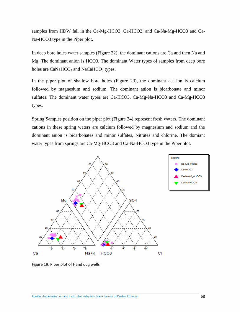
Aquifer characterization and hydro chemistry in volcanic terrain of Central Ethiopia 68
samples from HDW fall in the Ca-Mg-HCO3, Ca-HCO3, and Ca-Na-Mg-HCO3 and Ca-
Na-HCO3 type in the Piper plot.
In deep bore holes water samples (Figure 22); the dominant cations are Ca and then Na and
Mg. The dominant anion is HCO3. The dominant Water types of samples from deep bore
holes are CaNaHCO3 and NaCaHCO3 types.
In the piper plot of shallow bore holes (Figure 23), the dominant cat ion is calcium
followed by magnesium and sodium. The dominant anion is bicarbonate and minor
sulfates. The dominant water types are Ca-HCO3, Ca-Mg-Na-HCO3 and Ca-Mg-HCO3
types.
Spring Samples position on the piper plot (Figure 24) represent fresh waters. The dominant
cations in these spring waters are calcium followed by magnesium and sodium and the
dominant anion is bicarbonates and minor sulfates, Nitrates and chlorine. The domiant
water types from springs are Ca-Mg-HCO3 and Ca-Na-HCO3 type in the Piper plot.
Figure 19: Piper plot of Hand dug wells
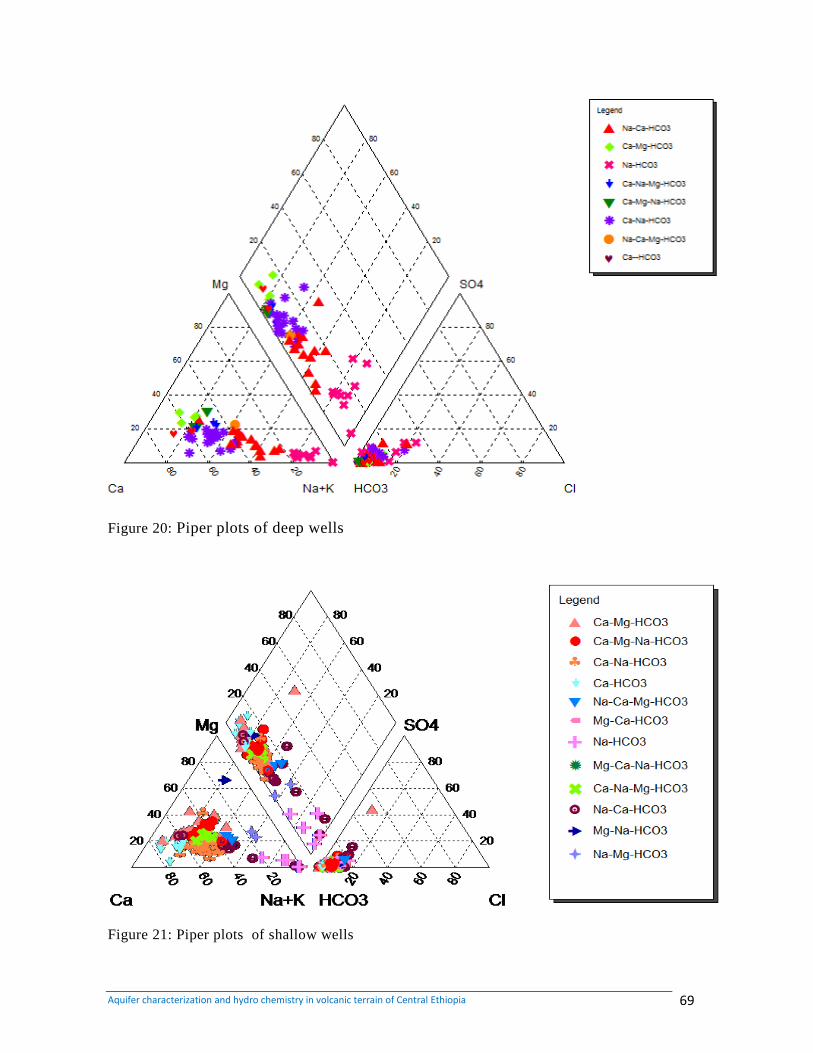
Aquifer characterization and hydro chemistry in volcanic terrain of Central Ethiopia 69
Figure 20: Piper plots of deep wells
Figure 21: Piper plots of shallow wells
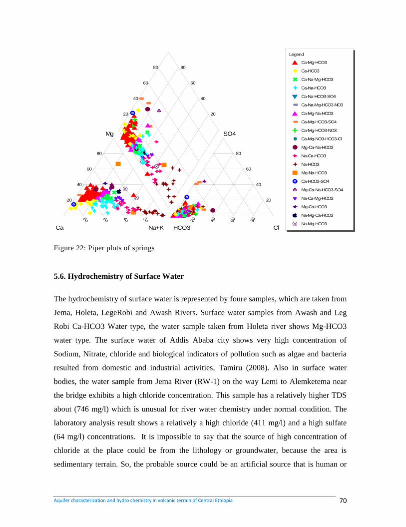
Aquifer characterization and hydro chemistry in volcanic terrain of Central Ethiopia 70
80 60 40 20 20 40 60 80
20
40
60
80 80
60
40
20
20
40
60
80
20
40
60
80
Ca Na+K HCO3 Cl
Mg SO4
Piper Plot
A
A
A
E
E
E
A
A
A
A
A
A
I
I
I
AA
A
M
M
M
A
A
A
E
E
E
A
A
A
E
E
E
A
A
A
A
A
A
F
F
F
MM
M
A
A
A
MM
M
A
A
A
A
A
A
A
A
A
A
A
A
M
M
M
A
A
A
I
I
I
I
I
I
EE
E
A
A
A
I
I
I
A
A
A
A
A
A
A
A
A
DD
D
A
A
A
A
A
A
A
A
A
F
F
F
A
A
A
A
A
A
A
A
A
A
A
A
AA
A
A
A
A
A
A
A
A
A
A
A
A
A
F
F
F
E E
E
A
A
A
A
A
A
A
A
A
A
A
A
A
A
A
E
E
E
A
A
A
A
A
A
J
J
J
A
A
A
A
A
A
C
C
C
E E
E
A
A
A
A
A
A
A
A
A
HH
H
A
A
A
A
A
A
J
J
J
M
M
M
M
M
M
O
O
O
O O
OG
G
G
GG
G
GG
G
M M
M
I
I
I
G
G
G
A
A
A
A
A
A
MM
M
G
G
G
M
M
M
A
A
A
PP
P
G
G
G
OO
O
M
M
M
G
G
GD
D
D
A
A
A
E
E
E
A
A
A
A
A
A
GG
G
E
E
E
A
A
A
M
M
M
Q
Q
Q
M
M
M
A
A
A
OO
O
OO
O
GG
G
E
E
E
A
A
A
G G
G
M M
M
I
I
I
E
E
E
E
E
E
E
E
E
A
A
A
MM
M
Q
Q
Q
Q
Q
Q
I
I
I
Q
Q
Q
A
A
A
A
A
A
M
M
M
Q
Q
Q
A
A
A
M
M
M
OO
O
O O
O
O O
O
O O
O
GG
G
OO
O
O O
O
O O
O
OO
O
A
A
A
O O
O
GG
G
O O
OA
A
A
I
I
I
A
A
A
A
A
A
A
A
A
R
R
R
A
A
A
A
A
A
A
A
A
I
I
I
M
M
M
A
A
A
C
C
C
M
M
M
I
I
I
A
A
A
S
S
S
M
M
M
A
A
A
M
M
M
I
I
I
Q
Q
Q
G
G
G
M
M
M
I
I
I
A
A
A
M
M
M
M
M
M
U
U
U
A
A
A
Q
Q
Q
M
M
M
U
U
U
GG
G
M
M
M
G
G
G
M
M
M
A
A
A
A
A
A
M
M
M
I
I
I
M
M
M
E
E
E
LegendLegend
A Ca-Mg-HCO3
E Ca-HCO3
I Ca-Na-Mg-HCO3
M Ca-Na-HCO3
B Ca-Na-HCO3-SO4
F Ca-Na-Mg-HCO3-NO3
A Ca-Mg-Na-HCO3
F Ca-Mg-HCO3-SO4
J Ca-Mg-HCO3-NO3
N Ca-Mg-NO3-HCO3-Cl
C Mg-Ca-Na-HCO3
G Na-Ca-HCO3
O Na-HCO3
D Mg-Na-HCO3
H Ca-HCO3-SO4
P Mg-Ca-Na-HCO3-SO4
Q Na-Ca-Mg-HCO3
R Mg-Ca-HCO3
S Na-Mg-Ca-HCO3
U Na-Mg-HCO3
Figure 22: Piper plots of springs
5.6. Hydrochemistry of Surface Water
The hydrochemistry of surface water is represented by foure samples, which are taken from
Jema, Holeta, LegeRobi and Awash Rivers. Surface water samples from Awash and Leg
Robi Ca-HCO3 Water type, the water sample taken from Holeta river shows Mg-HCO3
water type. The surface water of Addis Ababa city shows very high concentration of
Sodium, Nitrate, chloride and biological indicators of pollution such as algae and bacteria
resulted from domestic and industrial activities, Tamiru (2008). Also in surface water
bodies, the water sample from Jema River (RW-1) on the way Lemi to Alemketema near
the bridge exhibits a high chloride concentration. This sample has a relatively higher TDS
about (746 mg/l) which is unusual for river water chemistry under normal condition. The
laboratory analysis result shows a relatively a high chloride (411 mg/l) and a high sulfate
(64 mg/l) concentrations. It is impossible to say that the source of high concentration of
chloride at the place could be from the lithology or groundwater, because the area is
sedimentary terrain. So, the probable source could be an artificial source that is human or
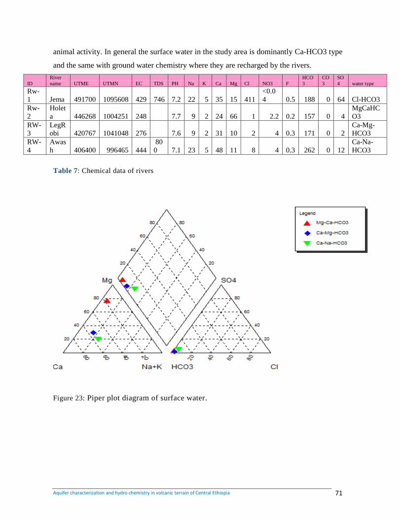
Aquifer characterization and hydro chemistry in volcanic terrain of Central Ethiopia 71
animal activity. In general the surface water in the study area is dominantly Ca-HCO3 type
and the same with ground water chemistry where they are recharged by the rivers.
ID
River
name UTME UTMN EC TDS PH Na K Ca Mg Cl NO3 F
HCO
3
CO
3
SO
4 water type
Rw-
1 Jema 491700 1095608 429 746 7.2 22 5 35 15 411
<0.0
4 0.5 188 0 64 Cl-HCO3
Rw-
2
Holet
a 446268 1004251 248 7.7 9 2 24 66 1 2.2 0.2 157 0 4
MgCaHC
O3
RW-
3
LegR
obi 420767 1041048 276 7.6 9 2 31 10 2 4 0.3 171 0 2
Ca-Mg-
HCO3
RW-
4
Awas
h 406400 996465 444
80
0 7.1 23 5 48 11 8 4 0.3 262 0 12
Ca-Na-
HCO3
Table 7: Chemical data of rivers
Figure 23: Piper plot diagram of surface water.
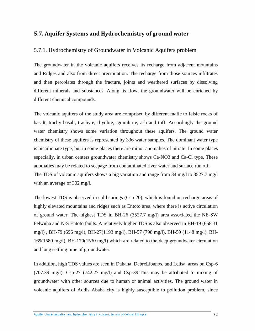
Aquifer characterization and hydro chemistry in volcanic terrain of Central Ethiopia 72
5.7. Aquifer Systems and Hydrochemistry of ground water
5.7.1. Hydrochemistry of Groundwater in Volcanic Aquifers problem
The groundwater in the volcanic aquifers receives its recharge from adjacent mountains
and Ridges and also from direct precipitation. The recharge from those sources infiltrates
and then percolates through the fracture, joints and weathered surfaces by dissolving
different minerals and substances. Along its flow, the groundwater will be enriched by
different chemical compounds.
The volcanic aquifers of the study area are comprised by different mafic to felsic rocks of
basalt, trachy basalt, trachyte, rhyolite, ignimbrite, ash and tuff. Accordingly the ground
water chemistry shows some variation throughout these aquifers. The ground water
chemistry of these aquifers is represented by 336 water samples. The dominant water type
is bicarbonate type, but in some places there are minor anomalies of nitrate. In some places
especially, in urban centers groundwater chemistry shows Ca-NO3 and Ca-Cl type. These
anomalies may be related to seepage from contaminated river water and surface run off.
The TDS of volcanic aquifers shows a big variation and range from 34 mg/l to 3527.7 mg/l
with an average of 302 mg/l.
The lowest TDS is observed in cold springs (Csp-20), which is found on recharge areas of
highly elevated mountains and ridges such as Entoto area, where there is active circulation
of ground water. The highest TDS in BH-26 (3527.7 mg/l) area associated the NE-SW
Felwuha and N-S Entoto faults. A relatively higher TDS is also observed in BH-19 (658.31
mg/l) , BH-79 (696 mg/l), BH-27(1193 mg/l), BH-57 (798 mg/l), BH-59 (1148 mg/l), BH-
169(1580 mg/l), BH-170(1530 mg/l) which are related to the deep groundwater circulation
and long settling time of groundwater.
In addition, high TDS values are seen in Dahana, DebreLibanos, and Lelisa, areas on Csp-6
(707.39 mg/l), Csp-27 (742.27 mg/l) and Csp-39.This may be attributed to mixing of
groundwater with other sources due to human or animal activities. The ground water in
volcanic aquifers of Addis Ababa city is highly susceptible to pollution problem, since
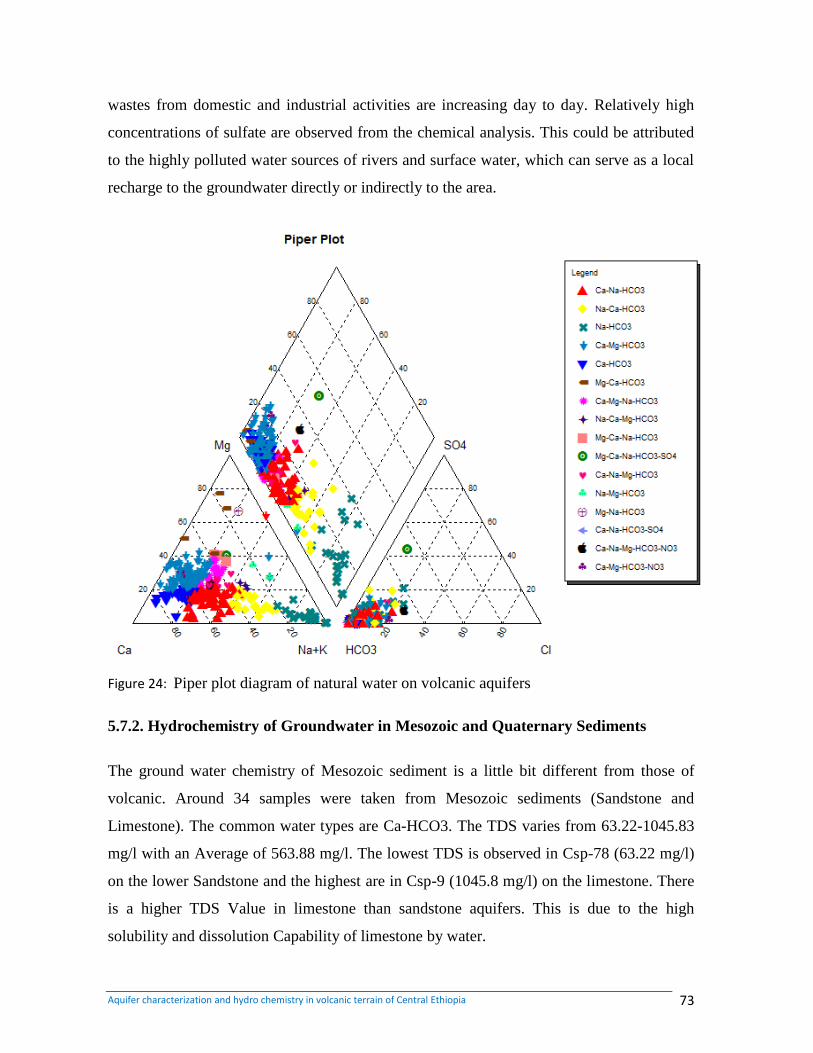
Aquifer characterization and hydro chemistry in volcanic terrain of Central Ethiopia 73
wastes from domestic and industrial activities are increasing day to day. Relatively high
concentrations of sulfate are observed from the chemical analysis. This could be attributed
to the highly polluted water sources of rivers and surface water, which can serve as a local
recharge to the groundwater directly or indirectly to the area.
Figure 24: Piper plot diagram of natural water on volcanic aquifers
5.7.2. Hydrochemistry of Groundwater in Mesozoic and Quaternary Sediments
The ground water chemistry of Mesozoic sediment is a little bit different from those of
volcanic. Around 34 samples were taken from Mesozoic sediments (Sandstone and
Limestone). The common water types are Ca-HCO3. The TDS varies from 63.22-1045.83
mg/l with an Average of 563.88 mg/l. The lowest TDS is observed in Csp-78 (63.22 mg/l)
on the lower Sandstone and the highest are in Csp-9 (1045.8 mg/l) on the limestone. There
is a higher TDS Value in limestone than sandstone aquifers. This is due to the high
solubility and dissolution Capability of limestone by water.
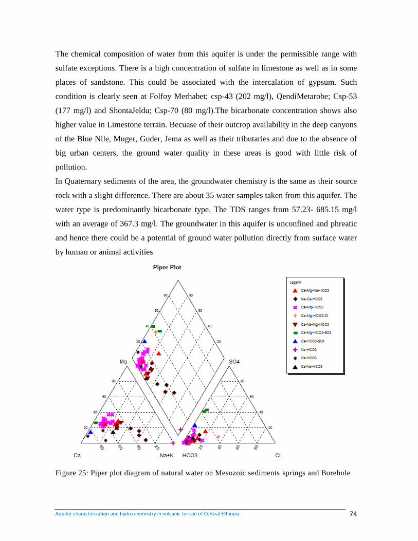
Aquifer characterization and hydro chemistry in volcanic terrain of Central Ethiopia 74
The chemical composition of water from this aquifer is under the permissible range with
sulfate exceptions. There is a high concentration of sulfate in limestone as well as in some
places of sandstone. This could be associated with the intercalation of gypsum. Such
condition is clearly seen at Folfoy Merhabet; csp-43 (202 mg/l), QendiMetarobe; Csp-53
(177 mg/l) and ShontaJeldu; Csp-70 (80 mg/l).The bicarbonate concentration shows also
higher value in Limestone terrain. Becuase of their outcrop availability in the deep canyons
of the Blue Nile, Muger, Guder, Jema as well as their tributaries and due to the absence of
big urban centers, the ground water quality in these areas is good with little risk of
pollution.
In Quaternary sediments of the area, the groundwater chemistry is the same as their source
rock with a slight difference. There are about 35 water samples taken from this aquifer. The
water type is predominantly bicarbonate type. The TDS ranges from 57.23- 685.15 mg/l
with an average of 367.3 mg/l. The groundwater in this aquifer is unconfined and phreatic
and hence there could be a potential of ground water pollution directly from surface water
by human or animal activities
Figure 25: Piper plot diagram of natural water on Mesozoic sediments springs and Borehole
Aquifer characterization and hydro chemistry in volcanic terrain of Central Ethiopia 75
Figure 26: Piper plot diagram of natural water in quaternary sediments, alluvial and
elluvial, (Boreholes, springs, and Dug wells).
5.8. Quality of water for public use
Water quality affects the daily lives of everyone and thus it is one of the most important
topics addressed in water-supply studies. Concerns about the quality and safety of the
Nation‟s water have led to the growth of a large industry devoted to filtering, treating, or
bottling water for domestic use and human consumption. The variation of chemical
properties of groundwater in the aquifer is due to many factors including where water
enters, the distance it travels and the rock types it contacts within the aquifer, and human
activity. The main objective of purification and water treatment is to get pure water from
available sources and subject it to processing which will ensure water of good physical
quality, free from unpleasant test or oder and containing nothing which might be
determined to health.
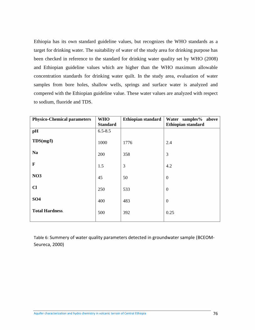
Aquifer characterization and hydro chemistry in volcanic terrain of Central Ethiopia 76
Ethiopia has its own standard guideline values, but recognizes the WHO standards as a
target for drinking water. The suitability of water of the study area for drinking purpose has
been checked in reference to the standard for drinking water quality set by WHO (2008)
and Ethiopian guideline values which are higher than the WHO maximum allowable
concentration standards for drinking water quilt. In the study area, evaluation of water
samples from bore holes, shallow wells, springs and surface water is analyzed and
compered with the Ethiopian guideline value. These water values are analyzed with respect
to sodium, fluoride and TDS.
Physico-Chemical parameters WHO
Standard
Ethiopian standard Water samples% above
Ethiopian standard
pH
TDS(mg/l)
Na
F
NO3
Cl
SO4
Total Hardness.
6.5-8.5
1000
200
1.5
45
250
400
500
1776
358
3
50
533
483
392
2.4
3
4.2
0
0
0
0.25
Table 6: Summery of water quality parameters detected in groundwater sample (BCEOM-
Seureca, 2000)
Aquifer characterization and hydro chemistry in volcanic terrain of Central Ethiopia 77
CHAPTER 6
CONCLUSIONS AND RECOMMENDATIONS
6.1. Conclusions
Mesozoic sedimentary rocks dip away from Abay gorge which was formed on the zone of
maximum crustal swell (uplift) along regional fracturing. Tertiary period volcanic rocks,
which were formed due to outpouring of magma through fractures along maximum swell,
are laid on the dipping Mesozoic sedimentary units. Late tertiary period faulting brought
about rifting and associated volcanic activities. Recent volcanic rocks and lacustrine
deposits were also formed during the Quaternary period. The area can be divided in to three
geomorphologic features (zones): central gentle slopes and plateau, western, northwestern
and northeastern deep gorges of Blue Nile, Guder, Muger and Jema rivers and low
elevation area, and elevated picks of mountains and ridges.
Fissured aquifers hosted in Tertiary basalts are the main hydro stratigraphic unit where
ground water is accumulated. Porous aquifers of sandstone, alluvium, fissured and karst
aquifers of limestone have also good groundwater holding and bearing capacity. They are
classified as high to moderately productive aquifers. Mesozoic sandstone possesses both
primary and secondary permeability for groundwater movement and occurrence. The main
water bearing horizon is constituted by interstitial spaces. In addition, the groundwater
occurrence and movement is governed by secondary fractures and joints which enhanced
the porosity and permeability. In this aquifer there are many springs following the NE-SW
and N-S faults. In general, these rocks are classified as high productive aquifers. The
productivity of Antalo limestone is highly dependent on secondary porosity (Fractures,
joints and Karsts). Springs of high yield are concentrated on karst and fissured aquifers of
limestone. This rock is found to be poor in groundwater occurrence where it is massive and
fresh. But in most places, it is highly fractured and karstified having good groundwater
occurrence, and it is classified as high productive aquifer. The porous aquifers of alluvium
and upper sandstone bear groundwater by dug wells and springs respectively. Lower
ignimbrite exposed in the southern part of the study area has a relatively moderate potential
Aquifer characterization and hydro chemistry in volcanic terrain of Central Ethiopia 78
to groundwater due to its limited weathered and fractured surface. It is mapped as
moderately productive aquifer. The Tertiary acidic volcanic rocks of trachyte and rhyolite
have minor significance in occurrence of groundwater resource.
Aquifer characterization is the process of quantifying the physical and chemical features of
an aquifer which control groundwater or contaminant movement in the subsurface. To
characterize aquifer quantitatively the borehole density and spatial distribution are other
required conditions. Groundwater flow direction in the study area is mainly controlled by
structures and geomorphology. Rain water infiltrates in outcrops of volcanic rocks and
flows within aquifers from recharge areas into discharge areas in shallow and deep
circulation.
Data obtained from the analyses of groundwater of the study area from AAWSA, GSE and
WWDSE are used in the characterization of aquifer in terms of chemical constituents of
groundwater. Analyses of spring and borehole sample show considerable differences in the
amounts and dominance of major ions. Chloride, Nitrate, Fluoride and total dissolved
solids (TDS) are commonly used as groundwater quality indicators of potential
contamination of groundwater. The concentration of nitrate and chloride are relatively high
in densely populated areas. High nitrate concentration levels indicate contamination from
municipal wastes, whereas high chloride concentrations in groundwater show
contamination from pit Latrines, waste disposals and from city water supply.
Moderately high pH values that are commonly associated with water are high in
bicarbonate.TDS and conductivity of the water samples show increase in concentration
parallel to the general ground water flow direction. The highest TDS is about 3527.7 mg/l
on the Felwuha fault while the lowest is 34 mg/l on the highly elevated Entoto Mountains.
In some parts especially in the rift zone and samples from some boreholes which are
associated to fault Zones show fluoride concentration is higher than the normal drinking
water standard. High Fluoride concentration, up to 28.6mg/l in central and rift zones
associated with thermal waters due to the high temperature which helps the ion to
precipitate freely in aqueous solution also the acidic rock has a big contribution. Calcium is
Aquifer characterization and hydro chemistry in volcanic terrain of Central Ethiopia 79
the only dominant cations in a Sample collected from boreholes. Bicarbonate is by far the
dominant anion water sample collected from boreholes with variation in composition of
Ca, Na and Mg. The relative abundance of the cations indicates the dissolution of minerals
that constitute either basic or acidic volcanic rocks.
The chemical analysis of major ions in spring water sample shows Sodium and Calcium as
the dominant cations and they are more or less equally abundant. The classification of
water has been based on dominant ions which are bicarbonate water (HCO3) and
bicarbonate sulfate Water (HCO3-SO4). The cat ion groups associated with bicarbonate are
Ca, Ca-Mg, Ca-Mg-Na, Ca-Na-Mg, Ca-Na, Mg-Ca, Na-Ca and Na-Ca- Mg. The water type
in the study area is predominantly bicarbonate type (Mg-HCO3, Ca-HCO3, and Na-
HCO3).
According to Ethiopian standard of water quality most of the water samples taken in this
analysis have good qulity except some samples. Among the 405 all water sample analyzed
TDS 2.2%, Na 3 %, F 5.2 % , NO3 4.2 % of the total samples that analyzed are above the
Ethiopian water standard guidline.
6.2. Recommendations
Detail hydrogeological and hydro chemical investigations are recommended in order to
identify and delineate zones of economic and investment interest like thermal zones like
along regional faults, gas rich water zones like areas surrounding acidic volcanics,
Suspected zones that limit portability of water like high fluoride, high TDS and other
parameters which determine the usefulness of water for a given purpose should be carefully
investigated.
The study area, along the major regional faults like Ambo-Filwuha, Ambo-Butajira and
Dukem-Abusera fault zones, where TDS and fluoride concentrations are expected to be
high, chemical analysis of water samples should be conducted before well completion
during drilling in order to save at least the cost of construction materials. Appropriate
environmental protection measures should be done in areas with highly permeable geologic
Aquifer characterization and hydro chemistry in volcanic terrain of Central Ethiopia 80
formations like in Adaa plains, Akaki well field and in areas surrounding Holota where
active flashing of surface runoff is expected to pollute groundwater. Impact assessment
should be done for the chemicals/fertilizers used by flower farms.
In urban center, cares should be taken to the ground water pollution. The surface water of
Addis Ababa city is highly polluted and contaminated. This could directly or indirectly
pollute the volcanic aquifer of Addis Ababa city. The chemical analysis of water samples
from some shallow boreholes in Addis Ababa city show contamination from surface water.
So the surface water of the city should be controlled and protected. In the study area, there
are numerous numbers of flower farming. The risk for pollution of groundwater will be
high due to the waste disposal from such kind of farming. It should be given a special
attention for flower farming disposal.
Aquifer characterization and hydro chemistry in volcanic terrain of Central Ethiopia 81
References
Abenezer Kefle. (2002). Hydrogeological evaluation in the Ambo-Weliso area.
Unpublished MSc thesis, AAU. Addis Ababa, Ethiopia.
Adane Bekele. (1999). Surface Water and Groundwater Pollution Problems in the Upper
Awash River Basin, Ethiopia. Master Thesis. University of Turku, Finland [
[[
[[[[[
Andarge Yitbarek. (2010). Hydrogeological and hydro geochemical framework of complex
volcanic system in the Upper Awash River Basin, Central Ethiopia. University of
Poitiers, France, unpublished, PhD. Thesis
Anderson, M.P. and Woessner, W.W. (1992). Applied Groundwater Modeling:
Simulation of flow and advective transport, Academic Press, Inc.,
New York, 381pp
Assegide Getahun. (2006). Geology of Addis Ababa city (NC 37-10/ X and Y and NC
476/ E and Sub sheets, Geological Survey of Ethiopia, Addis Ababa, Ethiopia.
Bartolino, J R. and Cole, J C. (2003). Groundwater Resources of the Middle Rio Grande
Basin, U.S. Geological Survey Circular 1222.
BCEOM & Seureca Space JV in association with Tropics Consulting Engineers, September
.(2000). Akaki Groundwater Model. Addis Ababa Water Supply Project Stage IIIA,
Groundwater Phase II. Addis Ababa Water & Sewerage Authority (AAWSA), Addis
Ababa
Berhanu Melaku. (1982). Hydrogeology of upper Awash basin. Ethiopian Institute of
geological Survey (EIGS). Addis Ababa, Ethiopia.
Aquifer characterization and hydro chemistry in volcanic terrain of Central Ethiopia 82
Berhanu Gizaw. (1996).The origin of high bicarbonate & fluoride concentrations in waters
of the Main Ethiopian Rift Valley, East African Rift System. J. African Earth Sci.
4, 391-402.
Berhanu Gizaw. (2002). Hydro-chemical and environmental investigation of Addis Ababa
region. Ethiopia Ph.D. Thesis Ludwing Maximlian University of Munich, Germeny.
Bisrat Lema and Amaha Athnafu .(2007). Conducted Hydrogeological mapping of south
eastern part of the Jema river basin.
Chernet ,T. Hart, WK. Aronson, JL. and Walter, RC. (1998). New age constraints on the
Timing of volcanism and tectonism in the northern Ethiopian Main Rift-Southern
Afar transition zone. J. Volcanol. Geotherm. Res., 80, 267-280.
Davis, S.N. and De Wiest, R.J.M. (1966). Hydrology. Wiley, New York.
Demlie, M., Wohnlich, S., Ayenew, T. (2008). Major ion hydrochemistry and
Environmental isotope signatures as a tool in assessing groundwater occurrence and
Its dynamics in a fractured volcanic aquifer system located within a he heavily
urbanized catchment, central Ethiopia. Journal of Hydrology 353: 175– 188.
Driscoll, F.G. (1986). Groundwater and wells. Reynolds Guyar Designs, USA.
Fanuel Seyoum. (2007). Aquifer characterization of Addis Ababa and adjacent High land.
Unpublished M.Sc. thesis, Addis Ababa University.
Fetter, C.W. (1994). Applied hydrogeology. New Jersey: Prentice-Hall, Inc.
Freeze, R., & Cherry, A. (1979). Groundwater. A Simon and Schuster Company
Englewood cliffs. New Jersey, USA.
Gaspron, M., Innocentti, F., Magetti, P., Piccerillo, A. and Tsegaye, A. (1993). Genesis
of the Pliocene to Recent bimodal mafic-felsic volcanism in the Debra Zest area,
central Ethiopia: volcanological and geochemical constraints. J Afri Earth Sci
Aquifer characterization and hydro chemistry in volcanic terrain of Central Ethiopia 83
17(2):145–1993
Hem D, (1971). Study and Interpretation of the Chemical Characteristics of Natural Water.
Second Edition. USA
Hem, D. J. (1992). Study and interpretation of the chemical characteristics of natural
water. Third edition, US geological survey water supply paper 2254, United States
government printing office, Washington, 264pp.
Ethiopia. Appl Geochem 20:1658–1676.
Kazmin, V. (1979). Stratigraphy and correlation of volcanic rocks of Ethiopia. Ethiopian
Institute of Geological Surveys, 106: 1- 26.
Kebede Tsehayu, &Tadesse Hailemariam.(1990). Engineering geological mapping of
Addis Ababa, EGS, and Addis Ababa.
Kebede, S., Travi, Y., Alemayehu, T., Ayenew, T. (2005). Groundwater recharge,
Circulation and geochemical evolution in the source region of the Blue Nile River
Mohr P.A. (1967). The Ethiopian Rift System. Bull. Geophysical Observatory.Addis
Ababa.
Mohr, P.A. (1971). Ethiopian rift and plateau: some volcanic petrochemical differences
Journal of Geophysical Research, 76, 1967-1984.
Morton et al. (1979). Rift wards Younging of Volcanic Rocks in the Addis
Ababa Region, Ethiopian Rift Valley. Nature V.280.
Mengesh Tefera, Tadiwos Cherinet and Worknesh Haro,(1996). Explanation of the
geoloical Map of Ethiopia, Ministry of Mines and Energy, EGS,
Bull.No 3,Addis Ababa.
Matebie, M., & Yonas, H. (2006). Geology of chancho(s) sub sheet of Addis Ababa sheet,
Geological Survey of Ethiopia. Addis Ababa, Ethiopia.
Aquifer characterization and hydro chemistry in volcanic terrain of Central Ethiopia 84
Mengesh Tefera, Tadiwos Cherinet, & Worknesh Haro. (1996). Explanation of the
geological map of Ethiopia, Ministry of Mines and Energy, EGS, Bull. No 3,Addis
Ababa.
Ministry of Mines Geological survey of Ethiopia .(2010). Technical hydro geological
report of Addis Ababa.
Piper, A.M. (1944). A graphic procedure in the geochemical interpretation of water
Analysis. Trans. Am. Geophys. Union 25, 914-923.
Raji, B. & Alagbe, S. (1997). Hydrochemical facies in parts of the Nigerian basement
complex. Environ. Geol. 29, 46–49.
Seifu Kebede, Yves Travi, Tamiru Alemayehu & Tenalem Ayenew. (2005). Groundwater
recharge, circulation and geochemical evolution in the source region of Blue Nile
River. [
Solomon Tale. (2000). The Extent of Surface and Groundwater Pollution in
Addis Ababa. Master Thesis. Addis Ababa University
Tamiru Alemayehu et al. (2005). Hydro geochemical and lake level changes in the Ethiopia
rift, hydrogeology journal
Tamiru Alemayew. (2006). Groundwater occurrence in Ethiopia. A.A.U, Ethiopia.
Tamiru Alemayehu. (2008). Urban groundwater and pollution in Addis Ababa, Ethiopia.
Tamiru Alemayehu and Tenalem Ayenew, 2001. Principles of hydrogeology, Addis
Ababa university department of Geology and Geophysics.
Tamiru A.,Tenalem A., Dagnachew, L.,Yirga, T., Solomon, W., Nuri, M. (2003).
Scientific report on the ground water vulnerability mapping of the Addis Ababa
water supply aquifers. Addis Ababa University and Addis Ababa Water &
Sewerage Authority. Addis Ababa, Ethiopia.
Aquifer characterization and hydro chemistry in volcanic terrain of Central Ethiopia 85
Tenalem Ayenaw. (1998).The Hydrogeological Systems of the Lake District Basin, Central
Main Ethiopian Rift. PhD Thesis. ITC publication No. 64.Enschede, the
Netherlands.
Tesfay Cherent. (1993). Hydro geology of Ethiopia and water resources development
Ethiopia. Institute of geological survey, Addis Ababa.
Tesfaye Cherent. (1982). Ground water investigation for water supply of Hilton Hotel.
Theis, CV. (1963): Estimating the transmissivity of a water table aquifer from the
Specific capacity of a well. US Geological Survey Water supply Paper 1536-I. pp
332-336 EIGS. Addis Ababa, Ethiopia.
Tilahun Azagegn. (2008). Hydro geochemical characterization of aquifer systems in upper
Awash and adjacent plateau .Unpublished M.Sc. thesis, Addis Ababa University.
World Health Organization, WHO (2008): Guidelines for drinking water quality, 3rd
edition, Geneva.
Water Works Design and Supervision Enterprise (WWDSE). (2008). Evaluation of water
resources of Adaa and Becho plains groundwater resource for irrigation. Addis
Ababa, Ethiopia. , annex-1 main report, Addis Ababa, Ethiopia
WWDSE (2008). Evaluation of water resources of Adaa and Becho plains groundwater
resources for irrigation, annex-2 Geology, Hydrology and Geophysics, Addis
Ababa, Ethiopia.
Zanettin, B., Justin Visentin, E., Nicoletti, M. and Piccirillo, E.M. (1980) Correlation
Among Ethiopian Volcanic formations with Special References to the Chronological and
stratigraphical Problems of the “Trap Series” in Geodynamic Evolution of the Afro-
Arabian Rift System. Atti dei convegni Lincei 47, 231-251.
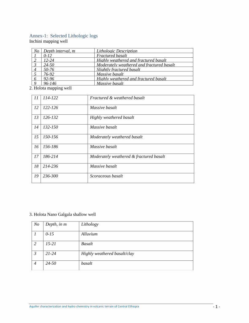
Aquifer characterization and hydro chemistry in volcanic terrain of Central Ethiopia - 1 -
Annex-1: Selected Lithologic logs Inchini mapping well
No Depth interval, m Lithologic Description 1 0-12 Fractured basalt 2 12-24 Highly weathered and fractured basalt 3 24-50 Moderately weathered and fractured basalt 4 50-76 Slightly fractured basalt 5 76-92 Massive basalt 6 92-96 Highly weathered and fractured basalt 9 96-146 Massive basalt
2. Holota mapping well
11 114-122 Fractured & weathered basalt
12 122-126 Massive basalt
13 126-132 Highly weathered basalt
14 132-150 Massive basalt
15 150-156 Moderately weathered basalt
16 156-186 Massive basalt
17 186-214 Moderately weathered & fractured basalt
18 214-236 Massive basalt
19 236-300 Scoraceous basalt
3. Holota Nano Galgala shallow well
No Depth, in m Lithology
1 0-15 Alluvium
2 15-21 Basalt
3 21-24 Highly weathered basalt/clay
4 24-50 basalt
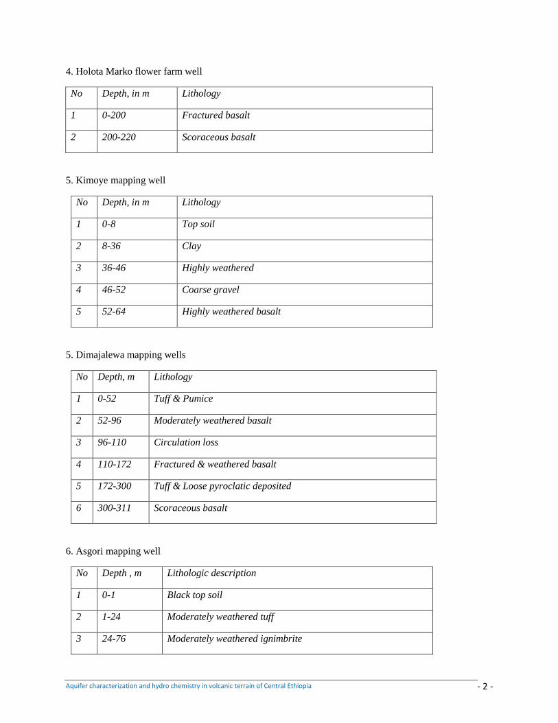
Aquifer characterization and hydro chemistry in volcanic terrain of Central Ethiopia - 2 -
4. Holota Marko flower farm well
No Depth, in m Lithology
1 0-200 Fractured basalt
2 200-220 Scoraceous basalt
5. Kimoye mapping well
No Depth, in m Lithology
1 0-8 Top soil
2 8-36 Clay
3 36-46 Highly weathered
4 46-52 Coarse gravel
5 52-64 Highly weathered basalt
5. Dimajalewa mapping wells
No Depth, m Lithology
1 0-52 Tuff & Pumice
2 52-96 Moderately weathered basalt
3 96-110 Circulation loss
4 110-172 Fractured & weathered basalt
5 172-300 Tuff & Loose pyroclatic deposited
6 300-311 Scoraceous basalt
6. Asgori mapping well
No Depth , m Lithologic description
1 0-1 Black top soil
2 1-24 Moderately weathered tuff
3 24-76 Moderately weathered ignimbrite
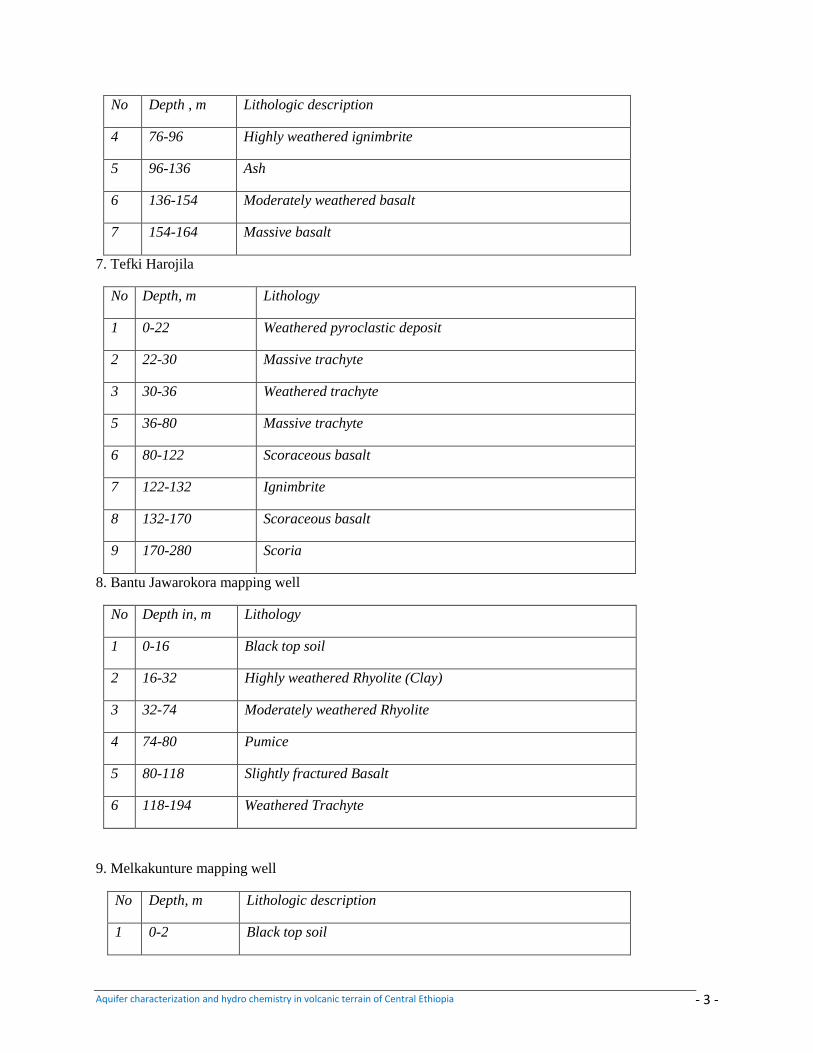
Aquifer characterization and hydro chemistry in volcanic terrain of Central Ethiopia - 3 -
No Depth , m Lithologic description
4 76-96 Highly weathered ignimbrite
5 96-136 Ash
6 136-154 Moderately weathered basalt
7 154-164 Massive basalt
7. Tefki Harojila
No Depth, m Lithology
1 0-22 Weathered pyroclastic deposit
2 22-30 Massive trachyte
3 30-36 Weathered trachyte
5 36-80 Massive trachyte
6 80-122 Scoraceous basalt
7 122-132 Ignimbrite
8 132-170 Scoraceous basalt
9 170-280 Scoria
8. Bantu Jawarokora mapping well
No Depth in, m Lithology
1 0-16 Black top soil
2 16-32 Highly weathered Rhyolite (Clay)
3 32-74 Moderately weathered Rhyolite
4 74-80 Pumice
5 80-118 Slightly fractured Basalt
6 118-194 Weathered Trachyte
9. Melkakunture mapping well
No Depth, m Lithologic description
1 0-2 Black top soil
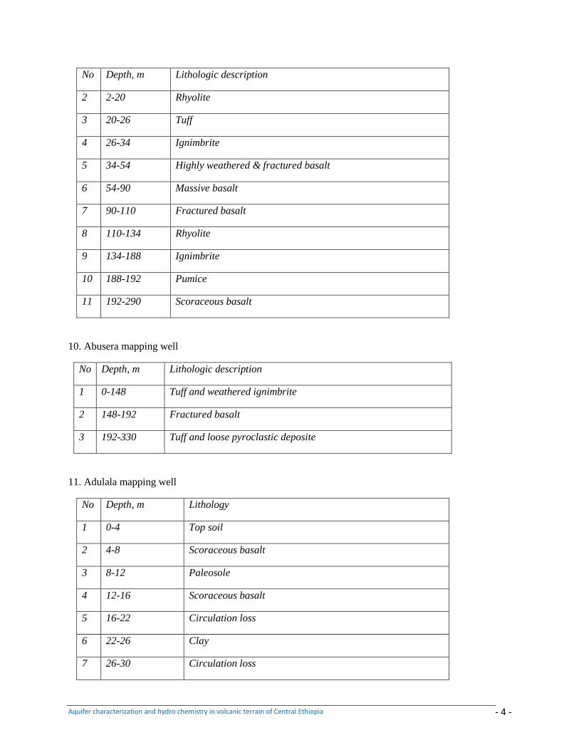
Aquifer characterization and hydro chemistry in volcanic terrain of Central Ethiopia - 4 -
No Depth, m Lithologic description
2 2-20 Rhyolite
3 20-26 Tuff
4 26-34 Ignimbrite
5 34-54 Highly weathered & fractured basalt
6 54-90 Massive basalt
7 90-110 Fractured basalt
8 110-134 Rhyolite
9 134-188 Ignimbrite
10 188-192 Pumice
11 192-290 Scoraceous basalt
10. Abusera mapping well
No Depth, m Lithologic description
1 0-148 Tuff and weathered ignimbrite
2 148-192 Fractured basalt
3 192-330 Tuff and loose pyroclastic deposite
11. Adulala mapping well
No Depth, m Lithology
1 0-4 Top soil
2 4-8 Scoraceous basalt
3 8-12 Paleosole
4 12-16 Scoraceous basalt
5 16-22 Circulation loss
6 22-26 Clay
7 26-30 Circulation loss
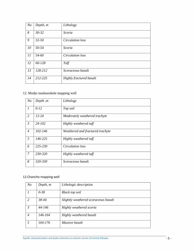
Aquifer characterization and hydro chemistry in volcanic terrain of Central Ethiopia - 5 -
No Depth, m Lithology
8 30-32 Scoria
9 32-50 Circulation loss
10 50-54 Scoria
11 54-60 Circulation loss
12 60-128 Tuff
13 128-212 Scoraceous basalt
14 212-225 Highly fractured basalt
12. Modjo mudasenkele mapping well
No Depth ,m Lithology
1 0-12 Top soil
2 12-24 Moderately weathered trachyte
3 24-102 Highly weathered tuff
4 102-146 Weathered and fractured trachyte
5 146-225 Highly weathered tuff
6 225-230 Circulation loss
7 230-320 Highly weathered tuff
8 320-330 Scoraceous basalt
12.Chancho mapping well
No Depth, m Lithologic description
1 0-38 Black top soil
2 38-44 Slightly weathered scoraceous basalt
3 44-146 Highly weathered scoria
4 146-164 Highly weathered basalt
5 164-176 Massive basalt
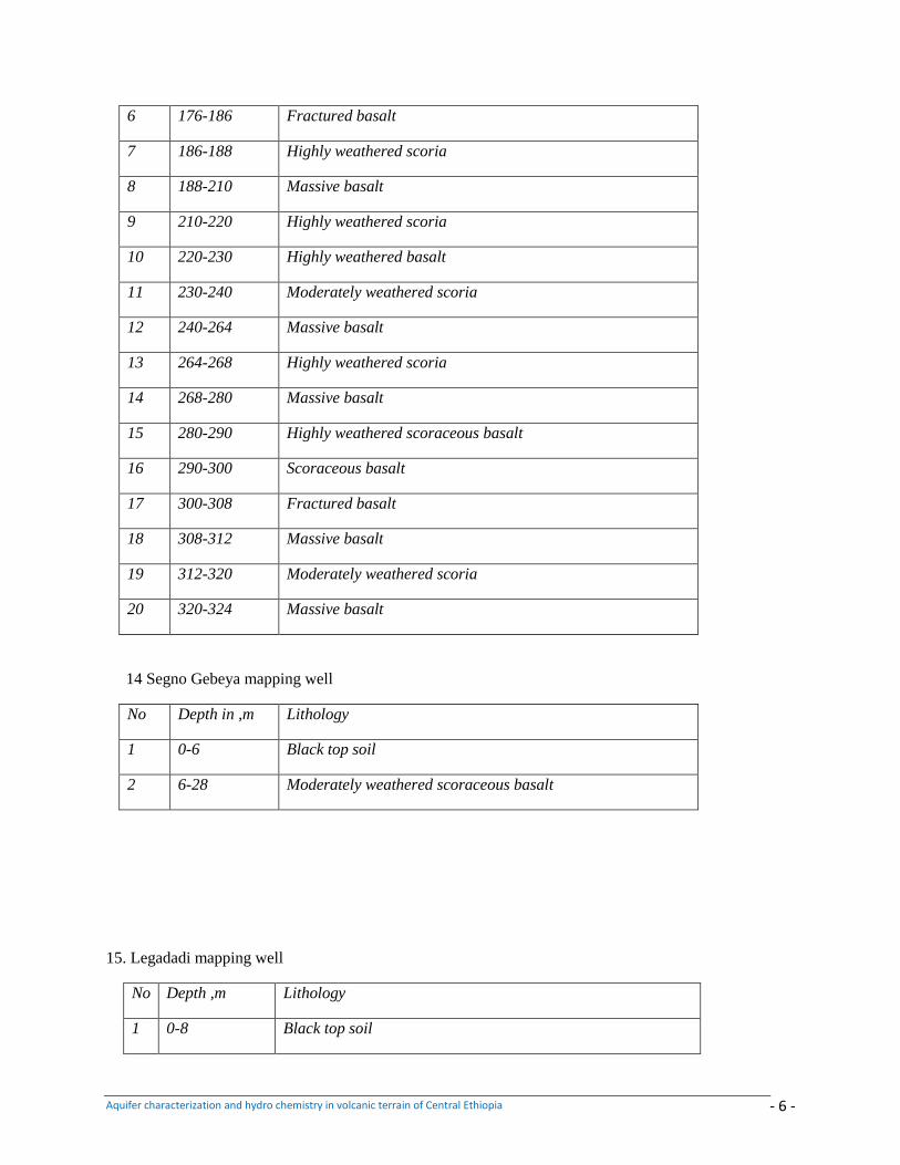
Aquifer characterization and hydro chemistry in volcanic terrain of Central Ethiopia - 6 -
6 176-186 Fractured basalt
7 186-188 Highly weathered scoria
8 188-210 Massive basalt
9 210-220 Highly weathered scoria
10 220-230 Highly weathered basalt
11 230-240 Moderately weathered scoria
12 240-264 Massive basalt
13 264-268 Highly weathered scoria
14 268-280 Massive basalt
15 280-290 Highly weathered scoraceous basalt
16 290-300 Scoraceous basalt
17 300-308 Fractured basalt
18 308-312 Massive basalt
19 312-320 Moderately weathered scoria
20 320-324 Massive basalt
14 Segno Gebeya mapping well
No Depth in ,m Lithology
1 0-6 Black top soil
2 6-28 Moderately weathered scoraceous basalt
15. Legadadi mapping well
No Depth ,m Lithology
1 0-8 Black top soil
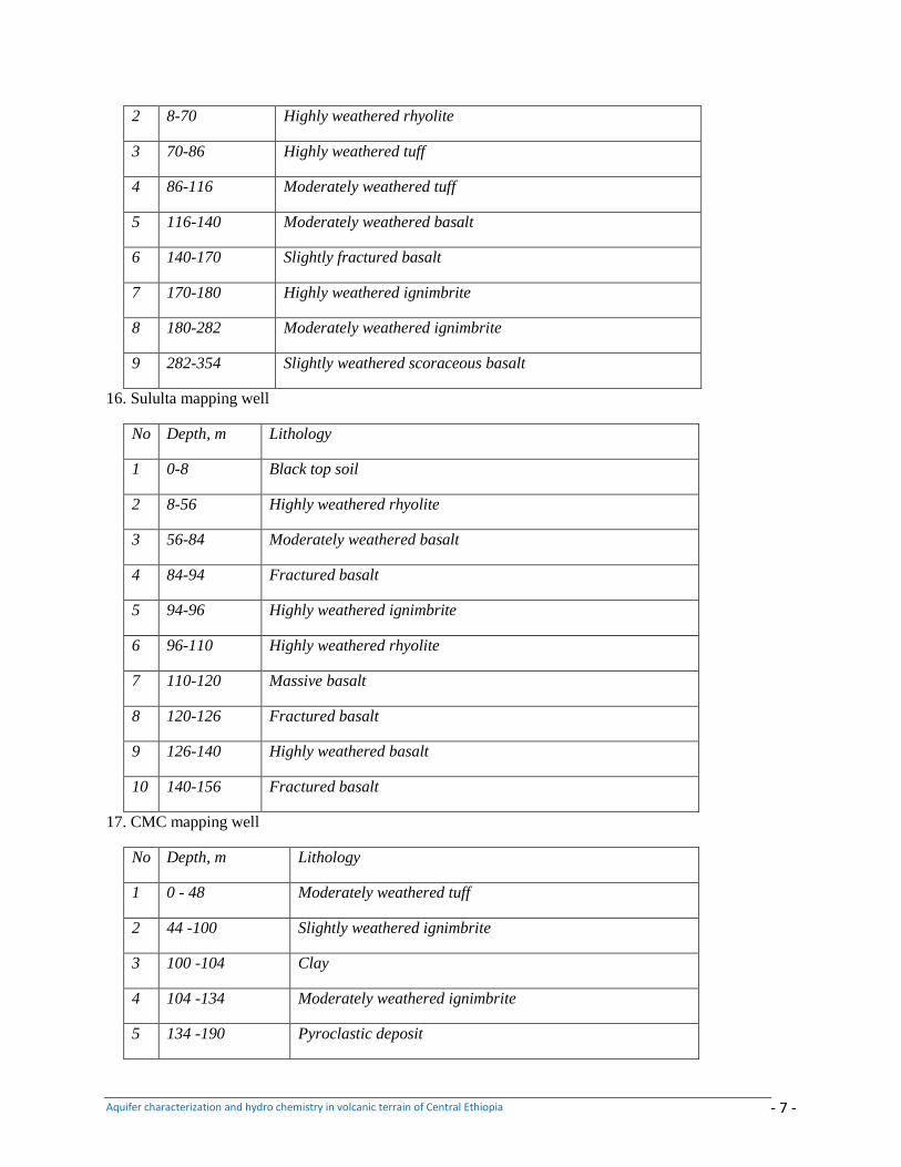
Aquifer characterization and hydro chemistry in volcanic terrain of Central Ethiopia - 7 -
2 8-70 Highly weathered rhyolite
3 70-86 Highly weathered tuff
4 86-116 Moderately weathered tuff
5 116-140 Moderately weathered basalt
6 140-170 Slightly fractured basalt
7 170-180 Highly weathered ignimbrite
8 180-282 Moderately weathered ignimbrite
9 282-354 Slightly weathered scoraceous basalt
16. Sululta mapping well
No Depth, m Lithology
1 0-8 Black top soil
2 8-56 Highly weathered rhyolite
3 56-84 Moderately weathered basalt
4 84-94 Fractured basalt
5 94-96 Highly weathered ignimbrite
6 96-110 Highly weathered rhyolite
7 110-120 Massive basalt
8 120-126 Fractured basalt
9 126-140 Highly weathered basalt
10 140-156 Fractured basalt
17. CMC mapping well
No Depth, m Lithology
1 0 - 48 Moderately weathered tuff
2 44 -100 Slightly weathered ignimbrite
3 100 -104 Clay
4 104 -134 Moderately weathered ignimbrite
5 134 -190 Pyroclastic deposit
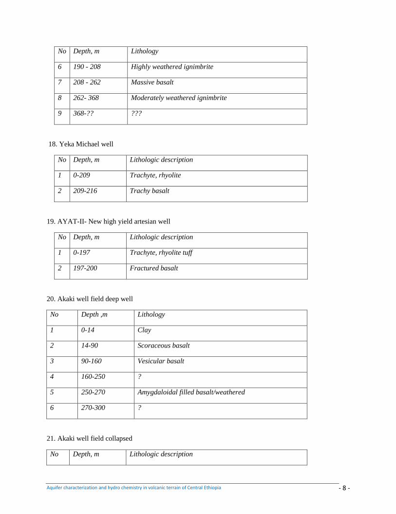
Aquifer characterization and hydro chemistry in volcanic terrain of Central Ethiopia - 8 -
No Depth, m Lithology
6 190 - 208 Highly weathered ignimbrite
7 208 - 262 Massive basalt
8 262- 368 Moderately weathered ignimbrite
9 368-?? ???
18. Yeka Michael well
No Depth, m Lithologic description
1 0-209 Trachyte, rhyolite
2 209-216 Trachy basalt
19. AYAT-II- New high yield artesian well
No Depth, m Lithologic description
1 0-197 Trachyte, rhyolite tuff
2 197-200 Fractured basalt
20. Akaki well field deep well
No Depth ,m Lithology
1 0-14 Clay
2 14-90 Scoraceous basalt
3 90-160 Vesicular basalt
4 160-250 ?
5 250-270 Amygdaloidal filled basalt/weathered
6 270-300 ?
21. Akaki well field collapsed
No Depth, m Lithologic description
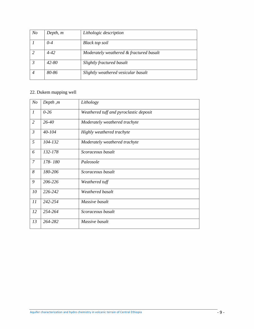
Aquifer characterization and hydro chemistry in volcanic terrain of Central Ethiopia - 9 -
No Depth, m Lithologic description
1 0-4 Black top soil
2 4-42 Moderately weathered & fractured basalt
3 42-80 Slightly fractured basalt
4 80-86 Slightly weathered vesicular basalt
22. Dukem mapping well
No Depth ,m Lithology
1 0-26 Weathered tuff and pyroclastic deposit
2 26-40 Moderately weathered trachyte
3 40-104 Highly weathered trachyte
5 104-132 Moderately weathered trachyte
6 132-178 Scoraceous basalt
7 178- 180 Paleosole
8 180-206 Scoraceous basalt
9 206-226 Weathered tuff
10 226-242 Weathered basalt
11 242-254 Massive basalt
12 254-264 Scoraceous basalt
13 264-282 Massive basalt
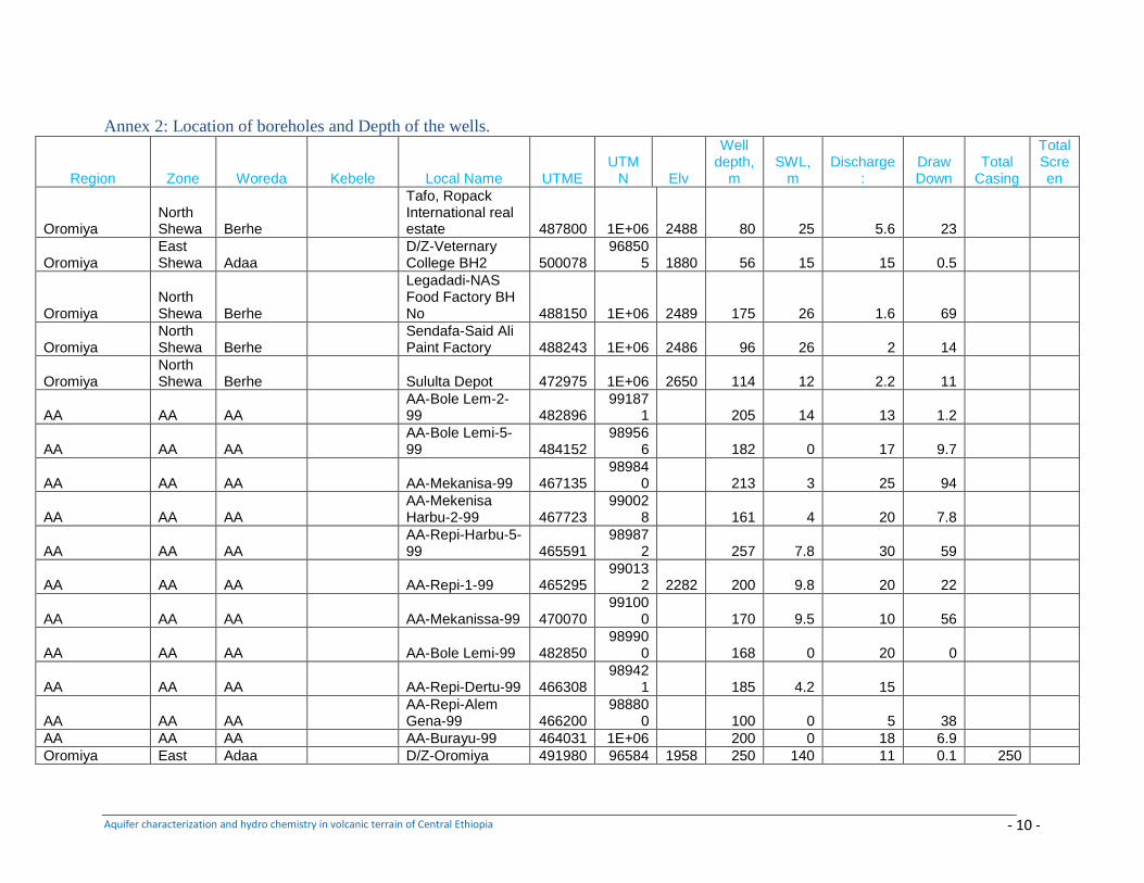
Aquifer characterization and hydro chemistry in volcanic terrain of Central Ethiopia - 10 -
Annex 2: Location of boreholes and Depth of the wells.
Region Zone Woreda Kebele Local Name UTME UTM
N Elv
Well depth,
m SWL,
m Discharge
: Draw Down
Total Casing
Total Screen
Oromiya North Shewa Berhe
Tafo, Ropack International real estate 487800 1E+06 2488 80 25 5.6 23
Oromiya East Shewa Adaa
D/Z-Veternary College BH2 500078
968505 1880 56 15 15 0.5
Oromiya North Shewa Berhe
Legadadi-NAS Food Factory BH No 488150 1E+06 2489 175 26 1.6 69
Oromiya North Shewa Berhe
Sendafa-Said Ali Paint Factory 488243 1E+06 2486 96 26 2 14
Oromiya North Shewa Berhe Sululta Depot 472975 1E+06 2650 114 12 2.2 11
AA AA AA AA-Bole Lem-2-99 482896
991871 205 14 13 1.2
AA AA AA AA-Bole Lemi-5-99 484152
989566 182 0 17 9.7
AA AA AA AA-Mekanisa-99 467135 98984
0 213 3 25 94
AA AA AA AA-Mekenisa Harbu-2-99 467723
990028 161 4 20 7.8
AA AA AA AA-Repi-Harbu-5-99 465591
989872 257 7.8 30 59
AA AA AA AA-Repi-1-99 465295 99013
2 2282 200 9.8 20 22
AA AA AA AA-Mekanissa-99 470070 99100
0 170 9.5 10 56
AA AA AA AA-Bole Lemi-99 482850 98990
0 168 0 20 0
AA AA AA AA-Repi-Dertu-99 466308 98942
1 185 4.2 15
AA AA AA AA-Repi-Alem Gena-99 466200
988800 100 0 5 38
AA AA AA AA-Burayu-99 464031 1E+06 200 0 18 6.9
Oromiya East Adaa D/Z-Oromiya 491980 96584 1958 250 140 11 0.1 250
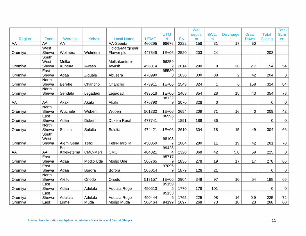
Aquifer characterization and hydro chemistry in volcanic terrain of Central Ethiopia - 11 -
Region Zone Woreda Kebele Local Name UTME UTM
N Elv
Well depth,
m SWL,
m Discharge
: Draw Down
Total Casing
Total Screen
AA AA AA AA-Sebeta 460295 98676 2222 158 31 17 50
Oromiya West Shewa Wolmera Wolmera
Holota-Marginpar Flower plc 447549 1E+06 2520 203 24 203
Oromiya
South West Shewa
Melka Kunture Awash
Melkakunture-Awash 456314
962592 2014 290 0 36 2.7 154 54
Oromiya East Shewa Adaa Ziquala Abusera 478990
955803 1830 330 38 2 42 204 0
Oromiya North Shewa Berehe Chancho Chancho 473911 1E+06 2543 324 1 6 158 324 84
Oromiya North Shewa Sendafa Legadadi Legadadi 493518 1E+06 2468 354 28 15 43 354 78
AA AA Akaki Akaki Akaki 476790 98122
9 2070 328 0 0 0
Oromiya North Shewa Wuchale Woberi Woberi 501332 1E+06 2654 209 71 16 0 209 42
Oromiya East Shewa Adaa Dukem Dukem Rural 477741
965964 1891 188 86 0 0
Oromiya North Shewa Sululta Sululta Sululta 474421 1E+06 2610 304 18 15 49 304 66
Oromiya
South West Shewa Alem Gena Tefki Tefki-Harojila 450359
981037 2084 280 11 19 42 281 78
AA AA Bole Kifleketema CMC-Meri CMC 484821
994284 2320 368 42 5.8 59 225 0
Oromiya East Shewa Adaa Modjo Ude Modjo Ude 506765
957179 1836 278 19 17 17 278 66
Oromiya East Shewa Adaa Borora Borora 505014
970969 1879 126 21 0 0
Oromiya North Shewa Aleltu Onodo Onodo 513157 1E+06 2904 348 97 10 54 188 66
Oromiya East Shewa Adaa Adulala Adulala Roge 490513
951595 1770 178 101 0 0
Oromiya East Shewa Adulala Adulala Adulala Roge 490444
951336 1765 225 98 16 0.9 225 72
Oromiya East Lume Muda Modjo Muda 506464 94199 1697 268 73 10 23 268 60
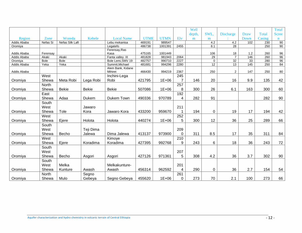
Aquifer characterization and hydro chemistry in volcanic terrain of Central Ethiopia - 12 -
Region Zone Woreda Kebele Local Name UTME UTMN Elv
Well
depth,
m
SWL,
m
Discharge
:
Draw
Down
Total
Casing
Total
Scree
n Addis Ababa Nefas Si Nefas Silk Laft Lebu mekanisa 469191 989547 4.2 4.2 102 230 90
Oromiya Legatefo 486738 1001391 2455 8.1 28 250 90
Addis Ababa Ferensay Ferensay,Ras Kasa 475165 1001449 106 18 1.2 260 96
Addis Ababa Akaki Akaki Fanta valley III 481828 981943 2064 29 7 146 260 96
Oromiya Bole Bole Bole Lemi,SMV 19 482757 990710 2227 0 32 33 280 96
Addis Ababa Yeka Yeka Summit,Michael 481681 994296 2280 12 13 145 250 84
Addis Ababa Alem Bank, Kidane Mihiret 466430 994219 2367 250 2 147 250 80
Oromiya West Shewa Meta Robi Lega Robi
Inchini-Lega Robi 421795 1E+06
2457 146 20 16 9.9 135 42
Oromiya North Shewa Bekie Bekie Bekie 507086 1E+06
2578 300 26 6.1 163 300 60
Oromiya East Shewa Adaa Dukem Dukem Town 490336 970789
1924 282 91 282 90
Oromiya
South West Shewa Tole
Jawaro Kora Jawaro Kora 433200 959670
2111 194 0 19 17 194 42
Oromiya West Shewa Ejere Holota Holota 440274 1E+06
2525 300 12 36 25 289 66
Oromiya
South West Shewa Becho
Teji Dima Jalewa Dima Jalewa 413137 973900
2090 311 8.5 17 35 311 84
Oromiya West Shewa Ejere Koradima
Kimoye Koradima 427395 992768
2109 243 6 18 36 243 72
Oromiya
South West Shewa Becho Asgori Asgori 427126 971361
2075 308 4.2 36 3.7 302 90
Oromiya
South West Shewa
Melka Kunture Awash
Melkakunture-Awash 456314 962592
2014 290 0 36 2.7 154 54
Oromiya North Shewa Mulo
Segno Gebeya Segno Gebeya 455620 1E+06
2610 273 70 2.1 100 273 66
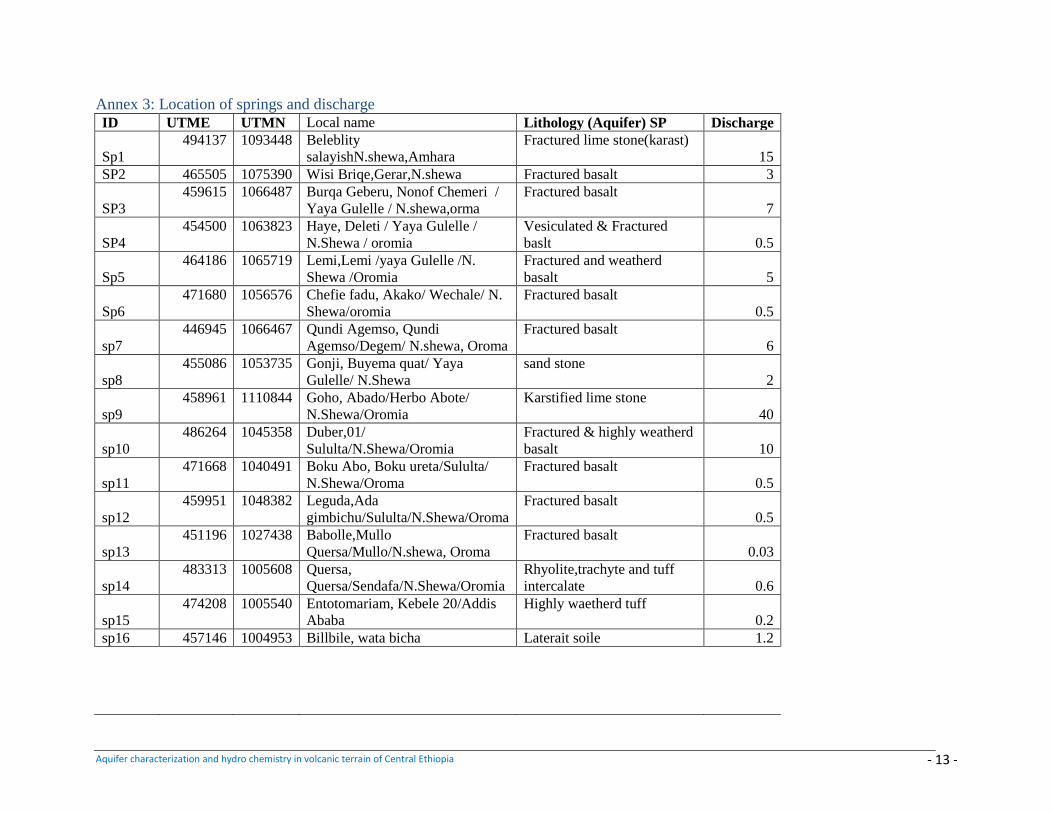
Aquifer characterization and hydro chemistry in volcanic terrain of Central Ethiopia - 13 -
Annex 3: Location of springs and discharge
ID UTME UTMN Local name Lithology (Aquifer) SP Discharge
Sp1
494137 1093448 Beleblity
salayishN.shewa,Amhara
Fractured lime stone(karast)
15
SP2 465505 1075390 Wisi Briqe,Gerar,N.shewa Fractured basalt 3
SP3
459615 1066487 Burqa Geberu, Nonof Chemeri /
Yaya Gulelle / N.shewa,orma
Fractured basalt
7
SP4
454500 1063823 Haye, Deleti / Yaya Gulelle /
N.Shewa / oromia
Vesiculated & Fractured
baslt 0.5
Sp5
464186 1065719 Lemi,Lemi /yaya Gulelle /N.
Shewa /Oromia
Fractured and weatherd
basalt 5
Sp6
471680 1056576 Chefie fadu, Akako/ Wechale/ N.
Shewa/oromia
Fractured basalt
0.5
sp7
446945 1066467 Qundi Agemso, Qundi
Agemso/Degem/ N.shewa, Oroma
Fractured basalt
6
sp8
455086 1053735 Gonji, Buyema quat/ Yaya
Gulelle/ N.Shewa
sand stone
2
sp9
458961 1110844 Goho, Abado/Herbo Abote/
N.Shewa/Oromia
Karstified lime stone
40
sp10
486264 1045358 Duber,01/
Sululta/N.Shewa/Oromia
Fractured & highly weatherd
basalt 10
sp11
471668 1040491 Boku Abo, Boku ureta/Sululta/
N.Shewa/Oroma
Fractured basalt
0.5
sp12
459951 1048382 Leguda,Ada
gimbichu/Sululta/N.Shewa/Oroma
Fractured basalt
0.5
sp13
451196 1027438 Babolle,Mullo
Quersa/Mullo/N.shewa, Oroma
Fractured basalt
0.03
sp14
483313 1005608 Quersa,
Quersa/Sendafa/N.Shewa/Oromia
Rhyolite,trachyte and tuff
intercalate 0.6
sp15
474208 1005540 Entotomariam, Kebele 20/Addis
Ababa
Highly waetherd tuff
0.2
sp16 457146 1004953 Billbile, wata bicha Laterait soile 1.2
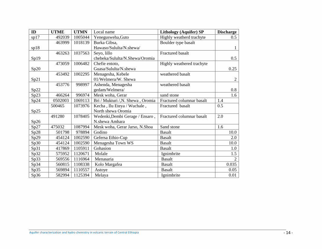
Aquifer characterization and hydro chemistry in volcanic terrain of Central Ethiopia - 14 -
ID UTME UTMN Local name Lithology (Aquifer) SP Discharge
sp17 492039 1005044 Yenegusweha,Guto Highly weatherd trachyte 0.5
sp18
463999 1018139 Burka Gibsa,
Hawaso/Sululta/N.shewa/
Boulder type basalt
1
Sp19
463263 1037563 Seyo, lillo
chebeka/Sululta/N.Shewa/Oromia
Fractured basalt
0.5
Sp20
473059 1006482 Chefie entoto,
Guasa/Sululta/N.shewa
Highly weathered trachyte
0.25
Sp21
453492 1002295 Menagesha, Kebele
01/Welmera/W. Shewa
weathered basalt
2
Sp22
453776 998997 Ashenda, Menagesha
gedam/Welmera/
weathered basalt
0.8
Sp23 466264 996974 Mesk woha, Gerar sand stone 1.6
Sp24 0502003 1069113 Bri / Mukturi /,N. Shewa , Oromia Fractured columnar basalt 1.4
Sp25
500465 1073976 Kecha , Ilu Eteya / Wuchale ,
North shewa Oromia
Fractured basalt 0.5
Sp26
491280 1078405 Wedenki,Dembi Gerage / Ensaro ,
N.shewa Amhara
Fractured columnar basalt 2.0
Sp27 475032 1087994 Mesk woha, Gerar Jarso, N.Shoa Sand stone 1.6
Sp28 501798 978894 Godino Basalt 10.0
Sp29 454124 1002590 Gefersa Ethio-Cup Basalt 2.0
Sp30 454124 1002590 Menagesha Town WS Basalt 10.0
Sp31 417869 1105911 Gohasion Basalt 1.0
Sp32 575952 1120671 Molale Ignimbrite 1.5
Sp33 569556 1116964 Menasaria Basalt 2
Sp34 560815 1108338 Kolo Margafea Basalt 0.035
Sp35 569894 1110557 Astoye Basalt 0.05
Sp36 582994 1125394 Melaya Ignimbrite 0.01
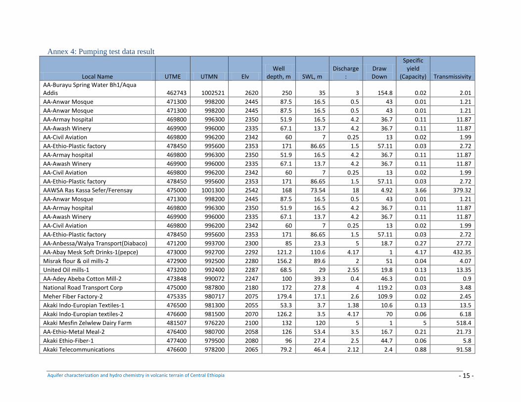
Aquifer characterization and hydro chemistry in volcanic terrain of Central Ethiopia - 15 -
Annex 4: Pumping test data result
Local Name UTME UTMN Elv Well
depth, m SWL, m Discharge
: Draw Down
Specific yield
(Capacity) Transmissivity
AA-Burayu Spring Water Bh1/Aqua Addis 462743 1002521 2620 250 35 3 154.8 0.02 2.01
AA-Anwar Mosque 471300 998200 2445 87.5 16.5 0.5 43 0.01 1.21
AA-Anwar Mosque 471300 998200 2445 87.5 16.5 0.5 43 0.01 1.21
AA-Armay hospital 469800 996300 2350 51.9 16.5 4.2 36.7 0.11 11.87
AA-Awash Winery 469900 996000 2335 67.1 13.7 4.2 36.7 0.11 11.87
AA-Civil Aviation 469800 996200 2342 60 7 0.25 13 0.02 1.99
AA-Ethio-Plastic factory 478450 995600 2353 171 86.65 1.5 57.11 0.03 2.72
AA-Armay hospital 469800 996300 2350 51.9 16.5 4.2 36.7 0.11 11.87
AA-Awash Winery 469900 996000 2335 67.1 13.7 4.2 36.7 0.11 11.87
AA-Civil Aviation 469800 996200 2342 60 7 0.25 13 0.02 1.99
AA-Ethio-Plastic factory 478450 995600 2353 171 86.65 1.5 57.11 0.03 2.72
AAWSA Ras Kassa Sefer/Ferensay 475000 1001300 2542 168 73.54 18 4.92 3.66 379.32
AA-Anwar Mosque 471300 998200 2445 87.5 16.5 0.5 43 0.01 1.21
AA-Armay hospital 469800 996300 2350 51.9 16.5 4.2 36.7 0.11 11.87
AA-Awash Winery 469900 996000 2335 67.1 13.7 4.2 36.7 0.11 11.87
AA-Civil Aviation 469800 996200 2342 60 7 0.25 13 0.02 1.99
AA-Ethio-Plastic factory 478450 995600 2353 171 86.65 1.5 57.11 0.03 2.72
AA-Anbessa/Walya Transport(Diabaco) 471200 993700 2300 85 23.3 5 18.7 0.27 27.72
AA-Abay Mesk Soft Drinks-1(pepce) 473000 992700 2292 121.2 110.6 4.17 1 4.17 432.35
Misrak flour & oil mills-2 472900 992500 2280 156.2 89.6 2 51 0.04 4.07
United Oil mills-1 473200 992400 2287 68.5 29 2.55 19.8 0.13 13.35
AA-Adey Abeba Cotton Mill-2 473848 990072 2247 100 39.3 0.4 46.3 0.01 0.9
National Road Transport Corp 475000 987800 2180 172 27.8 4 119.2 0.03 3.48
Meher Fiber Factory-2 475335 980717 2075 179.4 17.1 2.6 109.9 0.02 2.45
Akaki Indo-Europian Textiles-1 476500 981300 2055 53.3 3.7 1.38 10.6 0.13 13.5
Akaki Indo-Europian textiles-2 476600 981500 2070 126.2 3.5 4.17 70 0.06 6.18
Akaki Mesfin Zelwlew Dairy Farm 481507 976220 2100 132 120 5 1 5 518.4
AA-Ethio-Metal Meal-2 476400 980700 2058 126 53.4 3.5 16.7 0.21 21.73
Akaki Ethio-Fiber-1 477400 979500 2080 96 27.4 2.5 44.7 0.06 5.8
Akaki Telecommunications 476600 978200 2065 79.2 46.4 2.12 2.4 0.88 91.58
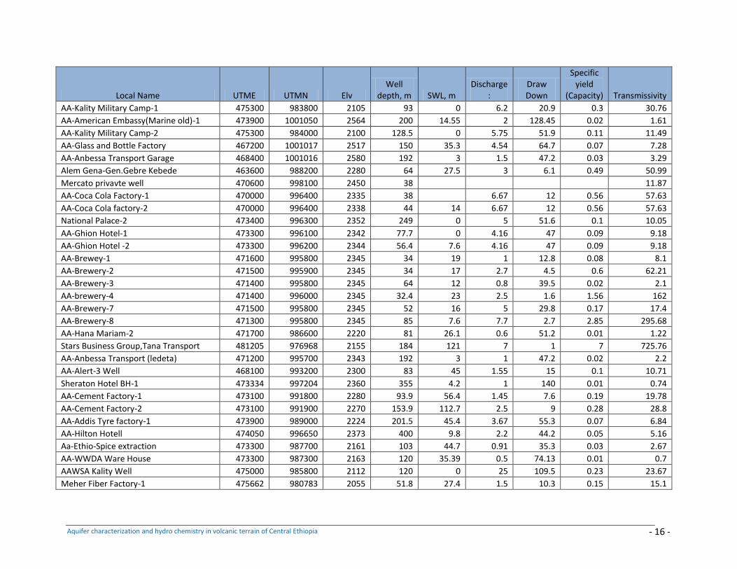
Aquifer characterization and hydro chemistry in volcanic terrain of Central Ethiopia - 16 -
Local Name UTME UTMN Elv Well
depth, m SWL, m Discharge
: Draw Down
Specific yield
(Capacity) Transmissivity
AA-Kality Military Camp-1 475300 983800 2105 93 0 6.2 20.9 0.3 30.76
AA-American Embassy(Marine old)-1 473900 1001050 2564 200 14.55 2 128.45 0.02 1.61
AA-Kality Military Camp-2 475300 984000 2100 128.5 0 5.75 51.9 0.11 11.49
AA-Glass and Bottle Factory 467200 1001017 2517 150 35.3 4.54 64.7 0.07 7.28
AA-Anbessa Transport Garage 468400 1001016 2580 192 3 1.5 47.2 0.03 3.29
Alem Gena-Gen.Gebre Kebede 463600 988200 2280 64 27.5 3 6.1 0.49 50.99
Mercato privavte well 470600 998100 2450 38 11.87
AA-Coca Cola Factory-1 470000 996400 2335 38 6.67 12 0.56 57.63
AA-Coca Cola factory-2 470000 996400 2338 44 14 6.67 12 0.56 57.63
National Palace-2 473400 996300 2352 249 0 5 51.6 0.1 10.05
AA-Ghion Hotel-1 473300 996100 2342 77.7 0 4.16 47 0.09 9.18
AA-Ghion Hotel -2 473300 996200 2344 56.4 7.6 4.16 47 0.09 9.18
AA-Brewey-1 471600 995800 2345 34 19 1 12.8 0.08 8.1
AA-Brewery-2 471500 995900 2345 34 17 2.7 4.5 0.6 62.21
AA-Brewery-3 471400 995800 2345 64 12 0.8 39.5 0.02 2.1
AA-brewery-4 471400 996000 2345 32.4 23 2.5 1.6 1.56 162
AA-Brewery-7 471500 995800 2345 52 16 5 29.8 0.17 17.4
AA-Brewery-8 471300 995800 2345 85 7.6 7.7 2.7 2.85 295.68
AA-Hana Mariam-2 471700 986600 2220 81 26.1 0.6 51.2 0.01 1.22
Stars Business Group,Tana Transport 481205 976968 2155 184 121 7 1 7 725.76
AA-Anbessa Transport (ledeta) 471200 995700 2343 192 3 1 47.2 0.02 2.2
AA-Alert-3 Well 468100 993200 2300 83 45 1.55 15 0.1 10.71
Sheraton Hotel BH-1 473334 997204 2360 355 4.2 1 140 0.01 0.74
AA-Cement Factory-1 473100 991800 2280 93.9 56.4 1.45 7.6 0.19 19.78
AA-Cement Factory-2 473100 991900 2270 153.9 112.7 2.5 9 0.28 28.8
AA-Addis Tyre factory-1 473900 989000 2224 201.5 45.4 3.67 55.3 0.07 6.84
AA-Hilton Hotell 474050 996650 2373 400 9.8 2.2 44.2 0.05 5.16
Aa-Ethio-Spice extraction 473300 987700 2161 103 44.7 0.91 35.3 0.03 2.67
AA-WWDA Ware House 473300 987300 2163 120 35.39 0.5 74.13 0.01 0.7
AAWSA Kality Well 475000 985800 2112 120 0 25 109.5 0.23 23.67
Meher Fiber Factory-1 475662 980783 2055 51.8 27.4 1.5 10.3 0.15 15.1
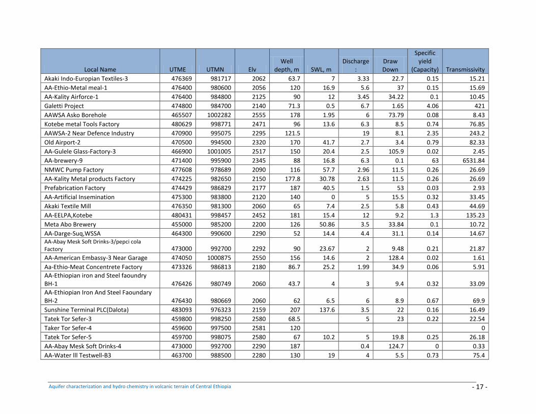
Aquifer characterization and hydro chemistry in volcanic terrain of Central Ethiopia - 17 -
Local Name UTME UTMN Elv Well
depth, m SWL, m Discharge
: Draw Down
Specific yield
(Capacity) Transmissivity
Akaki Indo-Europian Textiles-3 476369 981717 2062 63.7 7 3.33 22.7 0.15 15.21
AA-Ethio-Metal meal-1 476400 980600 2056 120 16.9 5.6 37 0.15 15.69
AA-Kality Airforce-1 476400 984800 2125 90 12 3.45 34.22 0.1 10.45
Galetti Project 474800 984700 2140 71.3 0.5 6.7 1.65 4.06 421
AAWSA Asko Borehole 465507 1002282 2555 178 1.95 6 73.79 0.08 8.43
Kotebe metal Tools Factory 480629 998771 2471 96 13.6 6.3 8.5 0.74 76.85
AAWSA-2 Near Defence Industry 470900 995075 2295 121.5 19 8.1 2.35 243.2
Old Airport-2 470500 994500 2320 170 41.7 2.7 3.4 0.79 82.33
AA-Gulele Glass-Factory-3 466900 1001005 2517 150 20.4 2.5 105.9 0.02 2.45
AA-brewery-9 471400 995900 2345 88 16.8 6.3 0.1 63 6531.84
NMWC Pump Factory 477608 978689 2090 116 57.7 2.96 11.5 0.26 26.69
AA-Kality Metal products Factory 474225 982650 2150 177.8 30.78 2.63 11.5 0.26 26.69
Prefabrication Factory 474429 986829 2177 187 40.5 1.5 53 0.03 2.93
AA-Artificial Insemination 475300 983800 2120 140 0 5 15.5 0.32 33.45
Akaki Textile Mill 476350 981300 2060 65 7.4 2.5 5.8 0.43 44.69
AA-EELPA,Kotebe 480431 998457 2452 181 15.4 12 9.2 1.3 135.23
Meta Abo Brewery 455000 985200 2200 126 50.86 3.5 33.84 0.1 10.72
AA-Darge-Suq,WSSA 464300 990600 2290 52 14.4 4.4 31.1 0.14 14.67 AA-Abay Mesk Soft Drinks-3/pepci cola Factory 473000 992700 2292 90 23.67 2 9.48 0.21 21.87
AA-American Embassy-3 Near Garage 474050 1000875 2550 156 14.6 2 128.4 0.02 1.61
Aa-Ethio-Meat Concentrete Factory 473326 986813 2180 86.7 25.2 1.99 34.9 0.06 5.91
AA-Ethiopian iron and Steel faoundry BH-1 476426 980749 2060 43.7 4 3 9.4 0.32 33.09
AA-Ethiopian Iron And Steel Faoundary BH-2 476430 980669 2060 62 6.5 6 8.9 0.67 69.9
Sunshine Terminal PLC(Dalota) 483093 976323 2159 207 137.6 3.5 22 0.16 16.49
Tatek Tor Sefer-3 459800 998250 2580 68.5 5 23 0.22 22.54
Taker Tor Sefer-4 459600 997500 2581 120 0
Tatek Tor Sefer-5 459700 998075 2580 67 10.2 5 19.8 0.25 26.18
AA-Abay Mesk Soft Drinks-4 473000 992700 2290 187 0.4 124.7 0 0.33
AA-Water lll Testwell-B3 463700 988500 2280 130 19 4 5.5 0.73 75.4
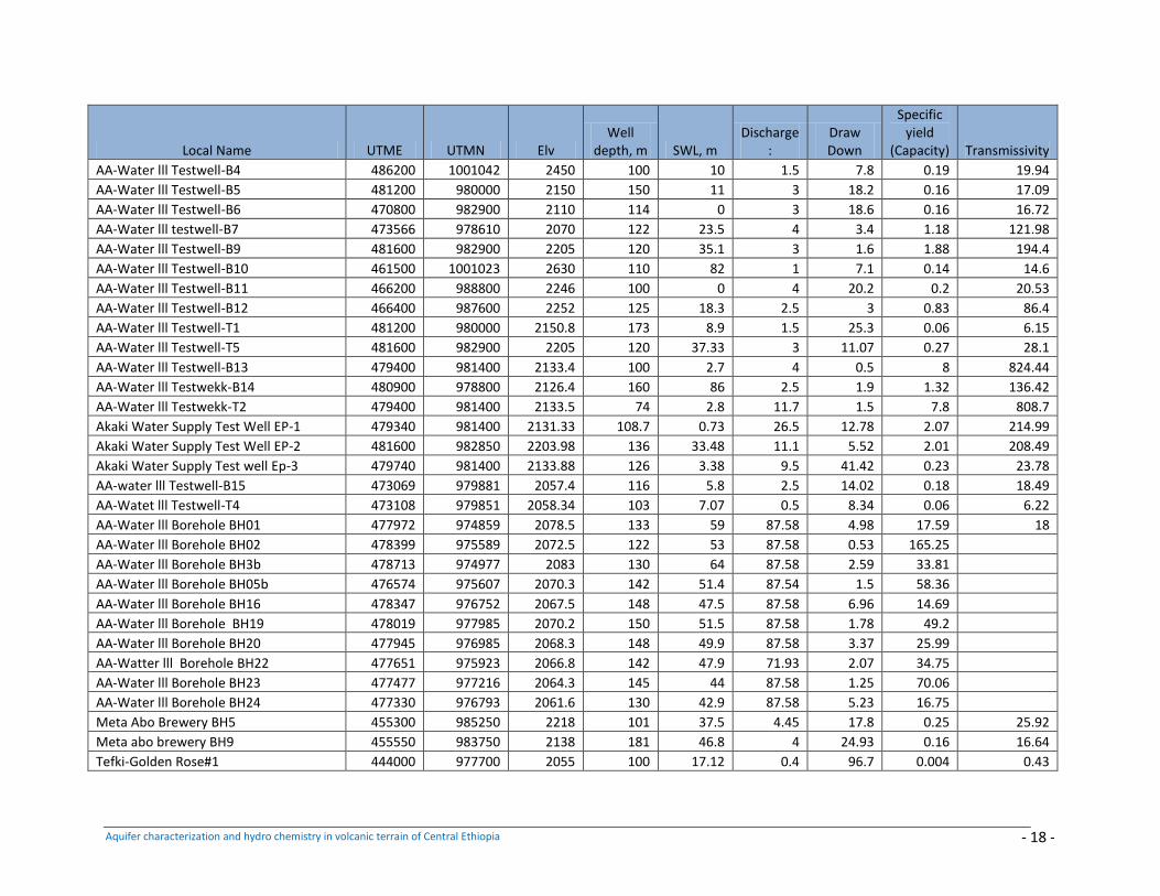
Aquifer characterization and hydro chemistry in volcanic terrain of Central Ethiopia - 18 -
Local Name UTME UTMN Elv Well
depth, m SWL, m Discharge
: Draw Down
Specific yield
(Capacity) Transmissivity
AA-Water lll Testwell-B4 486200 1001042 2450 100 10 1.5 7.8 0.19 19.94
AA-Water lll Testwell-B5 481200 980000 2150 150 11 3 18.2 0.16 17.09
AA-Water lll Testwell-B6 470800 982900 2110 114 0 3 18.6 0.16 16.72
AA-Water lll testwell-B7 473566 978610 2070 122 23.5 4 3.4 1.18 121.98
AA-Water lll Testwell-B9 481600 982900 2205 120 35.1 3 1.6 1.88 194.4
AA-Water lll Testwell-B10 461500 1001023 2630 110 82 1 7.1 0.14 14.6
AA-Water lll Testwell-B11 466200 988800 2246 100 0 4 20.2 0.2 20.53
AA-Water lll Testwell-B12 466400 987600 2252 125 18.3 2.5 3 0.83 86.4
AA-Water lll Testwell-T1 481200 980000 2150.8 173 8.9 1.5 25.3 0.06 6.15
AA-Water lll Testwell-T5 481600 982900 2205 120 37.33 3 11.07 0.27 28.1
AA-Water lll Testwell-B13 479400 981400 2133.4 100 2.7 4 0.5 8 824.44
AA-Water lll Testwekk-B14 480900 978800 2126.4 160 86 2.5 1.9 1.32 136.42
AA-Water lll Testwekk-T2 479400 981400 2133.5 74 2.8 11.7 1.5 7.8 808.7
Akaki Water Supply Test Well EP-1 479340 981400 2131.33 108.7 0.73 26.5 12.78 2.07 214.99
Akaki Water Supply Test Well EP-2 481600 982850 2203.98 136 33.48 11.1 5.52 2.01 208.49
Akaki Water Supply Test well Ep-3 479740 981400 2133.88 126 3.38 9.5 41.42 0.23 23.78
AA-water lll Testwell-B15 473069 979881 2057.4 116 5.8 2.5 14.02 0.18 18.49
AA-Watet lll Testwell-T4 473108 979851 2058.34 103 7.07 0.5 8.34 0.06 6.22
AA-Water lll Borehole BH01 477972 974859 2078.5 133 59 87.58 4.98 17.59 18
AA-Water lll Borehole BH02 478399 975589 2072.5 122 53 87.58 0.53 165.25
AA-Water lll Borehole BH3b 478713 974977 2083 130 64 87.58 2.59 33.81
AA-Water lll Borehole BH05b 476574 975607 2070.3 142 51.4 87.54 1.5 58.36
AA-Water lll Borehole BH16 478347 976752 2067.5 148 47.5 87.58 6.96 14.69
AA-Water lll Borehole BH19 478019 977985 2070.2 150 51.5 87.58 1.78 49.2
AA-Water lll Borehole BH20 477945 976985 2068.3 148 49.9 87.58 3.37 25.99
AA-Watter lll Borehole BH22 477651 975923 2066.8 142 47.9 71.93 2.07 34.75
AA-Water lll Borehole BH23 477477 977216 2064.3 145 44 87.58 1.25 70.06
AA-Water lll Borehole BH24 477330 976793 2061.6 130 42.9 87.58 5.23 16.75
Meta Abo Brewery BH5 455300 985250 2218 101 37.5 4.45 17.8 0.25 25.92
Meta abo brewery BH9 455550 983750 2138 181 46.8 4 24.93 0.16 16.64
Tefki-Golden Rose#1 444000 977700 2055 100 17.12 0.4 96.7 0.004 0.43
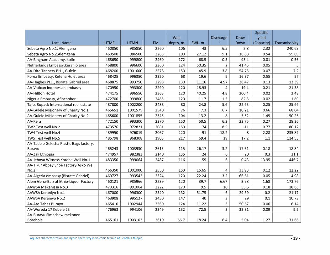
Aquifer characterization and hydro chemistry in volcanic terrain of Central Ethiopia - 19 -
Local Name UTME UTMN Elv Well
depth, m SWL, m Discharge
: Draw Down
Specific yield
(Capacity) Transmissivity
Sebeta Agro No.1, Alemgena 460850 985850 2260 106 43 6.5 2.8 2.32 240.69
Sebeta Agro No.2,Alemgena 460500 986500 2285 100 27.12 9.1 16.88 0.54 55.89
AA-Bingham Acadamy, kolfe 468650 999800 2460 172 68.5 0.5 93.4 0.01 0.56
Netherlands Embassy,Keranio area 468800 996600 2360 124 50.35 2 41.45 0.05 5
AA-Dire Tannery BH1, Gulele 468200 1001600 2578 150 45.9 3.8 54.75 0.07 7.2
Korea Embassy, Ketena Hulet area 468425 996350 2320 68 19.6 9 16.37 0.55 57
AA-Hagbes PLC., Bisrate Gabriel area 468875 993750 2298 130 11.16 4.97 38.47 0.13 13.39
AA-Vatican Indonesian embassy 470950 993300 2290 120 18.93 4 19.4 0.21 21.38
AA-Hillton Hotel 474175 996550 2365 120 40.25 4.8 200.4 0.02 2.48
Nigeria Embassy, Afinchober 472700 999800 2485 120 11.7 1.5 82.3 0.02 1.89
Tafo, Ropack International real estate 487800 1002200 2488 80 24.8 5.6 22.63 0.25 25.66
AA-Gulele Misionery of Charity No.1 465651 1001575 2540 76 7.3 6.7 10.21 0.66 68.04
AA-Gulele Misionery of Charity No.2 465600 1001855 2545 104 13.2 8 5.52 1.45 150.26
AA-Kera 472150 993300 2270 150 50.5 6.2 22.75 0.27 28.26
TW2 Test well No.2 473576 972821 2081 150 74 8.5 11 0.77 80.12
TW4 Test well No.4 489950 976019 2067 220 91 18.2 8 2.28 235.87
TW5 Test well No.5 485798 968308 1905 217 69.4 19 17.2 1.1 114.53
AA-Tadele Gelecha Plastic Bags factory, Burayu 465243 1003930 2615 115 26.17 3.2 17.61 0.18 18.84
AA-Zak Ethiopia 474957 982383 2140 135 24 6 20 0.3 31.1
AA-Jehova Witness Kotebe Well No.1 483350 999064 2487 116 59 6 0.43 13.95 446.7
AA-Tikur Abbay Shoe Factory(Asko Well No.2) 466350 1001000 2550 153 15.65 4 33.93 0.12 12.22
AA-Algeria embassy (Bisrate Gabriel) 469727 993542 2324 120 22.24 3.2 66.61 0.05 4.98
Alem Gena-Balz af Ethio-Liquor Factory 460121 985966 2239 120 39.7 6.67 3.98 1.68 173.76
AAWSA Mekanissa No.3 470316 991064 2222 170 9.5 10 55.6 0.18 18.65
AAWSA Keraniyo No.1 467000 996300 2340 132 51.75 6 29.39 0.2 21.17
AAWSA Keraniyo No.2 463908 995127 2450 147 40 3 29 0.1 10.73
AA-Ato Tahas Burayo 465410 1002944 2560 124 11.22 3 50.67 0.06 6.14
AA-Woreda 17 Kebele 23 476963 994106 2349 132 72.5 3 33.81 0.09 9.2
AA-Burayu Simachew mekonen Borehole 465161 1003103 2610 66.7 18.24 6.4 5.04 1.27 131.66
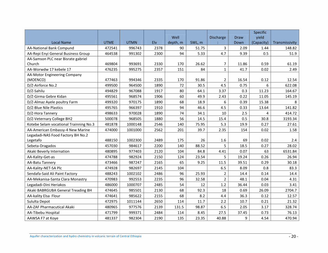
Aquifer characterization and hydro chemistry in volcanic terrain of Central Ethiopia - 20 -
Local Name UTME UTMN Elv Well
depth, m SWL, m Discharge
: Draw Down
Specific yield
(Capacity) Transmissivity
AA-National Bank Compund 472541 996743 2378 90 51.75 3 2.09 1.44 148.82
AA-Repi Enyi General Business Group 464538 991302 2300 94 5.33 4.7 9.39 0.5 51.9
AA-Samson PLC near Bisrate gabriel Church 469804 993691 2330 170 26.62 7 11.86 0.59 61.19
AA-Worwdw 17 kebele 17 476235 995275 2357 151 84 1 41.7 0.02 2.49
AA-Motor Engineering Company (MOENCO) 477463 994346 2335 170 91.86 2 16.54 0.12 12.54
D/Z-Airforce No.2 499500 964500 1890 72 30.5 4.5 0.75 6 622.08
D/Z-Sahilu 494829 967088 1917 80 64.1 3.37 0.3 11.23 164.67
D/Z-Girma Gebre Kidan 495561 968574 1906 60 49.9 2.43 0.22 11.05 145.19
D/Z-Almaz Ayele poultry Farm 499320 970175 1890 68 18.9 6 0.39 15.38 8
D/Z-Blue Nile Plastics 495765 966397 1910 94 46.6 4.5 0.33 13.64 141.82
D/Z-Hora Tannery 498633 970028 1890 74 34.1 10 2.5 4 414.72
D/Z-Veternary College BH2 500078 968505 1880 56 14.5 15.4 0.5 30.8 3193.34
Kotebe Selam vocational Trainning No.3 481878 1000148 2546 140 75.95 5.3 19.9 0.27 27.61
AA-American Embassy-4 New Marine 474000 1001000 2562 201 39.7 2.35 154 0.02 1.58
Legadadi-NAS Food Factory BH No.2 Legetafo 488150 1002300 2489 175 26 1.6 69 0.02 2.4
Sebeta-Dragados 457030 984617 2200 140 88.52 5 18.5 0.27 28.02
Akaki Beverly Internation 480895 977403 2120 104 84.8 4.41 0.07 63 6531.84
AA-Kality-Get-as 474788 982924 2150 124 23.54 5 19.24 0.26 26.94
AA-Batu Tannery 473466 987247 2165 65 9.25 11.5 39.51 0.29 30.18
AA-Kality-NET-SA Plc 474928 982697 2145 104 6.5 8.09 0.8 83.3
Sendafa-Said Ali Paint Factory 488243 1002102 2486 96 25.93 2 14.4 0.14 14.4
AA-Mekanisa-Santa Clara Monastry 470983 992553 2235 96 32.58 2 48.1 0.04 4.31
Legadadi-Dini Heriakos 486000 1000707 2485 54 12 1.2 36.44 0.03 3.41
Akaki BABRGUBA General Treading BH 474645 985501 2130 68 92.3 18 0.69 26.09 2704.7
AA-kality Elsa Flour 474641 985622 2155 68 8.2 4.4 36.3 0.12 12.57
Sululta Depot 472975 1011144 2650 114 11.7 2.2 10.7 0.21 21.32
AA-ZAF Pharmacutical Akaki 480965 977576 2139 131.5 98.87 6.5 2.05 3.17 328.74
AA-Tibebu Hospital 471799 999371 2484 114 8.45 27.5 37.45 0.73 76.13
AAWSA F7 at Koye 481337 982304 2190 135 23.35 40.88 9 4.54 470.94
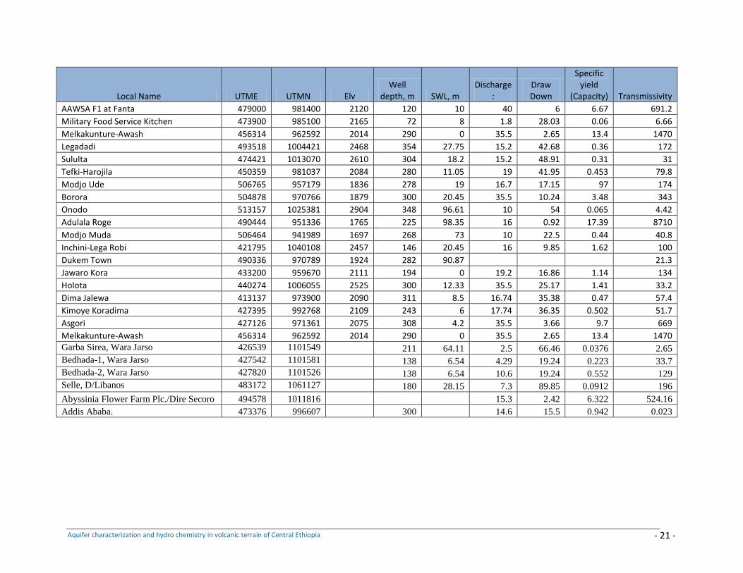
Aquifer characterization and hydro chemistry in volcanic terrain of Central Ethiopia - 21 -
Local Name UTME UTMN Elv Well
depth, m SWL, m Discharge
: Draw Down
Specific yield
(Capacity) Transmissivity
AAWSA F1 at Fanta 479000 981400 2120 120 10 40 6 6.67 691.2
Military Food Service Kitchen 473900 985100 2165 72 8 1.8 28.03 0.06 6.66
Melkakunture-Awash 456314 962592 2014 290 0 35.5 2.65 13.4 1470
Legadadi 493518 1004421 2468 354 27.75 15.2 42.68 0.36 172
Sululta 474421 1013070 2610 304 18.2 15.2 48.91 0.31 31
Tefki-Harojila 450359 981037 2084 280 11.05 19 41.95 0.453 79.8
Modjo Ude 506765 957179 1836 278 19 16.7 17.15 97 174
Borora 504878 970766 1879 300 20.45 35.5 10.24 3.48 343
Onodo 513157 1025381 2904 348 96.61 10 54 0.065 4.42
Adulala Roge 490444 951336 1765 225 98.35 16 0.92 17.39 8710
Modjo Muda 506464 941989 1697 268 73 10 22.5 0.44 40.8
Inchini-Lega Robi 421795 1040108 2457 146 20.45 16 9.85 1.62 100
Dukem Town 490336 970789 1924 282 90.87 21.3
Jawaro Kora 433200 959670 2111 194 0 19.2 16.86 1.14 134
Holota 440274 1006055 2525 300 12.33 35.5 25.17 1.41 33.2
Dima Jalewa 413137 973900 2090 311 8.5 16.74 35.38 0.47 57.4
Kimoye Koradima 427395 992768 2109 243 6 17.74 36.35 0.502 51.7
Asgori 427126 971361 2075 308 4.2 35.5 3.66 9.7 669
Melkakunture-Awash 456314 962592 2014 290 0 35.5 2.65 13.4 1470 Garba Sirea, Wara Jarso 426539 1101549 211 64.11 2.5 66.46 0.0376 2.65
Bedhada-1, Wara Jarso 427542 1101581 138 6.54 4.29 19.24 0.223 33.7
Bedhada-2, Wara Jarso 427820 1101526 138 6.54 10.6 19.24 0.552 129
Selle, D/Libanos 483172 1061127 180 28.15 7.3 89.85 0.0912 196
Abyssinia Flower Farm Plc./Dire Secoro 494578 1011816 15.3 2.42 6.322 524.16
Addis Ababa. 473376 996607 300 14.6 15.5 0.942 0.023
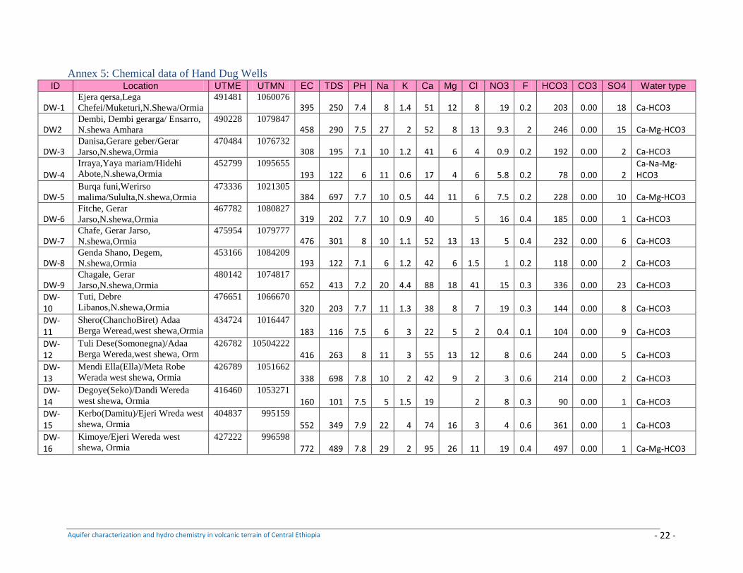
Aquifer characterization and hydro chemistry in volcanic terrain of Central Ethiopia - 22 -
Annex 5: Chemical data of Hand Dug Wells ID Location UTME UTMN EC TDS PH Na K Ca Mg Cl NO3 F HCO3 CO3 SO4 Water type
DW-1 Ejera qersa,Lega
Chefei/Muketuri,N.Shewa/Ormia
491481 1060076 395 250 7.4 8 1.4 51 12 8 19 0.2 203 0.00 18 Ca-HCO3
DW2 Dembi, Dembi gerarga/ Ensarro,
N.shewa Amhara
490228 1079847 458 290 7.5 27 2 52 8 13 9.3 2 246 0.00 15 Ca-Mg-HCO3
DW-3 Danisa,Gerare geber/Gerar
Jarso,N.shewa,Ormia
470484 1076732 308 195 7.1 10 1.2 41 6 4 0.9 0.2 192 0.00 2 Ca-HCO3
DW-4
Irraya,Yaya mariam/Hidehi
Abote,N.shewa,Ormia
452799 1095655
193 122 6 11 0.6 17 4 6 5.8 0.2 78 0.00 2 Ca-Na-Mg-HCO3
DW-5 Burqa funi,Werirso
malima/Sululta,N.shewa,Ormia
473336 1021305 384 697 7.7 10 0.5 44 11 6 7.5 0.2 228 0.00 10 Ca-Mg-HCO3
DW-6 Fitche, Gerar
Jarso,N.shewa,Ormia
467782 1080827 319 202 7.7 10 0.9 40 5 16 0.4 185 0.00 1 Ca-HCO3
DW-7 Chafe, Gerar Jarso,
N.shewa,Ormia
475954 1079777 476 301 8 10 1.1 52 13 13 5 0.4 232 0.00 6 Ca-HCO3
DW-8 Genda Shano, Degem,
N.shewa,Ormia
453166 1084209 193 122 7.1 6 1.2 42 6 1.5 1 0.2 118 0.00 2 Ca-HCO3
DW-9 Chagale, Gerar
Jarso,N.shewa,Ormia
480142 1074817 652 413 7.2 20 4.4 88 18 41 15 0.3 336 0.00 23 Ca-HCO3
DW-10
Tuti, Debre
Libanos,N.shewa,Ormia
476651 1066670
320 203 7.7 11 1.3 38 8 7 19 0.3 144 0.00 8 Ca-HCO3
DW-11
Shero(ChanchoBiret) Adaa
Berga Weread,west shewa,Ormia
434724 1016447
183 116 7.5 6 3 22 5 2 0.4 0.1 104 0.00 9 Ca-HCO3
DW-12
Tuli Dese(Somonegna)/Adaa
Berga Wereda,west shewa, Orm
426782 10504222
416 263 8 11 3 55 13 12 8 0.6 244 0.00 5 Ca-HCO3
DW-13
Mendi Ella(Ella)/Meta Robe
Werada west shewa, Ormia
426789 1051662
338 698 7.8 10 2 42 9 2 3 0.6 214 0.00 2 Ca-HCO3
DW-14
Degoye(Seko)/Dandi Wereda
west shewa, Ormia
416460 1053271
160 101 7.5 5 1.5 19 2 8 0.3 90 0.00 1 Ca-HCO3
DW-15
Kerbo(Damitu)/Ejeri Wreda west
shewa, Ormia
404837 995159
552 349 7.9 22 4 74 16 3 4 0.6 361 0.00 1 Ca-HCO3
DW-16
Kimoye/Ejeri Wereda west
shewa, Ormia
427222 996598
772 489 7.8 29 2 95 26 11 19 0.4 497 0.00 1 Ca-Mg-HCO3
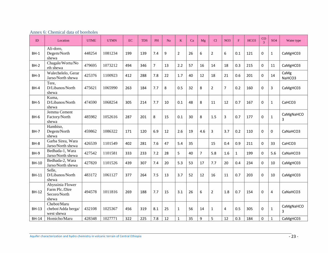
Aquifer characterization and hydro chemistry in volcanic terrain of Central Ethiopia - 23 -
Annex 6: Chemical data of boreholes
ID Location UTME UTMN EC TDS PH Na K Ca Mg Cl NO3 F HCO3 CO
3 SO4 Water type
BH-1 Ali-doro,
Degem/North
shewa
448254 1081234 199 139 7.4 9 2 26 6 2 6 0.1 121 0 1 CaMgHC03
BH-2 Chagale/Wortu/No
rth shewa 479695 1073212 494 346 7 13 2.2 57 16 14 18 0.3 215 0 11 CaMgHC03
BH-3 Walechelelo, Gerar
Jarso/North shewa 425376 1100923 412 288 7.8 22 1.7 40 12 18 21 0.6 201 0 14
CaMg NaHCO3
BH-4 Tere,
D/Libanos/North
shewa
475621 1065990 263 184 7.7 8 0.5 32 8 2 7 0.2 160 0 3 CaMgHC03
BH-5 Kuma,
D/Libanos/North
shewa
474590 1068254 305 214 7.7 10 0.1 48 8 11 12 0.7 167 0 1 CaHCO3
BH-6 Jemma Cement
Factory/North
shewa
485982 1052616 287 201 8 15 0.1 30 8 1.5 3 0.7 177 0 1 CaMgNaHCO3
BH-7 Hambiso,
Degem/North
shewa
459862 1086322 171 120 6.9 12 2.6 19 4.6 3 3.7 0.2 110 0 0 CaNaHCO3
BH-8 Garba Sirea, Wara
Jarso/North shewa 426539 1101549 402 281 7.6 47 5.4 35 15 0.4 0.9 211 0 33 CaHCO3
BH-9 Bedhada-1, Wara
Jarso/North shewa 427542 1101581 333 233 7.2 28 5 40 7 5.8 1.6 1 199 0 5.6 CaNaHCO3
BH-10 Bedhada-2, Wara
Jarso/North shewa 427820 1101526 439 307 7.4 20 5.3 53 17 7.7 20 0.4 234 0 10 CaMgHC03
BH-11 Selle,
D/Libanos/North
shewa
483172 1061127 377 264 7.5 13 3.7 52 12 16 11 0.7 203 0 10 CaMgHC03
BH-12
Abyssinia Flower
Farm Plc./Dire
Secoro/North
shewa
494578 1011816 269 188 7.7 15 3.1 26 6 2 1.8 0.7 154 0 4 CaNaHCO3
BH-13 Chebot/Maru
chebot/Adda berga/
west shewa
432108 1025367 456 319 8.1 25 1 56 14 1 4 0.5 305 0 1 CaMgNaHCO3
BH-14 Homicho/Maru 428348 1027771 322 225 7.8 12 1 35 9 5 12 0.3 184 0 1 CaMgHC03
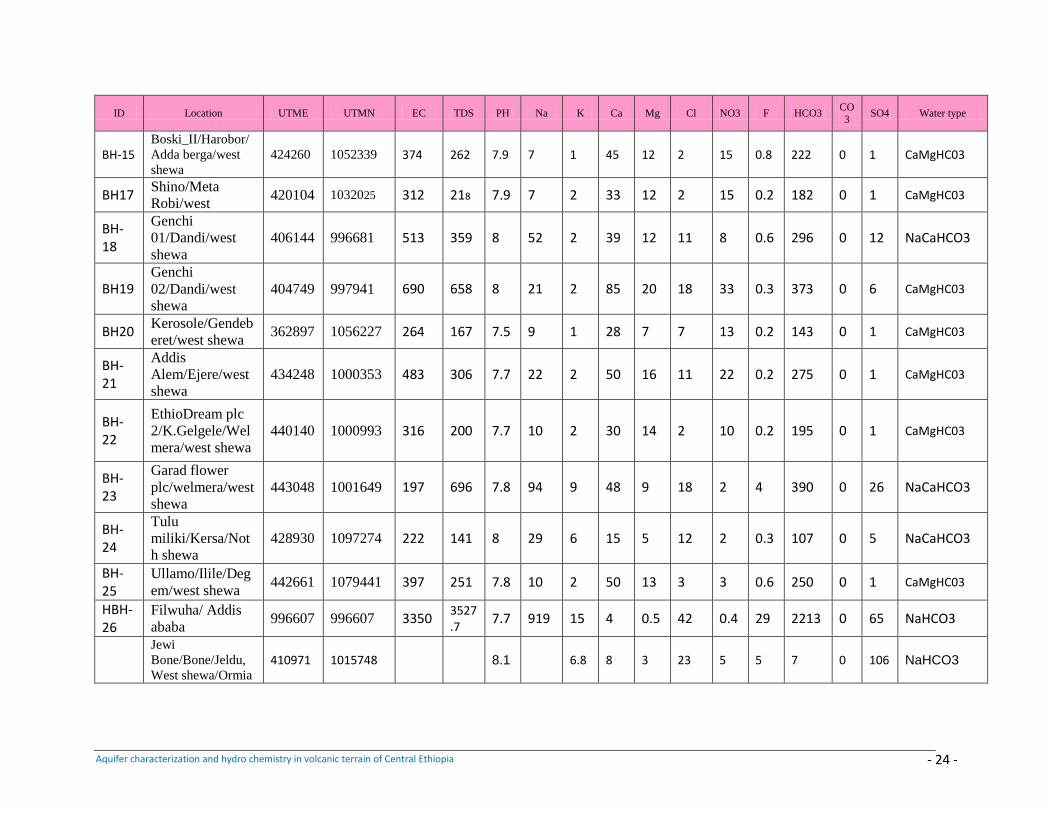
Aquifer characterization and hydro chemistry in volcanic terrain of Central Ethiopia - 24 -
ID Location UTME UTMN EC TDS PH Na K Ca Mg Cl NO3 F HCO3 CO
3 SO4 Water type
BH-15 Boski_II/Harobor/
Adda berga/west
shewa
424260 1052339 374 262 7.9 7 1 45 12 2 15 0.8 222 0 1 CaMgHC03
BH17 Shino/Meta
Robi/west 420104 1032025 312 218 7.9 7 2 33 12 2 15 0.2 182 0 1 CaMgHC03
BH-18
Genchi
01/Dandi/west
shewa
406144 996681 513 359 8 52 2 39 12 11 8 0.6 296 0 12 NaCaHCO3
BH19 Genchi
02/Dandi/west
shewa
404749 997941 690 658 8 21 2 85 20 18 33 0.3 373 0 6 CaMgHC03
BH20 Kerosole/Gendeb
eret/west shewa 362897 1056227 264 167 7.5 9 1 28 7 7 13 0.2 143 0 1 CaMgHC03
BH-21
Addis
Alem/Ejere/west
shewa
434248 1000353 483 306 7.7 22 2 50 16 11 22 0.2 275 0 1 CaMgHC03
BH-22
EthioDream plc
2/K.Gelgele/Wel
mera/west shewa
440140 1000993 316 200 7.7 10 2 30 14 2 10 0.2 195 0 1 CaMgHC03
BH-23
Garad flower
plc/welmera/west
shewa
443048 1001649 197 696 7.8 94 9 48 9 18 2 4 390 0 26 NaCaHCO3
BH-24
Tulu
miliki/Kersa/Not
h shewa
428930 1097274 222 141 8 29 6 15 5 12 2 0.3 107 0 5 NaCaHCO3
BH-25
Ullamo/Ilile/Deg
em/west shewa 442661 1079441 397 251 7.8 10 2 50 13 3 3 0.6 250 0 1 CaMgHC03
HBH-26
Filwuha/ Addis
ababa 996607 996607 3350
3527.7
7.7 919 15 4 0.5 42 0.4 29 2213 0 65 NaHCO3
Jewi
Bone/Bone/Jeldu,
West shewa/Ormia
410971 1015748 8.1 6.8 8 3 23 5 5 7 0 106 NaHCO3
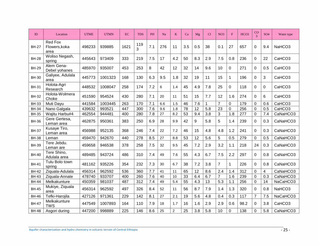
Aquifer characterization and hydro chemistry in volcanic terrain of Central Ethiopia - 25 -
ID Location UTME UTMN EC TDS PH Na K Ca Mg Cl NO3 F HCO3 CO
3 SO4 Water type
BH-27 Red Fox Flowers,koka area
498233 939885 1621 1193
7.1 276 11 3.5 0.5 38 0.1 27 657 0 9.4 NaHCO3
BH-28 Woliso Negash, spring
445643 973409 333 219 7.5 17 4.2 50 8.3 2.9 7.5 0.8 236 0 22 CaHCO3
BH-29 Alem Gena-Debel yohanes
485970 935007 453 253 8 42 12 32 14 9.6 10 0 271 0 0.5 CaHCO3
BH-30 Galiyee, Adulala area
445773 1001323 168 130 6.3 9.5 1.8 32 19 11 15 1 196 0 3 CaHCO3
BH-31 Holota-Agri Research
448532 1008047 258 174 7.2 6 1.4 45 4.9 7.8 25 0 118 0 0 CaHCO3
BH-32 Holota-Wolmera Choke
451590 954524 430 280 7.1 20 11 51 15 7.7 12 1.6 274 0 6 CaHCO3
BH-33 Muti Dayu 441584 1003445 263 170 7.1 6.6 1.5 46 7.6 1 7 0 179 0 0.6 CaHCO3
BH-34 Nano Galgala 439632 993521 447 300 7.6 9.6 1.8 78 12 5.8 23 0 256 0 0.5 CaHCO3
BH-35 Wajitu Harbu#4 462554 944481 400 280 7.8 27 8.2 53 9.4 3.8 3 1.8 277 0 7.4 CaNaHCO3
BH-36 Gere Gertesa, Leman area
462875 950361 383 250 6.9 28 9.9 42 9 5.8 5 1.4 239 0 0.3 CaNaHCO3
BH-37 Kusaye Tiro, Leman area
456988 952135 368 246 7.4 22 7.2 46 15 4.8 4.8 1.2 241 0 0.3 CaNaHCO3
BH-38 Leman 459470 942670 440 278 8.5 27 8.8 53 12 5.6 5 0.5 279 0 0.5 CaNaHCO3
BH-39 Tere Jebdu. Leman are
459658 946538 378 258 7.5 32 9.5 45 7.2 2.9 3.2 1.1 218 24 0.3 CaNaHCO3
BH-40 Tere Shino, Adulala area
489485 943724 486 310 7.4 49 7.6 55 4.3 6.7 7.5 2.2 297 0 0.8 CaNaHCO3
BH-41 Tulu Bolo town spring
481162 935226 354 232 7.3 30 6.7 38 7.2 3.8 7 1 226 0 0.8 CaNaHCO3
BH-42 Ziquala-Adulala 456314 962592 536 360 7.7 41 11 65 12 8.6 2.4 1.4 312 0 4 CaNaHCO3
BH-43 Ziquala-Annate 478740 933707 400 260 7.6 40 10 33 6.4 6.7 7 1.6 239 0 0.3 CaNaHCO3
BH-44 Melkakunture 450359 981037 487 312 7.4 49 5.4 55 4.3 13 5.3 1.1 256 0 14 NaCaHCO3
BH-45 Mukiye, Ziquala area
456314 962592 497 326 8.4 52 11 56 8.7 7.9 1.4 1.3 320 0 0.8 NaHCO3
BH-46 Tefki-Harojila 427126 971361 229 142 8.1 27 2.1 19 5.6 4.8 0.4 0.3 117 7 7.5 NaCaHCO3
BH-47 Melkakunture TWS
447549 1007893 164 110 7.9 18 1.7 16 1.6 2.9 2.9 0.6 98.2 0 3.8 CaHCO3
BH-48 Asgori during 447200 998889 225 146 8.6 25 2 25 3.8 5.8 10 0 138 0 5.8 CaNaHCO3
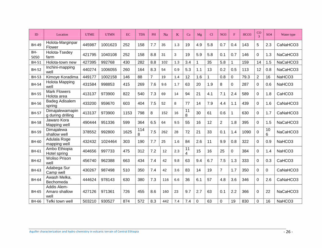
Aquifer characterization and hydro chemistry in volcanic terrain of Central Ethiopia - 26 -
ID Location UTME UTMN EC TDS PH Na K Ca Mg Cl NO3 F HCO3 CO
3 SO4 Water type
BH-49 Holota-Marginpar Flower
445987 1001623 252 158 7.7 35 1.3 19 4.9 5.8 0.7 0.4 143 5 2.3 CaNaHCO3
BH-5050
Holota-Tsedey farm
421795 1040108 252 158 8.8 31 3 19 5.9 5.8 0.1 0.7 146 0 1.3 NaCaHCO3
BH-51 Holota-town new 427395 992768 430 282 8.8 102 1.3 3.4 1 35 5.8 1 159 14 1.5 NaCaHCO3
BH-52 Inchini-mapping well
440274 1006055 260 164 8.3 54 0.9 5.3 1.1 13 0.2 0.5 113 12 0.8 NaCaHCO3
BH-53 Kimoye Koradima 449177 1002158 146 88 7 19 1.4 12 1.6 1 0.8 0 79.3 2 16 NaHCO3
BH-54 Holota Mapping well
431584 998853 415 269 7.6 9.6 1.7 63 20 1.9 8 0 287 0 0.6 NaHCO3
BH-55 Mark Flowers Holota area
413137 973900 822 540 7.3 69 14 94 21 4.1 7.1 2.4 589 0 1.8 CaHCO3
BH-56 Badeg Adisalem spring
433200 959670 603 404 7.5 52 8 77 14 7.9 4.4 1.1 439 0 1.6 CaNaHCO3
BH-57 Dimajalewamaping during drilling
413137 973900 1153 798 8 152 16 118
30 61 0.6 1 630 0 1.7 CaNaHCO3
BH-58 Jawaro Kora Mapping well
490444 951336 599 364 6.5 64 9.5 55 16 12 2 1.8 395 0 1.5 NaCaHCO3
BH-59 Dimajalewa shallow well
378552 992800 1625 1148
7.5 262 28 72 21 33 0.1 1.4 1090 0 106
NaCaHCO3
BH-60 Adulala Roge mapping well
432432 1024464 303 190 7.7 25 1.6 84 2.6 11 9.9 0.8 322 0 0.9 NaHCO3
BH-61 Ambo Ethiopia Hotel spring
404656 997733 475 312 7.2 12 2.3 114
15 16 25 0 384 0 1.4 NaHCO3
BH-62 Woliso Prison well
456740 962388 663 434 7.4 42 9.8 63 9.4 6.7 7.5 1.3 333 0 0.3 CaHCO3
BH-63 Adabega Sur Camp well
430267 987498 510 350 7.4 42 3.6 83 14 19 7 1.7 350 0 0 CaNaHCO3
BH-64 Awash Melka, Bechomeda
444624 978143 630 380 7.3 116 6.6 36 6.1 57 4.8 3.6 346 0 2.6 CaNaHCO3
BH-65 Addis Alem-Amaro shallow well
427126 971361 726 455 8.6 160 23 9.7 2.7 63 0.1 2.2 366 0 22 NaCaHCO3
BH-66 Tefki town well 503210 930527 874 572 8.3 442 7.4 7.4 0 63 0 19 830 0 16 NaHCO3
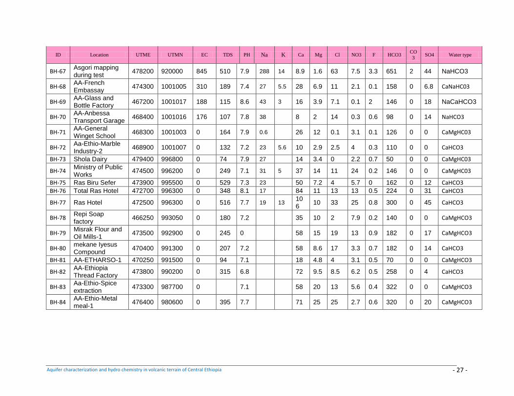
Aquifer characterization and hydro chemistry in volcanic terrain of Central Ethiopia - 27 -
ID Location UTME UTMN EC TDS PH Na K Ca Mg Cl NO3 F HCO3 CO3
SO4 Water type
BH-67 Asgori mapping during test
478200 920000 845 510 7.9 288 14 8.9 1.6 63 7.5 3.3 651 2 44 NaHCO3
BH-68 AA-French Embassay
474300 1001005 310 189 7.4 27 5.5 28 6.9 11 2.1 0.1 158 0 6.8 CaNaHC03
BH-69 AA-Glass and Bottle Factory
467200 1001017 188 115 8.6 43 3 16 3.9 7.1 0.1 2 146 0 18 NaCaHCO3
BH-70 AA-Anbessa Transport Garage
468400 1001016 176 107 7.8 38
8 2 14 0.3 0.6 98 0 14 NaHCO3
BH-71 AA-General Winget School
468300 1001003 0 164 7.9 0.6
26 12 0.1 3.1 0.1 126 0 0 CaMgHC03
BH-72 Aa-Ethio-Marble Industry-2
468900 1001007 0 132 7.2 23 5.6 10 2.9 2.5 4 0.3 110 0 0 CaHCO3
BH-73 Shola Dairy 479400 996800 0 74 7.9 27
14 3.4 0 2.2 0.7 50 0 0 CaMgHC03
BH-74 Ministry of Public Works
474500 996200 0 249 7.1 31 5 37 14 11 24 0.2 146 0 0 CaMgHC03
BH-75 Ras Biru Sefer 473900 995500 0 529 7.3 23
50 7.2 4 5.7 0 162 0 12 CaHCO3
BH-76 Total Ras Hotel 472700 996300 0 348 8.1 17
84 11 13 13 0.5 224 0 31 CaHCO3
BH-77 Ras Hotel 472500 996300 0 516 7.7 19 13 106
10 33 25 0.8 300 0 45 CaHCO3
BH-78 Repi Soap factory
466250 993050 0 180 7.2
35 10 2 7.9 0.2 140 0 0 CaMgHCO3
BH-79 Misrak Flour and Oil Mills-1
473500 992900 0 245 0
58 15 19 13 0.9 182 0 17 CaMgHCO3
BH-80 mekane Iyesus Compound
470400 991300 0 207 7.2
58 8.6 17 3.3 0.7 182 0 14 CaHCO3
BH-81 AA-ETHARSO-1 470250 991500 0 94 7.1
18 4.8 4 3.1 0.5 70 0 0 CaMgHCO3
BH-82 AA-Ethiopia Thread Factory
473800 990200 0 315 6.8
72 9.5 8.5 6.2 0.5 258 0 4 CaHCO3
BH-83 Aa-Ethio-Spice extraction
473300 987700 0 7.1
58 20 13 5.6 0.4 322 0 0 CaMgHCO3
BH-84 AA-Ethio-Metal meal-1
476400 980600 0 395 7.7
71 25 25 2.7 0.6 320 0 20 CaMgHCO3
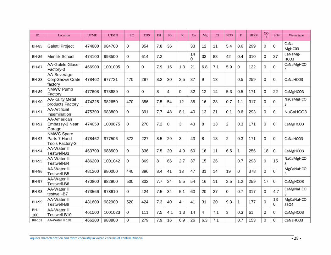
Aquifer characterization and hydro chemistry in volcanic terrain of Central Ethiopia - 28 -
ID Location UTME UTMN EC TDS PH Na K Ca Mg Cl NO3 F HCO3 CO3
SO4 Water type
BH-85 Galetti Project 474800 984700 0 354 7.8 36
33 12 11 5.4 0.6 299 0 0 CaNa MgHC03
BH-86 Menilik School 474100 998500 0 614 7.2
140
33 83 42 0.4 310 0 37 CaNaMg-HCO3
BH-87 AA-Gulele Glass-Factory-3
466900 1001005 0 0 7.9 15 1.3 21 6.8 7.1 5.9 0 122 0 0 CaNaMgHCO4
BH-88 AA-Beverage CorpGasv& Crate factory
478462 977721 470 287 8.2 30 2.5 37 9 13
0.5 259 0 0 CaNaHCO3
BH-89 NMWC Pump Factory
477608 978689 0 0 8 4 0 32 12 14 5.3 0.5 171 0 22 CaMgHCO3
BH-90 AA-Kality Metal products Factory
474225 982650 470 356 7.5 54 12 35 16 28 0.7 1.1 317 0 0 NaCaMgHCO3
BH-91 AA-Artificial Insemination
475300 983800 0 391 7.7 48 8.1 40 13 21 0.1 0.6 293 0 0 NaCaHCO3
BH-92 AA-American Embassy-3 Near Garage
474050 1000875 0 270 7.2 0 3 43 8 13 2 0.3 171 0 0 CaMgHCO3
BH-93 NMWC Spare Parts 7 Hand Tools Factory-2
478462 977506 372 227 8.5 29 3 43 8 13 2 0.3 171 0 0 CaNaHCO3
BH-94 AA-Water lll Testwell-B3
463700 988500 0 336 7.5 20 4.9 60 16 11 6.5 1 256 18 0 CaMgHCO3
BH-95 AA-Water lll Testwell-B4
486200 1001042 0 369 8 66 2.7 37 15 26
0.7 293 0 15 NaCaMgHCO3
BH-96 AA-Water lll Testwell-B5
481200 980000 440 396 8.4 41 13 47 31 14 19 0 378 0 0 MgCaNaHCO3
BH-97 AA-Water lll Testwell-B6
470800 982900 500 332 7.7 24 5.5 54 16 11 2.5 1.2 259 17 0 CaMgHCO3
BH-98 AA-Water lll testwell-B7
473566 978610 0 424 7.5 34 5.1 60 20 27 0 0.7 317 0 4.7 CaMgNaHCO3
BH-99 AA-Water lll Testwell-B9
481600 982900 520 424 7.3 40 4 41 31 20 9.3 1 177 0 130
MgCaNaHCO3SO4
BH-100
AA-Water lll Testwell-B10
461500 1001023 0 111 7.5 4.1 1.3 14 4 7.1 3 0.3 61 0 0 CaMgHCO3
BH-101 AA-Water lll 101 466200 988800 0 279 7.9 16 6.9 26 6.3 7.1
0.7 153 0 0 CaNaHCO3
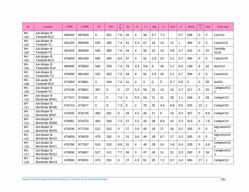
Aquifer characterization and hydro chemistry in volcanic terrain of Central Ethiopia - 29 -
ID Location UTME UTMN EC TDS P
H Na K Ca Mg Cl NO3 F HCO3
CO
3 SO4 Water type
BH-102
AA-Water lll Testwell-B12
466400 987600 0 351 7.6 20 4 56 9.7 7.1
0.7 268 0 0 CaHCO3
BH-103
AA-Water lll Testwell-T1
481200 980000 530 385 7.4 41 5.3 67 16 14 12 1 366 0 0 CaNaHCO3
BH-104
AA-Water lll Testwell-T5
481600 982900 540 380 7.8 44 4 56 20 14 9.6 0.7 342 0 15 CaNaMg-HCO4
BH-105
AA-Water lll Testwell-B13
479400 981400 500 390 8.4 37 4 91 2.9 20 0.1 0.7 366 0 0 CaNaHCO3
BH-106
AA-Water lll Testwekk-B14
480900 978800 500 330 7.4 79 3.4 9.6 8 28 2.7 0.6 159 9 42 NaHCO3
BH-107
AA-Water lll Testwekk-T2
479400 981400 430 362 7.5 44 4 91 2.9 20 0.1 0.7 366 0 0 CaNaHCO3
BH-108
AA-water lll Testwell-B15
473069 979881 0 346 7.6 41 0 0 0 5 9.7 0.6 0 0 28 NaSO4
BH-109
AA-Watet lll Testwell-T4
473108 979851 397 0 0 37 5.3 55 22 14 19 0.7 317 0 25 CaMgNaHCO3
BH-110
AA-Water lll Borehole BH01
477972 974859 0 0 7.3 0 9.9 64 21 21 28 1.1 256 0 28 CaMgHCO3
BH-111
AA-Water lll Borehole BH3b
478713 974977 0 0 7.3 0 2 70 20 4.5 8.8 0.5 325 13 1 CaMgHCO3
BH-112
AA-Water lll Borehole Bh07
479405 976735 493 301 0 26 4.2 46 27 9 19 0.4 307 0 6.6 CaMgHCO3
BH-113
AA-Water lll Borehole BH08
479061 976370 464 283 7.3 27 4.2 44 28 8.5 14 0.3 313 0 7.6 CaMgHCO3
BH-114
AA-Water lll Borehole BH09
479246 977104 512 312 0 27 3.6 45 29 17 26 0.2 305 0 0 MgCaNaHCO3
BH-115
AA-Water lll Borehole BH10
479058 976020 478 292 0 31 3.6 49 28 8.7 17 0.2 305 0 0 MgCaNaHCO3
BH-116
AA-Water lll Borehole BH11
478780 977307 516 315 8.8 31 4 40 28 14 3.9 0.4 329 0 6.6 CaMgNaHCO3
BH-117
AA-Water lll Borehole BH12
478808 976867 527 311 7.7 30 3 47 26 11 21 0.3 293 0 18 CaMgNaHCO3
BH-118
AA-Water lll Borehole BH14
478580 976051 476 291 0 27 4.3 61 20 7.2 9.7 0.4 300 17 1 CaMgHCO3
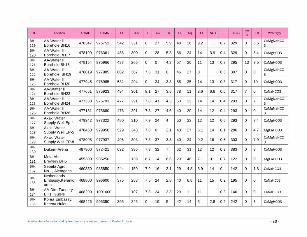
Aquifer characterization and hydro chemistry in volcanic terrain of Central Ethiopia - 30 -
ID Location UTME UTMN EC TDS PH Na K Ca Mg Cl NO3 F HCO3 CO
3 SO4 Water type
BH-119
AA-Water lll Borehole BH16
478347 976752 542 331 8 27 5.9 48 26 9.2
0.7 329 0 6.6 CaMgNaHCO3
BH-120
AA-Water lll Borehole BH17
478199 976361 486 300 0 28 5.3 56 24 14 3.9 0.4 329 0 5.4 CaMgHCO3
BH-121
AA-Water lll Borehole Bh18
478154 975966 437 266 0 0 4.3 57 20 11 13 0.3 295 13 9.5 CaMgHCO3
BH-122
AA-Water lll Borehole BH19
478019 977985 602 367 7.5 31 0 46 27 0
0.3 307 0 0 CaMgNaHCO3
BH-123
AA-Water lll Borehole BH20
477945 976985 532 294 0 24 3.3 55 25 14 13 0.3 317 0 10 CaMgHCO3
BH-124
AA-Watter lll Borehole BH22
477651 975923 494 301 8.1 27 3.5 78 11 3.6 6.6 0.6 317 7 0 CaNaHCO3
BH-125
AA-Water lll Borehole BH24
477330 976793 477 291 7.8 41 4.3 50 23 14 14 0.4 293 0 7 CaMgNaHCO3
BH-126
AA-Water lll Borehole BH26
477181 975680 476 291 7.8 27 4.6 40 20 14 12 0.4 293 0 0 CaMgNaHCO3
BH-127
Akaki Water Supply Well Ep-4
479942 977322 480 310 7.9 24 4 50 23 12 12 0.6 293 0 7.4 CaMgHCO3
BH-128
Akaki Water Supply Well EP-5
478450 979950 529 343 7.8 0 2.1 43 27 6.1 14 0.1 286 0 4.7 MgCaHCO3
BH-129
Akaki Water Supply Well EP-8
478998 977937 496 303 7.3 37 3.3 40 24 9.2 16 0.5 303 0 7.9 CaMgNaHCO3
BH-130
Dukem-Arena 487900 972421 632 386 7.3 32 7 62 31 12 12 0.3 383 0 8 CaMgHCO3
BH-131
Meta Abo Brewery BH5
455300 985250 139 6.7 14 6.6 20 46 7.1 0.1 0.7 122 0 0 MgCaHCO3
BH-132
Sebeta Agro No.1, Alemgena
460850 985850 244 159 7.9 16 3.1 29 4.8 3.9 14 0 142 0 1.8 CaNaHCO3
BH-133
Netherlands Embassy,Keranio area
468800 996600 375 253 7.5 24 2.8 40 6.8 11 15 0.2 195 0 0 CaNaHC03
BH-134
AA-Dire Tannery BH1, Gulele
468200 1001600 107 7.3 24 3.3 29 1 11
0.3 146 0 0 CaNaHCO3
BH-135
Korea Embassy, Ketena Hulet
468425 996350 395 246 0 19 5 42 14 5 2.8 0.2 242 0 3 CaMgHCO3
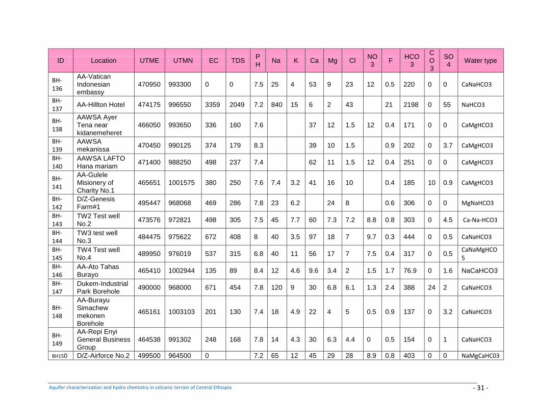
Aquifer characterization and hydro chemistry in volcanic terrain of Central Ethiopia - 31 -
ID Location UTME UTMN EC TDS PH
Na K Ca Mg Cl NO3
F HCO
3
CO3
SO4
Water type
BH-136
AA-Vatican Indonesian embassy
470950 993300 0 0 7.5 25 4 53 9 23 12 0.5 220 0 0 CaNaHCO3
BH-137
AA-Hillton Hotel 474175 996550 3359 2049 7.2 840 15 6 2 43
21 2198 0 55 NaHCO3
BH-138
AAWSA Ayer Tena near kidanemeheret
466050 993650 336 160 7.6
37 12 1.5 12 0.4 171 0 0 CaMgHCO3
BH-139
AAWSA mekanissa
470450 990125 374 179 8.3
39 10 1.5
0.9 202 0 3.7 CaMgHCO3
BH-140
AAWSA LAFTO Hana mariam
471400 988250 498 237 7.4
62 11 1.5 12 0.4 251 0 0 CaMgHCO3
BH-141
AA-Gulele Misionery of Charity No.1
465651 1001575 380 250 7.6 7.4 3.2 41 16 10
0.4 185 10 0.9 CaMgHCO3
BH-142
D/Z-Genesis Farm#1
495447 968068 469 286 7.8 23 6.2
24 8
0.6 306 0 0 MgNaHCO3
BH-143
TW2 Test well No.2
473576 972821 498 305 7.5 45 7.7 60 7.3 7.2 8.8 0.8 303 0 4.5 Ca-Na-HCO3
BH-144
TW3 test well No.3
484475 975622 672 408 8 40 3.5 97 18 7 9.7 0.3 444 0 0.5 CaNaHCO3
BH-145
TW4 Test well No.4
489950 976019 537 315 6.8 40 11 56 17 7 7.5 0.4 317 0 0.5 CaNaMgHCO5
BH-146
AA-Ato Tahas Burayo
465410 1002944 135 89 8.4 12 4.6 9.6 3.4 2 1.5 1.7 76.9 0 1.6 NaCaHCO3
BH-147
Dukem-Industrial Park Borehole
490000 968000 671 454 7.8 120 9 30 6.8 6.1 1.3 2.4 388 24 2 CaNaHCO3
BH-148
AA-Burayu Simachew mekonen Borehole
465161 1003103 201 130 7.4 18 4.9 22 4 5 0.5 0.9 137 0 3.2 CaNaHCO3
BH-149
AA-Repi Enyi General Business Group
464538 991302 248 168 7.8 14 4.3 30 6.3 4.4 0 0.5 154 0 1 CaNaHCO3
BH150 D/Z-Airforce No.2 499500 964500 0
7.2 65 12 45 29 28 8.9 0.8 403 0 0 NaMgCaHC03
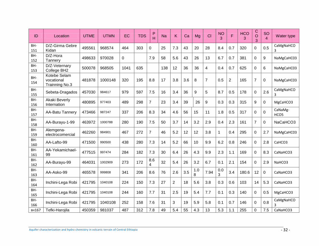
Aquifer characterization and hydro chemistry in volcanic terrain of Central Ethiopia - 32 -
ID Location UTME UTMN EC TDS PH
Na K Ca Mg Cl NO3
F HCO
3
CO3
SO4
Water type
BH-151
D/Z-Girma Gebre Kidan
495561 968574 464 303 0 25 7.3 43 20 28 8.4 0.7 320 0 0.5 CaMgNaHCO3
BH-152
D/Z-Hora Tannery
498633 970028 0
7.9 58 5.6 43 26 13 6.7 0.7 381 0 9 NaMgCaHC03
BH-153
D/Z-Veternary College BH2
500078 968505 1041 635
138 12 36 36 4 0.4 0.7 625 0 6 NaMgCaHC03
BH-154
Kotebe Selam vocational Trainning No.3
481878 1000148 320 195 8.8 17 3.8 3.6 8 7 0.5 2 165 7 0 NaMgCaHC03
BH-155
Sebeta-Dragados 457030 984617 979 597 7.5 16 3.4 36 9 5 8.7 0.5 178 0 2.6 CaMgNaHCO3
BH-156
Akaki Beverly Internation
480895 977403 489 298 7 23 3.4 39 26 9 0.3 0.3 315 9 0 MgCaHCO3
BH-157
AA-Batu Tannery 473466 987247 337 206 8.3 34 4.6 56 15 11 1.8 0.5 317 0 0 CaNaMg-HCO5
BH-158
AA-Burayu-1-99 463972 1000788 280 190 7.5 50 3.7 14 3.2 2.9 0.4 2.3 161 7 0 NaCaHCO3
BH-159
Alemgena-electrocomercial
462260 984901 467 272 7 46 5.2 12 12 3.8 1 0.4 295 0 2.7 NaMgCaHC03
BH-160
AA-Lafto-99 471500 990500 438 280 7.3 14 5.2 66 10 9.9 6.2 0.8 246 0 2.8 CaHCO3
BH-161
AA-Yekamichael-99
477515 997474 284 182 7.3 30 6.4 26 4.3 9.9 2.3 1.1 169 0 8.3 CaNaHCO3
BH-162
AA-Burayu-99 464031 1002909 273 172 8.64
32 5.4 26 3.2 6.7 0.1 2.1 154 0 2.9 NaHCO3
BH-163
AA-Asko-99 465578 999808 341 206 8.6 76 2.6 3.5 1.08
7.94 0.03
3.4 180.6 12 0 CaNaHCO3
BH-164
Inchini-Lega Robi 421795 1040108 224 150 7.3 27 2 18 5.6 3.8 0.3 0.6 103 14 5.3 CaNaHCO3
BH-165
Inchini-Lega Robi 421795 1040108 244 160 7.7 31 2.5 19 5.4 7.7 0.1 0.3 140 0 0.5 MgCaHCO3
BH-166
Inchini-Lega Robi 421795 1040108 252 158 7.6 31 3 19 5.9 5.8 0.1 0.7 146 0 0.8 CaMgNaHCO3
BH167 Tefki-Harojila 450359 981037 487 312 7.8 49 5.4 55 4.3 13 5.3 1.1 255 0 7.5 CaNaHCO3
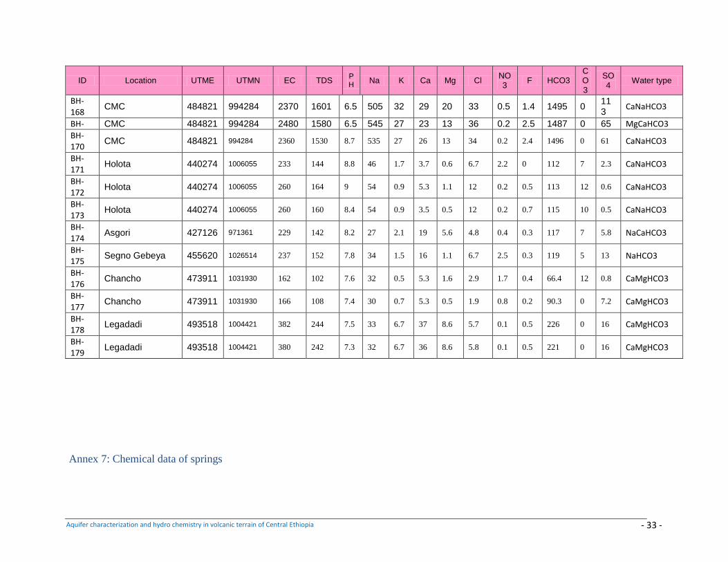
Aquifer characterization and hydro chemistry in volcanic terrain of Central Ethiopia - 33 -
ID Location UTME UTMN EC TDS PH
Na K Ca Mg Cl NO3
F HCO3 CO3
SO4
Water type
BH-168
CMC 484821 994284 2370 1601 6.5 505 32 29 20 33 0.5 1.4 1495 0 113
CaNaHCO3
BH- CMC 484821 994284 2480 1580 6.5 545 27 23 13 36 0.2 2.5 1487 0 65 MgCaHCO3
BH-170
CMC 484821 994284 2360 1530 8.7 535 27 26 13 34 0.2 2.4 1496 0 61 CaNaHCO3
BH-171
Holota 440274 1006055 233 144 8.8 46 1.7 3.7 0.6 6.7 2.2 0 112 7 2.3 CaNaHCO3
BH-172
Holota 440274 1006055 260 164 9 54 0.9 5.3 1.1 12 0.2 0.5 113 12 0.6 CaNaHCO3
BH-173
Holota 440274 1006055 260 160 8.4 54 0.9 3.5 0.5 12 0.2 0.7 115 10 0.5 CaNaHCO3
BH-174
Asgori 427126 971361 229 142 8.2 27 2.1 19 5.6 4.8 0.4 0.3 117 7 5.8 NaCaHCO3
BH-175
Segno Gebeya 455620 1026514 237 152 7.8 34 1.5 16 1.1 6.7 2.5 0.3 119 5 13 NaHCO3
BH-176
Chancho 473911 1031930 162 102 7.6 32 0.5 5.3 1.6 2.9 1.7 0.4 66.4 12 0.8 CaMgHCO3
BH-177
Chancho 473911 1031930 166 108 7.4 30 0.7 5.3 0.5 1.9 0.8 0.2 90.3 0 7.2 CaMgHCO3
BH-178
Legadadi 493518 1004421 382 244 7.5 33 6.7 37 8.6 5.7 0.1 0.5 226 0 16 CaMgHCO3
BH-179
Legadadi 493518 1004421 380 242 7.3 32 6.7 36 8.6 5.8 0.1 0.5 221 0 16 CaMgHCO3
Annex 7: Chemical data of springs
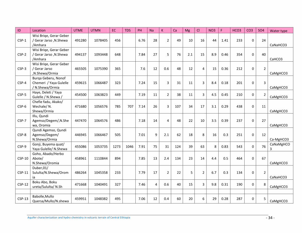
Aquifer characterization and hydro chemistry in volcanic terrain of Central Ethiopia - 34 -
ID Location UTME UTMN EC TDS PH Na K Ca Mg Cl NO3 F HCO3 CO3 SO4 Water type
CSP-1 Wisi Briqe, Gerar Geber / Gerar Jarso ,N.Shewa /Amhara
491280 1078405 456 6.76 28 2 49 10 16 44 1.41 233 0 24 CaNaHCO3
CSP-2 Wisi Briqe, Gerar Geber / Gerar Jarso ,N.Shewa /Amhara
494137 1093448 648 7.84 27 5 76 2.1 15 8.9 0.46 354 0 40 CaHCO3
CSP-3 Wisi Briqe, Gerar Geber / Gerar Jarso ,N.Shewa/Ormia
465505 1075390 365 7.6 12 0.6 48 12 4 15 0.36 212 0 2 CaMgHCO3
CSP-4 Burqa Geberu, Nonof Chemeri / Yaya Gulelle / N.Shewa/Ormia
459615 1066487 323 7.24 15 3 31 11 3 8.4 0.18 201 0 3 CaMgHCO3
CSP-5 Haye, Deleti / Yaya Gulelle / N.Shewa /
454500 1063823 449 7.19 11 2 38 11 3 4.5 0.45 210 0 2 CaMgHCO3
CSP-6 Chefie fadu, Akako/ Wechale/ N. Shewa/Ormia
471680 1056576 785 707 7.14 26 3 107 34 17 3.1 0.29 438 0 11 CaMgHCO3
CSP-7 Illu, Qundi Agemso/Degem/,N.Shewa, Oromia
447470 1064576 486 7.18 14 4 48 22 10 3.5 0.39 237 0 27 CaMgHCO3
CSP-8 Qundi Agemso, Qundi Agemso/Degem/ N.Shewa/Ormia
446945 1066467 505 7.01 9 2.1 62 18 8 16 0.3 251 0 12 Ca-MgHCO3
CSP-9 Gonji, Buyema quat/ Yaya Gulelle/ N.Shewa
455086 1053735 1273 1046 7.91 75 31 124 39 63 8 0.83 543 0 76 CaNaMgHCO3
CSP-10 Goho, Abado/Herbo Abote/ N.Shewa/Oromia
458961 1110844 894 7.85 13 2.4 134 23 14 4.4 0.5 464 0 67 CaMgHCO3
CSP-11 Duber,01/ Sululta/N.Shewa/Oromia
486264 1045358 233 7.79 17 2 22 5 2 6.7 0.3 134 0 2 CaNaHCO3
CSP-12 Boku Abo, Boku ureta/Sululta/ N.Sh
471668 1040491 327 7.46 4 0.6 40 15 3 9.8 0.31 190 0 8 CaMgHCO3
CSP-13 Babolle,Mullo Quersa/Mullo/N.shewa
459951 1048382 495 7.06 12 0.4 60 20 6 29 0.28 287 0 5 CaMgHCO3
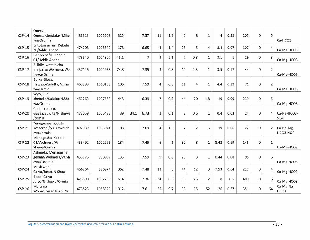
Aquifer characterization and hydro chemistry in volcanic terrain of Central Ethiopia - 35 -
CSP-14 Quersa, Quersa/Sendafa/N.Shewa/Oromia
483313 1005608 325 7.57 11 1.2 40 8 1 4 0.52 205 0 5 Ca-HCO3
CSP-15 Entotomariam, Kebele 20/Addis Ababa
474208 1005540 178 6.65 4 1.4 28 5 4 8.4 0.07 107 0 4 Ca-Mg-HCO3
CSP-16 Gebrechefie, Kebele 01/ Addis Ababa
473540 1004307 45.1 7 3 2.1 7 0.8 1 3.1 1 29 0 3 Ca-Mg-HCO3
CSP-17 Billbile, wata bicha minjarro/Welmera/W.shewa/Ormia
457146 1004953 74.8 7.35 3 0.8 10 2.3 1 3.5 0.17 44 0 2 Ca-Mg-HCO3
CSP-18 Burka Gibsa, Hawaso/Sululta/N.shewa/Ormia
463999 1018139 106 7.59 4 0.8 11 4 1 4.4 0.19 71 0 2 Ca-Mg-HCO3
CSP-19 Seyo, lillo chebeka/Sululta/N.Shewa/Oromia
463263 1037563 448 6.39 7 0.3 44 20 18 19 0.09 239 0 5 Ca-Mg-HCO3
CSP-20 Chefie entoto, Guasa/Sululta/N.shewa/ormia
473059 1006482 39 34.1 6.73 2 0.1 2 0.6 1 0.4 0.03 24 0 4 Ca-Na-HCO3-SO4
CSP-21 Yenegusweha,Guto Weserebi/Sululta/N.shewa/ormia
492039 1005044 83 7.69 4 1.3 7 2 5 19 0.06 22 0 2 Ca-Na-Mg-HCO3-NO3
CSP-22 Menagesha, Kebele 01/Welmera/W. Shewa/Ormia
453492 1002295 184 7.45 6 1 30 8 1 8.42 0.19 146 0 1 Ca-Mg-HCO3
CSP-23 Ashenda, Menagesha gedam/Welmera/W.Shewa/Oromia
453776 998997 135 7.59 9 0.8 20 3 1 0.44 0.08 95 0 6 Ca-Mg-HCO3
CSP-24 Mesk woha, Gerar/Jarso, N.Shoa
466264 996974 362 7.48 13 3 44 12 3 7.53 0.64 227 0 4 Ca-Mg-HCO3
CSP-25 Bedo, Gerar Jarso/N.shewa/Ormia
473890 1087756 614 7.36 24 0.5 83 25 2 8 0.5 400 0 6 Ca-Mg-HCO3
CSP-26 Marame Wonnz,cerar,Jarso, Ns
473823 1088329 1012 7.61 55 9.7 90 35 52 26 0.67 351 0 64 Ca-Mg-Na-HCO3
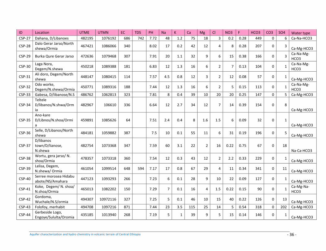
Aquifer characterization and hydro chemistry in volcanic terrain of Central Ethiopia - 36 -
ID Location UTME UTMN EC TDS PH Na K Ca Mg Cl NO3 F HCO3 CO3 SO4 Water type
CSP-27 Dahana, D/Libanoes 482195 1076192 686 742 7.72 48 1.2 75 18 3 0.2 0.28 449 0 6 Ca-Na-HCO3
CSP-28 Dalo Gerar Jarso/North shewa/Ormia
467421 1086066 340 8.02 17 0.2 42 12 4 8 0.28 207 0 3 Ca-Mg-HCO3
CSP-29 Burka Qure Gerar Jarso 472636 1079468 307 7.91 20 1.1 32 9 6 15 0.38 166 0 3 Ca-Na-Mg-HCO3
CSP-30 Laga Nora, Degem/N.shewa
450218 1089388 181 6.83 12 1.3 16 6 2 7 0.13 104 0 1 Ca-Na-Mg-HCO3
CSP-31 Ali doro, Degem/North shewa
448147 1080415 114 7.57 4.5 0.8 12 3 2 12 0.08 57 0 1 Ca-Mg-HCO3
CSP-32 Odo worke, Degem/N.shewa/Ormia
450771 1089316 188 7.44 12 1.3 16 6 2 5 0.15 113 0 1 Ca-Na-Mg-HCO3
CSP-33 Gabesa, D/libanose/N.S 486762 1062813 323 7.81 8 0.4 39 10 20 20 0.25 147 0 5 Ca-Mg-HCO3
CSP-34 Teltele D/libanos/N.shwa/Ormia
482967 106610 336 6.64 12 2.7 34 12 7 14 0.39 154 0 8 Ca-Mg-HCO3
CSP-35 Ano-kare D/Libnos/N.shoa/Ormia
459891 1085626 64 7.51 2.4 0.4 8 1.6 1.5 6 0.09 32 0 1 Ca-Mg-HCO3
CSP-36 Selle, D/Libanos/North shewa
484181 1059882 387 7.5 10 0.1 55 11 6 31 0.19 196 0 5 Ca-Mg-HCO3
CSP-37 D/libanos town/D/lianose, N.shewa
482754 1073368 347 7.59 60 3.1 22 2 16 0.22 0.75 67 0 18 Na-Ca-HCO3
CSP-38 Wortu, gera jarso/ N. shoa/Ormia
478357 1073318 360 7.54 12 0.3 43 12 2 2.2 0.33 229 0 1 Ca-Mg-HCO3
CSP-39 Lelisa, Degem, N.shewa/ Ormia
461054 1099514 648 594 7.17 17 0.8 67 29 4 11 0.34 341 0 11 Ca-Mg-HCO3
CSP-40 Serree morosea Hidabu abote/NS/Amahara
447123 1093293 266 7.23 6 0.1 28 9 10 22 0.09 127 0 1 Ca-Mg-HCO3
CSP-41 Koke, Degem/ N. shoa/ N.shoa/Ormia
465013 1082202 150 7.29 7 0.1 16 4 1.5 0.22 0.15 90 0 1 Ca-Mg-Na-HCO3
CSP-42 Gordoma, Wuchale/N.S/ormia
494307 10972116 327 7.25 5 0.1 46 10 15 40 0.22 126 0 13 Ca-Mg-HCO3
CSP-43 Folofoy, merhabit 494708 1097216 871 7.44 23 3.5 115 25 14 5 0.54 318 0 202 Ca-Mg-HCO3
CSP-44 Gerbeside Logo, Engoye/Sululta/Oromia
435185 1013940 268 7.19 5 1 39 9 5 15 0.14 146 0 1 Ca-Mg-HCO3
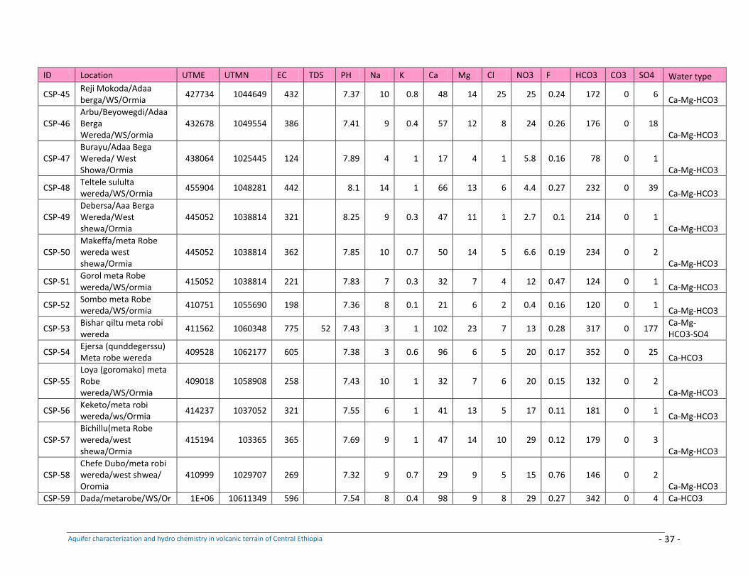
Aquifer characterization and hydro chemistry in volcanic terrain of Central Ethiopia - 37 -
ID Location UTME UTMN EC TDS PH Na K Ca Mg Cl NO3 F HCO3 CO3 SO4 Water type
CSP-45 Reji Mokoda/Adaa berga/WS/Ormia
427734 1044649 432 7.37 10 0.8 48 14 25 25 0.24 172 0 6 Ca-Mg-HCO3
CSP-46 Arbu/Beyowegdi/Adaa Berga Wereda/WS/ormia
432678 1049554 386 7.41 9 0.4 57 12 8 24 0.26 176 0 18 Ca-Mg-HCO3
CSP-47 Burayu/Adaa Bega Wereda/ West Showa/Ormia
438064 1025445 124 7.89 4 1 17 4 1 5.8 0.16 78 0 1 Ca-Mg-HCO3
CSP-48 Teltele sululta wereda/WS/Ormia
455904 1048281 442 8.1 14 1 66 13 6 4.4 0.27 232 0 39 Ca-Mg-HCO3
CSP-49 Debersa/Aaa Berga Wereda/West shewa/Ormia
445052 1038814 321 8.25 9 0.3 47 11 1 2.7 0.1 214 0 1 Ca-Mg-HCO3
CSP-50 Makeffa/meta Robe wereda west shewa/Ormia
445052 1038814 362 7.85 10 0.7 50 14 5 6.6 0.19 234 0 2 Ca-Mg-HCO3
CSP-51 Gorol meta Robe wereda/WS/ormia
415052 1038814 221 7.83 7 0.3 32 7 4 12 0.47 124 0 1 Ca-Mg-HCO3
CSP-52 Sombo meta Robe wereda/WS/ormia
410751 1055690 198 7.36 8 0.1 21 6 2 0.4 0.16 120 0 1 Ca-Mg-HCO3
CSP-53 Bishar qiltu meta robi wereda
411562 1060348 775 52 7.43 3 1 102 23 7 13 0.28 317 0 177 Ca-Mg-HCO3-SO4
CSP-54 Ejersa (qunddegerssu) Meta robe wereda
409528 1062177 605 7.38 3 0.6 96 6 5 20 0.17 352 0 25 Ca-HCO3
CSP-55 Loya (goromako) meta Robe wereda/WS/Ormia
409018 1058908 258 7.43 10 1 32 7 6 20 0.15 132 0 2 Ca-Mg-HCO3
CSP-56 Keketo/meta robi wereda/ws/Ormia
414237 1037052 321 7.55 6 1 41 13 5 17 0.11 181 0 1 Ca-Mg-HCO3
CSP-57 Bichillu(meta Robe wereda/west shewa/Ormia
415194 103365 365 7.69 9 1 47 14 10 29 0.12 179 0 3 Ca-Mg-HCO3
CSP-58 Chefe Dubo/meta robi wereda/west shwea/ Oromia
410999 1029707 269 7.32 9 0.7 29 9 5 15 0.76 146 0 2 Ca-Mg-HCO3
CSP-59 Dada/metarobe/WS/Or 1E+06 10611349 596 7.54 8 0.4 98 9 8 29 0.27 342 0 4 Ca-HCO3
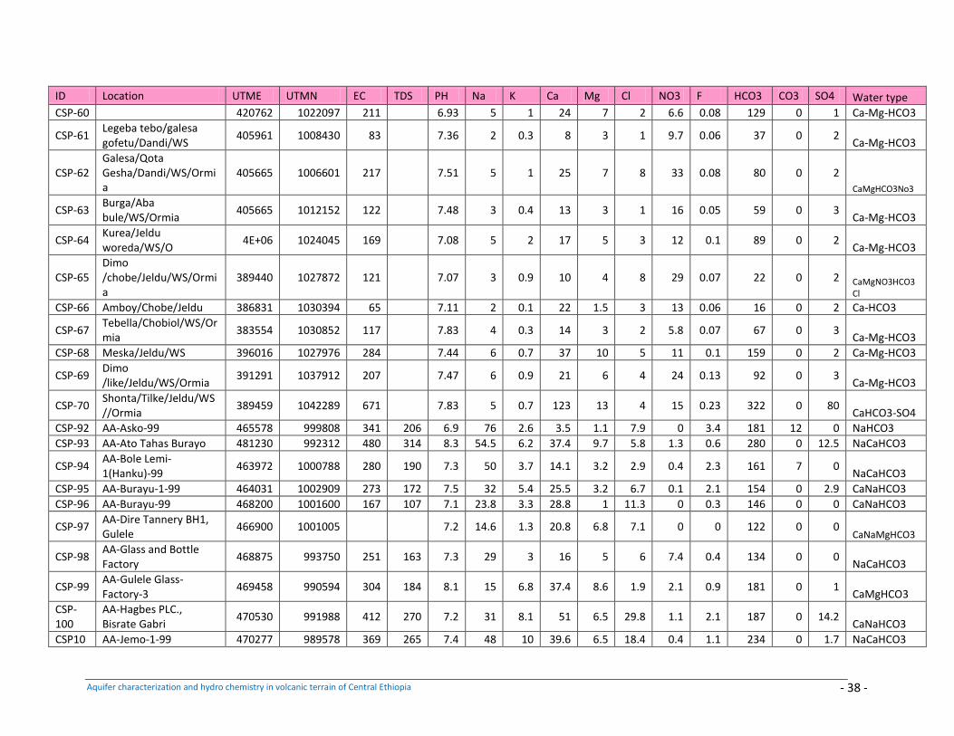
Aquifer characterization and hydro chemistry in volcanic terrain of Central Ethiopia - 38 -
ID Location UTME UTMN EC TDS PH Na K Ca Mg Cl NO3 F HCO3 CO3 SO4 Water type
CSP-60 420762 1022097 211 6.93 5 1 24 7 2 6.6 0.08 129 0 1 Ca-Mg-HCO3
CSP-61 Legeba tebo/galesa gofetu/Dandi/WS
405961 1008430 83 7.36 2 0.3 8 3 1 9.7 0.06 37 0 2 Ca-Mg-HCO3
CSP-62 Galesa/Qota Gesha/Dandi/WS/Ormia
405665 1006601 217 7.51 5 1 25 7 8 33 0.08 80 0 2
CaMgHCO3No3
CSP-63 Burga/Aba bule/WS/Ormia
405665 1012152 122 7.48 3 0.4 13 3 1 16 0.05 59 0 3 Ca-Mg-HCO3
CSP-64 Kurea/Jeldu woreda/WS/O
4E+06 1024045 169 7.08 5 2 17 5 3 12 0.1 89 0 2 Ca-Mg-HCO3
CSP-65 Dimo /chobe/Jeldu/WS/Ormia
389440 1027872 121 7.07 3 0.9 10 4 8 29 0.07 22 0 2 CaMgNO3HCO3Cl
CSP-66 Amboy/Chobe/Jeldu 386831 1030394 65 7.11 2 0.1 22 1.5 3 13 0.06 16 0 2 Ca-HCO3
CSP-67 Tebella/Chobiol/WS/Ormia
383554 1030852 117 7.83 4 0.3 14 3 2 5.8 0.07 67 0 3 Ca-Mg-HCO3
CSP-68 Meska/Jeldu/WS 396016 1027976 284 7.44 6 0.7 37 10 5 11 0.1 159 0 2 Ca-Mg-HCO3
CSP-69 Dimo /like/Jeldu/WS/Ormia
391291 1037912 207 7.47 6 0.9 21 6 4 24 0.13 92 0 3 Ca-Mg-HCO3
CSP-70 Shonta/Tilke/Jeldu/WS//Ormia
389459 1042289 671 7.83 5 0.7 123 13 4 15 0.23 322 0 80 CaHCO3-SO4
CSP-92 AA-Asko-99 465578 999808 341 206 6.9 76 2.6 3.5 1.1 7.9 0 3.4 181 12 0 NaHCO3
CSP-93 AA-Ato Tahas Burayo 481230 992312 480 314 8.3 54.5 6.2 37.4 9.7 5.8 1.3 0.6 280 0 12.5 NaCaHCO3
CSP-94 AA-Bole Lemi-1(Hanku)-99
463972 1000788 280 190 7.3 50 3.7 14.1 3.2 2.9 0.4 2.3 161 7 0 NaCaHCO3
CSP-95 AA-Burayu-1-99 464031 1002909 273 172 7.5 32 5.4 25.5 3.2 6.7 0.1 2.1 154 0 2.9 CaNaHCO3
CSP-96 AA-Burayu-99 468200 1001600 167 107 7.1 23.8 3.3 28.8 1 11.3 0 0.3 146 0 0 CaNaHCO3
CSP-97 AA-Dire Tannery BH1, Gulele
466900 1001005 7.2 14.6 1.3 20.8 6.8 7.1 0 0 122 0 0 CaNaMgHCO3
CSP-98 AA-Glass and Bottle Factory
468875 993750 251 163 7.3 29 3 16 5 6 7.4 0.4 134 0 0 NaCaHCO3
CSP-99 AA-Gulele Glass-Factory-3
469458 990594 304 184 8.1 15 6.8 37.4 8.6 1.9 2.1 0.9 181 0 1 CaMgHCO3
CSP-100
AA-Hagbes PLC., Bisrate Gabri
470530 991988 412 270 7.2 31 8.1 51 6.5 29.8 1.1 2.1 187 0 14.2 CaNaHCO3
CSP10 AA-Jemo-1-99 470277 989578 369 265 7.4 48 10 39.6 6.5 18.4 0.4 1.1 234 0 1.7 NaCaHCO3
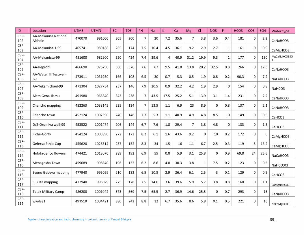
Aquifer characterization and hydro chemistry in volcanic terrain of Central Ethiopia - 39 -
ID Location UTME UTMN EC TDS PH Na K Ca Mg Cl NO3 F HCO3 CO3 SO4 Water type
CSP-102
AA-Mekanisa National Alchole
470070 991000 305 200 7 20 7.2 35.6 7 3.8 3.6 0.4 181 0 2.2 CaNaHCO3
CSP-103
AA-Mekanisa-1-99 465741 989188 265 174 7.5 10.4 4.5 36.1 9.2 2.9 2.7 1 161 0 0.9 CaMgHCO3
CSP-104
AA-Mekanissa-99 481600 982900 520 424 7.4 39.6 4 40.9 31.2 19.9 9.3 1 177 0 130 MgCaNaHCO3SO4
CSP-105
AA-Repi-99 466690 976790 588 376 7.6 67 9.5 41.8 13.8 20.2 32.5 0.8 266 0 17.3 CaNaHCO3
CSP-106
AA-Water lll Testwell-B9
473911 1031930 166 108 6.5 30 0.7 5.3 0.5 1.9 0.8 0.2 90.3 0 7.2 NaCaHCO3
CSP-107
AA-Yekamichael-99 471304 1027754 257 146 7.9 20.5 0.9 32.2 4.2 1.9 2.9 0 154 0 0.8 NaHCO3
CSP-108
Alem Gena-Ilamu 491980 965840 343 238 7 43.5 17.5 25.2 5.1 13.9 3.1 1.4 231 0 2.2 CaNaHCO3
CSP-109
Chancho mapping 482263 1038145 235 134 7 13.5 1.1 6.9 23 8.9 0 0.8 137 0 2.1 CaNaHCO3
CSP-110
Chancho town 452124 1002590 240 148 7.7 5.3 1.1 40.9 4.9 4.8 8.5 0 149 0 0.5 CaHCO3
CSP-111
D/Z-Oromiya well-99 453522 1001474 206 144 6.7 7.6 1.8 29.4 7 3.8 4.8 0 133 0 1.3 CaHCO3
CSP-112
Fiche-Gorfo 454124 1005990 272 172 8.2 6.1 1.6 43.6 9.2 0 10 0.2 172 0 0 CaMgHCO3
CSP-113
Gefersa Ethio-Cup 455620 1026514 237 152 8.3 34 1.5 16 1.1 6.7 2.5 0.3 119 5 13.2 CaMgHCO3
CSP-114
Holota-Jerico flowers 474421 1013070 289 192 6.9 55 0.8 5.9 3.1 25.8 0 0.9 69.8 24 25.6 NaCaHCO3
CSP-115
Menagesha Town 459689 998340 196 132 6.2 8.6 4.8 30.3 3.8 1 7.5 0.2 123 0 0.5 NaHCO3Cl
CSP-116
Segno Gebeya mapping 477940 995029 210 132 6.5 10.8 2.9 26.4 6.1 2.5 3 0.1 129 0 0.5 CaHCO3
CSP-117
Sululta mapping 477940 995029 275 178 7.5 14.6 3.6 39.6 5.9 5.7 3.8 0.8 160 0 1.1 CaMgNaHCO3
CSP-118
Tatek Military Camp 486200 1001042 573 369 7.5 65.5 2.7 36.9 14.6 25.5 0 0.7 293 0 15 CaNaHCO3
CSP-119
wwdse1 493518 1004421 380 242 8.8 32 6.7 35.6 8.6 5.8 0.1 0.5 221 0 16 NaCaMgHCO3
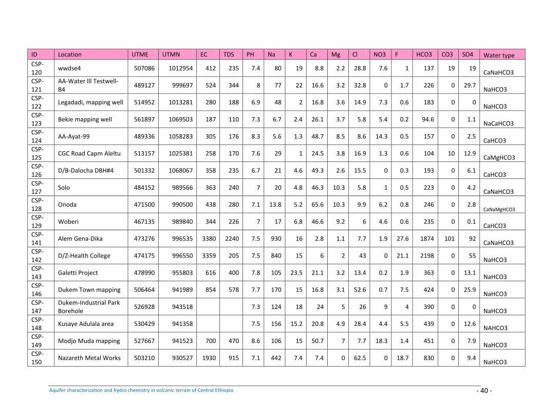
Aquifer characterization and hydro chemistry in volcanic terrain of Central Ethiopia - 40 -
ID Location UTME UTMN EC TDS PH Na K Ca Mg Cl NO3 F HCO3 CO3 SO4 Water type
CSP-120
wwdse4 507086 1012954 412 235 7.4 80 19 8.8 2.2 28.8 7.6 1 137 19 19 CaNaHCO3
CSP-121
AA-Water lll Testwell-B4
489127 999697 524 344 8 77 22 16.6 3.2 32.8 0 1.7 226 0 29.7 NaHCO3
CSP-122
Legadadi, mapping well 514952 1013281 280 188 6.9 48 2 16.8 3.6 14.9 7.3 0.6 183 0 0 NaHCO3
CSP-123
Bekie mapping well 561897 1069503 187 110 7.3 6.7 2.4 26.1 3.7 5.8 5.4 0.2 94.6 0 1.1 NaCaHCO3
CSP-124
AA-Ayat-99 489336 1058283 305 176 8.3 5.6 1.3 48.7 8.5 8.6 14.3 0.5 157 0 2.5 CaHCO3
CSP-125
CGC Road Capm Aleltu 513157 1025381 258 170 7.6 29 1 24.5 3.8 16.9 1.3 0.6 104 10 12.9 CaMgHCO3
CSP-126
D/B-Dalocha DBH#4 501332 1068067 358 235 6.7 21 4.6 49.3 2.6 15.5 0 0.3 193 0 6.1 CaHCO3
CSP-127
Solo 484152 989566 363 240 7 20 4.8 46.3 10.3 5.8 1 0.5 223 0 4.2 CaNaHCO3
CSP-128
Onoda 471500 990500 438 280 7.1 13.8 5.2 65.6 10.3 9.9 6.2 0.8 246 0 2.8 CaNaMgHCO3
CSP-129
Woberi 467135 989840 344 226 7 17 6.8 46.6 9.2 6 4.6 0.6 235 0 0.1 CaHCO3
CSP-141
Alem Gena-Dika 473276 996535 3380 2240 7.5 930 16 2.8 1.1 7.7 1.9 27.6 1874 101 92 CaNaHCO3
CSP-142
D/Z-Health College 474175 996550 3359 205 7.5 840 15 6 2 43 0 21.1 2198 0 55 NaHCO3
CSP-143
Galetti Project 478990 955803 616 400 7.8 105 23.5 21.1 3.2 13.4 0.2 1.9 363 0 13.1 NaHCO3
CSP-146
Dukem Town mapping 506464 941989 854 578 7.7 170 15 16.8 3.1 52.6 0.7 7.5 424 0 25.9 NaHCO3
CSP-147
Dukem-Industrial Park Borehole
526928 943518 7.3 124 18 24 5 26 9 4 390 0 0 NaHCO3
CSP-148
Kusaye Adulala area 530429 941358 7.5 156 15.2 20.8 4.9 28.4 4.4 5.5 439 0 12.6 NAHCO3
CSP-149
Modjo Muda mapping 527667 941523 700 470 8.6 106 15 50.7 7 7.7 18.3 1.4 451 0 7.9 NaHCO3
CSP-150
Nazareth Metal Works 503210 930527 1930 915 7.1 442 7.4 7.4 0 62.5 0 18.7 830 0 9.4 NaHCO3
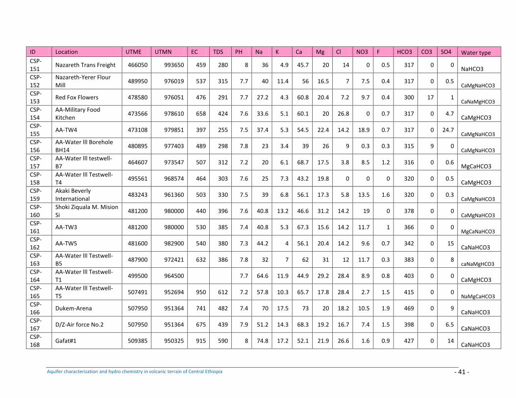
Aquifer characterization and hydro chemistry in volcanic terrain of Central Ethiopia - 41 -
ID Location UTME UTMN EC TDS PH Na K Ca Mg Cl NO3 F HCO3 CO3 SO4 Water type
CSP-151
Nazareth Trans Freight 466050 993650 459 280 8 36 4.9 45.7 20 14 0 0.5 317 0 0 NaHCO3
CSP-152
Nazareth-Yerer Flour Mill
489950 976019 537 315 7.7 40 11.4 56 16.5 7 7.5 0.4 317 0 0.5 CaMgNaHCO3
CSP-153
Red Fox Flowers 478580 976051 476 291 7.7 27.2 4.3 60.8 20.4 7.2 9.7 0.4 300 17 1 CaNaMgHCO3
CSP-154
AA-Military Food Kitchen
473566 978610 658 424 7.6 33.6 5.1 60.1 20 26.8 0 0.7 317 0 4.7 CaMgHCO3
CSP-155
AA-TW4 473108 979851 397 255 7.5 37.4 5.3 54.5 22.4 14.2 18.9 0.7 317 0 24.7 CaMgNaHCO3
CSP-156
AA-Water lll Borehole BH14
480895 977403 489 298 7.8 23 3.4 39 26 9 0.3 0.3 315 9 0 CaMgNaHCO3
CSP-157
AA-Water lll testwell-B7
464607 973547 507 312 7.2 20 6.1 68.7 17.5 3.8 8.5 1.2 316 0 0.6 MgCaHCO3
CSP-158
AA-Water lll Testwell-T4
495561 968574 464 303 7.6 25 7.3 43.2 19.8 0 0 0 320 0 0.5 CaMgHCO3
CSP-159
Akaki Beverly International
483243 961360 503 330 7.5 39 6.8 56.1 17.3 5.8 13.5 1.6 320 0 0.3 CaMgNaHCO3
CSP-160
Shoki Ziquala M. Mision Si
481200 980000 440 396 7.6 40.8 13.2 46.6 31.2 14.2 19 0 378 0 0 CaMgNaHCO3
CSP-161
AA-TW3 481200 980000 530 385 7.4 40.8 5.3 67.3 15.6 14.2 11.7 1 366 0 0 MgCaNaHCO3
CSP-162
AA-TW5 481600 982900 540 380 7.3 44.2 4 56.1 20.4 14.2 9.6 0.7 342 0 15 CaNaHCO3
CSP-163
AA-Water lll Testwell-B5
487900 972421 632 386 7.8 32 7 62 31 12 11.7 0.3 383 0 8 caNaMgHCO3
CSP-164
AA-Water lll Testwell-T1
499500 964500 7.7 64.6 11.9 44.9 29.2 28.4 8.9 0.8 403 0 0 CaMgHCO3
CSP-165
AA-Water lll Testwell-T5
507491 952694 950 612 7.2 57.8 10.3 65.7 17.8 28.4 2.7 1.5 415 0 0 NaMgCaHCO3
CSP-166
Dukem-Arena 507950 951364 741 482 7.4 70 17.5 73 20 18.2 10.5 1.9 469 0 9 CaNaHCO3
CSP-167
D/Z-Air force No.2 507950 951364 675 439 7.9 51.2 14.3 68.3 19.2 16.7 7.4 1.5 398 0 6.5 CaNaHCO3
CSP-168
Gafat#1 509385 950325 915 590 8 74.8 17.2 52.1 21.9 26.6 1.6 0.9 427 0 14 CaNaHCO3
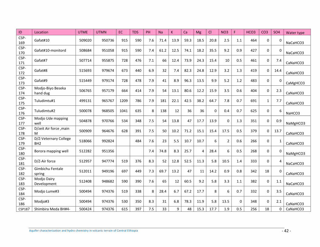
Aquifer characterization and hydro chemistry in volcanic terrain of Central Ethiopia - 42 -
ID Location UTME UTMN EC TDS PH Na K Ca Mg Cl NO3 F HCO3 CO3 SO4 Water type
CSP-169
Gafat#10 509020 950736 915 590 7.6 71.4 13.9 59.3 18.5 20.8 2.5 1.1 464 0 0 NaCaHCO3
CSP-170
Gafat#10-monitord 508684 951058 915 590 7.4 61.2 12.5 74.1 18.2 35.5 9.2 0.9 427 0 0 NaCaHCO3
CSP-171
Gafat#7 507714 955875 728 476 7.1 66 12.4 73.9 24.3 15.4 10 0.5 461 0 7.4 CaNaHCO3
CSP-172
Gafat#8 515693 979674 673 440 6.9 32 7.4 82.3 24.8 12.9 3.2 1.3 419 0 14.4 CaNaHCO3
CSP-173
Gafat#9 515449 979174 728 478 7.9 41 8.9 96.3 13.5 9.9 5.2 1.2 483 0 0 CaMgHCO3
CSP-174
Modjo-Biyo Beseka hand dug
506765 957179 664 414 7.9 54 13.1 80.6 12.2 15.9 3.5 0.6 404 0 2.3 CaNaHCO3
CSP-175
Tuludimtu#1 499131 965767 1209 786 7.9 181 22.1 42.5 38.2 64.7 7.8 0.7 691 1 7.7 CaNaHCO3
CSP-176
Tuludimtu#2 500078 968505 1041 635 8 138 12 36 36 0 0.4 0.7 625 0 6 NaHCO3
CSP-177
Modjo Ude mapping well
504878 970766 534 348 7.5 54 13.8 47 17.7 13.9 0 1.3 351 0 0.9 NaMgHCO3
CSP-178
D/zeit Air force ,main M
500909 964676 628 391 7.5 50 10.2 71.2 15.1 15.4 17.5 0.5 379 0 13.7 CaNaHCO3
CSP-179
D/Z-Veternary College BH2
518066 992824 484 7.6 23 5.5 10.7 10.7 6 2 0.6 266 0 1 CaNaHCO3
CSP-180
Borora mapping well 512282 951356 7.4 74.8 8.3 25.7 4 28.4 6 0.5 268 0 0 NaMgHCO3
CSP-181
D/Z-Air force 512957 947774 519 376 8.3 52 12.8 52.5 11.3 5.8 10.5 1.4 333 0 4 NaCaHCO3
CSP-182
Gimbichu Fentale spring
512011 949196 697 449 7.3 69.7 13.2 47 11 14.2 0.9 0.8 342 18 0 CaNaHCO3
CSP-183
Modjo Dairy Development
512408 948682 590 390 7.6 65 12 60.5 9.2 5.8 3.3 1.1 382 0 1.1 NaCaHCO3
CSP-184
Modjo Lume#3 500494 974376 519 338 8 28.4 6.7 67.2 17.7 8 6 0.7 332 0 3.5 CaNaHCO3
CSP-186
Modjo#3 500494 974376 530 350 8.3 31 6.8 78.3 11.9 5.8 13.5 0 348 0 2.1 CaNaHCO3
CSP187 Shimbira Meda BH#4- 500424 974376 615 397 7.5 33 9 48 15.3 17.7 1.9 0.5 256 18 0 CaNaHCO3