australian geographic society expedition
TRANSCRIPT
86 A u s t r a l i a n G e o g r a p h i c
Trade winds
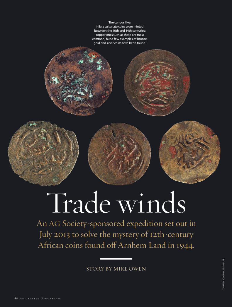
The curious five. Kilwa sultanate coins were minted
between the 10th and 14th centuries; copper ones such as these are most
common, but a few examples of bronze, gold and silver coins have been found.
STORY BY MIKE OWEN
An AG Society-sponsored expedition set out in July 2013 to solve the mystery of 12th-century African coins found off Arnhem Land in 1944.
CO
URT
ESY
POW
ERH
OU
SE M
USE
UM
TOP:
WIK
IMED
IA C
OM
MO
NS;
MA
P: C
OU
RTES
Y M
IKE
OW
EN; G
LEN
N C
AM
PBEL
L
J a n u a r y – F e b r u a r y 2 0 1 4 87
MYSTERY AND MAGIC still inhabit the wild places. Few are wilder than the Northern Territory’s Wessel Islands, which arch out into the Arafura Sea like a reaper’s scythe, harvest-ing flotsam from Indonesia’s fabled Maluku,
or ‘Spice’, Islands, just a few days’ sail to the north-west. And no mystery is more beguiling than the 900-year-old coins from a medieval African sultanate, found on one of the archipelago’s beaches during WWII by RAAF serviceman Morry Isenberg.
By far the oldest foreign artefacts ever found in Australia, the Kilwa sultanate coins are now held at the Powerhouse Museum in Sydney. Only twice before have Kilwa coins been found out-side Tanzania; once in Zimbabwe and once in Oman. Australia is a great deal further for them to have travelled – more than 8000km. Perhaps their discovery in the Wessels tells of ancient disaster, shipwreck and castaways, or they may merely have been left by ocean-going traders at ease in the safe anchorage beside a freshwater lagoon on Marchinbar Island.
Were Yolngu Aboriginal people trading comforts and neces-sities for iron tools centuries before they were first thought to have bartered them for grog and tobacco with Macassan fleets from Sulawesi in the 1700s? Perhaps the Yolngu played a small, and previously unknown, part in the ancient maritime trade net-work that stretched from Mozambique on east Africa’s Swahili coast, across the Indian Ocean to the Spice Islands and China.
The island of Kilwa Kisiwani, off the south coast of Tanzania, was once a thriving seaport. From the 11th century, the sultans of Kilwa grew rich controlling the gold, ivory and slave trade, and presided over a vast empire that included Zanzibar and the Comoros archipelago. Could it be that other Europeans connected to this trading network had contact with Australia before the well-documented arrival of Dutch explorer Willem Janszoon in 1606? The Yolngu tell of white men emerging from the sea dressed in “mirror” (armour), and beating stones to make metal on the beach. The rock art in caves on Marchinbar features passing ships and European-looking sailors.
These ideas and questions had long been on my mind. So in July 2013, Australian anthropologist Dr Ian McIntosh, based at Indiana University-Purdue University Indianapolis (IUPUI) in the USA, and I led the “Past Masters”, a team of five archaeolo-gists and heritage experts, to the Wessel Islands. Our ultimate objective was to answer how these 12th century coins ended up on a beach at Marchinbar Island, the largest in the archipelago. But our week-long expedition in 2013 was more specifically aimed at locating and mapping key sites of interest and finding enough evidence to justify a much bigger scientific study of
Trade winds
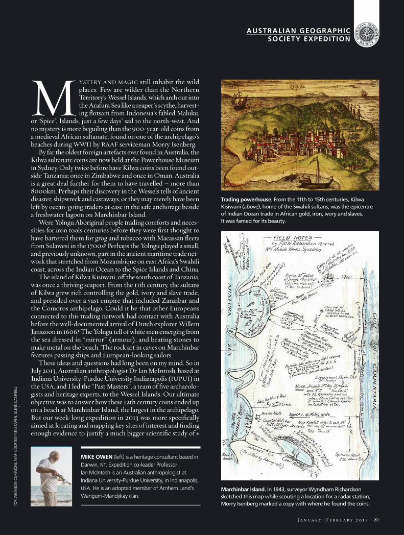
Trading powerhouse. From the 11th to 15th centuries, Kilwa Kisiwani (above), home of the Swahili sultans, was the epicentre of Indian Ocean trade in African gold, iron, ivory and slaves. It was famed for its beauty.
Marchinbar Island. In 1943, surveyor Wyndham Richardson sketched this map while scouting a location for a radar station; Morry Isenberg marked a copy with where he found the coins.
MIKE OWEN (left) is a heritage consultant based in Darwin, NT. Expedition co-leader Professor Ian McIntosh is an Australian anthropologist at Indiana University-Purdue University, in Indianapolis, USA. He is an adopted member of Arnhem Land’s Wangurri-Mandjikay clan.
AUSTRALIAN GEOGRAPHICSOCIETY EXPEDITION
CO
URT
ESY
POW
ERH
OU
SE M
USE
UM
TOP:
WIK
IMED
IA C
OM
MO
NS;
MA
P: C
OU
RTES
Y M
IKE
OW
EN; G
LEN
N C
AM
PBEL
L
88 A u s t r a l i a n G e o g r a p h i c
the islands in 2014. We were also hoping to find interesting new artefacts and document the rock art.
OUR JOURNEY BEGAN at Nhulunbuy, a small township on the NT’s Gove Peninsula. Our morning flight from Darwin had barely touched down before our hosts, the
sea rangers of the Dhimurru Indigenous Protected Area, had bundled us into four-wheel-drives. Within minutes, we were bumping along the Gulf of Carpentaria’s rough coastal tracks, over remnant red sand dunes that once stretched all the way to New Guinea. We were heading to Wurrwurrwuy, the site of important Yolngu rock sculptures that decorate a large bauxite shelf. Here we would collect data and advise on the proposed restoration of these extraordinary artworks, which depict a his-tory of contact with Macassan trepang (sea cucumber) fishermen from Sulawesi, which is today part of Indonesia.
The following day, we conducted a heritage ranger workshop for the Dhimurru rangers and members of the broader Nhu-lunbuy community. In attendance were rangers from nearby Yirrkala and from Milingimbi community on Yurrwi Island, which is the largest of the Crocodile Island Group and about 70km south-west of the Wessels. A large contingent of Norforce reservists of the Australian Army – who patrol remote parts of the Top End coast (see AG 93) – swelled the ranks.
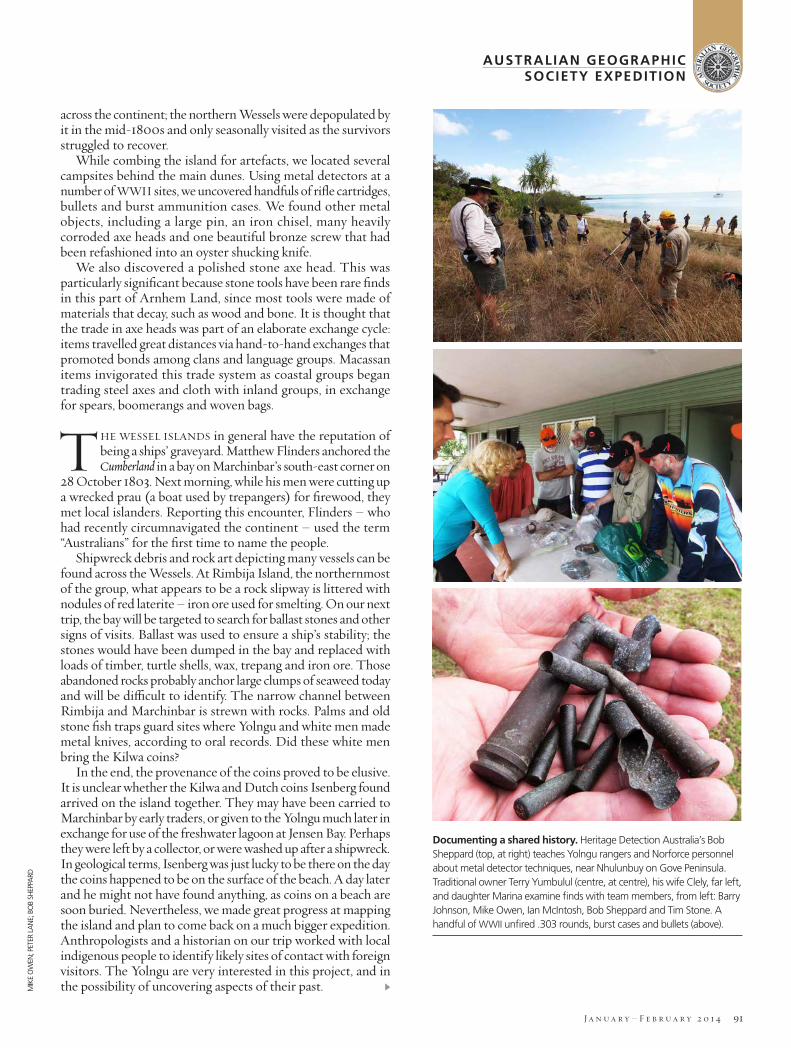
The aim of the workshop, which was sponsored by the Swiss Ubuntu Foundation, Minelab and Pacific Aluminium, was to sensitise the rangers and reservists to the rich heritage they will encounter on the Arnhem Land coast. Specifically, they were taught how to handle the types of Aboriginal and maritime artefacts that are often found here. On the afternoon’s field visit to a former Macassan trepang processing site in Melville Bay near Nhulunbuy, everyone also had the chance to work with metal detectors under the tuition of our expert, Bob Sheppard.
That evening, as the tide rose and the sun set, our expedition boarded the Hama Pearl II in Melville Bay. The former pearling boat would be our home for the next five days while we island-hopped through the Wessels. As we cleared the harbour, the south-east trade wind lashed the Pearl’s starboard side and we battened down for a tempestuous night passage to Jensen Bay on Marchinbar Island, the largest of the Wessels.
After the bombing of Darwin in 1942, Top End coastal defences were strengthened and surveyor Wyndham Richardson visited Marchinbar by air to plot a site for a radar unit and camp (see map on previous page). As we followed in his footsteps, my mind turned to his subsequent return with a construction corps by sea in 1943. This had been more hazardous than our own journey, given the bombing of nearby Milingimbi and sinking of Navy cutter HMAS Maroubra by Japanese warplanes.
As we arrived in the morning, the rising sun slowly revealed Jensen Bay. A low line of dunes rolled out towards a backdrop of hills. The landscape was framed by the skeletal remains of massive trees – a reminder that cyclones regularly whip through this windswept place. In the bay, shallow waters rippled over rocks and boulders, which gave way to gentle beaches. Stretches of white sand concealed turtle nests and were cut by camouflaged creeks and crocodile tracks. We were at the start of our quest.
After the first few euphoric hours ashore, we settled into a routine that we followed each day of the expedition. In the
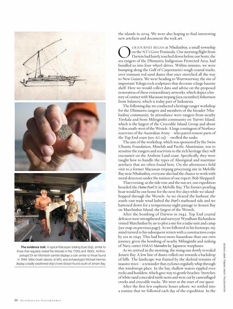
The evidence trail. A typical Macassan trading boat (top), similar to those that regularly visited the Wessels in the 1700s and 1800s. Anthro-
pologist Dr Ian McIntosh (centre) displays a coin similar to those found in 1944. Mike Owen (above, at left), and archaeologist Michael Hermes
display a badly weathered ship’s knee (brace) found south of Jensen Bay.
WILL
IAM
WES
TALL
; GLE
NN
CA
MPB
ELL;
BA
RRY
JOH
NSO
N
MIK
E O
WEN
J a n u a r y – F e b r u a r y 2 0 1 4 89
mornings, some teams would be dropped off along the coast with specific targets; at midday the boats would ferry them back to the Pearl to eat lunch and decide on new targets for the afternoon.
Others would take a packed lunch and start early, trekking across the island to the windswept eastern shore. Hours later and tasks completed, they would radio the Pearl and boats bearing sea-cooled drinks would be dispatched to pick them up.
The positions transmitted by the returning teams were not always accurate and the boats would have to identify tiny figures that seemed like hermit crabs wandering along the beach. It resulted in frequent delays and depleted drink rations for the last party to be retrieved.
OUR FIRST MAJOR port of call on Marchinbar Island was marked on a map that late RAAF serviceman Morry Isenberg had drawn in the early 1980s. That was more
than 30 years after he’d found the Kilwa coins (along with four Dutch coins from the 17th and 18th centuries) while fishing, not far from the Marchinbar radar station at which he was based. He had labelled the site simply “coins”. We located the spot but realised the harsh landscape here is ever-changing. We pondered what hope there could be of gleaning much new information about the coins following 70 years of winds, waves and storms.
In 1944, when Isenberg found the coins, the region was still a wild, uncharted and downright dangerous place. Following the 1943 sinking of the Maroubra near the mainland, HMAS Patricia Cam was sunk in 1944 off the Wessel Islands, bombed by a Japanese float plane.
Yolngu helped rescue the survivors and Wyndham Richardson photographed many of the servicemen, construction crews and Yolngu on Marchinbar. His colleagues’ names are on the backs of the photos but the descriptions of Yolngu stretched only to things such as “No. 1 Boy Djingal” or nicknames such as “Swivel Eye” and “Snowball” for some of the children.
When Isenberg found the coins in 1944, the region was still a wild, uncharted place.
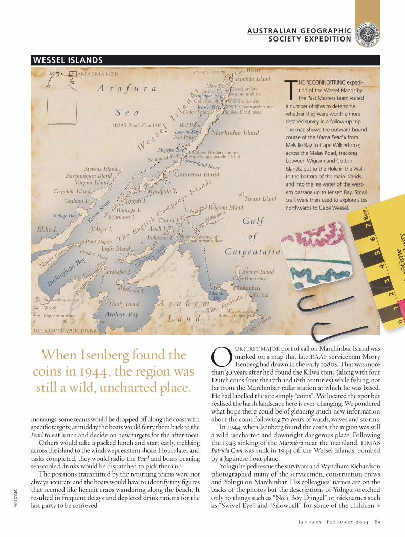
WESSEL ISLANDS
THE RECONNOITRING expedi-tion of the Wessel Islands by the Past Masters team visited
a number of sites to determine whether they were worth a more detailed survey in a follow-up trip. The map shows the outward-bound course of the Hama Pearl II from Melville Bay to Cape Wilberforce; across the Malay Road, tracking between Wigram and Cotton Islands; out to the Hole in the Wall; to the bottom of the main islands and into the lee water of the west-ern passage up to Jensen Bay. Small craft were then used to explore sites northwards to Cape Wessel.
AUSTRALIAN GEOGRAPHICSOCIETY EXPEDITION
WILL
IAM
WES
TALL
; GLE
NN
CA
MPB
ELL;
BA
RRY
JOH
NSO
N
MIK
E O
WEN
90 A u s t r a l i a n G e o g r a p h i c
Richardson’s daughter, Ann Brothers, has recently supplied us with copies of the images and we are trying to identify and record the names of the Yolngu photographed, with help from communities on Gove Peninsula, Elcho Island and Milingimbi.
The geography of Marchinbar Island today is quite different from 20,000 years ago during the last Ice Age. At that time, sea levels were about 150m lower and the Wessels were distant hilltops in the middle of a vast plain that connected Australia to New Guinea. By about 6000 years ago, seas swollen by meltwa-ter from polar ice caps had almost completely flooded this land bridge, isolating Marchinbar’s bauxite-capped sandstone into a series of small islands, rocky shoals and reefs. In the millennia that followed, the great weight of the ocean bore down upon the surrounding continental shelf and, by about 3000 years ago, this pressure had forced Marchinbar upwards to roughly its current height above sea level.
Slowly the shoals and reefs became connected as waves, currents and wind conspired to form beach-ridge plains, spits and barrier dunes. A freshwater lagoon that formed at Jensen Bay probably little more than a thousand years ago is a haven and would have made Marchinbar a suitable trading port and
useful way station for sailors to restock their drinking supplies. Our theory is that this lagoon brought the mysterious vessel that carried the five Kilwa coins to the island.
Unlike the trade winds, trade routes are fickle, but the Yolngu are survivors – pragmatism and resilience are part of their culture. Their oral histories resound with accounts of hardship and camaraderie; they tell of massacres inflicted and endured. They recall battles fought with foreign invaders, as well as times when enemies became allies and foes became fam-ily. The Macassan mariners from Sulawesi influenced virtually every aspect of Yolngu life – they brought technology, language, music and vices. Some historians argue smallpox was introduced to Australia by Macassans and that the disease quickly spread
The Wessel Islands have the reputation of being a
ships’ graveyard.
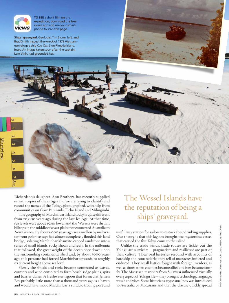
Ships’ graveyard. Geologist Tim Stone, left, and Brad Smith inspect the wreck of 1978 Vietnam-ese refugee ship Cua Can 3 on Rimbija Island. Inset: An image taken soon after the captain, Lam Vinh, had grounded her.
TO SEE a short film on the expedition, download the free viewa app and use your smart-phone to scan this page.
MA
IN IM
AG
E M
IKE
OW
EN; I
NSE
T: TO
M C
OLL
IS; A
RTEF
AC
TS: M
IKE
OW
EN
MIK
E O
WEN
; PET
ER L
AN
E; B
OB
SHEP
PARD
J a n u a r y – F e b r u a r y 2 0 1 4 91
across the continent; the northern Wessels were depopulated by it in the mid-1800s and only seasonally visited as the survivors struggled to recover.
While combing the island for artefacts, we located several campsites behind the main dunes. Using metal detectors at a number of WWII sites, we uncovered handfuls of rifle cartridges, bullets and burst ammunition cases. We found other metal objects, including a large pin, an iron chisel, many heavily corroded axe heads and one beautiful bronze screw that had been refashioned into an oyster shucking knife.
We also discovered a polished stone axe head. This was particularly significant because stone tools have been rare finds in this part of Arnhem Land, since most tools were made of materials that decay, such as wood and bone. It is thought that the trade in axe heads was part of an elaborate exchange cycle: items travelled great distances via hand-to-hand exchanges that promoted bonds among clans and language groups. Macassan items invigorated this trade system as coastal groups began trading steel axes and cloth with inland groups, in exchange for spears, boomerangs and woven bags.
THE WESSEL ISLANDS in general have the reputation of being a ships’ graveyard. Matthew Flinders anchored the Cumberland in a bay on Marchinbar’s south-east corner on
28 October 1803. Next morning, while his men were cutting up a wrecked prau (a boat used by trepangers) for firewood, they met local islanders. Reporting this encounter, Flinders – who had recently circumnavigated the continent – used the term “Australians” for the first time to name the people.
Shipwreck debris and rock art depicting many vessels can be found across the Wessels. At Rimbija Island, the northernmost of the group, what appears to be a rock slipway is littered with nodules of red laterite – iron ore used for smelting. On our next trip, the bay will be targeted to search for ballast stones and other signs of visits. Ballast was used to ensure a ship’s stability; the stones would have been dumped in the bay and replaced with loads of timber, turtle shells, wax, trepang and iron ore. Those abandoned rocks probably anchor large clumps of seaweed today and will be difficult to identify. The narrow channel between Rimbija and Marchinbar is strewn with rocks. Palms and old stone fish traps guard sites where Yolngu and white men made metal knives, according to oral records. Did these white men bring the Kilwa coins?
In the end, the provenance of the coins proved to be elusive. It is unclear whether the Kilwa and Dutch coins Isenberg found arrived on the island together. They may have been carried to Marchinbar by early traders, or given to the Yolngu much later in exchange for use of the freshwater lagoon at Jensen Bay. Perhaps they were left by a collector, or were washed up after a shipwreck. In geological terms, Isenberg was just lucky to be there on the day the coins happened to be on the surface of the beach. A day later and he might not have found anything, as coins on a beach are soon buried. Nevertheless, we made great progress at mapping the island and plan to come back on a much bigger expedition. Anthropologists and a historian on our trip worked with local indigenous people to identify likely sites of contact with foreign visitors. The Yolngu are very interested in this project, and in the possibility of uncovering aspects of their past.
Documenting a shared history. Heritage Detection Australia’s Bob Sheppard (top, at right) teaches Yolngu rangers and Norforce personnel about metal detector techniques, near Nhulunbuy on Gove Peninsula. Traditional owner Terry Yumbulul (centre, at centre), his wife Clely, far left, and daughter Marina examine finds with team members, from left: Barry Johnson, Mike Owen, Ian McIntosh, Bob Sheppard and Tim Stone. A handful of WWII unfired .303 rounds, burst cases and bullets (above).
AUSTRALIAN GEOGRAPHICSOCIETY EXPEDITION
MA
IN IM
AG
E M
IKE
OW
EN; I
NSE
T: TO
M C
OLL
IS; A
RTEF
AC
TS: M
IKE
OW
EN
MIK
E O
WEN
; PET
ER L
AN
E; B
OB
SHEP
PARD
92 A u s t r a l i a n G e o g r a p h i c
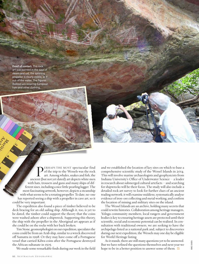
PERHAPS THE MOST spectacular find of the trip to the Wessels was the rock art. Among whales, snakes and fish, the
ancient (but not yet dated) art depicts white men with hats, trousers and guns and many ships of dif-
ferent sizes, including a nice little pearling lugger. The most fascinating artwork, however, depicts a steamship
with what seems to be a rotating propeller. To date, no-one has reported seeing a ship with a propeller in cave art, so it
could be very important.The expedition also found a piece of timber believed to be
deck bracing for an old sailing ship. Although it, too, is yet to be dated, the timber could support the theory that the coins were washed ashore after a shipwreck. Supporting this theory, the ship with the propeller in the Aboriginal art appears as if she could be on the rocks with her back broken.
Tim Stone, geomorphologist on our expedition, speculates the coins could be from an Arab ship, similar to a wreck discovered off Sumatra in 1998. Or they may have come off a Portuguese vessel that carried Kilwa coins after the Portuguese destroyed the African sultanate in 1505.
We made some remarkable finds during our week in the field
and we established the location of key sites on which to base a comprehensive scientific study of the Wessel Islands in 2014. This will involve marine archaeologists and geophysicists from Indiana University’s Office of Underwater Science – a leader in research about submerged cultural artefacts – and searching for shipwrecks will be their focus. The study will also include a detailed rock art survey to look for further clues of an ancient trading network; it will examine middens, systematically analyse evidence of iron-ore collecting and metal working, and confirm the location of mining and military sites on the island.
The Wessel Islands are an archive, holding many secrets that could rewrite histories. Collaboration among heritage managers, Yolngu community members, local rangers and government bodies is key to ensuring heritage assets are protected until their scientific, social and economic potential can be realised. In con-sultation with traditional owners, we are seeking to have the archipelago listed as a national park and, subject to discoveries during our next expedition, the Wessels may one day be eligible for World Heritage listing.
As it stands, there are still many questions yet to be answered. But we have refined the questions themselves and next year we hope to be in a better position to answer some of them. AG
Proof of contact. This rock art was painted in the days of steam and sail; the spinning propeller is clearly visible, as if out of the water. The figures (below) are wearing European hats and other clothing.
MIK
E O
WEN