assessment of reclamation potentiality in the lignite mines of northern greece1
TRANSCRIPT
FACTORS OF RECLAMATION SUCCESS AT THE LIGNITE STRIP-MINED LAND IN NORTHERN GREECE
FATORES DE RECUPERAÇÃO BEM SUCEDIDA NAS MINAS DE LIGNITE DA
GRÉCIA
Thomas Panagopoulos
ABSTRACT
The adverse ecological conditions at the lignite mines of Ptolemaida make the landscape reclamation difficult. The naturally established vegetation and soil properties were studied prior to reclamation. Various forest species were planted to assess the afforestation potential. The natural vegetation was heterogeneous but can be used for the analysis of the site. The soil of the spoil heaps was heterogeneous with unfavourable physicochemical properties. Surface soil temperature was still 24ºC higher in bare soil than in soil covered with vegetation. The most successful species of the afforestation trial were Robinia pseudoacacia and Cedrus atlantica. Covering of fly ash spoils with topsoil presented poor results, while sewage sludge gave a favorable amelioration response in areas with high fly ash content. Topsoil from older stands was the suggested method to establish Robinia pseudoacacia. Reclamation success was dependent on appropriate planning; thus, the new landscape had to be designed in harmony with the surrounding landscape before the start of the mining activity.
Keywords: Landscape Reclamation, Mining Industry, Afforestation, Greece
RESUMO
As condições adversas nas minas de carvão de Ptolemaida dificultam a recuperação ambiental. As propriedades dos solos e a vegetação naturalmente estabelecida nas minas foram estudadas antes da recuperação. Várias espécies florestais foram plantadas para avaliar o potencial de reflorestação. A vegetação natural era muito heterogénea mas podia ser usada para a análise do local. O solo das minas era heterogéneo e com desfavoráveis propriedades físico-químicas. A temperatura do solo era até 24ºC mais elevada em solo sem cobertura vegetal. Robinia pseudoacacia and Cedrus atlantica foram as espécies com maior sucesso. A cobertura das cinzas com solo superficial deu fracos resultados, mas o uso de lamas urbanas foi o meio mais adequado para melhoramento de áreas com alto teor de cinzas. Usar solo superficial de floresta deu os melhores resultados na instalação da Robinia. O sucesso da recuperação da paisagem depende do planeamento, assim, o projeto da nova paisagem deve começar antes no início da atividade mineira.
Palavras-chave: Recuperação da Paisagem, Indústria Extrativa, Reflorestação, Grécia
JEL Classification: Q01, Q15, Q26
Factors of Reclamation Success at the Lignite Strip-Mined Land in Northern Greece
31
1. INTRODUCTION
Lignite is the most important energy resource for the electric power production in Greece. However, the different lignite mining activities create peculiar problems. Except the environmental pollution from fly ash, dust, toxic or radioactive substrates and noises, one of the biggest problems that lignite mining creates is the destruction of large productive areas and the change in the landscape aesthetics (Panagopoulos and Hatzistathis, 1995).
The lignite exploitation activities are occupying the area only temporarily. Following the appropriate program in all stages of mining the area can even return it to the society improved and ready for use as agriculture, forestry, recreation, sports, industrial areas etc. (Brenner and Steiner 1987; Gonzalez-Duque and Panagopoulos, 2010). However, every reclamation trial has to fight with peculiar problems caused by the adverse ecological conditions that exist. The Public Electric Company, which is responsible for the reclamation of the area, did not manage to store the surface soil and replace it after the end of the excavation.
The Public Electric Company has already done many trials to establish many different forest species. The trials have not been adequately planned, but trees were planted in areas that probably will not be excavated again in the near future. Some of the species selected for these trials were inappropriate for the climate and soil of the area. Irrigation of the trees for at least two summers fertilisation and additional soil were not provided as it is suggested from McGinnies and Nicolas (1980) for most of the reclaimed lignite mines.
The most important parameters for successful reforestation-revegetation of the lignite spoils are the climate (especially the microclimate), the soil (physical, chemical and biological properties) and the vegetation (natural and artificially established). Ashby and Kolar (1985) have pointed out that climate, type of rooting medium, drainage and herbaceous competition may limit reclamation success with trees. Most of the afforestation trials fail due to faulty treatments during the establishment and because of the extreme ecological conditions in some microenvironments. Another important reason for these failures was the lack of care and cultivation treatments after establishment of trees.
The lignite spoils of Ptolemaida have diverse physical and chemical properties and its colour may be black, white, red, brown or gray, depending on the percentage of marl, lignite, topsoil and fly ash in the soil. Addition of topsoil in some extreme microenvironments improves the physical and chemical properties of the soil and water retention in it (Barth and Martine, 1984), decreases the high surface soil temperatures (Helgerson, 1990), helps in quickly establishing a high diversity of species of natural vegetation and introduces microorganisms. Many researchers have studied the use of natural revegetation and forest establishment on the spoils from some years before those areas to be agricultural lands (Alexander, 1989). The establishment of natural vegetation and reforestation help to cover and stabilise the soil, start microbiological activity and soil genesis (Gonzalez et al., 1991) and generally impose the physical and chemical properties of the spoils soil; thus, agricultural cultivation and grazing can be reestablished to these areas 20-30 years after reclamation (Chambers et al., 1987).
This study examines the ecological conditions at the lignite spoils of Ptolemaida and their influence to landscape reclamation success.
Journal of Spatial and Organizational Dynamics - Discussion Papers Number 13
32
2. DESCRIPTION OF THE STUDY AREA
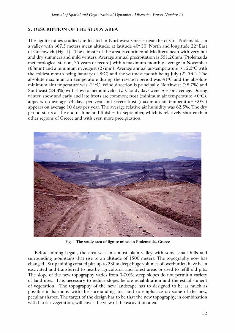
The lignite mines studied are located in Northwest Greece near the city of Ptolemaida, in a valley with 667.5 meters mean altitude, at latitude 40o 30’ North and longitude 22o East of Greenwich (Fig. 1). The climate of the area is continental Mediterranean with very hot and dry summers and mild winters. Average annual precipitation is 551.26mm (Ptolemaida meteorological station, 35 years of record) with a maximum monthly average in November (68mm) and a minimum in August (27mm). Average annual air-temperature is 12.3oC with the coldest month being January (1.8oC) and the warmest month being July (22.5oC). The absolute maximum air temperature during the research period was 41oC and the absolute minimum air temperature was -21oC. Wind direction is principally Northwest (38.7%) and Southeast (24.4%) with slow to medium velocity. Cloudy days were 56% on average. During winter, snow and early and late frosts are common; frost (minimum air temperature <0oC), appears on average 74 days per year and severe frost (maximum air temperature <0oC) appears on average 10 days per year. The average relative air humidity was 62.5%. The dry period starts at the end of June and finishes in September, which is relatively shorter than other regions of Greece and with even more precipitation.
Fig. 1 The study area of lignite mines in Ptolemaida, Greece
Before mining began, the area was an almost plain valley with some small hills and surrounding mountains that rise to an altitude of 1500 meters. The topography now has changed. Strip mining created pits up to 230m deep; huge volumes of overburden have been excavated and transferred to nearby agricultural and forest areas or used to refill old pits. The slope of the new topography varies from 0-70%; steep slopes do not permit a variety of land uses. It is necessary to reduce slopes before rehabilitation and the establishment of vegetation. The topography of the new landscape has to designed to be as much as possible in harmony with the surrounding area and to emphasize on some of the new, peculiar shapes. The target of the design has to be that the new topography, in combination with barrier vegetation, will cover the view of the excavation area.
Factors of Reclamation Success at the Lignite Strip-Mined Land in Northern Greece
33
The hydrology of Ptolemaida valley have been drastically changed. The mining activity change the level of the underground water table, which is 14 meters lower compared with 1968 levels; 35 years after the establishment of the first spoils, the underground water table had not been created yet (Papadopoulos and Nikolaidis, 1992). The lignite of Ptolemaida is a soft brown to black coal with a low fuel value of 10-16Kj/g and a sulfur content generally below 0.6%. The thickness of the lignite layers varies between 12 and 32 meters.
The spoils are generally consisted of the materials that arise after the extraction of lignite. The overburden of the lignite layers is mixed together with bad quality lignite and lignite gasification ashes (fly ash) and surface soil. The new soils that arise from this mixture are heterogeneous, unstable and unconsolidated, with a high pH and low compaction (Panagopoulos, 2012). The transportation of the spoil materials is by tracks and the mixture of them is not programmed or planned. The overburden that covers the lignite layers in the valley consists of marls (forms of soft limestone characterized by high quantities of CaCO3, alkaline and rich in bases), sediments, red-soils, alluvial, peatmould, earthy lignite, fossils, and others. The pH of the fly ash varies between 9 and 12. Soil analyses showed that the new soils are poor in nutrients and contain some toxic elements. The colour of the soil was between light grey (7/1 10YR) and black (2/1 10YR).
Unplanned placement of the spoil materials provokes the instability of the new soils and the high risk of erosion, topsoil in most of the cases buried in high depths and lost, self-igniting fires when unburned lignite is exposed close to the surface of the spoils, soil on the surface with unidentified properties, mineral toxicity and problems with vegetation survival in areas of high fly ash presence.
The vegetation of the Ptolemaida valley corresponds to the submediterranean vegetation zone of Quercetalia pubescentis (Athanasiadis, 1986). Chenopodiacae species dominate on newly-established spoils (2 years old) while Compositae species are more common on older spoils; leguminous species are generally on younger and herbaceous species on older spoils (17 years old).
3. MATERIALS AND METHODS
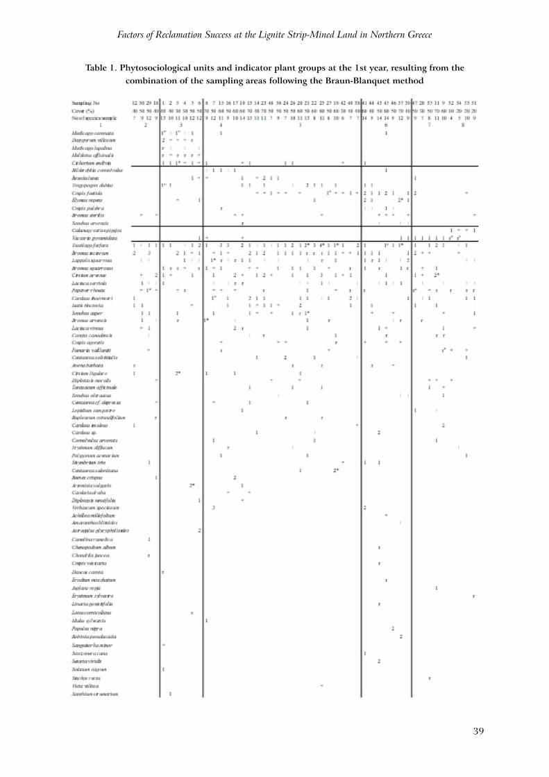
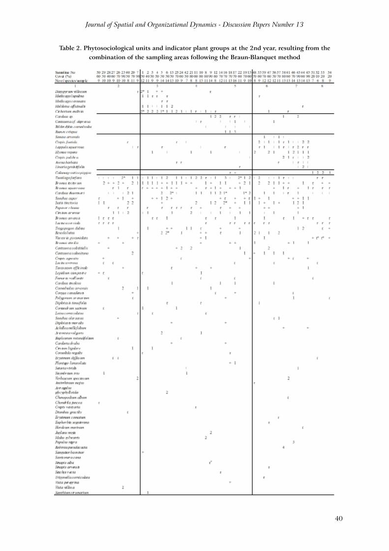
3. 1. Phytosociological studyFor the phytosociological study, 48 geographically positioned sampling areas of 1 m2 were established, permanent for two years on a spoil in which soil preparation for reclamation activities terminated 3 years before and forest species establishment finished 6 months before. Plant samples were collected between 25 of May and 10 of June for both years. For every sampling area, the Braun-Blanquet method was used and soil type, percentage of soil cover by plants and plant vitality were also measured. Species identification was done using Flora Europea of Tutin et al., (1964-1980). Phytosociological units were separated with criteria based on species physiognomy, ecology, flora and evolution (Athanasiadis, 1986). The method based on ecology and flora is assisting better on the target of the study, which was the ecological description of the separated communities that will arise from the plant-table process. In the present research, the systematic determination of phytosociological units was not studied. Specifically, the plant communities were defined with the method of the comparative process and the construction of phytosociological units tables. The separation of the plant communities was done with the help of the indicator plant groups. This method is based on the presence or absence of specific groups.
The method used by the present study was not based on the characteristic or differential species, but on the combination of the indicator groups that were appearing in the phytosociological units. The same group included all the species with the same or similar
Journal of Spatial and Organizational Dynamics - Discussion Papers Number 13
34
ecological behaviour. The ecological description of the separated plant communities was done with the help of the ecological properties of the indicator groups. The disadvantage of this method was that the separated communities had value only for the study of the research area, and they cannot be used for larger areas without additional process.
The method of the school Zürich-Montpellier based on Braun-Blanquet was used for the plant table process (Athanasiadis, 1986). The initial table with sampling areas and species was first constructed in the order they were collected. In a second table, sampling areas remain as they were, but species were written with appearance ascending order. In a third table, species remained as they were, but sampling areas were placed depending on their botanical relationship. In a forth table, species were placed in groups with appearance ascending order. After a continuous table process, the indicator plant groups were separated.
3.2. Soil studySoil is from the most important factors in surface mine reclamation. In the 1.5ha afforestated research area, 16 geographically positioned soil samples were collected. Many soil and water parameters that could explain the cause of spatial variability in revegetation success were analysed. Thus, soil colour, type of soil (lignite, peat, topsoil, fly ash, marl or mixture of the above) and percentage of vegetation cover were measured. The samples were packed in polyethylene bags and transferred to the laboratory. Soil colour was recognized with the tables of Munsell. Samples for the calculation of the soil moisture were weighed and dried. The mixture of soil and coarse fragments was air-dried, weighed and carefully sieved through a 2mm screen without breaking up fragile fragments. The fine earth fraction was analyzed for the following: texture by sieve and pipette method, particle density, specific weight, available water content by pressure membrane extraction of saturated soil at 0.33 and 15 bar, total porosity, air porosity, organic matter, pH, electrical conductivityin 1:1 slury of soil and distilled water, calcium carbonate (CaCO3), available phosphorus, total nitrogen, and exchangeable calcium, magnesium and potassium by ammonium acetate extraction at pH 9.
3.3. Planting of forest species in pitsBetween the 20th and 30th of November, 1992, 680 seedlings from 6 forest species in pits were planted. The area was 1.5ha and prepared for revegetation 3 years ago. The 6 forest species were planted in a split-split plot design with treatments of irrigation and fertilisation. For every treatment there were 4 replications. Seedlings were planted in a 4X3 spacing and they were: 160 Pinus nigra (one year old in paper pots), 160 Pinus brutia (one year old in paper pots), 160 Cupressus arizonica (one year old in paper pots), 160 Robinia pseudoacacia (one year old bear-root), 20 Cedrus atlantica (two year old in pots) and 20 Prunus avium (one year old bear-root). In spring of 1993, 40 more Cupressus arizonica seedlings were planted to replace some of the winter losses. Measurements on survival and growth were done at establishment and every 6 months (November and May). Also, data for soil colour and natural vegetation cover around every tree was collected.
3.4. Soil temperature Soil temperature during summer is a very important factor limiting reclamation success in the lignite mines of Ptolemaida. This is happening mainly due to the black colour of lignite which in many areas is the main element in the surface. For the estimation of the soil temperature mercury thermometers were placed in 17, 11, 2.5 and 0.5cm depths, in three different soil colours: red (5YR 4/3), light grey (10YR 7/1) and black (10YR 3/1). The red coloured soil was mainly surface soil, the grey had a main element of marl and the black lignite. Air temperature was measured under shadow 50cm from the soil. soil and air temperatures of 20 days were measured between the 20th of June and the 20th of August of
Factors of Reclamation Success at the Lignite Strip-Mined Land in Northern Greece
35
1993 and 1994, at 11.00, 13.00, 15.00 and 17.00 hours. It was a completely randomized design with main treatment of the soil colours. Soil surface temperatures (0.5cm) were also measured, under the shadow of the natural vegetation and planted trees in a black coloured soil. The results were compared with the soil surface temperatures of the black coloured bare soil. Soil surface temperature was measured at 0.5cm depth.
3.5. Establishment of a Robinia forest by spreading surface soil from Robinia mother forestThe main methods for establishing Robinia on the spoils of the lignite mines of Ptolemaida is the plantation in pits, plantation by riper or other machines and the establishment by spreading surface soil from the Robinia mother forest. For the first method, bare-root plants or plants in paper pots were used; the success of establishment was high but with much higher cost. For the second method, a bulldozer type “CATERPILLAR D9N” was used with a riper in the back which opens a half meter deep rill while a man is placing the seedlings in it simultaneously. This method has higher success than planting in pits, because roots are covered immediately and the cost is lower. The third method was applied for the first time in February of 1992.
It is known that Robinia can easily become multiplied with small pieces of roots (3-5cm) (Papanastasi, 1991). By spreading surface soil from the Robinia mother forest, a bulldozer type FIAT-ALLIS-21C is used carrying in the back a disk used to cut the roots till 40cm depth. The disk has diameter 130cm and thickness 5cm that finishes in high sharpness. The soil of the Robinia mother forest is ripped many times and then is carried and spread on the reclamation area. There it is ripped again and irrigated. The success of this method is very high and the cost of it is minimal. From 120 tons of mother soil, 1.5ha of spoils can become afforestated, with a seedling density of 1.5/m2.
This chapter compares the success of the three methods. Forest establishment by spreading surface soil from the Robinia mother forest was studied in the three areas that were planted 32, 20 and 8 months ago. In the last area, planted in February of 1994, an area of 3ha was split in three and mother forest topsoil was mixed with topsoil, sand and lignite respectively. In every research area, three permanent 2X5 sample plots were placed and the number, height, and basal diameter of Robinia seedlings were measured in June and November of 1992 to 1994.
The mixture with light coloured materials was done to alter the success of the method on the dark coloured spoil materials where the success, especially during the first summer, was lower. The number of the emerging Robinia was increasing after the first summer and especially when natural vegetation was covering the soil and with its shadow protecting the Robinia seedlings from high soil temperatures. The main disadvantage of this method is that there are not many available areas from where mother soil can be taken. However, 40cm deep soil can be taken for many years without Robinia losing its ability to multiply.
3.6. Statistical methodsAll data was entered into a field-scale GIS (ArcView), and interlayer data analytical tools were utilized to quantify spatially dependent relationships. Two-way analysis of variance (ANOVA) was used to determine differences (P=0.05) in soil temperatures, seedling growth and survival. Comparisons of all means were examined with Fisher’s protected LSD’s and with Duncan’s test. Significant differences at P=0.01 were noted separately. The search of the influence from the parameters soil type and colour, natural vegetation species and cover to the parameters height, diameter, survival and seedling vigour was done with the simple correlation analysis. The above statistics were done based on the methodology mentioned from Snedecor and Cochran (1977) and with the help of the SPSS, EXCEL and MSTAT statistical programs.
Journal of Spatial and Organizational Dynamics - Discussion Papers Number 13
36
4. RESULTS
4.1. Results from the phytosociological researchDetermination of the phytosociological units. Phytosociological units were determined with the help of the indicator plant groups. After the plant-table process, 6 indicator plant groups were separated in the 1st year table of species sampling (Table 1) and 5 indicator plant groups in the 2nd year table (Table 2). The ecological description of those groups was done bibliographically, after an “on site” research (Ellenberg et al., 1992).
Group A. Constant in both years with average drought species. Those species appear in infertile, clay soils, with relatively high salinity, pH 8 and in relatively warm environments. The characteristic species of this group were: Melilotus officinalis, Medicago lupulina, Cichorium endivia, Medicago coronata, and Dasypyrum villosum.
Group B. Constant in both years with higher number of species in the second sampling year. This group had species of average humid areas, indicators of fertile soil with normal moisture and pH 7-8. The characteristic species of this group were: Bilderdykia convolvulus, Carduus sp., Centaurea cf. depressa and Rumex crispus.
Group C. Appearing only in the table of the 1st year. Includes drought species, with large ecological adaptation, developing in medium fertile soil with pH 8 and warm environments. The characteristic species of this group were: Tragopogon dubius and Reseda lutea.
Group D. Constant in both years. Includes species of average drought, with large ecological adaptation, growing in warm environments and average fertile soil with pH 7-8. The characteristic species of this group were: Sonchus arvensis, Crepis foetida, Lappula squarrosa, Elymus repens and Crepis pulchra.
Group E. Constant in both years. The characteristic species of this group (Calamagrostis epigejos) can be seen in humid and cool environments, in soil of average fertility and pH 7-8.
Group F. Appearing only in the table of the 1st year. Includes drought resistant species, growing in warm environments and soils with poor fertility and pH 9. The characteristic species of this group was: Vaccaria pyramidata.
Group G. Appearing only in the table of the 2nd year. Includes drought resistant species, expanding in warm environments with fertile soils and pH 7-8. The characteristic species of this group were: Crepis pulchra, Avena barbata and Linaria genistifolia.
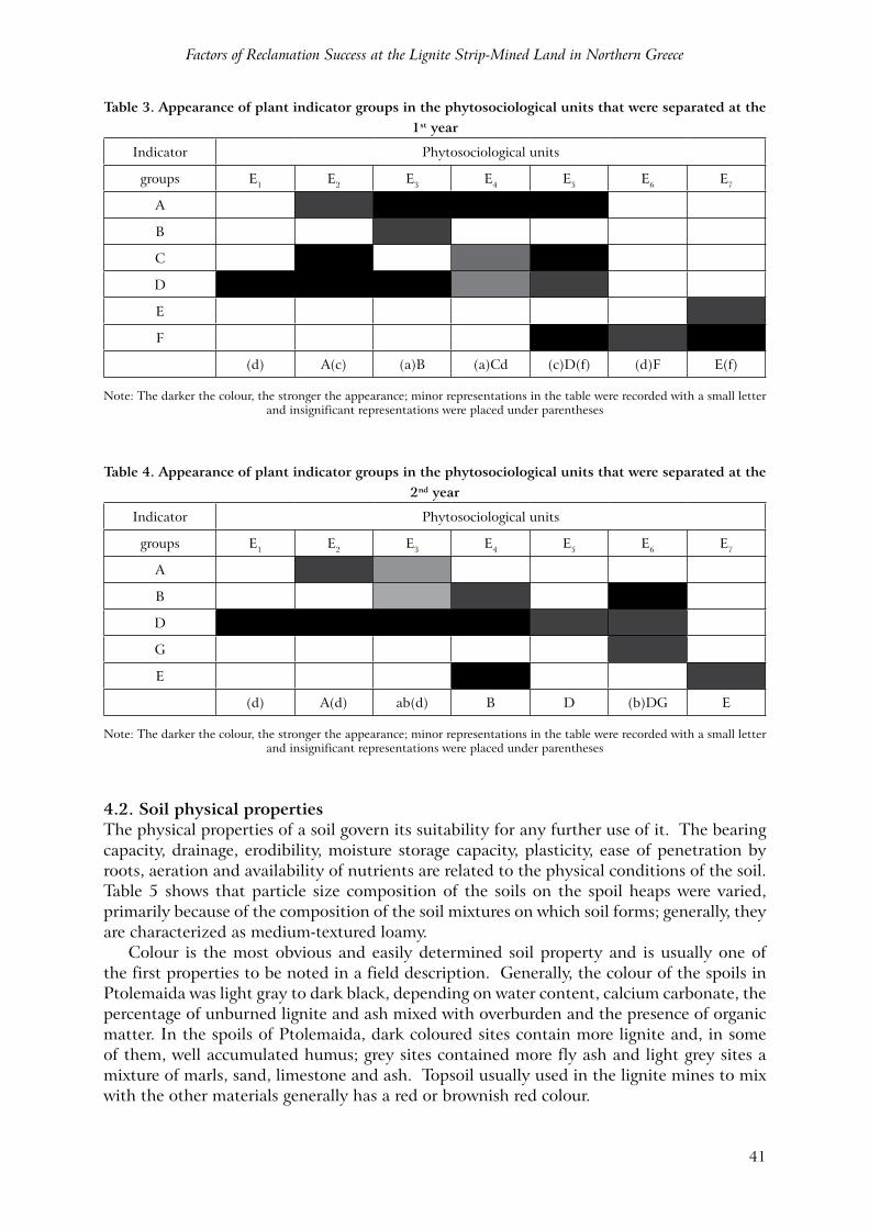
Description of the determined phytosociological units. With the above indicator plant groups, the keys for the determination of the phytosociological units were made. Tables 3 and 4 show the range of the group appearance in the phytosociological units where those groups belong. From the coverage of the group appearance, it can be seen that the drought group A is limited in areas where clay topsoil was spread on the spoil. The average drought group B is decreasing as the soil fertility decreases. The groups C and D were increasing by time, with the first to develop in more infertile areas and the second in fertile soils with a high percentage of lignite. Indicator group E appears as a spot in a small part of the spoil where marl was the dominant element and surface soil temperature was lower due to lighter soil color, while the F appears in small spots all over the spoil in areas where fly ash was the dominant material (fly ash pH was higher than 9). Finally the group G always becomes visible in areas adjacent to group D, but in spots where lignite was significantly higher.
Factors of Reclamation Success at the Lignite Strip-Mined Land in Northern Greece
37
Phytosociological unit E1 (constant for both years). Indicator plant group (d). This unit appeared in areas affected from topsoil that exists in a depth of more than 30cm and covered with lignite spoils. Soil was fertile and pH varied between 7.5-8. The forest species planted at the specific area had fast growth, while the few dead trees noted in the area were caused from the high soil surface temperatures. Natural vegetation was covering the soil with its shadow between 40% and 50% and assisted in the survival of the newly established forest species. Dominant species of this unit were: Bromus tectorum, Tussilago farfara, Isatis tinctoria and Carduus thoermeri. The indicator value for this community had only the species Bromus sterilis, Crepis foetida and Lappula squarrosa of group D; but, because its representation in the table was minor, it is recorded with a small letter between parenthesis. This plant community was characterized by the absence of any other indicator groups.
Phytosociological unit E2 (constant for both years). Indicator plant groups A(c) for 1st and A(d) for 2nd year. This unit appears in areas affected from topsoil. That soil had a clay loam texture, pH 8-8.5 and a high content of Na+ (0.5-0.6meq/lit). The forest species planted in that area had low growth and survival. The soil was compacted and waterlogged. Hydraulic conductivity and air porosity were lower than in the other soil types of the spoil. Soil cover by natural vegetation was less than 50%. Dominant species of this unit were: Tussilago farfara, Bromus tectorum, Bromus squarrosus, Sonchus asper and Artemisia vulgaris. The indicator value for this community had all the species of group A, Tragopogon dubius and Reseda lutea of group C and Elymus repens of group D. This plant community was characterized from its stability in both sampling years. Melilotus officinalis appears in compacted, clay and salty soils and Sonchus asper is resistant in high soil salinity as noted by Ellenberg et al. (1992).
Phytosociological unit E3 (for 1st year). Indicator plant groups (a)B. This unit became visible in areas affected from topsoil mixed with marl, lignite and fly ash. Soil was loamy with pH between 7 and 8. The forest species planted in the area had good growth and survival. Dominant species of this unit were: Tussilago farfara, Bromus tectorum, Lappula squarrosa, Verbascum speciosum and Rumex crispus, but the indicator value only had the species Bilderdykia convolvulus and Cichorium endivia. The main characteristic of this plant community was its relationship with group A species, a fact that became more clear in the second year.
Phytosociological unit E3 (for 2nd year). Indicator plant groups ab(d). Developing in the same area as E3 of 1st year, with dominant species: Tussilago farfara, Bromus tectorum, Carduus thoermeri, Isatis tinctoria and Centaurea solstitialis. The indicator value for this plant community had the species Cichorium endivia (group A), Centaurea cf. depressa, Bilderdykia convolvulus and Carduus sp. (group B), Elymus repens, Lappula squarrosa and Crepis foetida (group D), but with minor representation in the table so they were recorded with a small letter. This plant community was the intermediate stage between E2 and E4, and Cichorium endivia was increasing its presence over time.
Phytosociological unit E4 (1st year). Indicator plant groups (a)Cd. The soil of the
area where the community was developing had well mixed all of the spoil materials with a higher content of fly ash and marl. Texture was sandy loamy and pH was varying between 7 and 8. Dominant species of this unit were: Tussilago farfara, Bromus tectorum, Bromus squarrosus, Lappula squarrosa, Cirsium arvense, Carduus thoermeri, Isatis tinctoria, Sonchus asper and Centaurea solstitialis, but the indicator value had the species Cichorium endivia (group A), Tragopogon dubius and Reseda lutea (group C) and Crepis foetida (group D).
Journal of Spatial and Organizational Dynamics - Discussion Papers Number 13
38
Phytosociological unit E4 (2nd year). Indicator plant group B. The characteristics
of the area where this community was appearing were the same as E3 of 1st year. Dominant species of this plant community were: Tussilago farfara, Bromus tectorum, Bromus squarrosus, Cirsium arvense, Carduus thoermeri and Isatis tinctoria.
Phytosociological unit E5 (1st year). Indicator plant groups (c)D(f). This community
was a developing on soil that was a mixture of all spoil materials. Texture was loamy and pH was varying between 7 and 8. The forest species planted in the area had good growth and survival. Dominant species of this unit were: Tussilago farfara, Bromus tectorum, Bromus squarrosus and Lactuca serriola, but the indicator value for this plant community had the species of group D and Tragopogon dubius of group C and Vaccaria pyramidata of group F.
Phytosociological unit E5 (2nd year). Indicator plant group D. This community was
developing in soil that was a mixture of all spoil materials. Dominant species of this unit were: Tussilago farfara, Bromus tectorum and Reseda lutea.
Phytosociological unit E6 (1st year). Indicator plant group (d)F. This community
become visible in soil similar to the E5 unit, but in spots where fly ash content was high; as a consequence, pH was higher than 9. Dominant species of this plant community were: Tussilago farfara, Bromus tectorum and Cirsium arvense, but the indicator value only had the species Crepis foetida (group C) and Vaccaria pyramidata (group F). Kavadas (1956-1964) mentioned that Vaccaria pyramidata grows in calcareous soils, while Ellenberg et al. (1992) cited that this species is an indicator of dry and infertile soils with pH 9. Those species may be used as bioindicators of low quality zones, and soil improvement of those areas should be done before reforestation.
Phytosociological unit E6 (2nd year). Indicator plant group (b)DG. This community
appeared in soil similar to E5, but in spots where lignite and topsoil were higher. The forest species planted in that area had low growth and high survival. Seedling growth was low due to high competition from natural vegetation, but survival rate was high due to a shadowing effect of almost total soil cover that kept low surface soil temperatures during summer. Dominant species of this plant community were: Bromus squarrosus, Isatis tinctoria, Sonchus asper, Bromus arvensis, Tragopogon dubius and Bromus tectorum, but the indicator value had the species Carduus sp. (group B), Crepis foetida, Lappula squarrosa, Elymus repens (group D) and Crepis pulchra, Avena barbata, Linaria genistifolia (group G). Those species may be used as bioindicators of good quality zones on the lignite spoils, and forest species density could be lower on the establishment.
Phytosociological unit E7. Indicator plant group E(f) for 1st and E for 2nd year. This unit comes into view in areas of marl soil with loamy clay texture. Soil surface temperatures were lower than in the other sites of the spoil because soil colour was white. The forest species planted in that area had low growth and high survival. Dominant species of this community were: Tussilago farfara, Lappula squarrosa, Lactuca serriola, Carduus thoermeri and Bromus tectorum. The indicator value had the species Calamagrostis epigejos which is increasing its presence with time and Vaccaria pyramidata which appears in spots around the area of Calamagrostis epigejos. Natural vegetation cover was less than 20%, but the forest species planted in that area had a higher rate of survival because the lighter soil colour did not permit high surface soil temperatures.
Factors of Reclamation Success at the Lignite Strip-Mined Land in Northern Greece
39
Table 1. Phytosociological units and indicator plant groups at the 1st year, resulting from the combination of the sampling areas following the Braun-Blanquet method
Journal of Spatial and Organizational Dynamics - Discussion Papers Number 13
40
Table 2. Phytosociological units and indicator plant groups at the 2nd year, resulting from the combination of the sampling areas following the Braun-Blanquet method
Factors of Reclamation Success at the Lignite Strip-Mined Land in Northern Greece
41
Table 3. Appearance of plant indicator groups in the phytosociological units that were separated at the 1st year
Indicator Phytosociological units
groups E1 E2 E3 E4 E5 E6 E7
A
B
C
D
E
F
(d) A(c) (a)B (a)Cd (c)D(f) (d)F E(f)
Note: The darker the colour, the stronger the appearance; minor representations in the table were recorded with a small letter and insignificant representations were placed under parentheses
Table 4. Appearance of plant indicator groups in the phytosociological units that were separated at the 2nd year
Indicator Phytosociological units
groups E1 E2 E3 E4 E5 E6 E7
A
B
D
G
E
(d) A(d) ab(d) B D (b)DG E
Note: The darker the colour, the stronger the appearance; minor representations in the table were recorded with a small letter and insignificant representations were placed under parentheses
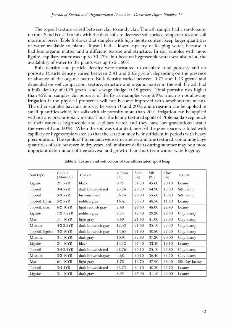
4.2. Soil physical propertiesThe physical properties of a soil govern its suitability for any further use of it. The bearing capacity, drainage, erodibility, moisture storage capacity, plasticity, ease of penetration by roots, aeration and availability of nutrients are related to the physical conditions of the soil. Table 5 shows that particle size composition of the soils on the spoil heaps were varied, primarily because of the composition of the soil mixtures on which soil forms; generally, they are characterized as medium-textured loamy.
Colour is the most obvious and easily determined soil property and is usually one of the first properties to be noted in a field description. Generally, the colour of the spoils in Ptolemaida was light gray to dark black, depending on water content, calcium carbonate, the percentage of unburned lignite and ash mixed with overburden and the presence of organic matter. In the spoils of Ptolemaida, dark coloured sites contain more lignite and, in some of them, well accumulated humus; grey sites contained more fly ash and light grey sites a mixture of marls, sand, limestone and ash. Topsoil usually used in the lignite mines to mix with the other materials generally has a red or brownish red colour.
Journal of Spatial and Organizational Dynamics - Discussion Papers Number 13
42
The topsoil texture varied between clay to sandy clay. The ash sample had a sand-loamy texture. Sand is used to mix with the dark soils to decrease soil surface temperatures and soil moisture losses. Table 6 shows that samples with high lignite content keep larger quantities of water available to plants. Topsoil had a lower capacity of keeping water, because it had less organic matter and a different texture and structure. In soil samples with more lignite, capillary water was up to 50.42%, but because hygroscopic water was also a lot, the availability of water to the plants was up to 21.60%.
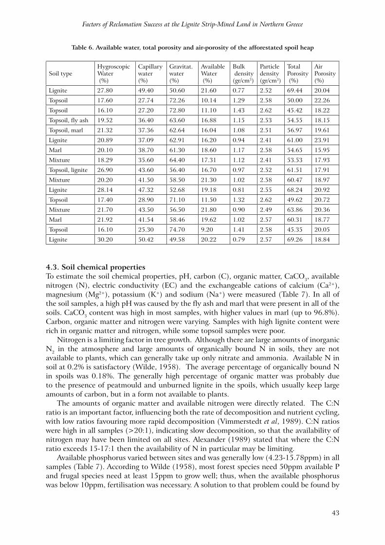
Bulk density and particle density were measured to calculate total porosity and air porosity. Particle density varied between 2.41 and 2.62 gr/cm3, depending on the presence or absence of the organic matter. Bulk density varied between 0.77 and 1.43 gr/cm3 and depended on soil compaction, texture, structure and organic matter in the soil. Fly ash had a bulk density of 0.79 gr/cm3 and sewage sludge, 0.48 gr/cm3. Total porosity was higher than 45% in samples. Air porosity of the fly ash samples were 8.9%, which is not allowing irrigation if the physical properties will not become improved with amelioration means. The other samples have air porosity between 10 and 20%, and irrigation can be applied in small quantities while, for soils with air porosity more than 20%, irrigation can be applied without any precautionary means. Thus, the loamy textured spoils of Ptolemaida keep much of their water as hygroscopic and capillary water, and they have low gravitational water (between 40 and 60%). When the soil was saturated, most of the pore space was filled with capillary or hygroscopic water, so that the aeration may be insufficient in periods with heavy precipitation. The spoils of Ptolemaida were structureless and fine textured, containing large quantities of ash; however, in dry years, soil moisture deficits during summer may be a more important determinant of tree survival and growth than short term winter waterlogging.
Table 5. Texture and soil colour of the afforestated spoil heap
Soil type Colour(Munsell) Colour >2mm
(%)Sand(%)
Silt(%)
Clay(%) Texture
Lignite 2/1 5YR black 6.95 34.30 45.60 20.10 Loamy
Topsoil 3/4 5YR dark brownish red 23.76 29.30 54.90 15.80 Silt loamy
Topsoil 5/3 5YR brownish red 36.54 29.00 55.60 15.40 Silt loamy
Topsoil, fly ash 5/2 5YR reddish gray 16.41 39.70 48.50 11.80 Loamy
Topsoil, marl 6/2 10YR light reddish gray 2.48 29.60 48.00 22.40 Loamy
Lignite 7/2 7.5YR reddish gray 9.54 42.40 29.20 28.40 Clay loamy
Marl 7/1 10YR light gray 4.69 21.60 41.00 37.40 Clay loamy
Mixture 4/2 2.5YR dark brownish gray 12.43 31.60 35.10 33.30 Clay loamy
Topsoil, lignite 3/2 10YR dark brownish gray 14.65 31.90 40.80 27.30 Clay loamy
Mixture 3/1 10YR dark gray 10.91 32.80 37.20 30.00 Clay loamy
Lignite 2/1 10YR black 13.12 47.40 33.50 19.10 Loamy
Topsoil 3/4 2.5YR dark brownish red 28.76 35.10 25.10 35.80 Clay loamy
Mixture 3/2 10YR dark brownish gray 4.68 30.10 36.40 33.50 Clay loamy
Marl 6/1 10YR light gray 1.78 13.70 47.90 38.40 Silt clay loamy
Topsoil 3/4 5YR dark brownish red 33.75 34.10 40.20 25.70 Loamy
Lignite 3/1 10YR dark gray 8.95 35.90 41.10 23.00 Loamy
Factors of Reclamation Success at the Lignite Strip-Mined Land in Northern Greece
43
Table 6. Available water, total porosity and air-porosity of the afforestated spoil heap
Soil typeHygroscopicWater (%)
Capillarywater (%)
Gravitat.water (%)
AvailableWater (%)
Bulk density(gr/cm3)
Particledensity(gr/cm3)
TotalPorosity (%)
Air Porosity(%)
Lignite 27.80 49.40 50.60 21.60 0.77 2.52 69.44 20.04
Topsoil 17.60 27.74 72.26 10.14 1.29 2.58 50.00 22.26
Topsoil 16.10 27.20 72.80 11.10 1.43 2.62 45.42 18.22
Topsoil, fly ash 19.52 36.40 63.60 16.88 1.15 2.53 54.55 18.15
Topsoil, marl 21.32 37.36 62.64 16.04 1.08 2.51 56.97 19.61
Lignite 20.89 37.09 62.91 16.20 0.94 2.41 61.00 23.91
Marl 20.10 38.70 61.30 18.60 1.17 2.58 54.65 15.95
Mixture 18.29 35.60 64.40 17.31 1.12 2.41 53.53 17.93
Topsoil, lignite 26.90 43.60 56.40 16.70 0.97 2.52 61.51 17.91
Mixture 20.20 41.50 58.50 21.30 1.02 2.58 60.47 18.97
Lignite 28.14 47.32 52.68 19.18 0.81 2.55 68.24 20.92
Topsoil 17.40 28.90 71.10 11.50 1.32 2.62 49.62 20.72
Mixture 21.70 43.50 56.50 21.80 0.90 2.49 63.86 20.36
Marl 21.92 41.54 58.46 19.62 1.02 2.57 60.31 18.77
Topsoil 16.10 25.30 74.70 9.20 1.41 2.58 45.35 20.05
Lignite 30.20 50.42 49.58 20.22 0.79 2.57 69.26 18.84
4.3. Soil chemical propertiesTo estimate the soil chemical properties, pH, carbon (C), organic matter, CaCO3, available nitrogen (N), electric conductivity (EC) and the exchangeable cations of calcium (Ca2+), magnesium (Mg2+), potassium (K+) and sodium (Na+) were measured (Table 7). In all of the soil samples, a high pH was caused by the fly ash and marl that were present in all of the soils. CaCO3 content was high in most samples, with higher values in marl (up to 96.8%). Carbon, organic matter and nitrogen were varying. Samples with high lignite content were rich in organic matter and nitrogen, while some topsoil samples were poor.
Nitrogen is a limiting factor in tree growth. Although there are large amounts of inorganic N2 in the atmosphere and large amounts of organically bound N in soils, they are not available to plants, which can generally take up only nitrate and ammonia. Available N in soil at 0.2% is satisfactory (Wilde, 1958). The average percentage of organically bound N in spoils was 0.18%. The generally high percentage of organic matter was probably due to the presence of peatmould and unburned lignite in the spoils, which usually keep large amounts of carbon, but in a form not available to plants.
The amounts of organic matter and available nitrogen were directly related. The C:N ratio is an important factor, influencing both the rate of decomposition and nutrient cycling, with low ratios favouring more rapid decomposition (Vimmerstedt et al, 1989). C:N ratios were high in all samples (>20:1), indicating slow decomposition, so that the availability of nitrogen may have been limited on all sites. Alexander (1989) stated that where the C:N ratio exceeds 15-17:1 then the availability of N in particular may be limiting.
Available phosphorus varied between sites and was generally low (4.23-15.78ppm) in all samples (Table 7). According to Wilde (1958), most forest species need 50ppm available P and frugal species need at least 15ppm to grow well; thus, when the available phosphorus was below 10ppm, fertilisation was necessary. A solution to that problem could be found by
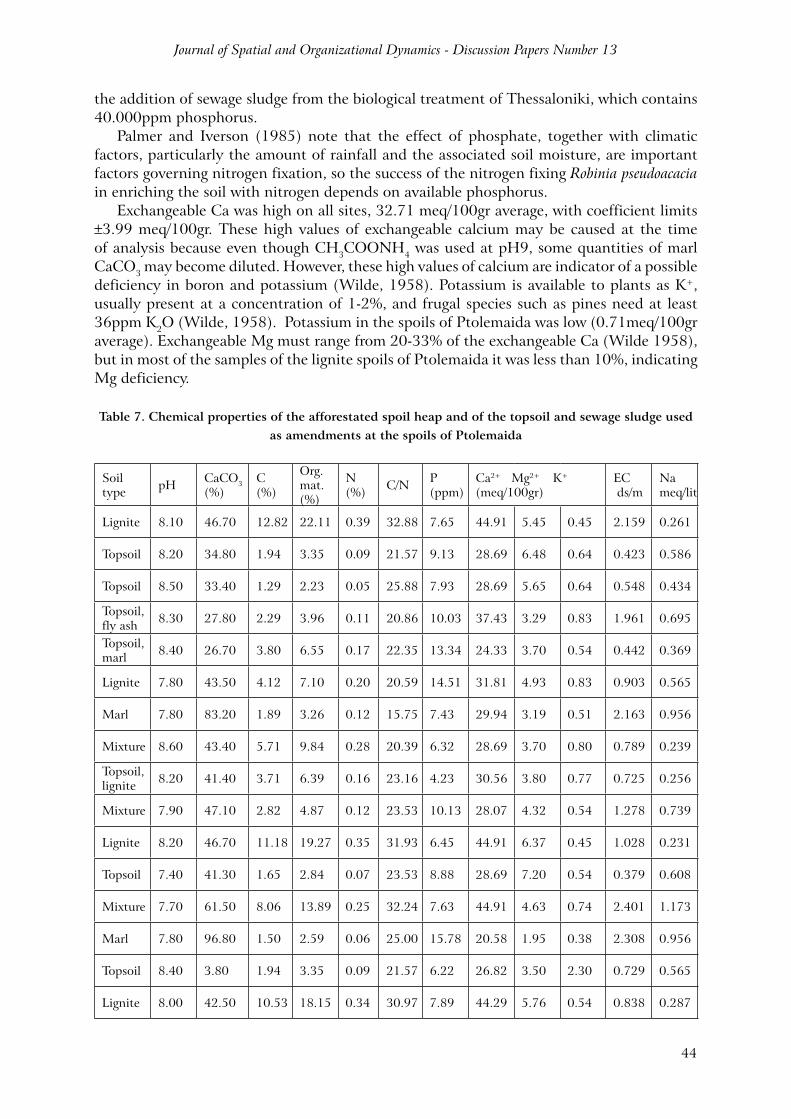
Journal of Spatial and Organizational Dynamics - Discussion Papers Number 13
44
the addition of sewage sludge from the biological treatment of Thessaloniki, which contains 40.000ppm phosphorus.
Palmer and Iverson (1985) note that the effect of phosphate, together with climatic factors, particularly the amount of rainfall and the associated soil moisture, are important factors governing nitrogen fixation, so the success of the nitrogen fixing Robinia pseudoacacia in enriching the soil with nitrogen depends on available phosphorus.
Exchangeable Ca was high on all sites, 32.71 meq/100gr average, with coefficient limits ±3.99 meq/100gr. These high values of exchangeable calcium may be caused at the time of analysis because even though CH3COONH4 was used at pH9, some quantities of marl CaCO3 may become diluted. However, these high values of calcium are indicator of a possible deficiency in boron and potassium (Wilde, 1958). Potassium is available to plants as K+, usually present at a concentration of 1-2%, and frugal species such as pines need at least 36ppm K2O (Wilde, 1958). Potassium in the spoils of Ptolemaida was low (0.71meq/100gr average). Exchangeable Mg must range from 20-33% of the exchangeable Ca (Wilde 1958), but in most of the samples of the lignite spoils of Ptolemaida it was less than 10%, indicating Mg deficiency.
Table 7. Chemical properties of the afforestated spoil heap and of the topsoil and sewage sludge used as amendments at the spoils of Ptolemaida
Soil type pH CaCO3
(%)C(%)
Org.mat.(%)
N(%) C/N P
(ppm)Ca2+ Mg2+ K+
(meq/100gr)EC ds/m
Nameq/lit
Lignite 8.10 46.70 12.82 22.11 0.39 32.88 7.65 44.91 5.45 0.45 2.159 0.261
Topsoil 8.20 34.80 1.94 3.35 0.09 21.57 9.13 28.69 6.48 0.64 0.423 0.586
Topsoil 8.50 33.40 1.29 2.23 0.05 25.88 7.93 28.69 5.65 0.64 0.548 0.434
Topsoil, fly ash 8.30 27.80 2.29 3.96 0.11 20.86 10.03 37.43 3.29 0.83 1.961 0.695
Topsoil, marl 8.40 26.70 3.80 6.55 0.17 22.35 13.34 24.33 3.70 0.54 0.442 0.369
Lignite 7.80 43.50 4.12 7.10 0.20 20.59 14.51 31.81 4.93 0.83 0.903 0.565
Marl 7.80 83.20 1.89 3.26 0.12 15.75 7.43 29.94 3.19 0.51 2.163 0.956
Mixture 8.60 43.40 5.71 9.84 0.28 20.39 6.32 28.69 3.70 0.80 0.789 0.239
Topsoil, lignite 8.20 41.40 3.71 6.39 0.16 23.16 4.23 30.56 3.80 0.77 0.725 0.256
Mixture 7.90 47.10 2.82 4.87 0.12 23.53 10.13 28.07 4.32 0.54 1.278 0.739
Lignite 8.20 46.70 11.18 19.27 0.35 31.93 6.45 44.91 6.37 0.45 1.028 0.231
Topsoil 7.40 41.30 1.65 2.84 0.07 23.53 8.88 28.69 7.20 0.54 0.379 0.608
Mixture 7.70 61.50 8.06 13.89 0.25 32.24 7.63 44.91 4.63 0.74 2.401 1.173
Marl 7.80 96.80 1.50 2.59 0.06 25.00 15.78 20.58 1.95 0.38 2.308 0.956
Topsoil 8.40 3.80 1.94 3.35 0.09 21.57 6.22 26.82 3.50 2.30 0.729 0.565
Lignite 8.00 42.50 10.53 18.15 0.34 30.97 7.89 44.29 5.76 0.54 0.838 0.287
Factors of Reclamation Success at the Lignite Strip-Mined Land in Northern Greece
45
Total soil electric conductivity was low or average in most of the samples (Table 7). Fly ash and one topsoil sample were found to have high electric conductivity (3.85 and 7.68ds/m respectively), resulting in poor plant growth. Soluble Na content was also very high in those two samples (9.95 and 15.65meq/lit respectively), indicating high salinity of those soils.
Topsoil replacement on the fly ash spoils of Akrini-Klitos gave until now very poor results. Sample 3 shows that this topsoil, placed in part of the experimental site, had good physical properties but did not contain nitrogen and was low in organic matter. The result was to become easily eroded from the first year of placement, mainly because natural vegetation was not established even five years after reclamation. The reforestation trials on it had survival of less than 30% and erosion created 40cm deep rills. This area compared with two neighbouring areas (Table 7, sample 1 and sample 2) which became covered with surface soil and had high reclamation success. Reclamation success could be higher if fertilisation with organic fertilisers was applied, like sewage sludge or manure. Root soil from the mother soil forest could also help in the faster and easier establishment of flora and fauna on spoils.
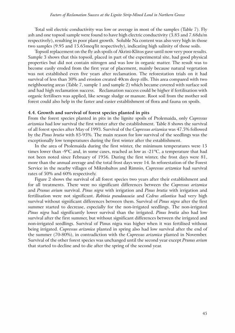
4.4. Growth and survival of forest species planted in pitsFrom the forest species planted in pits in the lignite spoils of Ptolemaida, only Cupressus arizonica had low survival the first winter after the establishment. Table 8 shows the survival of all forest species after May of 1993. Survival of the Cupressus arizonica was 47.5% followed by the Pinus brutia with 85-93%. The main reason for low survival of the seedlings was the exceptionally low temperatures during the first winter after the establishment.
In the area of Ptolemaida during the first winter, the minimum temperatures were 15 times lower than -9ºC and, in some cases, reached as low as -21ºC, a temperature that had not been noted since February of 1956. During the first winter, the frost days were 81, more than the annual average and the total frost days were 14. In reforestation of the Forest Service in the nearby villages of Mikrobaltos and Rimnio, Cupressus arizonica had survival rates of 50% and 60% respectively.
Figure 2 shows the survival of all forest species two years after their establishment and for all treatments. There were no significant differences between the Cupressus arizonica and Prunus avium survival. Pinus nigra with irrigation and Pinus brutia with irrigation and fertilisation were not significant. Robinia pseudoacacia and Cedrus atlantica had very high survival without significant differences between them. Survival of Pinus nigra after the first summer started to decrease, especially for the non-irrigated seedlings. The non-irrigated Pinus nigra had significantly lower survival than the irrigated. Pinus brutia also had low survival after the first summer, but without significant differences between the irrigated and non-irrigated seedlings. Survival of Pinus nigra was higher when it was fertilised without being irrigated. Cupressus arizonica planted in spring also had low survival after the end of the summer (70-80%), in contradiction with the Cupressus arizonica planted in November. Survival of the other forest species was unchanged until the second year except Prunus avium that started to decline and to die after the spring of the second year.
Journal of Spatial and Organizational Dynamics - Discussion Papers Number 13
46
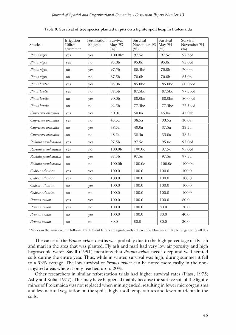
Table 8. Survival of tree species planted in pits on a lignite spoil heap in Ptolemaida
SpeciesIrrigation50lit/pl4/summer
Fertilisation100g/plt
Survival May ‘93 (%)
Survival November ‘93 (%)
Survival May ‘94(%)
Survival November ‘94(%)
Pinus nigra yes yes 100.0b* 97.5c 97.5c 92.5cd
Pinus nigra yes no 95.0b 95.0c 95.0c 95.0cd
Pinus nigra no yes 97.5b 88.5bc 70.0b 70.0bc
Pinus nigra no no 87.5b 70.0b 70.0b 65.0b
Pinus brutia yes yes 85.0b 85.0bc 85.0bc 80.0bcd
Pinus brutia yes no 87.5b 87.5bc 87.5bc 97.5bcd
Pinus brutia no yes 90.0b 80.0bc 80.0bc 80.0bcd
Pinus brutia no no 92.5b 77.5bc 77.5bc 77.5bcd
Cupressus arizonica yes yes 50.0a 50.0a 45.0a 45.0ab
Cupressus arizonica yes no 43.5a 38.5a 33.5a 30.0a
Cupressus arizonica no yes 48.5a 40.0a 37.5a 33.5a
Cupressus arizonica no no 48.5a 38.5a 35.0a 38.5a
Robinia pseudoacacia yes yes 97.5b 97.5c 95.0c 95.0cd
Robinia pseudoacacia yes no 100.0b 100.0c 97.5c 95.0cd
Robinia pseudoacacia no yes 97.5b 97.5c 97.5c 97.5d
Robinia pseudoacacia no no 100.0b 100.0c 100.0c 100.0d
Cedrus atlantica yes yes 100.0 100.0 100.0 100.0
Cedrus atlantica yes no 100.0 100.0 100.0 100.0
Cedrus atlantica no yes 100.0 100.0 100.0 100.0
Cedrus atlantica no no 100.0 100.0 100.0 100.0
Prunus avium yes yes 100.0 100.0 100.0 80.0
Prunus avium yes no 100.0 100.0 80.0 70.0
Prunus avium no yes 100.0 100.0 80.0 40.0
Prunus avium no no 80.0 80.0 80.0 20.0
* Values in the same column followed by different letters are significantly different by Duncan’s multiple range test (a=0.05)
The cause of the Prunus avium deaths was probably due to the high percentage of fly ash and marl in the area that was planted. Fly ash and marl had very low air porosity and high hygroscopic water. Savill (1991) mentions that Prunus avium needs deep and well aerated soils during the entire year. Thus, while in winter, survival was high, during summer it fell to a 53% average. The low survival of Prunus avium can be noted more easily in the non-irrigated areas where it only reached up to 20%.
Other researchers in similar reforestation trials had higher survival rates (Plass, 1975; Asby and Kolar, 1977). This may have happened mainly because the surface soil of the lignite mines of Ptolemaida was not replaced when mining ended, resulting in fewer microorganisms and less natural vegetation on the spoils, higher soil temperatures and fewer nutrients in the soils.
Factors of Reclamation Success at the Lignite Strip-Mined Land in Northern Greece
47
In the lignite mines of Ptolemaida, except for the seedling death, there is the death of higher trees 15-20 years old. When those trees reach a homogenous lignite spot in the spoil and when humidity and pressure are reaching a specific point, then, suddenly, a self ignition of the lignite occurs and the trees die. A solution to that problem can be given if the spoils are deep ploughed and the lignite spoils are mixed very well with the other overburden materials. Pinus nigra sometimes is dying because the pH of the spoils is very high due to the fly ash and marl content; thus, it is unfavourable for this species because they prefer and grow better in slightly acid soils.
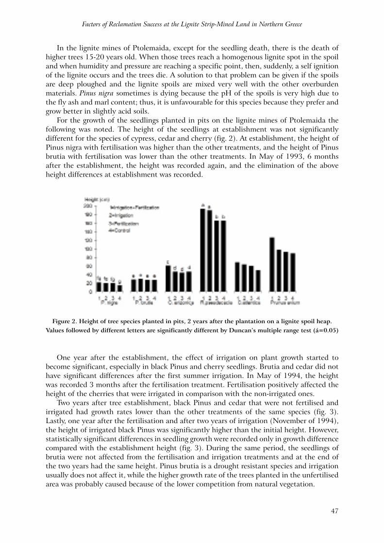
For the growth of the seedlings planted in pits on the lignite mines of Ptolemaida the following was noted. The height of the seedlings at establishment was not significantly different for the species of cypress, cedar and cherry (fig. 2). At establishment, the height of Pinus nigra with fertilisation was higher than the other treatments, and the height of Pinus brutia with fertilisation was lower than the other treatments. In May of 1993, 6 months after the establishment, the height was recorded again, and the elimination of the above height differences at establishment was recorded.
Figure 2. Height of tree species planted in pits, 2 years after the plantation on a lignite spoil heap. Values followed by different letters are significantly different by Duncan’s multiple range test (á=0.05)
One year after the establishment, the effect of irrigation on plant growth started to become significant, especially in black Pinus and cherry seedlings. Brutia and cedar did not have significant differences after the first summer irrigation. In May of 1994, the height was recorded 3 months after the fertilisation treatment. Fertilisation positively affected the height of the cherries that were irrigated in comparison with the non-irrigated ones.
Two years after tree establishment, black Pinus and cedar that were not fertilised and irrigated had growth rates lower than the other treatments of the same species (fig. 3). Lastly, one year after the fertilisation and after two years of irrigation (November of 1994), the height of irrigated black Pinus was significantly higher than the initial height. However, statistically significant differences in seedling growth were recorded only in growth difference compared with the establishment height (fig. 3). During the same period, the seedlings of brutia were not affected from the fertilisation and irrigation treatments and at the end of the two years had the same height. Pinus brutia is a drought resistant species and irrigation usually does not affect it, while the higher growth rate of the trees planted in the unfertilised area was probably caused because of the lower competition from natural vegetation.
Journal of Spatial and Organizational Dynamics - Discussion Papers Number 13
48
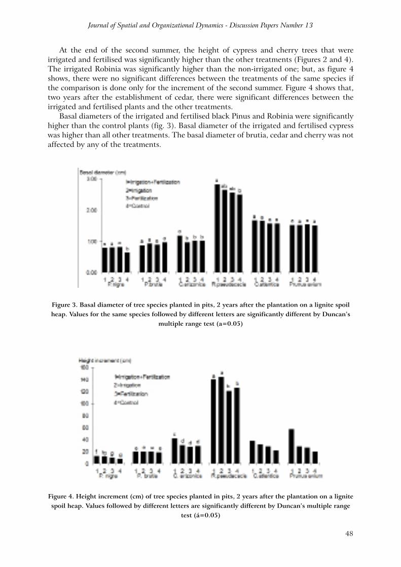
At the end of the second summer, the height of cypress and cherry trees that were irrigated and fertilised was significantly higher than the other treatments (Figures 2 and 4). The irrigated Robinia was significantly higher than the non-irrigated one; but, as figure 4 shows, there were no significant differences between the treatments of the same species if the comparison is done only for the increment of the second summer. Figure 4 shows that, two years after the establishment of cedar, there were significant differences between the irrigated and fertilised plants and the other treatments.
Basal diameters of the irrigated and fertilised black Pinus and Robinia were significantly higher than the control plants (fig. 3). Basal diameter of the irrigated and fertilised cypress was higher than all other treatments. The basal diameter of brutia, cedar and cherry was not affected by any of the treatments.
Figure 3. Basal diameter of tree species planted in pits, 2 years after the plantation on a lignite spoil heap. Values for the same species followed by different letters are significantly different by Duncan’s
multiple range test (a=0.05)
Figure 4. Height increment (cm) of tree species planted in pits, 2 years after the plantation on a lignite spoil heap. Values followed by different letters are significantly different by Duncan’s multiple range
test (á=0.05)
Factors of Reclamation Success at the Lignite Strip-Mined Land in Northern Greece
49
Figure 4 shows that two years after the establishment of the forest species the height of black Pinus, except control, was not different than brutia, and those species were much lower than all others. The height of cypress can be compared with the cedar which was the immediately higher species of the afforestation, while cherry and Robinia were the highest. It has to be mentioned that the height of Robinia was up to 305cm.
However, if the height comparison is conducted without the initial height, then brutia, cedar and cypress had the same increment as cherries. Additionally, it can be seen that Pinus brutia grew much more than Pinus nigra. Thus, if the height comparison is shown as growth rate as percentage from the initial height, then Robinia is again first, but two of the treatments are not significantly different with brutia and cypress treatments. Those species are following in tree growth rate, while slower growth rate was noted from Pinus nigra and cedar without significant differences between them. Finally, wild cherry was last in growth rate, having a significantly lower growth rate than all other species.
The statistical research of the effect from the parameters of colour and type of soil, natural vegetation and percentage of soil cover at the parameters: height, diameter, vigour and seedling survival led to these findings:• When seedlings were irrigated and fertilised, there was a weak correlation (r=0.38)
between height and soil colour and type. Darker soil (with more lignite content)indicated higher trees, but because r was less than 0.50 this result is only an indicator and not a proof.
• When seedlings were irrigated and fertilised, there was a weak negative correlation (r= -0.29) between survival and soil colour. Darker soil meant decreased survival rates.
• When seedlings were not irrigated and fertilised, there was a weak negative correlation (r= -0.27) between height and soil colour. Thus, in the non-irrigated, fertilised area, when the soil was dark then tree growth was low.
• The correlation between soil colour and soil covered by natural vegetation was very strong (r=0.75 till 0.82). This correlation was strong in all of the treatments.
• There was a weak correlation between soil cover and tree height in the non-irrigated areas (r=0.27), while the correlation was stronger in areas with irrigation (r=0.57).
• All other parameter correlation made with the simple correlation analysis found r close to zero.
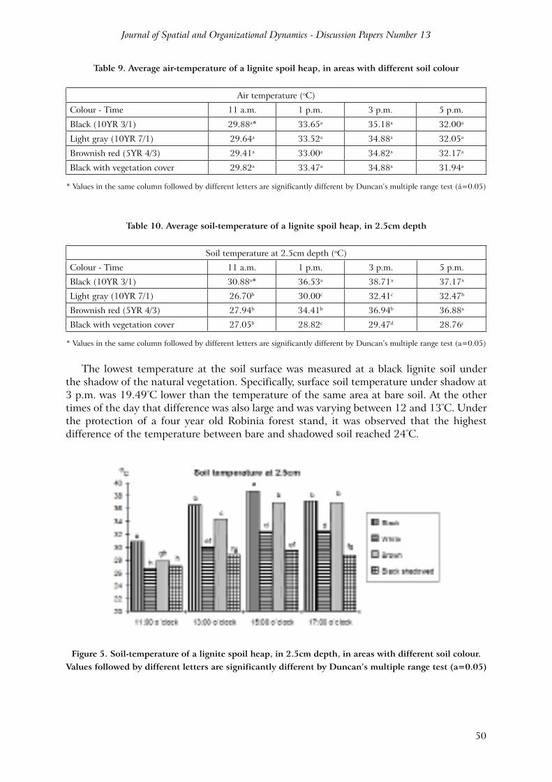
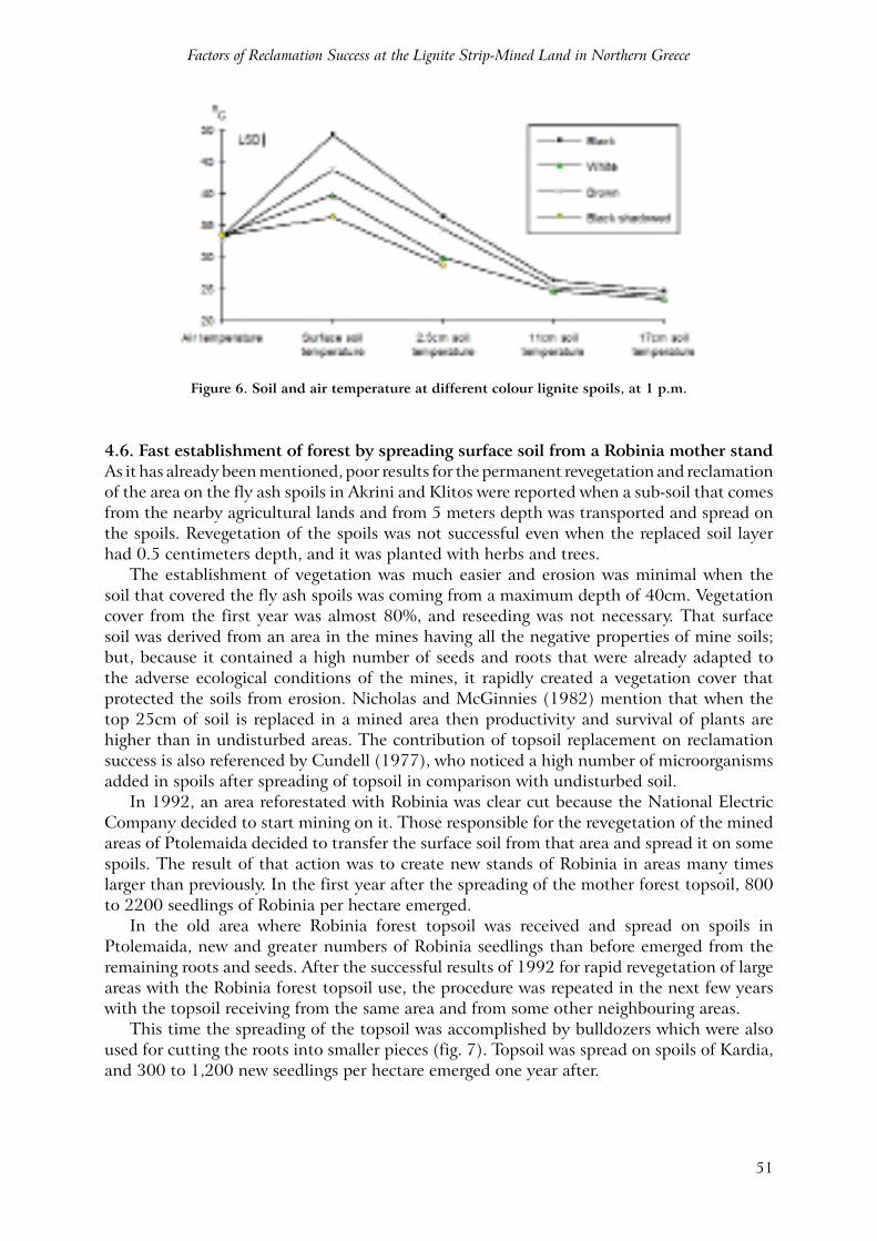
4.5. Soil temperature and moistureA very important parameter limiting tree growth and survival of forest species planted on the lignite spoils of Ptolemaida is the high surface soil temperature during the hot summer days. This is caused due to the black colour of lignite leftovers mixed with overburden on the surface. Soil temperature during the two years of experiment was varying between 35ºC on the surface, when the weather was cloudy, to 62ºC on the very hot days.
The highest values at 0.5cm depth were 62ºC (air temperature 41ºC). Table 9 shows the air temperature in the four areas where the soil temperatures were measured. There were no significant differences between the four areas at any time of the day because all of them have the same aspect and slope. Table 10 shows the average soil temperature at 2.5cm depth. At all mentioned times there were statistically significant differences, as it can be seen in figure 5, with the higher differences during the hot midday hours (fig. 6). The average soil temperature at 3 p.m. in the black coloured soil was 55ºC, while the brown coloured soil had a 47.05ºC soil temperature and the white marl soil was 42.94ºC. Average temperature difference observed between the darkest and lightest spoil materials was approximately 12ºC
Journal of Spatial and Organizational Dynamics - Discussion Papers Number 13
50
Table 9. Average air-temperature of a lignite spoil heap, in areas with different soil colour
Air temperature (oC)
Colour - Time 11 a.m. 1 p.m. 3 p.m. 5 p.m.
Black (10YR 3/1) 29.88a* 33.65a 35.18a 32.00a
Light gray (10YR 7/1) 29.64a 33.52a 34.88a 32.05a
Brownish red (5YR 4/3) 29.41a 33.00a 34.82a 32.17a
Black with vegetation cover 29.82a 33.47a 34.88a 31.94a
* Values in the same column followed by different letters are significantly different by Duncan’s multiple range test (á=0.05)
Table 10. Average soil-temperature of a lignite spoil heap, in 2.5cm depth
Soil temperature at 2.5cm depth (oC)
Colour - Time 11 a.m. 1 p.m. 3 p.m. 5 p.m.
Black (10YR 3/1) 30.88a* 36.53a 38.71a 37.17a
Light gray (10YR 7/1) 26.70b 30.00c 32.41c 32.47b
Brownish red (5YR 4/3) 27.94b 34.41b 36.94b 36.88a
Black with vegetation cover 27.05b 28.82c 29.47d 28.76c
* Values in the same column followed by different letters are significantly different by Duncan’s multiple range test (a=0.05)
The lowest temperature at the soil surface was measured at a black lignite soil under the shadow of the natural vegetation. Specifically, surface soil temperature under shadow at 3 p.m. was 19.49ºC lower than the temperature of the same area at bare soil. At the other times of the day that difference was also large and was varying between 12 and 13ºC. Under the protection of a four year old Robinia forest stand, it was observed that the highest difference of the temperature between bare and shadowed soil reached 24ºC.
Figure 5. Soil-temperature of a lignite spoil heap, in 2.5cm depth, in areas with different soil colour. Values followed by different letters are significantly different by Duncan’s multiple range test (a=0.05)
Factors of Reclamation Success at the Lignite Strip-Mined Land in Northern Greece
51
Figure 6. Soil and air temperature at different colour lignite spoils, at 1 p.m.
4.6. Fast establishment of forest by spreading surface soil from a Robinia mother standAs it has already been mentioned, poor results for the permanent revegetation and reclamation of the area on the fly ash spoils in Akrini and Klitos were reported when a sub-soil that comes from the nearby agricultural lands and from 5 meters depth was transported and spread on the spoils. Revegetation of the spoils was not successful even when the replaced soil layer had 0.5 centimeters depth, and it was planted with herbs and trees.
The establishment of vegetation was much easier and erosion was minimal when the soil that covered the fly ash spoils was coming from a maximum depth of 40cm. Vegetation cover from the first year was almost 80%, and reseeding was not necessary. That surface soil was derived from an area in the mines having all the negative properties of mine soils; but, because it contained a high number of seeds and roots that were already adapted to the adverse ecological conditions of the mines, it rapidly created a vegetation cover that protected the soils from erosion. Nicholas and McGinnies (1982) mention that when the top 25cm of soil is replaced in a mined area then productivity and survival of plants are higher than in undisturbed areas. The contribution of topsoil replacement on reclamation success is also referenced by Cundell (1977), who noticed a high number of microorganisms added in spoils after spreading of topsoil in comparison with undisturbed soil.
In 1992, an area reforestated with Robinia was clear cut because the National Electric Company decided to start mining on it. Those responsible for the revegetation of the mined areas of Ptolemaida decided to transfer the surface soil from that area and spread it on some spoils. The result of that action was to create new stands of Robinia in areas many times larger than previously. In the first year after the spreading of the mother forest topsoil, 800 to 2200 seedlings of Robinia per hectare emerged.
In the old area where Robinia forest topsoil was received and spread on spoils in Ptolemaida, new and greater numbers of Robinia seedlings than before emerged from the remaining roots and seeds. After the successful results of 1992 for rapid revegetation of large areas with the Robinia forest topsoil use, the procedure was repeated in the next few years with the topsoil receiving from the same area and from some other neighbouring areas.
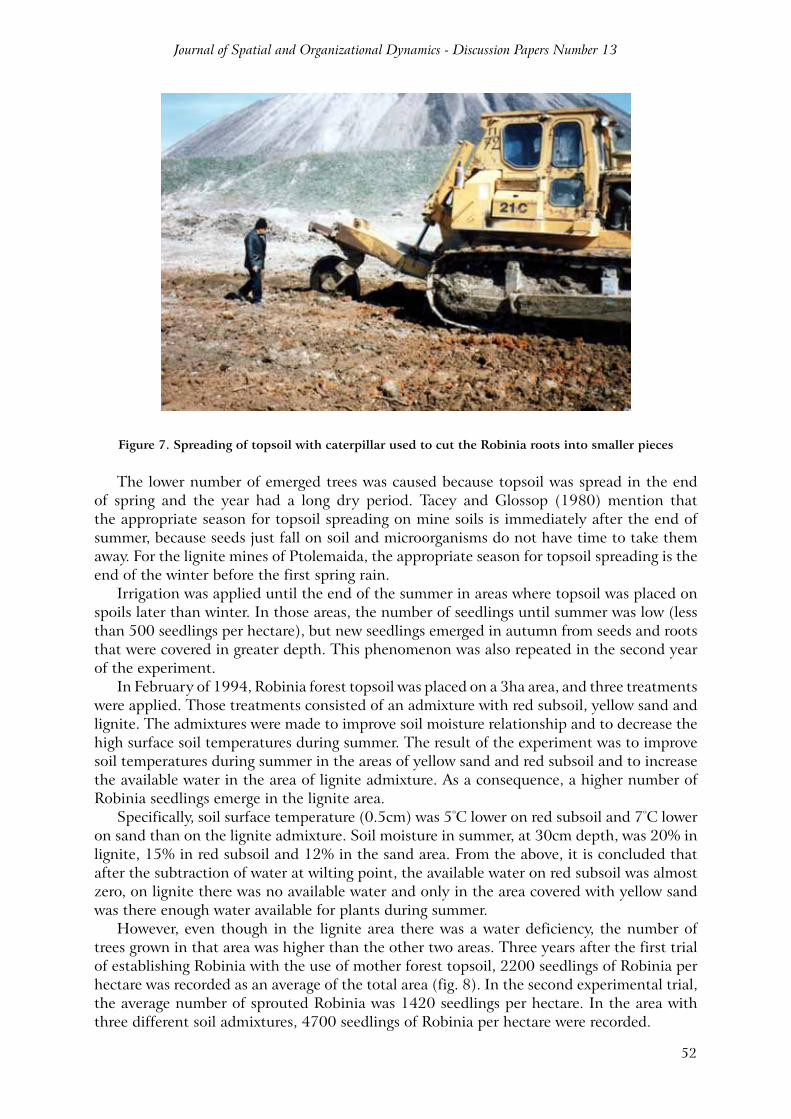
This time the spreading of the topsoil was accomplished by bulldozers which were also used for cutting the roots into smaller pieces (fig. 7). Topsoil was spread on spoils of Kardia, and 300 to 1,200 new seedlings per hectare emerged one year after.
Journal of Spatial and Organizational Dynamics - Discussion Papers Number 13
52
Figure 7. Spreading of topsoil with caterpillar used to cut the Robinia roots into smaller pieces
The lower number of emerged trees was caused because topsoil was spread in the end of spring and the year had a long dry period. Tacey and Glossop (1980) mention that the appropriate season for topsoil spreading on mine soils is immediately after the end of summer, because seeds just fall on soil and microorganisms do not have time to take them away. For the lignite mines of Ptolemaida, the appropriate season for topsoil spreading is the end of the winter before the first spring rain.
Irrigation was applied until the end of the summer in areas where topsoil was placed on spoils later than winter. In those areas, the number of seedlings until summer was low (less than 500 seedlings per hectare), but new seedlings emerged in autumn from seeds and roots that were covered in greater depth. This phenomenon was also repeated in the second year of the experiment.
In February of 1994, Robinia forest topsoil was placed on a 3ha area, and three treatments were applied. Those treatments consisted of an admixture with red subsoil, yellow sand and lignite. The admixtures were made to improve soil moisture relationship and to decrease the high surface soil temperatures during summer. The result of the experiment was to improve soil temperatures during summer in the areas of yellow sand and red subsoil and to increase the available water in the area of lignite admixture. As a consequence, a higher number of Robinia seedlings emerge in the lignite area.
Specifically, soil surface temperature (0.5cm) was 5ºC lower on red subsoil and 7ºC lower on sand than on the lignite admixture. Soil moisture in summer, at 30cm depth, was 20% in lignite, 15% in red subsoil and 12% in the sand area. From the above, it is concluded that after the subtraction of water at wilting point, the available water on red subsoil was almost zero, on lignite there was no available water and only in the area covered with yellow sand was there enough water available for plants during summer.
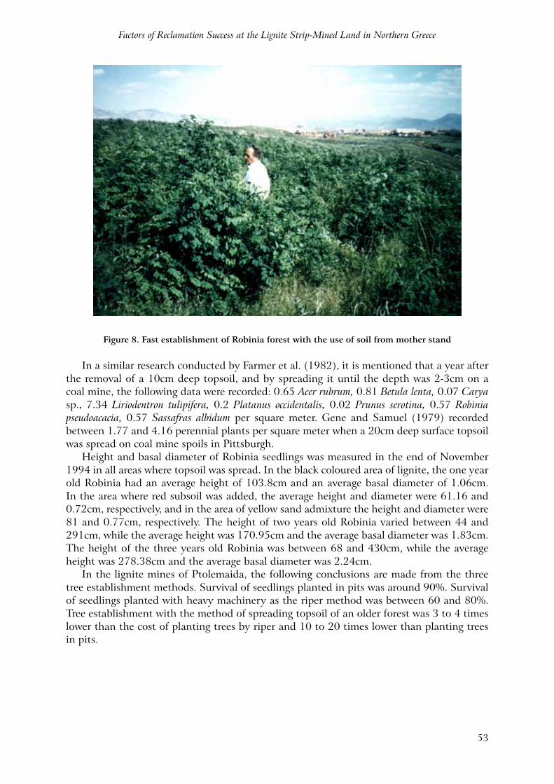
However, even though in the lignite area there was a water deficiency, the number of trees grown in that area was higher than the other two areas. Three years after the first trial of establishing Robinia with the use of mother forest topsoil, 2200 seedlings of Robinia per hectare was recorded as an average of the total area (fig. 8). In the second experimental trial, the average number of sprouted Robinia was 1420 seedlings per hectare. In the area with three different soil admixtures, 4700 seedlings of Robinia per hectare were recorded.
Factors of Reclamation Success at the Lignite Strip-Mined Land in Northern Greece
53
Figure 8. Fast establishment of Robinia forest with the use of soil from mother stand
In a similar research conducted by Farmer et al. (1982), it is mentioned that a year after the removal of a 10cm deep topsoil, and by spreading it until the depth was 2-3cm on a coal mine, the following data were recorded: 0.65 Acer rubrum, 0.81 Betula lenta, 0.07 Carya sp., 7.34 Liriodentron tulipifera, 0.2 Platanus occidentalis, 0.02 Prunus serotina, 0.57 Robinia pseudoacacia, 0.57 Sassafras albidum per square meter. Gene and Samuel (1979) recorded between 1.77 and 4.16 perennial plants per square meter when a 20cm deep surface topsoil was spread on coal mine spoils in Pittsburgh.
Height and basal diameter of Robinia seedlings was measured in the end of November 1994 in all areas where topsoil was spread. In the black coloured area of lignite, the one year old Robinia had an average height of 103.8cm and an average basal diameter of 1.06cm. In the area where red subsoil was added, the average height and diameter were 61.16 and 0.72cm, respectively, and in the area of yellow sand admixture the height and diameter were 81 and 0.77cm, respectively. The height of two years old Robinia varied between 44 and 291cm, while the average height was 170.95cm and the average basal diameter was 1.83cm. The height of the three years old Robinia was between 68 and 430cm, while the average height was 278.38cm and the average basal diameter was 2.24cm.
In the lignite mines of Ptolemaida, the following conclusions are made from the three tree establishment methods. Survival of seedlings planted in pits was around 90%. Survival of seedlings planted with heavy machinery as the riper method was between 60 and 80%. Tree establishment with the method of spreading topsoil of an older forest was 3 to 4 times lower than the cost of planting trees by riper and 10 to 20 times lower than planting trees in pits.

Journal of Spatial and Organizational Dynamics - Discussion Papers Number 13
54
5. CONCLUSIONS
Conclusions that arise from the present research are briefly the following.• From the phytosociological research of two consecutive years, it was accrued that:
1) Natural vegetation presented a lack of homogeneity and none of the dominant species presented more than 80% stability. 2) With the assistance of indicator plant groups, seven phytosocial units were distinguished which differ between them by vegetation composition and soil type. 3) The average drought species of phytosocial group A, which appear in areas of replaced topsoil, are increasing their population by time. 4) Phytosocial group E, which is represented from Calamagrostis epigejos, appears in a compacted marl area and remained constant for both years. 5) Phytosocial group Z, which is represented from Vaccaria pyramidata, appears in locations with high fly ash content.
• From the soil analyses at the lignite spoils of Ptolemaida, it was accrued that the soil presented high heterogeneity in both physical and chemical properties. Bulk density was low and varied between 0.77 and 1.43 gr/cm3. Porosity of fly ash was 8.9%; thus, irrigation of areas with high fly ash content was impossible without prior improvement of the physical properties. pH and CaCO3 content was high in most of the area. Organic matter, carbon and nitrogen content were varying. Available phosphorus, potassium and magnesium were low. Electric conductivity was low in most of the area, and no serious plant growth problems were recorded from it. Fly ash samples had high electric conductivity and soluble sodium content, and vegetation cover was minimal in areas with a high presence of fly ash.
• From the forest species planted in pits, Cupressus arizonica and Pinus brutia presented low survival rates during winter months due to low temperatures, while Pinus nigra and Prunus avium presented low survival rates during summer due to drought. Irrigation significantly improved the ability of survival of all species. Fertilisation did not affected tree survival, but it increased plant growth when it was followed by irrigation. Inoculation of Pinus nigra with Pisolithus tinctorius before the plantation in the lignite mines of Ptolemaida may increase the afforestation success and reduce or replace the use of fertilisers.
• The most successful species of the afforestation trial were Robinia pseudoacacia and Cedrus atlantica.
• The highest surface soil temperatures were 55ºC and recorded at 15.00 hours. Surface soil temperature was up to 24ºC higher in bare soil than when covered under natural vegetation.
• Covering of fly ash spoils with soil presented poor results. Subsurface soil had luck of organic matter, microorganisms and seeds of natural vegetation, resulting in low vegetation cover and high erosion (Ferreira and Panagopoulos, 2012). From the present research it has been demonstrated that sewage sludge may give a favourable amelioration response and, in consequence, may improve reclamation success of areas with high fly ash content. The best method to establish Robinia pseudoacacia in the lignite mines of Ptolemaida was the use and spreading of topsoil from older stands of Robinia.
• From the present research, it was concluded that afforestation of the lignite mine spoils was possible despite the extreme environmental conditions. However, reclamation success depended on appropriate planning for reclamation, and the new landscape had to be designed in harmony with the surrounding landscape before the start of the mining activity.
Factors of Reclamation Success at the Lignite Strip-Mined Land in Northern Greece
55
REFERENCES
Alexander, M.J., 1989. The effect of Acacia albida on tin-mine spoil and their possible use in reclamation. Landscape Urban Plann., 17:61-71.
Ashby, W.D. and Kolar, C.A., 1985. Ecological forces affecting reclamation with trees. Symposium on the reclamation of lands disturbed by surface mining: A cornerstone for communication and understanding. Southern Illinois University, Carbondale, Illinois, pp:395-409.
Ashby, W.D. and Kolar, C.A., 1977. A 30 year record of tree growth in strip mine plantings. Tree Planters’ Notes 28(3/4):18-21.
Athanasiadis, N.H., 1986. Forest Phytosociology. Aristotle University of Thessaloniki. Thessaloniki, 111pp. (In Greek).
Barth, R.C. and Martin, B.K., 1984. Soil depth requirements for revegetation of surface mined areas in Wyoming, Montana and North Dacota. J. Environ. Qual. 13:399-404.
Brenner, F.J. and Steiner, R.P., 1987. Alternative reclamation strategies for mined lands. Environmental Consequences of Energy Production: Problems and Prospects. Edited by S.K. Majumdar, F.J. Brenner and E.W. Miller. The Pennsylvania Academy of Science, pp. 115-130.
Chambers J.C., Brown, R.W. and Johnston, R.S., 1987. A comparison of soil and vegetation properties of seeded and naturally revegetated pyritic alpine mine spoil and reference sites. Landscape Urban Plann. 14: 507-519.
Cundell, A.M., 1977. The role of microorganisms in the revegetation of strip-mined land in the Western United States. J. Range Management, 30(4):299-305.
Ellenberg, H., Weber, H.E., Dull, R., Wirth, V., Werner, W. and Pauliben, D., 1992. Scripta geobotanica. Volume 18 Indicator values of plants in Central Europe. Årich Goltze KG, Gottingen, 258pp.
Farmer, R.E., Cunningham, M. and Barnhill, A., 1982. First-year development of plant communities originating from forest topsoils placed on southern Appalachian minesoils. J. Applied Ecology, 19:283-294.
Ferreira, V., Panagopoulos, T. 2012. Predicting Soil Erosion Risk at the Alqueva Dam Watershed. Spatial and Organizational Dynamics- Discussion Papers, 9:60-80.
Gene, S.H. and Samuel, M.J., 1979. The value of fresh-stripped topsoil as a source of useful plants for surface mine revegetation. J. Range Management 32(1):76-77.
Gonzalez-Sangregorio, M.V., Trasar-Cepeda, M.C., Leiros, M.C., Gil-Sotres, F. and Guitian- Gonzalez-Duque, J.A., Panagopoulos, T. 2010. Urban planning throughout environmental quality and human well-being. Discussion Papers - Spatial and Organizational Dynamics, 4, pp. 7-20.
Ojea, F., 1991. Early stages of lignite mine soil genesis: changes in biochemical properties. Soil Biol. Biochem. 23(6): 589-595
Helgerrson, O.T., 1990. Heat damage in tree seedlings and its prevention. New Forests 3:333-358.
McGinnies, W.J. and Nicolas, P.J., 1980. Effects of topsoil thickness and nitrogen fertilisation on the revegetation of coal mine spoils. J. Environ. Qual. 9:681-685.
Nicholas, P.J. and McGinnies W.J., 1982. An evaluation of 17 grasses and 2 legumes for revegetation of soil and spoil on a coal strip mine. J. Range Manag., 35:288-293.
Journal of Spatial and Organizational Dynamics - Discussion Papers Number 13
56
Panagopoulos, T. and Hatzistathis, A., 1995. Early growth of Pinus nigra and Robinia pseudoacacia stands; contributions to soil genesis and landscape improvement on lignite spoils in Ptolemaida. Landscape and Urban Planning, 32:19-29.
Panagopoulos, T. 2012. The role of soil properties variability to reclamation success on the lignite strip-mined land in Northern Greece. Spatial and Organizational Dynamics- Discussion Papers, 9:43-59.
Papadopoulos, G. and Nikolaidis, E., 1992. Hydrologic contributions in the municipality of Ptolemaida water from the lignite mining. A.N.K.O., Kozani. (In Greek).
Papanastasi, I., 1991. Robinia: A neglected forest species. Geotechnic scientific issues, 4:55-58. (In Greek).
Plass, W.T., 1975. An evaluation of trees and shrubs for planting surface-mine spoils. USDA Forest Service Res. Pap. NE-317, 8pp.
Savill, P.S., 1991. The silviculture of trees used in British forestry. C.A.B. International, Oxon, UK., 143pp.
Snedecor, W.G. and Cochran, G.W., 1977. Statistical Methods. The Iowa State Univ. Press. Seventh edition, Iowa, 503pp.
Tacey, W.H. and Glossop, B.L., 1980. Assessment of topsoil handling techniques for the rehabilitation of sites mined for bauxite within the jarrah forest of western Australia. J. Applied Ecology, 17:195-203.
Tutin, T.G., Heywood, V.H., Burgers, N.A., Moore, D.M., Valentine, D.H., Walters, S.M., Wedd, D.A., 1964-1980. Flora Europea. Vol. I-V. Cambridge Univ. Press, London.
Vimmerstedt, J.P., House, M.C., Larson, M.M., Kasile, J.D. and Bishop, B.L., 1989. Nitrogen and carbon accretion on Ohio coal minesoils: influence of soil-forming factors. Landscape Urban Plann. 17: 99-111.
Wilde, S.A., 1958. Forest Soils, Their Properties and Relations to Silviculture. The Ronalt Press Co, New York, 537pp.