archaeology in alberta 1986
TRANSCRIPT
ARCHAEOLOGY IN ALBERTA, 1986
Compiled by
Martin Magne
Archaeological Survey of AlbertaOccasional Paper No. 31
Prepared by:Archaeological Surveyof Alberta
Published by:Alberta Culture and MulticulturalismHistorical Resources Division
OCCASIONAL PAPERS
Papers for publication in this series of monographs are producedby or for the five branches of the Historical Resources Division ofAlberta Culture and Multiculturalism: the Provincial Archives ofAlberta, the Provincial Museum of Alberta, the Historic Sites Service,the Archaeological Survey of Alberta, and the Tyrrell Museum ofPalaeontology. Those persons or institutions interested in particularsubjects may obtain publication lists from the appropriate branches.All publications produced by the Archaeological Survey of Alberta aredistributed free of charge to the public. Requests for list of availablepublications and orders for specific papers should be addressed to:
Occasional PapersArchaeological Survey of Alberta
8820 - 112 StreetEdmonton, Alberta
T6G 2P8
Phone (403) 431-2300
The Archaeological Survey of Alberta Occasional Papers are intendedprimarily for interested specialists rather than as popular publicationsfor general readers. The Archaeological Survey encourages authors tosubmit manuscripts for.publication on topics of Alberta archaeology.Editorial policy requires full length monographs to be subjected to peerreview process. Papers published in the Annual Review of AlbertaArchaeology and edited thematic volumes are subject to the discretion ofthe series editor. To maintain a free distribution of Occasional Papers,production costs are minimized.
iii

List of Tables ••
TABLE OF CONTENTS
•• vii
List of Figures
Archaeology in Alberta, 1986John W. Ives • • • • • • . . . . . . . . . . . . . . . . . . .
ix
1
Research Excavations at EdPl-12: A Whiskey Trade EraStructure in High River
Margaret Kennedy • • •
More on Image and Material Culture the Fur TradeHeinz W. Pyszczyk •• • • • • • • • •
• • • • • • •• 11
17
The Pincher Creek Buffalo Jump: A Late PrehistoricBison Kill Site
Bruce F. Ball •••••••••••••• • • • • • • • •• 31
Preliminary Report on the 1986 Field Season atHead-Smashed-In and Calderwood Buffalo Jumps
Jack Brink, Robert J. Dawe and Susan Marshall
Locational Variability of Archaeological Sites in the PeaceRiver - Grande Prairie Region of Northwestern Alberta
Martin P.R. Magne •••••••••••••••••
Analysis and Prediction of Historical Resource Potential ofAggregate Source locales in Southeastern Alberta
Eric Damkjar • • • • • • • • • • • • • • • • • • • •
Preliminary Report on the 1986 Excavations at the StrathconaSite
Bri an Kooyman • • • • • • • • • • • • • • • • • • • • •
A Critique of Medicine Wheel AstronomySteven C. Haack •••••••••
• • • •• 44
79
96
121
129
Eating Rocks: Pebble Cherts, Fall-off Curves and OptimalDiet Theory
Bruce F. Ball •••••••••••••••••• • ••••• 140
The Triangular Projectile Point in Plains Prehistory:A Preform Trade Hypothesis
Robert J. Dawe •••••••••••••••••• • • • • 150
Environment Canada, Parks, Archaeology in Alberta, 1986Don Steer, Alison Landals, Kevin Montgomery, Daryl Fedje,Rod Pickard and Ian Sumpter ••••••••••••••••••• 163
v
TABLE OF CONTENTS (continued)
Collection and Submission of Samples for Radiocarbon DatingAlwynne B. Beaudoin •• • • • • • • • • • • • • • • • •
Alberta Radiocarbon Dates 1982-1986Alwynne B. Beaudoin •• • • • •
188
197
• 215
• • 217
Research NotesAn Update on the 1986 Excavations at the LarsonSite in Southeastern Alberta
Laurie Milne ••••••••••••••••The Pink Mountain Paleo-Indian Site
Ian Wilson •••••••••••••••••Distributions of Native Groups in Western Canada,A.D. 1700 to A.D. 1850
Martin Magne and Contributors to theSaskatchewan-Alberta Dialogue •••••••••••••••• 220
A Consideration of Semi-quantitative X-rayFluorescence Analysis Used in Obsidian SourceCharacterization
D.I. Godfrey-Smith and J.M. D1Auria ••••••••••••• 233
AbstractsMartina Purdon (compiler)
Bibliography •••
vi
•• 240
• 289
LIST OF TABLES
Table 1. Summary statistics of single regression:fort size - building area. • • • • • • • • • • • • • • •• 24
Table 2. Summary statistics of single regression:fort size - storage area •• • • • • • • • • • • • • • •• 25
Table 3. Summary statistics of single regression:fort size - trading shop size • • • • • • 26
Table 4. Comparison of Indian hall/trading shop to totalfort size • • • • • • • • • • • • • • • • • • • • • • • 28
Table 8. Factor analysis of 284 sites by 13 variables
Table 6. Raw material distribution by artifact class.
Table 10. Multiple discriminant analysis of 71 sitesin the Grande Prairie and Peace River areas
Table 5.
Table 7.
Table 9.
Table 11.
Table 12.
Frequency of bone elements (NISP), DkPj-27
Size distribution of FBR by material type ••
Factor analysis of 17 sites by 13 variables.
Topographic position • • .•
List of descriptive variables recorded in stage 1of analysis •••••••••••••••
70
73
74
84
86
87
95
100
Table 13. Three sets of discriminant functions used forpredicting presence/absence of historicalresources ••••••••••••••••••••••••• 113
Table 14. List of site types, raw materials and artifacttypes from sites recorded in the Neutral Hillsregion of east central Alberta •••••••• •••• 143
Table 15.
Table 16.
Table 17.
Projects conducted/implemented in Alberta by theArchaeological Research Services Unit, EnvironmentCanada, Parks, Western Region •••••••••••
Summary of sites assessed in western regionnational parks in Alberta in 1986 ••
The effect of carbon contamination on truesample age •••••••••••••
vii
176
183
191
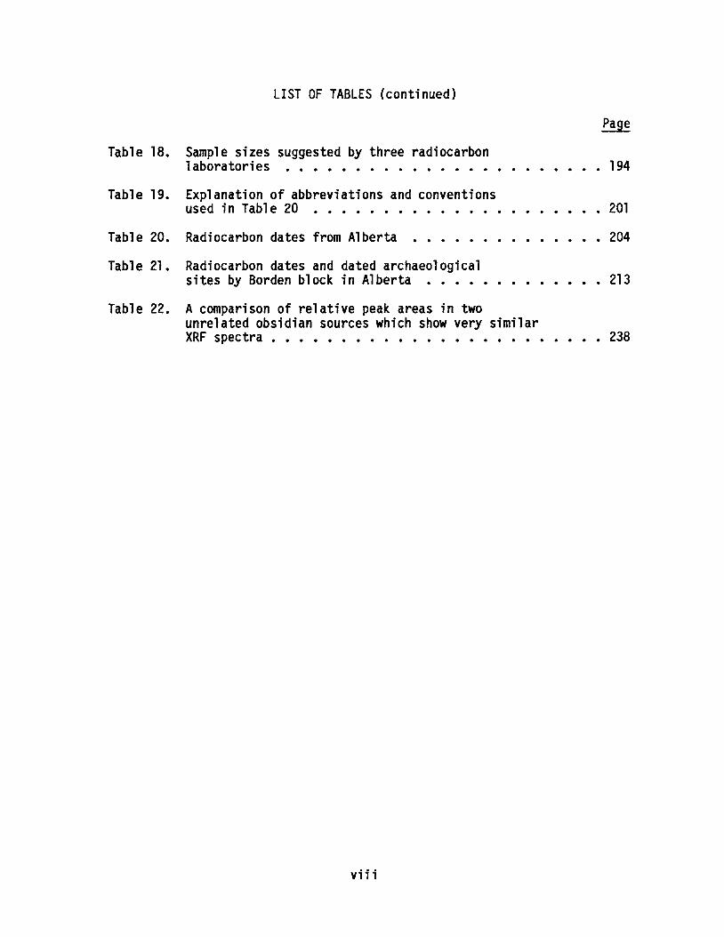
Table 19. Explanation of abbreviations and conventionsused in Table 20 • • • • • • • • •••
Table 18.
Table 20.
Table 21.
LIST OF TABLES (continued)
Sample sizes suggested by three radiocarbonlaboratories ••••••••••••••••
Radiocarbon dates from Alberta •••••••
Radiocarbon dates and dated archaeologicalsites by Borden block in Alberta •••••
194
• • 201
• • 204
213
Table 22. A comparison of relative peak areas in twounrelated obsidian sources which show very similarXRF spectra • • • • • • • • • • • • • • • • • • • • • • • • 238
viii
· · · · · 13
in
· · · · · 23
. . · · · · · 24
· · · · · 25
LIST OF FIGURES
Page
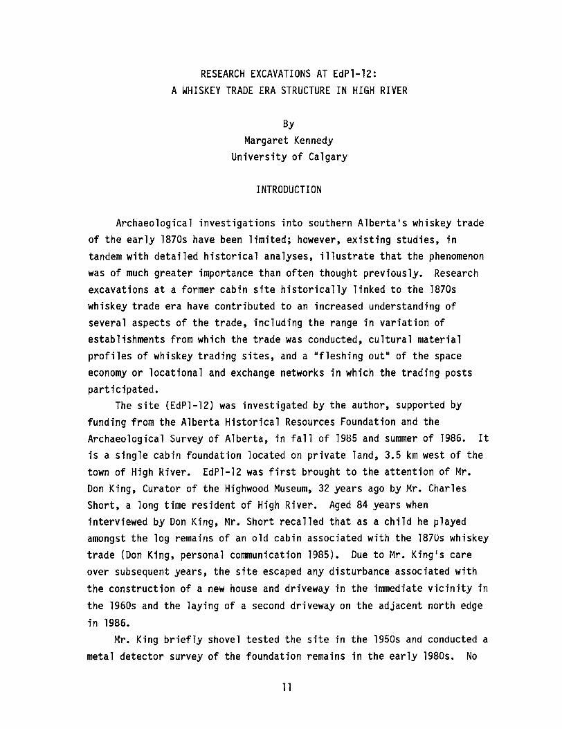
Figure 1. Excavations at EdPl-12, High River •••••••••••• 13
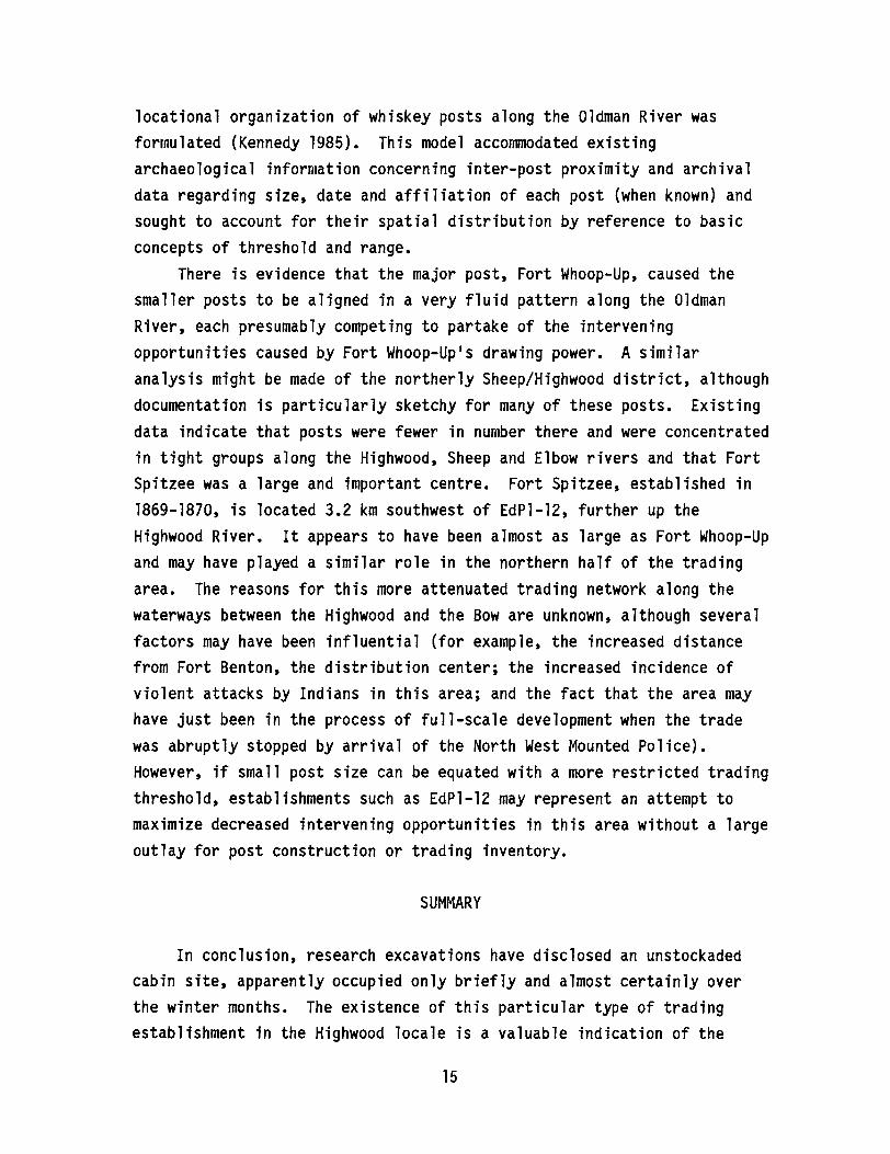
Figure 2. Sheet refuse scatter inside the cabindoorway •• • • • • • • • • • • • • •
Figure 3. Estimated populations of Indians and tradersthe Athabasca region between 1805 and 1830 •
Figure 4. Relationship between total fort size (squarefeet) and total building area (square feet)
Figure 5. Relationship between fort size (square feet)and total storage area (square feet) ••••
Figure 6. The relationship between fort size (square feet)and trading shop size (square feet) ••••••••••• 26
Figure 7. The Pincher Creek jump site showing the five areasof ring features to the east of the kill site andthe distribution of disturbed deposits foundbelow the kill site • • • • • • • • • • • • • • • • • •• 32
Figure 10. Profile of the east wall of Unit 2 ••
Figure 8.
Figure 9.
Location of the various testing programs (augering,shovel tests and systematic excavation units)within the immediate vicinity of the PincherCreek Jump kill site ••••••••
Profile of the north wall of Unit 1
34
36
37
Figure 11. Projectile points recovered from units 1 and 2in the kill site deposits • • • • • • • • • • • •• 39
Figure 12. Small endscraper recovered from the testing ofthe ring features •• • • • • • • • • • • • • • • • • •• 40
Figure 13. Projectile points recovered from the ringfeatures located just east of the kill site • • • • • •• 41
Figure 14. Projectile points recovered from the ringfeatures located just east of the kill site • • • •• 41
Figure 15. Projectile points and point fragments surfacecollected from the ploughed field below the killsite • • • • • • • • • • • • • • • • • • • • • • • • • • • 43
Figure 16. Location of the Head-Smashed-In (DkPj-l)and Calderwood (DkPj-27) buffalo jumps. • • • • • • • •• 46
ix

Figure 17.
Figure 18.
Figure 19.
LIST OF FIGURES (continued)
The 1986 excavation area at Head-Smashed-In
Soil profile from excavations at theHead-Smashed-In processing area •• • •
Bone upright feature at Head-Smashed-In
Page
49
50
55
Figure 20. Topographic map of the Calderwood Buffalo Jumpand map of excavation unit placement. • • • 61
Figure 21. Excavations at the Calderwood Buffalo Jump. • •••• 62
Figure 22. Soil profile, west wall, block excavation atthe Calderwood Buffalo Jump•••••••••• 65
Figure 23. Soil profile, south wall, block excavations atthe Calderwood Buffalo Jump. • • • • • • • • • • • • • •• 67
Figure 24. Projectile points recovered from the CalderwoodBuffalo Jump. • • • • • • • • • • • • • 72
Figure 25. Bone layer at Calderwood Buffalo Jump •• • 77
Figure 26. Locations of archaeological sites in thestudy area and distribution of Borden blocksanalyzed in the Peace River and Grande Prairieregions •• • • • • • • • • • • • • • • • • • • • • • •• 81
Figure 27. Histograms of distance to major river or lakeGrande Prairie and Peace River regions • • • • • • • • 89
Figure 28. Histograms of vertical distance to nearest water,Grande Prairie and Peace River regions • • • • • • • 89
Figure 29. Histograms of distance to nearest buildings,Grande Prairie and Peace River regions • • • • • • • • •• 91
Figure 30.
Figure 31.
Figure 32.
Histograms of direction to nearest water,Grande Prairie and Peace River regions ••
Histograms of distance to nearest archaeologicalsite, Grande Prairie and Peace River regions
Histogram of fish capability, Grande Prairieand Peace River regions ••••••••••
91
92
93
Figure 33. Histogram of waterfowl capability, Grande Prairieand Peace River regions • • • • • • • • • • • • • • • • • 93
x
LIST OF FIGURES (continued)
Figure 34. Descriptive statistics and barchart of relativeelevation (feet) ••••••••••••••••• 106
Figure 35. Descriptive statistics and barchart of aspect(visibility) in southeast directional sector (km) 107
Figure 36. Descriptive statistics and barcharts of distance(m) to major water source • • • •
Figure 37. Barchart of landform •••••••••••
•• 108
• 109
Figure 38. Example of scatterplot analysis - relativeelevation (feet) vs. waterfowl capability 115
Figure 39. Predicted and actual presence/absence ofhistorical resources for three discriminantfunctions with posterior probability =proportional ••••••••••••••••••••••• 116
Figure 40. Predicted and actual presence/absence ofhistorical resources for three discriminantfunctions with posterior probability = 0.5/0.5 •••••• 118
Figure 41.
Figure 42.
Predicted and actual presence/absence ofhistorical resources for grouped discriminantfunctions with posterior probability =proporti ona1 and 0.5/0.5 • • • • • • • • • • •
An oblique view of the earth1s orbit aroundthe sun • • • • • • • • • • • • • • • • • •
120
131
133
Figure 43. On the day of the summer solstice, the sun travelsacross the sky along the upper dotted line. Itsdeclination, ~,is 23.5 degrees at this time.The angle £ is the same as the latitude of the site.The angle a is the angular distance along thehorizon from due east of the sun1s rising point 132
The yearly variation of a as measured from asite at latitude 51 degrees •••••••••
Figure 44.
136The angle a of the rising solstice sun as afunction of latitude is indicated by the line
Figure 46. The Neutral Hills region showing the generallocations of four study areas: the NeutralHills, the adjacent slopes, Nose Hill and theoutlands ••••••••••••••••••••••••• 141
Figure 45.
xi
LIST OF FIGURES (continued)
Figure 47. Proportions of chert and quartzite artifactsare shown to change relative to one another insites located in the Neutral Hills studY area •••••• 144
Figure 48. Proportion of split pebble detritus compared toquartzite detritus in sites recorded in theNeutral Hills study region •••••••••••••••• 144
Figure 49. The proportion of split pebble detritus is plottedagainst the proportion of tools found in the sitesin the four areas of the study region •••••••••• 145
Figure 50.
Figure 51.
Sample of projectile points from the processingarea at Head-Smashed-In Buffalo Jump •••
Locations of 1986 ARIA and survey projects inJasper National Park • • • • • • • • • • • • •
Figure 52. Locations of 1986 ARIA projects in the Banfftownsite area ••• • • • • • • • • • • ••
Figure 53. Locations of 1986 ARIA projects in the lakelouise area ••••••••••••••••
157
166
171
172
Figure 54.
Figure 55.
Figure 56.
Locations of 1986 ARIA projects in southernBanff National Park •••••••
Locations of 1986 ARIA projects in Elk IslandNational Park ••••••••••••••••
Locations of 1986 ARIA projects in WatertonLakes National Park ••••••••••••
173
174
175
Figure 57. An example of radiocarbon sample submissionfonn • • • • • • • • • • • • • • •
Figure 58. location of site HhRr-1
•• 195
• • 218
Figure 61. Native group distributions, ca. A.D. 1700
Figure 59.
Figure 60.
Figure 62.
Sample of projectile points recovered fromsite HhRr-l •••••••••••••••
Dates and general areas of travel of the authorsof published primary accounts of Native locationsin Saskatchewan and Alberta ••••
Native group distributions, ca. A.D. 1750
xii
219
• 222
• 224
• 226

Figure 64. Native group distributions, ca. A.D. 1850
Figure 65. A typical ED-XRF spectrum of an obsidian rock(Mount Edziza, flow #3) ••••.••••
Figure 63.
Figure 66.
LIST OF FIGURES (continued)
Native group distributions, ca. A.D. 1800
ED-XRF spectra of obsidian from the Suemez Islandand Ilgachuz 1 source localities •••••••••
xiii
Page
• 228
• 230
236
237
ARCHAEOLOGY IN ALBERTA, 1986
ByJohn W. Ives
Archaeological Survey of Alberta
During 1986, the Archaeological Survey of Alberta continued toundergo as much or more change as has occurred at any time since thefounding of the organization. Much of this change has come simplythrough shifts in personnel. In recent years, Paul Donahue (formerlyDirector), David Burley (formerly Head of Research), Ray Le Blanc(formerly Northwestern Archaeologist), and Bob Vance (formerlyPalaeoenvironmental Research Officer) have left the Survey. In March of1986, I became Director. After a brief sojourn as NorthwesternArchaeologist, Martin Magne became Head of Research in June, 1986. Laterthat summer, Milt Wright became Boreal Archaeologist. In February of1986, Alwynne Beaudoin became Palaeoenvironmental Research Officer.
Other changes in 1986 followed upon the difficult budgetarysituation which has prevailed in Alberta. Because of fiscal cutbacksfirst felt at the end of 1986, the resources with which theArchaeological Survey of Alberta once operated were sharply limited.This has been felt particularly in the loss of two positions. Thecoordinator1s position for subdivisions and integrated resource planning,occupied by Barry Newton, was abolished. The capacity to take part inthe government1s integrated resource planning process is so critical,however, that we have devoted a vacant position (formerly for theNorthwestern Archaeologist) to this function. The position, now calledthe Resource Planning Archaeologist, has been filled by Barry Newton, whowill carry out field and administrative duties.
A position in the Research Section, occupied by Heinz Pyszczyk, wasalso abolished in the same series of cutbacks. However, we had access toanother vacancy in consequence of a long-term disability. Given thescale of historic archaeology needs now evident, particularly in supportof interpretive developments conducted by the Historic Sites Service, thefunction Heinz fulfilled had to be maintained. The available positionwas committed, therefore, to continued work in historic archaeology.
The year 1986 for the Archaeological Survey of Alberta can best becharacterized as one of bringing outstanding projects to fruition. Staffarchaeologists were asked to make every effort to clear up reports andpublications ensuing from work already initiated. This was not simply toclear the slate, but so that we could gather ourselves for some jointefforts at research projects of great significance.
Most important in this respect was planning for a IIFirst AlbertansResearch Project,1I designed to explore how Native peoples first came toAlberta. There is a consensus amongst staff that, in all probability,the ice-free corridor played a pivotal role in this. A key component ofthe planning which went on in 1986 was to identify productive ways ofsearching systematically inside Alberta1s portion of the corridor. Earlythinking in this vein has stressed topographic predictions of sitelocation based on sites like Vermilion Lakes and Sibbald, which are knownto be relatively early. We also solicited from field personnel in avariety of agencies information on rock shelters and caves, mindful ofthe example of Bluefish Caves in the Yukon. With the resources currentlyavailable to us, it is not possible to search extensively in so large aregion as the approximately 40,000 square kilometres of the corridor.Nevertheless, it is possible to search systematically and intensively atthe best locations, and this premise will guide future work.
The configuration of Late Wisconsinan ice sheets in the easternslopes region and the biophysical conditions within the prospectivecorridor are still not well understood. Another key objective of theproject will be to enhance our knowledge of these issues. AlwynneBeaudoin will work closely with archaeological researchers involved inthe project (inclUding myself, Martin Magne, Milt Wright, Brian Ronaghanand Rod Vickers) to synthesize palaeoenvironmental information for thecorridor region and to undertake original research on selected problemsconcerning palaeoenvironmental conditions inside the corridor.
IIFirst ll Albertans research has been defined in a liberal way, andour interest in this time period does extend to later Palaeo-Indiansites, which may represent the first concerted occupation of theprovince. Rod Vickers began planning long-term strategies for derivingmore information about the Fletcher site in southern Alberta, anAlberta-Scottsbluff bison kill, in this connection.
2

In concluding this initial brief description of the First AlbertansResearch Project, I should add that the focus is upon a team approach,with interdisciplinary objectives. The Archaeological Survey of Albertawould welcome overtures from other researchers prepared to commit timeand resources to the topic under consideration. Over the next severalyears, I expect the Occasional Paper series will provide information onour progress on this research topic, which I think can be said to be ofinternational significance.
There is a conceptual connection between this research project andanother which was planned in 1986. Through the Department ofAnthropology, University of Alberta, I was so fortunate as to meetdelegates from the Heilongjiang Provincial Relics Committee.Heilongjiang, China1s northernmost province, is one of Alberta1s sisterprovinces. The Heilongjiang officials expressed an interest in seeingCanadian archaeologists visit their province in order to exchange ideasabout methods and procedures in archaeology and matters such as culturalresource management.
Most intriguing of all was the prospect of visiting sites andexamining collections which document a human presence in northern Chinain excess of 20,000 years ago. Much as Alberta might be viewed as thefirst destination south of the Late Wisconsinan ice sheets for theancestors of today1s Indian populations, northern China is clearly one ofthe regions of northeastern Asia which could be implicated as theultimate source for such populations. The initial contacts withHeilongjiang officials in 1986 led to a scientific exchange concerningthis subject, the results of which will be reported in succeedingOccasional Papers.
On a smaller scale, 1986 also saw limited planning for a IILithicSource Study.1I Through a variety of efforts, the Archaeological Surveyof Alberta already has been engaged in the recovery and characterizationof raw stone materials with sources in Alberta and elsewhere in western
North America. Since the Archaeological Survey of Alberta could readilyplay the role of IIclearing house II for information of this sort, we willbegin systematic efforts to establish comparative collections of bothcommon and exotic raw stone materials employed in tool making in thisprovince. Once again, researchers with a special interest in this topic
3
should feel free to contact the Archaeological Survey of Alberta, and inparticular, Dr. Martin Magne, Assistant Director for Research.
As was reported in the last Occasional Paper, the ArchaeologicalSurvey of Alberta had underway by early 1986 two projects expresslydesigned to further public appreciation of archaeology in Alberta. Oneof these projects, the "Traces, Stories and Choices" series of posters,was completed in the fall of 1986. The images involved, rendered byMarna Bunnell and Brian Noble, have been the subject of many positivecomments in Alberta, across North America, and from various pointselsewhere in the world. The second project, involving work on a tradepublication for lay audiences, continued throughout 1986. That volume,entitled The First Albertans, An Archaeological Search, was released inJune of 1987. It was the product of a highly successful collaborationbetween Archaeological Survey of Alberta staff, other professionalscientists throughout Alberta, and Lone Pine Publishing. Grant Kennedyof Lone Pine brought his considerable enthusiasm and acumen to theproject, along with the talents of writers Gail Helgason and BillWilliams and illustrator Don Inman.
Of course, 1986 saw increasingly intense levels of activityconcerning Head-Smashed-In for many of us at the Archaeological Survey ofAlberta, and most especially Jack Brink, Milt Wright and Bob Dawe. Thesestaff members worked closely with Historic Sites Service personnel on theplanning team for the Head-Smashed-In Buffalo Jump Interpretive Centre,in preparation for the July 1987 opening by the Duke and Duchess of York.
Throughout all of these activities, the Archaeological Survey ofAlberta maintained its functions in other key areas of resourcemanagement and research. In describing this work, I will rely heavilyupon Bruce Ball·s account of archaeological activities in Alberta as itappeared in the Canadian Archaeological Association Bulletin.
Eighty-nine permits were issued in Alberta in 1986: seven of thesewere eventually cancelled. Of the 82 remaining permits, 57 were forhistorical resources impact assessments; two were for impact assessmentsand mitigations; eight were for mitigation; and 14 were for researchpurposes. Archaeological work was also carried out in national parksareas of Alberta by staff of Environment Canada, Parks. A total of 742new sites were located from work throughout Alberta: 494 of these
4
through the permit process and 248 outside the permit process(principally through Environment Canada, Parks work). Another 239 siteswere re-visited. Joan Damkjar, Site Data Compiler, supervised the entryof 966 sites to the CHIN (Canadian Heritage Information Network) system.
The majority of the above work was undertaken by the consultingcommunity. Individuals associated with firms taking out permitsincluded: Rebecca Balcom, Richard Callaghan and Jim Light for ARESCOLimited; Tom Head and Stan Van Dyke for Bison Historical ServicesLimited; Rebecca Balcom for Environmental Management Associates Limited;Jim Light and Glenn Stuart for Ethos Consultants; Gloria Fedirchuk and EdMcCullough for Fedirchuk McCullough and Associates Limited; Jim Calder,Bea Loveseth and Brian Reeves for Lifeways of Canada Limited; and JohnPollock for Settlement Surveys Limited. The independent consultantsincluded Peter Bobrowsky, Terry Gibson and Eugene Gryba. Researchpermits were issued to Alan Bryan and Theresa Ferguson of the Universityof Alberta; Brian Kooyman and Margaret Kennedy of the University ofCalgary; Laurie Milne of Medicine Hat College; and Susan Marshall ofTrent University. From the Archaeological Survey of Alberta, permitswere issued to Bruce Ball, Jack Brink, Michael Forsman, Brian Ronaghanand Rod Vickers.
Several students in the Department of Anthropology at the Universityof Alberta undertook research projects in Alberta. Theresa Fergusonimplemented research on hunter-gatherer models of resource exploitationwith a survey of the Salt River in the extreme northeast corner of theprovince. Maureen Rollans entered the final stages of her Master1sthesis research (sponsored by the Archaeological Survey of Alberta) ondrive lane systems at Head-Smashed-In Buffalo Jump. Kathy Connor-Learn"completed her thesis on pottery and prehistory of the Black Fox Islandarea. Carole Mandryk continued her work on palaeoecological models ofthe ice-free corridor. Catherine Sandham continued her research on theimpact of climatic change in the northern parkland-marginal farming areasof central Alberta.
In Banff National Park, Daryl Fedje and Alison Landals undertooktest excavations at two house pit sites in the upper Red Deer Rivervalley and another house pit site in the Bow River valley. They alsoexcavated two multicomponent, Early Prehistoric sites which they expect
5
will have ages up to 8,000-9,000 years B.P.; in both cases culturalmaterial was recovered from below layers of Mazama ash.
The largest assessment project in the province involved workassociated with the construction of the Oldman River Dam situated justnorth of Pincher Creek. Brian Reeves continued his inventory and siteassessment throughout the reservoir area. More than 300 prehistoricsites have been identified to date in the greater project area. JohnBrumley and Glenn Stuart, also working on the Oldman River Dam project,undertook impact assessments and mitigation of specific sites in thevalley.
Gloria Fedirchuk conducted excavations at a high terrace campsite(EdPq-16) on Gorge Creek in the heavily forested foothills west of TurnerValley. Occupations ranging from Lusk through Late Plains have beenidentified in this shallow site.
Ed McCullough conducted a public archaeology project at the Duckettsite located near Cold Lake in east central Alberta. The project wasfunded by Esso Resources and was aimed at the recovery of additionalcultural and environmental data from this Early Middle Prehistoric site.For the first time, pottery was recovered from the site, and clearlyundisturbed deposits were identified. The project was particularlysuccessful in providing the opportunity for people of the area to viewthe excavation activities or participate as volunteers. The publicarchaeology programme was well received with over 400 people visiting thesite and over 30 volunteers taking part in the excavation programme. Ed,Gloria and Esso Resources are much to be commended for this effort.
Barry Dau and John Brumley completed fieldwork at Forty Mile CouleeReservoir. This project lies within a large glacial spillway valleysituated in prairie lands between the Milk and South Saskatchewan riverbasins. Most of the 108 sites examined consisted of surface stonefeatures (tipi rings and cairns). To date, about 30,000 items have beenrecovered from the sites that were selected for assessment andmitigation. Although about half of this total is composed of faunalremains, the large numbers of both faunal and lithic items recovered isunusual for stone feature sites. Diagnostic artifacts indicate mostsites are Late Prehistoric in age.
6

Rebecca Balcom, working for ARESCO Limited, undertook mitigativeexcavations at the Cranford gravel pit in southern Alberta. The Cranfordsite is a stone feature site consisting of about 85 tipi rings and islocated on an upper terrace of the Oldman River. Sediment traps withinthe site area contained deposits of up to one metre in depth. The siteassemblage included diagnostics of Late and Middle Prehistoric age. LatePeriod Side-notched, Avonlea, Besant, Pelican Lake, Hanna, McKean andBoss Hill points were recovered, as were ceramics, bone and features.
John Pollock recorded a new medicine wheel site during the course ofa gravel pit impact assessment in the Oyen area in southeastern Alberta.The feature had been reported previously by amateurs but had not beenrecorded by a professional. Eugene Gryba subsequently mapped thefeature. Interestingly, in the same general area, another medicine wheelsite has since been reported and mapped by members of the Calgary chapterof the Archaeological Society of Alberta.
Stan Van Dyke and Thomas Head conducted an inventory and assessmentof a possible dam and reservoir area near the junction of the Milk andNorth Milk rivers. The project is the first intensive work to beundertaken on the Missouri drainage basin in Alberta, with the exceptionof the rock art sites recorded at Writing-On-Stone. Some 213 sites wererecorded including buried sites with stratified components, bison kills,stone feature sites, and a medicine wheel. Five of the sites haveyielded ceramics.
A number of students in the Department of Archaeology at theUniversity of Calgary continued their research interests in Alberta.Margaret Kennedy completed extensive faunal and artifactual analysis ofthe assemblage excavated from the Morleyville Mission site located westof Calgary. The site dates to the period 1875-1922 and has the oldestchurch building in southern Alberta on its original foundations.Margaret also began her doctoral research on southern Alberta trade inthe late nineteenth century with the excavation of an independent whiskeytrader1s cabin (EdPl-12) situated in the Highwood-Sheep River region ofsouthern Alberta. Neil McKinnon completed his Master1s thesis researchon palaeoenvironmental reconstruction using carbon isotope ratios onBison remains recovered from the Head-Smashed-In Buffalo Jump site. LynnTuk progressed with her Master1s thesis research on the competition
7
between the Hudson1s Bay Company and the North West Company as seen atActon House (Rocky Mountain House) between 1799 and 1821.
The Department of Archaeology at the University of Calgary begantheir second, five-year research and education programme at theStrathcona Archaeological Centre in 1986. Dr. Brian Kooyman directed theproject. In addition to his research, administration and teachingresponsibilities associated with Strathcona, Brian began teaching coursesin the Department of Archaeology at the University of Calgary.
Two very large, chert pebble quarry sites were recorded, the firstby Bruce Ball, the second by Ed McCullough. Both sites are large in areaand contain mass quantities of chert pebbles, as well as the unmistakableremnants of pebble tool manufacture. This area of the Neutral Hills hadpreviously been noted for its high incidence of pebble tools, chertpebble cores and pebble tool detritus in sites recorded and excavated byMike Quigg in 1976.
The Archaeological Survey of Alberta supported research in a numberof areas during the past year. Jack Brink directed the fourth season offield studies at Head-Smashed-In Buffalo Jump in the Porcupine Hills ofsouthwestern Alberta. Other key personnel on this project included MiltWright and Bob Dawe. Research continued to focus on the compressedarchaeological deposits of bone and fire-broken rock in the camp andprocessing area of the site. The excavation revealed the firstindications of stratified deposits in this part of the site. It is hopedthat these data will assist in the correlation of specific episodes ofsite use. Because of the proximity of the 1985 and 1986 excavationareas, research results of both seasons of fieldwork will be combined ina single report. Analysis will focus on problems identified in previousresearch; these include the structure of the faunal assemblage of a bisonprocessing site and the nature of the lithic tool kit associated with thepre-planned hunting events of the great communal kills.
In addition to this work, a more extensive excavation was completedat the Calderwood Buffalo Jump located approximately 1 km north ofHead-Smashed-In. This excavation was directed by Susan Marshall of TrentUniversity who will use the site data as a basis for her Master1sthesis. The project was partially funded and supported by theArchaeological Survey of Alberta. Twenty-one l-square-metre units were
8

excavated. The kill site was originally thought to contain threediscrete bone lenses but it now appears that at least four separate bonelenses are present. The upper layers are relatively well preserved.Lower layers, however, were uniformly burned and calcined andconsequently element identification from these levels is poor. Most ofthe points recovered from the lower levels are Pelican Lake specimens.Point styles from the upper layers are most similar to Old Women1s Phasematerials. Radiocarbon dates from the site range from 2,800 to 210 yearsB.P. and are consistent with the ages expected for these point types.Susan1s research will compare the variety of bone elements and portionspresent within the components with that expected as suggested by recentmodels of utility and selection at bison kill sites.
Bruce Ball undertook an assessment of the Pincher Creek BuffaloJump. Assisted by Brian Ronaghan and his crew, Ball mapped the extent ofcultural material at the site and tested the kill site and campsiteareas. Results of the work indicate that the site dates to the Middleand Late Prehistoric periods. Three separate bone beds were identifiedin the kill site, two of which produced Prairie and Plains Side-notchedprojectile points.
Brian Ronaghan initiated survey in the Porcupine Hills of thesouthern Eastern Slopes. While the number of sites recorded was small,owing to a restricted time schedule, the results were neverthelesspromising, with the recovery of an Eden style point from one of theassemblages.
Brian Ronaghan and Barry Newton undertook an assessment of anintegrated management area located in the Jean D10r Prairie region innorthern Alberta. During their survey, they were able to relocate theNorth West Company1s provisioning and fur trading post, Aspin House.Although there are forts known to have been built earlier, Aspin House isthe earliest presently recorded in the province.
J. Rod Vickers of the Archaeological Survey of Alberta conducted abrief inventory of sites in the vicinity of Majorville Cairn in southernAlberta. Within a surrounding area of 3.5 square km, 33 new sites wererecorded. Composed of 143 stone circles and 22 cairns, the larger sitesincluded features of up to 24 tip; rings and were found to be situatednear the Bow River Valley escarpment; inland sites were much smaller and
9
displayed fewer features (ranging from 1-3 rings). The site density(about 10 sites per square km) is similar to that noted previously on thelower Red Deer and the South Saskatchewan rivers.
Michael Forsman carried out a brief survey for early fur trade sitesalong the Athabasca River between Fort McMurray and Fort Chipewyan. Thepost of Pierre au Calumet, established some time before 1819, wasrelocated, mapped and photographed. An assessment of the continuingimpacts of river erosion was also undertaken at the southern Albertasites of Fort Whoop-up and the original Fort Macleod. No excavationswere carried out.
In addition to work on his doctoral dissertation on the role ofmaterial goods in social structure in the fur trade of western Canada,Heinz Pyszczyk carried out photo documentation of an early 20th centuryblacksmith shop in Sexsmith, Alberta. This documentation is part of along-term historic restoration project.
Aspects of a number of these projects are reported in the articlesin the present volume, which I am pleased to say features a significantvariety of subjects. On behalf of the staff members of theArchaeological Survey of Alberta, I wish to express sincere thanks to themany individuals, institutions and companies who have assisted us in ourwork in 1986. We look forward to 1987 with great anticipation.
10
RESEARCH EXCAVATIONS AT EdPl-12:A WHISKEY TRADE ERA STRUCTURE IN HIGH RIVER
ByMargaret Kennedy
University of Calgary
INTRODUCTION
Archaeological investigations into southern Alberta1s whiskey tradeof the early 1870s have been limited; however, existing studies, intandem with detailed historical analyses, illustrate that the phenomenonwas of much greater importance than often thought previously. Researchexcavations at a former cabin site historically linked to the 1870swhiskey trade era have contributed to an increased understanding ofseveral aspects of the trade, including the range in variation ofestablishments from which the trade was conducted, cultural materialprofiles of whiskey trading sites, and a "fleshing out" of the spaceeconomy or locational and exchange networks in which the trading postsparticipated.
The site (EdPl-12) was investigated by the author, supported byfunding from the Alberta Historical Resources Foundation and theArchaeological Survey of Alberta, in fall of 1985 and summer of 1986. Itis a single cabin foundation located on private land, 3.5 km west of thetown of High River. EdPl-12 was first brought to the attention of Mr.Don King, Curator of the Highwood Museum, 32 years ago by Mr. CharlesShort, a long time resident of High River. Aged 84 years wheninterviewed by Don King, Mr. Short recalled that as a child he playedamongst the log remains of an old cabin associated with the 187Us whiskeytrade (Don King, personal communication 1985). Due to Mr. King1s careover subsequent years, the site escaped any disturbance associated withthe construction of a new house and driveway in the immediate vicinity in
the 1960s and the laying of a second driveway on the adjacent north edge
in 1986.Mr. King briefly shovel tested the site in the 1950s and conducted a
metal detector survey of the foundation remains in the early 1980s. No
11

formal en bloc excavations of the site took place until the fall of 1985,when the author initiated a small-scale research project (A.S.A. permit85-80). When adverse weather conditions forced a premature halt to theexcavation, the project was postponed until the summer of 1986 when theentire foundation was exposed (A.S.A. permit 86-27).
RESULTS
The cabin foundations uncovered in 1986 measured 10.5 x 5 m(approximately 35 x 16.5 feet) with the long axis oriented east-west(Figure 1). The scattered remains of a cobble fireplace were exposed inmidsection of the north wall. A gap in the traces of wood whichrepresent the south wall is interpreted as being a doorway (a logicalorientation for a whiskey trade era structure inhabited in winter). Thepresence of windows is deduced from the large quantities of broken flatglass found in and around the foundation. Much of this glass wasencountered along the east wall and the easterly portion of the southwall. A possible sill for a central roof support was represented by woodremains lying in a shallow, 2 m long trench in the east half of the cabinexactly half way between the north and south walls. No other suchfeatures were observed.
Large concentrated sheet scatters of ash and artifactual and faunalrefuse were encountered just inside the presumed cabin doorway andimmediately outside along the southeast corner. A preliminaryinterpretation of this feature is that garbage disposal consisted ofheaving undesired materials out the door and possibly out a window whichmay have been located east of the door. The interior refuse was overlainby what appears to have been the door frame (Figure 2). This sequence ofrefuse deposition and structural decay, while not absolutely linking therefuse with occupation of the cabin, at least limits the time period inwhich this material entered the archaeological record.
The artifactual assemblage is fairly basic in composition,consisting of architectural materials (cut nails, spikes, screws, flatglass, etc.), trade/personal items (metal, glass and mother-of-pearlbuttons, glass seed beads, brass beads, comb fragments, etc.), ammunitionrepresenting at least four different types of arms (cartridge cases and
12

Figure 1. Excavations at EdPl-12, High River. View is east across cabinfoundation. Arrows mark the remains of south wall (July 1986).
Figure 2. Sheet refuse scatter inside the cabin doorway. Wood remainsof a possible door frame lie immediately over the ash, boneand artifact concentrations (July 1986).
13

bullets, percussion caps and various sizes of musket balls), and smokingitems (fragments of at least three different clay pipe bowls). Bottleglass fragments were fairly numerous, but tin cans were poorlyrepresented. This is surprising since it was presumed a large part ofthe subsistence fare would have been derived from canned goods shippedout from Fort Benton. (An exterior dump was searched by Don King in 1955and the author in 1986, but neither bottles nor cans were found.) Itappears from the variety of species and butchering cuts present at thesite that the trader(s) may have depended heavily on meat. Bison remainsdominated the faunal assemblage in the form of butchered ribs andthoracic vertebrae. No bison long bones were found. The predominance ofthe rib and hump meat cuts suggests that very discrete packages of meat,likely obtained through trade, were entering the cabin site. Numerqusfoetal bison bones have been identified, lending support to theinterpretation of winter occupation of the site. Canid faunal remains,including at least two adult wolves, as well as rabbit, Sharp-tailedgrouse, ground squirrel,. mouse and prairie vole, completed the faunalassemblage. (The last three species lacked any butchering evidence andwere likely natural to the site area.) Some faunal elements were highlycomminuted' and associated with both the ash scatters near the cabin walland fire-broken rock scatters to the east of the foundation. Theoccasional presence of hammerstone-size rocks alongside the bonefragments and fire-broken rock in the predominantly flood silt matrixoutside the cabin may be evidence of short-term native occupation of thesite area. Presently ongoing analyses of both excavated materials andcontextual information hopefully will clarify this situation.
THE PLACE OF EdPl-12 IN THE SOUTHERN ALBERTA WHISKEY TRADE
Historical documentation for the whiskey trade is frustratinglyincomplete in many areas. A recent inventory of the extantarchaeological and historical records for the trade (Kennedy and Reeves1984) identified over 40 posts (over twice as many as traditionallyenumerated) but also disclosed the inconsistency of associated archivalinformation, particularly with regard to merchant affiliation and date ofoccupation. Using available information, a preliminary model of
14
locational organization of whiskey posts along the Oldman River wasformulated (Kennedy 1985). This model accommodated existingarchaeological information concerning inter-post proximity and archivaldata regarding size, date and affiliation of each post (when known) andsought to account for their spatial distribution by reference to basicconcepts of threshold and range.
There is evidence that the major post, Fort Whoop-Up, caused thesmaller posts to be aligned in a very fluid pattern along the OldmanRiver, each presumably competing to partake of the interveningopportunities caused by Fort Whoop-Up·s drawing power. A similaranalysis might be made of the northerly Sheep/Highwood district, althoughdocumentation is particularly sketchy for many of these posts. Existingdata indicate that posts were fewer in number there and were concentratedin tight groups along the Highwood, Sheep and Elbow rivers and that FortSpitzee was a large and important centre. Fort Spitzee, established in1869-1870, is located 3.2 km southwest of EdPl-12, further up theHighwood River. It appears to have been almost as large as Fort Whoop-Upand may have played a similar role in the northern half of the tradingarea. The reasons for this more attenuated trading network along thewaterways between the Highwood and the Bow are unknown, although severalfactors may have been influential (for example, the increased distancefrom Fort Benton, the distribution center; the increased incidence ofviolent attacks by Indians in this area; and the fact that the area mayhave just been in the process of full-scale development when the tradewas abruptly stopped by arrival of the North West Mounted Police).However, if small post size can be equated with a more restricted tradingthreshold, establishments such as EdPl-12 may represent an attempt tomaximize decreased intervening opportunities in this area without a largeoutlay for post construction or trading inventory.
SUMMARY
In conclusion, research excavations have disclosed an unstockadedcabin site, apparently occupied only briefly and almost certainly overthe winter months. The existence of this particular type of tradingestablishment in the Highwood locale is a valuable indication of the
15
nature of the trade in the region south of the Bow River. It wouldappear, on the basis of extant archival documentation and archaeologicalevidence, that the whiskey trade in the Highwood-Sheep region was ofsufficient complexity to prompt the development of a hierarchical rangeof trading establishments. On the Highwood proper, in the vicinity ofEdPl-12, there was the Fort Spitzee organization (one to two posts in theimmediate area) and EdPl-12. (No other sites are currently recognized.)This suggests that Spitzee may have dominated trade on the Highwood andthat only low-order posts such as EdPl-12 could effectively deal with thehigher trading threshold that such competition would enforce. However,while it is never very satisfying to read that IImore work will beneeded,1I such is certainly the case in order to fully comprehend theobviously complex southern Alberta whiskey trade era.
16
MORE ON IMAGE AND MATERIAL CULTURE IN THE FUR TRADE
ByHeinz W. Pyszczyk
Archaeological Survey of Alberta
INTRODUCTION
In last year·s annual review, I examined how occupational andsettlement rank in the fur trade affected variability in somearchitectural attributes and remains (Pyszczyk 1986). The results ofthat study corresponded to those of other studies which indicate that, inmany societies, material culture is often used in social and reciprocalstrategies between individuals or groups. In other words, someattributes of material culture take on symbolic significance as anotherform of communication in the social and economic interactions betweenhumans. In the fur trade, it is evident that fort rank was positivelyrelated to the size and quality of the forts and their buildings. It wassuggested that such differences were more prominent in the officers·quarters than in those of the labourers at the inland fur trade forts.Additional research has supported this interpretation, indicating thatarchitectural attributes reinforced the positive images of particularforts within the regional system and of the officers who operated them(Pyszczyk 1987).
While collecting data for the above research, I ran acrossreferences in the historic journals which suggested that material culturewas important in portraying a positive image to another target group,namely the Indians who traded at the many inland fur trade forts. Hereagain material culture functioned symbolically in social and economicinteractions between two different groups. The purpose of this paper isto investigate further how fort size and rank affect architecturalremains and how the Indians influenced architectural attributes in thefur trade. It must be stated at the outset, however, that it is onething to explain these relationships with documentary references butentirely another matter to support them with sound archaeological andarchitectural data from the various fur trade records. This paper is a
17

preliminary attempt to investigate the subject, one which I hope willstimulate others to re-examine their documentary and archaeological datato either support, refine or reject some of the interpretations made here.
EUROPEAN AND INDIAN TRADE RELATIONS
In the fur trade, it was very important for the Europeans to havegood trade relations with the Indian population. This was especiallytrue during that period from the late 1780s to 1821 in the Athabasca andSaskatchewan fur trade districts when the competition for furs betweenthe Hudson1s Bay Company and its chief rival, the North West Company, wasextremely fierce. Before I examine how variability in trade relationsand competition might have affected the use of material culture, I willreview briefly how important a positive image and trade relations withthe Indians were for the survival of many of the inland posts.
Trade relations with the Indians during the late eighteenth andearly nineteenth centuries were very liberal in both companies, althoughalways slightly more so in the North West Company. In some instances,the North West Company went so far as to marry company officers to Nativewomen who were related to prominent leaders (Brown 1980). In addition,Indian groups were given presents and honours to induce them to trade atthe posts. According to most sources, the Montreal pedlars always hadmore lavish trade goods than the Hudson1s Bay Company (Davidson 1918;Masson 1890). For example, Duncan M1Gillivray describes tradingceremonies with the Indians at the North West Company Fort George in1794-1795. To convince the Indians to trade, they were given tobacco andrum, and some were given IIChiefls clothing ll which marked them as superiortraders among their people (Morton 1929:31, 50, 55, 74).
Although the Hudson1s Bay Company traders also gave the Indiansgifts to encourage trade, the insufficient supplies provided by thetight-fisted London committee did not allow them to compete with thelavishness of the North West Company. M1Gillivrayis comments regardingthe trading methods at the Hudson1s Bay Company1s Buckingham House in1794 (as opposed to those of the rival Fort George) provide a goodexample of the trading differences between the two companies and theimportance of having sound relations with the Indian groups.
18
Our neighbours are scarce of Goods this Spring, a circumstancewhich they have hitherto carefully concealed from the natives,but the demands made upon them at this time are so great thatthey could not supply them or satisfy the Indians in the usualmanner. To increase this dissatisfaction and to make thecontract more glaring, we have been rather more lavish thanusual ••• (Morton 1929:75).
There are additional references in the literature which indicate that theimage of fur trading posts as portrayed through trade goods and fortappearance was a very important factor in convincing the Indians to tradeat the forts. For example, George Simpson, while observing the conductof the trade in the Athabasca district just prior to amalgamation of thetwo companies in 1821, remarked that the Indians liked to trade at poststhat displayed wealth in the outward appearance of the establishment anda large store of trade goods inside the establishment •
• • • we fell off however considerably in the estimation of theIndians, with whom well stocked stores is the only criterion ofrespectability and consequence ••• (Rich 1938:378).
The extravagance of trade relations which the Indians had becomeaccustomed to changed dramatically after 1821 when the new Hudson1s BayCompany monopolized the trade in the interior of western Canada. Fewergratuities were given to the Indians, and the use of alcohol in trade wasforbidden. In 1829, while travelling through the Athabasca district,George Simpson noted with some satisfaction:
••• [I] saw a large band of Indians at Portage 1a Loche, someof whom claimed special notice from their acquaintance with mein the "Days of the Wars" at Fort Wedderburn: they allacknowledged, that the change from hot opposition withboundless extravagance, to peaceful and well regulated Tradewith all its wholesome restrictions, had been of immediatebenefit to themselves and Families ••• (Rich 1947:6).
However, there are some telling references which indicate that even afteramalgamation the image of the European establishments was still veryimportant for trade. Considerable amounts of money were still investedin the appearance of the fur trade posts. Macoun1s (1877:166)description of the newly rebuilt Fort Chipewyan in 1872 provides a goodexample of this.
Fort Chipewyan is situated on a peninsula at the west end ofLake Athabasca. Under the fostering care of Mr. McFarlane, it
19
has attained the pre-eminence of being the capital of theNorth. All the buildings are of the most substantialcharacter, are all shingled and white-washed, and present fromthe lake quite an imposing and beautiful appearance. Two largestores with glass windows, each sixty-three by thirty-one feetand seventeen feet high, stand next to the landing.
The question arises of what target group the company officers weretrying to impress with the extravagance of the company forts. I havesuggested elsewhere that there was considerable competition betweenofficers of various forts and districts for furs (Pyszczyk 1986). Chieftraders were jockeying for more power and profits in their respectiveregions. The forts they controlled were visible extensions of that powerand of the rank they held, to both their European counterparts and theIndians. This fact is all too clear from Simpson1s description of FortEdmonton in 1841; the characteristics of the fort seemed to impress bothSimpson and the Native people.
Edmonton is a well-built place ••• surrounded by highpickets and bastions, which, with the battlemented gateways,the flagstaffs, etc., give it a good deal of a martialappearance. • •• This fort, both inside and outside, isdecorated with paintings and devices to suit the taste of thesavages that frequent it. Over the gateway are a most fancifulvariety of vanes; but the hall, of which both the ceiling andthe walls present the grandest colors and most fantasticsculpture, absolutely rivets the astonished natives to the spotwith wonder and admiration (Simpson 1847:101).
From these few references, it is apparent that fort size, buildingsize and building lavishness all played important roles in impressing andmaintaining good trade relations with the Indian groups. But while manyarchitectural features may have been important in impressing the Indianswho traded at the posts, the overall size of the fort, the trading storeand Indian hall may have been especially important. Of these, the Indianhall was likely the most important, since it was there that the Indianswere received, entertained and encouraged to trade their furs. It wouldbe profitable to examine the archaeological and documentary record of thetrading stores and Indian halls, both between companies and through time,to determine if these architectural features were being purposefullyembellished to impress the Native population.
20
METHODS OF INVESTIGATING ARCHITECTURAL VARIABILITY
TRENDS AND COMPARISONS
Based upon the historic evidence, it is apparent that the need tomaintain sound social relations with the Indian population was importantfor both fur trade companies throughout the entire fur trade period inwestern Canada. The difficulty is how to measure what relativepercentage of any architectural feature was attributable to maintainingthese relations, as opposed to the many other possible factors that couldalso account for architectural variability. It is evident that there arefew architectural attributes that are influenced solely by socialfactors. The key to measuring the effect of social variables on materialculture remains is to compare historic situations where the relativeimportance of the variable has changed through time or space.Fortunately, in historical archaeology, the documentary record often iscomplete, and the accurate control of many of the factors that affectarchitectural variability allow such comparisons to be carried out.
Keeping the methodological limitations of the data in mind,instances must be found in the fur trade data where definite changes inpossible emphasis of social relations between the European traders andthe Indians occurred. The data can then be grouped accordingly to see ifthere is a positive relationship between the cultural variable and thematerial culture variable.
It is evident from the historical fur trade records that socialrelations were more important during the period of intense rivalry andcompetition between the North West Company and the Hudson's Bay Companythan any time before or after. Therefore, if certain architecturalattributes were important to impress the Indians in order to gain anadvantage in the trade, those attributes should be relatively moreprominent in the early period of competition than any period thereafter(after 1821). There is also some indication that the North West Companyinvested considerably more time and resources to gain a monopoly in thetrade than the Hudson's Bay Company. Therefore, architectural attributesintended to gain an advantage in the fur trade should be relatively moreprominent at North West Company forts than at Hudson's Bay Company forts.
21

Another possible way of dividing and comparing the architecturaldata is between the two fur trade districts. It seems that althoughcompetition for furs was fierce in both fur trade districts, it was muchmore intense in the Saskatchewan district. (The North West Companytotally monopolized the trade in the Athabasca district.) There is son~
reason to believe, therefore, that architectural attributes designed toimpress the Indians should be more apparent at the Saskatchewan districtposts than in the Athabasca district.
DATA AND METHODS OF MEASUREMENT
The data that exist to determine if some architectural attributes ofbuildings or forts were more extravagant than was functionally required,or relatively more extravagant than necessity dictated, consist ofarchaeological and documentary architectural information collected from anumber of fur trade forts in western Canada. Although these data by nomeans include all the possible architectural information for the furtrade, they do represent both the Hudson1s Bay Company and the North WestCompany forts and come from both the Saskatchewan and Athabasca fur tradedistricts. It should be emphasized that due to the poor clarity and/orsmall size of the historic maps and the nature of the archaeologicalremains, the accuracy of the measurements of attributes is somewhatdecreased; however, the degree of error is likely too minimal to make anydifference in the interpretation of the results.
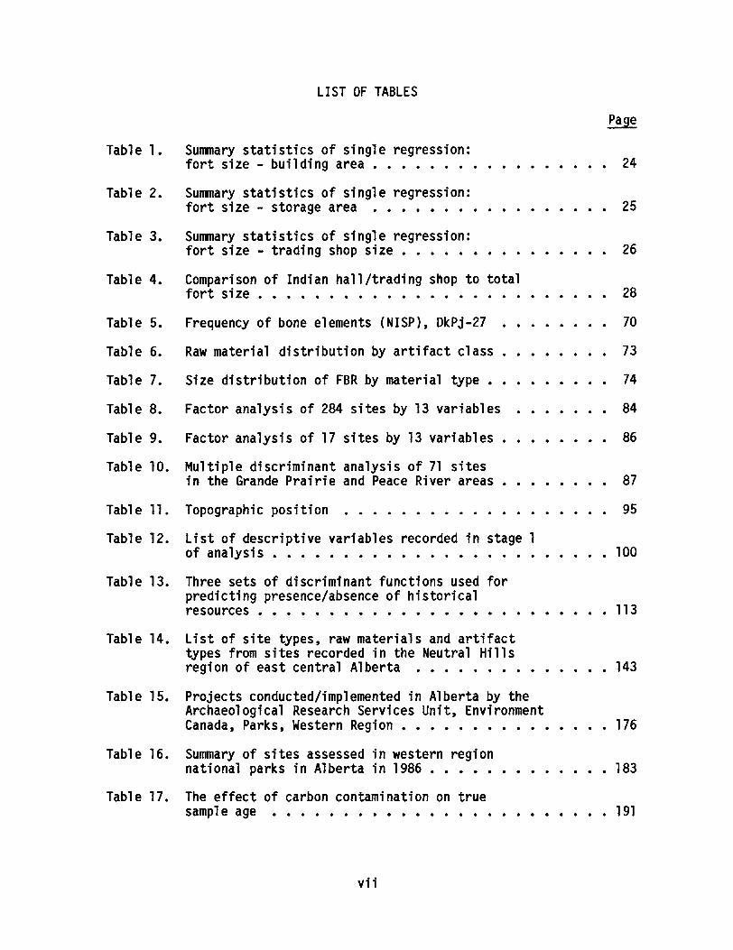
A number of problems had to be addressed before the major researchquestion could be adequately investigated. The first problem that had tobe dealt with was to determine how fort size is related to environmental/economic factors, primarily the fur resources that the traders were thereto exploit. Although there is no direct evidence that fort size andpopulation were related to the number of Indians exploiting furs in aparticular region, it seems likely that fort size was largely determinedby the fur resources available and the amount of those resources tradedto the forts. Indirect evidence to support the relationship comes fromexamining the Indian population data in the Athabasca region between 1805
and 1830 and comparing it to overall fort population (Figure 3). Therelationship is relatively good, suggesting that fort population/size was
22
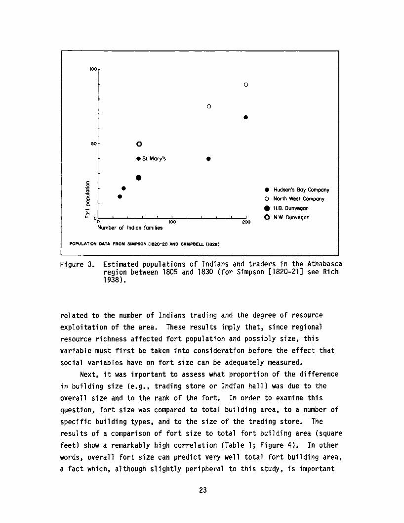
100
o
o
•50 o
.51. Mary's •c.2 •o~ .oa.
Number of Indian families
I
100I
200
• Hudson's Bay Company
o North West Company
e H.B. Dunvegan
o N.W Dunvegan
POPULATION DATA FROM SIMPSON (1820-21) AND CAMPBELL (1828>'
Figure 3. Estimated populations of Indians and traders in the Athabascaregion between 1805 and 1830 (for Simpson [1820-21] see Rich1938) •
related to the number of Indians trading and the degree of resourceexploitation of the area. These results imply that, since regionalresource richness affected fort population and possibly size, thisvariable must first be taken into consideration before the effect thatsocial variables have on fort size can be adequately measured.
Next, it was important to assess what proportion of the differencein building size (e.g., trading store or Indian hall) was due to theoverall size and to the rank of the fort. In order to examine thisquestion, fort size was compared to total building area, to a number ofspecific building types, and to the size of the trading store. Theresults of a comparison of fort size to total fort building area (squarefeet) show a remarkably high correlation (Table 1; Figure 4). In otherwords, overall fort size can predict very well total fort building area,a fact which, although slightly peripheral to this study, is important
23

Table 1. Summary statistics of single regression: fort size - buildingarea.
Simple: X - Fort Size Y - Total Building Area
Coef. Var.:131.204
Std. Err.:12495. 1
R-squared:1.925
OF:
for general investigative procedures used at other fur trade sites. Forthe purposes of this study, however, we must determine how well totalfort size can predict the total area of some specific buildings locatedwithin the fort. In order to examine this question further, total fortsize was compared to total storage area. The results of the singleregression indicate that there is a strong relationship between fort sizeand total building storage area at the fur trade forts (Table 2; Figure5). These results are not too startling, since it is expected that furtrade forts were built only large enough as was necessary to carry outthe fur trade in an area, and their respective storage areas would also
35000
30000
25000
20000
- 15000.,;'to-
ci'~
c 10000CDL. •C
0 5000c:2·5m 0
0 20000 40000 60000
Fort size (sq. ft.)
•
•
y= .252x + -1534.081 r2: .925
80000 100000 120000 140000
Figure 4. Relationship between total fort size (square feet) and totalbuilding area (square feet).
24
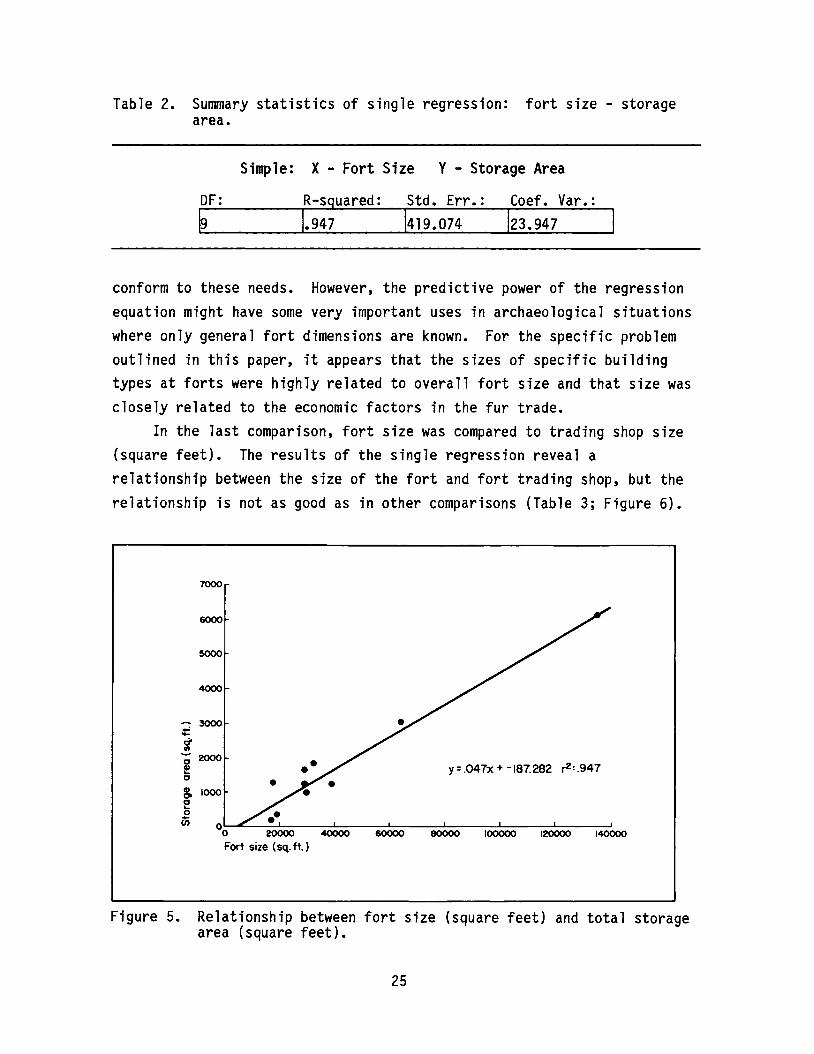
Table 2. Summary statistics of single regression: fort size - storagearea.
Simple: X - Fort Size Y - Storage Area
DF: R-sguared: Std. Err.: Coef. Var.:
conform to these needs. However, the predictive power of the regressionequation might have some very important uses in archaeological situationswhere only general fort dimensions are known. For the specific problemoutlined in this paper, it appears that the sizes of specific buildingtypes at forts were highly related to overall fort size and that size wasclosely related to the economic factors in the fur trade.
In the last comparison, fort size was compared to trading shop size(square feet). The results of the single regression reveal arelationship between the size of the fort and fort trading shop, but therelationship is not as good as in other comparisons (Table 3; Figure 6).
7000
y=.047x+ -187.282 r2 :.947
60000 100000 120000 1400006000040000
•
4000
:;-3000;fI)
~2000!o
& 1000o'-~ ..en
00 20000
Fort size (sq. ft. )
6000
5000
Figure 5. Relationship between fort size (square feet) and total storagearea (square feet).
25

Table 3. Summary statistics of single regression: fort size - tradingshop size.
Simple: X - Fort Size Y - Trading Shop Size
DF: R-squared: Std. Err.: Coef. Var.:
In other words, it is tempting to say that these results show that fortsize accounts for most of the variability of building sizes, althoughless so for the trading store. However, other types of comparisons areneeded to further examine this possible relationship.
COMPARISONS
Since it was evident that the size of the trading shop was relatedprimarily to the overall size the fur trade forts, any subsequentcomparisons of the data to establish how social factors affected the size
3500
3000
2500
2000
..-.-ct 1500!!.Q) •N•• 1000~ •01itJ' 500c •:sc •~ 0
0 20000 40000 60000
Fort size (sq. ft.)
y=.02Ix + 89.172 r2 :.87
80000 100000 120000 140000
Figure 6. The relationship between fort size (square feet) and tradingshop size (square feet).
26
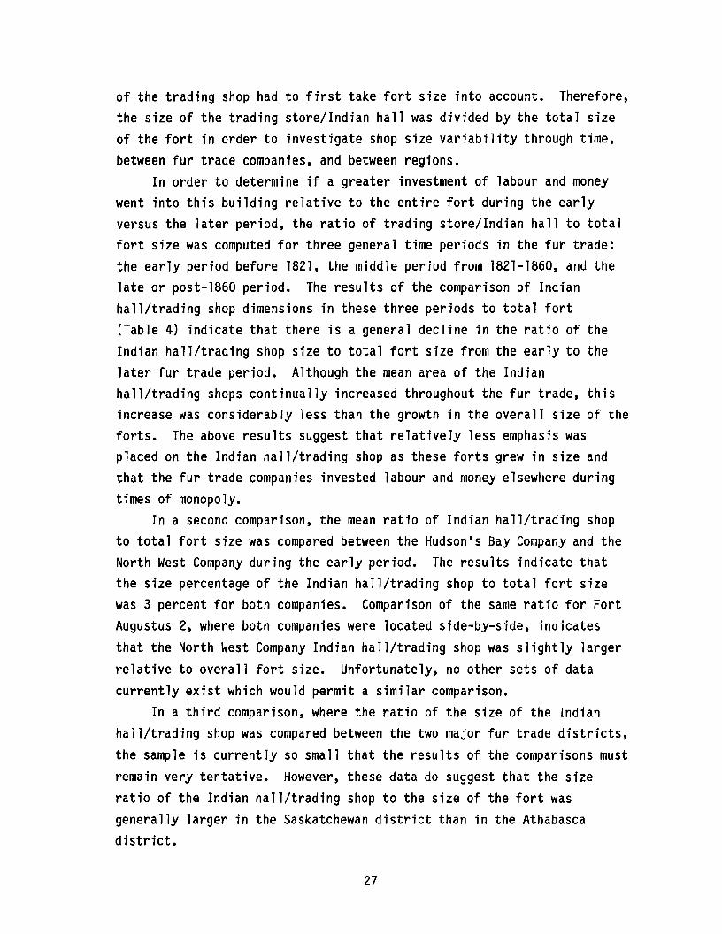
of the trading shop had to first take fort size into account. Therefore,the size of the trading store/Indian hall was divided by the total sizeof the fort in order to investigate shop size variability through time,between fur trade companies, and between regions.
In order to determine if a greater investment of labour and moneywent into this building relative to the entire fort during the earlyversus the later period, the ratio of trading store/Indian hall to totalfort size was computed for three general time periods in the fur trade:the early period before 1821, the middle period from 1821-1860, and thelate or post-1860 period. The results of the comparison of Indianhall/trading shop dimensions in these three periods to total fort(Table 4) indicate that there is a general decline in the ratio of theIndian hall/trading shop size to total fort size from the early to thelater fur trade period. Although the mean area of the Indianhall/trading shops continually increased throughout the fur trade, thisincrease was considerably less than the growth in the overall size of theforts. The above results suggest that relatively less emphasis wasplaced on the Indian hall/trading shop as these forts grew in size andthat the fur trade companies invested labour and money elsewhere duringtimes of monopoly.
In a second comparison, the mean ratio of Indian hall/trading shopto total fort size was compared between the Hudson1s Bay Company and theNorth West Company during the early period. The results indicate thatthe size percentage of the Indian hall/trading shop to total fort sizewas 3 percent for both companies. Comparison of the same ratio for FortAugustus 2, where both companies were located side-by-side, indicatesthat the North West Company Indian hall/trading shop was slightly largerrelative to overall fort size. Unfortunately, no other sets of datacurrently exist which would permit a similar comparison.
In a third comparison, where the ratio of the size of the Indianhall/trading shop was compared between the two major fur trade districts,the sample is currently so small that the results of the comparisons mustremain very tentative. However, these data do suggest that the sizeratio of the Indian hall/trading shop to the size of the fort wasgenerally larger in the Saskatchewan district than in the Athabascadistrict.
27
Table 4. Comparison of Indian hall/trading shop to total fort size.
Fort
Early PeriodAugustus 2 R.B.Co.Augustus 2 N.W.Co.Dunvegan 1 N.W.Co./H.B.Co.Buckingham House H.B.Co.Hudson1s House H.B.Co.Red Deer1s PostMEAN
Middle PeriodPe11y H. B. Co.CarltonFort ChipewyanMEAN
Late PeriodSt. JamesDunveganChipewyanLac La BicheLac La BicheVictoriaAugustus 4MEAN
A. Indian Hall/Trading Shop(sq. ft.)
7561149
59887
784400m
8001449
750TCrnO
720469750880822348
3060lUU7
B.Fort Size(sq. ft.)
2430029700388091783512100
24548.8
3255464349
48451.5
2948013575082616
A+B (%)
3. 13.91.50.496.5
n
2.52.3
2:4
1.22.3r:s
Note: The above data were taken from Babcock 1984; Clark 1969; Forsman1985; Harris 1974; Klimko 1983; MacDonald 1959; MacGregor 1967; G. Nicks1969; J. Nicks 1977; Pyszczyk 1983.
CONCLUDING REMARKS
It is obvious from the above results that there are very few (ifany) attributes of material culture that are sensitive only to singlecultural variables. It is equally apparent that many attributes ofmaterial culture, especially the size of architectural remains,environmental and economic factors (e.g., total resources, population,etc.), likely always will account for the greatest amount of variabilityfound in those remains. This is obvious when archaeological variablesare compared to one another for the fur trade data. For example, the
28

overall size and population of the many inland fur trade forts wererelated to the Indian population trading furs and the total resourcesthat could be exploited in a region. In turn, many of the changes inbuildings were related to major changes in the degree of resourceexploitation.
It is also apparent that social factors, although they may beeconomically influenced (e.g., architectural lavishness to induce theIndians to trade), playa lesser role in cultural systems. Thesesecondary factors are often very difficult to isolate from the moreprevalent economic variables. Nevertheless, they are important sincefort size alone cannot account for all the variability in the size of theIndian hall/trading shop.
In the three final comparisons, there was some indication that theimportance of the Indian hall/trading shop decreased relative to the sizeof the fort and to other buildings through time. The results ofcomparisons between the two fur trade companies or between the fur tradeareas are inconclusive. Because the database is so small, I wouldcaution readers about the reliability of these results at the presenttime.
The current results of using architectural remains to determinewhether certain material culture attributes played a social role in thefur trade must be re-examined with more documentary and archaeologicaldata from fur trade forts. It is clear in this study, as well as inother studies that undertake temporal or regional comparisons of furtrade data, that the database with which archaeologists must deal isrelatively small compared to the total population of fur trade sites inwestern Canada. Perhaps other attributes should be used to examine thestudy problem, but there are relatively few other types of materialculture or architectural attributes that are readily available or easy tomeasure quantitatively.
To conclude, even though the initial investigation of materialculture in a social context in the fur trade was somewhat inconclusive,there are indications of relationships between fort and buildingattributes that may have more practical applications and should bepursued in future studies. For example, the ability of total fort sizeto predict total building area, total storage area, and perhaps other
29

building characteristics is a very promising avenue of research in thefur trade. If regression equations could be computed which would allowarchaeologists to accurately predict unknown architecturalcharacteristics of the fur trade forts they investigate from only a fewtypes of data, the time and money saved in more thorough investigationswould be tremendous.
30

THE PINCHER CREEK BUFFALO JUMP:A LATE PREHISTORIC BISON KILL SITE
ByBruce F. Ball
Archaeological Survey of Alberta
INTRODUCTION
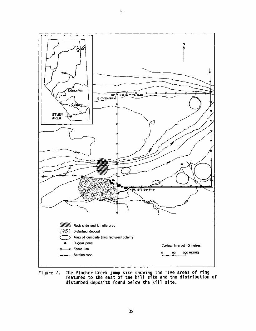
The Pincher Creek Buffalo Jump (DjPl-l) is located approximately 4km north of the town of Pincher Creek and 1.5 km south of the OldmanRiver in the foothills of southwestern Alberta (Figure 7). The site iswell known to local amateur archaeologists and has been focus ofcollectors for over fifty years. But despite its long-lasting eclat, thesite had somehow eluded the attention of professional archaeologists.This report describes the results of a formal investigation of thePincher Creek Jump site.
The site is situated on the southern face of the eastern extremityof a large sandstone feature, geologically described as a remnant of atertiary peneplain and now part of the Porcupine Hills formation. Thenorthern margins of the feature parallel the Oldman River and displayrelatively steep sides. The feature gradually rises above thesurrounding landscape from the west and is easily accessed from thesouthern and southwestern flanks. Presumably, it would be from thissouthwestern quarter that the bison would have been herded into positionfor the jump.
PURPOSE AND OBJECTIVES
Stimulus for this investigation originated in the Oldman River Damproject. The realization that the Pincher Creek Buffalo Jump site was anarchaeological unknown resulted from a proposal by Alberta Environment touse the jump area as a quarry for construction materials. With thisproposal it was educed that, while some site characteristics were known,no formal investigation had ever been undertaken, and the site1s spatialand temporal dimensions were essentially unknown.
31
N
1
Contour Interval 10 metres
~ Rock slide and kill site area
~S.?~~:·~~ Disturbed deposit,---,\ ..,1 Area of campsite (ring features) activity
• Dugout pond
~ Fence line
Section roodoI Itf 290 METRES
Figure 7. The Pincher Creek jump site showing the five areas of ringfeatures to the east of the kill site and the distribution ofdisturbed deposits found below the kill site.
32
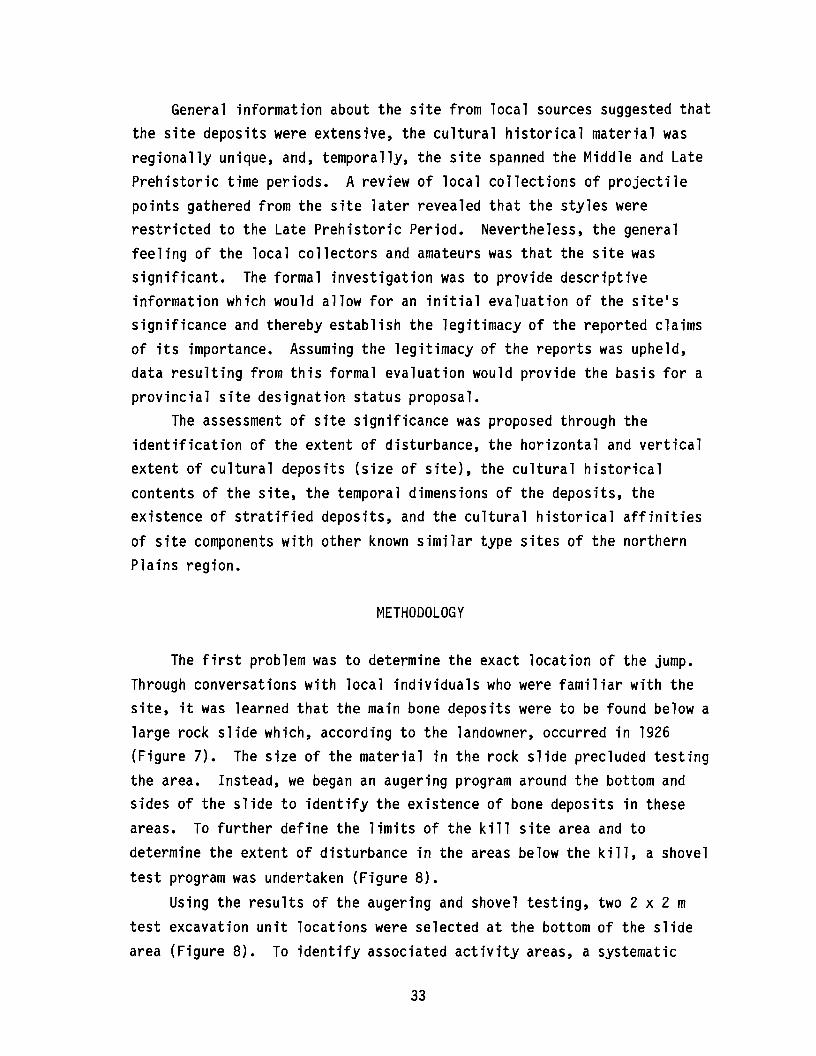
General information about the site from local sources suggested thatthe site deposits were extensive, the cultural historical material wasregionally unique, and, temporally, the site spanned the Middle and LatePrehistoric time periods. A review of local collections of projectilepoints gathered from the site later revealed that the styles wererestricted to the Late Prehistoric Period. Nevertheless, the generalfeeling of the local collectors and amateurs was that the site wassignificant. The formal investigation was to provide descriptiveinformation which would allow for an initial evaluation of the site1ssignificance and thereby establish the legitimacy of the reported claimsof its importance. Assuming the legitimacy of the reports was upheld,data resulting from this formal evaluation would provide the basis for aprovincial site designation status proposal.
The assessment of site significance was proposed through theidentification of the extent of disturbance, the horizontal and verticalextent of cultural deposits (size of site), the cultural historicalcontents of the site, the temporal dimensions of the deposits, theexistence of stratified deposits, and the cultural historical affinitiesof site components with other known similar type sites of the northernPlains region.
METHODOLOGY
The first problem was to determine the exact location of the jump.Through conversations with local individuals who were familiar with thesite, it was learned that the main bone deposits were to be found below alarge rock slide which, according to the landowner, occurred in 1926
(Figure 7). The size of the material in the rock slide precluded testingthe area. Instead, we began an augering program around the bottom andsides of the slide to identify the existence of bone deposits in theseareas. To further define the limits of the kill site area and todetermine the extent of disturbance in the areas below the kill, a shoveltest program was undertaken (Figure 8).
Using the results of the augering and shovel testing, two 2 x 2 mtest excavation unit locations were selected at the bottom of the slidearea (Figure 8). To identify associated activity areas, a systematic
33

~~~N
l/Nm
• "42
". ~
132 ~17
I~" e~
~43
• CI ~44 ~48~ ~
~
I) .IP .'M .104 .103.73 .72 .48 .....17~
~ ~
~.131.
e ~.1>
~ ~ ~22
~t'''', -~, 9
~ ~ .. \ a 1.:.-1 -/ ~ -~Vt.t\- -. -,., - Dla,. -,--, - '-'" I
I ~ 1>10 ~. .~ 8
-III -120 - ..8 •••87 .61a .eo .35 ·52 -IDATUM
t(r----Auger test
~ Positivex Negative
Shovel test@ Positive
- Negative
Ring feature test
- 50cm SQ..D 1m sq.
() Ring feature
o I Excavation unit in the kill site
--r- Fence
~ Depression
oI
50 METRESI
Figure 8. Location of the various testing programs (augering, shoveltests and systematic excavation units) within the immediatevicinity of the Pincher Creek Jump kill site.
34
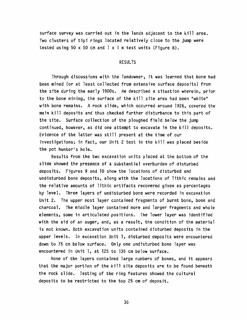
surface survey was carried out in the lands adjacent to the kill area.Two clusters of tipi rings located relatively close to the jump weretested using 50 x 50 cm and 1 x 1 mtest units (Figure 8).
RESULTS
Through discussions with the landowner, it was learned that bone hadbeen mined (or at least collected from extensive surface deposits) fromthe site during the early 1900s. He described a situation wherein, priorto the bone mining, the surface of the kill site area had been "white"with bone remains. A rock slide, which occurred around 1926, covered themain kill deposits and thus checked further disturbance to this part ofthe site. Surface collection of the ploughed field below the jumpcontinued, however, as did one attempt to excavate in the kill deposits.Evidence of the latter was still present at the time of ourinvestigations; in fact, our Unit 2 test in the kill was placed besidethe pot hunter1s hole.
Results from the two excavation units placed at the bottom of theslide showed the presence of a substantial overburden of disturbeddeposits. Figures 9 and 10 show the locations of disturbed andundisturbed bone deposits, along with the locations of lithic remains andthe relative amounts of lithic artifacts recovered given as percentagesby level. Three layers of undisturbed bone were recorded in excavationUnit 2. The upper most layer contained fragments of burnt bone, bone andcharcoal. The middle layer contained more and larger fragments and wholeelements, some in articulated positions. The lower layer was identifiedwith the aid of an auger, and, as a result, the condition of the materialis not known. Both excavation units contained disturbed deposits in theupper levels. In excavation Unit 1, disturbed deposits were encountereddown to 75 cm below surface. Only one undisturbed bone layer wasencountered in Unit 1, at 125 to 135 cm below surface.
None of the layers contained large numbers of bones, and it appearsthat the major portion of the kill site deposits are to be found beneath
the rock slide. Testing of the ring features showed the culturaldeposits to be restricted to the top 25 cm of deposit.
35
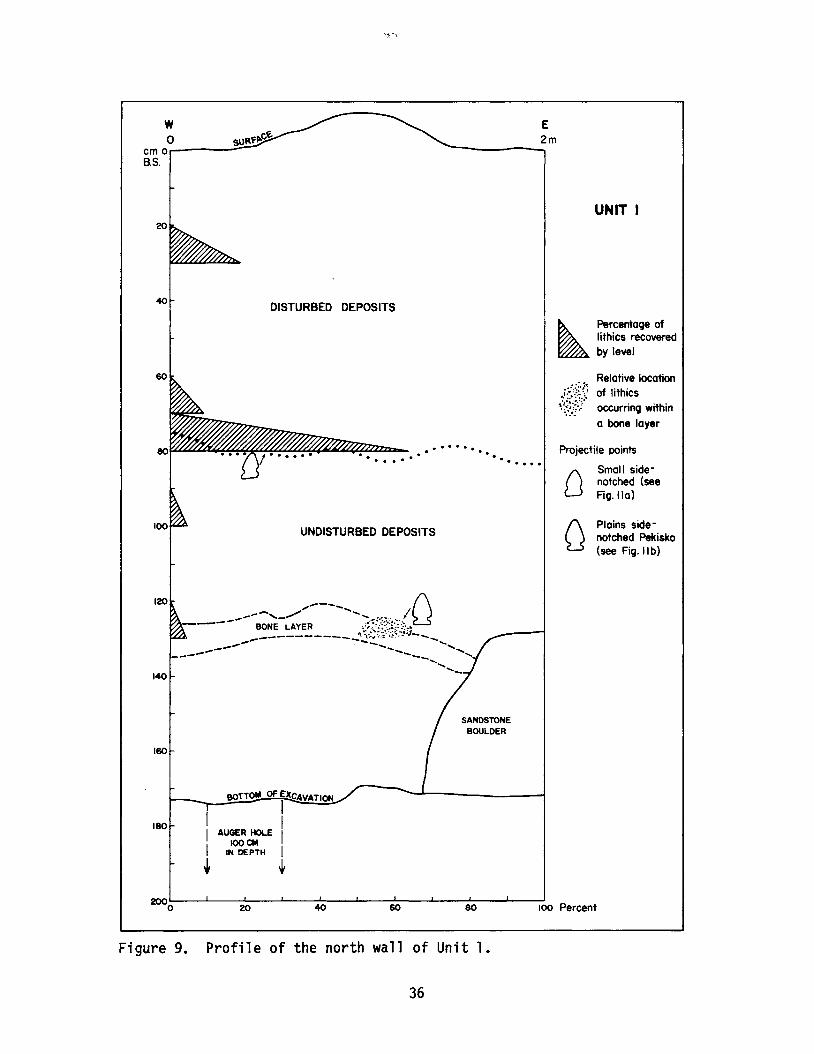
wo
cmo----~
B.S.
E2m
UNIT I20
40
60
DISTURBED DEPOSITS
................ . .
UNDISTURBED DEPOSITS
~PercentoQe oflithics recoveredby level
Relative locationof lithicsoccurrinQ within
a bone layer
Projectile points
OSmall sidenotched (seeFiQ. 110)
f\ Plains sideU notched Pekisko
(see Fig. II b)
120
140
160
180
BOTTOM OF EXCAVATION
~I-- II AUGER HOLE I
IOOCMI IN DEPTH I+ t
SANDSTONEBOULDER
2000 20 40 60 80 100 Percent
Figure 9. Profile of the north wall of Unit 1.
36
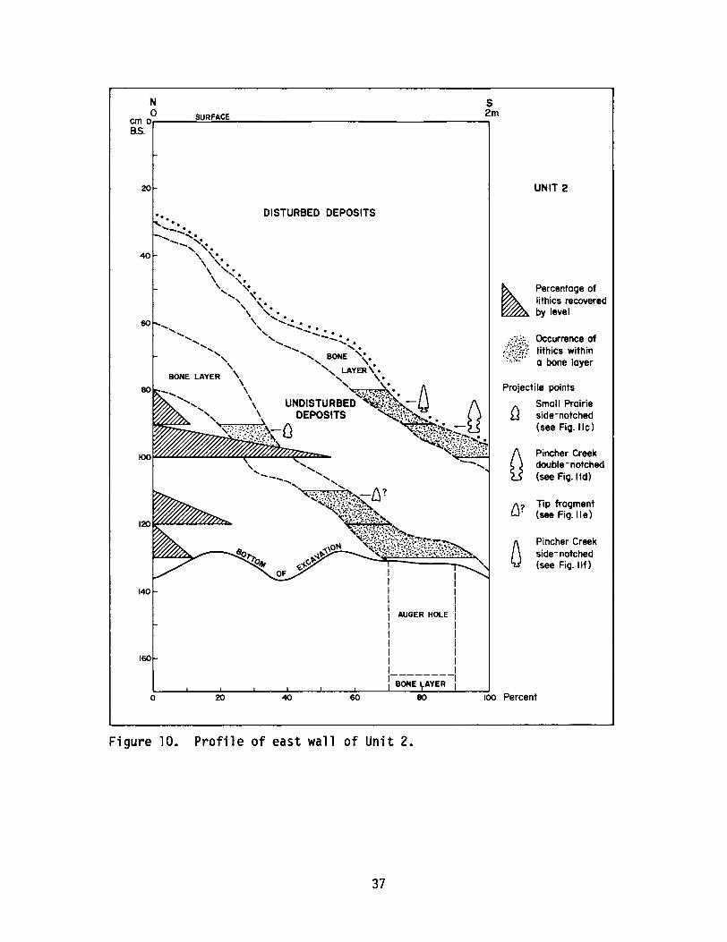
1\? Tip fragmentW (see Fig. II e)
Projectile points
1\ Small PrairieU side-notched
(see Fig. Ilc)
N So SURFACE 2m
cmo~--.....,;;",;;~~----------------------.....,B.S.
20
DISTURBED DEPOSITS
140
AUGER HOLE
160
o
UNIT 2
Percentage oflithics recoveredby level
Occurrence ofIithics withina bone layer
Pincher Creekdouble - notched(see Fig. lid)
Pincher Creekside- notched(see Fig. IIf)
1--------1I BONE AVER I
o 20 40 60 80 100 Percent
Figure 10. Profile of east wall of Unit 2.
37

The number of items and the number of types collected from theexcavation units in the kill site were small. Of a total of 578 lithicitems recovered, 6.75 percent came from the two excavation units in thekill site area; 1.21 percent resulted from the shovel testing below andeast of the jump; 3.6 percent were from surface collections; and 88.4
percent came from the testing of the rings. Seven projectile andprojectile point fragments were recovered; five of these displayrecognizable morphological characteristics. In Unit 1, two points werefound: a small, side-notched type (Figure lla) from level 8 and al~rger, side-notched form (Figure llb) from level 13. The former lacksany particular distinguishing characteristics and was found in adisturbed context. The latter may be described as a Plains Side-notchedPekisko point type.
Five specimens were recovered from Unit 2; two of these are pointtip fragments (one is shown in Figure lle). A small Prairie Side-notchedtype was found in level 10, bone layer 2 (Figure llc). A small,well-made point type (Figure llf), which shows some similarity toHead-Smashed-In Corner-notched type (Reeves 1983a), was recovered fromlevel 9 in bone layer 1. However, with its stratigraphic positioningabove the Prairie Side-notched type (found in bone layer 2 below layer1), one expects that it would date more recent than Reeves'classification would peg it. Using Vickers' (1986:98) techniques adaptedfrom Forbis' (1962) typology, the point would be classified as an Irvineor High River Prairie Side-notched type. Vickers (1986:99) places Irvinewithin the A.D. 600 to A.D. 1700 period. The overall distinctivemorphology and workmanship of this specimen (Figure llf) is unlike otherknown types of the area. It is herein called a Pincher CreekSide-notched type. Finally, a double side-notched point type (Figurelld) was recovered from level 10 in bone layer 1.
The double-notched type is a unique point type that has not beendescribed in Alberta archaeology previously. While several of mycolleagues swear on their Clovis Point collections that they have seenthe double-notched variety type before, I can find no references orexamples of this type in any of the collections or reports of sites inAlberta. This type is herein referred to as Pincher Creek Double-notched.
38
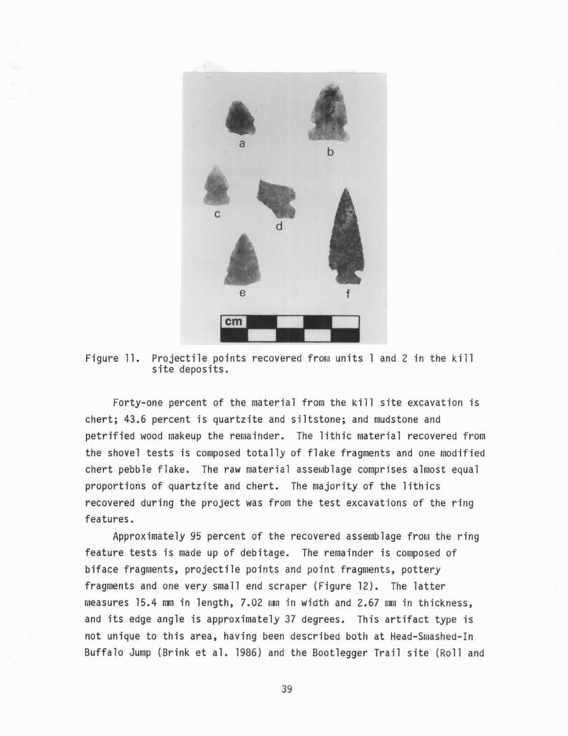
Figure 11. Projectile points recovered from units 1 and 2 in the killsite deposits.
Forty-one percent of the material from the kill site excavation ischert; 43.6 percent is quartzite and siltstone; and mudstone andpetrified wood makeup the remainder. The lithic material recovered fromthe shovel tests is composed totally of flake fragments and one modifiedchert pebble flake. The raw material assemblage comprises almost equalproportions of quartzite and chert. The majority of the lithicsrecovered during the project was from the test excavations of the ringfeatures.
Approximately 95 percent of the recovered assemblage fron the ringfeature tests is made up of debitage. The remainder is composed ofbiface fragments, projectile points and point fragments, potteryfragments and one very small end scraper (Figure 12). The lattermeasures 15.4 mm in length, 7.02 rm in width and 2.67 mm in thickness,and its edge angle is approximately 37 degrees. This artifact type isnot unique to this area, having been described both at Head-Smashed-InBuffalo Jump (Brink et ale 1986) and the Bootlegger Trail site (Roll and
39
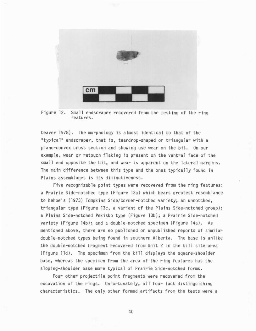
Figure 12. Small endscraper recovered from the testing of the ringfeatures.
Deaver 1978). The morphology is almost identical to that of theIItypical ll endscraper, that is, teardrop-shaped or triangular with aplano-convex cross section and showing use wear on the bit. On ourexample, wear or retouch flaking is present on the ventral face of thesmall end opposite the bit, and wear is apparent on the lateral margins.The main difference between this type and the ones typically found inPlains assemblages is its diminutiveness.
Five recognizable point types were recovered from the ring features:a Prairie Side-notched type (Figure 13a) which bears greatest resemblance
to Kehoe1s (1973) Tompkins Side/Corner-notched variety; an unnotched,triangular type (Figure l3c, a variant of the Plains Side-notched group);a Plains Side-notched Pekisko type (Figure l3b); a Prairie Side-notchedvariety (Figure 14b); and a double-notched specimen (Figure 14a). Asentioned above, there are no published or unpublished reports of similar
double-notched types being found in southern Alberta. The base is unlikethe double-notched fragment recovered from Unit 2 in the kill site area(Figure lld). The specimen from the kill displays the square-shoulderbase, whereas the specimen from the area of the ring features has the
sloping-shoulder base more typical of Prairie Side-notched forms.Four other projectile point fragments were recovered from the
excavation of the rings. Unfortunately, all four lack distinguishingcharacteristics. The only other formed artifacts from the tests were a
40
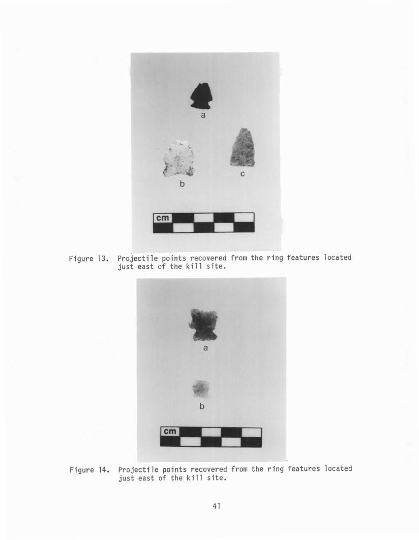
Figure 13. Projectile points recovered from the ring features locatedjust east of the kill site.
Figure 14. Projectile points recovered from the ring features locatedjust east of the kill site.
41
biface fragment and a historic copper IItinkle cone. 1I The raw materialrecovered from the rings consists of 38 percent chert, 13 percentsiltstone, 3 percent mudstone, and small quantities of petrified wood,obsidian, limestone and ceramics. The largest of the pottery specimensis a cord-marked neck sherd which may be affiliated with the Late Variantof the Saskatchewan Basin Complex ceramics (Byrne 1973).
Artifacts collected from the ploughed field south of the kill siteincluded projectile points and point fragments (Figure 15), a pieceesquillee, three scraper fragments and four biface fragments. The pointstyles are not inconsistent with those recovered from the undisturbeddeposits consisting of both Plains and Prairie styles. Results from theanalysis of the faunal remains are not yet available.
CONCLUSIONS
A rock slide which occurred around 1926 covered the main killdeposits of the Pincher Creek Jump site and effectively conserved thisportion of the site. Prior to the slide, bone remains were removed fromthe kill to supply the IIbuffalo bone trade. 1I It is impossible todetermine the extent of disturbance that the bone mining caused, since wehave no idea what was there before the removal of the bone.
While the rock slide protected the bone deposits in the kill, italso prevented us from mapping the full vertical and horizontal extent ofthe remaining deposits. From our two tests at the bottom of the slide,we were able to identify three undisturbed layers of bone. The upper twoof these can be dated to the Late Prehistoric Period, as indicated by therecovery of known projectile point styles from these layers. A thirdbone lens was identified in Unit 2 at 1.65 m below surface. No sampleswere recovered from this third layer since it was discovered in an augertest. As a result, we are unable to provide information regarding thenature of these deposits outside of the obvious conclusion that they dateto before the remains of bone layer 2.
In addition to the recognizable point forms, two new forms wererecovered; one is called a Pincher Creek Side-notched point and the othera Pincher Creek Double-notched point. Both appear to show temporalaffinities with Plains Side-notched point types. Other archaeological
42
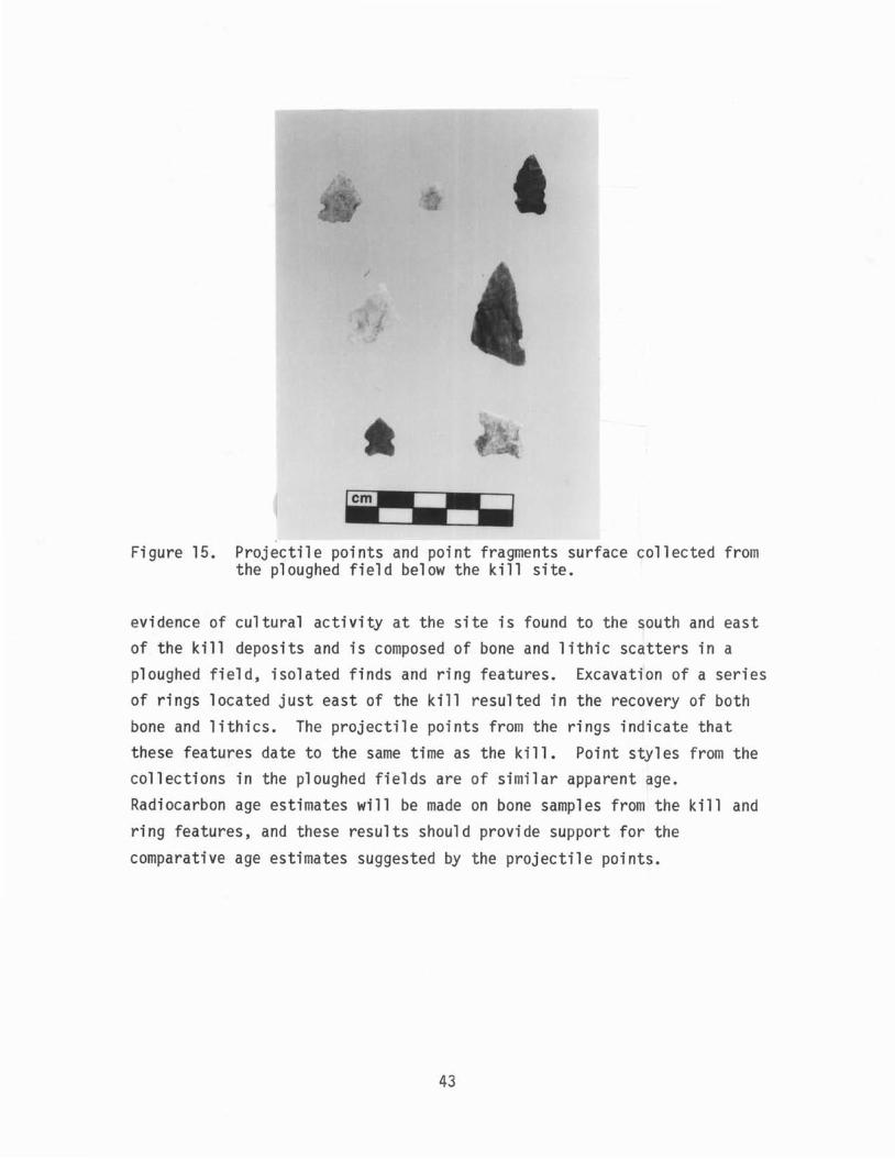
Figure 15. Projectile points and point fragments surface collected fromthe ploughed field below the kill site.
evidence of cultural activity at the site is found to the south and eastof the kill deposits and is composed of bone and lithic scatters in aploughed field, isolated finds and ring features. Excavation of a seriesof rings located just east of the kill resulted in the recovery of bothbone and lithics. The projectile points from the rings indicate thatthese features date to the same time as the kill. Point styles from thecollections in the ploughed fields are of similar apparent age.Radiocarbon age estimates will be made on bone samples from the kill andring features, and these results should provide support for the
comparative age estimates suggested by the projectile points.
43
PRELIMINARY REPORT ON THE 1986 FIELD SEASON ATHEAD-SMASHED-IN AND CALDERWOOD BUFFALO JUMPS
ByJack Brink,
Robert J. DaweArchaeological Survey of Alberta
andSusan Marshall
Trent University
INTRODUCTION
The 1986 field season at Head-Smashed-In Buffalo Jump (HSI) insouthwestern Alberta was the final year of field studies sponsored byAlberta Culture prior to the opening of the on-site interpretive centre.During the three previous seasons, many of the objectives of the annualresearch designs had been attained. In brief, these consisted ofmitigating potential impacts to archaeological resources as might beoccasioned by the interpretive developments; documenting thearchaeological record of the previously poorly known processing sitebelow the kill; experimental studies of hearths, bone boiling and bisontaphonomy; baseline studies of associated site features, includingpetroglyphs, a vision quest site and the drive lane complex; and theinvestigation of other potential kill sites in the immediate vicinity ofHSI (see Brink et al. 1985, 1986; Marshall and Brink 1986; Reeves 1985;Rollans 1986; Wright and Brink 1986).
At the onset of the 1986 field season in June, all majordevelopment-related activities that posed a threat to in situarchaeological materials had either been completed or were wellunderway. Hence, no further mitigative studies were required. With manyof the research objectives attained or in progress, the 1986 season was
accordingly reduced considerably in scale relative to previous seasons.At Head-Smashed-In Buffalo Jump, field work consisted of the excavationof two contiguous 2 x 2 munits on the prairie level adjacent to theunits excavated in 1985 and screening of a sample of the dirt which forms
44

a small dam at the head of a spring channel below the kill. Also in1986, excavations at the Calderwood Buffalo Jump, situated about 1 kmnorth of HSI, were conducted under permit issued to Marshall. Because ofthe closely related nature of these two projects, they are discussed herein a single report.
1986 AT HEAD-SMASHED-IN
Head-Smashed-In Buffalo Jump is located in southwestern Alberta atthe southern end of the Porcupine Hills (Figure 16). Bison were roundedup in the confines of a large natural basin located to the west of thejump and herded through a complex series of drive lanes to the edge of a10 m high sandstone cliff. Topple and slump from the cliff face haveformed a bench at the base of the cliff, and it is this bench whichcontains the stratified layers of bison bones and stone tools extendingto a depth of 10 m below surface. Archaeological study of the bone bedat the kill site has been conducted by Wettlaufer (1949) and Reeves(1978, 1983b). To the east of the kill, the bench drops off steeply tothe prairie level where a shallowly buried blanket of cultural materialcovers and estimated area of 500,000 square metres. This has beenreferred to as the processing/campsite portion of the site and has beenthe primary focus of recent site studies sponsored by Alberta Culture.
The rationale for the selection of this component of the site fordetailed investigation lies, in general, in the paucity of archaeologicalexamination of butchering/processing sites associated with communal bisonkills on the Plains and, more specifically, in the fact that little wasknown about this component at HSI. With the decision by the Albertagovernment to construct a major, on-site interpretive facility, it becameapparent that adequate development of the interpretive storyline anddisplays required a substantial amount of new research into poorlyunderstood aspects of HSI. The 1986 field season saw a continuation ofresearch at the processing/campsite portion of the site.
During the first season at HSI (1983), a number of exploratoryexcavations were placed over a large area of the processing site (Brinket ale 1985). This provided a preliminary indication of the nature andextent of cultural materials in different portions of the site. The
45
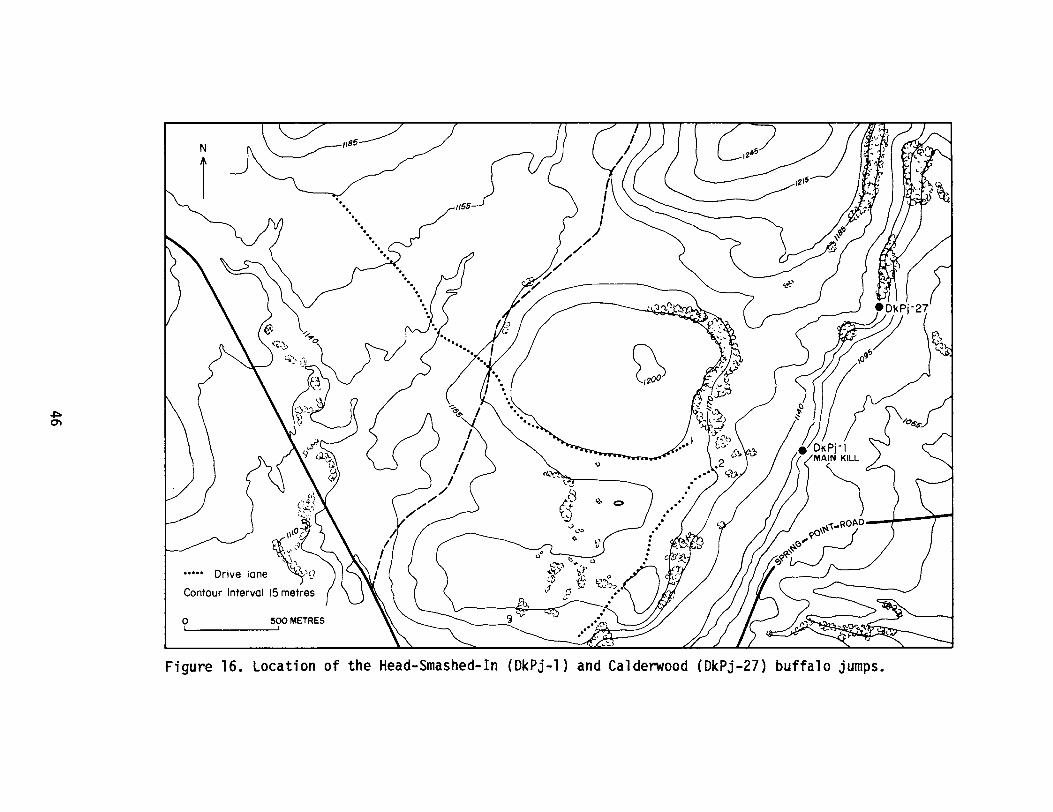
1155
500 METRES,
N
r
oI
Figure 16. Location of the Head-Smashed-In (DkPj-1) and Calderwood (DkPj-27) buffalo jumps.
following year we conducted detailed excavations at the north end of theprocessing site in an area intentionally selected because of its distancefrom the most heavily used part of the site (Brink et ale 1986). In sodoing, we had hoped to avoid some of the confusion of the core area ofthe site where several thousands of years of bison processing arecompressed into an unstratified soil averaging 15 cm in thickness. Themajor thrust of the 1985 season was the excavation of four contiguous2 x 2 m units at the south end of the core area of the processing site,350 mdistant from the 1984 excavations. These excavations were designedto explore a portion of the prairie where a well trench had exposedcultural deposits extending to a depth (50 cm), more than twice what wehad previously encountered (Wright and Brink 1986). Unfortunately, theunits were placed on the very edge of the higher deposition area, andonly a thin strip of our excavations intersected the deeper culturallayers. Continued excavation in this locale was deemed advisable as thisarea offered at least limited potential to produce some verticalseparation of temporally distinct occupations on the site.
Accordingly, we returned to this area in 1986. Two more 2 x 2 munits were placed directly adjacent to those excavated in 1985, along thewest edge of the previous units where the deeper cultural materials hadbeen encountered. Excavation methodology was generally similar to thatemployed in previous seasons. Each unit was divided into 1 m quadrantsand 0.5 msubquadrants. Excavation proceeded by arbitrary 10 cm levelsuntil all pits were sterile. All bone identifiable as to anatomicalelement was mapped in situ. Unidentifiable bone scraps were discarded.Fire-broken rock fragments larger than 5 cm in any dimension werelikewise mapped. Initially, chipped stone artifacts were baggedaccording to the 0.5 m subquadrant and 10 cm vertical level of origin.Soon after the outset of the 1986 season, however, it became apparentthat discernable natural stratigraphy was present in the units, and thedecision was made to excavate the one as yet unopened 2 x 2 m unitkeeping exact provenience of lithic artifacts in three dimensions.Ongoing analysis of these data, combined with radiocarbon dating of theidentified natural strata, hopefully will demonstrate if culturalmaterials are indeed layered in proper temporal sequence in this area ofhigher deposition.
47
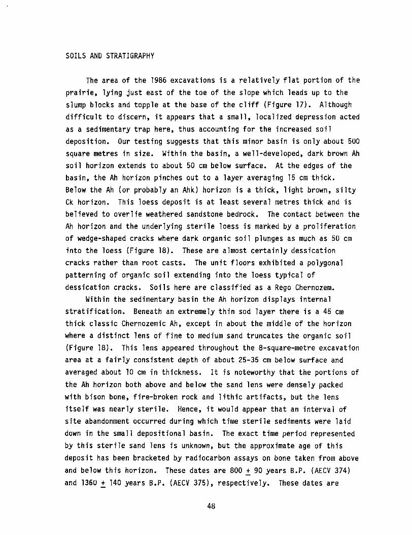
SOILS AND STRATIGRAPHY
The area of the 1986 excavations is a relatively flat portion of theprairie, lying just east of the toe of the slope which leads up to theslump blocks and topple at the base of the cliff (Figure 17). Althoughdifficult to discern, it appears that a small, localized depression actedas a sedimentary trap here, thus accounting for the increased soildeposition. Our testing suggests that this minor basin is only about 500square metres in size. Within the basin, a well-developed, dark brown Ahsoil horizon extends to about 50 cm below surface. At the edges of thebasin, the Ah horizon pinches out to a layer averaging 15 cm thick.Below the Ah (or probably an Ahk) horizon is a thick, light brown, siltyCk horizon. This loess deposit is at least several metres thick and isbelieved to overlie weathered sandstone bedrock. The contact between theAh horizon and the underlying sterile loess is marked by a proliferationof wedge-shaped cracks where dark organic soil plunges as much as 50 cminto the loess (Figure 18). These are almost certainly dessicationcracks rather than root casts. The unit floors exhibited a polygonalpatterning of organic soil extending into the loess typical ofdessication cracks. Soils here are classified as a Rego Chernozem.
Within the sedimentary basin the Ah horizon displays internalstratification. Beneath an extremely thin sod layer there is a 45 cmthick classic Chernozemic Ah, except in about the middle of the horizonwhere a distinct lens of fine to medium sand truncates the organic soil(Figure 18). This lens appeared throughout the 8-square-metre excavationarea at a fairly consistent depth of about 25-35 cm below surface andaveraged about 10 cm in thickness. It is noteworthy that the portions ofthe Ah horizon both above and below the sand lens were densely packedwith bison bone, fire-broken rock and lithic artifacts, but the lensitself was nearly sterile. Hence, it would appear that an interval ofsite abandonment occurred during which time sterile sediments were laiddown in the small depositional basin. The exact time period representedby this sterile sand lens is unknown, but the approximate age of thisdeposit has been bracketed by radiocarbon assays on bone taken from aboveand below this horizon. These dates are 800 ~ 90 years B.P. (AECV 374)and 1360 ~ 140 years B.P. (AECV 375), respectively. These dates are
48
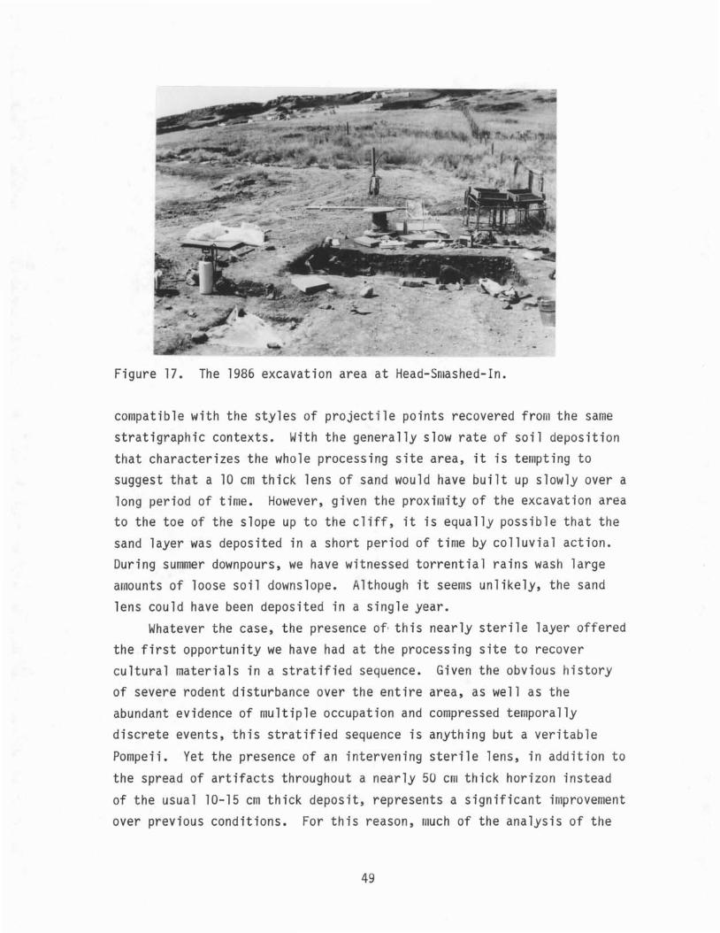
Figure 17. The 1986 excavation area at Head-S ashed-In.
compatible with the styles of projectile points recovered from the samestratigraphic contexts. With the generally slow rate of soil depositionthat characterizes the whole processing site area, it is tempting tosuggest that a 10 em thick lens of sand would have built up slowly over along period of time. However, given the proxi ity of the excavation areato the toe of the slope up to the cliff, it is equally possible that thesand layer was deposited in a short period of time by colluvial action.During summer downpours, we have witnessed torrential rains wash largeamounts of loose soil downslope. Although it seems unlikely, the sandlens could have been deposited in a single year.
Whatever the case, the presence of· this nearly sterile layer offeredthe first opportunity we have had at the processing site to recovercultural materials in a stratified sequence. Given the obvious historyof severe rodent disturbance over the entire area, as well as theabundant evidence of multiple occupation and compressed temporallydiscrete events, this stratified sequence is anything but a veritable
Pompeii. Yet the presence of an intervening sterile lens, in addition tothe spread of artifacts throughout a nearly 50 cm thick horizon instead
of the usual 10-15 em thick deposit, represents a significant improvementover previous conditions. For this reason, much of the analysis of the
49

eM 00 20 40 60 80 100 120 140 160 180 200
~ R
~O ~ ~~~R L2::J
C>CJ~
~Lap @ CJ 0 c::::>
ROOMPR<::::"R
cqa IT C?a40
ill ,r'\ I \60 \
I I \ I I \01
1 I I I \ r\ I \ r, \01
I I 1/ V \ r J J
\ I ( I\ I \ I \/
80 \ I \ )II IjIIV
100
® Identified bone
~FBR
Figure 18. Soil profile from excavations at the Head-Smashed-In processing area.
1986 data will focus on the problem of separating out assemblages whichare believed to be more or less temporally discrete.
EXCAVATION RESULTS
FaunaAnalysis of the faunal remains recovered in the 1986 excavations is
still underway. It is evident that a pattern of processing activity,comparable to results yielded in our investigations elsewhere in theprocessing area (Brink et ale 1985, 1986; Wright and Brink 1986), isemerging here. The recovery techniques used in the 1986 excavations werethe same as those used in the 1984 and 1985 field seasons (Brink et ale1986; Wright and Brink 1986). A total of 3,141 specimens was identifiedto the level of species and anatomical element. Of these, the vastmajority were large mammal bones identified as bison. Elementsrepresented are predominantly longbone fragments, carpals, tarsals andphalanges. There are relatively fewer amounts of rib fragments, skullpieces, teeth and vertebrae. The fragmentary condition of the limb bonespresumably reflects intensive processing for the rendering of bone greaseand marrow. A full species list has not yet been compiled, buttentatively it appears that no further additions to those identifiedduring the 1984 field season (Brink et ale 1986) will be forthcoming. Itshould be noted that once again there is a good representation of canid,either dog or wolf.
Lithic AssemblageExcavations in the processing area at HSI in 1986 resulted in the
recovery of a total of 5,284 flaked stone artifacts and 15 ground stonetools. A preliminary examination of the flaked stone assemblage
. indicates that the bulk of this material is debitage (4,768 - 90.2%),with fewer amounts of tools (364 - 6.9%) and cores (152 - 2.9%). Theinitial impression of this assemblage is that it nearly duplicates theresults obtained elsewhere in the processing area, in terms of both rawmaterials and artifact morphology (Brink et ale 1985, 1986).Approximately a third of the flaked stone tools is projectile points, thevast majority of which falls into the range of variation of the Old
51
Women1s and Avonlea types. The remainder of the tools consists largelyof marginally modified expedient flake tools, with significantly feweramounts of formed bifacial or unifacial tools which are either exhaustedor in fragmentary condition. Cores are predominantly bipolar pebblecores of chert or silicified sediment, with a few simple cobble cores oflocal materials such as argillite.
The debitage appears to fall into two general categories: smallmaintenance debris derived primarily from exotic, fine-grained materialsand relatively larger primary and secondary reduction flakes of localmaterials. This dichotomy in the applications of local versus non-localmaterials cross-cuts all aspects of the assemblage and presumablyreflects site specific considerations of economical use of the availablelithic materials. Fine-grained lithic materials have been observed to bescarce in the vicinity of the site; hence, these materials appear in theassemblage as tiny pieces of maintenance debris and small exhausted orunusable formed tool pieces. Coarse-grained local materials providedmuch of the heavy duty hardware at the site: hammerstones, pestles,anvils, and simple flake or core butchering tools. It would appear thatevery effort was made to get the most out of the lithic resources. Thisconsideration is manifest in the assemblage in that virtually everysizeable lithic item has been used or reused.
As we had hoped, the excavations in the relatively deepsedimentation area of the processing site did yield stratified culturalmaterials. Although the results have not yet been fully tabulated, thereappears to be a definite stratigraphic separation of the Old Women1sPhase and Avonlea materials. Avonlea material was found below thedistinct sterile sand lens that blankets the excavation at a depth ofbelow 20 cm. The focus of the analysis of the lithic material from thisdeposit will attempt to augment our understanding of the chronologicalordering of these particular artifact styles and to investigate thepremise that the lithic resource base and reduction strategies in theprocessing area underwent change in the Late Prehistoric Period. Suchchange was observed in the lithic assemblage recovered by Reeves in hisexcavations of the kill site (Reeves 1978, 1983b).
52
CeramicsA total of 99 pieces of pottery was recovered in the block
excavation. With the exception of three rimsherds and one small shouldersherd, these are all small body sherds in very crumbly condition. Thelargest sherd is less than 5 cm in any dimension. The decoration on thebody sherds is limited to a fabric impression which appears as eithersmoothened or truncated cord-wrapped stick impressions. For the mostpart, these fragments are unanalyzeable, other than providing paste andtemper characteristics. It is quite likely that many of the specimenswere derived from a few common pots; however, the fragmentary conditionprohibits reconstruction.
The three rimsherds recovered have been classified as SaskatchewanBasin Complex pottery after Byrne (1973). Two of these rimsherds wererecovered from level 1 (0-10 cm below surface), and the other wasrecovered in level 4 (30-40 cm b.s.) from the base of the largely sterilelens of sand discussed above. The latter rimsherd is of particularinterest because it has been decorated with an alternate pinched lipimpression that is a characteristic attribute of pottery associated withthe Avonlea Phase in southern Alberta (W. Byrne, personal communication1987). The identification of this rimsherd as belonging to the AvonleaPhase component, and its stratigraphic position just beneath the sandlens, are in agreement with the recovery of Avonlea style projectilepoints and a date of 1360 ~ 140 years B.P. (AECV 375) from this samedepositional unit. The frequency of other sherds by level is asfollows: level 1 (0-10 cm b.s.) - 70, level 2 (10-20 cm b.s.) - 15,level 3 (20-30 cm b.s.) - 8, and level 4 (30-40 cm b.s.) - 3.
Fire-broken RockThe recovery of an enormous quantity of fire-broken rock (FBR) in
1986 is consistent with the interpretation that the block excavation liesin the heart of the processing area. Most of the rock exhibits thecrenelated fractures, reticulated surfaces, and friable conditioncharacteristic of stone that has been heated to a high temperature andsubsequently quenched. Most likely these rocks were used as boilingstones for cooking and the rendering of bone grease. The procedure usedfor the FBR analysis duplicates the procedure used during the 1983, 1984
53

and 1985 seasons (Brink et ale 1985, 1986; Wright and Brink 1986).The preliminary results of the FBR analysis indicate that a total of1919 pieces, weighing a total of 320. 15 kg, were recorded from our8-square-metre excavation. With the exception of two small pieces, allwere recovered from within 50 cm of the surface. Of the total, only 183pieces (9.5%), weighing 42.55 kg (13.3%), were the sandstone whichoutcrops at the site. Virtually all of the remaining FBR consisted ofquartzite and other rock types not available in the immediate site area.The considerable effort undertaken to transport large amounts of theseraw materials to the site attests to their superior properties as boilingstones.
FeaturesOnly two features were encountered during the 1986 excavations. One
of these is the western extension of a boiling pit feature encountered inthe 1985 excavations and compares favorably both in content anddimensions with those described from the 1983 and 1984 seasons (Brink etale 1985, 1986). The second feature is a bone upright feature, theprinciple elements of which are a pair of left distal bison tibias(Figure 19). The tibia shafts had been pushed or driven down into asterile, buff-coloured silt with the articular ends up. Similar boneuprights were found in the adjacent block excavation in 1985 (Wright andBrink 1986), and the possibility that these are associated is presentlybeing considered.
SCREENING DAM FILL
As mentioned above, a second and relatively minor component of the1986 field season included a brief testing of the archaeological richnessof the dirt which forms an earthen dam near the head of the springchannel which bisects the site (see Figure 17). Many decades ago(pre-1949), a rancher used a piece of heavy machinery to scrape the sidesand bottom of the channel at the toe of the slope below the kill site andused the accumulated earth to build a dam across the channel. Thisponded spring water for the rancher1s cattle. The volume of the dam isabout 2,000 cubic metres. Since the channel originates at the spring
54
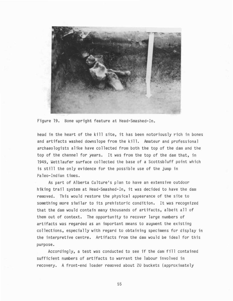
Figure 19. Bone upright feature at Head-Smashed-In.
head in the heart of the kill site, it has been notoriously rich in bonesand artifacts washed downslope from the kill. Amateur and professionalarchaeologists alike have collected fro both·the top of the dam and thetop of the channel for years. It was from the top of the dam that, in1949, Wettlaufer surface collected the base of a Scottsbluff point whichis still the only evidence for the possible use of the ju p inPaleo-Indian times.
As part of Alberta Culture1s plan to have an extensive outdoorhiking trail system at Head-Smashed-In, it was decided to have the damremoved. This would restore the physical appearance of the site tosomething ore sir ilar to its prehistoric condition. It was recognizedthat the da would contain many thousands of artifacts, albeit all ofthem out of context. The opportunity to recover large numbers ofartifacts was regarded as an i portant means to augment the existingcollections, especially with regard to obtaining specimens for display inthe interpretive centre. Artifacts from the dan would be ideal for this
purpose.Accordingly, a test was conducted to see if the da fill contained
sufficient numbers of artifacts to warrant the labour involved inrecovery. A front-end loader removed about 20 buckets (approximately
55
25 cubic m) from several different parts of the dam. This earth was thenscreened using two power screens with 1/4 inch (0.6 em) mesh. Similar toour excavations, initially we retained all cultural materials exceptsmall pieces of fire-broken rock and unidentifiable bone fragments.However, it soon became apparent that the fill was exceedingly rich inwell-preserved faunal material, and we found ourselves becomingincreasingly strict with regard to which fragments were saved. Since allmaterials lacked provenience, it is unlikely that less complete elementswill have any significant value as either analytical or display items.
No formal tabulation or analysis of the materials has been performednor is any intended. Indeed, as of this writing, much of the recoveredmaterial has already made its way into various displays in the HSIinterpretive centre. The purpose of our screening exercise was todetermine whether the dam fill appeared rich enough in material remainsto warrant complete screening. It was our conclusion that it did. Thedam will soon be completely removed and stored in a new, off-sitelocation to be screened over the next several years of the ongoingarchaeological field project.
SUMMARY
The 1986 field season at Head-Smashed-In was small in scale relativeto previous years but was rewarding in that an 8-square-metre area wasexcavated in a unique portion of the processing site. The increaseddeposition within the small sediment trap has produced a stratificationof cultural materials which had not been evident in other areas on thepralrle. True, this layering spans only 45 cm of soil within whichseveral thousands of years of butchering activities are compressed.Furthermore, rodent disturbance, as well as mixing of deposits as causedby repeated re-use of the site (especially the excavation and re-use offeatures), likely have blended together numerous separate archaeologicaldeposits. Nevertheless, the situation is markedly improved from previousyears· findings and presents an opportunity to compare and contrastassemblage components recovered from a stratified sequence.
Analysis of much of the 1986 materials from HSI has only just begun,and no substantial interpretations are yet available. In general, the
56

faunal, lithic and other artifactual materials are similar to andconsistent with those recovered from previous excavations in theprocessing area. Faunal material is badly dessicated and often poorlypreserved. Identifiability of elements is low. It would appear thatprocessing of bison bones for marrow and grease is extreme, although thisinterpretation is tempered by the severe taphonomic agents believed to beactive at the site throughout the span of its use. These latterprocesses could well mimic the pattern of cultural processing.Preliminary impressions of the patterns of element representation suggestthat, for the most part, appendicular carcass portions were transporteddownslope for further processing. Skull and vertebrae fragments arerelatively uncommon. This is consistent with interpretations of thefaunal remains encountered in previous excavations (see Hrink et ale1986). Pending further analysis, it is suggested that this pattern is aresult of recognition of differential utility of carcass portions by theprehistoric hunters (Binford 1978).
Lithic artifacts, fire-broken rock and features likewise exhibitedsimilarities in number, kind and distribution to the results of ouradjacent 1985 excavations. It is noteworthy that once again ourexcavations of the processing area below the HSI kill site have failed toturn up any evidence as to the use of the area by the earliest users ofthe jump. The 5,500 year old Mummy Cave Complex artifacts and faunarecovered by Reeves (1978, 1983b) from the kill site have remainedconspiciously absent on the prairie level despite research spanning fourdecades. Considering the size of the sample of archaeological materialsnow recovered from the processing area and the widespread nature of thesediverse research programmes, it seems warranted to conclude that someremarkably different pattern of bison butchering and processing was inoperation during the Mummy Cave occupations of the site. Apparently,carcass portions were not transported down from the kill to the prairiebut instead may have been butchered solely at the kill, after which thesite was abandoned. Processing of carcasses may simply have shiftedlocations. However, given the small size of the slump blocks on whichthe kills took place, the rugged nature of the kill topography relativeto the level prairie, and the difficulties of accessing water, boilingstones and other processing materials, the hypothesis seems unlikely.
57
Though purely speculation at this point, a more plausibleexplanation may be that these Middle Prehistoric hunters essentially didnot process bison remains beyond simple primary butchering. Frison(1982:200) has noted that Late Prehistoric bison kills are characterizedby evidence of intensive processing of the carcasses, including severereduction of bone for marrow and grease extraction and the association ofhearths and stone boiling pits. This scenario is entirely consistentwith the abundant evidence of processing at HSI by Late Prehistorichunters. Frison (1982) goes on to note, however, that this model ofbison utilization does not apply to Paleo-Indian bison kills on thePlains. These latter sites tend to be characterized by a pattern of lowlevel and highly selective utilization of carcass portions. It may bethat the Middle Prehistoric use of HSI was more in keeping with thePaleo-Indian model of large game utilization than with the LatePrehistoric pattern.
Carrying the argument a step further, it is also evident thatsubsequent uses of the jump in Late Middle Prehistoric times by makers ofPelican Lake and Besant projectile points are very poorly represented inthe processing area. Although not absent, like the Mummy Cave materials,four seasons of excavations on the prairie have yielded only a handful ofpoints identified as belonging to either of these two types, and this isout of a sample of well over 1000 points. Viewing the situation from thenarrow focus of a single site, it is tempting to suggest that intensivebison processing is a decidedly Late Prehistoric phenomenon, poorlyexpressed or entirely absent in earlier periods. At least at HSI, thisappears to be the case. However, this problem requires much furtheranalysis, including a re-examination of the HSI kill site fauna combinedwith continued excavations of the kill deposit and comparative analysiswith other Middle Prehistoric bison kills.
THE 1986 SEASON AT THE CALDERWOOD JUMP
One of the exciting discoveries of the continuing researchassociated with the HSI project is the existence of an elaborate systemof drive lane cairns which we now know were designed to funnel animals tomore than one kill location. While it had been known that the gathering
58
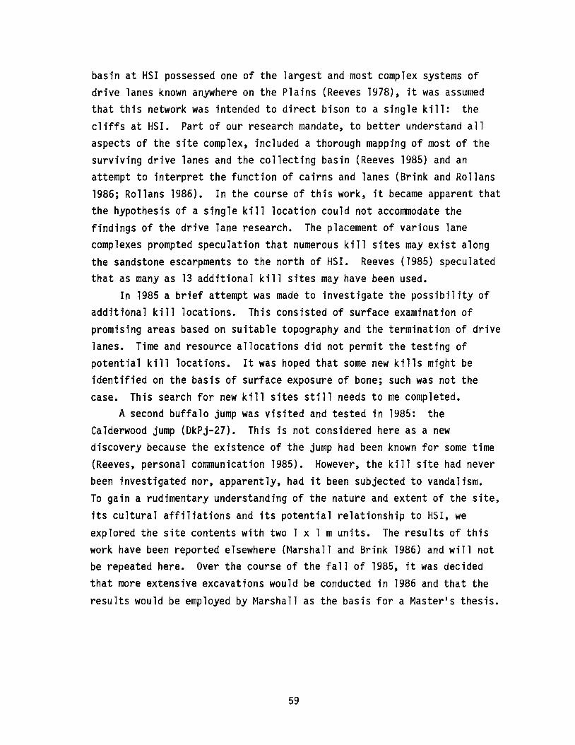
basin at HSI possessed one of the largest and most complex systems ofdrive lanes known anywhere on the Plains (Reeves 1978), it was assurnedthat this network was intended to direct bison to a single kill: thecliffs at HSI. Part of our research mandate, to better understand allaspects of the site complex, included a thorough mapping of most of thesurviving drive lanes and the collecting basin (Reeves 1985) and anattempt to interpret the function of cairns and lanes (Brink and Rollans1986; Rollans 1986). In the course of this work, it became apparent thatthe hypothesis of a single kill location could not accommodate thefindings of the drive lane research. The placement of various lanecomplexes prompted speculation that numerous kill sites may exist alongthe sandstone escarpments to the north of HSI. Reeves (1985) speculatedthat as many as 13 additional kill sites may have been used.
In 1985 a brief attempt was made to investigate the possibility ofadditional kill locations. This consisted of surface examination ofpromising areas based on suitable topography and the termination of drivelanes. Time and resource allocations did not permit the testing ofpotential kill locations. It was hoped that some new kills might beidentified on the basis of surface exposure of bone; such was not thecase. This search for new kill sites still needs to me completed.
A second buffalo jump was visited and tested in 1985: theCalderwood jump (DkPj-27). This is not considered here as a newdiscovery because the existence of the jump had been known for some time(Reeves, personal communication 1985). However, the kill site had neverbeen investigated nor, apparently, had it been subjected to vandalism.To gain a rudimentary understanding of the nature and extent of the site,its cultural affiliations and its potential relationship to HSI, weexplored the site contents with two 1 x 1 m units. The results of thiswork have been reported elsewhere (Marshall and Brink 1986) and will notbe repeated here. Over the course of the fall of 1985, it was decidedthat more extensive excavations would be conducted in 1986 and that theresults would be employed by Marshall as the basis for a Master1s thesis.
59
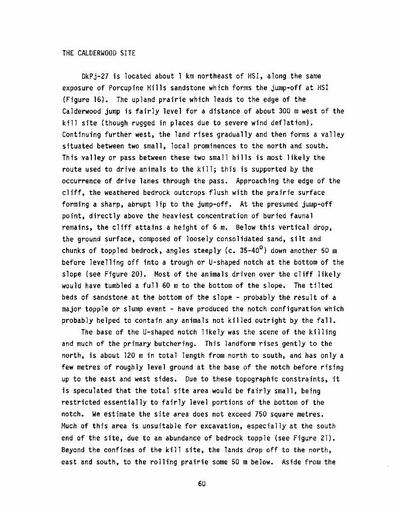
THE CALDERWOOD SITE
DkPj-27 is located about 1 km northeast of HSI, along the sameexposure of Porcupine Hills sandstone which forms the jump-off at HSI(Figure 16). The upland prairie which leads to the edge of theCalderwood jump is fairly level for a distance of about 300 mwest of thekill site (though rugged in places due to severe wind deflation).Continuing further west, the land rises gradually and then forms a valleysituated between two small, local prominences to the north and south.This valley or pass between these two small hills is most likely theroute used to drive animals to the kill; this is supported by theoccurrence of drive lanes through the pass. Approaching the edge of thecliff, the weathered bedrock outcrops flush with the prairie surfaceforming a sharp, abrupt lip to the jump-off. At the presumed jump-offpoint, directly above the heaviest concentration of buried faunalremains, the cliff attains a height of 6 m. Below this vertical drop,the ground surface, composed of loosely consolidated sand, silt andchunks of toppled bedrock, angles steeply (c. 35-400
) down another 50 mbefore levelling off into a trough or U-shaped notch at the bottom of theslope (see Figure 20). Most of the animals driven over the cliff likelywould have tumbled a full 60 m to the bottom of the slope. The tiltedbeds of sandstone at the bottom of the slope - probably the result of amajor topple or slump event - have produced the notch configuration whichprobably helped to contain any animals not killed outright by the fall.
The base of the U-shaped notch likely was the scene of the killingand much of the primary butchering. This landform rises gently to thenorth, is about 120 m in total length from north to south, and has only afew metres of roughly level ground at the base of the notch before risingup to the east and west sides. Due to these topographic constraints, itis speculated that the total site area would be fairly small, beingrestricted essentially to fairly level portions of the bottom of thenotch. We estimate the site area does not exceed 750 square metres.Much of this area is unsuitable for excavation, especially at the south
end of the site, due to an abundance of bedrock topple (see Figure 21).Beyond the confines of the kill site, the lands drop off to the north,
east and south, to the rolling prairie some 50 m below. Aside from the
60
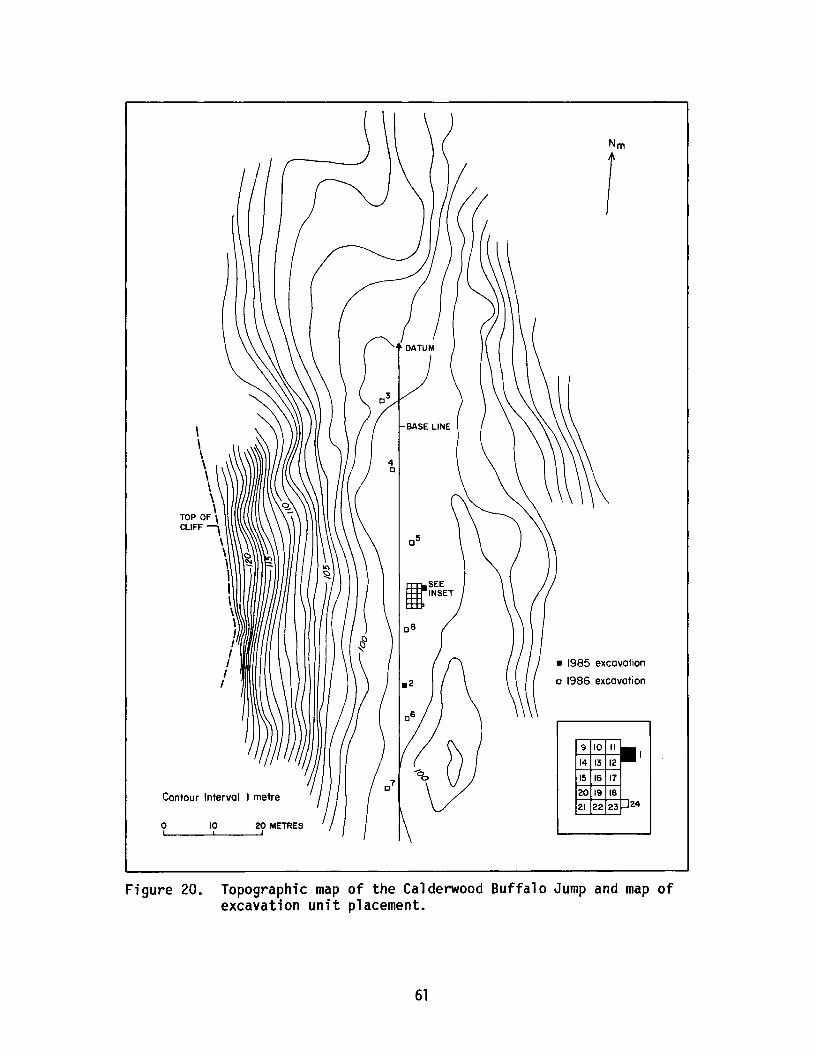
\\\\\\\\
TOP OF \CLIFF \
\\\,I\\\IIIIII
Contour Interval 1metre
o 10 20 METRES~I__----"-,__---',
Nm
1
• 1985 excavation
c 1986 excavation
9 10 II
14 13 12
15 16 17
20 19 18
21 22 23
Figure 20. Topographic map of the Calderwood Buffalo Jump and map ofexcavation unit placement.
61
Figure 21. Excavations at the Calderwood Buffalo Jump. Pits aresituated in the bottom of the notch below the cliff.
i mediate kill site, there is no adjacent area to which carcass portionscould have been transported for further butchering and processing. Thenearest area suitable for this task would have been the extensive prairiebelow the kill. Cursory examination of the surface of the prairie in1983 did result in the identification of scattered lithic artifacts.Years ago, Reeves had recorded this area as DkPj-3 and suggested that thematerials belonged to a camp/processing site which was probablyassociated with the nearby jump, but the area has never been tested.
METHODOLOGY
Fieldwork in 1986 commenced with the placement of a north/south
baseline running essentially down the centre of the notch and spanningnearly the entire length of the potential kill area (100 m). To
62

supplement the information obtained from the two units excavated in 1985(units 1 and 2), an additional six 1 x 1 m squares (units 3-8) wereplaced along the length of the baseline. Excavation of these test unitshelped to determine the most productive parts of the site. For example,unit 3, at the far north end of the baseline, was nearly sterile, and thenext units to the south, units 4 and 5, were likewise characterized by alow yield of cultural material. At the far south end, ample bone wasencountered in stratified layers, but the massive amounts of toppledbedrock made excavation extremely difficult or impossible. Based on the1985 and 1986 tests, it was decided to concentrate excavations in thevicinity of the centre of the notch where stratified cultural materialappeared to be plentiful and topple, while present, was notinsurmountable. An area was chosen for the excavation of 15 contiguous1 x 1 m units (Figure 20).
The excavation of both the test units and the block area employed10 cm arbitrary levels. While both natural and cultural stratigraphywere present, information gleaned from the test units suggested that itwould be exceedingly difficult to proceed with excavation via the use ofnatural stratigraphy. At times, layers of bone and natural strata wereclearly discernable and would have been relatively easy to follow in thefloors of the units. At other times, however, the convoluted topographyof the base of the notch combined with the complex depositional historyat the site (as discussed below) resulted in a merging and splitting ofnatural and cultural deposits. Combined use of arbitrary levels andcareful profiling of the walls of the block unit hopefully will permit areconstruction of site formation processes and events.
All identifiable bone was mapped in place, as were all features andfire-broken rock. Chipped stone artifacts were bagged according to the1 x 1 m unit of origin. All excavated materials were passed through a1/4 inch (0.6 cm) mesh. Bone fragmentation was extreme in some levels,especially where the bone lens had experienced severe burning. We did
not attempt to collect all unidentifiable bone fragments. Instead asingle unit was selected from which all bone was saved. The 5 x 3 mblock unit was opened and excavated to a depth of 30 cm below surface.Since our 1985 tests had indicated that cultural materials would extendto a depth of 1 m, it was decided that the time remaining in the 1986
63
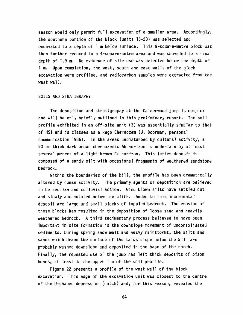
season would only permit full excavation of a smaller area. Accordingly,the southern portion of the block (units 15-23) was selected andexcavated to a depth of 1 m below surface. This 9-square-metre block wasthen further reduced to a 4-square-metre area and was shoveled to a finaldepth of 1.9 m. No evidence of site use was detected below the depth of1 m. Upon completion, the west, south and east walls of the blockexcavation were profiled, and radiocarbon samples were extracted from thewest wall.
SOILS AND STRATIGRAPHY
The deposition and stratigraphy at the Calderwood jump is complexand will be only briefly outlined in this preliminary report. The soilprofile exhibited in an off-site unit (3) was essentially similar to thatof HSI and is classed as a Rego Chernozem (J. Doormar, personalcommunication 1986). In the areas undisturbed by cultural activity, a50 cm thick dark brown chernozemic Ah horizon is underlain by at leastseveral metres of a light brown Ck horizon. This latter deposit iscomposed of a sandy silt with occasional fragments of weathered sandstonebedrock.
Within the boundaries of the kill, the profile has been dramaticallyaltered by human activity. The primary agents of deposition are believedto be aeolian and colluvial action. Wind blown silts have settled outand slowly accumulated below the cliff. Added to this incrementaldeposit are large and small blocks of toppled bedrock. The erosion ofthese blocks has resulted in the deposition of loose sand and heavilyweathered bedrock. A third sedimentary process believed to have beenimportant in site formation is the downslope movement of unconsolidatedsediments. During spring snow melt and heavy rainstorms, the silts andsands which drape the surface of the talus slope below the kill areprobably washed downslope and deposited in the base of the notch.Finally, the repeated use of the jump has left thick deposits of bisonbones, at least in the upper 1 mof the soil profile.
Figure 22 presents a profile of the west wall of the blockexcavation. This edge of the excavation unit was closest to the centreof the U-shaped depression (notch) and, for this reason, revealed the
64
50S,1.5E515,1.5E
I
~~:.. :. '.: ..~: .:: .:.: .::c;;).T~ ....>o'::.. ~. ~.:.::;:\ ~:: ':.':: :::'.: .. T~'. ~': :'/~'.:::: :.:.,
--------WIA -===~
525,1.5E
I
150
WI:e~i:i:? Unburned bone layer
~ Identified bone
1:<,'..>:1 Burned bone layer
o Sandstone
1111 Fired sandstone
~ Disturbed
t ·on at the Calderwood Buffalo Jump.profile, west wall, block excava 1Figure 22. Soil
clearest record of deposition at the site. Toward the east end of theexcavation, the ground surface began sloping back up, following thetilted bedrock. As this occurred, depositional layers which appearedclearly separated in the west profile began to pinch together. Figure23, the south wall profile, demonstrates this compression of strata fromwest to east. The enhanced resolution of the stratigraphy at the westend of the excavation can be attributed to the higher rate of depositionand minimal erosion which would typify the lowest point of the depressionin contrast to the inclined areas to either side.
Although the stratigraphy displayed in the west wall is far fromcrystal clear, it is suggested that four major cultural strata can bedelineated. In Figure 22, these strata are layers II, III, V and VII.In layer II, the hatched line, which lies at a depth of about 10-15 cmbelow surface, is a thin layer of unburned and fairly well-preservedbison bones. Layers III, V and VII are all thicker, heavily burned bonelenses. These three layers, especially layer III, all appear very blackin the profile due to the presence of massive amounts of charred bone.Pockets of white, calcined bone were connon in parts of layer V but rarein the other two burned horizons. Separating these four bone depositswere layers of lighter coloured, sandy silt particles mixed withsandstone fragments, as well as the occasional piece of burned andunburned bone. In no cases were the intervening sediments culturallysterile. Nevertheless, the transition between the major bone lenses andthe intervening mixed sediments was usually quite marked. The presenceof bone elements within the layers which separated the bone lenses isbelieved to be due to disturbance by burrowing animals and especially bydownslope movement of bone and sediment from the talus slope to the west.
Whether or not the four bone layers each represent a single use ofthe jump is still problematic. Multiple radiocarbon samples taken fromdifferent sections of the profiles may have to resolve this issue.Likewise, ongoing analysis of the lithic artifacts and faunal materialmay help clarify the sequence of site use. Pending these results, it iscurrently our suspicion that the four layers of bone identified between10 and 100 cm below surface represent four individual episodes of bisonkilling at DkPj-27. Based on radiocarbon dates obtained from test unit1, the earliest use of the site appears to be about 2,800 years ago and
66

1lDIB
j O _
53S,2.5E
I
t/iiii
535,3.5E
I
/~(//////// Unburned bone layer
t:==:J Identified bone
I.::';:: ·:····1 Burned bone layer
o Sandstone
_ Fired sandstone
~ Disturbed
. .-0-'-'-
150
100
53S,4.5EeM 0
Figure 23. Soil profile, south wall block excavations at the Calderwood Buffalo Jump.
the latest about 200 years ago (Marshall and Brink 1986:157). Although
our 1985 tests identified three distinct bone layers, compared with fourin 1986, our preliminary analysis of the 1986 data suggests that allkills were conducted within this same time period. That a fewer numberof and more shallowly buried bone layers were recorded in the 1985 testunit 1 is probably a result of the fact that this unit was placed to theeast side of the block excavations where the strata were more compressed.
EXCAVATION RESULTS
Faunal RemainsA total of 11,225 identifiable bison bone elements and fragments,
weighing 232.02 kg, were recovered during the 1986 season. All wereclassified as the present species, Bison bison. Remains of other species
were rare. A small amount of non-bison material was recovered duringexcavation, but it has not yet been identified. This material is thoughtto include small rodents, such as the Richardson1s ground squirrel(Spermophilus richarsonii), and canid remains of dog (Canis familiaris)or wolf (Canis lupus).
The first bone lens was encountered by the end of Levell (0-10 cmb.s.), almost directly under the sod layer, and continued into Level 2(20-30 cm b.s.). The lens was quite distinct, although not highlyvisible in profile. This upper bone lens is thought to represent adiscreet kill event as it was separated from the underlying bone lensesby relatively sterile soil. Bone preservation was generally good, withboth whole elements and large fragments noted.
By Level 4 (30-40 cm b.s.) massive amounts of heavily charred andburned bone covered the excavation floors. Calcined bone was evident and
appeared as distinct pockets. All bone was highly fragmented anddifficult to identify, but that identified consisted largely of small,
dense bones such as carpals, tarpals and phalanges. This rich lens began
near the top of the level and extended to 40-45 cm below surface. Very
little soil matrix was mixed with the bone which suggests that a great
deal of bone must have accumulated before burning occurred. The upper
and lower zones of the lens appear to be equally calcined, so the fire
must have consumed the entire bone lens.
68
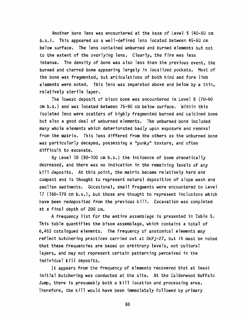
Another bone lens was encountered at the base of Level 5 (40-50 cmb.s.). This appeared as a well-defined lens located between 45-60 crnbelow surface. The lens contained unburned and burned elements but notto the extent of the overlying lens. Clearly, the fire was lessintense. The density of bone was also less than the previous event, theburned and charred bone appearing largely in localized pockets. Most ofthe bone was fragmented, but articulations of both hind and fore limbelements were noted. This lens was separated above and below by a thin,relatively sterile layer.
The lowest deposit of bison bone was encountered in Level 8 (70-S0cm b.s.) and was located between 75-90 cm below surface. Within thisisolated lens were scatters of highly fragmented burned and calcined bonebut also a good deal of unburned elements. The unburned bone includedmany whole elements which deteriorated badly upon exposure and removalfrom the matrix. This lens differed from the others as the unburned bonewas particularly decayed, possessing a "punky" texture, and oftendifficult to excavate.
By Level 10 (90-100 cm b.s.) the incidence of bone dramaticallydecreased, and there was no indication in the remaining levels of anykill deposits. At this point, the matrix became relatively hard andcompact and is thought to represent natural deposition of slope wash andaeolian sediments. Occasional, small fragments were encountered to Level17 (160-170 cm b.s.), but these are thought to represent inclusions whichhave been redeposited from the previous kill. Excavation was completedat a final depth of 200 cm.
A frequency list for the entire assemblage is presented in Table 5.This table quantifies the bison assemblage, which contains a total of6,453 catalogued elements. The frequency of anatomical elements mayreflect butchering practices carried out at DkPj-27, but it must be notedthat these frequencies are based on arbitrary levels, not culturallayers, and may not represent certain patterning perceived in the
individual kill deposits.It appears from the frequency of elements recovered that at least
initial butchering was conducted at the site. At the Calderwood BuffaloJump, there is presumably both a kill location and processing area.
Therefore, the kill would have been immediately followed by primary
69

Table 5. Frequency of bone elements (NISP), DkPj-27.
Element
SkullMandibleHyoidAtlasAxisCervical vertebraeThoracic vertebraeLumbar vertebraeSacrumCaudalRibsSternebraPelvisScapulaHumerusRadiusUlnaScaphoidLunateCuneiformPisiformMagnumUnciformFifth metacarpalFemurPatellaTibiaLateral malleolusAstragulusCalcaneusNavicular cuboidCuneiform pesFirst tarsalSecond tarsalMetacarpalMetatarsalMetapodialFirst phalanxSecond phalanxThird phalanxProximal sesamoidDistal sesamoidLong bone fragmentsEpiphysisCostal cartilageSkull fragmentsTooth fragments
Frequency
299130
122517
119162
552132
3462
11714118017095
12110411537
1259610
15117
15555
220145166111
108
131134264441458137265
95141
23
3484
70
Percentage
3.52.00.20.40.31.82.50.90.30.55.4o1.82.22.82.61.51.91.61.80.61.91.50.22.30.32.40.93.42.22.61. 70.2O. 12.02. 14. 16.87.12. 14. 11.52.2oo0.51.3

Table 5. continued
Element
Upper toothIncisor/canineLower molar/premolarRib fragmentsVertebral fragmentsIntervertebral discUnknownTotal
Frequency
18379
202136945516
6543
Percentage
2.81.23. 12. 11.50.90.3
100.0
butchering of the carcasses. Portable units may have been takendownslope for further processing. Consequently, not all anatomicalelements would be transported from the kill site. During initialbutchering, decisions must have been made as to the particular value of agiven element. Thus, much of the remaining elements predictably would bethe least desirable or low utility elements (Binford 1978). Thoseregarded as highly desirable, more useful elements were carried away to aprocessing area or campsite.
Lithic AssemblageA total of 582 lithic artifacts were recovered at the Calderwood
Buffalo Jump during the 1986 season. The assemblage consists of 579flaked stone artifacts and debitage and three ground stone tools. Theflaked stone assemblage consists of 494 pieces of debitage, four coresand 81 retouched artifacts. The retouched artifacts include 45projectile points and point fragments. The projectile points illustratedifferent styles characteristic of both the Late and Middle Prehistoricperiods and represent varieties of both atlatl darts and arrowheads (seeFigure 24). Where possible, projectile point classification was based onknown point typologies (after Reeves 1983a). Otherwise, simplemorphological descriptions were used.
All lithics were sorted into six classes, following an abridgedversion of that employed for HSI, and represent the products andby-products of stone tool manufacture (Brink et ale 1985:313).
71
Figure 24. Projectile points recovered from the Calderwood Buffalo Jump.
Distribution of the assemblage by lithic category and material type ispresented in Table 6.
The lithic assemblage recovered from the Calderwood Buffalo Jumprepresents different stages in lithic reduction, including a number oflarge quartzite flakes and heavy tools associated with the early stagesof tool manufacture. Presumably, these were used as cutting or choppingtools. Retouch flakes, having a wide variety of cutting and choppingedges, were likely used in the disarticulation of bison carcasses. Coresere reduced to produce large, coarse flakes with some individual flakes
being unifacially and bifacially retouched for use as scraping tools.Non-local material is represented by small, usually broken tools,
especially projectile points and small, thin resharpening flakes.Scarcity of complete tools suggests that they were carried away from thesite, presumably for future use. Tools produced of fine quality,
72
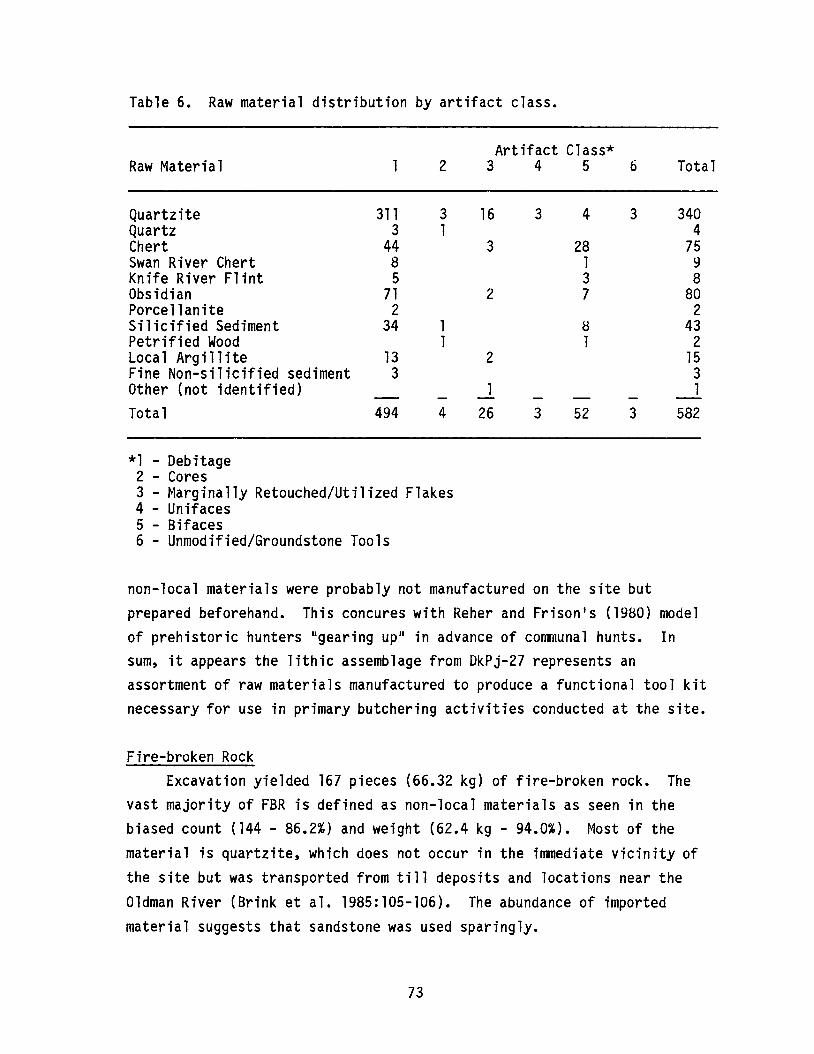
Table 6. Raw material distribution by artifact class.
Artifact Class*Raw Material 2 3 4 5 6 Total
Quartzite 311 3 16 3 4 3 340Quartz 3 1 4Chert 44 3 28 75Swan River Chert 8 1 9Knife River Flint 5 3 8Obsidian 71 2 7 80Porcellanite 2 2Silicified Sediment 34 1 8 43Petrified Wood 1 1 2Local Argillite 13 2 15Fine Non-silicified sediment 3 3Other (not identified) 1 1Total 494 4 26 3 52 3 582
*1 - Debitage2 - Cores3 - Marginally Retouched/Utilized Flakes4 - Unifaces5 - Bifaces6 - Unmodified/Groundstone Tools
non-local materials were probably not manufactured on the site butprepared beforehand. This concures with Reher and Frison1s (1980) modelof prehistoric hunters IIgearing Upll in advance of communal hunts. Insum, it appears the lithic assemblage from DkPj-27 represents anassortment of raw materials manufactured to produce a functional tool kitnecessary for use in primary butchering activities conducted at the site.
Fire-broken RockExcavation yielded 167 pieces (66.32 kg) of fire-broken rock. The
vast majority of FBR is defined as non-local materials as seen in thebiased count (144 - 86.2%) and weight (62.4 kg - 94.0%). Most of thematerial is quartzite, which does not occur in the immediate vicinity ofthe site but was transported from till deposits and locations near theOldman River (Brink et ale 1985:105-106). The abundance of importedmaterial suggests that sandstone was used sparingly.
73

The size distribution presented in Table 7 shows that the majorityof FBR (B8.1%) is less than 10 square cm in size. The properties of heattransfer and distance to the raw material may be factors in size, urgingrecycling. In addition, it should be noted that some FBR was heavilyoxidized, indicating intense and direct heat exposure. While it is notpossible at this time to differentiate FBR utilized at the site with thatcreated by fire, it is plausible that burning of the bone lenses wasresponsible for some of the material identified as FBR.
FeaturesOnly one possible feature was recovered. This appeared as a
concentration of FBR in a roughly circular pattern in Unit 8, Level 6
(50-60 cm b.s.). Approximately 40 cm in diameter, it contained severallarge broken and unbroken quartzite cobbles and fired sandstone. Insideand around the FBR, the floor produced a reddish stained soil and ascattering of charred and calcined bone. This cluster may have beenhearth matrix material associated with the FBR. Alternatively, it couldsimply have been caused by firing of the bone lens at this level.
Table 7. Size distribution of FBR by material type.
Size (sq. cm)
0-5
5-10
10-15
15-20
> 20
Total
Non-sandstone(primarily quartzite)
n = 37% = 22.2
n = 88%= 52.7
n = lB%= 10.7
n = 1%= 0.6
144
74
Sandstone
n = 11%= 6.6
n = 11%= 6.6
n = 1%= 0.6
23
However, it is conspicuous as no discrete concentrations of FBR werefound in any other unit.
SUMMARY
The 1986 season at the Calderwood Buffalo Jump (DkPj-27) includedthe excavation of six additional 1 x 1 mtest units and a block area 15square metres in size. This represents approximately 2.8 percent of theestimated total area of the kill site deposits. The placement of testunits in a north-south line along the base of the notch below the cliffhelped to clarify the size and nature of subsurface deposits and todetermine the most productive areas for further excavation. Thisdecision took into account our two primary concerns: the presence ofstratified layers of bison bones and a relative absence of toppledsandstone bedrock. The eventual site of the block excavation met boththese concerns.
Preliminary results of the Calderwood excavations indicate that thejump was used a minimum of four times between 2,800 and 200 years ago.Additional radiocarbon samples were taken in 1986 and likely will helpclarify the chronology of the site. Stratified layers of bison bone werebest displayed in the west end of the block excavation and were morecompressed in shallower soil to the east side. This variation within avery small area was a result of site topography as controlled by theconfiguration of local bedrock. There may yet be other areas of the sitewhere factors of deposition have preserved and separated additional killevents; that is, the four layers recognized in the 1986 excavations couldeach be compressions of several kill events which took place in fairlyrapid succession and which might be preserved elsewhere at the site inseparate context. One suggestion of this possibility was noted in testunit 6, where butchered bison bones were encountered at a depth of 1.4 mbelow surface. Whether this is an earlier kill episode or simply agreater depth of burial of the lowest kill deposit in the blockexcavation (layer VIII, Figure 22) is not known. Samples of the unit 6bone layer have been submitted for radiocarbon dating.
It is equally possible that the jump was infrequently used and thatthe bone layers we recorded are the result of single-use episodes. The
75

great depth (c. 10 m) of the bone deposits at the nearby HSI kill siteand the long cultural-historical sequence exhibited at the site areevidence that HSI was the primary target for bison drives. TheCalderwood jump may have been one of a series of alternate kill locationsthat were used only when certain conditions existed which made the use ofthe HSI kill unacceptable. The most likely such condition would havebeen the placement of a suitably sized herd of bison in the immediatevicinity of the Calderwood jump. The topographic swale or pass whichleads from the collecting area to the jump is relatively small and onlyopens into one tributary IIfinger basin ll of the entire collecting area.In contrast, the HSI kill is fed by a large, broad pass which opens intothe whole of the 40 square km gathering basin. It seems probable thatthe Calderwood jump would have been used when herds were already grazingin or very near the small pass leading to the jump, and that herds foundoutside of this restricted area were likely driven to the HSI kill siteor to other kill locations still undiscovered.
Faunal material from the excavations was abundant but generallypoorly preserved. The best preserved layer was the most recent killevent, encountered at a depth of about 15 cm below surface. None of thebone from this episode was burned, hence the percentage of identifiablebone was relatively high. All other bone layers were characterized by anabundance of charred and calcined bone. However, even within the smallarea excavated it was apparent that the entire bone deposits were notevenly burned (see Figure 25). The percentage of identifiable bone inthese lower layers was quite low. Tens, if not hundreds, of thousands oftiny charred and calcined bone fragments made up the bulk of theselayers. Identifiable specimens tended to be the hard, dense elementssuch as phalanges, carpals, tarsals and long bone shaft fragments.
Lithic artifacts were relatively rare at the Calderwood jump. Atotal of only 582 specimens were recovered: 81 formed tools, 494 flakesand debitage, four cores and three ground stone tools. Of the formedtools, 48 specimens are identified as projectile points. The majority ofthe points (n=28) consist of very small, unanalyzable fragments. Twentyspecimens were complete enough to permit detailed examination. Thisnumber is quite low compared with the generally high occurrence of pointsat bison kill sites in southern Alberta (Forbis 1962; Reeves 1978). If
76
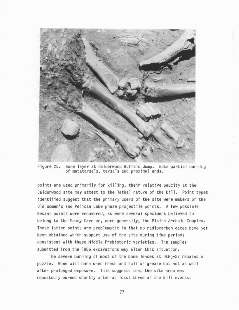
Figure 25. Bone layer at Calderwood Buffalo Jump. Note partial burningof metatarsals, tarsals and proximal ends.
points are used primarily for killing, their relative paucity at theCalderwood site may attest to the lethal nature of the kill. Point typesidentified suggest that the primary users of the site were makers of theOld Women1s and Pelican Lake phase projectile points. A few possibleBesant points were recovered, as were several specimens believed tobelong to the Mummy Cave or, more generally, the Plains Archaic Co plex.
These latter points are problematic in that no radiocarbon dates have yetbeen obtained which support use of the site during time periodsconsistent with these Middle Prehistoric varieties. The samples
submitted from the 1986 excavations may alter this situation.The severe burning of most of the bone lenses at DkPj-27 remains a
puzzle. Bone will burn when fresh and full of grease but not as wellafter prolonged exposure. This suggests that the site area wasrepeatedly burned shortly after at least three of the kill events.
77
Frison (1970:6) has raised the possibility that bison kill sites wereintentionally burned by the hunters as a means of clearing the site forsubsequent use. The alternate hypothesis is that natural fires sweptover the region igniting the bone. Arguing against the latter scenariois the fact that wind-swept grass fires generate little heat, and thenecessary coincidence that natural fires would occur shortly after eachkill episode. In other words, we doubt that most prairie fires wouldgenerate sufficient heat during their short life span at a specific spotto cause the bison bone to char and become calcined as exhibited in thelayers at the Calderwood jump. Our own experiments suggest that freshbison bones burn quite well if added to a hot fire but are otherwise hardto ignite. The presence of fire-broken rock at the site indicates thatculturally initiated fires were a feature associated with site use. Atthe time of site abandonment, hunters may have intentionally throwndiscarded bone into the fires in attempt to burn off much of the wastematerial.
Analysis of the Calderwood Buffalo Jump archaeological material iscontinuing as a Master1s thesis project. Examination and comparison ofthe 1986 excavation data promise to provide an interesting adjunct to ourknowledge of bison jumping at Head-Smashed-In and to our growingunderstanding of the prehistoric use of a large region - not just asingle site - for orchestrating communal bison kills.
78

LOCATIONAL VARIABILITY OF ARCHAEOLOGICAL SITES IN THEPEACE RIVER - GRANDE PRAIRIE REGION OF NORTHWESTERN ALBERTA
ByMartin P.R. Magne
Archaeological Survey of Alberta
INTRODUCTION
Archaeological site databases, whether we like them or not, are hereto stay. While they serve a useful function in the management of theresource, there has been little attempt to explore these databases fortheir potential to yield information regarding prehistoric settlementpatterning. With the large amount of data being generated by impactassessment surveys, I think it is worthwhile to exp'lore patternrecognition in the database. This may be particularly crucial in an areawhere the known site density is rather low.
One of the major functions of research staff of the ArchaeologicalSurvey of Alberta (and historical resource managers everywhere) is theassessment of proposed development areas for their potential to containarchaeological sites. On the bases of previous experience, theethnographic record, the existing site record, some select physiographicvariables and some soul-searching, recommendations are made for oragainst the conduct of impact assessment programmes. In certain types ofdevelopment, such as large dams, extensive roads, power lines orpipelines, sites almost certainly exist somewhere in the project area.We have much more difficulty assessing smaller, localized developments,such as gas wells or gravel pits. These difficulties aside, it is worthexamining if we are detecting a wide range of prehistoric and historicsettlement patterning with the existing site record, especially in anarea where the known site density is low.
Note: This paper was originally read at the Saskatchewan-AlbertaDialogue (SAD) Symposium, held in Edmonton in January, 1986.
79

If we reflect on the probable range of settlement patterns that havebeen possible over the last ca. 10,000 years, we can expect a certainamount of redundancy to be present in locational data, due largely tophysiographic and subsistence resource constraints. It is commonpractice when surveying, for example, to expect sites to occur in areaswhere contemporary settlements, campsites and so on exist today. Inaddition, fish capability and ungulate capability have been investigatedin northeastern Alberta (Donahue 1976) and have been shown to havesignificant bearing on site density in certain areas.
Northwestern Alberta is an area of quite low site density. Itincludes about one third of the area of the province and only fourpercent (ca. 700) of all known sites (ca. 18,000). Half of the sites inthis region are concentrated in the Grande Prairie and Peace Riverareas. It is my guess that about half of these have been recordedthrough impact assessment projects.
This paper analyzes geographic variability in known site locationsin northwestern Alberta and identifies potentially important differencesbetween two specific regions. These are preliminary results of ongoingresearch that also includes investigation of the utility of experimentalvariables in predicting site locations.
THE SAMPLE
Locational data were tabulated for 284 prehistoric and historicsites that could be plotted on four 1:250,000 NTS map sheets (83M, 83N,84C and 840), between 55 and 570 north latitude and 116 and 1190 westlongitude. The total area comprises over 5~,500 square km (Figure 26).I should note that the site record contains Borden numbers forapproximately 100 additional sites whose precise locations are notknown. The sample comprises 235 prehistoric sites, 33 historic agesites, and 16 sites whose general age is not known. Thirty-four percent
of the sample consists of lithic scatters; 22 percent are isolated finds;and 31 percent are IIcampsites.1I Also represented are three trading
posts, eight buildings, and seven other kinds of sites whose IIfunction ll
could be easily debated. Eighty-seven (31%) sites have not beenclassified into any of the common types.
80
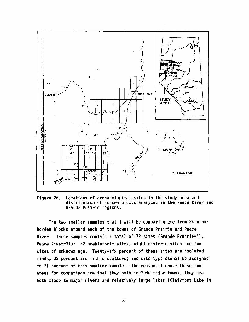
3 Three sites
2 -34
- 2-4 9
2 69(- Lesser Slave
o'+-~ Lake -C;~
2 -
2
4
33
----32-
212-
4
24
92
2
Figure 26. Locations of archaeological sites in the study area anddistribution of Borden blocks analyzed in the Peace River andGrande Prairie regions.
The two smaller samples that I will be comparing are from 24 minorBorden blocks around each of the towns of Grande Prairie and PeaceRiver. These samples contain a total of 72 sites (Grande Prairie=4l,Peace River=3l): 62 prehistoric sites, eight historic sites and twosites of unknown age. Twenty-six percent of these sites are isolatedfinds; 32 percent are lithic scatters; and site type cannot be assignedto 31 percent of this smaller sample. The reasons I chose these twoareas for comparison are that they both include major towns, they areboth close to major rivers and relatively large lakes (Clairmont Lake in
81
Peace River; Bear Lake in Grande Prairie) and, in general, they containsimilar environments.
THE DATA
For the entire sample of 284 sites, 25 variables were recorded. Ofthese, 15 are used in the analyses to follow. Knowing that metricmultivariate statistics would be the major analytic method used, thesevariables needed to be at least ordinal in nature, and most arecontinuous. The variables used are as follows:
(1) Horizontal distance to nearest water (WAHO)(2) Direction to water (WADR)(3) Vertical distance to water (WAVE)(4) Distance to major river/lake (WAMA)(5) Slope within 500 m (SLOP)(6) Direction of major slope (SLUR)(7) Overview (OVER)(8) Topographic position (Tapa)(9) Distance to buildings (BLDG)
(10) Distance to historical trail (TRAIL)(11) Distance to road (ROAD)(12) Distance to archaeological site(SITE)(13) Fish capability (FISH)(14) Waterfowl capability (FOWL)(15) Ungulate capability (UNGU)The variables latitude, longitude and elevation are omitted since theywould no doubt combine into very strong factors of overall percent ofvariability explained and tell us nothing more than where sites arelocated. In addition, I decided to omit the variables of distance toroad and distance to historic trail because, in this highly cultivatedregion, section roads are ubiquitous - everything is close to a road and the historic trail data are not complete for the southern part of thearea of concern.
82
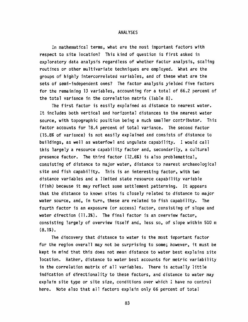
ANALYSES
In mathematical terms, what are the most important factors withrespect to site location? This kind of question is first asked inexploratory data analysis regardless of whether factor analysis, scalingroutines or other multivariate techniques are employed. What are thegroups of highly intercorrelated variables, and of these what are thesets of semi-independent ones? The factor analysis yielded five factorsfor the remaining 13 variables, accounting for a total of 66.2 percent ofthe total variance in the correlation matrix (Table 8).
The first factor is easily explained as distance to nearest water.It includes both vertical and horizontal distances to the nearest watersource, with topographic position being a much smaller contributor. Thisfactor accounts for 18.4 percent of total variance. The second factor(15.8% of variance) is not easily explained and consists of distance tobuildings, as well as waterfowl and ungulate capability. I would callthis largely a resource capability factor and, secondarily, a culturalpresence factor. The third factor (12.6%) is also problematical,consisting of distance to major water, distance to nearest archaeologicalsite and fish capability. This is an interesting factor, with twodistance variables and a limited state resource capability variable(fish) because it may reflect some settlement patterning. It appearsthat the distance to known sites is closely related to distance to majorwater source, and, in turn, these are related to fish capability. Thefourth factor is an exposure (or access) factor, consisting of slope andwater direction (11.3%). The final factor is an overview factor,consisting largely of overview itself and, less so, of slope within 500 m(8.1%).
The discovery that distance to water is the most important factorfor the region overall may not be surprising to some; however, it must bekept in mind that this does not mean distance to water best explains sitelocation. Rather, distance to water best accounts for metric variabilityin the correlation matrix of all variables. There is actually littleindication of directionality to these factors, and distance to water mayexplain site type or site size, conditions over which I have no controlhere. Note also that all factors explain only 66 percent of total
83
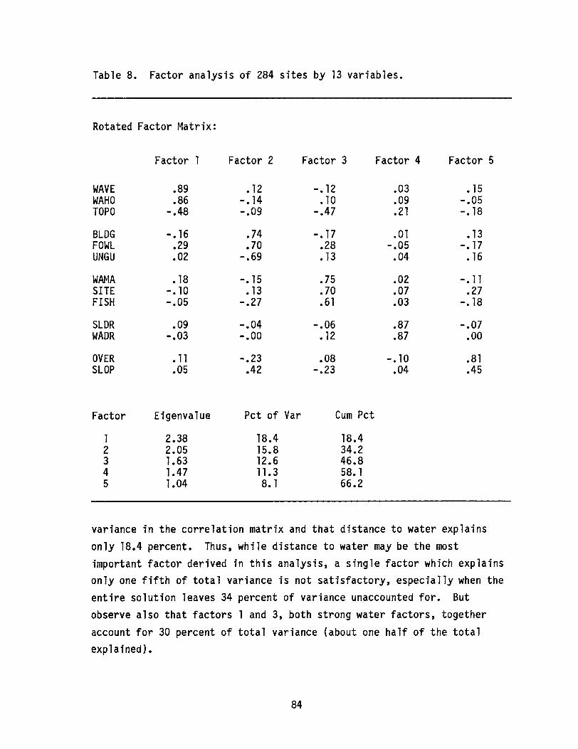
Table 8. Factor analysis of 284 sites by 13 variables.
Rotated Factor Matrix:
Factor 1 Factor 2 Factor 3 Factor 4 Factor 5
WAVE .89 •12 -. 12 .03 •15WAHO .86 -. 14 •10 .09 -.05TOPO -.48 -.09 -.47 .21 -. 18
BLDG -. 16 .74 -. 17 .01 •13FOWL .29 .70 .28 -.05 -. 17UNGU .02 -.69 •13 .04 •16
WAMA •18 -. 15 .75 .02 -.11SITE -. 10 •13 .70 .07 .27FISH -.05 -.27 .61 .03 -. 18
SLDR .09 -.04 -.06 .87 -.07WADR -.03 -.00 •12 .87 .00
OVER •11 -.23 .08 -. 10 .81SLOP .05 .42 -.23 .04 .45
Factor Eigenvalue Pct of Var Cum Pct
1 2.38 18.4 18.42 2.05 15.8 34.23 1.63 12.6 46.84 1.47 11.3 58. 15 1.04 8. 1 66.2
variance in the correlation matrix and that distance to water explainsonly 18.4 percent. Thus, while distance to water may be the mostimportant factor derived in this analysis, a single factor which explainsonly one fifth of total variance is not satisfactory, especially when theentire solution leaves 34 percent of variance unaccounted for. Butobserve also that factors 1 and 3, both strong water factors, togetheraccount for 30 percent of total variance (about one half of the totalexplained).
84
If we turn to the smaller sample of sites from the Grande Prairieand Peace River regions and undertake a similar analysis, much the samesolution is achieved (Table 9). Again, a distance to water factor isobtained which accounts for 21 percent of variance. Another generalwater factor, consisting of distance to major water source and fishcapability (and distance to buildings), accounts for 16 percent. Thethird factor (14%) is the exposure or access factor again (slopedirection and direction to water), and the final two factors aredominated by ungulate capability and overview. In this analysis,69 percent of total variance is explained, a slightly better solutionthan that achieved with the larger sample. Here the water factoraccounts for 37 percent of variance, again about half of total varianceexplained.
In comparing the two analyses, it is important to note that overallvariability is explained in much the same way in both large and smallsamples and that, in both analyses, some 30 percent of variabilityremains unexplained with the current set of variables. Thus, these twoareas can be considered representative of the range of site conditionsthat exist.
The next problem is to determine if there are significantdifferences in site location between the two areas. Are the samedeterminants of site location present in each area? Are there patternswhich we could attribute to settlement and subsistence traditions? Thisproblem is approached with discriminant analysis, which seeks an equationby which sites can be classified as belonging to either of the tworegions. Thus, knowing which variables are most important indifferentiating the two regions can be useful in demonstrating whether ornot those variables are equally important in each area.
The discriminant function derived (Table 10) is capable of correctlyassigning the small sample of sites to the Grande Prairie or Peace Riverregions with 80.28 percent accuracy, using only seven of the 13variables. The analysis shows that, with the shortened variable list,
sites can be located to either Grande Prairie or Peace River with a highdegree of accuracy. In contrast to the factor analyses above,differences between sites in the two regions are best expressed with thevariables of fish capability, topographic position, distance to
85
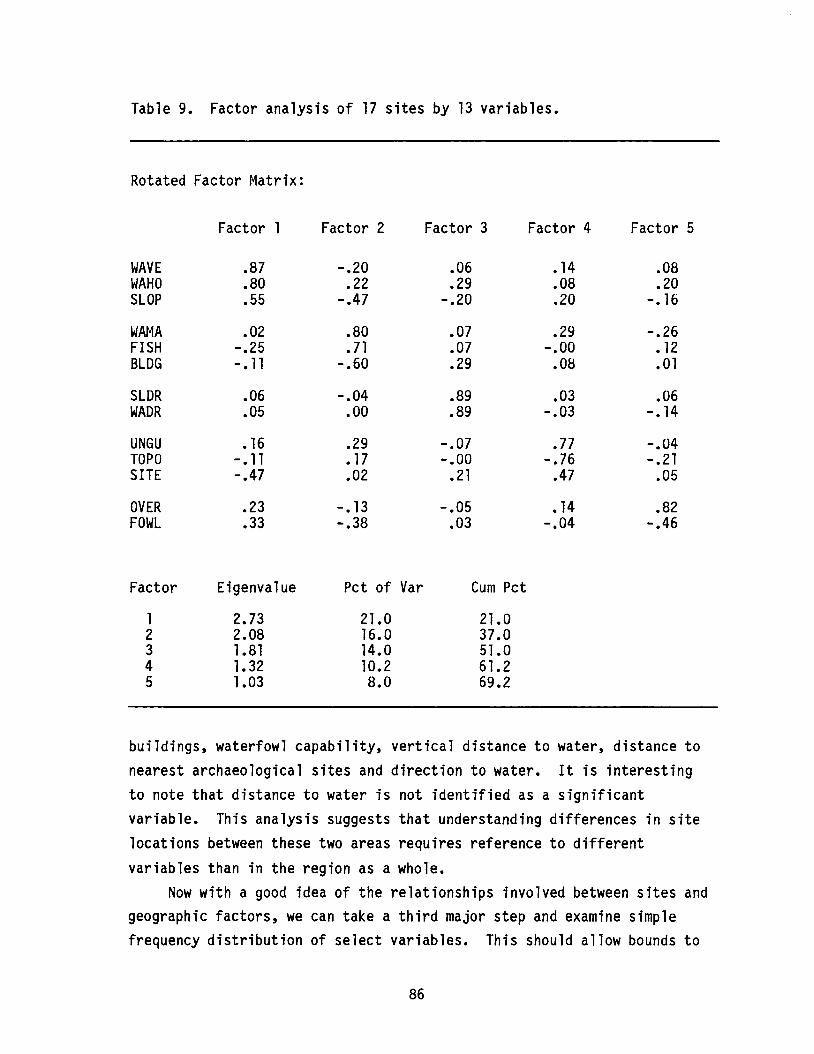
Table 9. Factor analysis of 17 sites by 13 variables.
Rotated Factor Matrix:
Factor 1 Factor 2 Factor 3 Factor 4 Factor 5
WAVE .87 -.20 .06 •14 .08WAHO .80 .22 .29 .08 .20SLOP .55 -.47 -.20 .20 -. 16
WAr~A .02 .80 .07 .29 -.26FISH -.25 .71 .07 -.00 •12BLDG -. 11 -.60 .29 .08 .01
SLDR .06 -.04 .89 .03 .06WADR .05 .00 .89 -.03 -. 14
UNGU •16 .29 -.07 .77 -.04TOPO -.11 •17 -.00 -.76 -.21SITE -.47 .02 .21 .47 .05
OVER .23 -. 13 -.05 •14 .82FOWL .33 -.38 .03 -.04 -.46
Factor Eigenvalue Pct of Var Cum Pct
1 2.73 21.0 21.02 2.08 16.0 37.03 1.81 14.0 51.04 1.32 10.2 61.25 1.03 8.0 69.2
buildings, waterfowl capability, vertical distance to water, distance tonearest archaeological sites and direction to water. It is interestingto note that distance to water is not identified as a significantvariable. This analysis suggests that understanding differences in sitelocations between these two areas requires reference to different
variables than in the region as a whole.Now with a good idea of the relationships involved between sites and
geographic factors, we can take a third major step and examine simplefrequency distribution of select variables. This should allow bounds to
86
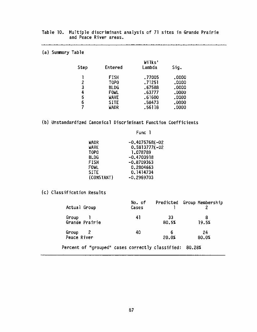
Table 10. Multiple discriminant analysis of 71 sites in Grande Prairieand Peace River areas.
(a) Summary Table
Wilks·Step Entered Lambda Sig.
1 FISH .77005 .00002 TOPO .71251 .00003 BLDG .67588 .00004 FOWL .63777 .00005 WAVE .61600 .00006 SITE .58473 .00007 WADR .56118 .0000
(b) Unstandardized Canonical Discriminant Function Coefficients
Func 1
WADRWAVETOPOBLDGFISHFOWLSITE(CONSTANT)
(c) Classification Results
Actual Group
Group 1Grande Prairie
Group 2Peace River
-0.4075768E-020.5813777E-021.078789
-0.4703918-0.87093630.2804663O. 1414734
-0.2969703
No. of Predicted Group MembershipCases 1 2
41 33 880.5% 19.5%
40 6 2420.0% 80.0%
Percent of IIgroupedll cases correctly classified: 80.28%
87

be set on major patterns. This information could be used to helpreconstruct settlement patterns with known limits to the distances,slopes and site exposures involved and could help guide management of theresources.
ANALYSIS OF FREQUENCY DISTRIBUTIONS
The preceding multivariate analyses identified a select fewvariables from those initially gathered which explain much of thevariability in archaeological site locations. To understand morecompletely why sites are located where they are and to speak in physicalterms about certain limits to their distributions, we need to examineclosely the actual frequency distributions. The variables examined herefigured strongly in both the general analysis and in the Grande Prairie Peace River discriminant analysis. They include distance to water, fishand waterfowl resource capability, distance to nearest archaeologicalsite, slope and water direction, and distance to nearest building. Thefollowing discussion compares the 24 Borden block areas around each ofthe towns of Grande Prairie and Peace River.
Distance to Major WaterIn Figure 27, separate histograms are plotted for the two areas,
showing frequency of sites with kilometre distances from a major river orlake. There are weak trimodal distributions with slight differences inactual modes in each area of comparison. The Grande Prairie distributionpeaks at 0.5 km, falls off rapidly at 2.5 km, and peaks again at 10.0 kmor more. The Peace River distribution has two strong peaks: one at0.3 km; the other at 5.3 km. In both cases, there appears to be strongconcentration of sites in the 0 to 2.0 km area, a shortage of sites inthe 2.0 to 4.0 km range, a recurrence, particularly in the Peace Riverarea, of sites in the 4.5 to 6.5 km range, then a peak in the 8.0 to10.0 km range, especially in the Grande Prairie area.
Vertical Distance to WaterThis variable exhibits sharp bimodality in each of the regions of
concern (Figure 28), with peaks at 15 and 100 mabove water in the Grande
88

GRANDE PRAIRIE
IS
10
5
~ucCD
6-a»..to
o I 234 S 678
Distance to major river/lake (km)
PEACE RIVER
15
10
~uca»6-a»..to
9 10 0 I 2 3 4 S 6 7 8 9
Distance to major river/lake (km)
Figure 27. Histograms of distance to major river or lake, Grande Prairieand Peace River regions.
GRANDE PRAIRIE
IS
10
5
~cCD
iLt o
o 30 10 ., 120 ISO
Vertical distance to water (m)
PEACE RIVER
15
10
5
~uca»6!LLO
180 0 30 60 90 120 150 180
Vertical distance to water (m)210 240
Figure 28. Histograms of vertical distance to nearest water, GrandePrairie and Peace River regions.
89

Prairie region and at 0 and 240 mabove water in the Peace ~iver region.Essentially, these distributions show a strong tendency for sites to belocated either very close to water level or at the valley top. Thedifferences in scale simply reflect the differences in relativetopography between the two areas.
Distance to BuildingsAs can be seen in Figure 29, most sites tend to be situated quite
close to existing buildings (well within 1 km). The Peace Riverdistribution exhibits some bimodality with a secondary grouping of sitesbetween about 1.75 and 2.5 km from buildings.
Direction to WaterIn both the Grande Prairie and Peace River regions, there is a
strong tendency for the closest water source to be located south of thesites; that is, sites tend to be found on the north side of rivers,
. creeks, lakes and sloughs (Figure 30). This tendency is most marked inthe Grande Prairie area, while in the Peace River area a tendency alsoexists for sites to be located either on the west or east sides of thenearest water source. Furthermore, while a few sites are situated on thesouth side of water in the Grande Prairie area, no sites in the PeaceRiver area exhibit this characteristic.
Distance to Archaeological SiteFigure 31 clearly shows that most archaeological sites are located
within about 2 km of the nearest other site. There is no doubt that afair amount of sampling bias is reflected here; however, the modes ineach area are at about 500 m. This can be interpreted as beingindicative of strong cultural selectivity in site location over aconsiderable period of time. Those instances where sites are 10 km ormore distant from the nearest site are likely due to surveys in areas
which have witnessed little intensive investigation.
Fish CapabilityOn the whole, the Grande Prairie area exhibits more sites in areas
with severe restrictions to fish than does the Peace River area. In the
90
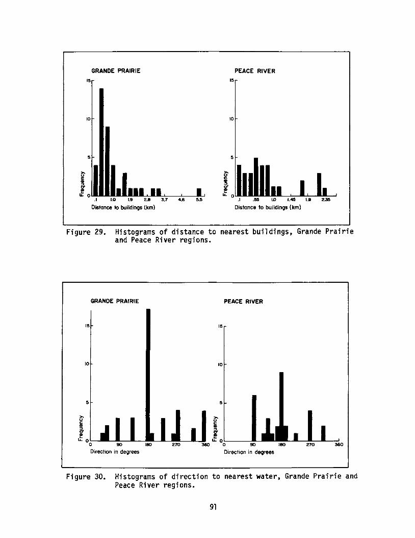
~UC•llL. 0
GRANDE PRAIRIE
15
10
~Uc
flL. 0 lIJU.I.I1I
.1 1.0 1.9 2.8 3.7 4.6 5.5
Distance to buildings (km)
15
10
5
PEACE RIVER
.I .55 ID I.ee 1.9 2.3e
Distance to buildings (km)
Figure 29. Histograms of distance to nearest buildings, Grande Prairieand Peace River regions.
GRANDE PRAIRIE
15
10
5
~UCCD
6-CDLt oo 90 180
Direction in degrees270
PEACE RIVER
15
10
~UCCD
&!~ o~-_....-.-
360 0 90 180
Direction in degrees
270 360
Figure 30. Histograms of direction to nearest water, Grande Prairie andPeace River regions.
91

GRANDE PRAIRIE
15
10
5
~ucCD
6-CDLt o
01 234 S 678
Distance to archaeological site (km)
PEACE RIVER
15 ...
10
~ucCD
S-f I"0 I I I I
9 10 0 I 2 3 4 S 6 7 8 , 10
Distance to archoeolOCJicol sit. (km)
Figure 31. Histograms of distance to nearest archaeological site, GrandePrairie and Peace River regions.
latter area, sites tend to be located in areas with only slightrestrictions (Figure 32). In other words, fishing may have been a moreimportant subsistence activity in the Peace River region than in theGrande Prairie region.
Waterfowl CapabilityIn opposition to the fish capability values, the Grande Prairie area
shows more sites located in areas with slight or no limitations towaterfowl than does the Peace River area (Figure 33). In the Peace Riverarea, all sites are in zones with severe restrictions on the availabilityof waterfowl.
INTERPRETATION OF FREQUENCY DISTRIBUTIONS
Leaving aside the difficulties in estimating the effects of sampling
bias in the preceding analyses, several settlement pattern inferences canbe suggested. In the early days of the SARG project (Gumerman 1971), itwas clear that southwestern American archaeologists were dealing with a
92
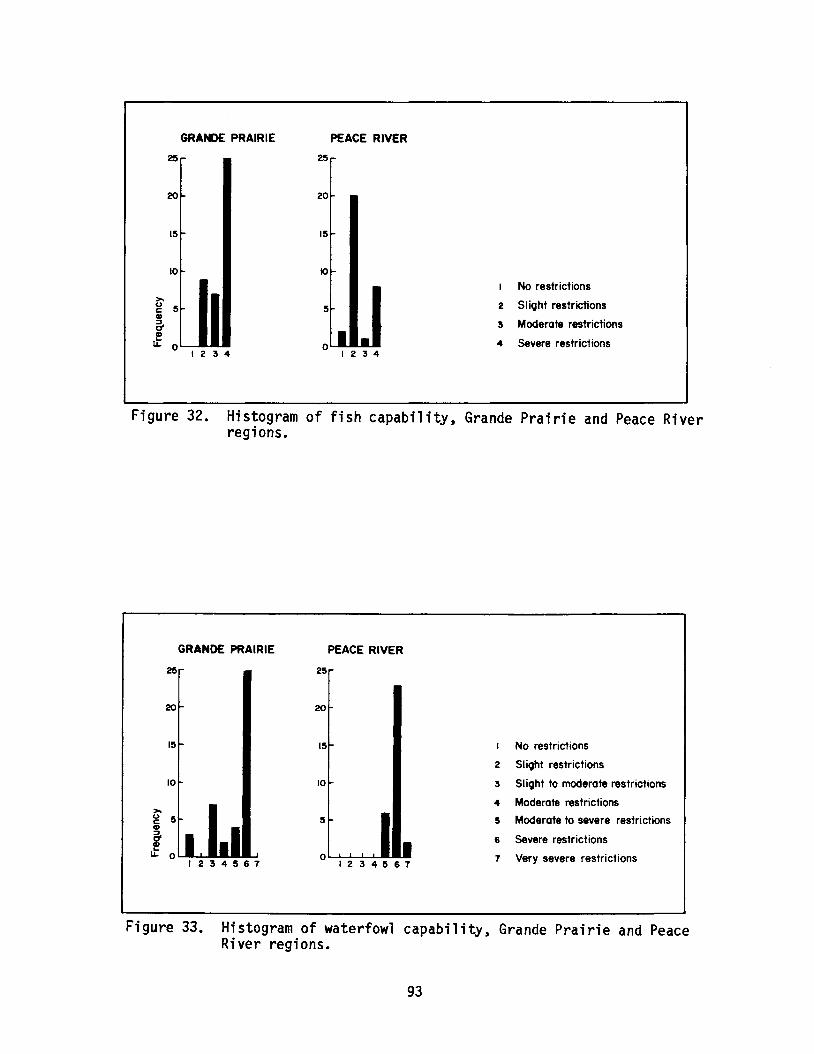
GRANDE PRAIRIE
25
20
15
10~
~
g 5CD
5!
1L. 01234
PEACE RIVER
25
20
15~
5
I •o I 2 3 4
I No restrictions
2 Slight restrictions
5 Moderate restrictions
4 Severe restrictions
Figure 32. Histogram of fish capability, Grande Prairie and Peace Riverregions.
GRANDE PRAIRIE PEACE RIVER
25 25
20 20
15 15 No restrictions
2 SI ight restrictions
10 10 3 Slight to moderate restrictions
4 Moderate restrictions~
Moderate to severe restrictionsu 5 5 5cCD
6- 6 Severe restrictionsCDl-
Very severe restrictionsLL 0 0 71234567 1234567
Figure 33. Histogram of waterfowl capability, Grande Prairie and PeaceRiver regions.
93
vast number of sites with relatively precise chronological controls.This is not the case here, and the interpretation of northwestern Albertasite location must cover the entire period of some 10,000 years of humanoccupation.
On the whole, site distributions appear to exhibit a consistencywhich is perhaps the result of physical constraints imposed on generalpatterns of hunter-gatherer behaviour. The distributions noted indistance to water and in fish and waterfowl resource capability arelikely complementary in nature; that is, apart from water being a criticalresource in itself, sites in the Grande Prairie region may have beenlocated so as to take advantage of waterfowl resources, while in the PeaceRiver region they were positioned to take advantage of fish resources.Indeed, it is conceivable that prehistoric patterns of resourceexploitation could have ranged over both areas, with appropriate seasonalscheduling of these two resources. The limitations to daily and extendedforaging may be evident in the multi-modal nature of the distributions.Over the long term, one could expect that sites would tend to becomeconcentrated in areas about 4 and 10 km from major water sources.
The notion that long-term patterns of occupation would tend to becontrolled by physical constraints is supported by the distributions ofsites in their proximity to present and past cultural features. In thevernacular, if it is a good place to live now, it likely was a good placein the past as well.
CONCLUSIONS
The patterns observed demonstrate that we can detect substantialdifferences in the structure of site location variation between two quitesimilar regions and possibly set limits for them. It is clear also thatevidence of contemporary cultural activity needs to be more fullyexplored as a potential predictor of historical resource locations.
There are many other ways to look at the problem of site locationdeterminants, for example, by site type. While data for prehistoric sitetypes are vague and mostly based on individual researcher1s judgements,
with sufficient sample sizes one could examine, for example, differences
94
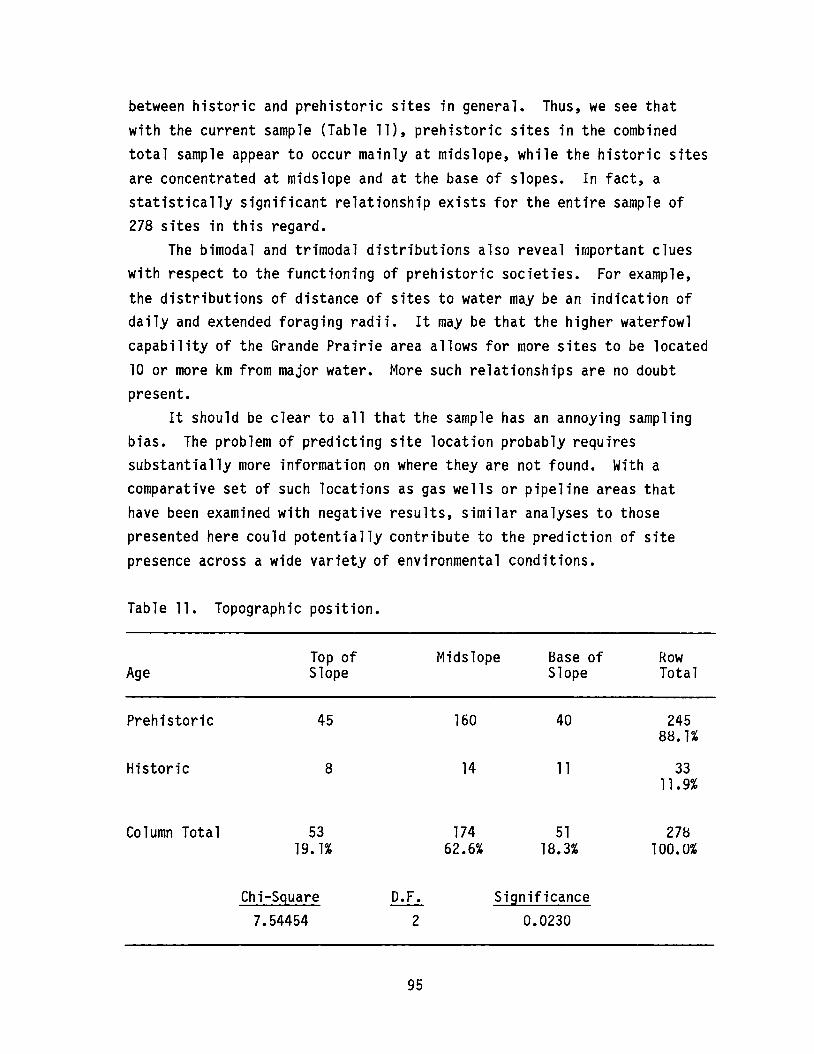
between historic and prehistoric sites in general. Thus, we see thatwith the current sample (Table 11), prehistoric sites in the combinedtotal sample appear to occur mainly at midslope, while the historic sitesare concentrated at midslope and at the base of slopes. In fact, astatistically significant relationship exists for the entire sample of278 sites in this regard.
The bimodal and trimodal distributions also reveal important clueswith respect to the functioning of prehistoric societies. For example,
the distributions of distance of sites to water may be an indication ofdaily and extended foraging radii. It may be that the higher waterfowlcapability of the Grande Prairie area allows for more sites to be located10 or more km from major water. More such relationships are no doubtpresent.
It should be clear to all that the sample has an annoying samplingbias. The problem of predicting site location probably requiressubstantially more information on where they are not found. With acomparative set of such locations as gas wells or pipeline areas thathave been examined with negative results, similar analyses to thosepresented here could potentially contribute to the prediction of sitepresence across a wide variety of environmental conditions.
Table 11. Topographic position.
Age
Prehistoric
Historic
Column Total
Top ofSlope
45
8
5319. 1%
Midslope
160
14
17462.6%
Base ofSlope
40
11
5118.3%
RowTotal
24588. 1%
3311.9%
278100.0%
Chi-Square7.54454
D.F.2
95
Significance0.0230

ANALYSIS AND PREDICTION OF HISTORICAL RESOURCE POTENTIALOF AGGREGATE SOURCE LOCALES IN SOUTHEASTERN ALBERTA
ByEric Damkjar
University of Alberta
INTRODUCTION
In 1985, Lifeways of Canada Limited conducted a research projectdesigned to:
1) develop an evaluation system by which aggregate resourcelocales could be assessed for historical resource potential,2) test this system on a sample drawn from 407 designatedaggregate resource locales ••• located within 386 quartersections, 3) assess the relative historical potential of thespecified borrow pits and 4) develop a sieve criteria formanagement use by which future aggregate source locales may beevaluated (Loveseth and Van Dyke 1985:1).
The study summarized here is a continuation of that research utilizingdata generated by the Lifeways study, as well as new information. Themain objectives of this study were to identify descriptive variables andanalytic methodologies which may be useful in predicting the historicalresource potential of aggregate source locales and to produce a list ofaggregate source locales in the southeast quarter of the provincespecifying the likelihood of presence or absence of historical resourcesfor each locale. For specific predictions and data see Damkjar 1986.
The study was carried out in two stages. The first stage involvedthe analysis of 66 aggregate source locales for which historical resourcepotential was previously determined by Lifeways (Loveseth and Van Dyke1985), plus one source evaluated by Bobrowsky and Gibson (1986). Eachborrow pit was described in terms of 51 variables and relationshipsbetween these variables, and the presence or absence of historicalresources were evaluated. Six variables were identified (throughdiscriminant analysis) which, as a group, appear to provide the greatestpotential for predicting presence or absence of historical resources (seeDamkjar 1986).
96
In the second stage, 254 aggregate source locales for whichhistorical resource potentials were not known were described in terms ofthe six significant variables. Applying the discriminant functions fromstage 1, predictions were made regarding historical resource potential.
METHODS
UNIT OF ANALYSIS
In this study, the aggregate source locale forms the unit ofanalysis, whereas the Lifeways study employed the quarter sectioncontaining the aggregate source as the unit of analysis. This change inapproach was taken because, as pointed out by Loveseth and Van Dyke(1985:9), quarter sections often display as much internal variability inthe descriptive variables being measured as exists between aggregatesource locales. Using quarter sections as the unit of analysis resultsin measurements which either describe an arbitrary point (e.g., centre ofthe quarter section) or provide only a generalized measure of the entirequarter section. In either case, a suitable characterization of theaggregate source locale may not result. Moreover, the degree to whichsuitable characterization is achieved cannot be determined. Byrestricting the unit of analysis to the borrow source, less intra-unitvariability is encountered because aggregate source locales are usuallymuch smaller than a quarter section and are usually restricted to aparticular landform or topographic feature. Also, all descriptivevariables refer specifically to the aggregate source locale.
In some cases, borrow pits are divided to form two or more units ofanalysis. This occurs when the aggregate source straddles the boundarybetween two or more quarter sections. Because the archaeological fieldstudies carried out by Lifeways focussed on quarter sections, only aportion of such aggregate sources has been assessed for historicalresource potential, and, consequently, such aggregate sources are dividedinto two units of analysis, as having known or unknown historicalresource potential. Alternatively, some quarter sections contain two ormore gravel pits, each treated as a separate unit of analysis.
97
Data concerning locations and extent of aggregate source localeswere obtained from Alberta Transportation. Files pertaining to eachsource were examined, and appropriate maps and other documentation werecopied. However, the quality of available documentation variesconsiderably. In some cases, maps are detailed and recently updated. Inother cases, only rough, small-scale maps (usually several decades old)exist. Some maps indicate the extent of existing or planned excavations,while others merely show where aggregate testing has taken place.Moreover, not all aggregate source locales have been mapped. Many aredocumented only by reservation application for future aggregate testingof one or more quarter sections, usually with no reference to thespecific location of the aggregate source. The location of some poorlyor undocumented sourcescould be determined from 1:50,000 NTS maps and/or air photographs. Otherscould be located with reasonable certainty by identifying landforms whichtypically contain aggregate materials. When an undocumented aggregatesource occurred in a quarter section with little internal variability inthe six variables used for prediction (in stage 2), an arbitrary locationwas chosen, and historical resource potential was predicted for thatlocation.
Where documentation was particularly poor or absent, and noappropriate landform could be identified, the aggregate source was notused in developing criteria for prediction. Also, some quarter sectionsreserved for aggregate purposes do not actually contain aggregate sourcesbut merely provide vehicular access to a source. These were not includedin the analysis. As a result of the variability in documentation, atotal of 31 aggregate sources could not be included in the study. Of the73 aggregate sources with known historical resource potential, 67 couldbe analyzed, and of the 279 sources with unknown resource potential, 254could be analyzed.
VARIABLES
Thirty-seven variables were initially recorded for each of the 67aggregate sources of known heritage resource potential, and an additionalfourteen variables were produced through transformation of existing
98
variables. Table 12 provides a list of the 51 variables, and the majorcategories are summarized below.
Local TopographyMaximum elevation and minimum elevation above sea level in the unit
of analysis were recorded to the nearest 25-foot (7.62-metre) contourinterval using information available from 1:50,000 NTS map sheets.Relief equals maximum elevation minus minimum elevation. Medianelevation was obtained by summing maximum elevations and dividing by two.
Regional TopographyA circle with a radius of 1.5 km from the centre of the aggregate
source was drawn on the appropriate 1:50,000 NTS map sheet to define theIIregion. 1I Maximum and minimum regional elevations were recorded to thenearest 25-foot contour interval. Median regional elevation was obtainedby summing maximum and minimum regional elevations and dividing by two.Regional relief was found by subtracting minimum from maximum regionalelevation. Relative elevation is the difference between median elevationand regional median elevation. A positive value indicates that theaggregate source has a relatively high elevation compared with theregion. A negative value indicates a relatively depressed aggregatesource elevation.
Topographic ComplexityTopographic complexity within the aggregate source locale was
measured in two ways. Topographic complexity 1 is defined as the maximumnumber of intersections of a straight line and a single contour line.This is designed to provide a measure of topographic undulation.Topographic complexity 2 is defined as the maximum number ofintersections of a straight line and any contour lines within the unit ofanalysis. This provides a more general measure of topographic complexity.
AspectAspect refers to approximate horizontal visibility from the highest
point in the aggregate source locale. Straight line visibility wasmeasured every thirty degrees (i.e., twelve rays) for a maximum distance
99
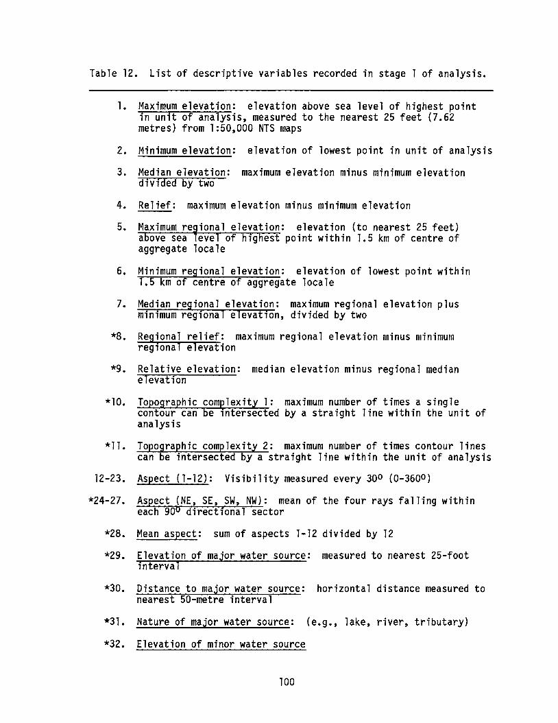
Table 12. List of descriptive variables recorded in stage 1 of analysis.
1. Maximum elevation: elevation above sea level of highest pointin unit of analysis, measured to the nearest 25 feet (7.62metres) from 1:50,000 NTS maps
2. Minimum elevation: elevation of lowest point in unit of analysis
3. Median elevation: maximum elevation minus minimum elevationdivided by two
4. Relief: maximum elevation minus minimum elevation
5. Maximum regional elevation: elevation (to nearest 25 feet)above sea level of highest point within 1.5 km of centre ofaggregate locale
6. Minimum regional elevation: elevation of lowest point within1.5 km of centre of aggregate locale
7. Median regional elevation: maximum regional elevation plusminimum regional elevation, divided by two
*8. Regional relief: maximum regional elevation minus minimumregional elevation
*9. Relative elevation: median elevation minus regional medianelevation
*10. Topographic comelexity 1: maximum number of times a singlecontour can be lntersected by a straight line within the unit ofanalysis
*11. Topographic complexity 2: maximum number of times contour linescan be intersected by a straight line within the unit of analysis
12-23. Aspect (1-12): Visibility measured every 300 (0-3600 )
*24-27. Aspect (NE, SE, SW, NW): mean of the four rays falling withineach 900 directional sector
*28. Mean aspect: sum of aspects 1-12 divided by 12
*29. Elevation of major water source: measured to nearest 25-footinterval
*30. Distance to major water source: horizontal distance measured tonearest 50-metre interval
*31. Nature of major water source: (e.g., lake, river, tributary)
*32. Elevation of minor water source
100

Table 12. continued
*33. Distance to minor water source
*34. Nature of minor water source: (e.g., stream or slough)
*35. Elevation of nearest water source: (i.e., nearest of major orminor water source)
*36. Distance to nearest water source
*37. Nature of nearest water source
*38. Elevation relative to major water source: elevation of majorwater source minus median elevation of aggregate source
*39. Landform: based on airphoto interpretation
*40. Surficial geology: as recorded in 1985 study (Lifeways 85-5C)
*41. Land use: as recorded in 1985 study (Lifeways 85-5C)
*42. Vegetation: as recorded in 1985 study (Lifeways 85-5C)
*43. Agricultural potential: based on Canada Land Inventory
*44. Wildlife (ungulates) capability: based on Canada Land Inventory
*45. Wildlife (waterfowl) capability: based on Canada Land Inventory
*46. Sport fish capability: based on Canada Land Inventory
47. Area of aggregate source: to nearest 1000 square metres
48. Area disturbed: within aggregate source to nearest 1000 squaremetres
*49. Area undisturbed: area of aggregate source minus area disturbed
*50. Historical resources: presence or absence of historicalresources
51. Number of historical resources
*Indicates variable used in univariate analysis.
101
of 10 km. Visibility was determined by drawing a profile (based onintersections with contour lines) for each ray and determining the limitsof visibility with a straight line originating at the aggregate source.Northeast, southeast, southwest and northwest directional sectors (i.e.,0-900
, 90-1800, 180-2700
, and 270-3600) were calculated by
summing visibilities for the four appropriate rays in each sector anddividing by four. Mean aspect was obtained by summing all twelve raysand dividing by twelve.
Water SourceThree variables each were recorded for the nearest major water
source and the nearest minor water source: elevation (horizontal),distance (from centre of the aggregate source), and nature. The majorwater source is any permanent body of water. The minor water source is asmall creek or slough (including intermittent ones). Measurements weretaken from 1:50,000 NTS map sheets - elevation to the nearest 25-footcontour interval and distance to the nearest 50 m. Nature of waterbodies included lake, major river, major tributary, minor tributary,intermittent creek and slough.
In addition, elevation, distance and nature of the nearest watersource were recorded as separate variables. Elevation relative to majorwater source was found by subtracting elevation of the major water sourcefrom median elevation of the aggregate source.
LandformThe major landform within the aggregate source locale was identified
from stereo-pairs of airphotos. Possible landforms included floodplain,river terrace, slope, linear prairie edge, desiccated prairie edge,tributary or slough on flat prairie, major slough on flat prairie,glacial feature, hummocky terrain (prairie), and river gravels (bars,bed). Not all of these landforms were present.
Surficial GeologySurficial geology, as recorded by Loveseth and Van Dyke (1985),
includes alluvium, gravel and sand; ground moraine; hummockydisintegration moraine, subtle; hummocky disintegration moraine, modest;
102

end moraine, veneered till; end moraine, veneered till, modest; hummockyend moraine, mainly till; bedrock upland veneered with till; collapsedice-contact satisfied drift; flood eroded sediments; ice-marginalchannel, silt and clay; ice-marginal channel, gravel and sand; outwashdeposits; colluvium and alluvial fan deposits; lacustrine sediments;alluvium sand, silt and clay, some gravel; bedrock exposures; Pleistocenelacustrine sediments; and eroded slope. Not all of these were present.
Land UseLand use is categorized as in Loveseth and Van Dyke (1985:9):
undisturbed or grazed lands, partially or ploughed lands, partiallydeveloped lands, and fully developed or urbanized lands.
VegetationVegetation, as recorded by Loveseth and Van Dyke (1985:9), refers to
carrying capacities of native grasslands in hectares per animal permonth. The four categories are less than 0.91 ha/animal/month, 0.92 to1.2 ha/animal/month, 1.3 to 1.8 ha/animal/month, and more than1.8 ha/animal/month. The information is taken from Smoliak et ale(1982:18).
Agricultural PotentialAgricultural potential for cultivated field crops is ordered into
seven classes: no significant limitations, moderate limitations,moderately severe limitations, severe limitations, very severelimitations, not feasible, and no capability. Information is taken fromappropriate 1:250,000 Canada Land Inventory maps.
Wildlife (Ungulates) CapabilityCapability for wild ungulates is ordered into seven classes: no
significant limitations, very slight limitations, slight limitations,
moderate limitations, moderately severe limitations, severe limitations,and no ungulate production. Capability ratings do not generally reflectpresent land use. The information is taken from appropriate 1:250,000Canada Land Inventory maps.
103
Wildlife (Waterfowl) CapabilityWaterfowl potential is ordered into seven classes: no significant
limitations, very slight limitations, slight limitations, moderatelimitations, moderately severe limitations, severe limitations, and nowaterfowl production. Capability ratings do not generally reflectpresent land use. The information is taken from appropriate 1:250,000
Canada Land Inventory maps.
Sport Fish CapabilitySport fish potential is ordered into four classes: no significant
limitations, few or minor limitations, several minor or few seriouslimitations, and numerous and severe limitations. Capability ratings donot necessarily reflect present fish populations. The information istaken from appropriate 1:250,000 Canada Land Inventory maps; however, mapareas 72L and 821 are not yet covered by this map series. Informationfor these areas was obtained from the Lethbridge office of AlbertaForestry, Lands and Wildlife.
Area of Aggregate SourceThe area of the aggregate source was measured to the nearest 1000
square metres using a digitizing tablet and an Apple II computer. Onlythose sources for which there was adequate documentation were measured.In many locales, part of the source had already been removed or heavilydisturbed so area disturbed was also measured to the nearest 1000 squaremetres. Area undisturbed is the difference between the two measurements.
Historical ResourcesPresence or absence of archaeological, historical or
palaeontological resources within the aggregate source was based on thefield work conducted by Lifeways in 1985 and Bobrowsky and Gibson in1986. The number of historical resources within the aggregate sourcelocale was also recorded.
104

RESULTS
UNIVARIATE ANALYSIS
The first stage of the analysis involved comparing aggregate sourceswith and without historical resources in terms of single variables. Of67 aggregate source locales, fourteen contain historical resources. Tominimize redundancy, only thirty of the 51 recorded variables were usedin the stage 1 analysis (Table 12). Data for selected variables weretabulated and distributions graphically illustrated (e.g., Figures34-37). Aggregate sources with and without historical resources aretabulated and illustrated separately. Where appropriate, chi-square andG-statistic values were calculated (see Damkjar 1986). Probabilitiespresented below are based on the chi-square values. The statistics werecomputed using Stateview (Feldman and Gagnon 1985) and an Apple Macintoshmicrocomputer.
Median ElevationNo systematic variation relative to presence/absence of historical
resources is apparent.
ReliefAggregate sources containing historical resources tend to have
slightly greater relief than aggregate sources without historicalresources. This is supported by a chi-square value significant at the.01 level (X2=11.5; df=3).
Regional ReliefNo systematic difference between the two distributions is apparent.
Relative Elevation
There is a complete absence of historical resources at aggregatelocales with relative elevation less than -50 feet (Figure 34).
Chi-square is significant at .01 level (X2 with continuitycorrection=5.8; df=l).
105
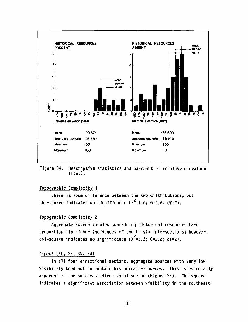
MODE~.......--MEDIAN
,........-1........-.....t~-MEAN
HISTORICAL RESOURCESABSENT
10
HISTORICAL RESOURCESPRESENT
10
8 8
6 6
4
---MODEMEDIANMEAN 4
22..C:I
8 0 0~ ~ ~ ~ ~ ~ 8 ~ ~ ~ 0 m~ ~ 8 ~ i! ~ ~ ~ ~ 8 ~ ~ ~ 0 ~ i ~ ~ ~I I I I I I I I • I I I I I
Relative elevation (feet) Relative elevation (feet)
Mean 20.571
Standard deviation 52.684
Minimum -50
Maximum 100
Mean -55.509
Standard deviation 83.945
Minimum -250
Maximum 113
Figure 34. Descriptive statistics and barchart of relative elevation(feet).
Topographic Complexity 1There is some difference between the two distributions, but
2chi-square indicates no significance (X =1.6; G=1.6; df=2).
Topographic Complexity 2
Aggregate source locales containing historical resources haveproportionally higher incidences of two to six intersections; however,chi-square indicates no significance (X2=2.3; G=2.2; df=2).
Aspect (NE, SE, SW, NW)In all four directional sectors, aggregate sources with very low
visibility tend not to contain historical resources. This is especiallyapparent in the southeast directional sector (Figure 35). Chi-squareindicates a significant association between visibility in the southeast
106
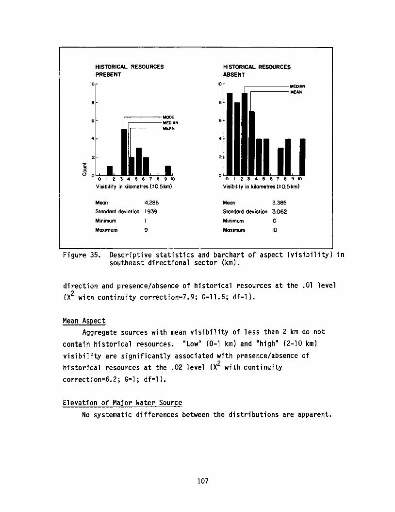
HISTORICAL RESOURCESPRESENT
HISTORICAL RESOURCESABSENT
10 r------- MEDIAN----MEAN
o I 2 3 4 5 618 9 ~
Visibility in kilometres (1: 0.5km)
2
8
4
6
o
10
----MODE----MEDIANI----MEAN
2
8
4
6
+C::Joo 0
o I 234 5 6 7 8 9 ~
Visibility in kilometres (iO.5km)
Mean 4.286
Standard deviation I.939
Minimum I
Maximum 9
Mean 3.385
Standard deviation 3.062
Minimum 0
Maximum 10
Figure 35. Descriptive statistics and barchart of aspect (visibility) insoutheast directional sector (km).
direction and presence/absence of historical resources at the .01 level(X2 with continuity correction=7.9; G=11.5; df=l).
Mean AspectAggregate sources with mean visibility of less than 2 km do not
contain historical resources. II Lowll (0-1 km) and IIhigh ll (2-10 km)
visibility are significantly associated with presence/absence ofhistorical resources at the .02 level (X2 with continuitycorrection=6.2; G=l; df=l).
Elevation of Major Water SourceNo systematic differences between the distributions are apparent.
107
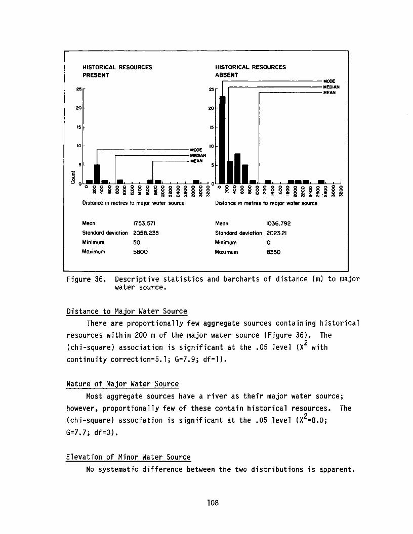
HISTORICAL RESOURCES
PRESENT
HISTORICAL RESOURCESABSENTr------------MODE-----------MEDIAN
..-------MEAN
20 20
15 15
5
10,..----------MOOE
--------MEDIAN----MEAN
5
10
+c::::J
8 0 0
o ~ ~ § ~ §§~ ~ § ~ §I I ~ ~ I 0 ~ i § § § ~ ~ ~ ~ ~ § ~ 1,1 ~ ~Distance in metres to major water source Distance in metres to major water source
Mean 1753.571 Mean 1036.792
Standard deviation 2058.235 Standard deviation 2023.21
Minimum 50 Minimum 0
Maximum 5800 Maximum 8350
Figure 36. Descriptive statistics and barcharts of distance (m) to majorwater source.
Distance to Major Water SourceThere are proportionally few aggregate sources containing historical
resources within 200 m of the major water source (Figure 36). The(chi-square) association is significant at the .05 level (X2 withcontinuity correction=5.1; G=7.9; df=l).
Nature of Major Water SourceMost aggregate sources have a river as their major water source;
however, proportionally few of these contain historical resources. The(chi-square) association is significant at the .05 level (X2=8.0;G=7.7; df=3).
Elevation of Minor Water SourceNo systematic difference between the two distributions is apparent.
108
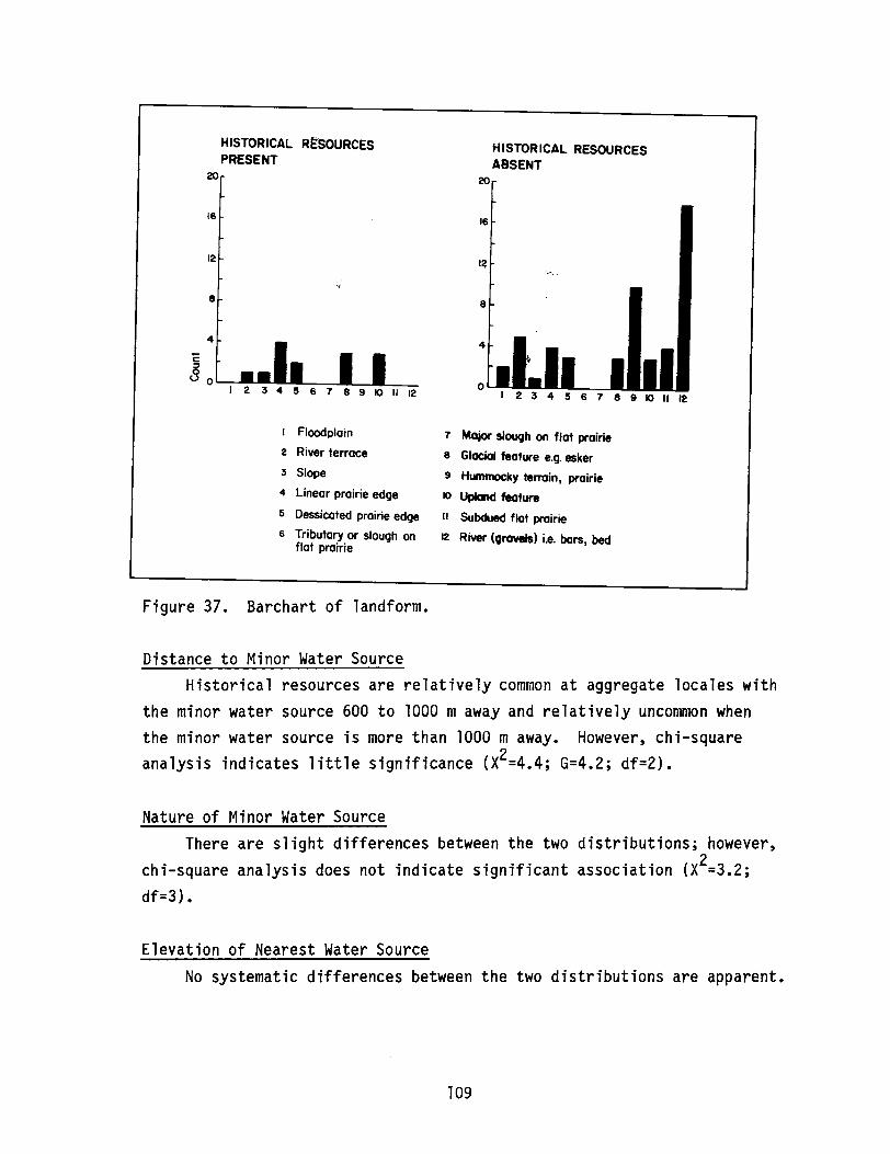
HISTORICAL RESOURCESPRESENT
20
16
HISTORICAL RESOURCESABSENT
20
16
12
.•?,
8
4
'E:::J0
U 0
I Floodplain
2 River terrace
3 Slope
4 Linear prairie edge
5 Dessicated prairie edge
6 Tributary or slough onflat prairie
Figure 37. Barchart of landform.
I~"..~ -
8
4
0
7 Major slough on flat prairie
8 Glacial feature e.g. esker
9 Hummocky terrain, prairie
10 Upland feature
II Subdued flat prairie
12 River (grovels) i.e. bars, bed
9 10 II 12
Distance to Minor Water SourceHistorical resources are relatively common at aggregate locales with
the minor water source 600 to 1000 maway and relatively uncommon whenthe minor water source is more than 1000 m away. However, chi-squareanalysis indicates little significance (X2=4.4; G=4.2; df=2).
Nature of Minor Water SourceThere are slight differences between the two distributions; however,
chi-square analysis does not indicate significant association (X2=3.2;df=3) •
Elevation of Nearest Water SourceNo systematic differences between the two distributions are apparent.
109

Distance to Nearest Water SourceAggregate locales with historical resources occur with relatively
low frequency within 100 mof water and relatively high frequency within700 to 1000 m. A chi-square analysis indicates significant associationbetween distance to nearest water source and presence/absence ofhistorical resources at the .05 level (X2=9.5; G=8.7; df=3).
Nature of Nearest Water SourceMost differences between the two distributions appear to be due to
the fact that aggregate locales containing historical resources rarelyhave rivers as their nearest water source. Chi-square analysis indicatesassociation between historical resource potential and nature of nearestwater source at the .001 level of significance (X2=17.9; G=16.4; df=3).
Elevation Relative to Major Water SourceAggregate sources containing historical resources tend to have
higher elevations relative to major water source compared with aggregatesources without historical resources. However, based on chi-squareanalysis, the association is significant at only the. 10 level (X2=5.3;df=2).
LandformHistorical resources are commonly associated with aggregate locales
at prairie edges and glacial or upland features but never with rivergravels or hummocky terrain (Figure 37). Association between rivergravels and presence/absence of historical resources is significant(based on chi-square analysis) at .05 level (X2 with continuitycorrection=4.9; df=l).
Surficial GeologyNo significant differences between the distributions are apparent.
Land UseNo significant differences between the distributions are apparent.
110

Vegetation (Carrying Capacity)Historical resources are absent where carrying capacity is high
(less than 0.91 ha/animal/month) and relatively common where carryingcapacity is low (greater than 1.8 ha/animal/month). Based on chi-squareanalysis, associations are significant at the .05 level (X2=7.8; df=3).
Agricultural PotentialNo significant differences between the two distributions are
apparent.
Wildlife (Ungulates) CapabilityNo significant differences between the two distributions are
apparent.
Wildlife (Waterfowl) CapabilityNo significant differences between the two distributions are
apparent.
Sport Fish CapabilityA relatively high proportion of aggregate locales containing
historical resources have numerous and severe limitations for sport fishcapability. Chi-square analysis indicates association at only the .20level of significance (X2=4.3; df=2).
Area UndisturbedHistorical resources are relatively uncommon at aggregate locales
with less than 80,000 square metres of undisturbed surface. Chi-squareanalysis indicates the association is significant at the. 10 level (X2
with continuity correction=3.2; G=4.7; df=l).
SummaryThere are undoubtedly many factors affecting associations between
the variables used in this study and presence or absence of historicalresources at aggregate source locales. However, many of the associationscan be understood as a consequence of the fact that gravel pits locatedin river bars and/or beds do not contain historical resources. Such
111
locales have low relief, low relative elevations and low aspect(visibility) due to walls of the river valley. They are close to themajor and/or nearest water source (i.e., river), are low in elevationrelative to the river, have river gravels as their associated landform,and have relatively high fish capability. Many of these trends areredundant, simply representing different measures of the same association.Twenty-seven percent of the 67 surveyed aggregate locales are situated inriver bars and/or beds. Assuming a similar frequency among the 254non-surveyed aggregate sources, approximately 63 can be predicted, withconsiderable confidence, to contain no historical resources.
DISCRIMINANT FUNCTION ANALYSIS
In order to isolate which variable{s) best reflect the associationsnoted above and also account for other patterning in the data, stepwisediscriminant function analyses were conducted. This work was done on theUniversity of Alberta mainframe computer using the Michigan InteractiveData Analysis System (MIDAS; Fox and Guire 1976).
All of the variables used in the previous descriptive, univariateanalysis were employed in generating the discriminant functions. Twostepwise analyses (forward and backward) were conducted, and discriminantfunctions were derived. A third discriminant function was derived bycombining the variables selected in the stepwise analyses. Significancelevels for inclusion in the stepwise functions were set at 0.1.
Forward Stepwise AnalysisThe forward stepwise analysis selected four variables for inclusion
in the discriminant function: distance to nearest water source,elevation relative to major water source, vegetation (carryingcapability), and wildlife (waterfowl) capability (Table 13A).
Backward Stepwise AnalysisThe backward stepwise analysis selected four variables for inclusion
in the discriminant function: regional relief, relative elevation,vegetation (carrying capacity), and wildlife (waterfowl) capability(Table 13B).
112
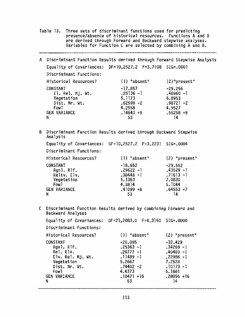
Table 13. Three sets of discriminant functions used for predictingpresence/absence of historical resources. Functions A and Bare derived through Forward and Backward stepwise analyses.Variables for Function C are selected by combining A and B.
(2)lIpresentll
-29.266.46960 -16.8953.98721 -24.9527.55258 +9
14
-17.857.25136 -15.1173.62599 -24.2558•14640 +9
53
(1) lIabsent ll
CONSTANTEl. Rel. Mj. Wt.VegetationDist. Nr. Wt.Fowl
GEN VARIANCEN
A Discriminant Function Results derived through Forward Stepwise AnalysisEquality of Covariances: DF=10,2527.2 F=3.7108 SIG=.OOOlDiscriminant Functions:Historical Resources?
(2) IIpresentll
-29.552.43529 -1.71613 -17.08305. 1044.64553 +7
14
-18.652.29622 -1.38446 -15. 13634.3814.41099 +8
53
CONSTANTRgnl. Rlf.Reltv. Elv.VegetationFowl
GEN VARIANCEN
B Discriminant Function Results derived through Backward StepwiseAnalysisEquality of Covariances: DF=10,2527.2 F=3.2231 SIG=.0004Discriminant Functions:Historical Resources?
(2) IIpresentll
-32.429.34269 -1.40403 -1.22986 -17.2528.10173 -15. 1881.28056 +16
14
-20.095.25363 -1.20777 -1.11489 -15.2667.74402 -24.4373.10471 +16
53
Wt.
CONSTANTRgnl. Rlf.Rel. Elv.Elv. Rel. Mj.VegetationDist. Nr. Wt.Fowl
GEN VARIANCEN
C Discriminant Function Results derived by combining Forward andBackward AnalysesEquality of Covariances: DF=21,2083.0 F=4.3150 SIG=.OOOODiscriminant Functions:Historical Resources?
113

Combined AnalysisThe six variables selected through the stepwise analyses were forced
into a third discriminant function (Table 13C).
Scatterplot AnalysisIn order to better understand the interrelationships of the six
variables selected through stepwise discriminant analysis, a scatterplotwas produced for each pair with presence or absence of historicalresources indicated. An example is shown in Figure 38. (Note thatoverlying data points of the same category [present or absent] appear assingle data points.) There is considerable overlap in all of thedistributions; however, in several cases they differ in some portion ofthe plot. The main trends are summarized below, excluding those alreadyapparent from the earlier univariate analysis.- Aggregate sources with high regional relief and low relative elevation
do not contain historical resources.- Aggregate sources with high regional relief and high elevation relative
to major water contain historical resources, while those with highregional relief and low elevations relative to major water do notcontain historical resources.
- Aggregate sources with low waterfowl capability and comparatively highrelative elevation commonly contain historical resources.
- Within each vegetation category, aggregate sources with relatively highelevation relative to major water commonly contain historical resources.
EVALUATION OF DISCRIMINANT FUNCTIONS
From the scatterplots, it is apparent that the discriminantfunctions should have greater explanatory/predictive power than anysingle variable alone. To assess the usefulness of the functions, it isdesirable to test them on a known sample not used in deriving thefunction. One method of so doing is to derive a function from half thesample and try to predict the other half. However, because only fourteen
locales contain historical resources, the present sample is too small forsubdivision.
114
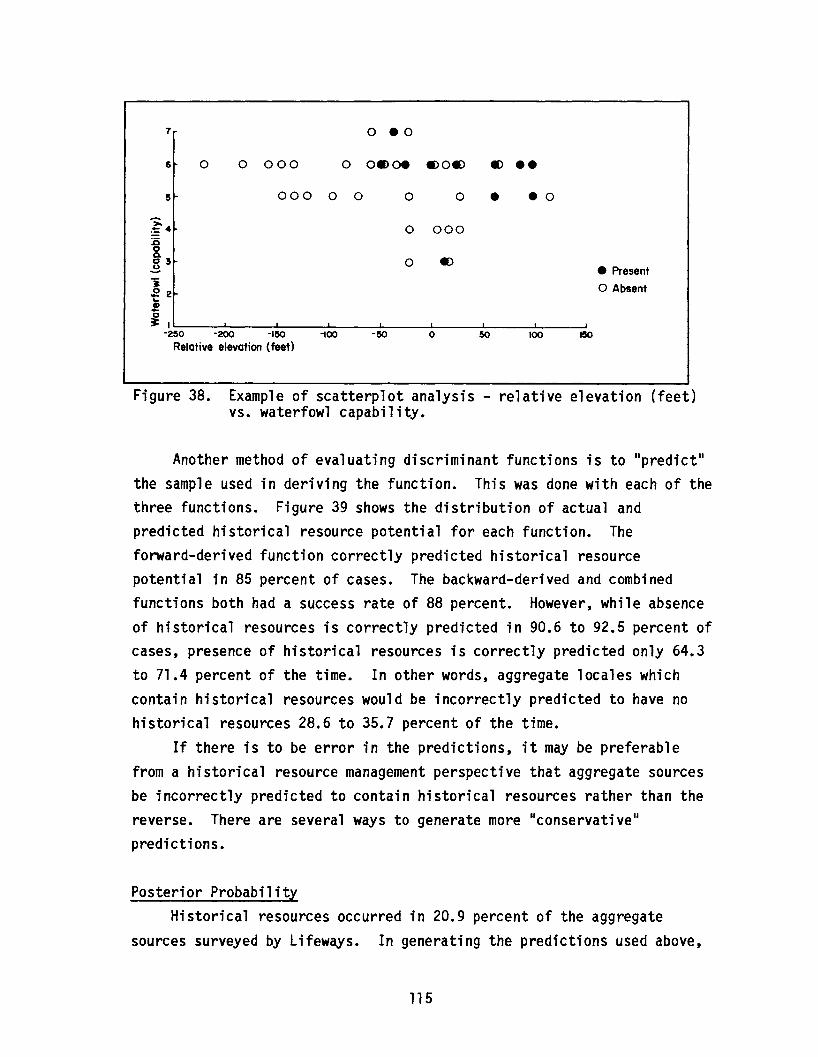
7 0 .0
6 0 0 000 0 oeoe .,0., ., ••5 000 0 0 0 0 e eo
~0 000~4
1500. .,].3 0
• Present"i o Absent.2 2~
CD..c~I I
-250 -200 -150 -100 -50 0 50 100
Relative elevation (feet)
Figure 38. Example of scatterplot analysis - relative elevation (feet)vs. waterfowl capability.
Another method of evaluating discriminant functions is to II predict ll
the sample used in deriving the function. This was done with each of thethree functions. Figure 39 shows the distribution of actual andpredicted historical resource potential for each function. Theforward-derived function correctly predicted historical resourcepotential in 85 percent of cases. The backward-derived and combinedfunctions both had a success rate of 88 percent. However, while absenceof historical resources is correctly predicted in 90.6 to 92.5 percent ofcases, presence of historical resources is correctly predicted only 64.3to 71.4 percent of the time. In other words, aggregate locales whichcontain historical resources would be incorrectly predicted to have nohistorical resources 28.6 to 35.7 percent of the time.
If there is to be error in the predictions, it may be preferablefrom a historical resource management perspective that aggregate sourcesbe incorrectly predicted to contain historical resources rather than thereverse. There are several ways to generate more IIconservati veilpredictions.
Posterior ProbabilityHistorical resources occurred in 20.9 percent of the aggregate
sources surveyed by Lifeways. In generating the predictions used above,
115
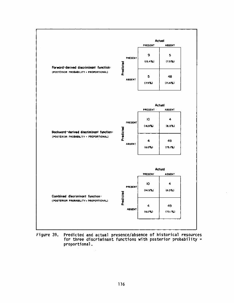
PRESENT
ActualABSENT
Forward-derived discriminant function:(POSTERIOR PROBABILITY = PROPORTIONAL)
~•~u:0•...0..
PRESENT
ABSENT
9 5
(13.4%) (7.5%)
5 48
(7.5%) (71.6%)
ActualPRESENT ABSENT
Backward-derived discriminant functiOn:(POSTERIOR PROBABILITY = PROPORTIONAL)
PRESENT
ABSENT
10 4
(14.9%) (6.0%)
4 49
(6.0Cfo) (73.1%)
ActualPRESENT ABSENT
Combined discriminant function:(POSTERIOR PROBABILITY =PROPORTIONAL)
PRESENT
ABSENT
10 4
(14.9Cfo) (6.0Cfo)
4 49
(6.0Cfo) (73.ICfo)
Figure 39. Predicted and actual presence/absence of historical resourcesfor three discriminant functions with posterior probability =proportional.
116
it was assumed that historical resources would occur with similarfrequency in the non-surveyed sample. One way to generate more"conservative" predictions is to change this probability for purposes ofprediction. This can be done by specifying a "posterior probability"other than proportional (i.e., other than 0.21/0.79) when generatingpredictions using discriminant functions.
A second set of predictions was calculated using the samediscriminant functions as before but with a posterior probability of0.5/0.5 - in other words, with the assumption that any gravel source hasa fifty percent chance of containing historical resources. Figure 40summarizes the predictions with posterior probability set at 0.5/0.5.Between 82.1 and 86.6 percent of all cases were correctly predicted(slightly lower than before). However, of all aggregate sourcescontaining historical resources, between 85.7 and 92.9 percent werecorrectly predicted - a considerable improvement.
Examining ScoresDiscriminant function predictions are based on the values or scores
which result when data for each aggregate locale are entered into a pairof equations (see Table 13). The two values always sum to 1 andclassification or prediction is based on which of the two is highest(i.e., over 0.5). Some indication of the certainty with whichclassifications are made can be gained by examining the two values. Ifthey are close to 0.5, the resulting prediction can be considered weak orat least suspect. If the values are less similar (e.g., 0.1 and 0.9),the prediction is more clear cut.
Grouping PredictionsAnother method of generating more conservative predictions is to
apply all three discriminant functions to each case and, if any of thepredictions point to presence of historical resources, assume such
resources are present. When this is done with the first set ofpredictions (i.e., those with proportional posterior probability),overall correct prediction goes up to 89.5 percent, and, moreimportantly, presence of historical resources is correctly predicted 92.9percent of the time. When this method is applied to the second set of
117
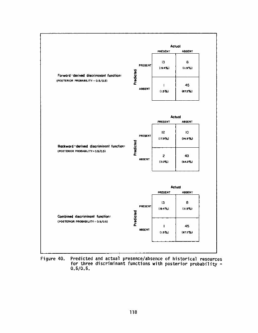
PRESENT
ActualABSENT
Forward - derived discriminant function:(POSTERIOR PROBABILITY =0.5/0.5)
Backward -derived discriminant function:(POSTERIOR PROBABILITY =0.5/0.5)
PRESENT
ABSENT
PRESENT
ABSENT
13 8
(19.4%) {I 1.9%)
1 45
(1.5%) (67.2%)
ActualPRESENT ABSENT
12 10
(17.9%) (14.9%)
2 43
(3.0CYo) (64.2CYo)
ActualPRESENT ABSENT
Combined discriminant function:(POSTERIOR PROBABILITY =0.5/0.5)
~•~u:g•~Q.
PRESENT
ABSENT
13 8
09.4%) (11.9CYo)
I 45
(I.5CYo) (67.2%)
Figure 40. Predicted and actual: presence/absence of historical resourcesfor three discriminant functions with posterior probability =0.5/0.5.
118

predictions (posterior probability set at 0.5/0.5), overall accuracydrops to 82. 1 percent, but the presence of historical resources iscorrectly predicted in 100 percent of cases (Figure 41).
CONCLUSIONS
The study summarized here (Damkjar 1986) set out to develop methodsof predicting historical resource potential of aggregate sources in thesoutheast quarter of Alberta and, using those methods, predict historicalresource potential of 254 aggregate sources. Development of a predictivemethodology began with univariate analysis of thirty variables for 67aggregate sources of known historical resource potential. This wasnecessary for two reasons. First, it was hoped that a number of thevariables would provide good predictive power. Second, it is importantin any predictive plan to understand the behaviour of variables beingused for prediction. The analysis showed that there was predictivepotential in many of the variables examined, but much of it wasredundant. Specifically, much of it could be explained in terms ofproximity to rivers. In future historical resource management ofaggregate sources, the descriptive analysis in this report should proveuseful for comparison and assessment. In terms of making specificpredictions, however, it became evident that a multivariate method wasneeded.
Discriminant function analysis provides a potentially powerfulmethod for classification or prediction. Since the earlier univariateanalysis had indicated considerable overlap or redundancy in the data,stepwise discriminant techniques were employed to isolate those variableswhich, as a group, provide the best predictive value. This does not meanthat these variables, on an individual basis, are the best predictors.Waterfowl, for example, has very little predictive value in isolation.However, in a multivariate context, waterfowl obviously providespredictive information not available from other variables.
A variety of approaches to generating predictions using thediscriminant functions are presented. Emphasis is placed on correctlypredicting presence of historical resources. Overall accuracy averagesaround 90 percent and, depending on which approach is used, correct
119

ActualPRESENT ABSENT
PRESENT
Grouped discriminant functions:(POSTERIOR PROBABILITY: PROPORTIONAL)
ABSENT
13 6
(19.4-') (9.~)
1 47
(1.5%) (70.1"-)
ActualPRESENT ABSENT
PRESENT
Grouped discriminant functions:(POSTERIOR PROBABILITY: 0.510.5)
ABSENT
14 12
(20.9"-) (17.9%)
0 41
(<>CIt) (61.2%)
Figure 41. Predicted and actual presence/absence of historical resourcesfor grouped discriminant functions with posterior probability= proportional and 0.5/0.5, respectively.
prediction of historical resource presence is achieved in 64.3 to 100percent of cases.
It is important to keep in mind that evaluation of predictiveaccuracy of the di scrimi nant functi ons has been done by Ilpredicti ng ll thesample from which the discriminant functions are derived. The utility ofthe functions in correctly predicting historical resource potential ofthe non-sampled aggregate sources rests entirely on the assumedrepresentativeness of the surveyed sample. Therefore, it is recommendedthat a sample of the non-surveyed aggregate sources be examined in orderto test the predictions in Damkjar (1986). Furthermore, findings of thisstudy apply only to aggregate sources within the prescribed geographicarea.
120

PRELIMINARY REPORT ON THE 1986 EXCAVATIONS AT THE STRATHCONA SITE
ByBrian Kooyman
University of Calgary
INTRODUCTION
The Strathcona site (FjPi-29) is located on a North SaskatchewanRiver terrace on the east side of the city of Edmonton (Ives 1985:3).The site area presently includes at least 20,000 square metres (Pyszczyk1985:6), although the original areal extent cannot be known due to recentsite destruction. Since archaeological work began at the site in 1976,researchers have variously viewed the site as a lithic workshop andquarry with only limited habitation (Ives 1985; Newton and Pollock 1985),a combination workshop/campsite (Helmer et ale 1986; Pyszczyk 1985), orsimply a habitation site (Driver et ale 1982).
The University of Calgary1s Department of Archaeology undertook itssixth field season at the site in 1986, beginning on May 1 and concludingon September 1. During this time, 27 one-metre units were completelyexcavated and another two were partially excavated. Twenty-six of the27 completed units were situated in a contiguous block excavation whichwas the focus of this season1s research. The remaining completed unitand the partially finished units were part of a salvage operationdesigned to recover cultural material from a sump pit slated to beconstructed on the site in 1987. The sump pit will drain the waterloggednortheast portion of the site so that excavations can be undertaken inthat area in 1988 to determine if faunal preservation is improvedrelative to the remainder of the site.
METHODOLOGY
As has been the case over the last five field seasons, most of theexcavation was undertaken by students from the University of Calgary1sarchaeology field school. As well as the 15 students who took part inthe field school, over fifty members of the public participated in a
121
volunteer programme at the site. Each volunteer worked a four-dayperiod, participating in both excavation and preliminary cataloguing.
The location for this season1s excavation was chosen on the basis ofthe results of a four-year, site-wide sampling progranne designed todefine the nature of the intrasite variability at FjPi-29 (Helmer et ale1986). The type and duration of occupation at FjPi-29 are crucial todefining the site1s role in the parkland settlement and subsistencesystem. Although much is now known about the lithic reduction activitiesat FjPi-29, it has proven very difficult to obtain information about theother activities that may have occurred at the site during itsoccupation. A possible hearth located in Unit 91 in 1984 (Helmer et ale1986:189), in combination with the apparently high concentration offaunal remains (1986:360), suggest that this area might represent ahabitation location at the site. Therefore, a block excavation wasinitiated around Unit 91 in 1986.
RESULTS
Previous excavations at FjPi-29 have identified cultural remainsdating from the Historic through to the Early Middle Prehistoric Period(Helmer et ale 1986:267-268). The 1986 excavations uncovered nothing newin this regard; the culturally diagnostic material recovered consisted oftwo Oxbow projectile point fragments and one Besant projectile point.The absence of stratigraphic layers at the site has caused considerabletrouble in the ordering and interpretation of the remains recovered fromthe site, and, in this regard, the projectile points from the 1986excavation do have some significance. Both Oxbow point fragments camefrom near the base of the excavation, while the Besant point came fromthe upper portion of the site. This may indicate that verticalstratification does indeed exist in the remains, a point made previouslyby Pyszczyk (1985) and Helmer et ale (1986) but contested by Driver etal. (1982). A single large charcoal fragment was recovered fromapproximately the same depth as the Oxbow point fragments. It was hopedthat this might provide some absolute dating control on the lowestoccupation at the site since the fragment appeared to come from anundisturbed context. The date obtained, 130 ~ 90 years B.P. (AECV 308C),
122

is clearly not compatible with the excavated remains. The charcoal wasobtained from a situation some 5 to 10 cm below a rodent burrow and wasapparently introduced to the lower portion of the site from that source.
Extensive refitting analysis is currently underway in an attempt tocircumvent the problem of the absence of stratigraphic layering at thesite. This project has only just begun and, due to its time-consumingnature, only limited results have been achieved thus far. One aspect ofthe results worthy of note, however, is the great success attained inrefitting a distinctive pitted cobble of fire-broken rock (FBR). Somethree-quarters of a single, large cobble has been reconstructed from 31small fragments. The fragments come from eight different 1 x 1 munitsand represent a maximum depth difference of 20 cm (658.83 to 659.03 mabove sea level) and a maximum depth difference of 18 cm in anyoneunit. If the fragmentation of this cobble can be assumed to represent asingle event or occupation (a reasonable assumption given that largequantities of suitable raw material for stone boiling are readilyavailable, and it would not be necessary to reuse old, scavaged rockfragments), then it may be that this 20 cm zone of the site doesrepresent a single, discrete occupation. Of further interest in thisregard is that both Oxbow projectile point fragments come from below thiszone (658.69 and 658.72 mabove sea level), while the Besant point comes
from above it. (Although the exact location is not known, it is between659.37 and 659.35 mabove sea level.) As this analysis progressesfurther, it may be that at least three cultural horizons will bedefinable. Other goals of the refitting analysis include a betterdefinition of stone boiling technology, lithic reduction sequences andactivity loci.
A reasonable quantity of FBR is present in the remains from the sitearea excavated this year. In other areas of the site, the presence ofFBR has been interpreted as debris from general campsite livingactivities rather than as special debris (Driver et ale 1982:180). Withthe exception of processing areas associated with communal kills, such asat Head-Smashed-In Buffalo Jump (Brink et ale 1986:105-110), this isprobably a valid assumption in Alberta. Since good success has beenattained in the refitting of FBR from the excavation, it is quiteprobable that stone boiling did take place in the immediate area of the
123

excavation and that the area does represent some type of habitation locusas had been originally predicted.
The possible hearth feature that was the initial reason forexcavating in this area is located at the base of the zone encompassed bythe reconstructed FBR cobble. Whether or not this feature is a hearth,it does appear to be associated with the proposed occupation defined bythe FBR refitting analysis. A hearth would be necessary to heat thestones used in the boiling process, and such an association of thesefeatures would be a good indication of domestic activity. However, theproposed hearth feature remains somewhat of an enigma, despite the factthat the three units adjacent to it were all excavated. As in 1984, noquantity of charcoal was recovered in the area, although isolated smallflecks were scattered throughout the vicinity. Also, there was no clearcontinuation of the FBR alignment into the other units, although a vaguecircular pattern some 1.5 to 2.0 metres in diameter might be construed.(Detailed examination of the FBR spatial patterning has not yet beencompleted.) It is hoped that the status of this possible feature will bemore clearly defined when the remaining analysis is complete.
A feature found in Unit 162 also suggests the presence of a domesticactivity locus in the excavated area. It appears that a pit was dug some15 to 25 cm into the soil. At its base, there is a lens of mixed sandyand finer-sized material. The purpose or cause of this feature is notcertainly known. The dimensions of the feature and its chronologicalaffiliation are not perfectly understood since only a portion of thefeature was included in the excavation area; however, it does appear tooriginate in the upper 5 to 16 cm of the deposit. This would suggestthat it is associated with the Besant portion of the excavation. If thisdoes prove to be the case, it would suggest that this area of the site,including both the middle and upper proposed occupations, might have beenconnected with domestic activities over an extended period of time.
The presence of faunal remains in the excavation area could also beindicative of domestic activity. Some faunal material was recovered,but, as seems to be the case at Strathcona in general, it was mostly inpoor condition. This suggests that much of the original material mayhave been lost due to various degradative processes. In terms of theStrathcona site, the quantity of bone recovered in 1986 is fairly large
124
(by number of pieces, about 10% of the excavated remains, but many of thepieces were very small). The material was fairly completelydisarticulated, as would be expected in a consumption or terminalprocessing location. If the bones had laid on the surface for any lengthof time, other non-human taphonomic agents might have been a cause ofthis dispersal. The poor condition of the bone might indicate a periodof weathering on the surface. On the other hand, some butchering markswere observed on the remains.
Most of the bone recovered was large ungulate and some wasdefinitely Bison. A variety of bone elements were recovered, both axialand appendicular, but limb bones appear to dominate the, assemblage. Somerelatively meatless bones, such as the phalanges, metapodials and themandible, are included. These meatless bones might have been utilizedfor their marrow. It is conceivable that the remains resulted from anisolated kill in the immediate vicinity, where it would have beenpossible to return much of the carcass to camp. In turn, this mightsuggest that, although the area examined is a domestic activity area, theoccupation may have been short-term. A better understanding of thefaunal evidence must await the completion of this aspect of the analysis.
Lithic usewear analysis is also being employed to help define whattypes of activities were undertaken in the 1986 excavation area. Bothtools and resharpening flakes are being employed in the analysis. Thelatter are particularly relevant since it is probable that toolsresharpened in the excavation area also became dull due to use there.The problem associated with the usewear analysis is that quartzite wasthe most commonly used lithic material, and it has proven very difficultto analyze due to its toughness and resistance to wear. Recently,success has been realized by using micropolish analysis with bothquartzite (Kooyman 1985) and quartz (Sussman 1985). Based on these twostudies, it appears feasible to distinguish between working dry hide,antler, bone, wood (and perhaps between hard and soft woods), fibrousplants and non-fibrous plants. Dry hide, plants, bone and hardwoods haveall been shown to develop microwear polishes in experiments withquartzite from the site area. A sample of resharpening flakes has alsobeen examined and at least some of these apparently demonstrate usewearpolish. A pilot study has been initiated using quartzite from sources in
125
the immediate vicinity of the site. As this experimental programme andanalysis progresses, it should allow much more precise definition of thetypes of activities that occurred at the Strathcona site.
This year1s lithic analysis focussed on defining which lithicreduction stages are represented in the remains. This information inturn allows an assessment of the role of stone tool manufacture in siteactivities. The frequencies of raw material, finished tools, variousflake categories (sharpening, decortication, resharpening, etc.) andfabricators are all being employed in this assessment, as is the extentof platform and dorsal surface flake scarring. (For a discussion of thislast point see Magne [1985] and Morrow [1984].) The tools that weremanufactured and/or used on the site are also being examined to clarifythe role of stone tools in site activities. The usewear characteristicsof resharpening flakes and tool edges are a major component of thisanalysis, but the frequency of bifacial reduction flakes and thetypological classification of finished and unfinished tools are alsoelements of it. Although the analysis is not yet complete, the basicnature of the remains can be seen in some of the results from a sample ofseven of the excavation units.
The results are much as has been found in previous seasons. Roughlythree-quarters of the lithic material is quartzite, and another 10 to 15
percent is petrified wood. Some 90 percent of the lithic remains aredebitage. About 6 percent of the lithics are IImanufacturing tools,1I suchas hammerstones and cores, and only 4 percent are other tool types.Given these figures, tool use appears to have been unimportant relativeto tool manufacture, but this assumption should be tempered with theknowledge that the percent calculations are based on number of pieces.Over half of the lithic remains are shatter fragments, many of which arequite small. It is probably preferable to examine the relativeimportance of lithic manufacturing in site activities by examining onlylIintentional ll debitage (flakes), particularly when considering materialssuch as quartzite that experience considerable shattering duringreduction. Only about 35 percent of the lithic remains are flakedebitage, hence manufacturing debris does not actually dominate theassemblage. This point can be further emphasized by examining estimates
126
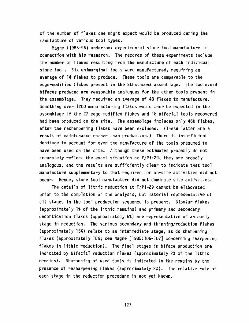
of the number of flakes one might expect would be produced during themanufacture of various tool types.
Magne (1985:96) undertook experimental stone tool manufacture inconnection with his research. The records of these experiments includethe number of flakes resulting from the manufacture of each individualstone tool. Six unimarginal tools were manufactured, requiring anaverage of 14 flakes to produce. These tools are comparable to theedge-modified flakes present in the Strathcona assemblage. The two ovoidbifaces produced are reasonable analogues for the other tools present inthe assemblage. They required an average of 48 flakes to manufacture.Something over 1200 manufacturing flakes would then be expected in theassemblage if the 27 edge-modified flakes and 18 bifacial tools recoveredhad been produced on the site. The assemblage includes only 46~ flakes,after the resharpening flakes have been excluded. (These latter are aresult of maintenance rather than production.) There is insufficientdebitage to account for even the manufacture of the tools presumed tohave been used on the site. Although these estimates probably do notaccurately reflect the exact situation at FjPi-29, they are broadlyanalogous, and the results are sufficiently clear to indicate that toolmanufacture supplementary to that required for on-site activities did notoccur. Hence, stone tool manufacture did not dominate site activities.
The details of lithic reduction at FjPi-29 cannot be elaboratedprior to the completion of the analysis, but material representative ofall stages in the tool production sequence is present. Bipolar flakes(approximately 1% of the lithic remains) and primary and secondarydecortication flakes (approximately 5%) are representative of an earlystage in reduction. The various secondary and thinning/reduction flakes(approximately 15%) relate to an intermediate stage, as do sharpeningflakes (approximately 10%; see Magne [1985:106-107] concerning sharpeningflakes in lithic reduction). The final stages in biface production areindicated by bifacial reduction flakes (approximately 2% of the lithicremains). Sharpening of used tools is indicated in the remains by the
presence of resharpening flakes (approximately 2%). The relative role ofeach stage in the reduction procedure is not yet known.
127
CONCLUSION
The initial results of the 1986 field season at FjPi-29 suggest thatthe area excavated was a domestic or habitation area, with lithicreduction probably occurring only as a result of immediate use demands.The lithic reduction analysis suggests that all stages in the lithicreduction sequence are represented in the site remains and that thisportion of the site resulted from a habitation occupation rather than alithic workshop. In addition, the presence of non-meaty bones in thefaunal assemblage indicates that the occupants had sufficient time toundertake a variety of tasks, such as bone marrow extraction. It issuggested that this would not have been possible at a specialized lithicworkshop site, and, therefore, the occupation in this portion of FjPi-29could not have been of this nature. The other cultural remains recoveredseem compatible with such an interpretation.
It is possible that at least three different occupations occurred atthis location on the site. Refitting analysis was employed to clarifythe stratigraphy of the site, and the results also suggested a threefolddivisio~ of the site. The uppermost occupation dated to the Besant timeperiod, based on a projectile point recovered in the excavation. Thelowest occupation was dated to Oxbow times, also based on an excavatedprojectile point. The middle occupation could not be directly dated butobviously occurred between the other two.
128
A CRITIQUE OF MEDICINE WHEEL ASTRONOMY
BySteven C. Haack
INTRODUCTION
The development of the human mind, both in terms of biologicalevolution and the endless variety of cultural inventions which give itform and expression, has centred largely about man1s manipulation of theenvironment: the ability to pick up pieces of it and chip, mold, cut andentwine them. The early world was given meaning by the ability toinspect and experiment with it, and the resultant technologies opened newvistas and set constraints upon every aspect of life. An interest in theform and motion of the sky was at the basis of man1s most fundamentalconstruction of the world, but the sky confronted our ancestors with avery special problem. Its diurnal and seasonal cycles and the capricesof its weather encompassed all and dictated the activities and often thesurvival of man. Yet it stood far outside his ability to manipulate orcontrol. Even an understanding of the motions of the sky made nocontribution to its control. The heavens posed the first purelyintellectual problem.
Efforts to control the sky took the form of populating it with godswith whom deals could be struck. Contracts written in ritual andsacrifice were offered to the cosmic powers in the hopes that they wouldrespond with bountiful harvests, mild winters, plentiful game andadequate rainfall.
Attempts to comprehend the motions of the sky were rarer and lessostentatious. Generally taking the form of tracking the motions of thecelestial bodies through their seasonal cycles, recording paths andevents and, in some cases, attempting to predict them, these activitiesform the core of the discipline of archaeoastronomy. A number of earlycivilizations displayed a propensity for such activities. In the case ofthe ancient Chinese, the evidence is quite clear: thousands of writtenrecords exist which establish a careful, systematic study of theheavens. There are many more instances (in Egypt and Mesoamerica, for
129
example) in which the tangible artifacts of such activity have beentragically destroyed. However, traces of records and peripheral remainsattest to a persistant interest in the mechanics of the sky.
There are also a number of borderline cases wherein considerableeffort was expended in activity which may have been related to the studyof the sky, but the evidence is sketchy and unclear. The formulations ofstanding stones throughout Britain exemplify this class of evidence, asdo the medicine wheels constructed by inhabitants of the northern Plainsof America. The purpose of this paper is to study the medicine wheels inthe context of the hypothesis that they were constructed to facilitatethe study of the motions of the sky.
SOME FUNDAMENTALS
The earth rotates from west to east causing all of the celestialbodies to cross the sky from east to west. Each object moves along apath which consists of a circle centered about the earth1s axis ofrotation. We can project the earth1s equator into the sky to form thecelestial equator. The angular distance of an object above or below thecelestial equator is known as its declination, the celestial analog tolatitude on the surface of the earth. Ignoring the very long-termvariation known as precession, the declination of a particular star doesnot change by any amount detectable without the use of moderninstrumentation.
The declination of the sun changes dramatically, however, cyclingthrough a full 47 degrees in the course of a year. This is because theearth1s axis of rotation is not perpendicular to the plane of its orbit.As shown in Figure 42, the sun appears to lie on the celestial equator atthe time of the spring equinox. As the earth moves along its orbit, thesun1s declination increases until it reaches a maximum of 23.5 degrees onthe day of the summer solstice. The declination of the sun thendecreases, and the passage of three months brings the sun back to theequator at the autumnal equinox. In another three months, itsdeclination decreases to -23.5 degrees at the winter solstice. Althoughthere is a lag of a couple of months between the extremes of the sun1sdeclination and the extremes in temperature, the correspondence is an
130
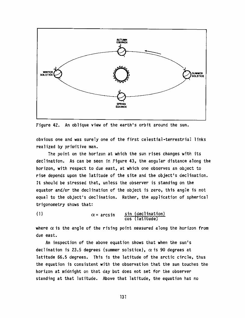
WINTERSOLSTICE
AUTUMNEQUINOX
oSPRING
EQUINOX
SUMMERSOLSTICE
Figure 42. An oblique view of the earth1s orbit around the sun.
obvious one and was surely one of the first celestial-terrestrial linksrealized by primitive man.
The point on the horizon at which the sun rises changes with itsdeclination. As can be seen in Figure 43, the angular distance along thehorizon, with respect to due east, at which one observes an object torise depends upon the latitude of the site and the object1s declination.It should be stressed that, unless the observer is standing on theequator and/or the declination of the object is zero, this angle is notequal to the object1s declination. Rather, the application of sphericaltrigonometry shows that:
(1) ex= arcsin sin (declination)cos (latitude)
where ex is the angle of the rising point measured along the horizon fromdue east.
An inspection of the above equation shows that when the sun1sdeclination is 23.5 degrees (summer solstice), ex is 90 degrees atlatitude 66.5 degrees. This is the latitude of the arctic circle, thusthe equation is consistent with the observation that the sun touches thehorizon at midnight on that day but does not set for the observerstanding at that latitude. Above that latitude, the equation has no
131
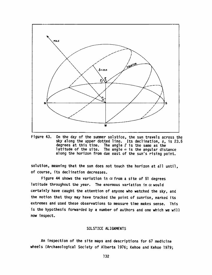
POLE
N1-------------,L---~----____7'_----____7-"""""1 S
w
Figure 43. On the day of the summer solstice, the sun travels across thesky along the upper dotted line. Its declination, ~, is 23.5degrees at this time. The angle f is the same as thelatitude of the site. The angle a is the angular distancealong the horizon from due east of the sun's rising point.
solution, meaning that the sun does not touch the horizon at all until,of course, its declination decreases.
Figure 44 shows the variation in a from a site of 51 degreeslatitude throughout the year. The enormous variation in a wouldcertainly have caught the attention of anyone who watched the sky, andthe notion that they may have tracked the point of sunrise, marked itsextremes and used these observations to measure time makes sense. Thisis the hypothesis forwarded by a number of authors and one which we willnow inspect.
SOLSTICE ALIGNMENTS
An inspection of the site maps and descriptions for 67 medicinewheels (Archaeological Society of Alberta 1976; Kehoe and Kehoe 1979;
132

MAR 21
JUN 21
SEP 21
DEC 21
MAR 21 40
a20 o
Figure 44. The yearly variation of aas measured from a site at latitude51 degrees. Considering that the position of the sunrisechanges very slowly about the time of the equinoxes and thesmall angular diameter of the sun (shown at summer solstice),an alignment must be quite accurate to establish the day ofthe solstice.
Quigg 1984) demonstrated that the majority, consisting of single cairns,simple rings or broad accumulations of stone with no perceptablestructure, have no possible astronomical significance. Although this byno means constitutes evidence against the hypothesis that some medicinewheels have astronomical alignments, the fact that 54 of the 67 initiallycould be placed in this category indicates that any astronomicallysignificant feature is exceptional, and the astronomical hypothesis doesnot offer any comprehensive explanation of these puzzling structures.
Of the remaining examples, twelve had strings of stones or pairs ofcairns which could have been used to establish lines which pointed towithin a few degrees of the summer solstice sunrise. It has also beensuggested that some medicine wheels show alignments to the rising points ofbright stars (Eddy 1974, 1979). A site often mentioned in this regard (BigHorn) was chosen for analysis and will be dealt with in the next section.
133
An initial inspection of the twelve sites chosen for possiblesolstitial alignments introduced questions concerning the logistics ofestablishing accurate, useful sightlines. Although the sun is brightenough to dominate the sky, its angular diameter is quite small. It canbe easily eclipsed by the tip of the finger held at armis length. Asightline accurate enough to follow the daily progress of the sun aroundthe time of the solstice should be accurate to within a few tenths of adegree, but, in most cases, the forward cairn of the proposed sightlineconsists of a sprawling mass of rock subtending some five or ten degrees,while the rising sun subtends only one half of a degree. Sightlines madeof two posts on either end of a very long baseline would have been muchmore accurate, and it is hard to believe that this would have escaped theattention of anyone actually involved in studying the sunls motion. Inthat, in some cases, the foresight cairn consists of many tons of rock,the astronomical hypothesis demands that we believe that the nativesundertook many hours of hard labor which, indeed, rendered the sightlineless accurate than it was when it consisted of two small piles ofstones. Again, this does not prove that medicine wheels were never setup to record the position of the summer solstice sunrise. However, itdoes indicate that if they were, accuracy was probably of no particularinterest, and, therefore, the use of medicine wheels to establish acalendar date is not a very viable possibility. Furthermore, it suggeststhat, in many cases, it would be advisable to approach archaeologicaltheories experimentally. In the present case, going out to a high hillaround the time of the summer solstice and attempting to construct themeans to follow the sunls motion would make the above-mentioned problemsabundantly clear.
We have as yet to actually test the hypothesis. To do so, we mustuse it to make a specific prediction which can be confirmed or refuted bythe data. It would be nice if we could find a pair (or more) ofvariables which should relate to one another in a specific way if thehypothesis is true. Medicine wheels take a wide variety of forms and theones which feature possible solstitial alignments do not stand out in anyparticular way. Variables involving the actual structures, such asbaseline length, cairn size or auxilliary features, do not appear capableof offering the test needed. However, there is another variable which is
134
accurately established and which should be directly tied to anothervariable: geographic latitude. As shown in Figure 43 and equation (1),the angle a depends both upon the latitude of the site and thedeclination of the object. If a number of baseline~at differentlatitudes are to point at the summer solstice sunrise, the variation intheir latitudes should render a systematic variation in the angle a.Figure 45 illustrates the results of this test. There is no systematicrelationship between latitude and the angle a. Even if we knew what wewere looking for before selecting data points, it would be difficult toselect them in such a manner as to support the astronomical hypothesis •
•STELLAR ALIGNMENTS
We now turn our attention to the possibility that certain Medicinewheels were constructed to indicate the rising points of various brightstars. Here we are once again faced with some initial problemsconcerning the usefulness of such alignments. As pointed out earlier,while the sun1s declination varies dramatically with the seasons, thedeclinations of the stars do not change over any short timescale. Why,then, would one want to denote the rising point of a particular star? Ithas been proposed the the rising time of a particular star with respectto the rising time of the sun would be of value in determining the day ofthe year. This is true; the ancient Egyptians defined the first day ofthe year as the day that Sirius was first visible before sunrise (theheliacal rising). It is certainly possible that the American nativeswere aware that this was a phenoruena which could be employed to establishan accurate calendar. But why would they have to indicate the risingposition of the star in question? They certainly would have beenfamiliar enough with its position with respect to the visible stars tohave been able to anticipate the position and approximate time of itsrising. Again, the above questions do not, in themselves, undermine theastronomical hypothesis. We must invent a test which the hypothesis can
pass if and only if it is correct.In the case of solstitial alignments, there was a single target:
the summer solstice sunrise. However, here there are many possibletargets. The summer sky has many conspicuous stars which may have been
135
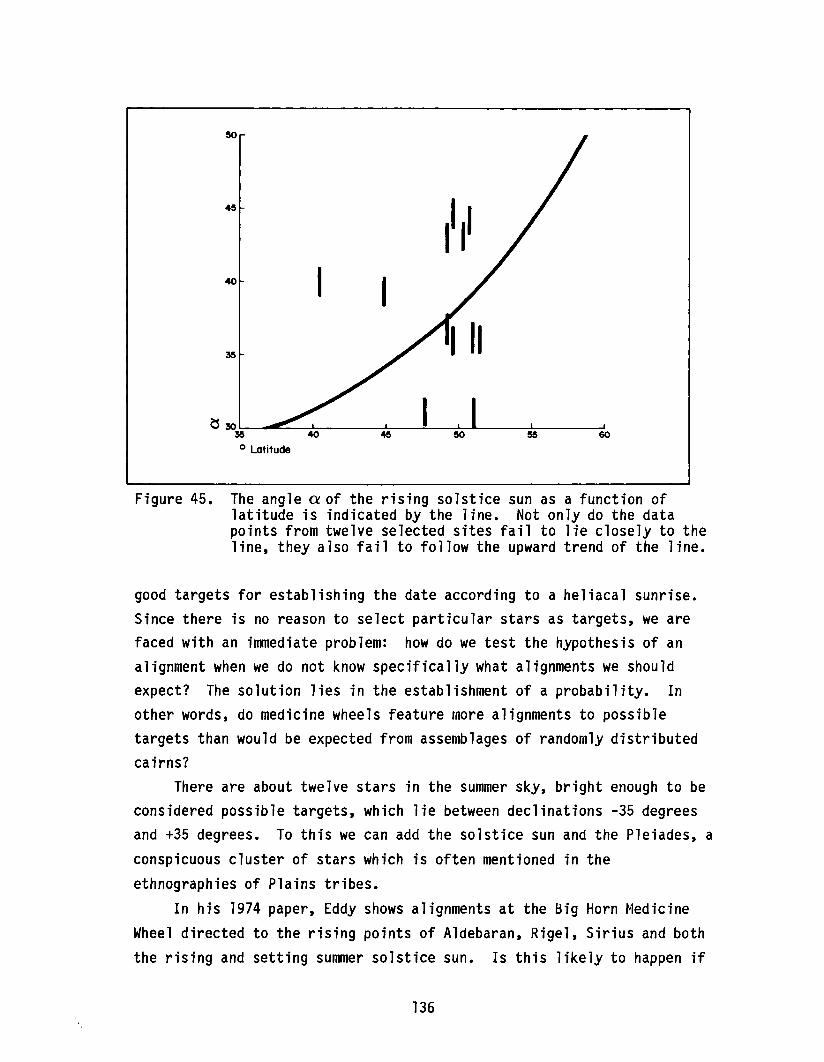
6050
11
45
40
~ 30 ""'----- 1 ----'35
o Latitude
Figure 45. The angle a of the rising solstice sun as a function oflatitude is indicated by the line. Not only do the datapoints from twelve selected sites fail to lie closely to theline, they also fail to follow the upward trend of the line.
good targets for establishing the date according to a heliacal sunrise.Since there is no reason to select particular stars as targets, we arefaced with an immediate problem: how do we test the hypothesis of analignment when we do not know specifically what alignments we shouldexpect? The solution lies in the establishment of a probability. Inother words, do medicine wheels feature more alignments to possibletargets than would be expected from assemblages of randomly distributedcairns?
There are about twelve stars in the summer sky, bright enough to beconsidered possible targets, which lie between declinations -35 degreesand +35 degrees. To this we can add the solstice sun and the Pleiades, aconspicuous cluster of stars which is often mentioned in theethnographies of Plains tribes.
In his 1974 paper, Eddy shows alignments at the Big Horn MedicineWheel directed to the rising points of Aldebaran, Rigel, Sirius and boththe rising and setting summer solstice sun. Is this likely to happen if
136
the cairns are randomly distributed? What is the probability of such animpressive array of alignments?
The centers of the cairns involved cannot be determined to anaccuracy better than plus or minus one degree in azimuth. (Thiscorresponds to about 0.7 degrees in declination.) We also have to dealwith the refraction of the starlight as it passes through the atmosphereand the amount of its light which is absorbed. Both of these processesaffect the position of the star when it is first visible, and both arehighly variable. Estimating conservatively, we find that a particularcairn-to-cairn sightline covers about two degrees of declination. Any ofthe target stars lying within that range could be argued to be the object
of that sightline.The proposed alignments at the Big Horn site involve both lines
radiating from the central cairn and lines drawn between pairs ofoutlying cairns. When all possible pairs of cairns are considered, wefind ten alignments which are directed into the area of the sky betweenthe declinations of -35 degrees and +35 degrees. Since there arefourteen targets, each two degrees wide, distributed over 70 degrees ofthe sky, the probability that a single random line pointing into thispart of the sky hitting one of the targets is (14 x 2)/70 or about 40percent. What is the probability of five hits out of ten alignments?The formula for this, found in most mathematical handbooks, is:
N
p =2:X=I
N! QX (l-Q)(N-X)X! (N-X)!
where N is the number of random lines, I is the number of hits, and Q isthe probability of each hit. Inserting the numbers, we have:
10p =~ 10! (.40)X (.60)(lO-X) = .36
L..J X! ( lO-X)!X=5
There is a 36 percent chance that five or more alignments would result ifthe Big Horn Medicine Wheel were built with the same basic configurationbut with no intentionally constructed astronomical alignments.
137
The numbers used are all debatable; others may have differentestimates of accuracy of the sightlines or the numbers of acceptabletarget stars. However, no reasonable manipulation of the numbers canmake the Big Horn alignments appear unlikely to have happened by chance.The other four medicine wheels analyzed in this way were even lessimpressive; probabilities of the alignments being the result of chanceranged from 64 to 85 percent. Statistical tests cannot prove a negative,however. We have not established that Big Horn or any other medicinewheel was not intended to be used as astronomical observatories, but itis reasonable to demand that the hypothesis pass the above test, and itsperformance is not impressive.
CONCLUSIONS
The present study yields both specific and general conclusions whichare worthy of consideration. The astronomical hypothesis as applied tomedicine wheels fails to pass two simple tests. Not only does it appearunlikely that they were used for the purpose of making astronomicalobservations, it also appears unlikely that the structures of this naturecould have been useful in this manner even if the orientations were moreconvincing. None of this should really come as a surprise. There is noindication that the Plains Indians were ever particularly interested inestablishing an accurate calendar. Any periodic event in which they wereinterested, such as the right time for planting, was attended by anynumber of environmental clues. A familiarity with the motions of the skywas undoubtedly part of the assemblage of observations which they broughtto bear upon the problem of time determination; however, a generalknowledge of the changing star patterns was probably sufficient for theirpurposes.
The weaknesses of the astronomical hypothesis as applied to medicinewheels are typical of those which have surfaced elsewhere. In recentyears, a number of classical assertions in archaeoastronomy have beenbrought into question. Even Stonehenge, the archetype of prehistoricastronomy, has been shown to lie on foundations considerably weaker thanthose granted to it by the popular press, if not by the scientificcommunity. This also should come as no surprise. Particularly in a
138
young discipline, the temptation to bring a wide range of phenomena underthe umbrella of a single coherent explanation is quite strong. The realmof ancient civilization is especially vulnerable to the over-extension ofa particular hypothesis since little tangible evidence can be accumulatedin counterpoint. In the absence of hard evidence, an idea which seemsreasonable or is based upon popular preconceptions needs littlecircumstantial evidence to appear quite convincing.
The fundamental basis of archaeoastronomy lies on firm ground:clearly the sky has been a focal point of interest throughout time. Acareful study of the subject will certainly yield fascinating insightsinto the past for some time to come. However, there are a number ofpitfalls which must be born in mind if the disciple is to develop with asound structure.
It is tempting, when studying cultures of the past, to view them inthe context of the concepts and motivations which make sense to themodern mind. The rationalists· outlook upon the universe as amechanistic, cause-and-effect system which can be subjected to analysismay seem to offer a comprehensive explanation of the practices ofprimitive people. However, those people were largely of a mysticaloutlook who perceived the world as working according to principles whichwould be quite alien to us. Their motivations would puzzle us, and ourpropensity for the detailed analysis and restructuring of oursurroundings may well seem pointless from their viewpoint.
The ideal starting point from which to approach the problem posed bya cryptic artifact or practice lies within a through understanding of theethnography of the people involved. Clearly, this is not available inmany cases. When it is not, it is essential to bear in mind that ourframework of ideas and motivations are historically quite young and maytranslate poorly into other cultures and times.
ACKNOWLEDGEMENT
The author is grateful to Pat Wendt for her remarks on themanuscript.
139
EATING ROCKS: PEBBLE CHERTS,FALL-OFF CURVES AND OPTIMAL DIET THEORY
ByBruce F. Ball
Archaeological Survey of Alberta
INTRODUCTION
During a tour of historical resource sites in the Neutral Hills ofeast central Alberta in July of 1986, we were shown a site our guidethought to be most peculiar. On the gentle slope of a small rise on thesouthern slopes of the hills, a round cut had exposed a site composed ofchert pebbles. Our guide thought the site was unusual because only oneartifact type appeared to be present in the assemblage - split pebbles.What he had discovered, of course, was a chert pebble quarry.
The discovery was not a new one, however; Quigg (1977, lY78)surveyed the area in 1976 and noted that sites in the region aredominated by "bipolar pebble technology." Quigg termed the phenomenonthe "Neutral Hills Pebble Industry" (1977:58). While his observationswere based for the most part on survey and surface collections, one "tipiring" (camp) site (FbOr-57) was chosen for excavation. Over 81 percentof the assemblage from the site was found to be attributable to splitpebble technology. A review of the composition of the surface collectedmaterial from Quigg1s 1976 survey underlines the significance of thechert pebble raw materials in the Neutral Hills region.
CHERT PEBBLES IN THE NEUTRAL HILLS
Collections from 82 sites recorded by Quigg (1977) in the NeutralHills and surrounding area were examined. To identify possibledifferences between the site assemblages, the region was stratified intofour groups: the Neutral Hills, adjacent slopes, Nose Hill and theoutlands (Figure 46). The collections from the sites located in theserespective areas were then examined and described in terms of rawmaterial type and artifact type. The information categories and data
140

OUTLANDS
N
1
o~a
ADJACENT SLOPES
OUTLANDS
o IOKM.....' --------,
Figure 46. The Neutral Hills region showing the general locations offour study areas: the Neutral Hills, the adjacent slopes,Nose Hill and the outlands.
141
recorded are shown in Table 14. From these data, a series of graphs weremade to identify general trends or patterns occurring between thecombined assemblages of the different areas.
Plotting the occurrence of the two dominant raw material types(chert and quartzite) over the four areas shows the overwhelmingpredominance of chert over quartzite in the Neutral Hills sites and thegradual decrease and change to approximately equal proportions in thesites located more than 5 km from the hills (outlands; Figure 47).Figure 48 displays the proportions of chert split pebble detritus toquartzite in the sites within the different areas. While showing a trendidentical to that in Figure 47, Figure 48 demonstrates the relativeimportance of the chert pebble as compared with quartzite as you moveaway from the hill quarries. Another interesting trend is displayed inFigure 49. The occurrence of split pebble chert debitage in the siteassemblages decreases as you move from the Neutral Hills to the outlands,while concomitantly there is an increase in the proportion of tools(scrapers and projectile points). We must assume, of course, that thesite assemblage samples we looked at are generally indicative of what isactually in the sites and that the collection methodology is generallycorrect (i.e., quarries are quarries and camps are camps). I think thepatterns which result from the data support these assumptions, at leastin a general way. Our total for chert pebbles - 77.5 percent of thetotal assemblage recovered from the camps in the hills proper - whencompared to Quigg1s (1978:19) total of 81.6 percent suggests relativecongruence.
DISCUSSION
Of particular interest in the study of the presence and use pebblecherts in the Neutral Hills is the fact that the pebble cherts appear tobe more highly regarded than the other raw material (quartzite), whichlikely is equally available and abundant in the area. Comparing the useof pebble cherts vis-a-vis quartzite and other raw materials in theNeutral Hills sites with sites in other areas of the province, we see ahint of the importance of this raw material and the bipolar technology inAlberta1s prehistory. (Note also Reeves I identification of chert pebble
142
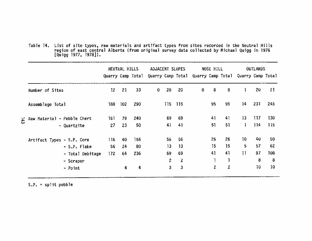
Table 14. List of site types, raw materials and artifact types from sites recorded in the Neutral Hillsregion of east central Alberta (from original survey data collected by Michael Quigg in 1976[Quigg 1977, 1978]).
NEUTRAL HILLS ADJACENT SLOPES NOSE HILL OUTLANDSQuarry Camp Total Quarry Camp Total Quarry Camp Total Quarry Camp Total
Number of Sites 12 21 33 0 20 20 0 8 8 20 21
Assemblage Total 188 102 290 115 115 95 95 14 231 245
~Raw Material - Pebble Chert 161 79 240 69 69 41 41 13 117 130
w41 51 51 1 114 115- Quartzite 27 23 50 41
Artifact Types - S.P. Core 116 40 156 56 56 26 26 10 40 50
- S.P. Flake 56 24 80 13 13 15 15 5 57 62
- Total Debitage 172 64 236 69 69 41 41 11 97 108
- Scraper 2 2 1 1 8 8
- Point 4 4 3 3 2 2 10 10
S.P. = split pebble

100
80
=60og15ECD:140g
Cg'0 20
- Chert
-- Quartzite
...cCDe8!. 0 '---_~__---I _..L. .....J
HILLS SLOPES
Area of site locationsNOSE HILL OUTLANDS
Figure 47. Proportions of chert and quartzite artifacts are shown tochange relative to one another in sites located in theNeutral Hills stuQy area. While the percentage of chert inthe site assemblages decreases, the amount of quartziteincrease as you move out from the Neutral Hills area to thesurrounding outlands.
100
80
1ft
"6S&60.2~
ECD140oofo0201:I)
eI)
0. 0HillS SLOPES
Area of site locations
(Itt] Quartzite
III Split pebble
NOSE HILL OUTLANDS
Figure 48. Proportion of split pebble detritus compared to quartzitedetritus in sites recorded in the Neutral Hills studyregion. Note that while the percentage of split pebbledetritus decreases as you move out from the hills into theadjacent outlands, the relative proportions are stillrelatively high.
144
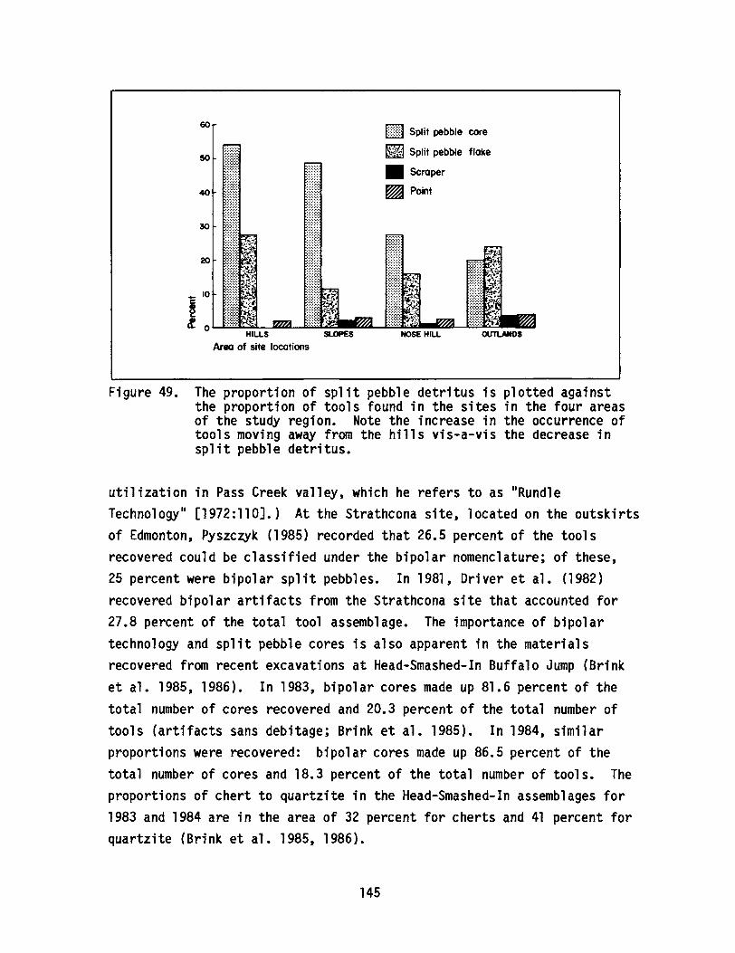
[ill] Split pebble core
~ Split pebble flake
• Scraper
~ Point
20
60
50
30
40
~ 10c
~l. 0 LE~L.~U[t!~_L.Et~-..I~--lli1lt!~
HILLS NOSE HILL
Area of site locations
Figure 49. The proportion of split pebble detritus is plotted againstthe proportion of tools found in the sites in the four areasof the study region. Note the increase in the occurrence oftools moving away from the hills vis-a-vis the decrease insplit pebble detritus.
utilization in Pass Creek valley, which he refers to as IIRundleTechnology" [1972:110].) At the Strathcona site, located on the outskirtsof Edmonton, Pyszc~k (1985) recorded that 26.5 percent of the toolsrecovered could be classified under the bipolar nomenclature; of these,25 percent were bipolar split pebbles. In 1981, Driver et ale (1982)recovered bipolar artifacts from the Strathcona site that accounted for27.8 percent of the total tool assemblage. The importance of bipolartechnology and split pebble cores is also apparent in the materialsrecovered from recent excavations at Head-Smashed-In Buffalo Jump (Brinket ale 1985, 1986). In 1983, bipolar cores made up 81.6 percent of thetotal number of cores recovered and 20.3 percent of the total number oftools (artifacts sans debitage; Brink et ale 1985). In 1984, similarproportions were recovered: bipolar cores made up 86.5 percent of thetotal number of cores and 18.3 percent of the total number of tools. Theproportions of chert to quartzite in the Head-Smashed-In assemblages for1983 and 1984 are in the area of 32 percent for cherts and 41 percent forquartzite (Brink et ale 1985, 1986).
145

While chert and quartzite make up a significant portion of theassemblages of Head-Smashed-In and Strathcona, a variety of other rawmaterial types are present as well. Thus, we have relatively highdiversity (richness) of raw material types. This is at odds with thesituation in the Neutral Hills where the raw material diversity(richness) is low. This pattern of low diversity is also present in theAthabasca River valley at the source area for Beaver River Sandstone(Ives and Fenton 1985:38). Assemblages near the source were observed tobe composed of high, if not exclusive, proportions of Beaver RiverSandstone. Not unexpectedly, the proportions decrease with acorresponding increase in distance from the source. A pattern emergeswherein the number of material types (NMT) found in any assemblage isdependent upon the absolute abundance of the preferred types. Thus, thetotal NMT decreases with an increase in the availability or abundance ofpreferred or highly ranked types. The obvious assumption being made hereis that one raw material will be preferred over another. However, Reherand Frison (1980) argue that the richness of an assemblage may be due tothe IImobilityll and IIresidential dispersion ll of groups.
Assuming access to an uplifted area and to a roughly equalnumber and diversity of resources, differences in assemblagediversity should be due to differences in residentialdispersion during the gearing-up season. Traveling in acentralized group and gearing up at one or a few main quarriesresults in low assemblage diversity. If gearing up isaccomplished in the context of dispersed family units, highassemblage diversity results (1980:128-129).
While I would agree with Reher and Frison1s observation that IIsuperiorll(highly ranked or preferred) materials were selected over lessermaterials (1980:127) and that concentrating on lIone or a few mainquarries results in low assemblage diversitY,1I I would argue thatassemblage diversity (richness) is first a function of relative abundanceof preferred types regardless of the nature of group size and mobility.In actuality, these latter factors of group size and mobility complicatethe equation somewhat and should be considered in addition to theabundance of material types. The NMT present in an assemblage isdependent upon the availability of preferred materials.
146
Renfrew (1977) discusses the pattern of decreasing abundance of acommodity with increasing distance from source under the rubric of theIILaw of Monotonic Decrement,1I which simply put says that the frequency ofoccurrence of an item declines with increasing distance from the source.Hodder (1974), Sidrys (1977) and others have explored some of theproperties of such distributions through regression analysis.
The focus of the discussions by researchers such as Renfrew (1977),Hodder (1974) and Sidrys (1977) is on trade and exchange of items from asingle source. However, raw material types commonly used in Alberta aremore homogeneously distributed. With the exception of unique situationssuch as the Neutral Hills pebble cherts and the Beaver River Sandstonesource area, raw materials such as quartzite are readily available in themany stream bed and till outcrops throughout Alberta. While trade andexchange of exotic items such as Knife River Flint and obsidian occurred,selection and utilization of most material types for everyday use likelywas dependent upon abundance of known, locally available types. Thus,the process of acquisition is more closely related to foraging than todependence upon trade and exchange.
If it can be assumed that the user was aware of the relativeproperties of the various raw material types available to him or her withrespect to the job at hand, it can be assumed that some materials wouldbe ranked over others. The model which follows this process of selectingraw material types is contained most closely in Optimal Diet theory (seeCharnov 1976; MacArthur and Pianka 1966; Pyke et ale 1977; Sih 1979).Like our assumption above that the user is notably familiar with thematerial types available to him, the model of optimal diets assumes thatlI a predator has perfect knowledge of available resources [to make therankings]1I (Hespenheide 1980:74). The properties of optimal diet whichare of interest here are as follows:
(1) whether or not a food type should be eaten is independenton the abundance of that food type and depends only on theabsolute abundances of food types of higher rank. So, intheory, an animal should never specialize on a IIl esspreferred ll food type regardless of its abundance.
(2) in general, as the abundance of a preferred food typeincluded in the diet increases, the number of lesspreferred food types included in the optimal diet will
147

shrink. In other words, increasing food abundance shouldlead to greater food specialization. And, in particular,as the abundance of an item included in the optimal dietbecomes infinitely large, all food items of lower rank aredropped out of the diet.
(3) a food type is either completely included in the optimaldiet or completely excluded from it. In other words, if afood type is included it should be eaten wheneverencountered, and if excluded it should never be consumed.Hence, animals should never exhibit "partial preferences"(Pyke et ale 1977:141).
One of the important patterns which Hespenheide (1980:75) notes isthat the effect of reducing the absolute densities of highly ranked itemsis to enlarge the optimal set of items (Hespenheide 1980:75) •
• • • if the densities of prey items ••• are normallydistributed ••• the resource diversity of optimal diets willnormally be intermediate in size. If predator populationdensity is relatively low ••• prey abundance will be highrelative to predator needs, and optimal resource diversity ofpredator diets will be low. As population size of the predatorincreases, both relative and absolute densities of preferreditems ••• decrease and the optimal resource diversity expands(Hespenheide 1980:75).
In the archaeological record it might be expected that human populationsincrease over time, and that over time group populations become morefamiliar or restricted to one region. Our analogy thus would see theassemblages of early populations exhibit low diversities of preferredmaterial types and later assemblages display greater diversity. One ofthe limiting factors in this proposition may involve the accumulation ofgreater knowledge of the resource base over time. The idea is that earlypopulations would have been less knowledgeable of the potential of theirsurroundings and therefore less likely to access or utilize the fullcomplement of available resources.
Models which describe the distributions of raw materials in thearchaeological record remain scarce. Examples of studies which describepatterns of trade and exchange are more often than not restricted tounique or highly visible exotic items (Hodder 1974; Sidrys 1977).Patterns and models of the more common, everyday, utilitarian lithic
resources, are less well known. In this descriptive report, the optimaldiet model is proposed as a means of describing patterns of lithic raw
148
material utilization. The optimal diet model is one of several modelssubsumed under a body of ecological theory known as optimal foragingtheory. Recognizing that there are and will be limitations to theapplications of foraging models, the identification of patterns in thearchaeological record which conform to or may be described by optimalforaging models is nevertheless encouraging.
Demonstrable regularities conforming to mathematically simpleforms are still disappointingly few in archaeology, and theiranalysis raises new and interesting questions. For there ishope that many archaeological distributions from differenttimes and places, and entirely independent in the circumstancesof their formation, can be expressed in this way. If it is thecase that these distributions share basic, simple properties,the same may be true also for the processes generating them.And the understanding of these cultural processes is theultimate goal of our investigation (Renfrew 1977:73).
149

THE TRIANGULAR PROJECTILE POINT IN PLAINS PREHISTORY:A PREFORM TRADE HYPOTHESIS
ByRobert J. Dawe
Archaeological Survey of Alberta
INTRODUCTION
Head-Smashed-In Buffalo Jump in southwestern Alberta is one of thelargest and most extensively studied jumps in the northwestern Plains.Excavations in the deeply stratified kill site deposits in 1965, 1966 and1972 revealed a sequence of site use extending back more than 5,500 years(Reeves 1978, 1983b). Additional studies of the butchering/processingarea below the kill by the Archaeological Survey of Alberta from 1983 to1986 have added substantially to the lithic artifact sample (Brink et ale1985, 1986). The artifact inventory of the kill site deposits isdominated by the occurrence of stone projectile points. More than3,000 point specimens account for over half of the recovered lithicassemblage. Reeves (1978, 1983b) has observed that the principal lithicmaterials used to make these points were obtained from a variety ofdistant sources, including Palaeozoic cherts from sources in the RockyMountains of Alberta and British Columbia; Madison Formation cherts fromMontana; obsidian from the Yellowstone area; Kootenay argillite fromBritish Columbia; and Knife River Flint from North Dakota. Subsequentinvestigations indicate that Swan River Chert, possibly derived fromSaskatchewan, is also an important part of the assemblage (Brink et ale1985, 1986). The considerable distance from which many of thesematerials were derived (approximately 1000 km in the case of Knife RiverFlint) suggests that trade was a means by which some of these rawmaterials must have been obtained.
Traditionally, most archaeologists have argued that exotic rawmaterials were obtained through trade and that the production of thefinished artifacts was presumably completed by the people who importedthe raw materials. However, recent analysis of the lithic assemblagefrom the processing area at Head-Smashed-In revealed that on-site
150
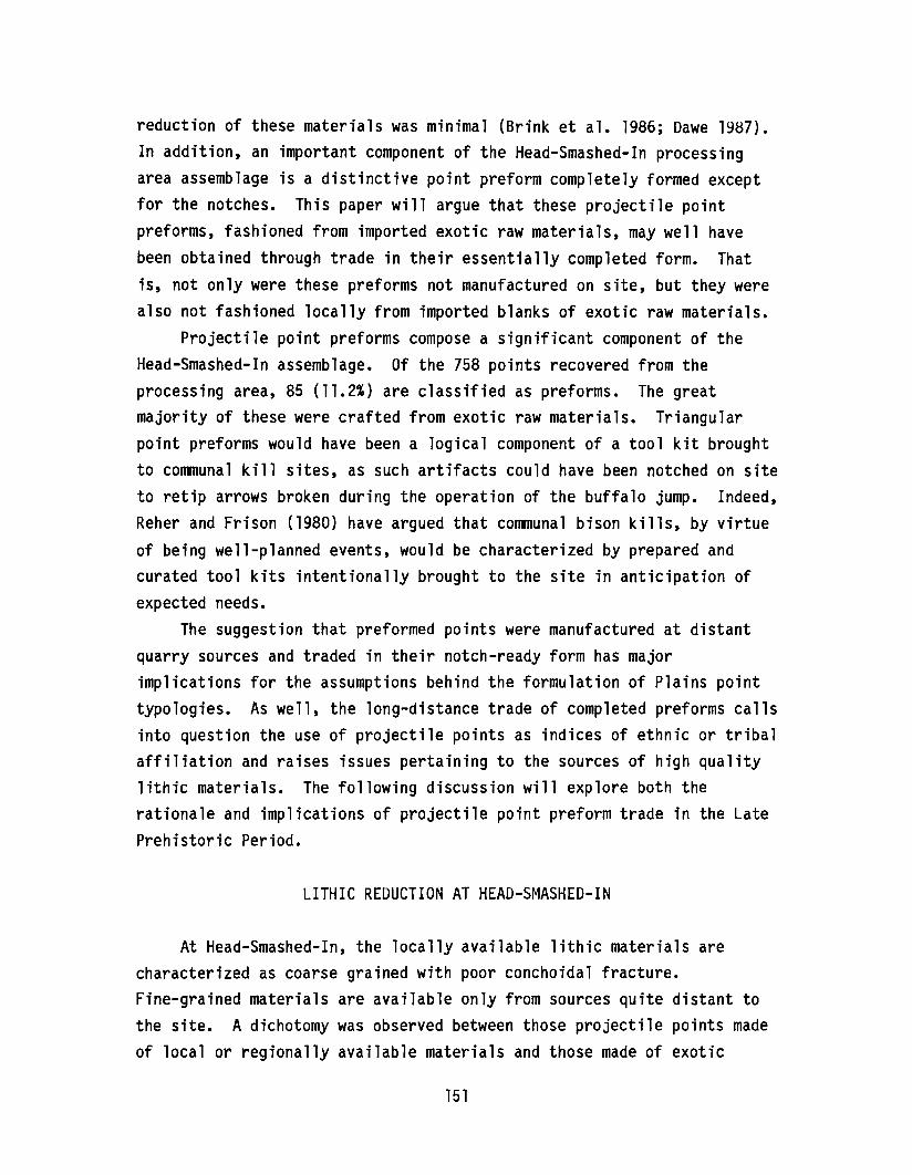
reduction of these materials was minimal (Brink et ale 1986; Dawe 1987).In addition, an important component of the Head-Smashed-In processingarea assemblage is a distinctive point preform completely formed exceptfor the notches. This paper will argue that these projectile pointpreforms, fashioned from imported exotic raw materials, may well havebeen obtained through trade in their essentially completed form. Thatis, not only were these preforms not manufactured on site, but they werealso not fashioned locally from imported blanks of exotic raw materials.
Projectile point preforms compose a significant component of theHead-Smashed-In assemblage. Of the 758 points recovered from theprocessing area, 85 (11.2%) are classified as preforms. The greatmajority of these were crafted from exotic raw materials. Triangularpoint preforms would have been a logical component of a tool kit broughtto communal kill sites, as such artifacts could have been notched on siteto retip arrows broken during the operation of the buffalo jump. Indeed,Reher and Frison (1980) have argued that communal bison kills, by virtueof being well-planned events, would be characterized by prepared andcurated tool kits intentionally brought to the site in anticipation ofexpected needs.
The suggestion that preformed points were manufactured at distantquarry sources and traded in their notch-ready form has majorimplications for the assumptions behind the formulation of Plains pointtypologies. As well, the long-distance trade of completed preforms callsinto question the use of projectile points as indices of ethnic or tribalaffiliation and raises issues pertaining to the sources of high qualitylithic materials. The following discussion will explore both therationale and implications of projectile point preform trade in the LatePrehistoric Period.
LITHIC REDUCTION AT HEAD-SMASHED-IN
At Head-Smashed-In, the locally available lithic materials arecharacterized as coarse grained with poor conchoidal fracture.Fine-grained materials are available only from sources quite distant tothe site. A dichotomy was observed between those projectile points madeof local or regionally available materials and those made of exotic
151
materials. Projectile points made of local materials tend to be poorlymanufactured, usually by the marginal retouch of flakes obtained fromsmall bipolar cores. The reduction debris of local material isrepresented by all stages of the manufacturing process, including bipolarcores and primary, secondary and small tertiary debris. It appears thatprojectile points made of local materials were expediently produced onsite.
On the other hand, projectile points of exotic raw materials aretypically well made. However, the raw materials are rarely representedin the debitage assemblage by anything other than very tiny tertiarydebris. Obviously, projectile points and point preforms of exoticmaterials were made elsewhere and brought to the site in finished ornearly finished form.
THE TRIANGULAR PROJECTILE POINT AS A PREFURM
Unnotched, triangular arrow points have been recovered from thecampsite or processing area associated with virtually every investigatedLate Prehistoric communal bison kill but rarely from the associated killsite deposits themselves. Characteristics of unnotched, triangularpoints from Head-Smashed-In and numerous other Late Prehistoric sitesindicate that these are notch-ready points with no hafting modification,no basal grinding and no use wear. With the addition of notches, thepoints would be ready to use.
The large number of point bases in the processing area atHead-Smashed-In (approximately a 2:1 base to tip ratio) indicates thatfrequent retipping of arrows was taking place. Such retipping orretooling can be regarded as a normal consequence of the high breakageincidence and short tool use lives of hafted tools (Keeley 1982) and canaccount for the need to have replacement preforms available in somequantity. An example that illustrates a desire to have such preforms athand for insurance might be provided at the Braden burial site (see Muto1971). Of 152 triangular dart (1) points recovered, only two werenotched; the others were interpreted as being blanks or preforms from thefinal stages of reduction. The specimens illustrated by Muto could be
152
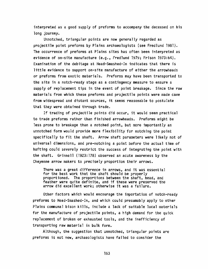
interpreted as a good supply of preforms to accompany the deceased on hislong journey.
Unnotched, triangular points are now generally regarded asprojectile point preforms by Plains archaeologists (see Fredlund 1981).The occurrence of preforms at Plains sites has often been interpreted asevidence of on-site manufacture (e.g., Fredlund 1979; Frison 1973:64).Examination of the debitage at Head-Smashed-In indicates that there islittle evidence to support on-site manufacture of either the arrowheadsor preforms from exotic materials. Preforms may have been transported tothe site in a notch-ready stage as a contingency measure to ensure asupply of replacement tips in the event of point breakage. Since the rawmaterials from which these preforms and projectile points were made camefrom widespread and distant sources, it seems reasonable to postulatethat they were obtained through trade.
If trading of projectile points did occur, it would seem practicalto trade preforms rather than finished arrowheads. Preforms might beless prone to breakage than a notched point, but more importantly anunnotched form would provide more flexibility for notching the pointspecifically to fit the shaft. Arrow shaft parameters were likely not ofuniversal dimensions, and pre-notching a point before the actual time ofhafting could severely restrict the success of integrating the point withthe shaft. Grinnell (1923:178) observed an acute awareness by theCheyenne arrow makers to precisely proportion their arrows.
There was a great difference in arrows, and it was essentialfor the best work that the shaft should be properlyproportioned. The proportions between the shaft, head, andfeather were quite definite, and if these were preserved thearrow did excellent work; otherwise it was a failure.
Other factors which would encourage the importation of notch-readypreforms to Head-Smashed-In, and which could presumably apply to otherPlains communal bison kills, include a lack of suitable local materialsfor the manufacture of projectile points, a high demand for the quickreplacement of broken or exhausted tools, and the inefficiency oftransporting raw material in bulk form.
Although, the suggestion that unnotched, triangular points arepreforms is not new, archaeologists have failed to consider the
153
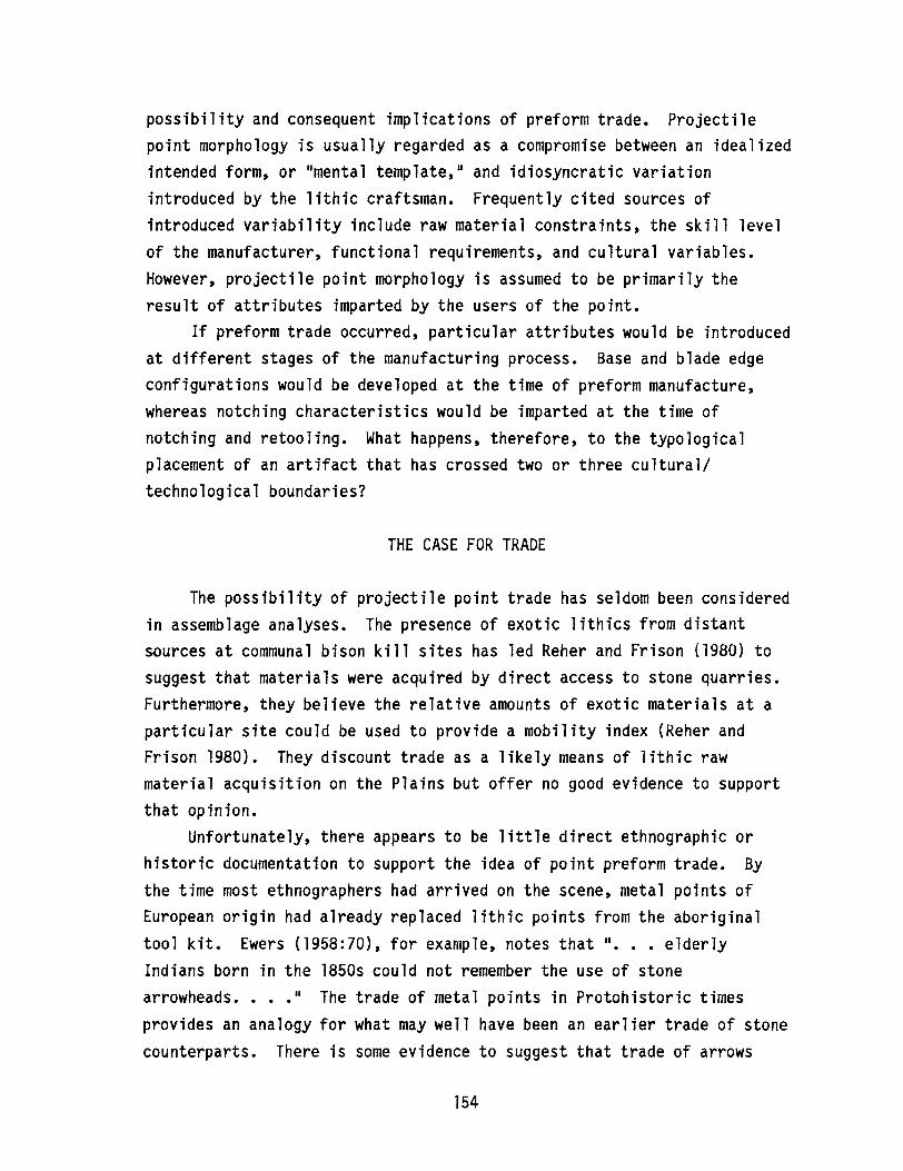
possibility and consequent implications of preform trade. Projectilepoint morphology is usually regarded as a compromise between an idealizedintended form, or "mental template," and idiosyncratic variationintroduced by the lithic craftsman. Frequently cited sources ofintroduced variability include raw material constraints, the skill levelof the manufacturer, functional requirements, and cultural variables.However, projectile point morphology is assumed to be primarily theresult of attributes imparted by the users of the point.
If preform trade occurred, particular attributes would be introducedat different stages of the manufacturing process. Base and blade edgeconfigurations would be developed at the time of preform manufacture,whereas notching characteristics would be imparted at the time ofnotching and retooling. What happens, therefore, to the typologicalplacement of an artifact that has crossed two or three cultural/technological boundaries?
THE CASE FOR TRADE
The possibility of projectile point trade has seldom been consideredin assemblage analyses. The presence of exotic lithics from distantsources at communal bison kill sites has led Reher and Frison (1980) tosuggest that materials were acquired by direct access to stone quarries.Furthermore, they believe the relative amounts of exotic materials at aparticular site could be used to provide a mobility index (Reher andFrison 1980). They discount trade as a likely means of lithic rawmaterial acquisition on the Plains but offer no good evidence to supportthat opinion.
Unfortunately, there appears to be little direct ethnographic orhistoric documentation to support the idea of point preform trade. Bythe time most ethnographers had arrived on the scene, metal points ofEuropean origin had already replaced lithic points from the aboriginaltool kit. Ewers (1958:70), for example, notes that "••• elderlyIndians born in the 1850s could not remember the use of stonearrowheads•••• " The trade of metal points in Protohistoric timesprovides an analogy for what may well have been an earlier trade of stonecounterparts. There is some evidence to suggest that trade of arrows
154
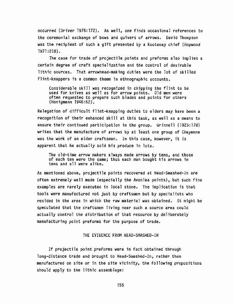
occurred (Driver 1975:172). As well, one finds occasional references tothe ceremonial exchange of bows and quivers of arrows. David Thompsonwas the recipient of such a gift presented by a Kootenay chief (Hopwood1971:218).
The case for trade of projectile points and preforms also implies acertain degree of craft specialization and the control of desirablelithic sources. That arrowhead-making duties were the lot of skilledflint-knappers is a common theme in ethnographic accounts.
Considerable skill was recognized in chipping the flint to beused for knives as well as for arrow points. Old men wereoften requested to prepare such blades and points for others(Honigmann 1946:52).
Relegation of difficult flint-knapping duties to elders may have been arecognition of their enhanced skill at this task, as well as a means toensure their continued participation in the group. Grinnell (1923:178)writes that the manufacture of arrows by at least one group of Cheyennewas the work of an elder craftsman. In this case, however, it isapparent that he actually sold his produce in lots.
The old-time arrow makers always made arrows by tens, and thoseof each ten were the same; thus each man bought his arrows intens and all were alike.
As mentioned above, projectile points recovered at Head-Smashed-In areoften extremely well made (especially the Avonlea points), but such fineexamples are rarely executed in local stone. The implication is thattools were manufactured not just by craftsmen but by specialists whoresided in the area in which the raw material was obtained. It might bespeculated that the craftsmen living near such a source area couldactually control the distribution of that resource by deliberatelymanufacturing point preforms for the purpose of trade.
THE EVIDENCE FROM HEAD-SMASHED-IN
If projectile point preforms were in fact obtained throughlong-distance trade and brought to Head-Smashed-In, rather thanmanufactured on site or in the site vicinity, the following propositionsshould apply to the lithic assemblage:
155
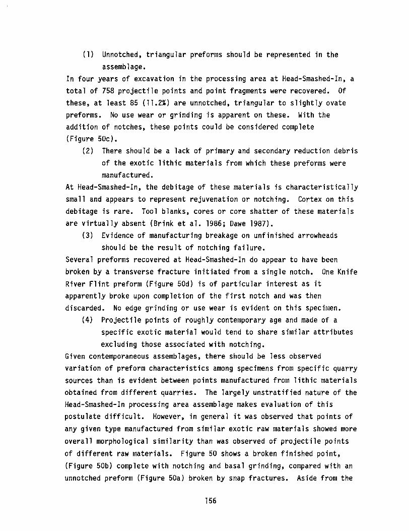
(1) Unnotched, triangular preforms should be represented in theassemblage.
In four years of excavation in the processing area at Head-Smashed-In, atotal of 758 projectile points and point fragments were recovered. Ofthese, at least 85 (11.2%) are unnotched, triangular to slightly ovatepreforms. No use wear or grinding is apparent on these. With theaddition of notches, these points could be considered complete(Figure SOc).
(2) There should be a lack of primary and secondary reduction debrisof the exotic lithic materials from which these preforms weremanufactured.
At Head-Smashed-In, the debitage of these materials is characteristicallysmall and appears to represent rejuvenation or notching. Cortex on thisdebitage is rare. Tool blanks, cores or core shatter of these materialsare virtually absent (Brink et ale 1986; Dawe 1987).
(3) Evidence of manufacturing breakage on unfinished arrowheadsshould be the result of notching failure.
Several preforms recovered at Head-Smashed-In do appear to have beenbroken by a transverse fracture initiated from a single notch. One KnifeRiver Flint preform (Figure 50d) is of particular interest as itapparently broke upon completion of the first notch and was thendiscarded. No edge grinding or use wear is evident on this specimen.
(4) Projectile points of roughly contemporary age and made of aspecific exotic material would tend to share similar attributesexcluding those associated with notching.
Given contemporaneous assemblages, there should be less observedvariation of preform characteristics among specimens from specific quarrysources than is evident between points manufactured from lithic materialsobtained from different quarries. The largely unstratified nature of theHead-Smashed-In processing area assemblage makes evaluation of thispostulate difficult. However, in general it was observed that points ofany given type manufactured from similar exotic raw materials showed moreoverall morphological similarity than was observed of projectile pointsof different raw materials. Figure 50 shows a broken finished point,(Figure 50b) complete with notching and basal grinding, compared with anunnotched preform (Figure 50a) broken by snap fractures. Aside from the
156

d
Figure 50. Sa ple of projectile points from the processing area atHead-Smashed-In Buffalo Jump. Projectile point preforms -a and c; Avonlea projectile point - b; unfinished projectilepoint - d.
notches and grinding, these points are identical in every respect. Bothare of the same peculiar, imported chert, and the flaking characteristicsare so nearly duplicated that one suspects they were made by a singlecraftsman.
(5) Contemporary projectile points made of lithics from differentquarries would tend to have different planform characteristicsbut similar notching characteristics.
The Head-Smashed-In data have not been sufficiently quantified to supportthis contention. However, a projectile point sample obtained from theVore site includes materials from three principal and equally quitedistant sources. Although the overall dimensions of these were observedto be different, some similaritiy was observed of the notching dimensions(Reher and Frison 1980:105, 107).
If we can assume that there was a trade of projectile pointpreforms, there could be an expected bimodal aspect to morphologicalvariation in a projectile point sample based on observations of thepreform design and notching characteristics. Variability represented atthe preform stage should be raw material specific, and, at any particulartime, the preform characteristics of com on materials might reflect
157
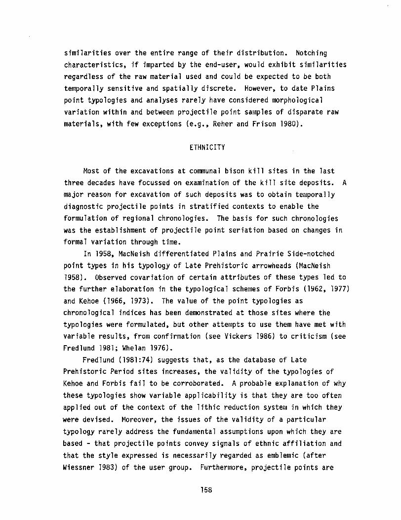
similarities over the entire range of their distribution. Notchingcharacteristics, if imparted by the end-user, would exhibit similaritiesregardless of the raw material used and could be expected to be bothtemporally sensitive and spatially discrete. However, to date Plainspoint typologies and analyses rarely have considered morphologicalvariation within and between projectile point samples of disparate rawmaterials, with few exceptions (e.g., Reher and Frison 1980).
ETHNICITY
Most of the excavations at communal bison kill sites in the lastthree decades have focussed on examination of the kill site deposits. Amajor reason for excavation of such deposits was to obtain tenJporallydiagnostic projectile points in stratified contexts to enable theformulation of regional chronologies. The basis for such chronologieswas the establishment of projectile point seriation based on changes informal variation through time.
In 1958, MacNeish differentiated Plains and Prairie Side-notchedpoint types in his typology of Late Prehistoric arrowheads (MacNeish1958). Observed covariation of certain attributes of these types led tothe further elaboration in the typological schemes of Forbis (1962, 1977)and Kehoe (1966, 1973). The value of the point typologies aschronological indices has been demonstrated at those sites where thetypologies were formulated, but other attempts to use them have met withvariable results, from confirmation (see Vickers 1986) to criticism (seeFredlund 1981; Whelan 1976).
Fredlund (1981:74) suggests that, as the database of LatePrehistoric Period sites increases, the validity of the typologies ofKehoe and Forbis fail to be corroborated. A probable explanation of whythese typologies show variable applicability is that they are too oftenapplied out of the context of the lithic reduction system in which theywere devised. Moreover, the issues of the validity of a particulartypology rarely address the fundamental assumptions upon which they arebased - that projectile points convey signals of ethnic affiliation andthat the style expressed is necessarily regarded as emblemic (afterWiessner 1983) of the user group. Furthermore, projectile points are
158
often assumed to convey ethnic identity apparently because their elaborateform has been interpreted as evidence of long use life and, hence,curation. Coupled with an extremely high archaeological visibility ofthis artifact type, arrowheads have achieved an archaeologicalsignificance that probably overemphasizes their prehistoric value.
Although Forbis (1962, 1977) used his typology of Late Prehistoricpoints to provide a seriation of chronologically sensitive points, othersinappropriately assume that a typology with demonstrable temporalsensitivity must also be culturally sensitive. In other words,morphologically similar sets of points occurring in a defined regionduring a relatively restricted period of time are believed to beindicative of a particular ethnic group. Claims for ethnic affiliationof specific point types abound in the literature (e.g., Greaves 1982;Kehoe 1973; Reeves 1983a).
One reason for believing that Late Prehistoric projectile points aregood carriers of emblemic style is that points are assumed to have beenhighly curated and maintained. For example, Fawcett states:
It is assumed that a great deal of effort was expendedmanufacturing and maintaining projectile points. As a result,they have a long tool use life or curation rate (1980:8).
Although projectile points were highly curated in the sense that theywere often transported over considerable distances and were not bediscarded until broken, care must be taken not to confuse curation with along use life. David Thompsons· observations in the late 1700s indicatethat the use life of stone arrowheads was short. In reference to thearrowheads used by the Snake Indians, Thompson noted that Iithey were allheaded with a sharp, smooth, black stone (flint) which broke when itstruck anything" (Hopwood 1971:193). The delicate nature of arrowheadsis again indicated with reference to the Kootenay•
• • • their only arms were a few rude lances, and flint-headedarrows. Good bowman as they are, these arrowheads brokeagainst a shield of tough bison hide, or even against thickleather could do no harm; their only aim was the face (Hopwood1971:261).
Similarly, the Peigan chief, Kootenae Appee, complained to Thompson aboutthe effectiveness of stone arrowheads on grizzly bears: "••• our
159

arrows were headed with stone, which broke on themll (Hopwood 1971:269).Moreover, Thompson keenly observed which individuals and groups were inpossession of metal (llironshod ll ) arrowheads as opposed to stone points,as well as the relative numbers of these in each quiver. The moredurable metal points were observed to be clearly the superior medium, andthose who were in possession of these had a definite advantage over thosewho were not. The frequent bother of retipping stone points made themeconomically undesirable once metal points became available.
The evidence suggests that, in terms of their use life, arrowheadswere extremely expedient tools, often used only once, broken and thendiscarded. This probably explains the incredible numbers of arrowheadsrecovered at Head-Smashed-In and other buffalo jump sites. If arrowheadswere viewed as having short use lives, it seems difficult to believe thata great investment in signalling ethnicity would have been lavished uponthese artifacts. It can be argued that arrowheads were not intended toconvey ethnic identity, rather the variation expressed may have beenmerely conventions of habit. When emblem and ownership were important,as among the Cheyenne for example, such was imparted to the arrow bypainting the shaft (see Grinnell 1923:183). Similarly, Ewers (1958:122)observed of the Blackfeet:
Arrowmakers could tell their finished products by minordifferences in construction, as well as by the number, widths,and colors of painted stripes under the feathering.
Not only did the shaft surface provide more latitude than the point fordesign, but the shaft would have the added benefit of longevity. Thegreat investment in time required to make a shaft would enhance thelikelihood that it would be curated.
Men always gathered up their arrows, devoting much time tosearching for them and trying never to lose one. They were toohard to get and cost too much effort to be wasted (Grinnell1923:178).
Therefore, if any intended signalling of ethnic affiliation occurred onthe arrow at all, design features imparted to the shaft would appear tohave been the best means to convey such identity. The features on the
point which are regarded in Plains point typologies as the most likely toconvey style occur at the notched area near the base. However, this
160
portion of the artifact would be largely obscured upon hafting. Giventhe short use life of arrowheads and the near invisibility of their mostunique features when hafted, it seems unlikely that the projectile pointwas ever intended to play an emblemic role.
CONCLUSIONS
Recent excavations at Head-Smashed-In Buffalo Jump in southwesternAlberta have provided a large inventory of Late Prehistoric projectilepoints. Attempts to classify the points using typologies established forthe northern Plains met with only marginal success (Brink et ale1985:105). It may be inappropriate to apply typological formulaedeveloped at other sites to describe the morphological variation of theHead-Smashed-In sample. The analysis of the lithic assemblage fromHead-Smashed-In suggests that there is a need to evaluate each assemblagein the context of site specific environmental and cultural factors (Brinket ale 1986:172; Dawe 1987). It is necessary to view point typologies inthe context of the total lithic reduction sequence at each site.
At Head-Smashed-In, the absence of locally available, fine qualitylithics which would have been required to replace broken arrowheadsappears to have resulted in the importation of exotic materials in theform of finished projectile points or point preforms. TheHead-Smashed-In assemblage is characterized by a multitude of arrowheadsof exotic materials, but there is very little evidence of primary orsecondary reduction of these lithic types. It is evident that projectilepoints were often brought to the site in the form of notch-ready preformsand that those made of exotic materials may represent imports obtained bytrade. Notching was done on site at the time of retooling to fitparticular design requirements of the haft and perhaps to satisfyidiosyncratic preferences.
Stone projectile points should be regarded as expedient tools havingshort use lives. The large numbers of unnotched, triangular pointpreforms often noted in campsites associated with communal bison killsmay reflect a frequent pattern of retooling as a result of the breakageof points at such kill sites. The trade of projectile point preforms mayhave been a regular means of acquiring replacements for broken points
161

where the materials for the manufacture of such were not available.Projectile point preforms might be viewed as something of a commodity inthe Late Prehistoric Period. Formal variation of projectile points mayreflect stages of manufacture attributable to different cultural groups.An assemblage containing such forms may be interpreted erroneously asbeing representative of the distribution or affiliation of a singleethnic unit. This possibility has been overlooked in the analysis ofPlains lithic assemblages.
The arguments presented above are not intended to be a compellingdemonstration that notch-ready projectile point preforms were the objectof trade in the Late Prehistoric. However, there is sufficient evidenceto warrant serious consideration of this hypothesis due to its importantimplications for Plains point styles, ethnicity, trade and craftspecialization.
ACKNOWLEDGEMENTS
The author would like to thank Jack Brink and Rod Vickers of theArchaeological Survey of Alberta for their invaluable assistance in theproduction of this paper.
162
ENVIRONMENT CANADA, PARKS, ARCHAEOLOGY IN ALBERTA, 1986
ByDon Steer, Alison Landals, Kevin Montgomery,
Daryl Fedje, Rod Pickard and Ian SumpterEnvironment Canada, Parks
INTRODUCTION
The Archaeological Research Services Unit of the Western RegionalOffice of Environment Canada, Parks directed a total of 115 projectsduring 1986. Of interest in this discussion are 88 projects whichrelated to national parks in Alberta. These projects included 44Archaeological Resource Impact Assessments (ARIAs), four projectsinvolving monitoring, two mitigative excavations and 38 special projects(Table 15). As has been the case in previous years, a number of projects(21%) were completed under contract. A total of 154 new sites wererecorded in the Alberta parks during 1986, and 35 previously recordedsites were reassessed (Table 16). This paper consists of brief summariesof the investigations and results of major projects carried out in 1986.Some special projects not discussed in detail, but worthy of note, arebriefly mentioned below.
During 1986, the Archaeological Research Services Unit begandeveloping a computer-based informational management system. Thisproject, including the entry of management data, will continue in 1987.A number of in-house projects in the areas of planning, collectionsmanagement and storage were also completed in 1986. A contract for theorganization of historic period collections (Anna Curtis) and anotherconcerning administration and organization of records, reports andlibrary materials (Kathy Dilts) were also initiated. A finalcomprehensive faunal analysis of Jasper House materials by Carlann Thomasand Gwyn Langemann and a dendrochronological study of the Jasper area byForintek Canada were administered in a contract basis. Susan Langley ofthe University of Calgary carried out underwater archaeological studiesat Waterton Lakes National Park. Finally, during the 1986 field season,a,' successful volunteer fieldwork programme was initiated. Volunteers in
163
Alberta parks were either university students or graduates inanthropology/archaeology and gained practical experience in a widevariety of field situations. A list of all Alberta projects andresearchers is given in Table 15. All projects under the financialmanagement and administrative responsiblity of the Head of ArchaeologicalResearch, Planning and Development Division.
Results from all projects will appear in one or more of thefollowing: unpublished in-house manuscripts, external publications, orone of Environment Canada, Parks· three publication formats - theMicrofiche Report Series (MRS), Research Bulletin series, or Studies inArchaeology, Architecture and History. Access to or information on thesereports can be obtained from the Archaeological Research Services Unit,Calgary.
Banff National Park Field Progra..e, 1986 (Daryl Fedje andAlison Landals)
A number of different projects were undertaken in Banff NationalPark in 1986, including Archaeological Resource Impact Assessments(ARIAs), mitigative excavations and monitoring. Projects were completedboth in-house and on a contract basis.
The most extensive fieldwork was related to the twinning of theTrans-Canada Highway. Portions of the Norquay site, 156R (EhPv-15), werescheduled for impact during the landscaping of the Norquay Interchangeand, thus, required additional mitigation. A small crew carried outexcavations during a six week period in the summer of 1986.Investigations were directed towards examination of an undisturbedcomponent below Mazama Ash which contained a large quantity of lithicremains, including many exotic material types. Although a great deal ofdebitage was present, no diagnostics were recovered.
Prior to construction of the wildlife fence through the Eclipsesite, 62R (EhPv-14), a series of shovel tests were excavated along thesurveyed fence line. One test revealed the presence of a previouslyunrecorded component at the site, well below the Mazama Ash level. A
very limited one week excavation in the area of the find revealed aconsiderable quantity of lithic material from a well-defined Early
164
Prehistoric component. Two relatively complete points and fourfragmentary specimens were recovered. These are classed as Early Stemmedpoints. A report on the results of the Norquay site and Eclipse siteexcavations will be completed in 1987.
A total of 23 ARIAs and monitoring projects were undertaken in BanffNational Park in 1986. Most were relatively minor in extent, involvingassessment of linear developments (such as roads and trails) or arealdevelopments (such as hotel and campground expansions). Two sizeableARIAs were done under contract by Bison Historical Services: the BanffTownsite Peripheral Land-use Study and the Cascade Borrow Pit expansion.These studies resulted in the recording of one palaeontological,23 prehistoric and six historic sites. Another ARIA of note wascompleted in response to the proposed expansion of the Banff SpringsHotel golf course. An intensive foot survey and shovel testing programmewas implemented in the golf course area, resulting in the discovery of12 previously unrecorded sites. Intensive visual reconnaissance, shoveltesting and excavation of a test trench in the area of a pit-house site356R (EhPv-12), first reported by Harlan Smith in 1913, demonstrated thatthe pit-house features have been either destroyed or covered over by roadand fairway construction. Shovel tests in the area revealed many lithicartifacts; however, these could not be definitely attributed to thepit-house occupation. Since golf course expansion will not entailfurther land modification in this area, additional investigations werenot warranted.
In addition, a two-person crew spent approximately two weeks on aprogramme of preliminary assessment of various cultural resources in theBow and Red Deer river valleys. At site 362R (EhPw-3) in the Bow Riverarea, a single house pit was tested. In the Red Deer River valley, twosites with associated cultural depressions were examined. At site 418R(EkPx-4), ten cultural depressions were located, two of which weresubjected to preliminary testing. At site 1214R (EkPx-13), onedepression was encountered. A quantity of bone and a few lithic itemswere recovered from features at each of these sites. Bone and charcoalsamples have been submitted for radiocarbon dating. During thisprogramme, a tipi-ring site, 1324R, was also discovered in the Big HornCreek area of Ya-Ha-Tinda Ranch.
165
Archaeological Resources Data Recording and Compilation(Kevin Montgomery)
Last year1s reorganization of the Western Region1s archaeologicalresource inventory system has proved to be successful in improvingmanagement of the data, as well as the resources themselves. However,the greater demands placed on inventory data as a result of thisreorganization have revealed several inadequacies in the basic datacollection procedures. A rapidly growing inventory and increasedmanagement concerns relating to archaeological resources have produced aneed for greater standardization and objectivity in the archaeologicaldata. In response, a new field recording procedure and a new specialpurpose field recording form for Western Regional archaeologicalresources have been developed and are currently in the review stage. Therecording system is based on a multiple choice format designed tomaintain consistency and allow for efficient computer data entry and alsoto provide the basis for establishing a comparative site significancerating system over the next fiscal year. The Environment Canada, Parks,Western Region Archaeological Site Data Inventory Form was developed inco~junction with a comprehensive guide to archaeological resourcerecording, in general, and the new inventory form, in particular. It ishoped that this manual will abolish any uncertainties and simplify thetask of recording an archaeological site.
A related project is the development of a manual establishingguidelines for the management of archaeological resources within parks.This document will serve as the blueprint for producing ArchaeologicalResource Descriptions for each national park in the aim of promotingincreasing park involvement in the management of these resources.
Jasper National Park Field Programme, 1986 (Rod Pickard)
A number of different projects were undertaken in Jasper NationalPark in 1986, including ARIAs, regional inventory, research excavationsand a mitigative excavation (Figure 51). These projects were implementedboth in-house and on a contract basis by a number of differentresearchers (Table 15).
166

Iv
I
WRA-86-89
::::::::::::::::::: Survey area
••••••• Reconnaissance survey
• Project area
o 50 KMI I
Figure 51. locations of 1986 ARIA and survey projects in Jasper NationalPark.
167
The third and final year of historical resource inventory saw thecompletion of the Miette River section of the Yellowhead Corridor fromJasper townsite to the Yellowhead Pass. A total of 71 sites wererecorded, relating primarily to the Grand Trunk Pacific and CanadianNorthern railways. Other historic sites included structures and featuresassociated with a graphite mine, outfitters· camps, cairns, a grave andnumerous dumps. In contrast to the area from Jasper Townsite to the EastPark Gate, only 12 prehistoric sites were recorded within the 1986 studyarea; five of these were isolated finds. The Jasper Historical ResourcesInventory was designed to locate and preliminarily assess resourceswithin the high-use Yellowhead Corridor in order to prepare a managementplan to facilitate the protection, development and interpretation ofthese resources. With completion of the 1986 field programme, thesegoals can now be addressed in coming years.
The final season of fieldwork at the National Historic Site ofJasper House consisted of a three-week programme with a small volunteercrew. The Jasper House project has successfully established apreliminary inventory of features and structures relating to the ca.1830-1884 Hudson·s Bay Company occupation and subsequent occupations atJasper House. The location and dimensions of a large building weredelineated during the 1986 season. In late October, all archaeologicalgrid markers were removed, excavations were backfilled and a line ofbenchmarks was established along the river bank to monitor the long-termimpact of river erosion. To date, only a small percentage of the sitehas been excavated, since the programme has been geared towards inventoryfor the purpose of site documentation and protection. The final reporton Jasper House will be completed in 1987.
A small, one week excavation was also undertaken at the Track site,198R (FhQl-6). This special project, funded by the CNR, was designed tofurther examine a stratified site which was briefly investigated in 1983(prior to the twinning of the track) and to determine whether impact tothe site as a result of the development was still occurring. Althoughcultural material recovery was quite limited, three well-separatedcultural components were clearly defined. The lowest was located belowan ash identified as St. Helen·s Yn (dated at ca. 3300-3500 years B.P.),and associated with an Oxbow-like projectile point recovered in 1983.
168
The two upper components are both above the ash level. Two radiocarbondates have been submitted, but the results are not yet available. Areport on the results of the Track site excavations has been completed(Pickard 1987)
A total of 11 ARIAs were completed in Jasper National Park in 1986.Two of these projects consisted of trail assessments: the South BoundaryTrail was contracted to Bison Historical Services and the TonquinLoop/Whirlpool Valley trails to I.R. Wilson Consultants. The remainderof the ARIAs consisted primarily of small linear assessments. One ofthese, the Miette Hot Springs Road, resulted in a small mitigativeexcavation at site l073R (FhQl-29), completed under contract by I.R.Wilson Consultants. All cultural material was recovered from beneath avolcanic ash, unidentified as yet. Two Middle Prehistoric projectilepoints and a number of lithic remains were recovered.
A final project was the initiation in 1986 of the development of anArchaeological Resource Description Manual for Jasper National Park.This manual will use the information gathered from the regional inventoryand other pertinent archaeological sources in order to facilitate bettermanagement and park planning within the context of the environmentalassessment and review process. Writing of the manual will continue in1987, and eventually similar documents will be developed for other parkswithin Western Region.
Historical Resource Salvage Archaeology Programme in Albertals NationalParks (Ian Sumpter)
During the 1986 field season, in response to a number of proposedland-modifying developments, the Archaeological Research Services Unit1ssalvage crew undertook archaeological investigations in Banff, Elk Islandand Waterton Lakes national parks (Table 15). Based upon the fieldresults of 33 projects, recommendations forwarded to pertinentEnvironment Canada personnel varied from "no further work warranted" to"additional archaeological conservation/mitigation studies required."
Within Banff National Park, a five week field schedule involved atotal of 19 projects, including 15 archaeological resource impactassessments, three monitoring projects and a general heritage site
169
inventory programme (Figures 52, 53 and 54). In all, the field studieswere productive in locating eleven historic sites, two prehistoric sitesand one prehistoric/palaeontological resource (Table 16).
In Elk Island National Park, a total of five ARIAs were conductedduring a two week period (Figure 55). Investigations within proposedproject zones resulted in the discovery of two palaeontological sites andone prehistoric subsurface isolated find. One historic period featuresand four previously recorded prehistoric sites were revisited and,subjected to further evaluative testing (Table 16).
Finally, a total of nine ARIAs were undertaken in Waterton LakesNational Park, extending over a three-week period (Figure 56). Heritageconcerns were noted for five of the nine development-related projects,resulting in the evaluation of seven known prehistoric sites and therecording of three new resources - one historic period site and twoprehistoric sites. Of note were archaeological investigations undertakenat Linnet Lake, in the vicinity of site 646R (DgPl-18). In response toproposed boat launch improvements, preliminary excavations within thedevelopment zone yielded a high frequency of cultural items, including asmall number of Late and Middle Prehistoric projectile points.Associated with gravelly alluvial and colluvial deposits, these horizonmarkers evidenced buried cultural components within the the projectright-of-way extending back approximately 3,500 to 4,500 years beforepresent. Initial investigations by Reeves (1969) at this site resultedin the recovery of his Early Prehistoric cultural complexes, Lake LinnetI and II (Reeves 1971, 1975). Because the site was assessed as havinghigh archaeological significance (Reeves 1971), additional mitigativeexcavations are scheduled at this locale in the upcoming field season.
170
\/
(~,
J
Cr.
Mt
'\SSunshine
-"./J Village
,J~
B.C.·~ ALTA
" '1./ \
L
CJ~·
N
1
CopperMtn
+
Castle Mtn+
• Project area
WRA-86-63D
o 5 10 KILOMETRES-'-----,---~,
Figure 52. Locations of 1986 ARIA projects in the Banff Townsite area.
171
,WRA-86-34D \,-,,-
(I\
WRA-86-63G
10 KILOMETRES,5I
• Project area
Linear survey
oI
N
1
peYfoi\!Lak.: LS
'--",
'\\(
Figure 53. locations of 1986 ARIA projects in the lake louise area.
172

WRA-86-63C
WRA-86-14A\
)Mt Birdwood~
N
1
,~
\
, _\Mt Sir~,V.. Douglas10 KILOMETRES,5,
Project area
Linear survey•
o,
---------\f
) I
\.. CJ
" <9r ~ .
\
.YO "~JI ',WRA-86-
• C'r i\ 348, - \r-~ ",
..J \..0- "-Mount",~ ~e\
Assiniboine"\ ~()<
•
l+r--",Eon Mtn )
,~,
'-.J'\ ,,
White Man +...,',---\Mtn \
Leman L.
Figure 54. Locations of 1986 ARIA projects in southern Banff NationalPark.
173
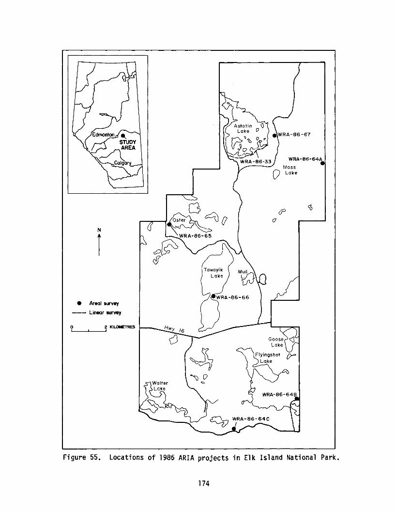
N
1
• Areal survey
--- Linear survey
o 2 KILOMETRESI ,
o e:::u ()
WRA-86-64A
Figure 55. Locations of 1986 ARIA projects in Elk Island National Park.
174
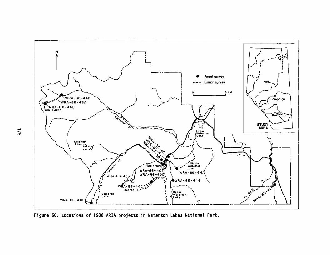
• Areal survey
Linear survey
o 5 KM, ,
Figure 56. Locations of 1986 ARIA projects in Waterton Lakes National Park.

Table 15. Projects conducted/implemented in Alberta by theArchaeological Research Services Unit, Environment Canada,Parks, Western Region.
ProjectNumber Researcher Project Description
WRA-86-1 Ian Sumpter ARIA - Golf Course Sewage Field Expansion,Waterton Lakes National Park
WRA-86-2 Kevin Montgomery Special Project - Archaeological ResourcesManagement Guidelines Preparation, WesternRegional Office
WRA-86-3 Rod Pickard Special Project - Archaeological ResourceDescription/Manual Preparation, JasperNational Park
WRA-86-4 Daryl Fedje ARIA - Banff Springs Hotel and Golf CourseExpansion, CP Hotels, Banff National Park
WRA-86-5 Glenn Webber Special Project - Archaeological SpecimensProcessing, Western Region Sites (contract)
WRA-86-6 Ian Sumpter ARIA - Prince of Wales Hotel UndergroundElectrical Line Installation, Waterton LakesNational Park
WRA-86-7 Daryl Fedje Mitigation - Twinning Trans-Canada HighwayPhase II, Site Mitigation and ConstructionMonitoring, Banff National Park
WRA-86-8 Rod Pickard Special Project - Track Site (CNR)Archaeological Investigations and Reporting,Jasper National Park
WRA-86-10 Bison Historical ARIA - Cascade Borrow Pit ExpansionServices Ltd. (contract), Banff National Park
WRA-86-11 Daryl Fedje
WRA-86-13 Don Steer
WRA-86-14 Bill Perry
Special Project - Banff Springs Golf CoursePit-house Preliminary Investigations, BanffNational Park
Special Project - Society for HistoricalArchaeology Newsletter Current ResearchSubmissions, Western Regional Office
ARIA - Palliser, Johnston Creek andPipestone Pass Warden Cabins, Banff NationalPark
176
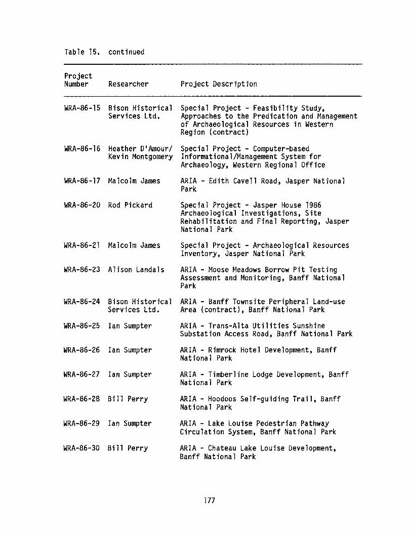
Table 15. continued
ProjectNumber Researcher Project Description
WRA-86-15 Bison Historical Special Project - Feasibility Study,Services Ltd. Approaches to the Predication and Management
of Archaeological Resources in WesternRegion (contract)
WRA-86-16 Heather D1Amour/ Special Project - Computer-basedKevin Montgomery Informational/Management System for
Archaeology, Western Regional Office
WRA-86-17 Malcolm James ARIA - Edith Cavell Road, Jasper NationalPark
WRA-86-20 Rod Pickard Special Project - Jasper House 1986Archaeological Investigations, SiteRehabilitation and Final Reporting, JasperNational Park
WRA-86-21 Malcolm James Special Project - Archaeological ResourcesInventory, Jasper National Park
WRA-86-23 Alison Landals ARIA - Moose Meadows Borrow Pit TestingAssessment and Monitoring, Banff NationalPark
WRA-86-24 Bison Historical ARIA - Banff Townsite Peripheral Land-useServices Ltd. Area (contract), Banff National Park
WRA-86-25 I~n Sumpter ARIA - Trans-Alta Utilities SunshineSubstation Access Road, Banff National Park
WRA-86-26 Ian Sumpter ARIA - Rimrock Hotel Development, BanffNational Park
WRA-86-27 Ian Sumpter ARIA - Timberline Lodge Development, BanffNational Park
WRA-86-28 Bill Perry ARIA - Hoodoos Self-guiding Trail, BanffNational Park
WRA-86-29 Ian Sumpter ARIA - Lake Louise Pedestrian PathwayCirculation System, Banff National Park
WRA-86-30 Bill Perry ARIA - Chateau Lake Louise Development,Banff National Park
177
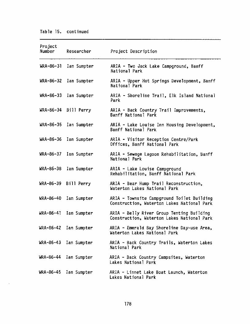
Table 15. continued
ProjectNumber Researcher
WRA-86-31 Ian Sumpter
WRA-86-32 Ian Sumpter
WRA-86-33 Ian Sumpter
WRA-86-34 Bill Perry
WRA-86-35 Ian Sumpter
WRA-86-36 Ian Sumpter
WRA-86-37 Ian Sumpter
WRA-86-38 Ian Sumpter
WRA-86-39 Bill Perry
WRA-86-40 Ian Sumpter
WRA-86-41 Ian Sumpter
WRA-86-42 Ian Sumpter
WRA-86-43 Ian Sumpter
WRA-86-44 Ian Sumpter
WRA-86-45 Ian Sumpter
Project Description
ARIA - Two Jack Lake Campground, BanffNational Park
ARIA - Upper Hot Springs Development, BanffNational Park
ARIA - Shoreline Trail, Elk Island NationalPark
ARIA - Back Country Trail Improvements,Banff National Park
ARIA - Lake Louise Inn Housing Development,Banff National Park
ARIA - Visitor Reception Centre/ParkOffices, Banff National Park
ARIA - Sewage Lagoon Rehabilitation, BanffNational Park
ARIA - Lake Louise CampgroundRehabilitation, Banff National Park
ARIA - Bear Hump Trail Reconstruction,Waterton Lakes National Park
ARIA - Townsite Campground Toilet BuildingConstruction, Waterton Lakes National Park
ARIA - Belly River Group Tenting BuildingConstruction, Waterton Lakes National Park
ARIA - Emerald Bay Shoreline Day-use Area,Waterton Lakes National Park
ARIA - Back Country Trails, Waterton LakesNational Park
ARIA - Back Country Campsites, WatertonLakes National Park
ARIA - Linnet Lake Boat Launch, WatertonLakes National Park
178

Table 15. continued
ProjectNumber Researcher Project Description
WRA-86-51 Malcolm James
WRA-86-52 Malcolm James
WRA-86-53 Malcolm James
WRA-86-54 Malcolm James
WRA-86-55 Malcolm James
WRA-86-56 Malcolm James
WRA-86-57 Malcolm James
ARIA - Maligne Lake Road, Jasper NationalPark
ARIA - Miette Hot Springs Road, JasperNational Park
ARIA - Pyramid Lake Road, Jasper NationalPark
ARIA - Marmot Road, Jasper National Park
ARIA - Cabin Creek Water Supply Line, JasperNational Park
ARIA - Pocahontas Trail Development, JasperNational Park
ARIA - Jasper Townsite Redevelopment, JasperNational Park
WRA-86-58 Ian Wilson Mitigation - Miette Hot Springs Road, Sitel073R (contract), Jasper National Park
WRA-86-59 Bison Historical ARIA - South Boundary Trail (contract),Services Ltd. Jasper National Park
WRA-86-61 Don Steer/ Special Project - Archaeological ResearchHeather D1Amour Unit Volunteer Programme, Western Regional
Office
WRA-86-63 Bill Perry ARIA - Primitive Campsite Development, BanffNational Park
WRA-86-64 Ian Sumpter ARIA - Borrow Sources, Elk Island NationalPark
WRA-86-65 Ian Sumpter ARIA - Oster Lake Group Camp Redevelopment,Elk Island National Park
WRA-86-66 Ian Sumpter ARIA - Preliminary Archaeological Assessmentof the Narrows Site (521R), Elk IslandNational Park
WRA-86-67 Ian Sumpter ARIA - Sandy Beach Campground Improvements,Elk Island National Park
179
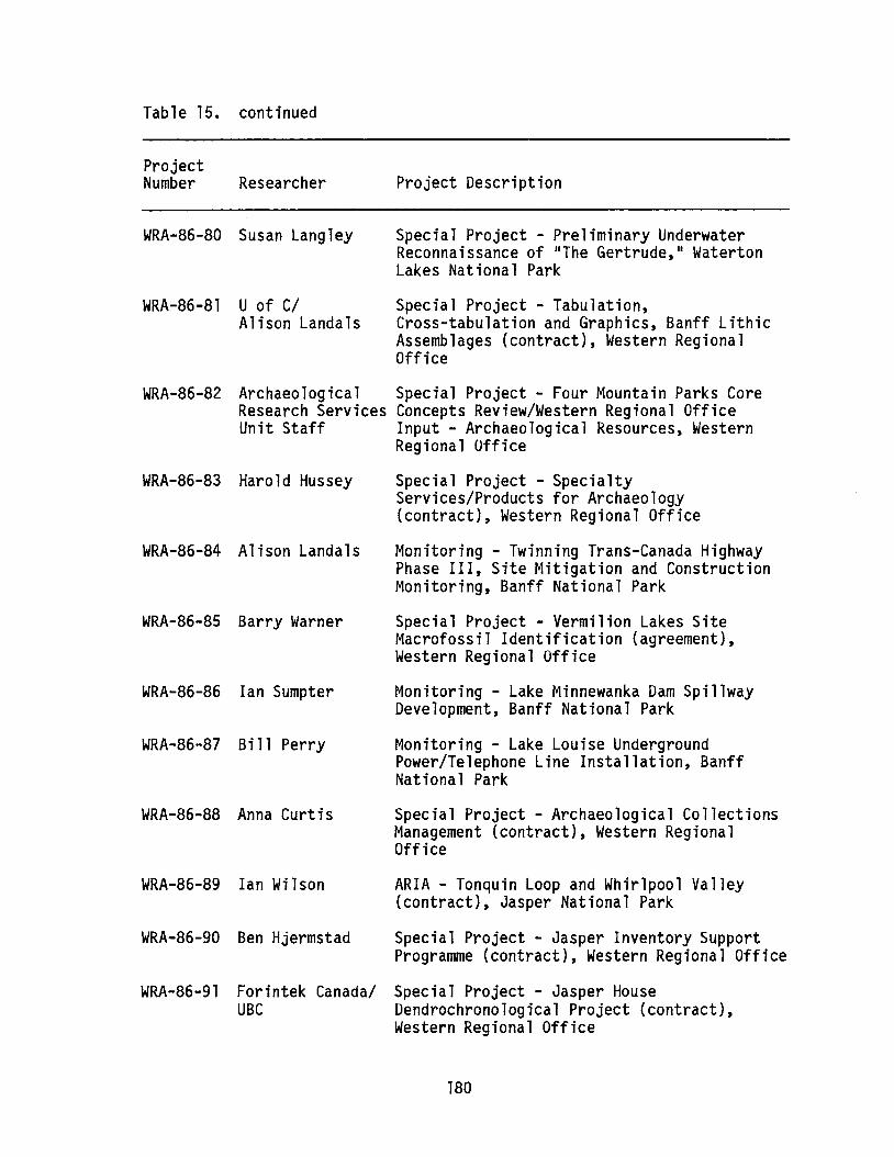
Table 15. continued
ProjectNumber Researcher Project Description
WRA-86-80 Susan Langley
WRA-86-81 U of C/Alison Landals
Special Project - Preliminary UnderwaterReconnaissance of liThe Gertrude,1I WatertonLakes National Park
Special Project - Tabulation,Cross-tabulation and Graphics, Banff LithicAssemblages (contract), Western RegionalOffice
WRA-86-82 Archaeological Special Project - Four Mountain Parks CoreResearch Services Concepts Review/Western Regional OfficeUnit Staff Input - Archaeological Resources, Western
Regional Office
WRA-86-83 Harold Hussey
WRA-86-84 Alison Landals
WRA-86-85 Barry Warner
WRA-86-86 Ian Sumpter
WRA-86-87 Bill Perry
WRA-86-88 Anna Curtis
Special Project - SpecialtyServices/Products for Archaeology(contract), Western Regional Office
Monitoring - Twinning Trans-Canada HighwayPhase III, Site Mitigation and ConstructionMonitoring, Banff National Park
Special Project - Vermilion Lakes SiteMacrofossil Identification (agreement),Western Regional Office
Monitoring - Lake Minnewanka Dam SpillwayDevelopment, Banff National Park
Monitoring - Lake Louise UndergroundPower/Telephone Line Installation, BanffNational Park
Special Project - Archaeological CollectionsManagement (contract), Western RegionalOffice
WRA-86-89 Ian Wilson
WRA-86-90 Ben Hjermstad
ARIA - Tonquin Loop and Whirlpool Valley(contract), Jasper National Park
Special Project - Jasper Inventory SupportProgramme (contract), Western Regional Office
WRA-86-91 Forintek Canada/ Special Project - Jasper HouseUBC Dendrochronological Project (contract),
Western Regional Office
180

Table 15. continued
ProjectNumber Researcher Project Description
WRA-86-92 RIDDL/SFU
WRA-86-93 Brian VivianiKathy Dilts
WRA-86-94 Ben Hjermstad
Special Project - Accelerator MassSpectroscopy Radiocarbon Dating (contract),Western Regional Office
Special Project - Administrative SupportProgramme for Archaeology (contract),Western Regional Office
Special Project - General Support Programmefor Archaeology (contract), Western RegionalOffice
WRA-86-95 Rick Lalonde
WRA-86-97 Harold Hussey
WRA-86-96 Don Steer/Alison Landals
Special Project - 1986 Drafting Support(contract), Western Regional Office
Special Project - 1986 ASA OccasionalPaper Submission, Environment Canada, Parks,Archaeological Research Services Unit,Western Regional Office
Special Project - Soil Profile (Transfer)Exhibit for Archaeology (contract), WesternRegional Office
WRA-86-98 Brock University Special Project - Western Region 1986Radiocarbon Dating (contract), WesternRegional Office
WRA-86-99 Alison Landals Special Project - Western Region 1986 FaunalRemains Identification, Western RegionalOffice
WRA-86-100 Carlann Thomas/Gwyn Langemann
Special Project - 1986 Jasper HouseNational Historic Site Faunal Analysis(contract), Western Regional Office
WRA-86-101 Heather D1Amour/ Special Project - Implementation ofKevin Montgomery Collection Management System, Archaeological
Research Services, Western Regional Office
WRA-86-102 Heather D1Amour Special Project - Archaeology Lab SpecimensStorage Review and Implementation, WesternRegional Office
181

Table 15. continued
ProjectNumber Researcher Project Description
WRA-86-103 Susan Langley
WRA-86-104 Ian Sumpter
Special Project - Underwater SalvageArchaeology, Emerald Bay (agreement),Waterton Lakes National Park
Special Project - Western Region GeneralSite Inventory Programme, Western RegionOffice
WRA-86-108 Bill Perry
WRA-86-111 Don Steer
WRA-86-110 Don Steer
WRA-86-109 Helen Lemon
WRA-86-105 Kevin Montgomery Special Project - Preparation of Guide tothe Environment Canada, Parks, WesternRegion Archaeological Site Data InventoryForm, Western Regional Office
Monitoring - Mineral Springs HospitalConstruction, Banff National Park
Special Project - Acquisition and Transferof Fort St. James Archaeological Specimensfrom Parks Headquarters (contract), WesternRegional Office
Special Project - 1986/1987 ArchaeologicalResearch Services Unit Functional Review,Western Regional Office
Special Project - Archaeological ResearchUnit Functional Review/Preparation ofPosition Analysis Schedules, WesternRegional Office
WRA-86-112 Rod Pickard/ Special Project - Archaeological ResourceHeather D1Amour/ Management Seminars, Western RegionalKevin Montgomery Office
WRA-86-1l4 Rod Pickard
WRA-86-115 Daryl Fedje
ARIA - Borrow Sources, Jasper National Park
Special Project - Resource Assessment forBanff Resource Description Program, WesternRegional Office
182
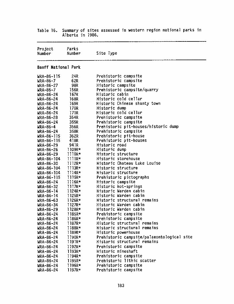
Table 16. Summary of sites assessed in western region national parks inAlberta in 1986.
ProjectNumber
ParksNumber Site Type
Banff National Park
WRA-86-115WRA-86-7WRA-86-27WRA-86-7WRA-86-24WRA-86-24WRA-86-24WRA-86-24WRA-86-24WRA-86-28WRA-86-24WRA-86-4WRA-86-24WRA-86-115WRA-86-115WRA-86-29WRA-86-26WRA-86-29WRA-86-104WRA-86-30WRA-86-104WRA-86-104WRA-86-115WRA-86-24WRA-86-32WRA-86-14WRA-86-14WRA-86-63WRA-86-34WRA-86-29WRA-86-24WRA-86-24WRA-86-24WRA-86-24WRA-86-24WRA-86-24WRA-86-24WRA-86-24WRA-86-24WRA-86-24WRA-86-24WRA-86-24WRA-86-24
24R62R98R
156R167R168R169R170R171R354R355R356R358R362R418R941R
1109R*1110R*llllR*1112R*1113R*1114R*1115R*1116R*1117R*1124R*1125R*1126R*1127R*1128R*1185R*1186R*1187R*1188R*1189R*1190R*1191R*1192R*1193R*1194R*1195R*1196R*1197R*
Prehistoric campsitePrehistoric campsiteHistoric campsitePrehistoric campsite/quarryHistoric cabinHistoric cold cellarHistoric Chinese shanty townHistoric dumpHistoric cold cellarPrehistoric campsitePrehistoric campsitePrehistoric pit-houses/historic dumpPrehistoric campsitePrehistoric pit-housePrehistoric pit-housesHistoric roadHistoric dumpHistoric structureHistoric storehouseHistoric Chateau Lake LouiseHistoric structureHistoric structurePrehistoric pictographsHistoric campsiteHistoric hot-springsHistoric Warden cabinHistoric Warden cabinHistoric structural remainsHistoric Warden cabinHistoric Warden cabinPrehistoric campsitePrehistoric campsiteHistoric structural remainsHistoric structural remainsHistoric powerhousePrehistoric campsite/palaeontological siteHistoric structural remainsPrehistoric campsiteHistoric mineshaftPrehistoric campsitePrehistoric lithic scatterPrehistoric campsitePrehistoric campsite
183
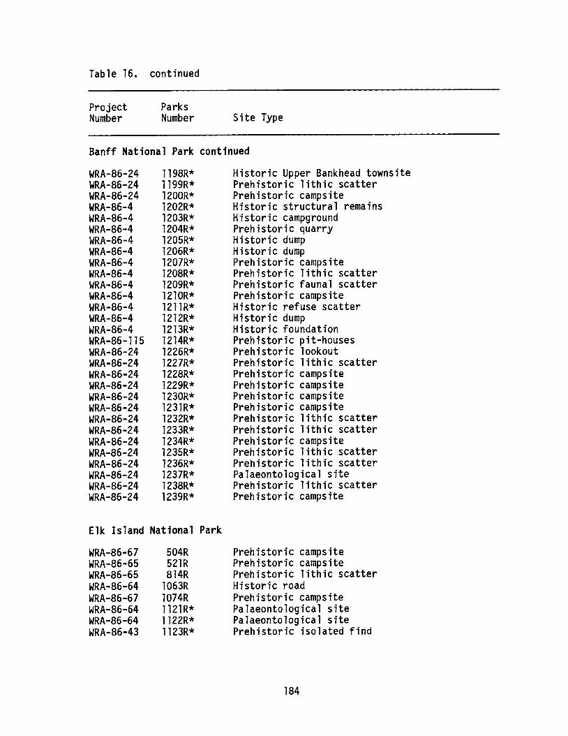
Table 16. continued
ProjectNumber
ParksNumber Site Type
Banff National Park continued
WRA-86-24WRA-86-24WRA-86-24WRA-86-4WRA-86-4WRA-86-4WRA-86-4WRA-86-4WRA-86-4WRA-86-4WRA-86-4WRA-86-4WRA-86-4WRA-86-4WRA-86-4WRA-86-115WRA-86-24WRA-86-24WRA-86-24WRA-86-24WRA-86-24WRA-86-24WRA-86-24WRA-86-24WRA-86-24WRA-86-24WRA-86-24WRA-86-24WRA-86-24WRA-86-24
1198R*1199R*1200R*1202R*1203R*1204R*1205R*1206R*1207R*1208R*1209R*1210R*1211R*1212R*1213R*1214R*1226R*1227R*1228R*1229R*1230R*1231R*1232R*1233R*1234R*1235R*1236R*1237R*1238R*1239R*
Historic Upper Bankhead townsitePrehistoric lithic scatterPrehistoric campsiteHistoric structural remainsHistoric campgroundPrehistoric quarryHistoric dumpHistoric dumpPrehistoric campsitePrehistoric lithic scatterPrehistoric faunal scatterPrehistoric campsiteHistoric refuse scatterHistoric dumpHistoric foundationPrehistoric pit-housesPrehistoric lookoutPrehistoric lithic scatterPrehistoric campsitePrehistoric campsitePrehistoric campsitePrehistoric campsitePrehistoric lithic scatterPrehistoric lithic scatterPrehistoric campsitePrehistoric lithic scatterPrehistoric lithic scatterPalaeontological sitePrehistoric lithic scatterPrehistoric campsite
Elk Island National Park
WRA-86-67WRA-86-65WRA-86-65WRA-86-64WRA-86-67WRA-86-64WRA-86-64WRA-86-43
504R521R814R
l063Rl074R1121R*1122R*1123R*
Prehistoric campsitePrehistoric campsitePrehistoric lithic scatterHistoric roadPrehistoric campsitePalaeontological sitePalaeontological sitePrehistoric isolated find
184
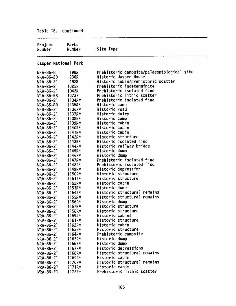
Table 16. continued
ProjectNumber
ParksNumber Site Type
Jasper National Park
WRA-86-8WRA-86-20WRA-86-21WRA-86-21WRA-86-21WRA-86-58WRA-86-21WRA-86-89WRA-86-21WRA-86-21WRA-86-21WRA-86-21WRA-86-21WRA-86-21WRA-86-21WRA-86-21WRA-86-21WRA-86-21WRA-86-21WRA-86-21WRA-86-2lWRA-86-21WRA-86-21WRA-86-21WRA-86-21WRA-86-21WRA-86-21WRA-86-21WRA-86-21WRA-86-21WRA-86-2lWRA-86-2lWRA-86-2lWRA-86-21WRA-86-21WRA-86-21WRA-86-21WRA-86-21WRA-86-21WRA-86-21WRA-86-21WRA-86-21WRA-86-2lWRA-86-21
198R230R492R
l025Rl042Rl073R1134R*1135R*1136R*1137R*1138R*1139R*1140R*1141R*1142R*1143R*1144R*1145R*l146R*1147R*l148R*1149R*l150R*1151R*1152R*1153R*1154R*1155R*1156R*1157R*1158R*1159R*l161R*1162R*1163R*1164R*l165R*1166R*1167R*l168R*1169R*1170R*1171R*1172R*
Prehistoric campsite/palaeontological siteHistoric Jasper HouseHistoric cabin/prehistoric scatterPrehistoric indeterminatePrehistoric isolated findPrehistoric lithic scatterPrehistoric isolated findHistoric campHistoric roadHistoric dairyHistoric campHistoric cabinHistoric cabinHistoric cabinHistoric structureHistoric isolated findHistoric railway bridgeHistoric dumpHistoric dumpPrehistoric isolated findPrehistoric isolated findHistoric depressionHistoric structureHistoric structureHistoric cabinHistoric dumpHistoric structural remainsHistoric structural remainsHistoric dumpHistoric structureHistoric structureHistoric cabinsHistoric structureHistoric cabinHistoric structurePrehistoric campsiteHistoric dumpHistoric dumpHistoric depressionsHistoric structural remainsHistoric cabinHistoric structural remainsHistoric cabinPrehistoric lithic scatter
185
Table 16. continued
ProjectNumber
ParksNumber Site Type
Jasper National Park continued
WRA-86-21WRA-86-21WRA-86-21WRA-86-21WRA-86-21WRA-86-21WRA-86-21WRA-86-21WRA-86-21WRA-86-21WRA-86-21WRA-86-21WRA-86-21WRA-86-21WRA-86-89WRA-86-89WRA-86-89WRA-86-89WRA-86-89WRA-86-89WRA-86-89WRA-86-89WRA-86-89WRA-86-89WRA-86-89WRA-86-89WRA-86-89WRA-86-89WRA-86-21WRA-86-21WRA-86-21WRA-86-21WRA-86-21WRA-86-21WRA-86-21WRA-86-21WRA-86-21WRA-86-21WRA-86-2lWRA-86-2lWRA-86-2lWRA-86-2lWRA-86-2lWRA-86-2l
1173R*1174R*1175R*1176R*1177R*l178R*1179R*1180R*1181R*1182R*1183R*1184R*1256R*1257R*1258R*1259R*1260R*1261R*1262R*1263R*1264R*1265R*1266R*1267R*1268R*1269R*1270R*1271R*1301R*1302R*l303R*1304R*1305R*1306R*1307R*130BR*1309R*1310R*1311R*1312R*1313R*1314R*1315R*1316R*
Historic mineHistoric corralHistoric flumeHistoric depressionHistoric structural remainsPrehistoric campsiteHistoric Warden cabinHistoric ski hillHistoric ovenPrehistoric isolated findHistoric graveHistoric cabinsPrehistoric/historic campsitePrehistoric cairnHistoric campsitePrehistoric quarryHistoric cabinPrehistoric/historic campsiteHistoric campsite/prehistoric isolated findPrehistoric lithic scatterHistoric sawmillHistoric logging campPrehistoric campsitePrehistoric isolated findPrehistoric isolated findPrehistoric lithic scatterPrehistoric lithic scatterPrehistoric lithic scatterHistoric structural remainsHistoric survey markerHistoric cabinsHistoric dumpHistoric dumpHistoric dumpHistoric structural remainsHistoric internment campHistoric structural remainsHistoric structural remainsHistoric railway stationHistoric dumpHistoric structureHistoric structural remainsPrehistoric campsiteHistoric dump
186
Table 16. continued
ProjectNumber
ParksNumber Site Type
Jasper National Park continued
WRA-86-21WRA-86-21WRA-86-21WRA-86-21WRA-86-89WRA-86-89WRA-86-89WRA-86-115WRA-86-115
1317R*1318R*1319R*1320R*1321R*1322R*1323R*1324R*1325R*
Historic refuse scatterPrehistoric campsiteHistoric depressionPrehistoric campsiteHistoric structural remainsPrehistoric lithic scatterHistoric gravePrehistoric tipi ring campsiteHistoric structural remains
Waterton Lakes National Park
WRA-86-42WRA-86-109WRA-86-45WRA-86-44WRA-86-44WRA-86-43WRA-86-44WRA-86-43WRA-86-44WRA-86-6WRA-86-43
570R639R646R690R692R693R740R778R
l069R*1118R*1120R*
Prehistoric campsitePrehistoric campsitePrehistoric campsitePrehistoric campsitePrehistoric campsitePrehistoric campsitePrehistoric fishing campPrehistoric campsitePrehistoric isolated findHistoric hotelPrehistoric lithic scatter
*Denotes sites recorded in 1986. These sites include prehistoric,historic and palaeontological finds. Although all have been recordedusing the Environment Canada, Parks recording system, not all will begiven Borden designations.
187

COLLECTION AND SUBMISSION OF SAMPLES FOR RADIOCARBON DATING
ByAlwynne B. Beaudoin
Archaeological Survey of Alberta
GENERAL CRITERIA FOR SELECTING MATERIAL FOR DATING
The most suitable samples for radiocarbon dating are carbon-richmaterials such as charcoal and wood. Other organic materials, such aspeat and gyttja (lake mud), can also be used. Biogenically derivedcalcium carbonate, such as that found in shells and bone, can be dated;however, due to contamination problems (see below), the protein collagenis usually isolated from bone and dated. Similarly, if the sample islarge enough, the protein conchiolin may be extracted from shells anddated (Bradley 1985). Other materials of archaeological interest thathave been radiocarbon dated, albeit in some cases experimentally, includemortar (Van Strydonck et ale 1986), sherds and ceramics (De Atley 1980),and blood residues on stone tools (Nelson et ale 1986).
When selecting material for radiocarbon dating, two considerationsshould be of paramount importance: first, to collect and submit onlythose samples that will produce valid, interpretable results and second,to minimize post-collection contamination. Hence, there must be a clearunderstanding of the stratigraphic position of the sample and how itrelates to the rest of the site or section. Additionally, there shouldbe an awareness of the possible sources of sample contamination so thatfield notes and submission forms will contain sufficient information forthe radiocarbon laboratory to process the sample appropriately andproduce a useful date.
Material for radiocarbon dating should be derived from as narrow astratigraphic range as possible. This is to minimize the chance thatmaterial of several ages may be combined together. For the same reason,samples from several sources or different stratigraphic layers are rarelycombined together for dating. The resulting date would be a compositefrom all the material included and hence meaningless if the time range ofthose materials is excessive.
188
Before a radiocarbon sample is collected in the field, both itsstratigraphic and archaeologic context must be clearly defined within thesite. For instance, does it provide a minimum date for underlyingmaterial or a maximum date for overlying material? Is the material insitu (e.g., a tree with roots in place) or could it have been transportedto the site (e.g., disarticulated bone)? Has the site's stratigraphicsequence remained undisturbed or has reworking occurred to affect samplecontext? Is the material likely to be contemporary with the occupationof the site (e.g., bones from animals used as food) or could it be mucholder (e.g., shells used as ornaments)? Many materials may give datesthat are tricky to interpret. For example, charcoal from a hearth willdate the material burnt rather than the date the hearth was used. Sinceold dead wood or driftwood may have been burnt, the date may be olderthan the date the hearth was used. In this case, the date gives amaximum possible date for the hearth (Polach and Golson 1966:5).
Finally, possible sources and types of contamination should beconsidered. The major sources of contamination and their effects on theradiocarbon date are as follows:(1) Roots and rootlets may penetrate into the sample. These roots could
be from present-day surface vegetation, in which case they can oftenbe seen by eye or under a dissecting microscope and removed.Alternatively, if the sample is taken from beneath a palaeosol, itmay be affected by roots of vegetation that was growing on thepalaeosol when it was exposed at the ground surface (Polach andGolson 1966:7). This contamination is difficult to detect. Bothsources of contamination will make the radiocarbon date younger thanthe true age of the sample. Similarly, dates derived from soilorganic matter or Ah horizons, may be subject to error because ofboth continual addition of organic matter and continual humificationprocesses (Paul 1969; Geyh et ale 1983).
(2) Humus materials from decomposition of organic matter in the soil maybe translocated by pedogenic processes down the soil profile and maybe redeposited at greater depth in the soil. These humus materialsmay penetrate samples well below the surface organic layer. Thiscontamination would again tend to make the date younger. This source
189
of contamination is a particular problem for samples from peats(Polach and Golson 1966:7).
(3) Fine detrital carbonate may be mixed with the sample, particularly ifthe sample is from an area with carbonate bedrock or carbonate-richtills. This contamination would cause the sample to give an apparentage older than its true age. This source of contamination canusually be detected in organic samples and removed by the radiocarbonlaboratory using acid washes. The problem is more acute if thematerial to be dated is itself composed of carbonate.
(4) IIOld carbon ll may have been actually incorporated in the structure ofthe material being dated. In this case, the apparent date is oftenvery much older than the true age (Table 17). This contaminationoccurs when carbon-containing materials, such as aquatic plants, marlor freshwater shells, are formed in lake waters which may containdissolved bicarbonate from limestone bedrock, for example (Turner etale 1983; Karrow et ale 1984). This is sometimes referred to as theIIhard water effect. 1I
(5) IIYoung carbon ll may become incorporated within a samplels structure.This problem often occurs with shells and bone because the carbonatematerial of which they are composed may be involved in exchangereactions with rainwater and/or groundwater, particularly during thetransformation of aragonite to calcite (Bradley 1985:55). The effectof this is to make the apparent age younger than the true age (Table17). For this reason, collagen from bone is generally used fordating, although in older weathered bone the amount of collagen leftmay be too small (Bradley 1985:56).
(6) The sample may become contaminated by either coal, lignite orbitumen, all of which are sources of lIold carbon. 1I This is a problemin many areas in the eastern slopes of the Rockies.As well as these lIenvironmental ll sources of contamination, there are
many other factors which influence the production and assimilation ofC-14 in organisms and the interpretation of radiocarbon dates. Thesefactors include isotopic fractionation by living organisms and long-termchanges in the atmospheric C-14 content and hence the relationship ofC-14 years to calendar years (Bradley 1985).
190
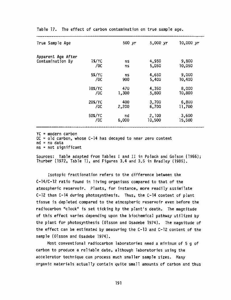
Table 17. The effect of carbon contamination on true sample age.
True Sample Age 500 yr 5,000 yr 10,000 yr
Apparent Age After9,800Contamination By l%/YC ns 4,950
10C ns 5,050 10,050
5%/YC ns 4,650 9,00010C 900 5,400 10,400
10%/YC 470 4,350 8,00010C 1,300 5,800 10,800
20%/YC 400 3,700 6,80010C 2,200 6,700 11,700
50%/YC nd 2, 100 3,6001OC 6,000 10,500 15,500
YC = modern carbonOC = old carbon, whose C-14 has decayed to near zero contentnd = no datans = not significant
Sources: Table adapted from Tables I and II in Polach and Golson (1966);Thurber (1972, Table 1), and Figures 3.4 and 3.5 in Bradley (1985).
Isotopic fractionation refers to the difference between theC-14/C-12 ratio found in living organisms compared to that of theatmospheric reservoir. Plants, for instance, more readily assimilateC-12 than C-14 during photosynthesis. Thus, the C-14 content of planttissue is depleted compared to the atmospheric reservoir even before theradiocarbon IIclock ll is set ticking by the plant's death. The magnitudeof this effect varies depending upon the biochemical pathway utilized bythe plant for photosynthesis (Olsson and Osadebe 1974). The magnitude ofthe effect can be estimated by measuring the C-13 and C-12 content of thesample (Olsson and Osadebe 1974).
Most conventional radiocarbon laboratories need a minimum of 5 g ofcarbon to produce a reliable date, although laboratories using theaccelerator technique can process much smaller sample sizes. Many
organic materials actually contain quite small amounts of carbon and thus
191

fairly large amounts of material may be necessary to provide a date.Hence, when in the field, an estimate must be made of the size of sampleneeded for dating to ensure that enough material is collected (see below).
FIELD COLLECTION
Samples intended for radiocarbon dating should be handled in thefield as little as possible to avoid introducing contaminants. Afternote taking, description and photography, samples should be removed fromthe section/excavation unit, preferably using clean metal trowels,plastic scoops or tweezers rather than hands and placed in a clean, dryplastic bag. Ideally, the sample should not be handled; grease, suntanoil, human hair, tobacco or cigarette ash can all cause contamination(Kra 1985).
Samples must be clearly labelled; this is best done bydouble-bagging and including the label in the outer bag. Never put alabel in with a sample or attach a label to a sample intended for dating;paper, tape, etc. themselves contain carbon compounds and can contaminatethe sample. Make sure the label and the sample number are unambiguous.
Samples wrapped in aluminum foil should be placed also inside aplastic bag. Foil tears too easily to be a secure packaging andwithstand shipment to a radiocarbon laboratory.
SAMPLE STORAGE AND PREPARATION
To minimize the possibility of contamination or post-collectionalteration, samples should be submitted for radiocarbon dating as soon aspossible after field collection. In order to avoid fungal growth andbacterial activity, field-moist samples for radiocarbon dating should bekept as cool as possible, preferably in a cold room or freezer. Mostsamples removed from soil or sediments, even in mid-summer, will containsome moisture. These samples should be oven-dried at lOSoC overnightand re-packaged in a new, clean plastic bag. It is useful to record themoisture content of the sample since this may act as a guide to how muchsample to collect in future situations.
192

The amount of cleaning and preparation done by the collector dependsupon the type and condition of the sample. Generally, physicalseparation of the sample from the soil or sediment matrix can be done bythe collector, whereas preparations involving chemical treatments arebest left to the radiocarbon laboratory. Obvious contaminants, such asmodern roots, can be removed from the sample by hand-picking withtweezers (Kra 1985). Soil or sediment adhering to bone can be removed bybrushing, although brushes made from animal hair or fibre should not beused.
The amount of material needed by a radiocarbon laboratory to derivea reliable date depends on the type of material (which controls itscarbon content) and, to some extent, the analytical techniques used bythe processing laboratory. Recommended amounts of various types ofmaterial for different conventional radiocarbon laboratories are shown inTable 18.
Processing the sample to yield the carbon for analysis results in agreat decrease of material. What appears to be a large sample may yieldlittle carbon for dating. This is particularly the case for samples suchas highly weathered bone or charcoal mixed with soil matrix. As ageneral rule, it is better to submit a sample of at least the weightrecommended by the laboratory. It is frustrating, as well as a waste oflaboratory time, when a date cannot be obtained because of insufficientcarbon content, particularly if more material was available than wassubmitted to the radiocarbon laboratory. If .only small samples areavailable, consideration should be given to submitting the sample to anAMS (accelerator mass spectrometry) laboratory, some of which can produceresults from samples as small as 15 mg of carbon (see Beukens et ale1986, Table 1).
SAMPLE SUBMISSION
Each sample submitted for radiocarbon dating should be accompaniedby a sample data form, and a "sample identification number" of twelvecharacters or less should be clearly and unambiguously designated andincluded in the packaging of the sample as well as on the data form. Anexample of the form used by the radiocarbon laboratory at AECV is given
193
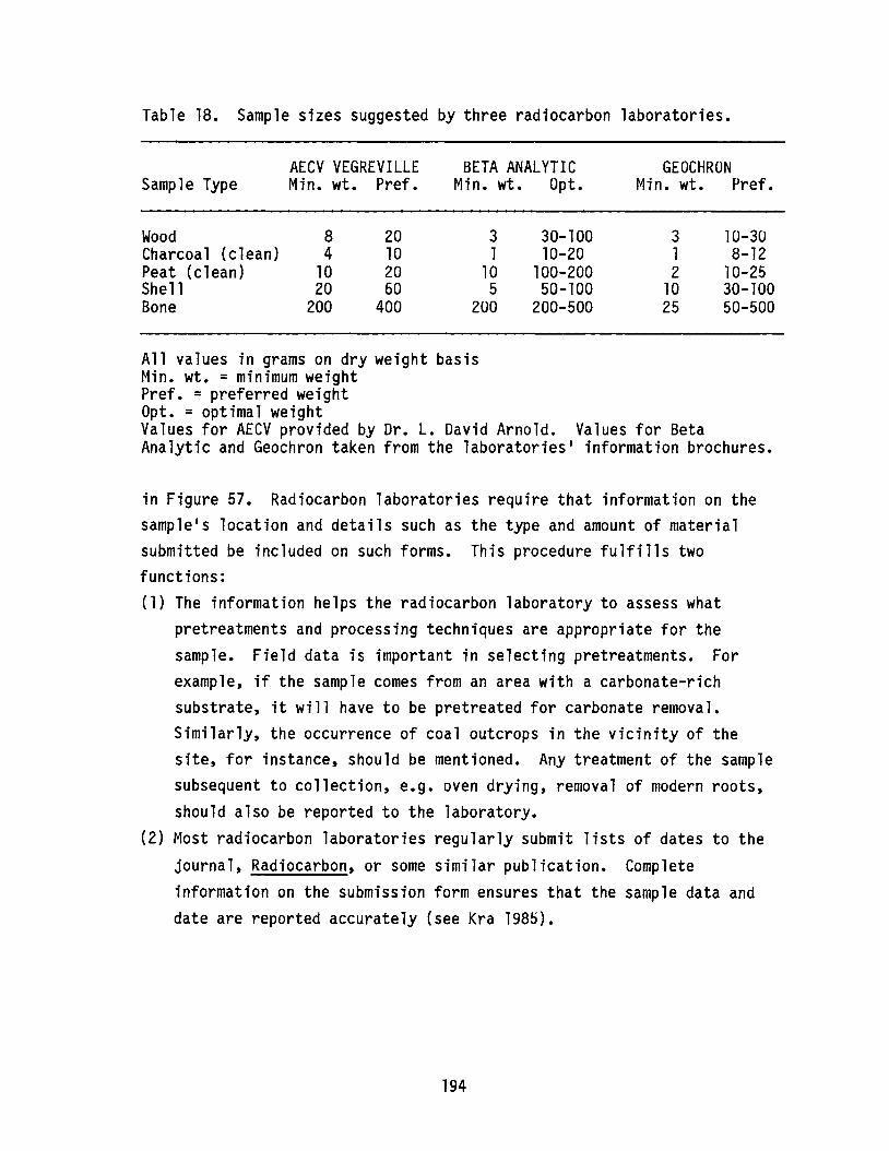
Table 18. Sample sizes suggested by three radiocarbon laboratories.
AECV VEGREVILLE BETA ANALYTIC GEOCHRONSample Type Min. wt. Pref. Min. wt. Opt. Min. wt. Pref.
Wood 8 20 3 30-100 3 10-30Charcoal (clean) 4 10 1 10-20 1 8-12Peat (clean) 10 20 10 100-200 2 10-25Shell 20 60 5 50-100 10 30-100Bone 200 400 200 200-500 25 50-500
All values in grams on dry weight basisMin. wt. = minimum weightPref. = preferred weightOpt. = optimal weightValues for AECV provided by Dr. L. David Arnold. Values for BetaAnalytic and Geochron taken from the laboratories· information brochures.
in Figure 57. Radiocarbon laboratories require that information on thesample·s location and details such as the type and amount of materialsubmitted be included on such forms. This procedure fulfills twofunctions:(1) The information helps the radiocarbon laboratory to assess what
pretreatments and processing techniques are appropriate for thesample. Field data is important in selecting pretreatments. Forexample, if the sample comes from an area with a carbonate-richsubstrate, it will have to be pretreated for carbonate removal.Similarly, the occurrence of coal outcrops in the vicinity of thesite, for instance, should be mentioned. Any treatment of the samplesubsequent to collection, e.g. oven drying, removal of modern roots,should also be reported to the laboratory.
(2) Most radiocarbon laboratories regularly submit lists of dates to thejournal, Radiocarbon, or some similar publication. Completeinformation on the submission form ensures that the sample data anddate are reported accurately (see Kra 1985).
194
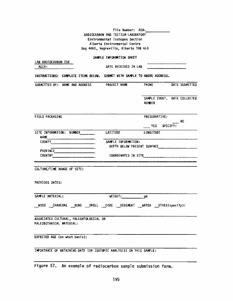
File Number: ASA------RADIOCARBON AND TRITIUM LABORATORY
Environmental Isotopes SectionAlberta Environmental Centre
Bag 4000, Vegreville, Alberta TOB 4LO
LAB RADIOCARBON 101AECV-
SAMPLE INFORMATION SHEET
DATE RECEIVED IN LAB
INSTRUCTIONS: COMPLETE ITEMS BELOW. SUB~T WITH SAMPLE TO ABOVE ADDRESS.
SUBMITTED BY: NAME AND ADDRESS PROJECT NArtE PHONE DATE SUBMITTED
FIELD PACKAGING
SAMPLE IDENT. DATE COLLECTEDNUMBER
PRESERVATIVE:NO
YES SPECIFY:
COORDINATES IN SITE-----------
SAMPLE INFORMATION:DEPTH BELOW PRESENT SURFACE--------
SITE INFORMATION: NUMBER---NAME----------COUNTY---------PROVINCE--------COUNTRY---------
CULTURE/TlrtE RANGE OF SITE:
PREVIOUS DATES:
LATITUDE LONGITUDE
SAMPLE MATERIAL: WEIGHT: ~gm
WOOD CHARCOAL BONE SHELL CORE SEDIMENT WATER OTHER(specify}:
ASSOCIATED CULTURAL, PALEONTOLOGICAL ORPALEOBOTANICAL MATERIAL:
EXPECTED AGE (on what basis):
IMPORTANCE OF OBTAINING DATE (OR ISOTOPIC ANALYSIS) ON THIS SAMPLE:
Figure 57. An example of radiocarbon sample submission form.
195
REPORTING AND INTERPRETATION
Because of the possible sources of error, contamination andmisassociation of sample and event, it is wise to submit severalsamples,preferably of different materials, from anevent/occupation/horizon. Inferences based on single dates should betreated with caution. A single date, in general, is best used as anindication of age awaiting confirmation.
Radiocarbon dates should always be reported with their standarddeviation (1 sigma) and radiocarbon laboratory number.
Two general "corrections" may be applied to radiocarbon dates. Manyradiocarbon laboratories correct radiocarbon dates for isotopicfractionation effects using an internationally agreed standard (Olssonand Osadebe 1974). The report from the radiocarbon laboratory shouldindicate if this correction has been applied. Dates produced in theearly days of the technique will probably not have been corrected forfractionation. This correction is often not significant but it can makea difference of several hundred years to the dates of some materials(Olsson and Osadebe 1974; Bradley 1985, Table A.l).
Due to variation in atmospheric C-14 over time, a number ofcalibration curves or tables have been proposed which attempt totranslate from C-14 decay years B.P. to calendar years. The latestversions of these calibrations are given in Radiocarbon, 1986, Vol. 28,No. 2B. If a radiocarbon date is "corrected" using one of thesecalibrations, the original radiocarbon date with its standard deviationand laboratory number should also be included, together with the sourcefor the calibration and the corrected date. This would permit laterrevision of the date in the event that the calibration was changed orfurther refined.
ACKNOWLEDGEMENT
I am grateful to Dr. L. David Arnold for reading and commenting uponan earlier version of this manuscript.
196
ALBERTA RADIOCARBON DATES 1982-1986
ByAlwynne B. Beaudoin
Archaeological Survey of Alberta
INTRODUCTION
In 1983, Brumley and Rushworth presented a compilation ofradiocarbon dates from Alberta and expressed the hope that the list wouldbe maintained as an information resource for archaeologists in Alberta.The present list is an update to their work and includes additionalinformation, derived mainly from data on file at the ArchaeologicalSurvey of Alberta.
SOURCES AND COMPILATION
The list is based primarily on information on file at the palynologylaboratory at the Archaeological Survey, supplemented by informationprovided by research archaeologists at the Survey. The list includes, asfar as possible, all dates produced for Survey staff since thecompilation of Brumley and Rushworth (1983), together with some datesgenerated earlier which did not appear on that list and a few dates fromother sources. Several dates are associated with palaeoenvironmentalstudies; all other dates are associated with archaeological sites.
Details of conventions and abbreviations used in the list areprovided in Table 19. To a large extent, the information is tabulated ina fashion similar to that of Brumley and Rushworth (1983). However,dates have been reported in radiocarbon years B.P. (i.e., beforeA.D. 1950), rather than with respect to the Christian calendar.
For the most part, the dates in Table 20 are uncorrected dates. Ifa C-13 correction has been applied, this is indicated in the commentcolumn. A number of calibrations have been applied over the last fewyears in attempts to translate from C-14 years to calendar years.Unfortunately, this situation has led to some confusion (see Ottaway1986). Revised versions of calibrations are now available (see
197
Radiocarbon, Vol. 28, No. 2B). Because calibrations are still beingrefined, no attempt has been made to "correct" any of the dates in thistable. Hence, unless otherwise stated, all dates are in C-14 years B.P.
Many of the dates are, as yet, unpublished and have been generatedin connection with continuing projects. In this case, the principalresearcher is indicated in Table 20.
COMMENTARY
Brumley and Rushworth estimated that their date list comprised "atleast 80 to 90 percent of all radiocarbon dates available for theprovince" (1983:143). However, the few dates reported from other thanarchaeological sites suggest that their estimate was over-optimistic. Noclaims for completeness are made for the present list.
In recent years, there has undoubtedly been an increase in thenumber of radiocarbon dates being generated for archaeological sites inthe province. Of the 334 dates associated with archaeological siteslisted by Brumley and Rushworth (1983), for instance, only 16 dates havecited references between 1960 and 1969, and none are reported prior to1960. In contrast, in 1986 alone, 54 samples associated witharchaeological sites have been submitted for dating through thepalynology laboratory at the Archaeological Survey of Alberta. In theSurvey·s case, the increased radiocarbon dating effort partly reflectsthe availability of radiocarbon dating facilities within the province atthe Alberta Environmental Centre in Vegreville.
However, consideration of Table 21 shows that the areal and temporaldisparities in radiocarbon dating noted by Brumley and Rushworth (1983)still exist. Only about 1 percent of the identified sites have anyradiocarbon dates associated with them (Table 21). Only 8.5 percent ofradiocarbon dates are from the northern third of the province, comparedto 17.4 percent from central and 74.1 percent from southern areas.Partly, this discrepancy may result from the fact that conditions forpreservation of datable organic material appear to be poor on northernsites; Ives (1981:43) considers that this is due to the generally acidsoils. However, the discrepancy must also be a reflection of the fewersites recorded from the north (Table 21). In itself, this difference in
198
site density from north to south may be related to the fact that thesouth of the province contains the main population centres, hence mostdevelopment, and therefore a higher likelihood of site discovery andinvestigation.
The preponderance of dates from the south is also related to theconcentration of research effort on a few sites. In particular,Head-Smashed-In Buffalo Jump stands out as being by far the most datedsite. Of the 471 dates reported from archaeological sites on the twolists, 54 (11.5%) are from this site alone.
The majority of dates in Table 20 are not associated with diagnosticmaterial assigned to specific cultural phases. In addition, seven of thedates are "Modern" (i.e., less than 100 years) and therefore are notuseful for establishing a chronology. Brumley and Rushworth (1983:144)lamented the fact that only 201 dates were available as "our primarychronometric data base for developing cultural chronologies for theentire province." Indeed, only 176 dates were from unmixedassociations. This situation has improved slightly: 15 more usefuldates from unmixed associations are now available. However, this has notappreciably improved the temporal definition of most cultural phasessince the majority of dates are associated with only two culturalphases: Avonlea (5 dates) and McKean (3 dates).
NOTE
It is intended to produce updates to this list on an annual basis.Researchers having radiocarbon dates from archaeological sites which theywould like to bring to the attention of their colleagues are invitedto submit information on dates, as given in Table 20, to thePalaeoenvironmental Research Officer at the Archaeological Survey. Dateswould then be included in subsequent lists.
CAVEAT
This list is intended purely as an information resource forarchaeologists working in the province. Anyone interested in a
199
particular date is advised to go directly to the primary source for moredetail.
ACKNOWLEDGEMENTS
I would like to thank my colleagues at the Survey for theirassistance and co-operation in compiling this list.
200
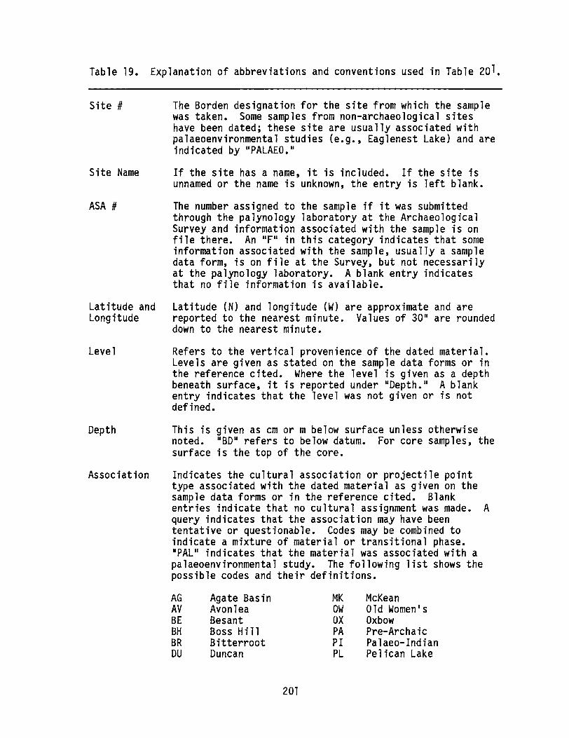
Table 19. Explanation of abbreviations and conventions used in Table 20 1•
Site # The Borden designation for the site from which the samplewas taken. Some samples from non-archaeological siteshave been dated; these site are usually associated withpalaeoenvironmental studies (e.g., Eaglenest Lake) and areindicated by "PALAEO."
Site Name If the site has a name, it is included. If the site isunnamed or the name is unknown, the entry is left blank.
ASA # The number assigned to the sample if it was submittedthrough the palynology laboratory at the ArchaeologicalSurvey and information associated with the sample is onfile there. An "F" in this category indicates that someinformation associated with the sample, usually a sampledata form, is on file at the Survey, but not necessarilyat the palynology laboratory. A blank entry indicatesthat no file information is available.
Latitude andLongitude
Level
Depth
Association
Latitude (N) and longitude (W) are approximate and arereported to the nearest minute. Values of 30" are roundeddown to the nearest minute.
Refers to the vertical provenience of the dated material.Levels are given as stated on the sample data forms or inthe reference cited. Where the level is given as a depthbeneath surface, it is reported under IIDepth." A blankentry indicates that the level was not given or is notdefined.
This is given as cm or m below surface unless otherwisenoted. "BD U refers to below datum. For core samples, thesurface is the top of the core.
Indicates the cultural association or projectile pointtype associated with the dated material as given on thesample data forms or in the reference cited. Blankentries indicate that no cultural assignment was made. Aquery indicates that the association may have beententative or questionable. Codes may be combined toindicate a mixture of material or transitional phase."PAL" indicates that the material was associated with apalaeoenvironmental study. The following list shows thepossible codes and their definitions.
AG Agate Basin MK McKeanAV Avonlea OW Old Women1sBE Besant OX OxbowBH Boss Hill PA Pre-ArchaicBR Bitterroot PI Palaeo-IndianDU Duncan PL Pelican Lake
201

MC Mummy Cave
Table 19. continued
HAKP
HannaKootenay Plains
SR Salmon RiverPAL Palaeoenvironmental
study
Material
Note that Duncan, Boss Hill and Agate Basin were notrecognized by Brumley and Rushworth (1983).
Indicates the kind of material that was dated and itscondition, when known. These codes may be combined.Blank entries indicate that no information on the type ofmaterial dated was available in the sources consulted.Possible codes are as follows:
AP80CHCOCSHAMAMC
MX
ApatiteBoneCharcoalCo 11 agenSegment of coreHumic acidMarlPlant remains(leaves, twigs,needles, etc.)Matrix
OR Combined sample oforganic material
PE PeatSED SedimentSH ShellWO WoodB BurnedC CharredL CalcinedA Acid treatment
Geochron (dates with the lab. number beginning GX-)reports dates from gelatin. Since gelatin and collagenare synonymous, these dates are coded IICO.II
Lab # The sample number assigned by the radiocarbon laboratory.
C-14 date The radiocarbon date expressed in radiocarbon years B.P.(i.e., years before A.D. 1950). These are uncorrecteddates. Where corrected dates are available, they areflagged by an 11*,11 and the type of correction is givenunder "Comments. 1I Dates of less than 100 years B.P. arereported as IIModern. 1I
SO The standard deviation of the radiocarbon date.
Reference(s) The report(s) or publication(s) that cite the date wherefurther information on the date and its interpretation maybe found. In some instances, the date is on file at theArchaeological Survey, but no reference is known or thedate is not yet published. If the date is part of acontinuing project, or is as yet unpublished, the name(s)of the principal researcher(s) are given. Alternatively,the name of the person who submitted the material fordating is given.
202
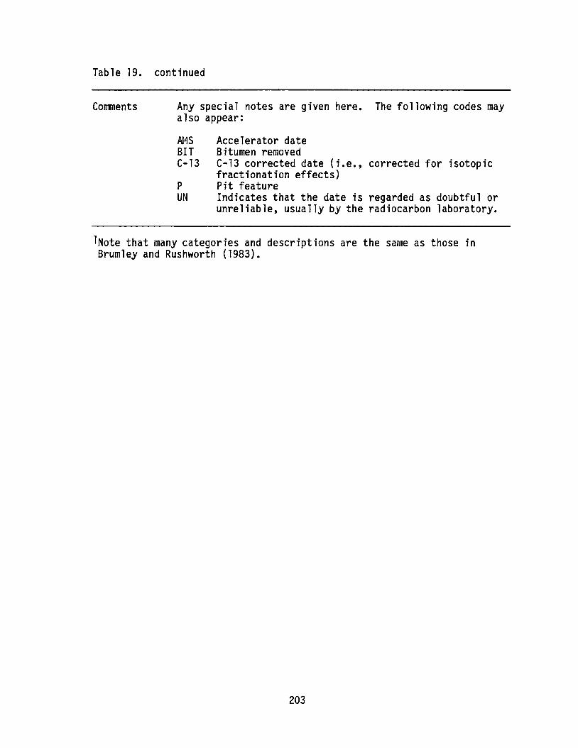
Table 19. continued
Comments Any special notes are given here. The following codes mayalso appear:
N4S Accelerator dateBIT Bitumen removedC-13 C-13 corrected date (i.e., corrected for isotopic
fractionation effects)P Pit featureUN Indicates that the date is regarded as doubtful or
unreliable, usually by the radiocarbon laboratory.
lNote that many categories and descriptions are the same as those inBrumley and Rushworth (1983).
203

Table 20. Radiocarbon dates from Alberta.
Site , Site N_ ASA , Latitude Longitude Level Depth Association Material Lab , C-14 date SD Reference(s) C~nts
DhPj-69 8elly Burial F 49016' 113°34' 80 OxA-682 340 70 Ball (1986b) AMS
DhPj-69 8elly Burial F 49016' 113°34' BO OxA-384 370 75 Ball (1986b) AMS
DhPj-69 Belly Burial F 49°16' 113°34' BO Beta-11902 4030 110 Ball (1986b) UN, AMS
DhPj-69 Belly Burial F 49°16' 113°34' BO Beta-16257 *630 80 Ball AMS, C-13
DhPj-69 Belly Burial F 49016' 113034' BO/CO AECY-195C 310 140 Ball
DjOu-4 FortY Mile Coulee F 49°36' 111°21' 3.0 • BO/CO GX-8400-& *2850 135 B".ley C-13East Dm Site
DjOu-4 Forty Mile Coulee F 49036' 111°21' 3.0 • BO/AP GX-8400-A *2900 150 B".ley C-13East D. Sfte
DjPf-4 Blood Coulee F 49°34' 112°55' BO/CO AECY-82C 1320 90 BrinkBuffalo J..-p
DjPn-16 - ASA-D86-1 49034' 114°15' 4 30-40 c. BO/CO AECY-214C 4650 110 RonaghanN0
DjPn-16 ASA-D86-2 49°34' 114°15' 6 50-60 CII BO/CO AECY-215C 5200 160 Ronaghan~ -DjPn-16 - F 49°34' 114°15' F ?DU BO/CO AECY-22OC 4860 90 Ronaghan
DjPn-16 - ASA-D86-5 49°34' 114°15' B 70-80 c. BH BO/CO AECY-218C 4080 230 Ronaghan
DjPn-16 ASA-D86-3 49°34' 114°15' 4 30-40 c. BR BO/CO AECY-216C 3960 140 Ronaghan
DjPn-16 F 49034' 114°15' MK BO/CO AECY-219C 3820 100 Ronaghan
DjPn-16 ASA-D86-4 49°34' 114°15' 4 30-40 CII OX BO/CO AECY-217C 2700 200 Ronaghan
DjPn-47 - F 49°35' 114°12' 90-100 c. SO/CH AECY-108C 6200 120 Ronaghan (1986) -
DjPn-53 F 49034' 113°14' 50-60 c. BO/CO AECY-115C 450 100 Ronaghan
DjPn-53 F 49034' 113°14' 20-30 CII BO/CO AECY-114C 1200 100 Ronaghan
DjPn-60 F 49033' 114°18' 0-10 c. BO/CO AECY-221C 470 60 Ronaghan
DjPn-66 F 49°34' 114°18' 8 70-78 c. CH/MX AECY-222C 3390 100 Ronaghan
F 49°34' 114018' 9 80-97 c. CH/MX AECY-223C 4930 110 RonaghanDjPn-66 -
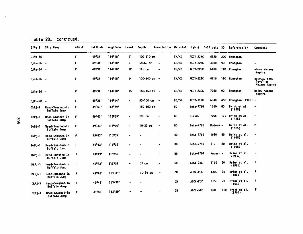
Table 20. continued.
Site , Site Hue ASAI Latitude Longitude Level Depth Association Material Lab I C-14 date SD Reference(s) Conments
DjPn-66 - F 49°34' 114°18' 11 100-110 em - CH/MX AECY-224C 5120 200 Ronaghan
DjPn-66 - F 49°34' 114°18' 6 58-60 em CH/MX AECY-225C 4980 90 Ronaghan
DjPn-66 - F 49°34' 114°18' 12 115 em CH/MX AECY-228C 6180 110 Ronaghan above Mazamatephra
DjPn-66 - F 49°34' 114°18' 14 130-140 cm - CH/MX AECY-229C 6710 180 Ronaghan approx. samelevel asMazama tephra
DjPn-66 - F 49°34' 114°18' 15 140-150 cm - CH/MX AECY-23OC 7050 90 Ronaghan below Mazamatephra
DjPn-90 - F 49°35' 114°14' 90-100 cm BO/CO AECY-112C 6040 450 Ronaghan (1986) -
DkPj-1 Head-Smashed-In F 49°43' 113°39' 150-160 cm - BO Beta-7718 1660 80 Brink et a1.Buffalo Jump (1985)
N DkPj-l Head-Smashed-In F 49°43' 113°39' 135.cm BO 5-2500 7065 175 Brink et a1.e Buffalo JISIp (1985)tTl
DkPj-1 Head-Smashed-In F 49°43' 113°39' 10-20 em BO Beu-7791 Modern - Brink et al. PBuffalo Jllllp (1985)
DkPj-1 Head-Smashed-In F 49°43' 113°39' BO Beta 7792 1620 80 Brink et al.Buffalo Jump (1985)
DkPj-1 Head-Smashed-In F 49°43' 113°39' BO Beta-7793 310 80 Brink et al.Buffalo Jump (1985)
DkPj-1 Head-Smashed-In F 49°43' 113°39' BO Beta-7794 Modern - Brink et al.Buffalo Jump (1986)
DkPj-l Head-Smashed-In F 49°43' 113°39' 30 em CH AECY-21C 1160 50 Brink et al. P
Buffalo Jump(1985)
DkPj-l Head-Smashed-In F 49°43' 113°39' 10-34 em CH AECY-22C 1300 70 Brink et al. P
Buffalo Jump(1986)
DkPj-1 Head-Smashed-In F 49°43' 113°39' CH AECY-23C 1050 70 Brink et al. P
Buffalo Jump(1985)
Head-Smashed-In F 49°43' 113°39' CH AECY-54C 800 110 Brink et a1. PDkPj-l (1986)
Buffalo Jllllp
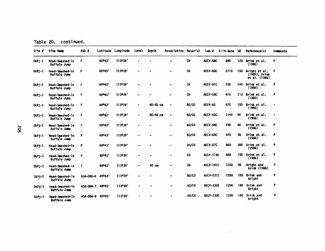
Table 20. continued.
Site , Site N.- ASA , latitude longitude level Depth Association Material lab , C-14 date SD Reference(s) Ce..ents
DkPj-l Head-Slushed-In F 49043' 113°39' CH AECY-58C 890 120 Brink et al. PBuffalo J..-p (1986)
DkPj-l Head-Sllashed-In F 49°43' 113°39' CH AECY-6OC 2710 150 Wright et al. PBuffalo J..-p (1985). Brink
et al. (1986)
DkPj-l Head-SlDashed-In F 49043' 113°39' CH AECY-61C 530 140 Brink et al. PBuffalo J..-p (1986)
DkPj-l Head-Smashed-In F 49043' 113°39' CH AECY-59C 470 110 Brink et a1. PBuffalo J..p (1986)
DkPj-l Head-Sllashed-In F 49°43' 113°39' 40-50 c. BO/CO AECY-62 470 150 Brink et al.Buffalo JUIIIp (1986)
DkPj-l Head-Slushed-In F 49°43' 113°39' 80-90 c. BO/CO AECY-63C 1140 90 Brink et al.Buffalo J.-p (1986)
N DkPj-l Head-Sllashed-In F 49043' 113039' BO/CO AECY-64C 190 80 Brink et al. P0 Buffalo J..-p (1986)0'\
DkPj-l Head-Sllashed-In F 49043' 113°39' BO/CO AECY-65C 470 90 Brink et al. PBuffalo J.-p (1986)
DkPj-l Head-Sllashed-In F 49043' 113°39' BO/CO AECY-67C 860 380 Brink et al. PBuffalo Ju.p (1986)
DkPj-l Head-Slushed-In F 49°43' 113°39' CH AECY-119C 680 150 Brink et al. PBuffalo Jump (1986)
DkPj-l Head-SUshed-In F 49043' 113°39' 60 CII CH AECY-191C 1250 90 Wright and PBuffalo JUlip Brink (1986)
DkPj-l Head-SIIIshed-In ASA-D86-6 49°43' 113°39' BO/CO AECY-231C 1280 100 Brink and PBuffalo J..-p Wright
DkPj-l Head-Slllashed-In ASA-D86-7 49°43' 113°39' BO/CO AECY-232C 1250 180 Brink and PBuffalo JUIIP Wright
DkPj-l Head-SUshed-In ASA-D86-8 49°43' 113°39' BO/CO AECY-233C 1030 150 Brink and PBuffalo Ju.p Wright
Table 20. continued.
Site , Site .... ASA , Latitude Longitude Level Depth Association Material Lab , C-14 date SO Reference(s) C~nts
DkPj-l Head-Sllashed-In F 49°43- 113039- CH/SED AECY-247C 1100 80 Brink and PBuffalo Ju.p Wright
DkPj-l Head-smashed-In ASA-D86-9 49°43- 113°39- BO/CO AECY-234C 1790 80 Brink and PBuffalo J..-p Wright
DkPj-l Head-Sllashed-In ASA-D86-10 49043- 113039- BO/CO AECY-235C 830 80 Brink and PBuffalo J..-p Wright
DkPj-l Head-Smashed-In ASA-D86-11 49°43- 113°39- BO/CO AECY-236C 1260 90 Brink andBuffalo JUlip Wright
DkPj-l Head-Smashed-In ASA-D86-12 49°43- 113°39- BO/CO AECY-237C 1300 70 Brink andBuffalo J.-p Wright
DkPj-l Head-Slushed-In ASA-D86-13 49°43- 113039- BO/CO AECY-238C 870 90 Brink andBuffalo J~ Wright
DkPj-l Head-Sllashed-In ASA-D86-14 49°43- 113°39- BO/CO AECY-239C 360 180 Brink andN Buffalo J..-p Wright0........ DkPj-l Head-Slushed-In ASA-D86-15 49°43- 113°39- BO/CO AECY-24OC 1620 180 Brink and
Buffalo J.-p Wright
DkPj-l Head-Slllashed-In ASA-D86-16 49°43- 113°39- BO/CO AECY-241C 1080 90 Brink and PBuffalo J..-p Wright
DkPj-l Head-Slushed-In F 49°43- 113°39- CH/SED AECY-25OC 680 120 Brink and P
Buffalo J..-p Wright
DkPj-l Head-Sllashed-In F 49°43- 113°39- CH/SED AECY-248C 410 130 Brink and P
Buffalo J.-p Wright
DkPj-l Head-Snlashed-In F 49043- 113°39- CH/SED AECY-249C 690 150 Brink and P
Buffalo JUIIIPWright
DkPj-27 Calderwood Bison F 49°43- 113°39- 10-18 CII BO GX-11607 *210 160 Marshall and C-13
J~Brink (1986)
DkPj-27 Calderwood Bison F 49°43- 113°39- 30-40 CII BO GX-11608 *1830 200 Marshall and C-13
Ju.pBrink (1986)
DkPj-27 Calderwood Bison F 49°43' 113039- 55-65 CII BO GX-11609 *2820 230 Marshall and C-13
J.-pBri nk (1986)

Table 20. continued.
Stte , Site I.e ASA , Latitude Longitude Level Depth Association Material Lab I C-14 date SO Reference (s) C~nts
OkPj-27 Calderwood Bison ASA-D86-5l 49043' 113°39' BO/CO AECY-319C 390 100 Brink. Wright.Ju.p Marshall
OkPj-27 Calderwood Bison ASA-D86-52 49043~ 113°39' BO/CO AECY-32OC 1310 110 Brink. Wright.J.-p Marshall
OkPj-27 Calderwood Bison ASA-D86-53 49043' 113°39' BO/CO AECY-321C 890 110 Brink. Wright.JUJnp Marshall
010n-3 Larson F 49°56' 110018' 56-76 c. AY BO/AP GX-9395-A *1420 150 Laurie Milne C-13
010n-3 Larson F 49056' 110018' 56-76 CID AY BO/CO GX-9396-G *1165 125 Laurie Milne C-13
010n-3 Larson ASA-D86-17 49°56' 11 ()O18' 65-75 C. AY BO/CO AECY-298C 1190 80 Laurie Milne
010n-3 Larson ASA-086-18 49°56' 110018' 70-110 C. AV CH AECY-299C 1210 80 Laurie Milne
010n-3 Larson ASA-D86-19 49056' 110018' 70-110 C. AY CH AECY-300c 1140 90 Laurie Milne
N 010u-9 Laidlaw F 49055' 111°28' BO Beta-11952 3280 110 B....ley (1986) AMS. 3420+130
0(C-13 adjusted)
ex>01Pa-4 Stalker (Taber 49°51' 112°9' BO 3550 500 Brown et al. AMS. redating
child)(1983) Taber child
D1Pb-2 Cranford Gravel ASA-D86-29 49°50' 112021' 16-24 c. BO/CO AECY-312C 1770 80 Rebecca Ba1COlI -Pit
D1Pb-2 Cranford Gravel ASA-D86-34 49°50' 112021' 18 CII BO/CO AECV-317C 620 100 Rebecca Balco. -Pit
D1Pb-2 Cranford Gravel ASA-D86-35 49°50' 112°21' 32-40 C. BO/CO AECY-318C 1890 80 Rebecca BalcOll -Pit
D1Pb-2 Cranford Gravel ASA-D86-30 49°50' 112021' 13-18 ell OW/AY/BE BO/CO AECY-313C 1000 90 Rebecca Balco. -Pit
01Pb-2 Cranford Gravel ASA-086-31 49050' 112°21' 20-30 C. OW/AY/BE/ BO/CO AECY-314C 1150 80 Rebecca Ba1cc. -Pit
MK/Pl
01Pb-2 Cranford Gravel ASA-D86-32 49050' 112°21' 24 CII OW/MK/HA BO/CO AECY-315C 1000 100 Rebecca BalcOll -Pit
Cranford Gravel ASA-086-28 49°50' 112021' 20 c. PL/t« BO/CO AECY-311C 1640 120 Rebecca BalcOII -01Pb-2
Pit
Table 20. continued.
Site , Sfte N_ ASA , Latftude Longitude Level Depth Association Materfal Lab , C-14 date SD Reference(s ) Ca.ents
D1Pd-3 Ross F 49052' 1120 31' OW CH S-2040 Modern - Yfckers (1987) -D1Pd-3 Ross F 490 52' 112°31' OW CH 5-2043 Modern - Vickers (1987) -EIPh-4 Lfttle Bow Rfver F 50010' 113°18' 10-20 c. BO/CO AECY-155C 940 160 Fedirchuk
Crossfng
EIPh-4 Little Bow River F 50°10' 113°18' 0-10 CII BO/CO AECY-154C 450 70 FedirchukCrossing (1986)
EaPh-4 Lfttle Bow River F 50°10' 113°18' 20-30 c. BO/CO AECY-153C 620 230 FedirchukCrossing (1986)
EaPna-5 Porcupine Hills ASA-D86-21 50°1' 114°2' BO/CO AECY-302C Modern - RonaghanNo. 1
EbOp-16 Cactus F1 ower 50015' 11()O38' MIC CH 5-1209 3740 100 Rutherford et Occupational. (1981) IIISub. by J.H.
N B".ley0\0 EbOp-16 Cactus F1 ower 50°15' 11()O38' r« CH 5-1210 4220 130 Rutherford et Occupation
al. (1981) YIIISub. by J.H.B".ley
EdOp-1 British Block 50036' 11()O36' 10 c. CH 5-1922 2720 220 Rutherford etCairn al. (1984)
EdPk-39 Callahan Sand Pit ASA-D86-23 50034' 113°48' 2 10-20 era BO/CO AECY-303C 8670 230 Ronaghan
Eg~179 Hawtwood 51°07' 114°10' RL-1277 6820 280 Van Dyke andStewart (1985)
EgPr-2 Sfbbald Creek F 51°3' 1140 52' 35-45 CII CH &X-881 0 7645 260 Ball (1983b)
EgPr-2 Sibbald Creek F 51°3' 114°52' 25-30 CII CH GX-8809 5850 190 Ball (1983b)
EgPr-2 Sibbald Creek F 51°3' 1140 52' 35-40 CII CH GX-8808 9570 320 Bill (1983b) UN (Countermalfunction)
EhPv-8 Yerwilfon Lakes 51°10' 115°39' CH/A SFU-314 10900 270 Hobson andNelson (1984)Fedje (1985)
Table 20. continued.
Sfte , Site N_ ASA , Latitude longitude level Depth Association Material Lab I C-14 date SO Reference(s) C~nts
EhPv-8 Yerllil10n lakes 51°10' 115°39' CH/A SFU-316 11500 300 Hobson andNelson (1984)Fedje (1985)
EhPv-8 Yenni1ion lakes 51°10' 115°39' CH/A SFU-317 9400 400 Hobson andNelson (1984)Fedje (1985)
EhPv-8 Yenai1ion Lakes 51°10' 115°39' CH/A SFU-31S 9SOO 400 Hobson andNe1son (1984)Sub. by DarylFedje
EhPv-S Yerlli1ion lakes 51°10' 115°39' CH/A SFU-346 11700 290 Hobson andNe1son (1984)Fedje (1985)
EhPv-8 Yenlli1ion lakes 51°10' 115°39' CH SFU-348 11000 480 Fedje (1985)
EhPv-8 Yermilion Lakes 51°10' 115°39' CH SFU-347 8950 600 Fedje (1985)N.....0 E1Pf-l D~ Island Buffalo F 51°56' 112°60' 45-70 til BO/AP &X-9124-A *2260 270 Ball (1984) C-13
J.-p
E1Pf-l D~ Island Buffalo F 51°56' 112°60' 45-70 C1I BO/CO &X-9125-& *2885 250 Ball (1984) C-13J..-p
E1Pf-l D~ Island Buffalo F 51°56' 112°60' 30-40 c. BO/AP GX-9122-A' *1305 160 Ball (1984) C-13Jump
E1Pf-l D~ Island Buffalo F 51°56' 112°60' 30-40 c. BO/CO GX-9123-& *1235 210 Ball (1984) C-13J..-p
E1Pf-1 D~ Island Buffalo F 51°56' 112°60' 15-20 CII BO/AP GX-912Q-A *710 140 Ball (1984) C-13J.-p
E1Pf-l D~ Island Buffalo F 51°56' 112°60' 60-70 CII BO/AP GX-911S-A *720 150 Ball (1984) C-13J..-p
E1Pf-l Dry Island Buffalo F 51°56' 112°60' 60-70 c. BO/CO &X-9119-& *680 155 Ball (1984) C-13
JUIIP
E1Pf-l Dry Island Buffalo F 51°56' 112060' 1.3 • BO/AP GX-9116-A *1010 150 Ball (1984) C-13
J..-p
Table 20. continued.
Site , Site N_ ASA , Latitude Longitude Level Depth Association Material Lab I C-14 date SO Reference(s) Caa.ents
E1Pf-l Dr" Island Buffalo F 51°56' 112°60' 1.3 • BO/CO GX-9117-& *905 120 Ball (1984) C-13JUlip
FbPf-l Miller F 52°15' 113°22' 2a 40-75 CII BO - BO/CO AECY-288C 350 60 Ball (1986a)
FbPf-l Miller F 52°15' 113°22' 2c 100-120 CII - BO/CO AECY-293C 210 60 Ball (1986a)BO
FbP1-1 Miller F 52°15' 113°22' 2a 40-75 CII BO - BO/CO AECY-289C 210 80 Ball (1986a)
FbPf-l Miller F 52°15' 113°22' 2b 75-100 CII BO/CO AECY-29OC 230 90 Ball (1986a)BD
FbPi-l Miller F 52°15' 113°22' 2b 75-100 C. BO/CO AECY-291C 340 90 Ball (1986a)SO
FbPi-l Miller F 52°15' 113°22' 2c 100-120 cm - BO/CO AECY-292C 370 90 Ball (1986a)BD
N FdOt-l Anderson F 52°48' 111°20' CH 5-1894 1070 80 QUigg.......... FhQl-4 Swan Landing F 53°19' 117°51' 33 3.3 • CH 5-2178 8675 270 Bill (19831)
FhQl-4 Swan Landing F 53°19' 117°51' 26 2.6 • HA 5-2179 7010 1560 Ball (19831)
FjPi-29 Strathcona ASA-086-36 53°33' 113°23' J 50 cm OX CH AECY-308C 130 90 Brian Kooyman
FkPg-42 SCotford styrene 53°48' 113°05' 36-40 ell CH Beta-3504 910 80 Bryan (1982)
F1Qs-30 Grande Cache Lake F 53°55' 11902' Three - .. CH 5-1888 4605 75 Brink
GdQp-l Tukwakin 54°33' 118037' 3 BO/B 5-1477 Modern - Buchner (1978) -GjPx-5 Hidden Creek F 55°31' 115°57' 2 CH Beta-7838 Modern - LeBlanc
HaPl-1 A100k 56°8' 113°51' BO DIC-l066 770 70 Si.s cited in Upper B horizonGruhn (1981) Site forwerly
HaPl-1oo
HhOv-73 Be~a F 57°16' 111°30' 3 CH Beta-7839 3990 170 LeBlanc (1985) -HkPa-14 Pelican Beach F 57°48' 112°07' 11 CH GX-8811 1940 130 Iyes
HkPa-14 Pelican Beach F 57°48' 112°07' 15 CH GX-8812 1965 135 Iyes
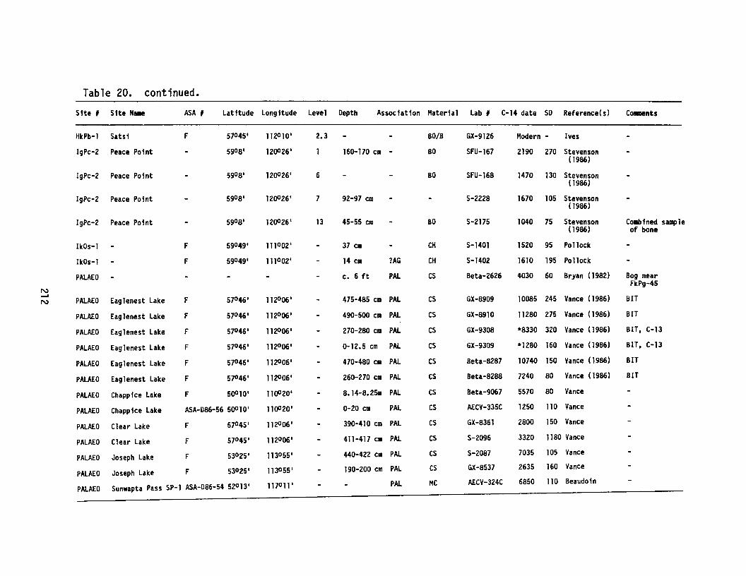
Table 20. continued.
Site , Site Name ASA # Latitude Longitude Level Depth Association Material Lab , C-14 date SD Reference(s) COIIIDInts
HkPb-1 Satsi F 57°45 1 112°101 2.3 80/B GX-9126 Modern - Ives
IgPc-2 Peace Point 59°81 120026 1 160-170 ell - BO SFU-167 2190 270 Stevenson(1986)
IgPc-2 Peace Point 59°8' 120026 1 6 BO SFU-168 1470 130 Stevenson(1986)
IgPc-2 Peace Point 59°81 12()O26 1 7 92-97 em S-2228 1670 105 Stevenson(1986)
IgPc-2 Peace Point 59°8' 12()O26 , 13 45-55 em BO S-2175 1040 75 Stevenson Combined sample(1986) of bone
IkOs-l F 59°49' 111°02 1 37 elD CH S-1401 1520 95 Pollock
IkOs-l F 59049 1 111°02 1 14 elD ?AG CH S-1402 1610 195 Pollock
PALAEO e. 6 ft PAL CS Beta-2626 4030 60 Bryan (1982) Bog near
NFkPg-45
--'N PALAEO Eaglenest Lake F 57°46' 112°06' 475-485 elD PAL CS GX-8909 10085 245 Vance (1986) BIT
PALAEO Eag1enest Lake F 57°46 1 112°061 490-500 CIA PAL CS GX-8910 11280 275 Vance (1986) BIT
PALAEO Eag1enest Lake F 57°46' 112006 1 270-280 elD PAL CS GX-9308 *8330 320 Vance (1986) BIT, C-13
PALAEO Eaglenest Lake F 57°46 1 112006 1 0-12.5 em PAL CS GX-9309 *1280 160 Vance (1986) BIT, C-13
PALAEO Eaglenest Lake F 57°46 1 112°06' 470-480 em PAL CS Beta-8287 10740 150 Vance (1986) BIT
PALAEO Eaglenest Lake F 57°46 1 112°061 260-270 ell PAL CS Beta-8288 7240 80 Vance (1986) BIT
PALAEO Chapp ice Lake F 50010' 11 ()O20 ' S.14-8.2511 PAL CS Beta-9067 5570 SO Vance
PALAEO Chapp ice Lake ASA-D86-56 50010' 110020 1 0-20 em PAL CS Af.CV-335C 1250 110 Vance
PALAEO Clear Lake F 570 45' 112°06' 390-410 em PAL CS GX-S361 2800 150 Vance
PALAEO Clear Lake F 570 45' 112°061 411-417 em PAL CS S-2096 3320 1180 Vance
PALAEO Joseph Lake F 53°25' 113°55' 440-422 em PAL CS S-2087 7035 105 Vance
PALAEO Joseph Lake F 530 25' 1130 55' 190-200 em PAL CS GX-8537 2635 160 Vance
PALAEO Sunwapta Pass SP-1 ASA-D86-54 52°13 1 117°11 1 PAL MC AECV-324C 6850 110 Beaudoin
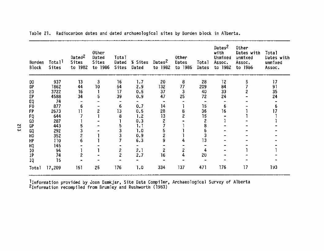
Table 21. Radiocarbon dates and dated archaeological sites by Borden block in Alberta.
Dates2 OtherOther with Dates with Total
Dated2 Dated Total Other Unmixed unmixed Dates withBorden Tota1 1 Sites Sites Dated % Sites Dates2 Dates Total Assoc. Assoc. unmixedBlock Sites to 1982 to 1986 Sites Dated to 1982 to 1986 Dates to 1982 to 19B6 Assoc.
DO 937 13 3 16 1.7 20 8 28 12 5 17DP 1862 44 10 54 2.9 132 77 209 84 7 91EO 3722 16 1 17 0.5 37 3 40 33 2 35EP 4588 34 5 39 0.9 47 25 72 24 24EQ 74FO 877 6 6 0.7 14 1 15 6 6FP 2673 11 2 13 0.5 28 8 36 16 1 17FQ 644 7 1 8 1.2 13 2 15 1 1GO 287 1 1 0.3 2 2 1
N GP 443 5 5 1•1 7 1 8-'"eN GQ 292 3 3 1.0 5 1 6
HO 352 2 1 3 0.9 2 1 3HP 110 6 1 7 6.3 9 4 13HQ 14510 94 1 2 2. 1 2 2 4 11P 74 2 2 2.7 16 4 201Q 15Total 17,209 151 25 176 1.0 334 137 471 176 17 193
l1nformation provided by Joan Damkjar, Site Data Compiler, Archaeological Survey of Alberta2Information recompiled from Brumley and Rushworth (1983)
RESEARCH NOTESf
IIResearch Notes ll are intended to convey infornlation useful topractising professionals in Alberta in those cases where an entirearticle is not warranted. Contributions should be brief, with a minimumof text and/or figures, and should be directed to the Head of theResearch Section.
Contributions this year include an update on excavations at theLarson site, a report on the Pink Mountain site in British Columbia, aseries of preliminary maps showing the distributions of Native groups inwestern Canada (ca. A.D. 1750 to A.D. 1850), and a consideration of x-rayfluorescence analysis used in obsidian source characterization.
Martin Magne
214
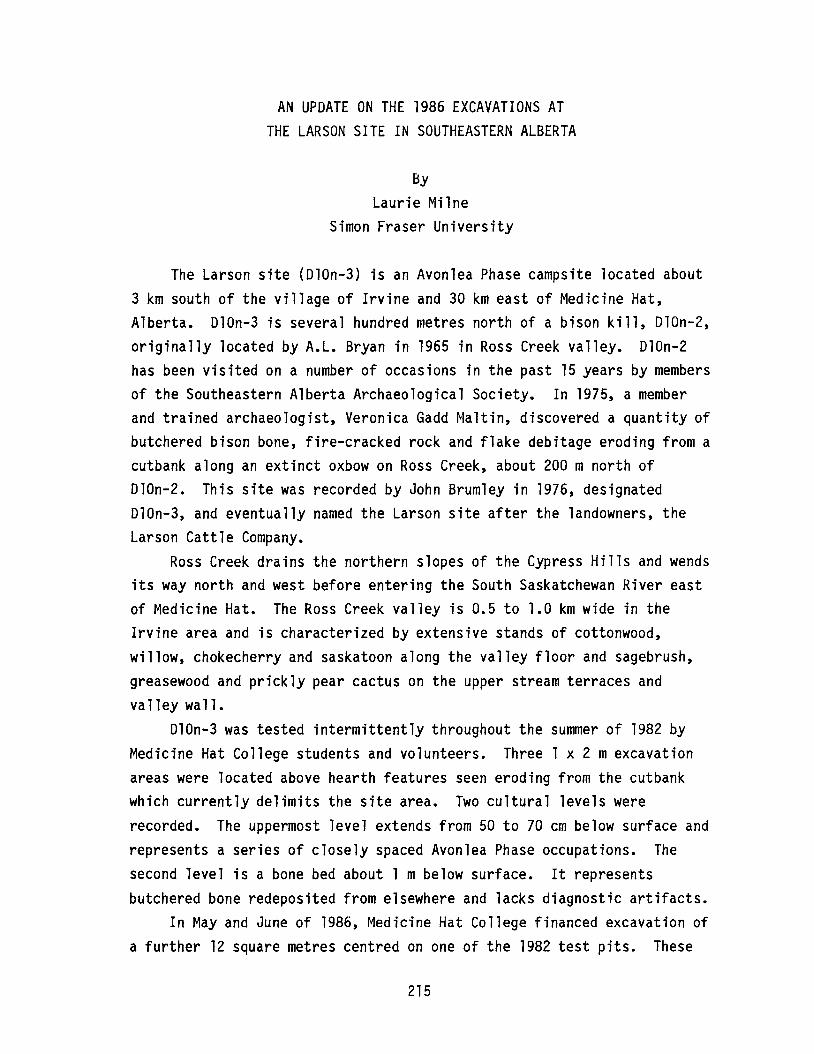
AN UPOATE ON THE 1986 EXCAVATIONS ATTHE LARSON SITE IN SOUTHEASTERN ALBERTA
ByLaurie Milne
Simon Fraser University
The Larson site (010n-3) is an Avonlea Phase campsite located about3 km south of the village of Irvine and 30 km east of Medicine Hat,Alberta. 010n-3 is several hundred metres north of a bison kill, 010n-2,originally located by A.L. Bryan in 1965 in Ross Creek valley. D10n-2has been visited on a number of occasions in the past 15 years by membersof the Southeastern Alberta Archaeological Society. In 1975, a memberand trained archaeologist, Veronica Gadd Maltin, discovered a quantity ofbutchered bison bone, fire-cracked rock and flake debitage eroding from acutbank along an extinct oxbow on Ross Creek, about 200 m north of010n-2. This site was recorded by John Brumley in 1976, designated010n-3, and eventually named the Larson site after the landowners, theLarson Cattle Company.
Ross Creek drains the northern slopes of the Cypress Hills and wendsits way north and west before entering the South Saskatchewan River eastof Medicine Hat. The Ross Creek valley is 0.5 to 1.0 km wide in theIrvine area and is characterized by extensive stands of cottonwood,willow, chokecherry and saskatoon along the valley floor and sagebrush,greasewood and prickly pear cactus on the upper stream terraces andvalley wall.
010n-3 was tested intermittently throughout the summer of 1982 byMedicine Hat College students and volunteers. Three 1 x 2 mexcavationareas were located above hearth features seen eroding from the cutbankwhich currently delimits the site area. Two cultural levels wererecorded. The uppermost level extends from 50 to 70 cm below surface andrepresents a series of closely spaced Avonlea Phase occupations. Thesecond level is a bone bed about 1 m below surface. It representsbutchered bone redeposited from elsewhere and lacks diagnostic artifacts.
In May and June of 1986, Medicine Hat College financed excavation ofa further 12 square metres centred on one of the 1982 test pits. These
215
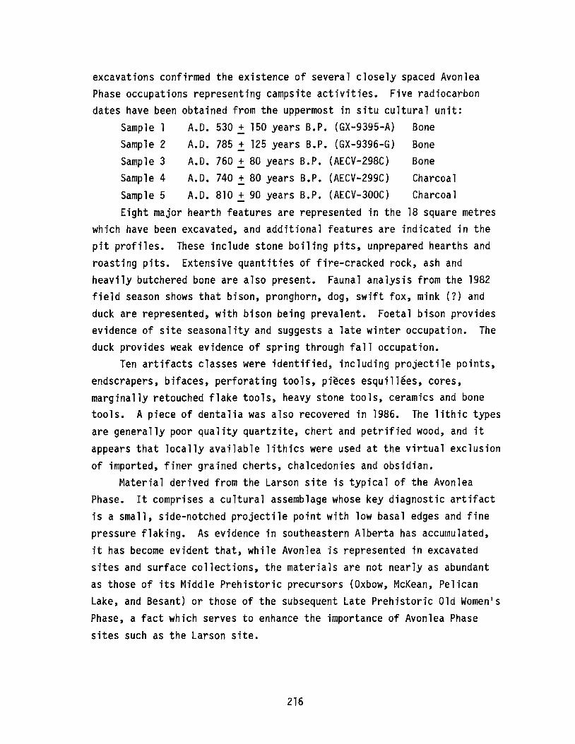
excavations confirmed the existence of several closely spaced AvonleaPhase occupations representing campsite activities. Five radiocarbondates have been obtained from the uppermost in situ cultural unit:
Sample 1 A.D. 530 + 150 years B.P. (GX-9395-A) BoneSample 2 A.D. 785 ~ 125 years B.P. (GX-9396-G) BoneSample 3 A.D. 760 + 80 years B.P. (AECV-298C) BoneSample 4 A.D. 740 ~ 80 years B.P. (AECV-299C) CharcoalSample 5 A.D. 810 + 90 years B.P. (AECV-300C) CharcoalEight major hearth features are represented in the 18 square metres
which have been excavated, and additional features are indicated in thepit profiles. These include stone boiling pits, unprepared hearths androasting pits. Extensive quantities of fire-cracked roc~, ash andheavily butchered bone are also present. Faunal analysis from the 1982field season shows that bison, pronghorn, dog, swift fox, mink (1) andduck are represented, with bison being prevalent. Foetal bison providesevidence of site seasonality and suggests a late winter occupation. Theduck provides weak evidence of spring through fall occupation.
Ten artifacts classes were identified, including projectile points,endscrapers, bifaces, perforating tools, pieces esquillees, cores,marginally retouched flake tools, heavy stone tools, ceramics and bonetools. A piece of dentalia was also recovered in 1986. The lithic typesare generally poor quality quartzite, chert and petrified wood, and itappears that locally available lithics were used at the virtual exclusionof imported, finer grained cherts, chalcedonies and obsidian.
Material derived from the Larson site is typical of the AvonleaPhase. It comprises a cultural assemblage whose key diagnostic artifactis a small, side-notched projectile point with low basal edges and finepressure flaking. As evidence in southeastern Alberta has accumulated,it has become evident that, while Avonlea is represented in excavatedsites and surface collections, the materials are not nearly as abundantas those of its Middle Prehistoric precursors (Oxbow, McKean, PelicanLake, and Besant) or those of the subsequent Late Prehistoric Old Women1sPhase, a fact which serves to enhance the importance of Avonlea Phasesites such as the Larson site.
216

THE PINK MOUNTAIN PALAEO-INDIAN SITE
ByIan Wilson
I.R. Wilson Consultants Ltd.
A Palaeo-Indian site (HhRr-l), with Clovis, Scottsbluff and Lermaprojectile points, has been discovered near Pink Mountain, 150 kmnorthwest of Fort St. John, B.C. (Figure 58). The site extends for morethan a kilometre along a ridge overlooking the Sikanni Chief Rivervalley. Surface finds account for a majority of the artifacts observed,but buried cultural materials have been recovered from a loess horizonnear the surface. Although initial investigations were brief, theapparent age of the artifacts, the large areal extent of the site, aswell as its location within the boundaries of the postulated lIice freecorridor" are compelling reasons for further research. No dates wereobtained from the site, although the Clovis materials (two projectilepoint bases; Figure 59a, b) are similar to the point recovered at CharlieLake Cave near Fort St. John which is radiocarbon dated to about 10,400years B.P. The complete Scottsbulff point (Figure 59d) is the firstidentified from an archaeological site in B.C. As well as these pointtypes, a microblade core was also recovered, as were several modifiedmacroblades.
217

N
i
o 5 10 KILOMETRESL-' ......' ----',
Figure 58. Location of site HhRr-l.
218
---~STUDY
AREA
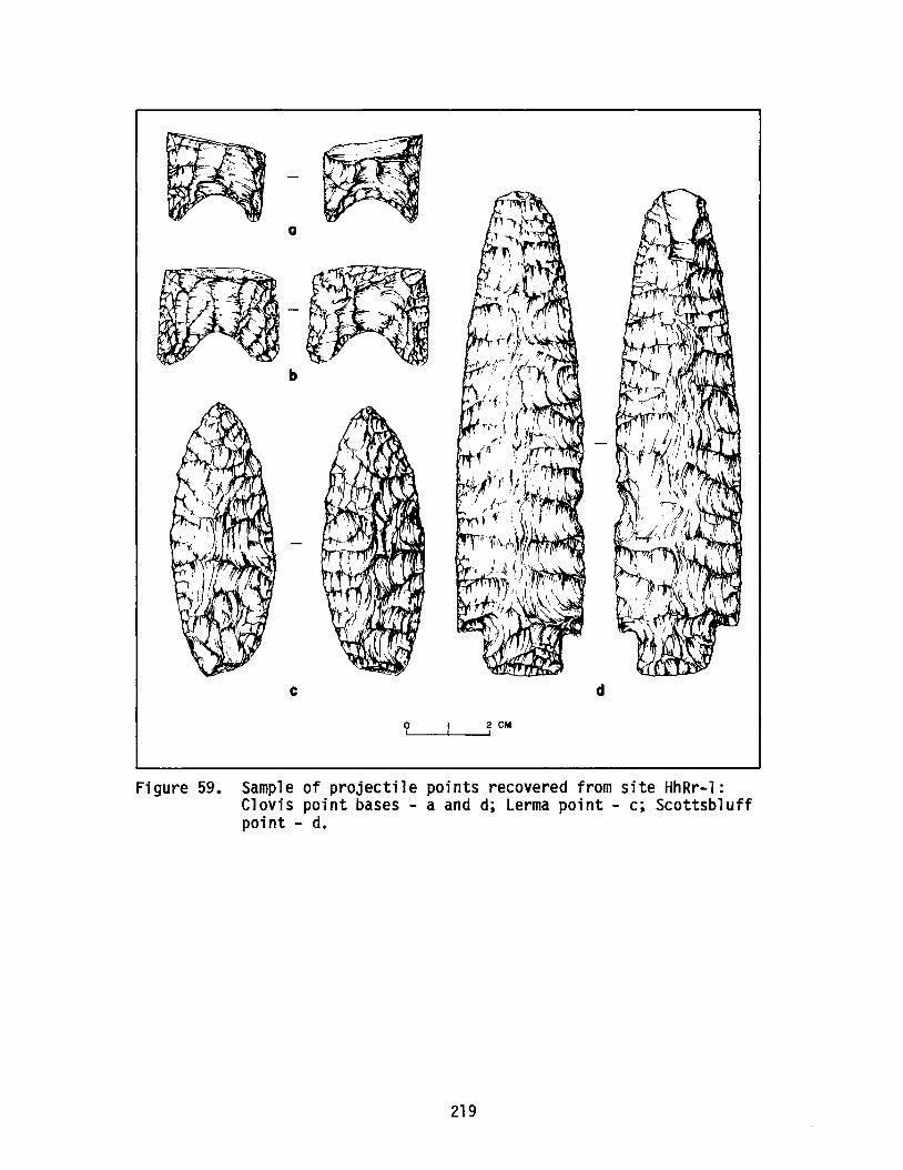
a
b
c d
o 2 eM'......----~,
Figure 59. Sample of projectile points recovered from site HhRr-l:Clovis point bases - a and d; Lerma point - c; Scottsbluffpoint - d.
219

DISTRIBUTIONS OF NATIVE GROUPS IN WESTERN CANADA,A.D. 1700 TO A.D. 1850
ByMartin Magne
Archaeological Survey of Albertaand
Contributors to the Saskatchewan-Alberta Dialogue
The maps that appear in the following pages are the product of abrain-storming session held at the conclusion of the Saskatchewan-AlbertaDialogue symposium held in Edmonton in January, 1986. During adiscussion aimed at merging archaeological evidence, historic literature,anthropological theory and common sense regarding Native groupdistributions in the early historic period, the suggestion arose thatparticipants should circulate a set of maps and attempt to compile anacceptable set of standards for this issue. The purpose of such anexercise, with foreseeable limitations, would be to develop a baselinefor future studies of this genre. The five maps included here are theresults of the ensuing year1s correspondence.
The design of this research project was simple. After the initialsuggestion to proceed, blank maps were sent to 25 researchers in Albertaand Saskatchewan, along with a letter asking them to outline Native groupdistributions within their areas of expertise. Fifty-year intervals werechosen, recognizing the difficulties inherent in imposing arbitrary timelimits. Five sets of draft maps were returned, with a surprisingconsistency over the period of A.D. 1700 to A.D 1850. A compilation ofthese was assembled on a Macintosh computer and redistributed to theoriginal mailing list. Fifteen sets of comments were returned; the mapswere revised and drafted as they appear here. During this lastcompilation, David Meyer and Dale Russell included an extra map showingthe routes of travel for writers of "primary published accounts of Nativelocations," mainly for Saskatchewan. This map was revised to includeAlberta and appears here as Figure 60.
These maps contain several limitations that should be noted brieflyhere. Although this is hard to document throughout western Canada, there
220

is no doubt that Native groups used large areas which overlapped withthose of neighbouring groups. Furthermore, the seasonal movements ofpeople were frequently wide ranging. Finally, several severe epidemicshad the effect of drastically reducing the sizes of Native populations,as well as leading to considerable geographic displacement.
This exercise appears in "Research Notes" as a means to furtherrefinement. The many comments now in hand with regard to the individualgroups have become too cumbersome to compile coherently at this time.Hopefully, this current year will see some additional comments returned,following which a decision can be made as to whether or not to continuethis venture in more detail. Please write to the Archaeological Surveyof Alberta should you have observations to make.
221
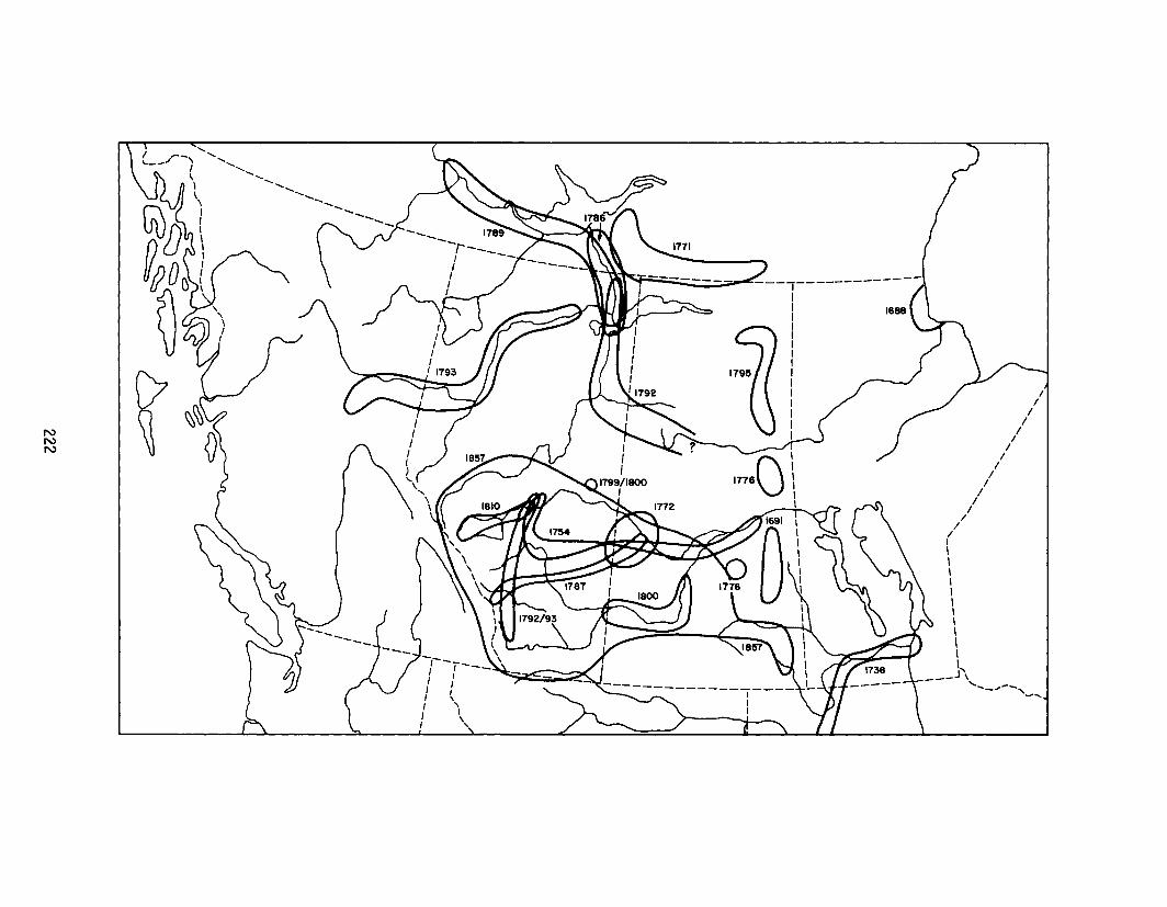
1688
------------.,.-IIIIIIIIIIIIIII
II
//
//
//
I/
I/
II
//
/,\\\\\\\\\\\\,
_J \--- '--..,--~-......

Figure 60.
Year A.D.
168816911738175417711772177617861787178917921792/93179317951799/180018101857
Dates and general areas of travel of the authors of publishedprimary accounts of Native locations in Saskatchewan andAlberta.
Author
Henry KelseyHenry KelseyPierre La VerendryeAnthony HendaySamuel HearneMathew CockingAlexander Henry the ElderCuthbert GrantDavid ThompsonAlexander MackenziePhilip TurnerPeter Fidler (archival)Alexander MackenzieDavid ThompsonPeter FidlerAlexander Henry the YoungerJ. Palliser
223
A.D. 1700
__ CHIPEWYAN
r-------------,-------, I
III
II
/I
II
II
I/
//I,,,,,,,,,
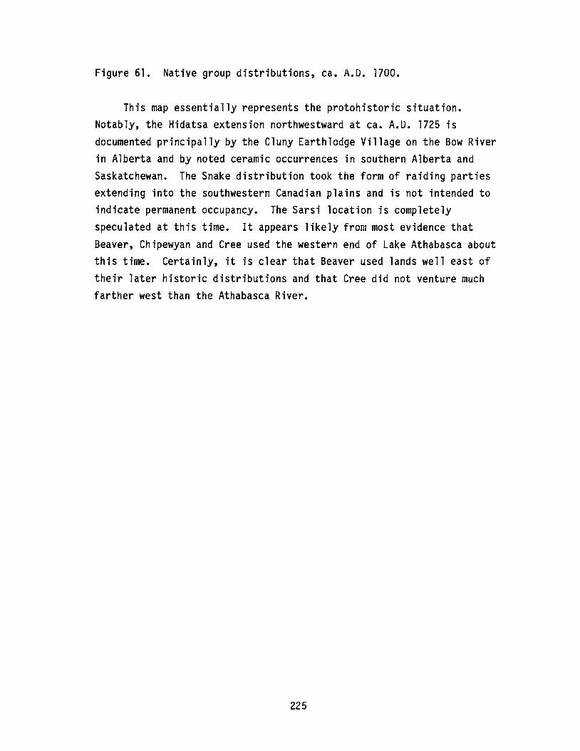
Figure 61. Native group distributions, ca. A.D. 1700.
This map essentially represents the protohistoric situation.Notably, the Hidatsa extension northwestward at ca. A.D. 1725 isdocumented principally by the Cluny Earthlodge Village on the Bow Riverin Alberta and by noted ceramic occurrences in southern Alberta andSaskatchewan. The Snake distribution took the form of raiding partiesextending into the southwestern Canadian plains and is not intended toindicate permanent occupancy. The Sarsi location is completelyspeculated at this time. It appears likely from most evidence thatBeaver, Chipewyan and Cree used the western end of Lake Athabasca aboutthis time. Certainly, it is clear that Beaver used lands well east oftheir later historic distributions and that Cree did not venture muchfarther west than the Athabasca River.
225

A.D. 1750
-.,._______ CHIPEWYAN _--, ------,-------, I
tIIIIII
II
II
II
II
II
II
II
/I
/,,,\
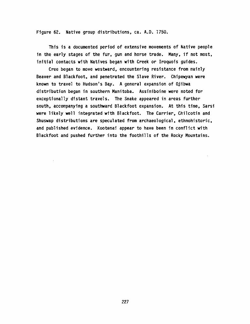
Figure 62. Native group distributions, ca. A.D. 1750.
This is a documented period of extensive movements of Native peoplein the early stages of the fur, gun and horse trade. Many, if not most,initial contacts with Natives began with Creek or Iroquois guides.
Cree began to move westward, encountering resistance from mainlyBeaver and Blackfoot, and penetrated the Slave River. Chipewyan wereknown to travel to Hudson1s Bay. A general expansion of Ojibwadistribution began in southern Manitoba. Assiniboine were noted forexceptionally distant travels. The Snake appeared in areas furthersouth, accompanying a southward Blackfoot expansion. At this time, Sarsiwere likely well integrated with Blackfoot. The Carrier, Chilcotin andShuswap distributions are speculated from archaeological, ethnohistoric,and published evidence. Kootenai appear to have been in conflict withBlackfoot and pushed further into the foothills of the Rocky Mountains.
227
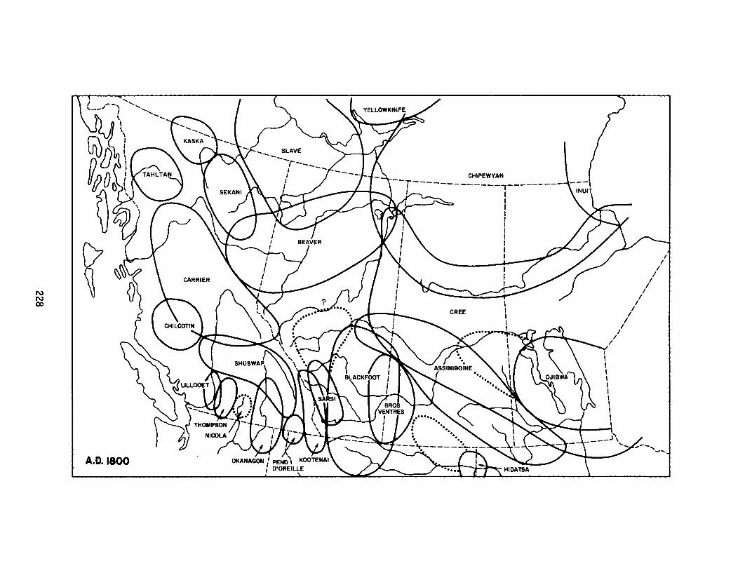
NNex>
A.D. 1100
CHIPEWYAN
--r-------------,---------,,
II
II
II
II
II
II
II
I/
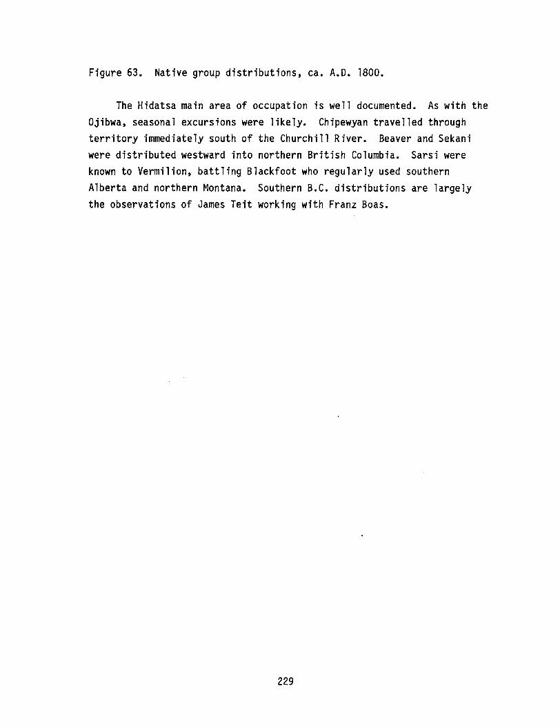
Figure 63. Native group distributions, ca. A.D. 1800.
The Hidatsa main area of occupation is well documented. As with theOjibwa, seasonal excursions were likely. Chipewyan travelled throughterritory immediately south of the Churchill River. Beaver and Sekaniwere distributed westward into northern British Columbia. Sarsi wereknown to Vermilion, battling Blackfoot who regularly used southernAlberta and northern Montana. Southern B.C. distributions are largelythe observations of James Teit working with Franz Boas.
229
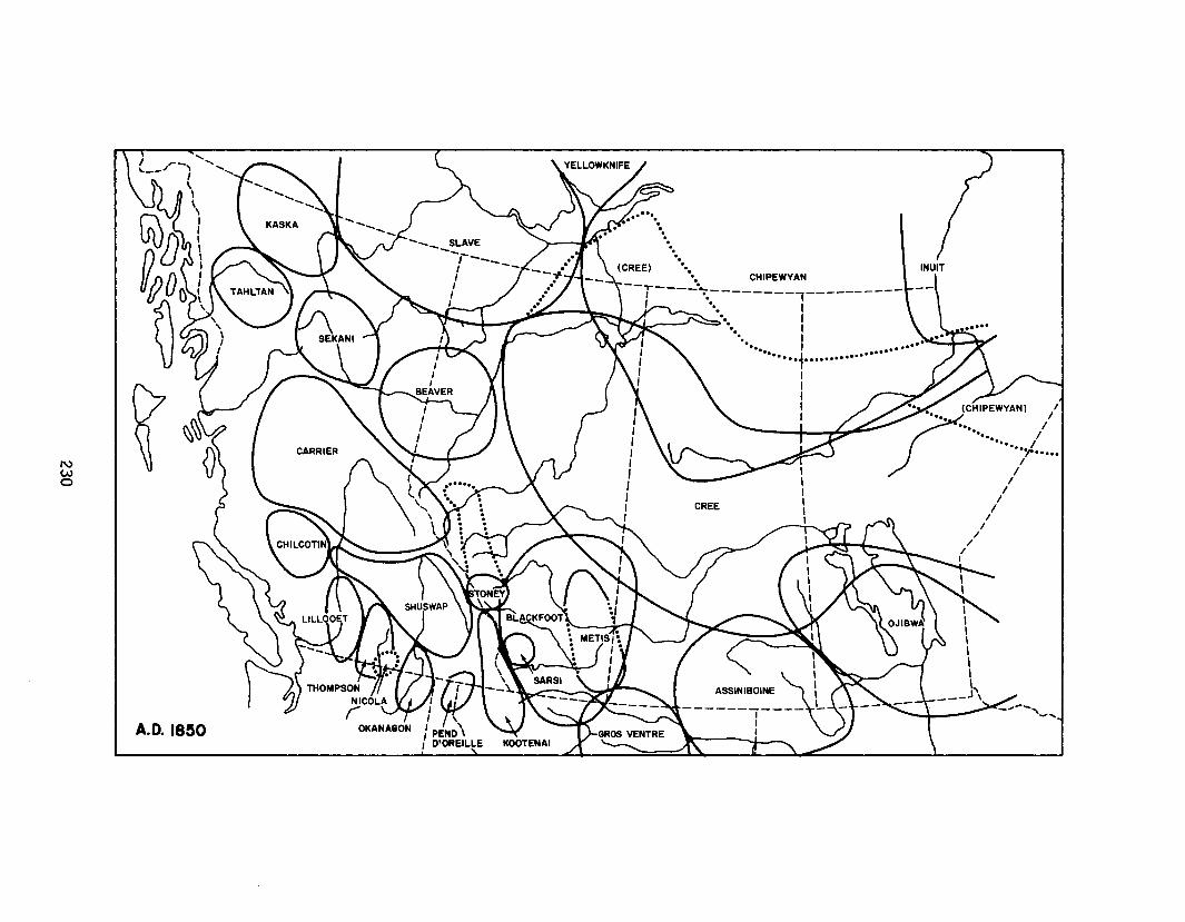
NWo
A.D. 18~O
........ .
•••• CHIPEWYAN
--T---~~--------,----------, ~. I
•• I••• I....: .............-....II..-~..... . ....·i···········
IIIII
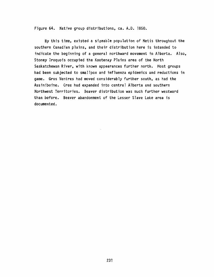
Figure 64. Native group distributions, ca. A.D. 1850.
By this time, existed a sizeable population of Metis throughout thesouthern Canadian plains, and their distribution here is intended toindicate the beginning of a general northward movement in Alberta. Also,Stoney Iroquois occupied the Kootenay Plains area of the NorthSaskatchewan River, with known appearances further north. Most groupshad been subjected to smallpox and influenza epidemics and reductions ingame. Gros Ventres had moved considerably further south, as had theAssiniboine. Cree had expanded into central Alberta and southernNorthwest Territories. Beaver distribution was much further westwardthan before. Beaver abandonment of the Lesser Slave Lake area isdocumented.
231

LIST OF CONTRIBUTORS:
Tom Andrews, Dene Mapping Project, University of Alberta (Dene, Slave,Chipewyan)
Bruce Ball, Archaeological Survey of Alberta (Sarsi, Blackfoot, GrosVentres)
Jack Brink, Archaeological Survey of Alberta (Blackfoot, Snake, GrosVentres, Assiniboine, Kootenai, Sarsi, general)
W.J. Byrne, Historical Resources Division, Alberta Culture andMulticulturalism (Blackfoot, Hidatsa)
Maurice Doll, Provincial Museum of Alberta (general)
Anthony Fisher, Department of Anthropology, University of Alberta (general)
Michael Forsman, Archaeological Survey of Alberta (primary accounts)
John Foster, Department of History, University of Alberta (Cree,Blackfoot, Ojibwa, Assiniboine, Chipewyan, Beaver, general)
Cliff Hickey, Department of Anthropology, University of Alberta (general)
Jack Ives, Archaeological Survey of Alberta (Beaver, Slave, Chipewyan,Cree, primary accounts)
Wendy Johnson, Archaeological Survey of Alberta (drafting)
David Meyer, Saskatchewan Research Council (Chipewyan, Cree, Assiniboine,Gros Ventres, Hidatsa, Snake, Ojibwa, Inuit, general)
Pat McCormack, Provincial Museum of Alberta (Beaver, Chipewyan, Cree)
Heinz Pyszczyk, Archaeological Survey of Alberta (primary accounts)
Dale Russell, Saskatchewan Research Council (Cree, Chipewyan, GrosVentres, Assiniboine, Snake, Ojibwa, Inuit, general)
Rod Vickers, Archaeological Survey of Alberta (Blackfoot, Gros Ventres,Assiniboine, Snake, Hidatsa, Macintosh drafts)
ADDITIONAL SESSION SHAKERS:
Charles Schweger, Department of Anthropology, University of Alberta
Brian Spurling, Archaeological Resource Management, Saskatchewan Parks,Recreation and Culture
I am grateful to all of these people for their ideas; however, finalresponsibility for the maps is completely my own.
232
A CONSIDERATION OF SEMI-QUANTITATIVE X-RAY FLUORESCENCE ANALYSISUSED IN OBSIDIAN SOURCE CHARACTERIZATION
ByD. I. Godfrey-Smith
andJ. M. D1Auria
Simon Fraser University
Obsidian source analysis is an archaeometric pursuit which isappreciated by archaeologists and geologists alike. Applications of thisform of scientific enquiry are found throughout the world. Not only doesit shed light on the geochemistry of volcanic terrains, but it has beenparticularly fruitful in elucidating the patterns and paths of materialexchange and thus of long-distance contacts, sometimes on a continentalscale, among aboriginal societies in the past in North America andelsewhere.
The key to the success of obsidian source analysis in archaeologicalstudies is the fact that natural occurrences of obsidian are relativelyrare and that they can usually be distinguished from each other on thebasis of their chemical compositions. However, the assumption that thechemical composition of an obsidian flow is uniform throughout andclearly distinct from the chemical composition of all flows in otherareas is not always true. For example, Bowman et ale (1973), who testedthe assumption of chemical uniformity on a single obsidian flow,concluded that the chemical composition was not uniform, but it varied ina systematic manner. Similarly, although macroscopic homogeneity of theobsidian, a natural volcanic glass, is assumed, this does not alwaysreflect its real nature. Using suitable instruments, both microscopicand submicroscopic inhomogeneities in the form of crystalline inclusionscan be observed in some obsidians (for an example, see Appendix B inGodfrey-Smith 1985). It is important to bear these two facts in mindwhen results of obsidian source analysis are presented. Chemicaldistinctness and homogeneity are approximations only, and unrecognizedflow variability may result in errors of source attribution for artifacts.
233

In energy-dispersive x-ray fluorescence (ED-XRF), a sample isbombarded with high-energy lines characteristic of a secondary target.This causes lower-energy x-rays, characteristic of the elements in thesample, to be emitted. The x-rays emitted by the sample are detectedusing a Si(Li) detector and pulse-height analysis electronics. Forobsidian analysis, our XRF spectrometer is equipped with a silver (Ag)secondary target, which enables the detection of elements from potassium(K) to niobium (Nb). The XRF spectrometer is operated at 40 keY and 12to 25 rnA; each sample is measured for 10 minutes. Further details of theinstrumentation and operation can be found in Nelson et ale (1975) andGodfrey-Smith (1985).
The physical details of x-ray fluorescence are such that x-rayemission by an element is most efficient for x-rays whose energy is justlower than the energy of the x-rays emitted by the secondary target. Foran Ag secondary target, the exciting x-rays are at approximately 21 keY,and the detection of x-rays at 3-18 keY is possible. However, thedetection efficiency is very much greater in the 13-18 keY range than inthe lower part of the x-ray energy spectrum. Although potassium andcalcium are present in obsidian in high concentrations (percent byweight), they are detected much more weakly than the trace elements Rb,Sr, Y, Zr and Nb, which are present only in parts per millionconcentrations.
Because of the manner in which x-rays of different energies aretransmitted and absorbed by the obsidian matrix, the thickness of thesample being measured will affect the results. A very thin sample willyield significantly higher values for Fe and slightly lower values for Zrand Nb than a thick sample (see Bollong 1983). In an archaeologicalapplication, this may result in slightly different spectra being obtainedfrom a microblade and its core, for example. Since artifacts may vary inthickness from a fraction of a millimetre for retouch flakes tocentimetres for large bifaces, scrapers and cores, this source ofvariability needs to be taken into account in the interpretation ofnumerical data obtained from the analysis.
Finally, changes in the instrumental setup over time may alter therelative element ratios obtained from the same standard rock. It is veryimportant that such instrumental drift is closely and continually
234
monitored and accounted for during the analysis of artifacts, and thatthe results of artifact measurements are compared to the results ofrecent source material measurements.
The foregoing is intended as a cautionary note to potential users ofXRF analysis for the source characterization of obsidian artifacts.Intelligent evaluation of true chemical differences must be based on theknowledge of the relative contributions to error from intrinsic chemicaldifferences and the variations in instrumental and artifact parameters.It is important, therefore, to include elemental standards (preferablyobsidian source material standards) with every analytical run, since thismakes the discrimination of the sources of variation much easier.Unfortunately, despite good experimental procedures, it is possible forerrors to occur, especially if the analyst lacks experience. Errors suchas these are found in James (1986). The following points endeavour tocorrect these inaccuracies in order that the data presented therein maybe of use without misinterpretation.(1) The peaks in the second group of peaks in all the spectra in Figures
41 and 42, are Rb, Sr, Y, Zr, Nb, Zr K-beta. They are not, aslabeled, Kr, Rb, Sr, Y, Zr, Nb. A typical spectrum, correctlylabeled, obtained from Mount Edziza flow type #3 is shown below inFigure 65. Also, the element Ga is incorrectly identified in James(1986:92) as galenium; its correct name is gallium.
(2) The peak attributed to As (arsenic) is actually due to Pb (lead).Such an error of interpretation can occur when two elements emitx-rays of the same energy. In this case, the K-alpha emission lineof As (10.54 keY) and the L-alpha emmission line of Pb (10.55 keY)cannot be resolved. The only way to discriminate between the twoelements instrumentally is on the basis of the corresponding K-betaand L-beta emission lines. These are 11.8 keY for As and 12.6 keYfor Pb. However, because the K-beta and L-beta peak has a muchlower intensity than the corresponding K-alpha or L-alpha peak, andthe 10.54 keY peak is small in this case, an instrumental resolutionis not possible. A properly conservative approach would be to quote
the peak as As/Pb, indicating that it could be either or both.Arsenic can be eliminated, however, on the basis of ~ prioriknowledge of geochemistry. This element is not one of the
235
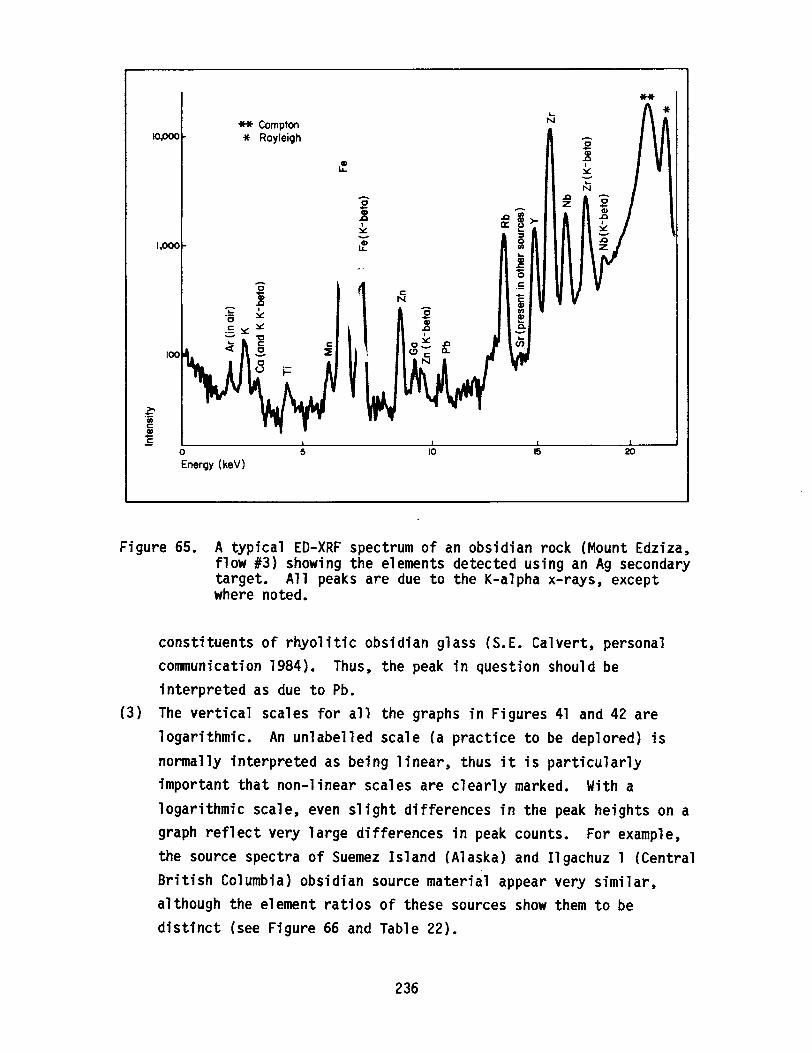
10POO
1,000
-.~
** Compton* Rayleigh
**
oEnergy (keV)
5 10 15 20
Figure 65. A typical ED-XRF spectrum of an obsidian rock (Mount Edziza,flow #3) showing the elements detected using an Ag secondarytarget. All peaks are due to the K-alpha x-rays, exceptwhere noted.
constituents of rhyolitic obsidian glass (S.E. Calvert, personalcommunication 1984). Thus, the peak in question should beinterpreted as due to Pb.
(3) The vertical scales for all the graphs in Figures 41 and 42 arelogarithmic. An unlabelled scale (a practice to be deplored) isnormally interpreted as being linear, thus it is particularlyimportant that non-linear scales are clearly marked. With alogarithmic scale, even slight differences in the peak heights on agraph reflect very large differences in peak counts. For example,the source spectra of Suemez Island (Alaska) and Ilgachuz 1 (CentralBritish Columbia) obsidian source material appear very similar,although the element ratios of these sources show them to bedistinct (see Figure 66 and Table 22).
236
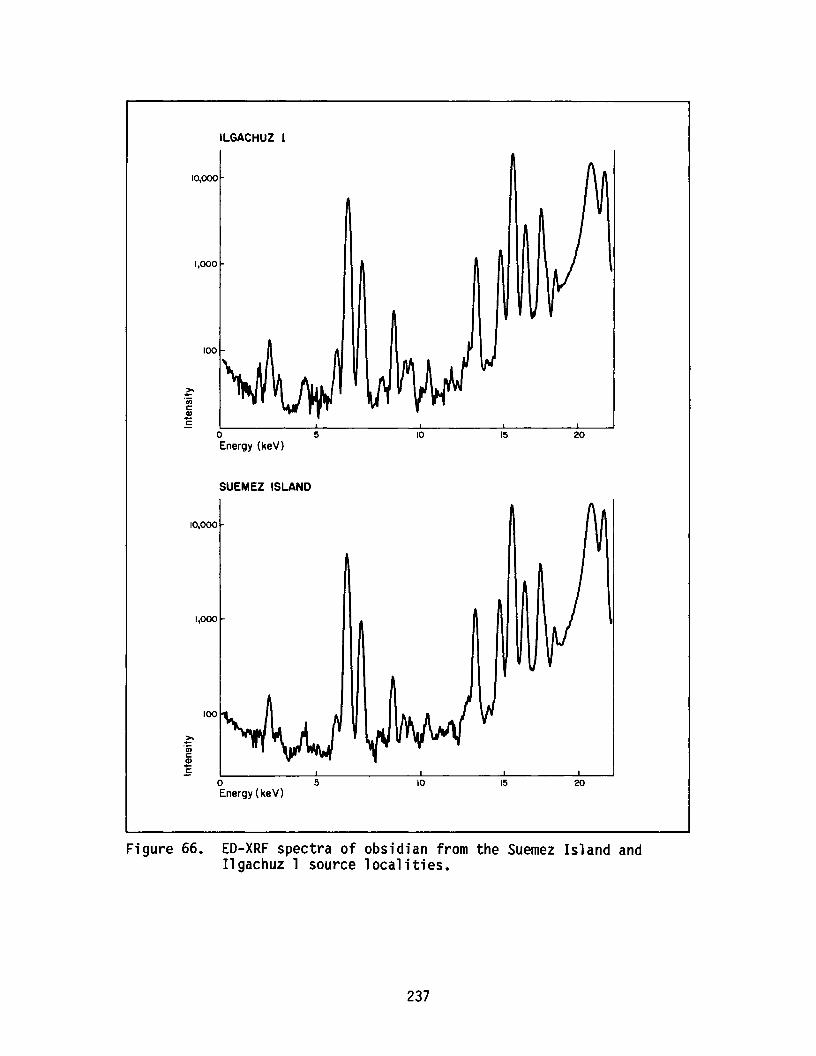
ILGACHUZ 1
10,000
1,000
100
oEnergy (keV)
SUEMEZ ISLAND
10,000
1,000
100
oEnergy ( keV)
5
5
10
10
15
15
20
20
Figure 66. ED-XRF spectra of obsidian from the Suemez Island andIlgachuz 1 source localities.
237
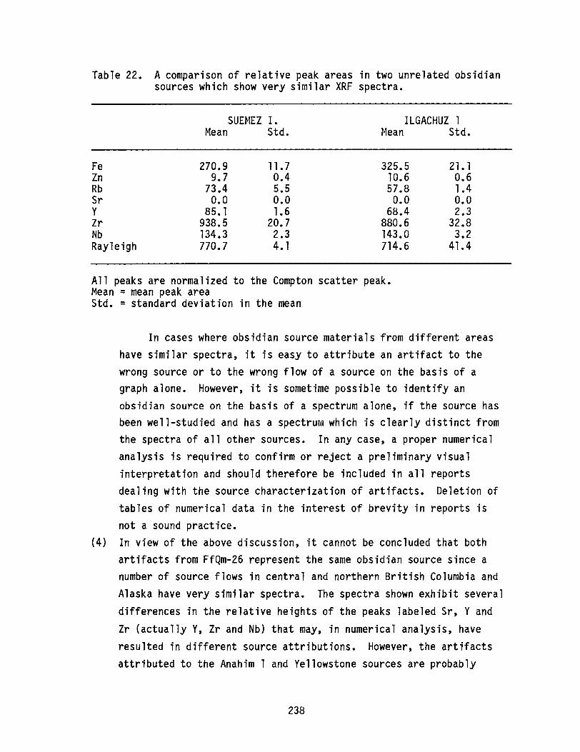
Table 22. A comparison of relative peak areas in two unrelated obsidiansources which show very similar XRF spectra.
SUEMEZ I.Mean Std.
ILGACHUZ 1Mean Std.
FeZnRbSrYZrNbRayleigh
270.99.7
73.40.0
85. 1938.5134.3770.7
11.70.45.50.01.6
20.72.34. 1
325.510.657.80.0
68.4880.6143.0714.6
21.10.61.40.02.3
32.83.2
41.4
All peaks are normalized to the Compton scatter peak.Mean = mean peak areaStd. = standard deviation in the mean
In cases where obsidian source materials from different areashave similar spectra, it is easy to attribute an artifact to thewrong source or to the wrong flow of a source on the basis of agraph alone. However, it is sometime possible to identify anobsidian source on the basis of a spectrum alone, if the source hasbeen well-studied and has a spectrum which is clearly distinct fromthe spectra of all other sources. In any case, a proper numericalanalysis is required to confirm or reject a preliminary visualinterpretation and should therefore be included in all reportsdealing with the source characterization of artifacts. Deletion oftables of numerical data in the interest of brevity in reports isnot a sound practice.
(4) In view of the above discussion, it cannot be concluded that bothartifacts from FfQm-26 represent the same obsidian source since anumber of source flows in central and northern British Columbia andAlaska have very similar spectra. The spectra shown exhibit severaldifferences in the relative heights of the peaks labeled Sr, Y andZr (actually Y, Zr and Nb) that may, in numerical analysis, haveresulted in different source attributions. However, the artifactsattributed to the Anahim 1 and Yellowstone sources are probably
238

identified correctly, since both sources have spectra which aredistinct from those of other sources.
(5) The source in Yellowstone National Park is not only known, but it isthe best known one on the entire North American continent. Thisobsidian type is found at Obsidian Cliff in Yellowstone Park, withclasts of the material also occurring in nearby Obsidian and Crystalcreeks (Anderson et ale 1986). The source is often referred to asObsidian Cliff, Yellowstone Park. Other obsidian occurrences inYellowstone Park, more distant from Obsidian Cliff and representingdifferent flows, yield different spectra.In summary, it is useful to reiterate that semi-quantitative ED-XRF
is a powerful technique for the identification of the sources of obsidianartifacts, since it is both fast and non-destructive. The ease withwhich it is applied, however, should not lead to an oversimplification ofthe analytical procedures which follow measurement. In all manner ofscientific endeavour, data collection procedures can be easily learned,but the meaningful interpretation of data is the result of bothsufficient theoretical knowledge and experience.
ACKNOWLEDGEMENTS
The work discussed above was performed at the XRF laboratory in theChemistry Department, Simon Fraser University and was partly supported bythe Natural Sciences and Engineering Research Council. Many thanks toC. Campbell of Anchorage, Alaska for submission of obsidian sourcematerial from Suemez Island; to D.E. Nelson for his permission to use theobsidian source collection at SFU; to Malcolm James for discussions onthe preliminary form of this report; and to D.J. Huntley for hiscomments. The computer program for data analysis was provided byM. Cackette.
239

ABSTRACTS FOR 1986 PERMITS
Compiled byMartina Purdon
The following abstracts represent those for 1986 permits available atthe time of publication. We thank all those permit holders who submittedabstracts by our publication deadline.
240
Alberta TransportationCranford Gravel Pit
Rebecca J. BalcomARESCO Ltd.2912 - 18 Street N.E.Calgary, Alberta
PROJECT TYPE: Reconnaissance and mapping at D1Pb-2
86-1
LOCATION/SETTING: Native prairie on the south upper terrace of the OldmanRiver, about 13 km northwest of Taber. About 13 of the 69hectares have been disturbed by gravel pit operations.
METHODOLOGY: The entire lease area was examined by means of severalnarrowly spaced foot traverses. Exposures, such as roadcuts and those made by the pit excavations, wereexamined. The site was mapped by compass and chain, andsite features were staked and flagged. Bearings anddistances were taken from the gravel test pits which havebeen surveyed by Alberta Transportation. Notes were takenon all site features.
RESULTS: Eighty rings, five cairns, one rock alignment and severallithic concentrations were recorded. Most of thesefeatures are in danger of impact.
SITE TYPE: Prehistoric encampment
REPORT: Complete, entitled IIHistorical Resources Reconnaissanceand Mapping Program Cranford Gravel Pit Final Report,Permit 86-1,11 by Rebecca J. Balcom
86-2 John BrumleyEthos Consultants Ltd.Group Box 20, VeinervilleMedicine Hat, Alberta
Lacana Petroleum Ltd.Natural Gas Developmentsnear Matziwin
PROJECT TYPE: HRIA
LOCATION/SETTING: Matziwin area of south-central Alberta. The project areaincludes portions of the Red Deer River valley and theprairie surface adjoining it.
METHODOLOGY: Foot traverse of all development locations
RESULTS: Three previously recorded sites (EgOx-30, 31 and 64) wereexamined and evaluated in terms of the proposeddevelopment. As well, a previously unrecorded site(EgOx-65) was located, recorded and evaluated.
SITE TYPES: Historic farmstead and stone circles
241
REPORT: Complete, entitled IIAn Historical Resources ImpactAssessment of Natural Gas Development Locations in theMatziwin Area of South Central Alberta - Final Report,1I byJohn H. Brumley
86-3C Barry J. DauEthos Consultants Ltd.Group Box 20, VeinervilleMedicine Hat, Alberta
Alberta EnvironmentOldman River Dam Project
PROJECT TYPE: HRIA
LOCATION/SETTING: The project area is located north of Pincher Creek, onboth sides of the Oldman River, immediately downstreamfrom the proposed Oldman River Dam.
METHODOLOGY: The projected consisted of foot traverse surveys of twoproposed borrow source locales on the north and southsides of the river, a proposed construction camp locale, aproposed access road and a proposed stockpile area on thenorth side of the river; a backhoe testing program on theobserved terraces within the borrow source locale; and anauger testing program at those sites threatened withimmediate disturbance due to construction camp development.
RESULTS: During the course of the project, two historic sites (astone foundation and a bridge or ferry crossing) and eightprehistoric sites (DjPl-28, 29, 58, 78, 100, 121, 132,133) were assessed. All but two of the prehistoric siteshad been previously recorded. Auger testing was completedat sites DjPl-28, 100, 121, 132 and 133. Sites DjPl-78and 100 were fenced off to protect them from currentdevelopment.
SITE TYPES: Historic sites (2), stone circles (6), stone circle/cairn,stone circle/buried camp
REPORT: Complete, entitled IIAn Historic Resource Impact Assessmentof a Series of Proposed Developments at the Oldman RiverDam, Southwestern Alberta - A. S.A. Perrnit 86-3, II by BarryJ. Dau
86-4 Rebecca J. BalcomARESCO Ltd.2912 - 18 Street N.E.Calgary, Alberta
City of Medicine HatEast Glen In-fillEast of Carry DriveHighway 1 Upgrading
PROJECT TYPE: HRIA
LOCATION/SETTING: Located within the city of Medicine Hat, the subdivisionis 7.8 ha in size and lies in an area of native prairie
242
overlooking Ross Creek. The portion of Highway 1 to beupgraded is 2.8 km in length and traverses lands whichhave been disturbed by ploughing, topsoil stripping orprevious road construction.
METHODOLOGY: The development areas were walked and shovel tested wherenecessary. EaOp-37, located in the proposed subdivision,was later mitigated by means of a 2,000 square metrecontrolled surface collection and excavation of twenty 0.5x 0.5 mtest units.
RESULTS: Two sites (EaOp-37 and 38) were located at the proposedsubdivision and three sites (EaOp-39, D10p-17 and 18) werelocated within the proposed highway upgrading. Only smallamounts of debitage were collected from the sites, exceptat EaOp-37 where 438 pieces of material were recovered.No diagnostics were found at any of the sites.
SITE TYPES: Campsites and small lithic scatters
REPORT: Complete, entitled IIHistorical Resources Impact Assessmentand Mitigation East Glen In-fill East of Carry Drive andCity of Medicine Hat Highway Upgrading, Final Report,Permit 86-4,11 by Rebecca J. Balcom
86-5 Barry J. DauEthos Consultants Ltd.Group Box 20, VeinervilleMedicine Hat, Alberta
NovaCorp InternationalConsulting Ltd.Medicine Hat Manyberries Pipeline
PROJECT TYPE: HRIA
LOCATION/SETTING: The project area extended southward from Medicine Hat tothe vicinity of the village of Manyberries.
METHODOLOGY: The 81 km proposed pipeline route was surveyed by foot andvehicle traverse. Uncultivated portions (40 km) of theright-of-way were examined more closely. These weresituated within and adjacent to stream drainage channelsor on open prairie.
RESULTS: Five new stone circle sites (DjOq-l to 5) and two newsurface scatter/lithic quarry sites (DkOq-9 and 10) wererecorded. No diagnostic cultural materials were noted inany of the sites.
SITE TYPES: Stone circles (5) and surface scatters/lithic quarries (2)
REPORT: Complete, entitled IIAn Historic Resources ImpactAssessment of a Proposed Pipeline between Medicine Hat andManyberries, Southeastern Alberta," by Barry J. Dau
243
86-6 Edward J. McCulloughFedirchuk McCullough &Associates Ltd.304, 1725 - 10 Avenue S.W.Calgary, Alberta
PROJECT TYPE: HRIA
Nova, An AlbertaCorporationMilo Pipeline Project
LOCATION/SETTING: The proposed project consisted of a realignment of aportion of the pipeline right-of-way discussed in theresults of investigations conducted under permit85-93. The project area is directly north of BadgerLake in the grasslands of southern Alberta.
METHODOLOGY: Fortuitous natural exposures and visual inspection forsurface features were used to identify the existenceof prehistoric remains.
RESULTS: Three prehistoric sites (EcPc-73, EdPc-67 and 68) werenewly recorded, and one previously recorded site(EdPd-16) was reassessed relative to the new alignment.
SITE TYPES: Isolated find and stone feature sites
DATES: Unknown
REPORT: Complete, entitled IIHistorical Resources ImpactAssessment Nova, An Alberta Corporation Milo PipelineProject,1I by Edward J. McCullough
86-7 Rebecca J. BalcomARESCO Ltd.2912 - 18 Street N.E.Calgary, Alberta
Canadian Western NaturalGasTaber to Bow IslandPipeline
PROJECT TYPE: HRIA
LOCATION/SETTING: The proposed pipeline extends from east of Taber tonorth of Bow Island. It is approximately 50 km inlength and runs more or less parallel to the Oldmanand South Saskatchewan rivers. Approximately 14 km ofpipeline was selected by the Archaeological Survey ofAlberta to be examined. These areas exhibited higherpotential than the remainder of the route. About 7.4km of the route inspected crossed ploughed fields andabout 6.6 km crossed native prairie.
METHODOLOGY: The entire pipeline was spot checked to ensure thatthere were no areas of native prairie that had notbeen defined on the basis of the map study. Shoveltests were excavated in areas exhibiting moderate tohigh potential for historical resources but lacking in
244
exposures, where the possibility of buried culturalmaterial existed, and at sites. Sites located duringthe impact assessment were recorded, photographed andsketched. The sites were shovel tested to aid in theevaluation of their significance.
RESULTS: Six sites were recorded on or near the pipeline.Three were located in the native prairie on the uppersouth terrace of the Oldman River and three werelocated in ploughed fields.
SITE TYPES: Tipi rings, tipi ring and lithic scatter and isolatedfinds
REPORT: Complete, entitled "Historical Resources ImpactAssessment Taber to Bow Island Pipeline Final Report,Permit 86-7," by Rebecca J. Balcom
86-8 John PollockSettlement Surveys Ltd.P.O. Box 2529New Liskeard, Ontario
Meridian Surveys Ltd.Lac La Biche Subdivision
PROJECT TYPE: HRIA
LOCATION/SETTING: Lot B, part of Lot 47, Lac La Biche Settlement
METHODOLOGY: Judgemental foot traverses with surface and subsurfacetesting
RESULTS: One prehistoric site (GePa-48) was located on thesecond terrace up from Lac La Biche.
SITE TYPE: Isolated find (quartzite flake)
REPORT: Complete, entitled "Historical Resources ImpactAssessment Lot B, Part of Lot 47, Lac La BicheSettlement," by Settlement Surveys Ltd.
86-9 John PollockSettlement Surveys Ltd.P.O. Box 2529New Liskeard, Ontario
Meridian Surveys Ltd.Lac La Biche Subdivision
PROJECT TYPE: HRIA
LOCATION/SETTING: Lot A, Part of Riverlot 68, Lac La Biche Settlement.The area has been severely disturbed by previous treeclearing operations undertaken by the former owner.
METHODOLOGY: Intensive subsurface and surface inspection
245
RESULTS: One site (GeOx-56) was located on a high bluff nearthe shore of Lac La Biche.
SITE TYPES: Scattered buried campsite consisting of quartziteflakes
REPORT: Complete, entitled "Historical Resources ImpactAssessment Part of Lot A, Riverlot 68 Lac La BicheSettlement," by John Pollock
86-10 Richard CallaghanARESCO Ltd.2912 - 18 Street N.E.Calgary, Alberta
Genstar Development Co.Sundance Storm TrunkLine
PROJECT TYPE: HRIA
LOCATION/SETTING: South Calgary, west of the Bow River. The line runsfrom the river westward across the valley floor, upthe valley wall, and for a short distance over prairielevel. The total length of the line is 1.2 km.
METHODOLOGY: The entire line was inspected on foot. Extensivevertical and horizontal exposures existed wheresurface disturbance and ditching had occurred; thesewere closely examined. In localities of limitedvisibility, test holes were excavated by hand.
RESULTS: No cultural material was found; however, considerablymore deposition than expected was observed runningback from the valley rim.
REPORT: Complete, entitled "Historical Resources ImpactAssessment Fish Creek Area Development Sundance StormTrunk Line, Final Report, Permit 86-10," by RichardCallaghan
86-11 Peter T. BobrowskyP.T.B. Consulting4604 - 119 AvenueEdmonton, Alberta
Daltam Consulting Ltd.Residential Subdivision
PROJECT TYPE: HRIA
LOCATION/SETTING: East of Elk Point, north side of the NorthSaskatchewan River, east side of Laurier Lake
METHODOLOGY: Systematic foot traverse of the shoreline areaencompassing 34 ha. A total of 35 shovel test holeswas excavated in areas judgementally deemed to be ofhigh potential. Sediment was not screened.
246
RESULTS: Known prehistoric site F10p-5 was relocated. Noadditional historical, archaeological orpalaeontological sites were found in the study area.
SITE TYPE: Isolated find
REPORT: Incomplete
86-12 B.O.K. ReevesLifeways of Canada Ltd.317 - 37 Avenue N.E.Calgary, Alberta
PROJECT TYPE: HRIA
Canuck GIE EngineeringJoffre Nitrogen Project
LOCATION/SETTING: The study area is situated in the park lands ecotone ofsouth central Alberta, east of Red Deer and north ofthe Red Deer River.
METHODOLOGY: Surface inspection, supplemented by subsurface shovelprospecting, was made of 37.7 km of pipelinerights-of-way. FbPj-14 was assessed utilizing bothbackhoe and hand excavations.
RESULTS: One prehistoric site (FbPj-14) was located on the RedDeer River. During assessment of FbPj-14, a varietyof artifacts (knives, wedges, choppers and retouchedflakes), other cultural materials (fire-cracked rockand bone) and features (rock-filled hearths andsurface and buried ring rocks) were noted and recorded.
SITE TYPE: Prehistoric campsite
RESULTS: Complete, entitled IIHistorical Resources ImpactAssessment Alberta Energy Company Ltd. Joffre NitrogenProject,1I by B.O.K. Reeves
86-14 Barry J. DauEthos Consultants Ltd.Group Box 20, VeinervilleMedicine Hat, Alberta
Alberta EnvironmentConstruction Camp,Oldman River Dam Project
PROJECT TYPE: Mitigation
LOCATION/SETTING: The project area is located on the north side of theOldman River, north of Pincher Creek, immediatelydownstream from the proposed Oldman River Dam.
METHODOLOGY: The project consisted of the detailed mapping of thestone circles in three sites (D1Pd-28, 121 and 132)and a detailed surface collection at one stone circle
247
at site DjPl-132. All three sites were threatenedwith disturbance due to the construction of the mainconstruction camp associated with the Oldman River Dam.
RESULTS: Seven stone circles and a single cairn were mapped atthe three sites in question. In addition, 17 piecesof cultural material were recovered from the surfacewithin and adjacent to stone circle 1 at siteDjPl-132. No cultural diagnostics were found duringsurface collection.
SITE TYPES: Stone circles
REPORT: Complete, entitled IIAn Historic Resources MitigationProject at the Oldman River Dam, Southwestern Alberta- A.S.A. Permit 86-14,11 by Barry J. Dau
86-15 John PollockSettlement Surveys Ltd.P.O. Box 2529New Liskeard, Ontario
Alberta TransportationSeven Aggregate Pits inSouthern Alberta
PROJECT TYPE: HRIA
LOCATION/SETTING: Various locations throughout southern Alberta
METHODOLOGY: Surface and subsurface testing
RESULTS: Eight new sites (EaPd-l to 3, EfPo-7, EgPo-47, 48,EhOq-8 and 9) were recorded. Four previously recordedsites (EgPo-45, EhPo-35, 47 and EhOq-l) were alsoexamined.
SITE TYPES: Medicine wheel/cairn, surface scatter/surfacecampsite, tipi rings
REPORT: Complete, entitled IIHistorical Resources ImpactAssessment of Seven Aggregate Pits in SouthernAlberta,1I by John Pollock
86-16 Bea LovesethLifeways of Canada Ltd.317 - 37 Avenue N.E.Calgary, Alberta
Scion PetroleumEngineering Ltd.Ponoka Pipeline Project
PROJECT TYPE: HRIA
LOCATION/SETTING: The study area is located in the central Albertaplains/park lands near the hamlet of Morningside. Thearea is characterized by hummocky ground moraine withapproximately 80 percent under cultivation.
248
METHODOLOGY: The 45 km of pipeline rights-of-way were examinedutilizing a series of zig-zag foot traversesapproximately 15 mapart with examination offortuitous exposures. Shovel testing was undertakenwhere natural subsurface exposures were lacking and todelineate archaeological sites content and size.
RESULTS: Three prehistoric sites (FdPj-5, FdPi-2 and FdPl-10)were recorded. All three were observed on the surfaceof ploughed fields, contained minimal amounts ofcultural material and represent temporaryoccupations. FdPj-5 contained a Middle PrehistoricHanna projectile point.
SITE TYPES: Temporary campsite and lithic scatters
CULTURALAFFILIATION: FdPj-5 - McKean Phase
REPORT: Complete, entitled "Historical Resources ImpactAssessment Morgan Hydrocarbons Ponoka PipelineProject," by B.A. Loveseth
86-17 Peter T. BobrowskyP.T.B. Consulting4604 - 119 AvenueEd.anton, Alberta
Associated EngineeringLtd.Residential Subdivision
PROJECT TYPE: HRIA
LOCATION/SETTING: East of Canyon Creek and west of Widewater, along thesouth shore of Lesser Slave Lake
METHODOLOGY: Systematic foot traverse of the shoreline areaencompassing 16 ha. A total of 14 shovel test holeswas excavated in areas judgementally deemed to be ofhigh potential. Sediment was not screened.
RESULTS: No historical, archaeological or palaeontologicalsites were found in the study area.
REPORT: Complete, entitled "Historical Resources ImpactAssessment for the Proposed Canyon Creek Subdivisionon Behalf of Associated Engineering Ltd. FinalReport," by Peter T. Bobrowsky
249

86-18 James A. LightARESCO Ltd.2912 - 18 Street N.E.Calgary, Alberta
Alberta TransportationHwy. 22:16 Cochrane, Hwy.22X:20 Sundre, SR 766:10Spruceview, SR 835:02Ewing Lake, Tolman BridgeRecreation Area
PROJECT TYPE: HRIA
LOCATION/SETTING: Highway 22:16 is west and north of Cochrane in partlydisturbed rolling prairie. Highway 22X:20 is north ofSundre in largely disturbed rolling boreal foothills.It crosses the James River at the north end. SR766:10 near Spruceview is in slightly rolling aspenparkland which is largely disturbed by agriculture.SR 835:02, near Ewing Lake, is in rolling prairieaspen parkland. The Tolman Bridge Recreation Area ison the flood plain of the Red Deer River east ofTrochu.
METHODOLOGY: All highway construction was visually examined. Newhighway construction was walked and shovel testedwhere necessary. Areas where the right-of-wayexpansion was less than 1 mwere visually examined.Areas where new construction did not affect areasundisturbed by previous construction were not walked.The Tolman Bridge Recreation Area was walked andshovel tested as necessary.
RESULTS: Six sites (EhPo-61, E1Pg-ll, FaPo-21, FbPo-2, FbPf-2and 3) were recorded. No sites contained diagnosticartifacts.
SITE TYPES: Lithic and fire-broken rock scatter and isolated finds
REPORT: Complete, entitled IIHistorical Resource ImpactAssessments of Highway 22:16, Highway 22X:20, SR766:10, SR 835:02, and the Tolman Bridge RecreationArea, Final Report, Permit 86-18,11 by James A. Light
86-l9C Rebecca J. BalcomARESCO Ltd.2912 - 18 Street N.E.Calgary, Alberta
PROJECT TYPE: Mitigation of site D1Pd-2
Alberta TransportationCranford Gravel Pit
LOCATION/SETTING: The site is at prairie level on the south side of theOldman River. The gravel lease encompasses an area ofabout 70 ha. The site has been impacted by two gravelpits covering 13 ha. Vegetation is native prairie.
250

METHODOLOGY: A total of 29 tipi rings was tested by 256 squaremetres of excavation. At least one 2 x 2 m unit wasexcavated in the centre of each ring. A rockalignment was tested with seven 1 x 1 m units. Ashovel testing program consisting of 120 0.5 x 0.5 munits was undertaken. Excavation in other areasconsisted of five 1 x 1 m units. The depth ofexcavations ranged from 10 to 100 cm below surface.
RESULTS: Totals of 4,739 lithic artifacts, 319 ceramics, and13,780 bones and bone fragments were recovered fromthe excavations at D1Pb-2. Deposition was shallow inthe east area of the site but much deeper in the westwhere several components were buried under the rings.Buried rings and hearths were found.
DATES: Based on ceramics and projectile point types, the sitedates from Early Prehistoric through to the LakePrehistoric Period. Point types identified at thesite include Plains Triangular, Plains Side-notched,Prairie Side-notched, Avonlea, Besant, Pelican Lake,Hanna, McKean and Boss Hill. Radiocarbon dates rangefrom 620 ± 100 years B.P. to 1890 ±80 years B.P.
REPORT: Complete, entitled IIHistorical Resources ImpactMitigation, Site D1Pd-2, Cranford Gravel Pit, Phase 1,Final Report, Permit 86-19C,1I by Rebecca J. Balconl
86-20C Barry J. DauEthos Consultants Ltd.Group Box 20, VeinervilleMedicine Hat, Alberta
PROJECT TYPE: Assessment/mitigation
Alberta EnvironmentForty Mile CouleeIrrigation Dam
LOCATION/SETTING: The project area is located approximately 35 km southof Bow Island within the portion of Forty Mile Couleeintended for the Forty Mile Coulee irrigation dam.
METHODOLOGY: The 1986 Forty Mile Coulee archaeological projectserved as the culmination of a multi-year assessment/mitigation project begun in 1981. During 1986,limited feature mapping and auger testing wereconducted at 85 stone circles in 17 sites. Excavationof 506.54 square metres was completed at 41 stonecircles, 12 cairns and two buried camps.
RESULTS: A total of 14,727 pieces of cultural material wasrecovered. The majority of this consisted ofbutchered bison bone. Full analysis of the recovereddata is currently in progress.
251
\'
CULTURALAFFILIATION: Preliminary examinations of the data show that the
majority of the surface stone feature sites excavatedin 1986 belong to the Late Prehistoric or historicperiods. Diagnostics recovered from the surface sitesconsist of Old Womenls Phase projectile points,Saskatchewan Basin Complex ceramics and Euro-Canadiangoods of the pre-homestead period. Diagnostics fromthe buried camps consist of projectile pointsbelonging to the Avonlea, Besant and Pelican Lakephases.
REPORT: Complete, entitled IIHistorical Resource Investigationswithin the Forty Mile Coulee Reservoir,1I by Barry J•.Dau and John Brumley
86-21C Gloria J. FedirchukFedirchuk McCullough &Associates Ltd.304, 1725 - 10 Avenue S.W.Calgary, Alberta
PROJECT TYPE: Mitigation
Alberta CultureAlberta TransportationSite Excavation
LOCATION/SETTING: The Missinglink site, EdPq-16, is situated in theeastern slopes of southern Alberta, approximately 2 kmnorth of the Sheep Sanctuary/Ranger Station on NorthFork Road, Kananaskis Country, Alberta.
METHODOLOGY: Thirty 1 x 1 m units were excavated: ten in thelocality which, based on Pollockls (1984)interpretation, contained Avonlea materials; ten inthe locality associated with Besant materials; and tenin the area from which bones had been previouslyobtained.
RESULTS: Nearly 1200 artifacts were recovered in 1986 includingprojectile points, bifaces, scrapers, retouchedflakes, flakes, cores, fire-broken rock and bone.
SITE TYPE: Campsite
CULTURALAFFILIATION: Of the 21 projectile points recovered from the site,
one is a large lanceolate, possibly Lusk; three areBesant; five are large, side-notched points consistentwith the Bitterroot series; and three possibly fitinto the Pelican Lake series. Four areunidentifiable, small, side-notched points, and one isan unidentified IIwaisted ll and l-eared,1I possibly Oxbowform. The remaining points are unidentifiablefragments.
252
DATES: No absolute dates are available; however, acceptingthe above typological identifications, the sitecould reflect occupations from 6,000 B.C. to A.D. 1000.
REPORT: Complete, entitled liThe Missinglink Site, KanananskisCountry,1I by Gloria J. Fedirchuk
86-22 Bea LovesethLifeways of Canada Ltd.317 - 37 Avenue N.E.Calgary, Alberta
PROJECT TYPE: HRIA
Marquis Scenic AcresDevelopment CorporationScenic Acres Subdivision
LOCATION/SETTING: The proposed subdivision is located in northwestCalgary in grasslands - natural and pasture - ofhummocky disintegration moraine.
METHODOLOGY: The 200.5 ha of lands were inspected by foottraverses. All visible exposures were examined andshovel tested. Backhoe tests were dug in swales andglacial stream channels.
RESULTS: Fourteen prehistoric sites (EgPn-304 to 317) wererecorded.
SITE TYPES: Tipi rings, buried campsite and lithic scatters
REPORT: Complete, entitled IIHistorical Resources ImpactAssessment Scenic Acres Undeveloped Lands 1986,11 byB.A. Loveseth
Alberta CultureStrathcona Site
Brian KooymanDepartment of ArchaeologyUniversity of CalgaryCalgary, Alberta
PROJECT TYPE: Research/archaeology field school
86-23C
LOCATION/SETTING: The site is located on the east side of the NorthSaskatchewan River, in the county of Strathcona, nearthe eastern limits of the city of Edmonton.
METHODOLOGY: A 26-square-metre block excavation was undertaken in aportion of the site suspected of being a habitationarea based on a previous test unit. Excavation was bytrowel; all material was sieved through 1/4 inchscreens; and a 1 percent sample was processed through1 mm screens. Three 1 x 1 m units were excavated toallow excavation of a sump pit on the site. These
253

units were excavated by shovel shaving and sievedthrough 1/4 inch screen.
RESULTS: Several thousand pieces of cultural material wererecovered, most of it being lithic debitage and smallbone fragments. Besant and Oxbow projectile pointswere included in the assemblage, and a possible stoneboiling pit was located.
SITE TYPE: Habitation site, possible lithic workshop
CULTURALAFFILIATION: Middle and Late Prehistoric
DATES: From contact through to ca. 4,000 or 5,000 years B.P.,based on radiocarbon dates and projectile pointtypology
REPORT: Complete, entitled IIFinal Report of the 1986University of Calgary Archaeology Field School at theStrathcona Site (FjPi-29),1I by Brian Kooyman, TomArnold, Don Boras and Maria Teresa Garcia
86-24 Laurie MilneDepartment of ArchaeologySimon Fraser UniversityBurnaby, B.C.
Alberta CultureLarson Site
PROJECT TYPE: Research
LOCATION/SETTING: County of Cypress, near Irvine
METHODOLOGY: A 12-square-metre area was excavated to delineatespecific activity areas, enlarge the artifact sample,secure additional bone and/or charcoal for radiocarbondating, and enlarge the faunal assemblage.
RESULTS: Four features were recorded, including severalroasting pits and a stone boiling pit. The sample often artifact classes was substantially enlarged withthe recovery of more projectile points, endscrapers,bifaces, perforating tools, pieces esquillees, cores,marginally retouched flake tools, heavy stone tools,ceramics and bone tools. The most unusual find was asegment of dentalia. The late winter seasonality ofsite occupation suggested by the foetal bison bonerecovered in the 1982 excavations was reconfirmed.
SITE TYPE: Campsite
DATES: Three additional radiocarbon dates were obtained fromthe Avonlea cultural level: A.D. 760 ± 80 years
254

(AECV-298C), A.D. 740 + 80 years (AECV-299C) and A.D.810 ~ 90 years (AECV-300C).
REPORT: Complete, entitled liThe 1986 Excavations at the LarsonSite (D10n-3): Description, Interpretation andSpeculation,1I by Laurie Milne
86-25 John PollockSettlement Surveys Ltd.P.O. Box 2529New Liskeard, Ontario
Dirham Construction Ltd.Grande PrairieSubdivision
PROJECT TYPE: HRIA
LOCATION/SETTING: Grande Prairie, Alberta
METHODOLOGY: Systematic judgemental surface and subsurfaceinspection
RESULTS: One prehistoric site (GgQq-5) was located.
SITE TYPES: Surface scatter of lithic specimens, no buriedcomponents
REPORT: Complete, entitled IIHistorical Resources ImpactAssessment Sand Ridge Estates SW 1/4 Section17-71-5-W6M,1I by John Pollock
86-26 John BrumleyEthos Consultants Ltd.Group Box 20, VeinervilleMedicine Hat, Alberta
Canadian WesternNatural Gas Co.Pipeline Across ChinCoulee and Reservoir
PROJECT TYPE: HRIA
LOCATION/SETTING: Chin Coulee, south of Taber. The region consistslargely of level to undulating prairie which ischaracterized by surficial deposits of glacial till.
METHODOLOGY: Foot traverse. Sites discovered were recorded andmapped. Mitigative needs and options were formulatedon a site by site basis.
RESULTS: Three sites (DjPa-4 to 6) were located.
SITE TYPES: Stone circles/tipi rings
CULTURALAFFILIATION: Unknown, probably reflect prehistoric native campsites
255
REPORT: Complete, entitled IIAn Historical Resource ImpactAssessment of a Proposed Pipeline across Chin Couleeand Reservoir,1I by John H. Brumley
86-27 Margaret KennedyDepartment of ArchaeologyUniversity of CalgaryCalgary, Alberta
PROJECT TYPE: Research
Alberta CultureHigh River AreaWhiskey Post Site
LOCATION/SETTING: The site (EdPl-12) is situated on private property,3.5 km west of the town of High River, on formerHighwood River floodplain marked by cottonwood andwillow thickets.
METHODOLOGY: Initial excavations at the site began in the fall of1985 (ASA Permit 85-80) but were discontinued due tobad weather. When continued in 1986, excavations wereexpanded to expose the entire camp foundation, as wellas an additional area to the southeast which wascharacterized by considerable quantities of sheetrefuse, FBR, ash and burnt wood. All ash depositswere passed through fine nesting screens for enhancedrecovery of minute artifactual and faunal remains.
RESULTS: The exposed cabin foundation measured 10.5 x 5 m. Nointernal divisions could be discerned. Deposits ofrefuse and bone scrap littered the cabin interior onthe south side near the presumed doorway and continuedoutside the cabin to the southeast. In total, 2,894artifacts and 9,596 bones and bone fragments werecollected. Identifiable commercial products indicatedSt. Louis, Missouri as the source of manufacture, aconclusion totally in keeping with known whiskey tradesupply patterns.
SITE TYPE: Archaeological remains of historic whiskey trade erastructure
DATES: Likely early 1870s
REPORT: Complete, entitled IIFinal Report, Research Excavationsat EdPl-12; A Whiskey Trade Era Structure, HighRiver,1I by Margaret Kennedy
86-28 Jack BrinkArchaeological Survey ofAlberta
Alberta CultureHead-Smashed-In BuffaloJump
PROJECT TYPE: Research
256
LOCATION/SETTING: In southwestern Alberta, on the eastern flank of thePorcupine Hills, about 16 km west of Fort Macleod
METHODOLOGY: Research excavations were conducted in the processingsite using 2 x 2 m units with provenience recorded tothe 50 x 50 cm subquad in arbitrary 10 cm levels. Allidentifiable bone, features and fire-broken rock weremapped in place. Lithic remains from selected unitswere piece plotted using horizontal and verticalprovenience controls. All excavated material wasscreened using 1/4 inch (6.3 mm) mesh.
RESULTS: A total of 8 square metres of contiguous excavationwas completed. The cultural deposits ranged in depthfrom near surface to 50 cm below the surface andrevealed some evidence of stratification in the lowestlevel. The stratification is the result of slopewash, and samples of bone have been submitted todetermine the timing of this event.
SITE TYPE: Buffalo jump and associated camp and processing site
REPORT: Incomplete
86-29 J. Rod VickersArchaeological Survey ofAlberta
Alberta CultureMajorville Cairn AreaInventory
PROJECT TYPE: Research, inventory
LOCATION/SETTING: About 22 km south of Sassano, on lands adjacent toMajorville Cairn (EdPc-l)
METHODOLOGY: Foot traverse, site recording and sketch mapping. Nosubsurface testing or artifact collection
RESULTS: About 1.5 sections were examined in an irregular blockof land within about 1-1.5 km of EdPc-l. Threepreviously recorded and 30 new sites were examined.Twenty-two cairns and 143 stone circles were noted.Four circles were bisected by cobble rows. Largersites were located near the valley rim. Milky whitequartzite was common, and Knife River Flint wasobserved. No diagnotics were seen.
SITE TYPES: Tipi rings, cairns, medicine wheel and historic site
REPORT: Incomplete, to be entitled 111986 Majorville CairnInventory Project,1I by J. Roderick Vickers
257

86-30 Don SteerDS Consulting723 Woodpark Blvd. S.W.Calgary, Alberta
PROJECT TYPE: HRIA
Don KellyBearspaw VillageSubdivision, Phase I
LOCATION/SETTING: The project area is situated immediately west of thecity of Calgary, approximately 500 mfrom an upperterrace escarpment of the Bow River valley.
METHODOLOGY: Surface examination and subsurface testing
RESULTS: One prehistoric site, consisting of a single smallretouched brown-black vitreous chert flake, wasdiscovered. The archaeological specimen was recoveredfrom a context 10 to 15 cm below ground surface.
SITE TYPES: Isolated find
REPORT: Complete, entitled IIHistorical Resources ImpactAssessment Bearspaw Village Subdivision Phase I,ll byDon Steer and Malcom James
86-31C Gloria J. FedirchukFedirchuk McCullough &Associates Ltd.304, 1725 - 10 Avenue S.W.Calgary, Alberta
Alberta CultureAlberta TransportationHighway Projects
PROJECT TYPE: HRIA
LOCATION/SETTING: Four highway projects were examined: Highway 54:0bcurve revision west of Innisfail, SR 851:04 upgradingsouth of Delia; SR 845:06 new crossing of Little BowRiver; and Highway 3:06 new climbing lane west ofBrockett.
METHODOLOGY: All rights-of-way were traversed on foot; naturalexposures were examined; surficial cultural materialsand features were noted; and subsurface tests wereexcavated where visibility was impeded by vegetation.Identified sites were shovel tested and documented.Palaeontological survey of both banks and monitoringof construction cut on north side of Little Bow werealso carried out on SR 845:06.
RESULTS: Highway 54:06 - three surficial sites (FaPo-1B to 2U)were located off proposed right-of-way. SR 851:04 six surficial sites (EjPb-2 and EjPc-6 to 10) werelocated. SR 845:06 - three sites (D1Pd-22, EaPd-4and 5), all surficial indications, and one
258
palaeontological site containing a molar of Mammuthussp. were identified during monitoring of gravelcrushing operations. Highway 3:06 - no new sites wererecorded.
SITE TYPES: Isolated finds, campsites and stone circle sites
DATES: No absolute dates are available. Although two sitescontained temporally diagnostic material (FaPo-18 tip of large unidentifiable projectile point andEaPd-4 - Late Prehistoric Period small side-notchedpoint), it was possible to relate only the latter of aspecific period.
REPORT: Complete, entitled "Historical Resources ImpactAssessment Alberta Transportation Projects," by GloriaJ. Fedirchuk
86-32 Susan MarshallDepartment of AnthropologyTrent UniversityPeterborough, Ontario
Alberta CultureCalderwood Buffalo Jump
PROJECT TYPE: Research
LOCATION/SETTING: On the eastern slope of the Porcupine Hills insouthwestern Alberta, approximately 16 km west of FortMacleod and 1 km north of Head-Smashed-In Buffalo Jump
METHODOLOGY: Research was undertaken at kill area using 1 x 1 munits. The horizontal provenience of recoveredcultural material was recorded to the 1 msquare,employing arbitrary levels of 10 cm. All identifiablebone, fire-broken roc~ and features were mapped insitu. Excavated matrix was passed through a 1/4 inch(6.3 mm) screen. Bone, lithic remains and FBR werebagged separately for each excavation unit and level.
RESULTS: A total of 21 square metres was excavated in the killarea, 15 square metres being a contiguous excavationarea. Preliminary testing in 1985 and investigationsin 1986 recovered cultural deposits ranging fromapproximately 10 to 120 cm below surface, representingat least four stratigraphically separated deposits.
SITE TYPE: Buffalo jump and associated drive lane cairns
DATES: Middle Prehistoric Period, based on radiocarbon datesand projectile point typology
REPORT: Complete, entitled "The Calderwood Buffalo JumpDkPj-27," by Susan E. Marshall
259
86-33 Theresa A. FergusonDepartment of AnthropologyUniversity of AlbertaEdmonton, Alberta
Alberta CultureSalt River, Hay MeadowsSurvey
PROJECT TYPE: Research
LOCATION/SETTING: Project area is located in the Mission Farm area innortheastern Alberta, just southwest of Ft. Smith.This is an area of extensive meadow, both wet and dry,with spruce and aspen forest invading.
METHODOLOGY: The survey technique involved visual survey forcontemporary/twentieth century sites and cutbanksurvey and testing on the Salt River where possiblefor prehistoric sites. Informants were interviewed asto site locations and uses.
RESULTS: Twenty-six sites were found, all of which werecontemporary or twentieth century. Ethnographicsources did not prove useful in locating older sitesin this area, but they did provide information on thelocation and use of contemporary sites.
SITE TYPES: Campsites, trapping sites, a "caboose," a barn andisolated fireplaces
REPORT: Complete, entitled "Salt River Hay Meadow Survey(Permit 86-33): Final Report," by Theresa A. Ferguson
86-34 Edward J. McCulloughFedirchuk McCullough &Associates Ltd.304, 1725 - 10 Avenue S.W.Calgary, Alberta
PROJECT TYPE: Public archaeology/research
Esso Resources CanadaLimitedPublic Archaeology,Duckett Site
LOCATION/SETTING: The public archaeology program, sponsored by EssoResources Canada Limited, was conducted at the Duckettsite (GdOo-16) on Ethel Lake in northeastern Alberta.The Duckett site lies within the lakeland district ofthe southern boreal forest of Alberta.
METHODOLOGY: The public archaeology program consisted of a trainingprogram for full time volunteers (two weeks), forvisiting volunteers (one week), and for one grade sixclass (one day). One hour public lectures (five perday for one week) on the nature of archaeologicaldata, artifact identification, Duckett site chronologyand excavations were given to students from a varietyof local schools.
260
RESULTS: The range of temporal indicators recovered from theDuckett site has been extended and now includesClovis, Agate Basin, Plainview, Scottsbluff, Oxbow,McKean, Pelican Lake, and Late Prehistoric smallside-notched. Cord marked and neck punctate ceramicswere also recovered.
SITE TYPE: Campsite
REPORT: Incomplete, to be entitled liThe Duckett Site, 10,000Years of Prehistory on the Shores of Ethel Lake,Alberta,1I by G.J. Fedirchuk and E.J. McCullough
86-35 Edward J. McCulloughFedirchuk McCullough &Associates Ltd.304, 1725 - 10 Avenue S.W.Calgary, Alberta
PROJECT TYPE: HRIA
Singleton AssociatedEngineering/BP ResourcesChauvin Pipeline Project
LOCATION/SETTING: The proposed Chauvin Pipeline System, Section 1Edgerton Lateral pipeline project is situatedsoutheast of Wainwright in the parkland of centralAlberta.
METHODOLOGY: Fortuitous natural exposures and ploughed fields werevisually inspected for identification of prehistoricremains.
RESULTS: Seven prehistoric sites (FdOp-l to 5, FeOp-l and 2)were newly recorded.
SITE TYPES: Isolated finds (5) and artifact scatters (2)
REPORT: Complete, entitled IIHistorical Resources ImpactAssessment Singleton Engineering Ltd. BP ResourcesCanada Limited Chauvin Pipeline System Section IEdgerton Lateral,1I by E.J. McCullough
86-36 Gloria J. FedirchukFedirchuk McCullough &Associates Ltd.304, 1725 - 10 Avenue S.W.Calgary, Alberta
American Trading andProduction CorporationShannon-Kirkwal1 Pipeline
PROJECT TYPE: HRIA
LOCATION/SETTING: The proposed Shannon-Kirkwall area pipeline project issituated south of Cereal within the grasslands ofsouthern Alberta.
261
METHODOLOGY: Examination of fortuitous exposures, ploughed fieldsand shovel tests were used to identify the presence ofprehistoric cultural materials.
RESULTS: Eleven newly identified prehistoric sites (EhOq-10 to19 and EhOr-3) were recorded, and two previouslyrecorded sites (EhOq-8 and 9) were assessed relativeto the proposed project.
SITE TYPES: Cairns (6), stone circles (4) and cairns and stonecircles (3)
REPORT: Complete, entitled "Historical Resources ImpactAssessment American Trading and Production CorporationShannon-Kirkwall Area Pipeline," by FedirchukMcCullough and Associates
86-37 Bruce F. BallArchaeological Survey ofAlberta
Alberta CulturePincher Creek BuffaloJump (DjPl-l)
PROJECT TYPE: Mapping and assessment
LOCATION/SETTING: Located in southwestern Alberta, on the southern edgeof the Porcupine Hills, approximately 4 km north ofthe town of Pincher Creek
METHODOLOGY: The site area and its surroundings were surveyed, andareas of cultural activity were mapped. The kill sitearea was tested using shovel tests, a power auger andtwo 2 x 2 mexcavations. Test excavations of ringfeatures located near the kill site were carried outas well.
RESULTS: Three undisturbed layers of bone were identified inthe kill site deposits.
SITE TYPE: Buffalo jump with associated camp and processing areas
CULTURALAFFILIATION: Projectile points (Prairie and Plains Side-notched)
from the tests date the site to Late Prehistoric times.
REPORT: Complete, entitled "Archaeological Investigation ofthe Pincher Creek Buffalo Jump (DjPl-l)," by Bruce F.Ball
86-39 Brian RonaghanArchaeological Survey ofAlberta
262
Alberta CulturePorcupine HillsInventory
PROJECT TYPE: Research inventory was conducted in a high elevation,spring fed drainage basin in order to identify newsites, as well as to assess the terrain for thepossibility of containing early occupations in nearsurface situations.
LOCATION/SETTING: Honey Coulee is the head of the Trout Creek drainageand is located in the north Porcupine Hills insouthwestern Alberta.
METHODOLOGY: Due to time and manpower restrictions, survey wasjudgemental and extensive rather than intensive incharacter. Shovel and, in some cases, auger testingwere employed when prehistoric materials wereencountered.
RESULTS: Nine possible sites (EaPm-5 to 13) were identified.Four (EaPm-10 to 13) consisted only of large ungulatebone fragments exposed in small erosional cuts orrodent holes. Shovel and auger tests failed toproduce clear-cut evidence of human origin. Fivesites (EaPm-5 to 9) produced lithic remains, eithersingularly or in association with large ungulate bonefragments. All appear to be small, near surfaceconcentrations believed representative of short-termhunting forays into these high elevation grazing areas.
SITE TYPES: Artifact scatters and small campsites
CULTURALAFFILIATION: Based on projectile point morphology, EaPm-8 - Late
Plains, EaPm-9 - Scottsbluff/Eden
REPORT: Incomplete
ADDITIONALINFORMATION: Although several potential rock shelter locations were
examined, no evidence of prehistoric occupation wasidentified. The wide dispersal of prehistoricmaterials, both in time and space, suggest that thisarea has seen frequent use throughout the bulk of theprehistoric record. Systematic deep testing would benecessary to adequately assess depositionalcharacteristics and the potential for very earlyoccupations.
86-40 Michael ForsmanArchaeological Survey ofAlberta
Alberta CultureNortheastern Alberta
PROJECT TYPE: Continuation of research and resource management stUdy
263
LOCATION/SETTING: Athabasca River, Fort Chipewyan area
METHODOLOGY: Review of archival records and in-field search forsite locations and preliminary assessment
RESULTS: Several sites were located and surveyed, includingHeOu-l (at the confluence of the Clearwater andAthabasca rivers), Pierre au Columet (on the AthabascaRiver), and Fort Wedderburn and Fort Chipewyan on LakeAthabasca.
REPORT: Part of a continuing study to be prepared later
Manalta Coal Ltd.Montgomery Mine Expansion
James A. LightARESCO Ltd.2912 - 18 Street N.E.Calgary, Alberta
PROJECT TYPE: Mitigation in advance of strip mining, inventory andrecording of historic period coal mines in the minelease and preparation of a general history of coalmining in the Sheerness area
86-41
LOCATION/SETTING: The study area is largely mixed grass prairie. Themitigated sites were situated in cultivated fields.
METHODOLOGY: EiOw-73 was surface collected without proveniencecontrols. EiOw-132 and 133 were collected as one siteusing a 5 m collection grid. Historic period siteswere mapped, photographed and recorded.
SITE TYPES: Lithic scatters (3), coal mining sites (3) and relatedhabitation sites (2)
REPORT: Complete, entitled "Historical Resources ImpactMitigation at EiOw-72, EiOw-132, and EiOw-133,Inventory and Recording of Historic Period MiningSites, Montgomery Mine Expansion Project, FinalReport, Permit 86-41," by James A. Light
86-42C Stanley Van DykeBison Historical Services236 - llA Street N.W.Calgary, Alberta
Alberta TransportationSummerfield, Thurn andOuellette borrow pits andHighway 2:10 twinningStavely to Nanton
PROJECT TYPE: HRIA
LOCATION/SETTING: Various locations in parklands and prairie, includingvicinity of Big Hills Springs, North SaskatchewanRiver and Stavely area
264
METHODOLOGY: Foot traverse of study areas with examination ofbackhoe tests excavated in conjunction with pittesting and shovel tests of moderate and highpotential areas where no pit tests were present
RESULTS: Four prehistoric sites (EbPj-l, EbPk-14, EhPo-62 and63) were identified. Sites were determined to be notsignificant.
SITE TYPES: Isolated ring sites (2) and lithic scatters (2)
REPORT: Complete, entitled IIFinal Report, Historical ResourcesImpact Assessment, Summerfield, Ouellette and ThurnBorrow Pits, and Highway 2:10 Twinning, ASA PermitNumber 86-42-C,1I by Stanley Van Dyke
86-43 John PollockSettlement Surveys Ltd.P.O. Box 2529New Liskeard, Ontario
Lehndorff DevelopmentCorp.Pineview SubdivisionPhase 2
PROJECT TYPE: HRIA
LOCATION/SETTING: Lehndorff Lands Pineview Neighbourhood, city of St.Albert
METHODOLOGY: Systematic foot traverses and surface inspection alongwith judgemental subsurface testing
RESULTS: Three prehistoric sites (FjPj-41 to 43) were located.
SITE TYPES: Surface campsites
REPORT: Complete, entitled IIHistorical Resources ImpactAssessment Lehndorff Development Corp. Lands City ofSt. Albert,1I by John Pollock
86-44 B.O.K. ReevesLifeways of Canada Ltd.317 - 37 Avenue N.E.Calgary, Alberta
Magnesium Company ofCanada LimitedMagnesium Plant
PROJECT TYPE: HRIA
LOCATION/SETTING: Flat, glacial fluvial plain in a meander of theHighwood River south of Aldersyde
METHODOLOGY: Foot traverses of the entire area complemented byshovel and backhoe testing where potential for buriedsoils and cultural remains existed
265

RESULTS: One prehistoric site (EdPl-16) was located in thedevelopment area.
SITE TYPE: Scattered campsite (tipi ring)
REPORT: Complete, entitled IIHistorical Resources ImpactAssessment Magnesium Company of Canada LimitedMagnesium Plant Aldersyde, Alberta,1I by Brian O.K.Reeves
86-45 James A. LightARESCO Ltd.2912 - 18 Street N.E.Calgary, Alberta
PROJECT TYPE: HRIA
Bow River Pipe Lines Ltd.1986 Stanmore MainlineLoop
LOCATION/SETTING: The proposed pipeline is about 40 km in length with a10 m wide right-of-way. The line begins north andeast of the town of Stanmore near Kirkpatrick Lake,passes within 3 km of Stanmore and terminates west ofthe town of Rose Lynn. The area is predominantlynative prairie with slight relief. The line crossesBerry Creek near its southern terminus.
METHODOLOGY: The entire right-of-way was walked and shovel testedwhere there was potential for buried sites.
RESULTS: One site (EjOu-3) was located on a hilltop near theright-of-way. Four flakes were collected from surfaceexposures. The site will not be directly affected bypipeline construction.
SITE TYPE: Lithic scatter
REPORT: Complete, entitled IIHistorical Resources ImpactAssessment of Bow River Pipe Lines Ltd.ls Proposed,1986 Stanmore Mainline Loop, Final Report, Permit86-45,11 by James A. Light
86-47 Alan Bryan and Ruth GruhnDepartment of AnthropologyUniversity of AlbertaEdmonton, Alberta
Alberta CultureCaribou Island Site
PROJECT TYPE: To clarify stratigraphy and dating at Caribou Islandsite (GbOs-l)
LOCATION/SETTING: West of Moose Lake, west of Bonnyville, north of RifeChurch
266

RESULTS: Excavated two superimposed charcoal concentrations(probably hearths) and took sand samples for TLdating. Quarry workshop detritus (flakes and bulblessspalls, battered pebbles, anvil stones) indicate blockon anvil splitting of quartzite pebbles. Littleevidence was noted for hand-held flaking or bifacialthinning. Glacially split pebbles were excavated fromunderlying kame deposits.
SITE TYPE: Quartzite pebble quarry/workshop
REPORT: Complete, entitled IIFinal Report of a Text Excavationat the Caribou Island Site (GbOs-l), East CentralAlberta,1I by Alan Bryan
86-48 James A. LightARESCO Ltd.2912 - 18 Street N.E.Calgary, Alberta
PROJECT TYPE: Inventory and assessment
BHP Petroleum Ltd.Turin Area Pipeline
LOCATION/SETTING: The proposed development is in an area of native shortgrass prairie on the valley rim and terraces of theOldman River north of the town of Chin.
METHODOLOGY: The entire 2 km right-of-way was walked and shoveltested where appropriate. Two areas with tipi rings,previously noted by the land surveyors, were examinedin detail.
RESULTS: Two archaeological sites (D1Pc-ll and 12) wererecorded. Neither are on the right-of-way of theproposed developments.
SITE TYPES: Tipi rings
REPORT: Complete, entitled IIHistorical Resources IlllpactAssessment BHP Petroleum Ltd.ls Turin Pipeline inSections 19 and 30, T10-R18-W4M Final Report, Permit86-48,11 by Rebecca J. Balcom
86-49 James A. LightARESCO Ltd.2912 - 18 Street N.E.Calgary, Alberta
Fording Coal Ltd.Bow City MineBrooks Coal Project
PROJECT TYPE: HRIA
LOCATION/SETTING: The proposed development is a strip mine which wouldaffect about 325 ha of previously undisturbed land.
267
It is located on the north side of the Bow River, westof Bow City. The area is mostly native short grassprairie, although some areas have been cultivated ormined for gravel. The development straddles CoalCreek which flows into the Bow River.
METHODOLOGY: The development area was walked in narrowly spacedtransects and shovel tested where there was moderateto high potential for buried archaeological material.
RESULTS: Fourteen sites (EcPb-19 to 32) were recorded.
SITE TYPES: Isolated finds (2), lithic scatters (3), cairns (2),single ring sites (2) and multiple feature sites (5)
CULTURALAFFILIATION: One site, EcPb-2l, produced a Besant type projectile
point.
REPORT: Complete, entitled "Historical Resources ImpactAssessment, Fording Coal Ltd. Bow City Mine, BrooksCoal Project, Final Report, Permit 86-49," by James A.Light
86-51 B.O.K. ReevesLifeways of Canada Ltd.317 - 37 Avenue N.E.Calgary, Alberta
Town of TaberSewage System
PROJECT TYPE: HRIA
LOCATION/SETTING: The project area is located on the north side of theOldman River north of Taber.
METHODOLOGY: The proposed pipeline rights-of-way and the sewagelagoon location were covered by foot traverse with allexposures examined. Subsurface shovel testing wasundertaken in areas with poor ground visibility.
RESULTS: No significant historical resource sites were observed.
REPORT: Complete, entitled "Historical Resources ImpactAssessment Town of Taber Sewage System Improvements,"by Brian O.K. Reeves
86-53 Eugene M. Gryba3, 346 - 4th Avenue N.E.Calgary, Alberta
Alberta TransportationSorgaard and KenneyGravel Pits
PROJECT TYPE: Mitigation of tipi ring sites EaPd-2 and EhOq-8 andmapping of a medicine wheel (EhOq-l)
268
LOCATION/SETTING: Little Bow River valley near Picture Butte insouthwestern Alberta and the Cereal district in theeast-central part of the province. Local environmentin both areas consists of natural shortgrass prairie.
METHODOLOGY: Units (2 x 2 m) were excavated within two rings atEaPd-2 and in 11 rings at EhOq-8. Horizontalprovenience was maintained for each square metre.Units were taken down in 5 cm levels to top of graveldeposits, which occurred from 7.5 to 15 cm belowsurface. Matrix was sifted through a screen having a6.0 x 2.9 mm diamond-shaped mesh. Detailed featureand site maps were made of all three sites.
RESULTS: The stone circles at EaPd-2 and EhOq-8 yielded adisappointing return of cultural material. Two endscrapers from EhOq-8 comprised the only diagnostictools recovered during this project. These resultsconfirmed the observations of very sparse surfaceoccurrences of material at the two sites. The centralrock cairn at EhOq-l had been vandalized; however,much of the ring and at least six spokes radiatingfrom it were still intact. The fact that three spokesterminated at large boulders tentatively negates anastronomical interpretation of this medicine wheel.
REPORT: Complete, entitled IITest Excavations at Tipi RingSites EaPd-2 and EhOq-8, and Mapping of the SutherlandWheel (EhOq-l): Sorgaard and Kenney Gravel PitsMitigations, Permit 86-53,11 by Eugene M. Gryba
86-54 James A. LightARESCO Ltd.2912 - 18 Street N.E.Calgary, Alberta
Gulf Canada CorporationMil1arvil1e Pipeline
PROJECT TYPE: HRIA
LOCATION/SETTING: The pipeline is 20 km long with a 20 m right-of-way,located in the foothills west of Calgary between BraggCreek and Millarville.
METHODOLOGY: The entire right-of-way was walked and shovel testedin areas of medium and high potential.
RESULTS: No historical resource sites were discovered.
REPORT: Conlp 1ete, ent i t 1ed II Hi stori ca1 Resources IrnpactAssessment of the Gulf Canada Resources Ltd.Millarville Gas Pipeline, Final Report, Pernlit 86-54,11by James A. Light
269
86-55 B.O.K. ReevesLifeways of Canada Ltd.317 - 37 Avenue N.E.Calgary, Alberta
Municipal District ofCardstonSubdivision
PROJECT TYPE: HRIA
LOCATION/SETTING: Meandering flood plain of Crooked Creek in theMunicipal District of Cardston, north of WatertonLakes National Park
METHODOLOGY: Foot traverse with inspection of natural and man-madeexposures
RESULTS: No archeological sites were noted.
REPORT: Complete, entitled IIHistorical Resources ImpactAssessment Proposed Subdivision Development in theMunicipal District of Cardston SW-22-2-29-4,1I by BrianO.K. Reeves
86-56 Gloria J. FedirchukFedirchuk McCullough &Associates Ltd.304, 1725 - 10 Avenue S.W.Calgary, Alberta
TransAlta UtilitiesCorporationDeerland Substation
PROJECT TYPE: HRIA
LOCATION/SETTING: The proposed Deerland substation project is situatednorth of Bruderheim within the parkland region ofcentral Alberta.
METHODOLOGY: Examination of fortuitous exposures and shovel testswere used to identify the presence of prehistoriccultural materials.
RESULTS: One prehistoric site (F1Pf-25) was recorded.
SITE TYPE: Isolated find
REPORT: Complete, entitled IIHistorical Resources ImpactAssessment TransAlta Utilities Corporation DeerlandSubstation,1I by G.J. Fedirchuk
86-57 Bruce F. BallArchaeological Survey ofAlberta
Alberta CultureFolkin Lake BurialFeOm-l
PROJECT TYPE: Mitigation
270
LOCATION/SETTING: Located on the bank of an unnamed lake, east ofChauvin in east central Alberta
METHODOLOGY: Human bone remains were removed from an erodingsection of lake shore using archaeological excavationtechniques. The overburden was removed by trowel, andthe bone elements were exposed, photographed andremoved for laboratory analysis. All recoveredmaterial was described and analyzed.
RESULTS: Osteological analysis is not yet complete. Remainsare that of an older, male individual. Four lithicartifacts were recovered from the surroundingdeposits; unfortunately, none are indicative of knownculture historical associations
SITE TYPE: Human burial
REPORT: Incomplete
86-58 Stanley Van DykeBison Historical Services236 - llA Street N.W.Calgary, Alberta
Alberta EnvironmentMilk River Dam andReservoir
PROJECT TYPE: HRIA
LOCATION/SETTING: Located 18 km upstream from the town of Milk River,the study area includes portions of the North Milk andMilk river valleys above the dam site located 4 kmbelow the confluence. The area of the study was 2,590ha in size and consisted of short grass prairie withfew areas of past disturbance.
METHODOLOGY: The study area was traversed on foot. Shovel testingwas carried out on areas of moderate and highpotential in areas of limited deposition. Backhoetesting was carried out in areas with deepdeposition. Test excavations were carried out onselected sites with moderate and high values.
RESULTS: Two hundred and ten sites were recorded. A highpercentage of the sites yielded preserved organicmaterials.
SITE TYPES: Isolated finds (4), lithic scatters (22), buried boneoccurrence, campsites (13), medicine wheel, stonecircle sites (115) isolated cairns (8), buried hearths(2), buried bone in association with FBR (11), buriedbone in association with lithics (2), stratifiedcampsites (21), surface hearth, kill sites (6),historic aged sites (3)
271
CULTURALAFFILIATION: Besant, Pelican Lake, Avonlea and Old Women1s
REPORT: Complete, entitled IIFinal Report Historical ResourcesImpact Assessment Milk River Dam and Reservoir, ASAPermit Number 86-58,11 by Stanley Van Dyke and ThomasH. Head
86-59 B.O.K. ReevesLifeways of Canada Ltd.317 - 37 Avenue N.E.Calgary, Alberta
Shell Canada ResourcesLtd.Waterton Field Wellsitesand Access Road
PROJECT TYPE: HRIA
LOCATION/SETTING: The project area is located southwest of Pincher Creekon the top of Prairie Bluff Mountain.
METHODOLOGY: The proposed well site locations and access roadright-of-way were foot traversed.
RESULTS: No historical resources sites were located in thestudy area. DiPm-ll is outside the study area.
SITE TYPE: Spiritual circle/cairn
REPORT: Complete, entitled IIHistorical Resources ImpactAssessment Shell Canada Resources Ltd. Shell WatertonField Prairie Bluff Development,1I by Brian O.K. Reeves
86-60 John PollockSettlement Surveys Ltd.P.O. Box 2529New Liskeard, Ontario
Nova, An AlbertaCorporationJoffre Sales Pipeline
PROJECT TYPE: HRIA
LOCATION/SETTING: The 25.2 km pipeline begins at the 48 inch main linesouthwest of Red Deer and proceeds northeasterlyacross relatively flat terrain, crosses Piper Creek,passes through an area of very high hills and thencrosses the Red Deer River.
METHODOLOGY: Complete foot traverse and subsurface testing of areaslacking surface exposures
RESULTS: Four prehistoric archaeological sites (FbPj-15 to 17and FbPk-12) were located.
SITE TYPES: Surface camps, isolated finds and a buried campsite
272
REPORT: Complete, entitled IIHistorical Resources ImpactAssessment Proposed Joffre Sales Pipeline,1I by JohnPollock
ADDITIONALINFORMATION: One site, FbPj-17, with buried components, produced
projectile points relating to the middle prehistoricera including an Oxbow point and faunal remains.Further mitigative work was recommended for this site.
86-61C Rebecca J. BalcomARESCO Ltd.2912 - 18 Street N.E.Calgary, Alberta
PROJECT TYPE: Site assessment
Alberta CultureSir Winston ChurchillProvincial Park Upgrading
LOCATION/SETTING: Sir Winston Churchill Provincial Park is located onBig Island in Lac La Biche, Alberta.
METHODOLOGY: Sites were relocated and visually assessed to aid indefining impacts. Sites were mapped and tested with0.5 x 0.5 m or 1 x 1 m tests.
RESULTS: In all, 22.5 square metres were excavated. A total of154 artifacts and bones was recovered from the fiveprehistoric sites (GfOx-2, 3, 44, GfPa-l and 57),while a nail and a bottle were recovered from thehistoric site (GfOx-l).
SITE TYPES: Historic cabin, lithic scatters (3) and buriedcampsites (2)
DATES: Based on projectile point typology, GfPa-l is MiddlePrehistoric, about 5,500 to 3,500 years B.P.
REPORT: Complete, entitled IIHistorical Resources AssessmentProgram, Sir Winston Churchill Provincial Park, Lac LaBiche, Final Report, Permit 86-61C," by Rebecca J.Balcom
Alberta EnvironmentOldman River DamProject
John BrumleyGlenn StuartEthos Consultants Ltd.Group Box 20, VeinervilleMedicine Hat, Alberta
PROJECT TYPE: Assessment of site DjPl-15, 60, 61, 63, 78, 100, 113to 115, 134, 135
86-62 and86-74
273
LOCATION/SETTING: Oldman River, southwestern Alberta, northeast ofPincher Creek. The topography ranges from moderatelyrolling in the open prairie areas, through roughbroken terrain of the valley walls, to flat on thevalley bottom.
METHODOLOGY: All sites, except DjPl-60 and 63, were recorded byaerial photography. All excavated features weremapped using the photoboom. At DjPl-15, 19 stonecircles were auger tested; seven stone circles weretest excavated with centrally located 1 x 2 munits;and four stone circles were excavated with a total of49 square metres. And additional 15 square metreswere excavated over the historic component. DjPl-60and 63 were flagged for avoidance from impendingconstruction activity. DjPl-61 and 113 were augertested. DjPl-78 was auger tested, and 18 squaremetres were excavated at one stone circle. DjPl-100was test excavated with 5 square metres. Backhoetesting was also conducted. DjPl-114 was auger testedand one stone circle was test excavated with aninternally placed 2 x 2 munit. At DjPl-115, eightstone circles were auger tested, and two stone circleswere test excavated with centrally located 1 x 2 munits. An additional 5 square metres were excavatedover the historic component. Backhoe testing was alsoconducted. DjPl-134 was test excavated with a 2 x 2 munit. DjPl-135 was auger tested and one stone circlewas test excavated with a centrally located 1 x 2 munit.
RESULTS: This project recovered a total of 5,801 culturalitems. Investigation of the prehistoric sites andprehistoric components at DjPl-15 and 115 yielded86 artifacts, 38 FBR and 152 faunal remains.Investigation of the historic components yielded 4,903artifacts and 622 faunal remains, all from DjPl-15.Of the prehistoric sites only, DjPl-100 displayed arelatively high density of artifacts at 4.43items/square metre (28.96 items/square metre includingfaunal remains). This site also contains culturalmaterial to depth of 70+ cm B.S. The remainingprehistoric sites were quite shallow and containedrelatively low quantities of cultural material.Analysis of material recovered had not been completedat the time of abstract preparation.
SITE TYPES: Stone circles, cairns, possible rock shelter, historichouse foundation, privy and barn
274
CULTURALAFFILIATION: DjPl-15 - Historic, Old Women1s, DjPl-100 - Historic/
Protohistoric, Old Women1s, DjPl-115 - Historic,unknown
REPORT: Complete, entitled IIArchaeological Survey, Assessmentand Excavation Activities at the Oldman Dam ConductedUnder the Auspices of ASA Permits 86-62 and 86-74,11 byGlenn Stuart and John H. Brumley
86-63C Eugene M. Gryba3, 346 - 4th Avenue N.E.Calgary, Alberta
Alberta TransportationHaig Lake Road
PROJECT TYPE: HRIA
LOCATION/SETTING: Project is located in northwestern Alberta in low,rolling terrain south of Haig Lake. Project crossesmixed forest uplands and shagnum and black spruce bogs.
METHODOLOGY: Foot traverse and visual inspection, supplemented byshovel testing. The western half of the alignment hadbeen winter cleared, while a recent cutline of twobulldozer widths marked the remainder of the route.Construction was already in progress when the impactassessment was made. About one third of the road hadalready been built. There was an abundance ofexcellent exposures of mineral soil throughout thelength of the new alignment. Exposures where the RoxyPetroleum road skirted the southeast side of Haig Lakeand along the edge of a large meltwater channel southof Sawn Lake were also checked.
RESULTS: No archaeological material was encountered along theproposed alignment. Two small occurrences of lithicmaterial (HfQa-l and 2), discovered where the RoxyPetroleum road cut through an abandoned beach in thesoutheast side of Haig Lake, suggest that prehistoricsettlement was focussed locally around the largerwater bodies. The material consisted of debitage, abroken biface and two retouched pieces. The lithicmaterial is represented by quartz, quartzite and agrey-black chert.
SITE TYPES: Lithic scatters
REPORT: Conlplete, entitled IIFinal Report of a HistoricalResources Impact Assessment of the Haig Lake Road inNorthern Alberta,1I by Eugene M. Gryba
275
86-64 Brian RonaghanArchaeological Survey ofAlberta
Alberta CultureJean D'Or PrairieInventory
PROJECT TYPE: Management-oriented pilot inventory
LOCATION/SETTING: Lands on both sides of the Peace River in the FortVermilion/Jean OIOr Prairie area. The terrain isgenerally flat to low lying glacial lake bed shallowlycut by the Peace River and several small tributaries.Lands are largely agricultural with treed ridgesrepresenting stabilized aeolian dunes.
METHODOLOGY: Airphoto interpretation to identify areas of high tomoderate potential. Foot traverse of these areas withvisual examination and judgemental shovel testing inan attempt to identify sites. Helicopter assistedaccess to more remote areas.
RESULTS: Despite examination of a number high potential areas,only three sites were identified. IcPx-5 consists ofa widespread scatter of bone with some lithicmaterials located on the ploughed south valley rim ofthe Peace River. IcPu-l is a small find of two lithicitems recovered in undisturbed context on the northrim of the valley near the confluence with BeaverRanch Creek. IcPu-2 is a lithic scatter exposed byroad construction upstream along Beaver Ranch Creek.
SITE TYPES: Campsite, small find and lithic scatter
REPORT: Incomplete
ADDITIONALINFORMATION: The limited results obtained suggest that this section
of the Peace River was not densely occupied and/orsettlement patterns are not completely understood.
86-65 Rebecca J. BalcomARESCO Ltd.2912 - 18 Street N.E.Calgary, Alberta
Westmin Resources Ltd.Wintering Hills GasPipeline
PROJECT TYPE: HRIA
LOCATION/SETTING: In the Wintering Hills area, on both the north andsouth sides of the Red Deer River
METHODOLOGY: The 19.2 ha of pipeline were examined on foot andvisually assessed. Shovel tests were excavated asdeemed appropriate.
276
RESULTS: Seven prehistoric sites (EgPb-3, EhPa-24 to 26,EhPc-117 to 119) were found.
SITE TYPES: Tipi rings (3), isolated find, lithic scatters (2) anda buried campsite
REPORT: Complete, entitled IIHistorical Resources ImpactAssessment Westmin Resources Limited Wintering HillsGas Pipeline,1I by Rebecca J. Balcom
86-66C Thomas H. HeadBison Historical Services236 - llA Street N.W.Calgary, Alberta
PROJECT TYPE: Mitigation
Alberta TransportationSR 845:06, Sites D1Pd-22and EaPd-4
LOCATION/SETTING: D1Pd-22 is located on the south side of the Little BowRiver on the first terrace above the river, whileEaPd-4 is located in an area of mixed prairie.
METHODOLOGY: Excavation of 34 square metres at D1Pd-22 and 16square metres at EaPd-4; site and feature mapping atboth sites
RESULTS: D1Pd-22 contained only limited cultural materials(lithic remains, FBR and bone) associated withinternal and external areas of two stone circles.Most of the material recovered was associated with oneof the stone circles, which contains a hearth and atleast two activity areas. EaPd-4 contains at leasttwo cultural occupations. The occupation associatedwith two stone circles contained only limitedmaterials, while a buried occupation beneath one ofthe features was a small quartzite reduction area.
SITE TYPES: Stone circles
DATES: EaPd-4 - Late Prehistoric point collected during HRIA
REPORT: Complete, entitled IIHistorical Resources MitigationSR 845:06 Prehistoric Sites EaPd-4 and D1Pd-22 ASAPermit No. 86-66-C,1I by Thomas H. Head
86-67 Edward J. McCulloughFedirchuk McCullough &Associates Ltd.304, 1725 - 10 Avenue S.W.Calgary, Alberta
277
Tera EnvironmentalConsultants (Alta.) Ltd./BP ResourcesAmisk Pipeline Project
PROJECT TYPE: HRIA
LOCATION/SETTING: The proposed Amisk pipeline project is situated northof the Neutral Hills in the parkland of centralAlberta.
METHODOLOGY: Fortuitous natural exposures and ploughed fields wereexamined for the presence of prehistoric culturalmaterials.
RESULTS: Eight prehistoric sites (FaOr-7, 8, FbOr-53, 70 to 72,FcOr-4 and FcOs-l) and two historic sites wererecorded.
SITE TYPES: Isolated finds (4), artifact scatter, quarry,campsites, stone circle, historic rock structure andhomestead remains
DATES: Historic rock structure - 1932
REPORT: . Complete, entitled IIHistorical Resources ImpactAssessment Tera Environmental Consultants (Alta) Ltd.BP Resources Canada Limited Amisk Pipeline Project,"by E.J. McCullough and G.J. Fedirchuk
86-68 Edward J. McCulloughFedirchuk McCullough &Associates Ltd.304, 1725 - 10 Avenue S.W.Calgary, Alberta
Singleton AssociatedEngineering Ltd./BPResources Canada Ltd.Chauvin Pipeline Project
PROJECT TYPE: HRIA
LOCATION/SETTING: The proposed Chauvin Pipeline System Hayter Extensionis situated south of Chauvin in the parkland ofcentral Alberta.
METHODOLOGY: Fortuitous natural exposures and ploughed fields wereexamined. Shovel tests were excavated in theundisturbed area adjacent to an unnamed streamdraining into Killarney Lake.
RESULTS: Three prehistoric sites (FdOm-16, 17 and FdOn-4) wererecorded.
SITE TYPES: Isolated finds
REPORT: Complete, entitled IIHistorical Resources ImpactAssessment Singleton Associated Engineering Ltd. BPResources Canada Limited Chauvin Pipeline SystemHayter Extension," by E.J. McCullough
278
86-69 Gloria J. FedirchukFedirchuk McCullough &Associates Ltd.304, 1725 - 10 Avenue S.W.Calgary, Alberta
PROJECT TYPE: HRIA
Chevron Canada ResourcesLimitedCalais Well Site/AccessRoad
LOCATION/SETTING: The proposed Calais well site and access road aresituated east of Peace River within the boreal forestregion of northwestern Alberta.
METHODOLOGY: Examination of fortuitous exposures and shovel testswere used to identify the presence of prehistoriccultural materials.
RESULTS: No prehistoric sites were recorded.
REPORT: Complete, entitled "Historical Resources ImpactAssessment Chevron Canada Resources Limited CalaisWell Site and Access Road, by G.J. Fedirchuk
86-70 Rebecca J. BalcomARESCO Ltd.2912 - 18 Street N.E.Calgary, Alberta
Tripet Resources Ltd.Nevis Wellsite andAccess Road
PROJECT TYPE: HRIA
LOCATION/SETTING: Alix area, south of the Red Deer River. The well siteis on the lower terrace, while the access road beginson the upper terrace. Most of the area is cultivated.
METHODOLOGY: Foot traverses and subsurface testing as necessary
RESULTS: No sites were located.
REPORT: Complete, entitled "Historical Resources ImpactAssessment Wellsite and Access Road Near Nevis," byRebecca J. Balcom
86-71 Bea LovesethLifeways.of Canada Ltd.317 - 37 Avenue N.E.Calgary, Alberta
Alberta Power Limited240 kV TransmissionProject
PROJECT TYPE: HRIA
LOCATION/SETTING: The proposed project is located in east centralAlberta, south of Deerland and extending northeast tojust north of Vilna.
279

METHODOLOGY: Thirty-nine kilometres considered to have highpotential for the occurrence of historical resourcesites were foot traversed. Shovel testing wasutilized to complement surficial examination.
RESULTS: One historic and three prehistoric sites (GaPa-2,GaPb-18 and 19) were recorded. Only GaPb-18 wasjudged to be significant. Twenty-two sites reportedby the Historic Sites Service were visited and foundto be well outside the impact zone.
SITE TYPES: Historic farmstead and prehistoric campsites
REPORT: Complete, entitled IIHistorical Resources ImpactAssessment Deerland to 7L41 240 kV TransmissionProject," by B. Loveseth
86-72 Bea LovesethLifeways of Canada Ltd.317 - 37 Avenue N.E.Calgary, Alberta
PROJECT TYPE: HRIA and site assessment
Alberta TransportationExtraction Areas andHighway Rights-of-way
LOCATION/SETTING: The projects in central and southern Alberta includedSR 620:02 near Drayton Valley, Local Road County 23near Ponoka, Highway 37 near Onoway, Highway 23 at theLittle Bow River crossing at Carmangay, and MuellerSand Pit near Ponoka.
METHODOLOGY: The area of 1 ha of extraction and 15 km of highwayright-af-way was examined by systematic foottransects, visual examination of available exposuresand subsurface testing in medium to high potentialareas and to delimit the site area.
RESULTS: No sites were recorded for SR 620, as the passing lanehad already been constructed, or for the local roadwidening and realignment near Penhold. The historicsite (FkPn-6), a log barn and house foundationrecorded in 1977, was to be photographed and mappedbut could not be relocated with the legal and UTMdescriptions given. A temporary campsite (FdPj-6) wasrecorded in the Mueller Sand Pit extraction area.EaPg-3, a tipi ring site near Carmangay, is outsidethe new Highway 23 alignment, but shovel testing inthe proposed right-of-way uncovered cultural materialat 15 to 20 cm below surface.
SITE TYPES: Temporary surface campsite and buried campsite
280
CULTURALAFFILIATION: EaPg-3 - early Late Prehistoric Period based on the
recovery of an Avonlea triangular projectile pointfragment
REPORT: COfllplete, entitled IIFinal Report HRIA and ImpactAssessment Alberta Transportation Highway ConstructionProgram in Central and Southern Alberta (ASA PermitNo. 86-72),11 by B. Loveseth
86-73 Sea LovesethLifeways of Canada Ltd.317 - 37 Avenue N.E.Calgary, Alberta
PROJECT TYPE: HRIA
Shell Canada LimitedEnhanced Oil RecoveryProject
LOCATION/SETTING: The project is located in gently rolling grassland insoutheastern Alberta near the hamlet of Manyberries.
METHODOLOGY: Surface examination was undertaken of ten proposedwell sites, 2.5 km of access roads and a centraltreatment facility. All facilities were foottraversed with natural exposures examined in detailand complemented by subsurface shovel tests. Bedrockexposures were identified as possible locales forsignificant palaeontological remains.
RESULTS: Twenty prehistoric sites (DiOp-24 to 43) wereidentified.
SITE TYPES: Tipi rings, workshops, lithic scatters and isolatedfinds
REPORT: Complete, entitled IIManyberries Enhanced Oil RecoveryProject,1I by B. Loveseth
86-75C Terrance H. Gibson9932 - 112 StreetEdmonton, Alberta
Alberta TransportationAlberta Forestry ServiceFort MacKay - FortChipewyan Winter Road,Forestry Station andWater Pipeline
PROJECT TYPE: HRIA
LOCATION/SETTING: Fort MacKay locality and winter road north ofAthabasca River to Richardson Lake. Setting is spruceforest, bog and pine forest on stabilized sand dunes.
281
METHODOLOGY: Shovel testing of a cleared 4.25 ha area to beimpacted by construction of an Alberta ForestryService station. Shovel testing and backhoemonitoring the transect of a proposed 2 km waterpipeline which will service the station. Shoveltesting and surface inspection of selected localitiesalong the route of the Fort MacKay-Fort ChipewyanWinter Road, which was to be widened by AlbertaTransportation. Areas of ground inspection includedthe Firebag and Richardson river crossings and sevenlocalities in the Richardson Hills area. The roadroute paralleling the Maybelle River was alsoinspected from the air for potential archaeologicalresources.
RESULTS: No cultural remains were encountered n the vicinity ofthe forestry station or the associated waterpipeline. Three prehistoric sites were discovered inthe Richardson Hills locality. Two sites (H10s-l and3) consisted of spot finds of two lithic items each onthe exiting road surface. The third site (H10s-2)consisted of 18 pieces of lithic shatter found on theground surface of a high hill of the projected routeof the winter road improvement. No sites requiredfurther mitigation, although avoidance of H10s-2 wasrecommended if further work is planned in the area.
SITE TYPES: Surface scatters
REPORT: Complete, entitled "Project 86-75C; Fort MacKay RangerStation and Water Pipeline and Fort MacKay - FortChipewyan Winter Road Historical Resources ImpactAssessment," by Terrance H. Gibson and Eric Damkjar
86-76 Terrance H. Gibson9932 - 112 StreetEdmonton, Alberta
City of EdmontonEdmonton Ring Road
PROJECT TYPE: HRIA
LOCATION/SETTING: West side of municipal boundary of the city ofEdmonton. Setting is parkland under cultivation,spruce forest and bog.
METHODOLOGY: Shovel testing and surface inspection of portions ofthe 24 quarters of land associated with the plannedconstruction of the Edmonton Ring Road (West Leg) bythe City of Edmonton
RESULTS: Twenty-five archaeological sites were located withinthe assessment corridor defined by the proponent. Allsites consisted of prehistoric artifact surface
282
scatters or find spots. Seven sites yielded historicartifacts as well. Detailed subsurface testingdemonstrated that all archaeological stratigraphyassociated with the sites had been destroyed, eitherby agricultural activities or construction. Nosignificant historic features were noted. No furthermitigation is recommended for these sites.
SITE TYPES: Surface scatters and find spots
REPORT: Complete, entitled "Project 86-76; HistoricalResources Impact Assessment of the West Leg of theEdmonton Ring Road," by Terrance H. Gibson
86-77C B.O.K. ReevesLifeways of Canada Ltd.317 - 37 Avenue N.E.Calgary, Alberta
PROJECT TYPE: HRIA
Alberta TransportationUpgrading Hwy. lA
LOCATION/SETTING: West of Cochrane, on a high terrace of the Bow River
METHODOLOGY: Surface inspection of the entire alignment. Shoveltests were conducted along a major curve revision eastof the Ghost River.
RESULTS: Five sites were previously reported in the developmentarea. Surface inspection determined that sites EhPp-land 4 and EhPq-l would not be impacted by thedevelopment. Casual reinspection of site EhPp-6failed to reveal any new cultural materials. Minimalimpacts occurred at this site as a result of thedevelopment. Access could not be gained to siteEhPp-5. Part of the site area was subsequently takenas borrow in the 1987 highway construction program.No new sites were located.
SITE TYPES: Tipi rings, isolated find, historic coal mine complex
REPORT: Complete, entitled "Final Report Historical ResourcesImpact Assessment Upgrading Highway lA from GhostRiver to Horse Creek," by B.O.K. Reeves
86-79 Alan BryanRuth GruhnDepartment of AnthropologyUniversity of AlbertaEdmonton, Alberta
Alberta CultureMitigation of BisonSkeleton
PROJECT TYPE: Research
283

LOCATION/SETTING: Near mouth of Aux Pines Creek north of Sherwood Park
METHODOLOGY: Excavation bison skeleton from eroding cutbank
RESULTS: Excavated six articulated bison cervical vertebrae.Discoverer of the site, Mr. Kon Bonderenko, reported asmall chunk of hematite in association, and charcoalis also associated. Vertebral spines are possiblydeliberately flaked off. Bones were given to JimBurns, palaeontologist at the Provincial Museum, whowill complete the excavation and determine if there isany cultural evidence present.
RESULTS: Site form, profile and abstract on file
86-80 James A. LightD.S. Consulting2912 - 18 Street N.E.Calgary, Alberta
PROJECT TYPE: HRIA and mitigative research
Novacorp InternationalPorcupine Hills LiquidPipeline Corridor
LOCATION/SETTING: Porcupine Hills, Turner Valley, Pincher Creek,Lundbreck
METHODOLOGY: Relocating 25 known sites, surface observation,subsurface testing and mapping of sites in thedevelopment area
RESULTS: Incomplete, project extended to 1987
REPORT: Complete, entitled IIHistorical Resources ImpactAssessment Porcupine Hills Pipeline Final Report,1I byD.S. Consulting
86-81 Peter T. BobrowskyP.T.B. Consulting4604 - 119 AvenueEdmonton, Alberta
Stanley AssociatesEngineering Ltd.Residential Subdivision
PROJECT TYPE: HRIA
LOCATION/SETTING: South of Edmonton, south side of Black Mud Creek onploughed field
METHODOLOGY: Systematic foot traverse of the terraced areaencompassing 11 ha. Ten shovel test holes wereexcavated in areas judgementally deemed to be highpotential. Sediment was not screened.
284
RESULTS: No historical, archaeological or palaeontologicalsites were found in the study area. Previouslyrecorded sites FiPj-64 and 65 could not be relocated.
REPORT: Complete, entitled IIHistorical Resources ImpactAssessment for the Proposed Running Creek Subdivisionon Behalf of Stanley Associates Ltd. and Georgy WimpeyCanada Ltd. Final Report," by Peter T. Bobrowsky
86-82C Gloria J. FedirchukFedirchuk McCullough &Associates Ltd.304, 1725 - 10 Avenue S.W.Calgary, Alberta
PROJECT TYPE: HRIA
Alberta CultureAlberta TransportationHighway 41:24 Project
LOCATION/SETTING: The proposed right-of-way for upgrading and wideningof Highway 41:24, Beaver River crossing is located ina predominantly cultivated area of the boreal forest.The new bridge approach at the Beaver River which hadalready been constructed is located in uncultivatedlands. Except for the deeply incised Beaver River,the route is located on flat upland terrain.
METHODOLOGY: The entire right-of-way was traversed on foot.Natural exposures, cultivated fields and the cut andgraded portion of the bridge approaches wereexamined. Subsurface tests were excavated wherevisibility was impeded by vegetation.
RESULTS: No new historical resource sites were identified.
REPORT: Complete, entitled IIHistorical Resources ImpactAssessment, Highway 41:24, Beaver River Crossing,1I byGloria J. Fedirchuk
86-83 Edward J. McCulloughFedirchuk McCullough &Associates Ltd.304, 1725 - 10 Avenue S.W.Calgary, Alberta
Esso Resources CanadaLimitedObed Kaybob/Pine CreekPipeline Project
PROJECT TYPE: HRIA
LOCATION/SETTING: The proposed Obed Kaybob/Pine Creek pipeline issituated northeast of Hinton. It crosses theAthabasca River in the Boreal-Cordilleran TransitionZone of western Alberta.
285
METHODOLOGY: Shovel tests were used to determine the presence ofprehistoric cultural materials.
RESULTS: No sites were recorded.
RESULTS: Complete, entitled IIHistorical Resources ImpactAssessment Esso Resources Canada Limited ObedKaybob/Pine Creek Pipeline Project,1I by E.J. McCullough
86-84 Rebecca J. BalcomARESCO Ltd.2912 - 18 Street N.E.Calgary, Alberta
PROJECT TYPE: HRIA
Alberta EnvironmentHutch Lake Reservoir
LOCATION/SETTING: Hutch Lake is located in northwestern Alberta, 32 kmnorth of High Level. The lake and Meander River,which flows into the lake, will be impounded.
METHODOLOGY: The Archaeological Survey of Alberta identifiedportions of the impact zone at the northern andsouthern ends of the lake and along the river to beexamined. These areas were modified to reflectcurrent conditions. The areas were examined by meansof foot traverses, shovel tests and inspection offortuitous exposures.
RESULTS: No historical resources were found.
RESULTS: Complete, entitled IIHistorical Resources ImpactAssessment, Hutch Lake Reservoir,1I by Rebecca J. Balcom
86-85 Rebecca J. BalcomARESCO Ltd.2912 - 18 Street N.E.Calgary, Alberta
PROJECT TYPE: Mitigation
Alberta TransportationSite EaPg-3 on Highway 23
LOCATION/SETTING: EaPg-3 is located on the north terrace of the LittleBow River at the Carmangay Recreation Area. Portionsof the site have been disturbed by grading, roadconstruction and development of park facilities.
METHODOLOGY: Ten 1 x 2 m units were excavated within the proposedright-of-way for a distance of about 150 m.Excavation proceeded in the 10 cm levels until sterilesoils were encountered. All matrix was screened.Shovel tests were excavated to depths ranging from 40to 75 cm below surface in five units. Horizontal
286

provenience was maintained to 1 x 1 mquadrants. Alltests were located outside of the tipi rings.
RESULTS: The excavation resulted in the collection of 29 piecesof debitage (primarily quartzite) and severalunidentifiable bone and burnt bone fragments and therecording of 11 pieces of fire-broken rock. Theassemblage is distributed from 5 to 25 em belowsurface. There are no clear stratigraphic changes.
SITE TYPES: Multiple tipi ring site/buried campsite
REPURT: Complete, entitled "Historical Resources ImpactMitigation Site EaPg-3, Carmangay," by Rebecca J.Balcom
86-86 Edward J. McCulloughFedirchuk McCullough &Associates Ltd.304, 1725 - 10 Avenue S.W.Calgary, Alberta
PROJECT TYPE: HRIA
TransAlta UtilitiesCorporationTransmission Line
LOCATION/SETTING: The proposed 240 kV 942L/943L transmission line issituated northeast of Bruderheim within the parklandregion of central Alberta.
METHODOLOGY: Examination of fortuitous exposures and ploughedfields and shovel tests were used to identify thepresence of prehistoric cultural materials.
RESULTS: No prehistoric sites were recorded.
REPORT: Complete, entitled "Historical Resources ImpactAssessment TransAlta Utilities Corporation 240kV942L/943L Transmission Line," by E.J. McCullough
86-87 Edward J. McCulloughFedirchuk McCullough &Associates Ltd.304, 1725 - 10 Avenue S.W.Calgary, Alberta
PROJECT TYPE: HRIA
TransAlta UtilitiesCorporationBurdett WestfieldTransmission Line
LOCATION/SETTING: The proposed Burdett Westfield transmission line issituated adjacent to Yellow Lake, north of Forty MileCoulee, within the grasslands of southern Alberta.
287
METHODOLOGY: Examination of fortuitous exposures, ploughed fields,and shovel tests were used to identify the presence ofprehistoric cultural materials.
RESULTS: Nine sites (DkOu-51 to 59) were recorded.
SITE TYPES: Stone feature sites and historic cellar remains
RESULTS: Complete, entitled "Historical Resources ImpactAssessment TransAlta Utilities Corporation Project730, 138kV Transmission Line Burdett Substation toWestfield Substation," by E.J. McCullough
86-88 Edward J. McCulloughFedirchuk McCullough &Associates Ltd.304, 1725 - 10 Avenue S.W.Calgary, Alberta
PROJECT TYPE: HRIA
Amoco Canada PetroleumCompany LimitedElk Point Heavy OilProject
LOCATION/SETTING: The proposed heavy oil project is situated south ofElk Point within the boreal forest of central Alberta.
METHODOLOGY: Examination of fortuitous exposures, ploughed fields,and shovel tests were used to identify the presence ofprehistoric cultural materials.
RESULTS: Twenty-seven newly identified sites (FkOq-48 to 68 andFkOr-27 to 32) were recorded, and two previouslyrecorded sites (FkOq-2 and 3) were reassessed relativeto the proposed project.
SITE TYPES: Artifact scatters (10), isolated finds (16) andcampsites (3)
RESULTS: Complete, entitled IIHistorical Resources ImpactAssessment Amoco Canada Petroleum Company Ltd. ElkPoint Project," by E.J. McCullough
288
BIBLIOGRAPHY
Anderson, D.C., J.A Tiffany, and F.W. Nelson1986 Recent Research on Obsidian from Iowa Archaeological Sites.
American Antiguity 51:837-852.
Archaeological Society of Alberta1976 The Grassy Lake - Suitor Sites. Archaeological Society of
Alberta, Lethbridge Centre, Lethbridge.
Babcock, Douglas R.1984 Fort Dunvegan: A Structural Synopsis and Archival Extracts.
Report on file, Historic Site Service, Edmonton.
Ball, B.F.1983a Archaeology of the Athabasca River Valley between Jasper and
Hinton, 1981. Report on file, Archaeological Survey ofAlberta, Edmonton.
1983b Radiocarbon Age Estimates from the Sibbald Creek Site,EgPr-2. In Archaeology in Alberta, 1982, compiled by D.Burley, pp. 177-185. Archaeological Survey of Alberta,Occasional Paper No. 21. Alberta Culture, Edmonton.
1984 Archaeological Investigation of Dry Island Buffalo JumpProvincial Park, 1982. Report on file, Archaeological Surveyof Alberta, Edmonton.
1986a Archaeological Investigation of the Miller Jump Site (FbP;-l)and the Sherwood Site (FiOq-l), 1985. Report on file,Archaeological Surey of Alberta, Edmonton.
1986b Radiocarbon Dates from the Belly Burial Site (DhPj-69). InArchaeology in Alberta, 1985, compiled by John W. Ives, pp.207-210. Archaeological Survey of Alberta Occasional PaperNo. 29. Alberta Culture, Edmonton.
Beukens R.P., D.M. Gurfinkel, and H.W. Lee1986 Progress at the Isotrace Laboratory Facility, Radiocarbon
28(2A):229-236.
Binford, L.R.1978 Nunamiut Ethnoarchaeology. Academic Press, New York.
Bobrowsky, Peter, and Terrance Gibson1986 Alberta Parks and Alberta Transportation HRIA - 1985: Permit
No. 85-30C. Report on file, Archaeological Survey ofAlberta, Edmonton.
289

Bollong, C.A.1983 Automated Isoprobe Analysis of New Zealand and Oceanic
Volcanic Glasses. Unpublished Master1s thesis, University ofOtago, Dunedin, New Zealand.
Bowman, H.R., F. Asaro, and I. Perlman1973 On the Uniformity of Composition in Obsidians and Evidence
for Magmatic Mixing. Journal of Geology 81-312-327.
Bradley, R.S.1985 Quaternary Paleoclimatology. Allen and Unwin, Boston.
Brink, J.W., and Maureen Rollans1986 Thoughts on the Structure and Function of Drive Lanes at
Communal Bison Kill Sites. Paper presented at the WorldArchaeological Congress, Southampton.
Brink, J.W., M. Wright, B. Dawe, and D. Glaum1985 Final Report of the 1983 Season at Head-Smashed-In Buffalo
Jume, Alberta. Archaeological Survey of Alberta ManuscriptSerles No. 1. Alberta Culture, Edmonton.
1986 Final Report of the 1984 Season at Head-Smashed-In BuffaloJume, Alberta. Archaeological Survey of Alberta, ManuscriptSerles No. 9. Alberta Culture, Edmonton.
Brown, Jennifer S.H.1980 Strangers in Blood. University of British Columbia Press,
Vancouver, B.C.
Brown, R.M., H.R. Andrews, G.C. Ball, N. Burn, Y. Imahori, andJ.C.D. Milton
1983 Accelerator 14C Dating of the Taber Child. CanadianJournal of Archaeology 7(2):233-237.
Brumley, J.H.1986 A Radiocarbon Date from the Laidlaw Site, D10u-7. In
Archaeology in Alberta, 1985, compiled by John W. Ives, pp.205-206. Archaeological Survey of Alberta Occasional PaperNo. 29. Alberta Culture, Edmonton.
Brumley, J.H., and C.A. Rushworth1983 A Summary and Appraisal of Alberta Radiocarbon Dates. In·
Archeology in Alberta, 1982, compiled by D. Burley, pp.142-160. Archaeological Survey of Alberta Occasional PaperNo. 21. Alberta Culture, Edmonton.
Bryan, A.L.1982 Final Report of an Historical Impact Assessment of the
Shell/Nova Styrene Plant at Scotford, Northeast of FortSaskatchewan. Report on file, Archaeological Survey ofAlberta, Edmonton.
290
Buchner, A.P.1978 The Tukwakin Site (GdQp-l) Project 77-35, 1977. Report on
file, Archaeological Survey of Alberta, Edmonton.
Byrne, W.J.1973 The Archaeology and Prehistory of Southern Alberta as
Reflected b* Ceramics. National Museum of Man MercurySeries, Arc aeological Survey of Canada Paper 14, Ottawa.
Campbell, Colin1828 Hudson1s Bay Company Archives Reel lM42 B 56/a/2.
Charnov, E.l.1976 Optimal Foraging: Attack Strategy of a Mantid. The American
Naturalist 110:141-151.
Clark, Dean W.1969 Report on Preliminary Excavations at Hudson1s House. Na1pao
2(1):28-33.
Damkjar, Eric1986 Analysis and Predictions of Historical Resource Potential of
Aggregate Souce locales: TWP 1 to 39, RGE 1 to 29, W4M.Report on file, Archaeological Survey of Alberta, Edmonton.
Davidson, Gordon1918 The North West Company. University of California
Publications in History, New York.
Dawe, Robert J.1987 The lithic Assemblage at Head-Smashed-In: Economy in the
lithic Wasteland. Paper presented at the 20th annual meetingof the Canadian Archaeological Association, Calgary.
De Atley, S.P.1980 Radiocarbon Dating of Ceramic Materials: Progress and
Prospects. Radiocarbon 22(3):987-993.
Donahue, Paul1976 Archaeological Research in Northern Alberta 1975.
Archaeological Survey of Alberta Occasional Paper No.2.Alberta Culture, Edmonton.
Driver, Harold E.1975 Indians of North America. 2nd edition. University of
Chicago Press, Chicago.
Driver, J.C., S.D. Haley, and B.P. Kooyman1982 Investigations at FjPi-29, 1981 Season. Report on file,
Archaeological Survey of Alberta, Edmonton.
291
Contributions toNational Museum of
Eddy, John A.1974 Astronomical Alignments of the Big Horn Medicine Wheel.
Science 184(4141):1035-1043.
1979 Medicine Wheels and Plains Astronomy. In Native AmericanAstronomy, edited by Anthony F. Aveni, pp. 147-169.University of Texas Press, Austin.
Ewers, J.C.1958 The Blackfeet: Raiders of the Northwestern Plains.
University of Oklahoma Press, Norman.
Fawcett, William B., Jr.1980 Projectile Point Variability in Late Prehistoric Sites of the
Northwestern Plains. Unpublished Master1s thesis, Departmentof Anthropology, University of Wyoming, Laramie.
Fedirchuk, G.J.1986 Two Late Prehistoric Ceramic Components at the Little Bow
Site, EaPh-4. In Archaeology in Alberta, 1985, compiled byJohn W. Ives, pp. 91-129. Archaeological Survey of AlbertaOccasional Paper No. 29. Alberta Culture, Edmonton.
Fedje, D.1985 Archaeological Investigations in Banff National Park - 1983.
Parks Canada Research Bulletin No. 236, Ottawa.
Feldman, Dan, and Jim Gagnon1985 Statview: The Graphic Statistics Utility for the Macintosh.
Brainpower Inc., Calabasas, California.
Forbis, R.G.1962 The Old Women1s Buffalo Jump, Alberta.
Anthropology 1960, Part 1, pp. 57-123.Canada Bulletin 180, Ottawa.
1977 Cluny, An Ancient Fortified Village in Alberta. TheUniversity of Calgary, Department of Archaeology OccasionalPaper 4, Calgary.
Forsman, Michael R.A.1985 The Archaeology of Victoria Post 1864-1897. Archaeological
Survey of Alberta Manuscript Series No.6. Alberta Culture,Edmonton.
Fox, Daniel J., and Kenneth E. Guire1976 Documentation for Midas. Statistical Research Laboratory,
The University of Michigan, Ann Arbor.
Fredlund, Lynn B.1979 Benson1s Butte 24BH1726. Montana Tech Alumni Foundation,
Mineral Research Center, Cultural Resources Division, Reportsof Investigations 10, Butte.
292
Fredlund, Lynn B.1981 Southeastern Montana in the Late Prehistoric Period: Human
Adaptation and Projectile Point Chronology. UnpublishedPh.D. dissertation, Department of Archaeology, Simon FraserUniversity, Burnaby.
Frison, George C.1970 The Glenrock Buffalo Jump 48C0304: Late Prehistoric Period
Buffalo Procurement and Butchering on the NorthwesternPlains. Plains Anthropologist Memoir 7, 15(50}, Part 2,Lincoln, Nebraska.
1973 The Wardell Buffalo Trap 48SU301: Communal Procurement inthe Upper Green River Basin, Wyoming. Anthropological Papersof the Musuem of Anthropology University of Michigan 48, AnnArbor.
1982 Palaeo-Indian Winter Subsistence Strategies on the HighPlains. In Palaeo-Indian Studies, A Collection of Essays inHonour of John C. Ewers and Waldo R. Wedel, edited by D.H.Ube1aker and H.J. Viola, pp. 193-201. SmithsonianContributions to Anthropology No. 30, Washington, D.C.
Geyh M.A., G. Roeschmann, T.A. Wijmstra, and A.A. Middledorp1983 The Unreliability of 14C Dates Obtained from Buried Sandy
Podzols. Radiocarbon 25(2):409-416.
Godfrey-Smith, 0.1.1985 X-ray Fluorescence Characterization of the Obsidian Flows
from the Mount Edziza Volcanic Complex of British Columbia,Canada. Unpublished Master1s thesis, Simon FraserUniversity, Burnaby.
Greaves, Sheila1982 Upon the Point: A Preliminary Investigation of Ethnicity as
a Source of Metric Variation in Lithic pro~ectile Points.National Museum of Man Mercury Series, Arc aeological Surveyof Canada Paper 109, Ottawa.
Grinnell, G.B.1923 The Cheyenne Indians: Their History and Ways of Life. 2
volumes. Yale University Press, New Haven.
Gruhn, R.1981 Archaeological Research at Callinij Lake, Northern Alberta.
National Museum of Man Archaeologlcal Survey of CanadaMercury Series No. 99, Ottawa.
Gumerman, George (editor)1971 The Distribution of Prehistoric Population Aggregates.
Prescott College Anthropological Reports No.1. PrescottCollege Press, Prescott, Arizona.
293
Harris, Donald A.1974 The Archaeological Excavations at the Site of Fort St. James,
British Columbia, 1972. Manuscript Report Number 228. ParksCanada, Department of Indian Affairs, Ottawa.
Helmer, J.W., E. Poplin, and T. Arnold1986 Final Report of the 1981-1985 University of Calgary
Archaeology Field School Excavations at the Strathcona Site(FjPi-29). Report on file, Archaeological Survey of Alberta,Edmonton.
Hespenheide, H.A.1980 Comment: Ecological Models of Resource Selection. In
Modeling Change in Prehistoric Subsistence Economies, editedby T.K. Earle and A.L. Christenson, pp. 73-78. AcademicPress, New York.
Hobson, K.A. and D.E. Nelson1984 Simon Fraser University Radiocarbon Dates III. Radiocarbon
26(3):431-440.
Hodder, I.1974 Regression Analysis of Some Trade and Marketing Patterns.
World Archaeology 6:172-189.
Honigmann, John1946 Ethnography and Acculturation of the Fort Nelson Slave. Yale
University Publications in Anthropology No. 33, New Haven.
Hopwood, V.G.1971 David Thompson Travels in Western North America 1784-1812.
Macmillan of Canada, Toronto.
Ives, J.W.1981 The Prehistory of the Boreal Forest of Northern Alberta. In
Alberta Archaeology: Prospect and Retrospect, edited by T.A.Moore, pp. 39-58. Archaeological Society of Alberta,Lethbridge.
1985 The Results of Mitigative Excavations during the Fall of1979, Strathcona Science Park Archaeological Site (FjPi-29).Archaeological Survey of Alberta Manuscript Series No.3.Alberta Culture, Edmonton.
Ives, J.W., and M.M. Fenton1985 Progress Report for the Beaver River Sandstone Geological
Source Study. Permit No. 83-54, Final Report. Report onfile, Archaeological Survey of Alberta, Edmonton.
294
James, Malcolm1986 Obsidian Source Analysis for Banff and Jasper National Parks,
Alberta. In Eastern Slopes Prehistory: Selected Papers,edited by Brian Ronaghan, pp. 91-98. Archaeological Surveyof Alberta Occasional Paper No. 30. Alberta Culture,Edmonton.
Karrow P.F., B.G. Warner, and P. Fritz1984 Corry Bog, Pennsylvania: A Case Study of the Radiocarbon
Dating of Marl. Quaternary Research 21:326-336.
Keeley, Lawrence H.1982 Hafting and Retooling: Effects on the Archaeological
Record. American Antiquity 47(4):798-809.
Kehoe, Alice B., and Thomas F. Kehoe1979 Solstice-Aligned Boulder Configurations in Saskatchewan.
Canadian Ethnology Service Paper No. 48. National Museums ofCanada, Ottawa.
Kehoe, Thomas F.1966 The Small Side-notched Point System of the Northern Plains.
American Antiquity 31(6):827-841.
1973 The Gull Lake Site: A Prehistoric Bison Drive inSouthwestern Saskatchewan. Milwaukee Public MuseumPublications in Anthropology and History 1, Milwaukee,Wisconsin.
Kennedy, Margaret1985 The American Whiskey Trade in Southern Alberta 1869-1875 - An
Economic Geography Approach to the Archaeological Data.Unpublished manuscript in possession of the author.
Kennedy, Margaret, and Brian Reeves1984 An Inventory and Historical Description of Whiskey Posts in
Southern Alberta. Manuscript on file, Historic SitesService, Edmonton.
Klimko, Olga1983 The Archaeology and History of Fort Pelly 1: 1824-1856.
Manuscript Series in Archaeology and History Past log, No.5.Saskatchewan Culture and Recreation, Regina.
Kooyman, B.P.1985 Moa and Moa Hunting: An Archaeological Analysis of Big Game
Hunting in New Zealand. Unpublished Ph.D. dissertation,Department of Anthropology, University of Otago, Dunedin, NewZealand.
295

Kra, R.1985 Standardizing Procedures for Collecting, Submitting,
Recording, and Reporting Radiocarbon Samples. North AmericanArchaeologist 6(3):245-255.
LeBlanc, R.J.1985 The Bezya Site: A Wedge-shaped Core Assemblage from
Northeastern Alberta. Report on file, Archaeological Surveyof Alberta, Edmonton.
Loveseth, Bea, and Stanley Van Dyke1985 Final Report, Historical Resource Potential Aggregate
Resource Locales, TWP 1 to 39, RGE 1 to 29, W4M, ASA PermitNo. 85-5. Report on file, Archaeological Survey of Alberta,Edmonton.
MacArthur, R.H., and E.R. Pianka1966 On Optimal Use of a Patchy Environment. The American
Naturalist 100:603-609.
MacDonald, George Heath1959 Edmonton, Fort - House - Factory. The Douglas Printing Co.,
Edmonton.
MacGregor, J.G.1967 Edmonton, A History. Hurtig Publishers, Edmonton.
MacNeish, Richard S.1958 An Introduction to the Archaeology of Southeast Manitoba.
National Museum of Canada Bulletin 157, Ottawa.
Macoun, John1877 Geological and Topographical Notes of the Lower Peace and
Athabasca Rivers. Reports of Progress for 1875-76.Geological Survey of Canada, Ottawa.
Magne, M.P.R.1985 Lithics and Livelihood: Stone Tool Techno10~ies of Central
and Southern Interior British Columbia. Nat10nal Museum ofMan Mercury Series, Archaeological Survey of Canada Paper No.133, Ottawa.
Marshall, S., and J. Brink1986 A Preliminary Test of the Calderwood Buffalo Jump (DkPj-27).
In Archaeology in Alberta, 1985, compiled by John W. Ives,pp. 140-159. Archaeological Survey of Alberta OccasionalPaper No. 29. Alberta Culture, Edmonton.
Masson, L.R.1890 Les Bourgeois de la Compagnie du Nord-Quest. A Cote et Cie,
Quebec.
296
Morrow, C.A.1984 A Biface Production Model for Gravel-based Chipped Stone
Industries. Lithic Technology 13(1):20-28.
Morton, Arthur S. (editor)1929 The Journal of Duncan M1Gillivray of the North West Company
at Fort George on the Saskatchewan, 1794-5. MacMillan,Toronto.
Muto, Guy R.1971 A Technological Analysis of the Early Stages in the
Manufacture of Lithic Artifacts. Unpublished Master1sthesis, Idaho State University, Pocatello.
Nelson, D.E., J.M. D1Auria, and R.B. Bennett1975 Characterization of Pacific Northwest Coast Obsidian by X-ray
Fluorescence Analysis. Archaeometry 17:85-97.
Nelson D.E., T.H. Loy, J.S. Vogel, and J.R. Southon1986 Radiocarbon Dating Blood Residues on Prehistoric Stone
Tools. Radiocarbon 28(1):170-174.
Newton, B.M., and J.W. Pollock1985 FjPi-29, A Prehistoric Workshop in the Alberta Parklands.
Archaeological Survey of Alberta Manuscript Series No.2.Alberta Culture, Edmonton.
Nicks, Gertrude1969 The Archaeology of Two Hudson1s Bay Company Posts:
Buckingham House (1792-1800) and Edmonton House III(1810-1813). Unpublished Master1s thesis, Department ofAnthropology, The University of Alberta, Edmonton.
Nicks, John1977 The Archaeology of Buckingham House. Report on file,
Historic Sites Service, Edmonton.
Olsson, I.U., and F.A.N. Osadebe1974 Carbon Isotope Variations and Fractionation Corrections in
14C Dating. Boreas 3:139-146.
Ottaway, B.S.1986 Is Radiocarbon Dating Obsolescent for Archaeologists?
Radiocarbon 68(2A):732-738.
Paul, E.A.1969 Characterization and Turnover Rate of Soil Humic
Constituents. In Pedology and Quaternary Research, edited bys. Pawluk, pp. 63-76. Symposium, Edmonton.
297
Pickard, Rod1987 Archaeological Resource Description Canadian National Railway
Corridor Jasper National Park. Unpublished manuscript inpossession of the author.
Polach, H.A., and J. Golson1966 Collection of Specimens for Radiocarbon Dating and
Interpretation of Results. Australian Institute ofAboriginal Studies Manual No.2. Australian NationalUniversity.
Pollock, John1984 Historical Resources Mitigative Excavations at Site EiPs-7 on
Hwy. 940:14 at Fallentimber Creek and Sites EdPq-15 andEdPq-16 on the Gorge Creek Trail (North Fork Road), SheepRiver Wildlife Sanctuary, Kananaskis Country: Final Report.Report on file, Archaeological Survey of Alberta, Edmonton.
Pyke, G.H., H.R. Pulliam, and E.l. Charnov1977 Optimal Foraging: A Selective Review of Theory and Tests.
The Quarterly Review of Biology 52:137-154.
Pyszczyk, Heinz W.1983 The Archaeology of Clay Pipes. Paper presented at the
Canadian Archaeological Association Meetings, Halifax, NovaScotia.
1985 Strathcona Site Excavations: Archaeological Investigationsat the Strathcona Science Park Site (FjPi-29) Final ReportPermit Number 80-74. Archaeological Survey of AlbertaManuscript series No.4. Alberta Culture, Edmonton.
1986 Big ~1en - Big Houses? The Interpretation of ArchaeologicalArchitectural Remains, Dunvegan. In Archaeology in Alberta,1985, edited by John W. Ives, pp. 29-50. ArchaeologicalSurvey of Alberta Occasional Paper Series No. 29. AlbertaCulture, Edmonton.
1987 Economic and Social Factors in the Consumption of MaterialGoods in the Fur Trade of Western Canada. Unpublished Ph.D.dissertation, Department of Archaeology, Simon FraserUniversity, Burnaby, B.C••
Quigg, J.M.1977 1976 Field Investigations in the Neutral Hills Regions. In
Archaeology in Alberta, 1976, compiled by J.M. Quigg, pp.54-73. Archaeological Survey of Alberta Occasional PaperNo.4. Alberta Culture, Edmonton.
1978 Tipi Rings in Southern Alberta: The lazy Dog Tipi Ring Site(FbOr-57). Archaeological Survey of Alberta Occasional PaperNo.8. Alberta Culture, Edmonton.
298
Quigg, J.M.1984 Medicine Wheel Descriptions for the Northwestern Plains.
Report on file, Archaeological Survey of Alberta, Edmonton.
Reeves, Brian O.K.1969 Archaeological Investigations in Waterton Lakes National
Park: Preliminary Report 1969. Manuscript on file, Nationaland Historic Parks Branch, Ottawa.
1971 An Archaeological Resource Inventory of Waterton LakesNational Park and Preliminary Archaeological Report for1971. Manuscript on file, National Historic Parks and SitesBranch, Department of Indian and Northern Affairs, Ottawa.
1972 The Archaeology of Pass Creek Valley, Waterton Lakes NationalParks. National and Historic Parks Branch Manuscript ReportNumber 61. Department of Indian Affairs and NorthernDevelopment, Ottawa.
1975 Early Holocene (ca. 8000 to 5500 B.C.) PrehistoricLand/Resource Utilization Patterns in Waterton Lakes NationalPark, Alberta. Arctic and Alpine Research 7(3):237-248.
1978 Head-Smashed-In: 5500 Years of Bison Jumping in the AlbertaPlains. In Bison Procurement and Utilization: A S~~osium,
edited by Leslie B. Davis and Michael Wilson, pp. 15 -174.Plains Anthropologist Memoir 14(2), Lincoln, Nebraska.
1983a Culture Change in the Northern Plains: 1000 B.C. - A.D.1000. Archaeological Survey of Alberta Occasional Paper No.~ Alberta Culture, Edmonton.
1983b Six Millenniums of Buffalo Kills. Scientific American249(4):120-135.
1985 The Head-Smashed-In Drive Lane/Kill Complex. Report on file,Archaeological Survey of Alberta. Edmonton.
Reher, C.A., and G.C. Frison1980 The Yore Site, 48CK302, A Stratified Buffalo Jump in the
Wyoming Block Hills. Plains Anthropologist Memoir 16,Lincoln, Nebraska.
Renfrew, C.1977 Alternative Models for Exchange and Spatial Distribution. In
Exchange Systems in Prehistory, edited by T.K. Earle and J.E.Ericson, pp. 71-90. Academic Press, New York.
Rich, E.E.1938 Journal of Occurrences in the Athabasca Department by George
Simpson, 1820 and 1821, and Report. The Champlain Societyfor the Hudson1s Bay Record Society.
299

Rich, E.E.1947 History of the Hudson1s Bay Company 1670-1870. MacMillan,
New York.
Roll, T.E., and K. Deaver1978 The Bootlegger Trail Site, A Late Prehistoric Spring Bison
Kill. Interagency Archaeological Services InvestigativeReport No.1. U.S. Department of the Interior, HeritageConservation and Recreation Service, Washington.
Rollans, M.1986 A Preliminary Formal and Functional Analysis of the Drive
Lane System at Head-Smashed-In Buffalo Jump. Unpublishedmanuscript on file, Archaeological Survey of Alberta,Edmonton.
Ronaghan, Brian1986 Radiocarbon Dates on Pre-Mazama Ashfall Occupations in the
Crowsnest Pass. In ArChaeo1o~ in Alberta, 1985, compiled byJohn W. Ives, p. 206. Archaeo ogical Survey of AlbertaOccasional Paper No. 29. Alberta Culture, Edmonton.
Rutherford, A.A., J. Wittenberg, and B.C. Gordon1984 University of Saskatchewan Radiocarbon Dates X. Radiocarbon
26(2):241-292.
Rutherford, A.A., J. Wittenberg, and R. Wilmeth1981 University of Saskatchewan Radiocarbon Dates IX. Radiocarbon
23(1):94-135.
Sidrys, R.1977 Mass-distance Measures for Maya Obsidian Trade. In Exchange
Systems in Prehistory, edited by T.K. Earle and J.E. Ericson,pp. 91-101. Academic Press, New York.
Sih, A.1979 Optimal Diet: The Relative Importance of the Parameters.
American Naturalist 113:460-463.
Simpson, Sir George1847 Narrative of a Journey Round the World During the Years 1841
and 1842. Volume 1. Henry Colburn Publishers, London.
Smoliak, S., M.R. Kilcher, R.W. Lodge, and A. Johnston1982 Mana~ement of Prairie Rangeland. Agriculture Canada
Publ,cat;on 1589, Ottawa.
Stevenson, M.G.1986 Window on the Past: Archaeological Assessment of the Peace
Point Site, Wood Buffalo National Park, Alberta. Report onfile, Environment Canada, Parks, Ottawa.
300
Sussman, C.1985 Microwear on Quartz: Fact or Fiction? World Archaeology
17(1 ): 101 -111 •
Thurber, D.l.1972 Problems of Dating Non-woody Materials from Continental
Environments. In Calibration of Hominid Evolution, edited byW. Bishop and J. Miller, pp. 1-17. university of TorontoPress, Toronto.
Turner, J.V., P. Fritz, P.F. Karrow, and B.G. Warner1983 Isotopic and Geochemical Composition of Marl lake Waters and
Implications for Radiocarbon Dating of Marl lake Sediments.Canadian Journal of Earth Sciences 20:599-615.
Van Dyke,1985
Van Strydonck, M., D. Dupas, M. Dauchot-Dehon, C. Padriani, andJ. Marechal
1986 The Influence of Contaminating (Fossil) Carbonate and theVariations in 13C in Mortar Dating. Radiocarbon28(2A):702-710.
Vance, R.E.1986 Pollen Stratigraphy of Eaglenest lake, Northeastern Alberta.
Canadian Journal of Earth Sciences 23:11-20.
Vickers, J.R.1986 Alberta Plains Prehistory: A Review of Current
Interpretations. Archaeological Survey of Alberta OccasionalPaper No. 27. Alberta Culture, Edmonton.
1987 Final Report 1980 Archaeological Investigations at the RossSite (D1Pd-3). Report on file, Archaeological Survey ofAlberta, Edmonton.
Wettlaufer, Boyd1949 Survey and Excavations at the Maclean Site
(Head-Smashed-In). Manuscript and field notes on file,Archaeological Survey of Alberta, Edmonton.
Whelan, James Patrick1976 Projectile Point Varieties from the Brokinton Site (DhMg-7)
in Southwestern Manitoba. Na1pao 6:5-20.
Wiessner, P.1983 Style and Social Information in Kalahari San Projectile
Points. American Antiquity 48:253-276.
301
Wright, M., and J.W. Brink1986 Preliminary Report of the Results of the 1985 Field Season at
Head-Smashed-In. In Archaeology in Alberta, 1985, compiledby John W. Ives, pp. 130-139. Archaeological Survey ofAlberta Occasional Paper No. 29. Alberta Culture, Edmonton.
Wright, M., B. Dawe, D. Glaum, and J. Brink1985 Preliminary Results from the 1984 Field Season at
Head-Smashed-In Buffalo Jump. In ArChe010~ in Alberta,1984, compiled by D. Burley, pp. 81-101. ~chaeo1ogica1Survey of Alberta Occasional Paper No. 25. Alberta Culture,Edmonton.
302
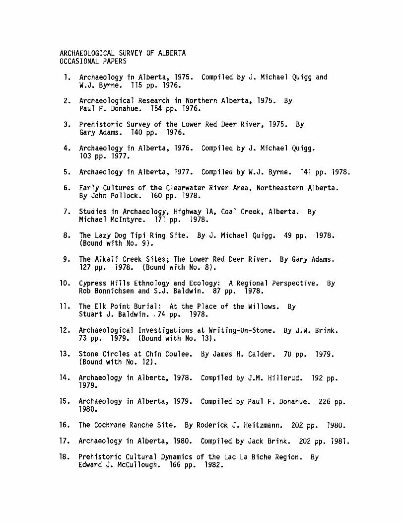
ARCHAEOLOGICAL SURVEY OF ALBERTAOCCASIONAL PAPERS
1. Archaeology in Alberta, 1975. Compiled by J. Michael Quigg andW.J. Byrne. 115 pp. 1976.
2. Archaeological Research in Northern Alberta, 1975. ByPaul F. Donahue. 154 pp. 1976.
3. Prehistoric Survey of the Lower Red Deer River, 1975. ByGary Adams. 140 pp. "1976.
4. Archaeology in Alberta, 1976. Compiled by J. Michael Quigg.103 pp. 1977.
5. Archaeology in Alberta, 1977. Compiled by W.J. Byrne. 141 pp. 1978.
6. Early Cultures of the Clearwater River Area, Northeastern Alberta.By John Pollock. 160 pp. 1978.
7. Studies in Archaeology, Highway lA, Coal Creek, Alberta. ByMichael McIntyre. 171 pp. 1978.
8. The Lazy Dog Tipi Ring Site. By J. Michael Quigg. 49 pp. 1978.(Bound with No.9).
9. The Alkali Creek Sites; The Lower Red Deer River. By Gary Adams.127 pp. 1978. (Bound with No.8).
10. Cypress Hills Ethnology and Ecology: A Regional Perspective. ByRob Bonnichsen and S.J. Baldwin. 87 pp. 1978.
11. The Elk Point Burial: At the Place of the Willows. ByStuart J. Baldwin. ~ 74 pp. 1978.
12. Archaeological Investigations at Writing-an-Stone. By J.W. Brink.73 pp. 1979. (Bound with No. 13).
13. Stone Circles at Chin Coulee. By James H. Calder. 70 pp. 1979.(Bound with No. 12).
14. Archaeology in Alberta, 1978. Compiled by J.M. Hillerud. 192 pp.1979.
15. Archaeology in Alberta, 1979. Compiled by Paul F. Donahue. 226 pp.1980.
16. The Cochrane Ranche Site. By Roderick J. Heitzmann. 202 pp. 1980.
17. Archaeology in Alberta, 1980. Compiled by Jack Brink. 202 pp. 1981.
18. Prehistoric Cultural Dynamics of the Lac La Biche Region. ByEdward J. McCullough. 166 pp. 1982.
19. Archaeology in Alberta, 1981. Compiled by Jack Brink. 208 pp. 1982.
20. Culture Change in the Northern Plains: 1000 B.C. - A.D. 1000. ByBrian O.K. Reeves. 390 pp. 1983.
21. Archaeology in Alberta, 1982. Compiled by David Burley. 222 pp.1983.
22. Sibbald Creek: 11,000 Years of Human Use of the Alberta Foothills.By Eugene M. Gryba. 219 pp. 1983.
23. Archaeology in Alberta, 1983. Compiled by David Burley. 256 pp.1984.
24. Communal Buffalo Hunting among the Plains Indians. ByEleanor Verbicky-Todd. 262 pp. 1984.
25. Archaeology in Alberta, 1984. Compiled by David Burley. 277 pp.1985.
26. Contributions to Plains Prehistory. Edited by David Burley. 284pp. 1985.
27. Alberta Plains Prehistory: A Review. By J. Roderick Vickers. 139pp. 1986. (Bound with No. 28).
28. Dog Days in Southern Alberta. By Jack Brink. 70 pp. 1986. (Boundwith No. 27).
29. Archaeology in Alberta, 1985. Compiled by John W. Ives. 287 pp.1986.
30. Eastern Slopes Prehistory: Selected Papers. Edited byBrian Ronaghan. 405 pp. 1987.
31. Archaeology in Alberta, 1986. Compiled by Martin Magne. 302 pp.1987.