april 18, 2019 - california tahoe conservancy - board packet
TRANSCRIPT
TAHOE RESOURCE CONSERVATION DISTRICT
LAKE-WIDE AQUATIC INVASIVE PLANT
CONTROL PROJECT State Clearinghouse Number: 2014042043
F INAL ENVIRONMENTAL
DOCUMENTATION PACKAGE
July 16, 2014
L A K E - W I D E A Q U A T I C I N V A S I V E P L A N T C O N T R O L P R O J E C T
N E G A T I V E D E C L A R A T I O N C E R T I F I C A T I O N
J U L Y 2 0 1 4 P A G E 1
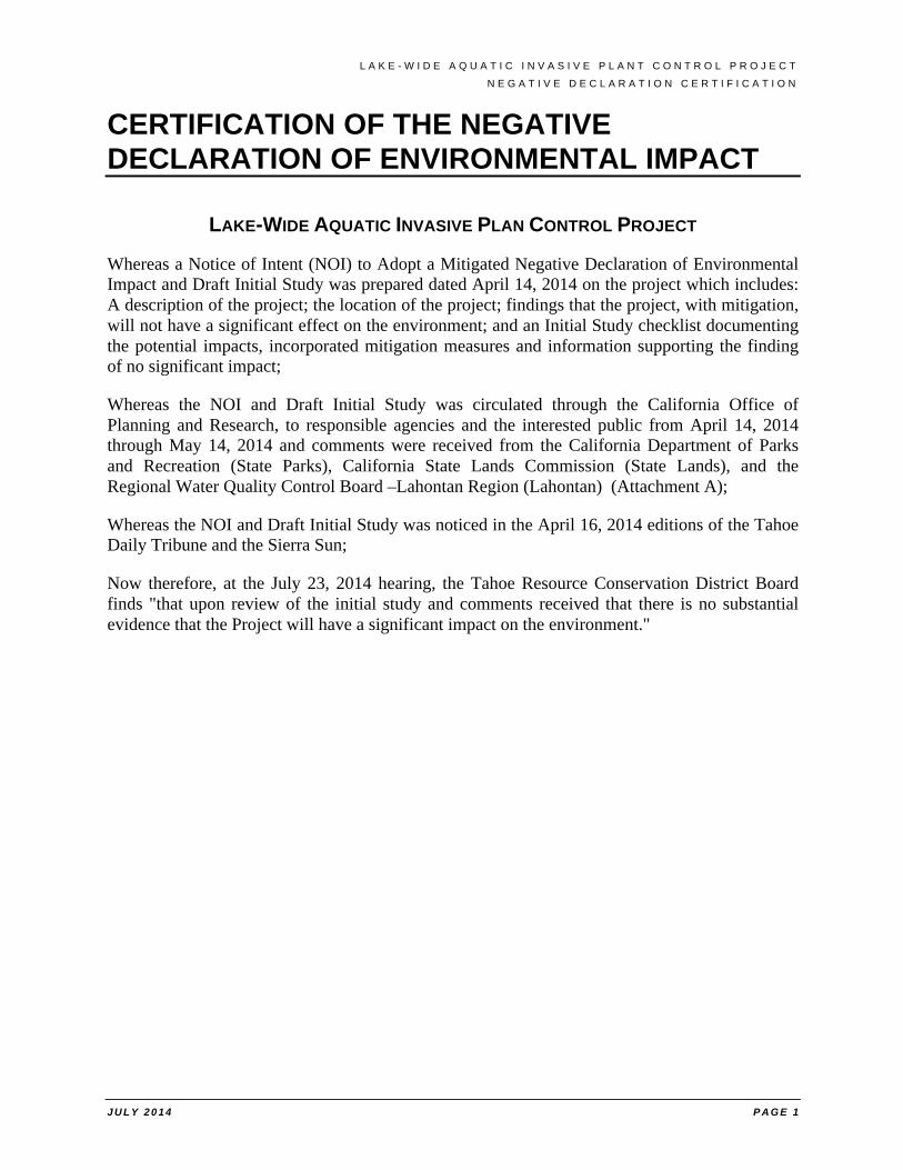
CERTIFICATION OF THE NEGATIVE DECLARATION OF ENVIRONMENTAL IMPACT
LAKE-WIDE AQUATIC INVASIVE PLAN CONTROL PROJECT
Whereas a Notice of Intent (NOI) to Adopt a Mitigated Negative Declaration of Environmental Impact and Draft Initial Study was prepared dated April 14, 2014 on the project which includes: A description of the project; the location of the project; findings that the project, with mitigation, will not have a significant effect on the environment; and an Initial Study checklist documenting the potential impacts, incorporated mitigation measures and information supporting the finding of no significant impact;
Whereas the NOI and Draft Initial Study was circulated through the California Office of Planning and Research, to responsible agencies and the interested public from April 14, 2014 through May 14, 2014 and comments were received from the California Department of Parks and Recreation (State Parks), California State Lands Commission (State Lands), and the Regional Water Quality Control Board –Lahontan Region (Lahontan) (Attachment A);
Whereas the NOI and Draft Initial Study was noticed in the April 16, 2014 editions of the Tahoe Daily Tribune and the Sierra Sun;
Now therefore, at the July 23, 2014 hearing, the Tahoe Resource Conservation District Board finds "that upon review of the initial study and comments received that there is no substantial evidence that the Project will have a significant impact on the environment."
L A K E - W I D E A Q U A T I C I N V A S I V E P L A N T C O N T R O L P R O J E C T
N E G A T I V E D E C L A R A T I O N N O T I C E O F D E T E R M I N A T I O N
J U L Y 2 0 1 4 P A G E 1
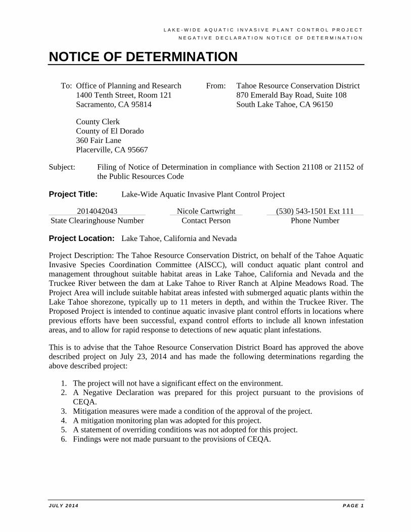
NOTICE OF DETERMINATION
To: Office of Planning and Research From: Tahoe Resource Conservation District 1400 Tenth Street, Room 121 870 Emerald Bay Road, Suite 108 Sacramento, CA 95814 South Lake Tahoe, CA 96150
County Clerk County of El Dorado 360 Fair Lane Placerville, CA 95667
Subject: Filing of Notice of Determination in compliance with Section 21108 or 21152 of the Public Resources Code
Project Title: Lake-Wide Aquatic Invasive Plant Control Project
2014042043 Nicole Cartwright (530) 543-1501 Ext 111 State Clearinghouse Number Contact Person Phone Number
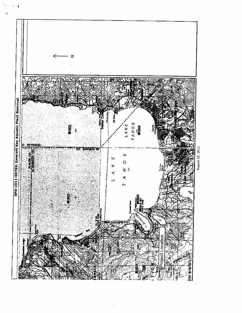
Project Location: Lake Tahoe, California and Nevada
Project Description: The Tahoe Resource Conservation District, on behalf of the Tahoe Aquatic Invasive Species Coordination Committee (AISCC), will conduct aquatic plant control and management throughout suitable habitat areas in Lake Tahoe, California and Nevada and the Truckee River between the dam at Lake Tahoe to River Ranch at Alpine Meadows Road. The Project Area will include suitable habitat areas infested with submerged aquatic plants within the Lake Tahoe shorezone, typically up to 11 meters in depth, and within the Truckee River. The Proposed Project is intended to continue aquatic invasive plant control efforts in locations where previous efforts have been successful, expand control efforts to include all known infestation areas, and to allow for rapid response to detections of new aquatic plant infestations.
This is to advise that the Tahoe Resource Conservation District Board has approved the above described project on July 23, 2014 and has made the following determinations regarding the above described project:
1. The project will not have a significant effect on the environment. 2. A Negative Declaration was prepared for this project pursuant to the provisions of
CEQA. 3. Mitigation measures were made a condition of the approval of the project. 4. A mitigation monitoring plan was adopted for this project. 5. A statement of overriding conditions was not adopted for this project. 6. Findings were not made pursuant to the provisions of CEQA.
L A K E - W I D E A Q U A T I C I N V A S I V E P L A N T C O N T R O L P R O J E C T
R E S P O N S E T O C O M M E N T S O N T H E D R A F T I S
J U L Y 2 0 1 4 P A G E 1
RESPONSE TO COMMENTS
Comments in the form of one email and three letters were received on the Project (Attachment A). A summary of each comment received is provided below and is followed by a formal response to the comment:
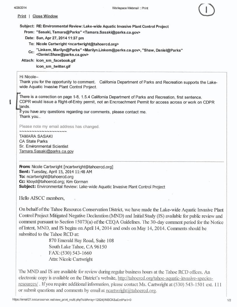
Commenter 1 – California Department of Parks and Recreation, Tamara Sasaki, Email dated 27 April 2014
1-1. Correction. Correction requested on page 1-8, Section 1.8.4 regarding Department of State Parks access requirements. Change Encroachment Permit to Right-of-Entry Permit.
Response – This change will be made for future documentation.
Commenter 2 – California State Land Commission, Cy Oggins, Letter dated 9 May 2014
2-1. Project Area. Revise the total infestation treatment area from 1,951,950 (44.81 acres) to 686,070 square feet (15.75 acres) in Table 2-1 on page 2-6 of document.
Response – This change will be made for future documentation.
2-2. Aesthetics/Plant Disposal. Section 2.2.3 describes staging and access for the Project and indicated that garbage dumpsters will be used for direct disposal of collected plant materials. Please describe in more detail the size and number of bags that would be expected on the beach at any given time and the length of time those bags would be left on the beach to dry, the number, size and location of dumpsters and analyze impacts.
Response – Section 2.2.3 has been revised to include information on the size and number of bags that would be expected on the beach at any given time and the length of time those bags would be left on the beach to dry. The section has also been revised to document the number, size and location of dumpsters. Impacts described in Section 3.2.3 pertaining to aesthetics remain less than significant.
2-3. Aesthetics/Lighting. Add details related to the expected amount/intensity of light and proximity to residences, frequency of use, and other pertinent details to Section 2.2.3.
Response – Section 2.2.3 has been revised to include information related to the expected amount/intensity of light and proximity to residences, frequency of use, and other pertinent details. Impacts described in Section 3.2.3 pertaining to lighting remain less than significant.
2-4. Biological Resources/Consultation. Add discussion on whether informal or formal consultation has occurred with U.S Fish and Wildlife Service. Explain if the Project will comply with any measures imposed through the federal consultation process between the US Army Corps of Engineers and the U.S Fish and Wildlife Service.
L A K E - W I D E A Q U A T I C I N V A S I V E P L A N T C O N T R O L P R O J E C T
R E S P O N S E T O C O M M E N T S O N T H E D R A F T I S
J U L Y 2 0 1 4 P A G E 2
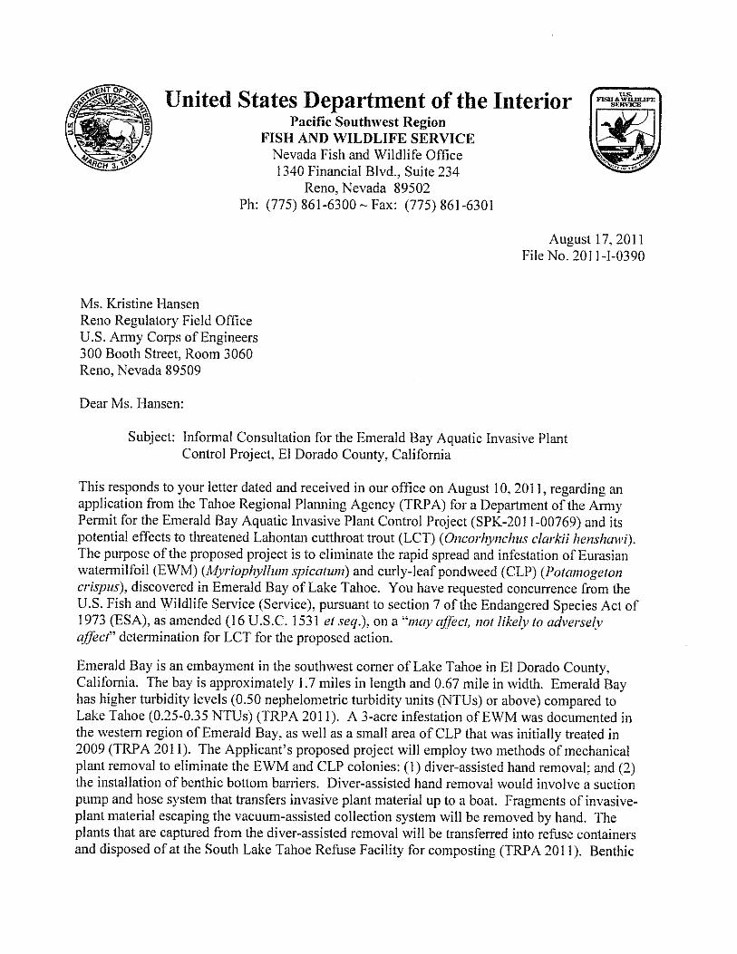
Response – TRCD staff has consulted with both the US Army Corps of Engineers and US Fish and Wildlife Service regarding impacts to Lahontan cutthroat trout for both the current project and also the 2011 project in Emerald Bay. The 2011 aquatic invasive species control project that was approved for Emerald Bay resulted in concurrence from USFWS that the project “may affect, but not likely to adversely affect” Lahontan cutthroat trout (LCT). Attachment B provides a copy of the USFWS and USACE correspondence regarding the 2011 project. Currently TRPA and TRCD staff have been in communication with USFWS and USACE regarding potential impacts to LCT from implementation of the lake wide project. As similar Best Management Practices are proposed with the lake-wide project, it is likely USFWS will concur with the Initial Study.
Section 3.5 has been revised to add this information on informal consultation with the USACE and the USFWS.
In June 2014 following the release of the Initial Study, the USFWS changed the status of the Sierra Nevada yellow-legged frog from a candidate species for listing to a federally listed endangered species. As such, the TRPA and TRCD staff will also consult with the USFWS regarding the Project’s potential effects to suitable yellow-legged frog habitat.
2-5. Cultural Resources/Title to Resources. Add disclosure that the title to all abandoned shipwrecks, archaeological sites, and historic or cultural resources on or in the tide and submerged lands of California is vested in the State and under the jurisdiction of the California State Lands Commission.
Response - Section 2.4.3.5, Cultural Resource Surveys, will be revised for future documentation. Also, mitigation measure CULT-3: Unanticipated Discovery currently requires that “if archaeological or paleontological features are discovered during Project implementation, submerged artifacts and/or features shall be marked, left in place, and reported to appropriate cultural resources specialist.”
2-6. Greenhouse Gas (GHG) Emissions. Add information on the type and number of equipment vehicles needed, the number of vehicle trips expected, and any other pertinent information related to estimating GHG emissions and the significance of those emissions. Discussion should include a complete accounting of emissions sources, a quantitative or qualitative estimate of GHG emissions using accepted model methods, and how those GHG emissions compare to applicable local, regional and State thresholds.
Response – GHG calculations will be added to Section 3.8.3, page 3-38, for future documentation.
2-7. Noise. Add discussion as to whether the project area is currently out of attainment with any State, federal or Tahoe Regional Planning Agency noise standards. Evaluate project-related noise against baseline to determine if additional mitigation measures are needed or to justify why mitigation is not required. State whether motorized equipment or vessels would be used during night-time activities, how sounds would compare to ambient night-time noise levels, and whether any such noise would exceed allowable levels.
L A K E - W I D E A Q U A T I C I N V A S I V E P L A N T C O N T R O L P R O J E C T
R E S P O N S E T O C O M M E N T S O N T H E D R A F T I S
J U L Y 2 0 1 4 P A G E 3
Response – This information will be added to Section 3.13.3, page 3-51, for future documentation. Impacts described in Section 3.13 pertaining to noise remain less than significant.
2-8. Recreation and Traffic. Add account for worst-case scenario of having to manage watercraft recreation and traffic for bottom barrier installation/removal activities during peak boating season (Memorial Day weekend through Labor Day weekend). State Lands staff recommends a detailed traffic control plan.
Response – Section 2.2.3, on page 2-4, has been revised to clarify procedures for dealing with diver and recreational safety. There is no need for a traffic control plan because the project will not restrict the use of project areas by the public and will not propose closures of recreational areas. Notices will be provided to public marinas and watercraft locations on an annual basis as part of the annual work plan to inform recreational providers where work is proposed. Impacts described in Sections 3.16 and 3.17 pertaining to recreation and traffic, remain less than significant and less than significant with mitigation, respectively.
Commenter 3 – Lahontan Regional Water Quality Control Board, Douglas Smith, Letter dated 13 May 2014
3-1. Section 2.4.1. Add sub-surface utility survey referenced in Section 2.3.3.8 to Section 2.4.1, which would be needed for each treatment site that may involve subsurface disturbance.
Response – The sub-surface utility survey will be added to the list of control efforts in Section 2.4.1 for future documentation.
3.2. Section 2.4.1.2, Hand Removal. Hazard Assessment and Critical Control Point Plan (HACPP) included in mitigation measure HYDRO-1.7 should acknowledge that equipment and clothing associated with hand pulling has the potential to spread invasive plants and should include control measures that will effectively decontaminate these potential vectors.
Response – This information will be added to mitigation measure HYDRO-1 that begins on page 3-46 (and is duplicated on page MND-3) for future documentation.
3.3. Section 2.4.3.4, Lake Bottom Substrate Characterization. Mitigation measure HYDRO-1.6 should recognize that fill material should be of higher quality (with a minimum standards of fill consisting of sand grain material) if lake bottom substrate characterization indicates that the lake substrate is of poor quality.
Response – This information will be added to mitigation measure HYDRO-1 that begins on page 3-46 (and is duplicated on page MND-3) for future documentation.
3-4. Section 3.10, Hydrology and Water Quality. Impacts associated with sand bags. Discussion in section 3.10.a should recognize that potential discharge of pollutants could impact water quality such as clarity and decrease in dissolved oxygen levels. Pollutant sources include sand bags when used and recovered or left in place at the end of a project, because the fill material would be considered a discharge of sediment. Add language to mitigation measure
L A K E - W I D E A Q U A T I C I N V A S I V E P L A N T C O N T R O L P R O J E C T
R E S P O N S E T O C O M M E N T S O N T H E D R A F T I S
J U L Y 2 0 1 4 P A G E 4
HYDRO-1.6 to include using washed gravels, obtaining clean sand from a compatible near-site location, and using biodegradable bags.
Response - This language will be added to the analysis that begins on page 3-44 and to mitigation measure HYDRO-1 that begins on page 3-46 (and is duplicated on page MND-3) for future documentation.
3-5. Sections 3.10.3 and 3.5.3. Impacts associated with bottom barriers consisting of jute or other plant-based materials. Jute or plant-based materials used as bottom barriers may be a source of weeds if not certified weed-free. Add dissolved oxygen sampling to mitigation measure HYDRO-1.
Response – Section 2.4.1.1, page 2-7, of the Project Description will be revised for future documentation to include the requirement that natural fiber barriers, if used, shall be certified weed free. Impacts described in Section 3.1.3 pertaining to water quality remain less than significant after mitigation. Impacts described in Section 3.5.3 pertaining to biological resources remain less than significant.
3.6. Section 3.18, Utilities and Service Systems. Add water quality impacts associated with driving rebar to Section 3.10.a. Add potential impact from discharges of sediment and turbidity if physical damage to subsurface utilities would occur within a treatment site. Add to mitigation measure HYDRO-1 that project proponent will affirmatively document presence/absence of subsurface utilities and will incorporate a utility avoidance plan if such utilities are known to be present.
Response - Section 3.10.3, page 3-45, will be revised for future documentation to include disclosure of potential impacts from discharges of sediment and turbidity if physical damage to subsurface utilities would occur. The requirement for a utility avoidance plan will be added to mitigation measure HYDRO-1 beginning on page 3-46 (and is duplicated on page MND-3) for future documentation.
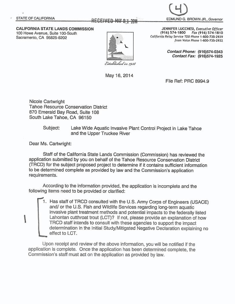
Commenter 4 – California State Lands Commission, Beverly Terry, Letter dated 16 May 2014
4-1. Lahontan Cutthroat Trout Consultation. Has TRCD staff consulted with US army Corps of Engineers and/or US Fish and Wildlife Service regarding long-term aquatic invasive plant control methods and potential impacts to the federally-listed Lahontan Cutthroat Trout (LCT)? If not, please provide an explanation of how TRCD staff intends to consult with these agencies to support the impact determination in the Initial Study of no effects.
Response – See response to Comment 2.4 above.
L A K E - W I D E A Q U A T I C I N V A S I V E P L A N T C O N T R O L P R O J E C T
M O D I F I C A T I O N S T O T H E D R A F T I S
J U L Y 2 0 1 4 P A G E 5
MODIFICATIONS TO THE DRAFT INITIAL STUDY DATED APRIL 14, 2014
The following changes will be made to the Initial Study dated April 14, 2014. Underlined text is new text that has been added to the Initial Study. Text that is shown in strikeout has been removed from the Initial Study.
Section 1.5.4, page 1-8: Make correction regarding Department of Parks and Recreation access requirements. Change Encroachment Permit to Right-of-Entry Permit.
The CDPR issues an Right-of-Entry Encroachment Permit.
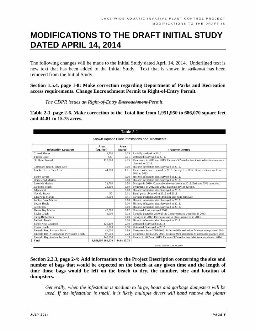
Table 2-1. page 2-6. Make correction to the Total line from 1,951,950 to 686,070 square feet and 44.81 to 15.75 acres.
Section 2.2.3, page 2-4: Add information to the Project Description concerning the size and number of bags that would be expected on the beach at any given time and the length of time those bags would be left on the beach to dry, the number, size and location of dumpsters.
Generally, when the infestation is medium to large, boats and garbage dumpsters will be used. If the infestation is small, it is likely multiple divers will hand remove the plants
Table 2-1
Known Aquatic Plant Infestations and Treatments
Infestation Location
Area (sq. feet)
Area (acres)
Treatment/Notes
Crystal Shores 1,500 0.03 Partially dredged in 2010. Timber Cove 520 0.01 Untreated; Surveyed in 2012. Ski Run Channel 120,000 2.75 Treatments in 2012 and 2013. Estimate 50% reduction. Comprehensive treatment
planned for 2014. Commons Beach, Tahoe City 0.00 Historic infestation site. Surveyed in 2012. Truckee River Dam Area 44,000 1.01 Treated with hand removal in 2010. Surveyed in 2012. Observed increase from
2011 to 2013. Tahoe Tavern 0.00 Historic infestation site. Surveyed in 2012. Homewood Marina 0.00 Historic infestation site. Surveyed in 2012. Lakeside Marina 21,700 0.50 Dredged in 2010. Comprehensive treatment in 2012. Estimate 75% reduction. Lakeside Beach 21,600 0.50 Treatments in 2012 and 2013. Estimate 85% reduction. Edgewood 0.00 Historic infestation site. Surveyed in 2012. Nevada Beach 50 0.01 Small patch observed in 2012 and 2013 Elks Point Marina 18,000 0.41 Partially treated in 2010 (dredging and hand removal) Zephyr Cove Marina 0.00 Historic infestation site. Surveyed in 2012 Logan Shoals 0.00 Historic infestation site. Surveyed in 2012. Glenbrook 0.00 Historic infestation site. Surveyed in 2012. Meeks Bay Marina 40,000 0.92 Untreated, Last surveyed 2009 Taylor Creek 1,000 0.02 Partially treated in 2010/2011; Comprehensive treatment in 2013. Camp Richardson 0.00 Surveyed in 2012; Patches of native plants observed in 2013. Baldwin Beach 0.00 Historic infestation site. Surveyed in 2012. Tahoe Keys Channels 126,200 2.90 Untreated, Surveyed in 2012 Regan Beach 8,000 0.18 Untreated, Surveyed in 2012 Emerald Bay, Parson’s Rock 41,000 0.94 Treatments from 2005-2013. Estimate 99% reduction. Maintenance planned 2014. Emerald Bay, Vikingsholm Pier/Swim Beach 97,500 2.24 Treatments from 2005-2013. Estimate 99% reduction. Maintenance planned 2014 Emerald Bay, Avalanche Beach 145,000 3.33 Treated in 2005 and 2013. Estimate 99% reduction. Maintenance planned 2014. Total 1,951,950 686,070 44.81 15.75
Source: Tahoe RCD, TRPA, CDPR

L A K E - W I D E A Q U A T I C I N V A S I V E P L A N T C O N T R O L P R O J E C T
M O D I F I C A T I O N S T O T H E D R A F T I S
J U L Y 2 0 1 4 P A G E 6
from locations along the beach and dispose of the biomass in vehicles parked nearby. Some A maximum of between 10 to 20 bagsged of plant material may be left on the beach to dry, for short periods during daily project activities before removal at the end of each work day, to reduce the weight of the material for removal. If the plants are collected by boat, the driver of the boat will either carry the weed biomass to the closest marina or the diver will drive the boat to a pier or beach and the biomass will be transferred from the diver to buckets or wheelbarrows. The biomass will then be loaded in a truck and taken to a dumpster. When possible an existing dumpster will be utilized or a dumpster may be temporarily placed at an approved staging area for direct disposal.
Section 2.4.1.4, page 2-8: Add information to the Project Description related to the expected amount/intensity of light and proximity to residences, frequency of use, and other pertinent details.
Night-time operations to implement barrier deployment and diver-assisted hand removal are possible considered as a way to minimize conflicts with recreational use of a Treatment Site and to maximize safe working conditions for the divers and crews. Should night operations be employed, divers and deck crews would use standard watercraft lighting necessary for safe nighttime boating navigation and diver lights. Diver lights are used underwater on the helmet of the diver and do not result in light spill on adjacent areas, to facilitate plant control operations. This would include lighted dive gear and lighted work platform deck(s) with lights pointed down to illuminate the work space of the platform. Night-time plant control activities would only take place in areas with potential recreation conflicts, which are marinas and commercial use areas with existing light sources. Nighttime project activities would not be necessary in residential areas.
Section 3.5. page 3-22: Add information on informal or formal consultation with the US Army Corps of Engineers and the U.S Fish and Wildlife Service completed to date, including clarification on how the Project will comply with the federal consultation process and implement any measures imposed through the process.
Mechanical hand removal and diver-assisted removal have the potential for suction of LCT and other fish species. This impact is unlikely as fish species avoid project areas during construction as noted above. TRCD staff has consulted with both the US Army Corps of Engineers and US Fish and Wildlife Service regarding impacts to Lahontan cutthroat trout for both the current project and also the 2011 project in Emerald Bay. The 2011 aquatic invasive species control project that was approved for Emerald Bay resulted in concurrence from USFWS that the project “may affect, but not likely to adversely affect” LCT. Attachment B provides a copy of the USFWS and USACE correspondence regarding the 2011 project. Currently TRPA and TRCD staff have been in communication with USFWS and USACE regarding potential impacts to LCT from implementation of the lake wide project. As similar Best Management Practices are proposed with the lake-wide project, it is likely USFWS will concur with the Initial Study.
Other temporary impacts that may result due to increased turbidity, which may have an adverse effect on foraging activities of LCT and other fish species. Turbidity impacts are mitigated through MITIGATION MEASURE HYDRO-1 through installation of
L A K E - W I D E A Q U A T I C I N V A S I V E P L A N T C O N T R O L P R O J E C T
M O D I F I C A T I O N S T O T H E D R A F T I S
J U L Y 2 0 1 4 P A G E 7
turbidity curtains and monitoring requirements. Monitoring results from previous plant removal efforts have shown a discrete, short-term disturbance to clarity with turbidity levels returning to background generally within 10-15 minutes. Past plant removal efforts in Lake Tahoe have not exceeded permissible water quality parameters or nor have past projects caused water quality conditions that are potentially harmful to fish. Therefore, temporary and localized elevations in water turbidity are expected to have no effect on LCT.
Section 2.4.3.5. page 2-10: Add disclosure that the title to all abandoned shipwrecks, archaeological sites, and historic or cultural resources on or in the tide and submerged lands of California is vested in the State and under the jurisdiction of the California State Lands Commission.
2.4.3.5 Cultural Resource Surveys
A qualified Archaeologist will survey the Treatment Site and the appropriate cultural review documentation will be completed. If evidence of potentially significant historical/archaeological resources is found (shell, burned animal bone or rock, concentration of bottle glass or ceramics, etc.), the contracted archaeologist will be contacted and work will be suspended until identification and proper treatment are determined and implemented. The title to all abandoned shipwrecks, archaeological sites, and historic or cultural resources on or in the tide and submerged lands of California is vested in the State and under the jurisdiction of CSLC. Tahoe RCD staff will consult with Senior Staff Counsel with CSLC should any cultural resources on California state lands be discovered during Project activities. Appendix D contains the cultural resource report prepared for the Project by CDPR Associate State Archaeologist, Denise Jaffke.
Section 3.8.3, page 3-38: Revise impact analysis to add the type and number of equipment vehicles needed, the number of vehicle trips expected, and any other pertinent information related to estimating GHG emissions and the significance of those emissions as compared to applicable local, regional and State thresholds.
a) The Project would not directly contribute to greenhouse gas emissions because of the nature of treatment and removal activities. Indirectly during implementation at Treatment Sites, greenhouse gas emissions would occur on a temporary and intermittent basis from equipment used in Project activities, including delivery vehicles and boat motors, and pumps and could contribute to an increase in CO2 and N2O levels, both components of GHG. Each Treatment Site would include vehicle trips for worker and material delivery, truck trips for moving plants from the treatment to their disposal site, and in some case, generators to run pumps necessary for the removal of plants from the water column.
The current global, U.S., California, Nevada, and Tahoe Basin GHG emission levels are provided below, and provide reference points for comparison to the Project GHG emissions. The emissions of each GHG are multiplied by its respective global warming potential (CO2 Equivalency Factor) to obtain emissions on the common basis of millions of metric tons per year (MMtpy) of carbon dioxide equivalent (CO2e). As of 2005, global
L A K E - W I D E A Q U A T I C I N V A S I V E P L A N T C O N T R O L P R O J E C T
M O D I F I C A T I O N S T O T H E D R A F T I S
J U L Y 2 0 1 4 P A G E 8
GHG emissions are estimated to equal approximately 39,000 MMtpy. An estimate for the U.S. is 6,708 MMtpy (2011); California is 448 MMtpy (2011); Nevada is 56.3 MMtpy (2005) and the Tahoe Basin is 0.30 MMtpy (2013 calculation using TMPO data).
Indirectly during operations, GHG emissions would occur from vehicles accessing the Treatment Sites. Limited CO2 emissions are anticipated from two small generators, one small watercraft, two light trucks and vehicles of up to four workers commuting to and from the Project Area. In comparison with CARB estimates for annual CO2e emissions with the worst-case scenario of up to 10 daily trips associated with Project implementation at individual Treatment Sites, the contribution of the Project towards statewide GHG emissions is very small, estimated to be less than 25,000 pounds per day (11.3 metric tons per year assuming up to 100 days of operation) of CO2e. The limited use of boats, pumps and vehicles, and the temporary nature of this activity, would result in a less than significant impact on the generation of GHG emissions.
Section 3.13.3, page 3-51: Revise impact analysis to include discussion as to whether the project area is currently out of attainment with any State, federal or Tahoe Regional Planning Agency noise standards.
a) Daytime Project activities requiring use of a boat, winch, and/or backhoe could produce noise in excess of typical noise in the area; however, noise related to project activities will be temporary in nature, and temporary increases in noise levels along the shoreline of Lake Tahoe frequently occur as a result of substantial watercraft recreation. Noise generated by boats used to access the treatment areas will comply with established Code Chapter 68.3.1.C noise standards because boatsthey will only be used to access the treatment sites and will not be operated while treatment work is performed. When accessing sites near the shoreline and noise sensitive land use, boats will be operated at low speed and therefore low noise output. Because of the small engines used by the pumps for diver-assisted suction removal of plants, noise generated by these project activities will not violate any single-event noise standards established by the Tahoe Regional Planning Agency or other local, state, or federal standards.
Noise monitoring data collected during previous aquatic invasive species treatment operations documented noise levels of up to 64 dBA Leq at 200 feet and 64 dBA Leq at 100 feet from pump and generator operations. The majority of the treatment work occurs beyond 100 feet off shore but treatment sites may extend to the shoreline. Treatment work completed during the hours of 8 AM to 6:30 PM are exempt from TRPA noise standards for TRPA approved construction or maintenance projects (Code Section 68.9). However, work performed before or after the exemption period must comply with Plan Area CNEL limits (e.g., 55 dB CNEL for most residential plan areas and 60 dB CNEL for commercial and tourist plan areas) at their Lake Tahoe shoreline boundaries. Based on the noise monitoring data collected during previous operations, up to two hours of work could be performed before the exemption time period begins (e.g., between 6:00 and 8:00 AM) and comply with the 55 dB CNEL residential standard if the work location is at least 250 feet from the Plan Area shoreline boundary. To comply with the CNEL standard for tourist or commercial plan areas (e.g., marinas), the work location would need to be at least 100 feet from the Plan Area shoreline boundary. Therefore, in order to comply with
L A K E - W I D E A Q U A T I C I N V A S I V E P L A N T C O N T R O L P R O J E C T
M O D I F I C A T I O N S T O T H E D R A F T I S
J U L Y 2 0 1 4 P A G E 9
CNEL standards, the project description will limit early morning work locations to the minimum setback distances referenced above. The noise generated by project activities will result in a less than significant impact in regards to public exposure to elevated noise levels.
Section 2.2.3, page 2-4: Revise Project Description to clarify that the Project proposes no closures of recreation areas and that if Treatment Site areas become too heavily used, project activities will be temporarily suspended or rescheduled during an off-peak period (e.g., mid-week and early morning hours).
The diver will be made aware of visitor use in the potential staging areas and applicable Ranger staff, Visitor Services, and Maintenance personnel will be contacted beforehand to be sure that Project activities will not interfere with normal recreational operations. No partial or complete closure of recreational areas is proposed, but diver safety equipment (e.g., buoys and flags) will be used as required to notify the recreational users that divers are working under water. If there is a conflict with recreational use in the Treatment Site area, the diver will be notified that the plan for access, staging and disposal must be amended and operations may be suspended and rescheduled to occur during more off-peak times (e.g., early morning hours consistent with noise restrictions or mid week).
Section 2.4.1, page 2-4: Add sub-surface utility survey to the list of control efforts in Section 2.4.1.
2.4.1 Treatment Methods
The Project proposes to extirpate aquatic invasive plant species in Lake Tahoe and the Truckee River, emphasizing two mechanical removal methods: benthic bottom barriers and hand removal (including diver-assisted hand removal). Given that each infestation will vary in size and density, and will have site-specific substrate and lake bottom conditions, these methods will be employed at each site as deemed appropriate, independently or in combination. In addition to removal methods, control efforts at each Treatment Site will include pre-project Tahoe yellow cress surveys (where work includes shoreline access or staging), pre-project cultural resource surveys, active project water quality monitoring, post-project effectiveness monitoring, sub-surface utility survey, and Hazard Analysis and Critical Control Point (HACCP) plan implementation and reporting.
Section 3.10.3, page 3-46: Revise mitigation measure HYDRO-1, requirements 6 and 7, to include control measures to decontaminate potential vectors and require fill materials of higher quality should lake substrate be of poor quality. Add requirement 11 to address need for a subsurface utility avoidance plan should utilities be located near treatment sites during pre-project utility location surveys.
L A K E - W I D E A Q U A T I C I N V A S I V E P L A N T C O N T R O L P R O J E C T
M O D I F I C A T I O N S T O T H E D R A F T I S
J U L Y 2 0 1 4 P A G E 10
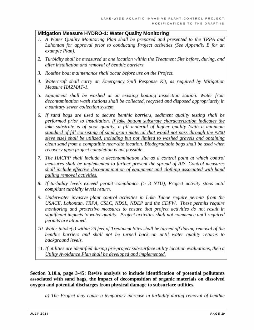
Mitigation Measure HYDRO-1: Water Quality Monitoring 1. A Water Quality Monitoring Plan shall be prepared and presented to the TRPA and
Lahontan for approval prior to conducting Project activities (See Appendix B for an example Plan).
2. Turbidity shall be measured at one location within the Treatment Site before, during, and after installation and removal of benthic barriers.
3. Routine boat maintenance shall occur before use on the Project.
4. Watercraft shall carry an Emergency Spill Response Kit, as required by Mitigation Measure HAZMAT-1.
5. Equipment shall be washed at an existing boating inspection station. Water from decontamination wash stations shall be collected, recycled and disposed appropriately in a sanitary sewer collection system.
6. If sand bags are used to secure benthic barriers, sediment quality testing shall be performed prior to installation. If lake bottom substrate characterization indicates the lake substrate is of poor quality, a fill material of higher quality (with a minimum standard of fill consisting of sand grain material that would not pass through the #200 sieve size) shall be utilized, including but not limited to washed gravels and obtaining clean sand from a compatible near-site location. Biodegradable bags shall be used when recovery upon project completion is not possible.
7. The HACPP shall include a decontamination site as a control point at which control measures shall be implemented to further prevent the spread of AIS. Control measures shall include effective decontamination of equipment and clothing associated with hand pulling removal activities.
8. If turbidity levels exceed permit compliance (> 3 NTU), Project activity stops until compliant turbidity levels return.
9. Underwater invasive plant control activities in Lake Tahoe require permits from the USACE, Lahontan, TRPA, CSLC, NDSL, NDEP and the CDFW. These permits require monitoring and protective measures to ensure that project activities do not result in significant impacts to water quality. Project activities shall not commence until required permits are attained.
10. Water intake(s) within 25 feet of Treatment Sites shall be turned off during removal of the benthic barriers and shall not be turned back on until water quality returns to background levels.
11. If utilities are identified during pre-project sub-surface utility location evaluations, then a Utility Avoidance Plan shall be developed and implemented.
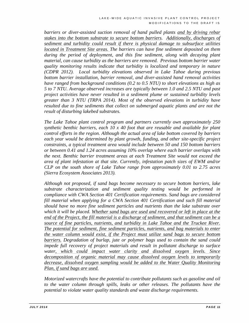
Section 3.10.a, page 3-45: Revise analysis to include identification of potential pollutants associated with sand bags, the impact of decomposition of organic materials on dissolved oxygen and potential discharges from physical damage to subsurface utilities.
a) The Project may cause a temporary increase in turbidity during removal of benthic
L A K E - W I D E A Q U A T I C I N V A S I V E P L A N T C O N T R O L P R O J E C T
M O D I F I C A T I O N S T O T H E D R A F T I S
J U L Y 2 0 1 4 P A G E 11
barriers or diver-assisted suction removal of hand pulled plants and by driving rebar stakes into the bottom substrate to secure bottom barriers. Additionally, discharges of sediment and turbidity could result if there is physical damage to subsurface utilities located in Treatment Site areas. The barriers can have fine sediment deposited on them during the period of deployment, and this fine sediment, along with decaying plant material, can cause turbidity as the barriers are removed. Previous bottom barrier water quality monitoring results indicate that turbidity is localized and temporary in nature (CDPR 2012). Local turbidity elevations observed in Lake Tahoe during previous bottom barrier installation, barrier removal, and diver-assisted hand removal activities have ranged from background conditions (0.2 to 0.5 NTU) to short elevations as high as 5 to 7 NTU. Average observed increases are typically between 1.0 and 2.5 NTU and past project activities have never resulted in a sediment plume or sustained turbidity levels greater than 3 NTU (TRPA 2014). Most of the observed elevations in turbidity have resulted due to fine sediments that collect on submerged aquatic plants and are not the result of disturbing lakebed substrates.
The Lake Tahoe plant control program and partners currently own approximately 250 synthetic benthic barriers, each 10 x 40 foot that are reusable and available for plant control efforts in the region. Although the actual area of lake bottom covered by barriers each year would be determined by plant growth, funding, and other site-specific project constraints, a typical treatment area would include between 50 and 150 bottom barriers or between 0.41 and 1.24 acres assuming 10% overlap where each barrier overlaps with the next. Benthic barrier treatment areas at each Treatment Site would not exceed the area of plant infestation at that site. Currently, infestation patch sizes of EWM and/or CLP on the south shore of Lake Tahoe range from approximately 0.01 to 2.75 acres (Sierra Ecosystem Associates 2013).
Although not proposed, if sand bags become necessary to secure bottom barriers, lake substrate characterization and sediment quality testing would be performed in compliance with CWA Section 401 Certification requirements. Sand bags are considered fill material when applying for a CWA Section 401 Certification and such fill material should have no more fine sediment particles and nutrients than the lake substrate over which it will be placed. Whether sand bags are used and recovered or left in place at the end of the Project, the fill material is a discharge of sediment, and that sediment can be a source of fine particles, nutrients, and turbidity in Lake Tahoe and the Truckee River. The potential for sediment, fine sediment particles, nutrients, and bag materials to enter the water column would exist, if the Project must utilize sand bags to secure bottom barriers. Degradation of burlap, jute or polymer bags used to contain the sand could impede full recovery of project materials and result in pollutant discharge to surface water, which could impact water clarity and dissolved oxygen levels. Since decomposition of organic material may cause dissolved oxygen levels to temporarily decrease, dissolved oxygen sampling would be added to the Water Quality Monitoring Plan, if sand bags are used.
Motorized watercrafts have the potential to contribute pollutants such as gasoline and oil to the water column through spills, leaks or other releases. The pollutants have the potential to violate water quality standards and waste discharge requirements.
L A K E - W I D E A Q U A T I C I N V A S I V E P L A N T C O N T R O L P R O J E C T
M O D I F I C A T I O N S T O T H E D R A F T I S
J U L Y 2 0 1 4 P A G E 12
Implementation of MITIGATION MEASURE HYDRO-1 and MITIGATION MEASURE HAZMAT-1 would reduce potential impacts to water quality to a level of less than significant.
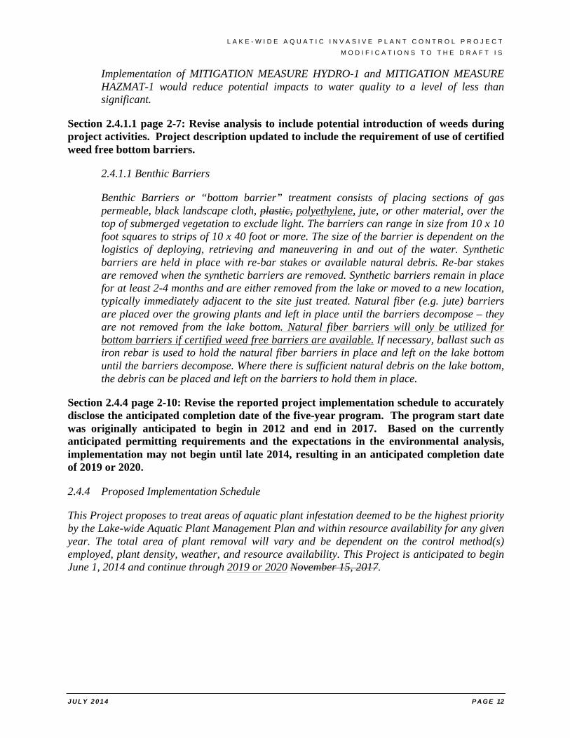
Section 2.4.1.1 page 2-7: Revise analysis to include potential introduction of weeds during project activities. Project description updated to include the requirement of use of certified weed free bottom barriers.
2.4.1.1 Benthic Barriers
Benthic Barriers or “bottom barrier” treatment consists of placing sections of gas permeable, black landscape cloth, plastic, polyethylene, jute, or other material, over the top of submerged vegetation to exclude light. The barriers can range in size from 10 x 10 foot squares to strips of 10 x 40 foot or more. The size of the barrier is dependent on the logistics of deploying, retrieving and maneuvering in and out of the water. Synthetic barriers are held in place with re-bar stakes or available natural debris. Re-bar stakes are removed when the synthetic barriers are removed. Synthetic barriers remain in place for at least 2-4 months and are either removed from the lake or moved to a new location, typically immediately adjacent to the site just treated. Natural fiber (e.g. jute) barriers are placed over the growing plants and left in place until the barriers decompose – they are not removed from the lake bottom. Natural fiber barriers will only be utilized for bottom barriers if certified weed free barriers are available. If necessary, ballast such as iron rebar is used to hold the natural fiber barriers in place and left on the lake bottom until the barriers decompose. Where there is sufficient natural debris on the lake bottom, the debris can be placed and left on the barriers to hold them in place.
Section 2.4.4 page 2-10: Revise the reported project implementation schedule to accurately disclose the anticipated completion date of the five-year program. The program start date was originally anticipated to begin in 2012 and end in 2017. Based on the currently anticipated permitting requirements and the expectations in the environmental analysis, implementation may not begin until late 2014, resulting in an anticipated completion date of 2019 or 2020.
2.4.4 Proposed Implementation Schedule
This Project proposes to treat areas of aquatic plant infestation deemed to be the highest priority by the Lake-wide Aquatic Plant Management Plan and within resource availability for any given year. The total area of plant removal will vary and be dependent on the control method(s) employed, plant density, weather, and resource availability. This Project is anticipated to begin June 1, 2014 and continue through 2019 or 2020 November 15, 2017.
L A K E - W I D E A Q U A T I C I N V A S I V E P L A N T C O N T R O L P R O J E C T
M O D I F I C A T I O N S T O T H E D R A F T I S
J U L Y 2 0 1 4 P A G E 13
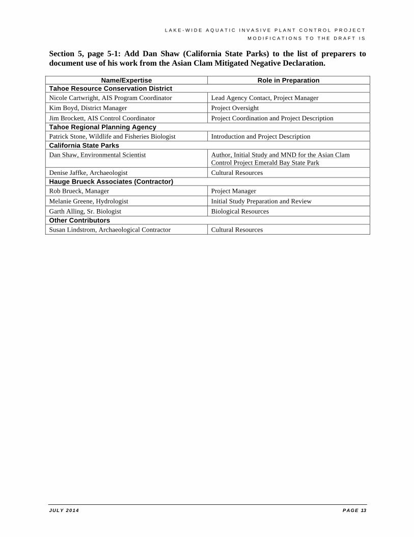
Section 5, page 5-1: Add Dan Shaw (California State Parks) to the list of preparers to document use of his work from the Asian Clam Mitigated Negative Declaration.
Name/Expertise Role in Preparation Tahoe Resource Conservation District Nicole Cartwright, AIS Program Coordinator Lead Agency Contact, Project Manager Kim Boyd, District Manager Project Oversight Jim Brockett, AIS Control Coordinator Project Coordination and Project Description Tahoe Regional Planning Agency Patrick Stone, Wildlife and Fisheries Biologist Introduction and Project Description California State Parks Dan Shaw, Environmental Scientist Author, Initial Study and MND for the Asian Clam
Control Project Emerald Bay State Park Denise Jaffke, Archaeologist Cultural Resources Hauge Brueck Associates (Contractor) Rob Brueck, Manager Project Manager Melanie Greene, Hydrologist Initial Study Preparation and Review Garth Alling, Sr. Biologist Biological Resources Other Contributors Susan Lindstrom, Archaeological Contractor Cultural Resources
L A K E - W I D E A Q U A T I C I N V A S I V E P L A N T C O N T R O L P R O J E C T
M I T I G A T I O N M O N I T O R I N G A N D R E P O R T I N G P R O G R A M
J U L Y 2 0 1 4 P A G E 14
MITIGATION MONITORING AND REPORTING PROGRAM
CEQA Guidelines Section 15097 requires the adoption of a program by a public agency for monitoring or reporting on the project revisions or measures it has imposed to mitigate or avoid significant impacts of a project. The plan implementation and impact mitigation measures that are incorporated into the Proposed Project are contained in the Lake-Wide Aquatic Invasive Plant Control Project Initial Study. Detailed descriptions of each measure are included below.
The following mitigation measures are those measures that are required for construction and operation of the Lake-Wide Aquatic Invasive Plant Control Project, operated by the Tahoe Resource Conservation District. Each of the mitigation measures includes a description of the measure that will be completed, lists the impacts that are mitigated, and lists the lead, implementing, and monitoring agencies. Also included is the timing associated with the implementation of the mitigation measure.
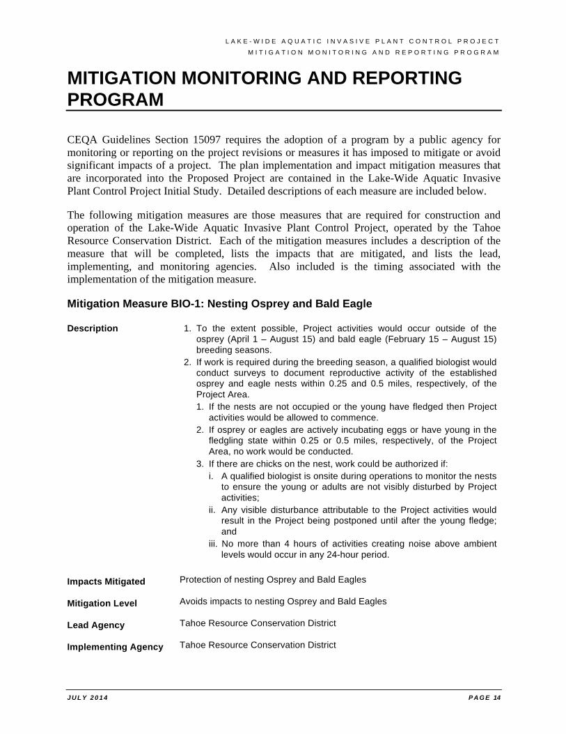
Mitigation Measure BIO-1: Nesting Osprey and Bald Eagle
Description 1. To the extent possible, Project activities would occur outside of the osprey (April 1 – August 15) and bald eagle (February 15 – August 15) breeding seasons.
2. If work is required during the breeding season, a qualified biologist would conduct surveys to document reproductive activity of the established osprey and eagle nests within 0.25 and 0.5 miles, respectively, of the Project Area. 1. If the nests are not occupied or the young have fledged then Project
activities would be allowed to commence. 2. If osprey or eagles are actively incubating eggs or have young in the
fledgling state within 0.25 or 0.5 miles, respectively, of the Project Area, no work would be conducted.
3. If there are chicks on the nest, work could be authorized if: i. A qualified biologist is onsite during operations to monitor the nests
to ensure the young or adults are not visibly disturbed by Project activities;
ii. Any visible disturbance attributable to the Project activities would result in the Project being postponed until after the young fledge; and
iii. No more than 4 hours of activities creating noise above ambient levels would occur in any 24-hour period.
Impacts Mitigated Protection of nesting Osprey and Bald Eagles
Mitigation Level Avoids impacts to nesting Osprey and Bald Eagles
Lead Agency Tahoe Resource Conservation District
Implementing Agency Tahoe Resource Conservation District
L A K E - W I D E A Q U A T I C I N V A S I V E P L A N T C O N T R O L P R O J E C T
M I T I G A T I O N M O N I T O R I N G A N D R E P O R T I N G P R O G R A M
J U L Y 2 0 1 4 P A G E 15
Monitoring Agency Tahoe Resource Conservation District
Timing Start: Project activities that would occur outside of the osprey (April 1 – August 15) and bald eagle (February 15 – August 15) breeding seasons
Complete: On-going
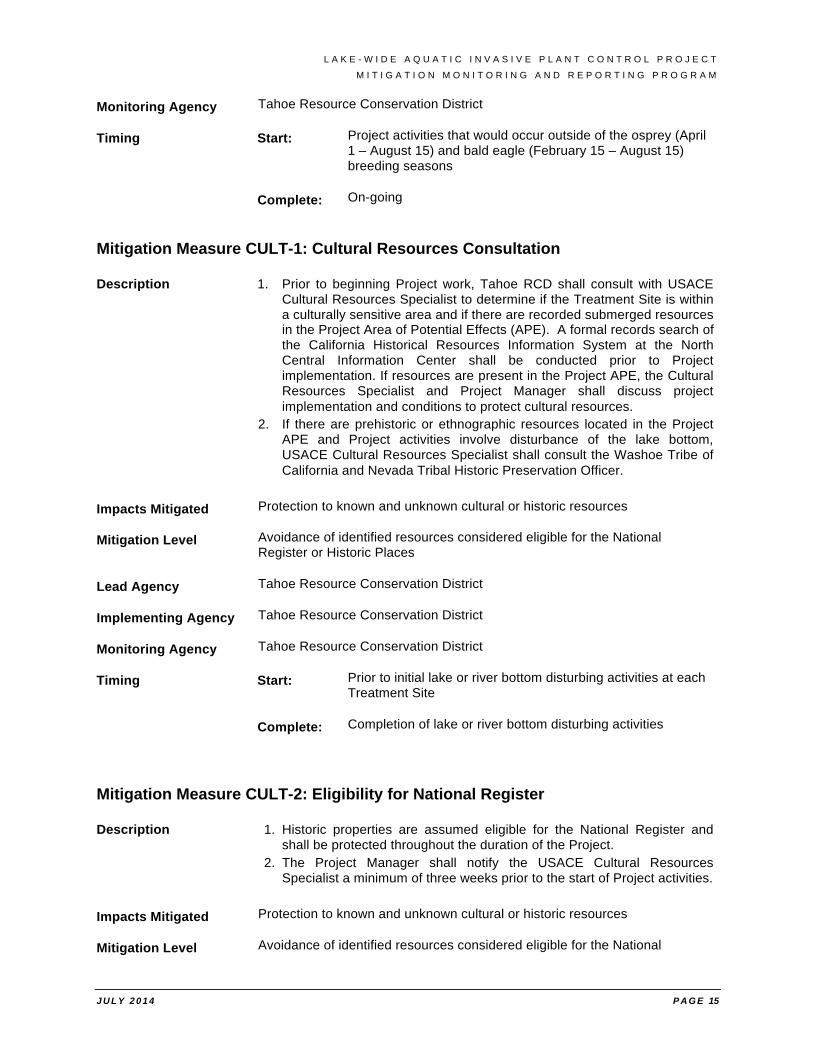
Mitigation Measure CULT-1: Cultural Resources Consultation
Description 1. Prior to beginning Project work, Tahoe RCD shall consult with USACE Cultural Resources Specialist to determine if the Treatment Site is within a culturally sensitive area and if there are recorded submerged resources in the Project Area of Potential Effects (APE). A formal records search of the California Historical Resources Information System at the North Central Information Center shall be conducted prior to Project implementation. If resources are present in the Project APE, the Cultural Resources Specialist and Project Manager shall discuss project implementation and conditions to protect cultural resources.
2. If there are prehistoric or ethnographic resources located in the Project APE and Project activities involve disturbance of the lake bottom, USACE Cultural Resources Specialist shall consult the Washoe Tribe of California and Nevada Tribal Historic Preservation Officer.
Impacts Mitigated Protection to known and unknown cultural or historic resources
Mitigation Level Avoidance of identified resources considered eligible for the National Register or Historic Places
Lead Agency Tahoe Resource Conservation District
Implementing Agency Tahoe Resource Conservation District
Monitoring Agency Tahoe Resource Conservation District
Timing Start: Prior to initial lake or river bottom disturbing activities at each Treatment Site
Complete: Completion of lake or river bottom disturbing activities
Mitigation Measure CULT-2: Eligibility for National Register
Description 1. Historic properties are assumed eligible for the National Register and shall be protected throughout the duration of the Project.
2. The Project Manager shall notify the USACE Cultural Resources Specialist a minimum of three weeks prior to the start of Project activities.
Impacts Mitigated Protection to known and unknown cultural or historic resources
Mitigation Level Avoidance of identified resources considered eligible for the National
L A K E - W I D E A Q U A T I C I N V A S I V E P L A N T C O N T R O L P R O J E C T
M I T I G A T I O N M O N I T O R I N G A N D R E P O R T I N G P R O G R A M
J U L Y 2 0 1 4 P A G E 16
Register or Historic Places
Lead Agency Tahoe Resource Conservation District
Implementing Agency Tahoe Resource Conservation District
Monitoring Agency Tahoe Resource Conservation District
Timing Start: Prior to lake or river bottom disturbing activities
Complete: Completion of lake or river bottom disturbing activities
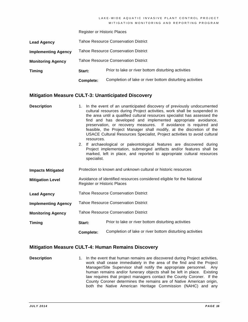
Mitigation Measure CULT-3: Unanticipated Discovery
Description 1. In the event of an unanticipated discovery of previously undocumented cultural resources during Project activities, work shall be suspended in the area until a qualified cultural resources specialist has assessed the find and has developed and implemented appropriate avoidance, preservation, or recovery measures. If avoidance is required and feasible, the Project Manager shall modify, at the discretion of the USACE Cultural Resources Specialist, Project activities to avoid cultural resources.
2. If archaeological or paleontological features are discovered during Project implementation, submerged artifacts and/or features shall be marked, left in place, and reported to appropriate cultural resources specialist.
Impacts Mitigated Protection to known and unknown cultural or historic resources
Mitigation Level Avoidance of identified resources considered eligible for the National Register or Historic Places
Lead Agency Tahoe Resource Conservation District
Implementing Agency Tahoe Resource Conservation District
Monitoring Agency Tahoe Resource Conservation District
Timing Start: Prior to lake or river bottom disturbing activities
Complete: Completion of lake or river bottom disturbing activities
Mitigation Measure CULT-4: Human Remains Discovery
Description 1. In the event that human remains are discovered during Project activities, work shall cease immediately in the area of the find and the Project Manager/Site Supervisor shall notify the appropriate personnel. Any human remains and/or funerary objects shall be left in place. Existing law requires that project managers contact the County Coroner. If the County Coroner determines the remains are of Native American origin, both the Native American Heritage Commission (NAHC) and any
L A K E - W I D E A Q U A T I C I N V A S I V E P L A N T C O N T R O L P R O J E C T
M I T I G A T I O N M O N I T O R I N G A N D R E P O R T I N G P R O G R A M
J U L Y 2 0 1 4 P A G E 17
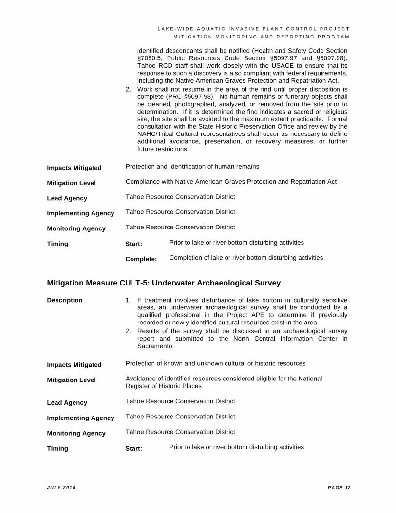
identified descendants shall be notified (Health and Safety Code Section §7050.5, Public Resources Code Section §5097.97 and §5097.98). Tahoe RCD staff shall work closely with the USACE to ensure that its response to such a discovery is also compliant with federal requirements, including the Native American Graves Protection and Repatriation Act.
2. Work shall not resume in the area of the find until proper disposition is complete (PRC §5097.98). No human remains or funerary objects shall be cleaned, photographed, analyzed, or removed from the site prior to determination. If it is determined the find indicates a sacred or religious site, the site shall be avoided to the maximum extent practicable. Formal consultation with the State Historic Preservation Office and review by the NAHC/Tribal Cultural representatives shall occur as necessary to define additional avoidance, preservation, or recovery measures, or further future restrictions.
Impacts Mitigated Protection and Identification of human remains
Mitigation Level Compliance with Native American Graves Protection and Repatriation Act
Lead Agency Tahoe Resource Conservation District
Implementing Agency Tahoe Resource Conservation District
Monitoring Agency Tahoe Resource Conservation District
Timing Start: Prior to lake or river bottom disturbing activities
Complete: Completion of lake or river bottom disturbing activities
Mitigation Measure CULT-5: Underwater Archaeological Survey
Description 1. If treatment involves disturbance of lake bottom in culturally sensitive areas, an underwater archaeological survey shall be conducted by a qualified professional in the Project APE to determine if previously recorded or newly identified cultural resources exist in the area.
2. Results of the survey shall be discussed in an archaeological survey report and submitted to the North Central Information Center in Sacramento.
Impacts Mitigated Protection of known and unknown cultural or historic resources
Mitigation Level Avoidance of identified resources considered eligible for the National Register of Historic Places
Lead Agency Tahoe Resource Conservation District
Implementing Agency Tahoe Resource Conservation District
Monitoring Agency Tahoe Resource Conservation District
Timing Start: Prior to lake or river bottom disturbing activities
L A K E - W I D E A Q U A T I C I N V A S I V E P L A N T C O N T R O L P R O J E C T
M I T I G A T I O N M O N I T O R I N G A N D R E P O R T I N G P R O G R A M
J U L Y 2 0 1 4 P A G E 18
Complete: Completion of lake or river bottom disturbing activities
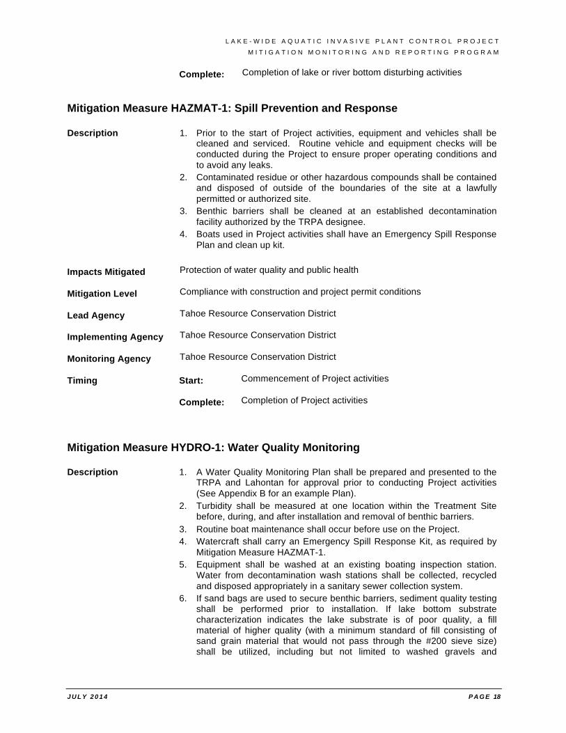
Mitigation Measure HAZMAT-1: Spill Prevention and Response
Description 1. Prior to the start of Project activities, equipment and vehicles shall be cleaned and serviced. Routine vehicle and equipment checks will be conducted during the Project to ensure proper operating conditions and to avoid any leaks.
2. Contaminated residue or other hazardous compounds shall be contained and disposed of outside of the boundaries of the site at a lawfully permitted or authorized site.
3. Benthic barriers shall be cleaned at an established decontamination facility authorized by the TRPA designee.
4. Boats used in Project activities shall have an Emergency Spill Response Plan and clean up kit.
Impacts Mitigated Protection of water quality and public health
Mitigation Level Compliance with construction and project permit conditions
Lead Agency Tahoe Resource Conservation District
Implementing Agency Tahoe Resource Conservation District
Monitoring Agency Tahoe Resource Conservation District
Timing Start: Commencement of Project activities
Complete: Completion of Project activities
Mitigation Measure HYDRO-1: Water Quality Monitoring
Description 1. A Water Quality Monitoring Plan shall be prepared and presented to the TRPA and Lahontan for approval prior to conducting Project activities (See Appendix B for an example Plan).
2. Turbidity shall be measured at one location within the Treatment Site before, during, and after installation and removal of benthic barriers.
3. Routine boat maintenance shall occur before use on the Project. 4. Watercraft shall carry an Emergency Spill Response Kit, as required by
Mitigation Measure HAZMAT-1. 5. Equipment shall be washed at an existing boating inspection station.
Water from decontamination wash stations shall be collected, recycled and disposed appropriately in a sanitary sewer collection system.
6. If sand bags are used to secure benthic barriers, sediment quality testing shall be performed prior to installation. If lake bottom substrate characterization indicates the lake substrate is of poor quality, a fill material of higher quality (with a minimum standard of fill consisting of sand grain material that would not pass through the #200 sieve size) shall be utilized, including but not limited to washed gravels and
L A K E - W I D E A Q U A T I C I N V A S I V E P L A N T C O N T R O L P R O J E C T
M I T I G A T I O N M O N I T O R I N G A N D R E P O R T I N G P R O G R A M
J U L Y 2 0 1 4 P A G E 19
obtaining clean sand from a compatible near-site location. Biodegradable bags shall be used when recovery upon project completion is not possible.
7. The HACPP shall include a decontamination site as a control point at which control measures shall be implemented to further prevent the spread of AIS. Control measures shall include effective decontamination of equipment and clothing associated with hand pulling removal activities.
8. If turbidity levels exceed permit compliance (> 3 NTU), Project activity stops until compliant turbidity levels return.
9. Underwater invasive plant control activities in Lake Tahoe require permits from the USACE, Lahontan, TRPA, CSLC, NDSL, NDEP and the CDFW. These permits require monitoring and protective measures to ensure that project activities do not result in significant impacts to water quality. Project activities shall not commence until required permits are attained.
10. Water intake(s) within 25 feet of Treatment Sites shall be turned off during removal of the benthic barriers and shall not be turned back on until water quality returns to background levels.
11. If utilities are identified during pre-project sub-surface utility location evaluations, then a Utility Avoidance Plan shall be developed and implemented.
Impacts Mitigated Protection of water quality
Mitigation Level Compliance with permitted discharge standards
Lead Agency Tahoe Resource Conservation District
Implementing Agency Tahoe Resource Conservation District
Monitoring Agency Tahoe Resource Conservation District
Timing Start: Prior to lake or river bottom disturbing activities
Complete: Completion of lake or river bottom disturbing activities
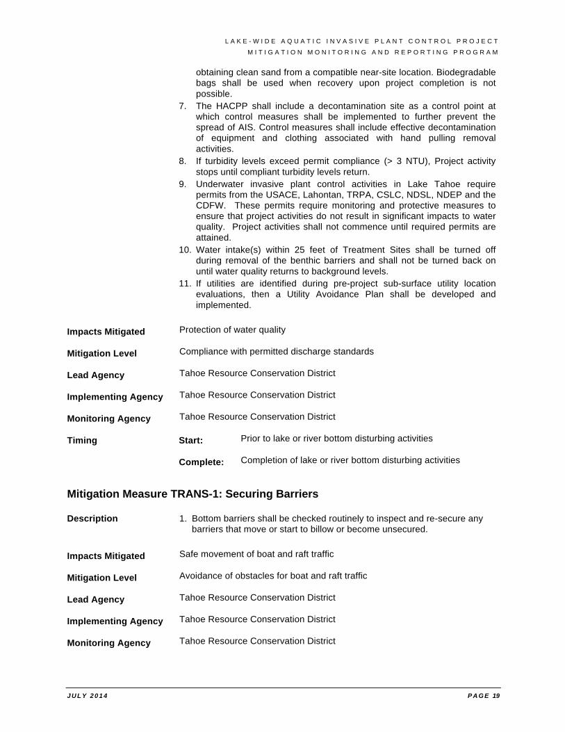
Mitigation Measure TRANS-1: Securing Barriers
Description 1. Bottom barriers shall be checked routinely to inspect and re-secure any barriers that move or start to billow or become unsecured.
Impacts Mitigated Safe movement of boat and raft traffic
Mitigation Level Avoidance of obstacles for boat and raft traffic
Lead Agency Tahoe Resource Conservation District
Implementing Agency Tahoe Resource Conservation District
Monitoring Agency Tahoe Resource Conservation District

L A K E - W I D E A Q U A T I C I N V A S I V E P L A N T C O N T R O L P R O J E C T
M I T I G A T I O N M O N I T O R I N G A N D R E P O R T I N G P R O G R A M
J U L Y 2 0 1 4 P A G E 20
Timing Start: Prior to lake or river bottom disturbing activities
Complete: Completion of lake or river bottom disturbing activities

L A K E - W I D E A Q U A T I C I N V A S I V E P L A N T C O N T R O L P R O J E C T
A T T A C H M E N T S
ATTACHMENT A
Comments Received on the Draft Initial Study

L A K E - W I D E A Q U A T I C I N V A S I V E P L A N T C O N T R O L P R O J E C T
A T T A C H M E N T S
ATTACHMENT B
Correspondence Regarding 2011 Aquatic Invasive Species Control Project
LAKE-WIDE AQUATIC INVASIVE PLANT CONTROL PROJECT
LAKE TAHOE, CALIFORNIA AND NEVADA
Initial Study / Mitigated Negative Declaration
Prepared for: Tahoe Resource Conservation District
Prepared by:
Hauge Brueck Associates, LLC
April 2014

L A K E - W I D E A Q U A T I C I N V A S I V E P L A N T C O N T R O L P R O J E C T

7 / 2 4 / 1 4 P AG E T O C - 1
TABLE OF CONTENTS
LAKE-WIDE AQUATIC INVASIVE PLANT CONTROL PROJECT IN LAKE TAHOE, CALIFORNIA AND NEVADA ............................................................................................................................................................ COVER PAGE TABLE OF CONTENTS................................................................................................................................................ TOC-1 ACRONYMS ................................................................................................................................................................... TOC-5 MITIGATED NEGATIVE DECLARATION ............................................................................................................. MND-1 SECTION 1 INTRODUCTION ...................................................................................................................................... 1-1
1.1 BACKGROUND ........................................................................................................................................................................... 1-1 1.1.1 Aquatic Invasive Species ................................................................................................................................................... 1-1 1.1.2 Aquatic Invasive Plant Control in Lake Tahoe and the Truckee River ........................................................ 1-2
1.2 PURPOSE AND NEED ............................................................................................................................................................... 1-5 1.3 LEAD AGENCIES ....................................................................................................................................................................... 1-5
1.3.1 U.S. Army Corps of Engineers .......................................................................................................................................... 1-5 1.3.2 Tahoe Resource Conservation District ....................................................................................................................... 1-5 1.3.3 Tahoe Regional Planning Agency ................................................................................................................................. 1-5
1.4 LEGAL AUTHORITY .................................................................................................................................................................. 1-6 1.4.1 CEQA ........................................................................................................................................................................................... 1-6 1.4.2 TRPA ........................................................................................................................................................................................... 1-7 1.4.3 NEPA ........................................................................................................................................................................................... 1-7
1.5 OTHER PERMITTING AGENCIES ............................................................................................................................................ 1-8 1.5.1 U.S. Fish and Wildlife Service .......................................................................................................................................... 1-8 1.5.2 Advisory Council on Historic Preservation ............................................................................................................... 1-8 1.5.3 California Department of Fish and Wildlife ............................................................................................................. 1-8 1.5.4 California Department of Parks and Recreation ................................................................................................... 1-8 1.5.5 Regional Water Quality Control Board – Lahontan ............................................................................................. 1-9
1.6 OTHER REVIEWING AGENCIES .......................................................................................................................................... 1-10 1.6.1 U.S. Forest Service – Lake Tahoe Basin Management Unit ........................................................................... 1-10 1.6.2 Natural Resource Conservation Service ................................................................................................................ 1-10 1.6.3 California State Lands Commission ............................................................................................................................ 1-9 1.6.4 Nevada Department of Agriculture and Nevada Department of Wildlife ............................................. 1-10 1.6.5 Nevada Division of State Lands ................................................................................................................................. 1-10 1.6.6 Nevada Division of Environmental Protection – Bureau of Safe Drinking Water ............................. 1-10
1.7 PUBLIC REVIEW PROCESS ................................................................................................................................................... 1-10 SECTION 2 PROJECT DESCRIPTION ........................................................................................................................ 2-1
2.1 PURPOSE AND OBJECTIVES .................................................................................................................................................... 2-1 2.2 PROJECT LOCATION ................................................................................................................................................................. 2-1
2.2.1 Project Area ............................................................................................................................................................................ 2-2 2.2.2 Treatment Sites ..................................................................................................................................................................... 2-2 2.2.3 Staging and Access Locations ......................................................................................................................................... 2-4
2.3 NO ACTION ALTERNATIVE ..................................................................................................................................................... 2-4 2.4 PROPOSED PROJECT ALTERNATIVE ..................................................................................................................................... 2-4
2.4.1 Treatment Methods ............................................................................................................................................................. 2-4 2.4.2 Disposal of Plant Biomass ................................................................................................................................................ 2-8 2.4.3 Monitoring and Evaluation ............................................................................................................................................. 2-8 2.4.4 Proposed Implementation Schedule ........................................................................................................................ 2-10
7 / 2 4 / 1 4 P AG E T O C - 2
SECTION 3 ENVIRONMENTAL ANALYSIS .............................................................................................................. 3-1 3.1 CUMULATIVE PROJECTS CONSIDERED ............................................................................................................................. 3-1
3.1.1 Past Projects ........................................................................................................................................................................... 3-1 3.1.2 Present and Reasonably Foreseeable Projects ........................................................................................................ 3-2
3.2 AESTHETICS ........................................................................................................................................................................... 3-3 3.2.1 Environmental Setting ...................................................................................................................................................... 3-3 3.3.2 Environmental Impacts of the No Action Alternative ......................................................................................... 3-4 3.3.3 Environmental Impacts of the Proposed Project Alternative .......................................................................... 3-4 3.2.4 Environmental Commitments and Mitigation Measures .................................................................................... 3-5
3.3 AGRICULTURAL AND FOREST RESOURCES ............................................................................................................. 3-6 3.3.1 Environmental Setting ...................................................................................................................................................... 3-6 3.3.2 Environmental Impacts of the No Action Alternative ......................................................................................... 3-6 3.3.3 Environmental Impacts of the Proposed Project Alternative .......................................................................... 3-6 3.3.4 Environmental Commitments and Mitigation Measures .................................................................................... 3-7
3.4 AIR QUALITY ........................................................................................................................................................................ 3-8 3.4.1 Environmental Setting ....................................................................................................................................................... 3-8 3.4.2 Environmental Impacts of the No Action Alternative ...................................................................................... 3-10 3.4.3 Environmental Impacts of the Proposed Action Alternative......................................................................... 3-10 3.4.4 Environmental Commitments and Mitigation Measures ............................................................................... 3-11
3.5 BIOLOGICAL RESOURCES ..................................................................................................................................................... 3-12 3.5.1 Environmental Setting .................................................................................................................................................... 3-12 3.5.2 Environmental Impacts of the No Action Alternative ...................................................................................... 3-20 3.5.3 Environmental Impacts of the Proposed Action Alternative......................................................................... 3-21 3.5.4 Environmental Commitments and Mitigation Measures ................................................................................ 3-24
3.6 CULTURAL RESOURCES, AREAS OF CRITICAL ENVIRONMENTAL CONCERN (ACEC) AND NATIVE AMERICAN 3-CULTURAL VALUES .......................................................................................................................................................................... 3-25
3.6.1 Environmental Setting ................................................................................................................................................... 3-25 3.6.2 Environmental Impacts of the No Action Alternative ...................................................................................... 3-29 3.6.3 Environmental Impacts of the Proposed Action Alternative......................................................................... 3-29 3.6.4 Environmental Commitments and Mitigation Measures ................................................................................ 3-30
3.7 GEOLOGY AND SOILS ..................................................................................................................................................... 3-32 3.7.1 Environmental Setting ................................................................................................................................................... 3-32 3.7.2 Environmental Impacts of the No Action Alternative ...................................................................................... 3-33 3.7.3 Environmental Impacts of the Proposed Action Alternative......................................................................... 3-34 3.7.4 Environmental Commitments and Mitigation Measures ............................................................................... 3-35
3.8 GREENHOUSE GAS EMISSIONS AND GLOBAL CLIMATE CHANGE ..................................................................... 3-36 3.8.1 Environmental Setting ................................................................................................................................................... 3-36 3.8.2 Environmental Impacts of the No Action Alternative ...................................................................................... 3-38 3.8.3 Environmental Impacts of the Proposed Alternative ....................................................................................... 3-38 3.4.4 Environmental Commitments and Mitigation Measures ............................................................................... 3-38
3.9 PUBLIC SAFETY, HAZARDS AND HAZARDOUS MATERIALS .................................................................................... 3-39 3.9.1 Environmental Setting .................................................................................................................................................... 3-39 3.9.2 Environmental Impacts of the No Action Alternative ...................................................................................... 3-39 3.9.3 Environmental Impacts of the Proposed Alternative ....................................................................................... 3-39 3.4.4 Environmental Commitments and Mitigation Measures ............................................................................... 3-41
3.10 HYDROLOGY AND WATER QUALITY ............................................................................................................................. 3-42 3.10.1 Environmental Setting ................................................................................................................................................. 3-42 3.10.2 Environmental Impacts of the No Action Alternative ................................................................................... 3-43 3.10.3 Environmental Impacts of the Proposed Alternative ..................................................................................... 3-44
7 / 2 4 / 1 4 P AG E T O C - 3
3.10.4 Environmental Commitments and Mitigation Measures ............................................................................. 3-46 3.11 LAND USE AND PLANNING ............................................................................................................................................ 3-47
3.11.1 Environmental Setting ................................................................................................................................................. 3-47 3.11.2 Environmental Impacts of the No Action Alternative ................................................................................... 3-47 3.11.3 Environmental Impacts of the Proposed Action Alternative ...................................................................... 3-47 3.11.4 Environmental Commitments and Mitigation Measures ............................................................................. 3-47
3.12 MINERAL RESOURCES ................................................................................................................................................ 3-48 3.12.1 Environmental Setting ................................................................................................................................................. 3-48 3.12.2 Environmental Impacts of the No Action Alternative ................................................................................... 3-48 3.12.3 Environmental Impacts of the Proposed Project Alternative .................................................................... 3-48 3.12.4 Environmental Commitments and Mitigation Measures ............................................................................. 3-48
3.13 NOISE .................................................................................................................................................................................. 3-49 3.13.1 Environmental Setting ................................................................................................................................................. 3-49 3.13.2 Environmental Impacts of the No Action Alternative ................................................................................... 3-50 3.13.3 Environmental Impacts of the Proposed Action Alternative ...................................................................... 3-50 3.13.4 Environmental Commitments and Mitigation Measures ............................................................................. 3-51
3.14 POPULATION AND HOUSING ................................................................................................................................... 3-52 3.14.1 Environmental Setting ................................................................................................................................................. 3-52 3.14.2 Environmental Impacts of the No Action Alternative ................................................................................... 3-52 3.14.3 Environmental Impacts of the Proposed Action Alternative ...................................................................... 3-52 3.14.4 Environmental Commitments and Mitigation Measures ............................................................................. 3-52
3.15 PUBLIC SERVICES ......................................................................................................................................................... 3-53 3.15.1 Environmental Setting ................................................................................................................................................. 3-53 3.15.2 Environmental Impacts of the No Action Alternative ................................................................................... 3-53 3.15.3 Environmental Impacts of the Proposed Action Alternative ...................................................................... 3-54 3.15.4 Environmental Commitments and Mitigation Measures ............................................................................. 3-54
3.16 RECREATION ..................................................................................................................................................................... 3-55 3.16.1 Environmental Setting ................................................................................................................................................. 3-55 3.16.2 Environmental Impacts of the No Action Alternative ................................................................................... 3-55 3.16.3 Environmental Impacts of the Proposed Action Alternative ...................................................................... 3-55 3.16.4 Environmental Commitments and Mitigation Measures ............................................................................. 3-56
3.17 TRANSPORTATION AND TRAFFIC .......................................................................................................................... 3-57 3.17.1 Environmental Setting ................................................................................................................................................. 3-57 3.17.2 Environmental Impacts of the No Action Alternative ................................................................................... 3-57 3.17.3 Environmental Impacts of the Proposed Project Alternative .................................................................... 3-58 3.17.4 Environmental Commitments and Mitigation Measures ............................................................................. 3-59
3.18 UTILITIES AND SERVICE SYSTEMS ....................................................................................................................... 3-60 3.18.1 Environmental Setting ................................................................................................................................................. 3-60 3.18.2 Environmental Impacts of the No Action Alternative ................................................................................... 3-60 3.18.3 Environmental Impacts of the Proposed Project Alternative .................................................................... 3-60 3.18.4 Environmental Commitments and Mitigation Measures ............................................................................. 3-61
3.19 MANDATORY FINDINGS OF SIGNIFICANCE ................................................................................................................ 3-62 SECTION 4 ENVIRONMENTAL COMMITMENTS/MITIGATION MEASURES AND MONITORING REPORTING ...................................................................................................................................................................... 4-1 SECTION 5 LIST OF PREPARERS .............................................................................................................................. 5-1 SECTION 6 REFERENCES ............................................................................................................................................ 6-1
7 / 2 4 / 1 4 P AG E T O C - 4
Appendices
Appendix A. CEQA Checklist
Appendix B. Water Quality Monitoring Plan Template
Appendix C. Hazard Assessment and Critical Control Point (HACCP) Example
Appendix D. Cultural Resources Report
Appendix E. Biological Database Searches– California Native Plant Society, California Natural Diversity Database and United States Fish and Wildlife Service
List of Tables
Table 2-1. Known Aquatic Plant Infestations and Treatments
Table 2-2. Typical Calendar Year for Annual Aquatic Invasive Plant Treatment Efforts
Table 2-3. Approximate Number of Diver-hours Required for Treatment by Relative Plant Densities
Table 3.4-1. Air Quality Standards – 2006 Lake Tahoe Air Basin Air Quality Designations
Table 3.5-1. Special-Status Plant Species
Table 3.5-2. Special Status Animal Species
Table 3.6-1. Identified Cultural Resources in the Project Study Areas
Table 3.13-1. Sound Levels Generated by Various Sources of Noise
Table 3.17-1. Level of Service Ratings
Table 4-1. Mitigation, Monitoring and Reporting Program for Proposed Project Alternative
List of Figures
Figure 1-1. Emerald Bay Eurasian Watermilfoil Density Fall 2012
Figure 2-1. Project Area: Potential Habitat for Submerged Aquatic Plants
Figure 2-2. Potential Aquatic Invasive Plant Treatment Sites
Figure 3-1. Culturally Sensitive Areas
7 / 2 4 / 1 4 P AG E T O C - 5
ACRONYMS
ABT Actual Bottom time ACHP Advisory Council on Historic Preservation AIS Aquatic Invasive Species (Plant Species) AISCC Tahoe Aquatic Invasive Species Coordination Committee Basin Plan Water Quality Control Plan – Lahontan Region BWQP Bureau of Water Quality Protection (NDEP) CA California CAA Clean Air Act of 1970 CAISMP California Aquatic Invasive Species Management Plan CalFire California Department of Forestry and Fire Protection Caltrans California Department of Transportation CARB California Air Resources Board CCAA California Clean Air Act of 1988 CCR California Code of Regulations CDFA California Department of Food and Agriculture CDFW California Department of Fish and Wildlife CDOC California Department of Conservation CDPR California Department of Parks and Recreation CDTSC California Department of Toxic Substance Control CEQA California Environmental Quality Act CESA California Endangered Species Act CFC’s Chlorofluorocarbons CGS California Geological Survey CH4 Methane CLP Curlyleaf Pondweed CNDDB California Natural Diversity Database (CDFW) CNEL Community Noise Equivalent Level CNPS California Native Plant Society CO Carbon Monoxide CO2 Carbon Dioxide COLD Cold Freshwater Habitat CRHR California Register of Historic Resources CSLC California State Land Commission CSLT City of South Lake Tahoe CSLC California State Land Commission CTC California Tahoe Conservancy CWA Clean Water Act dB Decibels dBA Noise Measurement Expressed in Weighting Frequencies DIN Dissolved Inorganic Nitrogen DTSC Department of Toxic Substance Control EA Environmental Assessment EDCAQMD El Dorado County Air Quality Management District
7 / 2 4 / 1 4 P AG E T O C - 6
EIP Environmental Improvement Program EIR Environmental Impact Report EIS Environmental Impact Statement ESA Endangered Species Act EWM Eurasian Watermillfoil GHG Greenhouse Gas GWP Global Warming Potential HACCP Hazard Assessment and Critical Control Point HCFC’s Hydrofluorocarbons IEC Initial Environmental Checklist IPCC Intergovernmental Panel on Climate Change IS Initial Study Leq Equivalent Sound Level Lahontan Lahontan Regional Water Quality Control Board LCT Lahontan Cuttroat Trout LTD Lake Tahoe Datum LOS Level of Service LTAISCC Lake Tahoe Aquatic Invasive Species Coordination Committee LTAISWG Lake Tahoe Aquatic Invasive Species Working Group LTBMU Lake Tahoe Basin Management Unit MBTA Migratory Bird Treaty Act MMT million metric tons MND Mitigated Negative Declaration MUN Municipal NAAQS National Ambient Air Quality Standards NAHC Native American Heritage Commission NAWWG Nearshore Aquatic Weed Working Group N2O Nitrous Oxide NCCP Natural Community Conservation Plan NDA Nevada Department of Agriculture NDEP Nevada Department of Environmental Protection NDOW Nevada Department of Wildlife NDSL Nevada Division of State Lands NEPA National Environmental Protection Act NITC NRCS National Information Technology Center NHPA National Historic Preservation Act NPDES National Pollutant Discharge Elimination System NOx Nitrogen Oxide NOAA National Oceanic Atmosphere Administration NOC Notice of Completion NOD Notice of Determination NOI Notice of Intent NOT Notice of Termination NRCS Natural Resource Conservation Service NRHP National Register of Historic Places NTRT Nevada Tahoe Resource Team
7 / 2 4 / 1 4 P AG E T O C - 7
NTU Nephelometric Turbidity Units O3 Ozone OHP Office of Historic Resources Pb Lead PM10 Particulate Matter with an aerodynamic diameter of 10 Microns or less PM 2.5 Particulate Matter with an aerodynamic diameter of 2.5 Microns or less PRC Public Resources Code Project Lake-wide Aquatic Invasive Plant Control Project SCH State Clearinghouse SCUBA Self Contained Underwater Breathing Apparatus SEZ’s Stream Environment Zones SHPO State Historic Preservation Officer SNPLMA Southern Nevada Public Lands Management Act SO2 Sulfur Dioxide State Board California State Water Resources Control Board SWPPP Stormwater Pollution Prevention Plan TART Tahoe Area Regional Transit Tahoe RCD Tahoe Resource Conservation District TERC Tahoe Environmental Research Center TIIMS Tahoe Integrated Information Management System TKPOA Tahoe Keys Property Owners Association TRPA Tahoe Regional Planning Agency TSC Tahoe Science Consortium TYC Tahoe Yellow Cress UNR University of Nevada Reno US United States USACE United States Army Corps of Engineers USDOI United States Department of Interior USFS United Stated Department of Agriculture – Forest Service USEPA United States Environmental Protection Agency USFWS United States Fish and Wildlife Service USGS United States Geological Service VRP’s Visibility Reducing Particles

7 / 2 4 / 1 4 P AG E T O C - 8
L A K E - W I D E A Q U A T I C I N V A S I V E P L A N T C O N T R O L P R O J E C T
7 / 2 4 / 1 4 P AG E M N D -1
MITIGATED NEGATIVE DECLARATION
DRAFT NEGATIVE DECLARATION
PROJECT Lake-Wide Aquatic Invasive Plant Control Project
LEAD AGENCY Tahoe Resource Conservation District
PROJECT DESCRIPTION
This combined Initial Study and Mitigated Negative Declaration (IS/MND) evaluates the environmental effects of the proposed Lake-Wide Invasive Aquatic Plant Control Project (Project). The Tahoe Resource Conservation District (Tahoe RCD), on behalf of the Tahoe Aquatic Invasive Species Coordination Committee (AISCC), is proposing to conduct aquatic plant control and management throughout suitable habitat areas in Lake Tahoe, California and Nevada and the Truckee River between the dam at Lake Tahoe to River Ranch at Alpine Meadows Road. The Project intends to continue aquatic invasive plant control efforts in locations where previous efforts have been successful, expand control efforts to include known infestation areas, and to allow for rapid response to detections of new aquatic plant infestations.
Consistent with the Lake Tahoe Region Aquatic Invasive Species Management Plan, the annual objectives of the Project include:
1. To prevent the spread of existing invasive plants;
2. To ensure early detection of new invasive plant infestations; and
3. To monitor existing invasive plant populations.
Treatment actions will utilize the most effective methods at high-priority Treatment Sites and will include maintenance activities at sites that have been treated previously.
FINDINGS
An IS/MND has been prepared to assess the Project’s potential effects on the environment and the significance of those effects. Based on the IS/MND, it has been determined that the proposed Project would not have any significant effects on the environment after implementation of mitigation measures. This conclusion is supported by the following findings:
1. The proposed Project would have no effects related to mineral resources.
2. The proposed Project would have a less-than-significant impact on agricultural and forest resources, air quality, geology and soils, hazards and hazardous materials, hydrology and water quality, land use and planning, greenhouse gas emissions, noise, population and housing, recreation, and utilities and service systems.
3. Mitigation is required to reduce potentially significant impacts related to biological resources, cultural resources, water quality, public safety, transportation and recreation.
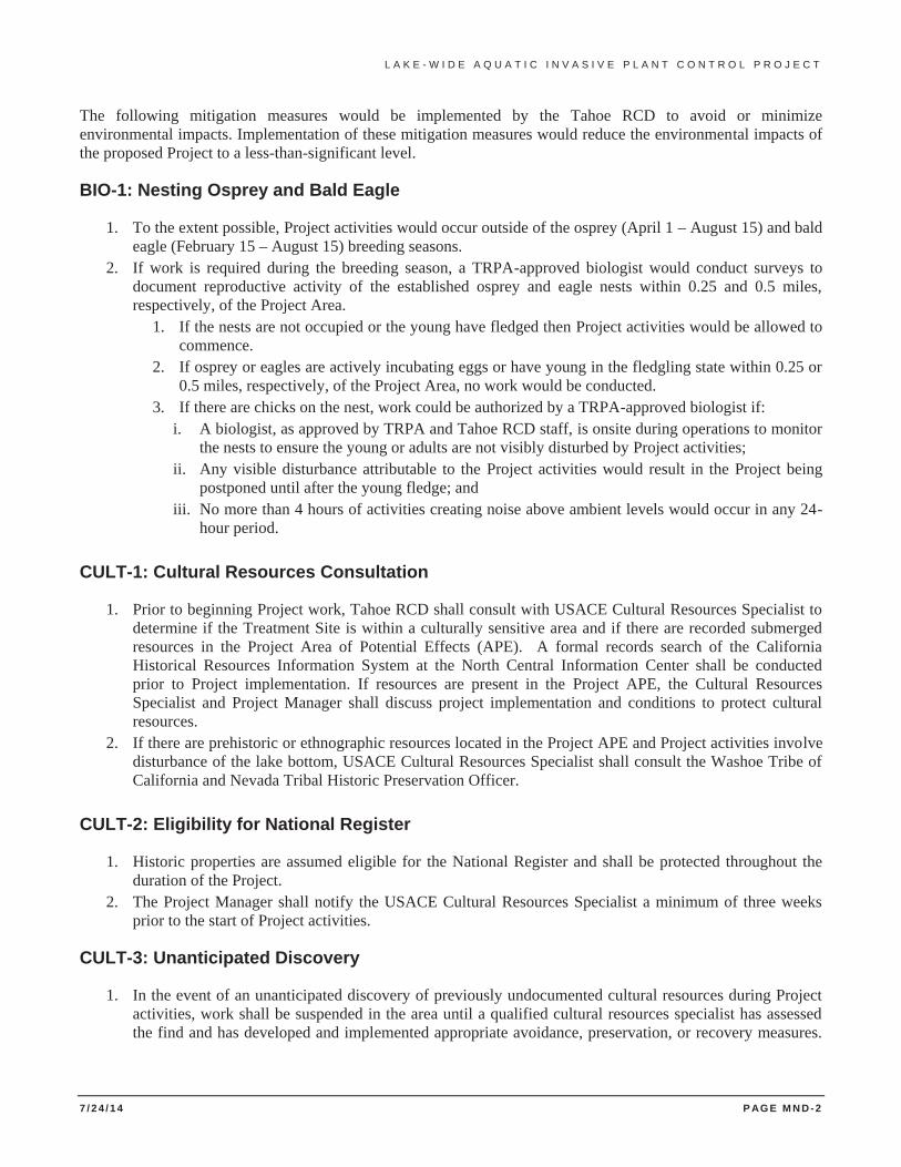
L A K E - W I D E A Q U A T I C I N V A S I V E P L A N T C O N T R O L P R O J E C T
7 / 2 4 / 1 4 P AG E M N D -2
The following mitigation measures would be implemented by the Tahoe RCD to avoid or minimize environmental impacts. Implementation of these mitigation measures would reduce the environmental impacts of the proposed Project to a less-than-significant level.
BIO-1: Nesting Osprey and Bald Eagle
1. To the extent possible, Project activities would occur outside of the osprey (April 1 – August 15) and bald eagle (February 15 – August 15) breeding seasons.
2. If work is required during the breeding season, a TRPA-approved biologist would conduct surveys to document reproductive activity of the established osprey and eagle nests within 0.25 and 0.5 miles, respectively, of the Project Area.
1. If the nests are not occupied or the young have fledged then Project activities would be allowed to commence.
2. If osprey or eagles are actively incubating eggs or have young in the fledgling state within 0.25 or 0.5 miles, respectively, of the Project Area, no work would be conducted.
3. If there are chicks on the nest, work could be authorized by a TRPA-approved biologist if: i. A biologist, as approved by TRPA and Tahoe RCD staff, is onsite during operations to monitor
the nests to ensure the young or adults are not visibly disturbed by Project activities; ii. Any visible disturbance attributable to the Project activities would result in the Project being
postponed until after the young fledge; and iii. No more than 4 hours of activities creating noise above ambient levels would occur in any 24-
hour period.
CULT-1: Cultural Resources Consultation
1. Prior to beginning Project work, Tahoe RCD shall consult with USACE Cultural Resources Specialist to determine if the Treatment Site is within a culturally sensitive area and if there are recorded submerged resources in the Project Area of Potential Effects (APE). A formal records search of the California Historical Resources Information System at the North Central Information Center shall be conducted prior to Project implementation. If resources are present in the Project APE, the Cultural Resources Specialist and Project Manager shall discuss project implementation and conditions to protect cultural resources.
2. If there are prehistoric or ethnographic resources located in the Project APE and Project activities involve disturbance of the lake bottom, USACE Cultural Resources Specialist shall consult the Washoe Tribe of California and Nevada Tribal Historic Preservation Officer.
CULT-2: Eligibility for National Register
1. Historic properties are assumed eligible for the National Register and shall be protected throughout the duration of the Project.
2. The Project Manager shall notify the USACE Cultural Resources Specialist a minimum of three weeks prior to the start of Project activities.
CULT-3: Unanticipated Discovery
1. In the event of an unanticipated discovery of previously undocumented cultural resources during Project activities, work shall be suspended in the area until a qualified cultural resources specialist has assessed the find and has developed and implemented appropriate avoidance, preservation, or recovery measures.
L A K E - W I D E A Q U A T I C I N V A S I V E P L A N T C O N T R O L P R O J E C T
7 / 2 4 / 1 4 P AG E M N D -3
If avoidance is required and feasible, the Project Manager shall modify, at the discretion of the USACE Cultural Resources Specialist, Project activities to avoid cultural resources.
2. If archaeological or paleontological features are discovered during Project implementation, submerged artifacts and/or features shall be marked, left in place, and reported to appropriate cultural resources specialist.
CULT-4: Human Remains Discovery
1. In the event that human remains are discovered during Project activities, work shall cease immediately in the area of the find and the Project Manager/Site Supervisor shall notify the appropriate personnel. Any human remains and/or funerary objects shall be left in place. Existing law requires that project managers contact the County Coroner. If the County Coroner determines the remains are of Native American origin, both the Native American Heritage Commission (NAHC) and any identified descendants shall be notified (Health and Safety Code Section §7050.5, Public Resources Code Section §5097.97 and §5097.98). Tahoe RCD staff shall work closely with the USACE to ensure that its response to such a discovery is also compliant with federal requirements, including the Native American Graves Protection and Repatriation Act.
2. Work shall not resume in the area of the find until proper disposition is complete (PRC §5097.98). No human remains or funerary objects shall be cleaned, photographed, analyzed, or removed from the site prior to determination. If it is determined the find indicates a sacred or religious site, the site shall be avoided to the maximum extent practicable. Formal consultation with the State Historic Preservation Office and review by the NAHC/Tribal Cultural representatives shall occur as necessary to define additional avoidance, preservation, or recovery measures, or further future restrictions.
CULT-5: Underwater Archaeological Survey
1. If treatment involves disturbance of lake bottom in culturally sensitive areas, an underwater archaeological survey shall be conducted by a qualified professional in the Project APE to determine if previously recorded or newly identified cultural resources exist in the area.
2. Results of the survey shalll be discussed in an archaeological survey report and submitted to the North Central Information Center in Sacramento.
HAZMAT-1: Spill Prevention and Response
1. Prior to the start of Project activities, equipment and vehicles shall be cleaned and serviced. Routine vehicle and equipment checks will be conducted during the Project to ensure proper operating conditions and to avoid any leaks.
2. Contaminated residue or other hazardous compounds shall be contained and disposed of outside of the boundaries of the site at a lawfully permitted or authorized site.
3. Benthic barriers shall be cleaned at an established decontamination facility authorized by the TRPA designee.
4. Boats and barges used in Project activities shall have an Emergency Spill Response Plan and clean up kit.
HYDRO-1: Water Quality Monitoring
1. A Water Quality Monitoring Plan shall be prepared and presented to the TRPA and Lahontan for approval prior to conducting Project activities (See Appendix B for an example Plan).
2. Turbidity shall be measured at one location within the Treatment Site before, during, and after installation and removal of benthic barriers.
L A K E - W I D E A Q U A T I C I N V A S I V E P L A N T C O N T R O L P R O J E C T
7 / 2 4 / 1 4 P AG E M N D -4
3. Routine boat maintenance shall occur before use on the Project. 4. Watercraft shall carry an Emergency Spill Response Kit, as required by Mitigation Measure HAZMAT-1. 5. Equipment shall be washed at an existing boating inspection station. Water from decontamination wash
stations shall be collected, recycled and disposed appropriately in a sanitary sewer collection system. 6. If sand bags are used to secure benthic barriers, sediment quality testing shall be performed prior to
installation. 7. The HACPP shall include a decontamination site as a control point at which control measures shall be
implemented to further prevent the spread of AIS. 8. Turbidity curtains shall be utilized during diver-assisted suction removal activities to contain any
disturbance related turbidity. 9. Underwater invasive plant control activities in Lake Tahoe require permits from the USACE, Lahontan,
TRPA, CSLC, NDSL and the CDFW. These permits require monitoring and protective measures to ensure that Project activities do not result in significant impacts to water quality. Project activities shall not commence until required permits are attained.
10. Water intake(s) within 25 feet of Treatment Sites shall be turned off during removal of the benthic barriers and shall not be turned back on until water quality returns to background levels.
REC-1: Boating Access
1. Project activities shall be coordinated with tour boat operators in Lake Tahoe to determine the least disruptive days and hours to conduct work. Work will occur during these days and time periods to the extent possible.
2. The U. S. Coast Guard shall be contacted to coordinate dissemination of information and to potentially assist with boater compliance and diver safety.
3. Some Treatment Sites shall require traffic control for motorized boat traffic for up to 6 hours per day during barrier installation and barrier removal, and during some alternative treatment work. Non-motorized boats and escorted motorized boats may be allowed to pass through if the water level is high enough to allow passage and maintain the safety of the divers.
4. Public notices shall be used to inform the public of temporary boat traffic control. 5. Project activities shall be scheduled during the mornings and on weekdays to the extent possible. No boat
traffic control shall occur during the weekend, unless there is a need to re-secure a barrier. 6. A boat or raft shall be positioned to inform the public of Project activities and provide information on
when they can proceed when Treatment Sites are located in high use areas of the Project Area. 7. When appropriate, overnight boaters shall be informed of the temporary boat traffic control to allow
departure prior to the start of work. 8. To the extent possible and as dictated by water temperatures, installation and removal activities shall be
scheduled outside of the high recreation period between the Memorial Day and Labor Day weekends.
TRANS-1: Securing Barriers
1. Bottom barriers shall be checked routinely to inspect and re-secure any barriers that move or start to billow or become unsecured.

L A K E - W I D E A Q U A T I C I N V A S I V E P L A N T C O N T R O L P R O J E C T
7 / 2 4 / 1 4 P AG E M N D -6
L A K E - W I D E A Q U A T I C I N V A S I V E P L A N T C O N T R O L P R O J E C T
7 / 2 4 / 1 4 P AG E 1 - 1
SECTION 1 INTRODUCTION
The Tahoe Resource Conservation District (Tahoe RCD), on behalf of the Tahoe Aquatic Invasive Species Coordination Committee (AISCC), is proposing to conduct aquatic plant control and management throughout suitable habitat areas in Lake Tahoe, California and Nevada and the Truckee River between the dam at Lake Tahoe to River Ranch at Alpine Meadows Road. The Proposed Project Alternative (Project) described in this document is intended to continue aquatic invasive plant control efforts in locations where previous efforts have been successful, expand control efforts to include known infestation areas, and to allow for rapid response to detections of new aquatic plant infestations.
The AISCC is composed of a partnership between more than 40 public, private, and tribal stakeholders. In 2009, these partners worked collaboratively to develop the Lake Tahoe Aquatic Invasive Species Management Plan, which was then enacted by the Governors of California and Nevada and approved by the federal Aquatic Nuisance Species Task Force. This overarching management plan identifies current and reasonably foreseeable threats to the Tahoe Region, discusses control and eradication strategies and methodologies, and describes a management and planning structure for implementation of prevention, control, and early detection/rapid response actions.
The AISCC and the Nearshore Aquatic Weed Working Group (NAWWG) review project accomplishments and challenges on an annual basis to evaluate the aquatic invasive plant control program and to advise future control efforts. Historically, efforts to control aquatic plants in Lake Tahoe have been addressed as small scale, site-specific projects. Currently, a Lake-wide Aquatic Plant Control Plan is under development to guide and prioritize aquatic invasive plant control efforts throughout the Tahoe Region. The Lake-wide Aquatic Invasive Plant Control Plan will be consistent with the Management Plan and is necessary for planning site-specific implementation, identifying site-prioritization criteria, and guiding advisory groups and project proponents. The document is intended to guide the prioritization of site selection based on risk of spread, infestation size and location, public benefit, cost and feasibility and impacts to the environment. The document will also describe a variety of methods and techniques that could be deployed in combination both spatially and seasonally. Another component of the plan is to develop Oversight Strategies that provide suggested approaches for outside review of program actions and results.
1.1 BACKGROUND
1.1.1 Aquatic Invasive Species
There are many threats to the world famous clarity and water quality of Lake Tahoe, and only recently has attention turned to addressing the threat of invasive aquatic plants, particularly Eurasian watermilfoil (Myriophyllum spicatum) and more recently, curly-leaf pondweed (Potamogeton crispus). Habitat disruption, loss of native plant and animal communities, loss of property values, reduced fishing and water recreation opportunities, and large public/private expenditures have accompanied invasive plant introduction in the lower 48 states (USACE 2009). The occurrence of aquatic invasive plants has spread rapidly across the country with the help of boaters who unintentionally transport and spread plant fragments that adhere to boats and trailers.
Eurasian watermilfoil (EWM) and other aquatic invasive plants grow prolifically and aggressively, invading and altering native aquatic communities. Native aquatic plant communities provide many ecological benefits such as food and habitat for waterfowl, fish, and other aquatic organisms. They also help maintain water quality by absorbing nutrients, providing oxygen, and reducing shoreline erosion. However, when EWM is introduced it is able to dominate fresh water ecosystems quickly and can enhance its own habitat by trapping sediment in the water column and initiating a favorable environment for further establishment of other invasive species, such as
L A K E - W I D E A Q U A T I C I N V A S I V E P L A N T C O N T R O L P R O J E C T
7 / 2 4 / 1 4 P AG E 1 - 2
warm-water fish. EWM is capable of spreading over long distances when fragmented by boat propellers and by way of buds, surface runners, and seed (USACE 2009)
EWM plants are capable of growing from tiny fragments as small as one inch long. Equally aggressive, curly-leaf pondweed (CLP) spreads primarily by rhizomes and turions, which are small, hardened stem tips capable of rooting and germinating in the fall and winter. Both of these aggressive invaders also tolerate a wide range of environmental conditions including low light levels, high or low nutrient water, and freezing water temperatures.
EWM has been present in Lake Tahoe for over 10 years. During the 1997 flood event, EWM escaped from Lake Tahoe into the Truckee River and has now been documented downstream as far as Verdi, Nevada. Visual observations and anecdotal evidence suggests quite sizable infestation patches occur between the dam at Lake Tahoe downstream to River Ranch restaurant at Alpine Meadows Road.
1.1.2 Aquatic Invasive Plant Control in Lake Tahoe and the Truckee River
Aquatic invasive plant infestations have dramatically increased in Lake Tahoe in the past 10 to 15 years. Without control, it is likely that infestations will continue to spread in Lake Tahoe and throughout the Truckee River, with potentially devastating results.
Early detection, prevention, and constant maintenance are the best defense and offer the best hope for control, eradication, and successful management of any invasive plant infestation. Once widespread establishment has occurred, aquatic invasive plants are difficult and costly to control. As mentioned previously, the development of a Lake-wide Aquatic Plant Control Plan in Lake Tahoe is needed to guide the prioritization of site selection based on: risk of spread, infestation size and location, public benefit, cost and feasibility, and impacts to the environment. Recent invasive aquatic plant control efforts and their results are summarized below.
From 2005 to 2009, a cooperative effort among management and regulatory agencies, scientists, and professional divers was initiated to combat the invasive aquatic plant infestation in Emerald Bay after the dramatic expansion was discovered in 2003. A series of small-scale treatments were deployed in Emerald Bay between 2005 and 2009, but the EWM infestation continued to persist. The recognition of persistence was documented by the California Department of Parks and Recreation (CDPR) through transect monitoring beginning in 2008. By the end of 2009, three separate patches of EWF had established at the western end of Emerald Bay, covering a combined area of over 3 acres. One small infestation of curly-leaf pondweed was detected in 2009 near Vikingsholm Pier; the infestation was immediately removed and the species has since not been detected in Emerald Bay. Also in 2009, the cooperative effort tested available control methods at the Ski Run infestation area; however, a limited amount of work was conducted at the Ski Run site due to high recreational boater traffic and concern for the safety of project divers.
In 2010, CDPR and the NAWWG sought to use a combination of treatment methods over a larger proportion of the Vikingsholm Pier site in Emerald Bay in a strategic attempt toward eventual complete removal of a discrete infestation. Although transect monitoring data collected prior to the 2010 efforts in Emerald Bay indicated that EWM will begin to re-colonize a site within 15 months post-treatment, the pilot project in 2010 reduced the observed re-colonization rate by treating a greater portion of the infestation. Using the techniques and lessons learned in Emerald Bay, the NAWWG developed a comprehensive treatment strategy and removal techniques for Lake Tahoe.
The NAWWG also identified an opportunity in 2010 to partner with the private operator of Lakeside Marina in a cooperative effort to dredge the marina bottom and remove aquatic vegetation. The Lakeside Marina dredging was an attempt to evaluate the effectiveness of standard maintenance dredging in removing aquatic plant populations. Approximately 8-12 inches of benthic material was removed, including aquatic weed biomass. However, rapid and nearly complete recovery of plants from 2010 to 2011 suggests that dredging alone, even with removal of the plant biomass, does not effectively eradicate the population.
L A K E - W I D E A Q U A T I C I N V A S I V E P L A N T C O N T R O L P R O J E C T
7 / 2 4 / 1 4 P AG E 1 - 3
From 2011 to 2013, the Tahoe RCD, CDPR, and Tahoe Regional Planning Agency (TRPA) conducted comprehensive weed control and removal treatments in Emerald Bay, Lakeside Marina, Lakeside beach, and the channels offshore from Ski Run Marina. In 2011, bottom-barriers and diver-assisted hand removal were used to remove or treat visible EWM at Parson’s Rock and Vikingsholm Pier/Swim Beach. In addition to these two comprehensive treatments, preliminary work was begun in a third area, Avalanche Beach. Synthetic bottom barriers were deployed from May to late October and divers assisted in substantial hand removal efforts from late September through late October. A total area of 21,400 square feet of lake bottom was treated with barriers in Emerald Bay and divers removed an approximate total of 22 cubic yards of plant material. The 2011 treatments removed submerged aquatic vegetation from greater than 99% of the infested areas at Parson’s Rock and Vikingsholm Pier/Swim Beach. Plant density at the perimeters of the infestations was very low and the plants were very small. Diver-assisted hand removal at the Avalanche Beach infestation in 2011 was estimated to have removed 75-80% of the plants that were not covered by barriers.
In 2012, activity in Emerald Bay was primarily focused at Avalanche Beach because the infestations at the other two sites were significantly reduced as a result of the highly successful treatments in 2011. The Vikingsholm Pier/Swim Beach infestation was nearly eradicated, with only a very small number of new plants observed. These plants were removed and follow-up monitoring and maintenance continued in 2013. Upon removing barriers from Parson’s Rock in the spring of 2012, a relatively small amount of diver-assisted removal was needed there (approximately 8,700 square feet) to remove EWM. Comprehensive treatment was repeated at Parson’s Rock in 2013 and post-treatment monitoring showed the infestation is virtually eradicated, with only maintenance needed in 2014.
Avalanche Beach presented a more difficult invasive aquatic plant control environment than either Vikingsholm Pier/Swim Beach or Parson’s Rock due to the physical environment. The substrate is largely covered in woody debris of varying sizes from historic avalanches and landslides that makes the placement of barriers very difficult. Additionally, EWM was observed growing at Avalanche Beach in shallow areas that are difficult to access with watercraft and equipment. To address these challenges, contract divers have improved their barrier deployment and diver-assisted suction removal techniques and were able to deploy approximately 44,000 square feet of barrier material at Avalanche Beach in 2012. An additional 82,000 square feet of area was treated using diver-assisted suction removal. This infestation had increased in size from 2011 to 2012 by nearly 25% and remained approximately 30% untreated after 2012. Comprehensive treatments were repeated at this location in 2013, when divers deployed approximately 28,800 square feet of barriers and hand-removed plants from an additional 8,000 square feet of lake bed. Post treatment monitoring showed no submerged aquatic plants at this site in fall 2013. The CDPR will continue maintenance and monitoring at Avalanche Beach and throughout Emerald Bay in 2014.
As described above, aquatic invasive plants were mechanically dredged from Lakeside Marina in 2010 but the weeds had completely recolonized the marina in 2011. In 2012, Tahoe RCD and TRPA partnered to treat the entire marina using bottom-barriers and diver assisted hand removal. Surveys in 2013 showed that the submerged aquatic vegetation was significantly reduced from 2012 and the majority of growth observed was a native plant species; however, CLP was observed growing in three discrete areas within the marina.
Also in 2012 and 2013, Tahoe RCD and TRPA, with contributions from Lakeside Homeowners Association, conducted the first comprehensive treatments for EWM and CLP in Lake Tahoe’s nearshore at Lakeside Beach and Ski Run channels. Contract divers utilized multiple watercraft, swim markers and buoy lines, and limited work hours to avoid potential safety or navigation issues in high traffic boating areas. Utilizing techniques from Emerald Bay together with commercial diving expertise, the team was able to accomplish a large capacity of plant treatment and removal in areas that were previously thought to be infeasible. Barrier deployment and diver-assisted removal treated 1.5 acres at Lakeside Beach in 2012 and 1.67 acres in 2013. Removal efforts at Ski Run treated 3.15 acres in 2012 and 3.10 acres in 2013. Post-treatment monitoring has shown that the infestations at both sites have been significantly reduced from pre-treatment conditions. With continued comprehensive treatments, these high-priority infestations could be completely removed by 2015.
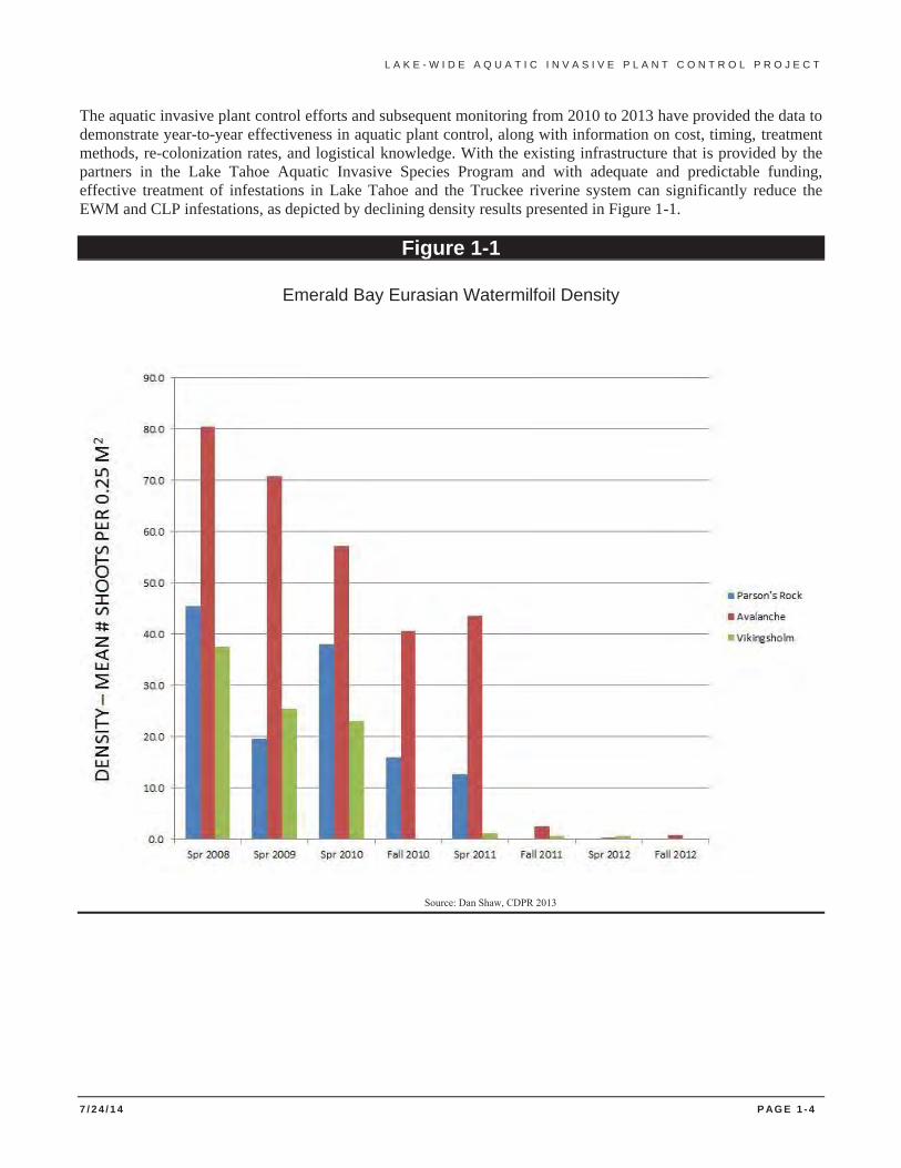
L A K E - W I D E A Q U A T I C I N V A S I V E P L A N T C O N T R O L P R O J E C T
7 / 2 4 / 1 4 P AG E 1 - 4
The aquatic invasive plant control efforts and subsequent monitoring from 2010 to 2013 have provided the data to demonstrate year-to-year effectiveness in aquatic plant control, along with information on cost, timing, treatment methods, re-colonization rates, and logistical knowledge. With the existing infrastructure that is provided by the partners in the Lake Tahoe Aquatic Invasive Species Program and with adequate and predictable funding, effective treatment of infestations in Lake Tahoe and the Truckee riverine system can significantly reduce the EWM and CLP infestations, as depicted by declining density results presented in Figure 1-1.
Figure 1-1
Emerald Bay Eurasian Watermilfoil Density
Source: Dan Shaw, CDPR 2013
L A K E - W I D E A Q U A T I C I N V A S I V E P L A N T C O N T R O L P R O J E C T
7 / 2 4 / 1 4 P AG E 1 - 5
1.2 PURPOSE AND NEED
As described above, the invasion, establishment and spread of aquatic invasive plants are threatening the environmental quality of portions of Lake Tahoe and the Truckee River. The Lake Tahoe Aquatic Invasive Species Management Plan identifies aquatic invasive plant control projects in Lake Tahoe as a program objective. The focus of aquatic invasive species (AIS) control projects in Lake Tahoe is to control existing infestations of invasive plant species to avoid and mitigate potential nuisances on the human population while improving native fish and plant habitats.
The purpose of this environmental documentation is to provide analysis of environmental effects for the physical removal or control of aquatic invasive plants in Lake Tahoe. This document is prepared in accordance with the guidelines established by the California Environmental Quality Act (CEQA). This document also provides information for the TRPA Initial Environmental Checklist and to support environmental review required under the TRPA Rules of Procedure (Article VI) and Section 3.3 of the Code of Ordinances. Further, this document is intended to support preparation of the appropriate environmental documentation in accordance with the regulations established by the National Environmental Policy Act (NEPA).
Once the documentation is completed and approved by the lead agencies, conditional permits from other regulating agencies may be granted to the Tahoe RCD for implementation of the Proposed Project Alternative. Permit conditions may require modification of proposed project plans for specific treatment areas for compliance.
The overall goal of the Lake-wide Aquatic Invasive Plant Control Project is to remove aquatic invasive plants from Lake Tahoe and the Truckee River to improve water quality, enhance physical and biological habitat conditions for native fisheries and wildlife, and to inhibit the establishment and spread of other aquatic invasive species.
1.3 LEAD AGENCIES
The CEQA environmental document requires a lead agency. Tahoe RCD is the project lead for CEQA. TRPA is the project lead for the TRPA Initial Environmental Checklist that will be published as a separate document. The U.S. Army Corps of Engineers (USACE) is the project lead for NEPA and will prepare separate environmental documentation, as appropriate.
1.3.1 U.S. Army Corps of Engineers
The USACE has jurisdiction of Wetlands and Other Waters of the United States, including Lake Tahoe. The Project falls under USACE jurisdiction as a permitting agency and will require acquisition of a Section 404 permit to comply with the Clean Water Act (CWA) of 1972 and potentially 408 Permission to comply with the Section 10 of the Rivers and Harbors Act of 1899. Authorization for the Project could be covered under Nationwide Permit 27 - Aquatic Habitat Restoration, Establishment and Enhancement Activities.
1.3.2 Tahoe Resource Conservation District
The Tahoe RCD is the grantee for funding from the Southern Nevada Public Lands Management Act (SNPLMA) along with US Fish and Wildlife Service (USFWS) and project coordinator for the Lake Tahoe Aquatic Invasive Species Program. Representatives from Tahoe RCD are members of the NAWWG and AISCC.
1.3.3 Tahoe Regional Planning Agency
The TRPA is the administering agency for the Environmental Improvement Program (EIP). The Project is an EIP project for Aquatic Invasive Plant Species Control. As EIP administrator and permitting agency, TRPA provides
L A K E - W I D E A Q U A T I C I N V A S I V E P L A N T C O N T R O L P R O J E C T
7 / 2 4 / 1 4 P AG E 1 - 6
an advisory representative to the NAWWG. Approval of the Project would require preparation of a TRPA Initial Environmental Checklist (IEC). The Project must also comply with the TRPA Regional Plan and the Code of Ordinances.
1.4 LEGAL AUTHORITY
1.4.1 CEQA
The Tahoe RCD is the lead agency under provisions of CEQA and numerous other state agencies (e.g., California Department of Fish and Wildlife) will participate as responsible agencies. CEQA requires that state and local government agencies consider the environmental consequences of projects over which they have discretionary authority before acting on those projects. This Initial Study (IS), prepared in accordance with the CEQA Statutes (Public Resources Code Section 21000 et seq.) and the CEQA Guidelines (California Administrative Code Section 15000 et seq.), presents sufficient information to allow the Tahoe RCD to determine whether the Project may have a significant effect on the environment, requiring preparation of an Environmental Impact Report (EIR). The CEQA Appendix G Checklist is provided in Appendix A of this IS.
If the Tahoe RCD finds substantial evidence that any aspect of the Project, either individually or cumulatively, may have a significant effect on the environment, regardless of whether the overall effect of the Project is adverse or beneficial, the Tahoe RCD must prepare an EIR. If the Tahoe RCD finds no substantial evidence that the Project or any of its aspects may cause a significant effect on the environment, a Negative Declaration shall be prepared. If in the course of analysis, the Tahoe RCD recognizes that the Project may have a significant impact on the environment, but that by incorporating specific mitigation measures the impact will be reduced to a less than significant effect, a Mitigated Negative Declaration (MND) shall be prepared.
The IS also provides sufficient information for responsible and trustee agencies to use as the basis for CEQA compliance, such as the California Department of Fish and Wildlife (CDFW) and Regional Water Quality Control Board – Lahontan Region (Lahontan). The IS is not, in and of itself, a decision document. The document’s purpose is to evaluate the environmental consequences of implementing the Project and to identify measures if necessary to avoid significant impacts.
Although the lead agency must consider the information in the IS, the document’s conclusions do not dictate the lead agency’s discretion to approve or disapprove the Project. The decision making document is the MND that records the agency’s decision and is also circulated for public review. The minimum content requirements for a MND are:
• Description and title of the Project; • Location of the Project, preferably shown on a map; • Name of the Project Applicant; • A proposed finding that the Project will not have a significant effect on the environment; • An attached copy of the Initial Study documenting reasons to support the finding; and • Mitigation measures, if any, included in the Project to avoid potentially significant effects.
The State Clearinghouse (SCH) circulates the environmental documentation for agency review and requests a completed Notice of Completion (NOC) form to be submitted with the 15 copies of the draft MND. This form facilitates the processing of environmental documents and is circulated to state agencies together with the MND. The information from the NOC form is entered into the SCH database. The normal review period for a Negative Declaration submitted to the SCH is 30 calendar days (see CEQA Guidelines, Section 15105). Comments are forwarded to the SCH prior to the end of the assigned review period. At the end of the state review period, comments from the reviewing state agencies are collected at the SCH. A closing letter and a complete package of comments are forwarded to the Lead Agency on the day following the close of the review period.
L A K E - W I D E A Q U A T I C I N V A S I V E P L A N T C O N T R O L P R O J E C T
7 / 2 4 / 1 4 P AG E 1 - 7
Within five working days of approving a project for which a MND has been adopted, the Tahoe RCD must file a Notice of Determination (NOD). The filing of the NOD begins a 30-calendar-day statute of limitations on court challenges to the project approval under CEQA.
1.4.2 TRPA
The Project Area is entirely located in the Lake Tahoe Basin and is therefore under the jurisdiction of the TRPA. TRPA is the lead agency under the Tahoe Regional Planning Compact (PL 96-551 94 Statute 3233). As such, an IEC shall be prepared in accordance with Article VII of the Tahoe Regional Planning Compact, TRPA revised Code Section 3.3, specifically Subsection 3.3.2, and Article VI of the TRPA Rules of Procedure. The responsible body for the TRPA is the Governing Board. The Governing Board’s decision shall consider: consistency of the Project with the TRPA Regional Plan and Environmental Threshold Carrying Capacities and project approval or denial.
TRPA utilizes an IEC, which is used to determine whether an environmental impact statement (EIS) shall be prepared for a project. The IEC provides information identifying the environmental effects of the Project and includes:
• An identification of the environmental effects; • A discussion of proposed mitigation for significant adverse effects, if any; • The name of the person who prepared the responses; and • Supporting data or evidence to support the responses.
1.4.3 NEPA
The United States Army Corps of Engineers (USACE) is the lead agency under NEPA and must issue CWA Section 404(B) permits, requiring that a Project Applicant avoid unnecessary environmental impacts to the maximum extent practicable, minimize unavoidable adverse impacts of the Project and prepare a compensatory mitigation plan necessary to replace the wetland functions that would be lost as a result of unavoidable adverse impacts. Because the Project is expected to result in net increases in aquatic resource functions and services, the USACE could authorize the Project under the Nationwide Permit 27 - Aquatic Habitat Restoration, Establishment and Enhancement Activities.
USACE is delegated authority to issue Department of Army permits for discharges of dredged or fill materials into “waters of the United States”, including wetlands, pursuant to Section 404 of the CWA and for work or structures affecting navigable waters under Section 10 of the Rivers and Harbors Act.
The USACE can only issue a permit for the least environmentally damaging practicable alternative that meets a project's basic purpose. The USACE independently reviews environmental documentation, determines the sufficiency of the studies, and determines compliance with the CWA, National Historic Preservation Act (NHPA) and other relevant statutes. If the USACE finds the reports insufficient, it notifies the applicant as to additional information and follow-up reports needed.
Section 106 of the National Historic Preservation Act (NHPA) requires federal agencies to take into account effects of projects on historic properties caused by federal actions, and to provide the Advisory Council on Historic Preservation (ACHP) a reasonable opportunity to comment on such undertakings though consultation with the California State Historic Preservation Officer (SHPO). The USEPA delegates the California State Water Resources Control Board (State Board) the responsibility for carrying out the requirements of Section 106 of the NHPA.
L A K E - W I D E A Q U A T I C I N V A S I V E P L A N T C O N T R O L P R O J E C T
7 / 2 4 / 1 4 P AG E 1 - 8
1.5 OTHER PERMITTING AGENCIES
Numerous federal, state, and regional regulations and programs are in place in the Lake Tahoe Region to limit the introduction and spread of AIS with no single agency or group responsible for AIS issues. This Project will require the review and approval of federal, state and local agencies in addition to the Lead Agencies identified in Sections 1.3 and 1.4. Some of the agencies identified here are permitting agencies and may approve this Project through a defined permit, consultation, or agreement process.
1.5.1 U.S. Fish and Wildlife Service
The USFWS plays an advisory role in the CWA 404(B) permitting process administered by the USACE and overseen by the USEPA. The USFWS mission is working with others to protect, conserve, and enhance fish, wildlife and plants, and their habitats, for the continuing benefit of the American people. The USFWS mission is authorized and accomplished via various authorities, including: the Fish and Wildlife Coordination Act, Fish and Wildlife Act of 1956, Food Security Act, Anadromous Fish Conservation Act, Migratory Bird Treaty Act (MBTA), and Endangered Species Act (ESA). If a threatened or endangered species is observed within the Project Area, Section 7 consultation must occur. Lahontan cutthroat trout and Tahoe yellow cress are federal listed species that occur in the Project Area.
Federal authority to limit the interstate transport and importation to the U.S. of prohibited plant species is provided by the USDA-Animal and Plant Health Inspection Service-Plant Protection and Quarantine (USDA-APHIS-PPQ) (Plant Protection Act of 2000) and prohibited wildlife species authority is provided USFWS through the Lacey Act. USFWS may provide funding toward Project implementation.
1.5.2 Advisory Council on Historic Preservation
Section 106 of the NHPA requires federal agencies to take into account effects of projects on historic properties caused by federal actions, and to provide the Advisory Council on Historic Preservation (ACHP) a reasonable opportunity to comment on such undertakings though consultation with the California SHPO. The United States Environmental Protection Agency (USEPA) delegates the California State Water Resources Control Board (State Board) the responsibility for carrying out the requirements of Section 106 of the NHPA. Because the Project also includes sites in Nevada, the Nevada SHPO must also consult on this Project.
1.5.3 California Department of Fish and Wildlife
In California, the CDFW is responsible for prohibited fish and wildlife resources (CCR, Title 14) and is the lead agency for the California AIS Management Plan (CAISMP). CDFW Code §2301 allows CDFW designated staff (and other authorized state authorities, i.e., CDPR peace officers and California Department of Food and Agriculture [CDFA]) to inspect, impound or quarantine any conveyance (e.g., watercraft) that may carry dreissenid mussels (i.e., quagga and zebra mussels). CDFA is the lead agency for regulatory activities associated with noxious weeds (CAC Title 3, Sec. 3400). A Lake and Streambed Alteration Agreement or a Five-year Maintenance Agreement may be necessary to remove vegetation from or to install temporary barriers in Lake Tahoe or the Truckee River.
1.5.4 California Department of Parks and Recreation
The CDPR issues an Encroachment Permit. The mission of the CDPR is: to provide for the health, inspiration and education of the people of California by helping to preserve the state ́s extraordinary biological diversity, protecting its most valued natural and cultural resources, and creating opportunities for high-quality outdoor recreation. The CDPR is a Tahoe Integrated Information Management System (TIIMS) stakeholder that participated in the requirements analysis for the AIS Management Plan. CDPR is responsible for overseeing State
L A K E - W I D E A Q U A T I C I N V A S I V E P L A N T C O N T R O L P R O J E C T
7 / 2 4 / 1 4 P AG E 1 - 9
Park lands that lie within the California side of the Lake Tahoe Basin. As such, they maintain the lands and provide educational information to park visitors. Specifically, they oversee the following park units: Burton Creek State Park, D. L. Bliss State Park, Ed Z'berg Sugar Pine Point State Park, Emerald Bay State Park, Kings Beach State Recreation Area, Lake Valley State Recreation Area, Tahoe State Recreation Area, Ward Creek Unit, and Washoe Meadows State Park.
1.5.5 Regional Water Quality Control Board – Lahontan
California State law assigns responsibility for protection of water quality within the Lahontan watershed basin, which fully contains the Lake Tahoe Basin, to the California Regional Water Quality Control Board – Lahontan Region (Lahontan). Lahontan implements and enforces the Porter-Cologne Water Quality Control Act (California Water Code Section 1300 et seq.) and the Water Quality Control Plan for the Lahontan Region (Basin Plan). Lahontan will be a responsible agency under CEQA and will need adequate CEQA documentation as the basis for issuing CWA Section 401 water quality certification and/or waste discharge requirements. As such, Lahontan must ensure compliance with CEQA when taking discretionary actions on this Project.
Section 402 of the CWA is directly relevant to earthwork and grading in the Project Area’s staging areas and establishes the National Pollutant Discharge Elimination System (NPDES) program that Lahontan implements in Lake Tahoe. Projects with construction activities disturbing greater than one acre must apply for coverage under Board Order No R6T-2011-0019, prepare a Notice of Intent (NOI) and implement a Stormwater Pollution Prevention Plan (SWPPP). BMPs must be installed and maintained to avoid adverse impacts to receiving water quality as defined by Chapter 5 of the Basin Plan. Upon completion of the Project, a Notice of Termination (NOT) must be submitted to Lahontan to indicate that construction is completed.
With respect to managing AIS, the Basin Plan states that region wide water quality objectives for pesticides, and related objectives for nondegradation and toxicity, essentially preclude direct discharges of pesticides such as aquatic herbicides. Although a Basin Plan amendment to allow consideration of temporary exemptions to the water quality objectives to prevent the spread of disease or invasive species is currently under review of the USEPA, the Project does not include the use of aquatic pesticides to control aquatic invasive plants.
1.5.6 California State Lands Commission
The State of California acquired sovereign ownership of tide and submerged lands and beds of navigable waterways upon its admission to the United States in 1850. The State holds these lands for the benefit of people of the State for statewide Public Trust purposes, which include waterborne commerce, navigation, fisheries, water-related recreation, habitat preservation and open space. The boundaries of these State-owned lands generally are based upon the last naturally occurring location of the ordinary high or low water marks prior to artificial influences, which may have altered or modified the river or shoreline characteristics. On navigable non-tidal waterways, the State holds fee ownership of the bed of the waterway landward to the ordinary low water mark and a Public Trust easement exists landward to the ordinary high water mark, as they last naturally existed. The State's sovereign interests are under the jurisdiction of the California State Lands Commission (CSLC).
With respect to Lake Tahoe, the State’s sovereign ownership extends water ward from the low water mark, which has been established as elevation 6,223 feet, Lake Tahoe Datum (LTD). Consequently, any activity involving the State’s sovereign lands in Lake Tahoe below elevation 6,223 feet LTD requires a lease from the CSLC. Uses requiring approval of a lease from the CSLC must also comply with the CEQA. The area lying between the high and low tide lines of Lake Tahoe is subject to a Public Trust easement for commerce, navigation, fishing, recreation and preservation. Uses situated between the high and low water marks must be consistent with the uses permitted under the Public Trust.
Permission from the CSLC would be required to implement the proposed activities contemplated by resource managers and researchers. The form of that permission would vary in accordance with the specific activity and its
L A K E - W I D E A Q U A T I C I N V A S I V E P L A N T C O N T R O L P R O J E C T
7 / 2 4 / 1 4 P AG E 1 - 1 0
location and, therefore, would be determined on a case-by-case basis. Prior AIS removal and maintenance projects have been covered under an existing lease with CDPR: General Lease – Public Use No. PRC 7366.9.
1.5.7 Nevada Division of State Lands
The Nevada Division of State Lands (NDSL) leads the State of Nevada’s programs to protect Lake Tahoe, including coordination of the Nevada Tahoe Resource Team (NTRT). NTRT is an interagency team dedicated to preserving and enhancing the natural environment in the Lake Tahoe Basin. The Division also administers other special programs as well as provides staff assistance to the Nevada TRPA and the State Land Use Planning Advisory Council.
1.5.8 Nevada Division of Environmental Protection – Bureau of Safe Drinking Water
The mission of the Bureau of Safe Drinking Water is to protect the public health of the citizens, tourists and visitors to the State by assuring that the public water systems provide safe and reliable drinking water. Nevada Revised Statute 445A.800 states, "It is the policy of this state to provide for water which is suited for drinking and other domestic purposes and thereby promote the public health and welfare." With respect to the Project, control activities in and around water intakes that involve physical removal processes (e.g., that could disturb sediment and increase turbidity) can have an impact on compliance with regulations and serving potable water.
1.6 OTHER REVIEWING AGENCIES AND ENTITIES
The agencies listed are members of the NAWWG or advisory committee and have been involved in the project planning process. Other reviewing agencies include:
California Department of Food and Agriculture (CDFA) California Tahoe Conservancy (CTC) Lake Tahoe Aquatic Invasive Species Coordination Committee (LTAISCC) Lake Tahoe Aquatic Invasive Species Working Group (LTAISWG) Natural Resource Conservation Service (NRCS) Nevada Department of Agriculture Nevada Department of Wildlife (NDOW) Tahoe Area Sierra Club Tahoe Science Advisory Group Tahoe Keys Property Owners Association (TKPOA) TRPA’s Environmental Improvement Program (EIP) Tahoe Science Consortium (TSC) University of California Davis – Tahoe Environmental Research Center (TERC) University of Nevada Reno (UNR) U.S. Department of Interior (USDOI) U.S. Forest Service – Lake Tahoe Basin Management Unit (LTBMU)
1.7 PUBLIC REVIEW PROCESS
Opportunities for public participation in the Environmental Review process are provided in order to promote open communication and better decision-making. Persons and organizations having a potential interest in the Project are invited to provide comments during the 30-day comment period for this document.
L A K E - W I D E A Q U A T I C I N V A S I V E P L A N T C O N T R O L P R O J E C T
7 / 2 4 / 1 4 P AG E 1 - 1 1
Pursuant to the requirements of CEQA, this document was sent, along with a NOI to adopt a MND, to the California SCH. During a 30-day public review period from April 11, 2014 until May 12, 2014, federal agencies, state agencies, local agencies, and the general public will have the opportunity to review and comment on this document. Distribution of this document occurred through public clearinghouses, local public repositories, and direct mailing to interested agencies and parties.
The public will also have opportunity to comment at the scheduled Tahoe RCD Board meeting in June when the CEQA findings are considered by the Tahoe RCD Board for the MND approval.
The Draft MND is included in the front of this document. These documents will be updated as needed to address comments received during the 30-day comment period.
Written comments should be sent to the Tahoe RCD at the contact information listed below:
CEQA Lead Nicole Cartwright Tahoe Resource Conservation District 870 Emerald Bay Road, Suite 108 South Lake Tahoe, CA 96150 [email protected]

L A K E - W I D E A Q U A T I C I N V A S I V E P L A N T C O N T R O L P R O J E C T
7 / 2 4 / 1 4 P AG E 1 - 1 2
7 / 2 4 / 1 4 P AG E 2 - 1
SECTION 2 PROJECT DESCRIPTION
2.1 PURPOSE AND OBJECTIVES
The purpose of the Proposed Project Alternative (Project) is to control or eradicate aquatic invasive plant populations in Lake Tahoe. This Project will complement previous efforts throughout Lake Tahoe that have tested the efficiency of different aquatic plant removal methods. When deployed effectively and strategically, successful control efforts will increase public safety, improve water quality, and protect Lake Tahoe’s biodiversity. Dense growth of invasive aquatic plants can impede water flow, disrupt navigation, discourage recreation, negatively affect water quality, and reduce plant diversity. Non-native plants can “pump” nutrients from the sediment to the overlying water column during growth and may be contributing to increased phytoplankton and reductions in water clarity. Control of invasive aquatic plants will support other control efforts like warm-water fish removal and suppression.
Consistent with the Lake Tahoe Region Aquatic Invasive Species Management Plan, the annual objectives of the Project include:
To prevent the spread of existing invasive plants; To ensure early detection of new invasive plant infestations; and To monitor existing invasive plant populations.
Treatment actions will utilize the most effective methods at high-priority Treatment Sites and will include maintenance activities at sites that have been treated previously.
2.2 PROJECT LOCATION
The Project location includes suitable habitat areas within Lake Tahoe and the Truckee River between the dam at Lake Tahoe to River Ranch at Alpine Meadows Road and several project staging areas. Suitable habitat is present in Lake Tahoe within the City of South Lake Tahoe and El Dorado and Placer counties in California and within Douglas and Washoe counties in Nevada. The Project Area will include suitable habitat areas infested with submerged aquatic plants, typically up to 11 meters in depth. Within this large Project Area, several sites have been identified for potential control treatments based on existing knowledge of invasive plant presence. These Treatment Sites are project locations where control efforts will be conducted. Although Treatment Sites have been identified for the first year of Project implementation, these sites are expected to change annually if new infestations are detected.
The Truckee River is the sole outlet of Lake Tahoe and drains part of the high Sierra Nevada, emptying into Pyramid Lake in the Great Basin. Its waters are an important source of irrigation along its valley and adjacent valleys. The Middle Watershed is regarded as the 15 miles (24 km) of river and its tributaries from Tahoe City in Placer County, through the Town of Truckee in Nevada County, to the state line between Sierra and Washoe counties. This Project will be implemented along an approximately 3-mile section of the Truckee River from the dam at Lake Tahoe in Tahoe City to River Ranch restaurant at Alpine Meadows Road. This Project falls within Placer County jurisdiction and is contained within the boundary of the Lake Tahoe Basin as defined by TRPA. As such, it is included in the Lake Tahoe Basin AIS Management Plan. The Treatment Site locations are on a section of the river that is heavily used for recreation, including whitewater rafting and fly-fishing. Figure 2-1 illustrates the extent of the Project Area.
7 / 2 4 / 1 4 P AG E 2 - 2
2.2.1 Project Area
The Project Area includes areas within the lakeshore, nearshore and backshore of Lake Tahoe and the Truckee River corridor within the TRPA jurisdictional boundary that provide suitable conditions for establishment of submerged invasive aquatic plants. In order to quantify potential aquatic plant treatment requirements within Lake Tahoe, the Lake Tahoe AIS Management Plan identifies areas of suitable habitat based on the best available bathymetry data. Figure 2-1 depicts suitable habitat within Lake Tahoe for aquatic invasive plant establishment. The Truckee River portion is 3 miles long with an average width is 40 feet or an estimated 14.5 acres of potential habitat in the linear river system. Monitoring results estimate that 30 percent or 4.35 acres of this portion of the river system is infested with EWM. The total Project Area encompasses greater than 11,300 acres, including the 14.5 acres along the Truckee River.
2.2.2 Treatment Sites
Within the Project Area, aquatic plant surveys conducted from 1997 through 2011 have documented plant infestations at approximately twenty locations around the lake. Treatment sites that have been identified as known infestations to be treated using Project methods are shown in Figure 2-2 and listed in Table 2-1.
Prior work has shown that for successful management, known and new infestations of aquatic invasive plants must be treated comprehensively and repeatedly. This Project will establish annual prioritization criteria for plant infestation treatments as described in the Lake Tahoe Region AIS Management Plan and could include locations not shown in Figure 2-2.
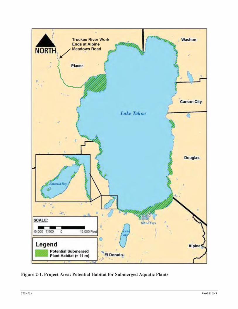
7 / 2 4 / 1 4 P AG E 2 - 3
Figure 2-1. Project Area: Potential Habitat for Submerged Aquatic Plants
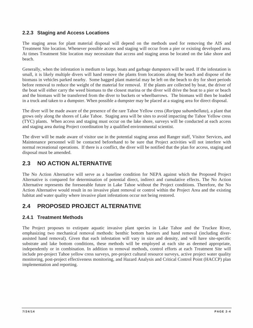
7 / 2 4 / 1 4 P AG E 2 - 4
2.2.3 Staging and Access Locations
The staging areas for plant material disposal will depend on the methods used for removing the AIS and Treatment Site location. Whenever possible access and staging will occur from a pier or existing developed area. At times Treatment Site location may necessitate that access and staging areas be located on the lake shore and beach.
Generally, when the infestation is medium to large, boats and garbage dumpsters will be used. If the infestation is small, it is likely multiple divers will hand remove the plants from locations along the beach and dispose of the biomass in vehicles parked nearby. Some bagged plant material may be left on the beach to dry for short periods before removal to reduce the weight of the material for removal. If the plants are collected by boat, the driver of the boat will either carry the weed biomass to the closest marina or the diver will drive the boat to a pier or beach and the biomass will be transferred from the diver to buckets or wheelbarrows. The biomass will then be loaded in a truck and taken to a dumpster. When possible a dumpster may be placed at a staging area for direct disposal.
The diver will be made aware of the presence of the rare Tahoe Yellow cress (Rorippa subumbellata), a plant that grows only along the shores of Lake Tahoe. Staging area will be sites to avoid impacting the Tahoe Yellow cress (TYC) plants. When access and staging must occur on the lake shore, surveys will be conducted at each access and staging area during Project coordination by a qualified environmental scientist.
The diver will be made aware of visitor use in the potential staging areas and Ranger staff, Visitor Services, and Maintenance personnel will be contacted beforehand to be sure that Project activities will not interfere with normal recreational operations. If there is a conflict, the diver will be notified that the plan for access, staging and disposal must be amended.
2.3 NO ACTION ALTERNATIVE
The No Action Alternative will serve as a baseline condition for NEPA against which the Proposed Project Alternative is compared for determination of potential direct, indirect and cumulative effects. The No Action Alternative represents the foreseeable future in Lake Tahoe without the Project conditions. Therefore, the No Action Alternative would result in no invasive plant removal or control within the Project Area and the existing habitat and water quality where invasive plant infestations occur not being restored.
2.4 PROPOSED PROJECT ALTERNATIVE
2.4.1 Treatment Methods
The Project proposes to extirpate aquatic invasive plant species in Lake Tahoe and the Truckee River, emphasizing two mechanical removal methods: benthic bottom barriers and hand removal (including diver-assisted hand removal). Given that each infestation will vary in size and density, and will have site-specific substrate and lake bottom conditions, these methods will be employed at each site as deemed appropriate, independently or in combination. In addition to removal methods, control efforts at each Treatment Site will include pre-project Tahoe yellow cress surveys, pre-project cultural resource surveys, active project water quality monitoring, post-project effectiveness monitoring, and Hazard Analysis and Critical Control Point (HACCP) plan implementation and reporting.
7 / 2 4 / 1 4 P AG E 2 - 5
Source: Lake Tahoe AIS Management Plan 2009
Figure 2-2. Potential Aquatic Invasive Plant Treatment Sites
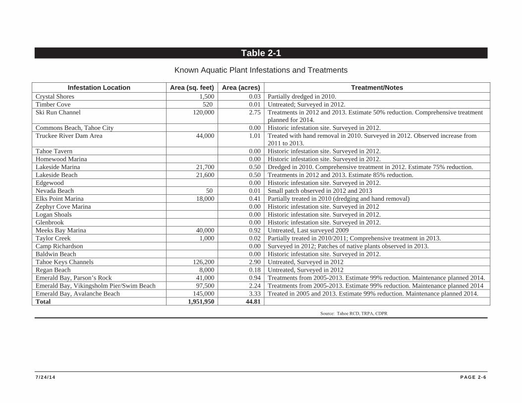
7 / 2 4 / 1 4 P AG E 2 - 6
Table 2-1
Known Aquatic Plant Infestations and Treatments
Infestation Location Area (sq. feet) Area (acres) Treatment/Notes Crystal Shores 1,500 0.03 Partially dredged in 2010. Timber Cove 520 0.01 Untreated; Surveyed in 2012. Ski Run Channel 120,000 2.75 Treatments in 2012 and 2013. Estimate 50% reduction. Comprehensive treatment
planned for 2014. Commons Beach, Tahoe City 0.00 Historic infestation site. Surveyed in 2012. Truckee River Dam Area 44,000 1.01 Treated with hand removal in 2010. Surveyed in 2012. Observed increase from
2011 to 2013. Tahoe Tavern 0.00 Historic infestation site. Surveyed in 2012. Homewood Marina 0.00 Historic infestation site. Surveyed in 2012. Lakeside Marina 21,700 0.50 Dredged in 2010. Comprehensive treatment in 2012. Estimate 75% reduction. Lakeside Beach 21,600 0.50 Treatments in 2012 and 2013. Estimate 85% reduction. Edgewood 0.00 Historic infestation site. Surveyed in 2012. Nevada Beach 50 0.01 Small patch observed in 2012 and 2013 Elks Point Marina 18,000 0.41 Partially treated in 2010 (dredging and hand removal) Zephyr Cove Marina 0.00 Historic infestation site. Surveyed in 2012 Logan Shoals 0.00 Historic infestation site. Surveyed in 2012. Glenbrook 0.00 Historic infestation site. Surveyed in 2012. Meeks Bay Marina 40,000 0.92 Untreated, Last surveyed 2009 Taylor Creek 1,000 0.02 Partially treated in 2010/2011; Comprehensive treatment in 2013. Camp Richardson 0.00 Surveyed in 2012; Patches of native plants observed in 2013. Baldwin Beach 0.00 Historic infestation site. Surveyed in 2012. Tahoe Keys Channels 126,200 2.90 Untreated, Surveyed in 2012 Regan Beach 8,000 0.18 Untreated, Surveyed in 2012 Emerald Bay, Parson’s Rock 41,000 0.94 Treatments from 2005-2013. Estimate 99% reduction. Maintenance planned 2014. Emerald Bay, Vikingsholm Pier/Swim Beach 97,500 2.24 Treatments from 2005-2013. Estimate 99% reduction. Maintenance planned 2014 Emerald Bay, Avalanche Beach 145,000 3.33 Treated in 2005 and 2013. Estimate 99% reduction. Maintenance planned 2014. Total 1,951,950 44.81
Source: Tahoe RCD, TRPA, CDPR
7 / 2 4 / 1 4 P AG E 2 - 7
2.4.1.1 Benthic Barriers
Benthic Barriers or “bottom barrier” treatment consists of placing sections of gas permeable, black landscape cloth, plastic, jute, or other material, over the top of submerged vegetation to exclude light. The barriers can range in size from 10 x 10 foot squares to strips of 10 x 40 foot or more. The size of the barrier is dependent on the logistics of deploying, retrieving and maneuvering in and out of the water. Synthetic barriers are held in place with re-bar stakes or available natural debris. Re-bar stakes are removed when the synthetic barriers are removed. Synthetic barriers remain in place for at least 2-4 months and are either removed from the lake or moved to a new location, typically immediately adjacent to the site just treated. Natural fiber (e.g. jute) barriers are placed over the growing plants and left in place until the barriers decompose – they are not removed from the lake bottom. If necessary, ballast such as iron rebar is used to hold the natural fiber barriers in place and left on the lake bottom until the barriers decompose. Where there is sufficient natural debris on the lake bottom, the debris can be placed and left on the barriers to hold them in place.
Barriers will be deployed to high priority areas of dense plant growth. Following barrier placement, diver-assisted hand removal will be conducted to achieve 99%-100% plant removal at the perimeter of the barriers. Where plant density is low, diver-assisted hand removal may be the primary method of control. The Lake Tahoe plant control program and partners currently own approximately 250 synthetic benthic barriers, each 10 x 40 foot that are reusable and available for plant control efforts in the region. Although the actual area of lake bottom covered by barriers each year would be determined by plant growth, funding, and other site-specific project constraints, a typical treatment area would include between 50 and 150 bottom barriers or between 18,000 and 54,000 square feet assuming 10% overlap where each barrier overlaps with the next. Benthic barrier treatment areas at each Treatment Site would not exceed the area of plant infestation at that site. Currently known infestation patch sizes of EWM and/or CLP on the south shore of Lake Tahoe range from approximately 0.01 to 2.75 acres (Sierra Ecosystem Associates 2013).
Depending on site characteristics, plant composition, water temperature, and placement timing, synthetic barriers may need to be left in the water over the winter. Synthetic barriers left in the water over the winter will be monitored on a regular basis and be prioritized for removal or relocation in the subsequent year.
2.4.1.2 Hand Removal
Hand removal consists of simply removing vegetation from the water by hand and transferring it to garbage cans or bags for disposal. Hand removal is only feasible when the water level is low enough and can be conducted from the shore or from a canoe or kayak.
2.4.1.3 Diver-Assisted Hand Removal
Diver-assisted hand removal of aquatic weeds is accomplished through the use of a small suction hose that is mounted on a floating work platform. The suction is produced by a water injection system that uses a small 4-stroke gas powered engine. Attached to the engine is a water pump that pumps water from the lake into a water injector. A suction hose from the injector, usually between 3 and 6 inches in diameter, is used at the lake bottom to capture and transfer biomass to a catch basket on the work platform.
Qualified dive or snorkel crews will remove aquatic invasive plants by pulling the plant by the roots and feeding it into the suction hose and transfer the plant matter and associated water up to a conveyor system or collection box mounted on a boat or attached to a floating platform. Screen material separates the plant material from the associated water, which passes through the screen and returns to the water column. The collected plant material is conveyed to an approved staging area. Hand pulled fragments escaping the
7 / 2 4 / 1 4 P AG E 2 - 8
diver-assisted collection method will be removed by hand, net, or vacuum hose as reasonably practical before the close of each day. The plants that are captured in the screened-in container are transferred into garbage cans for removal and disposal offshore. The material will be collected at each Treatment Site staging area and then taken to a TRPA-approved disposal site where it is either disposed of or composted.
2.4.1.4 Night Operations
Night-time operations to implement barrier deployment and diver-assisted hand removal are possible to minimize conflicts with recreational use of a Treatment Site and to maximize safe working conditions for the divers and crews. Should night operations be employed, divers and deck crews would use lights to facilitate plant control operations. This would include lighted dive gear and lighted work platform deck(s).
2.4.1.5 Truckee River Operations
Following the flood of 1997, EWM escaped from Lake Tahoe into the Truckee River, and has now been documented downstream as far as Verdi, NV. Visual observations and anecdotal evidence suggests quite sizable infestation patches occur between the dam at Lake Tahoe downstream to River Ranch restaurant at Alpine Meadows Road. This stretch of river has typical riverine attributes such as pools and riffles, so fortunately the river itself is not homogeneous enough to provide suitable habitat along the entire length of the Project Area. The timing of Truckee River operations will have to occur outside the high volume whitewater rafting season but before excessive winter conditions arise (e.g., mid-September, allowing for a potential survey and removal activity for a period of 6 weeks through the end of October).
The Truckee River within the 3-mile section of the Project Area is at lower flows and warmer temperatures during the fall than during other seasons. For this reason the preferred method for EWM removal will be using diver-assisted hand removal, as described in Section 2.4.1.3. In addition to diver-assisted hand removal, when the water level is low enough, hand removal from the shore or via raft, canoe or kayak will also be possible. Vegetation is simply removed from the water and transferred to garbage cans on the shore for transport and disposal.
2.4.2 Disposal of Plant Biomass
The plant materials that are captured in the screened-in container are transferred into garbage cans for removal and disposal off shore. In addition to diver-assisted hand removal, when the water level is low enough, hand removal from the shore or via raft, canoe or kayak is also possible. Vegetation is simply removed from the water and transferred to garbage cans on the shore for disposal.
The material is transported to the Treatment Site access and staging area and then taken to a TRPA approved disposal site. This disposal site will likely be Full Circle Compost in Carson City, NV where it is composted or for Truckee River Treatment Sites, the Eastern Regional Landfill off Hwy 89 approximately 6 miles to the north.
2.4.3 Monitoring and Evaluation
As described above, annual monitoring of plant populations is imperative in effective management. While post-treatment observations may indicate that plants have been removed, recolonization from roots, fragments, and buried plants is likely in infestations. Experience has shown that annual treatment cycles in excess of three years are necessary for effective management of aquatic invasive plants. This suggests that effective control requires that the same area is treated each year for a minimum of three years. Following comprehensive treatment, however, monitoring has reported that re-treatment in subsequent years requires less time and resources due to reduced plant density. To be useful in effectiveness evaluations, pre-treatment infestation evaluations must record
7 / 2 4 / 1 4 P AG E 2 - 9
plant density, such as relative percent cover, as well as spatial information, such as location and extent. Pre- and post-treatment evaluations will be conducted for plant control treatments and year-over-year comparisons will assist in subsequent Treatment Site prioritization.
2.4.3.1 Water Quality Monitoring
Turbidity monitoring is an integral part of aquatic plant treatment in Lake Tahoe because turbidity levels provide an indication of potential risks to water quality. The Water Quality Monitoring Plan template is included as Appendix B. The template will be revised to reflect site-specific requirements of individual Treatment Sites, as appropriate to address permit conditions. Most of the turbidity observed during barrier installation or hand removal results from diver or worker movements that disturb bottom sediments. The disturbance is easily noticed on continuous turbidity readings and returns to background levels quickly once the barriers are placed or the divers retreat, as shown by monitoring results of pilot AIS projects.
Turbidity levels have been monitoring throughout previous control work efforts in Lake Tahoe. Previous work to remove Asian clams in Emerald Bay (2005-6, 2009-2011) recorded higher background and project turbidity levels (often above 0.50 NTU) compared to Lake Tahoe proper (about 0.25-0.35 NTU). Turbidity in marina environments is typically between 1.5 and 2.5 NTU and can rise rapidly depending on substrate composition. While the turbidity levels during bottom barrier installation and removal are generally much less than during diver-assisted hand removal, results from previous diver-assisted hand removal efforts have shown a discrete, short-term disturbance with turbidity levels dropping to background generally within 10-15 minutes.
2.4.3.2 Fish Habitat Characterization
Fish habitat characterization will be completed when required in permit conditions for individual Treatment Sites. Method will follow those outlined in the study by Beauchamp, D. A et al. Titled “Summer habitat use by littoral-zone fishers in Lake Tahoe and effects of shoreline structures” (1994).
2.4.3.3 Lake Bottom Substrate Characterization
The use of sand bags, which can be classified as fill material, to secure benthic barriers is not anticipated. If the use of sand bags becomes necessary, then lake bottom substrate characterization would be completed in fulfillment of permit conditions.
2.4.3.4 Hazards Analysis and Critical Control Point (HACCP) Plan
To prevent impacts to Lake Tahoe from inadvertent movement or introduction of non-target species, regulatory agencies in the Lake Tahoe basin are now requiring preparation and adherence to a HACCP plan. HACCP planning is an international standard for reducing or eliminating the spread of unwanted species during specific processes or practices, such as delivery, removal, and installation of benthic barriers. The Water Quality Control Plan for the Lahontan Region (Lahontan 1994 Chapter 5: Water Quality Standards and Control Measures for the Lake Tahoe Basin) has designated beneficial uses for the surface waters of the Lake Tahoe Hydrologic Unit, such as Cold Freshwater Habitat. HACCP planning is a permit requirement of this Project. Preparation of a HACCP Plan is an element of risk management that is built into the Project to protect beneficial uses. Implementation if the HACCP should eliminate the Project’s potential direct and indirect impacts to biological resources causes by the degradation of cold freshwater habitat. An example HACCP is attached in Appendix C.
7 / 2 4 / 1 4 P AG E 2 - 1 0
2.4.3.5 Cultural Resource Surveys
A qualified Archaeologist will survey the Treatment Site and the appropriate cultural review documentation will be completed. If evidence of potentially significant historical/archaeological resources is found (shell, burned animal bone or rock, concentration of bottle glass or ceramics, etc.), the contracted archaeologist will be contacted and work will be suspended until identification and proper treatment are determined and implemented. Appendix D contains the cultural resource report prepared for the Project by CDPR Associate State Archaeologist, Denise Jaffke.
2.4.3.6 Tahoe Yellow Cress Surveys
Tahoe yellow cress (Rorippa subumbellata) is a small perennial plant in the Brassicaceae (Mustard) family. Tahoe yellow cress is endemic to the sandy shores of Lake Tahoe. The species is listed as Endangered in California, Critically Endangered in Nevada, and has been a candidate species for listing under the federal Endangered Species Act since 1999. In response to near extinction of the species in the late 1990s, a Conservation Strategy for Tahoe Yellow Cress was completed in 2002. Thirteen stakeholders, including TRPA, signed a Memorandum of Understanding agreeing to implement the strategy. A Tahoe Yellow Cress Stewardship Program has been developed through the Nevada Tahoe Conservation District, Nevada Division of Forestry and the NRCS to conserve this plant. Monitoring and project-related surveys are ongoing as per the Conservation Strategy for Tahoe Yellow Cress.
The Project will utilize developed launch sites to access Lake Tahoe and improved or developed access points to Lake Tahoe and the Truckee River for project access and staging areas whenever possible. When access and staging areas must be located on the lakeshore, a qualified environmental scientist will conduct TYC surveys during Project coordination. Should TYC be present, access and staging areas will be relocated and appropriate enclosure and signage will be established to avoid potential disturbance to occupied TYC habitat. Due to the nature of aquatic invasive plant removal techniques, access and staging areas for the will avoid sensitive habitat areas like sandy shorelines.
2.3.3.8 Subsurface Utility Location
Subsurface utilities will be affirmatively documented by: 1) contacting public and private utilities that provide service in the vicinity of the Treatment Site; 2) contacting the Underground Service Alert; or 3) so other equivalent contact. Documentation will be provided to Lahontan when applying for coverage under the CWA Section 401 Certification. If subsurface utilities are located in the Treatment Site (e.g., boundaries where there will be excavation for sample collection or other purposes and/or driving of rebar stakes or other materials to secure benthic barriers), an Utility Avoidance Plan will be developed and followed.
2.4.4 Proposed Implementation Schedule
This Project proposes to treat areas of aquatic plant infestation deemed to be the highest priority by the Lake-wide Aquatic Plant Management Plan and within resource availability for any given year. The total area of plant removal will vary and be dependent on the control method(s) employed, plant density, weather, and resource availability. This Project is anticipated to begin June 1, 2014 and continue through November 15, 2017.
7 / 2 4 / 1 4 P AG E 2 - 1 1
2.4.4.1 Annual Calendar
Depending on the sites selected for treatment, previous treatments performed, and resources available, the specific activities during any given year will vary. However, experience has shown that any plant control treatment year will roughly follow the timeline shown in Table 2-2.
Experience has also shown that the effort required for diver-assisted removal of aquatic plants varies based upon the density of plant growth. Approximations of diver-time expressed as Actual Bottom Time (ABT) required based on plant density is shown in Table 2-3.
The hours provided in Table 2-3 are approximate. The efficiency and timing of aquatic plant removal is affected by many factors, including weather and water conditions, substrate composition, and equipment malfunctions (e.g. suction hose clogging).
Bottom barriers typically cover less area than is treated with diver-assisted plant removal. Barriers have been utilized successfully where plant growth is dense, usually greater than 50% density. The average deployment time for bottom barriers is approximately one-half diver-hour (30 minutes) for 10 x 40 foot barriers and one-third diver-hour (20 minutes) for 10 x 10-foot barriers. This extrapolates to approximately 54.5 diver-hours per acre using 10 x 40-foot barriers and 130.7 diver-hours per acre using 10 x 10-foot barriers.
2.4.4.2 Project Timeline
This lake-wide Project will continue the ongoing aquatic invasive plant control efforts that are currently underway and initiate control efforts at newly selected sites. Specifically, the work in Emerald Bay will continue with a goal of eradicating EWF. It is expected that another two years of comprehensive treatment will be required in Emerald Bay, after which minimal annual maintenance will be required. Newly selected Treatment Sites will likely be very similar, requiring two to three years of comprehensive treatment, followed by annual maintenance. The spatial extent and duration of annual maintenance at any given infestation site will vary depending on the site size and the annual recolonization of plants. Experience has shown that repeated and rigorous follow-up is required at Treatment Sites to ensure minimal recolonization. At any given Treatment Site, a typical infestation treatment timeline will be roughly:
Year 1 Comprehensive treatment with bottom barriers and diver-assisted removal. Highest density areas treated with bottom barriers laid early in the growing season, removed at the end of the growing season. If complete plant mortality is not achieved, the barriers will remain in place over winter. Aggressive diver-assisted removal.
Year 2 Comprehensive treatment with fewer barriers and aggressive diver-assisted removal. Year 3 Diver-assisted removal with possible need of barriers. Year 4 Maintenance surveys and diver-assisted removal as required. Year 5 Maintenance surveys and diver-assisted removal as required.
For the duration of this Project, each Treatment Site may be in a phase of treatment different from other sites.
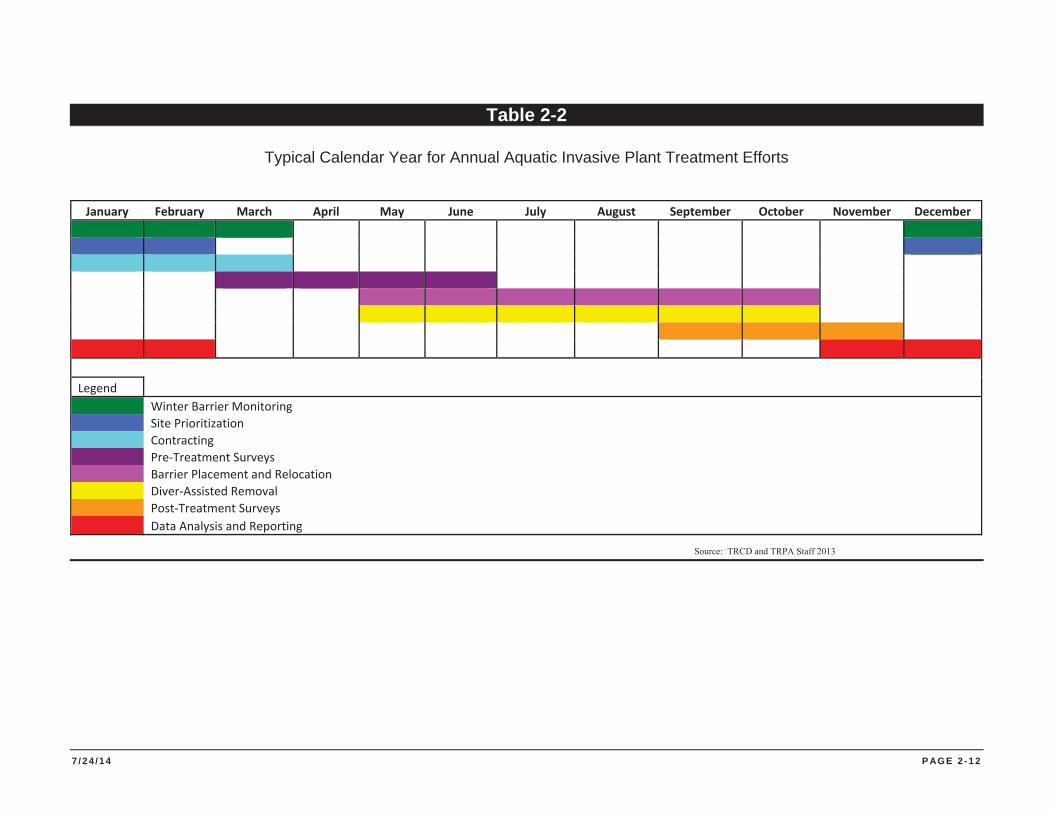
7 / 2 4 / 1 4 P AG E 2 - 1 2
Table 2-2
Typical Calendar Year for Annual Aquatic Invasive Plant Treatment Efforts
January February March April May June July August September October November December
Legend Winter Barrier Monitoring Site Prioritization Contracting Pre-Treatment Surveys Barrier Placement and Relocation Diver-Assisted Removal Post-Treatment Surveys Data Analysis and Reporting
Source: TRCD and TRPA Staff 2013
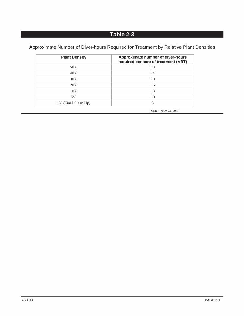
7 / 2 4 / 1 4 P AG E 2 - 1 3
Table 2-3
Approximate Number of Diver-hours Required for Treatment by Relative Plant Densities
Plant Density Approximate number of diver-hours required per acre of treatment (ABT)
50% 28 40% 24 30% 20 20% 16 10% 13 5% 10
1% (Final Clean Up) 5
Source: NAWWG 2013

7 / 2 4 / 1 4 P AG E 2 - 1 4
7 / 2 4 / 1 4 P AG E 3 - 1
SECTION 3 ENVIRONMENTAL ANALYSIS
The evaluation of environmental impacts is based upon the completion of the checklist portion of the Environmental Checklist Form, and consists of the analysis of each impact issue area required under CEQA. The analysis of each checklist item identifies significance criteria or thresholds used to evaluate each impact question, and any mitigation measure(s) identified to reduce the impact to a less-than-significant level.
This checklist identifies physical, biological, social and economic factors that might be affected by the Proposed Project Alternative (Project). In some cases, background studies performed in connection with the Project indicate no impacts. A “No Impact” answer in the last column reflects this determination. Where there is a need for clarifying discussion, the discussion is included either following the applicable section of the checklist or is within the body of the environmental document itself. The words "significant" and "significance" used throughout the following checklist are related to CEQA impacts and not NEPA effects. The questions in this analysis section are intended to encourage the thoughtful assessment of impacts.
To address potential NEPA permitting requirements, this section describes the affected environment and environmental consequences that could result from implementation of the Proposed Action (Project) and No Action alternatives described in Section 2. Aspects of the affected environment described in this section focus on relevant resources as determined by the context, duration and intensity of potential effects and by the issues identified during internal and external scoping. Certain environmental components require analysis under USACE policy. Only those aspects of the affected environment that are potentially affected by the Proposed Action and No Action alternatives are described in detail.
3.1 CUMULATIVE PROJECTS CONSIDERED
“Cumulative Impacts” is defined by CEQA Guideline section 15355 as “two or more individual effects which, when considered together, are considerable or which compound or increase other environmental impacts.
(a) The individual effects may be changes resulting from a single project or a number of separate projects.
(b) The cumulative impact from several projects is the change in the environment, which results from the incremental impact of the project when added to other closely related past, present, and reasonably foreseeable probable future projects. Cumulative impacts can result from individually minor but collectively significant projects taking place over a period of time.”
See also CEQA Guideline section 15065(a)(3). “A cumulative impact results from the combination of an adverse impact of the project together with related impacts caused by other projects. The project must contribute to the adverse impact; otherwise the impact cannot be characterized as a cumulative impact of that project.” (Kostka & Zischke, Practice Under the Cal. Environmental Quality Act (Cont.Ed.Bar 2009) § 13.38, p. 647; Sierra Club v. West Side Irrigation District (2005) 128 CAL.APP.4TH 690) in others words, if a project does not make some contribution to a cumulative environmental effect, the cumulative effect cannot be characterized as a cumulative impact of that project.
3.1.1 Past Projects
The following list includes past projects or types of projects located in the shorezone and considered towards cumulative effects:
Emerald Bay Aquatic Plant Control Project, 2010 to 2013;
7 / 2 4 / 1 4 P AG E 3 - 2
Lakeside Marina and Beach Aquatic Invasive Plant Control Project, 2012 and 2013; Ski Run Channel Aquatic Invasive Plant Control Project, 2012 and 2013; Emerald Bay Asian Clam Control Pilot Project, 2012 to 2014; and Shorezone structure permitting and construction consisting of piers, buoys, marina boat slips, boat
ramps, and related channel dredging.
3.1.2 Present and Reasonably Foreseeable Projects
The following list includes current and reasonably foreseeable projects within Lake Tahoe and the Truckee River corridor considered towards cumulative effects:
Lake Tahoe Passenger Ferry Service; Highway 89 Bypass Project at Tahoe City; Truckee River Rafting Permit Reauthorization; Maintenance dredging for existing marina channels and boat ramps; Pier extensions or relocations; and Buoy relocations.
7 / 2 4 / 1 4 P AG E 3 - 3
3.2 AESTHETICS
3.2.1 Environmental Setting
The topography, flora, water features, and climate combine to create the aesthetic character of the Project Area. Lake Tahoe is a large, high elevation (approximately 6223 feet) lake in the Sierra Nevada Mountains. The Lake Tahoe Basin is renowned for its natural beauty and Lake Tahoe is recognized as an Outstanding National Resource Water by the USEPA’s Water Quality Standards Program and the Clean Water Act. Rugged peaks, forested slopes, and the clear, blue waters of the lake characterize the scenery. The lake sits in a basin encompassed by the Crystal Range to the west and the Carson Range to the east. The border between California and Nevada divides the lake. Lake Tahoe Basin is approximately 20 miles southwest of Reno, Nevada and approximately 80 miles northeast of Sacramento, California.
The scenic vistas and visual resources of the Lake Tahoe Basin are widely valued by residents and visitors to the area. As summarized in the TRPA Regional Plan:
Scenic quality is perhaps the most often identified natural resource of the Lake Tahoe Basin. The Basin affords views of a magnificent lake setting within a forested mountainous environment. The unique combination of visual elements provides for exceptionally high aesthetic values. The maintenance of the Basin's scenic quality largely depends on careful regulation of the type, location, and intensity of land uses.
CEQA guidelines identify the Lake Tahoe Basin as an area of critical environmental sensitivity for its scenic as well as its ecological and recreational value. Federal policy, under the U.S. Department of Transportation Act Section 4(f), provides that “special effort should be made to preserve the natural beauty of the countryside and public park and recreational lands, wildlife, and waterfowl refuges, and historic sites.” The TRPA Compact states that the “Maintenance of the social and economic health of the region depends on maintaining the significant scenic values provided by the Lake Tahoe Basin” (TRPA Compact 1980).
The Lake Tahoe Region is a unique alpine destination offering immense vistas and vast amounts of natural beauty and scenery. The scenic beauty of the region is recognized as a national treasure. Because of this natural beauty, alpine setting, and large lake, the region is a popular recreation and vacation destination offering boating, skiing, hiking, and tourist accommodations as well as residential and commercial land uses that create a mixture of aesthetic characteristics throughout the Lake Tahoe Region (TRPA 2007).
The region offers a variety of natural settings and vistas. Some areas are characterized by meadows, while others include rocky outcrops and forest vegetation. As a basin, mountain peaks and ridgelines are visible around the lake. Most mountainsides lack structural development with the exception of ski facilities where straight, vertical swaths of cleared forest can be seen from roadways, communities, and the lake.
Most development along with major roads are concentrated on more gentle topographic settings near lake level. Development surrounds much of Lake Tahoe, with the north and south shores generally more developed than the west or east shores. Amongst the array of trees, is a mixture of parks, beaches, residences, and commercial development often located along the shoreline of the lake.
TRPA standards require maintenance of threshold rating values for roadway and shoreline travel routes, individually mapped scenic resources, recreation area scenic resources, and compatibility with the natural environment. For travel routes or views from inventoried scenic resources that are not in attainment, TRPA standards require mitigation actions to contribute to reaching attainment. The TRPA travel route ratings track long-term, cumulative changes to views from state and federal highways in urban, transition, and natural visual environments in the region. The ratings also track changes to shoreline views from the surface of Lake Tahoe.
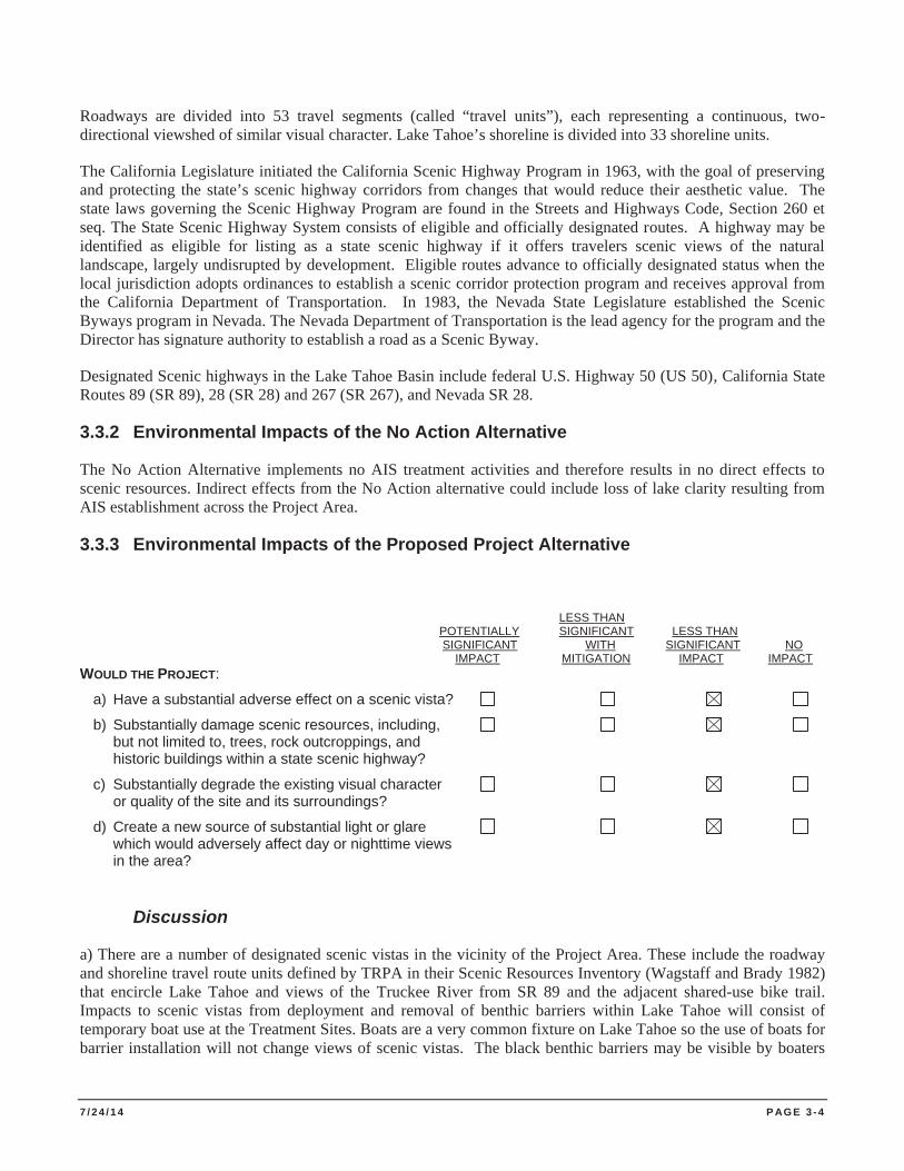
7 / 2 4 / 1 4 P AG E 3 - 4
Roadways are divided into 53 travel segments (called “travel units”), each representing a continuous, two-directional viewshed of similar visual character. Lake Tahoe’s shoreline is divided into 33 shoreline units.
The California Legislature initiated the California Scenic Highway Program in 1963, with the goal of preserving and protecting the state’s scenic highway corridors from changes that would reduce their aesthetic value. The state laws governing the Scenic Highway Program are found in the Streets and Highways Code, Section 260 et seq. The State Scenic Highway System consists of eligible and officially designated routes. A highway may be identified as eligible for listing as a state scenic highway if it offers travelers scenic views of the natural landscape, largely undisrupted by development. Eligible routes advance to officially designated status when the local jurisdiction adopts ordinances to establish a scenic corridor protection program and receives approval from the California Department of Transportation. In 1983, the Nevada State Legislature established the Scenic Byways program in Nevada. The Nevada Department of Transportation is the lead agency for the program and the Director has signature authority to establish a road as a Scenic Byway.
Designated Scenic highways in the Lake Tahoe Basin include federal U.S. Highway 50 (US 50), California State Routes 89 (SR 89), 28 (SR 28) and 267 (SR 267), and Nevada SR 28.
3.3.2 Environmental Impacts of the No Action Alternative
The No Action Alternative implements no AIS treatment activities and therefore results in no direct effects to scenic resources. Indirect effects from the No Action alternative could include loss of lake clarity resulting from AIS establishment across the Project Area.
3.3.3 Environmental Impacts of the Proposed Project Alternative
LESS THAN POTENTIALLY SIGNIFICANT LESS THAN SIGNIFICANT WITH SIGNIFICANT NO IMPACT MITIGATION IMPACT IMPACT WOULD THE PROJECT:
a) Have a substantial adverse effect on a scenic vista?
b) Substantially damage scenic resources, including, but not limited to, trees, rock outcroppings, and historic buildings within a state scenic highway?
c) Substantially degrade the existing visual character or quality of the site and its surroundings?
d) Create a new source of substantial light or glare which would adversely affect day or nighttime views in the area?
Discussion
a) There are a number of designated scenic vistas in the vicinity of the Project Area. These include the roadway and shoreline travel route units defined by TRPA in their Scenic Resources Inventory (Wagstaff and Brady 1982) that encircle Lake Tahoe and views of the Truckee River from SR 89 and the adjacent shared-use bike trail. Impacts to scenic vistas from deployment and removal of benthic barriers within Lake Tahoe will consist of temporary boat use at the Treatment Sites. Boats are a very common fixture on Lake Tahoe so the use of boats for barrier installation will not change views of scenic vistas. The black benthic barriers may be visible by boaters
7 / 2 4 / 1 4 P AG E 3 - 5
and travelers adjacent to the shoreline, but a fine sediment layer typically covers the barriers within days, making them difficult to see unless a viewer is specifically looking for them, resulting in a less than significant impact.
b) The Project Area and potential Treatment Sites are visible from California and Nevada Scenic Highways. However, treatment actions would occur under the surface of Lake Tahoe and a considerable distance from most viewpoint locations, resulting in a less than significant impact.
c) Barrier deployment would be temporary in nature with barriers installed and removed during a period of six weeks to 24 months. The existing visual character of the site would not be permanently altered and because of the minimal visibility of the barriers, the impacts to visual character and quality would result in a less than significant impact. Treatment actions designed to improve water quality and clarity are expected to result in long-term beneficial effects to the visual quality of the Project Area and surroundings.
d) Interference with nighttime skies from ground level light and glare or interference with vision due to reflective glare constitutes a significant impact. Depending on recreation uses of a Treatment Site, Project activities at times may be performed at night using lighting to avoid user conflicts. However, the Project does not create a new permanent source of light or glare and would therefore result in a less than significant impact.
3.2.4 Environmental Commitments and Mitigation Measures
The scenic resource analysis determines no mitigation measures are necessary.
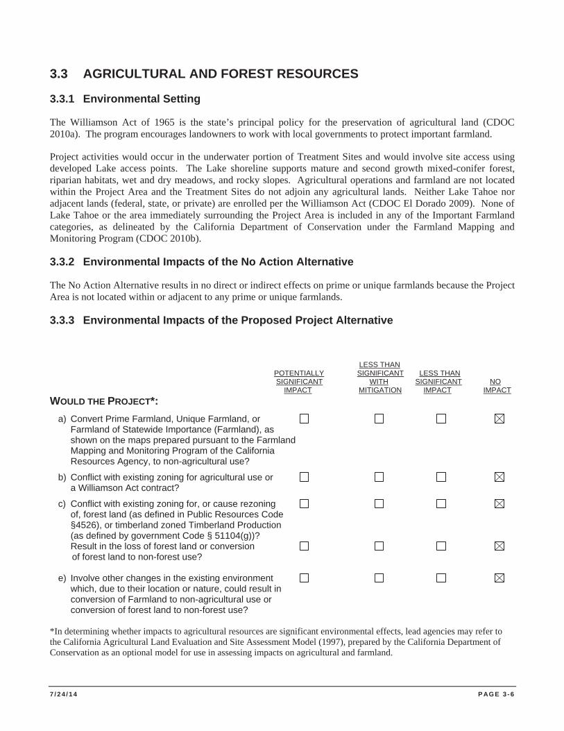
7 / 2 4 / 1 4 P AG E 3 - 6
3.3 AGRICULTURAL AND FOREST RESOURCES
3.3.1 Environmental Setting
The Williamson Act of 1965 is the state’s principal policy for the preservation of agricultural land (CDOC 2010a). The program encourages landowners to work with local governments to protect important farmland.
Project activities would occur in the underwater portion of Treatment Sites and would involve site access using developed Lake access points. The Lake shoreline supports mature and second growth mixed-conifer forest, riparian habitats, wet and dry meadows, and rocky slopes. Agricultural operations and farmland are not located within the Project Area and the Treatment Sites do not adjoin any agricultural lands. Neither Lake Tahoe nor adjacent lands (federal, state, or private) are enrolled per the Williamson Act (CDOC El Dorado 2009). None of Lake Tahoe or the area immediately surrounding the Project Area is included in any of the Important Farmland categories, as delineated by the California Department of Conservation under the Farmland Mapping and Monitoring Program (CDOC 2010b).
3.3.2 Environmental Impacts of the No Action Alternative
The No Action Alternative results in no direct or indirect effects on prime or unique farmlands because the Project Area is not located within or adjacent to any prime or unique farmlands.
3.3.3 Environmental Impacts of the Proposed Project Alternative
LESS THAN POTENTIALLY SIGNIFICANT LESS THAN SIGNIFICANT WITH SIGNIFICANT NO IMPACT MITIGATION IMPACT IMPACT WOULD THE PROJECT*: a) Convert Prime Farmland, Unique Farmland, or Farmland of Statewide Importance (Farmland), as shown on the maps prepared pursuant to the Farmland Mapping and Monitoring Program of the California Resources Agency, to non-agricultural use?
b) Conflict with existing zoning for agricultural use or a Williamson Act contract?
c) Conflict with existing zoning for, or cause rezoning of, forest land (as defined in Public Resources Code §4526), or timberland zoned Timberland Production (as defined by government Code § 51104(g))? Result in the loss of forest land or conversion
of forest land to non-forest use?
e) Involve other changes in the existing environment which, due to their location or nature, could result in
conversion of Farmland to non-agricultural use or conversion of forest land to non-forest use? *In determining whether impacts to agricultural resources are significant environmental effects, lead agencies may refer to the California Agricultural Land Evaluation and Site Assessment Model (1997), prepared by the California Department of Conservation as an optional model for use in assessing impacts on agricultural and farmland.
7 / 2 4 / 1 4 P AG E 3 - 7
Discussion
a) The Project Area does not contain Prime Farmland, Unique Farmland, or Farmland of Statewide Importance (Farmland), as shown on the maps prepared pursuant to the Farmland Mapping and Monitoring Program of the California Resources Agency. Because no lands designated Prime Farmland, Unique Farmland or Farmland of Statewide Importance exist within the Project Area, the Project results in no impact to these resources.
b) The Project Area is not zoned for agricultural use, and does not contain any Williamson Act contracts. Because no such zoning exists within the Project Area, the Project results in no impact to these resources.
c) The Project Area is not zoned for forest land (as defined in Public Resources Code section 12220(g)), timberland (as defined by Public Resources Code section 4526), or timberland zoned Timberland Production (as defined by Government Code section 51104(g)). Because the Project area contains no lands with these designations, the Project results in no impact to these resources.
d) The Project does not result in the loss of forest land or conversion of forest land to non-forest use. Because forest land does not exist within the Project Area, the Project creates no impact to this resource.
e) Because designated Farmland does not existing within the Project Area, the Project creates no impact to this resource.
3.3.4 Environmental Commitments and Mitigation Measures
The agricultural and forestry resource analysis determines no mitigation measures are necessary.
7 / 2 4 / 1 4 P AG E 3 - 8
3.4 AIR QUALITY
This section describes the air quality conditions in the Project Area and analyzes potential project-related impacts to air quality in the Lake Tahoe Basin. The study area for this analysis includes the Lake Tahoe water body, the TRPA jurisdictional portion of the Lower Truckee River and staging and access areas.
3.4.1 Environmental Setting
Lake Tahoe sits in a high-elevation basin bounded by the Sierra Nevada Mountains to the west and the Carson Range to the east. The source of the air pollutants that threaten Lake Tahoe water clarity are created both locally and from outside the basin. Local sources are the most significant contributor of pollutants and include urban and forest wood smoke, vehicle exhaust, and dust (Gertler et al. 2006). Air pollution sources from outside the basin include Sacramento and San Francisco Bay Area urban pollutants and smoke from wildfires.
The Lake Tahoe Air Basin is comprised of the eastern portions of Placer and El Dorado Counties in California and the western portions of Washoe, Douglas, and Carson City Counties in Nevada that encompass the Lake Tahoe hydrographic basin (CARB 2008).
Air Quality Standards. Public land owners and managers are subject to air quality planning programs required by the federal Clean Air Act of 1970 (CAA), its 1990 amendments, and within California, the California Clean Air Act of 1988 (CCAA). Both the federal and state clean air statutes provide for ambient air quality standards related to air pollutants, timetables for progressing toward achieving and maintaining ambient standards, and the development of plans to guide air quality improvement efforts by state and local agencies. Ambient air pollutants called criteria pollutants are pollutants for which acceptable levels of exposure can be determined and for which an ambient air quality standard has been set. The criteria pollutants of primary concern in the Project Area are carbon monoxide, ozone, nitrogen oxides, and particulate matter.
The USEPA is responsible for setting National Ambient Air Quality Standards (NAAQS) and established national area designations for six criteria pollutants after the passage of the Clean Air Act of 1970 (USEPA 2008). These pollutants include carbon monoxide (CO), ozone (O3), nitrogen dioxide (NO2), sulfur dioxide (SO2), lead (Pb), particulate matter 10 microns or less in diameter (PM10), and particulate matter 2.5 microns or less in diameter (PM2.5). If an area does not meet (or that contributes to ambient air quality in a nearby area that does not meet) the national primary or secondary ambient air quality standard for the pollutant, it is designated as “non-attainment.” If an area meets the national primary or secondary ambient air quality standard for the pollutant, it is designated in “attainment.” An area that cannot be classified on the basis of available information as meeting or not meeting the national primary or secondary ambient air quality standard for the pollutant is designated “unclassifiable” (USEPA 2008).
The California Air Resources Board (CARB) is the lead state agency responsible for air quality and for assisting local air districts in California. CARB has set California area designations for ten criteria pollutants including ozone, PM10, PM2.5, CO, NO2, SO2, sulfates, lead, hydrogen sulfide, and visibility reducing particles (VRPs). If a pollutant concentration is lower than the standard, the area is classified as “attainment” for that pollutant. If an area exceeds the standard, the area is classified as “non-attainment” for that pollutant. If there are not enough data available to determine whether the standard is exceeded in an area, the area is designated “unclassified” (CARB 2010).
The Project Area is within the jurisdiction of the El Dorado County Air Quality Management District, Placer County Air Quality Management District, and NDEP’s Bureau of Air Pollution Control, and Washoe County Health District’s Air Quality Management Division. The TRPA acts as the lead air quality planning agency in the Lake Tahoe Basin. TRPA responsibilities include controlling or mitigating air pollution through land use
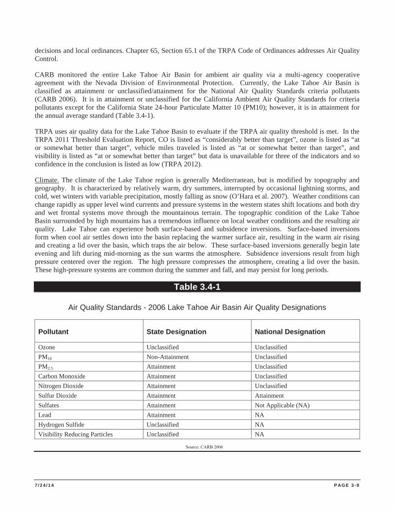
7 / 2 4 / 1 4 P AG E 3 - 9
decisions and local ordinances. Chapter 65, Section 65.1 of the TRPA Code of Ordinances addresses Air Quality Control.
CARB monitored the entire Lake Tahoe Air Basin for ambient air quality via a multi-agency cooperative agreement with the Nevada Division of Environmental Protection. Currently, the Lake Tahoe Air Basin is classified as attainment or unclassified/attainment for the National Air Quality Standards criteria pollutants (CARB 2006). It is in attainment or unclassified for the California Ambient Air Quality Standards for criteria pollutants except for the California State 24-hour Particulate Matter 10 (PM10); however, it is in attainment for the annual average standard (Table 3.4-1).
TRPA uses air quality data for the Lake Tahoe Basin to evaluate if the TRPA air quality threshold is met. In the TRPA 2011 Threshold Evaluation Report, CO is listed as “considerably better than target”, ozone is listed as “at or somewhat better than target”, vehicle miles traveled is listed as “at or somewhat better than target”, and visibility is listed as “at or somewhat better than target” but data is unavailable for three of the indicators and so confidence in the conclusion is listed as low (TRPA 2012).
Climate. The climate of the Lake Tahoe region is generally Mediterranean, but is modified by topography and geography. It is characterized by relatively warm, dry summers, interrupted by occasional lightning storms, and cold, wet winters with variable precipitation, mostly falling as snow (O’Hara et al. 2007). Weather conditions can change rapidly as upper level wind currents and pressure systems in the western states shift locations and both dry and wet frontal systems move through the mountainous terrain. The topographic condition of the Lake Tahoe Basin surrounded by high mountains has a tremendous influence on local weather conditions and the resulting air quality. Lake Tahoe can experience both surface-based and subsidence inversions. Surface-based inversions form when cool air settles down into the basin replacing the warmer surface air, resulting in the warm air rising and creating a lid over the basin, which traps the air below. These surface-based inversions generally begin late evening and lift during mid-morning as the sun warms the atmosphere. Subsidence inversions result from high pressure centered over the region. The high pressure compresses the atmosphere, creating a lid over the basin. These high-pressure systems are common during the summer and fall, and may persist for long periods.
Table 3.4-1
Air Quality Standards - 2006 Lake Tahoe Air Basin Air Quality Designations
Pollutant State Designation National Designation
Ozone Unclassified Unclassified PM10 Non-Attainment Unclassified PM2.5 Attainment Unclassified Carbon Monoxide Attainment Unclassified Nitrogen Dioxide Attainment Unclassified Sulfur Dioxide Attainment Attainment Sulfates Attainment Not Applicable (NA) Lead Attainment NA Hydrogen Sulfide Unclassified NA Visibility Reducing Particles Unclassified NA
Source: CARB 2006
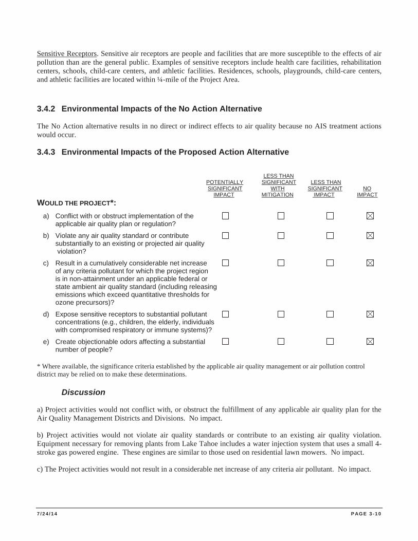
7 / 2 4 / 1 4 P AG E 3 - 1 0
Sensitive Receptors. Sensitive air receptors are people and facilities that are more susceptible to the effects of air pollution than are the general public. Examples of sensitive receptors include health care facilities, rehabilitation centers, schools, child-care centers, and athletic facilities. Residences, schools, playgrounds, child-care centers, and athletic facilities are located within ¼-mile of the Project Area.
3.4.2 Environmental Impacts of the No Action Alternative
The No Action alternative results in no direct or indirect effects to air quality because no AIS treatment actions would occur.
3.4.3 Environmental Impacts of the Proposed Action Alternative
LESS THAN POTENTIALLY SIGNIFICANT LESS THAN SIGNIFICANT WITH SIGNIFICANT NO IMPACT MITIGATION IMPACT IMPACT WOULD THE PROJECT*: a) Conflict with or obstruct implementation of the applicable air quality plan or regulation?
b) Violate any air quality standard or contribute substantially to an existing or projected air quality violation?
c) Result in a cumulatively considerable net increase of any criteria pollutant for which the project region is in non-attainment under an applicable federal or state ambient air quality standard (including releasing emissions which exceed quantitative thresholds for ozone precursors)?
d) Expose sensitive receptors to substantial pollutant concentrations (e.g., children, the elderly, individuals with compromised respiratory or immune systems)?
e) Create objectionable odors affecting a substantial number of people? * Where available, the significance criteria established by the applicable air quality management or air pollution control district may be relied on to make these determinations.
Discussion
a) Project activities would not conflict with, or obstruct the fulfillment of any applicable air quality plan for the Air Quality Management Districts and Divisions. No impact.
b) Project activities would not violate air quality standards or contribute to an existing air quality violation. Equipment necessary for removing plants from Lake Tahoe includes a water injection system that uses a small 4-stroke gas powered engine. These engines are similar to those used on residential lawn mowers. No impact.
c) The Project activities would not result in a considerable net increase of any criteria air pollutant. No impact.
7 / 2 4 / 1 4 P AG E 3 - 1 1
d) A sensitive receptor is generally defined as a person in the population who is particularly susceptible to health effects due to exposure to an air contaminant than is the population at large. Sensitive receptors (and the facilities that house them) in proximity to localized CO sources, toxic air contaminants or odors are of particular concern. Project activities would be performed at great distances to potential sensitive receptors, primarily under water and with equipment that minimizes the creation of air borne pollutants. Because Project activities would not release substantial pollutant concentrations and because the Treatment Sites would not be located in close proximity to sensitive receptors, no impact occurs.
e) Project activities would create no objectionable odors affecting a substantial number of people because of the nature of treatment and removal actions and no impact would occur.
3.4.4 Environmental Commitments and Mitigation Measures
The air resource analysis determines no mitigation measures are necessary.
7 / 2 4 / 1 4 P AG E 3 - 1 2
3.5 BIOLOGICAL RESOURCES
This section describes the conditions of biological resources in the Project Area and analyzes potential impacts to Special-Status Species, their habitats, Sensitive Natural Plant Communities Wetlands and Waters of the US and local policies protecting biological resources.
3.5.1 Environmental Setting
The nearshore and foreshore environments associated with Lake Tahoe support a diverse assemblage of biological resource. The Project activities are located within the Truckee River cooridor and the waters of Lake Tahoe in both the foreshore and nearshore environments of California and Nevada to a maximum depth of 30 feet. Upland vegetation is typical of the eastern Sierra Nevada consisting of Sierran Mixed Conifer, Jeffrey Pine, Montane Riparian and Wet Meadow habitats. The Lake Tahoe Basin provides habitat for over 262 species of resident and migratory vertebrate wildlife species. Based on the Lake Tahoe Watershed Assessment (Murphy and Knopp 2000), each of these species of mammals (66), birds (262), and reptiles (8) and amphibians (6) occur in the region because certain habitats are available to meet their needs. A total of 13 fish species (both native and introduced), occupy the waters of Lake Tahoe. The quality and size of the wide variety of habitats present generally determine the abundance of any one species or animal population.
Special-Status Species
Sensitive biological resources that potentially could occur in or near the Treatment Sites are discussed in this section. Special-status species (sensitive species) are defined as plants and animals that are legally protected or that are considered sensitive by federal, state, or local resource conservation agencies and organizations. Specifically, this list includes:
1. Species listed as state or federally Threatened or Endangered; 2. Species considered as candidates for listing as Threatened or Endangered; 3. Species identified by the USFWS and/or CDFW as Species of Special Concern; 4. Species identified by CDFW as Fully Protected or Protected; 5. Species identified as At-Risk by Nevada Natural Heritage Program; 6. Special status species of particular concern to the LTBMU; 7. Threshold Species as identified by the TRPA; 8. Other protected or sensitive animals; and 9. Plants considered by the California Native Plant Society (CNPS) and LTBMU to be rare, threatened, or
endangered. Habitats that are considered critical for the survival of a listed species or have special value for wildlife species and plant communities that are unique or of limited distribution are also included in this section.
Special-status species and their habitats were evaluated for potential impacts from the Project. Existing available data were collected and reviewed to determine the proximity of special-status plants, animals, and their habitats to the Treatment Sites. Queries of the CDFW California Natural Diversity Database (CNDDB) (2014), the California Native Plant Society’s On-line Inventory (CNPS 2014), and the US Fish and Wildlife Service (USFWS 2014) were conducted for special-status species and habitats within the United States Geological Survey (USGS) 7.5 minute quadrangle maps surrounding Lake Tahoe.
Special-status plant and animal species are described below along with their potential to occur at the Treatment Sites and the impacts this Project could cause to these species.
7 / 2 4 / 1 4 P AG E 3 - 1 3
Plant Species
The initial review of available information identified five (5) special-status plant species that could occur in or near the Project Area. Table 3.5-1 summarizes the potential for occurrence of each special-status plant species that was evaluated during this analysis. Based on a review of this list, two of these special-status plant species may have the potential to occur in proximity to Project activities. One plant community of local interest (TRPA) is also reviewed, and may have the potential to occur in the vicinity of the Project Area.
Plant Species with a Potential to Occur near the Project Area
Five plants evaluated as potentially present near the Project Area occur near lake margins, or within the Truckee River (Table 3.5-1). Project activities will be conducted from a boat or barge and work will occur underwater. One species of special status plant, Tahoe yellow-cress (TYC), has the potential to occur in close proximity to the Project Area. No operations from shore will be authorized in previously undisturbed areas with potential habitat for any of the five plant species listed above. Plant species also represented in the Deep Water Plant Community, of local concern, may have the potential to occur near the Project Area.
Wildlife Species
Murphy and Knopp estimate that the Lake Tahoe Basin supports at least 312 resident and migrant vertebrate species (2000). The following information is based on observations made by agency staff and information obtained from the CNDDB, the USFS LTBMU, TRPA wildlife database, and other database queries (Appendix E).
Mammals and birds use forested areas within the Lake Tahoe Basin for concealment, cover, nesting, denning, and foraging. Large mammals using this habitat include black bear (Ursus americanus), mule deer (Odocoileus hemionus), and mountain lion (Felis concolor). These large mammals have extensive home ranges and the same individual could conceivably frequent more than one park unit. Medium and small mammals observed in the park unit include coyote (Canis latrans), bobcat (Lynx rufus), raccoon (Procyon lotor), porcupine (Erethizon dorsatum), long-tailed weasel (Mustela frenata), pine marten (Martes americana), golden-mantled ground squirrel (Spermophilus lateralis), lodgepole chipmunk (Tamias speciosus), Trowbridge’s shrew (Sorex trowbridgii), and deer mouse (Peromyscus maniculatus). Common bird species include dark-eyed junco (Junco hymenalis), western tanager (Piranga ludoviciana), mountain chickadee (Poecile gambeli), and red-breasted nuthatch (Sitta canadensis).
Reptiles, amphibians, and fish comprise a relatively small percentage of the wildlife found in the Lake Tahoe Basin. In coniferous forest areas, lizard and snake species that may be found include western fence lizard (Sceloporus occidentalis) and western terrestrial garter snake (Thamnophis elegans). Most amphibians are dependent on streams, ponds, and other water bodies for reproduction and other aspects of their life. Amphibian species include Pacific tree frog (Hyla regilla) and American bullfrog (Rana catesbeiana). Fish species that occur include Lahontan cutthroat trout (Oncorhynchus clarkii henshawi), rainbow trout (Oncorhynchus mykiss), brook trout (Salvelinus fontinalis), Piute sculpin (Cottus beldingi), Lahonton redside shiner (Richardsonius egregious), and Tahoe sucker (Catostonmus tahoensis). Rrainbow trout, brook trout, and bullfrog are non-native species.
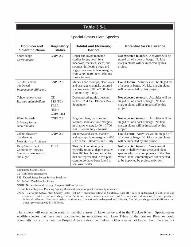
7 / 2 4 / 1 4 P AG E 3 - 1 4
Table 3.5-1
Special-Status Plant Species
Common and Scientific Name
Regulatory Status
Habitat and Flowering Period
Potential for Occurrence
Shore sedge Carex limosa
CNPS 2.2 Upper and lower montane conifer forest, bogs, fens, meadows, marshes, seeps, and swamps; in floating bogs and soggy meadows at lake margins; from 3,700-9,100 feet. Blooms June - August.
Not expected to occur. Activities will be staged off of a boat or barge. No lake margin plants will be impacted by this project
Slender-leaved pondweed Potamogeton filiformis
CNPS 2.2 Marshes and swamps, clear lakes and drainage channels, assorted shallow water; 980 – 7,600 feet. Blooms May – July.
Could Occur. Activities will be staged off of a boat or barge. No lake margin plants will be impacted by this project.
Tahoe yellow-cress Rorippa subumbellata
CE FSS (FC) TRPA NNHP CNPS 1B.1
Decomposed granitic beaches; 6217 – 6234 feet. Blooms May – September.
Not expected to occur. Activities will be staged off of a boat or barge. No lake margin plants will be impacted by this project.
Water bulrush Schoenoplectus subterminalis
CNPS 2.3 Bogs and fens, marshes and swamps, montane lake margins in shallow water; 2,400 – 7,700 feet. Blooms July - August
Not expected to occur. Activities will be staged off of a boat or barge. No lake margin plants will be impacted by this project.
Crème-flowered bladderwort Utricularia ochroleuca
CNPS 2.2 Meadows and seeps, marshes and swamps, lake margins; 4,650 – 4750 feet. Blooms June – July.
Could occur. Activities will be staged off of a boat or barge. No lake margin plants will be impacted by this project.
Deep Water Plant Community- mosses, liverworts, stoneworts, and algae
TRPA This plant community is typically found at depths greater than 200 feet, but some species that are represented in this plant community have been found in shallower water.
Not expected to occur. Work would occur in shallow water areas and plant species which are components of the Deep Water Plant Community are not expected to be impacted by project activities.
Regulatory Status Codes: CE: California endangered FSS: United States Forest Service Sensitive FC: Federal Candidate for listing NNHP: Nevada Natural Heritage Program At-Risk Species TRPA: Tahoe Regional Planning Agency threshold species or plant community of concern CNPS - California Native Plant Society Lists: List 1A = presumed extinct in California; List 1B = rare or endangered in California and
elsewhere; List 2 = rare or endangered in California, more common elsewhere; List 3 = need more information; List 4 = plants of limited distribution. New threat code extensions are: .1 = seriously endangered in California; .2 = fairly endangered in California; and .3 not very endangered in California.
The Project will occur underwater in nearshore areas of Lake Tahoe and in the Truckee River. Special-status wildlife species that have been documented in association with Lake Tahoe or the Truckee River or could potentially occur in or near the Project Area are described below. Other species not known from the area, but
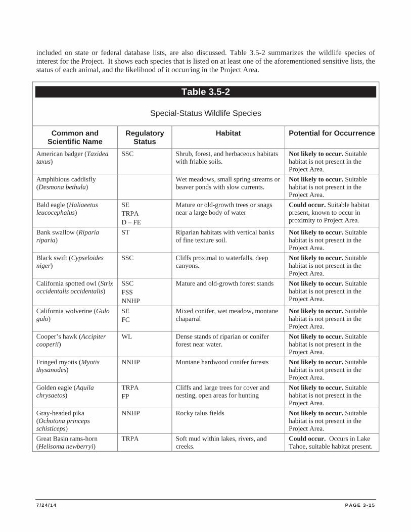
7 / 2 4 / 1 4 P AG E 3 - 1 5
included on state or federal database lists, are also discussed. Table 3.5-2 summarizes the wildlife species of interest for the Project. It shows each species that is listed on at least one of the aforementioned sensitive lists, the status of each animal, and the likelihood of it occurring in the Project Area.
Table 3.5-2
Special-Status Wildlife Species
Common and Scientific Name
Regulatory Status
Habitat Potential for Occurrence
American badger (Taxidea taxus)
SSC
Shrub, forest, and herbaceous habitats with friable soils.
Not likely to occur. Suitable habitat is not present in the Project Area.
Amphibious caddisfly (Desmona bethula)
Wet meadows, small spring streams or beaver ponds with slow currents.
Not likely to occur. Suitable habitat is not present in the Project Area.
Bald eagle (Haliaeetus leucocephalus)
SE TRPA D – FE
Mature or old-growth trees or snags near a large body of water
Could occur. Suitable habitat present, known to occur in proximity to Project Area.
Bank swallow (Riparia riparia)
ST Riparian habitats with vertical banks of fine texture soil.
Not likely to occur. Suitable habitat is not present in the Project Area.
Black swift (Cypseloides niger)
SSC Cliffs proximal to waterfalls, deep canyons.
Not likely to occur. Suitable habitat is not present in the Project Area.
California spotted owl (Strix occidentalis occidentalis)
SSC FSS NNHP
Mature and old-growth forest stands Not likely to occur. Suitable habitat is not present in the Project Area.
California wolverine (Gulo gulo)
SE FC
Mixed conifer, wet meadow, montane chaparral
Not likely to occur. Suitable habitat is not present in the Project Area.
Cooper’s hawk (Accipiter cooperii)
WL Dense stands of riparian or conifer forest near water.
Not likely to occur. Suitable habitat is not present in the Project Area.
Fringed myotis (Myotis thysanodes)
NNHP Montane hardwood conifer forests Not likely to occur. Suitable habitat is not present in the Project Area.
Golden eagle (Aquila chrysaetos)
TRPA FP
Cliffs and large trees for cover and nesting, open areas for hunting
Not likely to occur. Suitable habitat is not present in the Project Area.
Gray-headed pika (Ochotona princeps schisticeps)
NNHP Rocky talus fields Not likely to occur. Suitable habitat is not present in the Project Area.
Great Basin rams-horn (Helisoma newberryi)
TRPA Soft mud within lakes, rivers, and creeks.
Could occur. Occurs in Lake Tahoe, suitable habitat present.
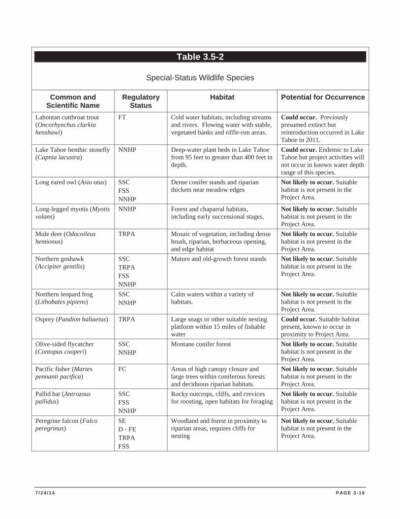
7 / 2 4 / 1 4 P AG E 3 - 1 6
Table 3.5-2
Special-Status Wildlife Species
Common and Scientific Name
Regulatory Status
Habitat Potential for Occurrence
Lahontan cutthroat trout (Oncorhynchus clarkia henshawi)
FT Cold water habitats, including streams and rivers. Flowing water with stable, vegetated banks and riffle-run areas.
Could occur. Previously presumed extinct but reintroduction occurred in Lake Tahoe in 2011.
Lake Tahoe benthic stonefly (Capnia lacustra)
NNHP Deep-water plant beds in Lake Tahoe from 95 feet to greater than 400 feet in depth.
Could occur. Endemic to Lake Tahoe but project activities will not occur in known water depth range of this species.
Long eared owl (Asio otus) SSC FSS NNHP
Dense conifer stands and riparian thickets near meadow edges
Not likely to occur. Suitable habitat is not present in the Project Area.
Long-legged myotis (Myotis volans)
NNHP Forest and chaparral habitats, including early successional stages.
Not likely to occur. Suitable habitat is not present in the Project Area.
Mule deer (Odocoileus hemionus)
TRPA Mosaic of vegetation, including dense brush, riparian, herbaceous opening, and edge habitat
Not likely to occur. Suitable habitat is not present in the Project Area.
Northern goshawk (Accipiter gentilis)
SSC TRPA FSS NNHP
Mature and old-growth forest stands Not likely to occur. Suitable habitat is not present in the Project Area.
Northern leopard frog (Lithobates pipiens)
SSC NNHP
Calm waters within a variety of habitats.
Not likely to occur. Suitable habitat is not present in the Project Area.
Osprey (Pandion haliaetus) TRPA Large snags or other suitable nesting platform within 15 miles of fishable water
Could occur. Suitable habitat present, known to occur in proximity to Project Area.
Olive-sided flycatcher (Contopus cooperi)
SSC NNHP
Montane conifer forest Not likely to occur. Suitable habitat is not present in the Project Area.
Pacific fisher (Martes pennanti pacifica)
FC Areas of high canopy closure and large trees within coniferous forests and deciduous riparian habitats.
Not likely to occur. Suitable habitat is not present in the Project Area.
Pallid bat (Antrozous pallidus)
SSC FSS NNHP
Rocky outcrops, cliffs, and crevices for roosting, open habitats for foraging
Not likely to occur. Suitable habitat is not present in the Project Area.
Peregrine falcon (Falco peregrinus)
SE D - FE TRPA FSS
Woodland and forest in proximity to riparian areas, requires cliffs for nesting
Not likely to occur. Suitable habitat is not present in the Project Area.
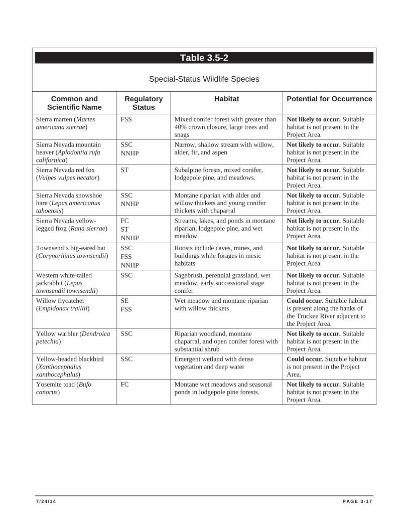
7 / 2 4 / 1 4 P AG E 3 - 1 7
Table 3.5-2
Special-Status Wildlife Species
Common and Scientific Name
Regulatory Status
Habitat Potential for Occurrence
Sierra marten (Martes americana sierrae)
FSS Mixed conifer forest with greater than 40% crown closure, large trees and snags
Not likely to occur. Suitable habitat is not present in the Project Area.
Sierra Nevada mountain beaver (Aplodontia rufa californica)
SSC NNHP
Narrow, shallow stream with willow, alder, fir, and aspen
Not likely to occur. Suitable habitat is not present in the Project Area.
Sierra Nevada red fox (Vulpes vulpes necator)
ST Subalpine forests, mixed conifer, lodgepole pine, and meadows.
Not likely to occur. Suitable habitat is not present in the Project Area.
Sierra Nevada snowshoe hare (Lepus americanus tahoensis)
SSC NNHP
Montane riparian with alder and willow thickets and young conifer thickets with chaparral
Not likely to occur. Suitable habitat is not present in the Project Area.
Sierra Nevada yellow-legged frog (Rana sierrae)
FC ST NNHP
Streams, lakes, and ponds in montane riparian, lodgepole pine, and wet meadow
Not likely to occur. Suitable habitat is not present in the Project Area.
Townsend’s big-eared bat (Corynorhinus townsendii)
SSC FSS NNHP
Roosts include caves, mines, and buildings while forages in mesic habitats
Not likely to occur. Suitable habitat is not present in the Project Area.
Western white-tailed jackrabbit (Lepus townsendii townsendii)
SSC Sagebrush, perennial grassland, wet meadow, early successional stage conifer
Not likely to occur. Suitable habitat is not present in the Project Area.
Willow flycatcher (Empidonax traillii)
SE FSS
Wet meadow and montane riparian with willow thickets
Could occur. Suitable habitat is present along the banks of the Truckee River adjacent to the Project Area.
Yellow warbler (Dendroica petechia)
SSC Riparian woodland, montane chaparral, and open conifer forest with substantial shrub
Not likely to occur. Suitable habitat is not present in the Project Area.
Yellow-headed blackbird (Xanthocephalus xanthocephalus)
SSC Emergent wetland with dense vegetation and deep water
Could occur. Suitable habitat is not present in the Project Area.
Yosemite toad (Bufo canorus)
FC Montane wet meadows and seasonal ponds in lodgepole pine forests.
Not likely to occur. Suitable habitat is not present in the Project Area.
7 / 2 4 / 1 4 P AG E 3 - 1 8
Regulatory Status Codes: SSC: California Department of Fish and Wildlife Species of Special Concern SE: California Department of Fish and Wildlife Endangered ST: California Department of Fish and Wildlife Threatened WL: California Department of Fish and Wildlife Watch List FP: California Department of Fish and Wildlife Fully Protected D – FE: Delisted United States Fish and Wildlife Service Endangered TRPA: Tahoe Regional Planning Agency Threshold Species FSS: United States Forest Service Sensitive FC: Candidate species for listing by United States Fish and Wildlife Service NNHP: Nevada Natural Heritage Program At-Risk Species
Wildlife Species Known or Likely to Occur in Lake Tahoe with Potential for Presence at or near the Project Area
The following wildlife species are known to occur or likely to occur in Lake Tahoe and the Truckee River and have the potential to be present within or in the vicinity of the Project Area.
Bald eagle (Haliaeetus leucocephalus) (nesting and wintering). The bald eagle was delisted under the Federal Endangered Species Act in 2007. However, the bald eagle is protected under the Bald and Golden Eagle Protection Act and the Migratory Bird Treaty Act (MBTA). Bald Eagles in the Lake Tahoe Basin can be either year-round residents or winter migrants. Nest trees are often in very large trees in proximity to water and the breeding season generally ranges between February and July (CDFG 2008). Suitable nesting and wintering habitat occur near the Project site along the margins of the lake. There are known nest sites near the mouth of Emerald Bay, in Sugar Pine Point State Park, and on Stateline Point. Creating excessive noise or visual disturbance during sensitive periods of the breeding season could result in impacts to this species.
Osprey (Pandion haliaetus). The osprey is a TRPA threshold species. They are a migratory species and are present during the breeding season, April 1 through August 15. They build large stick nests in treetops or snags in open forests within fifteen miles of water used for foraging (CDFG 2008). Ospreys are known to nest near the Project Area in Emerald Bay State Park, along multiple locations on the east shore, and a handful of locations on the north shore of Lake Tahoe. No impacts to suitable nesting habitat for this species would be altered by the Project; however, Project activities during the breeding season could impact this species by creating excessive noise or visual disturbance. Ospreys have high nest site fidelity and selectively choose nesting locations with a clear view of the surrounding area. Creating excessive noise or visual disturbance during sensitive periods of the breeding season could result in impacts to this species. However, osprey in Lake Tahoe often nest in close proximity to high boat traffic and recreation uses and become habituated to a tolerable level of disturbance from human presence.
Willow Flycatcher (Empidonmax traillii). The willow flycatcher (Empidonax traillii adastus) is a Forest Service Sensitive speices and is considered endangered by CDFW. It is a rare to locally uncommon, summer resident in wet meadow and montane riparian habitats above 2000 feet in the Sierra Nevada and Cascade Range. The birds are most often found in broad, open river valleys or in large meadows. Great Basin races are known as E. t. adastus. To the north and west, Pacific Northwest races are regarded as a separate subspecies E. t. brewsteri. The species is often found nesting in ungrazed willow thickets of mountain meadows, seeps and streams where it feeds on flying insects. This species has suitable habitat along the banks of the Truckee River but has not previously been recorded in the CNDDB for the Project Area.
Great Basin rams-horn (Helisoma newberryi). This species is known to occur in Lake Tahoe. These snails burrow into soft mud of larger lakes and slow rivers. The Project Area consists of rock or cobble substrate and there are
7 / 2 4 / 1 4 P AG E 3 - 1 9
no soft, muddy habitat types with slow moving water within the Project Area. Because typically suitable habitat for this species does not occur in the Project Area, impacts to this species are expected to be less than significant.
Lake Tahoe benthic stonefly (Capnia lacustra). This species is known to occur in Lake Tahoe at depths of 95 to 400 feet. Project activities will not occur in deep water areas and will not impact suitable habitat for this species.
Lahontan Cutthroat Trout (Oncorhynchus clarkii henshawi). Researchers are in the process of reintroducing Lahontan cutthroat trout (LCT) into Lake Tahoe and Fallen Leaf Lake to monitor survival and life history traits as well as provide a recreational fishery. LCT were stocked in the waters of Lake Tahoe by Nevada Division of Wildlife in 2011 to support recreational trout fishing. However, as LCT do not compete well with other non-native fish that occur in Lake Tahoe, this stocking was not anticipated to support recovery of LCT. Because LCT are obligate stream spawners, deployment of benthic barriers and removal of aquatic plants are not expected to impact potential spawning habitat. A combination of factors is presumed to have led to the extirpation of Lahontan cutthroat trout from Lake Tahoe, with over fishing and the introduction of non-native species being the most significant. Aquatic invasive plants such as Eurasian watermilfoil and curly-leaf pondweed negatively impact habitat for native species; removal of aquatic plants from a targeted LCT reintroduction area is not anticipated to negatively impact reintroduced Lahontan cutthroat trout and may benefit the recovery of LCT in Lake Tahoe.
Common Biological Communities
Lake Tahoe supports a variety of aquatic biological communities. The lake fishery includes brook trout, kokanee salmon, rainbow trout, mackinaw, brown trout, and mountain whitefish, which is the only native species. Nongame fish species include Tahoe sucker, Lahontan redside, Lahontan speckled dace, Piute sculpin, and Tui chub. Lake Tahoe is limited in its fishery production as it has low primary production. Existing low levels of nutrients limits its primary productivity. Fish productivity is also limited due to relative low levels of suitable feeding, cover and spawning habitats. Historical impacts to lake habitats during the Comstock era and urban development have further impacted suitable fish habitats in Lake Tahoe (TRPA 1991).
The Lake Tahoe Region fishery is sensitive to habitat disturbance. The maintenance of the fishery has focused on preserving fish habitat in regional lakes and streams. To survive, fish must have favorable water quality, an adequate food supply, and suitable feeding, cover, spawning, and juvenile rearing habitats. Comstock era logging and urban development have negatively impacted lake and stream habitats in the Tahoe Region. The loss of vegetation cover, in-stream flow manipulations, siltation, deterioration of streambed features, and barriers to migration, have negatively impacted fish populations and habitat (TRPA 1991).
Aquatic habitats at Lake Tahoe were identified by Phillips et al. (1978) and included fish spawning areas, inlets to spawning streams, and wetlands. Phillips, et al. (1978) defined prime fish and aquatic habitats as areas that satisfy habitat requirements critical to the survival of fish, or as important components of the Lake’s aquatic food chain. These areas commonly had nearshore substrates consisting of rock, boulders, and/or rubble. These areas provided cover, forage and nursery grounds for a wide variety of organisms, including periphyton, zooplankton, benthic macroinvertebrates, snails, clams, crayfish, and fish (TRPA 2004). Whitman et al. (2012) showed that benthic macroinvertebrate abundances were reduced as a result of barrier placement for Asian clam (Corbicula fluminea) removal and recolonization rates were variable in relation to individual taxon. However, past treatment areas in the Tahoe Keys have shown no apparent effects of synthetic barrier placement and removal on benthic invertebrate densities (TRCD 2013; TRCD 2012).
Sensitive Natural Plant Communities
Sensitive plant communities are regionally uncommon or unique, unusually diverse, or of special concern to local, state, and federal agencies. Removal or substantial degradation of these plant communities constitutes a
7 / 2 4 / 1 4 P AG E 3 - 2 0
significant adverse impact under CEQA. A search of the CNDDB did not show any sensitive natural plant communities near the Project Area (CNDDB 2014), but the deep water plant communities in Lake Tahoe are of concern because they are important ecological components in Lake Tahoe and have experienced substantial long-termdeclines. These plant communities consist of mosses, liverworts, stoneworts, and algae and are typically found at depths greater than 200 feet. Control activities will occur in waters generally less than 30 feet deep. Project activities are not expected to impact deep-water plant communities.
Wetlands and Waters of the United States
The Federal CWA defines wetlands as lands that are inundated or saturated by surface or ground water at a frequency and duration sufficient to support, and under normal circumstances do support, a prevalence of vegetation typically adapted for life in saturated soil conditions. The USACE has jurisdictional authority of wetlands under provisions found in Section 404 of the CWA. Typically, the USACE jurisdictional wetlands meet three criteria: hydrophytic vegetation; hydric soils; and wetland hydrology.
Waters of the U.S. (Other Waters) are regulated by the USACE under Sections 401 and 404 of the CWA. They are defined as waters used in interstate or foreign commerce, waters subject to the ebb and flow of the tide, interstate waters including interstate wetlands and other waters such as: intrastate lakes, rivers, streams, mudflats, sandflats, wetlands, sloughs, prairie potholes, wet meadows, playa lakes, and natural ponds. Waters of the U.S. are under the USACE jurisdiction.
TRPA Goals and Policy, Chapter IV: Conservation Element, Vegetation Goal #2 is to “Provide for maintenance and restoration of such unique ecosystems as wetlands, meadows, and other riparian vegetation.” TRPA’s goals and policies are implemented by TRPA and the Lahontan by special designation for wetlands and other waters known as Stream Environment Zones (SEZs). SEZs have additional protective regulations.
3.5.2 Environmental Impacts of the No Action Alternative
The no action alternative would result in the continued growth and spread of invasive aquatic plant species. The prolific growth and expansion of these invasive populations would lead to habitat disruption and loss of native plant and animal communities. These aquatic invasive species often outcompete native plant species and modify the environment to allow for favorable conditions to allow for establishment of other invasive species of plant and animal. This modification can result in a loss in natural species diversity and overall health of local lentic and lotic ecosystems.
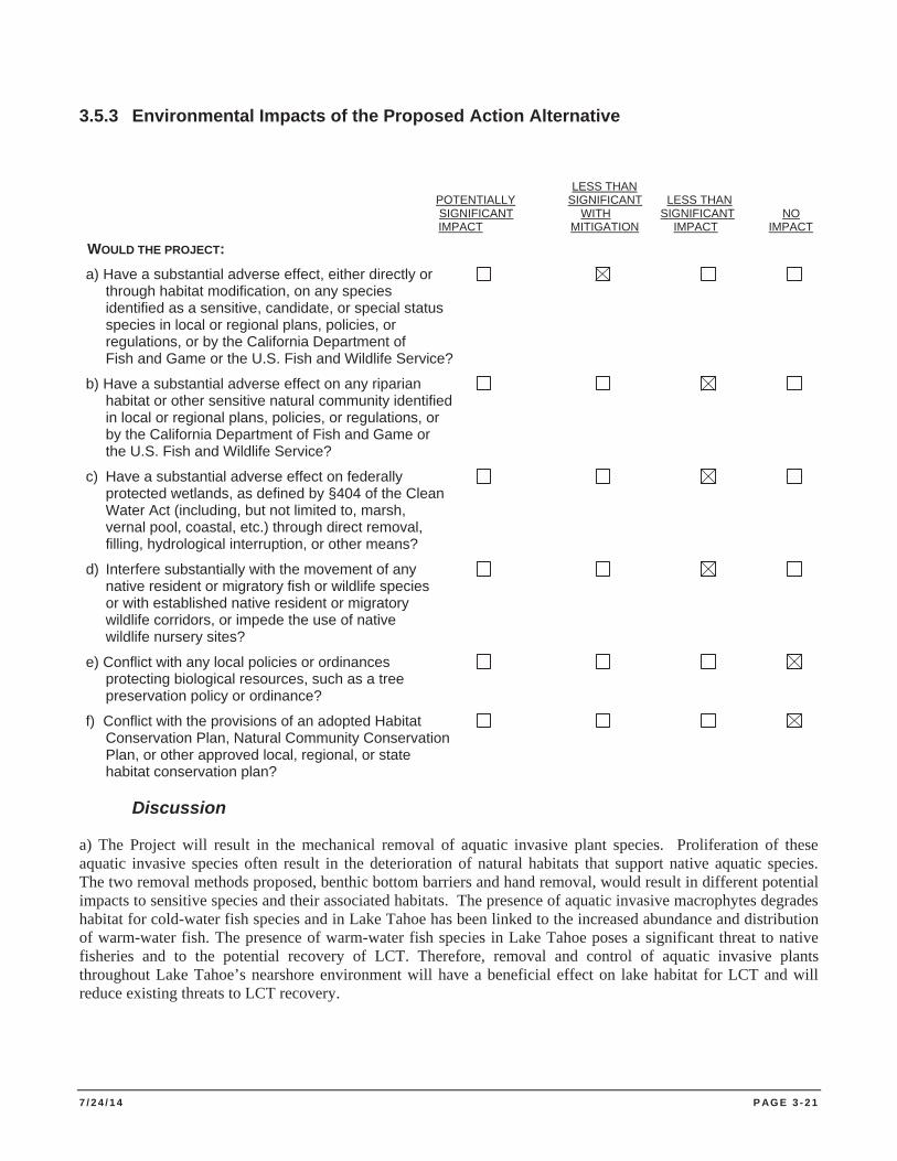
7 / 2 4 / 1 4 P AG E 3 - 2 1
3.5.3 Environmental Impacts of the Proposed Action Alternative
LESS THAN POTENTIALLY SIGNIFICANT LESS THAN SIGNIFICANT WITH SIGNIFICANT NO IMPACT MITIGATION IMPACT IMPACT
WOULD THE PROJECT: a) Have a substantial adverse effect, either directly or through habitat modification, on any species identified as a sensitive, candidate, or special status species in local or regional plans, policies, or regulations, or by the California Department of Fish and Game or the U.S. Fish and Wildlife Service?
b) Have a substantial adverse effect on any riparian habitat or other sensitive natural community identified in local or regional plans, policies, or regulations, or by the California Department of Fish and Game or the U.S. Fish and Wildlife Service?
c) Have a substantial adverse effect on federally protected wetlands, as defined by §404 of the Clean Water Act (including, but not limited to, marsh, vernal pool, coastal, etc.) through direct removal, filling, hydrological interruption, or other means?
d) Interfere substantially with the movement of any native resident or migratory fish or wildlife species or with established native resident or migratory wildlife corridors, or impede the use of native wildlife nursery sites?
e) Conflict with any local policies or ordinances protecting biological resources, such as a tree preservation policy or ordinance?
f) Conflict with the provisions of an adopted Habitat Conservation Plan, Natural Community Conservation Plan, or other approved local, regional, or state habitat conservation plan?
Discussion
a) The Project will result in the mechanical removal of aquatic invasive plant species. Proliferation of these aquatic invasive species often result in the deterioration of natural habitats that support native aquatic species. The two removal methods proposed, benthic bottom barriers and hand removal, would result in different potential impacts to sensitive species and their associated habitats. The presence of aquatic invasive macrophytes degrades habitat for cold-water fish species and in Lake Tahoe has been linked to the increased abundance and distribution of warm-water fish. The presence of warm-water fish species in Lake Tahoe poses a significant threat to native fisheries and to the potential recovery of LCT. Therefore, removal and control of aquatic invasive plants throughout Lake Tahoe’s nearshore environment will have a beneficial effect on lake habitat for LCT and will reduce existing threats to LCT recovery.
7 / 2 4 / 1 4 P AG E 3 - 2 2
The potential exists for LCT to be present in the Project Area during both placement of the benthic barriers and also during mechanical hand removal of non-native plant species. Installation of the benthic barriers have the possibility to have passive impacts on LCT through the avoidance of Treatment Areas during AIS removal activities. However, these impacts are less than significant as LCT spawn in streams and not on lake substrate, therefore avoidance of Treatment Areas will not result in a decrease in species reproduction or overall health. Beneficial impacts to overall lake habitat will result through the removal of non-native species by virtue of placement of the benthic barriers, thereby increasing suitable habitat. The presence of divers and equipment is similar to the existing conditions of recreational boaters, swimmers, scuba divers, and anglers that generally occur throughout the Project Area. During past plant removal efforts, divers have observed the behavior of large trout, most likely rainbow trout and Mackinaw trout, to continue undisturbed in the presence of the divers. Therefore, displacement due to temporary project activities is unlikely and is expected to have no effect on LCT.
Mechanical hand removal and diver-assisted removal have the potential for suction of LCT and other fish species. This impact is unlikely as fish species avoid project areas during construction as noted above. Other temporary impacts that may result due to increased turbidity which may have an adverse effect on foraging activities of LCT and other fish species. Turbidity impacts are mitigated through MITIGATION MEASURE HYDRO-1 through installation of turbidity curtains and monitoring requirements. Monitoring results from previous plant removal efforts have shown a discrete, short-term disturbance to clarity with turbidity levels returning to background generally within 10-15 minutes. Past plant removal efforts in Lake Tahoe have not exceeded permissible water quality parameters or nor have past projects caused water quality conditions that are potentially harmful to fish. Therefore, temporary and localized elevations in water turbidity are expected to have no effect on LCT.
Impacts to Tahoe yellow-cress (TYC) will not occur with the implementation of identified project elements that will avoid disturbance to upland vegetation. The Project will have no effect on Tahoe yellow-cress populations.
Impacts to benthic macroinvertebrate community may occur as a result of barrier placement through the modification of community structure and differing rates of recolinization (Whitmann et al. 2012a). However, previously completed work in the Tahoe keys shows no apparent impact to density of benthic macroinvertebrates in treatment areas (Tahoe RCD 2013; Tahoe RCD 2012). Suction dredging activities during removal of Asian clam infestations have been shown to disrupt benthic macroinvertebrate community structure (Whitmann et al. 2012a) through the removal of non-target macroinvertebrate species. Long-term effects on these communities are not known and monitoring is needed to determine the effects of suction dredging (Whitemann et al. 2012b). It should be noted the Lake Tahoe benthic stonefly is unlikely to be impacted by barrier placement due to proposed work being performed to a depth of 30 feet, whereas the Lake Tahoe benthic stonefly occurs at depths greater than 95 feet. Suction dredging is not a necessary action for this Project and is not proposed for removal of aquatic invasive plants.
Bald eagle and osprey are known to nest in a variety of areas along the shores of Lake Tahoe. The potential exists for impacts to these species due to noise and visual disturbance from project activites. Suitable nesting and foraging habitat, in the form of willow thickets adjacent to standing water, also exists along the banks of the Truckee River for willow flycatcher. Impacts to potential willow flycatcher nesting activity are not likely due to the exising high level of recreational use of the upper reaches of the Truckee River by rafters, swimmers and other day use activies. Additionally the bike path that parrallels the highway and the river is used heavily during the spring, summer and fall months. Project activities in this area will not have a negative impact due to the exising and ongoing human presence and activity in the area and the fact that AIS removal will occur in open water.
Increased noise and human presence in the Treatment Sites during nesting season may have negative impacts on the reproductive success of osprey and bald eagle. Implementation of MITIGATION MEASURE BIO-1 will reduce potential visual and noise disturbance to a less than significant level. The placement of the underwater benthic barriers over the substrate of the Treatment Sites and mechanical removal of non-native plant species will
7 / 2 4 / 1 4 P AG E 3 - 2 3
have less than significant impacts on species identified as sensitive, candidate, or special status species with the inclusion of the mitigation outlined below.
b) Project activities would not result in impacts to riparian habitat as activities will take place in deep water and away from shores or stream banks of the Truckee River. Deep water plant communities are of local concern because they are important to the ecology of Lake Tahoe and because they have experienced substantial documented declines in the lake. The Project is not expected to impact deep water plant communities because the Project Area is contained within 30 feet of water depth. Removal of AIS in the lake and the upper reaches of the Truckee River will result in a long-termbenefit for native species in Lake Tahoe and will have a less than significant impact on riparian habitat and sensitive natural communities.
c) Project activities would occur on the lake and river substrates of the of the treatments sites located in Lake Tahoe and the upper reaches of the Truckee River. Benthic barriers will be secured to the lake bottom temporarily covering the substrate and any substrate affected by diver-assisted suction removal of non-native plant species would be left in place or returned clean. No long-term negative impacts to wetlands and waters of the US are expected as a result of removal of non-native plant species. Temporary impacts to waters of the US will result through the installation of benthic barriers and associated anchors. These materials, while considered fill, will be removed at the end of the project duration and will not be placed in the Treatment Sites in perpetuity. The Project would comply with State and Federal regulatory requirements concerning work in protected waters. The short-term duration of the project, long-termecological benefits of the proposed activities, and lack of permanent alteration of the substrate would result in less than significant impacts.
d) The Project will not impede fish or wildlife movement and will not impact wildlife corridors. Work will occur in Lake Tahoe and the upper reaches of the Truckee River both of which are known to be fish bearing. Installation of turbidity curtains surrounding the Treatment Sites will not impact the movement of fish species as small working areas will be cordoned off at any one time. This will prevent large areas from becoming excluded from fish movement. The positive impacts of non-native plant species removal resulting from the project will result in increased habitat suitability and will likely increase movement opportunities for native fish species. The short-term impacts noted above will result in less than significant impacts to fish and their associated movement. There are no known wildlife nursery sites in the Project Area.
e) The Project will comply with local policies protecting biological resources. The purpose of the Project is to protect the native aquatic habitats of Lake Tahoe and the upper reaches of the Truckee River that lie within the Tahoe Basin. The resulting conditions will benefit local native biological resources and will have a beneficial impact on the ecology of the Project Area. Therefore, no impacts would occur.
f) The Project will not conflict with local ordinances, adopted conservation plans, or policies. The resulting conditions will benefit local native biological resources and will have a beneficial impact on the ecology of the Project Area. Therefore, no impacts would occur.
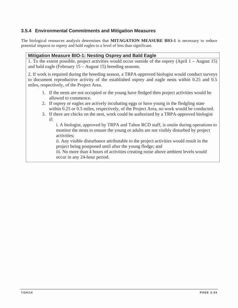
7 / 2 4 / 1 4 P AG E 3 - 2 4
3.5.4 Environmental Commitments and Mitigation Measures
The biological resources analysis determines that MITAGATION MEASURE BIO-1 is necessary to reduce potential impacts to osprey and bald eagles to a level of less than significant.
Mitigation Measure BIO-1: Nesting Osprey and Bald Eagle 1. To the extent possible, project activities would occur outside of the osprey (April 1 – August 15) and bald eagle (February 15 – August 15) breeding seasons.
2. If work is required during the breeding season, a TRPA-approved biologist would conduct surveys to document reproductive activity of the established osprey and eagle nests within 0.25 and 0.5 miles, respectively, of the Project Area.
1. If the nests are not occupied or the young have fledged then project activities would be allowed to commence.
2. If osprey or eagles are actively incubating eggs or have young in the fledgling state within 0.25 or 0.5 miles, respectively, of the Project Area, no work would be conducted.
3. If there are chicks on the nest, work could be authorized by a TRPA-approved biologist if:
i. A biologist, approved by TRPA and Tahoe RCD staff, is onsite during operations to monitor the nests to ensure the young or adults are not visibly disturbed by project activities; ii. Any visible disturbance attributable to the project activities would result in the project being postponed until after the young fledge; and iii. No more than 4 hours of activities creating noise above ambient levels would occur in any 24-hour period.
7 / 2 4 / 1 4 P AG E 3 - 2 5
3.6 CULTURAL RESOURCES, AREAS OF CRITICAL ENVIRONMENTAL CONCERN (ACEC) AND NATIVE AMERICAN CULTURAL VALUES
3.6.1 Environmental Setting
Current environmental review policies, in compliance with the TRPA’s Code of Ordinances Section 29.5A and CEQA Section 15064.5, require that heritage resources be considered as part of environmental documentation.
CEQA requires that projects financed by, or requiring the discretionary approval of public agencies in California, must consider the effects that a project has on historical and unique archaeological resources (PRC Section 21083.2). Historical resources are defined as buildings, sites, structures, or objects, each of which may have historical, architectural, archaeological, cultural or scientific importance (PRC Section 50201).
Executive Order W-26-92 requires state agencies, including Parks, in furtherance of the purposes and policies of the state’s environmental protection laws and historic resource preservation laws, to the extent prudent and feasible within existing budget and personnel resources, to preserve and maintain the significant heritage (cultural and historical) resources of the state.
This section discusses the potential Project impacts on cultural resources related to disturbance of archaeological, historical, architectural, and Native American and traditional heritage resources and addresses disturbance of unknown archaeological and paleontological resources (fossils). To provide a basis for this evaluation, the setting subsection describes broad periods of cultural history for the Project Area, which is the lake body itself. The goal of the cultural resources analysis for this Project is to identify prehistoric and historic archaeological sites, architectural and historical sites, historical landscapes, and traditional cultural properties, including Native American heritage resources, potentially affected by implementation of the Project. Detailed archaeological and ethnographic studies of the Project Area are found in the cultural resource report prepared for the Project, which is attached in Appendix D.
Detailed research on the topic of Tahoe Sierra paleoclimate is found in The Lake Tahoe Environmental Improvement Program, Volume 1, Contextual Background: Lake Tahoe Outlet (Lindström et al. 2002), and in The Lake Tahoe Watershed Assessment, Vol. 1, Chapter 2 (Murphy and Knopp 2000).
There are several Native American communities in close proximity to Lake Tahoe. None of these communities are living on, or adjacent to, the Project Area. No treaty rights (hunting, fishing, etc.) are associated with any of these communities or with the Project Area. Some members of these communities hunt and some do subsistence collecting of materials such as basket weaving materials and medicinal plants on public lands. However, this is general use and no specific “traditional use areas” have been identified by any of the tribes at this time. Any other traditional uses or use areas have not been divulged towards preparation of this environmental document. The Project Area has not been identified as a Native American religious or sacred site.
A full accounting of known cultural resources within the Project Area was achieved through a comprehensive literature review and records search of regional, federal and state agency archives. The study area was defined as areas around the shoreline from the lake’s natural rim (6223 feet elevation contour) to a depth of 36-foot (11 meters) below present water level (6220 feet elevation). Denise Jaffke, Associate State Archaeologist with California State Park, conducted a records search of 1) the Sierra District Unit Data Files located at the Cultural Resources Office, Ed Z’berg Sugar Pine Point State Park, 2) CTC cultural resource files, and 3) Heritage Resource files located at LTBMU. Information collected in the course of research was supplemented with pertinent archaeological resource information compiled by Susan Lindström, a resident Archaeologist with substantial experience in the Project Area. Archaeological resource information was compiled into a single Excel spreadsheet and georeferenced using ArcMap 10. Record searches undertaken for this Project had two primary
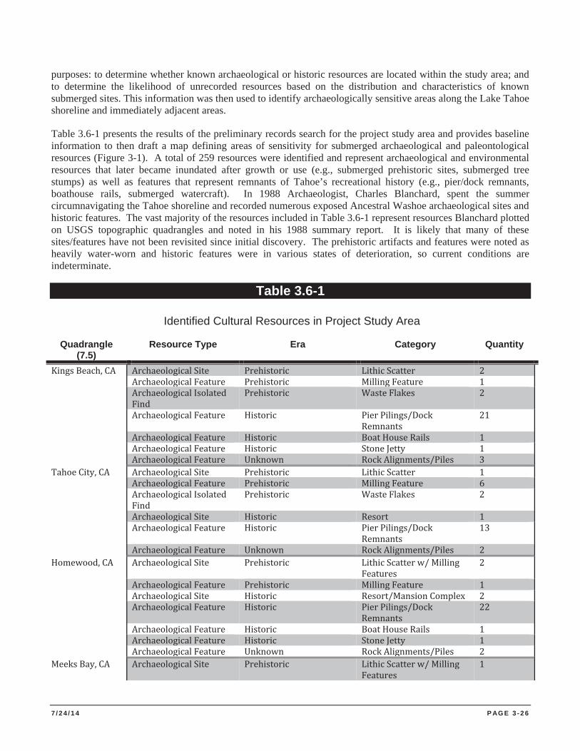
7 / 2 4 / 1 4 P AG E 3 - 2 6
purposes: to determine whether known archaeological or historic resources are located within the study area; and to determine the likelihood of unrecorded resources based on the distribution and characteristics of known submerged sites. This information was then used to identify archaeologically sensitive areas along the Lake Tahoe shoreline and immediately adjacent areas.
Table 3.6-1 presents the results of the preliminary records search for the project study area and provides baseline information to then draft a map defining areas of sensitivity for submerged archaeological and paleontological resources (Figure 3-1). A total of 259 resources were identified and represent archaeological and environmental resources that later became inundated after growth or use (e.g., submerged prehistoric sites, submerged tree stumps) as well as features that represent remnants of Tahoe’s recreational history (e.g., pier/dock remnants, boathouse rails, submerged watercraft). In 1988 Archaeologist, Charles Blanchard, spent the summer circumnavigating the Tahoe shoreline and recorded numerous exposed Ancestral Washoe archaeological sites and historic features. The vast majority of the resources included in Table 3.6-1 represent resources Blanchard plotted on USGS topographic quadrangles and noted in his 1988 summary report. It is likely that many of these sites/features have not been revisited since initial discovery. The prehistoric artifacts and features were noted as heavily water-worn and historic features were in various states of deterioration, so current conditions are indeterminate.
Table 3.6-1
Identified Cultural Resources in Project Study Area
Quadrangle (7.5)
Resource Type Era Category Quantity
Kings Beach, CA Archaeological Site Prehistoric Lithic Scatter 2 Archaeological Feature Prehistoric Milling Feature 1 Archaeological Isolated
Find Prehistoric Waste Flakes 2
Archaeological Feature Historic Pier Pilings/Dock Remnants
21
Archaeological Feature Historic Boat House Rails 1 Archaeological Feature Historic Stone Jetty 1 Archaeological Feature Unknown Rock Alignments/Piles 3 Tahoe City, CA Archaeological Site Prehistoric Lithic Scatter 1 Archaeological Feature Prehistoric Milling Feature 6 Archaeological Isolated
Find Prehistoric Waste Flakes 2
Archaeological Site Historic Resort 1 Archaeological Feature Historic Pier Pilings/Dock
Remnants 13
Archaeological Feature Unknown Rock Alignments/Piles 2 Homewood, CA Archaeological Site Prehistoric Lithic Scatter w/ Milling
Features 2
Archaeological Feature Prehistoric Milling Feature 1 Archaeological Site Historic Resort/Mansion Complex 2 Archaeological Feature Historic Pier Pilings/Dock
Remnants 22
Archaeological Feature Historic Boat House Rails 1 Archaeological Feature Historic Stone Jetty 1 Archaeological Feature Unknown Rock Alignments/Piles 2 Meeks Bay, CA Archaeological Site Prehistoric Lithic Scatter w/ Milling
Features 1
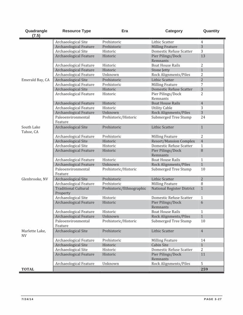
7 / 2 4 / 1 4 P AG E 3 - 2 7
Quadrangle (7.5)
Resource Type Era Category Quantity
Archaeological Site Prehistoric Lithic Scatter 4 Archaeological Feature Prehistoric Milling Feature 3 Archaeological Site Historic Domestic Refuse Scatter 3 Archaeological Feature Historic Pier Pilings/Dock
Remnants 13
Archaeological Feature Historic Boat House Rails 2 Archaeological Feature Historic Stone Jetty 1 Archaeological Feature Unknown Rock Alignments/Piles 2 Emerald Bay, CA Archaeological Site Prehistoric Lithic Scatter 2 Archaeological Feature Prehistoric Milling Feature 7 Archaeological Site Historic Domestic Refuse Scatter 3 Archaeological Feature Historic Pier Pilings/Dock
Remnants 2
Archaeological Feature Historic Boat House Rails 4 Archaeological Feature Historic Utility Cable 3 Archaeological Feature Unknown Rock Alignments/Piles 3 Paleoenvironmental
Feature Prehistoric/Historic Submerged Tree Stump 24
South Lake Tahoe, CA
Archaeological Site Prehistoric Lithic Scatter 1
Archaeological Feature Prehistoric Milling Feature 2 Archaeological Site Historic Resort/Mansion Complex 4 Archaeological Site Historic Domestic Refuse Scatter 1 Archaeological Feature Historic Pier Pilings/Dock
Remnants 8
Archaeological Feature Historic Boat House Rails 1 Archaeological Feature Unknown Rock Alignments/Piles 1 Paleoenvironmental
Feature Prehistoric/Historic Submerged Tree Stump 10
Glenbrooke, NV Archaeological Site Prehistoric Lithic Scatter 2 Archaeological Feature Prehistoric Milling Feature 8 Traditional Cultural
Property Prehistoric/Ethnographic National Register District 1
Archaeological Site Historic Domestic Refuse Scatter 1 Archaeological Feature Historic Pier Pilings/Dock
Remnants 6
Archaeological Feature Historic Boat House Rails 1 Archaeological Feature Unknown Rock Alignments/Piles 1 Paleoenvironmental
Feature Prehistoric/Historic Submerged Tree Stump 10
Marlette Lake, NV
Archaeological Site Prehistoric Lithic Scatter 4
Archaeological Feature Prehistoric Milling Feature 14 Archaeological Site Historic Cabin Site 1 Archaeological Site Historic Domestic Refuse Scatter 2 Archaeological Feature Historic Pier Pilings/Dock
Remnants 11
Archaeological Feature Unknown Rock Alignments/Piles 5 TOTAL 259
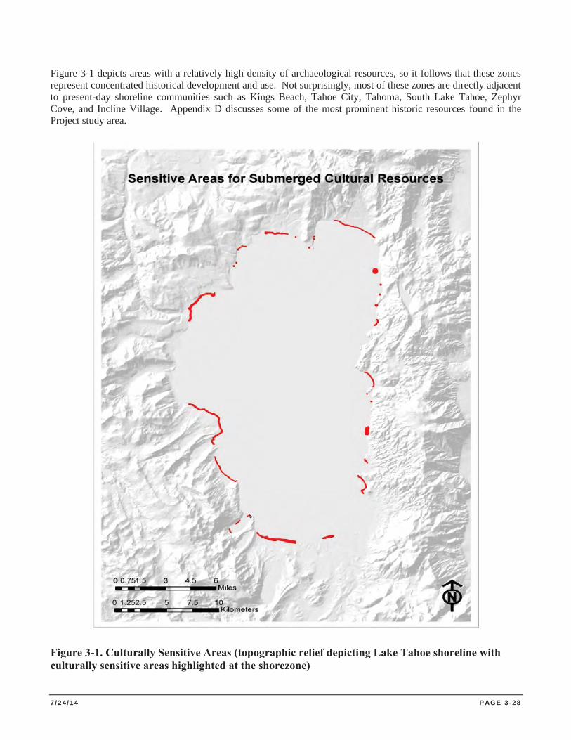
7 / 2 4 / 1 4 P AG E 3 - 2 8
Figure 3-1 depicts areas with a relatively high density of archaeological resources, so it follows that these zones represent concentrated historical development and use. Not surprisingly, most of these zones are directly adjacent to present-day shoreline communities such as Kings Beach, Tahoe City, Tahoma, South Lake Tahoe, Zephyr Cove, and Incline Village. Appendix D discusses some of the most prominent historic resources found in the Project study area.
Figure 3-1. Culturally Sensitive Areas (topographic relief depicting Lake Tahoe shoreline with culturally sensitive areas highlighted at the shorezone)
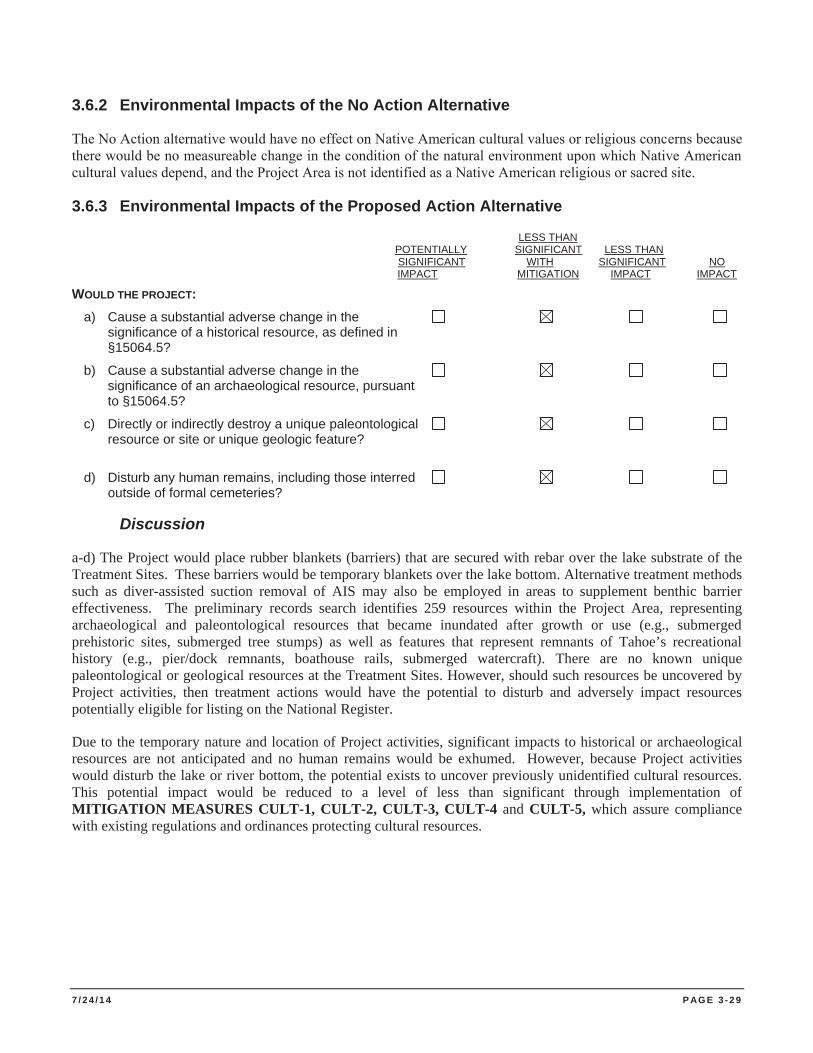
7 / 2 4 / 1 4 P AG E 3 - 2 9
3.6.2 Environmental Impacts of the No Action Alternative
The No Action alternative would have no effect on Native American cultural values or religious concerns because there would be no measureable change in the condition of the natural environment upon which Native American cultural values depend, and the Project Area is not identified as a Native American religious or sacred site.
3.6.3 Environmental Impacts of the Proposed Action Alternative
LESS THAN POTENTIALLY SIGNIFICANT LESS THAN SIGNIFICANT WITH SIGNIFICANT NO IMPACT MITIGATION IMPACT IMPACT
WOULD THE PROJECT: a) Cause a substantial adverse change in the significance of a historical resource, as defined in §15064.5?
b) Cause a substantial adverse change in the significance of an archaeological resource, pursuant to §15064.5?
c) Directly or indirectly destroy a unique paleontological resource or site or unique geologic feature?
d) Disturb any human remains, including those interred outside of formal cemeteries?
Discussion
a-d) The Project would place rubber blankets (barriers) that are secured with rebar over the lake substrate of the Treatment Sites. These barriers would be temporary blankets over the lake bottom. Alternative treatment methods such as diver-assisted suction removal of AIS may also be employed in areas to supplement benthic barrier effectiveness. The preliminary records search identifies 259 resources within the Project Area, representing archaeological and paleontological resources that became inundated after growth or use (e.g., submerged prehistoric sites, submerged tree stumps) as well as features that represent remnants of Tahoe’s recreational history (e.g., pier/dock remnants, boathouse rails, submerged watercraft). There are no known unique paleontological or geological resources at the Treatment Sites. However, should such resources be uncovered by Project activities, then treatment actions would have the potential to disturb and adversely impact resources potentially eligible for listing on the National Register.
Due to the temporary nature and location of Project activities, significant impacts to historical or archaeological resources are not anticipated and no human remains would be exhumed. However, because Project activities would disturb the lake or river bottom, the potential exists to uncover previously unidentified cultural resources. This potential impact would be reduced to a level of less than significant through implementation of MITIGATION MEASURES CULT-1, CULT-2, CULT-3, CULT-4 and CULT-5, which assure compliance with existing regulations and ordinances protecting cultural resources.
7 / 2 4 / 1 4 P AG E 3 - 3 0
3.6.4 Environmental Commitments and Mitigation Measures
The cultural resources analysis determines that MITAGATION MEASURES CULT-1, CULT-2, CULT-3, CULT-4 and CULT-5 are necessary to reduce potential impacts to historical and archaeological resources to a level of less than significant.
Mitigation Measure CULT-1: Cultural Resources Consultation 1. Prior to beginning project work, Tahoe RCD shall consult with USACE Cultural Resources Specialist to
determine if the Project is within a culturally sensitive area and if there are recorded submerged resources in the Project Area of Potential Effects (APE). A formal records search of the California Historical Resources Information System at the North Central Information Center shall be conducted prior to project implementation. If resources are present in the Project APE, the Cultural Resources Specialist and Project Manager shall discuss project implementation and conditions to protect cultural resources.
2. If there are prehistoric or ethnographic resources located in the Project APE and Project activities involve disturbance of the lake bottom, USACE Cultural Resources Specialist shall consult the Washoe Tribe of California and Nevada Tribal Historic Preservation Officer.
Mitigation Measure CULT-2: Eligibility for National Register 1. Historic properties are assumed eligible for the National Register and shall be protected throughout
the duration of the Project.
2. The Project Manager shall notify the USACE Cultural Resources Specialist a minimum of three weeks prior to the start of Project activities.
Mitigation Measure CULT-3: Unanticipated Discovery 1. In the event of an unanticipated discovery of previously undocumented cultural resources during
Project activities, work shall be suspended in the area until a qualified cultural resources specialist has assessed the find and has developed and implemented appropriate avoidance, preservation, or recovery measures. If avoidance is required and feasible, the project manager shall modify, at the discretion of the USACE Cultural Resources Specialist, Project activities to avoid cultural resources.
2. If archaeological or paleontological features are discovered during Project implementation, submerged artifacts and/or features shall be marked, left in place, and reported to appropriate cultural resources specialist.
Mitigation Measure CULT-4: Human Remains Discovery 1. In the event that human remains are discovered during Project activities, work shall cease
immediately in the area of the find and the Project Manager/Site Supervisor shall notify the appropriate personnel. Any human remains and/or funerary objects shall be left in place. Existing law requires that project managers contact the County Coroner. If the County Coroner determines the remains are of Native American origin, both the Native American Heritage Commission (NAHC) and any identified descendants shall be notified (Health and Safety Code Section §7050.5,
7 / 2 4 / 1 4 P AG E 3 - 3 1
Public Resources Code Section §5097.97 and §5097.98). Tahoe RCD staff shall work closely with the USACE to ensure that its response to such a discovery is also compliant with federal requirements, including the Native American Graves Protection and Repatriation Act.
2. Work shall not resume in the area of the find until proper disposition is complete (PRC §5097.98).
No human remains or funerary objects shall be cleaned, photographed, analyzed, or removed from the site prior to determination. If it is determined the find indicates a sacred or religious site, the site shall be avoided to the maximum extent practicable. Formal consultation with the State Historic Preservation Office and review by the NAHC/Tribal Cultural representatives shall occur as necessary to define additional avoidance, preservation, or recovery measures, or further future restrictions.
Mitigation Measure CULT-5: Underwater Archaeological Survey 1. If treatment involves disturbance of lake bottom in culturally sensitive areas, an underwater
archaeological survey shall be conducted by a qualified professional in the Project APE to determine if previously recorded or newly identified cultural resources exist in the area.
2. Results of the survey shalll be discussed in an archaeological survey report and submitted to the
North Central Information Center in Sacramento.
7 / 2 4 / 1 4 P AG E 3 - 3 2
3.7 GEOLOGY AND SOILS
3.7.1 Environmental Setting
Lake Tahoe lies within the Sierra Nevada Geomorphic Province, occupying a basin surrounded by peaks of the Sierra Nevada Mountains with Freel Peak the highest at 10,891 feet. The eastern and western sides of the basin are composed of granite rock, with minor amounts of older metamorphic rock. Volcanic rock, some deposited as recently as 2.5 million years ago, covers most of the northern and some of the southern part of the basin. The Sierra Nevada is a gently sloping fault block mountain range that was uplifted along its eastern edge. This range is bounded on the east and west by a series of interconnected fault segments. The displacement has been greater on the eastern margin, giving the Sierra Nevada a western tilt. South of Lake Tahoe, there is a single crest dividing the gentle western slope from the steep eastern scarp. The crest splits south of the lake, with one crest trending northwesterly and the other crest trending northward creating the Carson Range. This range separates the Carson Valley from Lake Tahoe. Lake Tahoe occupies the basin between the two uplifted crests.
Geology. The Lake Tahoe Basin was formed two to three million years ago by geologic block faulting between the northwest-trending Sierra Nevada to the west and the north-trending Carson Ridge to the east. Lake Tahoe occupies the depression, or fault-produced graben, between these two uplifted mountain ranges. During the past two million years, glaciers played an active roll in shaping the Sierra Nevada Mountains and Lake Tahoe. Alpine glaciers extended below the current lake level along the west shoreline and Emerald Bay. The basement geology of the Lake Tahoe Basin is divided into three categories: granitic, metamorphic and volcanic (Hyne et al. 1972).
Soils. Most of the soils in the Lake Tahoe Basin are of granitic or volcanic parent material. The soils are geologically young and poorly developed. Most soils are shallow, coarse textured, and have low cohesion, and contain small amounts of organic material. These attributes account for a high erosion potential on steeper slopes in the Tahoe Basin. The subsurface of the lake in the Project Area is variable, but consists of cobble and sand at most of the Treatment Sites.
Seismicity. The potential for seismic activity within a Project Area is primarily related to the proximity of faults. Faults are fractures or zones of related fractures where the rocks on one side have been displaced with respect to rocks on the other side. The California State Mining and Geology Board define an “active fault” as one that has had surface displacement within the past 11,000 years, the Holocene. Potentially active faults are defined as those that have ruptured between 11,000 and 1.6 million years before the present (Quaternary). Faults are generally considered inactive if there is no evidence of displacement during the Quaternary period.
The Lake Tahoe Basin is located in a region of Holocene age and early Quaternary age, as evidenced by the features and historical data published in Natural Hazards of the Lake Tahoe Basin (Cooper, Clark and Associates 1974) and Preliminary Maps of Pleistocene to Holocene Faults in the Lake Tahoe Basin, California and Nevada (Saucedo 2005):
Movements have taken place along faults adjacent to the basin within historical time (Lawson 1912; Kachadoorian 1967);
Sediments at the bottom of Lake Tahoe show offsets or displacements that are indicative of faulting ; and Steep cliffs (30 to 45 degree slopes) and other topographic features associated with active faulting are
found on both sides of Lake Tahoe (Hyne et al. 1972).
A north-south fault zone, located about six miles east of the Lake Tahoe Basin, separates the eastern edge of the Sierra Nevada from the parallel fault-block mountains of Nevada and Utah. The north-south faults along the shores of Lake Tahoe appear to be the longest continuous faults traversing the basin area. Of these faults, the
7 / 2 4 / 1 4 P AG E 3 - 3 3
fault along the west side of the lake appears to be the longest, with a surface length of approximately 50 miles. A fault of this length could potentially generate a 7.5 magnitude earthquake (Cooper, Clark and Associates 1974).
The Preliminary Resource Element for Sugar Pine Point State Park (CDPR 1991) characterizes the seismicity of the Lake Tahoe Basin. The fault activity has played a major, geologically recent role in the evolution of the Tahoe Basin, and the potential for a large destructive earthquake sometime in the future should be considered to be high. Relative to much of the rest of California, however, the earthquake shaking potential (Branum et al. 2008) and earthquake hazard (USGS and CGS 2010) in the Project Area are low. Rather than a single linear fault, the Sierra Nevada frontal fault system is a complex zone of faults along the eastern face of the Sierra Nevada. The western Lake Tahoe boundary fault, and the mountains that rise above the western edge of Emerald Bay, very likely represent a segment of the Sierra Nevada fault system.
Based upon physiographic evidence, the main fault on the west side of the Lake Tahoe Basin probably lies less than a mile east of the shore at Ed Z’berg-Sugar Pine Point State Park, about 0.5 mile east of the shore at Rubicon Point, and continues south immediately offshore of Eagle Point at the mouth of Emerald Bay, heading inland at Baldwin Beach.
Since the 1900’s, a number of earthquakes with an intensity of less than 5.0 Richter magnitude have been recorded in the Basin, although historical epicenters are more common to the north of Lake Tahoe and to the south-southeast of the Lake Tahoe Basin along the Sierra Nevada frontal fault system. Both of these areas have experienced moderate to high magnitude earthquake activity measuring between 5.0 and 7.5 on the Richter scale.
Liquefaction and Landslide Hazards. Secondary seismic hazards, such as liquefaction and landslides, may occur during an earthquake. Liquefaction could occur in loose, granular materials (alluvium) below the water table, such as along stream channels and in unconsolidated, disturbed materials. It takes place when a granular material is transformed from a solid state to a liquid state during earthquake events. The potential for liquefaction as a result of seismic events is high in areas of unconsolidated and saturated fine-grained alluvium such as at the mouth of creeks.
Regulations. There are regulatory laws governing geologic protection and safety from geological hazards. For geologic and topographic features, the key federal law is the Historic Sites Act of 1935, which establishes a national registry of natural landmarks and protects “outstanding examples of major geological features.” Topographic and geologic features are also protected under CEQA.
Other federal regulations include the Earthquake Hazard Reduction Act of 1977, Executive Order 12699 on Seismic Safety of Federal Buildings, and the Uniform Building Code (superseded in California by the 2001 California Building Code). State regulations include the Alquist-Priolo Earthquake Zone Act, the Field Act, the 2001 California Building Code, the Seismic Hazards Mapping Act, and the Historic Structures Act (California PRC 5028). Some state agencies have their own regulations covering seismic and geologic hazards.
In the Lake Tahoe Basin, TRPA Goals and Policies, Soils (1986), Goal #1 is stated as “Minimize soil erosion and the loss of soil productivity.” This goal is to maintain soil productivity and existing vegetation cover and prevent excessive sediment and nutrient transport to streams and lakes.
3.7.2 Environmental Impacts of the No Action Alternative
The No Action alternative implements no AIS treatment and removal activities, and therefore, would result in no direct or indirect effects to geology and soils of the Project Area.
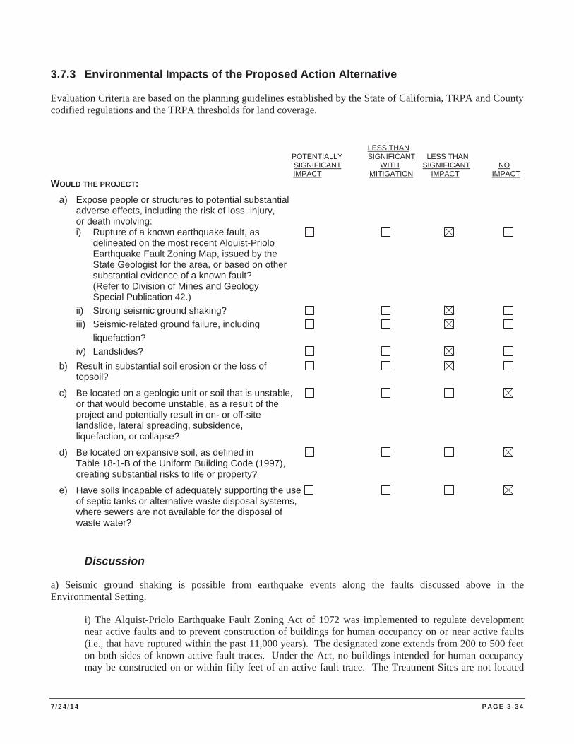
7 / 2 4 / 1 4 P AG E 3 - 3 4
3.7.3 Environmental Impacts of the Proposed Action Alternative
Evaluation Criteria are based on the planning guidelines established by the State of California, TRPA and County codified regulations and the TRPA thresholds for land coverage.
LESS THAN POTENTIALLY SIGNIFICANT LESS THAN SIGNIFICANT WITH SIGNIFICANT NO IMPACT MITIGATION IMPACT IMPACT WOULD THE PROJECT: a) Expose people or structures to potential substantial adverse effects, including the risk of loss, injury, or death involving: i) Rupture of a known earthquake fault, as delineated on the most recent Alquist-Priolo Earthquake Fault Zoning Map, issued by the State Geologist for the area, or based on other substantial evidence of a known fault? (Refer to Division of Mines and Geology Special Publication 42.) ii) Strong seismic ground shaking? iii) Seismic-related ground failure, including liquefaction? iv) Landslides? b) Result in substantial soil erosion or the loss of topsoil?
c) Be located on a geologic unit or soil that is unstable, or that would become unstable, as a result of the project and potentially result in on- or off-site landslide, lateral spreading, subsidence, liquefaction, or collapse?
d) Be located on expansive soil, as defined in Table 18-1-B of the Uniform Building Code (1997), creating substantial risks to life or property?
e) Have soils incapable of adequately supporting the use of septic tanks or alternative waste disposal systems, where sewers are not available for the disposal of waste water?
Discussion
a) Seismic ground shaking is possible from earthquake events along the faults discussed above in the Environmental Setting.
i) The Alquist-Priolo Earthquake Fault Zoning Act of 1972 was implemented to regulate development near active faults and to prevent construction of buildings for human occupancy on or near active faults (i.e., that have ruptured within the past 11,000 years). The designated zone extends from 200 to 500 feet on both sides of known active fault traces. Under the Act, no buildings intended for human occupancy may be constructed on or within fifty feet of an active fault trace. The Treatment Sites are not located
7 / 2 4 / 1 4 P AG E 3 - 3 5
within an Alquist-Priolo Earthquake Fault Zone as designated by the California Geological Survey (CGS 2007). No structures that are designed for human occupancy are located at the Treatment Sites and no permanent structures are proposed as part of this Project. Therefore, there is no expected adverse effect on people or structures with regard to earthquake rupture as a result of implementation of this Project.
ii) Seismic ground shaking may occur during an earthquake with an epicenter located in the vicinity of Lake Tahoe. However, Project activities would not increase the risk of exposure of employees or contractors working in the forest and open space to a seismic event. Therefore, the potential risk of effects to staff, contractors, or the public is considered to be less than significant.
iii) Seismic-induced ground failure, such as liquefaction, usually occurs in unconsolidated granular soils that are water saturated. During seismic-induced ground shaking, pore water pressure in the soil could increase in loose soils, causing the soils to change from a solid to a liquid state (liquefaction). Potential for liquefaction in the Project Area would not increase as a result of the Project. Therefore, the potential risk of effects to staff, contractors, or the public is considered to be less than significant.
iv) Portions of the Project Area have potential for coherent landslides in the event of an earthquake in the Lake Tahoe Basin. This is an existing condition and the Project would not increase this potential hazard. Therefore, the potential risk of effects to staff, contractors, or the public is considered to be less than significant.
b) Benthic barriers would be placed over the top of the underwater substrate in Treatment Sites. In addition, some portions of the Project Area may be treated with diver-assisted hand removal. Underwater plant control activities in Lake Tahoe require permits from the USACE, Lahontan, TRPA, CSLC, NDSL and the CDFW. These permits require monitoring and protective measures to ensure that project activities do not result in negative effects to a water body. Treatment actions would not contribute to soil erosion and necessary permits would be attained prior to commencing Project activities to reduce potential impacts to a less than significant level.
c) Benthic barriers would be placed over the top of the lake bottom substrate in Treatment Sites. In addition, some portion of the Treatment Sites may be treated with diver-assisted suction removal. These actions would not contribute to runoff or contribute to instability of soil. No impact.
d) Expansive soils are those soils that have high clay content that swell when wet and shrink when dry. Soils in the Project Area do not have high clay content, are therefore not expansive, and would not result in a substantial risk to life and property. No impact.
e) The Project does not involve the installation of waste disposal systems, and therefore, would not result in impacts to onsite soils.
3.7.4 Environmental Commitments and Mitigation Measures
The earth resource analysis determines no mitigation measures are necessary.
7 / 2 4 / 1 4 P AG E 3 - 3 6
3.8 GREENHOUSE GAS EMISSIONS AND GLOBAL CLIMATE CHANGE
3.8.1 Environmental Setting
Greenhouse gases (GHG) such as carbon dioxide and methane trap heat in the earth’s atmosphere. Increased concentrations of these gases over time produce an increase in the average surface temperature of the earth. The rising temperatures can in turn produce changes in precipitation patterns, storm severity, and sea level, resulting in what is commonly referred to as “climate change.”
Global climate change is caused in large part by anthropogenic (human caused) emissions of GHGs released into the atmosphere through the combustion of fossil fuels and by other activities that affect the global GHG budget, such as deforestation and land use change. According to the California Energy Commission (CEC), GHG emissions in California are attributable to human activities associated with industrial/manufacturing, utilities, transportation, residential, and agricultural sectors as well as natural processes (California Energy Commission, 2006a).
Carbon Dioxide (CO2) is the primary GHG attributed to the Project. CO2 accounts for more than 75% of anthropogenic GHG emissions. Increasing concentrations of CO2 in the atmosphere are largely due to emissions from the burning of fossil fuels, gas flaring, cement production, and land use changes such as vegetation removal and large-scale agriculture. The Project removes aquatic invasive plant species from water bodies at a scale that would not increase CO2 emissions, unlike forest management action such as clear cutting and fuels reductions.
The Project Area includes no existing facilities. Water pumping and usage generate small amounts of GHG emissions. In addition, fuel usage from vehicles and haul trucks traveling to and from the Treatment Sites represent an additional source of GHG emissions.
In order to simplify reporting and analysis, methods have been set forth to describe emissions of GHGs in terms of a single gas. The most commonly accepted method to compare GHG emissions is the “global warming potential” methodology defined in the Intergovernmental Panel on Climate Change (IPCC) reference documents (IPCC 1996; IPCC 2001). The IPCC defines the global warming potential (GWP) of various GHG emissions in terms of CO2 equivalents (CO2e), which compares the GHG in question to that of the same mass of CO2 (by definition, CO2 has a GWP of 1.0).
CARB completed a GHG inventory of California’s 2006 GHG emissions. Their report states that 1990 emissions amounted to 433.3 million metric tons (MMT) of CO2e, while 2006 emissions levels rose to 483.9 MMT of CO2e (CARB 2009). Based on California’s 2006 population of 37,114,598, this amounts to approximately 13 metric tons of CO2e per person (State of California, Department of Finance 2008).
The California State Legislature has proposed and the Governor has approved laws and policies to reduce the amount of GHG generated each year. As stated in Assembly Bill 32, Global Warming Solutions Act (AB 32), passed in 2006; “The State of California found that Global Warming would have detrimental effects on some of California’s largest industries including agriculture, wine, tourism, skiing, recreational and commercial fishing, and forestry.” AB 32 requires statewide GHG emissions in California be reduced to 1990 levels by the year 2020 and requires the CARB to adopt rules and regulations to achieve this goal.
In California, CDPR has developed a “Cool Parks” initiative to address climate change within the State Park system. Cool Parks proposes that DPR itself, as well as resources under its care, adapt to the environmental changes resulting from climate change. In order to fulfill the Cool Parks initiative, DPR is dedicated to using alternative energy sources, low emission vehicles, recycling and reusing supplies and materials, and educating staff and visitors on climate change (CDPR 2008).
7 / 2 4 / 1 4 P AG E 3 - 3 7
Some GHG such as carbon dioxide occur naturally and are emitted to the atmosphere through natural processes and through human activities. Naturally occurring greenhouse gasses include water vapor, carbon dioxide, methane, nitrous oxide, and ozone.
Water Vapor. Water Vapor is the most abundant GHG in the atmosphere. Changes in its concentration are considered a result of climate feedback loops related to the warming of the atmosphere rather than a direct result of human activities. The feedback loop that involves water is critically important to projecting future climate change. As the temperature of the atmosphere rises, more water is evaporated from ground storage (rivers, oceans, reservoirs, soil). Because the air is warmer, the absolute humidity can be higher (in essence, the air is able to 'hold' more water when it's warmer), leading to more water vapor in the atmosphere. As a greenhouse gas, the higher concentration of water vapor is then able to absorb more thermal energy radiated from the Earth, thus further warming the atmosphere. The warmer atmosphere can then hold more water vapor and so on and so on. This is referred to as a 'positive feedback loop'. However, scientific uncertainty exists in defining the extent and importance of this feedback loop. As water vapor increases in the atmosphere, more of it would eventually also condense into clouds, which are more able to reflect incoming solar radiation (thus allowing less energy to reach the Earth's surface and heat it up).
Carbon Dioxide. The natural production and absorption of carbon dioxide (CO2) is achieved through the terrestrial biosphere and the ocean. Carbon dioxide also enters the atmosphere through the burning of fossil fuels (oil, natural gas, and coal), solid waste, trees, and wood products, and as a result of other chemical reactions (e.g., manufacture of cement). Carbon dioxide is removed from the atmosphere (or “sequestered”) when absorbed by plants as part of the biological carbon cycle. Carbon dioxide was the first greenhouse gas demonstrated to be increasing in atmospheric concentration with the first conclusive measurements being made in the last half of the 20th century.
Methane. Methane (CH4) has both natural and anthropogenic sources. It is released as part of the biological processes in low oxygen environments, such as in swamplands (at the roots of the plants). Methane is emitted during the production and transport of coal, natural gas, and oil. Methane emissions also result from livestock and other agricultural practices and by the decay of organic waste in municipal solid waste landfills. Methane is an extremely effective absorber of radiation, though its atmospheric concentration is less than CO2 and its lifetime in the atmosphere is brief (10-12 years), compared to some other greenhouse gases (such as CO2, N2O, CFCs).
Nitrous Oxide. Nitrous Oxide (N2O) is produced naturally from a wide variety of biological sources in soil and water, particularly microbial action in wet tropical forests.
Concentrations of nitrous oxide began to rise at the beginning of the industrial revolution and it is understood to be produced by reactions that occur in fertilizer containing nitrogen. Increasing use of these fertilizers has occurred over the last century (NOAA 2010).
Ozone. Ozone (O3) is a gas present in both the upper stratosphere, where it shields the Earth from harmful levels of ultraviolet radiation, and at lower concentrations in the troposphere, the air closest to the Earth’s surface, where it forms through chemical reactions between pollutants from vehicles, factories, fossil fuels combustion, evaporation of paints and many other sources. Key pollutants involved in ozone formation are hydrocarbon and nitrous oxide gases (CARB 2008). Sunlight and hot weather cause the ground-level ozone to form in harmful concentrations and is the main component of anthropogenic photochemical “smog” (USEPA 2008).
Other greenhouse gases (e.g., fluorinated gases) are created and emitted solely through human activities.
Fluorinated Gases. Hydrofluorocarbons, perfluorocarbons, and sulfur hexafluoride are synthetic, powerful greenhouse gases that are emitted from a variety of industrial processes. Fluorinated gases are sometimes used as substitutes for ozone-depleting substances (i.e., CFCs, HCFCs, and halons). These gases are typically emitted in
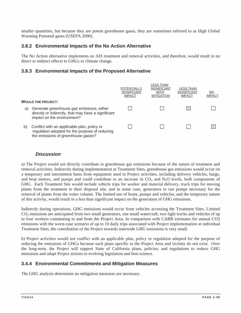
7 / 2 4 / 1 4 P AG E 3 - 3 8
smaller quantities, but because they are potent greenhouse gases, they are sometimes referred to as High Global Warming Potential gases (USEPA 2008).
3.8.2 Environmental Impacts of the No Action Alternative
The No Action alternative implements no AIS treatment and removal activities, and therefore, would result in no direct or indirect effects to GHGs or climate change.
3.8.3 Environmental Impacts of the Proposed Alternative
LESS THAN
POTENTIALLY SIGNIFICANT LESS THAN SIGNIFICANT WITH SIGNIFICANT NO IMPACT MITIGATION IMPACT IMPACT WOULD THE PROJECT: a) Generate greenhouse gas emissions, either directly or indirectly, that may have a significant impact on the environment? b) Conflict with an applicable plan, policy or
regulation adopted for the purpose of reducing the emissions of greenhouse gases?
Discussion
a) The Project would not directly contribute to greenhouse gas emissions because of the nature of treatment and removal activities. Indirectly during implementation at Treatment Sites, greenhouse gas emissions would occur on a temporary and intermittent basis from equipment used in Project activities, including delivery vehicles, barge, and boat motors, and pumps and could contribute to an increase in CO2 and N2O levels, both components of GHG. Each Treatment Site would include vehicle trips for worker and material delivery, truck trips for moving plants from the treatment to their disposal site, and in some case, generators to run pumps necessary for the removal of plants from the water column. The limited use of boats, pumps and vehicles, and the temporary nature of this activity, would result in a less than significant impact on the generation of GHG emissions.
Indirectly during operations, GHG emissions would occur from vehicles accessing the Treatment Sites. Limited CO2 emissions are anticipated from two small generators, one small watercraft, two light trucks and vehicles of up to four workers commuting to and from the Project Area. In comparison with CARB estimates for annual CO2 emissions with the worst-case scenario of up to 10 daily trips associated with Project implementation at individual Treatment Sites, the contribution of the Project towards statewide GHG emissions is very small.
b) Project activities would not conflict with an applicable plan, policy or regulation adopted for the purpose of reducing the emissions of GHGs because such plans specific to the Project Area and vicinity do not exist. Over the long-term, the Project will support State of California plans, policies, and regulations to reduce GHG emissions and adapt Project actions to evolving legislation and best science.
3.4.4 Environmental Commitments and Mitigation Measures
The GHG analysis determines no mitigation measures are necessary.
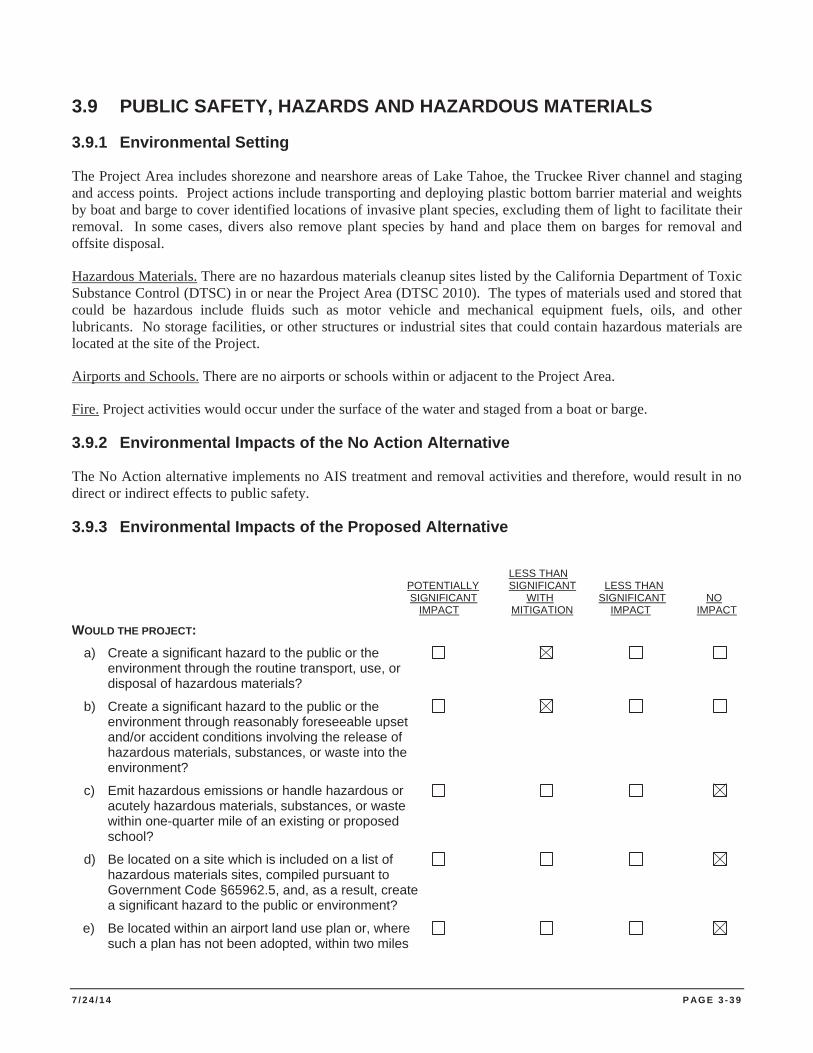
7 / 2 4 / 1 4 P AG E 3 - 3 9
3.9 PUBLIC SAFETY, HAZARDS AND HAZARDOUS MATERIALS
3.9.1 Environmental Setting
The Project Area includes shorezone and nearshore areas of Lake Tahoe, the Truckee River channel and staging and access points. Project actions include transporting and deploying plastic bottom barrier material and weights by boat and barge to cover identified locations of invasive plant species, excluding them of light to facilitate their removal. In some cases, divers also remove plant species by hand and place them on barges for removal and offsite disposal.
Hazardous Materials. There are no hazardous materials cleanup sites listed by the California Department of Toxic Substance Control (DTSC) in or near the Project Area (DTSC 2010). The types of materials used and stored that could be hazardous include fluids such as motor vehicle and mechanical equipment fuels, oils, and other lubricants. No storage facilities, or other structures or industrial sites that could contain hazardous materials are located at the site of the Project.
Airports and Schools. There are no airports or schools within or adjacent to the Project Area.
Fire. Project activities would occur under the surface of the water and staged from a boat or barge.
3.9.2 Environmental Impacts of the No Action Alternative
The No Action alternative implements no AIS treatment and removal activities and therefore, would result in no direct or indirect effects to public safety.
3.9.3 Environmental Impacts of the Proposed Alternative
LESS THAN
POTENTIALLY SIGNIFICANT LESS THAN SIGNIFICANT WITH SIGNIFICANT NO IMPACT MITIGATION IMPACT IMPACT WOULD THE PROJECT: a) Create a significant hazard to the public or the environment through the routine transport, use, or disposal of hazardous materials?
b) Create a significant hazard to the public or the environment through reasonably foreseeable upset and/or accident conditions involving the release of hazardous materials, substances, or waste into the environment?
c) Emit hazardous emissions or handle hazardous or acutely hazardous materials, substances, or waste within one-quarter mile of an existing or proposed school?
d) Be located on a site which is included on a list of hazardous materials sites, compiled pursuant to Government Code §65962.5, and, as a result, create a significant hazard to the public or environment?
e) Be located within an airport land use plan or, where such a plan has not been adopted, within two miles
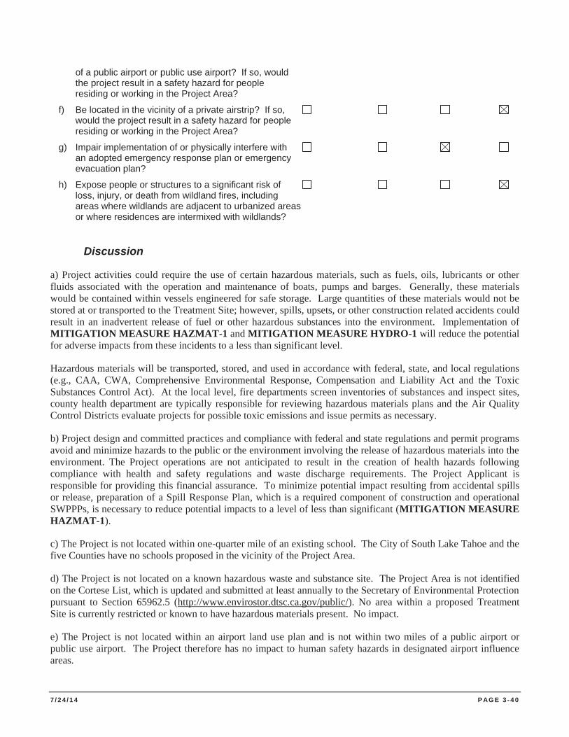
7 / 2 4 / 1 4 P AG E 3 - 4 0
of a public airport or public use airport? If so, would the project result in a safety hazard for people residing or working in the Project Area?
f) Be located in the vicinity of a private airstrip? If so, would the project result in a safety hazard for people residing or working in the Project Area?
g) Impair implementation of or physically interfere with an adopted emergency response plan or emergency evacuation plan?
h) Expose people or structures to a significant risk of loss, injury, or death from wildland fires, including areas where wildlands are adjacent to urbanized areas or where residences are intermixed with wildlands?
Discussion
a) Project activities could require the use of certain hazardous materials, such as fuels, oils, lubricants or other fluids associated with the operation and maintenance of boats, pumps and barges. Generally, these materials would be contained within vessels engineered for safe storage. Large quantities of these materials would not be stored at or transported to the Treatment Site; however, spills, upsets, or other construction related accidents could result in an inadvertent release of fuel or other hazardous substances into the environment. Implementation of MITIGATION MEASURE HAZMAT-1 and MITIGATION MEASURE HYDRO-1 will reduce the potential for adverse impacts from these incidents to a less than significant level.
Hazardous materials will be transported, stored, and used in accordance with federal, state, and local regulations (e.g., CAA, CWA, Comprehensive Environmental Response, Compensation and Liability Act and the Toxic Substances Control Act). At the local level, fire departments screen inventories of substances and inspect sites, county health department are typically responsible for reviewing hazardous materials plans and the Air Quality Control Districts evaluate projects for possible toxic emissions and issue permits as necessary.
b) Project design and committed practices and compliance with federal and state regulations and permit programs avoid and minimize hazards to the public or the environment involving the release of hazardous materials into the environment. The Project operations are not anticipated to result in the creation of health hazards following compliance with health and safety regulations and waste discharge requirements. The Project Applicant is responsible for providing this financial assurance. To minimize potential impact resulting from accidental spills or release, preparation of a Spill Response Plan, which is a required component of construction and operational SWPPPs, is necessary to reduce potential impacts to a level of less than significant (MITIGATION MEASURE HAZMAT-1).
c) The Project is not located within one-quarter mile of an existing school. The City of South Lake Tahoe and the five Counties have no schools proposed in the vicinity of the Project Area.
d) The Project is not located on a known hazardous waste and substance site. The Project Area is not identified on the Cortese List, which is updated and submitted at least annually to the Secretary of Environmental Protection pursuant to Section 65962.5 (http://www.envirostor.dtsc.ca.gov/public/). No area within a proposed Treatment Site is currently restricted or known to have hazardous materials present. No impact.
e) The Project is not located within an airport land use plan and is not within two miles of a public airport or public use airport. The Project therefore has no impact to human safety hazards in designated airport influence areas.
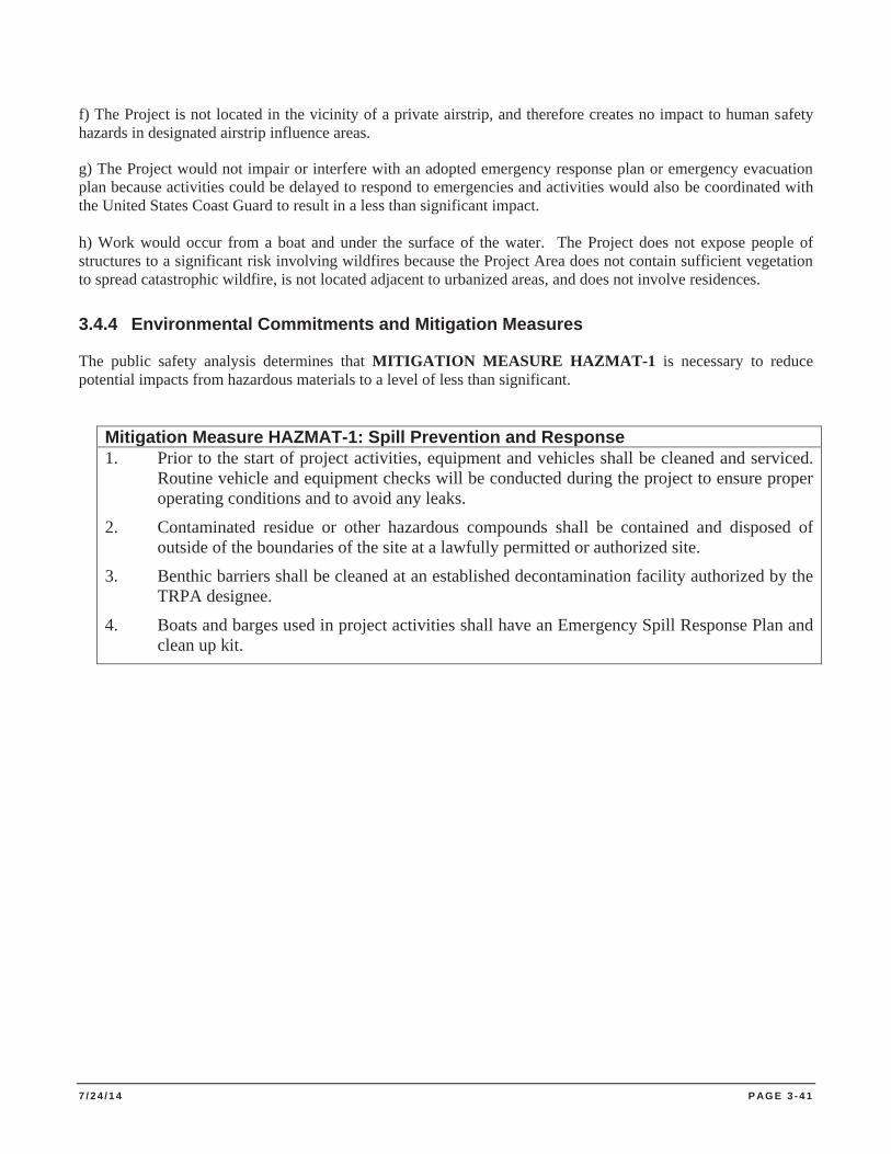
7 / 2 4 / 1 4 P AG E 3 - 4 1
f) The Project is not located in the vicinity of a private airstrip, and therefore creates no impact to human safety hazards in designated airstrip influence areas.
g) The Project would not impair or interfere with an adopted emergency response plan or emergency evacuation plan because activities could be delayed to respond to emergencies and activities would also be coordinated with the United States Coast Guard to result in a less than significant impact. h) Work would occur from a boat and under the surface of the water. The Project does not expose people of structures to a significant risk involving wildfires because the Project Area does not contain sufficient vegetation to spread catastrophic wildfire, is not located adjacent to urbanized areas, and does not involve residences.
3.4.4 Environmental Commitments and Mitigation Measures
The public safety analysis determines that MITIGATION MEASURE HAZMAT-1 is necessary to reduce potential impacts from hazardous materials to a level of less than significant.
Mitigation Measure HAZMAT-1: Spill Prevention and Response 1. Prior to the start of project activities, equipment and vehicles shall be cleaned and serviced.
Routine vehicle and equipment checks will be conducted during the project to ensure proper operating conditions and to avoid any leaks.
2. Contaminated residue or other hazardous compounds shall be contained and disposed of outside of the boundaries of the site at a lawfully permitted or authorized site.
3. Benthic barriers shall be cleaned at an established decontamination facility authorized by the TRPA designee.
4. Boats and barges used in project activities shall have an Emergency Spill Response Plan and clean up kit.
7 / 2 4 / 1 4 P AG E 3 - 4 2
3.10 HYDROLOGY AND WATER QUALITY
3.10.1 Environmental Setting
Climate and Hydrology. The Lake Tahoe Basin comprises a bowl-shaped watershed, characterized by steep, north/south trending mountain ranges to the east and west, with Lake Tahoe occupying nearly 40 percent of the watershed. Within the basin, 63 individual watersheds contribute their flow to Lake Tahoe. The regional and local climate consists of long, relatively mild winters with short, dry summers, reflective of a Mediterranean climate. Most of the area's precipitation, 75 to 80% of total precipitation, comes in the form of snow, with occasional thunderstorms during the summer months. Precipitation that falls from June through September accounts for less than 20 percent of the annual total. The western portions of the basin receive between 35 and 90 inches of precipitation per year (in/yr), while the eastern portions receive between 20 and 40 in/yr (USGS 2002). The higher amounts of precipitation typically occur in the upper elevations.
Lake Tahoe can be described as an oligotrophic lake with typically low concentrations of nutrients, low algal productivity, and high oxygen concentrations. These factors contribute towards Lake Tahoe’s exceptional clarity and its recognition as an Outstanding National Resource Water by the USEPA’s Water Quality Standards Program and Clean Water Act. However, since first measured in 1968, water clarity has significantly declined (UC Davis 2010). The 2013 State of the Lake Report (UC Davis 2013) indicates improvements in lake clarity in recent years.
Natural drainage systems surrounding Lake Tahoe convey surface and subsurface runoff from rain and melting snow that slowly erodes the land. Sediment, dissolved minerals, organic litter, and nutrients are transported through the drainage courses and stream environment zones (SEZ) to the lake. Delta marshes of tributary streams filter these sediments and nutrients whereby they are used for plant growth. Organic materials are decomposed in the oxygen-rich lake and stream waters and nutrients are used by aquatic biota. Water quality in Lake Tahoe and its tributaries can be adversely affected by runoff from surrounding lands. Suspended sediment can cause turbidity and result in sedimentation and suspended and dissolved nutrients can stimulate algal growth, depleting the lake of oxygen in the natural process of eutrophication (i.e., increasing biologic material and depletion of oxygen over time). Today significant portions of the Lake Tahoe Basin are urbanized. Many factors such as land disturbance, habitat destruction, air pollution, soil erosion, and roads can interact to degrade water quality (Murphy and Knopp 2000). Control of nutrient inputs and eradication of AIS have become top priorities of regulatory agency actions in the Lake Tahoe Basin. Turbidity in Lake Tahoe and the Truckee River could increase at Treatment Sites during aquatic plant removal. Monitoring results from pilot AIS removal projects report that elevated turbidity levels are temporary and localized in nature (CDPR 2012).
Robert Coats published Climate change in the Tahoe Basin: regional trends, impacts and drivers (2010), a study that quantified decadal-scale time trends in air temperature, precipitation phase and intensity, spring snowmelt timing, and lake temperature in the Lake Tahoe Basin. The results indicate strong upward trends in air temperature, a shift from snow to rain precipitation regime, a shift in snowmelt timing to earlier dates, increased rainfall intensity, increased interannual variability and continued increases in temperature of Lake Tahoe. The study concludes that continued warming in the Lake Tahoe Basin has important implications for efforts to manage biodiversity and maintain clarity of the lake.
Regulatory Environment and Water Quality Standards. Lahontan is one of the nine Regional Water Quality Control Boards (RWQCBs) in California. The nine RWQCBs maintain Basin Plans that include comprehensive lists of water bodies in each area, as well as detailed language about the components of applicable water quality objectives. As authorized by the USEPA, the State Board and nine RWQCBs implement the Section 402 CWA NPDES Permitting Program and requirements in California. CWA Section 401 requirements generally relate to State certification of federal permits, including those issued by a federal agency under CWA Section 404. In addition, the Lahontan regulates waste discharges under the California Water Code, Article 4 (Waste Discharge
7 / 2 4 / 1 4 P AG E 3 - 4 3
Requirements) and Chapter 5.5 (Compliance with the Provisions of the Federal Water Pollution Control Act as Amended in 1972).
The Basin Plan (Lahontan 1995), specifically Chapter 5: Water Quality Standards and Control Measures for the Lake Tahoe Basin, designates beneficial uses for the surface waters of the Lake Tahoe Hydrologic Unit. Specifically the Basin Plan outlines the narrative and numeric WQOs for water bodies within the Lake Tahoe Hydrologic Unit. Section 5.2 of the Basin Plan contains the waste discharge prohibitions, including the waste discharge prohibitions on discharges to floodplains and SEZs.
Lahontan must consider anti-degradation pursuant to 40 CFR 131.12 and State Board Resolution No. 68-16 to find that the subject discharges are consistent with the provisions of these policies. Anti-degradation findings that consistent with the policies are necessary for reissuance of waste discharge requirements for operations and actions within the Project Area.
The TRPA is the designated area-wide water quality planning agency under Section 208 of the Clean Water Act. In 1988 the States of California and Nevada and the USEPA adopted the TRPA Water Quality Management Plan for the Lake Tahoe Basin (TRPA 1988), commonly referred to as the 208 Plan. The 208 Plan identifies water quality problems, proposes solutions or mitigation measures, identifies those entities responsible for implementing solutions, and determines agencies or jurisdictions responsible for enforcement. The TRPA Environmental Thresholds (Resolution 82-11 adopted in 1982) and State of California WQOs establish over 30 separate water quality standards for Lake Tahoe and its tributaries. The standards address algal growth potential, plankton count, clarity, turbidity, phytoplankton productivity, phytoplankton biomass, zooplankton biomass, periphyton biomass, dissolved inorganic nitrogen (DIN) loading, nutrient loading in general, tributary water quality, surface runoff quality, and the quality of other lakes in the Lake Tahoe Basin.
Regional water quality standards are outlined in the TRPA Code of Ordinances, Chapter 81. The chapter sets forth standards for the discharge of runoff water from parcels, and regulates the discharge of domestic, municipal, or industrial wastewaters. The standards and prohibitions apply to discharges to both surface and ground waters. Chapter 82 addresses water quality mitigation for projects and activities that result in the creation of additional impervious coverage.
NDEP’s Bureau of Water Quality Planning (BWQP) is responsible for several water quality protection functions which include collecting and analyzing water data, developing standards for surface waters, publishing informational reports, providing water quality education and implementing programs to address surface water quality. The Lake Tahoe Watershed Program is the NDEP program collaborating with Lahontan to protect Lake Tahoe as a water of extraordinary aesthetic or ecologic value.
3.10.2 Environmental Impacts of the No Action Alternative
The No Action alternative implements no AIS treatment and removal activities, and therefore, would result in no direct effects to hydrology and water quality. Indirect effects of the No Action alternative are expected to include a decline in lake clarity and decreased quality of aquatic habitat for benthic macroinvertabrates and fish.
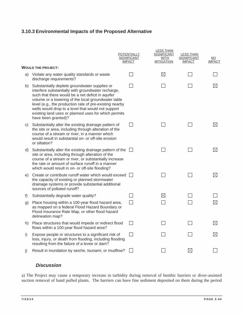
7 / 2 4 / 1 4 P AG E 3 - 4 4
3.10.3 Environmental Impacts of the Proposed Alternative
LESS THAN POTENTIALLY SIGNIFICANT LESS THAN SIGNIFICANT WITH SIGNIFICANT NO IMPACT MITIGATION IMPACT IMPACT WOULD THE PROJECT: a) Violate any water quality standards or waste discharge requirements?
b) Substantially deplete groundwater supplies or interfere substantially with groundwater recharge, such that there would be a net deficit in aquifer volume or a lowering of the local groundwater table level (e.g., the production rate of pre-existing nearby wells would drop to a level that would not support existing land uses or planned uses for which permits have been granted)?
c) Substantially alter the existing drainage pattern of the site or area, including through alteration of the course of a stream or river, in a manner which would result in substantial on- or off-site erosion or siltation?
d) Substantially alter the existing drainage pattern of the site or area, including through alteration of the course of a stream or river, or substantially increase the rate or amount of surface runoff in a manner which would result in on- or off-site flooding?
e) Create or contribute runoff water which would exceed the capacity of existing or planned stormwater drainage systems or provide substantial additional sources of polluted runoff?
f) Substantially degrade water quality?
g) Place housing within a 100-year flood hazard area, as mapped on a federal Flood Hazard Boundary or Flood Insurance Rate Map, or other flood hazard delineation map?
h) Place structures that would impede or redirect flood flows within a 100-year flood hazard area?
i) Expose people or structures to a significant risk of loss, injury, or death from flooding, including flooding resulting from the failure of a levee or dam?
j) Result in inundation by seiche, tsunami, or mudflow?
Discussion
a) The Project may cause a temporary increase in turbidity during removal of benthic barriers or diver-assisted suction removal of hand pulled plants. The barriers can have fine sediment deposited on them during the period
7 / 2 4 / 1 4 P AG E 3 - 4 5
of deployment, and this fine sediment, along with decaying plant material, can cause turbidity as the barriers are removed. Previous bottom barrier water quality monitoring results indicate that turbidity is localized and temporary in nature (CDPR 2012). Local turbidity elevations observed in Lake Tahoe during previous bottom barrier installation, barrier removal, and diver-assisted hand removal activities have ranged from background conditions (0.2 to 0.5 NTU) to short elevations as high as 5 to 7 NTU. Average observed increases are typically between 1.0 and 2.5 NTU and past project activities have never resulted in a sediment plume or sustained turbidity levels greater than 3 NTU (TRPA 2014). Most of the observed elevations in turbidity have resulted due to fine sediments that collect on submerged aquatic plants and are not the result of disturbing lakebed substrates.
The Lake Tahoe plant control program and partners currently own approximately 250 synthetic benthic barriers, each 10 x 40 foot that are reusable and available for plant control efforts in the region. Although the actual area of lake bottom covered by barriers each year would be determined by plant growth, funding, and other site-specific project constraints, a typical treatment area would include between 50 and 150 bottom barriers or between 18,000 and 54,000 square feet assuming 10% overlap where each barrier overlaps with the next. Benthic barrier treatment areas at each Treatment Site would not exceed the area of plant infestation at that site. Currently known infestation patch sizes of EWM and/or CLP on the south shore of Lake Tahoe range from approximately 0.01 to 2.75 acres (Sierra Ecosystem Associates 2013).
Although not proposed, if sand bags become necessary to secure bottom barriers, lake substrate characterization and sediment quality testing would be performed in compliance with CWA Section 401 Certification requirements. Sand bags are considered fill material when applying for a CWA Section 401 Certification and such fill material should have no more fine sediment particles and nutrients than the lake substrate over which it will be placed. Degradation of burlap, jute or polymer bags used to contain the sand could impede full recovery of project materials and result in pollutant discharge to surface water.
Motorized watercrafts have the potential to contribute pollutants such as gasoline and oil to the water column through spills, leaks or other releases. The pollutants have the potential to violate water quality standards and waste discharge requirements.
Implementation of MITIGATION MEASURE HYDRO-1 and MITIGATION MEASURE HAZMAT-1 would reduce potential impacts to water quality to a level of less than significant.
b) The Project would not deplete groundwater supplies or interfere with groundwater recharge. No impact.
c) No existing surface drainages or drainage patterns would be substantially altered by the Project. No impact.
d) The Project, because of the location of AIS removal activities, would not result in a substantial increase in the rate or amount of surface runoff or result in off-site flooding. No impact.
e) The Project, because of the location of AIS removal activities, would not create or contribute runoff water. No impact.
f) Refer to question (a) above. The Project may cause a temporary increase in turbidity during removal of benthic barriers or diver-assisted suction removal activities. Implementation of MITIGATION MEASURE HYDRO-1 would reduce these potential impacts to a level of less than significant.
g) The Project involves no placement of housing. No impact.
h) The Project involves no construction of permanent structures. No impact.
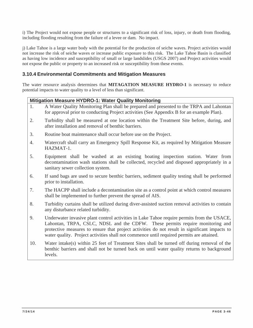
7 / 2 4 / 1 4 P AG E 3 - 4 6
i) The Project would not expose people or structures to a significant risk of loss, injury, or death from flooding, including flooding resulting from the failure of a levee or dam. No impact.
j) Lake Tahoe is a large water body with the potential for the production of seiche waves. Project activities would not increase the risk of seiche waves or increase public exposure to this risk. The Lake Tahoe Basin is classified as having low incidence and susceptibility of small or large landslides (USGS 2007) and Project activities would not expose the public or property to an increased risk or susceptibility from these events.
3.10.4 Environmental Commitments and Mitigation Measures
The water resource analysis determines that MITAGATION MEASURE HYDRO-1 is necessary to reduce potential impacts to water quality to a level of less than significant.
Mitigation Measure HYDRO-1: Water Quality Monitoring 1. A Water Quality Monitoring Plan shall be prepared and presented to the TRPA and Lahontan
for approval prior to conducting Project activities (See Appendix B for an example Plan).
2. Turbidity shall be measured at one location within the Treatment Site before, during, and after installation and removal of benthic barriers.
3. Routine boat maintenance shall occur before use on the Project.
4. Watercraft shall carry an Emergency Spill Response Kit, as required by Mitigation Measure HAZMAT-1.
5. Equipment shall be washed at an existing boating inspection station. Water from decontamination wash stations shall be collected, recycled and disposed appropriately in a sanitary sewer collection system.
6. If sand bags are used to secure benthic barriers, sediment quality testing shall be performed prior to installation.
7. The HACPP shall include a decontamination site as a control point at which control measures shall be implemented to further prevent the spread of AIS.
8. Turbidity curtains shall be utilized during diver-assisted suction removal activities to contain any disturbance related turbidity.
9. Underwater invasive plant control activities in Lake Tahoe require permits from the USACE, Lahontan, TRPA, CSLC, NDSL and the CDFW. These permits require monitoring and protective measures to ensure that project activities do not result in significant impacts to water quality. Project activities shall not commence until required permits are attained.
10. Water intake(s) within 25 feet of Treatment Sites shall be turned off during removal of the benthic barriers and shall not be turned back on until water quality returns to background levels.
7 / 2 4 / 1 4 P AG E 3 - 4 7
3.11 LAND USE AND PLANNING
3.11.1 Environmental Setting
The TRPA Code of Ordinances (Chapter 21) defines permissible land uses in the Lake Tahoe Basin. Each of the potential treatment areas allows for the treatment and removal of invasive plant species. Each plan area along the shoreline and Truckee River includes “Uncommon plant community management” as an allowed use which includes activities or improvements designed to protect, enhance, or perpetuate and ensure the normal ecological processes of a plant community that is of local, regional, state, or national interest. Allowed uses are assumed to be compatible with the direction of the Regional Plan and the surrounding uses.
3.11.2 Environmental Impacts of the No Action Alternative
The No Action alternative implements no AIS treatment and removal activities and therefore, would result in no direct or indirect effects to land uses of the Project Area.
3.11.3 Environmental Impacts of the Proposed Action Alternative
LESS THAN POTENTIALLY SIGNIFICANT LESS THAN SIGNIFICANT WITH SIGNIFICANT NO IMPACT MITIGATION IMPACT IMPACT WOULD THE PROJECT: a) Physically divide an established community?
b) Conflict with the applicable land use plan, policy, or regulation of any agency with jurisdiction over the project (including, but not limited to, a general plan, specific plan, local coastal program, or zoning ordinance) adopted for the purpose of avoiding or mitigating an environmental effect?
c) Conflict with any applicable habitat conservation plan or natural community conservation plan?
Discussion
a, c) The Project Area is within Lake Tahoe and the Truckee River and would not physically divide an established community or conflict with a HCD or natural community conservation plan as none exist.
b) Appropriate interagency coordination, consultation and permits would be completed or obtained, in compliance with applicable local, state, and federal requirements. No Project elements are in conflict with the zoning, regulatory policies, land use plans, conservation plans, or ordinances for the Lake Tahoe Basin and no incompatibilities between the Project and existing plans or ordinances have been identified. The Project would remove non-native, invasive plant species consistent with goals of the TRPA Regional Plan and local area plans that control land use along the shoreline of Lake Tahoe and along the Truckee River. Projects, which are consistent with the zoning and compatible with the surrounding uses, result in no impact to land use.
3.11.4 Environmental Commitments and Mitigation Measures
The land use analysis determines no mitigation measures are necessary.
7 / 2 4 / 1 4 P AG E 3 - 4 8
3.12 MINERAL RESOURCES
3.12.1 Environmental Setting
For purposes of CEQA analysis, “mineral resources” refers to aggregate resources, which consist of sand, gravel and crushed rock. The State Mining and Geology Board classifies mineral deposits through maps and report at: http://www.conservation.ca.gov/cgs/minerals/mlc/Pages/Index.aspx. The map and accompanying text provides general information about the current availability of California's permitted aggregate resources. The map compares projected aggregate demand for the next 50 years with currently permitted aggregate resources in 31 regions of the state. The map also highlights regions where there are less than 10 years of permitted aggregate supply remaining.
There are currently no important mineral resources identified in the Project Area. Commercial mineral resource extractions are restricted due to impacts to resources and in accordance with the PRC Section 5001.65.
3.12.2 Environmental Impacts of the No Action Alternative
The No Action alternative implements no AIS treatment and removal activities, and therefore, would result in no direct or indirect effects to mineral resources.
3.12.3 Environmental Impacts of the Proposed Project Alternative
LESS THAN POTENTIALLY SIGNIFICANT LESS THAN SIGNIFICANT WITH SIGNIFICANT NO IMPACT MITIGATION IMPACT IMPACT WOULD THE PROJECT: a) Result in the loss of availability of a known mineral resource that is or would be of value to the region and the residents of the state?
b) Result in the loss of availability of a locally important mineral resource recovery site delineated on a local general plan, specific plan, or other land use plan?
Discussion
a) The Project is not located in Mineral Resource Zones 1 through 4 classification areas. No significant mineral resources have been identified within the boundaries of the Project Area. The Project would not change land use activities in Treatment Site areas and would therefore not result in the loss of availability of a known mineral resource or a locally important mineral resource recovery site. As stated in the Environmental above, under PRC Section 5001.65, mining within any unit of the State Park System is prohibited.
b) The Project Area does not contain an economically feasible extraction operation.
3.12.4 Environmental Commitments and Mitigation Measures
The mineral resource analysis determines no mitigation measures are necessary.
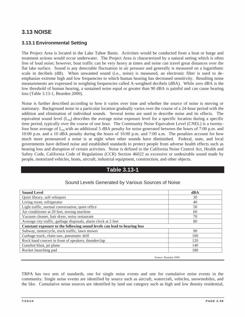
7 / 2 4 / 1 4 P AG E 3 - 4 9
3.13 NOISE
3.13.1 Environmental Setting
The Project Area is located in the Lake Tahoe Basin. Activities would be conducted from a boat or barge and treatment actions would occur underwater. The Project Area is characterized by a natural setting which is often free of loud noise; however, boat traffic can be very heavy at times and noise can travel great distances over the flat lake surface. Sound is any detectable fluctuation in air pressure and generally is measured on a logarithmic scale in decibels (dB). When unwanted sound (i.e., noise) is measured, an electronic filter is used to de-emphasize extreme high and low frequencies to which human hearing has decreased sensitivity. Resulting noise measurements are expressed in weighting frequencies called A-weighted decibels (dBA). While zero dBA is the low threshold of human hearing, a sustained noise equal or greater than 90 dBA is painful and can cause hearing loss (Table 3.13-1, Bearden 2000).
Noise is further described according to how it varies over time and whether the source of noise is moving or stationary. Background noise in a particular location gradually varies over the course of a 24-hour period with the addition and elimination of individual sounds. Several terms are used to describe noise and its effects. The equivalent sound level (Leq) describes the average noise exposure level for a specific location during a specific time period, typically over the course of one hour. The Community Noise Equivalent Level (CNEL) is a twenty-four hour average of Leq with an additional 5 dBA penalty for noise generated between the hours of 7:00 p.m. and 10:00 p.m. and a 10 dBA penalty during the hours of 10:00 p.m. and 7:00 a.m. The penalties account for how much more pronounced a noise is at night when other sounds have diminished. Federal, state, and local governments have defined noise and established standards to protect people from adverse health effects such as hearing loss and disruption of certain activities. Noise is defined in the California Noise Control Act, Health and Safety Code, California Code of Regulations (CCR) Section 46022 as excessive or undesirable sound made by people, motorized vehicles, boats, aircraft, industrial equipment, construction, and other objects.
Table 3.13-1
Sound Levels Generated by Various Sources of Noise
Sound Level dBA Quiet library, soft whispers 30 Living room, refrigerator 40 Light traffic, normal conversation, quiet office 50 Air conditioner at 20 feet, sewing machine 60 Vacuum cleaner, hair dryer, noisy restaurant 70 Average city traffic, garbage disposals, alarm clock at 2 feet 80 Constant exposure to the following sound levels can lead to hearing loss Subway, motorcycle, truck traffic, lawn mower 90 Garbage truck, chain saw, pneumatic drill 100 Rock band concert in front of speakers, thunderclap 120 Gunshot blast, jet plane 140 Rocket launching pad 180
Source: Bearden 2000
TRPA has two sets of standards, one for single noise events and one for cumulative noise events in the community. Single noise events are identified by source such as aircraft, watercraft, vehicles, snowmobiles, and the like. Cumulative noise sources are identified by land use category such as high and low density residential,
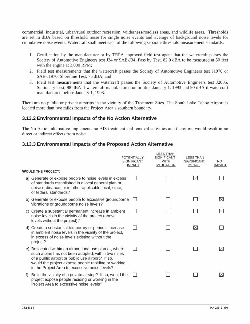
7 / 2 4 / 1 4 P AG E 3 - 5 0
commercial, industrial, urban/rural outdoor recreation, wilderness/roadless areas, and wildlife areas. Thresholds are set in dBA based on threshold noise for single noise events and average of background noise levels for cumulative noise events. Watercraft shall meet each of the following separate threshold measurement standards:
1. Certification by the manufacturer or by TRPA approved field test agent that the watercraft passes the Society of Automotive Engineers test J34 or SAE-J34, Pass by Test, 82.0 dBA to be measured at 50 feet with the engine at 3,000 RPM;
2. Field test measurements that the watercraft passes the Society of Automotive Engineers test J1970 or SAE-J1970, Shoreline Test, 75 dBA; and
3. Field test measurements that the watercraft passes the Society of Automotive Engineers test J2005, Stationary Test, 88 dBA if watercraft manufactured on or after January 1, 1993 and 90 dBA if watercraft manufactured before January 1, 1993.
There are no public or private airstrips in the vicinity of the Treatment Sites. The South Lake Tahoe Airport is located more than two miles from the Project Area’s southern boundary.
3.13.2 Environmental Impacts of the No Action Alternative
The No Action alternative implements no AIS treatment and removal activities and therefore, would result in no direct or indirect effects from noise.
3.13.3 Environmental Impacts of the Proposed Action Alternative
LESS THAN POTENTIALLY SIGNIFICANT LESS THAN SIGNIFICANT WITH SIGNIFICANT NO IMPACT MITIGATION IMPACT IMPACT WOULD THE PROJECT: a) Generate or expose people to noise levels in excess of standards established in a local general plan or noise ordinance, or in other applicable local, state, or federal standards?
b) Generate or expose people to excessive groundborne vibrations or groundborne noise levels?
c) Create a substantial permanent increase in ambient noise levels in the vicinity of the project (above levels without the project)?
d) Create a substantial temporary or periodic increase in ambient noise levels in the vicinity of the project, in excess of noise levels existing without the project?
e) Be located within an airport land use plan or, where such a plan has not been adopted, within two miles of a public airport or public use airport? If so, would the project expose people residing or working in the Project Area to excessive noise levels?
f) Be in the vicinity of a private airstrip? If so, would the project expose people residing or working in the Project Area to excessive noise levels?
7 / 2 4 / 1 4 P AG E 3 - 5 1
Discussion
a) Project activities requiring use of a barge, boat, winch, and/or backhoe could produce noise in excess of typical noise in the area; however, noise related to project activities will be temporary in nature, and temporary increases in noise levels along the shoreline of Lake Tahoe frequently occur as a result of substantial watercraft recreation. Because of the small engines used by the pumps for diver-assisted suction removal of plants, noise generated by these project activities will not violate any established noise standards established by the Tahoe Regional Planning Agency or other local, state, or federal standards. The noise generated by project activities will result in a less than significant impact in regards to public exposure to elevated noise levels.
b) Equipment use would create temporary and periodic vibration effects in the Project Area, but would not expose persons to excessive groundborne vibration or noise levels. The Project does not include fulltime or backup generator power for operations. Because of Treatment Site locations, Project activities would not result in excessive groundborne vibrations or noise levels. No impact.
c) Project activities would be temporary in nature and there will be no permanent change in noise levels at the Treatment Site. No impact.
d) Project noise would be intermittent, and the level will vary depending on the type, location, and length of the activity. Project activities will result in boat use at Treatment Sites and noise from a winch or backhoe, or from diver-assisted suction removal equipment such as an air compressor or pump. However, this noise will be temporary in nature and will not be substantially higher than the periodic noise that this site routinely experiences from power boat operation. Project activities would generate temporary and periodic noise, but ambient noise will not increase substantially as measured at the Project Area boundary because of the topography and locations of the Treatment Sites. Additionally, residential uses or other sensitive receptors are typically not located within 500 feet of the Project Area.
e) The Project is not located within an airport land use plan or within two miles of a public airport or public use airport and therefore creates no exposure of people working in the Project Area to excessive noise levels from air traffic.
f) The Project is not within the vicinity of a private airstrip and therefore creates no exposure to people working in the Project Area to excessive noise levels from air traffic.
3.13.4 Environmental Commitments and Mitigation Measures
The noise analysis determines no mitigation measures would be necessary.
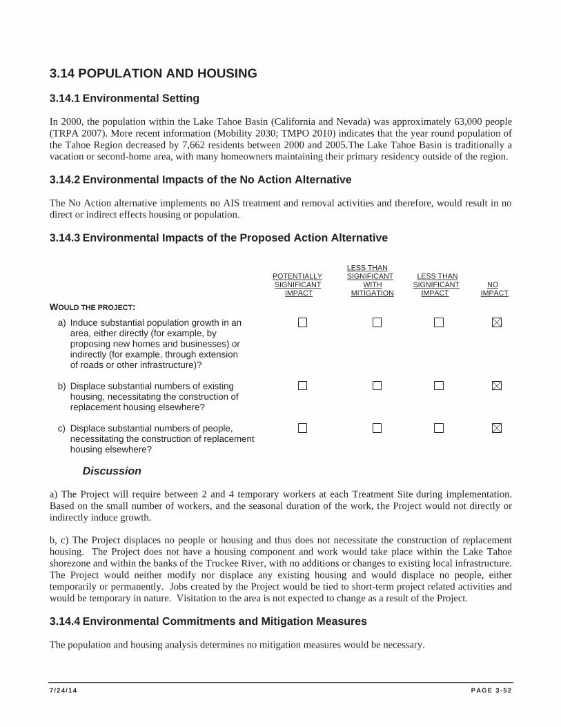
7 / 2 4 / 1 4 P AG E 3 - 5 2
3.14 POPULATION AND HOUSING
3.14.1 Environmental Setting
In 2000, the population within the Lake Tahoe Basin (California and Nevada) was approximately 63,000 people (TRPA 2007). More recent information (Mobility 2030; TMPO 2010) indicates that the year round population of the Tahoe Region decreased by 7,662 residents between 2000 and 2005.The Lake Tahoe Basin is traditionally a vacation or second-home area, with many homeowners maintaining their primary residency outside of the region.
3.14.2 Environmental Impacts of the No Action Alternative
The No Action alternative implements no AIS treatment and removal activities and therefore, would result in no direct or indirect effects housing or population.
3.14.3 Environmental Impacts of the Proposed Action Alternative
LESS THAN POTENTIALLY SIGNIFICANT LESS THAN SIGNIFICANT WITH SIGNIFICANT NO IMPACT MITIGATION IMPACT IMPACT WOULD THE PROJECT: a) Induce substantial population growth in an area, either directly (for example, by proposing new homes and businesses) or indirectly (for example, through extension of roads or other infrastructure)? b) Displace substantial numbers of existing housing, necessitating the construction of replacement housing elsewhere? c) Displace substantial numbers of people, necessitating the construction of replacement housing elsewhere?
Discussion
a) The Project will require between 2 and 4 temporary workers at each Treatment Site during implementation. Based on the small number of workers, and the seasonal duration of the work, the Project would not directly or indirectly induce growth.
b, c) The Project displaces no people or housing and thus does not necessitate the construction of replacement housing. The Project does not have a housing component and work would take place within the Lake Tahoe shorezone and within the banks of the Truckee River, with no additions or changes to existing local infrastructure. The Project would neither modify nor displace any existing housing and would displace no people, either temporarily or permanently. Jobs created by the Project would be tied to short-term project related activities and would be temporary in nature. Visitation to the area is not expected to change as a result of the Project.
3.14.4 Environmental Commitments and Mitigation Measures
The population and housing analysis determines no mitigation measures would be necessary.
7 / 2 4 / 1 4 P AG E 3 - 5 3
3.15 PUBLIC SERVICES
3.15.1 Environmental Setting
Public services include fire and police protection, schools, parks, and other public facilities. The Treatment Sites benefit from existing public services, such as fire and law enforcement protection.
Fire Protection. California state park units in the Tahoe Basin are located on State Responsibility Land in Placer and El Dorado Counties. The California Department of Forestry and Fire Protection (CalFire) has primary jurisdiction for fire suppression in State Responsibility Land including units of the State Park System (CalFire 2007). Approximately 80 percent of the lands within the Tahoe Basin are owned and managed by the LTBMU. CalFire has an agreement with the LTBMU to provide fire protection to State Responsibility Lands in the Basin.
The size of the state and the numerous types of emergencies such as wildfires, floods, and earthquakes, require the cooperative efforts of federal, state, and local agencies. The LTBMU provides service to the entire Lake Tahoe Basin in California and Nevada. The Fire Protection Districts within Tahoe Basin work cooperatively with LTBMU and adjacent Fire Protection Districts.
The Nevada Division of Forestry provides wildfire protection statewide through its Wildland Fire Protection Program, which was approved by the Nevada State Legislature in 2013. The program was developed to defend the people and lands of Nevada against wildland fire through collaborative and comprehensive use of fire suppression, prevention and restoration resources available through the state. It works to address current challenges facing federal, state, and local governments which include fighting year-round wildland fires, escalating fire suppression costs, cheatgrass and other invasive species, expanding Wildland Urban Interfaces, scattered capabilities and jurisdictions, tight budgets, and declining federal resources and cost shifting.
The Wildland Fire Protection Program allows the State to provide financial assistance with wildland fire costs, increased suppression resources and coordination, incident management assistance, and technical expertise to participating counties during a wildfire. The Division also operates under cooperative agreements with federal agencies and other states.
Police Protection. California and Nevada Park Rangers assigned to lands within the Lake Tahoe Basin are Peace Officer Standards and Training certified law enforcement officers and provide year round law enforcement within park unit boundaries. The County Sheriff Departments responds to emergency calls and assists with criminal investigations. LTBMU provides Law Enforcement Officers to address incidents on National Forest Lands. On the Lake Tahoe water body the United States Coast Guard maintains legal authority. TRPA also maintains enforcement presence on Lake Tahoe for boating, scenic quality and design standard regulations.
Schools. No schools are located within or adjacent to the Project Area.
Parks and Other Public Facilities. Many parks and recreational facilities that serve local residents and visitors are located adjacent to and provide access to the Project Area. Such parks, recreational facilities and access areas are managed by CDPR, Nevada State Parks, LTBMU, City of South Lake Tahoe, North Tahoe Public Utility District, California Tahoe Conservancy and various other agencies.
3.15.2 Environmental Impacts of the No Action Alternative
The No Action alternative implements no AIS treatment and removal activities and therefore, would result in no direct or indirect effects to public services.
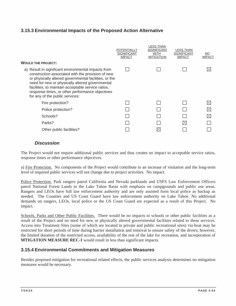
7 / 2 4 / 1 4 P AG E 3 - 5 4
3.15.3 Environmental Impacts of the Proposed Action Alternative
LESS THAN POTENTIALLY SIGNIFICANT LESS THAN SIGNIFICANT WITH SIGNIFICANT NO IMPACT MITIGATION IMPACT IMPACT WOULD THE PROJECT: a) Result in significant environmental impacts from construction associated with the provision of new or physically altered governmental facilities, or the need for new or physically altered governmental facilities, to maintain acceptable service ratios, response times, or other performance objectives for any of the public services:
Fire protection?
Police protection?
Schools?
Parks?
Other public facilities?
Discussion
The Project would not require additional public services and thus creates no impact to acceptable service ratios, response times or other performance objectives.
a) Fire Protection. No components of the Project would contribute to an increase of visitation and the long-term level of required public services will not change due to project activities. No impact.
Police Protection. Park rangers patrol California and Nevada parklands and USFS Law Enforcement Officers patrol National Forest Lands in the Lake Tahoe Basin with emphasis on campgrounds and public use areas. Rangers and LEOs have full law enforcement authority and are only assisted form local police as backup as needed. The Counties and US Coast Guard have law enforcement authority on Lake Tahoe. No additional demands on rangers, LEOs, local police or the US Coast Guard are expected as a result of this Project. No impact.
Schools, Parks and Other Public Facilities. There would be no impacts to schools or other public facilities as a result of the Project and no need for new or physically altered governmental facilities related to these services. Access into Treatment Sites (some of which are located in private and public recreational sites) via boat may be restricted for short periods of time during barrier installation and removal to ensure safety of the divers; however, the limited duration of the restricted access, availability of the rest of the lake for recreation, and incorporation of MTIGATION MEASURE REC-1 would result in less than significant impacts.
3.15.4 Environmental Commitments and Mitigation Measures
Besides proposed mitigation for recreational related effects, the public services analysis determines no mitigation measures would be necessary.
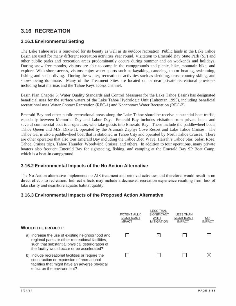
7 / 2 4 / 1 4 P AG E 3 - 5 5
3.16 RECREATION
3.16.1 Environmental Setting
The Lake Tahoe area is renowned for its beauty as well as its outdoor recreation. Public lands in the Lake Tahoe Basin are used for many different recreation activities year round. Visitation to Emerald Bay State Park (SP) and other public parks and recreation areas predominantly occurs during summer and on weekends and holidays. During snow free months, visitors are able to camp in the campgrounds and picnic, hike, mountain bike, and explore. With shore access, visitors enjoy water sports such as kayaking, canoeing, motor boating, swimming, fishing and scuba diving. During the winter, recreational activities such as sledding, cross-country skiing, and snowshoeing dominate. Many of the Treatment Sites are located on or near private recreational providers including boat marinas and the Tahoe Keys access channel. Basin Plan Chapter 5: Water Quality Standards and Control Measures for the Lake Tahoe Basin) has designated beneficial uses for the surface waters of the Lake Tahoe Hydrologic Unit (Lahontan 1995), including beneficial recreational uses Water Contact Recreation (REC-1) and Noncontact Water Recreation (REC-2). Emerald Bay and other public recreational areas along the Lake Tahoe shoreline receive substantial boat traffic, especially between Memorial Day and Labor Day. Emerald Bay includes visitation from private boats and several commercial boat tour operators who take guests into Emerald Bay. These include the paddlewheel boats Tahoe Queen and M.S. Dixie II, operated by the Aramark Zephyr Cove Resort and Lake Tahoe Cruises. The Tahoe Gal is also a paddlewheel boat that is stationed in Tahoe City and operated by North Tahoe Cruises. There are other operators that also tour Emerald Bay including the Tahoe Bleu Wave, Harrah’s Tahoe Star, Safari Rose, Tahoe Cruises trips, Tahoe Thunder, Woodwind Cruises, and others. In addition to tour operations, many private boaters also frequent Emerald Bay for sightseeing, fishing, and camping at the Emerald Bay SP Boat Camp, which is a boat-in campground.
3.16.2 Environmental Impacts of the No Action Alternative
The No Action alternative implements no AIS treatment and removal activities and therefore, would result in no direct effects to recreation. Indirect effects may include a decreased recreation experience resulting from loss of lake clarity and nearshore aquatic habitat quality.
3.16.3 Environmental Impacts of the Proposed Action Alternative
LESS THAN POTENTIALLY SIGNIFICANT LESS THAN SIGNIFICANT WITH SIGNIFICANT NO IMPACT MITIGATION IMPACT IMPACT
WOULD THE PROJECT: a) Increase the use of existing neighborhood and regional parks or other recreational facilities, such that substantial physical deterioration of the facility would occur or be accelerated?
b) Include recreational facilities or require the construction or expansion of recreational facilities that might have an adverse physical effect on the environment?
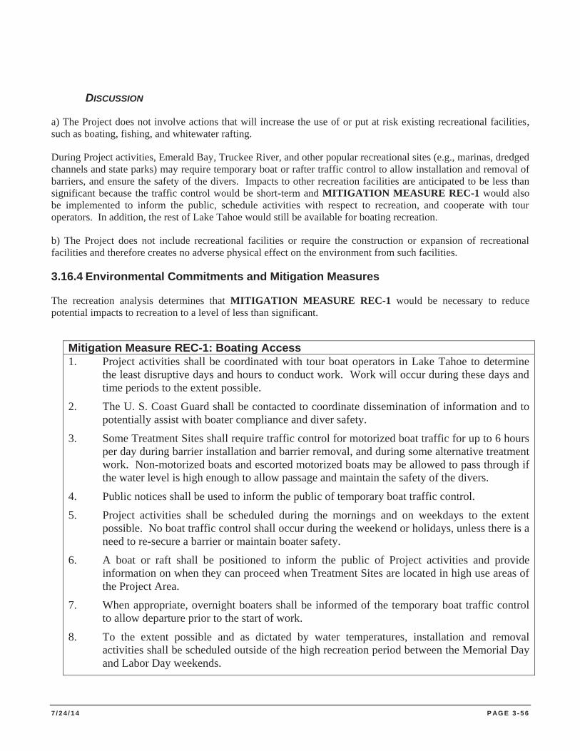
7 / 2 4 / 1 4 P AG E 3 - 5 6
DISCUSSION
a) The Project does not involve actions that will increase the use of or put at risk existing recreational facilities, such as boating, fishing, and whitewater rafting.
During Project activities, Emerald Bay, Truckee River, and other popular recreational sites (e.g., marinas, dredged channels and state parks) may require temporary boat or rafter traffic control to allow installation and removal of barriers, and ensure the safety of the divers. Impacts to other recreation facilities are anticipated to be less than significant because the traffic control would be short-term and MITIGATION MEASURE REC-1 would also be implemented to inform the public, schedule activities with respect to recreation, and cooperate with tour operators. In addition, the rest of Lake Tahoe would still be available for boating recreation.
b) The Project does not include recreational facilities or require the construction or expansion of recreational facilities and therefore creates no adverse physical effect on the environment from such facilities.
3.16.4 Environmental Commitments and Mitigation Measures
The recreation analysis determines that MITIGATION MEASURE REC-1 would be necessary to reduce potential impacts to recreation to a level of less than significant.
Mitigation Measure REC-1: Boating Access 1. Project activities shall be coordinated with tour boat operators in Lake Tahoe to determine
the least disruptive days and hours to conduct work. Work will occur during these days and time periods to the extent possible.
2. The U. S. Coast Guard shall be contacted to coordinate dissemination of information and to potentially assist with boater compliance and diver safety.
3. Some Treatment Sites shall require traffic control for motorized boat traffic for up to 6 hours per day during barrier installation and barrier removal, and during some alternative treatment work. Non-motorized boats and escorted motorized boats may be allowed to pass through if the water level is high enough to allow passage and maintain the safety of the divers.
4. Public notices shall be used to inform the public of temporary boat traffic control.
5. Project activities shall be scheduled during the mornings and on weekdays to the extent possible. No boat traffic control shall occur during the weekend or holidays, unless there is a need to re-secure a barrier or maintain boater safety.
6. A boat or raft shall be positioned to inform the public of Project activities and provide information on when they can proceed when Treatment Sites are located in high use areas of the Project Area.
7. When appropriate, overnight boaters shall be informed of the temporary boat traffic control to allow departure prior to the start of work.
8. To the extent possible and as dictated by water temperatures, installation and removal activities shall be scheduled outside of the high recreation period between the Memorial Day and Labor Day weekends.
7 / 2 4 / 1 4 P AG E 3 - 5 7
3.17 TRANSPORTATION AND TRAFFIC
3.17.1 Environmental Setting
The predominant mode of transportation used in the Lake Tahoe Basin is private vehicle (TRPA 2007). In the summer, there is considerable private vehicle traffic on the highways around the lake and at times traffic can become congested on these roads.
Streets and Highways. State Routes 28 and 89 and U.S. Highway 50 encompass the perimeter of Lake Tahoe. These main travel corridors can experience high traffic volume from private vehicles during portions of the year, specifically summer between Memorial Day and Labor Day holidays.
Road Traffic and Level of Service. Level of Service (LOS) measures how the route operates during peak hour traffic. LOS summarizes the effects of speed, travel time, traffic interruptions, freedom to maneuver and other factors. The performance of the county roads and highways is evaluated based on LOS definitions. Six levels of service represent varying roadway conditions ranging from ideal (LOS "A") to forced flow (LOS "F"). The areas of high congestion that sometimes achieve LOS F are the intersections of Highway 50 and Highway 89 in South Lake Tahoe and in Tahoe City at the intersection of Highway 89 and Highway 28.
Bicycle Traffic. The Lake Tahoe Regional Bicycle and Pedestrian Master Plan was developed in 2003 by the Tahoe Metropolitan Planning Organization and updated in 2010. This plan provides a “blueprint for developing a regional bicycle and pedestrian system that includes both on-street and off-street facilities as well as support facilities and programs throughout the Lake Tahoe region”.
Parking. During peak visitation in the summer, parking on paved surfaces is limited to a first-come, first served basis at the State Parks, NTPUD, City of South Lake Tahoe and LTBMU recreational sites and Lake access areas. There are no parking facilities in the active Project Area; however access and staging areas may be located in existing parking facilities when appropriate.
3.17.2 Environmental Impacts of the No Action Alternative
The No Action alternative implements no AIS treatment and removal activities and therefore, would result in no direct or indirect effects to transportation or traffic.
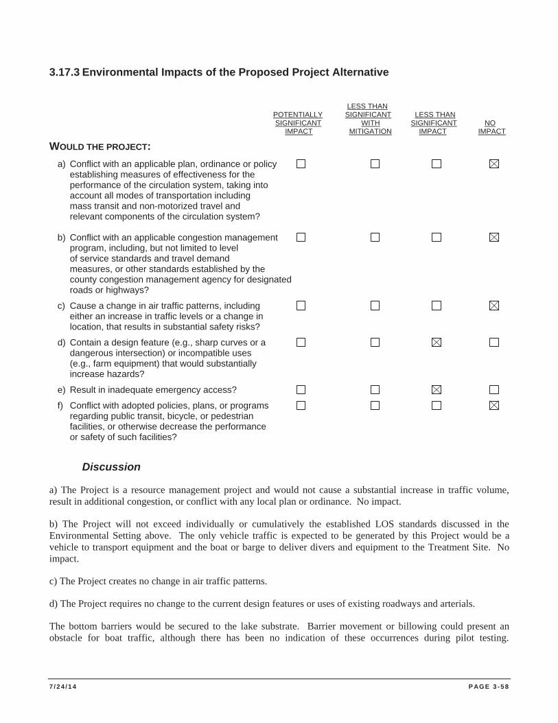
7 / 2 4 / 1 4 P AG E 3 - 5 8
3.17.3 Environmental Impacts of the Proposed Project Alternative
LESS THAN POTENTIALLY SIGNIFICANT LESS THAN SIGNIFICANT WITH SIGNIFICANT NO IMPACT MITIGATION IMPACT IMPACT
WOULD THE PROJECT: a) Conflict with an applicable plan, ordinance or policy establishing measures of effectiveness for the performance of the circulation system, taking into account all modes of transportation including mass transit and non-motorized travel and relevant components of the circulation system? b) Conflict with an applicable congestion management program, including, but not limited to level of service standards and travel demand measures, or other standards established by the county congestion management agency for designated roads or highways?
c) Cause a change in air traffic patterns, including either an increase in traffic levels or a change in location, that results in substantial safety risks?
d) Contain a design feature (e.g., sharp curves or a dangerous intersection) or incompatible uses (e.g., farm equipment) that would substantially increase hazards?
e) Result in inadequate emergency access?
f) Conflict with adopted policies, plans, or programs regarding public transit, bicycle, or pedestrian facilities, or otherwise decrease the performance or safety of such facilities?
Discussion
a) The Project is a resource management project and would not cause a substantial increase in traffic volume, result in additional congestion, or conflict with any local plan or ordinance. No impact.
b) The Project will not exceed individually or cumulatively the established LOS standards discussed in the Environmental Setting above. The only vehicle traffic is expected to be generated by this Project would be a vehicle to transport equipment and the boat or barge to deliver divers and equipment to the Treatment Site. No impact.
c) The Project creates no change in air traffic patterns.
d) The Project requires no change to the current design features or uses of existing roadways and arterials.
The bottom barriers would be secured to the lake substrate. Barrier movement or billowing could present an obstacle for boat traffic, although there has been no indication of these occurrences during pilot testing.
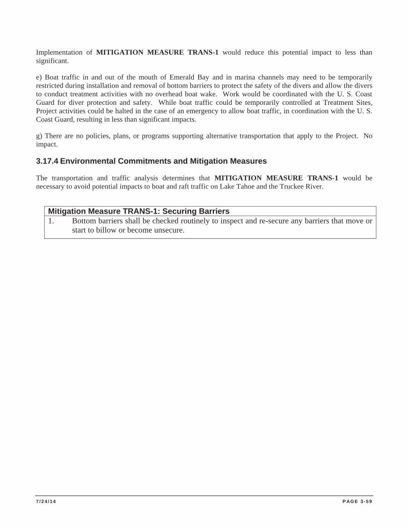
7 / 2 4 / 1 4 P AG E 3 - 5 9
Implementation of MITIGATION MEASURE TRANS-1 would reduce this potential impact to less than significant.
e) Boat traffic in and out of the mouth of Emerald Bay and in marina channels may need to be temporarily restricted during installation and removal of bottom barriers to protect the safety of the divers and allow the divers to conduct treatment activities with no overhead boat wake. Work would be coordinated with the U. S. Coast Guard for diver protection and safety. While boat traffic could be temporarily controlled at Treatment Sites, Project activities could be halted in the case of an emergency to allow boat traffic, in coordination with the U. S. Coast Guard, resulting in less than significant impacts.
g) There are no policies, plans, or programs supporting alternative transportation that apply to the Project. No impact.
3.17.4 Environmental Commitments and Mitigation Measures
The transportation and traffic analysis determines that MITIGATION MEASURE TRANS-1 would be necessary to avoid potential impacts to boat and raft traffic on Lake Tahoe and the Truckee River.
Mitigation Measure TRANS-1: Securing Barriers 1. Bottom barriers shall be checked routinely to inspect and re-secure any barriers that move or
start to billow or become unsecure.
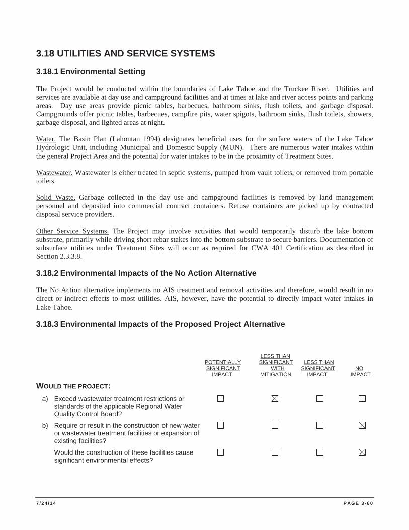
7 / 2 4 / 1 4 P AG E 3 - 6 0
3.18 UTILITIES AND SERVICE SYSTEMS
3.18.1 Environmental Setting
The Project would be conducted within the boundaries of Lake Tahoe and the Truckee River. Utilities and services are available at day use and campground facilities and at times at lake and river access points and parking areas. Day use areas provide picnic tables, barbecues, bathroom sinks, flush toilets, and garbage disposal. Campgrounds offer picnic tables, barbecues, campfire pits, water spigots, bathroom sinks, flush toilets, showers, garbage disposal, and lighted areas at night.
Water. The Basin Plan (Lahontan 1994) designates beneficial uses for the surface waters of the Lake Tahoe Hydrologic Unit, including Municipal and Domestic Supply (MUN). There are numerous water intakes within the general Project Area and the potential for water intakes to be in the proximity of Treatment Sites.
Wastewater. Wastewater is either treated in septic systems, pumped from vault toilets, or removed from portable toilets.
Solid Waste. Garbage collected in the day use and campground facilities is removed by land management personnel and deposited into commercial contract containers. Refuse containers are picked up by contracted disposal service providers.
Other Service Systems. The Project may involve activities that would temporarily disturb the lake bottom substrate, primarily while driving short rebar stakes into the bottom substrate to secure barriers. Documentation of subsurface utilities under Treatment Sites will occur as required for CWA 401 Certification as described in Section 2.3.3.8.
3.18.2 Environmental Impacts of the No Action Alternative
The No Action alternative implements no AIS treatment and removal activities and therefore, would result in no direct or indirect effects to most utilities. AIS, however, have the potential to directly impact water intakes in Lake Tahoe.
3.18.3 Environmental Impacts of the Proposed Project Alternative
LESS THAN POTENTIALLY SIGNIFICANT LESS THAN SIGNIFICANT WITH SIGNIFICANT NO IMPACT MITIGATION IMPACT IMPACT
WOULD THE PROJECT: a) Exceed wastewater treatment restrictions or standards of the applicable Regional Water Quality Control Board?
b) Require or result in the construction of new water or wastewater treatment facilities or expansion of existing facilities?
Would the construction of these facilities cause significant environmental effects?
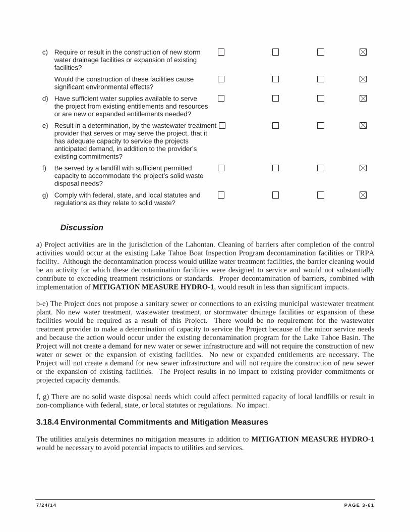
7 / 2 4 / 1 4 P AG E 3 - 6 1
c) Require or result in the construction of new storm water drainage facilities or expansion of existing facilities?
Would the construction of these facilities cause significant environmental effects?
d) Have sufficient water supplies available to serve the project from existing entitlements and resources or are new or expanded entitlements needed?
e) Result in a determination, by the wastewater treatment provider that serves or may serve the project, that it has adequate capacity to service the projects anticipated demand, in addition to the provider’s existing commitments?
f) Be served by a landfill with sufficient permitted capacity to accommodate the project’s solid waste disposal needs?
g) Comply with federal, state, and local statutes and regulations as they relate to solid waste?
Discussion
a) Project activities are in the jurisdiction of the Lahontan. Cleaning of barriers after completion of the control activities would occur at the existing Lake Tahoe Boat Inspection Program decontamination facilities or TRPA facility. Although the decontamination process would utilize water treatment facilities, the barrier cleaning would be an activity for which these decontamination facilities were designed to service and would not substantially contribute to exceeding treatment restrictions or standards. Proper decontamination of barriers, combined with implementation of MITIGATION MEASURE HYDRO-1, would result in less than significant impacts.
b-e) The Project does not propose a sanitary sewer or connections to an existing municipal wastewater treatment plant. No new water treatment, wastewater treatment, or stormwater drainage facilities or expansion of these facilities would be required as a result of this Project. There would be no requirement for the wastewater treatment provider to make a determination of capacity to service the Project because of the minor service needs and because the action would occur under the existing decontamination program for the Lake Tahoe Basin. The Project will not create a demand for new water or sewer infrastructure and will not require the construction of new water or sewer or the expansion of existing facilities. No new or expanded entitlements are necessary. The Project will not create a demand for new sewer infrastructure and will not require the construction of new sewer or the expansion of existing facilities. The Project results in no impact to existing provider commitments or projected capacity demands.
f, g) There are no solid waste disposal needs which could affect permitted capacity of local landfills or result in non-compliance with federal, state, or local statutes or regulations. No impact.
3.18.4 Environmental Commitments and Mitigation Measures
The utilities analysis determines no mitigation measures in addition to MITIGATION MEASURE HYDRO-1 would be necessary to avoid potential impacts to utilities and services.
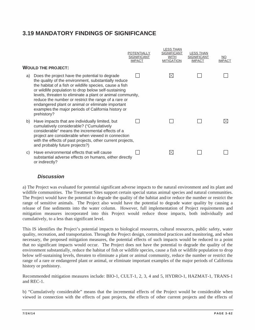
7 / 2 4 / 1 4 P AG E 3 - 6 2
3.19 MANDATORY FINDINGS OF SIGNIFICANCE
LESS THAN
POTENTIALLY SIGNIFICANT LESS THAN SIGNIFICANT WITH SIGNIFICANT NO IMPACT MITIGATION IMPACT IMPACT WOULD THE PROJECT: a) Does the project have the potential to degrade the quality of the environment, substantially reduce the habitat of a fish or wildlife species, cause a fish or wildlife population to drop below self-sustaining levels, threaten to eliminate a plant or animal community, reduce the number or restrict the range of a rare or endangered plant or animal or eliminate important examples the major periods of California history or prehistory?
b) Have impacts that are individually limited, but cumulatively considerable? (“Cumulatively considerable” means the incremental effects of a project are considerable when viewed in connection with the effects of past projects, other current projects, and probably future projects?)
c) Have environmental effects that will cause substantial adverse effects on humans, either directly or indirectly?
Discussion
a) The Project was evaluated for potential significant adverse impacts to the natural environment and its plant and wildlife communities. The Treatment Sites support certain special status animal species and natural communities. The Project would have the potential to degrade the quality of the habitat and/or reduce the number or restrict the range of sensitive animals. The Project also would have the potential to degrade water quality by causing a release of fine sediments into the water column. However, full implementation of Project requirements and mitigation measures incorporated into this Project would reduce those impacts, both individually and cumulatively, to a less than significant level.
This IS identifies the Project’s potential impacts to biological resources, cultural resources, public safety, water quality, recreation, and transportation. Through the Project design, committed practices and monitoring, and when necessary, the proposed mitigation measures, the potential effects of such impacts would be reduced to a point that no significant impacts would occur. The Project does not have the potential to degrade the quality of the environment substantially, reduce the habitat of fish or wildlife species, cause a fish or wildlife population to drop below self-sustaining levels, threaten to eliminate a plant or animal community, reduce the number or restrict the range of a rare or endangered plant or animal, or eliminate important examples of the major periods of California history or prehistory.
Recommended mitigation measures include: BIO-1, CULT-1, 2, 3, 4 and 5, HYDRO-1, HAZMAT-1, TRANS-1 and REC-1.
b) “Cumulatively considerable” means that the incremental effects of the Project would be considerable when viewed in connection with the effects of past projects, the effects of other current projects and the effects of
7 / 2 4 / 1 4 P AG E 3 - 6 3
probable future projects. The projects that could have a cumulative impact on the resources in the Project Area, when considered incrementally with the Project, are referred to as “related projects” and are listed in Section 3.1 of this IS. Agencies contacted and documents referenced for development of this list include: TRPA, USACE, Lahontan, CDPR and Tahoe RCD.
The Project, when considered in context with other past, present and reasonably foreseeable future projects, would not create impacts that are individually limited but cumulatively considerable. The long-term effects of the Project will result in beneficial impacts to numerous resource areas, including water quality, biological resources, scenic quality, and recreation. Potential short-term Project related implementation impacts (e.g., increased localized turbidity, conflicts with recreational uses, potential to disturb cultural resources) will be offset by measures proposed as part of the Project description and where necessary, mitigation measures recommended in this Initial Study.
CDPR, Nevada State Parks, LTBMU, NTPUD, the City of South Lake Tahoe and other land management entities often have maintenance programs, as well as rehabilitation, interpretation, and accessibility projects planned for areas adjacent to the Project Area. Potential impacts from environmental issues addressed in this Initial Study would not overlap in such a way as to result in cumulative impacts that are greater than the sum of the parts.
c) The Project would not substantially affect humans. The Project directly benefits the natural environment, and thus indirectly the human environment, through identification, removal, disposal and long-term monitoring of AIS infestations in Lake Tahoe and the Truckee River.

7 / 2 4 / 1 4 P AG E 3 - 6 4
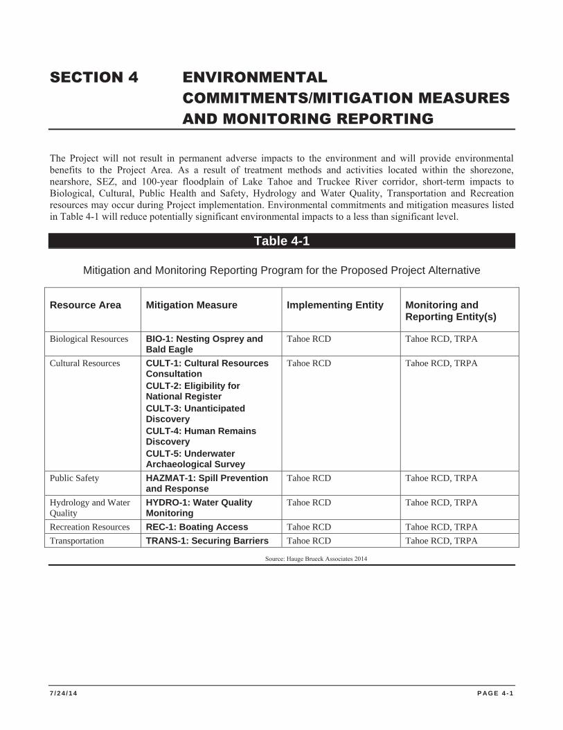
7 / 2 4 / 1 4 P AG E 4 - 1
SECTION 4 ENVIRONMENTAL COMMITMENTS/MITIGATION MEASURES AND MONITORING REPORTING
The Project will not result in permanent adverse impacts to the environment and will provide environmental benefits to the Project Area. As a result of treatment methods and activities located within the shorezone, nearshore, SEZ, and 100-year floodplain of Lake Tahoe and Truckee River corridor, short-term impacts to Biological, Cultural, Public Health and Safety, Hydrology and Water Quality, Transportation and Recreation resources may occur during Project implementation. Environmental commitments and mitigation measures listed in Table 4-1 will reduce potentially significant environmental impacts to a less than significant level.
Table 4-1
Mitigation and Monitoring Reporting Program for the Proposed Project Alternative
Resource Area Mitigation Measure Implementing Entity Monitoring and Reporting Entity(s)
Biological Resources BIO-1: Nesting Osprey and Bald Eagle
Tahoe RCD Tahoe RCD, TRPA
Cultural Resources CULT-1: Cultural Resources Consultation CULT-2: Eligibility for National Register CULT-3: Unanticipated Discovery CULT-4: Human Remains Discovery CULT-5: Underwater Archaeological Survey
Tahoe RCD Tahoe RCD, TRPA
Public Safety HAZMAT-1: Spill Prevention and Response
Tahoe RCD Tahoe RCD, TRPA
Hydrology and Water Quality
HYDRO-1: Water Quality Monitoring
Tahoe RCD Tahoe RCD, TRPA
Recreation Resources REC-1: Boating Access Tahoe RCD Tahoe RCD, TRPA Transportation TRANS-1: Securing Barriers Tahoe RCD Tahoe RCD, TRPA
Source: Hauge Brueck Associates 2014

7 / 2 4 / 1 4 P AG E 4 - 2
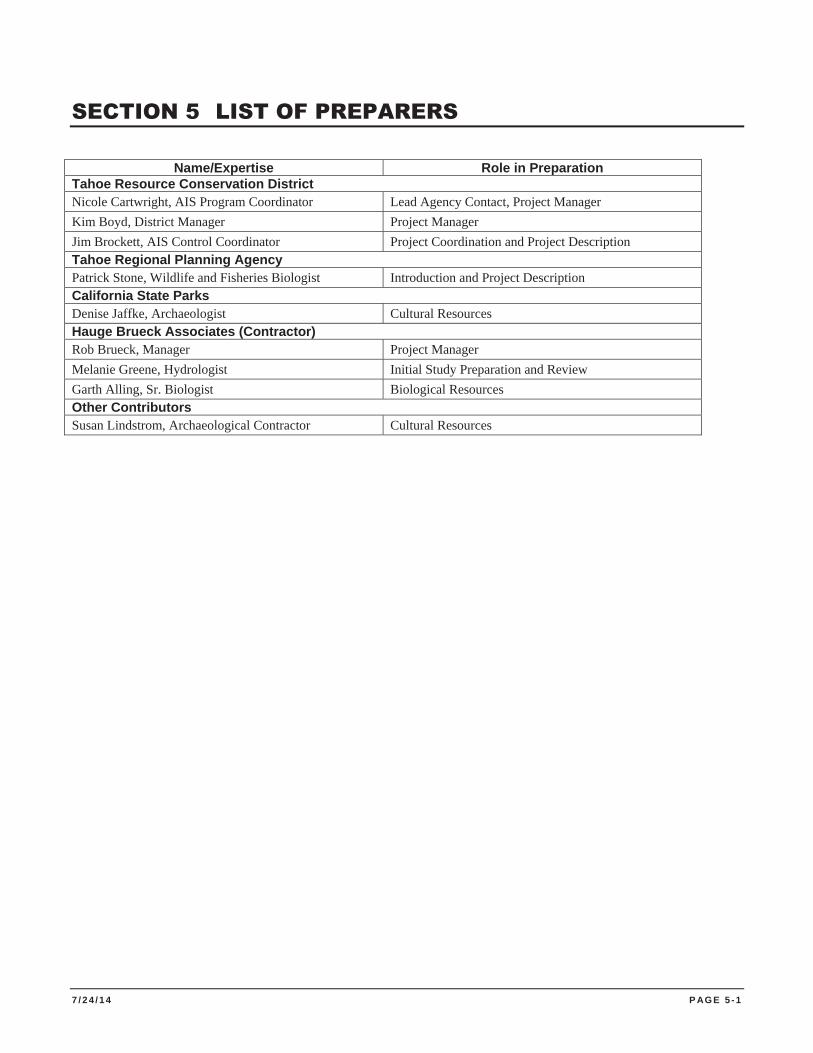
7 / 2 4 / 1 4 P AG E 5 - 1
SECTION 5 LIST OF PREPARERS
Name/Expertise Role in Preparation Tahoe Resource Conservation District Nicole Cartwright, AIS Program Coordinator Lead Agency Contact, Project Manager Kim Boyd, District Manager Project Manager Jim Brockett, AIS Control Coordinator Project Coordination and Project Description Tahoe Regional Planning Agency Patrick Stone, Wildlife and Fisheries Biologist Introduction and Project Description California State Parks Denise Jaffke, Archaeologist Cultural Resources Hauge Brueck Associates (Contractor) Rob Brueck, Manager Project Manager Melanie Greene, Hydrologist Initial Study Preparation and Review Garth Alling, Sr. Biologist Biological Resources Other Contributors Susan Lindstrom, Archaeological Contractor Cultural Resources

7 / 2 4 / 1 4 P AG E 5 - 2
7 / 2 4 / 1 4 P AG E 6 - 1
SECTION 6 REFERENCES
Basgall, M. E. 1988.Archaeology of the Komodo site, an Early Holocene Occupation in Central-eastern California. In Early Human Occupation in Western North America: the Clovis-Archaic Interface, edited by J. Willig, C.M. Aikens, and J. Fagan, pp. 103-119. Nevada State Museum Anthropological Papers 21.
Bearden, D. M. 2000. Noise Abatement and Control: An Overview of Federal Standards and Regulations. http://ncseonline.org/NLE/CRSreports/Risk/rsk-52.cfm?&CFID=7463199&CFTOKEN=71822941(accessed March 17, 2014).
Beauchamp, D. A., et al. 1994. Summer habitat use by littoral-zone fishers in Lake Tahoe and effects of shoreline structures. North American J. of Fisheries Management. Vol. 14. pp. 385-394.
Bloomer, W. W., et al. 1997. Basalt Quarrying on Watson Creek: An Archaeological and Ethnographic Study in the Northern Lake Tahoe Basin. Volume 1: Report. Prepared for the U. S. Forest Service, Lake Tahoe Basin
Branum, D. S. et al. 2008. Earthquake shaking potential for California. California Geological Survey Map Sheet 48 (Revised).
California Air Resources Board (CARB). 2006. Maps Available on this Website: Area Designation Maps. http://www.arb.ca.gov/desig/adm/adm.htm (accessed March 17, 2014)
CARB. 2008. California Local Air District Directory. http://www.arb.ca.gov/ei/ maps/statemap/dismap.htm (accessed March 17, 2014).
CARB. 2009. California Greenhouse Gas Emissions Inventory: 2000-2009
CARB. 2010. State Standard Designations. http://www.arb.ca.gov/desig/statedesig.htm (accessed March 16, 2010).
California Department of Conservation (CDOC). 2010a. Williamson Act.http://www.conservation.ca.gov/DLRP/lca/Pages/Index.aspx (accessed February 1, 2011).
CDOC. 2010b. Farmland Mapping and Monitoring Program. http://www.conservation.ca.gov/dlrp/FMMP/Pages/Index.aspx (accessed January 29, 2011).
California Department of Fish and Wildlife (CDFG). 2008. Rare Find: California Department of Fish and Game Natural Diversity Database. Version 3.1.0 (accessed March 17, 2014). California Department of Parks and Recreation (CDPR). 1991. Sugar Pine Point State Park Preliminary Resources Element.
CDPR 2008. Department of Parks and Recreation Memorandum Vision Statement and Strategic Initiatives issued February 8, 2008.
CDPR. 2012. Asian Clam Control Project Emerald Bay State Park Initial Study and Mitigated Negative Declaration.
California Geological Survey (CGS). 2007. Alquist-Priolo Earthquake Fault Zones. California Department of Conservation. http://www.consrv.ca.gov/cgs/rghm/ap/map_index/ Pages/index.aspx (accessed March 14, 2014).
7 / 2 4 / 1 4 P AG E 6 - 2
CGS. 2008. Probabilistic Seismic Hazards Mapping Ground Motion Page (selected site). http://redirect.conservation.ca.gov/cgs/rghm/pshamap (accessed March 14, 2014).
Coates. R. 2010. Climate Change in the Lake Tahoe Basin.
California Native Plant Society (CNPS). 2014. Inventory of Rare and Endangered Plants (online edition, v7-09d). California Native Plant Society. Sacramento, CA. http://www.cnps.org/inventory (accessed March 17, 2014).
Cooper, Clark and Associates. 1974. Natural Hazards of the Lake Tahoe Basin. Prepared for Tahoe Regional Planning Agency.
Davis, J. O., and M. K. Rusco. 1987. The Old Humboldt Site - 26PE670. In, Studies in Archaeology, Geology and Paleontology at Rye Patch Reservoir, Pershing County, Nevada, edited by M. K. Rusco and J. O. Davis. Nevada State Museum Anthropological Papers Number 20. Carson City, Nevada.
d’Azevedo, W. L. 1986. The Washoe. In The Great Basin, edited by Warren L. d’Azevedo, pp.466-499. Handbook of North American Indians, Vol.11, William G. Sturtevant, general editor. Smithsonian Institution, Washington, D.C.
Downs, J. F. 1966. The Two Worlds of the Washo: an Indian Tribe of California and Nevada. Holt Rinehart and Winston, Inc. Fort Worth.
Downs, J. F. 1986. Prehistory of the Western Area. In, Handbook of North American Indians. Vol. 11: Great Basin, pp. 135-148. W. L. d’Azevedo (ed.). Smithsonian Institution, Washington, D.C.
Department of Toxic Substance Control – California (DTSC). 2010. California Department of Toxic Substances Control (DTSC). Envirostor Database search for Tahoe Basin. http://www.envirostor.dtsc.ca.gov/public/ (accessed March, 2014).
El Dorado County Air Quality Management District (EDCAQMD). 2010. http://www.co.el-dorado.ca.us/emd/apcd/index.html (accessed March 8, 2014)
Elliot, R. R. 1973. History of Nevada. University of Nebraska Press, Lincoln. NE.
Elston, R. G., et al. 1977. The Archaeology of the Tahoe Reach of the Truckee River. Nevada Archaeological Survey, University of Nevada, Reno.
Elston, R. G., et al. 1994. Beyond the Blue Roof: An Archaeological Survey on Mt. Rose Fan and Northern Steamboat Hills. Intermountain Research, Silver City, Nevada. Submitted to Toiyabe National Forest, Reno, Nevada.
Elston, R. G., et al. 1995a. A Research Design for the Southern Truckee Meadows Prehistoric Archaeological District. Prepared for American Land Conservancy on behalf of Humboldt/Toiyabe National Forest by Intermountain Research, Silver City, Nevada.
Elston, R. G., et al. 1995b. Paleoenvironmental Variation and Human Land Use in Toedokado Territory. In, An Optimal Foraging Model of Hunter-Gatherer Land Use in the Carson Desert (David W. Zeanah, editor). Report submitted to the U. S. Fish and Wildlife Service.
Freed, Stanley. 1966. Washo Habitation Sites in the Lake Tahoe Area. In Notes on Western Nevada Archaeology and Ethnography. University of California Archaeological Survey Reports 66(3):73-84. Berkeley.
7 / 2 4 / 1 4 P AG E 6 - 3
Gertler, A.W. et al. 2006. Local Pollutants Threaten Lake Tahoe’s Clarity, California Agriculture, 60, 53-58.
Grayson, D.K. 1993. The Desert’s Past: A Natural Prehistory of the Great Basin. Smithsonian Institution Press, Washington D. C.
Hyne, N. J. et al. 1972. Quaternary History of Lake Tahoe, California. Geological Society of America Bulletin, v. 83, p. 1435-1448.
Intergovernmental Panel on Climate Change. 1996. 1995: Science of Climate Chang. (Second Assessment Report). Cambridge University Press. Cambridge, U.K
IPCC. 2001. Atmospheric Chemistry and Greenhouse Gases. In: Climate Change 2001: Working Group I: The Scientific Basis. Available: http://www.ipcc.ch/ipccreports/tar/wg1/pdf/TAR-04.PDF. (accessed: March 14, 2014).
Kachadoorian. 1967. Effects of the Truckee California, Earthquake of September 12, 1966. Geological Survey Circular 537
Landauer, L.B. 1966. The Mountain Sea: A History of Lake Tahoe. Flying Cloud Press, South Lake Tahoe.
Lawson. 1912. The recent fault scarps at Genoa, Nev.: Seismol. Soc. America Bull., vol. 2, pp. 193-200, 1912.
Lindström, S. 1992. Great Basin Fisherfolk: Optimal Diet Breadth Modeling the Truckee River Aboriginal Subsistence Fishery. Unpublished PhD dissertation, Department of Anthropology, University of California, Davis.
Lindström, S. and W. W. Bloomer. 1994 Evaluation of Site Data Potential for 26Wa5322 (TY3437/05-19-280), Tahoe Meadows Prehistoric Site Complex, Segment 17 of the Tahoe Rim Trail Near Mt. Rose, Lake Tahoe, Nevada, Washoe County. Prepared for USDA Forest Service, Toiyabe National Forest, Sparks, Nevada. Report TY-94-1004.
Lindström, S. et al. 2002. Lake Tahoe Environmental Improvement Program Restoration and Rehabilitation of Truckee River Outlet Parcel: Volume 1 Contextual Background. Prepared for California Department of Parks and Recreation. Sacramento.
Lindström, S. et al. 2000. Chapter 2: A Contextual Overview of Human Land Use and Environmental Conditions. In, The Lake Tahoe Watershed Assessment Vol. 1. USDA Forest Service, Lake Tahoe Basin Management Unit. South Lake Tahoe, California.
Martin, T. P. 1998. Archaeological Test Excavations at the Visitor Center Site, An Early Holocene Site in Lake Tahoe, California. Unpublished master’s thesis, Sonoma State University, Rohnert Park, California.
McGuire, K. et al. 2006. Archaeological Investigations at the Alder Hill Prehistoric Basalt Quarry, Nevada County: Volume 1 - Prehistoric Sites. Prepared by Far Western Anthropological Research Group, Inc., Davis, California, for East West Partners, Truckee, California.
Moore, M. W. et al. 1992. Cultural Resource Inventory and Evaluation: Truckee River Flood Control Project, Washoe and Storey Counties, Nevada. Prepared by Archaeological Research Services, Inc., Virginia City, Nevada. Submitted to Army Corps of Engineers, Sacramento, California.
7 / 2 4 / 1 4 P AG E 6 - 4
Murphy, D. D., and C. M. Knopp, technical editors. 2000. Lake Tahoe Watershed Assessment: Volume 1. Gen. Tech. Rep. PSW-GTR-175. Albany, CA: Pacific Southwest Research Station, Forest Service, U.S. Department of Agriculture; 753 pp.
NOAA. 2010. National Oceanic and Atmosphere Administration National Climate Data Center – Greenhouse Gases - February 23, 2010 Website: http://lwf.ncdc.noaa.gov/oa/climate/gases.html (accessed March 16, 2014).
O’Hara, B. F. et al. 2007. Weather and Climate of the Reno-Carson City-Lake Tahoe Region. Nevada Bureau of Mines and Geology. Special Publication 34. University of Nevada, Reno College of Science, Mackay School of Earth Sciences and Engineering: 84 pp.
Phillips et al. 1978. The cumulative impacts of shorezone development at Lake Tahoe. Phillips Brandt Reddick McDonald and Grefe, Inc. A report submitted to: The California State Lands Commission, State of Nevada, Tahoe Regional Planning Agency, and the U. S. Army Corps of Engineers.
Price, J. A. 1980. The Washo Indians: History, Life Cycle, Religion, Technology, Economy and Modern Life. Nevada State Museum Occasional Papers, Number 4. Carson City, Nevada. Regional Water Quality Control Board – Lahontan Region (Lahontan). 1995. Regional Water Quality Control Plan for the Lahontan Region.
Rucks, M. M. 1996. Ethnographic Report for North Shore Ecosystems Heritage Resource Report (HRR# 05-19-297). Report on file, USFS - Lake Tahoe Basin Management Unit, South Lake Tahoe, California.
Saucedo, G.J. 2005. Geologic Map of the Lake Tahoe Basin, California and Nevada. California Department of Conservation, California Geological Survey.
Scott, E.B. 1957. The Saga of Lake Tahoe: Volume 1. Crystal Bay. Sierra-Tahoe Publishing Company. Sierra Ecosystem Associates. 2013. Lake Tahoe Aquatic Plant Survey Project: 2012 Results. For Tahoe Regional Planning Agency. April.
State of California, Department of Finance. 2008. Demographic Research Unit. E-5 Population and Housing Estimates for City, Counties, and the State, 2001-2007, with 2000 Benchmark. May. Sacramento, CA. Available: <http://www.dof.ca.gov/ (accessed: March 14, 2014).
Stine, Scott. 1990. Late Holocene fluctuations of Mono Lake, eastern California. Palaeogeography, Palaeoclimatology, Palaeoecology 78:333-381.
Stine, Scott. 1998. A Medieval Climatic Anomaly in the Americas. In, Water, Environment, and Society in Times of Climatic Change, edited by A. Issar and N. Brown, pp. 43-67. Kluwer Academic, Dordrecht.
Tahoe Metropolitan Planning Organization (TMPO). 2010. Mobility 2030.
Tahoe Resource Conservation District (Tahoe RCD). 2013. Tahoe Keys Aquatic Plant Management Research Project 2012 Report
Tahoe RCD. 2012. Tahoe Keys Aquatic Plant Management Research Project - 2011 Report
Tahoe Regional Planning Agency (TRPA). 1980. Compact
7 / 2 4 / 1 4 P AG E 6 - 5
TRPA. 1986. Goals and Policies.
TRPA. 1988. TRPA Water Quality Management Plan for the Lake Tahoe Basin
TRPA. 1991. Draft 1991 Evaluation Report: Environmental Threshold Carrying Capacities and the Regional Plan Package.
TRPA. 2004. Draft Lake Tahoe Shorezone Ordinance Environmental Impact Statement
TRPA. 2006. Threshold Evaluation Report
TRPA. 2007. 2006 Threshold Evaluation Report.
TRPA. 2012. 2011 Threshold Evaluation Report.
USACE. 2009. Lake Tahoe Region Aquatic Invasive Species Management Plan, California - Nevada. 84 pp + Appendices.
US Census Bureau. 2009. www.census.gov/acs/www/.../2009_release/ (accessed March 14, 2014).
University of California, Davis. 2010. Tahoe: State of the Lake Report 2010.
University of California, Davis. 2013. Tahoe: State of the Lake Report 2013.
US Environmental Protection Agency (USEPA). 2008. The Plain English Guide to the Clean Air Act. http://www.epa.gov/air/caa/peg/ (accessed March 6, 2014). U.S. Fish and Wildlife Service (USFWS). 2008. Sacramento Fish & Wildlife Office: Endangered Species Program: Make a Species List or Letter. http://www.fws.gov/ sacramento/es/spp_lists/auto_list_form.cfm (accessed March 17, 2014).
USGS. 2002. Fact Sheet 035-02: Estimated Flood Flows in the Lake Tahoe Basin, California and Nevada. http://pubs.usgs.gov/fs/fs03502/table01.html
USGS. 2007. California’s landslide hazards: incidence and susceptibility. http://education.usgs.gov/california/maps/landslides1.htm (accessed March 14, 2014).
Geological Survey and California Geological Survey (USGS and CGS). 2010. Earthquake Hazards Program. http://earthquake.usgs.gov/ (accessed March 14, 2014). Wagstaff and Brady. 1982. Lake Tahoe Scenic Resource Inventory. Report prepared for TRPA.
Whittmann et al. 2012a. The Control of an Invasive Bivalve, Corbicula fluminea, Using Gas Impermeable Benthic Barriers in a Large Natural Lake. Environmental Management. 49:1163–1173
Whittmann et al. 2012b. Harvesting an invasive bivalve in a large natural lake: species recovery and impacts on native benthic macroinvertebrate community structure in Lake Tahoe, USA. Aquatic Conservation: Marine and Freshwater Ecosystems. Wiley Online Library DOI: 10.1002/aqc.2251
Willig, J. A. 1988. Paleo-Archaic Adaptations and Lakeside Settlement Patterns in the Northern Alkali Lake Basin, Oregon. In Early Human Occupation in Far Western North America: The Clovis-Archaic Interface, edited by J. A. Willig, C. M. Aikens and J. L. Fagan. Nevada State Museum Anthropological Papers 21.
7 / 2 4 / 1 4 P AG E 6 - 6
Zancanella, J. K. 1988. Early Lowland Prehistory in South-central Nevada. In Early Human Occupation in Far Western North America: The Clovis-Archaic Interface, edited by J. A. Willig , C. M. Aikens and J.L Fagan. Nevada State Museum Anthropological Papers 21.
Zeier, C. D. et al. 1986. The Archaeology of the Vista Site (26Wa3017). Intermountain Research, Silver City, Nevada. Prepared for Nevada Department of Transportation, Carson City, Nevada.

AAPPENDIX A CEQA CHECKLIST

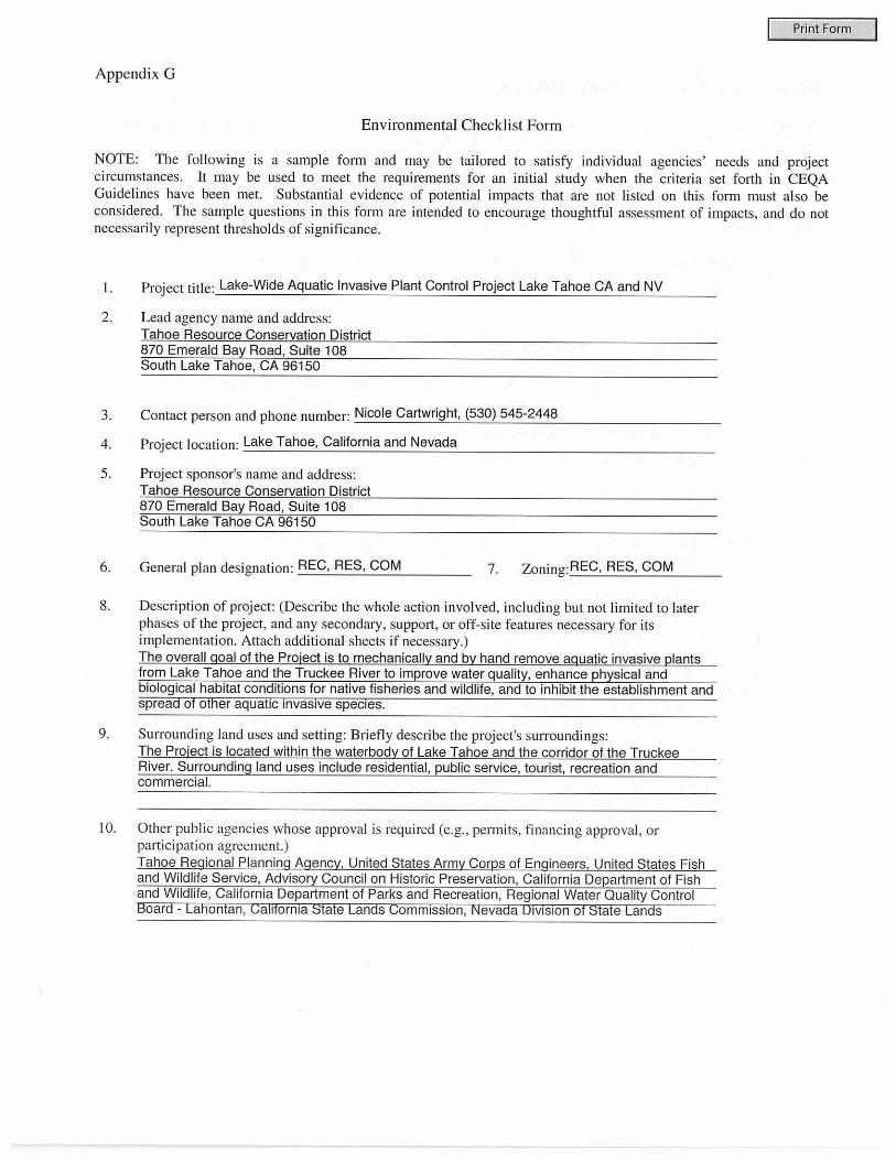
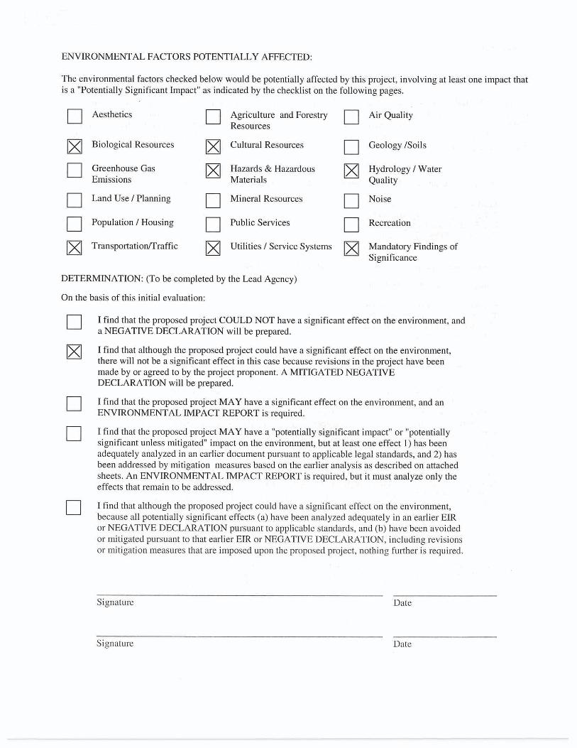
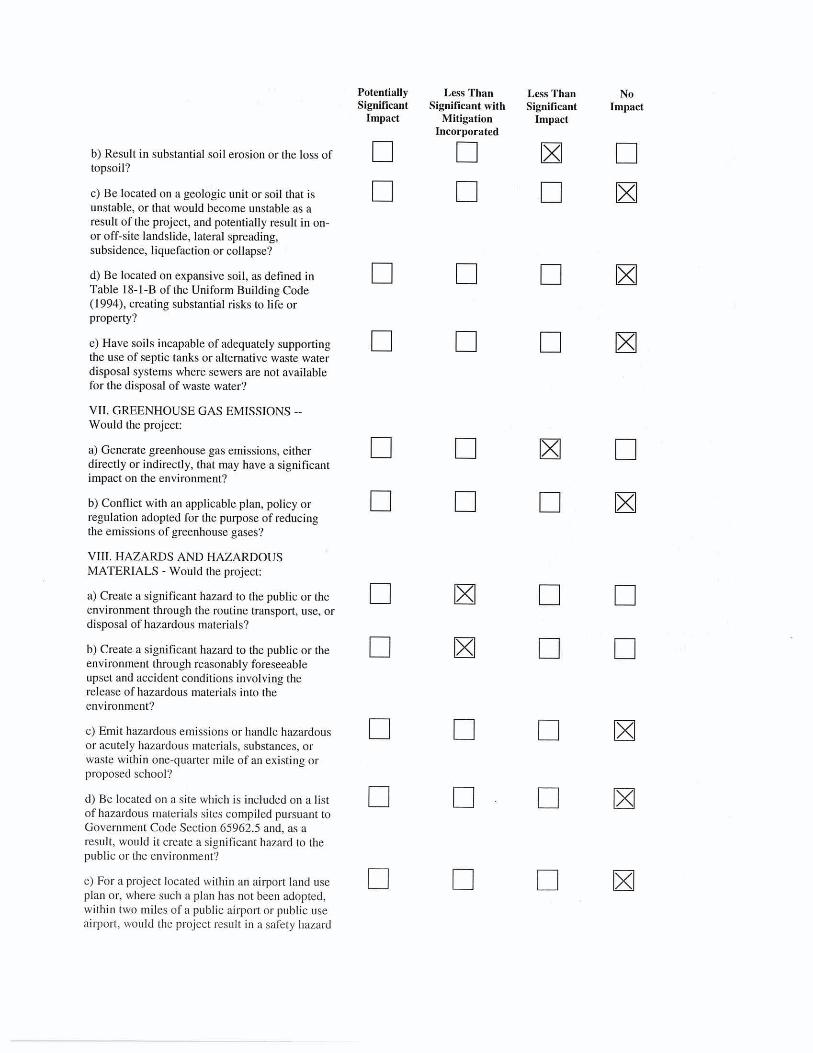
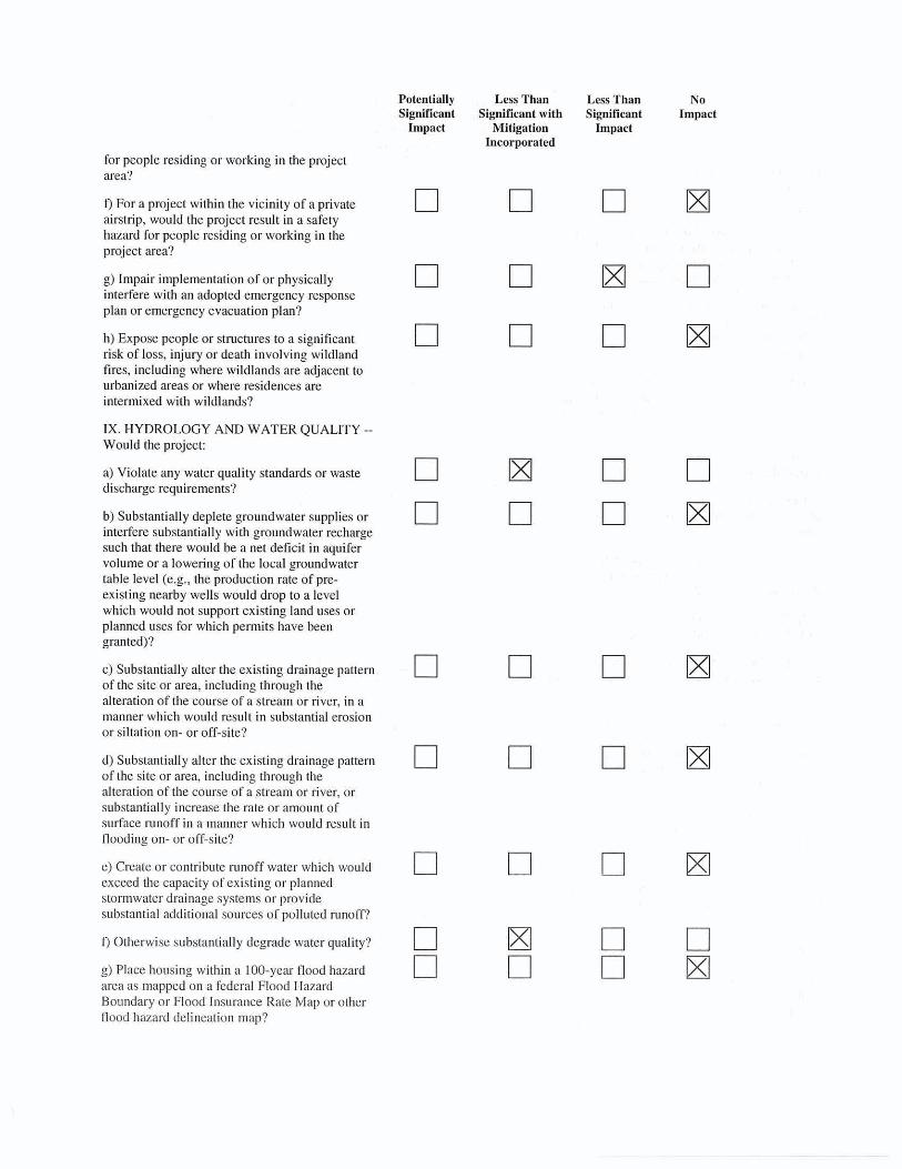
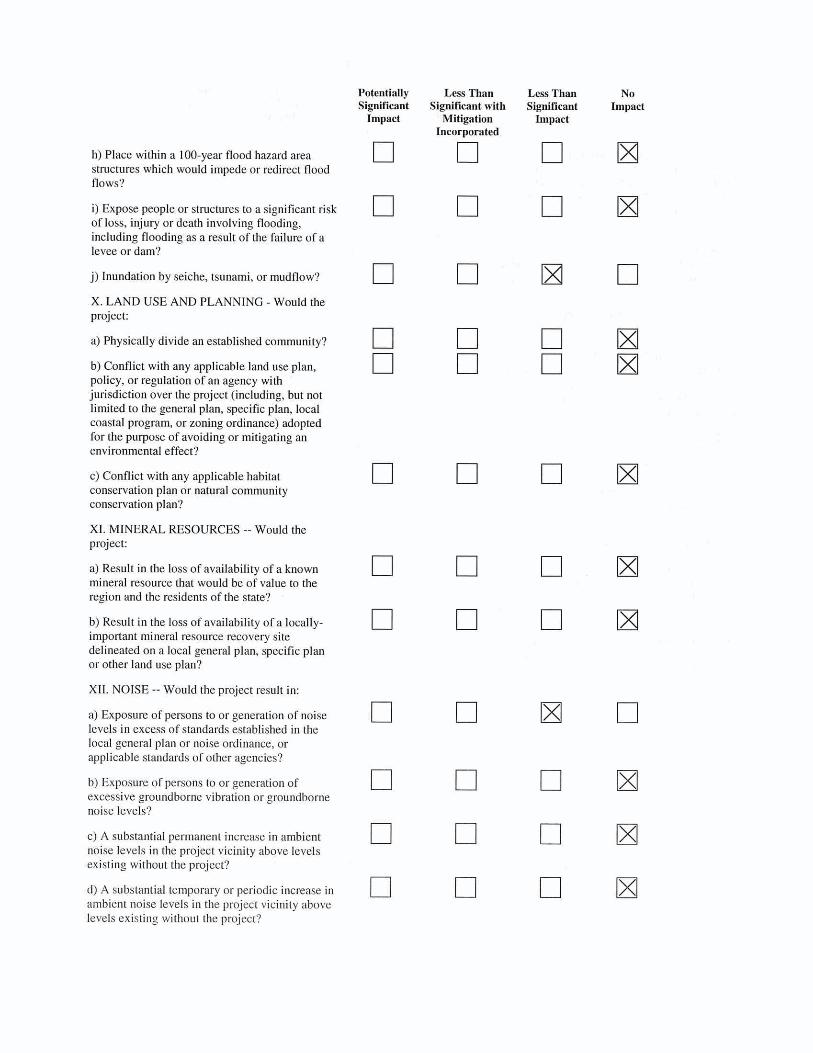
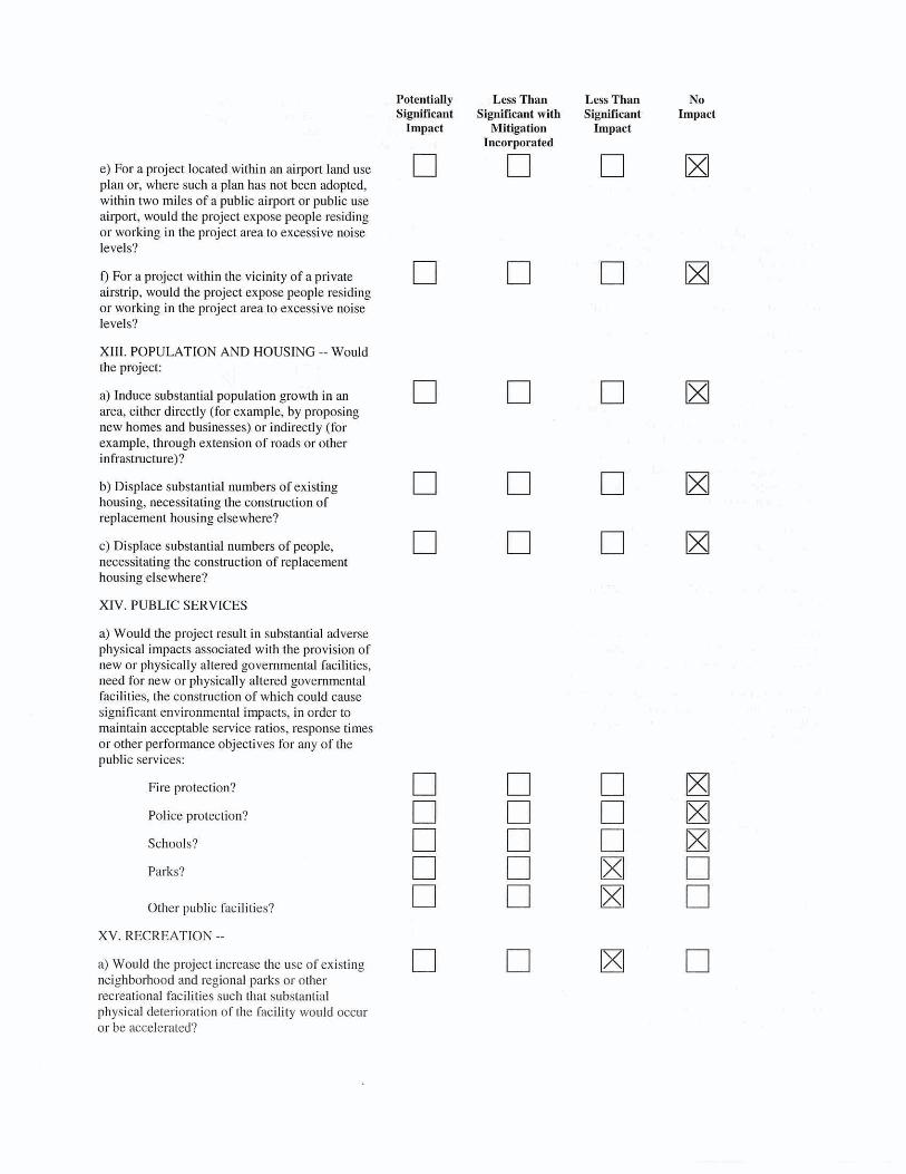
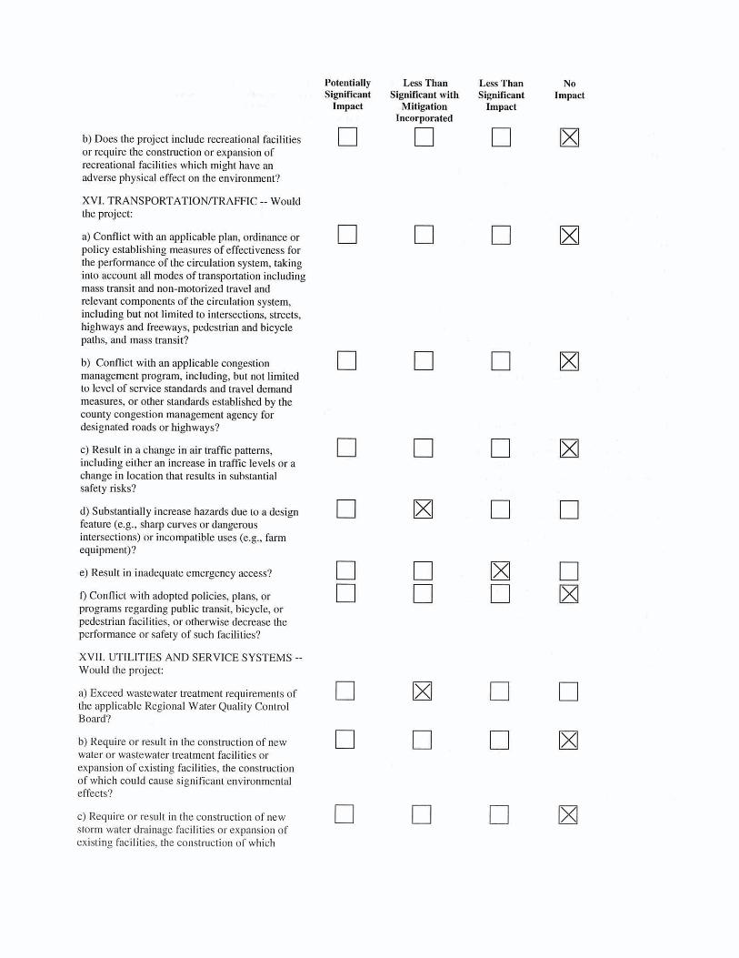
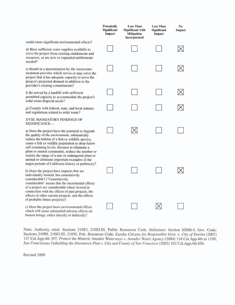

AAPPENDIX B WATER QUALITY
MONITORING PLAN TEMPLATE

Aquatic Invasive Plant Control Monitoring Plan – 2011 1 of 4
Aquatic Invasive Plant Control
Monitoring Plan
Prepared for Permitting Compliance for
Tahoe Regional Planning Agency (TRPA) and
Lahontan Regional Water Quality Control Board (LRWQCB)
May 2011
By
Kim Boyd, Invasive Species Program, Tahoe Resource Conservation District (Tahoe RCD)

Aquatic Invasive Plant Control Monitoring Plan – 2011 2 of 4
Monitoring Rationale Information
Water quality monitoring is required to determine and mitigate the potential disturbances associated with deployment of benthic bottom barriers and diver-assisted hand removal activites. The objective is to determine any detrimental water quality impacts from barrier placement and removal in terms of elevated turbidity. The monitoring plan will be submitted as permit conditions for Tahoe Regional Planning Agency (TRPA) and the respective regulatory State agency, Lahontan Regional Water Quality Control Board (Water Board). The plan attempts to be consistent between agency requirements and could be revised or amended as the project progresses. The plan covers operation of the project in Emerald Bay, Lake Tahoe California. The Water Board must find that the project complies with the turbidity water quality objective as stated:
(1) Turbidity must be 3 Nephelometric Turbidity Units (NTU) or less, or (2) Turbidity must be no more than 10% above background turbidity,
determined by measurements made within one-hour before the installation phase and one-hour before the removal phase.
Turbidity measurements are not regularly taken in the Tahoe Keys lagoons, so it is not known which of the two objectives above will serve as a better compliance measure. A determination will be made prior to implementation to determine the best objective for turbidity measurements. Either way, water quality measurements will be applied as a condition taken as a cumulative average over all the samples taken each day (see Narrative Monitoring Description). The subject of allowable turbidity levels, project monitoring, and proposed safeguards and mitigation measures outlined in this plan are designed to provide flexibility for the project goals for short term disturbances, with ultimate protection of public health and safety and lake clarity. To determine background turbidity and project compliance, a minimum of 10 measurements will be taken as equally spaced as possible around the perimeter of the project site and averaged to determine the overall turbidity (see Narrative Monitoring Description).
Monitoring Approach Rationale – The major impact of the placement and removal of benthic bottom barriers is the substrate disturbance from both diver’s movements and the barriers themselves. Previous work with benthic barriers for aquatic weeds in Emerald Bay (2007-2010) has shown the placement of barriers to have minimal disturbance, while the movement and removal of barriers has somewhat greater impact. It has also been shown that diver-assisted hand removal
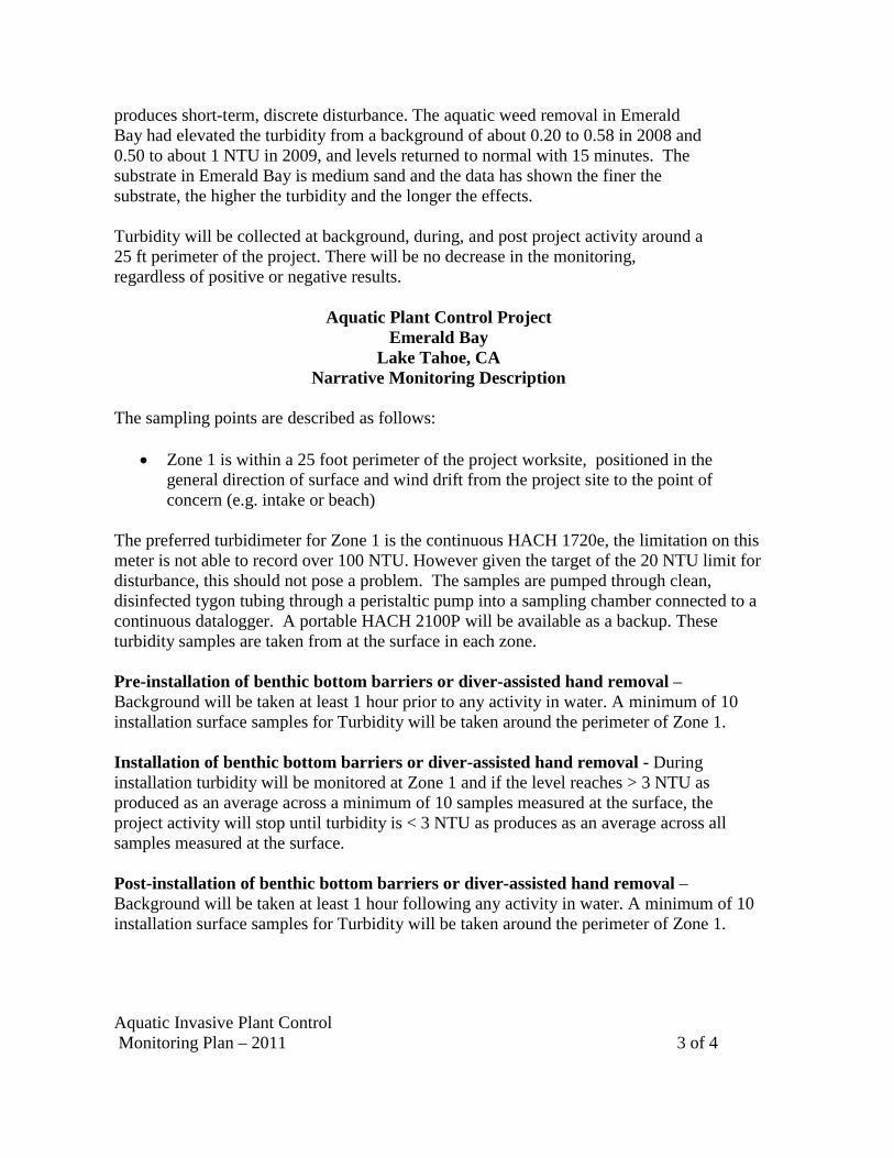
Aquatic Invasive Plant Control Monitoring Plan – 2011 3 of 4
produces short-term, discrete disturbance. The aquatic weed removal in Emerald Bay had elevated the turbidity from a background of about 0.20 to 0.58 in 2008 and 0.50 to about 1 NTU in 2009, and levels returned to normal with 15 minutes. The substrate in Emerald Bay is medium sand and the data has shown the finer the substrate, the higher the turbidity and the longer the effects.
Turbidity will be collected at background, during, and post project activity around a 25 ft perimeter of the project. There will be no decrease in the monitoring, regardless of positive or negative results.
Aquatic Plant Control Project Emerald Bay
Lake Tahoe, CA Narrative Monitoring Description
The sampling points are described as follows:
Zone 1 is within a 25 foot perimeter of the project worksite, positioned in the general direction of surface and wind drift from the project site to the point of concern (e.g. intake or beach)
The preferred turbidimeter for Zone 1 is the continuous HACH 1720e, the limitation on this meter is not able to record over 100 NTU. However given the target of the 20 NTU limit for disturbance, this should not pose a problem. The samples are pumped through clean, disinfected tygon tubing through a peristaltic pump into a sampling chamber connected to a continuous datalogger. A portable HACH 2100P will be available as a backup. These turbidity samples are taken from at the surface in each zone. Pre-installation of benthic bottom barriers or diver-assisted hand removal –Background will be taken at least 1 hour prior to any activity in water. A minimum of 10 installation surface samples for Turbidity will be taken around the perimeter of Zone 1. Installation of benthic bottom barriers or diver-assisted hand removal - During installation turbidity will be monitored at Zone 1 and if the level reaches > 3 NTU as produced as an average across a minimum of 10 samples measured at the surface, the project activity will stop until turbidity is < 3 NTU as produces as an average across all samples measured at the surface. Post-installation of benthic bottom barriers or diver-assisted hand removal –Background will be taken at least 1 hour following any activity in water. A minimum of 10 installation surface samples for Turbidity will be taken around the perimeter of Zone 1.
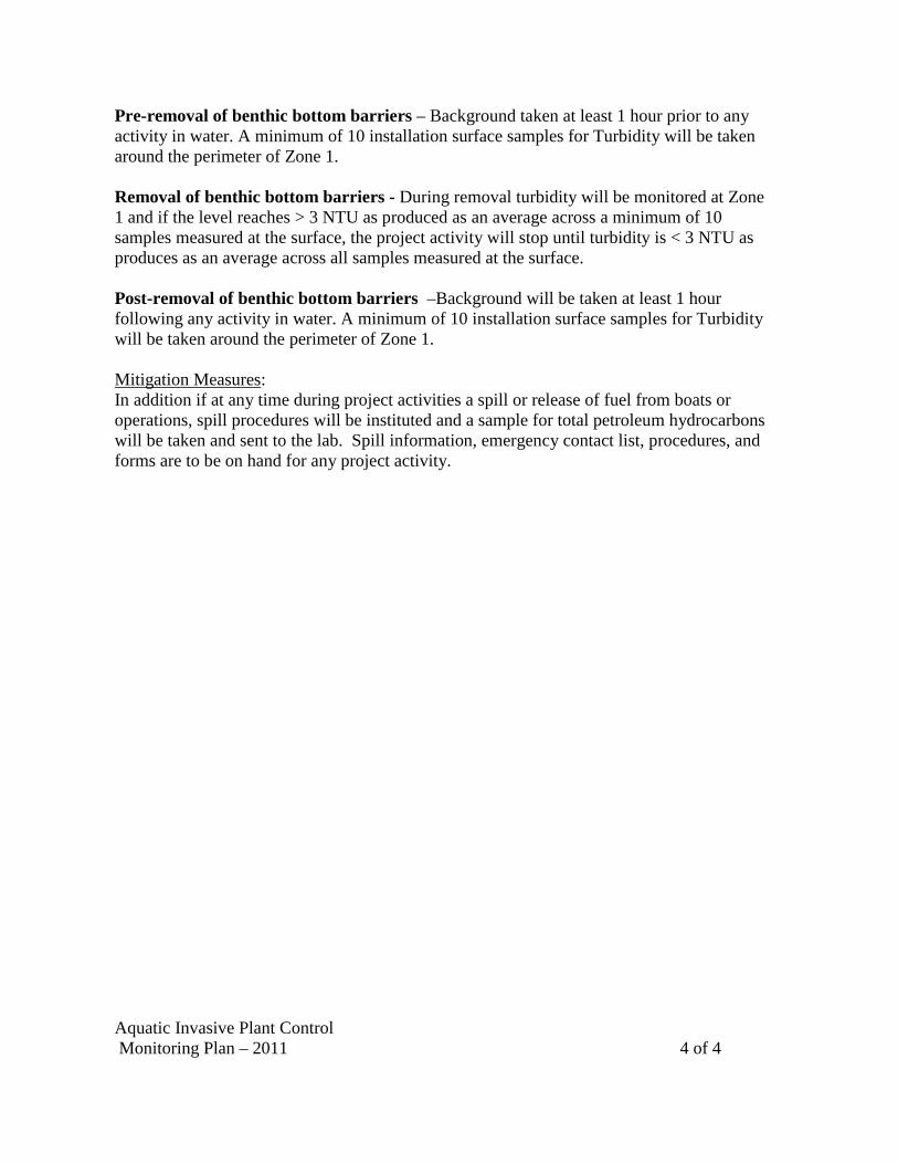
Aquatic Invasive Plant Control Monitoring Plan – 2011 4 of 4
Pre-removal of benthic bottom barriers – Background taken at least 1 hour prior to any activity in water. A minimum of 10 installation surface samples for Turbidity will be taken around the perimeter of Zone 1. Removal of benthic bottom barriers - During removal turbidity will be monitored at Zone 1 and if the level reaches > 3 NTU as produced as an average across a minimum of 10 samples measured at the surface, the project activity will stop until turbidity is < 3 NTU as produces as an average across all samples measured at the surface. Post-removal of benthic bottom barriers –Background will be taken at least 1 hour following any activity in water. A minimum of 10 installation surface samples for Turbidity will be taken around the perimeter of Zone 1. Mitigation Measures: In addition if at any time during project activities a spill or release of fuel from boats or operations, spill procedures will be instituted and a sample for total petroleum hydrocarbons will be taken and sent to the lab. Spill information, emergency contact list, procedures, and forms are to be on hand for any project activity.

AAPPENDIX C HAZARD ASSESSMENT AND
CRITICAL CONTROL POINT (HACCP)
EXAMPLE

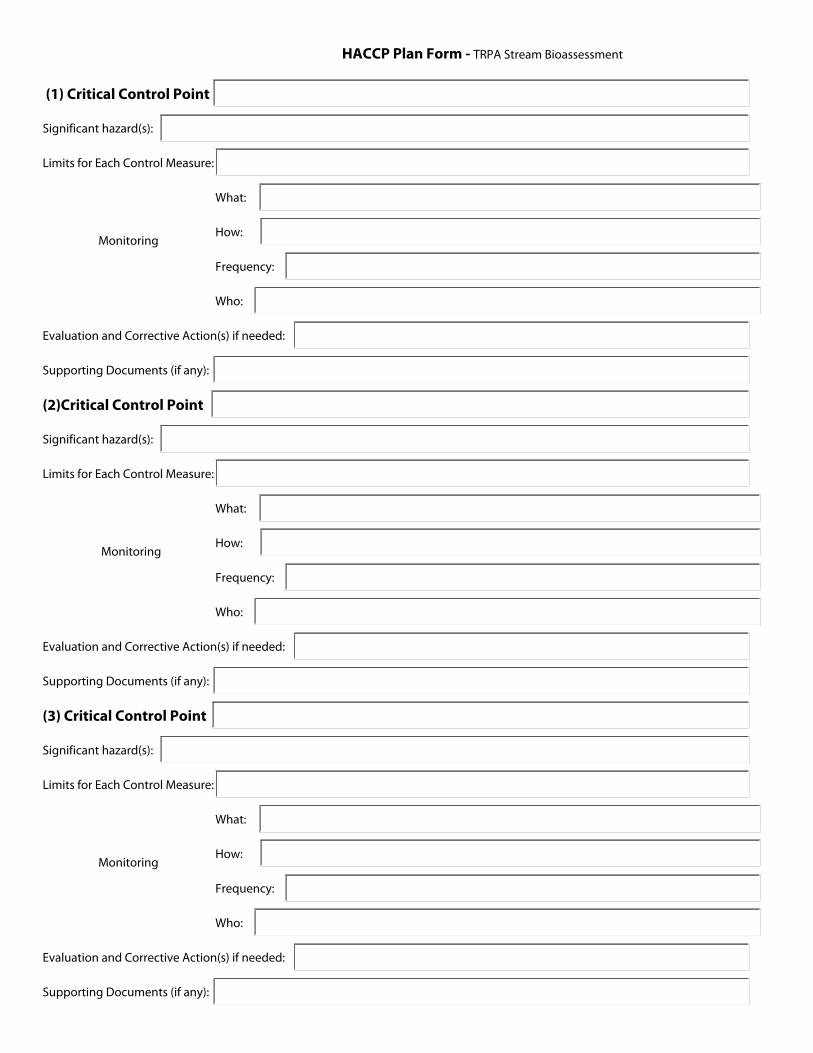
HACCP Plan Form - TRPA Stream Bioassessment
Monitoring
(1) Critical Control Point
Significant hazard(s):
Limits for Each Control Measure:
What:
How:
Frequency:
Who:
Evaluation and Corrective Action(s) if needed:
Supporting Documents (if any):
(2)Critical Control Point
Significant hazard(s):
Limits for Each Control Measure:
What:
How:
Frequency:
Who:
Evaluation and Corrective Action(s) if needed:
Supporting Documents (if any):
(3) Critical Control Point
Significant hazard(s):
Limits for Each Control Measure:
What:
How:
Frequency:
Who:
Evaluation and Corrective Action(s) if needed:
Supporting Documents (if any):
Monitoring
Monitoring
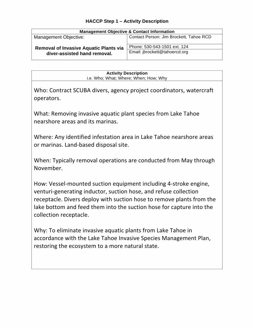
HACCP Step 1 – Activity Description
Management Objective & Contact Information Management Objective: Removal of Invasive Aquatic Plants via
diver-assisted hand removal.
Contact Person: Jim Brockett, Tahoe RCD Phone: 530-543-1501 ext. 124 Email: [email protected]
Activity Description i.e. Who; What; Where; When; How; Why
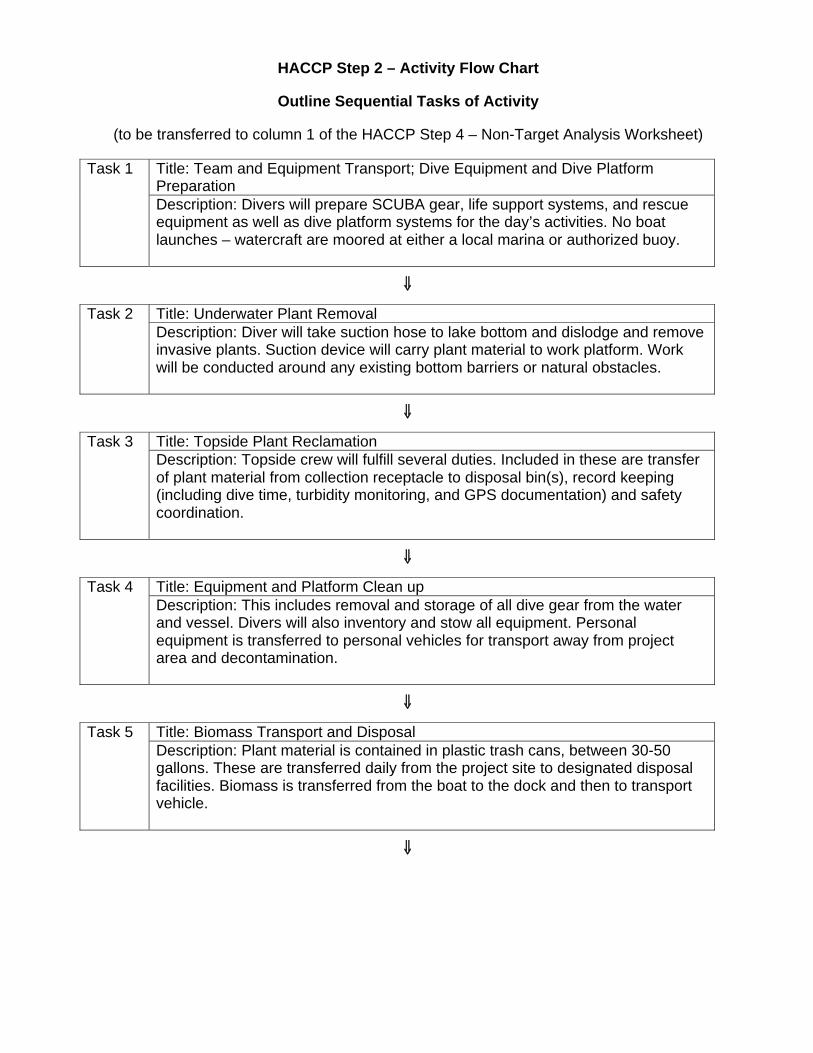
HACCP Step 2 – Activity Flow Chart
Outline Sequential Tasks of Activity
(to be transferred to column 1 of the HACCP Step 4 – Non-Target Analysis Worksheet)
Task 1 Title: Team and Equipment Transport; Dive Equipment and Dive Platform Preparation Description: Divers will prepare SCUBA gear, life support systems, and rescue equipment as well as dive platform systems for the day’s activities. No boat launches – watercraft are moored at either a local marina or authorized buoy.
⇓⇓
Task 2 Title: Underwater Plant Removal Description: Diver will take suction hose to lake bottom and dislodge and remove invasive plants. Suction device will carry plant material to work platform. Work will be conducted around any existing bottom barriers or natural obstacles.
⇓
Task 3 Title: Topside Plant Reclamation Description: Topside crew will fulfill several duties. Included in these are transfer of plant material from collection receptacle to disposal bin(s), record keeping (including dive time, turbidity monitoring, and GPS documentation) and safety coordination.
⇓
Task 4 Title: Equipment and Platform Clean up Description: This includes removal and storage of all dive gear from the water and vessel. Divers will also inventory and stow all equipment. Personal equipment is transferred to personal vehicles for transport away from project area and decontamination.
⇓
Task 5 Title: Biomass Transport and Disposal Description: Plant material is contained in plastic trash cans, between 30-50 gallons. These are transferred daily from the project site to designated disposal facilities. Biomass is transferred from the boat to the dock and then to transport vehicle.
⇓
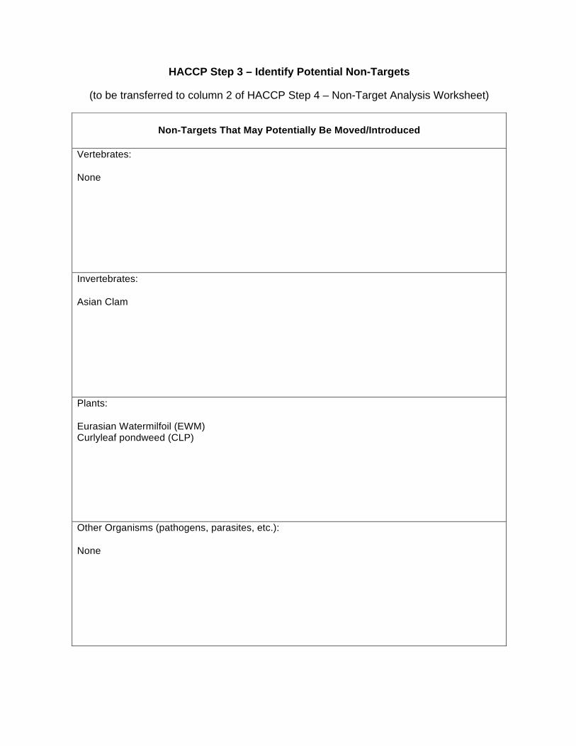
HACCP Step 3 – Identify Potential Non-Targets
(to be transferred to column 2 of HACCP Step 4 – Non-Target Analysis Worksheet)
Non-Targets That May Potentially Be Moved/Introduced
Vertebrates: None
Invertebrates: Asian Clam
Plants: Eurasian Watermilfoil (EWM) Curlyleaf pondweed (CLP)
Other Organisms (pathogens, parasites, etc.): None
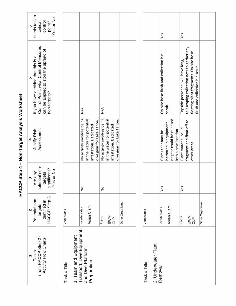
HA
CC
P St
ep 4
– N
on-T
arge
t Ana
lysi
s W
orks
heet
1 Ta
sks
(from
HA
CC
P S
tep
2 -
Act
ivity
Flo
w C
hart)
2 P
oten
tial n
on-
targ
ets
iden
tifie
d in
H
AC
CP
Ste
p 3
3 A
re a
ny
pote
ntia
l non
-ta
rget
s si
gnifi
cant
? Y
es o
r No
4 Ju
stify
Ris
k A
sses
smen
t
5 If
you
have
dec
ided
that
this
is a
C
ontro
l Poi
nt, w
hat C
ontro
l Mea
sure
s ca
n be
app
lied
to s
top
the
spre
ad o
f no
n-ta
rget
s?
6 Is
this
task
a
criti
cal
cont
rol
poin
t?
Yes
or N
o Ta
sk #
Titl
e 1.
Tea
m a
nd E
quip
men
t Tr
ansp
ort;
Div
e E
quip
men
t an
d D
ive
Pla
tform
P
repa
ratio
n
Ver
tebr
ates
In
verte
brat
es
Asi
an C
lam
P
lant
s E
WM
C
LP
Oth
er O
rgan
ism
s
Task
# T
itle
2. U
nder
wat
er P
lant
R
emov
al
Ver
tebr
ates
In
verte
brat
es
Asi
an C
lam
P
lant
s E
WM
C
LP
Oth
er O
rgan
ism
s
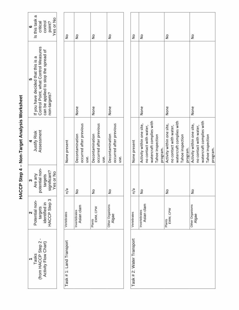
HA
CC
P St
ep 4
– N
on-T
arge
t Ana
lysi
s W
orks
heet
1 Ta
sks
(from
HA
CC
P S
tep
2 -
Act
ivity
Flo
w C
hart)
2 P
oten
tial n
on-
targ
ets
iden
tifie
d in
H
AC
CP
Ste
p 3
3 A
re a
ny
pote
ntia
l non
-ta
rget
s si
gnifi
cant
? Y
es o
r No
4 Ju
stify
Ris
k A
sses
smen
t
5 If
you
have
dec
ided
that
this
is a
C
ontro
l Poi
nt, w
hat C
ontro
l Mea
sure
s ca
n be
app
lied
to s
top
the
spre
ad o
f no
n-ta
rget
s?
6 Is
this
task
a
criti
cal
cont
rol
poin
t?
Yes
or N
o Ta
sk #
1: L
and
Tran
spor
tV
erte
brat
es
Inve
rtebr
ates
Asi
an c
lam
P
lant
s
E
WM
, CP
W
Oth
er O
rgan
ism
s
Alg
ae
Task
# 2
: Wat
er T
rans
port
Ver
tebr
ates
Inve
rtebr
ates
Asi
an c
lam
P
lant
s
EW
M, C
PW
O
ther
Org
anis
ms
A
lgae
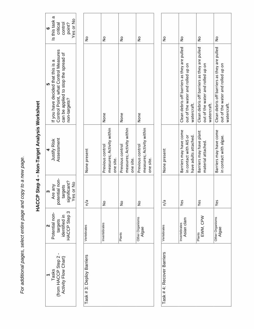
For a
dditi
onal
pag
es, s
elec
t ent
ire p
age
and
copy
to a
new
pag
e.
HA
CC
P St
ep 4
– N
on-T
arge
t Ana
lysi
s W
orks
heet
1 Ta
sks
(from
HA
CC
P S
tep
2 -
Act
ivity
Flo
w C
hart)
2 P
oten
tial n
on-
targ
ets
iden
tifie
d in
H
AC
CP
Ste
p 3
3 A
re a
ny
pote
ntia
l non
-ta
rget
s si
gnifi
cant
? Y
es o
r No
4 Ju
stify
Ris
k A
sses
smen
t
5 If
you
have
dec
ided
that
this
is a
C
ontro
l Poi
nt, w
hat C
ontro
l Mea
sure
s ca
n be
app
lied
to s
top
the
spre
ad o
f no
n-ta
rget
s?
6 Is
this
task
a
criti
cal
cont
rol
poin
t?
Yes
or N
o Ta
sk #
3: D
eplo
y B
arrie
rsV
erte
brat
es
Inve
rtebr
ates
P
lant
s O
ther
Org
anis
ms
A
lgae
Task
# 4
: Rec
over
Bar
riers
Ver
tebr
ates
In
verte
brat
es
A
sian
cla
m
Pla
nts
E
WM
, CP
W
Oth
er O
rgan
ism
s
Alg
ae
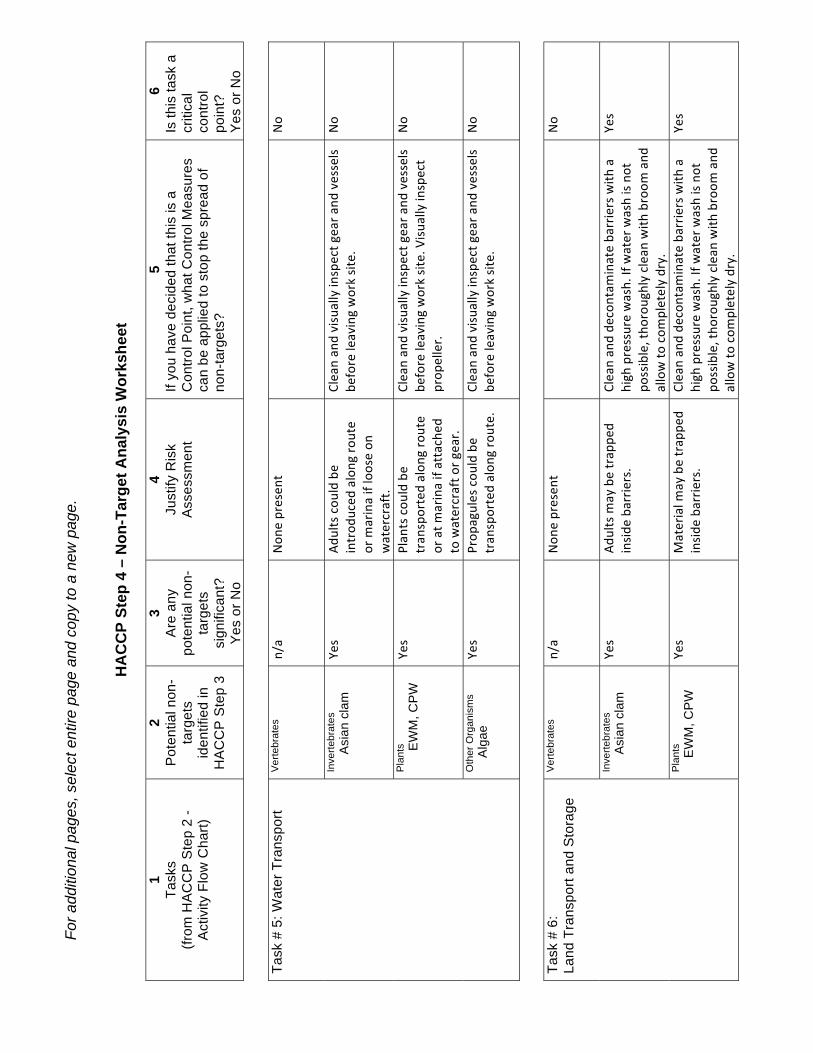
For a
dditi
onal
pag
es, s
elec
t ent
ire p
age
and
copy
to a
new
pag
e.
HA
CC
P St
ep 4
– N
on-T
arge
t Ana
lysi
s W
orks
heet
1 Ta
sks
(from
HA
CC
P S
tep
2 -
Act
ivity
Flo
w C
hart)
2 P
oten
tial n
on-
targ
ets
iden
tifie
d in
H
AC
CP
Ste
p 3
3 A
re a
ny
pote
ntia
l non
-ta
rget
s si
gnifi
cant
? Y
es o
r No
4 Ju
stify
Ris
k A
sses
smen
t
5 If
you
have
dec
ided
that
this
is a
C
ontro
l Poi
nt, w
hat C
ontro
l Mea
sure
s ca
n be
app
lied
to s
top
the
spre
ad o
f no
n-ta
rget
s?
6 Is
this
task
a
criti
cal
cont
rol
poin
t?
Yes
or N
o Ta
sk #
5: W
ater
Tra
nspo
rtV
erte
brat
es
Inve
rtebr
ates
Asi
an c
lam
P
lant
s
E
WM
, CP
W
Oth
er O
rgan
ism
s
Alg
ae
Task
# 6
: La
nd T
rans
port
and
Sto
rage
Ver
tebr
ates
In
verte
brat
es
A
sian
cla
m
Pla
nts
E
WM
, CP
W
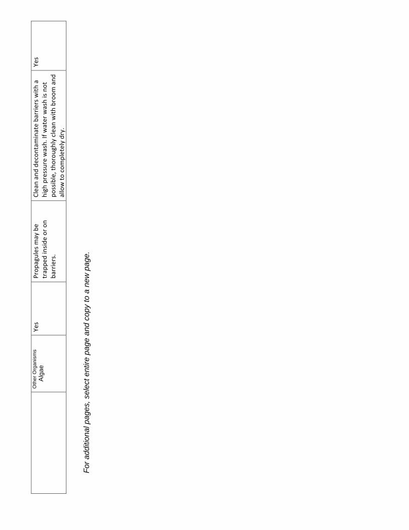
Oth
er O
rgan
ism
s
Alg
ae
For a
dditi
onal
pag
es, s
elec
t ent
ire p
age
and
copy
to a
new
pag
e.
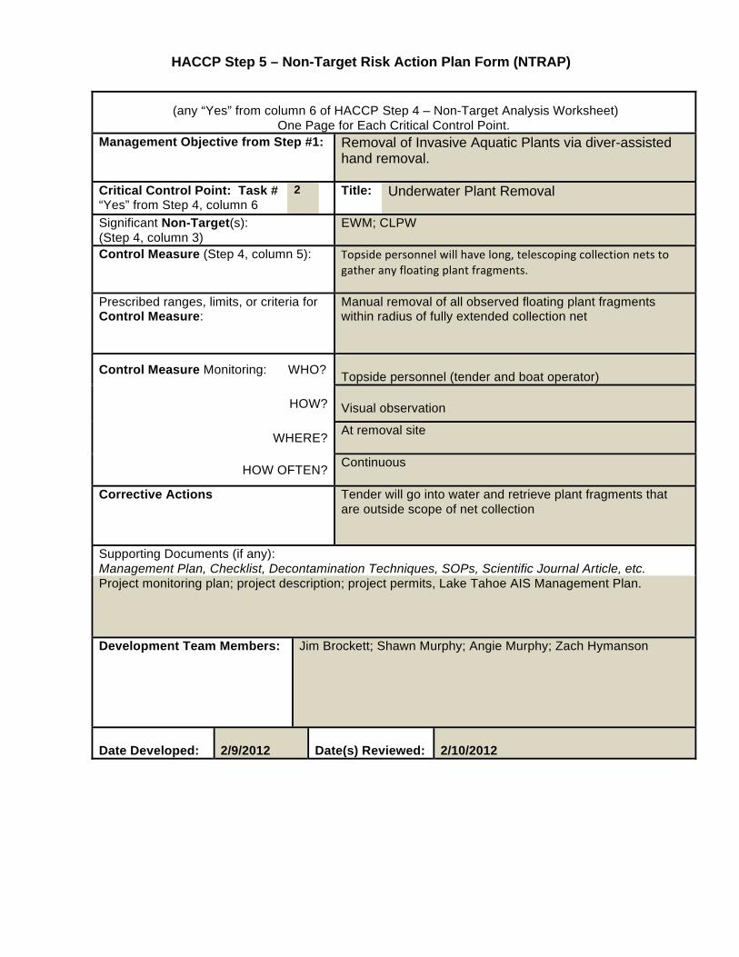
HACCP Step 5 – Non-Target Risk Action Plan Form (NTRAP)
(any “Yes” from column 6 of HACCP Step 4 – Non-Target Analysis Worksheet)
One Page for Each Critical Control Point. Management Objective from Step #1: Removal of Invasive Aquatic Plants via diver-assisted
hand removal.
Critical Control Point: Task # “Yes” from Step 4, column 6
2 Title: Underwater Plant Removal
Significant Non-Target(s): (Step 4, column 3)
EWM; CLPW
Control Measure (Step 4, column 5):
Prescribed ranges, limits, or criteria for Control Measure:
Manual removal of all observed floating plant fragments within radius of fully extended collection net
Control Measure Monitoring: WHO? Topside personnel (tender and boat operator)
HOW? Visual observation
WHERE? At removal site
HOW OFTEN? Continuous
Corrective Actions Tender will go into water and retrieve plant fragments that are outside scope of net collection
Supporting Documents (if any): Management Plan, Checklist, Decontamination Techniques, SOPs, Scientific Journal Article, etc. Project monitoring plan; project description; project permits, Lake Tahoe AIS Management Plan.
Development Team Members:
Jim Brockett; Shawn Murphy; Angie Murphy; Zach Hymanson
Date Developed: 2/9/2012
Date(s) Reviewed: 2/10/2012
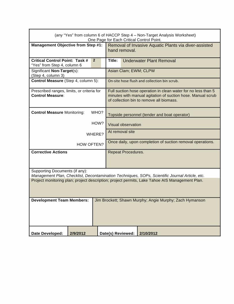
(any “Yes” from column 6 of HACCP Step 4 – Non-Target Analysis Worksheet)
One Page for Each Critical Control Point. Management Objective from Step #1: Removal of Invasive Aquatic Plants via diver-assisted
hand removal.
Critical Control Point: Task # “Yes” from Step 4, column 6
2 Title: Underwater Plant Removal
Significant Non-Target(s): (Step 4, column 3)
Asian Clam; EWM; CLPW
Control Measure (Step 4, column 5):
Prescribed ranges, limits, or criteria for Control Measure:
Full suction hose operation in clean water for no less than 5 minutes with manual agitation of suction hose. Manual scrub of collection bin to remove all biomass.
Control Measure Monitoring: WHO? Topside personnel (tender and boat operator)
HOW? Visual observation
WHERE? At removal site
HOW OFTEN? Once daily, upon completion of suction removal operations.
Corrective Actions Repeat Procedures.
Supporting Documents (if any): Management Plan, Checklist, Decontamination Techniques, SOPs, Scientific Journal Article, etc. Project monitoring plan; project description; project permits, Lake Tahoe AIS Management Plan.
Development Team Members:
Jim Brockett; Shawn Murphy; Angie Murphy; Zach Hymanson
Date Developed: 2/9/2012
Date(s) Reviewed: 2/10/2012
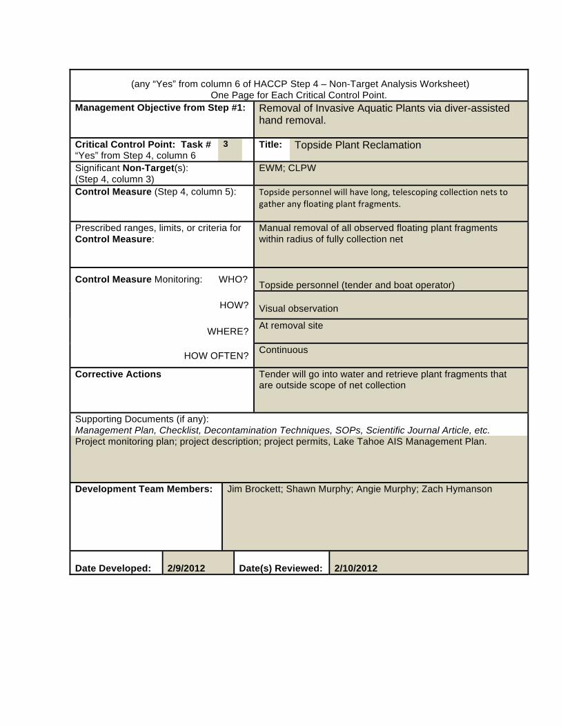
(any “Yes” from column 6 of HACCP Step 4 – Non-Target Analysis Worksheet)
One Page for Each Critical Control Point. Management Objective from Step #1: Removal of Invasive Aquatic Plants via diver-assisted
hand removal.
Critical Control Point: Task # “Yes” from Step 4, column 6
3 Title: Topside Plant Reclamation
Significant Non-Target(s): (Step 4, column 3)
EWM; CLPW
Control Measure (Step 4, column 5):
Prescribed ranges, limits, or criteria for Control Measure:
Manual removal of all observed floating plant fragments within radius of fully collection net
Control Measure Monitoring: WHO? Topside personnel (tender and boat operator)
HOW? Visual observation
WHERE? At removal site
HOW OFTEN? Continuous
Corrective Actions Tender will go into water and retrieve plant fragments that are outside scope of net collection
Supporting Documents (if any): Management Plan, Checklist, Decontamination Techniques, SOPs, Scientific Journal Article, etc. Project monitoring plan; project description; project permits, Lake Tahoe AIS Management Plan.
Development Team Members:
Jim Brockett; Shawn Murphy; Angie Murphy; Zach Hymanson
Date Developed: 2/9/2012
Date(s) Reviewed: 2/10/2012
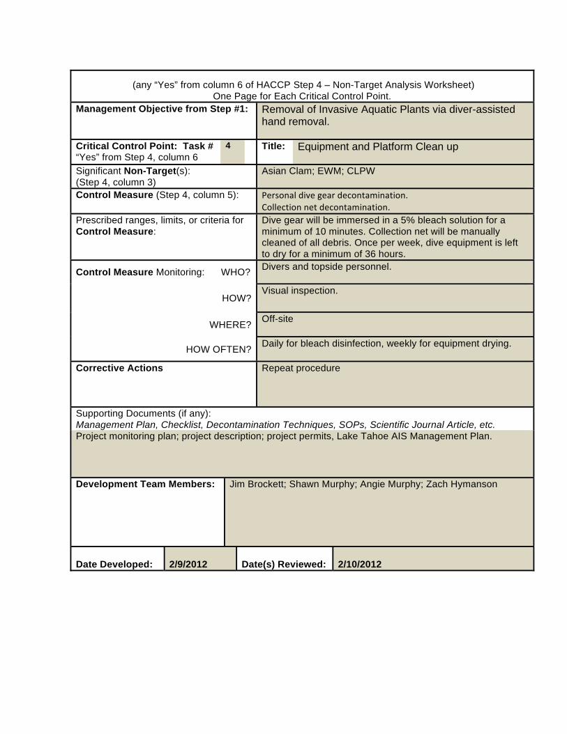
(any “Yes” from column 6 of HACCP Step 4 – Non-Target Analysis Worksheet)
One Page for Each Critical Control Point. Management Objective from Step #1: Removal of Invasive Aquatic Plants via diver-assisted
hand removal.
Critical Control Point: Task # “Yes” from Step 4, column 6
4 Title: Equipment and Platform Clean up
Significant Non-Target(s): (Step 4, column 3)
Asian Clam; EWM; CLPW
Control Measure (Step 4, column 5):
Prescribed ranges, limits, or criteria for Control Measure:
Dive gear will be immersed in a 5% bleach solution for a minimum of 10 minutes. Collection net will be manually cleaned of all debris. Once per week, dive equipment is left to dry for a minimum of 36 hours.
Control Measure Monitoring: WHO? Divers and topside personnel.
HOW? Visual inspection.
WHERE? Off-site
HOW OFTEN? Daily for bleach disinfection, weekly for equipment drying.
Corrective Actions Repeat procedure
Supporting Documents (if any): Management Plan, Checklist, Decontamination Techniques, SOPs, Scientific Journal Article, etc. Project monitoring plan; project description; project permits, Lake Tahoe AIS Management Plan.
Development Team Members:
Jim Brockett; Shawn Murphy; Angie Murphy; Zach Hymanson
Date Developed: 2/9/2012
Date(s) Reviewed: 2/10/2012
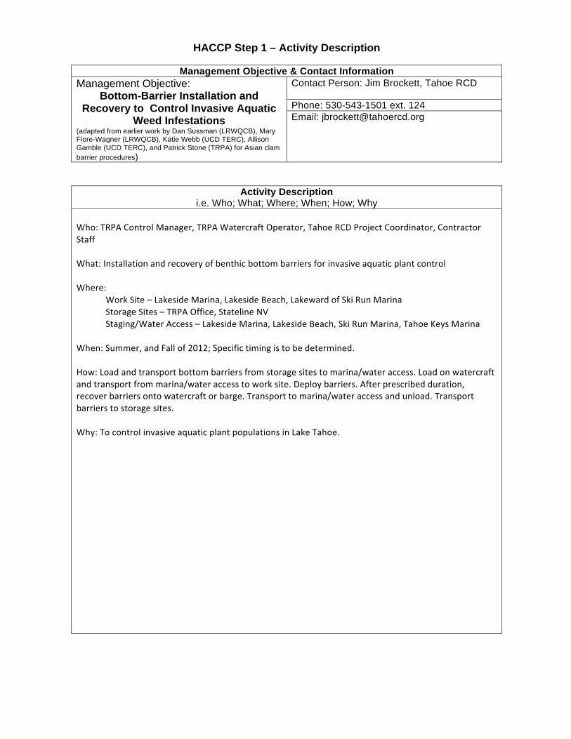
HACCP Step 1 – Activity Description
Management Objective & Contact Information Management Objective:
Bottom-Barrier Installation and Recovery to Control Invasive Aquatic
Weed Infestations (adapted from earlier work by Dan Sussman (LRWQCB), Mary Fiore-Wagner (LRWQCB), Katie Webb (UCD TERC), Allison Gamble (UCD TERC), and Patrick Stone (TRPA) for Asian clam barrier procedures)
Contact Person: Jim Brockett, Tahoe RCD Phone: 530-543-1501 ext. 124 Email: [email protected]
Activity Description i.e. Who; What; Where; When; How; Why
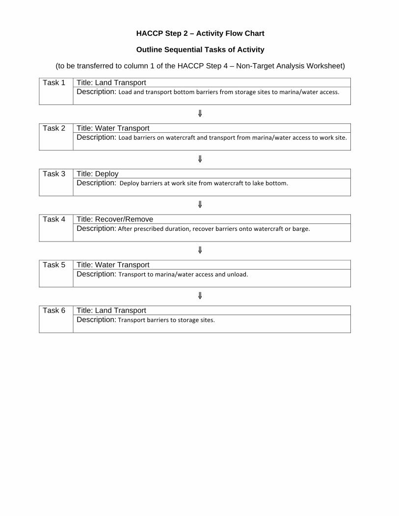
HACCP Step 2 – Activity Flow Chart
Outline Sequential Tasks of Activity
(to be transferred to column 1 of the HACCP Step 4 – Non-Target Analysis Worksheet)
Task 1 Title: Land Transport Description:
⇓⇓
Task 2 Title: Water Transport Description:
⇓
Task 3 Title: Deploy Description:
⇓
Task 4 Title: Recover/Remove Description:
⇓
Task 5 Title: Water Transport Description:
⇓
Task 6 Title: Land Transport Description:
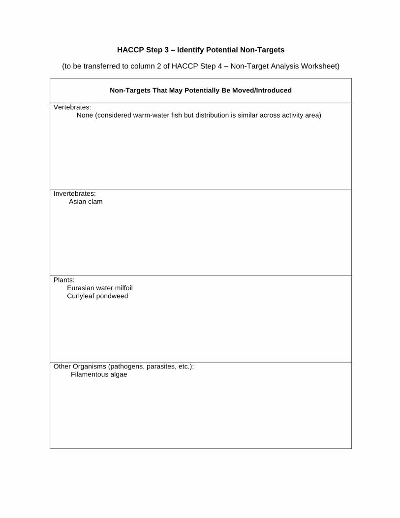
HACCP Step 3 – Identify Potential Non-Targets
(to be transferred to column 2 of HACCP Step 4 – Non-Target Analysis Worksheet)
Non-Targets That May Potentially Be Moved/Introduced
Vertebrates: None (considered warm-water fish but distribution is similar across activity area)
Invertebrates: Asian clam
Plants: Eurasian water milfoil Curlyleaf pondweed
Other Organisms (pathogens, parasites, etc.): Filamentous algae
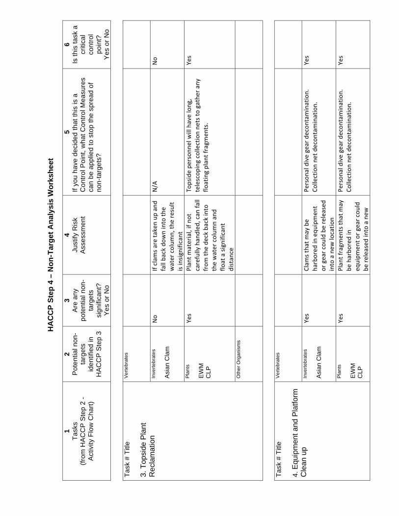
HA
CC
P St
ep 4
– N
on-T
arge
t Ana
lysi
s W
orks
heet
1 Ta
sks
(from
HA
CC
P S
tep
2 -
Act
ivity
Flo
w C
hart)
2 P
oten
tial n
on-
targ
ets
iden
tifie
d in
H
AC
CP
Ste
p 3
3 A
re a
ny
pote
ntia
l non
-ta
rget
s si
gnifi
cant
? Y
es o
r No
4 Ju
stify
Ris
k A
sses
smen
t
5 If
you
have
dec
ided
that
this
is a
C
ontro
l Poi
nt, w
hat C
ontro
l Mea
sure
s ca
n be
app
lied
to s
top
the
spre
ad o
f no
n-ta
rget
s?
6 Is
this
task
a
criti
cal
cont
rol
poin
t?
Yes
or N
o Ta
sk #
Titl
e 3.
Top
side
Pla
nt
Rec
lam
atio
n
Ver
tebr
ates
In
verte
brat
es
Asi
an C
lam
P
lant
s E
WM
C
LP
Oth
er O
rgan
ism
s
Task
# T
itle
4. E
quip
men
t and
Pla
tform
C
lean
up
Ver
tebr
ates
In
verte
brat
es
Asi
an C
lam
P
lant
s E
WM
C
LP
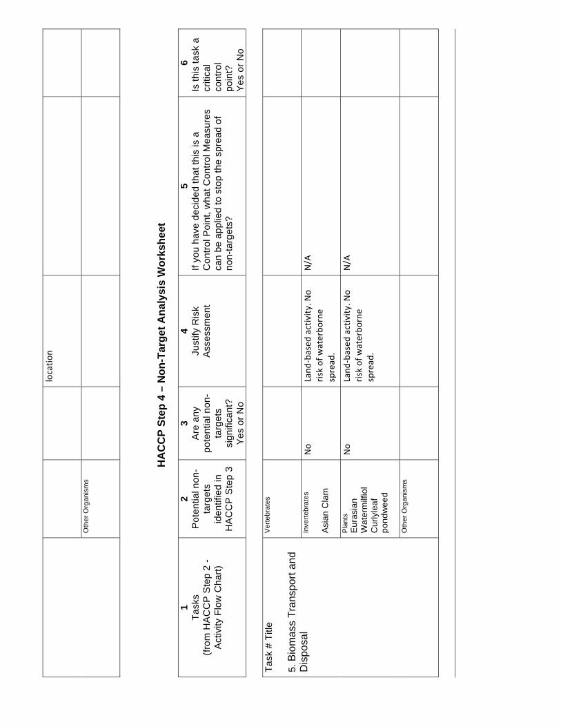
Oth
er O
rgan
ism
s
HA
CC
P St
ep 4
– N
on-T
arge
t Ana
lysi
s W
orks
heet
1 Ta
sks
(from
HA
CC
P S
tep
2 -
Act
ivity
Flo
w C
hart)
2 P
oten
tial n
on-
targ
ets
iden
tifie
d in
H
AC
CP
Ste
p 3
3 A
re a
ny
pote
ntia
l non
-ta
rget
s si
gnifi
cant
? Y
es o
r No
4 Ju
stify
Ris
k A
sses
smen
t
5 If
you
have
dec
ided
that
this
is a
C
ontro
l Poi
nt, w
hat C
ontro
l Mea
sure
s ca
n be
app
lied
to s
top
the
spre
ad o
f no
n-ta
rget
s?
6 Is
this
task
a
criti
cal
cont
rol
poin
t?
Yes
or N
o Ta
sk #
Titl
e 5.
Bio
mas
s Tr
ansp
ort a
nd
Dis
posa
l
Ver
tebr
ates
In
verte
brat
es
Asi
an C
lam
P
lant
s E
uras
ian
Wat
erm
ilfio
l C
urly
leaf
po
ndw
eed
Oth
er O
rgan
ism
s
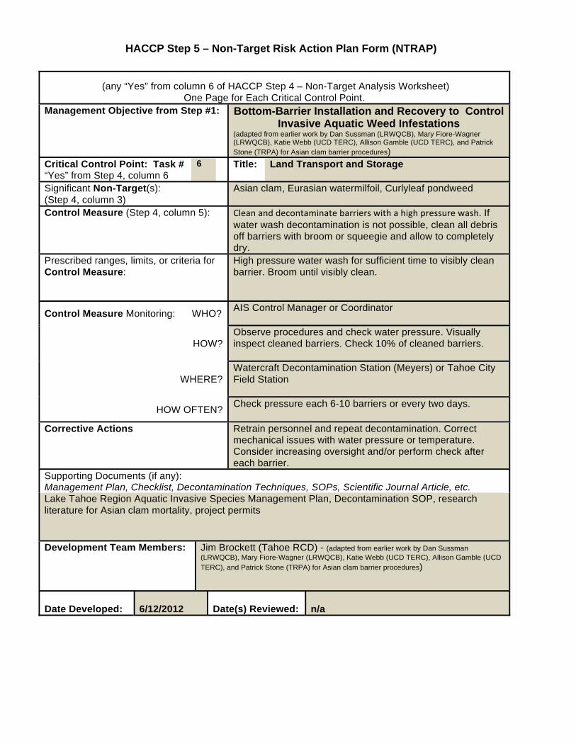
HACCP Step 5 – Non-Target Risk Action Plan Form (NTRAP)
(any “Yes” from column 6 of HACCP Step 4 – Non-Target Analysis Worksheet)
One Page for Each Critical Control Point. Management Objective from Step #1: Bottom-Barrier Installation and Recovery to Control
Invasive Aquatic Weed Infestations (adapted from earlier work by Dan Sussman (LRWQCB), Mary Fiore-Wagner (LRWQCB), Katie Webb (UCD TERC), Allison Gamble (UCD TERC), and Patrick Stone (TRPA) for Asian clam barrier procedures)
Critical Control Point: Task # “Yes” from Step 4, column 6
6 Title: Land Transport and Storage
Significant Non-Target(s): (Step 4, column 3)
Asian clam, Eurasian watermilfoil, Curlyleaf pondweed
Control Measure (Step 4, column 5): If water wash decontamination is not possible, clean all debris off barriers with broom or squeegie and allow to completely dry.
Prescribed ranges, limits, or criteria for Control Measure:
High pressure water wash for sufficient time to visibly clean barrier. Broom until visibly clean.
Control Measure Monitoring: WHO? AIS Control Manager or Coordinator
HOW? Observe procedures and check water pressure. Visually inspect cleaned barriers. Check 10% of cleaned barriers.
WHERE? Watercraft Decontamination Station (Meyers) or Tahoe City Field Station
HOW OFTEN? Check pressure each 6-10 barriers or every two days.
Corrective Actions Retrain personnel and repeat decontamination. Correct mechanical issues with water pressure or temperature. Consider increasing oversight and/or perform check after each barrier.
Supporting Documents (if any): Management Plan, Checklist, Decontamination Techniques, SOPs, Scientific Journal Article, etc. Lake Tahoe Region Aquatic Invasive Species Management Plan, Decontamination SOP, research literature for Asian clam mortality, project permits
Development Team Members:
Jim Brockett (Tahoe RCD) - (adapted from earlier work by Dan Sussman (LRWQCB), Mary Fiore-Wagner (LRWQCB), Katie Webb (UCD TERC), Allison Gamble (UCD TERC), and Patrick Stone (TRPA) for Asian clam barrier procedures)
Date Developed: 6/12/2012
Date(s) Reviewed: n/a

AAPPENDIX D CULTURAL RESOURCES
REPORT


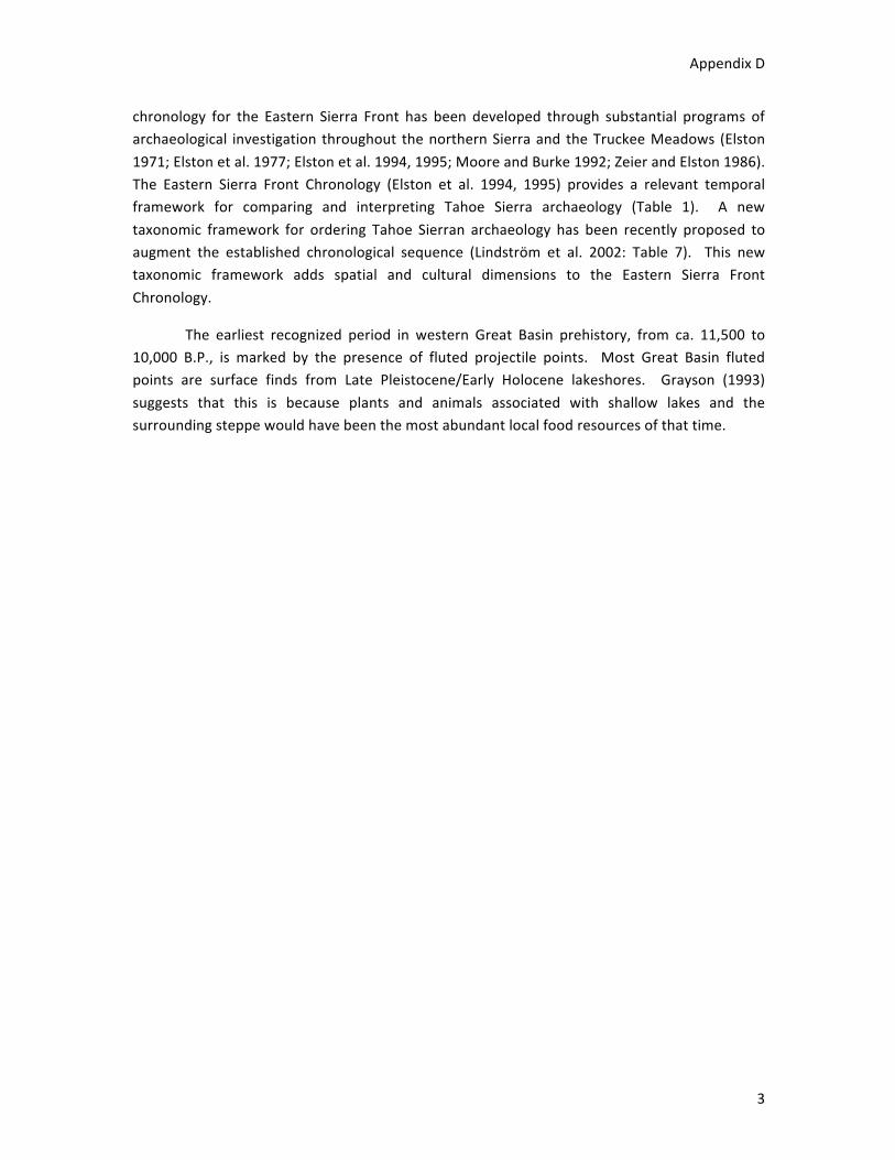
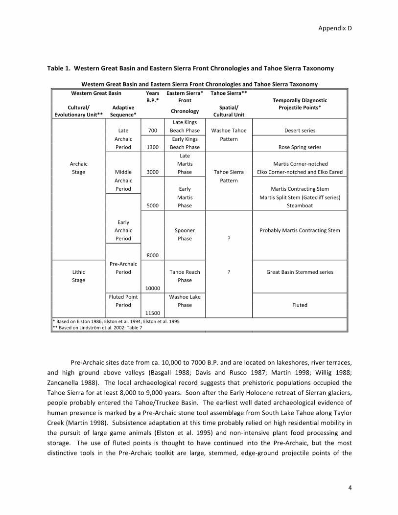
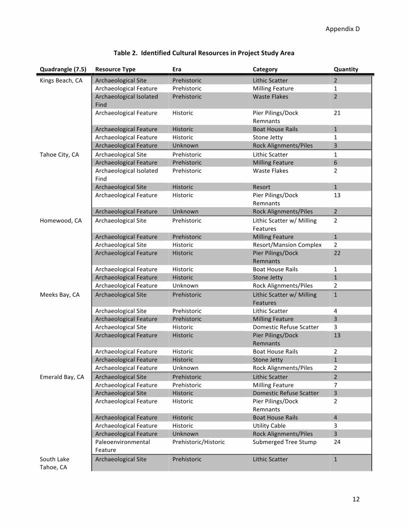
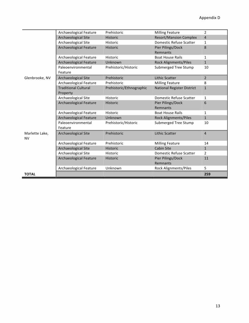
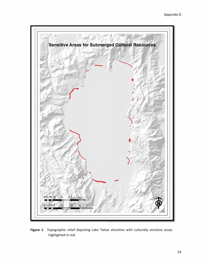
•
•
•
•
•
•
• If treatment involves disturbance of lake bottom in culturally sensitive areas, an underwater archaeological survey will be conducted by a qualified professional in the project APE to determine if previously recorded or newly identified cultural resources exist in the area.
• Results of the survey will be discussed in an archaeological survey report and submitted to the North Central Information Center in Sacramento.
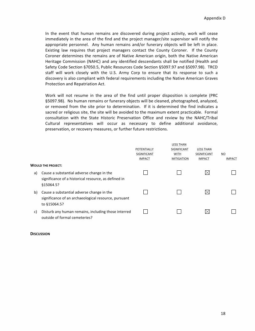
•
•
AAPPENDIX E BIOLOGICAL DATABASE
SEARCHES– CALIFORNIA NATIVE
PLANT SOCIETY, CALIFORNIA
NATURAL DIVERSITY DATABASE
AND UNITED STATES FISH AND
WILDLIFE SERVICE

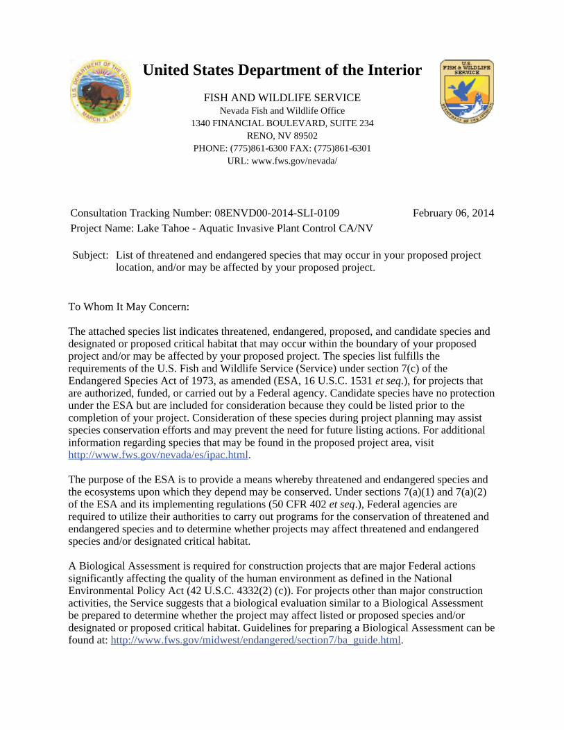
United States Department of the Interior
FISH AND WILDLIFE SERVICENevada Fish and Wildlife Office
1340 FINANCIAL BOULEVARD, SUITE 234RENO, NV 89502
PHONE: (775)861-6300 FAX: (775)861-6301URL: www.fws.gov/nevada/
Consultation Tracking Number: 08ENVD00-2014-SLI-0109 February 06, 2014Project Name: Lake Tahoe - Aquatic Invasive Plant Control CA/NV
Subject: List of threatened and endangered species that may occur in your proposed projectlocation, and/or may be affected by your proposed project.
To Whom It May Concern:
The attached species list indicates threatened, endangered, proposed, and candidate species anddesignated or proposed critical habitat that may occur within the boundary of your proposedproject and/or may be affected by your proposed project. The species list fulfills therequirements of the U.S. Fish and Wildlife Service (Service) under section 7(c) of theEndangered Species Act of 1973, as amended (ESA, 16 U.S.C. 1531 .), for projects thatet seqare authorized, funded, or carried out by a Federal agency. Candidate species have no protectionunder the ESA but are included for consideration because they could be listed prior to thecompletion of your project. Consideration of these species during project planning may assistspecies conservation efforts and may prevent the need for future listing actions. For additionalinformation regarding species that may be found in the proposed project area, visit
.http://www.fws.gov/nevada/es/ipac.html
The purpose of the ESA is to provide a means whereby threatened and endangered species andthe ecosystems upon which they depend may be conserved. Under sections 7(a)(1) and 7(a)(2)of the ESA and its implementing regulations (50 CFR 402 .), Federal agencies areet seqrequired to utilize their authorities to carry out programs for the conservation of threatened andendangered species and to determine whether projects may affect threatened and endangeredspecies and/or designated critical habitat.
A Biological Assessment is required for construction projects that are major Federal actionssignificantly affecting the quality of the human environment as defined in the NationalEnvironmental Policy Act (42 U.S.C. 4332(2) (c)). For projects other than major constructionactivities, the Service suggests that a biological evaluation similar to a Biological Assessmentbe prepared to determine whether the project may affect listed or proposed species and/ordesignated or proposed critical habitat. Guidelines for preparing a Biological Assessment can befound at: .http://www.fws.gov/midwest/endangered/section7/ba_guide.html
If a Federal action agency determines, based on the Biological Assessment or biologicalevaluation, that listed species and/or designated critical habitat may be affected by the proposedproject, the agency is required to consult with the Service pursuant to 50 CFR 402. In addition,the Service recommends that candidate species, proposed species, and proposed critical habitatbe addressed within the consultation. More information on the regulations and procedures forsection 7 consultation, including the role of permit or license applicants, can be found in the"Endangered Species Consultation Handbook" at:
.http://www.fws.gov/endangered/esa-library/pdf/TOC-GLOS.PDF
New information based on updated surveys, changes in the abundance and distribution ofspecies, changed habitat conditions, or other factors could change this species list. Please feelfree to contact us if you need more current information or assistance regarding the potentialimpacts to federally listed, proposed, and candidate species and federally designated andproposed critical habitat. Please note that under 50 CFR 402.12(e) of the regulationsimplementing section 7 of the ESA, the accuracy of this species list should be verified after 90days. This verification can be completed formally or informally, as desired. The Servicerecommends that verification be completed by visiting the ECOS-IPaC website at regularintervals during project planning and implementation, for updates to species lists andinformation. An updated list may be requested through the ECOS-IPaC system by completingthe same process used to receive the attached list.
The Nevada Fish and Wildlife Office (NFWO) no longer provides species of concern lists. Mostof these species for which we have concern are also on the Animal and Plant At-Risk TrackingList for Nevada (At-Risk list) maintained by the State of Nevada’s Natural HeritageProgram (Heritage). Instead of maintaining our own list, we adopted Heritage's At-Risk list andare partnering with them to provide distribution data and information on the conservation needsfor at-risk species to agencies or project proponents. The mission of Heritage is to continuallyevaluate the conservation priorities of native plants, animals, and their habitats, particularlythose most vulnerable to extinction or in serious decline. In addition, in order to avoid futureconflicts, we ask that you consider these at-risk species early in your project planning andexplore management alternatives that provide for their long-term conservation.
For a list of at-risk species by county, visit Heritage's website ( ). For ahttp://heritage.nv.govspecific list of at-risk species that may occur in the project area, you can obtain a data requestform from the website ( ) or by contacting the Administrator ofhttp://heritage.nv.gov/get_dataHeritage at 901 South Stewart Street, Suite 5002, Carson City, Nevada 89701-5245, (775)684-2900. Please indicate on the form that your request is being obtained as part of yourcoordination with the Service under the ESA. During your project analysis, if you obtain newinformation or data for any Nevada sensitive species, we request that you provide theinformation to Heritage at the above address.
Furthermore, certain species of fish and wildlife are classified as protected by the State ofNevada ( ). You must first obtain the appropriatehttp://www.leg.state.nv.us/NAC/NAC-503.htmllicense, permit, or written authorization from the Nevada Department of Wildlife (NDOW) totake, or possess any parts of protected fish and wildlife species. Please visit
or contact NDOW in northern Nevada (775) 688-1500, in southernhttp://www.ndow.orgNevada (702) 486-5127, or in eastern Nevada (775) 777-2300.
2
Please be aware that bald and golden eagles are protected under the Bald and Golden EagleProtection Act (16 U.S.C. 668 .), and projects affecting these species may requireet seqdevelopment of an eagle conservation plan (
). Additionally, wind energy projectshttp://www.fws.gov/windenergy/eagle_guidance.htmlshould follow the Service's wind energy guidelines ( ) forhttp://www.fws.gov/windenergy/minimizing impacts to migratory birds and bats.
The Service’s Pacific Southwest Region developed the Interim Guidelines for theDevelopment of a Project Specific Avian and Bat Protection Plan for Wind Energy Facilities (Interim Guidelines). This document provides energy facility developers with a tool forassessing the risk of potential impacts to wildlife resources and delineates how best to designand operate a bird- and bat-friendly wind facility. These Interim Guidelines are available uponrequest from the NFWO. The intent of a Bird and Bat Conservation Strategy is to conservewildlife resources while supporting project developers through: (1) establishing projectdevelopment in an adaptive management framework; (2) identifying proper siting and projectdesign strategies; (3) designing and implementing pre-construction surveys; (4) implementingappropriate conservation measures for each development phase; (5) designing andimplementing appropriate post-construction monitoring strategies; (6) using post-constructionstudies to better understand the dynamics of mortality reduction ( , changes in blade cut-ine.g.speed, assessments of blade “feathering” success, and studies on the effects ofvisual and acoustic deterrents) including efforts tied into Before-After/Control-Impact analysis;and (7) conducting a thorough risk assessment and validation leading to adjustments inmanagement and mitigation actions.
The template and recommendations set forth in the Interim Guidelines were based upon theAvian Powerline Interaction Committee’s Avian Protection Plan template (
) developed for electric utilities and modified accordingly to address thehttp://www.aplic.org/unique concerns of wind energy facilities. These recommendations are also consistent with theService’s wind energy guidelines. We recommend contacting us as early as possible inthe planning process to discuss the need and process for developing a site-specific Bird and BatConservation Strategy.
The Service has also developed guidance regarding wind power development in relation toprairie grouse leks (sage-grouse are included in this). This document can be found at: http://www.fws.gov/southwest/es/Oklahoma/documents/te_species/wind%20power/prairie%20gro.
Migratory Birds are a Service Trust Resource. Based on the Service's conservationresponsibilities and management authority for migratory birds under the Migratory Bird TreatyAct of 1918, as amended (MBTA; 16 U.S.C. 703 .), we recommend that any land clearing et seqor other surface disturbance associated with proposed actions within the project area be timed toavoid potential destruction of bird nests or young, or birds that breed in the area. Suchdestruction may be in violation of the MBTA. Under the MBTA, nests with eggs or young ofmigratory birds may not be harmed, nor may migratory birds be killed. Therefore, werecommend land clearing be conducted outside the avian breeding season. If this is not feasible,we recommend a qualified biologist survey the area prior to land clearing. If nests are located,or if other evidence of nesting ( , mated pairs, territorial defense, carrying nesting material,i.e.transporting food) is observed, a protective buffer (the size depending on the habitat
3
requirements of the species) should be delineated and the entire area avoided to preventdestruction or disturbance to nests until they are no longer active.
Guidance for minimizing impacts to migratory birds for projects involving communicationstowers ( , cellular, digital television, radio, and emergency broadcast) can be found at: e.g.
; http://www.fws.gov/migratorybirds/CurrentBirdIssues/Hazards/towers/towers.htm; and http://www.towerkill.com
.http://www.fws.gov/migratorybirds/CurrentBirdIssues/Hazards/towers/comtow.html
If wetlands, springs, or streams are are known to occur in the project area or are present in thevicinity of the project area, we ask that you be aware of potential impacts project activities mayhave on these habitats. Discharge of fill material into wetlands or waters of the United States isregulated by the U.S. Army Corps of Engineers (ACOE) pursuant to section 404 of the CleanWater Act of 1972, as amended. We recommend you contact the ACOE’s RegulatorySection regarding the possible need for a permit. For projects located in northern Nevada(Carson City, Churchill, Douglas, Elko, Esmeralda, Eureka, Humboldt, Lander, Lyon, Mineral,Pershing, Storey, and Washoe Counties) contact the Reno Regulatory Office at 300 BoothStreet, Room 3060, Reno, Nevada 89509, (775) 784-5304; in southern Nevada (Clark, Lincoln,Nye, and White Pine Counties) contact the St. George Regulatory Office at 321 North MallDrive, Suite L-101, St. George, Utah 84790-7314, (435) 986-3979; or in California along theeastern Sierra contact the Sacramento Regulatory Office at 650 Capitol Mall, Suite 5-200,Sacramento, California 95814, (916) 557-5250.
We appreciate your concern for threatened and endangered species. Please include theConsultation Tracking Number in the header of this letter with any request for consultation orcorrespondence about your project that you submit to our office.
Attachment
4
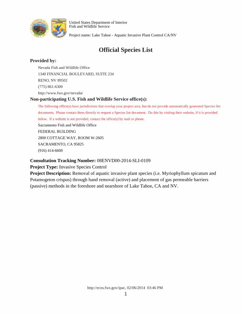
http://ecos.fws.gov/ipac, 02/06/2014 03:46 PM 1
Official Species List
Provided by: Nevada Fish and Wildlife Office
1340 FINANCIAL BOULEVARD, SUITE 234
RENO, NV 89502
(775) 861-6300
http://www.fws.gov/nevada/
Non-participating U.S. Fish and Wildlife Service office(s): The following office(s) have jurisdictions that overlap your project area, but do not provide automatically generated Species list
documents. Please contact them directly to request a Species list document. Do this by visiting their website, if it is provided
below. If a website is not provided, contact the office(s) by mail or phone.
Sacramento Fish and Wildlife Office
FEDERAL BUILDING
2800 COTTAGE WAY, ROOM W-2605
SACRAMENTO, CA 95825
(916) 414-6600 Consultation Tracking Number: 08ENVD00-2014-SLI-0109Project Type: Invasive Species ControlProject Description: Removal of aquatic invasive plant species (i.e. Myriophyllum spicatum andPotamogeton crispus) through hand removal (active) and placement of gas permeable barriers(passive) methods in the foreshore and nearshore of Lake Tahoe, CA and NV.
United States Department of InteriorFish and Wildlife Service
Project name: Lake Tahoe - Aquatic Invasive Plant Control CA/NV
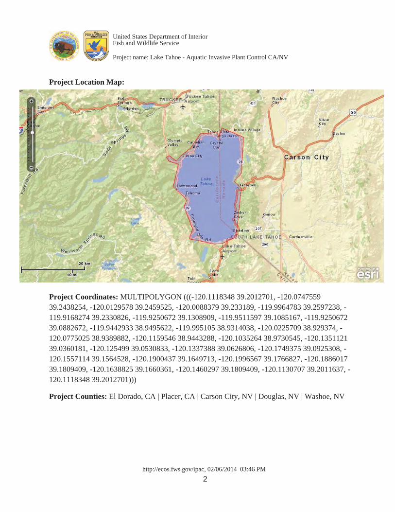
http://ecos.fws.gov/ipac, 02/06/2014 03:46 PM 2
Project Location Map:
Project Coordinates: MULTIPOLYGON (((-120.1118348 39.2012701, -120.074755939.2438254, -120.0129578 39.2459525, -120.0088379 39.233189, -119.9964783 39.2597238, -119.9168274 39.2330826, -119.9250672 39.1308909, -119.9511597 39.1085167, -119.925067239.0882672, -119.9442933 38.9495622, -119.995105 38.9314038, -120.0225709 38.929374, -120.0775025 38.9389882, -120.1159546 38.9443288, -120.1035264 38.9730545, -120.135112139.0360181, -120.125499 39.0530833, -120.1337388 39.0626806, -120.1749375 39.0925308, -120.1557114 39.1564528, -120.1900437 39.1649713, -120.1996567 39.1766827, -120.188601739.1809409, -120.1638825 39.1660361, -120.1460297 39.1809409, -120.1130707 39.2011637, -120.1118348 39.2012701))) Project Counties: El Dorado, CA | Placer, CA | Carson City, NV | Douglas, NV | Washoe, NV
United States Department of InteriorFish and Wildlife Service
Project name: Lake Tahoe - Aquatic Invasive Plant Control CA/NV
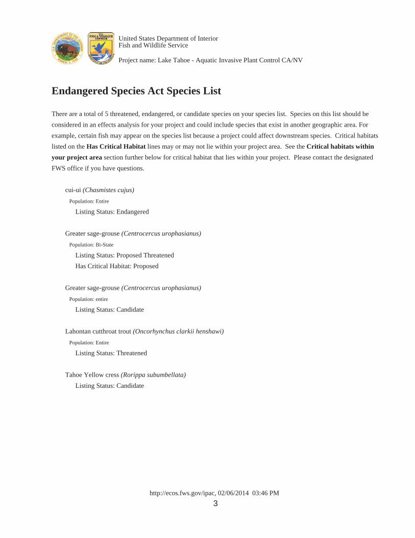
http://ecos.fws.gov/ipac, 02/06/2014 03:46 PM 3
Endangered Species Act Species List
There are a total of 5 threatened, endangered, or candidate species on your species list. Species on this list should be
considered in an effects analysis for your project and could include species that exist in another geographic area. For
example, certain fish may appear on the species list because a project could affect downstream species. Critical habitats
listed on the Has Critical Habitat lines may or may not lie within your project area. See the Critical habitats within
your project area section further below for critical habitat that lies within your project. Please contact the designated
FWS office if you have questions.
cui-ui (Chasmistes cujus)
Population: Entire
Listing Status: Endangered Greater sage-grouse (Centrocercus urophasianus)
Population: Bi-State
Listing Status: Proposed Threatened
Has Critical Habitat: Proposed Greater sage-grouse (Centrocercus urophasianus)
Population: entire
Listing Status: Candidate Lahontan cutthroat trout (Oncorhynchus clarkii henshawi)
Population: Entire
Listing Status: Threatened Tahoe Yellow cress (Rorippa subumbellata)
Listing Status: Candidate
United States Department of InteriorFish and Wildlife Service
Project name: Lake Tahoe - Aquatic Invasive Plant Control CA/NV
http://ecos.fws.gov/ipac, 02/06/2014 03:46 PM 4
Critical habitats that lie within your project areaThere are no critical habitats within your project area.
United States Department of InteriorFish and Wildlife Service
Project name: Lake Tahoe - Aquatic Invasive Plant Control CA/NV
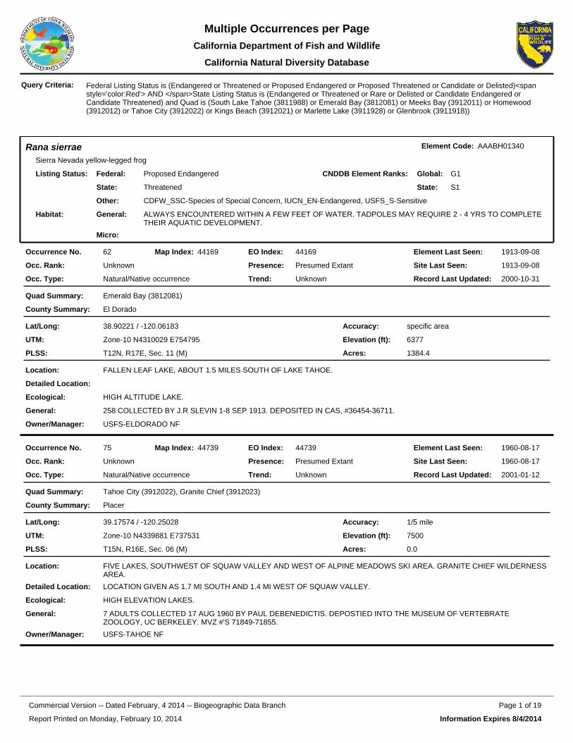
Rana sierraeSierra Nevada yellow-legged frog
Element Code: AAABH01340
Federal:
State:
Proposed Endangered
Threatened
Listing Status: CNDDB Element Ranks: Global:
State:
G1
S1
Other: CDFW_SSC-Species of Special Concern, IUCN_EN-Endangered, USFS_S-Sensitive
General: ALWAYS ENCOUNTERED WITHIN A FEW FEET OF WATER. TADPOLES MAY REQUIRE 2 - 4 YRS TO COMPLETE THEIR AQUATIC DEVELOPMENT.
Micro: �
Habitat:
44169EO Index:62Occurrence No. 44169Map Index: 1913-09-08Element Last Seen:
1913-09-08Site Last Seen:UnknownOcc. Rank:
Natural/Native occurrenceOcc. Type:
Presumed ExtantPresence:
UnknownTrend: 2000-10-31Record Last Updated:
Emerald Bay (3812081)Quad Summary:
El DoradoCounty Summary:
38.90221 / -120.06183Lat/Long:
Zone-10 N4310029 E754795UTM:
T12N, R17E, Sec. 11 (M)PLSS:
specific areaAccuracy:
6377Elevation (ft):
1384.4Acres:
FALLEN LEAF LAKE, ABOUT 1.5 MILES SOUTH OF LAKE TAHOE.Location:
Detailed Location:
HIGH ALTITUDE LAKE.Ecological:
258 COLLECTED BY J.R SLEVIN 1-8 SEP 1913. DEPOSITED IN CAS, #36454-36711.General:
USFS-ELDORADO NFOwner/Manager:
44739EO Index:75Occurrence No. 44739Map Index: 1960-08-17Element Last Seen:
1960-08-17Site Last Seen:UnknownOcc. Rank:
Natural/Native occurrenceOcc. Type:
Presumed ExtantPresence:
UnknownTrend: 2001-01-12Record Last Updated:
Tahoe City (3912022), Granite Chief (3912023)Quad Summary:
PlacerCounty Summary:
39.17574 / -120.25028Lat/Long:
Zone-10 N4339881 E737531UTM:
T15N, R16E, Sec. 06 (M)PLSS:
1/5 mileAccuracy:
7500Elevation (ft):
0.0Acres:
FIVE LAKES, SOUTHWEST OF SQUAW VALLEY AND WEST OF ALPINE MEADOWS SKI AREA. GRANITE CHIEF WILDERNESS AREA.
Location:
LOCATION GIVEN AS 1.7 MI SOUTH AND 1.4 MI WEST OF SQUAW VALLEY.Detailed Location:
HIGH ELEVATION LAKES.Ecological:
7 ADULTS COLLECTED 17 AUG 1960 BY PAUL DEBENEDICTIS. DEPOSTIED INTO THE MUSEUM OF VERTEBRATE ZOOLOGY, UC BERKELEY. MVZ #'S 71849-71855.
General:
USFS-TAHOE NFOwner/Manager:
Federal Listing Status is (Endangered or Threatened or Proposed Endangered or Proposed Threatened or Candidate or Delisted)<span style='color:Red'> AND </span>State Listing Status is (Endangered or Threatened or Rare or Delisted or Candidate Endangered or Candidate Threatened) and Quad is (South Lake Tahoe (3811988) or Emerald Bay (3812081) or Meeks Bay (3912011) or Homewood (3912012) or Tahoe City (3912022) or Kings Beach (3912021) or Marlette Lake (3911928) or Glenbrook (3911918))
Query Criteria:
Report Printed on Monday, February 10, 2014
Page 1 of 19Commercial Version -- Dated February, 4 2014 -- Biogeographic Data Branch
Information Expires 8/4/2014
Multiple Occurrences per PageCalifornia Department of Fish and
California Natural Diversity Database
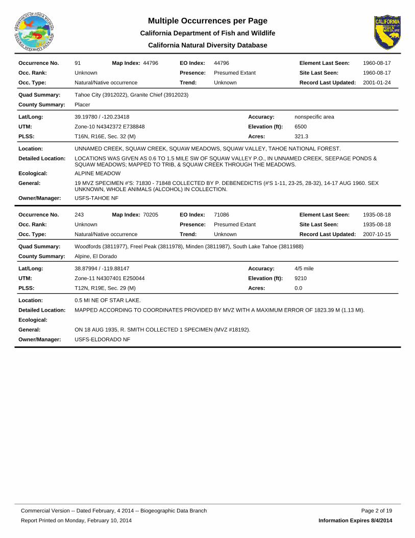
44796EO Index:91Occurrence No. 44796Map Index: 1960-08-17Element Last Seen:
1960-08-17Site Last Seen:UnknownOcc. Rank:
Natural/Native occurrenceOcc. Type:
Presumed ExtantPresence:
UnknownTrend: 2001-01-24Record Last Updated:
Tahoe City (3912022), Granite Chief (3912023)Quad Summary:
PlacerCounty Summary:
39.19780 / -120.23418Lat/Long:
Zone-10 N4342372 E738848UTM:
T16N, R16E, Sec. 32 (M)PLSS:
nonspecific areaAccuracy:
6500Elevation (ft):
321.3Acres:
UNNAMED CREEK, SQUAW CREEK, SQUAW MEADOWS, SQUAW VALLEY, TAHOE NATIONAL FOREST.Location:
LOCATIONS WAS GIVEN AS 0.6 TO 1.5 MILE SW OF SQUAW VALLEY P.O., IN UNNAMED CREEK, SEEPAGE PONDS & SQUAW MEADOWS; MAPPED TO TRIB, & SQUAW CREEK THROUGH THE MEADOWS.
Detailed Location:
ALPINE MEADOWEcological:
19 MVZ SPECIMEN #'S: 71830 - 71848 COLLECTED BY P. DEBENEDICTIS (#'S 1-11, 23-25, 28-32), 14-17 AUG 1960. SEX UNKNOWN, WHOLE ANIMALS (ALCOHOL) IN COLLECTION.
General:
USFS-TAHOE NFOwner/Manager:
71086EO Index:243Occurrence No. 70205Map Index: 1935-08-18Element Last Seen:
1935-08-18Site Last Seen:UnknownOcc. Rank:
Natural/Native occurrenceOcc. Type:
Presumed ExtantPresence:
UnknownTrend: 2007-10-15Record Last Updated:
Woodfords (3811977), Freel Peak (3811978), Minden (3811987), South Lake Tahoe (3811988)Quad Summary:
Alpine, El DoradoCounty Summary:
38.87994 / -119.88147Lat/Long:
Zone-11 N4307401 E250044UTM:
T12N, R19E, Sec. 29 (M)PLSS:
4/5 mileAccuracy:
9210Elevation (ft):
0.0Acres:
0.5 MI NE OF STAR LAKE.Location:
MAPPED ACCORDING TO COORDINATES PROVIDED BY MVZ WITH A MAXIMUM ERROR OF 1823.39 M (1.13 MI).Detailed Location:
Ecological:
ON 18 AUG 1935, R. SMITH COLLECTED 1 SPECIMEN (MVZ #18192).General:
USFS-ELDORADO NFOwner/Manager:
Report Printed on Monday, February 10, 2014
Page 2 of 19Commercial Version -- Dated February, 4 2014 -- Biogeographic Data Branch
Information Expires 8/4/2014
Multiple Occurrences per PageCalifornia Department of Fish and
California Natural Diversity Database
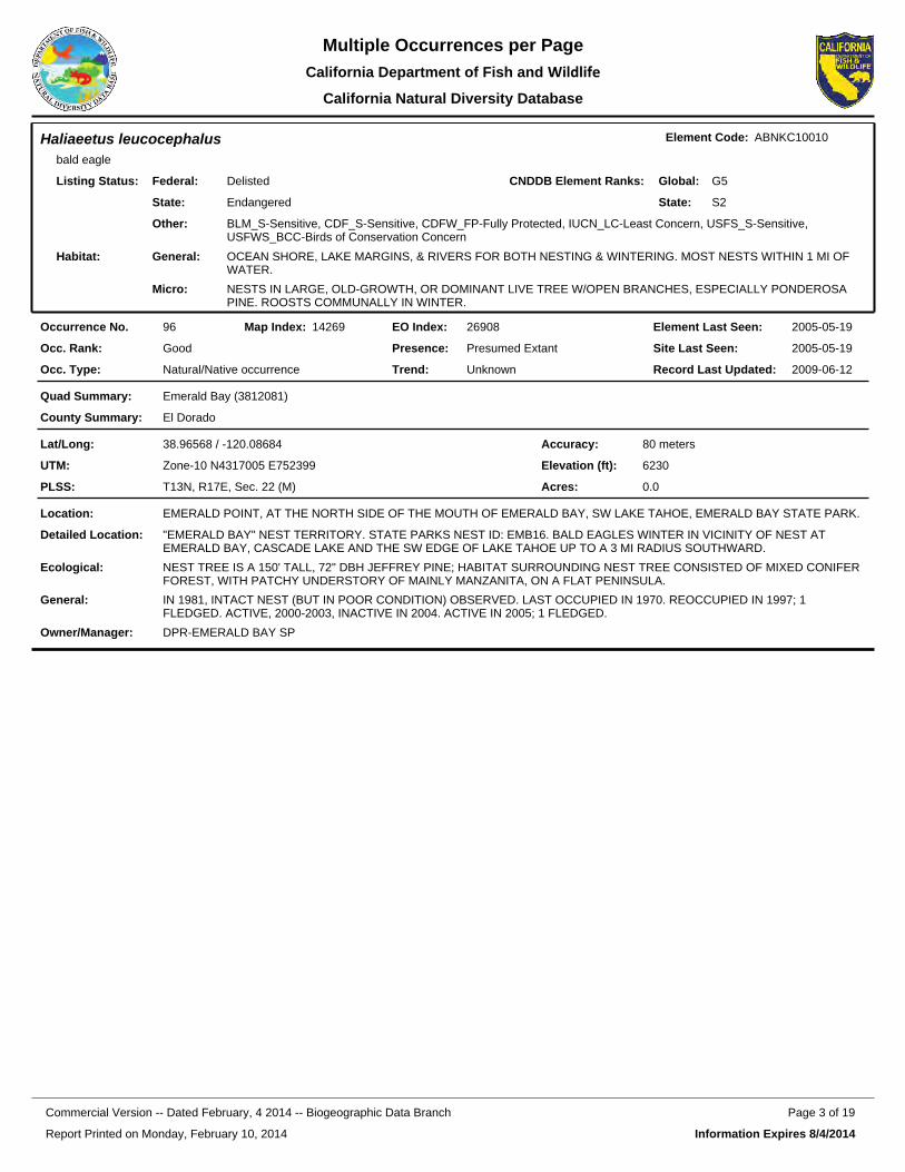
Haliaeetus leucocephalusbald eagle
Element Code: ABNKC10010
Federal:
State:
Delisted
Endangered
Listing Status: CNDDB Element Ranks: Global:
State:
G5
S2
Other: BLM_S-Sensitive, CDF_S-Sensitive, CDFW_FP-Fully Protected, IUCN_LC-Least Concern, USFS_S-Sensitive, USFWS_BCC-Birds of Conservation Concern
General: OCEAN SHORE, LAKE MARGINS, & RIVERS FOR BOTH NESTING & WINTERING. MOST NESTS WITHIN 1 MI OF WATER.
Micro: NESTS IN LARGE, OLD-GROWTH, OR DOMINANT LIVE TREE W/OPEN BRANCHES, ESPECIALLY PONDEROSA PINE. ROOSTS COMMUNALLY IN WINTER.
Habitat:
26908EO Index:96Occurrence No. 14269Map Index: 2005-05-19Element Last Seen:
2005-05-19Site Last Seen:GoodOcc. Rank:
Natural/Native occurrenceOcc. Type:
Presumed ExtantPresence:
UnknownTrend: 2009-06-12Record Last Updated:
Emerald Bay (3812081)Quad Summary:
El DoradoCounty Summary:
38.96568 / -120.08684Lat/Long:
Zone-10 N4317005 E752399UTM:
T13N, R17E, Sec. 22 (M)PLSS:
80 metersAccuracy:
6230Elevation (ft):
0.0Acres:
EMERALD POINT, AT THE NORTH SIDE OF THE MOUTH OF EMERALD BAY, SW LAKE TAHOE, EMERALD BAY STATE PARK.Location:
"EMERALD BAY" NEST TERRITORY. STATE PARKS NEST ID: EMB16. BALD EAGLES WINTER IN VICINITY OF NEST AT EMERALD BAY, CASCADE LAKE AND THE SW EDGE OF LAKE TAHOE UP TO A 3 MI RADIUS SOUTHWARD.
Detailed Location:
NEST TREE IS A 150' TALL, 72" DBH JEFFREY PINE; HABITAT SURROUNDING NEST TREE CONSISTED OF MIXED CONIFER FOREST, WITH PATCHY UNDERSTORY OF MAINLY MANZANITA, ON A FLAT PENINSULA.
Ecological:
IN 1981, INTACT NEST (BUT IN POOR CONDITION) OBSERVED. LAST OCCUPIED IN 1970. REOCCUPIED IN 1997; 1 FLEDGED. ACTIVE, 2000-2003, INACTIVE IN 2004. ACTIVE IN 2005; 1 FLEDGED.
General:
DPR-EMERALD BAY SPOwner/Manager:
Report Printed on Monday, February 10, 2014
Page 3 of 19Commercial Version -- Dated February, 4 2014 -- Biogeographic Data Branch
Information Expires 8/4/2014
Multiple Occurrences per PageCalifornia Department of Fish and
California Natural Diversity Database
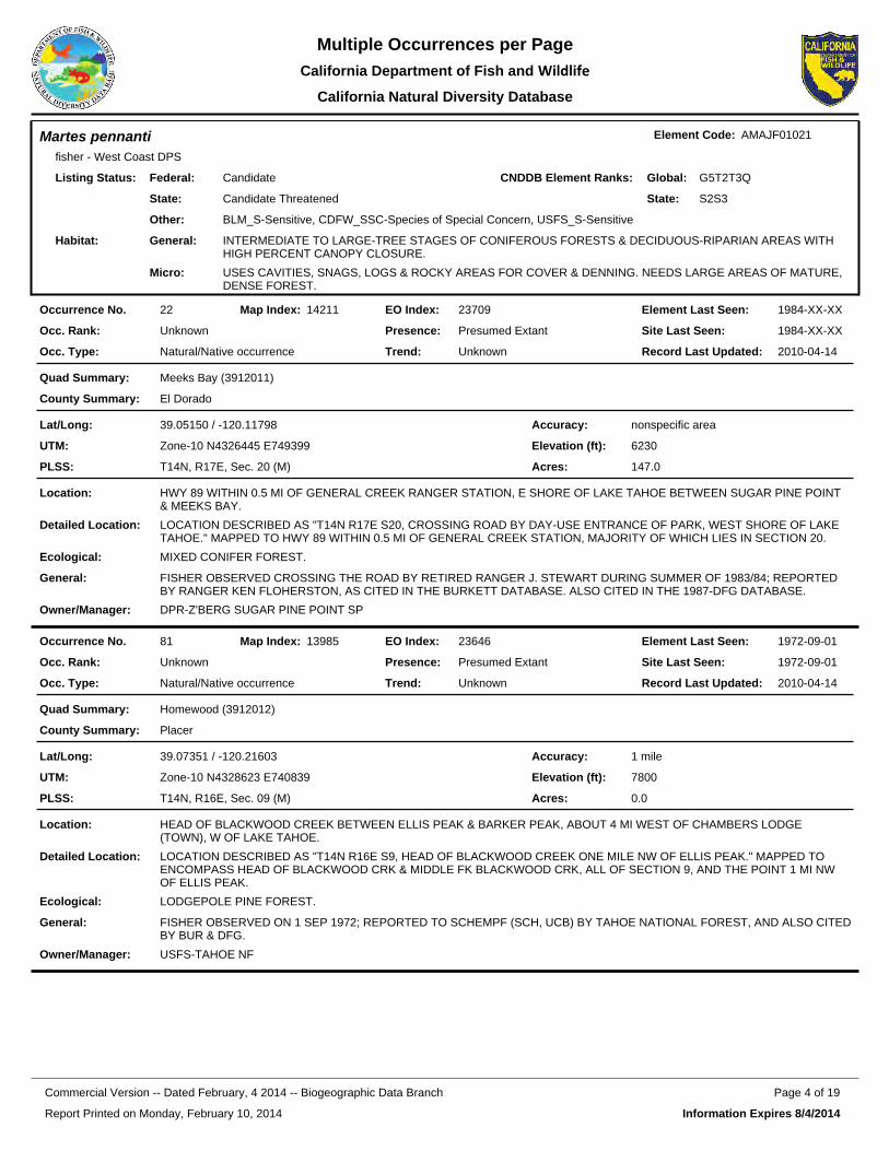
Martes pennantifisher - West Coast DPS
Element Code: AMAJF01021
Federal:
State:
Candidate
Candidate Threatened
Listing Status: CNDDB Element Ranks: Global:
State:
G5T2T3Q
S2S3
Other: BLM_S-Sensitive, CDFW_SSC-Species of Special Concern, USFS_S-Sensitive
General: INTERMEDIATE TO LARGE-TREE STAGES OF CONIFEROUS FORESTS & DECIDUOUS-RIPARIAN AREAS WITH HIGH PERCENT CANOPY CLOSURE.
Micro: USES CAVITIES, SNAGS, LOGS & ROCKY AREAS FOR COVER & DENNING. NEEDS LARGE AREAS OF MATURE, DENSE FOREST.
Habitat:
23709EO Index:22Occurrence No. 14211Map Index: 1984-XX-XXElement Last Seen:
1984-XX-XXSite Last Seen:UnknownOcc. Rank:
Natural/Native occurrenceOcc. Type:
Presumed ExtantPresence:
UnknownTrend: 2010-04-14Record Last Updated:
Meeks Bay (3912011)Quad Summary:
El DoradoCounty Summary:
39.05150 / -120.11798Lat/Long:
Zone-10 N4326445 E749399UTM:
T14N, R17E, Sec. 20 (M)PLSS:
nonspecific areaAccuracy:
6230Elevation (ft):
147.0Acres:
HWY 89 WITHIN 0.5 MI OF GENERAL CREEK RANGER STATION, E SHORE OF LAKE TAHOE BETWEEN SUGAR PINE POINT & MEEKS BAY.
Location:
LOCATION DESCRIBED AS "T14N R17E S20, CROSSING ROAD BY DAY-USE ENTRANCE OF PARK, WEST SHORE OF LAKE TAHOE." MAPPED TO HWY 89 WITHIN 0.5 MI OF GENERAL CREEK STATION, MAJORITY OF WHICH LIES IN SECTION 20.
Detailed Location:
MIXED CONIFER FOREST.Ecological:
FISHER OBSERVED CROSSING THE ROAD BY RETIRED RANGER J. STEWART DURING SUMMER OF 1983/84; REPORTED BY RANGER KEN FLOHERSTON, AS CITED IN THE BURKETT DATABASE. ALSO CITED IN THE 1987-DFG DATABASE.
General:
DPR-Z'BERG SUGAR PINE POINT SPOwner/Manager:
23646EO Index:81Occurrence No. 13985Map Index: 1972-09-01Element Last Seen:
1972-09-01Site Last Seen:UnknownOcc. Rank:
Natural/Native occurrenceOcc. Type:
Presumed ExtantPresence:
UnknownTrend: 2010-04-14Record Last Updated:
Homewood (3912012)Quad Summary:
PlacerCounty Summary:
39.07351 / -120.21603Lat/Long:
Zone-10 N4328623 E740839UTM:
T14N, R16E, Sec. 09 (M)PLSS:
1 mileAccuracy:
7800Elevation (ft):
0.0Acres:
HEAD OF BLACKWOOD CREEK BETWEEN ELLIS PEAK & BARKER PEAK, ABOUT 4 MI WEST OF CHAMBERS LODGE (TOWN), W OF LAKE TAHOE.
Location:
LOCATION DESCRIBED AS "T14N R16E S9, HEAD OF BLACKWOOD CREEK ONE MILE NW OF ELLIS PEAK." MAPPED TO ENCOMPASS HEAD OF BLACKWOOD CRK & MIDDLE FK BLACKWOOD CRK, ALL OF SECTION 9, AND THE POINT 1 MI NW OF ELLIS PEAK.
Detailed Location:
LODGEPOLE PINE FOREST.Ecological:
FISHER OBSERVED ON 1 SEP 1972; REPORTED TO SCHEMPF (SCH, UCB) BY TAHOE NATIONAL FOREST, AND ALSO CITEDBY BUR & DFG.
General:
USFS-TAHOE NFOwner/Manager:
Report Printed on Monday, February 10, 2014
Page 4 of 19Commercial Version -- Dated February, 4 2014 -- Biogeographic Data Branch
Information Expires 8/4/2014
Multiple Occurrences per PageCalifornia Department of Fish and
California Natural Diversity Database
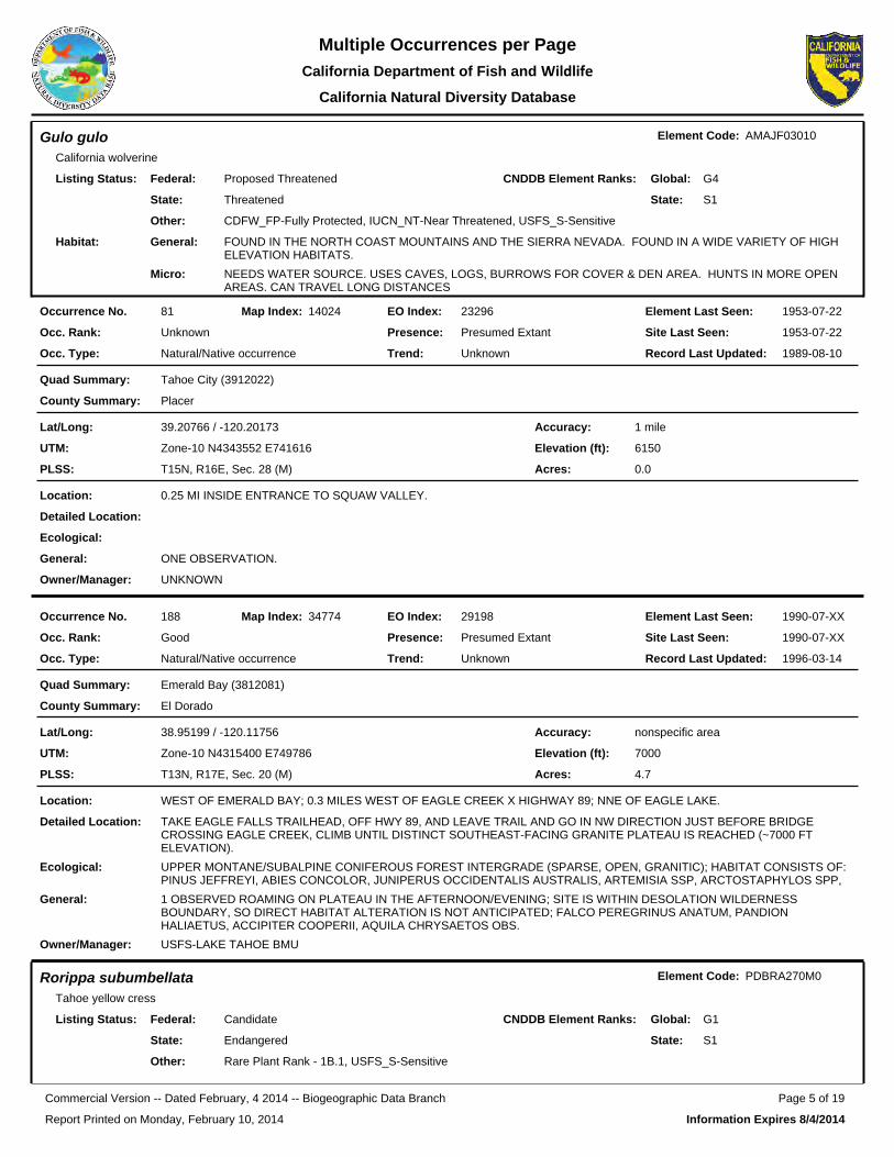
Gulo guloCalifornia wolverine
Element Code: AMAJF03010
Federal:
State:
Proposed Threatened
Threatened
Listing Status: CNDDB Element Ranks: Global:
State:
G4
S1
Other: CDFW_FP-Fully Protected, IUCN_NT-Near Threatened, USFS_S-Sensitive
General: FOUND IN THE NORTH COAST MOUNTAINS AND THE SIERRA NEVADA. FOUND IN A WIDE VARIETY OF HIGH ELEVATION HABITATS.
Micro: NEEDS WATER SOURCE. USES CAVES, LOGS, BURROWS FOR COVER & DEN AREA. HUNTS IN MORE OPEN AREAS. CAN TRAVEL LONG DISTANCES
Habitat:
23296EO Index:81Occurrence No. 14024Map Index: 1953-07-22Element Last Seen:
1953-07-22Site Last Seen:UnknownOcc. Rank:
Natural/Native occurrenceOcc. Type:
Presumed ExtantPresence:
UnknownTrend: 1989-08-10Record Last Updated:
Tahoe City (3912022)Quad Summary:
PlacerCounty Summary:
39.20766 / -120.20173Lat/Long:
Zone-10 N4343552 E741616UTM:
T15N, R16E, Sec. 28 (M)PLSS:
1 mileAccuracy:
6150Elevation (ft):
0.0Acres:
0.25 MI INSIDE ENTRANCE TO SQUAW VALLEY.Location:
Detailed Location:
Ecological:
ONE OBSERVATION.General:
UNKNOWNOwner/Manager:
29198EO Index:188Occurrence No. 34774Map Index: 1990-07-XXElement Last Seen:
1990-07-XXSite Last Seen:GoodOcc. Rank:
Natural/Native occurrenceOcc. Type:
Presumed ExtantPresence:
UnknownTrend: 1996-03-14Record Last Updated:
Emerald Bay (3812081)Quad Summary:
El DoradoCounty Summary:
38.95199 / -120.11756Lat/Long:
Zone-10 N4315400 E749786UTM:
T13N, R17E, Sec. 20 (M)PLSS:
nonspecific areaAccuracy:
7000Elevation (ft):
4.7Acres:
WEST OF EMERALD BAY; 0.3 MILES WEST OF EAGLE CREEK X HIGHWAY 89; NNE OF EAGLE LAKE.Location:
TAKE EAGLE FALLS TRAILHEAD, OFF HWY 89, AND LEAVE TRAIL AND GO IN NW DIRECTION JUST BEFORE BRIDGE CROSSING EAGLE CREEK, CLIMB UNTIL DISTINCT SOUTHEAST-FACING GRANITE PLATEAU IS REACHED (~7000 FT ELEVATION).
Detailed Location:
UPPER MONTANE/SUBALPINE CONIFEROUS FOREST INTERGRADE (SPARSE, OPEN, GRANITIC); HABITAT CONSISTS OF: PINUS JEFFREYI, ABIES CONCOLOR, JUNIPERUS OCCIDENTALIS AUSTRALIS, ARTEMISIA SSP, ARCTOSTAPHYLOS SPP,
Ecological:
1 OBSERVED ROAMING ON PLATEAU IN THE AFTERNOON/EVENING; SITE IS WITHIN DESOLATION WILDERNESS BOUNDARY, SO DIRECT HABITAT ALTERATION IS NOT ANTICIPATED; FALCO PEREGRINUS ANATUM, PANDION HALIAETUS, ACCIPITER COOPERII, AQUILA CHRYSAETOS OBS.
General:
USFS-LAKE TAHOE BMUOwner/Manager:
Rorippa subumbellataTahoe yellow cress
Element Code: PDBRA270M0
Federal:
State:
Candidate
Endangered
Listing Status: CNDDB Element Ranks: Global:
State:
G1
S1
Other: Rare Plant Rank - 1B.1, USFS_S-Sensitive
Report Printed on Monday, February 10, 2014
Page 5 of 19Commercial Version -- Dated February, 4 2014 -- Biogeographic Data Branch
Information Expires 8/4/2014
Multiple Occurrences per PageCalifornia Department of Fish and
California Natural Diversity Database
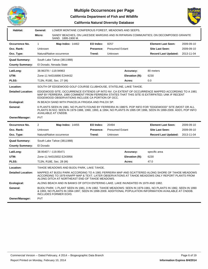
General: LOWER MONTANE CONIFEROUS FOREST, MEADOWS AND SEEPS.
Micro: SANDY BEACHES, ON LAKESIDE MARGINS AND IN RIPARIAN COMMUNITIES; ON DECOMPOSED GRANITE SAND. 1895-1900 M.
Habitat:
8257EO Index:1Occurrence No. 14462Map Index: 2009-09-10Element Last Seen:
2009-09-10Site Last Seen:UnknownOcc. Rank:
Natural/Native occurrenceOcc. Type:
Presumed ExtantPresence:
UnknownTrend: 2013-11-04Record Last Updated:
South Lake Tahoe (3811988)Quad Summary:
El Dorado, Nevada StateCounty Summary:
38.96378 / -119.94963Lat/Long:
Zone-11 N4316896 E244432UTM:
T13N, R18E, Sec. 27 (M)PLSS:
80 metersAccuracy:
6230Elevation (ft):
0.0Acres:
SOUTH OF EDGEWOOD GOLF COURSE CLUBHOUSE, STATELINE, LAKE TAHOE.Location:
EDGEWOOD SITE; OCCURRENCE EXTENDS UP INTO NV. CA EXTENT OF OCCURRENCE MAPPED ACCORDING TO A 1981 MAP BY FERREIRA. 1986 COMMENT FROM FERREIRA STATES THAT THIS SITE IS EXTIRPATED; UNK IF RECENT EDGEWOOD OBSERVATIONS INCLUDE CA PORTION OF OCC.
Detailed Location:
IN BEACH SAND WITH PHACELIA FRIGIDA AND PHLOX SP.Ecological:
6 PLANTS SEEN IN 1981. NO PLANTS FOUND BY FERREIRA IN 1980'S. POP INFO FOR "EDGEWOOD" SITE (MOST OR ALL PLANTS IN NV): SEEN IN 1979-1988, 1990, 1993, & 1994, NO PLANTS IN 1995 OR 1996, SEEN IN 1999-2009. ADD'L POP INFO AVAILABLE AT CNDDB.
General:
PVTOwner/Manager:
20494EO Index:2Occurrence No. 14455Map Index: 2009-09-10Element Last Seen:
2009-09-10Site Last Seen:UnknownOcc. Rank:
Natural/Native occurrenceOcc. Type:
Presumed ExtantPresence:
UnknownTrend: 2013-11-04Record Last Updated:
South Lake Tahoe (3811988)Quad Summary:
El DoradoCounty Summary:
38.95407 / -119.95471Lat/Long:
Zone-11 N4315832 E243956UTM:
T13N, R18E, Sec. 28 (M)PLSS:
specific areaAccuracy:
6230Elevation (ft):
47.0Acres:
TAHOE MEADOWS AND BIJOU PARK, LAKE TAHOE.Location:
MAPPED AT BIJOU PARK ACCORDING TO A 1981 FERREIRA MAP AND SCATTERED ALONG SHORE OF TAHOE MEADOWS ACCORDING TO 1979 KNAPP MAP & TEXT. LATER OBSERVATIONS AT TAHOE MEADOWS ONLY REPORT PLANTS FROM ALONG DITCH AT NORTHEAST END OF TAHOE MEADOWS.
Detailed Location:
ALONG BEACH AND IN BANKS OF DITCH ENTERING LAKE. LAKE INUNDATED IN 1979 AND 1982.Ecological:
BIJOU PARK: 1 PLANT SEEN IN 1981, 0 IN 1982. TAHOE MEADOWS: SEEN IN 1979-1981, NO PLANTS IN 1982, SEEN IN 1990 & 1993, NO PLANTS IN 1994-1997, SEEN IN 1998-2009. ADDITIONAL POPULATION INFORMATION AVAILABLE AT CNDDB. INCLUDES FORMER EO#3.
General:
PVTOwner/Manager:
Report Printed on Monday, February 10, 2014
Page 6 of 19Commercial Version -- Dated February, 4 2014 -- Biogeographic Data Branch
Information Expires 8/4/2014
Multiple Occurrences per PageCalifornia Department of Fish and
California Natural Diversity Database
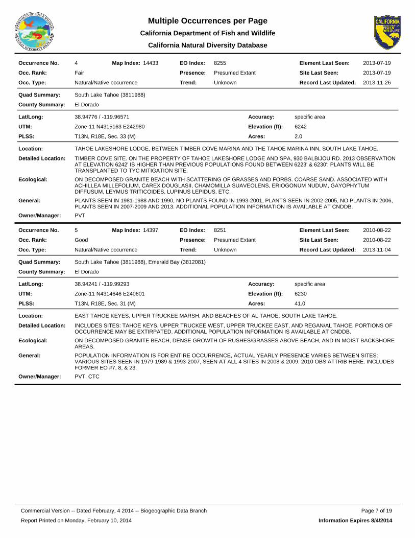
8255EO Index:4Occurrence No. 14433Map Index: 2013-07-19Element Last Seen:
2013-07-19Site Last Seen:FairOcc. Rank:
Natural/Native occurrenceOcc. Type:
Presumed ExtantPresence:
UnknownTrend: 2013-11-26Record Last Updated:
South Lake Tahoe (3811988)Quad Summary:
El DoradoCounty Summary:
38.94776 / -119.96571Lat/Long:
Zone-11 N4315163 E242980UTM:
T13N, R18E, Sec. 33 (M)PLSS:
specific areaAccuracy:
6242Elevation (ft):
2.0Acres:
TAHOE LAKESHORE LODGE, BETWEEN TIMBER COVE MARINA AND THE TAHOE MARINA INN, SOUTH LAKE TAHOE.Location:
TIMBER COVE SITE. ON THE PROPERTY OF TAHOE LAKESHORE LODGE AND SPA, 930 BALBIJOU RD. 2013 OBSERVATION AT ELEVATION 6242' IS HIGHER THAN PREVIOUS POPULATIONS FOUND BETWEEN 6223' & 6230'; PLANTS WILL BE TRANSPLANTED TO TYC MITIGATION SITE.
Detailed Location:
ON DECOMPOSED GRANITE BEACH WITH SCATTERING OF GRASSES AND FORBS. COARSE SAND. ASSOCIATED WITH ACHILLEA MILLEFOLIUM, CAREX DOUGLASII, CHAMOMILLA SUAVEOLENS, ERIOGONUM NUDUM, GAYOPHYTUM DIFFUSUM, LEYMUS TRITICOIDES, LUPINUS LEPIDUS, ETC.
Ecological:
PLANTS SEEN IN 1981-1988 AND 1990, NO PLANTS FOUND IN 1993-2001, PLANTS SEEN IN 2002-2005, NO PLANTS IN 2006, PLANTS SEEN IN 2007-2009 AND 2013. ADDITIONAL POPULATION INFORMATION IS AVAILABLE AT CNDDB.
General:
PVTOwner/Manager:
8251EO Index:5Occurrence No. 14397Map Index: 2010-08-22Element Last Seen:
2010-08-22Site Last Seen:GoodOcc. Rank:
Natural/Native occurrenceOcc. Type:
Presumed ExtantPresence:
UnknownTrend: 2013-11-04Record Last Updated:
South Lake Tahoe (3811988), Emerald Bay (3812081)Quad Summary:
El DoradoCounty Summary:
38.94241 / -119.99293Lat/Long:
Zone-11 N4314646 E240601UTM:
T13N, R18E, Sec. 31 (M)PLSS:
specific areaAccuracy:
6230Elevation (ft):
41.0Acres:
EAST TAHOE KEYES, UPPER TRUCKEE MARSH, AND BEACHES OF AL TAHOE, SOUTH LAKE TAHOE.Location:
INCLUDES SITES: TAHOE KEYS, UPPER TRUCKEE WEST, UPPER TRUCKEE EAST, AND REGAN/AL TAHOE. PORTIONS OF OCCURRENCE MAY BE EXTIRPATED. ADDITIONAL POPULATION INFORMATION IS AVAILABLE AT CNDDB.
Detailed Location:
ON DECOMPOSED GRANITE BEACH, DENSE GROWTH OF RUSHES/GRASSES ABOVE BEACH, AND IN MOIST BACKSHORE AREAS.
Ecological:
POPULATION INFORMATION IS FOR ENTIRE OCCURRENCE, ACTUAL YEARLY PRESENCE VARIES BETWEEN SITES: VARIOUS SITES SEEN IN 1979-1989 & 1993-2007, SEEN AT ALL 4 SITES IN 2008 & 2009. 2010 OBS ATTRIB HERE. INCLUDES FORMER EO #7, 8, & 23.
General:
PVT, CTCOwner/Manager:
Report Printed on Monday, February 10, 2014
Page 7 of 19Commercial Version -- Dated February, 4 2014 -- Biogeographic Data Branch
Information Expires 8/4/2014
Multiple Occurrences per PageCalifornia Department of Fish and
California Natural Diversity Database
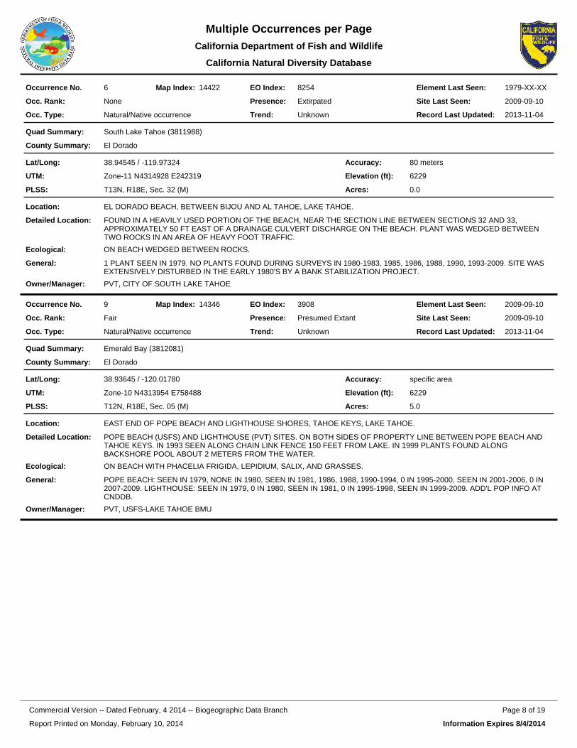
8254EO Index:6Occurrence No. 14422Map Index: 1979-XX-XXElement Last Seen:
2009-09-10Site Last Seen:NoneOcc. Rank:
Natural/Native occurrenceOcc. Type:
ExtirpatedPresence:
UnknownTrend: 2013-11-04Record Last Updated:
South Lake Tahoe (3811988)Quad Summary:
El DoradoCounty Summary:
38.94545 / -119.97324Lat/Long:
Zone-11 N4314928 E242319UTM:
T13N, R18E, Sec. 32 (M)PLSS:
80 metersAccuracy:
6229Elevation (ft):
0.0Acres:
EL DORADO BEACH, BETWEEN BIJOU AND AL TAHOE, LAKE TAHOE.Location:
FOUND IN A HEAVILY USED PORTION OF THE BEACH, NEAR THE SECTION LINE BETWEEN SECTIONS 32 AND 33, APPROXIMATELY 50 FT EAST OF A DRAINAGE CULVERT DISCHARGE ON THE BEACH. PLANT WAS WEDGED BETWEEN TWO ROCKS IN AN AREA OF HEAVY FOOT TRAFFIC.
Detailed Location:
ON BEACH WEDGED BETWEEN ROCKS.Ecological:
1 PLANT SEEN IN 1979. NO PLANTS FOUND DURING SURVEYS IN 1980-1983, 1985, 1986, 1988, 1990, 1993-2009. SITE WAS EXTENSIVELY DISTURBED IN THE EARLY 1980'S BY A BANK STABILIZATION PROJECT.
General:
PVT, CITY OF SOUTH LAKE TAHOEOwner/Manager:
3908EO Index:9Occurrence No. 14346Map Index: 2009-09-10Element Last Seen:
2009-09-10Site Last Seen:FairOcc. Rank:
Natural/Native occurrenceOcc. Type:
Presumed ExtantPresence:
UnknownTrend: 2013-11-04Record Last Updated:
Emerald Bay (3812081)Quad Summary:
El DoradoCounty Summary:
38.93645 / -120.01780Lat/Long:
Zone-10 N4313954 E758488UTM:
T12N, R18E, Sec. 05 (M)PLSS:
specific areaAccuracy:
6229Elevation (ft):
5.0Acres:
EAST END OF POPE BEACH AND LIGHTHOUSE SHORES, TAHOE KEYS, LAKE TAHOE.Location:
POPE BEACH (USFS) AND LIGHTHOUSE (PVT) SITES. ON BOTH SIDES OF PROPERTY LINE BETWEEN POPE BEACH AND TAHOE KEYS. IN 1993 SEEN ALONG CHAIN LINK FENCE 150 FEET FROM LAKE. IN 1999 PLANTS FOUND ALONG BACKSHORE POOL ABOUT 2 METERS FROM THE WATER.
Detailed Location:
ON BEACH WITH PHACELIA FRIGIDA, LEPIDIUM, SALIX, AND GRASSES.Ecological:
POPE BEACH: SEEN IN 1979, NONE IN 1980, SEEN IN 1981, 1986, 1988, 1990-1994, 0 IN 1995-2000, SEEN IN 2001-2006, 0 IN 2007-2009. LIGHTHOUSE: SEEN IN 1979, 0 IN 1980, SEEN IN 1981, 0 IN 1995-1998, SEEN IN 1999-2009. ADD'L POP INFO AT CNDDB.
General:
PVT, USFS-LAKE TAHOE BMUOwner/Manager:
Report Printed on Monday, February 10, 2014
Page 8 of 19Commercial Version -- Dated February, 4 2014 -- Biogeographic Data Branch
Information Expires 8/4/2014
Multiple Occurrences per PageCalifornia Department of Fish and
California Natural Diversity Database
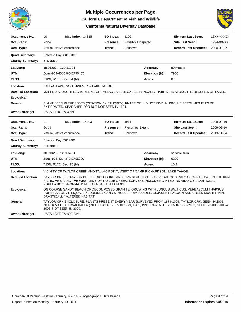
3105EO Index:10Occurrence No. 14215Map Index: 18XX-XX-XXElement Last Seen:
1994-XX-XXSite Last Seen:NoneOcc. Rank:
Natural/Native occurrenceOcc. Type:
Possibly ExtirpatedPresence:
UnknownTrend: 2000-03-02Record Last Updated:
Emerald Bay (3812081)Quad Summary:
El DoradoCounty Summary:
38.91207 / -120.11204Lat/Long:
Zone-10 N4310985 E750405UTM:
T12N, R17E, Sec. 04 (M)PLSS:
80 metersAccuracy:
7900Elevation (ft):
0.0Acres:
TALLAC LAKE, SOUTHWEST OF LAKE TAHOE.Location:
MAPPED ALONG THE SHORELINE OF TALLAC LAKE BECAUSE TYPICALLY HABITAT IS ALONG THE BEACHES OF LAKES.Detailed Location:
Ecological:
PLANT SEEN IN THE 1800'S (CITATION BY STUCKEY). KNAPP COULD NOT FIND IN 1980, HE PRESUMES IT TO BE EXTIRPATED. SEARCHED FOR BUT NOT SEEN IN 1994.
General:
USFS-ELDORADO NFOwner/Manager:
3911EO Index:11Occurrence No. 14293Map Index: 2009-09-10Element Last Seen:
2009-09-10Site Last Seen:GoodOcc. Rank:
Natural/Native occurrenceOcc. Type:
Presumed ExtantPresence:
UnknownTrend: 2013-11-04Record Last Updated:
Emerald Bay (3812081)Quad Summary:
El DoradoCounty Summary:
38.94026 / -120.05454Lat/Long:
Zone-10 N4314273 E755290UTM:
T13N, R17E, Sec. 25 (M)PLSS:
specific areaAccuracy:
6229Elevation (ft):
16.2Acres:
VICINITY OF TAYLOR CREEK AND TALLAC POINT, WEST OF CAMP RICHARDSON, LAKE TAHOE.Location:
TAYLOR CREEK, TAYLOR CREEK ENCLOSURE, AND KIVA BEACH SITES. SEVERAL COLONIES OCCUR BETWEEN THE KIVA PICNIC AREA AND THE WEST SIDE OF TAYLOR CREEK. SURVEYS INCLUDE PLANTED INDIVIDUALS. ADDITIONAL POPULATION INFORMATION IS AVAILABLE AT CNDDB.
Detailed Location:
ON COARSE SANDY BEACH OF DECOMPOSED GRANITE. GROWING WITH JUNCUS BALTICUS, VERBASCUM THAPSUS, RORIPPA CURVISILIQUA, EPILOBIUM SP, AND MIMULUS PRIMULOIDES. ADJACENT LAGOON AND CREEK MOUTH HAVE DRASTICALLY ALTERED HABITAT.
Ecological:
TAYLOR CRK ENCLOSURE: PLANTS PRESENT EVERY YEAR SURVEYED FROM 1979-2009. TAYLOR CRK: SEEN IN 2001-2009. KIVA BEACH/VALHALLA (INCL EO#13): SEEN IN 1979, 1981, 1991, 1992, NOT SEEN IN 1995-2002, SEEN IN 2003-2005 & 2008, NOT SEEN IN 2009.
General:
USFS-LAKE TAHOE BMUOwner/Manager:
Report Printed on Monday, February 10, 2014
Page 9 of 19Commercial Version -- Dated February, 4 2014 -- Biogeographic Data Branch
Information Expires 8/4/2014
Multiple Occurrences per PageCalifornia Department of Fish and
California Natural Diversity Database
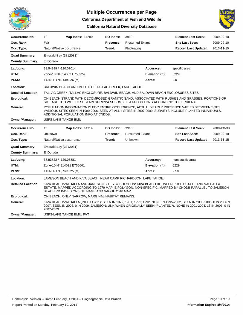
3912EO Index:12Occurrence No. 14280Map Index: 2009-09-10Element Last Seen:
2009-09-10Site Last Seen:FairOcc. Rank:
Natural/Native occurrenceOcc. Type:
Presumed ExtantPresence:
FluctuatingTrend: 2013-11-15Record Last Updated:
Emerald Bay (3812081)Quad Summary:
El DoradoCounty Summary:
38.94389 / -120.07014Lat/Long:
Zone-10 N4314632 E753924UTM:
T13N, R17E, Sec. 26 (M)PLSS:
specific areaAccuracy:
6229Elevation (ft):
2.0Acres:
BALDWIN BEACH AND MOUTH OF TALLAC CREEK, LAKE TAHOE.Location:
TALLAC CREEK, TALLAC ENCLOSURE, BALDWIN BEACH, AND BALDWIN BEACH ENCLOSURES SITES.Detailed Location:
ON BEACH STRAND WITH DECOMPOSED GRANITIC SAND. ASSOCIATED WITH RUSHES AND GRASSES. PORTIONS OF SITE ARE TOO WET TO SUSTAIN RORIPPA SUBUMBELLATA FOR LONG ACCORDING TO FERRIERA.
Ecological:
POPULATION INFORMATION IS FOR ENTIRE OCCURRENCE, ACTUAL YEARLY PRESENCE VARIES BETWEEN SITES: VARIOUS SITES SEEN IN 1980-2006, SEEN AT ALL 4 SITES IN 2007-2009. SURVEYS INCLUDE PLANTED INDIVIDUALS. ADDITIONAL POPULATION INFO AT CNDDB.
General:
USFS-LAKE TAHOE BMUOwner/Manager:
3910EO Index:13Occurrence No. 14314Map Index: 2008-XX-XXElement Last Seen:
2009-09-10Site Last Seen:UnknownOcc. Rank:
Natural/Native occurrenceOcc. Type:
Presumed ExtantPresence:
UnknownTrend: 2013-11-15Record Last Updated:
Emerald Bay (3812081)Quad Summary:
El DoradoCounty Summary:
38.93822 / -120.03881Lat/Long:
Zone-10 N4314091 E756661UTM:
T13N, R17E, Sec. 25 (M)PLSS:
nonspecific areaAccuracy:
6229Elevation (ft):
27.0Acres:
JAMESON BEACH AND KIVA BEACH, NEAR CAMP RICHARDSON, LAKE TAHOE.Location:
KIVA BEACH/VALHALLA AND JAMESON SITES. W POLYGON: KIVA BEACH BETWEEN POPE ESTATE AND VALHALLA ESTATE, MAPPED ACCORDING TO 1979 MAP. E POLYGON: NON-SPECIFIC, MAPPED BY CNDDB PARALLEL TO JAMESON BEACH RD BASED ON SITE NAME AND VAGUE 2010 MAP.
Detailed Location:
ON BEACH. ONLY NARROW, MARGINAL HABITAT REMAINS.Ecological:
KIVA BEACH/VALHALLA (INCL EO#11): SEEN IN 1979, 1981, 1991, 1992, NONE IN 1995-2002, SEEN IN 2003-2005, 0 IN 2006 & 2007, SEEN IN 2008, 0 IN 2009. JAMESON: UNK WHEN ORIGINALLY SEEN (PLANTED?), NONE IN 2001-2004, 13 IN 2006, 0 IN 2007-2009.
General:
USFS-LAKE TAHOE BMU, PVTOwner/Manager:
Report Printed on Monday, February 10, 2014
Page 10 of 19Commercial Version -- Dated February, 4 2014 -- Biogeographic Data Branch
Information Expires 8/4/2014
Multiple Occurrences per PageCalifornia Department of Fish and
California Natural Diversity Database
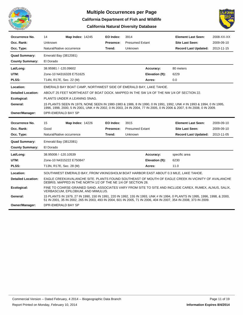
3914EO Index:14Occurrence No. 14245Map Index: 2008-XX-XXElement Last Seen:
2009-09-10Site Last Seen:UnknownOcc. Rank:
Natural/Native occurrenceOcc. Type:
Presumed ExtantPresence:
UnknownTrend: 2013-11-15Record Last Updated:
Emerald Bay (3812081)Quad Summary:
El DoradoCounty Summary:
38.95981 / -120.09602Lat/Long:
Zone-10 N4316328 E751625UTM:
T14N, R17E, Sec. 22 (M)PLSS:
80 metersAccuracy:
6229Elevation (ft):
0.0Acres:
EMERALD BAY BOAT CAMP, NORTHWEST SIDE OF EMERALD BAY, LAKE TAHOE.Location:
ABOUT 25 FEET NORTHEAST OF BOAT DOCK. MAPPED IN THE SW 1/4 OF THE NW 1/4 OF SECTION 22.Detailed Location:
PLANTS UNDER A LEANING SNAG.Ecological:
15 PLANTS SEEN IN 1979, NONE SEEN IN 1980-1983 & 1986, 8 IN 1990, 0 IN 1991, 1992, UNK # IN 1993 & 1994, 0 IN 1995, 1996, 1998, 2000, 5 IN 2001, UNK # IN 2002, 0 IN 2003, 24 IN 2004, 77 IN 2005, 0 IN 2006 & 2007, 6 IN 2008, 0 IN 2009.
General:
DPR-EMERALD BAY SPOwner/Manager:
3915EO Index:15Occurrence No. 14226Map Index: 2009-09-10Element Last Seen:
2009-09-10Site Last Seen:GoodOcc. Rank:
Natural/Native occurrenceOcc. Type:
Presumed ExtantPresence:
UnknownTrend: 2013-11-05Record Last Updated:
Emerald Bay (3812081)Quad Summary:
El DoradoCounty Summary:
38.95008 / -120.10539Lat/Long:
Zone-10 N4315222 E750847UTM:
T13N, R17E, Sec. 28 (M)PLSS:
specific areaAccuracy:
6230Elevation (ft):
11.0Acres:
SOUTHWEST EMERALD BAY, FROM VIKINGSHOLM BOAT HARBOR EAST ABOUT 0.3 MILE, LAKE TAHOE.Location:
EAGLE CREEK/AVALANCHE SITE. PLANTS FOUND SOUTHEAST OF MOUTH OF EAGLE CREEK IN VICINITY OF AVALANCHE DEBRIS. MAPPED IN THE NORTH 1/2 OF THE NE 1/4 OF SECTION 28.
Detailed Location:
FINE TO COARSE-GRAINED SAND. ASSOCIATES VARY FROM SITE TO SITE AND INCLUDE CAREX, RUMEX, ALNUS, SALIX, VERBASCUM, EPILOBIUM, AND MIMULUS.
Ecological:
15 PLANTS IN 1979, 27 IN 1990, 150 IN 1991, 220 IN 1992, 155 IN 1993, UNK # IN 1994, 0 PLANTS IN 1995, 1996, 1998, & 2000, 51 IN 2001, 35 IN 2002, 265 IN 2003, 493 IN 2004, 601 IN 2005, 71 IN 2006, 404 IN 2007, 354 IN 2008, 373 IN 2009.
General:
DPR-EMERALD BAY SPOwner/Manager:
Report Printed on Monday, February 10, 2014
Page 11 of 19Commercial Version -- Dated February, 4 2014 -- Biogeographic Data Branch
Information Expires 8/4/2014
Multiple Occurrences per PageCalifornia Department of Fish and
California Natural Diversity Database
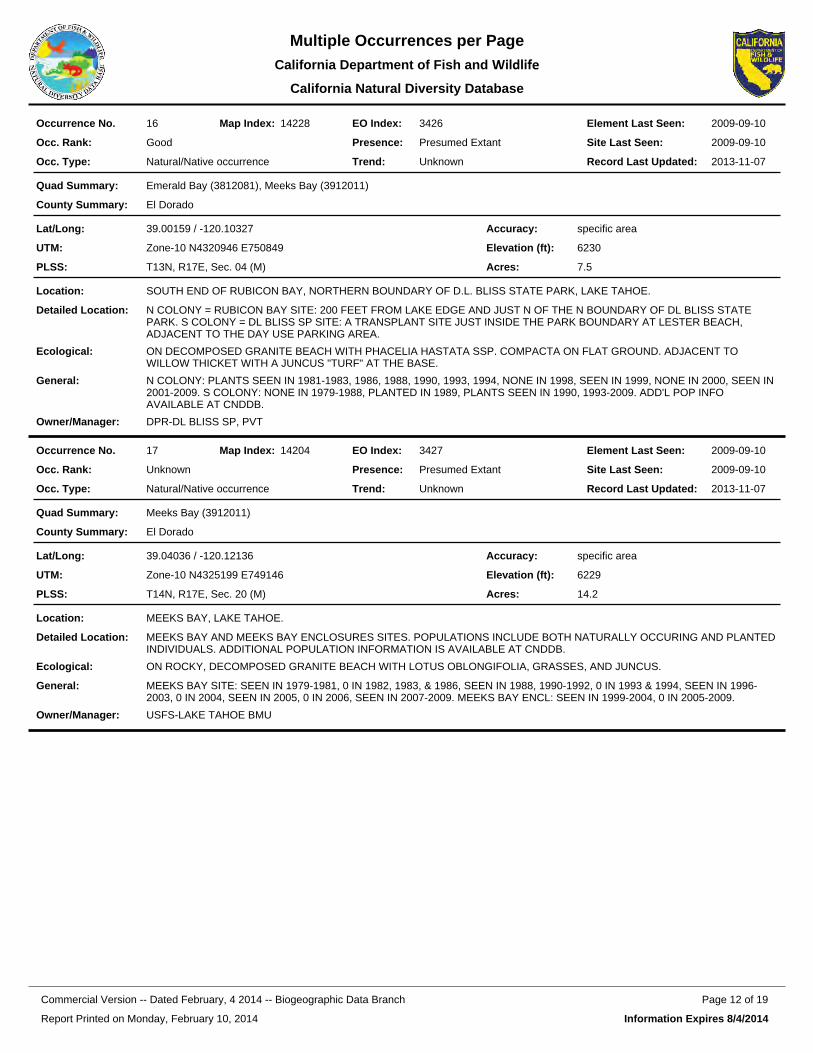
3426EO Index:16Occurrence No. 14228Map Index: 2009-09-10Element Last Seen:
2009-09-10Site Last Seen:GoodOcc. Rank:
Natural/Native occurrenceOcc. Type:
Presumed ExtantPresence:
UnknownTrend: 2013-11-07Record Last Updated:
Emerald Bay (3812081), Meeks Bay (3912011)Quad Summary:
El DoradoCounty Summary:
39.00159 / -120.10327Lat/Long:
Zone-10 N4320946 E750849UTM:
T13N, R17E, Sec. 04 (M)PLSS:
specific areaAccuracy:
6230Elevation (ft):
7.5Acres:
SOUTH END OF RUBICON BAY, NORTHERN BOUNDARY OF D.L. BLISS STATE PARK, LAKE TAHOE.Location:
N COLONY = RUBICON BAY SITE: 200 FEET FROM LAKE EDGE AND JUST N OF THE N BOUNDARY OF DL BLISS STATE PARK. S COLONY = DL BLISS SP SITE: A TRANSPLANT SITE JUST INSIDE THE PARK BOUNDARY AT LESTER BEACH, ADJACENT TO THE DAY USE PARKING AREA.
Detailed Location:
ON DECOMPOSED GRANITE BEACH WITH PHACELIA HASTATA SSP. COMPACTA ON FLAT GROUND. ADJACENT TO WILLOW THICKET WITH A JUNCUS "TURF" AT THE BASE.
Ecological:
N COLONY: PLANTS SEEN IN 1981-1983, 1986, 1988, 1990, 1993, 1994, NONE IN 1998, SEEN IN 1999, NONE IN 2000, SEEN IN 2001-2009. S COLONY: NONE IN 1979-1988, PLANTED IN 1989, PLANTS SEEN IN 1990, 1993-2009. ADD'L POP INFO AVAILABLE AT CNDDB.
General:
DPR-DL BLISS SP, PVTOwner/Manager:
3427EO Index:17Occurrence No. 14204Map Index: 2009-09-10Element Last Seen:
2009-09-10Site Last Seen:UnknownOcc. Rank:
Natural/Native occurrenceOcc. Type:
Presumed ExtantPresence:
UnknownTrend: 2013-11-07Record Last Updated:
Meeks Bay (3912011)Quad Summary:
El DoradoCounty Summary:
39.04036 / -120.12136Lat/Long:
Zone-10 N4325199 E749146UTM:
T14N, R17E, Sec. 20 (M)PLSS:
specific areaAccuracy:
6229Elevation (ft):
14.2Acres:
MEEKS BAY, LAKE TAHOE.Location:
MEEKS BAY AND MEEKS BAY ENCLOSURES SITES. POPULATIONS INCLUDE BOTH NATURALLY OCCURING AND PLANTED INDIVIDUALS. ADDITIONAL POPULATION INFORMATION IS AVAILABLE AT CNDDB.
Detailed Location:
ON ROCKY, DECOMPOSED GRANITE BEACH WITH LOTUS OBLONGIFOLIA, GRASSES, AND JUNCUS.Ecological:
MEEKS BAY SITE: SEEN IN 1979-1981, 0 IN 1982, 1983, & 1986, SEEN IN 1988, 1990-1992, 0 IN 1993 & 1994, SEEN IN 1996-2003, 0 IN 2004, SEEN IN 2005, 0 IN 2006, SEEN IN 2007-2009. MEEKS BAY ENCL: SEEN IN 1999-2004, 0 IN 2005-2009.
General:
USFS-LAKE TAHOE BMUOwner/Manager:
Report Printed on Monday, February 10, 2014
Page 12 of 19Commercial Version -- Dated February, 4 2014 -- Biogeographic Data Branch
Information Expires 8/4/2014
Multiple Occurrences per PageCalifornia Department of Fish and
California Natural Diversity Database
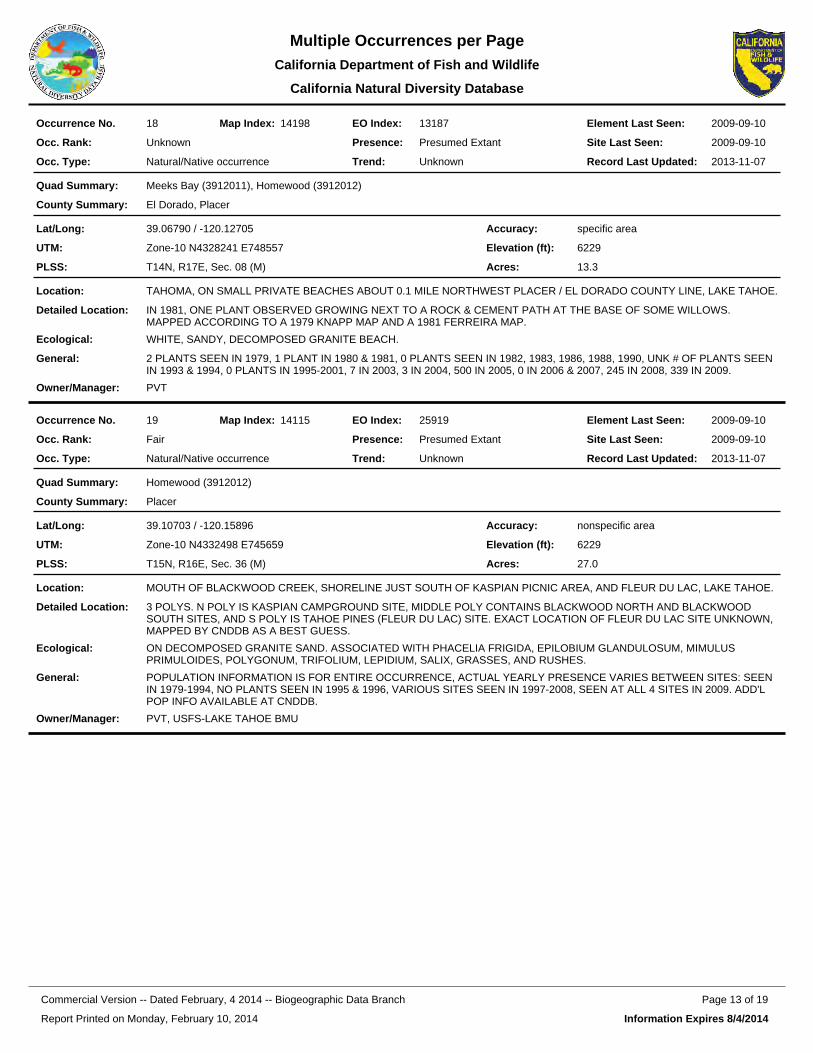
13187EO Index:18Occurrence No. 14198Map Index: 2009-09-10Element Last Seen:
2009-09-10Site Last Seen:UnknownOcc. Rank:
Natural/Native occurrenceOcc. Type:
Presumed ExtantPresence:
UnknownTrend: 2013-11-07Record Last Updated:
Meeks Bay (3912011), Homewood (3912012)Quad Summary:
El Dorado, PlacerCounty Summary:
39.06790 / -120.12705Lat/Long:
Zone-10 N4328241 E748557UTM:
T14N, R17E, Sec. 08 (M)PLSS:
specific areaAccuracy:
6229Elevation (ft):
13.3Acres:
TAHOMA, ON SMALL PRIVATE BEACHES ABOUT 0.1 MILE NORTHWEST PLACER / EL DORADO COUNTY LINE, LAKE TAHOE.Location:
IN 1981, ONE PLANT OBSERVED GROWING NEXT TO A ROCK & CEMENT PATH AT THE BASE OF SOME WILLOWS. MAPPED ACCORDING TO A 1979 KNAPP MAP AND A 1981 FERREIRA MAP.
Detailed Location:
WHITE, SANDY, DECOMPOSED GRANITE BEACH.Ecological:
2 PLANTS SEEN IN 1979, 1 PLANT IN 1980 & 1981, 0 PLANTS SEEN IN 1982, 1983, 1986, 1988, 1990, UNK # OF PLANTS SEEN IN 1993 & 1994, 0 PLANTS IN 1995-2001, 7 IN 2003, 3 IN 2004, 500 IN 2005, 0 IN 2006 & 2007, 245 IN 2008, 339 IN 2009.
General:
PVTOwner/Manager:
25919EO Index:19Occurrence No. 14115Map Index: 2009-09-10Element Last Seen:
2009-09-10Site Last Seen:FairOcc. Rank:
Natural/Native occurrenceOcc. Type:
Presumed ExtantPresence:
UnknownTrend: 2013-11-07Record Last Updated:
Homewood (3912012)Quad Summary:
PlacerCounty Summary:
39.10703 / -120.15896Lat/Long:
Zone-10 N4332498 E745659UTM:
T15N, R16E, Sec. 36 (M)PLSS:
nonspecific areaAccuracy:
6229Elevation (ft):
27.0Acres:
MOUTH OF BLACKWOOD CREEK, SHORELINE JUST SOUTH OF KASPIAN PICNIC AREA, AND FLEUR DU LAC, LAKE TAHOE.Location:
3 POLYS. N POLY IS KASPIAN CAMPGROUND SITE, MIDDLE POLY CONTAINS BLACKWOOD NORTH AND BLACKWOOD SOUTH SITES, AND S POLY IS TAHOE PINES (FLEUR DU LAC) SITE. EXACT LOCATION OF FLEUR DU LAC SITE UNKNOWN, MAPPED BY CNDDB AS A BEST GUESS.
Detailed Location:
ON DECOMPOSED GRANITE SAND. ASSOCIATED WITH PHACELIA FRIGIDA, EPILOBIUM GLANDULOSUM, MIMULUS PRIMULOIDES, POLYGONUM, TRIFOLIUM, LEPIDIUM, SALIX, GRASSES, AND RUSHES.
Ecological:
POPULATION INFORMATION IS FOR ENTIRE OCCURRENCE, ACTUAL YEARLY PRESENCE VARIES BETWEEN SITES: SEEN IN 1979-1994, NO PLANTS SEEN IN 1995 & 1996, VARIOUS SITES SEEN IN 1997-2008, SEEN AT ALL 4 SITES IN 2009. ADD'L POP INFO AVAILABLE AT CNDDB.
General:
PVT, USFS-LAKE TAHOE BMUOwner/Manager:
Report Printed on Monday, February 10, 2014
Page 13 of 19Commercial Version -- Dated February, 4 2014 -- Biogeographic Data Branch
Information Expires 8/4/2014
Multiple Occurrences per PageCalifornia Department of Fish and
California Natural Diversity Database
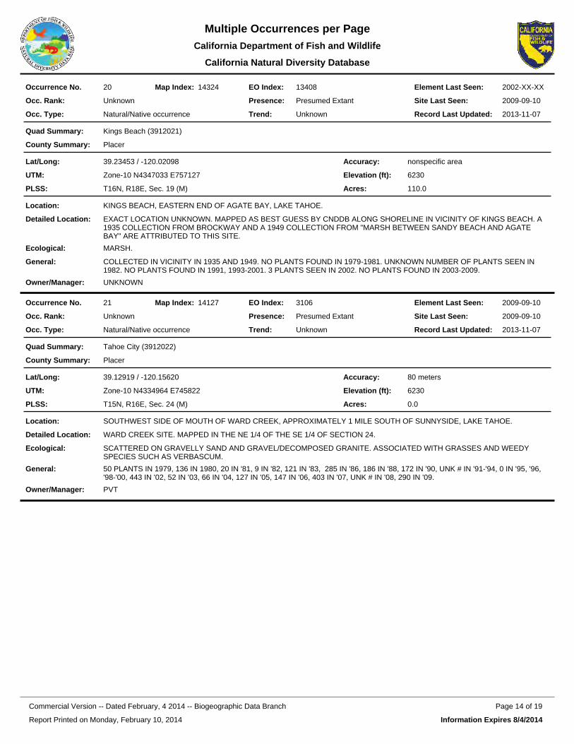
13408EO Index:20Occurrence No. 14324Map Index: 2002-XX-XXElement Last Seen:
2009-09-10Site Last Seen:UnknownOcc. Rank:
Natural/Native occurrenceOcc. Type:
Presumed ExtantPresence:
UnknownTrend: 2013-11-07Record Last Updated:
Kings Beach (3912021)Quad Summary:
PlacerCounty Summary:
39.23453 / -120.02098Lat/Long:
Zone-10 N4347033 E757127UTM:
T16N, R18E, Sec. 19 (M)PLSS:
nonspecific areaAccuracy:
6230Elevation (ft):
110.0Acres:
KINGS BEACH, EASTERN END OF AGATE BAY, LAKE TAHOE.Location:
EXACT LOCATION UNKNOWN. MAPPED AS BEST GUESS BY CNDDB ALONG SHORELINE IN VICINITY OF KINGS BEACH. A 1935 COLLECTION FROM BROCKWAY AND A 1949 COLLECTION FROM "MARSH BETWEEN SANDY BEACH AND AGATE BAY" ARE ATTRIBUTED TO THIS SITE.
Detailed Location:
MARSH.Ecological:
COLLECTED IN VICINITY IN 1935 AND 1949. NO PLANTS FOUND IN 1979-1981. UNKNOWN NUMBER OF PLANTS SEEN IN 1982. NO PLANTS FOUND IN 1991, 1993-2001. 3 PLANTS SEEN IN 2002. NO PLANTS FOUND IN 2003-2009.
General:
UNKNOWNOwner/Manager:
3106EO Index:21Occurrence No. 14127Map Index: 2009-09-10Element Last Seen:
2009-09-10Site Last Seen:UnknownOcc. Rank:
Natural/Native occurrenceOcc. Type:
Presumed ExtantPresence:
UnknownTrend: 2013-11-07Record Last Updated:
Tahoe City (3912022)Quad Summary:
PlacerCounty Summary:
39.12919 / -120.15620Lat/Long:
Zone-10 N4334964 E745822UTM:
T15N, R16E, Sec. 24 (M)PLSS:
80 metersAccuracy:
6230Elevation (ft):
0.0Acres:
SOUTHWEST SIDE OF MOUTH OF WARD CREEK, APPROXIMATELY 1 MILE SOUTH OF SUNNYSIDE, LAKE TAHOE.Location:
WARD CREEK SITE. MAPPED IN THE NE 1/4 OF THE SE 1/4 OF SECTION 24.Detailed Location:
SCATTERED ON GRAVELLY SAND AND GRAVEL/DECOMPOSED GRANITE. ASSOCIATED WITH GRASSES AND WEEDY SPECIES SUCH AS VERBASCUM.
Ecological:
50 PLANTS IN 1979, 136 IN 1980, 20 IN '81, 9 IN '82, 121 IN '83, 285 IN '86, 186 IN '88, 172 IN '90, UNK # IN '91-'94, 0 IN '95, '96, '98-'00, 443 IN '02, 52 IN '03, 66 IN '04, 127 IN '05, 147 IN '06, 403 IN '07, UNK # IN '08, 290 IN '09.
General:
PVTOwner/Manager:
Report Printed on Monday, February 10, 2014
Page 14 of 19Commercial Version -- Dated February, 4 2014 -- Biogeographic Data Branch
Information Expires 8/4/2014
Multiple Occurrences per PageCalifornia Department of Fish and
California Natural Diversity Database
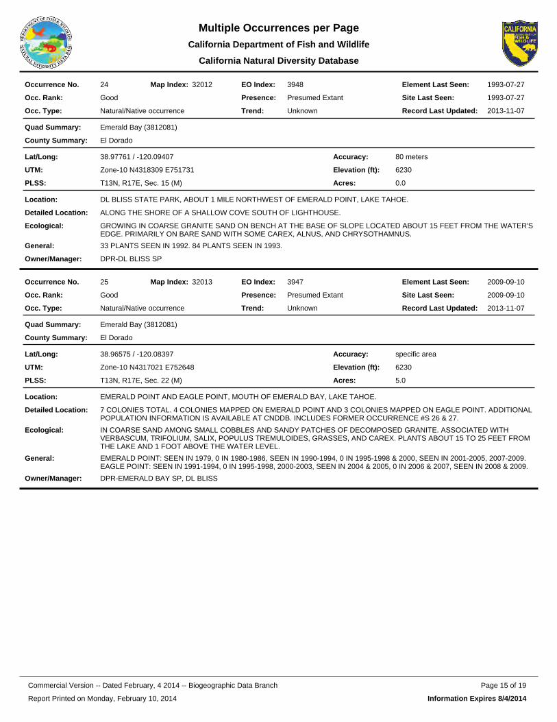
3948EO Index:24Occurrence No. 32012Map Index: 1993-07-27Element Last Seen:
1993-07-27Site Last Seen:GoodOcc. Rank:
Natural/Native occurrenceOcc. Type:
Presumed ExtantPresence:
UnknownTrend: 2013-11-07Record Last Updated:
Emerald Bay (3812081)Quad Summary:
El DoradoCounty Summary:
38.97761 / -120.09407Lat/Long:
Zone-10 N4318309 E751731UTM:
T13N, R17E, Sec. 15 (M)PLSS:
80 metersAccuracy:
6230Elevation (ft):
0.0Acres:
DL BLISS STATE PARK, ABOUT 1 MILE NORTHWEST OF EMERALD POINT, LAKE TAHOE.Location:
ALONG THE SHORE OF A SHALLOW COVE SOUTH OF LIGHTHOUSE.Detailed Location:
GROWING IN COARSE GRANITE SAND ON BENCH AT THE BASE OF SLOPE LOCATED ABOUT 15 FEET FROM THE WATER'SEDGE. PRIMARILY ON BARE SAND WITH SOME CAREX, ALNUS, AND CHRYSOTHAMNUS.
Ecological:
33 PLANTS SEEN IN 1992. 84 PLANTS SEEN IN 1993.General:
DPR-DL BLISS SPOwner/Manager:
3947EO Index:25Occurrence No. 32013Map Index: 2009-09-10Element Last Seen:
2009-09-10Site Last Seen:GoodOcc. Rank:
Natural/Native occurrenceOcc. Type:
Presumed ExtantPresence:
UnknownTrend: 2013-11-07Record Last Updated:
Emerald Bay (3812081)Quad Summary:
El DoradoCounty Summary:
38.96575 / -120.08397Lat/Long:
Zone-10 N4317021 E752648UTM:
T13N, R17E, Sec. 22 (M)PLSS:
specific areaAccuracy:
6230Elevation (ft):
5.0Acres:
EMERALD POINT AND EAGLE POINT, MOUTH OF EMERALD BAY, LAKE TAHOE.Location:
7 COLONIES TOTAL. 4 COLONIES MAPPED ON EMERALD POINT AND 3 COLONIES MAPPED ON EAGLE POINT. ADDITIONAL POPULATION INFORMATION IS AVAILABLE AT CNDDB. INCLUDES FORMER OCCURRENCE #S 26 & 27.
Detailed Location:
IN COARSE SAND AMONG SMALL COBBLES AND SANDY PATCHES OF DECOMPOSED GRANITE. ASSOCIATED WITH VERBASCUM, TRIFOLIUM, SALIX, POPULUS TREMULOIDES, GRASSES, AND CAREX. PLANTS ABOUT 15 TO 25 FEET FROM THE LAKE AND 1 FOOT ABOVE THE WATER LEVEL.
Ecological:
EMERALD POINT: SEEN IN 1979, 0 IN 1980-1986, SEEN IN 1990-1994, 0 IN 1995-1998 & 2000, SEEN IN 2001-2005, 2007-2009. EAGLE POINT: SEEN IN 1991-1994, 0 IN 1995-1998, 2000-2003, SEEN IN 2004 & 2005, 0 IN 2006 & 2007, SEEN IN 2008 & 2009.
General:
DPR-EMERALD BAY SP, DL BLISSOwner/Manager:
Report Printed on Monday, February 10, 2014
Page 15 of 19Commercial Version -- Dated February, 4 2014 -- Biogeographic Data Branch
Information Expires 8/4/2014
Multiple Occurrences per PageCalifornia Department of Fish and
California Natural Diversity Database
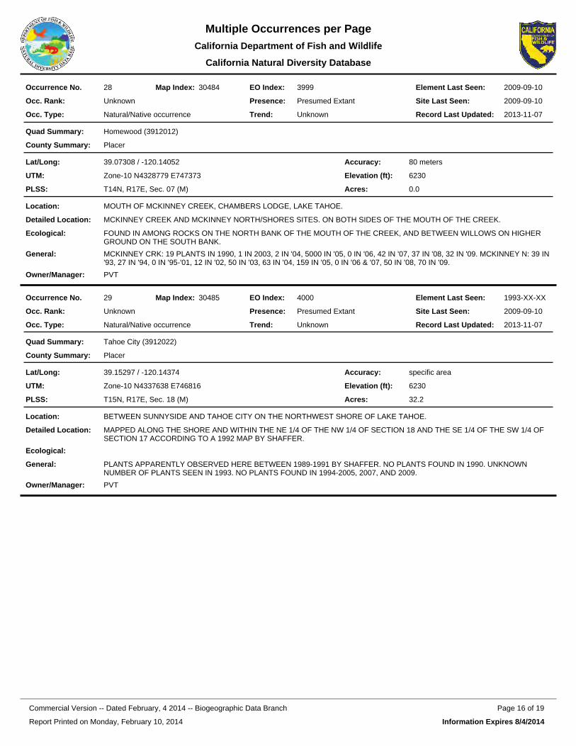
3999EO Index:28Occurrence No. 30484Map Index: 2009-09-10Element Last Seen:
2009-09-10Site Last Seen:UnknownOcc. Rank:
Natural/Native occurrenceOcc. Type:
Presumed ExtantPresence:
UnknownTrend: 2013-11-07Record Last Updated:
Homewood (3912012)Quad Summary:
PlacerCounty Summary:
39.07308 / -120.14052Lat/Long:
Zone-10 N4328779 E747373UTM:
T14N, R17E, Sec. 07 (M)PLSS:
80 metersAccuracy:
6230Elevation (ft):
0.0Acres:
MOUTH OF MCKINNEY CREEK, CHAMBERS LODGE, LAKE TAHOE.Location:
MCKINNEY CREEK AND MCKINNEY NORTH/SHORES SITES. ON BOTH SIDES OF THE MOUTH OF THE CREEK.Detailed Location:
FOUND IN AMONG ROCKS ON THE NORTH BANK OF THE MOUTH OF THE CREEK, AND BETWEEN WILLOWS ON HIGHER GROUND ON THE SOUTH BANK.
Ecological:
MCKINNEY CRK: 19 PLANTS IN 1990, 1 IN 2003, 2 IN '04, 5000 IN '05, 0 IN '06, 42 IN '07, 37 IN '08, 32 IN '09. MCKINNEY N: 39 IN '93, 27 IN '94, 0 IN '95-'01, 12 IN '02, 50 IN '03, 63 IN '04, 159 IN '05, 0 IN '06 & '07, 50 IN '08, 70 IN '09.
General:
PVTOwner/Manager:
4000EO Index:29Occurrence No. 30485Map Index: 1993-XX-XXElement Last Seen:
2009-09-10Site Last Seen:UnknownOcc. Rank:
Natural/Native occurrenceOcc. Type:
Presumed ExtantPresence:
UnknownTrend: 2013-11-07Record Last Updated:
Tahoe City (3912022)Quad Summary:
PlacerCounty Summary:
39.15297 / -120.14374Lat/Long:
Zone-10 N4337638 E746816UTM:
T15N, R17E, Sec. 18 (M)PLSS:
specific areaAccuracy:
6230Elevation (ft):
32.2Acres:
BETWEEN SUNNYSIDE AND TAHOE CITY ON THE NORTHWEST SHORE OF LAKE TAHOE.Location:
MAPPED ALONG THE SHORE AND WITHIN THE NE 1/4 OF THE NW 1/4 OF SECTION 18 AND THE SE 1/4 OF THE SW 1/4 OF SECTION 17 ACCORDING TO A 1992 MAP BY SHAFFER.
Detailed Location:
Ecological:
PLANTS APPARENTLY OBSERVED HERE BETWEEN 1989-1991 BY SHAFFER. NO PLANTS FOUND IN 1990. UNKNOWN NUMBER OF PLANTS SEEN IN 1993. NO PLANTS FOUND IN 1994-2005, 2007, AND 2009.
General:
PVTOwner/Manager:
Report Printed on Monday, February 10, 2014
Page 16 of 19Commercial Version -- Dated February, 4 2014 -- Biogeographic Data Branch
Information Expires 8/4/2014
Multiple Occurrences per PageCalifornia Department of Fish and
California Natural Diversity Database
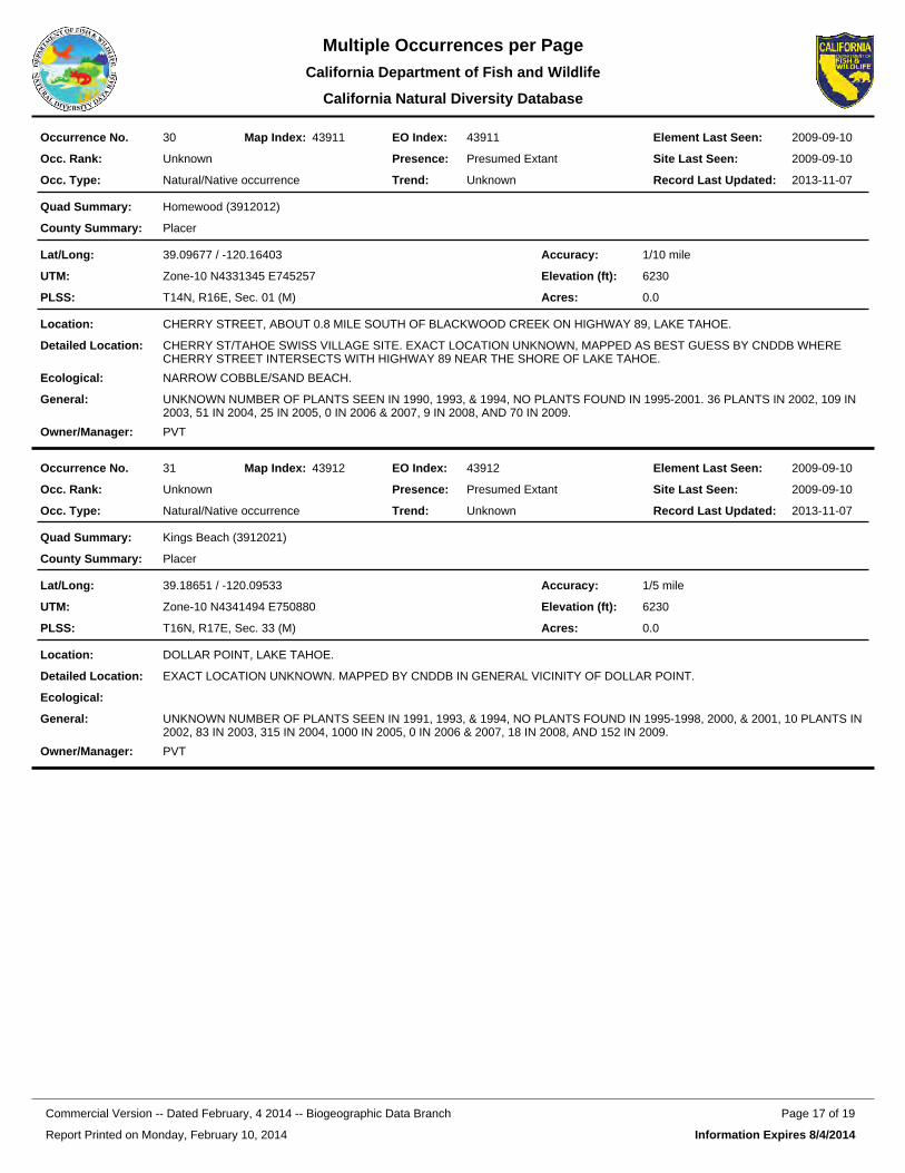
43911EO Index:30Occurrence No. 43911Map Index: 2009-09-10Element Last Seen:
2009-09-10Site Last Seen:UnknownOcc. Rank:
Natural/Native occurrenceOcc. Type:
Presumed ExtantPresence:
UnknownTrend: 2013-11-07Record Last Updated:
Homewood (3912012)Quad Summary:
PlacerCounty Summary:
39.09677 / -120.16403Lat/Long:
Zone-10 N4331345 E745257UTM:
T14N, R16E, Sec. 01 (M)PLSS:
1/10 mileAccuracy:
6230Elevation (ft):
0.0Acres:
CHERRY STREET, ABOUT 0.8 MILE SOUTH OF BLACKWOOD CREEK ON HIGHWAY 89, LAKE TAHOE.Location:
CHERRY ST/TAHOE SWISS VILLAGE SITE. EXACT LOCATION UNKNOWN, MAPPED AS BEST GUESS BY CNDDB WHERE CHERRY STREET INTERSECTS WITH HIGHWAY 89 NEAR THE SHORE OF LAKE TAHOE.
Detailed Location:
NARROW COBBLE/SAND BEACH.Ecological:
UNKNOWN NUMBER OF PLANTS SEEN IN 1990, 1993, & 1994, NO PLANTS FOUND IN 1995-2001. 36 PLANTS IN 2002, 109 IN 2003, 51 IN 2004, 25 IN 2005, 0 IN 2006 & 2007, 9 IN 2008, AND 70 IN 2009.
General:
PVTOwner/Manager:
43912EO Index:31Occurrence No. 43912Map Index: 2009-09-10Element Last Seen:
2009-09-10Site Last Seen:UnknownOcc. Rank:
Natural/Native occurrenceOcc. Type:
Presumed ExtantPresence:
UnknownTrend: 2013-11-07Record Last Updated:
Kings Beach (3912021)Quad Summary:
PlacerCounty Summary:
39.18651 / -120.09533Lat/Long:
Zone-10 N4341494 E750880UTM:
T16N, R17E, Sec. 33 (M)PLSS:
1/5 mileAccuracy:
6230Elevation (ft):
0.0Acres:
DOLLAR POINT, LAKE TAHOE.Location:
EXACT LOCATION UNKNOWN. MAPPED BY CNDDB IN GENERAL VICINITY OF DOLLAR POINT.Detailed Location:
Ecological:
UNKNOWN NUMBER OF PLANTS SEEN IN 1991, 1993, & 1994, NO PLANTS FOUND IN 1995-1998, 2000, & 2001, 10 PLANTS IN 2002, 83 IN 2003, 315 IN 2004, 1000 IN 2005, 0 IN 2006 & 2007, 18 IN 2008, AND 152 IN 2009.
General:
PVTOwner/Manager:
Report Printed on Monday, February 10, 2014
Page 17 of 19Commercial Version -- Dated February, 4 2014 -- Biogeographic Data Branch
Information Expires 8/4/2014
Multiple Occurrences per PageCalifornia Department of Fish and
California Natural Diversity Database
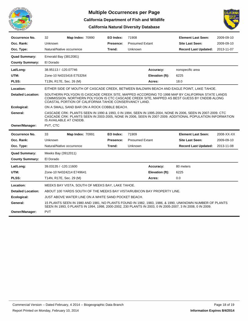
71908EO Index:32Occurrence No. 70990Map Index: 2009-09-10Element Last Seen:
2009-09-10Site Last Seen:UnknownOcc. Rank:
Natural/Native occurrenceOcc. Type:
Presumed ExtantPresence:
UnknownTrend: 2013-11-07Record Last Updated:
Emerald Bay (3812081)Quad Summary:
El DoradoCounty Summary:
38.95113 / -120.07746Lat/Long:
Zone-10 N4315416 E753264UTM:
T13N, R17E, Sec. 26 (M)PLSS:
nonspecific areaAccuracy:
6225Elevation (ft):
18.0Acres:
EITHER SIDE OF MOUTH OF CASCADE CREEK, BETWEEN BALDWIN BEACH AND EAGLE POINT, LAKE TAHOE.Location:
SOUTHERN POLYGON IS CASCADE CREEK SITE, MAPPED ACCORDING TO 1998 MAP BY CALIFORNIA STATE LANDS COMMISSION. NORTHERN POLYGON IS CTC CASCADE CREEK SITE, MAPPED AS BEST GUESS BY CNDDB ALONG COASTAL PORTION OF CALIFORNIA TAHOE CONSERVANCY LAND.
Detailed Location:
ON A SMALL SAND BAR ON A ROCK COBBLE BEACH.Ecological:
CASCADE CRK: PLANTS SEEN IN 1990 & 1993, 0 IN 1994, SEEN IN 1995-2004, NONE IN 2006, SEEN IN 2007-2009. CTC CASCADE CRK: PLANTS SEEN IN 2003-2005, NONE IN 2006, SEEN IN 2007-2009. ADDITIONAL POPULATION INFORMATION IS AVAILABLE AT CNDDB.
General:
PVT, CTCOwner/Manager:
71909EO Index:33Occurrence No. 70991Map Index: 2008-XX-XXElement Last Seen:
2009-09-10Site Last Seen:UnknownOcc. Rank:
Natural/Native occurrenceOcc. Type:
Presumed ExtantPresence:
UnknownTrend: 2013-11-08Record Last Updated:
Meeks Bay (3912011)Quad Summary:
El DoradoCounty Summary:
39.03135 / -120.11600Lat/Long:
Zone-10 N4324214 E749641UTM:
T14N, R17E, Sec. 29 (M)PLSS:
80 metersAccuracy:
6225Elevation (ft):
0.0Acres:
MEEKS BAY VISTA, SOUTH OF MEEKS BAY, LAKE TAHOE.Location:
ABOUT 100 YARDS SOUTH OF THE MEEKS BAY VISTA/RUBICON BAY PROPERTY LINE.Detailed Location:
JUST ABOVE WATER LINE ON A WHITE SAND POCKET BEACH.Ecological:
15 PLANTS SEEN IN 1980 AND 1981, NO PLANTS FOUND IN 1982, 1983, 1986, & 1990, UNKNOWN NUMBER OF PLANTS SEEN IN 1993, 0 PLANTS IN 1994, 1998, 2000-2002, 230 PLANTS IN 2003, 0 IN 2005-2007, 3 IN 2008, 0 IN 2009.
General:
PVTOwner/Manager:
Report Printed on Monday, February 10, 2014
Page 18 of 19Commercial Version -- Dated February, 4 2014 -- Biogeographic Data Branch
Information Expires 8/4/2014
Multiple Occurrences per PageCalifornia Department of Fish and
California Natural Diversity Database
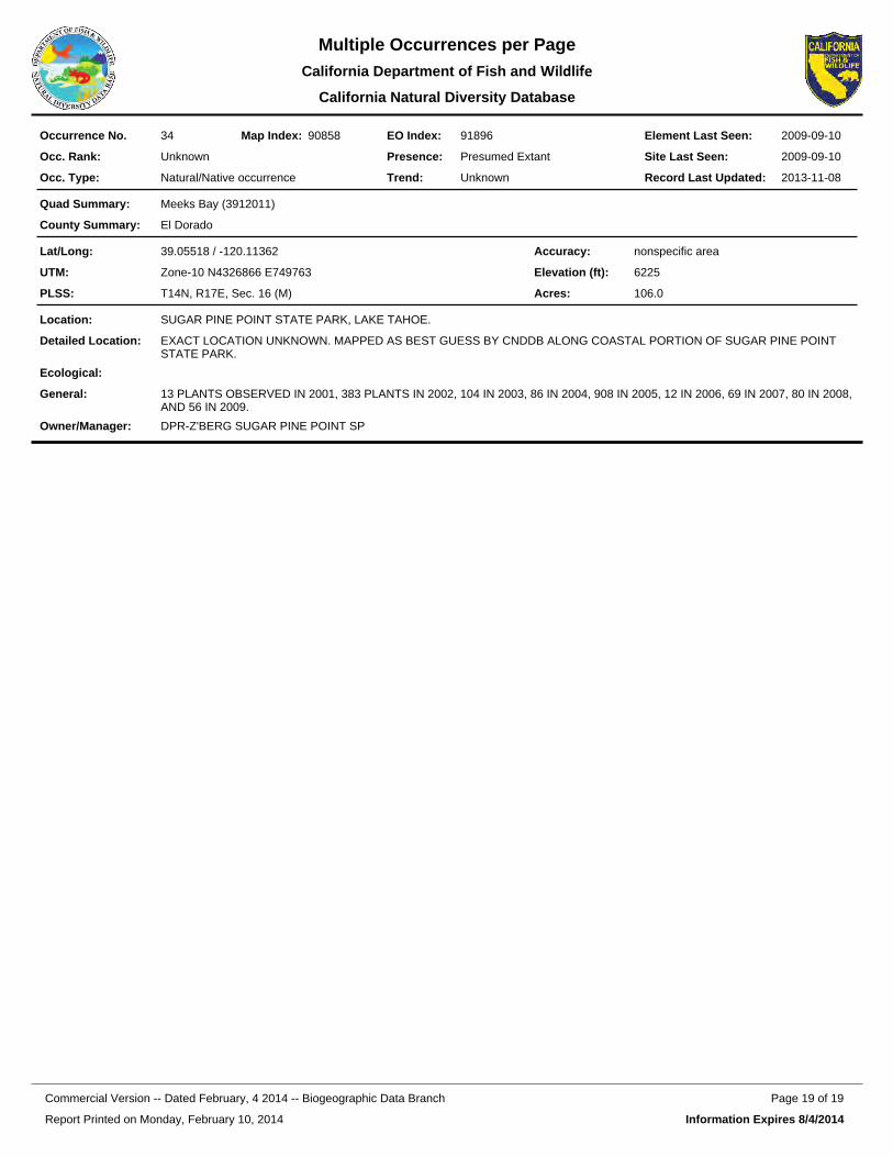
91896EO Index:34Occurrence No. 90858Map Index: 2009-09-10Element Last Seen:
2009-09-10Site Last Seen:UnknownOcc. Rank:
Natural/Native occurrenceOcc. Type:
Presumed ExtantPresence:
UnknownTrend: 2013-11-08Record Last Updated:
Meeks Bay (3912011)Quad Summary:
El DoradoCounty Summary:
39.05518 / -120.11362Lat/Long:
Zone-10 N4326866 E749763UTM:
T14N, R17E, Sec. 16 (M)PLSS:
nonspecific areaAccuracy:
6225Elevation (ft):
106.0Acres:
SUGAR PINE POINT STATE PARK, LAKE TAHOE.Location:
EXACT LOCATION UNKNOWN. MAPPED AS BEST GUESS BY CNDDB ALONG COASTAL PORTION OF SUGAR PINE POINT STATE PARK.
Detailed Location:
Ecological:
13 PLANTS OBSERVED IN 2001, 383 PLANTS IN 2002, 104 IN 2003, 86 IN 2004, 908 IN 2005, 12 IN 2006, 69 IN 2007, 80 IN 2008, AND 56 IN 2009.
General:
DPR-Z'BERG SUGAR PINE POINT SPOwner/Manager:
Report Printed on Monday, February 10, 2014
Page 19 of 19Commercial Version -- Dated February, 4 2014 -- Biogeographic Data Branch
Information Expires 8/4/2014
Multiple Occurrences per PageCalifornia Department of Fish and
California Natural Diversity Database
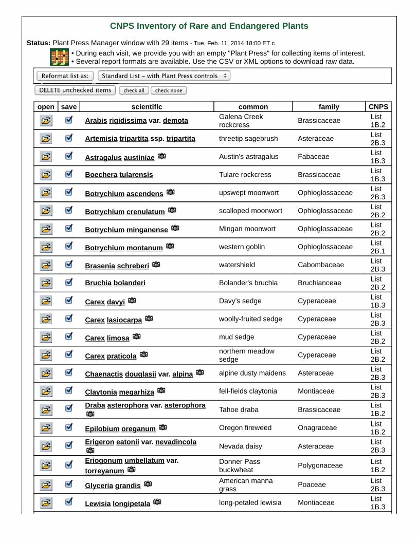
CNPS Inventory of Rare and Endangered Plants
Status: Plant Press Manager window with 29 items - Tue, Feb. 11, 2014 18:00 ET c • During each visit, we provide you with an empty "Plant Press" for collecting items of interest. • Several report formats are available. Use the CSV or XML options to download raw data.
Reformat list as: Standard List - with Plant Press controls
DELETE unchecked items check all check none
open save scientific common family CNPS
Arabis rigidissima var. demota Galena Creekrockcress Brassicaceae List
1B.2
Artemisia tripartita ssp. tripartita threetip sagebrush Asteraceae List2B.3
Astragalus austiniae Austin's astragalus Fabaceae List1B.3
Boechera tularensis Tulare rockcress Brassicaceae List1B.3
Botrychium ascendens upswept moonwort Ophioglossaceae List2B.3
Botrychium crenulatum scalloped moonwort Ophioglossaceae List2B.2
Botrychium minganense Mingan moonwort Ophioglossaceae List2B.2
Botrychium montanum western goblin Ophioglossaceae List2B.1
Brasenia schreberi watershield Cabombaceae List2B.3
Bruchia bolanderi Bolander's bruchia Bruchianceae List2B.2
Carex davyi Davy's sedge Cyperaceae List1B.3
Carex lasiocarpa woolly-fruited sedge Cyperaceae List2B.3
Carex limosa mud sedge Cyperaceae List2B.2
Carex praticola northern meadowsedge Cyperaceae List
2B.2
Chaenactis douglasii var. alpina alpine dusty maidens Asteraceae List2B.3
Claytonia megarhiza fell-fields claytonia Montiaceae List2B.3
Draba asterophora var. asterophora Tahoe draba Brassicaceae List1B.2
Epilobium oreganum Oregon fireweed Onagraceae List1B.2
Erigeron eatonii var. nevadincola Nevada daisy Asteraceae List2B.3
Eriogonum umbellatum var.torreyanum
Donner Passbuckwheat Polygonaceae List
1B.2
Glyceria grandis American mannagrass Poaceae List
2B.3
Lewisia longipetala long-petaled lewisia Montiaceae List1B.3
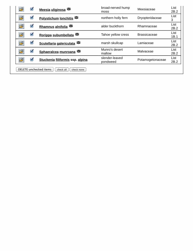
Meesia uliginosa broad-nerved humpmoss
Meesiaceae List2B.2
Polystichum lonchitis northern holly fern Dryopteridaceae List3
Rhamnus alnifolia alder buckthorn Rhamnaceae List2B.2
Rorippa subumbellata Tahoe yellow cress Brassicaceae List1B.1
Scutellaria galericulata marsh skullcap Lamiaceae List2B.2
Sphaeralcea munroana Munro's desertmallow Malvaceae List
2B.2
Stuckenia filiformis ssp. alpina slender-leavedpondweed Potamogetonaceae List
2B.2
DELETE unchecked items check all check none
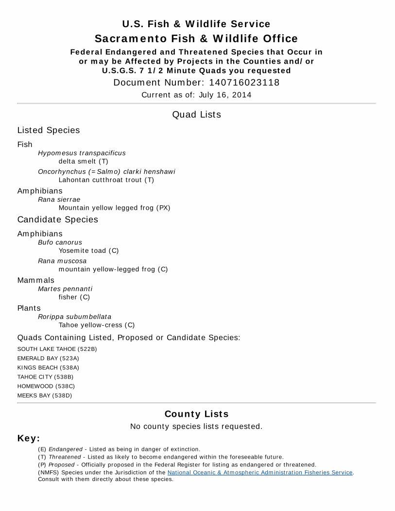
U.S. Fish & Wildlife ServiceSacramento Fish & Wildlife Office
Federal Endangered and Threatened Species that Occur inor may be Affected by Projects in the Counties and/or
U.S.G.S. 7 1/2 Minute Quads you requestedDocument Number: 140716023118
Current as of: July 16, 2014
Quad ListsListed SpeciesFish
Hypomesus transpacificusdelta smelt (T)
Oncorhynchus (=Salmo) clarki henshawiLahontan cutthroat trout (T)
AmphibiansRana sierrae
Mountain yellow legged frog (PX)
Candidate SpeciesAmphibians
Bufo canorusYosemite toad (C)
Rana muscosamountain yellow-legged frog (C)
MammalsMartes pennanti
fisher (C) Plants
Rorippa subumbellataTahoe yellow-cress (C)
Quads Containing Listed, Proposed or Candidate Species:SOUTH LAKE TAHOE (522B) EMERALD BAY (523A) KINGS BEACH (538A) TAHOE CITY (538B) HOMEWOOD (538C) MEEKS BAY (538D)
County ListsNo county species lists requested.
Key:(E) Endangered - Listed as being in danger of extinction.(T) Threatened - Listed as likely to become endangered within the foreseeable future.(P) Proposed - Officially proposed in the Federal Register for listing as endangered or threatened.(NMFS) Species under the Jurisdiction of the National Oceanic & Atmospheric Administration Fisheries Service.Consult with them directly about these species.
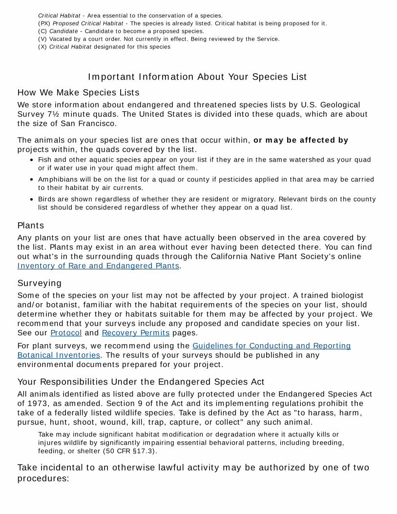
Critical Habitat - Area essential to the conservation of a species.(PX) Proposed Critical Habitat - The species is already listed. Critical habitat is being proposed for it.(C) Candidate - Candidate to become a proposed species.(V) Vacated by a court order. Not currently in effect. Being reviewed by the Service.(X) Critical Habitat designated for this species
Important Information About Your Species ListHow We Make Species ListsWe store information about endangered and threatened species lists by U.S. GeologicalSurvey 7½ minute quads. The United States is divided into these quads, which are aboutthe size of San Francisco.
The animals on your species list are ones that occur within, or may be affected byprojects within, the quads covered by the list.
Fish and other aquatic species appear on your list if they are in the same watershed as your quador if water use in your quad might affect them.Amphibians will be on the list for a quad or county if pesticides applied in that area may be carriedto their habitat by air currents.Birds are shown regardless of whether they are resident or migratory. Relevant birds on the countylist should be considered regardless of whether they appear on a quad list.
PlantsAny plants on your list are ones that have actually been observed in the area covered bythe list. Plants may exist in an area without ever having been detected there. You can findout what's in the surrounding quads through the California Native Plant Society's onlineInventory of Rare and Endangered Plants.
SurveyingSome of the species on your list may not be affected by your project. A trained biologistand/or botanist, familiar with the habitat requirements of the species on your list, shoulddetermine whether they or habitats suitable for them may be affected by your project. Werecommend that your surveys include any proposed and candidate species on your list.See our Protocol and Recovery Permits pages.For plant surveys, we recommend using the Guidelines for Conducting and ReportingBotanical Inventories. The results of your surveys should be published in anyenvironmental documents prepared for your project.
Your Responsibilities Under the Endangered Species ActAll animals identified as listed above are fully protected under the Endangered Species Actof 1973, as amended. Section 9 of the Act and its implementing regulations prohibit thetake of a federally listed wildlife species. Take is defined by the Act as "to harass, harm,pursue, hunt, shoot, wound, kill, trap, capture, or collect" any such animal.
Take may include significant habitat modification or degradation where it actually kills orinjures wildlife by significantly impairing essential behavioral patterns, including breeding,feeding, or shelter (50 CFR §17.3).
Take incidental to an otherwise lawful activity may be authorized by one of twoprocedures:
If a Federal agency is involved with the permitting, funding, or carrying out of a project that mayresult in take, then that agency must engage in a formal consultation with the Service.During formal consultation, the Federal agency, the applicant and the Service work together toavoid or minimize the impact on listed species and their habitat. Such consultation would result ina biological opinion by the Service addressing the anticipated effect of the project on listed andproposed species. The opinion may authorize a limited level of incidental take.If no Federal agency is involved with the project, and federally listed species may be taken as partof the project, then you, the applicant, should apply for an incidental take permit. The Service mayissue such a permit if you submit a satisfactory conservation plan for the species that would beaffected by your project.Should your survey determine that federally listed or proposed species occur in the area and arelikely to be affected by the project, we recommend that you work with this office and the CaliforniaDepartment of Fish and Game to develop a plan that minimizes the project's direct and indirectimpacts to listed species and compensates for project-related loss of habitat. You should includethe plan in any environmental documents you file.
Critical HabitatWhen a species is listed as endangered or threatened, areas of habitat considered essentialto its conservation may be designated as critical habitat. These areas may require specialmanagement considerations or protection. They provide needed space for growth andnormal behavior; food, water, air, light, other nutritional or physiological requirements;cover or shelter; and sites for breeding, reproduction, rearing of offspring, germination orseed dispersal.Although critical habitat may be designated on private or State lands, activities on theselands are not restricted unless there is Federal involvement in the activities or direct harmto listed wildlife.If any species has proposed or designated critical habitat within a quad, there will be aseparate line for this on the species list. Boundary descriptions of the critical habitat maybe found in the Federal Register. The information is also reprinted in the Code of FederalRegulations (50 CFR 17.95). See our Map Room page.
Candidate SpeciesWe recommend that you address impacts to candidate species. We put plants and animalson our candidate list when we have enough scientific information to eventually proposethem for listing as threatened or endangered. By considering these species early in yourplanning process you may be able to avoid the problems that could develop if one of thesecandidates was listed before the end of your project.
Species of ConcernThe Sacramento Fish & Wildlife Office no longer maintains a list of species of concern.However, various other agencies and organizations maintain lists of at-risk species. Theselists provide essential information for land management planning and conservation efforts.More info
WetlandsIf your project will impact wetlands, riparian habitat, or other jurisdictional waters asdefined by section 404 of the Clean Water Act and/or section 10 of the Rivers and HarborsAct, you will need to obtain a permit from the U.S. Army Corps of Engineers. Impacts towetland habitats require site specific mitigation and monitoring. For questions regardingwetlands, please contact Mark Littlefield of this office at (916) 414-6520.

UpdatesOur database is constantly updated as species are proposed, listed and delisted. If youaddress proposed and candidate species in your planning, this should not be a problem.However, we recommend that you get an updated list every 90 days. That would beOctober 14, 2014.
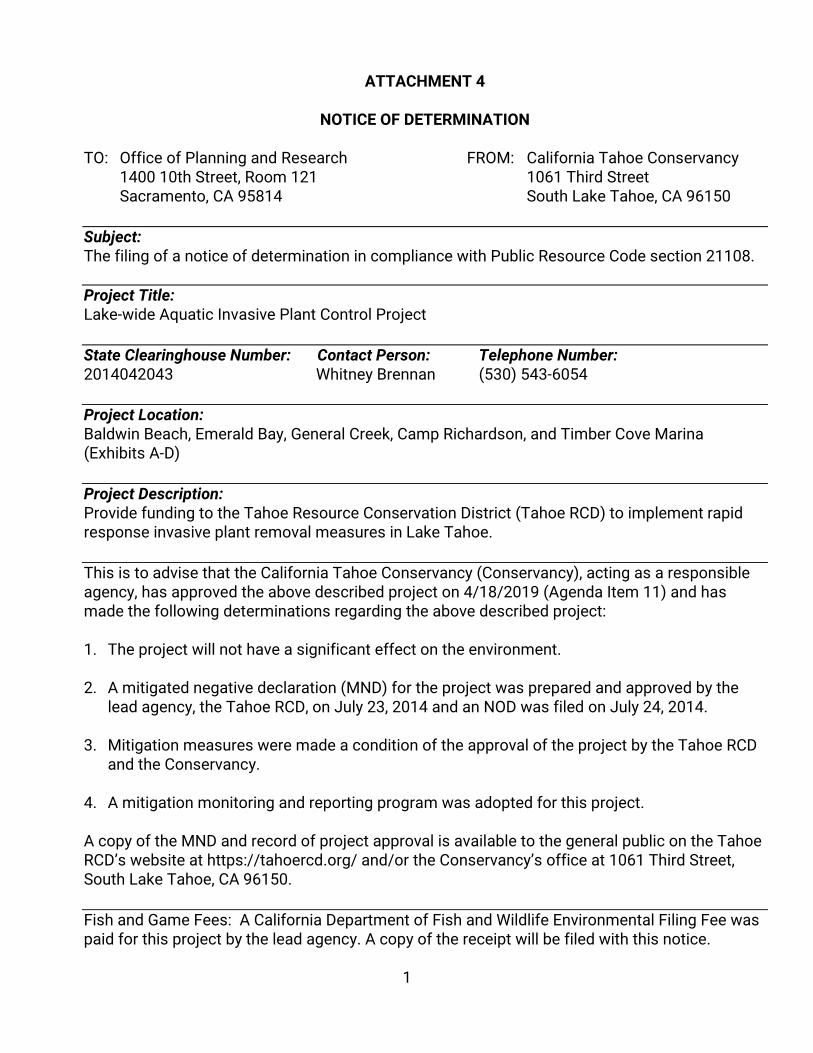
1
ATTACHMENT 4
NOTICE OF DETERMINATION
TO: Office of Planning and Research FROM: California Tahoe Conservancy 1400 10th Street, Room 121 1061 Third Street Sacramento, CA 95814 South Lake Tahoe, CA 96150 Subject: The filing of a notice of determination in compliance with Public Resource Code section 21108. Project Title: Lake-wide Aquatic Invasive Plant Control Project State Clearinghouse Number: Contact Person: Telephone Number: 2014042043 Whitney Brennan (530) 543-6054 Project Location: Baldwin Beach, Emerald Bay, General Creek, Camp Richardson, and Timber Cove Marina (Exhibits A-D) Project Description: Provide funding to the Tahoe Resource Conservation District (Tahoe RCD) to implement rapid response invasive plant removal measures in Lake Tahoe. This is to advise that the California Tahoe Conservancy (Conservancy), acting as a responsible agency, has approved the above described project on 4/18/2019 (Agenda Item 11) and has made the following determinations regarding the above described project: 1. The project will not have a significant effect on the environment. 2. A mitigated negative declaration (MND) for the project was prepared and approved by the
lead agency, the Tahoe RCD, on July 23, 2014 and an NOD was filed on July 24, 2014.
3. Mitigation measures were made a condition of the approval of the project by the Tahoe RCD and the Conservancy.
4. A mitigation monitoring and reporting program was adopted for this project. A copy of the MND and record of project approval is available to the general public on the Tahoe RCD’s website at https://tahoercd.org/ and/or the Conservancy’s office at 1061 Third Street, South Lake Tahoe, CA 96150. Fish and Game Fees: A California Department of Fish and Wildlife Environmental Filing Fee was paid for this project by the lead agency. A copy of the receipt will be filed with this notice.

2
Date Received for Filing: ________________________________________ Patrick Wright Executive Director
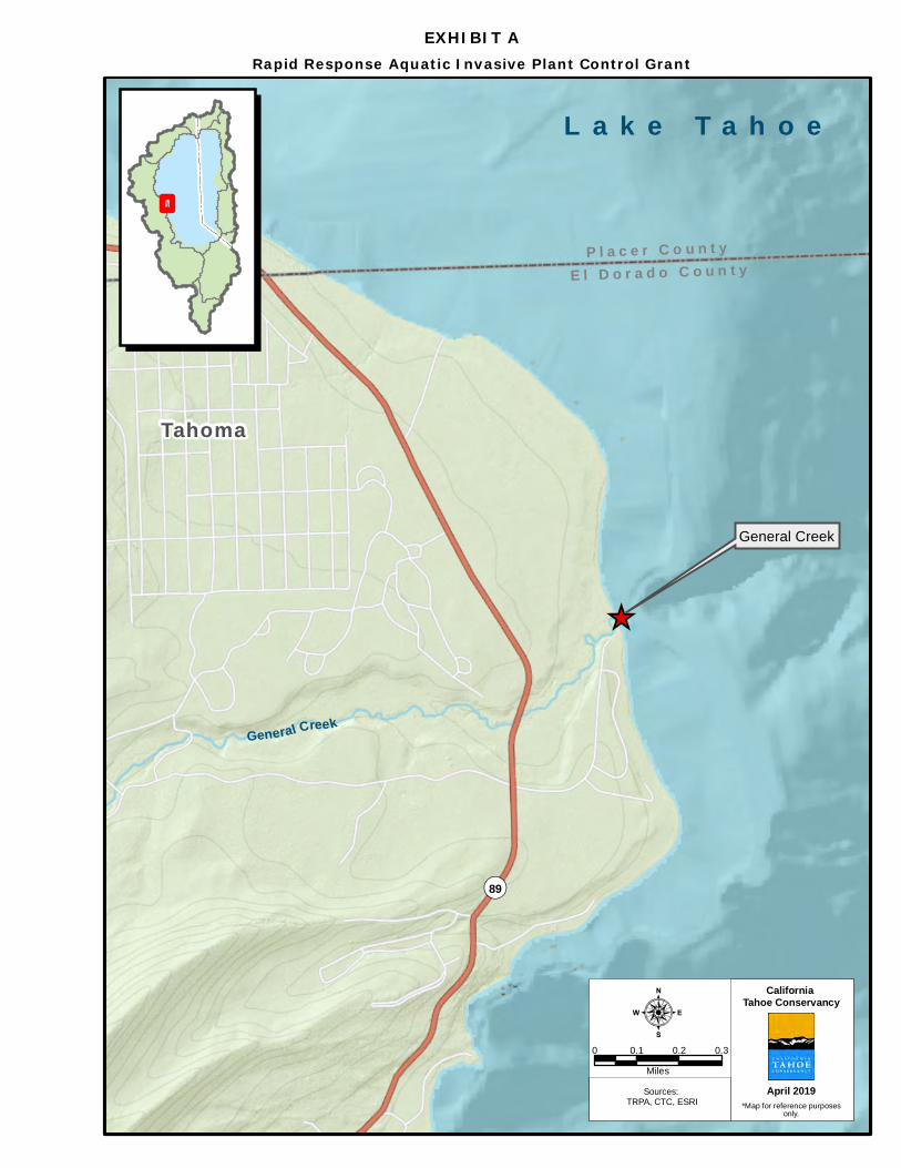
_̂
EXHIBIT ARapid Response Aquatic Invasive Plant Control Grant
¬«89
0 0.1 0.2 0.3
Miles
:Sources:
TRPA, CTC, ESRI
California Tahoe Conservancy
*Map for reference purposesonly.
April 2019
L a k e T a h o e
General Creek
P l a c e r C o u n t yE l D o r a d o C o u n t y
Tahoma
General Creek
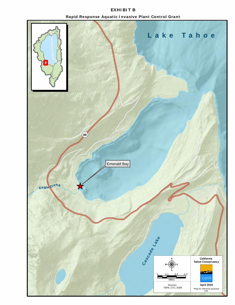
_̂
EXHIBIT BRapid Response Aquatic Invasive Plant Control Grant
¬«89
0 0.1 0.2 0.3
Miles
:Sources:
TRPA, CTC, ESRI
California Tahoe Conservancy
*Map for reference purposesonly.
April 2019
L a k e T a h o e
Emerald Bay
Casc
ade L
ake
Eagl e Creek
_̂
_̂
EXHIBIT CRapid Response Aquatic Invasive Plant Control Grant
¬«89
0 0.1 0.2 0.3
Miles
:Sources:
TRPA, CTC, ESRI
California Tahoe Conservancy
*Map for reference purposesonly.
April 2019
L a k e T a h o e
Camp Richardson
Fallen LeafLake
Tahoe Mountain
Taylor C reek
Baldwin Beach
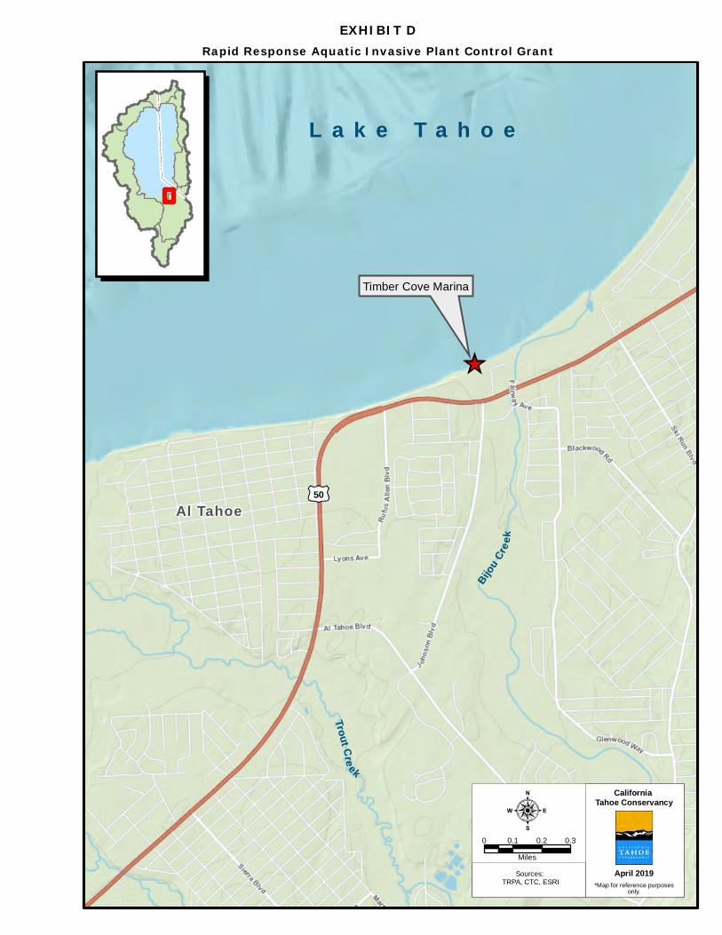
_̂
EXHIBIT DRapid Response Aquatic Invasive Plant Control Grant
£¤50
0 0.1 0.2 0.3
Miles
:Sources:
TRPA, CTC, ESRI
California Tahoe Conservancy
*Map for reference purposesonly.
April 2019
L a k e T a h o e
Timber Cove Marina
Al Tahoe
Trout Cre ek
Bijou Cr
e ek
California Tahoe Conservancy Agenda Item 12.a
April 18, 2019
POTENTIAL AGENDA ITEMS FOR THE JUNE 20 BOARD MEETING
Staff is seeking input from the Board regarding the agenda items for the June 20, 2019 Board meeting. A tentative list of agenda items beyond the normal standing items includes:
• Fiscal Year 2019/2020 Annual Program Budget Authorization (resolution) • Oflying Erosion Control Project License Agreement (resolution) • Alta Mira Public Access Project (resolution) • Draft Proposition 68 Funding Guidelines (discussion only) • Environmental Improvement Program Update (discussion only) • Kings Beach Asset Lands Pre-Sale Activities (resolution) • Kings Beach Asset Lands Tour (discussion only)
Conservancy Staff Contacts Patrick Wright [email protected] Jane Freeman [email protected]