usgs dds-43, lake tahoe case study
TRANSCRIPT
217
Sierra Nevada Ecosystem Project: Final report to Congress, Addendum. Davis: University of California, Centers for Water and Wildland Resources, 1996.
7
Lake Tahoe Case Study
DEBORAH L. ELLIOTT-FISKDepartment of Wildlife, Fish and
Conservation BiologyUniversity of California, Davis, CA
THOMAS C. CAHILLAir Quality Group, Crocker Nuclear
LaboratoryUniversity of California, Davis, CA
OWEN K. DAVISDepartment of Geosciences,University of Arizona, Tucson, AZ
LIAN DUANSierra Nevada Ecosystem Project CenterUniversity of California, Davis, CA
CHARLES R. GOLDMANDivision of Environmental StudiesUniversity of California, Davis, CA
GEORGE E. GRUELLRetired U.S.D.A. Forest Service,
Consulting Wildlife EcologistCarson City, NV
INTRODUCTION
The Sierra Nevada Ecosystem Project (SNEP) selected the LakeTahoe Basin as one of several areas deserving special study,as it believes that we have much to learn from the long-his-tory of human use and scientific study of the Basin’s resources.In addition, there is much policy and management insight togain from studying the continuing evolution of its institutions.Appropriately, our study is written along a chronologicalbackbone, from the past to the present and looking to the fu-ture of Lake Tahoe. It is important to realize that the SNEPstudy includes humans as a full-fledged element within theecosystem, and as such we are interested in various humanuses of the ecosystem, changing cultural attitudes and val-ues, and the evolution of human institutions.
Our understanding of the Lake Tahoe Basin ecosystem isstill evolving, and this report is only a partial description ofwhat we have learned. There is a need to complete a morethorough analysis of the ecosystem’s historical record, whichis “locked” in the sediments of Lake Tahoe, its tributaries,and its forest trees, in archives in written and graphic form,and in the beliefs and information handed down by our an-cestors. Nevertheless, if all extant information were to bebrought together we would have a better, science-based un-derstanding of the history of the Lake Tahoe Basin ecosys-
tem, especially for the last 150 years, than anywhere else inthe Sierra Nevada. During the past thirty-five years, researchhas greatly enhanced our understanding of the relationshipsbetween the dynamics of watershed and atmospheric pro-cesses and water quality. Based on this research, science-basedmanagement has played a greater role in the Lake Tahoe Ba-sin than in any other Sierra Nevada locale.
We also review some of the major legal and policy deci-sions that led to the current regulatory and resource situationat the Lake Tahoe Basin, and discuss what will be the “cost”to continue to restore damage to this ecosystem. Conservinga resource such as the Lake Tahoe Basin is very expensive,time-consuming, and complex because it is a highly disturbedand fragmented watershed due to a history of earlyclearcutting and recent rapid urbanization, and because ofthe pattern of mixed ownership of land. It has required pub-lic support, legislative, judicial, and/or regulatory agency ac-tion, the cooperation of all levels of government, theinvolvement of public and private landowners, the involve-ment of interest groups, an evolving set of regulatory mecha-nisms and actions, acquisition and restoration programs, anda high level of collaboration between all players to conservethis ecosystem. As the environment and our societal needsand values change, this process must be dynamic, flexible andsustainable. Thus, the history of the Lake Tahoe Basin serves
ROBERT HARRISLake Tahoe Basin Management UnitU.S.D.A. Forest Service,
South Lake Tahoe, CA
RICK KATTELMANNSierra Nevada Aquatic
Research LaboratoryUniversity of California,
Santa Barbara, CA
RAY LACEYCalifornia Tahoe ConservancySouth Lake Tahoe, CA
DOUG LEISZRetired U.S.D.A. Forest Service,
Consulting ForesterPlacerville, CA
SUSAN LINDSTROMConsulting ArchaeologistTruckee, CA
DENNIS MACHIDACalifornia Tahoe ConservancySouth Lake Tahoe, CA
ROWAN A. ROWNTREEU.S.D.A., Forest Service,
Northeastern Forest ExperimentStation and Pacific SouthwestResearch Station, Albany, CA
PENNY RUCKSLake Tahoe Basin Management UnitU.S.D.A. Forest Service,
South Lake Tahoe, CA
DEBRA A. SHARKEYSierra Nevada Ecosystem Project CenterUniversity of California, Davis
SCOTT L. STEPHENSDepartment of Environmental
Science, Policy & ManagementUniversity of California, Berkeley, CA, andU.S.D.A., Forest Service, Pacific Southwest
Research Station, Albany, CA
DAVID S. ZIEGLERZiegler TechnicalCarson City, NV
218ADDENDUM
as a valuable and expensive lesson in resource managementwithin a highly sensitive watershed of extraordinary beautyand economic value.
Lake Tahoe has long been recognized as a special place bythe Washoe and earlier Native American peoples, by earlysettlers and explorers, by all levels of government, by conser-vation agencies and organizations, by the millions of peoplewho visit the Basin every year, and in the economic and fiscalinvestments that both help draw people to the Basin and en-able its management. Today, Lake Tahoe’s topographicallybound, watershed ecosystem is regulated on a regional basisunder a bi-state compact between California and Nevadawhich created the Tahoe Regional Planning Agency (TRPA)and cooperatively involves various federal, state, and localagencies and non-profit organizations. As such, the LakeTahoe Basin serves as an historic, evolutionary model withelements of ecosystem management for public and privatelands, and affiliated land acquisition, institutional evolution,and consensus building processes. The “state” or what somemight term “health” of the ecosystem is monitored throughthe regular measurement and analysis of many ecosystemcomponents. No doubt, other ecosystem components couldbe monitored. Nevertheless, land management is evaluatedthrough regular monitoring and reviewed every five years.Restoration activities, resource preservation, land acquisitionprograms, other capital improvements, and regional land-useplanning are some of the means of achieving these thresh-olds1, and in the Lake Tahoe Basin this regional managementis done through strict regional review of permits, ceilings onthe number of permits issued, land coverage regulations, care-ful resource management, restoration projects, and a cautiouseye towards the future in terms of evolving energy, transpor-tation, recreation, housing and other societal needs.
In conducting our evaluation of the Lake Tahoe Basin’secosystem, we were guided by two questions that we hopedwould both inform the other parts of SNEP and contribute tothe long-term health of the Lake Tahoe Basin ecosystem:
• What can SNEP learn from what has been done at LakeTahoe in the ecological assessment, monitoring, consensusbuilding, land-use management and regulation, land ac-quisition and restoration, and policy development arenas?
• What can SNEP recommend as future needs and directionsfor the wise science-based assessment, policy formulation,and resource management of the Lake Tahoe Basin, to sus-tain and improve its ecological health into the future?
While these questions focused on our examination of the LakeTahoe Basin experience, this report does not contain explicitanswers to the questions as stated here. Regarding the firstquestion, the case study team informed other scientists abouthow the Lake Tahoe Basin experience could help the largerSNEP assessment. Regarding the second question, our rec-ommendations are very general and, for the most part, sup-port the process of cooperation, learning, planning andmanagement that is now underway in the Basin.
The case study team recognized the following premises up-front in our assessment:
• The Lake Tahoe Basin is an important local, regional, state,national and international resource; it is one of the largest,deepest, and clearest mountain lakes in the world and isreknown for its scenic beauty; before the turn of the cen-tury, it was discussed as one of the first three potential na-tional parks (i.e., Yosemite, Lake Tahoe and Yellowstone);the major attraction is the large, deep and clear mountainbasin lake and the scenic vistas it provides;
• The deterioration of the Lake Tahoe Basin ecosystem is un-derstood to have begun with the influx of large numbersof early settlers ca. 1870, with near stand-replacement log-ging, alteration of stream courses and flows, resultant ero-sion, loss of native flora from grazing, elimination of nativefisheries, modification of near-shore habitats, and urban-ization and recreational development; little is understoodabout the extent or effects of at least 8,000 years of NativeAmerican resource manipulation;
• The Lake Tahoe Basin has a long history of human conflict,litigation, and policy response targeted at development ver-sus environmental preservation; this history has forced dis-cussion between groups with dissimilar interests and goals,resulting in various efforts to better manage the environ-ment built on productive compromise and cooperation;
• Since the early 1980s, the Lake Tahoe Basin ecosystem hasbeen managed using an integrated resource managementphilosophy, with key thresholds defined for a variety ofecosystem parameters, with these parameters monitored,regulated and reviewed; various on-the-ground compo-nents of this management process still need to be imple-mented;
• The Lake Tahoe Basin ecosystem is still under threat (e.g.,lake water continues to decrease in clarity, parts of the for-est cover are severely stressed by drought, infestation, andother factors, and air pollution continues to be a concern),the full range of human concerns for the biophysical andhuman systems are present here (e.g., community well-being, recreation, economic redevelopment, invasion ofexotic organisms, wildfire risk, water quality deterioration);
• Continued analysis and discussion are needed to defineadditional key scientific data needs and monitoring andrestoration opportunities; key issues of concern include wa-tershed restoration, erosion, forest fuels reduction and veg-etation management, wildlife viability and habitatsuitability, and urban-wildland interfere processes; someof these are addressed in other SNEP assessment reports;
• The Lake Tahoe Basin ecosystem provides a window to thefuture of planning and management of other Sierra Ne-vada ecosystems in terms of multiple stress, participatoryplanning, financing, jurisdictional cooperation, and efficacyof efforts.
219Lake Tahoe Case Study
METHODS EMPLOYED IN THE CASESTUDY DEVELOPMENT
The case study team followed the specific charge given toSNEP as outlined in our May, 1994 Sierra Nevada EcosystemProject Progress Report, which set a framework for address-ing questions and conducting tasks within the project. AllSNEP-wide tasks in ecosystem assessment and policy analy-sis were undertaken in the Lake Tahoe case study and struc-tured as follows:
1. Assessment of current and historic ecosystem conditions andtrends—Our science-based ecosystem assessment (bio-physical and human dimensions) is portrayed in the sec-tion titled “Ecosystem Assessment” of this report. Weconducted an overview of existing data, as best as pos-sible, with limited time and funding, on the historical andcurrent conditions of the ecosystem’s biophysical elements,as well as on changing human uses and needs (i.e., hu-man elements). The purpose was to portray where theBasin ecosystem has been and where it is likely going. Wealso inventoried and identified the locations of key data,including time-series monitoring data, historical photo-graphs, and geographic information system (GIS) layers,and collected and centralized as many of these data aspossible in the SNEP GIS (ARC/Info, Unix-based). In theprocess of data compilation, we compiled a digital bibli-ography (using the bibliographic database programEndNote 2) of over 1,200 references. All of this digital in-formation is available through SNEP. The SNEP ARC/Info GIS is available through (1) the Alexandria project atUC Santa Barbara (http://alexandria.sdc.ucsb.edu), (2) theUC Davis GIS Center on campus, and (3) the CERES ofthe California State Resources Agency (http://ceres.ca.gov/snep/). Select layers and database files are also availableon the SNEP CD-ROM under compilation by Mike Digglesof the U.S. Geological Survey, Menlo Park. The biblio-graphic database for the Lake Tahoe Case Study is also onthe CD-ROM as well as available in hard copy, as a Wordtext file, or as an EndNote 2 bibliographic database filefrom Deborah Elliott-Fisk (lead author, [email protected]).
2. Definition and discussion of management choices set withinthe framework of policies as defined by evolving institutions:—Our “Institutional Evolution” part of the case study ad-dresses this objective. Using an historical approach, wecompiled information on and reviewed some land-use andresource management regulations and policy formulationfor the Lake Tahoe Basin (e.g., policy assessment). We com-piled an overview of the salient points and decisions inthe institutional history of Lake Tahoe Basin ecosystemmanagement from legal and policy perspectives. We alsoreviewed the effectiveness of the current ecosystem moni-toring network and the TRPA thresholds. The case studyteam conducted a modest identification of additional
monitoring and research needs (e.g., groundwater inputs,lake nutrient budget, air pollution sources, key wildlifeinventories) as a basis for further improving science-basedmanagement. The purpose was to provide a frameworkfor continued discussion rather than identify specific man-agement options.
3. Synthesis—In our final section on the current institutionalframework and future needs, we put our analyses in thebroader context of SNEP through a discussion of whatSNEP can learn from the institutional evolution of the LakeTahoe Basin’s management, and how this information canbe carried into SNEP’s policy analysis and discussion ofnew institutional approaches. Furthermore, we discussthe future science-based management needs of the LakeTahoe Basin in reference to the long-term sustainability ofthe ecosystem.
As this case study is an independent scientific assessment,we did our best to compile and review all published scien-tific data on the Lake Tahoe Basin ecosystems, to meet withvarious individuals and organizations to gain their perspec-tive, and to incorporate the range of opinions as best pos-sible. Although significant contributions of data were madeby TRPA and other organizations and individuals, not all ofthese individuals are authors of this report. All authors ofthe report either wrote first drafts of various sections of thiscase study or provided key figures, tables and appendices,and provided key input and critical review of the case study.This is not to be interpreted as a consensus report of all LakeTahoe residents, stakeholders, and organizations.
ECOSYSTEM ASSESSMENT
In the last fifty years, dozens of authors have written hun-dreds of books, papers, theses, and articles on Lake Tahoeand its ecosystem. It is appropriate at this point in the LakeTahoe Basin’s history to ask ourselves what we know aboutthe various ecosystem components and processes and theirinteractions, what we have witnessed and learned over thepast 100 plus years following the major deforestation andnatural reforestation of the Basin, and whether our percep-tion of key ecosystem parameters and threats and responsesto them have changed over time. We discuss herein the ecol-ogy of the Lake Tahoe Basin from a historical, evolutionaryperspective for both the biophysical and human elements ofthe ecosystem.
Biop hysical Elements
The Physical Setting
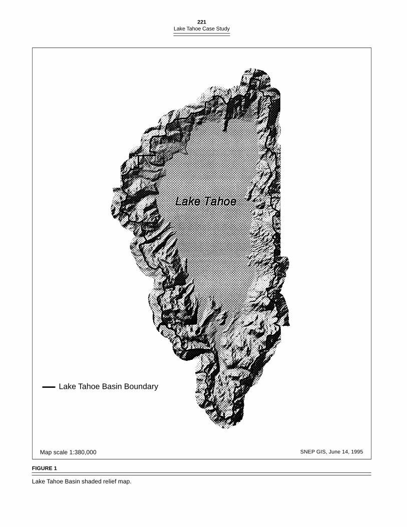
The Lake Tahoe Basin lies high in the Sierra Nevada, betweenelevations of 1,900–3,050 m (6,200–10,000 feet) asl . It includesabout 1,300 km2 (500 mi2), of which approximately 500 km2
220ADDENDUM
(192 mi2) or 38% are covered by the waters of Lake Tahoe(figure 1). The lake reaches a maximum depth of 502 m (1,645ft) and a mean depth of 313 m (1,027 ft). The depth of the lakeis important with respect to nutrient loading and response.
The Basin’s climate is one of long cool-to-moderate win-ters and short moderate-to-warm summers and is a functionof the latitude, proximity to the Pacific Ocean, and the eleva-tion of the Basin. Precipitation occurs primarily betweenOctober and May, with winter precipitation predominatelyin the form of snow. Thunderstorms occur sporadicallythroughout the summer, but do not produce significantamounts of precipitation (Department of Water Resources1991). There are many local climates within the Basin, due totopographic influences, as well as a pronounced rainshadoweffect and decreasing precipitation from west to east acrossthe Basin, with the Carson Range more arid than the mainSierra Nevada crest to the west.
The geologic underpinnings of the Lake Tahoe Basin aretypical of the northeastern Sierra Nevada (McGauhey et al.1963; Crippen and Pavelka 1970). Granitic rocks dominatethe bedrock geology and are the surficial rocks of the south-ern section of the Basin. Late Cenozoic volcanic rocks overliethe granitics in the northern part of the Basin and are domi-nated largely by basalts and andesites. All of these rocks areextensively faulted. In addition, metamorphic rocks, largelyas caprocks, are scattered throughout the Basin.
The rugged topography consists of steep slopes and gen-erally narrow canyons. Glaciation was most pronounced onthe west side of the Basin, producing steep sided troughs andserrated mountain peaks, and depositing morainal materialsacross the lower slope and into the lake itself. The northernand eastern portions of the Basin walls are deeply incised bynarrow stream valleys, with gently rolling, hilly terrain insome sections. The southern portion of the Basin and someareas of the lakeshore are covered by extensive glacial mo-raine and outwash deposits, as well as Quaternary lake de-posits (McGauhey et al. 1963; Bailey 1974).
Biota
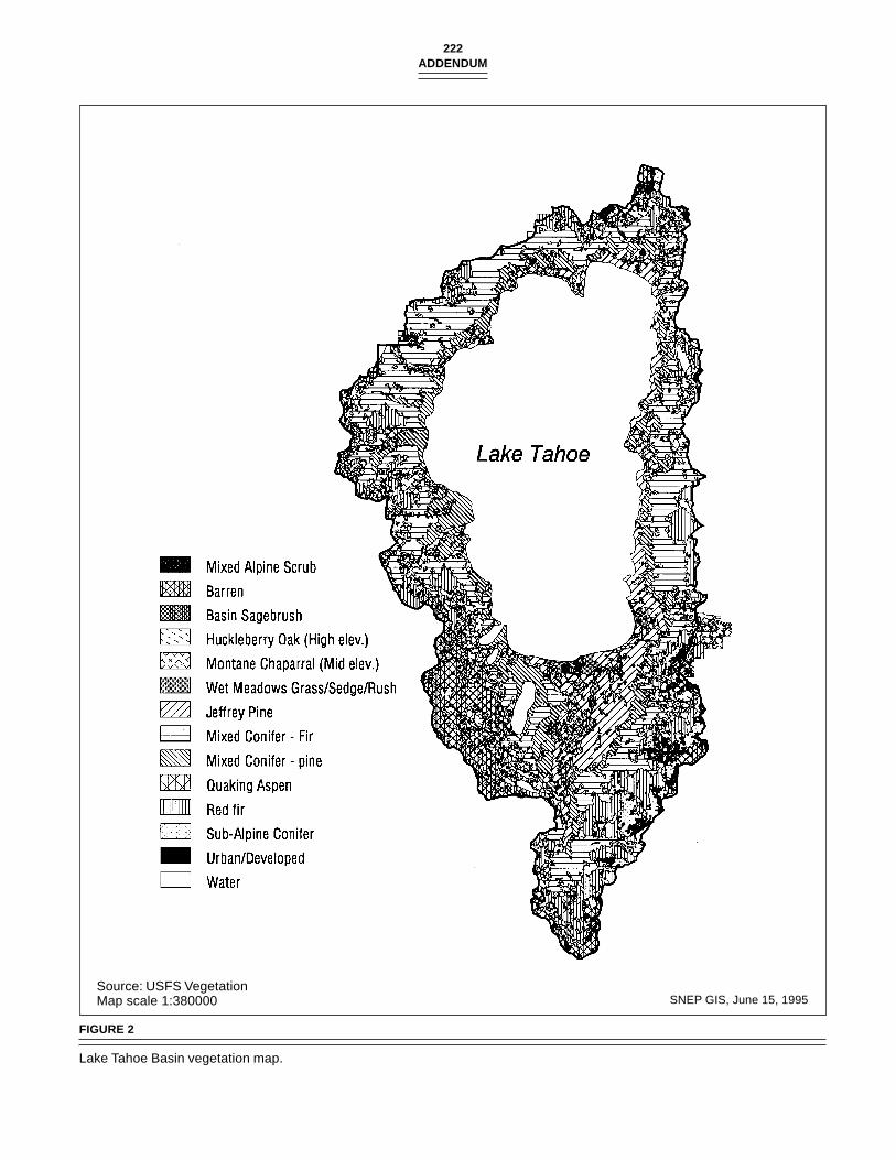
With the broad elevational range of the Basin, and topogra-phy strongly controlling precipitation and temperature, awide diversity of montane vegetation types occur here, rang-ing from subalpine to alpine meadow and fell-fields, to co-niferous forests and woodlands, riparian forests, Great Basinshrublands, and various wetland communities (figure 2). Soilsact as a secondary control to climate of vegetation patterns.A number of plant species of special interest, especially athigh elevations and in wetlands, are found here. Althoughthe typical northern Sierra Nevada diversity of tree species ispresent (e.g., lodgepole pine, red fir, white fir, incense cedar,Jeffrey pine), the relative species composition and density ofthe forest have changed in the last century, as the co-domi-nant sugar pine-Jeffrey pine-white fir forests which coveredthe greater part of the Basin before the logging of the late Nine-teenth century were largely lost. Remnants remain on smaller
parcels, steeper slopes, and at higher elevations, where redfir, mountain hemlock and other coniferous species co-occur(Bailey 1974).
This diversity of plant communities and vegetation typescreates a broad spectrum of wildlife habitats in the Basin. Dueto the high density of stream tributaries issuing from themountain slopes, riparian vegetation makes important habi-tat contributions here, and this vegetation and the adjacentstream ecosystem are currently the focus of intensivebiodiversity inventories on birds, mammals, amphibians, rep-tiles, terrestrial insects, aquatic insects, vascular plants,mosses, lichens and fungi (Pat Manley, USFS Region 5, SanFrancisco, 1995). The U.S. Forest Service (USFS), CaliforniaTahoe Conservancy (CTC), and University of Nevada, Renoare working collaboratively to design an innovative riparianinventory and monitoring protocol, which they will then ap-ply basin-wide. We find the knowledge on plant and foreststructure and dynamics to be incomplete in light of the im-portant role they play in the Basin ecosystem. There is stronginterest in manipulating vegetation on the lake’s watershed.If this is to be done, there must be monitoring of short-, me-dium-, and long-term results (e.g., nutrient fluxes from thin-ning or prescribed burning).
Small birds, waterfowl, upland game birds, raptors, andlarge and small mammals have lived in the Basin, includingwillow flycatchers, pileated woodpeckers, bald eagles, per-egrine falcons, golden eagles, pine martens, grizzly bear,wolverines, osprey, goshawks, and fishers. Populations ofsome of these vertebrates have diminished or have been lostcompletely. In its 1991 evaluation of environmental indica-tors (Tahoe Regional Planning Agency 1991), TRPA reportedthat it found no active bald eagle nests in the Basin. In thissame year, the USFS did sight juvenile and adult goshawks atAngora Lake. An active nest was also found at Saxon Creek.The TRPA furthermore recommended that cooperating agen-cies prepare an overall report on wildlife population dynam-ics.
The native fisheries of the past were diverse includingLahontan cutthroat trout, mountain whitefish, tui chub,Lahontan redside, speckled dace, Tahoe sucker, and Paiutesculpin (Tahoe Regional Planning Agency 1991). Brewer wroteof Lake Tahoe’s remarkable fishery in l863 (p. 443): “The lakeabounds in the largest trout in the world, a species of speck-led trout that often weighs over twenty pounds and some-times as much as thirty pounds!” Sadly, the Lahontancutthroat has been lost except at a few isolated spots in theTruckee River drainage. Efforts have been made to restorethe native Lahontan cutthroat, especially in the Upper TruckeeRiver watershed in the Meiss Lakes Basin and also in the lowerTruckee River below Lake Tahoe’s outlet. However, evenbefore cutthroat trout began to decline in the Lake Tahoewatershed, state fish and game departments cooperated toestablish a larger sport fishery, first by planting rainbow trout,brown trout, mackinaw (lake trout), brook trout, golden troutand, later, Kokanee salmon. These introductions impacted
221Lake Tahoe Case Study
Map scale 1:380,000 SNEP GIS, June 14, 1995
FIGURE 1
Lake Tahoe Basin shaded relief map.
Lake Tahoe Basin Boundary
222ADDENDUM
Source: USFS VegetationMap scale 1:380000 SNEP GIS, June 15, 1995
FIGURE 2
Lake Tahoe Basin vegetation map.

223Lake Tahoe Case Study
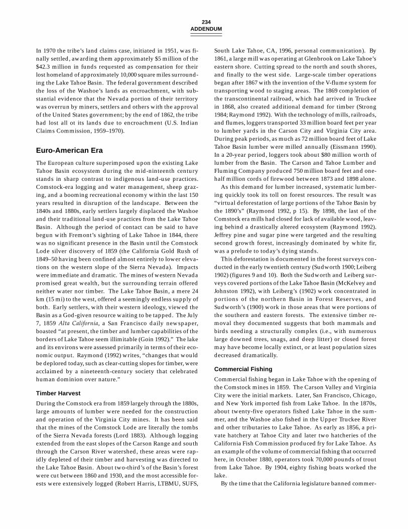
FIGURE 3
Truckee Marsh in 1930 (current site of Tahoe Keysdevelopment). Photo by Dr. Robert Orr, property ofCalifornia Tahoe Conservancy.
FIGURE 4
Tahoe Keys development of the Truckee Marsh, 1978.Photo by Ray Lacey, California Tahoe Conservancy.
the aquatic invertebrates. With a few notable exceptions, suchas at Taylor Creek, spawning streams were obstructed by roadconstruction, channelized, devegetated, or all three. Fish sur-vival rates from year-to-year were assured to be low, leadingto a policy of annual restocking from hatcheries. Today, LakeTahoe’s fishery consists almost totally of introduced species,although native fish species are present.
In the early years of the post-war era, urbanization of theBasin was accompanied by draining and filling of many wet-land areas, a practice that reached its peak in the 1960s withthe creation of the Tahoe Keys (figures 3 and 4), a dredgedand filled residential development in the region’s largestmarsh, at the mouth of the Upper Truckee River. Manybackshore as well as some nearshore habitats have been modi-fied by road construction, the management of beaches andpiers, and other construction. In 1979, the Western FederalRegional Council said that 75% of the Lake Tahoe Basin’smarshes, 50% of its meadows, and 35% of its riparian zoneshad been destroyed since 1900, and also that about 25% ofthe Basin’s marshland had been developed between 1969 and1979 (Western Federal Regional Council Interagency TaskForce 1979).
As the human population of the Basin started to grow, sup-pression of wildfires also became the norm. In the 1920s,public agencies began to regularly fight and extinguish for-est fires. Logging occurred through the 1960s, especially alongthe north shore. In 1947, the mill along the south shore wasstill the largest employer in the Basin. However, given theBasin’s beauty and attraction to visitors, a policy emerged inwhich timber production was later discouraged. Furthermore,land managers became reluctant to thin or otherwise harvestthe forest for fear of damaging water quality or other resourcesand upsetting environmental groups. The prevailing view ofthe forest ecosystem in the middle of this century was that,with fire excluded, the ecosystem would take care of and re-pair itself. The use of prescribed fire in the Basin continuedto be debated by many parties. A logic for protecting the LakeTahoe Basin from fire was put forth based on conservation ofwatershed values, recreational opportunities, preservation offorest and wildlife habitat, and protection of developed areasvalued at many millions of dollars. However, by 1975, theCalifornia Tahoe Regional Planning Agency (CTRPA2) hadadopted a regional plan that recognized the value of pre-scribed burning (California Tahoe Regional Planning Agency,1995). The ecosystem effects of prescribed burning were notcompletely understood, yet fire was recognized as an essen-tial ecological process in the summer-dry forest type of theBasin. Prescribed fire was also recognized as a tool for reduc-ing fuel load in the forest, thereby decreasing the risk of de-structive, high-intensity wildfires.
In the last two decades, a broader understanding of theecosystem has emerged. A drought, starting in the mid-1980s,stressed the overstocked, even-aged forest making white fir,and then the pines, susceptible to insect damage. In 1991, theUSFS reported that 300 million board feet of timber were dead
or dying in the Basin. Land managers also realized the needto reintroduce fire into the ecosystem, or substitute somethingelse for it to restore forest health.
A better understanding of the role of natural fire in the LakeTahoe Basin ecosystem is very much needed. Fire historieshave been compiled in six California State Parks within theSierra District of the California Department of Parks and Rec-reation (Rice 1988; Rice 1990), and three of these parks arewithin the Lake Tahoe Basin: (1) D. L. Bliss State Park (offHighway 89, 6 miles south of Meeks Bay), (2) Sugar Pine PointState Park (off Highway 89, 1 mile south of Tahoma), and (3)Emerald Bay State Park (off Highway 89, 22 miles south ofTahoe City).
For these fire history studies, slabs were taken out of liveand dead trees with fire scars. The forest vegetation at each
224ADDENDUM
TABLE 1
Average fire intervals at D. L. Bliss State Park.
Years Average Interval (yr.) Number of Fires
1900–1990 21.5 41800–1899 4.6 221700–1799 9.3 111600–1699 20.0 31500–1599 29.0 3
TABLE 2
Average fire intervals at Sugar Pine Point State Park.
Years Average Interval (yr.) Number of Fires
1900–1990 18.0 41800–1899 6.6 141700–1799 8.2 111600–1699 19.8 51500–1599 29.0 3
TABLE 3
Average fire intervals at Emerald Bay State Park.
Years Average Interval (yr.) Number of Fires
1900–1988 8.8 101800–1999 3.7 271700–1700 4.3 231600–1699 6.6 15
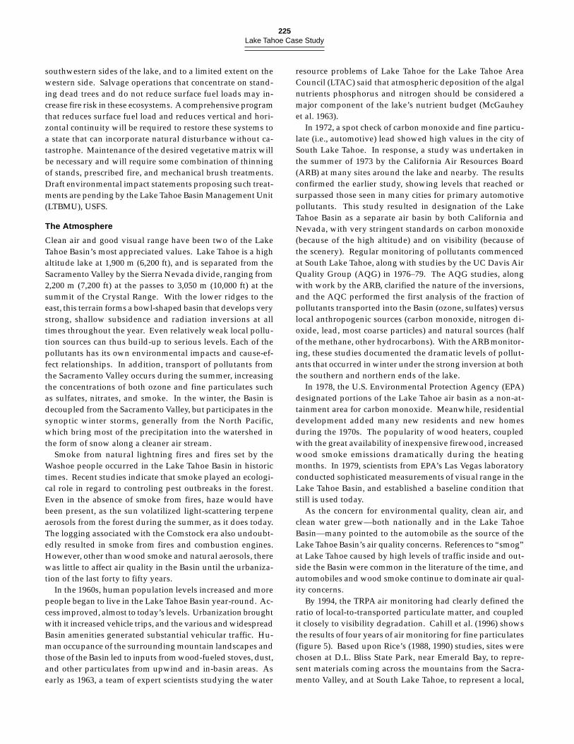
site consisted primarily of Jeffrey pine, ponderosa pine, andincense cedar, with white fir also a common overstory tree inthe D. L Bliss and Sugar Pine Point State Parks. Some sugarpine is found at Emerald Bay State Park.3 The studies pro-vide excellent fire history data, but it is difficult to arrive atgeneral conclusions because the spatial component of the firestudy is missing. The fire history studies do present averagefire intervals by century for each park and they are summa-rized in tables 1–3 (Rice 1988; Rice 1990).4 However, to effec-tively manage using fire, there must be a better understandingof the effects of varying fire intensity, season of burning, andnutrient retention and release. This is currently a major gapin scientific understanding in the Basin.
Before the year 1700, sample size becomes limited and cal-culations of fire intervals are unreliable. Past logging nearthese areas has also removed valuable fire scar data. A mea-sure of fire return interval variability would also give moreinformation on the disturbance regime, and the raw data thatare provided in the report could be analyzed in this regard.
The data demonstrate that fire is a persistent process inthese ecosystems. Fires occurred on the average every fiveyears from 1800–1899, and have occurred on an average ofevery twenty years from 1900–1990. In the twentieth-century,
fire frequency is higher in the Lake Tahoe Basin than for mostof the western Sierra Nevada. The change in fire frequencywith increased human occupance, however, has resulted inincreased tree density and changes in biodiversity of the for-est (McKelvey et al. 1996). Shade tolerant species such aswhite fir have increased in density over shade intolerant spe-cies such as Jeffrey pine. The use of prescribed fire generatessystem impacts that are both beneficial and potentially detri-mental from a human perspective, and needs to be carefullydealt with.
The biota of the Lake Tahoe Basin is affected not only byhuman induced processes, such as fire suppression, urban-ization, and pollution, but by natural influences, such as pe-riodic flooding, wildfire, mass movement (e.g., landslides),and droughts. Long-term drought is believed to be respon-sible for lowering the lake below its natural rim, and in thisregard, researchers have found tree stumps as deep as 4.9 m(16 ft) along the south shore of the lake and 12 m (40 ft) alongthe east shore. The size of these stumps indicates the treeswere over 100 years old when they died (Lindström (appen-dix A). A lake-level decrease of this magnitude would en-courage stream entrenchment and wetland modification,accelerated erosion, and sediment transport into the lake.
Further information on natural droughts, altered fire andrunoff regimes, and various human impacts are availablethrough the pollen analysis of a mid-lake core collected fromLake Tahoe by the Tahoe Research Group (TRG) (Davis ap-pendix 7.2). The pollen and sediment data attest to historicchanges in vegetation and fire in the Basin. During the LittleIce Age (ca. 1850–1890 AD), a decrease in pine and an increasein fir and sagebrush indicates cooler and drier conditions thanat the present. A decrease in both pollen and charcoal con-centration with settlement of the Basin in the latter nineteenthcentury is indicative of logging and accompanying erosionduring the Comstock era, with acceleration of the sedimenta-tion rate. Decreased wildfire beginning about 1885 is reflectedin the reduced charcoal concentration. A subsequent smallincrease in pollen and charcoal concentration and a brief butsharp decrease in pine pollen percentage appear to be the re-sult of post-World War II development in the Basin. Increasednutrient flow into the lake from accelerated erosion and hu-man pollution is also reflected here by the increases in theplanktonic algae Pediastrum, and also seen with the expan-sion of the nearshore littoral zone as represented by sedgepollen (Davis appendix 7.2).
As the result of fire suppression, past forest harvesting prac-tices (Sudworth 1900; Leiberg 1902), and recent stress, wide-spread tree mortality is occuring in the Basin today. Insectdamage in parts of the forest also occurred in 1921 and 1937.Increased tree density and reduced biodiversity, as demon-strated by the preponderance of white fir, has resulted in thecurrent ecosystem being much more vulnerable to distur-bances such as wildfire, drought, insects and disease, whetherthey are species specific or otherwise.
In the past five years, salvage logging operations have beenoccurring in the Basin, primarily on the eastern, northern and
225Lake Tahoe Case Study
southwestern sides of the lake, and to a limited extent on thewestern side. Salvage operations that concentrate on stand-ing dead trees and do not reduce surface fuel loads may in-crease fire risk in these ecosystems. A comprehensive programthat reduces surface fuel load and reduces vertical and hori-zontal continuity will be required to restore these systems toa state that can incorporate natural disturbance without ca-tastrophe. Maintenance of the desired vegetative matrix willbe necessary and will require some combination of thinningof stands, prescribed fire, and mechanical brush treatments.Draft environmental impact statements proposing such treat-ments are pending by the Lake Tahoe Basin Management Unit(LTBMU), USFS.
The Atmosphere
Clean air and good visual range have been two of the LakeTahoe Basin’s most appreciated values. Lake Tahoe is a highaltitude lake at 1,900 m (6,200 ft), and is separated from theSacramento Valley by the Sierra Nevada divide, ranging from2,200 m (7,200 ft) at the passes to 3,050 m (10,000 ft) at thesummit of the Crystal Range. With the lower ridges to theeast, this terrain forms a bowl-shaped basin that develops verystrong, shallow subsidence and radiation inversions at alltimes throughout the year. Even relatively weak local pollu-tion sources can thus build-up to serious levels. Each of thepollutants has its own environmental impacts and cause-ef-fect relationships. In addition, transport of pollutants fromthe Sacramento Valley occurs during the summer, increasingthe concentrations of both ozone and fine particulates suchas sulfates, nitrates, and smoke. In the winter, the Basin isdecoupled from the Sacramento Valley, but participates in thesynoptic winter storms, generally from the North Pacific,which bring most of the precipitation into the watershed inthe form of snow along a cleaner air stream.
Smoke from natural lightning fires and fires set by theWashoe people occurred in the Lake Tahoe Basin in historictimes. Recent studies indicate that smoke played an ecologi-cal role in regard to controling pest outbreaks in the forest.Even in the absence of smoke from fires, haze would havebeen present, as the sun volatilized light-scattering terpeneaerosols from the forest during the summer, as it does today.The logging associated with the Comstock era also undoubt-edly resulted in smoke from fires and combustion engines.However, other than wood smoke and natural aerosols, therewas little to affect air quality in the Basin until the urbaniza-tion of the last forty to fifty years.
In the 1960s, human population levels increased and morepeople began to live in the Lake Tahoe Basin year-round. Ac-cess improved, almost to today’s levels. Urbanization broughtwith it increased vehicle trips, and the various and widespreadBasin amenities generated substantial vehicular traffic. Hu-man occupance of the surrounding mountain landscapes andthose of the Basin led to inputs from wood-fueled stoves, dust,and other particulates from upwind and in-basin areas. Asearly as 1963, a team of expert scientists studying the water
resource problems of Lake Tahoe for the Lake Tahoe AreaCouncil (LTAC) said that atmospheric deposition of the algalnutrients phosphorus and nitrogen should be considered amajor component of the lake’s nutrient budget (McGauheyet al. 1963).
In 1972, a spot check of carbon monoxide and fine particu-late (i.e., automotive) lead showed high values in the city ofSouth Lake Tahoe. In response, a study was undertaken inthe summer of 1973 by the California Air Resources Board(ARB) at many sites around the lake and nearby. The resultsconfirmed the earlier study, showing levels that reached orsurpassed those seen in many cities for primary automotivepollutants. This study resulted in designation of the LakeTahoe Basin as a separate air basin by both California andNevada, with very stringent standards on carbon monoxide(because of the high altitude) and on visibility (because ofthe scenery). Regular monitoring of pollutants commencedat South Lake Tahoe, along with studies by the UC Davis AirQuality Group (AQG) in 1976–79. The AQG studies, alongwith work by the ARB, clarified the nature of the inversions,and the AQC performed the first analysis of the fraction ofpollutants transported into the Basin (ozone, sulfates) versuslocal anthropogenic sources (carbon monoxide, nitrogen di-oxide, lead, most coarse particles) and natural sources (halfof the methane, other hydrocarbons). With the ARB monitor-ing, these studies documented the dramatic levels of pollut-ants that occurred in winter under the strong inversion at boththe southern and northern ends of the lake.
In 1978, the U.S. Environmental Protection Agency (EPA)designated portions of the Lake Tahoe air basin as a non-at-tainment area for carbon monoxide. Meanwhile, residentialdevelopment added many new residents and new homesduring the 1970s. The popularity of wood heaters, coupledwith the great availability of inexpensive firewood, increasedwood smoke emissions dramatically during the heatingmonths. In 1979, scientists from EPA’s Las Vegas laboratoryconducted sophisticated measurements of visual range in theLake Tahoe Basin, and established a baseline condition thatstill is used today.
As the concern for environmental quality, clean air, andclean water grew—both nationally and in the Lake TahoeBasin—many pointed to the automobile as the source of theLake Tahoe Basin’s air quality concerns. References to “smog”at Lake Tahoe caused by high levels of traffic inside and out-side the Basin were common in the literature of the time, andautomobiles and wood smoke continue to dominate air qual-ity concerns.
By 1994, the TRPA air monitoring had clearly defined theratio of local-to-transported particulate matter, and coupledit closely to visibility degradation. Cahill et al. (1996) showsthe results of four years of air monitoring for fine particulates(figure 5). Based upon Rice’s (1988, 1990) studies, sites werechosen at D.L. Bliss State Park, near Emerald Bay, to repre-sent materials coming across the mountains from the Sacra-mento Valley, and at South Lake Tahoe, to represent a local,
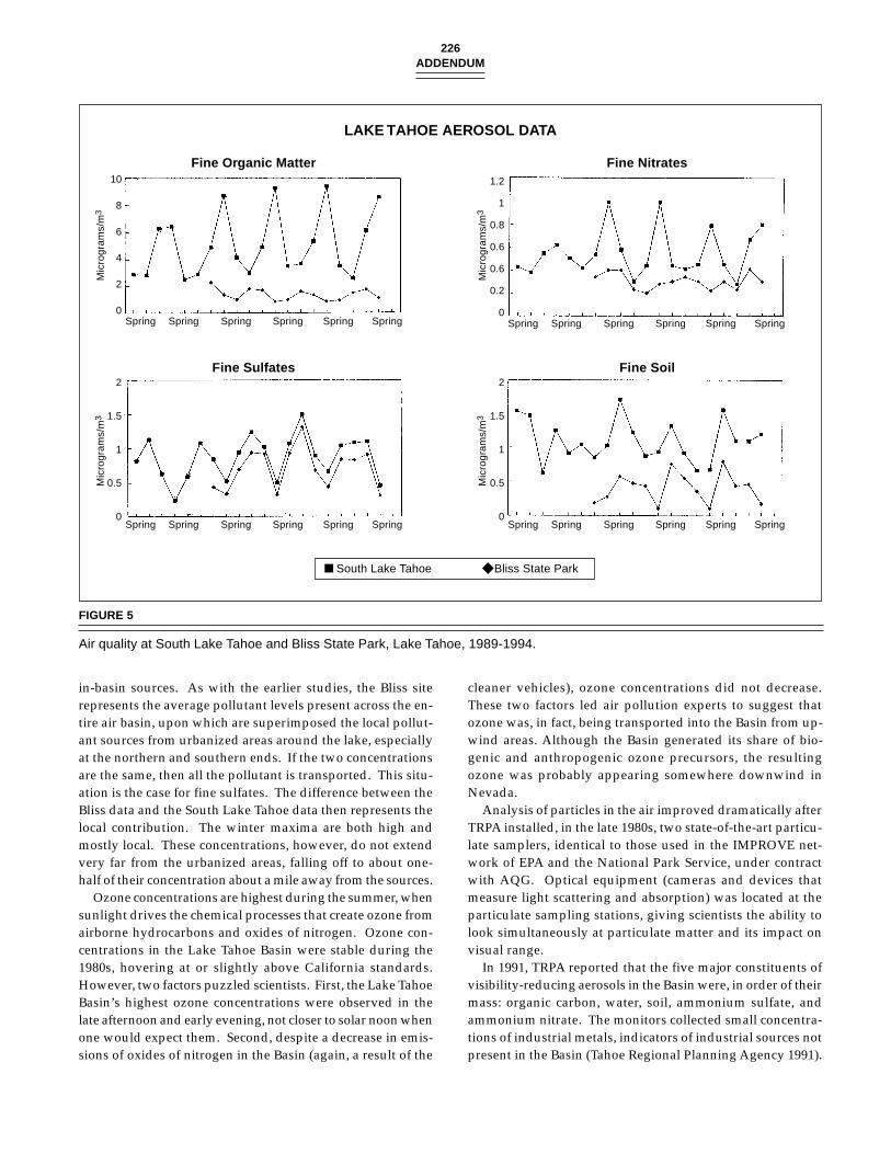
226ADDENDUM
in-basin sources. As with the earlier studies, the Bliss siterepresents the average pollutant levels present across the en-tire air basin, upon which are superimposed the local pollut-ant sources from urbanized areas around the lake, especiallyat the northern and southern ends. If the two concentrationsare the same, then all the pollutant is transported. This situ-ation is the case for fine sulfates. The difference between theBliss data and the South Lake Tahoe data then represents thelocal contribution. The winter maxima are both high andmostly local. These concentrations, however, do not extendvery far from the urbanized areas, falling off to about one-half of their concentration about a mile away from the sources.
Ozone concentrations are highest during the summer, whensunlight drives the chemical processes that create ozone fromairborne hydrocarbons and oxides of nitrogen. Ozone con-centrations in the Lake Tahoe Basin were stable during the1980s, hovering at or slightly above California standards.However, two factors puzzled scientists. First, the Lake TahoeBasin’s highest ozone concentrations were observed in thelate afternoon and early evening, not closer to solar noon whenone would expect them. Second, despite a decrease in emis-sions of oxides of nitrogen in the Basin (again, a result of the
cleaner vehicles), ozone concentrations did not decrease.These two factors led air pollution experts to suggest thatozone was, in fact, being transported into the Basin from up-wind areas. Although the Basin generated its share of bio-genic and anthropogenic ozone precursors, the resultingozone was probably appearing somewhere downwind inNevada.
Analysis of particles in the air improved dramatically afterTRPA installed, in the late 1980s, two state-of-the-art particu-late samplers, identical to those used in the IMPROVE net-work of EPA and the National Park Service, under contractwith AQG. Optical equipment (cameras and devices thatmeasure light scattering and absorption) was located at theparticulate sampling stations, giving scientists the ability tolook simultaneously at particulate matter and its impact onvisual range.
In 1991, TRPA reported that the five major constituents ofvisibility-reducing aerosols in the Basin were, in order of theirmass: organic carbon, water, soil, ammonium sulfate, andammonium nitrate. The monitors collected small concentra-tions of industrial metals, indicators of industrial sources notpresent in the Basin (Tahoe Regional Planning Agency 1991).
FIGURE 5
Air quality at South Lake Tahoe and Bliss State Park, Lake Tahoe, 1989-1994.
LAKE TAHOE AEROSOL DATA
Fine Organic Matter Fine Nitrates10
8
6
4
2
0Spring Spring Spring Spring Spring Spring
Fine Sulfates Fine Soil2
1.5
1
0.5
0Spring Spring Spring Spring Spring Spring
2
1.5
1
0.5
0Spring Spring Spring Spring Spring Spring
1.2
1
0.8
0.6
0.6
0.2
0Spring Spring Spring Spring Spring Spring
■ South Lake Tahoe ◆ Bliss State Park
Mic
rogr
ams/
m3
Mic
rogr
ams/
m3
Mic
rogr
ams/
m3
Mic
rogr
ams/
m3
227Lake Tahoe Case Study
The largest concentrations of these metals occurred in the sum-mer, when long-range transport conditions were most likely.The main sources of the particulate organic carbon compo-nent are natural terpene emissions in the summer and woodburning in the winter.
Ammonium sulfate is an industrial emission, for whichthere are no known sources in the Lake Tahoe Basin. Ammo-nium nitrate (from automobiles, generally upwind of the Ba-sin) represented only 6% of the fine particulate mass. Fromthese measurements, scientists were able to draw two con-clusions: long range transport of pollutants from distant ur-ban and industrial sources was definitely occurring, andautomobile exhausts were only a small contributor to hazeand diminished visual range in the Basin.
In the 1980s, those working to understand the water qual-ity trends in Lake Tahoe took a renewed interest in airbornealgal nutrients (especially phosphorus and nitrogen). Sincethe 1963 LTAC study (McGauhey et al. 1963), airborne nitro-gen and phosphorus compounds had been recognized as sig-nificant components of Lake Tahoe’s nutrient budget. Studiesof deposition elsewhere in the country (e.g., the Great Lakes)gave added impetus to the idea, as did the nation’s interest inacid rain and deposition of nitric and sulfuric acids. Airbornesubstances undoubtedly played a role in Lake Tahoe’s waterquality dynamics, but what role, exactly, was unclear.
In 1981 and 1982, the staff and consultants working onTRPA’s threshold standards contacted air quality expertsthroughout the country and asked what loading rate, in kilo-grams per hectare per year of nitric acid, one might expect tosee in the Sierra Nevada. Based on the responses, they esti-mated an annual dissolved inorganic nitrogen (DIN) load tothe surface of Lake Tahoe on the same order of magnitude asthe loads coming from surface streams and groundwater in-puts. This conclusion—even without monitoring data to con-firm it—influenced the development of TRPA’s thresholdstandards and subsequent regional plan by causing TRPA tolook beyond erosion and runoff control as methods to controlcultural eutrophication5, and by creating an amount of un-certainty as to sources, distribution, and impacts of the air-borne fractions.
In the following years, both water quality and air qualityspecialists attempted to measure or model nitrogen and phos-phorus inputs to Lake Tahoe, with variable and sometimescontradictory results. Since deposition is literally a molecu-lar-level phenomenon, monitoring it directly is difficult. Spa-tial variation in meteorology within the Basin, especially overthe lake itself, complicated attempts to measure dry-weatherand wet-weather deposition.
In 1990, in expert testimony in the case of Kelly v. TRPA,Cahill of AQG summarized what was known about the at-mospheric deposition of nutrients to Lake Tahoe. He statedthat the decline in the lake’s water quality was not primarilydue to atmospheric inputs. With abundant nitrogen in thesystem from various ecosystem sources, phosphorus is nowa major influence on aquatic productivity. Soils, especially
disturbed soils (e.g., along road cuts), appear to be the largestsource of phosphorous with smoke from wood stoves, agri-cultural burning, and other combustion negligible sources ofphosphorus.
In 1991, TRPA published a summary on deposition of air-borne algal nutrients on Lake Tahoe. It said that the primarynutrient of concern was nitrogen, commonly found in the airin gaseous form (e.g., NO2 or nitrogen dioxide) and particu-late form (e.g., NH4NO3 or ammonium nitrate) (Tahoe Re-gional Planning Agency 1991). Phosphorus compounds werealso found in the air in the particulate form.
Gaseous emissions from local sources appeared to be animportant source of atmospheric nitrogen in Lake Tahoe’snutrient budget. Particulate nitrogen from upwind areas ap-peared to be less important. The report said gaseous emis-sions of nitrogen compounds (known as “NOx”) fromautomobiles and other sources react with other substances inthe atmosphere and on the ground. The portion not scav-enged from the air by other chemicals, vegetation, or othersurfaces, including water bodies, changes to particulate inabout 24 hours. Because the particles are less than 2.5 mil-lionths of a meter in diameter, they do not settle easily, andare transported downwind.
The report said that most NOx emissions upwind of theLake Tahoe Basin change to the particulate form before theyreach the Basin, and are easily transported over the Basin bythe wind. However, NOx emissions within the Basin reactwith vegetation, water surfaces, and other surfaces before theychange to the particulate form. These reactions scavenge aportion of the NOx from the atmosphere. Thus, local NOxemissions contribute to the lake’s nitrogen budget.
Vegetation in the watershed also scavenges NOx, and someportion of the scavenged nitrogen eventually makes its wayinto Lake Tahoe. “The reader may wish to think of this pro-cess,” the report said, “as an area-wide enrichment, or fertili-zation, of Lake Tahoe and the Tahoe Region by local sourcesof NOx” (Tahoe Regional Planning Agency 1991).
Recent analysis of wet and dry deposition has been madebased upon a multi-year measurement program by TRG(Jassby et al. 1994). These results favor a larger fraction of thenitrate input from upwind sources, but due to the use of in-novative but uncharacterized sample collection, the resultsare being carefully evaluated for relevance to both dry depo-sition theory and standard sampling protocols.
The Hydrosphere
Lake Tahoe is unique as a Sierra Nevada high elevation lakein terms of its size and depth. It holds approximately 156cubic kilometers of water (126 million acre feet). It is 19 kmwide (12 mi) and 35 km (22 mi) long, with a surface area of500 km2 (192 mi2 ). The mean depth of Lake Tahoe is 313 m(1,027 ft), with a maximum depth of 502 m (1,645 ft), makingit the 10th deepest lake in the world.
Like most lakes, Lake Tahoe stratifies during much of theyear with colder, denser waters staying at the bottom and
228ADDENDUM
warmer, lighter waters on top, with little mixing between thelayers. However, unlike most temperate lakes, Lake Tahoedoes not always turnover annually. The depth and durationof winter mixing are extremely variable (Goldman 1988).
Tributary flows deliver about 370 million m3 (300,000 acre-feet of water) to Lake Tahoe each year. Nearly half of thesurface inflow to Lake Tahoe comes from only four of its sixty-three tributaries: Trout Creek, the Upper Truckee River, Tay-lor Creek, and Ward Creek. The amount of subsurfacegroundwater flow entering Lake Tahoe is not known, but isprobably not more than about 10% of surface flow (McGauheyet al. 1963). Four estimates of a water balance are known tohave been made for Lake Tahoe. The years, methods and as-sumptions used result in different estimates (table 4).
Estimates of average annual evaporation from the lake sur-face from these studies range from 338 million m3 (680 mm)to 551 million m3 (1,100 mm). These water balance estimatessuggest there is a considerable uncertainty in the calculationsand much variability between years.
By considering the water budget and the lake’s volume,scientists calculate the average residence time of a drop ofwater in Lake Tahoe at about 700 years. This residence timeis an important point in the development of control plansbecause, for practical purposes, one must think of Lake Tahoeas a nutrient sink not subject to flushing action.
Prior to European contact (ca. 1850) and probably throughglacial-interglacial cycles, the level of Lake Tahoe fluctuatednaturally, partially controlled by ice dams in the area of whatis now the Truckee River outlet. Tree-ring and other data re-veal a long-term drought after the last ice age which lastedover a thousand years (Stine 1996). Research in progress byscientists at the University of Nevada Desert Research Insti-tute (T. Kumamato, 1996, personal communication) shows thatthe level of the lake’s surface dropped at least 14 m (46 ft)below its current rim, and conifers grew at an elevation ofabout 6,200 feet. Further information on mid-to-late Holocenelake-level changes is contained in Lindström (appendix 7.1).
To examine possible increases in rates of sedimentationresulting from the intensive logging and watershed distur-bance of the late 1800s, TRG, led by Charles R. Goldman, ana-lyzed sediment cores from the deep portions of Lake Tahoe.They dated biological and physical changes in the cores bymeasuring the abundance of a radioactive lead isotope. Thecores revealed no demonstrable change in Lake Tahoe’s algal
community that correlated with the logging era. As notedpreviously, however, Davis’ (appendix 7.2) analysis of pollenand charcoal concentration showed increased sedimentationrates following the Comstock era. In the 1950s, however, therelative abundance of some of the phytoplankton(araphidinate Pennales and Centrales) increased dramaticallywith a corresponding influence on water clarity. This is alsoreflected in Davis’ analysis of the nearshore cores by an in-crease in Pediastrum (appendix 7.2).
Although land disturbance during the Comstock era wasextensive, it has been hypothesized that the absence of long-term impacts was due to the fact that logging did not createsurfaces as impervious to water percolation and throughflowas pavement and concrete, even though soil compaction un-doubtedly occurred, and thus the watershed recovered fromlogging with the natural wetlands largely intact. An alterna-tive hypothesis is that the climate of this time was such thatthere were few heavy winter snowpacks with their resultinglarge amounts of spring runoff that would have deliveredhigher amounts of sediment to Lake Tahoe in the immediatepost-Comstock years. However, hydrologic records show ma-jor flooding in Reno in 1867, 1886, and 1900, and four of theten highest seasonal snowfall amounts from 1879 to thepresent fell between 1880 and 1895, casting doubt on this hy-pothesis.
Lake Tahoe’s first dam was constructed at Tahoe City inthe early 1870s. The dam, which raised Lake Tahoe’s averagesurface elevation by about 2 m (6 feet) caused Lake Tahoe’sshoreline to move landward, a phenomenon that had previ-ously occurred only as a result of natural climatic variation.There is little documentation of the ecological effects of thischange. One can visualize, however, a period of adjustmentin which the lakeshore eroded and new beaches were formed.In the early 1900s, traincar-loads of sand were brought to theHomewood and Sunnyside areas on Lake Tahoe’s northwestshoreline to supplement the natural beaches, and this sandeventually moved into the nearshore circulation of the lake.
The impacts of sewage discharge in the Basin are a furtherconcern for the lake’s health. Not until the 1950s did theBasin’s residents begin to manage their sewage in a collectivefashion. The Tahoe City Public Utility District (TCPUD)opened a secondary treatment (e.g., trickling filter) plant in1954. The North Tahoe Public Utility District (NTPUD)opened a primary treatment plant near Tahoe Vista in 1957.
TABLE 4
Estimates of Lake Tahoe’s water balance (in million m3 of water).
Source McGauhey et al. 1963 LTAC 1971 Lind and Goodridge 1978 Myrup et al. 1979
Interval (yrs) unknown 1960–71 1958–77 1967–90
Streamflow into lake 380 459 362 510Precipitation into lake 253 336 255 388Evaporation from lake 410 541 338 551Outflow to Truckee River 217 214 227 368Change in storage plus 0.1 plus 40 minus 36 minus 22
229Lake Tahoe Case Study
The South Tahoe Public Utility District (STPUD) built a sec-ondary treatment (i.e., activated sludge) plant near theconfluence of Heavenly Valley and Trout Creeks in 1960,which served portions of the south shore in both Californiaand Nevada, including the Stateline casino district. All ofthese treatment plants disposed of their treated effluent byapplication to the land, via spray irrigation or infiltrationponds and trenches.
Still, many populated areas of the Basin were outside theservice areas of these facilities, and by the early 1960s therewas a significant interest in providing sewage collection andtreatment for all the residents and visitors of the Lake TahoeBasin, to “cure” or at least slow down the onset of culturaleutrophication of Lake Tahoe. The LTAC, with money fromthe Max C. Fleischmann Foundation, contracted in 1961 withthe consulting engineering firm Engineering-Sciences, Inc.,which conducted a thorough study under the direction of anexpert “board of consultants” to explore possible solutions tothe sewage problems of the Basin. The analysis contained inthe LTAC’s 1963 report (McGauhey et al. 1963) included ahydrologic budget, a nutrient balance, a detailed analysis ofnutrient sources and outflow, and an analysis of the impactsof nutrients on Lake Tahoe (present and future). Despite thefact that it did not have long-term water quality data to relyupon, it concluded that “the amounts of nutrients to be de-veloped in [the] Tahoe Basin with continuing growth of popu-lation appear to be sufficient to pose a definite hazard to LakeTahoe should an appreciable portion of these find their wayinto the lake.” The study considered “all feasible methods of[sewage] disposal which can protect the quality of the lakeand of the Truckee River,” including land disposal, surfacedisposal, and removal from the Lake Tahoe Basin. However,in 1963 LTAC was considering a land freeze as a moratoriumon land-use changes.
In July 1966, the Secretary of the Interior convened a con-ference at Lake Tahoe, under the authority of Section 10 ofthe Federal Water Pollution Control Act, for representativesof federal, state, and local agencies concerned with the waterquality of the lake. The purpose of the conference was to laya basis for future action, and give the states and localities anopportunity to take whatever remedial action is possible andpracticable under state and local law. The conferees concludedthat recognizable long and short-term threats of pollution toLake Tahoe and the Lake Tahoe Basin existed, primarily fromthe rapid development of the area. They said that federal,state, and local agencies had been aware of these threats, andthat substantial progress had already been made, but thatthere was an urgent need for the establishment of basin-wideobjectives and standards for development and use of the landsand waters, which would include enforcement provisionscovering not only the waters of Lake Tahoe but its shorelinedevelopments and the total complex of lands and waters thatmake up the Basin. They further recommended that all de-veloped lands be included within sewage districts, and thatthe districts aggressively pursue plans to export sewage ef-
fluent from the Basin by 1970, with substantial federal finan-cial assistance.
In 1967, Engineering Sciences, Inc. published another re-port for LTAC, the purpose of which was to indicate thoseprograms necessary to provide a truly long-range regionalplan for solution of the sewerage problem. The report notedthat considerable effort had been expended toward the ac-cepted goal of total export of sewage from the Lake TahoeBasin, but that the effort had been uncoordinated, particu-larly from a financial point of view.
At the time of the 1967 LTAC (Engineering Sciences, Inc.1967) report, the Douglas County Sewer Improvement Dis-trict had a secondary treatment plant under construction forthe Nevada portion of the South Shore, and the Incline Vil-lage General Improvement District had installed a 1 MGD(million gallons per day) package plant, treating sewage fromthe commercial area adjacent to Lake Tahoe, with disposalvia golf course irrigation and hillside spray irrigation. Thereport said that, of 93,200 privately-owned acres (37,700 ha)in the Basin, 31,290 acres (12,670 ha) were served by sewerfacilities, and of the area within existing sewerage districts,only about 60% of the developments were connected to sew-ers. It concluded that it was essential that a long-range planproviding for sewage collection and management be adopted.
In 1969, LTAC published another report on eutrophicationof surface waters (in general) and Lake Tahoe (specifically).Based on the use of bio-assays of the stimulatory effect ofvarious sources of nutrients on algae, the report examinedthe expected impacts of sewage effluent on Lake Tahoe. And,with more emphasis than in the earlier LTAC reports, the 1969report examined the role of other sources of nutrients (i.e.,non-sewage) on algal growth in surface waters. The reportstated that the assumption that domestic and industrial wastewater effluents are the principal source of nutrients was notnecessarily valid, and furthermore it addressed not only theability of sewage effluents to stimulate algal growth (in LakeTahoe and in receiving waters outside the Lake Tahoe Basin),but also the overall amount of nutrients reaching Lake Tahoeannually from the normal processes of nature and the effectof anthropogenic near-shore and shoreline modifications andactivities.
The 1969 LTAC report concluded that all types of sewageeffluents stimulated growth of algae in Lake Tahoe, and thathuman activity in a watershed can increase its normal yieldof nutrients. It said that Ward Creek had about the same levelof biostimulatory properties as Lake Tahoe, but that InclineCreek and the Upper Truckee-Trout Creek (which draineddeveloped areas) each had about twice the biostimulation ofLake Tahoe.
In 1969, the California legislature added Section 13951 tothe State Water Code, requiring the export of sewage effluentfrom the Lake Tahoe Basin and prohibiting the further main-tenance or use of cesspools, septic tanks, or other measure ofwaste disposal in the Basin after January 1, 1972. The gover-nor of Nevada later issued an Executive Order on January 27,
230ADDENDUM
1971, prohibiting the use of septic tanks in the Basin afterDecember 31, 1972.
By 1975, virtually all wastewaters in the California portionsof the Basin were being exported to Indian Creek Reservoirin Alpine County (by STPUD), within the heart of contempo-rary Washoe-land, and to the Cinder Cone land disposal site,near the Truckee River outside the Lake Tahoe Basin (byTCPUD and NTPUD) while a regional treatment plant atTruckee was under construction. These efforts were sup-ported by an extraordinary funding commitment through fed-eral and state loans and grants.
Progress on exported sewage in Nevada was slower, andthe EPA sued Douglas County to enforce water quality stan-dards and the sewering and export of wastewaters from theBasin. In May 1973, the U.S. District Court in Reno enjoinedany issuance of building permits by Douglas County afterDecember 1, 1973 until sewage facilities were completed andin operation. Construction of sewer facilities were completedin 1975.
In addition, there was a concern whether there was suffi-cient treatment capacity to accomodate growth. Even thoughsewage was being exported, the Lahontan Regional WaterQuality Control Board (LRWQCB) imposed a sewer connec-tion ban on utilities on both the north and south shore areasof the California side of the Basin because of a shortage oftreatment capacity. This shortage was due to increasing ratesof development around the Basin. This ban slowed down thedevelopment rate in the Basin. However, the gradual deci-sion to collect and export sewage, which spanned the 1960s,allowed for additional subdivision of land and residential useof the Basin. While it may not have been desirable or pos-sible, even then, to reverse the urbanization of the Basin toprotect Lake Tahoe and its surroundings, the decision to sewerand export effectively changed the relevant issues.
However, despite the investment in sewage treatment andexport, the productivity of Lake Tahoe continued to increase,and its clarity to decrease. State and regional water qualityand planning agencies increased their focus on human-in-duced erosion in Lake Tahoe Basin as the crucial variable inthe lake’s water quality trend.
Federal, state, and regional agencies began in-depth stud-ies of the water quality situation, focusing on erosion and dif-fuse or “non-point” sources of water pollution. Workingprimarily under the provisions of sections 208 and 303 of thefederal act, they developed a series of plans and regulationsto control erosion and other sources of pollution (e.g., fertil-izer). During the 1970s, the California State Water ResourcesControl Board (SWRCB) and the LRWQCB based their poli-cies on the premise that erosion and siltation were the pri-mary causes of increased algal growth rates in the lake, andthey consistently sought greater protection of environmen-tally sensitive lands and the implementation of soil-erosioncontrol projects through regional water quality plans (Ingramand Sabatier 1987).
Starting in the late 1970s, California and Nevada renegoti-
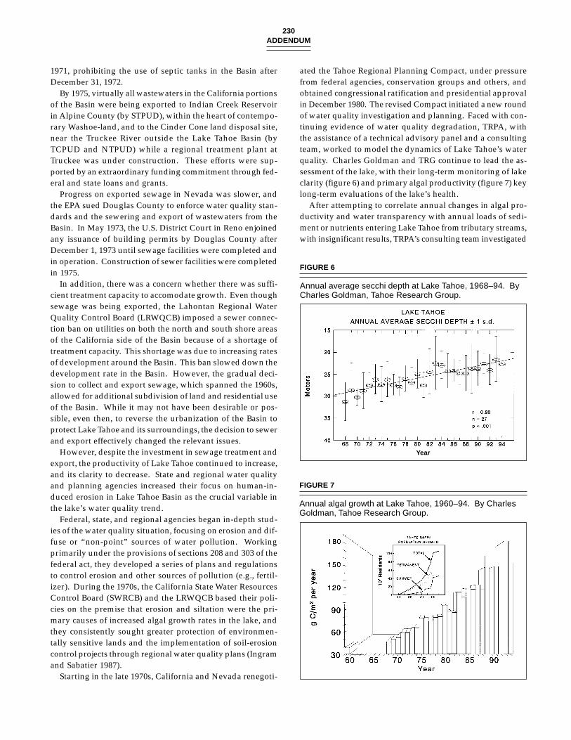
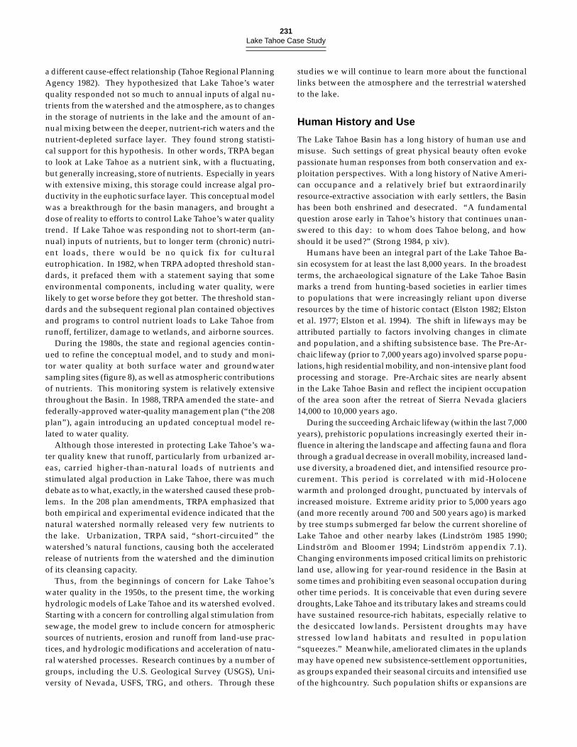
ated the Tahoe Regional Planning Compact, under pressurefrom federal agencies, conservation groups and others, andobtained congressional ratification and presidential approvalin December 1980. The revised Compact initiated a new roundof water quality investigation and planning. Faced with con-tinuing evidence of water quality degradation, TRPA, withthe assistance of a technical advisory panel and a consultingteam, worked to model the dynamics of Lake Tahoe’s waterquality. Charles Goldman and TRG continue to lead the as-sessment of the lake, with their long-term monitoring of lakeclarity (figure 6) and primary algal productivity (figure 7) keylong-term evaluations of the lake’s health.
After attempting to correlate annual changes in algal pro-ductivity and water transparency with annual loads of sedi-ment or nutrients entering Lake Tahoe from tributary streams,with insignificant results, TRPA’s consulting team investigated
FIGURE 6
Annual average secchi depth at Lake Tahoe, 1968–94. ByCharles Goldman, Tahoe Research Group.
Year
FIGURE 7
Annual algal growth at Lake Tahoe, 1960–94. By CharlesGoldman, Tahoe Research Group.
231Lake Tahoe Case Study
a different cause-effect relationship (Tahoe Regional PlanningAgency 1982). They hypothesized that Lake Tahoe’s waterquality responded not so much to annual inputs of algal nu-trients from the watershed and the atmosphere, as to changesin the storage of nutrients in the lake and the amount of an-nual mixing between the deeper, nutrient-rich waters and thenutrient-depleted surface layer. They found strong statisti-cal support for this hypothesis. In other words, TRPA beganto look at Lake Tahoe as a nutrient sink, with a fluctuating,but generally increasing, store of nutrients. Especially in yearswith extensive mixing, this storage could increase algal pro-ductivity in the euphotic surface layer. This conceptual modelwas a breakthrough for the basin managers, and brought adose of reality to efforts to control Lake Tahoe’s water qualitytrend. If Lake Tahoe was responding not to short-term (an-nual) inputs of nutrients, but to longer term (chronic) nutri-ent loads, there would be no quick fix for culturaleutrophication. In 1982, when TRPA adopted threshold stan-dards, it prefaced them with a statement saying that someenvironmental components, including water quality, werelikely to get worse before they got better. The threshold stan-dards and the subsequent regional plan contained objectivesand programs to control nutrient loads to Lake Tahoe fromrunoff, fertilizer, damage to wetlands, and airborne sources.
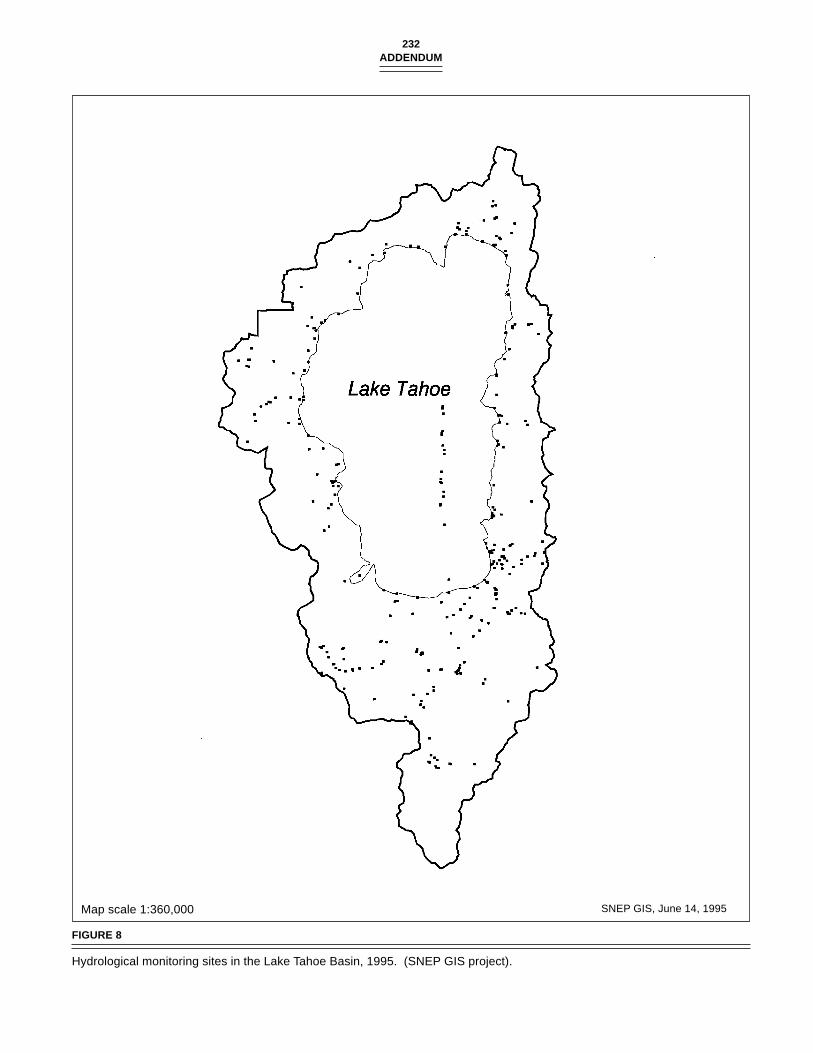
During the 1980s, the state and regional agencies contin-ued to refine the conceptual model, and to study and moni-tor water quality at both surface water and groundwatersampling sites (figure 8), as well as atmospheric contributionsof nutrients. This monitoring system is relatively extensivethroughout the Basin. In 1988, TRPA amended the state- andfederally-approved water-quality management plan (“the 208plan”), again introducing an updated conceptual model re-lated to water quality.
Although those interested in protecting Lake Tahoe’s wa-ter quality knew that runoff, particularly from urbanized ar-eas, carried higher-than-natural loads of nutrients andstimulated algal production in Lake Tahoe, there was muchdebate as to what, exactly, in the watershed caused these prob-lems. In the 208 plan amendments, TRPA emphasized thatboth empirical and experimental evidence indicated that thenatural watershed normally released very few nutrients tothe lake. Urbanization, TRPA said, “short-circuited” thewatershed’s natural functions, causing both the acceleratedrelease of nutrients from the watershed and the diminutionof its cleansing capacity.
Thus, from the beginnings of concern for Lake Tahoe’swater quality in the 1950s, to the present time, the workinghydrologic models of Lake Tahoe and its watershed evolved.Starting with a concern for controlling algal stimulation fromsewage, the model grew to include concern for atmosphericsources of nutrients, erosion and runoff from land-use prac-tices, and hydrologic modifications and acceleration of natu-ral watershed processes. Research continues by a number ofgroups, including the U.S. Geological Survey (USGS), Uni-versity of Nevada, USFS, TRG, and others. Through these
studies we will continue to learn more about the functionallinks between the atmosphere and the terrestrial watershedto the lake.
Human History and Use
The Lake Tahoe Basin has a long history of human use andmisuse. Such settings of great physical beauty often evokepassionate human responses from both conservation and ex-ploitation perspectives. With a long history of Native Ameri-can occupance and a relatively brief but extraordinarilyresource-extractive association with early settlers, the Basinhas been both enshrined and desecrated. “A fundamentalquestion arose early in Tahoe’s history that continues unan-swered to this day: to whom does Tahoe belong, and howshould it be used?” (Strong 1984, p xiv).
Humans have been an integral part of the Lake Tahoe Ba-sin ecosystem for at least the last 8,000 years. In the broadestterms, the archaeological signature of the Lake Tahoe Basinmarks a trend from hunting-based societies in earlier timesto populations that were increasingly reliant upon diverseresources by the time of historic contact (Elston 1982; Elstonet al. 1977; Elston et al. 1994). The shift in lifeways may beattributed partially to factors involving changes in climateand population, and a shifting subsistence base. The Pre-Ar-chaic lifeway (prior to 7,000 years ago) involved sparse popu-lations, high residential mobility, and non-intensive plant foodprocessing and storage. Pre-Archaic sites are nearly absentin the Lake Tahoe Basin and reflect the incipient occupationof the area soon after the retreat of Sierra Nevada glaciers14,000 to 10,000 years ago.
During the succeeding Archaic lifeway (within the last 7,000years), prehistoric populations increasingly exerted their in-fluence in altering the landscape and affecting fauna and florathrough a gradual decrease in overall mobility, increased land-use diversity, a broadened diet, and intensified resource pro-curement. This period is correlated with mid-Holocenewarmth and prolonged drought, punctuated by intervals ofincreased moisture. Extreme aridity prior to 5,000 years ago(and more recently around 700 and 500 years ago) is markedby tree stumps submerged far below the current shoreline ofLake Tahoe and other nearby lakes (Lindström 1985 1990;Lindström and Bloomer 1994; Lindström appendix 7.1).Changing environments imposed critical limits on prehistoricland use, allowing for year-round residence in the Basin atsome times and prohibiting even seasonal occupation duringother time periods. It is conceivable that even during severedroughts, Lake Tahoe and its tributary lakes and streams couldhave sustained resource-rich habitats, especially relative tothe desiccated lowlands. Persistent droughts may havestressed lowland habitats and resulted in population“squeezes.” Meanwhile, ameliorated climates in the uplandsmay have opened new subsistence-settlement opportunities,as groups expanded their seasonal circuits and intensified useof the highcountry. Such population shifts or expansions are
232ADDENDUM
Map scale 1:360,000 SNEP GIS, June 14, 1995
FIGURE 8
Hydrological monitoring sites in the Lake Tahoe Basin, 1995. (SNEP GIS project).
233Lake Tahoe Case Study
reflected archaeologically in the location and composition ofupland sites. More intensive and long-term use of the LakeTahoe Basin uplands during dry (i.e., xeric) intervals withinthe last 1,000 years is tentatively documented (Lindström 1982,Lindström and Bloomer 1994).
The last 1,300 years of the Archaic period may representthe initial phase of the Washoe ethnographic pattern and theonset of their long tenure in their known area of historic oc-cupation. Nearly 75% of the tested archaeological remains inthe Lake Tahoe Basin represent this latter period of humanhistory (Elston et al. 1994), and it is reasonable to concludethat most of the anthropogenic effects on the Lake Tahoe Ba-sin landscape date from this time period.
Washoe territory extended along the eastern Sierra Nevadafront from Honey Lake to the north, south to Topaz Lake, east-ward to the Virginia Range, and westward into the westernSierra Nevada foothills. The Lake Tahoe Basin held a centralplace in the Washoe economic and spiritual world. Washoeculture, residential patterns, social structure, subsistence, andreligion have been studied by ethnographers over the pasteighty years in an effort to reconstruct pre-contact patterns(Barrett 1917, Dangberg 1918–1922, d’Azevedo 1956, 1971,1985, 1986a, 1986b, 1991, 1993, Downs 1961, 1971a, 1971b, 1966;Freed 1963, 1966; Freed and Freed 1963a, 1963b; Lowie 1939;Nevers 1976; Siskin 1983; Price 1963a, 1963b, 1980). Most re-cently, Rucks (1995) reviewed literature relevant to Washoeground stone-milling technology and discussed residentialmobility, egalitarian social structure, land and resource own-ership and sharing, resource management, and Washoe worldview in relation to their potential effects on the Lake TahoeBasin ecosystem.
The pre-contact Washoe were hunter-gatherer people.While fish were the single most abundant and predictablestaple in the diet (d’Azevedo 1980; Lindström 1992), withpiñon pine and acorn providing important storable winterfoods, the Washoe were dependent upon a vast array of plantand animal life from a varied and diverse ecosystem. Thedeliberate management of wild plant and animal resourcesand their habitats, in order to enhance their quality and quan-tity, is a practice not typically attributed to hunter-gatherers.Yet, recent research provides compelling evidence for signifi-cant levels of resource manipulation by hunter-gatherer popu-lations. Horticultural practices such as burning, weeding,pruning, copicing, and selective harvest, were major elementsof tribal subsistence strategies (Anderson 1993; Anderson andNabhan 1991; Blackburn and Anderson 1993; Fowler 1994;McCarthy 1993; Rucks 1995). Furthermore, these horticul-tural practices were augmented by the generative and con-straining power of human language, ideology, religion andworld view. The mental culture was as dynamic a part of thehuman environment as optimal economic choice. Both realmsexerted selective pressure over the consequences of humanresource exploitation and management.
The degree to which the Washoe engaged in a highly inter-active system that actually changed floral and faunal patterns
over time requires further research. The detection of anthro-pogenically altered landscapes in the Lake Tahoe region ismade difficult by relatively lower indigenous population den-sities at higher elevations than in the adjoining foothills and,perhaps, by the higher incidence of lightning-caused fires herein relation to human-set fires. However, it is clear that Washoenatural resource manipulation was extensive, continual andsustained over a 1,300-year period, and that it integrated cul-tural traditions and beliefs (Rucks 1995). Washoe ideologyincorporates ethics for sharing resources with a spiritual con-nection to and responsibility for the land, plants, and animals(Rucks 1995). For the Washoe, harvesting entails ritual thatdemonstrates respect and gratitude for the resource, whiletheir conservation practices help ensure a sustained yield inyears to come.
The Lake Tahoe region encountered by early settlers hadbeen subject to Washoe land use for at least 1,300 years. How-ever, early settlers viewed indigenous land management ascreating, according to their perceptions, a “natural, un-im-proved, and un-owned landscape.” Lacking agriculture perse, the Washoe were perceived as passive in their relation-ship with the environment. Over-emphasis of Washoe tech-nological and social simplicity and conservatism, residentialmobility and impermanence, egalitarian social structure, andlack of private ownership has been used through time to jus-tify taking land and resources from people that never “owned”them in the first place. While the Washoe were a relativelyinformal and flexible political collectivity, Washoe ethnogra-phy suggests a level of technological specialization and so-cial complexity uncharacteristic of their surroundingneighbors in the Great Basin. Sedentism and higher popula-tion densities, concepts of private property, and communallabor and ownership may have developed in conjunction withtheir residential and subsistence resource stability (d’Azevedo1986a; Lindström 1992).
After European contact ca. 1848, the Washoe were largelydisplaced from their traditional camps and fishing grounds.However, families continued to trek to the lake, gatheringseeds, making baskets, speaking their language, and raisingtheir children. They negotiated living arrangements with thedairies, logging operators, and resorts, working as domes-tics, laborers and game guides, and as such maintaining a rem-nant of their past lifeway and culture while their leaderscontinued to struggle for political and social reforms and re-quest land and protection for their resources. After the pas-sage of the General Allotment Act of 1887, 160 acre (65 ha)plots “scattered ... in the most desolate and waterless sectionsof the Pinenut Range, or elsewhere on lands not alreadyclaimed by white settlers” were granted to individual Washoe(d’Azevedo 1993). Although lands around Lake Tahoe andin fertile valley floors had been petitioned, none were includedin the land allotment. A few decades later, the tribe’s corpo-rate charter was ratified (1936), a Tribal Council formed, anda constitution adopted, thus achieving federal recognitionunder the provision of the Indian Reorganization Act of 1934.
234ADDENDUM
In 1970 the tribe’s land claims case, initiated in 1951, was fi-nally settled, awarding them approximately $5 million of the$42.3 million in funds requested as compensation for theirlost homeland of approximately 10,000 square miles surround-ing the Lake Tahoe Basin. The federal government describedthe loss of the Washoe’s lands as encroachment, with sub-stantial evidence that the Nevada portion of their territorywas overrun by miners, settlers and others with the approvalof the United States government; by the end of 1862, the tribehad lost all ot its lands due to encroachment (U.S. IndianClaims Commission, 1959–1970).
Euro-American Era
The European culture superimposed upon the existing LakeTahoe Basin ecosystem during the mid-ninteenth centurystands in sharp contrast to indigenous land-use practices.Comstock-era logging and water management, sheep graz-ing, and a booming recreational economy within the last 150years resulted in disruption of the landscape. Between the1840s and 1880s, early settlers largely displaced the Washoeand their traditional land-use practices from the Lake TahoeBasin. Although the period of contact can be said to havebegun with Fremont’s sighting of Lake Tahoe in 1844, therewas no significant presence in the Basin until the ComstockLode silver discovery of 1859 (the California Gold Rush of1849–50 having been confined almost entirely to lower eleva-tions on the western slope of the Sierra Nevada). Impactswere immediate and dramatic. The mines of western Nevadapromised great wealth, but the surrounding terrain offeredneither water nor timber. The Lake Tahoe Basin, a mere 24km (15 mi) to the west, offered a seemingly endless supply ofboth. Early settlers, with their western ideology, viewed theBasin as a God-given resource waiting to be tapped. The July7, 1859 Alta California, a San Francisco daily newspaper,boasted “at present, the timber and lumber capabilities of theborders of Lake Tahoe seem illimitable (Goin 1992).” The lakeand its environs were assessed primarily in terms of their eco-nomic output. Raymond (1992) writes, “changes that wouldbe deplored today, such as clear-cutting slopes for timber, wereacclaimed by a nineteenth-century society that celebratedhuman dominion over nature.”
Timber Harvest
During the Comstock era from 1859 largely through the 1880s,large amounts of lumber were needed for the constructionand operation of the Virginia City mines. It has been saidthat the mines of the Comstock Lode are literally the tombsof the Sierra Nevada forests (Lord 1883). Although loggingextended from the east slopes of the Carson Range and souththrough the Carson River watershed, these areas were rap-idly depleted of their timber and harvesting was directed tothe Lake Tahoe Basin. About two-third’s of the Basin’s forestwere cut between 1860 and 1930, and the most accessible for-ests were extensively logged (Robert Harris, LTBMU, SUFS,
South Lake Tahoe, CA, 1996, personal communication). By1861, a large mill was operating at Glenbrook on Lake Tahoe’seastern shore. Cutting spread to the north and south shores,and finally to the west side. Large-scale timber operationsbegan after 1867 with the invention of the V-flume system fortransporting wood to staging areas. The 1869 completion ofthe transcontinental railroad, which had arrived in Truckeein 1868, also created additional demand for timber (Strong1984; Raymond 1992). With the technology of mills, railroads,and flumes, loggers transported 33 million board feet per yearto lumber yards in the Carson City and Virginia City area.During peak periods, as much as 72 million board feet of LakeTahoe Basin lumber were milled annually (Eissmann 1990).In a 20-year period, loggers took about $80 million worth oflumber from the Basin. The Carson and Tahoe Lumber andFluming Company produced 750 million board feet and one-half million cords of firewood between 1873 and 1898 alone.
As this demand for lumber increased, systematic lumber-ing quickly took its toll on forest resources. The result was“virtual deforestation of large portions of the Tahoe Basin bythe 1890’s” (Raymond 1992, p 15). By 1898, the last of theComstock era mills had closed for lack of available wood, leav-ing behind a drastically altered ecosystem (Raymond 1992).Jeffrey pine and sugar pine were targeted and the resultingsecond growth forest, increasingly dominated by white fir,was a prelude to today’s dying stands.
This deforestation is documented in the forest surveys con-ducted in the early twentieth century (Sudworth 1900; Leiberg1902) (figures 9 and 10). Both the Sudworth and Leiberg sur-veys covered portions of the Lake Tahoe Basin (McKelvey andJohnston 1992), with Leiberg’s (1902) work concentrated inportions of the northern Basin in Forest Reserves, andSudworth’s (1900) work in those areas that were portions ofthe southern and eastern forests. The extensive timber re-moval they documented suggests that both mammals andbirds needing a structurally complex (i.e., with numerouslarge downed trees, snags, and deep litter) or closed forestmay have become locally extinct, or at least population sizesdecreased dramatically.
Commercial Fishing
Commercial fishing began in Lake Tahoe with the opening ofthe Comstock mines in 1859. The Carson Valley and VirginiaCity were the initial markets. Later, San Francisco, Chicago,and New York imported fish from Lake Tahoe. In the 1870s,about twenty-five operators fished Lake Tahoe in the sum-mer, and the Washoe also fished in the Upper Truckee Riverand other tributaries to Lake Tahoe. As early as 1856, a pri-vate hatchery at Tahoe City and later two hatcheries of theCalifornia Fish Commission produced fry for Lake Tahoe. Asan example of the volume of commercial fishing that occurredhere, in October 1880, operators took 70,000 pounds of troutfrom Lake Tahoe. By 1904, eighty fishing boats worked thelake.
By the time that the California legislature banned commer-
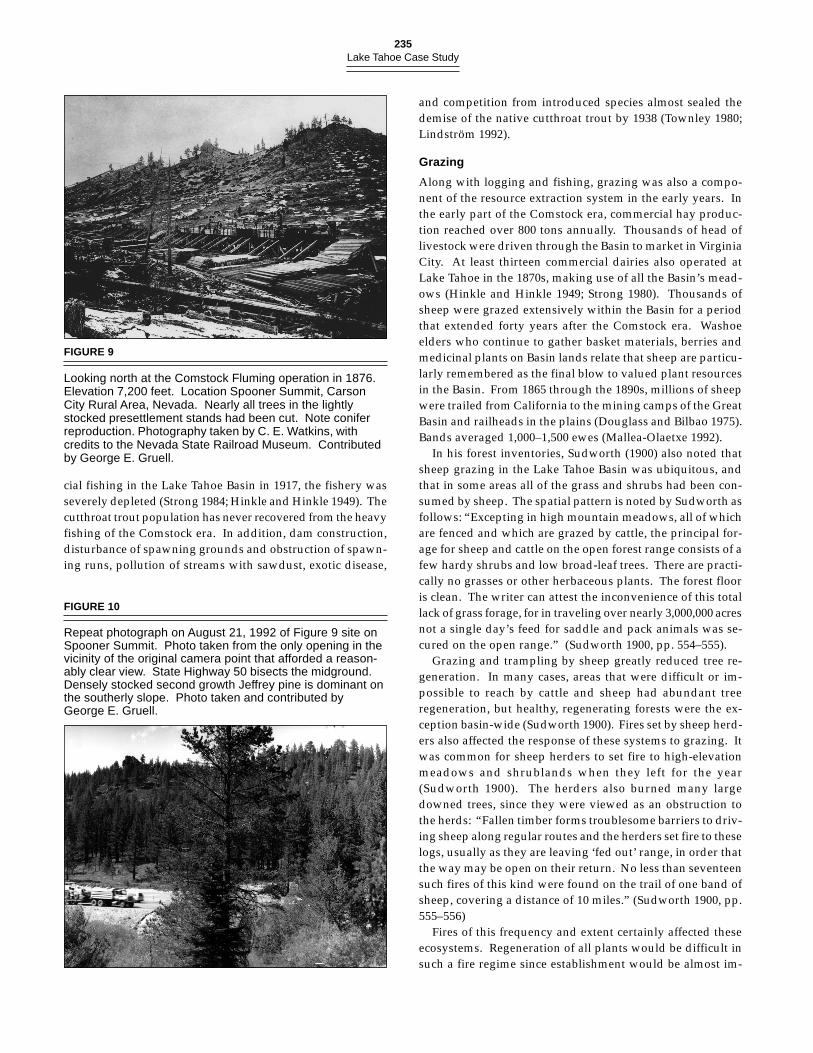
235Lake Tahoe Case Study
FIGURE 9
Looking north at the Comstock Fluming operation in 1876.Elevation 7,200 feet. Location Spooner Summit, CarsonCity Rural Area, Nevada. Nearly all trees in the lightlystocked presettlement stands had been cut. Note coniferreproduction. Photography taken by C. E. Watkins, withcredits to the Nevada State Railroad Museum. Contributedby George E. Gruell.
cial fishing in the Lake Tahoe Basin in 1917, the fishery wasseverely depleted (Strong 1984; Hinkle and Hinkle 1949). Thecutthroat trout population has never recovered from the heavyfishing of the Comstock era. In addition, dam construction,disturbance of spawning grounds and obstruction of spawn-ing runs, pollution of streams with sawdust, exotic disease,
and competition from introduced species almost sealed thedemise of the native cutthroat trout by 1938 (Townley 1980;Lindström 1992).
Grazing
Along with logging and fishing, grazing was also a compo-nent of the resource extraction system in the early years. Inthe early part of the Comstock era, commercial hay produc-tion reached over 800 tons annually. Thousands of head oflivestock were driven through the Basin to market in VirginiaCity. At least thirteen commercial dairies also operated atLake Tahoe in the 1870s, making use of all the Basin’s mead-ows (Hinkle and Hinkle 1949; Strong 1980). Thousands ofsheep were grazed extensively within the Basin for a periodthat extended forty years after the Comstock era. Washoeelders who continue to gather basket materials, berries andmedicinal plants on Basin lands relate that sheep are particu-larly remembered as the final blow to valued plant resourcesin the Basin. From 1865 through the 1890s, millions of sheepwere trailed from California to the mining camps of the GreatBasin and railheads in the plains (Douglass and Bilbao 1975).Bands averaged 1,000–1,500 ewes (Mallea-Olaetxe 1992).
In his forest inventories, Sudworth (1900) also noted thatsheep grazing in the Lake Tahoe Basin was ubiquitous, andthat in some areas all of the grass and shrubs had been con-sumed by sheep. The spatial pattern is noted by Sudworth asfollows: “Excepting in high mountain meadows, all of whichare fenced and which are grazed by cattle, the principal for-age for sheep and cattle on the open forest range consists of afew hardy shrubs and low broad-leaf trees. There are practi-cally no grasses or other herbaceous plants. The forest flooris clean. The writer can attest the inconvenience of this totallack of grass forage, for in traveling over nearly 3,000,000 acresnot a single day’s feed for saddle and pack animals was se-cured on the open range.” (Sudworth 1900, pp. 554–555).
Grazing and trampling by sheep greatly reduced tree re-generation. In many cases, areas that were difficult or im-possible to reach by cattle and sheep had abundant treeregeneration, but healthy, regenerating forests were the ex-ception basin-wide (Sudworth 1900). Fires set by sheep herd-ers also affected the response of these systems to grazing. Itwas common for sheep herders to set fire to high-elevationmeadows and shrublands when they left for the year(Sudworth 1900). The herders also burned many largedowned trees, since they were viewed as an obstruction tothe herds: “Fallen timber forms troublesome barriers to driv-ing sheep along regular routes and the herders set fire to theselogs, usually as they are leaving ‘fed out’ range, in order thatthe way may be open on their return. No less than seventeensuch fires of this kind were found on the trail of one band ofsheep, covering a distance of 10 miles.” (Sudworth 1900, pp.555–556)
Fires of this frequency and extent certainly affected theseecosystems. Regeneration of all plants would be difficult insuch a fire regime since establishment would be almost im-
FIGURE 10
Repeat photograph on August 21, 1992 of Figure 9 site onSpooner Summit. Photo taken from the only opening in thevicinity of the original camera point that afforded a reason-ably clear view. State Highway 50 bisects the midground.Densely stocked second growth Jeffrey pine is dominant onthe southerly slope. Photo taken and contributed byGeorge E. Gruell.
236ADDENDUM
possible unless the plants were in protected, isolated areas.The season of burning by the herders also would have a largeimpact on these systems. Fires did occur during diverse sea-sons pre-historically, but the compression of most fires to alimited season would adversely affect the biodiversity of theBasin.
Intensive sheep grazing of Basin meadows and slopescleared of their forests by Comstock-era logging continued inthe 1920s and 1930s (J.Mallea Olaetxe, personal communica-tion 1993). Grazing after the 1930s was continued by grazingallotments, with each permittee having access to a specificrange normally not shared with others.
The Lake Tahoe Basin’s strategic proximity to both theMother Lode and the Comstock Lode further promoted re-lated development in transportation infrastructure, markethunting and fishing, tourism, and urban development, whichbrought profound changes in the Basin’s ecosystem. Duringthe Comstock era, multiple streams were channeled and theirwater diverted to flumes for transport of logs downstream.Miles and miles of flumes were constructed to move cordwoodto Glenbrook and lumber from Spooner. The impacts of thisactivity on stream resources is not well documented.
Water Resources
After the Comstock Lode silver boom collapsed, water re-sources provided the next natural resource of great economicvalue. Pursuit of out-of-basin, alternative uses of Lake Tahoe’swater posed a subsequently serious threat to the ecosystem.The lake itself is a vast reservoir situated at the edge of theGreat Basin, and its high elevation offered unique opportuni-ties for gravity-flow diversions to nearby desert lands.
Early out-of-basin diversions were constructed at Echo andMarlette lakes. The Echo Lake diversion on the west side ofthe Basin, constructed in 1876 by a company that was a pre-decessor to the Pacific Gas and Electric Company, tunneledwater under the Sierra Nevada crest to the American RiverBasin, augmenting supplies to the western Sierra Nevada foot-hills and Sacramento. The Marlette Lake diversion on theeast side of the Basin, an inverted siphon constructed in 1873,delivered 6,600,000 gallons per day to the mines of VirginiaCity (Department of Water Resources 1991).
An example of human attempts to control water resourcescan be found in the efforts to turn Lake Tahoe into a reservoirfor Virginia City or San Francisco, an idea put forward byColonel Von Schmidt. Recognizing the agricultural potentialof western Nevada’s desert lands, Senator Francis G.Newlands pursued construction of a new dam at Lake Tahoe’soutlet along the northern shore to ensure a constant watersupply into Nevada for irrigation purposes, thus opening hun-dreds of thousands of acres for irrigation downstream. Hisefforts culminated in the passage of the Federal ReclamationAct of 1902, and, ultimately, construction of the NewlandsProject. The Bureau of Reclamation aimed to encourage settle-ment and economic development of the west by providingsufficient water to “make the desert bloom.” Nevada’s
Newlands Project, the first major project completed under theauthority of the Reclamation Act, remains the single largestappropriator of Lake Tahoe Basin water today. Constructionof this dam converted Lake Tahoe into a draw-down reser-voir. Later efforts (ca. 1938) by Nevada to receive permissionto tunnel through the Carson Range to obtain Lake Tahoe’swater were never approved.
In 1969, California and Nevada agreed to the InterstateCompact on the Truckee, Walker, and Carson River systems,which limited water withdrawals for use in the Lake TahoeBasin. Although the U.S. Congress never ratified the com-pact, it remains in effect as a policy agreement between thetwo states. As a result of litigation in federal court over wa-ter use and water rights in the Truckee River system, the courtappointed a federal water master to manage the dam at theoutlet to the Truckee River at Tahoe City. The reservoir por-tion of Lake Tahoe above the elevation of 1,897 m (6,223 ft)asl remains an important source of water for the Truckee-Carson Irrigation District and the Reno-Sparks area. A fed-eral statute which allotted Truckee River water was passed in1991, however, implementation of the bill is still the subjectof review.
The Lake Tahoe Basin’s incredible wealth of various waterresources and its strategic proximity to other resources andamenities justified the investment of a significant amount ofcapital in transportation to and through the Basin. ThePlacerville Road was constructed between Placerville andVirginia City in the 1850s and followed earlier emigrant andwagon routes through the Basin. The opening of the CentralPacific Railroad in 1868, with connections to the lake’snorthshore by stage in the 1860s and by rail in 1900 (LakeTahoe Railway and Transportation Company) fostered tour-ism and promoted the development of year-round commu-nities even after the demise of timber harvesting and grazingactivities. In addition, with the difficulty of overland travelwithin the Lake Tahoe Basin, steamships became a key partof the transportation network as early as 1864.
Conservation Ethic
While resource extraction was taking its toll on the Basinaround the turn of the century, the United States was alsowitnessing the beginnings of a conservation ethic. Prior tothe 1890s, popular culture had largely maintained the earlyJudeo-Christian ethic of wilderness as an evil, dark, forebod-ing menace that needed to be tamed by humankind before itsfruits could be harvested. With the onset of a conservationethic, a new philosophy emerged wherein the natural envi-ronment could be appreciated (Nash 1982). This emergentphilosophy of conservation of natural and scenic resources,promoted by the likes of Emerson, Thoreau, and Muir, quicklycame to play a major role in the public’s perceptions of, andattitudes toward Lake Tahoe. Increasingly, the Lake TahoeBasin was being viewed as a resource to be preserved ratherthan exploited.
Although the resource exploitation ethic remained domi-
237Lake Tahoe Case Study
nant during the latter half of the nineteenth century, therewas a notable increase in popular support for resource pres-ervation, particularly with respect to scenic quality. As earlyas 1859, the San Francisco press was reporting that Lake Tahoewould soon become beyond all doubt, one of the most inter-esting and agreeable resorts for pleasure and amusement onthe borders of the Pacific. Perhaps the most frequently citedsummation of Lake Tahoe’s beauty came in 1861 when ayoung Mark Twain wrote “.. at last the Lake burst upon us—a noble sheet of blue water lifted six thousand three hundredfeet above the level of the sea, and walled in by a rim of snow-clad mountain peaks that towered aloft full three thousandfeet higher still! As I lay there with shadows of the moun-tains brilliantly photographed upon its still surface, I thoughtit must surely be the fairest picture the whole earth affords.”(Twain, 1861 pp. 120-121)
The late 1800s saw a steady increase in the public’s percep-tion of Lake Tahoe as a recreational resource. Early lakefrontresorts flourished at Tahoe City, Glenbrook and Tallac. In 1900,the Lake Tahoe Railway opened between Truckee and TahoeCity, allowing wealthy San Francisco residents to travel tothe shores of Lake Tahoe in less than nine hours (Scott 1957).From Tahoe City, the luxurious steamer Tahoe ferried passen-gers around the lake to ports at Carnelian Bay, Brockway,Glenbrook, Tallac, and Emerald Bay. In ever increasing num-bers, these visitors helped establish a new direction in Ameri-can tourism. Historian John Sears describes this new directionwith a melding of recreational tourism and the wildernessethic as playing an important role in shaping a new Ameri-can identity. “People visited famed natural sites as if theywere shrines, where solemn reflection and adoration were theprescribed responses. In this regard, Tahoe was no excep-tion. Nineteenth century tourists came to the Lake to experi-ence its restorative powers, to see its sights, and to bespiritually uplifted amidst its well known beauties” (Sears1989).
For much of the next century, the name Lake Tahoe wouldbecome increasingly associated with both the beauty of natu-ral landscapes and recreational tourism. As a result, therewas a pronounced popular and political movement to set asidelands for the enjoyment of future generations. In 1883, theCalifornia legislature created the Lake Bigler Forestry Com-mission to specifically address the problems of over-harvest-ing of timber in the Lake Tahoe Basin. The study called forthe protection of the lake and its surrounding land for tour-ism. The commission also called for the creation of a park, tobe formed by the transfer of state, federal, and private land tothe State of California. Objections to land transfers that wouldultimately profit the Central Pacific Railroad prevented fur-ther action to create protection for the Lake Tahoe Basin (Pisani1977). Further protective legislation followed in 1889 andagain in 1894 which prohibited sawdust dumping in streamsand lakes. The federal presence at Lake Tahoe changed in1899 when 15,198 ha (37,550 ac) were set aside from the pub-lic domain by presidential proclamation as the Tahoe Forest
Reserve, areas where the resources—timber, watershed, andforage were to be used but not to the detriment of the reserveitself. Forest Reserves were transferred in 1905 from the De-partment of the Interior to the Department of Agriculture,where the Bureau of Forestry became the U.S. Forest Service.In 1907 forest reserves were renamed national forests (Steen1992). From this modest beginning, today the three nationalforests, Eldorado, Tahoe, and Toiyabe make up 77% of theLake Tahoe Basin land area. Three distinct efforts to desig-nate the Basin a national park were also pursued unsuccess-fully in 1900, 1912, and 1918.
The high percentage of ownership and development onprivate lands in the Basin dramatically changed land-use pat-terns in the Lake Tahoe Basin after 1900, especially with re-gard to increased recreation through the promotion ofcamping, hunting, fishing, winter sports activities, and theconstruction of summer homes (Beesley 1995; Markley andMeisenbach 1995). Large tracts of land remained privately-owned, particularly along the lakeshore, until the USFS be-gan acquiring tracts in the 1930s.
Tourism and Recreation
Lake Tahoe represented an idyllic vacation getaway to an evermore mobile and affluent society. The first passable roadaround the lake was completed in 1935. Having severely de-pleted timber resources, landowners were quick to capitalizeon the automobile and the new economic opportunity recre-ation provided. San Francisco newspapers proclaimed thatLake Tahoe would soon become a popular destination resortfor thousands of vacationers. Author Douglas Strong sum-marizes the sentiment of the day by quoting an editorial inthe Call, “...until now there has been no systematic exploita-tion of the real estate of the Lake shore. California (has) aduty to open the Lake Tahoe region to people from less fa-vored regions.” (Strong 1984, p. 39)
In the early part of the twentieth century, recreational tour-ism remained the domain of the wealthy elite. Transporta-tion was primarily by train or boat, and travel time was oftenlengthy (Nash 1982). At Lake Tahoe, summer resorts andsmall subdivisions characterized urban development from theturn of the century through World War II. Following the war,however, California’s population boomed, and the middleclass expanded at an unprecedented rate. Private automo-biles became available to large numbers of people, allowingthem access to recreational areas that had previously beeninaccessible. Highway 50 from Sacramento to the south shoreof Lake Tahoe was completed. At Lake Tahoe, as elsewherein the United States, use of the private automobile led to thedecline of railroads and steam-powered boats and the prolif-eration of roads, roadside attractions, and motor courts.
Casinos also came into being at this same time. In 1931,the Nevada legislature decided to allow open gambling op-erations so that gambling could be licensed, taxed, and po-liced. Games of chance were permitted and counties wereauthorized to collect a tax. During the 1930s and 1940s, the
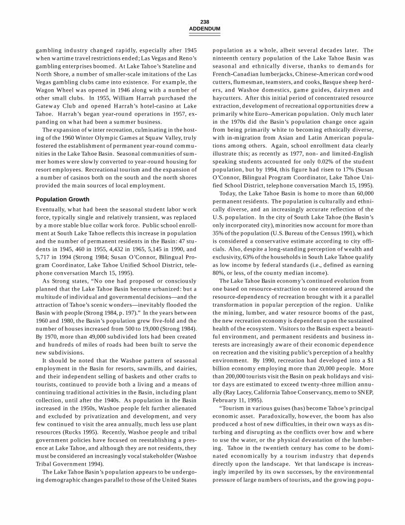
238ADDENDUM
gambling industry changed rapidly, especially after 1945when wartime travel restrictions ended; Las Vegas and Reno’sgambling enterprises boomed. At Lake Tahoe’s Stateline andNorth Shore, a number of smaller-scale imitations of the LasVegas gambling clubs came into existence. For example, theWagon Wheel was opened in 1946 along with a number ofother small clubs. In 1955, William Harrah purchased theGateway Club and opened Harrah’s hotel-casino at LakeTahoe. Harrah’s began year-round operations in 1957, ex-panding on what had been a summer business.
The expansion of winter recreation, culminating in the host-ing of the 1960 Winter Olympic Games at Squaw Valley, trulyfostered the establishment of permanent year-round commu-nities in the Lake Tahoe Basin. Seasonal communities of sum-mer homes were slowly converted to year-round housing forresort employees. Recreational tourism and the expansion ofa number of casinos both on the south and the north shoresprovided the main sources of local employment.
Population Growth
Eventually, what had been the seasonal student labor workforce, typically single and relatively transient, was replacedby a more stable blue collar work force. Public school enroll-ment at South Lake Tahoe reflects this increase in populationand the number of permanent residents in the Basin: 47 stu-dents in 1945, 460 in 1955, 4,432 in 1965, 5,145 in 1990, and5,717 in 1994 (Strong 1984; Susan O’Connor, Bilingual Pro-gram Coordinator, Lake Tahoe Unified School District, tele-phone conversation March 15, 1995).
As Strong states, “No one had proposed or consciouslyplanned that the Lake Tahoe Basin become urbanized: but amultitude of individual and governmental decisions—and theattraction of Tahoe’s scenic wonders—inevitably flooded theBasin with people (Strong 1984, p. 197).” In the years between1960 and 1980, the Basin’s population grew five-fold and thenumber of houses increased from 500 to 19,000 (Strong 1984).By 1970, more than 49,000 subdivided lots had been createdand hundreds of miles of roads had been built to serve thenew subdivisions.
It should be noted that the Washoe pattern of seasonalemployment in the Basin for resorts, sawmills, and dairies,and their independent selling of baskets and other crafts totourists, continued to provide both a living and a means ofcontinuing traditional activities in the Basin, including plantcollection, until after the 1940s. As population in the Basinincreased in the 1950s, Washoe people felt further alienatedand excluded by privatization and development, and veryfew continued to visit the area annually, much less use plantresources (Rucks 1995). Recently, Washoe people and tribalgovernment policies have focused on reestablishing a pres-ence at Lake Tahoe, and although they are not residents, theymust be considered an increasingly vocal stakeholder (WashoeTribal Government 1994).
The Lake Tahoe Basin’s population appears to be undergo-ing demographic changes parallel to those of the United States
population as a whole, albeit several decades later. Theninteenth century population of the Lake Tahoe Basin wasseasonal and ethnically diverse, thanks to demands forFrench-Canadian lumberjacks, Chinese-American cordwoodcutters, flumesman, teamsters, and cooks, Basque sheep herd-ers, and Washoe domestics, game guides, dairymen andhaycutters. After this initial period of concentrated resourceextraction, development of recreational opportunities drew aprimarily white Euro–American population. Only much laterin the 1970s did the Basin’s population change once againfrom being primarily white to becoming ethnically diverse,with in-migration from Asian and Latin American popula-tions among others. Again, school enrollment data clearlyillustrate this; as recently as 1977, non- and limited-Englishspeaking students accounted for only 0.02% of the studentpopulation, but by 1994, this figure had risen to 17% (SusanO’Connor, Bilingual Program Coordinator, Lake Tahoe Uni-fied School District, telephone conversation March 15, 1995).
Today, the Lake Tahoe Basin is home to more than 60,000permanent residents. The population is culturally and ethni-cally diverse, and an increasingly accurate reflection of theU.S. population. In the city of South Lake Tahoe (the Basin’sonly incorporated city), minorities now account for more than35% of the population (U.S. Bureau of the Census 1991), whichis considered a conservative estimate according to city offi-cials. Also, despite a long-standing perception of wealth andexclusivity, 63% of the households in South Lake Tahoe qualifyas low income by federal standards (i.e., defined as earning80%, or less, of the county median income).
The Lake Tahoe Basin economy’s continued evolution fromone based on resource-extraction to one centered around theresource-dependency of recreation brought with it a paralleltransformation in popular perception of the region. Unlikethe mining, lumber, and water resource booms of the past,the new recreation economy is dependent upon the sustainedhealth of the ecosystem. Visitors to the Basin expect a beauti-ful environment, and permanent residents and business in-terests are increasingly aware of their economic dependenceon recreation and the visiting public’s perception of a healthyenvironment. By 1990, recreation had developed into a $1billion economy employing more than 20,000 people. Morethan 200,000 tourists visit the Basin on peak holidays and visi-tor days are estimated to exceed twenty-three million annu-ally (Ray Lacey, California Tahoe Conservancy, memo to SNEP,February 11, 1995).
“Tourism in various guises (has) become Tahoe’s principaleconomic asset. Paradoxically, however, the boom has alsoproduced a host of new difficulties, in their own ways as dis-turbing and disrupting as the conflicts over how and whereto use the water, or the physical devastation of the lumber-ing. Tahoe in the twentieth century has come to be domi-nated economically by a tourism industry that dependsdirectly upon the landscape. Yet that landscape is increas-ingly imperiled by its own successes, by the environmentalpressure of large numbers of tourists, and the growing popu-
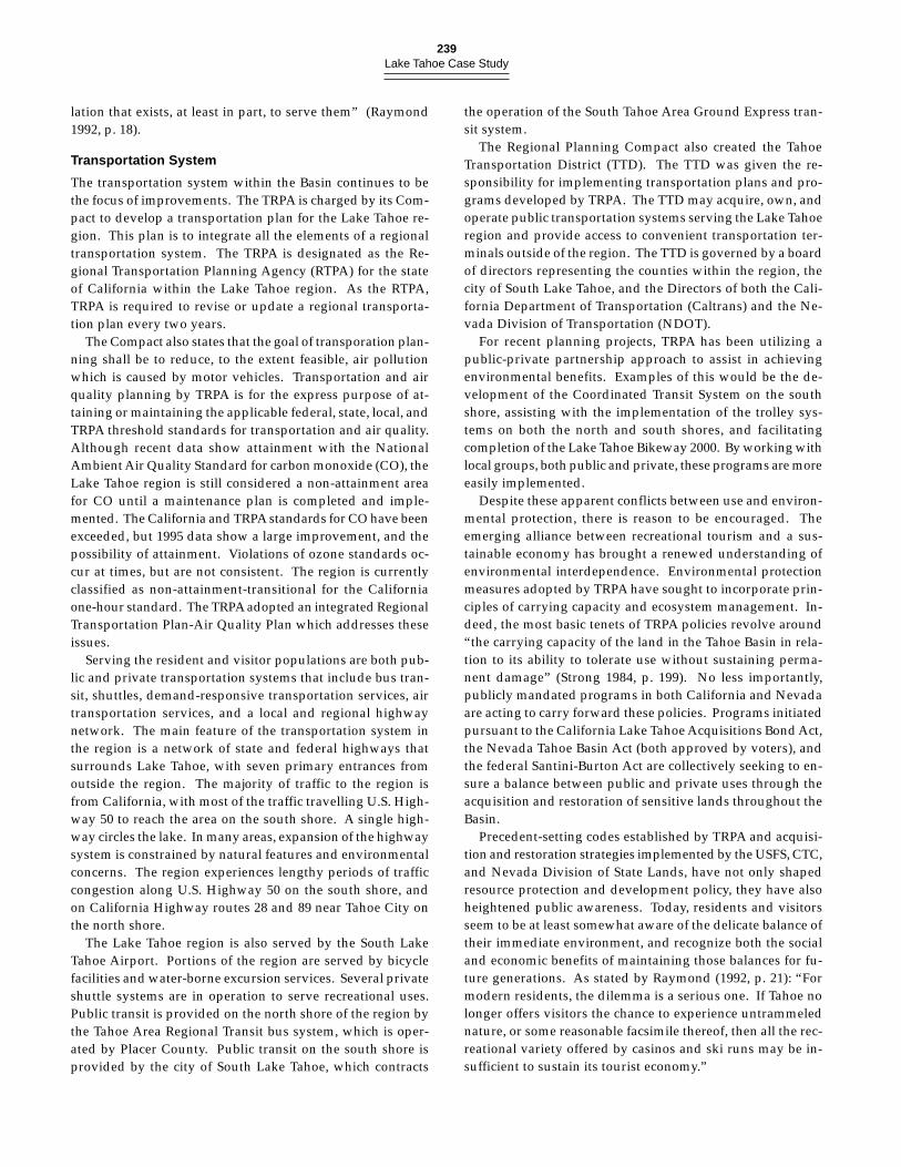
239Lake Tahoe Case Study
lation that exists, at least in part, to serve them” (Raymond1992, p. 18).
Transportation System
The transportation system within the Basin continues to bethe focus of improvements. The TRPA is charged by its Com-pact to develop a transportation plan for the Lake Tahoe re-gion. This plan is to integrate all the elements of a regionaltransportation system. The TRPA is designated as the Re-gional Transportation Planning Agency (RTPA) for the stateof California within the Lake Tahoe region. As the RTPA,TRPA is required to revise or update a regional transporta-tion plan every two years.
The Compact also states that the goal of transporation plan-ning shall be to reduce, to the extent feasible, air pollutionwhich is caused by motor vehicles. Transportation and airquality planning by TRPA is for the express purpose of at-taining or maintaining the applicable federal, state, local, andTRPA threshold standards for transportation and air quality.Although recent data show attainment with the NationalAmbient Air Quality Standard for carbon monoxide (CO), theLake Tahoe region is still considered a non-attainment areafor CO until a maintenance plan is completed and imple-mented. The California and TRPA standards for CO have beenexceeded, but 1995 data show a large improvement, and thepossibility of attainment. Violations of ozone standards oc-cur at times, but are not consistent. The region is currentlyclassified as non-attainment-transitional for the Californiaone-hour standard. The TRPA adopted an integrated RegionalTransportation Plan-Air Quality Plan which addresses theseissues.
Serving the resident and visitor populations are both pub-lic and private transportation systems that include bus tran-sit, shuttles, demand-responsive transportation services, airtransportation services, and a local and regional highwaynetwork. The main feature of the transportation system inthe region is a network of state and federal highways thatsurrounds Lake Tahoe, with seven primary entrances fromoutside the region. The majority of traffic to the region isfrom California, with most of the traffic travelling U.S. High-way 50 to reach the area on the south shore. A single high-way circles the lake. In many areas, expansion of the highwaysystem is constrained by natural features and environmentalconcerns. The region experiences lengthy periods of trafficcongestion along U.S. Highway 50 on the south shore, andon California Highway routes 28 and 89 near Tahoe City onthe north shore.
The Lake Tahoe region is also served by the South LakeTahoe Airport. Portions of the region are served by bicyclefacilities and water-borne excursion services. Several privateshuttle systems are in operation to serve recreational uses.Public transit is provided on the north shore of the region bythe Tahoe Area Regional Transit bus system, which is oper-ated by Placer County. Public transit on the south shore isprovided by the city of South Lake Tahoe, which contracts
the operation of the South Tahoe Area Ground Express tran-sit system.
The Regional Planning Compact also created the TahoeTransportation District (TTD). The TTD was given the re-sponsibility for implementing transportation plans and pro-grams developed by TRPA. The TTD may acquire, own, andoperate public transportation systems serving the Lake Tahoeregion and provide access to convenient transportation ter-minals outside of the region. The TTD is governed by a boardof directors representing the counties within the region, thecity of South Lake Tahoe, and the Directors of both the Cali-fornia Department of Transportation (Caltrans) and the Ne-vada Division of Transportation (NDOT).
For recent planning projects, TRPA has been utilizing apublic-private partnership approach to assist in achievingenvironmental benefits. Examples of this would be the de-velopment of the Coordinated Transit System on the southshore, assisting with the implementation of the trolley sys-tems on both the north and south shores, and facilitatingcompletion of the Lake Tahoe Bikeway 2000. By working withlocal groups, both public and private, these programs are moreeasily implemented.
Despite these apparent conflicts between use and environ-mental protection, there is reason to be encouraged. Theemerging alliance between recreational tourism and a sus-tainable economy has brought a renewed understanding ofenvironmental interdependence. Environmental protectionmeasures adopted by TRPA have sought to incorporate prin-ciples of carrying capacity and ecosystem management. In-deed, the most basic tenets of TRPA policies revolve around“the carrying capacity of the land in the Tahoe Basin in rela-tion to its ability to tolerate use without sustaining perma-nent damage” (Strong 1984, p. 199). No less importantly,publicly mandated programs in both California and Nevadaare acting to carry forward these policies. Programs initiatedpursuant to the California Lake Tahoe Acquisitions Bond Act,the Nevada Tahoe Basin Act (both approved by voters), andthe federal Santini-Burton Act are collectively seeking to en-sure a balance between public and private uses through theacquisition and restoration of sensitive lands throughout theBasin.
Precedent-setting codes established by TRPA and acquisi-tion and restoration strategies implemented by the USFS, CTC,and Nevada Division of State Lands, have not only shapedresource protection and development policy, they have alsoheightened public awareness. Today, residents and visitorsseem to be at least somewhat aware of the delicate balance oftheir immediate environment, and recognize both the socialand economic benefits of maintaining those balances for fu-ture generations. As stated by Raymond (1992, p. 21): “Formodern residents, the dilemma is a serious one. If Tahoe nolonger offers visitors the chance to experience untrammelednature, or some reasonable facsimile thereof, then all the rec-reational variety offered by casinos and ski runs may be in-sufficient to sustain its tourist economy.”
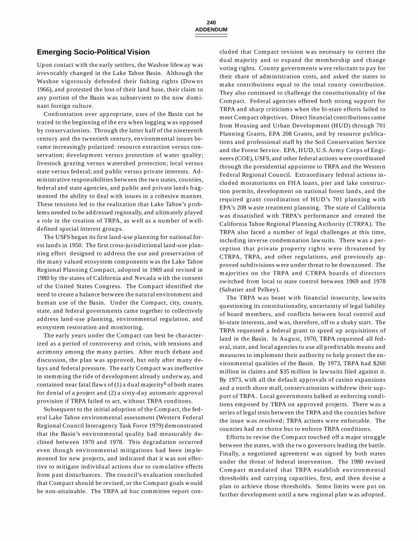
240ADDENDUM
Emerging Socio-Political Vision
Upon contact with the early settlers, the Washoe lifeway wasirrevocably changed in the Lake Tahoe Basin. Although theWashoe vigorously defended their fishing rights (Downs1966), and protested the loss of their land base, their claim toany portion of the Basin was subservient to the now domi-nant foreign culture.
Confrontation over appropriate, uses of the Basin can betraced to the beginning of the era when logging was opposedby conservationists. Through the latter half of the nineteenthcentury and the twentieth century, environmental issues be-came increasingly polarized: resource extraction versus con-servation; development versus protection of water quality;livestock grazing versus watershed protection; local versusstate versus federal; and public versus private interests. Ad-ministrative responsibilities between the two states, counties,federal and state agencies, and public and private lands frag-mented the ability to deal with issues in a cohesive manner.These tensions led to the realization that Lake Tahoe’s prob-lems needed to be addressed regionally, and ultimately playeda role in the creation of TRPA, as well as a number of well-defined special interest groups.
The USFS began its first land-use planning for national for-est lands in 1950. The first cross-jurisdictional land-use plan-ning effort designed to address the use and preservation ofthe many valued ecosystem components was the Lake TahoeRegional Planning Compact, adopted in 1969 and revised in1980 by the states of California and Nevada with the consentof the United States Congress. The Compact identified theneed to create a balance between the natural environment andhuman use of the Basin. Under the Compact, city, county,state, and federal governments came together to collectivelyaddress land-use planning, environmental regulation, andecosystem restoration and monitoring.
The early years under the Compact can best be character-ized as a period of controversy and crisis, with tensions andacrimony among the many parties. After much debate anddiscussion, the plan was approved, but only after many de-lays and federal pressure. The early Compact was ineffectivein stemming the tide of development already underway, andcontained near fatal flaws of (1) a dual majority6 of both statesfor denial of a project and (2) a sixty-day automatic approvalprovision if TRPA failed to act, without TRPA conditons.
Subsequent to the initial adoption of the Compact, the fed-eral Lake Tahoe environmental assessment (Western FederalRegional Council Interagency Task Force 1979) demonstratedthat the Basin’s environmental quality had measurably de-clined between 1970 and 1978. This degradation occurredeven though environmental mitigations had been imple-mented for new projects, and indicated that it was not effec-tive to mitigate individual actions due to cumulative effectsfrom past disturbances. The council’s evaluation concludedthat Compact should be revised, or the Compact goals wouldbe non-attainable. The TRPA ad hoc committee report con-
cluded that Compact revision was necessary to correct thedual majority and to expand the membership and changevoting rights. County governments were reluctant to pay fortheir share of administration costs, and asked the states tomake contributions equal to the total county contribution.They also continued to challenge the constitutionality of theCompact. Federal agencies offered both strong support forTRPA and sharp criticisms when the bi-state efforts failed tomeet Compact objectives. Direct financial contributions camefrom Housing and Urban Development (HUD) through 701Planning Grants, EPA 208 Grants, and by resource publica-tions and professional staff by the Soil Conservation Serviceand the Forest Service. EPA, HUD, U.S. Army Corps of Engi-neers (COE), USFS, and other federal actions were coordinatedthrough the presidential appointee to TRPA and the WesternFederal Regional Council. Extraordinary federal actions in-cluded moratoriums on FHA loans, pier and lake construc-tion permits, development on national forest lands, and therequired grant coordination of HUD’s 701 planning withEPA’s 208 waste treatment planning. The state of Californiawas dissatisfied with TRPA’s performance and created theCalifornia Tahoe Regional Planning Authority (CTRPA). TheTRPA also faced a number of legal challenges at this time,including inverse condemnation lawsuits. There was a per-ception that private property rights were threatened byCTRPA, TRPA, and other regulations, and previously ap-proved subdivisions were under threat to be downzoned. Themajorities on the TRPA and CTRPA boards of directorsswitched from local to state control between 1969 and 1978(Sabatier and Pelkey).
The TRPA was beset with financial insecurity, lawsuitsquestioning its constitutionality, uncertainty of legal liabilityof board members, and conflicts between local control andbi-state interests, and was, therefore, off to a shaky start. TheTRPA requested a federal grant to speed up acquisitions ofland in the Basin. In August, 1970, TRPA requested all fed-eral, state, and local agencies to use all predictable means andmeasures to implement their authority to help protect the en-vironmental qualities of the Basin. By 1973, TRPA had $260million in claims and $35 million in lawsuits filed against it.By 1973, with all the default approvals of casino expansionsand a north shore mall, conservationists withdrew their sup-port of TRPA. Local governments balked at enforcing condi-tions emposed by TRPA on approved projects. There was aseries of legal tests between the TRPA and the counties beforethe issue was resolved; TRPA actions were enforcable. Thecounties had no choice but to enforce TRPA conditions.
Efforts to revise the Compact touched off a major strugglebetween the states, with the two governors leading the battle.Finally, a negotiated agreement was signed by both statesunder the threat of federal intervention. The 1980 revisedCompact mandated that TRPA establish environmentalthresholds and carrying capacities, first, and then devise aplan to achieve those thresholds. Some limits were put onfurther development until a new regional plan was adopted.
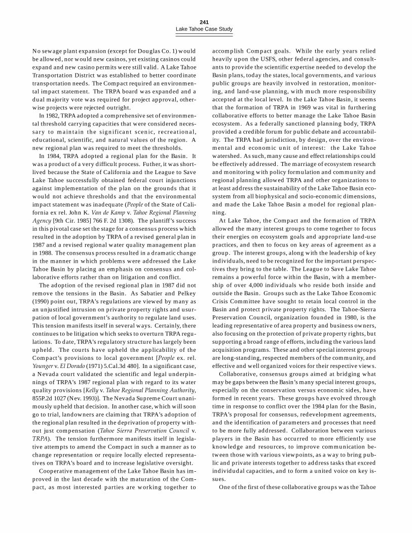
241Lake Tahoe Case Study
No sewage plant expansion (except for Douglas Co. 1) wouldbe allowed, nor would new casinos, yet existing casinos couldexpand and new casino permits were still valid. A Lake TahoeTransportation District was established to better coordinatetransportation needs. The Compact required an environmen-tal impact statement. The TRPA board was expanded and adual majority vote was required for project approval, other-wise projects were rejected outright.
In 1982, TRPA adopted a comprehensive set of environmen-tal threshold carrying capacities that were considered neces-sary to maintain the significant scenic, recreational,educational, scientific, and natural values of the region. Anew regional plan was required to meet the thresholds.
In 1984, TRPA adopted a regional plan for the Basin. Itwas a product of a very difficult process. Futher, it was short-lived because the State of California and the League to SaveLake Tahoe successfully obtained federal court injunctionsagainst implementation of the plan on the grounds that itwould not achieve thresholds and that the environmentalimpact statement was inadequate (People of the State of Cali-fornia ex rel. John K. Van de Kamp v. Tahoe Regional PlanningAgency [9th Cir. 1985] 766 F. 2d 1308). The plantiff’s successin this pivotal case set the stage for a consensus process whichresulted in the adoption by TRPA of a revised general plan in1987 and a revised regional water quality management planin 1988. The consensus process resulted in a dramatic changein the manner in which problems were addressed the LakeTahoe Basin by placing an emphasis on consensus and col-laborative efforts rather than on litigation and conflict.
The adoption of the revised regional plan in 1987 did notremove the tensions in the Basin. As Sabatier and Pelkey(1990) point out, TRPA’s regulations are viewed by many asan unjustified intrusion on private property rights and usur-pation of local government’s authority to regulate land uses.This tension manifests itself in several ways. Certainly, therecontinues to be litigation which seeks to overturn TRPA regu-lations. To date, TRPA’s regulatory structure has largely beenupheld. The courts have upheld the applicability of theCompact’s provisions to local government [People ex. rel.Younger v. El Dorado (1971) 5.Cal.3d 480]. In a significant case,a Nevada court validated the scientific and legal underpin-nings of TRPA’s 1987 regional plan with regard to its waterquality provisions [Kelly v. Tahoe Regional Planning Authority,855P.2d 1027 (Nev. 1993)]. The Nevada Supreme Court unani-mously upheld that decision. In another case, which will soongo to trial, landowners are claiming that TRPA’s adoption ofthe regional plan resulted in the deprivation of property with-out just compensation (Tahoe Sierra Preservation Council v.TRPA). The tension furthermore manifests itself in legisla-tive attempts to amend the Compact in such a manner as tochange representation or require locally elected representa-tives on TRPA’s board and to increase legislative oversight.
Cooperative management of the Lake Tahoe Basin has im-proved in the last decade with the maturation of the Com-pact, as most interested parties are working together to
accomplish Compact goals. While the early years reliedheavily upon the USFS, other federal agencies, and consult-ants to provide the scientific expertise needed to develop theBasin plans, today the states, local governments, and variouspublic groups are heavily involved in restoration, monitor-ing, and land-use planning, with much more responsibilityaccepted at the local level. In the Lake Tahoe Basin, it seemsthat the formation of TRPA in 1969 was vital in furtheringcollaborative efforts to better manage the Lake Tahoe Basinecosystem. As a federally sanctioned planning body, TRPAprovided a credible forum for public debate and accountabil-ity. The TRPA had jurisdiction, by design, over the environ-mental and economic unit of interest: the Lake Tahoewatershed. As such, many cause and effect relationships couldbe effectively addressed. The marriage of ecosystem researchand monitoring with policy formulation and community andregional planning allowed TRPA and other organizations toat least address the sustainability of the Lake Tahoe Basin eco-system from all biophysical and socio-economic dimensions,and made the Lake Tahoe Basin a model for regional plan-ning.
At Lake Tahoe, the Compact and the formation of TRPAallowed the many interest groups to come together to focustheir energies on ecosystem goals and appropriate land-usepractices, and then to focus on key areas of agreement as agroup. The interest groups, along with the leadership of keyindividuals, need to be recognized for the important perspec-tives they bring to the table. The League to Save Lake Tahoeremains a powerful force within the Basin, with a member-ship of over 4,000 individuals who reside both inside andoutside the Basin. Groups such as the Lake Tahoe EconomicCrisis Committee have sought to retain local control in theBasin and protect private property rights. The Tahoe-SierraPreservation Council, organization founded in 1980, is theleading representative of area property and business owners,also focusing on the protection of private property rights, butsupporting a broad range of efforts, including the various landacquisition programs. These and other special interest groupsare long-standing, respected members of the community, andeffective and well organized voices for their respective views.
Collaborative, consensus groups aimed at bridging whatmay be gaps between the Basin’s many special interest groups,especially on the conservation versus economic sides, haveformed in recent years. These groups have evolved throughtime in response to conflict over the 1984 plan for the Basin,TRPA’s proposal for consensus, redevelopment agreements,and the identification of parameters and processes that needto be more fully addressed. Collaboration between variousplayers in the Basin has occurred to more efficiently useknowledge and resources, to improve communication be-tween those with various viewpoints, as a way to bring pub-lic and private interests together to address tasks that exceedindividudal capacities, and to form a united voice on key is-sues.
One of the first of these collaborative groups was the Tahoe
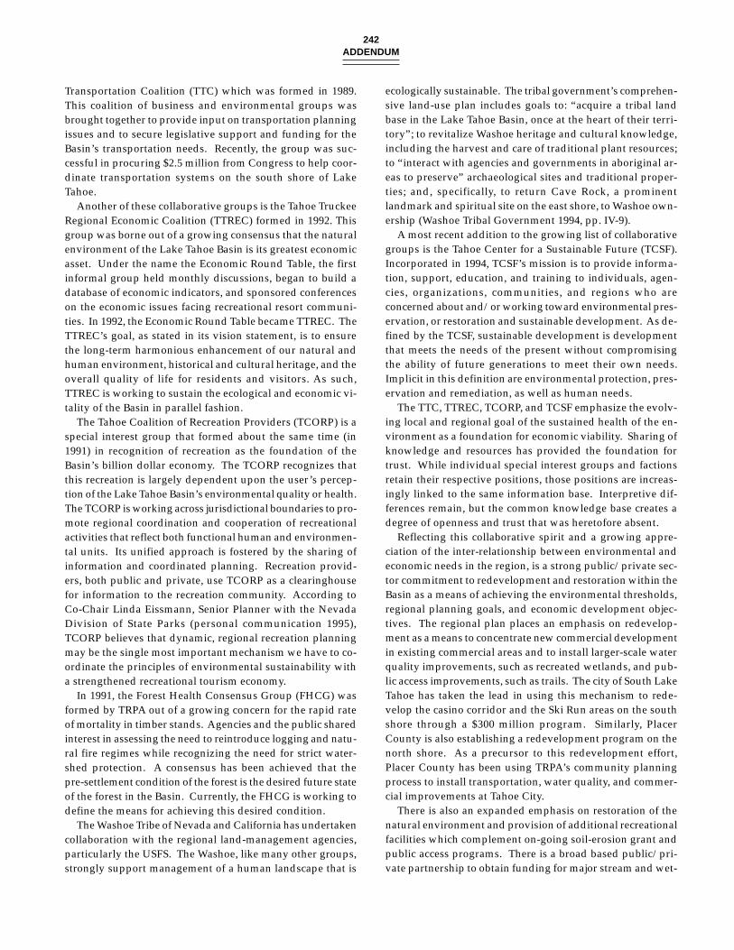
242ADDENDUM
Transportation Coalition (TTC) which was formed in 1989.This coalition of business and environmental groups wasbrought together to provide input on transportation planningissues and to secure legislative support and funding for theBasin’s transportation needs. Recently, the group was suc-cessful in procuring $2.5 million from Congress to help coor-dinate transportation systems on the south shore of LakeTahoe.
Another of these collaborative groups is the Tahoe TruckeeRegional Economic Coalition (TTREC) formed in 1992. Thisgroup was borne out of a growing consensus that the naturalenvironment of the Lake Tahoe Basin is its greatest economicasset. Under the name the Economic Round Table, the firstinformal group held monthly discussions, began to build adatabase of economic indicators, and sponsored conferenceson the economic issues facing recreational resort communi-ties. In 1992, the Economic Round Table became TTREC. TheTTREC’s goal, as stated in its vision statement, is to ensurethe long-term harmonious enhancement of our natural andhuman environment, historical and cultural heritage, and theoverall quality of life for residents and visitors. As such,TTREC is working to sustain the ecological and economic vi-tality of the Basin in parallel fashion.
The Tahoe Coalition of Recreation Providers (TCORP) is aspecial interest group that formed about the same time (in1991) in recognition of recreation as the foundation of theBasin’s billion dollar economy. The TCORP recognizes thatthis recreation is largely dependent upon the user’s percep-tion of the Lake Tahoe Basin’s environmental quality or health.The TCORP is working across jurisdictional boundaries to pro-mote regional coordination and cooperation of recreationalactivities that reflect both functional human and environmen-tal units. Its unified approach is fostered by the sharing ofinformation and coordinated planning. Recreation provid-ers, both public and private, use TCORP as a clearinghousefor information to the recreation community. According toCo-Chair Linda Eissmann, Senior Planner with the NevadaDivision of State Parks (personal communication 1995),TCORP believes that dynamic, regional recreation planningmay be the single most important mechanism we have to co-ordinate the principles of environmental sustainability witha strengthened recreational tourism economy.
In 1991, the Forest Health Consensus Group (FHCG) wasformed by TRPA out of a growing concern for the rapid rateof mortality in timber stands. Agencies and the public sharedinterest in assessing the need to reintroduce logging and natu-ral fire regimes while recognizing the need for strict water-shed protection. A consensus has been achieved that thepre-settlement condition of the forest is the desired future stateof the forest in the Basin. Currently, the FHCG is working todefine the means for achieving this desired condition.
The Washoe Tribe of Nevada and California has undertakencollaboration with the regional land-management agencies,particularly the USFS. The Washoe, like many other groups,strongly support management of a human landscape that is
ecologically sustainable. The tribal government’s comprehen-sive land-use plan includes goals to: “acquire a tribal landbase in the Lake Tahoe Basin, once at the heart of their terri-tory”; to revitalize Washoe heritage and cultural knowledge,including the harvest and care of traditional plant resources;to “interact with agencies and governments in aboriginal ar-eas to preserve” archaeological sites and traditional proper-ties; and, specifically, to return Cave Rock, a prominentlandmark and spiritual site on the east shore, to Washoe own-ership (Washoe Tribal Government 1994, pp. IV-9).
A most recent addition to the growing list of collaborativegroups is the Tahoe Center for a Sustainable Future (TCSF).Incorporated in 1994, TCSF’s mission is to provide informa-tion, support, education, and training to individuals, agen-cies, organizations, communities, and regions who areconcerned about and/or working toward environmental pres-ervation, or restoration and sustainable development. As de-fined by the TCSF, sustainable development is developmentthat meets the needs of the present without compromisingthe ability of future generations to meet their own needs.Implicit in this definition are environmental protection, pres-ervation and remediation, as well as human needs.
The TTC, TTREC, TCORP, and TCSF emphasize the evolv-ing local and regional goal of the sustained health of the en-vironment as a foundation for economic viability. Sharing ofknowledge and resources has provided the foundation fortrust. While individual special interest groups and factionsretain their respective positions, those positions are increas-ingly linked to the same information base. Interpretive dif-ferences remain, but the common knowledge base creates adegree of openness and trust that was heretofore absent.
Reflecting this collaborative spirit and a growing appre-ciation of the inter-relationship between environmental andeconomic needs in the region, is a strong public/private sec-tor commitment to redevelopment and restoration within theBasin as a means of achieving the environmental thresholds,regional planning goals, and economic development objec-tives. The regional plan places an emphasis on redevelop-ment as a means to concentrate new commercial developmentin existing commercial areas and to install larger-scale waterquality improvements, such as recreated wetlands, and pub-lic access improvements, such as trails. The city of South LakeTahoe has taken the lead in using this mechanism to rede-velop the casino corridor and the Ski Run areas on the southshore through a $300 million program. Similarly, PlacerCounty is also establishing a redevelopment program on thenorth shore. As a precursor to this redevelopment effort,Placer County has been using TRPA’s community planningprocess to install transportation, water quality, and commer-cial improvements at Tahoe City.
There is also an expanded emphasis on restoration of thenatural environment and provision of additional recreationalfacilities which complement on-going soil-erosion grant andpublic access programs. There is a broad based public/pri-vate partnership to obtain funding for major stream and wet-
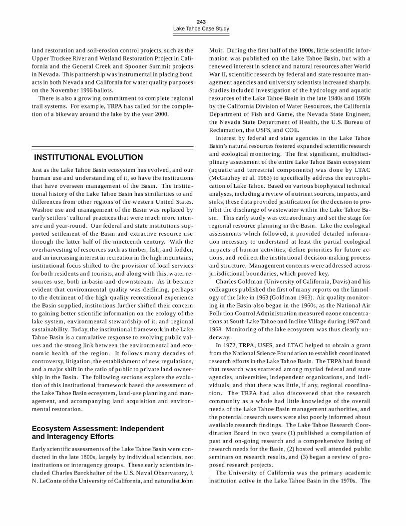
243Lake Tahoe Case Study
land restoration and soil-erosion control projects, such as theUpper Truckee River and Wetland Restoration Project in Cali-fornia and the General Creek and Spooner Summit projectsin Nevada. This partnership was instrumental in placing bondacts in both Nevada and California for water quality purposeson the November 1996 ballots.
There is also a growing commitment to complete regionaltrail systems. For example, TRPA has called for the comple-tion of a bikeway around the lake by the year 2000.
INSTITUTIONAL EVOLUTION
Just as the Lake Tahoe Basin ecosystem has evolved, and ourhuman use and understanding of it, so have the institutionsthat have overseen management of the Basin. The institu-tional history of the Lake Tahoe Basin has similarities to anddifferences from other regions of the western United States.Washoe use and management of the Basin was replaced byearly settlers’ cultural practices that were much more inten-sive and year-round. Our federal and state institutions sup-ported settlement of the Basin and extractive resource usethrough the latter half of the nineteenth century. With theoverharvesting of resources such as timber, fish, and fodder,and an increasing interest in recreation in the high mountains,institutional focus shifted to the provision of local servicesfor both residents and tourists, and along with this, water re-sources use, both in-basin and downstream. As it becameevident that environmental quality was declining, perhapsto the detriment of the high-quality recreational experiencethe Basin supplied, institutions further shifted their concernto gaining better scientific information on the ecology of thelake system, environmental stewardship of it, and regionalsustainability. Today, the institutional framework in the LakeTahoe Basin is a cumulative response to evolving public val-ues and the strong link between the environmental and eco-nomic health of the region. It follows many decades ofcontroversy, litigation, the establishment of new regulations,and a major shift in the ratio of public to private land owner-ship in the Basin. The following sections explore the evolu-tion of this institutional framework based the assessment ofthe Lake Tahoe Basin ecosystem, land-use planning and man-agement, and accompanying land acquisition and environ-mental restoration.
Ecosystem Assessment: Independentand Interagency Efforts
Early scientific assessments of the Lake Tahoe Basin were con-ducted in the late 1800s, largely by individual scientists, notinstitutions or interagency groups. These early scientists in-cluded Charles Burckhalter of the U.S. Naval Observatory, J.N. LeConte of the University of California, and naturalist John
Muir. During the first half of the 1900s, little scientific infor-mation was published on the Lake Tahoe Basin, but with arenewed interest in science and natural resources after WorldWar II, scientific research by federal and state resource man-agement agencies and university scientists increased sharply.Studies included investigation of the hydrology and aquaticresources of the Lake Tahoe Basin in the late 1940s and 1950sby the California Division of Water Resources, the CaliforniaDepartment of Fish and Game, the Nevada State Engineer,the Nevada State Department of Health, the U.S. Bureau ofReclamation, the USFS, and COE.
Interest by federal and state agencies in the Lake TahoeBasin’s natural resources fostered expanded scientific researchand ecological monitoring. The first significant, multidisci-plinary assessment of the entire Lake Tahoe Basin ecosystem(aquatic and terrestrial components) was done by LTAC(McGauhey et al. 1963) to specifically address the eutrophi-cation of Lake Tahoe. Based on various biophysical technicalanalyses, including a review of nutrient sources, impacts, andsinks, these data provided justification for the decision to pro-hibit the discharge of wastewater within the Lake Tahoe Ba-sin. This early study was extraordinary and set the stage forregional resource planning in the Basin. Like the ecologicalassessments which followed, it provided detailed informa-tion necessary to understand at least the partial ecologicalimpacts of human activities, define priorities for future ac-tions, and redirect the institutional decision-making processand structure. Management concerns were addressed acrossjurisdictional boundaries, which proved key.
Charles Goldman (University of California, Davis) and hiscolleagues published the first of many reports on the limnol-ogy of the lake in 1963 (Goldman 1963). Air quality monitor-ing in the Basin also began in the 1960s, as the National AirPollution Control Administration measured ozone concentra-tions at South Lake Tahoe and Incline Village during 1967 and1968. Monitoring of the lake ecosystem was thus clearly un-derway.
In 1972, TRPA, USFS, and LTAC helped to obtain a grantfrom the National Science Foundation to establish coordinatedresearch efforts in the Lake Tahoe Basin. The TRPA had foundthat research was scattered among myriad federal and stateagencies, universities, independent organizations, and indi-viduals, and that there was little, if any, regional coordina-tion. The TRPA had also discovered that the researchcommunity as a whole had little knowledge of the overallneeds of the Lake Tahoe Basin management authorities, andthe potential research users were also poorly informed aboutavailable research findings. The Lake Tahoe Research Coor-dination Board in two years (1) published a compilation ofpast and on-going research and a comprehensive listing ofresearch needs for the Basin, (2) hosted well attended publicseminars on research results, and (3) began a review of pro-posed research projects.
The University of California was the primary academicinstitution active in the Lake Tahoe Basin in the 1970s. The
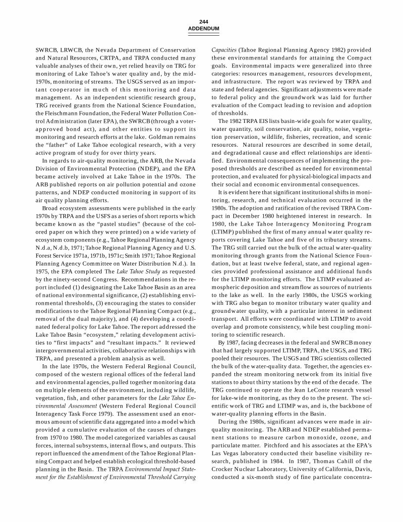
244ADDENDUM
SWRCB, LRWCB, the Nevada Department of Conservationand Natural Resources, CRTPA, and TRPA conducted manyvaluable analyses of their own, yet relied heavily on TRG formonitoring of Lake Tahoe’s water quality and, by the mid-1970s, monitoring of streams. The USGS served as an impor-tant cooperator in much of this monitoring and datamanagement. As an independent scientific research group,TRG received grants from the National Science Foundation,the Fleischmann Foundation, the Federal Water Pollution Con-trol Administration (later EPA), the SWRCB (through a voter-approved bond act), and other entities to support itsmonitoring and research efforts at the lake. Goldman remainsthe “father” of Lake Tahoe ecological research, with a veryactive program of study for over thirty years.
In regards to air-quality monitoring, the ARB, the NevadaDivision of Environmental Protection (NDEP), and the EPAbecame actively involved at Lake Tahoe in the 1970s. TheARB published reports on air pollution potential and ozonepatterns, and NDEP conducted monitoring in support of itsair quality planning efforts.
Broad ecosystem assessments were published in the early1970s by TRPA and the USFS as a series of short reports whichbecame known as the “pastel studies” (because of the col-ored paper on which they were printed) on a wide variety ofecosystem components (e.g., Tahoe Regional Planning AgencyN.d.a, N.d.b, 1971; Tahoe Regional Planning Agency and U.S.Forest Service 1971a, 1971b, 1971c; Smith 1971; Tahoe RegionalPlanning Agency Committee on Water Distribution N.d.). In1975, the EPA completed The Lake Tahoe Study as requestedby the ninety-second Congress. Recommendations in the re-port included (1) designating the Lake Tahoe Basin as an areaof national environmental significance, (2) establishing envi-ronmental thresholds, (3) encouraging the states to considermodifications to the Tahoe Regional Planning Compact (e.g.,removal of the dual majority), and (4) developing a coordi-nated federal policy for Lake Tahoe. The report addressed theLake Tahoe Basin “ecosystem,” relating development activi-ties to “first impacts” and “resultant impacts.” It reviewedintergovernmental activities, collaborative relationships withTRPA, and presented a problem analysis as well.
In the late 1970s, the Western Federal Regional Council,composed of the western regional offices of the federal landand environmental agencies, pulled together monitoring dataon multiple elements of the environment, including wildlife,vegetation, fish, and other parameters for the Lake Tahoe En-vironmental Assessment (Western Federal Regional CouncilInteragency Task Force 1979). The assessment used an enor-mous amount of scientific data aggregated into a model whichprovided a cumulative evaluation of the causes of changesfrom 1970 to 1980. The model categorized variables as causalforces, internal subsystems, internal flows, and outputs. Thisreport influenced the amendment of the Tahoe Regional Plan-ning Compact and helped establish ecological threshold-basedplanning in the Basin. The TRPA Environmental Impact State-ment for the Establishment of Environmental Threshold Carrying
Capacities (Tahoe Regional Planning Agency 1982) providedthese environmental standards for attaining the Compactgoals. Environmental impacts were generalized into threecategories: resources management, resources development,and infrastructure. The report was reviewed by TRPA andstate and federal agencies. Significant adjustments were madeto federal policy and the groundwork was laid for furtherevaluation of the Compact leading to revision and adoptionof thresholds.
The 1982 TRPA EIS lists basin-wide goals for water quality,water quantity, soil conservation, air quality, noise, vegeta-tion preservation, wildlife, fisheries, recreation, and scenicresources. Natural resources are described in some detail,and degradational cause and effect relationships are identi-fied. Environmental consequences of implementing the pro-posed thresholds are described as needed for environmentalprotection, and evaluated for physical-biological impacts andtheir social and economic environmental consequences.
It is evident here that significant institutional shifts in moni-toring, research, and technical evaluation occurred in the1980s. The adoption and ratification of the revised TRPA Com-pact in December 1980 heightened interest in research. In1980, the Lake Tahoe Interagency Monitoring Program(LTIMP) published the first of many annual water quality re-ports covering Lake Tahoe and five of its tributary streams.The TRG still carried out the bulk of the actual water-qualitymonitoring through grants from the National Science Foun-dation, but at least twelve federal, state, and regional agen-cies provided professional assistance and additional fundsfor the LTIMP monitoring efforts. The LTIMP evaluated at-mospheric deposition and streamflow as sources of nutrientsto the lake as well. In the early 1980s, the USGS workingwith TRG also began to monitor tributary water quality andgroundwater quality, with a particular interest in sedimenttransport. All efforts were coordinated with LTIMP to avoidoverlap and promote consistency, while best coupling moni-toring to scientific research.
By 1987, facing decreases in the federal and SWRCB moneythat had largely supported LTIMP, TRPA, the USGS, and TRGpooled their resources. The USGS and TRG scientists collectedthe bulk of the water-quality data. Together, the agencies ex-panded the stream monitoring network from its initial fivestations to about thirty stations by the end of the decade. TheTRG continued to operate the Jean LeConte research vesselfor lake-wide monitoring, as they do to the present. The sci-entific work of TRG and LTIMP was, and is, the backbone ofwater-quality planning efforts in the Basin.
During the 1980s, significant advances were made in air-quality monitoring. The ARB and NDEP established perma-nent stations to measure carbon monoxide, ozone, andparticulate matter. Pitchford and his associates at the EPA’sLas Vegas laboratory conducted their baseline visibility re-search, published in 1984. In 1987, Thomas Cahill of theCrocker Nuclear Laboratory, University of California, Davis,conducted a six-month study of fine particulate concentra-
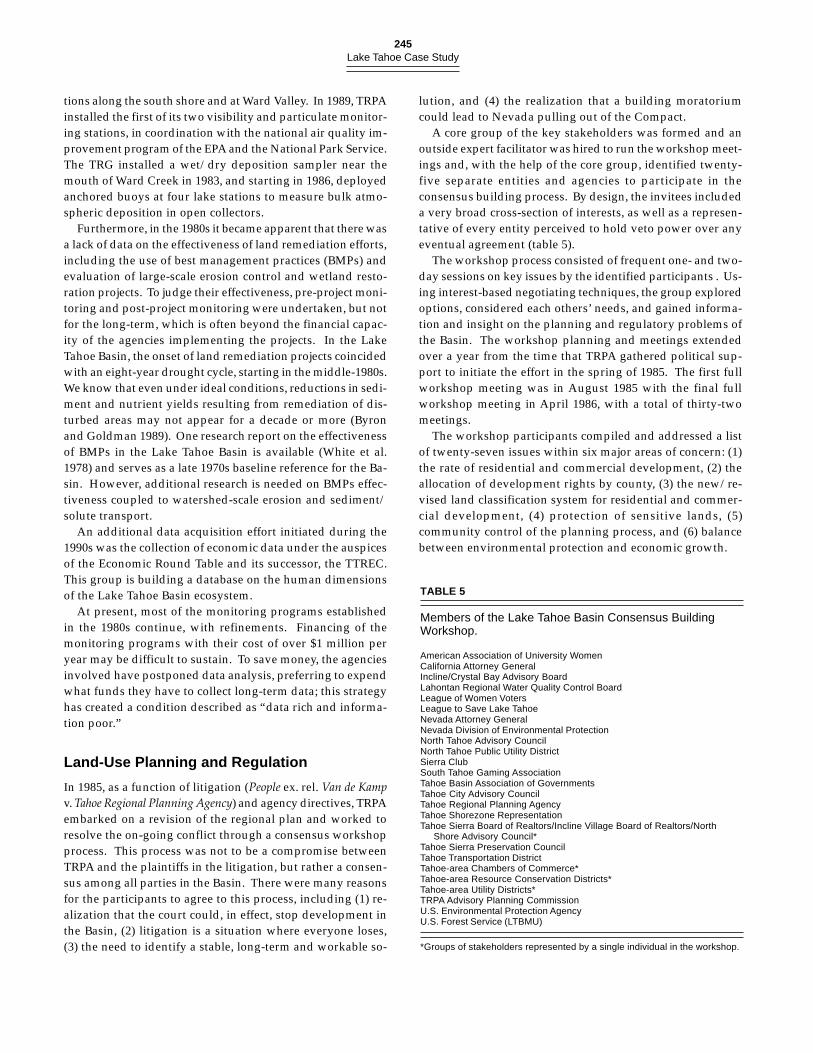
245Lake Tahoe Case Study
tions along the south shore and at Ward Valley. In 1989, TRPAinstalled the first of its two visibility and particulate monitor-ing stations, in coordination with the national air quality im-provement program of the EPA and the National Park Service.The TRG installed a wet/dry deposition sampler near themouth of Ward Creek in 1983, and starting in 1986, deployedanchored buoys at four lake stations to measure bulk atmo-spheric deposition in open collectors.
Furthermore, in the 1980s it became apparent that there wasa lack of data on the effectiveness of land remediation efforts,including the use of best management practices (BMPs) andevaluation of large-scale erosion control and wetland resto-ration projects. To judge their effectiveness, pre-project moni-toring and post-project monitoring were undertaken, but notfor the long-term, which is often beyond the financial capac-ity of the agencies implementing the projects. In the LakeTahoe Basin, the onset of land remediation projects coincidedwith an eight-year drought cycle, starting in the middle-1980s.We know that even under ideal conditions, reductions in sedi-ment and nutrient yields resulting from remediation of dis-turbed areas may not appear for a decade or more (Byronand Goldman 1989). One research report on the effectivenessof BMPs in the Lake Tahoe Basin is available (White et al.1978) and serves as a late 1970s baseline reference for the Ba-sin. However, additional research is needed on BMPs effec-tiveness coupled to watershed-scale erosion and sediment/solute transport.
An additional data acquisition effort initiated during the1990s was the collection of economic data under the auspicesof the Economic Round Table and its successor, the TTREC.This group is building a database on the human dimensionsof the Lake Tahoe Basin ecosystem.
At present, most of the monitoring programs establishedin the 1980s continue, with refinements. Financing of themonitoring programs with their cost of over $1 million peryear may be difficult to sustain. To save money, the agenciesinvolved have postponed data analysis, preferring to expendwhat funds they have to collect long-term data; this strategyhas created a condition described as “data rich and informa-tion poor.”
Land-Use Planning and Regulation
In 1985, as a function of litigation (People ex. rel. Van de Kampv. Tahoe Regional Planning Agency) and agency directives, TRPAembarked on a revision of the regional plan and worked toresolve the on-going conflict through a consensus workshopprocess. This process was not to be a compromise betweenTRPA and the plaintiffs in the litigation, but rather a consen-sus among all parties in the Basin. There were many reasonsfor the participants to agree to this process, including (1) re-alization that the court could, in effect, stop development inthe Basin, (2) litigation is a situation where everyone loses,(3) the need to identify a stable, long-term and workable so-
lution, and (4) the realization that a building moratoriumcould lead to Nevada pulling out of the Compact.
A core group of the key stakeholders was formed and anoutside expert facilitator was hired to run the workshop meet-ings and, with the help of the core group, identified twenty-five separate entities and agencies to participate in theconsensus building process. By design, the invitees includeda very broad cross-section of interests, as well as a represen-tative of every entity perceived to hold veto power over anyeventual agreement (table 5).
The workshop process consisted of frequent one- and two-day sessions on key issues by the identified participants . Us-ing interest-based negotiating techniques, the group exploredoptions, considered each others’ needs, and gained informa-tion and insight on the planning and regulatory problems ofthe Basin. The workshop planning and meetings extendedover a year from the time that TRPA gathered political sup-port to initiate the effort in the spring of 1985. The first fullworkshop meeting was in August 1985 with the final fullworkshop meeting in April 1986, with a total of thirty-twomeetings.
The workshop participants compiled and addressed a listof twenty-seven issues within six major areas of concern: (1)the rate of residential and commercial development, (2) theallocation of development rights by county, (3) the new/re-vised land classification system for residential and commer-cial development, (4) protection of sensitive lands, (5)community control of the planning process, and (6) balancebetween environmental protection and economic growth.
TABLE 5
Members of the Lake Tahoe Basin Consensus BuildingWorkshop.
American Association of University WomenCalifornia Attorney GeneralIncline/Crystal Bay Advisory BoardLahontan Regional Water Quality Control BoardLeague of Women VotersLeague to Save Lake TahoeNevada Attorney GeneralNevada Division of Environmental ProtectionNorth Tahoe Advisory CouncilNorth Tahoe Public Utility DistrictSierra ClubSouth Tahoe Gaming AssociationTahoe Basin Association of GovernmentsTahoe City Advisory CouncilTahoe Regional Planning AgencyTahoe Shorezone RepresentationTahoe Sierra Board of Realtors/Incline Village Board of Realtors/North
Shore Advisory Council*Tahoe Sierra Preservation CouncilTahoe Transportation DistrictTahoe-area Chambers of Commerce*Tahoe-area Resource Conservation Districts*Tahoe-area Utility Districts*TRPA Advisory Planning CommissionU.S. Environmental Protection AgencyU.S. Forest Service (LTBMU)
*Groups of stakeholders represented by a single individual in the workshop.
246ADDENDUM
Based on the progress made in the workshop through thespring of 1986, the parties involved in the litigation decidedto approach Federal District Court Judge Edmund Garcia witha plan to lift the then imposed development moratorium forthe summer construction season. He approved a stipulatedagreement among the parties authorizing a 1986 summerbuilding season, consisting of 300 residential permits and cer-tain other projects. This ended a four-year development mora-torium.
Subsequent to the adjournment of the full workshop, asmaller group of participants met from 1986 through early1987 to work out the details of the TRPA Code of Ordinancesand Plan Area Statements. The membership of this smallgroup varied from meeting to meeting based on the issueunder discussion, but the main participants were TRPA, theTahoe Sierra Preservation Council, the League to Save LakeTahoe, and the California Attorney General.
In 1987, a full settlement agreement was reached, based onTRPA’s adoption of the Code of Ordinances and Plan AreaStatements implementing the consensus plan. Judge Garciadismissed the lawsuits initiated by the State of California andthe League to Save Lake Tahoe. The consensus plan withamendments is still in place and being implemented today.
The consensus approach initially utilized to settle the 1984litigation has led to a number of cooperative and collabora-tive efforts. The focus is on finding areas of agreement andthen acting on them as a group. With the regional plan fi-nally in place, in 1988 TRPA revised the water quality man-agement plan (“208 plan”) to conform to the settlement, andobtained state and EPA approval. The TRPA also issued atransportation plan, and transportation planning became amajor institutional focus. In the Consensus Building Work-shop, the main planning issues had been related to land-useplanning, development on sensitive lands, and protection ofwater quality. With those issues settled, and traffic countsshowing increasing reliance on the private automobile, inter-est in transportation planning increased. A group of privateparties, including the Chambers of Commerce, the Lake TahoeGaming Alliance, Heavenly ski resort, and the League to SaveLake Tahoe, formed TCC to provide input to the transporta-tion planning process. The coalition was instrumental inbringing a Rural/Urban Design Assistance Team, from theAmerican Institute of Architects to Lake Tahoe in 1989 to studytransportation issues and make recommendations. At aboutthe same time, a group of private and public organizations inNorth Tahoe and Truckee formed a transportation manage-ment association, the first to be established in the Basin.
In keeping with the cooperative spirit of the ConsensusBuilding Workshop, planning proceeded for redevelopmentin South Lake Tahoe near the state-line. The city commencedits redevelopment program in order to upgrade its visitoraccomodations. As a result of the Urban Land Institute’s re-view of the regulatory program, the city realized that its mo-tel and hotel accomodations were not attractive to visitorswho wish to have more expensive accomodations. Addition-
ally, the redevelopment process provided an opportunity toreadjust land uses in an area and to incorporate public im-provements such as water quality improvements and trails.In support of this effort, the city obtained an amendment tothe state’s redevelopment law which allowed it to begin theprocess by making a finding of environmental degradationinstead of the usual finding of social blight. This finding re-flected, in part, the environmental objectives of the project. Apre-development agreement involving the city, the Califor-nia attorney general’s office, the League to Save Lake Tahoe,TRPA, and others resulted in adoption of a plan and the issu-ance of permits for two major redevelopment projects: theEmbassy Suites hotel, which opened in late 1991, and a hotelproposal at Ski Run Marina which has since been convertedinto a timeshare resort project which is scheduled to be con-structed in the summer of 1996. This redevelopment programhas resulted in improved aesthetics and water-quality treat-ment in the redevelopment area and in having California re-development law amended to include environmentaldegredation as a justification for redevelopment.
In the late 1980s, local governments and TRPA embarkedupon a process of community planning for up to twenty-fourdesignated commercial nodes around Lake Tahoe. Planningfor these areas had been contentious. Implementation hasmoved slowly and has remained difficult due to competitionbetween local areas, uncertainty regarding economic viabil-ity, and high costs of mitigation measures. Some participantsfelt that commercial areas should be governed by the samerules and regulations as other areas, while other participantsfelt they should be given a free hand to plan for the futurewithout interference from TRPA. The consensus plan em-braced the concept of a local-regional-community partnership,with incentives to property owners to participate.
In the present decade, the consensus approach developedin the 1980s has continued in effect throughout the Basin. Thecoalitions formed in the late 1980s continue to contribute tothe transportation and recreation planning processes. Com-munity planning also continues, albeit slowly.
In 1990, TRPA also began a complete evaluation of thethreshold standards and the regional plan (Tahoe RegionalPlanning Agency 1991). The resolution adopting the thresh-old standards in 1982, and every major plan document afterthat date, called for evaluations of the thresholds and the re-gional plan at least every five years. However, TRPA’s firstcomprehensive evaluation did not occur until 1991. Underthe terms of the Compact, TRPA may not implement a re-gional plan that will not achieve and maintain the environ-mental threshold standards, and may not approve any projectthat is inconsistent with the standards. Thus, periodic evalu-ations are important if TRPA is to continue to implement theregional plan and approve additional activities in the region.The evaluation was also of interest to the plaintiffs in the plan-related litigation, who needed to know that the consensus planwas being implemented, and to private property and devel-opment interests, who wanted orderly growth under the re-
247Lake Tahoe Case Study
gional plan to continue, rather than face another moratorium.The 1991 Evaluation Report (Tahoe Regional Planning Agency1991) concluded that the regional plan needed to be strength-ened in several areas. Specifically, TRPA made immediatechanges in its Code of Ordinances (e.g., strengthening con-trols on emissions from wood heaters) and agreed to a sched-ule for development of additional automobile usedisincentives (e.g., a parking ordinance). Given the magni-tude of the problems, however, these changes focused on rela-tively minor issues and details.
While for twenty-five years, the vast majority of planningactivity in the Lake Tahoe Basin had been directed at land-use planning, water-quality protection, transportation, andrelated issues, the forests of the Basin were gradually suc-cumbing to the combined stresses of insects, drought, over-stocking, and fire suppression. By the early 1990s, the dyingforest stands, many which were believed to have high fuelsloads with risk of wildfire, had become perhaps the Basin’smost contentious planning issue. There was no shortage ofblame, but there was a notable shortage of solutions on whichthe key institutions could agree. As such, in 1991, TRPA con-vened a Forest Health Consensus Group (FHCG), modeledafter the Consensus Building Workshop of the previous de-cade, to attempt to develop a consensus plan for forest man-agement. Local groups are working with the USFS to devisesmall-scale fuel reduction strategies for neighborhoods andsimilar areas. A draft EIS document by the LTBMU is cur-rently under review for treatment of fuels and fire hazard inthe forests of the northern part of the Basin.
It is difficult to assess the sustainability of the current useof the consensus approach in the Lake Tahoe Basin. Certainly,there are examples (e.g., export of sewage) where a consen-sus has been reached in the past. These efforts were followedby periods of contentiousness. However, the current empha-sis on consensus has produced significant results. This ap-pears to be a function of greater acceptance of both resourceprotection objectives and the means to achieve capital plan-ning and outlay programs and authority.
As in the past, litigation is creating uncertainty. There aretwo sets of cases which may significantly affect TRPA’s regu-latory programs. Two regulatory taking cases [Tahoe-SierraPreservation Council v. Tahoe Regional Planning Agency (U.S.District Court, D. Nev.) have been consolidated in the U.S.District Court in Reno, Nevada. This litigation challenges theconstitutionality (i.e., taking of land without just compensa-tion) of the TRPA building restrictions on environmentallysensitive lands under both the 1984 and 1987 regional plans.Currently, the parties are exploring settlement through medi-tated negotiations. In Suitum v. Tahoe Regional Planning Agency(U.S. Court of Appeals for the Ninth Circuit), the owner of awetlands parcel has challenged the constitutionality of TRPA’sregulations which preclude development of the parcel. Thecourt dismissed the appeal on the ground, that the landownerhad failed to take advantage of the multiple transfer of de-velopment programs available under the regional plan. On
appeal, the Ninth Circuit of Appeal has upheld the DistrictCourt decision. Decisions which are adverse to TRPA coulddramatically alter the manner in which environmentally sen-sitive lands are regulated in the Lake Tahoe Basin.
Public Land Acquisition, Restoration andManagement Activities
Another important resource management strategy in the LakeTahoe Basin is the acquisition of additional public lands, res-toration of their natural environments, and their on-goingmanagement. Such activities are especially important in ar-eas such as the Lake Tahoe Basin where there is a fine-scalemix of private and public land ownership and uses, wheresignificant natural values are being adversely impacted byrapid growth, and where the overall objective is to improveenvironmental quality.
These activities serve a number of resource managementobjectives. In the Lake Tahoe Basin, acquisition activities pro-vide the land and resource base to achieve public objectives(e.g., environmental thresholds) and to incorporate ecosys-tem dynamics into management strategies and practices. Spe-cifically, acquisition activities are important because they seekto prevent further disturbance of environmentally sensitivelands and wildlife habitat, and provide opportunities for res-toration and the construction of public access facilities. Re-search has shown that disturbance of environmentallysensitive lands (e.g., Bailey Land Capability Classes 1–3) (fig-ure 11) and stream environment zones (SEZs) significantlyincreases concentrations of nitrate, total phosphorous andsuspended sediment in streams, stimulating algal productiv-ity (Byron and Goldman 1987), and decreases wildlife habi-tat as well. Acquisitions can help prevent further disturbanceto wildlife habitat. Disturbance of wildlife habitat has reducedboth the number and variety of wildlife in the Basin (TRPA1982). Due to historical settlement patterns, most of the shore-line is privately-owned (Strong 1984). Consequently, acqui-sition is also needed to expand recreational opportunities inorder to accommodate existing public demand for recreation.Acquisition programs give landowners an opportunity to selltheir land for public purposes and to receive fair compensa-tion for it.
In the Lake Tahoe Basin, site improvements are critical toincrease the capacity of public lands to function naturallywhile supporting public uses. Erosion-control improvementsare needed to control the release of phosphorous and othernutrients from disturbed areas. Public access improvementsare needed to allow recreational opportunities at existing andnew sites, to enhance the visitor’s experience, and most im-portantly to minimize environmental damage caused by over-use. Trails are needed to connect existing facilities in order tolower reliance on the automobile to travel from one facility toanother. Activities such as stream and riparian restorationare needed to provide additional habitat for wildlife and fish.
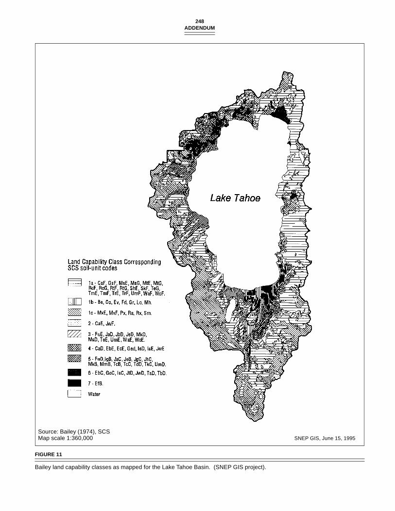
248ADDENDUM
Source: Bailey (1974), SCSMap scale 1:360,000 SNEP GIS, June 15, 1995
FIGURE 11
Bailey land capability classes as mapped for the Lake Tahoe Basin. (SNEP GIS project).
249Lake Tahoe Case Study
Site improvement activities also support local and regionalplanning activities and provide private sector jobs.
Land management activities strive to maintain naturalfunctions and provide public access opportunities, to enablethe development of new restoration techniques and manage-ment strategies, and to protect public health and safety. Thefollowing discussion outlines the evolution of these types ofactivities at Lake Tahoe.
Public Land Acquisition
There has been a long, approximately 100 year history of ac-quisition or reservation of land for public purposes in the LakeTahoe Basin. Land acquisition activities reflect, in large part,the evolutionary changes in public agency policy with regardto recreation and environmental protection and the availabil-ity of purchase funds.
The initial blueprint of ownership and land uses withinthe Basin was set by federal policy. With the original publicdomain, the government disposed of land in the Lake TahoeBasin in the second half of the nineteenth century under theprevailing national policy to encourage settlement and eco-nomic development of the American West (Fink 1991). Landwas disposed of to private owners for agricultural, timber,and resort uses, and for the development of the transconti-nental railway.
Toward the end of the nineteenth century, the federal gov-ernment began to shift policy from disposal of public landsto retention for park and conservation purposes (Fink 1991).The creation of the Tahoe Forest Reserve in 1899 was a mani-festation of this policy. It marked the beginning of an ex-traordinary effort to reserve lands for public purposes, whichhas resulted in federal ownership of 77% of the Lake TahoeBasin (figure 12).
Acquisition of public lands by the USFS has been exten-sive. The original national forest land in the Basin has beenincreased to the present 77% or 63,200 ha (158,000 acres) and21 km (11 miles) of shoreline through land exchanges and,more recently, through direct purchase under the Land andWater Conservation Fund Act of 1965 and the Santini-Burtonacquisition program. Two sizable land exchange transactionsadded significant acreage to public land in the Basin: (1) in1936, the Carson & Tahoe Timber and Flume Company ex-changed 3,147 ha (7,776 acres) of cut over and uncut timberland in the Upper Truckee River area, and (2) in 1950-51, thePope Baldwin exchange added 1,425 ha (3,523 acres) of primelakeshore land in the Fallen Leaf Lake and South Lake Tahoeareas, two key subregions of recreational activity. Three sig-nificant land purchases occurred after the passage of the Con-servation Fund Act in 1965: (1) the Whittell Estate (Dreyfus)lands on Nevada’s east shore comprising some 4,219 ha(10,425 acres) for $10.6 million in 1972, which added 10.5 km(6.5 mi) of shoreline to public ownership, (2) the FibreboardCorporation lands, 4,096 ha (10,121 acres) for $9.9 million inthe northwest sector of the Basin, in 1974, and (3) the MeeksBay land from Hewlett in 1974 for $3.0 million, adding 261 ha
(645 acre) including 1,014 m (3,328 ft) of shoreline with 549m(1,800 ft) of excellent beach.
Although the LTBMU of the USFS was formed in April,1973 to provide uniform management of national forest landsin the Basin, these lands legally remain a part of three pro-claimed national forests: Eldorado, Tahoe, and Toiyabe.
In the early 1970s, TRPA staff and the USFS Planning Teamfor the Basin prepared a Public Lands Priorities Map, whichwas an inventory of private lands which, if acquired, wouldserve a useful public purpose. Lands were evaluated for suchfactors as public use, manageability (size), watershed protec-tion, wildlife and scenic value, and development pressure.The cost was estimated to be well over $100 million for directpurchases and land exchanges of high-priority lands.
After more than fifty years of effort, the USFS land acquisi-tion program is more than 95% complete. Current federalownership now stands at 77% of the 83,065 ha (202,250 acres)landbase, with the ratio between public and private owner-ship effectively reversed from the situation in 1900.
Given the strong federal interest in the Lake Tahoe Basin,the states did not play an active role in acquisition duringmost of the nineteenth century. In California, however, therewas a concern that clear-cut removal of timber was severelydamaging the beauty of the region. In 1883, the Lake BiglerForest Commission urged the federal government to acquireprivate lands in the Basin and to transfer management re-sponsibilities to the states for park purposes (Strong 1994).
Near the end of the nineteenth century, California began toestablish a state park system. In 1899, the first park site, TahoeState Park, was set aside at Tahoe City (Strong 1984). Duringthe late 1920s, the state park movement expanded, and in 1927,the California legislature approved a $6 million bond act foracquisition of lands, including property in the Lake TahoeBasin, to be included in the state park system (Strong 1984).This action started a largely bond-funded acquisition pro-gram, which over the next sixty years resulted in the acquisi-tion of about 2,430 ha (6,000 ac) and creation of state parkssuch as D.L. Bliss and Sugar Pine Point. These acquisitionsare important recreational lands and core areas of biologicaldiversity because of their large size.
Nevada established its first state park in the Lake TahoeBasin at Sand Harbor in 1958 (Strong 1984). In 1961, therewas an attempt to create a bi-state park, as recommended byan Interstate Commission, through the establishment of theLake Tahoe Park Interstate Park Authority. The proposal wassparked by a realization that Nevada had the land and Cali-fornia had the funds and the likely user group. This proposalwas the first attempt to establish a bi-state authority in theLake Tahoe Basin but failed in the Nevada legislature (Fink1991). In 1964, the Nevada legislature did pass a park billwhich allocated funds for the acquisition of a large undevel-oped stretch of shoreline owned by George Whittell. In 1967,Nevada acquired 3,024 ha (5,000 ac) which became the foun-dation of a 5,260 ha (13,000 ac) Lake Tahoe Nevada State Park(Strong 1984).
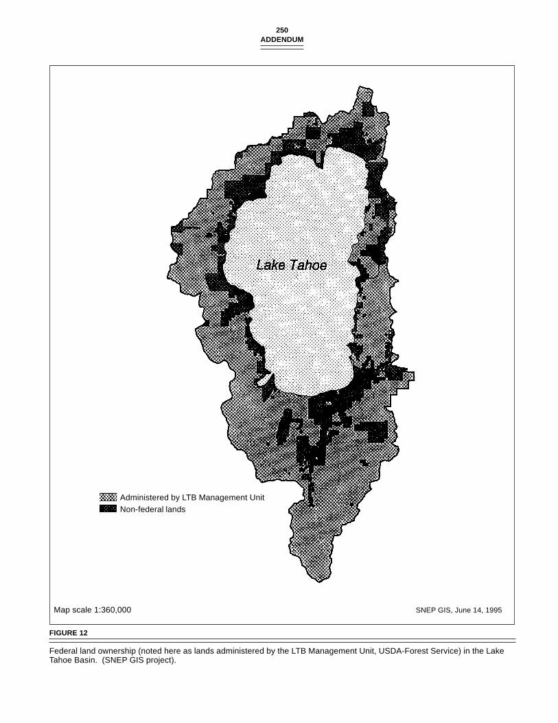
250ADDENDUM
Map scale 1:360,000 SNEP GIS, June 14, 1995
FIGURE 12
Federal land ownership (noted here as lands administered by the LTB Management Unit, USDA-Forest Service) in the LakeTahoe Basin. (SNEP GIS project).
Administered by LTB Management UnitNon-federal lands
251Lake Tahoe Case Study
The states’ efforts to acquire land (over 7,690 ha [19,000ac]) for state parks complemented the USFS efforts to acquirelarger parcels of land for recreation and conservation pur-poses. These acquisitions, totalling 52,600 ha (130,000 acres),formed the landbase for large-scale ecosystem protection.
The rapid urbanization of the Lake Tahoe Basin in the 1950salso dramatically influenced the scope and type of land ac-quisition within the region. Urbanization, fueled by a increas-ing demand for recreation, resulted in the creation of over49,000 parcels and the development of 11,300 ha (28,000 acres)(Ingrum 1986). The Lake Tahoe Basin’s population grew five-fold from 1960 to 1978 (Fink 1991). This urbanization frag-mented the Basin’s ecosystem into thousands of parcels ofdifferent qualities, and resulted in rapid deterioration of airand water quality, wetland function, and wildlife viability(Fink 1991). Loss of these natural values focused attentionon the urban areas, whereas previously, the focus of conser-vation was on the wildland mountains, forests, and portionsof the shoreline. It became evident that urban activities af-fected the natural areas, and as such, the practice of preserv-ing of natural areas while allowing development of urbanareas was no longer a sound method of resource management.
Monitoring made the impact of urbanization on water qual-ity in particular very clear. In the late 1950s, the focus was onthe disposal of sewage on lands within the Basin. Sewageexport was ordered in both states by 1966 and was accom-plished by 1975 (Fink 1991). During the 1960s, the role ofstream-borne nutrients to water quality of the lake began tobe examined. In the 1970s, studies showed that the occur-rence of free-floating algae (planktonic) and attached algae(periphyton) were closely related to urban development(Goldman 1989). Research showed that a direct positive rela-tionship existed between increased urban land coverage andland disturbance and decreased water quality (Goldman1989). It also became more evident that most nutrients spur-ring algal growth in the lake resulted from non-point sourcessuch as disturbed soils, enhanced runoff over impervioussurfaces, air pollution, and destruction of natural vegetationand wetlands (Goldman 1989). Point sources such as golfcourses which were regularly fertilized were also identifiedas potential nutrient sources (Goldman 1989).
With the pursuit of regional management strategies dur-ing the 1970s, there was a growing recognition of the need foran expanded basis of land acquisition. The call for expandedand accelerated federal and state acquisition efforts came fromthe League to Save Lake Tahoe, TRPA, Western Federal Re-gional Council (1979), and SWRCB (1980). The call for ex-panded acquisition efforts, including small subdivided parcelsin already developed areas, resulted from recognition that theremaining undeveloped environmentally sensitive landsneeded to be protected in order to prevent introduction ofadditional nutrients to the lake, to provide future opportuni-ties to restore the nutrient-removal capacity of natural sys-tems, to provide an equitable alternative to landowners, andto relieve pressure on the planning process. This proposal
was an extraordinary shift in policy because the acquisitionof this type of parcel was previously considered too expen-sive and controversial, because the parcels were thought tobe too difficult to manage. However, increasing scientificevidence pointed out the value of these small pieces of theecosystem. They were thought to perform important ecosys-tem functions, including being important in the maintenanceof the clarity of Lake Tahoe.
During the 1980s, three federal and state acquisition pro-grams were established primarily to acquire environmentallysensitive urban lots. The procurement of funding sources waskey to implementation of these programs. In 1980, the fed-eral Santini-Burton program was established, in part, for theacquisition of environmentally sensitive lands. The USFS hasmade substantial progress in implementing this program. Ithas expended $99.1 million for the acquisition of 3,479 par-cels involving 4,582 ha (11,322 acres) in both states (Marlow1996).
During the 1980s, the voters in California and Nevada ap-proved environmental bond acts in 1982 and 1986, respec-tively. These actions were consistent with a national trendtoward greater involvement by states, using bond-funded ac-quisition programs to deal with environmental protection(Fink 1991). The development of such programs is under-standable in light of the states’ traditional responsibility forland-use regulation. The programs were developed indepen-dently by each state. Previous attempts to establish a bi-statepark authority and a basin-wide Tahoe Conservancy agencyin 1973 were not approved by Nevada. Consequently, theseprograms evolved separately, unlike the successful effort toestablish a bi-state land-use regulatory agency (i.e., TRPA).
The California 1982 bond act provided $85 million of fundsfor the acquisition and management of undeveloped prop-erty for the purposes of protecting the natural environment,providing public access opportunities, and preserving wild-life habitat (Tahoe Area Land Acquisitions Commission 1983).Upon approval of the bond act, the Tahoe Area Land Acquisi-tions Commission (TALAC) was formed to advise the gover-nor and the legislature on the implementation of the bond actprogram. After a series of public hearings, TALAC recom-mended the use of a conservancy model. Conservancies inboth the non-profit and state agency sectors were created toaffirmatively deal with resource needs and to resolve land-use conflicts in a regional and more decentralized manner.They represented attempts to adapt institutional structure toregional ecosystems. The CTC was established only for theCalifornia side of the Lake Tahoe Basin because it could bedesigned under California law, with amendments to the origi-nal legislation, to be a regionally-based and locally headquar-tered agency with broad authorities to accomplish a range ofobjectives, and with a governing board which reflected a bal-ance of state, local, and federal entities necessary to success-fully implement its programs (Tahoe Area Land AcquisitionsCommission 1983). The activation of a regional agency wasalso thought to be desirable because it would be more respon-
252ADDENDUM
sive to landowners and management concerns as it was basedin the region; it would have shorter lines of communicationand fewer levels of decision-making than a typical state-wideagency. The conservancy model also placed an emphasis onthe resolution of land-use conflicts (Machida and Gussman1988).
Prior to the authorization of CTC, the State of Californiacompleted the acquisition of the 310 ha (770 ac) Lake Coun-try Estates for the purpose of resolving land-use litigation.This action was a precursor of the state’s interest in using theCTC to resolve land-use conflicts in the Lake Tahoe Basinthrough acquisition. To date, it has settled five major long-standing lawsuits against regulatory agencies through “will-ing-seller” acquisitions.
The CTC is continuing to implement its acquisitions pro-gram. The CTC has been able to expand the scope of its pro-grams to include (1) the acquisition and improvement ofdeveloped and undeveloped property to prevent disturbanceof environmentally sensitive lands, (2) the restoration of de-graded lands through erosion control, watershed restoration,and transfer of development rights and mitigation programs,(3) the provision of new or expanded access facilities to thelake and other natural areas, and (4) the protection and en-hancement of wildlife habitat. Pursuant to these programs, ithas authorized the expenditure of over $92 million for theacquisition of over 5,000 parcels of land involving over 2,830ha (7,000 ac) (California Tahoe Conservancy 1996). Mitiga-tion credit, or transfer of development rights, has been pro-vided for over 2,300 private and public projects (CaliforniaTahoe Conservancy 1996). It should be noted that the num-bers for these two programs include CTC grants to the USFS;therefore, there is some double-counting in both programs.
In Nevada, the voters approved a $31 million environmen-tal bond act in 1986. Of this amount, approximately $23 mil-lion was allocated for acquisitions and $8 million forsoil-erosion control projects. Nevada also used a commis-sion (Commission for Land Acquisition in the Tahoe Basin)to recommend the parameters of a program to the governorand the legislation. The commission recommended utiliza-tion of an existing governmental entity, the State Lands Divi-sion (Division) to acquire land under the bond act program.Recently, the Division received authorization to establish amitigation bank similar to California’s program. To date, theDivision has acquired 497 parcels involving approximately85 ha (212 ac) (Pam Wilcox, Director, Division of Lands, Stateof Nevada, interview March 12, 1996).
Non-profit land trust organizations have also played aprominent role in assisting public land acquisition programsin the Lake Tahoe Basin. Generally, these organizations se-cure options to acquire land, if public acquisition funds areunavailable, and sell land to public agencies when funds be-come available. For example, the Trust for Public Land hasassisted the USFS and CTC in acquiring 156 parcels (over 360ha [900 acres]), including the USFS’s Secret Harbor project
involving 1,070 m (3,500 feet) of shoreline in Nevada (DavidMarlow, Lands Oficer, LTBMU, interview March 13, 1996).
With the increase in public land ownership and associatedland uses over the past 100 years, several significant trendsare apparent: (1) the percentage of private and unclaimedlands decreased to only 12% of the landbase, with the highpercentage of public, non-urbanized lands offering signifi-cant cooperative resource management opportunities betweenthe USFS, state parks, conservancy lands, utility/improve-ment districts, and Natural Resources Conservation Service(NRCS)/Resource Conservation Districts; (2) opportunitiesto achieve and maintain TRPA’s environmental thresholds aresignificantly dependent on publicly managed lands, especiallythresholds involving wetland restoration, sediment reduction,fish and wildlife habitat, recreation, and vehicle miles trav-eled; federal, state, and local programs and budgets are anintegral part of helping the Basin meet the environmentalthresholds; (3) availability of publicly owned lands is also acritical component in meeting community needs for trans-portation and utility corridors, administrative sites, integratederosion-control sites, and community recreation sites.
Site Improvements
The USFS, state agencies, local governments, and non-profitorganizations are involved in a range of site improvementprograms, as the work only begins with acquisition activi-ties. Many different ecological improvements are underway,including better routing and construction of trails, restora-tion of converted meadows to include natural wetland func-tions, and revegetation and rewatering of streamside zones.
During the first seventy years of this century, the publicsector’s investment in site improvements was directed to-wards transportation, development of water supplies, fireprotection, sewage treatment, and recreational improvements,all increasing the accessibility of the Basin for humans. Dur-ing the past fifteen years, a substantial investment in preserv-ing water quality and protecting the environment has beenmade as well.
In 1980, the federal Santini-Burton program was also es-tablished, with a focus on erosion-control and wetland-resto-ration projects. In 1980, both states also establishederosion-control grants programs. Many agencies have coop-erated in implementing soil-erosion control and wetland-res-toration projects in the Basin. A combination of federal, state,and local funds were procured to fund substantial grant pro-grams. These funds are administered by the USFS, CTC,LRWQCB, and TRPA. The primary implementation agenciesare local governments. Their involvement began in 1979 whenWashoe County implemented the Upper Fairview project. Theinvolvement of local government has been critical in theseprograms because of their ownership of street rights-of-wayand project development, implementation, and managementcapabilities.
All of the local governments (El Dorado County, city of
253Lake Tahoe Case Study
South Lake Tahoe, Placer County, Washoe County, DouglasCounty) and public utility districts (STPUD, TCPUD, NTPUD,Incline Public Utility District) are currently implementingprojects. The Tahoe Resource Conservation District, in con-junction with NRCS, is providing technical and planning as-sistance to many of these entities
In addition to local governmental efforts, the state trans-portation agencies (CalTrans and NDOT), state park depart-ments, and resource management agencies (e.g., USFS, CTC)are implementing projects on their properties.
Between 1977 and 1992, federal, state, and local agencieshave invested approximately $90 million in erosion-controland SEZ site-improvement restoration projects (TRPA 1992;U.S. Forest Service 1996). Of this total, the states provided60%, the federal government provided 31%, and local sourcescontributed 9% of the funding. These totals do not includeland acquisition costs. State contributions have been substan-tial, with the Nevada contributing approximately $16.2 mil-lion (TRPA 1992), and since 1980, California contributing atotal of $40 million for soil-erosion control and SEZ restora-tion site improvement grant projects through the SWRCB($13.2 million) and the CTC ($26.9 million) (California TahoeConservancy 1994). This investment is helping to restore theLake Tahoe Basin’s landscape. As an example, local govern-ments have revegetated more than 47 ha (115 acres) of land,restored 26 ha (65 acres) of disturbed wetlands, and con-structed more than 11 k (70 miles) of roadside drainage facili-ties to control erosion and restore the watershed throughgrants by CTC. Since the inititation of the Santini-Burton pro-gram, the USFS has awarded $16.2 million in grants for sev-enty-six projects.
The CTC and Department of Parks and Recreation (DPR)are conducting site improvement activities under public ac-cess and wildlife programs. Public access site-improvementfunds are being used to construct hiking, biking, and cross-country ski trails (with 45 km [28 miles] of trails acquired orconstructed to date) and trailheads; the construction and ex-pansion of parks and support facilities such as restrooms andparking areas; and the installation of interpretive facilities.The wildlife site-improvement funds are being used to restorestreams and offshore habitat areas, marshes, and riparian ar-eas and to meet the special habitat needs of the bald eagle,peregrine falcon, and osprey. These projects are being imple-mented directly by the agencies or through grants to federal,state, and local agencies and to non-profit organizations. Todate, CTC has authorized the expenditure of $5.8 million forpublic access site-improvement projects and $2.7 million forwildlife enhancement projects. In total, CTC has authorizeda total of $41 million for site improvement projects (Califor-nia Tahoe Conservancy 1996).
The states are also actively managing their properties tothe extent feasible with available funds. To a large extent,site-improvement planning still needs to be completed forstate properties. For example, acquisition has provided op-portunities to build new parks. However, the construction of
the parks will depend on the provision of additional fund-ing. During the interim, the natural resources of the sites arebeing restored. In terms of CTC, acquisition activities are stillongoing. The CTC management efforts are involved in man-aging over 4,000 parcels including thousands of subdividedlots. Management is especially challenging because many ofthe parcels are located in developed neighborhoods wherethere is great potential for unauthorized uses.
Resource restoration projects are being undertaken by bothDPR and CTC. The DPR is undertaking a number of projectsto preserve and enhance biodiversity at state parks withinthe Basin (Catherine D. MacDonald, California Departmentof Parks and Recreation, telephone conversation, December31, 1996). Reflecting its ownership pattern, CTC is focusingon restoring smaller parcels, improving forest resources, andplanning and implementing site improvement projects (e.g.,Kings Beach Access Project) under all of its programs. A pri-ority is being placed on forestry management projects becauseof the urgency to deal with both fuel reduction needs nearsubdivisions and forest enhancement needs. Approximately200 management projects have been undertaken, with resto-ration of more than 460 ha (1,140 acres) of key habitat areasand 23 km (14.3 miles) of streamside zones for riparian andfisheries habitat purposes (California Tahoe Conservancy1996). Additional funding will be required to do largerprojects. The CTC is also participating in basin-wide coordi-nation efforts between public agencies and private partiessuch as TCORP and several public and private coordinationefforts such as Mt. Watson study group in Tahoe City.
Since the early 1980s, the USFS has also conducted a broadrange of management activities. The USFS has made substan-tial investments in recreation improvements, watershed res-toration, wildlife and fishery improvements, and forest healthneeds. Over $5 million, including partnership funding, hasbeen committed in master planning of the Heavenly Ski Area,the Tallac Historic Site restoration and interpretation, reno-vation of the Stream Profile Chamber, and renovation of re-sorts. An additional $5 million has been expended on therestoration of 1,400 ha (3,500 acres) of USFS lands. With part-nership funding, the USFS has restored approximately 182ha (450 acres) of wildlife habitat and 13 km (8 miles) of stream(which benefited 130 km [80 miles] of stream systems) andconducted a riparian assessment of 480 km (300 miles) ofstreams in the Basin.
Since 1989, the USFS has placed a priority on forest healthand reducing fire hazards. In order to comprehensively dealwith these needs, it has provided leadership in three coordi-nation efforts:
1. TRPA’s Forest Health Consensus Group, which is seekinga consensus among public agencies and interested groupson long-term forest health goals;
2. The Lake Tahoe Unified Steering Group for Forest HealthAssessment and Protection, which is coordinating the
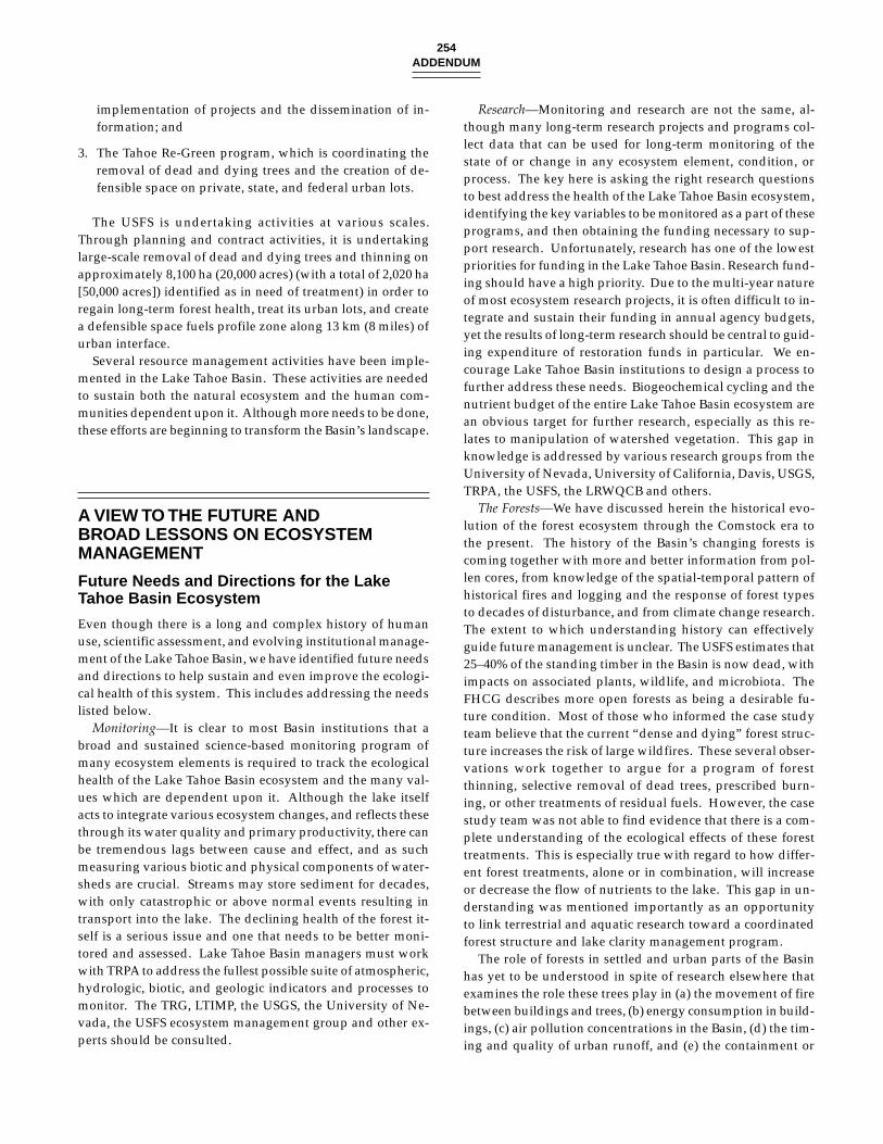
254ADDENDUM
implementation of projects and the dissemination of in-formation; and
3. The Tahoe Re-Green program, which is coordinating theremoval of dead and dying trees and the creation of de-fensible space on private, state, and federal urban lots.
The USFS is undertaking activities at various scales.Through planning and contract activities, it is undertakinglarge-scale removal of dead and dying trees and thinning onapproximately 8,100 ha (20,000 acres) (with a total of 2,020 ha[50,000 acres]) identified as in need of treatment) in order toregain long-term forest health, treat its urban lots, and createa defensible space fuels profile zone along 13 km (8 miles) ofurban interface.
Several resource management activities have been imple-mented in the Lake Tahoe Basin. These activities are neededto sustain both the natural ecosystem and the human com-munities dependent upon it. Although more needs to be done,these efforts are beginning to transform the Basin’s landscape.
A VIEW TO THE FUTURE ANDBROAD LESSONS ON ECOSYSTEMMANAGEMENT
Future Needs and Directions for the LakeTahoe Basin Ecosystem
Even though there is a long and complex history of humanuse, scientific assessment, and evolving institutional manage-ment of the Lake Tahoe Basin, we have identified future needsand directions to help sustain and even improve the ecologi-cal health of this system. This includes addressing the needslisted below.
Monitoring—It is clear to most Basin institutions that abroad and sustained science-based monitoring program ofmany ecosystem elements is required to track the ecologicalhealth of the Lake Tahoe Basin ecosystem and the many val-ues which are dependent upon it. Although the lake itselfacts to integrate various ecosystem changes, and reflects thesethrough its water quality and primary productivity, there canbe tremendous lags between cause and effect, and as suchmeasuring various biotic and physical components of water-sheds are crucial. Streams may store sediment for decades,with only catastrophic or above normal events resulting intransport into the lake. The declining health of the forest it-self is a serious issue and one that needs to be better moni-tored and assessed. Lake Tahoe Basin managers must workwith TRPA to address the fullest possible suite of atmospheric,hydrologic, biotic, and geologic indicators and processes tomonitor. The TRG, LTIMP, the USGS, the University of Ne-vada, the USFS ecosystem management group and other ex-perts should be consulted.
Research—Monitoring and research are not the same, al-though many long-term research projects and programs col-lect data that can be used for long-term monitoring of thestate of or change in any ecosystem element, condition, orprocess. The key here is asking the right research questionsto best address the health of the Lake Tahoe Basin ecosystem,identifying the key variables to be monitored as a part of theseprograms, and then obtaining the funding necessary to sup-port research. Unfortunately, research has one of the lowestpriorities for funding in the Lake Tahoe Basin. Research fund-ing should have a high priority. Due to the multi-year natureof most ecosystem research projects, it is often difficult to in-tegrate and sustain their funding in annual agency budgets,yet the results of long-term research should be central to guid-ing expenditure of restoration funds in particular. We en-courage Lake Tahoe Basin institutions to design a process tofurther address these needs. Biogeochemical cycling and thenutrient budget of the entire Lake Tahoe Basin ecosystem arean obvious target for further research, especially as this re-lates to manipulation of watershed vegetation. This gap inknowledge is addressed by various research groups from theUniversity of Nevada, University of California, Davis, USGS,TRPA, the USFS, the LRWQCB and others.
The Forests—We have discussed herein the historical evo-lution of the forest ecosystem through the Comstock era tothe present. The history of the Basin’s changing forests iscoming together with more and better information from pol-len cores, from knowledge of the spatial-temporal pattern ofhistorical fires and logging and the response of forest typesto decades of disturbance, and from climate change research.The extent to which understanding history can effectivelyguide future management is unclear. The USFS estimates that25–40% of the standing timber in the Basin is now dead, withimpacts on associated plants, wildlife, and microbiota. TheFHCG describes more open forests as being a desirable fu-ture condition. Most of those who informed the case studyteam believe that the current “dense and dying” forest struc-ture increases the risk of large wildfires. These several obser-vations work together to argue for a program of forestthinning, selective removal of dead trees, prescribed burn-ing, or other treatments of residual fuels. However, the casestudy team was not able to find evidence that there is a com-plete understanding of the ecological effects of these foresttreatments. This is especially true with regard to how differ-ent forest treatments, alone or in combination, will increaseor decrease the flow of nutrients to the lake. This gap in un-derstanding was mentioned importantly as an opportunityto link terrestrial and aquatic research toward a coordinatedforest structure and lake clarity management program.
The role of forests in settled and urban parts of the Basinhas yet to be understood in spite of research elsewhere thatexamines the role these trees play in (a) the movement of firebetween buildings and trees, (b) energy consumption in build-ings, (c) air pollution concentrations in the Basin, (d) the tim-ing and quality of urban runoff, and (e) the containment or
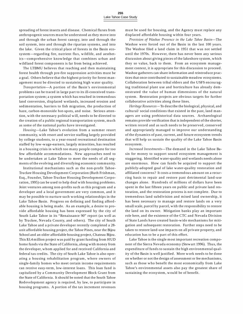
255Lake Tahoe Case Study
spreading of forest insects and disease. Chemical fluxes fromanthropogenic sources must be understood as they move intoand through the urban forest canopy, into and through thesoil system, into and through the riparian systems, and intothe lake. Given the critical place of forests in the Basin eco-system—regarding fire, nutrient flux, wildlife, and aesthet-ics—comprehensive knowledge that combines urban andwildland forest components is far from being achieved.
The LTBMU believes that reaching and then maintainingforest health through pre-fire suppression activities must bea goal. Others believe that the highest priority for forest man-agement must be directed to sustaining high water quality.
Transportation—A portion of the Basin’s environmentalproblems can be traced in large part to its ill-conceived trans-portation system; a system which has resulted in tremendousland conversion, displaced wetlands, increased erosion andsedimentation, barriers to fish migration, the production ofhaze, carbon-monoxide hot-spots, and noise. Serious atten-tion, with the necessary political will, needs to be directed tothe creation of a public regional transportation system, muchas some of the national parks have investigated.
Housing—Lake Tahoe’s evolution from a summer resortcommunity, with resort and service staffing largely providedby college students, to a year-round recreational destinationstaffed by low-wage-earners, largely minorities, has resultedin a housing crisis in which too many people compete for toofew affordable accommodations. New approaches need tobe undertaken at Lake Tahoe to meet the needs of all seg-ments of the evolving and diversifying economic community.
Institutional mechanisms such as the non-profit Tahoe-Truckee Housing Development Corporation (Ruth Frishman,Esq., Founder, Tahoe-Truckee Housing Development Corpo-ration, 1995) can be used to help deal with housing problems.Joint ventures among non-profits such as this program and adeveloper and a local government are very common, and itmay be possible to nurture such working relationships in theLake Tahoe Basin. Progress on defining and finding afford-able housing is being made. As an example, a desire to pro-vide affordable housing has been expressed by the city ofSouth Lake Tahoe in its “Renaissance 90” report (as well asby Truckee, Nevada County, and others). The city of SouthLake Tahoe and a private developer recently completed a 28-unit affordable housing project, the Tahoe Pines, near the BijouSchool and an older affordable housing project, Chateau Bijou.This $3.4 million project was paid by grant funding from HUDhome funds via the State of California, along with money fromthe developer, whom applied for and received California andfederal tax credits. The city of South Lake Tahoe is also oper-ating a housing rehabilitation program, where owners ofsingle-family homes who meet certain income requirementscan receive easy-term, low-interest loans. This loan fund iscapitalized by a Community Development Block Grant fromthe State of California. It should be noted that the South TahoeRedevelopment agency is required, by law, to participate inhousing programs. A portion of the tax increment revenues
must be used for housing, and the Agency must replace anydisplaced affordable housing within four years.
Provision of Washoe Presence in the Lake Tahoe Basin—TheWashoe were forced out of the Basin in the last 100 years.The Washoe filed a land claim in 1951 that was not settleduntil the 1970s. However, there has never been any seriousdiscussion about giving pieces of the lakeshore system, whichthey so value, back to them. From an ecosystem manage-ment context, it is appropriate for this discussion to proceed.Washoe gatherers can share information and reintroduce prac-tices that once contributed to sustainable meadow ecosystems.Collaboration between tribal elders and the USFS encourag-ing traditional plant use and horticulture has already dem-onstrated the value of human dimensions of the naturalsystem. Restoration projects are obvious targets for furthercollaborative activities along these lines.
Heritage Resources—To describe the biological, physical, andcultural/social conditions that existed in the past, land man-agers are using prehistorical data sources. Archaeologicalremains provide verification that is independent of the shorter,written record and as such needs to be preserved, conservedand appropriately managed to improve our understandingof the dynamics of past, current, and future ecosystem trendsthat will help us sustain the quality of the Lake Tahoe Basinecosystem.
Increased Investments—The demand in the Lake Tahoe Ba-sin for money to support sound ecosystem management isstaggering. Identified water-quality and wetlands needs aloneare enormous. How can funds be acquired to support thepublicly-adopted goal of lake water-quality restoration andaffiliated concerns? It costs a tremendous amount on a recur-ring basis to repair and restore past detrimental land-usechanges alone. Hundreds of millions of dollars have beenspent in the last fifteen years on public and private land res-toration, and the restoration process is not complete. Due totremendous land subdivision and mixed land ownership, ithas been necessary to manage and restore lands on a verysmall scale, parcel by parcel, with the responsibility to restorethe land on its owner. Mitigation banks play an importantrole here, and the existence of the CTC and Nevada Divisionof State Lands have created basin-wide mechanisms for miti-gation and subsequent restoration. Further steps need to betaken to restore land-use impacts on all private property, andeducation has to be a part of this effort.
Lake Tahoe is the single most important recreation compo-nent of the Sierra Nevada economy (Stewart 1996). Thus, theexpenditure of funds to sustain the high environmental qual-ity of the Basin is well justified. More work needs to be doneon whether or not the design of assessment or fee mechanisms,such as those who benefit the most economically from LakeTahoe’s environmental assets also pay the greatest share ofsustaining the ecosystem, would be of benefit.
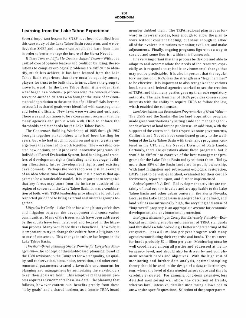
256ADDENDUM
Learning from the Lake Tahoe Experience
Several important lessons for SNEP have been identified fromthis case study of the Lake Tahoe Basin ecosystem, and we be-lieve that SNEP and its users can benefit and learn from themin order to better manage the future of the Sierra Nevada.
It Takes Time and Effort to Create a Unified Vision—Without aunified core of opinion leaders and coalition building, the so-lutions to complex ecological problems are difficult to iden-tify, much less achieve. It has been learned from the LakeTahoe Basin experience that there must be equality amongplayers for trust to be built that, in turn, allows the group tomove forward. In the Lake Tahoe Basin, it is evident thatwhat began as a bottom-up process with the concern of con-servation-minded citizens who brought the issue of environ-mental degradation to the attention of public officials, becamesuccessful as shared goals were identified with state, regional,and federal officials. New laws were written and enforced.There was and continues to be a consensus process in that themany agencies and public work with TRPA to enforce thethresholds and standards for the Lake Tahoe Basin.
The Consensus Building Workshop of 1985 through 1987brought together stakeholders who had been battling foryears, but who had much in common and great creative en-ergy once they learned to work together. The workshop cre-ated new options, and it produced innovative programs likeIndividual Parcel Evaluation System, land banking, and trans-fers of development rights (including land coverage, build-ing allocations, future development rights, and existingdevelopment). Perhaps the workshop was just an exampleof an idea whose time had come, but it is a process that ap-pears to be a transferable model. It is important to recognizethat key forces may come from the inside or outside of theregion of concern; in the Lake Tahoe Basin, it was a combina-tion of both, with TRPA leadership providing the forceful yetrespected guidance to bring external and internal groups to-gether.
Litigation Is Costly—Lake Tahoe has a long history of clashesand litigation between the development and conservationcommunities. Many of the issues which have been addressedby the courts have been narrowed and focused in the litiga-tion process. Many would see this as beneficial. However, itis important to try to change the culture from a litigious oneto one of consensus. This change in culture has begun in theLake Tahoe Basin.
Threshold-Based Planning Shows Promise for Ecosystem Man-agement—The concept of threshold-based planning found inthe 1980 revisions to the Compact for water quality, air qual-ity, soil conservation, biota, noise, recreation, and other envi-ronmental parameters created a favorable environment forplanning and management by authorizing the stakeholdersto set their goals up front. This adaptive management pro-cess requires environmental baseline data. The planning thatfollows, however contentious, benefits greatly from these“lofty goals” and a shared horizon, as a former TRPA board
member dubbed them. The TRPA regional plan moves for-ward in five-year strides, long enough to allow the plan towork without constant fiddling, but short enough to allowall of the involved institutions to monitor, evaluate, and makeadjustments. Finally, ongoing programs figure out a way tosurvive and some flourish within this framework.
It is very important that this process be flexible and able toadapt to and accommodate the needs of the resource, espe-cially as it responds to episodic environmental change thatmay not be predictable. It is also important that the regula-tory institution (TRPA) has the strength as a “legal hammer”to be effective. It is important to also recognize that variouslocal, state, and federal agencies worked to see the creationof TRPA, and that many parties gave up their sole regulatoryauthority. The legal hammer of TRPA provides conservationinterests with the ability to require TRPA to follow the law,which enabled the consensus.
Land Aquisition and Restoration Programs Are of Great Value—The USFS and the Santini-Burton land acquisition programmade great contributions by setting aside and managing thou-sands of acres of land for the public use. In addition, with thesupport of the voters and their respective state governments,California and Nevada have contributed greatly to the well-being of the Lake Tahoe Basin with their lands programs, cen-tered in the CTC and the Nevada Division of State Lands.Certainly, there are questions about these programs, but itwould be difficult to conceive of the best management pro-grams for the Lake Tahoe Basin today without them. Today,more than 85% of the Basin lands are in public ownership.With land mitigation and subsequent ecological restoration,BMPs need to be well quantified, evaluated for their cost ef-fectiveness, reported upon, and further implemented.
Redevelopment Is A Tool—Redevelopment activities are cer-tainly of local economic value and are applicable to the LakeTahoe Basin and other urban centers in the Sierra Nevada.Because the Lake Tahoe Basin is geographically defined, andland values are intrinsically high, the recycling and reuse of“improved” property is an appropriate avenue for economicdevelopment and environmental protection.
Ecological Monitoring Is Costly But Extremely Valuable—Eco-logical monitoring enables enforcement of TRPA standardsand thresholds while providing a better understanding of theecosystem. It is a $1 million per year program with manyagencies contributing their expertise and funds. The true needfor funds probably $2 million per year. Monitoring must bewell coordinated among all parties and addressed at the in-teragency level, and should also be driven by and comple-ment research needs and objectives. With the high cost ofmonitoring and further data analysis, optimal samplingtheory should be used in the design of a data collection sys-tem, where the level of data needed across space and time iscarefully evaluated. For example, long-term extensive, lessdetailed monitoring will allow the detection of trends,whereas local, intensive, detailed monitoring allows one toanswer site-specific questions. Selection of the proper param-
257Lake Tahoe Case Study
eters and processes for monitoring is especially crucial in judg-ing the effectiveness of restoration projects at varying scales.
In the Lake Tahoe Basin, monitoring is done to enforcethresholds. It becomes important to select a reference year orperiod (e.g., 10- to 30-year mean or mode) to use as the baselinefor trend analysis. For the Lake Tahoe Basin, 1974 was se-lected as the reference year for many of the indicators, basedon available data. There were ten years of data for a narrowset of parameters prior to 1974 to serve as a reference basis.
Long-Term Ecological Research is Valuable—Much discussionfocuses today on the natural range of variability of ecosys-tems or their historic variability, as managers strive to iden-tify acceptable ecosystem conditions in the hope that thesystem will be self-sustaining or sustainable with targeted in-puts. Long-term data exist for thirty or more years for someecosystem elements, especially the lake itself. Significant col-laboration has occurred among university, agency, and inde-pendent scientists, and some of this research has linked studiesof the atmosphere with the forest, the lake, and the humansystem. However, further ecosystem and long-term researchremains to be initiated and better integrated. Many histori-cal references and materials exist for the Lake Tahoe Basin,including photographs, writings, and some early inventoryinformation (e.g., Bliss special collections noting number andsizes of trees logged). Other information will soon becomeavailable (e.g., with the publication of George Gruell’s repeatphotography). Valuable information can also be gained byobtaining oral histories from long-time residents whose per-sonal observations provide information on land-use and eco-system change. However, the tremendous set of historicalinformation has not been thoroughly researched. Further-more, historical data are present in lake and stream sediments,in cave deposits, and in tree-rings.
Lastly, it is important to make all research data available toeveryone, so they can study, understand, use, and learn fromit. As such, a central research base and program in the LakeTahoe Basin would be very profitable to scientists, managers,and the public. Natural building blocks for this program in-clude TRPA database and staff, the Special Collections of theUniversity of Nevada, Reno, the TRG and AQG, the Univer-sity of Nevada and its Desert Research Institute, the scien-tists of the California Fish and Game, DPR, and DWR, andCTC, members of the Washoe Tribal Organization, the USFSLTBMU and Pacific Southwest Research Station scientists, theUSGS, and others. As indicated previously, the process ofdefining a long-term ecosystem research program has begunthrough the involvement of TRG with TRPA and LRWQCB.
Coalitions, Partnerships and Education—The Lake Tahoe Ba-sin community and the ecosystem of which it is a part havebenefited from a number of very positive public-private part-nerships and coalitions which have formed over the last thirtyplus years, including TTREC, TCORP, various transportationmanagement associations including the TTC, and the TahoeCenter for a Sustainable Future. Partnerships of these typesare being formed in other regions of the Sierra Nevada. It
has been evident in the Lake Tahoe Basin that widespreadpublic support is crucial for financing for various ecosystempurposes. Public support for and acceptance of land restora-tion and multi-jurisdictional land/resource planning andmanagement has largely been sustained in the Lake TahoeBasin over this time period. The need for further educationon ecosystem analysis and management, and database analy-sis and management, has been identified and the Tahoe Cen-ter for a Sustainable Future, is working with many parties tofulfill this need.
Applicability of the Experience in the LakeTahoe Basin to Ecosystem Management inthe Sierra Nevada
A considerable amount of legislation, time, staff, and fundshas been directed towards the management of the Lake TahoeBasin ecosystem. Insights from this thirty year plus historymay shed light on what may benefit others as we strive tobetter manage Sierra Nevada ecosystems.
How much do we need to know to manage an ecosystem?—Asubstantial quantity of literature has been written on the LakeTahoe Basin, and there is considerable data on many elementsof the ecosystem. However, it is clearly recognized that thereis a great deal more to learn in order to better manage theecosystem. For example, there is not a comprehensive nutri-ent budget for Lake Tahoe. Although much is known aboutstream-borne nutrients, there is a need to know more aboutthe deposition of nutrients from the atmosphere and their rela-tive contribution to the nutrient budget. Complex bio-geochemical processes will also take many years of study.
When is enough known? Obviously, it could be arguedthat there is always insufficient information. However, sig-nificant resources have been committed to approaches in theLake Tahoe Basin based on the “best available knowledge” ofthe time. In terms of our experience, it appears the key is tocollect what is known and to distribute this information tothe public and agencies in a integrated and understandablemanner. This compilation is an important starting point. Thisactivity was performed in the Lake Tahoe Basin, in part, withthe release of key ecological assessments, including the LTAC(McGauhey et. al., 1963) report; the Western Federal CouncilEnvironmental Assessment Report (1979); TRPA’s Environ-mental Threshold Study (1982); TRPA’s Regional Plan, the“208” plans (California State Water Resources Control Board1980; Tahoe Regional Planning Agency 1977, 1988); and vari-ous TRG efforts (e.g., goldman 1974, 1981; Byron and Goldman1986). Review of these works has enabled identification anddiscussion of what we do and do not know. The process hasallowed participants to develop a level of trust because ev-eryone has access to the same information. The SNEP GIS,database and report (Sierra Nevada Ecosystem Project 1996)should provide other valuable sources of scientific informa-tion both to the Basin and the entire Sierra Nevada.
258ADDENDUM
How do you define the objectives of ecosystem management?—In the Lake Tahoe Basin, the answer in part could be charac-terized as a combination of improving certain attributes ofthe region (e.g., water quality), sustaining other attributes(e.g., wildlife habitat), and minimizing or mitigating the dam-age caused by certain activities (e.g., transportation). In at-tempting to achieve these objectives, there is an overall goalof achieving an equilibrium between the human and the natu-ral environments. Environmental threshold standards helpmonitor progress in terms of meeting objectives. It has beenargued that these environmental objectives are optimistic onthe one hand and unachievable on the other, or at least diffi-cult to achieve in a highly fragmented ecosystem. There isalso a concern that the thresholds may be inadequate targetsfor sustaining the health of the ecosystem. The need to re-claim or restore the damaged ecosystem has resulted in ex-traordinary efforts to manage relatively small units of it.Implementation of ecosystem management in the Lake TahoeBasin has proven to be extremely complex and costly. How-ever, there is a relatively high degree of acceptance of the ob-jectives as goals even if there is skepticism about theirfeasibility. Along with this, there must be an on-going publicprocess to refine and expand the goals, and scientists andmanagers must work together to inform the public about thisneed. In the Lake Tahoe Basin, there has been a series of pro-cesses to accomplish this, including administrative processes(e.g., USFS studies), legislative hearings (Z’berg hearings inCalifornia in 1960s), approval of the bi-state Compact in 1969and its amendments in 1980, approval of the environmentalthresholds in 1982, the consensus process which led to theadoption of the 1987 plan, voter approval of bond acts, andthe five-year review of progress in meeting the thresholds. Itis important that the public feel it can participate and will begiven an opportunity to influence decision making.
In addition, for ecosystem management to work as a con-cept, and in order to obtain ongoing support, its objectivesneed to include socio-economic values and concerns alongwith environmental objectives.
How should you approach ecosystem management?—The LakeTahoe Basin ecosystem is an urbanized and disturbed eco-system. It has a mixture of public and private uses. The pres-sures to conserve and to utilize resources compete. There is asubstantial investment of private and public capital. Extraor-dinary efforts are being undertaken to preserve the ecosys-tem. From this, three primary components to ecosystemmanagement and its success to date in the Lake Tahoe Basinare becoming apparent. The attributes of disturbance, urban-ization, and complexity are similar to those of other SierraNevada ecosystems. The post–SNEP process will determineto what extent these three components can be successful partsof adaptive management of these other ecosystems.
First, monitoring and research have played a key role inassessing the condition of some elements of the ecosystemand in establishing some cause and effect relationships. Long-term datasets over thirty years in length established by
Charles Goldman and other scientists have been critical indocumenting the progressive eutrophication of Lake Tahoe.This research formed the foundation of many of the programscurrently being implemented. These activities are critical inestablishing baseline information, to document changes to theecosystem, and to establish cause and effect relationships.This approach should be highly beneficial for the rest of theSierra Nevada. Similar long-term datasets exist for other se-lect ecosystems in the Sierra Nevada, including some of ournational parks sites, ecological reserves and field stations, andMono Lake.
Second, the establishment of a regional land-use planningand regulatory approach was critical in integrating resourceinformation and reflecting this information in a basin-wideland-use plan. The scale of the approach facilitated compre-hensive and integrated planning which crossed jurisdictionallines. The approach was used to establish environmentalthresholds to guide land-use planning. As noted earlier, afive-year review process has been built into the assessmentprocess in order to allow regional plan adjustments. Addi-tionally, the approach unified land-use planning on both pub-lic and private lands. For a major part of the Lake TahoeBasin’s history, there seemed to be an assumption that publicland acquisition and management would largely control theecological future of the lake and that urban uses would haverelatively little impact on the environment (Fink 1991). Theeffects of urbanization on water and air quality and wildlifequickly illustrated the need to plan for all the componentsand ownerships within the Basin. Cross-jurisdictional landand resource planning is absolutely crucial to the sucess ofecosystem management, although it is difficult to conceive ofa similar regulatory system for other areas of the Sierra Ne-vada. It also appears to be important to integrate public andprivate property in these larger approaches—if only to dis-tribute burdens and responsibilities in a more equitable man-ner.
Third, land acquisition, site improvement, and wetlandrestoration programs have proven useful in reclaiming a re-source base, restoring the natural biodiversity, and enhanc-ing the capacity of existing public lands to perform a range ofnatural functions (e.g., maintenance of water quality). Theseprograms help the ecosystem heal and restore the capacity toabsorb at least some of the future impacts. They also providea choice and mechanism for compensation to landowners anda means to achieve local and regional planning objectives.
Land acquisition programs may not be necessary and fea-sible in some areas because of concerns related to the loss ofproperty tax revenues. However, they may be appropriate inresolving land-use conflicts or providing an opportunity forachieving a desirable public objective (e.g., public access). Siteimprovement and wetland restoration programs, however,may be needed in many areas. These programs should meetbroad ecosystem objectives or in some cases react to individualproject proposals. Additionally, they are a means of diversi-fying the local economy and providing jobs.
259Lake Tahoe Case Study
How do you sustain ecosystem approaches?—There are cer-tain assumptions which need to be stated in ecosystem man-agement. First, the status or condition of the ecosystem andthe functional relationships of ecosystem components take along time to define. Second, the systems will be constantlychanging in response to a changing array of inputs. Third,there will be a need to adapt to these changes in perpetuity.Fourth, it will take time, expertise, and money to continuallyadapt to changing needs and circumstances.
In the Lake Tahoe Basin, it could be argued that these as-sumptions have proven valid. In response, these various ap-proaches have been institutionalized through statutory oradministrative policies and through the provision of fundsand staff. These activities may ensure that these functionscan be performed over long periods of time. The LTIMP wasorganized to help consolidate, coordinate, and fund certainmonitoring efforts. The TRPA was created to regulate landuses. The USFS created a special management unit (LTBMU)to more effectively collaborate basin-wide and to acquire andmanage lands. The states of California and Nevada estab-lished independent programs designed to regulate land uses,acquire and/or manage the resources. Administratively, theseunits were designed to function within the environmentalboundaries of the Basin. The CTC is an example of adaptingan administrative model to meet the needs of the region.
It should be noted that the institutionalization of these ap-proaches has made it possible to exert leadership at criticaltimes during the Basin’s history. For example, the USFSplayed a critical role in providing support and expertise withthe design of the Bailey Land Capability System (Bailey 1974)in the formative years of TRPA.
A second response has been the commitment of fundingsources to these programs. Funding limits these approaches.During the past thirty years, a substantial amount of moneyhas been committed to support these programs. Due to thegoals of the programs (e.g., to improve the environment ofthe Basin) and institutional requirements, these approachesare expensive to implement and maintain. Over the years,hundreds of millions of dollars (e.g., Santini-Burton and statevoter approved bond acts) have been committed. In recentyears, funds have been reduced for almost all of the programs.However, the institutionalized approaches provide a meansto marshall and prioritize the use of existing resources and toseek additional funds.
A third response has been the development of specializedprograms to meet the complex needs of ecosystem manage-ment in the Lake Tahoe Basin (e.g., mitigation and transfer ofdevelopment rights programs). Additionally, the institution-alization of the approaches has made it possible to allocatetime and resources to develop new techniques (e.g.,biotechnical erosion control) and refine technologies (e.g., theuse of videography to help establish wildlife habitat relation-ships) to meet the needs of the region.
A fourth response has been to develop more participatoryand inclusive processes. Resource protection efforts have been
highly controversial and litigious. Conflict existed in the leg-islature, Congress, the courts, TRPA, the chambers of localgovernment, and in local establishments over the propermanagement of the Lake Tahoe Basin’s valued resources.
The culture of these approaches has changed overtime dueto the influence of many factors. A key factor was the use ofthe consensus process by TRPA to secure adoption of the re-gional plan in 1987. This process set the stage for a numberof other processes which are consensus based (e.g., the foresthealth consensus) and cooperative (e.g., South Lake TahoeRedevelopment). Additionally, the availability of funds foracquisitions and site improvements has provided the basisfor cooperative projects (e.g., South Lake Tahoe Redevelop-ment) and helped resolve litigation. Third, there is a grow-ing appreciation within the private and public sectors thatcooperation is needed to achieve both agendas, as there arenot enough fiscal or political resources in either sector to fullyachieve their own objectives. Consequently, both sectors needto share the financial burden and the responsibilities. Finally,there is a recognition that the public must become a part ofthe decision-making process in order to sustain support forthese approaches. Ultimately, this public involvement is theonly way to sustain regional ecosystem management here orelsewhere.
SUMMARY
These findings are the interpretations of the SNEP Lake Tahoecase study team. They reflect varying degrees of consensusamong the team members because they are inferences fromthe gathering of many fragments of information and teammembers represent a range of scientific disciplines and insti-tutional perspectives. However, it is our conclusion that thesefindings will illuminate the continued management of theLake Tahoe Basin ecosystem and, perhaps even more impor-tantly, will inform the bioregional planning and managementof the Sierra Nevada and its different and unique subregions.
Understanding the Ecosystem
The public and private organizations and institutions respon-sible for the stewardship of the Lake Tahoe Basin ecosystemhave a very good knowledge and understanding of the struc-ture and function of the terrestrial and aquatic componentsof the ecosystem, and of the atmospheric and anthropogenicfluxes through the ecosystem. We believe that this level ofunderstanding is higher than for most other ecosystems ofthis size and ecological and institutional complexity in theUnited States.
More than thirty years of cooperative scientific investiga-tions and management actions, coupled with detailed eco-logical monitoring, have generated more data and information
260ADDENDUM
about this ecosystem than for any other area of comparablesize in the Sierra Nevada. However, critical weaknesses inthe understanding of ecosystem processes still exist for sev-eral major components, including the major plant communi-ties, and especially the forest systems. Ecological mapping isfar from complete, as is the study of stand dynamics, under-story and soil components and processes, etc. Thus, it is un-clear how specific forest stands and plant communities mayrespond to certain land management or natural disturbances.Several components of aquatic ecosystems also remain incom-pletely understood, including the full biogeochemical inputs,throughputs and outputs for the lake and the Basin, and thegeneral ecology of fens, springs, and pools. Air pollution anddry and wet deposition of these substances into the Basin andlake are not fully understood, although our knowledge ismuch better than that at other sites. These voids in our knowl-edge are largely due to a lack of funding, as various formalstudies have been proposed to study all components of bio-geochemical system. Riparian corridors and the many ben-efits they provide to the regional ecosystem are alsoincompletely studied from biological (e.g., wildlife, aquaticbiota, vegetation) and physical (e.g., soil formation, sedimentbudget, decomposition) perspectives. Paleoecological recon-structions are very incomplete. Although recent studies byJassby et al. (1994) and Davis (1996 [appendix 7.2]) have shedlight on the roles of late-nineteenth century logging and post-World War II road and home building, the human impacts ofthe last 150 years are not fully understood as potential causesof diminishing lake clarity and ecosystem degradation. Thenature and extent of the surviving archaeological record ofthe Lake Tahoe Basin is unknown. No one knows exactlyhow many prehistoric and historic sites exist as only a smallpercentage of the area has been systematically surveyed. Thepotential significance of the extant archaeological record inmodeling the past, present, and future of the regional ecosys-tem is promising. However, if the archaeological data are notcollected before the record becomes too fragmentary to inter-pret due to site loss, one of the most important keys to under-standing humans as a part of the Basin ecosystem will be lost.
There is no institution that determines the priority of in-vestment for gathering knowledge across the ecosystem, suchas a science-management advisory board might provide. Thisabsence hinders a trans-organizational approach to setting in-formation and scientific priorities for the ecosystem as a whole.
Thus, in spite the wealth of information and a relativelyhigh level of understanding of the Lake Tahoe Basin ecosys-tem compared to other ecosystems, knowledge is not at thelevel where causes and effects are fully understood. It is notknown how the lake’s ecology has responded to the historyof climatic fluctuation and sediment-nutrient flux to the lakefrom natural and human causes, nor how much sediment andcritical nutrients will flow to the lake with different manage-ment actions on the watershed (e.g., additional construction,restoration, forest thinning, or burning [either prescribed oruncontrolled]).
Managing the Ecosystem
The Lake Tahoe Basin management experience is one of thebest, and longest term, examples of adaptive ecosystem man-agement in the world. A coalition of public and private orga-nizations cooperate in the gathering of data to determinewhether the ecosystem is meeting a set of performance stan-dards, termed thresholds. There is a growing commitment toobtain the best scientific understanding to modify these stan-dards and determine the validity, relevance, and usefulnessof the monitoring data.
Restoration of ecosystem elements has been modified asfurther knowledge is gained, with science and engineeringused to guide restoration efforts. This approach is consistentwith the concept of adaptive ecosystem management in thatmonitoring is a component of every project. The feedbacklink could be improved, however, to solicit better analysis ofdata from the restoration projects and feed it back into adap-tive management methods.
Land acquisition and subsequent restoration activities bypublic agencies have reduced ecosystem degradation locally,and are believed to have decreased the rate at which lake clar-ity is diminishing. With an incomplete understanding of sys-tem lags, it still appears to be a positive step in decreasingecosystem degradation.
Management of the Basin’s forests is hindered by a lack ofunderstanding of how wildland and urban forests interact interms of insect and disease migration, fire behavior, pollu-tion flux from air to canopy to soil and water, and wildlifehabitat gradients. More research is well justified on these for-est systems.
Although regulation of land development may have slowedecosystem degradation and has provided time to establish abetter understanding, and to restore certain elements, of theecosystem, the coalition of steward organizations continue todevelop the best processes to guide the range of human usesto sustain critical ecosystem elements and processes. Whetherthey will be able through time to halt the decline in lake clar-ity and environmental deterioration is yet unknown, partiallyas a function of the slow rate of some ecosystem processes.The management perspective thus must be long-term in na-ture, and the players patient yet willing to act when neces-sary to reverse deleterious actions and processes.
Applying This Knowledge to theGreater Sierra Nevada
The accuracy with which ecosystem structure and function isdefined greatly helps to focus management issues and nar-row the debate which, in turn, nurtures institutional coop-eration and coordination. The Lake Tahoe Basin has sharpwatershed boundaries, and the large, geographically domi-nant lake with its visible decline in water clarity and pro-nounced shoreline impacts focused the issues. In other SierraNevada ecosystems with less sharply-defined boundaries and
261Lake Tahoe Case Study
less visible ecosystem changes, efforts to comprehend andmanage loss of ecosystem quality, however defined, may bemore difficult.
The Lake Tahoe Basin’s human history is representative ofmost Sierra Nevada ecosystems. The criticism that the LakeTahoe Basin is unique and therefore unrepresentative of therest of the Sierra is unwarranted. Lake Tahoe is especiallyuseful as an example of the many ecosystems undergoingchange from prior logging activities, fire suppression, forestoverstocking and declining forest health, degradation of ri-parian corridors and wetlands, restoration activities, recre-ational impacts, declining air quality, and the many forms andimpacts of urbanization. Because all Sierra Nevada ecosys-tems are candidates for adaptive management, the Lake TahoeBasin provides a model for the selection of ecosystem perfor-mance standards, the generation and use of technical scien-tific data, institutional collaboration, and land-use regulationwhile protecting private property rights.
Lake Tahoe exemplifies how actions in one ecosystem haveimportant consequences in other ecosystems which, subse-quently, provide feedbacks that may modify structure andfunction in the original ecosystem. This interaction is a pro-cess applicable to all Sierra Nevada ecosystems. Land-useregulation in the Lake Tahoe Basin has shifted land develop-ment to Truckee and the Reno-Carson City area. Populationgrowth in these nearby areas influences wildlife, and increasesday use in the Lake Tahoe Basin, subsequent automobile useand pollution, and other processes.
The Lake Tahoe experience provides valuable informationon ecosystem protection and restoration costs that are appli-cable to other Sierra Nevada ecosystems. Restoration is atleast several times more expensive than protection, and thisstudy strongly suggests that pre-development studies maysubstantially reduce restoration costs post-development. Themore complete the understanding of all ecosystem processesis up-front, the better environmental planning can be done,minimizing ecological impacts and reducing the cost of theirmitigation.
ACKNOWLEDGMENTS
We thank the many individuals who met with our case studyteam, either collectively or individually, and who providedus with valuable data and perspective, including membersand staff of the California Department of Parks and Recre-ation, California Tahoe Conservancy, Lahontan Water Qual-ity Board, League to Save Lake Tahoe, Tahoe RegionalPlanning Agency, U.S. Forest Service, and others. We thankfive anonymous reviewers for their valuable comments on adraft of this paper, as well as members of the SNEP Key Con-tacts Group and the SNEP Science Team. Editorial assistanceprovided by Chris Sparks, Maureen Davis, and Erin Fleming
is greatly appreciated. Maureen Davis worked as special re-search assistant during the final phases of this work.
NOTES1Thesholds are defined by the Tahoe Regional Planning Agency.
According to the TRPA Code of Ordinances (adopted May 27, 1987),environmental threshold carrying capacities are environmental stan-dards necessary to maintain a significant scenic, recreational, educa-tional, scientific or natural value of the region, or to maintain publichealth and safety within the region. Such standards shall includebut not be limited to standards for air quality, water quality, soil con-servation, vegetation preservation and noise.
2 The California Tahoe Regional Planning Agency was establishedas a land use and regulation planning body, and put in place to regu-late private land use within the California portion of the Lake Tahoebasin in addition to the actions being taken by TRPA.
3As such, the vegetation is not homogenous in the three parks,although in the fire history analysis by Rice, the parks are treated ashaving similar ecosystem characteristics. There are also major dif-ferences in elevation both within and between parks as well as dif-ferences in aspect. [Note: To analyze the past disturbance regimesmore thoroughly, these studies should have stratified the sample ar-eas by vegetation type, slope and aspect. The locations of eachsampled tree should be presented and groups of trees with similarecosystem characteristics (e.g., vegetation type, elevation, slope, as-pect) should be used to produce a composite fire interval. It is alsofundamental to record the size of the area that has been sampled infire history work. The areas should be stratified ecologically andcare must be taken to choose and record the sampling sites.
4Composite fire return intervals should also be given for each dis-tinct region. This summarizes all of the fire dates in an area that hassimilar ecological characteristics and gives more accurate informa-tion on the past disturbance regimes. Composite fire intervals havebeen calculated for each park but the fire scar samples may havecome from areas in the park with different ecological characteristics.
5The cultural eutrophication of Lake Tahoe refers to increasingthe productivity (primarily of plankton and nearshore, benthic plants)of the lake, with a subsequent decrease in water clarity, due to in-creased nutrient inputs to the lake from human alteration of the ter-restrial system and the atmospheric loading of pollutants.
6 The lack-of-dual-majority rule (also known as the “deemed-ap-proved” rule) required a rejection by a majority of both state’s TRPAdelegations to reject a project. If, after 60 days, no action was taken,the project was deemed approved. During the 1970s, TRPA oversawa period of rapid growth, including the construction of four casino-hotel towers on the south state line. Much of this growth was “deemedapproved” under the dual-majority rule. This rule was considered afatal flaw to the 1969 Compact because it allowed the local delegatesfrom either state delegation to veto a denial for a project (i.e., ap-prove). The 1980 revision of the Compact eliminated this rule andincreased the membership of each state’s delegation to seven mem-bers, including four from outside the Basin.
262ADDENDUM
REFERENCESAnderson, M. K. 1993. The mountains smell like fire. Fremontia 21(4):
15-20.Anderson, M. K. and G. P. Nabhan. 1991. Gardeners in Eden. Wilder-
ness Magazine 55(194): 27-30.Bailey, R. G. 1974. Land-capability classification of the Lake Tahoe
Basin, California-Nevada: a guide for planning. South Lake Tahoe:U.S. Forest Service.
Barrett, S. A. 1917. The Washo Indians. Bulletin of the Public Museumof the City of Milwaukee 2(1):1-52.
Beesley, D. 1996. Reconstructing the Sierra Nevada landscape: anenvironmental history, 1820-1960. In Sierra Nevada EcosystemProject: Final Report to Congress, vol. II, chap. 1. Davis: Universityof California, Centers for Water and Wildland Resources.
Blackburn, T. C. and K. Anderson. 1993. Introduction: managing thedomesticated environment. In Before the Wilderness: environmentalmanagement by Native Americans, complied and edited by T. C.Blackburn and K. Anderson, 15-25. Menlo Park, CA: Ballena Press.
Byron, E. R. and C. R. Goldman. 1989. Land-use and water quality intributary streams of Lake Tahoe, California-Nevada. Journal ofEnvironmental Quality 18(1): 84-88.
Cahill, T. A., J. J. Carroll, D. Campbell, and T. E. Gill. 1996. Air Qual-ity. In Sierra Nevada Ecosystem Project: Final Report to Congress, vol.II, chap. 48. Davis: University of California, Centers for Water andWildland Resources.
California Department of Water Resources. 1991. Truckee River Atlas.Sacramento: Resources Agency, State of California.
California State Water Resources Control Board. 1980. Lake TahoeBasin water quality plan, final plan. Sacramento: California StateWater Resources Control Board.
California Tahoe Conservancy. 1991. California Tahoe Conservancy,Progress Report 1985-1991. Sacramento: Resources Agency, State ofCalifornia.
California Tahoe Conservancy. 1994. Summary of activities. Unpub-lished staff reports. South Lake Tahoe: The Resources Agency.
California Tahoe Conservancy. 1995. Summary of activities. Unpub-lished staff reports. South Lake Tahoe: The Resources Agency.
California Tahoe Conservancy. 1996. Summary of activities. Unpub-lished staff reports. South Lake Tahoe: The Resources Agency.
California Tahoe Regional Planning Agency. 1975. Regional plan forLake Tahoe, California. South Lake Tahoe, CA: California TahoeRegional Planning Agency.
Crippen, J. R. and B. R. Pavelka. 1970. The Lake Tahoe Basin, California-Nevada. U. S. Geological Survey Water-Supply Paper. Menlo Park,CA: U. S. Geological Survey.
d’Azevedo, W. L. 1956. Washoe place names. Unpublished manu-script.
d’Azevedo, W. L. 1971. Introduction. In The Washoe Indians of Califor-nia and Nevada, edited by W. L. d’Azevedo, 1-7. Salt Lake City:Department of Anthropology, University of Utah.
d’Azevedo, W. L. 1985. Straight with the medicine. Berkeley: HeydeyBooks.
d’Azevedo, W. L.1986a. Washoe. In The Great Basin: handbook of NorthAmerican Indians vol. 11, edited by W. L. d’Azevedo, 466-99. Wash-ington DC: Smithsonian Institution.
d’Azevedo, W. L. 1986b. Introduction. In The Great Basin: Handbookof North American Indians vol. 11, edited by W. L. d’Azevedo, 1-14. Washington DC: Smithsonian Institution.
d’Azevedo, W. L. 1991. Washoe. In Encyclopedia of world cultures:vol. 1, North America, edited by T. J. O’Leary and D. Levinson,366-370. Boston: G. K. Hall.
d’Azevedo, W. L. 1993. The Washoe people in the twentieth century.Paper presented at the Third Annual Wa-She-Shu-Edeh-Festivalof Native American Arts and Culture, Tallac Historic Site, LakeTahoe.
Dangberg, G. M. 1918-1922. Field notes. In the possession of W. L.d’Azevedo, Reno, Nevada.
Douglass, W. A. and J. Bilbao. 1975. Amerikanuak: Basques in the NewWorld. Reno: University of Nevada Press.
Downs, J. F. 1961. Washoe religion. Anthropological Records 16:9.Ber-keley: University of California Press.
Downs, J. F. 1966. The two worlds of the Washoe. New York: Holt,Rinehart and Winston.
Downs, J. F. 1971a. Differential response to white contact: Paiute andWasho. In The Washoe Indians of California and Nevada edited by W.L. d’Azevedo, 115-138. Salt Lake City: University of Utah, Depart-ment of Anthropology.
Downs, J. F. 1971b. Washo response to animal husbandry . In TheWashoe Indians of California and Nevada edited by W. L. d’Azevedo,138-53. Salt Lake City: University of Utah, Department of Anthro-pology.
Eissmann, L. J. 1990. Lake Tahoe Nevada State Park master plan.Carson City: Nevada Division of State Parks.
Elston, R. G. 1982. Western Great Basin prehistory. In Man and envi-ronment in the Great Basin, Society for American Archaeology Pa-pers No. 2, edited by D. B. Madsen and J. F. O’Connell, 186-206.Washington DC: Society for American Archaeology.
Elston, R. G., J. O. Davis, A. Leventhal, and C. Covington. 1977. Thearchaeology of the Tahoe Reach of the Truckee River. Manuscripton file at the Nevada Archeological Survey, University of Nevada,Reno.
Elston, R. G., S. Stornetta, D. Dugas, and P. Mires. 1994. Beyond theblue roof: archaeological survey of the Mt. Rose Fan and North-ern Steamboat Hills. Manuscript on file at Intermountain Research,Silver City, Nevada.
Engineering Sciences, Inc. 1967. A regional program for the protec-tion of water resources in the Lake Tahoe-Truckee River basin.Prepared for the Lake Tahoe Area Council. Arcadia, CA: Engineer-ing Sciences, Inc.
Fink, R. J. 1991. Public land acquisition for environmental protec-tion: structuring a program for the Lake Tahoe Basin. EcologicalLaw Quarterly 18(3): 485-557.
Fowler, C. S., ed. 1994. In the shadow of Fox Peak: an ethnography ofthe Cattail-Eater Northern Paiute people of Stillwater Marsh. Cul-tural Resource Series No. 5. Fallon, NV: U. S. Fish and WildlifeService, Stillwater National Wildlife Refuge.
Freed, S. A. 1963. A reconstruction of aboriginal Washo social orga-nization. University of Utah Anthropological Papers 67: 8-24.
Freed, S. A. 1966. Washo habitation sites in the Lake Tahoe Area.University of California Archaeological Survey Papers 67: 73-83.
Freed, S. and R. S. Freed. 1963a. The persistence of aboriginal cer-emonies among the Washo Indians. University of Utah Anthropo-logical Papers 67: 25-40.
Freed, S. and R. S. Freed. 1963b. A configuration of aboriginal Washoculture. University of Utah Anthropological Papers 67: 41-56.
Goin, P., ed. 1992. Stopping time: a rephotographic survey of Lake Tahoe.Albuquerque: University of New Mexico Press.
263Lake Tahoe Case Study
Goldman, C. R. 1963. Primary productivity measurements in LakeTahoe. Appendix 1 In Comprehensive study on protection of wa-ter resources of Lake Tahoe Basin through controlled waste dis-posal, McGauhey, P. H., R. Eliassen, G. Rohlich, H. F. Ludwig, E.A. Pearson, and Engineering Sciences, Inc., 154-163. San Francisco:Engineering Sciences, Inc.
Goldman, C. R. 1974. Eutrophication of Lake Tahoe emphasizingwater quality. EPA-660/3-74-034. Washington DC: U. S. Govern-ment Printing Office.
Goldman, C. R. 1981. Lake Tahoe: Two decades of change in a nitro-gen deficient oligotrophic lake. Verh. Internatl. Verein. Limnol. 21:45-70.
Goldman, C. R. 1988. Primary productivity, nutrients, and transpar-ency during the early onset of eutrophication in ultra-oligotrophicLake Tahoe, California-Nevada. Limnology and Oceanography 33(6):1321-33.
Goldman, C. R. 1989. Lake Tahoe: preserving a fragile ecosystem.Environment 31(7): 6-11, 27-31.
Goldman, C. R. and E. R. Byron. 1986. Changing water quality atLake Tahoe: the first five years of the Lake Tahoe InteragencyMonitoring Program. Davis: University of California, Institute ofEcology, Tahoe Research Group.
Hinckle, G. and B. Hinckle. 1949. Sierra Nevada lakes. Indianapolis:Bobbs-Merrill.
Ingram, W. and P. A. Sabatier. 1987. A descriptive history of land useand water quality planning in the Lake Tahoe Basin. Institute ofEcology Report. Davis: University of California, Institute of Gov-ernmental Affairs and the Institute of Ecology.
Ingrum, B. 1986. Progress at Lake Tahoe. Urban Land 44(11): 13-16.Jassby, A. D., J. E. Reuter, R. P. Axler, C. R. Goldman, and S. H. Hackley.
1994. Atmospheric deposition of nitrogen and phosphorus in theannual nutrient load of Lake Tahoe. Water Resources Research 30(7):2207-16.
Lake Tahoe Area Council. 1969. Eutrophication of surface waters, LakeTahoe, laboratory and pilot pond studies: second progress report.South Lake Tahoe, CA: Lake Tahoe Area Council.
Lake Tahoe Area Council. 1971. Eutrophication of surface waters-Lake Tahoe. Prepared for U.S. Environmental Protection Agency,Grant No. 16010 DSW. South Lake Tahoe: Lake Tahoe Area Coun-cil.
Leiberg, J. B. 1902. Forest conditions in the northern Sierra Nevada,California. U. S. Geological Survey Professional Paper No. 8, se-ries H, forestry 5.
Lind, R. A. and J. D. Goodridge. 1978. Lake Tahoe water balance.Paper presented at Conference on Sierra Nevada Meteorology,American Meteorological Society and U. S. Forest Service, SouthLake Tahoe, CA, June 19-21, 1978.
Lindström, S. G. 1982. Archaeological test excavations at OiyerSprings and Pi Pi Valley. Manuscript on file at the Tahoe NationalForest Supervisor’s Office, Nevada City, California.
Lindström, S. G. 1985. Archaeological investigations at Tallac Point(CA-ELD-184). Prepared for U. S. Forest Service, contract no. 91U9-657. South Lake Tahoe: U. S. Forest Service, Lake Tahoe BasinManagement Unit.
Lindström, S. G. 1990. Submerged tree stumps as indicators of mid-Holocene aridity in the Lake Tahoe Basin. Journal of California andGreat Basin Anthropology 12(2): 146-57.
Lindström, S. G. 1992. Great Basin fisherfolk: optimal diet breadthmodeling the Truckee River aboriginal subsistence fishery. Ph.D.dissertation, University of California, Davis.
Lindström, S. G. and W. W. Bloomer. 1994. Evaluation of site datapotential for 26Wa5322 (TY3437/05-19-280), Tahoe Meadows pre-historic site complex, segment 17 of the Tahoe Rim Trail near Mt.Rose, Lake Tahoe, Nevada, Washoe County. Report TY-94-1004 onfile at Toiyabe National Forest Supervisor’s Office, Sparks, Ne-vada.
Lord, E. 1883. Comstock mining and miners. Monographs of the U.S. Geological Survey vol. 4. Washington DC: U. S. GovernmentPrinting Office.
Lowie, R. H. Ethnographic notes on the Washo. University of Califor-nia Publications in American Archaeology and Ethnology 36:301-52.
Machida, D. T. and J. B Gussman. 1988. The California Tahoe Con-servancy: applying the principles. Coastal Management 16: 39-46.
Mallea-Olaetxe, J. 1992. The private Basque world of Zumarraga,Juan, 1st Bishop of Mexico. Revista de Historica de America Jul-Dec(114): 41-60.
Markley, R. and C. Meisenbach. 1995. Historical summary: TahoeNational Forest environmental history. Manuscript on file at theTahoe National Forest Supervisor’s Office, Nevada City.
Marlow, D. 1996. 1996 briefing paper. Unpublished staff report. SouthLake Tahoe: U. S. Forest Service, Lake Tahoe Basin ManagementUnit.
McCarthy, H. 1993. A political economy of Western Mono acorn pro-duction. Ph.D. dissertation, University of California, Davis.
McGauhey, P. H., R. Eliassen, G. Rohlich, H. F. Ludwig, E. A. Pearson,and Engineering Sciences, Inc. 1963. Comprehensive study on pro-tection of water resources of Lake Tahoe Basin through controlledwaste disposal. Prepared for the Lake Tahoe Area Council. SanFrancisco: Engineering Sciences, Inc.
McKelvey, K. S. and J. D. Johnston. 1992. Historical perspectives onforests of the Sierra Nevada and Transverse Ranges of southernCalifornia: forest conditions at the turn of the century. In The Cali-fornia spotted owl: a technical assessment of its current status, editedby J. Verner et al., 225-46. General Technical Report PSW-GTR-133. San Francisco: U. S. Forest Service Pacific Southwest ResearchStation.
McKelvey, K. S., C. N. Skinner, C. Chang, D. C. Erman, S. J Husari, D.J. Parson, J. W. van Wagtendon, C. P. Weatherspoon. 1996. An over-view of fire in the Sierra Nevada. In Sierra Nevada Ecosystem Project:Final Report to Congress, vol. II, chap. 37. Davis: University of Cali-fornia, Centers for Water and Wildland Resources.
Myrup, L. O., T. M. Powell, D. A. Godden, and C. R. Goldman. 1979.Climatological estimate of the average monthly energy and waterbudgets of Lake Tahoe, California-Nevada. Water Resources Research15(6): 1499-1508.
Nash, R. 1982. Wilderness and the American mind. New Haven, CT:Yale University Press.
Nevers, J. 1976. Wa She Shu: aWashoe tribal history. Reno: Inter-TribalCouncil of Nevada.
Pisani, D. 1977. Lost parkland: lumbering and park proposals in theTahoe-Truckee basin. Journal of Forest History 21: 4-17.
Price, J. A. 1963a. Washo culture change. Nevada State Museum An-thropological Paper No. 9. Carson City: Nevada State Museum.
Price, J. A. 1963b. Some aspects of the Washo life cycle. University ofUtah Anthropological Papers 67: 96-114.
Price, J. A. 1980. The Washoe Indians: history, life cycle, religion, tech-nology, economy and modern life. Nevada State Museum Occa-sional Papers No. 4. Carson City: Nevada State Museum.
264ADDENDUM
Raymond, C. E. 1992. A place one never tires of. In Stopping time: arephotographic survey of Lake Tahoe, edited by P. Goin, 11-26. Albu-querque: University of New Mexico Press.
Rice, C. L. 1988. Fire history of Emerald Bay State Park, CaliforniaDepartment of Parks and Recreation. Unpublished report. Wal-nut Creek, CA: Wildland Resources Management.
Rice, C. L. 1990. Fire history of state parks of the Sierra District of theCalifornia Department of Parks and Recreation. Unpublished re-port. Walnut Creek, CA: Wildland Resources Management.
Rucks, M. 1995. The social context and cultural meaning of groundstone milling among Washoe women. MS Thesis, Department ofAnthropology, University of Nevada, Reno.
Sabatier, P. A. and N. W. Pelkey. 1990. Land development at LakeTahoe, 1960-84: the effects of environmental controls and economicconditions on housing construction. Davis: FAU/FIU Joint Cen-ter for Environmental and Urban Problems and Institute of Ecol-ogy, University of California, Davis.
Scott, E. B. 1957. The Saga of Lake Tahoe. Crystal Bay, NV: Sierra TahoePublishing.
Sears, J. T. 1989. Sacred places: American tourist attractions in thenineteenth century. New York: Oxford University Press.
Sierra Nevada Ecosystem Project. 1996. Sierra Nevada EcosystemProject: Final report to Congress, vol. I, Assessments Summaries andManagement Strategies. Davis: University of California, Centers forWater and Wildland Resources.
Siskin, E. E. 1983. Washo shamans and peyotists: religious conflict in anAmerican Indian tribe. Salt Lake City: University of Utah Press.
Smith, R. M. 1971. Housing study of the Lake Tahoe basin. SouthLake Tahoe: Tahoe Regional Planning Agency.
Steen, H. K., ed. 1992. The origins of the national forests: a centennialsymposium. Durham NC: Forest History Society.
Stewart, W. C. 1996. Economic Assessment of the Ecosystem. In Si-erra Nevada Ecosystem Project: Final Report to Congress, vol. III, chap.23. Davis: University of California, Centers for Water and Wild-land Resources.
Stine, S. 1996. Climate, 1650-1850. In Sierra Nevada Ecosystem Project:Final Report to Congress, vol. II, chap. 2. Davis: University of Cali-fornia, Centers for Water and Wildland Resources.
Strong, D. H. 1984. Tahoe, an environmental history. Lincoln: Univer-sity of Nebraska Press.
Sudworth, G. B. 1900. Stanislaus and Lake Tahoe Forest Reserves,California, and adjacent territory. In Annual reports of the Depart-ment of Interior, 21st annual report of the U. S. Geological Survey.
Tahoe Area Land Acquisitions Commission. 1983. A preliminaryanalysis fo possible objectives, issues, and approaches involvedin implementation of the Lake Tahoe Acquisition Bond Act of 1982:a background document. Sacramento: The Resources Agency.
Tahoe Regional Planning Agency. N.d. Report on Lake Tahoe regionfire protection. South Lake Tahoe: Tahoe Regional PlanningAgency.
Tahoe Regional Planning Agency. N.d. Report on Lake Tahoe regionsolid waste collection and disposal. South Lake Tahoe: Tahoe Re-gional Planning Agency.
Tahoe Regional Planning Agency. 1971. Lake Tahoe region stormdrainage. Prepared for Tahoe Regional Planning Agency StormDrainage Committee. South Lake Tahoe: Tahoe Regional PlanningAgency.
Tahoe Regional Planning Agency. 1982. Study report for the estab-lishment of environmental threshold carrying capacities. ZephyrCove, NV: Tahoe Regional Planning Agency.
Tahoe Regional Planning Agency. 1988. Water quality managementplan for the Lake Tahoe region, vols. I-IV. Zephyr Cove, NV: TahoeRegional Planning Agency.
Tahoe Regional Planning Agency. 1991. 1991 evaluation: environmen-tal threshold carrying capacities and the regional plan package.Zephyr Cove, NV: Tahoe Regional Planning Agency.
Tahoe Regional Planning Agency Committee on Water Distribution.N.d. Report on water distribution in the Lake Tahoe region. SouthLake Tahoe: Tahoe Regional Planning Agency.
Tahoe Regional Planning Agency and U. S. Forest Service. 1971a.Wildlife of the Lake Tahoe region: a guide for planning. SouthLake Tahoe: Tahoe Regional Planning Agency.
Tahoe Regional Planning Agency and U. S. Forest Service. 1971b. Fish-eries of Lake Tahoe and its tributary waters: a guide for planning.South Lake Tahoe: Tahoe Regional Planning Agency.
Tahoe Regional Planning Agency and U. S. Forest Service. 1971c.Recreation resources of the Lake Tahoe region: a guide to plan-ning. South Lake Tahoe: Tahoe Regional Planning Agency.
Townley, J. M. 1980. The Truckee Basin fishery, 1844-1944. Nevada His-torical Society Publication No. 43008. Reno: Nevada HistoricalSociety.
Twain, M. 1861. Roughing it. New York: Rinehart and Winston.U. S. Bureau of the Census. 1991. 1990 census of population and hous-
ing. Public law 94-171 data. California, New York, WashingtonDC: U. S. Department of Commerce, Bureau of the Census, DataUser Services Division.
U. S. Environmental Protection Agency. 1975. The Lake Tahoe Study.Washington DC: U. S. Environmental Protection Agency.
U. S. Indian Claims Commission. 1959-1970. The Washoe Tribe v. theUnited States Government. Docket no. 288 [7 Ind. Cl. Comm. 206,March 2, 1959].
Washoe Tribal Council. 1994. Comprehensive land use plan. Manu-script on file at Tribal Headquarters, Gardnerville, Nevada.
Western Federal Regional Council Interagency Task Force. 1979. LakeTahoe environmental assessment. Western Federal Regional Coun-cil Interagency Task Force.
White, C. A., A. L. Franks and California State Water Resources Con-trol Board. 1978. Demonstration of erosion and sediment controltechnology: Lake Tahoe region of California. U. S. EnvironmentalProtection Agency Environmental Protection Technology SeriesEPA-600/2-78-208. Springfield, VA: U. S. Environmental Protec-tion Agency, Office of Research and Development, Municipal En-vironmental Research Laboratory.
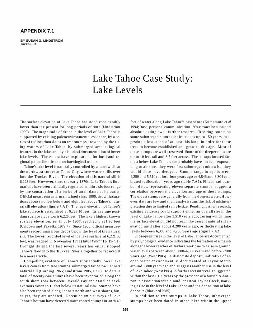
265
The surface elevation of Lake Tahoe has stood considerablylower than the present for long periods of time (Lindström1990). The magnitude of drops in the level of Lake Tahoe issupported by existing paleoenvironmental evidence, by a se-ries of radiocarbon dates on tree stumps drowned by the ris-ing waters of Lake Tahoe, by submerged archaeologicalfeatures in the lake, and by historical documentation of lowerlake levels. These data have implications for local and re-gional paleoclimatic and archaeological trends.
Tahoe’s lake level is naturally controlled by a narrow sill atthe northwest corner at Tahoe City, where water spills overinto the Truckee River. The elevation of this natural sill is6,223 feet. However, since the early 1870s, Lake Tahoe’s fluc-tuations have been artificially regulated within a six-foot rangeby the construction of a series of small dams at its outlet.Official measurements, maintained since 1900, show fluctua-tions about two feet below and eight feet above Tahoe’s natu-ral sill elevation (figure 7.A1). The legal elevation of Tahoe’slake surface is established at 6,229.10 feet. Its average post-dam surface elevation is 6,225 feet. The lake’s highest knownsurface elevation, set in July 1907, reached 6,231.26 feet(Crippen and Pavelka 1972:7). Since 1900, official measure-ments record numerous drops below the level of the naturalsill. The lowest recorded level of the lake surface, at 6,221.68feet, was reached in November 1991 (Tahoe World 11/15/91).Drought during the last several years has either stoppedTahoe’s flow into the Truckee River altogether or reduced itto a mere trickle.
Compelling evidence of Tahoe’s substantially lower lakelevels comes from tree stumps submerged far below Tahoe’snatural sill (Harding 1965; Lindström 1985, 1990). To date, atotal of twenty-one stumps have been inventoried along thesouth shore zone between Emerald Bay and Stateline at el-evations down to 16 feet below its natural rim. Stumps havealso been reported along Tahoe’s north and west shores, but,as yet, they are undated. Recent seismic surveys of LakeTahoe’s bottom have detected more rooted stumps in 30 to 40
feet of water along Lake Tahoe’s east shore (Kumamoto et al1994; Rose, personal communication 1994); exact location andabsolute dating await further research. Tree-ring counts onsome submerged stumps indicate ages up to 150 years, sug-gesting a low-stand of at least this long, in order for thesetrees to become established and grow to this age. Most ofthese stumps are well preserved. Some of the deeper ones areup to 10 feet tall and 3.5 feet across. The stumps located far-thest below Lake Tahoe’s rim probably have not been exposedlong to air since they were first submerged; otherwise, theywould since have decayed. Stumps range in age between4,250 and 5,510 radiocarbon years ago or 4,846 and 6,304 cali-brated radiocarbon years ago (table 7.A1). Fifteen radiocar-bon dates, representing eleven separate stumps, suggest acorrelation between the elevation and age of these stumps.The oldest stumps are generally from the deepest water. How-ever, data are few and their analysis runs the risk of misinter-pretation due to limited sample size. Pending further research,existing evidence could support either an overall rise in thelevel of Lake Tahoe after 5,510 years ago, during which timethe surface elevation did not reach the present natural sill el-evation until after about 4,200 years ago, or fluctuating lakelevels between 6,300 and 4,200 years ago (figure 7.A2).
Subsequent rises in the level of Lake Tahoe are documentedby palynological evidence indicating the formation of a marshalong the lower reaches of Taylor Creek due to a rise in groundwater levels between about 5,000–4,000 years and before 2,900years ago (West l985). A diatomite deposit, indicative of anopen water environment, is documented at Taylor Marsharound 2,800 years ago and suggests another rise in the levelof Lake Tahoe (West l985). A further wet interval is suggestedwithin the last 1,100 years by the presence of a buried A-hori-zon in association with a sand lens near Taylor Creek, mark-ing a rise in the level of Lake Tahoe and the deposition of lakedeposits (Blackard l985).
In addition to tree stumps in Lake Tahoe, submergedstumps have been dated in other lakes within the upper
APPENDIX 7.1
BY SUSAN G. LINDSTRÖMTruckee, CA
Lake Tahoe Case Study:Lake Levels
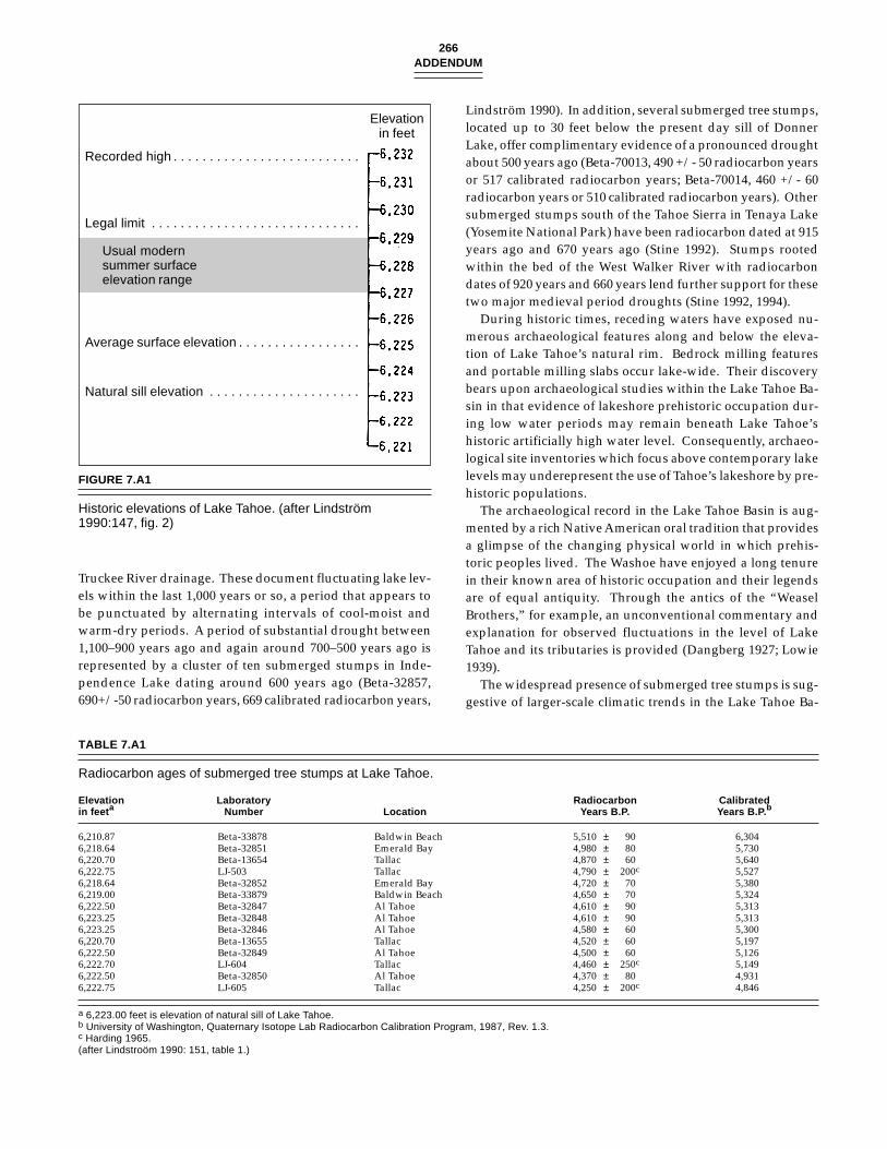
266ADDENDUM
Truckee River drainage. These document fluctuating lake lev-els within the last 1,000 years or so, a period that appears tobe punctuated by alternating intervals of cool-moist andwarm-dry periods. A period of substantial drought between1,100–900 years ago and again around 700–500 years ago isrepresented by a cluster of ten submerged stumps in Inde-pendence Lake dating around 600 years ago (Beta-32857,690+/-50 radiocarbon years, 669 calibrated radiocarbon years,
FIGURE 7.A1
Historic elevations of Lake Tahoe. (after Lindström1990:147, fig. 2)
Elevationin feet
Recorded high . . . . . . . . . . . . . . . . . . . . . . . . . .
Legal limit . . . . . . . . . . . . . . . . . . . . . . . . . . . . .
Usual modernsummer surfaceelevation range
Average surface elevation . . . . . . . . . . . . . . . . .
Natural sill elevation . . . . . . . . . . . . . . . . . . . . .
TABLE 7.A1
Radiocarbon ages of submerged tree stumps at Lake Tahoe.
Elevation Laboratory Radiocarbon Calibratedin feet a Number Location Years B.P. Years B.P. b
6,210.87 Beta-33878 Baldwin Beach 5,510 ± 90 6,3046,218.64 Beta-32851 Emerald Bay 4,980 ± 80 5,7306,220.70 Beta-13654 Tallac 4,870 ± 60 5,6406,222.75 LJ-503 Tallac 4,790 ± 200c 5,5276,218.64 Beta-32852 Emerald Bay 4,720 ± 70 5,3806,219.00 Beta-33879 Baldwin Beach 4,650 ± 70 5,3246,222.50 Beta-32847 Al Tahoe 4,610 ± 90 5,3136,223.25 Beta-32848 Al Tahoe 4,610 ± 90 5,3136,223.25 Beta-32846 Al Tahoe 4,580 ± 60 5,3006,220.70 Beta-13655 Tallac 4,520 ± 60 5,1976,222.50 Beta-32849 Al Tahoe 4,500 ± 60 5,1266,222.70 LJ-604 Tallac 4,460 ± 250c 5,1496,222.50 Beta-32850 Al Tahoe 4,370 ± 80 4,9316,222.75 LJ-605 Tallac 4,250 ± 200c 4,846
a 6,223.00 feet is elevation of natural sill of Lake Tahoe.b University of Washington, Quaternary Isotope Lab Radiocarbon Calibration Program, 1987, Rev. 1.3.c Harding 1965.(after Lindstroöm 1990: 151, table 1.)
Lindström 1990). In addition, several submerged tree stumps,located up to 30 feet below the present day sill of DonnerLake, offer complimentary evidence of a pronounced droughtabout 500 years ago (Beta-70013, 490 +/- 50 radiocarbon yearsor 517 calibrated radiocarbon years; Beta-70014, 460 +/- 60radiocarbon years or 510 calibrated radiocarbon years). Othersubmerged stumps south of the Tahoe Sierra in Tenaya Lake(Yosemite National Park) have been radiocarbon dated at 915years ago and 670 years ago (Stine 1992). Stumps rootedwithin the bed of the West Walker River with radiocarbondates of 920 years and 660 years lend further support for thesetwo major medieval period droughts (Stine 1992, 1994).
During historic times, receding waters have exposed nu-merous archaeological features along and below the eleva-tion of Lake Tahoe’s natural rim. Bedrock milling featuresand portable milling slabs occur lake-wide. Their discoverybears upon archaeological studies within the Lake Tahoe Ba-sin in that evidence of lakeshore prehistoric occupation dur-ing low water periods may remain beneath Lake Tahoe’shistoric artificially high water level. Consequently, archaeo-logical site inventories which focus above contemporary lakelevels may underepresent the use of Tahoe’s lakeshore by pre-historic populations.
The archaeological record in the Lake Tahoe Basin is aug-mented by a rich Native American oral tradition that providesa glimpse of the changing physical world in which prehis-toric peoples lived. The Washoe have enjoyed a long tenurein their known area of historic occupation and their legendsare of equal antiquity. Through the antics of the “WeaselBrothers,” for example, an unconventional commentary andexplanation for observed fluctuations in the level of LakeTahoe and its tributaries is provided (Dangberg 1927; Lowie1939).
The widespread presence of submerged tree stumps is sug-gestive of larger-scale climatic trends in the Lake Tahoe Ba-
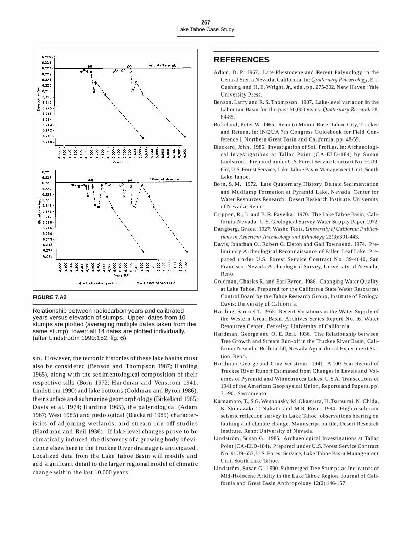
267Lake Tahoe Case Study
FIGURE 7.A2
Relationship between radiocarbon years and calibratedyears versus elevation of stumps. Upper: dates from 10stumps are plotted (averaging multiple dates taken from thesame stump); lower: all 14 dates are plotted individually.(after Lindstroöm 1990:152, fig. 6)
REFERENCESAdam, D. P. l967. Late Pleistocene and Recent Palynology in the
Central Sierra Nevada, California. In: Quaternary Paleoecology, E. J.Cushing and H. E. Wright, Jr., eds., pp. 275-302. New Haven: YaleUniversity Press.
Benson, Larry and R. S. Thompson. 1987. Lake-level variation in theLahontan Basin for the past 50,000 years. Quaternary Research 28:69-85.
Birkeland, Peter W. l965. Reno to Mount Rose, Tahoe City, Truckeeand Return, In: INQUA 7th Congress Guidebook for Field Con-ference l. Northern Great Basin and California, pp. 48-59.
Blackard, John. 1985. Investigation of Soil Profiles. In: Archaeologi-cal Investigations at Tallac Point (CA-ELD-184) by SusanLindström. Prepared under U.S. Forest Service Contract No. 91U9-657, U.S. Forest Service, Lake Tahoe Basin Management Unit, SouthLake Tahoe.
Born, S. M. 1972. Late Quaternary History. Deltaic Sedimentationand Mudlump Formation at Pyramid Lake, Nevada. Center forWater Resources Research. Desert Research Institute. Universityof Nevada, Reno.
Crippen, R., Jr. and B. R. Pavelka. 1970. The Lake Tahoe Basin, Cali-fornia-Nevada. U.S. Geological Survey Water Supply Paper 1972.
Dangberg, Grace. 1927. Washo Texts. University of California Publica-tions in American Archaeology and Ethnology 22(3):391-443.
Davis, Jonathan O., Robert G. Elston and Gail Townsend. l974. Pre-liminary Archeological Reconnaissance of Fallen Leaf Lake. Pre-pared under U.S. Forest Service Contract No. 39-4640, SanFrancisco, Nevada Archeological Survey, University of Nevada,Reno.
Goldman, Charles R. and Earl Byron. l986. Changing Water Qualityat Lake Tahoe. Prepared for the California State Water ResourcesControl Board by the Tahoe Research Group, Institute of Ecology.Davis: University of California.
Harding, Samuel T. l965. Recent Variations in the Water Supply ofthe Western Great Basin. Archives Series Report No. l6. WaterResources Center. Berkeley: University of California.
Hardman, George and O. E. Reil. l936. The Relationship betweenTree Growth and Stream Run-off in the Truckee River Basin, Cali-fornia-Nevada. Bulletin l4l, Nevada Agricultural Experiment Sta-tion. Reno.
Hardman, George and Cruz Venstrom. 1941. A 100-Year Record ofTruckee River Runoff Estimated from Changes in Levels and Vol-umes of Pyramid and Winnemucca Lakes. U.S.A. Transactions of1941 of the American Geophysical Union, Reports and Papers. pp.71-90. Sacramento.
Kumamoto, T., S.G. Wesnousky, M. Okamura, H. Tsutsumi, N. Chida,K. Shimazaki, T. Nakata, and M.R. Rose. 1994. High resolutionseismic reflection survey in Lake Tahoe: observations bearing onfaulting and climate change. Manuscript on file, Desert ResearchInstitute. Reno: University of Nevada.
Lindström, Susan G. 1985. Archaeological Investigations at TallacPoint (CA-ELD-184). Prepared under U.S. Forest Service ContractNo. 91U9-657, U.S. Forest Service, Lake Tahoe Basin ManagementUnit. South Lake Tahoe.
Lindström, Susan G. 1990 Submerged Tree Stumps as Indicators ofMid-Holocene Aridity in the Lake Tahoe Region. Journal of Cali-fornia and Great Basin Anthropology 12(2):146-157.
sin. However, the tectonic histories of these lake basins mustalso be considered (Benson and Thompson 1987; Harding1965), along with the sedimentological composition of theirrespective sills (Born 1972; Hardman and Venstrom 1941;Lindström 1990) and lake bottoms (Goldman and Byron 1986),their surface and submarine geomorphology (Birkeland 1965;Davis et al. 1974; Harding 1965), the palynological (Adam1967; West 1985) and pedological (Blackard 1985) character-istics of adjoining wetlands, and stream run-off studies(Hardman and Reil 1936). If lake level changes prove to beclimatically induced, the discovery of a growing body of evi-dence elsewhere in the Truckee River drainage is anticipated.Localized data from the Lake Tahoe Basin will modify andadd significant detail to the larger regional model of climaticchange within the last 10,000 years.
268ADDENDUM
Lindström, S.G. and W. Bloomer. 1994. Evaluation of Site Data Po-tential for 26Wa5322 (TY3437/05-10-280) Tahoe Meadows Prehis-toric Site Complex Segment 17 of the Tahoe Rim Trail near Mt.Rose, Lake Tahoe, Nevada, Washoe County. Submitted to USDAForest Service. Manuscript on file Toiyabe National Forest. Sparks.
Lowie. R.H. 1939. Ethnographic notes on the Washoe. University ofCalifornia Publications in American Archaeology and Ethnology 36(5):301-352.
Rose, M. R. 1994. Personal communication. Desert Research Insti-tute, University of Nevada, Reno.
Steen, H.K., ed. 1992. The Origins of the National Forests. DurhamN.C.: Forest History Society.
Stine, Scott. 1992. American Quaternary Association (AMQUA) 1992Post-Conference Field Trip to the Eastern Sierra and the WhiteMountains, August 26-28, 1992.
Stine, Scott. 1994. Extreme and persistent drought in California andPatagonia during medieval time. Nature 369:546-549.
Tahoe World, 11/15/91. Tahoe City.West, James G. 1985. Exploratory Palynology of Taylor Marsh. In:
Archaeological Investigations at Tallac Point (CA-ELD-184), SouthLake Tahoe, California by Susan Lindström. Prepared under U.S.Forest Service Contract No. 91U9-657, U.S. Forest Service, LakeTahoe Basin Management Unit. South Lake Tahoe.
269
SUMMARY
Routine pollen analysis was performed for forty samplesspanning 300 mm of a mid-lake core taken Aug. 1981, fromLake Tahoe (39o N, 120o W, elev. 1899 m), Placer County, Cali-fornia. At the surface, the pollen assemblage is dominatedby pine (80%), fir (6%), oak (3%), and sagebrush (3%). Wet-land and aquatic environments are represented by sedge (4%)and Pediastrum (2%). Time control is provided by 2 radio-carbon dates: 1.12±0.1 fraction modern at 45-50 mm (AA-17171P) and 14±54 yr B.P. (Before A.D. 1950) at 85-90 mm(AA-17172P). Cool-dry climate during the Little Ice Age (140- 300 mm) is indicated by lower pine (76%) and by greater fir(10%) and Artemisia (4%). Historic changes are evident above100 mm, where the pollen concentration drops from over1,000,000 to less than 600,000 grains cm-3, and charcoal dropsfrom 730,000 to 410,000 grains cm-3. A second event at 40-50mm is accompanied by a lesser increase in pollen and char-coal concentration and a sharp, brief drop of pine percent-ages. It is followed (above 40 mm) by increased percentagesof sedge (from 1% to 4%) and Pediastrum (from 0% to 2%).The two events probably resulted from human activity inthe Lake Tahoe watershed: the first due to logging and ero-sion following the gold rush, the second due to post-WWIIlogging and municipal development. Following the first im-pact, the increased flux of clastic sediment into the lake ac-celerated the sedimentation rate and decreased the pollenconcentration. Fire suppression beginning in 1885 is reflectedin reduced charcoal concentration. After 1950, housing con-struction and pollution increased nutrient flow to the lakeand stimulated the growth of planktonic algae includingPediastrum, and sediment deposition or lake level increaseexpanded the littoral zone, reflected in the expansion ofsedges.
APPENDIX 7.2
BY OWEN K. DAVISDepartment of Geosciences,
University of Arizona
Pollen Analysis of aMid-Lake Core from LakeTahoe, California: HistoricVegetation Change
INTRODUCTION
Setting
Lake Tahoe is a large (500 km2) deep (502 m max.) lake in theeastern Sierra Nevada of California and Nevada (Goldman1988). It has a comparatively small (800 km2) watershed drain-ing crystalline rocks. The oligotrophic lake is gradually be-coming polluted through addition of iron and nitrogen(Goldman 1988). Sewage is diverted from the watershed, sothe primary sources of pollutants are fertilizer, leaky sewerpipes, and atmospheric deposition following forest fires(Goldman et al. 1990). The lake phytoplankton compositionis dominated by diatoms. The species composition haschanged during the historic period, with mesotrophicFragilaria crotonensis increasing in response to pollution(Goldman 1988), and overall species diversity increasing aswell (Hunter et al., 1990).
The Lake Tahoe watershed is forested—primarily by pines:ponderosa (Pinus ponderosa), Jeffrey (P. jeffreyi), and sugar (P.lambertiana) pine. Juniper (Juniperus occidentalis) and oak(Quercus kelloggii) are abundant in openings and toward lowerelevation. Lodgepole pine (P. murrayana), fir (Abies concolor,A. magnifica) and mountain hemlock (Tsuga mertensiana) arecommon in moist habitats and at upper elevation. On ex-posed, rocky slopes sagebrush (Artemisia spp.) dominates(Adam 1967).
History of the Watershed
The Lake Tahoe Basin was one of the first areas of the SierraNevada to experience the impact of historic settlement; withexploration beginning in 1827 (Brooks 1977), accelerated im-pact during the gold rush of 1847, and with extensive loggingfrom 1856–80 (Sudworth 1900). The logging focused prima-rily on the ponderosa and sugar pine, which were used forthe trans-Sierra railroad, and for constructing the mines andmining camps to the east. Muir (Wolfe 1938) visited the areain 1888 and mentioned extensive “fallen burnt logs or tops oftrees felled for lumber.”
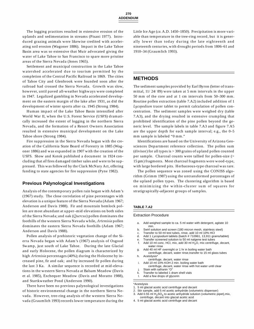
270ADDENDUM
The logging practices resulted in extensive erosion of theuplands and sedimentation in streams (Pisani 1977). Intro-duced grazing animals were likewise credited with acceler-ating soil erosion (Wagoner 1886). Impact in the Lake TahoeBasin area was so extensive that Muir advocated giving thewater of Lake Tahoe to San Francisco to spare more pristineareas of the Sierra Nevada (Jones 1965).
Settlement and municipal construction in the Lake Tahoewatershed accelerated due to tourism permitted by thecompletion of the Central Pacific Railroad in 1869. The citiesof Tahoe City and Glenbrook were founded soon after therailroad had crossed the Sierra Nevada. Growth was slow,however, until paved all-weather highways were completedin 1947. Legalized gambling in Nevada accelerated develop-ment on the eastern margin of the lake after 1931, as did thedevelopment of winter sports after ca. 1945 (Strong 1984).
Human impact of the Lake Tahoe Basin intensified afterWorld War II, when the U.S. Forest Service (USFS) dramati-cally increased the extent of logging in the northern SierraNevada, and the formation of a Resort Owners Associationresulted in extensive municipal development on the LakeTahoe shore (Strong 1984).
Fire suppression in the Sierra Nevada began with the cre-ation of the California State Board of Forestry in 1885 (Wag-oner 1886) and was expanded in 1907 with the creation of theUSFS. Show and Kotok published a document in 1924 con-cluding that all fires damaged timber sales and were to be sup-pressed. This was followed by the Clark McNary Act, offeringfunding to state agencies for fire suppression (Pyne 1982).
Previous Palynological Investigations
Analysis of the contemporary pollen rain began with Adam’s(1967) study. The close correlation of pine percentages withelevation is a unique feature of the Sierra Nevada (Adam 1967;Anderson and Davis 1988). Fir and mountain hemlock pol-len are most abundant at upper–mid elevations on both sidesof the Sierra Nevada; and oak (Quercus) pollen dominates thefoothills of the western Sierra Nevada while, Artemisia pollendominates the eastern Sierra Nevada foothills (Adam 1967;Anderson and Davis 1988).
Pollen analysis of prehistoric vegetation change of the Si-erra Nevada began with Adam’s (1967) analysis of OsgoodSwamp, just south of Lake Tahoe. During the late Glacialand early Holocene, the pollen diagram is characterized byhigh Artemisia percentages (40%); during the Holocene by in-creased pine, fir and oak; and by increased fir pollen duringthe last 3 Ka. A similar sequence is recorded at mid-eleva-tions in the western Sierra Nevada at Balsam Meadow (Daviset al. 1985), Exchequer Meadow (Davis and Moratto 1988),and Startkweather Pond (Anderson 1990).
There have been no previous palynological investigationsof historic environmental change in the northern Sierra Ne-vada. However, tree-ring analysis of the western Sierra Ne-vada (Graumlich 1993) records lower temperature during the
Little Ice Age (ca. A.D. 1450–1850). Precipitation is more vari-able than temperature in the tree-ring record, but it is gener-ally lower than today during the late eighteenth andnineteenth centuries, with drought periods from 1806–61 and1910–34 (Graumlich 1993).
METHODS
The sediment samples provided by Earl Byron (letter of trans-mittal, 11/24/89) were taken at 5 mm intervals in the upper50 mm of the core and at 1 cm intervals from 50–300 mm.Routine pollen extraction (table 7.A2) included addition of 1Lycopodium tracer tablet to permit calculation of pollen con-centration. The sediment samples were weighed dry (table7.A3), and the drying resulted in extensive crumpling thatprohibited identification of the pine pollen beyond the ge-neric level. The sample labels in table 7.A3 and figure 7.A5are the upper depth for each sample interval; e.g., the 0–5mm sample is labeled “0 mm.”
Identifications are based on the University of Arizona Geo-sciences Department reference collection. The pollen sum(divisor) for all types is > 300 grains of upland pollen countedper sample. Charcoal counts were tallied for pollen-size (>15 µm) fragments. Most charcoal fragments were wood-type,with large bordered pits. Herbaceous-type charcoal was rare.
The pollen sequence was zoned using the CONISS algo-rithm (Grimm 1987) using the untransformed percentages ofthe upland pollen types. The clustering algorithm is basedon minimizing the within-cluster sum of squares forstratigrapically-adjacent groups of samples.
TABLE 7.A2
Extraction Procedure
a. Add weighed sample to ca. 5 ml water with detergent, agitate 10min.
b. Swirl solution and screen (180 micron mesh, stainless steel)c. Transfer to 50 ml test tubes, rinse, add 10 ml 10% HCld. Add 1 Lycopodium tablets (batch # 710961, 13,911 grains/tablet)e. Transfer screened solution to 50 ml nalgene test tubesf. Add 10 ml conc. HCl, mix, add 30 ml H2O, mix centrifuge, decant,
water rinseg. Add 40 ml HF overnight or 1 hr in boiling water bath
centrifuge, decant, water rinse,transfer to 15 ml glass tubesh. Acetolysis*
centrifuge, decant, water rinsei. Add 10 ml 10% KOH 2 min. boiling water bath
centrifuge, decant, water rinse with hot water until clearj. Stain with safranin “O”k. Transfer to labeled 1 dram shell vialsl. Add a few drops of glycerin
*Acetolysis1. 5 ml glacial acetic acid centrifuge and decant2. Stir sample, add 5 ml acetic anhydride (volumetric dispenser)3. Add 0.55 ml H2SO4 to acetic anhydride solution (volumetric pipet),mix,
centrifuge, decant into glacial acetic acid4. 5 ml glacial acetic acid centrifuge and decant
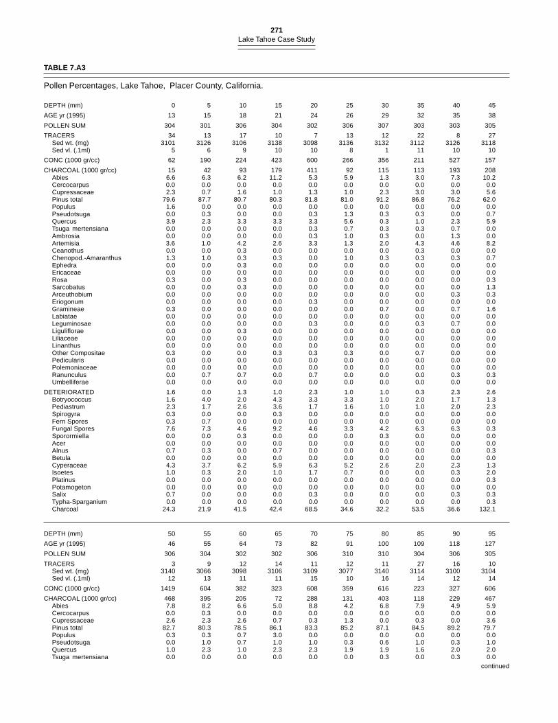
271Lake Tahoe Case Study
TABLE 7.A3
Pollen Percentages, Lake Tahoe, Placer County, California.
DEPTH (mm) 0 5 10 15 20 25 30 35 40 45
AGE yr (1995) 13 15 18 21 24 26 29 32 35 38
POLLEN SUM 304 301 306 304 302 306 307 303 303 305
TRACERS 34 13 17 10 7 13 12 22 8 27Sed wt. (mg) 3101 3126 3106 3138 3098 3136 3132 3112 3126 3118Sed vl. (.1ml) 5 6 9 10 10 8 1 11 10 10
CONC (1000 gr/cc) 62 190 224 423 600 266 356 211 527 157
CHARCOAL (1000 gr/cc) 15 42 93 179 411 92 115 113 193 208Abies 6.6 6.3 6.2 11.2 5.3 5.9 1.3 3.0 7.3 10.2Cercocarpus 0.0 0.0 0.0 0.0 0.0 0.0 0.0 0.0 0.0 0.0Cupressaceae 2.3 0.7 1.6 1.0 1.3 1.0 2.3 3.0 3.0 5.6Pinus total 79.6 87.7 80.7 80.3 81.8 81.0 91.2 86.8 76.2 62.0Populus 1.6 0.0 0.0 0.0 0.0 0.0 0.0 0.0 0.0 0.0Pseudotsuga 0.0 0.3 0.0 0.0 0.3 1.3 0.3 0.3 0.0 0.7Quercus 3.9 2.3 3.3 3.3 3.3 5.6 0.3 1.0 2.3 5.9Tsuga mertensiana 0.0 0.0 0.0 0.0 0.3 0.7 0.3 0.3 0.7 0.0Ambrosia 0.0 0.0 0.0 0.0 0.3 1.0 0.3 0.0 1.3 0.0Artemisia 3.6 1.0 4.2 2.6 3.3 1.3 2.0 4.3 4.6 8.2Ceanothus 0.0 0.0 0.3 0.0 0.0 0.0 0.0 0.3 0.0 0.0Chenopod.-Amaranthus 1.3 1.0 0.3 0.3 0.0 1.0 0.3 0.3 0.3 0.7Ephedra 0.0 0.0 0.3 0.0 0.0 0.0 0.0 0.0 0.0 0.0Ericaceae 0.0 0.0 0.0 0.0 0.0 0.0 0.0 0.0 0.0 0.0Rosa 0.3 0.0 0.3 0.0 0.0 0.0 0.0 0.0 0.0 0.3Sarcobatus 0.0 0.0 0.3 0.0 0.0 0.0 0.0 0.0 0.0 1.3Arceuthobium 0.0 0.0 0.0 0.0 0.0 0.0 0.0 0.0 0.3 0.3Eriogonum 0.0 0.0 0.0 0.0 0.3 0.0 0.0 0.0 0.0 0.0Gramineae 0.3 0.0 0.0 0.0 0.0 0.0 0.7 0.0 0.7 1.6Labiatae 0.0 0.0 0.0 0.0 0.0 0.0 0.0 0.0 0.0 0.0Leguminosae 0.0 0.0 0.0 0.0 0.3 0.0 0.0 0.3 0.7 0.0Liguliflorae 0.0 0.0 0.3 0.0 0.0 0.0 0.0 0.0 0.0 0.0Liliaceae 0.0 0.0 0.0 0.0 0.0 0.0 0.0 0.0 0.0 0.0Linanthus 0.0 0.0 0.0 0.0 0.0 0.0 0.0 0.0 0.0 0.0Other Compositae 0.3 0.0 0.0 0.3 0.3 0.3 0.0 0.7 0.0 0.0Pedicularis 0.0 0.0 0.0 0.0 0.0 0.0 0.0 0.0 0.0 0.0Polemoniaceae 0.0 0.0 0.0 0.0 0.0 0.0 0.0 0.0 0.0 0.0Ranunculus 0.0 0.7 0.7 0.0 0.7 0.0 0.0 0.0 0.3 0.3Umbelliferae 0.0 0.0 0.0 0.0 0.0 0.0 0.0 0.0 0.0 0.0
DETERIORATED 1.6 0.0 1.3 1.0 2.3 1.0 1.0 0.3 2.3 2.6Botryococcus 1.6 4.0 2.0 4.3 3.3 3.3 1.0 2.0 1.7 1.3Pediastrum 2.3 1.7 2.6 3.6 1.7 1.6 1.0 1.0 2.0 2.3Spirogyra 0.3 0.0 0.0 0.3 0.0 0.0 0.0 0.0 0.0 0.0Fern Spores 0.3 0.7 0.0 0.0 0.0 0.0 0.0 0.0 0.0 0.0Fungal Spores 7.6 7.3 4.6 9.2 4.6 3.3 4.2 6.3 6.3 0.3Sporormiella 0.0 0.0 0.3 0.0 0.0 0.0 0.3 0.0 0.0 0.0Acer 0.0 0.0 0.0 0.0 0.0 0.0 0.0 0.0 0.0 0.0Alnus 0.7 0.3 0.0 0.7 0.0 0.0 0.0 0.0 0.0 0.3Betula 0.0 0.0 0.0 0.0 0.0 0.0 0.0 0.0 0.0 0.0Cyperaceae 4.3 3.7 6.2 5.9 6.3 5.2 2.6 2.0 2.3 1.3Isoetes 1.0 0.3 2.0 1.0 1.7 0.7 0.0 0.0 0.3 2.0Platinus 0.0 0.0 0.0 0.0 0.0 0.0 0.0 0.0 0.0 0.3Potamogeton 0.0 0.0 0.0 0.0 0.0 0.0 0.0 0.0 0.0 0.0Salix 0.7 0.0 0.0 0.0 0.3 0.0 0.0 0.0 0.3 0.3Typha-Sparganium 0.0 0.0 0.0 0.0 0.0 0.0 0.0 0.0 0.0 0.3Charcoal 24.3 21.9 41.5 42.4 68.5 34.6 32.2 53.5 36.6 132.1
DEPTH (mm) 50 55 60 65 70 75 80 85 90 95
AGE yr (1995) 46 55 64 73 82 91 100 109 118 127
POLLEN SUM 306 304 302 302 306 310 310 304 306 305
TRACERS 3 9 12 14 11 12 11 27 16 10Sed wt. (mg) 3140 3066 3098 3106 3109 3077 3140 3114 3100 3104Sed vl. (.1ml) 12 13 11 11 15 10 16 14 12 14
CONC (1000 gr/cc) 1419 604 382 323 608 359 616 223 327 606
CHARCOAL (1000 gr/cc) 468 395 205 72 288 131 403 118 229 467Abies 7.8 8.2 6.6 5.0 8.8 4.2 6.8 7.9 4.9 5.9Cercocarpus 0.0 0.3 0.0 0.0 0.0 0.0 0.0 0.0 0.0 0.0Cupressaceae 2.6 2.3 2.6 0.7 0.3 1.3 0.0 0.3 0.0 3.6Pinus total 82.7 80.3 78.5 86.1 83.3 85.2 87.1 84.5 89.2 79.7Populus 0.3 0.3 0.7 3.0 0.0 0.0 0.0 0.0 0.0 0.0Pseudotsuga 0.0 1.0 0.7 1.0 1.0 0.3 0.6 1.0 0.3 1.0Quercus 1.0 2.3 1.0 2.3 2.3 1.9 1.9 1.6 2.0 2.0Tsuga mertensiana 0.0 0.0 0.0 0.0 0.0 0.0 0.3 0.0 0.3 0.0
continued
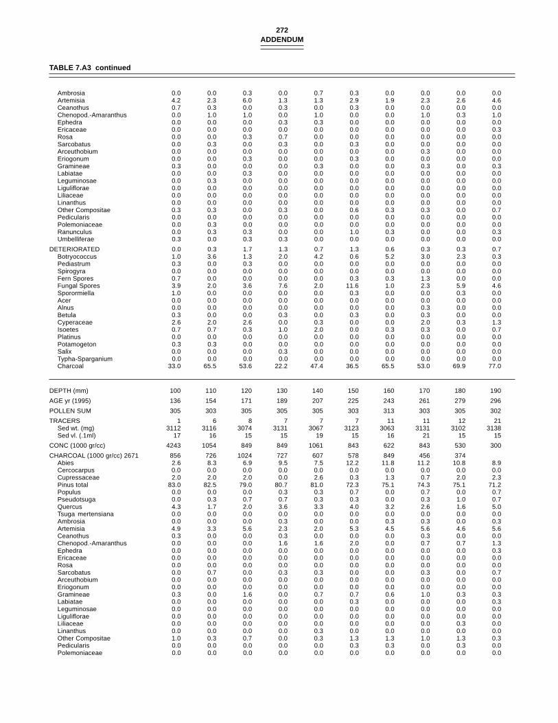
272ADDENDUM
Ambrosia 0.0 0.0 0.3 0.0 0.7 0.3 0.0 0.0 0.0 0.0Artemisia 4.2 2.3 6.0 1.3 1.3 2.9 1.9 2.3 2.6 4.6Ceanothus 0.7 0.3 0.0 0.3 0.0 0.3 0.0 0.0 0.0 0.0Chenopod.-Amaranthus 0.0 1.0 1.0 0.0 1.0 0.0 0.0 1.0 0.3 1.0Ephedra 0.0 0.0 0.0 0.3 0.3 0.0 0.0 0.0 0.0 0.0Ericaceae 0.0 0.0 0.0 0.0 0.0 0.0 0.0 0.0 0.0 0.3Rosa 0.0 0.0 0.3 0.7 0.0 0.0 0.0 0.0 0.0 0.0Sarcobatus 0.0 0.3 0.0 0.3 0.0 0.3 0.0 0.0 0.0 0.0Arceuthobium 0.0 0.0 0.0 0.0 0.0 0.0 0.0 0.3 0.0 0.0Eriogonum 0.0 0.0 0.3 0.0 0.0 0.3 0.0 0.0 0.0 0.0Gramineae 0.3 0.0 0.0 0.0 0.3 0.0 0.0 0.3 0.0 0.3Labiatae 0.0 0.0 0.3 0.0 0.0 0.0 0.0 0.0 0.0 0.0Leguminosae 0.0 0.3 0.0 0.0 0.0 0.0 0.0 0.0 0.0 0.0Liguliflorae 0.0 0.0 0.0 0.0 0.0 0.0 0.0 0.0 0.0 0.0Liliaceae 0.0 0.0 0.0 0.0 0.0 0.0 0.0 0.0 0.0 0.0Linanthus 0.0 0.0 0.0 0.0 0.0 0.0 0.0 0.0 0.0 0.0Other Compositae 0.3 0.3 0.0 0.3 0.0 0.6 0.3 0.3 0.0 0.7Pedicularis 0.0 0.0 0.0 0.0 0.0 0.0 0.0 0.0 0.0 0.0Polemoniaceae 0.0 0.3 0.0 0.0 0.0 0.0 0.0 0.0 0.0 0.0Ranunculus 0.0 0.3 0.3 0.0 0.0 1.0 0.3 0.0 0.0 0.3Umbelliferae 0.3 0.0 0.3 0.3 0.0 0.0 0.0 0.0 0.0 0.0
DETERIORATED 0.0 0.3 1.7 1.3 0.7 1.3 0.6 0.3 0.3 0.7Botryococcus 1.0 3.6 1.3 2.0 4.2 0.6 5.2 3.0 2.3 0.3Pediastrum 0.3 0.0 0.3 0.0 0.0 0.0 0.0 0.0 0.0 0.0Spirogyra 0.0 0.0 0.0 0.0 0.0 0.0 0.0 0.0 0.0 0.0Fern Spores 0.7 0.0 0.0 0.0 0.0 0.3 0.3 1.3 0.0 0.0Fungal Spores 3.9 2.0 3.6 7.6 2.0 11.6 1.0 2.3 5.9 4.6Sporormiella 1.0 0.0 0.0 0.0 0.0 0.3 0.0 0.0 0.3 0.0Acer 0.0 0.0 0.0 0.0 0.0 0.0 0.0 0.0 0.0 0.0Alnus 0.0 0.0 0.0 0.0 0.0 0.0 0.0 0.3 0.0 0.0Betula 0.3 0.0 0.0 0.3 0.0 0.3 0.0 0.3 0.0 0.0Cyperaceae 2.6 2.0 2.6 0.0 0.3 0.0 0.0 2.0 0.3 1.3Isoetes 0.7 0.7 0.3 1.0 2.0 0.0 0.3 0.3 0.0 0.7Platinus 0.0 0.0 0.0 0.0 0.0 0.0 0.0 0.0 0.0 0.0Potamogeton 0.3 0.3 0.0 0.0 0.0 0.0 0.0 0.0 0.0 0.0Salix 0.0 0.0 0.0 0.3 0.0 0.0 0.0 0.0 0.0 0.0Typha-Sparganium 0.0 0.0 0.0 0.0 0.0 0.0 0.0 0.0 0.0 0.0Charcoal 33.0 65.5 53.6 22.2 47.4 36.5 65.5 53.0 69.9 77.0
DEPTH (mm) 100 110 120 130 140 150 160 170 180 190
AGE yr (1995) 136 154 171 189 207 225 243 261 279 296
POLLEN SUM 305 303 305 305 305 303 313 303 305 302
TRACERS 1 6 8 7 7 7 11 11 12 21Sed wt. (mg) 3112 3116 3074 3131 3067 3123 3063 3131 3102 3138Sed vl. (.1ml) 17 16 15 15 19 15 16 21 15 15
CONC (1000 gr/cc) 4243 1054 849 849 1061 843 622 843 530 300
CHARCOAL (1000 gr/cc) 2671 856 726 1024 727 607 578 849 456 374Abies 2.6 8.3 6.9 9.5 7.5 12.2 11.8 11.2 10.8 8.9Cercocarpus 0.0 0.0 0.0 0.0 0.0 0.0 0.0 0.0 0.0 0.0Cupressaceae 2.0 2.0 2.0 0.0 2.6 0.3 1.3 0.7 2.0 2.3Pinus total 83.0 82.5 79.0 80.7 81.0 72.3 75.1 74.3 75.1 71.2Populus 0.0 0.0 0.0 0.3 0.3 0.7 0.0 0.7 0.0 0.7Pseudotsuga 0.0 0.3 0.7 0.7 0.3 0.3 0.0 0.3 1.0 0.7Quercus 4.3 1.7 2.0 3.6 3.3 4.0 3.2 2.6 1.6 5.0Tsuga mertensiana 0.0 0.0 0.0 0.0 0.0 0.0 0.0 0.0 0.0 0.0Ambrosia 0.0 0.0 0.0 0.3 0.0 0.0 0.3 0.3 0.0 0.3Artemisia 4.9 3.3 5.6 2.3 2.0 5.3 4.5 5.6 4.6 5.6Ceanothus 0.3 0.0 0.0 0.3 0.0 0.0 0.0 0.3 0.0 0.0Chenopod.-Amaranthus 0.0 0.0 0.0 1.6 1.6 2.0 0.0 0.7 0.7 1.3Ephedra 0.0 0.0 0.0 0.0 0.0 0.0 0.0 0.0 0.0 0.3Ericaceae 0.0 0.0 0.0 0.0 0.0 0.0 0.0 0.0 0.0 0.0Rosa 0.0 0.0 0.0 0.0 0.0 0.0 0.0 0.0 0.0 0.0Sarcobatus 0.0 0.7 0.0 0.3 0.3 0.0 0.0 0.3 0.0 0.7Arceuthobium 0.0 0.0 0.0 0.0 0.0 0.0 0.0 0.0 0.0 0.0Eriogonum 0.0 0.0 0.0 0.0 0.0 0.0 0.0 0.0 0.0 0.0Gramineae 0.3 0.0 1.6 0.0 0.7 0.7 0.6 1.0 0.3 0.3Labiatae 0.0 0.0 0.0 0.0 0.0 0.3 0.0 0.0 0.0 0.3Leguminosae 0.0 0.0 0.0 0.0 0.0 0.0 0.0 0.0 0.0 0.0Liguliflorae 0.0 0.0 0.0 0.0 0.0 0.0 0.0 0.0 0.0 0.0Liliaceae 0.0 0.0 0.0 0.0 0.0 0.0 0.0 0.0 0.3 0.0Linanthus 0.0 0.0 0.0 0.0 0.3 0.0 0.0 0.0 0.0 0.0Other Compositae 1.0 0.3 0.7 0.0 0.3 1.3 1.3 1.0 1.3 0.3Pedicularis 0.0 0.0 0.0 0.0 0.0 0.3 0.3 0.0 0.3 0.0Polemoniaceae 0.0 0.0 0.0 0.0 0.0 0.0 0.0 0.0 0.0 0.0
TABLE 7.A3 continued
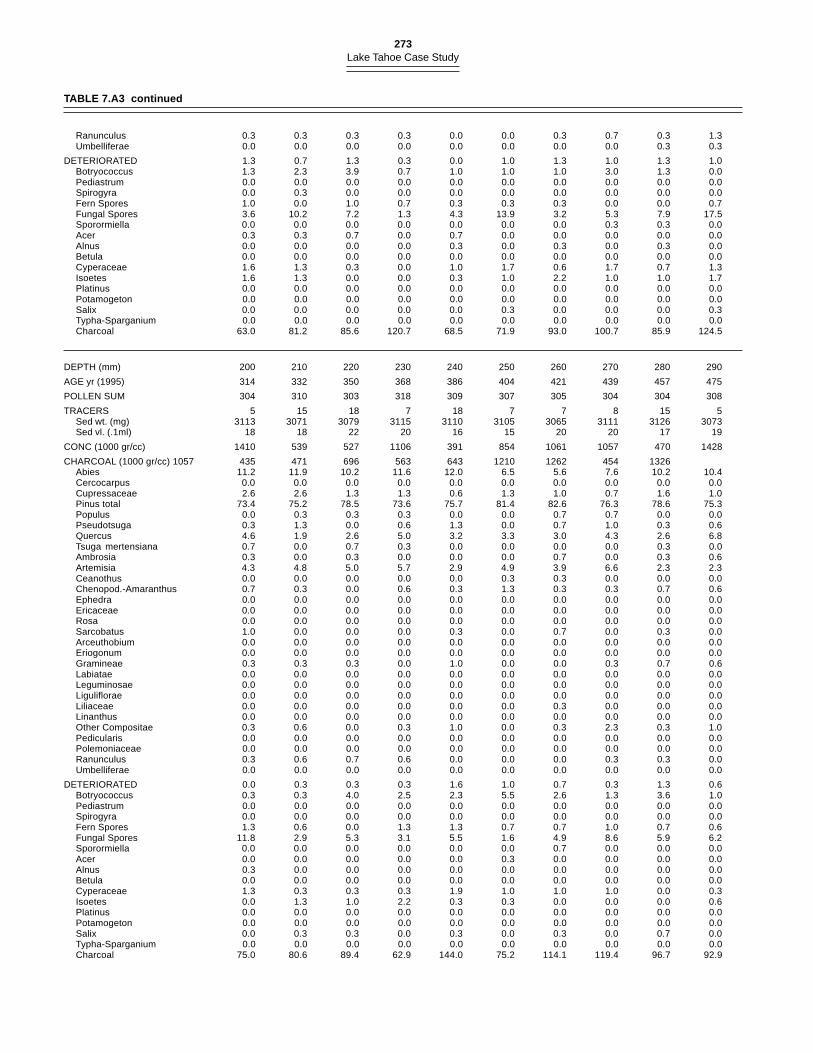
273Lake Tahoe Case Study
Ranunculus 0.3 0.3 0.3 0.3 0.0 0.0 0.3 0.7 0.3 1.3Umbelliferae 0.0 0.0 0.0 0.0 0.0 0.0 0.0 0.0 0.3 0.3
DETERIORATED 1.3 0.7 1.3 0.3 0.0 1.0 1.3 1.0 1.3 1.0Botryococcus 1.3 2.3 3.9 0.7 1.0 1.0 1.0 3.0 1.3 0.0Pediastrum 0.0 0.0 0.0 0.0 0.0 0.0 0.0 0.0 0.0 0.0Spirogyra 0.0 0.3 0.0 0.0 0.0 0.0 0.0 0.0 0.0 0.0Fern Spores 1.0 0.0 1.0 0.7 0.3 0.3 0.3 0.0 0.0 0.7Fungal Spores 3.6 10.2 7.2 1.3 4.3 13.9 3.2 5.3 7.9 17.5Sporormiella 0.0 0.0 0.0 0.0 0.0 0.0 0.0 0.3 0.3 0.0Acer 0.3 0.3 0.7 0.0 0.7 0.0 0.0 0.0 0.0 0.0Alnus 0.0 0.0 0.0 0.0 0.3 0.0 0.3 0.0 0.3 0.0Betula 0.0 0.0 0.0 0.0 0.0 0.0 0.0 0.0 0.0 0.0Cyperaceae 1.6 1.3 0.3 0.0 1.0 1.7 0.6 1.7 0.7 1.3Isoetes 1.6 1.3 0.0 0.0 0.3 1.0 2.2 1.0 1.0 1.7Platinus 0.0 0.0 0.0 0.0 0.0 0.0 0.0 0.0 0.0 0.0Potamogeton 0.0 0.0 0.0 0.0 0.0 0.0 0.0 0.0 0.0 0.0Salix 0.0 0.0 0.0 0.0 0.0 0.3 0.0 0.0 0.0 0.3Typha-Sparganium 0.0 0.0 0.0 0.0 0.0 0.0 0.0 0.0 0.0 0.0Charcoal 63.0 81.2 85.6 120.7 68.5 71.9 93.0 100.7 85.9 124.5
DEPTH (mm) 200 210 220 230 240 250 260 270 280 290
AGE yr (1995) 314 332 350 368 386 404 421 439 457 475
POLLEN SUM 304 310 303 318 309 307 305 304 304 308
TRACERS 5 15 18 7 18 7 7 8 15 5Sed wt. (mg) 3113 3071 3079 3115 3110 3105 3065 3111 3126 3073Sed vl. (.1ml) 18 18 22 20 16 15 20 20 17 19
CONC (1000 gr/cc) 1410 539 527 1106 391 854 1061 1057 470 1428
CHARCOAL (1000 gr/cc) 1057 435 471 696 563 643 1210 1262 454 1326Abies 11.2 11.9 10.2 11.6 12.0 6.5 5.6 7.6 10.2 10.4Cercocarpus 0.0 0.0 0.0 0.0 0.0 0.0 0.0 0.0 0.0 0.0Cupressaceae 2.6 2.6 1.3 1.3 0.6 1.3 1.0 0.7 1.6 1.0Pinus total 73.4 75.2 78.5 73.6 75.7 81.4 82.6 76.3 78.6 75.3Populus 0.0 0.3 0.3 0.3 0.0 0.0 0.7 0.7 0.0 0.0Pseudotsuga 0.3 1.3 0.0 0.6 1.3 0.0 0.7 1.0 0.3 0.6Quercus 4.6 1.9 2.6 5.0 3.2 3.3 3.0 4.3 2.6 6.8Tsuga mertensiana 0.7 0.0 0.7 0.3 0.0 0.0 0.0 0.0 0.3 0.0Ambrosia 0.3 0.0 0.3 0.0 0.0 0.0 0.7 0.0 0.3 0.6Artemisia 4.3 4.8 5.0 5.7 2.9 4.9 3.9 6.6 2.3 2.3Ceanothus 0.0 0.0 0.0 0.0 0.0 0.3 0.3 0.0 0.0 0.0Chenopod.-Amaranthus 0.7 0.3 0.0 0.6 0.3 1.3 0.3 0.3 0.7 0.6Ephedra 0.0 0.0 0.0 0.0 0.0 0.0 0.0 0.0 0.0 0.0Ericaceae 0.0 0.0 0.0 0.0 0.0 0.0 0.0 0.0 0.0 0.0Rosa 0.0 0.0 0.0 0.0 0.0 0.0 0.0 0.0 0.0 0.0Sarcobatus 1.0 0.0 0.0 0.0 0.3 0.0 0.7 0.0 0.3 0.0Arceuthobium 0.0 0.0 0.0 0.0 0.0 0.0 0.0 0.0 0.0 0.0Eriogonum 0.0 0.0 0.0 0.0 0.0 0.0 0.0 0.0 0.0 0.0Gramineae 0.3 0.3 0.3 0.0 1.0 0.0 0.0 0.3 0.7 0.6Labiatae 0.0 0.0 0.0 0.0 0.0 0.0 0.0 0.0 0.0 0.0Leguminosae 0.0 0.0 0.0 0.0 0.0 0.0 0.0 0.0 0.0 0.0Liguliflorae 0.0 0.0 0.0 0.0 0.0 0.0 0.0 0.0 0.0 0.0Liliaceae 0.0 0.0 0.0 0.0 0.0 0.0 0.3 0.0 0.0 0.0Linanthus 0.0 0.0 0.0 0.0 0.0 0.0 0.0 0.0 0.0 0.0Other Compositae 0.3 0.6 0.0 0.3 1.0 0.0 0.3 2.3 0.3 1.0Pedicularis 0.0 0.0 0.0 0.0 0.0 0.0 0.0 0.0 0.0 0.0Polemoniaceae 0.0 0.0 0.0 0.0 0.0 0.0 0.0 0.0 0.0 0.0Ranunculus 0.3 0.6 0.7 0.6 0.0 0.0 0.0 0.3 0.3 0.0Umbelliferae 0.0 0.0 0.0 0.0 0.0 0.0 0.0 0.0 0.0 0.0
DETERIORATED 0.0 0.3 0.3 0.3 1.6 1.0 0.7 0.3 1.3 0.6Botryococcus 0.3 0.3 4.0 2.5 2.3 5.5 2.6 1.3 3.6 1.0Pediastrum 0.0 0.0 0.0 0.0 0.0 0.0 0.0 0.0 0.0 0.0Spirogyra 0.0 0.0 0.0 0.0 0.0 0.0 0.0 0.0 0.0 0.0Fern Spores 1.3 0.6 0.0 1.3 1.3 0.7 0.7 1.0 0.7 0.6Fungal Spores 11.8 2.9 5.3 3.1 5.5 1.6 4.9 8.6 5.9 6.2Sporormiella 0.0 0.0 0.0 0.0 0.0 0.0 0.7 0.0 0.0 0.0Acer 0.0 0.0 0.0 0.0 0.0 0.3 0.0 0.0 0.0 0.0Alnus 0.3 0.0 0.0 0.0 0.0 0.0 0.0 0.0 0.0 0.0Betula 0.0 0.0 0.0 0.0 0.0 0.0 0.0 0.0 0.0 0.0Cyperaceae 1.3 0.3 0.3 0.3 1.9 1.0 1.0 1.0 0.0 0.3Isoetes 0.0 1.3 1.0 2.2 0.3 0.3 0.0 0.0 0.0 0.6Platinus 0.0 0.0 0.0 0.0 0.0 0.0 0.0 0.0 0.0 0.0Potamogeton 0.0 0.0 0.0 0.0 0.0 0.0 0.0 0.0 0.0 0.0Salix 0.0 0.3 0.3 0.0 0.3 0.0 0.3 0.0 0.7 0.0Typha-Sparganium 0.0 0.0 0.0 0.0 0.0 0.0 0.0 0.0 0.0 0.0Charcoal 75.0 80.6 89.4 62.9 144.0 75.2 114.1 119.4 96.7 92.9
TABLE 7.A3 continued
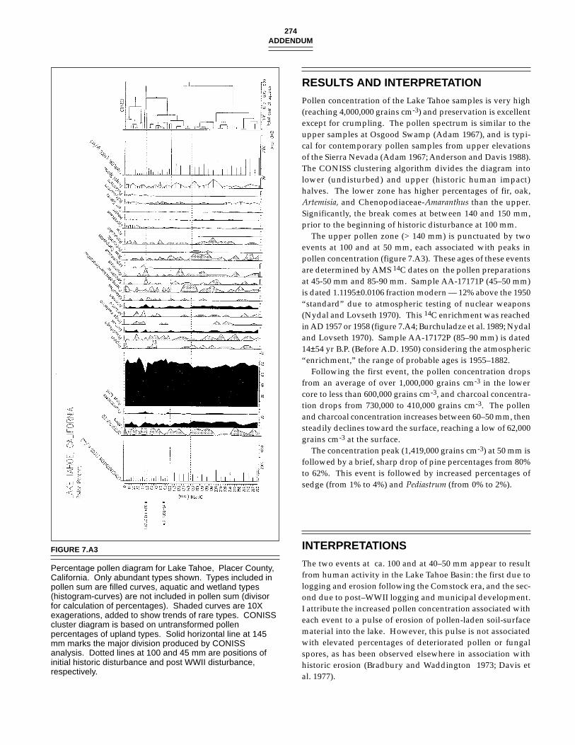
274ADDENDUM
RESULTS AND INTERPRETATION
Pollen concentration of the Lake Tahoe samples is very high(reaching 4,000,000 grains cm-3) and preservation is excellentexcept for crumpling. The pollen spectrum is similar to theupper samples at Osgood Swamp (Adam 1967), and is typi-cal for contemporary pollen samples from upper elevationsof the Sierra Nevada (Adam 1967; Anderson and Davis 1988).The CONISS clustering algorithm divides the diagram intolower (undisturbed) and upper (historic human impact)halves. The lower zone has higher percentages of fir, oak,Artemisia, and Chenopodiaceae-Amaranthus than the upper.Significantly, the break comes at between 140 and 150 mm,prior to the beginning of historic disturbance at 100 mm.
The upper pollen zone (> 140 mm) is punctuated by twoevents at 100 and at 50 mm, each associated with peaks inpollen concentration (figure 7.A3). These ages of these eventsare determined by AMS 14C dates on the pollen preparationsat 45-50 mm and 85-90 mm. Sample AA-17171P (45–50 mm)is dated 1.1195±0.0106 fraction modern — 12% above the 1950“standard” due to atmospheric testing of nuclear weapons(Nydal and Lovseth 1970). This 14C enrichment was reachedin AD 1957 or 1958 (figure 7.A4; Burchuladze et al. 1989; Nydaland Lovseth 1970). Sample AA-17172P (85–90 mm) is dated14±54 yr B.P. (Before A.D. 1950) considering the atmospheric“enrichment,” the range of probable ages is 1955–1882.
Following the first event, the pollen concentration dropsfrom an average of over 1,000,000 grains cm-3 in the lowercore to less than 600,000 grains cm-3, and charcoal concentra-tion drops from 730,000 to 410,000 grains cm-3. The pollenand charcoal concentration increases between 60–50 mm, thensteadily declines toward the surface, reaching a low of 62,000grains cm-3 at the surface.
The concentration peak (1,419,000 grains cm-3) at 50 mm isfollowed by a brief, sharp drop of pine percentages from 80%to 62%. This event is followed by increased percentages ofsedge (from 1% to 4%) and Pediastrum (from 0% to 2%).
INTERPRETATIONS
The two events at ca. 100 and at 40–50 mm appear to resultfrom human activity in the Lake Tahoe Basin: the first due tologging and erosion following the Comstock era, and the sec-ond due to post–WWII logging and municipal development.I attribute the increased pollen concentration associated witheach event to a pulse of erosion of pollen-laden soil-surfacematerial into the lake. However, this pulse is not associatedwith elevated percentages of deteriorated pollen or fungalspores, as has been observed elsewhere in association withhistoric erosion (Bradbury and Waddington 1973; Davis etal. 1977).
FIGURE 7.A3
Percentage pollen diagram for Lake Tahoe, Placer County,California. Only abundant types shown. Types included inpollen sum are filled curves, aquatic and wetland types(histogram-curves) are not included in pollen sum (divisorfor calculation of percentages). Shaded curves are 10Xexagerations, added to show trends of rare types. CONISScluster diagram is based on untransformed pollenpercentages of upland types. Solid horizontal line at 145mm marks the major division produced by CONISSanalysis. Dotted lines at 100 and 45 mm are positions ofinitial historic disturbance and post WWII disturbance,respectively.
275Lake Tahoe Case Study
The palynological events beginning at 100 cm can be as-cribed to environmental impacts between 1850 and 1900. In-creased rates of soil erosion, due to the combined effects oflogging, livestock ranching, and road construction perma-nently increased the flux of clastic sediment into the lake. Thisaccelerated deposition increased the overall sedimentationrate and decreased the pollen concentration (figure 7.A3). Theincreased pollen concentration from 60–50 cm implies a tem-porary reduction in the sedimentation rate, possibly due todecreased erosion during the early twentieth century.
Also associated with the 100-cm event is the abrupt reduc-tion of charcoal percentages. Fire suppression, beginning inthe late nineteenth century, produced lower fire frequencyreflected in reduced charcoal concentration. The approximatehalving of charcoal percentages does not necessarily indicatea halving of the regional fire frequency. The reduction is prob-ably greater, because transport of charcoal to the lake shouldhave increased during the historic period due to surface ero-sion from the watershed. The pollen concentration peak andpine percent minimum at 40–50 mm appear to reflect exten-sive logging. Erosion of soil-surface material resulted in highpollen concentration and logging reduced the pine percent.
The results of the zonation by CONISS have an importantimplication for the scale of vegetation change resulting fromhistoric impact. Because the primary division among zonescomes at between 140 and 150 mm, rather than at 100 mm(coincident with the beginning of historic disturbance), pa-lynological changes due to natural (or at least prehistoric)causes are as important as man-caused vegetation modifica-tions to the overall variation in the pollen diagram (figure7.A3). The higher percentages of fir, oak, Artemisia, and
Chenopodiaceae-Amaranthus in the lower zone are consistentwith cooler, drier climate during the late eighteenth and nine-teenth centuries as demonstrated in the tree ring data(Graumlich 1993).
The pollution of Lake Tahoe after 1950 appears to have in-creased the abundance of Pediastrum in the lake, just as itstimulated the growth of certain other algae. Although notspecifically mentioned by Hunter et al. (1990) as increasingin abundance, Pediastrum makes its first appearance in thefossil record at 50 cm and increases to a maximum of 3.6% at15 cm. Although Pediastrum seems to reflect the historic im-pact on the pelagic lake ecosystem, other aquatic plants donot. Neither the planktonic algae Botryococcus nor spores ofthe benthic quillwort Isoetes show consistent trends in the core(figure 7.A3). The unchanging Isoetes percentages indicatesthat the reduced transparency of the lake (Goldman 1988) hasnot yet effected the growth of this bottom-dwelling plant.
The expansion of sedge pollen percentages from 2% at 35mm to 6.3% at 20 mm shows historic impact on the littoralecosystem. The sedge expansion could be a response to ei-ther fertilization (pollution) of the littoral habitat, or to ex-pansion in the extent of that habitat. Because the sedgepercentages correlate with the Pediastrum percentages above50 cm, both may reflect the same forcing (i.e., increasing nu-trients). Alternatively, human activities may have increasedthe extent of the littoral zone through the progradation of thedeltas via. erosion of sediment from the watershed, or throughartificially increasing the level of the lake.
Finally, because atmospheric deposition of nutrients fol-lowing forest fires is known to provide limiting nutrients tothe lake (Goldman et al. 1990), the reduced charcoal frequencyabove 100 cm implies reduced nutrient loading to the lake.The total nutrient flux surely has been greater in the historicperiod, due to soil erosion, sewage input, and fertilizers; butthe relative contribution of fire-related atmospheric-depos-ited nutrients probably has been less.
CONCLUSIONS
1. Elevated percentages of fir (10%) and Artemisia (4%) pol-len below 140 mm indicate cool dry climate during theLittle Ice Age.
2. Pollen and charcoal concentrations decrease above 100 cmdue to soil erosion and fire suppression.
3. Above 45 cm, municipal construction and lake pollutionproduce further declines in pollen concentration, and ef-fect the modification of the lake environment as shown byincreased Pediastrum and sedge percentages.
FIGURE 7.A4
Comparison of the 14C content (1.1195±0.0106 fractionmodern) of sample AA-17171P (45-50 mm) with theatmospheric 14C enrichment due to the testing of nuclearweapons (Burchuladze et al., 1989). Plotted age forsample AA-17171P is 1957 A.D.
276ADDENDUM
REFERENCESAdam, D.P. 1967. Late Pleistocene and Recent palynology in the cen-
tral Sierra Nevada, California. In: Cushing, E.J., and Wright, H.E.,Jr. (eds.) Quaternary Paleoecology. Yale Univ. Press, New Haven,Conn. p. 275-301.
Anderson, R.S. and Davis, O.K. 1988. Contemporary pollen rainacross the central Sierra Nevada, California U.S.A.: Relationshipto modern vegetation types. Arctic and Alpine Research, 20:448-460.
Anderson, R.S. 1990. Holocene forest development and paleoclimateswithin the central Sierra Nevada, California. Jour. Ecology, 78: 470-489.
Beesley, D. 1985. Changing land use patterns and sheep transhumancein northeastern Sierra Nevada, 1870-1980. p. 3-8 in O. Templar,(Ed.) Forum for the Association of Arid Lands Studies Texas Tech.Univ., Lubbock.
Bradbury, J.P. and Waddington, J.C.B., 1973. The impact of Europeansettlement on Shagawa Lake, northeastern Minnesota, U.S.A., pp.289-308 In H.J.B. Birks and R.G. West (Editors), Quaternary PlantEcology. John Wiley and Sons, New York.
Burchuladze A.A., Chudy, M. Eristavi, I.V., Pagava, S.V., Povinec, P.,Sivo, A. and Togonidze, G.I. 1989. Anthropogenic 14C variationsin atmospheric CO2 and wines. Radiocarbon 31: 771-776.
Brooks, G.R. 1977. The southwest Expedition of Jedediah S. Smith.1826-1827. Univ. Nebraska Press, Lincoln.
Davis, O.K., Anderson, R.S., Fall, P.L., O’Rourke, M.K., and Thomp-son, R.S. 1985. Palynological evidence for early Holocene aridityin the southern Sierra Nevada, California. Quaternary Research24:322-332.
Davis, O.K., Kolva, D.A., and Mehringer, P.J., Jr. 1977. Pollen analy-sis of Wildcat Lake, Whitman County, Washington: The last 1000years. Northwest Science 51,13-30.
Davis, O.K. and Moratto, M.J. 1988. Evidence for a warm-dry earlyHolocene in the western Sierra: pollen and plant macrofossil analy-sis of Dinkey and Exchequer Meadows. Madroño 35:128-145.
Goldman, C.R. 1988. Primary productivity, nutrients, and transpar-ency during the early onset of eutrophication in ultra-oligotrophicLake Tahoe, California-Nevada. Limnol. Oceanogr. 33:1321- 1333.
Goldman, C.R. Jassby, A.D. and de Amezage, E. 1990. Forest fires,atmospheric deposition and primary productivity at Lake Tahoe,California-Nevada. Verh. Internat. Verein. Limnol. 24:499-503.
Graumlich, L.J. 1993. A 1000-year record of temperature and precipi-tation in the Sierra Nevada. Quaternary Research 39:249-255.
Grimm, E.C. 1987. CONISS: A FORTRAN 77 program forstratigraphically constrained cluster analysis by the method ofincremental sum of squares. Computers and Geosciences 13:13-35.
Hunter, D.A., Goldman D.R. and Byron, E.R. 1990. Changes in thephytoplankton community structure in Lake Tahoe,California-Nevada. Verh. Int. Ver. Limnol. 24:503-508.
Jones, H.R. 1965. John Muir and the Sierra Club: The Battle for Yosemite.Sierra Club, San Francisco, Ca.
Nydal, R. and Lovseth, K. 1970. Prospective decrease in atmosphericradiocarbon. J. Geophysical Res. 75:2271-2280.
Pisani, D. 1977. The polluted Turckee: a study on interstate waterquality, 1870-1934. Nevada Historical Society Quarterly. 20:151-166.
Pyne, S.J. 1982. Fire in America: A cultural history of wildland and ruralfire. Princeton Univ. Press, Princeton, NJ.
Show, S.B., and E.I. Kotok. 1924. The Role of Fire in the California PineForests. U.S. Printing Off., Washington, D.C.
Strong, D.H. 1984. Tahoe: an Environmental History. Univ. NebraskaPress, Lincoln.
Sudworth, G.B. 1900. Stanislaus and Lake Tahoe forest reserves, Cali-fornia, and adjacent territory. 21st annual report, U.S.G.S., Part V.Forest Preserves.
Wagoner, L. 1886. Report on the forests of the Counties of Amador,Calaveras, Tuolumne, and Mariposa. pp. 39-94. IN: First BiennialReport of the Board of Forestry for Years 1885-1886, Sacramento,Ca.
Wolfe, L.M. 1938. John of the Mountains: the Unpublished Journalsof John Muir. Univ. Wisconsin Press, Madison.