application of gis in the special zone of interest “gumnishtË ”- kosovo
TRANSCRIPT
No.4, Year 2015
www.geo-see.org ISSN: 1857-9000 (printed version), 1857-9019 (electronic version)
49
APPLICATION OF GIS IN THE SPECIAL ZONE OF
INTEREST “GUMNISHTË” - KOSOVO
Edon MALIQI1, Demir HYSENI
2, Gani MALIQI
3
ABSTRACT
Most of the geological data in our country that are in analog form should be
digitalized, therefore, this paper aims to present a necessary and urgent opportunity
to various data contained as analog data from the past to be converted into digital
data which then will offer various opportunities to work with them.
Through this paper is intended to make a general statement of GIS applications to
demonstrate the role of different applications of Geographic Information Systems
(GIS) in the field of geology and mining as well as show the significant role that
GIS plays as an opportunity to data integration and geo-spacedata manipulation tool.
Keywords: GIS, ArcGIS, Shape, area, geodatabase, data, layer.
1. INTRODUCTION
One of the biggest challenges faced by geologists and earth scientists is
assimilation, distribution, and the management of continually increasing
quantity of digital information. To solve these challenging problems, we
have to change the way information and datacan be stored, used and
distributed. One of the most promising systems used by earth scientists is the
Geographic Information System (GIS). GIS is an organized collection of
hardware, software, and data designed to store, manipulate, analyze, and
display information for decision making and accurate analysis of these
spatial data. One of the misconceptions about GIS is that it is only a map-
making tool. In fact, GIS does much more than simply making maps. It
enables a user to analyze, study, seek and optimize a database for a particular
purpose. These are simple tasks that can be completed within few seconds.
1Ass.MSc. Edon MALIQI,[email protected] ,
+37744446128, Universiteti i Mitrovicës “Isa Boletini”. Mitrovicë 2 BSc. Demir HYSENI, [email protected] ,
+37744212875, Agjencia Kadastrale e Kosovës. Kosovo.Prishtinë 3Prof.asoc.Dr. Gani MALIQI, [email protected],
+37744166044, Universiteti i Mitrovicës “Isa Boletini”. Mitrovicë
Nr.4, Viti 2015
UDC: 007:004.6]:528.45(497115) Geo-SEE Institute
50
GIS is a fundamental tool that if used properly, can provide effective support
for spatial planning and decision-making, because the geographic component
of the problem is determining when the sustainable development is in
question. Therefore, geospatial technologies should be leading the technical
implementation of open platforms and integrated information analysis,
problem solving, group planning and decision-making.
2. ZONE OF STUDY
Mines and Minerals Law no. 03 / L-163, adopted by the Assembly of
Kosovo in 2010, provides for the government the appointment of particular
zones of interest, where the energetic mineral deposits are found or other
metallic minerals, industrial and valued stones, semi-valued or in those
quantities as well as with those characteristics. These areas are expected that
will attract the interest of some exploration and mining companies with
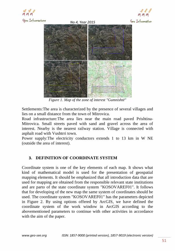
experience and good financial resources. Areaof Gumnishte, already
announced a special interest zone. The zone of interest "Gumnishte" lies in
the territory of the municipalities of Mitrovica and Vushtrri and borders to
those coordinates in KOSOVAREF01. Altitude 600 - 1300 m and the
surface area is 29,172 km² . In 2007, in this area drilling has been done from
Drilling Department of Stanterg Mine whose elements are presented in Table
2. It is thought that the institutions of Kosovo in accordance with the laws of
the country will give this area for exploration to potential interested foreign
companies. Table 1. Determinative coordinates of the Zone
Table 2. Collar data of drilling
No.4, Year 2015
www.geo-see.org ISSN: 1857-9000 (printed version), 1857-9019 (electronic version)
51
Figure 1. Map of the zone of interest "Gumnishtë"
Settlements:The area is characterized by the presence of several villages and
lies on a small distance from the town of Mitrovica.
Road infrastructure:The area lies near the main road paved Prishtina-
Mitrovica. Small streets paved with sand and gravel across the area of
interest. Nearby is the nearest railway station. Village is connected with
asphalt road with Vushtrri town.
Power supply:The electricity conductors extends 1 to 13 km in W NE
(outside the area of interest).
3. DEFINITION OF COORDINATE SYSTEM
Coordinate system is one of the key elements of each map. It shows what
kind of mathematical model is used for the presentation of geospatial
mapping elements. It should be emphasized that all introduction data that are
used for mapping are obtained from the responsible relevant state institutions
and are parto of the state coordinate system "KOSOVAREF01". It follows
that for developing of the new map the same system of coordinates should be
used. The coordinate system "KOSOVAREF01" has the parameters depicted
in Figure 2. By using options offered by ArcGIS, we have defined the
coordinate system of the work window in ArcGIS according to the
abovementioned parameters to continue with other activities in accordance
with the aim of the paper.

Nr.4, Viti 2015
UDC: 007:004.6]:528.45(497115) Geo-SEE Institute
52
Figure 2. Definition of coordinate sistem
4. MAP GEOREFERENCING
One of the processes on the way on digitizing mapping is called geo-
referencing. Scanned Maps called from whatever software for further use
should be geo-referenced. ArcGIS software contains many options to work
with geospatial data among which also geo-referencing is enabled. ArcGIS
software enables geo-referencing map with just a few clicks needed. After
we browse the scanned map in JPG format we continued geo-referencing by
utilizing tools from the geo-referencing toolbar. In order to save forever the
transformed scanned map we use the option "Update Geo-referencing",
which means that the original version of the map is already geo-referenced.
Figure 3 presents a caught moment during geo-referencing the map in
ArcGIS.
Figure 3. Map Georeferencing

No.4, Year 2015
www.geo-see.org ISSN: 1857-9000 (printed version), 1857-9019 (electronic version)
53
5. GEODATABASE
5.1. Description of the Geodatabase
A database is any information collected and organized into groups. This
database is created from tables, questionnaires, forms, pages, reports etc. The
basic unit of the database is a table, which stores the data in an organized
manner. Geodatabase is a structure which enables the registration and
management of geographic information in a RDBMS. An RDBMS can be
Oracle, MySQL, PostgreSQL, etc. GIS is a system that allows a database not
to be built only as a conventional geodatabase, simply for maintaining
records and their relations, but analyze, present and convert the notes
recorded in the tables of the database in dynamic maps. Geodatabase
(acronym of Geographic Data Base) is a physical storage of geographic
information such as spatial information, attributes, metadata and
relationships, which are inside the RDBMS (Relational Database
Management System).
Geo data base model includes object-oriented model for defining the
characteristics, behaviors and relations vector data and the strengthening of
sanctions and integration of data provided by the system. Also, the
geodatabase of this paper will be created in accordance with this that
explained above.
5.2. Data format
Geographical data in GIS require a specific format for data storage as they
comprise of the geographic form as well as descriptive data. The most
common model for GIS data storing is the vector, which uses points, lines
and polygonsto present the mapping objects. The most widely used format in
GIS applications is "shapefile", which is the standard format in ArcGIS,
QuantumGIS, KosmoGIS and many other GIS applications. This format
enables the storage of vector data in anappropriate form for GIS
applications. "Shapefile" consists of at least three separate files (this is the
minimum necessary for a shapefile to be considered correct, depending on
the actions taken by these data the number of files that form a shapefile is
often greater than three) that must be stored in the same directory (folder);
otherwise, the GIS application will not be able to recognize these files as
part of a "shapefile".
Most common files that make up a "shapefile" are:
.shp - which preserves the geometry of objects (point, line, and polygon)

Nr.4, Viti 2015
UDC: 007:004.6]:528.45(497115) Geo-SEE Institute
54
.dbf - database file in which information of attributes from objects is stored.
.shx - file which will store the objects geometry indexes.
.prj - the file where the information is stored on the coordinate system data in
"shapefile".
.sbn and .sbx - file where indexes of geographical spatial objects are stored.
To realize this paper we have chosen the data format respectively layers
that will be presented as shown in the table below, we estimate that it is the
most appropriate format to achieve the aim of the paper.
Table 3. Data format
5.3. Creation of geodatabase
Designing the geodatabase through ArcGIS enables the geodatabase to be
valid and stable, a detailed design of each of the fields-attributes and type,
the geospatial scope of each feature, the list of code per each attribute,
categorizing based on codes, creating special tables with textual data,
creating the link between tables with textual and spatial data, integrating the
raster format in the server. In designing the geodatabase, there will be
options to design the features, history, and to archive them. This is very
important and needed for the future developments and also calculations of
different statistics. ESRI has advanced new geographic model called
geodatabase which uses Microsoft Access files to store many tables, shape
files and raster images. Initially, we created geodatabase for the points to
continue with the database for lines and surfaces which we have enriched
with the necessary attributes for them such as; name, type, code,
coordinates,length, area, etc. The following figures represent the creation of
thematic layers for the zone of interest "Gumnishtë".
Figure 4. Creating shapefile Figure 5. Geodatabase lines

No.4, Year 2015
www.geo-see.org ISSN: 1857-9000 (printed version), 1857-9019 (electronic version)
55
Figure 6. Zone Geodatabase Figure7. Geodatabase of geological drilling
Figure 8. shows the database with metal values which are benefited as a
result of samples taken during different drillings. It seems that no matter the
volume of data, GIS enables to enter this data, and if necessary to manipulate
the content in order to benefit different results depending on the
requirements set forth.
Figure 8. Database with content of minerals
6. CREATING OF DIGITAL MAPPING
The digital map is created using data presented as follows:
Coordinates defining the area
Connecting lines between the coordinates defining the area
Surface area
Geological Drilling
Since the data we have already is in the appropriate form so that they can
easily change shape, can be changed to be updated in the text, in graphics
and different maps could be created depending on the defined requirements.
The figure shows the digital maps created with the above mentioned layers.

Nr.4, Viti 2015
UDC: 007:004.6]:528.45(497115) Geo-SEE Institute
56
Figure 9. The digital map of the zone
7. ROLE OF GIS IN ESTABLISHING DTM AND SPATIAL
ANALYSIS
GIS also allows us to create digital terrain model with just a few clicks, as
we used points needed to create the DTM on the working page of ArcGIS
digital terrain model of the zone of interest "Gumnishtë" will look like in the
Figures shown below, the DTM allows engineers who will do fieldwork to
be notified from their office about the terrain and relief they are going to
visit.
Figure 10. Creating DTM Figure 11. 3 D Digital Terrain Model
GIS also allows for different spatial analysis but we have to consider the
logic analysis so we do it in the right way. In our paper we have
demonstrated through ArcGIS the geological drilling done in the
"Gumnishtë" zone, whether it is located within the area of interest or not?!
The answers for this question we see on the next figure. This is one of the
simplest spatial analyses that can be done through GIS.

No.4, Year 2015
www.geo-see.org ISSN: 1857-9000 (printed version), 1857-9019 (electronic version)
57
Figura 12. Spatial analyses
8. PREPARATION OF MAP FOR PRINT
Various data generated in digital form are sometimes necessary to be printed
for various reasons, one of which may be that printed maps serve geologists
for field orientation, or even to extract various geological elements from
printed maps. ArcGIS also has numerous opportunities to create the maps in
the most suitable printing form such as: presentation of coordinates, legend,
northern direction, graphic and numerical scale, and any other writings on
the map, etc. Once the map is assigned the elements that would need when
printed, ArcGIS enables mapping conversion in another format that is
suitable for printing such as: JPEG, PDF, etc. The map that you see in
Figure 12 shows an example of this kind of mapping form for printing and is
from the mining zone of interest “Gumnishte".
Figure 13. Preparing the map for printing

Nr.4, Viti 2015
UDC: 007:004.6]:528.45(497115) Geo-SEE Institute
58
9. CONCLUSIONS AND RECOMMENDATIONS
The foundation of any GIS database is “Every object on the earth can be
geo- referenced". Geo-referencing is the position of a layer or cover in space,
defined by a reference coordinate system.
GIS is a convenient tool and helps geo engineers to develop plans for
management strategies that could be sustainable both locally and globally.
One of the biggest benefits of using GIS is that allows for numerical data /
textual and geographic to work with one another. GIS enables all spatial data
and non-spatial for mines to be stored on a unique database and enables easy
manipulation with this data.
GIS also allows the extraction of different information about this zone of
interest and at different times. Knowing the different formats of data is one
of the attributes that makes GIS to be a leader in this field. Applications of
GIS shows, that is suitable for creating different geological layers, which can
be enriched with different attribute that we can make different analysis. GIS
allows easy management of various data and also to manage the large
volume of data. Creating DTM through GIS enables us to create an image of
the terrain which we will investigate.
We hope that this paper will be used as an example by the relevant
institutions and various experts and to continue with such work in the future
and make data entry of geo-spatial data for all nine zones of interest that
exist in our country.
Acknowledgement
We would like to thank the Ministry of Economic Development and the
Kosovo Cadastral Agency for the permission to use the data used in the
paper.
10. REFERENCES
[1] Drishti, B. (2012). “GIS në planifikimin e zhvillimit të qëndrueshëm të
një rajoni” – Punim doctorate. Tiranë
[2] www.esri.com, “ Network analyst – tutorial”
[3] AL-Shehab, A. (2007). “Applications of GIS in Geology”. Published
Paper
[4] ART (2007). “Doracaku mbi përdorimin e platformës WebGIS.
Prishtinë
[5] MZHE (2010). “Promovimi i zonave të ineteresit të vacant – mineral”.
Prishtinë
No.4, Year 2015
www.geo-see.org ISSN: 1857-9000 (printed version), 1857-9019 (electronic version)
59
[6] Ferati, B. (2014). “Aplikimi i GIS-it në bujqësi në komunën e Vitisë” –
Punim diplome. Prishtinë
[7] Ymer, K., Ahmeti, P., Ajvazi, B., Murseli, S. (2014). “Application of
GIS in water supply management network”. Published Paper. Skopje
[8] KK (2010). “Ligji për Minierat dhe Mineralet Nr. 03/L-163 (2010)”.
Prishtinë