an inventory and condition survey of the murchison river
TRANSCRIPT
Research Library Research Library
Technical Bulletins Research Publications
1994
An inventory and condition survey of the Murchison River An inventory and condition survey of the Murchison River
catchment, Western Australia catchment, Western Australia
Peter James Curry
P Hennig
D A. Blood
K A. Leighton
Follow this and additional works at: https://researchlibrary.agric.wa.gov.au/tech_bull
Part of the Agricultural and Resource Economics Commons, Agricultural Economics Commons,
Agricultural Science Commons, Desert Ecology Commons, Environmental Education Commons,
Environmental Health Commons, Environmental Indicators and Impact Assessment Commons,
Environmental Monitoring Commons, Geology Commons, Geomorphology Commons, Natural Resource
Economics Commons, Natural Resources and Conservation Commons, Natural Resources Management
and Policy Commons, Physical and Environmental Geography Commons, Soil Science Commons,
Sustainability Commons, Systems Biology Commons, and the Terrestrial and Aquatic Ecology Commons
Recommended Citation Recommended Citation Curry, P J, Hennig, P, Blood, D A, and Leighton, K A. (1994), An inventory and condition survey of the
Murchison River catchment, Western Australia. Department of Agriculture and Food, Western Australia, Perth. Technical Bulletin 84.
This technical bulletin is brought to you for free and open access by the Research Publications at Research Library. It has been accepted for inclusion in Technical Bulletins by an authorized administrator of Research Library. For more information, please contact [email protected], [email protected], [email protected].
Department of Agriculture Western Australia
ISSN 0083·8675 Agdex 320/10
V@©UuOUD©@)O D
~Q[] @DcnJ An inventory and condition survey of the Murchison River catchment and surrounds, Western Australia
P.J,Cuny A.L.Payne K.A. Leighton P.Hennig DABlood
An inventory and condition survey of the Murchison River catchment, Western Australia
By: P.J. Curry, A.L. Payne, K.A. Leighton, P. Hennig and D.A. Blood
Editor: K.M.W. Howes
Technical Bulletin No. 84, 1994 Department of Agriculture Baron-Hay Court SOUTH PERTH 6151 Western Australia ISSN
The authors
P.J. Curry!, A.L. Payne, P. Hennig and D.A. Blood, Natural Resources Assessment Group, Department of Agriculture, Western Australia and K.A. Leighton, Geodetic Branch, Department of Land Administration, Western Australia.
Other contributors
A. Laws, Geological Survey, Department of Minerals and Energy, Western Australia.
Acknowledgments
This survey could not have been conducted without the cooperation, advice and assistance of pastoralists throughout the area. The authors also wish to thank L.J. and H. Merritt for providing essential logistical support, L.J. Merritt, J.J. Neil and R.J. Cranfield for valuable assistance with the field work, staff of the Western Australian Herbarium (particularly R.J. Cranfield) for identification of plant specimen..;; and numerous colleagues who provided constructive criticism on parts of this report. I. Foster's contribution to the climate chapter is particularly acknowledged. Finally, the authors wish to thank the staff of the Department of Agriculture's Word Processing Centre who typed up and reworked the drafts of our manuscript with patience and precision.
[-----------------,INational Library of Australia Cataloguing-in-Publication --I
I
II An inventory and condition survey of the Murchison River \ II catchment, Western Australia. I
1111. Bibliography. Ill-
ISBN 0 7309 5998 8.
Ill. Pastures-Western Australia-Murchison River Region. I: 2. Rangelands-Western Australia-Murchison River Region. I II 1. Curry, Peter J. II. Western Australia. Dept. of Agriculture. !
II (Series: Technical bulletin (Western Australia. Dept. of I ii Agnculture); no. 84). I ~33.202099413 _ II
1. Current address PO Box 316 Kelmscott 6111 WA
ii
Contents Page
Summary ......................................................................................................................... 1
The Murchison River catchment Introduction ............................................................................................................. 3 Brief history of pastoral use .................................................................................. 6 Climate ................................................................................................................... 10 Geology and hydrogeology (A. Laws) .............................................................. 21
The Survey Methods ................................................................................................................. 38 Land systems ......................................................................................................... 48 Landform development and soils .................................................................... 274 Vegetation ............................................................................................................ 285 Condition of the land resource ......................................................................... 338
Appendices 1. Station summaries ....................................................................................... 353 2. Vascular plants of the Murchison River catchment area ........................ 413 3. Distribution by land type of common perennial species ....................... 426 4. Inventory site and condition site recording sheets ................................. 429 5. Inventory and condition site data (microfiche) .............. inside back cover 6. Land system maps (1:250,000 scale)
iii

j
j
j
j
j
j
j
j
j
j
j
j
iv
j
j
j
j
j
j
j
j
j
j
j
j
j
j
j
j
j
j
Summary
Scope of the survey
The area surveyed by fieldwork during 1985-88 covers approximately 88,360 km' of arid zone rangelands situated between Mt Magnet and Meekatharra in the east and the catchments of the Greenough and Wooramel rivers in the west. This area includes most of the catchment of the Murchison River and its tributaries the Sanford, Roderick and Yalgar rivers; as well as most of the catchment of Lake Austin.
Land use in the area is dominated by 67 pastoral leases, the lands of which fall wholly within the survey in 53 cases and partly so for 14 others. Gold mining was the only other land use operating at a high level of activity, throughout the auriferous areas.
This report details a descriptive reference accompanying a 1:250,000 scale map series to the biophysical characteristics of the area. Descriptions of climatic patterns, geology and hydrogeology, soil types, land types, land systems, land units and vegetation types are presented as a regional inventory of land resources.
Land characteristics
The survey area exhibits a characteristically arid climate (mean annual rainfall 190-240 mm) throughout, with the exception of the moister far south-western corner. When subjected to analysis in terms of moisture potential for widespread plant growth, long-term records show the clear predominance of effective winter rainfall (probability 55-80% throughout) and the highly unreliable nature of effective summer rainfall « 20% throughout). A probability-based assessment of rainfall and plant growth presented here provides a basis for long-term strategic planning for pastoralists and other land managers who are operating in a highly erratic and unreliable seasonal environment.
Geologically, the area is dominated by a granitegreenstone terrain of the Archaean Yilgarn Craton, WIth the hill ranges widely separated by very flat plams derived from colluvium and alluvium. Soils are mainly shallow, sandy and infertile, and across most of the lower areas are distinctively underlain by red-brown siliceous hardpan.
Shallow aquifers found extensively below this hardpan and elsewhere have provided most of the groundwaters on which development of the area for pastoral and mining industries has depended. ~roundwater consumption by the pastoral industry IS small compared to estimated storage. The origins and qualIty of groundwater was described from survey work conducted by the Geological Survey (Department of Minerals and Energy) in the context of 12 major sub-catchments in the area.
1
Lands within the area have been described and mapped into 19 broad land types composed of 74 land systems. Their individual extent varies greatly, and over half the area is made up by just eight land systems (Yanganoo, Kalli, Koonmarra, Challenge, Sherwood, Belele, Mindura and Narryer). The land system approach attempts an integrated or natural classification of land from predominant biophysical features in an inventory which will be useful to all future land management and land use planning.
At a more detailed level, the component land units of each land system are described by their landform features, soils and vegetation associations. In this way, the mapped divisions of the landscape are related through their component parts to any position or site of interest on the ground.
Vegetation
The flora of the area is diverse, with about 830 recorded vascular species, of which 97% are native and about 4.5% endemic or near-endemic. No described species are thought to have become extinct. Associations considered at the scale of the land unit are objectively classified and described as 23 major types. All but three of these types are shrub lands or low woodlands of which the majority are naturally depauperate in grasses. Mulga (Acacia aneura) and cotton bush (Ptilotus obovatus) are the most ubiquitous perermials.
Intensive sampling of 14 of these types at 1256 'condition sites' throughout the area revealed the patterns of variation that exist, partly as natural variation but otherwise as a consequence of changes related to cumulative impact by grazing animals and pastoral management. In this way, analysis of the observed variation in perennial vegetation at comparable sites has enabled simple and objective criteria to be defined for classes of vegetation condition. Land managers and administrators will be able to reassess the condition of vegetation in an area of interest and compare their findings with quantified relativities recorded during 1985-88.
1n terms of adverse impact on perennial communities by pastoral usage, approximately 42% by area of all vegetation was in poor to very poor condition, 37% remained in fair condition and 21 % was still in good to very good condition. Taken overall, these summary data indicate that the vegetation in this survey area is in poorer condition -than that recorded from other regional rangeland surveys in Western Australia.
General symptoms of poor condition are a loss of perennial plant diversity and numbers per unit area, loss of palatable perennial diversity and density, while sites in the poorest condition states show general loss of vegetation structure, cover and hence subsequent denudation. Secondary increases and invasions by unpalatable species such as prickly acacia (Acacia victoriae) and needle bush (Hakea preissii) are common on disturbed or deflated soil surfaces, mainly on river
and tributary alluvial plains with duplex soils. The most widely degraded vegetation types are the halophytic shrublands (mainly saltbush and bluebush types), hardpan mulga shrublands and calcrete shrubby grasslands. They have been preferentially grazed for 80-110 years in most areas.
Introduced (exotic) plants in the area are mainly local in occurrence, annual or short-lived species, and associated with disturbed or nutrient-emiched or wetland sites.
Soils and soil erosion
Accelerated soil erosion is widespread in the area. Affected areas invariably show perennial vegetation in less than good condition. Erosion problems have evidently started and accelerated primarily as a consequence of loss of perennial vegetation. Natural processes which serve to stabilise otherwise vulnerable soil surfaces have been fragmented or disrupted. Many land units and soil surfaces on stony hills and plainS are highly resistant to erosion. Others are highly susceptible. The pivotal role of perennial vegetation in good condition on susceptible soils is illustrated by the major vegetation type, hardpan mulga shrub land, in which sites exhibiting either of the two most diverse and dense vegetation condition classes were never encountered showing significant accelerated erosion. Sites in the more depauperate vegetation classes showed a 9% incidence of accelerated erosion.
By two different survey methods the incidence of at least minor accelerated erosion was estimated at 15-17% of the area. Commonest forms of erosion are scalding and surface sheeting over 10-50% of the surface. The most susceptible soil types are red duplex types on areas with some slope and subject to concentrated sheet flows after major ralnfall events.
The preponderance of shallow soils « 50 cm deep over hardpan or baserock) has meant that this erosion is not characterised by spectacular gullying. Nor has the problem been highlighted by acute off-site effects, such as siltation of dams or estuaries. Eroded areas in the Murchison are mainly patchily vegetated or denuded flats, with deflated or no topsoil and exposed saline subsoils or inert hardpan remaining as the land surface.
Areas of extensive severe degradation and erosion (sde) larger than 40 ha were mapped and total 1.8% of the survey area (1561 km'), an area more than half as large as the Australian Capital Territory. The incidence of sde is largely confined to a small number of susceptible and preferentially grazed land units, mainly On Beringarra, Ero and Sherwood land systems.
Historical ct. contemporary effects
The Murchison's history and its development as a major pastoral and mining area indicates a high correlation between the location of early pastoral
2
development along the river plains with the presentday patterns of pastoral use and the recorded incidence of land degradation. Parts of many individual leases showed clear signs of recent recovery in the perennial vegetation. However, some local areas of recent vegetation degradation and soil erosion were encountered.
Management implications
For the present pastoral industry, about half of the land area grazed is in mainly poor condition but not severely degraded and eroded. It is these areas with mainly intact soil surfaces which present the best prospects for economically feasible perennial regeneration in the short to medium term.
Most of the eroded duplex plains will remaln irreversibly deflated and degraded until practical solutions are more fully researched and developed (a) to manage total grazing pressure throughout each affected sub-catchment; and (b) to enhance plant establishment and soil accretion on deflated areas on the major drainage systems and breakaway footslopes.
Aerial census of kangaroos, goats and other large animals, conducted across the area at the time of the survey indicated that the grazing pressure exerted by domestic stock was less than 50% of the total pressure from all grazing animals. Successful control of kangaroos and goats will be essential for implementing vegetation regeneration by controlling all grazing pressure.
The operating circumstances and financial position of woolgrowers in the area has changed rapidly for the worse since the survey began and will probably continue to change. Environmental awareness and technical knowledge of the soil and vegetation patterns within the pastoral industry and the wider commnnity continues to grow. In terms of management recommendations, this report mark., a significant departure from previous surveys, in which broad recommendations were made about how pastoralists might change management practices to address land degradation problems. The failure of such a government-led approach to the problem of land degradation and management planning in rangelands (and any other land under productive use) is now widely acknowledged.
It is therefore most appropriate that this report provides an enduring technical reference to assist Land Conservation District Committees (which became established throughout the area during the survey program) and other stakeholders to become more deeply engaged in management planning, monitoring and technical investigations. In addition the report stands as a reference work useful to various Government agencies and private enterprises concerned with land use and land use planning in the region.
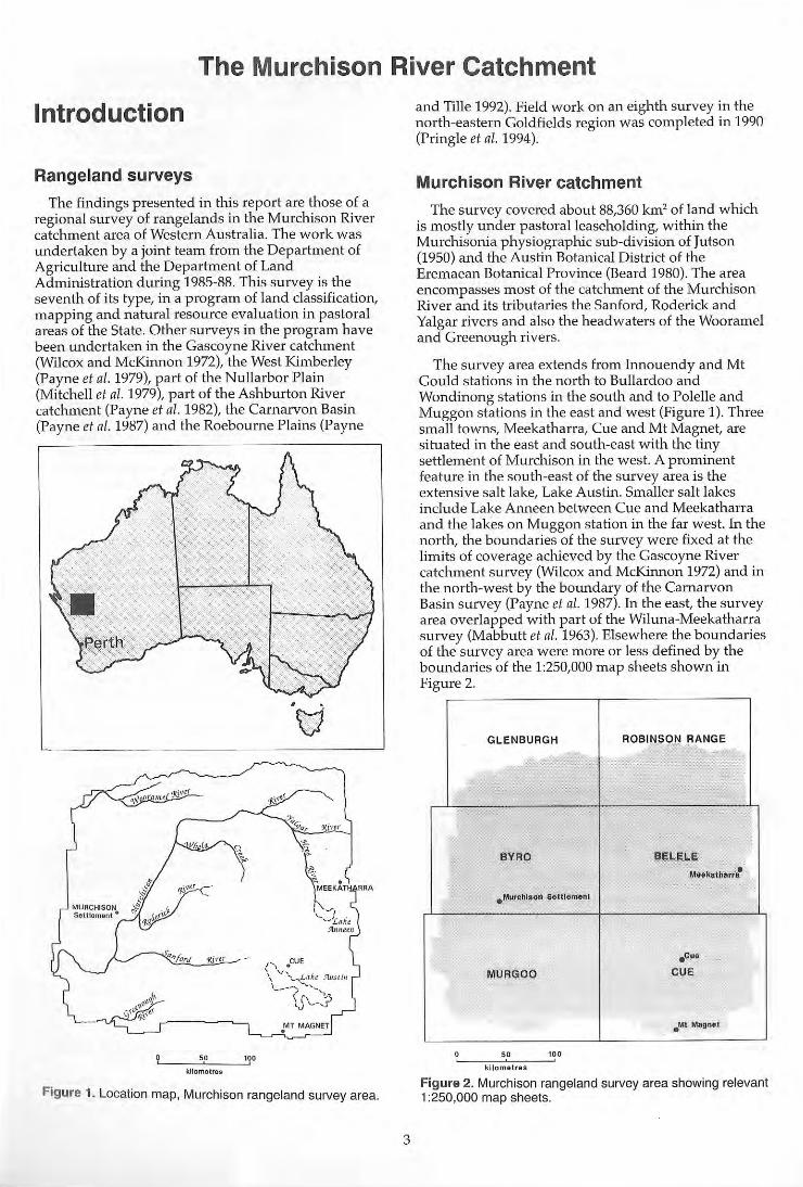
The Murchison River Catchment
Introduction
Rangeland surveys
The findings presented in this report are those of a regional survey of rangelands in the Murchison River catchment area of Western Australia. The work was undertaken by a joint team from the Department of Agriculture and the Department of Land Administration during 1985-88. This survey is the seventh of its type, in a program of land classification, mapping and natural resource evaluation in pastoral areas of the State. Other surveys in the program have been undertaken in the Gascoyne River catchment (Wilcox and McKinnon 1972), the West Kimberley (Payne et al. 1979), part of the Nullarbor Plain (Mitchell et al. 1979), part of the Ashburton River catchment (Payne et a/. 1982), the Carnarvon Basin (Payne et al. 1987) and the Roebourne Plains (Payne
kilometres
i!, , , . MEEKAT
( "\.. - ~I '-~-'£.aJi~
Yltlllel1l
", . CUE
\ 'F~".... ... L~(u JlJ,s t/" 1 __ --) -~'_,
\5\_-,:;J .MT MAGNET
Figure 1. Location map, Murchison rangeland survey area.
3
and Tille 1992). Field work on an eighth survey in the north-eastern Goldfields region was completed in 1990 (Pringle et al. 1994).
Murchison River catchment
The survey covered about 88,360 km' of land which is mostly under pastoralleaseholding, within the Murchisonia physiographic sub-division of Jutson (1950) and the Austin Botanical District of the Eremaean Botanical Province (Beard 1980). The area encompasses most of the catchment of the Murchison River and its tributaries the Sanford, Roderick and Yalgar rivers and also the headwaters of the Wooramel and Greenough rivers.
The survey area extends from Innouendy and Mt Gould stations in the north to Bullardoo and Wondinong stations in the south and to Polelle and Muggon stations in the east and west (Figure 1). Three small towns, Meekatharra, Cue and Mt Magnet, are situated in the east and south-east with the tiny settlement of Murchison in the west. A prominent feature in the south-east of the survey area is the extensive salt lake, Lake Austin. Smaller salt lakes include Lake Anneen between Cue and Meekatharra and the lakes on Muggon station in the far west. In the north, the boundaries of the survey were fixed at the limits of coverage achieved by the Gascoyne River catchment survey (Wilcox and McKinnon 1972) and in the north-west by the boundary of the Carnarvon Basin survey (Payne et al. 1987). In the east, the survey area overlapped with part of the Wiluna-Meekatharra survey (Mabbutt et at. 1963). Elsewhere the boundaries of the survey area were more or less defined by the boundaries of the 1:250,000 map sheets shown in Figure 2.
GLENBURGH ROBINSON RANGE ,
BYRD BELELE Meekatharrs-
.MUfChl~ QI1 S. lIlemllfll
. cue
MURGDD CUE
. M! Magllli
50 10 0
kilometre s
Figure 2. Murchison rangeland survey area showing relevant 1 :250,000 map sheets.
The survey area includes nearly all of the Murchison and Cue Land Conservation Districts (LCDs) and parts of the Yalgoo, Mt Magnet and Meekatharra LCDs.
The report
The purpose of the survey was to provide a comprehensive description and mapping of the biophysical resources of the region, together with an evaluation of the pastoral potential and the condition of the soils and vegetation. The report and the accompanying series of colour maps at 1:250,000 scale are primarily intended as a reference for present and future land managers, rangeland advisers, other state and local government officers and land administrators, the people most involved in planning and implementing management practices. The report and maps will also provide researchers and the public with a basic reference on the biogeographic features of the Murchison River catchment. The survey inventory also enables the recognition and location of land types of particular potential, land use or conservation value .
Survey findings give new perspectives on each type of land in good and poor condition, and the special circumstances of severely degraded areas. These can be considered by individual lessees and managers, Land Conservation District groups and by all future progratTIs of government assistance to land managers. The report presents essential resource information required to plan sustainable land management at the scales of sub-catchment, lease or paddock.
This report provides vegetation type descrip tions and indicates the spatial relationships of land units necessary for the strategic location of monitoring sites. It also provides information for 'do it yourself' assessment of condition of major vegetation types, and objective criteria by which such future assessment can be compared to this baseline survey. Monitoring of vegetation change is well established in the Western Australian rangelands, and can be considerably enhanced by such insight.
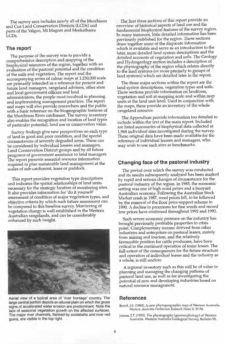
Aerial view of a typical area of 'river frontage' country. The large central portion depicts an alluvial plain on which the gross signs of accelerated water erosion are predominant. Note the lack of seasonal vegetation growth on the affected suriaces. The major river channels, flanked by coolabahs and river red gums, are visible in the top right.
4
The first three sections of this report provide an overview of historical aspects of land use and the fundamental biophysical features of the survey region. 1n many instances, little detailed information has been previously published for the region . 1)1ese sections draw together some of the disparate information which is available and serve as an introduction to the later, more detailed land system descriptions and the detailed accounts of vegetation and soils. The Geology and Hydrogeology section includes a description of the phYSiography of the region which relates directly to the land systems (or more precisely to groups of land systems) which are detailed later in the report.
The three major sections within the report are the land system descriptions, vegetation types and soils. These sections provide information on landform, vegetation and soil at mapping scale and within map units at the land unit level. Used in conjunction with the maps, these provide an inventory of the whole rangeland resource.
The Appendices provide information too detailed to include within the text of the main report. Included are listed summaries of biophysical data collected at 1,968 individual sites investigated during the survey. These original data have been made available for the reference of individual lessees and managers, who may wish to use such sites as benchmarks.
Changing face of the pastoral industry
The period over which the survey was conducted and its results subsequently analysed has been marked by rapid and serious changes of circumstance for the pastoral industry of the region. 1n 1985, the economic setting was one of high wool prices and a buoyant Australian economy. Following the Australian Stock Market crash in 1987, wool prices fell, to be followed by the removal of the floor price support scheme in 1990. A decline in premiums for fine wools and record low prices have continued throughout 1992 and 1993.
Such severe economic pressure on the industry has brought previously profitable properties to crisis point. Complementary income derived from other industries and enterprises on pastoral leases, mainly from mining and tourism, and the relatively favourable position for cattle producers, have been critical in the continued operation of some leases. The full extent of the consequences for the future structure and operation of individual leases and the industry as a whole, is still unclear.
A regional inventory such as this will be of value in planning and managing the changing patterns of pastoral land use, as well as for investigati ng the potential of new and developing industries based on natural resource management.
References Beard, J.S. (1980). A new phytogeographic map of Western Australia.
Wes tern Australia Herbarium Research Notes 3: 37-58.
jutson, J.T. (1950). The phYSiography (geomorphology) of Western Australia. Western Australi a Geological Survey, Bulletin 95.

Mabbutt, J.A, Litchfield, W.H., Speck N.H., Sofoulis, L Wilcox, D.G., Arnold, J.M. and Wright, R.L. (1963). General report on lands of the Wlluna-Meekatharra area, Western Australia 1958. CSIRO Land Research Series No.7.
Mitchell, AA, McCarthy. R. and Hacker, R.B. (1979). A range inventory and condition survey of part of the Western Australian Nullarbor Plain, 1974. Department of Agriculture, Western Australia, Technical Bulletin No. 47.
Payne, AL., Kubicki, A, Wilcox, D.G. and Short, L.c. (1979). A report on erosion and range condition in the West Kimberley area of Western Australia. Deparhnent of Agriculture, Western Australia, Technical Bulletin No. 42.
Payne, AL., Mitchell, AA and Hohnan, W.P. (1982). An inventory and condition survey of rangelands in the Ashburton River catchment, Western Australia. Department of Agriculture, Western Australia, Technical Bulletin No. 62.
5
Payne, AL., Curry, PJ. and Spencer, G.P. (1987). An inventory and condition survey of rangelands in the Carnarvon Basin, Western Australia. Deparhnent of Agriculture, Western Australia, Technical Bulletin No. 73.
Payne, AL. and Tille, P.J. (1992). An inventory and condition survey of rangelands of the Roebourne Plains and surrounds, Western Australia. Deparhnent of Agriculture, Western Australia, Technical Bulletin No. 83.
Pringle, H.J.R., Van Vreeswyk, AM.E. and Gilligin, S.A (1994). An inventory and condition survey of rangelands in the north eastern Goldfields, Western Australia. Deparhnent of Agriculture, Western Australia, Technical Bulletin No. 87 (In press).
Wilcox, D.G. and McKinnon, E.A (undated c. 1972). A report on the condition of the Gascoyne catchment. Department of Agriculture, Western Australia.
Brief history of pastoral use
The Murchison River was named after Roderick Impey Murchison, President of the Geographic Society, London, by Lt George Grey in 1839.
Assistant surveyor Robert Austin led the first expedition through the upper Murchison, travelling west from the southern fringes of Lake Austin during the spring of 1854. After a dry or indifferent winter season, Austin's party was repeatedly short of water and almost perished towards the end of the journey. As a consequence, Austin did not assess the Murchison as having pastoral potential. The first claims of promise for grazing potential were made by F.T. Gregory, S. Trigg and 1. Roe in 1857, who reported grass 'two to three feet high' around Mt Welcome, and 'a fine sward of grass' below the gums on the river. They concluded that the area was ' fair average cattle pasture'.
The first sheep to be grazed along the upper Murchison River were brought through the area by E.T. Hooley, who successfully drove a flock from Galena to the Ashburton in the winter of 1866. By this time T. Burges and J. Perks were already bringing flocks along the Greenough River as far as Yuin, and were granted the first pastoral leases made available in the region, in 1864, as 10,000 acre blocks leased for fourteen years. Burges and the Wittenoom brothers led the first wave of pastoral settlement and development which proceeded up the main arms of the Murchison River during the late 1860s and 1870s.
Early selections of country
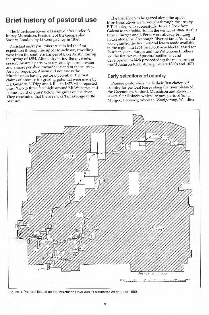
Pioneer pastoralists made their first choices of country for pastoral leases along the river pla ins of the Greenough, Sanford, Murchison and Roderick rivers. Small blocks which are now parts of Yuin, Murgoo, Boolardy, Wooleen, Woolgorong, Wandina
Figure 3. Pastoral leases on the Murchison River and its tributaries as at about 1880.
6
and Byro stations were settled by 1874. F. Wittenoom continued to explore the upper Murchison River, and by 1880 Nookawara, Billabalong, Beringarra, Milly Milly, the present Boolardy (Wittenoom's headquarters), Murgoo and Annean were established (Figure 3).
Sites selected for early shepherds' camps, and subsequently for homesteads, generally had two common features: one or more wells yielding plentiful water of an acceptable quality and proximity to the river plains. Most homesteads became established near some point where hardpan wash plains meet river plains, and on a slightly elevated site (such as a calcrete platform) which was more or less flood free. Wells sunk in the alluvium further out on the river plains proved brackish or saline more often than not. Thus, the first land used for pastoral development tended to be the zones around the wells, of which the shallowest (to dig by hand into 'Murchison cement' or red-brown siliceous hardpan) and most reliable were sought after. Such strategic locations for the wells allowed grazing access to both the mulga country of the sheet wash (or 'wanderrie') plains and the more saline river plains with their extensive bluebush and saltbush and more local perennial grass pastures on the clayey drainage zones and the limestone platforms. Away from the river frontages, New Forest station appears to have been established on the strength of its reputation as a water supply alone.
In this initial phase of settlement, higher country away from the rivers was virtually ignored. Flocks were shepherded and little or no infrastructure was used other than brush yards for confining animals at night and for shearing. It was not until the first decade of the twentieth century that wire fences and windmills were erected for stock control around the established pastoral settlements.
Early compilations of the boundaries of pastoral leases shown on Lands Department plans suggest that there was some contraction in the extent of areas leased after the initial major wave of occupation before about 1895: Areas of granite country with kite leaf poison, and the waterless 'bow gada' sandy plains, were two types of country subsequently avoided by
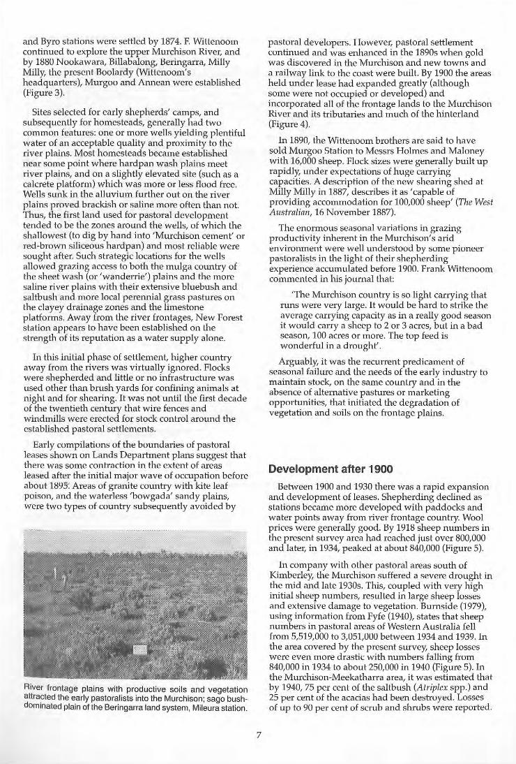
River frontage plains with productive soils and vegetation attra.cted the early pastoralists into the Murchison; sago bushdominated plain of the Beringarra land system, Mileura station.
7
pastoral developers. However, pastoral settlement continued and was enhanced in the 1890s when gold was discovered in the Murchison and new towns and a railway link to the coast were built. By 1900 the areas held under lease had expanded greatly (although some were not occupied or developed) and incorporated all of the frontage lands to the Murchison River and its tributaries and much of the hinterland (Figure 4).
In 1890, the Wittenoom brothers are said to have sold Murgoo Station to Messrs Holmes and Maloney with 16,000 sheep. Flock sizes were generally built up rapidly, under expectations of huge carrying capacities. A description of the new shearing shed at Milly Milly in 1887, describes it as 'capable of providing accommodation for 100,000 sheep' (The West Australian, 16 November 1887).
The enormous seasonal variations in grazing productivity inherent in the Murchison's arid environ_ment were well understood by some pioneer pastoralists in the light of their shepherding experience accumulated before 1900. Frank Wittenoom cOlnmented in his journal that:
'The Murchison country is so light carrying that runs were very large. It would be hard to strike the average carrying capacity as in a really good season it would carry a sheep to 2 or 3 acres, but in a bad season, 100 acres or more. The top feed is wonderful in a drought'.
Arguably, it was the recurrent predicament of seasonal failure and the needs of the early industry to lnaintain stock, on the same country and in the absence of alternative pastures or marketing opportunities, that initiated the degradation of vegetation and soils on the frontage plains.
Development after 1900
Between 1900 and 1930 there was a rapid expansion and development of leases. Shepherding declined as stations became more developed with paddocks and water points away from river frontage country. Wool prices were generally good. By 1918 sheep numbers in the present survey area had reached just over 800,000 and later, in 1934, peaked at about 840,000 (Figure 5).
In company with other pastoral areas south of Kimberley, the Murchison suffered a severe drought in the mid and late 1930s. This, coupled with very high initial sheep numbers, resulted in large sheep losses and extensive damage to vegetation. Burnside (1979), using information from Fyfe (1940), states that sheep numbers in pastoral areas of Western Australia fell from 5,519,000 to 3,051,000 between 1934 and 1939. In the area covered by the present survey, sheep losses were even more drastic with numbers falling from 840,000 in 1934 to about 250,000 in 1940 (Figure 5). In the Murchison-Meekatharra area, it was estimated that by 1940, 75 per cent of the saltbush (Atriplex spp.) and 25 per cent of the acacias had been destroyed. Losses of up to 90 per cent of scrub and shrubs were reported.
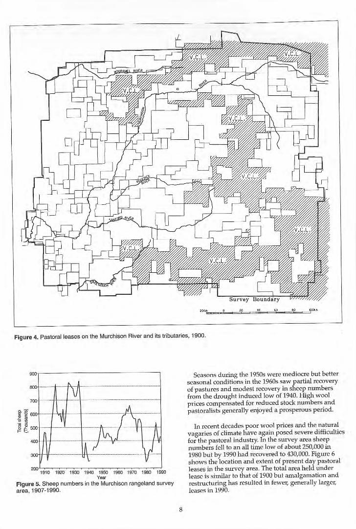
Figure 4. Pastoral leases on the Murchison River and its tributaries. t 900.
1910 1920 1930 1940 1950 1960 1970 1980 1990 Year
Figure 5. Sheep numbers in the Murchison rangeland survey area, 1907-1990.
8
Seasons during the 1950s were mediocre but better seasonal conditions in the 1960s saw partial recovery of pastures and modest recovery in sheep numbers from the drought induced low of 1940. High wool prices compensated for reduced stock numbers and pastoralists generally enjoyed a prosperous period.
In recent decades poor wool prices and the natural vagaries of climate have again posed severe difficulties for the pastoral industry. In the survey area sheep numbers fell to an all time low of about 250,000 in 1980 but by 1990 had recovered to 430,000. Figure 6 shows the location and extent of present day pastoral leases in the survey area. The total area held under lease is similar to that of 1900 but amalgamation and restructuring has resulted in fewer, generally larger, leases in 1990.
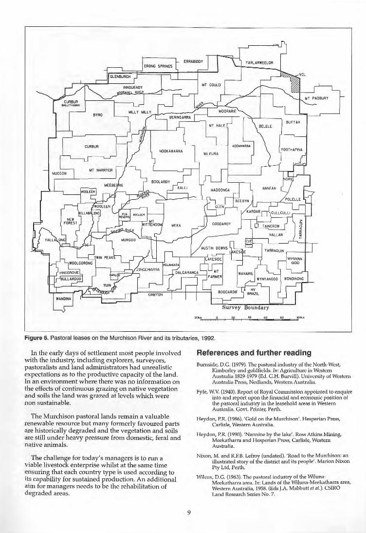
"~'Ic.=..b=="~' = ="::" _d':" _d':" _d~'
Figure 6. Pastoral leases on the Murchison River and its tributaries, 1992.
In the early days of settlement most people involved with the industry, including explorers, surveyors, pastoralists and land administrators had unrealistic expectations as to the productive capacity of the land. In an environment where there was no information on the effects of continuous grazing on native vegetation and soils the land was grazed at levels which were non sustainable.
The Murchison pastoral lands remain a valuable renewable resource but many formerly favoured parts are historically degraded and the vegetation and soils are still under heavy pressure from domestic, feral and native animals.
The challenge for today's managers is to run a viable livestock enterprise whilst at the same time ensuring that each country type is used according to its capability for sustained production. An additional aim for managers needs to be the rehabilitation of degraded areas.
9
References and further reading Burnside, D.G. (1979). The pastoral industry of the North-West,
Kimberley and goldfields. In: Agriculture in Western Australia 1829-1979 (Ed. C.H. Burvill). University of Western Australia Press, Nedlands, Western Australia.
Fyfe, W.V. (1940). Report of Royal Commission appointed to enquire into and report upon the financia l and economic position of the pastoral industry in the leasehold areas in Western Australia. Govt. Printer, Perth.
Heydon, p.R. (1986). 'Gold on the Murchison'. Hesperian Press, Carlisle, Western Australia.
Heydon, P.R. (1990). 'Nannme by the lake'. Ross Atkins Mining, Meekatharra and Hesperian Press, Carlisle, Western Australia.
Nixon, M. and R.F.B. Lefroy (undated). 'Road to the Murc.hison: an illustrated story of the district and its people'. Mar10n N ixon Pty Ltd, Pe"h.
Wilcox, D .G. (1963). The pastoral industry of the WilunaMeekatharra area. In: Lands of the Wiluna-Meekatha rra area, Western Australia, 1958. (Eds J.A. Mabbuttet al.). CSIRO Land Research Series NO. 7.
Climate
Int roduction
The climate of the Murchison River catchment is described by Meigs (1953) and most subsequent authorities as being arid. Beard (1976) followed Bagnouls and Gaussen (1957) classifying the area as 'desert' with bimodal (summer and winter) rainfall trending to semi-desert mediterranean in the southwest corner.
Climatic descriptions generally classify an area as arid when it normally receives insufficient rainfall to sustain the growth of rainfed crops at any season. Because of regional variations in latitudef seasonal patterns of rainfall and evaporation deficits, aridity cannot be universally defined by the mean annual rainfall being below a certain figure. As a working delineation for the southern boundary of the arid zone of Western Australia, several authors have stressed the co-incidence between the 250 mm isohyet for mean annual rainfall and the transition between the Eremaean (arid) Botanical Province and the SouthWestern Botanical Province (Beard 1976, Curry and Hacker 1990).
The mean (average) annual rainfall for the region is about 210 mm, ranging from about 240 mm in the south-west to about 190 mm in the north-east.
The dominant synoptic feature of the region's climate is the sub-tropical high pressure cell, which is composed of descending air and brings fine, stable weather conditions and prevailing easterly winds when located to the south of the survey area. The high, with its associated ridge is at its northernmost during winter and is most southerly during summer, gives rise to two dominant seasons. This is accompanied by large variations of temperature and moisture availability.
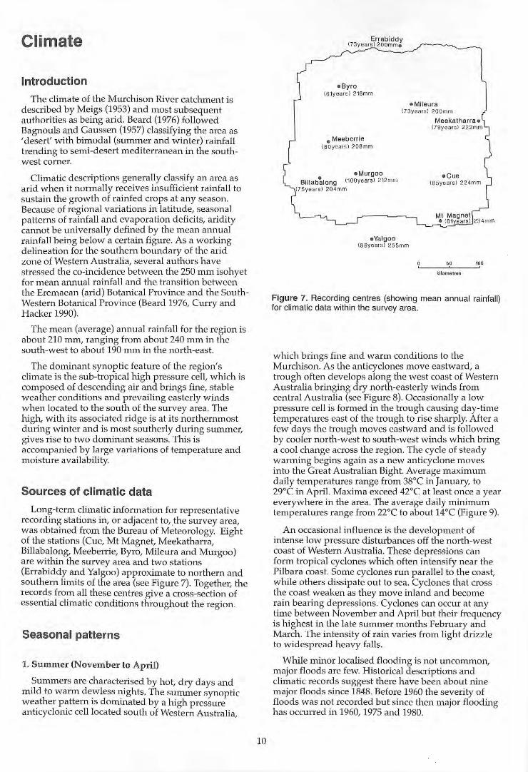
Sources of climatic data
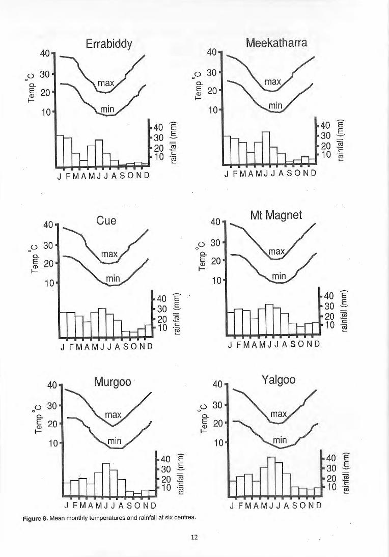
Long-term climatic information for representative record ing stations in, or adjacent to, ,the survey area, was obtained from the Bureau of Meteorology. Eight of the stations (Cue, Mt Magnet, Meekatharra, Billabalong, Meeberrie, Byro, Mileura and Murgoo) are within the survey area and two stations (Errabiddy and Yalgoo) approximate to northern and southern limits of the area (see Figure 7). Together, the records from all these centres give a cross-section of essential climatic conditions throughout the region.
Se,asonal patterns
1. Summer (November to April)
Summers are characterised by hot, dry days and mild to warm dewless nights. The summer synoptic weather pattern is dominated by a high pressure anticyclonic cell located south of Western Australia,
10
Errabiddy (73 years ) 200m me
eByro (61year s) 218mm
e Mileura (73y ears) 200mm
e Meeberrie (SOyears ) 20S mm
e Murgoo Billab~long (100years) 2 12mm
(75years) 20 4mm
eValgoo (86years) 255mm
Meekatharra e (79ye ars) 22 2mm
e Cue (85years) 22 4mm
Mt M agnet e (8Wears ) 234mm
kilometres
Figure 7. Recording centres (showing mean annual rainfall) for climatic data within the survey area.
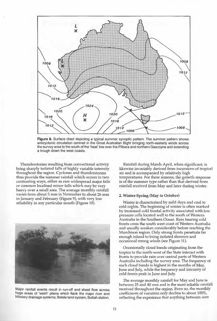
which brings fine and warm conditions to the Murchison. As the anticyclones move eastward, a trough often develops along the west coast of Western Australia bringing dry north-easterly winds from central Australia (see Figure 8). Occasionally a low pressure cell is formed in the trough causing day-time temperatures east of the trough to rise sharply. After a few days the trough moves eastward and is followed by cooler north-west to south-west winds which bring a cool change across the region. The cycle of steady warming begins again as a new anticyclone moves into the Great Australian Bight. Average maximtull daily temperatures range from 38"C in January, to 29°C in April. Maxima exceed 42°C at least once a year everywhere in the area. The average daily minimum temperatures range from 22"C to about 14"C (Figure 9).
An occasional influence is the development of intense low pressure disturbances off the north-west coast of Western Australia. These depressions can form tropical cyclones which often intensify near the Pilbara coast. Some cyclones run parallel to the coast, while others dissipate out to sea. Cyclones that cross . the coast weaken as they move inland and become rain bearing depressions. Cyclones can occur at any time between November and April but their frequency is highest in the late summer months February and March. The intensity of rain varies from light drizzle to widespread heavy falls.
While minor localised flooding is not uncommon, major floods are few. Historical descriptions and climatic records suggest there have been about nine major floods since 1848. Before 1960 the severity of floods was not recorded but since then major flooding has occurred in 1960, 1975 and 1980.
1012
1008
Figure 8. Surface chart depicting a typical summer synoptic pattern. The summer pattern shows anticyclonic circulation centred in the Great Australian Bight bringing north·easterly winds across the survey area to the south of the 'heat" low over the Pilbara and northern Gascoyne and extending a trough down the west coasts.
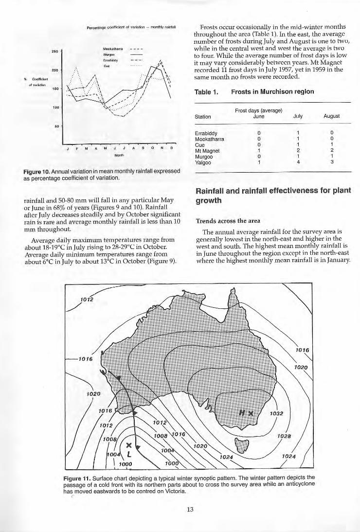
Thunderstorms resulting frOlTI convectional activity bring sharply isolated falls of highly variable intensity throughout the region. Cyclones and thunderstorms thus provide the summer rainfall which occurs in two contrasting ways, either as rare widespread major falls or common localised minor falls which may be very heavy over a small area. The average monthly rainfall varies frOln about 5 Inm in November to about 26 mm in January and February (Figure 9), with very low reliability in any particular month (Figure 10).
Major rainfall events result in run-off and sheet flow across huge areas of 'wash' plains which flank the major river and tnbutary drainage systems; Belele land system, Buttah station.
11
Rainfall during March-April, when significant, is likewise invariably derived from incursions of tropical air and is accompanied by relatively high temperatures. For these reasons, the growth response is of the summer type rather than that derived from rainfall received from May and later during winter.
2. Winter-Spring (May to October)
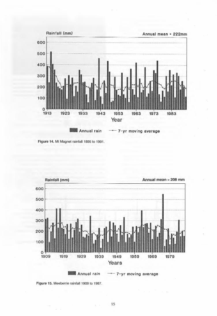
Winter is characterised by mi ld days and cool to cold nights. The beginning of winter is often marked by increased cold frontal activity associated with low pressure cells located well to the south of Western Australia in the Southern Ocean. Rain bearing cold fronts cross the south west coast of Western Australia and usually weaken considerably before reaching the Murchison region. Only strong fronts penetrate far enough inland to bring isolated showers and occasional strong winds (see Figure 11).
Occasionally cloud bands originating from the tropics to the north-west of the State interact with fronts to provide rain over central parts of Western Australia including the survey area. The frequency of such cloud bands is highest in the months of May, June and July, while the frequency and intensity of cold fronts peak in June and July.
The average monthly rainfall for May and June is between 25 and 40 mm and is the most reliable rainfall received throughout the region. Even so, the monthly coefficients of variation only decline to about 100%, reflecting the experience that anything between zero
40
P 30 D-
ffi 20 ~
10
40
P 30 D-
E 20 ~
10
40
P 30 D-
E 20 ~
10
Errabiddy
J FMAMJJASOND
Cue
J FMAMJJASOND
Murgoo '
(
J FMAMJJASOND
Figure 9. Mean monthly temperatures and rainfall at six centres.
12
40
10
40
P 30 D-
ffi 20 ~
10
Meekatharra
J FMAMJJASOND
Mt Magnet
J FMAMJJASOND
Yalgoo
40 E 30 .s 20 ~
rr-.-..---r 1 0 .~
J FMAMJJASOND
25'
'" 'If. CoetHclcnl
01 varlallon . " 10'
"
Percentage coeff.::ieot 01 variation - monthly rai1lal
Meekalharra
Err.bIddy
'. ' '.\ "- ---" . .:.--\ ."\ \,...-~-~\ \":~
,~ " \.
" . " \\ ;, •
M A MAS 0 N 0
Month
Figure 10. Annual variation in mean monthly rainfall expressed as percentage coefficient of variation.
rainfall and 50-80 mm will fall in any particular May or June in 68% of years (Figures 9 and 10). Rainfall after July decreases steadily and by October significant rain is rare and average monthly rainfall is less than 10 mm throughout.
Average daily maxhnum temperatures range from about 18-19°C in July rising to 28-29°C in October. Average daily minimum temperatures range from about 6°C in July to about 13°C in October (Figure 9).
Frosts occur occasionally in the mid-winter months throughout the area (Table 1). In the east, the average number of frosts during July and August is one to two, while in the central west and west the average is two to four. While the average number of frost days is low it may vary considerably between years. Mt Magnet recorded 11 frost days in July 1957, yet in 1959 in the same month no frosts were recorded.
Table 1.
Station
Errabiddy Meekatharra Cue Mt Magnet Murgoo Yalgoo
Frosts in Murchison region
Frost days (average) June
o o o 1 o 1
July
1 1 1 2 1 4
August
o o 1 2 1 3
Rainfall and rainfall effectiveness for plant growth
Trends across the area
The annual average rainfall for the survey area is generally lowest in the north-east and higher in the west and south. The highest mean monthly rainfall is in June throughout the region except in the north-east where the highest monthly mean rainfall is in January.
Figure 11. Surface chart depicting a typical winter synoptic pattern. The winter pattern depicts the passage of a cold front with its northern parts about to cross the survey area while an anticyclone has moved eastwards to be centred on Victoria.
c
13
". 52%
<ex
Yalgoo Mt Magnet
...
Murgoo Co.
'"
Errablddy Meekatharra
Figure 12. Proportions (%) of average winter (May·October) rainfall (shaded) to average summer (November·April) rainfal l.
Rainfall (mm)
600
500
400
_ Annual ra in
Figure 13. Meekatharra rainfall 1913 to 1991.
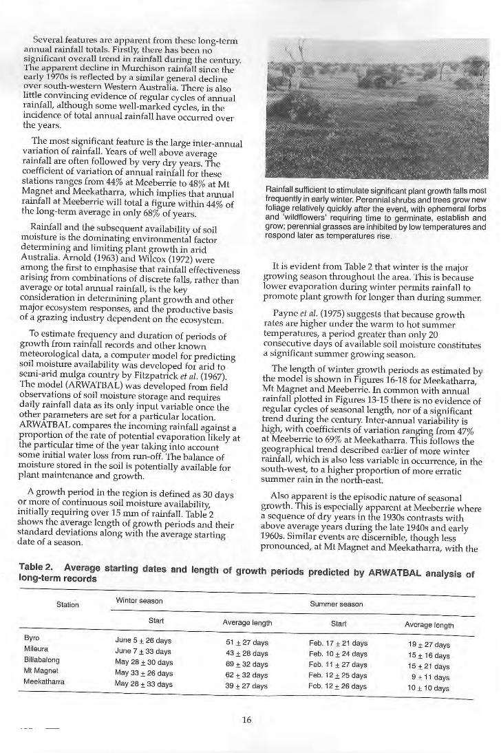
This difference in the peak or seasonal rainfall distribution reflects a steady geographi cal trel~d across the s urvey area. Ln th e extreme south-west, w ll1ter ra infall is su ff ici ent and regular enough to support semi-arid South Wes tern Botanica l Province vegetation, w hi ch domjnates the Irw in Botanical Dis trict further west. A trend of decreasi ng winter rainfall and increasing summer rainfall exists from the south-west to the north-east. Winter rainfall accounts for about 46% of Errab idd y's yearly to tal, while at Yalgoo and Murgoo the fi gure is about 61 %. SlmllarJy on the eastern margin of the region less w inter ram IS
recorded in the north than the south. At Meekatharra a mean of 46% of the alU1uai rainfa ll is recorded during winter wh ile at C ue the figure is 50% and at Mt Magnet, 52% (F ig ure 12) .
The re liability and effectiveness of rainfall is the most critical factor in determining plant growth. The variability of rainfall expressed as coefficient of variations (Figure 11 ) shows rainfall is most re liable (but still highly variable) everywhere from May to July when rainfall is li ke ly to be at it highest and least reliable from September to December when rainfall is at its lowest. Mid to late summ er Uanuary to March) shows less extreme monthly variation than early sun1mer owing to a low peak of some rainfall expectancy from cyclones and thunderstorms, p articularly at Meekatharra more than at other centres further south.
Seasonal patterns of effectiveness
Long-term rainfall trends and annual variation s ince the early part of this century are shown in Figures 13-15 for Meekatharra, Mt Magnet a nd Meeberrie. The bars represent annual rainfall and the line is a seven year moving average.
Annua l mean· 234 mm
~ 7 - yr moving average
14
Rainfall (mm) Annual mean· 222mm
600
500 .. - ....... . . .... - . - ... . .......... . . .......... ..... ..... ... ....... - .... .... ..... .. ...... .. -.. ........ .. .
_ Annual ra in ~ 7-yr moving average
Figure 14. Mt Magnet rainlall1 895 to 1991.
Rainfall (mm) Annual mean = 208 mm
600
500 ........... . . .. . ....... ...... .. .
400
300
200
100
o 1909 1919 1929 1939 1949
Years 1959 1969
_ Annual rain ~ 7-yr moving average
Figure 15. Meeberrie rainlall1 909 to 1987.
15
1979
Several features are apparent from these long-tenTI annual rainfall to tals. Firstly, there has been no significant overall trend in rainfall during the century. The apparent decline in Murchison rainfall since the early 1970s is reflected by a simil ar general decline over south-western Western Australia. There is also little convincing evidence of regular cycles of annual rainfall, although some well-marked cycles, in the incidence of total annual rainfall have occurred over the years.
The most significant feature is the large inter-annual variation of rainfall. Years of well above average rainfall are often followed by very dry years. The coefficient of variation of annual rainfall for these stations ranges from 44% at Meeberrie to 48% at Mt Magnet and Meekatharra, which implies that annual rainfall at Meeberrie will total a figure within 44% of the long-term average in only 68% of years.
Rainfall and the subsequent availability of soil moisture is the dominating environmental factor determining and limiting plant growth in arid Australia. Arnold (1963) and Wilcox (1972) were among the first to emphaSise that rainfall effectiveness arising from combinations of discrete falls, rather than average or total annual rainfall, is the key consideration in determining plant growth and other major ecosystem responses, and the productive basis of a grazing industry dependent on the ecosystem.
To estimate frequency and duration of periods of growth from rainfall records and other known meteorological data, a computer model for predicting soil moisture availabili ty was developed for arid to semi-arid mulga country by Fitzpatrick et al. (1967). The model (ARWATBAL) was developed from field observations of soil moisture storage and requires daily rainfall data as its only input variable once the other parameters are set for a particular location. ARWATBAL compares the incoming rainfall against a proportion of the rate of potenti al evaporation likely at the particular time of the year taking into account some initial water loss from run-off. The balance of moisture stored in the soil is potentially available for plant maintenance and growth.
A growth period in the region is defined as 30 days or more of continuous soil moisture availability, initially requiring over 15 mm of rainfall. Table 2 shows the average length of growth periods and their standard deviations along with the average starting da te of a season.
Rainfall sufficient to stimulate significant plant growth fa lls most frequently in early winter. Perennial shrubs and trees grow new foliage relatively quickly after the event, with ephemeral forbs and 'wildflowers' requiring time to germinate, establish and grow; perennial grasses are inhibited by low temperatures and respond later as temperatures rise.
It is evident from Table 2 that winter is the major growing season throughout the area. This is because lower evaporation during winter permits rainfall to promote plant grow th for longer than during summer.
Payne et al. (1975) suggests that because growth rates are higher wlder the warm to hot summer temperatures, a period greater than only 20 consecutive days of available soil moisture constitutes a significant summer growing season.
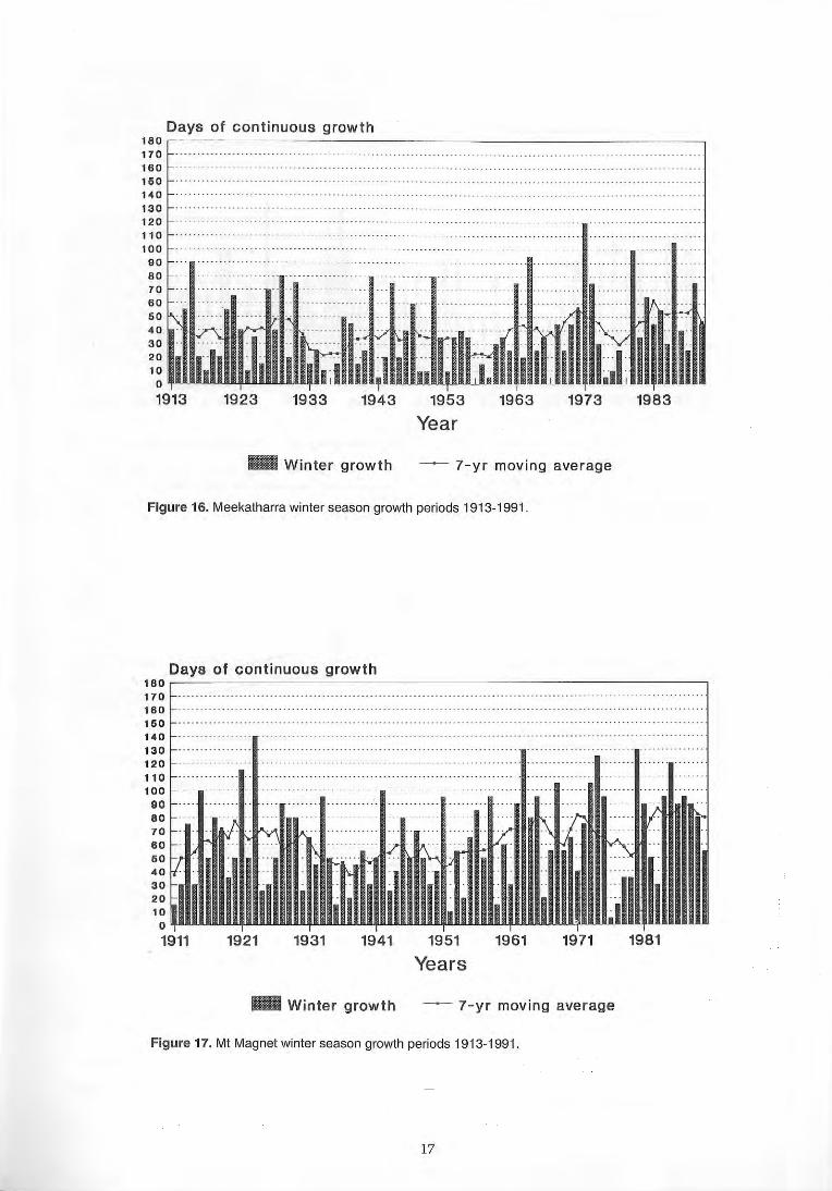
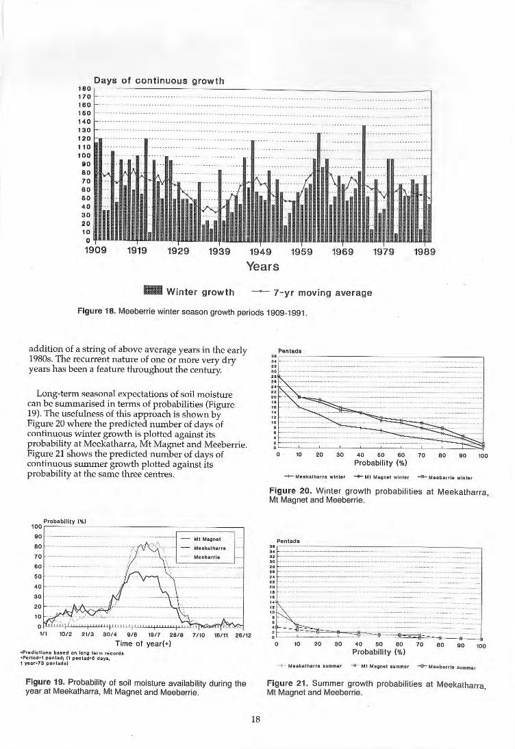
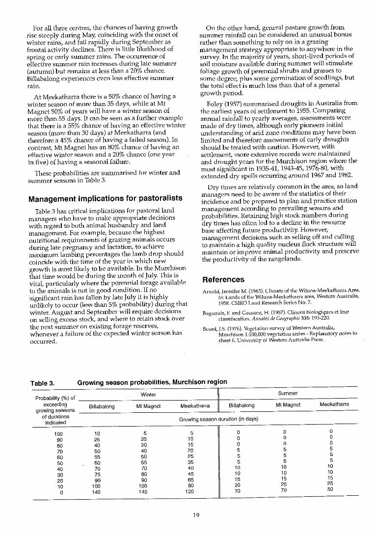
The length of winter growth periods as estimated by the model is shown in Figures 16-18 for Meekatharra, Mt Magnet and Meeberrie. In common with annual rainfall plotted in Figures 13-15 there is no evidence of regular cycles of seasonal length, nor of a Significant trend during the century. Inter-annual variability is high, with coefficients of variation ranging from 47% at Meeberrie to 69% at Meekatharra. This follows the geographical trend described ea:lier of more winter rainfall, which is also less variable in occurrence, in the south-west, to a higher proportion of more erratic summer rain in the north-east.
Also apparent is the episodic nature of seasonal growth. This is especially apparent at Meeberrie where a sequence of dry years in the 1930s contrasts with above average years during the late 1940s and early 1960s. Similar events are discernible, though less pronounced, at Mt Magnet and Meekatharra, with the
Table 2. Average starting dates and length of growth periods predicted by ARWATBAL analYSis of long-term records
Station Winter season Summer season
Start Average length Start Average length
Byro June 5 ± 26 days 51 ± 27 days Feb. 17 ± 21 days 19 ± 27 days Mileura June 7 ± 33 days 43 ± 28 days Feb. 10 ± 24 days 15 ± 16 days Billabalong May 28 ± 30 days 69 ± 32 days Feb. 11 ± 27 days 15±21 days Mt Magnet May 33 ± 26 days 62 ± 32 days Feb. 12 ± 25 days 9± 11 days Meekatharra May 28 ± 33 days 39 ± 27 days Feb. 12 ± 26 days 10± 10 days
16
Days of cont inuous growth 180,-~--------------~--------------------------------------------, 170 160 160 140 13 0 120 110 100
90 80 70 60 50 40 30 20 10 a 1913 1923 1933 1943 1953 1963 1973
Year
_ Winter grow th - - 7-yr moving ave rage
Figure 16. Meekatharra winter season growth periods 1913·1991.
1983
Days of cont inuous 9rowth 180r-~---------------=--------------------------------------------' 170 160 . . . ....... . .
150 14 0 130 12 0 110 100
90 80
_ Winter growth -- 7-yr movi ng average
Figure 17. Mt Magnet winter season growth periods 1913·1991 .
17
Days of continuous growth 180 ,-----------------------------------------------______________ -,
170 160 160 140 130 120 110 100
_ Winter growth -- 7-yr moving average
Figure 18. Meeberrie winter season growth periods 1909-1991 .
addition of a string of above average years in the early 1980s. The recurrent nature of one or more very dry years has been a feature throughout the century.
Long-term seasonal expectations of soil moisture can be summarised in terms of probabilities (Figure 19). The usefulness of this approach is shown by Figure 20 where the predicted number of days of continuous winter growth is plotted against its probability at Meekatharra, Mt Magnet and Meeberrie. Figure 21 shows the predicted number of days of continuous summer growth plotted against its probability at the same three centres.
~P~'O~b~.b~"~a~y~(%~)~------------------r===========~l 10° 1 90 - 1.41 Magne'
80
70
60
50
40
30
20
10 o~~~~~~~~~~~~~~~ 111 10/2 2113 30/4 916 19/7 28/8
Time of year(+) ·Predlctlon. b ... d on long tarm recorda ·Period-' pentad; (1 pentad-IS daya, I yur-73 pan lads)
7/10 16 / 11 26/12
Figure 19. Probability of soil moisture availabil ity during the year at Meekatharra, Mt Magnet and Meeberrie.
18
Pentad a " r-------------------------------------------, " " r· ····· ···· ··········
" "
o 10 20 30 40 50 60
Probability (%) 70 80 90 100
~ M"balrle winter
Figure 20. Winter growth probabil it ies at Meekatharra, Mt Magnet and Meeberrie.
Pentadll ,. ~~~--------------------------------------,
" " " " " ,. " " .. .. ..
o 10 20 30
-1- M • • klth,.,. Bummer
40 50 60 Probability (%)
-.:- Mt Maona' lummer
70 80 90 100
--a- Meeb errl . Bummer
Figure 21. Summer growth probabilities at Meekatharra, Mt Magnet and Meeberrie.
For all three centres. the chances of having growth rise steeply during May. coinciding with the onset of winter rains. and fall rapidly during September as frontal activity declines. There is little likelihood of spring or early summer rains. The occurrence of effective summer rain increases during late summer (autumn) but remains at less than a 20% chance. Billabalong experiences even less effective summer rain.
At Meekatharra there is a 50% chance of having a winter season of more than 35 days. while at Mt Magnet 50% of years will have a winter season of more than 55 days. It can be seen as a further example that there is a 55% chance of having an effective winter season (more than 30 days) at Meekatharra (and therefore a 45% chance of having a failed season). In contrast. Mt Magnet has an 80% chance of having an effective winter season and a 20% chance (one year in five) of having a seasonal failure.
These probabilities are summarised for winter and SUlnmer seasons in Table 3.
Management implications for pastoralists
Table 3 has critical implications for pastoral land managers who have to make appropriate decisions with regard to both animal husbandry and land management. For example. because the highest nutritional requirements of grazing animals occurs during late pregnancy and lactation. to achieve maximum lambing percentages the lamb drop should coincide with the time of the year in which new growth is most likely to be available. In the Murchison that time would be during the month of July. This is vital. particularly where the perennial forage available to the animals is not in good condition. If no significant rain has fallen by late July it is highly unlikely to occur (less than 5% probability) during that winter. August and September will require decisions on selling excess stock, and where to retain stock over the next summer on existing forage reserves, whenever a failure of the expected winter season has occurred.
On the other hand. general pasture growth from summer rainfall can be considered an unusual bonus rather than something to rely on in a grazing management strategy appropriate to anywhere in the survey. In the majority of years. short-lived periods of soil moisture available during summer will stimulate foliage growth of perennial shrubs and grasses to some degree. plus some germination of seedlings. but the total effect is much less than that of a general growth period.
Foley (1957) summarised droughts in Australia from the earliest years of settlement to 1955. Comparing annual rainfall to yearly averages, assessments were made of dry times. although early pioneers initial understanding of arid zone conditions may have been limited and therefore assessments of early droughts should be treated with caution. However. with settlement, more extensive records were maintained and drought years for the Murchison region where the most significant in 1935-41.1943-45. 197q-80. with extended dry spells occurring around 1967 and 1982.
Dry tilnes are relatively COlnmon in the area, so land managers need to be aware of the statistics of their incidence and be prepared to plan and practice station management according to prevailing seasons and probabilities. Retaining high stock numbers during dry times has often led to a decline in the resource base affecting future productivity. However. management decisions such as selling off and culling to maintain a high quality nucleus flock structure will Inaintain or itnprove animal productivity and preserve the productivity of the rangelands.
References Arnold, Jennifer M. (1963). Climate of the Wiluna-MeekatharraArea.
111: Lands of the Wiluna-Meekatharra area, Western Australia, 1958. CSIRO Land Research Series No.7.
Bagnouls, F. and Gaussen, H. (1957). Climats biologiques et leur classifacation. Anl1ales de GeO;{rapllie 335: 193-220.
Beard, J.S. (1976). Vegetation survey of Western Australia, Murchison 1:100,000 vegetation series - Explanatory notes to sheet 6. University of Western Australia Press.
Table 3. Growing season probabilities, Murchison region
Probability ('Yo) of Winter Summer
exceeding BHlabalong Mt Magnet Meekatharra Billabalong Mt Magnet Meekatharra growing seasons
of durations indicated Growing season duration (in days)
100 10 5 5 0 0 0 90 25 20 10 0 0 0 80 40 30 15 0 0 0 70 50 40 20 5 5 5 60 55 50 25 5 5 5 50 60 55 35 5 5 5 40 70 70 40 10 10 10 30 75 80 45 10 10 10 20 90 90 65 15 15 15 10 100 100 80 20 20 25
0 140 140 120 70 70 50
19

Curry, P.J. and Hacker, R.B. (1990). Can pastoral grazing management satisfy endorsed conservation objectives in arid Western Australia? Journal afEnvironmental Management 30: 295-320.
Fitzpatrick, E.A, Slayter, R.O. and Krishnan, A (1967). Incidence and duration of periods of plant growth in central Australia as estimated from climatic data. Agricultural Meteorology 4: 389-404.
Foley, J.e. (1957). Droughts in Australia. Review of records from earliest years of settlement to 1955. Bureau of Meteorology, Commonwealth of Australia, Bulletin No. 43.
Meigs, P. (1953). World distribution of arid and semi-arid homoclimates. In: Reviews of research on arid zone hydrology. pp. 203-210. UNESCO, Paris.
Payne, AL., Mitchell, AA and Holman, W.F. (1975). An inventory and condition survey of rangelands in the Ashburton River catchment, Western Australia. Department of Agriculture, Western Australia, Technical Bulletin No. 62.
20
Geology and hydrogeology
A. Laws
Introduction
This section of the report outlines the geology and hydrogeology of the area. Its purpose is to provide a description of the origin and nature of groundwater resources within the survey areaf and a practical guide to where they may be located, their salinity, and general guidelines on how they may be developed. For assistance on the siting of bores or any particular supply, pastoralists and other land users should contact the Director, Geological Survey of Western Australia, Department of Minerals and Energy.
The pastoral industry is one of the major users of groundwater in the area. Because there is a regional water-table, and over more than 60% of the total area the water-table is less than 15 m below ground level, more than 2000 bores and wells have been constructed throughout the area. However, the distribution of stock bores and wells does not reflect solely the availability of groundwater, but also the different pastoral value of the land for stock, and its carrying capacity.
Consequently bores and wells tend to be more concentrated on areas of alluvium rather than in the thinner, topographically higher, colluvial soils, or in areas of bedrock outcrop.
Previous investigations
Detailed comments on previous geological investigations are given in the relevant 1:250,000 Explanatory Notes (Belele-Elias 1982, Byro-Williams 1.R. ef a1. 1983, Cue-De La Hunty 1973, Watkins ef al. 1987, Glenburgh-Williams S.J. ef a1. 1983, GlengarryElias ef a1. 1982, Kirkalocka-Baxter ef a1. 1983, MurgooBaxter 1974, Robinson Range-Elias ef a1. 1980, Sandstone-Tingey 1985, and Yalgoo-Muhling ef al. 1977). In 1990 a major report on the geological evolution and mineralisation of the Murchison Province was published (Watkins and Hickman 1990), whilst the adjoining Western Gneiss Terrane was mapped in detail by Gee ef a1. (1981, 1986) and Myers (1988). Summaries of the geology can be obtained from Memoir 3 (Geological Survey of Western Australia 1990).
Apart from brief early reports on water supplies for mines and batteries in the area (Maitland 1908, Clarke 1916, and Ellis 1936a, 1936b, and 1953) and later reports that concentrated on groundwater in the calcrete drainages (Sanders 1969a, 1969b, 1971, 1973a, 1973b) regional reports on groundwater are limited to Berliat (1957); Morgan (1965); and Baxter (1972).
Broadscale regional assessments were made of the groundwater resources of this and surrounding areas as part of the 1975 Review of Australia's Water
21
Resources (Department of National Resources 1976), the Water 2000 Study (Department of Resources and Energy 1983) and the 1985 Review of Australia's Water Resources (Department of Primary Industries and Energy 1987).
Most other reports on groundwater in the area are unpublished reports covering work carried out to locate water supplies for individual pastoral leases, the Main Roads Department, and town water supplies, operated by the Water Authority of Western Australia. Other unpUblished reports review the water supplies for the towns of Mt Magnet, Cue, and Meekatharra.
Physiography
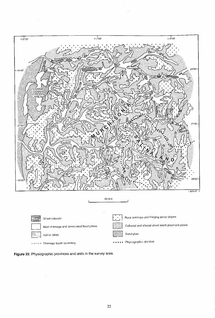
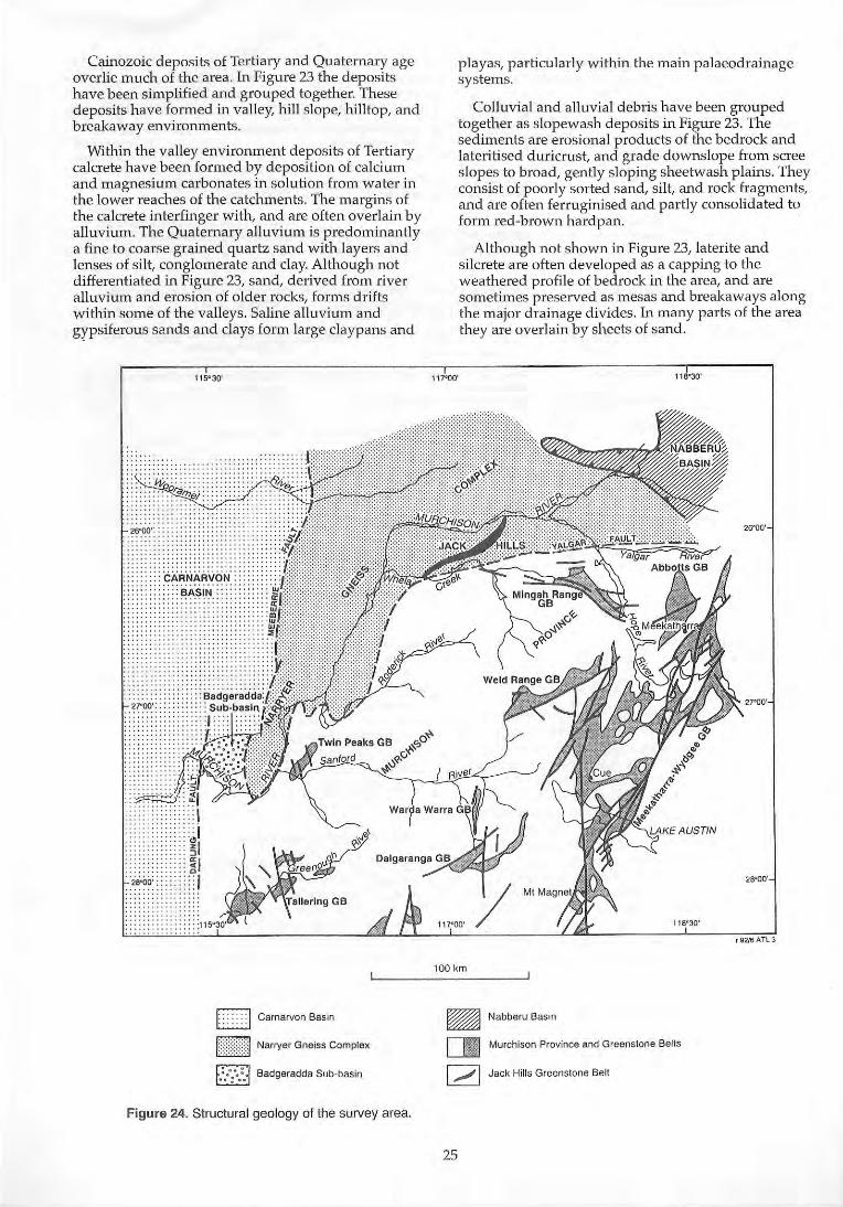
The Upper Murchison River Catchment is part of the drainage basin of the Murchison River, and is situated in the Yilgarn Craton (previously termed the Yilgarn Block) of Western Australia.
The major physiographic features are shown in Figure 22. Most of the drainage in the area covered by this report, falls within the south-east corner of Jutson's (1950) Murchisonia, and drains towards the Indian Ocean. A small, south-eastern part of the area, is in Salinaland, which drains inland into salt lakes, such as Lake Austin.
Within the area of Murchisonia there is a marked difference between the topography formed from bedrock of Phanerozoic and Archaean age. Phanerozoic sedimentary rocks occur in the northwest of the area, and topographically the area is generally monotonous and flat. There are scattered low hills and a few isolated mesas of duricrust, which are more or less overlain and surrounded by sand plains. Dunes and playas occupy a broad palaeodrainage in the Yarra Yarra Creek area (Figure 22). In general, areas of high and low relief are related to structural features within the Phanerozoic bedrock.
The Archaean terrain is characterised by very shallow alluvial 'valleys' which, to an observer on the ground are so broad and so gently inclined as to appear to be flat plains between distant hills. The hill ranges are often flanked by stony pediments which shed run-off onto very broad sheetwash plainS. Above the pediments are low rocky hills of bedrock, or breakaways over deeply weathered, duricrust-capped bedrock, which lie on the interfluves or at the heads of the main drainage lines. The duricrust remnants are all that remain of a once continuous Early Tertiary lateritic surface, which has become eroded during Quaternary times.
The topography over the areas of outcrop varies according to the rock type. The granitoids typically form large monoliths and extensive uplands of flat pavements, whilst basalt generally produces rugged, rounded hills. Prominent strike ridges are formed from outcropping iron formation and metaperidotite, while felsic volcanics tend to produce gently undulating plains.
Sheet calcrete
D Main drainage and associated flood plains
6-~::-~J Saline lakes
000 0 0 Drainage basin boundary
80 km
~ Rock outcrops and fringing scree slopes l0J
I??I~H Colluvial arid alluvial sheet wash piedmont plains
M:m~W~m:1 Sand plain
Physiographic division
Figure 22. Physiographic provinces and units in the survey area.
22

The south-east part of the study area falls within Jutson's Salinaland, and is dominated by a generally flat to gently undulating topography, with sandy surfaced Quaternary plains. Drainage is to the southeast into saline lakes. The physiography of the eastern part of the area, and land further to the east is described in Mabbutt (1963).
Drainage
More than 80% of the drainage in the area is exorheic, draining to the west into the Murchison, Wooramel, and Greenough River catchments, and subsequently to the Indian Ocean. The remainder of the area has an endorheic drainage system to inland salt lake systems.
All drainages are ephemeral. The Murchison River is very intermittent, but may flow for long periods after heavy rainfall. Generally the major drainages have broad flood plains, some of which have been discontinuously incised by narrow channels.
In the western part of the shldy area, the bed of the Murchison River follows a more deeply incised sinuous course and is probably a fault-controlled subsequent stream along this stretch. Williams I.R. et al. (1983) noted the unusual junction of the Roderick and Murchison Rivers and relate this to a faultcontrolled dam near the junction of the rivers, which has been subsequently breached. The west-flowing tributaries of the Murchison River and the upper part of the river itself are consequent streams.
Elongate and dissected sheets of valley calcrete occupy parts of the trunk drainages (Figure 22), and some are 1 to 2 m or more above the present ground level, indicating that there has been widespread erosion of the calcrete since its formation. Further to the east the trunk drainages of the Yalgar and Hope Rivers follow probable palaeodrainage lines developed on the duricrust during the early Tertiary (Elias 1982).
To the south-east the palaeodrainage system is represented by saline drainages and salt lakes, with gypsiferous mud flats and small parabolic banks of calcareous and gypsiferous sands, surrounded by sand sheets, salt flats, and sheets of calcrete.
Regional geology
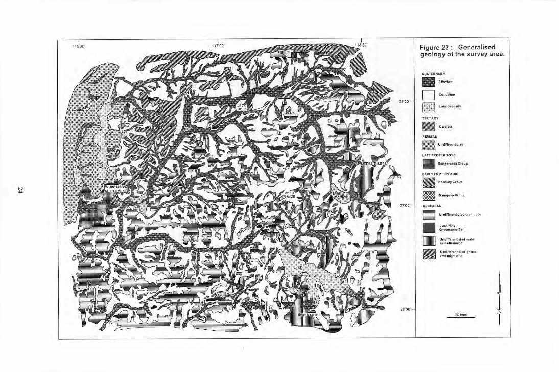
General features
For the purpose of this report the geology has been summarised and simplified, on the basis of its hydrogeological significance (Figure 23).
Most of the area falls within the Murchison Province, which is the westernmost of three graniteg~eenstone terranes in the Archaean Yilgarn Craton
23
(Watkins 1990, Watkins and Hickman 1990). To the north, north-west, and west the Murchison Province is in tectonic contact with the Narryer Gneiss Complex of the Western Gneiss Terrane (Myers 1990), whilst to the north-east the granite-greenstone rocks are overlain unconformably by sediments of the Nabberu Basin. In the north-west sediments of the Carnarvon Basin occur (Figure 23). The generalised stratigraphy is slUnmarised in Table 4, and the geology and structure in Figure 24.
Stratigraphy and structure
The area underlain by the Murchison Province consists of a series of greenstone sequences and suites of granitoids. To the north and north-west these abut the N arryer Gneiss Complex, which consists of two groups of gneisses. In the north-east and west, these rocks are overlain by Proterozoic sedimentary rocks, and further to the west are unconformably overlain by Penman sediments.
The greenstone belts trend NNW to NNE, and are surrounded by the more extensive granitoid intrusions. They are shown on Figure 23 as undifferentiated mafic and ultramafic rocks, consisting of basalt, amphibolite, gabbro and dolerite. They have been deformed by large scale foldmg and are dissected by faults. Most of the belts occur in the east and southeast of the study area.
The granitoid rocks show variable composition and texture, and include biotite granite, muscovite granite, tonalite, adamellite, granodiorite, and granophyre. They intrude the greenstone belts and are widespread in the western and central part of the area.
The Narryer Gneiss Complex consist of rnigmatite, gneiss, schist, and quartzite of Archaean age, and have been derived mainly from granite and, to a lesser extent, metasediments, dykes, sills, and layered intrusions. On the southern boundary of the complex, between the Whela and Murchison Rivers, schist and metasediment of the Jack Hills Group crop out as a prominent linear range.
Lower Proterozoic sediments of the Glengarry Subbasin of the N abbern Basin occur in the north-east where they unconformably overlie the Archaean basement, whilst Late Proterozoic sediments of the Badgerrada Group occur as a small intracratonic basin in the western part of the area, overlying Archaean basement, and abutting Permian sediments of the Carnarvon Basin.
The Permian sediments of the Carnarvon Basin consist of a series of sandstone, conglomerate, siltstone, claystone, and carbonaceous shale, and some glacial erratics. The sediments rest unconform~bly on the Archaean bedrock in a down-faulted synclmal zone known as the Byro Sub-basin.
'" ..
Figure 23: Generalised geology of the survey area.
QUATERNARY
• Alluvium
D Colluvium
trrr~:m L~e deposh
TERTIARY
• C .... ertlt
PERhtAN
BUM U~fft~n~Jltd LATE PROTEROZOIC
• Badge,addl Group
EARLY PROTEROZOIC
~ Padbu<y Group
e Gltng...-y Group
ARCHAEAN
II • • BJ
Undirrertnlial t d gnnitiods
Jnk Hils Gr«n$tone BeU
Undir'ere"tilted m~r.c , ,,eI ultramafic
Undilltrtntilted gne iss and migma!il!
30kms 1 I
Cainozoic deposits of Tertiary and Quaternary age overlie much of the area. In Figure 23 the deposits have been simpli fied and grouped together. These deposits have formed in valley, hill slope, hilltop, and breakaway environments.
Within the valley environment deposits of Tertiary calcrete have been formed by deposition of calcium and magnesium carbonates 1n solution frOln water in the lower reaches of the catchments. The margins of the calcrete in terfinger with, and are often overla in by alluvium. The Quaternary alluvium is predominantly a fine to coarse grained quartz sand w ith layers and lenses of silt, conglomerate and clay. Although not d ifferenti ated in Figure 23, sand, derived from river alluvium and erosion of older rocks, forms drifts within some of the valleys. Saline alluvium and gypsifero us sands and clays form large claypans and
115"30'
: 'cAR'NARvoN' ::::: ~~.~!t:'.: :"
1 I GB
I: : : : : : : I Carnarvon Basin
I!){}d Narryer Gneiss Complex
f.:.::" •• :.j Badgeradda Sub-basin
Figure 24. Structural geology of the survey area.
playas, particularly within the main palaeodrainage systems.
Colluvial and alluvial debris have been grouped together as slopewash deposits in Figure 23. The sediments are erosional products of the bedrock and lateritised duricrust, and grade downslope from scree slopes to broad, gently sloping sheetwash plains. They consist of poorly sorted sand, sil t, and rock fragments, and are often ferrugini sed and partly consolidated to form red-brown hardpan.
Although not shown in Figure 23, la terite and silcrete are often developed as a capping to the weathered profile of bedrock in the area, and are sometimes preserved as mesas and breakaways along the major drainage di vides. In many parts of the area they are overlain by sheets of sand.
l00km
~ Nabberu Basin
I B:I Murchison Province and Greenstone Belts
[ .,...; I Jack Hills Greenstone Belt
25
Table 4. Generalised stratigraphy
Age Name Lithology Distribution
Quaternary Alluvium
Colluvium
Fine to coarse~grained quartz sand, with patches of clay, silt, and conglomerate Rock fragments, sand and silt
Creek beds, and major drainage lines.
Scree slopes to outwash plains and flats along rivers.
Lake deposits Clay, silt and grit, some saline to gypsiferous; eolian sand banks
Salt lakes and clay pans, with marginal sand banks.
Tertiary Sheet calcrete Calcrete Laterite* Silcrete*
Massive and pisolitic duricrust Siliceous duricrust
Around lakes and in major drainages. Capping to granitoid rocks. Capping to granites and greenstone belts.
Permian Undifferentiated Sandstone, siltstone, shale, limestone, and glacial tillites, some coal measures
Sediments of Byro Sub-basin of the Carnarvon Basin.
Late Proterozoic Badgeradda Group Siltstone, sandstone and conglomerate Small intra-cratonic basin, overlying Archaean gneisses.
Early Proterozoic Padbury Group
Glengarry Group
Shale, BIF, dolomite, siltstone, phyllite and conglomerate
Unconformable over Glengarry Group in Glengarry Sub-basin.
Quartz arenite, micaceous siltstone Unconformable over Archaean bedrock.
Archaean Granitoids Adamellite, granodiorite, biotite granite, tonalite
Small to large bodies throughout area.
Jack Hills Greenstone Belt Mafic and Ultramafic rocks (Undiff)
Quartzite, conglomerate, schist, amphibolite, pyroxenite, and peridotite Basalt, schist, amphibolite, gabbro, dolerite, serpentite pyroxenite and peridotite
Linear outcrop as Jack Hills Range
Forms the major greenstone belts in the south-east of the area.
Migmatite and gneiss (Undiff)
Biotite gneiss and migmatite, paragneiss, schist, quartzite, and amphibolite
Forms the Narryer Gneiss Complex in west and north-west of area.
* Not shown on Figure 23.
Hydrogeology
General
The area covered by this report places great reliance on groundwater. It is an area of low rainfall with an erratic seasonal distribution, and a high potential evaporation; it has, therefore, a general surface water deficiency. Most of the rivers flow after heavy rains and permanent pools are generally restricted to the Murchison River. Large, semi-permanent pools and waterholes occur along the Roderick, Sanford, Woorame!, Whela, and Yalgar Rivers, and ephemeral water lies for some time after rainfall in many of the larger claypans in the region. Small rock holes, probably originating as weathering cavities, occur on the crests and margins of granitoid domes, and in the breakaway areas, but provide supplies of limited quantity and duration. Before European settlement of the area, the Aboriginal population was evidently heavily reliant on such sites.
Groundwater is now used for many purposes. It is essential for the pastoral industry, but is also used for domestic purposes on each pastoral lease, and provides town water supplies for Mt Magnet, Cue, and Meekatharra. In addition, groundwater of variable quality is extensively used in the mining industry during the processing and washing of ore and tailings.
26
Source of data
Data have been obtained from the detailed bore censuses carried out during regional geological mapping in the 1970s and 1980s. More than 2000 bores and wells were sampled, and there is a relatively even distribution of bores and wells throughout the area (Figure 25). The available bore data (water levels, depths, yields, and salinities), are held by the Geological Survey.
Groundwater occurrence
Groundwater is generally readily available throughout most of the area, although quality and quantity vary considerably depending on bore or well location. Table 5 summarises the range of bore depths, yields, and groundwater salinities for the various rock types of the three major aquifers i.e. surficial, seclimentary, and fractured rock aquifers. Figure 26 diagrammatically shows the relationship of groundwater within the various rock units, and typical bore locations.
Over most of the area, domestic and stock water requirements are met from small supplies of fresh to brackish groundwater in colluvium, valley-fill alluvium, and calcrete and calcreted alluvium. The extensive wash plains, generally underlain by hardpan, that flank the main trunk drainages, provide
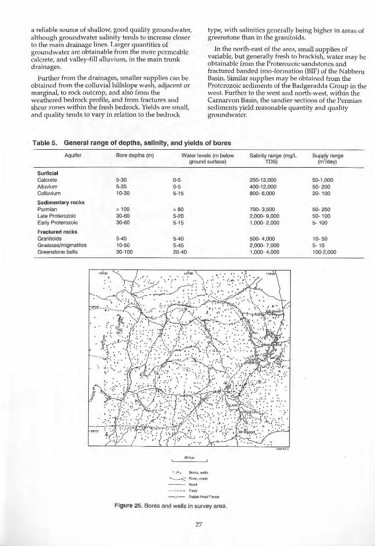
a reliable source of shallow, good quality groundwater, although groundwater salinity tends to increase closer to the Inain drainage lines. Larger quantities of groundwater are obtainable from the more permeable calcrete, and valley-fill alluvium, in the main trunk drainages.
Further from the drainages, smaller supplies can be obtained from the colluvial hills lope wash, adjacent or marginal, to rock outcrop, and also from the weaJhered bedrock profi le, and from fractures and shear zones within the fresh bedrock. Yields are small, and quality tends to vary in relation to the bedrock
type, with salinities generally being higher in areas of greenstone than in the granitoids.
In the north-east of the area, small supplies of variable, but generally fresh to brackish, water may be obtainable from the Proterozoic sandstones and fractured banded iron-formation (BIF) of the Nabberu Basin. Similar supplies may be obtained from the Proterozoic sediments of the Badgeradda Group in the west. Further to the west and north-west, within the Carnarvon Basin, the sandier sections of the Permian sediments yield reasonable quantity and quality groundwater.
Table 5. General range of depths, salinity, and yields of bores
Aquifer
Surficial Calcrete Alluvium Colluvium
Sedimentary rocks Permian Late Proterozoic Early Proterozoic
Fractured rocks Granitoids Gneisses/migmatites Greenstone belts
Bore depths (m)
5-30 5-35 10-30
> 100 30-60 30-60
5-45 10-50 30-100
Water levels (m below ground surface)
0-5 0-5 5-15
> 80 5-20 5-15
5-40 5-45 20-40
60 km
.~. Bores, wells
~ River, creek
Road
------ Track
- / - Rabbit Proof Fence
Figure 25. Bores and wells in survey area.
27
Salinity range (mg/L Supply range TDS) (m'/day)
250-12,000 50-1,000 400-12,000 50-200 800- 6,000 20- 100
700- 3,500 50-250 2,000- 9,000 50- 100 1,000- 2,000 5- 100
500- 4,000 10- 50 2,000- 7,000 5- 10 1,000- 4,000 100-2,000
'"
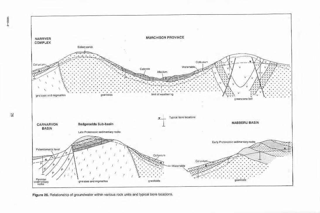
~
N 00
NARRYER COMPLEX
, gneisses and migmatites
CARNARVON BASIN
Permian sedimentary
rocks
.. .. .. .. .. .. .. .. . .. .. .. .. .. .. ..
.. .. .. .. .. .. .. .. .. .. .. .. .----..... . , ... ............ +++ ....... . J-
MURCHISON PROVINCE
............................................ ; .. ...................... .... ............. .... .......................... .. ...... .. +'~';""+ ' : '+' ;'''';1'~'+' + '~''':''';>';'''~''''''' '' '''''''''''' ...... ............... +++ + +.++++++++ ++ ...... ++ .... ++ ••• .... +. + ..... ++ ........ ++++ ..... + . ........ +.+ + .... .. .. •••• + ........ .. ...................... ++ ........... ..
granitoids limit of w.eathering
Badgeradda Sub-basin i Typical bore locations
Late Proterozoic sedimentary rocks
V ' greenstone belt
NABBERU BASIN
': t .
++++++ +
... C2~~~ I
f
f
f I f I gneisses and mIgmatites
f f
granitoids
-.~
+, ' '+ ................ .. . ~'.. .. .. .. .. .. .. .. .. .. .. t· ,'. .. .. .. .. .. .. .. .. .. ..
... .. . ..... ++ ••
.. g;aniioids
Figure 26. Relationship of groundwater within various rock units and typical bore locations.

Figure 27. Water·table map of the survey area.
Regional water-table and water-table levels
The determination of the groundwater flow systems in the study area is based on hydrogeological data collected during regional geological mapping, supp lemented by data obtained from town water supply investigations, exploration for water supp lies for milting purposes, and from bores drilled for road construction water supplies. Consequently the data are non-synoptic.
In addition the bores and wells have not been surveyed to Australian Height Datum and wa ter-table elevations have been calculated from estimates of surface elevation from 1:100,000 topographic series maps.
The water-table map (Figure 27) and the depth-towater map (Figure 28) are therefore generalised, and should be used with caution for future drilling and groundwater exploration . Salinity has been determined mainly in the field using conductivity measurements, and may also vary seasonally. Consequently the salinity data in Figure 29 are also generalised .
Whilst there are limited water supplies in areas of bedrock outcrop, or near outcrop, it is evident that a regional water-table exists throughout the study area (Figure 27). The height of the water-table ranges from over 500 m AHD on the eastern boundary of the area,
16602-3 29
Bedrock highs
~ Water1able contour (m AHD)
__ Geooralized How dirsction
......... Sub-ealchment boundary
SutJ.-catchmefli (See Table 6)
~ - ... "'... Zone for How through calcullltioJl
(See Table 6)
~ River, Creek
-- - - Track
~ RabbltProof f ence
to under 260 m in the west, a drop of more than 240 m in about 300 km, equivalent to a gradient of 1 m per 1250 m.
Interpretation of the water-table contours (Figure 27) shows a series of smaller sub-catchments to the main Murchison River catchm ent, and other catchments . A total of 13 sub-catchments are shown, 12 exorheic and 1 endorheic (Table 6). Of the 12, 7 are either catchments to tributaries of the Murchison River, or to part of the river itself. Two of the subcatchments contribute to the Wooram el River catchment in the north-west, one to the Greenough River in the south-west, and two to the Mongers Lake system to the south . The endorheic sub-catchment is centred on Lake Austin in the south-east of the area, into which groundwater drains and discharges by evapotranspiration.
Most of the sub-catchments are linear, with the drainage line forming the main axis. They range in size from less than 2600 km' to more than 13,750 km'. Hydraulic gradients along the main axes are very low and range from 0.6 to 2.6 x 10" .
The depth to the water-table (Figure 28) ranges from less than 1 m to over 80 m in the extreme west of the area, in the Carnarvon Basin. In most of the area the
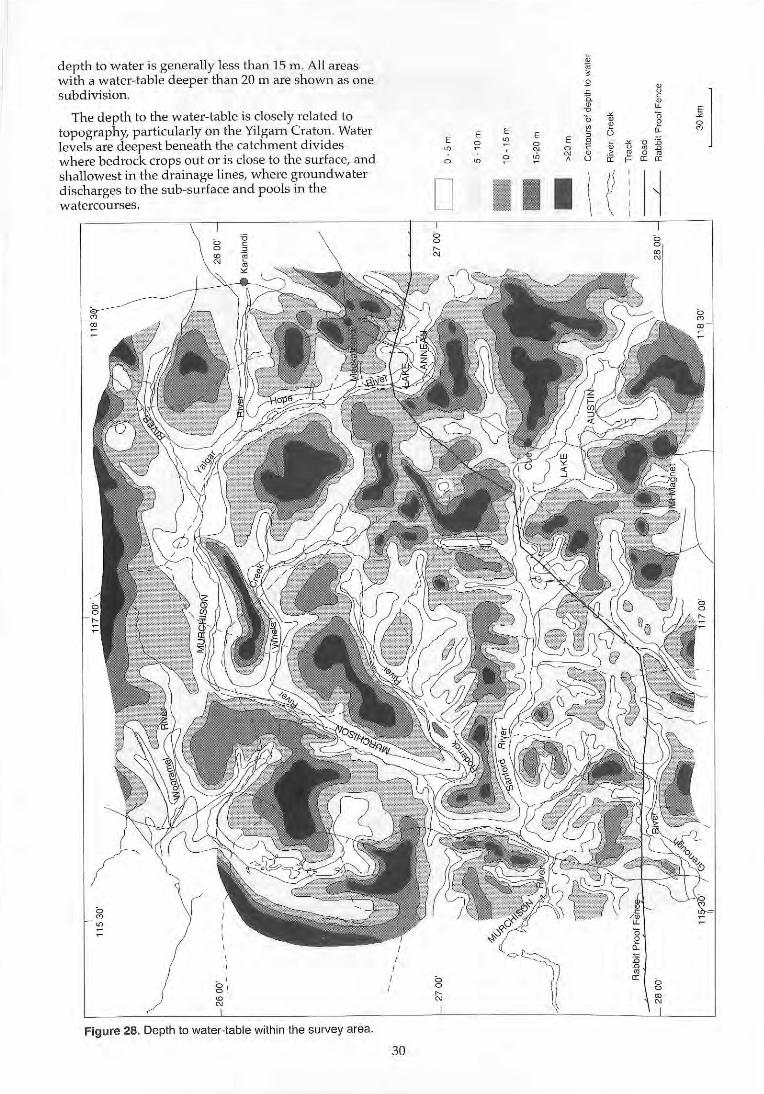
depth to water is generally less than 15 m. All areas with a water-table deeper than 20 m are shown as one subdiv ision.
The depth to the water-table is closely re lated to topography, particularly on the Yilgarn Craton. Water levels are deepest beneath the catchment divides where bedrock crops out or is close to the surface, and shallowest in the drainage lines, where grow1dwater discharges to the sub-surface and pools in the watercourses.
Figure 28. Depth to water-table with in the survey area.
30
E E
~ ~
0 ~
D
E E
'" 0 E
'" 0 N 0 ~ ,
I I I
;;; ;; • B
~ L
~ I a. c w w u. u
~ 13 13 w e • • , 0 "-
~ Oi ~ u 15 0 • D
0 > ~ 0 • 0 ii' r- 0: 0:
\ ~ ~
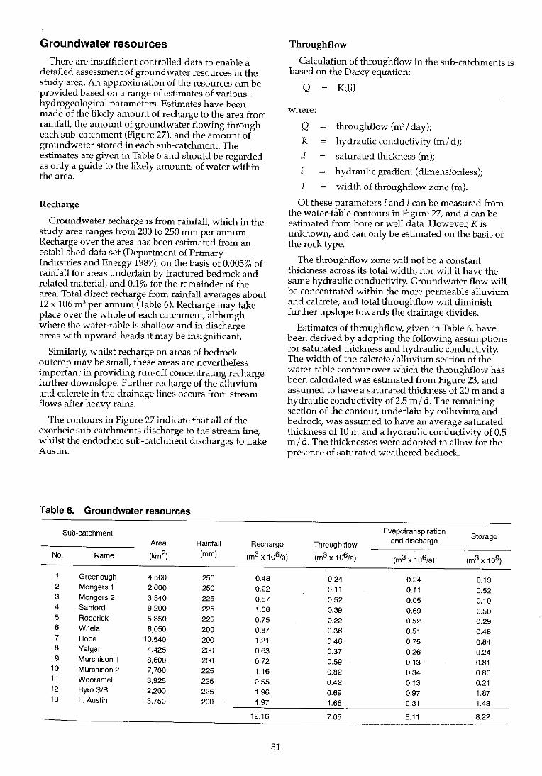
Groundwater resources
There are insufficient controlled data to enable a detailed assessment of groundwater resources in the study area. An approximation of the resources can be provided based on a range of estimates of various . hydrogeological parameters. Estimates have been made of the likely amount of recharge to the area from rainfall, the amount of groundwater flowing through each sub-catchment (Figure 27), and the amount of groundwater stored in each sub-catchment. The estimates are given in Table 6 and should be regarded as only a guide to the likely amounts of water within the area.
Recharge
Groundwater recharge is from rainfall, which in the study area ranges from 200 to 250 mm per annum. Recharge over the area has been estimated from an established data set (Department of Primary Industries and Energy 1987), on the basis of 0.005% of rainfall for areas underlain by fractured bedrock and related material, and 0.1% for the remainder of the area. Total direct recharge from rainfall averages about 12 x 106 m' per armum (Table 6). Recharge may take place over the whole of each catchment, although where the water-table is shallow and in discharge areas with upward heads it may be insignificant.
Similarly, whilst recharge on areas of bedrock outcrop may be small, these areas are nevertheless important in providing run-off concentrating recharge further downslope. Further recharge of the alluvium and calcrete in the drainage lines occurs from stream flows after heavy rains.
The contours in Figure 27 indicate that all of the exorheic sub-catchments discharge to the stream line, whilst the endorheic sub-catchment discharges to Lake Austin.
Table 6. Groundwater resources
Sub-catchment Area Rainfall Recharge
Throughflow
Calculation of throughflow in the sub-catchments is based on the Darcy equation:
Q Kdil
where:
Q throughflow (m'l day);
K hydraulic conductivity (ml d);
d saturated thickness (m);
hydraulic gradient (dimensionless);
width of throughflow zone (m).
Of these parameters i and I can be measured from the water-table contours in Figure 27, and d can be estimated from bore or well data. However, K is unlcnown, and can only be estimated on the basis of the rock type.
The throughflow zone will not be a constant thickness across its total width; nor will it have the same hydraulic conductivity. Groundwater flow will be concentrated within the more permeable alluvium and calcrete, and total throughflow will diminish further upslope towards the drainage divides.
Estimates of throughflow, given in Table 6, have been derived by adopting the following assumptions for saturated thickness and hydraulic conductivity. The width of the calcrete I alluvium section of the water-table contour over which the throughflow has been calculated was estimated from Figure 23, and assumed to have a saturated thickness of 20 m and a hydraulic conductivity of 2.5 ml d. The remaining section of the contour, underlain by colluvium and bedrock, was assumed to have an average saturated thickness of 10 m and a hydraulic conductivity of 0.5 mid. The thicknesses were adopted to allow for the presence of saturated weathered bedrock.
Evapotranspiration Storage
Through flow and discharge
No. Name (km2) (mm) (m3 x 106/a) (m3 x 106/a) (m3 x 106/a) (m3 x 109)
Greenough 4,500 250 0.48 0.24 0.24 0.13 2 Mongers 1 2,600 250 0.22 0.11 0.11 0.52 3 Mongers 2 3,540 225 0.57 0.52 0.05 0.10 4 Sanford 9,200 225 1.06 0.39 0.69 0.50 5 Roderick 5,350 225 0.75 0.22 0.52 0.29 6 Whela 6,050 200 0.87 0.36 0.51 0.48 7 Hope 10,540 200 1.21 0.46 0.75 0.84 8 Yalgar 4,425 200 0.63 0.37 0.26 0.24 9 Murchison 1 8,600 200 0.72 0.59 0.13 0.81
10 Murchison 2 7,700 225 1.16 0.82 0.34 0.80 11 Wooramel 3,925 225 0.55 0.42 0.13 0.21 12 Byro SIB 12,200 225 1.96 0.69 0.97 1.87 13 l. Austin 13,750 200 1.97 1.66 0.31 1.43
12.16 7.05 5.11 8.22
31
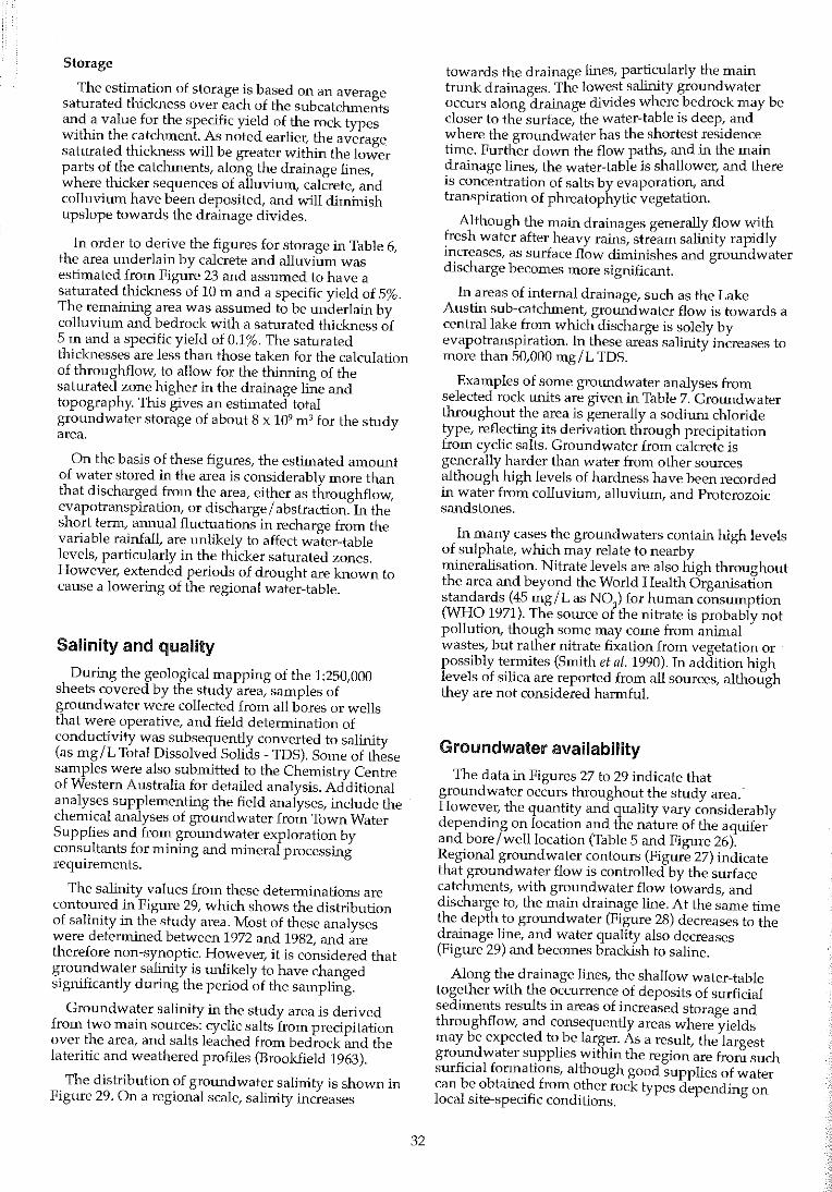
Storage
The estimation of storage is based on an average saturated thickness over each of the subcatchments and a value for the specific yield of the rock types within the catchment. As noted earliel; the average saturated thickness will be greater within the lower parts of the catchments, along the drainage lines, where thicker sequences of alluvium, calcrete, and colluvium have been deposited, and will diminish upslope towards the drainage divides.
In order to derive the figures for storage in Table 6, the area underlain by calcrete and alluvium was estimated from Figure 23 and assumed to have a saturated thickness of 10 m and a specific yield of 5%. The remaining area was assumed to be underlain by colluvium and bedrock with a saturated thickness of 5 m and a specific yield of 0.1%. The saturated thiclG1esses are less than those taken for the calculation of throughflow, to allow for the thimung of the saturated zone higher in the drainage line and topography. Thls gives an estimated total groundwater storage of about 8 x 10⁹ m 3 for the Shldy area.
On the basis of these figures, the estimated amount of water stored in the area is considerably more than that discharged from the area, either as throughflow, evapotranspiration, or discharge/ abstraction. In the short term, annual fluctuations in recharge from the variable rainfall, are unlikely to affect water-table levels, particularly in the thicker saturated zones. However, extended periods of drought are known to cause a lowering of the regional water-table.
Salinity and quality
During the geological mapping of the 1:250,000 sheets covered by the study area, samples of groundwater were collected from all bores or wells that were operative, and field determination of conductivity was subsequently converted to salinity (as mg/L Total Dissolved Solids - TOS). Some of these samples were also submitted to the Chemistry Centre of Western Australia for detailed analysis. Additional analyses supplementing the field analyses, include the chemical analyses of groundwater from Town Water Supplies and from groundwater exploration by consultants for mining and mineral processing requirements.
The salinity values frOlll these determinations are contoured in Figure 29, which shows the distribution of salinity in the study area. Most of these analyses were determined between 1972 and 1982, and are therefore non-synoptic. However, it is considered that groundwater salinity is wl1ikely to have changed sigluficantly during the period of the sampling.
Groundwater salinity in the study area is derived frotTI two main sources: cyclic salts from precipitation over the area, and salts leached from bedrock and the lateritic and weathered profiles (Brookfield 1963).
The distribution of groundwater salinity is shown in Figure 29. On a regional scale, salinity increases
32
towards the drainage lines, particularly the main trunk drainages. The lowest salinity groWldwater occurs along drainage divides where bedrock may be closer to the surface, the water-table IS deep, and where the groundwater has the shortestresidenc~ time. Further down the flow paths, and 111 the mam drainage lines, the water-table is shallower, and there is concentration of salts by evaporatIOn, and transpiration of phreatophytic vegetation.
Although the main drainages generally flow with fresh water after heavy rains, stream salinity rapidly increases, as surface flow ditninishes and groundwater discharge becomes more significant.
In areas of internal drainage, such as the Lake Austin sub-catchment, groundwater flow is towards a central lake from which discharge is solely by evapotranspiration. In these areas salinity increases to more than 50,000 mg/L TOS.
Examples of some groWldwater analyses from selected rock wlits are given in Table 7. Groundwater throughout the area is generally a sodiwn chloride type, reflecting its derivation through precipitation from cyclic salts. Groundwater from calcrete is generally harder than water from other sources although high levels of hardness have been recorded in water from colluvium, alluvium, and Proterozoic sandstones.
In many cases the groundwaters contain high levels of sulphate, which may relate to nearby mineralisation. Nitrate levels are also high throughout the area and beyond the World Health Organisation standards (45 mg/L as N0
3) for human consumption
(WHO 1971). The source of the nitrate is probably not pollution, though some may come from animal wastes, but rather nitrate fixation from vegetation or possibly termites (Smith et al. 1990). In addition high levels of silica are reported from all sources, although they are not considered harmful.
Groundwater availabiiity
The data in Figures 27 to 29 indicate that groundwater occurs throughout the study area. However, the quantity and quality vary considerably depending on location and the nature of the aquifer and bore/well location (Table 5 and Fignre 26). Regional groundwater contours (Figure 27) indicate that groundwater flow is controlled by the surface catchments, with groundwater flow towards, and discharge to, the main drainage line. At the same time the depth to grotmdwater (Figure 28) decreases to the drainage line, and water quality also decreases (Figure 29) and becomes bracldsh to saline.
Along the drainage lines, the shallow water-table together with the occurrence of deposits of surficial seditnents results in areas of increased storage and throughflow, and consequently areas where yields may be expected to be larger. As a result, the largest groundwater supplies withln the region are from such surficial formations, although good supplies of water can be obtained from other rock types depending on local site-specific conditions.
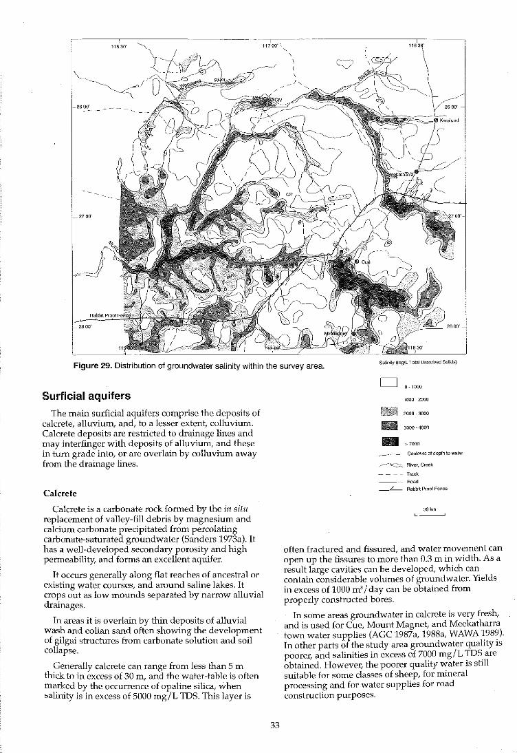
27 00'
I 11700'\ ,
\
\ I \
_I,
Figure 29. Distribution of groundwater salinity within the survey area. Salinity (mglL Total Dissolved Sotids)
Surficial aquifers
The main surficial aquifers comprise the deposits of calcrete, alluvium, and, to a lesser extent, colluvium. Calcrete deposits are restricted to drainage lines and may interfinger with deposits of alluvium, and these in turn grade into, or are overlain by colluvium away from the drainage lines.
Calcrete
Calcrete is a carbonate rock formed by the il1 situ replacement of valley-fill debris by magnesium and calcium carbonate precipitated from percolating carbonate-saturated groundwater (Sanders 1973a). lt has a well-developed secondary porosity and high permeability, and forms an excellent aquifer.
lt occurs generally along flat reaches of ancestral or existing water courses, and around saline lakes. It crops out as low Inounds separated by narrow alluvial drainages.
In areas it is overlain by thin deposits of alluvial wash and eolian sand often showing the development of gilgai structures from carbonate solution and soil collapse.
Generally calcrete can range from less than 5 m thick to in excess of 30 m, and the water-table is often marked by the occurrence of opaline silica, when salinity is in excess of 5000 mg/L TDS. This layer is
33
D 0·1000
1000 ·2000
2000·3000 - 3000 ·4000 -______ Contours of depth to water
______ -c---~-::c_::._ River, Creek
----Track
Road
-L- Rabbit Proof Fence
30 km
often fractured and fissured, and water movelnent can open up the fissures to more than 0.3 m in width. As a result large cavities can be developed, which can contain considerable volumes of groundwater. Yields in excess of 1000 m'l day can be obtained from properly constructed bores.
In some areas groundwater in calcrete is very fresh, and is used for Cue, Mount Magnet, and Meekatharra town water supplies (AGC 1987a, 1988a, WAWA 1989). In other parts of the study area groundwater quality IS
poorer, and salinities in excess of 7000 mg/L TDS are obtained. Howevel; the poorer qualIty water IS stIll suitable for Some classes of sheep, for mineral processing and for water supplies for road construction purposes.
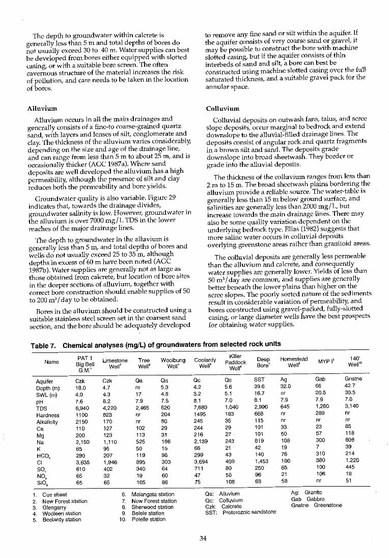
The depth to groundwater within calcrete is generally less than 5 m and total depths of bores do not usually exceed 30 to 40 m. Water supplies can best be developed from bores either equipped with slotted casing, or with a suitable bore screen. The often cavernous structure of the material increases the risk of pollution, and care needs to be taken in the location of bores.
Alluvium
Alluvium occurs in all the main drainages and generally consists of a fine-to coarse-grained quartz sand, with layers and lenses of silt, conglomerate and clay. The thickness of the alluvium varies considerably, depending on the size and age of the drainage line, and can range from less than 5 m to about 25 m, and is occasionally thicker (AGC 1987a). Where sand deposits are well developed the alluvium has a high permeability, although the presence of silt and clay reduces both the permeability and bore yields.
Groundwater quality is also variable. Figure 29 indicates that, towards the drainage divides, groundwater salinity is low. However, groundwater in the alluvium is over 7000 mg/L TDS in the lower reaches of the major drainage lines.
The depth to groundwater in the alluvium is generally less than 5 m, and total depths of bores and wells do not usually exceed 25 to 35 m, although depths in excess of 60 m have been noted (AGC 1987b). Water supplies are generally not as large as those obtained from calcrete, but location of bore sites in the deeper sections of alluvium, together with correct bore construction should enable supplies of 50 to 200 m'l day to be obtained.
Bores in the alluvium should be constructed using a suitable stainless steel screen set in the coarsest sand section, and the bore should be adequately developed
to remove any fine sand or silt within the aquifer. If the aquifer consists of very coarse sand or gravel, it may be possible to construct the bore with machine slotted casing, but if the aquifer consists of thin interbeds of sand and silt, a bore can best be constructed using machine slotted casing over the full saturated thickness, and a suitable gravel pack for the annular space.
Colluvium
Colluvial deposits on outwash fans, talus, and scree slope deposits, occur marginal to bedrock and extend downslope to the alluvial-filled drainage lines. The deposits consist of angular rock and quartz fragments in a brown silt and sand. The deposits grade downslope into broad sheetwash. They border or grade into the alluvial deposits.
The thickness of the colluvium ranges from less than 2 m to 15 m. The broad sheetwash plains bordering the alluvium provide a reliable source. The water-table is generally less than 15 m below ground surface, and salinities are generally less than 2000 mg/L, but increase towards the main drainage lines. There may also be some quality variation dependent on the underlying bedrock type. Elias (1982) suggests that more saline water occurs in colluvial deposits overlying greenstone areas rather than granitoid areas.
The colluvial deposits are generally less permeable than the alluvium and calcrete, and consequently water supplies are generally lower. Yields of less than 50 m 31 day are common, and supplies are generally better beneath the lower plains than higher on the scree slopes. The poorly sorted nature of the sediments result in considerable variation of permeability, and bores constructed using gravel-packed, fully-slotted casing, or large diameter wells have the best prospects for obtaining water supplies.
Table 7. Chemical analyses (mg/L) of groundwaters from selected rock units
Name PAT 1 Limestone Tree Woolbung Coolardy Killer
Deep Homestead 140' Big Bell Paddock MYP I' G.M.I
Wellz Well3 WeW Well5
WellS Bore1 Wella Well1!l
Aquifer Czk Czk Qa Qa Qc Qc SST Ag Gab Gnstne Depth (m) 18.0 4.7 nr 5.3 4.2 5.6 39.6 32.0 66 42.7 SWL (m) 4.0 4.3 17 4.8 3.2 5.1 16.7 nr 20.5 30.5 pH 7.6 8.2 7.9 7.5 8.1 7.0 8.1 7.9 7.9 7.8 TDS 6,940 4,220 2,465 620 7,680 1,040 2,990 645 1,280 3,140 Hardness 1100 823 nr 204 1495 183 668 nr 289 nr Alkalinity 2150 170 nr 80 245 35 115 nr nr nr Ca 110 127 102 29 244 29 101 33 23 85 Mg 200 123 113 31 216 27 101 50 57 118 Na 2,150 1,110 525 186 2,139 243 819 108 300 808 K 65 95 50 15 66 21 42 19 7 39 HCOa 290 207 119 98 299 43 140 76 310 214 CI 3,635 1,946 895 303 3,694 409 1,453 180 380 1,220 SO, 610 402 340 64 711 80 250 65 100 445 NO, 65 32 19 60 47 58 96 21 106 19 Si02 65 65 105 86 75 108 63 58 nr 51
1. Cue sheet 6. Maiangata station Qa: Alluvium Ag: Granite 2. New Forest station 7. New Forest station Qc: Colluvium Gab Gabbro 3. Glengarry 8. Sherwood station Czk: Calcrete Gnstne Greenstone 4. Wooleen station 9. Belele station SST: Proterozoic sandstone 5. Boolardy station 10. Polelle station
34
Sedimentary aquifers
Permian
The main occurrences of sedimentary rocks are in the north-west of the area, where Permian rocks of the Byro Sub-basin occur.
A limited number of bores are drilled into these rocks, but existing bore data indicate that groundwater flow is to the west. The depth to water also increases to the west, and the water-table may be in excess of 80 m. Salinity and quantity vary considerably. Water suitable for stock is generally obtainable from the Moogoo100 Sandstone, but parts of the sequence (e.g. Lyons Group) will yield larger supplies of potable quality water (Williams LR. et a1. 1983). Allen (1987) reports salinity in the Permian rocks ranging from 860 to 1930 mg/L TDS (Moogoo100 Sandstone) and 700 to 3230 mg/L TDS (Lyons Group), and indicates that a complex water-table exists and salinity and yields are highly variable.
Successful bores may need to exceed 100 m in the western part of the area, and drilling may need mud rotary techniques and geophysica110gging to locate optimal positions for bore screens to ensure adequate supplies.
Late Proterozoic
In the west, in the Late Proterozoic sedhnentary rocks of the Badgeradda Group, groundwater salinities range from about 2000 to 9000 mg/L TDS, with the more saline water derived from shale. Deep Bore (Table 7) is in sandstone and has a salinity of 2990 mg/L TDS.
Depth to water in the Badgeradda Group ranges from less than 5 m to more than 20 m below ground surface, depending on topography and bedrock type. Bores depths may range up to 60 m and future site selections should be aimed at locating drilling targets in sandstone, particularly where strong fracturing and/ or jointing occurs, and recharge has been enhanced. The sandstone should be competent enough to allow slotted casing to be used in bore construction, and yields of 50 to 100 m 3
/ day may be obtainable.
Early Proterozoic
The Early Proterozoic sedimentary rocks of the Padbury and Glengarry Groups occur in the extreme north-east of the area.
Limited bore data indicate that the groundwater in this area may be obtained from sandstone and dolomite sequences, and probably from banded ironformation. The water-table is between 5 m and 15 m below ground surface, and groundwater salinity ranges from 1000 to 2000 mg/L TDS. Bore yields range from 50 to 100 m' / day, although better supplies should be obtainable from fractured sections of the banded iron formation.
It is likely that, as with the Badgeradda Group, the formations should be competent enough to allow slotted bore casing to be used in bore construction.
35
Fractured rocks
Granitoids
The granitoid basement rocks consist of evengrained to porphyritic granite and adamellite, with some granodiorite and tonalite. In places they are deeply weathered to more than 40 m and small supplies of groundwater may be obtainable from within, or at the base of the weathered profile. Some groundwater may be intersected in exfoliation joints in the upper few metres of the fresh bedrock. However there is little evidence of bores exploiting this zone, and the main source of groundwater appears to be in the weathered profile.
Where groundwater associated with the granitoids is exploited, salinity ranges from 500 to 4000 mg/L TDS, with the lower salinity water occuring along the drainage divides, and increasing in salinity towards the drainage lines. Depths of bores are variable depending on the location of the site within the topography, but can range from 5 to 45 m. However, the higher in the topography the bore, the more likelihood that the supply will be small, and subject to large seasonal variations in the water-table levels.
Gneisses and migmatites
Groundwater generally occurs in the weathered profile, which usually has a high clay content. As a result salinities range from 2000 to 7000 mg/L TDS, though less saline groundwater can be obtained closer to the drainage divides, where salinities may be less than 1000 mg/L IDS. The depth to the water-table ranges from 12 to 15 m, and supplies are usually less than 10 m3 / day.
Greenstone belts
Drilling in the search for water for mineral processing, has mainly been on highly fractured and sheared zones in basalts and dolerites, some of which extend more than 100 m below ground level.
Bores have been drilled to depths greater than 100 m in several areas, but in these deep bores, static water levels range from 20 to 40 m. A wide range of yields, between 100 to 1800 m3
/ day, have been obtained, whilst salinity has generally ranged from 100 to 4000 mg / L IDS, although salinities in excess of 60,000 mg / L TDS have been obtained.
Conclusions
Regionally, the water requirements for the pastoral industry are generally small, and bore yields seldom exceed 10 m3
/ day, although larger supplies in excess of 20 m3 / day are available in areas of calcrete and thick alluvium. Water quality generally poses little problems as water with a salinity up to 7000 mg/L TDS can be utilised by stock. Shallow groundwater with a higher salinity is generally restricted to the main trunk drainages. Domestic supplies on pastoral leases are usually met from wells or bores, or from collection of rainwater from roof catchments.
On the basis of about 2000 bores and wells, with an 80% utilisation rate, pumping at 5 m'l day, groundwater consumption by the pastoral industry is about 2.9 x 10⁶ m'l annum. This is quite small compared with the estimated groundwater storage, and even allowing for groundwater discharge by throughflow and evapotranspiration, there appear to be satisfactory water resources to withstand short periods of drought.
References and bibliography A.G.e. (1987a). Groundwater scheme review-Cue. Australian
Groundwater Consultants Pty Ltd. Water Authority of Western Australia, Water Resources Directorate, Report No. WG26.
A.G.c. (1987b). Big Bell Gold Project water supply, groundwater investigations (Unpublished report).
A.C.C. (1988a). Groundwater scheme review-Mt Magnet. Australian Groundwater Consultants Pty Ltd. Water Authority of Western Australia, Water Resources Directorate, Report No. WG11.
Allen, A.D. (1987). Groundwater. In: Geology of the Carnarvon Basin, Western Australia. Western Australia Geological Survey, Bulletin 133.
Baxter, J.L. (1972). Regional hydrogeology of the Murgoo 1:250,000 sheet SG / 50-14, Western Australia. Western Australia Geological Survey;. Record 1971/14.
Baxter, J.L. (1974). Murgoo, WA. Western Australia Geological Survey, Explanatory Notes SG / 50-7.
Baxter, J.L., Lipple, S.L. and Marston, RJ. (1983). Kirkalocka, WA. Western Australia Geological Survey. Explanatory Notes, SH/SO-3.
Berliat, K. (1957). Report on hydrogeological reconnaissance in the Mul1ewa District. Western Australia Geological Survey, Bulletin 112, 22 pp.
Brookfield, M. (1963). Water Supply in the Wiluna-Meekatharra area. In: Lands of the Wiluna-Meekatharra Area, Western Australia, 1958. CSIRO Land Research Series No.7.
Clarke, E. De e. (1916). The geology and ore deposits of Meekatharra, Murchison Goldfield. Western Australia Geological Survey;. Bulletin 68.
De La Hunty;. L.E. (1973). Cue, WA. Western Australia Geological Survey;. Explanatory Notes SG/50-8.
Department of National Resources (1976). 1975 Review of Australia's water resources and water use. AGPS.
Department of Primary Industries and Energy (1987). 1985 Review of Australia's water resources and water use, Volume I, water resources data set. AGPS.
Department of Resources and Energy (1983). Water 2000. A perspective on Australia's water resources to the year 2000. AGPS.
Elias, M. (1982). Belele, WA. Western Australia GeolOgical Survey, Explanatory Notes SG / 50-4.
Elias, M., Bunting, J.A. and Wharton, P.H. (1982). Glengarry, WA. Western Australia Geological Survey, Explanatory Notes SG / 50-12.
Elias, M. and Williams, S.r (1980). Robinson Range, WA. Western Australia Geological Survey, Explanatory Notes SG/50-7.
Ellis, HA. (1936a). Proposed water supply for Tuckanarra Battery;. Murchison Goldfield. Western Australia Geological Survey, Annual Report for 1935, 13 pp.
Ellis, H.A. (1936b). The location of a bore site for water at Gnaweeda Station, Meekatharra. Western Australia Geological Survey; Annual Report for 1935, 14 pp.
36
Ellis, H.A (1953). Report on underground water supplies in the area east of Wiluna. Western Australia Geological Survey, Annual Report for 1951, pp. 9-12.
Gee, R.D., Baxtel~ J.L., Wilde, S.A. and Williams, LR. (1981). Crustal development in the Yilgarn Block. In: Archaean geology (Eds J.E. Glover and D.l. Groves); International Archaean Symposium, 2nd, Perth, WA 1980. Proceeding, Western Australia Geological Society of Australia, Special Publications, No.7, pp. 43-56.
Gee, R.D., Myers, J.S. and Trendall, AF. (1986). Relation between Archaean high-grade gneiss and granite-greenstone terrain in Western Australia. Precambrian Research 33: 87-102.
Geological Survey of Western Australia (1990). Geology and Mineral Resources of Western Australia. Western Australia Geological Survey;. Memoir 3.
Johnson, W. (1950). A geological reconnaissance survey of parts of the Yalgoo, Murchison, Peak Hill, and Gascoyne Goldfields. Western Australia Geological Survey Bulletin 106.
Jutson, J.T. (1950). The physiography (geomorphology) of Western Australia. Western Australia Geological Survey;. Bulletin 95.
Mabbutt, J.A. (1963). Geomorphology of the Wiluna-Meekatharra area: In: Lands of the Wiluna-Meekatharra area, Western Australia, 1958. CSIRO Land Research Series No.7.
Maitland, A.G. (1908). Artesian water boring in the Murchison, Gascoyne, and Kimberley Districts. Western Australia Geological Survey, Annual Report for 1907, 5 pp.
Morgan, KH. (1965). Hydrogeology of the East Murchison and North Coolgardie Goldfields area. Western Australia Geological Survey, Record 1965/16.
Muhling, Ee. and Low, G.H. (1977). Yalgoo, WA Western Australia Geological Survey;. Explanatory Notes, SH/50-2.
Myers, J.S. (1988). Early Archaean Narryer Gneiss Complex, Yilgarn Craton, Western Australia. Precambrian Research 38: 309-324.
Myers, J.S. (1990). Western Gneiss Terrane. In: Geology and mineral resources of Western Australia. Western Australia GeolOgical Survey, Memoir 3, pp. 13-31.
Sanders, c.e. (1969a). Hydrogeological reconnaissance of calcrete areas in the East Murchison and Mount Margaret Goldfields. Western Australia Geological Survey;. Record 1969/1.
Sanders, e.e. (1969b). Hydrogeological reconnaissance of calcrete areas in the East Murchison and Mount Margaret Goldfields. Western Australia Geological Survey, Annual Report for 1968, pp.14-17.
Sanders, c.e. (1971). Paroo Calcrete hydrogeological investigationinterim report. Western Australia Geological Survey, Record 1971/2.
Sanders, e.c. (1973a). Calcrete in Western Australia. Western Australia Geological Survey, Annual Report for 1973, pp. 12-14.
Sanders, e.e. (1973b). Hydrogeology of a calcrete deposit on Paroo Station, Wiluna, and surrounding areas. Western Australia Geological Survey, Annual Report for 1973, pp. 15-26.
Smith, GD., Lynch, R.H., Jacobsen, J. and Barnes, e.r (1990). Cyanobacterial nitrogen fixation in arid soils of Central Australia. FEMS Microbiology Ecology. 74: 79-90.
Tingey, RJ. (1985). Sandstone, WA. Western Australia Geological Survey, Explanatory Notes, SG/50-16.
WAWA (1989). Groundwater scheme review-Meekathana. Water Authority of Western Australia, Water Resources Directorate Report WG 42.
Watkins, KP. (1990). Murchison Province. In: Geology and mineral resources of Western Australia. Western Australia Geological Survey, Memoir 3, pp. 32-59.
Watkins, KP. and Hickman, AH. (1990). Geological evolution and mineralisation of the Murchison Province, Western Australia. Western Australia Geological Survey;. Bulletin 137.

Watkins, K.P., Tyler, I.M. and Hickman, A.H. (1987). Cue, WA. Western Australia Geological Survey, Explanatory Notes scI 50-8, 2nd Edition.
WHO (1971). International drinking-water standards. 3rd Edition. World Health Organisation, Geneva.
Williams, I.R., Walker, LW., Hockin& RM. and Williams, S.J. (1983). Byro, WA Western Australia Geological Survey, Explanatory Noles SG/50-3.
Williams, SJ, Williams, lR. and Hocking, RM. (1983). Glenburgh, WA Western Australia Geological Survey, Explanatory Notes SG/51-1.
37
The Survey
Methods
General approach
This survey adopted the land system approach to resource description and evaluation, as used for previous rangeland resource surveys in Western Australia (Wilcox and McKinnon 1972, Payne et a1. 1979,1982,1987, 1992, Mitchell et al. 1979).
The land system approach to the management of rangelands, in Australia and overseas, has withstood the test of time. This approach maps the component lands of extensive arid and semi-arid regions, in a natural classification at the smallest scale which is usefully applicable for planning land use, management and infrastructure design across very broad catchments.
Christian and Stewart (1953, 1968) defined a land system as 'an area or group of areas throughout which there is a recurring pattern of topography, soil and vegetation'. Each land system has characteristic patterns able to be seen on aerial photographs and other forms of remotely sensed images. Discrete areas of a land system mostly occur in areas greater than 5 km' and are therefore of a scale suitable for mapping at 1:250,000. Land systems consist of a number of smaller land units or elements, each of which has a distinctive photographic pattern. The relative proportion of the component units and their arrangement one to another gives the broader three dimensional pattern that characterises the particular land system.
Exhaustive effort was made to maximise the objectivity of the assessment of soil and vegetation resources by adopting a consistent, innovative, quantitative approach.
Field work program As a preliminary to fieldwork, tentative. land .
systems and their likely boundarIes were ldentified and marked onto the most recently available (mainly) 1:50,000 scale black and white stereo aerial photographs (Table 8). Published back?,ound . information on geology, landforms, SOlIs, vegetatIOn and land system classifications was available from several sources. These included the Geologrcal Survey of Western Australia (1:250,000 map sheet series), Bettenay et al. (1967), Beard (1976), Payne et al. (1987), Wilcox et a1. (1972) and Mabbutt et al. (1963). False colour images generated from Landsat (multi-spectral scanner) data were also used to provide broad overviews of the area.
Topographical and pastoral lease infrastructural features such as roads, fences, tracks and watering points were also identified and marked up on the aerial photographs before fieldwork started.
The program of field work was carried out between June 1985 and March 1988, with a total of 32 weeks of fieldwork undertaken by the full team:
Rangeland Advisers P.J. Curry, A.L. Payne Staff SurVeyor K.A. Leighton Navigator /Draftsperson J. Neil Soil Technician P. Hennig (and S.J. Fritz) Senior Survey Hand L.J. Merritt Botanist RJ. Cranfield (WA
Herbarium)
The methodology to achieve consistent coverage and assessment of the whole area was designed after five weeks of reconnaissance surveys. Development of efficient and appropriate field techniques was the focus during this initial stage before beginning systematic coverage in October 1985.
Table 8. Aerial photography used for the survey's mapping
Sheet Runs Film no. Scale Date flown
AJANA 4 WA2092 1 :50,000 28.09.82
BELELE 1,13,14 WA2308 1 :50,000 28.06.85 2-6 WA2309 1 :50,000 27.06.85 7-12 WA 2310 1 :50,000 28.06.85
BYRO 7 WA 2187 1 :65,000 13.12.83 8-10 WA2186 1 :65,000 13.12.83
CUE 1-4 WA2015 1 :50,000 28.10.81 5,6 WA2027 1 :50,000 16.12.81 7-14 WA 2011 1 :50,000 06.10.82
GLENBURGH 8-14 WA 2291 1 :50,000 19.03.85
KIRKALOCKA 1-3 WA 1841 1 :50,000 22.11.79
MURGOO 1-4 WA2015 1 :50,000 15.12.81 5-9 WA2027 1 :50,000 17.12.81 10-14 WA2028 1 :50,000 17.12.81
ROBINSON RANGE 7-11 WA2304 1 :50,000 01.06.85 12-14 WA2305 1 :50,000 01.06.85
YALGOO 1,2 WA2103 1 :50,000 05.12.82
38
A series of 209 pre-planned traverses (see Figure 30) was used, each generally 50 to 150 kIn long, to obtain lines of ground access and proximity to sampling points and sites in each part of the area.
GLENBURGH ROBINSON RANGE
100 . kilometres
Figure 30. Traverse routes, Murchison rangeland survey.
The total coverage achieved by the main survey program included:
• 13,621 km of traverse and point assessments;
• 679 inventory sites; and
• 1289 condition assessment sites.
Key features of the fieldwork included:
" involvement of station managers/ owners wherever possible;
9 traverse coverage (point assessments, land system boundary definition and air photography mark-up);
e sampling inventory sites;
• delineation of severely degraded and eroded areas;
G sampling condition sites;
• identification and collection of geological, soil and plant specimens;
" collation of data and ad hoc reviews of cumulative progress;
co referral to existing maps and literature;
• maintaining a consistent photographic record.
Involvelnent of the pastoral community was a vital part of the fieldwork, the total success of which would not have been possible without the continuous support and cooperation of individual pastoral families. In about two-thirds of all instances,
39
pastoralists accompanied the survey team during some of the fieldwork on their leases and provided current information on aspects of station infrastructure, management, history;. ecology and sociology. First hand experience of the local area and of the operational methods and approaches taken by the survey team was exchanged in this way.
Component techniques during fieldwork
Land system mapping
PrelirninarYf tentative boundaries and designations of land systems were identified and marked on aerial photographs, under stereo, before each traverse and subsequent ground truthing. Boundaries and designations were then modified in the field as necessary. After fieldwork was completed, the land system definitions were finalised and the entire land system classification of the area revised. The boundaries and designations of each land system polygon were revised accordingly and checked twice before mapping started.
Topographical and lease infrastructural updating (for pastoral lease plans)
During the fieldwork the position of station tracks, fences and water points, previously identified on the aerial photographs in the office, were validated wherever possible. Any anomalies were usually resolved in consultation with the pastoralist I manager. New infrastructure developed after the aerial photographs were taken was also positioned and marked on the photographs.
As an adjunct to this rangeland survey, a separate survey program, to identify the boundaries of all leases within the area, was initiated by the Department of Land Administration in 1987. This entailed a thorough research of historical records of previous lease definition and subsequent relocation and resurvey of many of the original survey markers. Leases previously unmarked were also physically defined and it is now possible to relate achlal occupational boundaries (i.e. boundary fences) to administrative boundaries for the first time.
Land system and unit description through inventory sites
As a major part of field activities, basic land resource data were compiled from site observations collected at inventory sites. Each inventory site (I site) was pre-selected from aerial photographs as being representative of a particular element of the photopattern. Generally, these elements of photo-patterns approximate to land units, or a recognisable part of. land units on the ground. Figure 31 shows the 10catlOn of inventory sites within the survey area.
Sites were selected according to:
• aerial photo-pattern and land unit identification;
• the cumulative coverage of such sites achieved at that time;
• the relative abundance of the type of photopattern or land unit within the broader land system; and
• the degree to which the site was likely to have been subjected to grazing pressures, or other known management (or envirorunental) impacts.
The location of each site was marked on the aerial photograph for future incorporation into the resource map base. The site itself was defined as an area within 100 m radius of the photo-point if the land unit being sampled was> 200 m wide, or if smaller, was bounded by the physical boundaries of the unit. Site data were recorded on standard sheets (Appendix 4).
GLENBURGH
, " .... . ',. ." -;. .
'. , '
' ..
. '.
; . . ,,' . '
• '. { BYRQ • : ", .. ','. " . ..
"
.. ,
, ,
ROBINSON RANGE
" . '.
.. ., . " " . , ..
, . BELELE. ~ .
, .
." .
' . , , : ... ..
• ~ t. • •. .' '. ":' · \ . ".. . '.\~' ..... , '. ". .. ...... "
, .' : ,0, . '. . , '. "'~" ': . ':
• *, CUE' .,. . . ... . .:. \ .. ': ~ . • .... '. .: 't ., ...
· . ::',
kliomulr.1
Figure 31. Inventory sites, Murchison rangeland survey.
Technical data collected routinely at inventory sites were as below. Additional notes and sketches of site attributes and special features of interest were also recorded. Such notes enable the recorder to recall (and a reader to appreciate) particular aspects of the sites much more clearly at a later date.
Logistics allowed up to one hour to make an inventory of soil, vegetation and landform at each site.
General
• Aerial photograph: year, map sheet, run and number
• Site number
• Land system and unit
40
• Pastoral lease name
• Date
• Compass bearing showing direction of oblique ground photograph of site
Physical environmen t
• Slope (in per cent)
• Geology (according to the 1:250,000 Geological Survey series)
• Site geology - if different to the above
• Surface mantle: abundance, shape, size and type
• Outcrop abundance and type
• Accelerated erosional features and their extent (Table 11)
• Vegetation condition rating (Table 10)
Vegetation
• Vegeta tion type
• Total projected foliar cover (PFC) by all canopies of perennial shrubs and trees
• The dominant species and order of cover dominance of each stratum of perennial vegetation
• Cover class for perennial grasses
• List of perennial plant species
Soil
In most cases both soil pit and auger observations were used to make profile descriptions. A grad uated soil auger of 5 em diameter was used to retrieve soil to a depth of 1 m or until underlying hard rock or substrate was encountered. In conjunction with the graduated auger, a pit up to 50 cm deep allowed boundaries for the upper layers of the soil to be described.
Soil profiles were described using the techniques and standards given in the Australian Soil and Land Survey Field Handbook (McDonald et al. 1984) and by Northcote (1979).
Soil textures were determined for the fine earth « 2 mm) fraction after sieving out the coarse fragments. The sieved fraction was moistened and the behaviour of the kneaded soil recorded. Soil textures were determined throughout the soil profile and used to characterise the different layers. Data recorded included:
• Principal profile form (Northcote 1979)
• Total soil depth
• Soil substrate
• Soil surface type
• Observation method
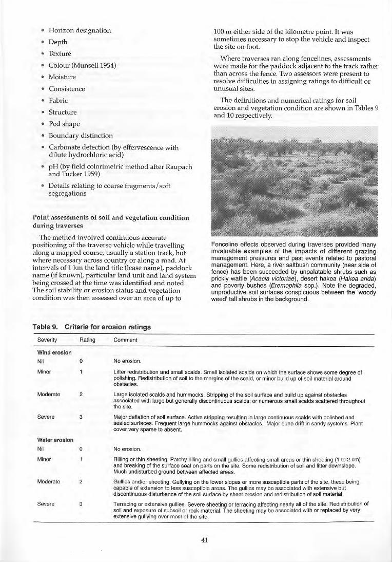
• Horizon designation
• Depth
• Texture
• Colour (Munsell 1954)
• Moisture
• Consistence
• Fabric
• Structure
• Ped shape
• Boundary distinction
• Carbonate detection (by effervescence with dilute hydrochloric acid )
• pH (by field colorimetric method after Raupach and Tucker 1959)
• Details relating to coarse fragments/soft segregations
Point assessments of soil and vegetation condition during traverses
The method involved continuous accurate positioning of the traverse vehicle while travelling along a mapped course, usually a station track, but where necessary across country or along a road. At intervals of 1 krn the land title (lease name), paddock name (if known), particular land unit and land system being crossed at the time was identified and noted. The soil stability or erosion status and vegetation condition was then assessed over an area of up to
Table 9. Criteria for erosion ratings
Severity Rating Comment
Wind erosion
Nil 0 No erosion.
100 m either side of the kilometre point. It was sometimes necessary to stop the vehicle and inspect the site on foot.
Where traverses ran along fencelines, assessments were made for the paddock adjacent to the track rather than across the fence. Two assessors were present to resolve difficulties in assigning ratings to difficult or unusual sites.
The definitions and numerical ratings for soi l erosion and vegetation condition are shown in Tables 9 and 10 respectively.
Fenceline effects observed during traverses provided many invaluable examples of the impacts of different grazing management pressures and past events related to pastoral management. Here, a river saltbush community (near side of fence) has been succeeded by unpalatable shrubs such as prickly wattle (Acacia victoriae) , desert hakea (Hakea arida) and poverty bushes (Eremophila spp.). Note the degraded, unproductive soil surfaces conspicuous between the 'woody weed' tall shrubs in the background.
Minor Litter redistribution and small scalds. Small isolated scalds on which the surface shows some degree of polishing. Redistribution of soi l to the margins of the scald, or minor build up of soil material around obstacles.
Moderate 2
Severe 3
Water erosion
Nil 0
Minor
Moderate 2
Severe 3
Large isolated scalds and hummocks. Stripping of the soil surface and build up against obstacles associated with large but generally discontinuous scalds; or numerous small scalds scattered throughout the site.
Major deflation of soil surface. Active stripping resulting in large continuous scalds with polished and sealed surfaces. Frequent large hummocks against obstacles. Major dune drift in sandy systems. Plant cover very sparse to absent.
No erosion.
Rilling or thin sheeting. Patchy rilling and small gullies affecting small areas or thin sheeting (1 to 2 cm) and breaking of the surface seal on parts on the site. Some redistribution of soil and litter downslope. Much undisturbed ground between affected areas.
Gullies and/or sheeting. Gullying on the lower slopes or more susceptible parts of the site, these being capable of extension to tess susceptible areas. The gullies may be associated with extensive but discontinuous disturbance of the soi l surface by sheet erosion and redistribution of soil material,
Terracing or extensive gullies. Severe sheeting or terracing affecting nearly all of the site. Redistribution of soil and exposure of subsoil or rock material. The sheeting may be associated with or replaced by very extensive gullying over most of the site.
41

Table 10. Criteria for vegetation condition ratings
Rating Condition indicators
Excellent or very good. For the land unit-vegetation type, the site's cover, structure and composition of shrubs, pe~ennial herbs and grasses is near optimal, free of obvious reduction in palatable species or increases in unpalatable species.
2 Good. Perennials present include all or most of the palatable species expected; some less palatable or unpalatable species may have increased, but total perennial cover is not very different from the optimal.
3 Fair. Moderate losses of palatable perennials and/or increases in unpalatable shrubs or grasses, but most palatable species and stability desirables still present; foliar Gover is less than on comparable sites rated 1 or 2 unless unpalatable species have increased.
4 Poor. Conspicuous losses of palatable perennials; foliar cover is either decreased through a general loss of perennials or is increased by invasion of unpalatable species.
5 Very poor. Few palatable perennials remain; cover is either greatly reduced, with a loss of the normal structural community and much bare ground arising from loss of stability desirables, or has become dominated by a proliferation of unpalatable species.
Traverse assessment symbols on the 1:250,000 maps
Map symbols depicting both vegetation condition and soil erosion status were devised to depict land resource conditions simply and visually across the maps of the area.
The design of the circular symbol (Figure 32) was based on the central part of the symbol representing perennial vegetation and the outer part of the symbol representing the soil.
Traverse points with vegetation in good condition are represented by a small filled inner circle. Where soil surfaces were also in good condition, i.e. with no evidence of accelerated erosion, the outer zone of the circle is also filled, making the resulting symbol appear as a larger, circular spot. At the opposite end of the condition spectrum, vegetation in poor condition (unfilled inner circle) is associated with lost (severely eroded) soil surfaces, which are depicted by a disintegration of the outer circle.
The intermediate states of condition for both vegetation and soil surfaces are thus depicted as partfilled inner and outer circles, in accordance with the combinations of condition status indicated by the twoway table in the map key.
Z 0 (f)
0 tY w --' 0 (f)
Nil
Minor
TRAVERSE ASSESSMENT SYMBOLS
VEGETATION CONDITION
Good Fair Poor
e Q 0 • Q 0
Moderate ~ ~ (() Severe 0 '::::.11
The more "lied the symbol. the belter the condItIon
Figure 32. Traverse assessment symbols, Murchison rangeland survey.
42
Assessment of vegetation and soil condition at preselected 'condition sites'
The quantitative approach used for such assessments represents a departure from previous regional rangeland surveys. Quantitative data were collected at pre-selected sampling sites (C sites, a standard recording sheet is attached as Appendix 4) throughout the survey area (see Figure 33), in order to characterise the full pattern of condition states and management-related changes within the major, productive land units. A further aim was to elucidate the most powerful indicators of soil and vegetation status. Indicators, whether qualitative or quantitative in nature, would be of value in the diagnosis of successful land conservation (in the absence of change) on the one hand and in the evaluation of change (towards desirable objectives in recovery from degraded states) on the other.
The condition site approach was designed during the reconnaissance survey fieldwork to investigate various site attributes which could be reasonably hypothesised as likely key variables of cumulative pastoral management impact, and to reflect states of condition in the long term (rather than seasonal) sense. Major considerations in the design of the field methods were:
1. time-efficiency to enable reasonable samples of equivalent sites to be accumulated over the course of the major survey;
2. stratification in relation to pastoral management infrastructure, in order that particular null hypotheses (e.g. no difference in an attribute in relation to grazing distance from a stock watering point) could be tested to elucidate effects related to pastoral management impacts; and
3. addressing the scale of within-site environmental patterning realistically, so that quantitative data collected would be truly representative of the vegetation type and land unit in that part of a paddock or other management unit.
Five quantitative methods were developed to investigate specific vegetation types. Many vegetation types were sampled during the survey, with great disparities in the numbers of sites eventually sampled for each type. Summary quantitative data are
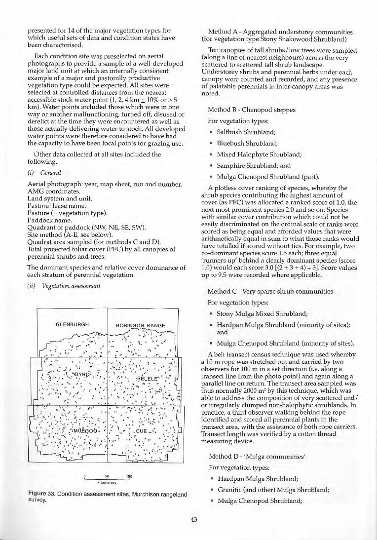
presented for 14 of the major vegetation types for which useful sets of data and condition states have been characterised.
Each condition site was preselected on aerial photographs to provide a sample of a well-developed major land unit at which an internally consistent example of a major and pastorally productive vegetation type could be expected. All sites were selected at controlled distances from the nearest accessible stock water point (I, 2, 4 km ± 10% or> 5 km). Water points included those which were in one way or another malfunctioning, turned off, disused or derelict at the time they were encountered as well as those actually delivering water to stock. All developed water points were therefore considered to have had the capacity to have been focal points for grazing use.
Other data collected at all sites included the following.
(i) General
Aerial photograph: year, map sheet, run and number. AMG coordinates. Land system and unit. Pastoral lease name. Pasture (~vegetation type). Paddock name. Quadrant of paddock (NW, NE, SE, SW). Site method (A-E, see below). Quadrat area sampled (for methods C and D). Total projected foliar cover (PFC) by all canopies of perennial shrubs and trees.
The dominant species and relative cover dominance of each stratum of perennial vegetation.
(ii) Vegetation assessment
GLENBURGH ROBINSON RANGE
.' , .' I • ~ t ..... ,'r
", ' . .. ,' .
. ..; .,:
. " " . .. '.
.. .; . ~ " '"
, . . , " • • +
", ,"
/'.... . ' . . .. ... • ". # ,'.', ... ,' *. ~.. ." ,01,"
".," _:1": ,f' .... "~'''~. '\: '-:. 0'. " j .:: .t ....... SYRp ... :.· ~ ..••• .BE~ELE .. 1 ',j' • :. '!.:':: :.:,' , :.':" ' .. :: ',.... ~" n' .. '. - . . +: " :. ... .... :.'
. :' •••• ' -~ t "I, .,' + " I. " .' ...... ' ... ':"':'~. ". • • • ' .. ',... I I " '." . '. '. " .. ... .' J; '.f • . ,.
: .. • \' 0' ,* I ." . " ':' .:" • :"/', : •• : •• : •••• {, .... ~.' •• : , : ..... ... + . :.~ .~\. :~ .:'.,' ... : ': .1 ....... ': ... . ~ ... ' , ........... '.: ..•
, '.. \ ' : ".,".,:,: ,,'.' : .. ' #
• ,," f '.,t ,.Mu.aqob: :.:' \ .. ~ ~C·UE ... \·. . , ......... - .#: '. - ~
,,,.' .1 ,,, .~! \ ; . ... : •. : 't' : •• ..:: ".. . • ...... /. ': ', '
..... , ' . I •• , ....... : ... f ." .. ' ..' .... '. .
'-_"U' '. f.. ,-r----'-l--......:.: •. t" ; ...
.' " :
kilometres
Figure 33. Condition assessment sites, Murchison rangeland survey.
43
Method A - Aggregated understorey communities (for vegetation type Stony Snakewood Shrubland)
Ten canopies of tan shrubs/low trees were sampled (along a line of nearest neighbours) across the very scattered to scattered tan shrub landscape. Understorey shrubs and perennial herbs under each canopy were counted and recorded, and any presence of palatable perennials in inter-canopy areas was noted.
Method B - Chenopod steppes
For vegetation types:
• Saltbush Shrubland;
• Bluebush Shrub land;
• Mixed Halophyte Shrub land;
• Samphire Shrubland; and
• Mulga Chenopod Shrubland (part).
A plotless cover ranking of species, whereby the shrub species contributing the highest amount of cover (as PFC) was allocated a ranked score of 1.0, the next most prominent species 2.0 and so on. Species with similar cover contribution which could not be easily discriminated on the ordinal scale of ranks were scored as being equal and afforded values that were arithmetically equal in sum to what those ranks would have totalled if scored without ties. For example, two co-dominant species score 1.5 each; three equal 'runners up' behind a clearly dominant species (score 1.0) would each score 3.0 [(2 + 3 + 4) + 3]. Score values up to 9.5 were recorded where applicable.
Method C - Very sparse shrub communities
For vegetation types:
• Stony Mulga Mixed Shrub land;
• Hardpan Mulga Shrubland (minority of sites); and
• Mulga Chenopod Shrubland (minority of sites).
A belt transect census technique was used whereby a 10 m rope was stretched out and carried by two observers for 100 m in a set direction (i.e. along a transect line from the photo point) and again along a parallel line on return. The transect area sampled was thus normally 2000 m' by this technique, which was able to address the composition of very scattered and / or irregularly clumped non-halophytic shrub lands. In practice, a third observer walking behind the rope identified and scored all perennial plants in the transect area, with the assistance of both rope carriers. Transect length was verified by a cotton thread measuring device.
Method D - 'Mulga communities'
For vegetation types:
• Hardpan Mulga Shrubland;
• Granitic (and other) Mulga Shrubland;
• Mulga Chenopod Shrub land;
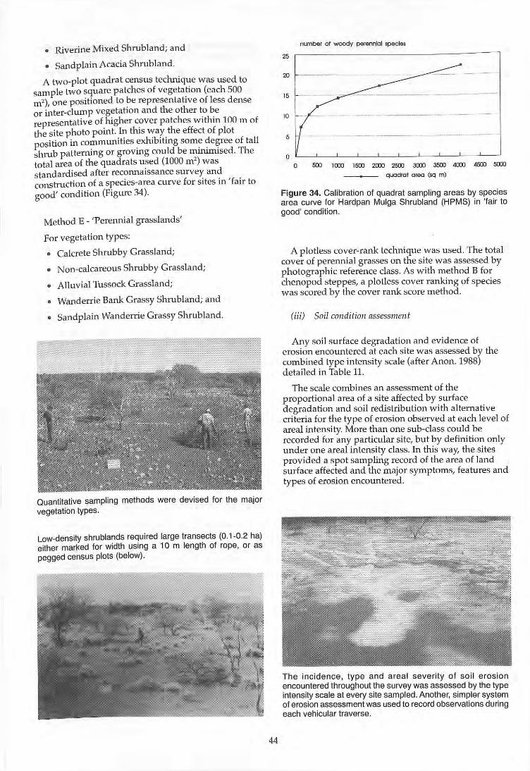
• Riverine Mixed Shrub land; and
• Sand plain Acacia Shrubland.
A two-plot quadrat census technique was used to sample two square patches of vegetation (each 500 m' ) one positioned to be representative of less dense or ~ter-clump vegetation and the other to be representative of higher cover patches within 100 m of the site photo point. In this way the effect of plot position in commumhes exhlblt1ng some de~ree of tall shrub patterning or grovmg could be ffiuuffil sed. The total area of the quadrats used (1000 m' ) was standardi sed after reconnaissance survey and construction of a species-area curve for sites in 'fair to good' condition (Figure 34).
Method E - 'Perennial grasslands'
For vegetation types:
• Calcrete Shrubby Grassland;
• Non-calcareous Shrubby Grassland;
• Alluvial Tussock Grassland;
• Wanderrie Bank Grassy Shrubland; and
• Sandplain Wanderrie Grassy Shrubland.
Quantitative sampling methods were devised for the major vegetation types.
Low-density shrublands required large transects (0. 1-0.2 hal either marked for width using a 10 m length of rope, or as pegged census plots (below).
44
number of woody perennial species
25 ~------------------,
15
10
5
o 500 100) 1500 200J 2500 3COO 3500 4O'XI 4SOO 500J
quadrat area (sq m)
Figure 34. Calibration of quadrat sampling areas by species area curve for Hardpan Mulga Shrubland (HPMS) in 'fair to good' condition.
A plotless cover-rank technique was used. The total cover of perennial grasses on the site was assessed by photographic reference class. As with method B for chenopod steppes, a plotless cover ranking of species was scored by the cover rank score method.
(iii) Soil condition assessment
Any soil surface degradation and evidence of erosion encountered at each site was assessed by the combined type intensity scale (after Anon. 1988) detailed in Table 11.
The scale combines an assessment of the proportional area of a site affected by surface degradation and soil redistribution with alternative criteria for the type of erosion observed at each level of areal intensity. More than one sub-class could be recorded for any particular site, but by definition only under one areal intensity class. In this way, the .sites p rovided a spot sampling record of the area of land surface affected and the major symptoms, features and types of erosion encountered .
The incidence, type and areal severity of soi l erosion encountered throughout the survey was assessed by the type intenSity scale at every site sampled. Another, simpler system of erosion assessment was used to record observations during each vehicular traverse.
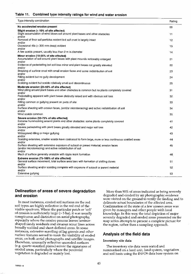
Table 11. Combined type intensity ratings for wind and water erosion
Type intensity combination
No accelerated erosion present
Slight erosion « 1 OOk of site affected) Slight accumulation of wind blown soil around plant bases and other obstacles and/or Removal of finer soil particles evident but soil crust is largely intact and/or Occasional rills « 300 mm deep) evident and/or A few scalds present, usually less than 2 m in diameter
Minor erosion (10-25% of Site affected) Accumulation of soil around plant bases with plant mounds noticeably enlarged and/or Evidence of pedestalling but soil loss minor and plant bases not greatly elevated and/or Breaking of surface crust with small erosion faces and some redistribution of soil and/or Rilling evident but no gully development and/or Scalding evident but scalds relatively small and discontinuous Moderate erosion (25-50% of site affected) Wind piling around plant bases and other obstacles is common but no plants completely covered and/or Pedestalling apparent with plant bases distinctly raised and with obvious soil loss and/or Rilling common or gullying present on parts of site and/or Suriace sheeting with erosion faces, (and/or microterracing) and active redistribution of soil and/or Wind scalds common
Severe erosion (50-75% of site affected) Extreme hummocking around plants and other obstacles: some plants completely covered and/or Severe pedestalling with plant bases greatly elevated and major soil loss and/or Widespread rilling or major gullying andlor Scalding extensive, smaller scalds have coalesced to form large, more or less continuous scalded areas and/or Surface sheeting with extensive exposure of subsoil or parent material; erosion faces (~nd/or microterracing) and active redistribution of soil and/or Much of suriace generally unstable with ripple mark formation
Extreme erosion (75-100% of site affected) General suriace movement, total surtace area bare with formation of shifting dunes and/or Surtace sheeting and/or scalding complete with exposure of subsoil or parent material and/or Extensive gullying
Rating
00
11
12
13
14
21
22
23
24
25
31
32
33
34
35
41
42
43
44
45
46
51
52
53
Delineation of areas of severe degradation and erosion
In most instances, eroded soil surfaces on the red soil types are highly reflective in the red end of the visible spectrum. Where the particular patch or 'cell' of erosion is sufficiently large (> 5 hal, it was usually conspicuous and distinctive on aerial photography, especially where the erosive process leaves laminarshaped sandy residuals and sinuous scour lines across broadly scalded and sheet-deflated areas. In some instances, extensive mantling of lag gravels and other surface features served to mask the visibility of eroded areas, on both aerial photographs and satellite images. Elsewhere, unusually reflective uneroded surfaces (e.g. quartz-mantled plains) mimic the signatures of eroded areas, particularly where the perennial vegetation is degraded or mainly lost.
More than 90% of areas indicated as being severely degraded and eroded by air photographic evidence were visited on the ground to verify the finding and to delineate actual boundaries of the affected area. Confirmation of the state of a few unseen areas was given by managers and other people with local knowledge. In this way, the total depiction of major severely degraded and eroded areas presented on the map series attempts to present a complete picture for the region, rather than a sampling approach.
45 16602--4
Analysis of the field data
Inventory site data
The inventory site data were sorted and summarised on a land unit, land system, vegetation and soil basis using the INF09 data base system on
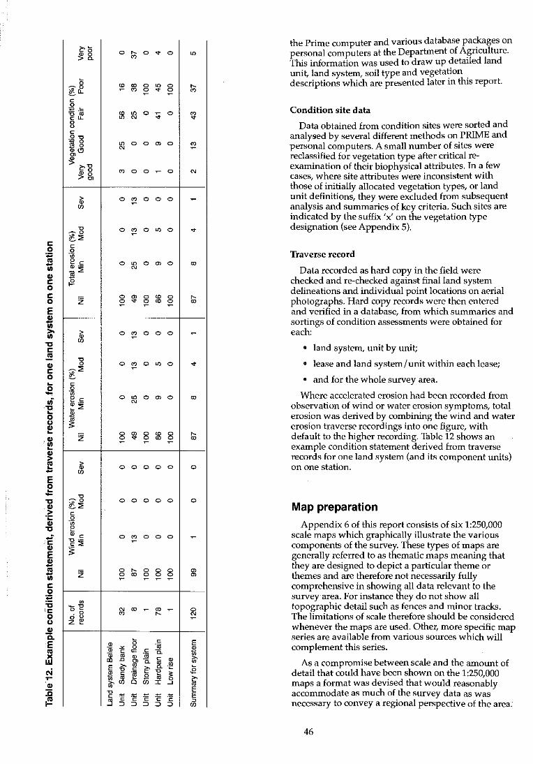
C o
~ .. C o C o E
f " C .!!! .. C o ~
.S! ui
i ~
'~
~ -E ,g " ~ .;: .. " ..: C .. E
~ C
.51 :t:
" 'C o (J .. "ii E
~ .. ~ .. :0 ~
~<;
~&.
<; -0 l-a.. e 0 ig .1ij eLL 0 0 e .2 '0 E g 1l,CJ :g
~-g
:%!&
> " (f)
"0 -0 ~~ e 0 'in e e " .-]j~ {?
Z
> " (f)
"0 0
-:. .s e .2 '" e e ~~ " 1il :;:
Z
> " (f)
"0 -0 ~:2 e 0 'in e " e "0 .-e:' ~
Z
'" 'O"E ·8
o " Z ~
0 .... '"
'" '" ~ '"
'" "' "' '"
"' 0
'"
'" 0
0 '" ~
0 '" ~
0 "' '"
0 ~ 0 ~
0 '" ~
0 '" ~
0 "' '"
0 en 0 ... ~
0 0
0 0
0 '" ~
0 .... 0 '" ~
'" '" '"
" c;
0; " 0 e 0=
0; '" " In .0 0> >, '" E "0 e
* e .~
'" >, (f) 0
'" "0 e ~
~ 5 E ~ ~
0 ... 0 "'
0 "' 0 .... 0 ... 0 '" ~ ~
0 :;;: 0 '" ...
0 en 0 ~
0 ~ 0 '"
0 0 0 ~
0 "' 0 ...
0 en 0 '"
0 '" 0 .... 0 '" 0 '" ~ ~
0 0 0 ~
0 "' 0 ...
0 en 0 '"
0 '" 0 .... 0 '" 0 '" ~ ~
0 0 0 0
0 0 0 0
0 0 0 ~
0 0 0 en 0 0 0 en ~ ~ ~
~ '" ~ 0 .... '" ~
e E e
. ,. i 0. .,.
e 0. " '" '" '" >, 0. .~
<2 e ~ ~ &l .3 ~ I '" E
'" ;g ''E E e ~ ~ ~ ~ (f)
the Prime computer and various database packages on personal computers at the Department of Agriculture. This information was used to draw up detaIled land unit, land system, soil type and vegetation . descriptions which are presented later In thIS report.
Condition site data
Data obtained from condition sites were sorted and analysed by several different methods on PRIME and personal computers. A small number of sites were reclassified for vegetation type after critical reexamination of their biophysical attributes. In a few cases, where site attributes were inconsistent with those of initially allocated vegetation types, or land unit definitions, they were excluded from subsequent analysis and summaries of key criteria. Such sites are indicated by the suffix 'x' on the vegetation type designation (see Appendix 5).
Traverse record
Data recorded as hard copy in the field were checked and re-checked against final land system delineations and individual point locations on aerial photographs. Hard copy records were then entered and verified in a database, from which summaries and sortings of condition assessments were obtained for each:
• land system, unit by unit;
• lease and land system/unit within each lease;
• and for the whole survey area.
Where accelerated erosion had been recorded from observation of wind or water erosion symptoms, total erosion was derived by combining the wind and water erosion traverse recordings into one figure, with default to the higher recording. Table 12 shows an example condition statement derived from traverse records for one land system (and its component units) on one station.
Map preparation
Appendix 6 of this report consists of six 1:250,000 scale maps which graphically illustrate the various components of the survey. These types of maps are generally referred to as thematic maps meaning that they are designed to depict a particular theme or themes and are therefore not necessarily fully comprehensive in showing all data relevant to the survey area. For instance they do not show all topographic detail such as fences and minor tracks. The limitations of scale therefore should be considered whenever the maps are used. Other, more specific map series are available from various sources which will complement this series .
As a compromise between scale and the amount of detail that could have been shown on the 1:250,000 maps a format was devised that would reasonably accommodate as much of the survey data as was necessary to convey a regional perspective of the area.
46
The traverse assessments have been shown on the maps as a series of symbols derived from the traverse data.
The maps depict the following major themes.
Cultural data
• Cadastral or property boundaries and identifiers.
• Topographic infrastructure - roads, watering points, towns, homesteads.
• Topographic features - lakes, rivers, creeks and ranges.
Resource data
• Land systems and land types.
• Severely degraded and eroded areas (sde).
• Inventory sites.
• Condition sites.
• Point traverse assessments.
These and other components are permanently archived on various levels within a computer (digital) mapping system and therefore allow great flexibility in the manipulation of this data to produce specific plans tailored for selective applications. A pastoral lease map for each station has been prepared at a scale of 1:100,000 and contains all the information shown on the published 1:250,000 scale series but with more detail of hydrological features and station infrastructure.
The major advantage of computer mapping is that changes and updates can be readily made. This facility also enables changes to station infrastructure (such as re-positioning of fences and mills) to be modelled and the management implications of the changes to be assessed.
Presentation of preliminary findings for the survey to the Murchison pastoral community
In recognition of the fact that the pastoral community needed to have early access to, and awareness of, the main patterns of survey findings, a preliminary presentation of results was made at a public meeting hosted by the Murchison Land Conservation District (and attended by members of the Meekatharra, Yalgoo, Cue and Mount Magnet LCDCs) on 11 May 1989. The meeting made a series of resolutions concerning ways to use the survey information and combat land degradation through management.
References Anon. (1988). The Western Australian rangeland mOnitoring system
for arid shrublands.lnstrudion manual, Part I, Field
47
operations (Ed. RB. Hacker). Deparhnent of Agriculhrre, Western Australia.
Beard, J.S. (1976). Vegetation survey of Western Australia, Murchison 1:100,000 vegetation series - Explanatory notes to sheet 6. University of Western Australia Press.
Bettenay, E., Churchwood, HM. and McArthur, W.H. (1967). Explanatory data for sheet 6, Meekatharra - Hamersley Range area. Atlas of Australian Soils, CSIRO, Melbourne University Press.
Christian, e.S. and Stewart, G.A (1953). General report on survey of Katherine-Darwin region 1946. CSIRO Land Research Series No. 1.
Christian, e.S. and Stewart, G.A (1968). Methodology of integrated survey. Aerial surveys and integrated studies, UNESCO, Paris, pp. 233-280.
Churchwood, H.M. and McArthur, W.H. (1967). Explanatory data for sheet 6 Meekatharra-Hamersley Range area, Atlas of Australian Soils. CSIRO, Melbourne University Press.
Curry, P.J. and Payne, AL. (1989). Rangeland surveys: a basis for improved land use. Journal of Agriculture, Western Australia 30: 111-115.
Geological Survey of Western Australia (various authors and dates). Explanatory notes 1:250,000 Geological series:
Glenburgh sheet Robinson Range sheet Byro sheet Belele sheet Murgoo sheet Cue sheet
Mabbutt, J.A, Litchfield, W.H., Speck, N.H., Sofoulis, J., Wilcox, D.G., Arnold, J.M. and Wright, RL (1963). General report on lands of the Wiluna-Meekatharra area, Western Australia 1958. CSIRO Land Research Selies No.7.
McDonald, RC., Isbell, RF., Speight, J.G., Walker, J. and Hopkins, M.S. (1984). 'Australian soil and land survey field handbook'. Inkata Press, Melbourne and Sydney.
Mitchell, A.A., McCarthy. R and Hacker, R.B. (1979). A range inventory and condition survey of part of the Western Australian Nullabor Plain, 1974. Department of Agriculture, Western Australia, Technical Bulletin No. 47.
Munsell Color Co. (1954). Soil color charts. Munsell Color Co., Baltimore, USA.
Northcote, KH. (1979).' A factual key for the recognition of Australian soils, 4th edition'. Rellim Technical Publications Pty Ltd, Glenside, South Australia.
Payne, AL., Kubicki, A, Wilcox, D.G. and Short, L.e. (1979). A report on erosion and range condition in the West Kimberley area of Western Australia. Department of Agriculture, Western Australia, Technical Bulletin No. 42.
Payne, AL., Mitchell, AA, and Holman, W.F. (1982). An inventory and condition survey of rangelands in the Ashburton River catchment, Western Australia. Department of Agriculture, Western Australia, Technical Bulletin No. 62.
Payne, AL., Curry, P.J. and Spencer, G.F. (1987). An inventory and condition survey of rangelands in the Carnarvon Basin, Western Australia. Department of Agriculture, Western Australia, Technical Bulletin No. 73.
Payne, AL. and Tille, PJ. (1992). An inventory and condition survey of the Roebourne Plains and surrounds, Western Australia. Department of Agriculture, Western Australia, Technical Bulletin No. 83.
Raupach, M. and Tucker, B.M. (1959). The field determination of soil reaction. Joumal of Australian Institute of Agricultural Science 25,129-33.
Wilcox, D.G. and McKinnon, E.A (1972). A report on the condition of the Gascoyne catchment. Deparhnent of Agriculrure, Western Australia.
land systems A final classification of 74 land systems is described
here, to comprise the entire land surface of the survey area. Thirty of the land systems are described for the first time; the remaining 44 have been described previously in adjacent areas. Those systems previously described are indicated by a letter (the report name) following the name in the general description and are as follows:
(W) Wiluna-Meekatharra survey (Mabbutt et al. 1963) to the east: 25 land systems in common.
(G) - Gascoyne catchment survey (Wilcox and McKinnon 1972) to the north: 16 systems.
(CB) - Carnarvon Basin survey (Payne et al. 1987) to the west: 3 systems.
In all cases, the descriptions focus on the best available information on regional patterns in vegetation composition, geological formations (some changes in their classification or estimated antiquity in accordance with more up-to-date findings) or in the proportions of the component land units actually encountered in the survey area.
A summary description of each system's major features precedes the more detailed accounts of the units that comprise each system. The format and conventions used for the summary descriptions are as follows.
• Land system name (and reference to past reports), area and the percentage of the survey area.
• The land type as mapped on the accompanying 1:250,000 map series.
• Pastoral potential (in good condition) on a regional scale of relativities.
• A brief encapsulation of the system's predominant landform(s) and vegetation features.
• The major geological formations or land surface types, listed according to stratigraphic development.
• An indication of the system's pastoral value and limitations on a regional scale of relativities; particular reference is made to the productive potential of the system under continuous grazing, susceptibility to erosion and special considerations or management requirements.
• Estimated over summer (November-April) carrying capacity assuming good range condition and a preceding effective winter season, expressed as hal dry sheep equivalent (dse).
• A statement of the observed condition of the soil surfaces and perennial vegetation of the land system. This is expressed as; (a) the percentage of active erosion scores according to severity; (b) the percentage of vegetation assessments according to standard criteria for vegetation
48
condition. For land systems with few observations « 20), the scores may not be representative; for example, often only the lower, more accessible parts of hill systems were traversed or sampled by sites.
• A locality map indicating distribution of the system throughout the region and the map sheet(s) on which it occurs.
• A listing of the component land units normally comprising the system numbered in sequence from the highest to the lowest units.
• A perspective diagram or plan view depicting the physical features of the system.
The tabulated descriptions of the land units summarise the biophysical component patterns and their normal variation. An approximate gUide to the proportion of each unit within the system is given, based on interpretation of aerial photo information and field observation. The units are described under three category headings.
Landform and soils: the salient features of the unit's landform - its type, usual dimensions, slopes, relief, surface features and relationship with other units or systems. The nature of the soil profile and its normal range of variation is summarised in terms of surface colour, surface features and texture, basic profile textures, surface pH and soil reaction trend through the profile, depth and underlying material.
Vegetation, formations and major species: a measure of the areal cover (projected foliar cover) comprised by the whole (woody) perennial plant community, the predominant formation type (tall shrubland, low woodland, tussock grassland, etc.) encountered, followed by the species which predominate in the total perennial cover of individual sites. Species listed are those found to be most abundant and I or widespread on the unit. Where sufficiently distinctive, rather than variants on a theme, two or more different associations commonly encountered are described separately under (a), (b), etc.
Comments and condition indicators: the predominant regional vegetation type(s) to which the particular association(s) can be ascribed are indicated. This is generally followed by a short list of key palatable perennial species which confer seasonal resilience under grazing usage. These species can generally be used as indicators, being those with vulnerable populations which successful management of the land unit will benefit. Under unresponsive management these species tend to decrease and eventually disappear (from vegetation in poor condition). A second short list of increaser (unpalatable) species, to which the converse applies in pastoral management, indicates species which may tend to predominate on degraded sites of the particular land unit. Pastoral use limitations are those major factors of risk of degradation, or constraints otherwise limiting usefulness of the land for livestock, which need to be constantly borne in mind.
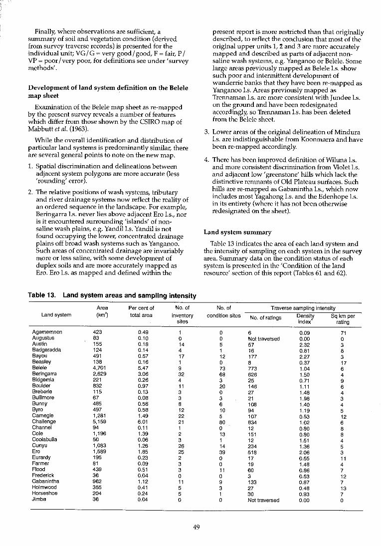
Finally, where observations are sufficient, a summary of soil and vegetation condition (derived from survey traverse records) is presented for the individual unit; VG / G ~ very good / good, F ~ fair, P / VP ~ poor / very poor, for definitions see under' survey methods'.
Development of land system definition on the Belele map sheet
Examination of the Belele map sheet as re-mapped by the present survey reveals a number of features which differ from those shown by the CSIRO map of Mabbutt et al. (1963).
While the overall identification and distribution of particular land systems is predominantly similar, there are several general points to note on the new map.
1. Spatial discrimination and delineations between adjacent system polygons are more accurate (less 'rounding' error).
2. The relative positions of wash systems, tributary and river drainage systems now reflect the reality of an ordered sequence in the landscape. For example, Beringarra l.s. never lies above adjacent Ero l.s., nor is it encountered surrounding 'islands' of nonsaline wash plains, e.g. Yandill.s. Yandil is not found occupying the lower, concentrated drainage plains off broad wash systems such as Yanganoo. Such areas of concentrated drainage are invariably more or less saline, with some development of duplex soils and are more accurately mapped as Ero. Ero I.s. as mapped and defined within the
Table 13. Land system areas and sampling intensity
Area Per cent of No. of
Land system (km~ total area inventory sites
Agamemnon 423 0.49 1 Augustus 83 0.10 0 Austin 155 0.18 14 Badgeradda 124 0.14 4 Bayou 491 0.57 17 Beasley 138 0.16 1 Belele 4,701 5.47 9 Beringarra 2,629 3.06 32 Bidgemia 221 0.26 4 Boulder 832 0.97 11 Breberle 115 0.13 3 Bullimore 67 0.08 3 Bunny 485 0.56 8 Byro 497 0.58 12 Carnegie 1,281 1.49 22 Challenge 5,159 6.01 21 Channel 94 0.11 1 Cole 1,196 1.39 2 CoolabuUa 50 0.06 3 Cunyu 1,083 1.26 26 Ero 1,589 1.85 25 Eurardy 195 0.23 2 Farmer 81 0.09 3 Flood 439 0.51 3 Frederick 36 0.04 0 Gabanintha 962 1.12 11 Holmwood 355 0.41 5 Horseshoe 204 0.24 5 Jimba 36 0.04 0
49
present report is more restricted than that originally described, to reflect the conclusion that most of the original upper units 1, :1 and 3 are more accurately mapped and described as parts of adjacent nonsaline wash systems, e.g. Yanganoo or Belele. Some large areas previously mapped as Belele I.s. show such poor and intermittent development of wanderrie banks that they have been re-mapped as Yanganoo I.s. Areas previously mapped as Trennaman I.s. are more consistent with Jundee I.s. on the ground and have been redesignated accordingly, so Trennaman I.s. has been deleted from the Belele sheet.
3. Lower areas of the original delineation of Mindura I.s. are indistinguishable from Koonmarra and have been re-mapped accordingly.
4. There has been improved definition of Wiluna I.s. and more consistent discrimination from Violet l.s. and adjacent low' greenstone' hills which lack the distinctive remnants of Old Plateau surfaces. Such hills are re-mapped as Gabanintha I.s., which now includes most Yagahong I.s. and the Edenhope I.s. in its entirety (where it has not been otherwise redesignated on the sheet).
Land system summary
Table 13 indicates the area of each land system and the intensity of sampling on each system in the survey area. Summary data on the condition status of each system is presented in the 'Condition of the land resource' section of this report (Tables 61 and 62).
No. of Traverse sampling intensity
condition sites No. of ratings Density Sq km per index rating
0 6 0.09 71 0 Not traversed 0.00 0 5 57 2.32 3 1 16 0.81 8 12 177 2.27 3 0 8 0.37 17 73 773 1.04 6 68 626 1.50 4 3 25 0.71 9 20 146 1.11 6 0 27 1.48 4 3 21 1.98 3 6 108 1.40 4 10 94 1.19 5 5 107 0.53 12 80 834 1.02 6 0 12 0.80 8 13 151 0.80 8 1 12 1.51 4 14 234 1.36 5 39 518 2.06 3 0 17 0.55 11 0 19 1.48 4 11 60 0.86 7 0 3 0.53 12 9 133 0.87 7 3 27 0.48 13 1 30 0.93 7 0 Not traversed 0.00 0

Table 13-continued
Area Per cent of No. of No. of Traverse sampling intensity
Land system (km~ total area inventory condition sites No. of ratings Density Sq km per sites index rating
Jundee 1,346 1.57 13 32 328 1.54 4 Kalil 6,097 7.10 23 70 704 0.73 9 Koonmarra 5,335 6.21 17 91 696 0.82 8 Liver 752 0.88 8 9 91 0.76 8 Mantle 155 0.18 4 0 6 0.24 26 Merbla 76 0.09 4 3 19 1.58 4 Mileura 1,007 1.17 37 35 301 1.88 3 Millex 500 0.58 19 7 87 1.10 6 Millrose 535 0.62 7 7 95 1.12 6 Mindura 3,661 4.26 16 31 322 0.55 11 Mongolia 456 0.53 6 8 72 0.99 6 Moogooloo 20 0.02 0 0 Not traversed 0.00 0 Naluthanna 26 0.03 3 0 10 2.43 3 Narryer 2,510 2.92 16 39 300 0.75 8 Nerramyne 848 0.99 12 10 146 1.09 6 Nerren 110 0.13 3 0 Not traversed 0.00 0 Norie 1,321 1.54 11 4 71 0.34 19 Outcamp 44 0.05 2 3 12 1.72 4 Peak Hill 503 0.59 1 0 2 0.03 252 Pells 4 < 0.01 0 0 Not traversed 0.00 0 Roderick 407 0.47 8 6 74 1.15 6 Sandi man 347 0.40 5 4 33 0.60 11 Sandplain 2,884 3.36 7 16 209 0.46 14 Sherwood 4,839 5.63 38 64 762 0.99 6 Siberia 43 0.05 3 0 19 2.79 2 Thomas 458 0.53 6 2 31 0.43 15 Tindalarra 3,091 3.60 17 64 741 1.51 4 Trillbar 131 0.15 10 3 56 2.70 2 Violet 1,078 1.26 15 23 260 1.52 4 Waguin 748 0.87 6 6 102 0.86 7 Weenyung 153 0.18 3 4 33 1,36 5 Weld 350 0.41 7 0 59 1.06 6 Wiluna 1,294 1.51 15 15 253 1.23 5 Wolarry 368 0.43 9 7 78 1.34 5 Wongong 317 0.37 3 11 62 1.23 5 Woodline 2,932 3.41 10 44 542 1.17 5 Woodrarrung 371 0.43 6 0 15 0.25 25 Wooleen 55 0.06 2 0 11 1.26 5 Wooramel 56 0.07 0 0 Not traversed 0.00 0 Yagahong 141 0.16 3 0 8 0.36 18 Yalbalgo 127 0.15 2 0 16 0.79 8 Yandil 3,402 3.96 16 60 610 1.13 6 Yanganoo 12,433 14.48 18 217 1,976 1.00 6 Yarrameedie 519 0.60 7 9 98 1.19 5 Yewin 316 0.37 13 8 70 1.40 5
Total 85,887* 100.00 679 1,289 13,621 1.00 6
• Does not include some vacant Crown land which occurs in the survey area .
+ Sampling density index: measure of sampling intensity relative to the mean (1.0) of the survey area.
References Mabbutt, J.A, Litchfield, W.H., Speck, N.H., Sofoulis, J., Wilcox,
D.G., Arnold, J.M. and Wright, R.L. (1963). General report on lands of the Wiluna-Meekatharra area, Western Australia 1958. CSIRO Land Research Series No.7.
Payne, AL., Curry, P.J. and Spencer, G.P. (1987). An inventory and condition survey of rangelands in the Carnarvon Basin, Western AustraJia. Department of Agriculture, Western Australia, Technical Bulletin No. 73.
Wilcox, D.G. and McKinnon, E.A (undated, circa 1972). A report on the condition of the Cascoyne catchment. Department of Agriculture, Western Australia.
50
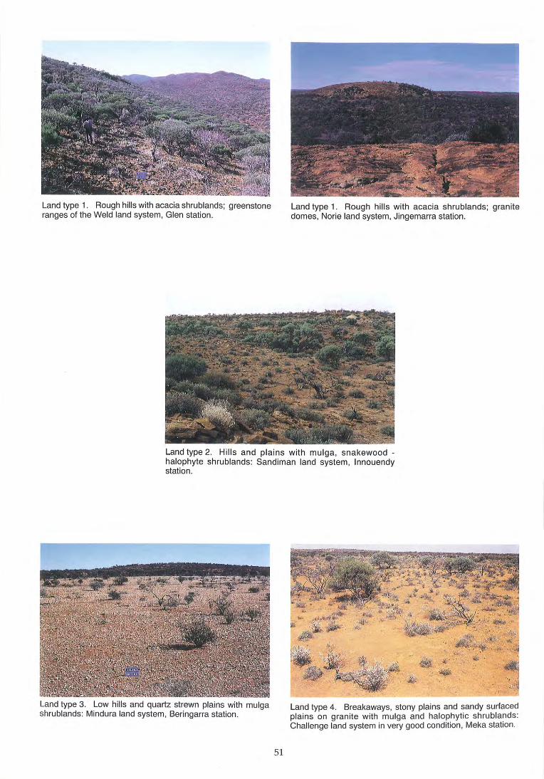
Land type 1. Rough hills with acacia shrublands; greenstone ranges of the Weld land system, Glen station.
Land type 1. Rough hills with acacia shrublands; granite domes, Norie land system, Jingemarra station.
Land type 2. Hills and plains with mulga, snakewood -halophyte shrublands: Sandiman land system, Innouendy station.
Land type 3. Low hills and quartz strewn plains with mulga shrublands: Mindura land system, Beringarra station.
51
Land type 4. Breakaways, stony plains and sandy surfaced plains on granite with mulga and halophytic shrublands: Challenge land system in very good condition, Meka station.
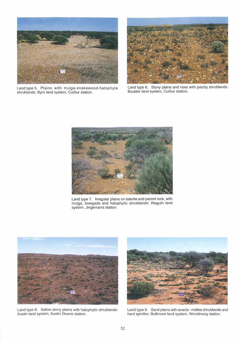
Land type 5. Plains with mulga-snakewood-halophyte shrublands: Byro land system, Curbur station.
Land type 6. Stony plains and rises with patchy shrublands: Boulder land system, Curbur station .
Land type 7. Irregular plains on laterite and parent rock, with mulga, bowgada and halophyt ic shrublands: Waguin land system, Jingemarra station.
Land type 8. Sali ne stony plains with halophytic shrublands: Austin land system, Austin Downs station.
52
Land type 9. Sand plains with acacia - mal lee shrublands and hard spini!ex: Bull imore land system, Wondinong station.
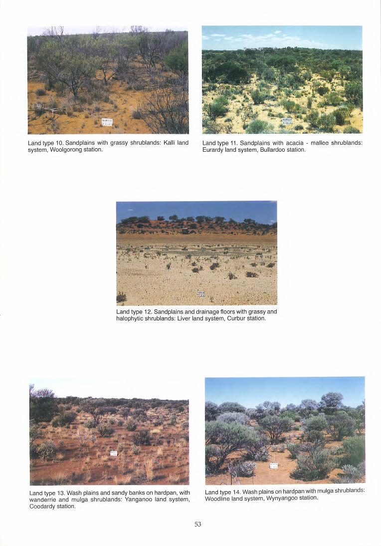
Land type 10. Sand plains with grassy shrublands: Kalli land system, Woolgorong station.
Land type 11. Sandplains with acacia - mallee shrublands: Eurardy land system, Bullardoo station.
Land type 12. Sandplains and drainage floors with grassy and halophytic shrublands: Liver land system, Curbur station.
Land type 13. Wash plains and sandy banks on hardpan, with wanderrie and mulga shrublands: Yanganoo land system, Coodardy station.
53
Land type 14. Wash plains on hardpan with mulga shrublands: Woodline land system, Wynyangoo station.
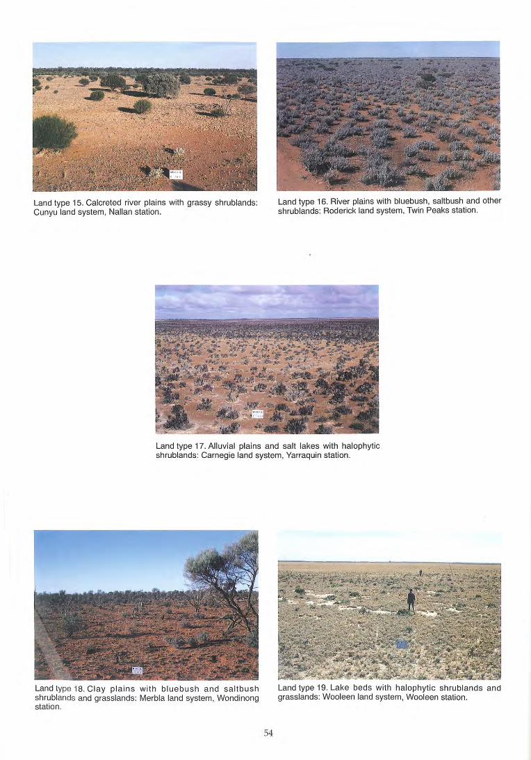
Land type 15, Calcreted river plains with grassy shrublands: Cunyu land system, Nalian station,
Land type 16, River plains with bluebush, saltbush and other shrublands: Roderick land system, Twin Peaks station,
Land type 17, Alluvial plains and salt lakes with halophytic shrublands: Carnegie land system, Yarraquin station,
Land type 18, Clay plains with bluebush and saltbush shrublands and grasslands: Merbla land system, Wondinong station .
54
Land type 19, Lake beds with halophytic shrublands and grasslands: Wooleen land system, Wooleen station,
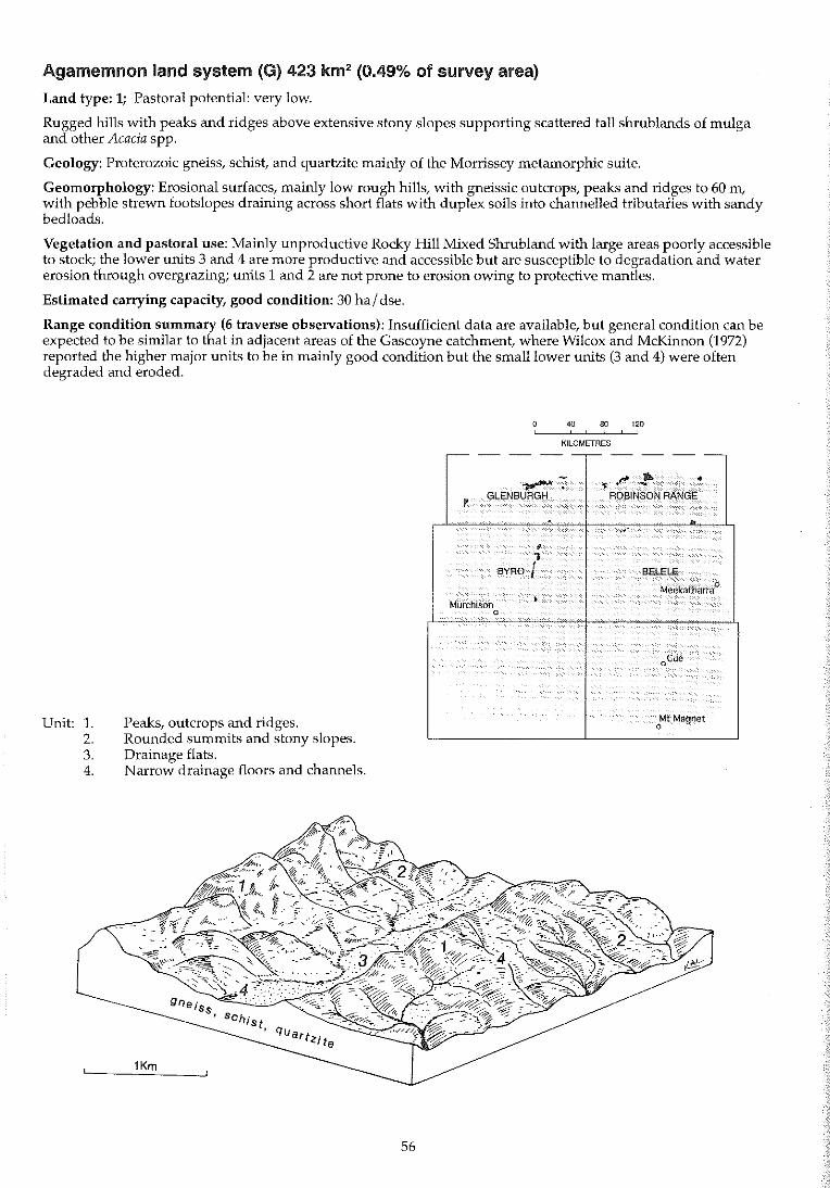
Agamemnon land system (0) 423 km2 (0.49% of survey area)
Land type: 1; Pastoral potential: very low.
Rugged hills with peaks and ridges above extensive stony slopes supporting scattered tall shrub lands of mulga and other Acacia spp.
Geology: Proterozoic gneiss, schist, and quartzite mainly of the Morrissey metamorphic suite.
Geomorphology: Erosional surfaces, mainly low rough hills, with gneissic outcrops, peaks and ridges to 60 m, with pebble strewn footslopes draining across short flats with duplex soils into channelled tributaries with sandy bedloads.
Vegetation and pastoral use: Mainly unproductive Rocky Hill Mixed Shrubland with large areas poorly accessible to stock; the lower units 3 and 4 are more productive and accessible but are susceptible to degradation and water erosion through overgrazing; units 1 and 2 are not prone to erosion owing to protective mantles.
Estimated carrying capacity, good condition: 30 ha I dse.
Range condition summary (6 traverse observations): Insufficient data are available, but general condition can be expected to be similar to that in adjacent areas of the Gascoyne catchment, where Wilcox and McKinnon (1972) reported the higher major units to be in mainly good condition but the small lower units (3 and 4) were often degraded and eroded.
Unit: 1. 2. 3. 4.
Peaks, outcrops and ridges. Rounded summits and stony slopes. Drainage flats. N arrow drainage floors and channels.
56
40 80 120 , , KILOMETRES
,-- -- --,-- -- --
- .F' II- • ........ . < , P
GLENBURGH ROBINSON RANGE
. ,.' ,
• BYRD I BELELE
Meekatharra 0
Murchison • 0
oCue
~t Magnet
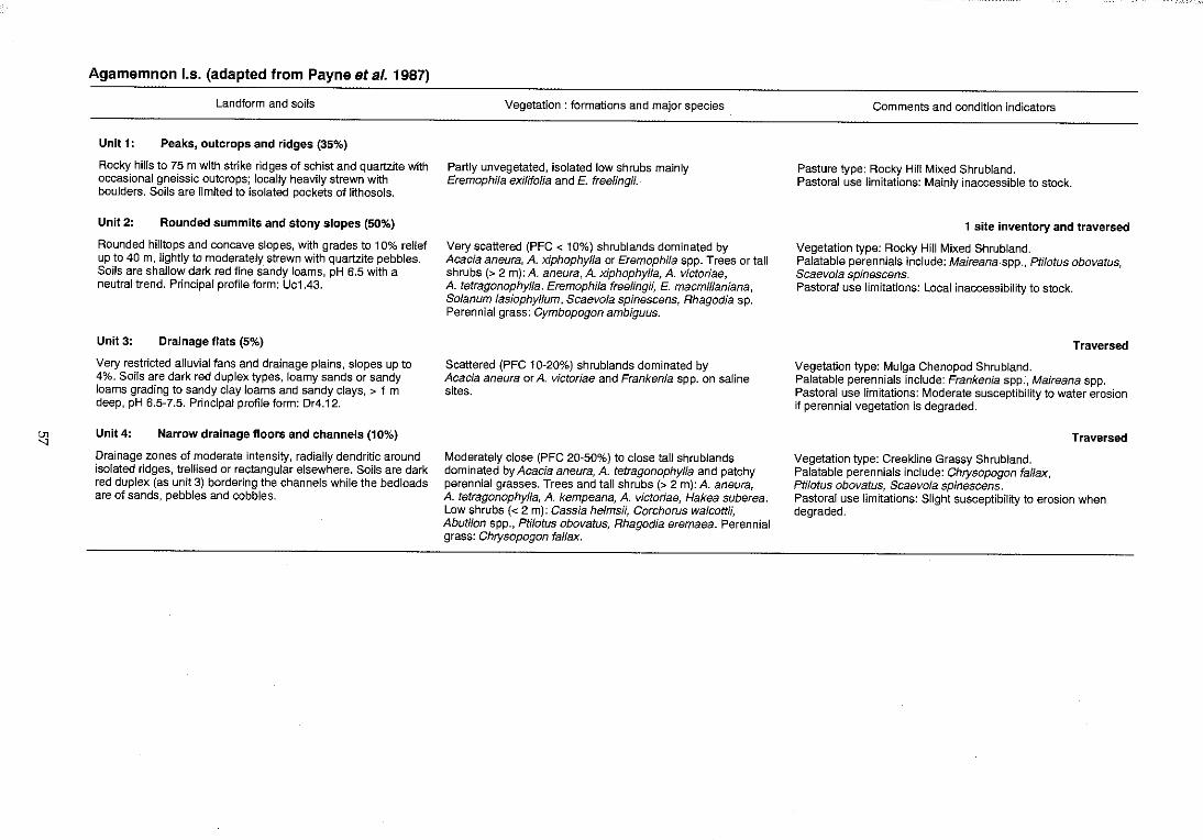
en
"
Agamemnon I.s. (adapted from Payne et al. 1987)
Landform and soils
Unit 1: Peaks, outcrops and ridges (35%)
Rocky hills to 75 m with strike ridges of schist and quartzite with occasional gneissic outcrops; locally heavily strewn with boulders. Soils are limited to isolated pockets of lithosols.
Unit 2: Rounded summits and stony slopes (50%)
Rounded hilltops and concave slopes, with grades to 10% relief up to 40 m, lightly to moderately strewn with quartzite pebbles. Soils are shallow dark red fine sandy loams, pH 6.5 with a neutral trend. Principal profile form: Uc1.43.
Unit 3: Drainage flats (5%)
Very restricted alluvial fans and drainage plains, slopes up to 4%. Soils are dark red duplex types, loamy sands or sandy loams grading to sandy clay loams and sandy clays, > 1 m deep, pH 6.5-7.5. Principal profile form: Dr4.12.
Unit4: Narrow drainage floors and channels (10%)
Drainage zones of moderate intensity, radially dendritic around isolated ridges, trellised or rectangular elsewhere. Soils are dark red duplex (as unit 3) bordering the channels while the bed loads are of sands, pebbles and cobbles.
Vegetation: formations and major species
Partly unvegetated, isolated low shrubs mainly Eremophila exilifo/ia and E. freelingii.
Very scattered (PFC < 10%) shrublands dominated by Acacia aneura, A. xiphophylla or Eremophila spp. Trees or tall shrubs (> 2 m): A. aneura, A. xiphophylla, A. victoriae, A. tetragonophylla. Eremophila freeHngii, E. macmillaniana, Solanum lasiophyllum, Scaevola spinescens, Rhagodia sp. Perennial grass: Cymbopogon ambiguus.
Scattered (PFC 10-20%) shrublands dominated by Acacia aneura or A. victoriae and Frankenia spp. on saline sites.
Moderately close (PFC 20-50%) to close tall shrublands dominated by Acacia aneura, A. tetragonophylla and patchy perennial grasses. Trees and tall shrubs (> 2 m): A. aneura, A. tetragonophylla, A. kempeana, A. victoriae, Hakea suberea. Low shrubs « 2 m): Cassia helmsii, Corchorus walcottH, Abutilon spp., Ptilotus obovatus, Rhagodia eremaea. Perennial grass: Chrysopogon fa/lax.
Comments and condition indicators
Pasture type: Rocky Hill Mixed Shrubland. Pastoral use limitations: Mainly inaccessible to stock.
1 site inventory and traversed
Vegetation type: Rocky Hill Mixed Shrubland. Palatable perennials include: Maireana spp., Ptilotus obovatus, Scaevola spinescens. Pastoral use limitations: Local inaccessibility to stock.
Traversed
Vegetation type: Mulga Chenopod Shrubland. Palatable perennials include: Frankenia spp., Maireana spp. Pastoral use limitations: Moderate susceptibility to water erosion if perennial vegetation is degraded.
Vegetation type: Creekline Grassy Shrubland. Palatable perennials include: Chrysopogon fallax, Ptilotus obovatus, Scaevola spinescens.
Traversed
Pastoral use limitations: Slight susceptibility to erosion when degraded.
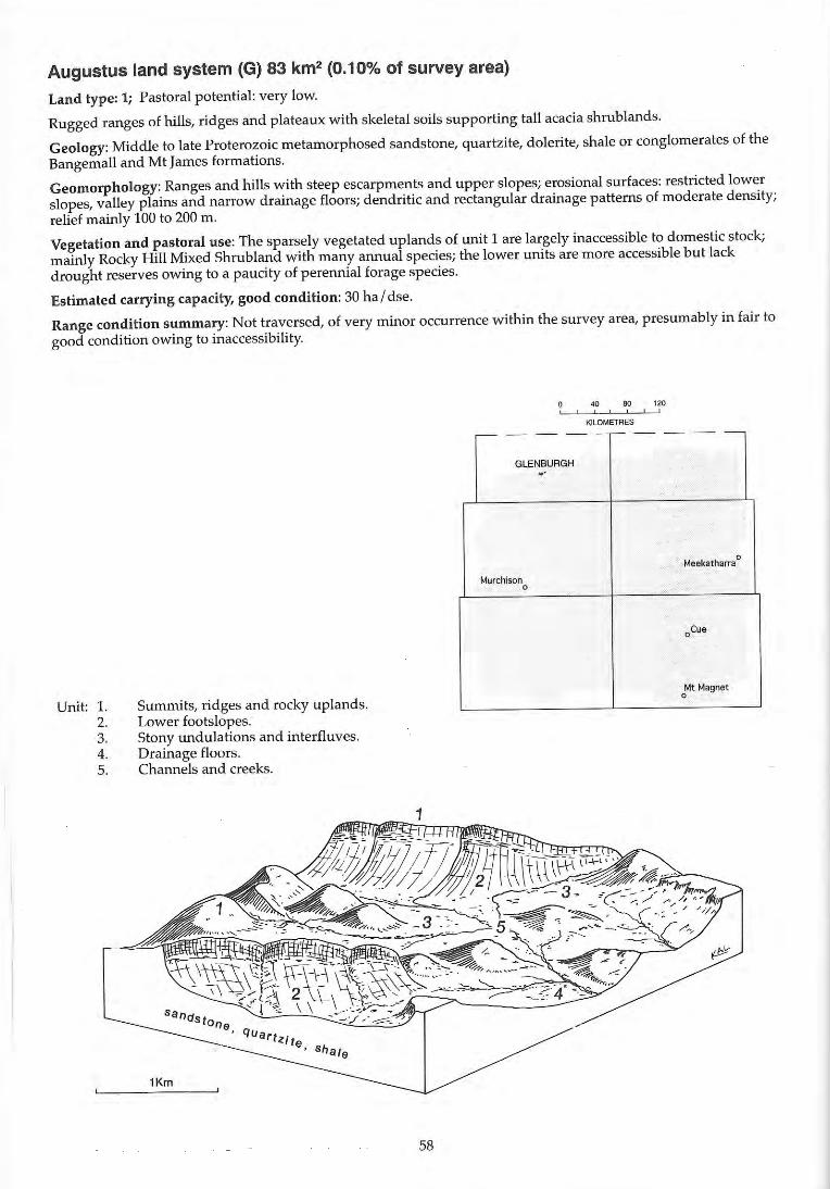
Augustus land system (G) 83 km2 (0.10% of survey area)
Land type: 1; Pastoral potential: very low.
Rugged ranges of hills, ridges and plateaux with skeletal soils supporting tall acacia shrub lands.
Geology: Middle to late Proterozoic metamorphosed sandstone, quartzite, dolerite, shale or conglomerates of the Bangemall and Mt James formations.
Geomorphology: Ranges and hills with steep escarpments and upper slopes; erosional surfaces: restricted lower slopes, valley plains and narrow drainage floors; dendritic and rectangular drainage patterns of moderate density; relief mainly 100 to 200 m.
Vegetation and pastoral use: The sparsely vegetated uplands of unit 1 are largely inaccessible to domestic stock; mainly Rocky Hill Mixed Shrubland with many annual species; the lower units are more accessible but lack drought reserves owing to a paucity of perennial forage species.
Estimated carrying capacity, good condition: 30 ha / dse.
Range condition summary: Not traversed, of very minor occurrence within the survey area, presumably in fair to good condition owing to inaccessibility.
Unit: l. 2. 3. 4. 5.
Summits, ridges and rocky uplands. Lower footslopes. Stony undulations and interfluves. Drainage floors. Channels and creeks.
1Km
58
40 80 120 , , , KILOMETRES
-- - - - ,-- - - --
GlENBUAGH ..
Meekatharra 0
Murchison 0
aCue
Mt Magnet 0
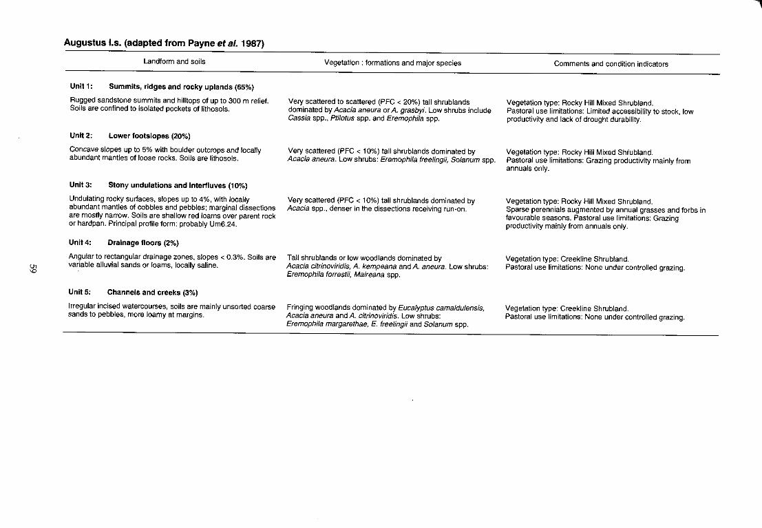
en 'D
Augustus I.s. (adapted from Payne et al. 1987)
Landform and soils
Unit 1: Summits, ridges and rocky uplands (65%)
Rugged sandstone summits and hilltops of up to 300 m relief. Soils are confined to isolated pockets of lithosols.
Unit 2: Lower footslopes (20%)
Concave slopes up to 5% with boulder outcrops and locally abundant mantles of loose rocks. Soils are lithosols.
Unit 3: Stony undulations and interfluves (10%)
Undulating rocky surfaces, slopes up to 4%, with locally abundant mantles of Gobbles and pebbles; marginal dissections are mostly narrow. Soils are shallow red loams over parent rock or hardpan. Principal profile form: probably Um6.24.
Unit4: Drainage floors (2%)
Angular to rectangular drainage zones, slopes < 0.3%. Soils are variable alluvial sands or loams, locally saline.
Unit 5: Channels and creeks (3%)
Irregular incised watercourses, soils are mainly unsorted coarse sands to pebbles, more loamy at margins.
Vegetation: formations and major species
Very scattered to scattered (PFC < 20%) tall shrublands dominated by Acacia aneura or A. grasbyi. Low shrubs include Cassia spp., pti/otus spp. and Eremophila spp.
Very scattered (PFC < 10%) tall shrublands dominated by Acacia aneura. Low shrubs: Eremophi/a freelingH, Solanum spp.
Very scattered (PFC < 10%) tall shrublands dominated by Acacia spp., denser in the dissections receiving run-on.
Tall shrublands or low woodlands dominated by Acacia citrinoviridis, A. kempeana and A. aneura. Low shrubs: Eremophila forrestii, Maireana spp.
Fringing woodlands dominated by Eucalyptus camaldulensis, Acacia aneura and A. citrinoviridis. Low shrubs: Eremophila margarethae, E. treelingii and Solanum spp.
Comments and condition indicators
Vegetation type: Rocky Hill Mixed Shrubland. Pastoral use limitations: Limited accessibility to stock, low productivity and lack of drought durability.
Vegetation type: Rocky Hill Mixed Shfubland. Pastoral use limitations: Grazing productivity mainly from annuals only.
Vegetation type: Rocky Hill Mixed Shrubland. Sparse perennials augmented by annual grasses and forbs in favourable seasons. Pastoral use limitations: Grazing productivity mainly from annuals only.
Vegetation type: Creekline Shrubland. Pastoral use limitations: None under controlled grazing.
Vegetation type: Creekline Shrubland. Pastoral use limitations: None under controlled grazing.
-,
Austin land system 155 km2 (0.18% of survey area)
Land type: 8; Pastoral potential: high.
Saline stony plains with low rises and drainage foci supporting low halophytic shrublands with scattered mulga; occurs mainly adjacent to lakes Austin and Annean, below greenstone hill systems.
Geology: Quaternary colluvium and alluvium with isolated Precambrian greenstone intrusives and Archaean granitic outcrops.
Geomorphology: Mainly erosional surfaces: gently undulating saline stony plains with scattered drainage foci and associated internal sluggish drainage lines; low rises and ridges up to 20 m high, but usually 5 to 10 ffi.
Vegetation and pastoral use: Bluebush and Stony Snakewood Shrub lands; palatable saline perennials of moderate quanti ty provide the bulk of the forage on the larger units; scattered mixed Acacia and EremophiLa spp. are prominent on units 1, 3 and 5. Preferential over-grazing of unit 5 can lead to increased erosion.
Estimated carrying capacity, good condition: 7 hal dse.
Range condition summary (57 traverse observations):
(a) Erosion status (%)
Nil Min. Mod. Sev.
73
Unit: 1. 2. 3. 4. 5.
18 9
Low ridges and rises. Saline stony plains. Non saline stony plains. Drainage foci. Drainage tracts.
L-_---""'-KmC-_~
o
60
(b) Vegetation condition (%)
Good Fair
34 41
,-- - -
Murchison 0
Poor
25
80 , '''' , KILOMETRES
- - ~- - - -
BElElE '"0
Meekatharra
.
~cue , CUE , ., ,
Mt Magnet .....
§ r ~
'" "'"
Austin I.s.
Landform and soils
Unit 1: Low ridges and rises (5%)
Stony rises and low ridges of outcropping granite, quartz or greenstone, up to SOD m long relief 2-25 m and short footslopes with abundant mantles of cobbles and pebbles. Soils are shallow alkaline red earths and hard-setting duplex types; principal profile forms: Uc1.33, Dr2.S3.
Unit2: Saline stony plains (80%)
Flat to gently sloping « 1%) plains extending up to 3 km with scattered small (generally < 20 m in diameter) drainage foci in parts, commonly with moderately dense to very dense mantles of quartz or ironstone gravel and pebbles. Soils are predominantly shallow, hard-setting duplex types as sandy loams over light clays, pH 6.5-S.5 with neutral or alkaline reaction trends; also clays in lower parts or shallow earthy sands over greenstones. Principal profile forms: Dr2.12, 2.13, 2.53, Uf6.31, Uc1.43.
Unit 3: Non saline stony plains (10%)
Flat to gently sloping « 1%) plains on granite within, or above, unit 2; mantles of quartz and granite and occasional granite ," outcrop. Soils are shallow, dark red, sandy loams and sandy clay loams over granite, pH 7.0 with neutral reaction trends. Principal profile forms: Uc5.21, Um5.51.
Unit4: Drainage foci « 1%)
Small, discrete foci (10-50 m in diameter) occurring sparsely within units 2 and 5. Soils are dark red clays of variable depth over hardpan or parent rock, pH 6.0 with neutral reaction trends. Principal profile form: Uf6.71.
Unit 5: Drainage tracts (5%)
Gently sloping linear drainage tracts, mostly unchannelled but occaSionally incised with rills, gutters and shallow gullies; variable mantles of ironstone and quartz. Soils are red earths and probably also duplex types. Principal profile form: UmS.52.
Vegetation: formations and major species
Scattered shrublands or woodlands usually dominated by Acacia aneura with low shrubs Ptilotus obovatus, Cassia spp., occasionally Maireana spp.
Very scattered to scattered low shrublands (PFC < 20%) dominated by Maireana spp. Trees (occasional, 2-5 m): Acacia aneura; Tall shrubs (> 2 m): A. aneura, A. victoriae, A. tetragonophylla, Hakea preissH; Low shrubs « 1 m): Maireana pyramidata, M. platycarpa, M. georgei, M. atkinsiana, M. glomerifolia, M. triptera, Atriplex vesicaria, Rhagodia eremaea, Halosarcia spp., Frankenia spp., Ptilotus obovatus. Perennial grass: (occaSional) Eragrostis setifolia.
Very scattered to scattered low shrublands (PFC < 20%). Tall shrubs (> 2 m): Acacia aneura, A. sp., A. tetragonophylfa; Low shrubs « 1 m): Ptilotus obovatus, P. schwartzH, Eremophila punicea, E. exilifolia, Solanum lasiophyllum, Maireana convexa, M. triptera, Sida calyxhymenia, Spartothamnella teucriiflora.
Moderately close or close woodland or tall shrubland (PFC 20-50%) usually dominated by Acacia aneura or A. tetragonophylla. Trees (4-S m): A. aneura; Tall shrubs (> 2 m): A. aneura, A. tetragonophylla; Mid and low shrubs: A. tetragonophylla, Eremophila youngii, E. forrestii, E. longifolia, Ptilotus obovatus, Maireana pyramidata, Scaevola spinescens, Cassia desolata, Enchylaena tomentosa, Rhagodia eremaea, Sida calyxhymenia.
Very scattered low woodland or tall shrubland (PFC < 10%) dominated by Acacia aneura.
Comments and condition indicators
2 inventory sites and traversed
Vegetation type: Mainly Rocky Hill Mixed Shrubland. Pastoral use limitations: None under controlled grazing.
8 inventory sites, 2 condition sites and traversed
Vegetation type: Bluebush Shrubland. Palatable perennials include: Maireana pyramidata, M. platycarpa, M. georgei, M. atkinsiana, Atriplex vesicaria, Frankenia spp. Pastoral use limitations: High salinity levels of pasture plants and mild susceptibility to erosion where perennial vegetation is degraded. Vegetation condition %: VG/G 40, F 39, PNP 21. Erosion incidence %: min 15, mod 6. 33 obs.
2 inventory sites and traversed
Vegetation type: Granitic Mulga Shrubland. Palatable perennials include: Ptilotus schwartzii, Maireana convexa, Sida calyxhymenia, Spartothamnella teucrittlora. Pastoral use limitations: None under controlled grazing.
1 inventory site
Vegetation type: Mulga Grove Woodland. Palatable perennials include: Maireana pyramidata, Enchylaena tomentosa, Rhagodia eremaea. Pastoral use limitations: None under controlled grazing.
1 inventory site and traversed
Vegetation type: Hardpan Mulga Shrubland or Bluebush Shrubland. Palatable perennials include: Eremophila latrobei, Enchylaena tomentosa, Rhagodia eremaea, Maireana spp. Pastoral use limitations: Susceptible to erosion if perennial vegetation is degraded.
8adgeradda land system 124 km2 (0.14% of survey area)
Land type: 2; Pastoral potential: low.
Hills and ridges, often with benched slopes mantled by fl at cobbles, and stony plains on siltstone and silty sandstone; supports moderately saline shrub lands but otherwise similar to Woodrarrung land system.
Geology: Late Proterozoic siltstone and sandstone; mostly of the Yarrawolya and Coomberarie fo rmations of the Badgeradda group; also Quaternary colluvium and alluvium.
Geomorphology: Erosional surfaces; low hills, ridges and associated benched slopes formed through weathering of old plateau; lower slopes and plains of similar origin but with colluvial and aeolian sand accumulations; alluvial drainage zones to several hundred metres wide; overall relief mainly about 50 m.
Vegetation and pastoral use: Stony Snakewood Shrublands on upper slopes, hills and ridges, poorly accessible to stock, and of limited use. Also supports saltbush and other saline shrublands on lower plains and drainage floors, productive when in reasonable condition; minor susceptibility to erosion on exposed duplex soils.
Estimated carrying capacity, good condition: 20 ha l dse.
Range condition summary (16 traverse observations):
(a) Erosion status (%)
Nil Min. Mod. Sev.
81 6 13 0
Unit: I. 2. 3. 4. 5. 6. 7.
Stony hills and ridges. Hill footslopes. Benched lower slopes. Stony plains. Drainage zones. Claypans. Sand sheets.
62
(b) Vegetation condition (%)
Good Fair Poor
37 25 38
0 " 80 120 , , , , KILOMETRES
c- - - - - - - - - -
i
BYRO
Meekatharra 0
~ l' 0 Murchison
, oCue
MURGOO
Mt Magnet 0
el
Badgeradda 1.5.
Landform and soils
Unit 1: Stony hills and ridges (40%)
Hills and low escarpments, undulating crests and crest~!ike ridges with up to 50 m relief, with abundant platy siltstone mantles. Soils are probably shallow red duplex types over siltstone, or lithosolloams.
Unit 2: Hill footslopes (10%)
Slopes around 10% flanking unit 1, abundantly mantled with siltstone or fine sandstone cobbles and angular flagstones. Soils are probably shallow red duplex types over parent rock.
Unit 3: Benched lower slopes (20%)
Benched slopes around 1 % below steeper footslopes and breakaway escarpment faces, abundantly mantled by platy siltstone fragments. Soils are shallow to moderately deep hardsetting duplexes, pH 7.0 with a neutral soil reaction trend. Principal profile form: Dr2.52.
Unit 4: Stony plains (25%)
Lower plains, moderately or abundantly mantled by rock fragments and with saline or non-saline loamy soils over colluvium.
Unit 5: Drainage zones « 5%)
Restricted drainage tracts with very gentle slopes « 0.5%) and small channels incised to < 1 m; sandy hummocks to 1 m common. Soils are shallow crusted duplexes to 60 cm; pH 7.5-8.0 with neutral trend. Principal profile form: Dr1.55.
Unit 6: Claypans « 1%)
Small pans, some stony, mainly unvegetated.
Unit 7: Sand sheets « 1%)
Marginal sandy plains.
Vegetation: formations and major species
Scattered (PFC 10-20%) shrublands dominated by Acacia xiphophylla and Maireana pyramidata. Tall shrubs (> 2 m): A. xiphophyl/a, A. aneura. Mid shrubs (1-2 m): Lycium australe, A. tetragonophylla Scaevola spinescens, A. microcalyx, Cassia phy/lodinea, Eremophila fongifolia. Low shrubs « 1 m): Maireana pyramidata, M. georgei, Ptilotus obovatus, P. po/akii, M. triptera, M. tomentosa, Enchylaena tomentosa, Eremophila compacta, Halosarcia sp.
Scattered (PFC 10-20%) shrublands dominated by Acacia xiphophyl/a, A. cuthbertsonii and Maireana pyramidata, similar to unit 1.
Very scattered (PFC < 10%) shrublands dominated by Acacia aneura and A. cuthbertsonii, with understorey halophytic shrubs. Mid shrubs: A. tetragonophylla, Cassia nemophi/a, Eremophila lachnocalyx. Low shrubs « 1 m): Maireana triptera, M. planifolia, M. tomentosa, Ptilotus po/akii, P. obovatus, Enchylaena tomentosa, Atriplex bunburyana, A. vesicaria.
Very scattered (PFC < 10%) shrublands, either dominated by Acacia spp. and Pti/otus obovatus, with other non-saline browse shrubs or Ha/osarcia and Maireana spp. on saline sites.
Very scattered (PFC < 10%) low shrublands dominated by Atrip/ex bunburyana. Tall shrubs « 2 m): Acacia victoriae. Mid shrubs (1-2 m): Hakea preissii, A. sc/erosperma, A. victoriae. Low shrubs « 1 m): Atrip/ex bunburyana, Enchylaena tomentosa, Maireana integra, M. tomentosa, Chenopodium gaudichaudianum. Perennial grass: Enteropogon acicu/aris.
Comments and condition indicators
1 inventory site and traversed
Vegetation type: Stony Snakewood Shrubland. Palatable perennials include: Maireana pyramidata, M. georgei, Atrip/ex bunburyana, Enchy/aena tomentosa. Pastoral use limitations: Upper parts of unit poorly accessible to stock.
Traversed
Vegetation type: Stony SnakewQod Shrubland as unit 1.
1 condition site and traversed
Vegetation type: Mulga Chenopod Shrubland. Palatable perennials include: Atrip/ex spp., Maireana spp., Ptilotus spp. Pastoral use limitations: None under controlled grazing.
2 inventory sites and traversed
Vegetation type: Samphire Shrubland. Palatable perennials include: Maireana spp., Ptilotus obovatus. Pastoral use limitations: High salinity levels in pasture plants.
1 inventory site and traversed
Vegetation type: Saltbush Shrubland. Palatable perennials include: Atriplex bunburyana, Chenopodium gaudichaudianum, Enchylaena tomentosa, Maireana integra, M. pyramidata, M. tomentosa, Enteropogon acicu/aris. Increaser species include: Acacia victoriae, Hakea preissii. Pastoral use limitations: Soils are susceptible to erosion if disturbed or overgrazed.
Bayou land system 491 km2 (0.57% of survey area)
Land type: 16; Pastoral potential: high.
Saline alluvial meander plains and river floodplains with anastomosing river channels supporting halophytic shrublands with overstorey shrubs and Eucalyptus trees.
Geology: Quaternary alluvium with areas of recent deposition; also minor aeolian sand.
Geomorphology: Depositional surfaces; flat riverine alluvial plains with low sandy banks over minor hardpans tracts on system margins; strongly saline plains 2 to 5 km wide flanking undulating 'bayou' deposits on channel margins; some alluvial surfaces with hummocky redistributed juvenile soils; large meandering channels with eroding banks and sandy bedloads; total system relief < 3 m.
Vegetation and pastoral use: Saltbush and Bluebush Shrub lands succeeded in parts by increasing Acacia, Eremophila and Hakea spp.; saline shrublands highly productive in areas with access to fresh water; erodible nature of exposed duplex soils is accentuated by regular flood events and preferential grazing of dominant species. Unit 2 is highly susceptible to continuing water erosion following the depletion of halophytic perennials.
Estimated carrying capacity, good condition: 7 hal dse.
Range condition summary (177 traverse observations):
(a) Erosion status (%)
Nil Min. Mod. Sev.
50
Unit: l. 2. 3. 4. 5. 6. 7.
33 14
Sandy banks. Alluvial plains.
3
Alluvial meander plains. Floodplains. Saline alluvial plains. Ephemeral swamps Major channels.
(b) Vegetation condition (%)
Good Fair Poor
26 25 49
40 80 120 ! , !
KILOMETRES
64
'" '"
Bayou 1.5.
Landform and soils
Unit 1: Sandy banks (5%)
Sand banks and low dunes up to 80 m wide and raised up to 2 m above adjacent unit 2. Soils are deep earthy sands or duplex loamy sands over sandy clay loam> 1 m deep. Principal profile form: Or2.52.
Unit 2: Alluvial plains (50%)
Flat to gently sloping « 0.5%) alluvial plains subject to periodic flooding from river. Soils are deep crusted and hard~setting duplexes, occasionally with hardpan at shallow depth. pH 6.0-9.0 with alkaline or neutral reaction trends. Principal profile forms: Or1.12, Dr1.23, Dr1.52, Dr2.23, Or2.52.
Unit 3: Alluvial meander plains (10%)
Alluvial deposits in ox-bow or bayou formations receiving regular channel overflow, little or no slope, sandy hummocks to 1-2 m above surrounding plain. Soils are deep, reddish-brown alluvial types, generally loamy or clayey sands with an alkaline reaction trend at depth. Principal profile forms: Uc5.21 , Um5.12.
Unit4: Flood plains (20%)
Plains marginally lower than units 2 and 3, subject to fairly regular flooding. Soils are> 1 m deep, yellowish-red clayey loams or clays, pH 7.0-9.0 with alkaline reaction trends. Principal profile forms: Uf6.71, Uf6.12, Uf6.31.
Unit 5: Saline alluvial plains (10%)
Flat, highly saline plains marginally lower than units 2 and 3. Soils are uniform yellowish-red clayey loams with an alkaline reaction trend. Principal profile form: Uf6.12.
Vegetation: formations and major species
Scattered (PFC 10-20%) shrub lands dominated by Hakea preissii. Tall shrubs (> 2 m): Acacia sclerosperma, Hakea preissii, Exocarpus aphyl/us. Mid and low shrubs « 2 m): Atriplex amnicola, Gunniopsis quadrifida, Scaevola spinescens, Cassia phyl/odinea, Enchylaena tomentosa, Sida aft. calyxhymenia.
Scattered to moderately close (PFC 10-30%) shrublands with occasional trees. Trees: (6-10 m) Eucalyptus coolabah. Tall shrubs (> 2 m): Hakea preissii, Acacia xiphophyl/a. Mid shrubs (1-2 m): Eremophila pterocarpa, Acacia microcalyx, A. sp., Cassia phyllodinea, C. sturtii. Low shrubs « 1 m): Atriplex vesicaria, Cratystylis subspinescens, Maireana platycarpa, M. pyramidata. Perennial grass: Stipa e/egantissima.
Moderately close (PFC 20-30%) mixed shrublands. dominated by Hakea preissii and Acacia sclerosperma. Trees: Eucalyptus coolabah. Tall shrubs (> 2 m): Acacia sc/erosperma, Hakea preissii. Mid shrubs (1-2 m): A. sclerosperma, A. victoriae, Scaevola spinescens, Rhagodia eremaea. Low shrubs « 1 m): Atriplex amnico/a, A. bunburyana, Enchylaena tomentosa.
Scattered shrublands (PFC 10-20%) with some sites very dense with low to medium shrubs (PFC > 50%). Trees (6-10 m): Eucalyptus coolabah. Tall shrubs (> 2 m): Eremophila youngii, Acacia aneura, A. victoriae, A. tetragonophylla. Mid shrubs (1-2 m): A. microcalyx, A. victoriae, Scaevola spinescens, A victoriae, Atriplex amnicola. Low shrubs « 1 m): Atriplex amnico/a, Cassia stUltii, Eremophila maculata, Ptilotus lazaridis.
Scattered (PFC 10-20%) low shrublands dominated by Halosarcia doleiformis, Frankenia spp. or Cratystylis subspinescens. Occasional Acacia victoriae and Atriplex amnicola.
Comments and condition indicators
1 inventory site and traversed
Vegetation type: Saltbush/Sand Dune Shrub land. Palatable perennials include: Atriplex amnicola, Enchylaena tomentosa. Pastoral use limitations: Susceptible to wind erosion if perennial cover lost.
6 inventory sites, 8 condition sites and traversed
Vegetation type: Saltbush/Bluebush Shrubland. Palatable perennials include: Atrip/ex vesicaria, Cratystylis subspinescens, Maireana platycarpa, M. pyramidata. Increaser species include: Hakea preissii, Eremophila pterocarpa. Pastoral use limitations: moderately to highly susceptible to shrub invasion and accelerated erosion where perennials are degraded. Vegetation condition %: VG/G 20, F 29, PNP 51. Erosion incidence %: min 46, mod 26, sev 4.82 obs.
3 inventory sites and traversed
Vegetation type: Saltbush Shrub land. Palatable perennials include: Atriplex amnicola, A. bunburyana, Rhagodia eremaea, Enchylaena tomentosa, Chenopodium gaudichaudianum. Increaser species include: Hakea preissii. Pastoral use limitations: None under controlled grazing.
5 inventory sites, 4 condition sites and traversed
Vegetation type: Saltbush/Riverine Mixed Shrubland. Palatable perennials include: Atriplex amnicola, Scaevola spinescens, Ptilotus lazaridis. Pastoral use limitations: None with controlled grazing.
1 inventory site and traversed
Vegetation type: Samphire Shrubland/Mixed Halophytic Shrubland. Pastoral use limitations: High salt content of dominant species.
-1
'" '"
Bayou I.s.-continued
Landform and soils
Unit 6: Ephemeral swamps « 1%)
Rounded drainage foci within units 4 and 5. Soils are clayey types.
Unit 7: Major channels (5%)
Major river beds and secondary channels to 5 m deep and> 50 m wide. Sandy channel beds often fringed by clayey terraces. Soils are mostly deep alluvial types.
Vegetation: formations and major species
Close or closed shrublands dominated by Melaleuea uncinata and Atriplex amnicola.
Scattered trees, shrubs and rushes (PFC 10-20%). Beds are generally bare of vegetation, banks and terraces are frequently dominated by Juncus aridicola and Eucalyptus coolabah. Trees: (8-10 m) Eucalyptus coolabah. Tall shrubs (> 2 m): Melaleuea aft. leiocarpa, Acacia sclerosperma. Mid shrubs (1-2 m): Muehlenbeckia cunningham;;, Hakea preiss;;. Low shrubs « 1 m): Atrip/ex amnico/a, Franken;a spp., Halosarcia spp., Ptilotus divaricatus.
Comments and condition 'Indicators
1 inventory site and traversed
Vegetation type: Riverine Mixed Shrubland or unvegetated. Palatable perennials include: Atrip/ex amnico/a, Ptilotus divaricatus, Frankenia spp. Pastoral use limitations: Channel banks and margins are highly susceptible to accelerated erosion if vegetation degraded.
Beasley land system (G) 138 km2 (0.16% of survey area)
Land type: 2; Pastoral potential: low.
Low ridges, hills and lateritised residuals above stony footslopes and broad, stony lower plains supporting scattered mulga and snakewood-dominated shrublands.
Geology: Lower Proterozoic metamorphic rocks of the Padbury group: hematite shale, banded ironstone, arenite and sandstone; also Tertiary laterite and Quaternary colluvium.
Geomorphology: Erosional surfaces; low ridges, mesas, hills, stripped surfaces and outcrops with stony footslopes and gently sloping stony lower plains and interfluves; moderately spaced tributary drainage patterns; relief mostly < 50 m.
Vegetation and pastoral use: Rocky Hill Mixed Shrubland with more productive Stony Snakewood Shrubland on lower units; mostly resistant to erosion owing to stony mantles; minor erosion is possible on unit 3.
Estimated carrying capacity, good condition: 20 ha l dse.
Range condition summary (8 traverse observations):
(a) Erosion status (%)
Nil Min. Mod. Sev.
100
Unit: 1. 2. 3. 4. 5.
o o o
Crests and hills. Stony slopes and interfluvial plains. Drainage tracts with groves. Stony rises. Stony plains.
68
(b) Vegetation condition (%)
Good Fair Poor
25 75 o
" " 120 , , , KILOMETRES
,--- - - --,- - - - -
-GLEN BURGH 1f ROBINSON RANGE ~ ;' , -
•
BElElE
Meekatharra 0
Murchison 0
oCue
Mt Magnet 0
'" '"
Beasley I.s. (adapted from Wilcox and M'Kinnon, 1972)
Landform and soils
Unit 1: Crests and hills (35%)
Rough, discontinuous ridges with frequent quartz intrusions extending up to 2 km long with peaks to 60 m or more; rounded lateritised summits and low hills to 30 m occurring in clusters up to 3 km in extent; usually mantled with ironstone, quartz or shale fragments. Soils are lithosols confined to small pockets of dark red loamy or clayey sands < 30 em deep with a mostly neutral trend.
Unit 2: Stony slopes and interfluvial plains (40%)
Slopes and rounded interfluves with slopes < 10% in upper parts and extending up to 1 km wide below unit 1 grading into flatter stony drainage plains dissected by unit 3, moderately to abundantly mantled by fragments of shale and manganiferous ironstones. Soils are reddish-brown clay loams or light clays over hardpan, usually < 1 m; duplex profiles probably common on lower plains.
Unit 3: Drainage tracts with groves (10%)
Broad disorganised flow zones with irregular grove formations grading into more concentrated drainage tracts to 1 00 m wide with small channels incised to 1 m deep and 10m wide. Soils are red-brown sandy clays to 1 m deep in flow zones; intergroves are < 1 m deep over hardpan.
Unit 4: Stony rises (5%)
Low rises with minor outcrops of parent rock, 1-5 m above surrounding plains (units 3 and 5). Soils are lithosols.
UnitS: Stony plains (10%)
Lower plains mantled with quartz and ironstone. Soils are shallow hardpan loams or red clays.
Vegetation: formations and major species
Very scattered (PFC < 10%) mixed shrublands dominated by Acacia aneura. Tall and mid shrubs (> 1 m): A. aneura, Cassia deso/ata, Eremophila treelingii, 8aeckea sp., Micromyrtus sp. Low shrubs « 1 m): ptilotu$ obovatus, So/anum /asiophyllum.
Scattered to moderately close (PFC 10-30%) tall Acacia aneura shrubland with halophytes on lower drainage plains. Trees and tall shrubs (> 2 m): A. aneura, A. grasbyi. A. ramuJosa, A. alf. citrinoviridis, A. pruinocarpa, A. cuthbertsonii. Mid shrubs (1-2 m): Cassia deso/afa, C. pruinosa, C. sturtii, Eremophila g/utinosa, E. treeHngii, E. /anata. Low shrubs « 1 m): E. compacta, Maireana georgei, M. triptera, M. thesioides, Pti/otus obovatus, P. schwartzii.
Groves: Moderately close to close (PFC 20 - > 50%) Acacia aneura woodland. Trees and tall shrubs (2-8 m): A. aneura, A. pruinocarpa, A. tetragonophylla. Mid shrubs (1-2 m): Cassia desolata, C. pruinosa, C. sturtii, Eremophi/a g/utinosa, E. treelingii, E. /anata, E. /atrobei. Low shrubs « 1 m): E. compacta, Ptilotus obovatus. Intergroves: very scattered shrublands of similar composition.
Very scattered (PFC < 10%) shrublands dominated by Acacia aneura.
Very scattered to scattered (PFC < 20%) shrublands dominated by Acacia xiphophylla.
Comments and condition indicators
Traversed
Vegetation type: Rocky Hill Mixed Shrubland. Pastoral use limitations: Poorly accessible to domestic stock; generally very low pastoral value throughout.
1 inventory site and traversed
Vegetation type: Rocky Hill Mixed Shrubland or Stony Mulga Mixed Shrub land. Palatable perennials include: Maireana spp., Eremophifa compacta, pti/otus spp. Pastoral use limitations: None under controlled grazing.
Traversed
Vegetation type: Mulga Grove Woodland or Creekline Shrubland. Palatable perennials include: Eremophila compacta, E. latrobei, Ptilotus spp. Pastoral use limitations: None with controlled grazing.
Vegetation type: Rocky Hill Mixed Shrubland. Palatable perennials include: Ptilotus obovatus. Pastoral use limitations: None under controlled grazing.
Vegetation type: Stony Snakewood Shrubland. Palatable perennials include: Maireana spp., Rhagodia eremaea, Enchylaena tomentosa. Pastoral use limitations: None under controlled grazing.
8elele land system (W) 4701 km2 (5.47% of survey area)
Land type: 13; Pastoral potential: moderate.
Hardpan wash plains interspersed by low sandy (wanderrie) banks supporting tall shrub lands of mulga with understorey shrubs on the hardpan plains and non-saline shrubs with perennial grasses on the banks.
Geology: Quaternary cemented alluvium and aeolian sand.
Geomorphology: Depositional surfaces, almost flat alluvial plains with water and wind-modified broad banks of aeolian sand; hardpan plains subject to sheet wash passing around the wanderrie banks and sand patches which are mainly transverse to direction of flow but also oblique or elongate downslope and forming connected patterns locally; central drainage tracts receiving more concentrated flow; most banks < 1 m and total relief is generally < 5 m.
Vegetation and pastoral use: Hardpan Mulga Shrub lands of moderate value and Wanderrie Bank Grassy Shrubland with reasonable drought durabili ty but susceptible to invasion by unpalatable shrubs when degraded; vegetation on units 2 and 3 frequently degraded, minor susceptibili ty to soil erosion when degraded.
Estimated carrying capacity, good condition: 12 ha l dse.
Range condition summary (773 traverse observations):
(a) Erosion status (%)
Nil Min. Mod. Sev.
90 7 3 0
Unit: 1. 2. 3.
Wanderrie banks and sand sheets. Hardpan plain and interbank areas. Drainage tracts.
70
(b) Vegetation condition (%)
Good
20 Fair
36
• ,
GLEN BURGH
1fJ
BYRD
Murchison o
Poor
44
.. ., " . . , ,
KILOMETRES
ROBINSON RANGE . '
CUE
Mt Magnet o
•

;::J
Belele I.s.
Landform and soils
Unit 1: Wanderrie banks and sand sheets (35%)
Sandy banks to 400 m wide and 3 km long, 0.5 to 1 m above unit 2, mostly arranged transverse to the direction of slope but also reticulate and elongate downslope; occasional larger patches of sand sheet. Soils are red earthy sands, usually> 1 m deep. pH 6.0-7.0 with neutral reaction trend. Principal profile form: UcS.21.
Unit2: Hardpan plains and interbank areas (40%)
Plains and flats (slopes mostly < 0.3%) subject to sheet flow. Soils are mostly 20-50 em deep, dark red sandy clay loams over hardpan. pH 5.5-6.5 with neutral or acidic reaction trends. Principal profile form: Um5.31.
Unit 3: Drainage tracts (25%)
Alluvial drainage tracts up to 750 m wide receiving more concentrated through flow than unit 2, locally with deposited sealed surfaces or with shallow runnels and incised channels with hardpan exposures in parts. Soils are red sandy clay loams over hardpan at shallow depth. Principal profile form: Um5.31.
Vegetation: formations and major species
Tall or mixed shrublands with tussock grasses or shrubby grasslands (shrub PFC > 20%). Trees: Acacia aneura; Tall shrubs (> 2 m) A. aneura, A ramulosa, Grevillea sp.; Low shrubs « 1 m): Eremophila margarethae, E. forrestii, E. aft. foliosissima, Cassia deso/ata, C. sturtii, Ptilotus obovatus, Solanum lasiophyllum, Rhagodia eremaea. Perennial grasses: Monachather paradoxa, Eragrostis eriopoda, E. lanipes, Eriachne helms;;.
Scattered tall or mixed shrublands (PFC 10-20%) sometimes weakly groved. Trees (4-6 m): Acacia aneura, A. pruinocarpa. Tall shrubs (> 2 m): A. aneura, A. aff. quadrimarginea, A kempeana, Mid and low shrubs (< 2 m): A tetragonophylla, Cassia desolata, Ptifotu$ obovatus, P. schwartzii, Eremophila forrestii, E. fraseri, Rhagodia eremaea, Maireana p/anifo/ia, Solanum /asiophyllum.
Shrublands very similar to those on unit 2, with more Cassia deso/ata, C. helmsii and Eremophila spp.
Comments and condition indicators
6 inventory sites, 35 condition sites and traversed
Vegetation type: Wanderrie Bank Grassy Shrubland or Sandplain Wanderrie Grassy Shrubland. Palatable perennials include: Eremophila forrestii, E. latrobei, Rhagodia eremaea, Grevillea deffexa, Monachather paradoxa, Eragrostis er;opoda, E. lanipes, Thyridolepis multiculmis. Pastoral use limitations: None under controlled grazing. Vegetation condition %: VG/G 37, F 40, PNP 23. 219 obs.
3 inventory sites, 37 condition sites and traversed
Vegetation type: Hardpan Mulga Shrubland. Palatable perennials include: Ptilotus obovatus, P. schwartzii, Eremophila latrobei, E. compacta, Rhagodia eremaea, Maireana planifo/ia, M. convexa, Sida calythymenia. Pastoral use limitations: None under controlled grazing. Vegetation condition %: VG/G 13, F 35, PNP 51. Erosion incidence %: min 7, mod 3. 467 obs.
1 condition site and traversed
Vegetation type: Hardpan Mulga Shrubland. Palatable perennials as for unit 2. Pastoral use limitations: Moderate susceptibility to accelerated water erosion when degraded. Vegetation condition %: VG/G 8, F 32, PNP 60. Erosion incidence %: min 35, mod 8, sev 5. 40 obs.
Beringarra land system (W) 2629 km2 (3.06% of survey area) Land type: 16; Pastoral potential: high. Major riverine plains with active lower floodplains flanking channelled watercourses; supports mostly halophytic shrub lands and mixed acacia shrub lands and low woodlands with minor perennial grasses; severely degraded and eroded in many areas.
Geology: Quaternary alluvium, partly cemented . Geomorphology: Depositional alluvial surfaces over variable underlying materials including extensive red-brown hardpan, clays and calcreted gravels; flat alluvial plains, often with windblown scalds and hummocks and / or active water erosion; river floodplains carrying regional drainage to 16 krn wide, with major charmel development; river channels (with isolated semi-permanent pools) to 200 m wide and 6 m deep; otherwise relief <3 m.
Vegetation and pastoral use: Bluebush and Saltbush Shrublands, Riverine Mixed Shrub land and minor Alluvial Tussock Grassland, widely invaded by Acacia, Cassia and Hakea species on major units, particularly those with duplex soils. Elsewhere, duplex plains, drainage tracts and floodplains with clay soils are highly productive with d iverse and abundant perennial forage plants. Widespread historical overuse and erodible soils have resulted in large areas being degraded and eroded: 37% of the system area traversed showed moderate to severe erosion . Estimated carrying capacity, good condition: 7 ha / dse. Range condition summary (626 traverse observations):
(a) Erosion status (%) Nil 31
Unit: 1. 2. 3 . 4. 5.
Min . Mod. 32 31
Hardpan plains. Alluvial plains. Floodplains. Wide drainage floors. Channels.
Sev. 6
72
(b) Vegetation condition (%) Good Fair Poor
7 18 75
" '" eo '''' , , , ,
KILOMETRES
GLENBURGH
Murchison o
~-MURGOO
ROBINSON RANGE
f ,I
BELELE
Meekatharra 0
CUE
Mt Magnet o
(;l
Beringarra I.s.
Landform and soils
Unit 1: Hardpan plains (30%)
Almost flat « 0.3%) alluvial plains on margins of system. Soils are hardpan loams and red earths (0.35 to 1 m) over hardpan. Principal profile forms: UmS.31, Gn2.16.
Unit2: Alluvial plains (40%)
Very gently sloping (O.S%) saline alluvial plains receiving run~on via adjacent unit 1 and subject to periodic flooding from river. Soils are generally deep (to 1 m) crusted or hardwsetting duplexes with occasional red earths and clays with alkaline reaction trends. Principal profile forms: Or1.16, Or1.13, Or1.33, Or2.53, Or2.52, Or2.13, Gn2.13, Ob3, Ob3.3, Ob1.33, Uf3, UfB.71.
Unit3: Flood plains and inter~channel zones (20%)
Almost flat, active flood plains with locally cracking or gilgai surfaces, relief to 1 m; traversed by shallow channels and subject to regular flooding. Soils are variable crusted duplexes and yellowish-red to brown clays, pH 6.5-7.5 with alkaline or neutral reaction trends. Depth mostly> 1 m, although some sites have calcrete at shallow depth. Principal profile forms: UfB.12, UfB.71, Ob1.33, Or1.73.
Unit 4: Wide drainage floors (5%)
Flat drainage zones, w'lth occasional anastomosing channels. Soils are yellowish-red to brown clays and duplex types; sandy loams or fine sandy loams over loamy clays, with an alkaline reaction trend. Depth is to 1 m with some sites over calcrete. Principal profile forms: DrS.53, Uf6.71, Uf6.12.
Vegetation: formations and major species
Scattered to moderately close (PFC 10-30%) mixed shrublands dominated by Acacia aneura and lower storey shrubs. Trees: Acacia aneura. Tall shrubs (> 2 m): A. aneura, A. victoriae. Mid shrubs (1-2 m):A. tetragonophylla, A. kempeana, Cassia helmsii, Eremophila fraseri. Low shrubs « 1 m): C. helmsH, C. desolata, Ptilotus obovatus, Rhagodia eremaea, Maireana aff. tomentosa.
Patchy (PFC 10-20%) mixed shrublands, often dominated by Acacia victoriae, Cassia desolata, Eremophila pterocarpa or Hakea preissii. Trees: Eucalyptus coolabah, Acacia aneura, A. distans, A. sibulans, Hakea preissii. Tall shrubs (> 2 m): A. sclerosperma, A. aneura, A. victoriae, H. preissii, A. tetragonophylla, A. sibulans. Mid shrubs (1-2 m): Eremophila pterocarpa, Cassia helmsii, C. desolata, A. victoriae, Scaevola spinescens. Low shrubs « 1 m): Maireana pyramidata, Eremophila maculata, Ptilotus beardH, P. obovatus, Solanum lasiophyflum, Frankenia aff. magnifica, Atriplex amnicola, A. bunburyana. Perennial grasses: Eragrostis falcata, E. spp.
Moderately close to closed (PFC 20- > 50%) woodlands with upper storey of Acacia distans or low shrublands dominated by Atriplex amnicola and Maireana pyramidata. Trees (8-10 m): Acacia sibulans, A. distans, Eucalyptus coolabah, GrevUlea striata. Tall shrubs (> 2 m): A. tetragonophylla, Eremophila lanata, E. sp., Hakea preissii. Mid shrubs (1-2 m): Cratystylissubspinescens, Scaevola spinescens, Acacia victoriae, A. wiseana, A. tetragonophylla. Low shrubs « 1 m): Atriplex amnicola, Cassia helmsii, Maireana pyramidata, Scaevola spinescens. Perennial grasses: Fimbristylis sp., Eriachne flaccida, Eragrostis setifolia, Stipa elegantissima.
Moderately close (PFC 20-30%) woodlands and tall shrublands. Trees (6-8 m): Acacia distans, A. aneura, Eucalyptus coolabah. Tall shrubs (> 2 m): A. tetragonophylla, A. victoriae, Eremophila fraseri, E. lanata. Mid shrubs (1-2 m): E. fraseri, Scaevola spinescens. Low shrubs « 1 m): E. fraseri, Ptilotus lazaridis, Grevillea deflexa. Perennial grasses: Eriachne flacc/da, Stipa elegant/ssima.
Comments and condition indicators
3 inventory sites, 13 condition sites and traversed
Vegetation type: Mulga Hardpan Shrubland. Palatable perennials include: Ptilotus obovatus, Rhagodia eremaea. Pastoral use limitations: Susceptible to increase in unpalatable shrubs and moderate susceptibility to accelerated erosion when perennials degraded. Vegetation condition %: VG/G 1, F 29, PNP 70. Erosion incidence %: min 35, mod 10, sev 1.135 obs.
14 inventory sites, 43 condition sites and traversed
Vegetation type: Bluebush, Saltbush and Mixed Halophyte Shrubland. Palatable perennials include: Atriplex amnicola, A. bunburyana, Maireana pyramidata, M. platycarpa, Scaevola sp/nescens, Frankenia spp., Eremophila maculata. Increaser species include: Hakea preissii, Acacia victoriae, Cassia desolata, Eremophila pterocarpa. Pastoral use limitations: Highly susceptible to sheet deflation, rilling, gullying and scalding and unpalatable shrub invasions when perennials are degraded. Vegetation condition %: VG/G 6, F 10, PNP 84. Erosion incidence %: min 32, mod 44, sev 9. 389 obs.
6 inventory sites, 11 condition sites and traversed
Vegetation type: Saltbush, Riverine Mixed Shrubland and NonCalcareous Shrubby Grassland. Palatable perennials include: Atriplex amnicola, Cratysty/is subspinescens, Maireana pyramidata, Scaevola spinescens, Eriachne flacc/da, Eragrost/s setitolia. Pastoral use limitations: Locally highly susceptible to accelerated erosion when perennials are degraded. Vegetation condition %: VG/G 41, F 28, PNP 31. Erosion incidence: min 38, mod 3. 29 obs.
5 inventory sites, 1 condition site and traversed
Vegetation type: Riverine Mixed Shrubland, Non-Calcareous Shrubby Grassland. Palatable perennials include: Scaevola spinescens, Ptilotus lazar/dis, Eriachne flaccida. Pastoral use limitations: Mild susceptibility to accelerated erosion when perennials are degraded. Vegetation condition %: VG/G 14, F 42, PNP 44. Erosion incidence: min 29. 29 obs.
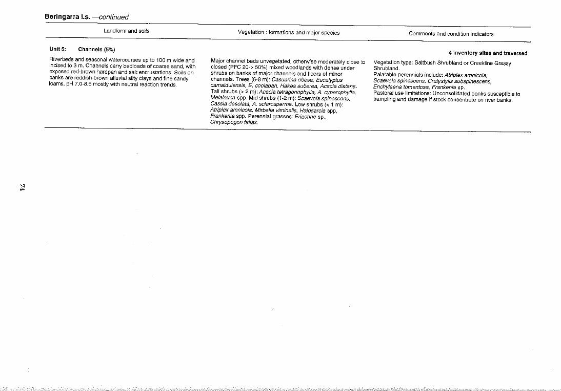
:;:
Beringarra 1.5. -continued
Landform and soils
UnitS: Channels (5%)
Riverbeds and seasonal watercourses up to 100 m wide and incised to 3 m. Channels carry bed loads of coarse sand, with exposed red-brown hardpan and salt encrustat'lons. Soils on banks are reddish-brown alluvial silty clays and fine sandy loams, pH 7.0-8.5 mostly with neutral reaction trends.
Vegetation: formations and major species
Major channel beds unvegetated, otherwise moderately close to closed (PFC 20-> 50%) mixed woodlands with dense under shrubs on banks of major channels and floors of minor channels. Trees (6-8 m): Casuarina obesa, Eucalyptus camaldulensis, E. coolabah, Hakea suberea, Acacia distans. Tall shrubs (> 2 m): Acacia tetragonophylla, A. cyperophylla, Me/a/euca spp. Mid shrubs (1-2 m): Scaevo/a spinescens, Cassia deso/ata, A. sc/erosperma. Low shrubs « 1 m): AMp/ex amnico/a, Mirbe/ia viminalis, Ha/osarcia spp, Frankenia spp. Perennial grasses: Eriachne sp., Chrysopogon fallax.
Comments and condition indicators
4 inventory sites and traversed
Vegetation type: Saltbush Shrubland or CreekJine Grassy Shrubland. Palatable perennials include: Atrip/ex amnico/a, Scaevola spinescens, Cratystylis subspinescens, Enchylaena tomentosa, Frankenia sp. Pastoral use limitations: Unconsolidated banks susceptible to trampling and damage if stock concentrate on river banks.
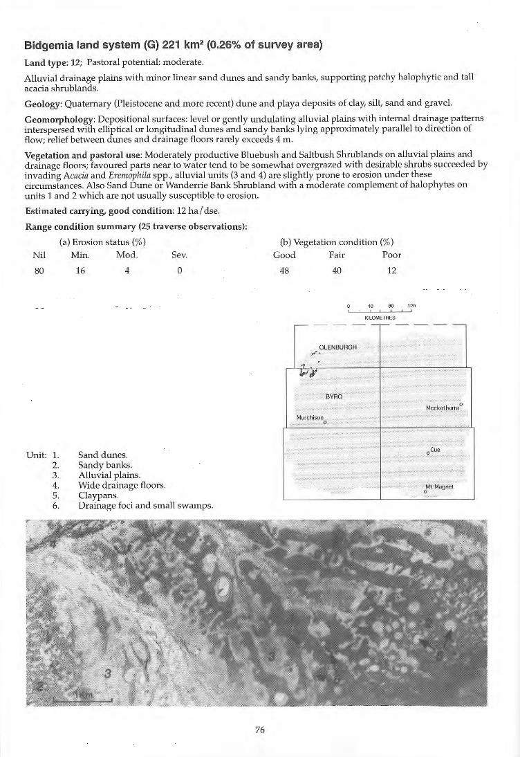
Bidgemia land system (G) 221 km2 (0.26% of survey area)
Land type: 12; Pastoral potential: moderate.
Alluvial drainage plains with minor linear sand dunes and sandy banks, supporting patchy halophytic and tall acacia shrublands.
Geology: Quaternary (Pleistocene and more recent) dune and playa deposits of clay, silt, sand and grave\.
Geomorphology: Depositional surfaces: level or gently undulating alluvial plains with internal drainage patterns interspersed with elliptical or longitudinal dunes and sandy banks lying approximately parallel to direction of fl ow; relief between dunes and drainage floors rarely exceeds 4 m.
Vegetation and pastoral use: Moderately productive Bluebush and Saltbush Shrublands on alluvial plains and drainage floors; favoured parts near to water tend to be somewhat overgrazed with desirable shrubs succeeded by invading Acacia and Eremophila spp., alluvial units (3 and 4) are sli ghtly prone to erosion under these circumstances. Also Sand Dune or Wanderrie Bank Shrubland with a moderate complement of halophytes on units 1 and 2 which are not usually susceptibJe to erosion.
Estimated carrying, good condition: 12 ha / dse.
Range condition summary (25 traverse observations) :
Nil
80
Unit: 1. 2. 3. 4. 5. 6.
(a) Erosion status (%)
Min.
16
Mod.
4
Sand dunes. Sandy banks. Alluvial plainS. Wide drainage floors . C1aypans.
Sev.
o
Drainage foci and small swamps.
76
(b) Vegetation condition (%)
Good Fair Poor
48 40 12
o 40 80 120 ! , , 1
KILOMETRES
- - - --,- - - --
GLENBURGH ". " /,!¥
BYRD
Meekatharra 0
Murchison 0
oCue
Mt Magnet 0
f
:::j
Bidgemia I.s.
landform and soils
Unit 1: Sand dunes (30%)
Linear and reticulate dUnes arranged mostly longitudinal to direction of sheet water flow; mostly < 1 km long and up to 4 m above adjacent units 2 and 3. Soils are deep dark red sands.
Unit 2: Sandy banks (30%)
Gently sloping or undulating (slopes < 1%) sand banks to 2 m above surrounding unit 3, and extending to 2 km down slope on unit 3. Soils are dark red clayey sands> 1 m deep; pH 6.5-7.5 with a neutral trend. Principal profile form: Uc5.21.
Unit 3: Alluvial plains (30%)
Gently sloping « 0.3%), interduna] plains to 200 m wide, widening downslope, slightly to moderately mantled by gravels and pebbles. Soils are crusted duplexes, red clayey sands over yellowish red light medium clays> 1 m; pH 7.0-9.0 with an alkaline trend. Principal profile form: Dr1.33.
Unit4: Wide drainage floors (5%)
Gently sloping « 0.4%) saline drainage tracts receiving sheet flow from unit 3, often with shallow, braided channels and runnels; extending to 1 km wide, although more commonly < 0.5 km. Soils are deep crusted duplexes pH 6.0 with an alkaline reaction trend. Principal profile form: Dr1.16.
Unit 5: Claypans (3%)
Variably shaped flat claypans to 500 m wide but more commonly < 250 m. Soils are deep clays.
Unit 6: Drainage foci and small swamps « 2%)
Isolated seasonally inundated small swamps to 500 m in diameter. Soils are deep clays or clay loams.
Vegetation: formations and major species
Moderately close (PFC 20-30%) tall shrubland of Acacia ramulosa. Tall shrubs (> 2 m): A ramulosa, A sclerosperma, A tetragonophylla. Mid shrubs (1-2 m): Eremophila forrestii, E. granitica, E. maitland;;, Rhagodia spp. Low shrubs « 1 m): Cassia spp., Corchorus walcottii. Perennial grass: Eriachne helmsH.
Moderately close (PFC 20-30%) mixed shrubland dominated by Acacia ramulosa. Tall shrubs (> 2 m): A ramu/osa, A sclerosperma. Mid shrubs (1-2 m): Cassia deso/ata, C. helmsH, Maireana lanosa, M. pyramidata, Scaevola spinescens, S. tomentosa, Pimelia microcephala, Eriachne helmsii.
Scattered (PFC 10-20%) low shrublands dominated by Cratystylis subspinescens and Atriplex vesicaria. Mid shrubs (1-2 m): Acacia tetragonophylla, A. victoriae, Eremophila pterocarpa, Cassia desolata, C. subspinescens. Low shrubs « 1 m): C. subspinescens, Atrip/ex vesicaria, Pti/otus beardii, Eremophila maculata, Maireana tomentosa, M. integra, Frankenia paucifloria, Halosarcia spp.
Very scattered (PFC < 10%) mixed shrublands dominated by Eremophila pterocarpa. Tall shrubs (> 2 m); Acacia cuspidifolia. Mid shrubs (1-2 m): E. pterocarpa, A. tetragonophylla, Cassia deso/ata. Low shrubs « 1 m): E. crenulata, E. macu/ata, Scaevola spinescens, PtHotus po/akii, Maireana p/atycarpa, M. pyramidata.
No perennial vegetation.
Tall close shrublands, sometimes fringing perennial grasslands in lower parts of unit.
Comments and condition indicators
Traversed
Vegetation type: Sand Dune Shrubland. Palatable perennials include: Eremophila forrestii, Rhagodia spp. Pastoral use limitations: None under controlled grazing.
1 inventory site and traversed
Vegetation type; Wanderrie Bank Grassy Shrubland. Palatable perennials include: Maireana lanosa, M. pyramidata, Scaevola spinescens, S. tomentosa. Pastoral use limitations: None under controlled grazing.
2 inventory sites, 2 condition sites and traversed
Vegetation type: Saltbush/Bluebush Shrubland. Palatable perennials include: Atriplex vesicaria, Eremophila macu/ata, Cratystylis subspinescens, Ptilotus beardii, Frankenia pauciflora, Maireana platycarpa, M. integra. Pastoral use limitations: Moderately susceptible to accelerated erosion when perennials are degraded and susceptible to increases in unpalatable shrubs such as Eremophila pterocarpa.
1 inventory site
Vegetation type: Bluebush Shrubland. Palatable perennials include: Eremophila maculata, Scaevola spinescens, Ptilotus polakii, Maireana platycarpa, M. pyramidata. Pastoral use limitations: Susceptible to erosion if vegetation is depleted; prone to increases in unpalatable shrubs such as Eremophila pterocarpa, E. crenulata, Acacia cuspidifolia.
Traversed
Traversed
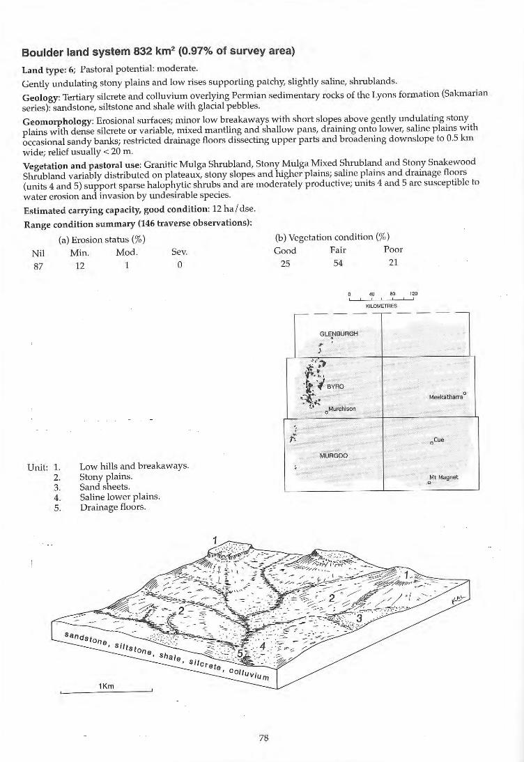
Boulder land system 832 km2 (0.97% of survey area)
Land type: 6; Pastoral potential: moderate.
Gently undulating stony plains and low rises supporting patchy, slightly saline, shrublands.
Geology: Tertiary silcrete and colluvium overlying Permian sedimentary rocks of the Lyons formation (Sakmarian series): sandstone, sil tstone and shale with glacial pebbles.
Geomorphology: Erosional surfaces; minor low breakaways w ith short slopes above gently undulating stony plains with dense silcrete or variable, mixed mantling and shallow pans, draining onto lower, saline plains with occasional sandy banks; restricted drainage floors dissecting upper parts and broadening downslope to 0.5 km wide; relief usually < 20 m.
Vegetation and pastoral use: Granitic Mulga Shrubland, Stony Mulga Mixed Shrubland and Stony Snakewood Shrubland variably distributed on plateaux, stony slopes and higher plains; saline plains and drainage floors (units 4 and 5) support sparse halophytic shrubs and are moderately productive; units 4 and 5 are susceptible to water erosion and invasion by undesirable species.
Estimated carrying capacity, good condition: 12 ha / dse.
Range condition summary (146 traverse observations):
(a) Erosion status (%)
Nil Min. Mod. Sev. 87 12 1 0
Unit: 1. 2. 3 . 4. 5.
Low hills and breakaways. Stony plains. Sand sheets. Saline lower plains. Drainage floors.
78
(b) Vegetati on condition (%)
Good Fair Poor 25 54 21
o .. 80 '" , , , , KILOMETRES
- - - --,-- - - --
GlE .. NBURGH
.~
" ~ ,.~
.~ . I-fl BYR~
0 ,;,(',. Meekatharra ......... ~. oMurchlson
"
f. oCue
MUAGOO , Mt Magnet
0
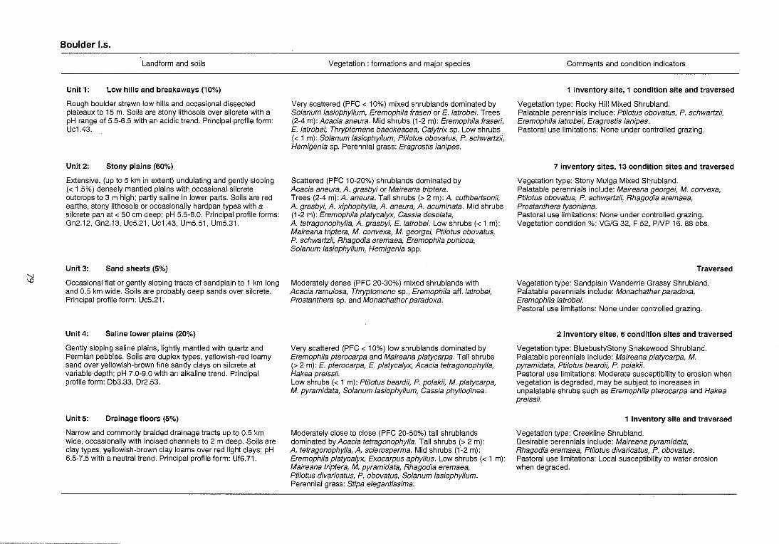
:i
Boulder 1.5.
Landform and soils
Unit 1: Low hills and breakaways (10%)
Rough boulder strewn low hills and occasional dissected plateaux to 15 m. Soils are stony lithosols over silcrete with a pH range of 5.5-6.5 with an acidic trend. Principal profile form: Uc1.43.
Unit 2: Stony plains (60%)
Extensive, (up to 5 km in extent) undulating and gently sloping « 1.5%) densely mantled plains with occasional silcrete outcrops to 3 m high; partly saline in lower parts. Soils are red earths, stony lithosols or occasionally hardpan types with a silcrete pan at < 50 em deep; pH 5.5-8.0. Principal profile forms: Gn2.12, Gn2.13, UcS.21, Uc1.43, UmS.S1, UmS.31.
Unit 3: Sand sheets (5%)
Occasional flat or gently sloping tracts of sand plain to 1 km long and 0.5 km wide. Soils are probably deep sands over silcrete. Principal profile form: Uc5.21.
Unit4: Saline lower plains (20%)
Gently sloping saline plains, lightly mantled with quartz and Permian pebb~es. Soils are duplex types, yellowish-red loamy sand over yellowish-brown fine sandy clays on silcrete at variable depth; pH 7.0-9.0 with an alkaline trend. Principal profile form: Db3.33, Dr2.53.
Unit 5: Drainage floors (5%)
Narrow and commonly braided drainage tracts up to 0.5 km wide, occasionally with incised channels to 2 m deep. Soils are clay types, yellowish-brown clay loams over red light clays; pH 6.5-7.5 with a neutral trend. Principal profile form: Uf6.71.
Vegetation: formations and major species
Very scattered (PFC < 10%) mixed shrublands dominated by Solanum lasiophylfum, Eremophila frased or E. latrobei. Trees (2-4 m): Acacia aneura. Mid shrubs (1-2 m): Eremophila fraseri, E. latrobei, Thryptomene baeckeacea, Calytrix sp. Low shrubs « 1 m): Solanum lasiophyllum, Ptilotus obovatus, P. schwartzii, Hemigenia sp. Perennial grass: Eragrostis lanipes.
Scattered (PFC 10-20%) shrublands dominated by Acacia aneura, A. grasbyi or Maireana triptera. Trees (2-4 m): A. aneura. Tall shrubs (> 2 m): A. cuthbertsonii, A. grasbyi, A. xiphophylla, A. aneura, A. acuminata. Mid shrubs (1-2 m): Eremophilaplatycalyx, Cassia desolata, A. tetragonophylla, A. grasbyi, E. latrobei. Low shrubs « 1 m): Maireana triptera, M. convexa, M. georgei, Ptilotus obovatus, P. schwartzii, Rhagodia eremaea, Eremophila punicea, Solanum lasiophyllum, Hemigenia spp.
Moderately dense (PFC 20-30%) mixed shrublands with Acacia ramulosa, Thryptomene sp., Eremophila aft.latrobei, Prostanthera sp. and Monachather paradoxa.
Very scattered (PFC < 10%) low shrublands dominated by Eremophila pterocarpa and Maireana platycarpa. Tall shrubs (> 2 m): E. pterocarpa, E. platyca/yx, Acacia tetragonophylla, Hakea preissii. Low shrubs « 1 m): Ptilotus beardii, P. po/akii, M. p/atycarpa, M. pyramidata, Solanum lasiophyllum, Cassia phyllodinea.
Moderately close to close (PFC 20-50%) tall shrublands dominated by Acacia tetragonophylla. Tall shrubs (> 2 m): A. tetragonophylla, A. sclerosperma. Mid shrubs (1-2 m): Eremophila platycalyx, Exocarpus aphyllus. Low shrubs « 1 m): Maireana triptera, M. pyramidata, Rhagodia eremaea, Pti/otus divaricatus, P. obovatus, Solanum lasiophyllum. Perennial grass: Stipa elegantissima.
Comments and condition indicators
1 inventory site, 1 condition site and traversed
Vegetation type: Rocky Hill Mixed Shrubland. Palatable perennials include: Ptilotus obovatus, P. schwartzii, Eremophila latrobei, Eragrostis lanipes. Pastoral use limitations: None under controlled grazing.
7 inventory sites, 13 condition sites and traversed
Vegetation type: Stony Mulga Mixed Shrub land. Palatable perennials include: Maireana georgei, M. convexa, Ptilotus obovatus, P. schwartzii, Rhagodia eremaea, Prostanthera tysoniana. Pastoral use limitations: None under controlled grazing. Vegetation condition %: VG/G 32, F 52, PNP 16. 88 obs.
Traversed
Vegetation type: Sand plain Wanderrie Grassy Shrubland. Palatable perennials include: Monachather paradoxa, Eremophila latrobei. Pastoral use limitations: None under controlled grazing.
2 inventory sites, 6 condition sites and traversed
Vegetation type: Bluebush/Stony Snakewood Shrubland. Palatable perennials include: Maireana p/atycarpa, M. pyramidata, PtiJotus beardii, P. polakii. Pastoral use limitations: Moderate susceptibility to erosion when vegetation is degraded, may be subject to increases in unpalatable shrubs such as Eremophila pterocarpa and Hakea preissii.
1 inventory site and traversed
Vegetation type: Creekline Shrubland. Desirable perennials include: Maireana pyramidata, Rhagodia eremaea, Ptilotus divaricatus, P. obovatus. Pastoral use limitations: Local susceptibility to water erosion when degraded.
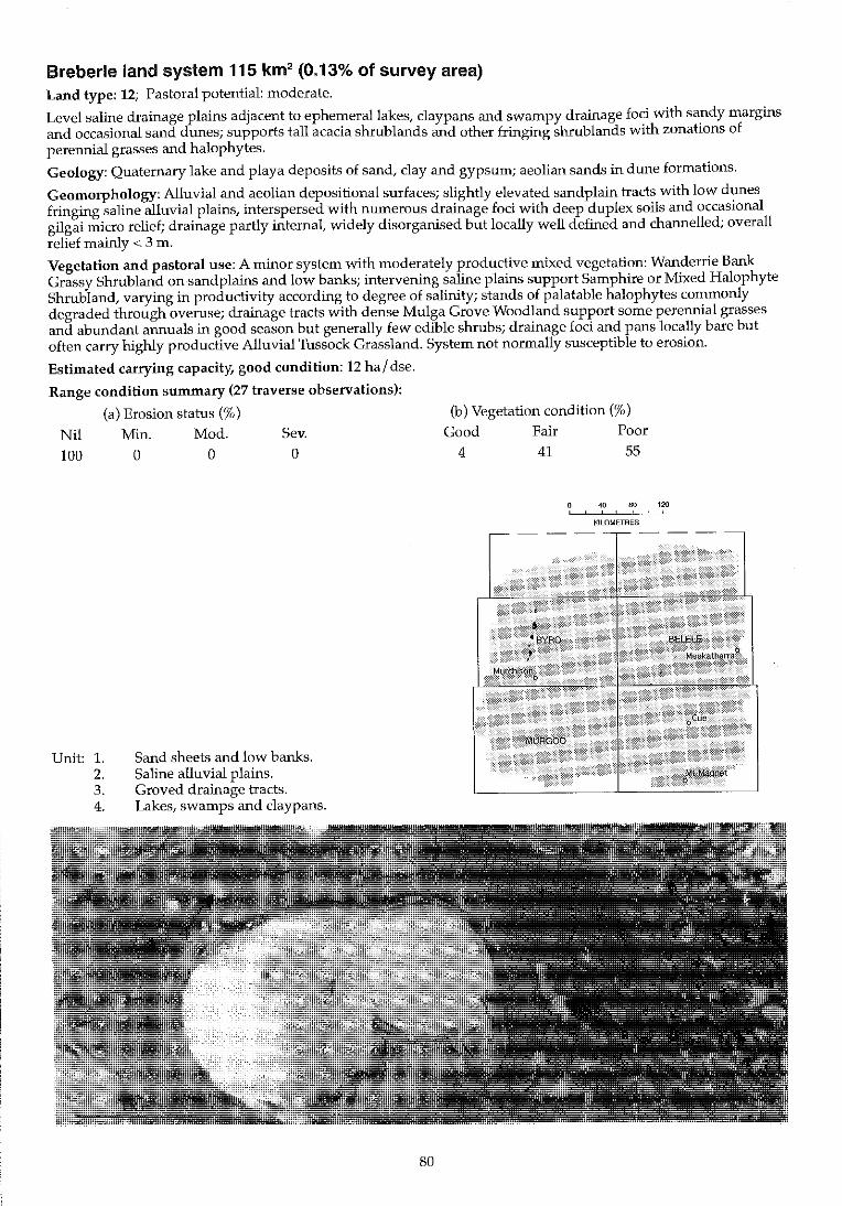
Breberle land system 115 km2 (0.13% of survey area) Land type: 12; Pastoral potential: moderate.
Level saline drainage plains adjacent to ephemeral lakes, claypans and swampy drainage foci with sandy margins and occasional sand dunes; supports tall acacia shrublands and other fringing sluublands with zonations of perennial grasses and halophytes.
Geology: Quaternary lake and playa deposits of sand, clay and gypsum; aeolian sands in dune formations.
Geomorphology: Alluvial and aeolian depositional surfaces; slightly elevated sandplain tracts with low dunes fringing saline alluvial plains, interspersed with numerous drainage foci with deep duplex soils and occasional gilgai micro relief; drainage partly internal, widely disorganised but locally well defined and channelled; overall relief mainly < 3 m.
Vegetation and pastoral use: A minor system with moderately productive mixed vegetation: Wanderrie Bank Grassy Shrubland on sand plains and low banks; intervening saline plains support Samphire or Mixed Halophyte Shrub land, varying in productivity according to degree of salinity; stands of palatable halophytes commonly degraded through overuse; drainage tracts with dense Mulga Grove Woodland support some perennial grasses and abundant annuals in good season but generally few edible shrubs; drainage foci and pans locally bare but often carry highly productive Alluvial Tussock Grassland. System not normally susceptible to erosion.
Estimated carrying capacity, good condition: 12 ha / dse.
Range condition summary (27 traverse observations):
(a) Erosion status (%)
Nil Min. Mod. Sev. 100 a a a
Unit: 1. 2. 3. 4.
Sand sheets and low banks. Saline alluvial plains. Groved drainage tracts. Lakes, swamps and claypans.
(b) Vegetation condition (%)
Good Fair Poor 4 41 55
40 80 120 , !
KILOMETRES
80
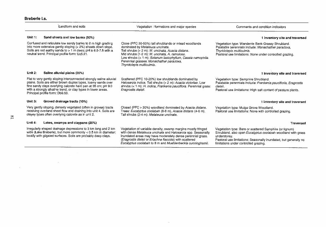
00
'""'
Breberle los.
Landform and soils
Unit 1: Sand sheets and low banks (50%)
Confused and reticulate low sandy banks to 2 m high grading into more extensive gently sloping « 2%) sheets down slope. Soils are red earthy sands to> 1 m deep; pH is 6.5-7.5 with a neutral trend. Principal profile form: Uc5.21.
Unit 2: Saline alluvial plains (20%)
Flat to very gently sloping interconnected strongly saline alluvial plains. Soils are either brown duplex types, loamy sands over fine sandy clays overlying calcrete hard pan at 35 em; pH 9.0 with a strongly alkaline trend, or clay types in lower areas. Principal profife form: DbO.53.
Unit 3: Groved drainage tracts (10%)
Very gently sloping, densely vegetated (often in groves) tracts receiving overland sheet flow and draining into unit 4. Soils are clayey types often overlying calcrete as in unit 2.
Unit 4: Lakes, swamps and claypans (20%)
Irregularly shaped drainage depressions to 3 km long and 2 km wide (Lake Breberle), but more commonly < 0.5 km in diameter; locally with gilgaied surfaces. Soils are probably deep clays.
Vegetation: formations and major species
Close (PFC 30-50%) tall shrub lands or mixed woodlands dominated by Melaleuca uncinata. Tall shrubs (> 2 m): M. uncinata, Acacia distans. Mid shrubs (1-2 m): M. uncinata, A. ramulosa. Low shrubs « 1 m): Solanum lasiophyllum, Cassia nemophila. Perennial grasses: Monachather paradoxa, Thyridolepis multiculmis.
Scattered (PFC 10-20%) low shrublands dominated by Halosarcia indica. Tall shrubs (> 2 m): Acacia victoriae. Low shrubs « 1 m): H. indica, Frankenia pauciflora. Perennial grass: Eragrostis dielsU.
Closed (PFC > 20%) woodland dominated by Acacia distans. Trees: Eucalyptus coo/abah (6-8 m), Acacia distans (4-6 m). Tall shrubs (2-4 m): Melaleuca uncinata.
Vegetation of variable density; swamp margins mostly fringed with dense Mela/euca uncinata and Halosarcia spp. Seasonally inundated areas may have moderately dense perennial grass. (Eragrostis dielsii or Eriachne flaccida) with scattered Eucalyptus coolabah to 8 m and Muehlenbeckia cunninghamii.
Comments and condition indicators
1 inventory site and traversed
Vegetation type: Wanderrie Bank Grassy Shrubland. Palatable perennials include: Monachather paradoxa, Thyrido/epis multiculmis. Pastoral use limitations: None under controlled grazing.
1 inventory site and traversed
Vegetation type: Samphire Shrubland. Palatable perennials include: Frankenia paucifloria, Eragrostis die/sU. Pastoral use limitations: High salt content of pasture plants.
1 inventory site and traversed
Vegetation type: Mulga Grove Woodland. Pastoral use limitations: None with controlled grazing.
Traversed
Vegetation type: Bare or scattered Samphire (or lignum) Shrubland, also open Eucalyptus coo/abah woodland with grass understorey. Pastoral use limitations: Seasonally inundated, but generally no limitations under controlled grazing.
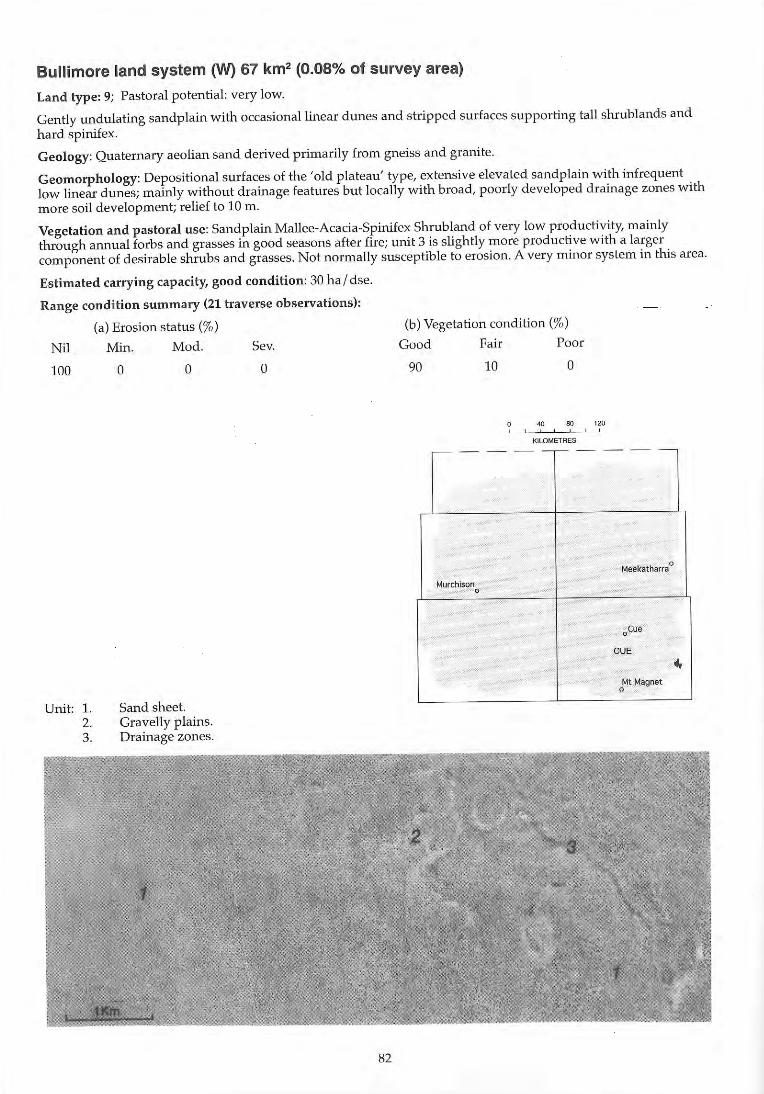
Bullimore land system (W) 67 km2 (0.08% of survey area)
Land type: 9; Pastoral potential: very low.
Gently undulating sandplain with occasional linear dunes and stripped surfaces supporting tall shrublands and hard spinifex.
Geology: Quaternary aeolian sand derived primarily from gneiss and granite.
Geomorphology: Depositional surfaces of the 'old plateau' type, extensive elevated sandplain with infrequent low linear dunes; mainly without drainage features but locally with broad, poorly developed drainage zones with more soil development; relief to 10 m.
Vegetation and pastoral use: Sand plain Mallee-Acacia-Spinifex Shrubland of very low productivity, mainly through annual forbs and grasses in good seasons after fire; unit 3 is slightly more productive with a larger component of desirable shrubs and grasses. Not normally susceptible to erosion. A very minor system in this area.
Estimated carrying capacity, good condition: 30 ha I dse.
Range condition summary (21 traverse observations):
Nil
100
Unit: 1. 2. 3.
(a) Erosion status (%)
Min.
o Mod.
o
Sand sheet. Gravelly plains. Drainage zones.
Sev.
o
82
(b) Vegetation condition (%)
Good Fair Poor
90 10 o
• .. eo " • , , , ,
KILOMETRES
-- - --- - - --
Meekatharra 0
Murchison 0
oCue
CUE
~ Mt Magnet
0
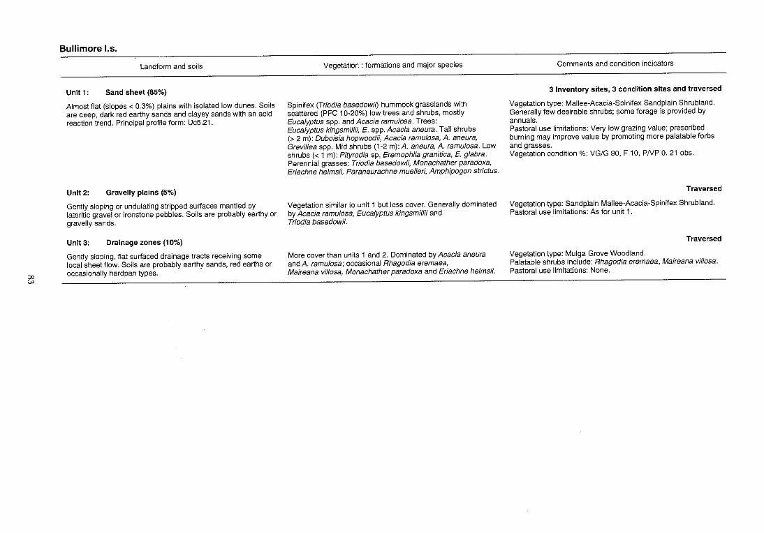
el
Bullimore 1.5.
Landform and soils
Unit 1: Sand sheet (85%)
Almost flat (slopes < 0.3%) plains with isolated low dunes. Soils are deep, dark red earthy sands and clayey sands with an acid reaction trend. Principal profile form: UcS.21.
Unit 2: Gravelly plains (5%)
Gently sloping or undulating stripped surfaces mantled by lateritic grave! or ironstone pebbles. Soils are probably earthy or gravelly sands.
Unit 3: Drainage zones (10%)
Gently sloping, flat surfaced drainage tracts receiving some local sheet flow. Soils are probably earthy sands, red earths or occasionally hardpan types.
Vegetation: formations and major species
Spinifex (Triodia basedowit) hummock grasslands with scattered (PFC 1 O~200/0) low trees and shrubs, mostly Eucalyptus spp. and Acacia ramulosa. Trees: Eucalyptus kingsmiffii, E. spp. Acacia aneura. Tall shrubs (> 2 m): Duboisia hopwoodii, Acacia ramulosa, A. aneura, Grevillea spp. Mid shrubs (1~2 m):A. aneura, A. ramufosa. Low shrubs « 1 m): Pityrodia sp, Eremophila granitica, E. glabra. Perennial grasses: Triodia basedowii, Monachather paradoxa, Eriachne helmsii, Paraneurachne muelleri, Amphipogon strictus.
Vegetation similar to unit 1 but less cover. Generally dominated by Acacia ramulosa, Eucalyptus kingsmiffii and Triodia basedowii.
More cover than units 1 and 2. Dominated by Acacia aneura and A. ramulosa; occasional Rhagodia eremaea, Maireana viffosa, Monachather paradoxa and Eriachne helmsii.
Comments and condition indicators
3 inventory sites, 3 condition sites and traversed
Vegetation type: Mallee~Acacia~Spinifex Sandplain Shrubland. Generally few desirable shrubs; some forage is provided by annuals. Pastoral use limitations: Very low grazing value; prescribed burning may improve value by promoting more palatable forbs and grasses. Vegetation condition %: VG/G 90, F 10, PNP O. 21 obs.
Traversed
Vegetation type: SandpJain Mallee~Acacia~Spinifex Shrubland. Pastoral use limitations: As for unit 1.
Traversed
Vegetation type: Mulga Grove Woodland. Palatable shrubs include: Rhagodia eremaea, Maireana vil/osa. Pastoral use limitations: None.
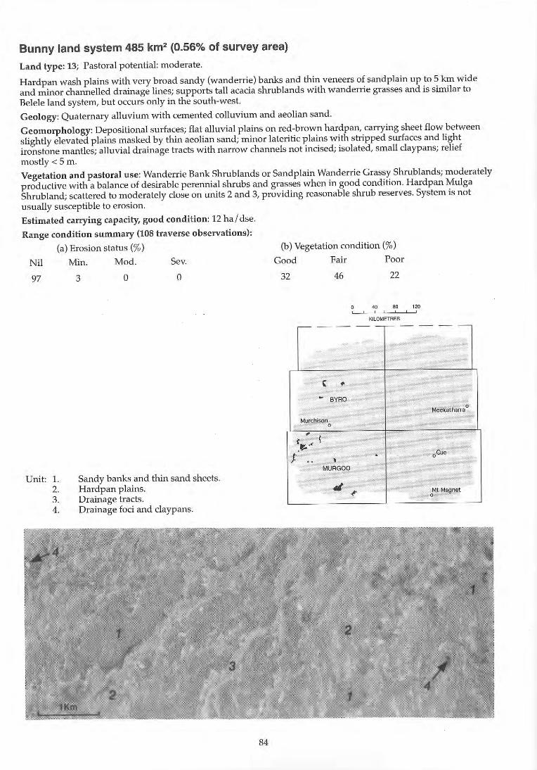
Bunny land system 485 km2 (0.56% of survey area)
Land type: 13; Pastoral potential: moderate.
H ardpan wash plains with very broad sandy (wanderrie) banks and thin veneers of sand plain up to 5 km wide and minor channelled drainage lines; supports tall acacia shrublands with wanderrie grasses and is sinUlar to Belele land system, but occurs only in the south-west.
Geology: Quaternary alluvium with cemented colluvium and aeolian sand .
Geomorphology: DepOSitional surfaces; flat alluvial plains on red-brown hardpan, carrying sheet flow between slightly elevated plains masked by thin aeolian sand; minor lateritic plains with stripped surfaces and light ironstone mantles; alluvial drainage tracts with narrow channels not incised; isolated, small daypans; relief mostly < 5 m .
Vegetation and pastoral use: Wanderrie Bank Shrublands or sandplain Wanderrie Grassy Shrublands; moderately productive with a balance of desirable perennial shrubs and grasses when in good condition. Hardpan Mulga Shrub land; scattered to moderately dose on units 2 and 3, providing reasonable shrub reserves. System is not usually susceptible to erosion .
Estimated carrying capacity, good condition: 12 hal dse.
Range condition summary (108 traverse observations):
(a) Erosion status (%)
Nil Min . Mod. Sev.
97
Unit: 1. 2. 3. 4.
3 a a
Sandy banks and thin sand sheets. Hardpan plains. Drainage tracts. Drainage foci and daypans.
84
(b) Vegetation condition (%)
Good Fair Poor
32 46 22
40 80 120 , ,
KILOMETRES
r- - - - - - - - - -
, • - BYRO
Meekatharra 0
Murchison 0 ,
\ (II:; .< ." oeue J . .. ,
MURGOO
41 ~ Mt Magnet
0
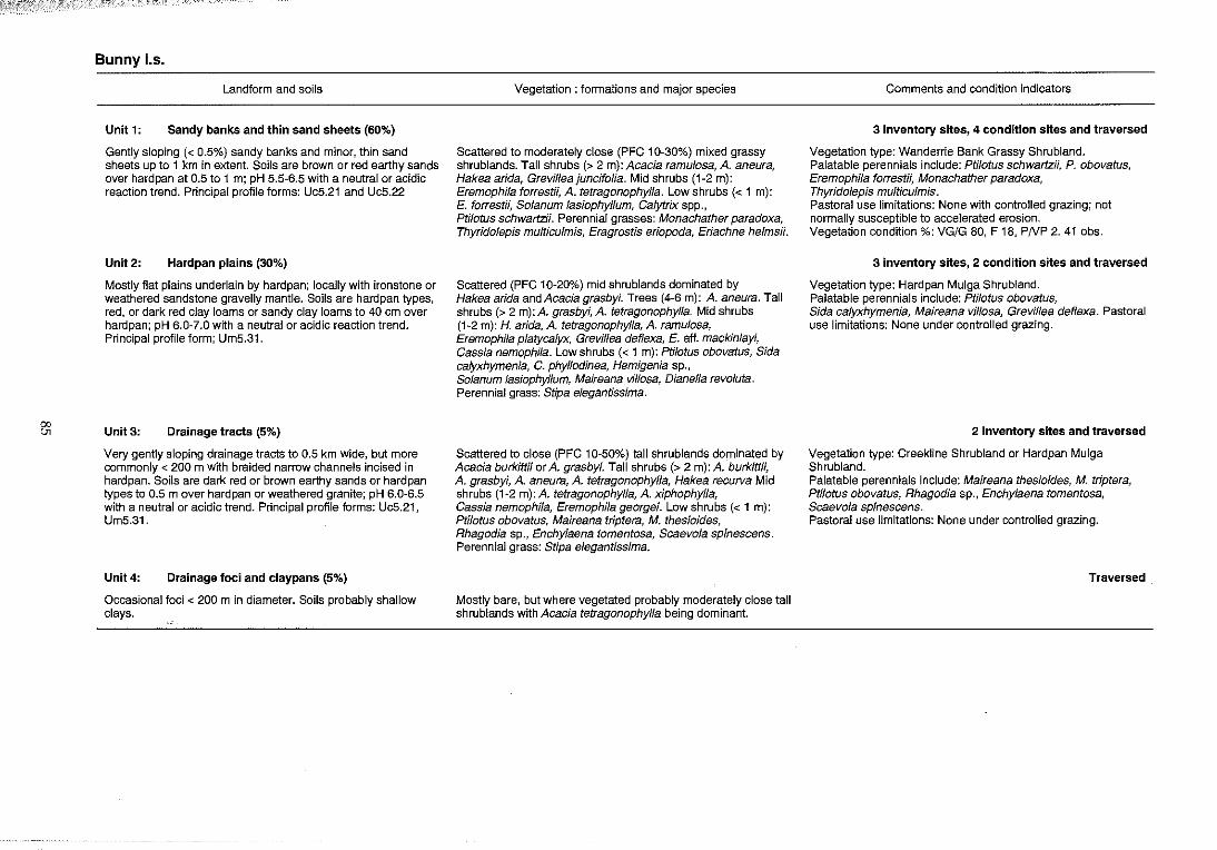
'" {Jj
Bunny los.
Landform and soils
Unit 1: Sandy banks and thin sand sheets (60%)
Gently sloping « 0.5%) sandy banks and minor, thin sand sheets up to 1 km in extent. Soils are brown or red earthy sands over hardpan at 0.5 to 1 m; pH 5.5-6.5 with a neutral or acidic reaction trend. Principal profile forms: UcS.21 and Uc5.22
Unit2: Hardpan plains (30%)
Mostly flat plains underlain by hardpan; locally with ironstone or weathered sandstone gravelly mantle. Soils are hardpan types, red, or dark red clay loams or sandy clay loams to 40 em over hardpan; pH 6.0-7.0 with a neutral or acidic reaction trend. Principal profile form; Um5.31.
Unit 3: Drainage tracts (5%)
Very gently sloping drainage tracts to 0.5 km wide, but more commonly < 200 m with braided narrow channels incised in hardpan. Soils are dark red or brown earthy sands or hardpan types to 0.5 m over hardpan or weathered granite; pH 6.0~6.5 with a neutral or acidic trend. Principal profile forms: Uc5.21, Um5.31.
Unit 4: Drainage foci and claypans (5%)
Occasional foci < 200 m in diameter. Soils probably shallow clays.
Vegetation: formations and major species
Scattered to moderately close (PFC 10~30%) mixed grassy shrublands. Tall shrubs (> 2 m): Acacia ramulosa, A. aneura, Hakea arida, Grevilleajuncifolia. Mid shrubs (1~2 m): Eremophila forrest;;, A. tetragonophylla. Low shrubs « 1 m): E. forrest;;, Solanum lasiophyllum, Calytrix spp., Ptilotus schwartz;;. Perennial grasses: Monachather paradoxa, Thyridolepis multiculmis, Eragrostis eriopoda, Eriachne helms;;.
Scattered (PFC 10~20%) mid shrublands dominated by Hakea arida and Acacia grasbyi. Trees (4~6 m): A. aneura. Tall shrubs (> 2 m):A. grasbyi, A. tetragonophylla. Mid shrubs (1 ~2 m): H. arida, A. tetragonophylla, A. ramu/osa, Eremophi/a platycalyx, Grevillea deflexa, E. aft. mackin/ayi, Cassia nemophila. Low shrubs « 1 m): Ptilotus obovatus, Sida calyxhymenia, C. phyllodinea, Hemigenia sp., So/anum lasiophyllum, Maireana villosa, Dianella revoluta. Perennial grass: Stipa elegantissima.
Scattered to close (PFC 10~50%) tall shrublands dominated by Acacia burkittii or A. grasbyi. Tall shrubs (> 2 m): A. burkittii, A. grasbyi, A. aneura, A. tetragonophylla, Hakea recurva Mid shrubs (1-2 m): A. tetragonophylla, A. xiphophylla, Cassia nemophila, Eremophila georgei. Low shrubs « 1 m): PtilotU5 obovatus, Maireana triptera, M. thes;oides, Rhagodia sp., Enchylaena tomentosa, Scaevola spinescens. Perennial grass: Stipa elegantissima.
Mostly bare, but where vegetated probably moderately close tall shrublands with Acacia tetragonophylla being dominant.
Comments and condition indicators
3 inventory sites, 4 condition sites and traversed
Vegetation type: Wanderrie Bank Grassy Shrubland. Palatable perennials include: Ptilotus schwartzii, P. obovatus, Eremophila forrest;;, Monachather paradoxa, Thyridolepis multiculmis. Pastoral use limitations: None with controlled grazing; not normally susceptible to accelerated erosion. Vegetation condition %: VG/G 80, F 18, P/VP 2. 41 obs.
3 inventory sites, 2 condition sites and traversed
Vegetation type: Hardpan Mulga Shrubland. Palatable perennials include: Ptilotus obovatus, Sida calyxhymenia, Maireana villosa, Grevillea deflexa. Pastoral use limitations: None under controlled grazing.
2 inventory sites and traversed
Vegetation type: Creekline Shrubland or Hardpan Mulga Shrubland. Palatable perennials include: Maireana thesioides, M. triptera, Ptilotus obovatus, Rhagodia sp., Enchylaena tomentosa, Scaevola spinescens. Pastoral use limitations: None under controlled grazing.
Traversed
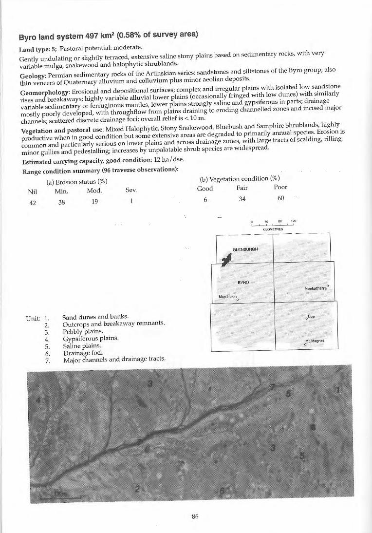
Byro land system 497 km2 (0.58% of survey area)
Land type; 5; Pastoral potential; moderate.
Gently undulating or slightly terraced, extensive saline stony plains based on sedimentary rocks, with very
variable mulga, snakewood and halophytic shrublands.
Geology: Permian sedimentary rocks of the Artinskian series: sandstones and siltstones of the Byro group; also
thin veneers of Quaternary alluvium and colluvium plus minor aeolian deposits.
Geomorphology: Erosional and depositional surfaces; complex and irregular plains with isolated low sandstone
rises and breakaways; highly variable alluvial lower plains (occasionally fringed with low dunes) with similarly
variable sedimentary or ferruginous mantles, lower plains strongly saline and gypsiferous in parts; d rainage
mostly poorly developed, with throughflow from plains draining to eroding dlannelled zones and incised major
channels; scattered discrete drainage foci; overall relief is < 10 m.
Vegetation and pastoral use: Mixed Halophytic, Stony Snakewood, Bluebush and Samphire Shrublands, highly
productive when in good condition but some extensive areas are degraded to primarily annual species. Erosion is
common and particularly serious on lower plains and across drainage zones, with large tracts of scalding, rilling,
minor gullies and pedestalling; increases by unpalatable shrub species are widespread.
Estimated carrying capacity, good condition: 12 ha / dse.
Range condition summary (96 traverse observations);
(a) Erosion status (%)
Nil Min. Mod. Sev.
42
Unit: 1. 2. 3. 4. 5. 6. 7.
38 19 1
Sand dunes and banks. Outcrops and breakaway remnants. Pebbly plains. GypsHerous plains. Saline plains. Drainage foci. Major chaIUlels and drainage tracts.
86
(b) Vegetation condition (%)
Good Fair Poor
6 34 60
40 80 120 , , .
KILOMETRES
-- - --r- - - --
J GLEN BURGH
~
BYRQ
Meekatharra 0
Murchison 0
oCue
Mt Magnet 0
00
"
Byro 1.5.
Landform and soils
Unit 1: Sand dunes and banks (4%)
Reticulate and elongate dunes to 200 m wide and 5 m high, slopes mostly < 10%; extending to 2 km in length parallel to the direction of flow. Soils are deep red earthy sands with a neutral trend. Principal profile form: UcS.21.
Unit 2: Outcrops and breakaway remnants (2%)
Residuals of sandstone and siltstone with indurated crests and short, steep foots lopes, up to 7 m above surrounding plains. Soils are skeletallithosols.
Unit 3: Pebbly plains (75%)
Gently sloping « 1 %) colluvial and alluvial plains with relief to 2 m above adjacent unit 4; with sparse to moderate mantle of weathered sandstone or ferruginous pebbles and gravels. Soils are deep duplex types: yellowish red or brown loamy to clayey sands over fine sandy clays to light clays over bedrock; pH 7.0-B.O with alkaline reaction trend. Principal profile form: Db3.33, Dr1.13, Dr1.33.
Unit4: Gypsiferous plains (5%)
Mostly flat (slope < 0.3%) plains of gypsiferous materials with puffy, thinly crusted saline surfaces; relief to 2 m. Soils are very shallow loams with gypsiferous sediments overlying a shale pan at 25-50 cm; pH 7.5 with a neutral reaction trend. Principal profile form: Um1.23.
Unit 5: Saline plains (10%)
Flat to gently sloping « 0.5%) strongly saline alluvial plains with low stony ridges or rises to 2 m above surrounding plains. Mostly covered with very sparse to very dense sandstone mantle. Soils are red, soft surfaced mottled duplexes overlying sedimentary rock; pH 6.5 with a neutral reaction trend. Principal profile form: Dr4.12.
Vegetation: formations and major species
Scattered (PFC 10-20%) tall shrublands dominated by Cafytrix sp and Grevi/lea stenobotrya. Tall shrubs (> 2 m); G. stenobotrya. Mid shrub Eremophifa maitlandH. Low shrubs « 1 m): Calytrfx sp, Scaevola tomentosa, Rhagodia eremaea, Enchylaena tomentosa.
Patchy shrublands, non-saline in higher parts of the unit, saline in lower parts.
Very scattered to scattered (PFC < 20%) shrublands, variably dominated. Tall shrubs (> 2 m): Acacia cuspidifofia, A. xiphophylla, A. aneura. Mid shrubs (1-2) m: Hakea preissii, Eremophila p/atycalyx, A. victoriae. Low shrubs (< 1 m): Rhagodia eremaea, Maireana p/atycarpa, M. pyramidata, M. aphylla, Frankenia pauciflora, Ptilotus po/akU, P. beard;;, P. obovatus, Solanum lasiophyllum, Atriplex vesicaria, A bunburyana, Enchy/aena tomentosa, Eremophi/a maculata.
Scattered (PFC 10-20%) low shrublands dominated by Ha/osarcia pruinosa. Low shrubs « 1 m): H. pruinosa, AMp/ex vesica ria, Maireana aphylla, So/anum /asiophyllum, Rhagodia eremaea, Eremophila lachnocalyx.
Very scattered (PFC < 10%) low shrub lands dominated by Halosarcia species. Tall shrubs (> 2 m): Acacia cuspidifolia. Mid shrubs (1-2 m): A. cuthbertsonil; Eremophila /achnocalyx. Low shrubs « 1 m): Ptilotus po/akii, P. obovatus, Ha/osarcia spp., H. prulnosa, Frankenia spp., Solanum lasiophyllum, Rhagodia eremaea, AMp/ex vesica ria, Maireana amoena, M. integra.
Comments and condition indicators
1 inventory site and traversed
Vegetation type: Sand Dune Shrubland. Palatable perennials include: Enchylaena tomentosa, Rhagodia eremaea, Scaevola tomentosa. Pastoral use limitations: None under controlled grazing.
4 inventory sites, 9 condition sites and traversed
Vegetation type: Stony Snakewood Shrubland, Saltbush and Bluebush Shrubland. Palatable perennials include: Maireana platycarpa, Ptilotus spp., Frankenia pauciflora, Atriplex spp. Increaser species include: Eremophila p/atycalyx, E. crenulata, Hakea preiss;;. Pastoral use limitations: Moderately susceptible to accelerated erosion where vegetation is degraded. Vegetation condition %: VG/G 3, F 35, PNP 62. Erosion incidence %: min 39, mod 20, sev 2.59 obs.
1 inventory site and traversed
Vegetation type: Samphire Shrubland. Palatable perennials include: AMplex vesicaria, Maireana aphylla, M. amoena, Rhagodia eremaea. Pastoral use limitations: High levels of salinity in pasture plants combined with poor availability of good stock water.
3 inventory sites, 1 condition site and traversed
Vegetation type: Samphire Shrubland Palatable perennials include: Ptilotus po/aW, P. obovatus, Rhagodia eremaea, Atriplex vesicaria, Maireana spp. Pastoral use limitations: High salt content of pasture plants.
&5
Byro I.s.---continued
Landform and soils
Unit 6: Drainage foci « 2%)
Scattered drainage foci and small swamps to 0.5 km long and 0.2 km wide. Soils are probably deep red earths.
Unit 7: Major channels and drainage tracts (2%)
Major drainage lines partly with narrow flood plains flanking incised channels to 3 m deep. Soils are deep red earths or light clays or juvenile profiles fringing main channels which carry deep sandy bedloads.
Vegetation: formations and major species
Close (PFC 30-50%) tall shrubland or low woodland dominated by Acacia tetragonophylla. Trees (4-6 em): A. aneura. Tall shrubs (> 2 m): A. tetragonophylla, Santa/urn spicatum. Mid shrubs (1-2 m): A. cuthbertsonii. Low shrubs « 1 m); Eremophila maculata, Enchylaena tomentosa, Maireana aphylla, M. platycarpa, M. pyramidata, Ptilotus obovatus.
Close to closed (PFC 30 - > 50%) tall shrublands dominated by Acacia tetragonophylla and A. sclerosperma. Trees (8-10 m): Eucalyptus camaldulensis. Tall shrubs (> 2 m): A. aneura, A. tetragonophylla, Heterodendrum oleaefolium, A. sclerosperma. Mid shrubs (1-2 m): A. sclerosperma, Rhagodia eremaea, Maireana pyramidata, Atriplex amnicola, Scaevola spinescens. Perennial grasses: Eragrostis setifolia, Cenchrus setigerus, C. ciliaris, Dichanthium sp, Eulalia fulva.
Comments and condition indicators
1 inventory site and traversed
Palatable perennials include: Eremophila maculata, Enchylaena tomentosa, Maireana aphylla, M. pyramidata, M. platycarpa, Ptilotus obovatus. Pastoral use limitations: None under controlled grazing.
2 inventory sites and traversed
Vegetation type: Creekline Grassy Shrubland. Palatable perennials include: Atriplex amnicola, Scaevola spinescens, Ptilotus obovatus, Rhagodia eremaea, Maireana pyramidata, Eragrostis setifolia, Cenchrus spp. Pastoral use limitations: Susceptible to accelerated erosion by major flows when vegetation is degraded.
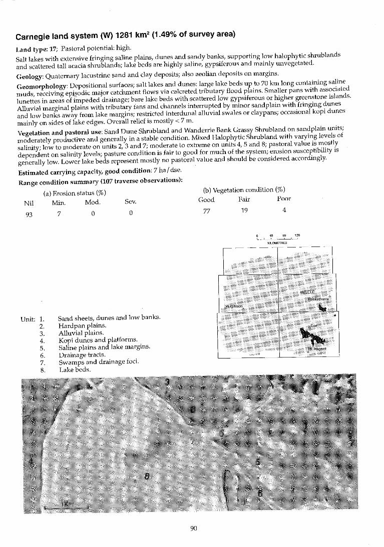
Carnegie land system (W) 1281 km2 (1.49% of survey area)
Land type: 17; Pastoral potential: high.
Salt lakes with extensive fringing saline plains, dunes and sandy banks, supporting low halophytic shrublands and scattered tall acacia shrublands; lake beds are highly saline, gypsiferous and mainly unvegetated.
Geology: Quaternary lacustrine sand and clay deposits; also aeolian deposits on margins.
Geomorphology: Depositional surfaces; salt lakes and dunes: large lake beds up to 70 km long containing saline muds, receiving ep~odic major catchment flows via ca!creted tributary flood plains. Smaller pans with associated lunettes in areas of impeded drainage; bare lake beds with scattered low gypsiferous or higher greenstone islands. Alluvial marginal plains with tributary fans and channels interrupted by minor sandplain with fringing dunes and low banks away from lake margins; restricted interdunal alluvial swales or claypans; occasional kopi dunes mainly on sides of lake edges. Overall relief is mostly < 7 m.
Vegetation and pastoral use: Sand Dune Shrubland and Wanderrie Bank Grassy Shrubland on sand plain units; moderately productive and generally in a stable condition. Mixed Halophytic Shrubland with varying levels of salinity; low to moderate on units 2, 3 and 7; moderate to extreme on units 4, 5 and 8; pastoral value is mostly dependent on salinity levels; pasture condition is fair to good for much of the system; erosion susceptibility is generally low. Lower lake beds represent mostly no pastoral value and should be considered accordingly.
Estimated carrying capacity, good condition: 7 ha / dse.
Range condition summary (107 traverse observations):
(a) Erosion status (%)
Nil Min. Mod. Sev.
93
Unit: 1. 2. 3. 4. 5. 6. 7. 8.
7 o o
Sand sheets, dunes and low banks. Hardpan plains. Alluvial plains. Kopi dunes and platforms. Saline plains and lake margins. Drainage tracts. Swamps and drainage foci. Lake beds.
(b) Vegetation condition (%)
Good Fair Poor
77 19 4
40 80 120 ! ,
KILOMETRES
90
~ ,...
Carnegie I.s.
Landform and soils
Unit 1: Sand sheets, dunes and low banks (10%)
Gently undulating sand sheets on outer margins of system with associated cut off relict dunes to > 5 m high fringing unit 5 or on lakebed; also low elliptical banks (distinct from dunes) to 2 m high surrounding small « 300 m diameter) saline interbank plains with duplex soils. Soils are dark red deep earthy sands on the sand sheets and deep siliceous sands on the dunes; pH 6.0-7.0 wfth a mainly neutral reaction trend. Principal profile forms: Uc1.23, UcS.21.
Unit 2: Hardpan plains (2%)
Minor areas of hardpan plain near system boundary; slopes < 0.5% with infrequent undulations to 1 m relief. Soils are dark red shallow hardpan types or hard-setting duplexes over hardpan at < 50 cm deep; pH 7.0 with a neutral trend. Principal profile form: Or2.52, Um5.31.
Unit 3: Alluvial plains (10%)
Mostly flat (slopes < 0.5%) broad interdunal plains, mostly saline, occasionally strewn with gravelly ironstone mantles. Soils are red duplex types, clayey sands or loamy sands over light clays < 50 cm deep over hardpan; pH 7.0-8.5 with neutral or alkaline reaction trend. Principal profile forms: Or2.12, Or2.53.
Vegetation: formatEons and major species
Scattered to moderately close (PFC 10-30%) tall or mixed shrub lands with a prominent mid storey dominated by Acacia aneura, A. sc/erosperma and A. xiphophylla; Trees (2-6 m): A. aneura. Tall shrubs (> 2 m): A. aneura, A. grasbyi, A. murrayana, A. ramu/osa, A. sclerosperma, A. tetragonophylla, A. xiphophylfa, Eremophila miniata, Hakea preissii. Mid shrubs (1-2 m): Jacksonia spp., Eremophila forrestii, E. margarethae, E. miniata, E. glabra, Cassia nemophila. Low shrubs « 1 m): Atriplex bunburyana, A. vesicaria, Ptilotus obovatus, E. granitica, Maireana convexa, M. triptera, M. pyramidata, M. thesioides, M. tomentosa, Cratystylis subspinescens, Rhagodia eremaea, R. drummondii, Gunniopsis quadrifidum, Frankenia spp., Solanum lasiophyllum. Perennial grasses: Eriachne helmsii, Eragrostis eriopoda, E. lanipes, Monachather paradoxa.
Scattered (PFC 10-20%) mixed acacia shrublands dominated by Acacia aneura. Trees (to 6 m): A. aneura. Tall shrubs (> 2 m): A. aneura, A. tetragonophylla, A. grasbyi. Mid-shrubs (1-2 m): A. ramulosa, Eremophila forrestii, Cassia nemophila, Rhagodia eremaea. Low shrubs « 1 m): Atriplex bunburyana, Maireana pyramidata, M. triptera, M. georgei, M. thesioides, Ptilotus obovatus, Solanum orbiculatum, S. lasiophyllum.
Very scattered to moderately close (PFC < 30%) low shrublands mainly dominated by Atrip/ex vesicaria or Maireana pyramidata. Tall shrubs (> 2 m): Melaleuca uncinata, Acacia aneura, A. xiphophylla, Hakeapreissii. Mid shrubs (1-2 m): Eremophila pterocarpa, A. xiphophylla. Low shrubs « 1 m): Maireana amoena, M atkinsiana, M. g/omerifolia, M integra, M platycarpa, M. pyramidata, M. triptera, M. tomentosa, Atriplex amnicola, A. vesica ria, Cratystylis subspinescens, Solanum lasiophyllum, Sida filiformis.
Comments and condition indicators
10 inventory sites and traversed
Vegetation type: Sand Dune Shrubland, Wanderrie Bank Grassy Shrubland or Saltbush Shrubland. Palatable perennials include: Maireana spp., Atriplex spp., Rhagodia spp., Cratystylis subspinescens, Eragrostis spp., Monachather paradoxa. Pastoral use limitations: None with controlled grazing. Vegetation condition %: VG/G 62, F 33, PNP 5. 21 obs.
1 inventory site, 1 condition site and traversed
Vegetation type: Mulga Chenopod Shrubland. Palatable perennials include: Atrip/ex spp., Maireana spp., Ptilotus obovatus, Rhagodia eremaea. Pastoral use limitations: None with controlled grazing and not normally susceptible to accelerated erosion. Vegetation condition %: VG/G 65, F 21, PNP 14. 14 obs.
3 inventory sites, 3 condition sites and traversed
Vegetation type: Saltbush or Bluebush Shrubland. Palatable perennials include: Atriplex spp., Maireana spp., Cratystylis subspinescens. Increaser species include: Hakea preissii, Eremophila pterocarpa. Pastoral use limitations: Areas overgrazed and degraded are susceptible to invasion by Hakea preissii, Solanum lasiophyllum and Eremophila pterocarpa. Mild to moderate susceptibility to accelerated erosion where perennial vegetation is degraded. Vegetation condition %: VG/G 77, F 20, PNP 3. Erosion incidence %: min 35. 35 obs.
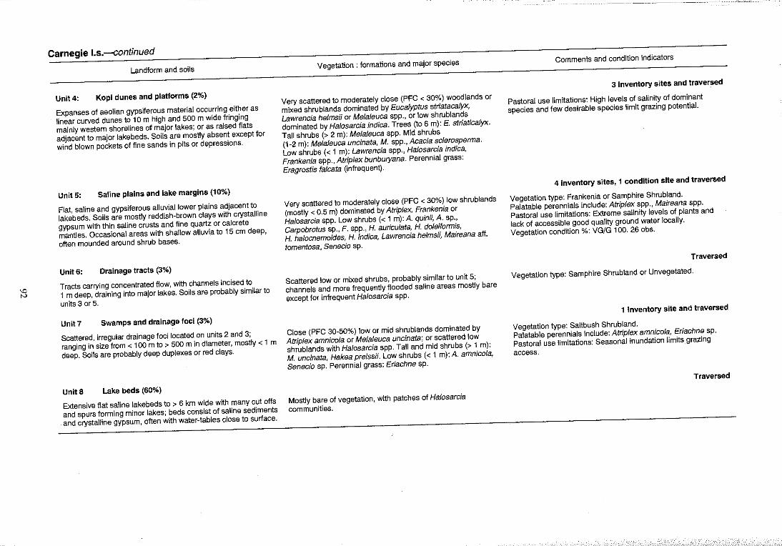
~ tv
Carnegie I.s.-continued
Landform and soils
Unit 4: Kopi dUnes and platforms (2%)
Expanses of aeolian gypsiferous material occurring either as
linear curved dunes to 10m high and 500 m wide fringing
mainly western shorelines of major lakes; or as raised flats
adjacent to major lakebeds. Soils are mostly absent except for
wind blown pockets of fine sands in pits or depressions.
UnitS: Saline plains and lake margins (10%)
Flat, saline and gypsiferous alluvial lower plains adjacent to
lakebeds. Soils are mostly reddish~brown clays with crystalline
gypsum with thin saline crusts and fine quartz or calcrete
mantles. Occasional areas with shallow alluvia to 15 em deep,
often mounded around shrub bases.
Unit 6: Drainage tracts (3%)
Tracts carrying concentrated flow, with channels incised to
1 m deep, draining into major lakes. Soils are probably similar to
units 3 or 5.
Unit7 Swamps and drainage foci (3%)
Scattered, irregular drainage foci located on units 2 and 3;
ranging in size from < 100 m to > 500 m in diameter, mostly < 1 m
deep. Soils are probably deep duplexes or red clays.
Unit 8 Lake beds (60%)
Extensive flat saline lakebeds to > 6 km wide with many cut offs
and spurs forming minor lakes; beds consist of saline sediments
and crystalline gypsum, often with water~tables close to surface.
Vegetation: formations and major species
Very scattered to moderately close (PFC < 30%) woodlands or
mixed shrublands dominated by Eucalyptus striatacalyx,
Lawrencia heJmsii or MeJaJeuca spp., or low shrublands
dominated by Halosarcia indica. Trees (to 6 m): £ striaticaJyx.
Tall shrubs (> 2 m): MelaJeuca spp. Mid shrubs
(1 ~2 m): Melaleuca uncinata, M. spp., Acacia sclerosperma.
Low shrubs « 1 m): Lawrencia spp., Halosarcia indica,
Frankenia spp., Atrip/ex bunburyana. Perennial grass:
Eragrostis fa/cata (infrequent).
Very scattered to moderately close (PFC < 30%) low shrublands
(mostly < 0.5 m) dominated by Atriplex, Frankenia or
Halosarcia spp. Low shrubs « 1 m): A. quinil, A. sp.,
Carpobrotus sp., F. spp., H. auricu/ata, H. doleiformis,
H. halocnemoides, H. indica, Lawrencia he/msii, Maireana aff.
tomentosa, Senecio sp.
Scattered low or mixed shrubs, probably similar to unit 5;
channels and more frequently flooded saline areas mostly bare
except for infrequent Ha/osarcia spp.
Close (PFC 30M 50%) low or mid shrublands dominated by
Atr/p/ex amnico/a or Me/aJeuca uncinata; or scattered low
shrublands with Ha/osarcia spp. Tall and mid shrubs (> 1 m):
M. uncinata, Hakea preissH. Low shrubs « 1 m): A. amnicola,
Senecio sp. Perennial grass: Eriachne sp.
Mostly bare of vegetation, with patches of Halosarcia
communities.
Comments and condition indicators
3 inventory sites and traver~ed
Pastoral use limitations: High levels of salinity of dominant
species and few desirable species limit grazing potential.
4 inventory sites, 1 condition site and traversed
Vegetation type: Frankenia or Samphire Shrubland.
Palatable perennials include: Atrip/ex spp., Maireana spp.
Pastoral use limitations: Extreme salinity levels of plants and
lack of accessible good quality ground water locally.
Vegetation condition %: VG/G 100. 260bs.
Traversed
Vegetation type: Samphire Shrubland or Unvegetated.
1 inventory site and traversed
Vegetation type: Saltbush Shrubland.
Palatable perennials include: Atriplex amnico/a, Eriachne sp.
Pastoral use limitations: Seasonal inundation limits grazing
access.
Traversed
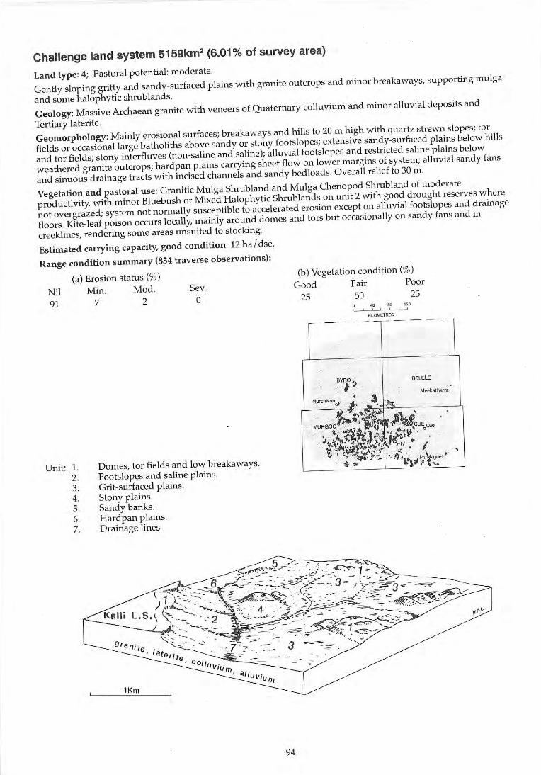
Challenge land system 5159km2 (6.01% of survey area)
Land type: 4; Pastoral potential : moderate.
Gently sloping gritty and sandy-surfaced plains with granite outcrops and minor breakaways, supporting mulga
and some halophytic shrublands.
Geology: Massive Archaean granite with veneers of Quaternary colluvium and minor alluvial deposits and
Tertiary laterite.
Geomorphology: Mainly erosional surfaces; breakaways and hills to 20 m high with quartz strewn slopes; tor
fields or occasional large batholiths above sandy or stony footslopes; extensive sandy-surfaced plains below lulls
and tor fields; stony interfluves (non-saline and sa line); alluvial footslopes and restricted saline plains below
weathered granite outcrops; hardpan plains carrying sheet flow on lower margins of system; alluvial sandy fans
and sinuous drainage tracts with incised channels and sandy bedloads. Overall relief to 30 m.
Vegetation and pastoral use: Grani tic Mulga Shrub land and Mulga Chenopod Shrub land of moderate
productivity, with minor Bluebush or Mixed Halophytic Shrub lands on unit 2 with good drought reserves where
not overgrazed; system not normally susceptible to accelerated erosion except on alluvial footslopes and drainage
floors. Kite-leaf poison occurs locally, mainly around domes and tors but occasionally on sandy fans and in
creeklines, rendering some areas unsuited to stocking.
Estimated carrying capacity, good condition: 12 ha I dse.
Range condition summary (834 traverse observations):
(a) Erosion status (%)
Nil Min. Mod. Sev.
91 7 2 a
Unit: 1. 2, 3. 4, 5. 6. 7.
Domes, tor fields and low breakaways. Footslopes and salin e plainS. Grit-surfaced plains. Stony plains. Sandy banks. Hardpan plains. Drainage lines
Kalli
94
(b) Vegetation conditi on (%)
Good Fair Poor
25 50 25 .w I!O 120 ,
I<IlDMETRES
--- --,----
BYA0 1 BELELE
jl Meeiraltiarll:l
0
MUrchiSO"of . " So ", '~ It ~ .. ,"~~., ~. '
MURGOO~;~1 tn ~~,~t.cu~c", '
,,,\:~- 'J." 't~W . #"t.'\1 ,-...I,l .... "<f' )./;~ "'. ~ ~iI#.:~ ... :'~ f "h .... :..... I , • '.' ~i " ~ V ' r'" • .... .!"' ..... " !r .i.\t~t agnetl'
. '$ .l1li' . . ,-
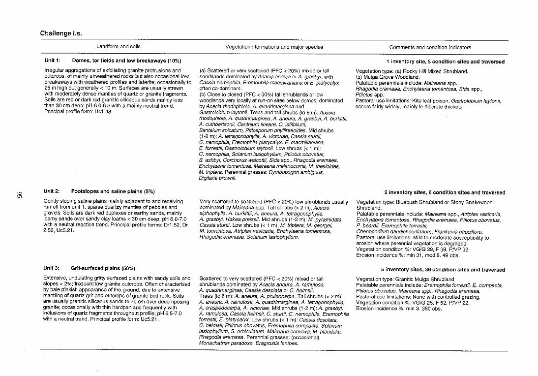
:;:
Challenge 1.5.
Landform and soils
Unit 1: Domes, tor fields and low breakaways (10%)
Irregular aggregations of exfoliating granite protrusions and outcrops, of mainly unweathered rocks but also occasional low breakaways with weathered profiles and laterite; occasionally to 25 m high but generally < 10m. Surfaces are usually strewn with moderately dense mantles of quartz or granite fragments. Soils are red or dark red granitic siliceous sands mainly less than 30 em deep; pH 6.0-6.5 with a mainly neutral trend. Principal profile form: Uc1.43.
Unit2: Footslopes and saline plains (5%)
Gently sloping saline plains mainly adjacent to and receiving run-off from unit 1, sparse quartzy mantles of pebbles and gravels. Soils are dark red duplexes or earthy sands, mainly loamy sands over sandy clay loams < 30 cm deep, pH 6.0-7.0 with a neutral reaction trend. Principal profile forms: Or1.52, Dr 2.52, Uc5.21.
Unit 3: Grit-surfaced plains (50%)
Extensive, undulating gritty surfaced plains with sandy soils and slopes < 2%; frequent low granite outcrops. Often characterised by pale pinkish appearance of the ground, due to extensive mantling of quartz grit and outcrops of granite bed rock. Soils are usually granitic siliceous sands to 70 cm over decomposing granite; occasionally with thin hardpan and frequently with inclusions of quartz fragments throughout profile; pH 6.5-7.0 with a neutral trend. Principal profile form: Uc5.21.
Vegetation: formations and major species
(a) Scattered or very scattered (PFC < 20%) mixed or tall shrublands dominated by Acacia aneura or A. grasbyi; with Cassia nemophila, EremophiJa macmillaniana or E. p/atycalyx often co-dominant. (b) Close to closed (PFC < 30%) tall shrublands or low woodlands very locally at run-on sites below domes, dominated by Acacia rhodophJoia, A. quadrimarginea and Gastr%bium laytonii. Trees and tall shrubs (to 6 m): Acacia rhodophloia, A. quadrimarginea, A. aneura, A. grasbyi, A. burkittii, A. cuthbertsonii, Canthium lineare, C. latifolium, Santalum spicatum, Pittosporum phylliraeoides. Mid shrubs (1-2 m): A. tetragonophylla, A. victoriae, Cassia sturtN, C. nemophila, Eremophila p/atycalyx, E. macmillaniana, E. forrest;;, Gastr%bium layton;;. Low shrubs « 1 m): C. nemophiJa, Solanum Jasiophyllum, PtHotus obovatus, S. ashbyi, Corchorus walcottii, $ida spp., Rhagodia eremaea, Enchylaena tomentosa, Maireana melanocoma, M. thesioides, M. triptera. Perennial grasses: Cymbopogon ambiguus, Digitaria brownii.
Very scattered to scattered (PFC < 20%) low shrublands usually dominated by Maireana spp. Tall shrubs (> 2 m): Acacia xiphophylla, A. burkittii, A. aneura, A. tetragonophylla, A. grasbyi, Hakea preiss;;. Mid shrubs (1-2 m): M. pyramidata, Cassia sturt;;. Low shrubs « 1 m): M. triptera, M. georgei, M. tomentosa, Atriplex ves/caria, Enchylaena tomentosa, Rhagodia eremaea, Solanum fasiophyllum.
Scattered to very scattered (PFC < 20%) mixed or tall shrublands dominated by Acacia aneura, A. ramulosa, A. quadrimarginea, Cassia deso/ata or C. helms;;. Trees (to 6 m): A. aneura, A. pruinocarpa. Tall shrubs (> 2 m): A. aneura, A. ramulosa, A. quadrimarginea, A. tetragonophylla, A. craspedocarpa, A. victoriae. Mid shrubs (1-2 m):A. grasbyf, A. ramulosa, Cassia he/msii, C. sturt;;, C. nemophila, Eremophila forrestH, E. p/atycalyx. Low shrubs « 1 m): Cassia deso/ata, C. helmsii, Ptilotus obovatus, EremophiJa compacta, Solanum lasiophyllum, S. orbiculatum, Maireana convexa, M. planifolia, Rhagodia eremaea. Perennial grasses: (occasional) Monachather paradoxa, Eragrostis lanipes.
Comments and condition indicators
1 inventory site, 5 condition sites and traversed
Vegetation type: (a) Rocky Hill Mixed Shrubland. (b) Mulga Grove Woodland. Palatable perennials include: Maireana spp., Rhagodia eremaea, Enchylaena tomentosa, Sida spp., Ptilotus spp. Pastoral use limitations: Kite leaf poison, Gastr%bium Jaytonii, occurs fairly widely, mainly in discrete thickets.
2 inventory sites, 6 condition sites and traversed
Vegetation type: Bluebush Shrubland or Stony Snakewood Shrubland. Palatable perennials include: Maireana spp., Atrip/ex vesicaria, Enchy/aena tomentosa, Rhagodia eremaea, Ptilotus obovatus, P. beardff, Eremophila forrestii, Chenopodium gaudichaudianum, Frankenia pauciflora. Pastoral use limitations: Mild to moderate susceptibility to erosion where perennial vegetation is degraded. Vegetation condition %: VG/G 29, F 39, PNP 32. Erosion incidence %: min 31, mod 8. 49 obs.
5 inventory sites, 36 condition sites and traversed
Vegetation type; Granitic Mulga Shrubland Palatable perennials include: Eremophila forrestii, E. compacta, Ptilotus obovatus, Maireana spp., Rhagodia eremaea. Pastoral use limitations: None with controlled grazing. Vegetation condition %: VG/G 26, F 52, PNP 22. Erosion incidence %: min 3. 380 obs.
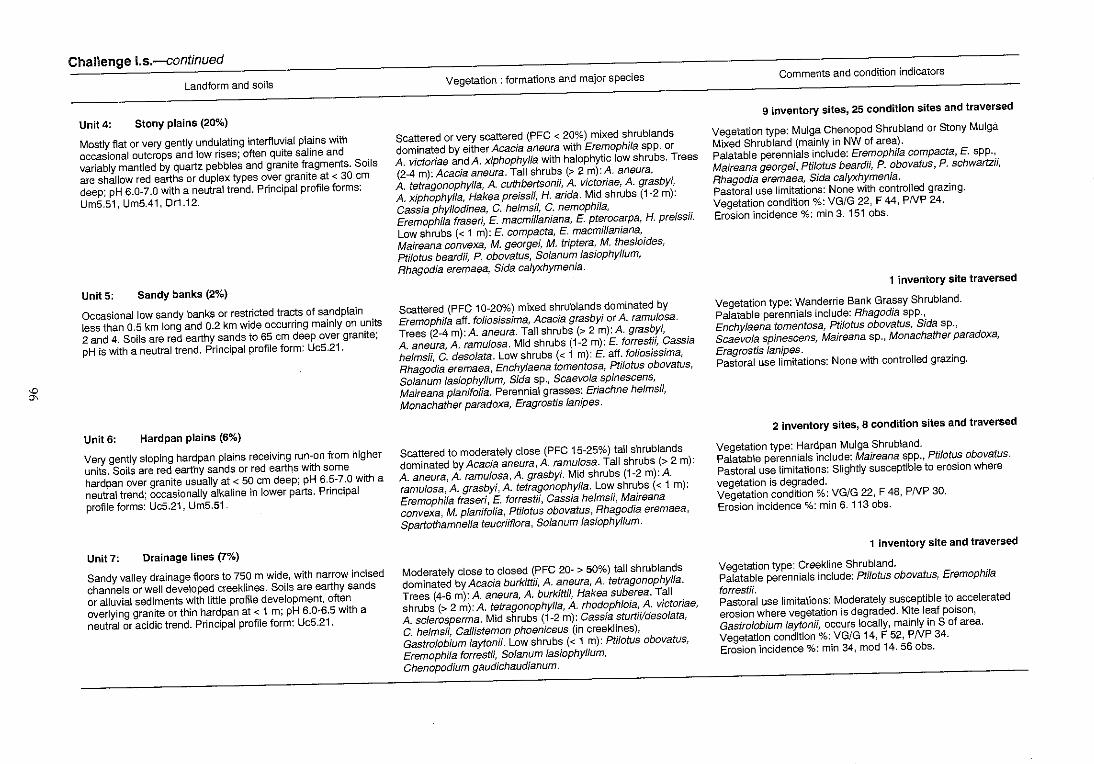
'D
'"
Challenge I.s.-continued
Landform and soils
Unit 4: Stony plains (20%)
Mostly flat or very gently undulating interfluvial plains with
occasional outcrops and low rises; often quite saline and
variably mantled by quartz pebbles and granite fragments. Soils
are shallow red earths or duplex types over granite at < 30 em
deep; pH 6.0-7.0 with a neutral trend. Principal profile forms:
Um5.51, Um5.41, Dr1.12.
Unit 5: Sandy banks (2%)
Occasional low sandy banks or restricted tracts of sandplain
less than 0.5 km long and 0.2 km wide occurring mainly on units
2 and 4. Soils are red earthy sands to 65 em deep over granite;
pH is with a neutral trend. Principal profile form: Uc5.21.
Unit 6: Hardpan plains (6%)
Very gently sloping hardpan plains receiving run-on from higher
units. Soils are red earthy sands or red earths with some
hardpan over granite usually at < 50 cm deep; pH 6.5-7.0 with a
neutral trend; occasionally alkaline in lower parts. Principal
profile forms: UC5.21, Um5.51.
Unit 7: Drainage lines (7%)
Sandy valley drainage floors to 750 m wide, with narrow incised
channels or well developed creeklines. Soils are earthy sands
or alluvial sediments with little profile development, often
overlying granite or thin hardpan at < 1 m; pH 6.0-6.5 with a
neutral or acidic trend. Principal profile form: Uc5.21.
Vegetation: formations and major species
Scattered or very scattered (PFC < 20%) mixed shrublands
dominated by either Acacia aneura with Eremophila spp. or
A. victoriae and A. xiphophylJa with halophytic low shrubs. Trees
(2-4 m): Acacia aneura. Tall shrubs (> 2 m): A. aneura,
A. tetragonophylfa, A. cuthbertsonii, A. victoriae, A. grasbyi,
A. xiphophylfa, Hakea preiss;;, H. arida. Mid shrubs (1-2 m):
Cassia phyllodinea, C. he/msii, C. nemophila,
Eremophila fraseri, E. macmillaniana, E. pterocarpa, H. preissii.
Low shrubs « 1 m): E. compacta, E. macmillaniana,
Maireana convexa, M. georgei, M. triptera, M. thesioides,
Ptilotus beardii, P. obovatus, Solanum lasiophyllum,
Rhagodia eremaea, Sida calyxhymenia.
Scattered (PFC 10-20%) mixed shrublands dominated by
Eremophila aff. fOliosissima, Acacia grasbyf or A. ramu/osa.
Trees (2-4 m): A. aneura. Tall shrubs (> 2 m): A. grasbyi,
A. aneura, A. ramulosa. Mid shrubs (1-2 m): E. forrestii, Cassia
he/msii, C. desolata. Low shrubs « 1 m): E. aft. foliosissima,
Rhagodia eremaea, Enchy/aena tomentosa, Ptilotus obovatus,
Solanum lasiophyllum, Sida sp., Scaevo/a spinescens,
Maireana p/anifolia. Perennial grasses: Eriachne he/msii,
Monachather paradoxa, Eragrostfs lanipes.
Scattered to moderately close (PFC 15-25%) tall shrublands
dominated by Acacia aneura, A. ramu/osa. Tall shrubs (> 2 m):
A. aneura, A. ramulosa, A. grasbyi. Mid shrubs (1-2 m): A.
ramu/osa, A. grasbyi, A. tetragonophylla. Low shrubs « 1 m):
Eremophila fraseri, E. forrestii, Cassia helmsii, Maireana
convexa, M. plan/folia, Ptilotus obovatus, Rhagodia eremaea,
Spartothamnella teucriif/ora, Solanum /asiophylfum.
Moderately close to closed (PFC 20- > 50%) tall shrublands
dominated by Acacia burkittii, A aneura, A. tetragonophylla.
Trees (4-6 m): A. aneura, A. burkittii, Hakea suberea. Tall
shrubs (> 2 m): A. tetragonophyfla, A. rhodophloia, A. victoriae,
A. sc/erosperma. Mid shrubs (1-2 m): Cassia sturtii/desolata,
C. he/msli: Callistemon phoenlceus (in creeklines),
Gastrolobium laytonii. Low shrubs « 1 m): Ptilotus obovatus,
Eremophila forrestIi; Solanum laslophyllum,
Chenopodium gaudichaudianum.
Comments and condition indicators
9 inventory sites, 25 condition sites and traversed
Vegetation type: Mulga Chenopod Shrubland or Stony Mulga
Mixed Shrubland (mainly in NW of area).
Palatable perennials include: Eremophila compacta, E. spp.,
Maireana georgel, Ptilotus beardii, P. obovatus, P. schwartzii,
Rhagod/a eremaea, Sida cafyxhymenla.
Pastoral use limitations: None with controlled grazing.
Vegetation condition %: VG/G 22, F 44, P/VP 24.
Erosion incidence %: min 3.151 obs.
1 inventory site traversed
Vegetation type: Wanderrie Bank Grassy Shrubland.
Palatable perennials include: Rhagodia spp.,
Enchylaena tomentosa, Ptilotus obovatus, Sfda sp.,
$caevola spinescens, Maireana sp., Monachather paradoxa,
Eragrostis lanipes. Pastoral use limitations: None with controlled grazing.
2 inventory sites, 8 condition sites and traversed
Vegetation type: Hardpan Mulga Shrubland.
Palatable perennials include: Maireana spp., Ptilotus obovatus.
Pastoral use limitations: Slightly susceptible to erosion where
vegetation is degraded. Vegetation condition %: VG/G 22, F 48, PNP 30.
Erosion incidence %: min 6. 113 obs.
1 inventory site and traversed
Vegetation type: Creekline Shrubland.
Palatable perennials include: Ptilotus obovatus, Eremophila
forrestii. Pastoral use limitations: Moderately susceptible to accelerated
erosion where vegetation is degraded. Kite leaf poison,
Gastrolobium faytonll, occurs locally, mainly in S of area.
Vegetation condition %: VG/G 14, F 52, PNP 34.
Erosion incidence %: min 34, mod 14. 56 obs.
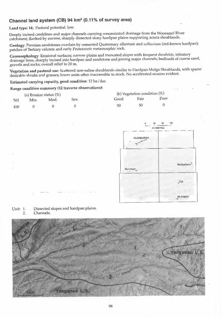
Channel land system (CS) 94 km2 (0.11% of survey area)
Land type: 14; Pastoral potential: low.
Deeply incised creeklines and major channels carrying concentrated drainage from the Wooramel River catchment; flanked by narrow, sharply dissected stony hardpan plains supporting acacia shrublands.
Geology: Permian sandstones overlain by cemented Quaternary alluvium and colluvium (red-brown hardpan); patches of Tertiary calcrete and early Proterozoic meta morphic rock.
Geomorphology: Erosional surfaces; narrow plains and truncated slopes with frequent dendritic, tributary drainage lines, sharply incised into hardpan and sandstone and joining major channels; bed loads of coarse sand, gravels and rocks; overall relief to 20 m .
Vegetation and pastoral use: Scattered non-saline shrublands similar to Hardpan Mulga Shrublands, with sparse desirable shrubs and grasses; lower units often inaccessible to stock. No accelerated erosion evident.
Estimated carrying capacity, good condition: 12 ha / dse.
Range condition summary (12 traverse observations):
(a) Erosion status (%) N il Min. Mod. Sev.
100
Unit: 1. 2.
o o o
Dissected slopes and hardpan plains. Channels.
98
(b) Vegetation condition (%) Good Fair Poor
50 50 o
o " '" 'ro , , , ,
K!LOMETRES
-- - --,-- - --
GLENBURGH
/ -
Meekatharra 0
Murchison 0
oCue
Mt Magnet 0
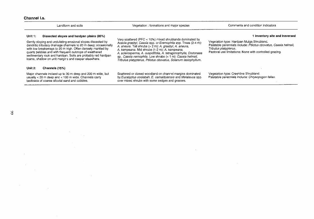
'" '"
Channel los.
Landform and soils
Unit 1: Dissected slopes and hardpan plains (85%)
Gently sloping and undulating erosional slopes dissected by dendritic tributary drainage channels to 20 m deep; occasionally with low breakaways to 20 m high. Often densely mantled by quartz pebbles and with frequent outcrops of weathered sedimentary rock and hardpan. Soils are probably red hardpan loams, shallow on unit margins and deeper elsewhere.
Unit 2: Channels (15%)
Major channels incised up to 30 m deep and 200 m wide, but usually < 20 m deep and < 100 m wide. Channels carry bedloads of coarse alluvial sand and cobbles.
Vegetation: formations and major species
Very scattered (PFC < 10%) mixed shrublands dominated by Acacia grasbyi, Cassia spp. or Eremophila spp. Trees (2-4 m): A. aneura. Tall shrubs (> 2 m): A. grasbyi, A. aneura, A. kempeana. Mid shrubs (1-2 m):A. kempeana, A. scferosperma, A. cuspidifofia, A. tetragonophyffa, Dodonaea sp., Cassia nemophila. Low shrubs « 1 m): Cassia helmsii, Tribulus platypterus, Ptilotus obovatus, Solanum lasiophyffum.
Scattered or closed woodland on channel margins dominated by Eucalyptus coolabah, E. camaldulensis and Melaleuca spp. over mixed shrubs with some sedges and grasses.
Comments and condition indicators
1 inventory site and traversed
Vegetation type: Hardpan Mulga Shrubland. Palatable perennials include: Ptilotus obovatus, Cassia helmsii, Tribulus platypterus. Pastoral use limitations: None with controlled grazing.
Vegetation type: Creekline Shrubland. Palatable perennials include: Chrysopogon fallax.
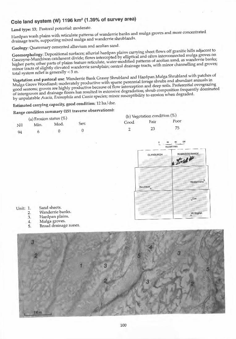
Cole land system (W) 1196 km2 (1.39% of survey area)
Land type: 13; Pastoral potential : moderate.
Hardpan wash plains with reticulate patterns of wanderrie banks and mulga groves and more concentrated
drainage tracts, supporting mixed mulga and wanderrie shrublands.
Geology: Quaternary cemented alluvium and aeolian sand.
Geomorphology: Depositional surfaces; alluvial hardpan plains carrying sheet flows off granitic hills adjacent to
Gascoyne-Murchison catchment divide; flows intercepted by elliptical and often interconnected mulga groves on
higher parts; other parts of plains feature reticulate, water-modified patterns of aeolian sand, as wanderrie banks;
minor tracts of slightly elevated wanderrie sandplain; central drainage tracts, with minor channelling and groves;
total system relief is generally < 5 m .
Vegetation and pastoral use: Wanderrie Bank Grassy Shrubland and Hardpan Mulga Shrubland with patches of
Mulga Grove Woodland; moderately productive with sparse perennial forage shrubs and abundant annuals in
good seasons; groves are highly prod uctive beca use of flow interception and deep soils. Preferential overgrazing
of intergroves and drainage floors has resulted in extensive degradation; shrub composition frequently dominated
by unpalatable Acacia, Eremophila and Cassia species; minor susceptibility to erosion when degraded.
Estimated carrying capacity, good condition: 12 ha l dse.
Range condition summary (151 traverse observations) :
(a) Erosion status (%)
Nil Min. Mod. Sev.
94
Unit: 1. 2. 3. 4. 5.
6 a
Sand sheets. Wanderrie banks. Hardpan plains. Mulga groves. Broad drainage zones.
a
100
(b) Vegetation condition (%)
Good Fair Poor
2 23 75
40 110 120 , , .
KILOMETRES
-----,..-----
GLENBUAGH ROBINSON RANGE
~ t'"jJ /JIi
Meekatharra 0
Murchison 0
oCue
Mt Magnet 0
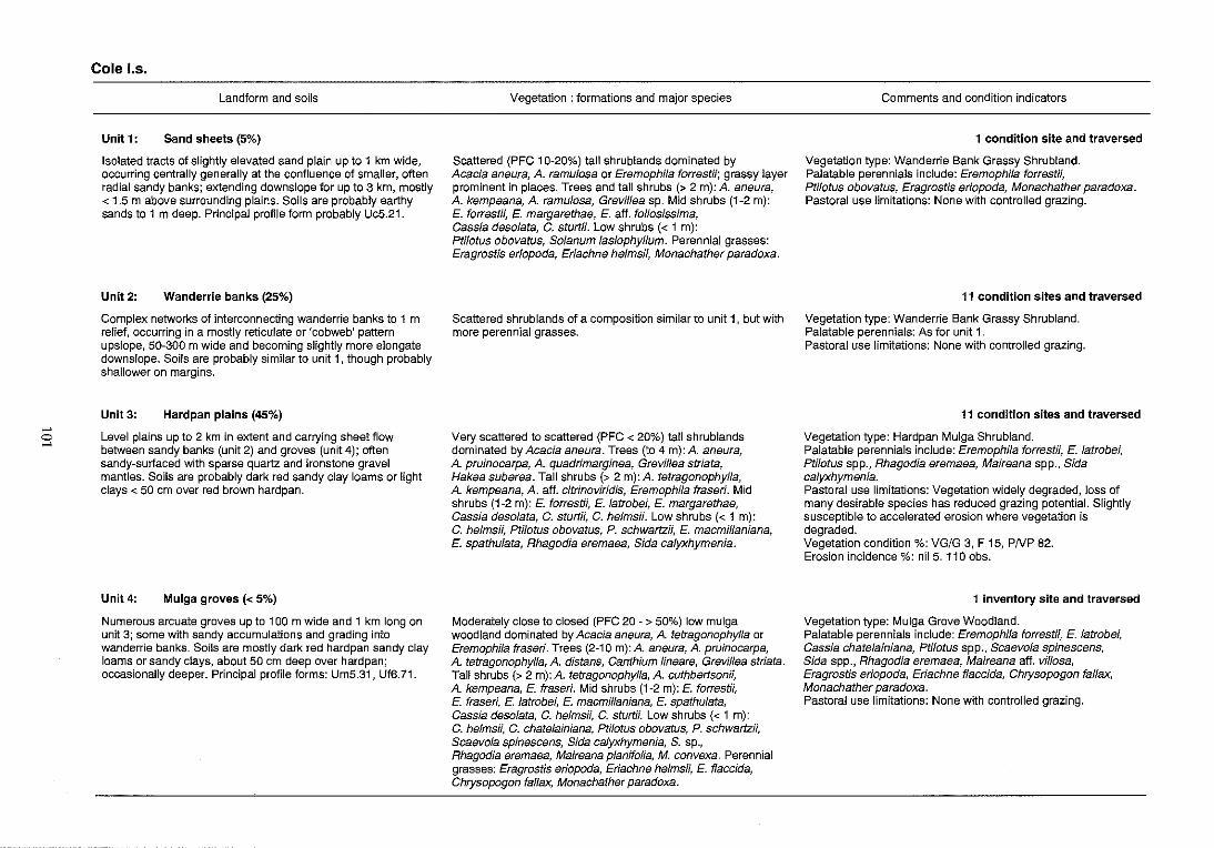
"'" o "'"
Cole los.
Landform and soils
Unit 1: Sand sheets (5%)
Isolated tracts of slightly elevated sand plain up to 1 km wide, occurring centrally generally at the confluence of smaller, often radial sandy banks; extending downslope for up to 3 km, mostly < 1.5 m above surrounding plains. Soils are probably earthy sands to 1 m deep. Principal profile form probably Uc5.21.
Unit 2: Wanderrie banks (25%)
Complex networks of interconnecting wanderrie banks to 1 m relief, occurring in a mostly reticulate or 'cobweb' pattern upslope, 50-300 m wide and becoming slightly more elongate downslope. Soils are probably similar to unit 1, though probably shallower on margins.
Unit 3: Hardpan plains (45%)
Level plains up to 2 km in extent and carrying sheet flow between sandy banks (unit 2) and groves (unit 4); often sandy-surlaced with sparse quartz and ironstone gravel mantles. Soils are probably dark red sandy clay loams or light clays < 50 cm over red brown hardpan.
Unit 4: Mulga groves « 5%)
Numerous arcuate groves up to 1 00 m wide and 1 km long on unit 3; some with sandy accumulations and grading into wanderrie banks. Soils are mostly dark red hardpan sandy clay loams or sandy clays, about 50 cm deep over hardpan; occasionally deeper. Principal profile forms: Um5.31, Uf6.71.
Vegetation: formations and major species
Scattered (PFC 10-20%) tall shrublands dominated by Acacia aneura, A. ramulosa or Eremophila forrestii; grassy layer prominent in places. Trees and tall shrubs (> 2 m): A. aneura, A. kempeana, A. ramulosa, GrevHlea sp. Mid shrubs (1-2 m): E. forrestii, E. margarethae, E. aft. foliosissima, Cassia desolata, C. sturtii. Low shrubs « 1 m): Ptilotus obovatus, Solanum lasiophyllum. Perennial grasses: Eragrostis eriopoda, Eriachne helmsii, Monachather paradoxa.
Scattered shrublands of a composition similar to unit 1, but with more perennial grasses.
Very scattered to scattered (PFC < 20%) tall shrublands dominated by Acacia aneura. Trees (to 4 m): A. aneura, A. pruinocarpa, A. quadrimarginea, Grevillea striata, Hakea suberea. Tall shrubs (> 2 m): A. tetragonophyfla, A. kempeana, A. aft. citrinoviridis, Eremophila fraseri. Mid shrubs (1-2 m): E. forrestii, E. latrobei, E. margarethae, Cassia desolata, C. sturtii, C. helms;;. Low shrubs « 1 m): C. helms;;, Ptilotus obovatus, P. schwartz;;, E. macmillaniana, E. spathulata, Rhagodia eremaea, Sida calyxhymenia.
Moderately close to closed (PFC 20 - > 50%) low mulga woodland dominated by Acacia aneura, A. tetragonophylla or Eremophila fraseri. Trees (2-10 m): A. aneura, A. pruinocarpa, A. tetragonophylla, A. distans, Canthium lineare, Grevillea striata. Tall shrubs (> 2 m): A. tetragonophylla, A. cuthbertsonii, A. kempeana, E. fraseri. Mid shrubs (1-2 m): E. forrestii, E. fraseri, E. latrobei, E. macmillaniana, E. spathulata, Cassia desolata, C. helmsii, C. sturti/. Low shrubs « 1 m): C. helmsii, C. chatelainiana, Ptilotus obovatus, P. schwartzii, Scaevola spinescens, Sida calyxhymenia, S. sp., Rhagodia eremaea, Maireana planifolia, M. convexa. Perennial grasses: Eragrostis eriopoda, Eriachne helmsii, E. flaccida, Chrysopogon faflax, Monachather paradoxa.
Comments and condition indicators
1 condition site and traversed
Vegetation type: Wanderrie Bank Grassy Shrubland. Palatable perennials include: Eremophila forrestii, Ptilotus obovatus, Eragrostis eriopoda, Monachather paradoxa. Pastoral use limitations: None with controlled grazing.
11 condition sites and traversed
Vegetation type: Wanderrie Bank Grassy Shrubland. Palatable perennials: As for unit 1. Pastoral use limitations: None with controlled grazing.
11 condition sites and traversed
Vegetation type: Hardpan Mulga Shrubland. Palatable perennials include: Eremophila forrestii, E. latrobei, Ptilotus spp., Rhagodia eremaea, Maireana spp., Sida calyxhymenia. Pastoral use limitations: Vegetation widely degraded, loss of many desirable species has reduced grazing potential. Slightly susceptible to accelerated erosion where vegetation is degraded. Vegetation condition %: VG/G 3, F 15, PNP 82. Erosion incidence %: nil 5. 110 obs.
1 inventory site and traversed
Vegetation type: Mulga Grove Woodland. Palatable perennials include: Eremophila forrestii, E. latrobei, Cassia chatelainiana, Ptilotus spp., Scaevola spinescens, Sida spp., Rhagodia eremaea, Maireana aft. villosa, Eragrostis eriopoda, Eriachne flaccida, Chrysopogon fal/ax, Monachather paradoxa. Pastoral use limitations: None with controlled grazing.
... f3
Cole I.s.--continued
Landform and soils
Unit 5: Broad drainage zones (20%)
Very gently inclined plains carrying more concentrated drainage
flows than unit 3; mostly occurring as broad, unchanneled tracts
to 1 km wide, locally with numerous small braided channels;
elsewhere large channels to 30 m wide and to 2 m deep occur.
Soils are mostly yellowish-red or red earths or loams up to 1 m
deep over hardpan; pH 6.0 with a neutral trend. Principal profile
form: Um5.31
Vegetation: formations and major species
Scattered to moderately close (PFC 10-30%) tall shrublands
dominated by Acacia aneura or A. tetragonophylla. Trees and
tall shrubs (2-8 m): A. aneura, A. cyperophyffa, A. grasbyi,
A cuthbertsonii, A. kempeana, A tetragonophylla,
Eremophifa fraseri, Hakea suberea. Mid shrubs (1~2 m):
E. fraseri, E. forrestii, A. craspedocarpa, Cassia sturtiJ;
C. helmsii. Low shrubs « 1 m): Ptilotus obovafus, Rhagodia
eremaea, Solanum lasiophyllum, Enchylaena tomentosa,
Sida cafyxhymenia. Perennial grasses: Eriachne benthamii,
E. helmsii, E. flaccida, Chrysopogon fallax .
Comments and condition indicators
1 inventory site and traversed
Vegetation type: Hardpan Mulga Shrub land and Creekline
Grassy Shrubland. Palatable perennials include: Eremophila forrestii,
Ptifotus obovatus, Rhagodia eremaea, Enchylaena tomentosa,
Sida calyxhymenia, Eriachne benthamii, E. flaccida,
Chrysopogon fallax. Pastoral use limitations: Mildly susceptible to accelerated
erosion.
•
Coolabulla land system 50 km2 (0.06% of survey area)
Land type: 16; l'a,tor,,1 potential: high.
River f1oodplain~ with calcrete or hardpan at ..,hallow dt.'pth and 10\\'I..'f claye~ pl,llJl'" adjacent to 111l'clndcring channel ... ; "upport.., halophytic ..,hrubland.., and fringing eucalypt woodland.
Geology: Quaternary iltiuv iUIl1 with patche ... of latc Tl~rtiary calcretc.
Geo morphology: Dcpol.,itional ..,urfacc<.,; alluvial plain ... 2 to'" kill wide, higher ,Heel', ot cemented hardpan with light ... urfacc mantle.., of calcrete and iron<.,to!1c; lowcr floodplain .... recei\'ing [egul,H ilooding ... ubjcct to "urfacC' fed i.,tribution and accelerated ..,treambanl-. ero...,ion; watefcour..,c.., ilfe variable - major river channe l.., about 50 III
\-v ide, or .., n1aller braided channel.., with pronounccd rncander..,.
Vegetation and pastoral use: Ilig hl )' productive Saltbu.,h Shrubland, Riverine Mi\ed ShrublilJ1d cllld Calcrete Euca lypt Woodland, mo<..,tly degraded through overgra/ing; der.,irablc .,hrubr., ilnd perennial gra.,r.,c., w idely replaced by invading Acacia, Ca .... ia and [n'111of1hila "'pecie.,. Channel., not important in term ... of forage \'alue, but highly .,u..,ceptible to acce lerated erchioll. A very minor "y<..,tel11 in the .,urvey area.
Estimated carrying capacity, good co ndition : 7 ha / d ... e.
Range condition summary (12 traverse observation s);
Nil
92
Unit: I. 2. 3, 4, 5,
(n) Era,ion ,tatl" (" ;, )
Min. Mod, Se\',
8 o o
Calcrete plain.,. Alluvial plain., on hardpfln. Flood plain,. Drainage foci. Major channel..,.
104
(b) \'c~ctation condition (";.)
Cood Fair Poor
o 92
~(J 80 '20
• - - - - --
l ~eekatharfa
0
~urthlson 0
oCue - MUAGOO
o"lt Magl1et
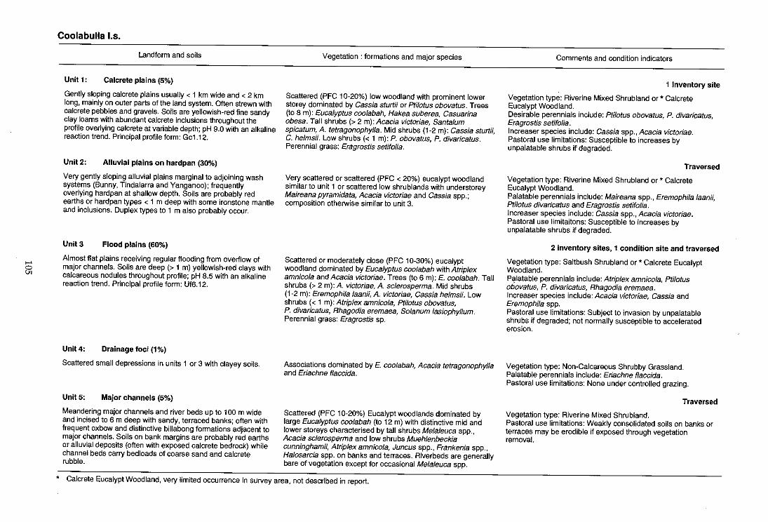
>-'
5i
Coolabulla I.s.
Landform and soils
Unit 1: Calcrete plains (5%)
Gently sloping calcrete plains usually < 1 km wide and < 2 km long, mainly on outer parts of the land system. Often strewn with calcrete pebbles and gravels. Soils are yellowish-red fine sandy clay loams with abundant calcrete inclusions throughout the profile overlying calcrete at variable depth; pH 9.0 with an alkaline reaction trend. Principal profile form: Gc1.12.
Unit 2: Alluvial plains on hardpan (30%)
Very gently sloping alluvial plains marginal to adjoining wash systems (Bunny, Tindalarra and Yanganoo); frequently overlying hardpan at shallow depth. Soils are probably red earths or hardpan types < 1 m deep with some ironstone mantle and inclusions. Duplex types to 1 m also probably occur.
Unit 3 Flood plains (60%)
Almost flat plains receiving regular flooding from overilow of major channels. Soils are deep (> 1 m) yellowish-red clays with calcareous nodules throughout profile; pH 8.5 with an alkaline reaction trend. Principal profile form: UfB.12.
Unit 4: Drainage foci (1%)
Scattered small depressions in units 1 or 3 with clayey soils.
Unit 5: Major channels (5%)
Meandering major channels and river beds up to 100 m wide and incised to B m deep with sandy, terraced banks; often with frequent oxbow and distinctive billabong formations adjacent to major channels. Soils on bank margins are probably red earths or alluvial deposits (often with exposed calcrete bedrock) while channel beds carry bed loads of coarse sand and calcrete rubble.
Vegetation: formations and major species
Scattered (PFC 10-20%) low woodland with prominent lower storey dominated by Cassia sturm or PfUotus obovatus. Trees (to 8 m): Eucalyptus coolabah, Hakea suberea, Casuarina obesa. Tall shrubs (> 2 m): Acacia victoriae, Santalum spicatum, A. tetragonophylla. Mid shrubs (1-2 m): Cassia sturtii, C. helmsii. Low shrubs « 1 m): P. obovatus, P. divaricatus. Perennial grass: Eragrostis setifolia.
Very scattered or scattered (PFC < 20%) eucalypt woodland similar to unit 1 or scattered low shrublands with understorey Maireana pyramidata, Acacia victoriae and Cassia spp.; composition otherwise similar to unit 3.
Scattered or moderately close (PFC 10-30%) eucalypt woodland dominated by Eucalyptus coolabah with Atriplex amnicola and Acacia victoriae. Trees (to B m): E. coolabah. TaU shrubs (> 2 m): A. victoriae, A. sclerosperma. Mid shrubS (1-2 m): Eremophila laanii, A. victoriae, Cassia helmsii. Low shrubs « 1 m): Atrip/ex amnicola, Pfilotus obovatus, P. divaricatus, Rhagodia eremaea, Solanum lasiophyllum. Perennial grass: Eragrostis sp.
Associations dominated by E. coolabah, Acacia tetragonophylla and Eriachne f/accida.
Scattered (PFC 10-20%) Eucalypt woodlands dominated by large Eucalyptus coolabah (to 12 m) with distinctive mid and lower storeys characterised by tall shrubs Melaleuca spp., Acacia sclerosperma and low shrubs Muehlenbeckia cunningham;;, Atrip/ex amnico/a, Juncus spp., Frankenia spp., Halosarcia spp. on banks and terraces. Riverbeds are generally bare of vegetation except for occasional Melaleuca spp.
* Calcrete Eucalypt Woodland, very limited occurrence in survey area, not described in report.
Comments and condition indicators
1 inventory site
Vegetation type: Riverine Mixed Shrub land or * Calcrete Eucalypt Woodland. Desirable perennials include: Ptilotus obovatus, P. diVaricatus, Eragrostis setifolia. Increaser species include: Cassia spp., Acacia victoriae. Pastoral use limitations: Susceptible to increases by unpalatable shrubs if degraded.
Traversed
Vegetation type: Riverine Mixed Shrubland or * Calcrete Eucalypt Woodland. Palatable perennials include: Maireana spp., Eremophila laanii, Pfilotus divaricatus and Eragrostis setifolia. Increaser species include: Cassia spp.,Acacia victoriae. Pastoral use limitaitons: Susceptible to increases by unpalatable shrubs if degraded.
2 inventory sites, 1 condition site and traversed
Vegetation type: Saltbush Shrubland or * Calcrete Eucalypt Woodland. P~latable perennials include: Atriplex amnicola, Pti/otus obovatus, P. divaricatus, Rhagodia eremaea. Increaser species include: Acacia victoriae, Cassia and Eremophila spp. Pastoral use limitations: Subject to invasion by unpalatable shrubs if degraded; not normally susceptible to accelerated erosion.
Vegetation type: Non-Calcareous Shrubby Grassland. Palatable perennials include: Eriachne flaccida. Pastoral use limitations: None under controlled grazing.
Traversed
Vegetation type: Riverine Mixed Shrubland. Pastoral use limitations: Weakly consolidated soils on banks or terraces may be erodible if exposed through vegetation removal.
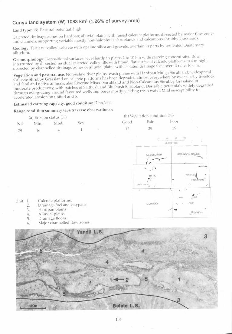
Cunyu land system (W) 1083 km2 (1 .26% of survey area)
La nd type: 15; (""lora I polcnllel: hi~h.
lcllcreted drainage .lone ... on hardpan; clllu\'ia! pi"in ... with rcli ... cd cillcrl'le platfofll1"i di ..... ectl'd by meljor tln\\' /Olll''''
and channl'I.." ... upporting \'ruiable Jl1o ... tly nOIl-lltllophytic ... hrublc1lld .... and cc1kareou" ... hrubb: gr,l' ..... land ....
Geology: fef!iary 'va llcy' calcrete with opaline ... ilicc) and grclvcl<." o\'crlclin 111 part ... by CL'111l'ntl'd QUclk'flltln'
c,lluviurn.
Geom o rph o logy: Dcpo.,itiollal ... urfacc<.,; k'\,e! hardpcln plclin ... 2 to 10 kill \vide carrying cOl1ccntreltL'd flow,
interrupted by di., ... cctcd fe",idual calcrctcd valll'Y fill ... with broad, Ilat-... urfaccd Glicrctc platform ... to -lm high,
di"'",C'ctcd by channelled drainc'gl' .lone ... or alluvial plclin<., with i..,o!alcd drainage foci; overall relid to h m.
Vegeta tion and pas tora l use: Non-..,alinl' river pla in ... : ",a ... h plain ... with Il iHdpan Mulga Shrublillld; widl''''prL'cld
Calcrete Shrubby Gra'-,'-,Iand on calcrete platform ... hi! ... been degradl'd almo..,t cvcrywhere by o\'cr-u'-,(' by li\'c ... tllCk.
and fe ral and nativc animal"i; ill..,o Rivcrine Mixed Shrubland and Non-Ca\cc1rcuu"i Shrubby l.ra ....... land 01
ll''IOderate productivity, w ith patchl'''i of Saltbu",h and Blul'bu"ih Shrubland. Dc ... irilble percJ'lniell ... widely degrilded
through o\'ergra~ing around favoured well ... c1nd bon~ ... nUl .... l1y yielding. fre .... h water. M ild ... u ... ccp tibility to
accelerated cro ... ion on unit.., -l and 5,
Estimated carry ing capa city, good conditi on : 7 hel "he.
Range condition summary (234 trave rse observati ons):
(e) Em,ion ,lalli' (' ,, )
Nil Min. Mod. Se\,.
79
Unil: 1. 2. 1. 4. 5. 0.
10
Calcrete pl cl tform .... Drainage foci and c1aypellh.
Hardpan plain ... Alluvial pielin<..,. Drainilge floor ..... tvliljor channelled flo\\' .lone ....
(b) Vegdcltion condition (, ',, )
Fai r Poor
12
I I
29
--, GlEN8URGH
/..~
\
BYRO
rr ~urchoson.
MURGOO
ROBINSON RANGE ~
BElElE j
Mee~harr ..
CUE
tt ~lagnet
3
.eI.l. ~.S. ~~~~~
100
>-' o
"
Cunyu I.s.
Landform and soils
Unit 1: Calcrete plaHorms (40%)
Level or very gently undulating platforms, mainly 0.5-3 km long, separated by flow zones and elevated 1-10 m above other units with marginal slopes to 2%; sparse to moderately dense mantle of calcrete fragments. Soils are red, reddish-brown and yellowish-red calcareous red earths or sands, usually shallow, over calcrete; pH 8.5 with an alkaline soil reaction trend. Principal profile forms: Gc1.12, Uc1.31.
Unit 2: Drainage foci and claypans (1%)
Isolated drainage foci up to 500 m wide located on unit 1 and adjacent to unit 3. Soils not sampled, but finer textured or clayey and deeper than soils of unit 1.
Unit 3: Hardpan plains (25%)
Almost flat « 0.3%) alluvial plains usually on outer margins of system. Soils are dark red deep hardpan types or red earths with hard-setting duplexes at unit margins, overlying hardpan at 1 m, pH 6.0-7.0 with neutral or acidic reaction trend. Principal profile forms: Um5.31, Dr2.51, Gn2.12.
Unit 4: Alluvial plains (20%)
Almost flat mildly saline alluvial plains with localised calcrete rises. Soils are dark red or dark brown duplex types, with a very sparse to moderately dense gravelly mantle, deep alkaline red earths or hard-setting duplexes. Depth is < 1 m over hardpan or calcrete, pH 7.0-8.0 with alkaline reaction trend. Principal profile forms: Gn2.13, Dr2.53.
Vegetation: formations and major species
Very scattered to moderately close (PFC < 30%) mixed shrublands or grassy shrublands dominated mostly by Acacia aneura, A. sclerosperma and Grevillea spp. Trees: A. aneura, Grevillea striata, Pittosporum phylliraeoides, Codonocarpus cotinifolius. Tall shrubs (> 2 m): A. sclerosperma, A. aneura, A. grasbyi, A. xiphophylla, A. ligulata, A. tysonii. Mid shrubs (1-2m): A. victoriae, A. aneura, A. sc/erosperma, A. tetragonophylla, Cassia desolata, C. nemophila, Eremophila youngii. Low shrubs « 1 m): Maireana pyramidata, M. trichoptera, Chorizema ericifolium, Cassia desolata, C. nemophila, Ptilotus obovatus, Rhagodia eremaea, Scaevola tomentosa, Solanum lasiophyllum. Perennial grasses: Eragrostis pergracilis, E. falcata, Enneapogon caerulescens, E. nigricans, Stipa scabra.
Claypans mostly bare, drainage foci with closed (PFC > 50%) mixed woodland dominated by Acacia aneura. Trees (to 8m): A. aneura, A. distans, Eucalyptus coolabah. Tall shrubS (> 2 m): A. tetragonophylla. Medium shrubs (1-2 m):A. victoriae. Low shrubs « 1 m): Scaevola spinescens, Rhagodia eremaea, Cassia desolata. Perennial grass: Eriachne f/accida.
Scattered (PFC 10-20%) mixed shrublands. Trees (4-6 m): Grevil/ea striata, Acacia aneura. Tall shrubs (> 2 m): A. aneura, A. burkittii, A. craspedocarpa, A. victoriae. Mid shrubs (1-2 m): Eremophila fraseri, A. tetragonophylla. Low shrubs « 1 m): Ptilotus obovatus, Rhagodia eremaea, Maireana planifolia, Sida calyxhymenia, Eremophila forrestii, E. maculata, Cassia helmsii, Solanum lasiophyllum.
Very scattered to moderately close (PFC < 30%) mixed shrublands. Trees: Eucalyptus coolabah. Tall shrubs (> 2 m): A. aneura, A. sclerosperma, A. victoriae. Mid shrubs (1-2 m): Stylobasium spathulatum, A. victoriae, Scaevola spinescens. Low shrubs « 1 m): CratystyJis subspinescens, Eremophila margarethae, E. maculata, E. malacoides, Solanum lasiophyllum, Scaevola spinescens, Rhagodia eremaea, Ptilotus divaricatus, Frankenia spp., Atriplex amnicola, Halosarcia spp.
Comments and condition indicators
10 inventory sites, 7 condition sites and traversed
Vegetation type: Calcrete Shrubby Grassland (variably degraded) or Bluebush Shrubland. Palatable perennials include: Enneapogon nigricans, E. caerulescens, Eragrostis pergracilis, E. falcata, Maireana spp., Rhagodia eremaea, Ptilotus obovatus, Scaevola tomentosa. Pastoral use limitations: Perennial grasses invariably overutilised and more or less degraded through preferential grazing by stock, goats, kangaroos and rabbits; susceptible to shrub invasion by Cassia nemophila, Acacia spp. Oncluding A. aneura) and Dissocarpus paradoxus where degraded; not normally susceptible to accelerated erosion. Vegetation condition %: VG/G 11, F 29, PNP 60. 65 obs.
1 inventory site and traversed
Vegetation type: Mulga Grove Woodland or Non-Calcareous Grassy Shrubland. Palatable perennials include: Rhagodia eremaea, Scaevola spinescens, Eriachne spp. Pastoral use limitations: None under controlled grazing.
3 inventory sites, 1 condition site and traversed
Vegetation type: Hardpan Mulga Shrubland. Palatable perennials include: Ptilotus obovatus, Maireana planifolia, Rhagodia eremaea, Sida calyxhymenia. Pastoral use limitations: Mild susceptibility to accelerated erosion where degraded. Vegetation condition %: VG/G 7, F 26, PNP 67. Erosion incidence %: min 14, mod 3, sev 3. 76 obs.
2 inventory Sites, 5 condition sites and traversed
Vegetation type: Riverine Mixed Shrubland. Palatable perennials include: Ptilotus spp., Cratystylis subspinescens, Atriplex amnicola, Scaevola spinescens, Rhagodia eremaea. Pastoral use limitations: Highly susceptible to accelerated erosion where degraded. Vegetation condition %: VG/G 5, F 28, PNP 67. Erosion incidence %: min 50, mod 15. 40 obs.
l
..... o 00
Cunyu I.s.-{;ontinued
Landform and soils
UnitS: Drainage floors (12%)
Mostly flat non~saline drainage tracts between calcrete platforms, up to 1 km wide but usually < 0.5 km wide with occasional channels. Soils are yellowish red, red, dark red or brown, red earths Or light clays often overlying calcrete at an average depth of 60 em, pH 6.0-9.0 with a mainly alkaline reaction trend. Principal profile forms: Gc1.12, Gn2.13, Uf6.71 , Uf6.12, Urn5. 11 .
Unit 6: Major channelled flow zones (2%)
Flow ZOnes up to 200 m wide with major channels incised to 2 m into calcrete or hardpan. Soils on banks and levees are dark red sandy, silty and clayey alluvial types; pH 7.5-9.0 with neutral or alkaline reaction trends; channels carry unsorted bedloads.
Vegetation: formations and major species
Scattered to closed (PFC 10-> 50%) woodlands or mixed shrublands dominated by Eucalyptus coo/abah, E. striaticalyx, Melaleuca aft. leiocarpa, Acacia aneura, A. burkittii, A. cyperophyJJa, A. tetragonophyJJa or A. tysonii. Trees (to 10 m): E. coo/abah, E. striatica/yx, A. aneura, M. aff./eiocarpa, A cyperophyl/a. Tall shrubs (> 2 m): A. aneura, A. burkittii, A. tetragonophylla, A. tyson;;, M. uncinata. Mid shrubs (1-2 m): A. tyson;;, Eremophila longifolia, Scaevo/a spinescens. Low shrubs « 1 m): Ptilotus obovatus, S. spinescens, Rhagodia eremaea, Solanum lasiophyllum, Cassia chatelainiana. Perennial grasses: Eriachne benthamii, E. flaccida, Stipa elegantissima.
Moderately close (PFC 20-30%) tall shrublands and fringing woodland. Trees: Acacia aneura, Eucalyptus cama/du/ensis. Tall and mid shrubs (1-> 2 m): Grevil/ea aft. stenobotrya, Hakea suberea, A. aneura, A. tysonii, AMp/ex amnico/a. Low shrubs « 1 m): Pimelia microcephala, Ptilotus obovatus, Rhagodia eremaea, Cassia nemophila, Frankenia spp. Perennial grass: Enteropogon acicu/aris .
* Calcrete Eucalypt Woodland, very limited occurrence in survey area, not described in report.
Comments and condition indicators
9 inventory sites, 1 condition sites and traversed
Vegetation type: Non-Calcareous Shrubby Grassland or * Calcrete Eucalypt Woodland. Palatable perennials include: Scaevo/a spinescens, Rhagodia eremaea, Ptilotus obovatus, Cassia chate/ainiana, Eriachne benthamii, E. flaccida. Pastoral use limitations: Mildly susceptible to erosion where degraded. Vegetation condition %: VG/G 24, F 41, P{VP 35. Erosion incidence %: min 15, mod B. 34 obs.
1 inventory site and traversed
Vegetation type: Riverine Mixed Shrubland. Palatable perennials include: AMp/ex amnico/a, Rhagodia eremaea, Ptilotus obovatus. Pastoral use limitations: None under controlled grazing.

16602-8
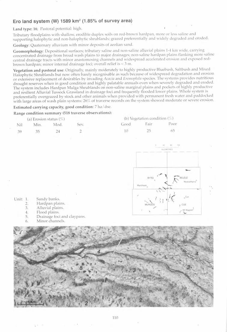
Ero land system (W) 1589 km2 (1 .85% of survey area)
La n d type: 16; I'a,t oral potential: high.
Tributary floodplain ... with ..,hallow, erodible duplc", ... nil ... on fed-browll h,udpal1, more or iL· ....... "'(1 Ii nl.' clnd ... upporting halophytic and non-I1c11ophytic ... hrublclI1d'-lo; grc1/cd preferentially and widdy dL'~rc1 Ckd (UH.i L'rOdl~d .
Geo logy: Quaternary alluviulll with minor depn..,it ... ot Cleoliclll ... and .
Geom o rph o logy: Dcpo'iitional ... urface ... ; tribllt ~lry ... aline c1l1d non-..,aline allu\' ial pl ,'I11'" 1-4 "111 wide, carrying concentrated drainage from broad \,\Ia..,h plain ... to rnajor drainage..,; nOIl -"'alinc hardpan plain ... f1M1"-ing more ... " llnt' central drainage tracr" with minor ana.,tomo...,ing channel., and widc"prc,H.i accelerated l,'W"'101l and l'\po..,ed fed brown hardpan; minor internfll drainage foci ; ovcrall relief i., < :1 m .
Vegetation and pas to ra l use: Originally, mainl y rl1<)derately to highly productivl' Blucbu ... h, "altbu ... h ,lnd Mi>..ed ll alophytic Shrub land.., but now often barely recognisable a .... .,uch becclu",c of wide .... prcad dq:;radatioll and ero .... ion or c\tcn.:..ive replacement of dc..,irable ... by invading Acacia and Ert'I/IOJ'hiln ... pecic ... . rhc ... y ... tl·m .... provide ... nutritiou ... drought re~erve., when in good condition and highly palatable annual .... even when .,('vcrl'ly degradcd and eroded . The "y..,tem include.., Hardpan Mulga Shrubland'-. on non-... aline Illarginal plc1in., and pod .. et ... of highly productive' and re ... i1ien t A llu vial Tu.., ... ock Grac.,..,land in drclinage foci and frequcntly flooded lower plain ..... \Vholc ... y..,tem i ... preferentia ll y overgrazed by "tock. and other animal .... when provided with permancnt fn:-... h \\'ater ilnd raddock.cd with large area" of wac;h plain "y.,te111..,: 2(" ";, of tr,l\'('r..,(, record .... on the .... y..,tclll .... ho\'\'cd Illoderate or .... ('verc ero ... ion .
Estimated carry ing capacity, go od co nditi o n : 7 h'l d.,c.
Ra nge condition summary (518 traverse o bserva ti o ns):
(a) Ero,ion qatu, (';, )
Nil Min. Mod . Sc\,.
39
Unit: I. 2. 1. 4. 5. 1\.
35 24
Sandv bank ... . Il ard'pall plain.., . Alluvi ill plain.., . Flood plain ... . Drainage foci and claypan.,. M inor channel.,.
110
(b) Vcgetation condition (", )
<...ood
10
/
Fair
2S
,VRO
Poor
6S
~ .. . I< '." tAl -,-
~
.. ~ tFBE~~."",,,," , \ \. '-, ~ "'"I
f/ oCUf" I ~ I ' \ 1\ .....,- \. MURGOO J I CUE
,/
( ~"'.tq""'ll ~
..... ..... .....
Ero I.s.
Landform and soils
Unit 1: Sandy banks (5%)
Sandy banks up to 300 m in extent and up to 1 m above adjacent unit 2. Soils are dark red earthy sands 0.5- > 1 m deep over hardpan, pH 6.0-6.5 with a neutral soil reaction trend. Principal profile form: UcS.21.
Unit2: Hardpan plains (30%)
Almost flat (slopes < 0.5%) plains, occasionally with a very sparse mantle of pebbles or cobbles. Soils are shallow red or dark red hardpan loams, or crusted duplexes or alkaline red earths over hardpan at < 0.75 m, pH 6.0-8.0 with a neutral to alkaline reaction trend. Principal profile forms: UmS.31, Dr1.53, Gn2.13.
Unit 3: Alluvial plains (50%)
Gently inclined « 0.3%) saline alluvial plains, often widely degraded. Most areas more or less eroded, with little topsoil and hardpan exposures where soil loss is complete. Soils are dark red duplexes, hardpan loams or red clays 0.3-> 1 m deep, mainly over hardpan; pH 6.5-9.0 with an alkaline reaction trend. Principal profile forms: Or1.52, Or2.52, 0r2.53, Um5.31, Uf6.53.
Unit 4: Flood plains (10%)
Gently inclined lower alluvial plains receiving more regular flooding than unit 3. Occasional ill-defined shalfow meandering channels < 0.5 m deep. Soils are red brown or dark red, mostly full depth (> 1 m) light clays or duplexes or alkaline red earths, some over calcrete substrates. Soil reaction trend is alkaline. Principal profile form: Gn2.13, Uf6.71 , Dr2.53.
Vegetation: formations and major species
Very scattered to moderately close (PFC < 30%) tall shrublands dominated by Acacia grasbyi and A. aneura. Trees: A aneura. Tall shrubs (> 2 m): A. aneura, A. grasbyi. Mid shrubs (1-2 m): A tetragonophylla. Low shrubs « 1 m): Eremophila forrestii, E. aft. compacta, Maireana triptera, Solanum lasiophyllum, Cassia helmsH, Ptilotus obovatus, Scaevola spinescens, Rhagodia eremaea. Perennial grasses: Monachather paradoxa, Eriachne helmsH.
Very scattered to moderately close (PFC < 30%) tall shrublands frequently dominated by Eremophila fraser;, Acacia victoriae or A grasbyi. Tall shrubs (> 2 m): E. fraseri, A. victoriae, A grasbyi, A tetragonophylla, A burkittii. Mid and low shrubs « 2 m): E. fraseri, E. forrestii, A. victoriae, A. tetragonophylla, Ptilotus obovatus, P. roei, Solanum lasiophyllum, Cassia heJms;;, C. desolata, Rhagodia eremaea, Eremophila maculata .
Very scattered to scattered (PFC < 20%) low shrublands dominated by Maireana or AtripJex spp. when in good condition; unpalatable shrubs such as Acacia victoriae, Eremophila pterocarpa and Cassia sturtii dominate areas in poor condition. Trees (2-4m m): A. aneura. Tall shrubs (> 2 m): Hakea preiss;;, A. victoriae, A. tetragonophyJla, A. xiphophylla. Mid shrubs (1-2 m): Cassia spp. A tetragonophylla, A victoriae, Eremophila pterocarpa. Low shrubs « 1 m): Maireana pyramidata, M. pJatycarpa, M. triptera, Rhagodia eremaea, Enchylaena tomentosa, Frankenia spp, Atriplex bunburyana, Eremophila pterocarpa, E. compacta, Ptilotus obovatus, Solanum lasiophyllum, Cassia desolata/sturtii, C. phyllodinea, C. helmsii.
Scattered to close (PFC 10-50%) tall shrublands dominated by Acacia tetragonophylla. Trees (2-4 m): Hakea suberea, EucaJyptus cooJabah, Acacia distans. Tall shrubs (> 2 m): A. aneura, A. tetragonophylJa. Mid shrubs (1-2 m): Eremophila fraseri, A. tetragonophylla, A. victoriae, A sclerosperma. Low shrubs « 1 m): PtHotus obovatus, P. divaricatus, Maireana pyramidata, Scaevola spinescens, Enchylaena tomentosa. Perennial grasses: Eriachne fJaccida, Stipa elegantissima.
Comments and condition indicators
2 inventory sites and traversed
Vegetation type: Wanderrie Bank Grassy Shrubland. Palatable perennials include: Monachather paradoxa, Ptilotus obovatus, Scaevola spinescens, Rhagodia eremaea. Pastoral use limitations: None under controlled grazing.
4 inventory sites, 10 condition sites and traversed Vegetation type: Hardpan Mulga Shrubland. Palatable perennials include: Ptilotus obovatus, Rhagodia eremaea, Eremophila forrestii, E. maculata, Maireana spp. Pastoral use limitations: Mildly to moderately susceptible to erosion where degraded. Vegetation condition %: VG/G 11, F 32, PNP 57. Erosion incidence %: min 26, mod 8, sev 3. 223 obs.
9 inventory sites, 27 condition sites and traversed Vegetation type: Bluebush Shrubland. Palatable perennials include: Maireana pyramidata, M. pJatycarpa, Enchylaena tomentosa, Rhagodia eremaea, Ptilotus obovafus, Frankenia spp. Increaser species include: Hakea preissii, Eremophila pterocarpa, Cassia sturtii, C. phyllodinea. Pastoral use limitations: Frequently degraded with marked loss of palatable perennial shrubs, highly susceptible to erosion where perennials are degraded, susceptible to shrub invasion. Vegetation condition %: VG/G 7, F16, PNP 77. Erosion incidence %: min 44, mod 39, sev 3. 246 obs.
4 inventory sites, 2 condition sites and traversed
Vegetation type: Riverine Mixed Shrubland. Palatable perennials include: AtripJex bunburyana, Maireana pyramidata, Scaevola spinescens, Ptilotus obovatus, P. divaricatus, Eriachne flaccida. Pastoral use limitations: None with controlled grazing.
.... .... tv
Ero I.s.--continued
Landform and soils
Unit 5: Drainage foci and claypans (3%)
Seasonally flooded claypans and rounded drainage foci up to 400 m in diameter (usually smaller) occurring on units 3 and 4. Soils are yellowish-red or brown clays and hard-setting duplex types mostly> 1 m deep, pH 6.0-7.0 with a neutral trend. Principal profile forms: Or2., Uf6.71.
Unit 6: Minor channels « 2%)
Anastomosing channels up to 25 m wide incised to 2 m deep with hardpan or calcrete exposures. Channel floors carry bedloads of coarse sand and grit. Soils on banks are alluvial types of variable depth and with alkaline soil reaction trends.
Vegetation: formations and major species
Scattered to close PFC (10-50%) woodlands or tall shrublands dominated by Acacia aneura, A. kempeana and A. tetragonophylla; may occur over whole foci or as fringes around more open grassy centres. Trees (6-10 m): A. aneura, Pittosporum phylliraeoides. Tall shrubs (> 2 m): A. kempeana, A. victoriae, A. tetragonophylla, Eremophila spp. Mid shrubs (1-2 m): Cassia helmsii, E. glabra, A. tetragonophylla. Low shrubs « 1 m): Cratystylis subspinescens, Solanum lasiophyllum, Enchylaena tomentosa, Rhagodia eremaea, Ptilotus obovatus. Perennial grasses: Eriachne f/aceida, Eragrostis xerophila, Enteropogon acicularls.
Close to closed (PFC 30- > 50%) fringing woodlands or tall shrublands dominated by Casuarina obesa or Acacia burkitth'. Trees (8-10 m):A. burkittii, C. obesa. Tall shrubs (> 2 m): A. burkittii, A. sclerosperma, A aneura. Medium shrubs (1-2 m): Cassi9 sturtii, C. helmsii, Scaevola spineseens, A. tetragonophylla, Grevil/ea stenobotrya. Low shrubs « 1 m): C. sturtii, Atriplex amnicola, Pti10tus obovatu5, Rhagodia eremaea, Frankenia sp., Enchylaena tomentosa, Halosarcia sp.
Comments and condition indicators
4 inventory sites and traversed
Vegetation type: Mulga Grove Woodland or Alluvial Tussock Grassland. Palatable perennials include: Cratystylis subspinescens, Scaevola spinescens, Ptilotus obovatus, Enchylaena tomentosa, Eriaehne flaccida, Enteropogon acicularis, Eragrostis xerophila. Pastoral use limitations: None under controlled grazing.
2 inventory sites and traversed
Vegetation type: Saltbush Shrubland or Creekline Shrubland. Palatable perennials include: Atriplex amnicola, Rhagodia eremaea, Enchylaena tomentosa, Scaevola spinescens, Frankenia sp., Ptilotus obovatus. Pastoral use limitations: None under controlled grazing.
Eurardy land system 195 km2 (0.23% of survey area)
Land type: 11; Pas to ral potential: very low.
Gently undulating sand plain with low dunes, "upporting acacia ..,hrubland'i, patchy 111(111ee and tree form eucalypts and low hcathland,;, rcprc~enting a tran,>ition to the South-Wc'itern Botanical Province; only in far south-west of area.
Geology: Quaternary aeolian ,and.
Geomorph ology: Depositional 'iurfacc'i; cxtcll<.;ivC' undulating o;andplain with occa..,ional rounded dune.., to 5 m; no drainage feature.;; other than scattered drainage foci.
Vegetation and pastoral use: Mainly South-Wc,tcrn Sand plain Shrubland-heathy vegetation containing mo,tly South-Western Botanical Province species of vcry little U"ie for graz ing; al..,o rninor Sand plain Wandcrric (.ra.,.,)' Shrub land of low productivity. A system unsuited to pa'toral development.
Estimated carrying ca pacity, good co ndition : 30 ha I d,e.
Range condition s ummary: Insufficiently sampled but in good condition where encountered.
Unit: 1. 2. 3.
,
Sandplain with low dune., . Lower plains. Drainage foci and claypan.,.
114
-- -
MurchIson 0
, MUAGOO
-
40 80 120
KILOMETRES
--r-- - --
Meekatharra 0
oCue
Ml Magnet 0
..... ..... c.n
Eurardy 1.5.
Landform and soils
Unit 1: Sandplain with low dunes (88%)
Extensive tracts of gently undulating yellowish sandplain, with little relief except for occasional low dunes « 5 m). Soils are deep, yellowish red earthy sands. Principal profile form: Uc5.21.
Unit 2: Lower plains (10%)
Flat plains with more soil development than unit 1 and receiving some local run-on. Soils are probably yellowish-red earthy sands over a calcrete pan at variable depth, pH 7.0 with a neutral reaction trend. Principal profile forms probably: Uc5.21, Uc5.22 .
Unit 3: Drainage foci and claypans (2%)
Isolated claypans up to 300 m in diameter, mostly located on lower parts of system. Soils are deep red earths or clays.
Vegetation: formations and major species
Moderately close (PFC 20-30%) mixed height shrublands (and heath lands) with many undetermined South-Western Botanical Province species; also patches of tree and mallee form eucalypts. Trees (to 12 m+): Eucalyptus loxophleba, E. foecunda. Tall shrubs (> 2 m): Acacia ramulosa, A. sclerosperma, A. royceii, Melaleuca sp., Callitris columellaris. Mid shrubs (1-2 m): A. ramulosa, A. tetragonophylla, Dononaea attenuata. Low shrubs « 1 m): Conospermum sp., Hakea sp., Rhagodia sp., Solanum lasiophyllum, S. orbiculatum, Ptilotus obovatus, Pimelia microcephala and numerous unidentified species. Perennial grasses: Monachather paradoxa, Thyridolepis multiculmis, Stipa sp., Triodia sp.
Vegetation similar to unit 1.
Generally bare of vegetation although occasionally fringed with dense Acacia tetragonophylla or Melaleuca spp.
* South Western Sandplain Shrubland, very limited occurrence in survey area, not described in report.
Comments and condition indicators
4 inventory sites and traversed
Vegetation type: SandpJain Mallee Acacia Spinifex Shrubland, Sandplain Wanderrie Grass Shrubland, * South Western Sandplain Shrubland. Palatable perennials include: Ptilotus obovatus, Monachather paradoxa, Thyridolepis multiculmis.
Pastoral use limitations: Pastoral potential is very low owing to scarcity of palatable species.
As for unit 1.
Farmer land system 81 km2 (0.09% of survey area)
Land type: 1; Pastoral potential: very low.
Rough hills and footslopes of gabbro and dolerite rising steeply from surrounding plains, supporting sparse tall acacia shrublands.
Geology: Archaean and early Proterozoic gabbro with frequent intrusive dykes and sills of dolerite; Quaternary colluvium on slopes.
Geomorphology: Erosional surfaces; hill crests and peaks with much outcrop and mantle of gabbro and dolerite; slopes variable but mostly> 10% and concave with interfluves dissected by narrow valleys; lower slopes and plains with stony mantles; relief up to 160 m.
Vegetation and pastoral use: Rocky Hill Mixed Shrubland of mostly very low pastoral value, with upper slopes and crests largely inaccessible to domestic stock; generally in good condition with little erosion owing to extensive protective mantle.
Estimated carrying capacity, good condition: 30 hal dse.
Range condition summary (19 traverse observations):
(a) Erosion status (%)
Nil Min. Mod. Sev.
100
Unit: l. 2. 3.
o o
Hills and ridges. Upper slopes.
o
Lower footslopes and marginal plains.
116
(b) Vegetation condition (%)
Good Fair Poor
63 32 5
40 80 120 , KILOMETRES
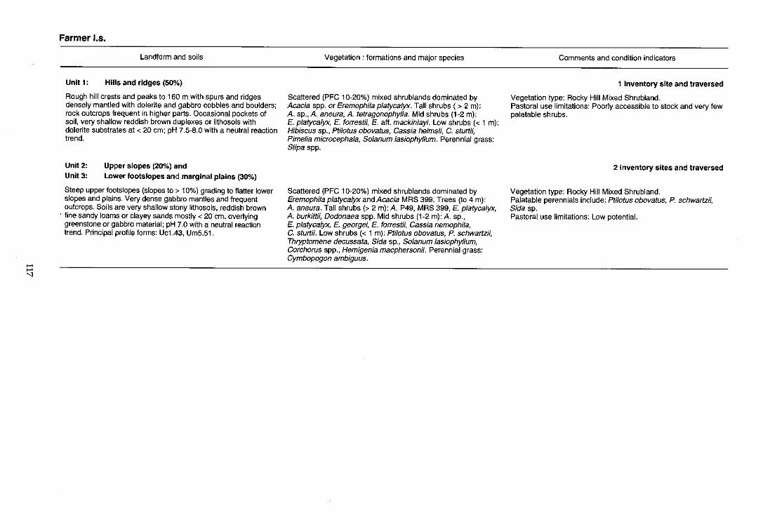
>-' >-'
"
Farmer los.
Landform and soils
Unit 1: Hills and ridges (50%)
Rough hill crests and peaks to 160 m with spurs and ridges densely mantled with dolerite and gabbro cobbles and boulders; rock outcrops frequent in higher parts. Occasional pockets of soil, very shallow reddish brown duplexes or lithosols with dolerite substrates at < 20 em; pH 7.5-8.0 with a neutral reaction trend.
Unit 2: Upper slopes (20%) and
Unit 3: Lower footslopes and marginal plains (30%)
Steep upper footslopes (slopes to > 10%) grading to flatter lower slopes and plains. Very dense gabbro mantles and frequent outcrops. Soils are very shallow stony lithosols, reddish brown
. fine sandy loams or clayey sands mostly < 20 cm, overlying greenstone or gabbro material; pH 7.0 with a neutral reaction trend. Principal profile forms: Uc1.43, Urn5.51.
Vegetation: formations and major species
Scattered (PFC 10-20%) mixed shrublands dominated by Acacia spp. or Eremophila platycalyx. Tall shrubs (> 2 m): A. sp., A. aneura, A. tetragonophylla. Mid shrubs (1-2 m): E. platyca/yx, E. forrestH, E. aft. mackin/ayi. Low shrubs « 1 m): Hibiscus sp., pti/otus obovatus, Cassia helmsii, C. sturtii, Pimelia microcephala, So/anum lasiophyllum. Perennial grass: Stipa spp.
Scattered (PFC 10-20%) mixed shrublands dominated by EremophHa platyca/yx and Acacia MRS 399. Trees (to 4 m): A. aneura. Tall shrubs (> 2 m): A. P49, MRS 399, E. platycalyx, A. burkittii, Dodonaea spp. Mid shrubs (1-2 m):A. sp., E. p/atycalyx, E. georgei, E. forrestii, Cassia nemophHa, C. sturtii. Low shrubs « 1 m): pti/otus obovatus, P. schwartzii, Thryptomene decussata, Sida sp., So/anum /asiophyllum, Corchorus spp., Hemigenia macphersonii. Perennial grass: Cymbopogon ambiguus.
Comments and condition indicators
1 inventory site and traversed
Vegetation type: Rocky Hill Mixed Shrubland. Pastoral use limitations: Poorly accessible to stock and very few palatable shrubs.
2 inventory sites and traversed
Vegetation type: Rocky Hill Mixed Shrubland. Palatable perennials include: pti/otus obovatus, P. schwartzii, Sida sp . Pastoral use limitations: Low potential.
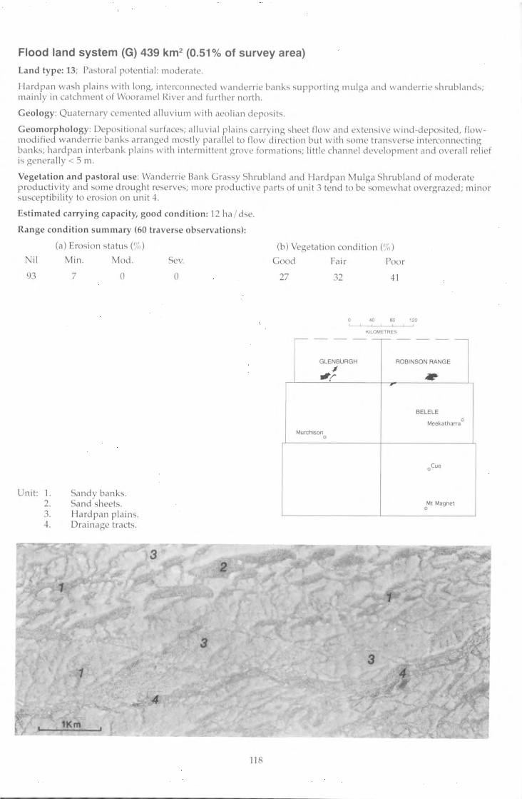
Flood land system (G) 439 km 2 (0.51% of survey area)
Land type: 13; ('a,toral potential: moderate.
Hardpan wa~h plain.., with long, interconnected wandcrric bank ...... upporting mulga and willldcrric ..,hrubland .... ; Il)ai niy in catchment of \Vooramcl River and further north .
Geology: Quaternary cemented alluv ium with aeolian dcpo,;"it ... .
Geo morp hology: Dcpo-,itional ..,urfacc..,; alluvial plain .... carrying ..,hl'ct flow and c).tenr..,ivc winu-dcpo..,itcd, f1owrnodificd wandcrrie bank.., arranged rno';tiy parallel to flow d irection but w ith ,;orne tran<..,vcr..,c interconnect ing bank ... ; hardpan interbank plain.., with inte rmittent grove formation'"); littl e channel development c1 nd overall re lief is genera lly < 5 Ill .
Vegetation and p as tora l use: Wandcrric Ba nk G ra ...... y Shrubl nnd ,) Ild I la rd pan Mul ga Shrubl a nd of rnoderatc producti v ity and I.,ome drought reserve..,; rnorc productive pari., o f unil 3 tend to be c,;ol11cwhat ovcrgra .lcd; mi nor .., u..,ceptibilil y to e ro.,io n o n unit 4.
Estimated ca rry ing ca pa city, good co nditi on: 12 ha/d,e.
Ra nge co nditi on summary (60 traverse observa tion s):
Ni l
93
Unit : I. 2. 3. 4 .
(a) Ero.,io!1 ..,tatu., e (,) Min . Mod .
7 (1
Sa nd y bank..,. Sa nd ,heet,. I lard pa n plain .:;. Dra inage trac t.."
1
1KIII
Sc\,.
o
3
3
4
11 8
(b) Vegetation condition e·,,) Cood Fair Poor
27 32 ~1
o 40 eo 120 .... .I.. .I.. .I.. ...
KILOMETRES
,--- - --~- - -
GLENBUAGH ROBINSON RANGE $
'r .. BELELE
Meckatharra • MurchISon
•
.Cue
Ml Magnel •
-
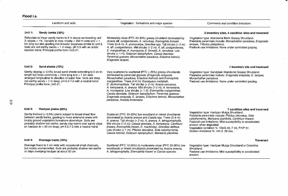
""' ""' '"
Flood I.s.
Landform and soils
Unit 1: Sandy banks (30%)
Reticulate or linear sandy banks to 3 m above surrounding unit 3; slopes < 1 %. Variable in size; mostly < 200 m wide and < 1 km long but also grading into broader expanses similar to unit 2. Soils are red earthy sands> 1 m deep; pH 5.5 with an acidic reaction trend. Principal profile form: UcS.21.
Unit2: Sand sheets (10%)
Gently sloping « 0.5%) broad sand sheets extending to 5 km in length but more commonly < 2 km long and < 1 km wide arranged longitudinal to direction of water flow. Soils are deep red earthy sands> 1 m deep; pH 6.5-7.0 with a neutral trend. Principal profile form:, UcS.21.
Unit 3: Hardpan plains (50%)
Gently inclined (< 0.5%) plains subject to broad sheet flow between sandy banks, grading to more extensive areas with locally groved vegetation formations downslope. Soils are probably shallow red earths, sandy clay loams over sandy clays on hardpan to < 50 cm deep; pH 6.0-7.0 with a neutral trend.
Unit 4: Drainage tracts (10%)
Drainage floors to 1 km wide with occasional small channels, but mostly unchannelled. Soils are probably shallow red earths or clays overlying hardpan at about 50 cm.
Vegetation: formations and major species
Moderately close (PFC 20-30%) grassy shrubland dominated by Acacia aft. coolgardiensis, A. ramulosa, Eremophila torrestii. Trees (to 6 m): A. pruinocarpa, Grevillea spp. Tall shrubs (> 2 m): A. aft. coolgardiensis. Mid shrubs (1-2 m): A. aft. coo/gardiensis, E. margarethae, A. murrayana, E. torrestii, A. ramulosa. Low shrubs « 1 m): Solanum /asiophyllum, Cassia desolata. Perennial grasses: Monachather paradoxa, Eriachne helmsii, Eragrostis lanipes.
Very scattered to scattered (PFC > 20%) grassy shrublands dominated by perennial grasses (Eragrostis eriopoda, Monachather paradoxa, Eriachne helmsif) and Eremophila margarethae. Trees (4-6 m): Eucalyptus coolabah, E. dichromophloia. Tall shrubs (> 2 m): Acacia ramulosa, A. kempeana, A. aneura. Mid shrubs (1-2 m):A. kempeana, A. murrayana. Low shrubs « 1-2): Eremophila margarethae, Cassia desolata, So/anum /asiophyllum. Perennial grasses: Eragrostis eriopoda, E. lanipes, Eriachne helmsii, Monachather paradoxa, Aristida browniana.
Scattered (PFC 10-20%) low woodland or mixed shrublands dominated by Acacia aneura and Cassia spp. Trees (2-4 m): A. aneura. Tall shrubs (> 2 m): A. aneura, A. tetragonophylla. Mid shrubs (1-2 m): Cassia desolata, A. kempeana, Canthium lineare, Eremophila fraseri, E. mackin/ayi, Grevillea def/exa. Low shrubs « 1 m): Ptilotus obovatus, Sida calyxhymenia, Cassia helmsii, Solanum lasiophyllum, Maireana planifolia.
Scattered (PFC 10-20%) to moderately close (PFC 20-30%) low woodlands or mixed shrublands dominated by Acacia aneura, A. tetragonophylla, Eremophila fraseri or Cassia species.
Comments and condition indicators
2 inventory sites, 4 condition sites and traversed
Vegetation type: Wanderrie Bank Grassy Shrubland. Palatable perennials include: Monachather paradoxa, Eragrostis lanipes, Tribulus platypterus. Pastoral use limitations: None under controlled grazing.
1 inventory site and traversed
Vegetation type: Sand plain Wanderrie Grassy Shrubland. Palatable perennials include: Eragrostis eriopoda, E. lanipes, Monachather paradoxa. Pastoral use limitations: None under controlled grazing.
7 condition sites and traversed Vegetation type: Hardpan Mulga Shrubland. Palatable perennials include: Ptilotus obovatus, Sida calyxhymenia, Maireana planifolia, Canthium lineare. Pastoral use limitations: Mild susceptibility to accelerated erosion when degraded. Vegetation condition %: VG/G 26, F 23, PNP 51. Erosion incidence %: min 5. 39 obs.
Traversed
Vegetation type: Hardpan Mulga Shrubland or Creekline Shrubland. Pastoral use limitations: Mild susceptibility to accelerated erosion.
.,
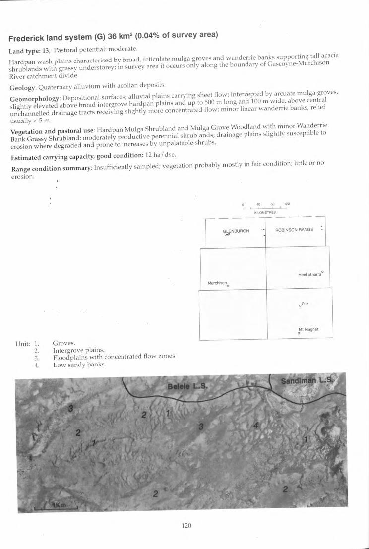
Frederick land system (G) 36 km2 (0.04% of survey area)
Land type: 13; Pastoral potential : moderate.
Hardpan wash plains characterised by broad, reticulate mulga groves and wandcrrie banks supporting tall acacia
shrublands with grassy understorey; in ~urvey area it occur., only along the boundary of Gac;coyne-Murchison
River catchment divide.
Geology: Quaternary alluvium with aeolian deposit'.
Geomorphology: Depositional surfaces; alluvial plains carrying sheet flow; intercepted by arcuate mulga grove"
slightly elevated above broad intergrove hardpan plains and up to 500 m long and '100 m wide, above cen tral
unchannelled drainage tracts receiving slightly morc concentrated flow; minor linear wanderrie banks, relief
usually < 5 m.
Vegetation and pastoral use: Hardpan Mulga Shrubland and Mulga Grove Woodland with minor Wanderrie
Bank Grassy Shrubland; moderately productive perennial shrublands; drainage plains slightly susceptible to
erosion where degraded and prone to increases by unpalatable shrubs.
Estimated carrying capacity, good co nditi on: 12 ha/dse.
Range condition summary: Insufficiently sampled; vegetation probably mostly in fair cond iti on; little or no
erosion.
Unit: 1. 2. 3. 4.
Groves. Intergrove plains. Floodplains with concentrated flow zones.
Low sandy banks.
120
,--- -
, 80 >2, ~-::"::':'==-~'
KILOMETRES
- -,-- - --
GLENBUAGH . ROBINSON RANGE
-'
Meekatharra ,
Murctuson 0
oCue
Mt Magnet 0
-
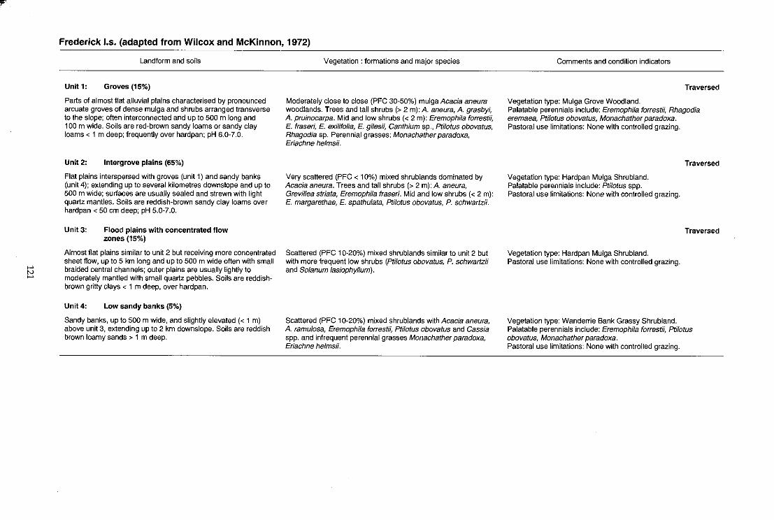
'-' tv '-'
Frederick 1.5. (adapted from Wilcox and McKinnon, 1972)
Landform and soils
Unit 1: Groves (15%)
Parts of almost flat alluvial plains characterised by pronounced arcuate groves of dense mulga and shrubs arranged transverse to the slope; often interconnected and up to 500 m long and 100 m wide. Soils are red-brown sandy loams or sandy clay loams < 1 m deep; frequently over hardpan; pH 6.0-7.0.
Unit 2: Intergrove plains (65%)
Flat plains interspersed with groves (unit 1) and sandy banks (unit 4); extending up to several kilometres downslope and up to 500 m wide; surfaces are usually sealed and strewn with light quartz mantles. Soils are reddish-brown sandy clay loams over hardpan < 50 cm deep; pH 5.0-7.0.
Unit 3: Flood plains with concentrated flow zones (15%)
Almost flat plains similar to unit 2 but receiving more concentrated sheet flow, up to 5 km long and up to 500 m wide often with small braided central channels; outer plains are usually lightly to moderately mantled with small quartz pebbles. Soils are reddishbrown gritty clays < 1 m deep, over hardpan.
Unit 4: Low sandy banks (5%)
Sandy banks, up to 500 m wide, and slightly elevated « 1 m) above unit 3, extending up to 2 km downslope. Soils are reddish brown loamy sands> 1 m deep.
Vegetation: formations and major species
Moderately close to close (PFC 30-50%) mulga Acacia aneura woodlands. Trees and tall shrubs (> 2 m): A. aneura, A. grasbyi, A. pruinocarpa. Mid and low shrubs « 2 m): Eremophila forrestii, E. fraseri, E. exilifolia, E. gilesii, Canthium sp., Pti/otus obovatus, Rhagodia sp. Perennial grasses: Monachather paradoxa, Eriachne helmsH.
Very scattered (PFC < 10%) mixed shrublands dominated by Acacia aneura. Trees and tall shrubs (> 2 m): A. aneura, Grevillea striata, Eremophila fraseri. Mid and low shrubs « 2 m): E. margarethae, E. spathulata, Ptilotus obovatus, P. schwartzii.
Scattered (PFC 10-20%) mixed shrublands similar to unit 2 but with more frequent low shrubs (Ptilotus obovatus, P. schwartz;; and Solanum lasiophyl/um).
Scattered (PFC 10-20%) mixed shrublands with Acacia aneura, A. ramu/osa, Eremophi/a forrestii, Ptilotus obovatus and Cassia spp. and infrequent perennial grasses Monachather paradoxa, Eriachne helmsii.
Comments and condition indicators
Traversed
Vegetation type: Mulga Grove Woodland. Palatable perennials include: Eremophila forrestii, Rhagodia eremaea, Ptilotus obovatus, Monachather paradoxa. Pastoral use limitations: None with controlled grazing.
Vegetation type: Hardpan Mulga Shrubland. Palatable perennials include: Ptilotus spp. Pastoral use limitations: None with controlled grazing.
Vegetation type: Hardpan Mulga Shrubland. Pastoral use limitations: None with controlled grazing.
Traversed
Traversed
Vegetation type: Wanderrie Bank Grassy Shrubland. Palatable perennials include: Eremophila forrestii, Ptilotus obovatus, Monachather paradoxa. Pastoral use limitations: None with controlled grazing.
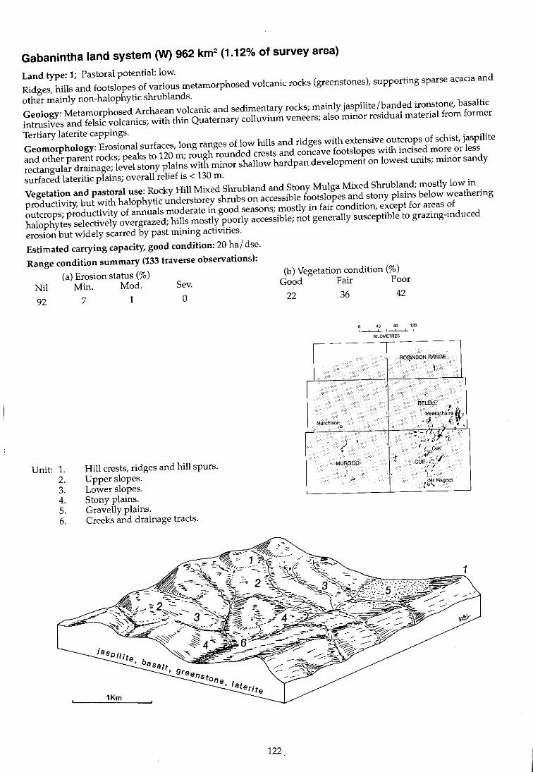
Gabanintha land system (W) 962 km2 (1.12% of survey area)
Land type: 1; Pastoral potential: low.
Ridges, hills and footslopes of various metamorphosed volcanic rocks (greenstones), supporting sparse acacia and
other mainly non-halophytic shrub lands.
Geology: Metamorphosed Archaean volcanic and sedimentary rocks; mainly jaspilite /banded ironstone, basaltic
intrusives and felsic volcanics; with thin Quaternary colluvium veneers; also minor residual material from former
Tertiary laterite cappings.
Geomorphology: Erosional surfaces, long ranges of low hills and ridges with extensive outcrops of schist, jaspilite
and other parent rocks; peaks to 120 m; rough rounded crests and concave footslopes with incised more or less
rectangular drainage; level stony plains with minor shallow hardpan development on lowest units; minor sandy
surfaced lateritic plains; overall relief is < 130 m.
Vegetation and pastoral use: Rocky Hill Mixed Shrubland and Stony Mulga Mixed Shrubland; mostly low in
productivity, but with halophytic understorey shrubs on accessible footslopes and stony plains below weathering
outcrops; productivity of annuals moderate in good seasons; mostly in fair condition, except for areas of
halophytes selectively overgrazed; hills mostly poorly accessible; not generally susceptible to grazing-induced
erosion but widely scarred by past mining activities.
Estimated carrying capacity, good condition: 20 ha / dse.
Range condition summary (133 traverse observations):
(a) Erosion status (%) Nil Min. Mod. Sev.
92 7 1 0
Unit: 1. 2. 3. 4. 5. 6.
Hill crests, ridges and hill spurs. Upper slopes. Lower slopes. Stony plains. Gravelly plains. Creeks and drainage tracts.
122
(b) Vegetation condition (%)
Good Fair Poor
22 36 42
40 80 120 , ,
KILOMETRES
-- - --,- - --RO~INSON RANGE ,
BELElE 1
Murchison Metlkatha(ra i I
0 -1,,<,. -! .";:)i"
.I • ',~t~: v, '<
I . C . :j> (Ie
MURGOO ! . cu~,;" Ij 'f ;.
.- . . , , . ~ » Mt Magnet
,"\
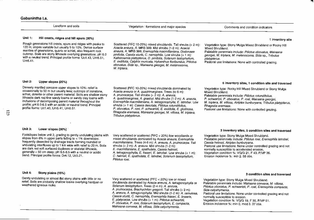
..... tl
Gabanintha 1.5.
Landform and soils
Unit I: Hill crests, ridges and hill spurs (30%)
Rough greenstone hill crests, spurs and ridges with peaks to 120 m; slopes variable but usually 5 to 10%. Dense surface mantles of greenstone, quartz or schist, also frequent rock outcrop. Soils are stony lithosols overlying greenstone; pH 6.0 with a neutral trend. Principal profile forms: Uc1.43, UrnS.51, Um5.41.
Unit 2: Upper slopes (20%)
Densely mantled concave upper stopes to 10%; relief is occasionally to 50 m but usually less; outcrops of ironstone, schist, dolerite or other parent material. Soils are shallow stony lithosols dark red fine sandy loams or sandy clay loams with inclusions of decomposing parent material throughout the profile; pH 6.0~6.5 with an acidic or neutral trend. Principal profile forms: Uc1.43, Um5.41, Um5.51.
Unit3: Lower slopes (30%) .
Footslopes below unit 2, grading to gently undulating plains with slopes from 6% in upper parts falling to < 1% downslope; frequently dissected by drainage tracts forming rounded or undulating interfluves up to 1 km wide with relief to 20 m. Soils are dark red soft surfaced duplexes or skeletallithosols, generally < 50 cm deep; pH 6.5~8.5 with a neutral or acidic trend. Principal profife forms: Dr4.12, Uc5.21.
Unit4: Stony plains (15%)
Gently undulating or almost flat stony plains with little or no relief. Soifs are probably shallow loams overlying hardpan or weathered igneous rocks.
Vegetation: formations and major species
Scattered (PFC 10~20%) mixed shrublands. Tall shrubs (> 2 m): Acacia aneura, A. MRS 399. Mid shrubs (1-2 m): Acacia aneura, A. MRS 399, Eremophila macmillaniana, Dodonaea pinifolia, Cassia sturtH, C. nemophila. Low shrubs « 1 m): Kallstroemia platypterus, D. pinifolia, Solanum lasiophyllum, E. ex;lifolia, Calytrix muricata, Hybanthus f/oribundus, pti/otus obovatus, Sida sp., Maireana georgei, M. melanocoma, M. triptera.
Scattered (PFC 1 0~20%) mixed shrublands dominated by Acacia aneura or A. quadrimarginea. Trees (to 6 m): A. pruinocarpa. Tall shrubs (> 2 my: A. aneura, A. quadrimarginea, A. grasbyi. Mid shrubs (1-2 m): A. aneura, Eremophila macmillaniana, A. tetragonophylla, E. latrobei. Low shrubs « 1 m): Cassia desolata, Ptilotus rotundifolius, P. obovatus, P. roei, P. schwartzii, E. exiHfolia, E. glutinosa, Rhagodia eremaea, Maireana georgei, M. viJIosa, M. triptera, Tribulus platypterus.
Very scattered or scattered (PFC < 20%) low woodlands or mixed shrublands dominated by Acacia aneura, Eremophila macmillaniana. Trees (4-6 m): A. aneura, A. pruinocarpa. Tall shrubs (> 2 m): A. aneura. Mid shrubs (1~2 m): E. macmil/aniana, E. spathulata, Cassia helms;;. A. tetragonophylla, E. fraseri, E. latrobei. Low shrubs « 1 m): C. helms;;, E. spathulata, E. latrobei, Solanum lasiophyllum, Ptilotus roei.
Very scattered or scattered (PFC < 20%) low or mixed shrublands dominated by Acacia aneura, A. tetragonophylla or Solanum lasiophyllum. Trees (2-4 m): A. aneura, A. pru;nocarpa, Brachychiton gregorii. Tall shrubs (> 2 m): A. aneura, A. tetragonophylla. Mid shrubs (1~2 m): A. ramulosa, Cassia sturtii, C. nemophila, Eremophila fraseri, E. linearis, E. platycarpa. Low shrubs « 1 m): Pti/otus schwartzii, P. obovatus, P. roei, Solanum lasiophyl/um, E. compacta, Maireana convexa, M. vil/osa, Sida ca/yxhymenia.
Comments and condition indicators
1 inventory site
Vegetation type: Stony Mulga Mixed Shrubland or Rocky Hill Mixed Shrubland. Palatable perennials include: Ptilotus obovatus, Maireana georgei, M. triptera, M. melanocoma, Sida sp., Tribulus platypterus. Pastoral use limitations: None with controlled grazing.
5 inventory sites, 1 condition site and traversed
Vegetation type: Rocky Hill Mixed Shrubland or Stony Mulga Mixed Shrubland. Palatable perennials include: ptilotus rotundifolius, P. schwartzii, P. obovatus, P. roei, Maireana georgei, M. triptera, M. vil/osa, Atriplex bunburyana, Tribulus platypterus, Rhagodia eremaea. Pastoral use limitations: None with controlled grazing.
3 inventory sites, 5 condition sites and traversed
Vegetation type: Stony Mulga Mixed Shrubland. Palatable perennials include: Ptilotus roei, Eremophila latrobei, Cassia helmsii, Atriplex bunburyana. Pastoral use limitations: None under controlled grazing and not normally susceptible to accelerated erosion. Vegetation condition %: VG/G 21, F 43, PNP 36. Erosion incidence %: min 2. 58 obs.
3 condition sites and traversed
Vegetation type: Stony Mulga Mixed Shrubland. Palatable perennials include: Maireana convexa, M. vil/osa, Pti/otus obovatus, P. schwartzii, P. roei, Eremophila compacta, Sida calyxhymenia. Pastoral use limitations: None under controlled grazing and not normally susceptible to erosion. Vegetation condition %: VG/G 19, F 30, PNP 51. Erosion incidence %: min 0, mod 3. 37 obs.
"
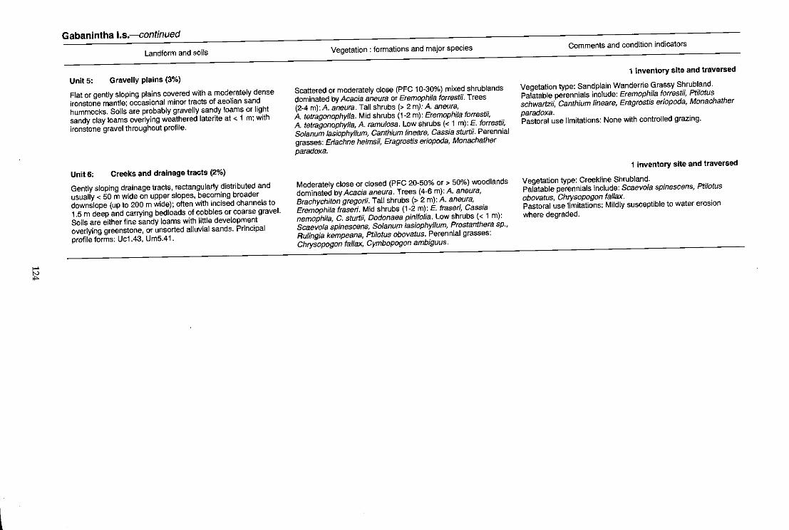
>-'
~
Gabanintha I.s.--continued
Landform and soils
UnitS: Gravelly plains (3%)
Flat or gently sloping plains covered with a moderately dense
ironstone mantle; occasional minor tracts of aeolian sand
hummocks. Soils are probably gravelly sandy loams or light
sandy clay loams overlying weathered laterite at < 1 m; with
ironstone gravel throughout profile.
Unit 6: Creeks and drainage tracts (2%)
Gently sloping drainage tracts, rectangularly distributed and
usually < 50 m wide on upper slopes, becoming broader
downslope (up to 200 m wide); often with incised channels to
1.5 m deep and carrying bed loads of cobbles or coarse gravel.
Soils are either fine sandy loams with little development
overlying greenstone, or unsorted alluvial sands. Principal
profile forms: Uc1.43, Um5.41.
Vegetation: formations and major species
Scattered or moderately close (PFC 10~30%) mixed shrublands
dominated by Acacia aneura or Eremophila forrestii. Trees
(2~4 m): A. aneura. Tall shrubs (> 2 my: A. aneura,
A. tetragonophylla. Mid shrubs (1~2 m): Eremophila forrestii,
A. tetragonophylla, A ramulosa. Low shrubs « 1 m): E. forrestii,
Solanum lasiophyllum, Canthium lineare, Cassia sturtii. Perennial
grasses: Eriachne helmsii, Eragrostis eriopoda, Monachather
paradoxa.
Moderately close or closed (PFC 20~50% or > 50%) woodlands
dominated by Acacia aneura. Trees (4~6 m): A. aneura,
Brachychiton gregor#. Tall shrubs (> 2 m): A. aneura,
Eremophl1a fraseri. Mid shrubs (1~2 m): E. fraseri, Cassia
nemophifa, C. sturtii, Dodonaea pinifolia. Low shrubs « 1 m):
Scaevola spinescens, Solanum lasiophyllum, Prostanthera sp.,
Rulingia kempeana, Ptilotus obovatus. Perennial grasses:
Chrysopogon fallax, Cymbopogon ambiguus.
Comments and condition indicators
1 inventory site and traversed
Vegetation type: Sandplain Wanderrie Grassy Shrubland.
Palatable perennials include: Eremophila forrest;;, Ptilotus
schwartzii, Canthium lineare, Eragrostis eriopoda, Monachather
paradoxa. Pastoral use limitations: None with controlled grazing.
1 inventory site and traversed
Vegetation type: Creekline Shrubland. Palatable perennials include: Scaevola spinescens, Ptilotus
obovatus, Chrysopogon faffax. Pastoral use limitations: Mildly susceptible to water erosion
where degraded.

16602-9
Holmwood land system 355 km2 (0.41 % of survey area)
Land type: 5; Pastoral potential: high.
Gently undulating saline stony and alluvial plains below low breakaways on Permian sedimentary rocks on the
eastern margins of the Victoria Sandplain; supports snakewood and various halophytic shrublands.
Geology: Permian sandstones and siltstones of the Sakmarian series with shale deposits of the Holmwood
formation; early Tertiary sandstones of the Pindilya formation; slopes and plains mostly on Quaternary alluvium
and colluvium with scattered aeolian deposits.
Geomorphology: Erosional surfaces; plateau edges and remnants with actively eroding breakaways and talus
slopes. Also depositional surfaces with occasional sandstone or siltstone mantles; undulating or nearly level
alluvial plains; isolated sandplain residuals; lower alluvial plains strongly saline with ill defined drainage
patterns; relief mostly < 10 m.
Vegetation and pastoral use: Bluebush and Saltbush Shrubland with scattered tall shrubs; minor sandy areas
carry moderately productive Wanderrie Bank Grassy Shrubland; lower saline plains often support Samphire
Shrub land of high salinity; footslopes and alluvial plains (units 1 and 4) are liable to overgrazing and show minor
susceptibility to erosion.
Estimated carrying capacity, good condition: 7 hal dse.
Range condition summary (27 traverse observations):
(a) Erosion status (%)
Nil Min. Mod. Sev.
85 11 4 0
Unit: l. 2. 3. 4. 5.
Low breakaways, plateaux and footslopes.
Sandy banks. Saline stony plains. Alluvial plains. Lower saline plains.
126
(b) Vegetation condition (%)
Good Fair Poor
59 19 22
40 80 120 , KILOMETRES
,--- - --~----
I BYRO Meekatharra
0
:Murchison ,
t oCuoa ~ '. MURGOO
J4t Magnet
'""' N
"
Holmwood 1.5.
Unit 1:
Landform and soils
Low breakaways, plateaux and footslopes (10%)
Low erosional scarps of weathered Permian siltstones and sandstones up to 10 m high, grading to gently sloping « 2%) and undulating saline footslopes, usually strewn with a platy sandstone mantle. Soils are skeletal on stripped indurated upper surfaces, brown light clays on footslopes and probably duplexes with patchy depositions of coarser material from local erosional activity, overlying weathered parent rocks, about 40 em deep; pH 6.0-7.0 with a neutral reaction trend. Principal profile forms: UfS.71.
Unit 2: Sandy banks (5%)
Wanderrie banks up to 0.5 km long and 200 m wide and sand sheets on narrow margins of system adjacent to higher Sand plain land system. Soils are probably red or brown earthy sands or sandy loams over hardpan or Permian shales with a neutral soil reaction trend.
Unit 3: Saline stony plains (10%)
Gently sloping « 1%) saline plains below unit 1; usually strewn with a moderately dense quartz mantle; occasional low rounded rises < 10 m also occur. Soils are duplexes, sandy loams over light clays with quartz inclusions throughout the profile; pH 7.0 with a neutral to alkaline trend. PrinCipal profile forms: Dr1.56, Dr2.52, Dr2.53.
Unit 4: Alluvial plains (35%)
Mostly flat weakly saline alluvial plains with sluggish unchannelled drainage zones. Soils are crusted duplexes, red clayey sands over light clays to hardpan at 50 cm; pH 6.0·8.5 with an alkaline trend. Principal profile form: Dr1.56.
Vegetation: formations and major species
Scattered or very scattered (PFC < 20%) low shrublands dominated by Atrip/ex vesicaria on saline footslopes or mixed shrublands with Acacia ramulosa or A. cuthbertson;; prominent on low plateaux or breakaway tops. Tall shrubs (> 2 m): A. cuthbertsonii, A. sclerosperma, A. ramulosa. Low shrubs « 1 m): Atrip/ex vesicaria, Halosarcia spp., Maireana georgei, M. glomerifolia, M. tomentosa, M. pyramidata, M. atkinsiana, Ptilotus beardii, Frankenia spp.
Scattered or moderately close (PFC 10·30%) mixed grassy shrublands dominated by Acacia ramulosa. Tall shrubs (> 2 m):
. A. ramulosa, A. sclerosperma. Mid shrubs (1·2 m): Eremophila forrestii, Cassia spp. Low shrubs « 1 m): Solanum lasiophyllum, Ptilotus spp. Perennial grasses: Monachather paradoxa, Thyridolepis multiculmis.
Very scattered or scattered (PFC < 20%) low shrublands dominated by Atriplex vesicaria or A. sp. Tall shrubs (> 2 m): Hakea preissii, Acacia sp. (aft. xiphophylla) , A tetragonophylfa. Mid shrubs (1-2 m): Eremophila pterocarpa, Cassia phyllodinea. Low shrubs « 1 m): Atrip/ex sp., A. vesicaria, Maireana georgei, M. atkinsiana, M. pyramidata, Halosarcia spp., Frankenia spp., Scaevola spinescens, Pti/otus beardii.
Moderately close (PFC 20-30%) shrublands dominated by Atriplex bunburyana and Maireana pyramidata in the lower storey and Acacia xiphophylla in the tall shrub layer. Trees (to 6 m): A. xiphophyl/a. Tall shrubs (> 2 m): A. xiphophylla. Mid shrubs (1·2 m): Atriplex bunburyana, Cassia phyllodinea, Eremophila pterocarpa. Low shrubs « 1 m): Maireana pyramidata, M. georgei, M. tomentosa, Rhagodia drummond;;, Enchylaena tomentosa, Lycium austra/e, Scaevo/a spinescens, Frankenia spp.
Comments and condition indicators
1 inventory site and traversed
Vegetation type: Saltbush Shrubland. Palatable perennials include: Atrip/ex vesicaria, Maireana spp., Ptilotus beardii, Frankenia spp. Pastoral use limitations: Areas not protected by stony surface mantle are highly erodible owing to slope and soil type.
Traversed
Vegetation type: Wanderrie Bank Grassy Shrubland. Palatable perennials include: Eremophila forrestii, Pti/otus spp., Monachather paradoxa, Thyridolepis multicu/mis. Pastoral use limitations: None with controlled grazing.
1 inventory site, 1 condition site and traversed
Vegetation type: Saltbush Shrubland. Palatable perennials include: Atrip/ex spp., Maireana spp., Frankenia spp., Scaevo/a spinescens, Ptilotus beardii. Pastoral use limitations: None with controlled grazing.
1 inventory site, 1 condition site and traversed
Vegetation type: Bluebush or Saltbush Shrublands. Palatable perennials include: Atriplex bunburyana, Maireana spp., Rhagodia drummond;;, Enchy/aena tomentosa, Lycium australe, Scaevola spinescens, Frankenia spp. Pastoral use limitations: Moderately susceptible to accelerated erosion where degraded.

>-'
~
Holmwood I.s-continued
Landform and soils
UnitS: Lower saline plains (40%)
Extensive flat saline plains slightly lower than unit 4 with little
relief except for intermittent occurrences of low sandy banks.
Some ill defined sluggish drainage tracts with little or no channel
development. Soils are brown or dark red clayey or duplex
types, sands over light or medium heavy clay> 1 m deep;
quartz and weathered silcrete fragments common throughout
profile: pH 7.0-8.5 with neutral to alkaline reaction trend.
Principal profile forms: Dr1.52, Uffi.12.
Vegetation: formations and major species
Moderately close (PFC 20-30%) low shrublands with prominent
zonations of dominant halophytes. Tall shrubs (> 2 m):
E. pterocarpa, Acacia tetragonophylla, A. sclerosperma. Mid
shrubs (1-2 m): E. pterocarpa. Low shrubs « 1 m):
M. atkinsiana, M. amoena, M. platycarpa, M. pyramidata,
M. georgei, Atriplex vesicaria, Carpobrotus sp., Frankenia
magnifica, Gunniopsis quadrifidum, Halosarcia spp., Lawrencia
squamata, Cratystylis subspinescens, Scaevofa spinescens,
Ptifotus obovatus, Solanum lasiophyllum, Rhagodia
drummondii.
Comments and condition indicators
2 inventory sites, 1 condition site and traversed
Vegetation type: Mixed Halophyte and Samphire Shrublands.
Palatable perennials include: Atrip/ex vesicaria, Maireana spp.,
Frankenia spp., Lawrencia squamata, Cratystylis
subspinescens, Scaevola spinescens, Ptilotus obovatus,
Rhagodia drummondii. Pastoral use limitations: Grazing of highly saline pasture plants
requires good quality stock water supplies.
Horseshoe land system (G) 204 km2 (0.24% of survey area)
Land type: 5; Pastoral potential: moderate.
Gently undulating stony plains and low rounded hills based on Proterozoic metamorphic rocks, with somewhat
saline drainage foci and alluvial tracts; supports scattered mulga and wait-a-while shrublands with halophytes.
Geology: Lower Proterozoic rocks; hematite shale, phyllite and siltstones of the Labouchere and Horseshoe Range
formations of the Padbury group; occasional Tertiary calcrete; Quaternary alluvium on lowlands.
Geomorphology: Erosional surfaces; rounded, weathered hills and low rises to 20 m with gently inclined stony
footslopes and interfluves above ahnost flat pebbly plains with partly internal drainage; flat marginal plains on
hardpan, dissected by narrow drainage tracts; overall relief to 25 m but often less.
Vegetation and pastoral use: Hills, non-saline slopes and stony hardpan plains support Stony Mulga Mixed
Shrubland and Hardpan Mulga Shrubland of low to moderate productivity; lower saline slopes, plains and
drainage tracts carry moderately to highly productive Stony Snakewood, Bluebush and Samphire Shrublands,
degraded to mainly annuals in overgrazed areas; system generally not susceptible to erosion.
Estimated carrying capacity, good condition: 12 hal dse.
Range condition summary (30 traverse observations):
(a) Erosion status (%)
Nil Min. Mod. Sev.
100
Unit: l. 2. 3. 4. 5. 6. 7.
o o o
Stony plains with low rises. Gravelly plains. Hardpan plains. Saline plains. Groves. Drainage foci. Drainage tracts.
1Km
130
(b) Vegetation condition (%)
Good
16
Fair
47
GLENBURGH
MurChison o
Poor
37
40 80 120 , KILOMETRES
..
Meekatharra 0
Mt Magnet o
-
>-' W >-'
Horseshoe I.s.
Landform and soils
Unit 1: Stony plains with low rises (30%)
Gently undulating plains, low rounded rises and low hills to 25 m relief covered with a variable ironstone, quartz or shale mantle. Soils are probably shallow dark red or reddish brown earthy sands or hardpan sandy clay loams.
Unit2: Gravelly plains (10%)
Gently sloping gravelly suriaced plains occurring as remnants of old surfaces covering high parts of unit 1. Soils are probably gravelly loamy sands to sandy loams.
Unit 3: Hardpan plains (20%)
Very gently sloping plains on red-brown hardpan. Soils are shallow hardpan loams locally with sparse quartzy mantles, overlying hardpan.
Unit 4: Saline plains (25%)
Almost flat, saline, low lying plains (slopes < O.S%) with variable mantles of mixed composition. Soils are hard-setting duplex types, reddish brown or dark red clay loams or sandy clay loams over light clay or light medium clay to 60 cm deep; pH 7.0-8.S with an alkaline trend. Principal profile forms: Uffi.12, Or2.53.
Unit 5: Groves (3%)
Irregularly shaped densely vegetated groves, situated in lower areas of unit 3 and 7, extending to O.S km long and < 200 m wide. Soils are red earths to > 100 cm; pH 6.0-7.0 with a neutral or acidic reaction trend. Principal profile forms: UmS.22, Gn2.12.
Vegetation: formations and major species
Very scattered or scattered (PFC < 20%) mixed shrublands dominated by Acacia aneura. Tall shrubs (> 2 m): A. aneura. Mid shrubs (1-2 m): A. aneura, A. quadrimarginea. Low shrubs « 1 m): Eremophila compacta, Ptilotus obovatus, P. rotundifolius. Perennial grass: Eragrostis eriopoda.
Scattered tall shrublands dominated by Acacia aneura and A. IinophyJla.
Very scattered (PFC < 10%) mixed shrublands dominated by Eremophila fraseri or Solanum lasiophyJlum. Trees (4-6 m): Acacia pruinocarpa, A. aft. citrinoviridis, A. aneura. Tall shrubs (> 2 m): A. aft. citrinoviridis. Mid shrubs (1-2 m): E. fraseri, A. tetragonophylla, Cassia desolata, E. latrobei. Low shrubs (< 1 m): Ptilotus schwartzii, P. rotundifolius, P. obovatus, Solanum lasiophyllum, Rhagodia eremaea.
Scattered (PFC 10-20%) saline low shrublands dominated by Halosarcia spp. or scattered to moderately close (PFC 10-30%) mixed shrublands on partly saline areas dominated by Acacia cuspidifolia. Trees (2-4 m): A. cuspidifolia. Tall shrubs (> 2 m): Eremophifa sp., A. cuspidifolia, A. cuthbertson;;. Mid shrubs (1-2 m): E. sp., A. cuspidifolia, A. tetragonophylla. Low shrubs « 1 m): Halosarcia spp., Frankenia spp., Maireana pyramidata, Enchylaena tomentosa, Solanum lasiophyllum.
Closed woodlands (PFC > SO%) dominated by Acacia aneura. Trees (to 10 m): A. aneura, A. pruinocarpa, Hakea suberea. Tall shrubs (> 2 m): A. kempeana, Canthium latifolium, A. aft. citrinoviridis, A. tetragonophylla, Santalum spicatum. Mid shrubs (1-2 m): Cassia oligophylla, Eremophila compacta, E. forrestii, E. spectabilis, E. latrobei. Low shrubs « 1 m): Ptilotus obovatus, Spartothamnella teucriif/ora, Solanum lasiophyl/um, Sida spp. Perennial grasses: Chrysopogon fallax, Eragrostis lanipes, Eriachne helmsii.
Comments and condition indicators
Traversed
Vegetation type: Stony Mulga Mixed Shrubland. Palatable perennials include: Eremophila compacta, Ptilotus obovatus, P. rotundifolius, Eragrostis eriopoda. Pastoral use limitations: None under controlled grazing.
Traversed
Vegetation type: Stony Mulga Mixed Shrubland. Pastoral use limitations: None under controlled grazing.
1 condition site and traversed
Vegetation type: Mulga Hardpan Shrubland. Palatable perennials include: Eremophila latrobei, Ptilotus obovatus, P. schwartzii, P. rotundifolius, Rhagodia eremaea. Pastoral use limitations: None under controlled grazing.
3 inventory sites and traversed
Vegetation type: Stony Snakewood and Samphire Shrublands. Palatable perennials include: Frankenia spp., M. pyramidata, Enchylaena tomentosa. Pastoral use limitations: None under controlled grazing.
1 inventory site and traversed
Vegetation type: Mulga Grove Woodland. Palatable perennials include: Eremophila forrestii, E. compacta, E. latrobei, Ptilotus obovatus, Sida spp., Chrysopogon fal/ax, Eragrostis lanipes. Pastoral use limitations: None with controlled grazing.
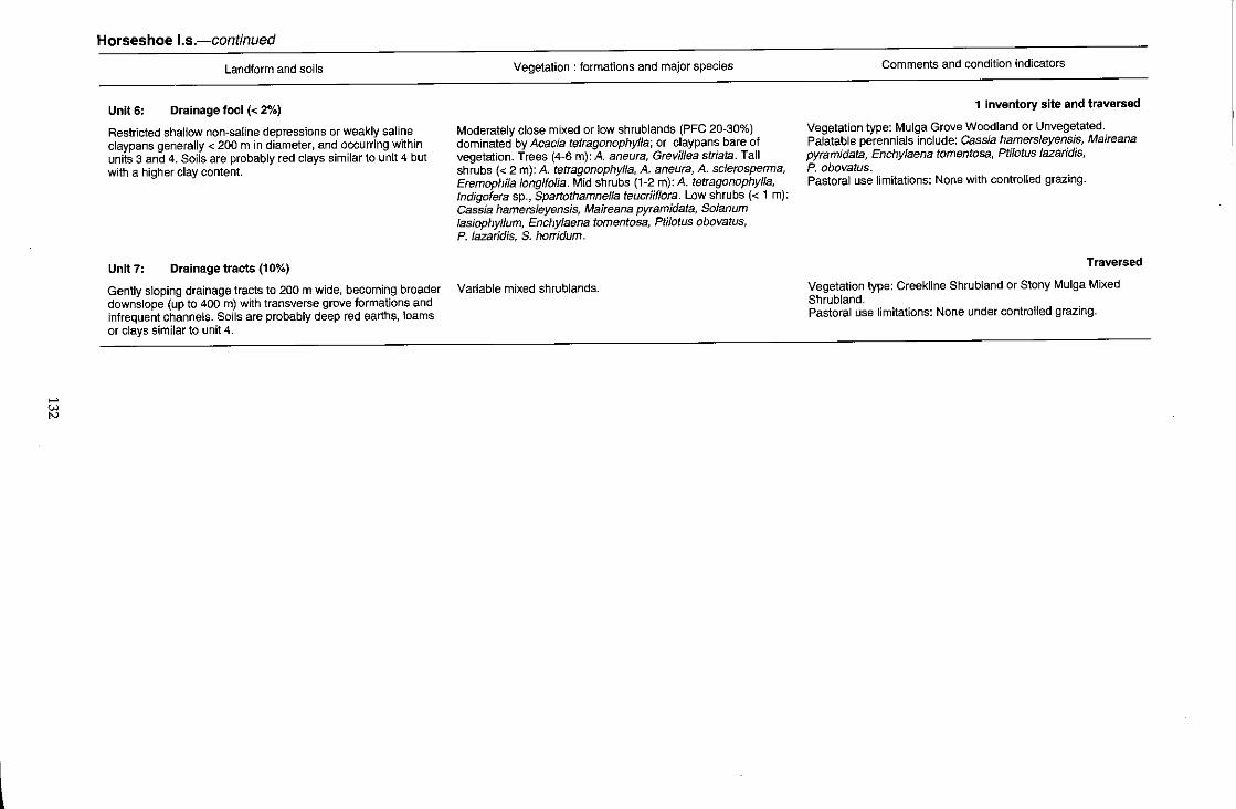
..... id
Horseshoe I.s.-continued
Landform and soils
Unit 6: Drainage foci « 2%)
Restricted shallow non-saline depressions or weakly saline claypans generally < 200 m in diameter, and occurring within units 3 and 4. Soils are probably red clays similar to unit 4 but with a higher clay content.
Unit 7: Drainage tracts (10%)
Vegetation: formations and major species
Moderately close mixed or low shrublands (PFC 20-30%) dominated by Acacia tetragonophylla; or claypans bare of vegetation. Trees (4-6 m): A. aneura, Grevillea striata. Tall shrubs « 2 m): A. tetragonophylla, A. aneura, A. sclerosperma, Eremophila longifolia. Mid shrubs (1-2 m): A. tetragonophylla, Indigofera sp., Spartothamnella teucriiflora. Low shrubs « 1 m): Cassia hamersleyensis, Maireana pyramidata, Solanum lasiophyllum, Enchylaena tomentosa, Ptilotus obovatus, P. lazaridis, S. horridum.
Gently sloping drainage tracts to 200 m wide, becoming broader Variable mixed shrublands. downslope (up to 400 m) with transverse grove formations and infrequent channels. Soils are probably deep red earths, loams or clays similar to unit 4 .
Comments and condition indicators
1 inventory site and traversed
Vegetation type: Mulga Grove Woodland or Unvegetated. Palatable perennials include: Cassia hamersleyensis, Maireana pyramidata, Enchylaena tomentosa, Ptilotus lazaridis, P. obovatus. Pastoral use limitations: None with controlled grazing.
Traversed
Vegetation type: Creekline Shrubland or Stony Mulga Mixed Shrubland. Pastoral use limitations: None under controlled grazing.
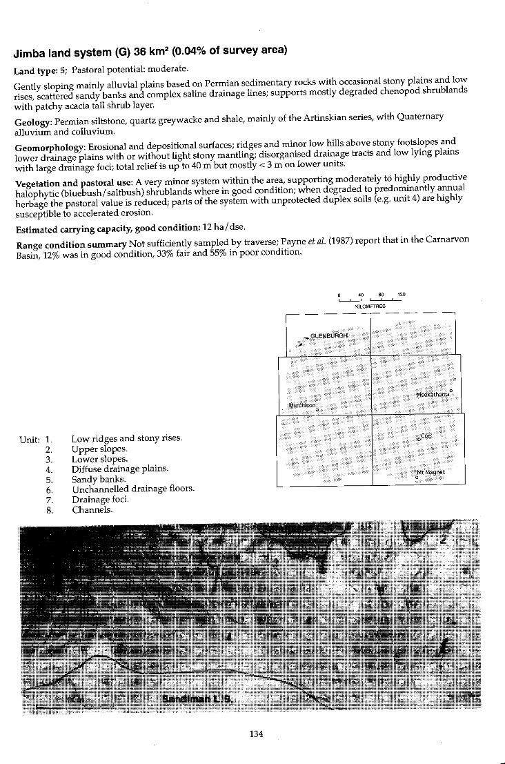
Jimba land system (G) 36 km2 (0.04% of survey area)
Land type: 5; Pastoral potential: moderate.
Gently sloping mainly alluvial plains based on Permian sedimentary rocks with occasional stony plains and low rises, scattered sandy banks and complex saline drainage lines; supports mostly degraded chenopod shrub lands with patchy acacia tall shrub layer.
Geology: Permian siltstone, quartz greywacke and shale, mainly of the Artinskian series, with Quaternary alluvium and colluvium.
Geomorphology: Erosional and depositional surfaces; ridges and minor low hills above stony footslopes and lower drainage plains with or without light stony mantling; disorganised drainage tracts and low lying plains with large drainage foci; total relief is up to 40 m but mostly < 3 m on lower units.
Vegetation and pastoral use: A very minor system within the area, supporting moderately to highly productive halophytic (bluebush/saltbush) shrublands where in good condition; when degraded to predominantly annual herbage the pastoral value is reduced; parts of the system with unprotected duplex soils (e.g. unit 4) are highly susceptible to accelerated erosion.
Estimated carrying capacity, good condition: 12 hal dse.
Range condition summary Not sufficiently sampled by traverse; Payne et al. (1987) report that in the Carnarvon Basin, 12% was in good condition, 33% fair and 55% in poor condition.
Unit: 1. 2. 3. 4. 5. 6. 7. 8.
Low ridges and stony rises. Upper slopes. Lower slopes. Diffuse drainage plains. Sandy banks. Unchannelled drainage floors. Drainage foci. Channels.
134
40 80 120 , ,
KILOMETRES
,--- - --r-- - --
..,.GlENBURGH ,-.
Meekatharra 0
Murchison 0
oCue
Mt Magnet 0
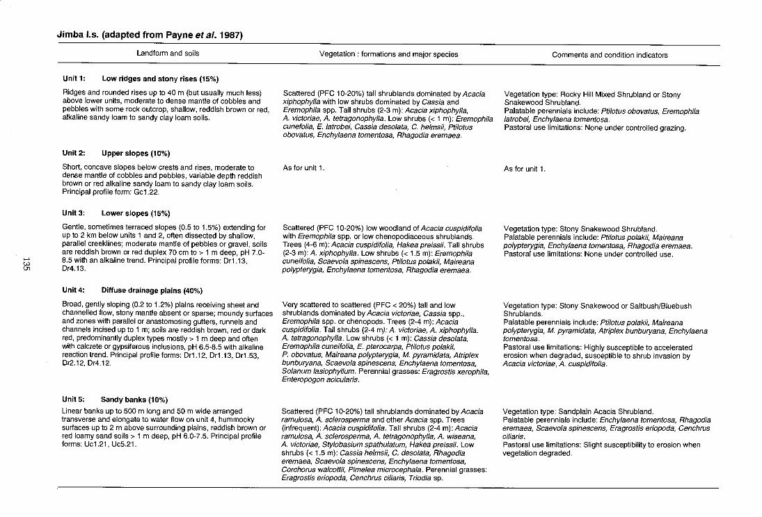
"-' tA
Jimba I.s. (adapted from Payne et al. 1987)
Landform and soils
Unit 1: Low ridges and stony rises (15%)
Ridges and rounded rises up to 40 m (but usually much less) above lower units, moderate to dense mantle of cobbles and pebbles with some rock outcrop, shallow, reddish brown or red, alkaline sandy loam to sandy clay loam soils.
Unit 2: Uppe, slopes (10%)
Short, concave slopes below crests and rises, moderate to dense mantle of cobbles and pebbles, variable depth reddish brown or red alkaline sandy loam to sandy clay loam soils. Principal profile form: Gc1.22.
Unit 3: Lower slopes (15%)
Gentle, sometimes terraced slopes (0.5 to 1.5%) extending for up to 2 km below units 1 and 2, often dissected by shallow, parallel creeklines; moderate mantle of pebbles or gravel, soils are reddish brown or red duplex 70 cm to > 1 m deep, pH 7.0-8.5 with an alkaline trend. Principal profile forms: Dr1.13, 0'4.13.
Unit 4: Diffuse drainage plains (40%)
Broad, gently sloping (0.2 to 1.2%) plains receiving sheet and channelled flow, stony mantle absent or sparse; moundy suriaces and zones with parallel or anastomosing gutters, runnels and channels incised up to 1 m; soils are reddish brown, red or dark red, predominantly duplex types mostly> 1 m deep and often with calcrete or gypsiferous inclusions, pH 6.5-8.5 with alkaline reaction trend. Principal profile forms: Dr1.12, Dr1.13, Dr1.53, Dr2.12,O'4.12.
Unit5: Sandy banks (10%)
Linear banks up to 500 m long and 50 m wide arranged transverse and elongate to water flow on unit 4, hummocky suriaces up to 2 m above surrounding plains, reddish brown or red loamy sand soils> 1 m deep, pH 6.0-7.5. Principal profile forms: Uc1.21 , Uc5.21.
Vegetation: formations and major species
Scattered (PFC 10-20%) tall shrublands dominated by Acacia xiphophylla with low shrubs dominated by Cassia and Eremophila spp. Tall shrubs (2-3 m): Acacia xiphophylla, A. victoriae, A. tetragonophylla. Low shrubs « 1 m): Eremophila cunefolia, E. latrobei, Cassia desolata, C. helmsii, ptilotus obovatus, Enchylaena tomentosa, Rhagodia eremaea.
As for unit 1 .
Scattered (PFC 10-20%) low woodland of Acacia cuspidifo/ia with Eremophila spp. or low chenopodiaceous shrublands. Trees (4-6 m): Acacia cuspidifolia, Hakea preissii. Tall shrubs (2-3 m): A. xiphophylla. Low shrubs « 1.5 m): Eremophila cuneifolia, Scaevola spinescens, ptilotus polakii, Maireana polypterygia, Enchylaena tomentosa, Rhagodia eremaea.
Very scattered to scattered (PFC < 20%) tall and low shrublands dominated by Acacia victoriae, Cassia spp., Eremophila spp. or chenopods. Trees (2-4 m): Acacia cuspidifolia. Tall shrubs (2-4 m): A. victoriae, A. xiphophylla, A. tetragonophylla. Low shrubs « 1 m): Cassia desolata, Eremophila cuneifolia, E. pterocarpa, Pti/otus polakii, P. obovatus, Maireana polypterygia, M. pyramidata, Atriplex bunburyana, Scaevola spinescens, Enchylaena tomentosa, Solanum /asiophyllum. Perennial grasses: Eragrostis xerophila, Enteropogon acicularis.
Scattered (PFC 10-20%) tall shrublands dominated by Acacia ramu/osa, A. sc/erosperma and other Acacia spp. Trees (infrequent): Acacia cuspidifolia. Tall shrubs (2-4 m): Acacia ramu/osa, A. sc/erosperma, A. tetragonophylla, A. wiseana, A. victoriae, Stylobasium spathulatum, Hakea preissii. Low shrubs « 1.5 m): Cassia helmsH, C. desolata, Rhagodia eremaea, Scaevo/a spinescens, Enchylaena tomentosa, Corchorus walcottii, Pimelea microcephala. Perennial grasses: Eragrostis eriopoda, Cenchrus ciliaris, Triodia sp.
Comments and condition indicators
Vegetation type: Rocky Hill Mixed Shrubland or Stony Snakewood Shrubland. Palatable perennials include: Ptilotus obovatus, Eremophila latrobei, Enchylaena tomentosa. Pastoral use limitations: None under controlled grazing.
As for unit 1.
Vegetation type: Stony Snakewood Shrubland. Palatable perennials include: pti/otus po/aW, Maireana po/ypterygia, Enchylaena tomentosa, Rhagodia eremaea. Pastoral use limitations: None under controlled use.
Vegetation type: Stony Snakewood or Saltbush/Bluebush Shrublands. Palatable perennials include: Ptilotus polak;;, Maireana polypterygia, M. pyramidata, Atrip/ex bunburyana, Enchylaena tomentosa. Pastoral use limitations: Highly susceptible to accelerated erosion when degraded, susceptible to shrub invasion by Acacia victoriae, A. cuspidifolia.
Vegetation type: Sand plain Acacia Shrubland. Palatable perennials include: Enchylaena tomentosa, Rhagodia eremaea, Scaevola spinescens, Eragrostis eriopoda, Cenchrus ciliaris. Pastoral use limitations: Slight susceptibility to erosion when vegetation degraded.
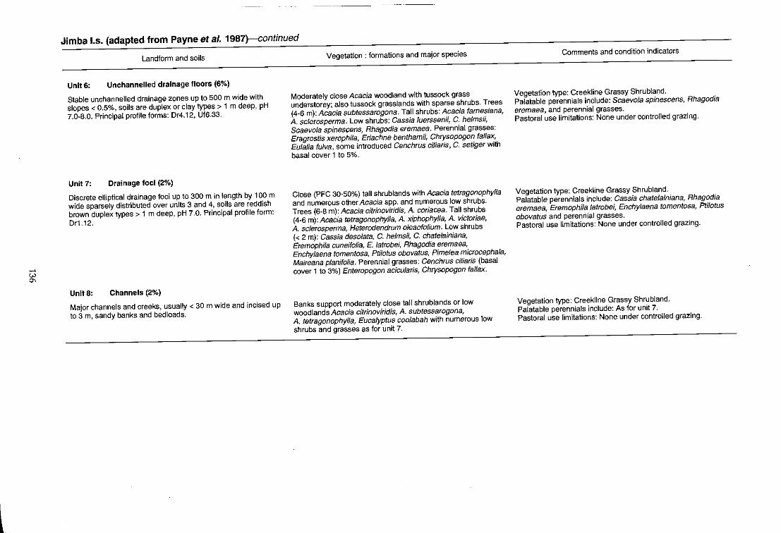
.... '" '"
Jimba 1.5. (adapted from Payne et al. 1987)-continued
Landform and soils
Unit 6: Unchannelled drainage floors (6%)
Stable unchannelled drainage zones up to 500 m wide with slopes < 0.5%, soils are duplex or clay types> 1 m deep, pH 7.0-8.0. Principal profile forms: Dr4.12, Uf6.33.
Unit 7: Drainage foci (2%)
Discrete elliptical drainage foci up to 300 m in length by 100 m wide sparsely distributed over units 3 and 4, soils are reddish brown duplex types> 1 m deep, pH 7.0. Principal profile form: Dr1.12.
UnitS: Channels (2%)
Major channels and creeks, usually < 30 m wide and incised up to 3 m, sandy banks and bed loads.
Vegetation: formations and major species
Moderately close Acacia woodland with tussock grass understorey; also tussock grasslands with sparse shrubs. Trees (4-6 m): Acacia subtessarogona. Tall shrubs: AcaCia farnesiana, A sclerosperma. Low shrubs: Cassia luerssenii, C. helms;;, Scaevola spinescens, Rhagodia eremaea. Perennial grasses: Eragrostis xerophila, Eriachne benthamii, Chrysopogon fallax, Eulalia fulva, some introduced Cenchrus ciliaris, C. setiger with basal cover 1 to 5%.
Close (PFC 30-50%) tall shrublands with Acacia tetragonophylla and numerous other Acacia spp. and numerous low shrubs. Trees (6-8 m): Acacia citrinoviridis, A coriacea. Tall shrubs (4-6 m): Acacia tetragonophyJla, A xiphophylla, A victoriae, A sclerosperma, Heterodendrum oleaefolium. Low shrubs « 2 m): Cassia desolata, C. helms;;, C. chatelainiana, Eremophila cuneifolia, E. latrobei, Rhagodia eremaea, Enchylaena tomentosa, Ptilotus obovatus, Pimelea microcephala, Maireana planifolla. Perennial grasses: Cenchrus ciliaris (basal cover 1 to 3%) Enteropogon acicularis, Chrysopogon fallax.
Banks support moderately close tall shrublands or low woodlands Acacia citrinoviridis, A subtessarogona, A tetragonophylla, Eucalyptus coolabah with numerous low shrubs and grasses as for unit 7.
Comments and condition indicators
Vegetation type: Creekline Grassy Shrubland. Palatable perennials include: Scaevola spinescens, Rhagodia eremaea, and perennial grasses. Pastoral use limitations: None under controlled grazing.
Vegetation type: Creekline Grassy Shrubland. Palatable perennials include: Cassia chatelainiana, Rhagodia eremaea, EremophHa latrobel; Enchylaena tomentosa, Ptl10tus obovatus and perennial grasses. Pastoral use limitations: None under controlled grazing.
Vegetation type: Creekline Grassy Shrubland. Palatable perennials include: As for unit 7. Pastoral use limitations: None under controlled grazing.

Jundee land system (W) 1346 km2 (1.57% of survey area)
Land type: 14; Pastoral potential: low.
Hardpan wash plains with variable dark gravelly mantling and weakly groved vegetation; minor sandy banks;
supports scattered mulga shrublands.
Geology: Cemented Quaternary alluvium derived mainly from greenstone.
Geomorphology: DepOSitional surfaces carrying sheet drainage; broad plains with variable, but frequently dense,
mantles of gravel and pebbles and occasional small groves and sandy banks; higher marginal stony plains on
weathered greenstones; drainage tracts receiving more concentrated flow and with some gutters and channels.
Relief mostly < 10 m.
Vegetation and pastoral use: Mainly Hardpan Mulga Shrubland of low to moderate productivity; groves and
drainage tracts receive more lasting soil moisture for plant growth than wash plains; palatable perennials widely
reduced through overgrazing; concentrated drainage zones are mildly susceptible to accelerated erosion when
degraded; hardpan plains otherwise not normally susceptible to erosion unless severely degraded.
Estimated carrying capacity, good condition: 20 hal dse.
Range condition summary (328 traverse observations):
(a) Erosion status (%)
Nil Min. Mod. Sev.
91
Unit: 1. 2. 3. 4. 5.
7 2
Isolated sandy banks. Stony plains. Hardpan plains. Groves. Drainage tracts.
o
138
(b) Vegetation condition (%)
Good Fair Poor
16 34 50
40 80 120 ! ,
KILOMETRES
----------
. .
~,
BEL£(E I , Meekatharra ()oo , ~. ,
Mur<:hison ,.-... fo(~" 0 • ~ ,
, > .~"f,.J';. J~'!I
• . , Cue. 1 (
:;-MURGOO , 'cuE: ,
I",~ ..<.11< .. 'I
Mt Magnet :'1lII ~.
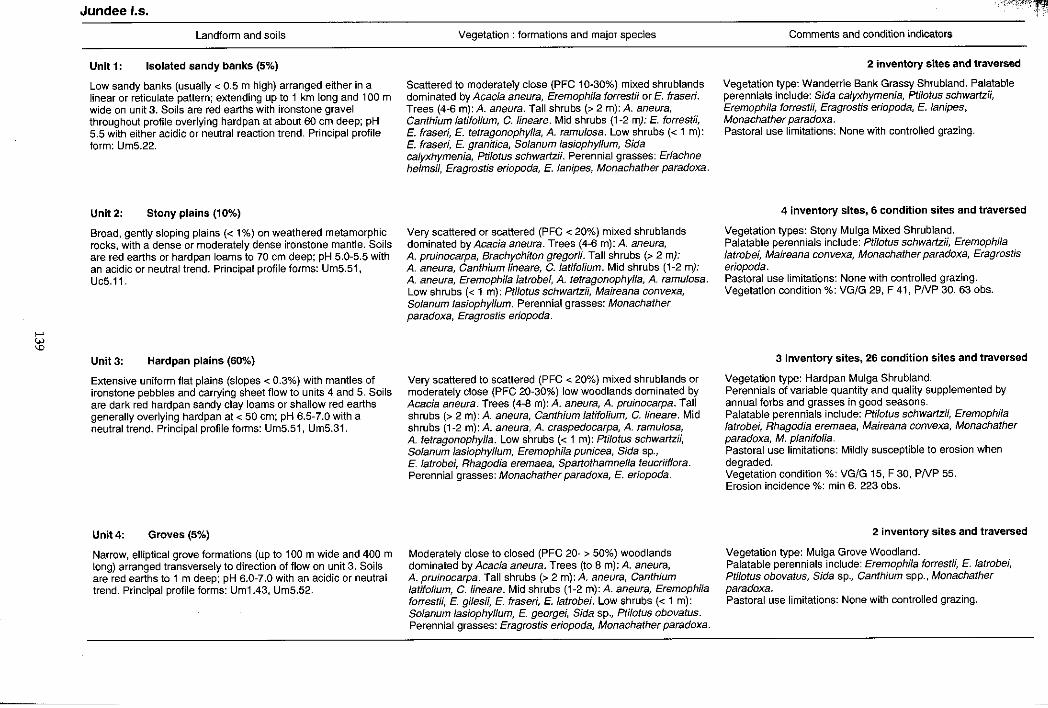
>-'
'" '"'
Jundee 1.5.
Landform and soils
Unit 1: Isolated sandy banks (5%)
Low sandy banks (usually < 0.5 m high) arranged either in a linear or reticulate pattern; extending up to 1 km long and 100 m wide on unit 3. Soils are red earths with ironstone gravel throughout profile overlying hardpan at about 60 em deep; pH 5.5 with either acidic or neutral reaction trend. Principal profile form: Um5.22.
Unit 2: Stony plains (10%)
Broad, gently sloping plains « 1%) on weathered metamorphic rocks, with a dense or moderately dense ironstone mantle. Soils are red earths or hardpan loams to 70 em deep; pH 5.0-5.5 with an acidic or neutral trend. Principal profile forms: Um5.51, Uc5.11.
Unit 3: Hardpan plains (60%)
Extensive uniform flat plains (slopes < 0.3%) with mantles of ironstone pebbles and carrying sheet flow to units 4 and 5. Soils are dark red hardpan sandy clay loams or shallow red earths generally overlying hardpan at < 50 cm; pH 6.5-7.0 with a neutral trend. Principal profile forms: Um5.51, Um5.31.
Unit 4: Groves (5%)
Narrow, elliptical grove formations (up to 100 m wide and 400 m long) arranged transversely to direction of flow on unit 3. Soils are red earths to 1 m deep; pH 6.0-7.0 with an acidic or neutral trend. Principal profile forms: Um1.43, Um5.52.
Vegetation: formations and major species
Scattered to moderately close (PFC 10-30%) mixed shrublands dominated by Acacia aneura, Eremophila forrestii or E. fraseri. Trees (4-6 m): A. aneura. Tall shrubs (> 2 m): A. aneura, Canthium /aUtolium, c. lineare. Mid shrubs (1-2 m): E. torrestii, E. fraseri, E. tetragonophylla, A. ramulosa. Low shrubs « 1 m): E. fraseri, E. granitica, Solanum lasiophyllum, Sida calyxhymenia, Ptilotus schwartzii. Perennial grasses: Eriachne helmsii, Eragrostis eriopoda, E. lanipes, Monachather paradoxa.
Very scattered or scattered (PFC < 20%) mixed shrublands dominated by Acacia aneura. Trees (4-6 m): A. aneura, A. pruinocarpa, Brachychiton gregorii. Tall shrubs (> 2 my: A. aneura, Canthium lineare, C.latifolium. Mid shrubs (1-2 m): A aneura, Eremophila latrobei, A. tetragonophylla, A. ramulosa. Low shrubs « 1 m): Ptilotus schwartzii, Maireana convexa, Solanum lasiophyllum. Perennial grasses: Monachather paradoxa, Eragrostis eriopoda.
Very scattered to scattered (PFC < 20%) mixed shrublands or moderately close (PFC 20-30%) low woodlands dominated by Acacia aneura. Trees (4-8 m): A. aneura, A pruinocarpa. Tall shrubs (> 2 m): A aneura, Canthium fatifolium, C. Iineare. Mid shrubs (1-2 m):A. aneura, A. craspedocarpa, A. ramulosa, A. tetragonophylla. Low shrubs « 1 m): Ptilotus schwartzii, Solanum lasiophyllum, Eremophila punicea, Sida sp., E. latrobei, Rhagodia eremaea, Spartothamnella teucriiflora. Perennial grasses: Monachather paradoxa, E. eriopoda.
Moderately close to closed (PFC 20- > 50%) woodlands dominated by Acacia aneura. Trees (to 8 m): A. aneura, A. pruinocarpa. Tall shrubs (> 2 m): A. aneura, Canthium latifolium, C.lineare. Mid shrubs (1-2 m):A. aneura, Eremophila forrestii, E. gilesH, E. fraseri, E. latrobei. Low shrubs « 1 m): Solanum las;ophyllum, E. george/~ Sida sp., Ptilotus obovatus. Perennial grasses: Eragrostis er/opoda, Monachather paradoxa.
".f~(~~';:~
Comments and condition indicators
2 inventory sites and traversed
Vegetation type: Wanderrie Bank Grassy Shrubland. Palatable perennials include: Sida calyxhymenia, Ptilotus schwartzii, Eremophila forrestii, Eragrostis eriopoda, E. lanipes, Monachather paradoxa. Pastoral use limitations: None with controlled grazing.
4 inventory sites, 6 condition sites and traversed
Vegetation types: Stony Mulga Mixed Shrubland. Palatable perennials include: Ptilotus schwartzi;, Eremophlla latrobei, Maireana convexa, Monachather paradoxa, Eragrostis eriopoda. Pastoral use limitations: None with controlled grazing. Vegetation condition %: VG/G 29, F 41, PNP 30. 63 obs.
3 inventory sites, 26 condition sites and traversed
Vegetation type: Hardpan Mulga Shrubland. Perennials of variable quantity and quality supplemented by annual forbs and grasses in good seasons. Palatable perennials include: Ptilotus schwartzH, Eremophila latrobei, Rhagodia eremaea, Maireana convexa, Monachather paradoxa, M. planifolia. Pastoral use limitations: Mildly susceptible to erosion when degraded. Vegetation condition %: VG/G 15, F 30, PNP 55. Erosion incidence %: min 6. 2230bs.
2 inventory sites and traversed
Vegetation type: Mulga Grove Woodland. Palatable perennials include: Eremophila forrestli, E. latrobei, Ptilotus obovatus, Sida sp., Canthium spp., Monachather paradoxa. Pastoral use limitations: None with controlled grazing.
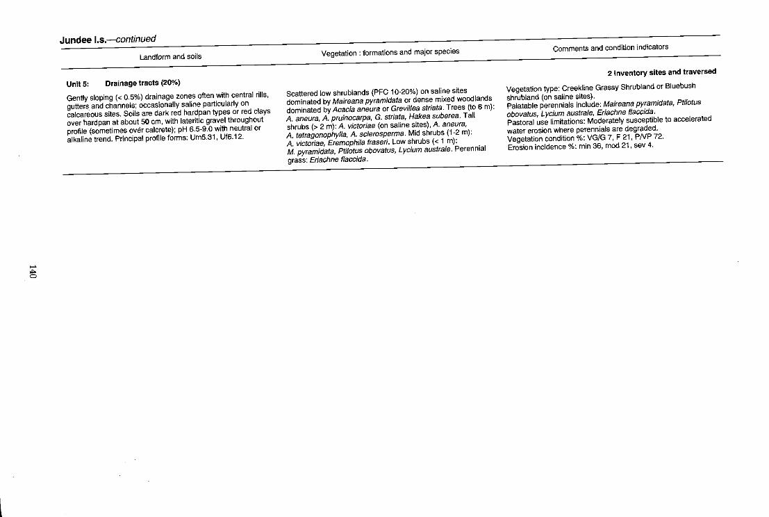
..... ~
Jundee I.s.-continued
Landform and soils
Unit 5: Drainage tracts (20%)
Gently sloping « 0.5%) drainage zones often with central rills,
gutters. and channels; occasionally saline particularly on
calcareous sites. Soils are dark red hardpan types or red clays
over hardpan at about 50 em, with lateritic gravel throughout
profile (sometimes QVe;r calcrete); pH 6.5-9.0 with neutral or
alkaline trend. Principal profile forms: UmS.31, UfS.12.
Vegetation: formations and major species
Scattered low shrublands (PFC 10-20%) on saline sites
dominated by Maireana pyramidata or dense mixed woodlands
dominated by Acacia aneura or Grevillea striata. Trees (to 6 m):
A. aneura, A. pruinocarpa, G. striata, Hakea suberea. Tall
shrubs (> 2 m): A. victoriae (on saline sites), A. aneura,
A. tetragonophylla, A. sc/erosperma. Mid shrubs (1-2 m):
A. victoriae, Eremophila fraser;. Low shrubs « 1 m):
M. pyramidata, Ptilotus obovatus, Lycium australe. Perennial
grass: Eriachne flaccida .
Comments and condition indicators
2 inventory sites and traversed
Vegetation type: Creekline Grassy Shrubland or Bluebush
shrubland (on saline sites). Palatable perennials include: Maireana pyramidata, Ptilotus
obovatus, Lycium australe, Eriachne flaccida.
Pastoral use limitations: Moderately susceptible to accelerated
water erosion where perennials are degraded. Vegetation condition %: VG/G 7, F 21, PNP 72.
Erosion incidence %: min 36, mod 21, sev 4.

16602-10
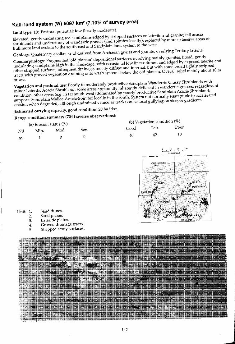
Kalli land system (W) 6097 km2 (7.10% of survey area)
Land type: 10; Pastoral potential: low (locally moderate).
Elevated, gently undulating red sandplains edged by stripped surfaces on laterite and granite; tall acacia
shrublands and understorey of wanderrie grasses (and spinifex locally); replaced by more extensive areas of
Bullimore land system to the south-east and Sandplain land system to the west.
Geology: Quaternary aeolian sand derived from Archaean gneiss and granite, overlying Tertiary laterite.
Geomorphology: Fragmented 'old plateau' depOSitional surfaces overlying mainly granites; broad, gently
undulating sandplains high in the landscape, with occasional low linear dunes, and edged by exposed laterite and
other stripped surfaces; infrequent drainage, mostly diffuse and internal, but with some broad lightly stripped
tracts with groved vegetation draining onto wash systems below the old plateau. Overall relief mainly about 10 m
or less.
Vegetation and pastoral use: Poorly to moderately productive Sandplain Wanderrie Grassy Shrublands with
minor Lateritic Acacia Shrubland; some areas apparently inherently deficient in wanderrie grasses, regardless of
condition; other areas (e.g. in far south-west) dominated by poorly productive Sandplain Acacia Shrubland;
supports Sandplain Mallee-Acacia-Spinifex locally in the south. System not normally susceptible to accelerated
erosion when degraded, although undrained vehicular tracks cause local gullying on steeper gradients.
Estimated carrying capacity, good condition: 20 hal dse.
Range condition summary (704 traverse observations):
(a) Erosion status (%)
Nil Min. Mod. Sev.
99
Unit: 1. 2. 3. 4. 5.
1 o
Sand dunes. Sand plains. Lateritic plains. Groved drainage tracts. Stripped stony surfaces.
o
142
(b) Vegetation condition (%)
Good Fair Poor
40 42 18
40 80 120 , " ,
KILOMETRES
GLENBURGH .~
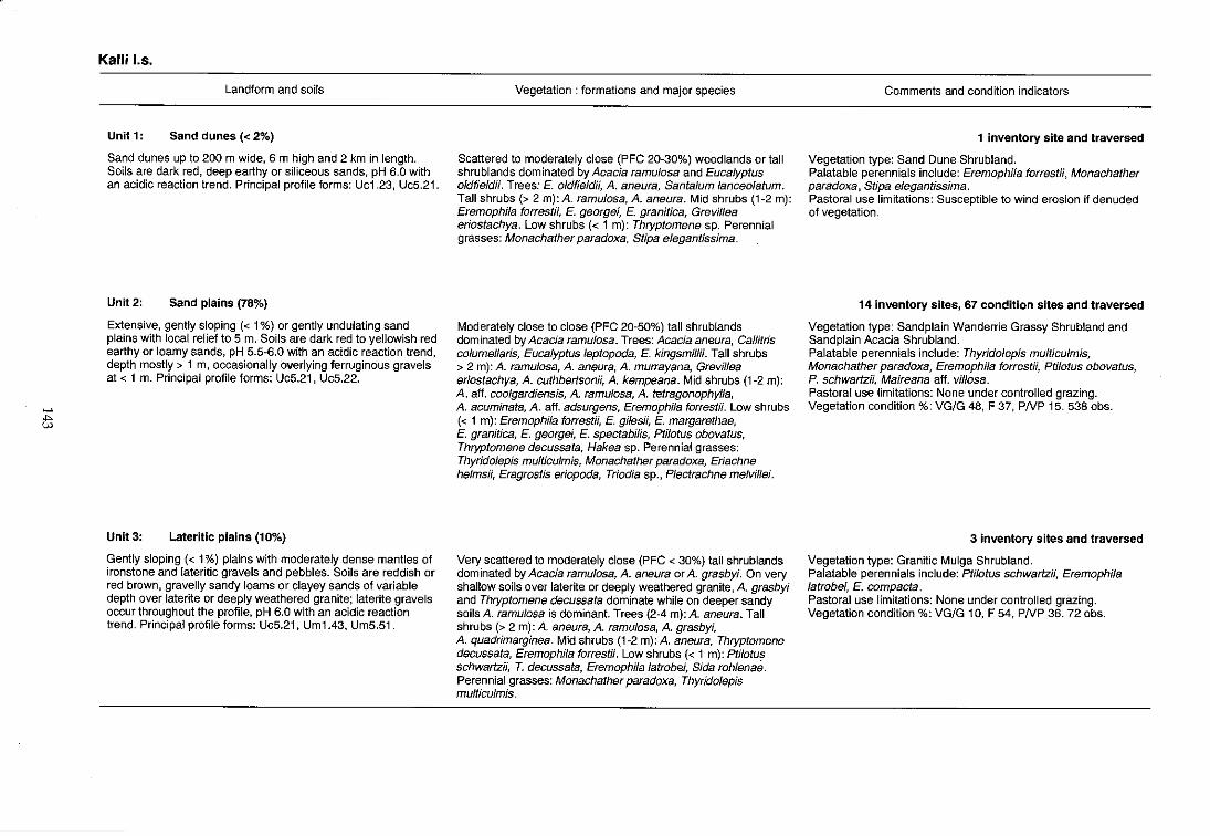
>-'
tt
Kalli I.s.
Landform and soils
Unit 1: Sand dunes « 2%)
Sand dunes up to 200 m wide, 6 m high and 2 km in length. Soils are dark red, deep earthy or siliceous sands, pH 6.0 with an acidic reaction trend. Principal profile forms: Uc1.23, UcS.21.
Unit 2: Sand plains (78%)
Extensive, gently sloping « 1%) or gently undulating sand plains with local relief to 5 m. Soils are dark red to yellowish red earthy or loamy sands, pH 5.5~6.0 with an acidic reaction trend, depth mostly> 1 m, occasionally overlying ferruginous gravels at < 1 m. Principal profile forms: UcS.21, UcS.22.
Unit 3: Lateritic plains (10%)
Gently sloping « 1%) plains with moderately dense mantles of ironstone and lateritic gravels and pebbles. Soils are reddish or red brown, gravelly sandy loams or clayey sands of variable depth over laterite or deeply weathered granite; laterite gravels occur throughout the profile, pH 6.0 with an acidic reaction trend. Principal profile forms: UcS.21, Um1.43, Um5.51 .
Vegetation: formations and major species
Scattered to moderately close (PFC 20-30%) woodlands or tall shrublands dominated by Acacia ramulosa and Eucalyptus oldfieldH. Trees: E. oldfield;;, A. aneura, Santalum lanceolatum. Tall shrubs (> 2 m): A. ramulosa, A. aneura. Mid shrubs (1-2 m): EremophHa forrestii, E. georgei, E. granitica, Grevillea eriostachya. Low shrubs « 1 m): Thryptomene sp. Perennial grasses: Monachather paradoxa, Stipa elegantissima.
Moderately close to close (PFC 20-50%) tall shrublands dominated by Acacia ramulosa. Trees: Acacia aneura, Callitris columellaris, Eucalyptus leptopoda, E. kingsmillH. Tall shrubs > 2 m): A. ramulosa, A. aneura, A. murrayana, Grevillea eriostachya, A. cuthbertson;;, A. kempeana. Mid shrubs (1 -2 m): A. aff. coolgardiensis, A. ramulosa, A. tetragonophylla, A. acuminata, A. aff. adsurgens, Eremophila forrest;;. Low shrubs « 1 m): Eremophila forrestii, E. gilesH, E. margarethae, E. granitica, E. georgei, E. spectabilis, PtHotus obovatus, Thryptomene decussata, Hakea sp. Perennial grasses: Thyridolepis multiculmis, Monachather paradoxa, Eriachne helmsH, Eragrostis eriopoda, Triodia sp., Plectrachne melvillei.
Very scattered to moderately close (PFC < 30%) tall shrublands dominated by Acacia ramulosa, A. aneura or A. grasbyi. On very shallow soils over laterite or deeply weathered granite, A. grasbyi and Thryptomene decussata dominate while on deeper sandy soils A. ramulosa is dominant. Trees (2-4 m): A. aneura. Tall shrubs (> 2 m): A. aneura, A. ramulosa, A. grasbyi, A. quadrimarginea. Mid shrubs (1-2 m):A. aneura, Thryptomene decussata, Eremophila forrestii. Low shrubs « 1 m): Ptilotus schwartzH, T. decussata, Eremophila latrobei, Sida rohlenae. Perennial grasses: Monachather paradoxa, Thyridolepis multiculmis.
Comments and condition indicators
1 inventory site and traversed
Vegetation type: Sand Dune Shrubland. Palatable perennials include: Eremophila forrestii, Monachather paradoxa, Stipa elegantissima. Pastoral use limitations: Susceptible to wind erosion if denuded of vegetation.
14 inventory sites, 67 condition sites and traversed
Vegetation type: Sand plain Wanderrie Grassy Shrubland and Sandplain Acacia Shrubland. Palatable perennials include: Thyridolepis multiculmis, Monachather paradoxa, Eremophi/a forrest;;, Ptilotus obovatus, P. schwartzii, Maireana aff. villosa. Pastoral use limitations: None under controlled grazing. Vegetation condition %: VG/G 48, F 37, PNP 15. 538 obs.
3 inventory sites and traversed
Vegetation type: Granitic Mulga Shrubland. Palatable perennials include: Ptilotus schwartzii, Eremophila latrobei, E. compacta. Pastoral use limitations: None under controlled grazing. Vegetation condition %: VG/G 10, F 54, PNP 36. 72 obs.

'"""' :::
Kalli I.s.---continued
Unit 4:
Landform and soils
Drainage tracts with groves and intergroves (5%)
Gently sloping broad fans and unchannelled drainage tracts, with areas of sheet flow up to 200 m wide (between groves) and 2 km in length. Some sites have sparse gravelly surface mantles. Soils are red earths, sandy clay loams and clay loams 0.6 to > 1 m deep, pH 5.5 with an acidic reaction trend. Principal profile form: UrnS.52.
Unit 5: Stripped stony surfaces (5%)
Gently sloping stony plains with outcrops of ferricrete, silcrete and weathered granite and a moderately dense mantle of silcrete or ironstone gravels, pebbles and rocks; locally with low breakaways. Soils are very shallow, dark red earths overlying silcrete or laterite. Principal profile form: Um5.51.
Vegetation: formations and major species
a) Groves; Closed woodlands (PFC > 50%) dominated by Acacia aneura, A. ramulosa and A. craspedocarpa. Trees (4~6 m): A. aneura. Tall shrubs (> 2 m): A. aft. citrinoviridis, A. craspedocarpa, A. ramulosa, A. tetragonophyl/a. Mid shrubs (1~2 m): A. craspedocarpa, A. daviesoides. Low shrubs « 1 m): Maireana vil/osa, Rhagodia eremaea, Ptilotus obovatus, Solanum lasiophyllum. Perennial grass: Stipa spp. b) Intergroves; Scattered shrublands (PFC 10~20%) dominated by Acacia aneura. Trees: A. aneura. Tall shrubs (> 2 m): A. aneura. Mid shrubs (1~2 m): A. craspedocarpa, Rhagodia eremaea. Low shrubs «-1 m): Maireana lanosa, M. triptera, Ptilotus obovatus, Solanum lasiophyllum.
Very scattered (PFC < 10%) low or mid shrublands. Trees: A. aneura. Tall shrubs (> 2 m): A. aneura. Mid shrubs (1~2 m): A. grasbyi, A. victoriae, A. tetragonophylla, Eremophila latrobei, E. p/atyca/yx. Low shrubs « 1 m): A. grasbyi, Pti/otus obovatus, Cassia sturtii, C. helmsH, Solanum /asiophyllum, Calytrix spp. Borya nitida, Thryptomene spp.
Comments and condition indicators
4 inventory sites, 3 condition sites and traversed
Vegetation type: Mulga Grove Woodland or Granitic Mulga Shrubland. Palatable perennials include: Maireana triptera, M. aft. vil/osa, Sida calyxhymenia, Hibiscus sp., Spanothamnella teucriif/ora, Ptilotus obovatus, Rhagodia eremaea. Pastoral use limitations: Generally none under controlled grazing.
1 inventory site and traversed
Vegetation type: Has similarities to Stony Mulga Mixed Shrubland. Palatable shrubs include: Ptilotus obovatus, P. schwartzii. Pastoral use limitations: None under controlled grazing.
Koonmarra land system (W) 5335 km2 (6.21% of survey area)
Land type: 3; Pastoral potential: low.
Quartz-strewn stony plains and low rises with outcropping granite, gneiss and schists; supports scattered mulga and other mainly non-saline shrubs.
Geology: Gneiss and granite of Archaean age, with occasional quartz intrusives; mostly covered by Quaternary colluvium and minor alluvium.
Geomorphology: Mostly erosional surfaces; broad stony plains and interfluves up to 3 km in extent with occasional rounded stony rises with rock outcrop to 10 m above plains; through going dendritic to sub-parallel drainage tracts with occasional channels; overall relief mostly < 10 m.
Vegetation and pastoral use: Predominantly Stony Mulga Mixed Shrub land of low productivity with sparse palatable perennials including small bluebushes when in good condition; not normally susceptible to accelerated erosion, even where severely degraded, except for minor accelerated streamline erosion along major drainage tracts.
Estimated carrying capacity, good condition: 20 ha I dse.
Range condition summary (696 traverse observations):
(a) Erosion status (%)
Nil Min. Mod. Sev.
96
Unit: 1. 2. 3. 4. 5.
4 o
Low ridges and rises. Sandy banks.
o
Stony plains and interfluves. Mulga groves. Drainage floors and channels.
3
146
(b) Vegetation condition (%)
Good
10
.. "~
Fair
32
BYRO
Murchison o
Poor
58
40 eo 1:20 , ,
KILOMETRES
oMt Magnet
~
t!:J
Koonmarra 1.5.
Landform and soils
Unit 1: Low ridges and rises (8%)
Ridges and low rises with dense mantles and frequent outcrops of gneiss, granite or quartz; relief to 10m; occasional hills to 30 m. Soils are dark red stony lithosols to 10 em deep, overlying parent material; pH 6.0-6.5 with a neutral trend. Principal profile form: Um5.41.
Unit 2: Sandy banks « 2%)
Infrequent low sandy banks < 300 m long and 100 m wide, usually < 1 m high and in reticulate patterns although occasionally mOTe transverse to the direction of flow. Soils are probably deep earthy sands.
Unit 3: Stony plains and interfluves (80%)
Extensive, gently rounded interfluves with slopes < 1 % and relief to 3 m; up to 2 km in width and> 3 km in length. Generally mantled with moderately dense to dense quartz, gneiss or granite pebbles and gravels. Soils are dark red hardpan loams or red earths overlying gneiss or granite (locally with veneers of red~ brown hardpan) at < 30 cm; pH S.S~7.0 with variable reaction trends. Principal profile forms: UmS.31, UrnS.S1.
Unit 4: Mulga groves « 2%)
Infrequent grove formations mainly situated within unit 3; usually < 30 m wide and < 100 m long and arranged transverse to the direction of flow. Soils are red earths or red clays usually> 1 m; pH 6.0~7.0 with a neutral or acidic trend. Principal profile forms: Gn2.12, Uffi.71.
Vegetation: formations and major species
Very scattered (PFC < 10%) mixed shrublands often dominated by low Acacia victoriae. Tall shrubs (> 2 m): A aneura, A xiphophylla. Mid shrubs (1~2 m):A tetragonophylla, A victoriae, Cassia desolata, Eremophila spathulata. Low shrubs ( < 1 m): A victoriae, Ptilotus rotundifoHus, Solanum lasiophyl/um, Eremophila freelingii.
Scattered to moderately close (PFC 10~30%) mixed grassy shrublands characterised by tall shrubs Acacia aneura, A ramufosa, mid and low shrubs Eremophila margarethae, £. forrestii, Ptilotus obovalus, and perennial grasses Monachather paradoxa, Eriachne helmsii, Eragrostis lanipes.
Very scattered to scattered (PFC < 20%) low or mixed shrublands dominated by associations of Acacia, Eremophila, and Ptilotus species. Trees (to 6 m): A aneura, A pruinocarpa. Tall shrubs (> 2 rn): A aneura, A victoriae, Eremophila fraseri, Canthium lineare, A letragonophylla. Mid shrubs (1-2 m): E. spathulata, A aneura, A. aft. quadrimarginea, E. macmilfaniana, E. aft.latrobei, C. helmsii. Low shrubs « 1 m): Ptilotus obovatus, P. rotundifolius, P. schwartzii, C. desolata, C. helmsii, Maireana triptera, M. georgei, M. convexa, M. planifolia, M. melanocoma, Solanum lasiophyllum, Rhagodia eremaea.
Moderately close (PFC 20~30%) tall shrublands or closed (PFC > SO%) woodlands dominated by Acacia aneura. Trees (to 10 m): A. aneura, A. pruinocarpa, A. aft. citrinoviridis, Canthium latifolium, Hakea suberea. Tall shrubs (> 2 my: A. kempeana, Alinophylla, A scferosperma. Mid shrubs (1~2 m): Eremophila forrestii, Cassia desolata. Low shrubs « 1 m): Solanum lasiophyllum, Maireana planifolia, M. tomentosa, Enchylaena tomentosa, Rhagodia eremaea, Ptilotus obovatus, P. rotundifoHus. Perennial grass: Eriachne sp.
Comments and condition indicators
1 inventory site, 6 condition sites and traversed
Vegetation type: Stony Mulga Mixed Shrubland. Palatable perennials include: Ptilotus spp. Eremophila compacta. Pastoral use limitations: None under controlled grazing. Vegetation condition %: VG/G 0, F 29, PNP 71. 21 obs.
1 condition site and traversed
Vegetation type: Wanderrie Bank Grassy Shrubland. Palatable perennials include: Eremophila forrestii, Ptilotus obovatus, Monachather paradoxa. Pastoral use limitations: None with controlled grazing.
6 inventory sites, 84 condition sites and traversed
Vegetation type: Stony Mulga Mixed Shrubland. Palatable perennials include: Maireana georgei, M. planifolia, M. convexa, M. melanocoma, Ptilotus obovatus, P. schwartzii, P. rotundifoJius, Rhagodia eremaea. Pastoral use limitations: Prone to increases in cover by unpalatable species, particularly Eremophila fraseri, E. spathulata and E. macmillaniana were vegetation is degraded; not susceptible to accelerated erosion. Vegetation condition %: VG/G 12, F 32, PN PS6. S14 obs.
3 inventory sites and traversed
Vegetation type: Mulga Grove Woodland. Palatable perennials include: Eremophila forrestii, Maireana planifolia, M. tomentosa, Enchylaena tomentosa, Rhagodia eremaea, Ptilotus obovatus, P. rotundifolius, Chrysopogon fal/ax. Pastoral use limitations: None under controlled grazing.
>-'
~
Koonmarra I.s.-continued
Landform and soils
Unit 5: Drainage floors and channels (8%)
Dendritic drainage tracts carrying through drainage and run-off from higher units originating as dendritic to parallel lines of low intensity developing into broad alluvial flow zones to 500 m wide downslope; often with channels « 30 wide) incised up to 2 m in alluvium or red-brown hardpan. Soils vary from red earthy sands to shallow and deep red earths overlying granitic or alluvial material; pH 6.0-7.5 with a neutral trend. Principal profile forms: Gn2.12, UcS.21, Urn1.43, UrnS.S1.
Vegetation: formations and major species
Variable and patchy scattered to closed (PFC 10- > 50%) low woodlands or tall shrublands mostly dominated by Acacia aneura, A. citrinoviridis, A. craspedocarpa, Cassia helmsii or Ptilotus obovatus. Trees (to 12 m): A aneura, A. aft. rhodophloia, Eucalyptus camaldulensis, A. pruinocarpa, Grevillea striata, Santa/um spicatum. Tall shrubs (> 2 m): A citrinoviridis, A aneura, A. craspedocarpa, A. tetragonophylla, A. sclerosperma, Exocarpus aphyllus. Mid shrubs (1-2 m): A. cuthbertsonii, Cassia helmsii, Eremophila linearis, E. fraseri, E. forrestii. Low shrubs « 1 m): C. helmsii, P. obovatus, Sida calyxhymenia, Rhagodia eremaea, Sparlothamnella teucriiflora. Perennial grasses (occasional): Themeda australis, Cymbopogon spp.
Comments and condition indicators
8 inventory sites and traversed
Vegetation type: Creekline Shrubland or Creekline Grassy. Shrubland. Palatable perennials include: Ptilotus obovatus, Sida calyxhymenia, Rhagodia eremaea, Eremophila forrestii, Monachather paradoxa, Eriachne flaccida, Cyperus bifax. Pastoral use limitations: Moderately susceptible to accelerated water erosion where degraded. Vegetation condition %: VG/G 16, F 34, PNP 60. Erosion incidence %: min 23, mod 3. 69 obs.
.J
Liver land system 752 km2 (0.88% of survey area)
Land type: 12; Pastoral potential: moderate.
Restricted sandplains and low dunes with tall acacia shrub lands interrupted by reticulate saline alluvial drainage
plains and numerous claypans and saline lake beds with low fringing halophytic shrublands.
Geology: Quaternary aeolian playa-dune deposits of sand, clay and gypsum; alluvium in lower units.
Geomorphology: Depositional surfaces; reticulate or lunette sand dunes, low banks and sandplain interrupted by
sluggish drainages (partly internal and part through), as camp lex networks of interconnecting saline drainage
floors (locally strewn with light mantles), discrete ephemeral lakes, claypans (some rock-strewn) and drainage
foci; overall relief is 10 to 12 m.
Vegetation and pastoral use: Sandplain Wanderrie Grassy Shrub land of moderate productivity and with
reasonable perennial reserves; overgrazed windward slopes are slightly susceptible to wind erosion. Saltbush,
Bluebush and Mixed Halophytic Shrub lands of high value provide the bulk of palatable perennial forage on lower
saline plains; locally, lake floors support Alluvial Tussock Grassland. Mild susceptibility to accelerated erosion on
units 3 and 4.
Estimated carrying capacity, good condition: 12 hal dse.
Range condition summary (91 traverse observations):
(a) Erosion status (%)
Nil Min. Mod. Sev.
70
Unit: 1. 2. 3. 4. 5.
24 6
Dunes and sandy banks. Sand sheets.
o
Saline swales and alluvial plains. Drainage tracts. Saline lakes.
150
(b) Vegetation condition (%)
Good Fair Poor
29 45 26
40 80 120 , !
KILOMETRES
,---- - --~----
/{ BYRO Meekatharra 0
l' Murchison . 0
t·
oCue
MURGOO
Mt Magnet 0
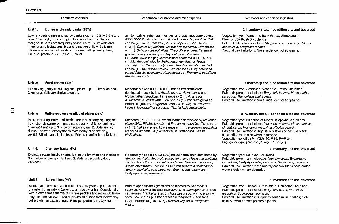
>-' Ul >-'
Liver 1.5.
Landform and soils
Unit 1: Dunes and sandy banks (25%)
Low reticulate dunes and sandy banks sloping 1 .5% to 7.5% and up to 10m high; mostly fringing lakes or claypans. Dunes marginal to lakes are frequently saline; up to 150 m wide and 1 km long, reticulate and linear to direction of flow. Soils are siliceous or earthy red sands> 1 m deep with a neutral trend. Principal profile forms: Uc1.23, Uc5.21.
Unit 2: Sand sheets (30%)
Flat to very gently undulating sand plains, up to 1 km wide and 2 km long. Soils are similar to unit 1.
Unit 3: Saline swales and alluvial plains (35%)
Interconnecting interdunal swales and plains carrying sluggish flow; strongly saline with marginal slopes < 1.5%; extending to 1 km wide and up to 3 m below adjoining unit 2. Soils are red duplex, loamy or clayey sands over loamy or sandy clay, pH 6.5-7.5 with an alkaline trend. Principal profile form: Dr1.16.
Unit 4: Drainage tracts (5%)
Drainage tracts, locally channelled, to 0.5 km wide and incised to 2 m below adjoining units 1 and 2. Soils are probably deep duplexes.
Unit 5: Saline lakes (5%)
Saline (and some non-saline) lakes and claypans up to 1.5 km in diameter but usually < 0.5 km; to 3 m below unit 2. Occasionally with a very sparse mantle of silcrete pebbles and rocks. Soils are clays or deep yellowish-red duplexes, fine sand over loamy clay, pH 6.5 with an alkaline trend. Principal profile form: Dy3.43.
Vegetation: formations and major species
a) Non-saline higher communities on crests: moderately close (PFC 20-30%) shrublands dominated by Acacia ramulosa. Tall shrubs (> 2 m): A. ramulosa, A. sclerosperma. Mid shrubs (1-2 m): Cassia phyllodinea, Eremophila maitlandii. Low shrubs « 1 m): Solanum lasiophyllum, Rhagodia eremaea. Perennial grasses: Eragrostislanipes, Thyridolepis multiculmis. b) Saline lower fringing communities: scattered (PFC 10-20%) shrublands dominated by Maireana pyramidata or Acacia sclerosperma. Tall shrubs (> 2 m): Grevillea stenobotrya. Mid shrubs (1-2 m): Hakea preissii. Low shrubs « 1 m): Maireana pyramidata, M. atkinsiana, Haloscarcia sp., Frankenia pauciflora, Atrip/ex vesicaria.
Moderately close (PFC 20-30%) mid to low shrublands dominated mostly by low Acacia aneura, A. ramulosa and Monachather paradoxa. Tall shrubs (> 2 m): A. aneura, A. wiseana, A. murrayana. Low shrubs (1-2 m): Hemigenia sp. Perennial grasses: Eragrostis eriopoda, E. lanipes, Eriachne helmsii, Monachather paradoxa, Thyridolepis multiculmis.
Scattered (PFC 10-20%) low shrublands dominated by Maireana glomerifolia, Ptilotus beardii and Frankenia magnifica. Tall shrubs (> 2 m): Hakea preissii. Low shrubs « 1 m): Frankenia magnifica, Maireana amoena, M. glomerifolia, M. platycarpa, Cassia phyllodinea.
Moderately close (PFC 20-30%) mixed shrublands dominated by Atriplex amnicola, Scaevola spinescens, and Melaleuca uncinata. Tall shrubs (> 2 m): Eucalyptus coolabah, Mela/euca uncinata, Acacia murrayana. Low shrubs « 1 m): Scaevola spinescens, Atriplex amnicola, Halosarcia sp., Enchylaena tomentosa, Cratystylis subspinescens.
Bare to open tussock grassland dominated by Sporobo/us virginicus or low shrubland Meuhlenbeckia cunninghamii on less saline sites; Frankenia spp. or Haloscarcia spp. on more saline sites. Low shrubs « 1 m): Frankenia magnifica, Halosarcia indica. Perennial grasses: Sporobolus virginicus, Eragrostis diels;;.
Comments and condition indicators
2 inventory sites, 1 condition site and traversed
Vegetation type: Wanderrie Bank Grassy Shrubland or Bluebush/Saltbush Shrublands. Palatable shrublands include: Rhagodia eremaea, Thyridolepis multiculmis, Eragrostis/anipes. Pastoral use limitations: None under controlled grazing.
1 inventory site, 1 condition site and traversed
Vegetation type: Sandplain Wanderrie Grassy Shrubland. Palatable perennials include: Eragrostislanipes, Monachather paradoxa, Thyridolepis multiculmis. Pastoral use limitations: None under controlled grazing.
3 inventory sites, 7 condition sites and traversed
Vegetation type: Bluebush or Mixed Halophyte Shrublands. Palatable perennials include: Maireana amoena, M. glomerifolia, M. platycarpa, Frankenia magnifica, Ptilotus beardii. Pastoral use limitations: High salinity levels of pasture plants; susceptible to erosion where degraded. Vegetation condition %: VG/G 40, F 36, PNP 24. Erosion incidence %: min 31, mod 11. 25 obs.
1 inventory site and traversed
Vegetation type: Saltbush Shrubland. Palatable perennials include: Atriplex amnicola, Enchylaena tomentosa, Cratystylis subspinescens, Scaevola spinescens. Pastoral use limitations: Moderately susceptible to accelerated water erosion where degraded.
1 inventory site and traversed
Vegetation type: Tussock Grassland or Samphire Shrubland. Palatable perennials include: Eragrostis diels;;, Frankenia magnifica, Sporobolus virginicus. Pastoral use limitations: Subject to seasonal inundation; high salinity levels of most palatable plants.

Mantle land system (G) 155 km2 (0.18% of survey area)
Land type: 6; Pastoral potential: low.
Gently undulating stony plains, low hills and rises with saline alluvial lower plains and sluggish drainage zones; poorly vegetated landscapes supporting clumped or patchy acacia and very low halophytic shrubs.
Geology: Permian sandstone, siltstone, shale and greywacke of the Byro group, belonging to the Artinskian series; minor Quaternary alluvium.
Geomorphology: Erosional surfaces; extensively weathered soft Permian beds with only the flattened remnants of crests remaining above level or mostly gently undulating stony plains and interfluves. Minor depositional surfaces; drainage partly internal and disorganised, more or less channelled with through drainage lines; overall relief up to 30 m.
Vegetation and pastoral use: Curiously patchy and irregular saline and non-saline shrublands with extensive areas of stony plains and rises being virtually unvegetated, sometimes with no clear evidence of degradation effects and on moderately deep soils. The quantity and type of annual production may be more useful and typical of a stony system of saline plains; the alluvial plains and drainage tracts support Mixed Halophytic Shrubland of moderate to high productivity. Some drainage areas have been overgrazed and show minor water erosion; the system is otherwise not usually susceptible to accelerated erosion and is best suited to grazing only after seasonal growth.
Estimated carrying capacity, good condition: 20 ha / dse.
Range condition summary (6 traverse observations):
Nil
83
Unit: 1. 2. 3. 4.
(a) Erosion status (%)
Min.
17
Mod.
o Sev.
o
Low hill crests and stony rises. Saline stony plains. Alluvial plains. Drainage tracts and channels.
152
(b) Vegetation condition (%)
Good Fair Poor
50 17 33
40 80 120 . KILOMETRES
~- - ---- - --
~ GlENBURGH
" BYRO
Meekatharra 0
Murchison 0
oCue
Mt Magnet 0
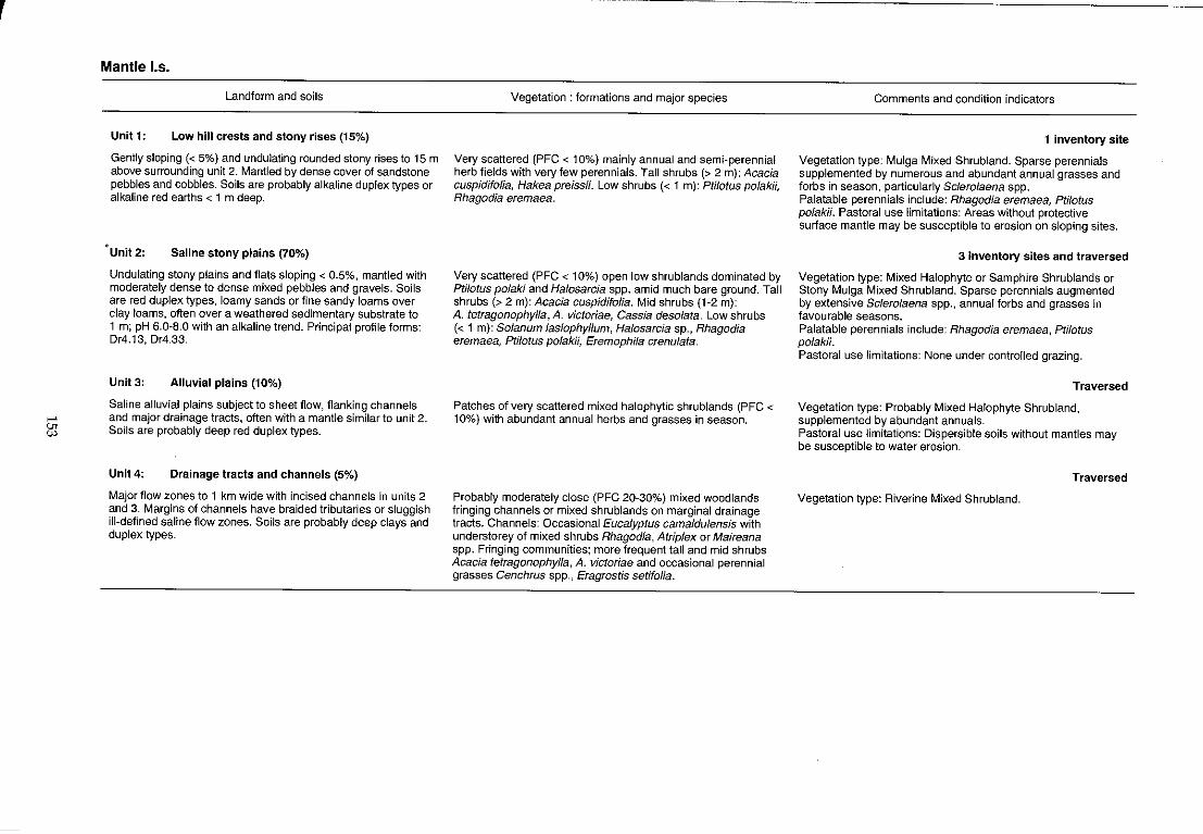
r
.... el
Mantle I.s.
Landform and soils
Unit 1: Low hill crests and stony rises (15%)
Gently sloping « 5%) and undulating rounded stony rises to 15 m above surrounding unit 2. Mantled by dense cover of sandstone pebbles and cobbles. Soils are probably alkaline duplex types or alkaline red earths < 1 m deep.
·Unit 2: Saline stony plains (70%)
Undulating stony plains and flats sloping < 0.5%, mantled with moderately dense to dense mixed pebbles and gravels. Soils are red duplex types, loamy sands or fine sandy loams over clay loams, often over a weathered sedimentary substrate to 1 m; pH 6.0-8.0 with an alkaline trend. Principal profile forms: Dr4.13, Dr4.33.
Unit 3: Alluvial plains (10%)
Saline alluvial plains subject to sheet flow, flanking channels and major drainage tracts, often with a mantle similar to unit 2. Soils are probably deep red duplex types.
Unit4: Drainage tracts and channels (5%)
Major flow zones to 1 km wide with incised channels in units 2 and 3. Margins of channels have braided tributaries or sluggish ill-defined saline flow zones. Soils are probably deep clays and duplex types.
Vegetation: formations and major species
Very scattered (PFC < 10%) mainly annual and semi-perennial herb fields with very few perennials. Tall shrubs (> 2 m): Acacia cuspidifolia, Hakea preissii. Low shrubs « 1 m): Ptilotus polakii, Rhagodia eremaea.
Very scattered (PFC < 10%) open low shrublands dominated by PtilotU5 polaki and Halosarcia spp. amid much bare ground. Tall shrubs (> 2 m): Acacia cuspidifolia. Mid shrubs (1-2 m): A. tetragonophylla, A. victoriae, Cassia desolata. Low shrubs « 1 m): Solanum lasiophyllum, Halosarcia sp., Rhagodia eremaea, Ptilotus polak;;, Eremophila crenulata.
Patches of very scattered mixed halophytic shrublands (PFC < 10%) with abundant annual herbs and grasses in season.
Probably moderately close (PFC 20-30%) mixed woodlands fringing channels or mixed shrublands on marginal drainage tracts. Channels: Occasional Eucalyptus camaldulensis with understorey of mixed shrubs Rhagodia, Atrip/ex or Maireana spp. Fringing communities; more frequent tall and mid shrubs Acacia tetragonophylla, A. victoriae and occasional perennial grasses Cenchrus spp., Eragrostis setifolia.
Comments and condition indicators
1 inventory site
Vegetation type: Mulga Mixed Shrubland. Sparse perennials supplemented by numerous and abundant annual grasses and forbs in season, particularly Sclerolaena spp. Palatable perennials include: Rhagodia eremaea, Ptilotus polakii. Pastoral use limitations: Areas without protective suriace mantle may be susceptible to erosion on sloping sites.
3 inventory sites and traversed
Vegetation type: Mixed Halophyte or Samphire Shrublands or Stony Mulga Mixed Shrubland. Sparse perennials augmented by extensive Sclerolaena spp., annual forbs and grasses in favourable seasons. Palatable perennials include: Rhagodia eremaea, Ptilotus polakii. Pastoral use limitations: None under controlled grazing.
Traversed
Vegetation type: Probably Mixed Halophyte Shrubland, supplemented by abundant annuals . Pastoral use limitations: Dispersible soils without mantles may be susceptible to water erosion.
Traversed
Vegetation type: Riverine Mixed Shrubland.
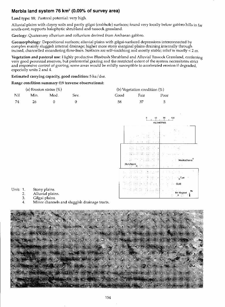
Merbla land system 76 km2 (0.09% of survey area)
Land type: 18; Pastoral potential: very high.
Alluvial plains with clayey soils and partly gilgai (crab hole) surfaces; found very locally below gabbro hills in far south-east; supports halophytic shrub land and tussock grassland.
Geology: Quaternary alluvium and colluvium derived from Archaean gabbro.
Geomorphology: Depositional surfaces; alluvial plains with gilgai-surfaced depressions interconnected by complex mainly sluggish internal drainage; higher more stony marginal plains draining internally through incised, channelled meandering flow-lines. Surfaces are self-mulching and mostly stable; relief is mostly < 2 m.
Vegetation and pastoral use: Highly productive Bluebush Shrub land and Alluvial Tussock Grassland, conferring very good perennial reserves, but preferential grazing and the restricted extent of the system necessitates strict and responsive control of grazing; some areas would be mildly susceptible to accelerated erosion if degraded, especially units 2 and 4.
Estimated carrying capacity, good condition: 5 ha I dse.
Range condition summary (19 traverse observations):
(a) Erosion status (%)
Nil Min. Mod. Sev.
74
Unit: 1. 2. 3. 4.
26 o
Stony plains. Alluvial plains. Gilgai plains.
o
Minor channels and sluggish drainage tracts.
154
(b) Vegetation condition (%)
Good Fair Poor
58 37 5
40 80 120
KILOMETRES -- - --,--- - - --
Meekatharra 0
Murchison 0
oCue
CUE
l>; Mt Magnet i 0
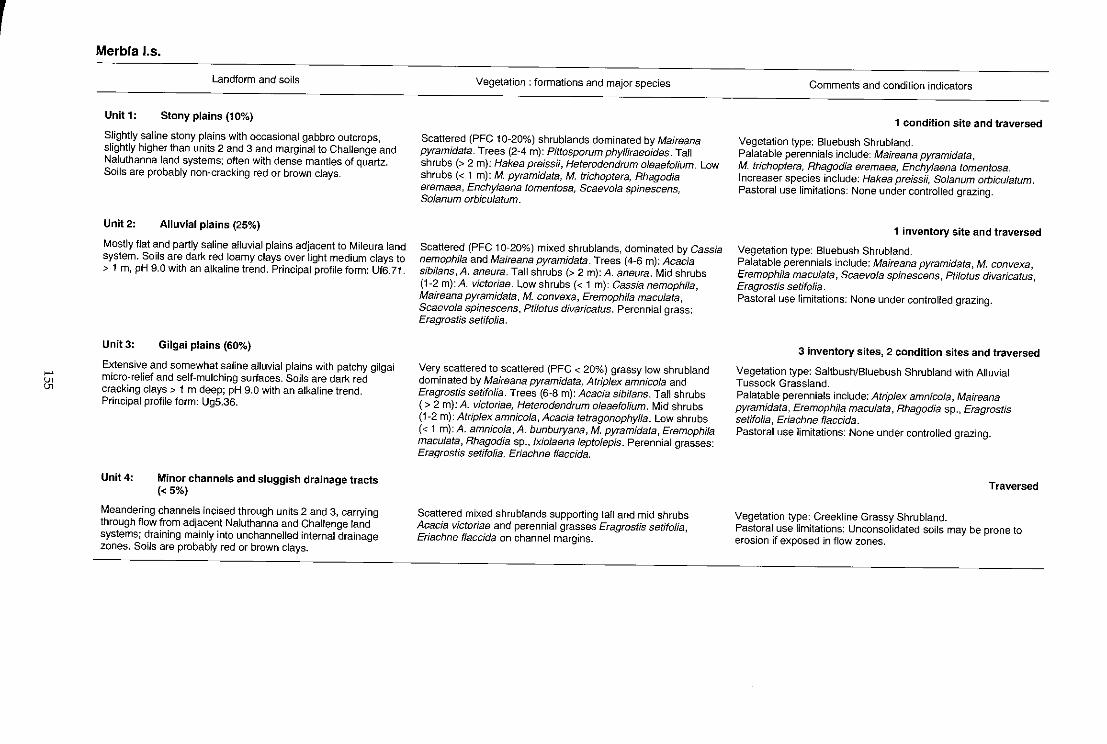
.... 81
Merbla 1.5.
Landform and soils
Unit 1: Stony plains (10%)
Slightly saline stony plains with occasional gabbro outcrops, slightly higher than units 2 and 3 and marginal to Challenge and Naluthanna land systems; often with dense mantles of quartz. Soils are probably non-cracking red or brown clays.
Unit 2: Alluvial plains (25%)
Mostly flat and partly saline alluvial plains adjacent to Mileura land system. Soils are dark red loamy clays over light medium clays to > 1 m, pH 9.0 with an alkaline trend. Principal profile form: Uf6.71.
Unit3: Gilgai plains (60%)
Extensive and somewhat saline alluvial plains with patchy gilgai micra-relief and self-mulching surfaces. Soils are dark red cracking clays> 1 m deep; pH 9.0 with an alkaline trend. Principal profile form: Ug5.36.
Unit 4: Minor channels and sluggish drainage tracts « 5%)
Meandering channels incised through units 2 and 3, carrying through flow from adjacent Naluthanna and Challenge land systems; draining mainly into unchannelled internal drainage zones. Soils are probably red or brown clays.
Vegetation: formations and major species
Scattered (PFC 10-20%) shrublands dominated by Maireana pyramidata. Trees (2-4 m): Pittosporum phylliraeoides. Tall shrubs (> 2 m): Hakea preissii, Heterodendrum oleaefolium. Low shrubs « 1 m): M. pyramidata, M. trichoptera, Rhagodia eremaea, Enchylaena tomentosa, Scaevola spinescens, Solanum orbiculatum.
Scattered (PFC 10-20%) mixed shrublands, dominated by Cassia nemophila and Maireana pyramidata. Trees (4-6 m): Acacia sibilans, A. aneura. Tall shrubs (> 2 m): A. aneura. Mid shrubs (1-2 m): A. victoriae. Low shrubs « 1 m): Cassia nemophila, Maireana pyramidata, M. convexa, Eremophila maculata, Scaevola spinescens, Pti/otus divaricatus. Perennial grass: Eragrostis setifolia.
Very scattered to scattered (PFC < 20%) grassy low shrubland dominated by Maireana pyramidata, Atriplex amnicola and Eragrostis setifolia. Trees (6-8 m): Acacia sibilans. Tall shrubs (> 2 m): A. victoriae, Heterodendrum oleaefolium. Mid shrubs (1-2 m): Atriplex amnicola, Acacia tetragonophylla. Low shrubs « 1 m): A. amnicola, A. bunburyana, M. pyramidata, Eremophila maculata, Rhagodia sp., Ixiolaena leptolepis. Perennial grasses: Eragrostis setifolia, Eriachne flaccida.
Scattered mixed shrublands supporting tall and mid shrubs Acacia victoriae and perennial grasses Eragrostis setifolia, Eriachne f1accida on channel margins.
Comments and condition indicators
1 condition site and traversed
Vegetation type: Bluebush Shrubland. Palatable perennials include: Maireana pyramidata, M. trichoptera, Rhagodia eremaea, Enchylaena tomentosa. Increaser species include; Hakea preiss;;, Solanum orbiculatum. Pastoral use limitations: None under controlled grazing.
1 inventory site and traversed
Vegetation type: Bluebush Shrubland. Palatable perennials include: Maireana pyramidata, M. convexa, Eremophila maculata, Scaevola spinescens, Ptilolus divaricatus, Eragrostis setifolia. Pastoral use limitations; None under controlled grazing.
3 inventory sites, 2 condition sites and traversed
Vegetation type: Saltbush/Bluebush Shrubland with Alluvial Tussock Grassland. Palatable perennials include: Atriplex amnicola, Maireana pyramidata, Eremophila maculata, Rhagodia sp., Eragrostis setifolia, Eriachne f1accida. Pastoral use limitations: None under controlled grazing.
Traversed
Vegetation type: Creekline Grassy Shrubland. Pastoral use limitations: Unconsolidated soils may be prone to erosion if exposed in flow zones.
Mileura land system (W) 1007 km2 (1.17% of survey area)
Land type: 15; Pastoral potential: high.
Saline and non-saline calcreted river plains, with clayey flood plains interrupted by raised calcrete platforms supporting diverse and very variable tall shrub lands, mixed halophytic shrub lands and shrubby grasslands.
Geology: Tertiary calcrete with opaline silica and fine gravel at depth; partly overlain by Quaternary alluvium.
Geomorphology: Depositional surfaces; calcreted valley fills with a mosaic of dissected calcrete platforms usually 1 to 10 km wide and 2 to 5 m high; alluvial plains, underlain by hardpan on margins; central plains and flow zones between platforms often highly saline; river channels (with isolated semi-permanent pools) to 100 m wide, incised and carrying bedloads of coarse materials: frequent drainage foci with minor internal drainage; overall relief < 6 m.
Vegetation and pastoral use: Moderately to highly productive saline and non-saline shrublands, mainly Bluebush, Saltbush, Mixed Halophytic, Samphire and Riverine Mixed Shrublands with good perennial reserves when in good condition; also Calcrete Shrubby Grassland and Bluebush Shrub land on calcrete platforms; frequently degraded with invasions of unpalatable shrubs. The system is preferentially grazed (especially unit 1) by kangaroos, feral animals and domestic stock; units with duplex soils moderately to highly susceptible to erosion, those with loam over hardpan less susceptible, calcrete platforms not normally susceptible, though widely degraded.
Estimated carrying capacity, good condition: 7 ha I dse.
Range condition summary (301 traverse observations):
(a) Erosion status (%)
Nil Min. Mod. Sev.
74 19 6 1
Unit: 1. 2. 3. 4. 5. 6.
Calcrete platforms. Drainage foci. Alluvial plains. Lower saline plains. Major drainage tracts. Channels.
156
(b) Vegetation condition (%)
Good
31
Fair Poor
37 32
40 80 120 , ,
KILOMETRES
,----------
GLENBURGH ROBINSON RANGE
~
"" , I - '\
BYRD / ,
BELELE Meekatharra 0
Murchison , ! .~ 0,-
- '\ • ... <:,cue ~-
MURaOO CUE" , , , 1 "-
MtMagnet 0
.
,
... V>
"
Mileura 1.5.
Landform and soils
Unit 1: Calcrete platforms (33%)
Calcrete platforms mainly O.5~3 km long, with little slope « 0.5%); usually elevated 2~3 metres above adjoining units and fragmented by flow zones (unit 5); very sparse to moderate mantling of calcrete fragments with occasional outcrop of opaline rocks. Soils are mostly calcareous sands, red or brown calcareous sandy loams or alkaline red earths with frequent calcareous nodules and fragments of calcrete through the profile, over calcrete at < 50 em; pH 7.5-9.5 with an alkaline trend. Principal profile forms: Uc1.12, Uc1 .13, UcS.12, Um1.33, Gc1.12.
Unit 2: Drainage foci « 2%)
Flat, saline and non-saline depressions occurring as ephemeral swamps up to 1 km wide and 3 m below adjacent units 1 and 3. Soils are reddish brown or brown clays, hard-setting duplexes or calcareous red earths; mostly full-depth (some with calcrete at 30 cm), pH 7.0-9.0 with mainly alkaline soil reaction trend. Principal profile forms: Ug6.3, Uf6.71, Dr2.53, Gcl.22.
Unit 3: Alluvial plains (35%)
Alm()st flat (< 0.6% slope) alluvial floors and plains between units 1 and 4; sheet and rill erosion common with some areas of severe scalding, hum mocking and wind piling evident. Soils are dark red, yellowish-red or brown duplex or clay types, clayey sands or clay loams over sandy or light clays with a scattered quartz or ironstone mantle and occasional calcrete or hardpan at 80-100 cm. pH 6.5-9.5 with a mainly alkaline trend. Principal profile forms: Dr1.33, Dr2.52, Dr2.53, Dr2.13, Uf6.71 , Uf6.53, Gc1.21.
Vegetation: formations and major species
a) Very scattered to scattered (PFC < 20%) tall shrublands dominated by Acacia sclerosperma, A. aneura and Cassia spp. Trees (4-8 m): A. aneura, A. sibilans, Codonocarpus cotinifofius, Pittosporum phylliraeoides. Tall shrubs (> 2 m): A. sclerosperma, A. tysonii, A. victoriae, Grevillea aft. stenobotrya, Eremophila miniata. Mid shrubs (1-2 m): A. sc/erosperma, A. victoriae, Lycium australe. Low shrubs « 1 m): Cassia nemophila, Cratystylis subspinescens, Maireana pyramidata, M. trichoptera, Atrip/ex bunburyana, Rhagodia eremaea, Enchylaena toment05a. Perennial grass (up to 2% basal cover): Enneapogon nigricans, E. sp., Eragrostis falcata, E. pergracilis. b) In south-east of area only; Moderately close (PFC 20-30%) woodland dominated by Eucalyptus striatacalyx. Trees (to 14 m): E. striatacalyx. Tall shrubs (> 2 m): A. ligulata, A. sc/erosperma. Low shrubs « 1 m): Pti/otus obovatus, Cassia nemophila, Atrip/ex bunburyana, A. aft. nummularia, Lycium australe, Enchylaena tomentosa. Perennial grass: Stipa sp.
Scattered to close (PFC 10-50%) woodland or shrubland with Grevillea striata, Eucalyptus cama/dulensis, E. striatacalyx, or mixed halophytes in more saline depressions, or lightly wooded tussock grasslands. Trees (to 14 m): G. striata, E. camaldulensis, E. striatacalyx, Acacia aneura. Tall shrubs (> 2 m): Exocarpus aphylla, Melaleuca uncinata. Low and mid shrubs: Muehlenbeckia cunninghamii, Chenopodium nitrariaceum, Cratystylis subspinescens, Rhagodia eremaea, Ptilotus divaricatus, Atriplex amnicola, Lyc/um austra/e. Perennial grasses: Eriachne flaccida, Stipa elegantissima.
Very scattered to moderately close (PFC < 30%) tall, mid height or low shrublands or with shrub layers co-dominant, occasional prominent trees. Trees (to 8 m): E. coolabah, Grevillea aft. stenobotrya, G. striata, Acacia aneura, A. sibilans. Tall shrubs (> 2 m); Melaleuca uncinata, A. tysonii, A. sclerosperma, A. xiphophylfa. Mid shrubs (1-2 m): Cratystylissubspinescens, Lycium australe, Scaevola spinescens, Eremophila pterocarpa, Acacia victoriae, Hakea preissii, Cassia nemophila, C.sturtii. Low shrubs (< 1 m): Frankenla spp., C. subspinescens, Halosarcia spp., Atriplex amnicola, A. vesicarla, Maireana pyramidata, Pti/otus lazarides, P. beardii. Perennial grasses: Eragrostis spp., E. setifolia, E. die/sii.
Comments and condition indicators
9 inventory Sites, 17 condition sites and traversed
Vegetation type: a) Calcrete Shrubby Grassland; or b) Bluebush or Saltbush Shrubland. Palatable perennials include: Cratystylis subspinescens, Maireana trichoptera, M. pyramidata, Rhagodia eremaea, Atriplex bunburyana, Sc/erolaena spp., Eragrostis spp., Enneapogon spp. Pastoral use limitations: Perennial grasses invariably overutilised and more or less degraded through preferential grazing by stock, goats, kangaroos and rabbits; susceptible to shrub invasion by Cassia spp. and Dissocarpus paradoxus where perennials are degraded; not normally subject to accelerated erosion. Vegetation condition %; VG/G 28, F 45, PNP 27. Erosion incidence %; min 3. 78 obs.
5 inventory sites and traversed
Vegetation type: Saltbush Shrubland or Mixed Halophyte Shrubland or Alluvial Tussock Grassland. Palatable perennials include: Chenopodium nitrariaceum, Cratystylis subspinescens, Atriplex amnicola, Rhagodia eremaea, Erfachne flaccida. Pastoral use limitations: Subject to seasonal inundation but otherwise none under controlled grazing.
11 inventory sites, 15 condition sites and traversed
Vegetation type: Riverine Mixed Shrubland or Mixed Halophyte Shrubland. Palatable perennials shrubs include: Maireana pyramidata, Rhagodia eremaea, Ptilotus spp., Cratystylfs subspinescens, Cassia chatelainiana, Atriplex vesicaria, Eremophila macu/ata, E. malacoides and perennial grasses. Pastoral use limitations; Degraded areas are highly susceptible to sheet erosion, soil redistribution and subsequent invasion by Acacia victoriae and Eremophila pterocarpa. Vegetation condition %; VG/G 33, F 28, PNP 39. Erosion incidence %: min 36, mod 10, sev 3. 115 obs.
~
"-' ii!
Mileura 1.5-Continued
Landform and soils
Unit 4: Lower saline plains (18%)
Flat low-lying strongly saline alluvial plains. Soils vary from
hard-setting duplexes to red and brown clays and calcareous
red earths, > 1 m deep, pH 7.0-9.0 with a mostly alkaline
reaction trend. Principal profile forms: Or2.52, Dr2.12, Gc1.2,
UfB.71, Uf5.12, Uf1.33, Uf6.53.
Unit 5: Major drainage tracts (10%)
Almost flat drainage tracts up to 1 km wide and subject to
concentrated sheet flow. Occasional small anastomosing
channels to 1 m deep with local relief to 3 m. Soils are
yellowish-red or dark red medium or heavy clays> 1 m deep,
pH 7.0-9.0 with an alkaline trend. Principal profile forms:
Ug5.36, Uf and juvenile alluvial types.
Unit 6: Channels (2%)
Channels incised up to 3 m deep and 30 m wide within units 3
and 4 with bed loads of coarse sand on exposed red-brown
hardpan and calcrete and often showing salt encrustations
when dry.
Vegetation: formations and major species
Very scattered (PFC < 10%) or moderately close (PFC 20-30%)
low shrublands dominated by Hafosarcia, Atrip/ex, Frankenia,
Cratystylis and Lawrencia spp. Trees (4-6 m): Grevillea spp. Tall
shrubs (> 2 m): Me/afeuca uncinata, Acacia tysonii,
A. sclerosperma. Mid shrubs (1-2 m): Cratystylis
subspinescens, Lycium australe, Scaevola spinescens. Low
shrubs « 1 m): Frankenia spp., F. setosa, C. subspinescens,
Lawrencia chrysoderma, Hafosarcia spp., Atriplex amnicoJa.
Perennial grasses: Eragrostis spp., E. setifoJia, E. dielsii.
Moderately close to closed (PFC 20- > 50%) low woodland and
tall shrublands dominated by Acacia sibilans, Muehlenbeckia
cunninghamii and Cratystyfis subspinescens. Trees (6-8 m):
A. sibilans, Eucalyptus camaldulensis, E. coolabah. Tall shrubs
(> 2 m): A. sibilans, Hakea preissii. Mid shrubs (1-2 m):
Eremophila sp., C. subsplnescens, M. cunninghamii. Perennial
grasses: Eriachne flaccida, SUpa eleganUssima.
Variable, moderately close (PFC 20-30%) fringing communities.
Trees (6-8 m): Eucalyptus camaldulensis, E. coolabah,
Casuarina sp. Tall shrubs (> 2 m): Duboisia hopwoodii, Acacia
sclerosperma. Mid shrubs (1-2 m): Atriplex amnicola,
Eremophila panton;;, E. platycarpa, Halosarcia indica, Lycium
australe, Scaevola spinescens. Perennial grass: Setaria sp.
Comments and condition indicators
7 inventory sites and traversed
Vegetation type: Saltbush or Mixed Halophyte Shrublands.
Palatable perennials include: Atriplex amnicofa, Cratystylis
subspinescens, Lawrencia chrysoderma, Scaevofa spinescens,
Enchylaena tomentosa, Eragrostis setifolia, E. dielsii.
Pastoral use limitations: High levels of salinity in pasture plants;
zones grading into unit 3 moderately susceptible to accelerated
erosion where degraded.
4 inventory sites, 3 condition sites and traversed
Vegetation type: Riverine Mixed Shrubland or Mixed Halophyte
Shrubland. Palatable perennials include: Cratystylis subspinescens,
Scaevola spinescens, Frankenia setosa, Rhagodia eremaea,
Enchylaena tomentosa. Increaser species include: Hakea
preissii. Pastoral use limitations: minor susceptibility to erosion where
perennials are degraded. Vegetation condition %: VG/G 63, F 19, PNP 8.
Erosion incidence 'Yo: min 8. 260bs.
1 inventory site and traversed
Palatable perennials include: Atrlpfex amnicola, Lycium
australe, Scaevola spinescens, Setaria sp.
Pastoral use limitations: Unconsolidated banks are susceptible
to erosion if bare of vegetation.
Millex land system 500 km2 (0.58% of survey area)
Land type: 5; Pastoral potential: moderate.
Plains on granite, with irregularly distributed low sandy banks and saline alluvial plains lightly strewn with
quartz mantles; supports mulga shrublands and low halophytic shrub lands.
Geology: Mixed Archaean porphyritic granites masked by Quaternary colluvium and alluvium with minor
aeolian deposits.
Geomorphology: Mainly erosional surfaces: very gently sloping to flat plains, with sandy or loamy soils over
more or less weathered rock and minor marginal red-brown hardpan; minor tracts of sandy banks; scattered low
outcrops with' onion' weathering; lower saline stony plains carrying sheet drainage, with duplex soils and
quartzy mantles especially below deeply weathered low outcrops; minor channelled drainage lines; relief mainly
5tolOm.
Vegetation and pastoral use: Moderately productive Granitic Mulga or Mixed Halophytic Shrub lands, with the
more productive saline units usually being preferentially grazed, and widely reduced in value towards mainly
annual production; some wanderrie grasses on sandy banks; wash plains otherwise support Hardpan Mulga
shrubland; units 2, 5 and 6 moderately susceptible to water erosion when degraded.
Estimated carrying capacity, good condition: 12 ha / dse.
Range condition summary (87 traverse observations):
(a) Erosion status (%)
Nil Min. Mod. Sev.
83
Unit: 1. 2. 3. 4. 5. 6.
14 3 o
Sand sheets and banks. Saline stony plains. Sandy-surfaced plains on granite. Hardpan plains. Alluvial plains. Drainage tracts.
160
(b) Vegetation condition (%)
Good Fair Poor
29 39 32
40 80 120 . KILOMETRES
.---- - - --,--- - --
Meekatharra 0
MUrchison 0
-:.- '-oeue )"'
I , CUE l • r' \' .-•
Mt Magnet ," " , 0
~
'" ~
Millex 1.5.
Landform and soils
Unit 1: Sand sheets and banks (5%)
Small sand sheets or isolated sand banks to 2 m above surrounding units 3 and 4. Soils are red, uniform earthy sands, mostly over granite at 35 em to > 1 m. pH 5.5-6.0 with an acidic trend. Principal profile form: Uc5.21.
Unit 2: Saline stony plains (40%)
Flat to very gently undulating more or less saline plains, slopes < 0.3%, relief to 2 m, and generally covered with sparse to moderately dense ironstone and quartz pebbly mantle, overlying weathered granitic parent rock. Soils are red or dark red duplex types, loamy sands or sandy clay loams over light sandy clays < 40 m deep, pH 6.0-6.5 with a neutral trend. Principal profile forms: Or2.52, Or1.12, Um5.51.
Unit 3: Sandy plains on granite (25%)
Gently sloping « 1.2%) sandy surtaced, non-saline plains with low outcrops of unweathered granite, relief occasionally to 6 m. Generally covered with a moderately dense quartz or granite mantle. Soils are red granitic siliceous or earthy sands overlying granite at < 40 cm; pH 6.5-7.0 with a neutral trend. Principal profile forms: Uc5.21, Uc1.43.
Unit 4: Hardpan plain (10%)
Flat plains subject to sheet flow, often on outer margins of system. Soils are red hardpan loams or shallow red earths to 50 cm deep over hardpan or granite with a neutral trend. Principal profile form: Um5.31.
UnitS: Alluvial plains (15%)
Flat to very gently sloping « 0.5%) mainly unmantled saline alluvial plains receiving run-on from units 2, 3 and 4. Soils are duplexes, red or dark red loamy sands or sandy clay loams over light clays to a depth of 45 cm, often over weathered granite; pH 6.0-7.0 with a neutral trend. Principal profile forms: Or2.12, Or2.52.
Vegetation: formations and major species
Scattered to moderately close (PFC 10-30%) low woodland or mixed shrubland dominated by Acacia aneura, A. craspedocarpa, A. ramulosa, Ptilotus obovatus and Eremophila aff. punicea. Trees (4-6 m): Acacia aneura. Tall shrubs (> 2 m): A. ramulosa, A. aneura, A. craspedocarpa, A. tetragonophylla. Mid shrubs (1-2 m): Eremophila forrestii, A. aneura, A. grasbyi, A. ramulosa. Low shrubs « 1 m): E. aft. punicea, E. forrestii, Ptilotus obovatus, Sida ca/yxhymenia. Perennial grass: Eragrostis eriopoda.
Very scattered to scattered (PFC < 20%) open mixed shrublands generally dominated by low halophytic shrubs such as Maireana and Ptilotus spp: Acacia aneura dominant on nonsaline margins. Trees (2-4 m): A. aneura. Tall shrubs (> 2 m): A. xiphophylla, Eremophila linearis, E. youngii, E. fraseri, A. aneura, A. victoriae. Mid shrubs (1-2 m): E. pterocarpa, E. fraseri, Cassia helmsii, C. desolata. Low shrubs « 1 m): Maireana pyramidata, M. tomentosa, M. glomerifolia, E. lachnocalyx, pti/otus beardii, P. obovatus.
Scattered to very scattered (PFC < 20%) mixed shrub lands dominated by Acacia aneura, Eremophila platycalyx and Ptilotus obovatus. Trees (2-6 m): A. aneura. Tall shrubs (> 2 m): A. aneura, E. platycalyx. Mid shrubs (1-2 m): E. platycalyx, E. fraseri, A. tetragonophylla. Low shrubs « 1 m): P. obovatus, Solanum lasiophyllum, E. forrestii, Cassia helmsii, Maireana planifolia, M. triptera.
Scattered (PFC 10-20%) low woodland dominated by Acacia aneura. Trees (4-6 m): A. pruinocarpa, A. aneura. Tall shrubs (> 2 m):A. aneura, A. craspedocarpa. Mid shrubs (1-2 m): A. tetragonophylla, Eremophila forrestii. Low shrubs « 1 m): Ptilotus obovatus, Solanum lasiophyllum, P. schwartzii, Eremophila georgei.
Very scattered to scattered (PFC < 20%) mixed or low shrubland dominated by Maireana pyramidata and Ptilotus obovatus. Trees (to 8 m): Acacia pruinocarpa, A. aneura. Tall shrubs (> 2 m): A. craspedocarpa. Mid shrubs (1-2 m):A. tetragonophyJla, Eremophila platycalyx. Low shrubs « 1 m): M. pyramidata, pti/otus obovatus, M. glomeritolia, M. triptera, M. aff. integra, Solanum lasiophyllum.
Comments and condition indicators
4 inventory sites, 1 condition site and traversed
Vegetation type: Granitic Mulga Shrubland or Wanderrie Bank Grassy Shrubland. Palatable perennials include: Rhagodia eremaea, Maireana convexa, M. platycarpa, M. triptera, Scaevola spinescens, Eragrostis eriopoda. Pastoral use limitations: None under controlled grazing.
6 inventory sites, 1 condition site and traversed
Vegetation type: Bluebush or Mixed Halophytic Shrubland. Palatable perennials include: Maireana pyramidata, M. platycarpa, M. georgei, Scaevola spinescens, Rhagodia eremaea, Pti/otus obovatus, P. beardii. Pastoral use limitations: Slightly susceptible to accelerated erosion where degraded and lightly mantled. Vegetation condition %: VG/G 20, F 31, PNP 49. Erosion incidence %: min 6. 35 obs.
5 inventory sites, 2 condition sites and traversed
Vegetation type: Granitic Mulga Shrubland. Palatable perennials shrubs include: Maireana planifolia, M. georgei, Pti/otus obovatus, P. schwartzii, Rhagodia eremaea, Eremophila compacta, E. latrobei. Pastoral use limitations: None with controlled grazing.
1 inventory site, 1 condition site and traversed
Vegetation type: Hardpan Mulga Shrubland. Palatable perennials include: Eremophila forrestii, Ptilotus obovatus, P. schwartzii, Maireana convexa, Rhagodia eremaea. Pastoral use limitations: Slightly susceptible to accelerated erosion where degraded.
2 inventory sites, 2 condition sites and traversed
Vegetation type: Mulga Chenopod or Bluebush Shrubland. Palatable perennials include: M. pyramidata, Rhagodia eremaea, M. aft. integra, P. obovatus, Cassia chatelainiana, Enchylaena tomentosa. Pastoral use limitatjons: Moderately susceptible to accelerated erosion where degraded.

,.... Rl
l
Millex I.s.--continued
Landform and soils
Unit 6: Narrow drainage tracts (5%)
Unchannelled drainage zones receiving concentrated flow
mainly from units 2, 4 and 5. Soils are dark red hardpan sandy
clay loams to 20 em deep, overlying hardpan; pH 6.5·7.5 with a
neutral trend. Principal profile form: UmS.31.
Vegetation: formations and major species
Moderately close (PFC 20-30%) shrubland dominated by Acacia
craspedocarpa and A tetragonophylla.
Tall shrubs (> 2 m): A. craspedocarpa, A. tetragonophylla. Mid
shrubs (1-2 m): A. craspedocarpa, Eremophila latrobe;. Low
shrubs « 1 m): Ptilotus obovatus, Sida calyxhymenia,
Abuti/on sp., Solanum lasiophyllum.
Comments and condition indicators
1 inventory site and traversed
Vegetation type: Hardpan Mulga Shrubland.
Palatable perennials include: Rhagodia eremaea, Ptilotus
obovatus, Enchylaena tomentosa. Pastoral use limitations: None under controlled grazing.
Millrose land system (W) 535 km2 (0.62% of survey area)
Land type: 3; Pastoral potential: low.
Level or very gently undulating stony plains on hardpan and granite with irregularly distributed sandy
wanderrie banks, supporting mostly scattered mulga shrublands with minor wanderrie grasses.
Geology: Quaternary aeolian sand and alluvium on partly weathered Archaean gneiss and granite.
Geomorphology: Higher units with erosional surfaces; low stony outcrops and rises on very gently undulating
interfluves; lower depositional surfaces over weathering granite and shallow red-brown hardpan: broad pebble
and gravel-strewn plains on hardpan or granite; also sandy plains with granite outcropping; elongate sandy banks
and sheets flanking ill defined drainage tracts; overall relief mostly < 6 m.
Vegetation and pastoral use: Stony Mulga Mixed Shrubland and Hardpan Mulga Shrublands of generally low
productivity; minor patches of Wanderrie Grass Shrubland on units 2 and 3; some soils very acidic; scattered
halophytes tend to be selectively grazed, particularly on units 1 and 4; condition often poorer on plains with
shallow soils. Mild susceptibility to accelerated erosion on units 1, 4 and 5 when degraded.
Estimated carrying capacity, good condition: 20 hal dse.
Range condition summary (95 traverse observations):
(a) Erosion status (%)
Nil Min. Mod. Sev.
85
Unit: 1. 2. 3. 4. 5.
11 4
Stony plains. Sandy banks.
o
Sandy surfaced plains on granite. Hardpan plains. Drainage tracts.
164
(b) Vegetation condition (%)
Good Fair Poor
15 39 46
o 80 120 , , KILOMETRES
,-- - --,.-- - --
ROBINSON RANGE
• ... • , j
, BYROt ... ~ ~ELELE
#
t" , ..... ' Meelf"atharra
0 . MurchIson "" . ,
0 •
aGue
CUE
Mt Magnet 0
J
~
8i
Millrose I.s.
Landform and soils
Unit 1: Stony plains (40%)
Gently sloping « 1%) quartzy interfluvial plains on granite, up to 1.5 km wide, with occasional granite outcrops and a moderately dense quartz pebbly mantle. Soils are shallow hardpan loams, red earths or hard-setting duplexes overlying granite or hardpan at < 35 em; pH 4.5-7.5 with a mainly neutral reaction trend. Principal profile forms: UmS.51, Um5.31, Dr2.52.
Unit 2: Sandy banks (15%)
Sandy banks up to 300 m wide and 1 km long, often overlying granitic material. Soils are probably red earthy sands.
Unit 3: Sandy surfaced plains on granite (5%)
Gently sloping « 1.5%) sandy surfaced plains with frequent granite outcrops to > 5m high. Soils are shallow red or dark red granitic siliceous or earthy sands to 25 cm over granite; pH 6.0-6.5 with a neutral or acid reaction trend. Principal profile form: Uc5.21.
Unit 4: Hardpan plains (35%)
Flat hardpan plains with a sparse quartz mantle. Soils are shallow hardpan red sandy clay loams to 30 cm deep; pH 7.0 with a neutral reaction trend. Principal profile form: Um5.31.
UnitS: Narrow drainage tracts (5%)
Flow zones up to 500 m wide with occasional small channels < 1 m. Soils are probably similar to unit 4.
Vegetation: formations and major species
Very scattered to scattered (PFC < 20%) mixed shrubland, Acacia aneura, Eremophi/a species and Ptilotus obovatus. Trees (2-4 m): A. aneura, Canthium lineare, A. aft. citrinoviridis. Tall shrubs (> 2 m):A. aneura. Mid shrubs (1-2 m):A. aneura, E freelingii, E forrestii. Low shrubs « 1 m): E. latrobei, Ptilotus obovatus, E freelingii.
Shrublands with prominent perennial grass layer of Monachather paradoxa, Thyridolepis mu/ticulmis and Eragrostis lanipes. Trees and tall shrubs (> 2 m): Acacia aneura. Mid shrubs (1-2 m): A. grasbyi. Low shrubs « 1 m): Sida sp., Maireana triptera.
Scattered low woodland or tall shrubland (PFC 10-20%) dominated by low Acacia aneura, A. cuthbertsonii and A. aft. quadrimarginea. Trees (2-4 m): A. aneura. Tall shrubs (> 2 m): A. cuthbertsonii,A. aft. quadrimarginea. Mid shrubs (1-2 m): Eremophila p/atycalyx. Low shrubs « 1 m): Ptilotus obovatus, Solanum lasiophyllum, Eremophila punicea, E. latrobe;, E forrestii, E. fraser;.
Scattered (PFC 10-20%) shrublands, dominated by Ptilotus obovatus, Eremophila forrestii and Solanum lasiophyllum. Tall shrubs (> 2 m): Acacia craspedocarpa, A. aneura, E. longifolia. Mid shrubs (1-2 m):A. kempeana, Elatrobei, E forrestii. Low shrubs « 1 m): Ptilotus obovatus, Solanum lasiophyllum, E forrestii.
Scattered (PFC 10-20%) mixed low woodland dominated by Acacia aneura. Trees (4-6 m): A. aneura. Tall shrubs (> 2 m): A. tetragonophylla. Mid shrubS (1-2 m): Eremophila fraseri, A. cuthbertsonii. Low shrubs « 1 m): Ptilotus obovatus, Solanum lasiophyllum.
Comments and condition indicators
3 inventory sites, 3 condition sites and traversed
Vegetation type: Stony Mulga Mixed Shrubland. Palatable perennials include: Eremophila forrestii, Pti/otus obovatus, P. schwartzii, Maireana spp. Pastoral use limitations: None under controlled grazing. Vegetation condition %: VG/G 11, F 34, PNP 55. Erosion incidence %: min 5. 38 obs.
1 condition site and traversed
Vegetation type: Wanderrie Bank Grassy Shrubland. Palatable perennials include: Thyrido/epis multiculmis, Monachather paradoxa, Eragrostis /anipes, Maireana triptera, Enchylaena tomentosa. Pastoral use limitations: Mildly susceptible to erosion where degraded.
2 inventory sites and traversed
Vegetation type: Granitic Mulga Shrubland. Palatable perennials include: Sida ca/yxhymenia, Ptilotus obovatus, Rhagodia eremaea, Eremophila latrobei, Maireana convexa, M. planifolia. Pastoral use limitations: None with controlled grazing.
1 inventory site, 3 condition sites and traversed
Vegetation type: Hardpan Mulga Shrubland. Palatable perennials include: Eremophila forrestii, Ptilotus obovatus, Maireana convexa. Pastoral use limitations: Mildly susceptible to erosion where degraded. Vegetation condition %: VG/G 18, F 42, PNP 40. Erosion incidence %: min 16, mod 3. 38 obs.
1 inventory site and traversed
Vegetation type: Creekline Shrubland. Palatable perennials include: Rhagodia eremaea, Pti/otus obovatus. Pastoral use limitations: None under controlled grazing.
Mindura land system (W) 3661 km2 (4.26% of survey area)
Land type: 3; Pastoral potential: low.
Low hills, ridges and outcrops of granite, gneiss and quartz above convex, quartz-strewn interfluves and lower
plains supporting sparse acacia shrublands.
Geology: Archaean gneiss and granitic rocks with some early Proterozoic inclusions and minor dykes and veins
of quartz, dolerite and diorite; cemented Tertiary colluvium and Quaternary alluvium and colluvium, locally
calcreted in north-east.
Geomorphology: Erosional surfaces; hills with crests to 30 m or more with much gneiss or granite exfoliation and
benches with rock debris; short, discontinuous ridges above concave rocky slopes grading to broader, convex
stony interfluves with low rounded rises < 20 m; some lower saline stony plains flanking incised dendritic
drainage lines; overall relief (including hills) locally to 40 m but mostly < 30 m.
Vegetation and pastoral use: Rocky Hill Mixed Shrub land on hills and upper slopes; Stony Mulga Mixed
Shrub land on interfluves and lower stony plains; mostly of low grazing productivity; patches of more productive
Mulga Chenopod and Stony Snakewood Shrublands occur on more saline soils, with mixed bluebush species
when in good condition but almost unrecognisable when degraded; vegetation on units 3, 4, 5 and 6 widely in
poor condition; slight susceptibility to accelerated erosion of steam lines and major drainage tracts.
Estimated carrying capacity, good condition: 20 hal dse.
Range condition summary (322 traverse observations):
(a) Erosion status (%)
Nil Min. Mod. Sev.
96
Unit: 1. 2. 3. 4. 5.
4 o
Low hills and ridges. Hill slopes.
o
Stony plains and interfluves. Saline stony plains. Drainage floors.
166
(b) Vegetation condition (%)
Good
13
Fair
30
-, f' BYRO
Murchison ,
MURGOO
Poor
57
40 60 120
KILOMETRES
3
. ,
CUE
Mt Magnet ,
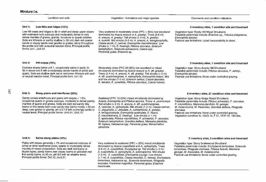
~
'" '"
Mindura los.
Landform and soils
Unit 1: Low hills and ridges (15%)
Low hill crests and ridges to 30 m relief and steep upper slopes with extensive rock outcrops and moderately dense to very dense mantles of gneiss, granite, ironstone or quartz cobbles. Soils are lithosols or earthy shallow « 35 em) dark red coarse sands or clayey sands over granite or gneiss, stony throughout the profile and with a neutral reaction trend. Principal profile forms: Uc1., UcS.51.
Unit 2: Hill slopes (15%)
Concave slopes below unit 1, occasionally saline in parts; to 30 m above unit 5 with a moderately dense mantle of schist and quartz. Soils are shallow dark red or red-brown lithosols with acid or neutral reaction trend. Principal profile form: Uc1.43.
Unit 3: Stony plains and interfluves (50%)
Gently convex interfluves and plains with slopes < 1.5%, occasional quartz or gneiss outcrops, moderate to dense pebbly mantles of quartz and gneiss. Soils are dark red sandy clay loams or fine sandy loam over sandy clay loams mostly < 50 cm deep, over gneiss or granite; pH 5.5-7.0 with a strongly acidic or neutral trend. Principal profile forms: Um5.51, Gn2.12.
Unit 4: Saline stony plains (10%)
Plains with slopes generally < 1 % and occasional outcrops of schist or other weathered rocks; sparse to moderately dense mantles of mixed composition. Soils are dark red loamy or duplex types, sandy loams over clayey loams or yellowish-red fine sandy loams, to 30 cm, pH 8.0 with an alkaline trend. Principal profile forms: Dr2.13, Um5.51.
Vegetation: formations and major species
Very scattered to moderately close (PFC < 30%) low woodland dominated by Acacia aneura or A. grasbyi. Trees (2-6 m): A. aneura, A. grasbyi. Tall shrubs (> 2 m): A. grasbyi, A. burkittii. Mid shrubs (1-2 m): A. aneura, A. tetragonophylla, Cassia sturtH, C. helmsH, Eremophila macmillaniana. Low shrubs « 1 m): E. freelingii, Ptilotus obovatus, Solanum lasiophyllum, Scaevola spinescens, Cassia spp. Perennial grass: Eriachne sp.
Moderately close (PFC 20-30%) low woodland or mixed shrublands dominated by Acacia aneura or A. aft. grasbyi. Trees (2-4 m): A. aneura, A. aft. grasbyi. Tall shrubs (> 2 m): A. aft. quadrimarginea, A. xiphophylla, Eremophila fraseri. Mid and low shrubs (1-2 m): Solanum ashby;, Cassia desolata, E. latrobei, E. cuneifolia, Ptilotus obovatus, Cassia helmsH.
Scattered (PFC 10-20%) mixed shrublands dominated by Acacia, Eremophila and Ptilotus species. Trees: A. pruinocarpa. Tall shrubs (> 2 m): A. aneura, A. aft. quadrimarginea, A. victoriae, A. xiphophylla. Mid shrubs (1-2 m): Cassia helmsii, C. oligophylla, C. deso/ata, A. cuthbertsonH, A. grasbyi, A. tetragonophylla, Eremophila spathulata, E. fraseri, E. macmillaniana, E. free/ingii. Low shrubs « 1 m): E. spathulata, Ptilotus rotundifolius, P. schwartzii, P. obovatus, So/anum lasiophyllum, Grevillea deflexa, Maireana planifolia, M. triptera, Halosarcia spp. Perennial grass: Monachather paradoxa.
Very scattered to scattered (PFC < 20%) mixed shrublands dominated by Acacia cuspidifolia and A. xiphophylla. Trees (4-6 m): A. cuspidifolia, Eucalyptus sp. Tall shrubs (> 2 m): A. cuspidifolia, A. xiphophylla, A. sclerosperma. Mid shrubs (1-2 m): A. cuspidifolia, Eremophila youngii. Low shrubs « 1 m): A. cuspidifolia, Cassia deso/ata, C. helmsii, Enchylaena tomentosa, Halosarcia sp., Scaevola tomentosa, Rhagodia eremaea, Frankenia magnifica. Perennial grass: Eriachne mucronata.
Comments and condition indicators
3 inventory sites, 1 condition site and traversed
Vegetation type: Rocky Hill Mixed Shrubland. Palatable perennials include: Eriachne sp., Tribulus platypterus, Eremophila latrobei. Pastoral use limitations: Local inaccessibility to stock.
3 inventory sites, 1 condition site and traversed
Vegetation type: Stony Acacia Hill Shrubland. Palatable perennials include: Ptilotus obovatus, P. ashbyi, Eremophila latrobei. Pastoral use limitations: None under controlled grazing.
5 inventory sites, 27 condition sites and traversed
Vegetation type: Stony Mulga Mixed Shrubland. Palatable perennials include: Ptilotus schwartzii, P. obovatus, P. rotundifolius, Maireana plan;folia, M. georgei, M. melanocoma, M. thesioides, Grevillea deflexa, Rhagodia eremaea. Pastoral use limitations: None under controlled grazing. Vegetation condition %: VG/G 14, F 31, VP/P 55. 190 obs.
3 inventory sites, 2 condition sites and traversed
Vegetation type: Stony Snakewood Shrubland. Palatable perennials include: Enchylaena tomentosa, Scaevola tomentosa, Rhagodia eremaea, Pti/otus beard;;, Maireana georgei, M. thesioides, M. me/anocoma. Pastoral use limitations: None under controlled grazing.
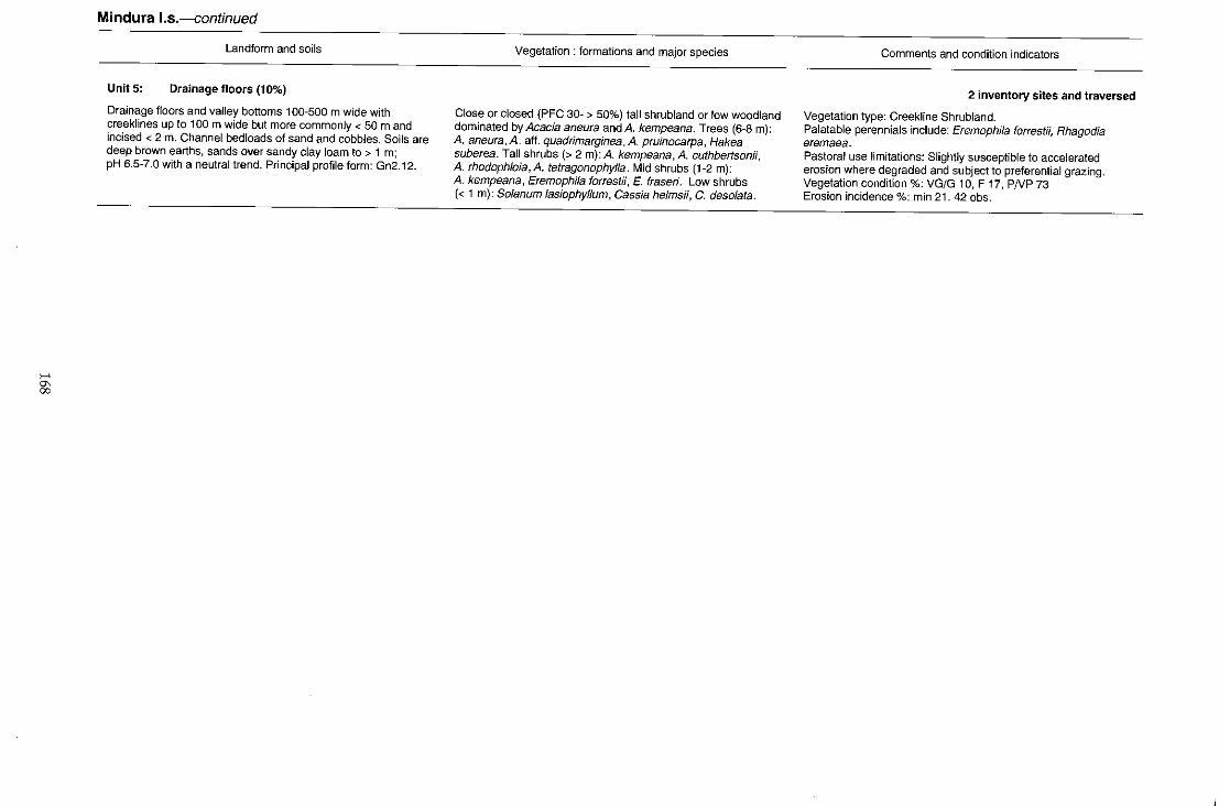
>-' g;
Mindura I.s.-continued
Landform and soils
Units: Drainage floors (10%)
Drainage floors and valley bottoms 100-500 m wide with creeklines up to 100 m wide but more commonly < 50 m and incised < 2 m. Channel bedloads of sand and cobbles. Soils are deep brown earths, sands over sandy clay loam to > 1 m; pH 6.5-7.0 with a neutral trend. Principal profile form: Gn2.12.
Vegetation: formations and major species
Close or closed (PFC 30- > 50%) tall shrubland or low woodland dominated by Acacia aneura and A. kempeana. Trees (6-8 m): A. aneura, A. aft. quadrimarginea, A. pruinocarpa, Hakea suberea. Tall shrubs (> 2 m): A. kempeana, A. cuthbertson;;, A. rhodophloia, A. tetragonophylla. Mid shrubs (1-2 m): A. kempeana, Eremophila forrestii, E. fraseri. Low shrubs « 1 m): Solanum lasiophyllum, Cassia helmsii, C. desolata.
Comments and condition indicators
2 inventory sites and traversed
Vegetation type: Creekline Shrubland. Palatable perennials include: Eremophila forrestii, Rhagodia eremaea. Pastoral use limitations: Slightly susceptible to accelerated erosion where degraded and subject to preferential grazing. Vegetation condition %; VG/G 10, F 17, PNP 73 Erosion incidence %: min 21. 42 obs.
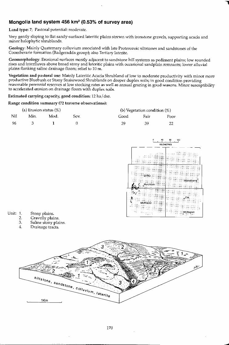
Mongolia land system 456 km2 (0.53% of survey area)
Land type: 7; Pastoral potential: moderate.
Very gently sloping to flat sandy-surfaced lateritic plains strewn with ironstone gravels, supporting acacia and minor halophytic shrub lands.
Geology: Mainly Quaternary colluvium associated with late Proterozoic siltstones and sandstones of the Coomberarie formation (Badgeradda group); also Tertiary laterite.
Geomorphology: Erosional surfaces mostly adjacent to sandstone hill systems as pediment plains; low rounded rises and interfluves above broad stony and lateritic plains with occasional sand plain remnants; lower alluvial plains flanking saline drainage floors; relief to 10 m.
Vegetation and pastoral use: Mainly Lateritic Acacia Shrubland of low to moderate productivity with minor more productive Bluebush or Stony Snakewood Shrub lands on deeper duplex soils; in good condition providing reasonable perennial reserves at low stocking rates as well as annual grazing in good seasons. Minor susceptibility to accelerated erosion on drainage floors with duplex soils.
Estimated carrying capacity, good condition: 12 hal dse.
Range condition summary (72 traverse observations):
(a) Erosion status (%)
Nil
96
Unit: 1. 2. 3. 4.
Min.
3
Mod.
1
Stony plains. Gravelly plains. Saline stony plains. Drainage tracts.
1Km
Sev.
o
COlll.Jv· . IU I7J
• Ia.terite
170
(b) Vegetation condition (%)
Good
39
Fair
39
Poor
22
40 80 120 , , ,
KILOMETRES
-- - ---- - --
.
BYRO
Meekatharra 0
I~ { oMurchison
'; , t...l
~ oCue
:, MURGOO
Mt Magnet 0
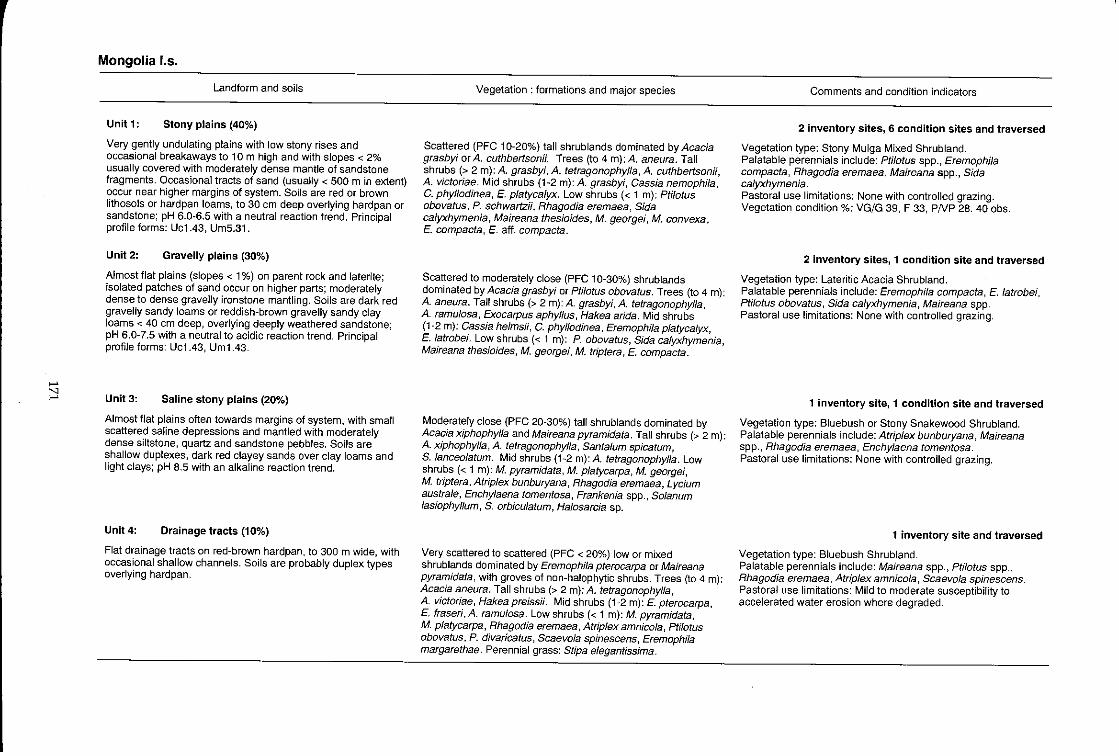
..... " .....
Mongolia 1.5.
Landform and soils
Unit 1: Stony plains (40%)
Very gently undulating plains with low stony rises and occasional breakaways to 10m high and with slopes < 2% usually covered with moderately dense mantle of sandstone fragments. Occasional tracts of sand (usually < 500 m in extent) occur near higher margins of system. Soils are red or brown lithosols or hardpan loams, to 30 em deep overlying hardpan or sandstone; pH 6.0-6.5 with a neutral reaction trend. Principal profile forms: Uc1.43, Um5.31.
Unit 2: Gravelly plains (30%)
Almost flat plains (slopes < 1 %) on parent rock and laterite; isolated patches of sand occur on higher parts; moderately dense to dense gravelly ironstone mantling. Soils are dark red gravelly sandy loams or reddish-brown gravelly sandy clay loams < 40 cm deep, overlying deeply weathered sandstone; pH 6.0-7.5 with a neutral to acidic reaction trend. PrinCipal profile forms: Ucl.43, Um1.43.
Unit 3: Saline stony plains (20%)
Almost flat plains often towards margins of system, with small scattered saline depressions and mantled with moderately dense siltstone, quartz and sandstone pebbles. Soils are shallow duplexes, dark red clayey sands over clay loams and light clays; pH 8.5 with an alkaline reaction trend.
Unit 4: Drainage tracts (10%)
Flat drainage tracts on red-brown hardpan, to 300 m wide, with occasional shallow channels. Soils are probably duplex types overlying hardpan.
Vegetation: formations and major species
Scattered (PFC 10-20%) tall shrub lands dominated by Acacia grasbyi or A. cuthbertson;;. Trees (to 4 m):A. aneura. Tall shrubs (> 2 m): A. grasbyi, A. tetragonophylla, A. cuthbertsonii, A. victoriae. Mid shrubs (1-2 m): A. grasbyi, Cassia nemophila, C. phyllodinea, E. platycalyx. Low shrubs « 1 m): Ptilotus obovatus, P. schwartzii, Rhagodia eremaea, Sida calyxhymenia, Maireana thesioides, M. georgei, M. convexa, E. compacta, E. aff. compacta.
Scattered to moderately close (PFC 10-30%) shrublands dominated by Acacia grasbyi or pti/otus obovatus. Trees (to 4 m): A. aneura. Tall shrubs (> 2 m): A. grasbyi, A. tetragonophylla, A. ramulosa, Exocarpus aphyllus, Hakea arida. Mid shrubs (1-2 m): Cassia helmsii, C. phyllodinea, Eremophila platycalyx, E. latrobei. Low shrubs « 1 m): P. obovatus, Sida calyxhymenia, Maireana thesioides, M. georgei, M. triptera, E. compacta .
Moderately close (PFC 20-30%) tall shrublands dominated by Acacia xiphophylla and Maireana pyramidata. Tall shrubs (> 2 m): A. xiphophylla, A. tetragonophylla, Santa/um spicatum, S. lanceo/atum. Mid shrubs (1-2 m): A. tetragonophylla. Low shrubs « 1 m): M. pyramidata, M p/atycarpa, M. georgei, M. triptera, Atriplex bunburyana, Rhagodia eremaea, Lycium australe, Enchylaena tomentosa, Frankenia spp., Solanum lasiophyllum, S. orbiculatum, Halosarcia sp.
Very scattered to scattered (PFC < 20%) low or mixed shrublands dominated by Eremophila pterocarpa or Maireana pyramidata, with groves of non-halophytic shrubs. Trees (to 4 m): Acacia aneura. Tall shrubs (> 2 m): A. tetragonophylla, A. victoriae, Hakea preissii. Mid shrubs (1-2 m): E. pterocarpa, E. fraseri, A. ramulosa. Low shrubs « 1 m): M. pyramidata, M. platycarpa, Rhagodia eremaea, Atriplex amnicola, Ptilotus obovatus, P. divaricatus, Scaevola spinescens, Eremophila margarethae. Perennial grass'. Slipa e1egantissima.
Comments and condition indicators
2 inventory sites, 6 condition sites and traversed
Vegetation type: Stony Mulga Mixed Shrubland. Palatable perennials include: Pti/otus spp., Eremophi/a compacta, Rhagodia eremaea, Maireana spp., Sida calyxhymenia. Pastoral use limitations: None with controlled grazing. Vegetation condition %: VG/G 39, F 33, PNP 28. 40 obs.
2 inventory Sites, 1 condition site and traversed
Vegetation type: Lateritic Acacia Shrubland. Palatable perennials include: Eremophila compacta, E. latrobei, Ptilotus obovatus, Sida calyxhymenia, Maireana spp. Pastoral use limitations: None with controlled grazing.
1 inventory site, 1 condition site and traversed
Vegetation type: Bluebush or Stony Snakewood Shrubland. Palatable perennials include: Atriplex bunburyana, Maireana spp., Rhagodia eremaea, Enchy/aena tomentosa. Pastoral use limitations: None with controlled grazing.
1 inventory site and traversed
Vegetation type: Bluebush Shrubland. Palatable perennials include: Maireana spp., Ptilotus spp., Rhagodia eremaea, Atrip/ex amnicola, Scaevola spinescens. Pastoral use limitations: Mild to moderate susceptibility to accelerated water erosion where degraded.

Moogooloo land system (G) 20 km2 (0.02% of survey area)
Land type: 1; Pastoral potential: low.
Intensely dissected plateaux, mesas and hills of sedimentary rocks with steep footslopes and dendritic drainage, supporting tall shrublands of mulga and other acacias; of only marginal occurrence in present area.
Geology: Permian quartz, sandstone, greywacke and siltstone of the Kennedy group.
Geomorphology: Erosional surfaces of residual flat topped hills with stony slopes, narrow valley floors and high density dendritic drainage lines with incised channels; relief to 60 m but mostly less.
Vegetation and pastoral use: Unproductive hilly shrub lands with some areas virtually inaccessible to stock. In favourable seasons, ephemerals and annuals provide some forage. Palatable perennial reserves generally low, even when in good condition.
Estimated carrying capacity, good condition: 20 hal dse.
Range condition summary: Not traversed; Payne et al. (1987) report 58% in good condition, 37% fair and 5% was in poor condition.
Unit: 1. 2. 3. 4.
Mesas and hills. Stony slopes. Drainage floors and incised creek lines. Marginal alluvial plains.
Silts t one,
1Km '-------"=--~
172
o 80 120 , , KILOMETRES
~- - ---- - --
GLENBURGH
• ,-
BYRD
Meekatharra 0
Murchison 0
oCue
Mt Magnet 0
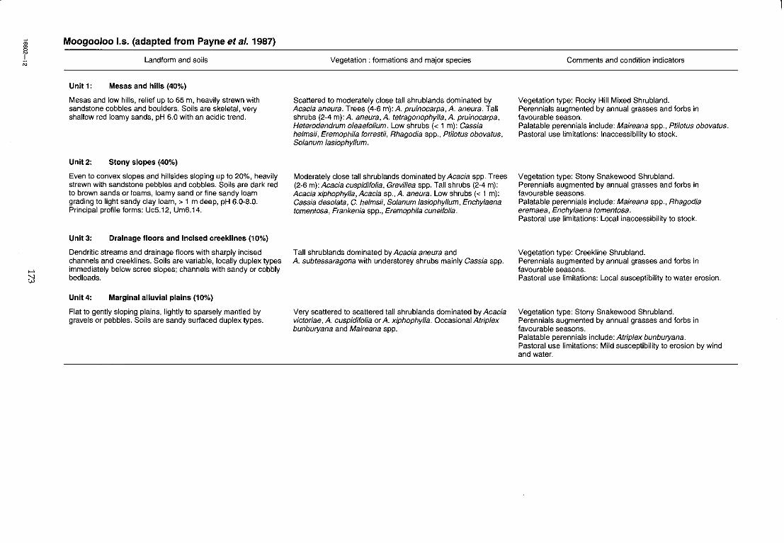
, N
>-'
~
Moogooloo 1.5. (adapted from Payne et a/. 1987)
Landform and soils
Unit 1: Mesas and hills (40%)
Mesas and [ow hills, relief up to 65 m, heavily strewn with sandstone cobbles and boulders. Soils are skeletal, very shallow red loamy sands, pH 6.0 with an acidic trend.
Unit 2: Stony slopes (40%)
Even to convex slopes and hillsides sloping up to 20%, heavily strewn with sandstone pebbles and cobbles. Soils are dark red to brown sands or toams, loamy sand or fine sandy loam grading to light sandy clay loam, > 1 m deep, pH 6.0-8.0. Principal profile forms: UcS.12, Um6.14.
Unit 3: Drainage floors and incised creeklines (10%)
Dendritic streams and drainage floors with sharply incised channels and creeklines. Soils are variable, locally duplex types immediately below scree slopes; channels with sandy or cobbly bedloads.
Unit4: Marginal alluvial plains (10%)
Flat to gently sloping plains, lightly to sparsely mantled by gravels or pebbles. Soils are sandy surfaced duplex types.
Vegetation: formations and major species
Scattered to moderately close tall shrublands dominated by Acacia aneura. Trees (4-6 m): A. pruinocarpa, A aneura. TaU shrubs (2-4 m): A aneura, A. tetragonophylla, A. pruinocarpa, Heterodendrum oleaefolium. Low shrubs « 1 m): Cassia helmsii, Eremophila forrestii, Rhagodia spp., Ptilotus obovatus, Solanum lasiophyllum.
Moderately close tall shrublands dominated by Acacia spp. Trees (2-6 m): Acacia cuspidifolia, Grevillea spp. Tall shrubs (2-4 m): Acacia xiphophyl/a, Acacia sp., A aneura. Low shrubs « 1 m): Cassia desolata, C. helmsii, Solanum lasiophyllum, Enchylaena tomentosa, Frankenia spp., Eremophila cuneifolia.
Tall shrublands dominated by Acacia aneura and A subtessaragona with understorey shrubs mainly Cassia spp.
Very scattered to scattered tall shrublands dominated by Acacia victoriae, A cuspidifolia or A. xiphophyl/a. Occasional Atriplex bunburyana and Maireana spp.
Comments and condition indicators
Vegetation type: Rocky Hill Mixed Shrubland. Perennials augmented by annual grasses and forbs in favourable season. Palatable perennials include: Maireana spp., Pti/otus obovatus. Pastoral use limitations: Inaccessibility to stock.
Vegetation type: Stony Snakewood Shrub land. Perennials augmented by annual grasses and forbs in favourable seasons. Palatable perennials include: Maireana spp., Rhagodia eremaea, Enchylaena tomentosa. Pastoral use limitations: Local inaccessibility to stock.
Vegetation type: Creekline Shrubland. Perennials augmented by annual grasses and forbs in favourable seasons. Pastoral use limitations: Local susceptibility to water erosion.
Vegetation type: Stony Snakewood Shrubland. Perennials augmented by annual grasses and forbs in favourable seasons. Palatable perennials include: Atrip/ex bunburyana. Pastoral use limitations: Mild susceptibility to erosion by wind and water.
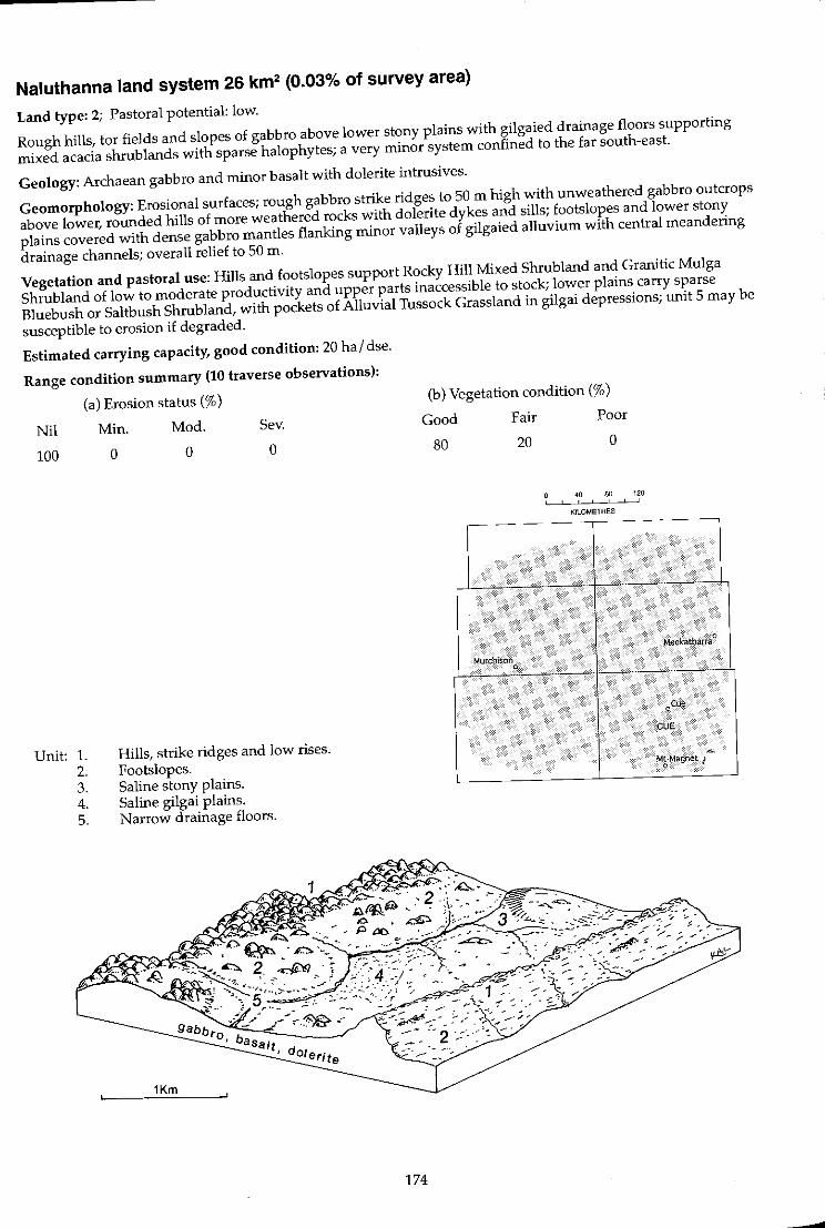
Naluthanna land system 26 km2 (0.03% of survey area)
Land type: 2; Pastoral potential: low.
Rough hills, tor fields and slopes of gabbro above lower stony plains with gilgaied drainage floors supporting
mixed acacia shrublands with sparse halophytes; a very minor system confined to the far south-east.
Geology: Archaean gabbro and minor basalt with dolerite intrusives.
Geomorphology: Erosional surfaces; rough gabbro strike ridges to 50 m high with unweathered gabbro outcrops
above lower, rounded hills of more weathered rocks with dolerite dykes and sills; footslopes and lower stony
plains covered with dense gabbro mantles flanking minor valleys of gilgaied alluvium with central meandering
drainage channels; overall relief to 50 m.
Vegetation and pastoral use: Hills and footslopes support Rocky Hill Mixed Shrubland and Granitic Mulga
Shrubland of low to moderate productivity and upper parts inaccessible to stock; lower plains carry sparse
Bluebush or Saltbush Shrubland, with pockets of Alluvial Tussock Grassland in gilgai depressions; unit 5 may be
susceptible to erosion if degraded.
Estimated carrying capacity, good condition: 20 hal dse.
Range condition summary (10 traverse observations):
(a) Erosion status (%)
Nil Min. Mod. Sev.
100
Unit: 1. 2. 3. 4. 5.
o o o
Hills, strike ridges and low rises. Footslopes. Saline stony plains. Saline gilgai plains. Narrow drainage floors.
174
(b) Vegetation condition (%)
Good
80
MurchIson o
Fair
20
Poor
o
40 80 120 , ,
KILOMETRES
Meekath,lrra 0
CUE
MtMagMt J ~ o
-

.... ~
Naluthanna I.s.
Landform and soils
Unit 1: Hills, strike ridges and low rises (45%)
Gabbro hills, tor fields and rocky rises with crests to 50 m (mostly < 30 m) and steep upper slopes covered with dense gabbro mantles; also rough strike ridges with frequent outcrops of gabbro. Soils are probably skeletallithosols, shallow sands or loamy sands over parent rock.
Unit2: Footslopes (30%)
Rough hillslopes with grades> 3% and extensive gabbro outcrops; lower slopes grading to lower stony plains with slopes < 3% with dense gabbro mantles. Soils are dark red shallow duplex types, loamy sands over clay loams to 40 em deep over gabbro; pH 7.0*8.0 with a neutral trend. Principal profile form: Dr2.52.
Unit 3: Saline stony plains (10%)
Minor undulating clay plains (slopes to 1-5%) with moderately dense quartz and gabbro mantles; usually moderately saline, increasing downslope on margins of unit 2. Soils are dark red heavy clays < 50 cm deep overlying gabbro parent material; pH 7.0 with a neutral trend. Principal profile form: Uf6.21.
Unit 4: Saline gilgai plains (10%)
Restricted saline alluvial floors flanked by units 2 and 3; slopes < 1% with patches of gilgai depressions adjacent to sluggish drainage lines. Soils are probably dark red, light to heavy cracking clays> 1 m deep. Principal profile form: Ug5.36.
Unit 5: Narrow drainage floors (5%)
Dendritic drainage lines riSing in upper parts of system and grading into broader alluvial floors usually with shallow incised channels < 20 m wide. Soils are hard·setting duplexes, dark red sandy loams over sandy clay loams < 1 m deep overlying gabbro parent material; pH 6.0-7.0 with a neutral trend. Principal profile form: Dr2.52.
Vegetation: formations and major species
Mixed shrub communities with mainly scattered Acacia aft. burkittii (MRS No. 362), A. ramulosa, Eremophila platyca/yx, E. aft. mackin/ayi.
Moderately close (PFC 20·30%) mixed shrublands dominated by Acacia aff. burkittii, Eremophila platycalyx or E. aft. p/atyca/yx. rail shrubs (> 2 m): A. aff. burkittii (MRS No. 362.), A. ramulosa, A. sclerosperma. Mid shrubs (1-2 m): E. p/atycalyx, E. physoca/yx, E. aff. mackinlayi, Dodonaea aft. inaequifoJia. Low shrubs « 1 m): E. aft. mackin/ayi, Cassia he/msii, Maireana convexa, M. georgei, Pfilotus obovatus, Scaevola spinescens, Solanum lasiophyllum.
Very scattered to scattered (PFC < 20%) mixed shrublands with isolated Hakea preissii and Maireana spp. Tall shrubs (> 2 m): H. preissii, Acacia aneura, A. sclerosperma, A. tetragonophylla, Pittosporum phylliraeoides. Mid shrubs (1·2 m): Eremophila aff. mackinlayi. Low shrubs « 1 m): M. tomentosa, M. pyramidata, M. georgei, M. convexa, M. trichoptera, Rhagodia eremaea, Scaevola spinescens, Pfilotus obovatus, Solanum lasiophyllum.
Scattered to very scattered (PFC < 20%) low shrublands dominated by Atrip/ex amnicola or Maireana pyramidata; or scattered tussock grasslands dominated by Eragrostis setifolia.
Scattered woodland (PFC 10-20%) dominated by Acacia aneura. Trees (to 8 m): A. aneura, Santa/um spicatum. Tall shrubs (> 2 m): A. sp. (MRS No. 362), A. burkittii. Mid shrubs (1·2 m): Eremophila forrestii, E. platyca/yx. Low shrubs « 1 m): Pti/otus obovatus, Solanum lasiophyllum, Enchy/aena tomentosa, Sida sp.
Comments and condition indicators
Vegetation type: Rocky Hill Mixed Shrubland. Pastoral use limitations: Poor accessibility to stock.
Traversed
1 inventory site and traversed
Vegetation type: Rocky Hill Mixed Shrubland and Granitic Mulga Shrubland. Palatable perennials include: Maireana spp., Ptilotus obovatus, Scaevo/a spinescens. Pastoral use limitations: None with controlled grazing.
1 inventory site and traversed
Vegetation type: Bluebush Shrubland. Palatable perennials include: Maireana spp., Rhagodia eremaea, Ptilotus obovatus, Scaevola spinescens. Pastoral use limitations: Little perennial forage for the vegetation type, but otherwise no limitations with controlled grazing.
Traversed
Vegetation type: Bluebush or Saltbush Shrubland or Alluvial Tussock Grassland. Palatable perennials include: Atriplex amnicola, Eragrostis setifolia, Eriachne flaccida, Eremophila maculata, Rhagodia sp. Pastoral use limitations: None with controlled grazing.
1 inventory site and traversed
Vegetation type: Creekline Shrubland. Palatable perennials include: Eremophila forrestii, Pfi/otus obovatus, Enchylaena tomentosa, Sida sp. Pastoral use limitations: Mild susceptibility to erosion where degraded.
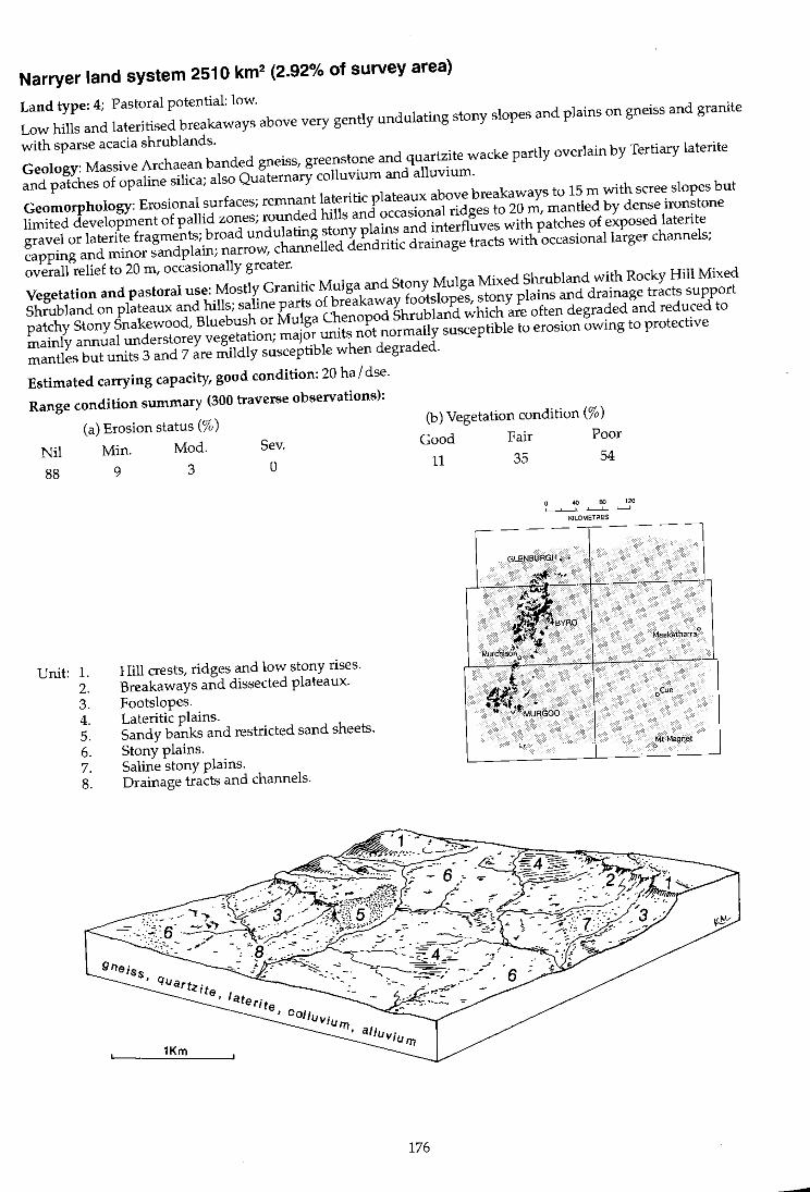
Narryer land system 2510 km2 (2.92% of survey area)
Land type: 4; Pastoral potential: low.
Low hills and lateritised breakaways above very gently undulating stony slopes and plains on gneiss and granite
with sparse acacia shrub lands.
Geology: Massive Archaean banded gneiss, greenstone and quartzite wacke partly overlain by Tertiary laterite
and patches of opaline silica; also Quaternary colluvium and alluvium.
Geomorphology: Erosional surfaces; remnant lateritic plateaux above breakaways to 15 m with scree slopes but
limited development of pallid zones; rounded hills and occasional ridges to 20 m, mantled by dense ironstone
gravel or laterite fragments; broad undulating stony plains and interfluves with patches of exposed laterite
capping and minor sandplain; narrow, channelled dendritic drainage tracts with occasional larger channels;
overall relief to 20 m, occasionally greater.
Vegetation and pastoral use: Mostly Granitic Mulga and Stony Mulga Mixed Shrubland with Rocky Hill Mixed
Shrubland on plateaux and hills; saline parts of breakaway footslopes, stony plains and drainage tracts support
patchy Stony Snakewood, Bluebush or Mulga Chenopod Shrubland which are often degraded and reduced to
mainly annual understorey vegetation; major units not normally susceptible to erosion owing to protective
mantles but units 3 and 7 are mildly susceptible when degraded.
Estimated carrying capacity, good condition: 20 hal dse.
Range condition summary (300 traverse observations):
(a) Erosion status (%)
Nil Min. Mod. Sev.
88 9 3 0
Unit: 1. 2. 3. 4. 5. 6. 7. 8.
Hill crests, ridges and low stony rises. Breakaways and dissected plateaux. Footslopes. Lateritic plains. Sandy banks and restricted sand sheets. Stony plains. Saline stony plains. Drainage tracts and channels.
176
(b) Vegetation condition (%)
Good Fair Poor
11 35 54
4{1 80 120 . KILOMETRES
GLENSURGH • •
"* -" '"
BYeo Meek:atharr~O
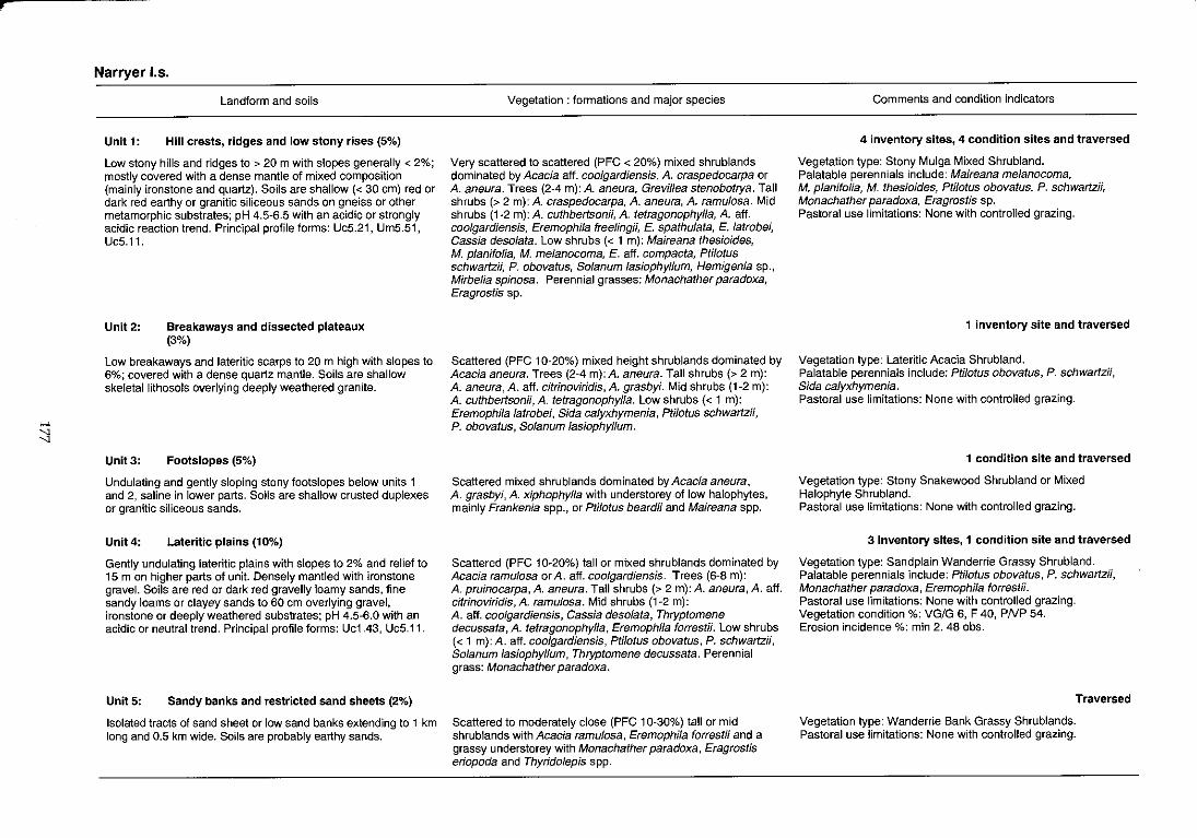
r
>-'
:::l
Narryer 1.5.
Landform and soils
Unit 1: Hill crests, ridges and low stony rises (5%)
Low stony hills and ridges to > 20 m with slopes generally < 2%; mostly covered with a dense mantle of mixed composition (mainly ironstone and quartz). Soils are shallow « 30 em) red or dark red earthy or granitic siliceous sands on gneiss or other metamorphic substrates; pH 4.5~6.5 with an acidic or strongly acidic reaction trend. Principal profile forms: UcS.21, UmS.51, UcS.11.
Unit 2: Breakaways and dissected plateaux (3%)
Low breakaways and lateritic scarps to 20 m high with slopes to 6%; covered with a dense quartz mantle. Soils are shallow skeletallithosols overlying deeply weathered granite.
Unit 3: Footslopes (5%)
Undulating and gently sloping stony footslopes below units 1 and 2, saline in lower parts. Soils are shallow crusted duplexes or granitic siliceous sands.
Unlt4: Lateritic plains (10%)
Gently undulating lateritic plains with slopes to 2% and relief to 15 m on higher parts of unit. Densely mantled with ironstone gravel. Soils are red or dark red gravelly loamy sands, fine sandy loams or clayey sands to 60 cm overlying gravel, ironstone or deeply weathered substrates; pH 4.S-6.0 with an acidic or neutral trend. Principal profile forms: Uc1.43, UcS.11 .
UnitS: Sandy banks and restricted sand sheets (2%)
Isolated tracts of sand sheet or low sand banks extending to 1 km long and 0.5 km wide. Soils are probably earthy sands.
Vegetation: formations and major species
Very scattered to scattered (PFC < 20%) mixed shrublands dominated by Acacia aft. coolgardiensis, A. craspedocarpa or A. aneura. Trees (2-4 m): A. aneura, Grevillea stenobotrya. Tall shrubs (> 2 m): A. craspedocarpa, A. aneura, A. ramulosa. Mid shrubs (1-2 m): A. cuthbertsonii, A. tetragonophylla, A. aft. coolgardiensis, Eremophila freelingii, E. spathu/ata, E. latrobei, Cassia desolata. Low shrubs « 1 m): Maireana thesioides, M. p/anifolia, M. me/anocoma, E. aft. compacta, Ptilotus schwartzii, P. obovatus, Solanum /asiophyllum, Hemigenia sp., Mirbelia spinosa. Perennial grasses: Monachather paradoxa, Eragrostis sp.
Scattered (PFC 10-20%) mixed height shrublands dominated by Acacia aneura. Trees (2-4 m): A. aneura. Tall shrubs (> 2 m): A. aneura, A. aff. citrinoviridis, A. grasbyi. Mid shrubs (1-2 m): A. cuthbertsonii, A. tetragonophylla. Low shrubs « 1 m): Eremophila latrobei, Sida calyxhymenia, Ptilotus schwartzH, P. obovatus, Solanum lasiophyllum.
Scattered mixed shrublands dominated by Acacia aneura, A. grasbyi, A. xiphophylla with understorey of low halophytes, mainly Frankenia spp., or Ptilotus beardH and Maireana spp.
Scattered (PFC 10-20%) tall or mixed shrublands dominated by Acacia ramu/osa or A. aff. coo/gardiensis. Trees (6-8 m): A. pruinocarpa, A. aneura. Tall shrubs (> 2 m): A. aneura, A. aft. citrinoviridis, A. ramu/osa. Mid shrubs (1-2 m): A. aft. coolgardiensis, Cassia desolata, Thryptomene decussata, A. tetragonophylla, EremophiJa forrestii. Low shrubs « 1 m): A. aft. coo/gardiensis, Ptilotus obovatus, P. schwartzii, Solanum lasiophyllum, Thryptomene decussata. Perennial grass: Monachather paradoxa.
Scattered to moderately close (PFC 10-30%) tall or mid shrublands with Acacia ramu/osa, Eremophila forrestii and a grassy understorey with Monachather paradoxa, Eragrostis eriopoda and Thyrido/epis spp.
Comments and condition indicators
4 inventory sites, 4 condition sites and traversed
Vegetation type: Stony Mulga Mixed Shrubland. Palatable perennials include: Maireana me/anocoma, M. planifolia, M. thesioides, Ptilotus obovatus, P. schwartzii, Monachather paradoxa, Eragrostis sp. Pastoral use limitations: None with controlled grazing.
1 inventory site and traversed
Vegetation type: Lateritic Acacia Shrubland. Palatable perennials include: PtilotU5 obovatus, P. schwartzii, Sida calyxhymenia. Pastoral use limitations: None with controlled grazing.
1 condition site and traversed
Vegetation type: Stony Snakewood Shrubland or Mixed Halophyte Shrubland. Pastoral use limitations: None with controlled grazing.
3 inventory sites, 1 condition site and traversed
Vegetation type: Sandplain Wanderrie Grassy Shrubland. Palatable perennials include: Ptilotus obovatus, P. schwartzii, Monachather paradoxa, Eremophila forrestii. Pastoral use limitations: None with controlled grazing. Vegetation condition %: VG/G 6, F 40, PNP 54. Erosion incidence %: min 2. 48 obs.
Traversed
Vegetation type: Wanderrie Bank Grassy Shrublands. Pastoral use limitations: None with controlled grazing.
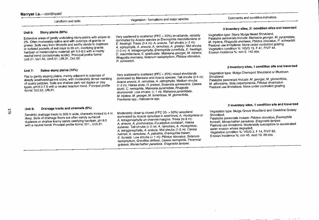
..... ;;l
Narryer I.s.-continued
Landform and soils
UnitS: Stony plains (60%)
Extensive areas of gently undulating stony plains with slopes to
2%. Often moderately saline and with outcrops of granite or
gneiss. Soils vary from lithosols and earthy sands to duplexes
or isolated pockets of red clays to 35 em, overlying granite,
hardpan or metamorphic material; pH 5.5-8.0 with a mainly
neutral trend (occasionally acidic). Principal profile forms:
UcS.21, Uc1.43, UmS.S1, Uf6.31 , Or2.S2.
Unit 7: Saline stony plains (10%)
Flat to gently sloping plains, mainly adjacent to outcrops of
deeply weathered parent rocks, with moderately dense mantling
of quartz pebbles. Soils are shallow dark red duplex or clay
types, pH 6.0-7.5 with a neutral reaction trend. Principal profile
forms: Or2.S2, Uf6.31.
Unit 8: Drainage tracts and channels (5%)
Dendritic drainage tracts to 300 m wide, channels incised to 4 m
deep. Soils of drainage floors are often sandy surfaced
duplexes or shallow loamy sands overlying hardpan, pH 6.5
with a neutral trend. Principal profile forms: Dr1., Uc5.21.
Vegetation: formations and major species
Very scattered to scattered (PFC < 20%) shrublands, variably
dominated by Acacia species or Eremophifa macmilfaniana or
E. freefingii. Trees (2-4 m): A. aneura. Tall shrubs (> 2 m):
A. xiphophylfa, A. aneura, A. ramu/osa, A. grasbyi. Mid shrubs
(1-2 m): A. tetragonophylfa, Eremophila cuneifolia, E. freelingii,
E. macmillaniana, E. spathufata, Maireana georgei, M. triptera,
Rhagodia eremaea, Solanum fasiophylJum, Ptilotus obovatus,
P. schwartzi!.
Very scattered to scattered (PFC < 20%) mixed shrublands
dominated by Maireana and Acacia species. Tall shrubs (2-4 m):
Acacia aneura, A. ramulosa, A. xiphophylfa. Medium shrubs
(1-2 m): Hakea arida, H. preissii, Scaevola spinescens, Cassia
sturtii, C. nemophila, Maireana pyramidata, Rhagodia
drummondii. Low shrubs: « 1 m): Maireana pyramidata,
M. triptera, M. georgei, M. tomentosa, M. g/omerifolia,
Frankenia spp., Ha/osarcia spp.
Moderately close to closed (PFC 20- > 50%) woodland
dominated by Acacia ramulosa in washlines; A. rhodophloia or
A. tetragonophylla on channel margins. Trees (to 8 m):
A. aneura, A. pruinocarpa, Eucalyptus coo/abah, Hakea
suberea. Tall shrubs (> 2 m): A. ramulosa, A. rhodophloia,
A. tetragonophylla, A. aneura. Mid shrubs (1-2 m): Cassia
helmsfi, A. ramulosa, A. palustris, Eremophila fraseri,
E. forrestii. Low shrubs « 1 m): Ptilotus obovatus, Solanum
lasiophyllum, Grevl1lea deflexa, Cassia nemophila. Perennial
grasses: Monachather paradoxa, Eragrostis lanipes.
Comments and condition indicators
3 inventory sites, 31 condition sites and traversed
Vegetation type: Stony Mulga Mixed Shrubland.
Palatable perennials include: Maireana georgei, M. pyramidata,
M. triptera, Rhagodia eremaea, Ptilotus obovatus, P. schwartz;;.
Pastoral use limitations: None under controlled grazing.
Vegetation condition %: VG/G 15, F 41, PNP 44.
Erosion incidence %: min 3. 140 obs.
3 inventory sites, 1 condition site and traversed
Vegetation type: Mulga Chenopod Shrubland or Bluebush
Shrubland. Palatable perennials include: M. georgei, M. glomerifolia,
M. atkinsiana, Sida calyxhymenia, Ptilotus divaricatus.
Pastoral use limitations: None under controlled grazing.
2 inventory sites, 1 condition site and traversed
Vegetation type: Mulga Grove Woodland and Creekline Grassy
Shrubland. Palatable perennials include: Ptilotus obovatus, Eremophila
forrestii, Monachather paradoxa, Eragrostis lanipes.
Pastoral use limitations: Moderately susceptible to accelerated
water erosion where degraded.
Vegetation condition %: VG/G 3, F 14, PNP 83.
Erosion incidence %: min 45, mod 10. 29 obs.
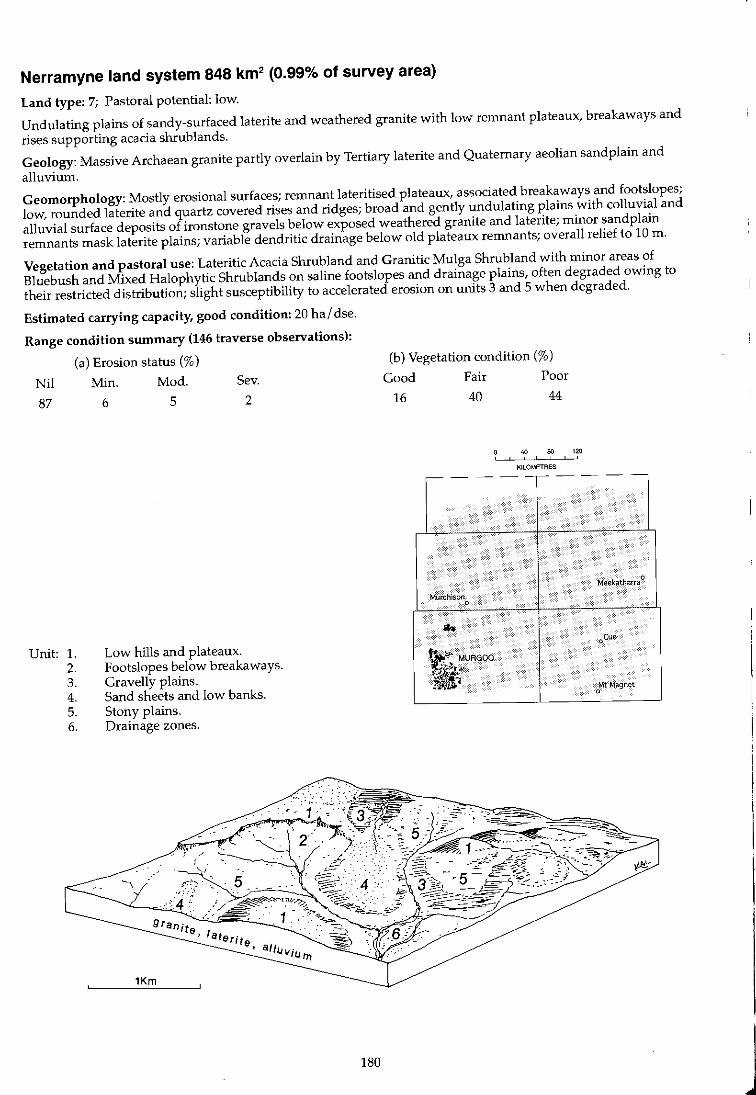
Nerramyne land system 848 km2 (0.99% of survey area)
Land type: 7; Pastoral potential: low.
Undulating plains of sandy-surfaced laterite and weathered granite with low remnant plateaux, breakaways and
rises supporting acacia shrublands.
Geology: Massive Archaean granite partly overlain by Tertiary laterite and Quaternary aeolian sandplain and
alluvium.
Geomorphology: Mostly erosional surfaces; remnant lateritised plateaux, associated breakaways and footslopes;
low, rounded laterite and quartz covered rises and ridges; broad and gently undulating plains with colluvial and
alluvial surface deposits of ironstone gravels below exposed weathered granite and laterite; minor sandplain
remnants mask laterite plains; variable dendritic drainage below old plateaux remnants; overall relief to 10 m.
Vegetation and pastoral use: Lateritic Acacia shrubland and Granitic Mulga Shrub land with minor areas of
Bluebush and Mixed Halophytic shrublands on saline footslopes and drainage plains, often degraded owing to
their restricted distribution; slight susceptibility to accelerated erosion on units 3 and 5 when degraded.
Estimated carrying capacity, good condition: 20 hal dse.
Range condition summary (146 traverse observations):
(a) Erosion status (%)
Nil Min. Mod. Sev.
87 6 5 2
Unit: 1. 2. 3. 4. 5. 6.
Low hills and plateaux. Footslopes below breakaways. Gravelly plains. Sand sheets and low banks. Stony plains. Drainage zones.
180
(b) Vegetation condition (%)
Good Fair Poor
16 40 44
40 80 120 , I
KILOMETRES
-- - - -,-- - --
Meekatharra 0
Mur<:h1sono ..
oCue
'~~ MURGQO
~.1i;v-~i ~ Mt Magnet
0
J
>-' 00 >-'
Nerramyne 1.5.
Landform and soils
Unit 1: Low hills and plateaux (8%)
Weathered hills and plateaux above low breakaways with minor areas of exposed pallid zone slopes to 4% and to 10m high. Also gently sloping low ridges and rises of deeply weathered granite, often densely mantled with weathered, platy ironstone and quartz pebbles. Soils are shallow, brown or reddish-brown coarse skeletallithosols over granite < 20 em deep; pH 6.0-7.0 with a neutral reaction trend. Principal profile form: Uc1.43.
Unit 2: Footslopes below breakaways (2%)
Quartz strewn slopes, some lying below minor pallid zone development, < 300 m long. Soils are granitic siliceous sands or shallow crusted duplexes over decomposing granite.
Unit 3: Gravelly plains (30%)
Gently sloping plains on weathered granite foundation with undulations to 5 m high occurring at 2-3 km intervals; usually covered with dense mantle of fine ironstone fragments. Soils are gravelly brown or yellowish-red loamy sands < 1 m deep over gravels; pH 6.0 with an acidic trend. Principal profile form: Uc1.43.
Unit 4: Sand sheets and low banks (5%)
Isolated areas of remnant sand plain, usually < 1 km in extent with slopes < 1 % and relief occasionally to 2 m. Soils are red or reddish-brown earthy or siliceous sands> 1 m deep; pH 5.5-7.0 with a neutral or acidic trend. Principal profile form: Uc5.21.
Vegetation: formations and major species
Scattered or very scattered (PFC < 20%) mixed or low shrublands dominated by Acacia ramufosa. Tall shrubs (> 2 m): A. ramufosa, A. burkittii, A. aneura, A. palustris, A. grasbyi. Mid shrubs (1-2 m): A. ramulosa, Eremophila glutinosa, Hakea recurva, A. tetragonophyfla, E. latrobei. Low shrubs « 1 m): Ptilotus obovatus, Solanum lasiophyllum, S. orbiculatum, Borya nitida, Dodonaea boroniifolia, Cafyfrix sp., Eriostemon brucei, Micromyrtus racemosa.
Very scattered low shrublands (PFC < 10%). Mid shrubs (1-2 m): Acacia aft. coolgardiensis, A. burkittii, Hakea arida, Acacia tetragonophylla, A. grasbyi, Frankenia sp., Maireana glomerifolia, Ptilotus obovatus. Low shrubs « 1 m): Rhagodia drummondii, Cassia phyllodinea.
Scattered or moderately close (PFC 10-30%) tall or mixed shrublands dominated by Acacia aft. acuminata or A. ramulosa. Tall shrubs (> 2 m): A. aft. acuminata, A. ramulosa, A. tetragonophylla, Thryptomene decussata, Eremophila forrestii. Low shrubs « 1 m): T. decussata, E. aft. malacoides, Ptilotus obovatus. Perennial grasses: Monachather paradoxa, Stipa elegantissima.
Scattered to moderately close (PFC 10-30%) tall shrublands with prominent hummock grasses (up to 25% cover) dominated by Triodia sp. Trees (to 8 m): Eucalyptus sp., E. hypochlamydea. Tall shrubs (> 2 m): Acacia ligulata, T. decussata, A. ramulosa, A. rhodophloia. Mid shrubs (1-2 m): Eremophila forrestii, E. granitica, Grevillea sp., T. decussata. Low shrubs « 1 m): Keraudrinia hermanniifolia, Sida cardiophylla, Ptilotus obovatus, P. schwartzii. Perennial grasses: Triodia sp., Monachather paradoxa, Stipa elegantissima, Thyridolepis multiculmis.
Comments and condition indicators
1 inventory sites and traversed
Vegetation type: Lateritic Acacia Shrubland. Palatable perennial shrubs include: Eremophila latrobei, Ptilotus obovatus, Maireana spp., Scaevola spinescens. Pastoral use limitations: None under controlled grazing.
1 inventory site and traversed
Vegetation type: Mixed Halophyte Shrubland or Bluebush Shrubland. Palatable perennials include: Maireana glomerifolia, Frankenia spp. Pastoral use limitations: Preferentially grazed and locally susceptible to microterracing and rilling where degraded.
2 inventory sites, 1 condition site and traversed
Vegetation type: Lateritic Acacia Shrub land. Palatable perennials include: Eremophila forrestii, Ptilotus obovatus, Monachather paradoxa. Pastoral use limitations: None with controlled grazing.
2 inventory sites and traversed
Vegetation type: Sand plain Wanderrie Grassy Shrubland or Sandplain Mallee-Acacia-Spinifex Shrubland. Palatable perennials include: Sida spp., Ptilotus spp., Monachather paradoxa, Thyridolepis multiculmis. Pastoral use limitations: None with controlled grazing.
>-'
?l
Nerramyne I.s.-continued
Landform and soils
UnitS: Stony plains (40%)
Gently sloping and undulating plains lower than units 1, 2 and 4,
with moderately dense mantles of quartz and ironstone gravel
with extensive very low granite outcrops. Soils are shallow
yellowish-red, red or dark red granitic siliceous sands or sandy
clay loams over granite at < 50 em deep; pH 6.0-7.0 with a
neutral or acidic reaction trend. Principal profile forms: Gn2.11,
Uc1.43, Uc5.21, Um5.51.
UnitS: Drainage zones (15%)
Narrow drainage zones from catchments in the higher units
and adjacent elevated systems (e.g. Kalli and Challenge);
creeklines locally flooding onto broad, saline alluvial fans,
otherwise continuing as zones with channels, locally incised,
over hardpan. Soils are duplex types dark red clayey sand or
loamy sands over red or reddish-brown light clays to 90 cm
deep; pH 6.0-8.0 with a neutral trend. Principal profile forms:
Gn.2.12, Dr1.55.
Vegetation: formations and major species
Scattered to moderately close (PFC 10-30%) tailor mixed
shrublands dominated by Acacia grasbyi, Hakea arida, Cassia
phyllodinea, EremophHa punicea or Ptifotus obovatus. Tall
shrubs (> 2 m): A. burkittii, A. grasbyi, A. tetragonophyffa,
A. ramulosa, H. arida. Mid shrubs « 2 m): C. phyllodinea,
H. arida, Thryptomene mucronata, E. /atrobei, E. p/atycalyx,
E. aft. mackin/ayi, E. g/andullfera. Low shrubs « 1 m):
Pti/otus obovatus, P. schwartzii, Thryptomene
decussata, E. punicea, Maireana convexa, M. viffosa,
M. thesioides, S/da cafyxhymenia, Scaevola spinescens.
a) Very scattered (PFC < 10%) low shrublands dominated by
Frankenia spp. TaU shrubs (> 2 m): Acacia tetragonophylla,
A. sc/erosperma, A. grasbyi. Mid shrubs (1-2 m): Eremophlla
platycalyx. Low shrubs « 1 m): F. magnifica, Ptilotus obovatus,
P. divaricatus, Rhagodia drummondii, R. eremaea, Chenopodium
gaudichaudanum, Scaevo/a spinescens.
b) Moderately close to close (PFC 20-50%) tall and mixed height
shrublands dominated by Acacia aneura or A. tetragonophylla.
Trees (to 6 m): A. aneura. Tall shrubs (> 2 m): A. tetragonophyJla,
A. burkittii, A. aneura, Hakea arida. Mid shrubs (1-2 m): A. aneura,
Eremophila forrestii, E. latrobei, E. platyca/yx. Low shrubs « 1 m):
AbutiJon sp., Sida calyxhymenia, S. sp., Enchylaena tomentosa,
Chenopodium gaudichaudanum, Scaevola spinescens, Maireana
thesioides, M villosa, Ptilotus schwartzii.
Comments and condition indicators
4 inventory sites, 9 condition sites and traversed
Vegetation type: Granitic Mulga Shrubland or Stony Mulga
Mixed Shrubland. Palatable perennials include: Eremophila latrobei, Pti/otus
obovatus, P. schwartzii, Maireana spp., Sida spp., Scaevo/a
spinescens. Pastoral use limitations: None with controlled grazing.
2 inventory sites and traversed
Vegetation type: a) Mixed Halophyte Shrubland.
b) Creekline Shrubland. Palatable perennials include: PWotus spp., Frankenla spp.,
Rhagodia spp., Maireana spp., Enchyfaena tomentosa,
Scaevola spinescens, Chenopodium gaudichaudanum, Sida
spp., Eremophila forrestii, E. latrobe/. Pastoral use limitations: Moderate susceptibility to accelerated
erosion if vegetation is degraded.
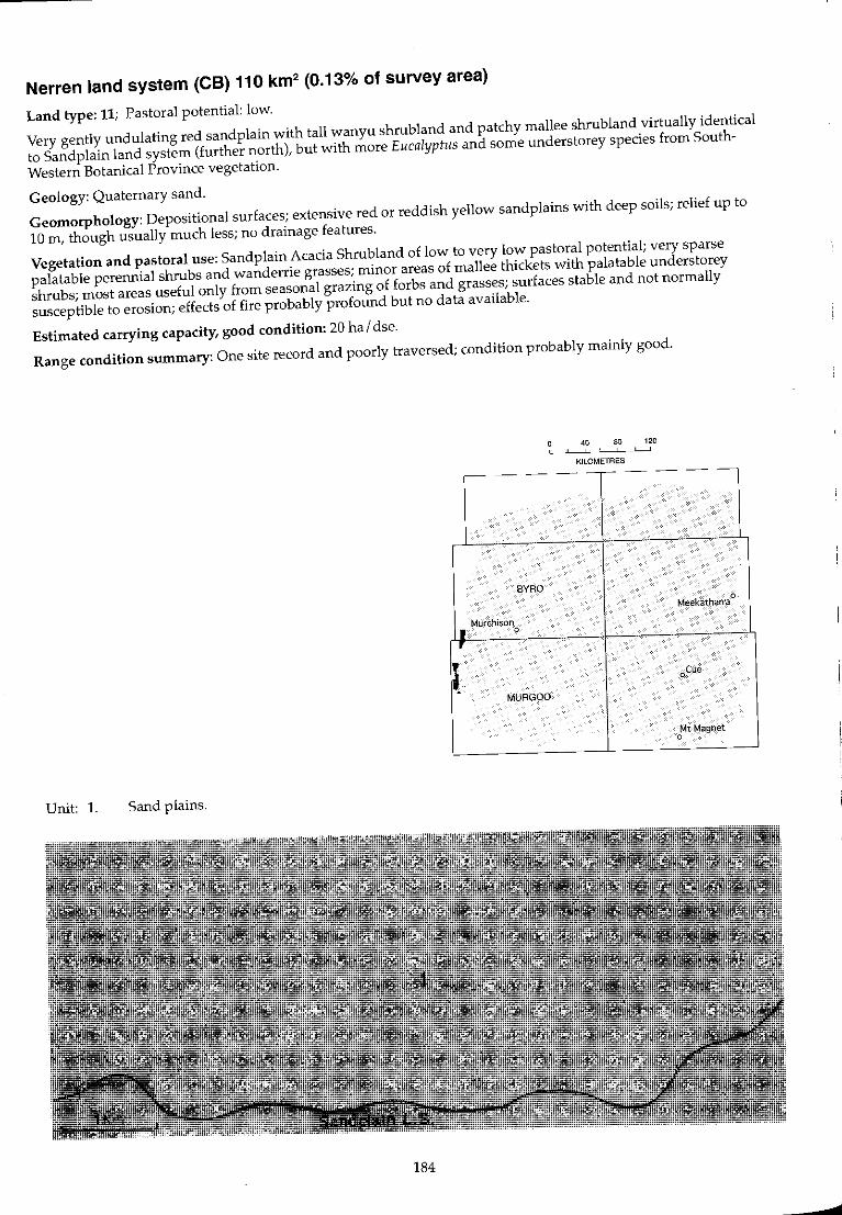
Nerren land system (CB) 110 km2 (0.13% of survey area)
Land type: 11; Pastoral potential: low.
Very gently undulating red sandplain with tall wanyu shrubland and patchy mallee shrubland virtually identical
to Sand plain land system (further north), but with more Eucalyptus and some understarey species from South
Western Botanical Province vegetation.
Geology: Quaternary sand.
Geomorphology: Depositional surfaces; extensive red or reddish yellow sandplains with deep soils; relief up to
10 m, though usually much less; no drainage features.
Vegetation and pastoral use: Sandplain Acacia Shrubland of low to very low pastoral potential; very sparse
palatable perennial shrubs and wanderrie grasses; minor areas of mallee thickets with palatable understorey
shrubs; most areas useful only from seasonal grazing of forbs and grasses; surfaces stable and not normally
susceptible to erosion; effects of fire probably profound but no data available.
Estimated carrying capacity, good condition: 20 ha / dse.
Range condition summary: One site record and poorly traversed; condition probably mainly good.
40 80 120 , KILOMETRES
~- - ----- --
BYRQ
Meekatharra 0
i I Murchison 0
r
i oCue
MURGOO
Mt Magnet 0
Unit: 1. Sand plains.
184

.... 00
'"
Nerren 1.5.
Landform and soils
Unit 1: Sand plains (100%)
Extensive flat to very gently undulating plains of red sand with slopes < 1%. Soils are red or dark red siliceous sands or earthy sands> 1 m deep. Principal profile form: Uc5.21.
Vegetation: formations and major species
Moderately close (PFC 20-30%) tall shrublands dominated by Acacia ramulosa with Eucalyptus spp. Trees and mallees (to 10 m): Eucalyptus sp. (MRS No 488). E. aff. foecunda, E. oldfield;;, Calfitris col/umellaris, Brachychiton gregorii. Tall shrubs (to 6 m): A. ramulosa, A. roycei,Stylobasium spathulatum. Mid shrubs (1-2 m): A. ramulosa, A. wiseana, Eremophila forrestH, E. latrobei, Pime/ea m;crocephela, S. spathulatum. Low shrubs « 1 m): E. aff. forrestii, Dianella revoluta, Ptifotus schwartzii, P. obovatus. Perennial grasses (infrequent): Monachather paradoxa, Stipa elegantissima .
Comments and condition indicators
3 inventory sites and traversed
Vegetation type: Sand plain Acacia Shrubland. Palatable perennials include: Eremophifa forrestii, E. latrobei, Ptilotus spp., Monachather paradoxa, Stipa elegantissima. Pastoral use limitations: None under controlled grazing.
l
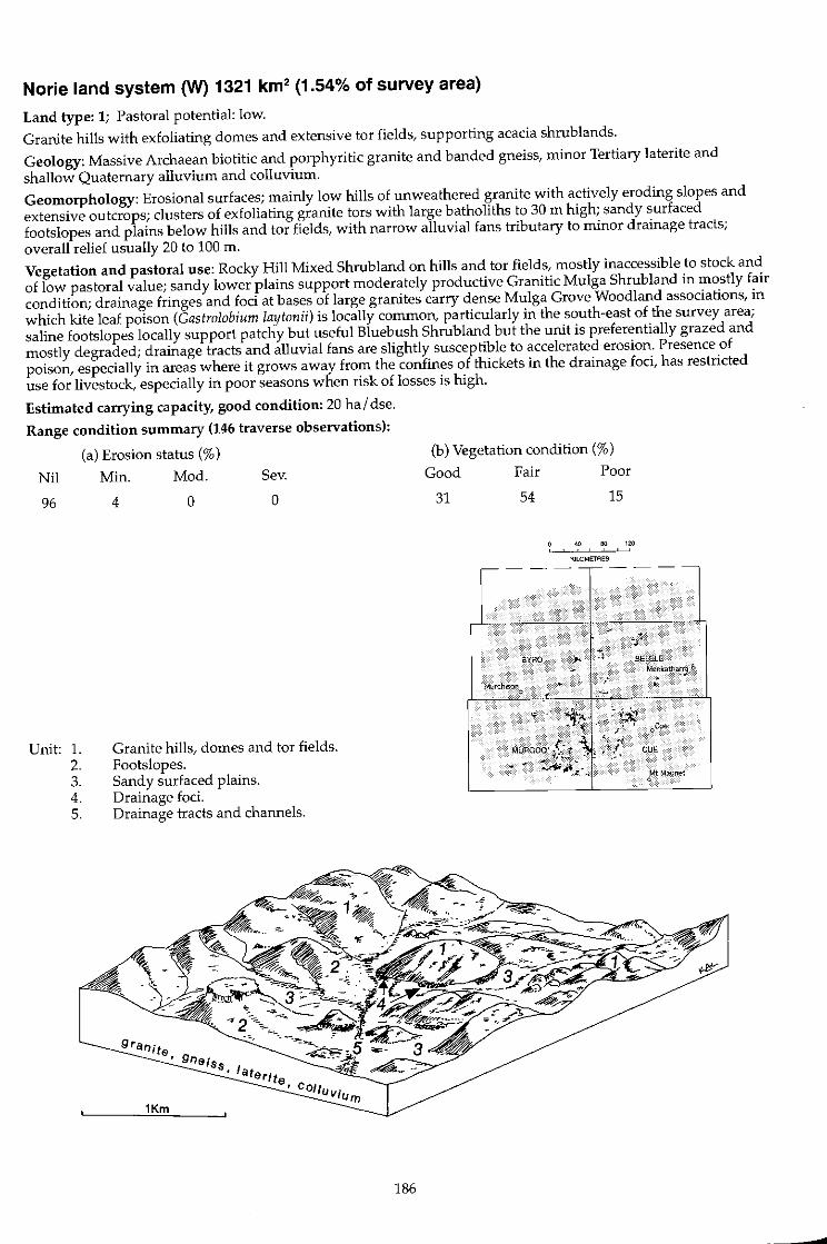
Norie land system ~ 1321 km2 (1.54% of survey area)
Land type: 1; Pastoral potential: low.
Granite hills with exfoliating domes and extensive tor fields, supporting acacia shrub lands.
Geology: Massive Archaean biotitic and porphyritic granite and banded gneiss, minor Tertiary laterite and shallow Quaternary alluvium and colluvium.
Geomorphology: Erosional surfaces; mainly low hills of unweathered granite with actively eroding slopes and extensive outcrops; clusters of exfoliating granite tors with large batholiths to 30 m high; sandy surfaced footslopes and plains below hills and tor fields, with narrow alluvial fans tributary to minor drainage tracts; overall relief usually 20 to 100 m.
Vegetation and pastoral use: Rocky Hill Mixed Shrub land on hills and tor fields, mostly inaccessible to stock and of low pastoral value; sandy lower plains support moderately productive Granitic Mulga Shrub land in mostly fair condition; drainage fringes and foci at bases of large granites carry dense Mulga Grove Woodland associations, in which kite leaf poison (Gastrolobium laytonii) is locally common, particularly in the south-east of the survey area; saline footslopes locally support patchy but useful Bluebush Shrub land but the unit is preferentially grazed and mostly degraded; drainage tracts and alluvial fans are slightly susceptible to accelerated erosion. Presence of poison, especially in areas where it grows away from the confines of thickets in the drainage foci, has restricted use for livestock, especially in poor seasons when risk of losses is high.
Estimated carrying capacity, good condition: 20 hal dse.
Range condition summary (146 traverse observations):
(a) Erosion status (%)
Nil Min. Mod. Sev.
96
Unit: 1. 2. 3. 4. 5.
4 o o
Granite hills, domes and tor fields. Footslopes. Sandy surfaced plains. Drainage foci. Drainage tracts and channels.
186
(b) Vegetation condition (%)
Good Fair Poor
31 54 15
40 80 120
KILOMETRES
----------
.
. .... . - ~l
eYRQ ). :; BELELE
Mu!'{;hlson '/ Meekath,.~.,a "0 ..
o f
CUE
...
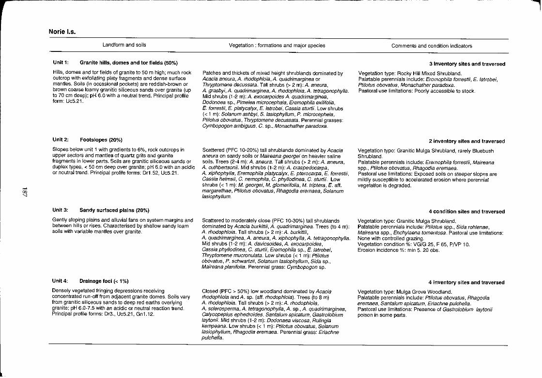
,.... 00
"
Norie 1.5.
Landform and soils
Unit 1: Granite hills, domes and tor fields (50%)
Hills, domes and tor fields of granite to 50 m high; much rock outcrop with exfoliating platy fragments and dense surface mantles. Soils (in occasional pockets) are reddish·brown or brown coarse loamy granitic siliceous sands over granite (up to 70 em deep); pH 6.0 with a neutral trend. Principal profile form: UcS.21.
Unit2: Footslopes (20%)
Slopes below unit 1 with gradients to 6%, rock outcrops in upper sectors and mantles of quartz grits and granite fragments in lower parts. Soils are granitic siliceous sands or duplex types, < 50 em deep over granite; pH 6.0 with an acidic or neutral trend. Principal profile forms: Dr1.52, Uc5.21.
Unit 3: Sandy surfaced plains (20%)
Gently sloping plains and alluvial fans on system margins and between hills or rises. Characterised by shallow sandy loam soils with variable mantles over granite.
Unit 4: Drainage foci « 1%)
Densely vegetated fringing depressions receiving concentrated run-off from adjacent granite domes. Soils vary from granitic siliceous sands to deep red earths overlying granite; pH 6.0-7.5 with an acidic or neutral reaction trend. Principal profile forms: Dr3., Uc5.21, Gn1.12.
Vegetation: formations and major species
Patches and thickets of mixed height shrublands dominated by Acacia aneura, A. rhodophloia, A. quadrimarginea or Thryptomene decussata. Tall shrubs (> 2 m): A. aneura, A. grasbyi, A. quadrimarginea, A. rhodophloia, A. tetragonophylla. Mid shrubs (1-2 m): A. exocarpoides A. quadrimarginea, Dodonoea sp., Pime/ea microcepha/a, Eremophila exilifolia, E. forrestii, E. platycalyx, E. latrobei, Cassia sturtii. Low shrubs « 1 m): Solanum ashbyi, S. /asiophyllum, P. microcephela, Ptilotus obovatus, Thryptomene decussata. Perennial grasses: Cymbopogon ambiguus, C. sp., Monachather paradoxa.
Scattered (PFC 10-20%) tall shrublands dominated by Acacia aneura on sandy soils or Maireana georgei on heavier saline soils. Trees (2-4 m): A. aneura. Tall shrubs (> 2 m): A. aneura, A. cuthbertsonH. Mid shrubs (1-2 m):A. craspedocarpa, A. xiphophylla, Eremophila platyca/yx, E. pterocarpa, E. forrestii, Cassia he/msii, C. nemophila, C. phyllodinea, C. sturtii. Low shrubs « 1 m): M. georgei, M. glomerifolia, M. triptera, E. aft. margarethae, pti/otus obovatus, Rhagodia eremaea, Solanum lasiophyllum.
Scattered to moderately close (PFC 10-30%) tall shrublands dominated by Acacia burkittii, A. quadrimarginea. Trees (to 4 m): A. rhodophloia. Tall shrubs (> 2 m): A. burkittii, A. quadrimarginea, A. aneura, A. xiphophylla, A. tetragonophylla. Mid shrubs (1-2 m):A. daviesoides,A. exocarpoides, Cassia phylJodinea, C. sturtii, Eremophila sp., E. latrobei, Thryptomene mucronulata. Low shrubs « 1 m): pti/otus obovatus, P. schwartzii, Solanum lasiophylJum, Sida sp., Maireana planifolia. Perennial grass: Cymbopogon sp.
Closed (PFC > 50%) low woodland dominated by Acacia rhodophloia and A. sp. (alf. rhodophloia). Trees (to 8 m) A. rhodophloia. Tall shrubs (> 2 m): A. rhodophloia, A. sclerosperma, A. tetragonophylla, A. sp., A. quadrimarginea, Calycopep/us ephedroides, Santalum spicatum, Gastrolobium laytonii. Mid shrubs (1-2 m): Dodonaea viscosa, Rulingia kempeana. Low shrubs « 1 m): ptilotus obovatus, Solanum lasiophyllum, Rhagodia eremaea. Perennial grass: Eriachne pulchella.
Comments and condition indicators
3 inventory sites and traversed
Vegetation type: Rocky Hill Mixed Shrubland. Palatable perennials include: Eremophila forrestii, E. latrobei, Ptilotus obovatus, Monachather paradoxa. Pastoral use limitations: Poorly accessible to stock.
2 inventory sites and traversed
Vegetation type: Granitic Mulga Shrubland, rarely Bluebush Shrubland. Palatable perennials include: Eremophila forrestii, Maireana spp., Ptilotus obovatus, Rhagodia eremaea. Pastoral use limitations: Exposed soils on steeper slopes are mildly susceptible to accelerated erosion where perennial vegetation is degraded.
4 condition sites and traversed
Vegetation type: Granitic Mulga Shrubland. Palatable perennials include: PtilOtU5 spp., Sida roh/enae, Maireana spp., Enchylaena tomentosa. Pastoral use limitations: None with controlled grazing. Vegetation condition %: VG/G 25, F 65, PNP 10. Erosion incidence %: min 5. 20 obs.
4 inventory sites and traversed
Vegetation type: Mulga Grove Woodland. Palatable perennials include: ptilotus obovatu5, Rhagodia eremaea, Santa/um spicatum, Eriachne pu/chella. Pastoral use limitations: Presence of Gastrolobium laytonii poison in some parts.
I

l
>-' 00 00
Norie I.s.-continued
Landform and soils
Unit 5: Drainage tracts and channels (9%)
Narrow « 0.5 km wide) valley floors and drainage tracts
flanked by units 1, 3 and 4, often with central shallowy incised
channels mostly < 20 m wide. Soils are dark red clayey sands
or loamy sands < 1 m deep overlying granite; pH 6.5-7.0 with
a neutral reaction trend. Principal profile forms: Uc5.21,
UcS.S1.
Vegetation: formations and major species
Scattered (PFC 10-20%) tall shrublands dominated by Acacia
aneura or A. aft. quadrimarginea. Trees and tall shrubs (to
6m): A aneura, A. aff. quadrimarginea, A tetragonophyfJa,
Eremophila fraseri, E. macmillaniana, Santa/urn spicatum. Mid
shrubs (1-2 m): A. craspedocarpa, E. macmillaniana, Cassia
helmsii. Low shrubs « 1 m): Ptilotus obovatus, C. he/msii,
So/anum fasiophylJum, E. compacta.
Comments and condition indicators
2 inventory sites and traversed
Vegetation type: Creekline Shrubland.
Palatable perennials include: Santa/um spicatum, Ptifotus
obovatus, Eremophifa compacta, Rhagodia spp.
Pastoral use limitations: Local occurrence of poisonous
Gastrolobium laytonli".

16602-13
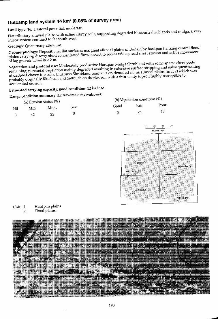
Outcamp land system 44 km2 (0.05% of survey area)
Land type: 16; Pastoral potential: moderate.
Flat tributary alluvial plains with saline clayey soils, supporting degraded bluebush shrublands and mulga; a very
minor system confined to far south-west.
Geology: Quaternary alluvium.
Geomorphology: Depositional flat surfaces; marginal alluvial plains underlain by hardpan flanking central flood
plains carrying disorganised concentrated flow, subject to recent widespread sheet erosion and active movement
of lag gravels; relief is < 2 m.
Vegetation and pastoral use: Moderately productive Hardpan Mulga Shrubland with some sparse chenopods
remaining; perennial vegetation mainly degraded resulting in extensive surface stripping and subsequent sealing
of deflated clayey top soils; Bluebush Shrubland remnants on denuded saline alluvial plains (unit 2) which was
probably originally Bluebush and Saltbush on duplex soil with a thin sandy topsoil highly susceptible to
accelerated erosion.
Estimated carrying capacity, good condition: 12 ha / dse.
Range condition summary (12 traverse observations):
(a) Erosion status (%)
Nil Min. Mod. Sev.
8
Unit: 1. 2.
42 22
Hardpan plains. Flood plains.
8
190
(b) Vegetation condition (%)
Good
o Fair
25
6$0
Murchison o
MLJRGOO
Poor
75
40 80 120 , , , KlLOMETRES
Mt,Magnet o
--
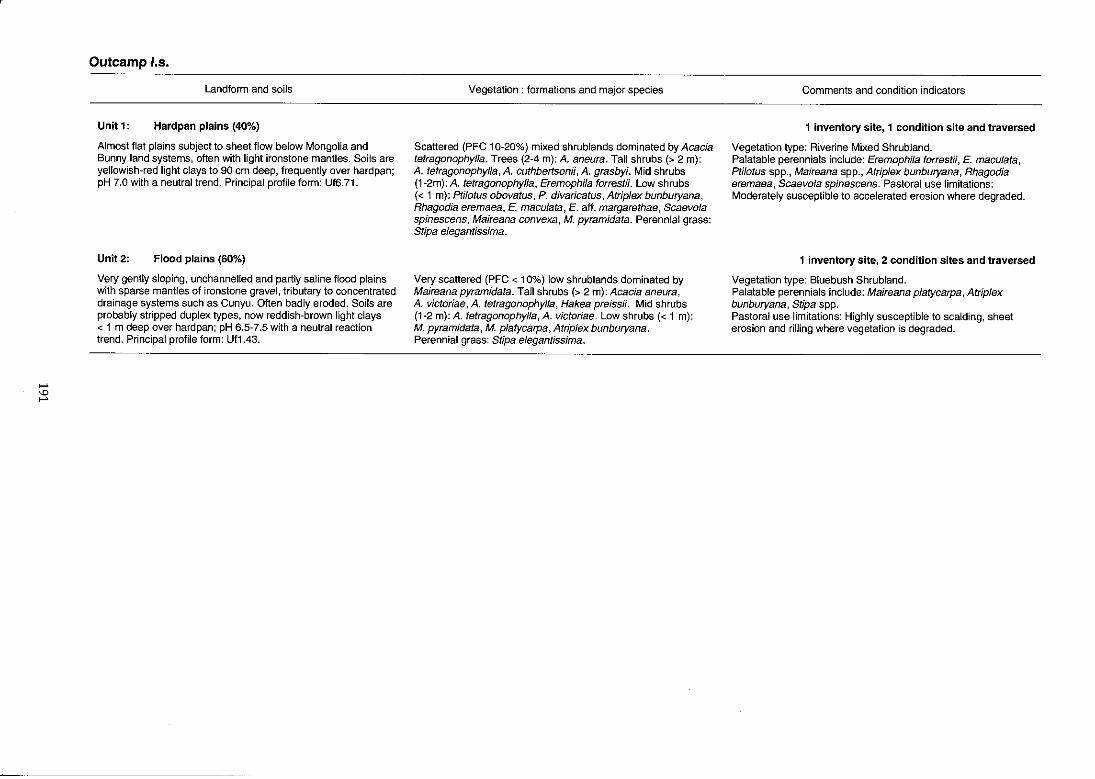
"" '" ""
Outcamp I.s.
Landform and soils
Unit 1: Hardpan plains (40%)
Almost flat plains subject to sheet flow below Mongolia and Bunny land systems, often with light ironstone mantles. Soils aTe yellowish-red light clays to 90 em deep, frequently over hardpan; pH 7.0 with a neutral trend. Principal profile form: Uf6.71.
Unit 2: Flood plains (60%)
Very gently sloping, unchannelled and partly saline flood plains with sparse mantles of ironstone gravel, tributary to concentrated drainage systems such as Cunyu. Often badly eroded. Soils are probably stripped duplex types, now reddish-brown light clays < 1 m deep over hardpan; pH 6.5-7.5 with a neutral reaction trend. Principal profile form: Uf1.43.
Vegetation: formations and major species
Scattered (PFC 10-20%) mixed shrublands dominated by Acacia tetragonophylla. Trees (2-4 m): A. aneura. Tall shrubs (> 2 m): A. tetragonophylla, A. cuthbertsonii, A. grasbyi. Mid shrubs (1-2m): A. tetragonophylla, Eremophila forrestii. Low shrubs « 1 m): Ptilotus obovatus, P. divaricatus, Atriplex bunburyana, Rhagodia eremaea, E. maculata, E. aft. margarethae, Scaevola spinescens, Maireana convexa, M. pyramidata. Perennial grass: Stipa elegantissima.
Very scattered (PFC < 10%) low shrublands dominated by Maireana pyramidata. Tall shrubs (> 2 m): Acacia aneura, A. victoriae, A. tetragonophylla, Hakea preissii. Mid shrubs (1-2 m): A. tetragonophylla, A. victoriae. Low shrubs « 1 m): M. pyramidata, M. platycarpa, Atriplex bunburyana. Perennial grass: Stipa elegantissima.
Comments and condition indicators
1 inventory site, 1 condition site and traversed
Vegetation type: Riverine Mixed ShrubJand. Palatable perennials include: Eremophila forrestii, E. macuJata, Ptilotus spp., Maireana spp., AtripJex bunburyana, Rhagodia eremaea, Scaevola spinescens. Pastoral use limitations: Moderately susceptible to accelerated erosion where degraded.
1 inventory site, 2 condition sites and traversed
Vegetation type: Bluebush Shrubland. Palatable perennials include: Maireana platycarpa, Atrip/ex bunburyana, Stipa spp. Pastoral use limitations: Highly susceptible to scalding, sheet erosion and rilling where vegetation is degraded.
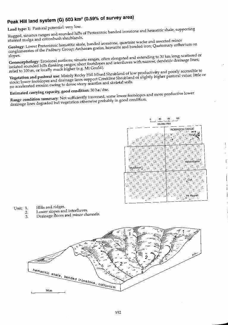
Pe.ak Hill land system (G) 503 km2 (0.59% of survey area)
Land type: 1; Pastoral potential: very low.
Rugged, sinuous ranges and rounded hills of Proterozoic banded ironstone and hematitic shale, supporting
stunted mulga and cottonbush shrub lands.
Geology: Lower Proterozoic hematitic shale, banded ironstone, quartzite wacke and assorted minor
conglomerates of the Padbury Group; Archaean gneiss, hematite and banded iron; Quaternary colluvium on
slopes.
Geomorphology: Erosional surfaces; sinuate ranges, often elongated and extending to 30 kin long; scattered or
isolated rounded hills flanking ranges; short footslopes and interfluves with narrow, dendritic drainage lines;
relief to 100 m, or locally much higher (e.g. Mt Gould).
Vegetation and pastoral use: Mainly Rocky Hill Mixed Shrubland of low productivity and poorly accessible to
stock; lower footslopes and drainage lines support Creekline Shrubland of slightly higher pastoral value; little or
no accelerated erosion owing to dense stony mantles and skeletal soils.
Estimated carrying capacity, good condition: 30 hal dse.
Range condition summary: Not sufficiently traversed, some lower footslopes and more productive lower
drainage lines degraded but vegetation otherwise probably in good condition.
Unit: 1. 2. 3.
Hills and ridges. Lower slopes and interfluves.
Drainage floors and minor channels.
192
-- -
Murchison 0
40 80 120 ! ,
KILOMETRES
---- - --ROBINSON RANGE
• ~, r:! .' -i"~,\!"" . J
.. ,
Meekatharra 0
oCue
Mt Magnet 0
...
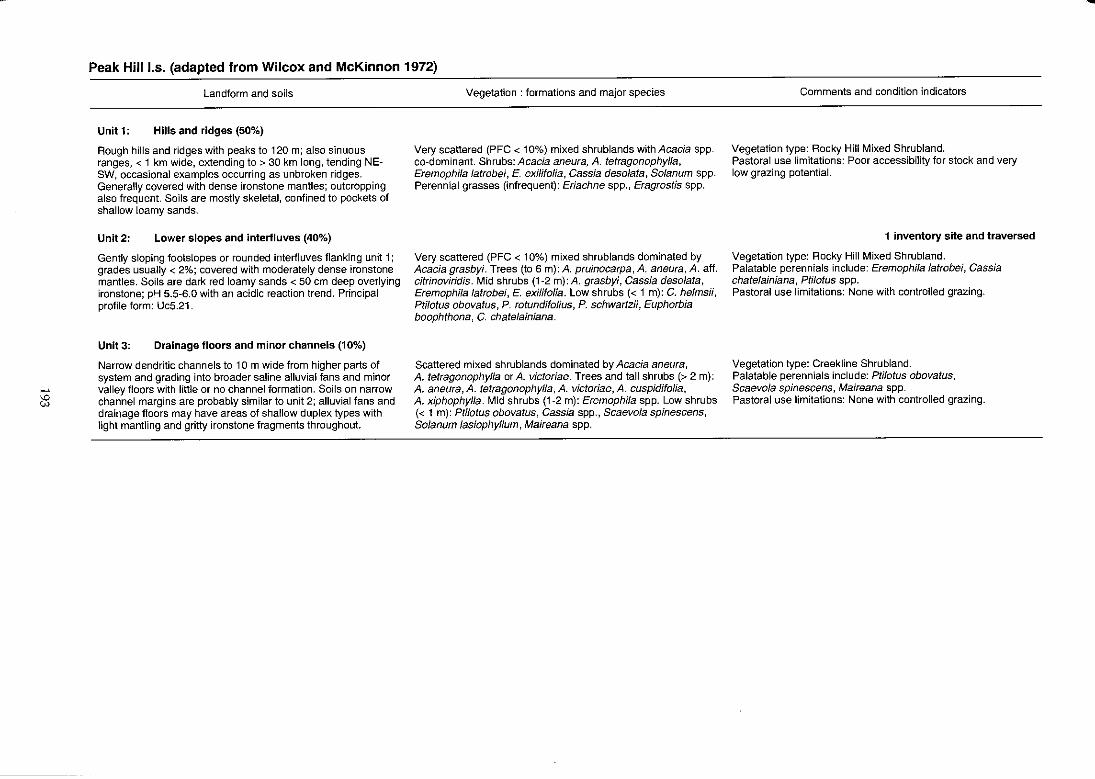
... C:S
Peak Hill 1.5. (adapted from Wilcox and McKinnon 1972)
Landform and soils
Unit 1: Hills and ridges (50%)
Rough hills and ridges with peaks to 120 m; also sinuous ranges, < 1 km wide, extending to > 30 km long, tending NESW, occasional examples occurring as unbroken ridges. Generally covered with dense ironstone mantles; outcropping also frequent. Soils are mostly skeletal, confined to pockets of shallow loamy sands.
Unit 2: Lower slopes and interfluves (40%)
Gently sloping footslopes or rounded interfluves flanking unit 1; grades usually < 2%; covered with moderately dense ironstone mantles. Soils are dark red loamy sands < 50 cm deep overlying ironstone; pH 5.5-6.0 with an acidic reaction trend. Principal profile form: Uc5.21.
Unit 3: Drainage floors and minor channels (10%)
Narrow dendritic channels to 10m wide from higher parts of system and grading into broader saline alluvial fans and minor valley floors with little or no channel formation. Soils on narrow channel margins are probably similar to unit 2; alluvial fans and drainage floors may have areas of shallow duplex types with light mantling and gritty ironstone fragments throughout.
Vegetation: formations and major species
Very scattered (PFC < 10%) mixed shrublands with Acacia spp. co-dominant. Shrubs: Acacia aneura, A. tetragonophylla, Eremophila latrobei, E. exilifolia, Cassia desolata, Solanum spp. Perennial grasses (infrequent): Eriachne spp., Eragrostis spp.
Very scattered (PFC < 10%) mixed shrub lands dominated by Acacia grasbyi. Trees (to 6 m): A. pruinocarpa, A. aneura, A. aft. citrinoviridis. Mid shrubs (1-2 m): A. grasbyi, Cassia desolata, Eremophila latrobei, E. exilifolia. Low shrubs « 1 m): C. helmsii, Ptilotus obovatus, P. rotundifoJius, P. schwartzii, Euphorbia boophthona, C. chatelainiana.
Scattered mixed shrublands dominated by Acacia aneura, A. tetragonophylla or A. victoriae. Trees and tall shrubs (> 2 m): A. aneura, A. tetragonophylla, A. victoriae, A. cuspidifolia, A. xiphophylla. Mid shrubs (1-2 m): Eremophila spp. Low shrubs « 1 m): Ptilotus obovatus, Cassia spp., Scaevola spinescens, Solanum lasiophyllum, Maireana spp.
Comments and condition indicators
Vegetation type: Rocky Hill Mixed Shrubland. Pastoral use limitations: Poor accessibility for stock and very low grazing potential.
1 inventory site and traversed
Vegetation type: Rocky Hill Mixed Shrubland. Palatable perennials include: Eremophila latrobei, Cassia chatelainiana, Ptilotus spp. Pastoral use limitations: None with controlled grazing.
Vegetation type: Creekline Shrubland. Palatable perennials include: Ptilotus obovatus, Scaevola spinescens, Maireana spp . Pastoral use limitations: None with controlled grazing.
-
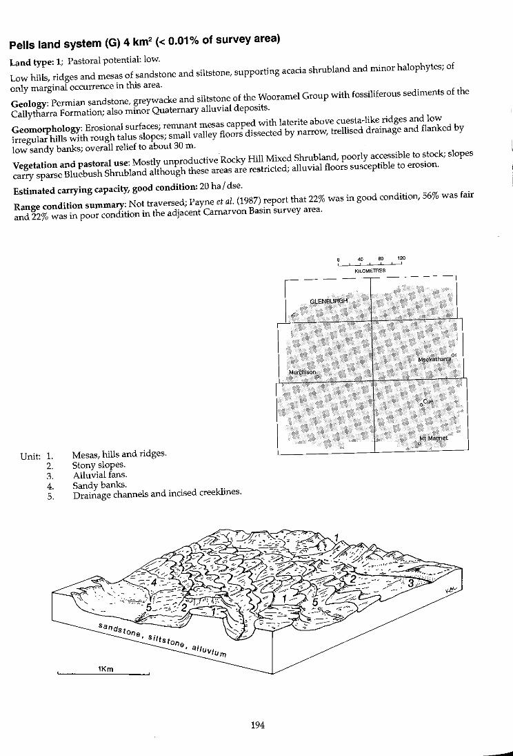
Pells land system (G) 4 km2 « 0.01% of survey area)
Land type: 1; Pastoral potential: low.
Low hills, ridges and mesas of sandstone and siltstone, supporting acacia shrubland and minor halophytes; of
only marginal occurrence in this area.
Geology: Permian sandstone, greywacke and siltstone of the Wooramel Group with fossiliferous sediments of the
Callytharra Formation; also minor Quaternary alluvial deposits.
Geomorphology: Erosional surfaces; remnant mesas capped with laterite above cuesta-like ridges and low
irregular hills with rough talus slopes; small valley floors dissected by narrow, trellised drainage and flanked by
low sandy banks; overall relief to about 30 m.
Vegetation and pastoral use: Mostly unproductive Rocky Hill Mixed Shrubland, poorly accessible to stock; slopes
carry sparse Bluebush Shrubland although these areas are restricted; alluvial floors susceptible to erosion.
Estimated carrying capacity, good condition: 20 hal dse.
Range condition summary: Not traversed; Payne et aZ. (1987) report that 22% was in good condition, 56% was fair
and 22% was in poor condition in the adjacent Carnarvon Basin survey area.
Unit: 1. 2. 3. 4. 5.
Mesas, hills and ridges. Stony slopes. Alluvial fans. Sandy banks. Drainage channels and incised creeklines.
1Km
194
, ,
GlE~BUAG~
Murci'iisoti o
" 80 120 , , KILOMETRES
'tAt'Magnet o
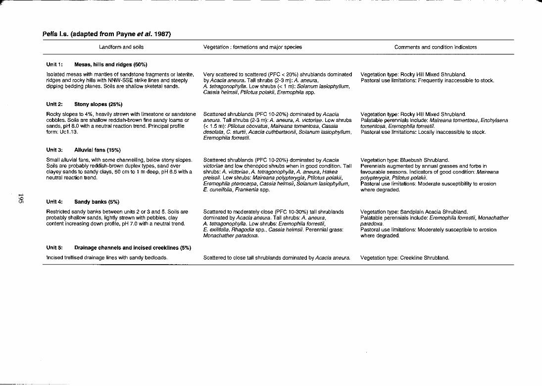
r
>-'
~
Pens I.s. (adapted from Payne et al. 1987)
Landform and soils
Unit 1: Mesas, hills and ridges (50%)
Isolated mesas with mantles of sandstone fragments or laterite, ridges and rocky hills with NNW-SSE strike lines and steeply dipping bedding planes. Soils are shallow skeletal sands.
Unlt2: Stony slopes (25%)
Rocky stopes to 4%, heavily strewn with limestone or sandstone cobbles. Soils are shallow reddish-brown fine sandy loams or sands, pH 8.0 with a neutral reaction trend. Principal profile form: Uci.i3.
Unit 3: Alluvial fans (15%)
Small alluvial fans, with some channelling, below stony slopes. Soils are probably reddish-brown duplex types, sand over clayey sands to sandy clays, 50 cm to 1 m deep, pH 6.5 with a neutral reaction trend.
Unit 4: Sandy banks (5%)
Restricted sandy banks between units 2 or 3 and 5. Soils are probably shallow sands, lightly strewn with pebbles, clay content increasing down profile, pH 7.0 with a neutral trend.
UnitS: Drainage channels and Incised creekllnes (5%)
Incised trellised drainage lines with sandy bedloads.
Vegetation: formations and major species
Very scattered to scattered (PFC < 20%) shrublands dominated by Acacia aneura. Tall shrubs (2-3 m): A. aneura, A. tetragonophylla. Low shrubs « 1 m): Solanum lasiophyllum, Cassia helmsii, Ptilotus polakii, Eremophila spp.
Scattered shrublands (PFC 10-20%) dominated by Acacia aneura. Tall shrubs (2-3 m): A. aneura, A. victoriae. Low shrubs (< 1.5 m): Ptilotus obovatus, Maireana tomentosa, Cassia desolata, C. sturtii, Acacia cuthbertsonii, Solanum lasiophyllum, Eremophila forrestii.
Scattered shrublands (PFC 10-20%) dominated by Acacia victoriae and low chenopod shrubs when in good condition. Tall shrubs: A. victor;ae, A. tetragonophylla, A. aneura, Hakea preissii. Low shrubs: Maireana polypterygia, Ptilotus polakii, Eremophila pterocarpa, Cassia helmsii, Solanum lasiophyllum, E. cuneifolia, Frankenia spp.
Scattered to moderately close (PFC 10-30%) tall shrublands dominated by Acacia aneura. Tall shrubs: A. aneura, A. tetragonophylla. Low shrubs: Eremophila forrestii, E. exilifolia, Rhagodia spp., Cassia helmsii. Perennial grass: Monachather paradoxa.
Scattered to close tall shrublands dominated by Acacia aneura.
Comments and condition indicators
Vegetation type: Rocky Hill Mixed Shrubland. Pastoral use limitations: Frequently inaccessible to stock.
Vegetation type: Rocky Hill Mixed Shrubland. Palatable perennials include: Maireana tomentosa, Enchylaena tomentosa, Eremophila forrestii. Pastoral use limitations: Locally inaccessible to stock.
Vegetation type: Bluebush Shrubland. Perennials augmented by annual grasses and forbs in favourable seasons. Indicators of good condition: Maireana polypterygia, Ptilotus polakii. Pastoral use limitations: Moderate susceptibility to erosion where degraded.
Vegetation type: Sand plain Acacia Shrubland. Palatable perennials include: Eremophila forrestii, Monachather paradoxa. Pastoral use limitations: Moderately susceptible to erosion where degraded.
Vegetation type: Creekline Shrubland.
....
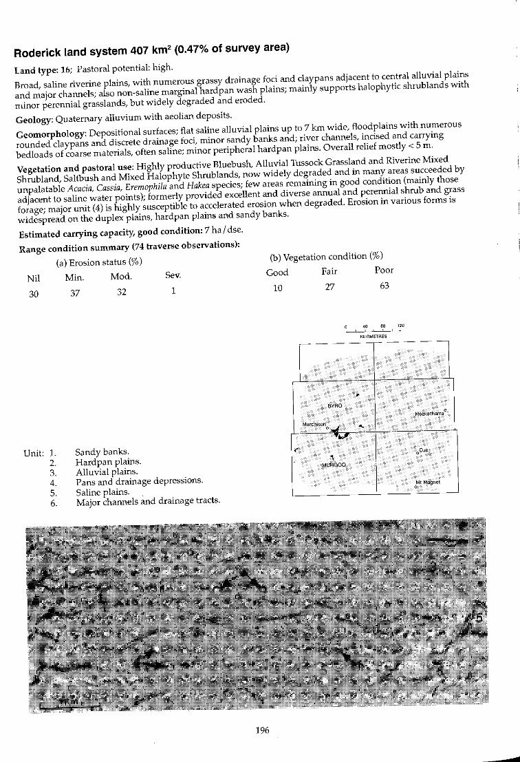
Roderick land system 407 km2 (0.47% of survey area)
Land type: 16; Pastoral potential: high.
Broad, saline riverine plains, with numerous grassy drainage foci and claypans adjacent to central alluvial plains
and major channels; also non-saline marginal hardpan wash plains; mainly supports halophytic shrub lands with
minor perennial grasslands, but widely degraded and eroded.
Geology: Quaternary alluvium with aeolian deposits.
Geomorphology: DepOSitional surfaces; flat saline alluvial plains up to 7 kIn wide, floodplains with numerous
rounded claypans and discrete drainage foci, minor sandy banks and; river channels, incised and carrying
bedloads of coarse materials, often saline; minor peripheral hardpan plains. Overall relief mostly < 5 m.
Vegetation and pastoral use: Highly productive Bluebush, Alluvial Tussock Grassland and Riverine Mixed
Shrubland, Saltbush and Mixed Halophyte Shrublands, now widely degraded and in many areas succeeded by
unpalatable Acacia, Cassia, Eremophila and Hakea species; few areas remaining in good condition (mainly those
adjacent to saline water points); formerly provided excellent and diverse annual and perennial shrub and grass
forage; major unit (4) is highly susceptible to accelerated erosion when degraded. Erosion in various forms is
widespread on the duplex plains, hardpan plains and sandy banks.
Estimated carrying capacity, good condition: 7 hal dse.
Range condition summary (74 traverse observations):
(a) Erosion status (%)
Nil Min. Mod. Sev.
30
Unit: l. 2. 3. 4. 5. 6.
37 32
Sandy banks. Hardpan plains. Alluvial plains.
1
Pans and drainage depressions. Saline plains. . Major channels and drainage tracts.
196
(b) Vegetation condition (%)
Good Fair Poor
10 27 63
40 80 120 , ,
KILOMETRES
-- ---r--- --
, BYRO
Meek3tharra¢
Murchisono wi . "-
'k'
,. oCue
'\ MURGOO
Mt Magnet 0
-c!
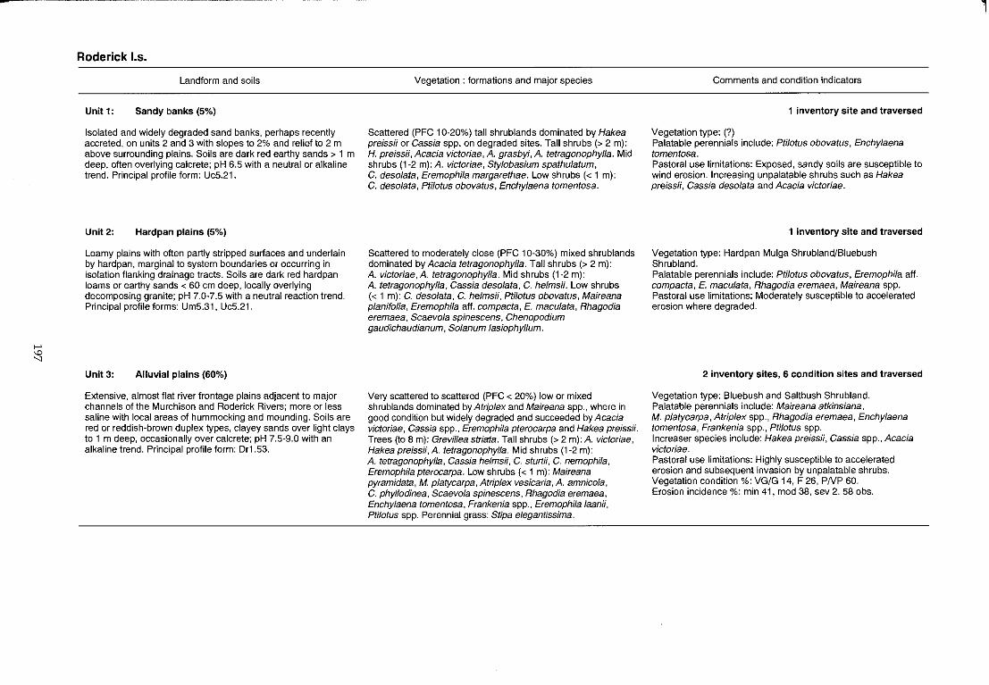
>-'
'" "
Roderick 1.5.
Landform and soils
Unit 1: Sandy banks (5%)
Isolated and widely degraded sand banks, perhaps recently accreted, on units 2 and 3 with slopes to 2% and relief to 2 m above surrounding plains. Soils are dark red earthy sands> 1 m deep, often overlying calcrete; pH 6.5 with a neutral or alkaline trend. Principal profile form: UcS.21.
Unit 2: Hardpan plains (5%)
Loamy plains with often partly stripped surfaces and underlain by hardpan, marginal to system boundaries or occurring in isolation flanking drainage tracts. Soils are dark red hardpan loams or earthy sands < 60 em deep, locally overlying decomposing granite; pH 7.0*7.5 with a neutral reaction trend. Principal profile forms: Um5.31, Uc5.21.
Unit 3: Alluvial plains (60%)
Extensive, almost flat river frontage plains adjacent to major channels of the Murchison and Roderick Rivers; more or less saline with local areas of hum mocking and mounding. Soils are red or reddish-brown duplex types, clayey sands over light clays to 1 m deep, occasionally over calcrete; pH 7.5-9.0 with an alkaline trend. Principal profile form: Dr1.53.
Vegetation: formations and major species
Scattered (PFC 10-20%) tall shrublands dominated by Hakea preiss;; or Cassia spp. on degraded sites. Tall shrubs (> 2 m): H. preissii, Acacia victoriae, A. grasbyi, A. tetragonophylla. Mid shrubs (1-2 m): A. victoriae, Stylobasium spathulatum, C. desolata, Eremophila margarethae. Low shrubs « 1 m): C. desolata, Ptilotus obovatus, Enchylaena tomentosa.
Scattered to moderately close (PFC 10-30%) mixed shrublands dominated by Acacia tetragonophylla. Tall shrubs (> 2 m): A. victoriae, A. tetragonophylla. Mid shrubs (1-2 m): A. tetragonophylla, Cassia desolata, C. helmsii. Low shrubs « 1 m): C. desolata, C. helms;;, Ptilotus obovatus, Maireana planifolia, Eremophila aft. compacta, E. maculata, Rhagodia eremaea, Scaevola spinescens, Chenopodium gaudichaudianum, Solanum lasiophyllum.
Very scattered to scattered (PFC < 20%) low or mixed shrublands dominated by Atriplex and Maireana spp., where in good condition but widely degraded and succeeded by Acacia victoriae, Cassia spp., Eremophila pterocarpa and Hakea preissii. Trees (to 8 m): Grevillea striata. Tall shrubs (> 2 m): A. victoriae, Hakea preissii, A. tetragonophylla. Mid shrubs (1-2 m): A. tetragonophylla, Cassia helmsii, C. sturtii, C. nemophila, Eremophila pterocarpa. Low shrubs « 1 m): Maireana pyramidata, M. platycarpa, Atriplex vesicaria, A. amnicola, C. phyllodinea, Scaevola spinescens, Rhagodia eremaea, Enchylaena tomentosa, Frankenia spp., Eremophila laanii, Ptilotus spp. Perennial grass: Stipa elegantissima.
Comments and condition indicators
1 inventory site and traversed
Vegetation type: (?) Palatable perennials include: Ptilotus obovatus, Enchylaena tomentosa. Pastoral use limitations: Exposed, sandy soils are susceptible to wind erosion. Increasing unpalatable shrubs such as Hakea preiss;;, Cassia desolata and Acacia victoriae.
1 inventory site and traversed
Vegetation type: Hardpan Mulga Shrubland/Bluebush Shrubland. Palatable perennials include: Ptilotus obovatus, Eremophila aft. compacta, E. maculata, Rhagodia eremaea, Maireana spp. Pastoral use limitations: Moderately susceptible to accelerated erosion where degraded.
2 inventory sites, 6 condition sites and traversed
Vegetation type: Bluebush and Saltbush Shrubland. Palatable perennials include: Maireana atkinsiana, M. platycarpa, Atriplex spp., Rhagodia eremaea, Enchylaena tomentosa, Frankenia spp., Ptilotus spp. Increaser species include: Hakea preiss;;, Cassia spp., Acacia victoriae. Pastoral use limitations: Highly susceptible to accelerated erosion and subsequent invasion by unpalatable shrubs. Vegetation condition %: VG/G 14, F 26, PNP 60. Erosion incidence %: min 41, mod 38, sev 2.58 obs.
l
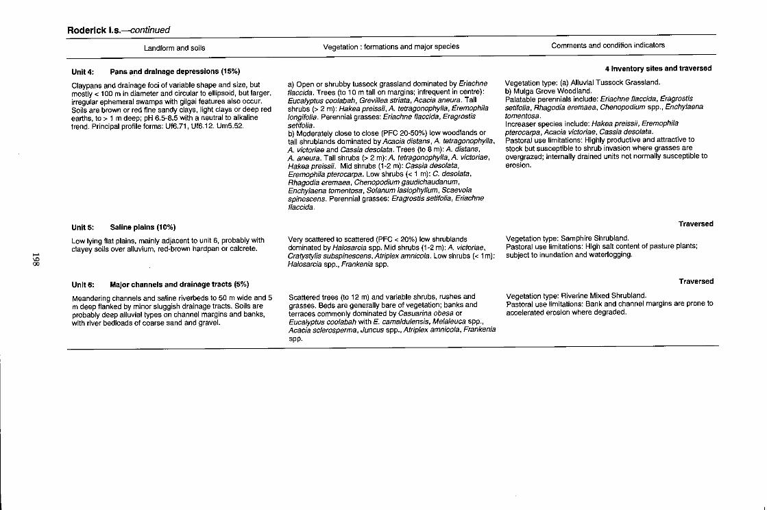
..... '"' 00
Roderick I.s.-continued
Landform and soils
Unlt4: Pans and drainage depressions (15%)
Claypans and drainage foci of variable shape and size, but mostly < 100 m in diameter and circular to ellipsoid, but larger, irregular ephemeral swamps with gilgai features also occur. Soils are brown or red fine sandy clays, light clays or deep red earths, to > 1 m deep; pH 6.5-8.5 with a neutral to alkaline trend. Principal profile forms: Uffi.71 , Uffi.12. UrnS.52.
UnitS: Saline plains (10%)
Low lying flat plains, mainly adjacent to unit 6, probably with clayey soils over alluvium, red-brown hardpan or calcrete.
Unlt6: Major channels and drainage tracts (5%)
Meandering channels and saline riverbeds to 50 m wide and 5 m deep flanked by minor sluggish drainage tracts. Soils are probably deep alluvial types on channel margins and banks, with river bed loads of coarse sand and gravel.
Vegetation: formations and major species
a) Open or shrubby tussock grassland dominated by Eriachne f/accida. Trees (to 10 m tall on margins; infrequent in centre): Eucalyptus coo/abah, Grevillea striata, Acacia aneura. Tall shrubs (> 2 m): Hakea preissii, A. tetragonophylla, Eremophila longifolia. Perennial grasses: Eriachne flaccida, Eragrostis setifolia. b) Moderately close to close (PFC 20-50%) low woodlands or tall shrublands dominated by Acacia distans, A. tetragonophyfla, A. victoriae and Cassia deso/ata. Trees (to 8 m): A. distans, A. aneura. Tall shrubs (> 2 m): A. tetragonophylla, A. victoriae, Hakea preissii. Mid shrubs (1-2 m): Gassia desolata, EremophiJa pterocarpa. Low shrubs « 1 m): C. desolata, Rhagodia eremaea, Chenopodium gaudichaudanum, Enchylaena tomentosa, Solanum lasiophyllum, Scaevola spinescens. Perennial grasses: Eragrostis setifolia, Eriachne flaccida.
Very scattered to scattered (PFC < 20%) low shrublands dominated by Ha/osarcia spp. Mid shrubs (1-2 m): A. victoriae, Cratystylis subspinescens, Atrip/ex amnicola. Low shrubs « 1 m): Halosarcia spp., Frankenia spp.
Scattered trees (to 12 m) and variable shrubs, rushes and grasses. Beds are generally bare of vegetation; banks and terraces commonly dominated by Casuarina obesa or Eucalyptus coolabah with E. camaldulensis, Melaleuca spp., Acacia sclerosperma, Juncus spp., Atrip/ex amnico/a, Frankenia spp.
Comments and condition indicators
4 inventory sites and traversed
Vegetation type: (a) Alluvial Tussock Grassland. b) Mulga Grove Woodland. Palatable perennials include: Eriachne flaccida, Eragrostis setifolia, Rhagodia eremaea, Chenopodium spp., Enchylaena tomentosa. Increaser species include: Hakea preissii, Eremophila pterocarpa, Acacia victoriae, Cassia desolafa. Pastoral use limitations: Highly productive and attractive to stock but susceptible to shrub invasion where grasses are overgrazed; internally drained units not normally susceptible to erosion.
Traversed
Vegetation type: Samphire Shrubland. Pastoral use limitations: High salt content of pasture plants; subject to inundation and waterlogging.
Traversed
Vegetation type: Riverine Mixed Shrubland. Pastoral use limitations: Bank and channel margins are prone to accelerated erosion where degraded.
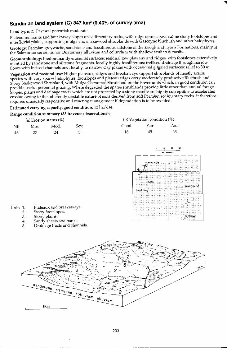
Sandi man land system (G) 347 km2 (0.40% of survey area)
Land type: 2; Pastoral potential: moderate.
Plateau remnants and breakaway slopes on sedimentary rocks, with ridge spurs above saline stony footslopes and interfluvial plains, supporting mulga and snakewood shrublands with Gascoyne bluebush and other halophytes.
Geology: Permian greywacke, sandstone and fossiliferous siltstone of the Keogh and Lyons Formations, mainly of the Sakmarian series; minor Quaternary alluvium and colluvium with shallow aeolian deposits.
Geomorphology: Predominantly erosional surfaces; residual low plateaux and ridges, with footslopes extensively mantled by sandstone and siltstone fragments, locally highly fossiliferous; trellised drainage through narrow floors with incised channels and, locally, to narrow clay plains with occasional gilgaied surfaces; relief to 30 m.
Vegetation and pastoral use: Higher plateaux, ridges and breakaways support shrublands of mostly acacia species with very sparse halophytes; footslopes and plateau edges carry moderately productive Bluebush and Stony Snakewood Shrubland, with Mulga Chenopod Shrub land on the lower units which, in good condition can provide useful perennial grazing. Where degraded the sparse shrublands provide little other than annual forage. Slopes, plains and drainage tracts which are not protected by a stony mantle are highly susceptible to accelerated erosion owing to the inherently unstable nature of soils derived from soft Permian sedimentary rocks. It therefore requires unusually responsive and exacting management if degradation is to be avoided.
Estimated carrying capacity, good condition: 12 hal dse.
Range condition summary (33 traverse observations);
(a) Erosion status (%) (b) Vegetation condition (%)
Nil Min. Mod. Sev.
46 27 24 3
Unit: 1. 2. 3. 4. 5.
Plateaux and breakaways. Stony footslopes. Stony plains. Sandy sheets and banks. Drainage tracts and channels.
1 =
~
Good
18
Si/ ts tOne -:-~,-"o.:... __ ~_-._~../ COllu"v· turn,
1Km
200
Fair Poor
49 33
40 eo 120 , ,
KILOMETRES
,----------
GLEN6URGH
('j V' I ,
BYRQ
Meekatharra 0
M.irchison 0
oLue
oMt Magnet
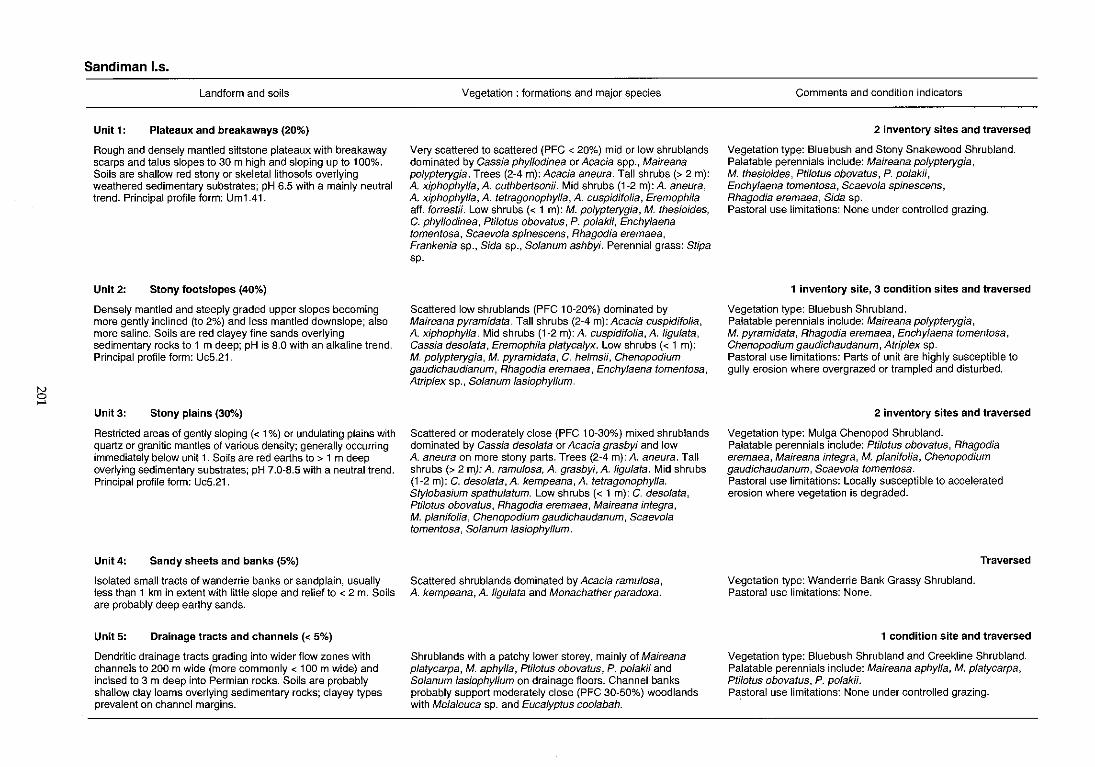
~ ....
Sandi man 1.5.
Landform and soils
Unit 1, Plateaux and breakaways (20%)
Rough and densely mantled siltstone plateaux with breakaway scarps and talus slopes to 30 m high and sloping up to 100%. Soils are shallow red stony or skeletallithosols overlying weathered sedimentary substrates; pH 6.5 with a mainly neutral trend. Principal profile form: Um1.41.
Unit 2: Stony footslopes (40%)
Densely mantled and steeply graded upper slopes becoming more gently inclined (to 2%) and less mantled downslope; also more saline. Soils are red clayey fine sands overlying sedimentary rocks to 1 m deep; pH is 8.0 with an alkaline trend. Principal profile form: Uc5.21.
Unit 3: Stony plains (30%)
Restricted areas of gently sloping « 1 %) or undulating plains with quartz or granitic mantles of various density; generally occurring immediately below unit 1 . Soils are red earths to > 1 m deep overlying sedimentary substrates; pH 7.0-8.5 with a neutral trend. Principal profile form: Uc5.21.
Unit4: Sandy sheets and banks (5%)
Isolated small tracts of wanderrie banks or sandplain, usually less than 1 km in extent with little slope and relief to < 2 m. Soils are probably deep earthy sands.
Unit 5: Drainage tracts and channels « 5%)
Dendritic drainage tracts grading into wider flow zones with channels to 200 m wide (more commonly < 100 m wide) and incised to 3 m deep into Permian rocks. Soils are probably shallow clay loams overlying sedimentary rocks; clayey types prevalent on channel margins.
Vegetation: formations and major species
Very scattered to scattered (PFC < 20%) mid or low shrublands dominated by Cassia phyl/odinea or Acacia spp., Maireana polypterygia. Trees (2-4 m): Acacia aneura. Tall shrubs (> 2 m): A xiphophyl/a,A cuthbertsonii. Mid shrubs (1-2 m):A aneura, A xiphophyl/a, A tetragonophyl/a, A cuspidifolia, Eremophila aft. forrestii. Low shrubs « 1 m): M. polypterygia, M. thesioides, C. phyllodinea, Ptilotus obovatus, P. polakii, Enchylaena tomentosa, Scaevola spinescens, Rhagodia eremaea, Frankenia sp., Sida sp., Solanum ashbyi. Perennial grass: Stipa sp.
Scattered low shrublands (PFC 10-20%) dominated by Maireana pyramidata. Tall shrubs (2-4 m): Acacia cuspidifolia, A xiphophyl/a. Mid shrubs (1-2 m):A cuspidifolia,Aligulata, Cassia desolata, Eremophila platycalyx. Low shrubs « 1 m): M. polypterygia, M. pyramidata, C. he/msii, Chenopodium gaudichaudianum, Rhagodia eremaea, Enchy/aena tomentosa, Atrip/ex sp., So/anum lasiophyl/um.
Scattered or moderately close (PFC 10-30%) mixed shrublands dominated by Cassia deso/ata or Acacia grasbyi and low A aneura on more stony parts. Trees (2-4 m): A aneura. Tall shrubs (> 2 my: A ramu/osa, A grasbyi, A ligu/ata. Mid shrubs (1-2 m): C. deso/ata, A kempeana, A tetragonophylla. Sty/obasium spathulatum. Low shrubs « 1 m): C. desolata, Pti/otus obovatus, Rhagodia eremaea, Maireana integra, M. planifo/ia, Chenopodium gaudichaudanum, Scaevola tomentosa, So/anum lasiophyl/um.
Scattered shrublands dominated by Acacia ramu/osa, A kempeana, A ligu/ata and Monachather paradoxa.
Shrublands with a patchy lower storey, mainly of Maireana p/atycarpa, M. aphylla, Pti/olus obovatus, P. po/akii and Solanum lasiophyllum on drainage floors. Channel banks probably support moderately close (PFC 30-50%) woodlands with Me/a/euca sp. and Eucalyptus coolabah.
Comments and condition indicators
2 inventory sites and traversed
Vegetation type: Bluebush and Stony Snakewood Shrubland. Palatable perennials include: Maireana polypterygia, M. thesioides, Ptilotus obovatus, P. po/akii, Enchy/aena tomentosa, Scaevo/a spinescens, Rhagodia eremaea, Sida sp. Pastoral use limitations: None under controlled grazing.
1 inventory site, 3 condition sites and traversed
Vegetation type: Bluebush Shrubland. Palatable perennials include: Maireana polypterygia, M. pyramidata, Rhagodia eremaea, Enchylaena tomentosa, Chenopodium gaudichaudanum, Atriplex sp. Pastoral use limitations: Parts of unit are highly susceptible to gully erosion where overgrazed or trampled and disturbed.
2 inventory sites and traversed
Vegetation type: Mulga Chenopod Shrubland. Palatable perennials include: Pti/otus obovatus, Rhagodia eremaea, Maireana integra, M. planifolia, Chenopodium gaudichaudanum, Scaevo/a tomentosa. Pastoral use limitations: Locally susceptible to accelerated erosion where vegetation is degraded.
Vegetation type: Wanderrie Bank Grassy Shrubland. Pastoral use limitations: None.
Traversed
1 condition site and traversed
Vegetation type: Bluebush Shrub land and Creekline Shrubland. Palatable perennials include: Maireana aphylla, M. p/atycarpa, Ptilolus obovalus, P. polakii. PC3:storal use limitations: None under controlled grazing.
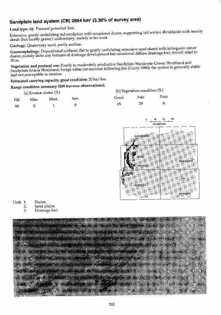
Sandplain land system (Ce) 2884 km2 (3.36% of survey area)
Land type: 10; Pastoral potential: low.
Extensive, gently undulating red sandplain with occasional dunes, supporting tall wanyu shrublands wi th mainly
shrub (but locally grassy) understorey; mainly in far west.
Geology: Quaternary sand, partly aeolian.
Geomorphology: Depositional surfaces; flat to gently undulating extensive sand sheets with infrequent minor
dunes; mainly lacks any features of drainage development but occasional diffuse drainage foci; overall relief to
20m.
Vegetation and pastoral use: Poorly to moderately productive Sandplain Wanderrie Grassy Shrubland and
Sandplain Acacia Shrubland; forage value can increase following fire (Curry 1986); the system is generally stable
and not susceptible to erosion.
Estimated carrying capacity, good condition: 20 hal dse.
Range condition summary (209 traverse observations):
(a) Erosion status (%)
Nil Min. Mod. Sev.
99
Unit: l. 2. 3.
o 1
Dunes. Sand plains. Drainage foci.
o
202
(b) Vegetation condition (%)
Good Fair Poor
65 29 6
o 40 80 120 ! , , ,
KILOMETRES
GLENBURGH
•
. MURGOO
Mt Magnet o
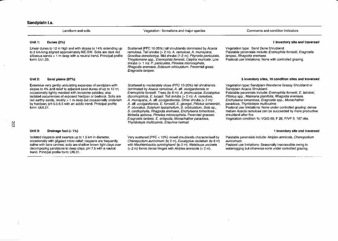
8
Sand plain I.s.
Landform and soils
Unit 1: Dunes (2%)
Linear dunes to 12 m high and with slopes to 14% extending up to 2 km long aligned approximately NE-SW. Soils are dark red siliceous sands> 1 m deep with a neutral trend. Principal profile form: Uc1.23.
Unit 2: Sand plains (97%)
Extensive very gently undulating expanses of sandplain with slopes to 4% and relief to adjacent sand dunes of up to 12 m; occasionally lightly mantled with ironstone pebbles; also isolated occurrences of exposed hardpan or bedrock. Soils are red earthy sands, mostly> 1 m deep but occasionally underlain by hardpan; pH 5.0-6.5 with an acidic trend. Principal profile form: Uc5.21.
Unit 3: Drainage foci « 1%)
Isolated claypans and swamps up to 1.5 km in diameter, occasionally with gilgaied micro-relief; claypans are frequently saline with bare centres; soils are shallow brown light clays over decomposing sandstone to deep clays: pH 7.5 with a neutral trend. Principal profile form: Uffi.31.
Vegetation: formations and major species
Scattered (PFC 10-20%) tall shrublands dominated by Acacia ramu/osa. Tall shrubs (> 2 m): A. ramulosa, A murrayana, Grevillea stenobotrya. Mid shrubs (1-2 m): Pityrodia panicu/ata, Thryptomene spp., Eremophila forrest;;, Calytrix muricata. Low shrubs « 1 m): P. paniculata, Pimelea microcephe/a, Rhagodia eremaea, So/anum orbiculatum. Perennial grass: Eragrostis /anipes.
Scattered to moderately close (PFC 10-30%) tall shrublands dominated by Acacia ramu/osa, A. aft. coolgardiensis or Eremophila forrestii. Trees (to 8 m): A. pruinocarpa, Eucalyptus dicromophloia, E. /ucasii. Tall shrubs (> 2 m): A ramu/osa, A murrayana, A. aft. coolgardiensis. Other shrubs « 2 m): A. aft. coolgardiensis, E. forrestii, E. georgei, Ptilotus schwartzii, P. obovatus, Solanum lasiophyllum, S. orbiculatum, Sida sp., S. cardiophylla, Rhagodia eremaea, Enchylaena tomentosa, Mirbelia spinosa, Pime/ea microcephela. Perennial grasses: Eragrostis /anipes, E. eriopoda, Monachather paradoxa, Thyrido/epis multiculmis, Eriachne helmsii.
Very scattered (PFC < 10%) mixed shrublands characterised by Chenopodium auricomum (to 2 m), Eucalyptus coo/abah (to 8 m) with Meuhlenbeckia cunninghamii (to 2 m). Melaleuca uncinata (> 2 m) forms dense fringes with Atriplex amnicola « 2 m).
Comments and condition indicators
1 inventory site and traversed
Vegetation type: Sand Dune Shrubland. Palatable perennials include: Eremophila forrestii, Eragrostis lanipes, Rhagodia eremaea. Pastoral use limitations: None with controlled grazing.
5 Inventory sites, 16 condition sites and traversed
Vegetation type: Sandplain Wanderrie Grassy Shrubland or Sand plain Acacia Shrubland. Palatable perennials include: Eremophila forrestii, E. latrobei, Ptilotus spp., Maireana planifolia, Rhagodia eremaea, Enchylaena tomentosa, Eragrostis spp., Monachather paradoxa, Thyridolepis multiculmis. Pastoral use limitations: None under controlled grazing; dense mature Acacia ramulosa can be succeeded by more productive shrubland after fire. Vegetation condition %: VG/G 69, F 28, PNP 3. 187 obs.
1 inventory site and traversed
Palatable perennials include: Atriplex amnicola, Chenopodium auricomum. Pastoral use limitations: Seasonally inaccessible owing to waterlogging but otherwise none under controlled grazing.
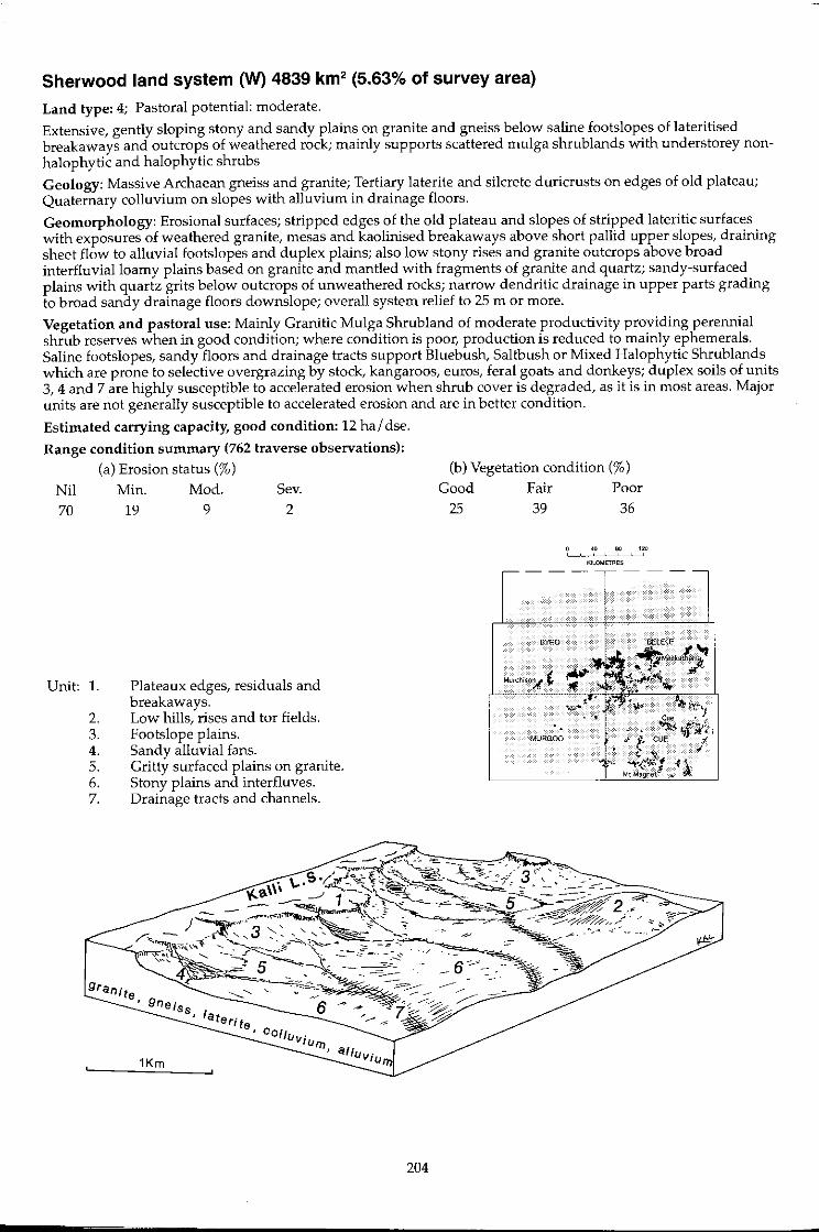
Sherwood land system (W) 4839 km2 (5.63% of survey area)
Land type: 4; Pastoral potential: moderate.
Extensive, gently sloping stony and sandy plains on granite and gneiss below saline footslopes of lateritised breakaways and outcrops of weathered rock; mainly supports scattered mulga shrub lands with understorey nonhalophytic and halophytic shrubs
Geology: Massive Archaean gneiss and granite; Tertiary laterite and silcrete duricrusts on edges of old plateau; Quaternary colluvium on slopes with alluvium in drainage floors.
Geomorphology: Erosional surfaces; stripped edges of the old plateau and slopes of stripped lateritic surfaces with exposures of weathered granite, mesas and kaolinised breakaways above short pallid upper slopes, draining sheet flow to alluvial footslopes and duplex plains; also low stony rises and granite outcrops above broad interfluvialloamy plains based on granite and mantled with fragments of granite and quartz; sandy-surfaced plains with quartz grits below outcrops of unweathered rocks; narrow dendritic drainage in upper parts grading to broad sandy drainage floors downslope; overall system relief to 25 m or more.
Vegetation and pastoral use: Mainly Granitic Mulga Shrubland of moderate productivity providing perennial shrub reserves when in good condition; where condition is poor, production is reduced to mainly ephemerals. Saline footslopes, sandy floors and drainage tracts support Bluebush, Saltbush or Mixed Halophytic Shrublands which are prone to selective overgrazing by stock, kangaroos, euros, feral goats and donkeys; duplex soils of units 3,4 and 7 are highly susceptible to accelerated erosion when shrub cover is degraded, as it is in most areas. Major units are not generally susceptible to accelerated erosion and are in better condition.
Estimated carrying capacity, good condition: 12 hal dse.
Range condition summary (762 traverse observations): (a) Erosion status (%)
Nil 70
Unit: 1.
2. 3. 4. 5. 6. 7.
Min. 19
Mod.
9
Sev. 2
Plateaux edges, residuals and breakaways. Low hills, rises and tor fields. Footslope plains. Sandy alluvial fans. Gritty surfaced plains on granite. Stony plains and interfluves. Drainage tracts and channels.
204
(b) Vegetation condition (%)
Good 25
Fair 39
BYRO
Poor 36
40 so 120
KlLOMI:TR~S
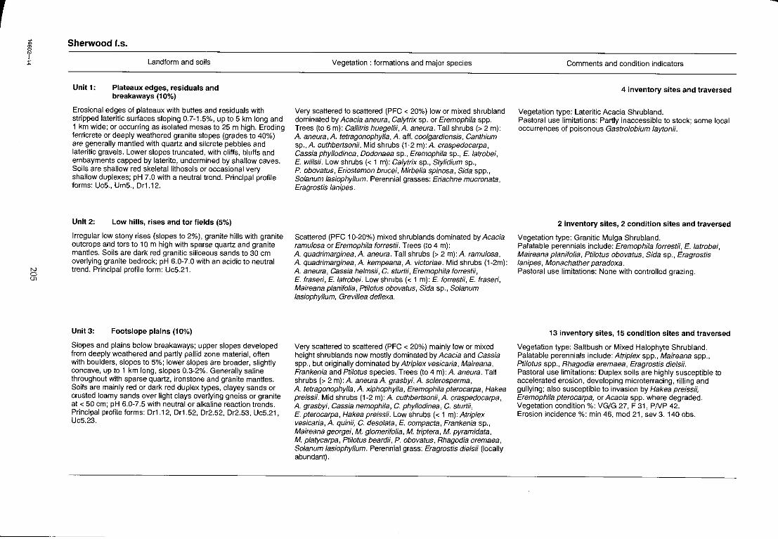
r , ;:
N 5;
Sherwood I.s.
Unit 1:
Landform and soils
Plateaux edges, residuals and breakaways (10%)
Erosional edges of plateaux with buttes and residuals with stripped lateritic surfaces sloping 0.7-1.5%, up to 5 km long and 1 km wide; or occurring as isolated mesas to 25 m high. Eroding ferricrete or deeply weathered granite slopes (grades to 40%) are generally mantled with quartz and silcrete pebbles and lateritic gravels. Lower slopes truncated, with cliffs, bluffs and embayments capped by laterite, undermined by shallow caves. Soils are shallow red skeletallithosols or occasional very shallow duplexes; pH 7.0 with a neutral trend. Principal profile forms: Uc5., Um5., Or1.12.
Unit2: Low hills, rises and tor fields (5%)
Irregular low stony rises (slopes to 2%), granite hills with granite outcrops and tors to 10m high with sparse quartz and granite mantles. Soils are dark red granitic siliceous sands to 30 cm overlying granite bedrock; pH 6.0-7.0 with an acidic to neutral trend. Principal profile form: Uc5.21.
Unit 3: Footslope plains (10%)
Slopes and plains below breakaways; upper slopes developed from deeply weathered and partly pallid zone material, often with boulders, slopes to 5%; lower slopes are broader, slightly concave, up to 1 km long, slopes 0.3-2%. Generally saline throughout with sparse quartz, ironstone and granite mantles. Soils are mainly red or dark red duplex types, clayey sands or crusted loamy sands over light clays overlying gneiss or granite at < 50 cm; pH 6.0-7.5 with neutral or alkaline reaction trends. Principal profile forms: Or1.12, Or1.52, Or2.52, Or2.53, UcS.21, Uc5.23.
Vegetation: formations and major species
Very scattered to scattered (PFC < 20%) low or mixed shrubland dominated by Acacia aneura, Cafytrix sp. or Eremophila spp. Trees (to 6 m): Callitris huegeflii, A. aneura. Tall shrubs (> 2 m): A. aneura, A. tetragonophylla, A. aft. coolgardiensis, Canthium sp., A. cuthbertson;;. Mid shrubs (1-2 m): A. craspedocarpa, Cassia phyllodinea, Dodonaea sp., Eremophila sp., E. latrobei, E. willsii. Low shrubs « 1 m): Calytrix sp., Stylidium sp., P. obovatus, Eriostemon brucei, Mirbelia spinosa, SieJa spp., Solanum lasiophyllum. Perennial grasses: Eriachne mucronata, Eragrostis lanipes.
Scattered (PFC 10-20%) mixed shrublands dominated by Acacia ramulosa or Eremophila forrestii. Trees (to 4 m): A. quadrimarginea, A. aneura. Tall shrubs (> 2 m): A. ramulosa, A. quadrimarginea, A. kempeana, A. victoriae. Mid shrubs (1-2m): A. aneura, Cassia helmsii, C. sturtii, Eremophila forrestii, E. fraseri, E. latrobei. Low shrubs « 1 m): E. forrestii, E. frased, Maireana planifolia, Ptilotus obovatus, Sida sp., Solanum lasiophyllum, Grevillea deflexa.
Very scattered to scattered (PFC < 20%) mainly low or mixed height shrublands now mostly dominated by Acacia and Cassia spp., but originally dominated by Atriplex vesicada, Maireana, Frankenia and Ptilotus species. Trees (to 4 m): A. aneura. Tall shrubs (> 2 m): A. aneura A. grasbyi, A. sclerosperma, A. tetragonophylla, A. xiphophylJa, Eremophila pterocarpa, Hakea preissii. Mid shrubs (1-2 m): A. cuthbertsonii, A. craspedocarpa, A. grasbyi, Cassia nemophila, C. phyllodinea, C. sturtii, E. pterocarpa, Hakea preissii. Low shrubs « 1 m): Atriplex vesicaria, A. quinN, C. desolata, E. compacta, Frankenia sp., Maireana georgei, M. glomerifolia, M. triptera, M. pyramidata, M. platycarpa, Ptilotus beardii, P. obovatus, Rhagodia eremaea, Solanum lasiophyllum. Perennial grass: Eragrostis dielsii (locally abundant).
Comments and condition indicators
4 inventory sites and traversed
Vegetation type: Lateritic Acacia Shrubland. Pastoral use limitations: Partly inaccessible to stock; some local occurrences of poisonous Gastrolobium laytonii.
2 inventory sites, 2 condition sites and traversed
Vegetation type: Granitic Mulga Shrubland. Palatable perennials include: Eremophila forrestii, E. latrobei, Maireana planifolia, Ptilotus obovatus, Sida sp., Eragrostis lanipes, Monachather paradoxa. Pastoral use limitations: None with controlled grazing.
13 inventory sites, 15 condition sites and traversed
Vegetation type: Saltbush or Mixed Halophyte Shrubland. Palatable perennials include: Atdplex spp., Maireana spp., Ptilotus spp., Rhagodia eremaea, Eragrostis dielsii. Pastoral use limitations: Duplex soils are highly susceptible to accelerated erosion, developing microterracing, Tilling and gullying; also susceptible to invasion by Hakea preissii, Eremophila pterocarpa, or Acacia spp. where degraded. Vegetation condition %: VG/G 27, F 31, PNP 42. Erosion incidence %: min 46, mod 21, sev 3. 140 obs.
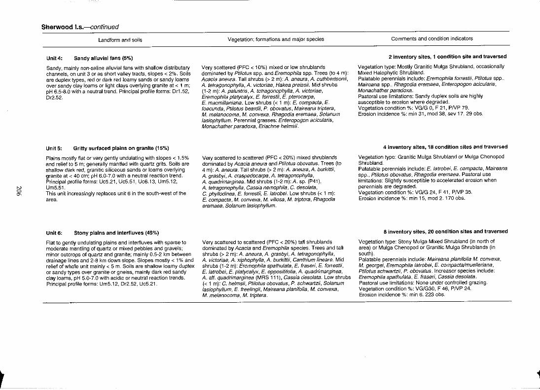
IV o
'"
Sherwood I.s.-continued
Landform and soils
Unit 4: Sandy alluvial fans (5%)
Sandy, mainly non-saline alluvial fans with shallow distributary channels, on unit 3 or as short valley tracts, slopes < 2%. Soils are duplex types, red or dark red loamy sands or sandy loams over sandy clay loams or light clays overlying granite at < 1 m; pH 6.5-8.0 with a neutral trend. Principal profile forms: Or1.52, Dr2.S2.
Unit 5: Gritty surfaced plains on granite (15%)
Plains mostly flat or very gently undulating with slopes < 1.5% and relief to 5 m; generally mantled with quartz grits. Soils are shallow dark red, granitic siliceous sands or loams overlying granite at < 40 em; pH 6.0-7.0 with a neutral reaction trend. Principal profile forms: Uc5.21, Uc5.51, Uc6.13, Um5.12, UmS.S1. This unit increasingly replaces unit 6 in the south-west of the area.
Unit 6: Stony plains and interfluves (45%)
Flat to gently undulating plains and interiluves with sparse to moderate mantling of quartz or mixed pebbles and gravels: minor outcrops of quartz and granite; mainly 0.5-2 km between drainage lines and 2-8 km down slope. Slopes mostly < 1 % and relief of whole unit mainly < 5 m. Soils are shallow loamy duplex or sandy types over granite or gneiss, mainly dark red sandy clay loams, pH 5.0-7.0 with acidic or neutral reaction trends. Principal profile forms: Um5.12, Dr2.52, Uc5.21 .
Vegetation: formations and major species
Very scattered (PFC < 10%) mixed or low shrublands dominated by Pti/otus spp. and Eremophila spp. Trees (to 4 m): Acacia aneura. Tall shrubs (> 2 m): A. aneura, A. cuthbertsonii, A. tetragonophylla, A. victoriae, Hakea preissii. Mid shrubs (1-2 m): A. palustris, A. tetragonophylla, A. victoriae, Eremophila platycalyx, E. forrestii, E. pterocarpa, E. macmillaniana. Low shrubs « 1 m): E. compacta, E. foecunda, Ptilotus beardii, P. obovatus, Maireana triptera, M. melanocoma, M. convexa, Rhagodia eremaea, Solanum lasiophyllum. Perennial grasses: Enteropogon acicularis, Monachather paradoxa, Eriachne helmsH.
Very scattered to scattered (PFC < 20%) mixed shrublands dominated by Acacia aneura and Ptilotus obovatus. Trees (to 4 m): A. aneura. Tall shrubs (> 2 m): A. aneura, A. burkittii, A. grasbyi, A. craspedocarpa, A. tetragonophylfa, A. quadrimarginea. Mid shrubs (1-2 m):A. sp. (P41), A. tetragonophylla, Cassia nemophila, C. desolata, C. phyllodinea, E. forrestii, E. latrobei. Low shrubs « 1 m): E. compacta, M. convexa, M. villosa, M. triptera, Rhagodia eremaea, Solanum lasiophylfum.
Very scattered to scattered (PFC < 20%) tall shrublands dominated by Acacia and Eremophila species. Trees and tall shrubs (> 2 m): A. aneura, A. grasbyi, A. tetragonophylla, A. victoriae, A. xiphophyfla, A. burkittii, Canthium lineare. Mid shrubs (1-2 m): Eremophila spathulata, E. fraseri, E. forrestii, E. latrobei, E. platycalyx, E. oppositifolia, A. quadrimarginea, A. aft. quadrimarginea (MRS 111), Cassia desolata. Low shrubs « 1 m): C. helmsii, Ptilotus obovatus, P. schwartzii, So/anum lasiophyllum, E. freelingii, Maireana planifolia, M. convexa, M. melanocoma, M. triptera.
Comments and condition indicators
2 inventory sites, 1 condition site and traversed
Vegetation type: Mostly Granitic Mulga Shrubland, occasionally Mixed Halophytic Shrubland. Palatable perennials include: Eremophila forrestii, Pti/otus spp., Maireana spp., Rhagodia eremaea, Enteropogon acicu/aris, Monachather paradoxa. Pastoral use limitations: Sandy duplex soils are highly susceptible to erosion where degraded. Vegetation condition %: VG/G 0, F 21, PNP 79. Erosion incidence %: min 31, mod 38, sev 17. 29 obs.
4 inventory sites, 18 condition sites and traversed
Vegetation type: Granitic Mulga Shrub land or Mulga Chenopod Shrubland. Palatable perennials include: E. latrobei, E. compacta, Maireana spp., Ptilotus obovatus, Rhagodia eremaea. Pastoral use limitations: Slightly susceptible to accelerated erosion when perennials are degraded. Vegetation condition %: VG/G 24, F 41, PNP 35. Erosion incidence %: min 15, mod 2.170 obs.
8 inventory sites, 20 condition sites and traversed
Vegetation type: Stony Mulga Mixed Shrubland (in north of area) or Mulga Chenopod or Granitic Mulga Shrub lands (in south). Palatable perennials include: Maireana planifolia M. convexa, M. georgei, Eremophila latrobei, E. compacta/muelleriana, Pti/otus schwartzii, P. obovatus. Increaser species include: Eremophila spathulata, E. fraseri, Cassia desolata. Pastoral use limitations: None under controlled grazing. Vegetation condition %: VG/G30, F 46, PNP 24. Erosion incidence %: min 6. 223 obs.
1
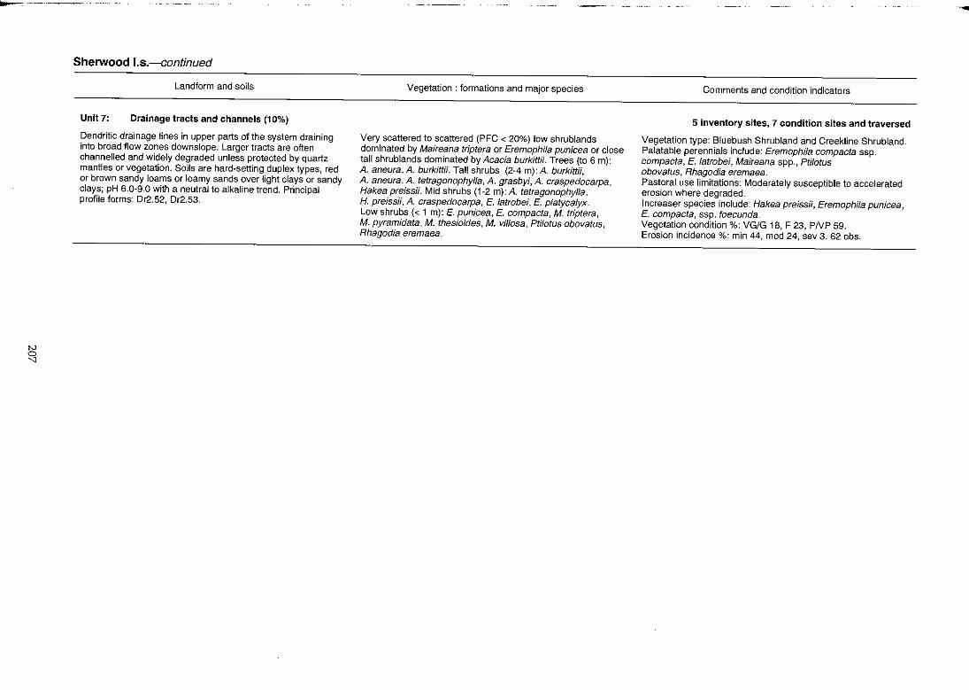
N o
"
Sherwood I.s.--continued
Landform and soils
Unit 7: Drainage tracts and channels (10%)
Dendritic drainage lines in upper parts of the system draining into broad flow zones downslope. Larger tracts are often channelled and w'ldely degraded unless protected by quartz mantles or vegetation. Soils are hard~setting duplex types, red or brown sandy loams or loamy sands over light clays or sandy clays; pH 6.0-9.0 with a neutral to alkaline trend. Principal profile forms: Dr2.52, Dr2.53.
Vegetation: formations and major species
Very scattered to scattered (PFC < 20%) low shrublands dominated by Maireana triptera or Eremophila punicea or close tall shrublands dominated by Acacia burkittii. Trees (to 6 m): A. aneura, A. burkittii. Tall shrubs (2-4 m): A. burkittii, A. aneura, A. tetragonophylla, A. grasbyi, A. craspedocarpa, Hakea preissii. Mid shrubs (1-2 m): A. tetragonophylla, H. preissii, A. craspedacarpa, E. latrobei, E. platyca/yx. Low shrubs « 1 m): E. punicea, E. compacta, M. triptera, M. pyramidata, M. thesioides, M. vil/asa, Ptilotus obovalus, Rhagodia eremaea.
Comments and condition indicators
5 inventory sites, 7 condition sites and traversed
Vegetation type: Bluebush Shrubland and Creekline Shrubland. Palatable perennials include: Eremophila compacta ssp. compacta, E. latrobei, Maireana spp., Ptilotus obovatus, Rhagodia eremaea. Pastoral use limitations: Moderately susceptible to accelerated erosion where degraded. Increaser species include: Hakea preissii, Eremophila punicea, E. compacta, ssp. foecunda. Vegetation condition %: VG/G 18, F 23, PNP 59. Erosion incidence %: min 44, mod 24, sev 3. 62 obs.
--
Siberia land system 43 km2 (0.05% of survey area)
Land type: 16; Pastoral potential: high.
Saline alluvial plains fringed with low dunes and peripheral stony plains; supports mostly halophytic shrublands with sparse tall acacias.
Geology: Predominantly Quaternary alluvium with minor Tertiary laterite.
Geomorphology: Mostly depositional surfaces; alluvial plains receiving concentrated drainage from sandstone escarpments, forming perched flood plains distant from major tributary drainages; higher stony plains with sandstone mantle fringing broad almost flat saline plains with short, linear sand dunes and scattered sandplain residuals; drainage disorganised but through to Outwash land system; overall relief to 5 m.
Vegetation and pastoral use: Mostly bluebush shrublands or other halophytic shrublands of moderate to high value when in fair to good condition; halophyte-dominated saline plains provide good quality dry season reserves but value is diminished if fresh water is not available to stock, units 3 and 4 are moderately to susceptible to accelerated erosion when degraded.
Estimated carrying capacity, good condition: 7 ha I dse.
Range condition summary (19 traverse observations):
Nil
68
Unit: 1. 2. 3 4.
(a) Erosion status (%)
Min.
21
Mod.
11
Sand dunes. Stony plains. Saline alluvial plains. Drainage tracts.
Sev.
o
208
(b) Vegetation condition (%)
Good
42
Fair
32
-- -
BYRO
Murchison -- 0
Poor
26
40 80 120 t ,
KILOMETRES
--,---- - --
Meekatharra 0
oCue
Mt Magnet 0
~
iOl '.tl
Siberia 1.5.
Landform and soils
Unit I: Sand dunes (3%)
Isolated irregular shaped dunes up to 500 m long to 8 m high, on margins of unit 3. Soils are dark red siliceous sands> 1 m deep; pH 6.0 with an acidic reaction trend. Principal profile form: Ucl.23.
Unit 2: Stony plains (35%)
Gently sloping expanses of stony plains below adjacent systems Woodrarrung and Mongolia; usually covered with dense platy sandstone mantles. Soils are duplexes, red loamy sands over red clayey loams to 20 em deep; often overlying hardpan; pH 7.0 with a neutral trend. Principal profile form: Dr2.52.
Unit 3: Saline alluvial plains (50%)
Mostly flat low lying plains; usually strongly saline with light sandstone mantles; subject to regular inundation. Soils are yellowish red light clays over heavy clays to 50 cm deep; pH 7.0 with a neutral trend. Principal profile form: Uf6.12.
Unit 4: Drainage tracts (12%)
Gently sloping, unchannelled saline drainage tracts up to 500 m wide; frequent areas of minor erosion with hummocking and rilling evident. Soils are probably clays similar to unit 3.
Vegetation: formations and major species
Moderately dense (PFC 20·30%) tall shrublands dominated by Acacia ramulosa. Tall shrubs (> 2 m): A. ramulosa, A. tetragonophylla, A. sclerosperma. Mid shrubs (1·2 m): A. microcalyx. Low shrubs « 1 m): Corynotheca sp., Pityrodia sp., Rhagodia eremaea, Chenopodium gaudichaudianum, Solanum lasiophyllum, Cassia phyllodinea, Maireana pyramidata.
Very scattered (PFC < 10%) mixed shrublands dominated by Acacia grasbyi. Trees (to 4 m): A. aneura. Tall shrubs (> 2 m): A. grasbyi, A. cuthbertsonii, A. tetragonophylla. Mid shrubs (I-2m): Eremophila platycalyx, E. sp. Low shrubs « 1m): Maireana triptera, M. georgei, Ptilotus obovatus, Atriplex bunburyana.
Very scattered (PFC < 10%) low shrublands dominated by Halosarcia spp. and Maireana glomerifolia. Low shrubs « 1 m): Carpobrotus sp., Ha/osarcia sp., M. glomerifolia.
Variable low and mid height shrubland characterised by shrub layer (1·2 m) of Acacia victoriae, Eremophila platycalyx, E. aft. forrestii, E. strongylophylla and low shrubs « 1 m): Atrip/ex bunburyana, Maireana pyramidata, M. vil/osa, M. convexa, M. thesioides, Ptilotus obovatus, P. divaricatus, Rhagodia eremaea, Scaevo/a spinescens.
Comments and condition indicators
1 inventory site and traversed
Vegetation type: Sand Dune Shrubland. Palatable perennials include: Rhagodia eremaea, Chenopodium gaudichaudianum, Maireana pyramidata. Pastoral use limitations: None with controlled grazing.
1 inventory site and traversed
Vegetation type: Mulga Chenopod Shrubland. Palatable perennials include: Atrip/ex bunburyana, Ptilotus obovatus, Maireana georgei, M. triptera. Pastoral use limitations: None with controlled grazing.
1 inventory site and traversed
Vegetation type: Samphire and Bluebush Shrub lands. Palatable perennials include: Maireana g/omerifolia. Pastoral use limitations: Seasonal flooding and high salt content of major species.
Traversed
Vegetation type: Saltbush/Bluebush Shrubland. Palatable perennials include: Atriplex bunburyana, Maireana spp., Ptilotus spp., Rhagodia eremaea, Scaevola spinescens. Pastoral use limitations: Moderately susceptible to accelerated erosion where perennial vegetation is degraded.
Thomas land system (G) 458 km2 (0.53% of survey area)
Land type: 1; Pastoral potential: low.
Lateritised mesas among hills of granite and gneiss, with stony footslopes above short, gently sloping interfluvial plains, supporting sparse acacia-dominated shrublands.
Geology: Archaean and Lower Proterozoic quartzite, granite and gneiss with some Tertiary silcrete and laterite capping.
Geomorphology: Mainly erosional surfaces; lateritised breakaways, mesas and plateaux residuals above rounded hills and unweathered summits flanked by stony colluvial plains and small alluvial fans; drainage dendritic, mostly incised and of moderate intensity; relief to 50 m, locally higher.
Vegetation and pastoral use: Mostly Rocky Hill Mixed Shrubland and Stony Mulga Mixed Shrub land of low to very low pastoral value and partly inaccessible to stock; minor units of Stony Snakewood and Mulga Chenopod shrubland are grazed preferentially; a moderately productive system in good seasons when annual forbs and grasses provide useful forage; in poor seasons, provides little perennial reserves. Unit 4 is susceptible to erosion when degraded; the other major units are not normally susceptible to accelerated erosion.
Estimated carrying capacity, good condition: 20 hal dse.
Range condition summary (31 traverse observations):
(a) Erosion status (%)
Nil Min. Mod. Sev.
97 0 3 0
Unit: 1. 2. 3. 4,
Low hills and breakaways. Footslopes. Stony plains and interfluves. Drainage tracts and creeklines.
210
(b) Vegetation condition (%)
Good Fair Poor
29 39 32
40 80 120 , KILOMETRES
-- - --,-- - --
... ... , GLENBURGH
i' ROBINSON RANGE
... "lo
~.' " , . • . ~ 'f • BYRO
Meekatharra 0
Murchison 0 .
oCue
Mt Magnet 0
IV .... ....
Thomas I.s.
Landform and soils
Unit 1: Low hills and breakaways (25%)
Rough hills and breakaways with occasional mesas and laterite plateaux to 30 m high; usually covered with dense quartz or lateritic mantles; outcrops of dolerite and ironstone common. Soils are mostly confined to pockets of very shallow dark red skeletallithosols with weakly acidic to neutral reaction trends. Principal profile form: Um1.43.
Unit 2: Footslopes (15%)
Slopes below unit 1 with grades to 5%; with gneiss or quartz outcrops and dense quartz mantles; often saline in lower parts. Soils are duplexes, red to reddish-brown loamy to clayey sands over light clays overlying gneiss at < 20 cm; pH 6.5-7.0 with a neutral trend. Principal profile form: Or2.52.
Unit 3: Stony plains and interfluves (50%)
Gently sloping « 2%) stony plains and broad interiluves frequently dissected by narrow dendritic drainage lines; also areas of ironstone-based plains; usually with dense quartz or ironstone mantles and occasional low sandy banks. Soils are duplexes, dark red clayey sands over sandy clay loams < 50 cm deep overlying granite, gneiss or gravel; pH 7.0-8.5 with an alkaline reaction trend. Principal profile form: Or2.13.
Unit 4: Drainage tracts and creeklines (10%)
Dendritic creeklines on narrow drainage floors and alluvial fans grading into wider, often eroded, broader tracts with larger channels. Soils are reddish-brown duplex types on margins and fans; channel beds usually carry bed loads of coarse sand and cobbles.
Vegetation: formations and major species
Scattered (PFC 10-20%) tailor mixed shrublands dominated by Acacia aneura, A. pruinocarpa or Calytrix spp. Trees (2-4 m): A. aneura, A. aft. citrinoviridis, A. pruinocarpa. Tall shrubs (> 2m): A. aneura, A. pruinocarpa, A. tetragonophylla. Mid shrubs (1-2 m): A. aneura, Dodonaea sp., Thryptomene baeckeacea, Calytrix sp., Cassia luerssenii, Eremophila granftica. Low shrubs « 1 m): Calytrix sp., C. muricata, Sida calyxhymenia, E. exilifolia, Mirbelia spinosa, Solanum ashbyf, S. lasiophylfum, Ptilotus obovafus, Tribulus pfalypterus. Perennial grass: Eriachne mucronata.
Scattered (PFC 10-20%) mixed shrublands dominated by Acacia aneura or A. xiphophyfla. Trees (2-4 m): A. aneura, A. burkittii. Tall shrubs (> 2 m): A. aneura, A. xiphophylla, A. cuthbertsonii, Santalum spicatum. Mid shrubs (1-2 m): A. cuthbertsonii, A. victoriae, Cassia nemophila, C. phyllodinea, Eremophila treelingii, E. exilifolia. Low shrubs « 1 m): E. freelingii, Ptilotus beardii, Scaevola spinescens, Frankenia magnifica, Maireana suaedifolia, M. glomerifolia, Solanum lasiophyllum, Rhagodia eremaea .
Scattered (PFC 10-20%) mixed shrub lands dominated by Acaccia aneura, Eremophi/a exilifolia or E. cuneifolia. Trees (2-4 m): A. aneura. Tall shrubs (> 2 m): A. victoriae, A. tetragonophylla, A. cuspiditolia. Mid shrubs (1-2 m): A. tetragonophylla, Cassia deso/ata. Low shrubs « 1 m): E. cuneifolia, E. exilitolia, Solanum lasiophyllum, Rhagodia eremaea, Maireana melanocoma, M. triptera, M. suaedifolia, Frankenia sp.
Scattered or very scattered (PFC < 20%) tall shrublands on alluvial fans and broader tracts with Acacia xiphophylla, Hakea preissii (on degraded sites), Cassia helmsH, Eremophila cuneitolia, Maireana pofypterygia, Ha/osarcia spp. Dense tall shrublands of A. aneura, A. tetragonophylla or A. holosericea fringing creeklines and channels.
Comments and condition indicators
3 inventory sites and traversed
Vegetation type; Rocky Hill Mixed Shrubland. Palatable perennials include: Sida ca/yxhymenia, Ptilotus obovatus, Tribufus plalypterus, Eriachne mucronata. Pastoral use limitations: Partly inaccessible to stock.
2 inventory sites, 1 condition site and traversed
Vegetation type: Stony Snakewood or Mulga Chenopod Shrublands. Palatable perennials include: Pti/otus beardii, Scaevo/a spinescens, Maireana spp., Rhagodia eremaea. Pastoral use limitations: None with controlled grazing.
1 inventory site, 1 condition site and traversed
Vegetation type: Stony Mulga Mixed Shrubland. Palatable perennials include: Rhagodia eremaea, Maireana spp. Pastoral use limitations; None with controlled grazing.
Traversed
Vegetation type: Mulga Chenopod Shrubland or Creekline Shrubland. Palatable perennials include: Maireana polypterygia. Pastoral use l'imitations: Alluvial fans and broader tracts mildly susceptible to erosion and invasion by Hakea preissii where degraded.
-- --.-

Tindalarra land system 3091 km2 (3.60% of survey area)
Land type: 14; Pastoral potential: moderate.
Very gently inclined hardpan wash plains with narrow drainage lines and fairly saline narrOw tributary drainage
floors; supports tall mixed acacia shrublands with patchy wanderrie banks and narrow tracts of snakewood and
bluebush; a major wash system in the Greenough River catchment.
Geology: Quaternary alluvium with minor colluvium and aeolian deposits.
Geomorphology: Depositional surfaces; restricted stony higher plains, gently sloping and often lightly mantled
and with minor granite outcrop; broad plains with slopes 0.3 to 0.75% on red-brown hardpan, carrying sheet flow
between occasional low wanderrie banks or sandplain remnants; narrow flood plains flanking saline drainage
tracts with incised channels; relief mostly < 5 m.
Vegetation and pastoral use: Predominantly Hardpan Mulga Shrub land relatively densely covered and co
dominated by several acacias; moderate productivity but generally in poor condition with many areas showing
loss of desirable perennial understorey species; various shrublands on saline plains are highly productive but are
often degraded through preferential overuse; unit 4 is moderately to highly susceptible to accelerated erosion and
liable to increases in unpalatable Cassia and Eremophila species.
Estimated carrying capacity, good condition: 12 hal dse.
Range condition summary (741 traverse observations):
Ca) Erosion status C%)
Nil Min. Mod. Sev.
80
Unit: 1. 2, 3. 4. 5.
16 4 o
Sandy banks and minor sand sheets,
Sandy surfaced plains with outcrops.
Hardpan plains. Alluvial plains and drainage tracts.
Creeklines.
212
Cb) Vegetation condition C%)
Good Fair Poor
10 46 44
40 60 120 , KILOMETRES
r---- - - --- - - -
BELELE
Meekatbarra 0
Murchison • 0
~\.' -tot :J~ oCue
1'" MURGOO
f"~~~'k":; CUE
rf~~ 'l' I( :"' ...... 'f.:Jt' ,~ .. Mt Magnet
0
d

IV >-' VJ
Tindalarra 1.5.
Unit 1:
Landform and soils
Sandy banks and minor sand sheets (7%)
Isolated sandy banks and sand plain remnants to 1 km in extent and 1 m or more above surrounding plains. Soils are dark red earthy sands < 1 m deep over hardpan; pH 7.0 with a neutral trend. Principal profile form: UcS.21.
Unit2: Sandy surfaced plains with outcrops (1%)
Gently sloping or slightly undulating plains with minor granite outcrops and light gritty or gravelly quartz mantles. Soils are shallow dark red hardpan loams over granite or hardpan; pH 6.5 with a neutral trend. Principal profile form: Um5.31.
Unit 3: Hardpan plains (80%)
Gently inclined plains with more slope (0.3-0.75%) than other wash plains in region, on red-brown hardpan; occasionally strewn with light quartz mantles. Soils are mainly hardpan dark red sandy clay loams, red earths and occasional earthy sands 20-70 cm; pH 6.0-6.5 with a mostly neutral trend. Principal profile forms: Um5.31, Gn2.12, Uc5.21.
Vegetation: formations and major species
Very scattered to scattered (PFC < 20%) tall shrublands dominated by Acacia ramulosa. Trees (2-4 m): A. aneura. Tall shrubs (> 2 m): A. ramulosa, A. burkittii, A. grasbyi, A. xiphophylla, A. tetragonophylla, Hakea preissii, Exocarpus aphyllus. Mid shrubs (1·2 m): A. ramulosa, A. burkittii, Cassia nemophila, C. phyl/odinea, Eremophila forrestii. Low shrubs « 1 m): E. forrestii, Mirbelia sp., Solanum lasiophyl/um, S. orbiculatum, Rhagodia eremaea, Ptilotus obovatus, Pimelea microcephela. Perennial grasses: Eriachne helmsii, Monachather paradoxa.
Scattered to moderately close (PFC 10-30%) tall shrublands dominated by Acacia burkittii, A. grasbyi, A. tetragonophylla, A. xiphophylla, Santalum spicatum. Mid shrubs (1-2 m): Cassia helmsii, Eremophila forrestii, E. platycalyx, E. latrobei. Low shrubs « 1 m): Maireana convexa, M. thesioides, M. vil/osa, M. pyramidata, M. planifolia, M. triptera, Sida calyxhymenia, S. sp., Ptilotus obovatus, P. schwartzii, E. compacta, Rhagodia eremaea, Scaevola spinescens, Enchylaena tomentosa, Solanum lasiophyllum.
Scattered to moderately close (PFC 10-30%) tall shrub lands dominated by Acacia grasbyi, A. xiphophylla, A. ramulosa, A. burkittii and A. tetragonophyl/a. Tall shrubs (> 2 m): A. aneura, A. burkittii, A. grasbyi, A. ramulosa, A. xiphophylla, A. tetragonophylla, Hakea recurva, A. victoriae. Mid shrubs (1-2 m): A. grasbyi, Hakea arida, Cassia helmsii, Cassia phyllodinea, E. forrestii, E. physocalyx. Low shrubs « 1 m): E. forrestii, Maireana convexa, M. vil/osa, Ptilotus obovatus, P. schwartzii, Rhagodia eremaea, R. drummondii, Sida calyxhymenia, Solanum lasiophyl/um. Perennial grasses: Monachather paradoxa, Eragrostis lanipes, Eriachne helmsii.
Comments and condition indicators
2 inventory sites, 3 condition sites and traversed
Vegetation type: Sand plain Wanderrie Grassy Shrubland. Palatable perennials include: Eremophila forrestii, Rhagodia eremaea, Ptilotus obovatus, Monachather paradoxa. Pastoral use limitations: None with controlled grazing.
1 inventory site and traversed
Vegetation type: Granitic Mulga Shrubland. Palatable perennials include: E. latrobei, E. compacta, Maireana spp., Sida calyxhymenia, Enchylaena tomentosa. Pastoral use limitations: None with controlled grazing.
7 inventory sites, 50 condition sites and traversed
Vegetation type: Hardpan Mulga Shrub land. Palatable perennials include: Eremophila forrestii, Maireana spp., Ptilotus obovatus, P. schwartzii, Rhagodia eremaea, R. drummondii, Sida calyxhymenia. Pastoral use limitations: None under controlled grazing. Vegetation condition %: VG/G 9, F 51, PNP 40. Erosion incidence %: min 8. 523 obs.
-..
N
"'" ...
Tindalarra I.s.-continued
Landform and soils
Unit 4: Alluvial plains and drainage tracts (10%)
Gently inclined saline tributary flood plains, up to 750 m wide flanking major drainage lines; vegetation frequently degraded with some areas of moderate erosion. Soils are duplex or clay types, dark red, reddish-brown or brown clayey sands or silty clays over light clays, often overlying hardpan < 1 m deep; pH 7.0 with a neutral to alkaline trend. Principal profile forms: Drl.52, Drl.56, Uf6.21.
Unit 5: Creekllnes « 2%)
Creeklines receiving flow from lower parts of unit 3 and becoming larger and more incised (to 50 m wide and 2 m deep) as they pass through unit 4. SOils are alluvial types on banks; beds carry loads of coarse sand and gravel.
Vegetation: formations and major species
Very scattered to scattered (PFC < 20%) low shrublands dominated by Acacia xiphophylJa and Atriplex bunburyana, Eremophila platycalyx, Frankenia spp. or Maireana pyramidata. Tall shrubs (> 2 m): Acacia tetragonophylJa, A. xiphophylJa, A. victoriae, Hakea arida. Mid shrubs (1-2 m): E. platyca/yx, E. pterocarpa, CratystyHs subspinescens. Low shrubs « 1 m): Atriplex bunburyana, A. vesicaria, F. spp., M. pyramidata, M. platycarpa, M. tomentosa, M. villosa, Solanum lasiophyllum, Rhagodia eremaea, Scaevola spinescens, Ptilotus obovatus, P. divaricatus, Gunniopsis quadrifida. Perennial grass: Stipa elegantissima.
Moderately close to close (PFC 30-50%) fringing woodlands or tall shrublands dominated by Acacia burkittii. Trees (to 6 m): A. aneura, Pittosporum phylfiraeoides, Casuarina obesa. Tall shrubs (up to 6 m): A. burkittil; Grevillea sp., A. sclerosperma, A. tetragonophyJla, Santalumspicatum. Mid shrubs (1-2 m): GreviIJea panicufata, G. sp., A. craspedocarpa, A. tetragonophylfa, Camstemon phoeniceus. Low shrubs « 1 m): Ptilotus obovatus, P. divaricatus, Rhagodia sp., R. eremaea, ScaevoJa spinescens, Enchy/aena tomentosa, Sida calyxhymenia, Solanum orbicu/alum, Chenopodium gaudichaudianum, Gunniopsis quadrifida. Perennial grasses: Cymbopogon sp., Eragrostis setifolia, Enteropogon acicularis, Eriachne pulchella.
Comments and condition indicators
5 inventory sites, 8 condition sites and traversed
Vegetation type: Bluebush or Saltbush Shrubland. Palatable perennials include: Atripfex spp., Maireana spp., Rhagodia eremaea, Ptilotus spp. Increaser species include: Cassia phyllodinea, Eremophila pterocarpa, E. pJatycalyx. Pastoral use limitations: Moderately to highly susceptible to accelerated water erosion where perennials are degraded. Vegetation condition %: VG/G 8, F 31, PNP 61. Erosion incidence %: min 46, mod 17, sev 1.157 obs.
2 inventory sites, 3 condition sites and traversed
Vegetation type: Creekline Shrubland. .Palatable perennials include: Pti/otus spp., Rhagodia spp., Enchylaena tomentosa, Sida calyxhymenia, Chenopodium gaudichaudianum, Cymbopogon sp., Eragrostis setifolia, Enteropogon acicularis, Eriachne pulchella.
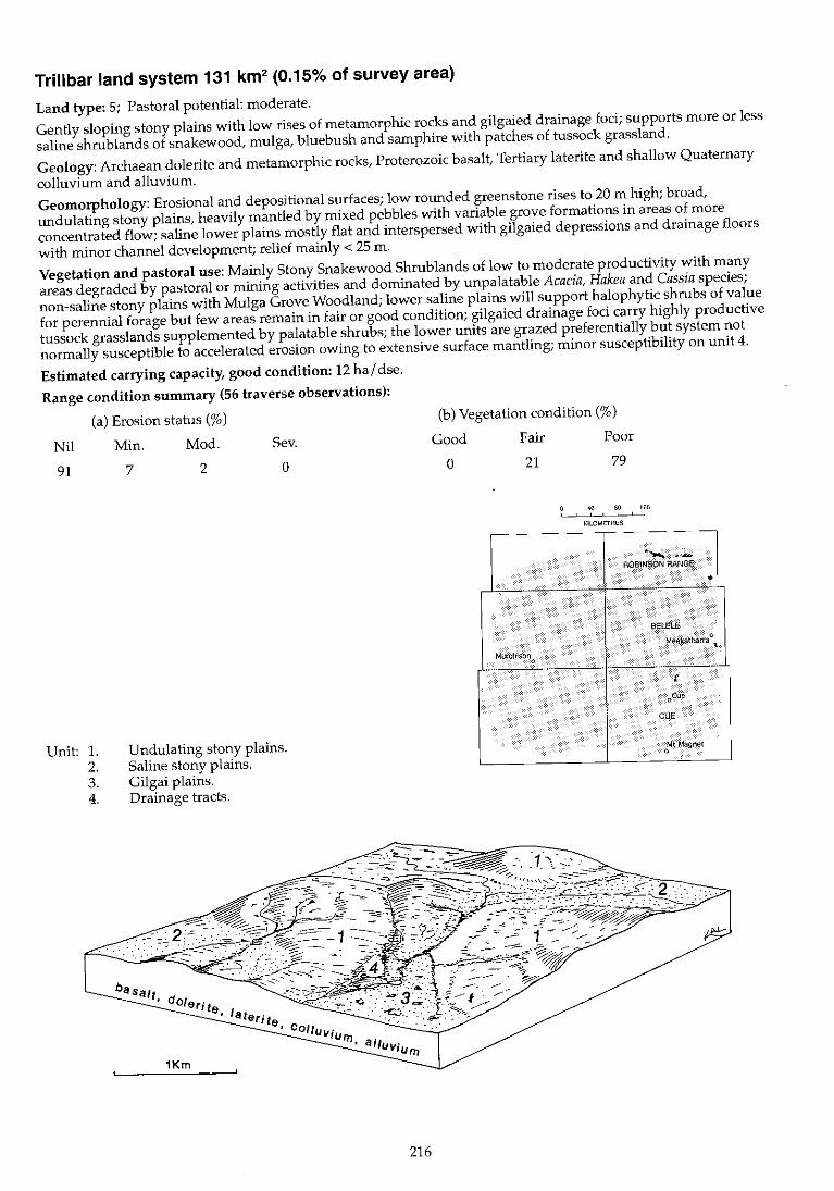
Trillbar land system 131 km2 (0.15% of survey area)
Land type: 5; Pastoral potential: moderate.
Gently sloping stony plains with low rises of metamorphic rocks and gilgaied drainage foci; supports more or less
saline shrub lands of snakewood, mulga, bluebush and samphire with patches of tussock grassland.
Geology: Archaean dolerite and metamorphic rocks, Proterozoic basalt, Tertiary laterite and shallow Quaternary
colluvium and alluvium.
Geomorphology: Erosional and depositional surfaces; low rounded greenstone rises to 20 m high; broad,
undulating stony plains, heavily mantled by mixed pebbles with variable grove formations in areas of more
concentrated flow; saline lower plains mostly flat and interspersed with gilgaied depressions and drainage floors
with minor channel development; relief mainly < 25 m.
Vegetation and pastoral use: Mainly Stony Snakewood Shrublands of low to moderate productivity with many
areas degraded by pastoral or mining activities and dominated by unpalatable Acacia, Hakea and Cassia species;
non-saline stony plains with Mulga Grove Woodland; lower saline plains will support halophytic shrubs of value
for perennial forage but few areas remain in fair or good condition; gilgaied drainage foci carry highly productive
tussock grasslands supplemented by palatable shrubs; the lower units are grazed preferentially but system not
normally susceptible to accelerated erosion owing to extensive surface mantling; minor susceptibility on unit 4.
Estimated carrying capacity, good condition: 12 hal dse.
Range condition summary (56 traverse observations):
(a) Erosion status (%)
Nil Min. Mod. Sev.
91
Unit: 1. 2. 3. 4.
7 2
Undulating stony plains. Saline stony plains. Gilgai plains. Drainage tracts.
o
216
(b) Vegetation condition (%)
Good Fair Poor
o 21 79
40 80 120 , KILOMETRES
,-- - --,- - --
-- .,-ROBINSON RANGE
•
BELELE
MMkatharraO,
Murct!ison , f
oCue
CUE
oMt Magnet
IV ~
"
Trillbar f.s.
Landform and soils
Unit 1: Undulating stony plains (55%)
Gently undulating (slopes < 3%) stony plains with rises and low greenstone ridges to 20 m; often weakly to moderately saline 'In
lower, flatter parts of unit; covered with moderately dense to dense quartz or ironstone mantles. Lower plains show irregular grove formations receiving concentrated flow. Soils are duplexes or red earths, sandy loams or sandy clay loams over clay loams or light to medium clays < 1 m deep overlying granite or metamorphic parent material; pH 5.5-8.0 with variable trends. Principal profile forms; Dr2.13, Gn2.11, UmS.31.
Unit2: Saline stony plains (25%)
Gently sloping « 1%) saline stony plains in lower parts of system adjacent to units 5 and 6; usually strewn with a moderately dense to dense quartz mantle. Soils are duplex red sandy loams over light clays or deep red earths> 1 m deep overlying weathering metamorphic rocks; pH 8.0-8.5 with an alkaline reaction trend. Principal profile forms: Or2.13, Gc2.22.
Unit 3: Gilgai plains (15%)
Restricted plains with gilgaied depressions, occurring as drainage foci up to 1 km wide with channelled drainage lines and swamp floors; gilgai relief to 1 m; floors of depressions often strewn with very light quartz or ironstone mantles; plains carry denser quartz mantles. Soils are red or brown light to medium cracking clays, > 1 m deep; pH 6.5-8.0 with an alkaline reaction trend. Principal profile form: Ug6.31.
Vegetation: formations and major species
a) Plains and slopes: Very scattered to scattered (PFC < 20%) tall shrublands dominated by Acacia cuspidifo/ia or A. xiphophylJa. Trees (2-8 m): A. aneura, A. cuspidifoJia. Tall shrubs (2-4 m): A. cuspidifolia, A. victoriae, A. xiphophylla, A. tetragonophylla, Hakea preissii. Mid shrubs (1-2 m): A. cuspidifoJia, A. tetragonophylla, A. victoriae, Cassia deso/ata. Low shrubs « 1 m): C. deso/ata, C. hamers/eyensis, Enchy/aena tomentosa, Scaevo/a spinescens. b) Mulga groves: Scattered to moderately close (PFC 10-30%) woodlands dominated by Acacia aneura, A. craspedocarpa, Eremophila fraseri or E. freelingii. Trees (to 6 m): A. pruinocarpa, A. aneura, A. cuspidifolia, A. kempeana, A. victoriae, A. tetragonophylla, A. craspedocarpa. Mid shrubs (1-2 m): E. fraseri, E. freeling;;, E. forrestii. Low shrubs « 1 m): E. freeling;;, E. compacta, E. macu/ata, E. forrestii, Scaevo/a spinescens, So/anum lasiophyllum, Ptilotus obovatus, P. roei, Sida ca/yxhymenia. Perennial grass: Eragrostis eriopoda.
Very scattered to scattered (PFC < 20%) shrublands dominated by Ha/osarcia sp. and Acacia xiphophyl/a. Trees (to 6 m): A. aneura. Tall shrubs (2-6 m): A. aneura, A. cuspidifolia, A. sclerosperma, A. victoriae, A. xiphophylla, Hakea arida. Mid shrubs (1-2 m): Ha/osarcia sp., Frankenia sp., Cassia deso/ata, C. chate/ainiana, Enchylaena tomentosa, Eremophila treelingii, Maireana melanocoma, M. planifolia, M. pyramidata, M. triptera, Ptilotus obovatus, Scaevola spinescens, Solanum lasiophylJum, Rhagodia eremaea.
Tussock grassland with Eragrostis setifolia, E. sp., Eriachne f1accida and Eremophila maculata. Trees (to 12 m): Acacia aneura, Grevillea striata, Hakea suberea, Piftosporum phylliraeoides. Tall shrubs (> 2 m): A. victoriae, A. farnesiana, E. longifolia, E. /aanii, H. preiss;;. Mid shrubs (1-2 m): Chenopodium nitrariaceum, C. auricomum, Ptilotus /azaridis, Eleocharis pal/ens, Pimelea ho/royd;;, Marselia drummond;;, Enchylaena tomentosa, Solanum lasiophyllum, Eremoph;/a maculata, Rhagodia eremaea. Perennial grasses (locally dense): Eragrostis setifo/ia, E. sp., Eriachne bentham;;, E. f1accida.
Comments and condition indicators
4 inventory sites, 1 condition site and traversed
Vegetation type: a) Stony Snakewood Shrubland. Palatable perennials include: Enchylaena tomentosa, Cassia hamersleyens;s, Scaevola spinescens. Vegetation condition %: VG/G 0, F 23, PNP 77. Erosion incidence %: min 4, mod 4. 26 obs. b) Mulga Grove Woodland. Palatable perennials include: Eremophila compacta, E. forrestii, E. maculata, Pti/otus spp., Sida calyxhymenia, Eragrostis eriopoda. Increaser species include: Acacia cuspidifoJia, A. victoriae, C. deso/ata, H. preissii. Pastoral use limitations: Susceptible to increases in cover by unpalatable species.
2 inventory sites, 3 condition sites and traversed
Vegetation type: Stony Snakewood Shrubland or Samphire Shrubland. Palatable perennials include: Cassia chatelainiana, Enchylaena tomentosa, Maireana spp., Pti/otus obovatus, Scaevola spinescens, Rhagod;a eremaea. Increaser species include: Acacia cusp;difolia, A. victoriae, Cassia deso/ata, Hakea arida, H. preiss;;. Pastoral use limitations: None under controlled grazing. Vegetation condition %: VG/G 0, F 11, PNP 89. Erosion incidence %: min 6. 18 obs.
4 inventory sites and traversed
Vegetation type: Alluvial Tussock Grassland. Palatable perennials include: Eragrostis setifolia, Eriachne spp., Ptilotus lazaridis, Chenopodium spp., Eremophila maculata, Enchylaena tomentosa, Rhagodia eremaea. Pastoral use limitations: Subject to seasonal inundation and preferential grazing.
~~.
'" >-' 00
Trillbar I.s.--continued
Landform and soils
Unit 4: Drainage tracts (5%)
Disorganised narrow drainage tracts; upper parts with dendritic
channels < 20 m wide; grading into broader, less distinct slow
drainage zones on unit 3; occasional larger channels also
occur. Soils are probably deep clays.
Vegetation: formations and major species
Very scattered to scattered (PFC < 20%) mixed shrublands. Tall
shrubs (> 2 m): Acacia vlctoriae, A. tetragonophyJla., A. aneura,
Hakea arida. Mid and low shrubs « 2 m): Eremophila
compacta, Scaevola spinescens, Rhagodia eremaea, Lepldium
platypetalum, Solanum lasiophyllum.
Comments and condition indicators
1 condition site and traversed
Vegetation type: Stony Snakewood Shrubland.
Palatable perennials include; Eremophila compacta, Lepfdium
platypetaJum, Rhagodia eremaea.
Pastoral use limitations: None with controlled grazing.
Violet land system (W) 1078 km2 (1.26% of survey area)
Land type: 7; Pastoral potential: moderate.
Gently undulating gravelly plains on greenstone, laterite and hardpan, with low stony rises and minor saline plains; supports mulga and bowgada-dominated shn'blands, with dense mulga groves and patchy halophytic shrublands.
Geology: Archaean greenstone, Upper Proterozoic basalt, Tertiary laterite and veneers of Quaternary alluvium and colluvium.
Geomorphology: Erosional surfaces; remnants of old plateau as gravelly sand plains above gently undulating outcrops of laterite and weathered greenstones; broad, lower stony plains on greenstone or red-brown hardpan, often densely mantled by pebbles of mixed lithology and with sluggish, occasionally channelled, drainage floors; relief mostly < 10 m.
Vegetation and pastoral use: Mainly Stony Mulga Mixed Shrubland and Lateritic Acacia Shrub land with Mulga Grove Woodland communities in drainage foci and Bluebush and Samphire Shrub lands on saline drainage floors; moderately productive when in fair to good condition. Groves and washes carry isolated dense Grove Woodland, the fringes of which tend to be preferentially grazed and prone to degradation; lower saline stony plains carry sparse halophytes; unit 6 is moderately susceptible and unit 2 slightly susceptible to accelerated erosion if vegetation is degraded or soil surface disturbed.
Estimated carrying capacity, good condition: 12 hal dse.
Range condition summary (260 traverse observations):
(a) Erosion status (%)
Nil Min. Mod. Sev.
92 6 2 0
Unit: 1. 2. 3. 4. 5. 6.
Low lateritic rises. Sandy surfaced gravelly plains. Stony plains. Mulga groves. Saline stony plains. Drainage tracts.
220
(b) Vegetation condition (%)
Good Fair Poor
25 43 32
40 80 120
KILOMETRES -- - ---- - --
RO~lNSON RANGE
,
BELELE ..... .1 .' Met~atl>a1ra 0 .,
Murchison g .( 0 - ,
r 'Of"'. .:) I JI .,r ... CU)~'
MURGOO , c':~ r < if . r-'-l~~
',Mt Magnet ('0'-:,
•
r ~
tv tv >-'
Violet 1.5.
Landform and soils
Unit 1: Low lateritic rises (10%)
Gently sloping « 1%) lateritic interfluves and stripped rises up to 1 km wide with crests up to 4 m high; strewn with moderately dense to dense ironstone gravel; also areas of exposed parent material on crests. Soils are dark red gravelly loamy sands < 30 cm deep overlying ironstone gravels; pH 5.5 with an acidic trend. Principal profile form: Uc1.43.
Unit 2: Sandy surfaced gravelly plains (20%)
Gently undulating plains with slopes to 2% and relief to 3 m; characterised by sandy soils with moderately dense mantles of lateritic gravels. Soils are dark red gravelly clayey sands or fine sandy loams < 1 m deep with abundant laterite and ironstone inclusions throughout the profile; over granite, laterite or greenstone; pH 5.5-6.5 with an acidic to neutral trend. Principal profile forms: Uc5.21, Uc1.43, Um5.51.
Unit 3: Stony plains (50%)
Very gently undulating plains with slopes < 1 % and relief to 5 m; usually strewn with moderately dense ironstone or quartz mantles. Soils are shallow red earths, clay loams or fine sandy loams to 40 cm mainly overlying greenstone or hardpan; pH 5.0-6.0 with an acidic or neutral reaction trend. Principal profile forms: Uc1.43, Um5.51.
Unit 4: Mulga groves (5%)
Elliptical or linear grove formations up to 500 m long and 100 m wide generally transverse to direction of sheet flow; commonly occurring as slight depressions in areas of broad, ill-defined drainage (unit 6) and also on unit 3. Soils are red earths, reddish brown sandy clay loams or fine sandy loams > 1 m deep with ironstone fractions throughout the profile; pH 5.0-7.0 with neutral or acidic reaction trend. Principal profile form: Urn5.52.
Vegetation: formations and major species
Scattered (PFC 10-20%) mixed or tall shrublands with Acacia aneura and A. aft. quadrimarginea the dominant species. Trees and tall shrubs (2-4 m): A. aneura, A. aft. quadrimarginea, Thryptomene sp., Eremophila latrobei, E. forrestii, E. finearis. Low shrubs « 1 m): E. compacta, E. latrobei, Ptilotus schwartzii, P. obovatus, Solanum Jasiophyl/um, Sida calyxhymenia, Rhagodia eremaea.
Moderately close (PFC 20-30%) tall shrublands dominated by Acacia aneura or A. ramulosa. Trees (to 8 m): A. aneura, A. pruinocarpa. Tall shrubs (> 2 m): Canthium Jatifolium, C. lineare, A. aneura, A. ramulosa, A. quadrimarginea, A. tetragonophylJa, A. aft. coolgardiensis. Mid shrubs (1-2 m): A. aneura, A. ramulosa, Eremophila forrestii, E. compacta, C. chatelainiana, C. nemophilq, Maireana convexa, M. thesioides, M. tomentosa, M. aft. planifolia, M. vilfosa, M. aft. vil/osa, M. georgei, Ptilotus obovatus, P. schwartzii, Sida caJyxhymenia, S. sp., Solanum lasiophyllum, Rhagodia eremaea. Perennial grasses: Eragrostis eriopoda, E. lanipes, Monachather paradoxa, ThyridoJepis multiculmis.
Very scattered to scattered (PFC < 20%) mixed shrublands dominated by Acacia aneura, Eremophila linearis or E. aft. compacta. Trees (to 6 m): A. pruinocarpa, A. aneura. Tall shrubs (> 2 m): A. victoriae, A. craspedocarpa, A. tetragonophyJla, A. cuthbertsonii, E. linearis, E. latrobei. Mid shrubs (1-2 m): Cassia sturtii, E. forrestii, E. fraseri. Low shrubs « 1 m): E. Jinearis, E. aft. compacta, E. spathulata, Ptilotus obovatus, P. rotundifolius, P. roei, P. schwartzii, Solanum lasiophyJlum, Rhagodia eremaea, Maireana melanocoma, M. ,;Ianifolia. Perennial grass: Monachather paradoxa.
Close to closed (PFC > 30%) low woodland dominated by Acacia aneura or A. pruinocarpa. Trees (to 8 m): A. aneura, A. pruinocarpa, Hakea suberea. Tall shrubs (> 2 m): A. aneura, A. tetragonophylfa, Canthium latifolium, C. lineare. Mid shrubs (1-2 m): Eremophila georgei, E. gilesH, E. forrestH, Rhagodia eremaea, Sida calyxhymenia, S. platycaJyx, Ptilotus obovatus, Maireana convexa, M. aft. tomentosa, M planifolia, Solanum lasiophyl/um, Lycium australe. Perennial grasses: Monachather paradoxa, Eriachne helmsii.
Comments and condition indicators
2 inventory sites, 2 condition sites and traversed
Vegetation type: Stony Mulga Mixed Shrubland. Palatable perennials include: Eremophila forrestii, E. latrobei, E. compacta, Ptilotus spp., Sida calyxhymenia, Rhagodia eremaea. Pastoral use limitations: None with controlled grazing.
4 inventory sites, 2 condition sites and traversed
Vegetation type: Lateritic Acacia Shrubland. Palatable perennials include: Eremophila forrestii, E. latrobei, E. compacta, Cassia chatelainiana, Maireana spp., Ptilotus spp., Sida spp., Rhagodia eremaea, Eragrostis spp., Monachather paradoxa, Thyridolepis multiculmis. Pastoral use limitations: None with controlled grazing. Vegetation condition %: VG/G 36, F 37, PNP 27. 41 obs.
3 inventory sites, 19 condition sites and traversed
Vegetation type: Stony Mulga Mixed Shrubland. Palatable perennials include: Eremophila latrobei, E. aft. compacta, Ptilotus spp., Maireana spp., Rhagodia eremaea. Pastoral use limitations: None with controlled grazing; not normally susceptible to accelerated erosion under pastoral use. Vegetation condition %: VG/G 22, F 43, PNP 35. Erosion incidence %: min 5, mod 1. 148 obs.
4 inventory sites and traversed
Vegetation type: Mulga Grove Woodland. Palatable perennials include: Eremophila forrestii, E. latrobei, Rhagodia eremaea, Sida spp., Ptilotus obovatus, Maireana spp., Monachather paradoxa. Pastoral use limitations: None with controlled grazing.
1
~
Violet I.s.-Gontinued
Landform and soils
UnitS: Saline stony plains (10%)
Lower saline stony plains with grades < 1%; often occurring on margins of system below low breakaways or greenstone hills; generally with moderately dense quartz or ironstone mantles. Soils are duplexes, deep red fine sandy loams over light to medium clays < 50 em deep; pH 7.5-9.5 with an alkaline trend. Principal profile form: Dr2.13.
Unit 6: Drainage tracts (5%)
Channelled or unchannelled zones to 500 m wide though usually < 300 m; channels are narrow and braided < 1 m deep; often draining onto broader zones with no channelling. Soils are alluvial sands, silts and loams with little profile development < 1 m deep on hardpan; pH 6.5-7.0 with a neutral reaction trend.
Vegetation: formations and major species
Very scattered (PFC < 10%) low shrublands dominated by Maireana spp. Tall or mid shrubs (> 1 m, infrequent): Acacia aneura, A. victoriae. Low shrubs « 1 m): M. aft. tomentosa, M. triptera, M. georgei, M. pyramidata, Halosarcia sp., Frankenia spp., Dissocarpus paradoxa. Perennial grass: Eragrostis die/sii.
Moderately close (PFC 20-30%) tall shrub lands dominated by Acacia aneur8. Trees (to 8 m): A. aneura, A. pruinocarpa. Tall shrubs (> 2 m): A. aneura, A. ramuJosa, A. sc/erosperma, A. tetragonophylla, Canthium Jatifolium, Santa/um spicatum. Mid shrubs (1-2 m): A. aneura, Eremophila fraseri, E. punicea, E. georgei. Low shrubs « 1 m): Pl/Jotus obovatus, Scaevo/a spinescens, Sida calyxhymenia, Solanum /asiophyllum, Rhagodia eremaea, Maireana convexa, M. georgei, M. triptera, M. villosa, Cassia chatelainiana. Perennial grass: Cymbopogon sp.
Comments and condition indicators
1 inventory site and traversed
Vegetation type: Bluebush Shrubland or Samphire Shrubland. Palatable perennials include: Maireana spp., Eragrostis diefsii, Frankenia spp., Lepidium pJatypetalum. Pastoral use limitations: None with controlled grazing.
1 inventory site and traversed
Vegetation type: Creekline Shrubland. Palatable perennials include: Ptilotus obovatus, Rhagodia eremaea, Sida ca/yxhymenia, Maireana spp., Cassia chatelainiana, Cymbopogon sp. Pastoral use limitations: Moderately susceptible to erosion where degraded.
1 ~
Waguin land system (W) 748 km2 (0.87% of survey area)
Land type: 7; Pastoral potential: low.
Sandplains and stripped granite or laterite surfaces with low fringing breakaways and lower plains; supports bowgada shrublands with sparse wanderrie grasses, r.:Iulga shrublands and minor mixed halophytes.
Geology: Massive Archaean granite, Tertiary laterite and aeolian sand; also minor Quaternary colluvium and alluvium.
Geomorphology: Depositional and erosional surfaces; residual sandplains on lateritic plateaux, locally fringed with low breakaways, above gently inclined and locally saline plains variably strewn with lateritic or granite mantles; lower plains carrying sheet flow and with some vegetation groving; narrow drainage floors with occasional channels; over relief to 20 m.
Vegetation and pastoral use: Mainly Lateritic Acacia Shrubland and Granitic Mulga Shrubland; palatable forage is provided principally by annual species and sparse perennial shrubs and herbs. Minor occurrences of Sandplain Wanderrie Grass Shrubland and Stony Snakewood or Mixed Halophytic Shrublands provide moderate value perennial forage when in good condition; pockets of chenopod shrubs occur along drainage tracts; unit 3 is moderately susceptible to accelerated erosion.
Estimated carrying capacity, good condition: 20 ha I dse.
Range condition summary (102 traverse observations):
(a) Erosion status (%) (b) Vegetation condition (%)
Nil Min. Mod. Sev. Good
92
Unit: l. 2.
3. 4. 5. 6.
8 o o
Sand plains. Stripped surfaces, plateaux remnants and low breakaways. Footslopes below breakaways. Stony plains with sandy soils over granite. Alluvial plains. Drainage floors.
1
Ite, aeOlian :~ :::. = ~'- \..~~:-,;.,. sand, .
1Km
224
22
Fair Poor
46 32
40 80 120
KILOMETRES
----------
BYRD
"\0.' MurChlSO~. ~ "
.
. - "..~ " " * ' ; ,~
• -MURGOO
"- . . . ~.$1'" 'o:t/t<\. -".'
.,; ,4. ~ ~~ !l:~~
l~<
.
BELELE
t M~ek~th<IITa (>. ,
CUE
.--5
~
Waguin I.s.
Landform and soils
Unit 1: Sand plains (20%)
Gently sloping remnant tracts of sand up to 2 km in extent and elevated several metres above surrounding plains, sometimes with sparse mantle of ironstone gravel. Soils are dark red earthy sands overlying weathered granite < 1 m deep; pH 6.5 with a neutral trend. Principal profile form: UcS.21.
Unit2: Stripped surfaces, plateaux remnants and low breakaways (40%)
Gently sloping stripped lateritic surface~, plateaux remnants and low breakaways (up to 20 m high) of ferricrete, silcrete and weathered granite and with mantles of laterite, granite and quartz. Soils are very shallow skeletallithosols or occasional pockets of brown duplexes overlying granite or laterite, < 50 em deep: pH 6.0 with an acidic trend. Principal profile forms: Uc1.43. Db1.S1.
Unit 3: Footslopes below breakaways (10%)
Mostly short footslopes extending 100-500 m below breakaways and outcrops of deeply weathered rocks, slopes around 1 %, . lightly to moderately mantled by mixed pebbles and gravels and some pallid zone deposits locally. Soils are red duplex or shallow gradational red earth types, sandy loams over sandy clay loams or sandy clays, < 50 em deep over granite, pH 6.0 with a neutral reaction trend. Principal profile forms: Dr1.51, Gn2.11.
Unit 4: Stony plains with sandy soils over granite (10%)
Erosional plains with mantles and frequent outcrops of granite and quartz; slopes 0.3-1%. Soils are probably shallow, earthy or granitic siliceous sands over granite.
Vegetation: formations and major species
Moderately close (PFC 20-30%) tall shrublands dominated by Acacia ramulosa or Thryptomene decussata. Trees and tall shrubs (> 2 my: A. aneura, A. ramulosa, T. decussata, Eremophila forrestii, E. granitica. Low shrubs « 1 my: T. decussata. Hemigenia sp., E. forrestii, Solanum lasiophyllum. ,Perennial grasses: Eragrostis eriopoda, Eriachne helmsii, Monachather paradoxa, Thyridolepis multiculmis.
Scattered (PFC 10-20%) tall shrublands dominated by Acacia ramulosa. Tall shrubs (> 2 m): A. aneura, A. burkittii, A. ramulosa, Cal/itris heuglii. Mid shrubs (1-2 m): A. aff. ramulosa, A. exocarpoides, Eremophila exilifolia, E. georgei, E. forrestii, E. latrobei, E. oldfieldii, Thryptomene racemulosa. Low shrubs « 1 m): Calytrix sp., E. forrestii, Ptilotus schwartzii, P. obovatus, Borya nitida, Rhagodia eremaea, R. sp., Maireana vil/osa, M. thesioides, Sida calyxhymenia, S. sp., Solanum lasiophyllum, Verticordia sp., Eriostemon brucei.
Very scattered to scattered (PFC < 20%) low shrublands dominated by mixed halophytic shrubs or mixed shrublands dominated by Acacia xiphophylla or A. aneura. Tall shrubs (2-4 m): A. xiphophylla, A. aneura, A. grasbyi, Eremophila oldfieldii. Mid shrubs (1-2 m): Cassia nemophila, C. phyJlodinea, C. sturtii, A. tetragonophylla. Low shrubs « 1 m): Maireana glomerifo/ia, M. thesioides, M. triptera, M. georgei, Ptilotus beardii, Frankenia spp., P. obovatus, Solanum lasiophyllum.
Very scattered to scattered (PFC < 20%) mixed shrubland. Tall and mid shrubs (> 1 m): Acacia aneura, A. burkittii, A. ramulosa, Eremophila latrobei, E. glutinosa, E. strongylophylla, Thryptomene racemulosa. Low shrubs « 1 m): Ptilotus obovatus, P. schwartzii, T. racemulosa, Maireana vil/osa, Rhagodia drummondii, Mirbelia spinosa, Hemigenia sp., Sida calyxhymenia, Solanum lasiophyllum, Borya nitida.
Comments and condition indicators
1 inventory site, 2 condition sites and traversed
Vegetation type: Sandplain Wanderrie Grassy Shrubland. Palatable perennials inClude: Eremophila forrestii, Eragrostis spp., Monachather paradoxa, Thyridolepis multiculmis. Pastoral use limitations: None with controlled grazing. Vegetation condition~%: VG/G 53, F 40, PNP 7. 15 obs.
3 inventory sites, 2 condition sites and traversed
Vegetation type: Lateritic Acacia Shrubland. Palatable perennials include: Eremophila forrestii, E. latrobei, Ptilolus spp., Rhagodia spp., Sida spp., Maireana spp. Pastoral use limitations: None with controlled grazing. Vegetation condition %: VG/G 16, F 56, PNP 28. 57 obs.
1 inventory site and traversed
Vegetation type: Bluebush or Mixed Halophyte Shrublands. Palatable perennials include: Maireana spp., Ptilotus spp., Enchylaena tomentosa, Rhagodia spp. Pastoral use limitations: Moderately susceptible to accelerated erosion where degraded.
2 condition sites and traversed
Vegetation type: Granitic Mulga Shrubland. Palatable perennials include: Ptilotus spp., Eremophila latrobei, Rhagodia drummondii, Sida calyxhymenia, Maireana spp. Pastoral use limitations: None with controlled grazing.
'""1
~
Waguin I.s.-continued
Landform and soils
Unit 5: Alluvial plains (15%)
Depositional wash plains and fans receiving sheet flow from higher units 2, 3 and 4. May have transverse groves of vegetation. Soils are dark red loamy sands over hardpan at variable depth. Principle profile form: Uc5.21.
Unit 6: Drainage floors (5%)
Narrow (up to 100 m wide) floors with shallow channels. Soils are probably sandy clay loams over hardpan.
Vegetation: formations and major species
Mainly very scattered (PFC < 10%) tall and mixed shrublands dominated by Acacia ramulosa and A. aneura, with close to closed (PFC > 30%) tall shrublands of similar composition in groves. Tall and mid shrubs (> 1 m): A. ramulosa, A. aneura, A. craspedocarpa, A. daviesioides, Eremophila georgei, Ptilotus obovatus, Solanum lasiophyllum. Low shrubs: « 1 m) Maireana convexa, M. vil/osa, Eremophila latrobei, Rhagodia eremaea, Sida spp.
As for unit 5.
Comments and condition indicators
1 inventory site and traversed
Vegetation type: Hardpan Mulga Shrubland and Mulga Grove Woodland. Palatable perennials include: Ptilotus spp., Maireana convexa, M. villosa, Eremophila latrobei, Rhagodia eremaea, Sida spp. Pastoral use limitations: None under controlled grazing.
Vegetation type: Hardpan Mulga Shrubland. Palatable perennials include: As for unit 5.
Traversed
Pastoral use limitations: Mildly susceptible to accelerated erosion if vegetation degraded.
."'1
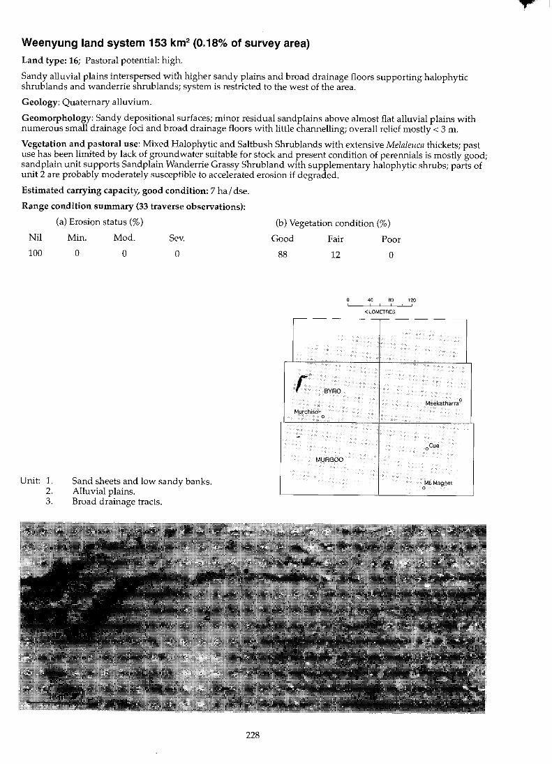
Weenyung land system 153 km2 (0.18% of survey area)
Land type: 16; Pastoral potential: high.
Sandy alluvial plains interspersed with higher sandy plains and broad drainage floors supporting halophytic shrublands and wanderrie shrub lands; system is restricted to the west of the area.
Geology: Quaternary alluvium.
Geomorphology: Sandy depositional surfaces; minor residual sand plains above almost flat alluvial plains with numerous small drainage foci and broad drainage floors with little channelling; overall relief mostly < 3 m.
Vegetation and pastoral use: Mixed Halophytic and Saltbush Shrub lands with extensive Melaleuca thickets; past use has been limited by lack of groundwater suitable for stock and present condition of perennials is mostly good; sandplain unit supports Sandplain Wanderrie Grassy Shrub land with supplementary halophytic shrubs; parts of unit 2 are probably moderately susceptible to accelerated erosion if degraded.
Estimated carrying capacity, good condition: 7 hal dse.
Range condition summary (33 traverse observations):
(a) Erosion status (%)
Nil Min. Mod. Sev.
100
Unit: 1. 2. 3.
o o o
Sand sheets and low sandy banks. Alluvial plains. Broad drainage tracts.
228
(b) Vegetation condition (%)
Good Fair Poor
88 12 o
40 80 120 , KILOMETRES
-- - --r-- - --
r BYRO
Meekatharra 0
Murchison 0
. oCue
MURGOO
Mt Magnet 0

N
~
Weenyung 1.5.
Landform and soils
Unit 1: Sand sheets and low sandy banks (20%)
Flat tracts of red sand, up to 1 m above surrounding plains; occasional linear or elliptical low dunes or banks flanking plains and drainage foci. Soils are dark red earthy and siliceous sands > 1 m deep; pH 5.5-6.0 with an acidic trend. Principal profile forms: UcS.21, Uc1.23.
Unit 2: Alluvial plains (70%)
Broad tracts of almost flat saline alluvial plains subject to flooding interspersed with numerous bare claypans and densely vegetated swamps, usually < 100 m in diameter. Soils are yellowish-red or reddish duplexes, clayey sands over light to medium clays> 1 m deep; pH 7.0 with an alkaline trend. Principal profile form: Dr1.53.
Unit3: Broad drainage tracts (10%)
Drainage tracts to 1.5 km wide, carrying mainly internally drained flows. Soils are red duplexes or red clays> 1 m deep; pH 7.0 with a neutral trend.
Vegetation: formations and major species
Moderately close (PFC 20-30%) tall shrublands dominated by Acacia ramulosa. Trees (to 8 m): A. aneura, A pruinocarpa, Eucalyptus coolabah. Tall shrubs (> 2 m): A ramulosa, A tetragonophylla, Grevillea stenobotrya. Mid shrubs (1-2 m): Eremophila forrestii, E. latrobei, Cassia sturtii, Pimelea microcephela. Low shrubs « 1 m): Ptilotus obovatus, Maireana planifolia, Rhagodia eremaea, Sida sp., Scaevola spinescens, Solanum lasiophyllum. Perennial grass: Monachather paradoxa.
Scattered to moderately close (PFC 10-30%) low or mid shrublands dominated by Cratystylis subspinescens, Atriplex bunburyana, Maireana platycarpa or M. pyramidata. Tall shrubs (> 2 m): Melaleuca uncinata, Acacia tetragonophylla, A victoriae, Hakea preissii. Mid shrubs (1-2 m): Eremophila pterocarpa, Cassia desolata, C. phyllodinea, C. sturtii, Cratystylis subspinescens, Lycium australe. Low shrubs « 1 m): AtripJex bunburyana, A amnicola, A vesicaria, Chenopodium gaudichaudianum, Cratystylis subspinescens, Enchylaena tomentosa, Frankenia sp., Lycium australe, Maireana atkinsiana, M. integra, M. platycarpa, M. pyramidata, M. tomentosa, Ptilotus beardii, P. obovatus, Scaevola spinescens. Perennial grass: Eragrostis setifolia.
Close (PFC 30-50%) tall or mixed height shrubland dominated by Melaleuca uncinata. Tall and mid shrubs (> 1 m): M. uncinata, M. glomerata, Acacia sp., Lycium australe, Scaevola spinescens. Low shrubs « 1 m): Cratystylis subspinescens, L. australe, Cassia chatelainiana, Eremophila maculata, Frankenia sp., Ptilotus divaricatus.
Comments and condition indicators
1 inventory site and traversed
Vegetation type: Sandplain Wanderrie Grassy Shrubland. Palatable perennials include: Ptilotus obovatus, Eremophila forrestii, E. latrobei, Maireana planifolia, Rhagodia eremaea, Sida sp., Scaevola spinescens, Monachather paradoxa. Pastoral use limitations: None with controlled grazing.
1 inventory site, 4 condition sites and traversed
Vegetation type: Saltbush or Bluebush Shrubland. Palatable perennials include: Atriplex spp., Cratystylis subspinescens, Chenopodium gaudichaudianum, Enchylaena tomentosa, Maireana spp., Ptilotus spp., Scaevola spinescens, Eragrostis setifolia. Pastoral use limitations: Probably moderate susceptibility to accelerated erosion. Vegetation condition %: VG/G 81, F 19, PNP O. 16 obs.
1 inventory site and traversed
Vegetation type: Mixed Halophyte Shrubland. Palatable perennials include: Cratystylis subspinescens, Eremophila maculata, Cassia chatelainiana, Scaevola spinescens, Ptilotus divaricatus. Pastoral use limitations: None with controlled grazing.
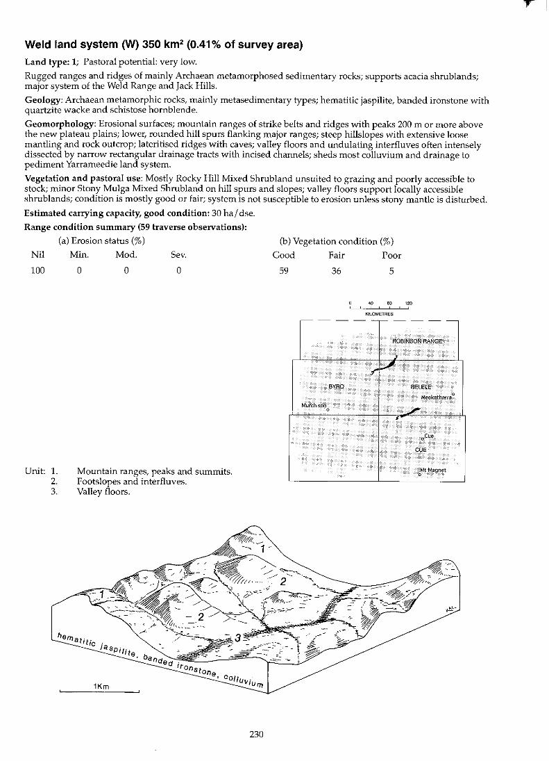
Weld land system (W) 350 km2 (0.41% of survey area)
Land type: 1; Pastoral potential: very low.
Rugged ranges and ridges of mainly Archaean metamorphosed sedimentary rocks; supports acacia shrub lands; major system of the Weld Range and Jack Hills.
Geology: Archaean metamorphic rocks, mainly metasedimentary types; hematitic jaspilite, banded ironstone with quartzite wacke and schistose hornblende.
Geomorphology: Erosional surfaces; mountain ranges of strike belts and ridges with peaks 200 m or more above the new plateau plains; lower, rounded hill spurs flanking major ranges; steep hillslopes with extensive loose mantling and rock outcrop; lateritised ridges with caves; valley floors and undulating interfluves often intensely dissected by narrow rectangular drainage tracts with incised channels; sheds most colluvium and drainage to pediment Yarrameedie land system.
Vegetation and pastoral use: Mostly Rocky Hill Mixed Shrubland unsuited to grazing and poorly accessible to stock; minor Stony Mulga Mixed Shrubland on hill spurs and slopes; valley floors support locally accessible shrublands; condition is mostly good or fair; system is not susceptible to erosion unless stony mantle is disturbed.
Estimated carrying capacity, good condition: 30 hal dse.
Range condition summary (59 traverse observations):
(a) Erosion status (%)
Nil
100
Unit: 1. 2. 3.
Min.
o Mod.
o Sev.
o
Mountain ranges, peaks and summits. Footslopes and interfluves. Valley floors.
230
(b) Vegetation condition (%)
Good
59
Fair
36
-- -
BYRO
Murchison 0
Poor
5
40 80 120 , KILOMETRES
--,---- - --
ROBINSON RANGE
;
.~ V SELElE-
Meekatharra 0
./ •
oCue
CUE
Mt Magnet 0
r!

8l ~
Weld 1.5.
Unit 1:
Landform and soils
Mountain ranges, peaks and summits (50%)
Rugged ironstone and jaspilite ranges occurring as parallel strike ridges to 200 m high (occasional summits to 400 m) and up to 2 km wide with slopes to 25%, aligned approximately NE-SW; extensive outcropping of ironstone and jaspilite and dense mantles of stones and cobbles on slopes. Soils are mostly skeletallithosols confined to pockets of dark red loamy or clayey sands with infrequent clay subsoils < 50 em deep, overlying metamorphic parent material; pH 5.5-7.5 with a neutral to acid'ie trend. Principal profile forms: Dr2.52, Uc1.43, UrnS.51.
Unit 2: Footslopes and interfluves (40%)
Broad conc"ave inclines extending to 1.5 km long; slopes in upper parts to 10% grading to 3% or less downslope; also minor interfluvial slopes between parallel drainage lines up to 1 km wide with pronounced convex crests or rises several metres high; generally covered with dense quartz or ironstone mantles. Soils are reddish-brown or dark red shallow red earths < 50 cm deep with varying metamorphic rock fragments; pH 5.5-6.0 with an acidic trend. Principal profile forms: Ucl.43, Um5.51.
Unit 3: Valley floors (10%)
Valley floors between ridges, up to 500 m wide and often extending for 10 km or more along strike valleys, dendritic creek patterns in upper parts, creek channels incised into bedrock. Soils are red earthy sands overlying various metamorphic substrates < 50 cm deep; pH 6.0-6.5 with an acidic trend. Principal profile form: Uc5.21.
Vegetation: formations and major species
Scattered (PFC 10-20%) tall shrublands dominated by Acacia aft. citrinoviridis or A. aneura. Trees (2-4 m): A. aneura, A. aft. citrinoviridis, A. pruinocarpa. Tall shrubs (> 2 m): A. aneura, A. aft. citrinoviridis, A. grasbyi, A. quadrimarginea, A. ramulosa, A. cuthbertsonii, Canthium lineare. Mid shrubs (1-2 m): A. aft. citrinoviridis, A. aneura, A. ramulosa, Thryptomene sp., T. decussata, Eremophila georgei, E. glutinosa, E. latrobei, E. linearis, Dodonaea viscosa. Low shrubs « 1 m): Ptilotus obovatus, P. schwartzii, P. rotundifolius, Corchorus sp., Tribulus platypterus, Solanum ashbyi, S. lasiophyllum, S. sp., Sarojusticia kempeana, Mirbe/ia spinosa, M. sp., Stylidium sp., Heliotropium aft. ovalfo/ium, Cheilanthes lasiophylla, C. austrotenuifolia, Spyridium sp. (MRS 174). Perennial grasses: Amphipogon strictus, Cymbopogon sp., Eriachne mucronata, E. helmsH, Eragrostis eriopoda, Triodia sp.
Very scattered to scattered (PFC < 20%) mixed shrubJands dominated by Acacia ramulosa or Ptilotus rotundifolius. Trees (2-4 m): A. aneura. Tall shrubs (> 2 m): A. aneura, A. aft. citrinoviridis, A. grasbyi, A. ramulosa, A linophyfla, A. quadrimarginea, A. tetragonophylla. Mid shrubs (1-2 m): Eremophila freelingii, E. macmillaniana, E. cuneifofia. Low shrubs « 1 m): P. rotundffolius, P. obovatus, P. schwartzii, Halgania gustafsenii, Cassia sturtii, Maireana georgei. Perennial grasses: Eriachne mucronata, Eragrostis lanipes, Cymbopogon ambiguus, Monachather paradoxa.
Scattered (PFC 10-20%) tall shrublands dominated by Acacia ramulosa on sandy floors or A. grasbyi on creek margins. Trees (2-4 m): A aneura, A. cuthbertson;;, A. cyperophyffa, A. pruinocarpa, Canthium lineare. Tall shrubs (> 2 m): Alinophylla, A. tetragonophylla. Mid shrubs (1-2 m): A ramulosa, A tetragonophylla. Low shrubs « 1 m): Ptilotus obovatus, Sida filiformis, Halgania gustafsenii, Hibiscus sturtii. Perennial grasses: Eragrostis lanipes, Eriachne mucronata, Monachather paradoxa.
--_._ ... _------,....,
Comments and condition indicators
4 inventory sites and traversed
Vegetation type: Rocky Hill Mixed Shrub land. Palatable perennials include: Eremophila latrobef, Tribulus platypterus, Ptilotus spp., Sida sp., Eragrostis eriopoda, Eriachne mucronata. Pastoral use limitations: Steep upper slopes and crests are mostly inaccessible to domestic stock.
2 inventory sites and traversed
Vegetation type: Stony Mulga Mixed Shrub land. Palatable perennials include: Ptilotus spp., Maireana georgei, Eriachne mucronata, Eragrostfs lanipes, Monachather paradoxa. Pastoral use limitations: None with controlled grazing. Vegetation condition %: VGJG 50, F 40, PNP 10. 30 obs.
1 inventory site and traversed
Vegetation type: Creekline Shrubland. Palatable perennials include: PtilotU5 obovatus, Sida filiformis, Eragrostis lanipes, Eriachne mucronata, Monachather paradoxa. Pastoral use limitations: None with controlled grazing. Vegetation condition %: VGJ G 76, F 24, PNP O. 25 obs.
Wiluna land system (W) 1294 km2 (1.51% of survey area)
Land type: 2; Pastoral potential: moderate.
Low greenstone hills with occasional lateritic breakaways and broad stony slopes, lower saline stony plains and broad drainage tracts; supports sparse mulga shrublands with patches of halophytic shrubs.
Geology: Archaean amphibolite, basalt and schistose rocks with Tertiary laterite capping; Quaternary colluvium on slopes and Quaternary alluvium on lowlands.
Geomorphology: Predominantly erosional surfaces; residuallateritised plateaux with stripped surfaces and eroding breakaways, generally 10 to 30 m high above steep footslopes with schists or quartz outcropping; rounded hills of basalt or jaspilite with occasional linear strike ridges and spurs; rounded lower footslopes dissected by narrow valleys and alluvial fans; broad stony plains, some saline, mantled by ironstone, quartz and greenstone fragments; drainage floors with more or less groved vegetation and minor channels; overall reli.ef mainly 20 to 40 m, locally higher. . J
Vegetation and pastoral use: Mainly Mulga Chenopod Shrubland, Granitic Mulga Shrubland and Stony Mulga Mixed Shrubland with some Mulga Grove Woodland. When in good condition, a variety of palatable low shrubs and perennial herbs provide durable reserves but have often been reduced by overgrazing; alluvial fans and partly saline drainage floors carry preferentially grazed Bluebush or Mulga Chenopod Shrubland, but have mainly been more or less degraded: units 4, 6 and 7 are mildly to moderately susceptible to accelerated erosion when degraded; the system shows extensive disturbance and localised erosion as a result of mining activities.
Estimated carrying capacity, good condition: 12 hal dse.
Range condition summary (253 traverse observations):
(a) Erosion status (%)
Nil Min. Mod. Sev.
96 3 1 0
Unit: 1. 2. 3. 4. 5. 6. 7.
Lateritic plateaux and breakaways. Low hills, spurs and strike ridges. Stony footslopes. Sandy surfaced gravelly plains. Stony plains and interfluves. Alluvial fans and plains. Drainage floors.
232
(b) Vegetation condition (%)
Good Fair Poor
25 35 40
40 eo 120
KILOMETRES
,--- - -------
ROB!NSON RANGE
.. . .. .
• • ..,;.. ~ .... ~ElELE _ ~ {
Murchison Mflekatharra :It~
0 " . , .• " ,,).i,~ >
" cfU;,j MUAGOO 'j"i
,~ , . ~tMagnet
,
r
~
Wiluna I.s.
Landform and soils
Unit 1: Lateritic plateaux and breakaways (5%)
Weathered plateau remnants with indurated surfaces and breakaway faces elevated up to 30 m above surrounding plains; plateau slopes and crests with laterite mantle and outcrop. Soils are mostly skeletal Iithosol confined to shallow pockets of acidic sands.
Unit 2: Low hills, spurs and strike ridges (25%)
Rounded laterite or greenstone hills and spurs to 25 m high with variable slopes to 5%, occasional narrow « 100 m wide) linear strike ridges of jaspilite up to 5 km long with dense laterite and quartz mantles. Soils are dark red gravelly loamy sands or brown earthy sands < 50 cm deep overlying weathered metamorphic parent material; pH 5.5-6.5 with a neutral to acidic trend. Principal profile forms: Uc1,43, Uc5.21.
Unit 3: Stony footslopes (20%)
Broad concave footslopes with upper slopes to 10% decreasing to 1% downslope; mantled with dense ironstone, quartz or basalt pebbles and with occasional greenstone or quartz outcrops; total unit relief to 25 m. Soils are shallow red earths or hard-setting duplexes < 50 cm deep on weathered basalt or greenstone; pH 6.5-8.0 with a neutral trend. Principal profile forms: Uc1.43, Um5.51, Dr2.52.
Unit 4: Sandy surfaced gravelly plains (5%)
Gently undulating plains and slopes lower than units 1 and 2; slopes < 2% and covered with gravelly ironstone mantles. Soils are dark red gravelly fine sandy loams or earthy sands < 50 cm deep with laterite and ironstone throughout; pH 5.5-7.0 with a neutral trend. Principal profile forms: Uc5.21, Um5.51.
Vegetation: formations and major species
Scattered (PFC 10-20%) tall shrublands with Acacia aneura and Eremophila spp. Tall and mid shrubs (> 1 m): A. aneura, A. burkittii, E. forrestii, E. georgei, E. latrobei, Thryptomene decussata, Dodonaea viscosa. Low shrubs « 1 m): E. forrestii, Sida calyxhymenia, S. cardiophylla, Hemigenia sp., Micromyrtus sulpherea, Ptilotus schwartzii.
Scattered to moderately close (PFC 10-30%) tall or mixed height shrublands dominated by Eremophila macmillaniana and Acacia aneura. Tall shrubs (> 2 m): A. aneura, A. ramulosa, Santa/um spicatum. Mid and low shrubs « 2 m): E. forrestii, E. latrobei, E. compacta, E. macmilfaniana, Ptilotus rotundifo!ius, P. schwartz;;, Olearia humilis, Cassia helmsii, Solanum lasiophyllum. Perennial grass: Eragrostis eriopoda.
Scattered to moderately close (PFC 10-30%) taU or mixed height shrublands dominated by Acacia aneura, A. sp. (MRS 372) or A. microcalyx. Trees (to 10 m): A. aneura, A. pruinocarpa. Tall shrubs (to 6 m): A. aneura, A. sp. (MRS 372). A. grasbyi, A. tetragonophylla, A. quadrimarginea, A. burkittii, Hakea preiss;i, Canthium Iineare. Mid shrubs (1-2 m): A. aneura, A. microcalyx, A. tetragonophylla, Cassia sturiii, C. nemophila, C. desolata, C. phylfodinea, Eremophila latrobei, E. Iinearis, E. forrestii, E. macmil/aniana. Low shrubs « 1 m); E. compacta, C. nemophila, Maireana triptera, M. vil/osa, M. thesioides, M. georgei, M. convexa, M. melanocoma, M. planifolia, Ptilotus obovatus, P. schwartzii, Sida calyxhymenia, S. sp., Enchylaena tomentosa, Rhagodia eremaea, R. drummondii, Solanum lasiophyllum, S. orbiculatum.
Scattered (PFC 10-20%) mixed Acacia shrublands. Tall shrubs « 2 m); A. aneura, A. aff. quadrimarginea, A. tetragonophylla, A. ramulosa, A. grasbyi. Mid shrubs (1-2 m):A. grasbyi, A. craspedocarpa, Cassia sturiii, Eremophila fraseri, E. freelingii. Low shrubs « 1 m): E. freelingii, E. macmillaniana, C. helmsii, C. nemophila, PtilolUS obovatus, P. schwartzii, Maireana thesioides, M. vil/osa, Solanum lasiophyllum. Perennial grasses: Monachather paradoxa, Thyridolepis multiculmis, Eragrostis eriopoda.
Comments and condition indicators
1 inventory site and traversed
Vegetation type: Rocky Hill Mixed Shrubland. Palatable perennials include: Eremophila forrestii, E. latrobei, Sida spp., Ptilotus schwartzii. Pastoral use limitations: Poorly accessible to stock.
2 inventory sites and traversed
Vegetation type: Rocky Hill Mixed Shrubland. Palatable perennials include: Eremophila forrest;;, E. compacta, E. latrobei, Ptilotus spp., Eragrostis eriopoda. Pastoral use limitations: None with controlled grazing.
4 inventory sites, 6 condition sites and traversed
Vegetation type: Mulga Chenopod Shrubland. Palatable perennials include: Eremophila compacta, E. forrestii, Maireana spp., Sida spp., Enchylaena tomentosa, Rhagodia spp., Ptilotus spp. Pastoral use limitations: None with controlled grazing. Vegetation condition %: VG/G 27, F 44, PNP 29. 51 obs.
1 inventory site, 2 condition sites and traversed
Vegetation type: Lateritic Acacia Shrubland. Palatable perennials include; Ptilotus spp., Maireana thesioides, Eremophila latrobei, E. compacta, Monachather paradoxa. Pastoral use limitations; Mildly susceptible to accelerated erosion.
N W
"'"
Wiluna I.s.-continued
Landform and soils
Unit 5: Stony plains and interfluves (35%)
Lower plains; mostly flat grading to areas with minor interfluves or undulations sloping to 2% marginal to units 6 and 7; soils are hardpan loams or shallow red earths < 50 em deep over hardpan or metamorphic parent material; pH 5.0-6.0 with an acidic to neutral trend. Principal profile forms: Um5.31, UrnS.51.
Unit 6: Alluvial fans and plains (2%)
Gently sloping and slightly saline alluvial fans generally < 2 km in extent with slopes < 1 %; often degraded with extensive rilling, scalding and hummocking of sandy soits. Soils are probably duplex types with sandy surfaces with moderate quartz mantle < 1 m deep.
Unit 7: Drainage floors (8%)
Narrow drainage floors from higher units grading into tracts up to 300 m wide with shallow channels incised in sandy alluvium; occasional lateral grove formations occur downslope. Soils are alluvial dark red fine sandy loams to 1 m deep over greenstone parent material; pH 7.0 with a neutral trend. Principal profile form: Uc1.43.
Vegetation: formations and major species
Scattered (PFC 10-20%) tall shrublands dominated by Acacia aneura or A. grasbyi. Trees (to 8 m): A. aneura, A. pruinocarpa. Tall shrubs (> 2 m): A. aneura, A. grasbyi, A. tetragonophylla, A. victoriae, Eremophila fraseri, E. spathulata, E. forrestii, E. glutinosa, Spartothamneffa teucriiflora. Low shrubs « 1 m): E. spathulata, E. compacta, C. helmsii, Ptilotus obovatus, P. roeH, P. rotundifolius, P. schwartzii, Maireana triptera, M. thesioides, M. convexa, M. melanocoma, M. lanosa, M. georgei, Rhagodia eremaea, Sida calyxhymenia, Solanum lasiophyffum. Perennial grass (rare): Eragrostis eriopoda.
Very scattered (PFC < 10%) low or mixed shrublands. Tall and mid shrubs (> 1 m): Acacia aneura, A. victoriae, Eremophila aff. margarethae, E. fraseri. Low shrubs « 1 m): Maireana triptera, M. tomentosa, M. pyramidata.
Moderately close (PFC 20-30%) woodlands or tall shrub lands dominated by Acacia aneura or A. victoriae. Trees (to 8 m): A. aneura. Tall shrubs (> 2 m): A. aneura, A. tetragonophylJa, A. sclerosperma, A. victoriae, Eremophila longifolia, Hakea preissii. Mid shrubs (1-2 m): Cassia sturtii, E. aff.latrobei, E. forrestii, E. fraseri, E. macmillaniana, Spartothamnella teucriiflora. Low shrubs « 1 m): Rhagodia eremaea, Solanum lasiophyllum, Enchylaena tomentosa, Scaevola spinescens, Ptilotus obovatus, E. compacta, Maireana pyramidata, Dissocarpus paradoxa, Sida calyxhymenia, S. sp., Abutilon sp., C. chatelainiana. Perennial grasses: Themeda australis, Eragrostis xerophila, E. setifolia.
Comments and condition indicators
4 inventory sites, 7 condition sites and traversed
Vegetation type: Mulga Chenopod Shrubland or Stony Mulga Mixed Shrubland. Generally low in production potential but with good reserves of palatable perennials when in good condition. Palatable perennials include: Eremophila compacta, E. forrestii, Ptilotus spp., Maireana spp., Rhagodia eremaea, AMp/ex bunburyana. Pastoral use limitations: Not normally susceptible to accelerated erosion. Vegetation condition %: VG/G 22, F 33, PNP 45. Erosion incidence %: min 2.124 obs.
1 inventory site and traversed
Vegetation type: Bluebush Shrubland. Palatable perennials include: Maireana spp Pastoral use limitations: Moderately susceptible to accelerated erosion where degraded.
2 inventory sites and traversed
Vegetation type: Mulga Grove Woodland or Creekline Grassy Shrubland. Palatable perennials include: Eremophila forrestii, E. aff. latrobei, E. compacta, Spartothamneffa teucriiflora, Rhagodia eremaea, Enchylaena tomentosa, Scaevola spinescens, Ptilotus obovatus, Maireana pyramidata, Sida spp., Abutilon spp., Cassia chatelainiana, Eragrostis spp. Pastoral use limitations: Mild susceptibility to accelerated erosion where degraded. Vegetation condition %: VG/G 10, F 35, PNP 55. Erosion incidence %: nil 25, mod 10. 20 obs.
1
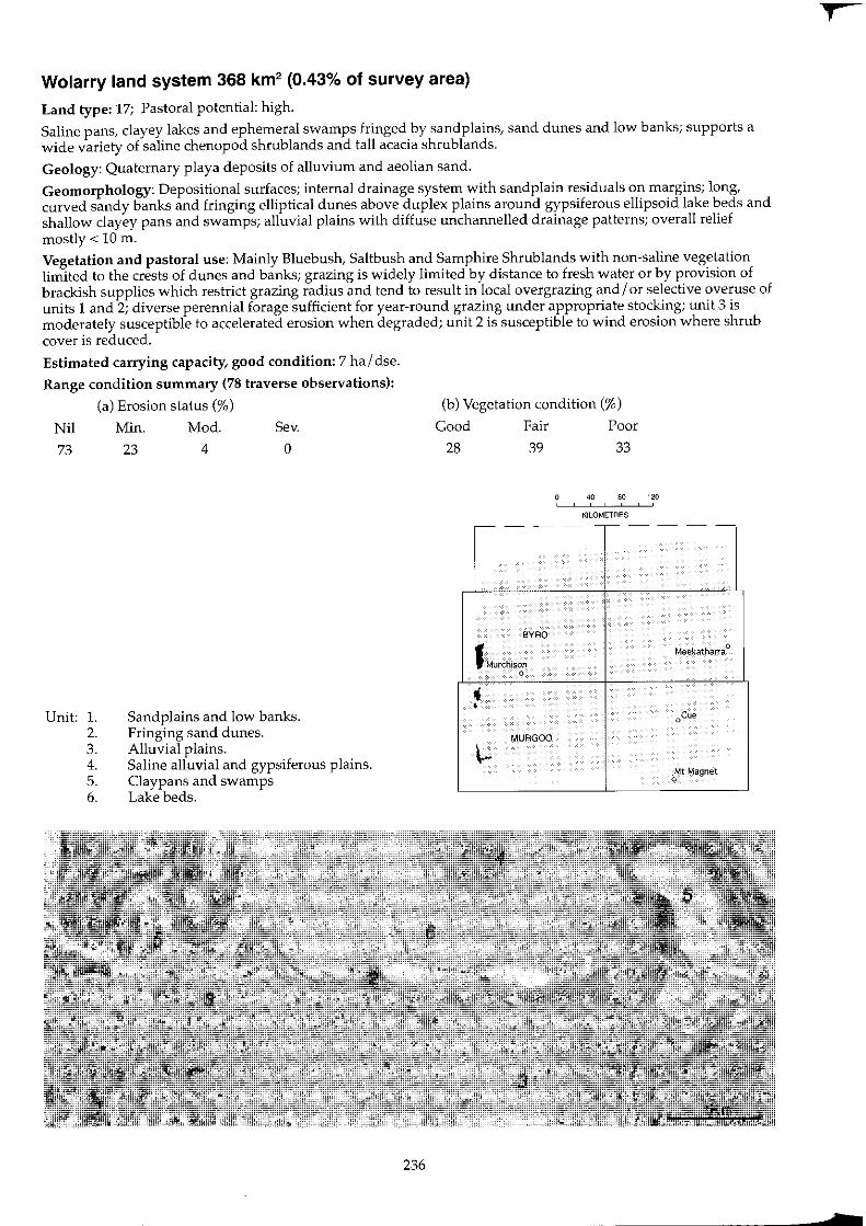
Wolarry land system 368 km2 (0.43% of survey area)
Land type: 17; Pastoral potential: high.
Saline pans, clayey lakes and ephemeral swamps fringed by sandplains, sand dunes and low banks; supports a wide variety of saline chenopod shrublands and tall acacia shrub lands.
Geology: Quaternary playa deposits of alluvium and aeolian sand.
Geomorphology: Depositional surfaces; internal drainage system with sand plain residuals on margins; long, curved sandy banks and fringing elliptical dunes above duplex plains around gypsiferous ellipsoid lake beds and shallow clayey pans and swamps; alluvial plains with diffuse unchannelled drainage patterns; overall relief mostly < 10 m.
Vegetation and pastoral use: Mainly Bluebush, Saltbush and Samphire Shrub lands with non-saline vegetation limited to the crests of dunes and banks; grazing is widely limited by distance to fresh water or by provision of brackish supplies which restrict grazing radius and tend to result in local overgrazing and/ or selective overuse of units 1 and 2; diverse perennial forage sufficient for year-round grazing under appropriate stocking; unit 3 is moderately susceptible to accelerated erosion when degraded; unit 2 is susceptible to wind erosion where shrub cover is reduced.
Estimated carrying capacity, good condition: 7 ha / dse.
Range condition summary (78 traverse observations):
(a) Erosion status (%)
Nil Min. Mod. Sev.
73 23 4 0
Unit: 1. 2. 3. 4. 5. 6.
Sandplains and low banks. Fringing sand dunes. Alluvial plains. Saline alluvial and gypsiferous plains. Claypans and swamps Lake beds.
236
(b) Vegetation condition (%)
Good Fair Poor
28 39 33
40 80 120 , , ,
KILOMETRES ,--- - --,-----
BYRO
1 Murchison Meekatharra
0
0 , •
0'"'
MURGOO
\-Mt Magnet
0
•
r , m
tv
'" "
Wolarry I.s.
Landform and soils
Unit 1: Sand plains and low banks (15%)
Areas of undulating remnant sandplain mainly towards margins of system or surrounding unit 2; often with small sandy banks to 1 m high. Soils are probably deep, red uniform earthy sands.
Unit 2: Fringing sand dunes (15%)
Elliptical and reticulate dunes to 4 m high fringing saline plains and lakes (units 4,5 and 6); saline in places, steep slopes often with areas of redistribution on slopes with windward aspects. Soils are red or yellowish red uniform siliceous sands or earthy sands> 1 m deep. Principal profile forms: Uc1.23, Uc5.21, downslope tending duplex, with clayey subsoils.
Unit 3: Alluvial plains (45%)
Plains above and surrounding brackish ephemeral lakes and claypans with relief to 5 m and slopes usually < 1 % often interspersed and interrupted by disintegrated drainage tracts and foci as in units 5 and 6; otten moderately saline in lower parts, tending less so upslope. Soils are duplex types, reddish-brown loamy sands over red sandy loams or red clayey sands over light clays < 1 m deep mainly over red-brown hardpan; pH 6.5-7.0 with neutral or alkaline reaction trends. Principal profile forms: Dr2., Orl.56.
Unit 4: Saline alluvial and gypsiferous plains (10%)
Strongly saline plains surrounding saline lakebeds; also minor expanses of low gypseous dunes; slope is generally negligible; total unit relief is < 2 m. Soils are red earthy sands or yellowish red light clays over light medium clays with some duplex types < 1 m deep; pH 9.0 with a strongly alkaline trend. Principal profile forms: Uc6., Uf6.21 , Dr2.
Vegetation: formations and major species
Scattered to moderately close (PFC 10-30%) tall shrub lands dominated by Acacia ramu/osa, A. sc/erosperma or A. tetragonophylla. Also scattered (PFC 10-20%) mixed shrublands dominated by Maireana pyramidata. Tall shrubs (> 2 m): A. ramu/osa, A. tetragonophylla, A. sc/erosperma, A. grasbyi, Hakea preissii. Mid shrubs (1-2 m): Eremophila forresti;, Hibiscus sp., M. pyramidata. Low shrubs (> 1 m): M. pyramidata, Cassia phyllodinea, Chenopodium gaudichaudianum, Ptilotus obovatus, Rhagodia eremaea, Solanum /asiophyllum, S. orbiculatum. Perennial grasses: Eriachne he/msii, Monachather paradoxa.
Moderately close (PFC 30-50%) tall shrublands dominated by Acacia sc/erosperma or Scaevo/a spinescens. Tall shrubs (> 2 m): A. sc/erosperma, A. ramu/osa, A. tetragonophylla. Mid shrubs (1-2 m): S. spinescens, Sty/obasium spathu/atum, Eremophila forrest;;, Cassia desolata, Me/a/euca uncinata. Low shrubs « 1 m): Ptilotus obovatus, P. divaricatus, Chenopodium gaudichaudianum, Maireana integra, M. /anosa, M. villosa, Rhagodia eremaea, Enchy/aena tomentosa, Scaevo/a tomentosa, Cassia chatelainiana, Solanum lasiophyllum, S. orbiculatum. Perennial grass: Eriachne helms;;.
Scattered to moderately close (PFC 10-30%) low shrublands dominated by Atrip/ex spp. and Maireana spp. with overstorey Acacia xiphophy/la on higher areas. Tall shrubs (> 2 m): A xiphophylla, A. tetragonophylfa Eremophila panton;;, Hakea preissii, H. arida, Me/aleuca uncinata. Mid shrubs (1-2 m): E. pterocarpa, E. p/atyca/yx, Cassia phyllodinea. Low shrubs « 1 m): Atrip/ex bunburyana, A. vesicaria, Chenopodium gaudichaudianum, Cassia phyllodinea, Enchylaena tomentosa, Maireana atkinsiana, M. integra, M. georgei, M. po/ypterygia, M. p/atycarpa, M. pyramidata, M. tomentosa, Ptilotus beardii, P. obovatus, Rhagodia eremaea, Scaevo/a spinescens.
Scattered to moderately close (PFC 10-30%) low shrublands dominated by Atrip/ex sp. or Halosarcia sp .. with sparse Acacia sc/erosperma on kopi outcrops. Tall and mid shrubs (> 1 m): A. sc/erosperma, A. tetragonophylla, Eremophila young;;. Low shrubs « 1 m): Atriplex amnico/a, A. sp., Frankenia magnifica, Halosarcia halocnemoides, H. indica, Lawrencia squamata, Lycium austra/e, Solanum /asiophyllum.
Comments and condition indicators
2 condition sites and traversed
Vegetation type: Sandplain Wanderrie Grassy Shrubland or Bluebush Shrubland. Palatable perennials include: Monachather paradoxa, Eremophila forrestii, Maireana pyramidata, Chenopodium gaudichaudianum, Pti/olus obovatus, Rhagodia eremaea. Pastoral use limitations: None with controlled grazing.
2 inventory sites and tmversed
Vegetation type: Sand Dune Shrubland. Palatable perennials include: Enchylaena tomentosa, Cassia chatelainiana, Chenopodium gaudichaudianum, Maireana spp., Scaevo/a tomentosa, Ptilotus spp. Pastoral use limitations: Susceptible to wind erosion where shrub cover is reduced. Vegetation condition %: VG/G 7, F 33, PNP 60. Erosion incidence %: min 30.15 obs.
2 inventory sites, 4 condition sites and traversed
Vegetation type: Bluebush or Saltbush Shrubland. Palatable perennials include: Atriplex spp., Chenopodium gaudichaudianum, Enchylaena tomentosa, Maireana spp., Ptilotus spp., Rhagodia eremaea, Scaevola spinescens. Increaser species include: Eremophila pterocarpa, Hakea arida, H. preissii. Pastoral use limitations: Mildly susceptible to accelerated erosion and increases in unpalatable shrubs where degraded. Vegetation condition %: VG/G 45, F 38, PNP 17. Erosion incidence %: min 25, mod 4. 240bs.
2 inventory sites, 1 condition site and traversed
Vegetation type: Saltbush or Samphire Shrubland. Palatable perennials include: Atriplex spp., Lycium austra/e. Pastoral use limitations: High salinity levels of dominant perennial species in lower parts associated with seasonal waterlogging reduces grazing potential.
ti 00
Wolarry I.s.--continued
Landform and soils
Unit 5: Claypans and swamps (5%)
Mainly circular drainage foci < 300 m in diameter. Soils are brown light clays over medium clays up to 1 m deep; pH 9.0 with an alkaline trend.
Unit 6: Lakebeds (10%)
Elliptical to circular lakebeds up to 4 km long and 2 km wide; salinity is variable with some larger terminal lakes strongly saline and others with some through flow less so. Soils are brown light clays over medium clays or yellowish red light clays < 1 m deep; pH 9.0 with a strongly alkaline trend. Principal profile form: Uf6.12.
Vegetation: formations and major species
Moderately close to close (PFC 20-50%) tall shrublands or low woodlands with Eucalyptus coo/abah, dense fringes of Melaleuca uncinata and Muehlenbeckia cunninghamii. Trees and tall shrubs (> 2 m): Eucalyptus coolabah, M. uncinata, M. glomerata, Hakea preissii, Muehlenbeckla cunninghamii. Mid and low shrubs « 2 m): Atriplex amnicola, M. cunninghamii.
(a) Moderately close (PFC 20-30%) low shrublands dominated by Atriplex amnicola with Halosarcia spp., and Muehlenbeckia cunninghamii.
(b) Scattered (PFC 10-20%) woodland with Eucalyptus coolabah, Melaleuca glomerata, M. uncinata, Atriplex amnicola and Scaevola spinescens on areas of broad sluggish drainage.
(c) Saline lakebeds often bare of perennial vegetation except for fringing communities of Halosarcia spp. or Atrip/ex spp.
Comments and condition indicators
1 inventory site and traversed
Vegetation type: Saltbush Shrubland. Palatable perennials include: Atrip/ex amnicola. Pastoral use limitations: None with controlled grazing.
2 inventory sites and traversed
Vegetation type: Samphire Shrubland, Saltbush Shrubland or unvegetated. Palatable perennials include: Atriplex amnicola, Scaevola spinescens. Pastoral use limitations: Seasonal inundation limits access some years; otherwise high salinity levels in pasture perennials necessitates stock having access to good quality water supplies.
1
Wongong land system 317 km2 (0.37% of survey area)
Land type: 8; Pastoral potential: high.
Almost flat saline stony plains on Permian rocks, with minor alluvial plains and sluggish drainage tracts supporting mostly chenopod shrub lands with scattered acacias; in the far west of the area.
Geology: Early Permian siltstones, sandstones and shales of the Lyons formation (Sakmarian series) with Quaternary colluvium and alluvium.
Geomorphology: Erosional surfaces formed by weathering of the Permian plateau; remnant sandplain tracts with low disorganised banks; broad stony plains and occasional low rises with sparse outcrops of parent rock; lower alluvial plains with duplex soils, adjacent to unchannelled tracts carrying through drainage; overall relief mostly < 8 m.
Vegetation and pastoral use: Mainly sparse Bluebush, Stony Snakewood and Mixed Halophytic Shrublands which respond with annual herbage in good seasons and in good condition provide sufficient perennial forage shrubs to sustain grazing throughout the year, but has been widely overused and degraded; units 2 and 3 are mildly susceptible to accelerated erosion when degraded.
Estimated carrying capacity, good condition: 7 ha I dse.
Range condition summary (62 traverse observations):
(a) Erosion status (%)
Nil Min. Mod. Sev.
77
Unit: 1. 2. 3. 4.
18 5
Scattered sandy banks. Undulating stony plains. Alluvial plains. Drainage tracts.
o
240
(b) Vegetation condition (%)
Good Fair Poor
13 32 55
40 80 120 . KILOMETRES
-- - ---- - --
.. , ~, BYRQ
Meekatharra ,
:J'o. oMurchison
oCue
Mt Magnet ,
~ ~
Wongong I.s.
Landform and soils
Unit 1: Scattered sandy banks (5%)
Sandy banks usually < 1 km long and < 300 m wide; generally elevated up to 2 m above surrounding low-lying plains. Soils are probably red uniform earthy sands.
Unit 2: Undulating stony plains (70%)
Extensive tracts of very gently undulating, slightly saline plains with occasional low stony rises up to 5 m; slopes usually < 1%; lightly to moderately strewn with quartz, ironstone or mixed pebbles. Soils are dark red duplex types, loamy sands over light clays < 1 m deep overlying Permian sedimentary rocks; pH 7.5 with neutral or alkaline reaction trend. Principal profile form: Dr2.13.
Unit 3: Alluvial plains (20%)
Alluvial plains occurring as shallow swales between sandy banks or as broad plains subject to sheet flow and draining onto unit 4; slopes are minimal, usually < 0.5% with relief to 1-2 m. Soils are dark red crusted duplex types, clayey sands over yellowish red light clays to > 1 m deep; pH 7.5 with an alkaline trend. Principal profile form: Or1.23.
Unit 4: Drainage tracts(5%)
Sluggish drainage tracts to 300 m wide similar to unit 3 but with narrow anastomosing channels with shallow incision. Soils probably duplex types similar to those of unit 3.
Vegetation: formations and major species
Scattered to moderately close (PFC 10-30%) tall shrublands dominated by Acacia ramu/osa. Tall and mid shrubs (> 1 m): A. ramu/osa, A. murrayana, Ca/ytrix muricata, Eremophila forrestii, Thryptomene sp., Pityrodia paniculata. Low shrubs « 1 m): P. panicu/ata, Pime/ea microcephela, Rhagodia eremaea, So/anum orbiculatum. Perennial grasses: Monachather paradoxa, Eragrostis lanipes.
Very scattered to scattered (PFC < 20%) tall or mixed height shrublands with Acacia xiphophylla and a prominent low shrub layer dominated by Maireana spp., Frankenia spp., or Ptilotus spp. Trees and tall shrubs (> 2 m): A. xiphophylla, Acacia aneura, A. cuspidifolia, A. grasbyi, A. tetragonophylla, A. victoriae, Eremophila pterocarpa, E. p/atycalyx, E. freelingii, Cassia desolata. Low shrubs « 1 m): Maireana atkinsiana, M. integra, M. georgei, M. glomerifolia, M. platycarpa, M. pyramidata, M. triptera, Atrip/ex bunburyana, E. treelingti; Frankenia magnifica, F. pauciflora, F. setosa, Cassia phyllodinea, Enchylaena tomentosa, Ptilotus beardii, P. obovatus, P. polakii, Rhagodia eremaea.
Very scattered to scattered (PFC < 20%) low shrublands dominated by Maireana platycarpa or M. pyramidata with very sparse tall shrubs. Tall shrubs (> 2 m): Acacia cuspidifolia, A. sc/erosperma, A. tetragonophylla, A. xiphophyfla, Hakea preissii. Low shrubs « 1 m): Atriplex bunburyana, M. atkinsiana, M. integra, M. glomerifolia, M. planifolia, M. platycarpa, M. pyramidata, M. triptera, Frankenia magnifica, F setosa, Ptilotus beardii, P. obovatus, Rhagodia eremaea, Enchylaena tomentosa, Solanum lasiophyllum.
Scattered low shrublands similar in composition to unit 3.
Comments and condition indicators
Traversed
Vegetation type: Sand plain Wanderrie Grassy Shrubland. Palatable perennials include: Eremophila forrestii, Rhagodia eremaea, Eragrostis lanipes, Monachather paradoxa. Pastoral use limitations: None with controlled grazing.
2 inventory sites, 8 condition sites and traversed
Vegetation type: Stony Snakewood Shrubland, Bluebush Shrubland or Mixed Halophytic Shrubland. Palatable perennials include: Maireana spp., Ptilotus spp., Atrip/ex bunburyana, Enchylaena tomentosa, Rhagodia eremaea. Increaser species include: Hakea preissii, Eremophila pterocarpa. Pastoral use limitations: Areas with more run-on and deeper soils are subject to increases by Hakea preissii and Eremophi/a pterocarpa where degraded; slightly susceptible to accelerated erosion. Vegetation condition %: VG/G 16, F 35, PNP 49. Erosion incidence %: min 14, mod 2. 49 obs.
1 inventory site, 3 condition sites and traversed
Vegetation type: Bluebush Shrub land. Palatable perennials include: Atriplex bunburyana, Maireana spp., Frankenia spp., Pti/otus spp., Rhagodia eremaea, Enchy/aena tomentosa. Pastoral use limitations: Moderately susceptible to accelerated erosion if perennial cover becomes degraded.
Traversed
Vegetation type: Bluebush Shrubland or Mixed Halophytic Shrubland. Palatable perennials include: As for unit 3. Pastoral use limitations: As for unit 3.
-~ .........
Woodline land system 2932 km2 (3.41% of survey area)
Land type: 14; Pastoral potential: low.
Almost flat sandy-surfaced hardpan wash plains supporting tall shrub lands and woodlands dominated by broadleafed mulga; in the south-east of the area.
Geology: Quaternary cemented alluvium with aeolian sand.
Geomorphology: Depositional surfaces; broad wash plains on red-brown hardpan, receiving run-on from higher granite systems and residual old plateau, characterised by stone free surfaces and moderately deep soils and by areas with indistinct groves and intergroves, mostly aligned downslope; sandplain tracts; diffuse more concentrated drainage tracts, mostly unchannelled (rarely with incised channels); relief mostly < 3 m.
Vegetation and pastoral use: Extensive Hardpan Mulga Shrubland with tracts of Mulga Grove Woodland and Sandplain Acacia Shrub land; condition mostly fair although many palatable understorey shrubs and perennial grasses having been lost from wide areas, reducing available forage to larger, less palatable shrubs and annual grass and forb species; more productive drainage tracts often receive preferential grazing pressure and are mildly susceptible to accelerated erosion; formerly subject to extensive timber cutting.
Estimated carrying capacity, good condition: 20 hal dse.
Range condition summary (542 traverse observations):
(a) Erosion status (%)
Nil Min. Mod. Sev.
96
Unit: 1. 2. 3.
3 1
Sand plains. Hard pan plains. Drainage tracts.
o
242
(b) Vegetation condition (%)
Good Fair Poor
23 52 25
40 60 120 , ! ,
KILOMETRES
-----,---- - --
Meekatharra 0
Murchison 0
.~. oGue ..
MURGOQ , -liUE.~ ," ,; ~~~f~ , • ~.... ~t
,
t
N
t3
Woodline 1.5.
Landform and soils
Unit 1: Sand plains (10%)
Slightly elevated plains of red sand, up to 2 km in extent. Soils are dark red earthy sands or clayey sands, mostly full depth (> 1 m); pH 6.0 with an acidic trend. Principal profile form: Uc5.21.
Unit 2: Hardpan plains (80%)
Almost flat, extensive and very uniform wash plains usually 5-10 km wide, subject to sheet flow from old plateaux or granite catchments, interrupted by patchy transverse grove formations, 50-100 m long and up to 30 m wide; flattest areas without graving patterns. Soils are red or dark red hardpan sandy clay loams or deep red earths mainly 40-80 em deep over hardpan; pH 5.5-6.5 with a neutral to acidic reaction trend. Principal profile form: Um5.31.
Unit 3: Drainage tracts (10%)
Diffuse unchannelled flat suriaced drainage tracts up to 1 km wide, but mainly 50-200 m, carrying concentrated sheet flow after heavy rains; slopes minimal; total relief usually < 1 m except for occasional incised channels up to 2 m; drainage often becomes dispersed for several kilometres and reforms downslope. Soils are red hardpan sandy clay loams or red earths to 1 m deep, with extensive development of cryptogamic crusting; some parts more regularly flooded are deep silty sands; pH 6.0 with a neutral trend. Principal profile form: Um5.31.
Vegetation: formations and major species
Scattered to moderately close (PFC 10-30%) tall shrublands or grasssy shrublands dominated by Acacia aneura or A. ramu/osa. Trees (2-4 m): A aneura, Canthium lineare, Hakea suberea. Tall shrubs (> 2 m): A. ramufosa, A. aneura. Mid shrubs (1-2 m): A. ramu/osa, Eremophila forrestii, E. granitica, E. gilesii, E. georgei, Spaltothamnelfa teucriiflora. Low shrubs « 1 m): E. gilesii, E. forrestii, E. aft. compacta, Ptilotus obovatus, P. schwartzii, Rhagodia eremaea, Mirbelia spinosa, M. convexa, M. villosa, M. aft. vilfosa, M. georgei, M. thesioides, Sida sp. Perennial grasses: Eragrostis eriopoda, Eriachne helmsii, Monachather paradoxa, Triodia sp.
a) Hardpan plains and intergroves; Scattered to moderately close (PFC 10-30%) low mulga woodlands dominated by Acacia aneura or A. craspedocarpa. Trees (to 6 m): A. aneura, A. pruinocarpa. Tall shrubs (> 2 m): A. aneura, A. craspedocarpa, A. tetragonophylla, A. ramulosa, Grevil/ea sp. Mid shrubs (1-2 m): A. craspedocarpa, A. tetragonophylla, Eremophifa forrestii, E. georgei, E. latrobei, E. punicea, Spaltothamneffa teucriiffora. Low shrubs « 1 m): E. punicea, E. forrestii, E. gilesii, Plilotus obovatus, P. schwartzii, Rhagodia eremaea, Maireana vil/osa, M. pyramidata, M. planifolia, M. convexa. Perennial grasses: Eragrostis eriopoda, Monachather paradoxa. b) Groves: Close (PFC 30-50%) woodlands dominated by A. aneura, A. craspedocarpa. Trees (to 8 m): A. aneura, A. pruinocarpa. Tall and mid shrubs (> 1 m): A. craspedocarpa, Eremophila forrestii, E. georgei, Spaltothamnella teucriiflora. Low shrubs « 1 m): E. punicea, Sida calyxhymenia, Maireana vil/osa, M. convexa, Mirbelia spinosa, Plilotus obovatus, Rhagodia eremaea.
Moderately close to close (PFC 30-50%) woodlands dominated by Acacia aneura, A. burkittii, or A. ramulosa. Trees (to 6 m): A. aneura, A. burkittii. Tall shrubs (> 2 m): A. ramulosa, A. tetragonophylfa, A. craspedocarpa. Mid shrubs (1-2 m): Eremophila forrestii, E. clarkei, Chamelaucium micranthum, Cassia nemophila, C. aft. chatelainiana, E. punicea, E. latrobei, E. gilesii. Low shrubs « 1 m): E. punicea, E. clarkei, E. forrestii, Ptilotus obovatus, P. aft. schwartzii, Maireana thesioides, M. vil/osa, Sida cafyxhymenia, S. sp., Solanum lasiophyllum. Perennial grasses: Eragrostis eriopoda, Eriachne helmsii, Monachather paradoxa, Stipa elegantissima.
Comments and condition indicators
1 inventory site, 2 condition sites and traversed
Vegetation type: Sand plain Wanderrie Grassy Shrubland or Sand plain Acacia Shrubland. Palatable perennials include: Eremophila forrestii, E. atf. compacta, Spaltothamnefla teucriiflora, Ptilolus spp., Maireana spp., Sida sp., Rhagodia eremaea, Eragrostis eriopoda, Monachather paradoxa. Pastoral use limitations: None with controlled grazing. Vegetation condition %: VG/G 29, F 58, PNP 13. 38 obs.
5 inventory sites, 42 condition sites and traversed
Vegetation type: Hardpan Mulga Shrubland, minor Mulga Grove Woodland. Palatable perennials include: E. latrobei, Spaltothemnelfa teucriiflora, Ptilotus spp., Maireana spp., Sida calyxhymenia, Rhagodia eremaea, Eremophila forrestii, Eragrostis eriopoda, Monachather paradoxa. Pastoral use limitations: Slight susceptibility to accelerated erosion where degraded or along tracks where they interrupt and concentrate sheet flow; formerly subject to extensive timber cutting. Vegetation condition %: VG/G 22, F 53, PNP 25. Erosion incidence %: min 2, mod 1. 489 obs.
4 inventory sites and traversed
Vegetation type: Hardpan Mulga Shrubland or Creekline Shrub land. Palatable perennials include: Eremophila forrestii, E. latrobei, Cassia aft. chatelainiana, Plilotus spp., Maireana spp., Sida spp., Eragrostis eriopoda, Monachather paradoxa. Pastoral use limitations: None under controlled grazing and not normally susceptible to accelerated erosion.
--1

Woodrarrung land system 371 km2 (0.43% of survey area)
Land type: 1; Pastoral potential: very low.
Rugged sandstone ranges with rocky slopes and boulder strewn valleys and gorges supporting tall acacia shrublands; in the south-west of the area.
Geology: Late Proterozoic sandstone and siltstone of the Coomberarie and Woodrarrung formations, both of the Badgeradda group.
Geomorphology: Erosional surfaces; rugged ranges and lateral spurs with peaks to 100 m; linear ridges, parallel to the divide of the Victoria Sandplain region, extending north-south for 30 km or more; steep-sided scree strewn valleys and gorges with alluvial floors and sharply incised drainage; footslopes with concave aspect, grading from steep upslope to gently inclined sandy plains with sandstone mantle; overall relief mainly 25 to 100 m.
Vegetation and pastoral use: Rocky Hill Mixed Shrubland and minor Sandplain Acacia Shrubland largely unsuited to pastoral production; upper parts inaccessible to domestic stock; lower slopes and alluvial valley floors provide some grazing value although palatable perennials are generally sparse; minor perennial grasses on sandy surfaced slopes; condition is mainly fair or good; probably feral goats have been responsible for much of recent grazing pressure; system not susceptible to accelerated erosion.
Estimated carrying capacity, good condition: 30 ha I dse.
Range condition summary (15 traverse observations):
(a) Erosion status (%)
Nil Min. Mod. Sev.
100
Unit: 1. 2. 3.
o o o
Stony hills and ridges. Valleys and shallow gorges. Footslopes with stony interfluves.
1Km
244
(b) Vegetation condition (%)
Good Fair Poor
40 40 20
40 80 120
KILOMETRES
r-- - ---- - --
GLENBURGH
BYRQ
Meekatharra 0
I~ i oMurchison
~. " ~:
oCue
MURGOO
oMt Magnet
r
N t;;
Woodrarrung I.s.
Landform and soils
Unit 1: Stony hills and ridges (40%)
Rather flat sandstone and siltstone crests and ridges with precipitous scarps to > 100 m high parallel to ridge lines; plateau-like crests dissected by steep truncated valleys or gorges to 30 m deep; densely mantled with large sandstone fragments; much sandstone outcrop. Soils are very shallow red earths or skeletallithosoJs, yellowish red fine sandy loams over sandstone parent material, < 50 em deep; pH 5.0-6.5 with a neutral to acidic trend. Principal profile forms: Uc1.43, Um1,43, Um5.51.
Unit2: Valley and shallow gorges (10%)
Streamline dissections to 30 m deep and 500 m wide with most < 200 m wide and extending to 3 km upslope; sides are steep (20%) to vertical; large sandstone outcrops very common; talus slopes mantled by dense layers of platy sandstone fragments; valley floors frequently channelled. Soils are skeletal sands.
Unit 3: Footslopes with stony interfluves (50%)
Steep upper slopes with grades to > 10% descending to inclined sandy surfaced pediment plains with grades < 4%; sandstone mantling and outcropping common in upper slopes, becoming smaller and less frequent downslope. Soils are Iithosols or shallow red earths, yellowish-red loamy sands with sandstone inclusions throughout the profile, usually very shallow « 20 cm) over sandstone but isolated pockets on lower slopes tending deeper.
____________ _ ______________ u '>4j
Vegetation: formations and major species
Scattered to moderately close (PFC 10-30%) tall shrublands dominated by Acacia aneura or A. ramulosa. Trees (some to 8 m): A. aft. subtessarogona, A. aneura, A. burkittH. Tall shrubs (> 2 m): A. ramu/osa, A. grasbyi, A. tetragonophylla, A. cuthbertsonii, A. xiphophylla, Hakea arida, H. preissii. Mid shrubs (1-2 m): Eremophila p/atycalyx, E. aft. margarethae, E. fraseri, E. aft. punicea, Grevillea deflexa, G. didymobotrya, Thryptomene decussata. Low shrubs « 1 m): E. aft. macmillaniana, E. aft. punicea, E. latrobei, Solanum ashbyi, Ptilotus obovatus, P. schwartzii, Sida ca/yxhymenia, Maireana thesioides, M. vil/osa, M. triptera, Cassia phyllodinea. Perennial grasses: Thyrido/epis multiculmis, Monachather paradoxa, Eragrostis eriopoda, Eriachne helmsH.
Moderately close (PFC 20-30%) woodland dominated by large Acacia aft. subtessarogona, A. sp. (MRS13; A. ramu/osa type) or A. ramulosa. Trees (to 15 m): A. aft. subtessarogona. Tall shrubs (> 2 m): A. sp (MRS13): A. ramulosa, A. wiseana. Mid and low shrubs « 2 m): Thryptomene sp., Eremophila sp., Grevillea sp., Pime{ea microcepha/a, Eriostemon brucei, Solanum orbiculatum, S. sp.
Moderately close (PFC 20-30%) tall shrublands dominated by Acacia grasbyi or A. sp. (MRS13; A. ramu/osa type). Tall shrubs (> 2 m): A. grasbyi, A. sp. MRS13, A. ramu{osa, A. murrayana. Mid shrubs (1-2 m): Thryptomene sp., Eremophila latrobei, E. georgei, E. g/utinosa, E. forrestii, Pityrodia panicu/ata, Grevillea didymobotrya. Low shrubs « 1 m): E. g/utinosa, T. sp., So/anum ashbyi, S. orbiculatum, Dianella revo/uta, Ptilotus schwartzii, Sida cardiophylla. Perennial grass (lower slopes): Monachather paradoxa.
Comments and condition indicators
3 inventory sites and traversed
Vegetation type: Rocky Hill Mixed Shrubland. Palatable perennials include: Eremophila /atrobei, Pti/otus spp., Sida ca/yxhymenia, Maireana spp., Thyridofepis multiculmis, Monachather paradoxa, Eragrostis eriopoda. Pastoral use limitations: Higher parts generally inaccessible to domestic stock.
1 inventory site and traversed
Vegetation type: Rocky Hill Mixed Shrubland. Pastoral use limitations: Poor accessibility to domestic stock combined with very low potential pastures.
2 inventory sites and traversed
Vegetation type: Rocky Hill Mixed Shrubland or Sandplain Acacia Shrubland (lower plains and slopes). Palatable perennials include: Eremophila latrobei, E. forrestii, Ptilotus schwartzH, Sida cardiophylla, Monachather paradoxa. Pastoral use limitations: None with controlled grazing.
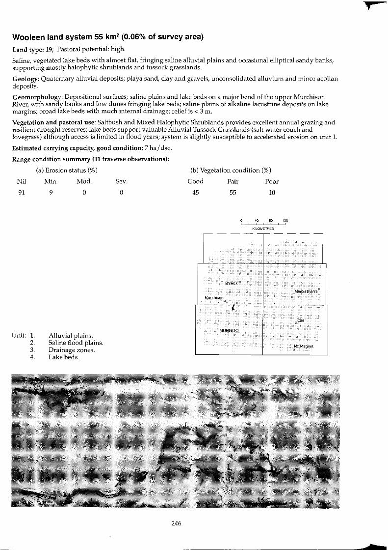
Wooleen land system 55 km2 (0.06% of survey area)
Land type: 19; Pastoral potential: high.
Saline, vegetated lake beds with almost flat, fringing saline alluvial plains and occasional elliptical sandy banks, supporting mostly halophytic shrub lands and tussock grasslands.
Geology: Quaternary alluvial depOSits; playa sand, clay and gravels, unconsolidated alluvium and minor aeolian deposits.
Geomorphology: Depositional surfaces; saline plains and lake beds on a major bend of the upper Murchison River, with sandy banks and low dunes fringing lake beds; saline plains of alkaline lacustrine deposits on lake margins; broad lake beds with much internal drainage; relief is < 3 ill.
Vegetation and pastoral use: Saltbush and Mixed Halophytic Shrublands provides excellent annual grazing and resilient drought reserves; lake beds support valuable Alluvial Tussock Grasslands (salt water couch and lovegrass) although access is limited in flood years; system is slightly susceptible to accelerated erosion on unit l.
Estimated carrying capacity, good condition: 7 hal dse.
Range condition summary (11 traverse observations):
(a) Erosion status (%)
Nil Min. Mod. Sev.
91
Unit: l. 2. 3. 4.
9 o
Alluvial plains. Saline flood plains. Drainage zones. Lake beds.
o
246
(b) Vegetation condition (%)
Good Fair Poor
45 55 10
40 80 120 ! ,
KILOMETRES ,---- - - ---- - --
BYRO
Meekatharra 0
Murchison 0 ,
oeue
MURGOO
Mt Magnet 0
f
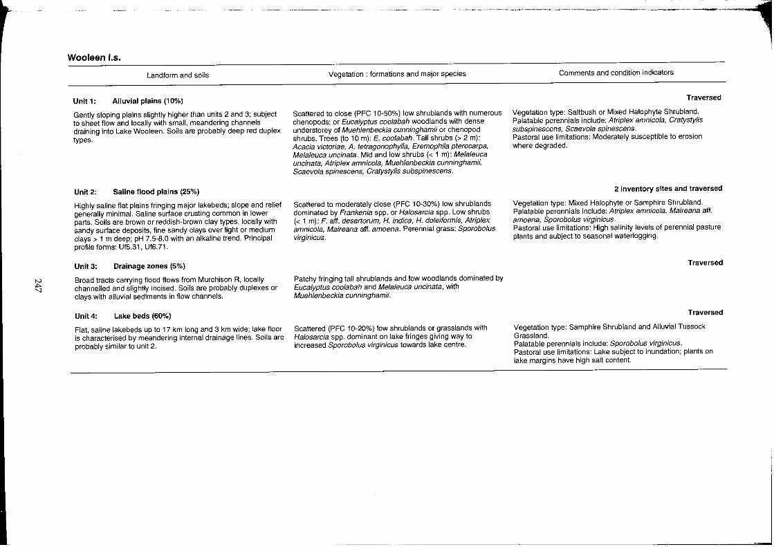
~ "
Wooleen 1.5.
Landform and soils
Unit 1: Alluvial plains (10%)
Gently sloping plains slightly higher than units 2 and 3; subject to sheet flow and locally with small, meandering channels draining into Lake Wooleen. Soils are probably deep red duplex types.
Unit 2: Saline flood plains (25%)
Highly saline flat plains fringing major lakebeds; slope and relief generally minimal. Saline suriace crusting common in lower parts. Soils are brown or reddish·brown clay types, locally with sandy surtace deposits, fine sandy clays over light or medium clays> 1 m deep; pH 7.5-8.0 with an alkaline trend. Principal profile forms: Uf5.31, Uf6.71.
Unit3: Drainage zones (5%)
Broad tracts carrying flood flows from MUrchison R, locally channelled and slightly incised. Soils are probably duplexes or clays with alluvial sediments in flow channels.
Unit4: Lake beds (60%)
Flat, saline lakebeds up to 17 km long and 3 km wide; lake floor is characterised by meandering internal drainage lines. Soils are probably similar to unit 2.
Vegetation: formations and major species
Scattered to close (PFC 10-50%) low shrublands with numerous chenopods; or Eucalyptus coolabah woodlands with dense understorey of Muehlenbeckia cunninghamii or chenopod shrubs. Trees (to 10 m): E. coolabah. Tall shrubs (> 2 m): Acacia victoriae, A. tetragonophylla, Eremophila pterocarpa, Melaleuca uncinata. Mid and low shrubs « 1 m): Melaleuca uncinata, AMplex amnicola, Muehlenbeckia cunningham;;, Scaevola spinescens, CratystyHs subspinescens.
Scattered to moderately close (PFC 10-30%) low shrub lands dominated by Frankenia spp. or Hafosarcia spp. Low shrubs « 1 m): F. aft. desertorum, H. indica, H. dofeiformis, AMp/ex amnicola, Maireana aft. amoena. Perennial grass: Sporobo/us virginicus.
Patchy fringing tall shrublands and low woodlands dominated by Eucalyptus coo/abah and Melaleuca uncinata, with Muehlenbeckia cunninghamii.
Scattered (PFC 10-20%) low shrublands or grasslands with Halosarcia spp. dominant on lake fringes giving way to increased Sporobofus virginicus towards lake centre.
---~--- _:--, Comments and condition indicators
Traversed
Vegetation type: Saltbush or Mixed Halophyte Shrubland. Palatable perennials include: AMp/ex amnicofa, CratystyHs subspinescens, Scaevola spinescens. Pastoral use limitations: Moderately susceptible to erosion where degraded.
2 inventory sites and traversed
Vegetation type: Mixed Halophyte or Samphire Shrubland. Palatable perennials include: Atriplex amnico/a, Maireana aft. amoena, Sporobo/us virginicus. Pastoral use limitations: High salinity levels of perennial pasture plants and subject to seasonal waterlogging.
Traversed
Traversed
Vegetation type: Samphire Shrubland and Alluvial Tussock Grassland. Palatable perennials include: Sporobo/us virginicus. Pastoral use limitations: Lake subject to inundation; plants on lake margins have high salt content.
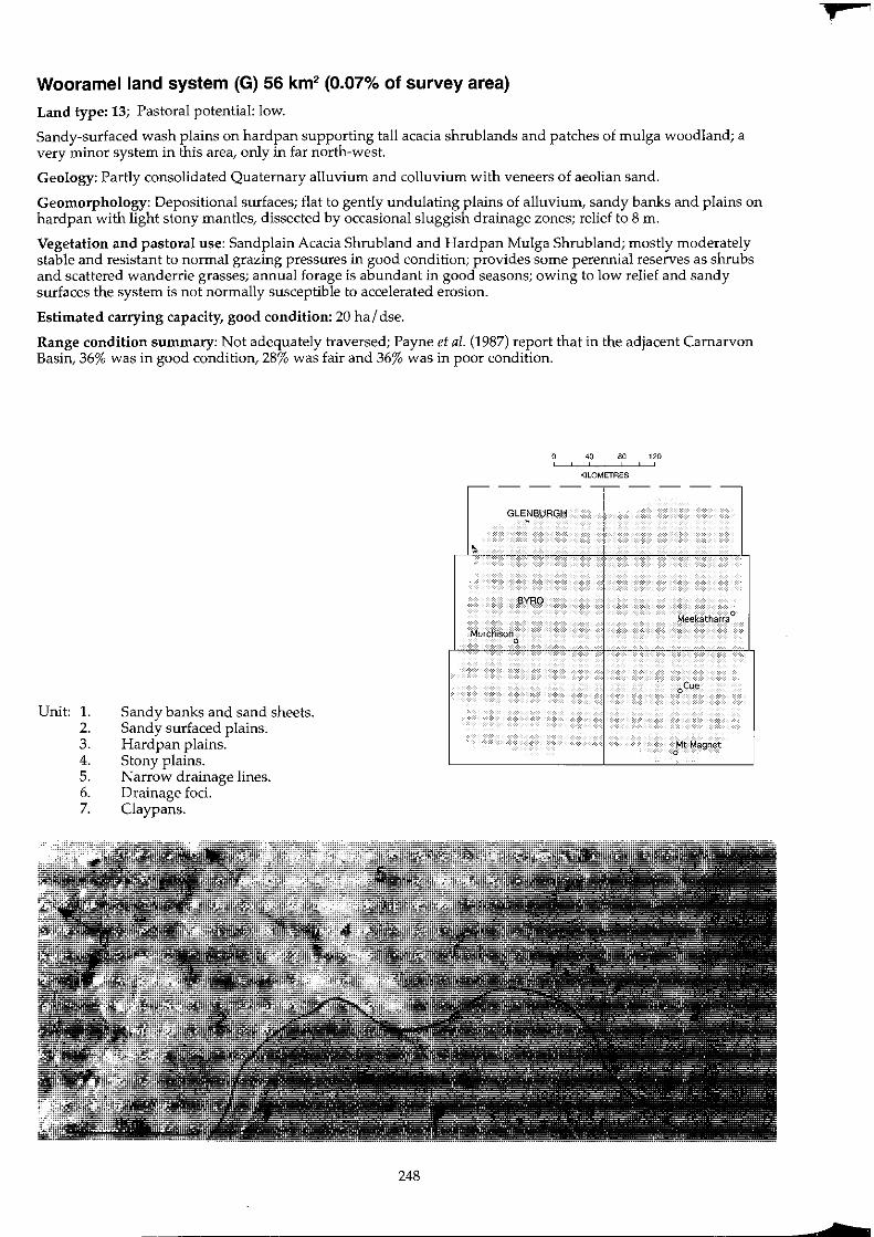
Wooramel land system (G) 56 km2 (0.07% of survey area)
Land type: 13; Pastoral potential: low.
Sandy-surfaced wash plains on hardpan supporting tall acacia shrub lands and patches of mulga woodland; a very minor system in this area, only in far north-west.
Geology: Partly consolidated Quaternary alluvium and colluvium with veneers of aeolian sand.
Geomorphology: Depositional surfaces; flat to gently undulating plains of alluvium, sandy banks and plains on hardpan with light stony mantles, dissected by occasional sluggish drainage zones; relief to 8 m.
Vegetation and pastoral use: Sandplain Acacia Shrubland and Hardpan Mulga Shrubland; mostly moderately stable and resistant to normal grazing pressures in good condition; provides some perennial reserves as shrubs and scattered wanderrie grasses; annual forage is abundant in good seasons; owing to low relief and sandy surfaces the system is not normally susceptible to accelerated erosion.
Estimated carrying capacity, good condition: 20 hal dse.
Range condition summary: Not adequately traversed; Payne et al. (1987) report that in the adjacent Carnarvon Basin, 36% was in good condition, 28% was fair and 36% was in poor condition.
Unit: 1. 2. 3. 4. 5. 6. 7.
Sandy banks and sand sheets. Sandy surfaced plains. Hardpan plains. Stony plains. Narrow drainage lines. Drainage foci. Claypans.
248
o " 80 120 , , , KILOMETRES
-- - --,-- - --
GLENBURGH
~
BYRO
Meekatharra 0
Murchison 0
oCue
Mt Magnet 0
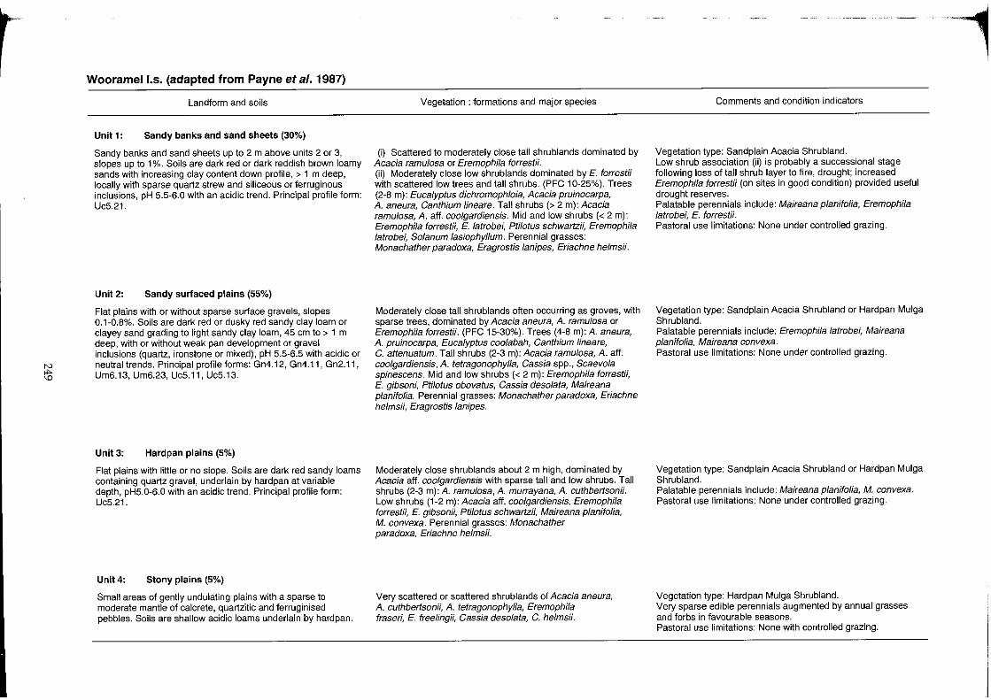
r
IV
il>
Wooramel I.s. (adapted from Payne et a/. 1987)
Landform and soils
Unit 1: Sandy banks and sand sheets (30%)
Sandy banks and sand sheets up to 2 m above units 2 or 3, slopes up to 1%. Soils are dark red or dark reddish brown loamy sands with increasing clay content down profile, > 1 m deep, locally with sparse quartz strew and siliceous or ferruginous inclusions, pH 5.5-6.0 with an acidic trend. Principal profile form: Uc5.21.
Unit 2: Sandy surfaced plains (55%)
Flat plains with or without sparse surface gravels, slopes 0.1-0.8%. Soils are dark red or dusky red sandy clay loam or clayey sand grading to tight sandy clay loam, 45 em to > 1 m deep, with or without weak pan development or gravel inclusions (quartz, ironstone or mixed), pH 5.5-6.5 with acidic or neutral trends. Principal profile forms: Gn4.12, Gn4.11, Gn2.11, Um6.13, Um6.23, Uc5.11, Uc5.13.
Unit 3: Hardpan plains (5%)
Flat plains with little or no slope. Soils are dark red sandy loams containing quartz gravel, underlain by hardpan at variable depth, pH5.0-6.0 with an acidic trend. Principal profile form: Uc5.21.
Unit 4: Stony plains (5%)
Small areas of gently undulating plains with a sparse to moderate mantle of calcrete, quartzitic and ferruginised pebbles. Soils are shallow acidic loams underlain by hardpan.
Vegetation: formations and major species
(i) Scattered to moderately close tall shrublands dominated by Acacia ramulosa or Eremophila forrestii. (ii) Moderately close low shrublands dominated by E. forrestii with scattered low trees and tall shrubs. (PFC 10-25%). Trees (2-8 m): Eucalyptus dichromophloia, Acacia pruinocarpa, A. aneura, Canthium lineare. Tall shrubs (> 2 m): Acacia ramulosa, A. aff. coo/gardiensis. Mid and low shrubs « 2 m): Eremophila forrestii, E. latrobei, Ptifotus schwartz;;, Eremophila latrobei, So/anum lasiophyllum. Perennial grasses: Monachather paradoxa, Eragrostislanipes, Eriachne helmsii.
Moderately close tall shrublands often occurring as groves, with sparse trees, dominated by Acacia aneura, A. ramulosa or Eremophila forrestii. (PFC 15-30%). Trees (4-8 m):A. aneura, A. pruinocarpa, Eucalyptus coolabah, Canthium lineare, C. attenuatum. Tall shrubs (2-3 m): Acacia ramulosa, A. aff. coo/gardiensis, A. tetragonophylla, Cassia spp., Scaevola spinescens. Mid and low shrubs « 2 m): Eremophila forrestii, E. gibsoni, Ptilotus obovatus, Cassia deso/ata, Maireana planifolia. Perennial grasses: Monachather paradoxa, Eriachne he/msii, Eragrostislanipes.
Moderately close shrublands about 2 m high, dominated by Acacia aff. coo/gardiensis with sparse tall and low shrubs. Tall shrubs (2-3 m): A. ramulosa, A. murrayana, A. cuthbertsonii. Low shrubs (1-2 m): Acacia aff. coo/gardiensis, Eremophila forrestii, E. gibsonii, Ptilotus schwartzii, Maireana planifolia, M. convexa. Perennial grasses: Monachather paradoxa, Eriachne helms;;.
Very scattered or scattered shrublands of Acacia aneura, A. cuthbertsonii, A. tetragonophylla, Eremophila fraseri, E. freeling;;, Cassia desofata, C. helms;;.
Comments and condition indicators
Vegetation type: Sandplain Acacia Shrubland. Low shrub association (ii) is probably a successional stage following loss of tall shrub layer to fire, drought; increased Eremophila forrestii (on sites in good condition) provided useful drought reserves. Palatable perennials include: Maireana planifolia, Eremophila /atrobe/~ E. forrestii. Pastoral use limitations: None under controlled grazing.
Vegetation type: Sandplain Acacia Shrubland or Hardpan Mulga Shrubland. Palatable perennials include: Eremophila latrobei, Maireana p/anifolia, Maireana convexa. Pastoral use limitations: None under controlled grazing.
Vegetation type: Sandplain Acacia Shrubland or Hardpan Mulga Shrubland. Palatable perennials include: Maireana planifolia, M. convexa. Pastoral use limitations: None under controlled grazing.
Vegetation type: Hardpan Mulga Shrubland. Very sparse edible perennials augmented by annual grasses and forbs in favourable seasons. Pastoral use limitations: None with controlled grazing.
-1

Di o
Wooramell.s. (adapted from Payne et al. 1987) -continued
Landform and soils
Unit 5: Narrow drainage lines « 1 %)
Mixed alluvial deposits, locally calcreted. Sluggish unchannelled drainage zones, slopes 0.1-0.3%. Soils are dark red sandy clay loams, > 1 m deep, pH 6.5 with a neutral trend. Principal profile form: Um6.24.
Unit 6: Drainage foci (1%)
Small, rounded foci with clay soils.
Unit7: Claypans (1%)
Small, bare claypans.
Vegetation: formations and major species
Moderately close low woodlands dominated by Acacia aneura. Trees and tall shrubs (2-5 my: A. aneura, Eucalyptus coolabah, Acacia ramu/osa, A. tetragonophylfa, A. pruinocarpa. Low shrubs (1-2 m): Ptifotus obovatus, Sida calyxhymenia, Chenopodium gaudichaudianum, Spartothamnefla teucriiffora, Rhagodia eremaea. Perennial grass: Monachather paradoxa.
Close shrublands dominated by Acacia tetragonophylla, A. aneura or A. cuthbertsonii.
Usually unvegetated.
Comments and condition indicators
Vegetation type: Acacia Creek line Shrubland. Perennials augmented by annual grasses and forbs in favourable seasons. Pastoral use limitations: None under controlled grazing.
Vegetation type: Creekline Shrubland. Pastoral use limitations: None with controlled grazing.
j
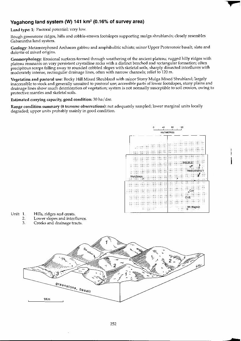
Yagahong land system 0N) 141 km2 (0.16% of survey area)
Land type: 1; Pastoral potential: very low.
Rough greenstone ridges, hills and cobble-strewn footslopes supporting mulga shrublands; closely resembles Gabanintha land system.
Geology: Metamorphosed Archaean gabbro and amphibolitic schists; minor Upper Proterozoic basalt, slate and dolerite of mixed origins.
Geomorphology: Erosional surfaces formed through weathering of the ancient plateau; rugged hilly ridges with plateau remnants on very persistent crystalline rocks with a distinct benched and rectangular formation; often precipitous scarps falling away to rounded cobbled slopes with skeletal soils, sharply dissected interfluves with moderately intense, rectangular drainage lines, often with narrow channels; relief to 120 m.
Vegetation and pastoral use: Rocky Hill Mixed Shrubland with minor Stony Mulga Mixed Shrub land; largely inaccessible to stock and generally unsuited to pastoral use; accessible parts of lower footslopes, stony plains and drainage lines show much deterioration of vegetation; system is not normally susceptible to soil erosion, owing to protective mantles and skeletal soils.
Estimated carrying capacity, good condition: 30 ha I dse.
Range condition summary (8 traverse observations): not adequately sampled; lower marginal units locally degraded; upper units probably mainly in good condition.
Unit: 1. 2. 3.
Hills, ridges and crests. Lower slopes and interfluves. Creeks and drainage tracts.
Stone, baSalt
1Km
-- -
Murchison 0
252
40 80 120 , ! ,
KILOMETRES
--r-- - --
BELElE
~~ ) •
Meekatharra 0
I ,
oCue
CUE
Mt Magnet 0
,
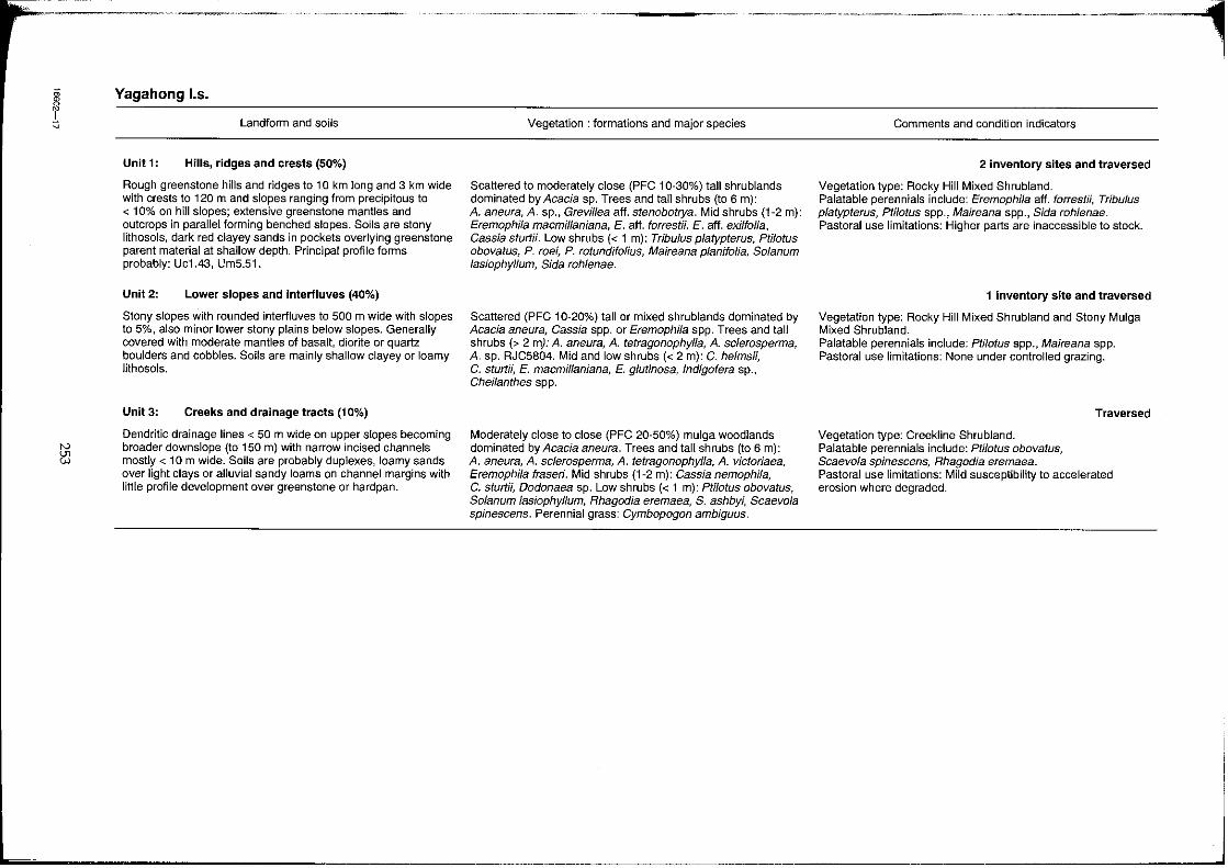
, ~
IV
~
--~-----
Yagahong 1.5.
Landform and soils
Unit 1: Hills, ridges and crests (50%)
Rough greenstone hills and ridges to 10 km long and 3 km wide with crests to 120 m and slopes ranging from precipitous to < 10% on hill slopes; extensive greenstone mantles and outcrops in parallel forming benched slopes. Soils are stony lithosols, dark red clayey sands in pockets overlying greenstone parent material at shallow depth. Principal profile forms probably: Uc1.43, Urn5.51.
Unit 2: Lower slopes and interfluves (40%)
Stony slopes with rounded interfluves to 500 m wide with slopes to 5%, also minor lower stony plains below slopes. Generally covered with moderate mantles of basalt, diorite or quartz boulders and cobbles. Soils are mainly shallow clayey or loamy lithosols.
Unit3: Creeks and drainage tracts (10%)
Dendritic drainage lines < 50 m wide on upper slopes becoming broader downslope (to 150 m) with narrow incised channels mostly < 10m wide. Soils are probably duplexes, loamy sands over light clays or alluvial sandy loams on channel margins with little profile development over greenstone or hardpan.
----~.--.-------.-------.----- -·--1 Vegetation: formations and major species
Scattered to moderately close (PFC 10-30%) tall shrublands dominated by Acacia sp. Trees and tall shrubs (to 6 m): A. aneura, A. sp., Grevillea aft. stenobotrya. Mid shrubs (1-2 m): Eremophila macmillaniana, E. aft. forrestii, E. aft. exi/folia, Cassia sturtii. Low shrubs « 1 m): Tribulus platypterus, Ptilotus obovatus, P. roei, P. rotundifolius, Maireana planifolia, Solanum lasiophyllum, Sida rohlenae.
Scattered (PFC 10-20%) tall or mixed shrublands dominated by Acacia aneura, Cassia spp. or Eremophila spp. Trees and tall shrubs (> 2 my: A. aneura, A. tetragonophylla, A. sclerosperma, A. sp. RJC5804. Mid and low shrubs « 2 m): C. helmsH, C. stunN, E. macmillaniana, E. glutinosa, Indigofera sp., Cheilanthes spp.
Moderately close to close (PFC 20-50%) mulga woodlands dominated by Acacia aneura. Trees and tall shrubs (to 6 m): A. aneura, A. sclerosperma, A. tetragonophylla, A. victoriaea, Eremophila fraseri. Mid shrubs (1-2 m): Cassia nemophila, C. sturtii, Dodonaea sp. Low shrubs « 1 m): Ptilotus obovatus, Solanum lasiophyllum, Rhagodia eremaea, S. ashbyi, Scaevola spinescens. Perennial grass: Cymbopogon ambiguus.
Comments and condition indicators
2 inventory sites and traversed
Vegetation type: Rocky Hill Mixed Shrubland. Palatable perennials include: Eremophila aft. forrestii, Tribulus platypterus, Ptilotus spp., Maireana spp., Sida rohlenae. Pastoral use limitations: Higher parts are inaccessible to stock.
1 inventory site and traversed
Vegetation type: Rocky Hill Mixed Shrubland and Stony Mulga Mixed Shrubland. Palatable perennials include: Ptilotus spp., Maireana spp. Pastoral use limitations: None under controlled grazing.
Vegetation type: Creekline Shrubland. Palatable perennials include: Ptilotus obovatus, Scaevola spinescens, Rhagodia eremaea.
Traversed
Pastoral use limitations: Mild susceptibility to accelerated erosion where degraded.
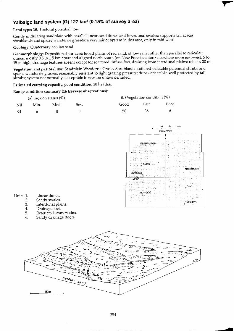
Yalbalgo land system (G) 127 km2 (0.15% of survey area)
Land type: 10; Pastoral potential: low.
Gently undulating sandplain with parallel linear sand dunes and interdunal swales; supports tall acacia shrublands and sparse wanderrie grasses; a very minor system in this area, only in Inid west.
Geology: Quaternary aeolian sand.
Geomorphology: Depositional surfaces; broad plains of red sand, of low relief other than parallel to reticulate dunes, mostly 0.5 to 1.5 Jan apart and aligned north-south (on New Forest station) elsewhere more east-west; 5 to 15 m high; drainage features absent except for scattered diffuse foci, draining from interdunal plains; relief < 20 m.
Vegetation and pastoral use: Sandplain Wanderrie Grassy Shrubland; scattered palatable perennial shrubs and sparse wanderrie grasses; reasonably resistant to light grazing pressure; dunes are stable, well protected by tall shrubs; system not normally susceptible to erosion unless denuded.
Estimated carrying capacity, good condition: 20 hal dse.
Range condition summary (16 traverse observations):
Nil
94
Unit: 1. 2. 3. 4. 5. 6.
(a) Erosion status (%)
Min. Mod.
o Sev.
6
Linear dunes. Sandy swales. lnterdunal plains. Drainage foci. Restricted stony plains. Sandy drainage floors.
o
254
(b) Vegetation condition (%)
Good
56
Fair
38
Poor
6
40 80 120 , KILOMETRES
-- - ---- - --
GLENBURGH
BYRD
Meekatharra 0
Murchison 0
_Ii'
oCue
MURGOO
Mt Magnet 0
-
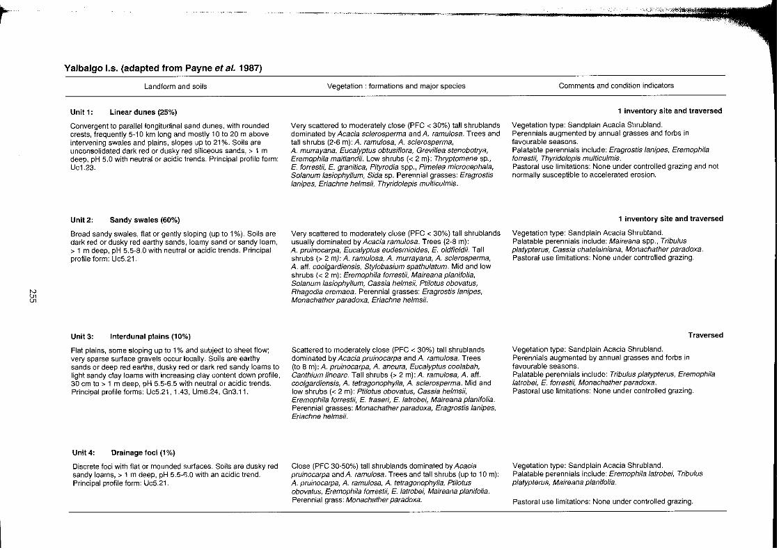
~
~ en
Yalbalgo 1.5. (adapted from Payne et at. 1987)
Landform and soils
Unit 1: Linear dunes (25%)
Convergent to parallel longitudinal sand dunes, with rounded crests, frequently 5-10 km long and mostly 10 to 20 m above intervening swales and plains, slopes up to 21 %. Soils are unconsolidated dark red or dusky red siliceous sands, > 1 m deep, pH 5.0 with neutral or acidic trends. Principal profile form: Uc1.23.
Unit 2: Sandy swales (60%)
Broad sandy swales, flat or gently sloping (up to 1%). Soils are dark red or dusky red earthy sands, loamy sand or sandy loam, > 1 m deep, pH 5.5-8.0 with neutral or acidic trends. Principal profile form: UcS.21.
Unit 3: Interdunal plains (10%)
Flat plains, some sloping up to 1 % and subject to sheet flow; very sparse surface gravels occur locally. Soils are earthy sands or deep red earths, dusky red or dark red sandy loams to light sandy clay loams with increasing clay content down profile, 30 cm to > 1 m deep, pH 5.5~S.5 with neutral or acidic trends. Principal profile forms: Uc5.21, 1.43, UmS.24, Gn3.11.
Unit 4: Drainage foci (1 %)
Discrete foci with flat or mounded surfaces. Soils are dusky red sandy loams, > 1 m deep, pH 5.5~?0 with an acidic trend. Principal profile form: Uc5.21.
Vegetation: formations and major species
Very scattered to moderately close (PFC < 30%) tall shrublands dominated by Acacia scJerosperma and A. ramulosa. Trees and tall shrubs (2-S m): A. ramulosa, A. sclerosperma, A. murrayana, Eucalyptus obtusiflora, Greviffea stenobotrya, Eremophila maitlandii. Low shrubs « 2 m): Thryptomene sp., E. forrestii, E. granitica, Pityrodia spp., Pimelea microcephala, Solanum lasiophyllum, Sida sp. Perennial grasses: Eragrostis lanipes, Eriachne helmsii, Thyridolepis multiculmis.
Very scattered to moderately close (PFC < 30%) tall shrublands usually dominated by Acacia ramulosa. Trees (2-8 m): A. pruinocarpa, Eucalyptus eudesmioides, E. oldfieldii. Tall shrubs (> 2 my: A. ramulosa, A. murrayana, A. sclerosperma, A. aft. coolgardiensis, Stylobasium spathulatum. Mid and low shrubs « 2 m): Eremophila forrestii, Maireana planifolia, Solanum Jasiophyllum, Cassia helmsii, Ptilotus obovatus, Rhagodia eremaea. Perennial grasses: Eragrostis/anipes, Monachather paradoxa, Eriachne helmsii.
Scattered to moderately close (PFC < 30%) tall shrublands dominated by Acacia pruinocarpa and A. ramulosa. Trees (to 8 m): A. pruinocarpa, A. aneura, Eucalyptus coolabah, Canthium lineare. Tall shrubs (> 2 m): A. ramulosa, A. aft. coolgardiensis, A. tetragonophylla, A. sclerosperma. Mid and low shrubs « 2 m): Ptilotus obovatus, Cassia helmsH, Eremophila forrestii, E. fraseri, E. latrobei, Maireana planifolia. Perennial grasses: Monachather paradoxa, Eragrostis lanipes, Eriachne helmsH.
Close (PFC 30-50%) tall shrublands dominated by Acacia pruinocarpa and A. ramulosa. Trees and tall shrubs (up to 10 m): A. pruinocarpa, A. ramulosa, A. tetragonophylJa, Ptilotus obovatus, Eremophila forrestii, E. latrobei, Maireana planifolia. Perennial grass: Monachather paradoxa.
~ ;
Comments and condition indicators
1 inventory site and traversed
Vegetation type: Sand plain Acacia Shrubland. Perennials augmented by annual grasses and forbs in favourable seasons. Palatable perennials include: Eragrostislanipes, Eremophila forrestii, Thyrido/epis multicu/mis. Pastoral use limitations: None under controlled grazing and not normally susceptible to accelerated erosion.
1 inventory site and traversed
Vegetation type: Sand plain Acacia Shrubland. Palatable perennials include: Maireana spp., Tribulus platypterus, Cassia chatelainiana, Monachather paradoxa. Pastoral use limitations: None under controlled grazing.
Traversed
Vegetation type: Sandplain Acacia Shrubland. Perennials augmented by annual grasses and forbs in favourable seasons. Palatable perennials include: Tribulus platypterus, Eremophila latrobei, E. forrestii, Monachather paradoxa. Pastoral use limitations: None under controlled grazing.
Vegetation type: Sandplain Acacia Shrubland. Palatable perennials include: Eremophila latrobei, Tribu/us p/atypterus, Maireana planifolia.
Pastoral use limitations: None under controlled grazing.

~ '"
~
Yalbalgo I.s. (adapted from Payne et al. 1987) -continued
Landform and soils
Units: Restricted stony plains (2%)
Restricted interdunal plains with rock outcropping (or at shallow depth) and strewn with quartzite cobbles. Soils are red loamy sands, < 50 em deep, pH 5.5 with an acidic trend. Principal profile form: Uc1.43.
Unit 6: Sandy drainage floors (2%)
Drainage tracts with minor channelling. Soils are probably sandy loams.
Vegetation: formations and major species
Moderately close (PFC 20~30%) mid height shrublands dominated by Acacia aft. coolgardiensis. Trees: A pruinocarpa. Tall shrubs: A. ramulosa. Mid and low shrubs: A. aft. coolgardiensis, Ptilotus schwartzii, Eremophila latrobe;, Cassia chatelainiana. Perennial grass: Monochather paradoxa.
Comments and condition indicators
Vegetation type: Hardpan Mulga Shrubland. Palatable perennials include: Eremophila latrobei, Cassia chatelainiana. Pastoral use limitations: None under controlled grazing.
Traversed
Variable woodlands or shrublands dominated by Eucalyptus Vegetation type: Creekline Shrubland. coolabah, Acacia spp. and sparse perennial grasses (Cenchrus ciliaris).
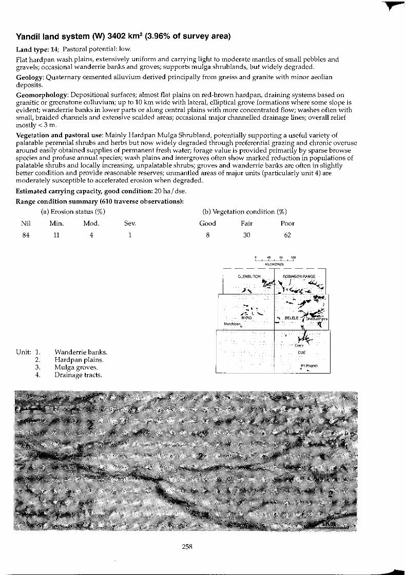
Yandil land system (W) 3402 km2 (3.96% of survey area)
Land type: 14; Pastoral potential: low.
Flat hardpan wash plains, extensively uniform and carrying light to moderate mantles of small pebbles and gravels; occasional wanderrie banks and groves; supports mulga shrublands, but widely degraded.
Geology: Quaternary cemented alluvium derived principally from gneiss and granite with minor aeolian deposits.
Geomorphology: Depositional surfaces; almost flat plains on red-brown hardpan, draining systems based on granitic or greenstone colluvium; up to 10 km wide with lateral, elliptical grove formations where some slope is evident; wanderrie banks in lower parts or along central plains with more concentrated flow; washes often with small, braided channels and extensive scalded areas; occasional major channelled drainage lines; overall relief mostly<3 m.
Vegetation and pastoral use: Mainly Hardpan Mulga Shrub land, potentially supporting a useful variety of palatable perennial shrubs and herbs but now widely degraded through preferential grazing and chronic overuse around easily obtained supplies of permanent fresh water; forage value is provided primarily by sparse browse species and profuse annual species; wash plains and intergroves often show marked reduction in populations of palatable shrubs and locally increasing, unpalatable shrubs; groves and wanderrie banks are often in slightly better condition and provide reasonable reserves; unmantled areas of major units (particularly unit 4) are moderately susceptible to accelerated erosion when degraded.
Estimated carrying capacity, good condition: 20 ha I dse.
Range condition summary (610 traverse observations):
(a) Erosion status (%)
Nil
84
Unit: 1. 2. 3. 4.
Min.
11
Mod.
4
Wanderrie banks. Hardpan plains. Mulga groves. Drainage tracts.
Sev.
1
258
(b) Vegetation condition (%)
Good
8
Fair
30
GLENBURGH
-~, , r;. l "eYRO
Murchisono
Poor
62
40 eo 120
KILOMETRES
--.'" ~"f/Y~}'
" BELELE~~"
Cueo ~ CUE
oMt ~a9net
N Ul
'"
Yandill.s.
Landform and soils
Unit 1: Wanderrie banks (5%)
Reticulate and interconnecting sandy banks up to 500 m wide extending downslope for up to 2 km; up to 1 m above hardpan plains. Soils are earthy sands, with occasional increases in texture with depth, up to 1 m deep over hardpan; pH 6.0-6.5 with a neutral trend. Principal profile forms: UcS.21, Gn2.12.
Unit 2: Hardpan plains (70%)
Almost flat plains (slopes < 0.5%) 2-10 km wide, of very uniform appearance except where interspersed with occasional sandy banks and groves (units 1 and 3); receiving broad sheet flow from Koonmarra, Mindura or Narryer land systems; usually lightly strewn with quartz or mixed gravel and pebble fragments. Degraded areas susceptible to soil loss through sheeting and scalding, other areas receive surface deposition of clay and silt. Soils are hardpan loams, shallow red earths or light clays, mostly over hardpan < 50 cm deep; isolated areas with sandy clay loams over light clays up to 1 m deep; pH 6.0-7.0 with a neutral to alkaline trend. Principal profile forms: Um5.31, Uf6.71.
Unit 3: Mulga groves (1 %)
Elliptical grove formations and drainage foci up to 200 m long and 50 m wide; transverse to direction of sheet water flow; occurring infrequently on units 2 and 4. Soils are deep red earths or clay loams over light clays, up to 1 m deep; pH 5.5-6.5 with a neutral to acidic trend. Principal profile forms: Gn2.12, Uf6.71.
--~~~--
Vegetation: formations and major species
Scattered to moderately close (PFC 10-30%) tall or mixed shrublands mainly dominated by Acacia aneura and Eremophila margarethae. Trees and tall shrubs (to 6 m): A. aneura, A. cuthbertsonii, A. tetragonophylla, A. victoriae, A. kempeana, Hakea preissii. Mid shrubs (1-2 m): Cassia helmsii, C. desolata, Eremophila forrestii, E fraseri, E/atrobei. Low shrubs « 1 m): E margarethae, E punicea. Ptilotus obovatus, Sida calyxhymenia, Scaevola spinescens, Maireana convexa, M. planifolia, Solanum lasiophyllum. Perennial grasses: Eriachne helmsii, Eragrostis lanipes, Monachather paradoxa.
Scattered (PFC 10-20%) tall or mixed shrub lands usually dominated by Acacia aneura and A. tetragonophylla. Trees (to 4 my: A. aneura, A. pruinocarpa, A. quadrimarginea, Grevillea striata, Hakea suberea, Brachychiton gregorii. Tall shrubs (> 2 m): A. tetragonophylla, A. aff. citrinoviridis. A. aneura, A. grasbyi, A. ramulosa, Eremophila longifolia, E. fraseri. Mid shrubs (1-2 m):A. palustris, Cassia desolata, C. helmsii, E. spathulata, E. forrestii. Low shrubs « 1 m): Ptilotus obovatus, P. rotundifolius, P. schwartzii, Rhagodia eremaea, Enchylaena tomentosa, Scaevola spinescens, Solanum lasiophyllum, Sida calyxhymenia, Maireana tomentosa, M. planifolia, M. convexa, M. vil/osa.
Close to closed (PFC > 30%) woodlands or tall shrublands dominated by Acacia aneura, A. distans or A. tetragonophylla. Trees (to 10 m):A. aneura, A. distans, A. pruinocarpa, Canthium lineare, Santalum spicatum, Grevillea striata. Tall shrubs (to 6 m): A. distans, A. tetragonophylla, A. ramulosa, A. kempeana, A. sclerosperma, A. cuthbertsonii, A. craspedocarpa, Eremophila fraseri, Canthium latifolium. Mid shrubs (1-2 m): E. forrestii, E. macmillaniana, E. latrobei, E. spathulata, Cassia deso/ata, C. helmsii, Spartothamnella teucriiflora. Low shrubs « 1 m): Maireana planifolia, Ptilotus obovatus, C. chate/ainiana, Sida sp., Scaevola spinescens. Creepers: Ipomoea sp., Leichardtia australis. Perennial grasses: Chrysopogon faf/ax, Eriachne helmsH.
Comments and condition indicators
2 inventory sites, 1 condition site and traversed
Vegetation type: Wanderrie Bank Grassy Shrubland. Palatable perennials include: Eremophila forrestii, E. latrobei, Ptilotus obovatus, Sida calyxhymenia, ScaevoJa spinescens, Maireana sPP'J Eragrostis Janipes, Monachather paradoxa. Pastoral use limitations: Slightly susceptible to accelerated erosion where degraded. Vegetation condition %: VG/G 15, F 50, PNP 35. Erosion incidence %: min 4. 26 obs.
5 inventory sites, 53 condition sites and traversed
Vegetation types: Hardpan Mulga Shrubland. Palatable perennials include: Maireana spp., Eremophila forrestii, E. latrobei, SpartothamneJla teucriifJora, Ptilotus spp., Rhagodia eremaea, Enchylaena tomentosa, ScaevoJa spinescens. Pastoral use limitations: Locally susceptible to accelerated erosion where severely degraded. Vegetation condition %: VG/G 8, F 29, PNP 63. Erosion incidence %: min 10, mod 2. 465 obs.
2 inventory sites and traversed
Vegetation type: Mulga Grove Woodland. Palatable perennials include: Eremophila forrestii, E. latrobei, Cassia chatelainiana, Spartothamnella teucriifJora, Maireana planifolia, Ptilotus obovatus, Sida sp., Scaevola spinescens, Chrysopogon fallax. Pastoral use limitations: None with controlled grazing.
1
tv g
Yandill.s.--continued
Landform and soils
Unit 4: Drainage tracts (25%)
Broad alluvial plains with negligible slope and receiving concentrated sheet flow from unit 2; with or without sparse pebbly quartz mantles. Up to 1.5 km wide (wider at confluences) with usually little channel development, although larger, well defined tracts have multiple, braided sandy channels and gutters. Some scalded tracts with hardpan exposures. Soils are deep red earths or hardpan loams up to 1 m deep over hardpan; pH 6.0~7.0 with a neutral to acidic trend. Principal profile forms: Gn2.12, Um5.31, Um5.41, Uc1.43.
Vegetation: formations and major species
Very scattered to moderately close (PFC < 30%) tall shrublands dominated by Acacia aneura. Trees (to 8 m): A. aneura, A. cyperophylla, Eucalyptus coolabah, Hakea suberea. Tall shrubs (> 2 m): A. aneura, A. grasbyi, A. rhodophloia, A. tetragonophylla, A. kempeana, A. cuthbertsonii, Canthium lineare, Eremophila fraseri. Mid shrubs (1-2 m): A. craspedocarpa, A. palustris, Cassia desolata, C. helmsii, C. sturtii, E. forrestii, E. latrobei, E. granitica, Spartothamnella teucriiflora. Low shrubs « 1 m): pti/otus obovatus, Maireana planifolia, E. compacta, Rhagodia eremaea, Enchylaena tomentosa, Solanum lasiophyllum, Sida calyxhymenia, S. cardiophylla, Grevillea deflexa. Perennial grasses (mainly along channels): Eriachne benthami, E. helms;;, E. sp., Chrysopogon 'aI/ax.
Comments and condition indicators
7 inventory sites, 6 condition sites and traversed
Vegetation type: Hardpan Mulga Shrubland and Creekline Grassy Shrubland. Palatable perennials include: Sida calyxhymenia, Eremophi/a forrestii, E. latrobei, E. compacta, Spartothamnella teucriiflora, ptilotus spp., Maireana spp., Rhagodia eremaea, Enchylaena tomentosa, Sida spp., Hibiscus sp. Pastoral use limitations: Mild to moderate susceptibility to accelerated erosion where degraded. Vegetation condition %: VG/G 4, F 28, PNP 68. Erosion incidence %: min 25, mod 14, sev 2.84 obs.
1
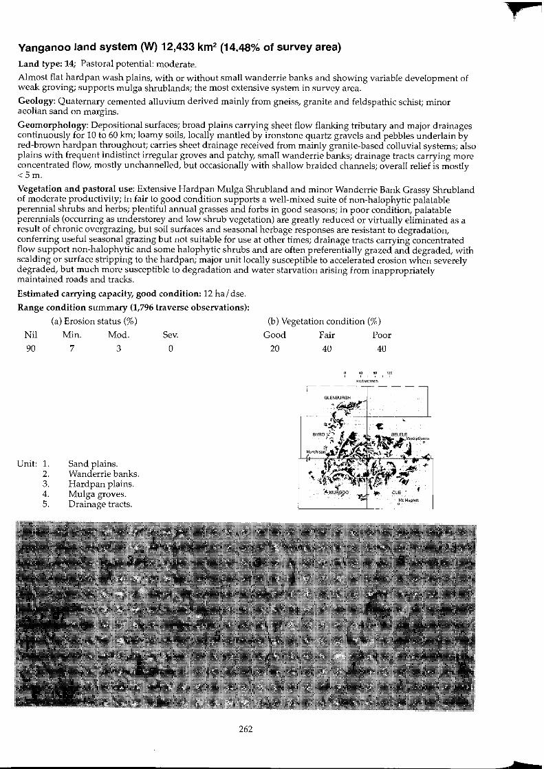
Yanganoo land system (W) 12,433 km2 (14.48% of survey area)
Land type: 14; Pastoral potential: moderate.
Almost flat hardpan wash plains, with or without small wanderrie banks and showing variable development of weak graving; supports mulga shrublands; the most extensive system in survey area.
Geology: Quaternary cemented alluvium derived mainly from gneiss, granite and feldspathic schist; minor aeolian sand on margins.
Geomorphology: Depositional surfaces; broad plains carrying sheet flow flanking tributary and major drainages continuously for 10 to 60 km; loamy soils, locally mantled by ironstone quartz gravels and pebbles underlain by red-brown hardpan throughout; carries sheet drainage received from mainly granite-based colluvial systems; also plains with frequent indistinct irregular groves and patchy, small wanderrie banks; drainage tracts carrying more concentrated flow, mostly unchannelled, but occasionally with shallow braided channels; overall relief is mostly <Sm.
Vegetation and pastoral use: Extensive Hardpan Mulga Shrub land and minor Wanderrie Bank Grassy Shrubland of moderate productivity; in fair to good condition supports a well-mixed suite of non-halophytic palatable perennial shrubs and herbs; plentiful annual grasses and forbs in good seasons; in poor condition, palatable perennials (occurring as understorey and low shrub vegetation) are greatly reduced or virtually eliminated as a result of chronic overgrazing, but soil surfaces and seasonal herbage responses are resistant to degradation, conferring useful seasonal grazing but not suitable for use at other times; drainage tracts carrying concentrated flow support non-halophytic and some halophytic shrubs and are often preferentially grazed and degraded, with scalding or surface stripping to the hardpan; major unit locally susceptible to accelerated erosion when severely degraded, but much more susceptible to degradation and water starvation arising from inappropriately maintained roads and tracks.
Estimated carrying capacity, good condition: 12 ha I dse.
Range condition summary (1,796 traverse observations):
(a) Erosion status (%)
Nil Min. Mod. Sev.
90 7 3 0
Unit: 1. 2. 3. 4. S.
Sand plains. Wanderrie banks. Hardpan plains. Mulga groves. Drainage tracts.
262
(b) Vegetation condition (%)
Good Fair Poor
20 40 40
KllOME1RE$
+
b
N e;
Yanganoo 1.5.
Landform and soils
Unit 1: Sand plains (2%)
Occasional patches of sand plains mainly in transitional areas adjacent to Kalli land system; up to 2 km in extent. Soils are dark red earthy sands, > 1 m deep: pH 5.5-6.0 with a neutral to acidic trend. Principal profile form: Uc5.21.
Unit 2: Wanderrie banks (10%)
Reticulate and interconnecting low sandy banks elevated up to 1 m above surrounding hardpan plain (unit 3); usually 50-100 m wide and extending up to 2 km long, commonly transverse to slope. Soils are dark red earthy sands < 1 m deep; occasionally over hardpan; pH 6.5-7.0 with a neutral trend. Principal profile form: Uc5.21.
Unit3: Hardpan plains (80%)
Extensive, flat surfaced, very gently inclined plains with slopes < 0.5% grading to almost flat in system centre, subject to sheet flow and flanking tributary drainages for many kilometres. Soil surfaces extensively crusted, with patchy cover of cryptogams (lichens, algae and mosses) parts lightly to moderately strewn with quartz or mixed gravels and pebbles. Soils are red hardpan clay loams over red-brown hardpan (occasionally granite), usually 20-50 cm deep; pH 5.5-7.0 with a neutral to acidic trend. Principal profile form: Um5.31.
Vegetation: formations and major species
Scattered (PFC 10-20%) mixed height grassy shrublands dominated by Acacia spp., Eremophila margarethae, Monachather paradoxa and occasionally Solanum lasiophyllum. Trees and tall shrubs (> 2 m): Acacia aneura, A. pruinocarpa, A. ramulosa, Eucalyptus dichromophloia. Mid shrubs (1-2 m): E. forrestii, E. granitica, E. latrobei, A. kempeana. Low shrubs « 1 m): E. margarethae, Ptilotus obovatus, Dianella revoluta, Maireana convexa, M. planifolia, Mirbelia spinosa, Rhagodia eremaea, S. lasiophyllum. Perennial grasses: Monachather paradoxa, Eriachne helmsii, Eragrostis eriopoda, E. lanipes, Thyridolepis mu/ticulmis.
Scattered to moderately close (PFC 10-30%) tall or mixed shrublands with perennial grasses, mainly dominated by Acacia spp. or EremophiJa spp. Trees and tall shrubs (> 2 m): A. aneura, A. grasbyi, A. kempeana, A. tetragonophylla, A. ramulosa, A. sclerosperma, A. xiphophylla. Mid shrubs (1-2 m): Cassia desolata, C. helmsii, C. nemophila, C. artemisioides, Eremophila granitica, E. fraseri, E. forrestii, Spartothamnella teucriiflora. Low shrubs « 1 m): Ptilotus obovatus, P. schwartzii, E. margarethae, Maireana planifolia, M. convexa, Solanum lasiophyllum, Sida calyxhymenia, Rhagodia eremaea. Perennial grasses: Monachather paradoxa, Eragrostis eriopoda, E. lanipes, Eriachne helmsH.
Very scattered to moderately close (PFC < 30%) mixed height or tall shrublands dominated by Acacia aneura. Trees (to 6 m): A. aneura, A. pruinocarpa, A. quadrimarginea, Grevillea striata. Tall shrubs (> 2 m): A. craspedocarpa, A. grasbyi, A. ramulosa, A. tetragonophylla, A. aff. quadrimarginea, A. rhodophloia, A. kempeana, Canthium latifolium, C. lineare, Hakea arida, H. recurva. Mid shrubs (1-2 m): Eremophila forrestii, E. fraseri, E. latrobei, E. spathulata, E. freelingii, Cassia desolata, C. sturtii, Calytrix spp., Mirbelia spinosa, Thryptomene sp., Spartothamnella teucriif/ora, Grevil/ea deflexa. Low shrubs « 1 m): Ptilotus obovatus, P. roei, P. schwartzii, Acacia daviesoides, E. compacta, Maireana convexa, M. planifolia, M. triptera, M. viIJosa, Abutilon sp., Sida calyxhymenia, S. sp., Solanum lasiophyllum, Rhagodia eremaea, Enchylaena tomentosa, Scaevola spinescens. Perennial grasses (always sparse): Eragrostis setifolia, E. eriopoda, Eriachne helmsii, Monachather paradoxa, Stipa sp.
---- ..•. ~
Comments and condition indicators
2 inventory sites, 7 condition sites and traversed
Vegetation type: Sandplain Wanderrie Grassy Shrubland. Palatable perennials include: Monachather paradoxa, Eragrostis spp., Thyridolepis multiculmis, Eremophila forrestii, E. latrobei, Ptilotus obovalus, Maireana spp., Rhagodia eremaea. Pastoral use limitations: None with controlled grazing.
2 inventory sites, 23 condition sites and traversed
Vegetation type: Wanderrie Bank Grassy Shrub land. Palatable perennials include: Monachather paradoxa, Eragrostis eriopoda, Eremophila latrobei, E. forrestii, Spartothamnella teucriiflora, Ptilotus spp., Maireana spp., Sida calyhymenia, Rhagodia eremaea. Pastoral use limitations: None with controlled grazing; subject to invasion by E. granitica or E. margarethae. Vegetation condition %: VG/G 19, F 51, PNP 30. Erosion incidence %: min 3.139 obs.
10 inventory sites, 184 condition sites and traversed
Vegetation type: Hardpan Mulga Shrubland. Palatable perennials include: Eremophila latrobei, E. compacta, E. forrestii, Ptilotus spp., Sida spp., Maireana convexa, M. planifolia, Spartothamnella teucriiflora, Rhagodia eremaea, Canthium lineare, Enchylaena tomentosa, Cassia chatelainiana, Hibiscus burtonii, Grevil/ea deflexa. Pastoral use limitations: Mildly susceptible to accelerated erosion where severely degraded mainly over areas near unit 5; also subject to water starvation where tracks intercept or divert sheet flows. Vegetation condition %: VG/G 21, F 40, PNP 39. Erosion incidence %: min 7, mod 1. 1,643 obs.
tv ~
Yanganoo I.s.-Gontinued
Landform and soils
Unit 4: Mulga groves (4%)
Groving formations prominent in areas receiving more concentrated sheet flow, up to 500 m long and 100 m wide; with dense vegetation; elsewhere, occurrence is scattered with groves being smaller, less distinct and barely discernible on the ground. Soils are red earths or hardpan clay loams < 1 m deep usually with more surface sand than intergrove areas; pH 5.5-6.0 with a neutral to acidic trend. Principal profile forms: UmS.31, Gn2.12.
UnitS: Drainage tracts (4%)
Broad alluvial tracts (up to 750 m wide) receiving concentrated run-on, usually without channels in tess organised tracts; larger or mOre discrete flow zones may have single or multiple channels incised into hardpan. Soils are mostly red hardpan loams > 50 cm over hardpan, slightly saline locally, pH 6.0-6.5 with a neutral to acidic trend. Principal profile form: Um5.3i.
Vegetation: formations and major species
Moderately close to closed (PFC 30 - > 50%) woodlands or tall shrublands dominated by Acacia aneura. Trees (to 8 m): A. aneura, A. pruinocarpa, Canthium lineare. Tall shrubs (> 2 m): A. ramulosa, A. tetragonophylla, A. kempeana, C. latifolium, A. craspedocarpa. Mid shrubs (1-2 m): Eremophila forrestii, E. latrobei, E. spathulata, E. gilesii, E. punicea, Spartothamnella teucriiflora. Low shrubs < 1 m): Ptilotus obovatus, Scaevola spinescens, Rhagodia eremaea, Solanum lasiophyllum, Maireana planifolia, M. convexa, Sida calyxhymenia, S. sp. Creepers: Leichardtia australis. Perennial grasses: Monachather paradoxa, Eragrostis eriopoda, Eriachne helmsii.
Moderately close (PFC 20-30%) tall shrublands dominated by Acacia aneura or A. tetragonophylla. Trees and tall shrubs (to 6 m): A. aneura, A. craspedocarpa, A. pruinocarpa, A. tetragonophylla, Eremophila fraseri, Canthium lineare. Mid shrubs (1-2 m): E. forrestii, E. latrobei, E. georgei, Spartothamnella teucriiflora, Cassia helms;;. Low shrubs « 1 m): Ptilotus obovatus, P. schwartzii, Sida calyxhymenia. S. sp., C. chatelainiana, Maireana vil/osa, M. planifolia, Rhagodia eremaea, Abutilon sp., Solanum lasiophyllum.
Comments and condition indicators
3 inventory sites, 3 condition sites and traversed
Vegetation type: Mulga Grove Woodland. Palatable perennials include: Eremophi/a forrestii, E. latrobei, Grevillea deflexa, Sparlothamnella teucriiflora, Ptilotus obovatus, Scaevola spinescens, Rhagodia eremaea, Maireana spp., Sida spp., Monachather paradoxa, Eragrostis eriopoda. Pastoral use limitations: None with controlled grazing.
1 inventory site, 2 condition sites and traversed
Vegetation type: Hardpan Mulga Shrubland and Creekline Shrubland. Palatable perennials include: Eremophila forrestii, E. latrobei, Sparlothamnella teucriiflora, Ptilotus spp., Sida spp., Maireana spp., CaSSia chatelainiana, Rhagodia eremaea. Pastoral use limitations: Moderately susceptible to accelerated erosion where degraded. Vegetation condition %: VG/G 5, F 24, PNP 71. Erosion incidence %: min 29, mod 25, sev 1. 102 obs
1
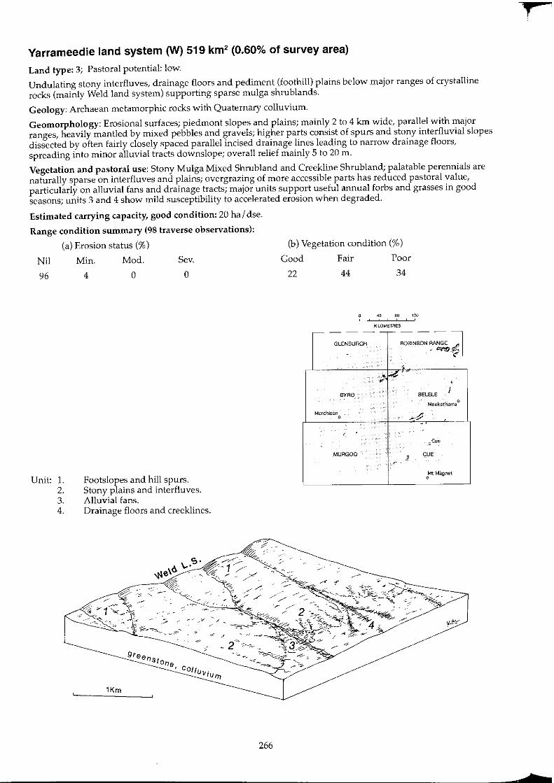
Yarrameedie land system (W) 519 km2 (0.60% of survey area)
Land type: 3; Pastoral potential: low.
Undulating stony interfluves, drainage floors and pediment (foothill) plains below major ranges of crystalline rocks (mainly Weld land system) supporting sparse mulga shrublands.
Geology: Archaean metamorphic rocks with Quaternary colluvium.
Geomorphology: Erosional surfaces; piedmont slopes and plains; mainly 2 to 4 km wide, parallel with major ranges, heavily mantled by mixed pebbles and gravels; higher parts consist of spurs and stony interfluvial slopes dissected by often fairly closely spaced parallel incised drainage lines leading to narrow drainage floors, spreading into minor alluvial tracts downslope; overall relief mainly 5 to 20 m.
Vegetation and pastoral use: Stony Mulga Mixed Shrub land and Creekline Shrub land; palatable perennials are naturally sparse on interfluves and plains; overgrazing of more accessible parts has reduced pastoral value, particularly on alluvial fans and drainage tracts; major units support useful annual forbs and grasses in good seasons; units 3 and 4 show mild susceptibility to accelerated erosion when degraded.
Estimated carrying capacity, good condition: 20 ha I dse.
Range condition summary (98 traverse observations):
(a) Erosion status (%)
Nil Min. Mod. Sev.
96 4 0 0
Unit: 1. 2. 3. 4.
Footslopes and hill spurs. Stony plains and interfluves. Alluvial fans. Drainage floors and creeklines.
1Km
266
(b) Vegetation condition (%)
Good Fair Poor
22 44 34
40 80 120 , KILOMETRES
,---- - --,-- - --GLENBURGH ROBINSON RANGE ~
- .~~
, • I..?
". , BYRO BELELE i
Meekatharra 0
Murchison
-~ 0
-, "Cue
MURGOO }
CUE ,.
Mt Magnet 0
f
b
N
'"' '-J
Yarrameedie 1.5.
Landform and soils
Unit 1: Footslopes and hill spurs (40%)
Concave or convex inclines and piedmont tracts with slopes 1-3%, oGcasionallow rounded crests to 10m relief with total relief generally < 20 m. All surfaces densely to very densely strewn with ironstone, greenstone, gabbro or quartz pebbles. Soils are dark red earthy sands, shallow red earths or occasional duplexes, overlying various metamorphic parent materials < 50 em deep; pH 5.0-7.0 with neutral to acidic reaction trends. Principal profile forms: Dr2.12, UcS.21, UrnS.51.
Unit 2: Stony plains and interfluves (50%)
Broad, gently sloping plains and slightly rounded interfluves to 1 km wide with slopes < 1 %, dissected by alluvial fans and associated drainage lines; lower plains are typically almost flat and carry moderately dense mantles of mixed pebbles and gravels, with small tracts of laterite, hardpan and low sandy banks. Soils are dark red or reddish-brown earthy sands to hardpan clay loams over various subtrates (laterite, hardpan or metamorphic colluvium) < 50 cm deep; pH 5.5-7.0 with a mainly neutral reaction trend. Principal profile forms: Uc5.21, Um5.31.
Unit 3: Alluvial fans (5%)
Gently sloping tracts of shallow sandy and gravelly surfaced alluvium diverging from narrow creeks as slope decreases; average grades are < 1%. Usually strewn with an ironstone, quartz or mixed gravel mantling. Soils are dark red earthy sands up to 1 m deep over various substrates. pH 6.5-7.0 with a neutral trend. Principal profile forms: Uc5.21, Um5.52.
Vegetation: formations and major species
Very scattered to scattered (PFC < 20%) mixed Acacia shrub lands. Trees and tall shrubs (2-6 m): A. aneura, A. burkittii, A. aft. citrinoviridis, A. pruinocarpa, A. ramu/osa, A. tetragonophylla, Canthium latifolia, Santalum spicatum. Mid shrubs (1-2 m): A. sp. MRS399, A. tetragonophylla, Cassia pruinosa, C. helmsii, C. nemophifa, C. oligophylla, C. sturtii, Eremophifa macmiIIaniana, E. cuneifolia, E. latrobei, E. georgei, E. oppositifolia, E. forrestii, Dodonaea pinifolia. Low shrubs « 1 m): Ptifotus obovatus, P. rotundifolius, P. schwartz;;, Thryptomene sp., E. compacta, Maireana georgei, M. planifolia, Solanum ashbyi, S. lasiophyllum, Scaevola spinescens, S. tomentosa, Sida calyxhymenia, S. sp., S. chryphiopeta/a. Perennial grasses: Eragrostis lanipes, Eriachne mucronata, Neurachne sp.
Very scattered to scattered (PFC < 20%) mixed Acacia shrublands dominated by stunted A. aneura. Trees and tall shrubs (2-6 m): A. aneura, A. pruinocarpa, A. quadrimarginea, A. tetragonophylla, Canthium latifofium, Hakea preiss;;. Mid shrubs (1-2 m): A. quadrimarginea, A. sp. P41, Thryptomene sp., Grevillea didymobotrya, Eremophifa latrobei, E. forrestii, Cassia sturtii. Low shrubs « 1 m): C. helmsii, E. spathu/ata, Ptilotus rotundifolius, P. obovatus, P. schwartzii, Solanum lasiophyllum, Maireana planifolia. Perennial grasses: Eragrostis lanipes, Eriachne helmsii, Monachather paradoxa.
Very scattered to scattered (PFC < 20%) mixed Acacia shrublands, with occasional groves of closer shrubland. Trees and tall shrublands (> 2 m):A. aneura, A. ramulosa, A. cuthbertsonii, A. pruinocarpa. Mid shrubs (1-2 m): Cassia deso/ata, C. helmsii, Eremophifa forrestii, E. aft. granitica, E. fraseri. Low shrubs « 1 m): Pti/otus obovatus, C. aft. chatelainiana, C. helmsii, Solanum /asiophyllum. Perennial grasses: Eragrostis eriopoda, E. lanipes, Eriachne helmsii, Monachather paradoxa.
Comments and cond"ition indicators
3 inventory sites and traversed
Vegetation type: Stony Mulga Mixed Shrubland. Palatable perennials include: Maireana spp., Ptifotus spp., Sida spp., Scaevola spp., Eremophila forrestii, E. latrobei, E. compacta, Tribulus platypterus, Eriachne mucronata. Pastoral use limitations: None with controlled grazing. Vegetation condition %: VG/G 30, F 43, PNP 27. 40 obs.
2 inventory sites, 8 condition sites and traversed
Vegetation condition: Stony Mulga Mixed Shrubland. Palatable perennials include: Eremophila forrestii, E. latrobei, Ptilotus spp., Maireana spp., Eragrostis lanipes, Monachather paradoxa. Pastoral use limitations: Sparse perennials but a high annual pasture component following good seasons. Vegetation condition %: VG/G 16, F 37, PNP 47. 38 obs.
2 inventory sites, 1 condition site and traversed
Vegetation type: Stony Mulga Mixed Shrubland. Palatable perennials include: Eremophila forrestii, Cassia aft. chatelainiana, Ptifotus obovatus, Eragrostis spp., Monachather paradoxa. Pastoral use limitations: Mildly susceptible to accelerated erosion where degraded.
... '11;
N
'" en
Yarrameedie I.s.-continued
Landform and soils
Unit 4: Drainage floors and creeklines (5%)
Drainage lines originating as creeklines in neighbouring elevated systems such as Weld, Farmer and Peak Hill; usually < 30 m wide and parallel on upper slopes, broadening to > 100 m and coalescing lower in the topography. Generally with minor incised channels, but mainly becoming disintegrated at alluvial fans or above wash plain systems. Soils are variable from shallow clayey sands upslope to deeper (up to 1 m) sandy clay loams.
Vegetation: formations and major species
Scattered to moderately close (PFC 10-30%) tall shrublands dominated by Acacia aneur8. Trees and tall shrubs (> 2 m): A. aneura, A. craspedocarpa, A. tetragonophylla, A. cuthbertsonii, A. pruinocarpa. Mid shrubs (1-2 m): Cassia desolata, C. helmsiJ; Eremophila fraseri, E. finearis. Low shrubs « 1 m): Ptilotus obovatus, C. he/msH, Sida spp., Rhagodia eremaea, Solanum /asiophyllum. Perennial grass (sparse): Chrysopogon fallax.
Comments and condition indicators
Traversed
Vegetation type: Creekline Shrubland. Palatable perennials include: Ptilotus obovatus, Sida spp., Rhagodia eremaea, Monachather paradoxa, Chrysopogon fallax. Pastoral use limitations: None with controlled grazing.
-1

16602-18
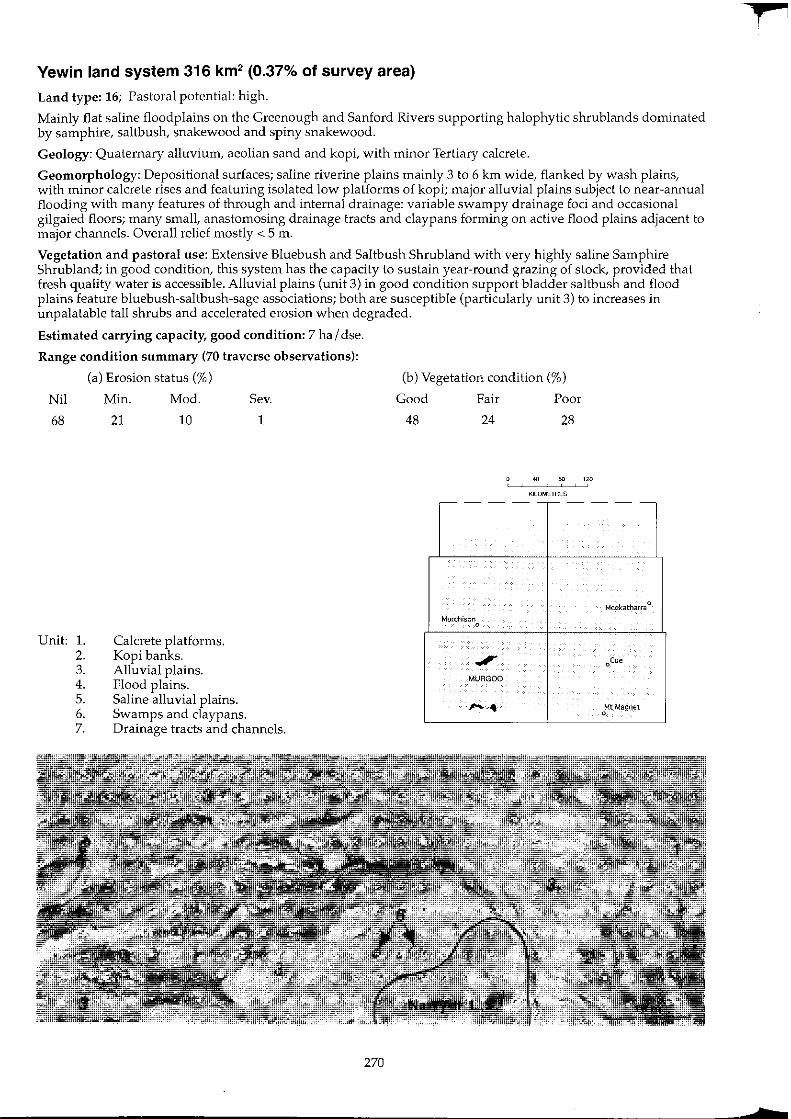
Yewin land system 316 km2 (0.37% of survey area)
Land type: 16; Pastoral potential: high.
Mainly flat saline floodplains on the Greenough and Sanford Rivers supporting halophytic shrub lands dominated by samphire, saltbush, snakewood and spiny snakewood.
Geology: Quaternary alluvium, aeolian sand and kopi, with minor Tertiary calcrete.
Geomorphology: Depositional surfaces; saline riverine plains mainly 3 to 6 km wide, flanked by wash plains, with minor calcrete rises and featuring isolated low platforms of kopi; major alluvial plains subject to near-annual flooding with many features of through and internal drainage: variable swampy drainage foci and occasional gilgaied floors; many small, anastomosing drainage tracts and claypans forming on active flood plains adjacent to major channels. Overall relief mostly < 5 m.
Vegetation and pastoral use: Extensive Bluebush and Saltbush Shrub land with very highly saline Samphire Shrubland; in good condition, this system has the capacity to sustain year-round grazing of stock, provided that fresh quality water is accessible. Alluvial plains (unit 3) in good condition support bladder saltbush and flood plains feature bluebush-saltbush-sage associations; both are susceptible (particularly unit 3) to increases in unpalatable tall shrubs and accelerated erosion when degraded.
Estimated carrying capacity, good condition: 7 hal dse.
Range condition summary (70 traverse observations):
(a) Erosion status (%)
Nil Min. Mod. Sev.
68
Unit: 1. 2. 3. 4. 5. 6. 7.
21 10
Calcrete platforms. Kopi banks. Alluvial plains. Flood plains.
1
Saline alluvial plains. Swamps and claypans. Drainage tracts and channels.
270
(b) Vegetation condition (%)
Good Fair Poor
48 24 28
40 so 120
KILOMETRES
,-- - ---- - --
Meekatharr8 0
Murchison 0
.". oCtJe
MURGQO
~ oMt Magnet
t

f,j
;::J
Yewin I.s.
Landform and soils
Unit 1: Calcrete platforms (2%)
Minor tracts of elevated calcrete residuals up to 2 m high and extending to 2 km long and < 1 km wide; usually located towards margins of system; almost flat plains, lightly to moderately strewn with calcrete rubble. Soils are calcareous yellowish red earths < 1 m deep overlying calcareous pan; pH 9.0 with an alkaline trend. Principal profile form: Gcl.12.
Unit 2: Kopi banks (1 %)
Occasional expanses of slightly elevated gypseous mounds (to 1 m high) between saline plains; often highly saline with areas of dense surface crusting over powdery kopi. Total profile depth is often greater than 1 m, mostly without true soil profile development; pH 9.5 with a strongly alkaline trend.
Unit 3: Alluvial plains (50%)
Extensive, flat plains flanking and slightly higher than major flood plains (units 4-7), slopes mostly negligible « 0.3%) with little relief except for occasional low sandy banks up to 1 m high or wind-blown hummocks around plant bases on degraded parts. Soils are red duplex types, clayey coarse sand to sandy loam over sandy to medium clays, locally gypsiferous, < 1 m deep often overlying hardpan; pH 6.5-7.0 with a neutral to alkaline trend. Principal profile forms: Orl.13, Or1.53, Drl.56, Or2.52.
Unit 4: Flood plains (20%)
Active flood plains adjacent to major watercourses; slightly below unit 3; flat plains with widespread patterning of recently redistributing surface deposits. Soils are brown light clays, with or without sandy surfaces, to 1 m deep; pH 7.0-8.0 with neutral to alkaline reaction trends. Principal profile forms: Uf6.53, Uffi.71.
L~, __ ~~ ___ _
Vegetation: formations and major species
Scattered (PFC 10-20%) tall shrublands dominated by Acacia tysonii and Atriplex bunburyana. Trees and tall shrubs (2-6 m): Grevillea aft. stenobotrya, A tysonii, A. burkittii, Pittosporum phylliraeoides. Mid shrubs (1-2 m): Cassia nemophila, C. spp., Eremophila miniata. Low shrubs « 1 m): Atriplex bunburyana, OlearJa pime/eoides, ScleroJaena spp.
Very scattered (PFC < 10%) low halophyte shrublands dominated by Lawrencia chrysoderma and Halosarcia spp. Tall and mid shrubs (sparse> 1 m): Acacia tysonii, A. victoriae. Low shrubs « 1 my: L. chrysoderma, Hafosarcia halocnemoides, H. pergranuJata, Lycium australe.
Scattered (PFC 10-20%) low shrublands dominated by Atrip/ex vesicaria or Maireana pyramidata. Trees and tall shrubs (2-8 m): Acacia sp. P41 'spiny snakewood', A. victoriae, A. sclerosperma, A. xiphophylla, A. microcalyx, Hakea preissii, Pittosporum phylliraeoides. Mid shrubs (1-2 m): A. sp. P41, A. microcalyx, Cassia phyllodinea. Low shrubs « 1 m): Atriplex vesicaria, A. bunburyana, Maireana amoena, M. atkinsiana, M. pyramidata, M. tomentosa, M. triptera, Enchylaena tomentosa, Rhagodia sp., Halosarcia indica, H. pergranulata, H. doleiformis, Frankenia sp., Gunniopsis quadrifida, Carpobrotus aft. virescens, $ida sp., Ptilotus obovatus, Solanum lasiophyllum, Scaevola spinescens, Eremophila maculata, Zygophyllum sp.
Very scattered to moderately close (PFC < 30%) low chenopod shrublands with a sparse mid shrub layer of Acacia spp. Tall and mid shrubs (> 1 m): Acacia sp. P41, A. tetragonophylla, A. victoriae, A. microcalyx, Hakea arida, Cratystylis subspinescens, Eremophila oldfieldii, Melaleuca sp. Low shrubs « 1 m): Atriplex amnicola, A. bunburyana, A. aft. pa/udosa, Halosarcia indica, Frankenia sp., C. subspinescens, Ptilotus divaricatus, Maireana pyramidata, M. triptera. Perennial grass: Stipa elegantissima.
Comments and condition indicatOl's
1 inventory site and traversed
Vegetation type: Saltbush Shrubland. Palatable perennials include: Atriplex bunburyana, Maireana spp., Enchy/aena tomentosa, Eragrostis spp. Pastoral use limitations: Preferentially grazed unit, susceptible to vegetation degradation but not normally susceptible to accelerated erosion.
1 inventory site, 1 condition site and traversed
Vegetation type: Sam ph ire Shrubland. Palatable perennials include: Lawrencia chrysoderma, Lycium australe. Pastoral use limitations: High salinity content of perennial species.
4 inventory sites, 4 condition sites and traversed
Vegetation type: Bluebush or Saltbush Shrubland. Highly productive perennial pastures providing excellent drought reserves with a significant annual component in good seasons. Palatable perennials include: Atrip/ex spp., Maireana atkinsiana, M. pyramidata, Enchylaena tomentosa, Rhagodia sp., Ptilotus obovatus, Frankenia spp., Eremophila maculata. Pastoral use limitations: Moderately to highly susceptible to accelerated erosion where perennial vegetation is degraded; less invaded by unpalatable shrubs than other equivalent units of Beringarra and Roderick land systems, but presumably still susceptible. Vegetation condition %: VG/G 41, F 32, PNP 27. Erosion incidence %: min 27, mod 12, sev 2.41 obs.
2 inventory sites, 2 condition sites and traversed
Vegetation type: Saltbush or Mixed Halophyte Shrubland. Palatable perennials include: Atriplex spp., Maireana spp., Cratysty/is subspinescens. Pastoral use limitations: Moderately susceptible to accelerated erosion where degraded.
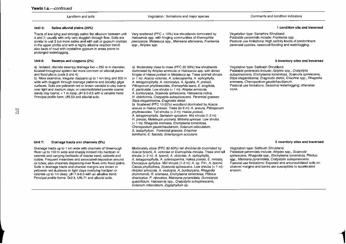
~
Yewin I.s.--continued
Landform and soils
Unit 5: Saline alluvial plains (20%)
Tracts of low-lying and strongly saline flat alluvium between unit 4 and 7; usually with only very sluggish through flow. Soils are similar to unit 3 but more saline and with salt or gypsum crystals in the upper profile and with a highly alkaline reaction trend; also beds of mud with crystalline gypsum in areas prone to prolonged waterlogging.
Unit 6: Swamps and claypans (2%)
a) Isolated, discrete swampy drainage foci < 250 m in diameter, located throughout system but more common on alluvial plains and flood plains (units 3 and 4). b) More extensive, irregular claypans up to 1 km long and 500 m wide with sluggish through drainage patterns and (locally) gilgai surfaces. Soils are yellowish red or brown variable to clay loams over light and medium clays; or unconsolidated juvenite coarse sandy clay loams; < 1 m deep; pH 6.0-9.5 with a variable trend. Principal profile form: Uf6.53 and alluvial soils.
Unit7: Drainage tracts and channels (5%)
Drainage tracts up to 1 km wide with channels of Greenough River up to 100 m wide and sharply incised into hardpan Or calcrete and carrying bedloads of coarse sand, calcrete and rubble. Frequent meanders and associated deposition around ox bows; also channels dispersing river flows onto flood plains. Soils in drainage tracts and channel margins are brown or yellowish red duplexes or light clays overlying hardpan or calcrete up to 1 m deep; pH 7.0-8.0 with an alkaline trend. Principal profile forms: Dr2.5, Uf6.71 and alluvial soils.
Vegetation: formations and major species
Very scattered (PFC < 10%) low shrublands dominated by Halosarcia spp. with fringing communities of Eremophila pterocarpa, Melaleuca spp., Maireana atkinsiana, Frankenia spp .• A/rip/ex spp.
a) Moderately close to close (PFC 20-50%) low shrublands dominated by Atriplex amnicola or Halosarcia spp. with dense fringes of Hakea preissii or Melaleuca sp. Trees and tall shrubs (> 1 m): Acacia victoriae, A. sclerosperma, A. xiphophylla, A. tetragonophylla, A. microcalyx, A, ligulata, H. preissii, Pittosporum phylliraeoides, Eremophila laan;;, E. longifolia, E. paniculata. Low shrubs « 1 m): Atriplex amnicola, A. bunburyana, Scaevola spinescens, Halosarcia indica, H. doleiformis, Cratystylis subspinescens. Perennial grasses: Stipa elegantissima, Eragrostis diels;;. b) Scattered (PFC 10-20%) woodland dominated by Acacia aneura or Hakea preissii. Trees (to 8 m): A. aneura, Pittosporum phylliraeoides. Tall shrubs (> 2 m): Hakea preissii, A. tetragonophylla, Santalumspicatum. Mid shrubs (1-2 m): H. preissii, Melaleuca uncinata, Mirbelia spinosa. Low shrubs « 1 m): Rhagodia eremaea, Enchylaena tomentosa, Chenopodium gaudichaudianum, Solanum orbiculalum, S. lasiophyllum. Perennial grasses: Eriachne benthamii, E. flaccida, Enteropogon acicularis.
Moderately close (PFC 30-50%) tall shrub lands dominated by Acacia tysomi; A. victoriae or EremophI7a miniata. Trees and tall shrubs (> 2 my: A. tysonii, A. victoriae, A. xiphophylla, A. tetragonophylla, A. sc/erosperma, Hakea preissi, E. miniata, Exocarpus aphyllus. Mid shrubs (1-2 m): A. sp. P41, A. tyson;;, Cassia phyllodinea, Scaevola spinescens. Low shrubs « 1 m): Atriplex amnicola, A. vesicaria, A. bunburyana, Rhagodia drummondii, R. eremaea, Enchylaena tomentosa, Plilotus divaricatus, P. obovatus, Maireana pyramidata, Gunniopsis quadrifidum, Halosarcia spp., Cratystylis subspinescens, Solanum orbiculatum, Zygophyl/um sp.
Comments and condition indicators
1 condition site and traversed
Vegetation type: Samphire Shrubland. Palatable perennials include: Frankenia spp. Pastoral use limitations: High salinity levels of predominant perennial species, seasonal flooding and waterlogging.
3 inventory sites and traversed
Vegetation type: Saltbush Shrubland. Palatable perennials include: Atriplex spp., Cratystylis subspinescens, Enchylaena tomentosa, Scaevola spinescens, Stipa elegantissima, Eragrostis die/sii, Eriachne spp., Rhagodia eremaea, Chenopodium gaudichaudianum. Pastoral use limitations: Seasonal waterlogging; otherwise none.
2 inventory sites and traversed
Vegetation type: Saltbush Shrubland. Palatable perennials include: Atriplex spp., Scaevola spinescens, Rhagodia spp., Enchylaena tomentosa, Ptilotus spp., Maireana pyramidata, Cratystylis subspinescens. Pastoral use limitations: Exposed and unconsolidated soils on channel margins and banks are susceptible to accelerated erosion.
1
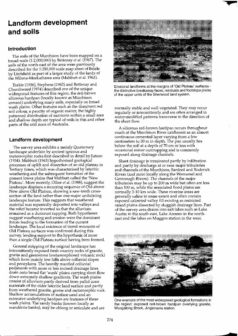
Landform development and soils
Introduction The soils of the Murchison have been mapped on a
broad scale (1:2,000,000) by Bettenay et al. (1967). The soils of the north-east of the area were previously described for the 1:250,000 scale map sheet of Belele by Litchfield as part of a larger study of the lands of the Wiluna-Meekatharra area (Mabbutt et al. 1963).
Teakle (1936), Stephens (1962) and Bettenay and Churchward (1974) described one of the unique widespread features of this region, the red-brown siliceous hardpan (locally known as MurchIson cement) underlying many soils, especially on broad wash plains. Other features such as the dominant red soil colour, a paucity of organic matter, the highly patterned distribution of nutrients within a small area and shallow depth are typical of soils in this and other parts of the arid zone of Australia.
Landform development
The survey area exhibits a mainly Quaternary landscape underlain by ancient igneous and metamorphic rocks first described in detail by Jutson (1934). Mabbutt (1963) hypothesised geological processes of uplift and dissection of an old plateau in Tertiary times, which was characterised by lateritic weathering and the subsequent formation of the present lower plains that Mabbutt called the 'New Plateau'. More recently, Ollier et al. (1988), suggest the landscape displays a recurring sequence of Old above New above Old Plateau, showing a saw-tooth crosssection of the land rather than one major undulating landscape feature. This suggests that weathered material was repeatedly deposited into valleys and the relief became inverted so that the alluvium remained as a duricrust capping. Both hypotheses suggest weathering and erosion were the dominant forces leading to the formation of the current landscape. The local existence of tiered remnants of Old Plateau surfaces was confirmed during this survey, lending support to the hypothesis of more than a single Old Plateau surface having been formed.
General stripping of the original landscape has intermittently exposed fresh country rocks of granite, gneiss and greenstone (metamorphosed voleanic rock) which form mainly low hills above colluvial slopes and peneplains. The heavily mantled colluvial pediments with more or less incised drainage lines drain onto broad flat 'wash' plains carrying sheet flow down extremely shallow gradients. The wash plains consist of alluvium partly derived from pallid zone materials of the older lateritic land surface and partly from weathered granite, gneiss and metamorphic rock. Shallow accumulations of surface sand and an extensive underlying hardpan are features of these wash plains. The sandy banks (known locally as wanderrie banks), may be oblong or reticulate and are
274
Erosional landforms at the margins of 'Old Plateau' surfaces -the distinctive breakaway faces, residuals and footslope plains of the upper units of the Sherwood land system.
normally stable and well vegetated. They may occur regularly or intermittently and are often arranged in water-modified patterns transverse to the direction of the sheet flow.
A siliceous red-brown hardpan occurs throughout much of the Murchison River catchment as an almost continuous cemented layer varying from a few centimetres to 30 m in depth. The pan usually lies below the soil at a depth of 70 cm or less with occasional minor outcropping and is commonly exposed along drainage channels.
Sheet drainage is terminated partly by infiltration and partly by discharge at or near major tributaries and channels of the Murchison, Sanford and Roderick Rivers (and more locally along the Wooramel and Greenough Rivers). The channels of the major tributaries may be up to 200 m wide but often are less than 100 m, while the associated flood plains are normally 3-10 km wide. These riverine areas are generally saline to some extent and often contain exposed calereted valley fill existing as restricted raised plains dissected by sluggish drainage lines. Part of the survey area drains into salt lakes such as Lake Austin in the south-east, Lake Anneen in the northeast and the lakes on Muggon station in the west.
One example of the most widespread geological formations in the region: exposed red-brown hardpan overlying granite, Woogalong Brook, Jingemarra station.
•

Deeply dissected Permian sediments of sandstone and siltstone occur on the western margin of the survey area. This landscape is dominated by gently undulating stony plains below breakaways with remnant low hills and plateaux with up to 30 m relief. The upland plateaux are often capped with a duricrust of silcrete. The northern portion of the Permian landscape drains to the Wooramel River, while the southern portion is associated with a lacustrine system. This palaeodrainage links the present Wooramel River headwaters with the Murchison River (Denman et aZ. 1985). Drainage is very sluggish with many local foci which are often saline. The Permian and lacustrine systems are closely associated with extensive areas of aeolian sand sheet. The sand sheet occurs as flat or gently undulating plains with occasional linear dunes and no surface drainage. This is essentially an outlying section of the vast Victoria Sand plain (Condon 1967) which dominates the landscape further west.
Soils
The method of soil sampling used during the survey and the data collected are described in the 'Survey methods' section of the report. The techniques and standards used were those given in the Australian Soil and Land Survey Field Handbook (McDonald et al. 1984) and Northcote (1979). The data collected enabled Northcote's key to rank soils into Principal Profile Forms (PPF's).
Soil classification is a systematic arrangement of soils on the basis of similarities and differences in their morphological features. Soils are generally composed of three major layers designated A, Band C horizons. The A and B horizons are layers that have been modified by weathering and soil development. The C horizon is weathering parent material. Occasionally D horizons occur. These are not related to the soil forming processes of the overlaying soil (e.g. redbrown hardpan). Northcote's key is based on observable soil profile features and uses alphanumeric coding system to identify classes. The first division is based on texture variation within the soil profile. Soils are mostly classified as one of three types - uniform (U), gradational (G) or duplex (D).
Uniform soils show little, if any, change in soil texture throughout the profile. These soils are further classified as either coarse, medium or fine textures. A uniform coarse profile is typically a sand; a uniform medium profile a loam and a uniform fine profile is clay throughout.
Gradational soils show a gradual increase in clay content throughout the depth of the soil profile. Further classification is based on the presence or absence of calcium carbonate (lime).
Duplex soils show a sharp textural change between the A and B horizons such as a coarse texture (e.g. sand) overlying a fine texture (e.g. clay). Duplex soils are further classified on COIOUf, surface characteristics, soil reaction trends and structure.
275
Soil profiles sharing similar characteristics have been combined to create soil groups. These soil groups are used for soil descriptions throughout the text.
Twelve major soil groups were identified in the survey area. Sorted primarily on soil profile development, the soil groups are, in part, similar to those of Stace et al. (1968). Soil phases of Great Soil Groups have been introduced to differentiate the soils according to their lithology or profile development. The soils range from poorly sorted river sands to well structured deep cracking clays.
Alluvial (juvenile) soils
These are weakly or undifferentiated soils formed in recent alluvium. They occur in or immediately adjacent to major and minor rivers or flow lines. These sediments may have many layers of coarse loose sand, clayey sand or silty sand. Layers containing river pebbles are visible on exposed creek banks. Depth is variable, but where it is less than 1 m, the soil is often underlain by rock or hardpan which, within drainage lines on occasions has a thin calcrete veneer. Fluvial sediments are often found on levee banks associated with the larger flow lines. They may be no more than poorly sorted coarse sands, depending on catchment size and lithology. Catchments with metamorphic lithology tend to produce finer sediments than granitic based catchments where quartz sand predominates. Alluvial soils are often called Juvenile soils, they occur in lake beds, drainage foci or other low lying areas receiving major run-on.
At drainage channels these soils are mostly weakly acidic to neutral (pH 6.0-7.5) and are non-saline. Saline varieties occur in areas of calcreted valleys, of the Mileura, Cunyu and Beringarra land systems. Soil colour varies from dark red (2.5YR 3/6) to strong brown (7.5YR4/6).
These soils generally support vegetation on the stable levee banks and floodplains but only occasionally in the river channels, indicating the impact of intermittent river flows rather than a reflection on soil quality. These soils cannot be classified within the Northcote key.
Solonchaks
Solonchaks are highly saline. They occur in lake beds, on gypsiferous plains, in some drainage flats and at terminated drainages. Solonchaks are stone-free and very shallow (often less than 30 em). Textures range from clayey sands to clay loams often overlying gypsum or cemented carbonates. Soil colour ranges from strong brown (7.5YR 4/6) to dark red (2.5YR 3/ 6). Some Solonchaks are characterised by a surface crusted with salt, showing polygonal cracking or exhibit a soft, loose, powdery surface horizon with visible salt crystals.
With high salinity and susceptibility to prolonged waterlogging, these soils support little or no . vegetation. Away from lake beds, the less salIne lake
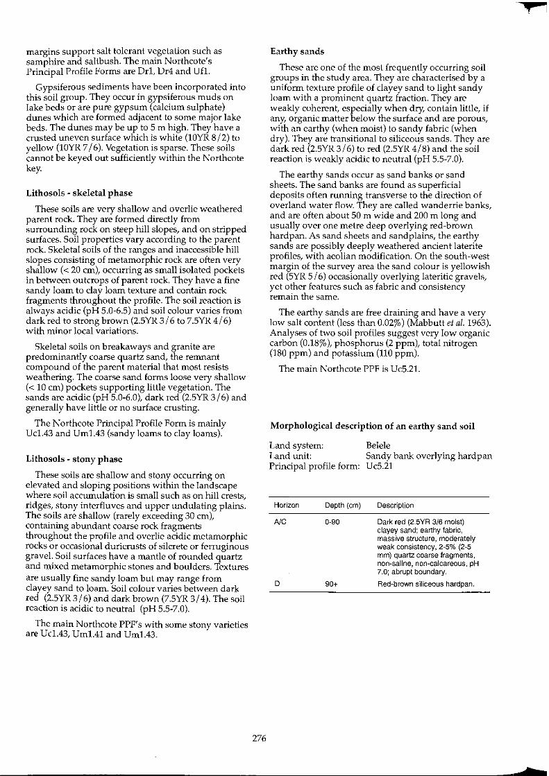
margins support salt tolerant vegetation such as samphire and saltbush. The main Northcote's Principal Profile Forms are Dr1, Dr4 and un.
Gypsiferous sediments have been incorporated into this soil group. They occur in gypsiferous muds on lake beds or are pure gypsum (calcium sulphate) dunes which are formed adjacent to some major lake beds. The dunes may be up to 5 m high. They have a crusted uneven surface which is white (lOYR 8/2) to yellow (lOYR 7/6). Vegetation is sparse. These soils cannot be keyed out sufficiently within the Northcote key.
Lithosols - skeletal phase
These soils are very shallow and overlie weathered parent rock. They are formed directly from surrounding rock on steep hill slopes, and on stripped surfaces. Soil properties vary according to the parent rock. Skeletal soils of the ranges and inaccessible hill slopes consisting of metamorphic rock are often very shallow « 20 cm), occurring as small isolated pockets in between outcrops of parent rock. They have a fine sandy loam to clay loam texture and contain rock fragments throughout the profile. The soil reaction is always acidic (pH 5.0-6.5) and soil colour varies from dark red to strong brown (2.5YR 3/6 to 7.5YR 4/6) with minor local variations.
Skeletal soils on breakaways and granite are predominantly coarse quartz sand, the remnant compound of the parent material that most resists weathering. The coarse sand forms loose very shallow « 10 cm) pockets supporting little vegetation. The sands are acidic (pH 5.0-6.0), dark red (2.5YR 3/6) and generally have little or no surface crusting.
The Northcote Principal Profile Form is mainly Uc1.43 and Um1.43 (sandy loams to clay loams).
Lithosols - stony phase
These soils are shallow and stony occurring on elevated and sloping positions within the landscape where soil accumulation is small such as on hill crests, ridges, stony interfluves and upper undulating plains. The soils are shallow (rarely exceeding 30 cm), containing abundant coarse rock fragments throughout the profile and overlie acidic metamorphic rocks or occasional duricrusts of silcrete or ferruginous gravel. Soil surfaces have a mantle of rounded quartz and mixed metamorphic stones and boulders. Textures are usually fine sandy loam but may range from clayey sand to loam. Soil colour varies between dark red (2.5YR 3/6) and dark brown (7.5YR 3/4). The soil reaction is acidic to neutral (pH 5.5-7.0).
The main Northcote PPF's with some stony varieties are Uc1.43, Um1.41 and Um1.43.
276
Earthy sands
These are one of the most frequently occurring soil groups in the study area. They are characterised by a uniform texture profile of clayey sand to light sandy loam with a prominent quartz fraction. They are weakly coherent, especially when dry, contain little, if any, organic matter below the surface and are porous, with an earthy (when moist) to sandy fabric (when dry). They are transitional to siliceous sands. They are dark red (2.5YR 3/6) to red (2.5YR 4/8) and the soil reaction is weakly acidic to neutral (pH 5.5-7.0).
The earthy sands occur as sand banks or sand sheets. The sand banks are found as superficial deposits often running transverse to the direction of overland water flow. They are called wanderrie banks, and are often about 50 m wide and 200 m long and usually over one metre deep overlying red-brown hardpan. As sand sheets and sandplains, the earthy sands are possibly deeply weathered ancient laterite profiles, with aeolian modification. On the south-west margin of the survey area the sand colour is yellowish red (5YR 5/6) occasionally overlying lateritic gravels, yet other features such as fabric and consistency remain the same.
The earthy sands are free draining and have a very low salt content (less than 0.02%) (Mabbutt et al. 1963). Analyses of two soil profiles suggest very low organic carbon (0.18%), phosphorus (2 ppm), total nitrogen (180 ppm) and potassium (110 ppm).
The main Northcote PPF is Uc5.21.
Morphological description of an earthy sand soil
Land system: Land unit: Principal profile form:
Horizon Depth (em)
NC 0-90
D 90+
Belele Sandy bank overlying hardpan Uc5.21
Description
Dark red (2.5YR 3/6 moist) clayey sand; earthy fabric, massive structure, moderately weak consistency, 2-5% (2-5 mm) quartz coarse fragments, non-saline, non-calcareous, pH 7.0; abrupt boundary.
Red-brown siliceous hardpan.
+
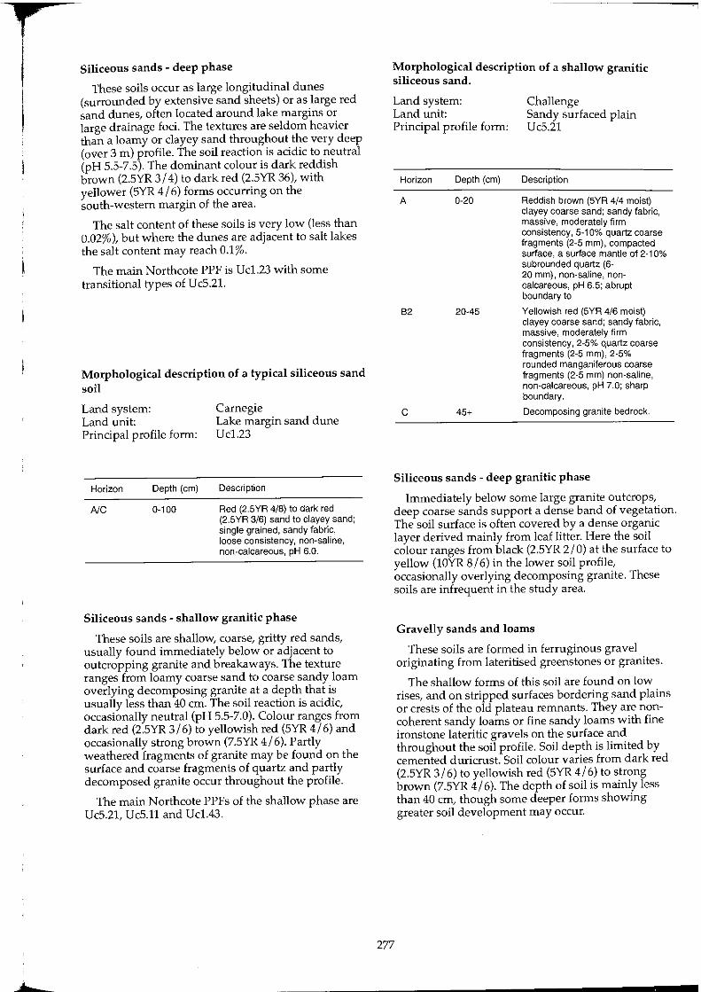
Siliceous sands - deep phase
These soils occur as large longitudinal dunes (surrounded by extensive sand sheets) or as large red sand dunes, often located around lake margins or large drainage foci. The textures are seldom heavier than a loamy or clayey sand throughout the very deep (over 3 m) profile. The soil reaction is acidic to neutral (pH 5.5-7.5). The dominant colour is dark reddish brown (2.5YR 3/4) to dark red (2.5YR 36), with yellower (5YR 4/6) forms occurring on the south-western margin of the area.
The salt content of these soils is very low (less than 0.02%), but where the dunes are adjacent to salt lakes the salt content may reach 0.1%.
The main Northcote PPF is Uc1.23 with some transitional types of Uc5.21.
Morphological description of a typical siliceous sand soil
Land system: Land unit: Principal profile form:
Horizon Depth (em)
NC 0-100
Carnegie Lake margin sand dune Uc1.23
Description
Red (2.5YR 4/8) to dark red (2.5YR 3/6) sand to clayey sand; single grained, sandy fabric, loose consistency, non~saline, non-calcareous, pH 6.0.
Siliceous sands - shallow granitic phase
These soils are shallow, coarse, gritty red sands, usually found immediately below or adjacent to outcropping granite and breakaways. The texture ranges from loamy coarse sand to coarse sandy loam overlying decomposing granite at a depth that is usually less than 40 cm. The soil reaction is acidic, occasionally neutral (pH 5.5-7.0). Colour ranges from dark red (2.5YR 3/6) to yellowish red (5YR 4/6) and occasionally strong brown (7.5YR 4/6). Partly weathered fragments of granite may be found on the surface and coarse fragments of quartz and partly decomposed granite occur throughout the profile.
The main Northcote PPFs of the shallow phase are Uc5.21, Uc5.11 and Uc1.43.
277
Morphological description of a shallow granitic siliceous sand.
Land system: Land unit: Principal profile form:
Horizon Depth (em)
A 0-20
B2 20-45
C 45+
Challenge Sandy surfaced plain Uc5.21
Description
Reddish brown (5YR 4/4 moist) clayey coarse sand; sandy fabric, massive, moderately firm consistency, 5-10% quartz coarse fragments (2-5 mm), compacted surface, a surface mantle of 2-10% subrounded quartz (6-20 mm), non-saline, noncalcareous, pH 6.5; abrupt boundary to
Yellowish red (5YR 4/6 moist) clayey coarse sand; sandy fabric, massive, moderately firm consistency, 2~5% quartz coarse fragments (2~5 mm), 2-5% rounded manganiferous coarse fragments (2-5 mm) non-saline, non-calcareous, pH 7.0; sharp boundary.
Decomposing granite bedrock.
Siliceous sands - deep granitic phase
Immediately below some large granite outcrops, deep coarse sands support a dense band of vegetation. The soil surface is often covered by a dense organic layer derived mainly from leaf litter. Here the soil colour ranges from black (2.5YR 2/0) at the surface to yellow (lOYR 8/6) in the lower soil profile, occasionally overlying decomposing granite. These soils are infrequent in the study area.
Gravelly sands and loams
These soils are formed in ferruginous gravel originating from lateritised greenstones or granites.
The shallow forms of this soil are found on low rises, and on stripped surfaces bordering sand plains or crests of the old plateau remnants. They are noncoherent sandy loams or fine sandy loams with fine ironstone lateritic gravels on the surface and throughout the soil profile. Soil depth is limited by cemented duricrust. Soil colour varies from dark red (2.5YR 3/6) to yellowish red (5YR 4/6) to strong brown (7.5YR 4/6). The depth of soil is mainly less than 40 cm, though some deeper forms showing greater soil development may occur.
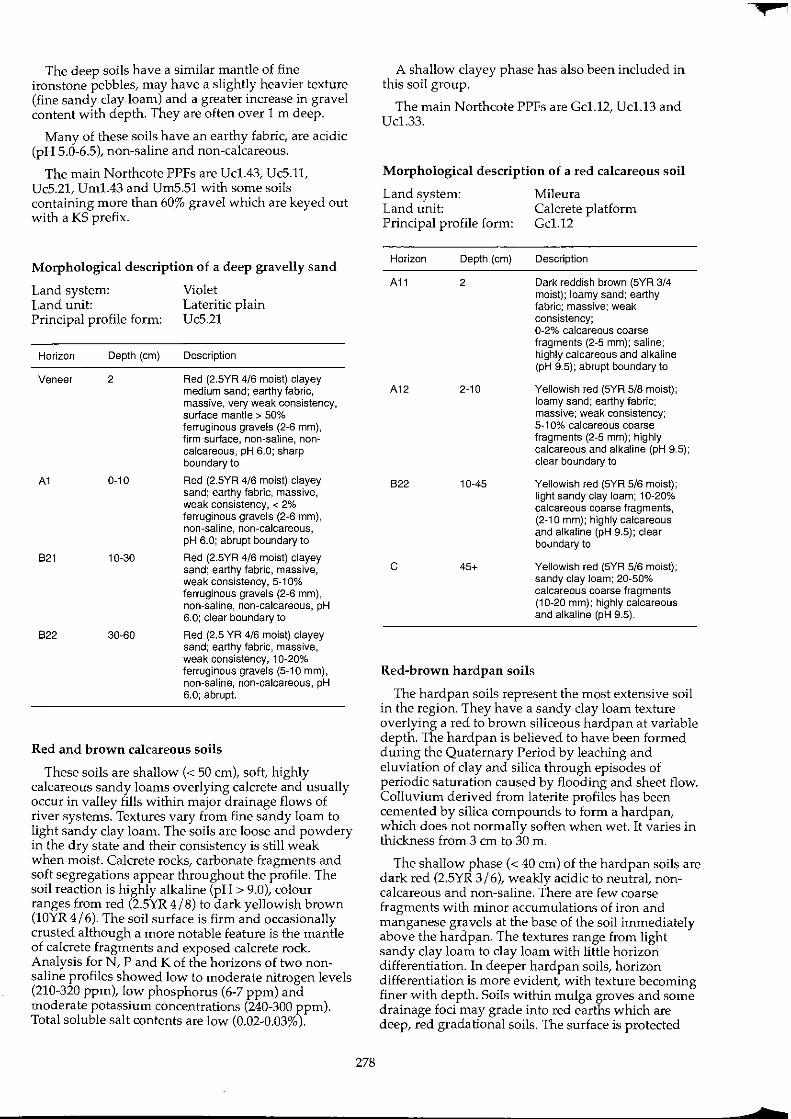
The deep soils have a similar mantle of fine ironstone pebbles, may have a slightly heavier texture (fine sandy clay loam) and a greater increase in gravel content with depth. They are often over 1 m deep.
Many of these soils have an earthy fabric, are acidic (pH 5.0-6.5), non-saline and non-calcareous.
The main Northcote PPFs are Uc1.43, Uc5.11, Uc5.21, Um1.43 and Um5.51 with some soils containing more than 60% gravel which are keyed out with a KS prefix.
Morphological description of a deep gravelly sand
Land system: Land unit: Principal profile form:
Horizon Depth (cm)
Veneer 2
A1 0-10
B21 10-30
B22 30-60
Violet Lateritic plain Uc5.21
Description
Red (2.5YR 4/6 moist) clayey medium sand; earthy fabric, massive, very weak consistency, surface mantle> 50% ferruginous gravels (2-6 mm), firm surface, non-saline, noncalcareous, pH 6.0; sharp boundary to
Red (2.5YR 4/6 moist) clayey sand; earthy fabric, massive, weak consistency, < 2% ferruginous gravels (2-6 mm), non-saline, non-calcareous, pH 6.0; abrupt boundary to
Red (2.5YR 4/6 moist) clayey sand; earthy fabric, massive, weak consistency, 5-1 0% ferruginous gravels (2-6 mm), non-saline, non-calcareous, pH 6.0; clear boundary to
Red (2.5 YR 4/6 moist) clayey sand; earthy fabric, massive, weak consistency, 10-20% ferruginous gravels (5-10 mm), non-saline, non~calcareous, pH 6.0; abrupt.
Red and brown calcareous soils
These soils are shallow « 50 cm), soft, highly calcareous sandy loams overlying calcrete and usually occur in valley fills within major drainage flows of river systems. Textures vary from fine sandy loam to light sandy clay loam. The soils are loose and powdery in the dry state and their consistency is still weak when moist. Calcrete rocks, carbonate fragments and soft segregations appear throughout the profile. The soil reaction is highly alkaline (pH> 9.0), colour ranges from red (2.5YR 4/8) to dark yellowish brown (10YR 4/6). The soil surface is firm and occasionally crusted although a more notable feature is the mantle of calcrete fragments and exposed calcrete rock. Analysis for N, P and K of the horizons of two nonsaline profiles showed low to moderate nitrogen levels (210-320 ppm), low phosphorus (6-7 ppm) and moderate potassium concentrations (240-300 ppm). Total soluble salt contents are low (0.02-0.03%).
278
A shallow clayey phase has also been included in this soil group.
The main Northcote PPFs are Gc1.12, Uc1.13 and Uc1.33.
Morphological description of a red calcareous soil
Land system: Mileura Land unit: Calcrete platform Principal profile form: Gc1.12
Horizon Depth (cm)
A11 2
A12 2-10
B22 10-45
c 45+
Red-brown hardpan soils
Description
Dark reddish brown (5YR 3/4 moist); loamy sand; earthy fabric; massive; weak consistency; 0~2% calcareous coarse fragments (2~5 mm); saline; highly calcareous and alkaline (pH 9.5); abrupt boundary to
Yellowish red (5YR 5/8 moist); loamy sand; earthy fabric; massive; weak consistency; 5~ 10% calcareous coarse fragments (2-5 mm); highly calcareous and alkaline (pH 9.5); clear boundary to
Yellowish red (5YR 5/6 moist); light sandy clay loam; 1 0~20% calcareous coarse fragments, (2~1 0 mm); highly calcareous and alkaline (pH 9.5); clear boundary to
Yellowish red (5YR 5/6 moist); sandy clay loam; 20~50% calcareous coarse fragments (10~20 mm); highly calcareous and alkaline (pH 9.5).
The hardpan soils represent the most extensive soil in the region. They have a sandy clay loam texture overlying a red to brown siliceous hardpan at variable depth. The hardpan is believed to have been formed during the Quaternary Period by leaching and eluviation of clay and silica through episodes of periodic saturation caused by flooding and sheet flow. Colluvium derived from laterite profiles has been cemented by silica compounds to form a hardpan, which does not normally soften when wet. It varies in thickness from 3 cm to 30 m.
The shallow phase « 40 cm) of the hardpan soils are dark red (2.5YR 3/6), weakly acidic to neutral, noncalcareous and non-saline. There are few coarse fragments with minor accumulations of iron and manganese gravels at the base of the soil immediately above the hardpan. The textures range from light sandy clay loam to clay loam with little horizon differentiation. In deeper hardpan soils, horizon differentiation is more evident, with texture becoming finer with depth. Soils within mulga groves and some drainage foci may grade into red earths which are deep, red gradational soils. The surface is protected

mainly by patchy cryptogams and tiny rhizomes of winter growing forbs although some areas are extensively mantled by gravels or pebbles. Chemical analyses of six shallow hardpan soils showed low to moderate nitrogen (250-400 ppm), low organic carbon (0.12-0.42%) and low salt contents (top soil 0.01-0.03%, subsoil 0.01-0.7%).
The Northcote PPFs are Um5.31 and occasionally Gn2.12.
Morphological description of a shallow red-brown hardpan soil
Land system: Land unit: Principal profile form:
Horizon Depth (em)
A 0-30
D 30+
Yandil Hardpan plain - intergrove Um5.31
Description
Dark red (2.5YR 3/6 moist) sandy clay loam; earthy fabric, massive, moderately firm consistency, 0-2% quartz coarse fragments, hardsetting with extensive cryptogamic crusting, 2-5% fine ironstone gravel mantle, non-saline, noncalcareous, pH 6.5; abrupt boundary.
Continuous cemented laminar red to dark red (2.5YR 4/6) siliceous hardpan with manganiferous inclusions.
Morphological description of a typical deep redbrown hardpan soil
Land system: Land unit: Principal profile form:
Horizon Depth (em)
A1 0-30
B2 30-80
D 80+
Woodline Hard pan plain Um5.31
Description
Red (2.5YR 4/6) sandy clay loam; earthy fabric, massive, moderately firm consistency, hardsetting surface with extensive cryptogamic crusting, > 2% quartz coarse fragments, non-saline non-calcareous, pH 7.0; gradual boundary to
Red (2.5YR 4/6) clay loam: earthy fabric, massive, firm consistency < 2% quartz coarse fragments, 2-10% ferromanganiferous coarse fragments, pH 7.5; abrupt boundary to
Continuous strongly cemented laminar red to dark red (2.5YR 4/6) siliceous hardpan with manganiferous inclusions.
279
Calcareous red earths
Calcareous red earths are essentially deep red earths WIth carbonates m part of, or throughout the profile. Their textures range from sandy loam and sandy clay loam to hght clay. The SOlis show a trend of increasing amounts of clay and carbonates with depth. The carbonates may appear as coarse fragments or as soft segregations within the massive earthy fabric. There are few (2-5%) carbonate nodules (2-5 mm) in the topsoil increasing in abundance to common (5-10%) in the subsoil. The soil reaction is neutral to mildly alkaline at the surface becoming strongly alkaline at depth.
These soils occur in and adjacent to major creek systems and on or adjacent to large calcrete platforms. Their colour varies from red (2.5YR 3/6) to yellowish red (5YR 4/6) at the surface and becomes reddish yellow (5YR 7/6) at depth (1 m).
The main Northcote PPFs are Gcl.12, Gc1.21 and Gcl.22 and Gc2.22.
Morphological description of a typical calcareous red earth
Land system: Land unit: Principal profile form:
Horizon Depth (em)
A1 0-10
A3 10-55
B21k 55-100+
B22ky 55-100+
Mileura Grove Gcl.22
Description
Dark reddish brown (5YR 3/2) fine sandy loam; earthy, massive, moderately weak consistency, soft soil surface, highly calcareous, pH 9.0; abrupt boundary to
Dark reddish brown (5YR 3/4) loam; earthy fabric, massive, moderately weak consistency, highly calcareous, pH 9.0; abrupt boundary to
Yellowish red (5YR 5/8) clay loam; earthy fabric, massive, moderately weak consistency, 0-2% soft calcareous nodules, highly calcareous, pH 9.5; abrupt boundary or
Yellowish red (5YR 5/8) light clay; earthy fabric massive, moderately firm consistency, 0-2% soft calcareous nodules, highly calcareous, 5-10% very fine gypsum crystals, pH 9.5.
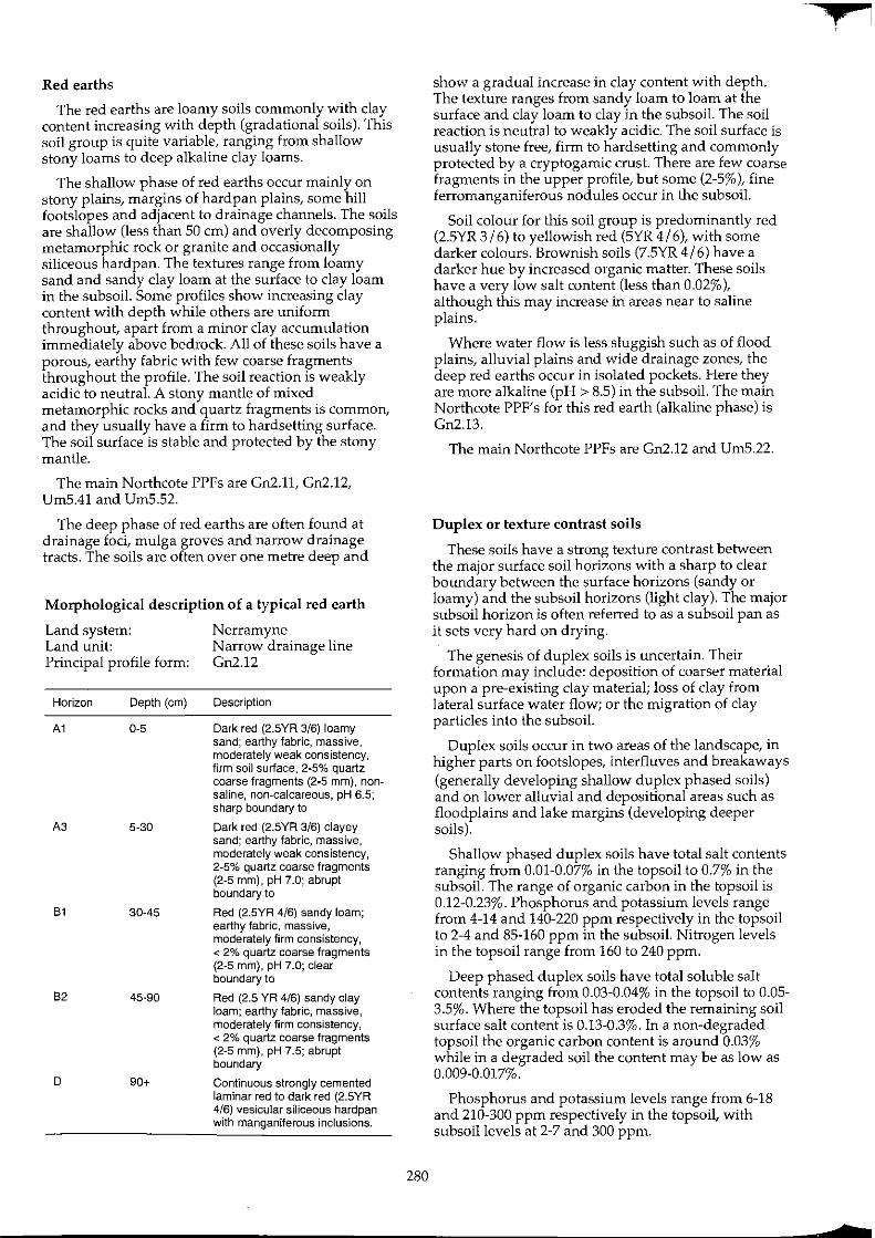
Red earths
The red earths are loamy soils commonly with clay content increasing with depth (gradational soils). This soil group is quite variable, ranging from shallow stony loams to deep alkaline clay loams.
The shallow phase of red earths occur mainly on stony plains, margins of hardpan plains, some hill footslopes and adjacent to drainage channels. The soils are shallow (less than 50 cm) and overly decomposing metamorphic rock or granite and occasionally siliceous hardpan. The textures range from loamy sand and sandy clay loam at the surface to clay loam in the subsoil. Some profiles show increasing clay content with depth while others are uniform throughout, apart from a minor clay accumulation immediately above bedrock. All of these soils have a porous, earthy fabric with few coarse fragments throughout the profile. The soil reaction is weakly acidic to neutral. A stony mantle of mixed metamorphic rocks and quartz fragments is common, and they usually have a firm to hardsetting surface. The soil surface is stable and protected by the stony mantle.
The main Northcote PPFs are Gn2.11, Gn2.12, Um5.41 and Um5.52.
The deep phase of red earths are often found at drainage foci, mulga groves and narrow drainage tracts. The soils are often over one metre deep and
Morphological description of a typical red earth
Land system: Land unit: Principal profile form:
Horizon Depth (cm)
A1 0-5
A3 5-30
81 30-45
82 45-90
D 90+
Nerramyne N arrow drainage line Gn2.12
Description
Dark red (2.5YR 3/6) loamy sand; earthy fabric, massive, moderately weak consistency, firm soil surface, 2-5% quartz coarse fragments (2-5 mm), nonsaline, non-calcareous, pH 6.5; sharp boundary to
Dark red (2.5YR 3/6) clayey sand; earthy fabric, massive, moderately weak consistency, 2-5% quartz coarse fragments (2-5 mm), pH 7.0; abrupt boundary to
Red (2.5YR 4/6) sandy loam; earthy fabric, massive, moderately firm consistency, < 2% quartz coarse fragments (2-5 mm), pH 7.0; clear boundary to
Red (2.5 YR 4/6) sandy clay loam; earthy fabric, massive, moderately firm consistency, < 2% quartz coarse fragments (2-5 mm), pH 7.5; abrupt boundary
Continuous strongly cemented laminar red to dark red (2.5YR 4/6) vesicular siliceous hardpan with manganiferous inclusions.
280
show a gradual increase in clay content with depth. The texture ranges from sandy loam to loam at the surface and clay loam to clay in the subsoil. The soil reaction is neutral to weakly acidic. The soil surface is usually stone free, firm to hardsetting and commonly protected by a cryptogamic crust. There are few coarse fragments in the upper profile, but some (2-5%), fine ferromanganiferous nodules occur in the subsoil.
Soil colour for this soil group is predominantly red (2.5YR 3/6) to yellowish red (5YR 4/6), with some darker colours. Brownish soils (7.5YR 4/6) have a darker hue by increased organic matter. These soils have a very low salt content (less than 0.02%), although this may increase in areas near to saline plains.
Where water flow is less sluggish such as of flood plains, alluvial plains and wide drainage zones, the deep red earths occur in isolated pockets. Here they are more alkaline (pH> 8.5) in the subsoil. The main Northcote PPF's for this red earth (alkaline phase) is Gn2.13.
The main Northcote PPFs are Gn2.12 and Um5.22.
Duplex or texture contrast soils
These soils have a strong texture contrast between the major surface soil horizons with a sharp to clear boundary between the surface horizons (sandy or loamy) and the subsoil horizons (light clay). The major subsoil horizon is often referred to as a subsoil pan as it sets very hard on drying.
The genesis of duplex soils is uncertain. Their formation may include: deposition of coarser material upon a pre-existing clay material; loss of clay from lateral surface water flow; or the migration of clay particles into the subsoil.
Duplex soils occur in two areas of the landscape, in higher parts on footslopes, interfluves and breakaways (generally developing shallow duplex phased soils) and on lower alluvial and depositional areas such as floodplains and lake margins (developing deeper soils).
Shallow phased duplex soils have total salt contents ranging from 0.01-0.07% in the topsoil to 0.7% in the subsoil. The range of organic carbon in the topsoil is 0.12-0_23%. Phosphorus and potassium levels range from 4-14 and 140-220 ppm respectively in the topsoil to 2-4 and 85-160 ppm in the subsoil. Nitrogen levels in the topsoil range from 160 to 240 ppm.
Deep phased duplex soils have total soluble salt contents ranging from 0.03-0.04% in the topsoil to 0.05-3.5%. Where the topsoil has eroded the remaining soil surface salt content is 0.13-0.3%. In a non-degraded topsoil the organic carbon content is around 0.03% while in a degraded soil the content may be as low as 0.009-0.017%.
Phosphorus and potassium levels range from 6-18 and 210-300 ppm respectively in the topsoil, with subsoil levels at 2-7 and 300 ppm.
+
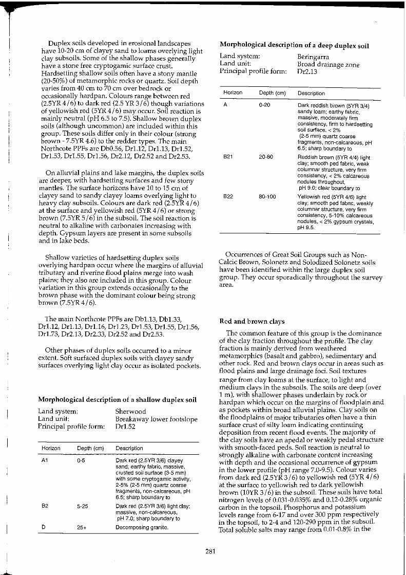
Ouplex soils developed in erosional landscapes have 10-20 cm of clayey sand to loams overlying light clay subsoils. Some of the shallow phases generally have a stone free cryptogamic surface crust. Hardsetting shallow soils often have a stony mantle (20-50%) of metamorphic rocks or quartz. Soil depth varies from 40 cm to 70 cm over bedrock or occasionally hardpan. Colours range between red (2.5YR 4/6) to dark red (2.5 YR 3/6) though variations of yellowish red (5YR 4/6) may occur. Soil reaction is mainly neutral (pH 6.5 to 7.5). Shallow brown duplex soils (although uncommon) are included within this group. These soils differ only in their colour (strong brown - 7.5YR 4.6) to the redder types. The main Northcote PPFs are Ob0.56, Orl.12, Or1.13, Or1.52, Orl.53, Orl.55, Or1.56, Or2.12, Or2.52 and Or2.53.
On alluvial plains and lake margins, the duplex soils are deeper, with hardsetting surfaces and few stony mantles. The surface horizons have 10 to 15 cm of clayey sand to sandy clayey loams overlying light to heavy clay subsoils. Colours are dark red (2.5YR 4/6) at the surface and yellowish red (5YR 4/6) or strong brown (7.5YR 5/6) in the subsoil. The soil reaction is neutral to alkaline with carbonates increasing with depth. Gypsum layers are present in some subsoils and in lake beds.
Shallow varieties of hardsetting duplex soils overlying hardpan occur where the margins of alluvial tributary and riverine flood plains merge into wash plains; they also are included in this group. Colour variation in this group extends occasionally to the brown phase with the dominant colour being strong brown (7.5YR4/6).
The main Northcote PPFs are Ob1.13, Ob1.33, Or1.12, Or1.13, Or1.16, Or1.23, Or1.53, Orl.55, Or1.56, Or1.73, Or2.13, Or2.33, Or2.52 and Or2.53.
Other phases of duplex soils occurred to a minor extent. Soft surfaced duplex soils with clayey sandy surfaces overlying light clay occur as isolated pockets.
Morphological description of a shallow duplex soil
Land system: Land unit: Principal profile form:
Horizon Depth (em)
A1 0-5
82 5-25
D 25+
Sherwood Breakaway lower footslope Or1.52
Description
Dark red (2.5YR 3/6) clayey sand; earthy fabric, massive, crusted soil surface (3-5 mm) with some cryptogamic activity, 2-5% (2-5 mm) quartz coarse fragments, non-calcareous, pH 6.5; sharp boundary to
Dark red (2.5YR 3/6) light clay; massive, non-calcareous, pH 7.0; sharp boundary to
Decomposing granite.
281
Morphological description of a deep duplex soil
Land system: Beringarra Land unit: Broad drainage zone Principal profile form: Or2.13
Horizon Depth (em)
A 0·20
B21 20·80
822 80-100
Description
Dark reddish brown (5YR 3/4) sandy loam; earthy fabric, massive, moderately firm consistency, firm to hardsetting soil surface, < 2% (2-5 mm) quartz coarse
fragments, non-calcareous, pH 6.5; sharp boundary to
Reddish brown (5YR 4/4) light clay; smooth ped fabric, weak columnar structure, very firm consistency, < 2% calcareous nodules throughout, pH 9.0; clear boundary to
Yellowish red (SYR 4/6) light clay; smooth ped fabric, weakly columnar structure, very firm consistency, 5-10% calcareous nodules, < 2% gypsum crystals, pH 9.5.
Occurrences of Great Soil Groups such as NonCalcic Brown, Solonetz and Solodized Solonetz soils have been identified within the large duplex soil group. They occur sporadically throughout the survey area.
Red and brown clays
The common feature of this group is the dominance of the clay fraction throughout the profile. The clay fraction is mainly derived from weathered metamorphics (basalt and gabbro), sedimentary and other rock. Red and brown clays occur in areas such as flood plains and large drainage foci. Soil textures range from clay loams at the surface, to light and medium clays in the subsoils. The soils are deep (over 1 m), with shallower phases underlain by rock or hardpan which occur on the margins of floodplain and as pockets within broad alluvial plains. Clay soils on the floodplains of major tributaries often have a thin surface crust of silty loam indicating continuing deposition from recent flood events. The majority of the clay soils have an apedal or weakly pedal structure with smooth-faced peds. Soil reaction is neutral to strongly alkaline with carbonate content increasing with depth and the occasional occurrence of gypsum in the lower profile (pH range 7.0-9.5). Colour varies from dark red (2.5YR 3/6) to yellowish red (5YR 4/6) at the surface to yellowish red to dark yellowish brown (lOYR 3/6) in the subsoil. These soils have total nitrogen levels of 0.031-0.035% and 0.12-0.28% organic carbon in the topsoil. Phosphorus and potassium levels range from 6-17 and over 300 ppm respectively in the topsoil, to 2-4 and 120-290 ppm in the subsoil. Total soluble salts may range from 0.01-0.8% in the
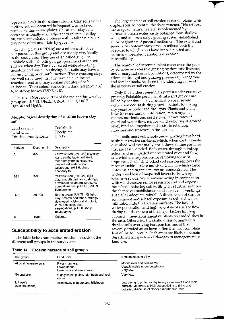
topsoil to 2.24% in the saline subsoils. Clay soils with a mottled subsoil occurred infrequently, as isolated pockets within saline plains. Calcareous clay soils occur occasionally in or adjacent to calcreted valley fill, with some shallow phases within saline plains or clay pans often underlain by gypsum.
Cracking clays (PPF:Ug) are a minor distinctive component of this group and occur only very locally in the study area. They are often called gilgai or crabhole soils exhibiting large open cracks at the soil surface when dry. The clays swell while absorbing moisture and shrink on drying. The soils may have a self-mulching or crumbly surface. These cracking clays are well structured, usually have an alkaline soil reaction trend and may contain nodules of soft carbonate. Their colour varies from dark red (2.5YR 3/ 6) to strong brown (7.5YR 4/8).
The main Northcote PPFs of the red and brown clay group are Uf6.12, Uf6.21, Uf6.31, Uf6.53, Uf6.71, Ug5.36 and Ug6.3.
Morphological description of a saline brown clay soil
Land system: Land unit: Principal profile form:
Horizon Depth (em)
A 0-5
B2t 5-50
B22 50-100
D 100+
Coolabulla Floodplain Uf6.12
Description
Yellowish red (5YR 4/6) silty clay loam; earthy fabric, massive, . moderately firm consistency, crusted soil surface, noncalcareous, pH 8.5; sharp boundary to
Yellowish red (5YR 4/6) light clay; smooth ped fabric, strongly developed polyhedral structure, non-calcareous, pH 9.0; gradual boundary to
Strong brown (7.5YR 4/6) light clay; smooth ped fabric, strongly developed polyhedral structure, 2-5% soft calcareous segregations, pH 9.0; sharp boundary to
Calcrete.
Susceptibility to accelerated erosion
The table below summarises erosion hazards of the different soil groups in the survey area.
Table 14. Erosion hazards of soil groups
Soil group
Alluvial Guvenile) soils
Land units
River channels. Levee banks. Lake beds and sink zones.
Solonchaks Highly saline plains, lake beds and kopi dunes.
Lithosols (skeletal phase)
Breakaway plateaux and hillslopes.
282
The largest areas of soil erosion occur on plains with duplex soils adjacent to the river systems. This reflects the usage of natural waters, supplemented by permanent fresh water easily obtained from shallow wells, and an open range grazing system established at the beginning of pastoral settlement. The extent and severity of contemporary erosion reflects both the over-use to which areas have been subjected and features soil-related variations in erosion susceptibility.
The removal of perennial plant cover over the years by sometimes excessive grazing by doniestic livestock under marginal rainfall conditions, exacerbated by the effects of drought and grazing pressure by kangaroos and feral animals, has been the underlying cause of the majority of soil erosion.
Only the hardiest perennials persist under excessive grazing. Palatable perennial shrubs and grasses are killed by continuous over-utilisation or if severe defoliation occurs during growth periods follOWing dry years or prolonged droughts. Plants and plant litter increase rainfall infiltration, retain organic matter, nutrients and seed stores, reduce rates of overland water flow, reduce wind velocities at ground level, bind soil together and assist in retaining moisture and structure in the subsoil.
The soils most vulnerable under grazing have hardsetting or crusted surfaces, which, when continuously disturbed will eventually break down to fine particles that are easily eroded. Both water, through raindrop action and unimpeded or accelerated overland flow, and wind are responsible for removing loose or unprotected soil. Unchecked soil erosion removes the most valuable surface mulch or 2 cm, in which scarce nutrients and organic matter are concentrated. The widespread loss of major soil layers is shown by extensive scalds. Water erosion acting in conjunction with wind erosion removes surface soil and exposes the subsoil reducing soil fertility. This further reduces the chance of establishment and survival of seedlings even after adequate rainfall. A direct result of surface soil removal and subsoil exposure is reduced water infiltration into the bare soil surfaces. The lack of water penetration and high velocities of surface flow during floods are two of the major factors limiting successful re-establishment of plants on eroded sites in the area. Otherwise, the shallowness of many thin duplex soils overlying hardpan has meant that severely eroded areas have suffered almost complete loss of the soil profile. Such areas are likely to remain desertified irrespective of changes to management or land use.
Erosion susceptibility
Mobile river bed sediments. US1Jaily stable under vegetation. Very low.
Very low.
Low owing to protection by heavy stone mantle and rock outcrop. Moderate to high susceptibility to rilling and guttering (because of slope) if mantle disturbed.
+
z
Table 14. Erosion hazards of soil groups--continued
Soil group
Lithosols (stony phase)
Earthy sands (deep phase)
Earthy sands (shallow calcareous phase)
Siliceous sands (deep phase)
Siliceous sands (shallow granitic phase)
Gravelly sands (and loams)
Red and brown calcareous soils
Red*brown hardpan soils
Red earths (shallow phase)
Red earths (deep phase including calcareous red earths and alkaline red earth)
Duplex soils Crusted duplex (shallow phase)
Crusted duplex (deep phase)
Hardsetting duplex (shallow phase)
Hardsetting duplex (deep phase)
Soft suriaced duplex (deep phase)
Red and brown clays (deep phase including calcareous red earths and alkaline red earth)
Red and brown clays (shallow phase - often over hardpan)
Cracking clays
Land units
Low hills, stony low rises and lower slopes.
Sandy banks.
Red and yellow sand plain.
Broad and narrow drainage zones and adjacent levee banks.
Red and yellow sand dUnes.
Sandy surfaced plains adjacent to granite outcrops. Breakaway plateaux and granite outcrops.
Red and yellow sand plain.
Lateritic plains, low hills or rises.
Calcrete platforms and non saline drainage tracts. Saline drainage tracts.
Hardpan plains and fringing units of drainage tracts and duplex soils.
Mulga groves and thickly wooded areas.
Stony plains, lower footslopes, margins of hardpan plains and drainage tracts.
Mulga groves and some drainage foci.
Occasional flood plains, alluvial plains and wide drainage tracts.
Hill or breakaway stony footslopes.
Hill or breakaway non-stony footslopes and some hardpan margins.
Alluvial plains, floodplains, saline plains, drainage foci and some hardpan margins.
Hill or breakaway footslopes, alluvial plains, stony plains, and saline plains over rock or hardpan.
Broad drainage tracts, floodplains, alluvial plains, saline plains and lake frontages.
Occasional broad drainage tracts, saline stony and stone free plains.
Alluvial plains, flood plains and saline plains.
Hardpan plains and fringing drainage units.
Drainage foci.
Gilgai plains and isolated pockets within alluvial and flood plains.
283
Erosion susceptibility
Low owing to protection by heavy stone mantle. High susceptibility to guttering and gullying (because of slope) if mantle disturbed.
Low to mild where vegetation is severely degraded.
Low where vegetated but susceptible to deep gullying along inappropriately maintained tracks and roads.
Low to moderate under existing vegetation.
Low.
Stable under existing vegetation otherwise moderately susceptible to water erosion.
Low where vegetated but susceptible to deep gullying along inappropriately maintained tracks and roads.
Low owing to ferruginous gravels on the surface and throughout the profile.
Low to moderate because of calcrete outcrop and often heavy mantle. Low to moderate where adjacent to duplex soils.
Locally susceptible to sheet erosion where vegetation is severely degraded and/or unprotected by a stony surfaces mantle. Low, but susceptible by accretion at edges where surrounding plain is eroding.
Low where protected by a stony mantle, otherwise low to moderate depending on hydrology and slope where vegetation is degraded.
Low under existing vegetation otherwise subject to minor wind erosion. Low to moderate - subject to sheet water and wind erosion where vegetation is degraded.
Moderate to high where perennial cover by low shrubs is reduced. Breakdown of surface crust leads to sheet, rill or minor gully erosion. High or very high whenever perennial cover of low shrubs is significantly reduced. Breakdown of surface algal crust leads to microterracing, scalding, sheet or rill erosion, with gutters and gullies on lower slopes.
Moderate to high - subject to wind and water erosion after initial breakdown of soil surface algal crust.
Very high, especially after initial soil surface decline where vegetation is degraded. Subject to water and wind erosion; major scalding and complete loss of topsoil common.
High, after initial soil surface decline where vegetation is degraded. Subject to water and wind erosion, scalding and guttering common.
High or very high, (soft nature of soil surface layers). Subject to wind and water erosion - scalding common.
Mild to moderate - subject to sheet water and wind erosion where vegetation is severely degraded - scalding common.
Moderate to high - subject to sheet water and wind erosion unless well vegetated - scalding common. Low to moderate under existing vegetation otherwise mild susceptibility to water erosion.
Very low to moderate under existing vegetation.
References Bettenay, E., Churchward, H.M. and McArthur, W.H. (1967).
Explanatory data for sheet 6 Meekatharra - Hamersley Range area, Atlas of Australian Soils. CSIRO, Melbourne University Press.
Bettenay, E. and Churchward, HM. (1974). Morphology and stratigraphic relationships of the Wiluna Hardpan in arid Western Australia. Journal of Geological Society oj Australia 21: 73-80.
Condon, M.A. (1967). The Geology of the Carnarvon Basin, Western Australia, Part 3: Post Permian stratigraphy, structure, economic geology. Bureau of Mineral Resources and Geophysics, Australia. Bulletin No. 77.
Denman, PD., Hocking, R.M., Moore, ES., Williams, LR. and van de Graaff, W.J.E. (1985). Explanatory notes on the Wooramel 1:250 000 geological sheet, Western Australia, (2nd edition). Geological Survey of Western Australia.
Jutson, J.T. (1934). The Physiography of Western Australia. (2nd edition). Geological Survey in Western Australia, Bulletin No. 95.
Mabbutt, J.A., Litchfield, W.H., Speck, N.H., Sofoulis, J., Wilcox, D.G., Arnold, J.M. and Wright, RL. (1963). General report on lands of the Wiluna-Meekatharra area, Western Australia 1958. CSIRO Land Research Series No.7.
284
McDonald, RC, Isbell, RF., Speight, J.G., Walker J. and Hopkins, M.S. (1984). 'Australian soil and land survey field handbook'. Inkata Press, Melbourne.
Northcote, K.H. (1979).' A factual key for the recognition of Australian Soils' (4th edition). Rellim Technical Publications, Glenside, South Australia.
OIlier, CD., Chan, RA., Craig, M.A., Gibson, D.L. (1988). Aspects of landscape history and regolith in the Kalgoorlie region, Western Australia. BMR Journal of Australian Geology and Geophysics 10: 309-321.
Stace, H.T.C, Hubble, G.D., Brewer, R, Northcote, KH., Sleeman, J.R, Mulcahy, M.J. and Hallsworth, E.G. (1968). 'A handbook of Australian soils'. CSIRO, Rellim Technical Publications, Glenside, South Australia.
Stephens, CG. (1962). 'A manual of Australian soils'. 3rd edition. CSIRO Melbourne.
Teakle, J.H. (1936). The red and brown hardpan soil of the Acacia semi-desert scrub of Western Australia. Journal of Agriculture, Western Australia, December 1936.
f

1
Vegetation
The main features of vegetation in the eastern parts of the area have been described by Mabbutt et al. (1963) and at a very broad scale by Beard (1976). As a result of the present survey, a much more detailed picture of the area emerges.
The account presented here concentrates on the major vegetation communities found in the area, and their structure, composition, variation and long-term condition status at the time of the survey. These factors relate to very variable cumulative impacts from past use and management. Implications for future pastoral usage and the potential for degraded vegetation to be rehabilitated through appropriate management are addressed.
As a result of collections made during the survey, R.J. Cranfield has compiled a comprehensive list of species of both the vascular and non-vascular plants known from the area (Cranfield 1990). This list is reproduced, with minor revisions and additions in Appendix 2. A shorter list of common perennial species and their broad patterns of occurrence in relation to the mapped land systems and land types of the 1:250,000 map series is given in Appendix 3.
Regional overview
Beard (1976) identified the whole of the Murchison River catchment, in its stricter hydrological sense, as a single Upper Murchison Sub-region of the Austin Botanical District in the Eremaean Botanical Province. The area covered by the present survey includes all but the north-eastern extremity of this Sub-region,
plus the Byro Sub-region in the north-west, parts of the Wiluna, Barlee and Yalgoo Sub-regions in the east, south-east and south-west respectively, and a tiny area of the South-Western Botanical Province in the far south-west (Figure 35).
The flora and communities of the Byro Sub-region resemble those of the Carnarvon Basin more than those of the Upper Murchison Sub-region. This appears to be correlated with the geomorphic change from the underlying Archaean rocks on which catchment lands of the Murchison River catchment are mainly based, to the Permian and Quaternary surfaces of the Byro Plains, the Muggon lakes area and the eastern edge of the Victoria (Shark Bay) Sand Plain.
The only abrupt transition in the whole area is the demarcation between the arid zone vegetation of the Upper Murchison sub-region and the South-Western Botanical Province in the south-western corner of the survey area. The boundary between the Eurardy land system and others to its north and east probably best delineates the semi-arid zone from the arid zone at its roughly 250 mm isohyetallimits. Otherwise, the climatic trends across the area are very gradual and do not produce anything more than gradual patterns of change and clines across the Upper Murchison sub-region.
General vegetation characteristics in the Upper Murchison Sub-region
Arid shrublands make up the vast majority of vege' tion types encountered. Most landscapes are dOPlated by mixed shrub lands, with few or no trees or perennial grasses, with shrubs apparently randomly scattered or loosely aggregated, and with large
Gascoyne Ranges ASH BURTON BOTANICAL DISTRICT
16602-19
.'
,
Upper,::Murcblson Suq:.r~glori
ERE~AEAN sqTANICAL PROVINCE
AUS.TlN .BQTANICAL DISTRICT
..
Yalgoo •.• Sub-region . . .' : .l9~e~on Sub-region
Barlee Sub-region
S.w. INTERZONE COOLGARDIE BOTANICAL DISTRICT
Figure 35, Natural regions of the Murchison area. after Beard (1976). Survey area
285

amounts of bare ground and shallow red soils exposed between the shrubs. Only over areas with either sand or clay soils are perennial grasses locally common, and then generally only as an understorey to shrub land or open woodland.
Areas of primary salinity exist, mainly adjacent to the lakes and rivers, but also below lateritic breakaways and deeply weathered rock outcrops. Here vegetation is also dominated by shrublands, but on such areas adjacent Acacia-dominated associations give way to low (steppe) shrublands dominated by Chenopodiaceae and other halophytes. It was these shrublands, with their proximity to more local grassy areas growing on river limestones (calcretes) and also on claypans, sandy washes and plains below granites, that originally attracted the pioneers of the pastoral industry to the area.
Vegetation has been cleared only around the settlements and mine sites, apart from small areas of sand plains in the far south-west which were chained at various times with the goal of increasing grasses for pastoral production.
Spatial aspects of vegetation
A feature of the vegetation, which is common to much of the shrublands of the southern arid zone, is the generally small scale of landscape patterning evident for the various vegetation types.
With few exceptions, the major vegetation types are usually encountered at the scale of the land unit rather than the land system or any larger mapping unit. In other words, most examples of any particular vegetation type exist over areas of a few hectares to hundreds of hectares, or as topographically restricted zones no more than hundreds of metres wide before being replaced by an adjacent, different vegetation type. Reference to the descriptions of individual land systems illustrates this general scale of environmental patterning. Often, the vegetation sequence repeats across the landscape, and long line transects in any direction will progress through repeated sequences of two or more major types across each land system.
Arguably, the most extensively uniform of the vegetation types are those encountered on the sand plains, where any controlling development of surface drainage is rudimentary or apparently absent.
Patterns of seasonal growth by annual and ephemeral species
The perennial long-lived, drought-resistant communities are augmented by a diverse ephemeral flora of fast-growing, drought-evading, short-lived species. While they are popularly known as 'annuals', their long-term occurrence in anyone location is less than annual. Their occurrence is determined primarily by the incidence of effective rainfall. During dry seasons, many species in an area exist only as seeds, sometimes for years at a time.
286
Winter growth of the ground herbage layer is made up by a wide variety of Asteraceae, Amaranthaceae, Chenopodiaceae and many other less dominant families (see Cranfield 1990). In late summer, however, when effective rainfall is less reliable (see 'Climate' section), the herbage response is dominated by Poaceae (annual grasses) and Chenopodiaceae (mainly annual saltbushes and bindiis).
Both types of seasonality are required for long-term maintenance and regeneration of the perennial communities. In general, summer rainfall stimulates rapid growth and flowering of perennial grasses, and the flowering of many shrubs and trees (particularly Acacia spp.; Davies 1976). Most germination of perennials also occurs after summer or autumn rains. Winter responses by perennial shrubs are slower, and generally feature considerable foliar growth before flowering and seeding. Perennial grasses respond only slowly after winter rain, as temperatures rise in early spring, whereas responses to summer rain are characteristically rapid.
Small-scale patterning and patchiness is a conspicuous feature of herbage response in all but the most uniform of land surface types. This is primarily a result of intense micro-topographic variation and redistribution of key surface features (soil crusting, nutrients, roughness elements, moisture, temperature and seed reserves), which are in turn related to the small-scale patterning found in the distribution of perennial plants (Mott 1973, Mott and McComb 1974, Hacker 1986).
Within each community, woody perennials serve to concentrate fauna, organic matter and soil nutrients and are vital protectors of the soil surface against erosive forces. During each period of growth there is recurrent competition between the ephemeral and perennial flora for moisture and nutrients. This has been clearly demonstrated in mulga environments elsewhere (Beale 1973). The most prolific growths of winter annuals such as everlastings (Helipterum and Helichrysum spp.), blue crow's foot (Erodium cygnorum) and billy buttons (Craspedia spp.) tend to occur on sites with depleted levels of mulga or other tall shrub cover, but with intact soil surfaces (through cryptogamic crusts, stony mantles etc. on the less erodible soil types).
Such effects are sometimes noticeable along fencelines where different stocking regimes have affected vegetation unequally. Once accelerated erosion of the first surface millimetres of topsoil has begun, for any reason, the growth potential of each affected patch of soil is severely reduced.
Classification of vegetation types
As described under 'Methods', 23 major, mostly widespread, recurrent association types have been identified (Table 15) and are described below. Table 60, presented at the end of this section, summarises the characteristics of the major vegetation types.
f
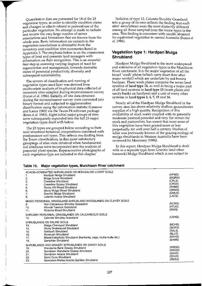
b
Quantitative data are presented for 14 of the 23 vegetation types, in order to identify condition states and changes or effects related to pastoral use of the particular vegetation. No attempt is made to include and review the very large number of minor associations and formations that are known from the whole area. Basic information on variants in the vegetation associations is obtainable from the inventory and condition sites summaries listed in Appendix 5. The emphasis below is on the commonest types of land and presents land managers with information on their recognition. This is an essential first step in assessing varying degrees of need for regeneration and management, towards desirable states of perennial productivity, diversity and subsequent sustainability.
The system of classification and naming of vegetation types used here was derived from multivariate analysis of biophysical data collected at inventory sites sampled during reconnaissance survey (Foran et al. 1986). Initially, all site data obtained during the reconnaissance survey were converted into binary format and subjected to agglomerative classification using the information statistic (Grunow and Lance 1969) via the Taxon P4 software package (Ross et al. 1983). Eight initial major groups of sites were subsequently expanded into the full 23 major vegetation types dealt with below.
The 23 types are grouped below according to their total structural-botanical compositions combined with predominant soil types. This reflects one finding from the Taxon classification, in that more satisfactory groupings of sites were obtained when fundamental soil attributes were incorporated into the analysis of perennial plant species. Representative photographs of each vegetation type are included in this chapter.
Isolation of type 12, Calcrete Shrubby Grassland into a group of its own reflects the finding that such sites' associations were the most distinctly different among all those sampled from the major types in the area. This finding is consistent with results obtained for equivalent vegetation in central Australia (Foran et a/. 1986).
Vegetation type 1: Hardpan'Mulga Shrubland
Hardpan Mulga Shrubland is the most widespread and extensive of all vegetation types in the Murchison River catchment. It is the major vegetation of all the broad 'wash' plains (which carry sheet flow after major rainfall) which are underlain by red-brown hardpan. These wash plains comprise the seven land systems of land type 14, as well as being a major part of all land systems in land type 13 (wash plains and sandy banks on hardpan) and a unit of many other systems in land types 3, 4, 7, 15 and 16.
Nearly all of the Hardpan Mulga Shrubland in the survey area lies above relatively shallow groundwater supplies of a high quality. Recognition of this availability of stock water coupled with its generally moderate pastoral potential and very flat terrain for stock and pastoralists, has meant that most areas of this vegetation have been grazed more or less perpetually for well over half a century. Studies of what was previously known of the grazing ecology of mulga shrub lands in Western Australia have been reviewed by Morrissey (1984).
In this report, Hardpan Mulga Shrubland is dealt with as a separate type from Granitic (and other baserock) Mulga Shrub land which is not subject to
Table 15. Major vegetation types, Murchison River catchment
ACACIA·DOMINATED SHRUBLANDS ON NON·SALINE LOAMY SOILS 1. Hardpan Mulga Shrubland 2. Mulga Grove Woodland 3. Creekline Shrubland 4. Creekline Grassy Shrubland 5. Rocky Hill Mixed Shrubland 6. Stony Mulga Mixed Shrubland 7. Granitic Mulga Shrubland 8. Lateritic Acacia Shrubland
MIXED PERENNIAL GRASSLAND·SHRUBLAND-WOODLANDS ON CLAYEY SOILS 9. Non~Calcareous Shrubby Grassland 10. Alluvial Tussock Grassland 11. Riverine Mixed Shrubland
SHRUBBY PERENNIAL GRASSLANDS ON CALCAREOUS SOILS 12. Calcrete Shrubby Grassland
SHRUBLANDS ON SALINE SOILS 13. Mulga Chenopod Shrubland 14. Stony Snakewood Shrubland 15. Saltbush Shrubland 16. Bluebush Shrubland 17. Mixed Halophytic Shrubland (frankenia, sage, mulla~mulla etc.) 18. Samphire Shrubland
SHRUBLANDS AND GRASSY SHRUBLANDS ON SANDY SOILS 19. Wanderrie Bank Grassy Shrubland 20. Sandplain Wanderrie Grassy Shrubland 21. Sandplain AcaCia Shrubland 22. Sand Dune Shrubland 23. Sandplain MalleewAcacia~Spinifex Shrubland
287
(HPMS) (MGRW) (CRLS) (CRGS) (RHMS) (SMMS) (GMUS) (LACS)
(NCSG) (ATUG) (RIMS)
(CSHG)
(MCHS) (SSWS) (SALS) (BLUS) (MXHS) (SAMS)
(WBGS) (SWGS) (SAAS) (SDUS) (SMAS)
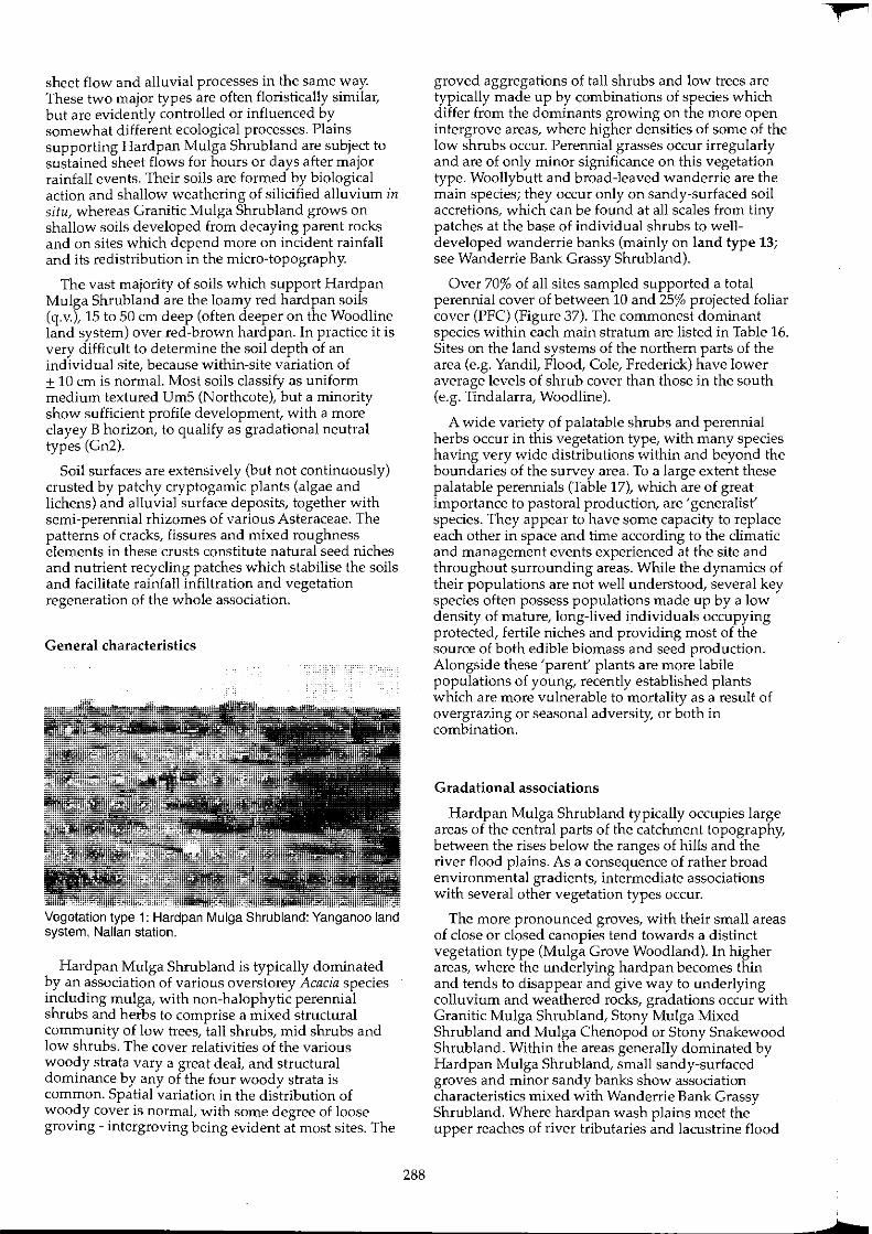
sheet flow and alluvial processes in the same way. These two major types are often floristically similar, but are evidently controlled or influenced by somewhat different ecological processes. Plains supporting Hardpan Mulga Shrubland are subject to sustained sheet flows for hours or days after major rainfall events. Their soils are formed by biological action and shallow weathering of silicified alluvium in situ, whereas Granitic Mulga Shrub land grows on shallow soils developed from decaying parent rocks and on sites which depend more on incident rainfall and its redistribution in the micro-topography.
The vast majority of soils which support Hardpan Mulga Shrubland are the loamy red hardpan soils (q.v.), 15 to 50 cm deep (often deeper on the Woodline land system) over red-brown hardpan. In practice it is very difficult to determine the soil depth of an individual site, because within-site variation of ± 10 em is normal. Most soils classify as uniform medium textured UrnS (Northcote), but a minority show sufficient profile development, with a more clayey B horizon, to qualify as gradational neutral types (Gn2).
Soil surfaces are extensively (but not continuously) crusted by patchy cryptogamic plants (algae and lichens) and alluvial surface deposits, together with semi-perennial rhizomes of various Asteraceae. The patterns of cracks, fissures and mixed roughness elements in these crusts constitute natural seed niches and nutrient recycling patches which stabilise the soils and facilitate rainfall infiltration and vegetation regeneration of the whole association.
General characteristics
Vegetation type t: Hardpan Mulga Shrub land: Yanganoo land system, Nallan station.
Hardpan Mulga Shrub land is typically dominated by an association of various overstorey Acacia species including mulga, with non-halophytic perennial shrubs and herbs to comprise a mixed structural community of low trees, tall shrubs, mid shrubs and low shrubs. The cover relativities of the various woody strata vary a great deal, and structural dominance by any of the four woody strata is common. Spatial variation in the distribution of woody cover is normal, with some degree of loose groving - intergroving being evident at most sites. The
288
groved aggregations of tall shrubs and low trees are typically made up by combinations of species which differ from the dominants growing on the more open intergrove areas, where higher densities of some of the low shrubs occur. Perennial grasses occur irregularly and are of only minor significance on this vegetation type. Woollybutt and broad-leaved wanderrie are the main species; they occur only on sandy-surfaced soil accretions, which can be found at all scales from tiny patches at the base of individual shrubs to welldeveloped wanderrie banks (mainly on land type 13; see Wanderrie Bank Grassy Shrubland).
Over 70% of all sites sampled supported a total perennial cover of between 10 and 25% projected foliar cover (PFC) (Figure 37). The commonest dominant species within each main stratum are listed in Table 16. Sites on the land systems of the northern parts of the area (e.g. Yandil, Flood, Cole, Frederick) have lower average levels of shrub cover than those in the south (e.g. Tindalarra, Woodline).
A wide variety of palatable shrubs and perennial herbs occur in this vegetation type, with many species having very wide distributions within and beyond the boundaries of the survey area. To a large extent these palatable perennials (Table 17), which are of great importance to pastoral production, are 'generalist' species. They appear to have some capacity to replace each other in space and time according to the climatic and management events experienced at the site and throughout surrounding areas. While the dynamics of their populations are not well understood, several key species often possess populations made up by a low denSity of mature, long-lived individuals occupying protected, fertile niches and providing most of the source of both edible biomass and seed production. Alongside these 'parent' plants are more labile populations of young, recently established plants which are more vulnerable to mortality as a result of overgrazing or seasonal adversity, or both in combination.
Gradational associations
Hardpan Mulga Shrubland typically occupies large areas of the central parts of the catchment topography, between the rises below the ranges of hills and the river flood plains. As a consequence of rather broad environmental gradients, intermediate associations with several other vegetation types occur.
The more pronounced groves, with their small areas of close or closed canopies tend towards a distinct vegetation type (Mulga Grove Woodland). In higher areas, where the underlying hardpan becomes thin and tends to disappear and give way to underlying colluvium and weathered rocks, gradations occur with Granitic Mulga Shrubland, Stony Mulga Mixed Shrub land and Mulga Chenopod or Stony Snakewood Shrub land. Within the areas generally dominated by Hardpan Mulga Shrubland, small sandy-surfaced groves and minor sandy banks show association characteristics mixed with Wanderrie Bank Grassy Shrub land. Where hardpan wash plains meet the upper reaches of river tributaries and lacustrine flood
,.
i
L
Table 16. Commonest dominant species at Hardpan Mulga Shrubland sites
Low trees
Acacia aneura A. pruinocarpa
Tall shrubs
A. aneura A. ramu/osa A. grasbyi
A. tetragonophylla A. craspedocarpa
plains, transitions occur with several types found on alluvial landforms. Among these is Riverine Mixed Shrubland which, like Hardpan Mulga Shrubland, is extensively underlain by hardpan.
Grazing impact and the condition of perennial vegetation
No. of condition sites investigated: 476
Site methodology: D
Site variables analysed: dominant species in association;
projected foliar cover (PFC); plant density; species richness; palatable species density; palatable species richness; perennial diversity (ShannonWeiner); palatable species diversity (Shannon-Weiner); species evenness (equability); distance from stock water point; paddock quadrant; and erosion status.
Table 17. Commonest palatable woody perennial species at Hardpan Mulga Shrubland sites
Maireana p/anifoJia M. convexa M. vil/Dsa Rhagodia eremaea Ptilotus obovatus Eremophila latrobe; E. forresti; E. compacta E. aft. compacta Sida calyxhymenia Grevillea deffexa Ganthium lineare Santa/um spicatum Spartothamnelfa teucriiflora Hibiscus gardneri
flat leaved bluebush mulga bluebush
rhagodia, tall saltbush cotton bush warty fuchsia bush Wilcox bush compact poverty bush
tall sida red grevillea
sandalwood mulga broom bush
Mid shrubs Low shrubs
Eremophila fraser; Ptilotus obovatus A. tetragonophylla E. forrestii Cassia deso/ata/sturti; E. fraseri E. forrestii Solanum lasiophyllum
A. ramulos8 Sida calyxhymeria C. helmsii C. helmsii
A. grasbyi E. punicea A. craspedocarpa Maireana convexa
C. phyl/odinea P. schwartzii
289
Results: condition of perennial vegetation: 4 classes
Class 1
Total density of woody perennials 2: 200/1000 m' Species richness of woody perennials 2: 10/1000 m' Density of palatable woody perennials 2: 150/1000 m' Species richness of palatable perennials 2: 4/1000 m'
Class 2
Not as class 1 Density of palatable woody perennials 2: 50/1000 m' Species richness of palatable woody perennials 2: 3/1000 m' Species richness of woody perennials 2: 7/1000 m'
Class 3
Not as classes 1 or 2 Density of palatable woody perennials
Class 4
2:5/1000 m'
Other sites, with very degraded vegetation not as classes 1, 2 or 3.
Table 18. Site claSSification summary (n = 476) Hardpan Mulga Shrubland sites
Class No. % Cumulative %
1 38 8 8 2 139 29 37 3 223 47 84 4 76 16 100
Table 19. Erosion status: incidence of accelerated erosion, Hardpan Mulga Shrubland sites
Class No. of % Mean
eroding sites intensity rating
1 a 0.0 0.0 2 a 0.0 0.0 3 11 4.9 1.8 4 7 9.2 2.0
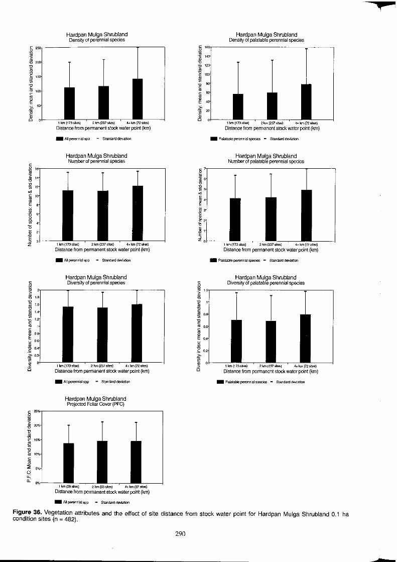
Hardpan Mulga Shrubland Density of perennial species
1 !an (173si1es) 2 !an (237 &lies) 4 .. krn (72 siles)
Distance from permanent stock water point (km)
_ All per6flnial spp - Standard deviation
Hardpan Mulga Shrubland Number of perennial species
c ,~ ____________________________________ ,
I 1l '" c
~ ID B 11. w
" .<; E o z 1 1m {173 s~es} 2 kin (2:37 s~es) 4+ km{72 sites)
Distance from permanent stock water point (km)
_ All perennial spp - Standard deviation
Hardpan Mulga Shrubland Diversity of perennial species
1 krn(l73s~es) 2km{237s~es) 4+km(72s~es}
Distance from permanent stock water point (km)
_ All perennial spp - Standard deviation
Hardpan Mulga Shrubland Projected Foliar Cover (PFC)
1 !an (26 silas) 2 Ion (53 sites) 4+ km (37 sites)
Distance from permanent stock water point (km)
_ All perennial spp - Standard deviation
• ~ ~ II " ~ ~ .~ w
" ~
Hardpan Mulga Shrubland Density of palatable perennial species
1 !an (173 s~es) 2 !an (237 s~es) 4+ krn (72 sites)
Distance from permanent stock water point (km)
_ Palatable perennial spec~ - Standard deviation
Hardpan Mulga Shrubland Number of palatable perennial species
'101-------1 km (173 s~es) 2 km (237 sites) 4+ km (72 s~es)
Distance from permanent stock water point (km)
_ Palatable perennial species - Standard deviation
Hardpan Mulga Shrubland C Diversity of palatable perennial species
j '''----------------------------.--------~ ~
i " m
~ ~ .~
.~ o
1m (173s~9S) 2 km (237 sites) 4+ km (72 s~es)
Distance from permanent stock water point (km)
_ Palatable perennial species - Standard deViation
Figure 36. Vegetation attributes and the effect of site distance from stock water point for Hardpan Mulga Shrubland 0.1 ha condition sites (n = 482).
290
+
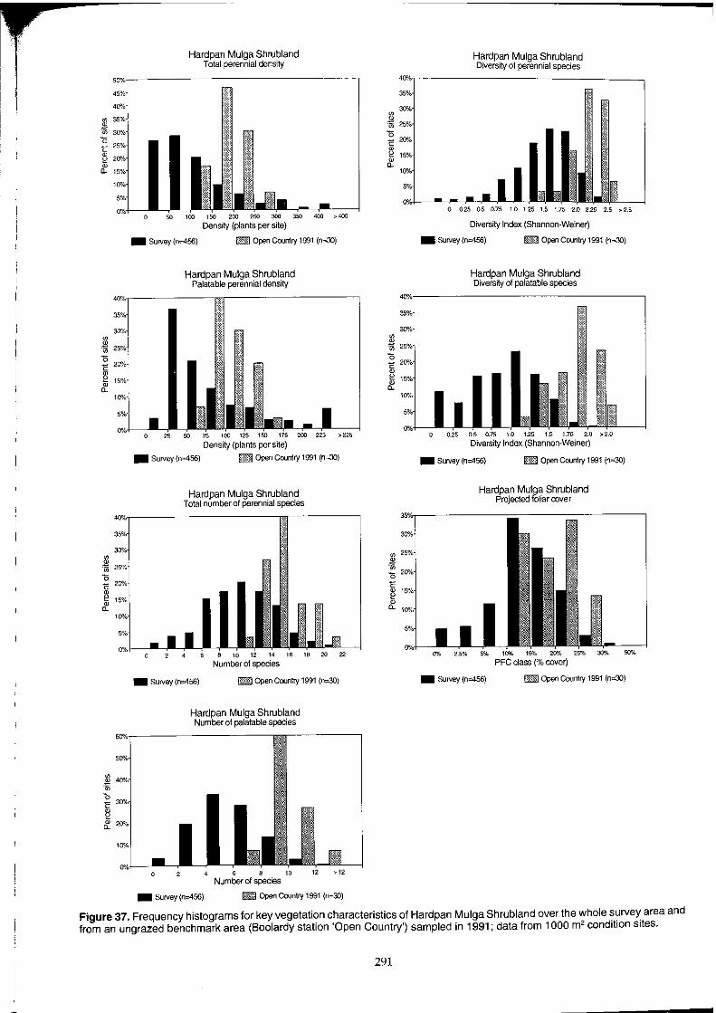
00
* " c 0 2 0 "-
00
.~ 00
" c 0 2 0 "-
Hardpan Mulga Shrubland Total perennial density
Density (plants per site)
_ Survey (n:0456) [lID Open Country 1991 (n=30)
Hardpan Mulga Shrubland Palatable perennial density
Density (plants per sfie) _ Survey (n=456) • Open Country 1991 (n=30)
Hardpan Mulga Shrubland Total number of perennial species
_ Survey (n=456) _ Open Country 1991 (n=30)
Hardpan Mulga Shrubland Number of palatable species
o 6' Number of species
_ SUrvey (n=456) 1mB Open Country 1991 (n=30)
00
~
" c 0 2 0 "-
00
.* " c § 0 "-
Hardpan Mulga Shrubland Diversity of perennial species
o 0.25 0.5 0.75 1.0 125 1.5 1.75 2.0 2.25 2,5 >2.5
Diversity Index (Shannon-Weiner)
_ SUrvey (n=456) _ Open Country 1991 (n=30)
Hardpan Mulga Shrubland Diversity of palatable species
Diversity Index (Shannon-Weiner)
_ Survey (n=456) _ Open Country 1991 (n=30)
Hardpan Mulga Shrubland Projected foliar cover
_ SUrvey (n=456) _ Open Country 1991 (n=30)
Figure 37. Frequency histograms for key vegetation characteristics of Hardpan Mulga Shrubland over the whole survey area and from an ungrazed benchmark area (Boolardy station 'Open Country') sampled in 1991; data from 1000 m2 condition sites.
291
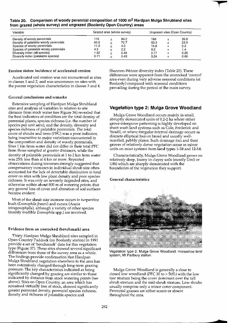
Table 20. Comparison of woody perennial composition of 1000 m2 Hardpan Mulga Shrubland sites from grazed (whole survey) and ungrazed (Boolardy Open Country) areas
Variable Grazed area (whole survey) Ungrazed sites (Open Country)
Density of woody perennials 116 Density of palatable woody perennials 60.5 Species of woody perennials 11.2 Species of palatable woody perennials 4.3 Diversity index (all species) 1.52 Diversity index (palatable species) 0.71
Erosion status: incidence of accelerated erosion
Accelerated soil erosion was not encountered at sites in classes 1 and 2, and was uncommon on sites with the poorer vegetation characteristics in classes 3 and 4.
General conclusions and remarks
Extensive sampling of Hardpan Mulga Shrubland sites and analysis of variables in relation to site distance from stock water (see Figure 36) revealed that the best indicators of condition are the total density of perennial plants, species richness (i.e. the number of species per unit area), and the density, diversity and species richness of palatable perennials. The total cover of shrubs and trees (PFC) was a poor indicator, being insensitive to major variations encountered in the composition and density of woody perennials. Sites 1 km from water did not differ in their total PFC from those sampled at greater distances, while the density of palatable perennials at 1 to 2 km from water was 25% less than at 4 km or more. Repeated observations during traverses strongly suggested that compensatory increases in individual shrub size often accounted for the lack of detectable diminution in total cover on sites with low plant density and poor species richness. It was only on severely degraded sites, and otherwise within about 800 m of watering points, that any general loss of cover and alteration of soil surfaces became evident.
Most of the shrub size increase occurs in turpentine bush (Eremophila fraseri) and curara (Acacia tetragonophylla), although a variety of other species (mainly inedible Eremophila spp.) are involved.
Evidence from an unstocked (benchmark) area
Thirty Hardpan Mulga Shrub land sites sampled in Open Country Paddock (on Boolardy station) in 1991 provide a set of 'benchmark' data for this vegetation type (Figure 37). These sites showed several significant differences from those of the survey area as a whole. The findings provide confirmation that Hardpan Mulga Shrub land vegetation elsewhere in the area has been extensively changed through long-term grazing pressure. The key characteristics indicated as being significantly changed by grazing are similar to those indicated by distance from stock watering points (see above). Sites on Open Country, an area which has remained virtually free of stock, showed significantly greater perennial density, perennial species richness, density and richness of palatable species and
292
± 94.2 186 ± 39.8 ± 72.7 83.3 ± 23.9 ± 4.0 15.8 ± 2.3 ± 2.2 8.2 ± 1.4 ± 0.44 2.17 ± 0.26 ± 0.43 3.24 ± 0.66
Shannon-Weiner diversity index (Table 20). These differences were apparent from the unstocked 'control' area even during very adverse seasonal conditions (at Boolardy) compared with seasonal conditions prevailing during the period of the main survey.
Vegetation type 2: Mulga Grove Woodland
Mulga Grove Woodland occurs mainly in small, abruptly demarcated units of 0.2-2 ha where either grove-intergrove patterning is highly developed on sheet wash land systems such as Cole, Frederick and Yandil, or where irregular internal drainage occurs as discrete elliptical foci on broad and usually wellmantled, pebbly plains. Such drainage foci and their groves of relatively dense vegetation occur as minor units on most systems from land types 1-10 and 12-14.
Characteristically, Mulga Grove Woodland grows on relatively deep, loamy to clayey soils (mostly Um5 or Uf6) which are sharply demarcated with the boundaries of the vegetation they support.
General characteristics
Vegetation type 2: Mulga Grove Woodland: Horseshoe land system, Mt Padbury station.
Mulga Grove Woodland is generally a close to closed low woodland (PFC 30 to > 50%) with the low tree stratum being the cover dominant over the tall shrub stratum and the mid-shrub stratum. Low shrubs usually comprise only a minor cover component. Perennial grasses are either scarce or absent throughout the area.
f

I 1-
While most Mulga Grove Woodland formation appear to be long-established, naturally selfperpetuating associations, some undoubtedly have their origins within historic times as almost even-aged woody regeneration on depositional cells of eroding alluvial land. Such groves are easily identified by their irregular aerial photopatterns and eroded surrounding units, as well as by their distinctively depauperate species composition.
More normal, regular Mulga Grove Woodland associations otherwise have distinctive composition variants related to specific geomorphological sites. One very distinctive variant is that of broad-leaved miniritchie (Acacia rhodophloia) and kite leaf poison (Gastrolobium laytonii) below granite domes of granitic land systems in land types 1 and 4. Otherwise, Mulga Grove Woodland associations are most widespread, contain high species richness and appear to be most productive for pastoral use on plains of greenstonederived colluvium and alluvium, as found within land systems of land types 2, 7 and 14. Here, mulga and gidgee are normally the dominant trees growing over a mixed understorey of Eremophila species with various palatable shrubs of low to mid-height.
Gradational associations
Mulga Grove Woodlands show some overlap with Wanderrie Bank Grassy Shrublands on poorly developed groves which feature accumulations of redistributed sand. These are particularly common on degraded areas of land systems of land type 13, in the north of the survey area.
Grazing impact and the condition of perennial vegetation
In most areas grazed by sheep, Mulga Grove Woodland units appear to be resilient under grazing. To some extent, they may have benefited from additional run-off and mobilised soil particles, organic matter and nutrients released from adjacent degraded mulga communities (mainly Hardpan Mulga Shrub land and Granitic Mulga Shrubland), some of which is redeposited locally in Mulga Grove Woodland' sinks'. Regeneration niches among dense
tangles of woody vegetation are common, and provide protection for seedlings against grazing during their vulnerable establishment phases. More mature palatable perennials frequently have foliage canopies or sprays out of reach to sheep. Mulga Grove Woodland is generally less susceptible to obvious degradation than the vegetation types around them.
The more important palatable perennials are rhagodia, ruby saltbush, flat-leaved bluebush, warty fuchsia bush, cotton bush, Canthium species, Wilcox bush and Sida species. Degraded sites are susceptible to increases by some unpalatable species, particularly Eremophila spectabilis, E. pantonii and flannel bush, but these remain understorey components in virtually every instance. Where present, perennial grasses are evidently susceptible to grazing impact.
Mulga Grove Woodland sites are sometimes susceptible to accelerated erosion at their margins where denudation of upstream slopes and plains has occurred.
Vegetation type 3: Creekline Shrubland
Creekline Shrub land develops along the innumerable channelled drainage lines encountered throughout the Murchison. Most drainage lines show considerable downstream development and reach a stage of one or more channels incised into hardpan (or hardpan veneers on rock) flanked by a zone or plain through which the creekline flows. While the majority of creeklines end where they disperse water onto broad wash plains, some major lines continue to the river tributaries and their flat plains with little net contribution to wash flow.
Davies (1976) indicated how the consequences of concentrated run-on and subsequent moisture storage benefited the biological productivity of drainage lines in this region. More often than not, the composition of the creekline community is not dissimilar from that of the adjacent run-off surfaces, but the association tends to be more species rich per unit area, with more concentrated and lasting seasonal productivity as a consequence of the superior moisture status available within the unit.
Table 21. Commonest dominant species at Mulga Grove Woodland sites
Low trees
Acacia aneura
A. pruinocarpa
A. rhodophloia
A. aft. citrinoviridis
Canthium fatifolium
A. distans
Tall shrubs
A. aneura
A. craspedocarpa
A. tetragonophyJ/a
A. ramulosa
Eremophi/a georgei
E. frased
E. macmillaniana
Gastrolobium layton;;
A. kempeana
Calycopeplus ephedroides
Rulingia kempeana
Mid and low shrubs
Eremophila georgei
E. forrestii
E. spectabilis
Solanum lasiophyflum
E. latrobe;
Cassia helms;;
Ptilotus obovatus
E. wills;;
E. panton;;
A. daviesioides
293
Perennial grasses
Monachather paradoxa
Enteropogon acicufaris
Eriachne pulchella
Chrysopogon taJ/ax
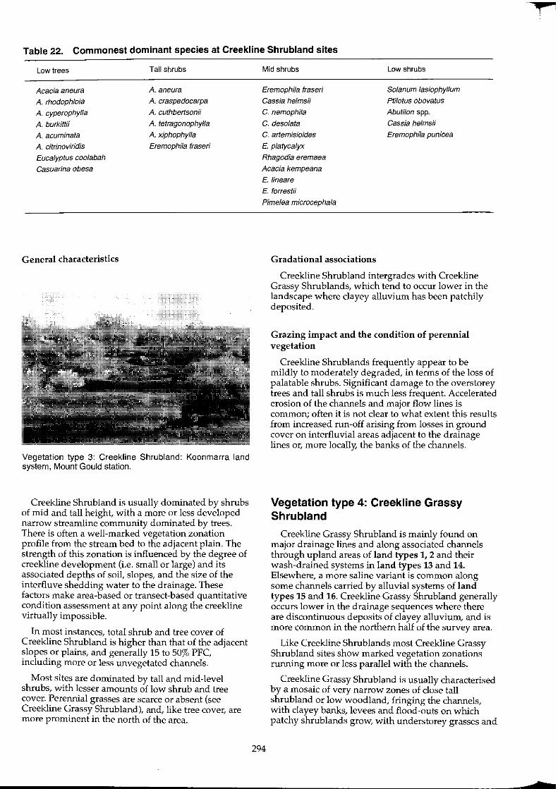
Table 22. Commonest dominant species at Creekline Shrubland sites
Low trees
Acacia aneura
A. rhodophloia
A. cyperophylla
A. burkittii
A. acuminata A. citrinoviridis
Eucalyptus coolabah
Casuarina abesa
General characteristics
Tall shrubs
A. aneura A. craspedocarpa
A. Guthbertsonii
A. tetragonophylla
A. xiphophylla
Eremophila frased
Vegetation type 3: Creekline Shrubland: Koonmarra land system, Mount Gould station.
Creekline Shrubland is usually dominated by shrubs of mid and tall height, with a more or less developed narrow streamline community dominated by trees. There is often a well-marked vegetation zonation profile from the stream bed to the adjacent plain. The strength of this zonation is influenced by the degree of creekline development (i.e. small or large) and its associated depths of soil, slopes, and the size of the interfluve shedding water to the drainage. These factors make area-based or transect-based quantitative condition assessment at any point along the creekline virtually impossible.
In most instances, total shrub and tree cover of Creekline Shrubland is higher than that of the adjacent slopes or plains, and generally 15 to 50% PFC, including more or less unvegetated channels.
Most sites are dominated by tall and mid-level shrubs, with lesser amounts of low shrub and tree cover. Perennial grasses are scarce or absent (see Creekline Grassy Shrubland), and, like tree cover, are more prominent in the north of the area.
Mid shrubs Low shrubs
Eremophila fraser;
Cassia helmsi;
Solanum lasiophyllum
Ptilotus obovatus
Abutilon spp. C. nemophila
C. deso/ata Cassia helmsii
Eremophila punicea C. artemisioides
E. platycalyx
Rhagodia eremaea
Acacia kempeana
E. lineare
E. forrestii
Pime/ea microcephala
294
Gradational associations
Creekline Shrubland intergrades with Creekline Grassy Shrublands, which tend to occur lower in the landscape where clayey alluvium has been patchily deposited.
Grazing impact and the condition of perennial vegetation
Creekline Shrublands frequently appear to be mildly to moderately degraded, in terms of the loss of palatable shrubs. Significant damage to the overstorey trees and tall shrubs is much less frequent. Accelerated erosion of the channels and major flow lines is common; often it is not clear to what extent this results from increased run-off arising from losses in ground cover on interfluvial areas adjacent to the drainage lines or, more locally, the banks of the channels.
Vegetation type 4: Creekline Grassy Shrubland
Creekline Grassy Shrub land is mainly found on major drainage lines and along associated channels through upland areas of land types 1, 2 and their wash-drained systems in land types 13 and 14. Elsewhere, a more saline variant is common along some channels carried by alluvial systems of land types 15 and 16. Creekline Grassy Shrub land generally occurs lower in the drainage sequences where there are discontinuous deposits of clayey alluvium, and is more common in the northern half of the survey area.
Like Creekline Shrub lands most Creekline Grassy Shrubland sites show marked vegetation zonations running more or less parallel with the channels.
Creekline Grassy Shrub land is usually characterised by a mosaic of very narrow zones of close tall shrubland or low woodland, fringing the channels, with clayey banks, levees and flood-outs on which patchy shrublands grow, with understorey grasses and
f
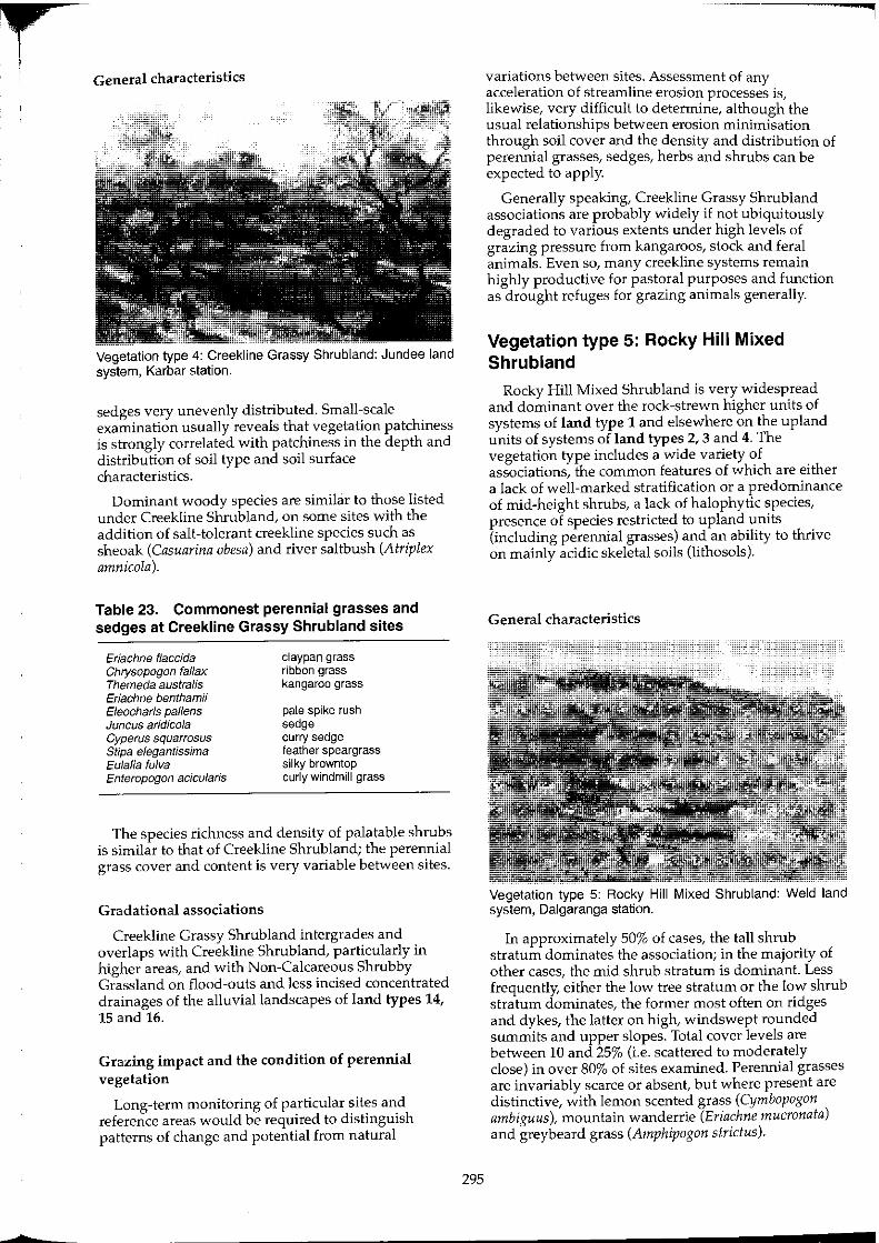
•
Vegetation type 4: Creekline Grassy Shrubland: Jundee land system, Karbar station.
sedges very unevenly distributed. Small-scale examination usually reveals that vegetation patchiness is strongly correlated with patchiness in the depth and distribution of soil type and soil surface characteristics.
Dominant woody species are similar to those listed under Creekline Shrubland, on some sites with the addition of salt-tolerant creekline species such as sheoak (Casuarina obesa) and river saltbush (Atriplex amnicola).
Table 23. Commonest perennial grasses and sedges at Creekline Grassy Shrubland sites
Eriachne flaccida Chrysopogon fal/ax Themeda australis Eriachne benthamii Efeocharis paffens Juncus aridico/a Cyperus squarrosus Stipa elegantissima Eulalia fulva Enteropogon acicularis
claypan grass ribbon grass kangaroo grass
pale spike rush sedge curry sedge feather speargrass silky browntop curly windmill grass
The species richness and density of palatable shrubs is similar to that of Creekline Shrub land; the perennial grass cover and content is very variable between sites.
Gradational associations
Creekline Grassy Shrub land intergrades and overlaps with Creekline Shrubland, particularly in higher areas, and with Non-Calcareous Shrubby Grassland on flood-outs and less incised concentrated drainages of the alluvial landscapes of land types 14, 15 and 16.
Grazing impact and the condition of perennial vegetation
Long-term monitoring of particular sites and reference areas would be required to distinguish patterns of change and potential from natural
295
variations between sites. Assessment of any acceleration of streamline erosion processes is, likewise, very difficult to determine, although the usual relationships between erosion minimisation through soil cover and the density and distribution of perennial grasses, sedges, herbs and shrubs can be expected to apply.
Generally speaking, Creekline Grassy Shrubland associations are probably widely if not ubiquitously degraded to various extents under high levels of grazing pressure from kangaroos, stock and feral animals. Even so, many creekline systems remain highly productive for pastoral purposes and function as drought refuges for grazing animals generally.
Vegetation type 5: Rocky Hill Mixed Shrubland
Rocky Hill Mixed Shrubland is very widespread and dominant over the rock-strewn higher units of systems of land type 1 and elsewhere on the upland units of systems of land types 2, 3 and 4. The vegetation type includes a wide variety of associations, the common features of which are either a lack of well-marked stratification or a predominance of mid-height shrubs, a lack of halophytic species, presence of species restricted to upland units (including perennial grasses) and an ability to thrive on mainly acidic skeletal soils (lithosols).
General characteristics
Vegetation type 5: Rocky Hill Mixed Shrubland: Weld land system, Dalgaranga station.
In approximately 50% of cases, the tall shrub stratum dominates the association; in the majority of other cases, the mid shrub stratum is dominant. Less frequently, either the low tree stratum or the low shrub stratum dominates, the former most often on ridges and dykes, the latter on high, windswept rounded summits and upper slopes. Total cover levels are between 10 and 25% (i.e. scattered to moderately close) in over 80% of sites examined. Perennial grasses are invariably scarce or absent, but where present are distinctive, with lemon scented grass (Cymbopogon ambiguus), mountain wanderrie (Eriachne mucronata) and greybeard grass (Amphipogon strictus).
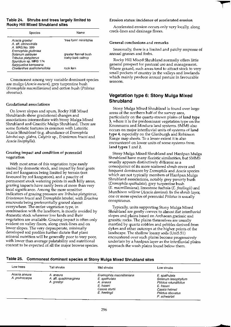
Table 24. Shrubs and trees largely limited to Rocky Hill Mixed Shrubland sites
Species
Acacia grasbyi A. aft. citrinoviridis A. MRS No. 399 Eremophila glutinosa Solanum ashbyae Tribulus platypterus Spyridium sp. MRS 174 Sarjojustica kempeana Cheilanthes austrotenuifolia
Name
'tree form' miniritchie
greater flannel bush corky-bark caltrop
rock fern
Commonest among very variable dominant species are mulga (Acacia aneura), grey turpentine bush (Eremophila macmillaniana) and cotton bush (Ptilotus abavatus).
Gradational associations
On lower slopes and spurs, Rocky Hill Mixed Shrub lands show gradational changes and associations intermediate with Stony Mulga Mixed Shrubland and Granitic Mulga Shrubland. There are some floristic features in common with Lateritic Acacia Shrub land (e.g. abundance of Eremaphila latrobei ssp. glabra, Calytrix sp., Eriostemon brucei and Acacia linophylla).
Grazing impact and condition of perennial vegetation
With most areas of this vegetation type rarely visited by domestic stock, and impact by feral goats and red kangaroos being limited by terrain (not favoured by red kangaroos), and a paucity of permanent stock watering points in such hilly areas, grazing impacts have rarely been of more than very local significance. Among the more sensitive indicators of grazing pressure are Tribulus platypterus, Eriostemon brucei and Eremophila latrobei, with Eriachne mucronata being preferentially grazed almost everywhere. The entire vegetation type, in combination with the landform, is mostly avoided by domestic stock wherever low lands and their vegetation are available. Grazing impact is often only evident on valley floors, along creek-lines and on lower slopes. The very depauperate, minimally developed soil profiles further dictate that plant mineral nutrition will be generally poor to very poor, with lower than average palatability and nutritional content to be expected of all the major browse species.
Erosion status: incidence of accelerated erosion
Accelerated erosion occurs only very locally, along creek-lines and drainage floors.
General conclusions and remarks
Seasonally, there is a limited and patchy response of annual grasses and forbs.
Rocky Hill Mixed Shrubland normally offers little general prospect for pastoral use and management. Where grazed, such areas tend to attract stock to very small pockets of country in the valleys and lowlands which mainly produce annual pasture in favourable seasons.
Vegetation type 6: Stony Mulga Mixed Shrubland
Stony Mulga Mixed Shrubland is found over large areas of the northern half of the survey area, particularly on the quartz-strewn plains of land type 3, where it is the predominant vegetation type on the Koonmarra and Mindura land systems. SMMS also occurS on major interfluvial units of systems of land type 4, especially on the Glenburgh and Robinson Range map sheets. To a lesser extent it is also encountered on lower units of some systems from land types 1 and 2.
Stony Mulga Mixed Shrubland and Hardpan Mulga Shrub land have many floristic similarities, but SMMS usually appears distinctively different as a consequence of its more scattered shrub cover and frequent dominance by Eremophila and Acacia species which are not typically members of Hardpan Mulga Shrubland associations, notably grey poverty bush (Eremophila spathulata), grey turpentine bush (E. macmillaniana), limestone fuchsia (E. jreelingii) and Murchison willow (Acacia demissa). In the shrub layer, one or more species of perennial Ptilotus is usually conspicuous.
Typically, units supporting Stony Mulga Mixed Shrub land are gently convex to almost flat interfluvial slopes and plains based on Archaean gneissic and granitic rocks. The plains themselves are usually mantled by quartz cobbles and pebbles derived from dykes and other outcrops at the higher points of the landscape. The shallow loamy soils (Um5.51) encountered over such plains become progressively underlain by a hardpan layer as the interfluvial plains approach the wash plains found below them.
Table 25. Commonest dominant species at Stony Mulga Mixed Shrubland sites
Low trees
Acacia aneura A. pruinocarpa
Tall shrubs
A. aneura A. aff. quadrimarginea A. grasbyi
Mid shrubs
Eremophila macmillaniana E. spathulata A. aneura E. fraser; Cassia sturtii E. freelingi;
296
Low shrubs
E. spathulata Solanum lasiophyffum ptNotus rotundifolius E. fraseri Cassia helmsii PINotus obovatus P. schwartzii
f
b
r i
Hydrologically, Stony Mulga Mixed Shrubland units shed run-off to narrow drainage lines. They are thus distinct from Hardpan Mulga Shrub land units lower in the landscape which receive run-on as sheet flow from the dispersal of water from higher drainage lines.
General characteristics
Vegetation type 6: Stony Mulga Mixed Shrubland: Narryer land system, Byro station.
Stony Mulga Mixed Shrubland is typically a mixed mid and low shrubland, with far fewer tall shrubs or trees than Hardpan Mulga Shrubland. Over 70% of all sites sampled supported total perennial cover of between 5 and 15% PFC (Figure 38). This open appearance, of mixed silvery and green shrubs set against the white quartzy ground of the very gently undulating landscape is distinctive of much of this 'hard' mulga country in the upper Murchison. Relative proportions of total cover vary, particularly in the tall shrub and low tree strata: tall shrubs are rarely dominant and low trees are only present at about 50% of sites. Perennial grasses are normally absent or rare (unless some minor sandy unit is present) regardless of condition status.
A wide variety of palatable shrubs and perennial herbs occurs (Table 26). These are mainly nonhalophytic species but include several of the less salttolerant bluebush species. Their distribution at individual sites is often somewhat patchy and local. For this reason, and the fact that palatable perennials often grow at only low densities (and in association with clumps of tall shrubs and decaying 'mulga log mounds') large transect areas are required to gauge their general level of abundance over any particular plain or slope.
Ungrazed or little grazed areas far (> 5 km) from stock watering more often supported three-winged bluebush (M. triptera) among other Maireana species. Although not usually considered to be a preferred palatable species, particular on alluvial surfaces, fenceline effects observed during the survey confirmed that three-winged bluebush has been widely eliminated and generally reduced by grazing in this vegetation type. Whether or not is was formerly ubiquitous, or of more patchy rather than general distribution is not known. At the time of the survey it was absent from the majority of sites.
297
Table 26. Main palatable woody perennial species at Stony Mulga Mixed Shrubland sites
Ptilotus schwartzii P. obovatus P. rotundifolius Eremophifa compacta E. latrobei Maireana triptera M. thesioides M. convexa M. georgei M. melanocoma Rhagodia eremaea Grevillea deflexa
Gradational associations
horse mulla-mulla cotton bush showy mul1a-mulla compact poverty bush warty fuchsia bush three-winged bluebush lax bluebush mulga bluebush golden bluebush pussy bluebush rhagodia, tall saltbush red grevillea
Stony Mulga Mixed Shrub land normally intergrades with several other main vegetation types. Geographically, it is mainly replaced by Granitic Mulga Shrub land south and west of a zone from the north-west corner of the Byro sheet to the south-east corner of the Belele sheet. At the land unit level, it merges with Rocky Hill Mixed Shrub land on the slopes of hills and on the higher rises and outcrops of the stony plains it dominates. While the relict areas of undisturbed perennials resemble Mulga Chenopod Shrub land in their composition of the low shrub layer, other differences in upper storey composition, soil type and landscape position indicate that typical Stony Mulga Mixed Shrubland sites are not merely degraded Mulga Chenopod Shrub land.
Across their lower extent, where stony plains meet hardpan plains, there is normally a transition zone with Hardpan Mulga Shrubland which follows the contour and extends downslope for several hundred metres.
Grazing impact and the condition of perennial vegetation
Number of condition sites investigated: 166
Site methodology: C
Site variables analysed: dominant species in association;
projected foliar cover (PFC);
plant density; species richness; palatable species
density; palatable species
richness; perennial diversity
(Shannon-Weiner); palatable species
diversity (Shannon-Weiner);
species evenness (equitability);
distance from stock water point;
paddock quadrant; erosion status.
00
:~ 00
'0 C ~ w "-
00
. .m 00
'0 C ~ w "-
00
.~ 00
'0 c ~ w "-
Stony Mulga Mixed Shrubland (n=165) lotal perennial density
20 40 60 80 ">l Density (plants per site)
Stony Mulga Mixed Shrubland (n=165) Palatable perennial density
Stony Mulga Mixed Shrubland (n= 165) lotal number of perennial species
Stony Mulga Mixed Shrubland (n=165) Number of palatable species
, <> '" Number of species
.~ 00
'0 C ~ w "-
> "'''
00
.~ 00
'0 C ~ w "-
00
.* '0 c ~ w "-
Stony Mulga Mixed Shrubland (n=165) Diversity of perennial species
, u = ,. ,. ,. ,~ u = _ Diversity Index (Shannon-Weiner)
Stony Mulga Mixed Shrubland (n=165) Diversity of palatable species
Diversity Index (Shannon-Weiner)
Stony Mulga Mixed Shrubland (n=165) Projected foliar cover
PFC dass (% cover)
,. 1,75
Figure 38. Frequency histograms for key vegetation characteristics of Stony Mulga Mixed Shrubland over the whole survey area; data from 2000 m' condition sites.
298
f
Stony Mulga Mixed Shrubland Density of perennial species
1 km (52 sites) :2 km (84 sites) 4+ km (43 s~es)
Distance from permanent stock water point (km)
_ All perennial spp - Standard deviation
Stony Mulga Mixed Shrubland Number of perennial species
1 km (52 s~es) 2 kin (84 s~os) 4+ km (43 siles)
Distance from permanent stock water point (km)
_ All perennial spp - Standard deviation
Stony Mulga Mixed Shrubland Diversity of perennial species
1 km (52 sites) :2 km (84 siles) 4+ km (43 s~es)
Distance from permanent stock water point (km)
_ All perennial spp - Standard deviation
Stony Mulga Mixed Shrubland Projected Foliar Cover (PFC)
1 km (52 sites) 2 krn (84 sites) 4+ krn (43 sites)
Distance from permanent stock water point (km)
_ All perennial spp - Standard deviation
i ~ II '" !i E
~ .~
" Z E
Stony Mulga Mixed Shrubland Density of palatable perennial species
1 kin (52 siles) 2 km (84 siles) 4+ km {43 sites}
Distance from permanent stock water point (km)
_ Palatable perennial species - Standard deviation
Stony Mulga Mixed Shrubland Number of palatable perennial species
:i!o+----1 km (52 siles) 2km(84si1es} 4+ km(43si1es)
Distance from permanent stock water point (km)
• Palatable perennial species - Standard deviation
Stony Mulga Mixed Shrubland Diversity of paTatable perennial species
1 krn (52 s~es) 2 krn (84 s~es) 4+ krn (43 sites)
Distance from permanent stock water point (km)
• Palatable perennial species - Standard deviation
Figure 39. Vegetation attributes and the effect of site distance from the nearest stock water point for Stony Mulga Mixed Shrubland srtes.
299
Results: condition of perennial vegetation: 4 classes
Class 1
Density of palatable woody perennials> 100/2000 m'
Species richness of palatable woody perennials 2: 7/2000 m'
Class 2
Not as class 1
Density of palatable woody perennials > 25/2000 m'
Species richness of palatable woody perennials 2: 4/2000 m'
Class 3
Not as class 1 or 2
Density of palatable woody perennials
Species richness of palatable woody perennials
Class 4
Not as classes 1, 2 or 3
> 5/2000 m'
2: 2/2000 m'
Table 27. Site classification summary (n = 166) Stony Mulga Mixed Shrubland sites
Class No. % Cumulative %
1 17 10 10 2 59 36 46 3 61 37 83 4 29 17 100
Erosion status: incidence of accelerated erosion
This vegetation type is not normally susceptible to accelerated erosion, even when severely degraded to near denudation. Only one site exhibited (minor) accelerated erosion in the entire survey.
General conclusions and remarks
The survey revealed marked patterns of reduced populations of total perennials and much reduced populations and species of palatable perennials at sites closer (1 and 2 km) to watering points (Figure 39). Sites with greatly reduced palatable perennial plants (classes 3 and 4) often exhibit compensatory increases in the cover of unpalatable Eremophila species as well as a general loss of Acacia species from the mid and upper storeys.
The causes of death of mulga and other tall shrubs (in evidence from standing dead wood) may not be attrIbutable to anyone cause. In general, regeneration of mulga from seedlings has as yet been poorer in Stony Mulga Mixed Shrubland than most of the other vegetation types in the survey area.
300
Stony Mulga Mixed Shrubland supports abundant annuals and ephemerals after effective rains. Perennial degradation may have increased the local susceptibility of these associations to fire when critical levels of herbage response not normally reached in the undegraded state occur.
Analysis of the site data suggests that densities of Stony Mulga Mixed Shrub land palatable perennials averaged significantly lower in the north-east quadrant of paddocks than elsewhere. This observation suggests that adverse grazing pressure which has resulted in the death, or lack of regeneration, of palatable shrubs has been particularly focussed on the north-eastern sectors of paddocks. Possibly, north-easterly winds have predominated and influenced grazing pressure during drought conditions or at times when shrub populations have been vulnerable on these landscapes.
Vegetation type 7: Granitic (and other baserock) Mulga Shrubland
Granitic (and other baserock) Mulga Shrub land occurs widely on rock-based plains and interfluves of the 'hard mulga' country generally found adjacent to and slightly above the hardpan plains which receive their run-off as sheet drainage. A variety of underlying rocks and their colluvium are involved, with granites and other igneous rocks being by far the most widespread, although sedimentary rocks also feature in some areas. Major areas of Granitic Mulga Shrub land vegetation are found in land type 4, for which it is the most extensive vegetation type, particularly in the southern half of the area. To a lesser extent it occurs on equivalent units of land types 2, 5 and 7 and irregularly elsewhere on other land types. Regardless of lithological types, the soils characteristic of Granitic Mulga Shrub land sites are shallow sandy loams with neutral reaction trends; they have developed over weathering parent rocks, which outcrop to some extent.
General characteristics
Vegetation type 7: Granitic Mulga Shrubland: Challenge land system, Boolardy station.
t
I ~
Table 28. Commonest dominant species at Granitic (and other base rock) Mulga Shrubland sites
Low trees
Acacia aneura
Tall shrubs
A. aneura
A. grasbyi A. cuthbertsonii A. xiphophyl/a A. victoriae A. quadrimarginea A. burkittii A. craspedocarpa
About 70% of sites are dominated by the tall shrub stratum, the remainder being dominated by either mid or low shrubs, or both lower strata co-dominantly. Over 30% of sites support a tree storey, which is dominated by tree-form mulgas in nearly all instances. Mulga (Acacia aneura) dominates the tall shrub layer at approximately 40% of sites, while minieritchie (A. grasbyi), snakewood (A. xiphophylla), fine leaf jam (A. burkittii), prickly acacia (A. victoriae), A. cuthbertsonii or Murchison willow (A. demissa) are dominant elsewhere. The total perennial cover is between 5 and 20% PFC in 80% of cases (Figure 40).
Among the low and mid shrubs, cotton bush (Ptilotus obovatus) and banana leaf cassia (Cassia phyllodinea) are the commonest dominants (Table 28).
As with Hardpan Mulga Shrubland, perennial grasses are not normally present.
Total perennial cover levels for Granitic Mulga Shrubland have the same central tendency (10-15%) as Hardpan Mulga Shrubland sites, but the normal range of variation (variance) is less and no grove-intergrove patterning is evident.
Non-halophytic species make up the vast majority of the palatable perennial shrubs and herbs which constitute the browse potential of this vegetation. The range of palatable species is similar to that encountered at Hardpan Mulga Shrubland sites, with some significant differences, such as the general absence of flat leaved bluebush (Maireana pianijoiia), mulga broombush (Spartothamnella teucriijlora), red grevillea (Grevillea def!.exa), Hibiscus gardneri and Wilcox bush (Eremophiia forrestii) from most sites, and the inclusion of ruby saltbush (Enchyiaena tomentosa), three-winged, golden and lax bluebushes (Maireana triptera, M. georgei and M. thesioides) on many sites.
It is interesting that, irrespective of differences in underlying geology, landform, surface hydrology and perennial species composition, the following general community attributes of the two types Granitic Mulga Shrubland and Hardpan Mulga Shrub land showed no significant differences (for 1000 m' sites over the survey areas as a whole):
total density of perennials; density of palatable perennials; species richness and diversity of perennials; and species richness and diversity of palatable perennials.
16602-20 301
Mid shrubs
A. tetragonophylla
A. craspedocarpa Cassia phyl/odinea A. ramulosa Eremophila fraser; Hakea arida A. quadrimarginea E p/atyca/yx E. exilifolia Cassia helmsii
Gradational associations
Low shrubs
Ptilotus obovatus Solanum fasiophyllum E. punicea C. helmsii P. schwartzii E. exilifolia Bida calyxhymenia E. aft. mackin/ayi Maireana convexa M. triptera
Granitic Mulga Shrubland intergrades with Stony Mulga Mixed Shrubland in some northern parts of the area, where some interfluvial plains (particularly of the Sherwood land system) based on granites and gneiss resemble a blend of the two types. Their similar landscape aspects, and surface mantles of pebbles and gravels add to the resemblance, although Granitic Mulga Shrub land sites are normally associated with lighter hued, pinkish, sandier soil surfaces carrying finer quartz grits than the more clayey, crusted, pebbled or cobbled surfaces of Stony Mulga Mixed Shrub land sites.
At the highest parts of the interfluvial plains, Granitic Mulga Shrub land normally has a transition zone to Rocky Hill Mixed Shrubland, for example around the boundary between Challenge and Norie land systems. At the lower end of the topography, there are normally only abrupt transitions to Creekline Shrub land or Creekline Grassy Shrubland, while there is a much broader transition zone where the interfluves flatten out and become veneered with hardpan at the upper limits of the 'wash' plains (land types 13 and 14) and the Hardpan Mulga Shrubland.
Grazing impact and the condition of perennial vegetation No. of condition sites investigated: Site methodology: Site variables analysed:
117 o dominant species in
association; projected foliar cover
(PFC); plant density; species richness; palatable species
density; palatable species
richness; perennial diversity
(Shannon-Weiner); palatable species; diversity (Shannon
Weiner); species evenness
(equitability); distance from stock
water point; paddock quadrant; erosion status.
w .~ w '0
~ " z 1
w .. • '0 C ~ ID a.
w
.* '0 c ~ ID a.
Granitic Mulga Shrubland (n=114) Tolal perennial density
50 100 150 200 250 300 >300 Density (plants per site)
Granitic Mulga Shrubland (n=114) Palatable perennial density
1
Density (plants per site)
Granitic Mulga Shrubland (n=114) Total number of perennial species
Gran"ic Mulga Shrubland (n=114) Number of palatable species
• Number of species
.~ w '0 C ~ ID a.
w .~ '0 C ~ 8'
w
~ '0 c ~ ID a.
0%
Granitic Mulga Shrubland (n=114) Diversity of perennial species
0.5 0.75 1.0 1.25 l.S 1.75 2.0 2.25 2.5
Diversity Index (Shannon-Weiner)
Granitic Mulga Shrubland (n=114) Diversity of palatable species
1
Diversity Index (Shannon-Weiner)
Gran"ic Mulga Shrubland (n=114) Projected foliar cover
2.5% 5% 10% 15%
PFC dass (% cover)
>-2,0
20% 25%
Figure 40. Frequency histograms for key vegetation characteristics of Granitic Mulga Shrubland over the whole survey area; data from 1000 m2 condition sites.
302
¢ i
b
c
~ 5 ID ~
12 rn TI c
ill TI C rn c rn ID E
~ "' w C ID 0
Granitic Mu!ga Shrub!and Density of perennial species
1 kin (28 sites) 2 kin (53sitcs) 4+ kin (37 sitcs)
Distance from permanent stock water point (km)
_ All perenrnal spp - Stardatd deVIation
Granitic Mulga Shrubland Number of perennial species
1 kin (28 sites) 2 km (53 s~es) 4+ kin (37 sites)
Distance from permanent stock water point (km)
_ All perennial spp - Standard deviation
Granitic Mulga Shrubland Diversity of perennial species
1 km (28 s~es) 2 km (53 s~es) 4+ kin (37 s~es)
Distance from permanent stock water point (km)
_ All pere!lnial spp - Standard deviation
Granitic Mu!ga Shrub!and Projected Foliar Cover (PFC)
1 kin (28 sites) 2 kIn (53 sites) 4+ km (37 sitos)
Distance from permanent stock water point (km)
_ All perennial spp - Standard deviaboo
~ranitic Mu!ga Shrub!and DenSIty of palatable perennial species
_ Palatable perannLaI species - Stardarrl deviation
Granitic Mulga Shrubland Number of palatable perennial species
_ Palatable perennial species - Standard deviatioo
Granitic Mulga Shrubland Diversity of palatable perennial species
1 kin (28s~es) 2 km (53 s~es) 4+ km (37 sites)
Distance from permanent stock water point (km)
_ Palatable perennial species - Standard deviatioo
Figure 41. Vegetation attributes and the effect of site distance from the nearest stock water point for Granitic Mulga Shrubland sites.
303
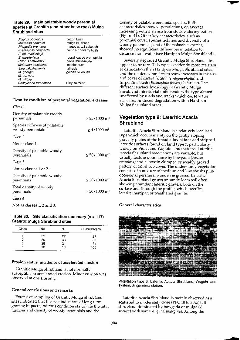
Table 29. Main palatable woody perennial species at Granitic (and other base rock) Mulga Shrubland sites
Ptilotus obovatus Maireana convexa Rhagodia eremaea Eremophila compacta E. aff. mackinlayi E. muelleriana Ptilotus schwartzii Maireana thesioides Sida calyxhymenia M. georgei M. sp. nov. M. vil/osa Enchylaena lomentDsa
cotton bush mulga bluebush rhagodia, tall saltbush compact poverty bush
round leaved eremophila horse mulla-mulla lax bluebush tall sida golden bluebush
ruby saltbush
Results: condition of perennial vegetation: 4 classes
Class 1
Density of palatable woody perennials
Species richness of palatable woody perennials
Class 2
Not as class 1.
Density of palatable woody perennials
Class 3
Not as classes 1 or 2.
Dc'-'sity of palatable woody perennials
Total density of woody perennials
Class 4
Not as classes 1, 2 and 3.
> 85/1000 m'
2: 4/1000 m'
2: 50/1000 m'
2: 20/1000 m'
2: 30/1000 m'
Table 30. Site classification summary (n = 117) Granitic Mulga Shrubland sites
Class No. % Cumulative %
1 32 27 27 2 39 33 60 3 28 24 84 4 18 16 100
Erosion status: incidence of accelerated erosion
Granitic Mulga Shrub land is not normally susceptible to accelerated erosion. Minor erosion was observed at one site only.
General conclusions and remarks
Extensive sampling of Granitic Mulga Shrubland sites indicated that the best indicators of long-term grazing impact (and thus condition states) are the total number and density of woody perennials and the
304
density of palatable perennial species. Both characteristics showed populations, on average, increasing with distance from stock watering points (Figure 41). Other key characteristics, such as perennial cover, species richness and diversity of all woody perennials, and of the palatable species, showed no significant differences in relation to distance from water (see Hardpan Mulga Shrubland).
Severely degraded Granitic Mulga Shrubland sites appear to be rare. This type is evidently more resistant to denudation than Hardpan Mulga Shrub land sites, and the tendency for sites to show increases in the size and cover of curara (Acacia tetragonophylla) and turpentine bush (Eremophila fraseri) is far less. The different surface hydrology of Granitic Mulga Shrubland interfluvial units renders the type almost unaffected by roads and tracks which cause water starvation-induced degradation within Hardpan Mulga Shrubland areas.
Vegetation type 8: Lateritic Acacia Shrubland
Lateritic Acacia Shrubland is a relatively localised type which occurs mainly on the gently sloping gravelly plains of the broad alluvial fans and stripped lateritic surfaces found on land type 7, particularly widely on Violet and Waguin land systems. Lateritic Acacia Shrubland associations are variable, but usually feature dominance by bowgada (Acacia ramulosa) and a loosely clumped or weakly groved pattern of tall shrub cover. The understorey vegetation consists of a mixture of medium and low shrubs plus occasional perennial wanderrie grasses. Lateritic Acacia Shrubland grows on sandy loam soil often showing abundant lateritic gravels, both on the surface and through the profile, which overlies laterite, hardpan or weathered granite.
General characteristics
Vegetation type 8: Lateritic Acacia Shrubland, Waguin land system, Jingemarra station.
Lateritic Acacia Shrub land is mainly observed as a scattered to moderately close (PFC 10 to 30%) tall shrubland dominated by bowgada or mulga (A. aneura) with some A. quadrimarginea. Among the
f
7
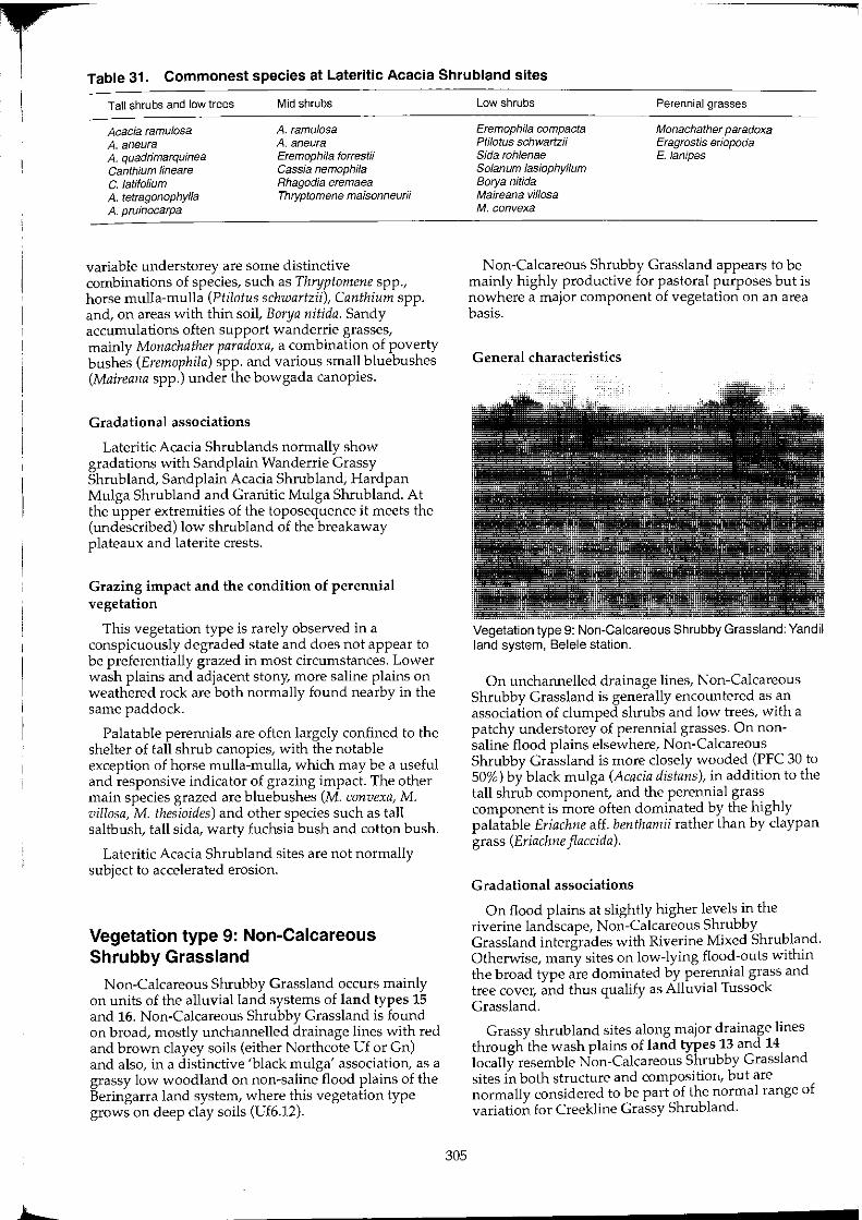
r !
Table 31. Commonest species at Lateritic Acacia Shrubland sites
Tall shrubs and low trees
Acacia ramu/os8 A. aneura A. quadrimarquinea Canthium lineare C. latifolium A. tetragonophyfla A. pruinocarpa
Mid shrubs
A. ramulosa A. aneura Eremophila forrestii Cassia nemophila Rhagodia eremaea Thryptomene maisonneurii
variable understorey are some distinctive combinations of species, such as Thryptomene spp., horse mulla-mulla (Ptilotus schwartzii), Canthium spp. and, on areas with thin soil, Borya nitida. Sandy accumulations often support wanderrie grasses, mainly Monachather paradoxa, a combination of poverty bushes (Eremophila) spp. and various small bluebushes (Maireana spp.) under the bowgada canopies.
Gradational associations
Lateritic Acacia Shrub lands normally show gradations with Sandplain Wanderrie Grassy Shrubland, Sandplain Acacia Shrubland, Hardpan Mulga Shrub land and Granitic Mulga Shrub land. At the upper extremities of the toposequence it meets the (undescribed) low shrubland of the breakaway plateaux and laterite crests.
Grazing impact and the condition of perennial vegetation
This vegetation type is rarely observed in a conspicuously degraded state and does not appear to be preferentially grazed in most circumstances. Lower wash plains and adjacent stony, more saline plains on weathered rock are both normally found nearby in the same paddock.
Palatable perennials are often largely confined to the shelter of tall shrub canopies, with the notable exception of horse mulla-mulla, which may be a useful and responsive indicator of grazing impact. The other main species grazed are bluebushes (M. convexa, M. villosa, M. thesioides) and other species such as tall saltbush, tall sida, warty fuchsia bush and cotton bush.
Lateritic Acacia Shrubland sites are not normally subject to accelerated erosion.
Vegetation type 9: Non-Calcareous Shrubby Grassland
Non-Calcareous Shrubby Grassland occurs mainly on units of the alluvial land systems of land types 15 and 16. Non-Calcareous Shrubby Grassland is found on broad, mostly unchannelled drainage lines with red and brown clayey soils (either Northcote Uf or Gn) and also, in a distinctive 'black mulga' association, as a grassy low woodland on non-saline flood plains of the Beringarra land system, where this vegetation type grows on deep clay soils (Uf6.12).
305
Low shrubs
Eremophila compacta Ptilotus schwartzii Sida rohlenae Solanum lasiophyllum Borya nitida Maireana vil/asa M. conveX8
Perennial grasses
Monachather paradoxa Eragrostis eriopoda E. /anipes
N on-Calcareous Shrubby Grassland appears to be mainly highly productive for pastoral purposes but is nowhere a major component of vegetation on an area basis.
General characteristics
Vegetation type 9: Non-Calcareous Shrubby Grassland: Yandil land system, Belele station.
On unchannelled drainage lines, Non-Calcareous Shrubby Grassland is generally encountered as an association of clumped shrubs and low trees, with a patchy understorey of perennial grasses. On nonsaline flood plains elsewhere, Non-Calcareous Shrubby Grassland is more closely wooded (PFC 30 to 50%) by black mulga (Acacia dis/ans), in addition to the tall shrub component, and the perennial grass component is more often dominated by the highly palatable Eriachne aff. benthamii rather than by claypan grass (Eriachne flaccida).
Gradational associations
On flood plains at slightly higher levels in the riverine landscape, Non-Calcareous Shrubby Grassland intergrades with Riverine Mixed Shrubland. Otherwise, many sites on low-lying flood-outs within the broad type are dominated by perennial grass and tree cover, and thus qualify as Alluvial Tussock Grassland.
Grassy shrub land sites along major drainage lines through the wash plains of land types 13 and 14 locally resemble Non-Calcareous Shrubby Grassland sites in both structure and compositioIt, but are normally considered to be part of the normal range of variation for Creekline Grassy Shrubland.
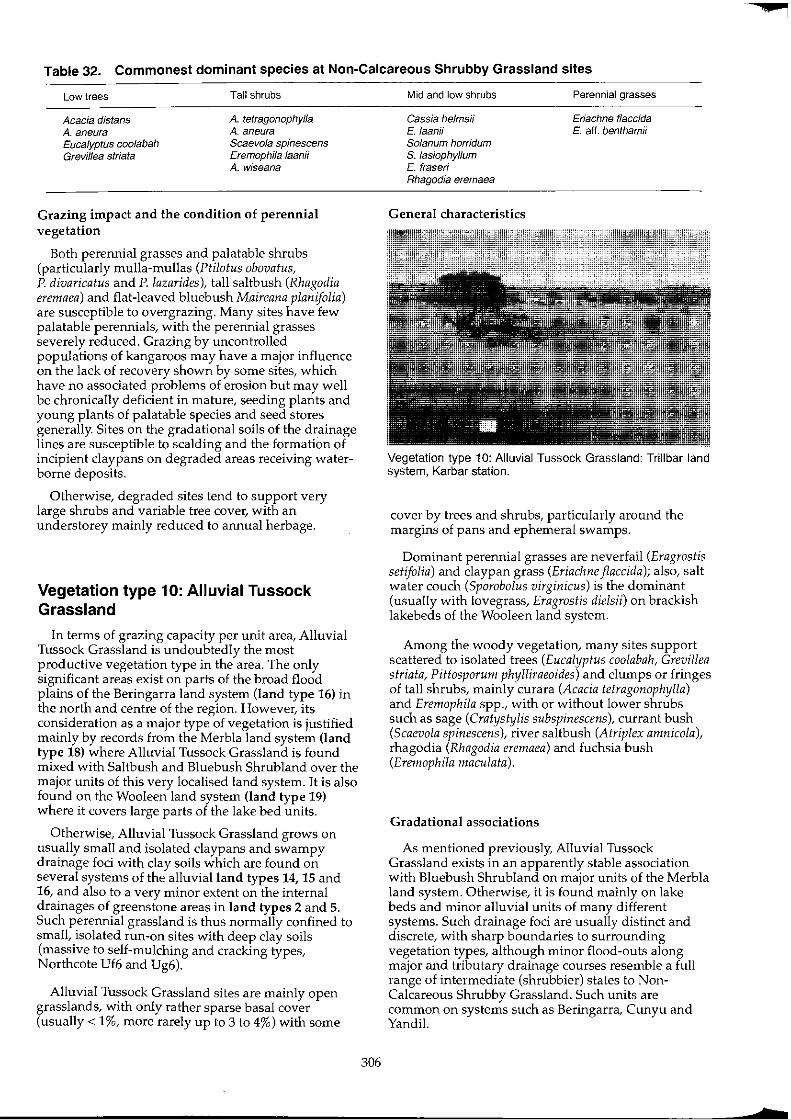
Table 32. Commonest dominant species at Non-Calcareous Shrubby Grassland sites
Low trees
Acacia distans A. aneura Eucalyptus coolabah Grevillea striata
Tall shrubs
A. tetragonophylla A. aneura Scaevola spinescens Eremophila laanii A. wiseana
Grazing impact and the condition of perennial vegetation
Both perennial grasses and palatable shrubs (particularly mulla-mullas (Ptilotus obovatus, P. divaricatus and P. lazarides), tall saltbush (Rhagodia eremaea) and flat-leaved bluebush Maireana planifolia) are susceptible to overgrazing. Many sites have few palatable perennials, with the perennial grasses severely reduced. Grazing by uncontrolled populations of kangaroos may have a major influence on the lack of recovery shown by some sites, which have no associated problems of erosion but may well be chronically deficient in mature, seeding plants and young plants of palatable species and seed stores generally. Sites on the gradational soils of the drainage lines are susceptible to scalding and the formation of incipient claypans on degraded areas receiving waterborne deposits.
Otherwise, degraded sites tend to support very large shrubs and variable tree cover, with an understorey mainly reduced to annual herbage.
Vegetation type 10: Alluvial Tussock Grassland
In terms of grazing capacity per unit area, Alluvial Tussock Grassland is undoubtedly the most productive vegetation type in the area. The only significant areas exist on parts of the broad flood plains of the Beringarra land system (land type 16) in the north and centre of the region. However, its consideration as a major type of vegetation is justified mainly by records from the Merbla land system (land type 18) where Alluvial Tussock Grassland is found mixed with Saltbush and Bluebush Shrubland over the major units of this very localised land system. It is also found on the Wooleen land system (land type 19) where it covers large parts of the lake bed units.
Otherwise, Alluvial Tussock Grassland grows on usually small and isolated claypans and swampy drainage foci with clay soils which are found on several systems of the alluvial land types 14, 15 and 16, and also to a very minor extent on the internal drainages of greenstone areas in land types 2 and 5. Such perennial grassland is thus normally confined to small, isolated run-on sites with deep clay soils (massive to self-mulching and cracking types, Northcote Vf6 and Vg6).
Alluvial Tussock Grassland sites are mainly open grasslands, with only rather sparse basal cover (usually < 1%, more rarely up to 3 to 4%) with some
306
Mid and low shrubs
Cassia helmsii E. laanii Solanum horridum S. lasiophyllum E. fraseri Rhagodia eremaea
General characteristics
Perennial grasses
Eriachne flaccida E. aft. benthamii
Vegetation type 10: Alluvial Tussock Grassland: Trillbar land system, Karbar station.
cover by trees and shrubs, particularly around the margins of pans and ephemeral swamps.
Dominant perennial grasses are neverfail (Eragrostis setifolia) and claypan grass (Eriachne flaccida); also, salt water couch (Sporobolus virginicus) is the dominant (usually with lovegrass, Eragrostis dielsii) on brackish lakebeds of the Wooleen land system.
Among the woody vegetation, many sites support scattered to isolated trees (Eucalyptus coolabah, Grevillea striata, Piftosporum phylliraeoides) and clumps or fringes of tall shrubs, mainly curara (Acacia tetragonophylla) and Eremophila spp., with or without lower shrubs such as sage (Cratystylis subspinescens), currant bush (Scaevola spinescens), river saltbush (Atriplex amnicola), rhagodia (Rhagodia eremaea) and fuchsia bush (Eremophila maculata).
Gradational associations
As mentioned previously, Alluvial Tussock Grassland exists in an apparently stable association with Bluebush Shrub land on major units of the Merbla land system. Otherwise, it is found mainly on lake beds and minor alluvial units of many different systems. Such drainage foci are usually distinct and discrete, with sharp boundaries to surrounding vegetation types, although minor flood-outs along major and tributary drainage courses resemble a full range of intermediate (shrubbier) states to NonCalcareous Shrubby Grassland. Such units are common on systems such as Beringarra, Cunyu and Yandi!.

Grazing impact and the condition of perennial vegetation
Such vegetation appears to be resilient even under concentrated grazing pressure. Undoubtedly, prolonged periods of inundation which follow major rains serve to protect perennial plants during part of their growth periods, through inaccessibility to stock. Even so, many sites appear to have become degraded through concentrations of grazing pressure by stock, feral and native animals. Patchiness or thinning of the grass tussock cover, perhaps as a consequence of a lack of recruitment by young plants, is frequently observed. On some sites, even-aged recruitment by unpalatable shrubs such as crinkled cassia (Cassia helmsii) has occurred.
Highly palatable species, particularly Eriachne benthamii and neverfail grass (Eragrostis setifolia) are probably the best indicators of vegetation condition. Although claypan grass (Eriachne flaccida) provides useful forage for livestock it is not regarded as being as highly palatable as the other grass species.
Condition of perennial vegetation
Insufficient sites were investigated to make any assessment of the area. A suggested condition classification is as follows:
Site methodology: E
Results: condition of perennial vegetation: 3 classes
Class 1
Palatable perennial grass(es) dominant among perennial grasses. Perennial grass cover dominant over shrubs.
Class 2
Palatable perennial grass(es) dominant among perennial grasses. Shrub cover exceeds perennial grass cover.
Class 3
Not class 1 or 2.
General conclusions and remarks
Some sites with degraded perennial grasses appear to have undergone secondary increases by unpalatable shrubs such as needle bush (Hakea preissii) and harlequin fuchsia bush (Eremophila linearis).
This vegetation type is not normally susceptible to accelerated erosion.
Vegetation type 11: Riverine Mixed Shrubland
Riverine Mixed Shrubland occurs on non-saline to slightly saline flood plains and unchannelled flow zones of the major rivers, on heavier clay loam or clayey soils of moderate depth, which are usually underlam by eIther cemented alluvium or red-brown hardpan. This is another structurally variable vegetation type, but one which is basically tall and mid-height shrubland with a tree storey and many forage shrubs. Riverine Mixed Shrub land mostly occurs on land systems of land types 15 and 16, particularly on Beringarra and Mileura land systems. Although no empirical information is available, Riverine Mixed Shrubland can be assumed to have high pastoral value from its botanical composition and favoured moisture status, being in close proximity to river channels and their underlying alluvium and associated shallow aquifers.
General characteristics
Vegetation type 11: Riverine Mixed Shrubland: Beringarra land system, Meeberrie station.
Riverine Mixed Shrubland associations are composed partIy by species typical of Hardpan Mulga Shrub land (found higher and adjacent in the landscape) and others found widely among more saline shrub lands (such as Bluebush and Mixed Halophyte Shrubland) with others which are generally confined to Riverine Mixed Shrub land and N onCalcareous Shrubby Grassland types.
Most sites are dominated by tall or mid-shrubs, although on others the low shrub stratum is the major component of the cover. About 90% of sites support some tree cover, while perennial grasses are always scarce or absent. Usually, a combination of scattered
Table 33 Commonest dominant species at Riverine Mixed Shrubland sites
Low trees
Eucalyptus coolabah Grevillea striata Acacia distans
Tall shrubs
A. tetragonophylla A. victoriae A. sc/erosperma A. aneura Eremophila laanii
Mid shrubs
A. victoriae A. tetragonophylla Scaevola spinescens Cassia desolata Rhagodia eremaea Stylobasium spathulatum
307
Low shrubs
Ptilotus obovatus Eremophila maculata Cassia desolata Solanum lasiophyllum P. lazarides

overstorey coolabahs (Eucalyptus coolabah), and beefwood (Grevillea striata) trees with a mixture of shrubs featuring curara (Acacia tetragonophylla), and prickly acacia (A. victoriae), (rather than much mulga, A. aneura) with cotton bush (Phlotus obovatus), fuchsIa (Eremophila maculata), currant bush (Scaevola spinescens), occasional sage (Cratystylis subspinescens) and river saltbush (Atriplex amnicola), make up a landscape which is distinctively recognisable as 'river country'.
Total perennial cover levels for Riverine Mixed Shrubland are mainly 10 to 20% but locally lower where severely degraded.
The range of palatable perennials is very broad, with much local variation. Cottonbush and fuchsia are the most abundant, with others including sage, river saltbush, frankenia (Frankenia spp.), currant bush, mulla-mullas (Ptilotus lazarides, P. divaricatus and P. polakii), rhagodia (Rhagodia eremaea), Maireana sp. nov. and spiny bluebush M. aphylla.
Gradational associations
Riverine Mixed Shrub land intergrades with Hardpan Mulga Shrubland along the line where wash plain systems (land types 13 and 14) drain sheet flow onto the river plains (land types 15 and 16). On the ground, this normally represents a zone up to 500 m wide, parallel with each arm of the river. Riverine Mixed Shrubland also intergrades with the more saline, mainly duplex plains of Saltbush, Bluebush and Mixed Halophytic Shrubland at transition zones lower in the alluvial catenas.
Otherwise, Non-Calcareous Shrubby Grassland associations, such as the 'black mulga' (A. dis tans ) country of the Beringarra land system, are a similar grassier type growing only on deep non-saline clay soils.
Grazing impact and the condition of perennial vegetation
No. of condition sites investigated:
Site methodology:
Site variables analysed:
16
B
dominant species in association;
projected foliar cover (PFC);
species composition index (SCI);
ratio of palatable to unpalatable species (RPU);
erosion status; and
distance from permanent water.
308
Results: condition of perennial vegetation: 3 classes
Class 1
A palatable species is the dominant or co-dominant cover perennial.
Class 2
Dominant cover perennial is not an unpalatable species with invasive tendencies. Palatable species are present on site.
Class 3
Dominant cover perennial is an unpalatable species with invasive tendencies.
Table 34. Site classification summary (n = 16) Riverine Mixed Shrubland sites
Class
1 2 3
No.
4 5 7
%
25 31 44
General conclusions and remarks
Cumulative %
25 56 100
The shrub strata of Riverine Mixed Shrub land in good condition are usually dominated or co-dominated by one or more palatable shrub species. Only sites which had evidently been subject to overgrazing showed the apparently secondary increases by unpalatable species, such as prickly acacia (Acacia victoriae), silver poverty bush (Eremophila pterocarpa), needle bush (Hakea preissii), or variable cassia (Cassia sturtii). Only at such sites is the occurrence of accelerated erosion common. Eroded sites show no difference in the range of total tree and shrub cover (PFC), indicating that once initiated, erosion is able to proceed and is not necessarily mitigated by increases in the density and cover of unpalatable invasive shrubs. This finding is common to several major vegetation types in the area (see Bluebush Shrub land, Saltbush Shrubland).
Vegetation type 12: Calcrete Shrubby Grassland
Calcrete Shrubby Grassland is a distinctive association of perennial grasses and a wide variety of shrubs that is confined to calcrete platforms on the alluvial landforms of land type 15 and, to a lesser extent, land type 16.
Floristically, Calcrete Shrubby Grassland is very different from other vegetation types with only poorly developed between-type transitions. Such distinctiveness can be attributed to its special soil types, which are thin sands or gradational calcareous soils. Developed on calcrete, they are strongly alkaline in soil reaction trend.
While the broadscale occurrence of the type is limited to the vicinity of the major river plains and tributaries of the salt lakes, Calcrete Shrubby Grassland provides preferred grazing land for stock
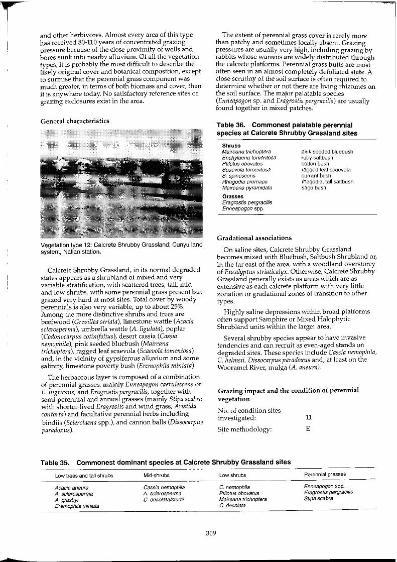
and other herbivores. Almost every area of this type has received 80-110 years of concentrated grazing pressure because of the close proximity of wells and bores sunk into nearby alluvium. Of all the vegetation types, it is probably the most difficult to describe the likely original cover and botanical composition, except to surmise that the perennial grass component was much greater, in terms of both biomass and cover, than it is anywhere today. No satisfactory reference sites or grazing exclosures exist in the area.
General characteristics
Vegetation type 12: Calcrete Shrubby Grassland: Cunyu land system, Nalian station.
Calcrete Shrubby Grassland, in its normal degraded states appears as a shrubland of mixed and very variable stratification, with scattered trees, tall, mid and low shrubs, with some perennial grass present but grazed very hard at most sites. Total cover by woody perennials is also very variable, up to about 25%. Among the more distinctive shrubs and trees are beefwood (Grevillea striata), limestone wattle (Acacia sclerosperma), umbrella wattle (A. ligulata), poplar (Codonocarpus cotinifolius), desert cassia (Cassia nemophila), pink seeded bluebush (Maireana trichoptera), ragged leaf scaevola (Scaevola tomentosa) and, in the vicinity of gypsiferous alluvium and some salinity, limestone poverty bush (Eremophila miniata).
The herbaceous layer is composed of a combination of perennial grasses, mainly Enneapogon caerulescens or E. nigricans, and Eragrostis pergracilis, together with semi-perennial and annual grasses (mainly Stipa scabra with shorter-lived Eragrostis and wind grass, Aristida contorta) and facultative perennial herbs including bindiis (Sclerolaena spp.), and cannon balls (Dissocarpus paradoxus ).
The extent of perennial grass cover is rarely more than patchy and sometimes locally absent. Grazing pressures are usually very high, including grazing by rabbits whose warrens are widely distributed through the calcrete platforms. Perennial grass butts are most often seen in an almost completely defoliated state. A close scrutiny of the soil surface is often required to determine whether or not there are living rhizomes on the soil surface. The major palatable species (Enneapogon sp. and Eragrostis pergracilis) are usually found together in mixed patches.
Table 36. Commonest palatable perennial species at Calcrete Shrubby Grassland sites
Shrubs Maireana trichoptera Enchylaena tomentosa ptilotus obovatus Scaevola tomentosa S. spinescens Rhagodia eremaea Maireana pyramidata
Grasses Eragrostis pergraciJis Enneapogon spp.
Gradational associations
pink seeded bluebush ruby saltbush cotton bush ragged leaf scaevola currant bush rhagodia, tall saltbush sago bush
On saline sites, Calcrete Shrubby Grassland becomes mixed with Bluebush, Saltbush Shrub land or, in the far east of the area, with a woodland overstorey of Eucalyptus striaticalyx. Otherwise, Calcrete Shrubby Grassland generally exists as areas which are as extensive as each calcrete platform with very little zonation or gradational zones of transition to other types.
Highly saline depressions within broad platforms often support Samphire or Mixed Halophytic Shrub land units within the larger area.
Several shrubby species appear to have invasive tendencies and can recruit as even-aged stands on degraded sites. These species include Cassia nemophila, C. helmsii, Dissocarpus paradoxus and, at least on the Wooramel River, mulga (A. aneura).
Grazing impact and the condition of perennial vegetation
No. of condition sites investigated: 11
Site methodology: E
Table 35. Commonest dominant species at Calcrete Shrubby Grassland sites
Low trees and tall shrubs
Acacia aneura A. sclerosperma A. grasbyi Eremophila miniata
Mid-shrubs
Cassia nemophila A. sc/erosperma C. desolata/sturtii
309
Low shrubs
C. nemophila Ptilotus obovatus Maireana trichoptera C. desolata
Perennial grasses ---
Enneapogon spp. Eragrostis pergracilis Stipa scabra
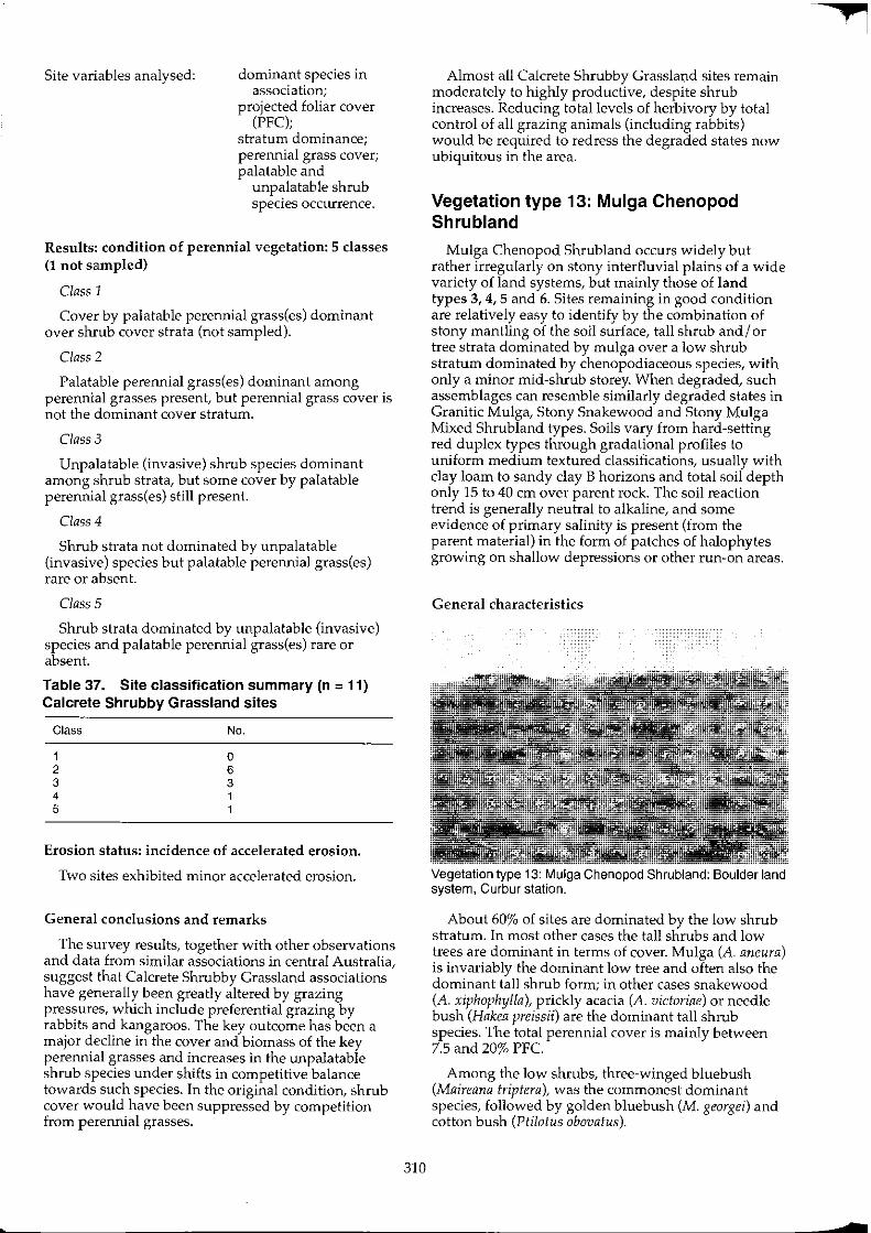
Site variables analysed: dominant species in association;
projected foliar cover (PFC);
stratum dominance; perennial grass cover; palatable and
unpalatable shrub species occurrence.
Results: condition of perennial vegetation: 5 classes (1 not sampled)
Class 1
Cover by palatable perennial grass(es) dominant over shrub cover strata (not sampled).
Class 2
Palatable perennial grass(es) dominant among perennial grasses present, but perennial grass cover is not the dominant cover stratum.
Class 3
Unpalatable (invasive) shrub species dominant among shrub strata, but some cover by palatable perennial grass(es) still present.
Class 4
Shrub strata not dominated by unpalatable (invasive) species but palatable perennial grass(es) rare or absent.
Class 5
Shrub strata dominated by unpalatable (invasive) species and palatable perennial grass(es) rare or absent.
Table 37. Site classification summary (n = 11) Calcrete Shrubby Grassland sites
Class No.
1 0 2 6 3 3 4 1 5 1
Erosion status: incidence of accelerated erosion.
Two sites exhibited minor accelerated erosion.
General conclusions and remarks
The survey results, together with other observations and data from similar associations in central Australia, suggest that Calcrete Shrubby Grassland associations have generally been greatly altered by grazing pressures, which include preferential grazing by rabbits and kangaroos. The key outcome has been a major decline in the cover and biomass of the key perennial grasses and increases in the unpalatable shrub species under shifts in competitive balance towards such species. In the original condition, shrub cover would have been suppressed by competition from perennial grasses.
310
Almost all Calcrete Shrubby Grasslm;td sites remain moderately to highly productive, despite shrub increases. Reducing total levels of herbivory by total control of all grazing animals (including rabbits) would be required to redress the degraded states now ubiquitous in the area.
Vegetation type 13: Mulga Chenopod Shrubland
Mulga Chenopod Shrub land occurs widely but rather irregularly on stony interfluvial plains of a wide variety of land systems, but mainly those of land types 3, 4, 5 and 6. Sites remaining in good condition are relatively easy to identify by the combination of stony mantling of the soil surface, tall shrub and I or tree strata dominated by mulga over a low shrub stratum dominated by chenopodiaceous species, with only a minor mid-shrub storey. When degraded, such assemblages can resemble similarly degraded states in Granitic Mulga, Stony Snakewood and Stony Mulga Mixed Shrubland types. Soils vary from hard-setting red duplex types through gradational profiles to uniform medium textured classifications, usually with clay loam to sandy clay B horizons and total soil depth only 15 to 40 cm over parent rock. The soil reaction trend is generally neutral to alkaline, and some evidence of primary salinity is present (from the parent material) in the form of patches of halophytes growing on shallow depressions or other run-on areas.
General characteristics
Vegetation type 13: Mulga Chenopod Shrubland: Boulder land system, Curbur station.
About 60% of sites are dominated by the low shrub stratum. In most other cases the tall shrubs and low trees are dominant in terms of cover. Mulga (A. aneura) is invariably the dominant low tree and often also the dominant tall shrub form; in other cases snakewood (A. xiphophylla), prickly acacia (A. victoriae) or needle bush (Hakea preissii) are the dominant tall shrub species. The total perennial cover is mainly between 7.5 and 20% PFC.
Among the low shrubs, three-winged bluebush (Maireana triptera), was the commonest dominant species, followed by golden bluebush (M. georgei) and cotton bush (Ptilotus obovatus).
In good seasons, Mulga Chenopod Shrubland grows annual and ephemeral herbage of a high quality for grazing stock. Short-lived chenopods, particularly bindiis and copperburrs (Sclerolaena spp.) are major components of the annual response, particularly when germinating summer rains are followed by winter growth periods.
Gradational associations
Mulga Chenopod Shrub land shows a full range of transitional states with Bluebush Shrubland (on adjacent run-on sites), Stony Snakewood Shrubland (typically exhibiting dominance by A. xiphophylla and stronger aggregation of understorey low shrubs) and Granitic Mulga Shrub land (fewer halophytes, more diverse tall shrubs and typically situated on gritsurfaced plains derived from granite). Some areas of Mulga Chenopod Shrub land in unusually good condition are very similar in structure and composition to Bluebush Shrublands, but when in poorer condition they are dominated by mid-height Eremophila and Acacia species.
A lack of extensive occurrence of this vegetation type anywhere in the area tends to suggest that it is mainly made up by associations and soil types that are to some extent transition states or intermediates between other major vegetation types.
Grazing impact and the condition of perennial vegetation
No. of condition sites investigated:
Site methodology:
Site variables analysed:
22
BandC
dominant species in association;
projected foliar cover (PFC);
species composition index (SCI);
ratio of palatable species to unpalatable species (RPU);
erosion status.
Results: condition of perennial vegetation: 4 classes
Class 1
A key palatable species is dominant, or second dominant in the low shrub stratum; one of:
Maireana georgei M. melanocoma M. pyramidata M. integra M. convexa Ptilotus beardii Rhagodia eremaea
Class 2
Low shrub cover dominated by Maireana triptera.
311
Class 3
Key palatable species present but not dominant among low shrub cover, which is dominated by species other than key unpalatable species (below).
Class 4
Low / mid shrub cover dominated by key unpalatable species:
Eremophila pterocarpa Hakea preissii Acacia victoriae
or
All key palatable species rare to absent.
Erosion status: incidence of accelerated erosion
None of the condition sites sampled displayed accelerated erosion, and it appears that this vegetation type is not normally susceptible, except locally in cases of severe degradation. On some land systems, notably Gabanintha and Wiluna, local redistribution of topsoils with subsequent water erosion caused by mining exploration and alluvial mining operations is widespread. This is probably commoner than pastoral impacts as a cause of accelerated erosion of degraded Mulga Chenopod Shrubland.
General conclusions and remarks
Most sites dominated by three-winged bluebush have probably been degraded to the extent of more palatable perennials having been lost and replaced by a competitive advantage of this less palatable but sometimes edible species. For this reason, sites dominated by three-winged bluebush have been distinguished from sites dominated by other more palatable chenopodiaceous species (i.e. class 2 cf class 1 ).
Where all or most of the palatable low shrubs have been lost from the understorey, some sites exhibit understorey dominance by invasive unpalatable species while others simply show lack of understorey perennials. In this way it appears that increases by unpalatable understorey species are secondary events which mayor may not occur (or have occurred) at any particular site. Mulga Chenopod Shrub land does not normally succumb to shrub 'invasion', in the conventional sense of supporting a greater amount of cover by unpalatable invasive species than the former cover by a palatable species and the original overstorey (mulga).
Table 38. Site classification summary (n = 22) Mulga Chenopod Shrubland sites
Class No. % Cumulative %
1 6 27 27 2 8 36 63 3 3 14 77 4 2 9 86 unclassified 3 14 100
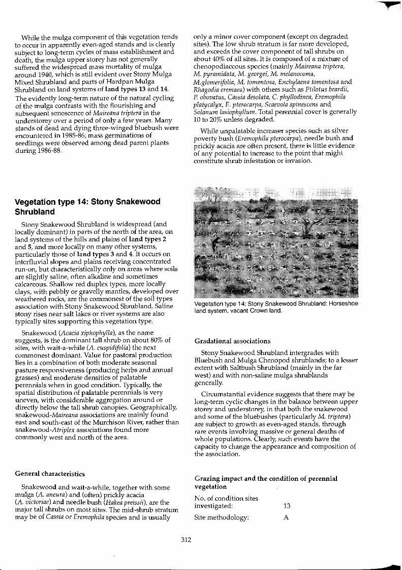
While the mulga component of this vegetation tends to occur in apparently even-aged stands and is clearly subject to long-term cycles of mass establishment and death, the mulga upper storey has not generally suffered the widespread mass mortality of mulga around 1940, which is still evident over Stony Mulga Mixed Shrub land and parts of Hardpan Mulga Shrubland on land systems of land types 13 and 14. The evidently long-term nature of the natural cycling of the mulga contrasts with the flourishing and subsequent senescence of Maireana triptera in the understorey over a period of only a few years. Many stands of dead and dying three-winged bluebush were encountered in 1985-86; mass germinations of seedlings were observed among dead parent plants during 1986-88.
Vegetation type 14: Stony Snakewood Shrubland
Stony Snakewood Shrubland is widespread (and locally dominant) in parts of the north of the area, on land systems of the hills and plains of land types 2 and 5, and more locally on many other systems, particularly those of land types 3 and 4. It occurs on interfluvial slopes and plains receiving concentrated run-on, but characteristically only on areas where soils are slightly saline, often alkaline and sometimes calcareous. Shallow red duplex types, more locally clays, with pebbly or gravelly mantles, developed over weathered rocks, are the commonest of the soil types association with Stony Snakewood Shrubland. Saline stony rises near salt lakes or river systems are also typically sites supporting this vegetation type.
Snakewood (Acacia xiphophylla), as the name suggests, is the dominant tall shrub on about 80% of sites, with wait-a-while (A. cuspidifolia) the next commonest dominant. Value for pastoral production lies in a combination of both moderate seasonal pasture responsiveness (producing herbs and annual grasses) and moderate densities of palatable perennials when in good condition. Typically, the spatial distribution of palatable perennials is very uneven, with considerable aggregation around or directly below the tall shrub canopies. Geographically, snakewood-Maireana associations are mainly found east and south-east of the Murchison River, rather than snakewood-Atriplex associations found more commonly west and north of the area.
General characteristics
Snakewood and wait-a-while, together with some mulga (A. aneura) and (often) prickly acacia (A. victoriae) and needle bush (Hakea preissii), are the major tall shrubs on most sites. The mid-shrub stratum may be of Cassia or Eremophila species and is usually
312
only a minor cover component (except on degraded sites). The low shrub stratum is far more developed, and exceeds the cover component of tall shrubs on about 40% of all sites. It is composed of a mixture of chenopodiaceous species (mainly Maireana triptera, M. pyramidata, M. georgei, M. melanocoma, M.glomerifolia, M. tomentosa, Enchylaena tomentosa and Rhagodia eremaea) with others such as Ptilotus beardii, p. obovatus, Cassia desolata, C. phyllodinea, Eremophila platycalyx, E. pterocarpa, Scaevola spinescens and Solanum lasiophyllum. Total perennial cover is generally 10 to 20% unless degraded.
While unpalatable increaser species such as silver poverty bush (Eremophila pterocarpa), needle bush and prickly acacia are often present, there is little evidence of any potential to increase to the point that might constitute shrub infestation or invasion.
Vegetation type 14: Stony Snakewood Shrubland: Horseshoe land system, vacant Crown land.
Gradational associations
Stony Snakewood Shrubland intergrades with Bluebush and Mulga Chenopod shrub lands; to a lesser extent with Saltbush Shrubland (mainly in the far west) and with non-saline mulga shrub lands generally.
Circumstantial evidence suggests that there may be long-term cyclic changes in the balance between upper storey and understorey, in that both the snakewood and some of the bluebushes (particularly M. triptera) are subject to growth as even-aged stands, through rare events involving massive or general deaths of whole populations. Clearly, such events have the capacity to change the appearance and composition of the association.
Grazing impact and the condition of perennial vegetation
No. of condition sites investigated: 13
Site methodology: A
+
Site variables analysed: projected foliar cover (PFC);
dominant species in association;
frequency of species per understorey aggregation;
density of species per understorey aggregation;
presence of palatable species in inter-shrub areas;
erosion status.
Results: condition of perennial vegetation: 4 classes
Class 1
A key palatable species dominates or co-dominates in the low shrub stratum:
M. georgei
M. melanocoma
M. pyramidata
M. platycarpa
M. convexa
Rhagodia eremaea
Class 2
Enchylaena tomentosa
Cassia hamersleyensis
Ptilotus beardii
P. schwartzii
Low shrub cover dominated by M. triptera.
Class 3
Low shrub cover dominated by other species, but not unpalatable species with invasive tendencies.
Class 4
Low shrub cover dominated by unpalatable shrub species with invasive tendencies (Eremophila pterocarpa, Hakea preissii, Acacia victoriae or Cassia phyllodinea!.
or
All key palatable species rare to absent (frequency ,,0.1 per tall shrub canopy).
Table 39. Site classification summary (n = 15) Stony Snakewood Shrublands sites
Class No. % Cumulative %
1 6 40 40 2 4 27 67 3 3 20 87 4 2 13 100
Erosion status: incidence of accelerated erosion
In general, Stony Snakewood Shrubland grows on sites which have well-mantled soils which are not susceptible to accelerated erosion.
313
General conclusions and remarks
The best indicators of sites in good condition are the persistence of key palatable species (see above) as dominant or co-dominant understorey elements, occurring both in the aggregations under tall shrub canopies and in the inter-shrub areas.
There are no perennial grasses either generally or specifically associated with this vegetation type in the survey area. The large proportion of sites remaining in the higher condition classes is probably attributable to past levels of grazing usage often not being excessive in the stony hilly land systems, as well as some sampling bias in the small number of sites reported here.
Vegetation type 15: Saltbush Shrubland
Saltbush Shrubland is a broad group of chenopodiaceous shrublands dominated by Atriplex species. It is a major vegetation type in land types 16 and 17 and a minor component of land types 4,5 and 12.
Of all the vegetation types in the region, Saltbush Shrub land is perhaps the most easily recognised, when in its characteristic undegraded form of a shrub 'steppe' of low to medium height, with distinctive silvery colouring and unusually uniform structure and composition. Its importance to pastoral management and production in the region was recognised by the earliest pioneer pastoralists, who were initially attracted to the extensive saltbush plains flanking the major watercourses of the upper Murchison for much of its length. For information from Australian studies of the grazing ecology of saltbush see Graetz and Wilson (1984), Graetz (1986) and Wilson (1991).
Like Bluebush Shrubland, Saltbush Shrubland is highly productive for domestic stock in pastoral situations wherever the permanent water supply is not saline. In the Murchison, Saltbush Shrubland is mainly found along the river flood plains and around the saline lakes. To a lesser extent it is found on saline footslopes and plains below breakaways edging 'Old Plateau' land surfaces, and more locally below outcrops of deeply weathered rocks shedding saline, relatively nutrient-rich soil-making minerals. The soil types which support Saltbush Shrubland are mainly shallow duplex types or deeper fine-textured soils (massive clays and gradational types).
Table 40. Commonest dominant shrub species at Saltbush Shrubland sites
Atriplex vesicaria A amnicola A bunburyana Asp. Acacia victoriae Cassia deso/ata/stUltii Eremophila pterocarpa others
Species
bladder saltbush river saltbush silver saltbush
prickly acacia cassia silver poverty bush
% of sites
21 17 13
4 17
8 8
12
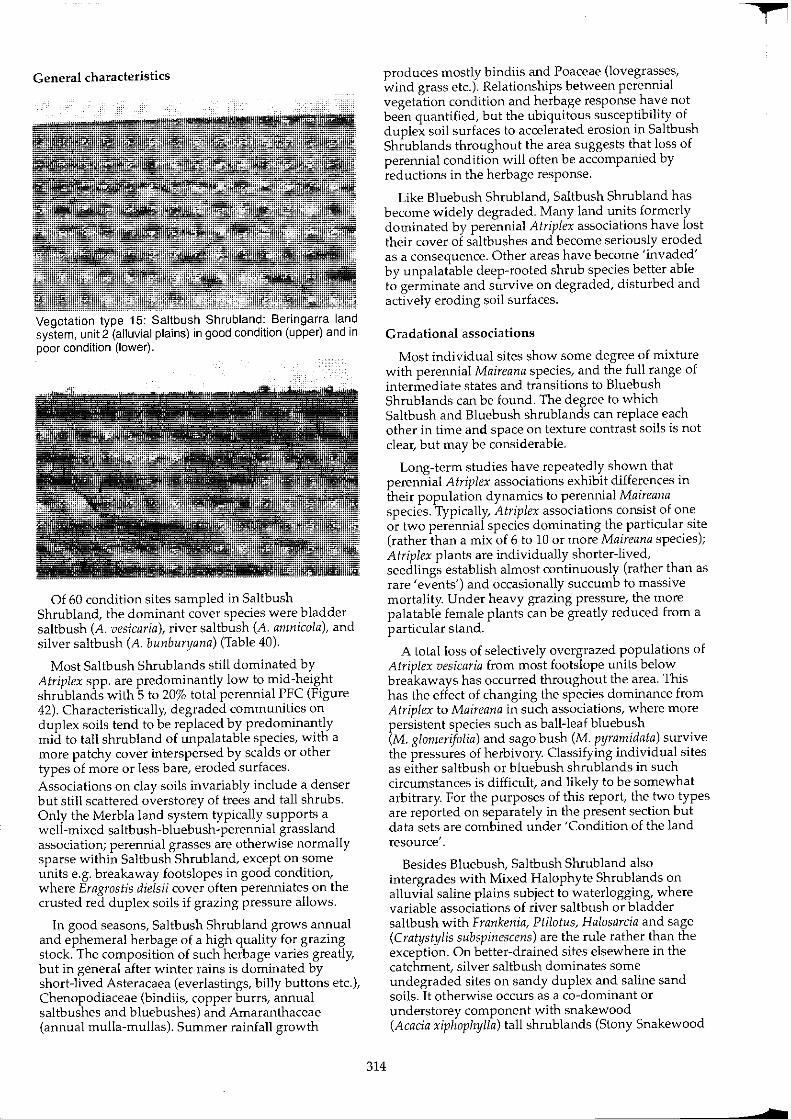
General characteristics
Vegetation type 15: Saltbush Shrubland: Beringarra land system, unit 2 (alluvial plains) in good condition (upper) and in poor condition (lower).
Of 60 condition sites sampled in Saltbush Shrubland, the dominant cover species were bladder saltbush (A. vesicaria), river saltbush (A. amnicola), and silver saltbush (A. bunburyana) (Table 40).
Most Saltbush Shrublands still dominated by Atriplex spp. are predominantly low to mid-height shrub lands with 5 to 20% total perennial PFC (Figure 42). Characteristically, degraded communities on duplex soils tend to be replaced by predominantly mid to tall shrub land of unpalatable species, with a more patchy cover interspersed by scalds or other types of more or less bare, eroded surfaces. Associations on clay soils invariably include a denser but still scattered overstorey of trees and tall shrubs. Only the Merbla land system typically supports a well-mixed saltbush-bluebush-perennial grassland association; perennial grasses are otherwise normally sparse within Saltbush Shrub land, except on some units e.g. breakaway footslopes in good condition, where Eragrostis dielsii cover often perenniates on the crusted red duplex soils if grazing pressure allows.
In good seasons, Saltbush Shrub land grows annual and ephemeral herbage of a high quality for grazing stock. The composition of such herbage varies greatly, but in general after winter rains is dominated by short-lived Asteracaea (everlastings, billy buttons etc.), Chenopodiaceae (bindiis, copper burrs, annual saltbushes and bluebushes) and Amaranthaceae (annual mulla-mullas). Summer rainfall growth
314
produces mostly bindiis and Poaceae (lovegrasses, wind grass etc.). Relationships between perennial vegetation condition and herbage response have not been quantified, but the ubiquitous susceptibility of duplex soil surfaces to accelerated erosion in Saltbush Shrub lands throughout the area suggests that loss of perennial condition will often be accompanied by reductions in the herbage response.
Like Bluebush Shrubland, Saltbush Shrubland has become widely degraded. Many land units formerly dominated by perennial Atriplex associations have lost their cover of saltbushes and become seriously eroded as a consequence. Other areas have become 'invaded' by unpalatable deep-rooted shrub species better able to germinate and survive on degraded, disturbed and actively eroding soil surfaces.
Gradational associations
Most individual sites show some degree of mixture with perennial Maireana species, and the full range of intermediate states and transitions to Bluebush Shrub lands can be found. The degree to which Saltbush and Bluebush shrublands can replace each other in time and space on texture contrast soils is not clear, but may be considerable.
Long-term studies have repeatedly shown that perennial Atriplex associations exhibit differences in their population dynamics to perennial Maireana species. Typically, Atriplex associations consist of one or two perennial species dominating the particular site (rather than a mix of 6 to 10 or more Maireana species); Atriplex plants are individually shorter-lived, seedlings establish almost continuously (rather than as rare 'events') and occasionally succumb to massive mortality. Under heavy grazing pressure, the more palatable female plants can be greatly reduced from a particular stand.
A total loss of selectively overgrazed populations of Atriplex vesicaria from most footslope units below breakaways has occurred throughout the area. This has the effect of changing the species dominance from Atriplex to Maireana in such associations, where more persistent species such as ball-leaf bluebush (M. glomerifolia) and sago bush (M. pyramidata) survive the pressures of herbivory. Classifying individual sites as either saltbush or bluebush shrublands in such circumstances is difficult, and likely to be somewhat arbitrary. For the purposes of this report, the two types are reported on separately in the present section but data sets are combined under 'Condition of the land resource'.
Besides Bluebush, Saltbush Shrubland also intergrades with Mixed Halophyte Shrub lands on alluvial saline plains subject to waterlogging, where variable associations of river saltbush or bladder saltbush with Frankenia, Ptilotus, Halosarcia and sage (Cratystylis subspinescens) are the rule rather than the exception. On better-drained sites elsewhere in the catchment, silver saltbush dominates some undegraded sites on sandy duplex and saline sand soils. It otherwise occurs as a co-dominant or understorey component with snakewood (Acacia xiphophylla) tall shrub lands (Stony Snakewood
f
7
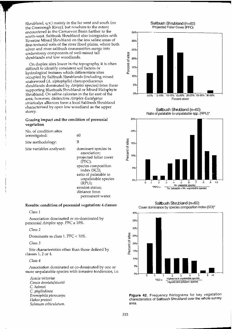
Shrub land, q.v.) mainly in the far west and south (on the Greenough River), but nowhere to the extent encountered in the Carnarvon Basin further to the north-west. Saltbush Shrub land also intergrades with Riverine Mixed Shrubland on the less saline areas of fine-textured soils of the river flood plains, where both silver and river saltbush communities merge into understorey components of well-mixed tall shrub lands and low woodlands.
On duplex sites lower in the topography, it is often difficult to identify consistent soil factors or hydrological features which differentiate sites occupied by Saltbush Shrublands (including mixed snakewood (A. xiphophylla) chenopodiaceous shrub lands dominated by Atriplex species) from those supporting Bluebush Shrubland or Mixed Halophyte Shrub land. On saline calcretes in the far east of the area, however, distinctive Atriplex-Eucalyptus striaticalyx alliances form a local Saltbush Shrub land characterised by open low woodland as the upper storey.
Grazing impact and the condition of perennial vegetation
No. of condition sites investigated:
Site methodology:
Site variables analysed:
60
B
dominant species in association;
projected foliar cover (PFC);
species composition index (SCI);
ratio of palatable to unpalatable species (RPU);
erosion status; distance from
permanent water.
Results: condition of perennial vegetation: 4 classes
Class 1
Association dominated or co-dominated by perennial Atriplex spp. PFC " 10%.
Class 2
Dominants as class 1. PFC < 10%.
Class 3
Site characteristics other than those defined by classes 1, 2 or 4.
Class 4
Association dominated or co-dominated by one or more unpalatable species with invasive tendencies, i.e.
Acacia victoriae Cassia desolata/sturtii C. helmsii C. phylladinea Eremophila pterocarpa Hakea preissii Solanum orbiculatum.
315
Saltbush Shrubland (n=60) Projected Foliar Cover (PFC)
Saltbush Shrubland (n=60) Ratio of palatable to unpalatable spp. (RPU)'
Saltbush Shrubland (n=60) Cover dominance by species composition index (SCI)'
Figure 42. Frequency histograms for key vegetation characteristics of Saltbush Shrubland over the whole survey area.
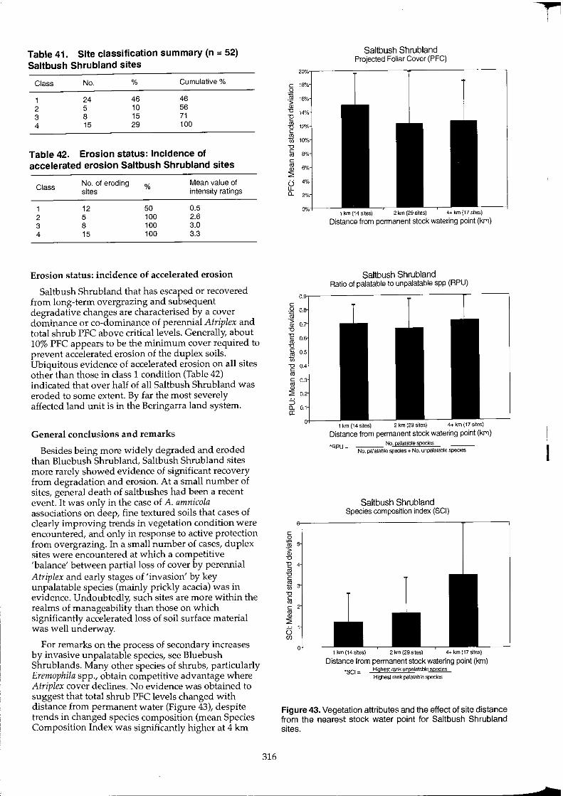
Table 41. Site classification summary (n = 52) Saltbush Shrubland sites
Class No. % Cumulative %
1 24 46 46 2 5 10 56 3 8 15 71 4 15 29 100
Table 42. Erosion status: Incidence of accelerated erosion Saltbush Shrubland sites
Class No. of eroding % Mean value of sites intensity ratings
1 12 50 0.5 2 5 100 2.6 3 8 100 3.0 4 15 100 3.3
Erosion status: incidence of accelerated erosion
Saltbush Shrubland that has escaped or recovered from long-term overgrazing and subsequent degradative changes are characterised by a cover dominance or co-dominance of perennial Atriplex and total shrub PFC above critical levels. Generally, about 10% PFC appears to be the minimum cover required to prevent accelerated erosion of the duplex soils. Ubiquitous evidence of accelerated erosion on all sites other than those in class 1 condition (Table 42) indicated that over half of all Saltbush Shrubland was eroded to some extent. By far the most severely affected land unit is in the Beringarra land system.
General conclusions and remarks
Besides being more widely degraded and eroded than Bluebush Shrub land, Saltbush Shrub land sites more rarely showed evidence of significant recovery from degradation and erosion. At a small number of sites, general death of saltbushes had been a recent event. It was only in the case of A. amnicola associations on deep, fine textured soils that cases of clearly improving trends in vegetation condition were encountered, and only in response to active protection from overgrazing. In a small number of cases, duplex sites were encountered at which a competitive 'balance' between partial loss of cover by perennial Atriplex and early stages of 'invasion' by key unpalatable species (mainly prickly acacia) was in evidence. Undoubtedly, such sites are more within the realms of manageability than those on which significantly accelerated loss of soil surface material was well underway.
For remarks on the process of secondary increases by invasive unpalatable species, see Bluebush Shrublands. Many other species of shrubs, particularly Eremophila spp., obtain competitive advantage where Atriplex cover declines. No evidence was obtained to suggest that total shrub PFC levels changed with distance from permanent water (Figure 43), despite trends in changed species composition (mean Species Composition Index was significantly higher at 4 km
316
Saltbush Shrubland Projected Foliar Cover (PFC)
1 km {14 sites) 2km(29sites) 4+km(17sites)
Distance from pennanent stock watering point (km)
Saltbush Shrubland Ratio of palatable to unpalatable spp (RPU)
1 km (14 siles) 2 km (29 sites) 4+ km (17 siles)
Distance from permanent stock watering point (km)
"RPU= No. palatable species
No. palatable species + No. unpalatable species
Saltbush Shrubland Species composition index (SCI)
1 km(14sites) 2 krn (29 sites) 4+ krn (17 sltes)
Distance from permanent stock watering pOint (km) 'SCI = Highest rank unpatatable species
Highest rank palatable spedes
Figure 43. Vegetation attributes and the effect of site distance from the nearest stock water paint for Saltbush Shrubland sites.
I
I
t
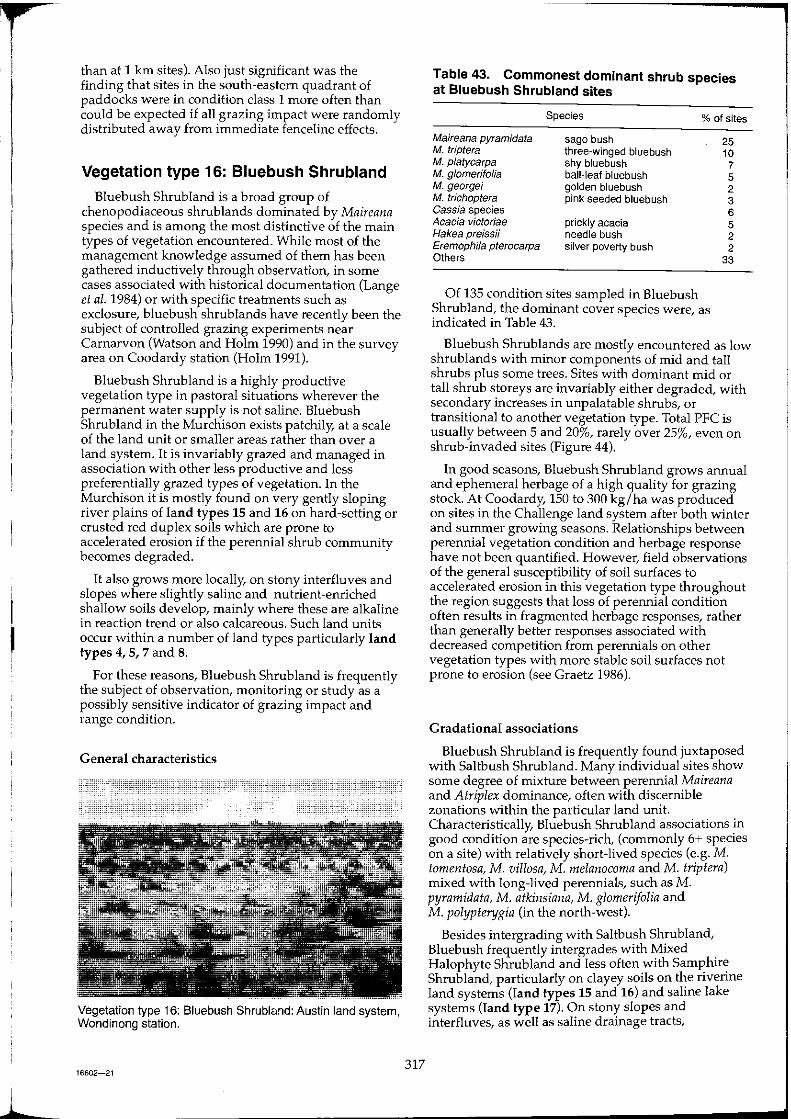
r l than at 1 Ian sites). Also just significant was the
finding that sites in the south-eastern quadrant of paddocks were in condition class 1 more often than could be expected if all grazing impact were randomly distributed away from immediate fenceline effects.
Vegetation type 16: Bluebush Shrubland
Bluebush Shrub land is a broad group of chenopodiaceous shrub lands dominated by Maireana species and is among the most distinctive of the main types of vegetation encountered. While most of the management knowledge assumed of them has been gathered inductively through observation, in some cases associated with historical documentation (Lange et al. 1984) or with specific treatments such as exclosure, bluebush shrublands have recently been the subject of controlled grazing experiments near Carnarvon (Watson and Holm 1990) and in the survey area on Coodardy station (Holm 1991).
Bluebush Shrub land is a highly productive vegetation type in pastoral situations wherever the permanent water supply is not saline. Bluebush Shrubland in the Murchison exists patchily, at a scale of the land unit or smaller areas rather than over a land system. It is invariably grazed and managed in association with other less productive and less preferentially grazed types of vegetation. In the Murchison it is mostly found on very gently sloping river plains of land types 15 and 16 on hard-setting or crusted red duplex soils which are prone to accelerated erosion if the perennial shrub community becomes degraded.
It also grows more locally, on stony interfluves and slopes where slightly saline and nutrient-enriched shallow soils develop, mainly where these are alkaline in reaction trend or also calcareous. Such land units occur within a number of land types particularly land types 4, 5, 7 and 8.
For these reasons, Bluebush Shrub land is frequently the subject of observation, monitoring or study as a possibly sensitive indicator of grazing impact and range condition.
General characteristics
Vegetation type 16: Bluebush Shrubl"od: Austin land system, Wondinong station.
16602-21 317
Table 43. Commonest dominant shrub species at Bluebush Shrubland sites
Species % of sites
Maireana pyramidata M. triptera M. pJatycarpa M. g/omerifolia M. george; M. trichoptera Cassia species Acacia victoriae Hakea preissii Eremophila pterocarpa Others
sago bush three-winged bluebush shy bluebush ball-leaf bluebush golden bluebush pink seeded bluebush
prickly acacia needle bush silver poverty bush
Of 135 condition sites sampled in Bluebush Shrubland, the dominant cover species were, as indicated in Table 43.
25 10 7 5 2 3 6 5 2 2
33
Bluebush Shrublands are mostly encountered as low shrublands with minor components of mid and tall shrubs plus some trees. Sites with dominant mid or tall shrub storeys are invariably either degraded, with secondary increases in unpalatable shrubs, or transitional to another vegetation type. Total PFC is usually between 5 and 20%, rarely over 25%, even on shrub-invaded sites (Figure 44).
In good seasons, Bluebush Shrub land grows annual and ephemeral herbage of a high quality for grazing stock. At Coodardy, 150 to 300 kg/ha was produced on sites in the Challenge land system after both winter and summer growing seasons. Relationships between perennial vegetation condition and herbage response have not been quantified. However, field observations of the general susceptibility of soil surfaces to accelerated erosion in this vegetation type throughout the region suggests that loss of perennial condition often results in fragmented herbage responses, rather than generally better responses associated with decreased competition from perennials on other vegetation types with more stable soil surfaces not prone to erosion (see Graetz 1986).
Gradational associations
Bluebush Shrubland is frequently found juxtaposed with Saltbush Shrub land. Many individual sites show some degree of mixture between perennial Maireana and Atriplex dominance, often with discernible zonations within the particular land unit. Characteristically, Bluebush Shrubland associations in good condition are species-rich, (commonly 6+ species on a site) with relatively short-lived species (e.g. M. tomentosa, M. villosa, M. melanocoma and M. triplera) mixed with long-lived perennials, such as M. pyramidata, M. atkinsiana, M. glomerifolia and M. polypterygia (in the north-west).
Besides intergrading with Saltbush Shrub land, Bluebush frequently intergrades with Mixed Halophyte Shrub land and less often with Samphire Shrub land, particularly on clayey soils on the riverine land systems (land types 15 and 16) and saline lake systems (land type 17). On stony slopes and interfluves, as well as saline drainage tracts,

'" Q) ~
'" '0 E ~ ~
Bluebush Shrubland (n=135) Projected Foliar Cover (PFC)
Percent cover
Bluebush Shrubland (n=135) Ratio of palatable to unpalatable spp. (RPUr
'RPU= No. palatab!e species No. palatable + No. unpalatable species
Bluebush Shrubland (n=135) Cover dominance by species composition index (SCI)'
Figure 44. Frequency histograms for key vegetation characteristics of Bluebush Shrubland over the whole survey area.
318
intermediate associations between Bluebush and Stony Snakewood Shrubland are frequent, as are gradations with Mulga Chenopod Shrub land. In many instances, the gradational states may be dynamic, rather than fixed in time and space. Possibly they reflect cyclical events in overstorey regeneration, or the lack of it (by mulga, minnieritchie and snakewood) and shifts in the competitive balance between the tall and low shrub stages. Management impact (vegetation condition) clearly has the ability to mask and complicate any generalised and simple understanding of such variation. The more severe forms of vegetation degradation make recognition of the previous or original vegetation type difficult or impossible.
Grazing impact and the condition of perennial vegetation
No. of condition sites investigated:
Site methodology:
Site variables analysed:
137
B
dominant species in association;
projected foliar cover (PFC);
species composition index (SCI);
ratio of palatable species to unpalatable (RPU);
erosion status; distance from
permanent water.
Results: condition of perennial vegetation: 5 classes
Class 1
Association dominated or co-dominated by one or more key (palatable) species, i.e.
Maireana pyramidata M. georgei M. platycarpa M. atkinsiana M. polypterygia M. integra/tomentosa.
and PFC " 10%, except where association dominated by M. georgei, where PFC 2' 5%.
Class 2
As 1 but PFC < 10% except where association dominated by M. georgei, where PFC < 5%.
Class 3
Association dominated by other palatable species, i.e.
Maireana glomerifolia M. triptera M. trichoptera
Class 4
Sites with association characteristics other than those defined by classes 1, 2, 3, or 5.
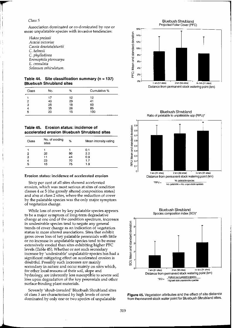
i i ! Class 5
Association dominated or co-dominated by one or more unpalatable species with invasive tendencies:
Hakea preissii Acacia victoriae Cassia desolata/sturtii C. helmsii C. phyllodinea Eremophila pterocarpa E. crenulata Solanum orbiculatum.
Table 44. Site classification summary (n = 137) Bluebush Shrubland sites
Class No. % Cumulative %
1 17 12 12 2 40 29 41 3 25 18 60 4 35 26 85 5 20 15 100
Table 45. Erosion status: incidence of accelerated erosion Bluebush Shrubland sites
Class No. of eroding % Mean intensity rating sites
1 1 1 0.1 2 32 80 2.2 3 11 44 0.9 4 23 70 1.7 5 15 75 1.9
Erosion status: incidence of accelerated erosion
Sixty per cent of all sites showed accelerated erosion, which was most serious at sites of condition classes 4 or 5 (the grossly altered composition states) and also at class 2 sites, where the reduction of cover by the palatable species was the only major symptom of vegetation change.
While loss of cover by key palatable species appears to be a major symptom of long-term degradative change at one end of the condition spectrum, increases in undesirable species tend to negate any general trends of cover change as an indication of vegetation status in more altered associations. Sites that exhibit gross cover loss of key palatable perennials with little or no increase in unpalatable species tend to be more extensively eroded than sites exhibiting higher PFC levels (Table 45). Whether or not such secondary increase by 'undesirable' unpalatable species has had a significant mitigating effect on accelerated erosion is doubtful. Possibly such increases are mainly secondary in nature and occur mainly on sites which, for other local reasons of their soil, slope and hydrology, are inherently less susceptible to severe soil loss upon degradation of the key perennials and other surface-binding plant materials.
Severely 'shrub-invaded' Bluebush Shrub land sites of class 5 are characterised by high levels of cover dominated by only one or two species of unpalatable
319
----------."
Bluebush Shrubland Projected Foliar Cover (PFC)
1 km(51 s~es) 2km(56sites) 4-t km (31 sites)
Distance from permanent stock watering point (km)
Bluebush Shrubland Ratio of palatable to unpalatable spp (RPUr
1 krn(51 sites) 2 krn (56 sites) 4-tkm{31siles)
Distance from permanent stock watering point (km)
'RPU== No. palatable species
No. palatable + No. urlpalatable species
Bluebush Shrubland Species compos~ion index (SCI)*
1 km (51 s~es) 2 km (S6sites) 4+km{31 sites)
Distance from permanent stock watering point (km) Highest larlk palatable species
'SCI == Highest rarlk urlpalatable species
Figure 45. Vegetation attributes and the effect of site distance from the nearest stock water point for Bluebush Shrubland sites.
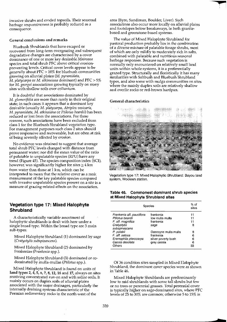
invasive shrubs and eroded topsoils. Their seasonal herbage responsiveness is probably reduced as a consequence.
General conclusions and remarks
Bluebush Shrublands that have escaped or recovered from long-term overgrazing and subsequent degradative changes are characteri.sed by a cover dominance of one or more key desIrable Mazreana species and total shrub PFC above critical erosionpreventing levels. Critical cover levels appear to be generally about PFC > 10% for bluebush communities growing on alluvial plains (M. pyramidata, M. platycarpa or M. atkinsiana dominant) and PFC > 5% for M. georgei associations growing typically on stony sites with shallow soils over colluvium.
It is doubtful that associations dominated by M. glomerifolia are more than rarely in their original state; in such cases it appears that a dominant key desirable (usually M. platycarpa, Atriplex vesicaria, M. pyramidata, M. atkinsiana or Ptilotus beardii) has been reduced or lost from the associations. For these reasons, such associations have been excluded from class 1 for the Bluebush Shrub land vegetation type. For management purposes such class 2 sites should prove responsive and recoverable, but are often at risk of being severely affected by erosion.
No evidence was obtained to suggest that average total shrub PFC levels changed with distance from permanent water; nor did the mean value of the ratio of palatable to unpalatable species (RPU) have any trend (Figure 45). The species composition index (SCI), however, was significantly higher for sites 2: 4 km from water than those at 1 km, which can be interpreted to mean that the relative cover as a rank measurement of the key palatable species compared with invasive unpalatable species present on a site is a measure of grazing-related effects on the association.
Vegetation type 17: Mixed Halophyte Shrubland
A characteristically variable assortment of halophytic shrub lands is dealt with here under a single broad type. Within the broad type are 3 main sub-types:
Mixed Halophyte Shrubland (1) dominated by sage (Cratystylis subspinescens).
Mixed Halophyte Shrub land (2) dominated by frankenias (Frankenia spp.).
Mixed Halophyte Shrubland (3) dominated or codominated by mulla-mullas (PWotus spp.).
Mixed Halophyte Shrub land is found on units of land types 2, 4, 5, 6, 7, 8, 12, 16 and 17, always on sites receiving concentrated run-on and with saline soils. It mainly occurs on duplex soils of alluvial plains associated with the major drainages, particularly the internally draining systems characteristic of the Permian sedimentary rocks in the north-west of the
320
area (Byro, Sandiman, Boulder, Liver). Such associations also occur more locally on alluvial plains and footslopes below breakaways, in both granitebased and greenstone-based systems.
The value of Mixed Halophyte Shrubland for pastoral production probably lies in the combination of a diverse mixture of palatable forage shrubs, most of which are only mildly to moderately rich in salts, combined with palatable and nutritious seasonal herbage responses. Because such vegetation is normally only encountered on relatively small land units within whole systems, it is a preferentially grazed type. Structurally and floristically it has many similarities with Saltbush and Bluebush Shrubland types, and also some with mulga communities on sites where the mainly duplex soils are relatively shallow and overlie rocks or red-brown hardpan.
General characteristics
Vegetation type 17: Mixed Halophytic Shrubland: Bayou land system, Wooleen station.
Table 46. Commonest dominant shrub species at Mixed Halophyte Shrubland sites
Species
Frankenia aft. pauciflora PWotus beardii F. aff. magnifica Cralys/ylis subspinescens P. polakii F. aft. setosa Eremophila pterocarpa Cassia desolata Others
frankenia low mulla-mulla frankenia sage
Gascoyne mulla-mulla frankenia silver poverty bush grey cassia
% of sites
11 11 11 8
8 6 6 6
33
Of 36 condition sites sampled in Mixed Halophyte Shrub land, the dominant cover species were as shown in Table 46.
Mixed Halophyte Shrublands are predominantly low to mid shrublands with some tall shrubs but few or no trees or perennial grasses. Total perennial cover is typically higher on sage-dominated sites, where PFC levels of 25 to 30% are common; otherwise 5 to 15% is
f
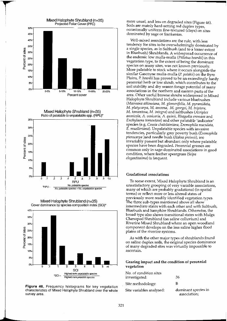
1
Mixed Halophyte Shrubland (n=35) Projected Foliar Cover (PFC)
0-5% 5-10% 10-15% 15-20"/" 20-25%
Percent cover
Mixed Halophyte Shrubland (n=35) Ratio of palatable to unpalatable spp. (RPU)'
RPU *RPU=
No. palatable species No. palatable species + No. unpalatable species
Mixed Halophyte Shrubland (n=35) Cover dominance by species composition index (SCI)'
'SCI""
SCI Highest rank unpalatable species
Highest rank palatable species
Figure 46. Frequency histograms for key vegetation characteristics of Mixed Halophyte Shrubland over the whole survey area.
321
more usual, and less on degraded sites (Figure 46). Soils are mainly hard-setting red duplex types, occasionally uniform fine-textured (clays) on sites dominated by sage or frankenias.
Well-mixed associations are the rule, with less tendency for sites to be overwhelmingly dominated by a single species, as in Saltbush (and to a lesser extent in Bluebush) Shrublands. A widespread occurrence of the endemic low mulla-mulla (Ptilotus beardii) in this vegetation type, to the extent of being the dominant species on many sites, was not known previously. More palatable to stock where it occurs alongside the similar Gascoyne mulla-mulla (P. polakii) on the Byro Plains, P. beardii has proved to be an exceedingly hardy perennial herb or low shrub, which contributes to the soil stability and dry season forage potential of many associations in the northern and eastern parts of the area. Other useful browse shrubs widespread in Mixed Halophyte Shrubland include various bluebushes (Maireana atkinsiana, M. glomerifolia, M. pyramidata, M. platycarpa, M. amoena, M. georgei, M. triptera, M. tomentosa, M. integra) and saltbushes (Atriplex amnicola, A. vesicaria, A. quinii, Rhagodia eremaea and Enchylaena tomentosa) and other palatable 'indicator' species (e.g. Cassia chatelainiana, Eremophila maculata, E. muelleriana). Unpalatable species with invasive tendencies, particularly grey poverty bush (Eremophila pterocarpa land needle bush (Hakea preissii), are invariably present but abundant only where palatable species have been degraded. Perennial grasses are common only in sage-dominated associations in good condition, where feather speargrass (Stipa elegantissima) is frequent.
Gradational associations
To some extent, Mixed Halophyte Shrubland is an unsatisfactory grouping of very variable associations, many of which are probably gradational (in spatial terms) or reflect more or less altered states of previously more readily identified vegetation types. The three sub-types mentioned above all show intermediate states with each other and with Saltbush, Bluebush and Samphire Shrub lands. Otherwise, the broad type also shows transitional states with Mulga Chenopod Shrub land (on saline colluvium) and Riverine Mixed Shrub land where an open woodland component develops on the less saline higher flood plains of the riverine systems.
As with the other major types of shrub lands found on saline duplex soils, the original species dominance of many degraded sites was virtually impossible to ascertain.
Grazing impact and the condition of perennial vegetation
No. of condition sites investigated:
Site methodology:
Site variables analysed:
36
B
dominant species in association;
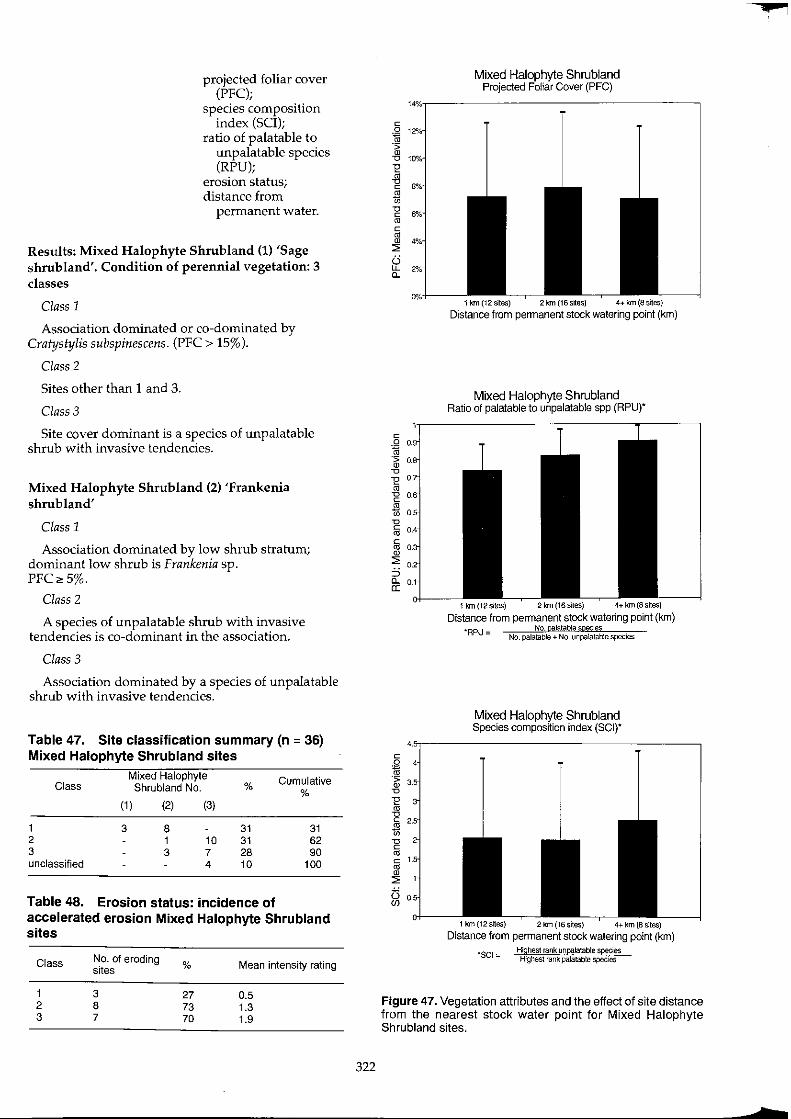
projected foliar cover (PFC);
species composition index (SCI);
ratio of palatable to unpalatable species (RPU);
erosion status; distance from
permanent water.
Results: Mixed Halophyte Shrub land (1) 'Sage shrub land'. Condition of perennial vegetation: 3 classes
Class 1
Association dominated or co-dominated by Cratystylis subspinescens. (PFC > 15%).
Class 2
Sites other than 1 and 3.
Class 3
Site cover dominant is a species of unpalatable shrub with invasive tendencies.
Mixed Halophyte Shrub land (2) 'Frankenia shrubland'
Class 1
Association dominated by low shrub stratum; dominant low shrub is Frankenia sp. PFC" 5%.
Class 2
A species of unpalatable shrub with invasive tendencies is co-dominant in the association.
Class 3
Association dominated by a species of unpalatable shrub with invasive tendencies.
Table 47. Site classification summary (n = 36) Mixed Halophyte Shrubland sites
Mixed Halophyte Cumulative Class Shrubland No. % %
(1 ) (2) (3)
1 3 8 31 31 2 1 10 31 62 3 3 7 28 90 unclassified 4 10 100
Table 48. Erosion status: incidence of accelerated erosion Mixed Halophyte Shrubland sites
Class No. of eroding % Mean intensity rating Sites
1 3 27 0.5 2 8 73 1.3 3 7 70 1.9
322
c
~ '0
I -g '" c 1.
~ (3 (f)
Mixed Halophyte Shrubland Projected Foliar Cover (PFC)
1 km (12 sltes) 2km(16s~es) 4+ km (8 sites)
Distance from pennanent stock watering point (km)
Mixed Halophyte Shrubland Ratio of palatable to unpalatable spp (RPU)'
1 km(12sites) 2krn(16srtes) 4+km(8srtes)
Distance from permanent stock watering point (km) "RPU = No. palatable soecies
No. palatable + No. unpalatable species
Mixed Halophyte Shrubland Species composition index (SCI)·
1 km{12srtes) 2km(16sites) 4+km(Bslles)
Distance from permanent stock watering point (km)
'SCI", Highest rank urlpalatable spedes Highest rank palatable species
Figure 47. Vegetation attributes and the effect of site distance from the nearest stock water point for Mixed Halophyte Shrubland sites.
•

L
Mixed Halophyte Shrub land (3) 'Alluvial mullamulla'
Class 1
Association dominated or co-dominated by low shrub stratum. Dominant or co-dominant species is Plilolus beardii or P. polakii. Neither second nor third dominant species in association is a species of unpalatable shrub with invasive tendencies. PFC '" 5%.
Class 2
Site other than 1 and 3.
Class 3
Association dominated or co-dominated by a species of unpalatable shrub with invasive tendencies.
Erosion status: incidence of accelerated erosion
Sage-dominated associations are less susceptible to degradation and accelerated erosion than the other two main sub-types. Sage appears more resistant to overgrazing than either frankenia or mulla-mulla subtypes, and typically grows on deeper less erodible soils, supported by more favourable moisture supplies.
General conclusions and remarks
Mixed Halophyte Shrub land exhibits broad characteristics and degradation symptoms in common with Bluebush and Saltbush shrub lands. Retention of critical levels of cover (above about 7.5%) by the naturally predominant low shrub stratum is evidently the key to preserving its productivity, dry season reserves, seasonal responsiveness and resistance to soil erosion and shrub invasion.
No evidence was obtained to suggest that mean values for total shrub PFC levels, the ratio of palatable to unpalatable species (RPU) or the species composition index (SCI) changed with distance from permanent watering points (Figure 47).
Vegetation type 18: Sam ph ire Shrubland
Samphire Shrubland consists of very distinctive, characteristically uniform areas of low or very low chenopodiaceous shrubland growing on highly saline run-on sites prone to waterlogging. In the survey area these can be found in a variety of positions in the landscape, but principally on four types of land units. The majority of this vegetation occurs on the saline muds and solonchak soils of minor lake beds and salt lake fringes, e.g. on Carnegie, Wolarry and Liver land systems (land types 12 and 17). It is also common on the lowest, most flooded of the saline alluvial plains found along the rivers and major drainage systems; it also occurs on the banks and levees of the major watercourses (land type 16). Otherwise, Samphire Shrubland occurs on isolated claypans and low-lying kopi deposits in several systems, and also in many,
323
widely scattered sites higher in the catchment landscapes, most often in small diversions on plains receIVIng concentrated slIghtly saline fun-on, below outcrops of deeply weathered crystalline rocks of many kinds. It also occurs, but much more locally, on equivalent sites on plains derived from sedimentary rocks such as the Permian mudstones and siltstones of the Mantle and Byro land systems.
Samphire Shrubland has not been studied to any extent in the arid zone in relation to grazing effects or other management influences. As the most saline of the vegetation types dominated by perennial chenopod shrubs, they are not normally regarded to be either sensitive to, or indicative of, grazing impacts in the arid zone. Geographically, the distribution of Samphire Shrublands in Murchison landscapes is highly correlated with the occurrence of saline or brackish groundwater. This further constrains consumption of so saline a source of browse as samphire by stock which cannot obtain fresh water during summer or poor seasons.
General characteristics
Vegetation type 18: Sam ph ire Shrubland: Bayou land system, Billabalong station.
Table 49. Dominant species identified at Samphire Shrubland sites
Ha/osarcia indica H. pergranulata H. doleiformis H. pruinos8 H. ha/ocnemoides
Species
tall samphire blackseed samphire samphire samphire shrubby samphire
No. of sites dominant
3 2 2 2 2
Of 6 condition sites and 18 inventory sites investigated, all were low shrublands dominated by Halosarcia species. Where specifically identified, dominant species were as indicated in Table 49.
The only other genus of 'samphires' encountered dominating individual sites was Tecticornia, of which both T. arborea and T. verrucosa were found at distinctively isolated claypans. Most Samphire Shrubland showed definite zonation of speCies
composition related to the micro-topography of individual sites. Total perennial cover was mainly PFC 7.5 to 15%, with up to 30% cover very locally.
Most sites were occupied by two to four species of Halosarcia, with very variable minor proportions of other halophytes. These were mainly Atriplex and Maireana spp., particularly on the shallower soils of stony sites, where Frankenia spp. and Eremophila spp. also frequently occur at low density. Otherwise, only irregular occurrences of Melaleuca, Cratystylis, Lawrencia, Ptilotus and Carpobrotus relieve the exclusive dominance of Halosarcia over large areas of saline and gypsiferous deposits around the margins of the salt lakes.
Seasonally, the herbage response of most Samphire Shrubland is unimpressive and consists of mainly annual grasses with sparse herbs (mainly ephermal Chenopodiaceae) and forbs (Asteraceae).
While in most situations, Halosarcia associations appear to be very long-lived, the dynamics of infrequently flooded alluvial deposits and their drying and cracking can give rise to the episodic gain or loss of entire areas of Samphire Shrubland, with instances of both even-aged recruitment over previously bare claypan and general death of old plants being recorded during the survey.
Grazing impact and the condition of perennial vegetation
Samphire Shrubland in the arid zone is not a favoured pasture for stock. Nonetheless, grazing impact clearly occurs, as evidenced by fenceline effects where the combined herbivory pressure from stock, kangaroos and rabbits is evident in most instances.
No. of condition sites analysed:
Site methodology:
Site variables analysed:
6
B
dominant species in associations;
projected foliar cover (PFC);
species composition index (SCI);
ratio of palatable to unpalatable species (RPU);
erosion status; distance from
permanent water.
Results: condition of perennial vegetation: 2 classes
Class 1
Association dominated or co-dominated by Halosarcia spp. two or more additional palatable perennial species present (PFC " 5%).
Class 2
Other sites.
324
Table 50. Site classification summary (n = 6) Samphire Shrubland sites
Class
1 2
No.
5 1
%
83 17
Erosion status: incidence of accelerated erosion
Samphire Shrub lands are not normally encountered on sites which are susceptible to accelerated erosion, except on some areas with shallow duplex soils based on Permian sedimentary rocks.
General conclusions and remarks
The small number of sites examined reflects the perceived lack of importance of significant grazing effects detectable within samphire shrub lands. While clear impacts occur locally, natural patterns of variation in the cover and composition of such associations are too great to reveal condition effects other than those of losses in total cover by the dominant Halosarcia species. This probably constitutes vegetation degradation and corresponds to change at the lower end of a condition spectrum which otherwise remains obscure or has no consistent characteristics. Various minor species of perennials other than Halosarcia may be important in particular situations. For example, patchy samphire shrublands found on low-lying run-on sites associated with colluvium frequently support some Maireana species. On lake bed alluvium, the major association sometimes includes perennial grasses, Eragrostis aff. dielsii or Sporobolus mitchellii, whereas on gypsiferous lake fringing plains, other halophytic low shrubs and perennial herbs such as Atriplex and Minuria species may have some indicator value.
Otherwise, site results support the general finding, derived from traverse observations, that samphire shrublands in the Murchison catchment are mainly in good condition.
Vegetation type 19: Wanderrie Bank Grassy Shrubland
Wanderrie Bank Grassy Shrubland is the dominant vegetation type on the broad, low sandy banks which are widespread major units of land systems in land type 13. Such banks occur on Quaternary alluvial surfaces and appear to be partly aeolian in origin, but are now modified and clearly subject to the alluvial processes occurring on the wash plains in their wider context. Wanderrie banks exist in a bewildering variety of sizes, forms and patterns, but in general represent sites of moderately deep sandy (Uc5) soils which intercept sheetflow and store moisture for longer periods than the shallow loams of the intervening flat plains and interbank areas. Such banks also occur to a lesser extent on parts of land types 3, 4, 12, 14, 16 and 17.
?
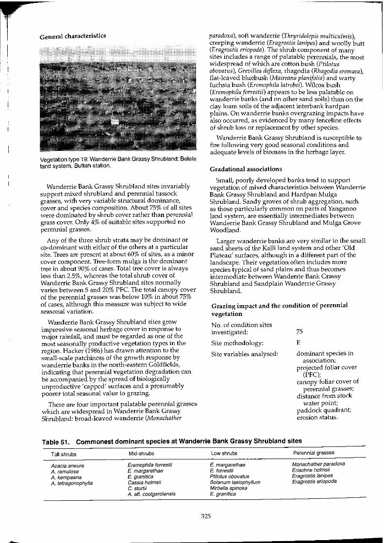
General characteristics
Vegetation type 19: Wanderrie Bank Grassy Shrubland: Belele land system, Buttah station.
Wanderrie Bank Grassy Shrubland sites invariably support mixed shrubland and perennial tussock grasses, with very variable structural dominance, cover and species composition. About 75% of all sites were dominated by shrub cover rather than perennial grass cover. Only 4% of suitable sites supported no perennial grasses.
Any of the three shrub strata may be dominant or co-dominant with either of the others at a particular site. Trees are present at about 60% of sites, as a minor cover component. Tree-form mulga is the dominant tree in about 90% of cases. Total tree cover is always less than 2.5%, whereas the total shrub cover of Wanderrie Bank Grassy Shrubland sites normally varies between 5 and 20% PFC. The total canopy cover of the perennial grasses was below 10% in about 75% of cases, although this measure was subject to wide seasonal variation.
Wanderrie Bank Grassy Shrubland sites grow impressive seasonal herbage cover in response to major rainfall, and must be regarded as one of the most seasonally productive vegetation types in the region. Hacker (1986) has drawn attention to the small-scale patchiness of the growth response by wanderrie banks in the north-eastern Goldfields, indicating that perennial vegetation degradation can be accompanied by the spread of biologically unproductive 'capped' surfaces and a presumably poorer total seasonal value to grazing.
There are four important palatable perennial grasses which are widespread in Wanderrie Bank Grassy Shrub land: broad-leaved wanderrie (Monachather
paradoxa), soft wanderrie (Thryridolepis muiticulmis), creeping wanderrie (Eragrostis lanipes) and woolly butt (Eragrostis eriopoda). The shrub component of many sites includes a range of palatable perennials, the most widespread of which are cotton bush (Plilotus obovatus), Grevillea deflexa, rhagodia (Rhagodia eremaea), flat-leaved bluebush (Maireana planifolia) and warty fuchsia bush (Eremophila latrobei). Wilcox bush (Eremophila forrestii) appears to be less palatable on wanderrie banks (and on other sand soils) than on the clay loam soils of the adjacent interbank hardpan plains. On wanderrie banks overgrazing impacts have also occurred, as evidenced by many fenceline effects of shrub loss or replacement by other species.
Wanderrie Bank Grassy Shrubland is susceptible to fire following very good seasonal conditions and adequate levels of biomass in the herbage layer.
Gradational associations
Small, poorly developed banks tend to support vegetation of mixed characteristics between Wanderrie Bank Grassy Shrubland and Hardpan Mulga Shrubland. Sandy groves of shrub aggregation, such as those particularly common on parts of Yanganoo land system, are essentially intermediates between Wanderrie Bank Grassy Shrub land and Mulga Grove Woodland.
Larger wanderrie banks are very similar to the small sand sheets of the Kalli land system and other 'Old Plateau' surfaces, although in a different part of the landscape. Their vegetation often includes more species typical of sand plains and thus becomes intermediate between Wanderrie Bank Grassy Shrubland and Sand plain Wanderrie Grassy Shrubland.
Grazing impact and the condition of perennial vegetation
No. of condition sites investigated:
Site methodology:
Site variables analysed:
75
E
dominant species in association;
projected foliar cover (PFC);
canopy foliar cover of perennial grasses;
distance from stock water point;
paddock quadrant; erosion status.
Table 51. Commonest dominant species at Wanderrie Bank Grassy Shrubland sites
Tall shrubs
Acacia aneura A. ramulosa A. kempeana A. tetragonophylla
Mid-shrubs
Eremophila forrestii E. margarethae E. gram1ica Cassia helmsii C. sturtii A. aft. coolgardiensis
Low shrubs
E. margarethae E. forrestii Ptl70tus obovatus Solanum lasiophyllum Mirbelia spinosa E. granitica
325
Perennial grasses
Monachather paradoxa Eriachne helmsii Eragrostis lanipes Eragroslis eriopoda
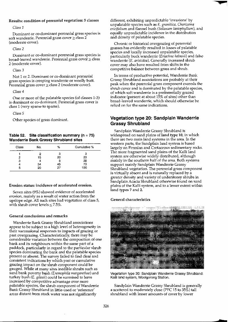
Results: condition of perennial vegetation: 5 classes
Class 1
Dominant or co-dominant perennial grass species is soft wanderrie. Perennial grass cover 2: class 2 (moderate cover).
Class 2
Dominant or co-dominant perennial grass species is broad-leaved wanderrie. Perennial grass cover 2: class 2 (moderate cover).
Class 3
Not 1 or 2. Dominant or co-dominant perennial grass species is creeping wanderrie or woolly butt. Perennial grass cover 2: class 2 (moderate cover).
Class 4
One or more of the palatable species (of classes 1-3) is dominant or co-dominant. Perennial grass cover is class 1 (very sparse to sparse).
Class 5
Other species of grass dominant.
Table 52. Site classification summary (n = 75) Wanderrie Bank Grassy Shrubland sites
Class No. % Cumulative %
1 2 3 3 2 15 20 23 3 4 5 28 4 34 45 73 5 20 27 100
Erosion status: incidence of accelerated erosion.
Seven sites (9%) showed evidence of accelerated erosion, mainly as a result of water action from the upslope edge. All such sites had vegetation of class 5, with shrub cover levels oS 7.5%.
General conclusions and remarks
Wanderrie Bank Grassy Shrub land associations appear to be subject to a high level of heterogeneity in their successional responses to impacts of grazing or past overgrazing. Characteristically, there may be considerable variation between the composition of one bank and its neighbours within the same part of a paddock, particularly in regard to the particular shrub species dominating the bank and the palatable species present or absent. The survey failed to find clear and consistent indications by which past or cumulative grazing impact on the shrub component could be gauged. While at many sites inedible shrubs such as sand bank poverty bush (Eremophila margarethae) and turkey bush (E. gilesii) could be surmised to have increased by competitive advantage over more palatable species, the shrub component of Wanderrie Bank Grassy Shrubland in little-used or 'reference' areas distant from stock water was not significantly
326
different, exhibiting unpredictable 'invasions' by unpalatable species such as E. granitica, Chorizema ericifolium and flannel bush (Solanum lasiophyllum), and equally unpredictable incidence in the distribution and density of palatable species.
Chronic or historical overgrazing of perennial grasses has evidently resulted in losses of palatable species and locally increased unpalatable species, particularly buck wanderrie (Eriachne helmsii) and false wanderrie (E. aristidea). Generally increased shrub cover may also have resulted from shifts in the competitive balance between grass and shrub.
In terms of productive potential, Wanderrie Bank Grassy Shrubland associations are probably at their peak when the perennial grass component exceeds the shrub cover and is dominated by the palatable species, of which soft wanderrie is a preferentially grazed indicator (present at about 15% of sites) other than broad-leaved wanderrie, which should otherwise be relied on for the same indications.
Vegetation type 20: Sand plain Wanderrie Grassy Shrubland
Sandplain Wanderrie Grassy Shrubland is widespread on sand plains of land type 10, in which there are two main land systems in the area. In the western parts, the Sandplain land system is based largely on Permian and Cretaceous sedimentary rocks. The more fragmented sand plains of the Kalli land system are otherwise widely distributed, although mainly in the southern half of the area. Both systems support mainly Sandplain Wanderrie Grassy Shrubland vegetation. The perennial grass component is virtually absent and is naturally replaced by a greater density and variety of understorey shrubs in Sandplain Acacia Shrub land otherwise found on sand plains of the Kalli system, and to a lesser extent within land types 7 and 2.
General characteristics
Vegetation type 20: Sand plain Wanderrie Grassy Shrubland: Kalli land system, Woolgorong Station.
Sandplain Wanderrie Grassy Shrubland is generally a scattered to moderately close (PFC 15 to 35%) tall shrubland with lesser amounts of cover by lower
.¢
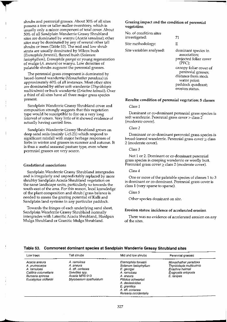
shrubs and perennial grasses. About 30% of all sites possess a tree or taller mallee overs torey, which is usually only a minor component of total cover. About 50% of all Sandplain Wanderrie Grassy Shrub land sites are dominated by wanyu (Acacia ramulosa); other sites may be dominated by any of several other tall shrubs or trees (Table 53). The mid and low shrub strata are usually dominated by Wilcox bush (Eremophila jorrestii), flannel bush (Solanum lasiophyllum), Eremophila georgei or young regeneration of mulga (A. aneura) or wanyu. Low densities of palatable shrubs augment the perennial grasses.
The perennial grass component is dominated by broad-leaved wanderrie (Monachather paradoxa) in approximately 60% of all instances. Most other sites are dominated by either soft wanderrie (Thyridolepis multiculmis) or buck wanderrie (Eriachne helmsii). Over a third of all sites have all three major grass species present.
Sandplain Wanderrie Grassy Shrubland cover and composition strongly suggests that this vegetation type would be susceptible to fire on a very long interval of return. Very little of it showed evidence of actually having carried fires.
Sandplain Wanderrie Grassy Shrubland grows on deep sand soils (mainly Uc5.21) which respond to significant rainfall with major herbage responses of forbs in winter and grasses in summer and autumn. It is thus a useful seasonal pasture type, even where perennial grasses are very scarce.
Gradational associations
Sand plain Wanderrie Grassy Shrubland intergrades and is irregularly and unpredictably replaced by more shrubby Sandplain Acacia Shrubland vegetation on the same landscape units, particularly so towards the south-east of the area. For this reason, local knowledge of the plant composition and shrub / grass balance is needed to assess the grazing potential of Kalli and Sandplain land systems in any particular paddock.
Towards the fringes of each underlying sand sheet, Sandplain Wanderrie Grassy Shrubland normally intergrades with Lateritic Acacia Shrubland, Hardpan Mulga Shrubland or Granitic Mulga Shrubland.
Grazing impact and the condition of perennial vegetation
No. of condition sites investigated:
Site methodology:
Site variables analysed:
71
E
dominant species in association;
projected foliar cover (PFC);
canopy foliar cover of perennial grasses;
distance from stock water point;
paddock quadrant; erosion status.
Results: condition of perennial vegetation: 5 classes
Class 1
Dominant or co-dominant perennial grass species is soft wanderrie. Perennial grass cover> class 2 (moderate cover).
Class 2
Dominant or co-dominant perennial grass species is broad-leaved wanderrie. Perennial grass cover?c class 2 (moderate cover).
Class 3
Not 1 or 2. Dominant or co-dominant perennial grass species is creeping wanderrie or woolly butt. Perennial grass cover ?c class 2 (moderate cover).
Class 4
One or more of the palatable species of classes 1 to 3 is dominant or co-dominant. Perennial grass cover is class 1 (very sparse to sparse).
Class 5
Other species dominant on site.
Erosion status: incidence of accelerated erosion
There was no evidence of accelerated erosion on any of the sites.
Table 53. Commonest dominant species at Sand plain Wanderrie Grassy Shrubland sites
Low trees
Acacia aneura A. pruinocarpa A. ramulosa Callitris columellaris Bursaria spinosa Eucalyptus oldfieldii
Tall shrubs
A. ramulosa A. aneura A. aft. coriacea Grevillea spp. Acacia MRS 013 Stylobasium spathulatum
Mid and low shrubs
Eremophila forrest!; Solanum lasiophyllum E. george; A. ramulosa A. aneura pti/otus schwartzii A. daviesioides E. granitica A. aft. coriacea Bursaria occidentalis
327
Perennial grasses
Monachather paradoxa Thyridolepis multiculmis Eriachne helmsii Eragrostis eriopoda E. lanipes
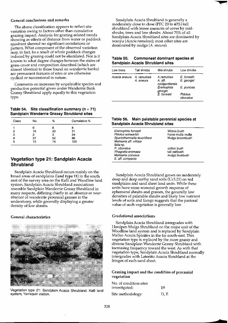
General conclusions and remarks
The above classification appears to reflect site variation owing to factors other than cumulative grazing impact. Analysis for grazing-related trends showing as effects of distance from water or paddock quadrant showed no significant correlations or pattern. What component of the observed variation may, in fact, be a result of whole paddock changes induced by grazing could not be elucidated. Nor is it known to what degree changes between the states of grass cover and composition described (which are almost identical to those found on wanderrie banks) are permanent features of sites or are otherwise cyclical or successional in nature.
Comments on increases by unpalatable species and productive potential given under Wanderrie Bank Grassy Shrub land apply equally to this vegetation type.
Table 54. Site classification summary (n = 71) Sand plain Wanderrie Grassy Shrubland sites
Class No. % Cumulative %
1 6 8 8 2 16 23 31 3 2 3 34 4 37 52 86 5 10 14 100
Vegetation type 21: Sand plain Acacia Shrubland
Sandplain Acacia Shrub land occurs mainly on the broad areas of sand plains (land type 11) in the south east of the survey area on the KaIli and Woodline land system. Sand plain Acacia Shrubland associations resemble Sandplain Wanderrie Grassy Shrubland in many respects, differing chiefly in an absence or nearabsence of wanderrie perennial grasses in the understorey, while generally displaying a greater density of low shrubs.
General characteristics
Vegetation type 21: Sandplain Acacia Shrubland: Kalli land system, Yarraquin station.
328
Sandplain Acacia Shrubland is generally a moderately close to close (PFC 20 to 40%) tall shrubland with lesser amounts of cover by midshrubs, trees and low shrubs. About 70% of all Sandplain Acacia Shrubland sites are dominated by wanyu (Acacia ramulosa); most other sites are dominated by mulga (A. aneura).
Table 55. Commonest dominant species at Sandplain Acacia Shrubland sites
Low trees
Acacia aneura
Tall shrubs
A. ramulosa A. aneura
Mid shrubs
A ramulosa A aff. coolgardiensis Eremophila georgei E. forrestii
Low shrubs
E. forrestii E. george;
E. punicea
Ptilotus obovatus
Table 56. Main palatable perennial species at Sandplain Acacia Shrubland sites
Eremophila forrestii Ptilotus schwartzii Spartothamnella teucriiflora Maireana aft. vil/osa Sidasp. P.obovatus Rhagodia eremaea Maireana convexa E. aft. compacta
Wilcox bush horse mulla-mulla Mulga broom bush
cotton bush tall saltbush mulga bluebush
Sandplain Acacia Shrubland grows on moderately deep and deep earthy sand soils (UcS.21) on red sandplains and sand sheet land units. While these units have some seasonal growth response of ephemeral shrubs and grasses, the generally low densities of palatable shrubs and likely low nutrient levels of soils and forage suggests that the pastoral value of such vegetation is generally low.
Gradational associations
Sandplain Acacia Shrubland intergrades with Hardpan Mulga Shrubland on the major unit of the Woodline land system and is replaced by Sandplain Mallee Acacia Spinifex in the far south-east. This vegetation type is replaced by the more grassy and diverse Sandplain Wanderrie Grassy Shrubland with increasing frequency toward the west. As with that vegetation type, Sandplain Acacia Shrub land normally intergrades with Lateritic Acacia Shrubland at the fringes of each sand sheet.
Grazing impact and the condition of perennial vegetation
No. of condition sites investigated:
Site methodology:
19
D,E
+
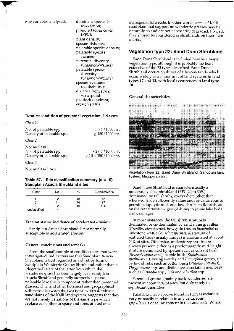
9
I
1
Site variables analysed: dominant species in association;
projected foliar cover (PFC);
plant density; species richness; palatable species density; palatable species
richness; perennial diversity
(Shannon-Weiner); palatable species
diversity (Shannon-Weiner);
species evenness (equitability);
distance from stock waterpoint;
paddock quadrant; erosion status.
Results: condition of perennial vegetation: 3 classes
Class 1
No. of palatable spp. Density of palatable spp.
Class 2
Not as class 1. No. of palatable spp. Density of palatable spp.
Class 3
Not as class 1 or 2.
0>: 7/1000 m'. 0>: 150/1000 m'.
0>: 4 < 7/1000 m'. 0>: 10 < 150/1000 m'.
Table 57. Site classification summary (n = 19) Sand plain Acacia Shrubland sites
Class No. % Cumulative %
1 2 13 13 2 11 74 87 3 2 13 100
unclassified 4
Erosion status: incidence of accelerated erosion
Sandplain Acacia Shrubland is not normally susceptible to accelerated erosion.
General conclusions and remarks
From the small sample of condition sites that were investigated, indications are that Sandplain Acacia Shrubland is best regarded as a shrubby form of Sand plain Wanderrie Grassy Shrub land rather than a (degraded) state of the latter from which the wanderrie grass has been largely lost. Sandplain Acacia Shrubland generally supports a sparse palatable low shrub component rather than perennial grasses. This, and other botanical and geographical differences between the two types which dominate sandplains of the Kalli land system, suggests that they are not merely variations of the same type which replace each other in space and time, at least on a
329
managerial timescale. In other words, areas of Kalli sand plain that support no wanderrie grasses may be naturally so and are not necessarily degraded. Instead, they should be considered as shrublands on their own merits.
Vegetation type 22: Sand Dune Shrubland
Sand Dune Shrubland is included here as a major vegetation type, although it is probably the least extensive of the 23 types described. Sand Dune Shrubland occurs on dunes of siliceous sands which occur widely as a minor unit of land systems in land types 17 and 12, with local occurrences in land type 10.
General characteristics
Vegetation type 22: Sand Dune Shrubland: Sand plain land system, Muggon station.
Sand Dune Shrubland is characteristically a moderately close shrubland (PFC 20 to 30%) dominated by tall shrubs, everywhere other than where soils are sufficiently saline and / or calcareous to permit halophytic mid- and low-shrubs to flourish, as on the transitional 'edges' of dunes in saline lake beds and drainages.
In most instances, the tall shrub stratum is dominated or co-dominated by sand dune grevillea (Grevillea stenobotrya), bowgada (Acacia linophylla) or limestone wattle (A. sclerosperrna). A stratum of scattered trees (usually mulga) is encountered at about 20% of sites. Otherwise, understorey shrubs are always present, either as a predominantly mid-height stratum dominated by species such as currant bush (Scaevola spinescens), pebble bush (Stylobasiurn spathulaturn), young wattles and Erernophila georgei, or by low shrubs such as cotton bush (Ptilotus obovatus), Thryptornene spp. and distinctive association members such as Pityrodia spp., Sida and Abutilon spp.
Perennial grasses (mainly buck wanderrie) are present at about 70% of sites, but only rarely in significant quantities.
Palatable shrub species found in such associations vary primarily in relation to any calcareous, gypsiferous or saline content in the sand soils. Where
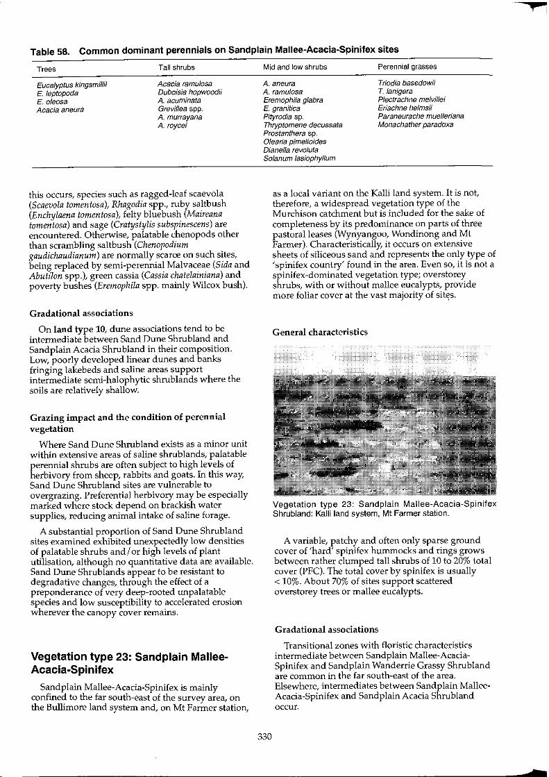
Table 58. Common dominant perennials on Sand plain Mallee-Acacia-Spinifex sites
Trees
Eucalyptus kingsmlllil E. leptopoda E. oleosa Acacia aneura
Tall shrubs
Acacia ramu/osa Duboisia hopwoodii A acuminata Grevillea spp. A murrayana A roycei
this occurs, species such as ragged-leaf scaevola (Scaevola tomentosa), Rhagodia spp., ruby saltbush (Enchylaena tomentosa), felty bluebush (Maireana tomentosa) and sage (Cratystylis subspinescens) are encountered. Otherwise, palatable chenopods other than scrambling saltbush (Chenopodium gaudichaudianum) are normally scarce on such sites, being replaced by semi-perennial Malvaceae (Sida and Abutilon spp.), green cassia (Cassia chatelainiana) and poverty bushes (Eremophila spp. mainly Wilcox bush).
Gradational associations
On land type 10, dune associations tend to be intermediate between Sand Dune Shrubland and Sandplain Acacia Shrubland in their composition. Low, poorly developed linear dunes and banks fringing lakebeds and saline areas support intermediate semi-halophytic shrublands where the soils are relatively shallow.
Grazing impact and the condition of perennial vegetation
Where Sand Dune Shrubland exists as a minor unit within extensive areas of saline shrublands, palatable perennial shrubs are often subject to high levels of herbivory from sheep, rabbits and goats. In this way, Sand Dune Shrubland sites are vulnerable to overgrazing. Preferential herbivory may be especially marked where stock depend on brackish water supplies, reducing animal intake of saline forage.
A substantial proportion of Sand Dune Shrub land sites examined exhibited unexpectedly low densities of palatable shrubs and I or high levels of plant utilisation, although no quantitative data are available. Sand Dune Shrublands appear to be resistant to degradative changes, through the effect of a preponderance of very deep-rooted unpalatable species and low susceptibility to accelerated erosion wherever the canopy cover remains.
Vegetation type 23: Sand plain MalleeAcacia-Spinifex
Sandplain Mallee-Acacia-Spinifex is mainly confined to the far south-east of the survey area, on the Bullimore land system and, on Mt Farmer station,
Mid and low shrubs Perennial grasses
A. aneura Triodia basedowii A. ramulosa T. lanigera Eremophila gfabra Plectrachne melvillei
Eriachne helmsii Paraneurache muelleriana Monachather paradoxa
E. granitica Pityrodia sp. Thryptomene decussata Prostanthera sp. Olearia pimelioides Dianella revo/uta Solanum lasiophyllum
330
as a local variant on the Kalli land system. It is not, therefore, a widespread vegetation type of the Murchison catchment but is included for the sake of completeness by its predominance on parts of three pastoral leases (Wynyangoo, Wondinong and Mt Farmer). Characteristically, it occurs on extensive sheets of siliceous sand and represents the only type of 'spinifex country' found in the area. Even so, it is not a spinifex-dominated vegetation type; overstorey shrubs, with or without mallee eucalypts, provide more foliar cover at the vast majority of sit,s.
General characteristics
Vegetation type 23: Sand plain Mallee-Acacia-Spinifex Shrubland: Kalli land system, Mt Farmer station.
A variable, patchy and often only sparse ground cover of 'hard' spinifex hummocks and rings grows between rather clumped tall shrubs of 10 to 20% total cover (PFC). The total cover by spinifex is usually < 10%. About 70% of sites support scattered overstorey trees or mallee eucalypts.
Gradational associations
Transitional zones with floristic characteristics intermediate between Sandplain Mallee-AcaciaSpinifex and Sandplain Wanderrie Grassy Shrubland are common in the far south-east of the area. Elsewhere, intermediates between Sand plain MalleeAcacia-Spinifex and Sand plain Acacia Shrubland occur.
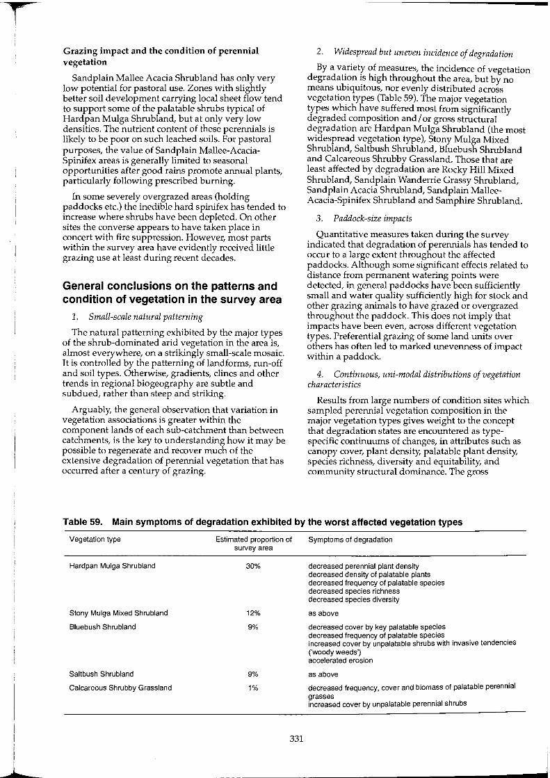
I 1
Grazing impact and the condition of perennial vegetation
Sandplain Mallee Acacia Shrub land has only very low potential for pastoral use. Zones with slightly better soil development carrying local sheet flow tend to support some of the palatable shrubs typical of Hardpan Mulga Shrubland, but at only very low densities. The nutrient content of these perennials is likely to be poor on such leached soils. For pastoral purposes, the value of Sandplain Mallee-AcaciaSpinifex areas is generally limited to seasonal opportunities after good rains promote annual plants, particularly following prescribed burning.
In some severely overgrazed areas (holding paddocks etc.) the inedible hard spinifex has tended to increase where shrubs have been depleted. On other sites the converse appears to have taken place in concert with fire suppression. However, most parts within the survey area have evidently received little grazing use at least during recent decades.
General conclusions on the patterns and condition of vegetation in the survey area
1. Small-scale natural patterning
The natural patterning exhibited by the major types of the shrub-dominated arid vegetation in the area is, almost everywhere, on a strikingly small-scale mosaic. It is controlled by the patterning of landforms, run-off and soil types. Otherwise, gradients, clines and other trends in regional biogeography are subtle and subdued, rather than steep and striking.
Arguably, the general observation that variation in vegetation associations is greater within the component lands of each sub-catchment than between catchments, is the key to understanding how it may be possible to regenerate and recover much of the extensive degradation of perennial vegetation that has occurred after a century of grazing.
2. Widespread but uneven incidence of degradation
By a variety of measures, the incidence of vegetation degradation is high throughout the area, but by no means ubiquitous; nor evenly distributed across vegetation types (Table 59). The major vegetation types which have suffered most from significantly degraded composition and I or gross structural degradation are Hardpan Mulga Shrubland (the most widespread vegetation type), Stony Mulga Mixed Shrub land, Saltbush Shrubland, Bluebush Shrubland and Calcareous Shrubby Grassland. Those that are least affected by degradation are Rocky Hill Mixed Shrub land, Sandplain Wanderrie Grassy Shrubland, Sandplain Acacia Shrub land, Sandplain MalleeAcacia-Spinifex Shrub land and Samphire Shrubland.
3. Paddock-size impacts
Quantitative measures taken during the survey indicated that degradation of perennials has tended to occur to a large extent throughout the affected paddocks. Although some significant effects related to distance from permanent watering points were detected, in general paddocks have been sufficiently small and water quality sufficiently high for stock and other grazing animals to have grazed or overgrazed throughout the paddock. This does not imply that impacts have been even, across different vegetation types. Preferential grazing of some land units over others has often led to marked unevenness of impact within a paddock.
4. Continuous, uni-modal distributions of vegetation characteristics
Results from large numbers of condition sites which sampled perennial vegetation composition in the major vegetation types gives weight to the concept that degradation states are encountered as typespecific continuums of changes, in attributes such as canopy cover, plant density, palatable plant density, species richness, diversity and equitability, and community structural dominance. The gross
Table 59. Main symptoms of degradation exhibited by the worst affected vegetation types
Vegetation type
Hardpan Mulga Shrubland
Stony Mulga Mixed Shrubland
Bluebush Shrubland
Saltbush Shrubland
Calcareous Shrubby Grassland
Estimated proportion of survey area
30%
12%
9%
9%
1%
331
Symptoms of degradation
decreased perennial plant density decreased density of palatable plants decreased frequency of palatable species decreased species richness decreased species diversity
as above
decreased cover by key palatable species decreased frequency of palatable species increased cover by unpalatable shrubs with invasive tendencies ('woody weeds') accelerated erosion
as above
decreased frequency, cover and biomass of palatable perennial grasses increased cover by unpalatable perennial shrubs

distributions of such characteristics between equivalent sites throughout the area in almost all instances indicated continuous uni-modal distributions of variation.
5. The vegetation attributes of any site, and therefore the 'condition' class allocated to a site reflect both long-term management impact and natural variation in botanical attributes
Variation between sites, and the characteristics of any particular site, always results partly from variations in site potential (attributable to its particular set of biophysical characteristics) and partly from the cumulative impact of all land use, management history and grazing pressure. The impossibility of 'controlling' the background natural variation in site potential in order to quantify the assessment of management impact means that quantified classification of individual sites, such as that given here, constitutes information on condition-related characteristics of the perennial resource as it was encountered during the survey.
In other words, a 'condition class' of sites exhibiting similar characteristics will, to some extent group any sites of higher biological potential, but which have received more degradative impacts, together with sites which have received less degradative impacts and changes but were inherently less productive, i.e. of a lower biological potential. The resultant compounding of these two effects does not negate the value of the information to a manager of that land. It is the outcome of the two variables in combination which is the determinant of the long-term status of the vegetation on the land sampled, and its relative position within the whole spectrum of condition variation (on a regional scale) which is being gauged and assessed for management implications.
6. The likely importance of non-vascular plants in maintaining vascular plant productivity
While the present survey program did not collect quantitative data on the occurrence of non-vascular plants (e.g. blue-green algae, lichens and liverworts), the importance of these widespread groups (see Cranfield 1990, Rogers 1989) cannot be overemphasised in proffering soil surface crusts which fix, concentrate and recycle nutrients, stabilise dispersible topsoils, and form natural seeding mats, infiltration zones and evapotranspiration shields.
Any future monitoring of remotely-sensed changes in land surface J cover' in this area will require a far more rigorous understanding of the ecology and seasonal dynamics of these cryptogams than is currently available.
7. Despite widespread degradation, the conservation status of the flora at species level appears to be favourable and encouraging
As a result of findings from this survey, there are no longer any 'missing' plant species known or suspected to have become extinct from the area. Previously inadequate and inaccurate knowledge of the status of some little-known endemic species, such as Prostanthera (= Eichlerago) tysoniana, and Ptilotus
332
beardii, has been redressed by encouraging findings on their occurrence, while the status of some other rare plants such as Grevillea subtiliflora, Maireana murrayana and Lepidium aff. xylodes gives rise for concern. A small number of currently more widespread species such as sandalwood (Santalum spicatum) do not appear to be reproducing at anything like sustainable rates under current land management and will require special management provision if they are not to be lost from many parts when the current generation of adult plants has gone.
S. Reference areas, where examples of vegetation types exist in good condition, still exist for major vegetation types
This is true with the exception of Calcrete Shrubby Grassland, for which there are no known sites that have avoided the chronic overgrazing pressures exerted by rabbits and red kangaroos irrespective of the presence of sheep. Sites are known which have reasonable levels of cover of the native perennial grass species, at least by the living rhizomes. These would almost certainly respond to effective grazing control. To achieve this, management controls would need to be developed for stock, kangaroos and rabbits.
9. Many isolated examples of locally regenerated or improved vegetation condition exist in the area, but are mainly little-known or undocumented
The survey encountered a number of sites, paddocks and larger areas which showed circumstantial evidence of significant long-term improvement in vegetation condition. While identifying causative factors was sometimes difficult or impossible without fuller information on the management history of individual areas, changes in grazing management practices could sometimes be identified and related to vegetation characteristics. In some cases, benign neglect or disuse, for example after the demise of a stock water supply, may have triggered natural regeneration.
While a few leases have Significantly benefited from successful long-term attempts to improve the grazing management and condition of the vegetation resource, most have not. The potential to plan, support and implement vegetation recovery through subcatchment scale management programs has yet to be tested. Such programs could be based on rigid control of all grazing animals, strategic and tactical grazing use of each land type and through non-mechanical enhancement of natural processes.
10. The recovery of degraded chenopodiaceous shrub lands and their associated soil erosion depends on the effective control of all grazing pressure
Past and present total grazing pressure on wellwatered, poorly fenced areas of river plains dictates that natural processes of recovery and stabilisation of eroded areas cannot begin without changes to management practices. Likely pre-requisites for the recovery of Saltbush and Bluebush Shrub lands on river frontages include improved condition in Hardpan Mulga Shrublands adjacent to the rivers, effective fencing by land type boundaries, and the ability for managers to deny access to all large grazing animals at critical times.
f
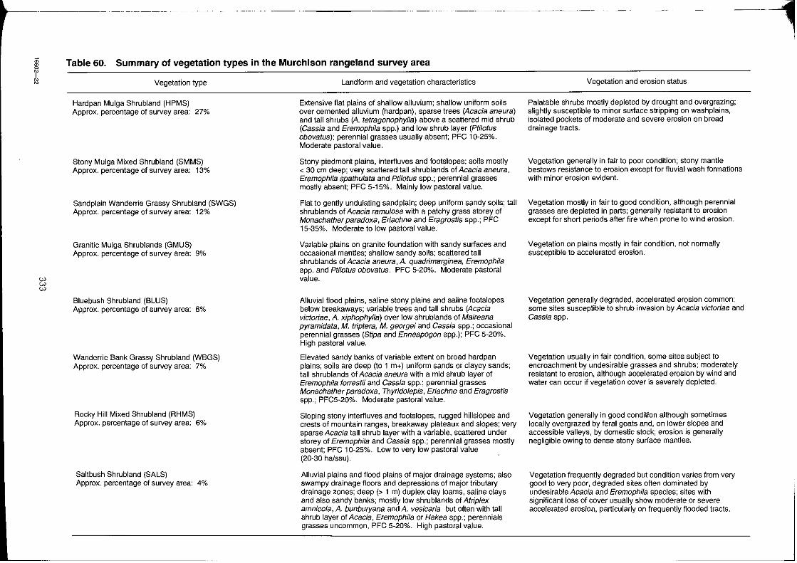
~ r ~
'" i::l
- --~ --------
Table 60. Summary of vegetation types in the Murchison rangeland survey area
Vegetation type
Hardpan Mulga Shrubland (HPMS) Approx. percentage of survey area: 27%
Stony Mulga Mixed Shrubland (SMMS) Approx. percentage of survey area: 13%
Sand plain Wanderrie Grassy Shrubland (SWGS) Approx. percentage of survey area: 12%
Granitic Mulga Shrublands (GMUS) Approx. percentage of survey area: 9%
Bluebush Shrubland (BLUS) Approx. percentage of survey area: 8%
Wanderrie Bank Grassy Shrubland (WBGS) Approx. percentage of survey area: 7%
Rocky Hill Mixed Shrubland (RHMS) Approx. percentage of survey area: 6%
Saltbush Shrubland (SALS) Approx. percentage of survey area: 4%
Landform and vegetation characteristics
Extensive flat plains of shallow alluvium; shallow uniform soils over cemented alluvium (hardpan), sparse trees (Acacia aneura) and tall shrubs (A. tetragonophylla) above a scattered mid shrub (Cassia and Eremophila spp.) and low shrub layer (Ptilotus obovatus): perennial grasses usually absent; PFC 10-25%. Moderate pastoral value.
Stony piedmont plains, interiluves and footslopes; soils mostly < 30 em deep; very scattered tall shrublands of Acacia aneura, Eremophila spathulata and Ptilotus spp.; perennial grasses mostly absent; PFC 5-15%. Mainly low pastoral value.
Flat to gently undulating sand plain; deep uniform sandy soils; tall shrublands of Acacia ramulosa with a patchy grass storey of Monachather paradoxa, Eriachne and Eragrostis spp.; PFC 15-35%. Moderate to low pastoral value.
Variable plains on granite foundation with sandy surfaces and occasional mantles; shallow sandy soils; scattered tall shrublands of Acacia aneura, A quadrimarginea, Eremophila spp. and Ptilotus obovatus. PFC 5-20%. Moderate pastoral value.
Alluvial flood plains, saline stony plains and saline footslopes below breakaways; variable trees and tall shrubs (Acacia victoriae, A xiphophylla) over low shrublands of Maireana pyramidata, M. triptera, M. georgei and Cassia spp.; occasional perennial grasses (Stipa and Enneapogon spp.); PFC 5-20%. High pastoral value.
Elevated sandy banks of variable extent on broad hardpan plains; soils are deep (to 1 m+) uniform sands or clayey sands; tall shrublands of Acacia aneura with a mid shrub layer of Eremophila forrestii and Cassia spp.; perennial grasses Monachather paradoxa, Thyridolepis, Eriachne and Eragrostis spp.; PFC5-20%. Moderate pastoral value.
Sloping stony interfluves and footslopes, rugged hillslopes arid crests of mountain ranges, breakaway plateaux and slopes; very sparse Acacia tall shrub layer with a variable, scattered under storey of Eremophila and Cassia spp.; perennial grasses mostly absent; PFC 10-25%. Low to very low pastoral value (20-30 halssu).
Alluvial plains and flood plains of major drainage systems; also swampy drainage floors and depressions of major tributary drainage zones; deep (> 1 m) duplex clay loams, saline clays and also sandy banks; mostly low shrublands of Atriplex amnicola, A bunburyana and A vesicaria but often with tall shrub layer of Acacia, Eremophila or Hakea spp.; perennials grasses uncommon, PFC 5-20%. High pastoral value.
--1 Vegetation and erosion status
Palatable shrubs mostly depleted by drought and overgrazing; slightly susceptible to minor sur1ace stripping on washplains, isolated pockets of moderate and severe erosion on broad drainage tracts.
Vegetation generally in fair to poor condition; stony mantle bestows resistance to erosion except for fluvial wash formations with minor erosion evident.
Vegetation mostly in fair to good condition, although perennial grasses are depleted in parts; generally resistant to erosion except for short periods after fire when prone to wind erosion.
Vegetation on plains mostly in fair condition, not normally susceptible to accelerated erosion.
Vegetation generally degraded, accelerated erosion common; some sites susceptible to shrub invasion by Acacia victoriae and Cassia spp.
Vegetation usually in fair condition, some sites subject to encroachment by undesirable grasses and shrubs; moderately resistant to erosion, although accelerated erosion by wind and water can occur if vegetation cover is severely depleted.
Vegetation generally in good condition although sometimes locally overgrazed by feral goats and, on lower slopes and accessible valleys, by domestic stock; erosion is generally negligible owing to dense stony surface mantles.
Vegetation frequently degraded but condition varies from very good to very poor, degraded sites often dominated by undesirable Acacia and Eremophila species; sites with significant loss of cover usually show moderate or severe accelerated erosion, particularly on frequently flooded tracts.
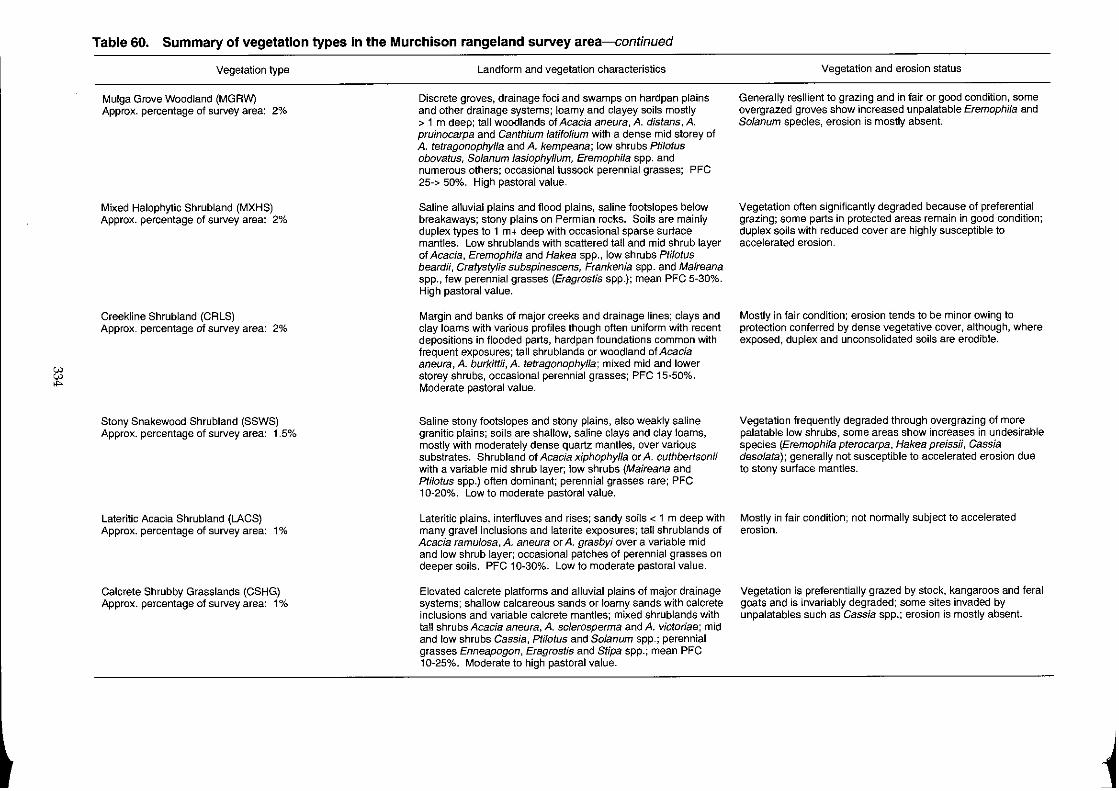
~
Table 60. Summary of vegetation types in the Murchison rangeland survey area-continued
Vegetation type
Mulga Grove Woodland (MGRW) Approx. percentage of survey area: 2%
Mixed Halophytic Shrubland (MXHS) Approx. percentage of survey area: 2%
Creekline Shrubland (CRLS) Approx. percentage of survey area: 2%
Stony Snakewood Shrubland (SSWS) Approx. percentage of survey area: 1.5%
Lateritic Acacia Shrubland (LACS) Approx. percentage of survey area: 1 %
Calcrete Shrubby Grasslands (CSHG) Approx. percentage of survey area: 1%
Landform and vegetation characteristics
Discrete groves, drainage foci and swamps on hardpan plains and other drainage systems; loamy and clayey soils mostly > 1 m deep; tall woodlands of Acacia aneura, A. distans, A. pruinocarpa and Canthium latifolium with a dense mid storey of A. tetragonophylla and A. kempeana; low shrubs Ptilotus obovatus, Solanum lasiophyllum, Eremophila spp. and numerous others; occasional tussock perennial grasses; PFC 25-> 50%. High pastoral value.
Saline alluvial plains and flood plains, saline footslopes below breakaways; stony plains on Permian rocks. Soils are mainly duplex types to 1 m+ deep with occasional sparse surface mantles. Low shrublands with scattered tall and mid shrub layer of Acacia, Eremophila and Hakea spp., low shrubs Ptilotus beardii, Cratystylis subspinescens, Frankenia spp. and Maireana spp., few perennial grasses (Eragrostis spp.); mean PFC 5-30%. High pastoral value.
Margin and banks of major creeks and drainage lines; clays and clay loams with various profiles though often uniform with recent depositions in flooded parts, hardpan foundations common with frequent exposures; tall shrublands or woodland of Acacia aneura, A. burkittii, A. tetragonophylla; mixed mid and lower storey shrubs, occasional perennial grasses; PFC 15-50%. Moderate pastoral value.
Saline stony footslopes and stony plains, also weakly saline granitic plains; soils are shallow, saline clays and clay loams, mostly with moderately dense quartz mantles, over various substrates. Shrubland of Acacia xiphophylla or A. cuthbertsonii with a variable mid shrub layer; low shrubs (Maireana and Ptilotus spp.) often dominant; perennial grasses rare; PFC 10-20%. Low to moderate pastoral value.
Lateritic plains, interfluves and rises; sandy soils < 1 m deep with many gravel inclusions and laterite exposures; tall shrublands of Acacia ramulosa, A. aneura or A. grasbyi over a variable mid and low shrub layer; occasional patches of perennial grasses on deeper soils. PFC 10-30%. Low to moderate pastoral value.
Elevated calcrete platforms and alluvial plains of major drainage systems; shallow calcareous sands or loamy sands with calcrete inclusions and variable calcrete mantles; mixed shrublands with tall shrubs Acacia aneura, A. sclerosperma and A. victoriae; mid and low shrubs Cassia, Ptilotus and Solanum spp.; perennial grasses Enneapogon, Eragrostis and Stipa spp.; mean PFC 10-25%. Moderate to high pastoral value.
Vegetation and erosion status
Generally resilient to grazing and in fair or good condition, some overgrazed groves show increased unpalatable Eremophila and Solanum species, erosion is mostly absent.
Vegetation often significantly degraded because of preferential grazing; some parts in protected areas remain in good condition; duplex soils with reduced cover are highly susceptible to accelerated erosion.
Mostly in fair condition; erosion tends to be minor owing to protection conferred by dense vegetative cover, although, where exposed, duplex and unconsolidated soils are erodible.
Vegetation frequently degraded through overgrazing of more palatable low shrubs, some areas show increases in undesirable species (Eremophila pterocarpa, Hakea preissii, Cassia desofata); generally not susceptible to accelerated erosion due to stony surface mantles.
Mostly in fair condition; not normally subject to accelerated erosion.
Vegetation is preferentially grazed by stock, kangaroos and feral goats and is invariably degraded; some sites invaded by unpalatables such as Cassia spp.; erosion is mostly absent.
.~
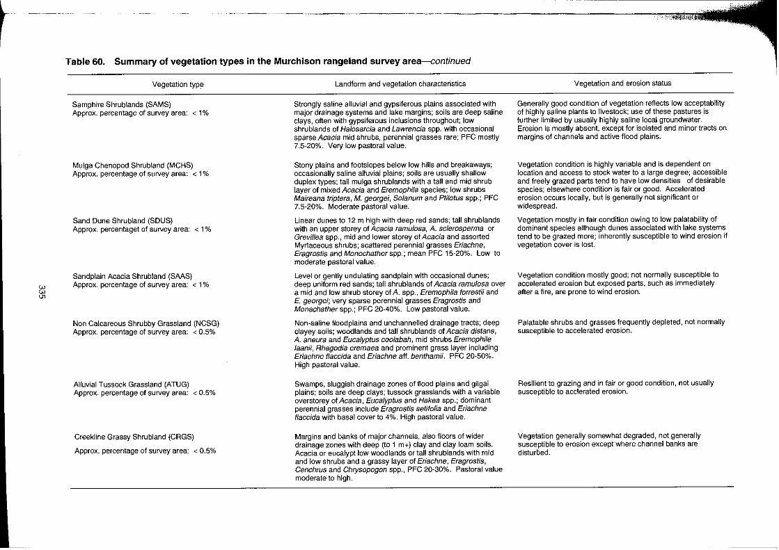
r
eN eN en
--.--~----
Table 60. Summary of vegetation types in the Murchison rangeland survey area-continued
Vegetation typ~
Sam ph ire Shrublands (SAMS) Approx. percentage of survey area: < 1 %
Mulga Chenopod Shrubland (MCHS) Approx. percentage of survey area: < 1 %
Sand Dune Shrubland (SDUS) Approx. percentaget of sU/vey area: < 1 %
Sand plain Acacia Shrubland (SAAS) Approx. percentage of survey area: < 1 %
Non Calcareous Shrubby Grassland (NCSG) Approx. percentage of survey area: < 0.5%
Alluvial Tussock Grassland (ATUG) Approx. percentage of survey area: < 0.5%
Creekline Grassy Shrubland (CRGS)
Approx. percentage of survey area: < 0.5%
Landform and vegetation characteristics
Strongly saline alluvial and gypsiferous plains associated with major drainage systems and lake margins; soils are deep saline clays, often with gypsiferous inclusions throughout; low shrublands of Halosarcia and Lawrencia spp. with occasional sparse Acacia mid shrubs, perennial grasses rare; PFC mostly 7.5-20%. Very low pastoral value.
Stony plains and footslopes below low hills and breakaways; occasionally saline alluvial plains; soils are usually shallow duplex types; tall mulga shrublands with a tall and mid shrub layer of mixed Acacia and Eremophila species; low shrubs Maireana triptera, M. georgei, Solanum and Ptilotus spp.; PFC 7.5-20%. Moderate pastoral value.
Linear dunes to 12 m high with deep red sands; tall shrublands with an upper storey of Acacia ramulosa, A. sclerosperma or Grevillea spp., mid and lower storey of Acacia and assorted Myrtaceous shrubs; scattered perennial grasses Eriachne, Eragrostis and Monochatherspp.; mean PFC 15-20%. Low to moderate pastoral value.
Level or gently undulating sandplain with occasional dunes; deep uniform red sands; tall shrublands of Acacia ramulosa over a mid and low shrub storey of A. spp., Eremophila forrestii and E. georgei; very sparse perennial grasses Eragrostis and Monachather spp.; PFC 20-40%. Low pastoral value.
Non-saline floodplains and unchannel1ed drainage tracts; deep clayey soils; woodlands and tall shrublands of Acacia distans, A. aneura and Eucalyptus coo/abah, mid shrubs Eremophile laanii, Rhagodia eremaea and prominent grass layer including Eriachne flaccida and Eriachne aft. benthamii. PFC 20-50%. High pastoral value.
Swamps, sluggish drainage zones of flood plains and gilgai plains; soils are deep clays; tussock grasslands with a variable overstorey of Acacia, Eucalyptus and Hakea spp.; dominant perennial grasses include Eragrostis setifolia and Eriachne ffaccida with basal cover to 4%. High pastoral value.
Margins and banks of major channels, also floors of wider drainage zones with deep (to 1 m+) clay and clay loam soils. Acacia or eucalypt low woodlands or tall shrublands with mid and low shrubs and a grassy layer of Eriachne, Eragrostis, Cenchrus and Chrysopogon spp., PFC 20-30%. Pastoral value moderate to high.
Vegetation and erosion status
Generally good condition of vegetation reflects low acceptability of highly saline plants to livestock; use of these pastures is further limited by usually highly saline local groundwater. Erosion is mostly absent, except for isolated and minor tracts on margins of channels and active flood plains.
Vegetation condition is highly variable and is dependent on location and access to stock water to a large degree; accessible and freely grazed parts tend to have low densities of desirable species; elsewhere condition is fair or good. Accelerated erosion occurs locally, but is generally not significant or widespread.
Vegetation mostly in fair condition owing to low palatability of dominant species although dunes associated with lake systems tend to be grazed more; inherently susceptible to wind erosion if vegetation cover is lost.
Vegetation condition mostly good; not normally susceptible to accelerated erosion but exposed parts, such as immediately after a fire, are prone to wind erosion.
Palatable shrubs and grasses frequently depleted, not normally susceptible to accelerated erosion.
Resilient to grazing and in fair or good condition, not usually susceptible to acclerated erosion.
Vegetation generally somewhat degraded, not generally susceptible to erosion except where channel banks are disturbed.
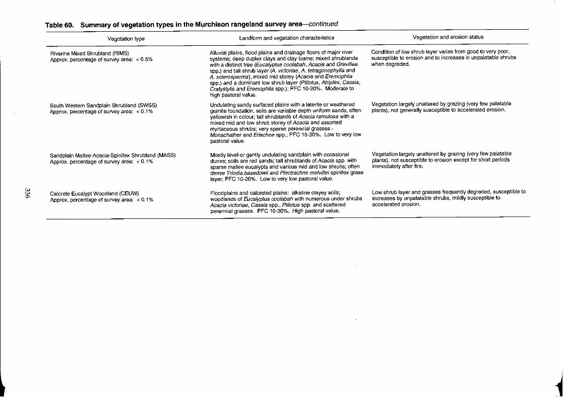
i:;l '"
Table 60. Summary of vegetation types in the Murchison rangeland survey area--continued
Vegetation type
Riverine Mixed Shrubland (RIMS) Approx. percentage of sU/vey area: < 0.5%
South Western Sand plain Shrubland (SWSS) Approx. percentage of survey area: < 0.1 %
Sand plain Mallee-Acacia-Spinifex Shrubland (MASS) Approx. percentage of survey area: < 0.1 %
Calcrete Eucalypt Woodland (CEUW) Approx. percentage of survey area: < 0.1 %
Landform and vegetation characteristics
Alluvial plains, flood plains and drainage floors of major river systems; deep duplex clays and clay loams; mixed shrublands with a distinct tree (Eucalyptus coo/abah, Acacia and Grevil/ea spp.) and tall shrub layer (A. victoriae, A. tetragonophylla and A. sc/erosperma), mixed mid storey (Acacia and Eremophila spp.) and a dominant low shrub layer (Ptilotus, Atrip/ex, Cassia, Cratystylis and Eremophila spp.); PFC 10-20%. Moderate to high pastoral value.
Undulating sandy surfaced plains with a laterite or weathered granite foundation, soils are variable depth uniform sands, often yellowish in colour; tall shrublands of Acacia ramulosa with a mixed mid and low shrub storey of Acacia and assorted myrtaceous shrubs; very sparse perennial grasses -Monachather and Eriachne spp.; PFC 15-30%. Low to very low pastoral value.
Mostly level or gently undulating sand plain with occasional dunes; soils are red sands; tall shrublands of Acacia spp. with sparse mallee eucalypts and various mid and low shrubs; often dense Triodia basedowii and Plectrachne melvillei spinifex grass layer; PFC 10-20%. Low to very low pastoral value.
Floodplains and calcreted plains; alkaline clayey soils; woodlands of Eucalyptus coo/abah with numerous under shrubs Acacia victorlae, Cassia spp., Pti/otus spp. and scattered perennial grasses. PFC 10-30%. High pastoral value.
Vegetation and erosion status
Condition of low shrub layer varies from good to very poor, susceptible to erosion and to increases in unpalatable shrubs when degraded.
Vegetation largely unaltered by grazing (very few palatable plants), not generally susceptible to accelerated erosion.
Vegetation largely unaltered by grazing (very few palatable plants), not susceptible to erosion except for short periods immediately after fire.
Low shrub layer and grasses frequently degraded, susceptible to increases by unpalatable shrubs, mildly susceptible to accelerated erosion.
j
References and bibliography Beale, I.E (1973). Tree density effects on yields of herbage and tree
components in south west Queensland mulga (Acacia aneura F. Muell) scrub. Tropical Grasslands 7: 135-142.
Beard, }.S. (1976). Vegetation survey of Western Australia: Sheet 6. University of Western Australia Press.
Cranfield, R.J. (1990). List of vascular plants recorded from the Murchison Catchment Survey area 1985-88. Kingia 1(4): 327-347.
Davies, S.J.J.E (1976). Environmental variables and the biology of Australian and zone birds. Proceedings 16th International Ornithological Congress. pp. 418-482.
Foran, B.D., Bastin, G.N. and Shaw, K.A. (1986). Range assessment and monitoring in arid lands: the use of classification and ordination in range survey. Journal of Environmental Management 22: 67-84.
Graetz, RD. (1986). A comparative study of sheep grazing on semiarid saltbush pasture in two condition classes. Australian Rangeland JournalS: 46-56.
Graetz, RD. and Wilson, AD. (1984). Saltbush and bluebush. In: Management of Australia's rangelands (Eds G.N. Harrington, AD. Wilson and M.D. Young) pp. 209-222. CSIRO, Melbourne.
Grunow, J.O. and Lance, G.N. (1969). Classification of savannah by information analysis. South African Journal of Science 35: 341-348.
Hacker, RB. (1986). Effect of grazing on chemical and physical properties of an earthy sand in the Western Australian mulga zone. Australian Rangeland JournalS: 135-150.
Holm, AMcR (1991). The effect on rangeland vegetation of periodic protection from sheep grazing in Western Ausralian arid shrublands (unpublished). Department of Agriculture, Western Australia.
337
Lange, R.T., Nicholson, A.D. and Nicholson, D.A. (1984). Vegetation management of chenopod rangelands in South Australia. Australian Rangeland Journal 6: 46-54.
Mabbutt, J.A, Litchfield, W.H., Speck, N.H., Sofoulis, J., Wilcox, D.G., Arnold, J.M. and WrIght, R.L. (1963). General report of lands of the Wiluna-Meekatharra area, Western Australia 1958. CSIRO Land Research Series No.7.
Morrissey, J.G. (1984). Arid mulga woodlands. In: Management of Australia'S rangelands (Eds G.N. Harrington, AD. Wilson and M.D. Young) pp. 285-298. CSIRO, Melbourne.
Mott, J.J. (1973). Temporal and spatial distribution of annual flora in an arid region of Western Australia. Tropical Grasslands 7(1); 89-97.
Mott, I.J. and McComb, AJ. (1974). Patterns in annual vegetation and soil microrelief in an arid region of Western Australia. Journal of Ecology 62: 115-126.
Rogers, R.W. (1989). Blue-green algae in southern Australian rangeland soils. Australian Rangeland Journal 11: 67-73.
Ross, D., Dale, M.I Shields, K. and Hulett, C. (1983). Taxon Users' Manual- edition P4. CSIRO Division of Computing Research, St. Lucia, Qld.
Watson, I. and Holm, A.McR. (1990). The benefits of palatable shrubs for wool production in a semi-arid environment. Sixth Australian Rangeland Society Conf~rence papers, Carnarvon, Western Australia, 3-6 September 1990. pp. 25-34.
Wilson, AD. (1991). The effect of grazing on Australian ecosystems. In: Australian ecosystems: 200 years of utilization, degradation and reconstruction. Proceedings of Ecological Society of Australia pp 235-44.
l
Condition of the land resource
Introduction
In order to provide benchmark assessments of the condition of the land resource throughout the study area, the survey attempted to define and quantify key measures of land degradation wherever possible. Conceptually what has been assessed or measured at any particular point or site on the ground is the cumulative impact of post-settlement pastoral land use. Biological indicators chosen for this purpose are those which have repeatedly proven to be the most powerful measures of ecosystem change:
• perennial vegetation;
• accelerated soil erosion.
In previous surveys of this type, the concept of 'range condition' has been used for the reporting of findings concerning these two key variables. In so doing, observations of changes to perennial vegetation were combined with those of accelerated soil erosion to formulate a very simple scale of condition relativities suitable for reporting to pastoral managers and administrators.
In this study, we present findings concerning the two factors separately. Many pastoral managers and administrators nowadays are skilled in identifying the symptoms of both vegetation decline and erosion and understand their causality in the ecological processes that link them in the arid rangelands. The provision of specific information on the degradation risks and symptoms for soil and vegetation within particular land units and vegetation types (see 'Land systems' and 'Vegetation' sections) also reflects this approach, to provide technical data specific to the land units being managed within a paddock or particular situation. In this way, measures of recovery and response to appropriate management are more easily made at the site, and by the land manager, rather than requiring re-assessment by Government resource experts.
This same principle of future self-help for land managers has been applied to the analysis of condition site data, and the application of objective criteria to site assessment at any time in the future. In this approach we provide a series of classifications of soil and vegetation attributes which are empirical and
probabilistic rather than judgemental. Data provided by this survey serve as a framework within which any future resource data collected at comparable sites may be compared and contrasted.
As indicated in the 'Methods' section of this report, two approaches to the assessment of soil and vegetation condition were used.
Traverse findings
Visual assessments of soil and vegetation condition were made at every kilometre along traverses using a set of standard definitions (Tables 9 and 10). In this way, the geographical extent of survey coverage was maximised and permanently recorded.
Three broad classes of vegetation condition were derived from the visual assessments. These levels of condition at 1 km points are referred to as good, fair and poor, and are reported accordingly on the accompanying map series.
A condition statement for the whole survey area has been compiled (see Table 61) by examining all 13,621 points of traverse data recorded during the survey. The table presents an overall summary, obtained from observations made mainly along station access tracks and otherwise through most parts of the survey area. The levels of coverage achieved throughout the region can be gauged from the line compilation of traverse routes, depicted in Figure 30.
Seventeen per cent of traverse observations indicate some form of accelerated erosion, with 5% and 1 % indicating moderate and severe erosion respectively. Water rather than wind is clearly the major causal agent of accelerated erosion in the survey area. Most of the erosion is confined to a small number of land systems (see Table 62) and vegetation types subject to concentrated drainage flows and are generally those systems and vegetation types with high pastoral potential.
Fifty-eight per cent of traverse observations indicated vegetation condition in the fair and good categories (which might be regarded as acceptable condition), However, several important vegetation types are widely degraded (42% of all traverse observations indicated poor or very poor vegetation condition) with considerable loss of palatable perennial plants, general losses of perennial plants or, in some cases, marked increases in cover by unpalatable species ('woody weeds').
Table 61. Condition of survey area from traverse observation summary over all land systems* Wind
% Water Total
erosion erosion % erosion % Vegetation condition %
Nil 96 Nil 83 Nil 83 Very good to good 21
Minor 3 Minor 11 Minor 11 Fair 37
Moderate Moderate 5 Moderate 5 Poor to very poor 42
Severe 0 Severe Severe
* 13,621 traverse observations were made on 68 land systems.
338
¥
i
L
Incidence and extent of severely degraded and eroded areas
Areas of eroded soil surfaces larger than 40 ha in extent have been identified and mapped (at 1:250,000) as being severely degraded and eroded (see Table 62). This area totals 1560 km2 and represents 1.8% of the survey area. Much of this degradation occurs on alluvial land systems with high pastoral potential such as Beringarra and Ero. For example, 10% (1043 km2
) of the total area of those land systems falling into the high pastoral pot~ntial category were identified and have been mapp~d as severely degraded and eroded (sde). In contrast, less than 1% (0.8% or 322 km2
) of the total area of those land systems of moderate pastoral potential were found to be severely degraded and eroded.
The extent and regional location of areas of sde are shown in Figure 48 and on the 1:250,000 scale land system maps accompanying this report. Although patches of sde are recorded on 30 of the 74 land systems in the survey area, the majority of the sde, as previously mentioned, occurs on a few important systems. These are:
• Land systems Bayou, Beringarra, Ero and Mileura - the river and tributary plains (land types 15 and 16) with major units characterised by duplex soils lacking in protective (stony) mantling and subject to accelerated concentrated flows through degraded areas.
• Land system Sherwood occurring as lateritised breakaways, footslopes with duplex soils and extensive lower plains on granite and gneiss (land type 4) and widely distributed through the survey area.
GLENBURGH
. (
kilometres
ROBINSON RANGE
.. -" .- /'.: 1
, I ... .' " ... ..
BELELE .... ,/.
, l ". /' .}O
" CUE I -.. , CUE
. ,
. '. .. , .
MT, MAGNET .,'ft: .
Figure 4B. Areas of severe degradation and erosion (sde) within the survey area.
339
• ClliLy"_ J'""'", 'mru.",« Y""m "'" -Yanganoo occurnng as very extensive wash ' plains (land type 14) with red earths and other medium-textured soils over hardpan; their tracts of more concentrated drainage flows are particularly susceptible.
Condition of land systems
Traverse assessment records are summarised by land system in Tables 62 and 63. Table 62 also indicates the total mapped areas of severely degraded and eroded country (sde) on all land systems. Several salient points are indicated by an examination of those data.
1. Systems with high rates of erosion incidence are mainly those:
• of high pastoral potential;
• of land types 15 and 16 - alluvial plains which constitute parts of the major drainage zones in the area.
2. Accelerated erosion is very widespread in lands with high pastoral potential: 42% of all traverse assessments made on these lands indicated evidence of some accelerated erosion, and 10.2% of these land systems was mapped as sde, including 27% of the entire Beringarra land system.
3. Among the land systems of moderate pastoral potential, the worst affected are those based on Permian sedimentary rocks (e.g. Byro land system, 58% erosion-affected) and those with highly erodible units lying below breakaways (e.g. Sherwood land system).
4. Land systems of low or very low pastoral potential are much less affected by erosion. Overall, the broad, flat wash zones of the Yandilland system are the most widespread type of eroded country in these categories.
5. The vegetation of land systems of low or very low pastoral potential was assessed as being in mainly good or fair condition.
6. Vegetation in land systems of moderate pastoral potential was assessed to be in very variable condition. Worst affected by perennial vegetation decline are certain 'wash' systems supporting mulga shrublands on hardpan (e.g. Cole land system), preferentially grazed systems on greenstones (e.g. Trillbar land system) and internally drained systems (e.g. Breberle and Outcamp).
7. Vegetation condition in land systems of high pastoral condition is mainly poor or fair, with only those systems characterised by highly saline vegetation remaining in predominantly good condition. Again, systems of land types 15 and 16 -the major drainage plains adjacent to river channels - are the most severely affected.
+
Table 62. The frequency and severity of soil erosion for land systems
Patoral Land Area No. of Soil erosion (% of traverse assessments) Severely degraded and
eroded* potential system (km~ traverse
assessments Nil Minor Moderate Severe (km') (% of system)
Very high Merbla 76 19 74 26 0 0 0 0.0
High Austin 155 57 73 18 9 0 15 9.8 Bayou 491 177 50 33 14 3 46 9.5 Beringarra 2,629 626 31 32 31 6 704 26.8 Carnegie 1,281 107 93 7 0 0 0 0.0 Coolabulla 50 12 92 8 0 0 0 0.0 Cunyu 1,083 234 79 16 4 1 11 1.1 Era 1,589 518 38 35 24 3 210 13.3 Holmwood 355 27 85 11 4 0 2 0.4 Mileura 1,007 301 74 19 6 1 27 2.7 Roderick 407 74 30 37 32 1 17 4.1 Siberia 43 19 68 21 11 0 0 0.0 Weenyung 153 33 100 0 0 0 0 0.0 Wolarry 368 78 73 23 4 0 1 0.3 Wongong 317 62 77 18 5 0 0 0.0 WDoleen 55 11 91 9 0 0 0 0.0 Yewin 316 70 68 21 10 1 10 3.4
Sub-total 10,299 2,406 58 24 16 2 1,043 10.2
Moderate Belele 4,701 773 89 7 3 1 27 0.6 Bidgemia 221 25 80 16 4 0 0 0.0 Boulder 832 146 87 12 1 0 0 0.0 Sreberle 115 27 100 0 0 0 0 0.0 Bunny 485 108 97 3 0 0 0 0.0 Byro 497 94 42 38 19 1 14 2.8 Challenge 5,159 834 91 7 2 0 2 0.0 Channel 94 12 100 0 0 0 0 0.0 Cole 1,196 151 94 6 0 0 3 0.2 Flood 439 60 93 7 0 0 0 0.0 Frederick 36 3 100 0 0 0 0 0.0 Horseshoe 204 30 100 0 0 0 0 0.0 Jimba 36 Not traversed 0 0.0 Liver 752 91 71 24 5 0 0 0.0 Millex 500 87 83 14 3 0 7 1.4 Mongolia 456 72 96 3 1 0 0 0.0 Outcamp 44 12 8 42 42 8 11 24.5 Sandiman 347 33 46 27 24 3 3 0.8 Sherwood 4,839 762 70 19 9 2 100 2.1 Tindalarra 3,091 741 80 16 4 0 50 1.6 Trillbar 131 56 91 7 2 0 6 4.5 Violet 1,078 260 92 6 2 0 3 0.2 Wi luna 1,294 253 96 3 1 0 0 0.0 Yanganoo 12,433 1976 91 7 2 0 96 0.8
Sub-total 38,980 6,606 86 10 3.5 0.5 322 0.8
340
t
Table 62.-continued
Pastoral Land Area No. of Soil erosion (% of traverse assessments) Severely degraded and
potential system (km') traverse eroded*
assessments Nil Minor Moderate Severe (km') ('Yo of system)
Low Badgeradda 124 81 16 6 13 0 0 0.0 Beasley 138 100 8 0 0 0 0 0.0 Gabanintha 962 92 133 7 1 0 1 0.1 Jundee 1,346 91 328 7 2 0 60 4.5 Kalli 6,097 99 704 1 0 0 0 0.0 Koonmarra 5,335 96 696 4 0 0 6 0.1 Mantle 155 83 6 17 0 0 0 0.0 MiIITase 535 85 95 11 4 0 1 0.2 Mindura 3,661 96 322 4 0 0 0 0.0 Moogooloo 20 Not traversed 0 0.0 Naluthanna 26 100 10 0 0 0 0 0.0 Narryer 2,510 88 300 9 3 0 10 0.4 Nerramyne 848 87 146 6 5 2 3 0.4 Nerren 110 Not traversed 0 0.0 Norie 1,321 96 71 4 0 0 0 0.0 Pells 4 Not traversed 0 0.0 Sand plain 2,884 99 209 0 1 0 0 0.0 Thomas 458 31 97 0 3 0 0 0.0 Waguin 748 102 92 8 0 0 0 0.0 Woodline 2,932 542 96 3 1 0 5 0.2 Wooramel 56 Not traversed 0 0.0 Yalbalgo 127 16 94 6 0 0 0 0.0 Yandil 3,402 610 84 11 4 1 110 3.2 Yarrameedie 519 98 96 4 0 0 0 0.0
Sub-total 34,318 4,443 94 5 < 0.1 196 0.6
Very low Agamemnon 423 6 100 0 0 0 0 0.0 Augustus 83 Not traversed 0 0.0 Bullimare 67 21 100 0 0 0 0 0.0 Eurardy 195 17 100 0 0 0 0 0.0 Farmer 81 19 100 0 0 0 0 0.0 Peak Hill 503 2 100 0 0 0 0 0.0 Weld 350 59 100 0 0 0 0 0.0 Woodrarrung 371 15 100 0 0 0 0 0.0 Yagahong 141 8 100 0 0 0 0 0.0
Sub·1otal 2,214 147 100 0 0 0 0 0.0
Total 85,887 13,621 83 11 5 1,561 1.8
* As mapped after photo interpretation and ground verification
341
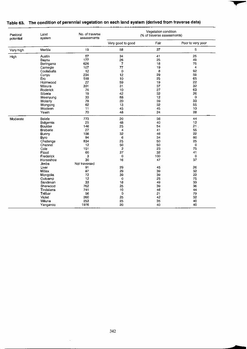
• Table 63. The condition of perennial vegetation on each land system (derived from traverse data)
Pastoral Land No. of traverse Vegetation condition
potential system assessments (% of traverse assessments)
Very good to good Fair Poor to very poor
Very high Merbla 19 58 37 5
High Austin 57 34 41 25 Bayou 177 26 25 49 Beringarra 626 7 18 75 Carnegie 107 77 19 4 Coolabulla 12 0 8 92 Cunyu 234 12 29 59 Ere 518 10 25 65 Holmwood 27 59 19 22 Mileura 301 31 37 32 Roderick 74 10 27 63 Siberia 19 42 32 26 Weenyung 33 88 12 0 Wolarry 78 20 39 33 Wongong 62 13 32 55 Wooleen 11 45 45 10 Yewin 70 48 24 28
Moderate Belele 773 20 36 44 Bidgemia 25 48 40 12 Boulder 146 25 54 21 . Breberle 27 4 41 55 Bunny 108 32 46 22 Byre 94 6 34 60 Challenge 834 25 50 25 Channel 12 50 50 0 Cole 151 2 23 75 Flood 60 27 32 41 Frederick 3 0 100 0 Horseshoe 30 16 47 37 Jimba Not traversed Liver 91 29 45 26 Millex 87 29 39 32 Mongolia 72 39 39 22 Outcamp 12 0 25 75 Sandiman 33 18 49 33 Sherwood 762 25 39 36 Tindalarra 741 10 46 44 Trillbar 56 0 21 79 Violet 260 25 42 32 Wiluna 253 25 35 40 Yanganoo 1976 20 40 40
342
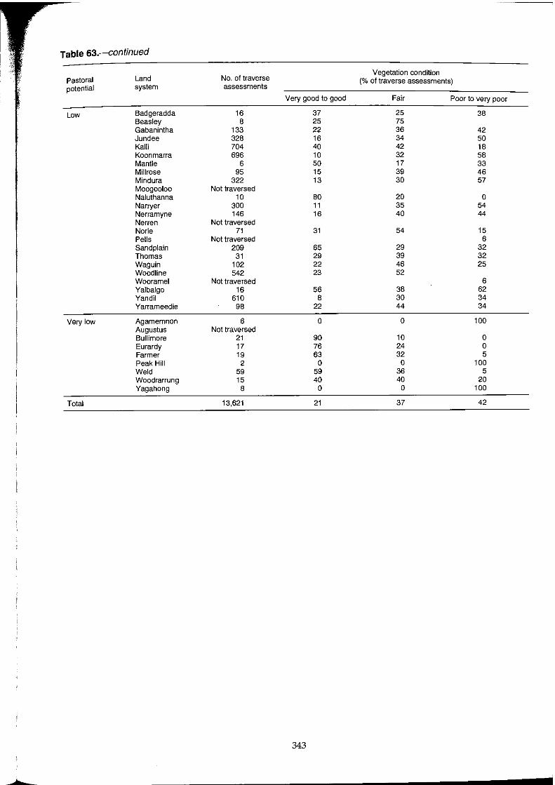
Table 63.--continued
Pastoral Land No. of traverse Vegetation condition
potential system assessments (% of traverse assessments)
Very good to good Fair Poor to very poor
Low Badgeradda 16 37 25 38 Beasley 8 25 75 Gabanintha 133 22 36 42 Jundee 328 16 34 50 Kalli 704 40 42 18 Koonmarra 696 10 32 58 Mantle 6 50 17 33 Millrose 95 15 39 46 Mindura 322 13 30 57 Moogooloo Not traversed Naluthanna 10 80 20 0 Narryer 300 11 35 54 Nerramyne 146 16 40 44 Nerren Not traversed Norie 71 31 54 15 Pells Not traversed 6 Sandplain 209 65 29 32 Thomas 31 29 39 32 Waguin 102 22 46 25 Woodline 542 23 52 Wooramel Not traversed 6 Yalbalgo 16 56 38 62 Yandil 610 8 30 34 Yarrameedie 98 22 44 34
Very low Agamemnon 6 0 0 100 Augustus Not traversed Bullimore 21 90 10 0 Eurardy 17 76 24 0 Farmer 19 63 32 5 Peak Hill 2 0 0 100 Weld 59 59 36 5 Woodrarrung 15 40 40 20 Yagahong 8 0 0 100
Total 13,621 21 37 42
343
....
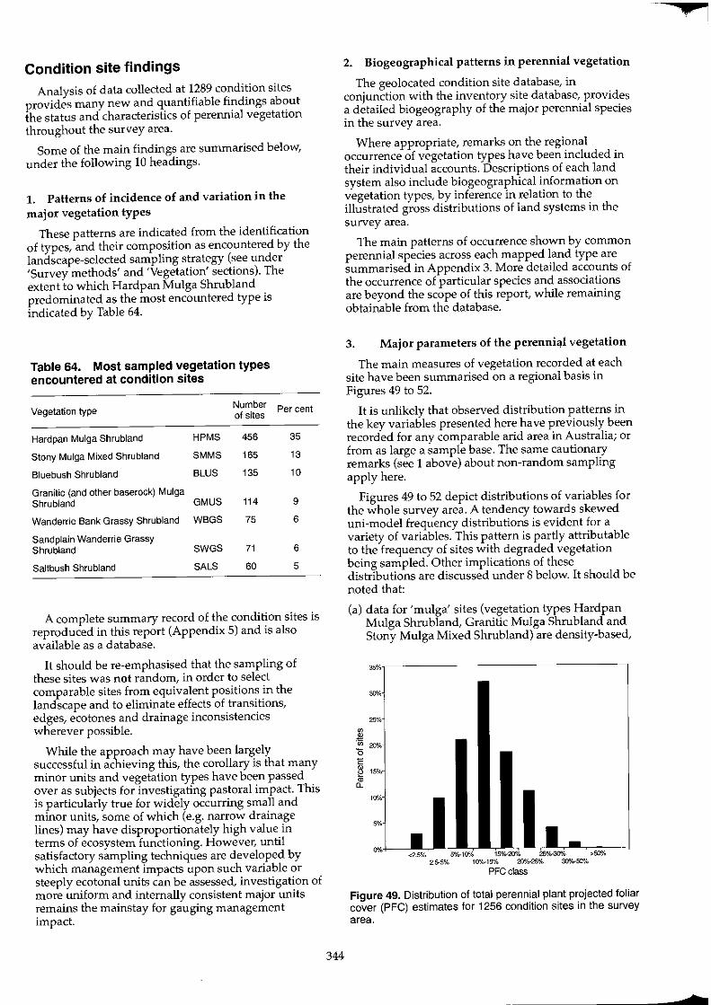
Condition site findings
Analysis of data collected at 1289 condition sites provides many new and quantifiable findings about the status and characteristics of perennial vegetation throughout the survey area.
Some of the main findings are summarised below, under the following 10 headings.
1. Patterns of incidence of and variation in the major vegetation types
These patterns are indicated from the identification of types, and their composition as encountered by the landscape-selected sampling strategy (see under 'Survey methods' and 'Vegetation' sections). The extent to which Hardpan Mulga Shrub land predominated as the most encountered type is indicated by Table 64.
Table 64. Most sampled vegetation types encountered at condition sites
Vegetation type
Hardpan Mulga Shrubland
Stony Mulga Mixed Shrubland
Bluebush Shrubland
Granitic (and other baserock) Mulga Shrubland
Wanderrie Bank Grassy Shrubland
Sand plain Wanderrie Grassy Shrubland
Saltbush Shrubland
HPMS
SMMS
BLUS
GMUS
WBGS
SWGS
SALS
Number of sites
456
165
135
114
75
71
60
Per cent
35
13
10
9
6
6
5
A complete summary record of the condition sites is reproduced in this report (Appendix 5) and is also available as a database.
It should be re-emphasised that the sampling of these sites was not random, in order to select comparable sites from equivalent positions in the landscape and to eliminate effects of transitions, edges, ecotones and drainage inconsistencies wherever possible.
While the approach may have been largely successful in achieving this, the corollary is that many minor units and vegetation types have been passed over as subjects for investigating pastoral impact. This is particularly true for widely occurring small and minor units, some of which (e.g. narrow drainage lines) may have disproportionately high value in terms of ecosystem functioning. However, until satisfactory sampling techniques are developed by which management impacts upon such variable or steeply ecotonal units can be assessed, investigation of more uniform and internally consistent major units remains the mainstay for gauging management impact.
344
2. Biogeographical patterns in perennial vegetation
The geolocated condition site database, in conjunction with the inventory site database, provides a detailed biogeography of the major perennial species in the survey area.
Where appropriate, remarks on the regional occurrence of vegetation types have been included in their individual accounts. Descriptions of each land system also include biogeographical information on vegetation types, by inference in relation to the illustrated gross distributions of land systems in the survey area.
The main patterns of occurrence shown by common perennial species across each mapped land type are summarised in Appendix 3. More detailed accounts of the occurrence of particular species and associations are beyond the scope of this report, while remaining obtainable from the database.
3. Major parameters of the perenni~l vegetation
The main measures of vegetation recorded at each site have been summarised on a regional basis in Figures 49 to 52.
It is unlikely that observed distribution patterns in the key variables presented here have previously been recorded for any comparable arid area in Australia; or from as large a sample base. The same cautionary remarks (see 1 above) about non-random sampling apply here.
Figures 49 to 52 depict distributions of variables for the whole survey area. A tendency towards skewed uni-model frequency distributions is evident for a variety of variables. This pattern is partly attributable to the frequency of sites with degraded vegetation being sampled. Other implications of these distributions are discussed under 8 below. It should be noted that:
(a) data for 'mulga' sites (vegetation types Hardpan Mulga Shrubland, Granitic Mulga Shrub land and Stony Mulga Mixed Shrub land) are density-based,
~%r------------------------------------'
30'10
25%
~ (f) 20%
" C ~ 15%
~ 10%
5%
0% <2.5% 5% .. 10% 15%,,20% 25% .. 30% ,.50%
2.5-5% 10"/0-15% 20% .. 25% 30% .. 50%
PFC class
Figure 49. Distribution of total perennial plant projected foliar cover (PFC) estimates for 1256 condition sites in the survey area.
t
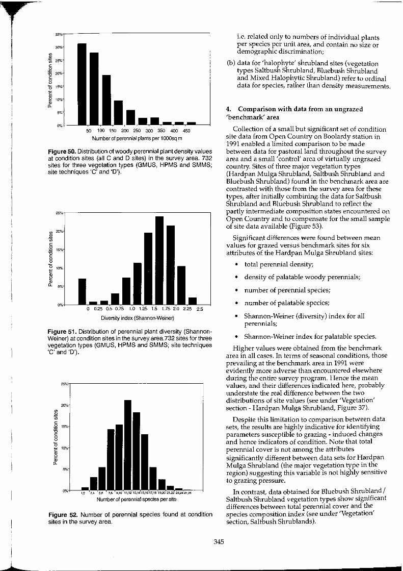
r I
50 1 00 150 200 250 300 350 400 450
Number of perennial plants per 1000sq m
Figure 50. Distribution of woody perennial plant density values at condition sites (all C and D sites) in the survey area. 732 sites for three vegetation types (GMUS, HPMS and SMMS; site techniques 'c' and 'D').
Diversity index (Shannon-Weiner)
Figure 51. Distribution of perennial plant diversity (Shannon· Weiner) at condition sites in the survey area.732 sites for three vegetation types (GMUS, HPMS and SMMS; site techniques 'c' and 'D').
Number of perennial species per site
Figure 52. Number of perennial species found at condition sites in the survey area.
345
i.e. related only to numbers of individual plants per species per unit area, and contain no size or demographic discrimination;
(b) data for 'halophyte' shrubland sites (vegetation types Saltbush Shrubland, Bluebush Shrub land and Mixed Halophytic Shrubland) refer to ordinal data for species, rather than density measurements.
4. Comparison with data from an ungrazed 'benchmark' area
Collection of a small but significant set of condition site data from Open Country on Boolardy station in 1991 enabled a limited comparison to be made between data for pastoral land throughout the survey area and a small' control' area of virtually ungrazed country. Sites of three major vegetation types (Hardpan Mulga Shrubland, Saltbush Shrubland and Bluebush Shrubland) found in the benchmark area are contrasted with those from the survey area for these types, after initially combining. the data for Saltbush Shrubland and Bluebush Shrubland to reflect the partly intermediate composition states encountered on Open Country and to compensate for the small sample of site data available (Figure 53).
Significant differences were found between mean values for grazed versus benchmark sites for six attributes of the Hardpan Mulga Shrub land sites:
• total perennial density;
• density of palatable woody perennials;
• number of perennial species;
• number of palatable species;
• Shannon-Weiner (diversity) index for all perennials;
• Shannon-Weiner index for palatable species.
Higher values were obtained from the benchmark area in all cases. In terms of seasonal conditions, those prevailing at the benchmark area in 1991 were evidently more adverse than encountered elsewhere during the entire survey program. Hence the mean values, and their differences indicated here, probably understate the real difference between the two distributions of site values (see under 'Vegetation' section - Hardpan Mulga Shrubland, Figure 37).
Despite this limitation to comparison between data sets, the results are highly indicative for identifying parameters susceptible to grazing - induced changes and hence indicators of condition. Note that total perennial cover is not among the attributes significantly different between data sets for Hardpan Mulga Shrubland (the major vegetation type in the region) suggesting this variable is not highly sensitive to grazing pressure.
In contrast, data obtained for Bluebush Shrubland I Saltbush Shrubland vegetation types show significant differences between total perennial cover and the species composition index (see under 'Vegetation' section, Saltbush Shrublands).
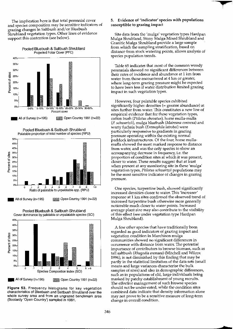
The implication here is that total perennial cover and species composition may be sensitive indicators of grazing changes in Saltbush and/ or Bluebush Shrubland vegetation types. Other lines of evidence support this contention (see below).
Pooled Bluebush & Saltbush Shrubland Projected Foliar Cover (PFC)
_ All of Survey (n=195) l1li Open Country 1991 (n=22)
Pooled Bluebush & Saltbush Shrubland Palatable proportion of total number of species (RPU)
_ All of Survey (n=195) l1li Open Country 1991 (n=22)
Pooled Bluebush & Saltbush Shrubland Cover dominance by palatable or unpalatable species (SCI)
Species Composition Index (SCI)
_ All of Survey (n=195) l1li Open Country 1991 (n=22)
Figure 53. Frequency histograms for key vegetation characteristics of Bluebush and Saltbush Shrubland over the whole survey area and from an ungrazed benchmark area (Boolardy 'Open Country') sampled in 1991.
346
5. Evidence of 'indicator' species with populations susceptible to grazing impact
Site data from the 'mulga' vegetation types Hardpan Mulga Shrub land, Stony Mulga Mixed Shrubland and Granitic Mulga Shrubland provide a large sample from which the sampling stratification, based on distance from stock watering points, allows analysis of species population trends.
Table 65 indicates that most of the common woody perennials showed no significant differences between their rates of incidence and abundance at 1 km from water from those encountered at 4 km or greater, where long-term grazing pressure might be expected to have been less if water distribution limited grazing impact in such vegetation types.
However, four palatable species exhibited significantly higher densities (~ greater abundance) at sites further from water. This constitutes a new line of empirical evidence that for these vegetation types, cotton bush (Ptilotus obovatus), horse mulla-mulla (P. schwartzii), mulga bluebush (Maireana convexa) and warty fuchsia bush (Eremophila latrobei) were particularly responsive to gradients in grazing pressure operating within the existing normal paddock infrastructures. Of the four, horse mullamulla showed the most marked response to distance from water, and was the only species to show an accompanying decrease in frequency, i.e. the proportion of condition sites at which it was present, closer to water. These results suggest that at least when present at any mOnitoring site in these 'mulga' vegetation types, Ptilotus schwartzii populations may be the most sensitive indicator of changes in grazing pressure.
One species, turpentine bush, showed significantly increased densities closer to water. This 'increaser' response at 1 km sites confirmed the observed trend of increased turpentine bush otherwise more generally noticeable much closer to water points. Increased average plant size may also contribute to the visibility of this effect (see under vegetation type Hardpan Mulga Shrubland).
A few other species that have traditionally been regarded as good indicators of grazing impact and vegetation condition in Murchison mulga communities showed no significant differences in occurrence with distance from water. The potential importance of contributors to browse biomass, such as tall saltbush (Rhagodia eremaea) (Mitchell and Wilcox 1994), is not diminished by this finding that may be partly in the statistical limitation of the data sets (small means and large variances characterise the bulk samples of sites) and also in demographic differences, such as in populations of old, large individuals being masked by patchy establishment of young recruits. The effective management of such browse species should not be under-rated, while the condition sites combined data indicate that density information alone may not prove to be a sensitive measure of long-term change in overall condition.
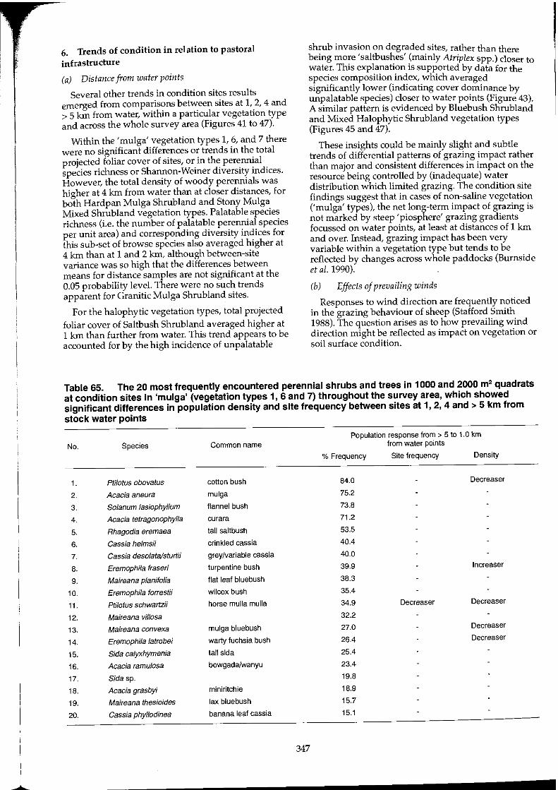
~
6. Trends of condition in relation to pastoral infrastructure
(a) Distance from water points
Several other trends in condition sites results emerged from comparisons between sites at 1, 2, 4 and > 5 kIn from water, within a particular vegetation type and across the whole survey area (Figures 41 to 47).
Within the 'mulga' vegetation types 1, 6, and 7 there were no significant differences or trends in the total projected foliar cover of sites, or in the perennial species richness or Shannon-Weiner diversity indices. However, the total density of woody perennials was higher at 4 kIn from water than at closer distances, for both Hardpan Mulga Shrubland and Stony Mulga Mixed Shrubland vegetation types. Palatable species richness (i.e. the number of palatable perennial species per unit area) and corresponding diversity indices for this sub-set of browse species also averaged higher at 4 kIn than at 1 and 2 kIn, although between-site variance was so high that the differences between means for distance samples are not significant at the 0.05 probability level. There were no such trends apparent for Granitic Mulga Shrub land sites.
For the halophytic vegetation types, total projected foliar cover of Saltbush Shrubland averaged higher at 1 kIn than further from water. This trend appears to be accounted for by the high incidence of unpalatable
bShrub invas~onlobn dhegr,a(ded sites, rather than there
emg more sa t us es mamly Atriplex spp.) closer to water. This explanation is supported by data for the species composition index, which averaged significantly lower (indicating cover dominance by unpalatable species) closer to water points (Figure 43). A similar pattern is evidenced by Bluebush Shrubland and Mixed Halophytic Shrubland vegetation types (Figures 45 and 47).
These insights could be mainly slight and subtle trends of differential patterns of grazing impact rather than major and consistent differences in impact on the resource being controlled by (inadequate) water distribution which limited grazing. The condition site findings suggest that in cases of non-saline vegetation ('mulga' types), the net long-term impact of grazing is not marked by steep 'piosphere' grazing gradients focussed on water points, at least at distances of 1 kIn and over. Instead, grazing impact has been very variable within a vegetation type but tends to be reflected by changes across whole paddocks (Burnside et al. 1990).
(b) Effects of prevailing winds
Responses to wind direction are frequently noticed in the grazing behaviour of sheep (Stafford Smith 1988). The question arises as to how prevailing wind direction might be reflected as impact on vegetation or soil surface condition.
Table 65. The 20 most frequently encountered perennial shrubs and trees in 1000 and 2000 m' quadrats at condition sites in 'mulga' (vegetation types 1, 6 and 7) throughout the survey area, which showed significant differences in population density and site frequency between sites at 1,2, 4 and> 5 km from stock water points
No. Species
1. Ptj/atus obovatus
2. Acacia aneura
3. Solanum lasiophyllum
4. Acacia tetragonophylla
5. Rhagodia eremaea
6. Cassia helmsii
7. Cassia deso/ata/sturtii
8. Eremophila fraseri
9. Maireana planifolia
10. Eremophila forrestii
11. Pti/otus schwartzii
12. Maireana vil/osa
13. Maireana convexa
14. Eremophila latrobei
15. Sida calyxhymenia
16. Acacia ramu/osa
17. Sida sp.
18. Acacia grasbyi
19. Maireana thesioides
20. Cassia phy/lodinea
Common name
cotton bush
mulga
flannel bush
curara
tall saltbush
crinkled cassia
grey/variable cassia
turpentine bush
flat leaf bluebush
wilcox bush
horse mulla mulla
mulga bluebush
warty fuchsia bush
tall sida
bowgadalwanyu
miniritchie
lax bluebush
banana leaf cassia
347
Population response from> 5 to 1.0 km from water points
% Frequency Site frequency Density
84.0
75.2
73.8
71.2
53.5
40.4
40.0
39.9
38.3
35.4
34.9
32.2
27.0
26.4
25.4
23.4
19.8
18.9
15.7
15.1
Decreaser
Decreaser
Increaser
Decreaser
Decreaser
Decreaser
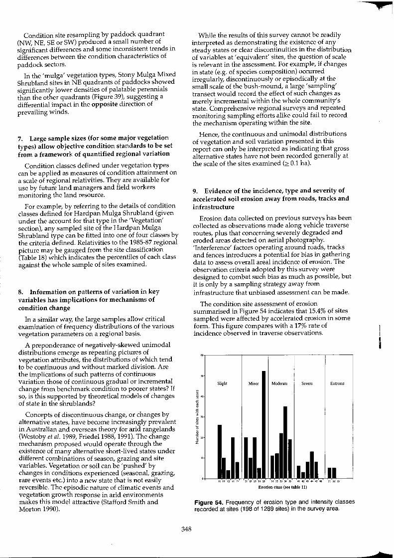
Condition site resampling by paddock quadrant (NW, NE, SE or SW) produced a small number of significant differences and some inconsistent trends in differences between the condition characteristics of paddock sectors.
In the 'mulga' vegetation types, Stony Mulga Mixed Shrub land sites in NE quadrants of paddocks showed significantly lower densities of palatable perennials than the other quadrants (Figure 39), suggesting a differential impact in the opposite direction of prevailing winds.
7. Large sample sizes (for some major vegetation types) allow objective condition standards to be set from a framework of quantified regional variation
Condition classes defined under vegetation types can be applied as measures of condition attainment on a scale of regional relativities. They are available for use by future land managers and field workers monitoring the land resource.
For example, by referring to the details of condition classes defined for Hardpan Mulga Shrubland (given under the account for that type in the 'Vegetation' section), any sampled site of the Hardpan Mulga Shrubland type can be fitted into one of four classes by the criteria defined. Relativities to the 1985-87 regional picture may be gauged from the site classification (Table 18) which indicates the percentiles of each class against the whole sample of sites examined.
8. Information on patterns of variation in key variables has implications for mechanisms of condition change
In a similar way, the large samples allow critical examination of frequency distributions of the various vegetation parameters on a regional basis.
A preponderance of negatively-skewed unimodal distributions emerge as repeating pictures of vegetation attributes, the distributions of which tend to be continuous and without marked division. Are the implications of such patterns of continuous variation those of continuous gradual or incremental change from benchmark condition to poorer states? If so, is this supported by theoretical models of changes of state in the shrublands?
Concepts of discontinuous change, or changes by alternative states, have become increasingly prevalent in Australian and overseas theory for arid rangelands (Westoby et al. 1989, Friedel 1988, 1991). The change mechanism proposed would operate through the existence of many alternative short-lived states under different combinations of season, grazing and site variables. Vegetation or soil can be 'pushed' by changes in conditions experienced (seasonal, grazing, rare events etc.) into a new state that is not easily reversible. The episodic nature of climatic events and vegetation growth response in arid environments makes this model attractive (Stafford Smith and Morton 1990).
348
While the results of this survey cannot be readily interpreted as demonstrating the existence of any steady states or clear discontinuities in the distribution of variables at 'equivalent' sites, the question of scale is relevant in the assessment. For example, if changes in state (e.g. of species composition) occurred irregularly, discontinuously or episodically at the small scale of the bush-mound, a large' sampling' transect would record the effect of such changes as merely incremental within the whole community's state. Comprehensive regional surveys and repeated monitoring sampling efforts alike could fail to record the mechanism operating within the site.
Hence, the continuous and unimodal distributions of vegetation and soil variation presented in this report can only be interpreted as indicating that gross alternative states have not been recorded generally at the scale of the sites examined ('" 0.1 hal·
9. Evidence of the incidence, type and severity of accelerated soil erosion away from roads, tracks and infrastructure
Erosion data collected on previous surveys has been collected as observations made along vehicle traverse routes, plus that concerning severely degraded and eroded areas detected on aerial photography. 'Interference' factors operating around roads, tracks and fences introduces a potential for bias in gathering data to assess overall areal incidence of erosion. The observation criteria adopted by this survey were designed to combat such bias as much as possible, but it is only by a sampling strategy away from infrastructure that unbiased assessment can be made.
The condition site assessment of erosion summarised in Figure 54 indicates that 15.4% of sites sampled were affected by accelerated erosion in some form. This figure compares with a 17% rate of incidence observed in traverse observations.
Slight Minor Moderate Severe Extreme
Erosion class (see table 11)
Figure 54. Frequency of erosion type and intensity classes recorded at sites (198 of 1289 sites) in the survey area.
¥
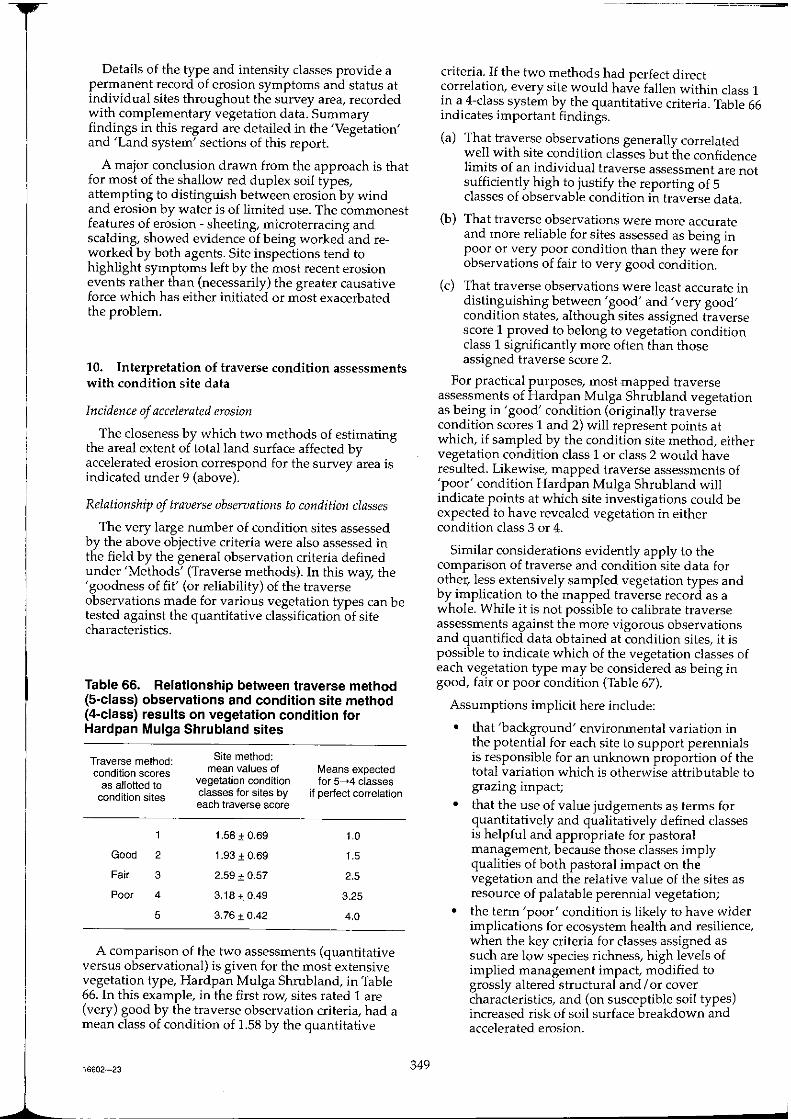
Details of the type and intensity classes provide a permanent record of erosion symptoms and status at individual sites throughout the survey area, recorded with complementary vegetation data. Summary findings in this regard are detailed in the 'Vegetation' and 'Land system' sections of this report.
A major conclusion drawn from the approach is that for most of the shallow red duplex soil types, attempting to distinguish between erosion by wind and erosion by water is of limited use. The commonest features of erosion - sheeting, microterracing and scalding, showed evidence of being worked and reworked by both agents. Site inspections tend to highlight symptoms left by the most recent erosion events rather than (necessarily) the greater causative force which has either initiated or most exacerbated the problem.
10. Interpretation of traverse condition assessments with condition site data
Incidence of accelerated erosion
The closeness by which two methods of estimating the areal extent of total land surface affected by accelerated erosion correspond for the survey area is indicated under 9 (above).
Relationship of traverse observations to condition classes
The very large number of condition sites assessed by the above objective criteria were also assessed in the field by the general observation criteria defined under 'Methods' (Traverse methods). In this way, the 'goodness of fit' (or reliability) of the traverse observations made for various vegetation types can be tested against the quantitative classification of site characteristics.
Table 66. Relationship between traverse method (S-class) observations and condition site method (4-class) results on vegetation condition for Hardpan Mulga Shrubland sites
Traverse method: condition scores
as allotted to condition sites
Good 2
Fair 3
Poor 4
5
Site method: mean values of
vegetation condition classes for sites by each traverse score
1.58 ± 0.69
1.93 ± 0.69
2.59 ± 0.57
3.18±0.49
3.76 ±0.42
Means expected for 5_4 classes
if perfect correlation
1.0
1.5
2.5
3.25
4.0
A comparison of the two assessments (quantitative versus observational) is given for the most extensive vegetation type, Hardpan Mulga Shrubland, in Table 66. In this example, in the first row, sites rated 1 are (very) good by the traverse observation criteria, had a mean class of condition of 1.58 by the quantitative
16602-23 349
criteria. If the two methods had perfect direct correlation, every site would have fallen within class 1 in a 4-class system by the quantitative criteria. Table 66 indicates important findings.
(a) That traverse observations generally correlated well with site condition classes but the confidence limits of an individual traverse assessment are not sufficiently high to justify the reporting of 5 classes of observable condition in traverse data.
(b) That traverse observations were more accurate and more reliable for sites assessed as being in poor or very poor condition than they were for observations of fair to very good condition.
(e) That traverse observations were least accurate in distinguishing between 'good' and 'very good' condition states, although sites assigned traverse score 1 proved to belong to vegetation condition class 1 significantly more often than those assigned traverse score 2.
For practical purposes, most mapped traverse assessments of Hardpan Mulga Shrubland vegetation as being in 'good' condition (originally traverse condition scores 1 and 2) will represent points at which, if sampled by the condition site method, either vegetation condition class 1 or class 2 would have resulted. Likewise, mapped traverse assessments of 'poor' condition Hardpan Mulga Shrubland will indicate points at which site investigations could be expected to have revealed vegetation in either condition class 3 or 4.
Similar considerations evidently apply to the comparison of traverse and condition site data for other, less extensively sampled vegetation types and by implication to the mapped traverse record as a whole. While it is not possible to calibrate traverse assessments against the more vigorous observations and quantified data obtained at condition sites, it is pOSSible to indicate which of the vegetation classes of each vegetation type may be considered as being in good, fair or poor condition (Table 67).
Assumptions implicit here include:
• that 'background' environmental variation in the potential for each site to support perennials is responsible for an unknown proportion of the total variation which is otherwise attributable to grazing impact;
• that the use of value judgements as terms for quantitatively and qualitatively defined classes is helpful and appropriate for pastoral management, because those classes imply qualities of both pastoral impact on the vegetation and the relative value of the sites as resource of palatable perennial vegetation;
• the term 'poor' condition is likely to have wider implications for ecosystem health and resilience, when the key criteria for classes assigned as such are low species richness, high levels of implied management impact, modified to grossly altered structural and / or cover characteristics, and (on susceptible soil types) increased risk of soil surface breakdown and accelerated erosion.
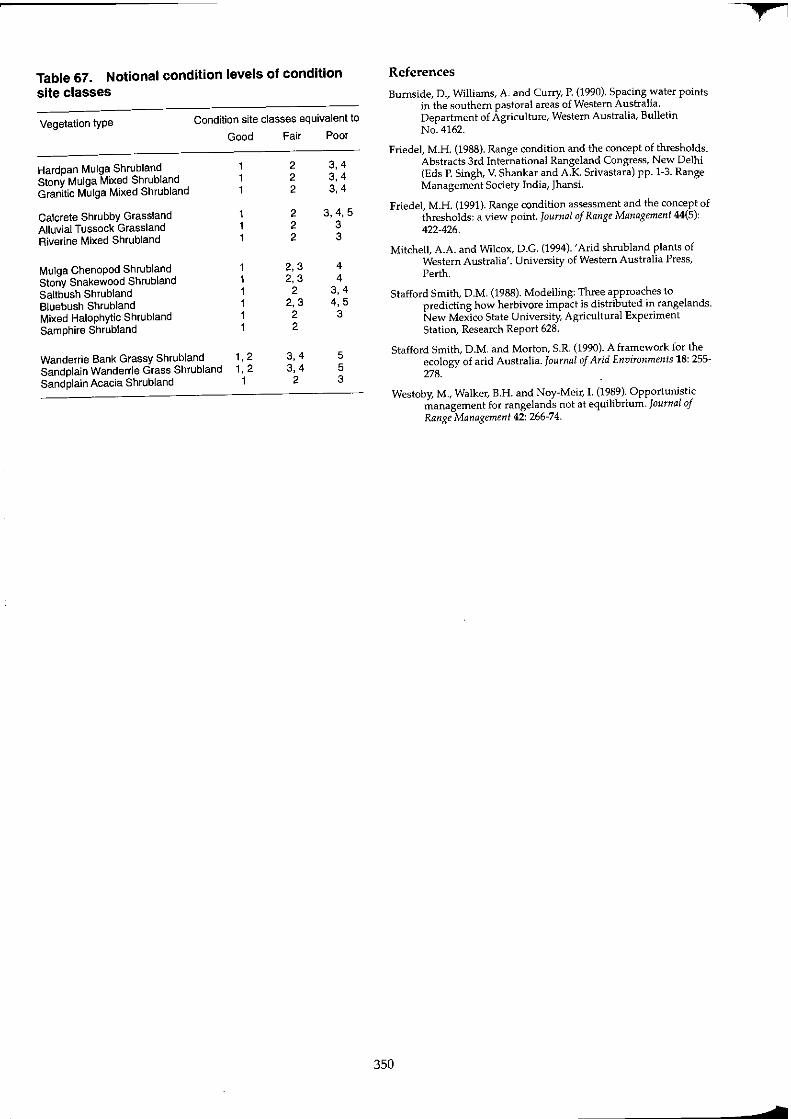
Table 67. Notional condition levels of condition site classes
Vegetation type Condition site classes equivalent to
Good Fair Poor
Hardpan Mulga Shrubland 2 3,4 Stony Mulga Mixed Shrubland 2 3,4 Granitic Mulga Mixed Shrubland 2 3,4
Calcrete Shrubby Grassland 2 3,4,5 Alluvial Tussock Grassland 2 3 Riverine Mixed Shrubland 2 3
Mulga Chenopod Shrubland 1 2,3 4 Stony Snakewood Shrubland 1 2, 3 4 Saltbush Shrubland 1 2 3,4 Bluebush Shrubland 1 2,3 4,5 Mixed Halophytic Shrubland 1 2 3 Samphire Shrubland 1 2
Wanderrie Bank Grassy Shrubland 1,2 3,4 5 Sandplain Wanderrie Grass Shrubland 1,2 3,4 5 Sandplain Acacia Shrubland 1 2 3
350
References
Burnside, D., Williams, A. and Curry, P. (1990). Spacing water points in the southern pastoral areas of Western Australia. Department of Agriculture, Western Australia, Bulletin No. 4162.
Friedel, M.H. (1988), Range condition and the concept of thresholds. Abstracts 3rd International Rangeland Congress, New Delhi (Eds P. Singh, V. Shankar and A.K Srivastara) pp. 1-3. Range Management Society India, Jhansi.
Friedel, M.H. (1991). Range condition assessment and the concept of thresholds: a view point. Journal of Range Management 44(5): 422·426.
Mitchell, A.A. and Wilcox, D.C. (1994). 'Arid shrubland plants of Western Australia'. University of Western Australia Press, Perth.
Stafford Smith, D.M. (1988). Modelling: Three approaches to predicting how herbivore impact is distributed in rangelands. New Mexico State University, Agricultural Experiment Station, Research Report 628.
Stafford Smith, D.M. and Morton, S.R. (1990). A framework for the ecology of arid Australia. Journal of Arid Environments 18: 255-278.
Westoby, M., Walker, B.H. and Noy-Meir, I. (1989). Opportunistic management for rangelands not at equilibrium. Journal of Range Management 42: 266-74.
¥'
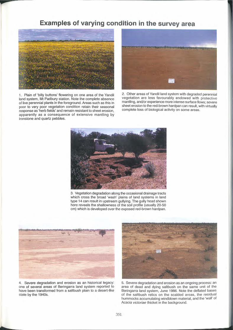
t
Examples of varying condition in the survey area
1. Plain of 'billy buttons' flowering on one area of the Yandi l land system, Mt Padbury station. Note the complete absence of live perennial plants in the foreground. Areas such as this in poor to very poor vegetation condition retain their seasonal response as 'herb fields' and remain resistant to sheet erosion, apparently as a consequence of extensive mantl ing by ironstone and quartz pebbles.
2. Other areas of Yandil land system with degraded perennial vegetation are less favourably endowed with protective mantling, and/or experience more intense surface flows; severe sheet erosion to the red-brown hardpan can result, with virtually complete loss of biological activity on some areas.
3. Vegetation degradation along the occasional drainage tracts which cross the broad 'wash' plains of land systems in land type 14 can result in upstream gullying. The gully head shown here reveals the shallowness of the soi l profi le (usually 20-50 cm) which is developed over the exposed red-brown hardpan.
-
4. Severe degradation and erosion as an historical legacy: one of several areas of Beringarra land system reported to have been transformed from a saltbush plain to a desert- like state by the 1940s.
351
5. Severe degradation and erosion as an ongoing process: an area of dead and dying saltbush on the same unit of the Beringarra land system, June 1986. Note the deflated bases of the saltbush relics on the scalded areas, the residual hummocks accumulating windblown material, and the 'wall' of Acacia victoriae thicket in the background.
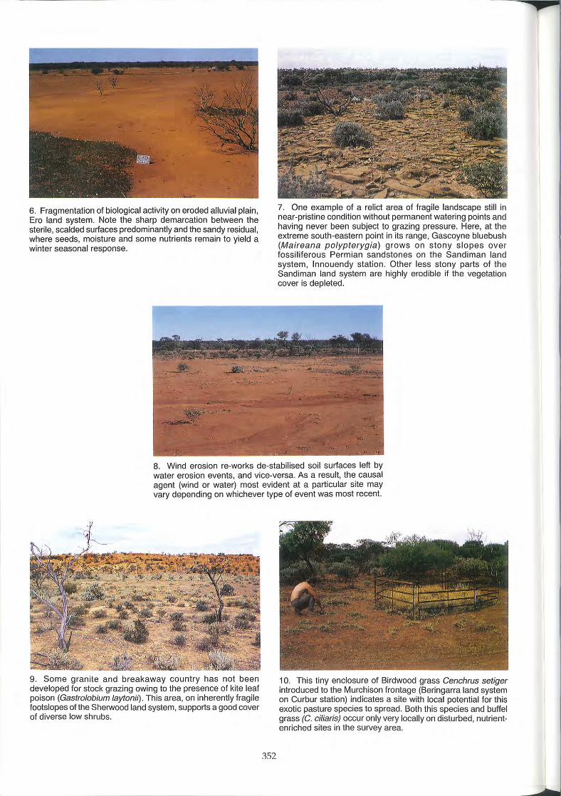
6. Fragmentation of biological activity on eroded alluvial plain, Era land system. Note the sharp demarcation between the sterile, scalded surfaces predominantly and the sandy residual, where seeds, moisture and some nutrients remain to yield a winter seasonal response.
7. One example of a relict area of fragile landscape still in near-pristine condition without permanent watering points and having never been subject to grazing pressure. Here, at the extreme south-eastern point in its range, Gascoyne bluebush (Maireana polypterygia) grows on stony slopes over fossiliferous Permian sandstones on the Sandiman land system, Innouendy station. Other less stony parts of the Sandiman land system are highly erodible if the vegetation cover is depleted.
8. Wind erosion re-works de-stabilised soil surfaces left by water erosion events, and vice-versa. As a result, the causal agent (wind or water) most evident at a particular site may vary depending on whichever type of event was most recent.
9. Some granite and breakaway country has not been developed for stock grazing owing to the presence of kite leaf poison (Gastrolobium laytonil). This area, on inherently fragile footslopes of the Sherwood land system, supports a good cover of diverse low shrubs.
352
10. This tiny enclosure of Birdwood grass Cenchrus setiger introduced to the Murchison frontage (Beringarra land system on Curbur station) indicates a site with local potential for this exotic pasture species to spread. Both this species and buffel grass (C. ciliaris) occur only very locally on disturbed, nutrientenriched sites in the survey area.
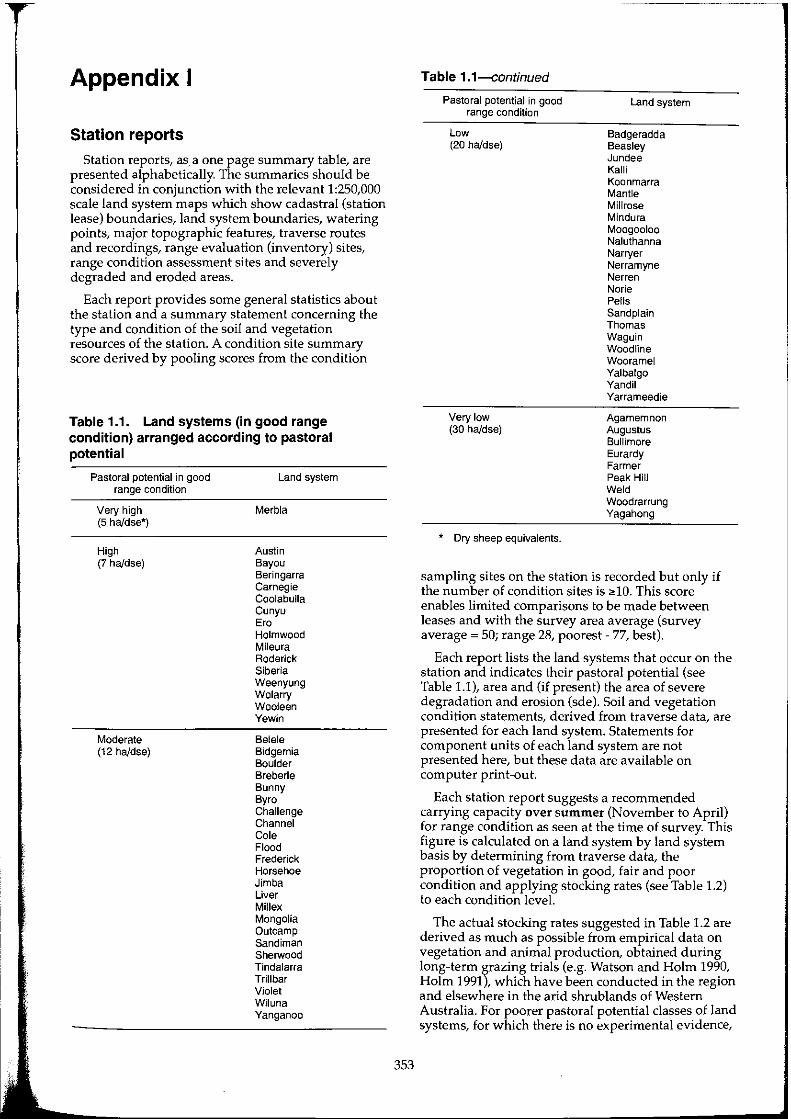
Appendix I
Station reports
Station reports, as a one page summary table, are presented alphabetically. The summaries should be considered in conjunction with the relevant 1:250,000 scale land system maps which show cadastral (station lease) boundaries, land system boundaries, watering points, major topographic features, traverse routes and recordings, range evaluation (inventory) sites, range condition assessment sites and severely degraded and eroded areas.
Each report provides some general statistics about the station and a summary statement concerning the type and condition of the soil and vegetation resources of the station. A condition site summary score derived by pooling scores from the condition
Table 1.1. Land systems (in good range condition) arranged according to pastoral potential
Pastoral potential in good range condition
Very high (5 haJdse*)
High (7 haJdse)
Moderate (12 haJdse)
Land system
Merbla
Austin Bayou Beringarra Carnegie Coolabulla Cunyu Ero Holmwood Mileura Roderick Siberia Weenyung Wolarry Wooleen Yewin
Belele Bidgemia Boulder Breberle Bunny ByrD Challenge Channel Cole Flood Frederick Horsehoe Jimba Liver Millex Mongolia Outcamp Sandiman Sherwood Tindalarra Trillbar Violet Wiluna Yanganoo
353
Table 1.1---continued
Pastoral potential in good range condition
Low (20 haJdse)
Very low (30 haJdse)
* Dry sheep equivalents.
Land system
Badgeradda Beasley Jundee Kalli Koonmarra Mantle Millrose Mindura Moogooloo Naluthanna Narryer Nerramyne Nerren Norie Pells Sand plain Thomas Waguin Woodline Wooramel Yalbalgo Yandil Yarrameedie
Agamemnon Augustus Bullimore Eurardy Farmer Peak Hill Weld Woodrarrung Yagahong
sampling sites on the station is recorded but only if the number of condition sites is ;dO. This score enables limited comparisons to be made between leases and with the survey area average (survey average = 50; range 28, poorest - 77, best).
Each report lists the land systems that occur on the station and indicates their pastoral potential (see Table 1.1), area and (if present) the area of severe degradation and erosion (sde). Soil and vegetation condition statements, derived from traverse data, are presented for each land system. Statements for component units of each land system are not presented here, but these data are available on computer print-out.
Each station report suggests a recommended carrying capacity over summer (November to April) for range condition as seen at the time of survey. This figure is calculated on a land system by land system basis by determining from traverse data, the proportion of vegetation in good, fair and poor condition and applying stocking rates (see Table 1.2) to each condition level.
The actual stocking rates suggested in Table 1.2 are derived as much as possible from empirical data on vegetation and animal production, obtained during long-term grazing trials (e.g. Watson and Holm 1990, Holm 1991), which have been conducted in the region and elsewhere in the arid shrublands of Western Australia. For poorer pastoral potential classes of land systems, for which there is no experimental evidence,

we have drawn on experience from leases on which grazing management has evidently achieved longterm resource conservation, as indicated through range monitoring and records of animal productivity (e.g. Morrissey and O'Connor 1988).
The recommended carrying capacity is a guideline figure for carrying over summer following a significant growth period during the preceding winter. This is the 'normal' situation for pastoral management in the survey area. The figure assumes that all of the station is developed and adequately watered for livestock use.
The recommended carrying capacity is suggested as being a reasonable approximation for long-term sustainable production. There is no requirement for it to be rigidly applied by managers, nor is it appropriate for it to be used as a basis for legislative or regulatory controls.
Each station report shows an overall traverse assessment (i.e. over all land systems on the station) for soil erosion and vegetation condition. For comparison purposes it also shows the average assessment over the whole survey area.
Individual station reports presented in this appendix are for the following stations:
Annean, Austin Downs, Ballythunna, Beebyn, Belele, Beringarra, Billabalong, Boolardy, Boogardie, Bullardoo, Buttah, Byro, Coodardy, Cullculli, Curbur, Dalgaranga, Glen, Erong Springs (part), Hy Brazil, Innouendy, Jingemarra, Kalli, Karbar, Koonmarra, Lakeside, Madoonga, Meeberrie, Meka, Melangata, Mileura, Milly Milly, Moorarie, Mt Farmer, Mt Gould (part), Mt Hale, Mt Narryer, Mt Padbury (part), Mt Wittenoom, Muggon, Murgoo, Nallan, Narloo, New Forest, Nookawarra, Norie, Pinegrove, Polelle, Twin Peaks, Wanarie, Wondinong, Wooleen, Woolgorong, Wynyangoo, Yallalong, Yarlarweelor (part), Yarraquin, Yoothapina (part), Yuin.
354
Table 1.2. Recommended over summer carrying capacities for land systems of each class of pastoral potential, at three levels of vegetation condition
Pastoral potential Vegetation Recommended condition carrying capacity
(ha/dse)
Very high Good 5 Fair 10 Poor 16
High Good 7 Fair 12 Poor 18
Moderate Good 12 Fair 16 Poor 16
Low Good 20 Fair 25 Poor 25
Very low Good 30 Fair 30 Poor 30
References and bibliography Holm, A.McR. (1991). The effect on rangeland vegetation of periodic
protection from sheep grazing in Western Australian arid shrublands (unpublished). Department of Agriculture, Western Australia.
Morrissey, J.G. and O'Connor, R.E.Y. (1988). 28 years of station management. Fair use and a fair go. Paper presented to the 5th Biennial Conference Australian Rangeland Society. Longreach, Queensland, June 13-15.
Watson, LW. and Holm, A.McR. (1990). The benefits of palatable shrubs for wool production in a semi-arid environment. Sixth Australian Rangeland Society Conference Papers, Carnarvon, Western Australia. pp. 25-34.
T
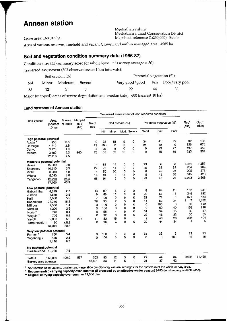
I
I ~
Annean station Meekatharra shire Meekatharra Land Conservation District
Lease area: 168,048 ha Mapsheet reference (1:250,000): Belele
Area of various reserves, freehold and vacant Crown land within managed area: 4585 ha.
Soil and vegetation condition summary data (1986-87)
Condition sites (35) summary score for whole lease: 52 (survey average = 50).
Traversed assessment (302 observations at 1 km intervals):
Soil erosion (%) Perennial vegetation (%)
Nil Minor Moderate Severe Very good / good Fair Poor / very poor
83 12 5 0 22 44 34
Major (mapped) areas of severe degradation and erosion (sde): 600 (nearest 10 hal.
Land systems of Annean station
Traversed assessment of land resource condition
Land system Area % Area Mapped (nearest of lease sde No of Soil erosion (%) Perennial vegetation (%) Rcc* Dec** 10 hal (ha) obs (dse) (dse)
Nil Minor Mod. Severe Good Fair Poor
High pastoral potential Austi.n + 950 0.5 0 73 18 9 0 34 41 25 92 136 Carnegie 4,710 2.8 21 100 0 0 0 81 19 0 620 673 Cunyu 3,170 1.9 13 92 8 0 0 0 23 77 197 453 Mileura 3880 2.3 360 23 35 35 30 0 0 35 65 233 554
12,710 7.5
Moderate pastoral potential Beleie 15,080 9.0 14 86 14 0 0 29 36 35 1,034 1,257 Sherwood 10,910 6.5 22 77 14 9 0 45 23 32 784 909 Violet 3,280 1.9 4 50 50 0 0 0 75 25 205 273 Wiluna 5.040 3.0 19 84 5 11 0 0 42 58 315 420 Yanganoo 42790 25.5 68 94 6 0 0 29 45 26 2,933 3,566
77,100 45.9
Low pastoral potential Gabanintha 4,610 2.7 13 92 8 0 0 8 69 23 188 231 Jundee 5,840 3.5 9 89 11 0 0 22 67 11 246 292 Kalli 8,660 5.2 7 100 0 0 0 29 71 0 371 433 Koonmarra 27,240 16.2 70 90 7 3 0 14 52 34 1,117 1,362 Millrose 2,380 1.4 3 100 0 0 0 0 100 0 95 119 Mindura 4,200 2.5 5 100 0 0 0 0 60 40 168 210 Norie + 740 0.4 0 96 4 0 0 31 54 15 32 37 Waguin + 700 0.4 0 92 8 0 0 22 46 32 30 35 Yandil 9,880 5.9 237 11 82 18 0 9 46 26 395 494 Yarrameedie + 90 < 0.1 0 96 4 0 0 22 44 34 4 5
64,340 38.3
Very low pastoral potential Farmer + 700 0.4 0 100 0 0 0 63 32 5 23 23 Yagahong + £Q ~ 0 100 0 0 0 0 0 100 16 16
1,170 0.7
No pastoral potential Bare lakebed 12,730 7.6
Totals 168,050 100.0 597 302 83 12 5 0 22 44 34 9,098 11,498 Survey area average 13,621 83 11 5 1 21 37 42
+ No traverse observations; erosion and vegetation condition figures are averages for the system over the whole survey area. * Recommended carrying capacity over summer (If preceded by an effective winter season) 9100 dry sheep equivalents (dse). ** Original carrying capacity over summer 11,500 dse.
355
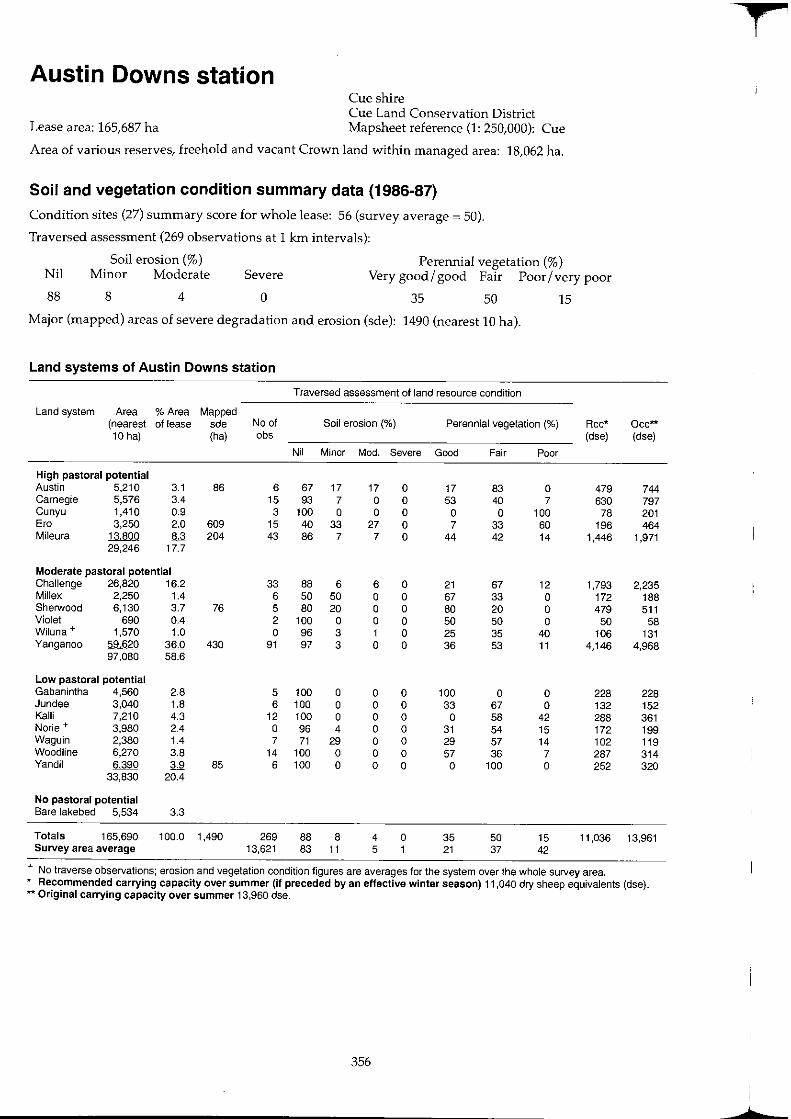
Austin Downs station Cue shire Cue Land Conservation District
Lease area: 165,687 ha Mapsheet reference (1: 250,000): Cue
Area of various reserves, freehold and vacant Crown land within managed area: 18,062 ha.
Soil and vegetation condition summary data (1986-87)
Condition sites (27) summary score for whole lease: 56 (survey average = 50).
Traversed assessment (269 observations at 1 krn intervals):
Soil erosion (%) Perennial vegetation (%) Nil Minor Moderate Severe Very good I good Fair Poor I very poor
88 8 4 0 35 50 15
Major (mapped) areas of severe degradation and erosion (sde): 1490 (nearest 10 hal.
Land systems of Austin Downs station
Traversed assessment of land resource condition
Land system Area % Area Mapped (nearest of lease sde No of Soil erosion (%) Perennial vegetation (%) Rcc* Occ** 10 hal (ha) abs (dse) (dse)
Nil Minor Mod. Severe Good Fair Poor
High pastoral potential Austin 5.210 3.1 86 6 67 17 17 0 17 83 0 479 744 Carnegie 5,576 3.4 15 93 7 0 0 53 40 7 630 797 Cunyu 1,410 0.9 3 100 0 0 0 0 0 100 78 201 Era 3.250 2.0 609 15 40 33 27 0 7 33 60 196 464 Mileura J.;lJlQQ 8.3 204 43 86 7 7 0 44 42 14 1,446 1,971
29,246 17.7
Moderate pastoral potential Challenge 26,820 16.2 33 88 6 6 0 21 67 12 1,793 2,235 Millex 2.250 1.4 6 50 50 0 0 67 33 0 172 188 Sherwood 6,130 3.7 76 5 80 20 0 0 80 20 0 479 511 Violet 690 0.4 2 100 0 0 0 50 50 0 50 58 Wiluna + 1,570 1.0 0 96 3 1 0 25 35 40 106 131 Yanganoo 5M2Q 36.0 430 91 97 3 0 0 36 53 11 4.146 4,968
97.080 58.6
Low pastoral potential Gabanintha 4.560 2.8 5 100 0 0 0 100 0 0 228 228 Jundee 3,040 1.8 6 100 0 0 0 33 67 0 132 152 Kalli 7,210 4.3 12 100 0 0 0 0 58 42 288 361 Norie + 3.980 2.4 0 96 4 0 0 31 54 15 172 199 Waguin 2,380 1.4 7 71 29 0 0 29 57 14 102 119 Woodline 6,270 3.8 14 100 0 0 0 57 36 7 287 314 Yandil 6390 3.9 85 6 100 0 0 0 0 100 0 252 320
33,830 20.4
No pastoral potential Bare lakebed 5.534 3.3
Totals 165.690 100.0 1,490 269 88 8 4 0 35 50 15 11.036 13,961 Survey area average 13.621 83 11 5 1 21 37 42
+ No traverse observations; erosion and vegetation condition figures are averages for the system over the whole survey area. * Recommended carrying capacity over summer (if preceded by an effective winter season) 11,040 dry sheep equivalents (dse). ** Original carrying capacity over summer 13,960 dse.
356
+
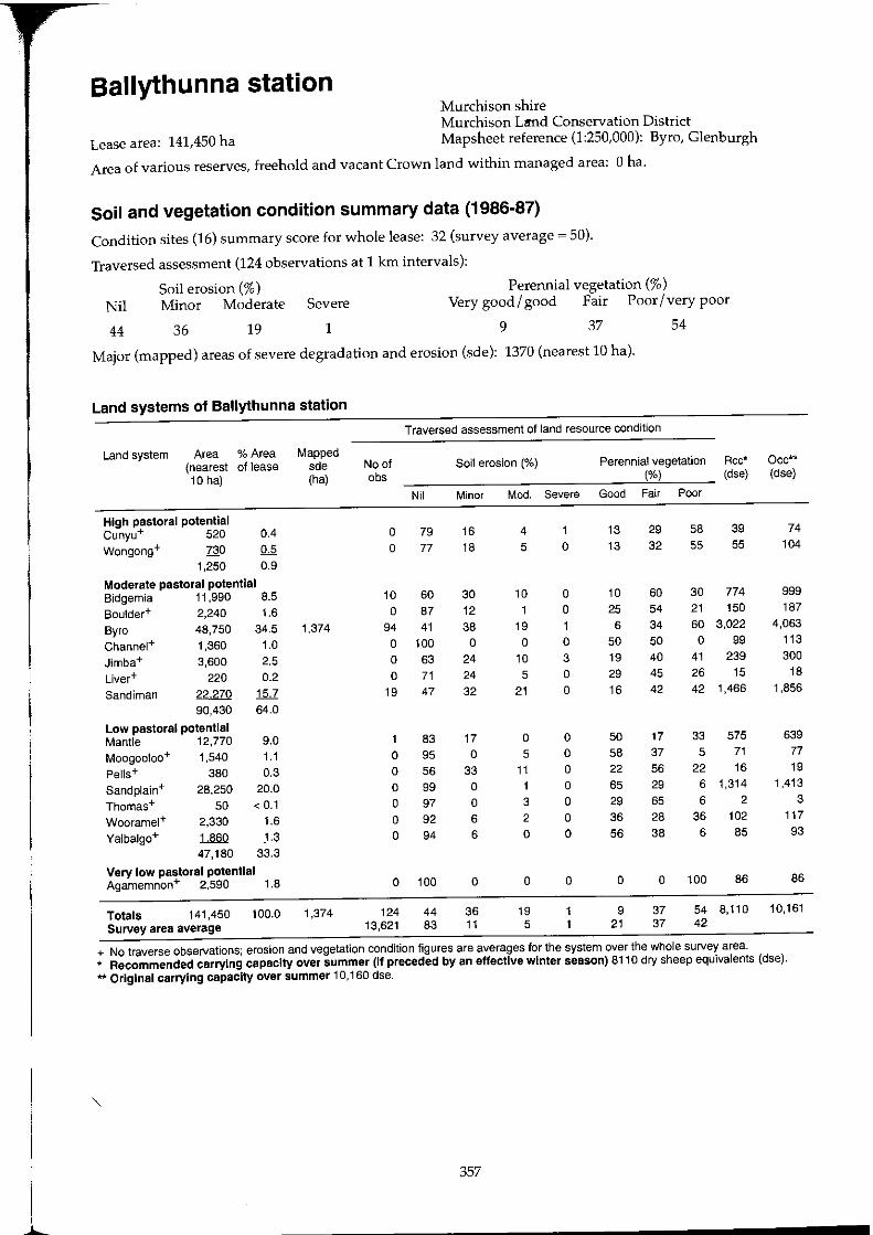
Ballythunna station Murchison shire Murchison Lmd Conservation District
Lease area: 141,450 ha Mapsheet reference (1:250,000): Byro, Glenburgh
Area of various reserves, freehold and vacant Crown land within managed area: Oha.
Soil and vegetation condition summary data (1986-87)
Condition sites (16) summary score for whole lease: 32 (survey average = 50).
Traversed assessment (124 observations at 1 Ian intervals):
Soil erosion (%) Perennial vegetation (%) Nil Minor Moderate Severe Very good / good Fair Poor / very poor
44 36 19 1 9 37 54
Major (mapped) areas of severe degradation and erosion (sde): 1370 (nearest 10 hal.
Land systems of Ballythunna station
Traversed assessment of land resource condition
Land system Area % Area Mapped (nearest of lease sde No of Soil erosion (%) Perennial vegetation Rcc* Oec** 10 hal (ha) obs (%) (dse) (dse)
Nil Minor Mod. Severe Good Fair Poor
High pastoral potential Cunyu+ 520 0.4 0 79 16 4 13 29 58 39 74
Wongong+ 730 0.5 0 77 18 5 0 13 32 55 55 104 1,250 0.9
Moderate pastoral potential Bidgemia 11,990 8.5 10 60 30 10 0 10 60 30 774 999 Boulder+ 2,240 1.6 0 87 12 0 25 54 21 150 187
Byro 48,750 34.5 1,374 94 41 38 19 6 34 60 3,022 4,063 Channel+ 1,360 1.0 0 100 0 0 0 50 50 0 99 113
Jimba+ 3,600 2.5 0 63 24 10 3 19 40 41 239 300 Liver+ 220 0.2 0 71 24 5 0 29 45 26 15 18
Sandirnan 22270 15.7 19 47 32 21 0 16 42 42 1,466 1,856
90,430 64.0
Low pastoral potential Mantle 12,770 9.0 83 17 0 0 50 17 33 575 639
Moogooloo+ 1,540 1.1 0 95 0 5 0 58 37 5 71 77 Pel1s+ 380 0.3 0 56 33 11 0 22 56 22 16 19 Sandplain+ 28,250 20.0 0 99 0 1 0 65 29 6 1,314 1,413
Thomas+ 50 < 0.1 0 97 0 3 0 29 65 6 2 3 Wooramel+ 2,330 1.6 0 92 6 2 0 36 28 36 102 117 Yalbalgo+ 1860 1& 0 94 6 0 0 56 38 6 85 93
47,180 33.3
Very low pastoral potential Agamemnon+ 2,590 1.8 0 100 0 0 0 0 0 100 86 86
Totals 141,450 100.0 1,374 124 44 36 19 9 37 54 8,110 10,161 Survey area average 13,621 83 11 5 21 37 42
+ No traverse observations; erosion and vegetation condition figures are averages for the system over the whole survey area. * Recommended carrying capacity over summer (If preceded by an effective winter season) 8110 dry sheep equivalents (dse). ** Original carrying capacity over summer 10,160 dse.
1 357
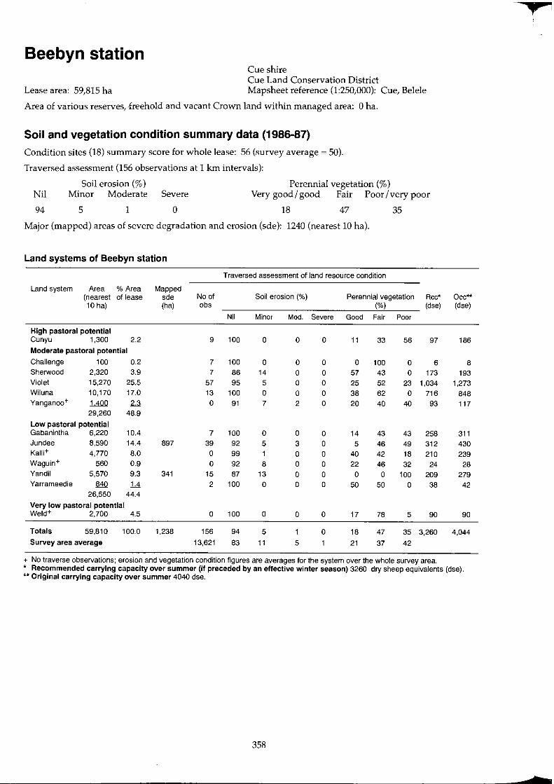
Beebyn station Cue shire Cue Land Conservation District
Lease area: 59,815 ha Mapsheet reference (1:250,000): Cue, Belele
Area of various reserves, freehold and vacant Crown land within managed area: Oha.
Soil and vegetation condition summary data (1986-87)
Condition sites (18) summary score for whole lease: 56 (survey average ~ 50).
Traversed assessment (156 observations at 1 km intervals):
Soil erosion (%) Perennial vegetation (%) Nil Minor Moderate Severe Very good / good Fair Poor / very poor
94 5 1 0 18 47 35
Major (mapped) areas of severe degradation and erosion (sde): 1240 (nearest 10 hal.
Land systems of Beebyn station
Traversed assessment of land resource condition
Land system Area % Area Mapped (nearest of lease sde No of Soil erosion (%) Perennial vegetation Rcc* Occ** 10 hal (ha) obs (%) (dse) (dse)
Nil Minor Mod. Severe Good Fair Poor
High pastoral potential Cunyu 1,300 2.2 9 100 0 0 0 11 33 56 97 186
Moderate pastoral potential
Challenge 100 0.2 7 100 0 0 0 0 100 0 6 8 Sherwood 2,320 3.9 7 86 14 0 0 57 43 0 173 193 Violet 15,270 25.5 57 95 5 0 0 25 52 23 1,034 1,273 Wi luna 10,170 17.0 13 100 0 0 0 38 62 0 716 848 Yanganoo+ 1400 2.3 0 91 7 2 0 20 40 40 93 117
29,260 48.9
Low pastoral potential Gabanintha 6,220 10.4 7 100 0 0 0 14 43 43 258 311 Jundee 8,590 14.4 897 39 92 5 3 0 5 46 49 312 430 Kalli+ 4,770 8.0 0 99 0 0 40 42 18 210 239 Waguin+ 560 0.9 0 92 8 0 0 22 46 32 24 28 Yandil 5,570 9.3 341 15 87 13 0 0 0 0 100 209 279 Yarrameedie 840 ]A 2 100 0 0 0 50 50 0 38 42
26,550 44.4
Very low pastoral potential Weld+ 2,700 4.5 0 100 0 0 0 17 78 5 90 90
Totals 59,810 100.0 1,238 156 94 5 0 18 47 35 3,260 4,044
Survey area average 13,621 83 11 5 21 37 42
+ No traverse observations; erosion and vegetation condition figures are averages for the system over the whole survey area. * Recommended carrying capacity over summer (if preceded by an effective winter season) 3260 dry sheep equivalents (dse). ** Original carrying capacity over summer 4040 dse.
358
+
tr
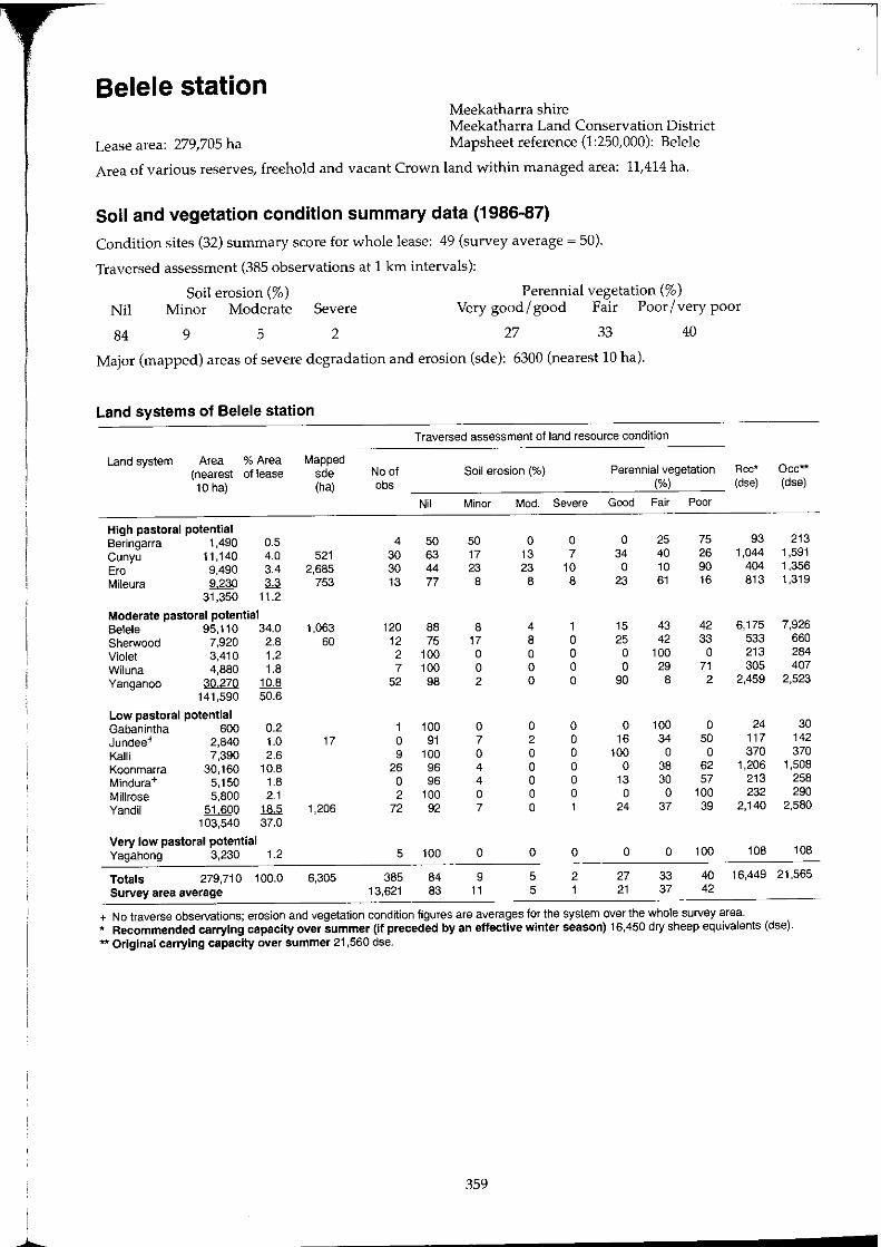
Belele station Meekatharra shire Meekatharra Land Conservation District
Lease area: 279,705 ha Mapsheet reference (1:250,000): Belele
Area of various reserves, freehold and vacant Crown land within managed area: 11,414 ha.
Soil and vegetation condition summary data (1986-87)
Condition sites (32) summary score for whole lease: 49 (survey average ~ 50).
Traversed assessment (385 observations at 1 km intervals):
Soil erosion (%) Perennial vegetation (%) Nil Minor Moderate Severe Very good / good Fair Poor / very poor
84 9 5 2 27 33 40
Major (mapped) areas of severe degradation and erosion (sde): 6300 (nearest 10 hal.
Land systems of Belele station
Traversed assessment of land resource condition
Land system Area % Area Mapped (nearest of lease sde No of Soil erosion (%) Perennial vegetation Rcc* 10 hal (ha) abs (%) (dse)
Nil Minor Mod. Severe Good Fair Poor
High pastoral potential Beringarra 1.490 0.5 4 50 50 0 0 0 25 75 93 Cunyu 11.140 4.0 521 30 63 17 13 7 34 40 26 1.044 Era 9.490 3.4 2.685 30 44 23 23 10 0 10 90 404 Mileura 9230 3.3 753 13 77 8 8 8 23 61 16 813
31.350 11.2
Moderate pastoral potential Belele 95.110 34.0 1.063 120 88 8 4 1 15 43 42 6.175 Sherwood 7.920 2.8 60 12 75 17 8 0 25 42 33 533 Violet 3.410 1.2 2 100 0 0 0 0 100 0 213 Wiluna 4.880 1.8 7 100 0 0 0 0 29 71 305 Yanganoo 30270 1QJ! 52 98 2 0 0 90 8 2 2,459
141.590 50.6
l.ow pastoral potential Gabanintha 600 0.2 1 100 0 0 0 0 100 0 24 Jundee+ 2.840 1.0 17 0 91 7 2 0 16 34 50 117 Kalli 7.390 2.6 9 100 0 0 0 100 0 0 370 Koonmarra 30.160 10.8 26 96 4 0 0 0 38 62 1.206 Mindura+ 5.150 1.8 0 96 4 0 0 13 30 57 213 Millrose 5.800 2.1 2 100 0 0 0 0 0 100 232 Yandil 51600 18.5 1.206 72 92 7 0 1 24 37 39 2.140
103.540 37.0
Very low pastoral potential Yagahong 3.230 1.2 5 100 0 0 0 0 0 100 108
Totals 279.710 100.0 6.305 385 84 9 5 2 27 33 40 16,449 Survey area average 13.621 83 11 5 1 21 37 42
+ No traverse observations; erosion and vegetation condition figures are averages for the system over the whole survey area.
Oec-(dse)
213 1.591 1.356 1.319
7.926 660 284 407
2.523
30 142 370
1.508 258 290
2.580
108
21.565
* Recommended carrying capacity over summer (If preceded by an effective winter season) 16,450 dry sheep equivalents (dse). ** Original carrying capacity over summer 21 ,560 dse.
359
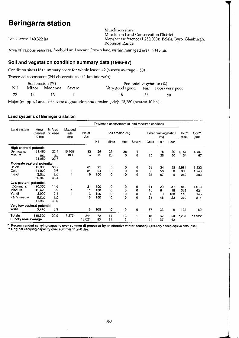
Beringarra station Murchison shire Murchison Land Conservation District
Lease area: 140,322 ha Mapsheet reference (1:250,000): Belele, Byro, Glenburgh, Robinson Range
Area of various reserves, freehold and vacant Crown land within managed area: 9143 ha.
Soil and vegetation condition summary data (1986-87)
Condition sites (16) summary score for whole lease: 42 (survey average ~ 50).
Traversed assessment (244 observations at 1 km intervals):
Perennial vegetation (%) Nil
72
Soil erosion (%) Minor Moderate Severe Very good / good Fair Poor / very poor
14 13 1 18 32 50
Major (mapped) areas of severe degradation and erosion (sde): 15,280 (nearest 10 hal.
Land systems of Beringarra station
Traversed assessment of land resource condition
Land system Area % Area Mapped (nearest of lease sde No of Soil erosion (%) Perennial vegetation Rcc* 10 hal (ha) obs (%) (dse)
Nil Minor Mod. Severe Good Fair Poor
High pastoral potential Beringarra 31,480 22.4 15,160 82 26 33 38 4 4 16 80 1,157 Mileura 470 0.3 109 4 75 25 0 0 25 25 50 34
31,950 22.7
Moderate pastoral potential Belele 42,380 30.2 61 95 5 0 0 38 34 28 2,984 Cole 14,920 10.6 34 94 6 0 0 0 50 50 933 Flood 3640 2.6 9 100 0 0 0 33 67 0 252
60,940 43.4
Low pastoral potential Koonmarra 20,360 14.5 4 21 100 0 0 0 14 29 57 843 Mindura 12,420 8.9 1 11 100 0 0 0 18 64 18 519 Yandil 2,900 2.1 1 3 100 0 0 0 0 0 100 116 Yarrameedie 6280 4.5 13 100 0 0 0 31 46 23 270
41,960 30.0
Very low pastoral potential Weld 5,470 3.9 6 100 0 0 0 67 33 0 182
Totals 140,320 100.0 15,277 244 72 14 13 18 32 50 7,290 Survey area average 13,621 83 11 5 21 37 42
Occ** (dse)
4,497 67
3,532 1,243
303
1,018 621 145 314
182
11,922
* Recommended carrying capacity over summer (If preceded by an effective winter season) 7,290 dry sheep equivalents (dse). ** Original carrying capacity over summer 11,920 dse.
360
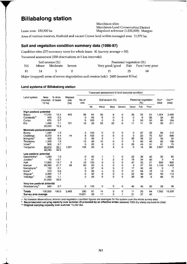
"I
Billabalong station Murchison shire Murchison Land Conservation District
Lease area: 130,920 ha Mapsheet reference (1:250,000): Murgoo
Area of various reserves, freehold and vacant Crown land within managed area: 11,570 ha.
Soil and vegetation condition summary data (1986-87)
Condition sites (27) summary score for whole lease: 41 (survey average ~ 50).
Traversed assessment (330 observations at 1 krn intervals):
Soil erosion (%) Perennial vegetation (%) Nil Minor Moderate Severe Very good I good Fair Poor I very poor
81 14 5 0 11 25 64
Major (mapped) areas of severe degradation and erosion (sde): 2480 (nearest 10 hal.
Land systems of Billabalong station
Traversed assessment of land resource condition
Land system fl<ea % Area Mapped (nearest of lease sde No of Soil erosion (%) Perennial vegetation Rcc* Occ** 10 hal (ha) obs (%) (dse) (dse)
Nil Minor Mod. Severe Good Fair Poor
High pastoral potential Bayou 17,240 13.2 643 98 64 30 6 0 26 23 51 1,424 2,463 Coolabulla+ 420 0.3 0 92 8 0 0 0 8 92 24 60 Cunyu 870 0.7 6 100 0 0 0 0 50 50 60 124 Ero 1480 II 721 18 39 33 22 6 11 11 78 59 211
20,010 15.3
Moderate pastoral potential Bunny 1,340 1.0 3 100 0 0 0 0 67 33 84 112 Challenge 8,370 6.4 44 8 100 0 0 0 0 25 75 521 698 Mongolia+ 420 0.3 0 96 3 1 0 39 39 22 30 35 Tindalarra 1,300 1.0 10 90 10 0 0 0 60 40 82 108 Violet+ 900 0.7 0 93 6 2 0 26 43 31 61 75 Yanganoo 45,910 35.1 1,001 108 90 6 4 0 0 14 86 2,807 3,826
58,240 44.5
Low pastoral potential Gabanintha + 1,290 1.0 0 92 7 1 0 22 36 42 55 65 Jundee+ 70 < 0.1 0 91 7 2 0 16 34 50 3 4 Kalli 17,900 13.7 5 19 100 0 0 0 47 32 21 800 895 Narryer 28,390 21.7 69 60 93 5 2 0 0 37 63 1,133 1,420 Nerramyne+ 130 0.1 0 87 6 5 2 17 40 43 5 7 Norie+ 310 0.2 0 96 4 0 0 31 54 15 13 16 Waguin+ 2,250 1.7 0 92 8 0 0 22 46 32 95 113 Yalbalgo+ ~ II 0 94 6 0 0 56 38 6 68 75
51,830 39.5
Very low pastoral potential Woodrarrung+ 840 0.7 0 100 0 0 0 40 40 20 28 28
Totals 130,920 100.0 2,483 330 81 14 5 0 11 25 64 7,352 10,335 Survey area average 13,621 83 11 5 1 21 37 42
+ No traverse observations; erosion and vegetation condition figures are averages for the system over the whole survey area. * Recommended carrying capacity over summer (if preceded by an effective winter season) 7350 dry sheep equivalents (dse). ** Original carrying capacity over summer 10,330 dse.
361
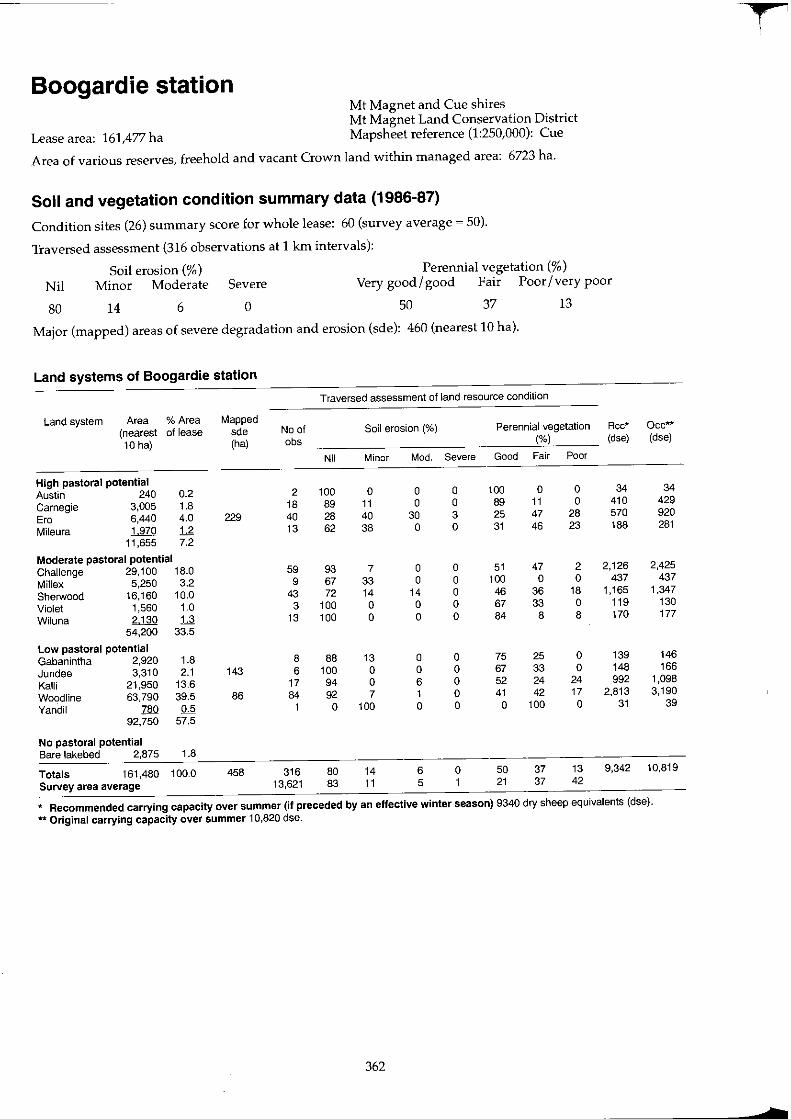
Boogardie station Mt Magnet and Cue shires Mt Magnet Land Conservation Distriel
Lease area: 161,477 ha Mapsheet reference (1:250,000): Cue
Area of various reserves, freehold and vacant Crown land within managed area: 6723 ha.
Soil and vegetation condition summary data (1986-87)
Condition sites (26) summary score for whole lease: 60 (survey average ~ 50).
Traversed assessment (316 observations at 1 km intervals):
Soil erosion (% ) Perennial vegetation (%) Nil Minor Moderate Severe Very good / good Fair Poor / very poor
80 14 6 0 50 37 13
Major (mapped) areas of severe degradation and erosion (sde): 460 (nearest 10 hal.
Land systems of Boogardie station
Traversed assessment of land resource condition
Land system Area % Area Mapped (nearest of lease sde No of Soil erosion (%) Perennial vegetation Rcc* Occ** 10 hal (ha) obs (%) (dse) (dse)
Nil Minor Mod. Severe Good Fair Poor
High pastoral potential Austin 240 0.2 2 100 a a a 100 a a 34 34 Carnegie 3,005 1.8 18 89 11 a a 89 11 a 410 429 Ero 6,440 4.0 229 40 28 40 30 3 25 47 28 570 920 Mileura 1970 U 13 62 38 a a 31 46 23 188 281
11,655 7.2
Moderate pastoral potential Challenge 29,100 18.0 59 93 7 a a 51 47 2 2,126 2,425 Mi1Iex 5,250 3.2 9 67 33 a a 100 a a 437 437 Sherwood 16,160 10.0 43 72 14 14 a 46 36 18 1,165 1,347 Violet 1,560 1.0 3 100 a a a 67 33 a 119 130 Wi luna 2,130 :!.d 13 100 a a a 84 8 8 170 177
54,200 33.5
Low pastoral potential Gabanintha 2,920 1.8 8 88 13 a a 75 25 a 139 146 Jundee 3,310 2.1 143 6 100 a a a 67 33 a 148 166 Kalli 21,950 13.6 17 94 a 6 a 52 24 24 992 1,098 Woodline 63,790 39.5 86 84 92 7 1 a 41 42 17 2,813 3,190 Yandil 780 0.5 1 a 100 a a a 100 a 31 39
92,750 57.5
No pastoral potential Bare lakebed 2,875 1.8
Totals 161,480 100.0 458 316 80 14 6 a 50 37 13 9,342 10,819 Survey area average 13,621 83 11 5 1 21 37 42
* Recommended carrying capacity over summer (if preceded by an effective winter season) 9340 dry sheep equivalents (dse). ** Original carrying capacity over summer 10,820 dse.
362
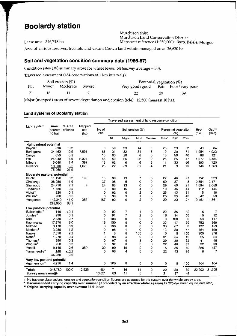
Boolardy station Murchison shire Murchison Land Conservation District
Lease area: 346,748 ha Mapsheet reference (1:250,000): Byro, Belele, Murgoo
Area of various reserves, freehold and vacant Crown land within managed area: 26,630 ha.
Soil and vegetation condition summary data (1986-87)
Condition sites (36) summary score for whole lease: 54 (survey average = 50).
Traversed assessment (484 observations at 1 km intervals):
Soil erosion (%) Perennial vegetation (%) Nil Minor Moderate Severe Very good I good Fair Poor I very poor
71 16 11 2 22 39 39
Major (mapped) areas of severe degradation and erosion (sde): 12,500 (nearest 10 hal.
Land systems of Boolardy station
Traversed assessment of land resource condition
Land system Area % Area Mapped (nearest of lease sde No of Soil erosion (%) Perennial vegetation Rcc* Occ** 10 hal (ha) abs (%) (dse) (dse)
Nil Minor Mod. Severe Good Fair Poor
Hgh pastoral potential Bayou+ 590 0.2 0 50 33 14 3 25 23 52 49 84 Beringarra 34,460 9.9 7,591 85 31 32 31 6 9 20 71 1,954 4,923 Cunyu 850 0.3 10 80 20 0 0 10 50 40 66 121 Era 24,040 6.9 2,025 65 50 26 22 2 28 25 47 1,977 3,434 Mileura 5,040 1.4 391 18 82 6 6 6 11 33 56 353 720 Roderick 10980 3.2 1,670 23 22 39 35 4 21 9 70 746 1,569
75,960 21.9
Moderate pastoral potential Belele 11,150 3.2 132 15 80 13 7 0 27 46 27 752 929 Challenge 38,050 11.0 37 95 5 0 0 60 37 3 2,854 3,171 Sherwood 24,710 7.1 4 24 88 13 0 0 29 50 21 1,694 2,059 Tindalarra+ 1,730 0.5 0 80 16 4 0 10 46 44 112 144 Violet+ 220 0.1 0 92 6 2 0 26 43 31 15 18 Wiluna+ 700 0.2 0 96 3 1 0 25 35 40 47 58 Yanganoo 142340 41.0 353 167 92 6 2 0 20 53 27 9,467 11,861
218,900 63.1
Low pastoral potential Gabanintha+ 140 < 0.1 0 92 7 1 0 22 36 42 6 7 Jundee+ 230 0.1 0 91 7 2 0 16 34 50 10 12 Kalli 2,330 0.7 1 100 0 0 0 0 100 0 93 117 Koonmarra 17,370 5.0 15 100 0 0 0 33 47 20 752 869 Millrose 3,170 0.9 3 100 0 0 0 33 67 0 137 159 Mindura+ 3,980 1.2 0 96 4 0 0 13 30 57 164 199 Narryer 7,510 2.2 1 0 0 100 0 0 0 100 300 376 Norie+ 1,270 0.4 0 96 4 0 0 31 54 15 55 64 Thomas+ 950 0.3 0 97 0 3 0 29 39 32 41 48 Waguin+ 750 0.2 0 92 8 0 0 22 46 32 32 38 Vandil 9,140 2.6 359 20 90 10 0 0 5 55 40 356 457 Yarrameedie+ 140 ~ 0 96 4 0 0 22 43 35 6 '7
46,980 13.6
Very low pastoral potential Agamemnon+ 4,910 1.4 0 100 0 0 0 0 0 100 164 164
Totals 346,750 100.0 12,525 484 71 16 11 2 22 39 39 22,202 31,608 Survey area average 13,621 83 11 5 1 21 37 42
+ No traverse observations; erosion and vegetation condition figures are averages for the system over the whole survey area. * Recommended carrying capacity over summer (if preceded by an effective winter season) 22,220 dry sheep equivalents (dse). ** Original carrying capacity over summer 31 ,61 0 dse.
363
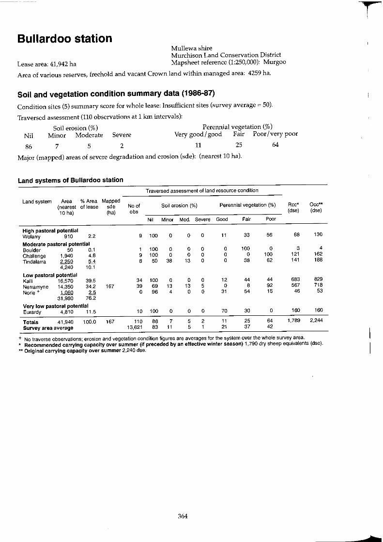
Bullardoo station Mullewa shire Murchison Land Conservation District
Lease area: 41,942 ha Mapsheet reference (1:250,000): Murgoo
Area of various reserves, freehold and vacant Crown land within managed area: 4259 ha.
Soil and vegetation condition summary data (1986-87)
Condition sites (5) summary score for whole lease: Insufficient sites (survey average = 50).
Traversed assessment (110 observations at 1 km intervals):
Perennial vegetation (%) Nil
86
Soil erosion (%) Minor Moderate Severe Very good I good Fair Poor I very poor
7 5 2 11 25 64
Major (mapped) areas of severe degradation and erosion (sde): (nearest 10 hal.
Land systems of Bullardoo station
Traversed assessment of land resource condition
Land system Area % Area Mapped (nearest of lease sde No of Soil erosion (%) Perennial vegetation (%) Rcc* 10 hal (ha) obs (dse)
Nil Minor Mod. Severe Good Fair Poor
High pastoral potential Wolarry 910 2.2 9 100 a a a 11 33 56 68
Moderate pastoral potential Boulder 50 0.1 1 100 a a a a 100 a 3 Challenge 1.940 4.6 9 100 a a a a a 100 121 Tindalarra 2250 5.4 8 50 38 13 a a 38 62 141
4,240 10.1
Low pastoral potential Ka11i 16,570 39.5 34 100 a a a 12 44 44 683 Nerramyne 14,350 34.2 167 39 69 13 13 5 a 8 92 567 Norie + 1060 2.5 a 96 4 a a 31 54 15 46
31,980 76.2
Very low pastoral potential Eurardy 4,810 11.5 10 100 a a a 70 30 a 160
Totals 41,940 100.0 167 110 86 7 5 2 11 25 64 1,789 Survey area average 13,621 83 11 5 1 21 37 42
+ No traverse observations; erosion and vegetation condition figures are averages for the system over the whole survey area.
Occ** (dse)
130
4 162 188
829 718
53
160
2,244
* Recommended carrying capacity over summer (if preceded by an effective winter season) 1,790 dry sheep equivalents (dse). ** Original carrying capacity over summer 2,240 dse.
364
1 i
t
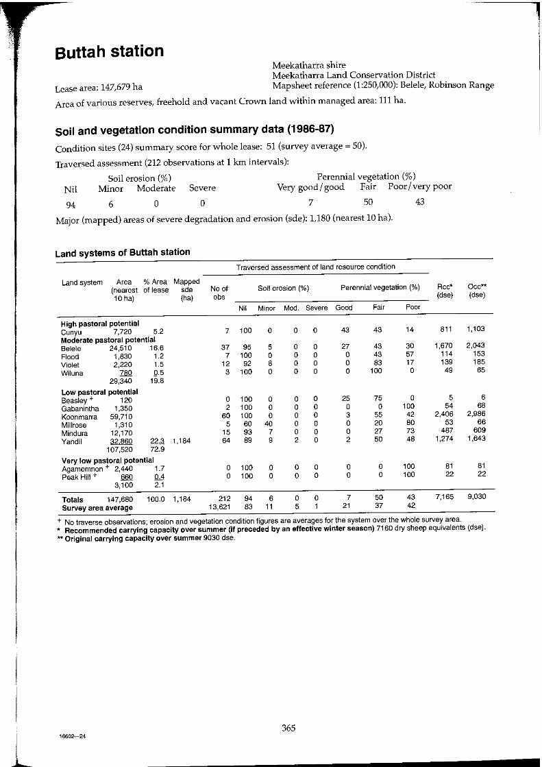
l
Buttah station Meekatharra shire Meekatharra Land Conservation District
Lease area: 147,679 ha Mapsheet reference (1:250,000): Belele, Robinson Range
Area of various reserves, freehold and vacant Crown land within managed area: 111 ha.
Soil and vegetation condition summary data (1986-87)
Condition sites (24) summary score for whole lease: 51 (survey average = 50).
Traversed assessment (212 observations at 1 km intervals):
Soil erosion (%) Perennial vegetation (%) Nil Minor Moderate Severe Very good / good Fair Poor / very poor
94 6 o o 7 50 43
Major (mapped) areas of severe degradation and erosion (sde): 1,180 (nearest 10 hal.
Land systems of Buttah station
Traversed assessment of land resource condition
Land system Area % Area Mapped (nearest of lease sde No of Soil erosion (%) Perennial vegetation (%) Rcc* 10 hal (ha) obs (dse)
Nil Minor Mod. Severe Good Fair Poor
High pastoral potential Cunyu 7,720 5.2 7 100 a a a 43 43 14 811 Moderate pastoral potential Belele 24.510 16.6 37 95 5 a a 27 43 30 1,670 Flood 1,830 1.2 7 100 a a a a 43 57 114 Violet 2,220 1.5 12 92 8 a a a 83 17 139 Wiluna 780 0.5 3 100 a a a a 100 a 49
29,340 19.8
Low pastoral potential Beasley + 120 a 100 a a a 25 75 a 5 Gabanintha 1,350 2 100 a a a a a 100 54 Koonmarra 59,710 60 100 a a a 3 55 42 2,406 Millrose 1,310 5 60 40 a a a 20 80 53 Mindura 12,170 15 93 7 a a a 27 73 487 Yandil ~ 22.3 1,184 64 89 9 2 a 2 50 48 1,274
107,520 72.9
Very low pastoral potential Agamemnon + 2,440 1.7 a 100 a a a a a 100 81 Peak Hill + 660 0.4 a 100 a a a a a 100 22
3,100 2.1
Totals 147,680 100.0 1,184 212 94 6 a a 7 50 43 7,165 Survey area average 13,621 83 11 5 1 21 37 42
+ No traverse observations; erosion and vegetation condition figures are averages for the system over the whole survey area.
Occ** (dse)
1,103
2,043 153 185
65
6 68
2,986 66
609 1,643
81 22
9,030
* Recommended carrying capacity over summer (If preceded by an effective winter season) 7160 dry sheep equivalents (dse). ** Original carrying capacity over summer 9030 dse.
365 16602-24
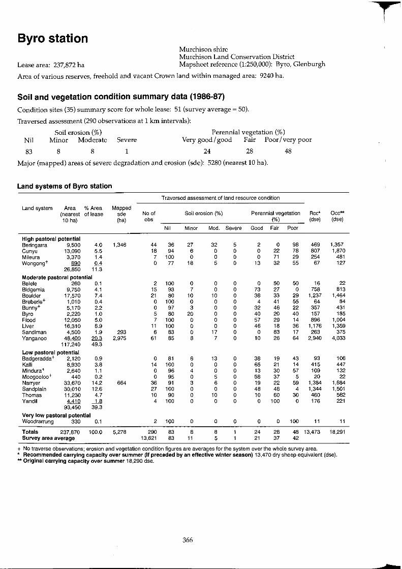
T Byro station
Murchison shire Murchison Land Conservation District
Lease area: 237,872 ha Mapsheet reference (1:250,000): Byro, Glenburgh
Area of various reserves, freehold and vacant Crown land within managed area: 9240 ha.
Soil and vegetation condition summary data (1986-87)
Condition sites (35) summary score for whole lease: 51 (survey average ~ 50).
Traversed assessment (290 observations at 1 kIn intervals):
Soil erosion (%) Perennial vegetation (%) Nil Minor Moderate Severe Very good I good Fair Poor I very poor
83 8 8 1 24 28 48
Major (mapped) areas of severe degradation and erosion (sde): 5280 (nearest 10 hal.
Land systems of Byro station
Traversed assessment of land resource condition
Land system Area % Area Mapped (nearest of lease sde No of Soil erosion (%) Perennial vegetation Rcc* Occ** 10 hal (ha) obs ('Yo) (dse) (dse)
Nil Minor Mod. Severe Good Fair Poor
High pastoral potential Beringarra 9,500 4.0 1,346 44 36 27 32 5 2 0 98 469 1,357 Cunyu 13,090 5.5 18 94 6 0 0 0 22 78 807 1,870 Mileura 3,370 1.4 7 100 0 0 0 0 71 29 254 481 Wongong+ 890 0.4 0 77 18 5 0 13 32 55 67 127
26,850 11.3
Moderate pastoral potential Belele 260 0.1 2 100 0 0 0 0 50 50 16 22 Bidgemia 9,750 4.1 15 93 7 0 0 73 27 0 758 813 Boulder 17,570 7.4 21 80 10 10 0 38 33 29 1,237 1.464 Breberle+ 1,010 0.4 0 100 0 0 0 4 41 55 64 84 Bunny+ 5,170 2.2 0 97 3 0 0 32 46 22 357 431 Byro 2,220 1.0 5 80 20 0 0 40 20 40 157 185 Flood 12,050 5.0 7 100 0 0 0 57 29 14 896 1,004 Liver 16,310 6.9 11 100 0 0 0 46 18 36 1,176 1,359 Sandiman 4,500 1.9 293 6 83 0 17 0 0 83 17 263 375 Yanganoo 48.400 20.3 2,975 61 85 8 7 0 10 26 64 2,940 4,033
117,240 49.3
Low pastoral potential 8adgeradda + 2,120 0.9 0 81 6 13 0 38 19 43 93 106 Kalii 8,930 3.8 14 100 0 0 0 65 21 14 415 447 Mindura+ 2,640 1.1 0 96 4 0 0 13 30 57 109 132 Moogooloo+ 440 0.2 0 95 0 5 0 58 37 5 20 22 Narryer 33,670 14.2 664 36 91 3 6 0 19 22 59 1.384 1,684 Sandplain 30,010 12.6 27 100 0 0 0 48 48 4 1,344 1,501 Thomas 11,230 4.7 10 90 0 10 0 10 60 30 460 562 Yandil 4410 -.il 4 100 0 0 0 0 100 0 176 221
93,450 39.3
Very low pastoral potential Woodrarrung 330 0.1 2 100 0 0 0 0 0 100 11 11
Totals 237,870 100.0 5,278 290 83 8 8 24 28 48 13,473 18.291 Survey area average 13,621 83 11 5 21 37 42
+ No traverse observations; erosion and vegetation condition figures are averages for the system over the whole survey area. * Recommended carrying capacity over summer (If preceded by an effective winter season) 13,470 dry sheep equivalent (dse). ** Original carrying capacity over summer 18,290 dse.
366
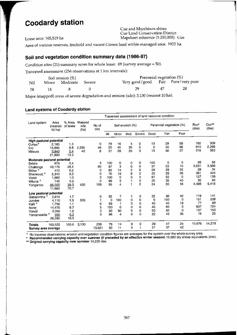
1
Coodardy station Cue and Murchison shires Cue Land Conservation District
Lease area: 165,519 ha Mapsheet reference (1:250,000): Cue
Area of various reserves, freehold and vacant Crown land within managed area: 1922 ha.
Soil and vegetation condition summary data (1986-87)
Condition sites (21) summary score for whole lease: 69 (survey average = 50).
Traversed assessment (236 observations at 1 km intervals):
Soil erosion (%) Perennial vegetation (%) Nil Minor Moderate Severe Very good / good Fair Poor / very poor
78 14 8 o 29 47 24
Major (mapped) areas of severe degradation and erosion (sde): 3,130 (nearest 10 hal.
Land systems of Coodardy station
Traversed assessment of land resource condition
Land system Area % Area Mapped (nearest of lease sde No of Soil erosion (%) Perennial vegetation (%) Rcc* 10 hal (hal abs (dse)
Nil Minor Mod. Severe Good Fair Poor
High pastoral potential Cunyu+ 2,160 1.3 a 79 16 4 a 13 29 58 162 Era 15,860 9.6 2,335 46 20 45 35 a 2 30 68 910 Mileura 3940 2d 40 8 37 38 25 a 13 50 37 316
21,960 13.3
Moderate pastoral potential Belele 670 0.4 3 100 a a a 100 a a 56 Challenge 43,170 26.1 60 97 3 a a 37 53 10 3,031 Millex+ 410 0.2 a 83 14 3 0 29 39 32 28 Sherwood + 5,310 3.2 0 70 19 9 2 25 39 36 361 Violet 1,660 1.0 3 100 0 a 0 67 33 0 127 Wiluna + 740 0.5 0 96 3 1 0 25 35 40 50 Yanganoo 65020 ~ 420 108 95 4 1 0 34 50 16 4,498
11,690 70.7
Low pastoral potential Gabanintha + 2,810 1.7 0 92 7 1 0 22 36 42 119 Jundee 4,110 2.5 335 1 0 100 0 0 0 100 0 151 Kalli + 1,750 1.1 0 99 1 0 0 40 42 18 77 Norie 14,470 8.7 5 100 0 0 0 40 60 0 637 Yandil 3,050 1.8 2 50 50 0 0 50 50 0 137 Yarrameedie + 390 !L2 0 96 4 0 0 22 43 35 16
26,580 16.0
Totals 165,520 100.0 3,130 236 78 14 8 0 29 47 24 10,676 Survey area average 13,621 83 11 5 1 21 37 42
+ No traverse observations; erosion and vegetation condition figures are averages for the system over the whole survey area.
Occ** (dse)
309 2,266
563
56 3,598
34 443 138
62 5,418
141 206
88 724 153
20
14,219
* Recommended carrying capacity over summer (if preceded by an effective winter season) 10,680 dry sheep equivalents (dse). ** Original carrying capacity over summer 14,220 dse.
367
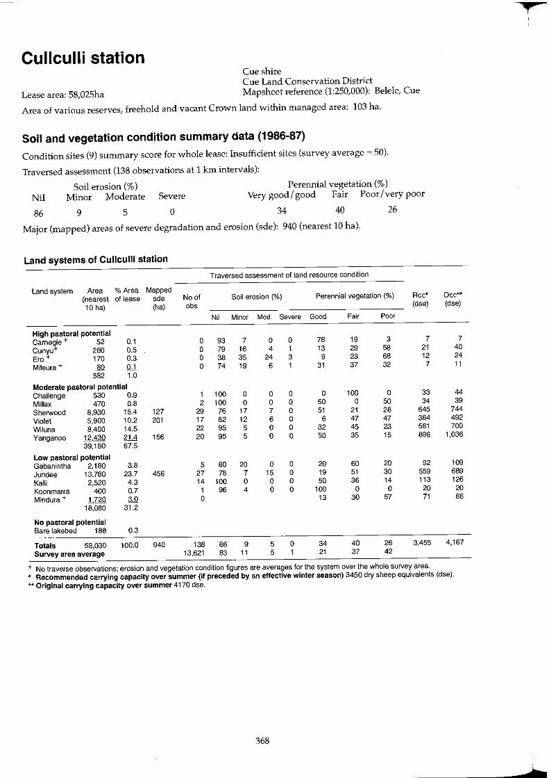
Cullculli station Cue shire Cue Land Conservation District
Lease area: 58,025ha Mapsheet reference (1:250,000): Belele, Cue
Area of various reserves, freehold and vacant Crown land within managed area: 103 ha.
Soil and vegetation condition summary data (1986-87)
Condition sites (9) summary score for whole lease: Insufficient sites (survey average ~ 50).
Traversed assessment (138 observations at 1 km intervals):
Perennial vegetation (%) Nil
86
Soil erosion (%) Minor Moderate Severe Very good/ good Fair Poor/very poor
9 5 o 34 40 26
Major (mapped) areas of severe degradation and erosion (sde): 940 (nearest 10 hal·
Land systems of Cullculli station
Traversed assessment of land resource condition
Land system Area % Area Mapped (nearest of lease sde No of Soil erosion (%) Perennial vegetation (%) Rcc* 10 hal (ha) obs (dse)
Nil Minor MOd. Severe Good Fair Poor
High pastoral potential Carnegie + 52 0.1 a 93 7 a a 78 19 3 7 Cunyu+ 280 0.5 a 79 16 4 1 13 29 58 21 Ero+ 170 0.3 a 38 35 24 3 9 23 68 12 Mileura + 80 QJ. a 74 19 6 1 31 37 32 7
582 1.0
Moderate pastoral potential Challenge 530 0.9 1 100 a a a a 100 a 33 Millex 470 0.8 2 100 a a a 50 a 50 34 Sherwood 8,930 15.4 127 29 76 17 7 a 51 21 28 645 Violet 5,900 10.2 201 17 82 12 6 a 6 47 47 364 Wiluna 8,400 14.5 22 95 5 a a 32 45 23 581 Yanganoo J2d3Q 2.1.d 156 20 95 5 a a 50 35 15 896
39,180 67.5
Low pastoral potential Gabanintha 2,180 3.8 5 80 20 a a 20 60 20 92 Jundee 13,780 23.7 456 27 78 7 15 a 19 51 30 559 Kalli 2,520 4.3 14 100 a a a 50 36 14 113 Koonmarra 400 0.7 1 96 4 a a 100 a a 20 Mindura + LZ2Q M a 13 30 57 71
18,080 31.2
No pastoral potential Bare lakebed 188 0.3
Totals 58,030 100.0 940 138 86 9 5 a 34 40 26 3,455 Survey area average 13,621 83 11 5 1 21 37 42
+ No traverse observations; erosion and vegetation condition figures are averages for the system over the whole survey area.
Occ** (dse)
7 40 24 11
44 39
744 492 700
1,036
109 689 126
20 86
4,167
* Recommended carrying capacity over summer (if preceded by an effective winter season) 3450 dry sheep equivalents (dse). ** Original carrying capacity over summer 4170 dse.
368
L
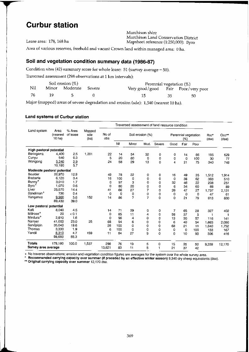
Curbur station
Lease area: 178, 168 ha
Murchison shire Murchison Land Conservation District Mapsheet reference (1:250,000): Byro
Area of various reserves, freehold and vacant Crown land within managed area: 0 ha.
Soil and vegetation condition summary data (1986-87)
Condition sites (42) summary score for whole lease: 51 (survey average ~ 50).
Traversed assessment (298 observations at 1 krn intervals):
Soil erosion (%) Perennial vegetation (%) Nil
76
Minor Moderate Severe Very good / good Fair Poor / very poor
19 5 o 15 35 50
Major (mapped) areas of severe degradation and erosion (sde): 1,540 (nearest 10 hal.
Land systems of Curbur station
Traversed assessment of rand resource condition
Land system Area % Area Mapped (nearest of lease sde No of Soil erosion (%) Perennial vegetation Rcc* 10 hal (ha) obs (%) (d,e)
Nil Minor Mod. Severe Good Fair Poor
High pastoral potential Beringarra 4,400 2.5 1,201 22 14 54 32 0 0 14 86 195 Cunyu 540 0.3 5 20 80 0 0 0 0 100 30 Wongong 5240 2.9 24 58 29 13 0 4 21 75 340
10,180 5.7
Moderate pastoral potential Boulder 22,970 12.9 49 78 22 0 0 16 49 35 1,512 Sreberle 6,120 3.4 16 100 0 0 0 0 38 62 383 Bunny+ 3,010 1.7 0 97 3 0 0 32 46 22 208 Byro+ 1,070 0.6 0 80 20 0 0 6 34 60 68 Liver 25,570 14.4 41 66 27 7 0 26 47 27 1,737 Sandiman+ 730 0.4 0 0 0 0 0 0 0 0 47 Yanganoo 9960 5.6 152 14 86 7 7 0 0 21 79 613
69,430 39.0
Low pastoral potential Kalli 8,040 4.5 14 71 29 0 0 7 65 28 327 MiJlrose+ 20 < 0.1 0 85 11 4 0 58 37 5 1 Mindura+ 2,810 1.6 0 96 4 0 0 13 30 57 116 Narryer 41,000 23.0 25 68 94 6 0 0 6 40 54 1,663 Sand plain 35,040 19.6 28 100 0 0 0 68 21 11 1,640 Thomas 3,330 1.9 6 100 0 0 0 0 0 100 133 Yandil 8310 4.7 159 11 64 27 9 0 0 10 90 326
98,550 55.3
Totals 178,160 100.0 1,537 298 76 19 5 0 15 35 50 9,339 Survey area average 13,621 83 11 5 1 21 37 42
+ No traverse observations; erosion and vegetation condition figures are averages for the system over the whole survey area. * Recommended carrying capacity over summer (if preceded by an effective winter season) 9,340 dry sheep equivalents (dse). ** Original carrying capacity over summer 12,170 dse.
369
Occ** (dse)
629 77
749
1,914 510 251
89 2,131
61 830
402 1
141 2,050 1,752
167 416
12,170
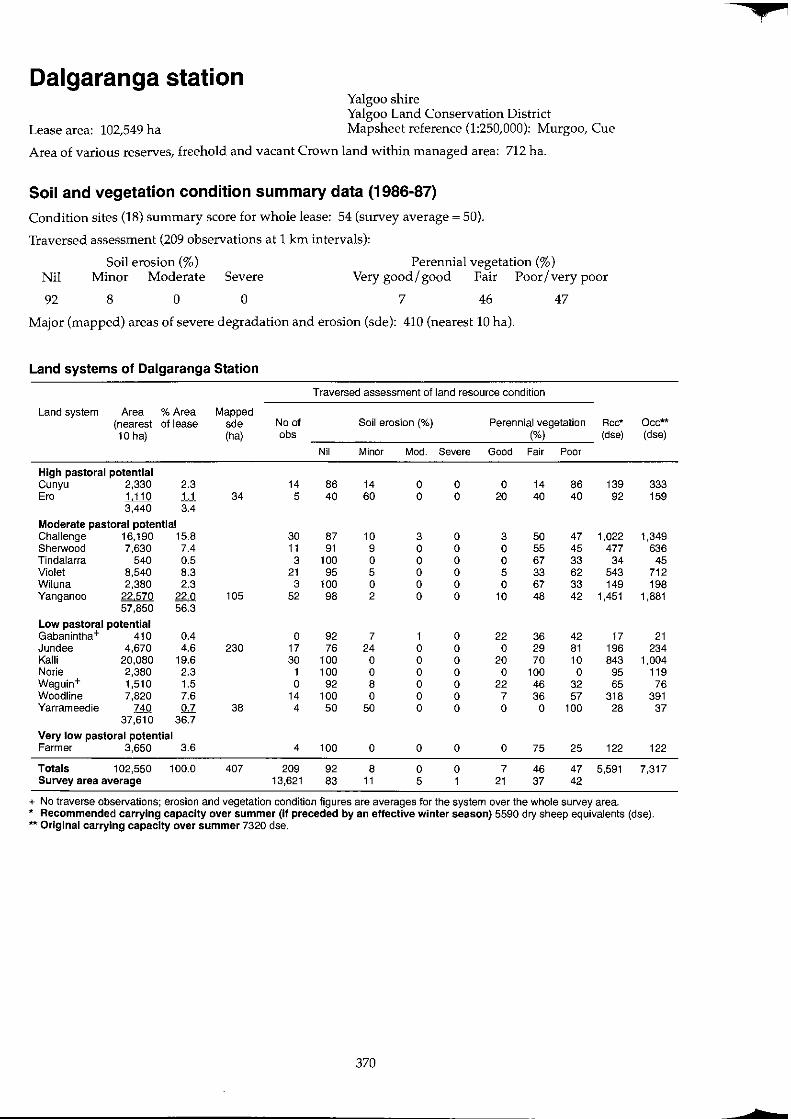
+
Dalgaranga station Yalgoo shire Yalgoo Land Conservation District
Lease area: 102,549 ha Mapsheet reference (1:250,000): Murgoo, Cue
Area of various reserves; freehold and vacant Crown land within managed area: 712 ha.
Soil and vegetation condition summary data (1986-87)
Condition sites (18) summary score for whole lease: 54 (survey average ~ 50).
Traversed assessment (209 observations at 1 km intervals):
Soil erosion (%) Perennial vegetation (%) Nil Minor Moderate Severe Very good / good Fair Poor / very poor
92 8 0 0 7 46 47
Major (mapped) areas of severe degradation and erosion (sde): 410 (nearest 10 hal.
Land systems of Oalgaranga Station
Traversed assessment of land resource condition
Land system Area % Area Mapped (nearest of lease sde No of Soil erosion (%) Perennial vegetation Rcc* Occ** 10 hal (ha) abs (%) (dse) (dse)
Nil Minor Mod. Severe Good Fair Poor
High pastoral potential Cunyu 2,330 2.3 14 86 14 0 0 0 14 86 139 333 Era 1,110 1,1 34 5 40 60 0 0 20 40 40 92 159
3,440 3.4 Moderate pastoral potential Challenge 16,190 15.8 30 87 10 3 0 3 50 47 1,022 1,349 Sherwood 7,630 7.4 11 91 9 0 0 0 55 45 477 636 Tindalarra 540 0.5 3 100 0 0 0 0 67 33 34 45 Violet 8,540 8.3 21 95 5 0 0 5 33 62 543 712 Wiluna 2,380 2.3 3 100 0 0 0 0 67 33 149 198 Yanganoo 22570 22.0 105 52 98 2 0 0 10 48 42 1,451 1,881
57,850 56.3 Low pastoral potential Gabanintha+ 410 0.4 0 92 7 1 0 22 36 42 17 21 Jundee 4,670 4.6 230 17 76 24 0 0 0 29 81 196 234 Kalli 20,080 19.6 30 100 0 0 0 20 70 10 843 1,004 Norie 2,380 2.3 1 100 0 0 0 0 100 0 95 119 Waguin+ 1,510 1.5 0 92 8 0 0 22 46 32 65 76 Woodline 7,820 7.6 14 100 0 0 0 7 36 57 318 391 Yarrameedie 740 0.7 38 4 50 50 0 0 0 0 100 28 37
37,610 36.7 Very low pastoral potential Farmer 3,650 3.6 4 100 0 0 0 0 75 25 122 122
Totals 102,550 100.0 407 209 92 8 0 0 7 46 47 5,591 7,317 Survey area average 13,621 83 11 5 1 21 37 42
+ No traverse observations; erosion and vegetation condition figures are averages for the system over the whole survey area. '* Recommended carrying capacity over summer (if preceded by an effective winter season) 5590 dry sheep equivalents (dse). ** Original carrying capacity over summer 7320 dse.
370
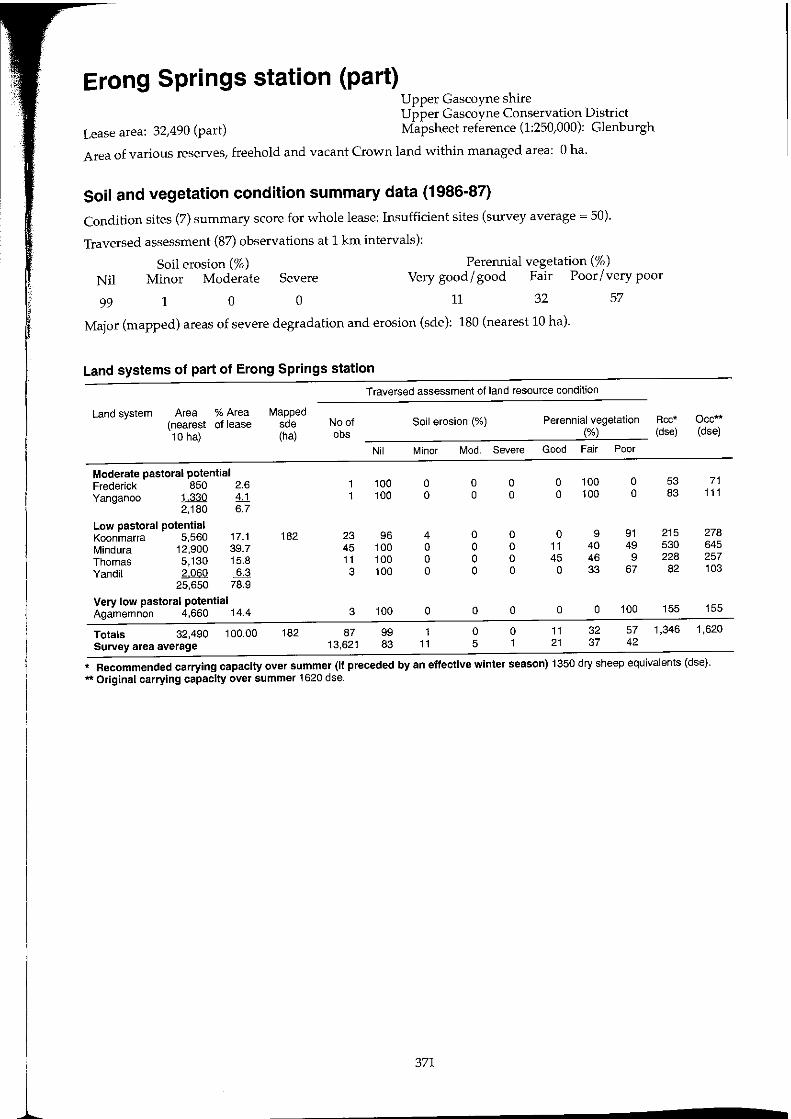
Erong Springs station (part) Upper Gascoyne shire Upper Gascoyne Conservation District
Lease area: 32,490 (part) Mapsheet reference (1:250,000): Glenburgh
Area of various reserves, freehold and vacant Crown land within managed area: 0 ha.
Soil and vegetation condition summary data (1986-87)
Condition sites (7) summary score for whole lease: Insufficient sites (survey average ~ 50).
Traversed assessment (87) observations at 1 km intervals):
Soil erosion (%) Minor Moderate Severe Nil
Perennial vegetation (%) Very good/ good Fair Poor/very poor
99 1 o o 11 32 57
Major (mapped) areas of severe degradation and erosion (sde): 180 (nearest 10 hal.
Land systems of part of Erong Springs station
Traversed assessment of land resource condition
Land system Area % Area Mapped (nearest of lease sde No of Soil erosion (%) Perennial vegetation Rcc* Dcc*" 10 hal (ha) obs (%) (dse) (dse)
Nil Minor Mod. Severe Good Fair Poor
Moderate pastoral potential Frederick 850 2.6 100 0 0 0 0 100 0 53 71 Yanganoo 1330 1.1 100 0 0 0 0 100 0 83 111
2,180 6.7
Low pastoral potential Koonmarra 5,560 17.1 182 23 96 4 0 0 0 9 91 215 278 Mindura 12,900 39.7 45 100 0 0 0 11 40 49 530 645 Thomas 5,130 15.8 11 100 0 0 0 45 46 9 228 257 Yandil 2060 ~ 3 100 0 0 0 0 33 67 82 103
25,650 78.9
Very low pastoral potential Agamemnon 4,660 14.4 3 100 0 0 0 0 0 100 155 155
Totals 32,490 100.00 182 87 99 1 0 0 11 32 57 1,346 1,620 Survey area average 13,621 83 11 5 1 21 37 42
* Recommended carrying capacity over summer (if preceded by an effective winter season) 1350 dry sheep equivalents (dse). *It Original carrying capacity over summer 1620 dse.
1 371
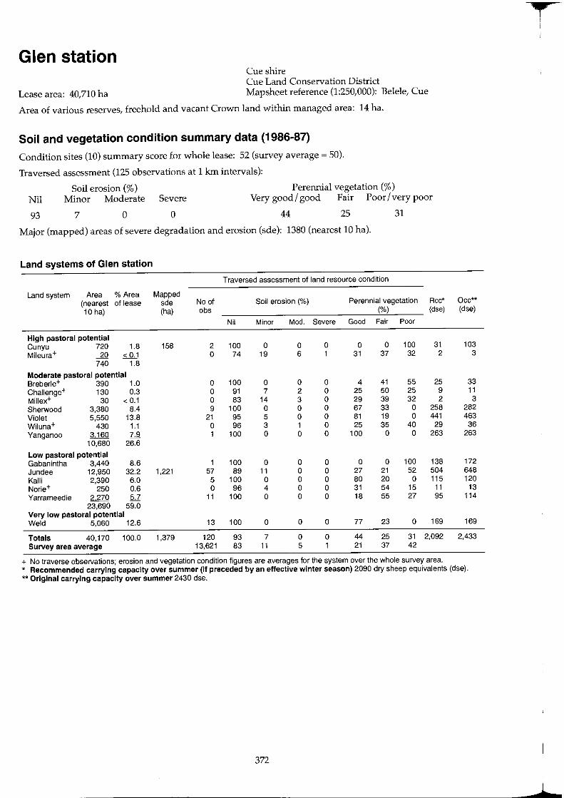
Glen station Cue shire Cue Land Conservation District
Lease area: 40,710 ha Mapsheet reference (1:250,000): Belele, Cue
Area of various reserves, freehold and vacant Crown land within managed area: 14 ha.
Soil and vegetation condition summary data (1986-87)
Condition sites (10) summary score for whole lease: 52 (survey average ~ 50).
Traversed assessment (125 observations at 1 km intervals):
Perennial vegetation (%) Nil
93
Soil erosion (%) Minor Moderate Severe Very good / good Fair Poor / very poor
7 o o 44 25 31
Major (mapped) areas of severe degradation and erosion (sde): 1380 (nearest 10 hal.
Land systems of Glen station
Traversed assessment of land resource condition
Land system Area % Area Mapped (nearest of lease sde No of Soil erosion (%) Perennial vegetation Rcc*
10 hal (ha) obs (%) (dse)
Nil Minor Mod. Severe Good Fair Poor
High pastoral potential Cunyu 720 1.8 158 2 100 0 0 0 0 0 100 31 Mileura+ -.2Q < 0.1 0 74 19 6 1 31 37 32 2
740 1.8
Moderate pastoral potential Breberle+ 390 1.0 0 100 0 0 0 4 41 55 25 Challenge+ 130 0.3 0 91 7 2 0 25 50 25 9 Mil1ex+ 30 < 0.1 0 83 14 3 0 29 39 32 2 Sherwood 3,380 8.4 9 100 0 0 0 67 33 0 258 Violet 5,550 13.8 21 95 5 0 0 81 19 0 441 Wiluna+ 430 1.1 0 96 3 1 0 25 35 40 29 Yanganoo 3,160 7.9 1 100 0 0 0 100 0 0 263
10,680 26.6
Low pastoral potential Gabanintha 3,440 8.6 1 100 0 0 0 0 0 100 138 Jundee 12,950 32.2 1,221 57 89 11 0 0 27 21 52 504 Kalli 2,390 6.0 5 100 0 0 0 80 20 0 115 Norie+ 250 0.6 0 96 4 0 0 31 54 15 11 Yarrameedie 2270 5.7 11 100 0 0 0 18 55 27 95
23,690 59.0 Very low pastoral potential Weld 5,060 12.6 13 100 0 0 0 77 23 0 169
Totals 40,170 100.0 1,379 120 93 7 0 0 44 25 31 2,092 Survey area average 13,621 83 11 5 1 21 37 42
+ No traverse observations; erosion and vegetation condition figures are averages for the system over the whole survey area.
Occ** (dse)
103 3
33 11
3 282 463 36
263
172 648 120
13 114
169
2,433
* Recommended carrying capacity over summer (if preceded by an effective winter season) 2090 dry sheep equivalents (dse). ** Original carrying capacity over summer 2430 dse.
372
t I I
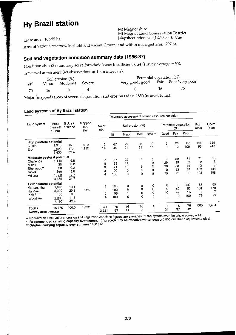
Hy Brazil station Mt Magnet shire Mt Magnet Land Conservation District
Lease area: 16,777 ha Mapsheet reference (1:250,000): Cue
Area of various reserves, freehold and vacant Crown land within managed area: 297 ha.
Soil and vegetation condition summary data (1986-87)
Condition sites (3) summary score for whole lease: Insufficient sites (survey average ~ 50).
Traversed assessment (49 observations at 1 km intervals):
Soil erosion (%) Minor Moderate Severe Nil
Perennial vegetation (%)
Very good/good Fair Poor/very poor
70 16 10 4 8 16 76
Major (mapped) areas of severe degradation and erosion (sde): 1850 (nearest 10 hal.
Land systems of Hy Brazil station
Traversed assessment of land resource condition
Land system Area % Area Mapped (nearest of lease sde No of Soil erosion (%) Perennial vegetation Rcc* Occ**
10 hal (ha) obs (%) (dse) (dse)
Nil Minor Mod. Severe Good Fair Poor
High pastoral potential Austin 2.510 15.0 512 12 67 25 8 0 8 25 67 146 359
Ere 2920 17.4 1,212 14 44 21 21 14 0 0 100 95 417
5,430 32.4
Moderate pastoral potential Challenge 1,140 6.8 7 57 29 14 0 0 29 71 71 95
Millex+ 30 0.2 0 83 14 3 0 29 39 32 2 3
Sherwood+ 30 0.2 0 71 19 9 2 26 38 36 2 3
Violet 1,650 9.8 3 100 0 0 0 0 33 67 103 138
Wi luna 1300 7.7 4 100 0 0 0 75 25 0 102 108
4,150 24.7
Low pastoral potential Gabanintha 1,690 10.1 3 100 0 0 0 0 0 100 68 85
Jundee 3,390 20.2 128 2 100 0 0 0 0 50 50 131 170
Kalli+ 130 0.8 0 98 1 0 0 40 42 18 6 7
Woodline 1980 1il 4 100 0 0 0 0 0 100 79 99
7,190 42.9
Totals 16,770 100.0 1,852 49 70 16 10 4 8 16 76 805 1,484
Survey area average 13,621 83 11 5 1 21 37 42
+ No traverse observations; erosion and vegetation condition figures are averages for the system over the whole sUlvey area.
* Recommended carrying capacity over summer (If preceded by an effective winter season) 800 dry sheep equivalents (dse).
** Original carrying capacity over summer 1480 dse.
373
! ~
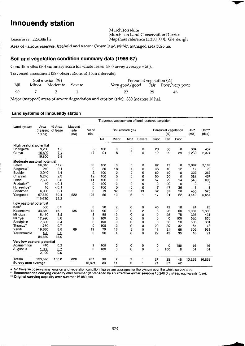
¥
Innouendy station Murchison shire Murchison Land Conservation District
Lease area: 223,386 ha Mapsheet reference (1:250,000): Glenburgh
Area of various reserves, freehold and vacant Crown land within managed area 5026 ha.
Soil and vegetation condition summary data (1986-87)
Condition sites (30) summary score for whole lease: 58 (survey average ~ 50).
Traversed assessment (287 observations at 1 km intervals):
Soil erosion (%) Perennial vegetation (%) Nil Minor Moderate Severe Very good/good Fair Poor/very poor
90 7 2 1 27 25 48
Major (mapped) areas of severe degradation and erosion (sde): 830 (nearest 10 hal.
Land systems of lnnouendy station
Traversed assessment of land resource condition
Land system Area % Area Mapped (nearest of lease sde No of Soil erosion (%) Perennial vegetation Rcc* Occ** 10 hal (ha) obs ('Yo) (dse) (dse)
Nil Minor Mod. Severe Good Fair Poor
High pastoral potential Beringarra 3,200 1.5 5 100 0 0 0 20 80 0 304 457 Cunyu 16600 7.4 17 94 6 0 0 12 29 59 1,230 2,371
19,800 8.9
Moderate pastoral potential Belele 26,010 11.6 38 100 0 0 0 87 13 0 2,097 2,168 Bidgemia+ 240 0.1 0 80 16 4 0 48 40 12 17 20 Boulder 3,040 1.4 2 100 0 0 0 50 50 0 222 253 Channel 5,240 2.3 12 100 0 0 0 50 50 0 382 437 Flood 7,300 3.3 14 100 0 0 0 57 29 14 543 608 Frederick+ 40 < 0.1 0 100 0 0 0 0 100 0 3 3 Horseshoe+ 10 < 0.1 0 100 0 0 0 17 47 36 1 1 Sandiman 6,900 3.1 8 13 37 37 13 37 37 26 485 575 Yanganoo 67,850 30.4 622 105 86 10 3 1 17 21 62 4,442 5,654
116,630 52.2
Low pastoral potential Kalli+ 550 0.2 0 98 2 0 0 40 42 18 24 28 Koonmarra 33,650 15.1 135 53 96 2 0 2 8 26 66 1,367 1,683 Mindura 8,410 3.8 8 88 12 0 0 0 25 75 336 421 Narryer 12,990 5.8 2 100 0 0 0 0 0 100 520 650 Sand plain 7,620 3.4 2 100 0 0 0 0 50 50 305 381 Thomas+ 1,560 0.7 0 100 0 0 0 29 39 32 67 78 Yandil 19,660 8.8 69 19 79 16 5 0 11 21 68 805 983 Yarrameedie+ 420 0.2 0 96 4 0 0 22 43 35 18 21
84,860 38.0
Very low pastoral potential Agamemnon 470 0.2 2 100 0 0 0 0 0 100 16 16 Augustus+ 1630 0.7 0 100 0 0 0 0 100 0 54 54
2,100 0.9
Totals 223,390 100.0 826 287 90 7 2 27 25 48 13,238 16,862 Survey area average 13,621 83 11 5 21 37 42
+ No traverse observations; erosion and vegetation condition figures are averages for the system over the whole survey area. * Recommended carrying capacity over summer (if preceded by an effective winter season) 13,240 dry sheep equivalents (dse). ** Original carrying capacity over summer 16,860 dse.
374
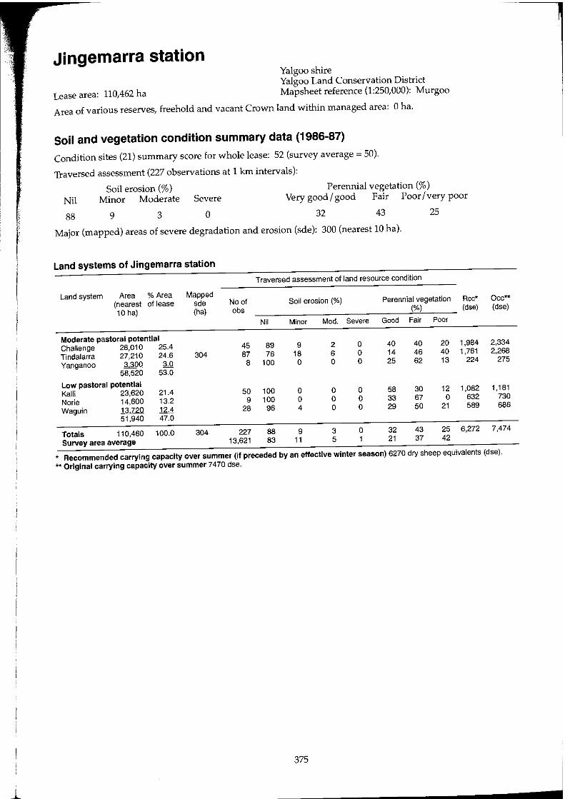
Jingemarra station Yalgoo shire Yalgoo Land Conservation District
Lease area: 110,462 ha Mapsheet reference (1:250,000): Murgoo
Area of various reserves, freehold and vacant Crown land within managed area: 0 ha.
Soil and vegetation condition summary data (1986-87)
Condition sites (21) summary score for whole lease: 52 (survey average = 50).
Traversed assessment (227 observations at 1 kIn intervals):
Soil erosion (%) Perennial vegetation (%) Nil Minor Moderate Severe Very good / good Fair Poor / very poor
88 9 3 o 32 43 25
Major (mapped) areas of severe degradation and erosion (sde): 300 (nearest 10 hal.
Land systems of Jingemarra station
Traversed assessment of land resource condition
Land system Area % Area Mapped (nearest of lease sde No of Soil erosion (%) Perennial vegetation Rcc* 10 hal (ha) obs (%) (dse)
Nil Minor Mod. Severe Good Fair Poor
Moderate pastoral potential Challenge 28,010 25.4 45 89 9 2 0 40 40 20 1,984 Tindalarra 27,210 24.6 304 87 76 18 6 0 14 46 40 1,761 Yanganoo 3300 M 8 100 0 0 0 25 62 13 224
58,520 53.0
Low pastoral potential Kalli 23,620 21.4 50 100 0 0 0 58 30 12 1,082 Norie 14,600 13.2 9 100 0 0 0 33 67 0 632 Waguin 13,720 12.4 28 96 4 0 0 29 50 21 589
51,940 47.0
Totals 110,460 100.0 304 227 88 9 3 0 32 43 25 6,272 Survey area average 13,621 83 11 5 1 21 37 42
Occ** (dse)
2,334 2,268
275
1,181 730 686
7,474
* Recommended carrying capacity over summer (if preceded by an effective winter season) 6270 dry sheep equivalents (dse). ** Original carrying capacity over summer 7470 dse.
375
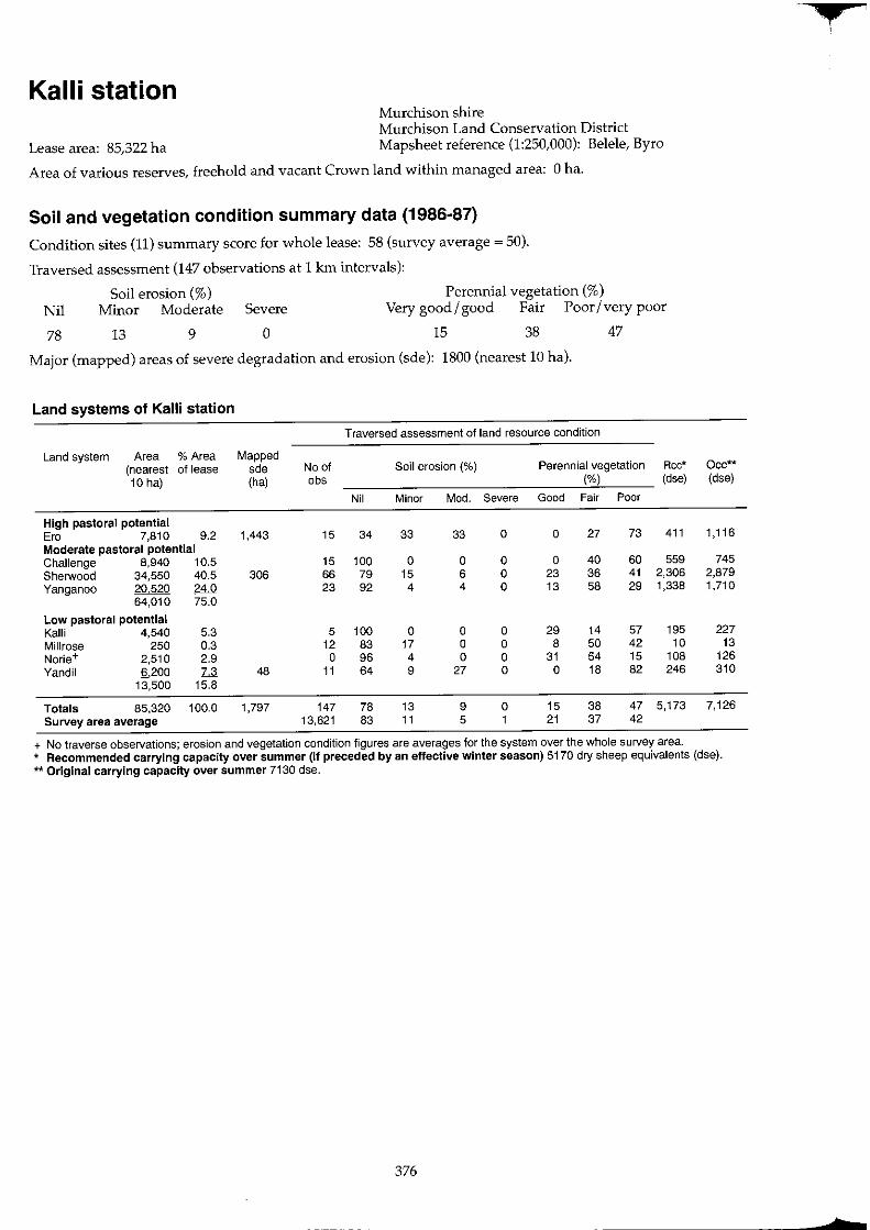
Kalli station Murchison shire Murchison Land Conservation District
Lease area: 85,322 ha Mapsheet reference (1:250,000): Belele, Byro
Area of various reserves, freehold and vacant Crown land within managed area: 0 ha.
Soil and vegetation condition summary data (1986-87)
Condition sites (11) summary score for whole lease: 58 (survey average = 50).
Traversed assessment (147 observations at 1 km intervals):
Soil erosion (%) Perennial vegetation (%) Nil Minor Moderate Severe Very good I good Fair Poor I very poor
78 l3 9 o 15 38 47
Major (mapped) areas of severe degradation and erosion (sde): 1800 (nearest 10 hal.
Land systems of Kalli station
Traversed assessment of land resource condition
Land system Area % Area Mapped (nearest of lease sde No of Soil erosion (%) Perennial vegetation Rcc* 10 hal (ha) abs (%) (dse)
Nil Minor Mod. Severe Good Fair Poor
High pastoral potential Era 7,810 9.2 1,443 15 34 33 33 0 0 27 73 411 Moderate pastoral potential Challenge 8,940 10.5 15 100 0 0 0 0 40 60 559 Sherwood 34,550 40.5 306 66 79 15 6 0 23 36 41 2,306 Yanganoo 20,520 24.0 23 92 4 4 0 13 58 29 1,338
64,010 75.0
Low pastoral potential Kalli 4,540 5.3 5 100 0 0 0 29 14 57 195 Millrose 250 0.3 12 83 17 0 0 8 50 42 10 Norie+ 2,510 2.9 0 96 4 0 0 31 54 15 108 Yandil 6200 7.3 48 11 64 9 27 0 0 18 82 246
13,500 15.8
Totals 85,320 100.0 1,797 147 78 13 9 0 15 38 47 5,173 Survey area average 13,621 83 11 5 1 21 37 42
+ No traverse observations; erosion and vegetation condition figures are averages for the system over the whole survey area.
Occ** (dse)
1,116
745 2,879 1,710
227 13
126 310
7,126
* Recommended carrying capacity over summer (if preceded by an effective winter season) 5170 dry sheep equivalents (dse). ** Original carrying capacity over summer 7130 dse.
376
• ,
tr
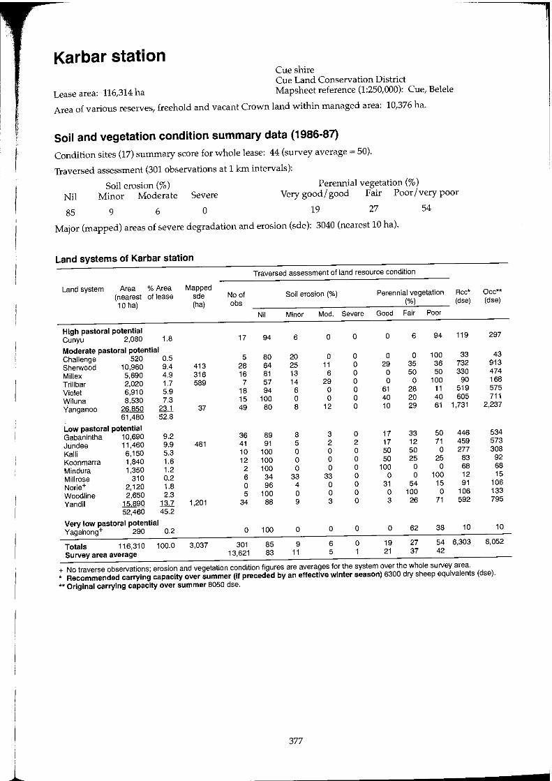
Karbar station Cue shire Cue Land Conservation District
Lease area: 116,314 ha Mapsheet reference (1:250,000): Cue, Belele
Area of various reserves, freehold and vacant Crown land within managed area: 10,376 ha.
Soil and vegetation condition summary data (1986-87)
Condition sites (17) summary score for whole lease: 44 (survey average = 50).
Traversed assessment (301 observations at 1 km intervals):
Soil erosion (%) Perennial vegetation (%) Nil Minor Moderate Severe Very good/ good Fair Poor / very poor
85 9 6 0 19 27 54
Major (mapped) areas of severe degradation and erosion (sde): 3040 (nearest 10 hal.
Land systems of Karbar station
Traversed assessment of land resource condition
Land system Area % Area Mapped (nearest of lease sde No of Soil erosion (%) Perennial vegetation Rcc* Occ** 10 hal (ha) obs (%) (dse) (dse)
Nil Minor Mod. Severe Good Fair Poor
High pastoral potential Cunyu 2,080 1.8 17 94 6 0 0 0 6 94 119 297
Moderate pastoral potential Challenge 520 0.5 5 80 20 0 0 0 0 100 33 43 Sherwood 10,960 9.4 413 28 64 25 11 0 29 35 36 732 913 Millex 5,690 4.9 316 16 81 13 6 0 0 50 50 330 474 Trillbar 2,020 1.7 589 7 57 14 29 0 0 0 100 90 168 Violet 6,910 5.9 18 94 6 0 0 61 28 11 519 575 Wiluna 8,530 7.3 15 100 0 0 0 40 20 40 605 711 Yanganoo 26,850 23.1 37 49 80 8 12 0 10 29 61 1,731 2,237
61,480 52.8
Low pastoral potential Gabanintha 10,690 9.2 36 89 8 3 0 17 33 50 446 534 Jundee 11,460 9.9 481 41 91 5 2 2 17 12 71 459 573 Kalli 6,150 5.3 10 100 0 0 0 50 50 0 277 308 Koonmarra 1,840 1.6 12 100 0 0 0 50 25 25 83 92 Mindura 1,350 1.2 2 100 0 0 0 100 0 0 68 68 Millrose 310 0.2 6 34 33 33 0 0 0 100 12 15 Norie+ 2,120 1.8 0 96 4 0 0 31 54 15 91 106 Woodline 2,650 2.3 5 100 0 0 0 0 100 0 106 133 Yandil 15890 1:u 1,201 34 88 9 3 0 3 26 71 592 795
52,460 45.2
Very low pastoral potential Yagahong+ 290 0.2 0 100 0 0 0 0 62 38 10 10
Totals 116,310 100.0 3,037 301 85 9 6 0 19 27 54 6,303 8,052 Survey area average 13,621 83 11 5 1 21 37 42
+ No traverse observations; erosion and vegetation condition figures are averages for the system over the whole survey area. * Recommended carrying capacity over summer (if preceded by an effective winter season) 6300 dry sheep equivalents (dse). ** Original carrying capacity over summer 8050 dse.
377

Koonmarra station Meekatharra shire
Lease area: 138,352 ha Meekatharra Land Conservation District Mapsheet reference (1:250,000): Belele
Area of various reserves, freehold and vacant Crown land within managed area: 7 ha.
Soil and vegetation condition summary data (1986-87)
Condition sites (22) summary score for whole lease: 45 (survey average ~ 50).
Traversed assessment (199 observations at 1 km intervals):
Perennial vegetation (%) Nil
83
Soil erosion (%) Minor Moderate Severe Very good I good Fair Poor I very poor
12 4 1 19 34 47
Major (mapped) areas of severe degradation and erosion (sde): 1560 (nearest 10 hal.
Land systems of Koonmarra station
Traversed assessment of land resource condition
Land system Area % Area Mapped (nearest of lease sde No of Soil erosion (%) Perennial vegetation (%) Rcc* 10 hal (ha) obs (dse)
Nil Minor Mod. Severe Good Fair Poor
High pastoral potential Ero 280 0.2 0 0 100 0 0 0 100 16
Moderate pastoral potential Belele 7,510 5.4 6 100 0 0 0 17 66 17 470 Sherwood 35,150 25.4 565 53 72 17 9 2 30 51 19 2,381 Violet+ 1,080 0.8 0 92 6 2 0 26 43 31 74 Wiluna 16,730 12.1 20 100 0 0 0 15 15 70 1,098 Yanganoo 9430 6.8 20 84 16 0 0 58 42 0 704
69,900 50.5
Low pastoral potential Gabanintha+ 520 0.4 0 92 7 1 0 22 36 42 22 Jundee 4,200 3.0 736 4 75 25 0 0 0 25 75 139 Kalli 9,760 7.1 10 100 0 0 0 40 60 0 429 Koonmarra 18,890 13.7 32 91 9 0 0 0 22 78 755 Millrose 2,070 1.5 84 2 100 0 0 0 0 100 0 79 Mindura 16,720 12.1 28 82 18 0 0 0 21 79 699 Norie 5,980 4.3 4 100 0 0 0 0 25 75 239 Yandil 10030 ~ 176 20 80 10 5 5 15 30 55 409
68,170 49.3
Totals 138,350 100.0 1,561 199 83 12 4 19 34 47 7,514 Survey area average 13,621 83 11 5 21 37 42
+ No traverse observations: erosion and vegetation condition figures are averages for the system over the whole survey area.
Occ** (dse)
41
626 2,929
90 1,394
786
26 210 488 944 103 836 299 502
9,274
* Recommended carrying capacity over summer (If preceded by an effective winter season) 7510 dry sheep equivalents (dse). ** Original carrying capacity over summer 9270 dse.
378
t
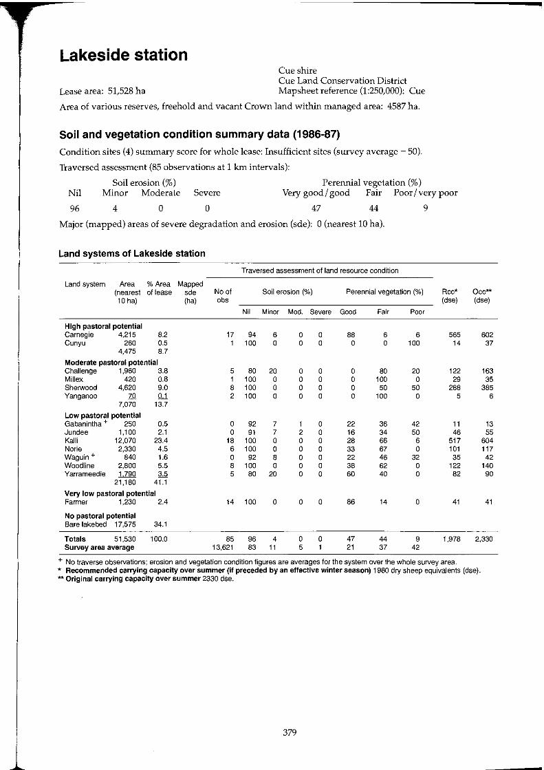
Lakeside station Cue shire Cue Land Conservation District
Lease area: 51,528 ha Mapsheet reference (1:250,000): Cue
Area of various reserves, freehold and vacant Crown land within managed area: 4587 ha.
Soil and vegetation condition summary data (1986-87)
Condition sites (4) summary score for whole lease: Insufficient sites (survey average ~ 50).
Traversed assessment (85 observations at 1 km intervals):
Perennial vegetation (%) Nil
96
Soil erosion (%) Minor Moderate Severe Very good/ good Fair Poor/very poor
4 o o 47 44 9
Major (mapped) areas of severe degradation and erosion (sde): 0 (nearest 10 hal.
Land systems of Lakeside station
Traversed assessment of land resource condition
Land system Area % Area Mapped (nearest of lease sde No of Soil erosion (%) Perennial vegetation (%) Rcc* 10 hal (ha) obs (dse)
Nil Minor Mod. Severe Good Fair Poor
High pastoral potential Carnegie 4,215 8.2 17 94 6 0 0 88 6 6 565 Cunyu 260 0.5 1 100 0 0 0 0 0 100 14
4,475 8.7
Moderate pastoral potential Challenge 1,960 3.8 5 80 20 0 0 0 80 20 122 Millex 420 0.8 1 100 0 0 0 0 100 0 29 ShelWood 4,620 9.0 8 100 0 0 0 0 50 50 288 Yanganoo 70 QJ. 2 100 0 0 0 0 100 0 5
7,070 13.7
Low pastoral potential Gabanintha + 250 0.5 0 92 7 1 0 22 36 42 11 Jundee 1,100 2.1 0 91 7 2 0 16 34 50 46 Kalli 12,070 23.4 18 100 0 0 0 28 66 6 517 Norie 2,330 4.5 6 100 0 0 0 33 67 0 101 Waguin + 840 1.6 0 92 8 0 0 22 46 32 35 Woodline 2,800 5.5 8 100 0 0 0 38 62 0 122 Yarrameedie 1790 3.5 5 80 20 0 0 60 40 0 82
21,180 41.1
Very low pastoral potential Farmer 1,230 2.4 14 100 0 0 0 86 14 0 41
No pastoral potential Bare lakebed 17,575 34.1
Totals 51,530 100.0 85 96 4 0 0 47 44 9 1,978 Survey area average 13,621 83 11 5 1 21 37 42
+ No traverse observations; erosion and vegetation condition figures are averages for the system over the whole survey area.
Occ** (dse)
602 37
163 35
385 6
13 55
604 117 42
140 90
41
2,330
* Recommended carrying capacity over summer (if preceded by an effective winter season) 1980 dry sheep equivalents (dse). ** Original carrying capacity over summer 2330 dse.
379
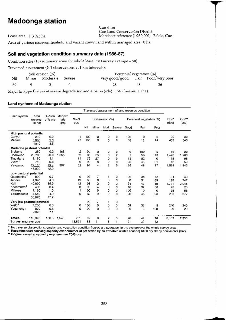
Madoonga station Cue shire Cue Land Conservation District
Lease area: 113,925 ha Mapsheet reference (1:250,000): Belele, Cue
Area of various reserves, freehold and vacant crown land within managed area: 0 ha.
Soil and vegetation condition summary data (1986-87)
Condition sites (18) summary score for whole lease: 58 (survey average ~ 50).
Traversed assessment (201 observations at 1 km intervals):
Perennial vegetation (%) Nil
89
Soil erosion (%) Minor Moderate Severe Very good / good Fair Poor / very poor
9 2 o 26 48 26
Major (mapped) areas of severe degradation and erosion (sde): 1540 (nearest 10 hal.
Land systems of Madoonga station
Traversed assessment of land resource condition
Land system Area % Area Mapped (nearest of lease sde No of Soil erosion (%) Perennial vegetation (%) Rcc* 10 hal (ha) obs (dse)
Nil Minor Mod. Severe Good Fair Poor
High pastoral potential Cunyu 210 0.2 1 100 0 0 0 100 0 0 30 Mileura 3800 3.3 22 100 0 0 0 68 18 14 455
4010 3.5
Moderate pastoral potential Sreberle 260 0.2 168 2 100 0 0 0 0 100 0 16 Sherwood 23,760 20.9 1,065 52 65 25 8 2 2 50 48 1,428 Tindalarra 1,180 1.1 11 73 27 0 0 18 82 0 78 Violet+ 710 0.6 0 92 6 2 0 26 43 31 48 Yanganoo 22,110 19.4 307 52 94 4 2 0 35 48 17 1,524
48,020 42.2
Low pastoral potential Gabanintha+ 800 0.7 0 92 7 1 0 22 36 42 34 Jundee 4,940 4.3 13 100 0 0 0 0 31 69 198 Kal1i 40,890 35.9 42 98 2 0 0 34 47 19 1,771 Koonmarra+ 490 0.4 0 96 4 0 0 10 32 58 20 Millrose 1,160 1.0 1 100 0 0 0 100 0 0 58 Yarrameedie 5540 4.9 5 89 9 2 0 26 48 26 233
53,820 47.2
Very low pastoral potential 92 7 1 0 Weld+ 7,200 6.3 0 100 0 0 0 59 36 5 240 Yagahong+ 870 0.8 0 100 0 0 0 0 0 100 29
8070 7.1
Totals 113,920 100.0 1,540 201 89 9 2 0 26 48 26 6,162 Survey area average 13,621 83 11 5 1 21 37 42
+ No traverse observations; erosion and vegetation condition figures are averages for the system over the whole survey area.
Occ** (dse)
30 543
22 1,980
98 59
1,843
40 247
2,045 25 58
277
240 29
7,536
* Recommended carrying capacity over summer (if preceded by an effective winter season) 6160 dry sheep equivalents (dse). ** Original carrying capacity over summer 7540 dse.
380
T
1
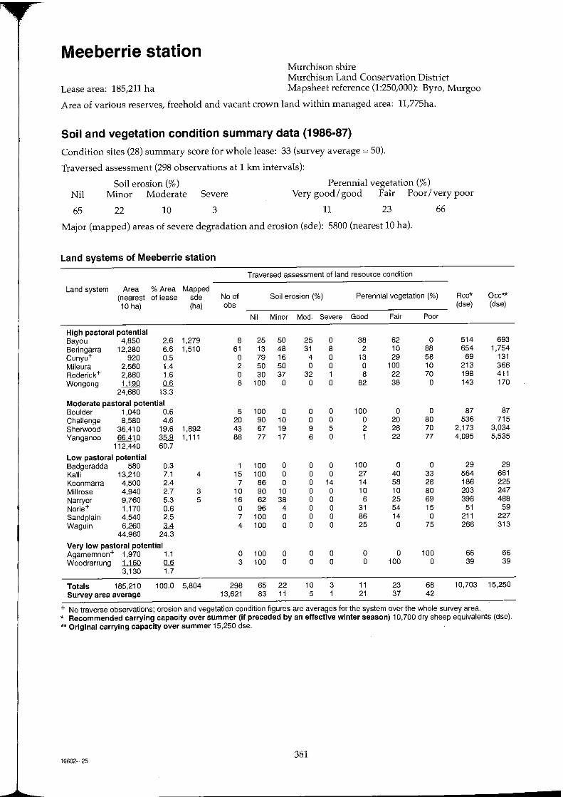
Meeberrie station Murchison shire Murchison Land Conservation District
Lease area: 185,211 ha Mapsheet reference (1:250,000): Byro, Murgoo
Area of various reserves, freehold and vacant crown land within managed area: 11,775ha.
Soil and vegetation condition summary data (1986-87)
Condition sites (28) summary score for whole lease: 33 (survey average ~ 50).
Traversed assessment (298 observations at 1 km intervals):
Soil erosion (%) Perennial vegetation (%) Nil Minor Moderate Severe Very good/good Fair Poor/very poor
65 22 10 3 11 23 66
Major (mapped) areas of severe degradation and erosion (sde): 5800 (nearest 10 hal.
Land systems of Meeberrie station
Traversed assessment of land resource condition
Land system Area % Area Mapped (nearest of lease sde No of Soil erosion (%) Perennial vegetation (%) Rcc* Occ** 10 hal (ha) obs (dse) (dse)
Nil Minor Mod. Severe Good Fair Poor
High pastoral potential Bayou 4,850 2.6 1,279 8 25 50 25 0 38 62 0 514 693 Beringarra 12,280 6.6 1,510 61 13 48 31 8 2 10 88 654 1,754 Cunyu+ 920 0.5 0 79 16 4 0 13 29 58 69 131 Mileura 2,560 1.4 2 50 50 0 0 0 100 10 213 366 Roderick+ 2,880 1.6 0 30 37 32 1 8 22 70 198 411 Wongong 1,190 0.6 8 100 0 0 0 62 38 0 143 170
24,680 13.3
Moderate pastoral potential Boulder 1,040 0.6 5 100 0 0 0 100 0 0 87 87 Challenge 8,580 4.6 20 90 10 0 0 0 20 80 536 715 Sherwood 36,410 19.6 1,892 43 67 19 9 5 2 28 70 2,173 3,034 Yanganoo 66410 35.9 1,111 88 77 17 6 0 1 22 77 4,095 5,535
112,440 60.7
Low pastoral potential Badgeradda 580 0.3 1 100 0 0 0 100 0 0 29 29 Kalli 13,210 7.1 4 15 100 0 0 0 27 40 33 564 661 Koonmarra 4,500 2.4 7 86 0 0 14 14 58 28 186 225 Millrose 4,940 2.7 3 10 90 10 0 0 10 10 80 203 247 Narryer 9,760 5.3 5 16 62 38 0 0 6 25 69 396 488 Norie+ 1,170 0.6 0 96 4 0 0 31 54 15 51 59 Sand plain 4,540 2.5 7 100 0 0 0 86 14 0 211 227 Waguin 6260 3.4 4 100 0 0 0 25 0 75 266 313
44,960 24.3
Very low pastoral potential Agamemnon+ 1,970 1.1 0 100 0 0 0 0 0 100 66 66 Woodrarrung 1 160 0.6 3 100 0 0 0 0 100 0 39 39
3,130 1.7
Totals 185,210 100.0 5,804 298 65 22 10 3 11 23 66 10,703 15,250 Survey area average 13,621 83 11 5 1 21 37 42
+ No traverse observations; erosion and vegetation condition figures are averages for the system over the whole survey area. * Recommended carrying capacity over summer (if preceded by an effective winter season) 10,700 dry sheep equivalents (dse). ** Original carrying capacity over summer 15,250 dse.
381 16602-25
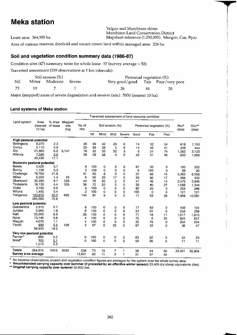
Meka station Yalgoo and Murchison shires Murchison Land Conservation District
Lease area: 364,905 ha Mapsheet reference (1:250,000): Murgoo, Cue, Byro
Area of various reserves, freehold and vacant crown land within managed area: 226 ha.
Soil and vegetation condition summary data (1986-87)
Condition sites (47) summary score for whole lease: 57 (survey average ~ 50).
Traversed assessment (539 observations at 1 !an intervals):
Soil erosion (%) Perennial vegetation (%) Nil Minor Moderate Severe Very good / good Fair Poor / very poor
73 19 7 1 26 44 30
Major (mapped) areas of severe degradation and erosion (sde): 5030 (nearest 10 hal·
Land systems of Meka station
Traversed assessment of land resource condition
Land system Area % Area Mapped (nearest of lease sde No of Soil erosion (%) Perennial vegetation (%) Rcc* Occ**
10 hal (ha) obs (dse) (dse)
Nil Minor Mod. Severe Good Fair Poor
High pastoral potential Beringarra 8,070 2.2 28 29 42 29 a 14 32 54 618 1,153 Cunyu 3,110 0.9 22 59 36 5 0 14 45 41 249 444 Ero 21,860 6.0 3,147 76 32 33 32 3 5 21 74 1,262 3,123 Mileura 7,390 2.0 26 38 58 4 0 23 31 46 623 1,056
40,430 11.1
Moderate pastoral potential Belele 2,420 0.7 6 100 0 0 0 67 33 0 185 202 Bunny 1,100 0.3 2 100 0 0 0 0 100 0 69 92 Challenge 78,700 21.6 91 92 8 0 0 27 59 14 5,362 6,558 Millex 5,320 1.4 43 6 50 33 17 0 33 50 17 368 443 Sherwood 35,280 9.7 528 44 78 20 2 0 41 45 14 2,473 2,940 Tindalarra 16,130 4.4 505 36 72 22 3 a 33 40 27 1,088 1,344 Violet 3,190 0.9 5 100 0 a 0 80 20 0 253 266 Wiluna 1,450 0.4 2 100 0 a 0 100 0 0 121 121 Yanganoo 120970 33.2 683 144 91 9 0 0 17 55 28 7,946 10,081
264,560 72.6
Low pastoral potential Gabanintha 2,610 0.7 6 100 a 0 0 17 83 0 109 131 Jundee 5,960 1.6 6 100 a 0 0 33 67 a 258 298 KaUi 32,200 8.8 28 100 0 0 0 71 18 11 1,517 1,610 Norie 13,140 3.6 4 100 0 0 0 75 0 25 624 657 Waguin 4,070 1.1 4 100 0 0 0 25 75 0 204 204 Yandi! 930 0.2 126 3 67 0 33 a 67 33 0 38 47
58,910 16.0
Very low pastoral potential Farmer+ 690 0.2 0 100 0 a a 63 32 5 23 23 Weld+ 320 QJ. 0 100 0 0 0 59 36 5 11 11
1,010 0.3
Totals 364,910 100.0 5032 539 73 19 7 26 44 30 23,401 30,804 Survey area average 13,621 83 11 5 21 37 42
+ No traverse observations; erosion and vegetation condition figures are averages for the system over the whole survey area. * Recommended carrying capacity over summer (if preceded by an effective winter season) 23,400 dry sheep equivalents (dse). ** Original carrying capacity over summer 30,800 dse.
382
hE
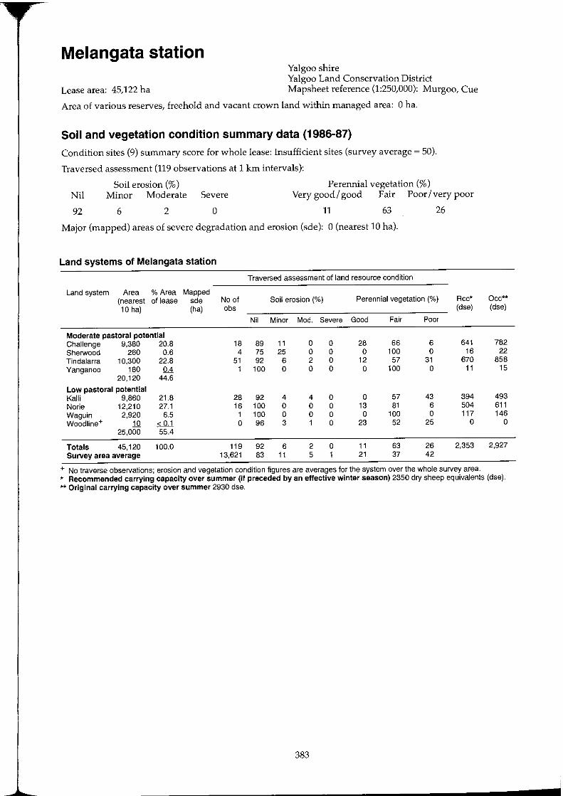
Melangata station Yalgoo shire Yalgoo Land Conservation District
Lease area: 45,122 ha Mapsheet reference (1:250,000): Murgoo, Cue
Area of various reserves, freehold and vacant crown land within managed area: 0 ha.
Soil and vegetation condition summary data (1986-87)
Condition sites (9) summary score for whole lease: Insufficient sites (survey average ~ 50).
Traversed assessment (119 observations at 1 krn intervals):
Soil erosion (%) Minor Moderate Severe Nil
Perennial vegetation (%) Very good/ good Fair Poor/very poor
92 6 2 o 11 63 26
Major (mapped) areas of severe degradation and erosion (sde): 0 (nearest 10 hal.
Land systems of Melangata station
Traversed assessment of land resource condition
Land system Area % Area Mapped (nearest of lease sde No of Soil erosion (%) Perennial vegetation (%) Rcc* Oec"'* 10 hal (ha) obs (dse) (dse)
Nil Minor Mod. Severe Good Fair Poor
Moderate pastoral potential Challenge 9,380 20.8 18 89 11 a a 28 66 6 641 782 Sherwood 260 0.6 4 75 25 a a a 100 a 16 22 Tindalarra 10,300 22.8 51 92 6 2 a 12 57 31 670 858 Yanganoo 180 0.4 1 100 a a a a 100 a 11 15
20,120 44.6
Low pastoral potential Kalli 9,860 21.8 28 92 4 4 a a 57 43 394 493 Norie 12,210 27.1 16 100 a a a 13 81 6 504 611 Waguin 2,920 6.5 1 100 a a a a 100 a 117 146 Woodline+ 10 < 0.1 a 96 3 1 a 23 52 25 a a
25,000 55.4
Totals 45,120 100.0 119 92 6 2 a 11 63 26 2,353 2,927 Survey area average 13,621 83 11 5 1 21 37 42
+ No traverse observations; erosion and vegetation condition figures are averages for the system over the whole survey area. * Recommended carrying capacity over summer (if preceded by an effective winter season) 2350 dry sheep equivalents (dse). ** Original carrying capacity over summer 2930 dse.
383

Mileura station
Lease area: 25,0511 ha
Murchison shire Murchison Land Conservation District Mapsheet reference (1:250,000): Belele
Area of various reserves, freehold and vacant crown land within managed area: 0 ha.
Soil and vegetation condition summary data (1986-87)
Condition sites (36) summary score for whole lease: 41 (survey average ~ 50).
Traversed assessment (401 observations at 1 km intervals):
Perennial vegetation (%) Nil
79
Soil erosion (%) Minor Moderate Severe Very good/good Fair Poor/very poor
13 8 o 11 41 48
Major (mapped) areas of severe degradation and erosion (sde): 5890 (nearest 10 hal.
Land systems of Mileura station
Traversed assessment of land resource condition
Land system Area % Area Mapped (nearest of Jease sde No of Soil erosion (%) Perennial vegetation (%) Rcc* 10 hal (ha) abs (dse)
Nil Minor Mod. Severe Good Fair Poor
High pastoral potential Beringarra 19,200 7.7 3,938 56 43 25 30 2 4 34 62 1,096 Era 23,110 9.2 1,686 52 38 35 27 a 10 21 69 1,526 Mileura 1 160 0.7 3 100 a a a a 67 33 123
43,970 17.6
Moderate pastoral potential Selele 42,810 17.1 81 96 4 a a 19 42 39 2,845 Sherwood 26,520 10.6 262 29 87 10 3 a 14 79 7 1,719 Tindalarra + 1,840 0.7 a 80 16 4 a 10 46 44 119 Yanganoo 84470 33.7 4 98 92 8 a a 12 37 51 5,490
155,640 62.1
Low pastoral potential Kalli 1,500 0.6 4 100 a a a a 100 a 60 Koonmarra 21,950 8.8 2 31 81 16 3 a a 32 68 878 Millrose 8,710 3.5 8 87 a 13 a a 38 62 348 Mindura 6,000 2.4 6 100 a a a a 50 50 240 Norie 1,030 0.4 1 100 a a a a a 100 41 Yarrameedie 6530 2.6 9 100 a a a a 67 33 261
45,720 18.3
Very low pastoral potential Weld 5,180 2.0 23 100 a a a 26 61 13 173
Totals 250,510 100.0 5,892 401 79 13 8 a 11 41 48 14,919 Survey area average 13,621 83 11 5 1 21 37 42
+ No traverse observations; erosion and vegetation condition figures are averages for the system over the whole survey area.
Occ** (dse)
2,743 3,302
237
3,568 2,210
153 7,039
75 1,098
436 300
52 327
173
21,713
* Recommended carrying capacity over summer (if preceded by an effective winter season) 14,920 dry sheep equivalents (dse). ** Original carrying capacity over summer 21 ,71 0 dse.
384
T
L
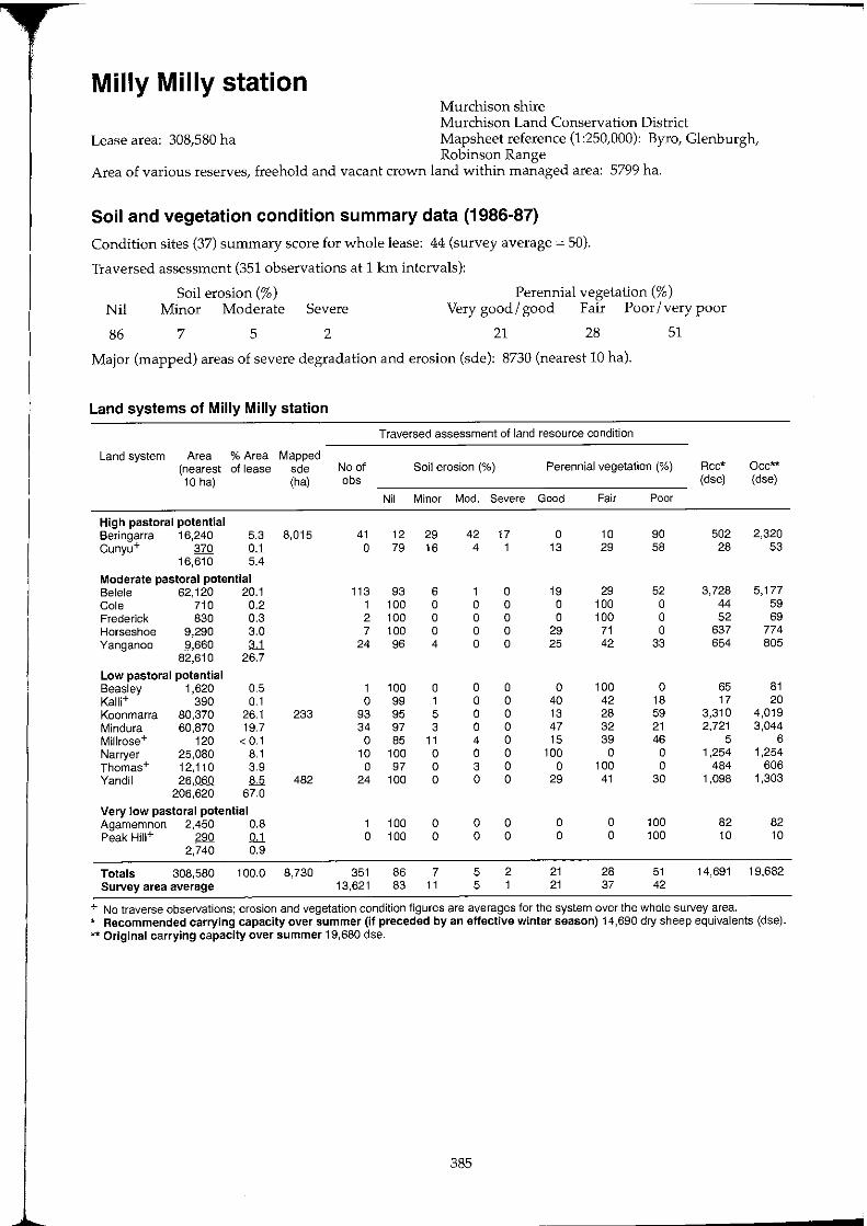
Milly Milly station Murchison shire Murchison Land Conservation District
Lease area: 308,580 ha Mapsheet reference (1:250,000): Byro, Glenburgh, Robinson Range
Area of various reserves, freehold and vacant crown land within managed area: 5799 ha.
Soil and vegetation condition summary data (1986-87)
Condition sites (37) summary score for whole lease: 44 (survey average = 50).
Traversed assessment (351 observations at 1 km intervals):
Perennial vegetation (%) Nil
86
Soil erosion (%) Minor Moderate Severe Very good / good Fair Poor / very poor
7 5 2 21 28 51
Major (mapped) areas of severe degradation and erosion (sde): 8730 (nearest 10 hal.
Land systems of Milly Milly station
Traversed assessment of land resource condition
Land system Area % Area Mapped (nearest of lease sde No of Soil erosion (%) Perennial vegetation (%) Rcc* 10 hal (ha) obs (dse)
Nil Minor Mod. Severe Good Fair Poor
High pastoral potential Beringarra 16,240 5.3 8,015 41 12 29 42 17 a 10 90 502 Cunyu+ 370 !U a 79 16 4 1 13 29 58 28
16,610 5.4
Moderate pastoral potential Belele 62,120 20.1 113 93 6 1 a 19 29 52 3,728 Cole 710 0.2 1 100 a a a a 100 a 44 Frederick 830 0.3 2 100 a a a a 100 a 52 Horseshoe 9,290 3.0 7 100 a a a 29 71 a 637 Yanganoo 9660 :u 24 96 4 a a 25 42 33 654
82,610 26.7
Low pastoral potential Beasley 1,620 0.5 1 100 a a a a 100 a 65 Kalli+ 390 0.1 a 99 1 a a 40 42 18 17 Koonmarra 80,370 26.1 233 93 95 5 a a 13 28 59 3,310 Mindura 60,870 19.7 34 97 3 a a 47 32 21 2,721 Millrose+ 120 < 0.1 a 85 11 4 a 15 39 46 5 Narryer 25,080 8.1 10 100 a a a 100 a a 1,254 Thomas+ 12,110 3.9 a 97 a 3 a a 100 a 484 Vandil 26,060 8.5 482 24 100 a a a 29 41 30 1,098
206,620 67.0
Very low pastoral potential Agamemnon 2,450 0.8 1 100 a a a a a 100 82 Peak Hm+ 290 !U a 100 a a a a a 100 10
2,740 0.9
Totals 308,580 100.0 8,730 351 86 7 5 2 21 28 51 14,691 Survey area average 13,621 83 11 5 1 21 37 42
+ No traverse observations; erosion and vegetation condition figures are averages for the system over the whole survey area.
Occ** (dse)
2,320 53
5,177 59 69
774 805
81 20
4,019 3,044
6 1,254
606 1,303
82 10
19,682
* Recommended carrying capacity over summer (if preceded by an effective winter season) 14,690 dry sheep equivalents (dse). ** Original carrying capacity over summer 19,680 dse.
385

Moorarie station Meekatharra shire Meekatharra Land Conservation District
Lease area: 137,450 ha Mapsheet reference (1:250,000): Robinson Range, Belele
Area of various reserves, freehold and vacant crown land within managed area: 11,273ha.
Soil and vegetation condition summary data (1986-87)
Condition sites (18) summary score for whole lease: 40 (survey average ~ 50).
Traversed assessment (217 observations at 1 km intervals):
Perennial vegetation (%) Nil
75
Soil erosion (%) Minor Moderate Severe Very good/ good Fair Poor/very poor
11 9 5 13 32 55
Major (mapped) areas of severe degradation and erosion (sde): 5490 (nearest lO hal.
Land systems of Moorarie station
Traversed assessment of land resource condition
Land system Area % Area Mapped (nearest of lease sde No of Soil erosion (%) Perennial vegetation (%) Rcc* 10 hal (ha) obs (dse)
Nil Minor Mod. Severe Good Fair Poor
High pastoral potential Beringarra 22,120 16.1 4,970 70 42 17 27 14 19 19 62 1,436 Cunyu 1,310 0.9 3 100 0 0 0 0 33 67 85 Mileura 5030 3.7 420 6 83 0 0 17 0 33 67 302
28,460 20.7
Moderate pastoral potential Belele 36,740 26.7 55 100 0 0 0 20 49 31 2,449 Cole 13,760 10.0 10 100 0 0 0 0 50 50 860 Flood 15,290 11.1 23 83 17 0 0 4 17 79 969 Yanganoo+ 210 0.2 0 91 7 2 0 20 40 40 14
66,000 48.0
Low pastoral potential Gabanintha+ 110 0.1 0 92 7 1 0 22 36 42 5 Koonmarra 17,440 12.7 7 100 0 0 a 14 57 29 722 Mindura 2,840 2.1 5 100 0 0 a a 40 60 113 Yandi! 20,800 15.1 35 80 20 0 a 3 23 74 838 Yarrameedie 1270 0.9 3 100 0 0 a a 100 0 51
42,460 30.9 Very low pastoral potential Agamemnon+ 530 0.4 a 100 a a a 0 a 100 18
Totals 137,450 100.0 5,486 217 75 11 9 5 13 32 55 7,862 Survey area average 13,621 83 11 5 1 21 37 42
+ No traverse observations; erosion and vegetation condition figures are averages for the system over the whole survey area.
Occ** (dse)
3,160 187 719
3,062 1,147 1,274
18
5 872 142
1,040 64
18
11,708
* Recommended carrying capacity over summer (if preceded by an effective winter season) 7860 dry sheep equivalents (dse). ** Original carrying capacity over summer 11,710 dse.
386
T
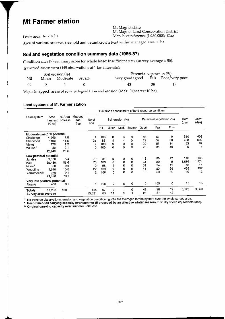
Mt Farmer station Mt Magnet shire Mt Magnet Land Conservation District
Lease area: 62,732 ha Mapsheet reference (1:250,000): Cue
Area of various reserves, freehold and vacant crown land within managed area: 0 ha.
Soil and vegetation condition summary data (1986-87)
Condition sites (7) summary score for whole lease: Insufficient sites (survey average ~ 50).
Traversed assessment (145 observations at 1 km intervals):
Soil erosion (%) Perennial vegetation (%) Nil Minor Moderate Severe Very good/ good Fair Poor/very poor
97 2 1 o 43 38 19
Major (mapped) areas of severe degradation and erosion (sde): 0 (nearest 10 hal.
Land systems of Mt Farmer station
Traversed assessment of land resource condition
Land system Area % Area Mapped (nearest of lease sde No of Soil erosion (%) Perennial vegetation (%) Rcc* Occ** 10 hal (ha) abs (dse) (dse)
Nil Minor Mod. Severe Good Fair Poor
Moderate pastoral potential Challenge 4,900 7.8 7 100 0 0 0 43 57 0 350 408 Sherwood 7,190 11.5 25 88 8 4 0 12 52 36 468 599 Violet 770 1.2 7 100 0 0 0 29 57 14 53 64 Wiluna+ 80 QJ. 0 100 0 0 0 25 35 40 5 7
12,940 20.6
Low pastoral potential Jundee 3,360 5.4 70 91 9 0 0 18 55 27 140 168 Kalli 35,480 56.6 70 100 0 0 0 61 30 9 1,636 1,774 Norie+ 300 0.5 0 96 4 0 0 31 54 15 13 15 Wood line 9,940 15.8 22 100 0 0 0 41 23 36 438 497 Yarrameedie 250 0.4 2 100 0 0 0 0 50 50 10 13
49,330 78.7
Very low pastoral potential Farmer 460 0.7 100 0 0 0 0 100 0 15 15
Totals 62,730 100.0 145 97 2 1 0 43 38 19 3,128 3,560 Survey area average 13,621 83 11 5 1 21 37 42
+ No traverse observations; erosion and vegetation condition figures are averages for the system over the whole survey area. * Recommended carrying capacity over summer (if preceded by an effective winter season) 3130 dry sheep equivalents (dse). ** Original carrying capacity over summer 3560 dse.
387
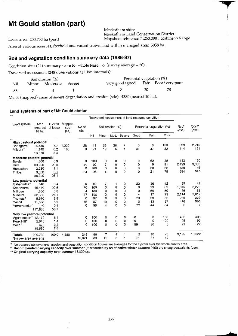
Mt Gould station (part) Meekathara shire Meekathara Land Conservation District
Lease area: 200,730 ha (part) Mapsheet reference (1:250,000): Robinson Range
Area of various reserves, freehold and vacant crown land within managed area: 5058 ha.
Soil and vegetation condition summary data (1986-87)
Condition sites (24) summary score for whole lease: 29 (survey average ~ 50).
Traversed assessment (248 observations at 1 km intervals):
Perennial vegetation (%) Nil
88
Soil erosion (%) Minor Moderate Severe Very good/ good Fair Poor/very poor
7 4 1 2 20 78
Major (mapped) areas of severe degradation and erosion (sde): 4380 (nearest 10 hal·
Land systems of part of Mt Gould station
Traversed assessment of land resource condition
Land system Area % Area Mapped (nearest of lease sde No of Soil erosion (0/0) Perennial vegetation ('Yo) Rcc* 10 hal (ha) obs (dse)
Nil Minor Mod. Severe Good Fair Poor
High pastoral potential Beringarra 15,530 7.7 4,200 28 18 39 36 7 0 0 100 629 Mileura+ 1340 0.7 180 0 74 19 6 1 31 37 32 114
16,870 8.4
Moderate pastoral potential Bele]e 1,800 0.9 8 100 0 0 0 0 62 38 113 Cole 39,990 20.0 44 93 7 0 a 0 9 91 2,499 Horseshoe 2,230 1.1 8 100 a 0 a 0 38 62 139 Trillbar 6300 ;U 24 96 4 0 0 0 21 79 394
50,320 25.1
Low pastoral potential Gabanintha + 840 0.4 0 92 7 1 0 22 36 42 35 Koonmarra 45,440 22.6 70 100 0 0 0 6 29 65 1,845 Millrose 1,650 0.8 4 100 a 0 0 0 50 50 66 Mindura 52,330 26.1 47 100 a 0 0 4 17 79 2,114 Thomas+ 5,570 2.8 0 97 0 3 a 29 39 32 239 Yandil 11,890 5.9 15 87 13 0 0 0 13 87 476 Yarrameedie+ 140 0.4 0 96 4 0 0 22 44 34 6
117,860 58.7
Very low pastoral potential Agamemnon+ 12,170 6.1 a 100 0 0 0 0 0 100 406 Peak HiII+ 2,840 1.4 0 100 0 0 0 0 0 100 95 Weld+ 670 0.3 0 100 0 0 a 59 36 5 22
15,680 7.8
Totals 200,730 100.0 4,380 248 88 7 4 2 20 78 9,192 Survey area average 13,621 83 11 5 21 37 42
+ No traverse observations; erosion and vegetation condition figures are averages for the system over the whole survey area.
Occ** (dse)
2,219 191
150 3,333
186 525
42 2,272
83 2,617
279 595
7
406 95 22
13,022
* Recommended carrying capacity over summer (if preceded by an effective winter season) 9190 dry sheep equivalents (dse). ** Original carrying capacity over summer 13,020 dse.
388
,
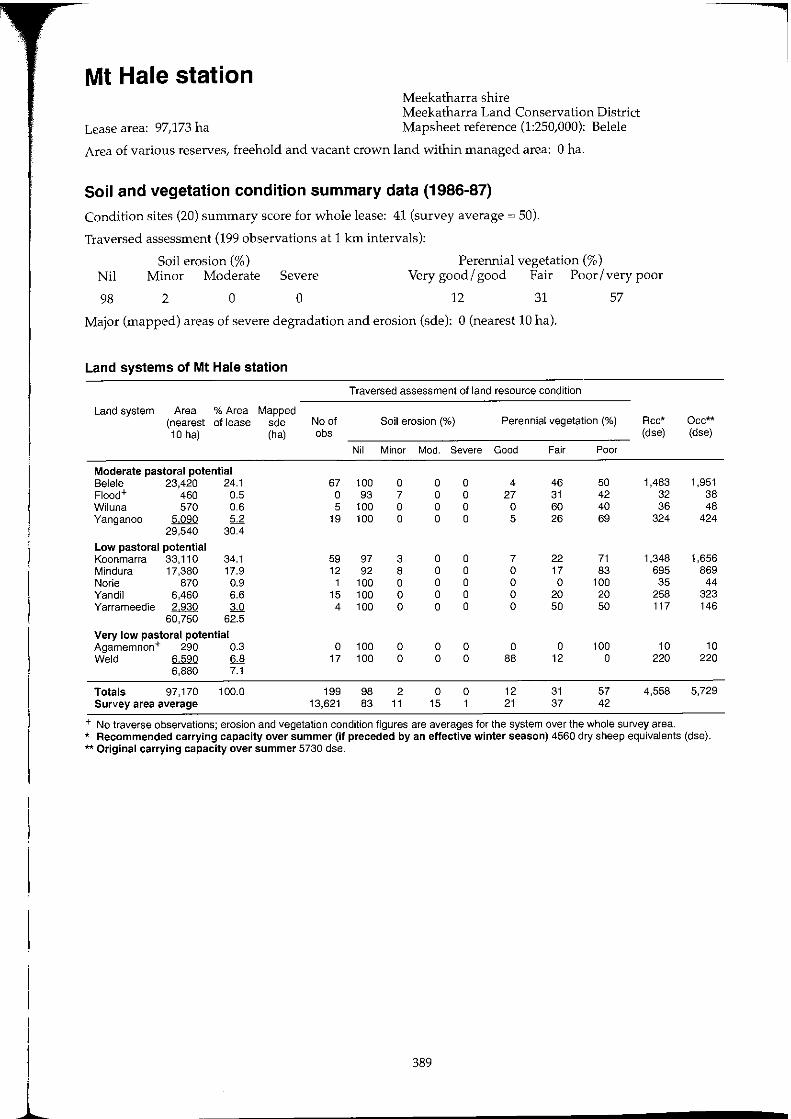
Mt Hale station Meekatharra shire Meekatharra Land Conservation District
Lease area: 97,173 ha Mapsheet reference (1:250,000): Belele
Area of various reserves, freehold and vacant crown land within managed area: 0 ha.
Soil and vegetation condition summary data (1986-87)
Condition sites (20) summary score for whole lease: 41 (survey average ~ 50).
Traversed assessment (199 observations at 1 krn intervals):
Perennial vegetation (%) Nil
98
Soil erosion (%) Minor Moderate Severe Very good / good Fair Poor / very poor
2 o o 12 31 57
Major (mapped) areas of severe degradation and erosion (sde): 0 (nearest 10 hal.
Land systems of Mt Hale station
Traversed assessment of land resource condition
Land system Area % Area Mapped (nearest of lease sde No of Soil erosion (%) Perennial vegetation (%) Rcc* 10 hal (ha) obs (dse)
Nil Minor Mod. Severe Good Fair Poor
Moderate pastoral potential Belele 23,420 24.1 67 100 0 0 0 4 46 50 1,483 Flood+ 460 0.5 0 93 7 0 0 27 31 42 32 Wiluna 570 0.6 5 100 0 0 0 0 60 40 36 Yanganoo 5090 5.2 19 100 0 0 0 5 26 69 324
29,540 30.4
Low pastoral potential Koonmarra 33,110 34.1 59 97 3 0 0 7 22 71 1,348 Mindura 17,380 17.9 12 92 8 0 0 0 17 83 695 Norie 870 0.9 1 100 0 0 0 0 0 100 35 Yandil 6,460 6.6 15 100 0 0 0 0 20 20 258 Yarrameedie 2,930 3.0 4 100 0 0 0 0 50 50 117
60,750 62.5
Very low pastoral potential Agamemnon+ 290 0.3 0 100 0 0 0 0 0 100 10 Weld 6590 6.8 17 100 0 0 0 88 12 0 220
6,880 7.1
Totals 97,170 100.0 199 98 2 0 0 12 31 57 4,558 Survey area average 13,621 83 11 15 1 21 37 42
+ No traverse observations; erosion and vegetation condition figures are averages for the system over the whole survey area.
Occ** (dse)
1,951 38 48
424
1,656 869
44 323 146
10 220
5,729
* Recommended carrying capacity over summer (if preceded by an effective winter season) 4560 dry sheep equivalents (dse). ** Original carrying capacity over summer 5730 dse.
389
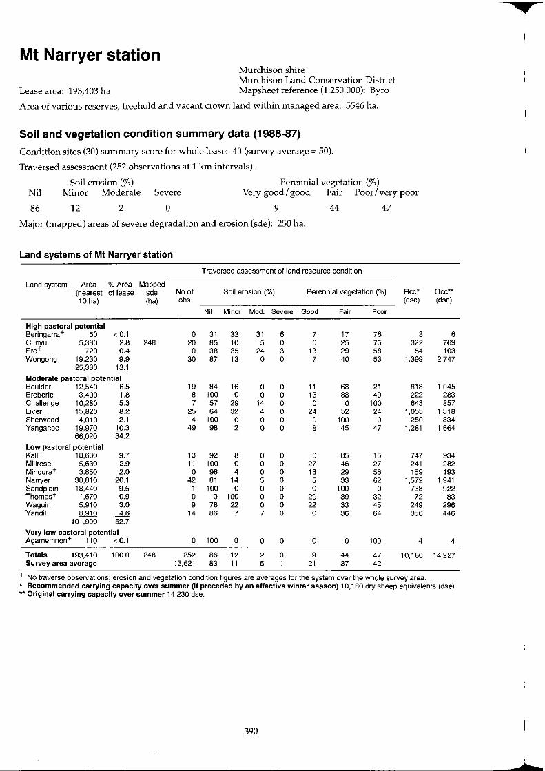
Mt Narryer station Murchison shire Murchison Land Conservation District
Lease area: 193,403 ha Mapsheet reference (1:250,000): Byro
Area of various reserves, freehold and vacant crown land within managed area: 5546 ha.
Soil and vegetation condition summary data (1986-87)
Condition sites (30) summary score for whole lease: 40 (survey average = 50).
Traversed assessment (252 observations at 1 km intervals):
Soil erosion (%) Perennial vegetation (%) Nil Minor Moderate Severe Very good / good Fair Poor / very poor
86 12 2 0 9 44 47
Major (mapped) areas of severe degradation and erosion (sde): 250 ha.
Land systems of Mt Narryer station
Traversed assessment of land resource condition
Land system Area % Area Mapped (nearest of lease sde No of Soil erosion (%) Perennial vegetation (%) Rcc* Occ** 10 ha) (ha) obs (dse) (dse)
Nil Minor Mod. Severe Good Fair Poor
High pastoral potential Beringarra+ 50 < 0.1 0 31 33 31 6 7 17 76 3 6 Cunyu 5,380 2.8 248 20 85 10 5 0 0 25 75 322 769 Ero+ 720 0.4 0 38 35 24 3 13 29 58 54 103 Wongong 19230 9.9 30 87 13 0 0 7 40 53 1,399 2,747
25,380 13.1
Moderate pastoral potential Boulder 12,540 6.5 19 84 16 0 0 11 68 21 813 1,045 Breberle 3,400 1.8 8 100 0 0 0 13 38 49 222 283 Challenge 10,280 5.3 7 57 29 14 0 0 0 100 643 857 Liver 15,820 8.2 25 64 32 4 0 24 52 24 1,055 1,318 Sherwood 4,010 2.1 4 100 0 0 0 0 100 0 250 334 Yanganoo 19970 10.3 49 98 2 0 0 8 45 47 1,281 1,664
66,020 34.2
Low pastoral potential Kalli 18,680 9.7 13 92 8 0 0 0 85 15 747 934 Millrose 5,630 2.9 11 100 0 0 0 27 46 27 241 282 Mindura+ 3,850 2.0 0 96 4 0 0 13 29 58 159 193 Narryer 38,810 20.1 42 81 14 5 0 5 33 62 1,572 1,941 Sand plain 18,440 9.5 1 100 0 0 0 0 100 0 738 922 Thomas+ 1,670 0.9 0 0 100 0 0 29 39 32 72 83 Waguin 5,910 3.0 9 78 22 0 0 22 33 45 249 296 Yandil 8,910 ....4J! 14 86 7 7 0 0 36 64 356 446
101,900 52.7
Very low pastoral potential Agamemnon+ 110 < 0.1 0 100 0 0 0 0 0 100 4 4
Totals 193,410 100.0 248 252 86 12 2 0 9 44 47 10,180 14,227 Survey area average 13,621 83 11 5 1 21 37 42
+ No traverse observations; erosion and vegetation condition figures are averages for the system over the whole survey area. * Recommended carrying capacity over summer (If preceded by an effective winter season) 10,180 dry sheep equivalents (dse). ** Original carrying capacity over summer 14,230 dse.
390
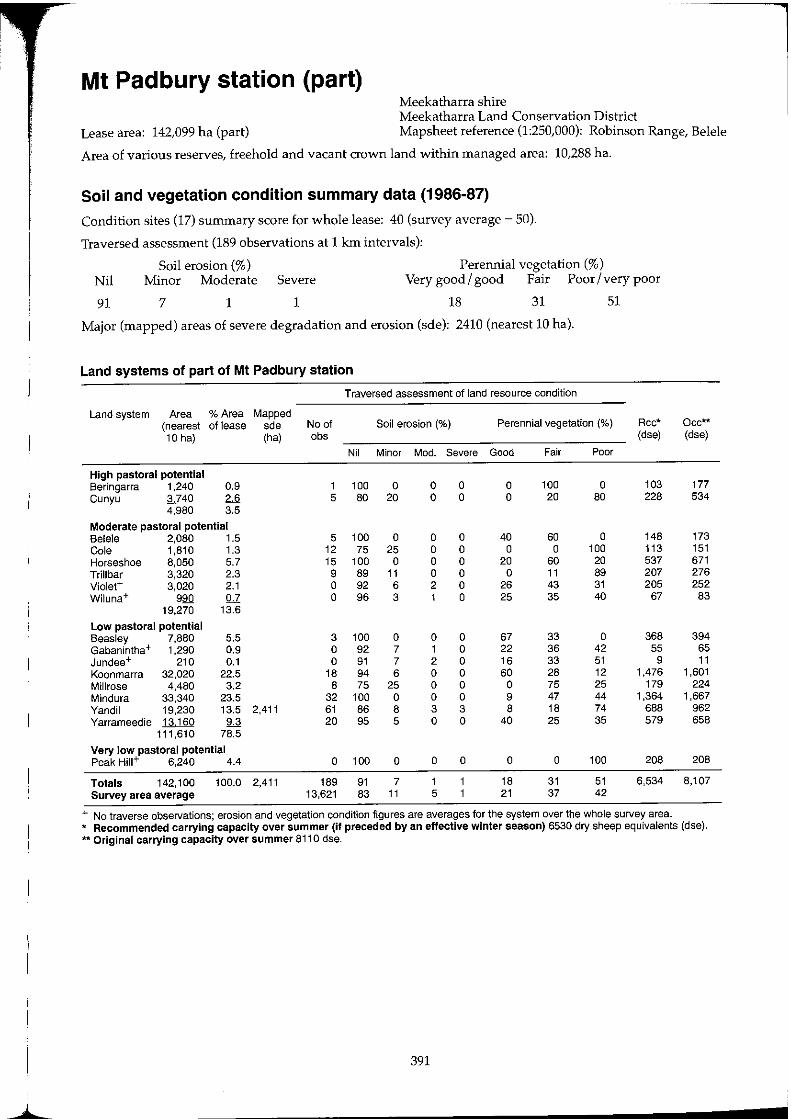
Mt Padbury station (part) Meekatharra shire Meekatharra Land Conservation District
Lease area: 142,099 ha (part) Mapsheet reference (1:250,000): Robinson Range, Belele
Area of various reserves, freehold and vacant crown land within managed area: 10,288 ha.
Soil and vegetation condition summary data (1986-87)
Condition sites (17) summary score for whole lease: 40 (survey average ~ 50).
Traversed assessment (189 observations at 1 km intervals):
Perennial vegetation (%) Nil
91
Soil erosion (%) Minor Moderate Severe Very good / good Fair Poor / very poor
7 1 1 18 31 51
Major (mapped) areas of severe degradation and erosion (sde): 2410 (nearest 10 hal.
Land systems of part of Mt Padbury station
Traversed assessment of land resource condition
Land system Area % Area Mapped (nearest of lease sde Na of Soil erosion (%) Perennial vegetation (%) Rcc* 10 hal (ha) obs (dse)
Nil Minor Mod. Severe Good Fair Poor
High pastoral potential Beringarra 1,240 0.9 1 100 0 0 0 0 100 0 103 Cunyu 3740 2.6 5 80 20 0 0 0 20 80 228
4,980 3.5
Moderate pastoral potential Belele 2,080 1.5 5 100 0 0 0 40 60 0 148 Cole 1,810 1.3 12 75 25 0 0 0 0 100 113 Horseshoe 8,050 5.7 15 100 0 0 0 20 60 20 537 Trillbar 3,320 2.3 9 89 11 0 0 0 11 89 207 Violet+ 3,020 2.1 0 92 6 2 0 26 43 31 205 Wiluna+ 990 0.7 0 96 3 1 0 25 35 40 67
19,270 13.6
Low pastoral potential Beasley 7,880 5.5 3 100 0 0 0 67 33 0 368 Gabanintha+ 1,290 0.9 0 92 7 1 0 22 36 42 55 Jundee+ 210 0.1 0 91 7 2 0 16 33 51 9 Koonmarra 32,020 22.5 18 94 6 0 0 60 28 12 1,476 Millrose 4,480 3.2 8 75 25 0 0 0 75 25 179 Mindura 33,340 23.5 32 100 0 0 0 9 47 44 1,364 Yandil 19,230 13.5 2,411 61 86 8 3 3 8 18 74 688 Yarrameedie 13160 9.3 20 95 5 0 0 40 25 35 579
111,610 78.5
Very low pastoral potential Peak HiII+ 6,240 4.4 0 100 0 0 0 0 0 100 208
Totals 142,100 100.0 2,411 189 91 7 1 18 31 51 6,534 Survey area average 13,621 83 11 5 21 37 42
+ No traverse observations; erosion and vegetation condition figures are averages for the system over the whole survey area.
Occ** (dse)
177 534
173 151 671 276 252 83
394 65 11
1,601 224
1,667 962 658
208
8,107
* Recommended carrying capacity over summer (if preceded by an effective winter season) 6530 dry sheep equivalents (dse). ** Original carrying capacity over summer 8110 dse.
391
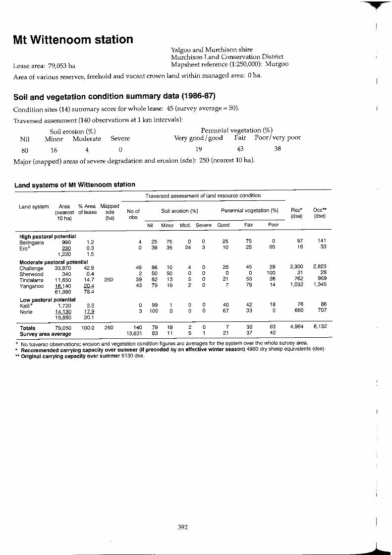
Mt Wittenoom station Yalgoo and Murchison shire Murchison Land Conservation District
Lease area: 79,053 ha Mapsheet reference (1:250,000): Murgoo
Area of various reserves, freehold and vacant crown land within managed area: 0 ha.
Soil and vegetation condition summary data (1986-87)
Condition sites (14) summary score for whole lease: 45 (survey average = 50).
Traversed assessment (140 observations at 1 km intervals):
Soil erosion (%) Perennial vegetation (%) Nil Minor Moderate Severe Very good/ good Fair Poor/very poor
80 16 4 o 19 43 38
Major (mapped) areas of severe degradation and erosion (sde): 250 (nearest 10 hal.
Land systems of Mt Wittenoom station
Traversed assessment of land resource condition
Land system Area % Area Mapped (nearest of lease sde No of Soil erosion (%) Perennial vegetation (%) Rcc* 10 hal (ha) abs (dse)
Nil Minor Mod. Severe Good Fair Poor
High pastoral potential Beringarra 990 1.2 4 25 75 0 0 25 75 0 97 Ero+ 230 0.3 0 38 35 24 3 10 25 65 16
1,220 1.5
Moderate pastoral potential Challenge 33,870 42.9 49 86 10 4 0 26 45 29 2,300 Sherwood 340 0.4 2 50 50 0 0 0 0 100 21 Tindalarra 11,630 14.7 250 39 82 13 5 0 21 53 26 762 Yanganoo 16140 20.4 43 79 19 2 0 7 79 14 1,032
61,980 78.4
Low pastoral potential Kalli+ 1,720 2.2 0 99 1 0 0 40 42 18 76 Norie 14130 1L.9 3 100 0 0 0 67 33 0 660
15,850 20.1
Totals 79,050 100.0 250 140 79 19 2 0 7 30 63 4,964 Survey area average 13,621 83 11 5 1 21 37 42
+ No traverse observations; erosion and vegetation condition figures are averages for the system over the whole survey area.
Occ** (dse)
141 33
2,823 28
969 1,345
86 707
6,132
* Recommended carrying capacity over summer (if preceded by an effective winter season) 4960 dry sheep equivalents (dse). ** Original carrying capacity over summer 6130 dse.
392
,
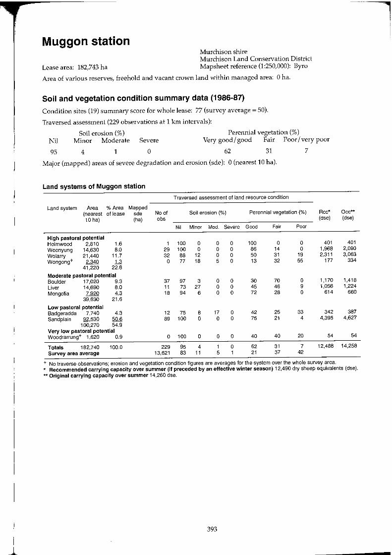
I ~
Muggon station Murchison shire Murchison Land Conservation District
Lease area: 182,743 ha Mapsheet reference (1:250,000): Byro
Area of various reserves, freehold and vacant crown land within managed area: 0 ha.
Soil and vegetation condition summary data (1986-87)
Condition sites (19) summary score for whole lease: 77 (survey average ~ 50).
Traversed assessment (229 observations at 1 km intervals):
Soil erosion (%) Perennial vegetation (%) Nil Minor Moderate Severe Very good/ good Fair Poor/very poor
95 4 1 o 62 31 7
Major (mapped) areas of severe degradation and erosion (sde): 0 (nearest 10 hal.
Land systems of Muggon station
Traversed assessment of land resource condition
Land system Area % Area Mapped (nearest of lease sde No of Soil erosion (%) Perennial vegetation (%) Rcc* 10 hal (ha) obs (dse)
Nil Minor Mod. Severe Good Fair Poor
High pastoral potential Holmwood 2,810 1.6 1 100 0 0 0 100 0 0 401 Weenyung 14,630 8.0 29 100 0 0 0 86 14 0 1,968 Wolarry 21,440 11.7 32 88 12 0 0 50 31 19 2,311 Wongong+ 2340 1& 0 77 18 5 0 13 32 55 177
41,220 22.6
Moderate pastoral potential Boulder 17,020 9.3 37 97 3 0 0 30 70 0 1,170 Liver 14,690 8.0 11 73 27 0 0 45 46 9 1,056 Mongolia 7,920 4.3 18 94 6 0 0 72 28 0 614
39,630 21.6
Low pastoral potential Badgeradda 7,740 4.3 12 75 8 17 0 42 25 33 342 Sandplain 92530 !ill& 89 100 0 0 0 75 21 4 4,395
100,270 54.9 Very low pastoral potential Woodrarrung+ 1,620 0.9 0 100 0 0 0 40 40 20 54
Totals 182,740 100.0 229 95 4 1 0 62 31 7 12,488 Survey area average 13,621 83 11 5 1 21 37 42
+ No traverse observations; erosion and vegetation condition figures are averages for the system over the whole survey area.
Oce*'" (dse)
401 2,090 3,063
334
1,418 1,224
660
387 4,627
54
14,258
* Recommended carrying capacity over summer (if preceded by an effective winter season) 12,490 dry sheep equivalents (dse). ** Original carrying capacity over summer 14,260 dse.
393
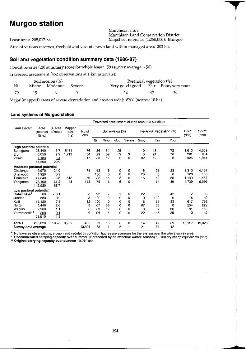
Murgoo station Murchison shire Murchison Land Conservation District
Lease area: 208,017 ha Mapsheet reference (1:250,000): Murgoo
Area of various reserves, freehold and vacant crown land within managed area: 203 ha.
Soil and vegetation condition summary data (1986-87)
Condition sites (28) summary score for whole lease: 59 (survey average ~ 50).
Traversed assessment (452 observations at 1 km intervals):
Perennial vegetation (%) Nil
79
Soil erosion (%) Minor Moderate Severe Very good / good Fair Poor / very poor
15 6 o 14 47 39
Major (mapped) areas of severe degradation and erosion (sde): 8700 (nearest 10 hal.
Land systems of Murgoo station
Traversed assessment of land resource condition
Land system Area % Area Mapped (nearest of lease sde No of Soil erosion (%) Perennial vegetation (%) Rcc*
10 hal (ha) abs (dse)
Nil Minor Mod. Severe Good Fair Poor
High pastoral potential Beringarra 28,440 13.7 6431 76 36 34 29 1 10 18 72 1,615 Era 6,050 2.9 1,713 34 29 59 9 3 0 24 76 281 Yewln 7100 3.4 17 88 12 0 0 82 12 6 926
41,590 20.0
Moderate pastoral potential Challenge 49,970 24.0 79 92 8 0 0 18 59 23 3,310 Sherwood 1,920 0.9 5 100 0 0 0 20 80 0 128 Tindalarra 17,840 8.6 518 59 82 15 3 0 15 49 36 1,139 Yanganoo 73190 35.2 43 158 79 15 6 0 11 54 35 4,739
142,920 68.7
Low pastoral potential Gabanintha+ 60 < 0.1 0 92 7 1 0 22 36 42 2 Jundee 380 0.2 3 100 0 0 0 0 100 0 15 Kalli 15,120 7.3 12 100 0 0 0 8 59 33 617 Norie 5,440 2.6 3 67 33 0 0 67 33 0 254 Waguln 2,260 1.1 6 83 17 0 0 0 67 33 91 Yarrameedle+ 250 QJ. 0 96 4 0 0 22 43 35 10
23,510 11.3
Totals 208,020 100.0 8,705 452 79 15 6 0 14 47 39 13,127 Survey area average 13,621 83 11 5 1 21 37 42
+ No traverse observations; erosion and vegetation condition figures are averages for the system over the whole survey area.
Occ** (dse)
4,063 864
1,014
4,164 160
1,487 6,099
3 19
756 272 113
12
19,026
* Recommended carrying capacity over summer (If preceded by an effective winter season) 13,130 dry sheep equivalents (dse). ** Original carrying capacity over summer 19,030 dse.
394
t I
1
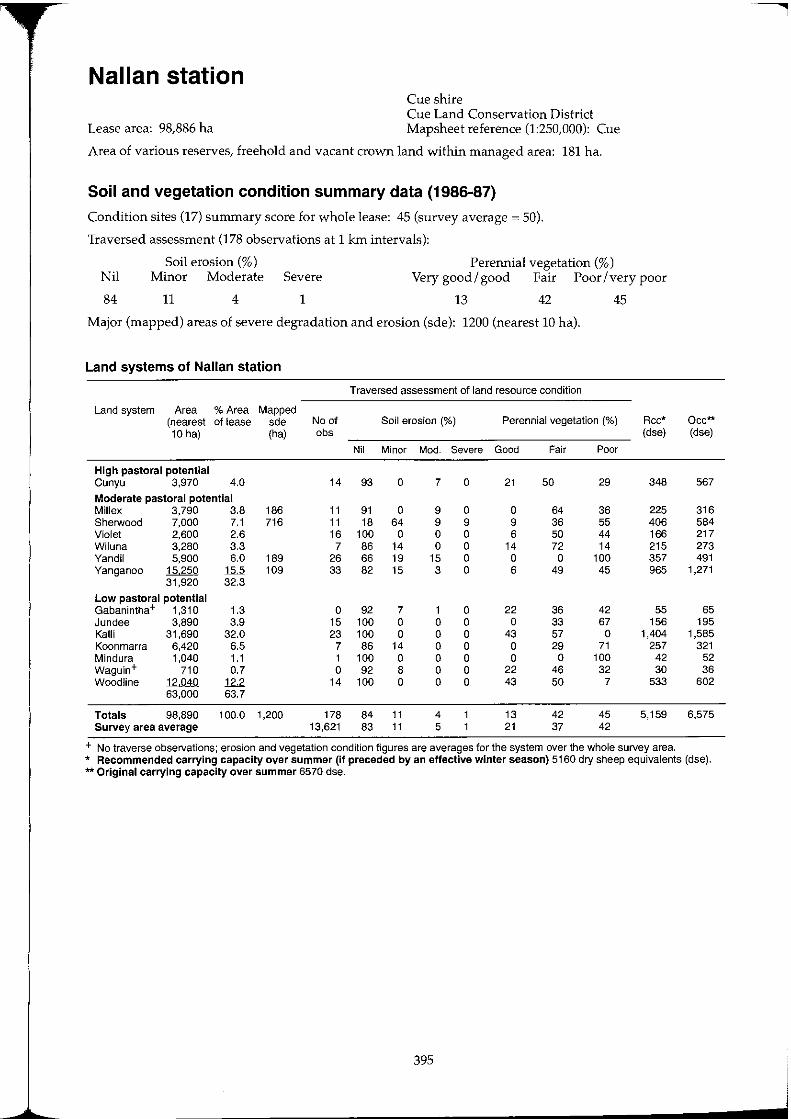
Nallan station Cue shire Cue Land Conservation District
Lease area: 98,886 ha Mapsheet reference (1:250,000): Cue
Area of various reserves, freehold and vacant crown land within managed area: 181 ha.
Soil and vegetation condition summary data (1986-87)
Condition sites (17) summary score for whole lease: 45 (survey average = 50).
Traversed assessment (178 observations at 1 km intervals):
Soil erosion (%) Perennial vegetation (%) Nil Minor Moderate Severe Very good/ good Fair Poor/very poor
84 11 4 1 13 42 45
Major (mapped) areas of severe degradation and erosion (sde): 1200 (nearest 10 hal.
Land systems of Nalian station
Traversed assessment of land resource condition
Land system Area % Area Mapped (nearest of lease sde No of Soil erosion (%) Perennial vegetation (%) Rcc* 10 hal (ha) obs (dse)
Nil Minor Mod. Severe Good Fair Poor
High pastoral potential Cunyu 3,970 4.0 14 93 a 7 a 21 50 29 348
Moderate pastoral potential Millex 3,790 3.8 186 11 91 a 9 a a 64 36 225 Sherwood 7,000 7.1 716 11 18 64 9 9 9 36 55 406 Violet 2,600 2.6 16 100 a a a 6 50 44 166 Wi luna 3,280 3.3 7 86 14 a a 14 72 14 215 Yandil 5,900 6.0 189 26 66 19 15 a a a 100 357 Yanganoo 15250 15.5 109 33 82 15 3 a 6 49 45 965
31,920 32.3
Low pastoral potential Gabanintha+ 1,310 1.3 a 92 7 1 a 22 36 42 55 Jundee 3,890 3.9 15 100 a a a a 33 67 156 Kalli 31,690 32.0 23 100 a a a 43 57 a 1,404 Koonmarra 6,420 6.5 7 86 14 a a a 29 71 257 Mindura 1,040 1.1 1 100 a a a a a 100 42 Waguin+ 710 0.7 a 92 8 a a 22 46 32 30 Woodline 12,040 12.2 14 100 a a a 43 50 7 533
63,000 63.7
Totals 98,890 100.0 1,200 178 84 11 4 13 42 45 5,159 Survey area average 13,621 83 11 5 21 37 42
+ No traverse observations; erosion and vegetation condition figures are averages for the system over the whole survey area.
Oec** (dse)
567
316 584 217 273 491
1,271
65 195
1,585 321
52 36
602
6,575
* Recommended carrying capacity over summer (if preceded by an effective winter season) 5160 dry sheep equivalents (dse). ** Original carrying capacity over summer 6570 dse.
395
j
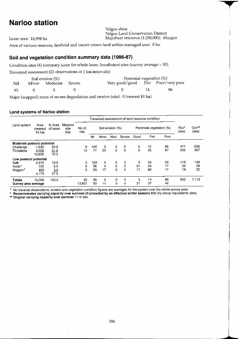
Narloo station Yalgoo shire Yalgoo Land Conservation District
Lease area: 14,998 ha Mapsheet reference (1:250,000): Murgoo
Area of various reserves, freehold and vacant crown land within managed area: 0 ha.
Soil and vegetation condition summary data (1986-87)
Condition sites (4) summary score for whole lease: Insufficient sites (survey average ~ 50).
Traversed assessment (22 observations at 1 km intervals):
Perennial vegetation (%) Nil
95
Soil erosion (%) Minor Moderate Severe Very good/good Fair Poor/very poor
o o o o 14 86
Major (mapped) areas of severe degradation and erosion (sde): 0 (nearest 10 hal.
Land systems of Narloo station
Traversed assessment of land resource condition
Land system Area % Area Mapped (nearest of lease sde No of Soil erosion (%) Perennial vegetation (%) Rcc* 10 hal (ha) cbs (dse)
Nil Minor Mod. Severe Good Fair Poor
Moderate pastoral potential Challenge 7,630 50.9 8 100 0 0 0 0 12 88 477 Tindalarra 3,200 21.3 12 77 23 0 0 8 25 67 205
10,830 72.2
Low pastoral potential Kalli 2,970 19.8 2 100 0 0 0 0 50 50 119 Norie+ 750 5.0 0 96 4 0 0 31 54 17 32 Waguin+ 450 3.0 0 83 17 0 0 17 66 17 19
4,170 27.8
Totals 15,000 100.0 22 95 5 0 0 0 14 86 852 Survey area average 13,621 83 11 5 1 21 37 42
+ No traverse observations: erosion and vegetation condition figures are averages for the system over the whole survey area.
Oec** (dse)
636 267
149 38 23
1,113
* Recommended carrying capacity over summer (if preceded by an effective winter season) 850 dry sheep equivalents (dse). ** Original carrying capacity over summer 1110 dse.
396
f
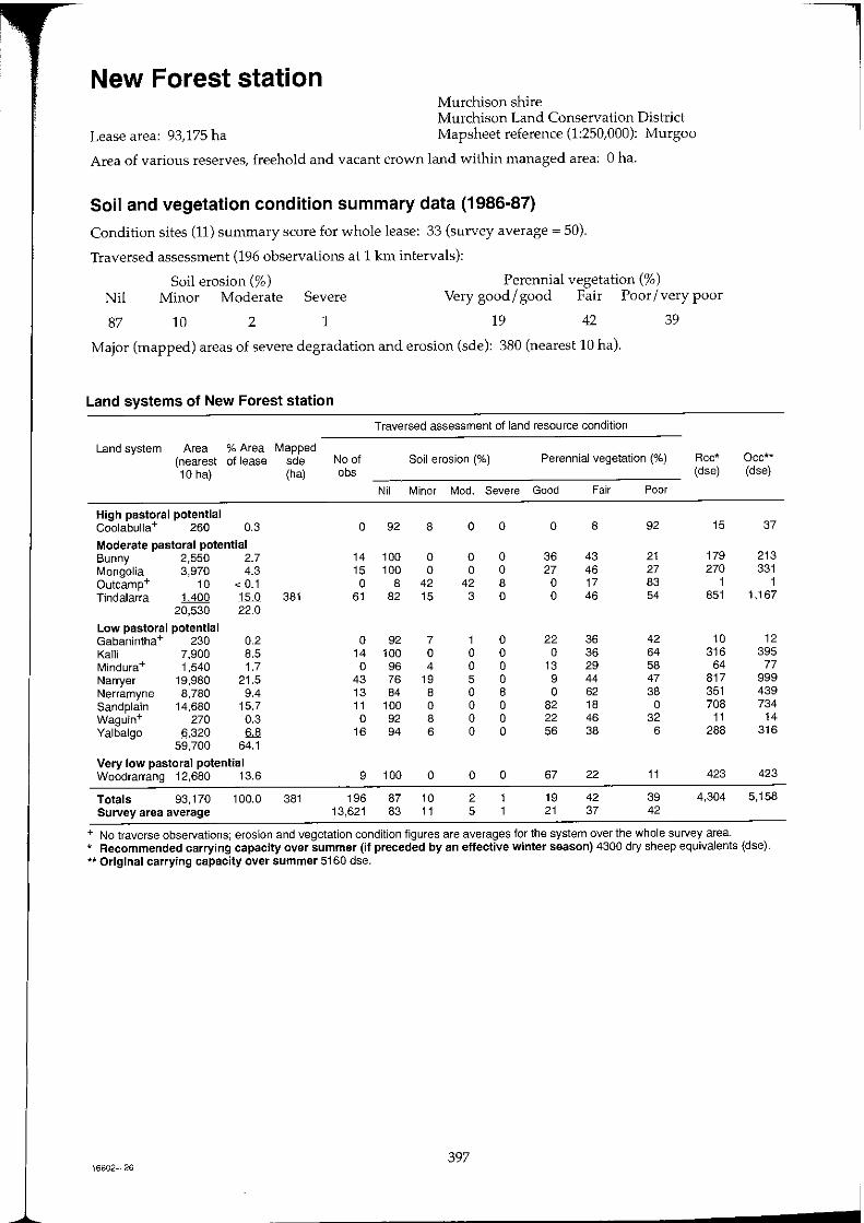
New Forest station Murchison shire Murchison Land Conservation District
Lease area: 93,175 ha Mapsheet reference (1:250,000): Murgoo
Area of various reserves, freehold and vacant crown land within managed area: 0 ha.
Soil and vegetation condition summary data (1986-87)
Condition sites (11) summary score for whole lease: 33 (survey average = 50).
Traversed assessment (196 observations at 1 km intervals):
Perennial vegetation (%) Nil
87
Soil erosion (%) Minor Moderate Severe Very good / good Fair Poor / very poor
10 2 1 19 42 39
Major (mapped) areas of severe degradation and erosion (sde): 380 (nearest 10 hal.
Land systems of New Forest station
Traversed assessment of land resource condition
Land system Area % Area Mapped (nearest of lease sde No of Soil erosion (%) Perennial vegetation (%) Rcc* 10 ha) (ha) obs (dse)
Nil Minor Mod. Severe Good Fair Poor
High pastoral potential Coolabulla+ 260 0.3 0 92 8 0 0 0 8 92 15
Moderate pastoral potential Bunny 2,550 2.7 14 100 0 0 0 36 43 21 179 Mongolia 3,970 4.3 15 100 0 0 0 27 46 27 270 Outcamp+ 10 < 0.1 0 8 42 42 8 0 17 83 1 Tindalarra 1400 15.0 381 61 82 15 3 0 0 46 54 851
20,530 22.0
Low pastoral potential Gabanintha+ 230 0.2 0 92 7 1 0 22 36 42 10 Ka11i 7,900 8.5 14 100 0 0 0 0 36 64 316 Mindura+ 1,540 1.7 0 96 4 0 0 13 29 58 64 Narryer 19,980 21.5 43 76 19 5 0 9 44 47 817 Nerramyne 8,780 9.4 13 84 8 0 8 0 62 38 351 Sand plain 14,680 15.7 11 100 0 0 0 82 18 0 708 Waguin+ 270 0.3 0 92 8 0 0 22 46 32 11 Yalbalgo 6320 6.8 16 94 6 0 0 56 38 6 288
59,700 64.1
Very low pastoral potential Woodrarrang 12,680 13.6 9 100 0 0 0 67 22 11 423
Totals 93,170 100.0 381 196 87 10 2 19 42 39 4,304 Survey area average 13,621 83 11 5 21 37 42
+ No traverse observations; erosion and vegetation condition figures are averages for the system over the whole survey area.
Occ** (dse)
37
213 331
1 1,167
12 395
77 999 439 734
14 316
423
5,158
* Recommended carrying capacity over summer (if preceded by an effective winter season) 4300 dry sheep equivalents (dse). ** Original carrying capacity over summer 5160 dse.
397 16602-26
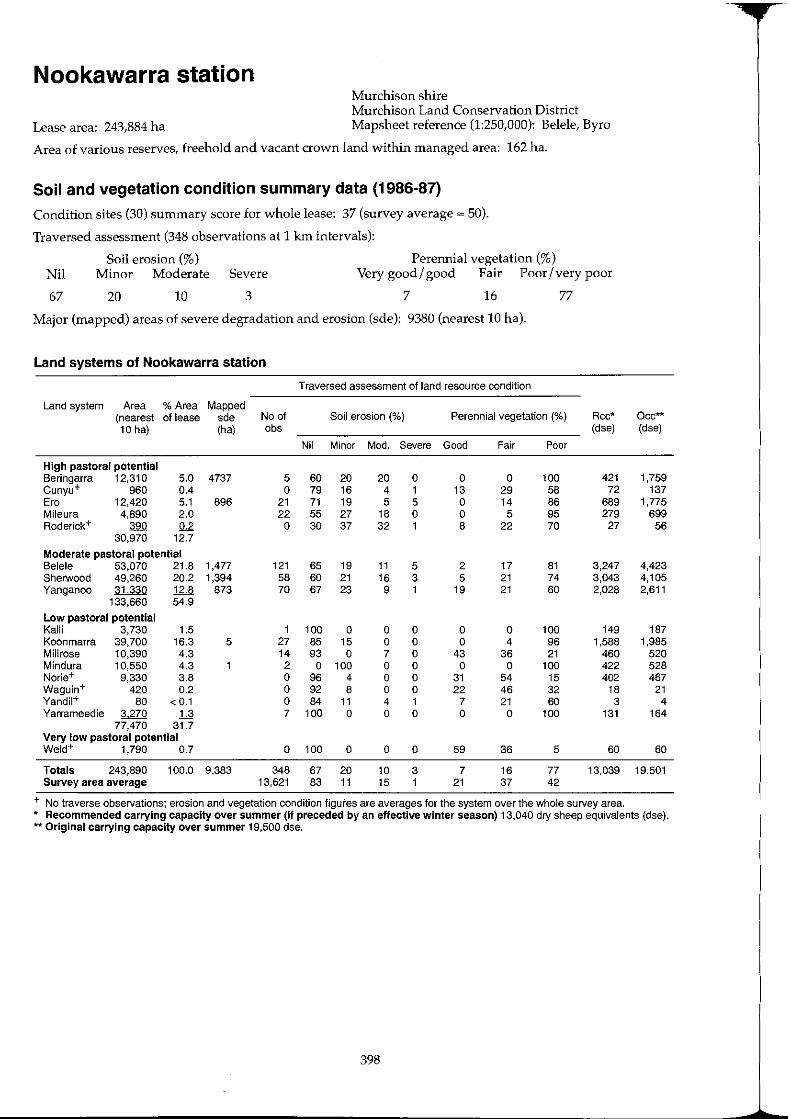
Nookawarra station Murchison shire Murchison Land Conservation District
Lease area: 243,884 ha Mapsheet reference (1:250,000): Belele, Byro
Area of various reserves, freehold and vacant crown land within managed area: 162 ha.
Soil and vegetation condition summary data (1986-87)
Condition sites (30) summary score for whole lease: 37 (survey average ~ 50).
Traversed assessment (348 observations at 1 km intervals):
Soil erosion (%) Perennial vegetation (%) Nil Minor Moderate Severe Very good/ good Fair Poor / very poor
67 20 10 3 7 16 77
Major (mapped) areas of severe degradation and erosion (sde): 9380 (nearest 10 hal.
Land systems of Nookawarra station
Traversed assessment of land resource condition
Land system Area % Area Mapped (nearest of lease sde No of Soil erosion (%) Perennial vegetation (%) Rcc* Oce** 10 ha) (ha) abs (dse) (dse)
Nil Minor Mod. Severe Good Fair Poor
High pastoral potential Beringarra 12,310 5.0 4737 5 60 20 20 0 0 0 100 421 1,759 Cunyu+ 960 0.4 0 79 16 4 1 13 29 58 72 137 Era 12,420 5.1 896 21 71 19 5 5 0 14 86 689 1,775 Mileura 4,890 2.0 22 55 27 18 0 0 5 95 279 699 Roderick+ 390 0.2 0 30 37 32 1 8 22 70 27 56
30,970 12.7
Moderate pastoral potential Belele 53,070 21.8 1,477 121 65 19 11 5 2 17 81 3,247 4,423 Sherwood 49,260 20.2 1,394 58 60 21 16 3 5 21 74 3,043 4,105 Yanganoo 31330 12.8 873 70 67 23 9 1 19 21 60 2,028 2,611
133,660 54.9
Low pastoral potential Kalli 3,730 1.5 1 100 0 0 0 0 0 100 149 187 Koonmarra 39,700 16.3 5 27 85 15 0 0 0 4 96 1,588 1,985 Millrose 10,390 4.3 14 93 0 7 0 43 36 21 460 520 Mindura 10,550 4.3 2 0 100 0 0 0 0 100 422 528 Norie+ 9,330 3.8 0 96 4 0 0 31 54 15 402 467 Waguin+ 420 0.2 0 92 8 0 0 22 46 32 18 21 Yandil+ 80 < 0.1 0 84 11 4 1 7 21 60 3 4 Yarrameedie 3270 U 7 100 0 0 0 0 0 100 131 164
77,470 31.7 Very low pastoral potential Weld+ 1,790 0.7 0 100 0 0 0 59 36 5 60 60
Totals 243,890 100.0 9,383 348 67 20 10 3 7 16 77 13,039 19,501 Survey area average 13,621 83 11 15 1 21 37 42
+ No traverse observations; erosion and vegetation condition figures are averages for the system over the whole survey area. * Recommended carrying capacity over summer (If preceded by an effective winter season) 13,040 dry sheep equivalents (dse). ** Original carrying capacity over summer 19,500 dse.
398
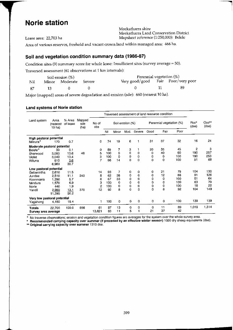
Norie station Meekatharra shire Meekatharra Land Conservation District
Lease area: 22,703 ha Mapsheet reference (1:250,000): Belele
Area of various reserves, freehold and vacant crown land within managed area: 466 ha.
Soil and vegetation condition summary data (1986-87)
Condition sites (9) summary score for whole lease: Insufficient sites (survey average ~ 50).
Traversed assessment (61 observations at 1 km intervals):
Soil erosion (%) Perennial vegetation (%) Nil Minor Moderate Severe Very good / good Fair Poor / very poor
87 13 0 0 0 11 89
Major (mapped) areas of severe degradation and erosion (sde): 660 (nearest 10 hal.
Land systems of Norie station
Traversed assessment of land resource condition
Land system Area % Area Mapped (nearest of lease sde No of Soil erosion (%) Perennial vegetation (%) Rcc* Occ** 10 hal (ha) cbs (dse) (dse)
Nil Minor Mod. Severe Good Fair Poor
High pastoral potential Mileura+ 170 0.7 0 74 19 6 31 37 32 16 24
Moderate pastoral potential Belele+ 30 0.1 0 89 7 3 1 20 35 45 2 3 Sherwood 3,080 13.6 46 5 100 0 0 0 0 40 60 190 257 Violet 3,040 13.4 3 100 0 0 0 0 0 100 190 253 Wiluna 810 M 7 86 14 0 0 0 0 100 51 68
6,960 30.7
Low pastoral potential Gabanintha 2,610 11.5 14 93 7 0 0 0 21 79 104 130 Jundee 2,510 11.1 240 8 62 38 0 0 0 12 88 91 126 Koonmarra 1,280 5.7 6 67 33 0 0 0 0 100 51 64 Mindura 1,570 6.9 3 100 0 0 0 0 0 100 63 79 Norie 440 1.9 2 100 0 0 0 0 0 100 18 22 Vandil 2980 1;11 370 12 92 8 0 0 0 8 92 104 149
11,390 50.2
Very low pastoral potential Yagahong 4,180 18.4 100 0 0 0 0 0 100 139 139
Totals 22,700 100.0 656 61 87 13 0 0 0 11 89 1,019 1,314 Survey area average 13,621 83 11 5 1 21 37 42
+ No traverse observations; erosion and vegetation condition figures are averages for the system over the whole survey area. * Recommended carrying capacity over summer (If preceded by an effective winter season) 1020 dry sheep equivalents (dse). ** Original carrying capacity over summer 1310 dse.
399
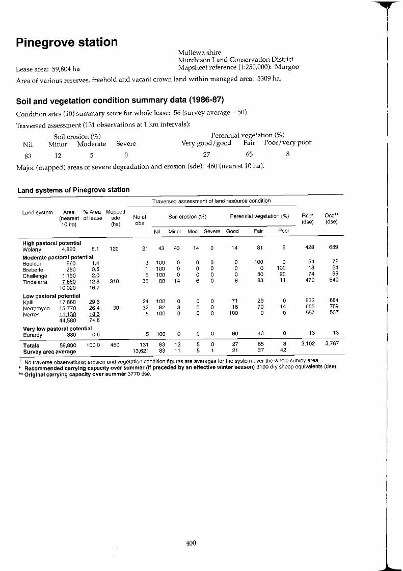
Pinegrove station Mullewa shire Murchison Land Conservation District
Lease area: 59,804 ha Mapsheet reference (1:250,000): Murgoo
Area of various reserves, freehold and vacant crown land within managed area: 5309 ha.
Soil and vegetation condition summary data (1986-87)
Condition sites (10) summary score for whole lease: 56 (survey average ~ 50).
Traversed assessment (131 observations at 1 km intervals):
Perennial vegetation (%) Nil
83
Soil erosion (%) Minor Moderate Severe Very good/good Fair Poor/very poor
12 5 o 27 65 8
Major (mapped) areas of severe degradation and erosion (sde): 460 (nearest 10 hal.
Land systems of Pinegrove station
Traversed assessment of land resource condition
Land system Area % Area Mapped (nearest of lease sde No of Soil erosion (%) Perennial vegetation (%) Rcc*
10 hal (ha) abs (dse)
Nil Minor Mod. Severe Good Fair Poor
High pastoral potential Wo[arry 4,820 8.1 120 21 43 43 14 0 14 81 5 428
Moderate pastoral potential Boulder 860 1.4 3 100 0 0 0 0 100 0 54 Sreberle 290 0.5 1 100 0 0 0 0 0 100 18 Challenge 1,190 2.0 5 100 0 0 0 0 80 20 74 Tindalarra 7680 12.8 310 35 80 14 6 0 6 83 11 470
10,020 16.7
Low pastoral potential Kalli 17,680 29.6 24 100 0 0 0 71 29 0 833 Nerramyne 15,770 26.4 30 32 92 3 5 0 16 70 14 655 Nerren 11,130 18.6 5 100 0 0 0 100 0 0 557
44,580 74.6
Very low pastoral potential Eurardy 380 0.6 5 100 0 0 0 60 40 0 13
Totals 59,800 100.0 460 131 83 12 5 0 27 65 8 3,102 Survey area average 13,621 83 11 5 1 21 37 42
+ No traverse observations; erosion and vegetation condition figures are averages for the system over the whole survey area.
Occ** (dse)
689
72 24 99
640
884 789 557
13
3,767
* Recommended carrying capacity over summer (if preceded by an effective winter season) 3100 dry sheep equivalents (dse). ** Original carrying capacity over summer 3770 dse.
400
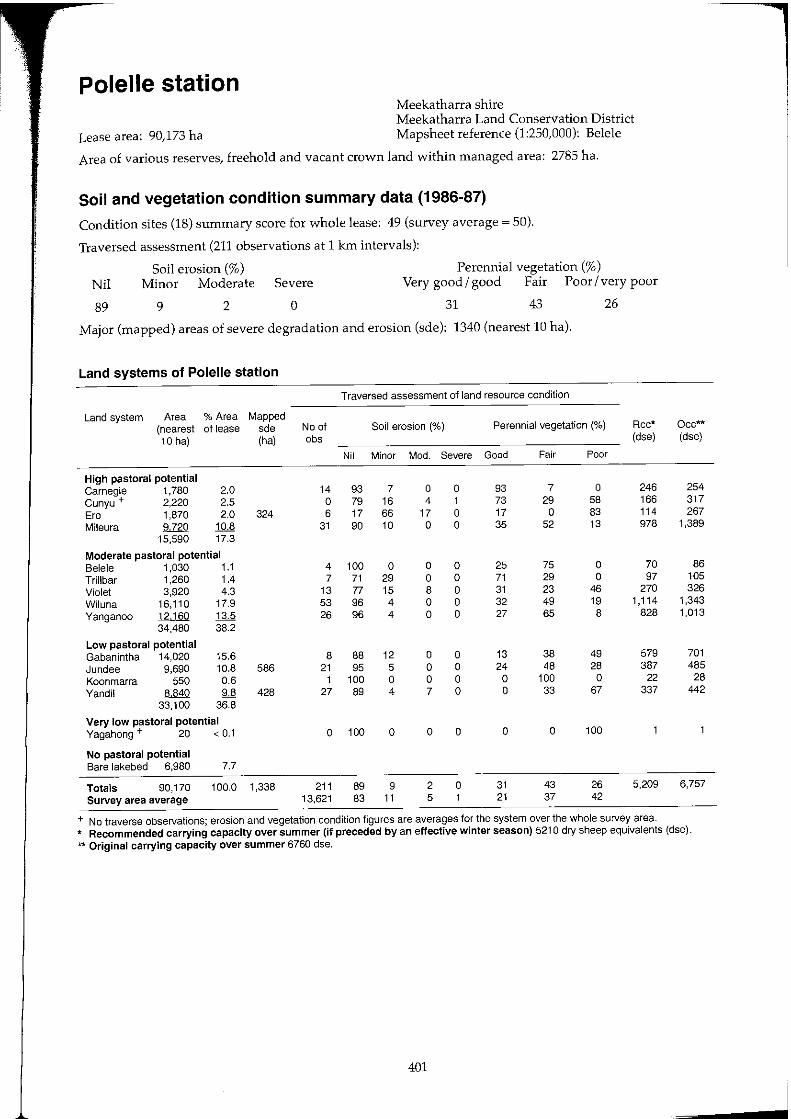
Polelle station Meekatharra shire Meekatharra Land Conservation District
Lease area: 90,173 ha Mapsheet reference (1:250,000): Belele
Area of various reserves, freehold and vacant crown land within managed area: 2785 ha.
Soil and vegetation condition summary data (1986-87)
Condition sites (18) summary score for whole lease: 49 (survey average ~ 50).
Traversed assessment (211 observations at 1 km intervals):
Perennial vegetation (%) Nil
89
Soil erosion (%) Minor Moderate Severe Very good/good Fair Poor/very poor
9 2 o 31 43 26
Major (mapped) areas of severe degradation and erosion (sde): 1340 (nearest 10 hal.
Land systems of Polelle station
Traversed assessment of land resource condition
Land system Area % Area Mapped (nearest of lease sde No of Soil erosion (%) Perennial vegetation (%) Rcc* 10 hal (ha) obs (dse)
Nil Minor Mod. Severe Good Fair Poor
High pastoral potential Carnegie 1,780 2.0 14 93 7 a a 93 7 0 246 Cunyu + 2,220 2.5 a 79 16 4 1 73 29 58 166 Era 1,870 2.0 324 6 17 66 17 a 17 a 83 114 Mileura ~ 10.8 31 90 10 a 0 35 52 13 978
15,590 17.3
Moderate pastoral potential Belele 1,030 1.1 4 100 0 a a 25 75 0 70 Trillbar 1,260 1.4 7 71 29 0 a 71 29 a 97 Violet 3,920 4.3 13 77 15 8 0 31 23 46 270 Wiluna 16,110 17.9 53 96 4 a 0 32 49 19 1,114 Yanganoo 1b1£Q 1>,2 26 96 4 a a 27 65 8 828
34,480 38.2
Low pastoral potential Gabanintha 14,020 15.6 8 88 12 a a 13 38 49 579 Jundee 9,690 10.8 586 21 95 5 0 a 24 48 28 387 Koonmarra 550 0.6 1 100 a a 0 a 100 a 22 Yandil aMQ 9.8 428 27 89 4 7 a 0 33 67 337
33,100 36.8
Very low pastoral potential Yagahong + 20 < 0.1 0 100 0 a 0 a 0 100
No pastoral potential Bare lakebed 6,980 7.7
Totals 90,170 100.0 1,338 211 89 9 2 0 31 43 26 5,209 Survey area average 13,621 83 11 5 1 21 37 42
+ No traverse observations; erosion and vegetation condition figures are averages for the system over the whole survey area.
Oec** (dse)
254 317 267
1,389
86 105 326
1,343 1,013
701 485
28 442
6,757
* Recommended carrying capacity over summer (if preceded by an effective winter season) 5210 dry sheep equivalents (dse). ** Original carrying capacity over summer 6760 dse.
401
Twin Peaks station Murchison shire Murchison Land Conservation District
Lease area: 132,415 ha Mapsheet reference (1:250,000): Murgoo
Area of various reserves, freehold and vacant crown land within managed area: 800 ha.
Soil and vegetation condition summary data (1986-87)
Condition sites (28) summary score for whole lease: 50 (survey average = 50).
Traversed assessment ( observations at 1 Ian intervals):
Perennial vegetation (%) Nil
79
Soil erosion (%) Minor Moderate Severe Very good/ good Fair Poor/very poor
17 4 o 15 39 46
Major (mapped) areas of severe degradation and erosion (sde): 480 (nearest 10 hal.
Land systems of Twin Peaks station
Traversed assessment of land resource condition
Land system Area % Area Mapped (nearest of lease sde No of Soil erosion (%) Perennial vegetation (%) Rco' 10 hal (ha) abs (dse)
Nil Minor Mod. Severe Good Fair Poor
High pastoral potential Bayou 1,610 1.2 3 34 33 33 a 34 33 33 152 Cunyu 110 0.1 1 100 a a a 100 a a 16 Era 7,030 5.3 399 33 43 42 15 a 9 21 70 465 Roderick 3,520 2.7 9 56 44 a a 11 33 56 262 Yewin 9,700 7.3 82 16 75 25 a a 69 19 12 1,170
21,970 16.6
Moderate pastoral potential Bunny 1,650 1.3 7 71 29 a a a 14 86 103 Challenge 27,710 20.9 29 97 a 3 a 21 51 28 1,853 Tindalarra 23,190 17.5 66 74 23 3 a 6 44 50 1,478 Violet+ 910 0.7 a 92 6 2 a 26 42 32 62 Yanganoo 27,080 20.5 57 98 2 a a 7 49 44 1,732
80,540 60.9
Low pastoral potential Gabanintha 1,390 1.0 2 100 a a a a 50 50 56 Jundee + 960 0.7 a 91 7 2 a 16 34 50 40 Kalli 16,050 12.1 14 100 a a a 36 43 21 700 Narryer 2,930 2.2 4 100 a a a 50 25 25 132 Norie + 10 < 0.1 a 96 4 a a 31 54 15 1 Waguin 8570 6.5 16 87 13 a a 6 31 63 355
29,910 22.5
Totals 132,420 100.0 481 257 79 17 4 a 15 39 46 8,577 Survey area average 13,621 83 11 5 1 21 37 42
+ No traverse observations; erosion and vegetation condition figures are averages for the system over the whole survey area.
Occ** (dse)
230 16
1,004 503
1,386
138 2,309 1,933
76 2,257
70 48
803 147
1 429
11,350
* Recommended carrying capacity over summer (If preceded by an effective winter season) 8580 dry sheep equivalents (dse). ** Original carrying capacity over summer 11,350 dse.
402
Wanarie station Mt Magnet shire Mt Magnet Land Conservation District
Lease area: 112,983 ha Mapsheet reference (1:250,000): Cue
Area of various reserves, freehold and vacant crown land within managed area: 869 ha.
Soil and vegetation condition summary data (1986-87)
Condition sites (19) summary score for whole lease: 48 (survey average ~ 50).
Traversed assessment (202 observations at 1 km intervals):
Soil erosion (%) Perennial vegetation (%) Nil Minor Moderate Severe Very good I good Fair Poor I very poor
88 7 4 1 22 41 37
Major (mapped) areas of severe degradation and erosion (sde): 600 (nearest 10 hal.
Land systems of Wanarie station
Traversed assessment of land resource condition
Land system Area % Area Mapped (nearest of lease sde No of Soil erosion (%) Perennial vegetation (%) Rcc* Occ** 10 hal (ha) obs (dse) (dse)
Nil Minor Mod. Severe Good Fair Poor
High pastoral potential Austin 2,520 2.2 6 100 a a a 67 33 a 310 360 Carnegie 3,850 3.4 1 100 a a a 100 a a 550 550 Cunyu + 560 0.5 a 79 16 4 1 13 29 58 42 80 Mileura 2900 2.6 171 9 89 11 a a 44 56 a 308 414
9,830 8.7
Moderate pastoral potential Challenge 12,730 11.3 100 29 86 7 7 a 14 69 17 827 1,061 Millex+ 3,130 2.8 a 83 14 3 a 29 39 32 215 261 Sherwood 10,010 8.8 331 29 45 31 17 7 28 38 34 663 834 Violet 6,150 5.4 12 100 a a a 25 33 42 416 513 Wiluna 9580 5.8 9 100 a a a 11 22 67 621 798
41,600 36.8
Low pastoral potential Gabanintha 4,680 4.2 9 100 a a a 56 22 22 213 234 Jundee 10,280 9.1 26 100 a a a a 8 92 411 514 Kalli 8,400 7.4 11 100 a a a 45 46 9 374 420 Woodline 31,730 28.1 57 96 2 2 a 14 47 39 1,314 1,587 Yandil 1J..!iQ LQ 4 100 a a a 25 75 a 49 58
56,240 49.8
No pastoral potential Bare lakebed 5,310 4.7
Totals 112,980 100.0 602 202 88 7 4 22 41 37 6,313 7,684 Survey area average 13,621 83 11 5 21 37 42
+ No traverse observations; erosion and vegetation condition figures are averages for the system over the whole survey area. * Recommended carrying capacity over summer (If preceded by an effective winter season) 6310 dry sheep equivalents (dse). ** Original carrying capacity over summer 7680 dse.
403
Wondinong station Mt Magnet and Cue shire Mt Magnet Land Conservation District
Lease area: 77,200 ha Mapsheet reference (1:250,000): Cue
Area of various reserves, freehold and vacant crown land within managed area: 260 ha.
Soil and vegetation condition summary data (1986-87)
Condition sites (12) summary score for whole lease: 60 (survey average ~ 50).
Traversed assessment ( 168 observations at 1 km intervals):
Perennial vegetation (%) Nil
89
Soil erosion (%) Minor Moderate Severe Very good/good Fair Poor/very poor
10 1 o 39 45 16
Major (mapped) areas of severe degradation and erosion (sde): 220 (nearest 10 hal·
Land systems of Wondinong station
Traversed assessment of land resource condition
Land system Area % Area Mapped (nearest of lease sde No of Soil erosion (%) Perennial vegetation (%) Rcc* 10 hal (ha) obs (dse)
Nil Minor Mod. Severe Good Fair Poor
Very high pastoral potential Merbla 4,990 6.5 14 71 29 0 0 43 50 7 702
High pastoral potential Austin 190 0.2 3 67 33 0 0 33 67 0 20 Carnegie 5,925 7.7 10 90 10 0 0 70 20 10 724 Cunyu 810 1.1 220 3 100 0 0 0 0 33 67 40 Ere 1,420 1.8 3 0 67 33 0 0 34 66 92 Mileura 12870 16.7 33 82 18 0 0 55 39 6 1,473
21,215 27.5
Moderate pastoral potential Challenge 3,030 3.9 8 100 0 0 0 38 13 49 213 Millex 4,700 6.0 7 86 14 0 0 29 29 42 322 Sherwood 2,680 3.5 4 75 25 0 0 100 0 0 223 Yanganoo + 1,460 ~ 0 91 7 2 0 20 40 40 97
11,870 15.3
Low pastoral potential Kalli + 1,040 1.3 0 99 1 0 0 40 42 18 46 Naluthanna 2,410 3.1 10 100 0 0 0 80 20 0 116 Woodline 30230 39.2 65 98 2 0 0 14 69 17 1,252
33,680 43.6
Very low pastoral potential Bullimore 3,850 5.0 8 100 0 0 0 87 13 0 128
No pastoral potential Bare lakebed 1,595 2.1
Totals 77,200 100.0 220 168 89 10 1 0 39 45 16 5,448 Survey area average 13,621 83 11 5 1 21 37 42
+ No traverse observations; erosion and vegetation condition figures are averages for the system over the whole survey area.
Occ** (dse)
998
27 846 116 203
1,839
253 392 223 122
52 121
1,511
128
6,831
* Recommended carrying capacity over summer (if preceded by an effective winter season) 5450 dry sheep equivalents (dse). ** Original carrying capacity over summer 6830 dse.
404
9
I ..I..
Wooleen station Murchison shire Murchison Land Conservation District
Lease area: 188,355 ha Mapsheet reference (1:250,000): Murgoo, Byro
Area of various reserves, freehold and vacant crown land within managed area: 3973 ha.
Soil and vegetation condition summary data (1986-87)
Condition sites (25) summary score for whole lease: 50 (survey average ~ 50).
Traversed assessment (280 observations at 1 km intervals):
Soil erosion (%) Perennial vegetation (%) Nil Minor Moderate Severe Very good / good Fair Poor / very poor
74 13 10 3 26 36 38
Major (mapped) areas of severe degradation and erosion (sde): 1390 (nearest 10 hal.
Land systems of Wooleen station
Traversed assessment of land resource condition
Land system Area % Area Mapped (nearest of lease sde No of Soil erosion (%) Perennial vegetation (%) Rcc* Occ** 10 hal (ha) Dbs (dse) (dse)
Nil Minor Mod. Severe Good Fair Poor
High pastoral potential Bayou 3,830 2.0 19 57 11 21 11 58 5 37 412 547 Beringarra 3,020 1.6 10 60 10 30 0 30 20 50 264 431 Cunyu 820 0.4 3 33 67 0 0 0 33 67 53 117 ErD 2,390 1.3 306 7 57 29 14 0 14 72 14 192 341 Roderick 15,640 8.3 35 29 31 40 0 6 26 68 1,064 2,234 Wooleen 5,500 2.9 11 91 9 0 0 45 46 9 592 786 Yewin+ 30 :5....Q.,1 0 68 21 10 1 47 23 30 3 4
31,230 16.6
Moderate pastoral potential Challenge 47,870 25.4 1 53 94 6 0 0 32 43 25 3,311 3,989 Sherwood 14,870 7.9 904 19 47 16 21 16 26 37 37 954 1,239 Tindalarra 80 < 0.1 3 100 0 0 0 67 0 33 6 7 Violet 3,850 2.0 6 100 0 0 0 66 17 17 294 321 Wiluna+ 1,260 0.7 0 96 3 1 0 25 35 40 85 105 Yanganoo 48,350 25.7 102 95 85 11 2 2 18 42 40 3,197 4,029
116,280 61.7
Low pastoral potential Gabanintha 1,070 0.6 1 100 0 0 0 100 0 0 54 54 Jundee 590 0.3 4 100 0 0 0 0 75 25 24 30 Kalli 16,600 8.8 2 5 100 0 0 0 60 40 0 763 830 Narryer+ 6,700 3.6 77 0 88 9 3 0 11 35 54 272 335 Norie 3,870 2.1 1 100 0 0 0 0 0 100 155 194 Sandplain+ 2,430 1.3 0 99 0 1 0 65 29 6 113 122 Waguin 3,430 1.8 6 100 0 0 0 0 33 67 137 172 Yarrameedie 430 0.2 2 100 0 0 0 50 50 0 19 22
35,120 18.7
Very low pastoral potential Woodrarrung+ 5,730 3.0 0 100 0 0 0 40 40 20 191 191
Totals 188,360 100.0 1,392 280 74 13 10 3 26 36 38 12,155 16,100 Survey area average 13,621 83 11 5 1 21 37 42
+ No traverse observations; erosion and vegetation condition figures are averages for the system over the whole survey area. * Recommended carrying capacity over summer (if preceded by an effective winter season) 12,150 dry sheep equivalents (dse). ** Original carrying capacity over summer 16,100 dse.
405
J
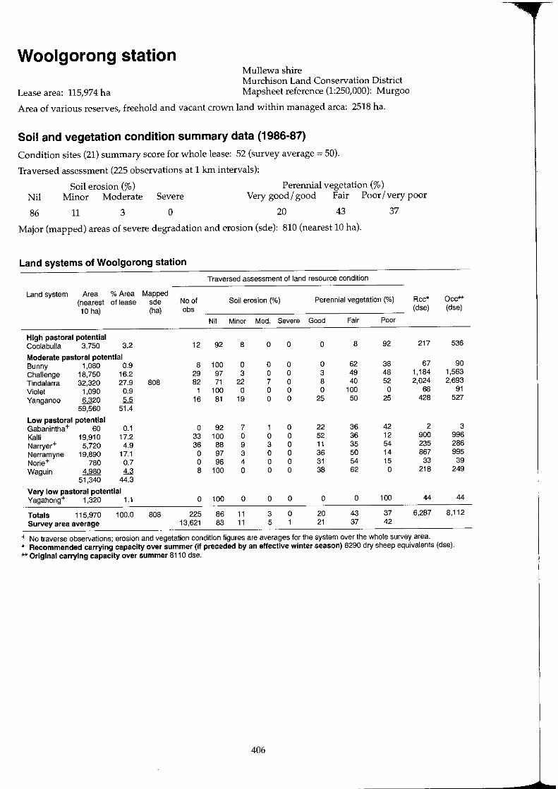
Woolgorong station Mullewa shire Murchison Land Conservation District
Lease area: 115,974 ha Mapsheet reference (1:250,000): Murgoo
Area of various reserves, freehold and vacant crown land within managed area: 2518 ha.
Soil and vegetation condition summary data (1986-87)
Condition sites (21) summary score for whole lease: 52 (survey average = 50).
Traversed assessment (225 observations at 1 km intervals):
Soil erosion (%) Perennial vegetation (%) Nil Minor Moderate Severe Very good/ good Fair Poor/very poor
86 11 3 o 20 43 37
Major (mapped) areas of severe degradation and erosion (sde): 810 (nearest 10 hal.
Land systems of Woolgorong station
Traversed assessment of land resource condition
Land system Area % Area Mapped (nearest of lease sde No of Soil erosion (%) Perennial vegetation (0/0) Rec· 10 hal (ha) obs (dse)
Nil Minor Mod. Severe Good Fair Poor
High pastoral potential Coolabulla 3.750 3.2 12 92 8 0 0 0 8 92 217
Moderate pastoral potential Bunny 1,080 0.9 8 100 0 0 0 0 62 38 67 Challenge 18,750 16.2 29 97 3 0 0 3 49 48 1,184 Tindalarra 32,320 27.9 808 82 71 22 7 0 8 40 52 2,024 Violet 1,090 0.9 1 100 0 0 0 0 100 0 68 Yanganoo 6320 5.5 16 81 19 0 0 25 50 25 428
59,560 51.4
Low pastoral potential Gabanintha+ 60 0.1 0 92 7 1 0 22 36 42 2 Kalli 19,910 17.2 33 100 0 0 0 52 36 12 900 Narryer+ 5,720 4.9 36 88 9 3 0 11 35 54 235 Nerramyne 19,890 17.1 0 97 3 0 0 36 50 14 867 Norie+ 780 0.7 0 96 4 0 0 31 54 15 33 Waguin 4980 4.3 8 100 0 0 0 38 62 0 218
51,340 44.3
Very low pastoral potential Yagahong+ 1,320 1.1 0 100 0 0 0 0 0 100 44
Totals 115,970 100.0 808 225 86 11 3 0 20 43 37 6,287 Survey area average 13,621 83 11 5 1 21 37 42
+ No traverse observations; erosion and vegetation condition figures are averages for the system over the whole survey area.
Occ** (dse)
536
90 1,563 2,693
91 527
3 996 286 995
39 249
44
8,112
* Recommended carrying capacity over summer (if preceded by an effective winter season) 6290 dry sheep equivalents (dse). ** Original carrying capacity over summer 8110 dse.
406
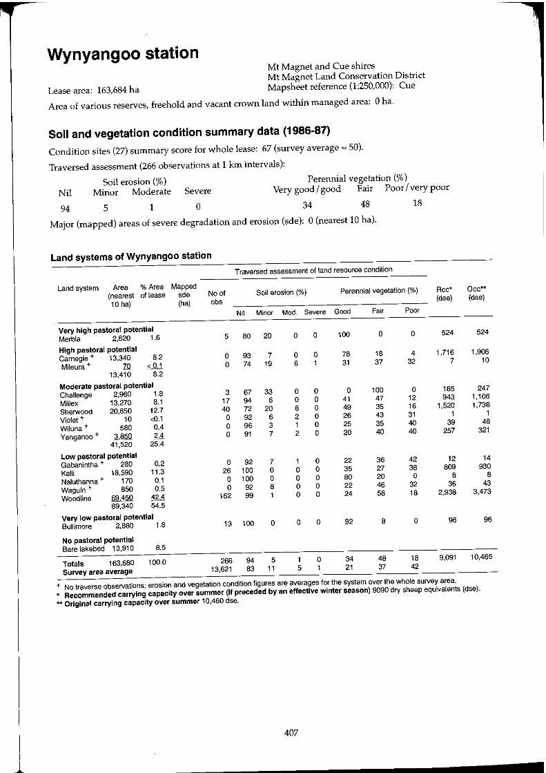
Wynyangoo station Mt Magnet and Cue shires Mt Magnet Land Conservation District
Lease area: 163,684 ha Mapsheet reference (1:250,000): Cue
Area of various reserves, freehold and vacant crown land within managed area: 0 ha.
Soil and vegetation condition summary data (1986-87)
Condition sites (27) summary score for whole lease: 67 (survey average ~ 50).
Traversed assessment (266 observations at 1 km intervals):
Soil erosion (%) Perennial vegetation (%)
Nil Minor Moderate Severe Very good/ good Fair Poor Ivery poor
94 5 1 o 34 48 18
Major (mapped) areas of severe degradation and erosion (sde): 0 (nearest 10 hal.
Land systems of Wynyangoo station
Traversed assessment of land resource condition
Land system Area % Area Mapped (nearest of lease sde No of Soil erosion (%) Perennial vegetation (%) Rcc*
10 hal (ha) obs (dse)
Nil Minor Mod. Severe Good Fair Poor
Very high pastoral potential Merbla 2,620 1.6 5 80 20 0 0 100 0 0 524
High pastoral potential Carnegie + 13,340 8.2 0 93 7 0 0 78 18 4 1,716
Mileura + 70 < 0.1 0 74 19 6 1 31 37 32 7
13,410 8.2
Moderate pastoral potential Challenge 2,960 1.8 3 67 33 0 0 0 100 0 185
Millex 13,270 8.1 17 94 6 0 0 41 47 12 943
Sherwood 20,850 12.7 40 72 20 8 0 49 35 16 1,520
Violet + 10 <0.1 0 92 6 2 0 26 43 31 1
Wiluna + 580 0.4 0 96 3 1 0 25 35 40 39
Yanganoo + M5ll 2.4 0 91 7 2 0 20 40 40 257
41,520 25.4
Low pastoral potential Gabanintha + 280 0.2 0 92 7 1 0 22 36 42 12
Kalli 18,590 11.3 26 100 0 0 0 35 27 38 809
Naluthanna + 170 0.1 0 100 0 0 0 80 20 0 8
Waguin + 850 0.5 0 92 8 0 0 22 46 32 36
Woodline 69450 42.4 162 99 0 0 24 58 18 2,938
89,340 54.5
Very low pastoral potential Bullimore 2,880 1.8 13 100 0 0 0 92 8 0 96
No pastoral potential Bare lakebed 13,910 8.5
Totals 163,680 100.0 266 94 5 1 0 34 48 18 9,091
Survey area average 13,621 83 11 5 1 21 37 42
+ No traverse observations; erosion and vegetation condition figures are averages for the system over the whole survey area.
Occ** (dse)
524
1,906 10
247 1,106 1,738
1 48
321
14 930
8 43
3,473
96
10,465
* Recommended carrying capacity over summer (if preceded by an effective winter season) 9090 dry sheep equivalents (dse).
** Original carrying capacity over summer 10,460 dse.
407
------------------------.......
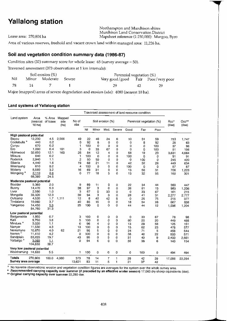
Yallalong station Northampton and Murchison shires Murchison Land Conservation District
Lease area: 270,804 ha Mapsheet reference (1:250,000): Murgoo, Byro
Area of various reserves, freehold and vacant crown land within managed area: 11,226 ha.
Soil and vegetation condition summary data (1986-87)
Condition sites (32) summary score for whole lease: 65 (survey average ~ 50).
Traversed assessment (373 observations at 1 krn intervals):
Soil erosion (%) Perennial vegetation (%) Nil Minor Moderate Severe Very good/ good Fair Poor/very poor
78 14 7 1 29 42 29
Major (mapped) areas of severe degradation and erosion (sde): 4080 (nearest 10 hal.
Land systems of Yallalong station
Traversed assessment of land resource condition
Land system Area % Area Mapped (nearest of lease sde No of Soil erosion (%) Perennial vegetation (%) Rcc* Occ**
10 hal (ha) obs (dse) (dse) Nil Minor Mod. Severe Good Fair Poor
High pastoral potential Bayou 12,230 4.5 2,566 49 22 48 24 6 10 31 59 753 1,747 Coolabulla + 440 0.2 0 92 8 0 0 0 8 92 25 63 Cunyu 670 0.2 1 100 0 0 0 0 0 100 37 96 Era 1,090 0.4 181 3 0 33 67 0 0 0 100 51 156 Holmwood 32,650 12.1 160 26 84 12 4 0 58 19 23 3,631 4,664 Mileura 640 0.2 1 100 0 0 0 100 0 0 91 91 Roderick 2,940 1.1 2 50 50 0 0 0 100 0 245 420 Siberia 4,440 1.6 19 68 21 11 0 42 32 26 449 634 Weenyung 610 0.2 4 100 0 0 0 100 0 0 87 87 Wolarry 8,560 3.2 16 69 31 0 0 13 56 31 706 1,223 Wongong + 2J.1Q 0.8 0 77 18 5 0 13 32 55 160 301
66,380 24.5
Moderate pastoral potential Boulder 5,360 2.0 9 89 11 0 0 22 34 44 360 447 Bunny 14,470 5.3 38 97 3 0 0 26 61 13 983 1,206 Liver 2,580 1.0 3 67 0 33 0 0 33 67 161 215 Mongolia 33,320 12.3 39 94 3 3 0 28 41 31 2,277 2,777 Outcamp 4,520 1.7 1,111 12 8 42 42 8 0 25 75 215 377 Tindalarra 10,060 3.7 40 85 15 0 0 18 54 28 667 838 Yanganoo 14450 5.3 25 100 0 0 0 44 44 12 1,036 1,204
84,760 31.3
Low pastoral potential Badgeradda 1,950 0.7 3 100 0 0 0 0 33 67 78 98 Kalli 9,750 3.6 5 100 0 0 0 60 20 20 449 488 Mindura + 3,020 1.1 0 96 4 0 0 13 29 58 125 151 Narryer 11,530 4.3 13 100 0 0 0 15 62 23 478 577 Nerramyne 10,870 4.0 62 21 95 5 0 0 24 71 5 458 544 Nerren + 11,410 4.2 0 100 0 0 0 38 40 22 500 571 Sandplain 53,220 19.7 43 95 0 5 0 51 40 9 2,400 2,661 Yalbalgo + 3080 U 0 94 6 0 0 56 38 6 140 154
104,830 38.7
Very low pastoral potential Woodrarrung 14,830 5.5 100 0 0 0 0 100 0 494 494
Totals 270,800 100.0 4,080 373 78 14 7 29 42 29 17,056 22,284 Survey area average 13,621 83 11 5 21 37 42
+ No traverse observations; erosion and vegetation condition figures are averages for the system over the whole survey area. * Recommended carrying capacity over summer (if preceded by an effective winter season) 17,060 dry sheep equivalents (dse). ** Original carrying capacity over summer 22,280 dse.
408

Yarlarweelor station (part) Meekatharra shire Meekatharra Land Conservation District
Lease area: 157,792 ha (part) Mapsheet reference (1:250,000): Robinson Range
Area of various reserves, freehold and vacant crown land within managed area: 9295 ha.
Soil and vegetation condition summary data (1986-87)
Condition sites (21) summary score for whole lease: 49 (survey average ~ 50).
Traversed assessment (184 observations at 1 km intervals):
Perennial vegetation (%) Nil
95
Soil erosion (%) Minor Moderate Severe Very good / good Fair Poor / very poor
5 o o 9 26 65
Major (mapped) areas of severe degradation and erosion (sde): 920 (nearest 10 hal.
Land systems of part of Yarlarweelor station
Traversed assessment of land resource condition
Land system Area % Area Mapped (nearest of lease sde No of Soil erosion (%) Perennial vegetation (%) Rcc* 10 hal (ha) obs (dse)
Nil Minor Mod. Severe Good Fair Poor
High pastoral potential Beringarra 6,930 4.4 621 5 40 60 0 0 0 0 100 351
Moderate pastoral potential Belele 8,680 5.5 8 75 25 0 0 0 37 63 543 Cole 43,320 27.5 295 50 98 2 0 0 6 14 80 2,743 Trillbar 6330 4.0 17 94 6 0 0 0 35 65 395
58,380 37.0
Low pastoral potential Beasley 150 0.1 4 100 0 0 0 0 100 0 6 Gabanintha + 1,320 0.8 0 92 7 1 0 22 36 42 56 Koonmarra 36,030 22.8 42 100 0 0 0 10 28 62 1,477 Mindura 46,700 29.6 48 96 4 0 0 15 22 63 1,938 Thomas 2,140 1.4 4 100 0 0 0 75 25 0 101 Vandi] + 50 < 0.1 0 84 11 4 1 7 30 63 2 Yarrameedie 2300 1..§ 4 100 0 0 0 0 75 25 92
88,690 56.2
Very low pastoral potential Peak Hill 3,840 2.4 2 100 0 0 0 0 0 100 128
Totals 157,790 100.0 916 184 95 5 0 0 9 26 65 7,832 Survey area average 13,621 83 11 5 1 21 37 42
+ No traverse observations; erosion and vegetation condition figures are averages for the system over the whole survey area.
Occ** (dse)
990
723 3,610
528
8 66
1,802 2,335
107 3
115
128
10,415
* Recommended carrying capacity over summer (if preceded by an effective winter season) 7830 dry sheep equivalents (dse). ** Original carrying capacity over summer 10,410 dse.
409
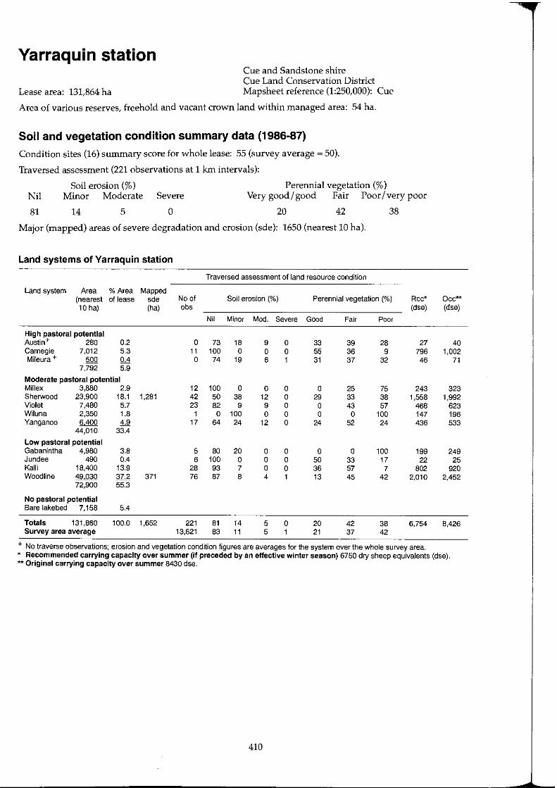
Yarraquin station Cue and Sandstone shire Cue Land Conservation District
Lease area: 131,864 ha Mapsheet reference (1:250,000): Cue
Area of various reserves, freehold and vacant crown land within managed area: 54 ha.
Soil and vegetation condition summary data (1986-87)
Condition sites (16) summary score for whole lease: 55 (survey average ~ 50).
Traversed assessment (221 observations at 1 km intervals):
Perennial vegetation (%) Nil
81
Soil erosion (%) Minor Moderate Severe Very good / good Fair Poor / very poor
14 5 o 20 42 38
Major (mapped) areas of severe degradation and erosion (sde): 1650 (nearest 10 hal.
Land systems of Yarraquin station
Traversed assessment of land resource condition
Land system Area % Area Mapped (nearest of lease sde No of Soil erosion (%) Perennial vegetation (%) Rcc* 10 hal (ha) Dbs (dse)
Nil Minor Mod. Severe Good Fair Poor
High pastoral potential Austin+ 280 0.2 0 73 18 9 0 33 39 28 27 Carnegie 7,012 5.3 11 100 0 0 0 55 36 9 796 Mileura + 500 0.4 0 74 19 6 1 31 37 32 46
7,792 5.9
Moderate pastoral potential Millex 3,880 2.9 12 100 0 0 0 0 25 75 243 Sherwood 23,900 18.1 1,281 42 50 38 12 0 29 33 38 1,558 Violet 7,480 5.7 23 82 9 9 0 0 43 57 468 Wiluna 2,350 1.8 1 0 100 0 0 0 0 100 147 Yanganoo 6400 4.9 17 64 24 12 0 24 52 24 436
44,010 33.4
Low pastoral potential Gabanintha 4,980 3.8 5 80 20 0 0 0 0 100 199 Jundee 490 0.4 6 100 0 0 0 50 33 17 22 Kalli 18,400 13.9 28 93 7 0 0 36 57 7 802 Woodline '!M:)Q 37.2 371 76 87 8 4 1 13 45 42 2,010
72,900 55.3
No pastoral potential Bare lakebed 7,158 5.4
Totals 131,860 100.0 1,652 221 81 14 5 0 20 42 38 6,754 Survey area average 13,621 83 11 5 1 21 37 42
+ No traverse observations; erosion and vegetation condition figures are averages for the system over the whole survey area.
Occ** (dse)
40 1,002
71
323 1,992
623 196 533
249 25
920 2,452
8,426
* Recommended carrying capacity over summer (if preceded by an effective winter season) 6750 dry sheep equivalents (dse). 'kit Original carrying capacity over summer 8430 dse.
410
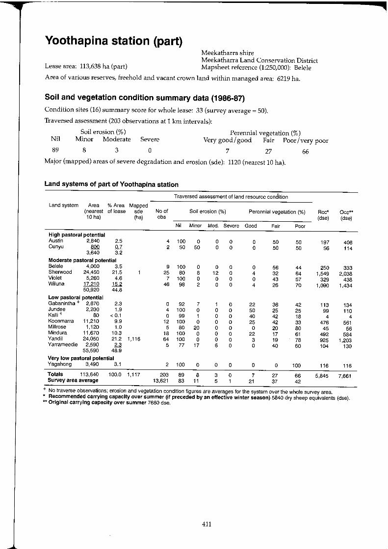
Yoothapina station (part) Meekatharra shire Meekatharra Land Conservation District
Lease area: 113,638 ha (part) Mapsheet reference (1:250,000): Belele
Area of various reserves, freehold and vacant crown land within managed area: 6219 ha.
Soil and vegetation condition summary data (1986-87)
Condition sites (16) summary score for whole lease: 33 (survey average ~ 50).
Traversed assessment (203 observations at 1 km intervals):
Soil erosion (%) Perennial vegetation (%) Nil Minor Moderate Severe Very good / good Fair Poor / very poor
89 8 3 o 7 27 66
Major (mapped) areas of severe degradation and erosion (sde): 1120 (nearest 10 hal.
Land systems of part of Yoothapina station
Traversed assessment of land resource condition
Land system Area % Area Mapped (nearest of lease sde No of Soil erosion (%) Perennial vegetation (%) Rcc* 10 hal (ha) cbs (dse)
Nil Minor Mod. Severe Good Fair Poor
High pastoral potential Austin 2.840 2.5 4 100 0 0 0 0 50 50 197 Cunyu 800 0.7 2 50 50 0 0 0 50 50 56
3.640 3.2
Moderate pastoral potential Belele 4.000 3.5 9 100 0 0 0 0 56 44 250 Sherwood 24,450 21.5 25 80 8 12 0 4 32 64 1,549 Violet 5,260 4.6 7 100 0 0 0 0 43 57 329 Wiluna 17210 15.2 46 98 2 0 0 4 26 70 1,090
50,920 44.8
Low pastoral potential Gabanintha + 2,670 2.3 0 92 7 1 0 22 36 42 113 Jundee 2,200 1.9 4 100 0 0 0 50 25 25 99 Kallj + 80 < 0.1 0 99 1 0 0 40 42 18 4 Koonmarra 11,210 9.9 12 100 0 0 0 25 42 33 476 Millrose 1,120 1.0 5 80 20 0 0 0 20 80 45 Mindura 11,670 10.3 18 100 0 0 0 22 17 61 492 Yandil 24,050 21.2 1,116 64 100 0 0 0 3 19 78 925 Yarrameedie 2,590 2.3 5 77 17 6 0 0 40 60 104
55,590 48.9
Very low pastoral potential Yagahong 3,490 3.1 2 100 0 0 0 0 0 100 116
Totals 113,640 100.0 1,117 203 89 8 3 0 7 27 66 5,845 Survey area average 13,621 83 11 5 1 21 37 42
+ No traverse observations; erosion and vegetation condition figures are averages for the system over the whole survey area.
Occ"'* (dse)
406 114
333 2,038
438 1,434
134 110
4 561
56 584
1,203 130
116
7,661
* Recommended carrying capacity over summer (if preceded by an effective winter season) 5840 dry sheep equivalents (dse). ** Original carrying capacity over summer 7660 dse.
411
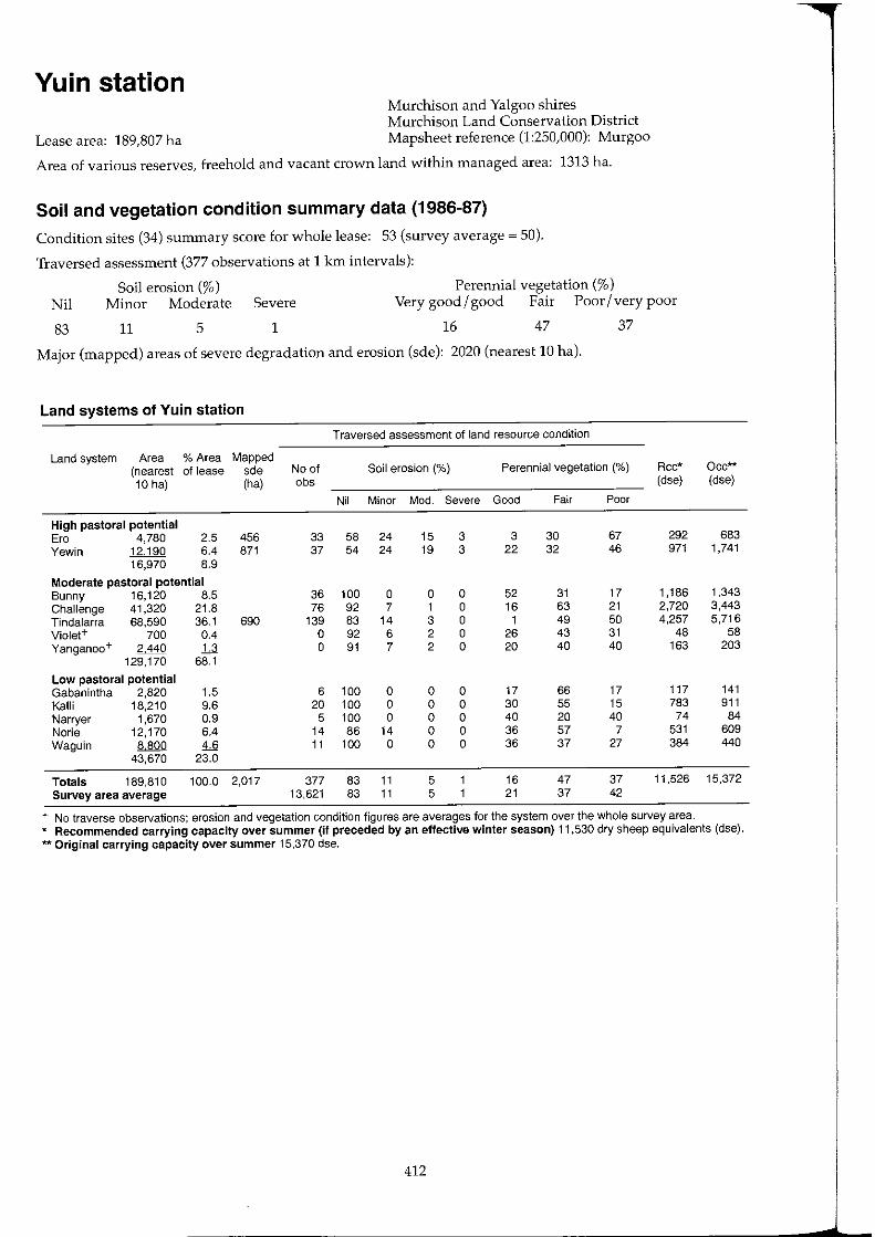
Yuin station Murchison and Yalgoo shires Murchison Land Conservation District
Lease area: 189,807 ha Mapsheet reference (1:250,000): Murgoo
Area of various reserves, freehold and vacant crown land within managed area: 1313 ha.
Soil and vegetation condition summary data (1986-87)
Condition sites (34) summary score for whole lease: 53 (survey average = 50).
Traversed assessment (377 observations at 1 km intervals):
Perennial vegetation (%) Nil
83
Soil erosion (%) Minor Moderate Severe Very good I good Fair Poor I very poor
11 5 1 16 47 37
Major (mapped) areas of severe degradation and erosion (sde): 2020 (nearest 10 hal.
Land systems of Yuin station
Traversed assessment of land resource condition
Land system Area % Area Mapped (nearest of lease sde No of Soil erosion (%) Perennial vegetation (%) Rcc* 10 hal (ha) cbs (dse)
Nil Minor Mod. Severe Good Fair Poor
High pastoral potential Era 4,780 2.5 456 33 58 24 15 3 3 30 67 292 Yewin 12,190 6.4 871 37 54 24 19 3 22 32 46 971
16,970 8.9
Moderate pastoral potential Bunny 16,120 8.5 36 100 0 0 0 52 31 17 1,186 Challenge 41,320 21.8 76 92 7 1 0 16 63 21 2,720 Tindalarra 68,590 36.1 690 139 83 14 3 0 1 49 50 4,257 Violet+ 700 0.4 0 92 6 2 0 26 43 31 48 Yanganoo+ 2440 U 0 91 7 2 0 20 40 40 163
129,170 68.1
Low pastoral potential Gabanintha 2,820 1.5 6 100 0 0 0 17 66 17 117 Kalli 18,210 9.6 20 100 0 0 0 30 55 15 783 Narryer 1,670 0.9 5 100 0 0 0 40 20 40 74 Norie 12,170 6.4 14 86 14 0 0 36 57 7 531 Waguin 8800 4.6 11 100 0 0 0 36 37 27 384
43,670 23.0
Totals 189,810 100.0 2,017 377 83 11 5 16 47 37 11,526 Survey area average 13,621 83 11 5 21 37 42
+ No traverse observations; erosion and vegetation condition figures are averages for the system over the whole survey area.
Occ** (dse)
683 1,741
1,343 3,443 5,716
58 203
141 911
84 609 440
15,372
* Recommended carrying capacity over summer (if preceded by an effective winter season) 11,530 dry sheep equivalents (dse). ** Original carrying capacity over summer 15,370 dse.
412
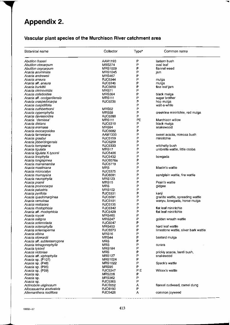
Appendix 2.
Vascular plant species of the Murchison River catchment area
Botanical name Collector Type' Common name
Abuti/on fraser; AAM1193 P lantern bush Abuti/on otocarpum MRS274 P oval leaf Abuti/on oxycarpum MRS1009 P flannel weed Acacia acuminata MRS1045 P jam Acacia andrewsii MRS467 P Acacia aneura RJC5344 P mulga Acacia aft. aneura RJC5345 P mulga Acacia burkittii RJC5650 P fine leaf jam Acacia citrinoviridis MRS71 P Acacia collet joides MRS364 P black mulga Acacia aft. coolgardiensis MRS111 P sugar brother Acacia craspedocarpa RJC5235 P hop mulga Acacia cuspidifo/ia P wait-a-while Acacia cuthbertsonii MRS52 P Acacia cyperophyl/a MRS58 P creekline miniritchie, red mulga Acacia daviesioides RJC5260 P Acacia 'demissa' MRS111 PE Murchison willow Acacia distans RJC5310 P black mulga Acacia eremaea MRS94 P snakewood Acacia exocarpoides RJC5682 P Acacia farnesiana AAM1333 P sweet acacia, mimosa bush Acacia grasbyi RJC5159 P miniritchie Acacia jibberdingensis RJC5259 P Acacia kempeana RJC5333 P witchetty bush Acacia ligulata MRS17 P umbrella wattle, little cooba Acacia Iigulata X tysonii RJC5406 P Acacia linophyl/a RJC5432 P bowgada Acacia longispinea RJC6076a P Acacia marramamba RJC5719 P Acacia masliniana MRS P Maslin's wattle Acacia microcalyx RJC5375 P Acacia murrayana RJC6091 P sandplain wattle, fire wattle Acacia neurophyl/a MRS123 P Acacia prainii MRS15 P Prain's wattle Acacia pruinocarpa MRS P gidgee Acacia palustris MRS102 P Acacia pyrifolia RJC5331 P kanji Acacia quadrimarginea RJC5091 P granite wattle, spreading wattle Acacia ramulosa RJC5101 P wanyu, bowgada, horse mulga Acacia restiacea RJC5135 P Acacia rhodoph/oia RJC5342 P flat leaf mini ritchie Acacia aft. rhodoph/oia RJC5429 P flat leaf mini ritchie Acacia roycei MRS465 P Acacia saligna MRS247 P golden wreath wattle Acacia scleroc/ada RJC6047 P Acacia sclerophyl/a MRS450 P hard leaf wattle Acacia sc/erosperma RJC5573 P limestone wattle, silver bark wattle Acacia sibina MRS16 P Acacia stowardii MRS44 P bastard mulga Acacia aft. subtessarogona MRS P Acacia tetragonophyl/a MRS P curara Acacia tysonH MRS184 P Acacia victoriae MRS P prickly acacia, bardi bush, Acacia all. xiphophyl/a MRS127 P snakewood Acacia sp. (P107) MRS1024 P Acacia sp. (P48) MRS1022 P Speck's wattle Acacia sp. (P95) MRS95 P Acacia sp. (P59) RJC5347 PE Wilcox's wattle Acacia sp. MRS206 P Acacia sp. MRS362 P Acacia sp. RJC5365 P Actinobole uJiginosum RJC5552 A flannel cudweed, camel dung Allocasuarina acutiva/vis RJC6190 P Alternanthera nodiflora RJC5426 A common joyweed
16602-27 413
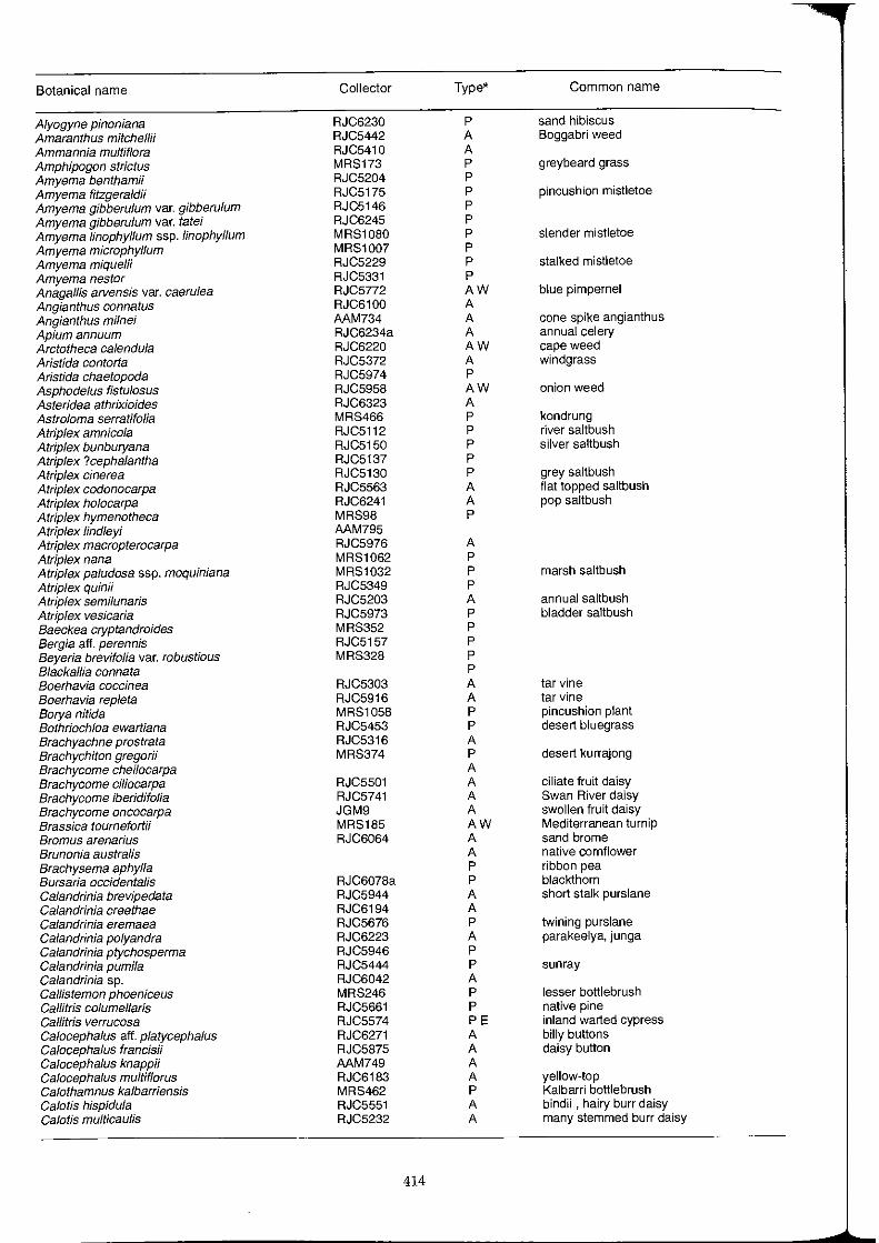
Botanical name Collector Type* Common name
Alyogyne pinoniana RJC6230 P sand hibiscus Amaranthus mitchellii RJC5442 A Boggabri weed Ammannia multiflora RJC5410 A Amphipogon strictus MRS173 P greybeard grass Amyema bentham;; RJC5204 P Amyema fitzgeraldii RJC5175 P pincushion mistletoe Amyema gibberulum var. gibberulum RJC5146 P Amyema gibberulum var. tatei RJC6245 P Amyema linophyllum ssp. linophyllum MRS1080 P slender mistletoe Amyema microphyllum MRS1007 P Amyema mique/ii RJC5229 P stalked mistletoe Amyema nestor RJC5331 P Anagallis arvensis var. caerulea RJC5772 AW blue pimpernel Angianthus connatus RJC6100 A Angianthus milnei AAM734 A cone spike angianthus Apium annuum RJC6234a A annual celery Arctotheca calendula RJC6220 AW cape weed Aristida contorta RJC5372 A windgrass Aristida chaetopoda RJC5974 P Asphodelus fistulosus RJC5958 AW onion weed Asteridea athrixioides RJC6323 A Astr%ma serratifolia MRS466 P kondrung Atriplex amnicola RJC5112 P river saltbush Atriplex bunburyana RJC5150 P silver saltbush Atriplex ?cephalantha RJC5137 P Atriplex cinerea RJC5130 P grey saltbush Atriplex codonocarpa RJC5563 A flat topped saltbush Atriplex holocarpa RJC6241 A pop saltbush Atriplex hymenotheca MRS98 P Atriplex lindleyi AAM795 Atriplex macropterocarpa RJC5976 A Atrip/ex nana MRS1062 P Atrip/ex paludosa ssp. moquiniana MRS1032 P marsh saltbush Atriplex quinii RJC5349 P Atriplex semilunaris RJC5203 A annual saltbush Atriplex vesicaria RJC5973 P bladder saltbush Baeckea cryptandroides MRS352 P Bergia aft. perennis RJC5157 P Beyeria brevifoHa var. robustious MRS328 P Blackallia cannata P Boerhavia coccinea RJC5303 A tar vine Boerhavia repleta RJC5916 A tar vine Borya nitida MRS1058 P pincushion plant Bothriochloa ewartiana RJC5453 P desert bluegrass Brachyachne prostrata RJC5316 A Brachychiton gregorii MRS374 P desert kurrajong Brachycome cheilocarpa A Brachycome ciliocarpa RJC5501 A ciliate fruit daisy Brachycome iberidifolia RJC5741 A Swan River daisy Brachycome oncocarpa JGM9 A swollen fruit daisy Brassica tournefortii MRS185 AW Mediterranean turnip Bromus arenarius RJC6064 A sand brome Brunonia australis A native cornflower Brachysema aphylla P ribbon pea Bursaria occidentalis RJC6078a P blackthorn Calandrinia brevipedata RJC5944 A short stalk purslane Galandrinia creethae RJC6194 A Galandrinia eremaea RJC5676 P twining purslane Calandrinia polyandra RJC6223 A parakeelya, junga Galandrinia ptychosperma RJC5946 P Calandrinia pumila RJC5444 P sunray Calandrinia sp. RJC6042 A Callistemon phoeniceus MRS246 P lesser bottlebrush Gal/itris columel/aris RJC5661 P native pine Callitris verrucosa RJC5574 PE inland warted cypress Calocephalus aff. platycephalus RJC6271 A billy buttons Galocephalus francisii RJC5875 A daisy button Calocephalus knappii AAM749 A Calocephalus multiflorus RJC6183 A yellow-top Galothamnus kalbarriensis MRS462 P Kalbarri bottlebrush Calotis hispidula RJC5551 A bindii , hairy burr daisy Calotis multicaulis RJC5232 A many stemmed burr daisy
414
Botanical name Collector Type* Common name
Calycopeplus ephedroides MRS18 P Ca/ytrix deso/ata RJC5341 P Ca/ytrix divergens RJC5483 P Ca/ytrix erosipeta/a P Ca/ytrix g/utinosa MRS146 P Calytrix aft. strigosa RJC6226 P Calytrix verruculosa PE Canthium attenuatum RJC5385 P Canthium latifolium RJC5366 P wild lemon, wild currant Canthium Iineare P native currant Carpobrotus aft. virescens MRS435 P stout pigface Cassia artemisioides RJC6218 P silver cassia Cassia charlesiana MRS30 P Cassia chate/ainiana RJC5647 P green cassia Cassia desolata P grey cassia Cassia hamersleyensis RJC5435 P creeping cassia Cassia helms;; RJC5646 P crinkled cassia Cassia luerssenii RJC5183 P white cassia Cassia nemophila var. nemophila RJC5194 P desert cassia Cassia nemophila var. platypoda RJC6102 P Cassia oligophyl/a P blood bush Cassia phyl/odinea MRS204 P banana leaf cassia Cassia pleurocarpa MRS287 P ribfruit senna Cassia pruinosa RJC5613 P white cassia Cassia sturtii RJC5243 P variable cassia Cassytha aurea var. aurea RJC6213 P dodder laurel Casuarina obesa RJC5142 P sheoak, swamp oak Cenchrus ciliaris MRS A buttel grass Cenchrus setiger AW Birdwood grass Centaurea melitensis RJC6144 AW Maltese cockspur Centaurium spicatum RJC6321 AW spike centaury Centipeda cunninghamii RJC5354 A common sneezewood Centro/epis sp. RJC5699 A Cephalipterum drummondii RJC5503 A pompom head Chamelaucium micranthum MRS1043 P wax flower Chara sp. RJC6246 A Chenopodium auricomum AAM1424 P northern bluebush Chenopodium gaudichaudianum RJC5399 P scrambling saltbush Chenopodium melanocarpum DGW3440 A black crumbweed Chenopodium mura/e RJC5559 A nettle leaf goosefoot Chenopodium nitrariaceum MRS316 P nitre goosefoot Chenopodium saxatile RJC5657 A Cheiranthera filifolia var. simplicifolia MRS1059 P Cheilanthes austrotenuifolia RJC5099 P rock fern Cheilanthes lasiophyl/a RJC5659 P woolly cloak fern Chloris sp. RJC6307 P? Chorizema ericifolium MRS257 P Chorizema genistoides MRS411 P Chrysocoryne pusilla RJC6052 A dwarf angianthus Chrysopogon fal/ax RJC5299 P ribbon grass, golden beard grass Chthonocephalus pseudevax RJC5498 A woolly groundhead C/eome oxalidea RJC5381 A Codonocarpus cotinifolius RJC5140 P native poplar, desert poplar Comesperma integerrimum RJC6110 P Commicarpus australis RJC6276 P perennial tar vine Convolvulus erubescens RJC6215 P four black seeds Corchorus walcottii RJC5927 P woolly corchorus Cotula australis RJC5667 A common cotula Crassula colorata RJC5505 A dense crassula Crassula pedicel/osa RJC6160 A Cratystylis subspinescens MRS1343 P sage Cryptandra sp. MRS331 P Cucumis myriocarpus RJC5441 A paddy melon Cuphonotus andraeanus RJC5493 A Cuscuta australis MRS181 A Australian dodder Cynodon dactylon MRS P couch grass Cymbopogon ambiguus RJC5415 P lemon scented grass Cymbopogon aft. ambiguus RJC5322 P curly leaf scented graes Cynanchum f/oribundum RJC5221 P dumara bush Cyperus alterniflorus RJC6063 P Cyperus bifax MRS62 P downs nutgrass Cyperus aft. concinnus RJC5852 P
415
Botanical name Collector Type' Common name
Cyperus gymnocaulos RJC5885 P spiny flat sedge Cyperus iria RJC5307 A Cyperus rigidellus RJC5158 A Cyperus squarrosus RJC5325 A curry sedge Cyperus sp. MRS1040 A Dactyloctenium radulans RJC5309 A button grass Darwinia aft. diosmoides RJC6304 P Darwinia capitellata MRS337 P Daucus glochidiatus MRS143 A Australian carrot Dianella revoluta AAM774 P native flax lily Dicladanthera forrestii RJC5427 P Dicrastylis fulva RJC6157 P Didymanthus roel RJC6148 P Dlelitzia tysonii RJC5497 A Digitaria brownii MRS105 P cotton panic grass Diplachne muelleri RJC5313 P brown beetle grass Disphyma crassifolium MRS653 P round leaf pigface Dissocarpus paradoxus MRS69 A cannon balls, curious bassia Dodonaea boroniifolia MRS1035 P Dodonaea aft. caespitosa MRS92 P Dodonaea aft. inaequifolia MRS363 P Dodonaea microzyga var. acrolobata MRS1070 P Dodonaea microzyga hybrid RJC6149 P Dodonaea pachyneura RJC5475 P Dodonaea petlolaris RJC6290 P Dodonaea pinifolia MRS1044 P Dodonaea rigida MRS387 P Dodonaea viscosa ssp. angustissima RJC5479 P Dodonaea viscosa ssp. mucronata RJC6078 P Dodonaea viscosa ssp. viscosa MRS273 P sticky hopbush Drosera bulbosa RJC5075 A red leaved sundew Drosera bulbosa ssp. major A Drosera glanduligera RJC6147 P scarlet sundew Drosera indica RJC5411 A sundew Drosera macrantha MRS402 A bridal rainbow Drosera macrantha ssp. eremaea A Drummondita miniata MRS344 PE Drummondita sp. AAM1542 PE Duboisia hopwoodii RJC6076 P pitun' Dysphania glandulosa RJC5380 AE Dysphania glomulifera RJC5581 A Dysphania glomulifera ssp. eremaea A Dysphania plantaginella RJC5357 A Dysphania rhadinostachya RJC5236 A Dysphania simulans RJC5980 A Ecdeiocolea monostachya MRS449 P Ehrharta longifolia RJC6169 AW annual veldtgrass E/atine grati%ides RJC5477 P waterwort Eleocharis pallens MRS293 P pale spike rush Elytrophorus spicatus RJC5414 A spikegrass Emex australis AW doublegee Enchylaena tomentosa RJC5210 P ruby saltbush Enneapogon caerulescens MRS144 A limestone grass Enneapogon nigricans RJC5970 A niggerhead grass Enneapogon oblongus AAM1195 P purple head nineawn Enneapogon sp. MRS70 A Enteropogon acicu/aris MRS P curly windmill grass, umbrella grass Eragrostis cumingii RJC5352 A Cuming's lovegrass Eragrostis dielsii P mallee lovegrass, lovegrass Eragrostis elongata MRS63 P clustered lovegrass Eragrostis eriopoda P wooly butt Eragrostis falcata MRS310 P sickle lovegrass Eragrostis kennedyae RJC5306 P small flower lovegrass Eragrostis lanipes MRS168 P creeping wanderrie Eragrostis pergracilis RJC5374 P Eragrostis setifo/ia RJC5454 P neverfail Eragrostis xerophila MRS113 P knottybutt grass Eragrostis sp. MRS45 A Eremophea spinosa MRS163 P Eremophila afternifolia MRS87 P Eremophila clarke; MRS32 P turpentine bush Eremophila compacta MRS5 P compact poverty bush
416
Botanical name Collector Type* Common name
Eremophila compacta ssp. 'compacta' MRS237 P
Eremophila compacta ssp. 'fecunda' MRS190 P
EremophOa deJisseri MRS78 P
Eremophifa eriocalyx RJC6066 P desert pride
Eremophila exilifofia RJC5624 P
Eremophila aft. exififolia RJC5205 P
Eremophila falcata P
Eremophila 'fasciata' PE
Eremophila 'fJabellata' RJC5673 PE
Eremophila 'flaccida' P
Eremophila foliosissima MRS48 PE
Eremophila forrestii P Wilcox bush
Eremophila forrestii ssp. forrestii RJC5838 P
Eremophila forrestii ssp. hastieana RJC5918 P
Eremophila fraseri RJC5148 P turpentine bush
Eremophila fraseri ssp. 'galeata' RJC5911 P
Eremophila fraseri ssp. 'parva' RJC5926 P
Eremophila freelingii RJC5181 P limestone fuchsia
Eremophila georgei MRS2 P
Eremophila gibsonii P
Eremophila gilesii MRS84 P turkey bush
Eremophifa gfabra ssp. gfabra MRS81 P black fuchsia
Eremophifa gfabra group MRS300 P
Eremophila 'glandulifera' MRS373 P
Eremophila glutinosa RJC5505 P
Eremophila granitica MRS182 P
Eremophila hughesii RJC5163 P
Eremophila 'hygrophana' RJC6313 PE
Eremophila imbricata PE
Eremophifa jacunda' MRS404 PE
Eremophila laanii PE
Eremophi/a lachnocalyx MRS140 PE woolly poverty bush
Eremophila 'Ianata' RJC5716 PE
Eremophila latrobei RJC5672 P warty leaf eremophila, warty fuchsia bush
Eremophila latrobei ssp. glabra RJC5533 P
Eremophila latrobei ssp. latrobei RJC5152 P
Eremophila latrobei X forrestii MRS65 P
Eremophila /inearis MRS87 P saline fUchsia bush, harlequin fuchSia bush
Eremophila fongifofia RJC5305 P berrigan, long leaved eremophila
Eremophila mackin/ayi P desert pride
Eremophila macmillaniana MRS50 P grey turpentine bush
Eremophila macu/ata P fuchsia bush
Eremophila maculata ssp. brevifolia RJC5600 P fuchsia bush
Eremophila 'malacoides' MRS295 P
Eremophila aft. 'malacoides' MRS304 P
Eremophila margarethae RJC5698 P sand bank poverty bush
Eremophila miniata MRS327 P limestone poverty bush
Eremophila muelleriana MRS231 P round leaved eremophila
Eremophifa ofdfiefdii RJC5645 P pixie bush
Eremophila oppositifolia ssp. angustifolia RJC5510 P twin leaf eremophila
Eremophi/a pantonii RJC5601 P
Eremophila phyllopoda ssp. phyllopoda RJC5913 P
Eremophifa 'physocafyx' RJC5116 PE
Eremophifa pfatycafyx MRS22 P granite poverty bush
Eremophila pterocarpa MRS96 PE silver poverty bush
Eremophila punctata RJC5718 P
Eremophila punicea MRS6 P crimson eremophila
Eremophila 'shonae ssp. diftusa' RJC5627 PE
Eremophila 'shonae ssp. shonae' RJC6192 PE
Eremophila 'simulans' MRS183 P
Eremophifa spathufata MRS51 PE grey poverty bush, spoon leaved eremophila
Eremophila spectabi1is MRS73 PE showy eremophila
Eremophila 'spuria' RJC6114 PE
Eremophila strongyfophylla RJC5302 P
Eremophila willsii MRS10l P
Eremophi/a youngii ssp. youngii RJC5077 P hook leaf poverty bush
Eriachne aft. aristidea MRS133 P false wanderrie
Eriachne benthamii MRS292 P swamp wanderrie
Eriachne dominH RJC5338 A
Eriachne flaccida RJC5308 P claypan grass
Eriachne helmsii RJC6224 P buck wanderrie
16602-28 417
--------------------------........
Botanical name Coliector Type- Common name
Eriachne mucronata RJC5177 P mountain wanderrie Eriachne pulchella RJC6093 P pretty wanderrie Eriochiton sclerolaenoides RJC5609 A woolly bindii Eriostemon brucei ssp. brucei MRS9 P noolburra Eriostemon brucei ssp. cinereus MRS175 P Eriostemon glabra MRS21 P Eriostemon sericeus MRS208 P Erodium crinitum JGM148 A corkscrew, crowsfoot Erodium cygnorum ssp. cygnorum RJC5704 A blue crowsfoot Erythrina vespertilio MRS283 P eelbia batwing coral tree Eucalyptus aspera MRS160 P brittle range gum Eucalyptus camaldulensis RJC5177 P river red gum Eucalyptus carnei MRS330 P Carne's blackbutt Eucalyptus coolabah RJC5314 P coolabah Eucalyptus dichromophloia RJC5393 P bloodwood Eucalyptus ewartiana MRS442 P Ewart's mallee Eucalyptus ferriticola RJC5656 P Eucalyptus hypochlamydea MRS444 P Eucalyptus incrassata MRS39 P lerp mal lee Eucalyptus kingsmillii MRS318 P Kingsmill's mallee Eucalyptus lenziana RJC5393 P narrow leaved bloodwood Eucalyptus leptopoda RJC6317 P Tammin mallee Eucalyptus lucas;; MRS334 P Barlee box Eucalyptus obtusifolia MRS P Dongara mallee Eucalyptus oldfieldii MRS12 P Oldfield's mailee Eucalyptus oleosa var. borealis MRS329 P Ninghan mallee Eucalyptus petraea RJC6176 P granite rock box Eucalyptus stenophylla AAM1332 P Eucalyptus striaticalyx MRS299 P kopi gum, Cue York gum Eucalyptus subluccida MRS314 P Eulalia fulva RJC5440 P silky brown top Euphorbia australis RJC5440 A namana Euphorbia boophthona RJC5334 A Gascoyne spurge Euphorbia drummondii RJC5315 A caustic weed Euphorbia tannensis RJC5106 A desert spurge Euphorbiaceae MRS1020 P Exocarpos aphyllus RJC5428 P leafless bailart, naked lady Exocarpos sparteus MRS460 P broom bailart Fimbristylis dichotoma RJC5590 A Fimbristylis sp. RJC5324 A Frankenia cinerea RJC6094 P Frankenia cordata MRS293 P heart leaved frankenia Frankenia aff. desertorum MRS267 P Frankenia aff. interioris var. interioris MRS256 P Frankenia irregularis RJC6260 P Frankenia magnifica MRS124 P Frankenia pauciflora RJC5124 P seaheath Frankenia setosa RJC5268 P bristly frankenia Galium sp. RJC6132 A Gastrolobium laytonii RJC5258 P kite leaf poison, breelya Gilruthia osbornei RJC6067 A Glossostigma diandrum RJC6327 A Glossostigma aft. drummond;; RJC5587 A mudmat Glossostigma sp. RJC5477 A Glycine clandestina RJC5588 P twining glycine Glycine tabacina AAM1196 P variable glycine Glycyrrhiza acanthocarpa AAM976 P native liquorice Gnephosis burkittii RJC5496 A Gnephosis eriocephala RJC6177 A woolly headed gnephosis Gnephosis leptoclada AAM892 A thin stemmed gnephosis Gnephosis skirrophora RJC6098 A woolly gnephosis Gonocarpus nodulosus RJC5874 A Goodenia berardiana RJC6061 A Goodenia grandiflora RJC6024 P large flowered goodenia Goodenia kingii PE Goodenia occidentalis RJC6020 A Goodenia peacockiana P Goodenia pinnatifida RJC5156 A cutleaf goodenia Goodenia aff. watsonii MRS1065 P Goodenia sp. nov. RJC5351 P Grevillea acacioides MRS407 P Grevillea berryana RJC5378 P Christmas tree
418
Botanical name Collector Type' Common name
Grevillea brachystachya RJC5270 P short styled grevillea Grevillea deflexa RJC5364 P red grevillea Grevillea didymobotrya RJC6072 P Grevillea dielsiana MRS455 P Grevillea eriostachya MRS461 P flame grevillea Grevillea aft. extorris RJC5253 P Grevillea inconspicua MRS1028 P Cue grevillea Grevillea juncifolia MRS406 P honey suckle grevillea Grevillea obliquistigma MRS1 P Grevillea paniculata RJC6171 P Grevillea pityophylla RJC6162 PE Grevillea sarissa RJC5086 P wheel grevillea Grevillea stenobotrya MRS20 P sand dune grevillea Grevillea stenostachya P Grevillea striata MRS P beetwood Grevillea subtiliflora PE Grevillea tenuiloba MRS447 P Grevillea tetrapleura P Grevillea sp. MRS413 P Gunniopsis quadrifida MRS263 P sweet samphire Gunniopsis rodwayi MRS227 A Gunniopsis septifraga RJC6088 A Gymnemasp. RJC5212 P Gyrostemon ramulosus RJC5591 P corkybark Hakeaarida RJC5540 P Hakea preissii RJC5185 P needle bush Hakea recurva RJC5227 P dart hakea, djarnokmurd Hakea suberea RJC5431 P corkwood Hakea subsulcata MRS409 P Halgania gustafsenii MRS172 P Halgania preissiana MRS307 P Haloragis gossei RJC6217 A Haloragis odontocarpa RJC6038 A mulga nettle Haloragis odontocarpa forma pterocarpa RJC6113 A Haloragis trigonocarpa RJC5770 A Halosarcia auriculata MRS348 P samphire Halosarcia calyptrata MRS291 P samphire Halosarcia doleiformis MRS270 P samphire Halosarcia halocnemoides MRS286 P shrubby samphire Halosarcia halocnemoides ssp. catenulata RJC1002 PE samphire Halosarcia indica ssp. bidens MRS117 P tall samphire Halosarcia peltata MRS262 P samphire Halosarcia pergranulata MRS97 P blackseed samphire Halosarcia pruinosa MRS142 P samphire Ha/osarcia undulata MRS369 P samphire Halosarcia sp. nov. MRS320 P samphire Helichrysum ayersii RJC5778 A Helichrysum davenportii RJC5660 A rose-pink everlasting Heliotropium curassavicum RJC5121 A smooth heliotrope Heliotropium europaeum RJC5224 AW common heliotrope Heliotropium heteranthum RJC5589 P mat heliotrope Heliotropium aft. ovalifolium RJC1026 P Heliotropium tenuifolium RJC5320 P mamukata Heliotropium undulatum RJC5403 P Helipterum adpressum RJC6309 A appressed-Ieaf sunray Helipterum battii RJC5922 A Helipterum chars/eyae A Helipterum craspedioides RJC5502 A billy buttons Helipterum f10ribundum RJC6255 A large white sunray, flowery sunray Helipterum humboldtianum RJC5886 A Helipterum mangles;; RJC6158 A pink sunray Helipterum maryonii RJC5614 A Helipterum propinquum RJC5693 A Helipterum pterochaetum MRS375 P Helipterum splendidum JGM11 A showy sunray Helipterum sterilescens RJC5602 A infertile sunray Helipterum strictum RJC5746 A glabrous sunray Helipterum tenel/um RJC6105 A slender sunray Helipterum venustum RJC5749 A charming sunray Hemichroa diandra RJC5166 P Hemigenia ?divaricata P Hemigenia eutaxioides MRS80 P
419
Botanical name Collector Type* Common name Be
Hemigenia macphersonii MRS412 P M, Hemigenia tysonii RJC5555 P M, Hemigenia sp. P M, Heterodendrum oleaefolium MRS P mingah bush, bullock bush, rosewood M. Hibiscus burtonN RJC5391 P M. Hibiscus gardneri P M Hibiscus krichauffianus P M Hibiscus panduriformis MRS1018 P yellow hibiscus M Hibiscus sturtN MRS197 P Sturt's hibiscus M Hordeum /eporinum RJC5738 AW barley grass M Hybanthus floribundus ssp. floribundus MRS400 P Ai Hypochaeris glabra RJC6049 AW smooth cats ear N Hypoxis occidentalis RJC5087 A N Indigofera australis RJC5164 P Australian indigo N Indigofera brevidens RJC5222 P widji N Indigofera georgei RJC5549 P bovine indigo ~ Indigofera sp. RJC5323 P ~ Ipomoea calobra RJC5300 A weir vine A IseHema vaginiflorum AAM1189 A red Flinders grass I IseHema sp. MRS59 A I Isoetes sp. RJC5218 A I Isoetopsis graminitolia JGM164 A cushion grass I Isolepis ct. congrua RJC5754 A Isolepis inundata RJC5765 A coarse club-rush Isotoma petraea RJC5929 A rock isotome /xiolaena leptolepis MRS359 P plover daisy, stalked ixiolaena Jacksonia foliosa MRS85 P Jacksonia sp. MRS426 P Josephinia eugeniae AAM852 A josephinia burr Juncus addicola RJC6168 P sedge Kennedia prorepens P scarlet runner Keraudrenia nephrosperma MRS1037 P Kippistia suaedifolia RJC5977 P fleshy minuria Lachnostachys cliftonii MRS1076 P big flannel plant Lamarchea hakeifolia MRS445 P Lamarchea aurea RJC6146 A goldentop Lawrencia chrysoderma MRS40 P golden dunna dunna Lawrencia densiflora RJC5884 P Lawrencia helmsN P dunna dUnna Lawrencia squamata MRS473 P grey fan leaf Leichardtia australis RJC5238 P cagla vine Lepidium echinatum P Lepidium oxytrichum RJC5504 A Lepidium platypetalum MRS317 P slender pepper cress Lepidium scandens RJC6211 P Lepidlum xylodes MRS55 P Lepidium aff. xylodes MRS1017 P Lepidabolus preissianus MRS453 P Leucopogon sp. MRS392 P Levenhookia leptantha RJC6090 A Upocarpha microcephala RJC5326 A Lobelia winfridae RJC6069 A little lobelia Lophochloa pumila RJC5669 AW raughtail Lotus australis MRS24 A austral trefoil Lotus cruentus A red flowered lotus Lycium australe RJC5969 P Australian boxthorn, water bush Lysiana exocarpi RJC5458 P harlequin mistletoe Lysiana murrayi RJC5122 P parka parka Maireana amoena MRS23 P five winged bluebush Maireana aphylla P spiny bluebush Maireana appressa RJC5129 P Maireana atkinsiana RJC5123 P bronze bluebush, five pin bluebush Maireana carnosa PA cottony bluebush, curious bluebush Maireana convexa RJC5407 P mulga bluebush Maireana georgei RJC5269 P golden bluebush, George's bluebush Maireana glomerifolia P ball leaf bluebush Maireana integra MRS1 P Maireana aft. integra MRS93 P Maireana lobitlora MRS P Maireana me/anocoma RJC5618 P pussy bluebush Maireana murrayana RJC5350 PE Maireana pentatropis RJC5953 P
420
Botanical name Collector Type* Common name
Maireana planifolia MRS201 P flat leaved bluebush, low bluebush Maireana platycarpa RJC5726 P shy bluebush Maireana polypterygia RJC5724 P Gascoyne bluebush Maireana pyramidata P sago bush Maireana suedifolia P Maireana thesioides MRS4 P lax bluebush Maireana tomentosa MRS131 P felly bluebush Maireana tomentosa X villosa MRS75 P Maireana trichoptera MRS152 P pink seeded bluebush Maireana triptera RJC5132 P three-winged bluebush Maireana vlHosa RJC5373 P Maireana villosa X planifolia MRS290 P Malacocera tricomis AAM1229 P soft horns Malva parvifJora RJC5737 A marshmallow Marsilea drummondii RJC5586 A nardoo MarsiJea sp. RJC5439 A Medicago polymorpha MRS226 AW burr clover Melaleuca cordata P Melaleuca eleuterostachya RJC6186 P Melaleuca glomerata MRS46 P Me/aleuca lanceolata MRS86 P Rottnest Island teatree Melaleuca aft. pauperiflora MRS1005 P boree Melaleuca uncinata MRS37 P broom bush Me/aleuca aff. uncinata MRS305 P Mela/euca sp. MRS1074 P Me/aleuca sp. MRS482 P Menkea australis RJC5872 A fairy spectacles Menkea villosu/a RJC5495 A Mesembryanthemum crystallinum RJC6239 A ice plant Micromyrtus racemosa RJC5067 P Micromyrtus su/phurea RJC6070 P Microtis parviflora RJC6155 A slender mignonette orchid Minuria cunninghamii MRS266 P bush minuria Minuria gardneri RJC5956 P Minuria leptophylla RJC6108 P minnie daisy Mirbelia microphylla AAM833 P Mirbelia ramu/osa AAM1072 P MirbeJia rhagodioides MRS P Mirbelia spinosa MRS34 P Mirbelia viminalis MRS366 P Mirbelia aft. viminalis MRS341 P MirbeJia sp. nov. RJC5256 P Monachather paradoxa MRS P broad-leaved wanderrie Morgania floribunda RJC5408 P blue rod Muehlenbeckia adpressa RJC6198 P climbing lignum Muehlenbeckia cunninghamii P lignum Muelleranthus trifolio/atus RJC5335 A Murchisonia volubilis RJC5897 A Myoporum acuminatum RJC5651 P native myrtle Myoporum deserti RJC5968 P turkey bush, dogwood Myriocephalus guerinae RJC5829 A Myriocephalus nudus RJC6129 A Najas sp. RJC5561 A water nymph Neurachne minor RJC5721 P Nicotiana cavico/a RJC5836 A talara Nicotiana glauca MRS66 PW tree tobacco Nicotiana rosu/ata ssp. rosu/ata RJC5319 P rosetted tobacco Nicotiana aft. rotundifolia RJC5261 A round-leaved tobacco O/earia humilis MRS377 P O/earia muelleri MRS384 P Goldfields daisy Olearia pimelioides MRS19 P burrobunga Olearia stuartii RJC5681 P Olearia sp. nov. RJC6279 P Omphalolappu/a concava RJC5777 A burr stickseed Opercu/aria vaginata RJC6156 P stinkweed Ophioglossum sp. RJC5664 A Osteospermum clandestinum RJC6060 A stinking roger Paraneurachne muelleri MRS P northern mulga grass Parentucellia latifo/fa RJC6054 A common bartsia Parietaria debiJis RJC5605 A pellitory PaspaJidium c/ementii RJC5266 A Clement's paspalidium Pentaschistis airoides RJC6039 A false hairgrass
421
Botanical name Collector Type* Common name
Peplidium maritimum RJC5228 A Peplidium muelleri RJC5301 A Peplidium sp. RJC5755 A Petrophile conifera MRS209 P Petrophile sp. RJC6191 P?E Philotheca sp nov. RJC7665 PE Phyllanthus lacunellus RJC5358 A lagoon spurge Phyllanthus sp. RJC5176 P?E Pileanthus sp. MRS147 P Pimelea forrestiana RJC5215 P Pimelea holroydii MRS294 P Pimelea imbricatus ssp. villifera MRS1049 P Pimelea microcephala RJC5423 P shrubby rice flower Pimelea trichostachya AAM1286 A spiked pimelea Pittosporum phylliraeoides MRS P native willow, weeping pittosporum, desert
willow Pityrodia paniculata MRS114 P Pilyrodia sp. MRS459 P Plantago debi/is RJC5857 A Plantago drummondii RJC6322 A sago weed Plectrachne aft. danthonioides MRS443 P Plectrachne melvillei MRS340 P Pluchea dentex RJC5262 P Pluchea rubel/il/ora RJC5402 P Pluchea squarrosa RJC5329 P squarrose bracted pluchea Pluchea sp. RJC5480 P Podolepis canescens RJC6008 A grey podolepis Podolepis capillaris RJC5084 A wiry podolepis Podolepis gardner; MRS A Podolepis rugata RJC6109 A pleated podolepis Podotheca gnaphalioides RJC6302 A golden long heads Pogonolepis stricta RJC5903 A Polycarpaea corymbosa RJC5353 A Polycarpon tetraphyllum RJC6243 AW four leaf allseed Polypogon monspeliensis RJC5234 AW annual beardgrass Parana sericea MRS P Portulaca cyc/ophylla RJC5328 A goat's droppings Portulaca oleracea MRS A pig weed Potamogeton aft. drummondii RJC5578 P pond weed Prasophyllum macrostachyum var. ringens MRS1057 A laughing leek orchid Prostanthera a/biflora MRS342 P Prostanthera althoferi RJC6152 P Prostanthera baxteri var. crassiflora RJC6073 P Prostanthera campbellii MRS480 P Prostanthera gry/loana RJC6188 P Prostanthera patens MRS11 PE Prostanthera petrophila MRS PE Prostanthera tysoniana MRS107 PE Murchison mint bush Prostanthera wilkieana MRS333 P Prostanthera sp. MRS233 P Psammomoya choretroides MRS408 P Pseudanthus sp. RJC6002 PE Psora/ea cinerea RJC6261 A annual verbine Ptilotus aervoides RJC6134 P Ptilotus albidus RJC6001 .p Ptilotus astralasius AAM1402 P Ptilotus beardii MRS56 PE low muila-mulla Ptilotus chamaecladus P Ptilotus chipendalei AAM1045 P Ptilotus divaricatus MRS272 P climbing mulla-mulla Ptilotus drummondii RJC6185 P narrow leaf mulla-mulla Ptilotus exa/tatus RJC6139 A tall mulla-mulla Ptilotus gaudichaudii var. gaudichaudii MRS A Ptilotus gomphrenoides RJC5436 A Ptilotus grandiflorus var. grandiflorus RJC6301 A Ptilotus helipteroides MRS A hairy mulla-mulla Ptilotus lazarides AAM978 P saline mulla-mulla Ptilotus macrocephalus RJC6137 A large green pussy tails Ptilotus murray; var. murrayi RJC5538 A Ptilotus obovatus RJC5538 P cotton bush Ptilotus polakii RJC6197 P Gascoyne mulla muila Ptilotus polystachyus MRS A green mulla mulla, bottle washers
422
~ Botanical name Collector Type' Common name
PtilOtU5 roei RJC5339 P Ptl10tus rotundifolius RJC5729 P royal muila mulla PtilOtU5 schwartzi; RJC5340 P horse mulla mulla pti/otus aft. schwartzi; MRS353 P Quinqueremulus linearis RJC5832 A Rhagodia drummondii MRS430 P lake~fringe rhagodia, low rhagodia Rhagodia eremaea RJC5379 P rhagodia, tall saltbush, thorny saltbush Rhyncharrhena linearis RJC5868 A bush bean Ricinocarpos muricatu5 AAM928 P Rulingia kempeana RJC5706 P Rulingia loxophylla RJC5392 P Rumex vesicarius ASG931 AW ruby dock Ruppia megacarpa RJC6248 P Ruppia sp. RJC5580 P Salsola kali MRS A rolypoly Sarno/us junceus MRS434 P Sarno/us repens RJC6142 P salvinia Santa/urn spicatum RJC5317 P sandalwood Santa/urn acuminatum RJC5421 P quandong, nganungu Sarcostemma australe MRS P caustic vine Sarojusticia kempeana MRS1025 A Sauropus crassifolius P Sauropus sp. MRS1051 P $caevola collaris RJC5985 P Scaevola parvifolia ssp. acuminata MRS P camel weed $caevola spinescens RJC5312 P currant bush, maroon bush Scaevola thesioides MRS215 P Scaevola tomentosa AAM788 P ragged leaf scaevola, felted scaevola Schismus barbatus RJC5742 A Arabian grass, kelch grass Schoenia cassiniana MRS242 A schoenia daisy Schoenus aff. nitens RJC5859 P shiny bog rush Schoenus odontocarpus RJC5932 P Schoenus sp. RJC5446 P Sclerolaena burbidgeae RJC6103 P Sc/ero/aena clelandii RJC5983 P Sclero/aena cornishiana AAM1151 P cartwheel burr Sc/erolaena costata RJC6327 P Sclerolaena cuneata RJC5171 P yellow bindii Sc/erolaena densiflora MRS249 P Sclerolaena deserticola RJC5856 P Sclerolaena diacantha RJC5202 P grey copper burr Sclero/aena eriacantha RJC5837 P silky bindii Sclerolaena eurotioides RJC6284 P fluffy bindii Sc/ero/aena fimbrio/ata MRS309 A kopi bindii Sclero/aena gardneri MRS198 P Sc/erolaena /anicuspis MRS298 P spinach burr, copper burr Sclerolaena longicuspis RJC5566 P Sclerolaena obliquicuspis MRS322 A limestone bindii Sclerolaena patenticuspis RJC5632 P spear fruit saltbush Sclerolaena recurvicuspis RJC6251 P Sclero/aena tridens RJC5201 A Scyphocoronis incurva RJC5995 A Senecio glossanthus RJC5508 A slender groundsel Senecio gregor;; RJC5959 A grey groundsel Senecio lautus RJC5999 A variable groundsel Setaria dielsii A Diel's pigeon grass Sida calyxhymenia RJC5105 P tall sida Sida cardiophylla MRS275 P Sida corrugata RJC5388 P prostrate sida, dwarf sida Sida cryphiopetala RJC6143 P Sida filiformis RJC5482 P Sida physocalyx AAM1210 P Silene gallica RJC6199 AW French catchfly Siloxerus pygmaeus RJC5516 A Sisymbrium erysimoides RJC5237 AW smooth mustard Sisymbrium irio RJC5736 AW London rocket Sisymbrium orientale RJC5735 AW Indian hedge mustard Solanum ashbyae RJC5330 P greater flannel bush Solanum horridum MRS10 P Solanum lasiophyllum MRS29 P flannel bush Solanum nigrum MRS PW blackberry night-shade Solanum orbiculatum MRS3 P wild tomato
J 423
Botanical name Collector Type- Common name
Solanum orbiculatum MRS3 P wild tomato Solanum sturtianum RJC5639 P Thargomindah night-shade Solanum sp. RJC5304 P Sonchus oleraceus AW common sowthistle Sonchus tenerrimus RJC5740 AW clammy sowthistle Spartothamnella puberula P Spartothamnella teucriiflora RJC5384 P mulga broom bush Spergularia diandra RJC5318 AW lesser sand spurry Spergularia rubra AAM1272 AW sand spurry Spergularia salina RJC5560 AW salt sand spurry Sporobolus actinocladus RJC5398 A katoora Sporobolus mitchellii RJC5452 A rats tail couch Sporobolus virginicus MRS P salt water couch, marine couch Spyridium complicatum RJC5678 P Spyridium sp. MRS174 P Stackhousia dielsii P yellow stackhousia Stackhousia huegelii RJC5220 P Stackhousia viminea RJC6058 P slender stackhousia Stackhousia sp. RJC5138 P Stemodia viscosa RJC6201 P pagurda Stenopetalum anfractum RJC5925 A Stenopetalum lineare RJC5604 A narrow thread petal Stenopetalum pedicel/are RJC5576 A Stipa elegantissima MRS203 P feather speargrass Stipa nitida MRS379 A Balcarra grass Stipa scabra ssp. scabra MRS236 A rough speargrass Stipa tenuifolia RJC6050 p Stipa sp. RJC6175 Streptoglossa cylindriceps MRS88 P Streptoglossa liatroides CAG1265 P StyJidium dielsianum RJC6305 P tangled trigger plant Stylidium longibracteatum P long bracted trigger plant Stylidium sp. MRS150 P Stylobasium australe RJC6212 P Stylobasium spathulatum RJC5863 P pebble bush Swainsona cyclocarpa RJC5975 A Swainsona elegans RJC5914 A Swainsona microphylla RJC5899 A small leaf swainsona Swainsona oliveri A Swainsona pterostylis RJC5582 A Swainsona rostellata A Symphyobasis macroplectra RJC7667 A spurred symphyobasis Synaptantha tillaeacea RJC5371 A Tecticornia arborea MRS129 P bulli bulli Tecticornia verrucosa MRS141 P Tetragonia cristata RJC5528 AE Teucrium racemosum MRS360 P grey germander Thelymitra macmillanii RJC6161 A salmon sun orchid Themeda australis RJC5448 P kangaroo grass Themeda avenacea RJC5449 P tall oat Thryptomene aspera MRS177 P Thryptomene decussata MRS109 P Thryptomene maisonneuvei MRS64 P desert thryptomene Thryptomene mucronulata MRS446 P granite thryptomene Thyridolepis multiculmis MRS116 p soft wandarrie Thysanotus exiliflorus AAM1041 A Thysanotus manglesianus MRS90 A Thysanotus speck;; RJC5525 A Toxanthes perpusillus RJC5834 A tiny bow flower Trachymene aff. caerulea RJC5919 A blue lace flower, Rottnest daisy Trachymene cyanopetala RJC5941 A Trachymene ornata RJC5939 A sponge fruit Tragus australianus A small burrgrass Trianthema glossostigma AAM1220 Trianthema oxycalyptra var. oxycalyptra RJC5396 A star pigweed Tribulus astrocarpus RJC5915 A Tribulus macrocarpus RJC5127 A Tribulus platypterus RJC5641 p fish poison, corky bark caltrop Trichodesma zeylanicum RJC5920 P cattle bush, camel bush Triglochin calcitrapa A spurred arrowgrass Triglochin centrocarpa RJC6006 A dwarf arrowgrass Triglochin mucronata RJC5882 A pricklyarrowgrass
I 424 I I
J
Botanical name
Triodia lanata Triodia longiceps Triodia pungens Triodia sp. Tripogon loliiformis Urospermum picroides Velleia cycnopotamica Velleia glabrata Velleia hispida Velleia rosea Verticordia jamiesonii Vulpia myuros Wahlenbergia sp. nov. Wahlenbergia sp. Waitzia acuminata Waitzia citrina Wurmbea densiflora Wurmbea tenella Zygophyllum aurantiacum Zygophyllum compressum Zygophyllum eremaeum Zygophyllum glaucum Zygophyllum kochii Zygophyllum ova/um
Collectors: code and name
RJC = R.J. Cranfield AAM = A.A. Mitchell MRS = Murchison Rangeland Survey
* Life cycle type and species distribution
P = Perennial
A=Annual
E = Endemic
W = Weed/exotic
Collector
RJC5397
MRS1044 RJC5219 RJC6216 RJC5934
RJC5615 RJC6041 RJC6189 RJC6129 RJC5109 RJC5359 RJC5831 RJC5138 RJC5119 RJC5094 MRS1030 AAM1047 MRS396 RJC5957 RJC5541 RJC5952
CAG = C.A. Gardner JGM = J.G. Morrissey
Type*
P P P P A AW A A A A P AW A A A A A A P A A A A A
Common name
slender spinifex giant grey spinifex, porcupine grass soft spinifex, gummy spinifex
five minute grass false hawkbit
pee the bed hispid velleia rosy velleia
rats tail fescue blue bell
orange immortelle
eight nancy shrubby twinleaf
pale twinleaf
dwarf twin leaf
ASG = A.S. George DGW = D.G. Wilcox
Species endemic to the Murchison area with possible conservation value
Species
Ca/ytrix verrucu/osa
Drummondita miniata
Eremophila fasciata
Eremophila hygrophana
Eremophila imbricata
Eremophila lanata
Eremophila physocafyx
Eremophila 'pro/ata'
Grevillea subtifffora
Maireana murrayana
Prostanthera tysoniana
** Conservation status.
Status**
P1
P3
P1
P1
P1
P1
P1
P1
P1
P3
P6
Location
Tuckanarra Creek
Not recorded
Gabanintha Hill
Near Meekatharra
Yarlaweelor station
3 km SSW of Mt Fraser
Woolgorong & Twin Peaks stations
Not recorded
Not recorded
Not recorded
Curbur station
P1 Very high risk taxa Species which are known from one or a few localities on lands under immediate threat.
P3 Vulnerable taxa Species which are known from several localities, some of which are on lands not under immediate threat.
P6 Poorly collected taxa Taxa which may be endangered and which require further survey, because of a paucity of information concerning their distribution and abundance.
425
Appendix 3.
Distribution by land type of common perennial species recorded at 679 inventory sites
Botanical name Common name
Aizoaceae Gunniopsis quadrifida sweet samphire Number of Aizoaceae: 1 species
Amaranthaceae Ptilotus beardii Ptilotus divaricatus Ptilotus lazaridis PtUotus obovatus Ptilotus po/akU Ptilolus roei
low mulla mulla climbing mulla mulla saline mulla mulla cotton bush Gascoyne mulla mulla
Ptilotus rotundifolius royal mulla mulia PtNatus schwartzii horse mulla mulla Number of Amaranthaceae: 8 species
Asclepiadaceae Leichardtia australis cogla vine Number of Asc/epiadaceae: 1 species
Asteraceae Cratysty/is subspinescens sage Number of Asteraceae: 1 species
Caesalpiniaceae Cassia char/esiana Cassia chatelainiana green cassia Cassia desolata grey cassia Cassia helmsii crinkled cassia Cassia nemophila desert cassia Cassia oligophylla blood bush Cassia phyllodinea banana leaf cassia Cassia sturtii variable cassia Number of Caesa/piniaceae: 8 species
Chenopodiaceae Atrip/ex amnicola river saltbush Atrip/ex bunburyana silver saltbush Atrip/ex vesicaria bladder saltbush Chenopodium gaudichaudianumscrambling saltbush Enchy/aena tomentosa ruby saltbush Halosarcia do/eiformis samphire Halosarcia indica tall samphire Halosarcia pergranu/ata black seed samphire Maireana aft. planifolia Maireana amoena Maireana aphyl/a Maireana atkinsiana Maireana convexa Maireana georgei Maireana glomerifolia Maireana integra Maireana melanocoma Maireana planifolia Maireana platycarpa Maireana suaedifolia Maireana thesioides Maireana tomentosa Maireana trichoptera Maireana triptera Maireana villosa
five winged bluebush spiny bluebush bronze bluebush mulga bluebush golden bluebush ball leaf bluebush
pussy bluebush flat leaved bluebush shy bluebush
lax bluebush fel1y bluebush pink seeded bluebush 3 winged bluebush
Rhagodia drummondii low rhagodia Rhagodia eremaea tall saltbush Number of Chenopodiaceae: 27 species
Chloanthaceae Spartothamnella teucriiflora mulga broom bush Number of Chloanthaceae: 1 species
Frankeniaceae Frankenia magnifica Frankenia pauciflora sea heath Frankenia setosa bristly frankenia Number of Frankeniaceae: 3 species
Goodeniaceae Scaevola spinescens currant bush Scaevola tomentosa ragged leaf scaevola Number of Goodeniaceae: 2 species
Land type class. (Species occurrence: 'C'=common 'p'=present) No of sites 2 3 4 5 6 7 8 9 10 11 12 13 14 15 16 17 18 19 observed 01
p p p
p
C P P P
p p
C C C C p
b p p p p b g
C p
p p
b g p p p
b g
p p
p p
b p C b p p
p
p
p p
ebb p c c p p pep p p p p
c p c p
p
p p
p p p p p
p p p b b p
p p p p p
p p p p p
p p p
p
p p p
p
p b g pep pep p p p
b b g p p
p C P P p
p
p p p
p p p
p
p p
P g b C p p p p p p
C b ebb p
p p p p p p
p p p p
p p
p p pee p p p p
426
p p
c c p p
p p
b p
p p
p
p p p p p p
p
p p
p p p
p p p
p p p p
p p
p p p p p p p
p p p p p p p p
c p p
p p p p
b p
p p
p p p
p p
c p
p
p
p p
c p
p
p
p p
p p
p p
p
p
p p
p p
c
p
p p
p
p p
p
p p p p
p
p
p p p p p
p
p
p p
p
p
p
p p
p p
p p p
p p
c c p
p
p
p p p
p p
p
p
p
p
p p
p
p p p
b p
p p p
pee p
p
pee p p p pep p p p b p
b b c b p p p
p p p p p p
p p p
b g p p
p
p p p p p
p p p p p
c p p p p p p
p p p p p p p p p
p
Cp P P P
P P P
C c b g
p
p p p
p
pep p
p p p
p p p p
pcccpp p p p
p
p p
11
30 49 20
408 14 17 36
124
12
50
5 55
148 178 109
9 99 93
56 47 34 50
161 7
15 5 7
16 5
21 99 92 36 21 29
123 37
5 61 39
8 106 62 14
342
76
14 9
26
190 20
l
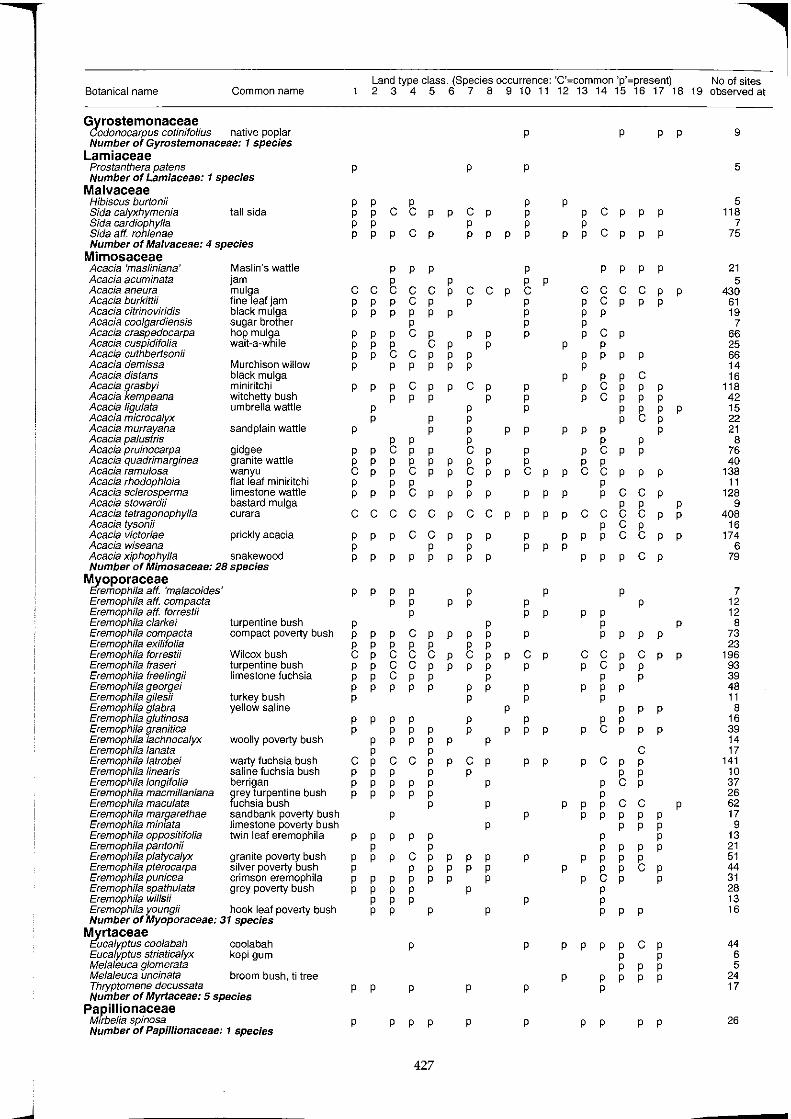
--~--~ Botanical name Common name
Gyrostemonaceae Codonocarpus cotinifofius native poplar Number of Gyrostemonaceae: 1 species
Lamiaceae Prostanthera patens Number of Lamiaceae: 1 species
Malvaceae Hibiscus burtonii Bida calyxhymenia Bida cardiophylla Sida atf. rohlenae
tall sida
Number of Malvaceae: 4 species Mimosaceae Acacia 'masliniana' Acacia acuminata Acacia aneura Acacia burkittii Acacia citrinoviridis Acacia coolgardiensis Acacia craspedocarpa Acacia cuspidifo/ia Acacia cuthbertsonii Acacia demissa Acacia distans Acacia grasbyi Acacia kempeana Acacia ligulata Acacia microcalyx Acacia murrayana Acacia palustris Acacia pruinocarpa Acacia quadrimarginea Acacia ramulosa Acacia rhodophloia Acacia sclerosperma Acacia stowardii Acacia tetragonophylla Acacia tyson;; Acacia victoriae Acacia wiseana
Maslin's wattle jam mulga fine leaf jam black mulga sugar brother hop mulga wait-a-while
Murchison willow black mulga miniritchi witchetty bush umbrella wattle
sand plain wattle
gidgee granite wattle wanyu flat leaf miniritchi limestone wattle bastard mulga curara
prickly acacia
Acacia xiphophylla snakewood Number of Mimosaceae: 28 species
Myoporaceae ~remophila aft. 'malacoides' Eremophila aft. compacta Eremophila aft. forrestii Eremophila clarkei Eremophila compacta Eremophila exilifolia Eremophila forrest;; Eremophila fraseri Eremophila freelingii Eremophila georgei Eremophila giles;; Eremophila glabra Eremophi/a g/utinosa Eremophi/a granitica Eremophila lachnocalyx Eremophila lanata Eremophila latrobei Eremophi/a linearis Eremophila longifolia Eremophila macmillaniana Eremophila maculata Eremophila margarethae Eremophi/a miniata Eremophi/a oppositifolia Eremophila pantonii Eremophila p/atycalyx Eremophila pterocarpa Eremophila punicea Eremophila spathu/ata Eremophila wills;;
turpentine bush compact poverty bush
Wilcox bush turpentine bush limestone fuchsia
turkey bush yellow saline
woolly poverty bush
warty fuchsia bush saline fuchsia bush berrigan grey turpentine bush fuchsia bush sandbank poverty bush limestone poverty bush twin leaf eremophila
granite poverty bush silver poverty bush crimson eremophila grey poverty bush
Eremophila youngii hook leaf poverty bush Number of Myoporaceae: 31 species
Myrtaceae ~ucalyptus coolabah coolabah Eucalyptus striatica/yx kopi gum Me/a/euea glomerata Me/a/euea uncinata Thryptomene deeussata
broom bush, ti tree
Number of Myrtaceae: 5 species Papillionaceae
Mtrbelia spinosa Number of Papillionaceae: 1 species
Land type class. (Species occurrence: 'C'=common 'p'=present) No of sites 23456789101112131415161718190bservedat
p
p p p p p p p p
C ~ p
pCp
p p p
p
C C ~ C C ~ P P pCp P P P P P p
P ~ P p p p p
p p p
pCp C C P P P P P P
p p pCp P P P P
p p p
p p
p p
~ ~ p p p
p p
p
C C C C C P
p p p p
C C P P
p p p P P P
p p p p p p p
p p pppCpp
~ ~ ~ ~ ~ p p p C C P P P pCp P P P P P P P
P P P P P P P P
P P P P P P P
CpCCpp P P P P P P P P P P P P P P
p
p p p p
p p p p p p p p p p
p p p p
P
p p p
C P P P P P p p
p
p
p p p
p p p p
427
p p p
p
C P P P P P
C C P P
p p
p p
p
C P P
p p p
~ p
~ ~ p p p
p
p
C C P
p p p p p
p p
p p p
~ ~ p p
p p p p
p
p
p
p p p
C P P
p
p
p
p p p p
p p
p
p
p
p
p
p p p p
p
~ p p p p p
p p p
p
p
~ p
p p
p p
p p p
p p p p
p
C P P
P P
P P P
p p
p
p
p
p
p
p
p
p
p
p
p
p
p
p
p p
p
p
p
p
p p
pCp P P P pCp P P
p p p p
C C C C P pCp P P P P P P
p p
p p
p
C P P P p
~ ~ C P
P P
p
p
C P P P P
~ ~ P
p ~ p
~ ~ p
p p
p p p p C C P
C C ~ ~ p
~ g ~ p p
p p pCp
p p
p p p p p p p
C C pCp pCp P
P P P P P
p
p
p p
P p
p
C C P P
p p p p
p
~ ~ C C P P P P
p
p
p
p p p p
p
p
p p p p
~ ~ ~ p
p p p p
p
p
p p pCp P P P P P
P P P P P
p p p p
p
p
p
p p
p
p
p
p
9
5
5 118
7 75
21 5
430 61 19
7 66 25 66 14 16
118 42 15 22 21
8 76 40
138 11
128 9
408 16
174 6
79
7 12 12
8 73 23
196 93 39 48 11
8 16 39 14 17
141 10 37 26 62 17 9
13 21 51 44 31 28 13 16
44 6 5
24 17
26
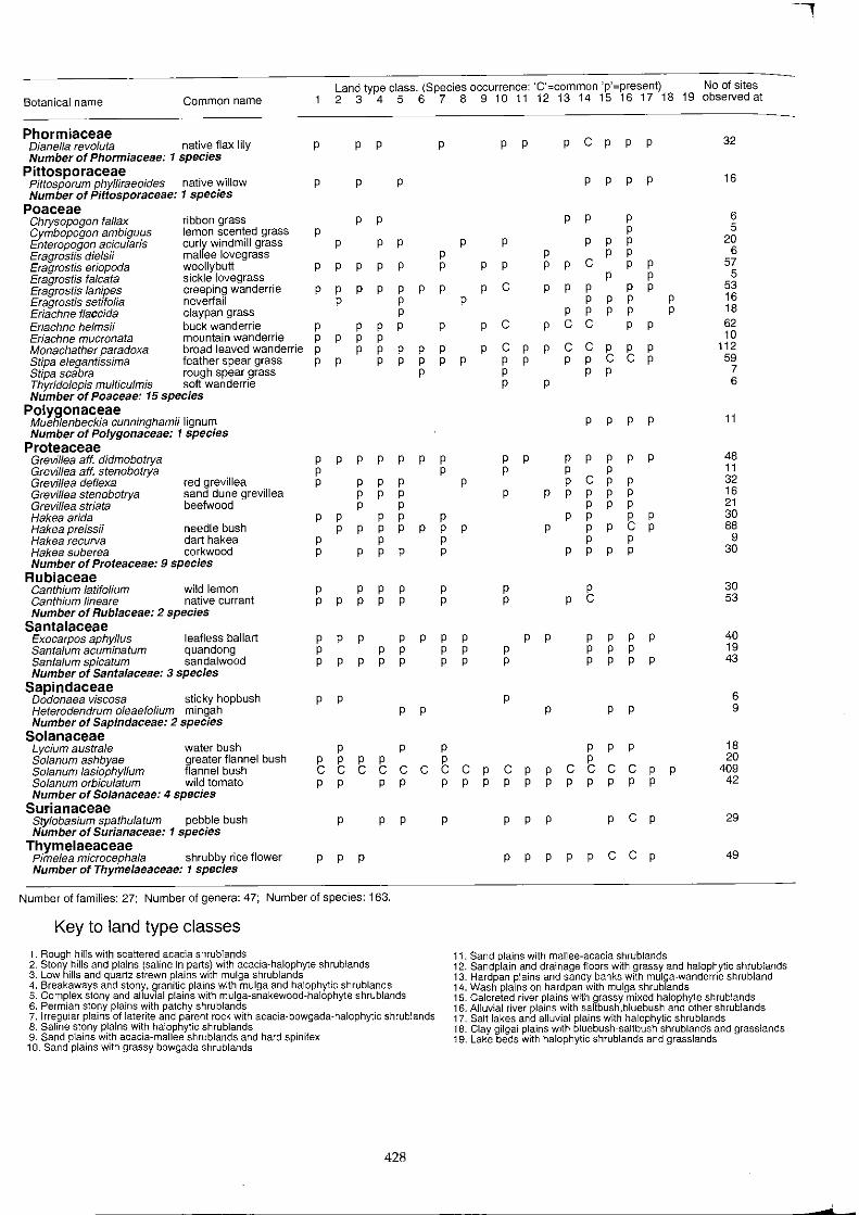
Land type class. (Species occurrence: 'C'=common 'p'=present) No of sites Botanical name Common name 2 3 4 5 6 7 8 9 10 11 12 13 14 15 16 17 18 19 observed at
Phormiaceae Dianel/a revo/uta native flax lily p P P P P P P c P p P 32 Number of Phormiaceae: 1 species
Pittosporaceae p p p P 16 Pittosporum phylliraeoides native willow p P P
Number of Pittosporaceae: 1 species Poaceae
6 Chrysopogon fal/ax ribbon grass p p p p p Cymbopogon ambiguus lemon scented grass p p 5 Enteropogon acicularis curly windmill grass p p p p p p p P 20 Eragrostis dielsii mallee lovegrass p p p P 6 Eragrostis eriopoda woollybutt p P P P P P P P P P C P P 57 Eragrostis falcata sickle lovegrass p p 5 Eragrostis lanipes creeping wanderrie p p p p p p p p C P P P P P 53 Eragrostis setifolia neveriail p p p p p p P 16 Eriachne flaccida claypan grass p p p p p P 18 Eriachne helmsii buck wanderrie p p p p p p C P C C P P 62 Eriachne mucronata mountain wanderrie p p p P 10 Monachather paradoxa broad leaved wanderrie p p p p p p p C P P C C P P P 112 Stipa elegantissima feather spear grass p p p p p p p p p p p C C P 59 Stipa scabra rough spear grass p p p P 7 Thyridolepis multiculmis soft wanderrie p p 6 Number of Poaceae: 15 species
Polygonaceae Muehlenbeckia cunninghamii lignum p p p P 11 Number of Polygonaceae: 1 species
Proteaceae Grevil/ea aft. didmobotrya p p p p p p p p p p p p p p 48 Grevillea aft. stenobotrya p p p p P 11 Grevillea deflexa red grevillea p p p p p p C P P 32 Grevil/ea stenobotrya sand dune grevillea p p p p p p p p P 16 Grevil/ea striata beefwood p p p p P 21 Hakea arida p p p p p p p p P 30 Hakea preissii needle bush p P P P P P P P P P C P 88 Hakea reCUNa dart hakea p p p p P 9 Hakea suberea corkwood p p p p p p p p P 30 Number of Proteaceae: 9 species
Rubiaceae 30 Canthium latifolium wild lemon p p p p p p p
Canthium lineare native currant p p p p p p p p C 53 Number of Rubiaceae: 2 species
Santalaceae 40 Exocarpos aphyl/us leafless ballart p p p p p p p p p p p p p
Santalum acuminatum quandong p p p p p p p p P 19 Santalum spicatum sandalwood p p p p p p p p p p p P 43 Number of Santalaceae: 3 species
Sapindaceae Dodonaea viscosa sticky hopbush p p p 6 Heterodendrum ofeaefolium mingah p p Number of Sapindaceae: 2 species
p p P 9
Solanaceae 18 Lycium australe water bush p P P P P P
Solanum ashbyae greater flannel bush p P P P P P 20 Solanum lasiophyffum flannel bush C C C C C C C C P C P P C C C C P P 409 Solanum orbicu/atum wild tomato p p p p p p p p p p p p p p P 42 Number of Solanaceae: 4 species
Surianaceae Stylobasium spathulatum pebble bush Number of Surianaceae: 1 species
p P P P P P P P c P 29
Thymelaeaceae Pimelea microcephala shrubby rice flower Number of ThymeJaeaceae: 1 species
p p p p p p p p C C p 49
Number of families: 27; Number of genera: 47; Number of species: 163.
Key to land type classes
1. Rough hills with scattered acacia shrublands 11. Sand plains with mallee-acacia shrublands 2. Stony hills and plains (saline in parts) with acacia-halophyte shrublands 12. Sandplain and drainage floors with grassy and halophytic shrublands 3. Low hills and quartz strewn plains with mulga shrublands 13. Hardpan plains and sandy banks with mulga-wanderrie shrubland 4. Breakaways and stony, granitic plains with mulga and halophytic shrublands 14. Wash plains on hardpan with mulga shrublands 5. Complex stony and alluvial plains with mulga-snakewood-halophyte shrublands 15. Calcreted river plains with grassy mixed halophyte shrublands 6. Permian stony plains with patchy shrublands 16. Alluvial river plains with saltbush,bluebush and other shrublands 7. Irregular plains of laterite and parent rock with acacia·bowgada·halophytic shrublands 17. Salt lakes and alluvial plains with halophytic shrublands 8. Saline stony plains with halophytic shrublands 18. Clay gilgai plains with bluebush-saltbush shrublands and grasslands 9. Sand plains with acacia-mallee shrublands and hard spinifex 19. Lake beds with halophytic shrublands and grasslands 10. Sand plains with grassy bowgada shrublands
428
-
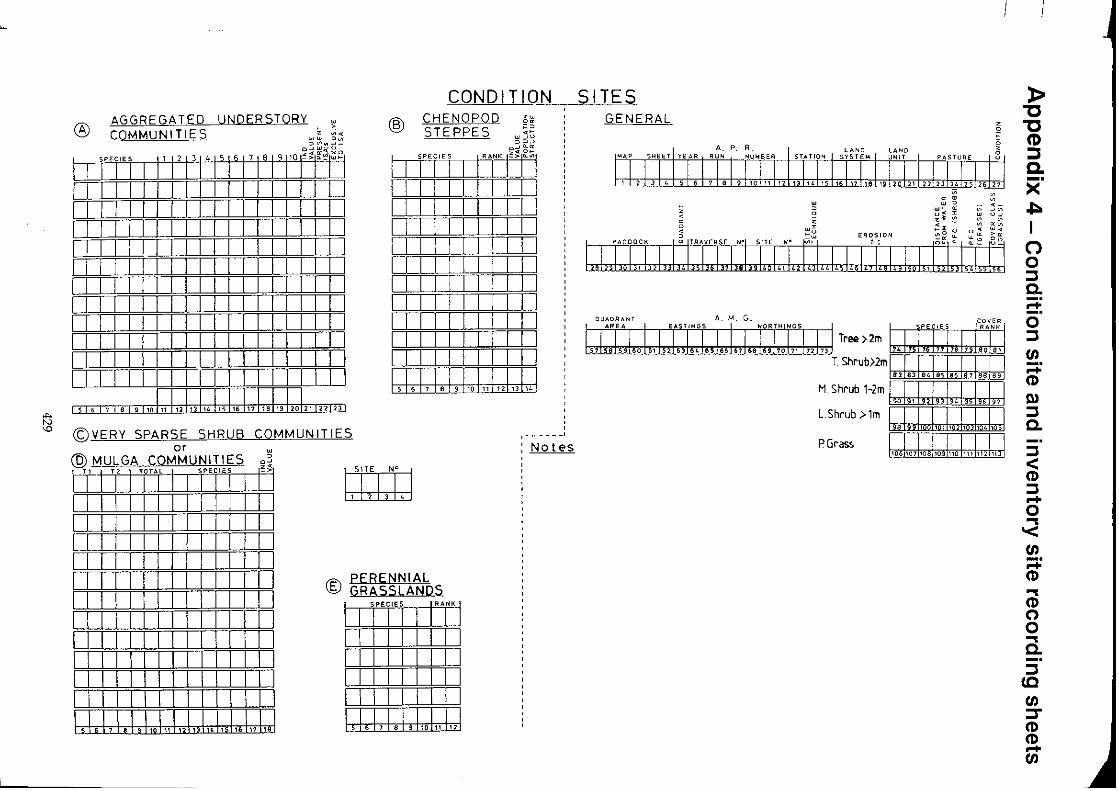
~
i!3 '-0
CONDITION SITES
® AGGREGATED COMMUNITIES
UNDERST08,{ W e , Z ~<
W W =><Ii ::> VI .. -'_.
@ CHENOPOD STEPPES
w
" o w 0 o 0
II 1"1"11 1'1' T 51617ITn~gl~fl I I I I I I I I I I I I I I I I I I I I I I I I I I I I I I I I I I I I I I I I I I I I I I I I I I I I I I I I I I : I J I I I I I I I I I I I I
o;t ~ I SPECIES I RANK 1"'> "'I I I I I
I I I I I I I I I I I I I I I I I I I I
I I I I I I I I I I I I I I I I I I I I i I I I I I I I I I I I I I I I
I I I I I I I I I m I I I I I
I I I I I I I I I I I I I I I I I
I II IIII II IW , i i f I i I I 5 6 7 e 9110 11 ,J 13 LJ
5TTT7TifL9_~11T13114 115116 111 ria 119 120121 122123
©VERY SPARSE SHRUB COMMUNITIES or •
@ MULGA COMMUNITIES ~~
IT I " I '0'" I ",m' I '\ I I I I I I I I Iii i I I i I I I I I I I I I I I I I I
I I I I II I I I I I I I I I I I I I I I I I I I I I I I I I I I I I I I I I I I I I I II III IU II II III In I I I I I I I I I I I I I II II I I I I I 11111111 I I I I I I I I I I I I
I,I,\,\, I" \,,\ "1,,\,,\,, !"I" \" ,.\
1511'1 N° I ,1,,,, 3 I ~ I
® PERENNIAL GRASSLANDS
I SPECIES I RANKj
I I I I I I I I i I I I I I i
I II I II I I I I I I I I I I I I I I I I I I I I I I I \,\,\, • ,1,,1,,1,,\
,------' Notes
GENERAL
e Z
A. p. R.
. ;;
0; , " > ~ w '" <1;_
w"- a: <11-'<11 0":I: UJ Ow
z~ ':::'. ;;; "'~ i ;<l:~uu!~:: '" "'u EROSION "'_ "-~ >-.
~
A. M, G.
Tree >2m
T Shrub>2m\ .,\.,\,J.l !,,\,,U M.Shrub 1-2m \,,\" \,,\,,\,J,,\,,\,,\ L.shrub >1m ii' I iii,
P Grass
» "0 "0 (1) :::I a. X" ~ I
(') o ::J 0.. -o ::J (fj ;:; (1)
Q) ::J 0..
::J < (1) ::J -o ... '< (fj ;:; (1) ... (1) o o ... 0.. ::J
CO (fj :::r (1) (1) -(fj

<t o
~NERAL I GEOMORPHOLOGY •
MANTLE
A.
z o C
OUTCROP ~ o
A, M. G.
EROSION
VEGETATION
z SOILS o
" PAN DETAILS ~g ::I: ~ 0: <II ..... ~~ 'om '""- • > 0 • 0 • ~.
I J:r. I, I J: i,l, I :!1 I:JJ" 1,1 11:1:i,:[] ,
PHOTO
INVENTORY SITE NotE'S
SkE'tch
FRAGMENTS, SEGREGATIONS
LSn-il tili:bj
n-ilLU h::tillJ
510n-il W:rlIJ
fTlilop N°
~

I.
I, I,
I' "
" II
'I
16602l6/94-120o-U6378