an assessment of tight oil resource potential in upper cretaceous cardium formation, western canada...
TRANSCRIPT

RESEARCH PAPER
PETROLEUM EXPLORATION AND DEVELOPMENT Volume 40, Issue 3, June 2013 Online English edition of the Chinese language journal
Cite this article as: PETROL. EXPLOR. DEVELOP., 2013, 40(3): 344–353.
Received date: 28 Aug. 2012; Revised date: 27 Mar. 2012. * Corresponding author. E-mail: [email protected] Copyright © 2013, Research Institute of Petroleum Exploration and Development, PetroChina. Published by Elsevier BV. All rights reserved.
An assessment of tight oil resource potential in Upper Cretaceous Cardium Formation, Western Canada Sedimentary Basin
CHEN Zhuoheng*, Kirk G Osadetz Natural Resources Canada, Geological Survey of Canada
Abstract: The Cardium Formation “halo oil” occurs either in the fringe of, or between, existing conventional discrete sandstone reser-voirs. It is commonly associated with conventional oil and gas pools in stratigraphic traps. This paper uses a geological model-based si-mulation approach to assess Cardium “halo oil” resource potential. The geological model-based approach consists of a geological model, a resource model and a stochastic modeling procedure that extracts essential information regarding the richness and spatial characteristics of oil resources from various data sources using statistical methods. It integrates them with the geological and resource models, respectively, to estimate the resource potential. This approach predicts not only the resource potential, but also the resource spatial distri-bution and the exploration risk. These outcomes provide critical information for exploration decision-making. Cardium “halo-oil” as-sessment results indicate a mean total oil in-place (conventional and unconventional) of 4.6×10⁹ m3 and a mean undiscovered “halo oil” in-place of 2.9×10⁹ m3. Using current technology and economic constraints the undiscovered recoverable “halo oil” in this tight formation is 0.11×10⁹ m3. This represents <4% of the remaining in-place oil resource, but it accounts for 38% of the total recoverable Cardium oil. A comparison with resource estimates obtained using a well-performance approach that is based on production data extrapolations from stimulated horizontal wells suggests that the mean recoverable estimate obtained using the two different approaches are similar, suggest-ing that the geological model-based approach provides a reliable oil resource potential estimate.
Key words: unconventional, Halo oil pool, stochastic simulation, resource assessment
Introduction
Over the past ten years, a rapid increase in natural gas pro-duction from shale reservoirs in the United States is resulted from advances in horizontal drilling technology coupled with multi-stage hydraulic fracturing. These technological devel-opments have changed not only the supply-demand dynamics of the North American natural gas market, but they have also changed the petroleum reservoir paradigm. The natural gas price dropped from above $350 (USD)/103 m3 ($USD 10/103
ft3) in the winter of 2007 to about $105 (USD)/103 m3 ($USD 3/103 ft3) in 2012. Concurrently, international crude oil prices remained less volatile and relatively stable. As a result, energy companies are gradually shifting their focus from natural gas to crude oil. On the other hand, successful applications of the same technology to develop Bakken shale oil in Williston Basin led to increased tight oil/shale oil exploration, first in North America, and then globally. The study of, and explora-tion for, unconventional petroleum resources is also entering a new era in China [1−5]. Whether or not tight oil/shale oil de-velopments will emulate the history of the shale gas
“revolution” remains unclear. It is possible that a rapid in-crease in tight oil production from shale/tight reservoirs could affect oilsands and even conventional oil development ad-versely. In the face of new challenges from growing shale/tight oil production, both company exploration decision makers and governmental energy policy makers need to have a clear view of the tight oil/shale oil resource potential. This paper uses Western Canada Sedimentary Basin (WCSB) Car-dium Formation (Fm.) tight oil reservoirs as an example for a geological model-based stochastic procedure to evaluate the tight oil resource potential and predict the undiscovered re-source spatial distribution. There are two reasons for selecting Cardium Fm. as the case study: a) Cardium Fm. tight oil res-ervoirs are typical and representative of many tight reservoirs in both WCSB and elsewhere. Understanding the oil resource potential, reservoir characteristics and spatial variations have important implications for exploration decision making and energy policy development. b) Cardium Fm. is a well known reservoir in WCSB. Since the Pembina oil field discovery in 1953, a large volume of exploration and production data have

CHEN Zhuoheng et al. / Petroleum Exploration and Development, 2013, 40(3): 344–353
− 345 −
become available. For example, a variety of production data, is available from more than 20,000 Cardium Fm. production wells [6].
1 Geological setting of study area
The WCSB is located in North America, east of the Rocky Mountains [7−8], is currently one of the sedimentary basins with the most abundant proved petroleum resources in the world. WCSB comprises two secondary basins of subsidence, Alberta Basin in the west and Williston Basin in the southeast (Fig.1). The sedimentary package of WCSB can be divided into two distinct stratal successions: Paleozoic carbonate rocks deposited on the paleo-Pacific miogeocline and stable platform dominate its lower part, and the Mesozoic-Cenozoic foreland basin clastic succession dominates its upper part, resulting in a westwardly thickening composite sedimentary wedge that is thickest in front of the western Rocky Moun-tains, about 6,000 m, and that thins eastward gradually to its erosional edge at Canadian Shield [9] (Fig.2).
WCSB Foreland succession (Jurassic - Paleocene) is linked to the complicated collision of North American Plate with a variety of terrenes along its western margin, resulting in the cratonward-verging imbricated Cordilleran thrust and fold belt that involved Proterozoic and Paleozoic successions and overlying strata. The Foreland basin was deposited in the Cretaceous North American Interior Seaway, which extends from the Gulf of Mexico in the south to the Arctic Ocean in the north. Cretaceous Colorado Group (Gp.), predominantly marine shale, was deposited within this interior seaway (Fig.3).
Within Colorado Gp. there are multiple transgressive-re-gressive depositional cycles, or cyclothems, consisting of intercalated mudstone, siltstone and sandstone. Several or-ganic-rich marine mudstones intervals, Fish Scale shale, Sec-ond White Speckled shale, and First White Speckled shale are the main source rock intervals in Colorado Gp. petroleum systems [10]. These source rocks occur widely, from western Alberta Basin to eastern Williston Basin. They have average
Fig. 1 Regional location of study area[6]
Fig. 2 A - A' Regional geologic profile of Western Canada Basin[9] (profile location indicated in Fig.1)
CHEN Zhuoheng et al. / Petroleum Exploration and Development, 2013, 40(3): 344–353
− 346 −
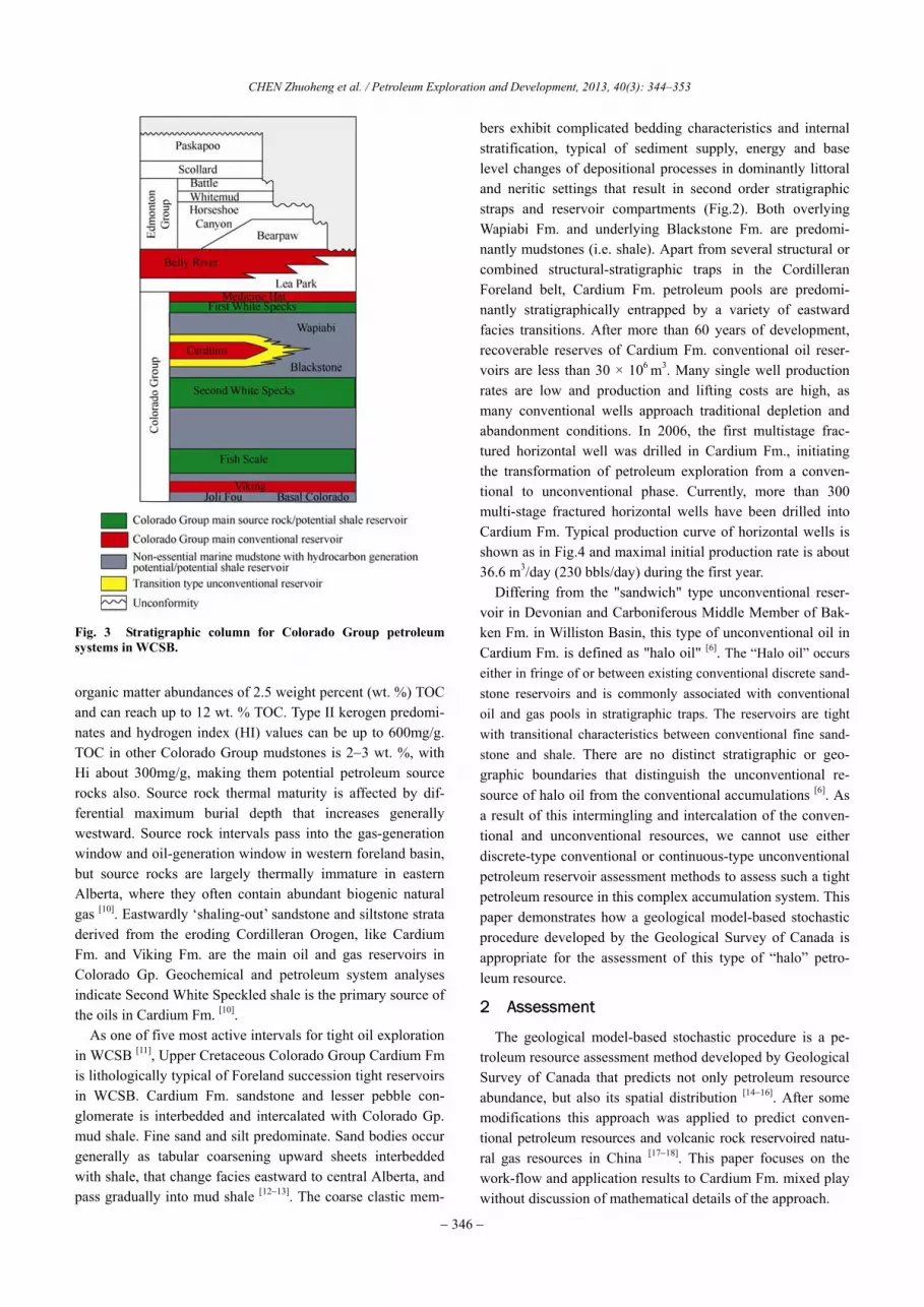
Fig. 3 Stratigraphic column for Colorado Group petroleum systems in WCSB.
organic matter abundances of 2.5 weight percent (wt. %) TOC and can reach up to 12 wt. % TOC. Type II kerogen predomi-nates and hydrogen index (HI) values can be up to 600mg/g. TOC in other Colorado Group mudstones is 2−3 wt. %, with Hi about 300mg/g, making them potential petroleum source rocks also. Source rock thermal maturity is affected by dif-ferential maximum burial depth that increases generally westward. Source rock intervals pass into the gas-generation window and oil-generation window in western foreland basin, but source rocks are largely thermally immature in eastern Alberta, where they often contain abundant biogenic natural gas [10]. Eastwardly ‘shaling-out’ sandstone and siltstone strata derived from the eroding Cordilleran Orogen, like Cardium Fm. and Viking Fm. are the main oil and gas reservoirs in Colorado Gp. Geochemical and petroleum system analyses indicate Second White Speckled shale is the primary source of the oils in Cardium Fm. [10].
As one of five most active intervals for tight oil exploration in WCSB [11], Upper Cretaceous Colorado Group Cardium Fm is lithologically typical of Foreland succession tight reservoirs in WCSB. Cardium Fm. sandstone and lesser pebble con-glomerate is interbedded and intercalated with Colorado Gp. mud shale. Fine sand and silt predominate. Sand bodies occur generally as tabular coarsening upward sheets interbedded with shale, that change facies eastward to central Alberta, and pass gradually into mud shale [12−13]. The coarse clastic mem-
bers exhibit complicated bedding characteristics and internal stratification, typical of sediment supply, energy and base level changes of depositional processes in dominantly littoral and neritic settings that result in second order stratigraphic straps and reservoir compartments (Fig.2). Both overlying Wapiabi Fm. and underlying Blackstone Fm. are predomi-nantly mudstones (i.e. shale). Apart from several structural or combined structural-stratigraphic traps in the Cordilleran Foreland belt, Cardium Fm. petroleum pools are predomi-nantly stratigraphically entrapped by a variety of eastward facies transitions. After more than 60 years of development, recoverable reserves of Cardium Fm. conventional oil reser-voirs are less than 30 × 106 m3. Many single well production rates are low and production and lifting costs are high, as many conventional wells approach traditional depletion and abandonment conditions. In 2006, the first multistage frac-tured horizontal well was drilled in Cardium Fm., initiating the transformation of petroleum exploration from a conven-tional to unconventional phase. Currently, more than 300 multi-stage fractured horizontal wells have been drilled into Cardium Fm. Typical production curve of horizontal wells is shown as in Fig.4 and maximal initial production rate is about 36.6 m3/day (230 bbls/day) during the first year.
Differing from the "sandwich" type unconventional reser-voir in Devonian and Carboniferous Middle Member of Bak-ken Fm. in Williston Basin, this type of unconventional oil in Cardium Fm. is defined as "halo oil" [6]. The “Halo oil” occurs either in fringe of or between existing conventional discrete sand- stone reservoirs and is commonly associated with conventional oil and gas pools in stratigraphic traps. The reservoirs are tight with transitional characteristics between conventional fine sand-stone and shale. There are no distinct stratigraphic or geo-graphic boundaries that distinguish the unconventional re-source of halo oil from the conventional accumulations [6]. As a result of this intermingling and intercalation of the conven-tional and unconventional resources, we cannot use either discrete-type conventional or continuous-type unconventional petroleum reservoir assessment methods to assess such a tight petroleum resource in this complex accumulation system. This paper demonstrates how a geological model-based stochastic procedure developed by the Geological Survey of Canada is appropriate for the assessment of this type of “halo” petro-leum resource.
2 Assessment
The geological model-based stochastic procedure is a pe-troleum resource assessment method developed by Geological Survey of Canada that predicts not only petroleum resource abundance, but also its spatial distribution [14−16]. After some modifications this approach was applied to predict conven-tional petroleum resources and volcanic rock reservoired natu-ral gas resources in China [17−18]. This paper focuses on the work-flow and application results to Cardium Fm. mixed play without discussion of mathematical details of the approach.

CHEN Zhuoheng et al. / Petroleum Exploration and Development, 2013, 40(3): 344–353
− 347 −
Fig. 4 Typical production curves, Valko model fits and EUR estimates of horizontal Cardium Fm. unconventional wells in WCSB.
The procedure used here is different from the method of Olea et al. [19] which estimates unconventional petroleum re-sources based on traditional geostatistical simulation. The geological model-based stochastic procedure consists of three parts: geological model, resource model and stochastic mod-eling. Our approach has many advantages such as: considera-tion of the spatial variation characteristics of resource distri-butions (e.g., resource abundance, anisotropy, space continu-ity etc.); it is convenient for uncertainty expression in resource prediction; it is convenient for extracting information required for model buildings and data integration; and it is good for the application of geological and geophysical constraints to en-sure resulting outputs to be consistent with known geology and available data.
2.1 Geological model
The geological model is a quantitative expression of basic geologic controls on the formation and occurrence of the re-sources and is built up on petroleum system model analysis and exploration data. Based on correlation analysis among geologic features and resource characteristics, major geologi-cal factors controlling petroleum formation and distribution are identified. The relationship between geological features and resource characteristics is quantified and transformed into a mathematical or statistical model. Chen suggests the use of Mahanalobis Distance as a parameter to describe the relation-ship [15]. This method divides exploratory wells into successful wells and unsuccessful wells based on oil productivity. The associated geological characteristics of the classification are
mapped and converted into a geological favorability map in prospective areas for petroleum occurrence. A Bayesian ap-proach is then employed to convert the geologic favorability map to a probability map, representing the probability density of petroleum occurrence. The output of this approach provides not only resource estimates, but also associated uncertainty for risk analysis. Recently, Chen et al. suggested the use of support vector machine for quantifying the geological model [20].
2.2 Resource model
The resource model is a quantitative expression of resource abundance and spatial relationships in an assessment area [16]. The original model is built based on petroleum exploration and development data, such as location, reserve magnitude, and geometrical properties of discovered petroleum accumu-lations; dry hole locations and other controls; location and output of producing wells; and location of petroleum shows in wells and the petroleum show intensity, etc. This paper uses a fractal model as the theoretical resource model to describe petroleum resource abundance and its spatial distribution [16]. However, petroleum resource model is not limited to a fractal model. It can be in other mathematical forms such as log-normal, gamma or beta distributions. In application, the re-source model is usually represented by a power spectrum in frequency domain. The power spectrum and covariance func-tion are mathematically equivalent because the power spec-trum of a spatial stochastic variable and its covariance func-tion is a Fourier transform pair [21], i.e., the power spectrum

CHEN Zhuoheng et al. / Petroleum Exploration and Development, 2013, 40(3): 344–353
− 348 −
contains all the information related to resource abundance, spatial continuity and anisotropy.
2.3 Stochastic modeling
There are many stochastic modeling algorithms available for this purpose. A modified phase identification Fourier inte-gral method [16] is adopted in this paper. We first transform the oil and gas reserve density map into the frequency domain using a fast Fourier transform (FFT), resulting in both an amplitude map and a phase map. Additional information extracted from other sources is bought into the frequency domain to correct the sampling bias in the amplitude map and to implant information regarding the locations of un-discovered resource that is contained in the geological model into the phase map. Subsequently an inverse Fourier transform of the “corrected” amplitude map and the new phase map gives a realization of the resource potential map in the spatial domain. The merits of this method include its convenience for the extraction and integration of additional information from various geological and geophysical data sources in the frequency domain, and hard and soft data conditioning in the simulation. Chen [16] elaborated the prin-ciple and application of stochastic modeling using the modi-fied phase identification Fourier integral method, and dis-cussed the difference between geological model-based sto-chastic modeling and simple geostatistical conditioning simu-lation, which is not described in detail herein.
3 Stochastic modeling of Cardium Formation petroleum resources
This paper defines the Cardium mixed oil play to include all oil accumulations in conventional and unconventional tight reservoirs in Cardium Formation with an areal extent coinci-dent with the region of Second White Specks Shale source rock maturity. We use oil abundance to describe the distribu-tion of the oil resource in Cardium Fm. This assessment gen-erates resource density maps in Cardium Fm. using the known discovered resources, then predicting the likely locations and abundance of the undiscovered resource potential. The data used in the Cardium Fm. tight oil resource assessment come from multiple sources, including 1) Cardium Fm. oil reserves compiled by the Alberta government [21]; 2) Cardium Fm. production data in a commercial database; 3) geochemical data from the Geological Survey of Canada in-house database and WCSB publications [10, 22−23]; and 4) other data, such as the regional structure formation thickness and sedimentary facies maps from sources including the Geologic Atlas of Western Canada Sedimentary Basin [7].
3.1 Geological model
Through data analysis, we realize that several geological and geophysical attributes, such as source rock petroleum generation intensity, regional structure gradient, sedimentation
rate and log resistivity are correlated to Cardium oil produc-tivity, which can be used to distinguish the productive well locations from the non-production well locations (Fig.5). Treating geological risk analysis as a classification with un-certainty, the Mahanalobis distance is used to measure the distance of an untested target at a given geographic location from the geometric center of the population of production wells in a parameter space. Based on that distance, the result-ing classification is projected into evaluation space as a Car-dium Fm. geological favorability map. A Bayesian method converts the geologic favorability map into a probability map of oil occurrence (Fig.6), which quantifies the spatial distribu-tion of petroleum resources. On the probability map, the probabilities of known oil accumulations are 1. In other loca-tions, the greater the probability value, the higher the prob-ability of containing oil.
3.2 Resource model
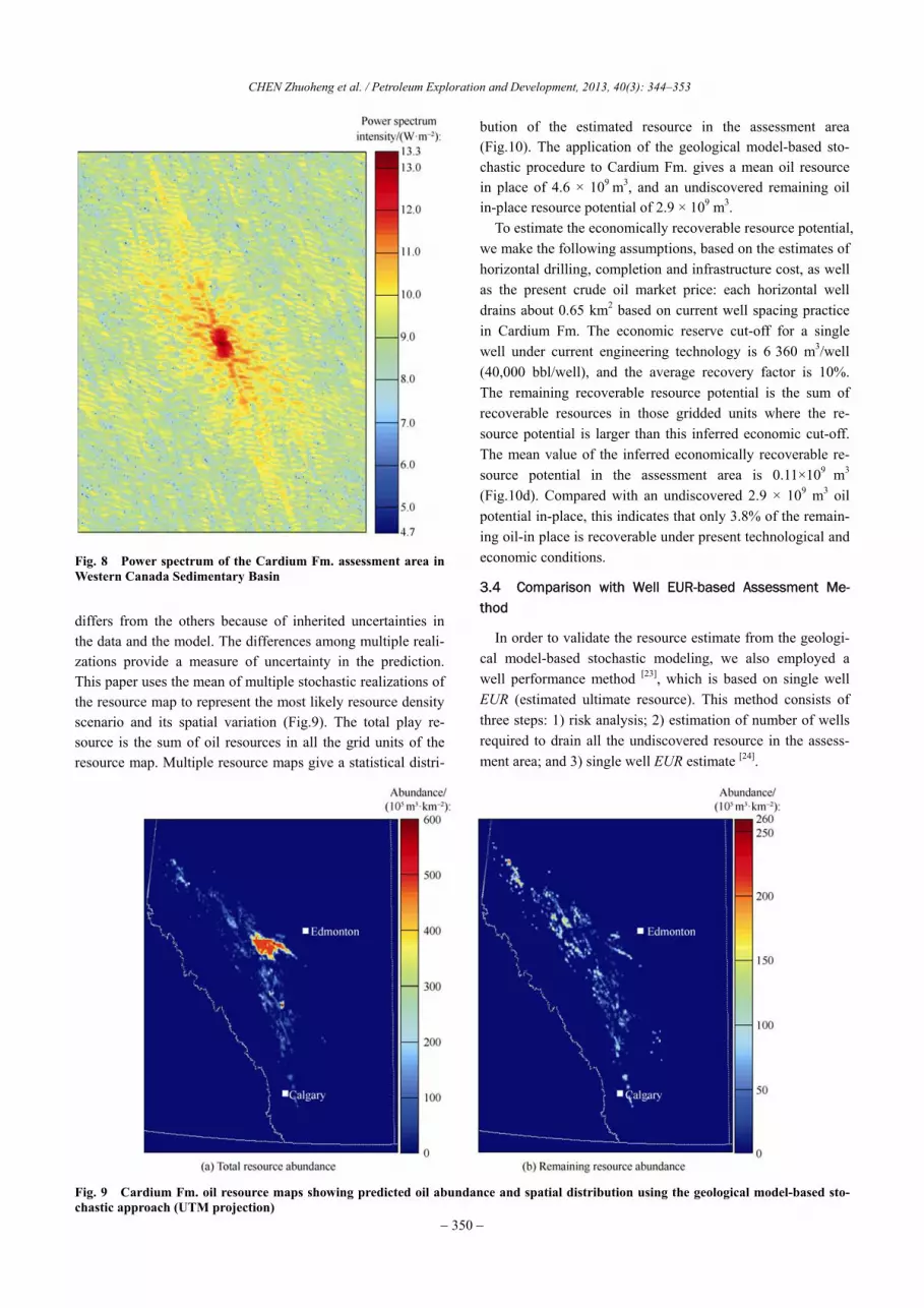
The resource model embodies mainly the spatial character-istics of resource abundance, anisotropy and continuity. For the construction of the Cardium Fm. oil resource model, the geometric association of more than 20,000 production wells and reserves of 379 existing pools were established to produce a reserve abundance map (Fig.7). The first oilfield in the Car-diun Fm. was discovered in 1953. After more than 60 years of exploration and development, the Cardium Fm. conventional petroleum resource has been discovered essentially, and the remaining petroleum resource occurs mostly in the tight res-ervoirs on the fringe of the conventional reservoirs. This type of reservoir occurs over a large area, but the reservoir has low porosity (5%−10%), and permeability (<10×10−3 μm3). As a result, the resource abundance is smaller. It is reasonable to believe that basic information regarding the conventional oil resource is reflected completely in Fig.7, but that the informa-tion regarding the tight reservoir resource is incomplete. The power spectrum (Fig.8) and phase maps are obtained using a Fourier transform from the reserve abundance and probability maps in the frequency domain. The power spec-trum map represents the petroleum resource abundance and spatial distribution characteristics of existing conventional and a few unconventional oil pools. It is necessary to correct the power spectrum using the fractal model [3]. The corrected fractal model represents the resource abundance and the spa-tial distribution characteristics of both conventional oil and tight "halo oil" resources.
3.3 Modeling results
Stochastic simulation integrates the geological model and the corrected resource model in the frequency domain and transforms them back to a spatial domain with constraints from exploration and geologic data, resulting in a resource map that shows both resource density and location. Each re-alization of the resource map derived from the simulation

CHEN Zhuoheng et al. / Petroleum Exploration and Development, 2013, 40(3): 344–353
− 349 −
Fig. 5 Geographic variation of primary variables in the geological model (UTM projection)
Fig. 6 Probability of oil occurrence in the Cardium Fm. assess-ment area in WCSB (UTM projection)
Fig. 7 Known reserve abundance for the Cardium Fm. assess-ment area in WCSB (UTM projection)
CHEN Zhuoheng et al. / Petroleum Exploration and Development, 2013, 40(3): 344–353
− 350 −
Fig. 8 Power spectrum of the Cardium Fm. assessment area in Western Canada Sedimentary Basin
differs from the others because of inherited uncertainties in the data and the model. The differences among multiple reali-zations provide a measure of uncertainty in the prediction. This paper uses the mean of multiple stochastic realizations of the resource map to represent the most likely resource density scenario and its spatial variation (Fig.9). The total play re-source is the sum of oil resources in all the grid units of the resource map. Multiple resource maps give a statistical distri-
bution of the estimated resource in the assessment area (Fig.10). The application of the geological model-based sto-chastic procedure to Cardium Fm. gives a mean oil resource in place of 4.6 × 10⁹ m3, and an undiscovered remaining oil in-place resource potential of 2.9 × 10⁹ m3.
To estimate the economically recoverable resource potential, we make the following assumptions, based on the estimates of horizontal drilling, completion and infrastructure cost, as well as the present crude oil market price: each horizontal well drains about 0.65 km2 based on current well spacing practice in Cardium Fm. The economic reserve cut-off for a single well under current engineering technology is 6 360 m3/well (40,000 bbl/well), and the average recovery factor is 10%. The remaining recoverable resource potential is the sum of recoverable resources in those gridded units where the re-source potential is larger than this inferred economic cut-off. The mean value of the inferred economically recoverable re-source potential in the assessment area is 0.11×10⁹ m3 (Fig.10d). Compared with an undiscovered 2.9 × 10⁹ m3 oil potential in-place, this indicates that only 3.8% of the remain-ing oil-in place is recoverable under present technological and economic conditions.
3.4 Comparison with Well EUR-based Assessment Me-thod
In order to validate the resource estimate from the geologi-cal model-based stochastic modeling, we also employed a well performance method [23], which is based on single well EUR (estimated ultimate resource). This method consists of three steps: 1) risk analysis; 2) estimation of number of wells required to drain all the undiscovered resource in the assess-ment area; and 3) single well EUR estimate [24].
Fig. 9 Cardium Fm. oil resource maps showing predicted oil abundance and spatial distribution using the geological model-based sto-chastic approach (UTM projection)

CHEN Zhuoheng et al. / Petroleum Exploration and Development, 2013, 40(3): 344–353
− 351 −
Fig. 10 Probability distributions of Cardium Fm. oil resource potential in WCSB.
Risk analysis examines key geological elements for the formation of petroleum resources in the petroleum system that include source rock type, quality, quantity and maturity; res-ervoir thickness and the economic cut-off for a single hori-zontal well. The number of wells to be drilled in the assess-ment area can be obtained from the ratio of the untested area to the drainage area of a single well. This can be either a sin-gle value or a probability distribution, depending on the data available. The single well EUR can be estimated directly by fitting a production decline model to production data if pro-tracted production history data is available. Otherwise it can be obtained using analogy to well EUR from areas with longer production history and similar geologic conditions. Typical Cardium Fm. tight oil production curves are shown in Fig.4. The play resource potential can then be estimated using the following expression:
( ) ( ) AR p g p p EURS
= (1)
where, R—Resource potential (m3), p(g)—Probability of pe-troleum resource existing in the assessment area, f; p(p)— Probability of at least one well that has resource potential greater than the economic cut-off, f; A—Total untested area in the assessment area, m2; S—well drainage area, m2.
In the assessment, the well EUR represents the recoverable resource potential in a well drainage area. Because we are assessing Cardium Fm. tight oil resource potential, only hori-zontal production wells with multi-stage fracturing comple-
tions are used in the EUR estimation. The Valko model [24] is used to estimate well EUR. The stimulated horizontal wells with greater than ten months of production history were ana-lyzed. The resulting EURs form a distribution that shows the variation in well performance. In Cardium Fm. many conven-tional pools are discovered and the probability for the pres-ence of oil resource is 1, i.e., p(g)=1.
The well EUR distribution curve (Fig.11a) is estimated based on oil production from 282 Cardium Fm. horizontal wells, among which about 30% failed to reach the inferred EUR economic cut-off, i.e., p(p)=0.7. The probability distri-bution curve for the untested Cardium Fm. area can be de-rived from the probability map of oil occurrence (Fig. 6) by integrating the area of pixels whose probability value is less than 1. The well performance method (Eq. (1)) gives a mean value of the remaining recoverable oil resource potential of 0.12 × 10⁹ m3 (Fig.11b). This is close to the mean value of 0.11 × 10⁹ m3 from the geological model-based stochastic modeling.
4 Conclusions
The WCSB “halo oil” resource represents a special type of unconventional oil resource. “Halo oil” occurs either on the fringe of, or between, existing discrete conventional sandstone reservoirs. It is commonly associated with conventional oil and gas pools in stratigraphic traps. The reservoirs are tight with characteristics transitional between that commonly as-

CHEN Zhuoheng et al. / Petroleum Exploration and Development, 2013, 40(3): 344–353
− 352 −
Fig. 11 Stimulated horizontal well oil EUR cumulative probability distribution of Cardium Formation estimated from Valko model (a), and unconventional recoverable oil resource cumulative probability distribution of Cardium Formation estimated from the well per-formance method (b).
cribed to sandstone and shale. The oils in these tight reservoirs could not be produced commercially previously with conven-tional completion methods. With the advent of advanced horizontal drilling combined with multi-stage hydraulic frac-turing techniques, the “halo oil” play has become a focus for new reserve growth throughout North America. The Cardium Fm. “halo oil” play is one of the most active resource plays in WCSB currently.
The geological model-based stochastic approach can effec-tively extract information relevant to the resource spatial cha-racteristics and abundance from various geological data sources, which are then integrated in the frequency domain to form a resource prediction. The output of the prediction in-cludes a resource map and associated uncertainty estimate, which provides estimates of resource potential, the likely un-discovered resource locations, and a measure of the uncer-tainty of the prediction. The results are all useful for explora-tion risk analysis and exploration decision-making.
The geological model-based stochastic modeling approach suggests the total (conventional and unconventional) Cardium Fm. oil in-place resource potential is 4.6 × 10⁹ m3, of which the total undiscovered tight oil in-place is 2.9 × 10⁹ m3, and the currently recoverable resource potential, under present technical and economic conditions, is 0.11 × 10⁹ m3. This is less than 4% of the total undiscovered in-place resource po-tential, but it comprises about 38% of the total recoverable resource potential for Cardium Fm. (0.29 × 10⁹ m3). It appears that tight reservoir hosts large oil resource potential in mature WCSB resource plays. It is expected that future advances in drilling and completion technology will improve oil recovery, increasing the recoverable proportion of unconventional re-source. Comparison to a well performance method validates the geological-model based stochastic model. The mean val-ues of the two estimates of the Cardium Fm. recoverable re-source potential in tight reservoirs are almost identical, sug-gesting the assessment result from the geological model-based stochastic modeling is reliable.
References
[1] Jia Chengzao, Zheng Min, Zhang Yongfeng. Unconventional hydrocarbon resources in China and the prospect of explora-tion and development. Petroleum Exploration and Develop-ment, 2012, 39(2): 129–136.
[2] Zou Caineng, Yang Zhi, Tao Shizhen, et al. Nano-hydro-carbon and the accumulation in coexisting source and reser-voir. Petroleum Exploration and Development, 2012, 39(1): 13–26.
[3] Huang Jinliang, Zou Caineng, Li Jianzhong, et al. Shale gas generation and potential of the Lower Cambrian Qiongzhusi Formation in Southern Sichuan Basin, China. Petroleum Ex-ploration and Development, 2012, 39(1): 69–75.
[4] Lu Shuangfang, Huang Wenbiao, Chen Fangwen, et al. Classi-fication and evaluation criteria of shale oil and gas resources: Discussion and application. Petroleum Exploration and De-velopment, 2012, 39(2): 249–256.
[5] Dai Jinxing, Ni Yunyan, Wu Xiaoqi. Tight gas in China and its significance in exploration and exploitation. Petroleum Exploration and Development, 2012, 39(3): 257–264.
[6] Clarkson C R, Pedersen P K. Production analysis of Western Canadian unconventional light oil plays. CSUG/SPE Paper 149005, 2011.
[7] Mossop G D, Shetsen I. Geological atlas of the Western Can-ada Sedimentary Basin. Calgary, Canada: Canadian Society of Petroleum Geologists and Alberta Research Council, 2012.
[8] Porter J W, Price R A, MaCrossan R G. The Western Canada Sedimentary Basin. London: Philisophical Transactions of the Royal Society of London, 1982.
[9] Wright G N, McMechan M E, Potter D E G. Chapter 3 struc-ture and architecture of the Western Canada Sedimentary Ba-sin Mossop G D, Shetsen I. Geological atlas of the Western Canada Sedimentary Basin. Calgary, Canada: Canadian Soci-ety of Petroleum Geologists and Alberta Research Council, 1994.
[10] Creaney S, Allan J, Cole K S, et al. Petroleum generation and migration in the Western Canada Sedimentary Basin Mossop

CHEN Zhuoheng et al. / Petroleum Exploration and Development, 2013, 40(3): 344–353
− 353 −
G D, Shetsen I. Geological atlas of the Western Canada Sedi-mentary Basin. Calgary, Canada: Canadian Society of Petro-leum Geologists and Alberta Research Council, 1994.
[11] Stastry R P. The five hot plays: producers chase oil and liquids in western Canada’s hottest plays. Oilweeks, 2011: 21–30.
[12] Leckie D A, Smith D G. Regional setting, evolution, and de-positional cycles of the Western Canada Foreland Basin Mac-queen R W, Leckie D A. AAPG Memoir 55: Foreland basin and fold belts. Tulsa: AAPG, 1992: 9–46.
[13] Krause F F, Deutsch K B, Joiner S D, et al. Cretaceous Car-dium Formation of the Western Canada Sedimentary Basin Mossop G D, Shetsen I. Geological atlas of the Western Can-ada Sedimentary Basin. Calgary, Canada: Canadian Society of Petroleum Geologists and Alberta Research Council, 1994.
[14] Chen Z, Osadetz K G, Gao Haiyu. Stochastic simulation of undiscovered petroleum accumulation Leuangthong O, Deutsch C V. Quantitative geology and geostatistics. Deutsch: Springer, 2005: 661–670.
[15] Chen Z, Osadetz K G. Geological risk mapping and prospect evaluation using multivariate and Bayesian methods, western Sverdrup Basin of Canada. AAPG Bulletin, 2006, 90(6): 859–872.
[16] Chen Z, Osadetz K G. Undiscovered petroleum accumulation mapping using model-based stochastic simulation. Mathe-matical Geology, 2006, 38(1): 1–16.
[17] Hu Suyun, Guo Qiulin, Chen Zhuoheng, et al. A method of
predicting petroleum resource spatial distribution and its ap-plication. Petroleum Exploration and Development, 2007, 34(1): 113–117.
[18] Xie H B, Guo Q L, Li F, et al. Prediction of petroleum explo-ration risk and subterranean spatial distribution of hydrocar-bon accumulations. Petroleum Science, 2011, 8(1): 17–23.
[19] Olea R A, Cook T A, Coleman J L. A methodology for the assessment of unconventional (continuous) resources with an application to the greater natural Buttes gas field, Utah. Natu-ral Resources Research, 2010, 19(4): 10–18.
[20] Chen Z, Liu Y, Osadetz K G. Geological risk evaluation using Support Vector Machine with example from the late Trias-sic-early Jurassic structural play in western Sverdrup Basin. Bulletin of Canadian Petroleum Geology, 2012, 60(3): 142–157.
[21] Pardo-Iguzquiza E, Chica-Olmo M. The Fourier Integral Method: An efficient spectral method for simulation of ran-dom fields. Mathematical Geology, 1993, 25(4): 177–217.
[22] ERCB. ST98-2009: Alberta’s energy reserves 2010 and sup-ply/demand outlook 2010-2020. [2012-03-16]. http://www. ercb.ca/docs/ products/ STs/st98_current.pdf.
[23] Charpentier R R, Cook T A. USGS methodology for assessing continuous petroleum resources. USGS Open File Report 2011-1167, 2011.
[24] Valko P P, Lee J. A better way to forecast production from unconventional gas wells. SPE 134231, 2010.