administrative procedures act rules - mississippi secretary of
TRANSCRIPT
1
Administrative Procedures Act Rules
Title 11: Mississippi Department of Environmental Quality
Part 8: Geology Regulations
Part 8, Chapter 1: Mississippi Commission on Environmental Quality Surface Mining and
Reclamation Rules and Regulations
TABLE OF CONTENTS
Subchapter 1: General Procedural Rules
Rule 1.1.1 Purpose and Scope of Regulations
Rule 1.1.2 Definitions
Rule 1.1.3 Awareness of the Act
Rule 1.1.4 Computation of Time
Rule 1.1.5 Inspection of Public Records
Rule 1.1.6 Designation and Protection of Confidential Information
Rule 1.1.7 Severability
Subchapter 2: Permitting Procedures
Rule 1.2.1 Applicability and Exemptions
Rule 1.2.2 Permit Application
Rule 1.2.3 General Permits
Rule 1.2.4 Notification of Exempt Operations
Rule 1.2.5 Processing of Permit Applications
Rule 1.2.6 Review and Comment by the Public
Rule 1.2.7 Permit Approval and Denial
Rule 1.2.8 Amendments
Rule 1.2.9 Certificate of Compliance
Rule 1.2.10 Operator Requirements
Rule 1.2.11 Permit Transfers, Revocations, Cancellations, Suspension, Rescissions and
Reissuance
Rule 1.2.12 Property Rights, All Rights
Subchapter 3: Performance Bonds
Rule 1.3.1 Purpose of the Bond
Rule 1.3.2 Form of the Bond
Rule 1.3.3 Duration of Liability
Rule 1.3.4 Application for Release of the Bond
2
Subchapter 4: Lands Unsuitable for Mining
Rule 1.4.1 Lands Designated as Unsuitable for Surface Mining
Rule 1.4.2 Register of Lands Designated as Unsuitable for Surface Mining
Rule 1.4.3 Petition to Have Lands Designated as Unsuitable for Surface Mining
Subchapter 5: Fees
Rule 1.5.1 Fees
Rule 1.5.2 Surface Mine Worker Safety Training Fees
Subchapter 6: Inspections
Rule 1.6.1 Inspections
Subchapter 7: Reclamation
Rule 1.7.1 Reclamation Plan
Rule 1.7.2 Reclamation of Lieu Lands
Rule 1.7.3 Reclamation Standards
Rule 1.7.4 Concurrent Reclamation
Rule 1.7.5 Right of the Operator and the Department to Complete Reclamation
Subchapter 8: Violations and Penalties
Rule 1.8.1 Notification of Violations
Rule 1.8.2 Violations and Penalties
Rule 1.8.3 Cease and Desist Authority
Subchapter 9: Enforcement, Hearings, and Appeals
Rule 1.9.1 Enforcement and Appeals
Rule 1.9.2 Place and Nature of Hearings
Rule 1.9.3 Appeals of Final Decisions
Subchapter 10: Effective Date
Rule 1.10.1 Effective Date
3
Subchapter 1: General Procedural Rules
Rule 1.1.1 Purpose and Scope of Regulations
A. The purpose of these Regulations is to provide an orderly and efficient system of
procedure by which the Mississippi Commission on Environmental Quality, through the
Mississippi Environmental Permit Board and the Mississippi Department of
Environmental Quality, shall administer the Mississippi Surface Mining and Reclamation
Act as set forth in Miss. Code Ann. §§ 53-7-1, et seq. The Legislature, recognizing its
duty and obligation to foster the economic well-being of the state and nation, to
encourage the development of its natural resources, and to preserve the beauty of its
lands, declares that the purpose of the Mississippi Surface Mining and Reclamation Act is
to:
(1) Provide for the regulation and control of surface mining so as to minimize its
injurious effects by requiring proper reclamation of surface-mined lands;
(2) Establish a regulatory system of permits and reclamation standards,
supplemented by the knowledge, expertise and concerns of mining operators,
landowners and the general public which is designed to achieve an acceptable,
workable balance between the economic necessities of developing our natural
resources and the public interest in protecting our birthright of natural beauty and
a pristine environment; and
(3) Establish a regulatory system of uniform standards and procedures to govern the
mining and reclamation of land, accepting the proposition that varied types of
mining, varied types of materials being mined and varied geographical and
ecological areas of this state may require variations in methods of surface mining
and reclamation, but any variation shall be designed to restore the affected area to
a useful, productive, and beneficial purpose.
B. Unless otherwise provided for by law, these Regulations shall govern the procedure for
all notification, filing, permitting, hearing, and other procedures pertaining to the
requirements of implementing the Mississippi Surface Mining and Reclamation Act.
Source: Miss. Code Ann. §§ 53-7-1, et seq., 49-2-1, et seq., and 49-17-1, et seq.
Rule 1.1.2 Definitions
As used in these Regulations, the following terms have the specified meaning, except where
otherwise indicated.
A. Act means the Mississippi Surface Mining and Reclamation Act and any amendments
thereto as codified in Miss. Code Ann. §§ 53-7-1, et seq.
4
B. Administratively complete application means an application for a permit, permit renewal,
or the transfer or sale of permit rights, which the Department determines to contain
sufficient information addressing each application requirement of the Act and these
Regulations and to contain all information necessary to initiate formal processing and
public review.
C. Affected area means any area from which any materials are removed or are to be
removed in a surface mining operation and upon which any materials are to be deposited,
handled or processed. The affected area includes all areas affected by the construction of
new roads, or the improvement or use of existing roads other than public roads to gain
access and to haul materials.
D. Appeal means an appeal to an appropriate court of the state taken from a final decision of
the Permit Board or Commission made after a formal hearing before that body.
E. Applicant means a person applying for a permit, coverage under a general permit, permit
renewal, or the transfer or sale of permit rights from the Permit Board to conduct surface
mining and reclamation operations.
F. Aquifer means a zone, stratum or group of strata that can store and transmit water in
sufficient quantities for a specific use.
G. As recorded in the minutes of the Permit Board means the date of the Permit Board
meeting at which the action concerned is taken by the Permit Board.
H. Cemetery means any area of land where human bodies are interred.
I. Commission means the Mississippi Commission on Environmental Quality.
J. Department means the Mississippi Department of Environmental Quality.
K. Director of the Office of Geology means the person charged with the direction and
management of the activities and personnel of the Office of Geology.
L. Executive Director means the Executive Director of the Mississippi Department of
Environmental Quality.
M. Exploration activity means the disturbance of the surface or subsurface for the purpose of
determining the location, quantity, or quality of a deposit of any material, except the
drilling of test holes or core holes of twelve (12) inches or less in diameter.
N. Formal hearing means a hearing on the record, as recorded and transcribed by a court
reporter, before the Commission or Permit Board where all parties to the hearing are
allowed to present witnesses, cross-examine witnesses and present evidence for inclusion
into the record, as appropriate under rules promulgated by the Commission or Permit
5
Board.
O. Fund means the Surface Mining and Reclamation Fund created by Miss. Code Ann. § 53-
7-69.
P. General Permit means a general permit as defined in Miss. Code Ann. § 49-17-5.
Q. Highwall means a wall created by mining having a slope steeper than two (2) vertical
units to one (1) horizontal unit.
R. Impoundment means a closed basin, naturally formed or artificially built, which is
dammed or excavated for the retention of water or sediment.
S. Interested party means an interested party as provided under Miss. Code Ann. § 49-17-
29.
T. Intermittent stream means a stream or reach of a stream that flows only at certain times of
the year. A stream that does not flow continuously as when water losses from evaporation
or seepage exceed the available streamflow.
U. Material means bentonite, metallic ore, mineral clay, dolomite, phosphate, sand, gravel,
soil, clay, sand clay, clay gravel, stone, chalk, and any other materials designated by the
Commission.
V. Nearest approximate original contour means that surface configuration achieved by
backfilling and grading of the mined area so that the reclaimed area, including any
terracing or access roads, closely resembles the general surface configuration of the land
prior to mining and blends into and complements the drainage pattern of the surrounding
terrain, with all highwalls and spoil piles eliminated. Permanent water impoundments
may be permitted where the Permit Board determines the impoundments are in
compliance with these Regulations.
W. Occupied dwelling means any building that is currently being used on a regular or
temporary basis for human habitation.
X. Operator means the person that is to engage, or is engaged, or has been engaged in a
surface mining operation, whether on a permanent, continuous basis, or for a limited
period of time and for a specific or ancillary purpose, including any person whose permit
or coverage under a general permit has expired or been suspended or revoked.
Y. Overburden means all materials which are removed to gain access to other materials in
the process of surface mining, including the material before or after its removal by
surface mining.
6
Z. Perennial stream means a stream or part of a stream that flows continuously during all of
the calendar year as a result of ground-water discharge or runoff.
AA. Permit means a permit to conduct surface mining and reclamation operations pursuant to
these Regulations and the Act.
BB. Permit area means all the area designated in the permit application or application for
coverage under a general permit. It shall include all land to be affected by the surface
mining operations during the term of the permit and may include any contiguous area
which the operator proposes to surface mine thereafter.
CC. Permit Board means the Permit Board created by Miss. Code Ann. § 49-17-28.
DD. Person means any individual, trust, firm, joint-stock company, public or private
corporation, joint venture, partnership, association, cooperative, state, or any agency or
institution thereof, municipality, commission, political subdivision of a state or any
interstate body, and includes any officer or governing or managing body of any
municipality, political subdivision, or the United States or any officer or employee of the
United States.
EE. Public hearing means a public forum organized by the Commission, Department or
Permit Board for the purpose of providing information to the public regarding a surface
mining and reclamation operation and at which members of the public are allowed to
make comments or ask questions or both of the Commission, Department or the Permit
Board regarding a proposed operation or permit.
FF. Public road means a road which:
(1) has been designated as a public road pursuant to the laws of the jurisdiction in
which it is located;
(2) is maintained with public funds in a manner similar to other public roads of the
same classification within the jurisdiction;
(3) there is substantial (more than incidental) public use; and
(4) meets road construction standards for other public roads of the same classification
within the jurisdiction.
GG. Reclamation means work necessary to restore an area of land affected by surface mining
to a useful, productive, and beneficial purpose, the entire process being designed to
restore the land to a useful, productive, and beneficial purpose, suitable and amenable to
surrounding land and consistent with local environmental conditions in accordance with
the standards set forth in these Regulations and the Act.
7
HH. Regulations mean the regulations promulgated by the Commission pursuant to the
Mississippi Surface Mining and Reclamation Act.
II. Sedimentation pond means an impoundment used to remove solids from water in order to
meet water quality standards or effluent limitations before the water leaves the permit
area.
JJ. Siltation structure means a sedimentation pond, a series of sedimentation ponds, or other
treatment facility.
KK. Slope means the average inclination of a surface, measured from the horizontal, generally
expressed as the ratio of a unit of vertical distance to a given number of units of
horizontal distance (e.g., 1v:5h). It may also be expressed as a percent or in degrees.
LL. Spoil pile means the overburden and other mined waste material as it is piled or deposited
in the process of surface mining.
MM. State means the State of Mississippi.
NN. Surface mining or mining means the extraction of materials from the ground or water or
from waste or stock piles or from pits or banks or natural occurrences by methods
including, but not limited to, strip, drift, open pit, contour or auger mining, dredging,
placering, quarrying and leaching, and activities related thereto, which will alter the
surface.
OO. Surface mining operation or operation means the activities conducted at a mining site,
including extraction, storage, processing and shipping of materials and reclamation of the
affected area. This term does not include the following: the dredging and removal of
oyster shells from navigable bodies of water; the dredging and removal of any materials
from the bed of navigable streams, when the activity is regulated and permitted under an
individual permit by the United States Corps of Engineers; the extraction of hydrocarbons
in a liquid or gaseous state by means of wells, pipe, or other on-site methods; the off-site
transportation of materials; exploration activities; construction activities at a construction
site; or any other exception set out in these Regulations.
PP. Topsoil means the organic or inorganic matter naturally present on the surface of the
earth which has been subjected to and influenced by genetic and environmental factors of
parent material, climate, macroorganisms and microorganisms, and topography, all acting
over a period of time, and that is necessary for the growth and regeneration of vegetation
on the surface of the earth.
QQ. Toxic material means any substance present in sufficient concentration or amount to
cause significant injury or illness to plant, animal, aquatic, or human life.
RR. Transfer means a change in ownership or other effective control over the right to conduct
surface mining operations under a permit issued by the Permit Board. The person to
8
which the permit has been transferred shall have, at a minimum, as stated in these
Regulations, the legal right to mine, a performance bond and liability insurance.
Source: Miss. Code Ann. §§ 53-7-1, et seq., 49-2-1, et seq., and 49-17-1, et seq.
Rule 1.1.3 Awareness of the Act
It shall be the duty and responsibility of all persons affected by the Mississippi Surface
Mining and Reclamation Act and these Regulations to read and be cognizant of their content.
Source: Miss. Code Ann. §§ 53-7-1, et seq., 49-2-1, et seq., and 49-17-1, et seq.
Rule 1.1.4 Computation of Time
Time for any period prescribed or allowed by the Act and these Regulations shall be
computed according to law.
Source: Miss. Code Ann. §§ 53-7-1, et seq., 49-2-1, et seq., and 49-17-1, et seq.
Rule 1.1.5 Inspection of Public Records
Requests for public documents generated or obtained by the Department under these
Regulations or the Act shall be made pursuant to Title 11, Part 1, Chapter 2. Public records
requests are managed by the Department’s Freedom of Information Administrator. As of the date
of approval of these Regulations, the Department’s Freedom of Information Administrator may
be contacted at Post Office Box 2261, Jackson, Mississippi 39225, by fax at (601) 354-6356, or
by e-mail at [email protected].
Source: Miss. Code Ann. §§ 53-7-1, et seq., 49-2-1, et seq., and 49-17-1, et seq.
Rule 1.1.6 Designation and Protection of Confidential Information
A. Information submitted to the Department, Commission, Permit Board or local Soil and
Water Conservation District pertaining to the deposits of materials, trade secrets or
privileged commercial or financial information relating to the competitive rights of the
applicant and which is specifically identified as confidential, shall not be available for
public examination and shall not be considered as a public record if:
(1) The applicant submits a written confidentiality claim to the Commission before
submission of the information; and
(2) The Commission determines the confidentiality claim to be valid.
B. The confidentiality claim shall include a generic description of the nature of the
information included in the submission. Any information for which a confidentiality
9
claim is asserted shall not be disclosed pending the outcome of any formal hearing and all
appeals.
C. Any person knowingly and willfully making unauthorized disclosures of any information
determined to be confidential shall be liable for civil damages arising from the
unauthorized disclosure and, upon conviction, shall be guilty of a misdemeanor and shall
be fined a sum not to exceed One Thousand Dollars ($1,000.00) and dismissed from
public office or employment.
Source: Miss. Code Ann. §§ 53-7-1, et seq., 49-2-1, et seq., and 49-17-1, et seq.
Rule 1.1.7 Severability
If any provision, section, subsection, sentence, clause or phrase of any of these
regulations, or the application of same to any person or set of circumstances, is for any reason
challenged or held to be invalid or void, the validity of the remaining regulations and/or portions
thereof or their application to other persons or sets of circumstances shall not be affected thereby.
Source: Miss. Code Ann. §§ 53-7-1, et seq., 49-2-1, et seq., and 49-17-1, et seq.
Subchapter 2 Permitting Procedures
Rule 1.2.1 Applicability and Exemptions
A. Any person engaging in surface mining or surface mining operations in the State of
Mississippi shall be required to conform to and comply with all applicable provisions of
the Act and these Regulations.
B. Except as expressly provided, the Act and these Regulations shall not apply to:
(1) Excavations made by the owner of land for the owner’s use and not for
commercial purposes, where the materials removed do not exceed one
thousand (1,000) cubic yards per year and where one (1) acre or less of land is
affected.
(2) Excavations made by a public agency on a one-time basis for emergency use at
an emergency site if:
(a) the excavation lies in the vicinity of the emergency site and affects less
than one-fourth (1/4) acre of mined surface area;
(b) the landowner has signed a statement giving approval for the removal of
the materials; and
(c) the public agency notifies the Department as required by the Commission
within two (2) working days of the removal of the materials.
10
(3) Operations for any materials on any affected area conducted before April 15,
1978, unless it has been reclaimed, including natural vegetation. These
Regulations shall apply to any additional land which the operation extended to or
encompassed after April 15, 1978.
(4) Operations for any materials that affect four (4) acres or less and are greater than
one thousand three hundred and twenty (1320) feet from any other affected area
if:
(a) the operation began before July 1, 2002; and
(b) the operator notified the Department of the commencement, expansion or
resumption of the operation before July 1, 2002.
(5) Operations for any materials that affect four (4) acres or less, are greater than one
thousand three hundred and twenty (1320) feet from any other affected area, and
commenced after July 1, 2002, if the operator notifies the Department at least
seven (7) calendar days before commencement or expansion of the operation. The
seven day notice prior to mining requirement shall be waived and the operator
may begin mining immediately after notifying the Department if:
(a) The operator agrees, in the notification, to reclaim the mine site in
accordance with the minimum standards adopted by the Commission; or
(b) The exempted operation is conducted for Mississippi Department of
Transportation (MDOT) projects or state aid road construction
projects funded in whole or in part by public funds.
(6) Excavations made by the owner of land where the materials removed are
transported to another location on that same land without using any public
highway, road or street, and where the distance between the excavation and the
location where the materials are deposited does not exceed five (5) miles;
provided, that the owner of such land has the legal right to the materials.
C. If a landowner refuses to allow the operator to complete reclamation in accordance with
minimum standards or interferes with or authorizes a third party to disturb or interfere
with reclamation in accordance with minimum standards, the landowner shall assume the
exempt notice and shall be responsible for any reclamation.
D. All operations exempted under Miss. Code Ann. §§ 53-7-7(2)(d) and 53-7-7(2)(e)
of the Act and Rule 1.2.1.B(4) or (5) of these Regulations shall be subject to the
prohibitions on mining in certain areas contained in Miss. Code Ann. §§ 53-7-49 and
53-7-51 and Rule 1.4.1, et seq. of these Regulations and may be subject to the
penalties set forth in the Act and these Regulations.
11
E. Any operator conducting operations exempted under Miss. Code Ann. §§ 53-7-7(2)(b) or
53-7-7(2)(e) and Rule 1.2.1.B(2) or (5) of these Regulations, failing to notify the
Department, may be subject to penalties provided in the Act and these Regulations.
Any operator of an exempted surface mining operation who agrees in the notification to
reclaim and fails to reclaim in accordance with that paragraph may be subject to penalties
as provided in the Act and these Regulations.
F. The Department may investigate any mining, or mining operations, or suspected
mining, to ensure compliance with the Act and these Regulations.
Source: Miss. Code Ann. §§ 53-7-1, et seq., 49-2-1, et seq., and 49-17-1, et seq.
Rule 1.2.2 Permit Application
A. Unless exempted under Miss. Code Ann. § 53-7-7 and Rule 1.2.1 of these Regulations,
no person shall engage in surface mining without having first obtained coverage under a
general permit, or having obtained from the Permit Board a permit for each operation.
B. Before commencing any operation for which a permit is required, each applicant for a
permit shall submit to the Permit Board an application, a proposed initial reclamation
plan and a performance bond in an amount proposed to be sufficient by the applicant to
reclaim the permit area. The application shall be in the form prescribed by the
Department and shall be deemed administratively complete if it contains:
(1) A legal description of the tract or tracts of land in the affected area and one or
more maps or plats of adequate scale to clearly portray the location of the affected
area. The description shall contain sufficient information so that the affected area
may be located and distinguished from other lands and shall identify the access
from the nearest public road. Said description of the tract shall be sufficient for
the Department to define and locate the permit boundary;
(2) The approximate location and depth of the deposit in the permit area and the total
number of acres in the permit area;
(3) The name, address and management officers of the permit applicant and any
affiliated persons who shall be engaged in the operations;
(4) The name and address of any person holding legal and equitable interests of
record, if reasonably ascertainable, in the surface estate of the permit area and in
the surface estate of land located within five hundred (500) feet of the exterior
limits of the permit area;
(5) The name and address of any person residing on the property of the permit area at
the time of application;
12
(6) Current or previous surface mining permits held by the applicant, including any
revocations, suspensions or bond forfeitures;
(7) The type and method of operation, the engineering techniques and the equipment
that is proposed to be used, including mining schedules, the nature and expected
amount of overburden to be removed, the depth of excavations, a description of
the permit area, the anticipated hydrologic consequences of the mining operation,
and the proposed use of explosives for blasting, including the nature of the
explosive, the proposed location of the blasting and the expected effect of the
blasting;
(8) A notarized statement, supported by sufficient documentation, showing the
applicant's legal right to surface mine the affected area;
(9) All other approvals, permits, clearances, easements and/or agreements, for the
construction and operation of the permit, which may be required;
(10) The names and locations of all lakes, rivers, reservoirs, streams, creeks and other
bodies of water in the vicinity of the contemplated operations which may be
affected by the operations and the types of existing vegetative cover on the area
affected thereby and on adjoining lands within five hundred (500) feet of the
exterior limits of the affected area;
(11) A topographical survey map showing the surface drainage plan on and away from
the permit area;
(12) The surface location and extent of all existing and proposed waste and spoil piles,
cuts, pits, tailing dumps, ponds, borrow pits, evaporation and settling basins,
roads, buildings, access ways, workings and installations sufficient to provide a
reasonably clear and accurate portrayal of the existing surface conditions and the
proposed mining operations;
(13) If the surface and mineral estates, or any part of those estates, in land covered by
the application, have been severed and are owned by separate owners, the
applicant shall provide a notarized statement subscribed to by each surface owner
and lessee of those lands, unless the lease or other conveyance to the applicant
specifically states the material to be mined by the operator granting consent for
the applicant to initiate and conduct surface mining, exploration and reclamation
activities on the land;
(14) A copy of a proposed initial reclamation plan prepared in accordance with the Act
and these Regulations;
(15) The application fee as set forth in Subchapter 5 of these Regulations;
13
(16) The application form with all requested information provided;
(17) Any other applicable forms;
(18) Certificate of Insurance (see Rule 1.2.10.F);
(19) Any other information needed to clarify the required parts of the application as
may be requested by the Department.
Source: Miss. Code Ann. §§ 53-7-1, et seq., 49-2-1, et seq., and 49-17-1, et seq.
Rule 1.2.3 General Permits
A. The Permit Board may issue general permits to cover those surface mining operations
deemed appropriate by the Permit Board. Conditions in any general permit shall provide
that no operation shall be conducted on lands designated as unsuitable for mining and
that each operator shall submit a proposed initial reclamation plan and a performance
bond in an amount sufficient to properly reclaim the permit area. The Permit Board may
include other conditions to ensure compliance with these Regulations and the Act.
B. Before commencing any operation for which coverage under a general permit may be
obtained, each applicant for coverage under a general permit shall submit to the
Department an application, in the form prescribed by the Department, and containing the
following:
(1) a copy of the proposed initial reclamation plan;
(2) a performance bond in an amount proposed by the applicant and approved by the
Permit Board;
(3) an application fee in accordance with Rule 1.5.1 of these Regulations;
(4) any other information deemed necessary by the Department.
C. The Permit Board shall issue a general permit for surface mining operations having a
permitted area of more than four (4) acres but less than ten (10) acres which are
conducted for projects funded in whole or in part by public funds for the Mississippi
Department of Transportation or the Division of State Aid Road Construction. The
general permit issued under this subsection shall require that all materials obtained from
an operation covered under such general permit shall be used exclusively on the
Mississippi Department of Transportation or Division of State Aid Road Construction
project and that no materials from an operation covered under such permit may be
provided or sold for any other purpose. The Permit Board shall consult with the
Mississippi Department of Transportation on the development of general permits issued
under this subsection. An applicant for coverage under a general permit issued under this
subsection shall submit an application for coverage and a proposed initial reclamation
14
plan. The applicant may submit either a surface mining performance bond for the
operation or a copy of the bond posted with the Mississippi Department of Transportation
or the Division of State Aid Road Construction if the latter bond specifically covers the
surface mining operation. If a copy of the bond posted with the Mississippi Department
of Transportation or the Division of State Aid Road Construction is submitted, the
Mississippi Department of Transportation or the Division of State Aid Road Construction
shall not release the bond until all reclamation requirements of the general permit issued
under this subsection have been met. The Permit Board may include other conditions in
any general permit issued under this subsection to ensure compliance with these
Regulations and the Act. The Mississippi Department of Environmental Quality shall be
responsible for inspecting the reclamation of the mining operation.
D. Within three (3) working days after receiving the application for coverage under a
general permit, the Department shall review the application, determine if the proposed
surface mining operation is eligible for coverage under a general permit, and notify the
applicant in writing accordingly. Operations may commence at the mining site after the
operator receives notice of coverage.
E. Any site and/or operator covered or eligible to be covered under a general permit may be
required to obtain a surface mining permit at the discretion of the Permit Board. Any
interested person may petition the Permit Board to take action under this paragraph.
F. Any site and/or operator covered by a general permit may request to be excluded from
such coverage by applying for a surface mining permit. The applicability of the general
permit is automatically terminated upon issuance of a surface mining permit.
G. Any site and/or operator excluded from coverage under a general permit solely because it
is already covered under a surface mining permit may request that the surface mining
permit be revoked and that it be covered by the general permit. Upon revocation of the
surface mining permit by the Permit Board, the general permit shall apply to the site
and/or operator.
Source: Miss. Code Ann. §§ 53-7-1, et seq., 49-2-1, et seq., and 49-17-1, et seq.
Rule 1.2.4 Notification of Exempt Operations
A. Any person wishing to conduct surface mining operations under the exempt status
defined in Rule 1.2.1 of these Regulations shall notify the Department. The
notification shall consist, at a minimum, of the following:
(1) the operator’s name, address, and telephone number;
(2) legal description of the affected area;
(3) number of acres to be mined;
15
(4) number of acres not actually mined, but involved with other aspects of the
operation;
(5) date of commencement of the operation;
(6) expected life of the operation;
(7) a description of the reclamation plan: and
(8) other information as may be required by the Department.
B. The notification shall be sent to the Department in a form prescribed by the Department
before the commencement of the operation occurs. Before the operation expands to a size
where it will affect an area greater than four (4) acres, the operator shall be required to
file an application to conduct surface mining operations and comply with all provisions
of the Act and these Regulations.
Source: Miss. Code Ann. §§ 53-7-1, et seq., 49-2-1, et seq., and 49-17-1, et seq.
Rule 1.2.5 Processing of Permit Applications
A. Applications for the issuance of any surface mining permit issued under this chapter shall
be filed with the Department. The Department shall:
(1) conduct an initial review of a completed permit application within thirty (30) days
following receipt of the complete application.
(2) make a recommendation to the Permit Board on the completed permit application
no later than the next regularly scheduled Permit Board meeting following the
thirty-day initial review period, unless a public hearing is held on the application
or the applicant agrees in writing to an additional time frame. If a public hearing
is held, the Department shall make its recommendation at the next regularly
scheduled Permit Board meeting following the public hearing, if practicable.
(3) file a copy of each permit application for public inspection with the chancery
clerk of the county where any portion of the operation is proposed to occur after
deleting any confidential information according to Rule 1.1.6 of these
Regulations.
(4) submit copies, excluding all confidential information, of the permit application as
soon as possible to:
(a) the Mississippi Soil and Water Conservation Commission, Mississippi
Department of Wildlife, Fisheries, and Parks, Mississippi Forestry
Commission, Mississippi Department of Environmental Quality,
Mississippi Department of Archives and History, Mississippi Department
16
of Transportation, Mississippi State Oil and Gas Board and Mississippi
Department of Agriculture and Commerce, and any other state or federal
agency whose jurisdiction the Department believes the particular mining
operation may affect.
(b) any person who requests in writing a copy of the application; and
(c) the owner of the land.
(5) require payment of a reasonable fee established by the Department for
reimbursement of the costs of reproducing and providing the copy.
(6) The Department shall notify the applicant if any part of the proposed operation
lies within an area already designated as unsuitable for surface mining or for
which a petition to have lands designated unsuitable for surface mining has been
filed.
(7) The Department shall cause an initial site inspection of the proposed affected area
to be made within 30 days following receipt of the completed application.
B. Each agency shall review the permit application and submit, within fifteen (15) days of
receipt of the application, any comments, recommendations and evaluations as the
agency deems necessary and proper based only upon the effect of the proposed operation
on matters within the agency's jurisdiction. The comments shall include a listing of
permits or licenses required under the agency's jurisdiction. Comments and
recommendations shall be made a part of the record and one (1) copy shall be furnished
to the applicant. All comments and recommendations shall be considered by, but shall not
be binding upon, the Permit Board. The failure of any agency to submit comments shall
not preclude action by the Permit Board.
Source: Miss. Code Ann. §§ 53-7-1, et seq., 49-2-1, et seq., and 49-17-1, et seq.
Rule 1.2.6 Review and Comment by the Public
Persons reviewing a copy of a permit application or general permit application may make
comments, recommendations, or evaluations to the Department. The deadline for such comments
shall be the same as that for state agencies.
Source: Miss. Code Ann. §§ 53-7-1, et seq., 49-2-1, et seq., and 49-17-1, et seq.
Rule 1.2.7 Permit Approval and Denial
A. The Permit Board, consistent with the Act and these Regulations, may reissue, deny,
modify, revoke, cancel, rescind, suspend or transfer a permit for a surface mining
operation. The Director of the Office of Geology, as a member of the Permit Board, shall
abstain in any action taken by the Permit Board pursuant to the Act or these Regulations.
17
B. Any permit approved by the Permit Board is not transferable to any person except after
notice to and approval by the Permit Board.
C. The Permit Board shall issue a permit if the Permit Board determines that the applicant
and completed application comply with the requirements of the Act and these
Regulations.
D. The Permit Board may deny a permit if:
(1) The Permit Board finds that the reclamation as required by this chapter cannot be
accomplished by means of the proposed reclamation plan;
(2) Any part of the proposed operation lies within an area designated as unsuitable for
surface mining;
(3) The Permit Board finds that the proposed mining operation will cause pollution of
any water of the state or of the ambient air of the state in violation of applicable
state and federal laws and regulations;
(4) The applicant has had any other surface mining permit revoked, or any bond or
deposit posted to comply with this chapter forfeited, and the conditions causing
the permit to be revoked or the bond or deposit to be forfeited have not been
corrected to the satisfaction of the Permit Board;
(5) The Permit Board determines that the proposed operation will endanger the health
and safety of the public or will create imminent environmental harm;
(6) The operation will likely adversely affect any public highway or road unless the
operation is intended to stabilize or repair the public road or highway; or
(7) The applicant is unable to meet the public liability insurance or performance
bonding requirements of the Act and these Regulations.
E. The Permit Board shall deny a permit if the Permit Board finds by clear and convincing
evidence on the basis of the information contained in the permit application or obtained
by on-site inspection that the proposed operation cannot comply with the Act or these
Regulations or that the proposed method of operation, road system construction, shaping
or revegetation of the affected area cannot be carried out in a manner consistent with this
chapter and applicable state and federal laws, rules and regulations.
F. The Department on behalf of the Permit Board may hold a public hearing to obtain
comments from the public on its proposed action. If the Department on behalf of the
Permit Board holds a public hearing, the Permit Board shall publish notice and conduct
the hearing as provided in Miss. Code Ann. § 49-17-29.
18
G. The Permit Board may authorize the Executive Director, under any conditions the Permit
Board may prescribe, to make decisions on permit issuance, reissuance, modification,
rescission or cancellation. A decision by the Executive Director is a decision of the
Permit Board and shall be subject to formal hearing and appeal as provided in Miss. Code
Ann. § 49-17-29. The Executive Director shall report all permit decisions to the Permit
Board at its next regularly scheduled meeting and those decisions shall be deemed as
recorded in the minutes of the Permit Board at that time.
Source: Miss. Code Ann. §§ 53-7-1, et seq., 49-2-1, et seq., and 49-17-1, et seq.
Rule 1.2.8 Amendments
The Permit Board may modify any surface mining permit to increase or decrease the
permit area and shall require an increase in the performance bond and a modified reclamation
plan for any expanded area.
Source: Miss. Code Ann. §§ 53-7-1, et seq., 49-2-1, et seq., and 49-17-1, et seq.
Rule 1.2.9 Certificate of Compliance
Each operator who holds either a surface mining permit or a general permit shall file an
annual certificate of compliance with the Department. The Department shall provide a form to
the operator at least thirty (30) days before the anniversary date of each permit. The operator
shall complete the form and declare under oath that he is following his approved mining and
reclamation plan and is abiding by the provisions of the Act and these Regulations. The operator
shall return the certificate of compliance together with a fee of Fifty Dollars ($50.00) and the
operator’s annual report to the Department within five (5) days after the anniversary date of the
period.
Source: Miss. Code Ann. §§ 53-7-1, et seq., 49-2-1, et seq., and 49-17-1, et seq.
Rule 1.2.10 Operator Requirements
A. Each operator holding a permit shall establish and maintain records, including:
(1) fees and bonds and penalties paid to the Department;
(2) all correspondence with the Department and its authorized representatives;
(3) reports, in writing, from authorized field inspectors;
(4) the results of readings, taken on a specified periodic basis, from any monitoring
equipment installed pursuant to orders from the Commission or from the Permit
Board.
19
B. Each permittee shall make a report to the Department annually. This report shall
accompany the certificate of compliance and shall include, as a minimum:
(1) the name of the operator and the permit number;
(2) area of land, in acres, affected by the operation during the previous year, with an
itemization, in acres, of how the area was affected (i.e., vegetation removed,
overburden removed, material extracted, regrading, revegetation, etc.);
(3) estimation of acreage to be affected by the operation during the following year;
and
(4) a description of reclamation procedures and their degree of success and any
suggestions or ideas the operator has regarding reclamation.
C. Each permittee shall install, use and maintain any monitoring equipment required by the
Commission or the Permit Board for the purpose of observing and determining relevant
surface or subsurface effects of the mining operation or reclamation program. Before
requiring the operator to install monitoring equipment, the Permit Board, or Department,
shall discuss and describe proper installation, use, and design of equipment and the
purpose for such devices.
D. Each permittee shall be required to post signs at the points of access to each operation
adjacent to the nearest public highway or road. These signs shall be at least two (2) feet
by four (4) feet, constructed of a durable material, and clearly identify the name and
address of the operator and the number of his surface mining permit. Signs shall be
maintained during the life of an operation, including periods of temporary suspension and
reclamation activity.
E. Records required to be held under these Regulations shall be held for a period of three (3)
years from the date of their submission to the Department, or from the date of their
preparation if not required to be so submitted, or such shorter period as may now or
hereafter be specifically permitted for individual records. The Department may, in the
adoption of its forms, specify the retention period of that form thereon.
F. Except for governmental agencies, a certificate of insurance certifying that the applicant
has in force a public liability insurance policy issued by an insurance company authorized
to conduct business in the State of Mississippi covering all operations of the applicant in
this state and affording bodily injury protection and property damage protection in an
amount not less than the following:
(1) One Hundred Thousand Dollars ($100,000.00) for all damages because of bodily
injury sustained by one (1) person as the result of any one (1) occurrence, and
Three Hundred Thousand Dollars ($300,000.00) for all damages because of bodily
injury sustained by two (2) or more persons as the result of any one (1) occurrence;
20
and
(2) One Hundred Thousand Dollars ($100,000.00) for all claims arising out of damage
to property as the result of any one (1) occurrence including completed operations.
(3) The policy shall be maintained in full force and effect during the term of the
permit, including the length of all reclamation operations.
G. Each permittee shall mark the permit boundary and place durable posts at the corners of
the permit area. The posts shall be painted or flagged to be readily visible during the life
of the operation.
Source: Miss. Code Ann. §§ 53-7-1, et seq., 49-2-1, et seq., and 49-17-1, et seq.
Rule 1.2.11 Permit Transfers, Revocations, Cancellations, Suspension, Rescissions and
Reissuance
A. The Permit Board may transfer, modify, revoke, cancel, rescind, suspend, or reissue a
permit. Applications for the modification, transfer or reissuance of any surface mining
permit issued under the Act and these Regulations may be filed with the Department on
forms prescribed by the Department.
B. The Permit Board may cancel a permit at the request of the operator, if the operator does
not commence operations under the permit by stripping, grubbing or mining any part of
the permit area.
C. The Permit Board may rescind a permit, if because of a change in post-mining use of the
land by the landowner, the completion of the approved reclamation plan by the operator
is no longer feasible. If a permit is canceled or rescinded, the remaining portion of the
bond or deposit required under the Act and these Regulations shall be returned to the
operator.
D. Any permit issued under the Act and these Regulations shall carry with it the right of
successive reissuance upon expiration for areas within the boundaries of the existing
permit. The operator may apply for reissuance and that permit shall be reissued, except as
provided in this subsection. On application for reissuance the burden of proving that the
permit should not be reissued shall be on the opponents of reissuance or the Department.
If the opponents to reissuance or the Department establish and the Permit Board finds, in
writing, that the operator is not satisfactorily meeting the terms and conditions of the
existing permit or the present surface mining and reclamation operation is not in
compliance with the Act and these Regulations, the Permit Board shall not reissue the
permit.
E. Any permit reissuance shall be for a term not to exceed the term of the original permit.
Application for permit reissuance shall be filed with the Permit Board at least sixty (60)
days before the expiration of the permit. If an application for reissuance is timely filed,
21
the operator may continue surface mining operations under the existing permit until the
Permit Board takes action on the reissuance application.
Source: Miss. Code Ann. §§ 53-7-1, et seq., 49-2-1, et seq., and 49-17-1, et seq.
Rule 1.2.12 Property Rights, All Rights
A permit issued by the Permit Board does not convey any property rights in either real or
personal property, or any exclusive privileges, nor does it authorize any injury to private property
or any invasion of personal rights, nor any infringement of federal, State, or local laws or
regulations.
Source: Miss. Code Ann. §§ 53-7-1, et seq., 49-2-1, et seq., and 49-17-1, et seq.
Subchapter 3 Performance Bonds
Rule 1.3.1 Purpose of the Bond
The bond is a performance bond designed to insure that the operator satisfactorily
performs all of the requirements of the Act, these Regulations, and the permit. The bond shall
cover that area of land within the permit area upon which the operator will initiate and conduct
surface mining and reclamation operations with the initial term of the permit.
Source: Miss. Code Ann. §§ 53-7-1, et seq., 49-2-1, et seq., and 49-17-1, et seq.
Rule 1.3.2 Form of the Bond
A. Before a permit is issued by the Permit Board, the applicant shall file with the
Department, in the manner and form prescribed by the Department, a bond for
performance payable to the Commission and conditioned on full and satisfactory
performance of the requirements of this rule and the permit. The bond shall not be less
than Five Hundred Dollars ($500.00) nor more than Two Thousand Five Hundred Dollars
($2,500.00) for each estimated acre of the permit area of the respective operation. The
Department shall make a recommendation to the Permit Board as to the amount of the
bond. The Permit Board shall make its decision based on the Department’s
recommendation, topographical features of the proposed affected area, impact on the
environment, and all other factors deemed appropriate by the Permit Board.
B. The bond is a performance bond designed to insure that the operator satisfactorily
performs all of the requirements of the Act, these Regulations, and the permit. The bond
shall cover that area of land within the permit area upon which the operator will initiate
and conduct surface mining and reclamation operations within the initial term of the
permit. Any operator who fails to comply with the Act, these Regulations, or the permit
shall be declared by the Commission to be in violation, and the Commission may rule
that he shall forfeit the bond, collateral, or deposit. Should the operator default, the bond
shall be expended to reclaim, in accordance with the provisions of the Act and these
22
Regulations, the lands with respect to which the bond, collateral, or deposit was filed.
Any unused funds may be used to reclaim other unreclaimed lands.
C. The bond shall be executed by the applicant and a corporate surety licensed to do
business in the state. The applicant may elect to deposit the following in lieu of the surety
bond: cash, negotiable bonds of the United States government or the state, assignment of
real or personal property, or a savings account acceptable to the Department, negotiable
certificates of deposit or a letter of credit of any bank organized or transacting business in
the state and insured by the Federal Deposit Insurance Corporation (FDIC) or the Federal
Savings and Loan Insurance Corporation (FSLIC) or a similar federal banking or savings
and loan insurance organization. The cash deposit or market value of the securities shall
be equal to or greater than the amount of the bond required for the permit area. Cash,
negotiable bonds, negotiable certificates of deposit, letter of credit, assignment of real or
personal property, or a savings account or other securities shall be deposited on the same
terms as the terms on which surety bonds may be deposited.
D. The amount of the bond or deposit required and the terms of acceptance of the applicant's
bond or deposit may be increased or decreased by the Permit Board from time to time to
reflect changes in the cost of future reclamation of land mined or to be mined subject to
the limitations on the amount of the bond set forth in this section.
E. All state agencies, political subdivisions of the state and local governing bodies shall be
exempt from the bonding requirements of this rule.
Source: Miss. Code Ann. §§ 53-7-1, et seq., 49-2-1, et seq., and 49-17-1, et seq.
Rule 1.3.3 Duration of Liability
The operator is liable under the bond until such time as the reclamation operations are
completed to the satisfaction of the Permit Board that all requirements of the Act, these
Regulations, and the permit have been met.
Source: Miss. Code Ann. §§ 53-7-1, et seq., 49-2-1, et seq., and 49-17-1, et seq.
Rule 1.3.4 Application for Release of the Bond
A. Upon completion of the operation in the permit area, the operator may file an application
with the Permit Board for the release of the performance bond or deposit. The application
for performance bond release shall require a description of the results achieved in
accordance with the operator's reclamation plan, which includes revegetation and end
result plans, and any other information the Permit Board may require in accordance with
this chapter. The Permit Board shall file a copy of the performance bond release
application for public inspection with the chancery clerk of the county where the majority
of the surface mining operation is located and with the local Soil and Water Conservation
District. The Permit Board shall give notice of the pending bond release application in the
same manner as required for notice of permit application.
23
B. After receipt of the application for bond release, the Department shall, and the local Soil
and Water District Commissioners may, within thirty (30) days, conduct an inspection
and evaluation of the reclamation work involved. The evaluation shall consider, among
other things, the occurrence of pollution of surface and subsurface water; the probability
of continuance or future occurrence of pollution; the estimated cost of abating the
pollution; whether grading or backfilling has been completed pursuant to the reclamation
plan; whether trash, debris, and discarded equipment have been disposed of properly; and
whether work on revegetation or other end use plan is progressing satisfactorily. Results
of the evaluation and findings of the Department or the Soil and Water Commissioners,
or both, shall be provided within thirty (30) days after the inspection to the operator and
other interested parties making written request for the evaluation and findings. The
evaluation and findings of the soil and water commissioners, if any shall be forwarded to
the Department before the end of the thirty (30) days.
C. The Permit Board may release in whole or in part the performance bond or deposit if it is
satisfied that reclamation covered by the performance bond or deposit or portion thereof
has been accomplished as required by this chapter according to the following schedule:
(1) When the operator or surety completes proper trash, debris, and equipment
disposal; required backfilling, regrading, and drainage control of a bonded area in
accordance with the approved reclamation plan; and the work on revegetation or
other end use plan is progressing satisfactorily, the Permit Board may release up
to ninety percent (90%) of the performance bond or deposit for the applicable
permit area. The amount of the unreleased portion of the performance bond or
deposit shall not be less than the amount necessary to assure completion of the
reclamation work by a third party in the event of default by the operator; and
(2) When the operator has successfully completed the remaining reclamation
activities, but not before two (2) years beyond the date of the initial performance
bond release, the Permit Board may release the remaining portion of the
performance bond or deposit. No performance bond or deposit shall be fully
released until all reclamation requirements of this chapter are fully met.
(3) Notwithstanding the provisions of paragraphs C(1) and C(2) of this rule, the
Permit Board may release one hundred percent (100%) of the performance bond
or deposit to private contractors surface mining on areas provided to them by the
United States Army Corps of Engineers. The Permit Board may release the
performance bond or deposit only if the contractors have completed the
reclamation work required in paragraph C(1) of this rule and the Corps of
Engineers furnishes written assurance to the Permit Board that it accepts
responsibility for restoration of the mined areas in accordance with all applicable
reclamation standards of this chapter.
24
D. If the Permit Board denies the application for release of the performance bond or deposit
or portion thereof, it shall notify the operator, in writing, stating the reasons for denial
and recommending corrective actions necessary to secure the release.
E. The Permit Board shall authorize the Executive Director under those conditions the
Permit Board may prescribe to administratively release any performance bond or deposit
provided by an operator for coverage under a general permit. A decision of the Executive
Director is a decision of the Permit Board and shall be subject to review and appeal as
provided in Miss. Code Ann. § 49-17-29.
Source: Miss. Code Ann. §§ 53-7-1, et seq., 49-2-1, et seq., and 49-17-1, et seq.
Subchapter 4 Lands Unsuitable for Mining
Rule 1.4.1 Lands Designated as Unsuitable for Surface Mining
A. To the extent that the Commission, the Permit Board and the Department may exercise
jurisdiction over the areas specified in this rule, no surface mining operation shall be
conducted on lands which are part of a national park, national monument, national
historic landmark, any property listed on the national register of historic places, national
forest, national wilderness area, national wildlife refuge, national wild or scenic river,
state scenic stream, state park, state wildlife refuge, state forest, recorded state historical
landmark, state historic site, state archaeological landmark or city or county park, forest
or historical area. For good cause shown and after any public hearing the Commission
may elect to hold, the Commission may make an exception to this rule.
B. With the assistance of the Mississippi Commission on Wildlife, Fisheries and Parks and
the Mississippi Department of Marine Resources, the Commission shall identify and
designate as unsuitable certain lands for all or certain types of surface mining. Prior to an
action by the Commission to designate an area as unsuitable for surface mining, or prior
to an action by the Commission to remove an area from the list of lands designated as
unsuitable for surface mining, notice shall be given to prospective operators and other
interested parties as required by Miss. Code Ann. § 25-43-7(1). The Commission may
designate areas as unsuitable for surface mining lands if the Commission determines:
(1) The operations will result in significant damage to important areas of historic,
cultural or archaeological value or to important natural systems;
(2) The operations will affect renewable resource lands resulting in a substantial loss
or reduction of long-range productivity of water supply or food or fiber products,
including aquifers and aquifer recharge areas;
(3) The operations are located in areas of unstable geological formations and may
reasonably be expected to endanger life and property;
(4) The operations will damage ecologically sensitive areas;
25
(5) The operations will significantly and adversely affect any national park, national
monument, national historic landmark, property listed on the national register of
historic places, national forest, national wilderness area, national wildlife refuge,
national wild or scenic river area, state scenic stream, state park, state wildlife
refuge, state forest, recorded state historical landmark, state historic site, state
archaeological landmark, or city or county park;
(6) The operations will endanger any public road, public building, cemetery, school,
church or similar structure or existing dwelling outside the permit area; or
(7) The operations and the affected area cannot be feasibly reclaimed under the
requirements of this chapter.
C. Unless an operation is exempted under Miss. Code Ann. §§ 53-7-7(2)(a) or 53-7-7(2)(b)
and Rule 1.2.1.B(1) and (2) of these Regulations, it is unlawful to conduct surface
mining operations within an area designated as unsuitable for surface mining, or to
conduct surface mining operations in rivers, lakes, bayous, intermittent or perennial
streams or navigable waterways, natural or manmade, without a permit or coverage under
a general permit issued or reissued consistent with these Regulations.
D. After the effective date of these regulations, no new surface mining operations shall be
permitted to conduct mining:
(1) Within one hundred (100) feet of the outside right-of-way line of any public road,
except where mine access roads or haul roads join such right-of-way line.
However, the Permit Board may allow the area affected by mining to lie within
one hundred (100) feet of such right-of-way line with written permission from the
governmental entity having authority over the road.
(2) Within three hundred (300) feet of any occupied dwelling, unless waived by the
owner or occupant thereof, nor within three hundred (300) feet of any public
building, school, church, community or institutional building.
(3) Within one hundred (100) feet of a cemetery.
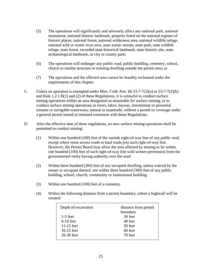
(4) Within the following distance from a permit boundary, where a highwall will be
created:
Depth of excavation distance from permit
boundary
1-5 feet 30 feet
6-10 feet 40 feet
11-15 feet 50 feet
16-25 feet 60 feet
26-30 feet 70 feet
26
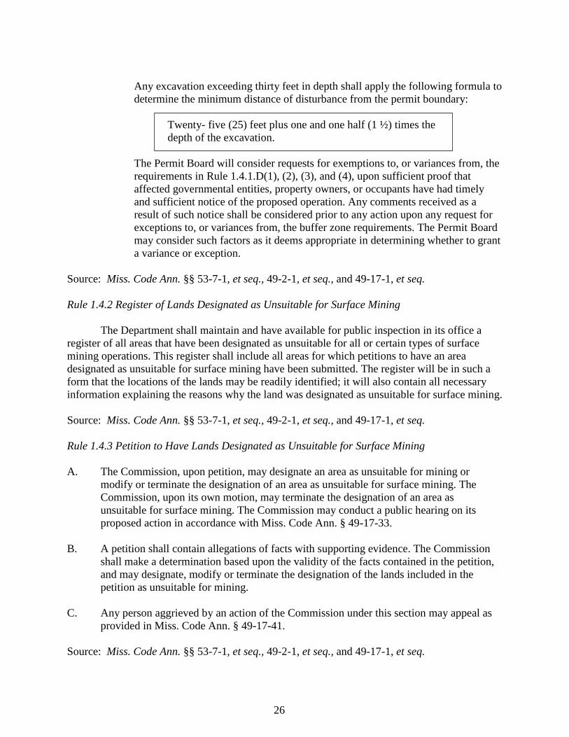
Any excavation exceeding thirty feet in depth shall apply the following formula to
determine the minimum distance of disturbance from the permit boundary:
Twenty- five (25) feet plus one and one half (1 ½) times the
depth of the excavation.
The Permit Board will consider requests for exemptions to, or variances from, the
requirements in Rule 1.4.1.D(1), (2), (3), and (4), upon sufficient proof that
affected governmental entities, property owners, or occupants have had timely
and sufficient notice of the proposed operation. Any comments received as a
result of such notice shall be considered prior to any action upon any request for
exceptions to, or variances from, the buffer zone requirements. The Permit Board
may consider such factors as it deems appropriate in determining whether to grant
a variance or exception.
Source: Miss. Code Ann. §§ 53-7-1, et seq., 49-2-1, et seq., and 49-17-1, et seq.
Rule 1.4.2 Register of Lands Designated as Unsuitable for Surface Mining
The Department shall maintain and have available for public inspection in its office a
register of all areas that have been designated as unsuitable for all or certain types of surface
mining operations. This register shall include all areas for which petitions to have an area
designated as unsuitable for surface mining have been submitted. The register will be in such a
form that the locations of the lands may be readily identified; it will also contain all necessary
information explaining the reasons why the land was designated as unsuitable for surface mining.
Source: Miss. Code Ann. §§ 53-7-1, et seq., 49-2-1, et seq., and 49-17-1, et seq.
Rule 1.4.3 Petition to Have Lands Designated as Unsuitable for Surface Mining
A. The Commission, upon petition, may designate an area as unsuitable for mining or
modify or terminate the designation of an area as unsuitable for surface mining. The
Commission, upon its own motion, may terminate the designation of an area as
unsuitable for surface mining. The Commission may conduct a public hearing on its
proposed action in accordance with Miss. Code Ann. § 49-17-33.
B. A petition shall contain allegations of facts with supporting evidence. The Commission
shall make a determination based upon the validity of the facts contained in the petition,
and may designate, modify or terminate the designation of the lands included in the
petition as unsuitable for mining.
C. Any person aggrieved by an action of the Commission under this section may appeal as
provided in Miss. Code Ann. § 49-17-41.
Source: Miss. Code Ann. §§ 53-7-1, et seq., 49-2-1, et seq., and 49-17-1, et seq.
27
Subchapter 5 Fees
Rule 1.5.1 Fees
A. Each application for a surface mining permit, for a surface mining permit modification to
add acreage, and for coverage under a general permit shall be accompanied by an
application fee in the amount of One Hundred Dollars ($100.00) plus Ten Dollars
($10.00) per acre. The maximum permit fee shall not exceed Five Hundred Dollars
($500.00).
B. Each submission of the annual certificate of compliance as required in Rule 1.2.9 of these
Regulations shall be accompanied by a fee in the amount of Fifty Dollars ($50.00).
C. State agencies, political subdivisions of the state, and local governing bodies shall be
exempt from all fees.
Source: Miss. Code Ann. §§ 53-7-1, et seq., 49-2-1, et seq., and 49-17-1, et seq.
Rule 1.5.2 Surface Mine Worker Safety Training Fees
A. Recipients of Surface Mine Worker Safety Training given by the Department shall pay a
fee. The fee shall be set by order of the Commission, and shall not exceed the cost of
providing the training.
B. All monies collected under this section shall be deposited into the Surface Mine Worker
Safety Training Program Operations Fund to be administered by the Executive Director
of MDEQ.
C. The Commission delegates to the Department responsibility for the collection of fees
under this section.
D. Any person required to pay a fee under this section who disagrees with the calculation or
applicability of the fee may petition the Commission for a hearing in accordance with
Miss. Code Ann. §§ 49-17-33 and 49-17-35.
E. Monies in the special fund shall be utilized to pay reasonable direct and indirect costs
associated with surface mine worker safety training provided by the Department
including, but not limited to, matching funds for federal grants to meet federal grant
requirements to pay a proportional share of the total cost of the training.
F. The special fund may receive monies from any available public or private source
including, but not limited to, collection of fees, interest, grants, taxes, public and private
donations, judicial actions and appropriated funds.
Source: Miss. Code Ann. §§ 53-7-1, et seq., 49-2-1, et seq., and 49-17-1, et seq.
28
Subchapter 6 Inspections
Rule 1.6.1 Inspections
A. Authorized representatives of the Department, on presentation of appropriate credentials,
may enter and inspect any operation or any premises in which records required to be
maintained under these Regulations are located and may at reasonable times, and without
delay, have access to and copy any records and inspect any monitoring equipment or
method of operation required by these Regulations, the Act, or a permit.
B. Inspections of operations, with or without a permit, by the Department, shall occur at a
frequency necessary to insure compliance with the Act and these Regulations and the
terms and conditions of any permit. Inspections shall occur only during normal operating
hours if practical, may occur without prior notice to the permittee or the agents or
employees of the permittee, and shall include the filing of an inspection report. The
Department shall make those reports part of the record and shall provide one (1) copy of
the report to the operator. The Department shall, as practical, establish a system of
rotation of field inspectors.
C. Each field inspector, on detection of each violation of the Act, these Regulations, or the
permit for the operation, shall inform the operator or the operator's agent orally at the
time of the inspection and subsequently in writing and shall report any violation in
writing to the Commission.
D. Any representative of the local Soil and Water Conservation District, upon presentation
of appropriate credentials may enter and inspect the operation for the purpose of making
recommendations regarding reclamation activities. The representative shall make any
recommendations on the progress of reclamation activities in writing to the Department
on behalf of the Permit Board.
E. The Department shall conduct an initial review of a completed permit application within
thirty (30) days following receipt of the completed application. The Department shall
make a recommendation to the Permit Board on the permit application no later than the
next regularly scheduled Permit Board meeting following the thirty-day initial review
period, unless a public hearing is held on the application or the applicant agrees in writing
to an additional time frame. If a public hearing is held, the Department shall make its
recommendation at the next regularly scheduled Permit Board meeting following the
public hearing, if practicable.
F. An on-site inspection of the proposed affected area shall be made by the Department
within the thirty-day time period specified in Rule 1.6.1.E of these Regulations, and
before a permit is issued.
G. After receipt of the application for bond release, the Department shall conduct an
inspection and evaluation of the reclamation work involved. The evaluation shall
29
consider, among other things, the occurrence of pollution of surface and subsurface
water, the probability of continuance or future occurrence of pollution, and the estimated
cost of abating the pollution. Results of the evaluation and findings of the Department,
and the local Soil and Water Commissioners if such evaluations and findings are so
made, shall be provided within thirty (30) days after the inspection to the operator and
other interested parties, making written request for the evaluation and findings.
Source: Miss. Code Ann. §§ 53-7-1, et seq., 49-2-1, et seq., and 49-17-1, et seq.
Subchapter 7 Reclamation
Rule 1.7.1 Reclamation Plan
A. A reclamation plan shall be developed in a manner consistent with local, physical,
environmental and climatological conditions and current mining and reclamation
technology. A proposed initial reclamation plan submitted as part of a permit
application shall include the following information:
(1) The identification of the proposed affected area, accompanied by a detailed
topographic map on a scale required by regulation showing:
(a) The proposed affected area, the location of any stream or standing body of
water into which the area drains, the location of drainways and any
planned siltation traps and other impoundments, and the location of access
roads to be prepared or used by the operator in the mining operation;
(b) The location of any buildings, cemeteries, public highways, railroad
tracks, gas and oil wells, publicly owned land, sanitary landfills, officially
designated scenic areas, utility lines, underground mines, transmission
lines or pipelines within the affected area or within five hundred (500) feet
of the exterior limits of the affected area;
(c) The approximate location of the cuts or excavations to be made in the
surface and the estimated location and height of spoil banks, and the total
number of acres involved in the affected area;
(d) The date the map was prepared and a statement of its accuracy by the
person responsible for its preparation.
B. The condition of the land to be covered by the permit before any mining, including:
(1) The land use existing at the time of the application, and if the land has a history of
previous mining, the land use, if reasonably ascertainable, which immediately
preceded any mining; and
30
(2) The capability of the land before any mining to support a variety of uses, giving
consideration to soil and foundation characteristics, topography and vegetative
cover.
C. The capacity of the land to support its anticipated use following reclamation, including a
discussion of the capacity of the reclaimed land to support alternative uses.
D. A description of how the proposed postmining land condition is to be achieved and the
necessary support activities that may be needed to achieve the condition, including an
estimate of the cost per acre of the reclamation.
E. The steps taken to comply with applicable air and water quality and water rights laws and
regulations and any applicable health and safety standards, including copies of any
pertinent permit applications.
F. A general timetable that the applicant estimates will be necessary for accomplishing the
major events contained in the reclamation plan.
G. Any other information as the Permit Board shall determine to be reasonably necessary to
effectuate the purposes of the Act and these Regulations.
Source: Miss. Code Ann. §§ 53-7-1, et seq., 49-2-1, et seq., and 49-17-1, et seq.
Rule 1.7.2 Reclamation of Lieu Lands
A. The Permit Board may, in its discretion, authorize the reclamation of lands in lieu of the
lands included in the permit application. The acreage of the authorized lieu lands
reclaimed shall not be less than the acreage of the lands in the permit application. Any
applicant who proposes to reclaim lands in lieu of those lands included in the permit
application shall state that fact in the application or subsequent or amended application
and shall submit the reclamation plan accordingly. The Permit Board shall not authorize
the reclamation of lieu lands unless the applicant submits with the reclamation plan a
notarized statement of each surface owner and lessee of all lands included in the permit
application. The statement shall contain the consent of each surface owner and lessee for
the reclamation of the proposed lieu lands.
B. If the Permit Board does not authorize the reclamation of the lieu lands, the applicant
shall submit a reclamation plan for the lands contained in the permit application.
Source: Miss. Code Ann. §§ 53-7-1, et seq., 49-2-1, et seq., and 49-17-1, et seq.
Rule 1.7.3 Reclamation Standards
A. Any permit issued under the Act and these Regulations shall require operations to comply
with all applicable reclamation standards. Reclamation standards shall apply to all
31
operations, exploration activities and reclamation operations covered by the Act and these
Regulations and shall require the operator at a minimum to:
(1) Conduct operations in a manner consistent with prudent mining practice, so as to
maximize the utilization and conservation of the resource being recovered; and, in
keeping with the intent of maximizing the value of mined land, stockpiles of
commercially valuable material may remain, if they are ecologically stable;
(2) Restore the affected area so that it may be used for a useful, productive and
beneficial purpose, including an agricultural, grazing, commercial, residential or
recreational purpose, including lakes, ponds, wetlands, wildlife habitat, or other
natural or forested areas;
(3) Conduct water drainage and silt control for the affected area to strictly control soil
erosion, damage to adjacent lands and pollution of waters of the state, both during
and following the mining operations. Before, during and for a reasonable period
after mining, all drainways for the affected area shall be protected with silt traps
or dams of approved design as directed by law. The operator may impound water
to provide wetlands, lakes or ponds of approved design for wildlife, recreational
or water supply purposes, if it is a part of the approved reclamation plan;
(4) Remove or cover all metal, lumber and other refuse, except vegetation, resulting
from the operation;
(5) Regrade the area to the nearest approximate original contour or rolling
topography, and eliminate all highwalls and spoil piles, except as provided in an
approved reclamation plan. Lakes, ponds or wetlands may be constructed, if part
of an approved reclamation plan;
(6) Stabilize and protect all affected areas sufficiently to control erosion and attendant
air and water pollution;
(7) Remove the topsoil, if any, from the affected area in a separate layer, and place it
on any authorized lieu lands to be reclaimed or replace it on the backfill area. If
not utilized immediately, the topsoil shall be segregated in a separate pile from
other spoil. If the topsoil is not replaced on a backfill area of authorized lieu lands
within a time short enough to avoid deterioration, the topsoil shall be protected by
a successful cover of plants or by other means approved by the Permit Board. If
topsoil is of insufficient quantity or of poor quality for sustaining vegetation and
if other strata can be shown to be as suitable for vegetation requirements, then the
operator may petition the Permit Board for permission to be exempt from the
requirements for the removal, segregation and preservation of topsoil and to
remove, segregate and preserve in a like manner other strata which are best able
to support vegetation or to mix strata, if that mixing can be shown to be equally
suitable for revegetation requirements;
32
(8) Replace, if required, available topsoil or the best available subsoil on top of the
land to be reclaimed or on top of authorized lieu lands being reclaimed;
(9) Minimize the disturbances to the prevailing hydrologic balance at the mine site
and in associated off-site areas and to the quality and quantity of water in surface
and groundwater systems both during and after surface mining operations and
during reclamation by:
(a) Avoiding acid or other toxic mine drainage by using measures such as, but
not limited to:
(1) Preventing or removing water from contact with toxic-
material producing deposits;
(2) Treating drainage to reduce toxic material content; and
(3) Casing, sealing or otherwise managing boreholes, shafts and wells
to keep acid or other toxic material drainage from entering ground
and surface waters;
(b) Conducting operations to prevent unreasonable additional levels of
suspended solids to streamflow or runoff outside the permit area above
natural levels under seasonal flow conditions;
(c) Removing temporary or large siltation structures from drainways,
consistent with good water conservation practices, after disturbed areas are
revegetated and stabilized;
(d) Performing any other actions as may be required by the Commission or
Permit Board to ensure compliance with the Act or these Regulations;
(10) Stabilize any waste piles;
(11) Incorporate current engineering practices for the design and construction of water
retention structures for the disposal of mine wastes, processing wastes or other
liquid or solid wastes which, at a minimum, shall be compatible with the
requirements of applicable state and federal laws and regulations, insure that
leachate will not pollute surface or ground water, and locate water retention
structures so as not to endanger public health and safety should failure occur;
(12) Insure that all debris, acid-forming materials, toxic materials or materials
constituting a fire hazard are treated or disposed of in a manner designed to
prevent contamination of ground or surface waters or combustion;
(13) Insure that construction, maintenance and postmining conditions of access roads
into and across the permit area will minimize erosion and siltation, pollution of air
33
and water, damage to fish or wildlife or their habitat, or public or private property.
The Permit Board may authorize the retention after mining of certain access roads
if compatible with the approved reclamation plan;
(14) Refrain from the construction of roads or other access ways up a stream bed or
drainage channel or in proximity to a channel where the construction would
seriously alter the normal flow of water;
(15) Revegetate the affected area with plants, approved by the Department, to attain a
useful, productive and beneficial purpose, including an agricultural, grazing,
industrial, commercial, residential or recreational purpose, including lakes, ponds,
wetlands, wildlife habitat or other natural or forested areas;
(16) Assume responsibility for successful revegetation for a period of two (2) years
beyond the date of initial bond release on any bond or deposit held by the
Department;
(17) Assure with respect to permanent impoundments of water as part of the approved
reclamation plan that:
(a) The size of the impoundment and the availability of water are adequate for
its intended purpose;
(b) The impoundment dam construction will meet the requirements of
applicable state and federal laws;
(c) The quality of impounded water will be suitable on a permanent basis for
its intended use and the discharges from the impoundment will not
degrade the water quality in the receiving stream;
(d) Final grading will provide adequate safety and access for anticipated water
users;
(e) Water impoundments will not result in the diminution of the quality or
quantity of water utilized by adjacent or surrounding landowners; and
(18) Protect off-site areas from slides or damage occurring during the surface mining
and reclamation operations, and not deposit spoil material or locate any part of the
operations or waste accumulations outside the permit area.
B. Reclamation is intended to cause the affected area to be restored to a useful, productive
and beneficial purpose. A method of reclamation other than that provided in this section
may be approved by the Permit Board if the Permit Board determines that the method of
reclamation required by this section is not practical and that the alternative method will
provide for the affected area to be restored to a useful, productive and beneficial purpose.
34
C. Each operator, except as authorized by the Permit Board, shall perform reclamation work
concurrently with the conduct of the mining operation where practical. The fact that an
operator will likely redisturb an area shall be cause for the Permit Board to grant an
exception from the requirement of concurrent reclamation.
D. The operator and, in case of bond forfeiture, the Department or its designee, shall have
the continuing right to enter and inspect the affected area in the reclamation plan and to
perform any reclamation measures required properly to complete the reclamation plan.
E. (1) If the Commission finds that
(a) reclamation of the affected area is not proceeding in accordance with the
reclamation plan and that the operator has failed within thirty (30) days
after notice to commence corrective action or
(b) revegetation has not been properly completed in conformance with the
reclamation plan within two (2) years or longer, if required by the
Commission, after termination of mining operations or upon revocation of
the permit, or
(c) if the Permit Board revokes a permit, the Commission may initiate
proceedings against the bond or deposit filed by the operator.
The proceedings shall not be commenced with respect to a surety bond until the
surety has been given sixty (60) days to commence and a reasonable opportunity
to begin and complete corrective action.
(2) A forfeiture proceeding against any performance bond or deposit shall be
commenced and conducted according to Miss. Code Ann. §§ 49-17-31 through
49-17-41.
(3) If the Commission orders forfeiture of any performance bond or deposit, the
entire sum of the performance bond or deposit shall be forfeited to the
Department. The funds from the forfeited performance bond or deposit shall be
placed in the appropriate account in the fund and used to pay for reclamation of
the permit area and remediation of any off-site damages resulting from the
operation. Any surplus performance bond or deposit funds shall be refunded to
the operator or corporate surety.
(4) Forfeiture proceedings shall be before the Commission and an order of the
Commission under this subsection is a final order. If the Commission determines
that forfeiture of the performance bond or deposit should be ordered, the
Department shall have the immediate right to all funds of any performance bond
or deposit, subject only to review and appeals allowed under Miss. Code Ann. §
49-17-41.
35
(5) If the operator cannot be located, the Department shall send notice of the
forfeiture proceeding, certified mail, return receipt requested, to the operator's last
known address. The Department shall also publish notice of the forfeiture
proceeding by publication once weekly for three (3) consecutive weeks in a
newspaper having general circulation in the State of Mississippi and in a
newspaper of general circulation in the county in which the operation is located.
Any formal hearing on the bond forfeiture shall be set at least thirty (30) days
after the last notice publication.
(6) If the performance bond or deposit is insufficient to cover the costs of reclamation
of the permit area in accordance with the approved reclamation plan or
remediation of any off-site damages, the Commission may initiate a civil action to
recover the deficiency amount in the county in which the surface mining
operation is located.
(7) If the Commission initiates a civil action under subsection (6) of this rule, the
Commission shall be entitled to any sums necessary to complete reclamation of
the permit area in accordance with the approved reclamation plan and remediate
any off-site damages resulting from that operation.
F. If a landowner, upon termination or expiration of a lease, refuses to allow the operator to
enter onto the property designated as the affected area to conduct or complete
reclamation in accordance with the approved reclamation plan, or if the landowner
interferes with or authorizes a third party to disturb or interfere with reclamation in
accordance with the approved reclamation plan, the landowner shall assume the permit
and shall file a reclamation plan and post a performance bond as required under these
Regulations and the Act.
Source: Miss. Code Ann. §§ 53-7-1, et seq., 49-2-1, et seq., and 49-17-1, et seq.
Rule 1.7.4 Concurrent Reclamation
Each operator, except as authorized by the Permit Board, shall perform reclamation work
concurrently with the conduct of the mining operation where practical. The fact that an operator
will likely redisturb an area shall be cause for the Permit Board to grant an exception from the
requirements of concurrent reclamation.
Source: Miss. Code Ann. §§ 53-7-1, et seq., 49-2-1, et seq., and 49-17-1, et seq.
Rule 1.7.5 Right of the Operator and the Department to Complete Reclamation
The operator and, in case of bond forfeiture, the Department, shall have the continuing
right to enter the affected area included in the reclamation plan and to perform thereon the
reclamation measures required properly to complete the reclamation plan.
Source: Miss. Code Ann. §§ 53-7-1, et seq., 49-2-1, et seq., and 49-17-1, et seq.
36
Subchapter 8 Violations and Penalties
Rule 1.8.1 Notification of Violations
A. Each Department field inspector, on detection of each violation of any requirement of the
Act, permit, or these Regulations, shall inform the operation supervisor orally at the time
of the inspection and subsequently in writing and shall report in writing any such
violation to the Commission.
B. Any operator found by the Department to be in noncompliance with any of the filing,
reporting, notification, mining, or reclaiming provisions of the Act, the permit or these
Regulations shall be notified in writing by the Department.
Source: Miss. Code Ann. §§ 53-7-1, et seq., 49-2-1, et seq., and 49-17-1, et seq.
Rule 1.8.2 Violations and Penalties
A. Any person who violates, or fails or refuses to comply with any rule or regulation or
written order of the Commission or any condition of a permit or coverage under a general
permit may be subject to a civil penalty to be assessed and levied by the Commission
after notice and opportunity for a formal hearing. In addition to assessing civil penalties,
the Commission may submit a written statement to the Permit Board recommending that
the Permit Board revoke the permit for any operation which is subject to the maximum
penalty of Twenty-five Thousand Dollars ($25,000.00). Appeals of any action or decision
of the Commission may be taken as provided in Miss. Code Ann. § 49-17-41.
B. Any civil penalty assessed against a permitted, covered or exempt operation and levied
by the Commission shall not exceed Five Hundred Dollars ($500.00) for the first
violation; for subsequent violations committed within three (3) years of the first violation
the maximum penalties are: Two Thousand Five Hundred Dollars ($2,500.00) for the
second violation, Five Thousand Dollars ($5,000.00) for the third violation and Twenty-
five Thousand Dollars ($25,000.00) for the fourth and subsequent violations by the same
operator. Multiple violations at a site during one (1) day shall not be cumulative. A
separate penalty shall not be assessed for each violation and only one (1) penalty may be
assessed for all violations occurring at a site during one (1) day. Each day of a continuing
violation shall be a separate violation until corrective action is taken or the operator after
notice of the violation is diligently pursuing efforts to achieve compliance in a timely
manner. In assessing a penalty under this subsection, the Commission shall not consider
offenses occurring before July 1, 2002. In addition to a civil penalty, the Commission
may order an operator of a permitted, covered or exempt operation to reclaim the affected
area.
C. Any civil penalty assessed against an operator for mining without a permit and levied by
the Commission shall not exceed Five Thousand Dollars ($5,000.00) for the first
violation, Ten Thousand Dollars ($10,000.00) for the second violation and Twenty-five
37
Thousand Dollars ($25,000.00) for the third and subsequent violations by an operator. In
assessing a penalty under this subsection, the Commission shall not consider violations
occurring before July 1, 2002.
D. In determining the amount of penalty, the Commission shall consider at a minimum:
(1) The willfulness of the violation;
(2) Any damage to air, water, land or other natural resources of the state or their uses;
(3) Costs of restoration and abatement;
(4) Economic benefit as a result of noncompliance;
(5) The seriousness of the violation, including any harm to the environment and any
hazard to the health, safety and welfare of the public; and
(6) Past performance history.
E. The Commission may institute and maintain a civil action for relief, including a
permanent or temporary injunction or any other appropriate order, in the chancery court
of the county in which the majority of the surface mining operation is located. The
chancery court shall have jurisdiction to provide relief as may be appropriate. Any relief
granted by the court to enforce a written order of the Commission shall continue in effect
until the completion of all proceedings for review of that order under this chapter, unless
the chancery court granting the relief sets it aside or modifies it before that time.
F. Liability for the costs of cleanup, removal, remediation or abatement of any pollution,
hazardous waste or solid waste shall be limited as provided in Miss. Code Ann. § 49-17-
42 and rules adopted under that section.
G. Any violation of the act and the Mississippi Air and Water Pollution Control Law or the
Solid Wastes Disposal Law of 1974 shall be assessed a civil penalty under only one (1) of
these laws.
H. Any person who knowingly makes any false statement, representation or certification, or
knowingly fails to make any statement, representation or certification in any application,
record, report, plan or other document filed or required to be maintained under the Act or
these Regulations is guilty of a misdemeanor and upon conviction, may be subject to a
fine of not more than Five Thousand Dollars ($5,000.00).
I. Any person who knowingly violates, or fails or refuses to comply with this chapter, any
rule or regulation or written order of the Commission adopted or issued under this
chapter, or any condition of a permit issued under this chapter, is guilty of a misdemeanor
and, upon conviction, may be subject to a fine of not more than Five Thousand Dollars
($5,000.00).
38
Source: Miss. Code Ann. §§ 53-7-1, et seq., 49-2-1, et seq., and 49-17-1, et seq.
Rule 1.8.3 Cease and Desist Authority
The Commission shall order the immediate cessation of any ongoing surface mining
operation being conducted with or without a permit or coverage under a general permit if it finds
that the operation endangers the health or safety of the public or creates imminent and significant
environmental harm.
Source: Miss. Code Ann. §§ 53-7-1, et seq., 49-2-1, et seq., and 49-17-1, et seq.
Subchapter 9 Enforcement, Hearings, and Appeals
Rule 1.9.1 Enforcement and Appeals
A, When an employee of the Department files a report alleging a violation or when any
person files a complaint with the Commission alleging that any other person is in
violation of any rule and regulation, or any condition of a permit, the Commission shall
notify the alleged violator and conduct an investigation of the complaint. Upon finding a
basis for the complaint, the Commission shall cause written notice of the complaint,
specifying the section of law, rule, regulation or permit alleged to be violated and the
facts of the alleged violations, to be served upon that person. The Commission may
require the person to appear before the Commission at a time and place specified in the
notice to answer the charges. The time of appearance before the Commission shall be not
less than twenty (20) days from the date of the mailing or service of the complaint,
whichever is earlier. If the Commission finds no basis for the complaint, the Commission
shall dismiss the complaint.
B. The Commission shall afford an opportunity for a formal hearing to the alleged violator
at the time and place specified in the notice or at another time or place agreed to in
writing by both the Department and the alleged violator, and approved by the
Commission. On the basis of the evidence produced at the formal hearing, the
Commission may enter an order which in its opinion will best further the purposes of this
chapter and shall give written notice of that order to the alleged violator and to any other
persons which appeared at the formal hearing or made written request for notice of the
order. The Commission may assess penalties as provided by law. Any formal hearing
shall be of record.
C. Except as otherwise expressly provided, any notice or other instrument issued by or under
authority of the Commission may be served on any affected person personally or by
publication, and proof of that service may be made in the same manner as in case of
service of a summons in a civil action. The proof of service shall be filed in the office of
the Commission. Service may also be made by mailing a copy of the notice, order, or
other instrument by certified mail, directed to the person affected at the person's last
known post office address as shown by the files or records of the Commission. Proof of
39
service may be made by the affidavit of the person who did the mailing and shall be filed
in the office of the Commission.
D. Any person who participated as a party in the formal hearing may appeal a decision of the
Commission under this rule as provided in Miss. Code Ann. § 49-17-41.
Source: Miss. Code Ann. §§ 53-7-1, et seq., 49-2-1, et seq., and 49-17-1, et seq.
Rule 1.9.2 Place and Nature of Hearings
A. Unless otherwise expressly provided in these Regulations or the Act, any interested party
aggrieved by any action of the Permit Board may request a formal hearing before the
Permit Board as provided in Miss. Code Ann. § 49-17-29. Any person aggrieved by any
action of the Commission may request a formal hearing before the Commission as
provided in Miss. Code Ann. § 49-17-41.
B. Any public hearing of the Permit Board provided for under these Regulations or the Act
shall be deemed to be the same hearing as otherwise afforded to any interested party by
the Permit Board under Miss. Code Ann. § 49-17-29. Any formal hearing of the Permit
Board shall be deemed to be the same hearing as otherwise afforded to any interested
party by the Permit Board under Miss. Code Ann. § 49-17-29.
C. Any public hearing of the Commission provided for under these Regulations or the Act
shall be deemed to be the same hearing as afforded under Miss. Code Ann. § 49-17-35.
Any formal hearing of the Commission provided for under these Regulations or the Act
shall be deemed to be the same hearing as afforded under Miss. Code Ann. § 49-17- 41.
D. (1) In conducting any formal hearing under these Regulations or the Act, the Permit
Board shall have the same authority to subpoena witnesses, administer oaths,
examine witnesses under oath and conduct the hearing as provided in Miss. Code
Ann. § 49-17-29.
(2) In conducting any formal hearing under these Regulations or the Act, the
Commission shall have the same authority to subpoena witnesses, administer
oaths, examine witnesses under oath and conduct the hearing as provided in Miss.
Code Ann. § 49-17-41.
Source: Miss. Code Ann. §§ 53-7-1, et seq., 49-2-1, et seq., and 49-17-1, et seq.
Rule 1.9.3 Appeals of Final Decisions
Any person who participated as a party in a formal hearing before the Permit Board may
appeal from a final decision of the Permit Board as provided in Miss. Code Ann. § 49-17-29.
Any person who participated as a party in a formal hearing before the Commission may appeal
from a final decision of the Commission as provided in Miss. Code Ann. § 49-17-41.
40
Source: Miss. Cod e Ann. §§ 53-7-1, et seq., 49-2-1, et seq., and 49-17-1, et seq.
Subchapter 10 Effective Date
Rule 1.10.1 Effective Date
These revisions to the Mississippi Surface Mining and Reclamation Rules and
Regulations were adopted by the Mississippi Commission on Environmental Quality on
December 10, 2009, and shall become effective on February 3, 2010.
Source: Miss. Code Ann. §§ 53-7-1, et seq., 49-2-1, et seq., and 49-17-1, et seq.
Part 8, Chapter 2: Mississippi Commission on Environmental Quality Regulations
Governing Surface Coal Mining
TABLE OF CONTENTS
Subchapter 2.1 General Information
Rule 1. General
§ 101 Authority
§ 103 Responsibility
§ 105 Definitions
§ 107 Applicability
§ 109 Petitions to Initiate Rulemaking
§ 111 Notice of Citizen Suits
§ 113 Availability of Records
§ 115 Computation of Time
Rule 3. Permanent Regulatory Program
§ 301 Authority
§ 303 Applicability
Rule 4. Exemption for Coal Extraction of Other Minerals
§ 401 Scope
§ 403 Definitions
§ 405 Application Requirements and Procedures
§ 407 Contents for Application for Exemption
§ 409 Public Availability of Information
§ 411 Requirements for Exemptions
§ 413 Conditions of Exemption and Right of Inspection and Entry
41
§ 415 Stockpiling of Minerals
§ 417 Revocation and Enforcement
§ 419 Reporting Requirements
Rule 5. Restriction of Financial Interests of Employees
§ 501 Authority
§ 503 Responsibility
§ 505 Penalties
§ 507 Who Shall File
§ 509 When to File
§ 511 Where to File
§ 513 What to Report
§ 515 Gifts and Gratuities
§ 517 Resolving Prohibited Interests
§ 519 Appeals Procedure
Rule 7. Exemption for Coal Extraction Incident to Government-financed Highway
or Other Construction
§ 701 Responsibility
§ 703 Applicability
§ 705 Information to Be Maintained on Site
Subchapter 2.2 Areas Unsuitable for Mining
Rule 9. General
§ 901 Authority
§ 903 Responsibility
Rule 11. Areas Designated by Act of Congress
§ 1101 Authority
§ 1103 Responsibility
§ 1105 Areas Where Mining Is Prohibited or Limited
§ 1106 Submission and Processing of Requests For Valid Existing Rights
Determinations
§ 1107 Procedures
Rule 13. Criteria For Designing Lands as Unsuitable for Surface Coal Mining
Operations
§ 1301 Responsibility
§ 1303 Criteria for Designating Lands as Unsuitable
§ 1305 Land Exempt from Designation as Unsuitable for Surface Coal Mining
42
Operations
§ 1307 Exploration or Development on Land Designated as Unsuitable for
Surface Coal Mining Operations
Rule 15. State Process for Designating Areas Unsuitable for Surface Coal Mining
Operations
§ 1501 Procedures: Petitions
§ 1503 Procedures: Initial Processing, Record Keeping, and Notification
Requirements
§ 1505 Procedures: Hearing Requirements
§ 1507 Procedures: Decision
§ 1509 Data Base and Inventory System Requirements
§ 1511 Public Information
§ 1513 Responsibility for Implementation
Subchapter 2.3 Surface Coal Mining and Reclamation Operations Permits and Coal
Exploration and Development Procedures Systems
Rule 17. General Requirements for Permit or Exploration Procedure Systems
§ 1701 Responsibilities
§ 1703 Applicability
§ 1705 Coordination with Requirements Under Other Laws
Rule 19. General Requirements for Permits and Permit Applications
§ 1901 General Requirements for Permits: Operators
§ 1903 Compliance with Permits
§ 1905 Permit Filing Application Deadlines
§ 1907 Permit Applications: General Requirements for Format and Contents
§ 1909 Permit Fees
§ 1911 Verification of Application
Rule 21. Coal Exploration and Development
§ 2101 Notice Requirements for Exploration Removing 250 Tons of Coal or Less
§ 2103 Permit Requirements for Exploration Removing More than 250 Tons of
Coal, or Occurring on Lands Designated as Unsuitable for Surface Coal
Mining Operations.
§ 2105 Coal Exploration Compliance Duties
§ 2107 Commercial Use or Sale
§ 2109 Public Availability of Information
Rule 23. Surface Mining and Permit Applications: Minimum Requirements for
Legal, Financial, Compliance and Related Information
43
§ 2301 Responsibility
§ 2303 Applicability
§ 2305 Identification of Interests
§ 2307 Compliance Information
§ 2309 Right of Entry and Operation Information
§ 2311 Relationship to Areas Designated Unsuitable for Mining
§ 2313 Permit Term Information
§ 2315 Personal Injury and Property Damage Insurance Information
§ 2317 Identification of Other Licenses and Permits
§ 2319 Identification of Location of Public Office for Filling of Application
§ 2321 Newspaper Advertisement and Proof of Publication
§ 2323 Facilities or Structures Used in Common
§ 2325 Additional Information
Rule 25. Surface Mining and Permit Applications: Minimum Requirements for
Information on Environmental Resources
§ 2501 Responsibilities
§ 2503 General Requirements
§ 2505 General Environmental Resources Information
§ 2507 Description of Hydrology and Geology: General Requirements
§ 2509 Geology Description
§ 2511 Groundwater Information
§ 2513 Surface-Water Information
§ 2515 Supplemental Information
§ 2517 Baseline Cumulative Impact Area Information
§ 2519 Modeling
§ 2521 Alternative Water Source Information
§ 2523 Probable Hydrologic Consequences Determination
§ 2525 Cumulative Hydrologic Impact Assessment
§ 2527 Climatological Information
§ 2529 Vegetation Information
§ 2531 Soil Resources Information
§ 2533 Land Use Information
§ 2535 Maps: General Requirements
§ 2537 Cross-Sections, Maps and Plans
§ 2539 Prime Farmland Investigation
Rule 27. Surface Mining Permit Applications: Minimum Requirements for
Reclamation and Operation
§ 2701 Responsibilities
§ 2703 Operation Plan: General Requirements
§ 2705 Operation Plan: Existing Structures
§ 2707 Operation Plan: Blasting
44
§ 2709 Operation Plan: Maps and Plans
§ 2711 Air Pollution Control Plan
§ 2713 Fish and Wildlife Plan
§ 2715 Reclamation Plan: General Requirements
§ 2717 Reclamation Plan: Protection of Hydrologic Balance
§ 2719 Groundwater Monitoring Plan
§ 2721 Surface-Water Monitoring Plan
§ 2723 Reclamation Plan: Post-mining Land Uses
§ 2725 Reclamation Plan: Siltation Structures, Impoundments, Banks, Dams and
Embankments
§ 2727 Reclamation Plan: Surface Mining near Underground Mining
§ 2729 Diversions
§ 2731 Protection of Public Parks and Historic Places
§ 2733 Relocation or Use of Public Roads
§ 2735 Disposal of Excess Spoil
§ 2737 Road Systems
§ 2739 Support Facilities
Rule 29. Requirements for Permits for Special Categories of Mining
§ 2901 Experimental Practices Mining
§ 2903 Steep Slope Mining
§ 2905 Permits Incorporating Alternatives from Approximate Original Contour
Restoration Requirements for Steep Slope Mining
§ 2907 Prime Farmlands
§ 2909 Coal Processing Plants or Support Facilities not Located Within the Permit
Area of a Specified Mine
§ 2911 In Situ Processing Activities
Rule 31. Public Participation, Approval of Permit Applications and Permit Terms
and Conditions
§ 3101 Responsibilities
§ 3103 Public Notices of Filing of Permit Applications
§ 3104 Revisions of Permits
§ 3105 Opportunity for Submission of Written Comments on Permit Applications
§ 3107 Right to File Written Objections
§ 3109 Public Hearings
§ 3111 Public Availability of Information in Permit Applications on File with the
Office
§ 3113 Review of Permit Applications
§ 3114 Valid Existing Rights Review at Time of Permit Application Review
§ 3115 Criteria for Permit Approval or Denial
§ 3117 Criteria for Permit Approval or Denial: Existing Structures
§ 3119 Permit Approval or Denial Actions
§ 3121 Permit Terms

45
§ 3123 Conditions of Permits: General and Right of Entry
§ 3125 Conditions of Permits: Environmental, Public Health and Safety
§ 3127 Improvidently Issued Permits: General Procedures
§ 3129 Improvidently Issued Permits: Revocation Procedures
§ 3131 Verification of Ownership or Control Application Information
§ 3133 Review of Ownership or Control and Violation Information
§ 3135 Procedures for Challenging Ownership or Control Links Shown in AVS
§ 3137 Standards for Challenging Ownership or Control Links and the Status of
Violations
Rule 33. Administrative and Judicial Review of Permit Decisions
§ 3301 Formal Hearing
§ 3303 Judicial Review
Rule 35. Permit Reviews and Renewals, and Transfer, Sale and Assignment of
Rights Granted under Permits
§ 3501 Responsibilities
§ 3503 Department Review of Outstanding Permits
§ 3505 Permit Modifications and Revisions
§ 3507 Permit Renewals: General Requirements
§ 3509 Permit Renewals: Completed Applications
§ 3511 Permit Renewals: Terms
§ 3513 Permit Renewals: Approval or Denial
§ 3515 Transfer, Assignment or Sale of Permit Rights: General Requirements
§ 3517 Transfer, Assignment or Sale of Permit Rights: Obtaining Approval
Rule 37. Small Operator Assistance
§ 3701 Authority
§ 3703 Responsibilities: General
§ 3705 Eligibility for Assistance
§ 3707 Filing for Assistance
§ 3709 Application Approval and Notice
§ 3711 Program Services and Data Requirements
§ 3713 Qualified Laboratories
§ 3715 Assistance Funding
§ 3717 Applicant Liability
Subchapter 2.4 Bond and Insurance Requirements for Surface Coal Mining and
Reclamation Operations
Rule 39. General Requirements of Bonding of Surface Coal Mining and
Reclamation Operations under Regulatory Program
46
§ 3901 Requirements to File a Bond
§ 3903 Requirements to File Certificate of Liability Insurance
§ 3905 Responsibilities
Rule 41. Amount and Duration of Performance Bond
§ 4101 Determination of Bond Amount
§ 4103 Minimum Amount
§ 4105 Period of Liability
§ 4107 Adjustment of Amount
Rule 43. Form, Conditions and Terms of Performance Bonds and Liability
Insurance
§ 4301 Form and Performance of Bond
§ 4303 Terms and Condition of the Bond
§ 4305 Self Bonding
§ 4307 Replacement of Bonds
§ 4309 Terms and Conditions for Liability Insurance
Rule 45. Procedures, Criteria and Schedule for Release of Performance Bond
§ 4501 Procedures for Seeking Release of Performance Bond
§ 4503 Criteria and Schedule for Release of Performance Bond
Rule 47. Performance Bond Forfeiture Criteria and Procedures
§ 4701 General
§ 4703 Procedures
§ 4705 Criteria for Forfeiture
§ 4707 Determination of Forfeiture Amount
Subchapter 2.5 Permanent Program Performance Standard
Rule 49. Permanent Program Performance Standards: General Provisions
§ 4901 Responsibility
Rule 51. Permanent Program Performance Standard: Coal Exploration and
Development Operations
§ 5101 General Responsibility of Persons Conducing Coal Exploration or
Development
47
§ 5103 Required Documents
§ 5105 Performance Standards for Coal Exploration or Development
Rule 53. Permanent Program Performance Standards for Surface Mining Activities
§ 5301 Signs and Markers
§ 5303 Casing and Sealing of Drilled Holes: General Requirements
§ 5305 Casing and Sealing of Drilled Holes: Temporary
§ 5307 Casing and Sealing of Drilled Holes: Permanent
§ 5309 Topsoil: General Requirements
§ 5311 Topsoil and Subsoil
§ 5313 Hydrologic Balance: General Requirements
§ 5315 Hydrologic Balance: Water Quality Standards and Effluent Limitations
§ 5317 Hydrologic Balance: Diversions
§ 5319 Hydrologic Balance: Sediment Control Measures
§ 5321 Hydrologic Balance: Siltation Structures
§ 5323 Hydrologic Balance: Discharge Structures
§ 5325 Hydrologic Balance: Acid-forming and Toxic-forming Materials
§ 5327 Hydrologic Balance: Impoundments
§ 5329 Hydrologic Balance: Groundwater Protection
§ 5331 Hydrologic Balance: Surface-Water Protection
§ 5333 Hydrologic Balance: Surface- and Groundwater Monitoring
§ 5335 Hydrologic Balance: Transfer of Wells
§ 5337 Hydrologic Balance: Water Rights and Replacement
§ 5339 Hydrologic Balance: Discharges into an Underground Mine
§ 5341 Hydrologic Balance: Post-mining Rehabilitation of Sedimentation Ponds,
Diversions, Impoundments and Treatment Facilities
§ 5343 Hydrologic Balance: Stream Buffer Zones
§ 5345 Coal Recovery
§ 5347 Use of Explosives: General Requirements
§ 5349 Use of Explosives: Pre-blasting Survey
§ 5351 Use of Explosives: Blasting Schedule
§ 5353 Use of Explosives: Blasting Signs Warnings and Access Control
§ 5355 Use of Explosives: Control of Adverse Effects
§ 5357 Use of Explosives: Records of Blasting Operations
§ 5359 Disposal of Excess Spoil: General Requirements
§ 5361 Disposal of Excess Spoil: Valley Fills/head-of-hollow Fills
§ 5363 Disposal of Excess Spoil: Durable Rock Fills
§ 5365 Disposal of Excess Spoil: Preexisting Benches
§ 5367 Protection of Underground Mining
§ 5369 Coal Mine Waste: General Requirements
§ 5371 Coal Mine Waste: Refuse Piles
§ 5373 Coal Processing Waste: Burning and Burned Waste Utilization
§ 5375 Disposal of Noncoal Wastes
§ 5377 Coal Mine Waste: Impounding Structures
§ 5379 Stabilization of Surface Areas
48
§ 5381 Air Resources Protection
§ 5383 Protection of Fish, Wildlife and Related Environmental Values
§ 5385 Slides and Other Damages
§ 5387 Contemporaneous Reclamation
§ 5389 Backfilling and Grading: Time and Distance Requirements
§ 5391 Backfilling and Grading: General Grading Requirements
§ 5393 Backfilling and Grading: Thin Overburden
§ 5395 Backfilling and Grading: Thick Overburden
§ 5397 Revegetation: General Requirements
§ 5399 Revegetation: Timing
§ 53101 Revegetation: Mulching and Other Soil Stabilizing Practices
§ 53103 Revegetation: Standards for Success
§ 53105 Cessation of Operations: Temporary
§ 53107 Cessation of Operations: Permanent
§ 53109 Post-mining Land Use
§ 53111 Roads: General
§ 53113 Primary Roads
§ 53115 Utility Installations
§ 53117 Support Facilities
Rule 55. Special Permanent Program Performance Standards: Operations on Prime
Farmland
§ 5501 Prime Farmland: Scope and Purpose
§ 5503 Prime Farmland: Soil Removal and Stockpiling
§ 5505 Prime Farmland: Soil Replacement
§ 5507 Prime Farmland: Revegetation and Restoration of Soil Productivity
Rule 57. Special Permanent Program Performance Standards: Operations on Steep
Slopes
§ 5701 Applicability
§ 5703 Steep Slopes: Backfilling and Grading: Steep Slopes
Rule 59. Special Permanent Program Performance Standards: Coal Preparation
Plants and Support Facilities Not Located at or near the Minesite or not
Within the Permit Area for a Mine
§ 5901 Applicability
§ 5903 Coal Plants: Performance Standards
Rule 61. Special Permanent Program Performance Standards: In Situ Processing
§ 6101 In Situ Processing: Performance Standards
§ 6103 In Situ Processing: Monitoring
49
Rule 63. Inspections
§ 6301 Inspections
§ 6303 Citizens’ Request for Inspections
§ 6305 Right of Entry
§ 6307 Review of Adequacy and Completeness of Inspection
§ 6309 Review of Decisions Not to Inspect or Enforce
§ 6311 Availability of Records
Rule 65. Enforcement
§ 6501 Cessation Orders
§ 6503 Notice of Violation
§ 6505 Suspension or Revocation of Permits
§ 6507 Service of Violation and Cessation Orders
§ 6509 Termination of Order
§ 6511 Formal Review of Citations
§ 6513 Failure to Give Notice and Lack of Information
§ 6515 Inability to Comply
§ 6517 Compliance Conference
§ 6519 Enforcement Actions at Abandoned Sites
Rule 67. Civil Penalties
§ 6701 How Assessments Are Made
§ 6703 When Penalty Will Be Assessed
§ 6705 Point System for Penalties
§ 6707 Determination of Amount of Penalty
§ 6709 Assessments of Separate Violations for Each Day
§ 6711 Waiver of Use of Formula to Determine Civil Penalty
§ 6713 Procedures for Assessment of Civil Penalties
Rule 69. Individual Civil Penalties
§ 6901 When an Individual Civil Penalty May be Assessed
§ 6903 Amount of Individual Civil Penalty
§ 6905 Procedure for Assessment of Individual Civil Penalty
§ 6907 Payment of Penalty
Rule 71. Petitions for Award of Costs and Expenses Under
§ 7101 Who May File
§ 7103 Where to File: Time for Filing
§ 7105 Contents of Petition
§ 7107 Answer

50
§ 7109 Who May Receive an Award
§ 7111 Awards
§ 7113 Appeal
Amendment A. Revegetation Success Standards
51
Subchapter 2.1 General Information
Rule 1. General
§ 101. Authority
The Department is authorized to administer the requirements of the act and regulations
promulgated thereunder.
§ 103. Responsibility
(a) The Commission is designated as the body to enforce the Act and these regulations
including, but not limited to, the issuance of penalty orders, promulgation of regulations,
designation of lands unsuitable for surface coal mining, and forfeiture of performance
bonds.
(b) The Permit Board is designated as the body to issue, modify, revoke, transfer, suspend,
and reissue permits and to require, modify or release performance bonds.
§ 105. Definitions
As used in these regulations, the following terms have the specified meaning, except where
otherwise indicated.
Abandoned Site–a surface coal mining and reclamation operation for which the Department has
found in writing that:
(a) all surface coal mining and reclamation activities at the site have ceased;
(b) the Department has issued at least one notice of violation, and either:
(1) is unable to serve the notice despite diligent efforts to do so; or
(2) the notice was served and has progressed to a failure-to-abate cessation
order;
(c) the Department:
(1) is taking action to ensure that the permittee and operator, and
owners and controllers of the permittee and operator, will be
precluded from receiving future permits while violations continue
at the site; and
(2) is taking action pursuant to these regulations and the act to ensure
52
that abatement occurs or that there will not be a recurrence of the
failure-to-abate, except where after evaluating the circumstances it
concludes that further enforcement offers little or no likelihood of
successfully compelling abatement or recovering any reclamation
costs; and
(d) where the site is, or was, permitted or bonded:
(1) the permit has expired or been revoked, or permit revocation
proceedings have been initiated and are being pursued diligently; and
(2) the Department has initiated and is diligently pursuing forfeiture
of, or the Commission has forfeited, the performance bond.
Acid Drainage–water with a pH value of less than 6.0, and in which total acidity exceeds total
alkalinity, discharged from an active, inactive or abandoned surface coal mine and reclamation
operation, or from an area affected by surface coal mining and reclamation operations.
Acid-Forming Materials–earth materials that contain sulfide minerals or other materials which, if
exposed to air, water or weathering processes, form acids that may create acid drainage.
Acid Test Ratio–the relation of quick assets to current liabilities.
Act–the Mississippi Surface Coal Mining and Reclamation Law codified at Sections 53-9-1 et
seq. of the Mississippi Code Annotated.
Adjacent Area–the area outside the permit area where a resource or resources, determined
according to the context in which adjacent area is used, are or reasonably could be expected to be
adversely impacted by proposed mining operations, including probable impacts from
underground workings.
Affected Area–any land or water surface which is used to facilitate, or is physically altered by,
surface coal mining and reclamation operations. The affected area includes: the disturbed area;
any area upon which surface coal mining and reclamation operations are conducted; any adjacent
lands the use of which is incidental to surface coal mining and reclamation operations; all areas
covered by new or existing roads used to gain access to, or for hauling coal to or from, surface
coal mining and reclamation operations; any area covered by surface excavations, workings,
impoundments, dams, ventilation shafts, entryways, refuse banks, dumps, stockpiles, overburden
piles, spoil banks, culm banks, tailings, holes or depressions, repair areas, storage areas or
shipping areas; any areas upon which are sited structures, facilities or other property material on
the surface resulting from, or incident to, surface coal mining and reclamation operations; and
the area located above underground workings.
Agricultural Use–the use of any tract of land for the production of animal or vegetable life. The
uses include, but are not limited to, the pasturing, grazing, and watering of livestock, and the
53
cropping, cultivation, and harvesting of plants.
Appeal–an appeal to an appropriate court of the state taken from a final decision of the Permit
Board or Commission made after a formal hearing before that body.
Applicant–a person applying for a permit, permit modification, permit renewal, or the transfer,
assignment, or sale of permit rights from the Permit Board to conduct surface coal mining and
reclamation operations or, where required, seeking approval for coal exploration or development
operations.
Applicant Violator System or AVS–the computer system maintained by OSM to identify
ownership or control links involving permit applicants, permittees, and persons cited in violation
notices.
Application–the documents and other information filed with the Permit Board for the issuance of
an exploration or surface mining and reclamation operations permit, permit modification, permit
renewal, or the transfer, assignment, or sale of permit rights for surface coal mining and
reclamation operations or where required, for coal exploration.
Approximate Original Contour–that surface configuration achieved by backfilling and grading of
the mined area so that the reclaimed area, including any terracing or access roads, closely
resembles the general surface configuration of the land prior to mining and blends into and
complements the drainage pattern of the surrounding terrain, with all highwalls, spoil piles and
coal refuse piles eliminated. Permanent water impoundments may be permitted where the Permit
Board determines that they are in compliance with § § 5327, 5341 and 53109.
Aquifer–a zone, stratum or group of strata that can store and transmit water in sufficient
quantities for a specific use.
As recorded in the minutes of the Permit Board–the date of the Permit Board meeting at which
the action concerned is taken by the Permit Board.
Asset Ratio–the relation of total assets to total liabilities.
Assets–cash and current assets that are reasonably expected to be realized in cash or sold or
consumed within one year.
Auger Mining–a method of mining coal at a cliff or highwall by drilling holes into an exposed
seam from the highwall and transporting the coal along an auger bit to the surface.
Best Technology Currently Available–equipment, devices, systems, methods or techniques which
will:
(a) prevent, to the extent possible, additional contributions of suspended
solids to stream flow or runoff outside the permit area, but in no event result in
contributions of suspended solids in excess of requirements set by applicable state
54
or federal laws; and
(b) minimize, to the extent possible, disturbances and adverse impacts on fish,
wildlife and related environmental values, and achieve enhancement of those
resources where practicable. The term includes equipment, devices, systems,
methods or techniques which are currently available anywhere as determined by
the Department, even if they are not in routine use. The term includes, but is not
limited to, construction practices, siting requirements, vegetative selection and
planting requirements, animal stocking requirements, scheduling of activities, and
design of sedimentation ponds in accordance with § 5313-5327. Within the
constraints of the permanent program, the Department shall have the discretion to
determine the best technology currently available on a case-by-case basis.
Capital Assets–those assets such as lands, buildings and equipment held for use in the production
and sale of other assets and services.
Cash–all cash items except cash restricted by an agreement, or described as earmarked for a
particular purpose; and short term investments such as stocks, bonds, notes and certificates of
deposit where the intent and ability to sell them in the near future is established by the operator.
Cemetery–any area of land where human bodies are interred.
Coal–combustible carbonaceous rock, classified as anthracite, bituminous, subbituminous, or
lignite by the American Society of Testing and Materials under the title, Standard Specification
for Classification of Coals by Rank, ASTM D 388-77.
Coal Exploration, or Exploration Operations–the drilling of test holes or core holes for the
purpose of, or related to, the determining of the location, quantity or quality of a coal deposit
under a permit to be issued by the Permit Board, and any other coal exploration operations that
will substantially disturb the surface and are not otherwise covered by these regulations.
Coal Mine Waste–coal processing waste and underground development waste.
Coal Mining Operation–the business of developing, producing, preparing and loading
bituminous coal, subbituminous coal, anthracite, or lignite, or of reclaiming the areas upon which
such activities occur. This term applies solely to Rule 5 of these regulations.
Coal Preparation–chemical or physical processing and the cleaning, concentrating or other
processing or preparation of coal.
Coal Preparation Plant–a facility where coal is subjected to chemical or physical processing or
cleaning, concentrating or other processing or preparation. It includes facilities associated with
coal preparation activities including, but not limited to, the following: loading facilities; storage
and stockpile facilities; sheds, shops and other buildings; water-treatment and water-storage
facilities; settling basins and impoundments; and coal processing and other waste disposal areas.
55
Coal Processing Waste–earth materials which are separated and wasted from the product coal
during cleaning, concentrating or other processing or preparation of coal.
Collateral Bond–an indemnity agreement in a sum certain executed by the permittee as principal
which is supported by the deposit with the Commission of one or more of the following:
(a) a cash account, which shall be the deposit of cash in one or more
federally-insured or equivalently protected accounts, payable only to the
Commission upon demand;
(b) negotiable bonds of the United States, a state or a municipality, endorsed
to the order of, and placed in the possession of, the Commission;
(c) negotiable certificates of deposit, made payable or assigned to the
Commission and placed in its possession or held by a federally-insured bank;
(d) an irrevocable letter of credit of any bank organized or authorized to
transact business in the United States, payable only to the Commission upon
presentation;
(e) other investment-grade rated securities having a rating of AAA, AA or A
or an equivalent rating issued by a nationally recognized securities rating service,
endorsed to the order of, and placed in the possession of, the Commission.
Combustible Material–organic material that is capable of burning, either by fire or through
oxidation, accompanied by the evolution of heat and a significant temperature rise.
Commission–the Mississippi Commission on Environmental Quality.
Community or Institutional Building–any structure, other than a public building or an occupied
dwelling, which is used primarily for meetings, gatherings or functions of local civic
organizations or other community groups; functions as an educational, cultural, historic,
religious, scientific, correctional, mental health or physical health care facility; or is used for
public services, including, but not limited to, water supply, power generation or sewage
treatment.
Compaction–increasing the density of a material by reducing the voids between the particles, and
generally accomplished by controlled placement and mechanical effort such as from repeated
application of wheel, track or roller loads from heavy equipment.
Complete Application–an application for a permit, permit modification, permit renewal, or the
transfer, assignment, or sale of permit rights or, where necessary, for the approval of coal
exploration operations, which the Department determines to contain information addressing each
application requirement of the act and these regulations and to contain all information necessary
to initiate formal processing and public review.

56
Complete and Accurate Application–an application for a permit, permit modification, permit
renewal, or the transfer, assignment, or sale of permit rights or, where necessary, for the approval
of coal exploration operations, which the Department determines to contain all information
required under the act or these regulations that is necessary for the Permit Board to make its
decision on permit issuance and for which all opportunity for public notice, comment and
hearings required by the act or these regulations has been completed.
Cropland–land used for the production of adapted crops for harvest, alone or in a rotation with
grasses and legumes, and includes row crops, small grain crops, hay crops, nursery crops,
orchard crops and other similar specialty crops.
Cumulative Impact Area–the area, including the permit area, within which impacts resulting
from the proposed operation may interact with the impacts of all anticipated mining on surface-
and ground-water systems. Anticipated mining shall include, at a minimum, the entire projected
lives through bond release of: the proposed operation; all existing operations; any operation for
which a permit application has been submitted to the Permit Board; and all operations required to
meet diligent development requirements for leased federal coal for which there is actual mine
development information available.
Current Liabilities–debts or other obligations that must be paid or liquidated within a short
period of time, usually a year. This shall also include dividends payable on preferred stock
within one year.
Department–the Office of Geology of the Department of Environmental Quality.
Direct Financial Interest–ownership or part ownership by an employee of lands, stocks, bonds,
debentures, warrants, partnership shares or other holdings and any other arrangement where the
employee may benefit from his or her holdings in, or salary from, coal mining operations. Direct
financial interests include employment, pensions, creditor, immovable property and other
financial relationships.
Director–the director of the federal Office of Surface Mining Reclamation and Enforcement.
Disturbed Area–an area where vegetation, topsoil or overburden is removed or upon which
topsoil, spoil, coal processing waste or noncoal waste is placed by surface coal mining
operations. Those areas are classified as disturbed until reclamation is completed and the
performance bond or other assurance of performance required by Subpart IV is released.
Diversion–a channel, embankment or other man-made structure constructed to divert water from
one area to another.
Drinking, domestic or Residential Water Supply–Water received from well or spring and any
appurtenant delivery system that provides water for direct human consumption or household use.
Wells and springs that serve only agricultural, commercial or industrial enterprises are not
included except to the extent the water supply is for direct human consumption or human
sanitation or domestic use.
57
Downslope–the land surface between the projected outcrop of the lowest coalbed being mined
along each highwall and a valley floor.
Embankment–an artificial deposit of material that is raised above the natural surface of the land
and used to contain, divert or store water, support roads or railways, or for other similar
purposes.
Employee–any person employed by any Office of the Mississippi Department of Environmental
Quality who performs any function or duty under the act, the Executive Director, and any
member of the Commission or Permit Board.
Ephemeral Stream–a stream which flows only in direct response to precipitation in the
immediate watershed or in response to the melting of a cover of snow and ice and which has a
channel bottom that is always above the local water table.
Excess Spoil–spoil material disposed of in a location other than the mined-out area; provided,
that spoil material used to achieve the approximate original contour or to blend the mined-out
area with the surrounding terrain in accordance with § § 5359-5365 and 5319(d) in non-steep
slope areas shall not be considered excess spoil.
Executive Director–the Executive Director of the Mississippi Department of Environmental
Quality, the Mississippi Commission on Environmental Quality, and the Mississippi
Environmental Quality Permit Board.
Existing Structure–a structure or a facility used in connection with or to facilitate surface coal
mining and reclamation operations for which construction begins prior to the approval of a state
program or implementation of a federal program or federal lands program, whichever occurs
first.
Exploration Operations Permit–a permit issued by the Permit Board to an applicant to conduct
coal exploration as that term is defined in these regulations.
Extraction of Coal as an Incidental Part–the extraction of coal which is necessary to enable the
accomplishment of the government-funded highway project construction that is necessitating the
extraction. For the purposes of Rule 7, only that coal extracted from within the right-of-way, in
the case of a road, railroad, utility line or other such construction or within the boundaries of the
area directly affected by other types of government-financed construction, may be considered
incidental to that construction. Extraction of coal outside the right-of-way or boundary of the
area directly affected by construction shall be subject to the requirements of the act and these
regulations.
Federal Land Program–a program established by the secretary of interior pursuant to § 523 of
SMCRA to regulate surface coal mining and reclamation operations on federal lands.
Federal Lands–any lands, including mineral interests, owned by the United States, without
58
regard to how the United States acquired ownership of the lands or which agency manages the
lands, but does not include Indian lands.
Federal Violation Notice–a violation notice issued by OSM or by another agency or
instrumentality of the United States.
Federal Office–the Office of Surface Mining Reclamation and Enforcement established under
Title II of the federal act.
Fixed Assets–plants and equipment, but does not include land or coal in place.
Formal hearing–a hearing on the record, as recorded and transcribed by a court reporter, before
the Commission or Permit Board where all parties to the hearing are allowed to present
witnesses, cross-examine witnesses and present evidence for inclusion into the record as
appropriate under rules promulgated by the Commission or Permit Board.
Fragile Lands–geographic areas containing natural, ecologic, scientific or aesthetic resources
that could be damaged or destroyed by surface coal mining operations. Examples of fragile
lands include: valuable habitats for fish or wildlife, critical habitats for endangered or threatened
species of animals or plants, uncommon geologic formations, paleontological sites, national
natural landmark sites, areas where mining may cause flooding, environmental corridors
containing a concentration of ecologic and aesthetic features, areas of recreational value due to
high environmental quality and buffer zones adjacent to the boundaries of areas where surface
coal mining operations are prohibited under the Act and these regulations.
Fugitive Dust–that particulate matter not emitted from a duct or stack which becomes airborne
due to the forces of wind or surface coal mining and reclamation operations or both. During
surface coal mining and reclamation operations it may include emissions from haulroads, wind
erosion of exposed surfaces, storage piles, spoil piles, reclamation operations and other activities
in which material is either removed, stored, transported or redistributed.
Fund–the Abandoned Mine Reclamation Fund established pursuant to § 401 of SMCRA.
Government-Financed Construction–construction funded 50 percent or more by funds
appropriated from a government financing agency's budget or obtained from general revenue
bonds, but shall not mean government financing agency guarantees, insurance, loans, funds
obtained through industrial revenue bonds or their equivalent or in kind payments.
Government Financing Agency–a federal, state, county municipal or local unit of government, or
a Department, bureau, agency or office of the unit which directly, or through another unit of
government, finances construction.
Ground Cover–the area of ground covered by the combined aerial parts of vegetation and the
litter that is produced naturally on site, expressed as a percentage of the total area of
measurement.
59
Ground Water–subsurface water that fills available openings in rock or soil materials to the
extent that they are considered water-saturated.
Half-Shrub–a perennial plant with a woody base whose annually produced stems die back each
year.
Head-of-Hollow Fill–a fill structure consisting of any material, other than coal-processing waste
and organic material, placed in the uppermost reaches of a hollow where side slopes of the
existing hollow measured at the steepest point are greater than 20 degrees or the average slope of
the profile of the hollow from the toe of the fill to the top of the fill is greater than 10 degrees. In
fills with less than 250,000 cubic yards of material, associated with contour mining, the top
surface of the fill will be at the elevation of the coal seam. In all other head-of-hollow fills, the
top surface of the fill, when completed, is at approximately the same elevation as the adjacent
ridge line, and no significant area of natural drainage occurs above the fill draining into the fill
area.
Higher or Better Uses–postmining land uses that have a higher economic value or nonmonetary
benefit to the landowner or the community than the premining land uses.
Highwall–the face of exposed overburden and coal in an open cut of a surface coal mining
activity or for entry to underground mining activities.
Historically Used for Cropland–
(a) lands that have been used for cropland for any five or more years out of
the 10 years immediately preceding the acquisition, including purchase, lease or
option of the land for the purpose of conducting or allowing through resale, lease
or option the conduct of surface coal mining and reclamation operations;
(b) lands that the Department determines, on the basis of additional cropland
history of the surrounding lands and the lands under consideration, that the permit
area is clearly cropland but falls outside the specific five-year-in-10 criterion, in
which case the regulations for prime farmland may be applied to include more
years of cropland history only to increase the prime farmland acreage to be
preserved; or
(c) lands that would likely have been used as cropland for any five out of the
last 10 years immediately preceding such acquisition, but for the same fact of
ownership or control of the land unrelated to the productivity of the land.
Historic Lands–historic or cultural districts, places, structures or objects, including
archaeological sites, National Historic Landmark sites, sites listed on or eligible for listing on a
State or National Register of Historic Places, sites having religious or cultural significance to
Native Americans or religious groups or sites for which historic designation is pending.
Hydrologic Balance–the relationship between the quality and quantity of water inflow to, water
60
outflow from and water storage in a hydrologic unit such as a drainage basin, aquifer, soil zone,
lake or reservoir. It encompasses the dynamic relationships between precipitation, runoff,
evaporation and changes in surface- and ground-water storage.
Hydrologic Regime–the entire state of water movement in a given area. It is a function of the
climate and includes the phenomena by which water first occurs as atmospheric water vapor,
passes into a liquid or solid form, falls as precipitation, moves along or into the ground surface
and returns to the atmosphere as vapor by means of evaporation and transpiration.
Immediate Mining Area–as used in the definition of Road in this section, means an area of
mining activity or pre-mining construction activity covered by a construction stormwater
pollution prevention plan or, after construction is completed, situated so that surface water run-
off will be routed to an approved water control structure such as a sedimentation pond. Routes
of travel within the immediate mining area will be either: consumed by mining; reclaimed; or
have design plans submitted for approval as permanent postmine features prior to phase II bond
release.
Imminent Danger to the Health and Safety of the Public–the existence of any condition or
practice, or any violation of a permit or other requirement of these regulations in a surface coal
mining and reclamation operation, which condition, practice or violation could reasonably be
expected to cause substantial physical harm to persons outside the permit area before such
condition, practice or violation can be abated. A reasonable expectation of death or serious
injury before abatement exists if a rational person, subjected to the same conditions or practices
giving rise to the peril, would not expose himself or herself to the danger during the time
necessary for abatement.
Impounding Structure–a dam, embankment or other structure used to impound water, slurry or
other liquid or semi-liquid material.
Impoundment–a closed basin, naturally formed or artificially built, which is dammed or
excavated for the retention of water, sediment or waste.
Indian Lands–all lands, including mineral interests, within the exterior boundaries of any federal
Indian reservation, notwithstanding the issuance of any patent, and including rights-of-way, and
all lands including mineral interests held in trust for or supervised by an Indian tribe.
Indian Tribe–any Indian tribe, band, group or community located within the state of Mississippi
having a governing body recognized by the secretary of interior.
Indirect Financial Interest–the same financial relationship as for direct ownership, but where the
employee reaps the benefits of such interests, including interests held by his or her spouse, minor
child and other relatives, including in-laws, residing in the employee's home. The employee will
not be deemed to have an indirect financial interest if there is no relationship between the
employee's functions or duties and the coal mining operation in which the spouse, minor children
or other resident relatives hold a financial interest.
61
In Situ Processes–activities conducted on the surface or underground in connection with in-place
processing of coal. The term includes, but is not limited to, in situ gasification, in situ leaching,
slurry mining, solution mining, borehole mining and fluid recovery mining.
Interested Party–any person claiming an interest relating to the surface coal mining operation
and who is so situated that the person may be affected by that operation, or in the matter of
regulations promulgated by the Commission, any person who is so situated that the person may
be affected by the action.
Intermittent Stream–a stream or reach of a stream that drains a watershed of at least one square
mile or a stream or reach of a stream that is below the local water table for at least some part of
the year and obtains its flow from surface runoff and ground-water discharge.
Irreparable Damage to the Environment–any damage to the environment that cannot be
corrected by actions of the applicant.
Knowingly–that an individual knew or had reason to know in authorizing, ordering or carrying
out an act or omission on the part of a corporate permittee that such act or omission constituted a
violation, failure or refusal.
Land Use–specific use or management-related activity, rather than the vegetation or cover of the
land. Land uses may be identified in combination when joint or seasonal uses occur. Changes of
land use or uses from one of the following categories to another shall be considered as a change
to an alternative land use which is subject to approval by the Permit Board:
(a) Cropland–land used for the production of adapted crops for harvest, alone
or in a rotation with grasses and legumes, and includes row crops, small grain
crops, hay crops, nursery crops, orchard crops and other similar specialty crops.
Land used for facilities in support of cropland farming operations which is
adjacent to or an integral part of these operations is also included for purposes of
these land use categories.
(b) Pastureland or Land Occasionally Cut for Hay–land used primarily for the
long-term production of adapted, domesticated forage plants to be grazed by
livestock or occasionally cut and cured for livestock feed. Land used for facilities
in support of pastureland or land occasionally cut for hay which is adjacent to or
an integral part of these operations is also included.
(c) Grazing land–includes both grasslands and forest lands where the
indigenous vegetation is actively managed for grazing, browsing or occasional
hay production. Land used for facilities in support of ranching operations which
is adjacent to or an integral part of these operations is also included.
(d) Forestry–land used or managed for the long-term production of wood,
wood fiber or wood derived products. Land used for facilities in support of forest
harvest and management operations which is adjacent to or an integral part of
62
these operations is also included.
(e) Residential–includes single- and multiple-family housing, mobile home
parks and other residential lodgings. Land used for facilities in support of
residential operations which is adjacent to or an integral part of these operations is
also included. Support facilities include, but are not limited to, vehicle parking
and open space that directly relate to the residential use.
(f) Industrial/Commercial–land used for:
(1) extraction or transformation of materials for fabrication of
products, wholesaling of products or for long-term storage of products.
This includes all heavy and light manufacturing facilities such as lumber
and wood processing, chemical manufacturing, petroleum refining and
fabricated metal products manufacture. Land used for facilities in support
of these operations which is adjacent to or an integral part of that
operation is also included. Support facilities include, but are not limited
to, all rail, road and other transportation facilities.
(2) retail or trade of goods or services, including hotels, motels, stores,
restaurants and other commercial establishments. Land used for facilities
in support of commercial operations which is adjacent to or an integral
part of these operations is also included. Support facilities include, but are
not limited to, parking, storage or shipping facilities.
(g) Recreation–land used for public or private leisure-time use, including
developed recreation facilities such as parks, camps and amusement areas, as well
as areas for less intensive uses such as hiking, canoeing and other undeveloped
recreational uses.
(h) Fish and Wildlife Habitat–land dedicated wholly or partially to the
production, protection or management of species of fish or wildlife.
(i) Developed Water Resources–land used for storing water for beneficial
uses such as stock ponds, irrigation, fire protection, flood control and water
supply.
(j) Undeveloped Land or No Current Use or Land Management–land that is
undeveloped or, if previously developed, land that has been allowed to return
naturally to an undeveloped state or has been allowed to return to forest through
natural succession.
Liabilities–obligations to transfer assets or provide services to other entities in the future as a
result of past transactions.
MSHA–the federal Mine Safety and Health Administration.
63
Modification–any change to a permit or reclamation plan that significantly changes, or has the
reasonable potential significantly to change, the effect of the mining operation on either those
persons impacted by the permitted operations or on the environment.
Moist Bulk Density–the weight of soil (oven dry) per unit volume. Volume is measured when
the soil is at field moisture capacity (one third bar moisture tension). Weight is determined after
drying the soil at 105 C.
Monitoring–as used in Rule 27, the collection of environmental data by either continuous or
periodic sampling methods.
Mulch–vegetation residues or other suitable materials that aid in soil stabilization and soil
moisture conservation, thus providing micro-climatic conditions suitable for germination and
growth.
Natural Hazard Lands–geographic areas in which natural conditions exist which pose or, as a
result of surface coal mining operations, may pose a threat to the health, safety or welfare of
people, property or the environment, including areas subject to landslides, cave-ins, large or
encroaching sand dunes, severe wind or soil erosion, frequent flooding, avalanches and areas of
unstable geology.
Net Worth–total assets minus total liabilities; equivalent to owner's equity.
Net Profit–the bottom line of the income statement after taxes, including taxes based on income,
adjustments, all extraordinary income and expense, but before preferred and common stock
dividends.
Noxious Plants–species that have been included on official Mississippi state lists of noxious
plants.
Occupied Dwelling–any building that is currently being used on a regular or temporary basis for
human habitation.
Office of Geology–the Office of Geology and Energy Resources of the Department, as created by
Miss. Code Ann. § 49-2-7(a).
Operator–any person, partnership or corporation engaged in coal mining who removes or intends
to remove more than 250 tons of coal from the earth by surface coal mining methods within 12
consecutive calendar months in any one location.
OSM or OSMRE–the federal Office of Surface Mining Reclamation and Enforcement, which
was established to administer the Surface Mining Control and Reclamation Act of 1977 (pub. L.
95-87).
Other Treatment Facilities–any chemical treatments, such as flocculation or neutralization, or
64
mechanical structures, such as clarifiers or precipitators, that have a point-source discharge and
that are utilized to prevent additional contributions of dissolved or suspended solids to
streamflow or runoff outside the permit area, or to comply with all applicable state and federal
water-quality laws and regulations.
Outslope–the face of the spoil or embankment sloping downward from the highest elevation to
the toe.
Overburden–material of any nature, consolidated or unconsolidated, that overlies a coal deposit,
excluding topsoil.
Owned or Controlled and Owns or Controls–any one or a combination of the relationships
specified in a and b below.
(a)
(1) being a permittee of a surface coal mining operation;
(2) based on instrument of ownership or voting securities, owning of
record in excess of 50 percent of an entity; or
(3) having any other relationship which gives one person authority
directly or indirectly to determine the manner in which an applicant, an
operator or other entity conducts surface coal mining operations.
(b) The following relationships are presumed to constitute ownership or
control unless a person can demonstrate that the person subject to the presumption
does not in fact have the authority directly or indirectly to determine the manner
in which the relevant surface coal mining operation is conducted:
(1) being an officer or director of an entity;
(2) being the operator of a surface coal mining operation;
(3) having the ability to commit the financial or real property assets or
working resources of an entity;
(4) being a general partner in a partnership;
(5) based on the instruments of ownership or the voting securities of a
corporate entity, owning of record 10 through 50 percent of the entity; or
(6) owning or controlling coal to be mined by another person under a
lease, sublease or other contract and having the right to receive such coal
after mining or having authority to determine the manner in which that
person or another person conducts a surface coal mining operation.
65
Ownership or Control Link–any relationship included in the definition of "owned or controlled"
or "owns or controls" or in the violations review provisions of § 3113 (b). It includes any
relationship presumed to constitute ownership or control under the definition of "owned or
controlled" or "owns or controls," unless such presumption has been successfully rebutted under
the provisions of § § 3135 and 3137 or under the provisions of Rule 33.
Parent Corporation–a corporation which owns or controls the applicant.
Perennial Stream–a stream or part of a stream that flows continuously during all of the calendar
year as a result of ground-water discharge or surface runoff. The term does not include
intermittent stream or ephemeral stream.
Performance Bond–a surety bond, collateral bond, letter or letters of credit, or self-bond, or a
combination thereof, by which a permittee assures faithful performance of all the requirements of
the act, these regulations, this program and the requirements of the permit and reclamation plan.
Permanent Diversion–a diversion remaining after surface coal mining and reclamation
operations are completed which has been approved for retention by the Permit Board.
Permanent Impoundment–an impoundment which is approved by the Permit Board and, if
required, by other state and federal agencies, for retention as part of the postmining land use.
Permit–a permit to conduct surface coal mining and reclamation operations issued by the Permit
Board. The term does not include exploration permits.
Permit Area–the area of land, indicated on the approved map submitted by the operator with his
or her application, required to be covered by the operator's performance bond under these
regulations and which shall include the area of land upon which the operator proposes to conduct
surface coal mining and reclamation operations under the permit, including all disturbed areas;
provided, that areas adequately bonded under another valid permit may be excluded from the
permit area.
Permit Board–the Mississippi Environmental Quality Permit Board created by Miss. Code Ann.
§ 49-17-28.
Permittee–a person holding a permit or persons required to have a permit to conduct surface coal
mining and reclamation operations.
Person–an individual, partnership, association, society, joint venture, joint stock company, firm,
company, corporation, cooperative or other business organization and any agency, unit, or
instrumentality of federal, state or local government including any publicly owned utility or
publicly owned corporation of federal state or local government.
Precipitation Event–a quantity of water resulting from drizzle, rain, snow, sleet or hail in a
limited period of time. It may be expressed in terms of recurrence interval. As used in these
regulations, precipitation event also includes that quantity of water emanating from snow cover
66
as snow-melt in a limited period of time.
Prime Farmland–farmland as defined by the United States Secretary of Agriculture on the basis
of factors such as moisture availability, temperature regime, chemical balance, permeability,
surface layer composition, susceptibility to flooding and erosion characteristics, and which
historically have been used for intensive agricultural purposes, and as published in the federal
register.
Principal Shareholder–any person who is the record or beneficial owner of 10 percent or more
of any class of voting stock.
Probable Cumulative Impacts–as used in Rule 25, the expected total qualitative and quantitative,
direct and indirect effects of mining and reclamation activities on the hydrologic regime.
Probable Hydrologic Consequence–as used in Rule 25, the projected result of proposed surface
coal mining and reclamation operations which may reasonably be expected to change the
quantity or quality of the surface water and ground water, the surface- or ground-water flow,
timing and pattern, the stream channel conditions, and the aquatic habitat on the permit area and
other affected areas.
Prohibited Financial Interest–any direct or indirect financial interest in any coal mining
operation.
Property to be Mined–both the surface and subsurface areas underneath lands which are within
the permit area.
Public Building–any structure that is owned by a public agency or used principally for public
business, meetings or other group gatherings.
Public Hearing, informal hearing, or public meeting–a public forum organized by the
Commission, Department or Permit Board for the purpose of providing information to the public
regarding a surface coal mining and reclamation operation or regulations proposed by the
Commission and at which members of the public are allowed to make comments or ask
questions or both of the Commission, Department or Permit Board.
Public Office–a facility under the direction and control of a governmental entity which is open to
public access on a regular basis during reasonable business hours.
Public Park–an area dedicated or designated by a federal, state or local agency for primarily
public recreational use, whether or not such use is limited to certain times or days, including any
land leased, reserved or held open to the public because of that use. The term also includes any
publicly-owned park as defined in 30 CFR § 761.5.
Public Road–a road:
(a) which has been designated as a public road pursuant to the laws of the
67
jurisdiction in which it is located;
(b) which is maintained with public funds in a manner similar to other public
roads of the same classification within the jurisdiction;
(c) for which there is substantial (more than incidental) public use; and
(d) which meets road construction standards for other public roads of the
same classification in the local jurisdiction.
Quick Assets–cash and current assets that can be quickly turned into cash.
Rangeland–land on which the natural potential (climax) plant cover is principally native grasses,
forbs and shrubs valuable for forage. This land includes natural grasslands and savannahs, such
as prairies, and juniper savannahs, such as brushlands. Except for brush control, management is
primarily achieved by regulating the intensity of grazing and season of use.
Recharge Capacity–the ability of the soils and underlying materials to allow precipitation and
runoff to infiltrate and reach the zone of saturation.
Reclamation–those actions taken to restore mined land as required by these regulations to a post-
mining land use approved by the Permit Board.
Recurrence Interval–the interval of time in which a precipitation event is expected to occur once,
on the average. For example, a 10-year, 24-hour precipitation event would be that 24-hour
precipitation event expected to occur on the average once in 10 years.
Reference Area–a land unit maintained under appropriate management for the purpose of
measuring vegetation ground cover, productivity and plant species diversity that are produced
naturally by approved crop production methods. Reference areas must be representative of
geology, soil, slope and vegetation in the permit area.
Refuse Pile–a surface deposit of coal mine waste that does not impound water, slurry or other
liquid or semiliquid material.
Regional Director–a regional director of the federal office or a regional director's representative.
Registered Professional Engineer–shall mean a person who has met the qualifications as
required under § 73-13-23(1) and who has been issued a certificate of registration by the
Mississippi State Board of Registration for Professional Engineers and Land Surveyors.
Registered Professional Geologist–means a geologist who has met the academic and experience
qualifications established by the Mississippi Board of Professional Geologists and has been
issued a certificate of registration as a registered professional geologist by the Mississippi Board
of Professional Geologists pursuant to § 73-63-1, et seq.
68
Regulatory Authority–the Department or agency in each State which has primary responsibility
at the State level for administering the initial regulatory program under Section 502 of SMCRA,
or the State agency responsible for administering the State regulatory program, or the Secretary
when the Secretary is directly administering the requirements of SMCRA, or the Secretary when
administering a Federal program or Federal lands program or when enforcing a State program
pursuant to section 521(b) of SMCRA.
Regulatory Program–any State or Federal program or, in a State with no approved State or
Federal program and coal exploration and surface coal mining and reclamation operations are on
Federal lands, the requirements of Subchapters A, F, G, J, K, L, M, and P of 30 CFR Chapter
VII.
Renewable Resource Lands–aquifers and areas for the recharge of aquifers and other
underground waters; areas for agricultural or silvicultural production of food and fiber; and
grazing lands.
Replacement of Water Supply-with respect to protected water supplies contaminated, diminished,
or interrupted by coal mining operations, provision of water supply on both a temporary and
permanent basis equivalent to premining quantity and quality. Replacement includes provision of
an equivalent water delivery system and payment of operation and maintenance costs in excess
of customary and reasonable delivery costs for premining water supplies.
(a) upon agreement by the permittee and the water supply owner, the
obligation to pay such operation and maintenance costs may be satisfied by a one-
time payment in an amount which covers the present worth of the increased
annual operation and maintenance costs for a period agreed to by the permittee
and the water supply owner.
(b) if the affected water supply was not needed for the land use in existence at
the time of loss, contamination, or diminution, and if the supply is not needed to
achieve the postmining land use, replacement requirements may be satisfied by
demonstrating that a suitable alternative water source is available and could
feasibly be developed. If the latter approach is selected, written concurrence must
be obtained from the water supply owner.
Retained Earnings–stockholder's equity that has arisen from retained assets from earnings in the
business. This shall include only earnings from normal operations and not gains from such
transactions as the sale of plant assets or investments.
Return on Investment–the relation of net profit for the last yearly period to ending net worth.
Revision–any change to the permit or reclamation plan that does not significantly change the
effect of the mining operation on either those persons impacted by the permitted operations or on
the environment, including, but not limited to, incidental boundary changes to the permit area or
a departure from or change within the permit area, incidental changes in the mining method or
incidental changes in the reclamation plan.
69
Road–a surface right-of-way for purposes of travel by land vehicles used in surface coal mining
and reclamation operations, coal exploration, or development operations. A road consists of the
entire area within the right-of-way, including the roadbed, shoulders, parking and side areas,
approaches, structures, ditches and surface. The term includes access and haulroads constructed,
used, reconstructed, improved or maintained for use in surface coal mining and reclamation
operations, coal exploration, or development operations, including use by coal hauling vehicles
to and from transfer, processing or storage areas. The term does not include ramps and routes of
travel within the immediate mining area or within spoil or coal mine waste disposal areas.
Safety Factor–the ratio of the available shear strength to the developed shear stress, or the ratio
of the sum of the resisting forces to the sum of the loading or driving forces, as determined by
accepted engineering practices.
Secretary of Interior–the secretary of the United States Department of the Interior.
Sedimentation Pond–an impoundment used to remove solids from water in order to meet water
quality standards or effluent limitations before the water leaves the permit area.
Self-Bond–an indemnity agreement in a sum certain payable to the Commission, with or without
separate surety, and executed by the applicant or by the applicant and any corporate guarantor.
Significant Forest Cover–an existing plant community consisting predominantly of trees and
other woody vegetation.
Significant, Imminent Environmental Harm to Land, Air or Water Resources–
(a) an environmental harm is an adverse impact on land, air or water
resources which include plant and animal life;
(b) an environment harm is imminent, if a condition, practice or violation
exists which is causing harm or may reasonably be expected to cause harm before
the end of the reasonable abatement time that would be set under Miss. Code Ann.
§ 53-9-69(1)(c)(i); or
(c) an environmental harm is significant if it is a harm which is appreciable
and not immediately repairable.
Significant Recreational, Timber, Economic or Other Values Incompatible with Surface Coal
Mining Operations–those values to be evaluated for their significance which could be damaged
and are not capable of existing together with surface coal mining operations because of the
undesirable effects mining would have on those values, either on the area included in the permit
application or on other affected areas. Those values to be evaluated for their importance include:
(a) recreation, including hiking, boating, camping, skiing or other related
outdoor activities;
70
(b) timber management and silviculture;
(c) agriculture, aquaculture or production of other natural, processed or
manufactured products which enter commerce; and
(d) scenic, historic, archaeologic, esthetic, fish, wildlife, plants or cultural
interests.
Siltation Structure–a sedimentation pond, a series of sedimentation ponds or other treatment
facility.
Slope–the average inclination of a surface, measured from the horizontal, generally expressed as
the ratio of a unit of vertical distance to a given number of units of horizontal distance (e.g.,
1v:5h). It may also by expressed as a percent or in degrees.
SMCRA–the federal Surface Mining Control and Reclamation Act of 1977 (Pub. L. 95-87), as
amended.
Soil Horizons–contrasting layers of soil parallel or nearly parallel to the land surface. Soil
horizons are differentiated on the basis of field characteristics and laboratory data. The four
major soil horizons are:
(a) A Horizon–the uppermost mineral layer, often called the surface soil. It is
the part of the soil in which organic matter is most abundant and leaching of
soluble or suspended particles is typically the greatest.
(b) E Horizon - the layer commonly near the surface below an A horizon and
above a B horizon. An E horizon is most commonly differentiated from an
overlying A horizon by a lighter color and generally has measurably less organic
matter than the A horizon. An E horizon is most commonly differentiated from
an underlying B horizon in the same sequum by color of higher value or lower
chrome, by coarser texture, or by a combination of these properties.
(c) B Horizon–the layer that typically is immediately beneath the E horizon
and often called the subsoil. This middle layer commonly contains more clay,
iron or aluminum than the A or C horizon.
(d) C Horizon–the deepest layer of the soil profile. It consists of loose
material or weathered rock that is relatively unaffected by biologic activity.
Soil Survey–a field and other investigation, resulting in a map showing the different kinds of
soils and an accompanying report that describes, classifies and interprets such soils for use. Soil
surveys must meet the standards of the National Cooperative Soil Survey as incorporated by
reference in § 2907 (a) (1).
71
Spoil–overburden that has been removed during surface coal mining operations.
Stabilize–to control movement of soil, spoil piles or areas of disturbed earth by modifying the
geometry of the mass or by otherwise modifying physical or chemical properties, such as by
providing a protective surface coating.
State Geologist–the head of the Office of Geology and Energy Resources of the Department.
State Regulatory Authority–the Mississippi Department of Environmental Quality.
State Violation Notice–a violation notice issued by the Department, the Commission, the state
regulatory authority of another state, or by another agency or instrumentality of State
government.
Steep Slope–any slope of more than 20 degrees or such lesser slope as may be designated by the
Department after consideration of soil, climate and other characteristics of a region.
Substantial Legal and Financial Commitments–significant investments that have been made on
the basis of a long-term coal contract in power plants, railroads, coal-handling, preparation,
extraction or storage facilities and other capital intensive activities. Costs of acquiring the coal
in place or the right to mine it alone without other significant investments, as described above,
are not sufficient to constitute substantial legal and financial commitments.
Substantially Disturb–for purposes of coal exploration, to significantly impact land or water
resources by blasting; by removal of vegetation, topsoil or overburden; by construction of roads
or other access routes; by placement of excavated earth or waste material on the natural land
surface or by other such activities; or to remove more than 250 tons of coal.
Successor in Interest–any person who succeeds to rights granted under a permit by transfer,
assignment or sale of those rights.
Surety Bond–an indemnity agreement in a sum certain payable to the Commission executed by
the permittee which is supported by the performance guarantee of a corporation licensed to do
business as a surety in this state.
Surface Coal Mining Operations–shall have the same definition provided in Miss. Code Ann. §
53-9-7(z).
Surface Coal Mining and Reclamation Operations–surface coal mining operations and all
activities necessary or incidental to the reclamation of such operations. This term includes the
term surface coal mining operations.
Surface Mining Activities–those surface coal mining and reclamation operations incident to the
extraction of coal from the earth by removing the materials over a coal seam before recovering
the coal, by auger coal mining or by recovery of coal from a deposit that is not in its original
geologic location.
72
Suspended Solids or Nonfilterable Residue, Expressed as Milligrams per Liter–organic or
inorganic materials carried or held in suspension in water which are retained by a standard glass
fiber filter in the procedure outlined by the Environmental Protection Agency's regulations for
waste water analyses (40 CFR 136).
Tangible Net Worth–net worth minus intangibles such as goodwill and rights to patents or
royalties.
Temporary Diversion–a diversion of a stream or overland flow which is used during coal
exploration or surface mining and reclamation operations and not approved by the Department to
remain after reclamation as part of the approved post-mining land use.
Temporary Impoundment–an impoundment used during surface coal mining and reclamation
operations, but not approved by the Department to remain as part of the approved postmining
land use.
Ton–2,000 pounds avoirdupois (0.90718 metric ton).
Topsoil–the A and E soil horizon layers of the four master soil horizons.
Toxic-Forming Materials–earth minerals or wastes which, if acted upon by air, water,
weathering or micro-biological processes, are likely to produce chemical or physical conditions
in soils or water that are detrimental to biota or uses of water.
Toxic Mine Drainage–water that is discharged from active or abandoned mines or other areas
affected by coal exploration or development operations or surface coal mining and reclamation
operations, which contains a substance that through chemical action or physical effects is likely
to kill, injure or impair biota commonly present in the area that might be exposed to it.
Transfer, Assignment or Sale of Rights–a change in ownership or other effective control over the
right to conduct surface coal mining operations under a permit issued by the Permit Board.
Unanticipated event or condition–an event or condition related to prior mining activity which
arises from a surface coal mining and reclamation operation on lands eligible for remining and
was not contemplated by the applicable permit.
Unwarranted Failure to Comply–the failure of a permittee to prevent or abate the occurrence of
any violation of his permit or any requirement of these regulations due to indifference, lack of
diligence or lack of reasonable care.
Valid Rights–as used in § 53-9-71(4) of the Act means Valid Existing Rights.
Valid Existing Rights–means a set of circumstances under which a person may, subject to Permit
Board approval, conduct surface coal mining operations on lands where 30 U.S.C. 1272(e), 30
C.F.R. § 761.11, Miss. Code Ann. § 53-9-71, or § 1105 of these regulations would otherwise
73
prohibit such operations. Possession of valid existing rights only confers an exception from the
prohibitions of 30 C.F.R. § 761.11, 30 U.S.C. 1272(e), Miss. Code Ann. § 53-9-71, and § 1105
of these regulations. A person seeking to exercise valid existing rights must comply with all
other pertinent requirements of the SMCRA, the Act, federal regulations promulgated under
SMCRA, and these regulations.
(a) property rights demonstration. Except as provided in paragraph (c) of this
definition, a person claiming valid existing rights must demonstrate that a legally
binding conveyance, lease, deed, contract, or other document vests that person, or
a predecessor in interest, with the right to conduct the type of surface coal mining
operations intended. This right must exist at the time that the land came under the
protection of 30 C.F.R. § 761.11, 30 U.S.C. § 1272(e), Miss. Code Ann. § 53-9-
71, or § 1105 of these regulations. Applicable Mississippi law will govern
interpretation of documents relied upon to establish property rights, unless
Federal law provides otherwise. If no applicable Mississippi law exists, custom
and generally accepted usage at the time and place that the documents came into
existence will govern their interpretation.
(b) except as provided in paragraph (c) of this definition, a person claiming valid
existing rights also must demonstrate compliance with one of the following
standards:
(1) good faith/all permits standard. All permits and other authorizations
required to conduct surface coal mining operations had been obtained, or a
good faith effort to obtain all necessary permits and authorizations had
been made, before the land came under the protection of 30 C.F.R. §
761.11, 30 U.S.C. 1272(e), Miss. Code Ann. § 53-9-71, or § 1105 of
these regulations. At a minimum, an application must have been
submitted for any permit required under the Act and these regulations.
(2) needed for and adjacent standard. The land is needed for and
immediately adjacent to a surface coal mining operation for which all
permits and other authorizations required to conduct surface coal mining
operations had been obtained, or a good faith attempt to obtain all permits
and authorizations had been made, before the land came under the
protection of 30 C.F.R. § 761.11, 30 U.S.C. 1272(e), Miss. Code Ann. §
53-9-71, or § 1105 of these regulations. To meet this standard, a person
must demonstrate that prohibiting expansion of the operation onto that
land would unfairly impact the viability of the operation as originally
planned before the land came under the protection of 30 C.F.R. § 761.11,
30 U.S.C. 1272(e), Miss. Code Ann. § 53-9-71, or § 1105 of these
regulations. Except for operations in existence before August 3, 1977, or
for which a good faith effort to obtain all necessary permits had been
made before August 3, 1977, this standard does not apply to lands already
under the protection of 30 C.F.R. § 761.11, 30 U.S.C. 1272(e), Miss. Code
Ann. § 53-9-71, or § 1105 of these regulations when the regulatory
74
authority approved the permit for the original operation or when the good
faith effort to obtain all necessary permits for the original operation was
made. In evaluating whether a person meets this standard, the Permit
Board may consider factors such as:
(i) the extent to which coal supply contracts or other legal and
business commitments that predate the time that the land came
under the protection of 30 C.F.R. § 761.11, 30 U.S.C. 1272(e),
Miss. Code Ann. § 53-9-71, or § 1105 depend upon use of that
land for surface coal mining operations;
(ii) the extent to which plans used to obtain financing for the
operation before the land came under the protection of 30 C.F.R. §
761.11, 30 U.S.C. 1272(e), Miss. Code Ann. § 53-9-71, or § 1105
of these regulations rely upon use of that land for surface coal
mining operations;
(iii) the extent to which investments in the operation before the
land came under the protection of 30 C.F.R. § 761.11, 30 U.S.C.
1272(e), Miss. Code Ann. § 53-9-71, or § 1105 rely upon use of
that land for surface coal mining operations; and
(iv) whether the land lies within the area identified on the life-of-
mine map submitted pursuant to § 1907(f) before the land came
under the protection of 30 C.F.R. § 761.11, 30 U.S.C. 1272(e),
Miss. Code Ann. § 53-9-71, or § 1105.
(c) roads. A person who claims valid existing rights to use or construct a road across
the surface of lands protected by 30 C.F.R. § 761.11, 30 U.S.C. 1272(e), Miss.
Code Ann. § 53-9-71, or § 1105 must demonstrate that one or more of the
following circumstances exist if the road is included within the definition of
"surface coal mining operations" in § 105 of these regulations:
(1) the road existed when the land upon which it is located came under the
protection of 30 C.F.R. § 761.11, 30 U.S.C. 1272(e), Miss. Code Ann. §
53-9-71, or § 1105, and the person has a legal right to use the road for
surface coal mining operations.
(2) a properly recorded right of way or easement for a road in that location
existed when the land came under the protection of 30 C.F.R. § 761.11,
30 U.S.C. 1272(e), Miss. Code Ann. § 53-9-71, or § 1105, and, under the
document creating the right of way or easement, and under subsequent
conveyances, the person has a legal right to use or construct a road across
the right of way or easement for surface coal mining operations.
(3) a valid permit for use or construction of a road in that location for
75
surface coal mining operations existed when the land came under the
protection of 30 C.F.R. § 761.11, 30 U.S.C. 1272(e), Miss. Code Ann. §
53-9-71, or § 1105.
(4) valid existing rights exist under paragraphs (a) and (b) of this
definition.
Valley Fill–a fill structure consisting of any material other than coal waste and organic material
that is placed in a valley where side slopes of the existing valley measured at the steepest point
are greater than 20 degrees or the average slope of the profile of the valley from the toe of the fill
to the top of the fill is greater than 10 degrees.
Violation, Failure or Refusal–
(a) a violation of a condition of a permit issued pursuant to the act and these
regulations; or
(b) a failure or refusal to comply with any order issued by the Commission.
Violation Notice–any written notification from a governmental entity, whether by letter,
memorandum, judicial or administrative pleading, or other written communication, of a violation
of the Act; any Federal rule or regulation promulgated pursuant thereto; a State program; or any
Federal or State law, rule, or regulation pertaining to air or water environmental protection in
connection with a surface coal mining operation. It includes, but is not limited to, a notice of
violation; an imminent harm cessation order; a failure-to-abate cessation order; a final order, bill,
or demand letter pertaining to a delinquent civil penalty; a bill or demand letter pertaining to
delinquent abandoned mine reclamation fees; and a notice of bond forfeiture, where one or more
violations upon which the forfeiture was based have not been corrected.
Water Table–the upper surface of a zone of saturation, where the body of ground water is not
confined by an overlying impermeable zone.
Willfully–that an individual acted: (1) either intentionally, voluntarily or consciously; and (2)
with intentional disregard or plain indifference to legal requirements in authorizing, ordering or
carrying out a corporate permittee's action or omission that constituted a violation, failure or
refusal.
Willful Violation–an act or omission which violates the act, state or federal laws or regulations or
individual permit conditions, committed by a person who intends the result which actually
occurs.
Working Capital–the excess of the operator's current assets over its current liabilities.
§ 107. Applicability
(a) These regulations apply to all coal exploration and surface coal mining and reclamation
76
operations, except:
(1) the extraction of coal by a landowner for his or her own noncommercial
use from land owned or leased by the landowner. Noncommercial use
does not include the extraction of coal by one unit of an integrated
company or other business or nonprofit entity which uses the coal in its
own manufacturing or power plants;
(2) the extraction of coal as an incidental part of federal, state or local
government-financed highway or other construction in accordance with
Rule 7 of these regulations;
(3) the extraction of coal not in connection with a surface coal mine and
incidental to the extraction of other minerals where coal does not exceed
162/3 percent of the total tonnage of coal and other minerals removed for
purposes of commercial use or sale;
(4) the extraction of coal on Indian lands in accordance with 25 CFR 177,
Subpart B;
(5) coal exploration on federal lands outside a permit area;
(b) The Permit Board may, on its own initiative and shall, within a reasonable time of a
request from any person who intends to conduct surface coal mining operations, make a
written determination whether the operation is exempt under this Section. The Permit
Board shall give reasonable notice of the request to interested persons. Prior to the time a
determination is made, any person may submit, and the Permit Board shall consider, any
written information relevant to the determination. A person requesting that an operation
be declared exempt shall have the burden of establishing the exemption. If a written
determination that an operation is exempt is reversed through subsequent administrative
or judicial action, any person who, in good faith, has made a complete and accurate
request for an exemption and relied upon the determination, shall not be cited for
violations which occurred prior to the date of the reversal.
(c) The Permit Board may terminate its jurisdiction under the regulatory program over the
reclaimed site of a completed surface coal mining and reclamation operation, or
increment thereof, when it determines in writing that under the permanent program all
requirements imposed under the applicable regulatory program have been successfully
completed or, where a performance bond was required, the Permit Board has made a final
decision in accordance with Subpart IV to release the performance bond fully;
(d) Following a termination under § 107 (c), the Permit Board may reassert jurisdiction under
the regulatory program over a site if it is demonstrated that the bond release or written
determination referred to in § 107 (c) was based upon fraud, collusion or
misrepresentation of a material fact.
77
§ 109. Petitions to Initiate Rulemaking
(a) Any person may petition the Commission to initiate a proceeding for the issuance,
amendment or repeal of any regulation under the act. The petition shall be submitted to
the State Geologist.
(b) The petition shall be a concise statement of facts, technical justification and the law
which require issuance, amendment or repeal of a regulation under the act and shall
indicate whether the petitioner desires a public hearing.
(c) Upon receipt of the petition, the Commission shall determine if the petition sets forth
facts, technical justification or law which may provide a reasonable basis for issuance,
amendment or repeal of a regulation. Facts, technical justification or law previously
considered in a petition or rulemaking on the same issue shall not provide a reasonable
basis. If the Commission determines that the petition has a reasonable basis, a notice
shall be published seeking comments from the public on the proposed change. The
Commission may hold a public hearing, may conduct an investigation or take other action
to determine whether the petition should be granted.
(d) Within 90 days from receipt of the petition, the Commission shall issue a written decision
either granting or denying the petition.
1. If the petition is granted, the Commission shall initiate a rulemaking
proceeding in accordance with Mississippi law.
2. If the petition is denied, the Commission shall notify the petitioner in
writing, setting forth the reasons for denial.
(e) The petitioners may request a formal hearing on the Commission’s denial of the petition
pursuant to § 53-9-77.
§ 111. Notice of Citizen Suits
(a) A person who intends to initiate a civil action on his or her own behalf under § 53-9-67
shall give notice of intent to do so, in accordance with this Section.
(b) Notice shall be given by certified mail to the Executive Director, chief legal counsel of
the Department, and the Attorney General in all cases. A copy of the notice shall also be
sent by first class mail to the regional director of the federal Office of Surface Mining if
the complaint involves or relates to surface coal mining and reclamation operations in a
specific region of the federal office.
(c) Notice shall be given by certified mail to the alleged violator, if the complaint alleges a
violation of the act or any regulation, order, or permit issued under the act.
(d) Service of notice under this Section is complete upon receipt by the Executive Director,
78
chief legal counsel, and the Attorney General. Service is complete on the alleged violator
by mailing to the most recent address of the person being notified, as reflected in the
records of the Department.
(e) A person giving notice regarding an alleged violation shall state, to the extent known:
1. sufficient information to identify the provision of the act, regulation, order
or permit allegedly violated;
2. the act or omission alleged to constitute a violation;
3. the name, address and telephone numbers of the person or persons
responsible for the alleged violation;
4. the date, time and location of the alleged violation;
5. the name, address and telephone number of the person giving notice; and
6. the name, address and telephone number of legal counsel, if any, of the
person giving notice.
(f) A person giving notice of an alleged failure by the state, a state instrumentality, or a state
agency to perform a mandatory act or duty under the act shall state, to the extent known:
1. the provision of the act containing the mandatory act or duty allegedly not
performed;
2. sufficient information to identify the omission alleged to constitute the
failure to perform a mandatory act or duty under the act;
3. the name, address and telephone number of the person giving notice; and
4. the name, address and telephone number of legal counsel, if any, of the
person giving notice.
§ 113. Availability of Records
Records required by the act to be made available to the public by the Department, the
Commission, or the Permit Board shall be retained at the Department.
§ 115. Computation of Time
(a) Except as otherwise provided, computation of time under these regulations is based on
calendar days.
(b) In computing any period of prescribed time, the day on which the designated period of
79
time begins is not included. The last day of the period is included unless it is a Saturday,
Sunday or legal holiday on which the Department is not open for business, in which event
the period runs until the end of the next day which is not a Saturday, Sunday or legal
holiday.
(c) Intermediate Saturdays, Sundays and legal holidays are excluded from the computation
when the period of prescribed time is seven days or less.
Source: Miss. Code Ann. §§ 53-9-7, 53-9-9, 53-9-11, 53-9-12 and 53-9-1, et seq.
Rule 3. Permanent Regulatory Program
§ 301. Authority
The Department is authorized to administer the requirements of the permanent regulatory
program.
§ 303. Applicability
(a) No person shall open, develop, engage in, carry out or continue on lands within the state
any new or existing surface coal mining operations without a permit issued by the Permit
Board.
(b) The requirements of these regulations shall be effective and shall apply to each surface
coal mining and reclamation operation which is required to obtain a permit under the act,
on the earliest date upon which these regulations require a permit to be obtained, except
as is provided in § 303 (c).
(c) Exemptions to § 303 (b).
(1) Each structure used in connection with or to facilitate a coal exploration,
development or surface coal mining and reclamation operation shall
comply with the performance standards and the design requirements of
these regulations.
(A) A structure which existed on the date an application for a surface
mining and reclamation permit became complete and which meets
the performance standards of these regulations but does not meet
the design requirements of these regulations may be exempted
from meeting those design requirements by the Permit Board. The
Permit Board may grant this exemption on non-Indian and non-
federal lands only as part of the permit application process after
obtaining the information required by § 2705 and after making the
findings required in § 3117.
(B) A structure which existed on the date of application for a surface
80
mining and reclamation permit became complete and which meets
the performance standards of Subchapter B of 30 CFR Chapter
VII, which are at least as stringent as the comparable standard of
Subpart V of these regulations, may be exempted by the Permit
Board from meeting the design requirements of these regulations.
The Permit Board may grant this exemption on non-Indian and
non-federal lands only as part of the permit application process
after obtaining the information required by § 2705 and after
making the findings required in § 3117.
(C) A structure which existed on the date of application for a surface
mining and reclamation permit became complete and which meets
a performance standard of Subchapter B of 30 CFR Chapter VII
which is less stringent than the comparable performance standards
of Subpart V of these regulations, or which does not meet a
performance standard of Subpart V for which there was no
equivalent performance standard in Subchapter B of 30 CFR
Chapter VII shall be modified or reconstructed to meet the design
standard of these regulations pursuant to a compliance plan
approved by the Department on non-Indian and non-federal lands
only as part of the permit application as required in § 2705 and
according to the findings required by § 3117.
(D) A structure which existed on the date an application for a surface
mining and reclamation permit became complete and which does
not meet the performance standards of Subchapter B of 30 CFR
Chapter VII and which the applicant proposes to use in connection
with or to facilitate exploration, development or surface coal
mining and reclamation operations shall be modified or
reconstructed to meet the design standards of these regulations
prior to issuance of the permit.
(2) The exemptions provided in § 303 (c) (1) (A) and (B) shall not apply to:
(A) the requirements for existing and new coal mine waste disposal
facilities used either temporarily or permanently as dams or
embankments;
(B) the requirements to restore the approximate original contour of the
land.
(d) The Act and these regulations shall not apply to:
(A) the extraction of coal by a landowner for that landowner’s own
noncommercial use from land owned or leased by the landowner;
or
81
(B) the extraction of coal as an incidental part of federal, state or local
financed highways or other construction.
(e)
(1) Any person conducting coal exploration operations on non-federal and
non-Indian lands on or after the date on which the Mississippi state
program is approved shall file either an application for the necessary
permit or a notice of intention to explore or develop and obtain approval
as required by the Act and Rule 21.
(2) Coal exploration performance standards in these regulations shall apply to
coal exploration or development operations on non-federal and non-Indian
lands which substantially disturb the natural land surface.
Source: Miss. Code Ann. §§ 53-9-11, 53-9-45 and 53-9-1, et seq.
Rule 4. Exemption for Coal Extraction Incidental to the Extraction of Other
Minerals
§ 401. Scope
This Rule implements the exemption concerning the extraction of coal not in connection with a
surface coal mine and incidental to the extraction of other minerals.
§ 403. Definitions As used in this Rule, the following terms have the meaning specified, except where otherwise
indicated:
(a) Cumulative Measurement Period–the period of time over which both cumulative
production and cumulative revenue are measured.
(1) For purposes of determining the beginning of the cumulative measurement
period, subject to approval by the Department, the operator must select
and consistently use one of the following:
(A) for mining areas where coal or other minerals were extracted prior
to August 3, 1977, the date extraction of coal or other minerals
commenced at that mining area or August 3, 1977, or
(B) for mining areas where extraction of coal or other minerals
commenced on or after August 3, 1977, the date extraction of coal
or other minerals commenced at that mining area, whichever is
earlier.
(2) For annual reporting purposes pursuant to § 419, the end of the period for
which cumulative production and revenue is calculated is either:
82
(A) for mining areas where coal or other minerals were extracted prior
to April 1, 1990, March 31, 1990, and every March 31 thereafter,
or
(B) for mining areas where extraction of coal or other minerals
commenced on or after April 1, 1990, the last day of the calendar
quarter during which coal extraction commenced, and each
anniversary of that day thereafter.
(b) Cumulative Production–the total tonnage of coal or other minerals extracted from a
mining area during the cumulative measurement period. The inclusion of stockpiled coal
and other mineral tonnages in this total is governed by § 415.
(c) Cumulative Revenue–the total revenue derived from the sale of coal or other minerals
and the fair market value of coal or other minerals transferred or used, but not sold,
during the cumulative measurement period.
(d) Mining Area–an individual excavation site or pit from which coal, other minerals and
overburden are removed.
(e) Other Minerals–any commercially valuable substance mined for its mineral value,
excluding coal, topsoil, waste and fill material.
§ 405. Application Requirements and Procedures
(a) Incidental mining exemption and approval process.
(1) Any person who plans to commence or continue coal extraction
after the effective date of these regulations in reliance on the
incidental mining exemption shall file a complete application for
exemption with the Permit Board for each mining area.
(2) Following incorporation of an exemption application approval
process into the regulatory program, a person may not commence
coal extraction based upon the exemption until the Permit Board
approves such application except as provided in § 405 (e) (3).
(b) Existing Operations. Any person who has commenced coal extraction at a mining
area in reliance upon the incidental mining exemption prior to the effective date
of these regulations may continue mining operations for 60 days after such
effective date. Coal extraction may not continue after such 60-day period unless
that person files an administratively complete application for exemption with the
Permit Board. If an administratively complete application is filed within 60 days,
the person may continue extracting coal in reliance on the exemption beyond the
60-day period until the Permit Board makes an administrative decision on such
application.
83
(c) Additional Information. The Permit Board shall notify the applicant if the
application for exemption is incomplete and may at any time require submittal of
additional information.
(d) Public Comment Period. Following publication of the newspaper notice required
by § 407 (b) (7), the Permit Board shall provide a period of no less than 30 days
during which time any person having an interest which is or may be adversely
affected by a decision on the application may submit written comments or
objections.
(e) Exemption Determination
(1) No later than 90 days after filing of an administratively complete
application, the Permit Board shall make a written determination
whether, and under what conditions, the persons claiming the
exemption are exempt under this Rule, and shall notify the
applicant and persons submitting comments on the application of
the determination and the basis for the determination.
(2) The determination of exemption shall be based upon information
contained in the application and any other information available to
the Permit Board at that time.
(3) If the Permit Board fails to provide an applicant with the
determination as specified in § 405 (e) (1), an applicant who has
not begun may commence coal extraction pending a determination
on the application unless the Permit Board issues an interim
finding, together with reasons therefore, that the applicant may not
begin coal extraction.
(f) Administrative Review
(1) The applicant or any other interested party aggrieved by the Permit
Board’s decision may request a formal hearing pursuant to § 53-9-
77 within 30 days of the notification of such determination in
accordance with procedures established under § 3301.
(2) A request for a formal hearing filed under § 3301 shall not suspend
the effect of a determination under § 405 (e).
§ 407. Contents of Application for Exemption
An application for exemption shall include at a minimum:

84
(a) the name and address of the applicant;
(b) a list of the minerals sought to be extracted;
(c) estimates of annual production of coal and the other minerals within each
mining area over the anticipated life of the mining operation;
(d) estimated annual revenues to be derived from bonafide sales of coal and
other minerals to be extracted within the mining area;
(e) where coal or other minerals are to be used rather than sold, estimated
annual fair market values at the time of projected use of the coal and other
minerals to be extracted from the mining area;
(f) the basis for all annual production, revenue, and fair market value
estimates;
(g) a description, including county, township if any, and boundaries of the
land, of sufficient certainty that the mining areas may be located and
distinguished from other mining areas;
(h) an estimate to the nearest acre of the number of acres that will compose
the mining area over the anticipated life of the mining operation;
(i) evidence of publication, in a newspaper of general circulation in the
county of the mining area, of a public notice that an application for
exemption has been filed with the Permit Board (The public notice must
identify the persons claiming the exemption and must contain a
description of the proposed operation and its locality that is sufficient for
interested persons to identify the operation);
(j) representative stratigraphic cross-section(s) based on test borings or other
information identifying and showing the relative position, approximate
thickness and density of the coal and each other mineral to be extracted for
commercial use or sale and the relative position and thickness of any
material, not classified as other minerals, that will also be extracted during
the conduct of mining activities;
(k) a map of appropriate scale which clearly identifies the mining area;
(l) a general description of mining and mineral processing activities for the
mining area;
(m) a summary of sales commitments and agreements for future delivery, if
85
any, which the applicant has received for other minerals to be extracted
from the mining area, or a description of potential markets for such
minerals;
(n) if the other minerals are to be commercially used by the applicant, a
description specifying the use;
(o) for operations having extracted coal or other minerals prior to filing an
application for exemption, in addition to the information required above,
the following information must also be submitted:
(1) any relevant documents the operator has received from the
Department or Permit Board documenting its exemption from the
requirements of the act;
(2) the cumulative production of the coal and other minerals from
the mining area; and
(3) estimated tonnages of stockpiled coal and other minerals;
and
(p) any other information pertinent to the qualification of the operation as
exempt.
§ 409. Public Availability of Information
(a) Except as provided in § 409 (b), all information submitted to the Department or Permit
Board under this Rule shall be made immediately available for public inspection and
copying at the Department until at least three years after expiration of the period during
which the subject mining area is active.
(b) Information submitted to the Department under this Rule may be kept confidential, to the
extent allowed by § 49-17-39 and any regulations promulgated thereunder, if the person
submitting it requests in writing, at the time of submission, that it be kept confidential
and the information concerns trade secrets or is privileged commercial or financial
information of the persons intending to conduct operations under this Rule.
(c) Information requested to be held as confidential under § 409 (b) shall not be made
publicly available until after notice and opportunity to be heard is afforded persons both
seeking and opposing disclosure of the information.
§ 411. Requirements for Exemption
(a) Activities are exempt from the requirements of the act if all of the following are satisfied:
(1) The cumulative production of coal extracted from the mining area
86
determined annually as described in this Section does not exceed 162/3
percent of the total cumulative production of coal and other minerals
removed during such period for purposes of bone fide sale or reasonable
commercial use.
(2) Coal is produced from a geological stratum lying above or immediately
below the deepest stratum from which other minerals are extracted for
purposes of bona fide sale or reasonable commercial use.
(3) The cumulative revenue derived from the coal extracted from the mining
area determined annually shall not exceed 50 percent of the total
cumulative revenue derived from the coal and other minerals removed for
purposes of bona fide sale or reasonable commercial use. If the coal
extracted or the minerals removed are used by the operator or transferred
to a related entity for use instead of being sold in a bona fide sale, then the
fair market value of the coal or other minerals shall be calculated at the
time of use or transfer and shall be considered rather than revenue.
(b) Persons seeking or that have obtained an exemption from the requirements of the act shall
comply with the following:
(1) Each other mineral upon which an exemption under this Rule is based
must be a commercially valuable mineral for which a market exists or
which is mined in bona fide anticipation that a market will exist for the
mineral in the reasonable foreseeable future, not to exceed 12 months from
the end of the current period for which cumulative production is
calculated. A legally binding agreement for the future sale of other
minerals is sufficient to demonstrate the above standard.
(2) If either coal or other minerals are transferred or sold by the operator to a
related entity for its use or sale, the transaction must be made for
legitimate business purposes.
§ 413. Conditions of Exemption and Right of Inspection and Entry
A person conducting activities covered by this Rule shall:
(a) maintain on-site or at other locations available to authorized
representatives of the Department and the secretary of interior information
necessary to verify the exemption including, but not limited to,
commercial use and sales information, extraction tonnages, and a copy of
the exemption application and exemption approved by the Department;
(b) notify the Department upon the completion of the mining operation or
permanent cessation of all coal extraction activities; and
87
(c) conduct operations in accordance with the approved application or when
authorized to extract coal under § 405(b) or (e)(3) prior to submittal or
approval of an exemption application, in accordance with the standards of
this Rule.
(d) Authorized representatives of the Department and the secretary of interior
shall have the right to conduct inspections of operations claiming
exemption under this Rule.
(e) Each authorized representative of the Department and the secretary of
interior conducting an inspection under this Rule:
(1) shall have a right of entry to, upon, and through any mining and
reclamation operations without advance notice or a search warrant,
upon presentation of appropriate credentials;
(2) may, at reasonable times and without delay have access to and
copy any records relevant to the exemptions; and
(3) shall have a right to gather physical and photographic
evidence to document conditions, practices or violations at a site.
(f) No search warrant shall be required with respect to any activity under §
413(d) or (e) except that a search warrant may be required for entry into a
building.
§ 415. Stockpiling of Minerals
(a) Coal. Coal extracted and stockpiled may be excluded from the calculation of cumulative
production until the time of its sale, transfer to a related entity or use:
(1) up to an amount equaling a 12-month supply of the coal required for
future sale, transfer or use as calculated based upon the average annual
sales, transfer and use from the mining area over the two preceding years;
or
(2) for a mining area where coal has been extracted for a period of less than
two years, up to an amount that would represent a 12-month supply of the
coal required for future sales, transfer or use as calculated based on the
average amount of coal sold, transferred or used each month.
(b) Other Minerals
(1) The Department shall disallow all or part of an operator's tonnages of
stockpiled other minerals for purposes of meeting the requirements of this
88
Rule if the operator fails to maintain adequate and verifiable records of the
mining area of origin, the disposition of stockpiles or if the disposition of
the stockpiles indicates the lack of commercial use or market for the
minerals.
(2) The Department may only allow an operator to utilize tonnages of
stockpiled other minerals for purposes of meeting the requirements of this
Rule if:
(A) the stockpiling is necessary to meet market conditions or is
consistent with generally accepted industry practices; and
(B) except as provided in § 415(b)(3), the stockpiled other
minerals do not exceed a 12-month supply of the mineral
required for future sales as approved by the Department on
the basis of the exemption application.
(3) The Department may allow an operator to utilize tonnages of stockpiled
other minerals beyond the 12-month limit established in § 415(b)(2) if the
operator can demonstrate to the Department's satisfaction that the
additional tonnage is required to meet future business obligations of the
operator, such as may be demonstrated by a legally binding agreement for
future delivery of the minerals.
(4) The Department may periodically revise the other mineral stockpile
tonnage limits in accordance with the criteria established by § 415(b)(2)
and (3) based on additional information available to the Department.
§ 417. Revocation and Enforcement
(a) Regulatory Authority Responsibility. The Department shall conduct an annual
compliance review of the mining area, utilizing the annual report submitted pursuant to §
419, an on-site inspection and any other information available to the Department.
(b) If the Department has reason to believe that a specific mining area was not exempt under
the provisions of this Rule at the end of the previous reporting period, is not exempt, or
will be unable to satisfy the exemption criteria at the end of the current reporting period,
the Department shall notify the operator that the exemption may be revoked and the
reason(s) therefore. The exemption will be revoked by the Permit Board unless the
operator demonstrates to the Department or Permit Board within 30 days that the mining
area in question should continue to be exempt.
(c)
89
(1) If the Permit Board finds that an operator has not demonstrated that
activities conducted in the mining area qualify for the exemption, the
Permit Board shall revoke the exemption and immediately notify the
operator and intervenors. If a decision is made not to revoke an
exemption, the Department shall immediately notify the operator and
intervenors.
(2) Any adversely affected person may request administrative review of a
decision whether to revoke an exemption within 30 days of the
notification of such decision in accordance with procedures established
under § 3301.
(3) A petition for administrative review shall not suspend the effect of a
decision whether to revoke an exemption.
(d) Direct Enforcement
(1) An operator mining in accordance with the terms of an approved
exemption shall not be cited for violations of the regulatory program
which occurred prior to the revocation of the exemption.
(2) An operator who does not conduct activities in accordance with the terms
of an approved exemption and knows or should know such activities are
not in accordance with the approved exemption shall be subject to direct
enforcement action for violations of the regulatory program which occur
during the period of such activities.
(3) Upon revocation of an exemption or denial of an exemption application,
an operator shall stop conducting surface coal mining operations until a
permit is obtained and shall comply with the reclamation standards of the
applicable regulatory program with regard to conditions, areas and
activities existing at the time of revocation or denial.
§ 419. Reporting Requirements
(a) General.
(1) Following approval by the Permit Board of an exemption for a mining
area, the person receiving the exemption shall, for each mining area, file a
written report annually with the Department containing the information
specified in § 419(b).
(2) The report shall be filed no later than 30 days after the end of the 12-
month period as determined in accordance with the definition of
cumulative measurement period in § 403.
90
(3) The information in the report shall cover:
(A) annual production of coal and other minerals and annual revenue
derived from coal and other minerals during the preceding 12-
month period, and
(B) the cumulative production of coal and other minerals and the
cumulative revenue derived from coal and other minerals.
(b) For each period and mining area covered by the report, the report shall specify:
(1) the number of tons of extracted coal sold in bona fide sales and total
revenue derived from such sales;
(2) the number of tons of coal extracted and used or transferred by the
operator or related entity and the estimated total fair market value of such
coal;
(3) the number of tons of coal stockpiled;
(4) the number of tons of other commercially valuable minerals extracted and
sold in bona fide sales and total revenue derived from such sales;
(5) the number of tons of other commercially valuable minerals extracted and
used or transferred by the operator or related entity and the estimated total
fair market value of such minerals; and
(6) The number of tons of other commercially valuable minerals removed and
stockpiled by the operator.
Source: Miss. Code Ann. § 53-9-11 and 53-9-1, et seq.
Rule 5. Restriction of Financial Interests of Employees
§ 501. Authority
The Commission is authorized to establish, monitor, and enforce the regulations contained in this
Rule.
§ 503. Responsibility
(a) The Department shall:
(1) provide advice, assistance and guidance to all state employees required to
file statements pursuant to § 507;
91
(2) promptly review the statement of employment and financial interests and
supplements, if any, filed by each employee, to determine if the employee
has correctly identified those listed employment and financial interests
which constitute a direct or indirect financial interest in any surface coal
mining operation or underground mining operation;
(3) resolve prohibited financial interest situations by ordering or initiating
remedial action or by reporting the violations to the director who is
responsible for initiating action to impose the penalties of the federal act;
(4) certify on each statement that review has been made, that prohibited
financial interests, if any, have been resolved and that no other prohibited
interests have been identified from the statement;
(5) submit to the Director such statistics and information as he or she may
request to enable preparation of the required annual report to Congress;
(6) submit to the Director the initial listing and the subsequent annual listings
of positions as required by 30 CFR 705.11(b), (c) and (d);
(A) furnish a blank statement 45 days in advance of the filing date
established by § 509(a) to each state employee required to file a
statement; and
(B) inform annually each state employee required to file a statement
with the Commission of the name, address and telephone number
of the person whom they may contact for advice and counseling.
(b) Department employees performing any duties or functions under the act shall:
(1) have no direct or indirect financial interest in coal mining operations;
(2) file a fully completed statement of employment and financial interest 120
days after these regulations become effective or upon entrance to duty and
annually thereafter on the specified filing date; and
(3) comply with directives issued by persons responsible for approving each
statement and comply with directives issued by those persons responsible
for ordering remedial action.
(c) Members of public bodies established in accordance with Mississippi laws or regulations
to represent multiple interests, who perform a function or duty under the Act, shall recuse
themselves from proceedings which may affect their direct or indirect financial interests.
§ 505. Penalties
92
(a) Criminal penalties are imposed by Miss. Code Ann. § 53-9-19. Section 53-9-19 prohibits
each employee of the Department who performs any function or duty under the act from
having a direct or indirect financial interest in any surface or underground coal mining
operation. The act provides that whoever knowingly violates the provisions of § 53-9-19
shall, upon conviction, be punished by a fine of not more than $2,500 or by imprisonment
of not more than one year or both.
(b) Regulatory penalties are imposed by this Rule. The provisions in § 53-9-19 of the act
make compliance with the financial interest requirements a condition of employment for
employees of the Department who perform any functions or duties under the act.
Accordingly, an employee who fails to file the required statement will be considered in
violation of the intended employment provisions of § 53-9-19 and will be subject to
removal from his or her position.
§ 507. Who Shall File
(a) Any employee who performs any function or duty under the act is required to file a
statement of employment and financial interests. Members of public bodies which may
be established in accordance with Mississippi laws or regulations to represent multiple
interests, who perform a function or duty under the Act, must file a statement of
employment and financial interests. An employee who occupies a position which has
been determined by the Department not to involve performance of any function or duty
under the act or who is no longer employed by the Department at the time a filing is due
is not required to file a statement.
(b) The Department shall prepare a list of those positions within the Department that do not
involve performance of any functions or duties under the act. Only those employees who
are employed in a listed organizational unit or who occupy a listed position will be
exempted from the filing requirements of § 53-9-19 of the act.
(c) The Department shall prepare and submit to the Director an initial listing of positions that
do not involve performance of any functions or duties under the act within 60 days of the
effective date of these regulations.
(d) The Department shall annually review and update this listing. For monitoring and
reporting reasons, the listing must be submitted to the Director and must contain a written
justification for inclusion of the provisions listed. Proposed revisions or a certification
that revision is not required shall be submitted to the director by no later than September
30 of each year. The Department may revise the listing by the addition or deletion of
positions at any time it determines such revisions are required to carry out the purpose of
the law or the regulations of this Rule. Additions to and deletions from the listing of
positions are effective upon notification to the incumbents of the positions added or
deleted.
§ 509. When to File
93
(a) Employees and members of public bodies performing functions or duties under the act
shall file within 120 days of the effective date of these regulations; and annually on
February 1 of each year, or at such other date as may be agreed to by the director,
provided that such alternative date will allow sufficient time to obtain information needed
by the director for his or her annual report to Congress.
(b) New employees and new members of public bodies representing multiple interests hired,
appointed or transferred to perform functions or duties under the act will be required to
file at the time of entrance to duty.
(c) New employees and new members of public bodies representing multiple interests are not
required to file an annual statement on the subsequent annual filing date if this date
occurs within two months after their initial statement was filed. For example, an
employee entering duty on December 1, 1988 would file a statement on that date.
Because December 1 is within two months of February 1, the employee would not be
required to file his or her next statement until February 1, 1990.
§ 511. Where to File
The Executive Director of the Department shall file his or her statement with the Director. All
other employees and members of public bodies representing multiple interests, as provided in §
507, shall file their statement with the Executive Director.
§ 513. What to Report
(a) Each employee shall report all information required on the statement of employment and
financial interests of the employee, his or her spouse, minor children, or other relatives
who are full-time residents of the employee's home. The report shall be on forms as
provided by the Department. The statement consists of three major parts: (1) a listing of
all financial interests, including employment, security, real property, creditor and other
financial interests held during the course of the preceding year; (2) a certification that
none of the listed financial interests represent a direct or indirect financial interest in any
surface coal mining operation or underground mining operation except as specifically
identified and described by the employee as part of the certificate; and (3) a certification
by the reviewer that the form was reviewed, that prohibited interests have been resolved,
and that no other prohibited interests have been identified from the statement.
(b) Listing of All Financial Interests. The statement will set forth the following information
regarding any financial interest:
(1) Employment. Any continuing financial interests in business entities and
nonprofit organizations through a pension or retirement plan, shared
income, salary or other income arrangement as a result of prior or current
employment. The employee, his or her spouse or other resident relative is
not required to report a retirement plan from which he or she will receive a
guaranteed income. A guaranteed income is one which is unlikely to be
94
changed as a result of actions taken by the Department.
(2) Securities. Any financial interest in business entities and nonprofit
organizations through ownership of stock, stock options, bonds, securities
or other arrangements including trusts. An employee is not required to
report holdings in widely diversified mutual funds, investments clubs or
regulated investment companies not specializing in surface or
underground coal mining operations.
(3) Real Property. Ownership, lease, royalty or other interests or rights in
land or minerals. Employees are not required to report lands developed
and occupied for a personal residence.
(4) Creditors. Debts owed to business entities and nonprofit organizations.
Employees are not required to report debts owed to financial institutions
(banks, savings and loan associations, credit unions and the like) which
are chartered to provide commercial or personal credit. Also excluded are
charge accounts and similar short term debts for current and ordinary
household and living expenses.
(c) Employee Certification and, if Applicable, a Listing of Exceptions
(1) The statement will provide for a signed certification by the employee that,
to the best of his or her knowledge: none of the listed financial interests
represent an interest in an underground or surface coal mining operation
except as specifically identified and described as exceptions by the
employee as part of the certificate; and the information shown on the
statement is true, correct and complete.
(2) An employee is expected to: have complete knowledge of his or her
personal involvement in business enterprises such as a sole proprietorship
or partnership, his or her outside employment and the outside employment
of the spouse and other covered relatives; and be aware of the information
contained in the annual financial statement or other corporate or business
reports routinely circulated to investors or routinely made available to the
public.
(3) The exceptions shown in the employee certification of the form must
provide enough information for the Executive Director to determine the
existence of a direct or indirect financial interest. Accordingly, the
exceptions should: list the financial interests; show the number of shares,
estimated value or annual income of the financial interests; and include
any other information which the employee believes should be considered
in determining whether or not the interest represents a prohibited interest.
(4) Employees are cautioned to give serious consideration to their direct and
95
indirect financial interests before signing the statement of certification.
Signing the certification without listing known prohibited financial
interests may be cause for imposing the penalties prescribed in § 505(a).
§ 515. Gifts and Gratuities
(a) Except as provided in § 515(b), employees shall not solicit nor accept, directly or
indirectly, any gift, gratuity, favor, entertainment, loan or any other thing of monetary
value from a coal company which:
(1) conducts or is seeking to conduct operations or activities that are regulated
by the Department: or
(2) has interests that may be substantially affected by the performance or non-
performance of the employee's official duty.
(b) The prohibitions in § 515(a) do not apply in the context of obvious family or personal
relationships, such as those between the parents, children or spouse of the employee and
the employee, when the circumstances make it clear that it is those relationships rather
than the business of the person concerned which are the motivating factors. An employee
may accept:
(1) food and refreshments of nominal value on infrequent occasions in the
ordinary course of a luncheon, dinner or other meeting where an employee
may properly be in attendance; and
(2) unsolicited advertising or promotional material, such as pens, pencils, note
pads, calendars and other items of nominal value.
(c) Employees found guilty of violating the provisions of this Section will be subject to
administrative remedies in accordance with existing or adopted state regulations or
policies.
§ 517. Resolving Prohibited Interests
(a) Actions to be taken by the Executive Director :
(1) Remedial Action to Effect Resolution. If an employee has a prohibited
financial interest, the Executive Director shall promptly advise the
employee that remedial action which will resolve the prohibited interest is
required within 90 days.
(2) Remedial action may include: reassignment of the employee to a position
which performs no function or duty under the act; divestiture of the
prohibited financial interest; other appropriate action which either
eliminates the prohibited interest or eliminates the situation which creates
96
the conflict.
(3) Reports of Noncompliance. If, 90 days after an employee is notified to
take remedial action, that employee is not in compliance with the
requirements of the act and these regulations, the Executive Director of the
Department shall notify the Director of his determination and shall provide
a report to the Director, including the original or a certified true copy of
the employee's statement and any other pertinent information.
(b) Actions to be taken by the Governor:
(1) Remedial Action to Effect Resolution. Violations of the regulations in this
Rule by the Executive Director or a member of the Commission on
Environmental Quality will be cause for remedial action by the Governor
or other appropriate state official based on recommendations from the
Director on behalf of the Secretary. The Governor or other appropriate
state official shall promptly advise the Executive Director or
Commissioner that remedial action which will resolve the prohibited
interest is required within 90 days.
(2) Remedial action should be consistent with the procedures prescribed for
other state employees by § 517(a)(2).
(3) Reports of Noncompliance. If, 90 days after the Governor is notified to
take remedial action, the Governor or other appropriate state official
notifies the director that the Executive Director or Commissioner is not in
compliance with the act and these regulations, the Director shall take such
action as may be appropriate under federal law.
§ 519. Appeals Procedure
Employees have the right to appeal an order for remedial action under § 517 and shall have 30
days to exercise this right before disciplinary action is initiated.
(a) Employees other than the Executive Director of the Department or a
member of the Commission on Environmental Quality may file their
appeal, in writing, through procedures established by the Department.
(b) The Executive Director or a member of the Commission on Environmental
Quality may file his or her appeal of a federal remedial action, in writing,
with the Director who will refer it to the Conflict of Interest Appeals
Board within the United States Department of the Interior or may file his
or her appeal of a remedial action taken by the Governor under procedures
established by the Office of the Governor or the Mississippi State
Personnel Board.
97
Source: Miss. Code Ann. §§ 53-9-19 and 53-9-1, et seq.
Rule 7. Exemption for Coal Extraction Incident to Government-Financed Highway
or Other Construction
§ 701. Responsibility
(a) The Department is responsible for enforcing the requirements of this Rule.
(b) Any person conducting coal extraction as an incidental part of government-financed
construction is responsible for possessing, on the site of the extraction operation, the
documentation required by § 705.
§ 703. Applicability
(a) Coal extraction which is an incidental part of government-financed construction is
exempt from the act and these regulations. This exclusion shall in no way lessen the
requirement of any facility, owner, or operator to comply with other federal or
Mississippi laws applicable to the facility, owner, operator, or activity
(b) Any person who conducts or intends to conduct coal extraction which does not satisfy §
703(a) shall not proceed until a permit has been obtained from the Department.
§ 705. Information to be Maintained on Site
Any person extracting coal incident to government-financed highway or other construction who
extracts more than 250 tons of coal or affects more than two acres shall maintain, on the site of
the extraction operation and available for inspection, documents which show:
(a) a description of the construction project;
(b) the exact location of the construction, right-of-way or the boundaries of
the area which will be directly affected by the construction; and
(c) the government agency which is providing the financing and the kind and
amount of public financing, including the percentage of the entire
construction costs represented by the government financing.
Source: Miss. Code Ann. §§ 53-9-75, 53-9-81 and 53-9-1, et seq.
Subchapter 2.2 Areas Unsuitable for Mining
Rule 9. General
98
§ 901. Authority
(a) The Commission is authorized, under § 53-9-71 of the Act, to establish a planning
process enabling objective decisions based upon competent and scientifically sound data
and information as to which, if any, land areas of the state are unsuitable for all or certain
types of surface coal mining operations under the standards set forth in § 53-9-71(1)(b)
and (c) and these regulations.
(b) The completion of any planning process undertaken under this Rule of the regulations
shall not be deemed a prerequisite to the Permit Board’s issuance of surface coal mining
permits or surface coal exploration permits. Rather, the planning process shall proceed
supplementally to any individual permitting process.
§ 903. Responsibility
(a) The Commission shall establish a process that includes a data base and inventory system
for designating lands unsuitable for surface coal mining operations which shall be
available to the public.
(b) The Commission shall integrate as closely as possible decisions to designate lands as
unsuitable for surface coal mining operations with present and future land-use planning
and regulatory processes at the federal, state and local levels.
(c) The Commission shall establish a process that allows any person, having an interest
which is or may be adversely affected, to petition to have an area designated as unsuitable
for all or certain types of surface coal mining operations or to have a designation
terminated.
(d) The Commission shall prohibit or limit surface coal mining operations on certain lands
and in certain locations designated by Congress in SMCRA § 522(e), 30 U.S.C. 1272(e).
Source: Miss. Code Ann. § 53-9-71 and 53-9-1, et seq.
Rule 11. Areas Designated by Act of Congress
§ 1101. Authority
The Commission is authorized by § 53-9-71(4) of the Act to prohibit or limit surface coal mining
operations on or near certain private, federal and other public lands, subject to valid rights.
§ 1103. Responsibility
The Permit Board shall comply with Rules 17 to 37 and determine whether an application for a
permit must be denied because surface coal mining operations on those lands are prohibited or
limited by § 522(e) of SMCRA, 30 U.S.C. 1272(e), a valid existing rights determination made by
99
OSM, § 53-9-71, these regulations, or a designation of the Commission.
§ 1105. Areas Where Mining is Prohibited or Limited
Subject to valid existing rights as defined in § 105, no surface coal mining operations shall be
conducted on the following lands unless you have valid existing rights as determined under §
1106 or qualify for the exception for existing operations under paragraph (h) of this section:
(a) on any lands within the boundaries of the National Park System, the
National Wildlife Refuge System, the National System of Trails, the
National Wilderness Preservation System, the Wild and Scenic Rivers
System, including study rivers designated under § 5(a) of the Wild and
Scenic Rivers Act, 16 U.S.C. 1276(a), or study rivers or study river
corridors as established in any guidelines pursuant to that Act, and
National Recreation Areas designated by Act of Congress;
(b) on any federal lands within the boundaries of any national forest unless the
United States Secretary of Agriculture or his or her designee finds that
there are no significant recreational, timber, economic or other values
which may be incompatible with surface coal mining operations or the
surface operations and impacts incident to an underground coal mine;
(c) on any lands which will adversely affect any publicly owned park or any
place included on the National Register of Historic Places, unless
approved jointly by the Permit Board and the federal, state or local agency
with jurisdiction over the park or place;
(d) within 100 feet measured horizontally of the outside right-of-way line of
any public road, except:
(1) where mine access roads or haulage roads join such right-
of-way line;
(2) where the Permit Board and the local governmental entity
with authority over the road approves the closure or
relocation of the public road; or
(3) the Permit Board expressly approves the area to be affected
within 100 feet of such road, after public notice and
1107(d), and after making a written finding that the
interests of the affected public and landowners will be
protected;
(e) within 300 feet measured horizontally from any occupied dwelling, unless
the owner thereof has provided a written waiver consenting to surface coal
mining operations closer than 300 feet; or the part of the mining operation
100
which is within 300 feet of the dwelling is a haul road or access road
which connects with an existing public road on the side of the public road
opposite the dwelling;
(f) within 300 feet measured horizontally of any public building, school,
church, community or institutional building or public park;
(g) within 100 feet measured horizontally of a cemetery. Cemeteries may be
relocated if authorized by applicable State law or regulations.
(h) The prohibitions and limitations of this section do not apply to surface
coal mining operations for which a valid permit, issued pursuant to these
regulations, exists when the land comes under the protection of this
section, 30 U.S.C. § 1272(e), or 30 C.F.R. § 761.11. This exception
applies only to lands within the permit area as it exists when the land
comes under the protection of this section, 30 U.S.C. § 1272(e), or 30
C.F.R. § 761.11.
§ 1106. Submission and Processing of Requests for Valid Existing Rights Determinations.
(a) The Permit Board shall have the authority to determine valid existing rights for
non-federal lands listed in 30 C.F.R. § 761.11, 30 U.S.C. 1272(e), Miss. Code
Ann. § 53-9-71, or § 1105 of these regulations. Pursuant to federal law, OSM
retains the authority to determine valid existing rights for federal lands described
listed in 30 U.S.C. § 1272(e)(1) and (2) and 30 C.F.R. § 761.11(a) and (b), and the
Permit Board will use the valid existing rights determination of OSM in
considering permit issuance for operations that would effect those federal lands.
(b) What you must submit as part of a request for a valid existing rights
determination. You must submit a request for a valid existing rights
determination to the appropriate agency under paragraph (a) of this section if you
intend to conduct surface coal mining operations on the basis of valid existing
rights or wish to confirm the right to do so.
(c) When the Permit Board is the appropriate agency under paragraph (a), you may
submit this request before preparing and submitting an application for a permit or
boundary revision for the land with a request that the Permit Board make a valid
rights determination prior to receiving a complete application to conduct surface
mining operations or to issue a permit revision or modification. Unless you
request that the valid existing rights determination be made prior to the receipt of
a complete application, the valid existing rights determination will be made by the
permit board after the receipt of a complete application pursuant to § 1107(a) of
these regulations.
101
(1) Requirements for property rights demonstration. You must provide a
property rights demonstration under paragraph (a) of the definition of
valid existing rights in § 105 if your request relies upon the good faith/all
permits standard or the needed for and adjacent standard in paragraph (b)
of the definition of valid existing rights in § 105. This demonstration
must include the following items:
(i) A legal description of the land to which your request pertains.
(ii) Complete documentation of the character and extent of your
current interests in the surface and mineral estates of the land to
which your request pertains.
(iii) A complete chain of title for the surface and mineral estates of the
land to which your request pertains.
(iv) A description of the nature and effect of each title instrument that
forms the basis for your request, including any provision pertaining
to the type or method of mining or mining-related surface
disturbances and facilities.
(v) A description of the type and extent of surface coal mining
operations that you claim the right to conduct, including the
method of mining, any mining-related surface activities and
facilities, and an explanation of how those operations would be
consistent with Mississippi property law.
(vi) Complete documentation of the nature and ownership, as of the
date that the land came under the protection of 30 C.F.R. § 761.11,
30 U.S.C. 1272(e), Miss. Code Ann. § 53-9-71, or § 1105 of these
regulations, of all property rights for the surface and mineral
estates of the land to which your request pertains.
(vii) Names and addresses of the current owners of the surface and
mineral estates of the land to which your request pertains.
(viii) If the coal interests have been severed from other property
interests, documentation that you have notified and provided
reasonable opportunity for the owners of other property interests in
the land to which your request pertains to comment on the validity
of your property rights claims.
(ix) Any comments that you receive in response to the notification
provided under paragraph (b)(1)(viii) of this section.
(2) Requirements for good faith/all permits standard. If your request relies
102
upon the good faith/all permits standard in paragraph (b)(1) of the
definition of valid existing rights in § 105, you must submit the
information required under paragraph (c)(1) of this section. You also must
submit the following information about permits, licenses, and
authorizations for surface coal mining operations on the land to which
your request pertains:
(i) Approval and issuance dates and identification numbers for any
permits, licenses, and authorizations that you or a predecessor in
interest obtained before the land came under the protection of 30
C.F.R. § 761.11, 30 U.S.C. 1272(e), Miss. Code Ann. § 53-9-71, or
§ 1105 of these regulations.
(ii) Application dates and identification numbers for any permits,
licenses, and authorizations for which you or a predecessor in
interest submitted an application before the land came under the
protection of 30 C.F.R. § 761.11, 30 U.S.C. 1272(e), Miss. Code
Ann. § 53-9-71, or § 1105 of these regulations.
(iii) An explanation of any other good faith effort that you or a
predecessor in interest made to obtain the necessary permits,
licenses, and authorizations as of the date that the land came under
the protection of 30 C.F.R. § 761.11, 30 U.S.C. 1272(e), Miss.
Code Ann. § 53-9-71, or § 1105 of these regulations.
(3) Requirements for needed for and adjacent standard. If your request relies
upon the needed for and adjacent standard in paragraph (b)(2) of the
definition of valid existing rights in § 105, you must submit the
information required under paragraph (c)(1) of this section. In addition,
you must explain how and why the land is needed for and immediately
adjacent to the operation upon which your request is based, including a
demonstration that prohibiting expansion of the operation onto that land
would unfairly impact the viability of the operation as originally planned
before the land came under the protection of 30 C.F.R. § 761.11, 30
U.S.C. 1272(e), Miss. Code Ann. § 53-9-71, or § 1105 of these
regulations.
(4) Requirements for standards for mine roads. If your request relies upon
one of the standards for roads in paragraphs (c)(1) through (c)(3) of the
definition of valid existing rights in § 105, you must submit satisfactory
documentation that:
(i) The road existed when the land upon which it is located came
under the protection of 30 C.F.R. § 761.11, 30 U.S.C. 1272(e),
Miss. Code Ann. § 53-9-71, or § 1105 of these regulations, and
you have a legal right to use the road for surface coal mining
103
operations;
(ii) A properly recorded right of way or easement for a road in that
location existed when the land came under the protection of 30
C.F.R. § 761.11, 30 U.S.C. 1272(e), Miss. Code Ann. § 53-9-71, or
§ 1105 of these regulations, and, under the document creating the
right of way or easement, and under any subsequent conveyances,
you have a legal right to use or construct a road across that right of
way or easement to conduct surface coal mining operations; or
(iii) A valid permit for use or construction of a road in that location for
surface coal mining operations existed when the land came under
the protection of 30 C.F.R. § 761.11, 30 U.S.C. 1272(e), Miss.
Code Ann. § 53-9-71, or § 1105 of these regulations.
(d) Initial review of request.
(1) The Department, acting as staff of the Permit Board, must conduct an
initial review to determine whether your request includes all applicable
components of the submission requirements of paragraph (c) of this
section. This review pertains only to the completeness of the request, not
the legal or technical adequacy of the materials submitted.
(2) If your request does not include all applicable components of the
submission requirements of paragraph (c) of this section, the Department
must notify you and establish a reasonable time for submission of the
missing information.
(3) When your request includes all applicable components of the submission
requirements of paragraph (c) of this section, the Department must
implement the notice and comment requirements of paragraph (e) of this
section.
(4) If you do not provide information that the Department requests under
paragraph (d)(2) of this section within the time specified or as
subsequently extended, the Permit Board must issue a determination that
you have not demonstrated valid existing rights, as provided in paragraph
(f)(4) of this section.
(e) Notice and comment requirements and procedures.
(1) When your request satisfies the completeness requirements of paragraph
(d) of this section, the Department must publish a notice in a newspaper of
general circulation in the county in which the land is located. This notice
must invite comment on the merits of the request. Alternatively, the
Department may require that you publish this notice and provide the
104
agency with a copy of the published notice. Each notice must include:
(i) The location of the land to which the request pertains.
(ii) A description of the type of surface coal mining operations
planned.
(iii) A reference to and brief description of the applicable standard(s)
under the definition of valid existing rights in § 105.
(A) If your request relies upon the good faith/all permits
standard or the needed for and adjacent standard in
paragraph (b) of the definition of valid existing rights in §
105, the notice also must include a description of the
property rights that you claim and the basis for your claim.
(B) If your request relies upon the standard in paragraph (c)(1)
of the definition of valid existing rights in § 105, the notice
also must include a description of the basis for your claim
that the road existed when the land came under the
protection of 30 C.F.R. § 761.11, 30 U.S.C. 1272(e), Miss.
Code Ann. § 53-9-71, or § 1105 of these regulations. In
addition, the notice must include a description of the basis
for your claim that you have a legal right to use that road
for surface coal mining operations.
(C) If your request relies upon the standard in paragraph (c)(2)
of the definition of valid existing rights in § 105, the notice
also must include a description of the basis for your claim
that a properly recorded right of way or easement for a road
in that location existed when the land came under the
protection of 30 C.F.R. § 761.11, 30 U.S.C. 1272(e), Miss.
Code Ann. § 53-9-71, or § 1105 of these regulations. In
addition, the notice must include a description of the basis
for your claim that, under the document creating the right
of way or easement, and under any subsequent
conveyances, you have a legal right to use or construct a
road across the right of way or easement to conduct surface
coal mining operations.
(iv) If your request relies upon one or more of the standards in
paragraphs (b), (c)(1), and (c)(2) of the definition of valid existing
rights in § 105, a statement that the Permit Board will not make a
decision on the merits of your request if, by the close of the
comment period under this notice or the notice required by
paragraph (e)(3) of this section, a person with a legal interest in the
105
land initiates appropriate legal action in the proper venue to resolve
any differences concerning the validity or interpretation of the
deed, lease, easement, or other documents that form the basis of
your claim.
(v) A description of the procedures that the Department will follow in
processing your request.
(vi) The closing date of the comment period, which must be a
minimum of 30 days after the publication date of the notice.
(vii) A statement that interested persons may obtain a 30-day extension
of the comment period upon request.
(viii) The name and address of the Department office where a copy of
the request is available for public inspection and to which
comments and requests for extension of the comment period
should be sent.
(2) The Department must promptly provide a copy of the notice required
under paragraph (e)(1) of this section to:
(i) All reasonably locatable owners of surface and mineral estates in
the land included in your request.
(ii) The owner of the feature causing the land to come under the
protection of 30 C.F.R. § 761.11, 30 U.S.C. 1272(e), Miss. Code
Ann. § 53-9-71, or § 1105 of these regulations, and, when
applicable, the agency with primary jurisdiction over the feature
with respect to the values causing the land to come under the
protection of 30 C.F.R. § 761.11, 30 U.S.C. 1272(e), Miss. Code
Ann. § 53-9-71, or § 1105 of these regulations. For example, both
the landowner and the State Historic Preservation Officer must be
notified if surface coal mining operations would adversely impact
any site listed on the National Register of Historic Places. As
another example, both the surface owner and the National Park
Service must be notified if the request includes non-Federal lands
within the authorized boundaries of a unit of the National Park
System.
(3) The letter transmitting the notice required under paragraph (e)(2) of this
section must provide a 30-day comment period, starting from the date of
service of the letter, and specify that another 30 days is available upon
request. At its discretion, the Department or Permit Board may grant
additional time for good cause upon request. The Permit Board need not
necessarily consider comments received after the closing date of the
106
comment period.
(f) How a decision will be made.
(1) The Permit Board must review the materials submitted under paragraph
(c) of this section, comments received under paragraph (e) of this section,
and any other relevant, reasonably available information to determine
whether the record is sufficiently complete and adequate to support a
decision on the merits of the request. If not, the Permit Board or
Department must notify you in writing, explaining the inadequacy of the
record and requesting submittal, within a specified reasonable time, of any
additional information that the Permit Board deems necessary to remedy
the inadequacy.
(2) Once the record is complete and adequate, the Permit Board must
determine whether you have demonstrated valid existing rights. The
decision document must explain how you have or have not satisfied all
applicable elements of the definition of valid existing rights in § 105. The
decision document must contain findings of fact and conclusions, and it
must specify the reasons for the conclusions.
(3) Impact of property rights disagreements. This paragraph applies only
when your request relies upon one or more of the standards in paragraphs
(b), (c)(1), and (c)(2) of the definition of valid existing rights in § 105.
(i) The Permit Board must issue a determination that you have not
demonstrated valid existing rights if your property rights claims
are the subject of pending litigation in a court or administrative
body with jurisdiction over the property rights in question. The
Permit Board will make this determination without prejudice,
meaning that you may refile the request once the property rights
dispute is finally adjudicated. This paragraph applies only to
situations in which legal action has been initiated as of the closing
date of the comment period under paragraph (e)(1) or (e)(3) of this
section.
(ii) If the record indicates disagreement as to the accuracy of your
property rights claims, but this disagreement is not the subject of
pending litigation in a court or administrative agency of competent
jurisdiction, the Permit Board must evaluate the merits of the
information in the record and determine whether you have
demonstrated that the requisite property rights exist under
paragraph (a), (c)(1), or (c)(2) of the definition of valid existing
rights in § 105, as appropriate. The Permit Board must then
proceed with the decision process under paragraph (f)(2) of this
section.
107
(4) The Permit Board must issue a determination that you have not
demonstrated valid existing rights if you do not submit information that
the Department or Permit Board requests under paragraph (d)(2) or (f)(1)
of this section within the time specified or as subsequently extended. The
Permit Board will make this determination without prejudice, meaning
that you may refile a revised request at any time.
(5) After making a determination, the Permit Board must:
(i) Provide a copy of the determination, together with an explanation
of appeal rights and procedures, to you, to the owner or owners of
the land to which the determination applies, to the owner of the
feature causing the land to come under the protection of 30 C.F.R.
§ 761.11, 30 U.S.C. 1272(e), Miss. Code Ann. § 53-9-71, or §
1105 of these regulations, and, when applicable, to the agency with
primary jurisdiction over the feature with respect to the values that
caused the land to come under the protection of § 30 C.F.R. §
761.11, 30 U.S.C. 1272(e), Miss. Code Ann. § 53-9-71, or § 1105
of these regulations.
(ii) Publish notice of the determination in a newspaper of general
circulation in the county in which the land is located.
Alternatively, the Permit Board may require that you publish this
notice and provide a copy of the published notice to the agency.
OSM will publish the determination, together with an explanation
of appeal rights and procedures, in the Federal Register if your
request includes Federal lands within an area listed in 30 C.F.R. §
761.11, 30 U.S.C. 1272(e), Miss. Code Ann. § 53-9-71, or § 1105
of these regulations.
(g) Administrative and judicial review. A determination that valid existing rights do
or do not exist is subject to administrative and judicial review under Miss. Code
Ann. § 53-9-77.
(h) Availability of records. The Department or Permit Board must make a copy of
the existing valid rights request available to the public in the same manner as the
Department or Permit Board must make permit applications available to the
public under § 3111 of these regulations. In addition, the Department or Permit
Board must make records associated with that request, and any subsequent
determination under paragraph (f) of this section, available to the public in
accordance with the requirements and procedures of § 6311 of these regulations.
§ 1107. Procedures
(a) Upon receipt of a complete application for a surface coal mining and reclamation
108
operation permit, or earlier, if properly requested under § 1106, the Permit Board shall
review the application to determine whether surface coal mining operations are limited or
prohibited under § 1105 on the lands which would be disturbed by the proposed
operation.
(b) Where the proposed operation would be located on any lands listed in § 1105, the Permit
Board shall deny the permit if the applicant has no valid existing rights for the area. If
the Department is unable to determine whether the proposed operation is located within
the boundaries of any of the lands in § 1105(a) or closer than the limits provided in §
1105(f) or (g), the Department shall transmit a copy of the relevant portions of the permit
application to the appropriate federal, state or local government agency for a
determination or clarification of the relevant boundaries or distances, with a notice to the
appropriate agency that it must respond within 30 days of receipt of the request. The
National Park Service or the U.S. Fish and Wildlife Service shall be notified of any
request for a determination of valid existing rights pertaining to areas within the
boundaries of areas under their jurisdiction. and shall have 30 days from receipt of the
notification in which to respond. The Department, upon request by the appropriate
agency, shall grant an extension to the 30-day period of an additional 30 days. If no
response is received within the 30-day period or within the extended period granted, the
Permit Board may make the necessary determination based on the information it has
available.
(c) Where the proposed operation would include Federal lands within the boundaries of any
national forest, and the applicant seeks a determination that mining is permissible under §
1105(b), the applicant shall submit a permit application to the Permit Board and the
Director for processing pursuant to 30 C.F.R. pt. 740. Before acting on the permit
application, the Permit Board shall ensure that the Secretary of the Interior’s
determination has been received and that all findings required by the Act and SMCRA
have been made.
(d) Where the mining operation is proposed to be conducted within 100 feet, measured
horizontally, of the outside right-of-way line of any public road (except as provided in §
1105(d)(1) or (2) or where the applicant proposes to relocate or close any public road, the
Permit Board or local governmental entity with authority over the public road designated
by the Permit Board shall:
(1) require the applicant to obtain necessary approvals of the authority with
jurisdiction over the public road;
(2) provide an opportunity for a public hearing in the locality of the proposed
mining operation for the purpose of determining whether the interests of
the public and affected landowners will be protected;
(3) if a public hearing is requested, provide appropriate advance notice of the
public hearing, to be published in a newspaper of general circulation in the
affected locale at least 2 weeks prior to the hearing; and
109
(4) make a written finding based upon information received at the public
hearing within 30 days after completion of the hearing, or after any public
comment period ends if no hearing is held, as to whether the interests of
the public and affected landowners will be protected from the proposed
mining operation. No mining shall be allowed within 100 feet of the
outside right-of-way line of a road, nor may a road be relocated or closed,
unless the Permit Board or public road authority determines that the
interests of the public and affected landowners will be protected.
(e)
(1) Where the proposed surface coal mining operations would be conducted
within 300 feet, measured horizontally, of any occupied dwelling, the
applicant shall submit with the application a written waiver by lease, deed
or other conveyance from the owner of the dwelling clarifying that the
owner and signatory had the legal right to deny mining and knowingly
waived that right. The waiver shall act as consent to such operations
within a closer distance of the dwelling as specified.
(2) Where the applicant for a permit after August 3, 1977 had obtained a valid
waiver prior to August 3, 1977 from the owner of an occupied dwelling to
mine within 300 feet of such dwelling, a new waiver shall not be required.
(3)
(A) Where the applicant for a permit after August 3, 1977 had obtained
a valid waiver from the owner of an occupied dwelling, that waiver
shall remain effective against subsequent purchasers who had
actual or constructive knowledge of the existing waiver at the time
of purchase.
(B) A subsequent purchaser shall be deemed to have constructive
knowledge if the waiver has been properly filed in public-property
records pursuant to state laws or if the mining has proceeded to
within the 300-foot limit prior to the date of purchase.
(f) Where the Permit Board determines that the proposed surface coal mining operation will
adversely affect any publicly owned park or any place included in the National Register
of Historic Places, the Permit Board shall follow the procedure required by § 3114(d).
(g) If the proposed surface coal mining operation is not prohibited under § 53-9-71(4) and
this Rule, the Commission may, nevertheless, pursuant to appropriate petitions, designate
such lands as unsuitable for all or certain types of surface coal mining operations
pursuant to § 53-9-71, and Rules 13 or 15 of these regulations.
Source: Miss. Code Ann. §§ 53-9-11, 53-9-71 and 53-9-1, et seq.
110
Rule 13. Criteria for Designating Lands as Unsuitable for Surface Coal Mining
Operations
§ 1301. Responsibility
The Commission shall use the criteria in this Rule for the evaluation of each petition for the
designation of areas as unsuitable for surface coal mining operations.
§ 1303. Criteria for Designating Lands as Unsuitable
(a) Upon petition pursuant to § 53-9-71(2) an area shall be designated as unsuitable for all or
certain types of surface coal mining operations, if the Commission determines that
reclamation is not technologically and economically feasible under the Act or these
regulations.
(b) Upon petition an area may be, but is not required to be, designated as unsuitable for
certain types of surface coal mining operations, if the operations will:
(1) be incompatible with existing state or local land use plans or programs;
(2) affect fragile or historic lands in which the operations could result in
significant damage to important historic, cultural, scientific or aesthetic
values or natural systems;
(3) affect renewable resource lands in which the operations could result in a
substantial loss or reduction of long-range productivity of water supply or
of food or fiber products;
(4) affect natural hazard lands in which the operations could substantially
endanger life and property, such lands to include areas subject to frequent
flooding and areas of unstable geology.
§ 1305. Land Exempt from Designation as Unsuitable for Surface Coal Mining
Operations
The requirements of this Rule do not apply to lands covered by a permit issued under the Act.
§ 1307. Exploration or Development on Land Designated as Unsuitable for Surface Coal
Mining Operations
Designation of any area as unsuitable for all or certain types of surface coal mining operations
pursuant to § 53-9-71 and regulations of this Subpart does not prohibit coal exploration
operations in the area, if conducted in accordance with that section, these regulations and other
applicable requirements. Exploration on any lands designated unsuitable for surface coal mining
111
operations must be approved by the Permit Board under Rule 21, to insure that exploration does
not interfere with any value for which the area has been designated unsuitable for surface coal
mining.
Source: Miss. Code Ann. §§ 53-9-11, 53-9-71 and 53-9-1, et seq.
Rule 15. State Process for Designating Areas Unsuitable for Surface Coal Mining
Operations
§ 1501. Procedures: Petitions
(a) Right to Petition. Any interested party which is or may be adversely affected has the
right to petition the Commission to have an area designated as unsuitable for surface coal
mining operations, or to have an existing designation terminated. For the purpose of this
Rule, an interested party is a person having an interest which is or may be adversely
affected by surface coal mining in the area at issue in his or her petition who is able to
demonstrate to the Commission that he or she meets an “injury in fact” test by describing
the actual or potential injury to his or her specific affected interests and demonstrating
how he or she is or would be among the injured.
(b) Designation. The petitioner must provide: identification of the petitioned area, including
its location and size, and a U.S. Geological Survey topographic map outlining the
perimeter of the petitioned area; allegations of facts and supporting evidence which
would tend to establish that the area is unsuitable for all or certain types of surface coal
mining operations; a description of how mining of the area has affected or may adversely
affect people, land, air, water or other resources; the petitioner's name, address, telephone
number and notarized signature; and identification of the petitioner's interest which is or
may be adversely affected, including a statement demonstrating how the petitioner
satisfies the requirements of § 1505(a) and any additional information deemed necessary
by the Commission.
(c) Termination. The petitioner must provide the following information in support of a
petition to terminate a designation:
(1) identification of the petitioned area, including its location and size, and a
U.S. Geological Survey topographic map outlining the perimeter of the
petitioned area to which the termination petition applies.
(2) allegations of facts, with supporting evidence, not contained in the record
of the proceeding in which the area was designated unsuitable, which
would tend to establish the statements or allegations, and which statements
or allegations indicate that the designation should be terminated based on:
(A) the nature or abundance of the protected resource or condition or
other basis of the designation if the designation was based on
criteria found in § 1303(b);
112
(B) reclamation now being technologically and economically feasible,
if the designation was based on the criteria found in § 1303(a); or
(C) the resources or condition not being affected by surface coal
mining operations, or in the case of land use plans, not being
incompatible with surface coal mining operations during and after
mining, if the designation was based on the criteria found in §
1303(b);
(3) the petitioner's name, address, telephone number and notarized signature;
(4) identification of the petitioner's interest which is or may be adversely
affected by the continuation of the designation, including a statement
demonstrating how the petitioner satisfies the requirements of § 1505(a),
and
(5) any additional information deemed necessary by the Commission.
§ 1503. Procedures: Initial Processing, Record keeping, and Notification Requirements
(a) (1) Within 30 days of receipt of a petition, the Department shall notify the
petitioner by certified mail whether or not the petition is complete under §
1505(b) or (c).
(2) The State Geologist shall determine whether any identified coal resources
exist in the area covered by the petition, without requiring any showing
from the petitioner. If the State Geologist finds there are not any
identified coal resources in that area, the State Geologist shall recommend
to the Commission that the Petition to Designate Lands unsuitable be
denied without prejudice, subject to the discovery of information
indicating that coal resources do exist in the area covered by the petition.
If the State Geologist determines that identified coal resources do exist in
the area covered by the petition, he or she will consider all available
information, including, without limitation, the information required by this
Rule to be submitted in support of the petition, and will make a
recommendation to the Commission for action at the conclusion of his or
her review.
(3) The Commission may deny petitions for designations or terminations of
designations which are incomplete, frivolous, or if the petitioner does not
meet the requirements of § 1505(a). A frivolous petition is one in which
the allegations of harm lack serious merit. Once the requirements of §
1505 are met, no party shall bear any burden of proof, but each accepted
petition shall be considered and acted upon by the Commission pursuant
113
to the procedures of this Rule.
(4) When considering a petition for an area which was previously and
unsuccessfully proposed for designation, the Commission shall determine
if the new petition presents new allegations of fact. If the petition does not
contain new allegations of fact, the Commission shall deny the petition,
with a statement of its findings and a reference to the record of the
previous designation proceedings where the facts were considered.
(5) If the Commission determines that the petition is incomplete or frivolous,
it shall deny the petition, with a written statement of the reasons for the
determination and the categories of information needed to make the
petition complete.
(6) The Commission shall notify the person who submits a petition of any
application for a permit received which proposes to include any area
covered by the petition, unless the Commission has denied the petition
prior to the receipt of the application.
(7) The Commission may determine, in deference to Permit Board procedures
stated in the act and these regulations, not to process any petition received,
or a part of a petition, that pertains to lands for which a complete permit
application has been filed and the first newspaper notice has been
published. Based upon such a determination, the Permit Board may issue
a decision on a complete and accurate permit application, and the
Commission shall inform the petitioner why it has determined not to
consider the part of the petition pertaining to the proposed permit area.
(b) (1) Promptly after a petition is received, the Commission shall notify the
general public of the receipt of the petition by a newspaper advertisement
placed in the locale of the area covered by the petition, and in the
newspaper providing broadest circulation in the region of the petitioned
area. The Commission shall make copies of the petition available to the
public and shall provide copies of the petition to other interested
governmental agencies, intervenors, persons with an ownership interest of
record in the property, and other persons known to the Commission to
have an interest in the property. Proper notice to persons with an
ownership interest of record in the property shall comply with the
requirements of applicable State law.
(2) The Commission may provide for a hearing or a period of written
comments on completeness of petitions. If a hearing or comment period
on completeness is provided, the Commission shall inform interested
governmental agencies, intervenors, persons with an ownership interest of
record in the property, and other persons known to the Commission to
114
have an interest in the property of the opportunity to request to participate
in such a hearing or provide written comments. Proper notice to persons
with an ownership interest of record in the property shall comply with the
requirements of the Act. Notice of such a hearing shall be made by a
newspaper advertisement placed in the locale of the area covered by the
petition, and in the newspaper providing broadest circulation in the region
of the petitioned area. The Commission shall notify the petitioner of such
a hearing by certified mail. On the basis of a Commission review as well
as consideration of all comments, the Commission shall determine
whether the petition is complete.
(3) Within twenty days after the determination that a petition is complete, the
Commission shall circulate copies of the petition to, and request
submissions of relevant information from, other interested government
agencies, the petitioner, intervenors, persons with an ownership interest of
record in the property and other persons known to the Commission to have
an interest in the property. For purposes of this Rule, a complete petition
shall be defined in the same way that a complete application is defined in
§ 105.
(4) Within twenty days after the determination that a petition is complete, the
Commission shall notify the general public of the receipt of the petition
and request submissions of relevant information by a newspaper
advertisement placed once a week for two consecutive weeks in the locale
of the area covered by the petition, in the newspaper of largest circulation
in the state and in any official state register of public notices.
(c) Any person may provide written or oral comment for consideration by the Commission
during a public hearing conducted pursuant to § 1509.
(d) Beginning immediately after a complete petition is filed, the Commission shall compile
and maintain a record consisting of all documents relating to the petition filed with or
prepared by the Commission. The Commission shall make the record available for public
inspection free of charge and copying at reasonable cost during all normal business hours
at a central location of the county or multi county area in which the land petition is
located and at the Commission.
(e) After an interested party has filed a petition, but before the public hearing is held
pursuant to § 1509 of these regulations, any other interested party may intervene by filing
a petition that complies with § 1505. An intervenor may adopt by reference all or part of
a petition previously filed by another party.
§ 1505. Procedures: Hearing Requirements
(a) Within 6 months after receipt of a complete petition, the Commission shall hold a public
hearing in the locality of the area covered by the petition. The Commission shall make a
115
transcript of the hearing.
(b) (1) The Commission shall give notice of the date, time and location of the
hearing to:
(A) local, state and federal agencies which may have an interest in the
decision on the petition;
(B) the petitioner; and
(C) any person known by the Commission to have a property interest
in the petitioned area.
(2) Notice of the hearing shall be sent by certified mail to the petitioner and
by regular mail to local, state and federal agencies, and property owners
and postmarked not less than 30 days before the scheduled date of the
hearing.
(c) The Commission shall notify the general public of the date, time and location of the
hearing by placing a newspaper advertisement once a week for two consecutive weeks in
the locale of the area covered by the petition and once during the week prior to the
scheduled date of the public hearing. The consecutive weekly advertisement must begin
between four and five weeks before the scheduled date of the public hearing.
(d) The Commission may consolidate in a single hearing the hearings required for each of
several petitions which relate to areas in the same locale.
(e) Prior to designating any land areas as unsuitable for surface coal mining operations, the
Commission shall prepare a detailed statement, using existing and available information
on the potential coal resources of the area, the demand for coal resources and the impact
of such designation on the environment, the economy and the supply of coal.
§ 1507. Procedures: Decision
(a) In reaching its decision, the Commission shall use:
(1) the information contained in the data base and inventory system;
(2) information provided by other governmental agencies;
(3) the detailed statement prepared under § 1509(e); and
(4) any other relevant information submitted during the comment period.
(b) A final written decision shall be issued by the Commission, including a statement of
reasons, within 60 days of completion of the public hearing. The Commission shall
116
simultaneously send the decision by certified mail to the petitioner and to persons who
submitted written comments concerning the application during the public comment
period and who provided the Department or Commission with a complete mailing
address.
(c) Any person having an interest which is or may be adversely affected as defined in §
1505(a) and who is aggrieved by a decision of the Commission or by the failure of the
Commission to act within the time limits set forth in this section may request a formal
hearing as provided in § 53-9-77.
(d) Any person who participated as a party in the formal hearing may appeal the final
decision of the Commission as provided in § 53-9-77. All relevant portions of the data
base, inventory system, and public comments received during the public comment period
set by the Commission shall be included in the record of the administrative proceeding.
§ 1509. Data Base and Inventory System Requirements
(a) The State Geologist shall be responsible for surface coal mining land review and shall
assist the Commission in developing a data base and inventory system which will permit
evaluation of whether reclamation is feasible in areas covered by petitions.
(b) The Commission shall include in the system information relevant to the criteria in § 1303
including, but not limited to, information received from the U.S. Fish and Wildlife
Service, the state historic preservation officer and the agency administering § 127 of the
Clean Air Act, as amended (42 U.S.C. 7470, et seq.).
(c) The Commission shall add to the data base and inventory system information:
(1) on potential coal resources of the state, demand for those resources, the
environment, the economy and the supply of coal sufficient to enable the
Commission to prepare the statements required by § 1509(e); and
(2) that becomes available from petitions, publications, experiments, permit
applications, mining and reclamation operations and other sources.
§ 1511. Public Information
The Department shall:
(a) make the information in the data base and inventory system developed
under § 1513 available to the public for inspection free of charge and for
copying at reasonable cost, except that specific information relating to
location of properties proposed to be nominated to, or listed in, the
National Register of Historic Places need not be disclosed if the
Commission determines that the disclosure of such information would
create a risk of destruction or harm to such properties.
117
(b) provide information to the public, on request, on the petition procedures
necessary to have an area designated as unsuitable for all or certain types
of surface coal mining operations or to have designations terminated and
describe how the inventory and data base system can be used.
§ 1513. Responsibility for Implementation
(a) The Permit Board shall not issue permits which are inconsistent with designations made
pursuant to Rules 9, 11, 13 or 15.
(b) The Department shall maintain a map of areas designated as unsuitable for all or certain
types of surface coal mining operations.
(c) The Department shall make available to any person any information within its control
regarding designations, including mineral or elemental content which is potentially toxic
in the environment except for proprietary information on the chemical and physical
properties of the coal.
Source: Miss. Code Ann. §§ 53-9-11, 53-9-71 and 53-9-1, et seq.
Subchapter 2.3
Surface Coal Mining and Reclamation Operations Permits and Coal Exploration
Procedures Systems
Rule 17. General Requirements for Permit or Exploration Procedure Systems
§ 1701. Responsibilities
(a) Persons seeking to engage in surface coal mining and reclamation operations must submit
an application for and obtain a permit for those operations in accordance with this
Subpart. Persons seeking to conduct coal exploration operations must first file the notice
of intention or obtain approval of the Permit Board as required under Rule 21.
(b) The Permit Board shall review each application for exploration approval and for a permit,
approve or disapprove each permit application or exploration application, and issue,
deny, modify, suspend or revoke exploration approval, permits, renewals or revised
permits.
§ 1703. Applicability
This Subpart applies to each person who applies for a permit for surface coal mining and
reclamation operations or conducts surface coal mining and reclamation operations
pursuant to a permit under these regulations and to persons who seek to conduct coal
exploration operations under these regulations.
118
§ 1705. Coordination with Requirements Under Other Laws
The Department shall provide for the coordination of review of permit applications for
surface coal mining and reclamation operations. These shall include but not be limited to
applicable requirements of the Endangered Species Act of 1973, as amended (16 U.S.C.
1531, et seq.); the Fish and Wildlife Coordination Act, as amended (16 U.S.C. 661, et
seq.); the Migratory Bird Treaty Act of 1918, as amended (16 U.S.C. 703, et seq.); the
National Historic Preservation Act of 1966, as amended (16 U.S.C. 470, et seq.); the Bald
Eagle Protection Act, as amended (16 U.S.C. 668a); and Executive Order 11593 to the
extent that each of these acts or orders is applicable to the activities of the Department,
Commission, or Permit Board in executing the authority and duty granted to those entities
by the Act.
Source: Miss. Code Ann. §§ 53-9-41 and 53-9-1, et seq.
Rule 19. General Requirements for Permits and Permit Applications
§ 1901. General Requirements for Permits: Operators
No person shall engage in or carry out surface coal mining and reclamation operations on non-
federal or non-Indian lands within the state, unless that person has first obtained a valid permit
issued by the Permit Board. A permittee need not renew the permit if no surface coal mining
operations will be conducted under the permit and solely reclamation activities remain to be
done. Obligations established under a permit continue until completion of surface coal mining
and reclamation operations, regardless of whether the authorization to conduct surface coal
mining operations has expired or has been terminated, revoked, or suspended.
§ 1903. Compliance with Permits
All persons shall conduct surface coal mining and reclamation operations under permits issued
pursuant to the act and these regulations and shall comply with the terms and conditions of the
permit and the requirements of the act and these regulations.
§ 1905. Permit Application Filing Deadlines
(a) Reissuance of Valid Permits. An application for reissuance of a permit shall be filed with
the Permit Board at least 180 days before the expiration of the permit involved. If an
application for reissuance is timely filed, the operator may continue surface coal mining
operations under the existing permit until the Permit Board takes action on the reissuance
application.
(b) Revisions of Permits.
(1) During the term of the permit, the permittee may submit an application for a
119
revision of the permit to the State Geologist, who shall make a recommendation to
the Executive Director regarding whether the revision should be allowed. An
application for a revision shall not be approved unless the Executive Director
finds that reclamation can be accomplished under the revised reclamation plan.
On receipt of an application for a revision, the State Geologist shall determine
whether the application is a request for a revision or for a modification.
(2) If the request is deemed a modification, the application will be processed as a
modification to the permit pursuant to the act and these regulations. A revision
shall not be considered a modification. The Executive Director is not required to
provide public notice or a public hearing prior to granting or denying the request
for a revision. The revision shall be granted or denied by the Executive Director
within fourteen days of receipt of the request by the State Geologist, unless the
State Geologist or Executive Director request additional information from the
applicant regarding the request. If a request for additional information is made,
the Executive Director shall grant or deny the request within fourteen days of his
or her receipt of the additional information.
(3) No request for a revision shall be approved unless:
(A) Applicable requirements under § 3115, which are pertinent to the
revision, are met; and
(B) The application for a revision complies with all requirements of the
act and the regulatory program.
(4) A decision by the Executive Director to grant or deny a revision shall be subject
to formal hearing and appeal as would an initial decision of the Permit Board
under § 53-9-77.
(5) Any extension or addition to the area covered by the permit except incidental
boundary revisions must be made by application for a new permit or a permit
modification.
(c) A successor in interest to a permittee who applies for a new permit within thirty (30) days
of succeeding to that interest, and who is able to obtain the bond coverage of the original
permittee, may continue surface coal mining and reclamation operations according to the
approved mining and reclamation plan of the original permittee until the Permit Board
takes action on the successor’s application.
§ 1907. Permit Applications: General Requirements for Format and Contents
(a) Applications for permits to conduct surface coal mining and reclamation operations shall
be filed in the format required by the Department. The application shall be complete and
include, at a minimum: for surface mining activities, all the applicable information
required under § 53-9-25 and Rules 23, 25, and 27; and, for special types of surface coal
120
mining and reclamation operations, all applicable information required under the Act and
Rule 29.
(b) Information set forth in the application shall be current, presented clearly and concisely,
and supported by appropriate references to technical and other written material available
to the Department.
(c) All technical data submitted in the application shall be accompanied by: names of
persons or organizations which collected and analyzed such data; dates of the collection
and analyses; and descriptions of methodology used to collect and analyze the data.
(d) Technical analyses shall be planned by or under the direction of a professional qualified
in the subject to be analyzed.
(e) The application shall state the name, address and position of officials of each private or
academic research organization or governmental agency consulted by the applicant in
preparation of the application for information on land uses, soils geology, vegetation, fish
and wildlife quantity and quality, air quality, and archaeological, cultural and historic
features.
(f) Maps and plans: General Requirements
(1) Maps submitted with the application shall be presented in a consolidated
format, to the extent possible, and shall include all the types of
information that are set forth on topographic maps of the United States
Geological Survey of the 1:24,000 scale series. Maps of the permit area
shall be at a scale of 1:6,000 or larger. Maps of the adjacent areas shall
clearly show the lands and waters within those areas and be in a scale
determined by the Department, but in no event smaller than 1:24,000.
(2) All maps and plans submitted with the application shall distinguish among
each of the phases during which surface coal mining operations were or
will be conducted at any place during the life of operations.
§ 1909. Permit Fees
(a) The Commission shall assess and collect a permit fee for reviewing the permit
application and administering and enforcing a surface coal mining and reclamation
permit. The Commission may set permit fees for the transfer, modification or reissuance
of a surface coal mining and reclamation permit. These fees shall be set by order of the
Commission in accordance with § 53-9-28.
(b) The Commission may also establish a permit fee for the issuance, reissuance, transfer or
modification of a coal exploration permit and a reasonable fee for a copy of a transcript
of a formal hearing held under these regulations. These fees shall be set by order of the
Commission in accordance with § 53-9-28.
121
§ 1911. Verification of Application Applications for permits, revisions of permits, renewals, or transfers, sales or assignment of
permit rights shall be verified under oath, by a responsible official of the applicant, that the
information contained in the application is true and correct to the best of the official's
information and belief.
Source: Miss. Code Ann. §§ 53-9-25, 53-9-28 and 53-9-1, et seq.
Rule 21. Coal Exploration and Development
§ 2101. Notice Requirements for Exploration Removing 250 tons of coal or less
(a) Any person who intends to conduct coal exploration operations outside a
permit area during which 250 tons or less of coal will be removed and
which shall not substantially disturb the natural land surface shall, before
conducting the exploration, file with the Department a written notice of
intention to explore, except that exploration which will take place on lands
designated as unsuitable for surface coal mining operations under Rules 5,
11, 13 and 15 of these regulations shall be subject to the permitting
requirements of § 2103. Exploration conducted under a notice of intent
shall not require a permit but shall be subject to the requirements
prescribed under § 2105.
(b) The notice shall include -
(1) The name, address and telephone number of the person seeking to
explore;
(2) The name, address and telephone number of the person’s
representative who will be present at, and responsible for,
conducting the exploration activities;
(3) A narrative describing the proposed exploration area or a map at a
scale of 1:24,000, or greater, showing the proposed area of
exploration and the general location of drill holes and trenches,
existing and proposed roads, occupied dwellings, topographic
features, bodies of surface water, and pipelines;
(4) A statement of the period of intended exploration; and
(5) A description of the method of exploration to be used and the
practices that will be followed to protect the environment and to
reclaim the area from adverse impacts of the exploration activities
in accordance with the applicable requirements of subpart V of
these regulations, permanent program performance standards.
122
§ 2103. Permit Requirements for Exploration Removing More Than 250 Tons of Coal, or
Occurring on Lands Designated as Unsuitable for Surface Coal Mining
Operations
(a) Exploration permit. Any person who intends to conduct coal exploration
outside a permit area during which more than 250 tons of coal will be
removed or which will substantially disturb the natural land surface, or
which will take place on lands designated as unsuitable for surface mining,
shall, before conducting the exploration, submit an application and obtain
written approval from the Permit Board in an exploration permit. Such
exploration shall be subject to the requirements prescribed under § 2105
and § 2107.
(b) Application information. Each application for an exploration permit shall
contain, at a minimum, the following information:
(1) The name, address and telephone number of the applicant;
(2) The name, address and telephone number of the applicant’s
representative who will be present at, and responsible for,
conducting the exploration activities.
(3) A narrative describing the proposed exploration area.
(4) A narrative description of the methods and equipment to be used to
conduct the exploration and reclamation.
(5) An estimated timetable for conducting and completing each phase
of the exploration and reclamation.
(6) The estimated amount of coal to be removed and a description of
the methods to be used to determine the amount.
(7) A statement of why extraction of more than 250 tons of coal is
necessary for exploration.
(8) A description of :
(A) Cultural or historical resources listed on the National
Register of Historic Places;
(B) Cultural or historical resources known to be eligible for
listing on the National Register of Historic Places; and
(C) Known archeological resources located within the proposed
123
exploration area.
(D) Any other information which the Permit Board may require
regarding known or unknown historic or archeological
resources.
(9) A description of any endangered or threatened species listed
pursuant to the Endangered Species Act of 1973 (16 U.S.C. 1531,
et seq.) identified within the proposed exploration area.
(10) A description of the measures to be used to comply with the
applicable requirements of Subpart V of these regulations.
(11) The name and address of the owner of record of the surface land
and of the subsurface mineral estate of the area to be explored.
(12) A map or maps at a scale of 1:24,000, or larger, showing the areas
of land to be disturbed by the proposed exploration and
reclamation. The map shall specifically show existing roads,
occupied dwellings, topographic and drainage features, bodies of
surface water, and pipelines; proposed locations of trenches, roads
and other access routes and structures to be constructed; the
location of proposed land excavations; the location of exploration
holes or other drill holes or underground openings; the location of
excavated earth or waste-material disposal areas; and the location
of critical habitats of any endangered or threatened species listed
pursuant to the Endangered Species Act of 1973 (16 U.S.C. 1531,
et seq.).
(13) If the surface is owned by a person other than the applicant, a
description of the basis upon which the applicant claims the right
to enter that land for the purposes of conducting exploration and
reclamation.
(14) For any lands listed in § 1105 of this Rule, a demonstration that, to
the extent technologically and economically feasible, the proposed
exploration activities have been designed to minimize interference
with the values for which those lands were designated as
unsuitable for surface coal mining operations. The application
must include documentation of consultation with the owner of the
feature causing the land to come under the protection of § 1105 of
this Rule, and, when applicable, with the agency with primary
jurisdiction over the feature with respect to the values that caused
the land to come under the protection of § 1105 of this Rule.
(c) Public notice and opportunity to comment. Public notice of the
124
application and opportunity to comment shall be provided as follows:
(1) The applicant shall provide public notice of the filing of complete
application with the Department by publication in a newspaper of
general circulation in the county of the proposed exploration area
within ten days of the filing of a complete application.
(2) The public notice shall state the name and address of the person
seeking approval, the filing date of the application, the address of
the Department, the closing date of the comment period, and a
description of the area of exploration.
(3) Any person having an interest which is or may be adversely
affected shall have the right to file written comments on the
application within reasonable time limits as set by the Department
and stated in the published public notice.
(d) Decisions on applications for exploration.
(1) The Permit Board shall act upon an administratively complete
application for a coal exploration permit and any written comments
within a reasonable period of time. The approval of a coal
exploration permit may be based only on a complete and accurate
application.
(2) The Permit Board shall approve a complete and accurate
application for a coal exploration permit filed in accordance with
this Rule if it finds, in writing, that the applicant has demonstrated
that the exploration and reclamation described in the application
will:
(i) Be conducted in accordance with this Rule subpart
V of these regulations, and any other applicable provision
of the regulatory program;
(ii) Not jeopardize the continued existence of an endangered or
threatened species listed pursuant to section 4 of the
Endangered Species Act of 1973 (16 U.S.C. 1533) or result
in the destruction or adverse modification of critical habitat
of those species; and
(iii) Not adversely affect any cultural or historical resources
listed on the National Register of Historic Places, pursuant
to the National Historic Preservation Act, as amended (16
U.S.C. Sec. 470 et seq., 1976, Supp. V), unless the
proposed exploration has been approved by both the Permit
125
Board and the agency with jurisdiction over such matters.
(iv) With respect to exploration activities on any lands
protected under § 1105 of these regulations, minimize
interference, to the extent technologically and economically
feasible, with the values for which those lands were
designated as unsuitable for surface coal mining operations.
Before making this finding, the Permit Board must provide
reasonable opportunity to the owner of the feature causing
the land to come under the protection of § 1105 of these
regulations, and, when applicable, to the agency with
primary jurisdiction over the feature with respect to the
values that caused the land to come under the protection of
§ 1105 of these regulations, to comment on whether the
finding is appropriate.
(e) Terms of approval issued by the Permit Board shall contain conditions
necessary to ensure that the exploration and reclamation will be conducted
in compliance with this Rule, Subpart V of these regulations, and any
other applicable provisions of the regulatory program.
(f) Notice and hearing.
(1) The Permit Board shall notify the applicant, the appropriate local
government officials, and other commentors on the application, in
writing, of its decision on the application. If the application is
disapproved, the notice to the applicant shall include a statement of
the reason for disapproval. Public notice of the decision on each
application shall be posted by the Department at a public office in
the vicinity of the proposed exploration operations.
(2) Any person having an interest which is or may be adversely
affected by a decision of the Permit Board pursuant to paragraph
(d) of this section shall have the opportunity for administrative and
judicial review as set forth in § 53-9-77.
§ 2105. Coal Exploration Compliance Duties
(a) All coal exploration and reclamation activities that substantially disturb
the natural land surface shall be conducted in accordance with the coal
exploration requirements of this Rule, Subpart V of these regulations, any
other applicable provisions of the Permit Board, and any exploration
permit term or condition imposed by the Permit Board.
(b) Any person who conducts any coal exploration in violation of the
126
provisions of this Rule, Subpart V of these regulations, any other
applicable provisions of the regulatory program, or any exploration permit
term or condition imposed by the Permit Board, shall be subject to the
provisions of § 53-9-55, Rules 63 through 71 of these regulations, and the
applicable inspection and enforcement provisions of the regulatory
program.
§ 2107. Commercial Use or Sale
(a) Except as provided under § 2107(b), any person who intends to
commercially use or sell coal extracted during coal exploration operations
under an exploration permit, shall first obtain a permit to conduct surface
coal mining operations.
(b) With the prior written approval of the Executive Director, no permit to
conduct surface coal mining operations is required for the sale or
commercial use of coal extracted during exploration operations if such
sale or commercial use is for coal testing purposes only. The person
conducting the exploration shall file an application in the form of a letter
requesting such approval with the Executive Director. The application
shall demonstrate that the coal testing is necessary for the development of
a surface coal mining and reclamation operation for which a surface coal
mining operations permit application is to be submitted in the near future,
and that the proposed commercial use or sale of coal extracted during
exploration operations is solely for the purpose of testing the coal. The
application shall contain the following:
(1) The name of the testing firm and the locations at which the coal
will be tested.
(2) If the coal will be sold directly to, or commercially used directly
by, the intended end user, a statement from the intended end user,
or if the coal is sold indirectly to the intended end user through an
agent or broker, a statement from the agent or broker. The
statement shall include:
(A) The specific reason for the test, including why the coal may
be so different from the intended user’s other coal supplies
as to require testing;
(B) The amount of coal necessary for the test and why a lesser
amount is not sufficient; and
(C) A description of the specific tests that will be conducted.
(3) Evidence that sufficient reserves of coal are available to the person
127
conducting exploration or its principals for future commercial use
or sale to the intended end user, or agent or broker of such user
identified above, to demonstrate that the amount of coal to be
removed is not the total reserve, but is a sampling of a larger
reserve.
(4) An explanation as to why other means of exploration, such as core
drilling, are not adequate to determine the quality of the coal
and/or the feasibility of developing a surface coal mining
operation.
§ 2109. Public Availability of Information
(a) Except as provided in paragraph (b) of this section, all information
submitted to the Department under this Rule shall be made available for
public inspection and copying at the offices of the Department in Jackson.
(b) The Department shall keep information confidential if the person
submitting it complies with § 53-9-43 and obtains a finding of
confidentiality from the Commission in accordance with § 49-17-39.
(c) Information requested to be held as confidential under § 2109(b) of this
section shall not be made publicly available until after notice and
opportunity to be heard before the Commission is afforded persons both
seeking and opposing disclosure of the information.
Source: Miss. Code Ann. §§ 53-9-41, 53-9-43 and 53-9-1, et seq.
Rule 23. Surface Mining Permit Applications: Minimum Requirements for Legal,
Financial, Compliance and Related Information
§ 2301. Responsibility
It is the responsibility of the permit applicant to provide to the Permit Board all of the
information required by this Rule.
§ 2303. Applicability
This Rule applies to any person who applies for a permit to conduct surface coal mining and
reclamation operations.
§ 2305. Identification of Interests
An application shall contain the following information, except that the submission of a social
security number is voluntary:
128
(a) a statement as to whether the applicant is a corporation, partnership, single
proprietorship, association or other business entity;
(b) the name, address, telephone number and, as applicable, social security
number and employer identification number of the:
(1) applicant;
(2) applicant's resident agent; and
(3) person who will pay the abandoned mine land reclamation fee;
(c) for each person who owns or controls the applicant under the definition of
owned or controlled and owns or controls in § 105, as applicable:
(1) the person's name, address, social security number and employer
identification number;
(2) the person's ownership or control relationship to the applicant,
including percentage of ownership and location in organizational
structure;
(3) the title of the person's position, date position was assumed and,
when submitted under § 3123(f), date of departure from the
position;
(4) for the applicant and each partner or principle shareholder of the
applicant, each additional name and identifying number, including
employer identification number, federal or state permit number,
and MSHA number with date of issuance, under which the person
owns or controls, or previously owned or controlled, a surface coal
mining and reclamation operation in the United States within the
five years preceding the date of the application; and
(5) the application number or other identifier of, and the regulatory
authority for, any other pending surface coal mining operation
permit application filed by the applicant in any state in the United
States;
(d) For any surface coal mining operation owned or controlled by either the
applicant or by any person who owns or controls the applicant under the
definition of owned or controlled and owns or controls in § 105, the
operation's:
(1) name, address, identifying numbers, including employer
identification number, federal or state permit number and MSHA
129
number, the date of issuance of the MSHA number, and regulatory
authority; and
(2) ownership or control relationship to the applicant, including
percentage of ownership and location in organizational structure;
(e) The name and address of each legal or equitable owner of record of the
surface and mineral property to be mined, each holder of record of any
leasehold interest in the property to be mined, and any purchaser of record
under a real estate contract for the property to be mined;
(f) the name and address of each owner of record of all property (surface and
subsurface) contiguous to any part of the proposed permit area;
(g) the MSHA numbers for all mine-associated structures that require MSHA
approval;
(h) A statement of all lands, interest in lands, options or pending bids on
interests held or made by the applicant for lands contiguous to the area
described in the permit application. Any claim of confidentiality for this
information must be presented to the Commission prior to the submission
of the information pursuant to § 53-9-43.
(i) After an applicant is notified that his or her application is approved, but
before the permit is issued, the applicant shall, as applicable, update,
correct or indicate that no change has occurred in the information
previously submitted under § 2305(a)-(d);
(j) The applicant shall submit the information required by this Section and by
§ 2307 in any form required by the Department.
§ 2307. Compliance Information
Each application shall contain:
(a) a statement of whether the applicant, any subsidiary, affiliate or persons
controlled by or under common control with the applicant has had a federal or
state mining permit suspended or revoked in the five years preceding the date of
submission of the application; or forfeited a performance bond or similar security
deposited in lieu of bond;
(b) if any such suspension, revocation or forfeiture has occurred, a brief explanation
of the facts involved if any such suspension, revocation, or forfeiture referred to
in § 2307 (a), including:
(1) identification number and date of issuance of the permit, and the
130
date and amount of bond or similar security;
(2) identification of the authority that suspended or revoked the permit
or forfeited the bond and the stated reasons for that action;
(3) the current status of the permit, bond or similar security involved;
(4) the date, location and type of any administrative or judicial
proceedings initiated concerning the suspension, revocation or
forfeiture; and
(5) the current status of the proceedings.
The applicant shall submit the information required by this section and in a form required
by the Department.
(c) A list of all violation notices received by the applicant during the three-year period
preceding the application date, and a list of all outstanding violation notices received
prior to the date of the application by any surface coal mining operation that is deemed or
presumed to be owned or controlled by either the applicant or any person who is deemed
or presumed to own or control the applicant under the definition of "owned or controlled"
and "owns or controls" in § 105. For each notice of violation issued pursuant to § 6503
or under a federal or state program for which the abatement period has not expired, the
applicant shall certify that such notice of violation is in the process of being corrected to
the satisfaction of the agency with jurisdiction over the violation. For each violation
notice reported, the list shall include the following information, as applicable:
(1) any identifying numbers for the operation, including the federal or state
permit number and MSHA number, the dates of issuances of the violation
notice and MSHA number, the name of the person to whom the violation
notice was issued, and the name of the issuing regulatory authority,
Department or agency;
(2) a brief description of the particular violation alleged in the notice;
(3) the date, location and type of any administrative or judicial proceedings
initiated concerning the violation including, but not limited to,
proceedings initiated by the applicant to obtain administrative or judicial
review of the violations;
(4) the current status of the proceedings and of the violation notice; and
(5) the actions, if any, taken by the applicant to abate the violation;
(d) After an applicant is notified that his or her application is approved, but before the permit
131
is issued, the applicant shall, as applicable, update, correct or indicate that no change has
occurred in the information previously submitted under this Section.
§ 2309. Right of Entry and Operation Information
(a) Each application shall contain a description of the documents upon which the applicant
bases his or her legal right to enter and begin surface mining and reclamation operation
activities in the permit area and whether that right is the subject of pending litigation.
The description shall identify those documents by type and date of execution, identify the
specific lands to which the document pertains, and explain the legal rights claimed by the
applicant.
(b) Where the private mineral estate has been severed from the private surface estate, where
such severance is authorized under Mississippi law, the application shall also provide for
lands within the permit area:
(1) a copy of the written consent of the surface owner to the extraction of coal
by surface mining methods; or
(2) a copy of the document of conveyance that expressly grants or reserves the
right to extract the coal by surface mining methods; or
(3) if the conveyance does not expressly grant the right to extract the coal by
surface mining methods, documentation that, under the applicable state
law, the applicant has the legal authority to extract the coal by these
methods.
(c) Nothing in this Section shall be construed to afford the Commission or Permit Board the
authority to adjudicate property title disputes.
§ 2311. Relationship to Areas Designated Unsuitable for Mining
(a) Each application shall contain a statement of available information on whether the
proposed permit area is within an area designated unsuitable for surface mining activities
under Rules 11, 13 and 15 or under study for designation in an administrative proceeding
under those Rules.
(b) If an applicant proposes to conduct surface mining activities within 300 feet of an
occupied dwelling, the application shall contain the waiver of the owner of the dwelling
as required by § 1107(e).
(c) If an applicant proposes to conduct surface mining activities with 100 feet of a public
road, the application shall contain the necessary information and meet the requirements
of § 1107(d).
132
§ 2313. Permit Term Information
(a) Each application shall state the anticipated or actual starting and termination date of each
phase of the surface coal mining and reclamation operations and the anticipated number
of acres of land to be affected for each phase of mining and over the total life of the mine.
(b) If the applicant proposes to conduct the surface coal mining and reclamation operations
in excess of five years, the application shall contain the information needed for the
showing required under § 3121(a).
§ 2315. Personal Injury and Property Damage Insurance Information
Each permit application shall contain either a certificate of liability insurance or evidence that the
self-insurance requirements in § 4309 are satisfied.
§ 2317. Identification of Other Licenses and Permits
Each application shall contain a list of all other licenses and permits needed by the applicant to
conduct the proposed surface mining activities. This list shall identify each license and permit
by:
(a) type of permit or license;
(b) name and address of issuing authority;
(c) identification numbers of applications for those permits or licenses or, if
issued, the identification numbers of the permits or licenses;
(d) if a decision has been made, the date of approval or disapproval by each
issuing authority.
§ 2319. Identification of Location of Public Office for Filing of Application
Each application shall identify, by name and address, the chancery clerk’s office where the
applicant will simultaneously file a copy of the complete application for public inspection under
§ 3103.
§ 2321. Newspaper Advertisement and Proof of Publication
A copy of the newspaper advertisement of the application and proof of publication of the
advertisement shall be filed with the Department and made a part of the complete application,
not later than four weeks after the last date of publication required under § 53-9-37 and § 3103.
§ 2323. Facilities or structures used in common
133
The plans of a facility or structure that is to be shared by two or more separately permitted
mining operations may be included in one permit application and referenced in the other
applications. In accordance with Rule 39, each permittee shall bond the facility or structure
unless the permittees sharing it agree to another arrangement for assuming their respective
responsibilities. If such agreement is reached, then the application shall include a copy of the
agreement between or among the parties setting forth the respective bonding responsibilities of
each party for the facility or structure. The agreement shall demonstrate to the satisfaction of the
Permit Board that all responsibilities under the regulations for the facility or structure will be
met.
Source: Miss. Code Ann. §§ 53-9-21, 53-9-25, 53-9-27, 53-9-33 and 53-9-1, et seq.
§ 2325. Additional Information
The Permit Board may require additional information of the applicant if the Permit Board
determines that the additional information is necessary to be considered in the Permit Board’s
decision-making process concerning the issuance, denial, modification or revocation of a permit.
Rule 25. Surface Mining Permit Applications: Minimum Requirements for
Information on Environmental Resources
§ 2501. Responsibilities
a. It is the responsibility of the applicant to provide, except where specifically exempted in
this Rule, all information required by this Rule in the application.
b. It is the responsibility of the Department to provide information for applications as
specifically required by this Rule.
§ 2503. General Requirements
Each permit application shall include a description of the existing, premining environmental
resources within the proposed permit area and adjacent areas that may be affected or impacted by
the proposed surface mining activities.
§ 2505. General Environmental Resources Information
Each application shall describe and identify:
(a) the size, sequence and timing of the subareas for which it is anticipated that
individual permits for mining will be requested and the lands subject to surface
coal mining operations over the estimated total life of the proposed surface
mining activities;
(b) the nature of cultural, historic and archaeological resources listed or eligible for
134
listing on the National Register of Historic Places and known archaeological
features within the proposed permit and adjacent areas. The description shall be
based on all available information including, but not limited to, data of state and
local archaeological, historical and cultural preservation agencies.
(c) The Permit Board may require the applicant to identify and evaluate important
historic and archeological resources that may be eligible for listing on the
National Register of Historic Places, through
(1) collection of additional information,
(2) conduct of field investigation, or
(3) other appropriate analyses.
§ 2507. Description of Hydrology and Geology: General Requirements
Each application shall contain a description, provided by, or under the direction of, a qualified
Registered Professional Geologist or Registered Professional Engineer as required by the
Department, of the geology, hydrology, and water quality and quantity of all lands within the
proposed permit area, the adjacent area and the cumulative impact area. The description shall
include information on the characteristics of all surface water and ground water within the
cumulative impact area, and any water which will flow into or receive discharges of water from
the cumulative impact area. The description shall be prepared according to this Rule and
conform to the following:
(a) Sampling and analysis methodology.
(1) Information on hydrology, water quality and quantity, and geology related
to hydrology of areas outside the proposed permit area and within the
cumulative impact area shall be provided by the Department, to the extent
that this data is available from an appropriate federal or state agency.
(2) Sampling and Analysis Methodology. All water quality analyses
performed to meet the requirements of this Section shall be conducted
according to the methodology in the 15th edition of "Standard Methods for
the Examination of Water and Wastewater,” which is incorporated by
reference, or the methodology in 40 CFR Parts 136 and 434. Water
quality sampling performed to meet the requirements of this Section shall
be conducted according to either methodology listed above when feasible.
"Standard Methods for the Examination of Water and Wastewater" is a
joint publication of the American Public Health Association, the American
Water Works Association, and the Water Pollution Control Federation and
is available from the American Public Health Association, 1015 15th
Street, NW., Washington, D.C. 20036. This document is also available for
inspection at the Office of the Federal Register, Room 700, 800 N. Capitol
135
Street, NW., Washington, D.C.; at the Office of Surface Mining,
Administrative Record, U.S. Department of the Interior, Room 210, 1951
Constitution Avenue, NW., Washington, D.C.; at the OSM Mid-Continent
Regional Coordinating Center, U.S. Department of the Interior, 501 Belle
Street, Alton, IL; at the OSM Appalachian Regional Coordinating Center,
U.S. Department of the Interior, Building, Parkway Center, Pittsburgh,
PA.; and at the OSM Western Regional Coordinating Center, U.S.
Department of the Interior, 1999 Broadway, Suite 3320, Denver, CO.
(b) If this information is not available from those agencies, the applicant may gather
and submit this information to the Department as part of the permit application.
(c) The permit shall not be approved by the Permit Board until this information is
made available in the application.
(d) Additionally, the Department may require the following, or equivalent
information, to be included in the application or otherwise provided to the
Department:
(1) Copies of all original field data collection notes and/or forms. Originals
shall be maintained by the permit applicant as records subject to
inspection pursuant to § 6305.
(2) Copies of all original data reduction calculations. The copies shall
include, but not be limited to, calculations, graphs, charts, and computer
models.
(3) An explanation of or reference for any methodology used for sampling
and analysis, data reduction, or calculations for any information value
provided.
(4) A Quality Assurance Quality Control (QA/QC) manual to the Department
for any division, company, party and/or subcontractor utilized to collect
information on hydrogeology, water quality and quantity, or geology
required for the permit sought.
(5) A work plan providing the procedure of how any testing, analysis,
methodology and/or any other manner for collecting and analyzing
information required in this Rule and Rules 27 and 29, submitted to the
Department for approval prior to conducting such effort.
(e) The use of modeling techniques may be included as part of the permit application,
but the same surface and ground-water information may be required for each site
as when models are not used.
136
§ 2509. Geology Description
(a) General. Each application shall include geologic information provided by, or under the
direction of, a qualified Registered Professional Geologist in sufficient detail to assist in
determining:
(1) the probable hydrologic consequences of the operation upon the quality and
quantity of surface water and ground water in the permit and adjacent areas,
including the extent to which surface- and ground-water monitoring is necessary;
(2) all potentially acid- or toxic-forming strata down to and including the stratum
immediately below the lowest coal seam to be mined; and
(3) whether reclamation as required by this Rule can be accomplished and whether
the proposed operation has been designed to prevent material damage to the
hydrologic balance outside the permit area.
(b) Geologic information shall include, at a minimum, the following:
(1) a description of the geology of the proposed permit and adjacent areas down to
and including the deeper of either the stratum immediately below the lowest coal
seam to be mined or any aquifer below the lowest coal seam to be mined which
may be adversely impacted by mining. The description shall include the areal and
structural geology of the permit and adjacent areas and other parameters which
influence the required reclamation, and the occurrence, availability, movement,
quantity and quality of potentially impacted surface and ground waters. It shall be
based on:
(A) the cross-sections, maps and plans required by § 2537;
(B) the information obtained under § 2509(b) and (c); and
(C) geologic literature and practices;
(2) analyses of samples collected from test borings, drill cores, or fresh, unweathered,
uncontaminated samples from rock outcrops from the permit area, down to and
including the deeper of either the stratum immediately below the lowest coal seam
to be mined or any aquifer below the lowest seam to be mined which may be
adversely impacted by mining. The analyses shall result in the following:
(A) logs showing the lithologic characteristics including physical properties
and thickness of each stratum and location of ground water where
occurring;
(B) chemical analyses identifying those strata that may contain acid- or toxic-
forming or alkalinity-producing materials and determining their content,
137
except that the Department may find that the analysis for alkalinity-
producing materials is unnecessary; and
(C) chemical analyses of the coal seam for acid- or toxic-forming materials,
including the total sulfur and pyritic sulfur, except that the Department
may find that the analysis of pyritic sulfur content is unnecessary;
(D) a statement of the result of test borings or core sampling from the permit
area. The statement shall include logs of the drill holes, the thickness of
the coal seam found, and an analysis of the chemical properties of the
coal. The sulphur content of any coal seam, chemical analysis of
potentially acid or toxic forming sections of the overburden and a
chemical analysis of the stratum lying immediately underneath the coal to
be mined, except that the Permit Board may find by a written
determination that this requirement is unnecessary.
(c) If determined to be necessary to protect the hydrologic balance or to meet the
performance standards of these regulations, the Department may require the collection,
analysis and description of geologic information in addition to that required by § 2509(b).
(d) An applicant may request the Permit Board to waive in whole or in part the requirements
of § 2509(b)(2). The waiver may be granted only if the Permit Board finds in writing that
the collection and analysis of such data are unnecessary because other equivalent
information is available to the Permit Board in a satisfactory form pursuant to § 53-9-
25(c) of the Act.
§ 2511. Ground-Water Information
(a) Ground-water information shall be provided by, or under the direction of, a qualified
Registered Professional Geologist. The application shall include the location and
ownership for the permit and adjacent areas of existing wells, springs and other ground-
water resources, seasonal quality and quantity of ground water, and usage. Water quality
descriptions shall include, at a minimum, total dissolved solids or specific conductance
corrected to 25° C, pH, total iron and total manganese. Ground-water quantity
descriptions shall include, at a minimum, approximate rates of discharge or usage and
depth to the water in the coal seam, and each water-bearing stratum above and potentially
impacted stratum below the coal seam.
(b) The Department also may require the applicant to provide a well location inventory for
the permit and adjacent areas to identify any permitted or non-permitted wells, including
information regarding the following:
(1) Specific location;
(2) ownership;
138
(3) well specifications such as construction, depth, diameter, screened
interval, date constructed, status, use, etc.;
(4) geologic logs and ground water information; and
(5) permit number, if applicable.
§ 2513. Surface-Water Information
The application shall include the name, location, ownership and description of all surface-water
bodies such as streams, lakes and impoundments, the location of any discharge into any surface-
water body in the proposed permit and adjacent areas, and information on surface-water quality
and quantity sufficient to demonstrate seasonal variation and water usage. Water quality
descriptions shall include, at a minimum, baseline information on total suspended solids, total
dissolved solids or specific conductance corrected to 25° C, pH, total iron and total manganese.
Baseline acidity and alkalinity information shall be provided if there is a potential for acid
drainage from the proposed mining operation. Water quantity descriptions shall include, at a
minimum, baseline information on seasonal flow rates.
§ 2515. Supplemental Information
If the determination of the probable hydrologic consequences (PHC) required by § 2523
indicates that adverse impacts on or off the proposed permit area may occur to the hydrologic
balance, or that acid-forming or toxic-forming material is present that may result in the
contamination of surface- or ground-water supplies, then information supplemental to that
required under § § 2511 and 2513 shall be provided to evaluate such probable hydrologic
consequences and to plan remedial and reclamation activities. Such supplemental information
may be based upon drilling, aquifer tests, hydrogeologic analysis of the water-bearing strata,
flood flows, or analysis of other water quality or quantity characteristics which shall be prepared
by, or under the direction of a qualified Registered Professional Geologist or Registered
Professional Engineer as required by the Department.
§ 2517. Baseline Cumulative Impact Area Information
(a) Hydrologic and geologic information for the cumulative impact area necessary to assess
the probable cumulative hydrologic impacts of the proposed operation and all anticipated
mining on surface- and ground-water systems as required by § 2525 shall be obtained by
the Department if available from appropriate federal or state agencies, provided this
information is derived from data provided by or under the supervision of a qualified
Registered Professional Geologist or Registered Professional Engineer as required by the
Department.
(b) If the information is not available from such agencies, then the applicant may gather and
submit this information to the Department as part of the permit application, provided this
information is derived from data provided by or under the supervision of a qualified
Registered Professional Geologist or Registered Professional Engineer as required by the
139
Department.
(c) The permit shall not be approved until the necessary hydrologic and geologic information
prepared by, or under the supervision of a qualified Registered Professional Geologist or
Registered Professional Engineer as required by the Department, is available to the
Permit Board.
§ 2519. Modeling
The use of modeling techniques, interpolation or statistical techniques may be included as part of
the permit application, but actual surface- and ground-water information may be required by the
Department for each site even when such techniques are used.
§ 2521. Alternative Water Source Information
If the PHC determination required by § 2523 indicates that the proposed mining operation may
proximately result in contamination, diminution or interruption of an underground or surface
source of water within the proposed permit or adjacent areas which is used for domestic,
agricultural, industrial or other legitimate purpose, then the application shall contain information
on water availability and alternative water sources, including the suitability of alternative water
sources for existing premining uses and approved postmining land uses.
§ 2523. Probable Hydrologic Consequences Determination
(a) The application shall contain a determination of the probable hydrologic consequences
(PHC) of all anticipated mining within the permit area upon the quality and quantity of
surface water and ground water under seasonal flow conditions for the proposed permit
and adjacent areas.
(b) The PHC determination shall be based on baseline hydrologic, geologic and other
information collected for the permit application and may include data statistically
representative of the site. The baseline hydrologic, geologic and other information
provided in § 2523 shall have been acquired, assimilated, or derived by, or under the
supervision of a qualified Registered Professional Geologist.
(c) The PHC determination shall include findings on:
(1) whether adverse impacts may occur to the hydrologic balance;
(2) whether acid or toxic-forming materials are present that could result in
the contamination of surface-water or ground-water supplies;
(3) whether the proposed operation may proximately result in contamination,
diminution or interruption of an underground or surface source of water
within the proposed permit or adjacent areas which is used for domestic,
agricultural, industrial or other legitimate purpose; and
140
(4) what impact the proposed operation will have on:
(A) sediment yield from the disturbed area;
(B) acidity, total suspended and dissolved solids and other important
water quality parameters of local impact;
(C) flooding or streamflow alteration;
(D) ground- and surface-water availability; and
(E) other characteristics as required by the Department.
d. An application for a permit modification shall be reviewed by the Department to
determine whether a new or updated PHC determination shall be required.
§ 2525. Cumulative Hydrologic Impact Assessment
(a) The Department shall provide an assessment of the probable cumulative hydrologic
impacts (CHIA) of the proposed operation and all anticipated mining upon surface- and
ground-water systems in the cumulative impact area. The CHIA shall be sufficient to
determine, for purposes of permit approval, whether the proposed operation has been
designed to prevent material damage to the hydrologic balance outside the permit area.
The Department may allow the applicant to submit data and analyses relevant to the
CHIA with the permit application.
(b) An application for a permit modification shall be reviewed by the Department to
determine whether a new or updated CHIA shall be required.
§ 2527. Climatological Information
(a) When requested by the Department, the application shall contain a statement of the
climatological factors that are representative of the proposed permit area, including:
(1) the average seasonal precipitation;
(2) the average direction and velocity of prevailing winds; and
(3) seasonal temperature ranges.
(b) The Department may request such additional data as deemed necessary to ensure
compliance with the requirements of this Subpart.
§ 2529. Vegetation Information
141
(a) The permit application shall contain a map that delineates existing vegetative types and a
description of the plant communities within the proposed permit area and within any
proposed reference area. This description shall include information adequate to predict
the potential for reestablishing vegetation.
(b) Sufficient adjacent areas shall be included on the map or aerial photograph to allow
evaluation of vegetation as important habitat for fish and wildlife for those species of fish
and wildlife identified under § 2713.
§ 2531. Soil Resources Information
(a) The applicant shall provide adequate soil survey information of the permit area consisting
of the following: a map delineating different soils; soil identification; soil description;
and present and potential productivity of existing soils.
(b) Where the applicant proposes to use selected overburden materials as a supplement or
substitute for topsoil, the application shall provide results of the analyses, trials and tests
required under § 5311.
§ 2533. Land Use Information
The application shall contain a statement of the condition, capability and productivity of
the land within the proposed permit area, including:
(a) a map and supporting narrative of the uses of the land existing at the time
of the filing of the application. If the premining use of the land was
changed within five years before the anticipated date of beginning the
proposed operations, the historic use of the land shall also be described.
In the case of previously mined land, the use of the land prior to any
mining shall also be described to the extent such information is available.
(b) a narrative of land capability and productivity, which analyzes the land-
use description under § 2533(a) in conjunction with other environmental
resources information required under this Rule. The narrative shall
provide analyses of:
(1) the capability of the land before any mining to support a variety of
uses, giving consideration to soil and foundation characteristics,
topography, vegetative cover and the hydrology of the proposed
permit area; and
(2) the productivity of the proposed permit area before mining,
expressed as average yield of food, fiber, forage or wood products
from such lands obtained under high levels of management. The
productivity shall be determined by yield data or estimates for
142
similar sites based on current data from the United States
Department of Agriculture, state agricultural universities or
appropriate state natural resource or agricultural agencies.
§ 2535. Maps: General Requirements
The permit application shall include maps showing:
(a) all boundaries of lands and names of present owners of record of those
lands, both surface and subsurface, included in or contiguous to the permit
area;
(b) the boundaries of land within the proposed permit area upon which the
applicant has the legal right to enter and begin surface mining activities;
(c) the boundaries of all areas proposed to be affected over the estimated total
life of the proposed surface mining activities, with a description of
size, sequence and timing of the mining of subareas for which it is
anticipated that additional permits will be sought;
(d) the location of all buildings on and within 1,000 feet of the proposed
permit area, with identification of the current use of the buildings;
(e) the location of surface and subsurface man-made features within, passing
through or passing over the proposed permit area including, but not
limited to, major electric transmission lines, pipelines and agricultural
drainage tile fields;
(f) the location and boundaries of any proposed reference areas for
determining the success of revegetation;
(g) the locations of water supply intakes for current users of water flowing
into, out of, and within a hydrologic area defined by the Department, and
those surface waters which will receive discharges from affected areas in
the proposed permit area;
(h) each public road located in or within 100 feet of the proposed permit area;
(i) the boundaries of any public park and locations of any cultural or
historical resources listed or eligible for listing in the National Register of
Historic Places and known archaeological sites within the permit or
adjacent areas;
(j) each public or private cemetery or Indian burial ground located in or
within 100 feet of the proposed permit area;
(k) any land within the proposed permit area and adjacent area which is within
143
the boundaries of any units of the National System of Trails or the Wild
and Scenic Rivers System, including study rivers designated under § 5(a)
of the Wild and Scenic Rivers Act; and
(l) other relevant information required by the Department.
§ 2537. Cross-Sections, Maps and Plans
(a) The application shall include cross-sections, maps and plans showing:
(1) elevations and locations of test borings and core sampling;
(2) elevations and locations of monitoring stations used to gather data for
water quality and quantity, fish and wildlife, and air quality, if required, in
preparation of the application;
(3) nature, depth and thickness of the coal seams to be mined, any coal or
rider seams above the seam to be mined, each stratum of the overburden,
and the stratum immediately below the lowest coal seam to be mined;
(4) all coal crop lines and the strike and dip of the coal to be mined within the
proposed permit area;
(5) location and extent of known workings of active, inactive or abandoned
underground mines, including mine openings to the surface within the
proposed permit and adjacent areas;
(6) location and extent of subsurface water, if encountered, within the
proposed permit or adjacent areas;
(7) location of surface-water bodies such as streams, lakes, ponds, springs,
constructed or natural drains and irrigation ditches within the proposed
permit and adjacent areas;
(8) location and extent of existing or previously surface-mined areas within
the proposed permit area;
(9) location and dimensions of existing areas of spoil, waste and non-coal
waste disposal, dams, embankments, other impoundments, and water
treatment and air pollution control facilities within the proposed permit
area;
(10) location, and depth if available, of gas and oil wells within the proposed
permit area and water wells in the permit area and adjacent area;
(b) Geologic maps, plans and cross-sections included in a permit application which are
144
required by this section shall be prepared by or under the direction of a qualified
Registered Professional Geologist. Other maps, plans and cross-sections included in a
permit application which are required by this Section shall be prepared by or under the
direction of and certified by a qualified registered professional engineer and/or registered
professional geologist, with assistance from experts in related fields such as land
surveying and landscape architecture and shall be updated as required by the Department.
§ 2539. Prime Farmland Investigation
(a) All permit applications, whether or not prime farmland is present, shall include the results
of a reconnaissance inspection of the proposed permit area to indicate whether prime
farmland exists. The Department, in consultation with the U.S. Natural Resources
Conservation Service, shall determine the nature and extent of the required
reconnaissance inspection.
(b) Land shall not be considered prime farmland where the applicant can demonstrate one of
the following:
(1) the land has not been historically used as cropland;
(2) the slope of the land is 10 percent or greater;
(3) other factors exist, such as a very rocky surface, or the land is frequently
flooded during the growing season, more often than once in two years, and
the flooding has reduced crop yields;
(4) on the basis of a soil survey of lands within the permit area, there are no
soil map units that have been designated prime farmland by the United
States Natural Resources Conservation Service.
(c) If the reconnaissance inspection establishes that no land within the proposed permit area
is prime farmland historically used for cropland, the applicant shall submit a statement
that no prime farmland is present. The statement shall identify the basis upon which such
a conclusion was reached.
(d) If the investigation indicates that lands within the proposed permit area may be prime
farmlands, the applicant shall contact the United States Natural Resources Conservation
Service to determine if a soil survey exists for those lands and whether the applicable soil
map units have been designated as prime farmlands. If no soil survey has been made for
the lands within the proposed permit area, the applicant shall cause such a survey to be
made:
(1) when a soil survey of lands within the proposed permit area contains soil
map units which have been designated as prime farmlands, the applicant
shall submit an application in accordance with § 2907 for such designated
145
land;
(2) when a soil survey for lands within the proposed permit area contains soil
map units which have not been designated as prime farmland after review
by the United States Natural Resources Conservation Service, the
applicant shall submit a request for negative determination for non-
designated land with the permit application establishing compliance with §
2539(b).
Source: Miss. Code Ann. §§ 53-9-11, 53-9-25, 53-9-33 and 53-9-1, et seq.
Rule 27. Surface Mining Permit Applications: Minimum Requirements for
Reclamation and Operation Plan
§ 2701. Responsibilities
It is the responsibility of the applicant to provide to the Department the information required by
this Rule, except where specifically exempted in this Rule.
§ 2703. Operation Plan: General Requirements
Each application shall contain a description of the mining operations proposed to be conducted
during the life of the mine within the proposed permit area including, at a minimum, the
following:
(a) a narrative description of the type and method of coal mining procedures
and proposed engineering techniques, anticipated annual and total
production of coal, by tonnage, and the major equipment to be used for
all aspects of those operations.
(b) a narrative explaining the construction, modification, use, maintenance,
and removal of the following facilities (unless retention of such facilities
is necessary for postmining land use as specified in § 53109):
(1) dams, embankments and other impoundments;
(2) overburden and topsoil handling and storage areas and structures;
(3) coal removal, handling, storage, cleaning, and transportation areas
and structures;
(4) spoil, coal processing waste, and non-coal waste removal,
handling, storage, transportation, and disposal areas and structures;
(5) mine facilities; and
146
(6) water and air pollution control facilities.
§ 2705. Operation Plan: Existing Structures
(a) Each application shall contain a description of each existing structure proposed to be used
in connection with or to facilitate the surface coal mining and reclamation operation. The
description shall include:
(1) location;
(2) plans of the structure which describe its current condition;
(3) approximate dates on which construction of the existing structure was
begun and completed; and
(4) a showing, including relevant monitoring data or other evidence, whether
the structure meets the performance standards of Subpart V (Permanent
Program Standards).
(b) Each application shall contain a compliance plan for each existing structure proposed to
be modified or reconstructed for use in connection with or to facilitate the surface coal
mining and reclamation operation. The compliance plan shall include:
(1) design specifications for the modification or reconstruction of the structure
to meet the design and performance standards of Subpart V;
(2) a construction schedule which shows dates for beginning and completing
interim steps and final reconstruction;
(3) provisions for monitoring the structure during and after modification or
reconstruction to ensure that the performance standards of Subpart V are
met; and
(4) a showing that the risk of harm to the environment or to public health or
safety is not significant during the period of modification or
reconstruction.
§ 2707. Operation Plan: Blasting
Each application shall contain a blasting plan for the proposed permit area explaining how the
applicant intends to comply with the requirements of § § 5347-5357 and including the following:
(a) information setting forth the limitations the operator will meet with regard
to ground vibration and airblast, the bases for those limitations, and the
methods to be applied in controlling the adverse effects of blasting
operations;
147
(b) types and approximate amounts of explosives to be used for each type of
blasting operation to be conducted;
(c) description of procedures and plans for recording and retention of
information on the following during blasting:
(1) drilling patterns, including size, number, depths and spacing of
holes;
(2) charge and packing of holes;
(3) types of fuses and detonation controls; and
(4) sequence and timing of firing holes;
(d) description of blasting warning and site access control equipment and
procedures;
(e) description of types, capabilities, sensitivities and locations of use of any
blast monitoring equipment and procedures proposed to be used;
(f) description of plans for recording and reporting to the Department the
results of preblasting surveys, if required;
(g) description of unavoidable hazardous conditions for which deviations
from the blasting schedule will be needed under § 5351(a)(3);
(h) blasting operations within 500 feet of active underground mines require
approval of the state and federal regulatory authorities concerned with the
health and safety of underground miners.
§ 2709. Operation Plan: Maps and Plans
Each application shall contain maps and plans of the proposed permit and adjacent areas as
follows:
(a) The maps and plans shall show the lands proposed to be affected
throughout the operation and any change in a facility or feature to be
caused by the proposed operations, if the facility or feature was shown
under § § 2535-2537.
(b) The following shall be shown for the proposed permit area:
148
(1) buildings, utility corridors and facilities to be used;
(2) the area of land to be affected within the proposed permit area,
according to the sequence of mining and reclamation;
(3) each area of land for which a performance bond or other equivalent
guarantee will be posted under Subpart IV;
(4) each coal storage, cleaning and loading area;
(5) each topsoil, spoil, coal waste and non-coal waste storage area;
(6) each water diversion, collection, conveyance, treatment, storage
and discharge facility to be used;
(7) each air pollution collection and control facility;
(8) each source of waste and each waste disposal facility relating to
coal processing or pollution control;
(9) each facility to be used to protect and enhance fish and wildlife and
related environmental values;
(10) each explosive storage and handling facility; and
(11) location of each sedimentation pond, permanent water
impoundment, coal processing waste bank, and coal processing
waste dam and embankment, in accordance with § 2725, and fill
area for the disposal of excess spoil in accordance with § 2735.
(c) Maps, plans and cross-sections required under § 2709(b)(4),(5),(6),(10)
and (11) shall be prepared by, or under the direction of, and certified by a
qualified registered professional engineer and/or qualified registered
professional geologist, with assistance from experts in related fields such
as land surveying and landscape architecture, except that maps, plans and
cross-sections for sedimentation ponds and spoil disposal facilities may
only be prepared by a qualified registered professional engineer and/or
registered professional geologist.
§ 2711. Air Pollution Control Plan
The application shall contain an air pollution control plan which includes the following:
(a) an air quality monitoring program, if required by the Department, to
provide sufficient data to evaluate the effectiveness of the fugitive dust
149
control practices under § 2711(b) to comply with applicable federal and
state air quality standards;
(b) a plan for fugitive dust control practices, as required under § 5381.
§ 2713. Fish and Wildlife Plan
(a) Resource Information. Each application shall include fish and wildlife resource
information for the permit area and adjacent area.
(1) The scope and level of detail for such information shall be determined by
the Department in consultation with state and federal agencies with
responsibilities for fish and wildlife and shall be sufficient to design the
protection and enhancement plan required under § 2713(b).
(2) Site-specific resource information necessary to address the respective
species or habitats shall be required when the permit area or adjacent area
is likely to include:
(A) listed or proposed endangered or threatened species of plants or
animals or their critical habitats listed by the secretary under the
Endangered Species Act of 1973, as amended (16 U.S.C. 1531, et
seq.), or those species or habitats protected by similar state
statutes;
(B) habitats of unusually high value for fish and wildlife such as
important streams, wetlands, riparian areas, cliffs supporting
raptors, areas offering special shelter or protection, migration
routes, or reproduction and wintering areas; or
(C) other species or habitats identified through agency consultation as
requiring special protection under state or federal law.
(b) Protection and Enhancement Plan. Each application shall include a description of how,
to the extent possible using the best technology currently available, the operator will
minimize disturbances and adverse impacts on fish and wildlife and related
environmental values, including compliance with the Endangered Species Act, during the
surface coal mining and reclamation operations and how enhancement of these resources
will be achieved where practicable. This description shall:
(1) be consistent with the requirements of § 5383;
(2) apply, at a minimum, to species and habitats identified under § 2713(a);
and
150
(3) include:
(A) protective measures that will be used during the active mining
phase of operation. Such measures may include the establishment
of buffer zones, the selective location and special design of haul
roads and powerlines, and the monitoring of surface water quality
and quantity;
(B) enhancement measures that will be used during the reclamation
and postmining phase of operation to develop aquatic and
terrestrial habitat. Such measures may include restoration of
streams and other wetlands, retention of ponds and impoundments,
establishment of vegetation for wildlife food and cover, and the
replacement of perches and nest boxes. Where the plan does not
include enhancement measures, a statement shall be given
explaining why enhancement is not practicable.
(c) Fish and Wildlife Service Review. Upon request, the Department shall provide the
resource information required under § 2713(a) and the protection and enhancement plan
required under § 2713(b) to the U.S. Department of the Interior, Fish and Wildlife
Service Regional or Field Office for their review. This information shall be provided
within 10 days of receipt of the request from the Service.
§ 2715. Reclamation Plan: General Requirements
(a) Each application shall contain a plan for reclamation of the lands within the proposed
permit area, showing how the applicant will comply with § 53-9-45 of the act, Subpart V
of these regulations, and the environmental protection performance standards of the
regulatory program. The plan shall include, at a minimum, all information required under
Rule 27.
(b) Each plan shall contain the following information for the proposed permit area:
(1) a detailed timetable for the completion of each major step in the
reclamation plan;
(2) a detailed estimate of the cost of reclamation of the proposed operations
required to be covered by a performance bond under Subpart IV with
supporting calculations for the estimates;
(3) a plan for backfilling, soil stabilization, compacting and grading, with
contour maps or cross-sections that show the anticipated final surface
configuration of the proposed permit area, in accordance with § § 5389-
5395;
(4) a plan for removal, storage, and redistribution of topsoil, subsoil, and other
151
material to meet the requirements of § § 5309 and 5311. A demonstration
of the suitability of topsoil substitutes or supplements under § 5311(b) of
this Rule shall be based upon analysis of the thickness of soil horizons,
total depth, texture, percent coarse fragments, pH, and areal extent of the
different kinds of soils. The Department may require other chemical and
physical analyses, field-site trials, or greenhouse tests if determined to be
necessary or desirable to demonstrate the suitability of the topsoil
substitutes or supplements.
(5) a plan for revegetation as required in § § 5397-53103, including, but not
limited to, descriptions of the:
(A) schedule of revegetation;
(B) species and amounts per acre of seeds and seedlings to be used;
(C) methods to be used in planting and seeding;
(D) mulching techniques;
(E) irrigation, if appropriate, and pest and disease control measures, if
any;
(F) measures proposed to be used to determine the success of
revegetation as required in § 53103; and
(G) a soil testing plan for evaluation of the results of topsoil handling
and reclamation procedures related to revegetation.
(6) a description of the measures to be used to maximize the use and
conservation of the coal resource as required in § 5345;
(7) a description of measures to be employed to ensure that all debris, acid-
forming and toxic-forming materials, and materials constituting a fire
hazard are disposed of in accordance with § § 5375 and 5391, and a
description of the contingency plans which have been developed to
preclude sustained combustion of such materials;
(8) a description, including appropriate cross-sections and maps, of the
measures to be used to seal or manage mine openings. Further, a
description, including appropriate cross sections and maps, of the
measures to be used to seal or plug, case or manage exploration holes,
other bore holes, wells and other openings within the proposed permit area
shall be prepared by, or under the direction of, a qualified registered
professional geologist pursuant to § § 5303 and 5307; and
152
(9) a description of steps to be taken to comply with the requirements of the
Clean Air Act (42 U.S.C. Sec. 7401, et seq.), the Clean Water Act (33
U.S.C. Sec. 1251, et seq.), and other applicable air and water quality laws
and regulations and health and safety standards.
(10) any other information required by § 53-9-29 of the Act.
§ 2717. Reclamation Plan: Protection of Hydrologic Balance
The application shall include a plan, with maps and descriptions, indicating how the relevant
requirements of Rule 53, including § § 5313-5343, will be met. The plan shall be specific to the
local hydrologic conditions. It shall contain the steps to be taken during mining and reclamation
through bond release to minimize disturbances to the hydrologic balance within the permit and
adjacent areas; to prevent material damage outside the permit area; to meet applicable federal
and state water quality laws and regulations; and to protect the rights of present water users. The
plan shall include the measures to be taken to: avoid acid or toxic drainage; prevent, to the
extent possible using the best technology currently available, additional contributions of
suspended solids to streamflow; provide water-treatment facilities when needed; control
drainage; restore approximate premining recharge capacity; and protect or replace rights of
present water users. The plan shall specifically address any potential adverse hydrologic
consequences identified in the PHC determination prepared under § 2523 and shall include
preventive and remedial measures.
§ 2719. Ground-Water Monitoring Plan
(a) The application shall include a ground-water monitoring plan based upon the PHC
determination required under § 2523 and the analysis of all baseline hydrologic, geologic
and other information in the permit application. The plan shall provide for the
monitoring of parameters that relate to the suitability of the ground water for current and
approved postmining land uses and to the objectives for protection of the hydrologic
balance set forth in § 2717. It shall identify the quantity and quality parameters to be
monitored, sampling frequency and site locations. It shall describe how the data may be
used to determine the impacts of the operation upon the hydrologic balance. At a
minimum, total dissolved solids or specific conductance corrected to 25 C, pH, total iron,
total manganese and water levels shall be monitored and data submitted to the
Department at least every three months for each monitoring location. The Department
may require additional monitoring.
(b) If an applicant can demonstrate by the use of the PHC determination and other available
information that a particular water-bearing stratum in the proposed permit and adjacent
areas is not one which serves as an aquifer which significantly ensures the hydrologic
balance within the cumulative impact area, then monitoring of that stratum may be
waived by the Permit Board.
§ 2721. Surface-Water Monitoring Plan
153
(a) The application shall include a surface-water monitoring plan based upon the PHC
determination required under § 2523 and the analysis of all baseline hydrologic, geologic,
and other information in the permit application. The plan shall provide for the
monitoring of parameters that relate to the suitability of the surface water for current and
approved postmine land uses and to the objectives for protection of the hydrologic
balance as set forth in § 2717, as well as the effluent limitations found at 40 CFR Part
434.
(b) The plan shall identify the surface-water quantity and quality parameters to be monitored,
sampling frequency and site locations. It shall describe how the data may be used to
determine the impacts of the operation upon the hydrologic balance.
(1) At all monitoring locations in the surface-water bodies such as streams,
lakes and impoundments that are potentially impacted or into which water
will be discharged and at upstream monitoring locations, the total
dissolved solids or specific conductance corrected to 25° C, total
suspended solids, pH, total iron, total manganese and flow shall be
monitored.
(2) For point-source discharges, monitoring shall be conducted in accordance
with 40 CFR Parts 122, 123 and 434 and as required by the National
Pollutant Discharge Elimination System permitting authority
Department’s Office of Pollution Control.
(c) The monitoring reports shall be submitted to the Department every three months. The
Department may require additional monitoring.
§ 2723. Reclamation Plan: Post-Mining Land Uses
(a) Each plan shall contain a detailed description of the proposed use, following reclamation
of the land within the proposed permit area, including a discussion of the utility and
capacity of the reclaimed land to support a variety of alternative uses, and the relationship
of the proposed use to existing land use policies and plans. This description shall
explain:
(1) how the proposed postmining land use is to be achieved and the necessary
support activities which may be needed to achieve the proposed land use;
(2) where a land use different from the pre-mining land use is proposed, all
materials needed for approval of the alternative use under § 53109;
(3) the consideration which has been given to making all of the proposed
surface mining activities consistent with surface owner plans and
applicable state and local land use plans and programs.
(b) The description shall be accompanied by a copy of the comments concerning the
154
proposed use by the legal or equitable owner of record of the surface of the proposed
permit area and the state and local government agencies which would have to initiate,
implement, approve or authorize the proposed use of the land following reclamation.
§ 2725. Reclamation Plan: Siltation Structures, Impoundments, Banks, Dams and
Embankments
(a) General. Each application shall include a general plan and a detailed design plan for each
proposed siltation structure, water impoundment, and coal processing waste bank, dam or
embankment within the proposed permit area.
(1) Each general plan shall:
(A) be prepared by, or under the direction of, and certified by a
qualified registered professional engineer, and a registered
professional geologist with assistance from experts in related fields
such as land surveying and landscape architecture;
(B) contain a description, map and cross-section of the structure and its
location;
(C) contain preliminary hydrologic and geologic information prepared
by, or under the direction of a qualified Registered Professional
Geologist as required to assess the hydrologic impact of the
structure;
(D) contain a survey describing the potential effect on the structure
from subsidence of the subsurface strata resulting from past
underground mining operations if underground mining has
occurred; and
(E) contain a certification statement which includes a schedule setting
forth the dates that any detailed design plans for structures that are
not submitted with the general plan will be submitted to the
Department. The detailed design plan for a structure must be
approved by the Department before construction of the structure
begins.
(2) Impoundments meeting the Class B or C criteria for dams in the U.S.
Department of Agriculture, Soil Conservation Service Technical Release
No. 60 (210-VI-TR60, Oct. 1985), "Earth Dams and Reservoirs,"
Technical Release No. 60 (TR-60) shall comply with the requirements of
this section for structures that meet or exceed the size of other criteria of
the Mine Safety and Health Administration (MSHA). The technical
release is hereby incorporated by reference. This incorporation by
155
reference was approved by the Director of the Federal Register in
accordance with 5 U.S.C. 552(a) and 1 CFR Part 51. Copies may be
obtained from the National Technical Information Service (NTIS), 5285
Port Royal Road, Springfield, Virginia 22161, order No. PB 87-
157509/AS. Copies can be inspected at the OSM Headquarters Office,
Office of Surface Mining Reclamation and Enforcement, Administrative
Record, Room 210, 1951 Constitution Avenue, Washington, DC or at the
Office of the Federal Register, 800 North Capitol Street, NW., suite 700,
Washington, DC.
(3) Each detailed design plan for a structure that meets or exceeds the size or
other criteria of the Mine Safety and Health Administration, 30 CFR
77.216(a), shall:
(A) be prepared by, or under the direction of, and certified by a
qualified registered professional engineer, experienced in the
design of similar earth and waste structures, with assistance from
experts in related fields such as geology, land surveying and
landscape architecture;
(B) include any geotechnical investigation, design and construction
requirements for the structure;
(C) describe the operation and maintenance requirements for each
structure; and
(D) describe the timetable and plans to remove each structure, if
appropriate.
(4) Each detailed design plan for a structure not included in § 2725(a)(2) or §
2725(a)(3) shall:
(A) be prepared by, or under the direction of, and certified by a
qualified registered professional engineer, experienced in the
design of similar earth and waste structures;
(B) include any design and construction requirements for the structure,
including any required geotechnical information;
(C) describe the operation and maintenance requirements for each
structure; and
(D) describe the timetable and plans to remove each structure, if
appropriate.
(b) Siltation Structures. Siltation structures, whether temporary or permanent, shall be
156
designed in compliance with the requirements of § 5321. Any siltation structure or
earthen structure which will remain on the proposed permit area as a permanent water
impoundment shall also be designed to comply with the requirements of § 5327. Each
plan shall, at a minimum, comply with the requirements of the Mine Safety and Health
Administration, 30 CFR 77.216-1 and 77.216-2.
(c) Permanent and Temporary Impoundments. Permanent and temporary impoundments
shall be designed to comply with the requirements of § 5327. Each plan shall comply
with the requirements of the Mine Safety and Health Administration, 30 CFR 77.216-1
and 77.216-2. The plan required to be submitted to the District Manager of MSHA under
30 CFR 77.216 shall be submitted to the Department as part of the permit application in
accordance with § 2725(a).
(d) Coal Processing Waste Banks. Coal processing waste banks shall be designed to comply
with the requirements of § § 5369-5377.
(e) Coal Processing Waste Dams and Embankments. Coal processing waste dams and
embankments shall be designed to comply with the requirements of § § 5369-5377. Each
plan shall comply with the requirements of the Mine Safety and Health Administration,
30 CFR 77.216-1 and 77.216-2, and shall contain the results of a geotechnical
investigation of the proposed dam or embankment foundation area, to determine the
structural competence of the foundation which will support the proposed dam or
embankment structure and the impounded material. The geotechnical investigation shall
be planned and supervised by a registered professional engineer or registered professional
geologist, according to the following:
(1) the number, location and depth of borings and test pits shall be determined
using current prudent engineering practice for the size of the dam or
embankment, quantity of material to be impounded, and subsurface
conditions;
(2) the character of the overburden and bedrock, the proposed abutment sites,
and any adverse geotechnical conditions which may affect the particular
dam, embankment or reservoir site shall be considered and reviewed by
both a qualified, registered professional engineer and registered
professional geologist;
(3) all springs, seepage, and ground-water flow observed or anticipated during
wet periods in the area of the proposed dam or embankment shall be
identified on each plan;
(4) consideration shall be provided by both a qualified, registered professional
engineer and registered professional geologist with respect to the
possibility of mudflows, rock-debris falls or other landslides into the dam,
embankment or impounded material.
157
(f) If the structure meets the Class B or C criteria for dams in TR-60 or meets the size or
other criteria of 30 CFR 77.216(a), each plan under § § 2725(b),(c) and (e) shall include a
stability analysis of each structure. The stability analysis shall include, but not be limited
to, strength parameters, pore pressures and long-term seepage conditions. The plan shall
also contain a description of each engineering design assumption and calculation with a
discussion of each alternative considered in selecting the specific design parameters and
construction methods.
§ 2727. Reclamation Plan: Surface Mining Near Underground Mining
For surface mining activities within the proposed permit area to be conducted within 500 feet of
an underground mine, the application shall describe the measures to be used to comply with §
5367.
§ 2729. Diversions
Each application shall contain descriptions, including maps and cross-sections, of stream channel
diversions and other diversions to be constructed within the proposed permit area to achieve
compliance with § 5317.
§ 2731. Protection of Public Parks and Historic Places
(a) For any publicly owned parks or any places listed on the National Register of Historic
Places that may be adversely affected by the proposed operation, each plan shall describe
the measures to be used:
(1) to prevent adverse impacts, or
(2) if valid existing rights exist or joint agency approval is to be obtained
under § 3114(d), to minimize adverse impacts.
(b) The Permit Board may require the applicant to protect historic or archeological properties
listed on or eligible for listing on the National Register of Historic Places through
appropriate mitigation and treatment measures. Appropriate mitigation and treatment
measures may be required to be taken after permit issuance provided that the required
measures are completed before the properties are affected by any mining operation.
§ 2733. Relocation or Use of Public Roads
Each application shall describe, with appropriate maps and cross-sections, the measures to be
used to ensure that the interests of the public and landowners affected are protected if, under §
1107(d), the applicant seeks to have the Permit Board approve conduction of the proposed
surface mining activities within 100 feet of the right-of-way line of any public road, except
where mine access or haul roads join that right-of-way, or seeks approval for relocating a public
road.
158
§ 2735. Disposal of Excess Spoil
(a) Each application shall contain descriptions, including appropriate maps and cross-
sections, of the proposed disposal site and design of the spoil disposal structures
according to § § 5359-5365. These plans shall describe the geotechnical investigation,
design, construction, operation, maintenance and removal, if appropriate, of the site and
structures.
(b) Each application shall contain the results of a geotechnical investigation of the proposed
disposal site, including the following:
(1) the character of bedrock and any adverse geologic conditions in the
disposal area;
(2) a survey identifying all springs, seepage, and ground-water flow observed
or anticipated during wet periods in the area of the disposal site;
(3) a survey of the potential effects of subsidence of the subsurface strata due
to past and future mining operations;
(4) a technical description of the rock materials to be utilized in the
construction of those disposal structures containing rock chimney cores or
underlain by a rock drainage blanket; and
(5) a stability analysis including, but not limited to, strength parameters, pore
parameters, pore pressures and long-term seepage conditions. These data
shall be accompanied by a description of all engineering design
assumptions and calculations and the alternatives considered in selecting
the specific design specifications and methods.
(c) If, under § 5359(d), rock-toe buttresses or key-way cuts are required, the application shall
include the following:
(1) the number, location and depth of borings or test pits which shall be
determined with respect to the size of the spoil disposal structure and
subsurface conditions; and
(2) engineering specifications utilized to design the rock-toe buttress or key-
way cuts which shall be determined in accordance with § 2735(b)(5).
§ 2737. Road Systems
(a) Plans and Drawings. Each applicant for a surface coal mining and reclamation permit
shall submit plans and drawings for each road, as defined in § 105, to be constructed,
used or maintained within the proposed permit area in accordance with § § 5313-5343, §
159
53111 and § 53113. The plans and drawings shall:
(1) include a map, appropriate cross-sections, design drawings and
specifications for road widths, gradients, surfacing materials, cuts, fill
embankments, culverts, bridges, drainage ditches, low-water crossings and
drainage structures;
(2) contain the drawings and specifications of each proposed road that is
located in the channel of an intermittent or perennial stream, as necessary
for approval of the road by the Permit Board in accordance with § § 5313-
5345, § 53111, and § 53113;
(3) contain the drawings and specifications for each proposed ford of
perennial or intermittent streams that is used as a temporary route, as
necessary for approval of the ford by the Permit Board in accordance with
§ § 5313-5343 and § 53113;
(4) contain a description of measures to be taken to obtain approval of the
Permit Board for alteration or relocation of a natural stream channel under
§ 5317 and § 53113;
(5) contain the drawings and specifications for each low-water crossing of
perennial or intermittent stream channels so that the Permit Board can
maximize the protection of the stream in accordance with § § 5313-5343;
and
(6) describe the plans to remove and reclaim each road that would not be
retained under an approved postmining land use, and the schedule for this
removal and reclamation.
(b) Primary Road Certification. The plans and drawings for each primary road shall be
prepared by, or under the direction of, and certified by a qualified registered professional
engineer as meeting the requirements of this Rule; current, prudent engineering practices;
and any design criteria established by the Department.
(c) Standard Design Plans. The Department may establish engineering design standards for
primary roads through the state program approval process, in lieu of engineering tests, to
establish compliance with the minimum static safety factor of 1.3 for all embankments
specified in § 53113.
§ 2739. Support Facilities
Each applicant for a surface coal mining and reclamation permit shall submit a description, plans
and drawings for each support facility to be constructed, used or maintained within the proposed
permit area. The plans and drawings shall include a map, appropriate cross-sections, design
drawings and specifications sufficient to demonstrate compliance with § 53117 for each facility.
160
Source: Miss. Code Ann. §§ 53-9-11, 53-9-25, 53-9-29, 53-9-47, 53-9-85 and 53-9-1, et seq.
Rule 29. Requirements for Permits for Special Categories of Mining
§ 2901. Experimental Practices Mining
(a) Experimental practices provide a variance from environmental protection performance
standards of the act, Subpart V, and the regulatory program for experimental or research
purposes, or to allow an alternative postmining land use, and may be undertaken if they
are approved by the Commission and the director of the Office of Surface Mining and if
they are incorporated in a permit or permit modification issued by the Permit Board in
accordance with the requirements of Subpart III.
(b) An application for an experimental practice shall contain descriptions, maps, plans and
data which show:
(1) the nature of the experimental practice, including a description of the
performance standards for which variances are requested, the duration of
the experimental practice, and any special monitoring which will be
conducted;
(2) how use of the experimental practice encourages advances in mining and
reclamation technology or allows a postmining land use for industrial,
commercial, residential or public use (including recreation facilities) on an
experimental basis;
(3) that the experimental practice:
(A) is at least as environmentally protective during and after mining
operations as those required by these regulations;
(B) the mining operations approved for particular land-use or other
purposes are not larger or more numerous than necessary to
determine the effectiveness and economic feasibility of the
experimental practices;
(C) do not reduce the protection afforded public health and safety
below that provided by these regulations.
(4) that the applicant will conduct monitoring of the effects of the
experimental practice. The monitoring program shall ensure the
collection, analysis and reporting of reliable data that are sufficient to
enable the Department and the director of the Office of Surface Mining to:
161
(A) evaluate the effectiveness of the experimental practice; and
(B) identify, at the earliest possible time, potential risk to the
environment and public health and safety which may be caused by
the experimental practice during and after mining.
(c) Applications for experimental practices shall comply with the public notice requirements
of § 53-9-27 and § 53-9-37 of the Act and §§ 3103-3111.
(d) No application for an experimental practice under this Section shall be approved until the
Commission first finds in writing and the director of the Office of Surface Mining then
concurs that:
(1) the experimental practice encourages advances in mining and reclamation
technology or allows a postmining land use for industrial, commercial,
residential or public use (including recreational facilities) on an
experimental basis;
(2) the experimental practice is potentially more, or at least as,
environmentally protective, during and after mining operations, as would
otherwise be required by standards promulgated under Subpart V;
(3) the mining operations approved for a particular land use or other purpose
are not larger or more numerous than necessary to determine the
effectiveness and economic feasibility of the experimental practice; and
(4) the experimental practice does not reduce the protection afforded public
health and safety below that provided by standards promulgated under
Subpart V.
(e) Experimental practices granting variances from the special environmental protection
performances standards of §§ 53-9-45 and 53-9-47 of the act applicable to prime
farmland shall be approved only after consultation with the U.S. Department of
Agriculture, Natural Resource Conservation Service.
(f) Each person undertaking an experimental practice shall conduct the periodic monitoring,
recording and reporting program set forth in the application, and shall satisfy such
additional requirements as the Permit Board or the director may impose to ensure
protection of the public health and safety and the environment.
(g) Each experimental practice shall be reviewed by the Department at a frequency set forth
in the approved permit, but no less frequently than every 21/2 years. After review, the
Permit Board may require such reasonable modifications of the experimental practice as
are necessary to ensure that the activities fully protect the environment and the public
health and safety. Copies of the decision of the Permit Board shall be sent to the
permittee and shall be subject to the provisions for administrative and judicial review of

162
Rule 33 and § 53-9-77 of the Act.
(h) Revisions or modifications to an experimental practice shall be processed in accordance
with the requirements of § 3505. Any modification which proposes significant
alterations in the experimental practice shall, at a minimum, be subject to the notice,
hearing and public participation requirements of § § 3103-3111, § 53-9-37 of the Act and
concurrence by the director of the Office of Surface Mining. Revisions shall not require
concurrence by the director of the Office of Surface Mining, public notice, hearing, or
public participation.
§ 2903. Steep Slope Mining
(a) This Section applies to any person who conducts or intends to conduct steep slope surface
coal mining and reclamation operations, except:
(1) where an operator proposes to conduct surface coal mining and
reclamation operations on flat or gently rolling terrain, leaving a
plain or predominantly flat area, but on which an occasional steep
slope is encountered as the mining operation proceeds; or
(2) to the extent that a person obtains a permit incorporating
alternative requirements under § 2905.
(b) Any application for a permit for surface coal mining and reclamation operations covered
by this Section shall contain sufficient information to establish that the operations will be
conducted in accordance with the requirements of § 53-9-45(3) and § 5703.
(c) No permit shall be issued for any operations covered by this Section, unless the Permit
Board finds, in writing, that in addition to meeting all other requirements of this Subpart,
the operation will be conducted in accordance with the requirements of § 5703.
§ 2905. Permits Incorporating Alternatives from Approximate Original Contour
Restoration Requirements for Steep Slope Mining
(a) This Section applies to steep slope surface coal mining and reclamation operations under
a regulatory program where the operation is not to be reclaimed to achieve the
approximate original contour required by § § 5389-5395 and § 5703.
(b) The objective of this Section is to allow for an alternative to approximate original contour
restoration pursuant to § 53-9-45 (4) requirements on steep slopes for surface coal mining
and reclamation operations to:
(1) improve watershed control of lands within the permit area and on adjacent
lands; and
(2) make land within the permit area, after reclamation, suitable for an
163
industrial, commercial, residential or public use, including recreational
facilities.
(c) The Permit Board may issue a permit for surface mining activities incorporating an
alternative to the requirement for restoration of the affected lands to their approximate
original contour only if it first finds, in writing, on the basis of a complete application,
that all of the following requirements and the applicable requirements of § 53-9-45 are
met:
(1) the applicant has demonstrated that the purpose of the request for an
alternative is to make the lands to be affected within the permit area
suitable for an industrial, commercial, residential or public postmining
land use;
(2) the proposed use, after consultation with the appropriate land-use planning
agencies, if any, constitutes an equal or better economic or public use;
(3) the applicant has demonstrated compliance with the requirements for
acceptable alternative postmining land uses of § 53109;
(4) the applicant has demonstrated that the watershed of lands within the
proposed permit area and adjacent areas will be improved by the
operations. The watershed will only be deemed improved if:
(A) there will be a reduction in the amount of total suspended solids or
other pollutants discharged to ground water or surface water from
the permit area as compared to such discharges prior to mining, so
as to improve public or private uses or the ecology of such waters;
or, there will be reduced flood hazards within the watershed
containing the permit area by reduction of the peak flow discharges
from precipitation events or thaws;
(B) the total volume of flows from the proposed permit area, during
every season of the year, will not vary in a way that adversely
affects the ecology of any surface water or any existing or planned
use of surface water or ground water;
(C) the Department’s Office of Pollution Control approves the plan;
(5) the applicant has demonstrated that the owner of the surface of the lands
within the permit area has knowingly requested, in writing, as part of the
application, that an alternative requirement be allowed. The request shall
be made separately from any surface owner consent given for the
operations under § 2309 and shall show an understanding that the
alternative requirement could not be allowed without the surface owner's
request;
164
(6) the applicant has demonstrated that the proposed operations will be
conducted in compliance with the requirements of § 53109 (d);
(7) after notification of appropriate federal, state and local governmental
agencies providing an opportunity to comment on the proposed use and
consultation with the appropriate land use planning agencies, if any, the
proposed postmining use of the affected land is deemed by the Permit
Board to constitute an equal or better economic or public use of the land as
compared with the premining use;
(8) the proposed postmining land use is compatible with adjacent land uses
and state and local land use planning, economically practical for the
proposed use and designed and certified by a qualified registered
professional engineer in conformance with professional standards
established to assure the stability, drainage and configuration necessary for
the intended use of the site;
(9) the watershed of the affected land is improved;
(10) the permittee shall place only the necessary amount of spoil off the mine
bench to achieve the planned postmining land use and insure stability of
the spoil retained on the bench.
(11) all other requirements of the act and these regulations will be met by the
proposed operations.
(d) If an alternative requirement is allowed under this Section:
(1) the requirements of § 53109 (d) shall be made a specific condition of the
permit;
(2) the permit shall be specifically marked as containing an alternative
requirement from approximate original contour.
(e) Any permits allowing an alternative requirement issued under this Section shall be
reviewed by the Department to evaluate the progress and development of the mining
activities, to establish that the operator is proceeding in accordance with the terms of the
alternative requirement:
(1) within the sixth month preceding the third year from the date of its
issuance;
(2) before each permit renewal; and
165
(3) not later than the middle of each permit term.
(f) If the permittee demonstrates to the Department at any of the times specified in § 2905(e)
that the operations involved have been and continue to be conducted in compliance with
the terms and conditions of the permit, the requirements of the act and these regulations,
the review required at that time need not be held.
(g) The terms and conditions of a permit allowing an alternative requirement under this
Section may be modified at any time by the Permit Board, if it determines that more
stringent measures are necessary to ensure that the operations involved are conducted in
compliance with the requirements of the act and these regulations.
§ 2907. Prime Farmlands
This section applies to any person who conducts or intends to conduct surface coal mining and
reclamation operations on prime farmlands historically used for cropland.
(a) Application Contents for Prime Farmland. If land within the proposed permit area is
identified as prime farmland under § 2539, the applicant shall submit a plan for the
mining and restoration of the land. Each plan shall contain, as a minimum:
(1) a soil survey of the permit area according to the standards of the National
Cooperative Soil Survey and in accordance with the procedures set forth
in U.S. Department of Agriculture Handbook 436 "Soil Taxonomy" (U.S.
Soil Conservation Service, 1975), as amended on March 22, 1982 and
October 5, 1982, and Handbook 18, "Soil Survey Manual" (U.S. Soil
Conservation Service, 1951), as amended on December 18, 1979, May 7,
1980, May 9, 1980, September 11, 1980, June 9, 1981, June 29, 1981, and
November 16, 1982. The U.S. Natural Resources Conservation Service
establishes the standards of the National Cooperative Soil Survey and
maintains a National Soils Handbook which gives current acceptable
procedures for conducting soil surveys. This National Soils Handbook is
available for review at area and state NRCS offices;
(A) U.S. Department of Agriculture Handbooks 436 and 18 are
incorporated by reference as they exist on the date of
adoption of this Section. Notices of changes made to these
publications will be periodically published by OSM in the
Federal Register. The handbooks are on file and available
for inspection at the OSM Central Office, U.S. Department
of the Interior, 1951 Constitution Avenue, NW.,
Washington, D.C., at each OSM Regional Coordinating
Center and Field Office, and at the Department. Copies of
these documents are also available from the Superintendent
of Documents, U.S. Government Printing Office,
166
Washington D.C. 20402, Stock Nos. 001-000-04612-8 and
001-000-04611-0, respectively. In addition, these
documents are available for inspection at the national, state
and area offices of the Natural Resource Conservation
Service, U.S. Department of Agriculture, and at the Office
of the Federal Register, 800 North Capitol Street, suite
700, Washington, D.C. Incorporation by reference
provisions were approved by the director of the Federal
Register on June 29, 1981;
(B) the soil survey shall include a description of soil mapping
units and a representative soil profile as determined by the
U.S. Natural Resources Conservation Service, including,
but not limited to, soil-horizon depths, pH, and the range of
soil densities for each prime farmland soil unit within the
permit area. Other representative soil-profile descriptions
from the locality, prepared according to the standards of the
National Cooperative Soil Survey, may be used if their use
is approved by the State Conservationist, U.S. Natural
Resources Conservation Service;
(2) a plan for soil reconstruction, replacement, and stabilization for the
purpose of establishing the technological capability of the mine operator to
comply with the requirements of Rule 55;
(3) the moist bulk density of each major horizon of each prime farmland soil
in the permit area. The moist bulk density shall be determined by
laboratory tests of samples taken from within the permit area according to
procedures set forth in "Soil Survey Laboratory Methods and Procedures
for Collecting Soil Samples" (Soil Survey Investigations Report No. 1,
United States Department of Agriculture, Soil Conservation Service,
1972). Other standard on-site methods of estimating moist bulk density
may be used where these methods correct for particle size distribution and
moisture content and are approved by the Natural Resources Conservation
Service. In lieu of laboratory data from samples taken within the permit
area, the Department may permit use of moist bulk density values
representing the soil series where such values have been established by the
Natural Resources Conservation Service;
(A) the location of areas to be used for the separate stockpiling
of the soil and plans for soil stabilization before
redistribution;
(B) if applicable, documentation, such as agricultural school
studies or other specific data from comparable areas, that
supports the use of other suitable material, instead of the A,
167
B or C soil horizon, to obtain on the restored area
equivalent or higher levels of yield as on non-mined prime
farmlands in the surrounding area under equivalent levels
of management;
(C) plans for seeding or cropping the final graded disturbed
land and the conservation practices to be used to adequately
control erosion and sedimentation and restoration of an
adequate soil moisture regime, during the period from
completion of regrading until release of the performance
bond or equivalent guarantee under Subpart IV. Proper
adjustments for seasons must be proposed so that final
graded land is not exposed to erosion during seasons when
vegetation or conservation practices cannot be established
due to weather conditions;
(D) available agricultural school studies or other scientific data
for areas with comparable soils, climate and management
(including water management) that demonstrate that the
proposed method of reclamation will achieve, within a
reasonable time, equivalent or higher levels of yield after
mining as existed before mining;
(E) the productivity prior to mining, including the average
yield of food, fiber, forage or wood products obtained
under a high level of management;
(F) in all cases, soil productivity for prime farmlands shall be
returned to equivalent levels of yield as non-mined prime
farmland of the same soil type in the surrounding area
under equivalent management practices as determined from
the soil survey performed pursuant to § 2907(a)(1).
(b) Consultation with Secretary of Agriculture.
(1) Before any permit is issued for areas that include prime farmlands, the
Department shall consult with the State Conservationist of the U. S. Natural
Resources Conservation Service.
(2) The Department shall obtain a list of prime farmland soils, their location, physical
and chemical characteristics, crop yields, and associated data necessary to support
adequate prime farmland soil descriptions.
(3) The Department shall request the assistance of the State Conservationist in
describing the nature and extent of the reconnaissance inspection required in §
2539.
168
(4) The Department shall submit to the State Conservationist for review and comment
on, the proposed method of soil reconstruction in the plan submitted under §
2907(a). If the State Conservationist considers those methods to be inadequate,
he or she may suggest revisions to the Department which result in more complete
and adequate reconstruction.
(c) Issuance of Permit. A permit for the mining and reclamation of prime farmland may be
granted by the Permit Board, if it first finds, in writing, upon the basis of a complete
application, that:
(1) the approved proposed postmining land use of these prime farmlands will
be cropland;
(2) the permit incorporates as specific conditions the contents of the plan
submitted under § 2907(a), after consideration of any revisions to that plan
suggested by the secretary of agriculture under § 2907(b);
(3) the applicant has the technological capability to restore the prime
farmland, within a reasonable time, to equivalent or higher levels of yield
as non-mined prime farmland in the surrounding area under equivalent
levels of management;
(4) the proposed operations will be conducted in compliance with the
requirements of Rule 55 and other environmental protection performance
and reclamation standards for mining and reclamation of prime farmland
of the regulatory program.
(5) the aggregate total prime farmland acreage shall not be decreased from
that which existed prior to mining. Water bodies, if any, to be constructed
during mining and reclamation operations must be located within the post-
reclamation non-prime farmland portions of the permit area. The creation
of any such water bodies must be approved by the Permit Board and the
consent of all affected property owners within the permit area must be
obtained.
§ 2909. Coal Processing Plants or Support Facilities Not Located Within the Permit Area
of a Specified Mine
(a) This Section applies to any person who operates or intends to operate a coal preparation
plant in connection with a coal mine but outside the permit area for a specific mine. Any
person who operates such a preparation plant shall obtain a permit from the Permit Board
in accordance with the requirements of this Section.
(b) Any application for a permit for operations covered by this Section shall contain in the
mining and reclamation plan specific plans, including descriptions, maps and cross-
169
sections, of the construction, operation, maintenance and removal of the processing plants
and associated support facilities. The plan shall demonstrate that those operations will be
conducted in compliance with Rule 59.
(c) No permit shall be issued for any operation covered by this Section, unless the Permit
Board finds, in writing, that, in addition to meeting all other applicable requirements of
this Subpart, the operations will be conducted in compliance with the requirements of
Rule 59.
§ 2911. In Situ Processing Activities
(a) This Section applies to any person who conducts or intends to conduct surface coal
mining and reclamation operations utilizing in situ processing activities.
(b) An application for a permit for operations covered by this Section shall be made
according to all requirements of 30 CFR Subchapter G applicable to underground mining
activities, which are, for the specific and limited purposes of this Section, hereby adopted
and made a part hereof. In addition, the mining and reclamation operations plan for
operations involving in situ processing activities shall contain information establishing
how those operations will be conducted in compliance with the requirements of Rule 61,
including:
(1) delineation of proposed holes and wells and production zone for approval
of the Permit Board;
(2) specification of drill holes and casings proposed to be used;
(3) a plan for treatment, confinement or disposal of all acid-forming, toxic-
forming, or radioactive gases, solids or liquids constituting a fire, health,
safety or environmental hazard caused by the mining and recovery
process; and
(4) plans for monitoring surface water and ground water and air quality, as
required by the Permit Board.
(c) No permit shall be issued for operations covered by this Section, unless the Permit Board
first finds, in writing, upon the basis of a complete application made in accordance with §
2911(b), that the operation will be conducted in compliance with all requirements of 30
CFR Subchapter G relating to underground mining activities, Rule 61, and 30 CFR Part
817, which is, for the specific and limited purposes of this section, hereby adopted and
made a part hereof.
Source: Miss. Code Ann. §§ 53-9-33, 53-9-45, 53-9-49 and 53-9-1, et seq.
Rule 31. Public Participation, Approval of Permit Applications and Permit Terms and
Conditions
170
§ 3101. Responsibilities
(a) The Permit Board has the responsibility to approve or disapprove permits. The
Department has the responsibility to review permit applications and to recommend to the
Permit Board whether each application is complete and accurate and fulfills the
requirements of the act and these regulations.
(b) The Department and the Permit Board and persons applying for permits under regulatory
programs shall involve the public throughout the permit process of regulatory programs.
(c) The Commission shall assure implementation and enforcement of the requirements of
this Rule.
(d) The applicant shall provide all information in a complete permit application for review by
the Department and action by the Permit Board in accordance with this Rule.
§ 3103. Public Notices of Filing of Permit Applications
(a) Upon submission of a complete application for a permit, modification of an existing
permit, or renewal of a permit under the act and these regulations, the applicant shall
submit to the Permit Board a copy of the applicant’s advertisement of the ownership,
precise location and boundaries of the land to be affected. At the time of submission, the
applicant shall place the advertisement for publication at least once a week for four (4)
consecutive weeks in a local newspaper and in a regional newspaper of general
circulation in the county in which the proposed surface coal mine is to be located. If no
local newspaper of general circulation in the county is published, notice shall be
published once a week for four (4) consecutive weeks in a regional newspaper of general
circulation in the county in which the proposed surface coal mine is to be located and in a
newspaper of general statewide circulation published in Jackson. The applicant shall
place the advertisement in the newspaper within thirty (30) days of the Department’s
notification to the applicant that the application is complete. The advertisement shall
contain, at a minimum, the following information:
(1) the name and address of the applicant;
(2) a map or description which shall:
(A) clearly show or describe towns, rivers, streams or other
bodies of water, local landmarks, and any other
information, including routes, streets or roads and accurate
distance measurements, necessary to allow local residents
to readily identify the proposed permit area;
(B) clearly show or describe the exact location and boundaries
171
of the proposed permit area;
(C) state the name of the United States Geological Survey 7.5-
minute quadrangle map(s) which contains the area shown
or described; and
(D) if a map is used, indicate the north point;
(3) the location where a copy of the application is available for public
inspection under § 3103(d);
(4) the name and address of the Department in order that written comments,
objections, or requests for informal conferences on the application may be
submitted under § § 3105-3109;
(5) if an applicant seeks a permit to mine within 100 feet of the outside right-
of-way of a public road or to relocate or close a public road, except where
public notice and hearing have previously been provided for this particular
part of the road in accordance with § 1107(d), a concise statement
describing the public road, the particular part to be relocated or closed, and
the approximate timing and duration of the relocation or closing;
(6) if the application includes a request for an experimental practice under §
2901, a statement indicating that an experimental practice is requested
and identifying the regulatory provisions for which a variance is
requested.
(b) Upon receipt of a complete application for a permit, a modification of a permit, or a
renewal of a permit, the Permit Board shall issue written notification of:
(1) the applicant's intention to surface mine a particularly described tract of
land;
(2) the application number;
(3) where a copy of the application may be inspected; and
(4) where comments on the application may be submitted under § 3105.
(c) The Permit Board’s written notifications shall be sent to:
(1) federal, state and local government agencies with jurisdiction over or an
interest in the area of the proposed operations including, but not limited to,
the U.S. Department of Agriculture Natural Resources Conservation
Service district office, the local U.S. Army Corps of Engineers district
engineer, the National Park Service, state and federal fish and wildlife
172
agencies, and the state historic preservation officer;
(2) local governmental agencies with jurisdiction to act with regard to land
use, air or water quality planning in the area of the proposed operations;
(3) sewage and water treatment authorities and water companies, either
providing sewage or water services to users in the area of the proposed
operations or having water sources or collection, treatment or distribution
facilities located in these areas; and
(4) the federal or state governmental agencies with authority to issue all other
permits and licenses needed by the applicant in connection with operations
proposed in the application.
(5) regional planning agencies.
(d)
(1) Each applicant for a permit, modification of a permit, or renewal of a
permit shall file, within ten (10) days after filing with the Permit Board, a
copy of its application for public inspection with the clerk of the chancery
court of the county or judicial district where the mining is to occur and
where real property contiguous to the surface coal mining and reclamation
operation is located, if that property is located in more than one (1) county
or judicial district. Information determined to be confidential by the
Commission pursuant to § 53-9-43 shall be omitted. This copy of the
application need not include confidential information exempt from
disclosure under § 53-9-43 and § 3111.
(2) The applicant shall file any subsequent revision of the application with the
clerk of the chancery court at the same time the revision is submitted to
the Department.
§ 3104. Revisions of Permits
An application for a revision of a permit shall not be approved unless the executive director finds
that reclamation as required by the act and these regulations can be accomplished under the
revised reclamation plan. The revision shall be granted or denied by the executive director. A
decision by the executive director to grant or deny a revision of a permit shall be subject to
formal hearing and appeal as would an initial decision of the Permit Board under § 49-17-29. A
revision shall not be considered a modification.
§ 3105. Opportunity for Submission of Written Comments on Permit Applications
(a) Written comments or objections on the permit, modification of a permit, or renewal of a
permit applications may be submitted to the Permit Board by the public entities to whom
notification is provided under § 53-9-37 and § 3103(b) and (c). with respect to the effects
173
of the proposed mining operations on the environment within their area of responsibility.
(b) These comments shall be submitted to the Permit Board in written form within 30 days of
notice.
(c) The Permit Board shall immediately transmit a copy of all such comments for filing and
public inspection at the chancery clerk’s office where the applicant filed a copy of the
application for permit under § 53-9-27 of the Act and § 3103(d). A copy shall also be
transmitted to the applicant.
§ 3107. Right to File Written Objections
(a) Any interested party or an officer or head of any federal, state, or local government
agency or authority shall have the right to file written comments or objections to an initial
or revised application for a permit, modification of a permit, or renewal of a permit with
the Permit Board, within 30 days after the last publication of the newspaper notice
required by § 53-9-37(1) and § 3103(a).
(b) The Permit Board shall, immediately upon receipt of any written objections:
(1) transmit a copy of them to the applicant;
(2) file a copy for public inspection at the clerk of the chancery court where
the applicant filed a copy of the application for permit under § 53-9-27
and § 3103(d).
§ 3109. Public Hearings
(a) Procedure for Requests. Any interested party, or the officer or head of any federal, state
or local government agency or authority may, in writing, request that the Permit Board
hold a public hearing on any application for a permit, modification to a permit, or
renewal of a permit. The request shall:
(1) briefly summarize the issues to be raised by the requestor at the hearing;
(2) be filed with the Permit Board not later than 45 days after the last
publication of the newspaper advertisement placed by the applicant under
§ 53-9-37(1) and § 3103(a).
(3) The Permit Board shall conduct a public hearing prior to issuing a permit
allowing a new surface coal mining and reclamation operation. The
Permit Board may conduct a public hearing prior to issuing a permit
modification or reissuing an existing permit, but shall hold a public
hearing if requested under § 53-9-37(2)(b).
(b) The Permit Board shall hold a public hearing within ninety (90) days following the
174
receipt of the request. The Public Hearing shall be conducted according to the following:
(1) if requested under § 53-9-37(2)(b) and § 3109(a)(2), it shall be held in the
locality of the proposed mining and reclamation;
(2) a notice including the date, time, subject matter and location of the public
hearing shall be sent to the applicant and all parties who requested a public
hearing and advertised by the Permit Board pursuant to § 53-9-37(2)(b);
(3) The Permit Board shall arrange with the applicant, upon request by an
interested party requesting a public hearing, reasonable access to the area
of the proposed surface coal mining and reclamation operation for the
purpose of gathering information relevant to the proceeding before the
public hearing. If such request is made less than one (1) week before the
scheduled date of the public hearing, access may not be provided before
the public hearing;
(4) The public hearing shall be conducted by a representative of the Permit
Board, who may accept oral or written statements and any other relevant
information from any participant. An electronic or stenographic record
shall be made of the public hearing. The record shall be maintained and
shall be accessible to the applicant and to the public until final release of
the applicant's performance bond or other collateral.
(c) If all persons requesting the public hearing stipulate agreement before the requested
public hearing and withdraw their request, the public hearing may be canceled at the
discretion of the Permit Board. This paragraph does not apply to mandatory public
hearings for new surface coal mining and reclamation operations.
(d) Public hearings held in accordance with this Section may be used by the Permit Board as
the public hearing required under the act and § 1107(d) on the proposed uses or
relocation of public roads.
(e) Nothing in this section shall be construed to prevent the Permit Board on its own motion
from conducting public hearings to obtain information from the public regarding the
proposed surface coal mining operations.
§ 3111. Public Availability of Information in Permit Applications on File with the Office
(a) General Availability. Except as provided in § 53-9-43 and § § 3111(b), all applications
for permits, modifications of a permit, revisions, renewal of a permit, and transfers,
assignments or sales of permit rights, information pertaining to coal seams, test borings,
core sampling or soil samples in an application on file with the Permit Board shall be
available, at reasonable times, for public inspection and copying.
(b)
175
(1) Information submitted to the Department, Commission or Permit Board in
an application and concerning trade secrets or privileged commercial or
financial information relating to the competitive rights of an applicant and
which is specifically identified as confidential, shall not be available for
public examination and shall not be considered as a public record if:
(A) The applicant submits a written confidentiality claim to the
Commission before the submission of the information; and
(B) The Commission determines the confidentiality claim to be valid
in accordance with § 3111(b)(2).
(2) Only the following types of information submitted in an application may
be held confidential:
(A) Information that pertains only to the analysis of the chemical and
physical properties of the coal to be mined, except information on
components of such coal which are potentially toxic in the
environment;
(B) Information required under § § 2715-2727 that is not otherwise on
public file pursuant to state law; and
(C) Information on the nature and location of archeological resources
on public land and Indian land as required under the Archeological
Resources Protection Act of 1979 (Pub. L. 96-95, 93 Stat.721, 16
U.S.C. 470).
(3) The confidentiality claim shall include a generic description of the nature
of the information included in the submission. Any information for which
a confidentiality claim is asserted shall not be disclosed pending the
outcome of any formal hearing and all appeals concerning the
confidentiality of the information.
(4) Information on the nature and location of archaeological resources on
public land and Indian land as required under the Archaeological
Resources Protection Act of 1979 (Pub. L. 96-95, 93 Stat. 721, 16 U.S.C.
470) shall be treated by the Commission, Permit Board and Department as
required under these Acts.
§ 3113. Review of Permit Applications
(a) Process
(1) The applicant for a permit or modification of a permit shall have the
176
burden of establishing that his application is in compliance with all the
requirements of these regulations.
(2) The Permit Board shall review the complete application for a permit,
modification, or renewal; written comments and written objections
submitted; and records of any public hearing held under § 53-9-37 and § §
3105-3109 of these regulations.
(b) Review of Violations: Based on a review of all reasonably available information
concerning violation notices and ownership or control links involving the applicant,
including information obtained pursuant to § § 3131, 3133, 2305, and 2307, the Permit
Board shall not issue the permit if any surface coal mining and reclamation operation
owned or controlled by either the applicant or by any person who owns or controls the
applicant is currently in violation of the Act, Federal Act, any state or federal rule or
regulation promulgated pursuant thereto, a state program, or any federal or state law, rule,
or regulation pertaining to air or water environmental protection. If this compliance
determination initially is made prior to the determination that the application is complete
and accurate, the Permit Board shall reconsider the compliance review prior to issuing,
modifying, or renewing a permit. The reconsideration shall be based on any new
information submitted pursuant to § 2307(d).
(c) In the absence of a failure-to-abate cessation order, the Permit Board may presume that a
notice of violation issued pursuant to § 53-9-55 and § 6503 or under a federal or state
program is being corrected to the satisfaction of the agency with jurisdiction over the
violation where the abatement period for such notice of violation has not yet expired and
where, as part of the violation information provided pursuant to § 2307, the applicant has
provided certification that such violation is in the process of being so corrected. Such
presumption shall not apply where evidence to the contrary is set forth in the permit
application, or where the notice of violation is issued for nonpayment of abandoned mine
land reclamation fees or civil penalties.
(d) If a current violation exists, the Permit Board shall require the applicant or person who
owns or controls the applicant, before the issuance of the permit, to either:
(1) submit to the Permit Board proof that the current violation has been or is
in the process of being corrected to the satisfaction of the agency that has
jurisdiction over the violation; or
(2) establish for the Permit Board that the applicant, or any person owned or
controlled by either the applicant or any person who owns or controls the
applicant, has filed and is presently pursuing, in good faith, a direct
administrative or judicial appeal to contest the validity of the current
violation. If the initial judicial review authority affirms the violation, then
the applicant shall within 30 days of the judicial action submit the proof
required under § 3113(b) and (c).
177
(e) Any permit that is issued on the basis of a presumption supported by certification under
the Act and § 2307 that a violation is in the process of being corrected, on the basis of
proof submitted under § 3113(c) that a violation is in the process of being corrected, or
pending the outcome of an appeal described in § 3113(d)(2), shall be conditionally
issued.
(f) After an initial determination by the Permit Board to deny a permit, modification, or
renewal application because the applicant, anyone who owns or controls the applicant, or
the operator specified in the application, controls or has controlled surface coal mining
and reclamation operations with a demonstrated pattern of willful violation of the act of
such nature and duration, and with such resulting irreparable damage to the environment
that indicates an intent not to comply with the provisions of the act, the applicant or
operator shall be afforded an opportunity for a formal hearing on the determination. Such
hearing shall be conducted pursuant to § 53-9-77(1) of the act and § 3301.
§ 3114. Valid Existing Rights Review At Time Of Permit Application Review
(a) Upon receipt of an administratively complete application for a permit for a surface coal
mining operation, or an administratively complete application for revision or
modification of the boundaries of a surface coal mining operation permit, the Department
or Permit Board must review the application to determine whether the proposed surface
coal mining operation would be located on any lands protected under 30 C.F.R. §
761.11, 30 U.S.C. 1272(e), Miss. Code Ann. § 53-9-71, or § 1105 of these regulations .
(b) The Permit Board must reject any portion of the application that would locate surface
coal mining operations on land protected under 30 C.F.R. § 761.11, 30 U.S.C. 1272(e),
Miss. Code Ann. § 53-9-71, or § 1105 of these regulations unless:
(1) The site qualifies for the exception for existing operations under § 1105(h);
(2) A person has valid existing rights for the land, as determined under § 1106;
(3) The applicant obtains a waiver or exception from the prohibitions of § 1105 in
accordance with 30 C.F.R. § 761.13 or § 1107(d) or § 1107(e) of these
regulations; or
(4) For lands protected by § 1105(c), both the Permit Board and the agency with
jurisdiction over the park or place jointly approve the proposed operation in
accordance with paragraph (d) of this section.
(c) Location verification. If the Department or Permit Board has difficulty determining
whether an application includes land within an area specified in § 1105(a) or within the
specified distance from a structure or feature listed in § 1105(f) or (g), the Department or
Permit Board must request that the Federal, State, or local governmental agency with
jurisdiction over the protected land, structure, or feature verify the location.
178
(1) The request for location verification must:
(i) Include relevant portions of the permit application.
(ii) Provide the agency with 30 days after receipt to respond, with a notice that
another 30 days is available upon request.
(iii) Specify that the Permit Board will not necessarily consider a response
received after the comment period provided under paragraph (c)(1)(ii) of
this section.
(2) If the agency does not respond in a timely manner, the Permit Board may make
the necessary determination based on available information.
(d) Procedures for joint approval of surface coal mining operations that will adversely affect
publicly owned parks or historic places.
(1) If the Department or Permit Board determines that the proposed surface coal
mining operation will adversely affect any publicly owned park or any place
included in the National Register of Historic Places, the Department or Permit
Board must request that the Federal, State, or local agency with jurisdiction over
the park or place either approve or object to the proposed operation. The request
must:
(i) Include a copy of applicable parts of the permit application.
(ii) Provide the agency with 30 days after receipt to respond, with a notice that
another 30 days is available upon request.
(iii) State that failure to interpose an objection within the time specified under
paragraph (d)(1)(ii) of this section will constitute approval of the proposed
operation.
(2) The Permit Board may not issue a permit for a proposed operation subject to
paragraph (d)(1) of this section unless all affected agencies jointly approve.
(3) Paragraphs (d)(1) and (d)(2) of this section do not apply to:
(i) Lands for which a person has valid existing rights, as determined under 30
C.F.R. § 761.16 or § 1106 of these regulations.
(ii) Lands within the scope of the exception for existing operations in §
1105(h).
§ 3115. Criteria for Permit Approval or Denial
179
No permit, modification, or reissuance shall be approved, unless the application affirmatively
demonstrates and the Permit Board finds, in writing, on the basis of information set forth in the
application, or from information otherwise available, which is documented in the approval and
made available to the applicant, that:
(a) the permit application is accurate and complete and that all requirements
of the act and these regulations have been complied with;
(b) the applicant has demonstrated that surface coal mining and reclamation
operations, as required by the act and these regulations, can be
accomplished under the mining and reclamation operations plan contained
in the application;
(c) the assessment of the probable cumulative impacts of all anticipated coal
mining in the cumulative impact area on the hydrologic balance, as
described in § 53-9-25 and § 2525, has been made by the Department and
the operations proposed under the application have been designed to
prevent damage to the hydrologic balance outside the proposed permit
area;
(d) the proposed permit area is:
(1) not included within an area designated unsuitable for surface coal
mining operations under § 53-9-71, Rule 11, Rule 13, or Rule 15;
or
(2) Not within an area that is the subject of a petition to designate
lands unsuitable for mining, unless the applicant demonstrates that,
before January 4, 1977, he or she made substantial legal and
financial commitments in relation to the operation for which he or
she is applying for a permit; or that is the subject of such a petition
but for which consideration has been deferred by the Commission
pursuant to § 1507(a)(7).
(3) not on any lands subject to the prohibitions or limitations of §
1105(a),(b),(f) or (g); or
(4) not within 100 feet of the outside right-of-way line of any public
road, except as provided for in § 1107(d); or
(5) not within 300 feet from any occupied dwelling, except as
provided for in the act and § 1107(e);
(e) the proposed operations will not adversely affect any publicly-owned
parks or places included on the National Register of Historic Places,
180
except as provided for in § 1105(c) or (d).
(f) for operations involving the surface mining of coal where the private
mineral estate to be mined has been severed from the private surface
estate, the applicant has submitted to the Department the documentation
required under § 53-9-33 and § 2309(b);
(1) The written consent of the surface owners to the extraction of coal
by surface mining methods; or
(2) A conveyance that expressly grants or reserves the right to extract
the coal by surface mining methods.
(g) the applicant has submitted proof that all reclamation fees from previous
and existing operations as required by 30 CFR subchapter R have been
paid;
(h) the applicant will submit the performance bond or other collateral required
under § 53-9-31 and Subpart IV prior to the issuance of the permit;
(i) the applicant has satisfied the applicable requirements of Rule 29;
(j) the applicant has, if applicable, satisfied the requirements for approval of a
long-term, intensive agricultural postmining land use, in accordance with
the requirements of § 53-9-45 and § 53-9-47 and 53109.
(k) the Permit Board has found that the activities would not affect the
continued existence of endangered or threatened species or result in the
destruction or adverse modification of their critical habitats as determined
under the Endangered Species Act of 1973 (16 U.S.C. Sec. 1531 et seq.);
(l) the Permit Board has taken into account the effect of the proposed
permitting action on properties listed on and eligible for listing on the
National Register of Historic Places. This finding may be supported in
part by inclusion of appropriate permit conditions or changes in the
operation plan protecting historic resources, or a documented decision that
the Permit Board has determined that no additional protection measures
are necessary.
(m) Final compliance review. After an application is approved, but before the
permit is issued, the Department shall reconsider its decision to approve
the application, based on the compliance review required by § 3113 in
light of any new information submitted under § 2305 (I) and § 2307 (d).
181
§ 3117. Criteria for Permit Approval or Denial: Existing Structures
No permit, modification, or renewal of a permit shall be issued unless the applicant has
demonstrated that any existing structure will comply with § 303(c)(1) and the applicable
performance standards of Subpart V.
§ 3119. Permit Approval or Denial Actions
(a) The Permit Board pursuant to the act and these regulations, shall approve, modify, reissue
or deny all applications for permits under the Act and these regulations on the basis of:
(1) complete applications for permits, modifications or reissuance and
revisions thereof;
(2) public participation as provided for in the act and this Subpart;
(3) compliance with any applicable provisions of the act and Rule 29;
(4) processing and review of applications as required by the act and this Rule.
(b) Upon the basis of a complete application for permit or a complete application for
modification or reissuance of a permit, including public notification and an opportunity
for public hearing as required by § 53-9-37, the Permit Board shall issue, deny or modify
the permit within the time required under § 53-9-37 and shall notify the applicant in
writing of its action within the time required under § 53-9-39. The Permit Board shall
take action as required under this section, within the following times:
(1) Except as provided for in § 3119(b)(1)(A) or (B), a complete application
submitted to the Department shall be processed by the Department, so that
an application is approved or denied by the Permit Board within the
following times:
(A) if a public hearing has been held under the act and § 3109, the
Permit Board shall act upon a complete permit application within
sixty (60) days after the date of the public hearing. This time
frame may be extended if agreed in writing by the Department, the
applicant, and the interested party or parties, if any, that requested
the public hearing.
(B) if no public hearing has been held under the act and § 3109, the
Permit Board shall act within sixty (60) days after the last
publication of the notice described in § 53-9-37 (1). The time
frames may be extended if agreed in writing by the Department
and the applicant. Further the Permit Board may allow additional
time for processing, taking into account:
182
(i) the time needed for proper investigation of the proposed
permit and adjacent areas;
(ii) the complexity of the application; and
(iii) whether written objections to or comments on the complete
application have been filed with the Permit Board.
(2) Notwithstanding any of the foregoing provisions of this Section, no time
limit under the act or this Section requiring the Permit Board to act shall
be considered expired from the time the Permit Board requests further
information under § 3113(d) until the final decision of the Permit Board.
(c) If the application is approved, the permit shall be issued upon submittal of a performance
bond in accordance with Rules 39, 41, and 43. If the application is disapproved, specific
reasons therefore shall be set forth in the notification required by § 3119(d).
(d) Within fourteen (14) days after issuing or denying a permit or granting or denying a
modification to an existing permit, as recorded in the minutes of the Permit Board, the
Permit Board shall notify by mail to the last-known address, the following:
(1) the permit applicant;
(2) the mayor of each municipality and the president of the board of
supervisors of each county in which the permit area is located;
(3) persons who submitted written comments concerning the application in
the time, manner and form as provided by regulation, if those persons
provided the Permit Board with a complete address; and
(4) persons who requested the public hearing, if a public hearing was held, if
those persons provided the Permit Board with a complete address; and
(5) the local OSMRE office.
(e) Permit application approval shall apply to those lands that are specifically designated as
the permit area on the maps submitted with the application and for which the application
is complete and accurate. Any valid permit issued in accordance with § 3119(a) shall
carry with it a right of successive renewal, within the approved boundaries of the existing
permit, upon expiration of the term of the permit, in accordance with Rule 35.
§ 3121. Permit Terms
(a) Each permit shall be issued for a fixed term not to exceed five years, unless the
requirements of § 3121(c) are met.
183
(b) Each application shall state the anticipated or actual starting and termination date of each
phase of the surface coal mining and reclamation operation and the anticipated number of
acres of land to be affected during each phase of mining over the life of the mine.
(c) If the applicant requires an initial permit term in excess of five years in order to obtain
necessary financing for equipment and the opening of the operation, the longer fixed
permit term may be granted by the Permit Board, if:
(1) the application is complete and accurate for the specified longer term;
(2) the applicant shows that a specified longer term is reasonably needed to
allow the applicant to obtain necessary financing of equipment and the
opening of the operation, and this need is confirmed, in writing, by the
applicant's proposed source for the financing.
(d) Termination, Extension
(1) A permit shall terminate if the permittee has not begun the surface coal
mining and reclamation operation covered by the permit within three years
of the issuance of the permit.
(2) The Permit Board may grant reasonable extensions of time for
commencement of these operations, upon receipt of a written statement
showing that such extensions of time are necessary, if litigation precludes
the commencement or threatens substantial economic loss to the permittee,
or there are conditions beyond the control and without the fault or
negligence of the permittee.
(3) With respect to coal to be mined for use in a synthetic fuel facility or
specified major electric generating facility, the permittee shall be deemed
to have commenced surface mining operations at the time that the
construction of the synthetic fuel or generating facility is initiated.
(4) Extensions of time granted by the Permit Board under this Subsection
shall be treated as modifications to the permit, triggering the public notice
requirements in § 53-9-37 and § 3103.
(e) Permits may be suspended, revoked or modified by the Permit Board, in accordance with
the act and § § 2901, 2905, and 3503.
§ 3123. Conditions of Permits: General and Right of Entry
Each permit issued by the Permit Board shall ensure that:
(a) except to the extent that the Permit Board otherwise directs in the permit
that specific actions be taken, the permittee shall conduct all surface coal
184
mining and reclamation operations as described in the complete
application;
(b) the permittee shall allow the authorized representatives of the Secretary of
Interior, including, but not limited to, inspectors and fee compliance
officers, and the Department, without advance notice or a search warrant,
upon presentation of appropriate credentials, and without delay, to have
the rights of entry provided for in § 53-9-51 of the act, and § 6305, and be
accompanied by private persons for the purpose of conducting an
inspection in accordance with the act and Rule 63, when the inspection is
in response to an alleged violation reported to the Department or OSM
by the private person;
(c) the permittee shall conduct surface coal mining and reclamation
operations only on those lands specifically designated on the maps
submitted under the act and Rules 25-27 and approved for the term of the
permit and which are subject to the performance bond or other collateral in
effect pursuant to the act and Subpart IV;
(d) the operator shall pay all reclamation fees required by the act and
Subchapter R of 30 CFR Chapter VII for coal produced under the permit
for sale, transfer or use, in the manner required by that Subchapter;
(e) the Permit Board shall require in the permit that adequate bond coverage
be in effect at all times;
(f) within 30 days after a cessation order is issued under § 53-9-69, 30 CFR
843.11 or § 6501 for operations conducted under the permit, except where
a stay of the cessation order is granted and remains in effect, the permittee
shall either submit to the Department the following information, current to
the date the cessation order was issued, or notify the Department in
writing that there has been no change since the immediately preceding
submittal of such information:
(1) any new information needed to correct or update the information
previously submitted to the Department by the permittee under the
act and § 2305(c); or
(2) if not previously submitted, the information required from a permit
applicant by the act and § 2305(c).
(g) The permittee shall comply with the terms and conditions of the permit, all
applicable performance standards of the Act, the Federal Act, and the
requirements of these regulations.
(h) As applicable, the permittee shall comply with the act and § 303.B and
185
Subpart V for compliance, modification, or abandonment of existing
structures.
§ 3125. Conditions of Permits: Environment, Public Health and Safety
Each permit issued by the Permit Board shall ensure and contain specific conditions requiring
that the:
(a) permittee shall operate in accordance with the general environmental
protection standards promulgated under § 53-9-45. Permittee shall take all
possible steps to minimize any adverse impact to the environment or
public health and safety resulting from noncompliance with any term or
condition of the permit, including, but not limited to:
(1) any accelerated or additional monitoring necessary to determine
the nature and extent of noncompliance and the results of the
noncompliance;
(2) immediate implementation of measures necessary to comply;
(3) warning, as soon as possible after learning of such noncompliance,
any person whose health and safety is in imminent danger due to
the noncompliance;
§ 3127. Improvidently Issued Permits: General Procedures
(a) Permit Review. When the Permit Board has reason to believe that it improvidently
issued a surface coal mining and reclamation permit, it shall review the circumstances
under which the permit was issued, using the criteria in the act and § 3127(b). Where the
Permit Board finds that the permit was improvidently issued, it shall comply with the act
and § 3127(c).
(b) Review Criteria. The Permit Board shall find that a surface coal mining and reclamation
permit was improvidently issued if:
(1) under the violations review criteria of the regulatory program at the time
the permit was issued:
(A) the Permit Board should not have issued the permit because of
an unabated violation or a delinquent penalty or fee; or
(B) the permit was issued on the presumption that a notice of violation
was in the process of being corrected to the satisfaction of the
agency with jurisdiction over the violation, but a cessation order
subsequently was issued; and
186
(2) the violation, penalty or fee:
(A) remains unabated or delinquent; and
(B) is not the subject of a good faith appeal, or of an abatement plan or
payment schedule with which the permittee or other person
responsible is complying to the satisfaction of the responsible
agency; and
(C) the permittee or any person owned or controlled by the permittee
continues to be responsible for the violation, penalty or fee.
(3) The provisions of § 3137 shall be applicable when the Permit Board
determines:
(A) whether a violation, penalty, or fee existed at the time that it was
cited, remains unabated or delinquent, has been corrected, is in the
process of being corrected, or is the subject of a good faith appeal,
and
(B) whether the permittee or any person owned or controlled by the
permittee continues to be responsible for the violation, penalty or
fee.
(c) Remedial Measures. When the Permit Board, under § 53-9-69 of the act and § 3127(b),
finds that because of an unabated violation or a delinquent penalty or fee a permit was
improvidently issued, it shall use one or more of the following remedial measures:
(1) implement through the Department and, if necessary, with the cooperation
of the Commission and with the cooperation of the permittee or other
person responsible, a plan for abatement of the violation or a schedule for
payment of the penalty or fee;
(2) impose on the permit a condition requiring that in a reasonable period of
time the permittee or other person responsible abate the violation or pay
the penalty or fee;
(3) suspend the permit by suspending its effective date or current
effectiveness until the violation is abated or the penalty or fee is paid or
revoke the permit.
(d) If the Permit Board decides to modify a permit by suspending its effective date or current
effectiveness, it shall afford at least 30 days' written notice to the permittee. If the Permit
Board decides to revoke the permit, it shall issue a notice in accordance with § 3129. In
either case, the permittee shall be given the opportunity to request a formal hearing under
187
the act and § 3301. The Permit Board's decision shall remain in effect during the
pendency of the appeal, unless temporary relief is granted in accordance with the act and
§ 3301(a)(2).
(e) If the Permit Board decides either to modify a permit by suspending its effective date or
current effectiveness or to revoke a permit as improvidently issued, and the permittee
requests a formal hearing regarding the Permit Board action, the Department shall have
the burden of going forward to present a prima facie case of the validity of the notice of
suspension or the notice of proposed suspension and recision. The permittee shall have
the ultimate burden of persuasion by a preponderance of the evidence that the notice is
invalid.
§ 3129. Improvidently Issued Permits: Revocation Procedures
(a) No less than thirty (30) days prior to the Department’s recommendation to the Permit
Board that a permit should be revoked, the Department shall notify the permittee in
writing of its intention to recommend revocation and of the Permit Board’s findings
under § 3127. If requested by the permittee, the Department shall meet with the
permittee prior to making its recommendation to the Permit Board in order to allow the
permittee an opportunity to demonstrate what reasons, if any, exist for not recommending
the permit be revoked. These reasons include, but are not limited to those set forth in §
3129(b).
(b) When the Permit Board, under the act and § 3127(c)(3), revokes an improvidently issued
permit, the permittee may request a formal hearing pursuant to § 53-9-77. After a
specified period of time, not to exceed 90 days the permit automatically will become
suspended, and not to exceed 90 days thereafter rescinded, unless at the formal hearing,
the permittee submits proof, and the Permit Board finds:
(1) That the finding of the Permit Board under § 3127(b) was erroneous;
(2) That the permittee or other person responsible has abated the violation on
which the finding was based, or paid the penalty or fee, to the satisfaction
of the responsible agency;
(3) That the violation, penalty or fee is the subject of a good faith appeal, or of
an abatement plan or payment schedule with which the permittee or other
person responsible is complying to the satisfaction of the responsible
agency; or
(4) That the permittee and all persons owned or controlled by the permittee
are no longer responsible for the violation, penalty or fee.
(c) Cessation of Operations. After permit suspension or revocation, the permittee shall cease
all surface coal mining and reclamation operations under the permit, except for violation
abatement and for reclamation and other environmental protection measures as required
188
by the Permit Board.
§ 3131. Verification of ownership or control application information
(a) In accordance with § 3115, prior to the issuance of a permit, the Department shall review
the information in the application provided pursuant to § 2305 to determine that such
information, including the identification of the operator and all owners and controllers of
the operator, is complete. In making such determination, the Department shall compare
the information provided in the application with information from other reasonably
available sources, including-
(1) manual data sources within Mississippi, including:
(A) the Department's inspection and enforcement records and
(B) State Corporation Commission or tax records, to the extent they contain
information concerning ownership or control links; and
(2) automated data sources, including:
(A) the Department's own computer systems and
(B) the Applicant/Violator System.
(b) If it appears from the information provided in the application pursuant to § 2305(c) and
(d) that none of the persons identified in the application has had any previous mining
experience, the Department shall inquire of the applicant and investigate whether any
person other than those identified in the application will own or control the operation (as
either an operator or other owner or controller).
(c) If, as a result of the review conducted under § 3131(a) and (b), the Department identifies
any potential omission, inaccuracy, or inconsistency in the ownership or control
information provided in the application, it shall, prior to making a final determination
with regard to the application, contact the applicant and require that the matter be
resolved through submission of
(1) an amendment to the application or
(2) a satisfactory explanation which includes credible information sufficient to
demonstrate that no actual omission, inaccuracy, or inconsistency exists.
(d) Upon completion of the review conducted under this section, the Department shall
promptly enter into or update all ownership or control information on AVS.
§ 3133. Review of ownership or control and violation information.
189
(a) Following the verification of ownership or control information pursuant to § 3131, the
Department shall review all reasonably available information concerning violation
notices and ownership or control links involving the applicant to determine whether the
application can be approved under the act and § 3113. Such information shall include-
(1) with respect to ownership or control links involving the applicant, all information
obtained under § § 3131 and 2305; and
(2) with respect to violation notices, all information obtained under§ 2307,
information obtained from OSM, including information shown in the AVS, and
information from the Department's own records concerning violation notices.
(b) If the review conducted under § 3133(a) of this section discloses any ownership or
control link between the applicant and any person cited in a violation notice-
(1) the Department shall so notify the applicant and shall refer the applicant to the
agency with jurisdiction over such violation notice; and
(2) the Permit Board shall not approve the application unless and until it determines,
in accordance with the provisions of the act and § § 3135 and 3137,
(A) that all ownership or control links between the applicant and any person
cited in a violation notice are erroneous or have been rebutted, or
(B) that the violation has been corrected, is in the process of being corrected,
or is the subject of a good faith appeal, within the meaning of §
3113(b)(2).
(c) Following the Permit Board's decision on the application (including unconditional
issuance, conditional issuance, or denial of the permit) or following the applicant's
withdrawal of the application, the Permit Board shall promptly enter all relevant
information related to such decision or withdrawal into AVS.
§ 3135. Procedures for Challenging Ownership or Control Links Shown in AVS.
(a)
(1) Any applicant or other person shown in AVS in an ownership or control link to
any person may challenge such link in accordance with the provisions of 30 CFR
773.24(b) through (d) and 773.25, unless such applicant or other person is bound
by a prior administrative or judicial determination concerning the link.
(2) Any applicant or other person shown in AVS in an ownership or control link to
any person cited in a Federal violation notice may challenge the status of the
violation covered by such notice in accordance with the provisions of 30 CFR
773.24(b) through (d) and 773.25, unless such applicant or other person is bound
190
by a prior administrative or judicial determination concerning the status of the
violation.
(3) Any applicant or other person shown in AVS in an ownership or control link to
any person cited in a State violation notice may challenge the status of the
violation covered by such notice in accordance with the act and § § 3135(b)-(d)
and 3137, unless such applicant or other person is bound by a prior administrative
or judicial determination concerning the status of the violation.
(b) Any applicant or other person who wishes to challenge the status of a State violation, and
who is eligible to do so under the provisions of the act and § 3135(a)(3), shall submit a
written explanation of the basis for the challenge, along with any relevant evidentiary
materials and supporting documents, to the Department.
(c) The Permit Board shall review any information submitted under the act and § 3135(b)
and shall make a written decision whether or not the violation covered by the notice
remains outstanding, has been corrected, is in the process of being corrected, or is the
subject of a good faith appeal within the meaning of the act and § 3113(b)(2).
(d) (1) If, as a result of the decision reached under the act and § 3135(c), the Permit
Board or Department determines that the violation covered by the notice has been
corrected, is in the process of being corrected, or is the subject of a good faith
appeal, the Department shall so notify the applicant or other person and, if an
application is pending, OSM, and shall correct the information in AVS.
(2) If, as a result of the decision reached under § 3135(c), the Permit Board or
Department determines that the violation covered by the notice remains
outstanding, the Department shall so notify the applicant or other person and, if an
application is pending, OSM, and shall update the information in AVS, if
necessary.
(A) The Permit Board shall serve a copy of the decision on the applicant or
other person by certified mail, or by any means consistent with the rules
governing service of a summons and complaint under Rule 4 of the
Mississippi Rules of Civil Procedure. Service shall be complete upon
tender of the notice or mailing of the notice and shall not be deemed
incomplete because of a refusal to accept.
(B) The applicant or other person may appeal the Permit Board's decision
within 30 days of the decision in accordance with § 53-9-77 and § 3301.
The Permit Board's decision shall remain in effect during the pendency of
the appeal, unless temporary relief is granted in accordance with the act
and § 3301(a)(2).
§ 3137. Standards for Challenging Ownership or Control Links and the Status of
Violations.
191
(a) The provisions of this section shall apply whenever a person has and exercises a right,
under the provisions of the act, and § § 3127, 3129, 3133, or 3135 or under the provisions
of Rule 33, to challenge
(1) an ownership or control link to any person and/or
(2) the status of any violation covered by a notice.
(b) Agencies responsible.
(1) Except as provided in § 3137(b)(3)-
(A) The Permit Board shall have responsibility for making decisions with
respect to ownership or control relationships of the application.
(B) The Permit Board shall have responsibility for making decisions with
respect to the ownership or control relationships of the permit.
(C) The regulatory authority for the State that issued a State violation notice
shall have responsibility for making decisions with respect to the
ownership or control relationships of the violation.
(D) The regulatory agency that issued a violation notice, whether State or
Federal, shall have responsibility for making decisions concerning the
status of the violation covered by such notice, i.e., whether the violation
remains outstanding, has been corrected, is in the process of being
corrected, or is the subject of a good faith appeal, within the meaning of
the act and § 3113.
(2) OSM shall have responsibility for making decisions with respect to the ownership
or control relationships of a Federal violation notice.
(3)
(A) With respect to information shown on AVS, the responsibilities referred to
in § 3137(b)(1) shall be subject to the plenary authority of OSM to review
any State regulatory authority decision regarding an ownership or control
link.
(B) With respect to ownership or control information which has not been
entered into AVS by a State and with respect to information shown on
AVS relating to the status of a violation, State regulatory authorities'
determinations are subject to OSM's program authority oversight under 30
CFR Parts 733, 842, and 843.
(c) Evidentiary standards.
192
(1) In any formal hearing regarding review of an ownership or control link or of the
status of a violation covered by a violation notice, the Department shall make a
prima facie determination or showing that such link exists, existed during the
relevant period, and/or that the violation covered by such notice remains
outstanding. If such a prima facie showing is made as determined by the Permit
Board, the person challenging such link or the status of the violation shall have
the burden of proving by a preponderance of the evidence, with respect to any
relevant time period-
(A) That the facts relied upon by the Department to establish:
(i) ownership or control under the definition of "owned or controlled"
or "owns or controls" in the act and § 105 or
(ii) a presumption of ownership or control under the definition of
"owned or controlled" or "owns or controls" in the act and § 105,
do not or did not exist;
(B) That a person subject to a presumption of ownership or control under the
definition of "owned or controlled" or "owns or controls" in the act and §
105, does not or did not in fact have the authority directly or indirectly to
determine the manner in which surface coal mining operations are or were
conducted, or
(C) That the violation covered by the violation notice did not exist, has been
corrected, is in the process of being corrected, or is the subject of a good
faith appeal within the meaning of the act and § 3113(b)(2); provided that
the existence of the violation at the time it was cited may not be
challenged under the provisions of the act and § 3135:
(i) by a permittee, unless such challenge is made by the permittee
within the context of the act and § § 3127 and 3129;
(ii) by any person who had a prior opportunity to challenge the
violation notice and who failed to do so in a timely manner; or
(iii) by any person who is bound by a prior administrative or judicial
determination concerning the existence of the violation.
(2) In meeting the burden of proof set forth in the act and § 3137(c)(1), the person
challenging the ownership or control link or the status of the violation shall
present probative, reliable, and substantial evidence and any supporting
explanatory materials, which may include-
(A) Before the Permit Board-
193
(i) affidavits setting forth specific facts concerning the scope of
responsibility of the various owners or controllers of an applicant,
permittee, or any person cited in a violation notice; the duties
actually performed by such owners or controllers; the beginning
and ending dates of such owners' or controllers' affiliation with the
applicant, permittee, or person cited in a violation notice; and the
nature and details of any transaction creating or severing an
ownership or control link; or specific facts concerning the status of
the violation;
(ii) if certified, copies of corporate minutes, stock ledgers, contracts,
purchase and sale agreements, leases, correspondence, or other
relevant company records;
(iii) if certified, copies of documents filed with or issued by any State,
Municipal, or Federal governmental agency.
(iv) an opinion of counsel, when supported by evidentiary materials; a
statement by counsel that he or she is qualified to render the
opinion; and a statement that counsel has personally and diligently
investigated the facts of the matter or, where counsel has not so
investigated the facts, a statement that such opinion is based upon
information which has been supplied to counsel and which is
assumed to be true.
(B) A final decision following formal hearing may be appealed pursuant to §
53-9-77.
(d) Following any determination by the Permit Board, or any decision by a judicial tribunal
reviewing such determination, the Department shall review the information in AVS to
determine if it is consistent with the determination or decision. If it is not, the
Department shall promptly inform OSM and request that the AVS information be revised
to reflect the determination or decision.
Source: Miss. Code Ann. §§ 53-9-11, 53-9-25, 53-9-27, 53-9-35, 53-9-37, 53-9-39, 53-9-77 and
53-9-1, et seq.
Rule 33. Administrative and Judicial Review of Permit Decisions
§ 3301. Formal Hearing
(a) Within forty-five (45) days after the action of the Permit Board, as recorded in the
minutes of the Permit Board, the applicant or any other interested party may request a
formal hearing concerning the action. The Permit Board shall commence the hearing
within 60 days after receipt of the first request for a formal hearing. This hearing shall be
194
of record, adjudicatory in nature, and no person who presided at public hearing under §
53-9-37 of the act and § 3109 shall either preside at the hearing, or participate in the
decision following the hearing, or in any administrative appeal therefrom. The Permit
Board shall have the burden of going forward to present a prima facie case of the validity
of the decision. The person filing the request for review shall have the ultimate burden of
persuasion by a preponderance of the evidence that the decision is in error.
(b) Any party may file a petition for temporary relief from the Permit Board’s action in
conjunction with the filing of the request for a formal hearing or at any time before a final
decision is issued by the Permit Board after a formal hearing.
(1) The petition for temporary relief shall be filed with the Executive Director. The
petition for temporary relief shall include:
(A) A statement of the specific relief requested;
(B) A detailed statement of why temporary relief should be granted, including:
(i) A showing that there is a substantial likelihood that the
petitioner will prevail on the merits, and
(ii) A showing that the relief sought will not adversely affect
the public health or safety or cause significant, imminent
environmental harm to land, air or water resources; and
(C) A statement whether the petitioner requests a formal hearing regarding
the petition for temporary relief.
(2) Any party may file a response to the petition no later than 5 days after it was
served and may request a formal hearing on the petition for temporary relief even
if the petitioner has not done so.
(3) The Permit Board may hold a formal hearing on any issue raised by the petition
within 10 days of the filing of responses to the petition, and shall do so if a
hearing is requested by any party. The Permit Board shall issue an order or
decision granting or denying the petition for temporary relief within 5 days of the
date of a hearing on the petition or, if no hearing is held, of service of the
responses to the petition on all parties.
(4) The Permit Board may grant temporary relief only if:
(A) All parties to the proceeding have been notified of the petition and
have had an opportunity to respond and a hearing has been held if
requested;
(B) The petitioner has demonstrated a substantial likelihood of
195
prevailing on the merits;
(C) Temporary relief will not adversely affect public health or safety or
cause significant, imminent harm to land, air or water resources,
and
(D) The relief sought is not the issuance of a permit where a permit has
been denied, in whole or in part, by the Permit Board, except that
continuation under an existing permit may be allowed where the
operation has a valid permit issued under the Act.
(5) Any party may seek judicial review of the Permit Board’s decision regarding
temporary relief as allowed by § 53-9-77 for final decisions of the Permit Board.
(c) For the purpose of a formal hearing, the Permit Board may administer oaths and
affirmations, subpoena witnesses and written or printed materials, compel attendance of
witnesses or production of those materials, and take evidence including, but not limited
to, site inspections of the land to be affected and other surface coal mining and
reclamation operations carried on by the applicant in the general vicinity of the proposed
operations.
(d) A verbatim record of each formal hearing required by this Section shall be made, and a
transcript made available on the request of any party pursuant to the Mississippi Public
Records Act.
(e) Ex parte contacts between interested parties or their representatives, who are not
employees of the Department, and Permit Board members authorized to vote on the
issue(s) of the formal hearing and/or an appointed hearing officer shall be prohibited.
(f) Except as provided in 3301(b)(3), at the conclusion of the formal hearing or within thirty
(30) days after the formal hearing, the Permit Board shall enter in its minutes a final
decision affirming, modifying, or reversing its prior decision to issue, modify, revoke or
deny the permit. The Permit Board shall mail within seven (7) days after its final
decision as recorded in the minutes of the Permit Board, notice of that decision to the
applicant and all persons who participated as a party in the formal hearing. The deadlines
in this subsection may be extended by written agreement of the parties.
§ 3303. Judicial Review
(a) Any applicant or any person who participated as a party in the formal hearing and who is
aggrieved by the final action of the Permit Board may appeal that action in accordance
with § 53-9-77.
Source: Miss. Code Ann. §§ 53-9-33, 53-9-37, 53-9-77 and 53-9-1, et seq.
Rule 35. Permit Reviews and Renewals, and Transfer, Sale and Assignment of Rights
196
Granted Under Permits
§ 3501. Responsibilities
The Department shall:
(a) recommend the modification of permits, or the denial of applications
therefor, and shall administratively process revisions to permits prior to
changes in surface coal mining and reclamation operations;
(b) ensure that all permits are regularly reviewed to determine that surface
coal mining and reclamation operations under these permits are conducted
in compliance with the act and these regulations;
(c) effectively review applications to renew existing permits, in a timely
manner, to ensure that surface coal mining and reclamation operations
continue, if they comply with the act and these regulations;
(d) ensure that no person conducts surface coal mining and reclamation
operations through the transfer, sale or assignment of rights granted under
permits without the prior approval of the Permit Board.
§ 3503. Department Review of Outstanding Permits
(a) The Department shall review each permit issued and outstanding under an approved
regulatory program during the term of the permit. This review shall occur not later than
the middle of the permit term and as required by § § 2901 and 2905. For permits of
longer than five year terms, a review of the permit shall be no less frequent than the
permit midterm or every five years, whichever is more frequent.
(b) After the Department’s review, the Department may recommend to the Permit Board,
reasonable modifications of the permit provisions or revocation of a permit to ensure
compliance with the act and these regulations.
§ 3505. Permit Modifications and Revisions
(a) Applications for permit modifications, as defined in these regulations, shall be made and
reviewed in accordance with Rules 31 and 35 of these regulations. Public participation
and review shall be as stated in Rule 31 of these regulations.
(b) An application for a revision of a permit, as defined in these regulations, shall be
submitted on forms or in a form as determined by the Department. The application shall
include all information requested by the Department, and shall not be approved unless the
Executive Director finds the reclamation as required by the act these regulations can be
accomplished under the revised reclamation plan and revision complies with all
requirements of the act and these regulations. The revision shall be granted or denied by
197
the executive director within ten (10) days of receipt by the Department of a complete
application for the revision. A decision by the executive director to grant or deny a
revision of a permit shall be subject to formal hearing and appeal as would an initial
decision of the Permit Board under § 49-17-29.
(c) Any extensions to the area covered by the permit, except for incidental boundary
revisions, must be made by application for a new permit and shall not be approved under
§ 53-9-35 of the act nor this Rule. A revision shall not be considered a modification.
(d) In the event that an approved permit is modified in accordance with this Section, the
Permit Board shall review the bond for adequacy and, if necessary, shall require
adjustment of the bond to conform to the permit as modified.
§ 3507. Permit Renewals: General Requirements
(a) Any valid, existing permit issued pursuant to a regulatory program shall carry with it the
right of successive renewal upon expiration of the term of the permit, in accordance with
§ 53-9-23 of the act and § § 3507-3513. Successive renewal shall be available only for
those areas which were specifically approved by the Permit Board on the application for
the existing permit as within the boundaries of the permit.
(b) Permit renewal shall not be available for conducting surface coal mining and reclamation
operations on the lands beyond the boundaries of the permit area approved under the
existing permit. If an application for reissuance of a permit includes a proposal to extend
the surface coal mining operation beyond the boundaries authorized in the existing
permit, the portion of the application for reissuance of the permit which addresses any
new land areas shall be subject to the requirements applicable to new applications under
the act and these regulations.
(c) Application for permit reissuance shall be filed at least one hundred and eighty (180)
days before the expiration of the permit. If an application for reissuance is timely filed,
the operator may continue surface coal mining operations under the existing permit until
the Permit Board takes action on the reissuance application.
§ 3509. Permit Renewals: Completed Applications
(a) Contents. Complete applications for renewals of a permit shall be made within the time
prescribed by the act, § § 1905 and 3507(c). Renewal applications shall be in a form and
with contents required by the Department and in accordance with the act and §
3509(b)(2) including, at a minimum, the following:
(1) a statement of the name and address of the permittee, the term of the
renewal requested, the permit number, and a description of any changes to
the matters set forth in the original application for a permit or prior
renewal;
198
(2) a copy of the newspaper notice and proof of publication of same under §
53-9-37 of the act and § 3103(a);
(3) sufficient evidence that the performance bond or any additional collateral
the Permit Board may require under § 53-9-31, which is in effect for the
operation in question, will continue in full force and effect for any period
of reissuance requested in the application; and
(4) evidence that a liability insurance policy or adequate self-insurance under
§ 4309 will be provided by the applicant for the proposed period of
renewal.
(b) Processing and Review
(1) complete applications for renewal shall be subject to the requirements of
public notification and participation contained in § 53-9-37 and § 53-9-39
of the act and § § 3103-3109;
(2) before issuing the permit renewal, the Permit Board shall require any
additional performance bond needed by the permittee to comply with the
requirements of § 53-9-31 of the act and § 3513(a)(5) to be filed with the
Department.
(3) If an application for renewal includes any proposed modifications to the
permit, such modifications shall be identified and subject to the
requirements of § 3505.
(4) the bond value of collateral may be evaluated at any time, but it shall be
evaluated as part of permit renewal and, if necessary, the performance
bond amount increased or decreased. In no case shall the bond value of
collateral exceed the market value of that collateral.
§ 3511. Permit Renewals: Terms
Any permit renewal shall be for a term not to exceed five (5) years.
§ 3513. Permit Renewals: Approval or Denial
(a) The permit shall be reissued after meeting the public notice requirements of § 53-9-37,
unless it is established by the opponents to reissuance or the Department, and written
findings are made by the Permit Board stating that:
(1) the permittee is not satisfactorily meeting the terms and conditions of the
existing permit;
(2) the present surface coal mining and reclamation operation is not in
199
compliance with the environmental protection standards under the act and
these regulations applicable to the existing permit;
(3) the requested reissuance substantially jeopardizes the operator's continuing
responsibility to comply with the act and these regulations on existing
permit areas;
(4) the operator has not provided evidence of having liability insurance or
self-insurance as required in under § 53-9-25(2)(b) and § 4309;
(5) the operator has not provided evidence that the performance bond, or any
additional bond the Permit Board may require under § 53-9-31 of the act
and Subpart IV, which is in effect for the operation in question, will
continue in full force and effect for any period of reissuance requested in
the application; or
(6) the operator has failed to provide any additional revised or updated
information required by the Department or Permit Board.
(b) In determining whether to approve or deny a renewal, the burden of proving that the
permit should not be reissued shall be on the opponents of reissuance or the Department.
If the Department determines that a condition exists which will prevent the Department
from recommending permit reissuance to the Permit Board, the Department shall
immediately provide the applicant with notice of such condition and provide the applicant
an opportunity to initiate action to correct the condition. A violation of the act, these
regulations, or a permit condition shall not be cause for denial of a permit renewal if the
Permit Board determines that the violation:
(1) has been corrected; or
(2) is in the process of being corrected; or
(3) the applicant has filed and is presently pursuing, in good faith, a direct
administrative or judicial appeal to contest the validity of that violation.
(c) The Permit Board shall send copies of its decision to the applicant and to any interested
party who requested a public hearing or filed written objections or comments to the
renewal, if the interested party provided the Permit Board with a complete address and to
OSM.
(d) Any interested party shall have the right to formal hearing and judicial review set forth in
§ 53-9-39, § 53-9-77 and Rule 33.
§ 3515. Transfer, Assignment or Sale of Permit Rights: General Requirements
No transfer, assignment, or sale of the rights granted under any permit issued pursuant to this
200
regulatory program shall be made without the prior written approval of the Permit Board in the
form of a new permit issued in the name of the transferee, in accordance with § 53-9-21 of the
act and § § 3515-3517.
§ 3517. Transfer, Assignment or Sale of Permit Rights: Obtaining Approval
(a) A successor in interest to a permittee who applies for a new permit within thirty (30) days
of succeeding to that interest, and who is able to obtain the bond coverage of the original
permittee, pursuant to § 53-9-31 of the act and Subpart IV, may continue surface coal
mining and reclamation operations according to the approved mining and reclamation
plan of the original permittee until the Permit Board takes action on the successor’s
application. Any person seeking to succeed by transfer, assignment or sale to the rights
granted by a permit issued under this regulatory program shall, prior to the date of such
transfer, assignment or sale:
(1) obtain appropriate performance bond coverage in an amount sufficient to
cover the proposed operations, as required under subpart IV;
(2) provide the Permit Board with an application for approval of such
proposed transfer, assignment or sale, including:
(A) the name and address of the existing permittee and permit number;
(B) a brief description of the proposed action requiring approval;
(C) for surface mining activities, the same information as is required
by the act and § § 2305, 2307, 2309, 2311(b), 2315 and 2317 for
applications for new permits for those activities; and
(3) obtain the written approval of the Permit Board for transfer, assignment or
sale of rights, according to the act and § 3517(c).
(b)
(1) The person applying for approval of such transfer, assignment or sale of
rights granted by a permit shall advertise the filing of the application as
required for a new application under § 53-9-37.
(2) Any interested party including, but not limited to, the head of any local,
state or federal government agency may submit written comments on the
application for approval to the Permit Board, within the thirty (30) days of
the final date of publication required by § 3517(b)(1).
(c) The Permit Board may, upon the basis of the applicant's compliance with the
requirements of § 3517(a) and (b), grant written approval for the transfer, sale or
assignment of rights under a permit, if it first finds, in writing, that:
201
(1) the applicant is eligible to receive a permit in accordance with § § 3113
and 3115;
(2) the applicant has, in accordance with § 3517(a)(1), submitted a
performance bond or other collateral as required by Subpart IV and at least
equivalent to the bond or other collateral of the original permittee;
(3) the applicant will continue to conduct the operations involved in full
compliance with the terms and conditions of the original permit, unless
and until it has obtained a new permit in accordance with this Subpart and
as required in § 53-9-21; and
(4) the applicant and application meet any other requirements specified by the
Department.
(d) Notification
(1) the Permit Board shall notify the permittee, the successor, commentors,
and OSM, of its findings;
(2) the successor shall immediately provide notice to the Permit Board of the
consummation of the transfer, assignment or sale of permit rights.
Source: Miss. Code Ann. §§ 53-9-21, 53-9-23, 53-9-35 and 53-9-1, et seq.
Rule 37. Small Operator Assistance
§ 3701. Authority
The Department shall provide financial and other assistance under § 53-9-26 of the act subject to
the availability of federal or other special funds for that purpose.
§ 3703. Responsibilities: General
The State Geologist shall:
(a) review requests for assistance and determine qualified operators;
(b) develop and maintain a list of qualified laboratories, and select and pay
laboratories for services rendered;
(c) conduct periodic on-site evaluations of the Mississippi surface mining
program activities with the appropriate small operator; and
(d) participate with the Office of Surface Mining in data coordination
202
activities with the U.S. Geological Survey, U.S. Environmental Protection
Agency, and other appropriate agencies or institutions.
§ 3705. Eligibility for Assistance
An applicant is eligible for assistance if he or she:
(a) intends to apply for a permit pursuant to the act;
(b) establishes that his or her probable total attributed annual production from
all locations on which the operator is issued the surface coal mining and
reclamation permit will not exceed 300,000 tons. Production from the
following operations shall be attributed to the applicant:
(1) the pro rata share, based upon percentage of ownership of the
applicant, of coal produced by operations in which the applicant
owns more than a 10 percent interest;
(2) the pro rata share, based upon percentage of ownership of the
applicant, of coal produced in other operations by persons who
own more than 10 percent of the applicant's operation;
(3) all coal produced by operations owned by persons who directly or
indirectly control the applicant by reason of direction of the
management; and
(4) all coal produced by operations owned by members of the
applicant's family and the applicant's relatives, unless it is
established that there is no direct or indirect business relationship
between or among them;
(c) is not restricted in any manner from receiving a permit under the
permanent regulatory program; and
(d) does not organize or reorganize his or her company solely for the purpose
of obtaining assistance under the Small Operator Assistance Program.
§ 3707. Filing for Assistance
Each applicant shall submit the following information to the State Geologist at any time after
initiation of the Small Operator Assistance Program within the state:
(a) a statement of intent to file permit applications;
203
(b) the names and addresses of:
(1) the potential permit applicant; and
(2) the potential operator if different from the applicant.
(c) a schedule of the estimated total production of coal from the proposed
permit area and all other locations from which production is attributed to
the applicant under § 3705. The schedule shall include for each location:
(1) the name under which coal is or will be mined;
(2) the permit number and Mining Health and Safety Administration
identification number;
(3) the actual coal production for the year preceding the application for
assistance and that portion of the production attributed to the
applicant; and
(4) the estimated coal production for each year of the proposed permit
and that portion attributed to the applicant;
(d) a description of:
(1) the method of surface coal mining operations proposed;
(2) the anticipated starting and termination date of mining operations;
(3) the number of acres of land to be affected by the proposed mining;
and
(4) a general statement on the probable depth and thickness of the coal
resource including a statement of reserves in the permit area and
the method by which they were calculated;
(e) a U.S. Geological Survey topographic map of 1:24,000 scale or larger or
other topographic map of equivalent detail which clearly shows:
(1) the area of land to be affected and the natural drainage above and
below the affected area;
(2) the names of property owners in the area to be affected and of
adjacent lands;
(3) the location of existing structures and developed water sources
within the area to be affected and on adjacent lands;
204
(4) the location of existing and proposed test boring or core sampling;
and
(5) the location and extent of known working of any underground
mines;
(f) copies of documents which show that:
(1) the applicant has a legal right to enter and commence mining
within the permit area; and
(2) a legal right of entry has been obtained for the Department to
inspect the lands to be mined and adjacent lands which may be
affected to collect environmental data or install necessary
instruments.
§ 3709. Application Approval and Notice
(a) If the State Geologist determines that the applicant is eligible, he or she shall so
recommend to the Commission, and shall inform the applicant in writing of his or her
determination. The State Geologist will place the application on the agenda of a future
Commission meeting for the Commission’s consideration, and shall inform the applicant
of the time and place of the Commission meeting. The Commission shall then determine
the eligibility of the applicant.
(b) If the State Geologist finds the applicant ineligible, he or she shall inform the applicant in
writing that the application is denied and shall state the reasons for denial. The
determination of the State Geologist to deny the application shall be subject to review by
the Commission at the request of the applicant.
§ 3711. Program Services and Data Requirements
(a) To the extent possible with available funds, the State Geologist shall select and pay a
qualified laboratory to make the determination and statement and provide other services
referenced in § 3711(b) for eligible operators who request assistance.
(b) The State Geologist shall determine the data needed for each applicant or group of
applicants. Data collected and the results provided to the State Geologist and the
Department shall be sufficient to satisfy the requirements for:
(1) the determination of the probable hydrologic consequences of the surface
mining and reclamation operations in the proposed permit area and
adjacent areas, including the engineering analyses and designs necessary
for the determination in accordance with § 2523, and any other applicable
205
provisions of these regulations; and
(2) the drilling and statement of the results of test borings or core samplings
for the proposed permit area in accordance with § 2509(b) and any other
applicable regulations.
(3) the development of cross-section maps and plans required by § 2537;
(4) the collection of archaeological and historic information and related plans
required by § § 2505 and 2731 and any other archaeological and historic
information required by the Department;
(5) pre-blast surveys required by § 2707; and
(6) the collection of site-specific resources information, the production of
protection and enhancement plans for fish and wildlife habitats required
by § 2713, and information and plans for any other environmental values
required by the Department under the act.
(c) Data collection and analysis may proceed concurrently with the development of mining
and reclamation plans by the operator.
(d) Data collected under this program shall be made publicly available in accordance with §
3111. The State Geologist shall develop procedures for interstate coordination and
exchange of data.
§ 3713. Qualified Laboratories
(a) General
As used in this Rule, qualified laboratory means a designated public agency,
private firm, institution, or analytical laboratory that can provide the required
determination of probable hydrologic consequences or statement of results of test
borings or core samplings or other services as specified at § 3711 under the Small
Operator Assistance Program and that meets the standards of § 3713(b).
(b) Basic Qualifications
(1) To qualify for designation, the laboratory shall demonstrate to the State
Geologist that it:
(A) is staffed with experienced, professional or technical personnel in
the fields of hydrology, mining engineering, aquatic biology,
206
geology or chemistry applicable to the work to be performed;
(B) is capable of competently collecting necessary field data and
samples;
(C) has adequate space for material preparation, cleaning and
sterilizing necessary equipment, and has stationary equipment,
storage and space to accommodate periods of peak work loads;
(D) meets the requirements of the Occupational Safety and Health Act
or the equivalent state safety and health program;
(E) has the financial capability and business organization necessary to
perform the work required.
(F) has analytical, monitoring and measuring equipment capable of
meeting the applicable standards; and
(G) has the capability of making hydrologic field measurements and
analytical laboratory determinations by acceptable hydrologic,
geologic, or analytical methods in accordance with the
requirements of § § 2507 and 2509 and any other applicable
provisions of these regulations. Other appropriate methods or
guidelines for data acquisition may be approved by the State
Geologist.
(2) The qualified laboratory must be capable of performing either the
determination or statement under § 3711.B. Subcontractors may be used
to provide the services required provided their use is identified at the time
a determination is made that a firm is qualified and they meet
requirements specified by the State Geologist.
(3) The qualified laboratory must have a Quality Assurance/Quality Control
(QA/QC) Program with a designated QA/QC officer. The qualified
laboratory must submit their QA/QC information to the Department prior
to conducting their services.
(4) The qualified laboratory must co-operate in an EPA, U.S.G.S. or similar
Standard Performance Program under the guidance of the Department, if
required.
§ 3715. Assistance Funding
(a) Use of Funds. Funds authorized for this program shall be used to provide the services
specified in § 3711 and shall not be used to cover administrative expenses.
207
(b) Allocation of Funds. The State Geologist shall to the extent practicable establish a
formula for allocating funds among eligible small operators if available funds are less
than those required to provide the services pursuant to this Rule. This formula shall
include such factors as the applicant's:
(1) anticipated date of filing a permit application;
(2) anticipated date for commencing mining; and
(3) performance history.
§ 3717. Applicant Liability
(a) The applicant shall reimburse the Department for the cost of the services performed
pursuant to this Rule if:
(1) the applicant submits false information, fails to submit a permit
application within one year from the date of receipt of the approved
laboratory report, or fails to mine after obtaining a permit;
(2) the Commission finds that the operator's actual and attributed annual
production of coal for all locations exceeds 300,000 tons during the 12
months immediately following the date on which the operator is issued the
surface coal mining and reclamation permit; or
(3) the permit is sold, transferred, or assigned to another person and the
transferee's total actual and attributed production exceeds the 300,000 ton
production limit during the 12 months immediately following the date on
which the permit was originally issued. Under this Paragraph the
applicant and its successor are jointly and severally obligated to reimburse
the Department.
(b) The Commission may waive the reimbursement obligation if it finds that the applicant at
all times acted in good faith.
Source: Miss. Code Ann. §§ 53-9-26, 53-9-89 and 53-9-1, et seq.
Subchapter 2.4
Bond and Insurance Requirements for Surface Coal Mining and Reclamation Operations
Rule 39. General Requirements for Bonding of Surface Coal Mining and Reclamation
Operations Under Regulatory Program
§ 3901. Requirement to File a Bond
208
(a) Before a permit is issued, the applicant shall file with the Department, on a form
prescribed and furnished by the Department, a bond or bonds for performance made
payable to the Commission and conditioned upon the faithful performance of all the
requirements of the act, the regulatory program, the permit and the reclamation plan.
“Bond” as used in this subpart includes other forms of collateral as approved by the
Permit Board consistent with § 53-9-31(2).
(b) An operator shall not disturb surface acreage or extend any operations prior to receipt of
approval from the Permit Board of the performance bond covering the surface acreage to
be affected.
(1) The bond or bonds shall cover that area of land within the permit area
upon which the operator will initiate and conduct surface coal mining and
reclamation operations during the initial term of the permit.
(2) As surface coal mining and reclamation operations on succeeding
increments are initiated and conducted within the permit area, the
permittee shall file with the Department an additional bond or bonds to
cover those increments in accordance with § 53-9-31 and this Section.
(3) The operator shall identify the initial and successive areas or increments
for bonding on the permit application map submitted for approval as
provided in the application and shall specify the bond amount to be
provided for each area or increment.
(4) Independent increments shall be of sufficient size and configuration to
provide for efficient reclamation operations should reclamation by the
Department become necessary pursuant to this act and Rule 47.
(c) An operator shall not disturb any surface areas, succeeding increments, or extend any
underground shafts, tunnels or operations prior to approval by the Permit Board of the
required performance bond.
(d) The applicant shall file, with the approval of the Permit Board, a bond or bonds under one
of the following schemes to cover the bond amounts for the permit area as determined in
accordance with § 4101:
(1) a performance bond or bonds for the entire permit area;
(2) a cumulative bond schedule and the performance bond required for full
reclamation of the initial area to be disturbed; or
(3) an incremental-bond schedule and the performance bond required for the
first increment in the schedule.
209
(e) The amount, duration, form, conditions and terms of the performance bond shall conform
to Rules 41 and 43.
§ 3903. Requirement to File a Certificate of Liability Insurance
Each applicant for a permit shall submit to the Department, as part of the permit application:
(a) a certificate issued by an insurance company authorized to do business in
the United States certifying that the applicant has a public liability
insurance policy in force for the surface coal mining and reclamation
operations for which the permit is sought; the amount, duration, form,
conditions and terms of this insurance shall conform to § 53-9-25(2) and
§ 4309; or
(b) evidence that the applicant has satisfied other state or federal self-
insurance requirements pursuant to § 53-9-25(2) and § 4309.
§ 3905. Responsibilities
(a) The Department shall prescribe and furnish the form for filing a performance bond.
(b) The Permit Board shall determine the amount of the performance bond required for the
permit area, including adjustments to the initial amount from time-to-time as land acreage
in the permit area are revised, or when other relevant conditions change according to the
minimum requirements of § 4107.
(c) The Permit Board may not accept a self-bond in lieu of a surety or collateral bond, unless
the permittee meets the requirements of § 4305 and any additional requirements in the
program.
(d) The Permit Board shall release the permittee from his bond and insurance requirements
consistent with Rule 45.
(e) If the conditions specified in Rule 47 occur, the Commission shall cause all or part of a
bond to be forfeited consistent with Rule 47.
(f) The Permit Board shall require in the permit that adequate bond coverage be in effect at
all times. Except as provided in § 4303(e)(6)(C), operating without a bond is a violation
of a condition upon which the permit is issued.
Source: Miss. Code Ann. §§ 53-9-31 and 53-9-1, et seq.
Rule 41. Amount and Duration of Performance Bond
§ 4101. Determination of Bond Amount
210
The standard applied by the Permit Board in determining the amount of performance bond shall
be the estimated cost to the Department if it had to perform the reclamation, restoration and
abatement work of a person who conducts surface coal mining and reclamation operations under
the act, these regulations and the permit, and such additional work as would be required to
achieve compliance with the general standards for revegetation in § 53103(a)(5) in the event the
permittee fails to implement an approved alternative postmining land use plan within the two
years required by § 53103. This amount shall be based on, but not be limited to:
(a) the estimated costs submitted by the permittee in accordance with § 2715;
(b) the additional estimated costs to the Department which may arise from
applicable public contracting requirements or the need to bring personnel
and equipment to the permit area after its abandonment by the permittee to
perform reclamation, restoration and abatement work;
(c) all additional estimated costs necessary, expedient and incident to the
satisfactory completion of the requirements identified in this Section;
(d) an additional amount based on factors of cost changes during the
preceding five years for the types of activities associated with the
reclamation to be performed;
(e) such other cost information as may be required by or available to the
Permit Board.
§ 4103. Minimum Amount
The amount of the bond for surface coal mining and reclamation operations shall be $10,000, at a
minimum, for the entire area under one permit and be sufficient to assure performance of
reclamation, restoration and abatement work required of a person who conducts surface coal
mining and reclamation operations under the act, these regulations and the provisions of the
permit, if the work had to be performed by the Department in the event of forfeiture.
§ 4105. Period of Liability
(a) Liability under performance bond(s) applicable to a permit shall continue until all
reclamation, restoration and abatement work required of persons who conduct surface
coal mining and reclamation operations under requirements of the act, these regulations,
the regulatory program and the provisions of the permit has been completed, and the
permit terminated by release of the permittee from any further liability in accordance
with Rule 45.
(b) In addition to the period necessary to achieve compliance with all requirements of the act,
these regulations, the regulatory program and the permit, including the standards for the
success of revegetation as required by § 53103, the period of liability under performance
bond shall continue for a minimum period beginning with the last year of augmented
211
seeding, fertilizing, irrigation or other work. The minimum period of liability shall
continue for not less than five full years. The period of liability shall begin again
whenever augmented seeding, fertilizing, irrigation or other work is required or
conducted on the site prior to bond release.
(c) If the Permit Board approves a long-term intensive agricultural post-mining land use, in
accordance with § 53109, the applicable five-year period of liability shall commence at
the date of initial planting for such long-term intensive agricultural land use.
(d) With the approval of the Permit Board, a bond may be posted and approved to guarantee
specific phases of reclamation within the permit area provided the sum of phase bonds
posted equals or exceeds the total amount required under § § 4103 and 4107. The scope
of work to be guaranteed and the liability assumed under each phase bond shall be
specified in detail.
(e) Isolated and clearly defined portions of the permit area requiring extended liability may
be separated from the original area and bonded separately with the approval of the Permit
Board. Such areas shall be limited in extent and not constitute a scattered, intermittent, or
checkerboard pattern of failure. Access to the separated areas for remedial work may be
included in the area under extended liability if deemed necessary by the Department.
(f) The bond liability of the permittee shall include only those actions which he or she is
obligated to take under the permit, including completion of the reclamation plan, so that
the land will be capable of supporting the postmining land use approved under § 53109.
(g) Implementation of an alternative postmining land use approved under § 53109(c) which
is beyond the control of the permittee need not be covered by the bond. Bond liability for
prime farmland shall be as specified in § 4503(b).
§ 4107. Adjustment of Amount
(a) The amount of the performance bond liability applicable to a permit shall be adjusted by
the Permit Board as the acreage in the permit area is modified, methods of mining
operation change, standards of reclamation change or when the cost of future
reclamation, restoration or abatement work changes. The Department shall notify the
permittee, the surety and any person with a property interest in collateral posted as bond
of any proposed bond adjustment and provide the permittee an opportunity to review and
discuss the adjustment with the Department prior to the Permit Board’s decision
regarding the adjustment. The Department shall review each outstanding performance
bond at the time that permit reviews are conducted under § 3503, and re-evaluate those
performance bonds in accordance with the standards in § 4101.
(b) A permittee may request reduction of the required performance bond amount upon
submission of evidence to the Permit Board proving that the permittee’s method of
operation or other circumstances will reduce the maximum estimated cost to the
department to complete the reclamation responsibilities and therefore warrant a reduction
212
of the bond amount. Bond adjustments which involve undisturbed land or revision of the
cost estimate of reclamation are not considered bond release subject to procedures of
Rule 45.
(c) In the event that an approved permit is modified or revised in accordance with § 3505,
the Permit Board shall review the bond for adequacy and, if necessary, shall require
adjustment of the bond to conform to the permit as modified.
Source Miss. Code Ann. §§ 53-9-31 and 53-9-1, et seq.
Rule 43. Form, Conditions and Terms of Performance Bonds and Liability Insurance
§ 4301. Form of the Performance Bond
The form for the performance bond shall be prescribed by the Department in accordance with
this Rule. The Permit Board shall allow for either:
(a) a surety bond,
(b) a collateral bond,
(c) a self-bond,
(d) a letter or letters of credit, or
(e) a combination of any of these bonding methods.
§ 4303. Terms and Conditions of the Bond
(a) The performance bond shall be in an amount determined by the permit board as provided
in § § 4101 and 4103.
(b) The performance bond shall be payable to the Commission.
(c) The performance bond shall be conditioned upon faithful performance of all of the
requirements of the act, these regulations and the conditions of the permit, and shall cover
the entire permit area or an identified increment of land within the permit area upon
which the operator will initiate and conduct surface coal mining and reclamation
operations during the initial term of the permit.
(d) The duration of the bond shall be for the time period provided in § 4105.
(e) Surety bonds shall be subject to the following conditions.
(1) The Permit Board shall not approve the bond of a surety company unless
the bond shall not be cancelable by the surety at any time for any reason
213
including, but not limited to, nonpayment of premium or bankruptcy of the
permittee during the period of liability. Surety bond coverage for
permitted lands not disturbed may be canceled with the consent of the
Permit Board; provided, the surety gives at least 60 days notice to both the
permittee and the Permit Board of the intent to cancel prior to
cancellation. Such notice shall be by certified mail and shall not be
effective until received by both the permittee and Permit Board.
Cancellation shall not be effective for lands subject to bond coverage
which are disturbed after receipt of notice, but prior to approval by the
Permit Board. The Permit Board may approve such cancellation only if a
replacement bond is filed by the permittee prior to the cancellation date, or
the permit is amended so that the surface coal mining operations approved
under the permit are reduced to the degree necessary to cover all the costs
attributable to the completion of reclamation operations on the reduced
permit area in accordance with Rule 41 and the remaining performance
bond liability.
(2) The Permit Board shall not accept surety bonds in excess of 10 percent of
the surety company's capital surplus account as shown on the balance
sheet certified by a certified public accountant, unless otherwise provided
by law.
(3) The Permit Board shall not accept surety bonds from a surety company for
any person, on all permits held by that person, in excess of three times the
company's maximum single obligation as provided by state law, or, in the
absence of state law, as provided in § 4303(e)(2).
(4) The Permit Board may provide in the bond that the amount shall be
confessed to judgment upon forfeiture.
(5) The bond shall provide that the surety and the permittee shall be liable
jointly and severally.
(6) The bond shall provide that:
(A) the surety will give prompt notice to the permittee and the Permit
Board of any notice received or action filed alleging the insolvency
or bankruptcy of the surety or the permittee, or alleging any
violations of regulatory requirements which could result in
suspension or revocation of the surety's license to do business;
(B) in the event the surety becomes unable to fulfill its obligations
under the bond for any reason, notice shall be given immediately to
the permittee and the Permit Board;
(C) upon the incapacity of a surety company by reason of bankruptcy,
214
insolvency, or suspension or revocation of a charter or license, the
permittee shall be deemed to be without bond coverage and shall
promptly notify the Permit Board. The Permit Board, upon
notification received through the procedures of § 4303(e)(6)(A) or
from the permittee, shall, in writing, notify the operator who is
without bond coverage and specify a reasonable period, not to
exceed 90 days, to replace bond coverage. If an adequate bond is
not posted by the end of the period allowed, the operator shall
cease coal extraction and shall comply with the provisions of §
53107 and shall immediately begin to conduct reclamation
operations in accordance with the reclamation plan. Mining
operations shall not resume until the Permit Board has determined
that an acceptable bond has been posted.
(7) A surety bond shall be executed by the operator and a corporate surety
licensed to do business in Mississippi.
(f) Collateral bonds, except for letters of credit and cash accounts, shall be subject to the
following conditions.
(1) The Department shall obtain possession of and keep in custody all
collateral deposited by the applicant, until authorized for release or
replacement as provided in this Subpart.
(2) The Permit Board shall value collateral at their current market value, not
face value.
(3) The Permit Board shall require that all collateral bonds comply with the
provisions of § 105.Collateral Bond.
(4) The Permit Board shall require that certificates of deposit be assigned to
the Commission, in writing, and upon the books of the bank issuing such
certificates.
(5) The Permit Board shall not accept an individual certificate of deposit for a
denomination in excess of $100,000 or maximum insurable amount as
determined by FDIC and FSLIC.
(6) The Permit Board shall require the banks issuing certificates of deposit to
waive all rights of set off or liens which it has or might have against those
certificates.
(7) The Permit Board shall only accept automatically renewable certificates of
deposit.
(8) The Permit Board shall value certificates of deposit for full or partial
215
fulfillment of the bonding requirement at the certificate’s face value and
shall not allow future accrued interest to be considered in that valuation.
(9) The estimated bond value of all collateral posted as assurance under this
Section shall be subject to a margin which is the ratio of bond value to
market value, as determined by the Permit Board. The margin shall reflect
legal and liquidation fees, as well as value depreciation, marketability and
fluctuations which might affect the net cash available to the Department to
complete reclamation.
(10) The bond value of collateral may be evaluated at any time, but it shall be
evaluated as part of permit renewal and, if necessary, the performance
bond amount increased or decreased. In no case shall the bond value of
collateral exceed the market value.
(11) Persons with an interest in collateral posted as a bond, and who desire
notification of actions pursuant to the bond, shall request the notification
in writing to the Department at the time collateral is offered.
(g) Letters of credit shall be subject to the following conditions.
(1) The letter may only be issued by a bank organized or authorized to do
business in the United States.
(2) Letters of credit shall be irrevocable during their term. A letter of credit
used as security in areas requiring continuous bond coverage shall be
forfeited and shall be collected by the Commission if not replaced by other
suitable bond or letter of credit at least 30 days before its expiration date.
(3) The letter must be payable only to the Commission in part or in full upon
demand and receipt from the Commission of a notice of forfeiture issued
in accordance with Rule 47.
(4) The Permit Board shall not accept a letter of credit in excess of 10 percent
of the bank's capital surplus account as shown on a balance sheet certified
by a certified public accountant.
(5) The Permit Board shall not accept letters of credit from a bank for any
person, on all permits held by that person, in excess of three times the
company's maximum single obligation as provided by state law or, in the
absence of state law, as provided in § 4303(g)(4).
(6) The Permit Board may provide in the letter of credit that the amount shall
be confessed to judgment upon forfeiture.
(7) The letter of credit shall provide that:
216
(A) the bank will give prompt notice to the permittee and the
Department of any notice received or action filed alleging the
insolvency or bankruptcy of the bank, or alleging any violations of
regulatory requirements which could result in suspension or
revocation of the bank's charter or license to do business;
(B) in the event the bank becomes unable to fulfill its obligations under
the letter of credit for any reason, notice shall be given
immediately to the permittee and the Department;
(C) upon the incapacity of a bank by reason of bankruptcy, insolvency,
or suspension or revocation of a charter or license, the permittee
shall be deemed to be without bond coverage and shall promptly
notify the Department. The Department, upon notification
received through the procedures of § 4303(g)(7)(A) or from the
permittee, shall, in writing, notify the operator who is without bond
coverage and specify a reasonable period, not to exceed 90 days, to
replace bond coverage. If an adequate bond is not posted by the
end of the period allowed, the operator shall cease coal extraction
and shall comply with the provisions of § 53107 and shall
immediately begin to conduct reclamation operations in
accordance with the reclamation plan. Mining operations shall not
resume until the Permit Board has determined that an acceptable
bond has been posted.
(8) Persons with an interest in the letter of credit, and who desire notification
of actions pursuant to the letter, shall request the notification in writing to
the Department at the time the letter is offered.
(h) Cash accounts shall be subject to the following conditions:
(1) The Permit Board may authorize the operator to supplement the bond
through the establishment of a cash account in one or more federally-
insured or equivalently protected accounts made payable upon demand to,
or deposited directly with, the Commission. The total bond including the
cash account shall not be less than the amount required under terms of
performance bonds including any adjustments, less amounts released in
accordance with Rule 45.
(2) Any interest paid on a cash account shall be retained in the account and
applied to the bond value of the account unless the Permit Board has
approved the payment of interest to the operator.
(3) Certificates of deposit may be substituted for a cash account with the
approval of the Permit Board.
217
(4) The Permit Board shall not accept an individual cash account in an amount
in excess of $100,000 or the maximum insurable amount as determined by
the Federal Deposit Insurance Corporation or the Federal Savings and
Loan Insurance Corporation.
§ 4305. Self-bonding
(a) The Permit Board may accept a self-bond from an applicant for a permit if all of the
following conditions are met by the applicant or its parent corporation guarantor:
(1) The applicant designates with the Mississippi Secretary of State a suitable
agent to receive service of process in the state of Mississippi.
(2) The applicant has been in continuous operation as a business entity for a
period of not less than five years. Continuous operation shall mean that
business was conducted over a period of five years immediately preceding
the time of application.
(A) The Permit Board may allow a joint venture or syndicate with less
than five years of continuous operation to qualify under this
requirement, if each member of the joint venture or syndicate has
been in continuous operation for at least five years immediately
preceding the time of application.
(B) When calculating the period of continuous operation, the Permit
Board may exclude past periods of interruption to the operation of
the business entity that were beyond the applicant's control and
that do not affect the applicant's likelihood of remaining in
business during the proposed surface coal mining and reclamation
operations.
(3) The applicant submits financial information in sufficient detail to show
that the applicant meets one of the following criteria:
(A) the applicant has a current rating for its most recent bond issuance
of "A" or higher as issued by either Moody's Investor Service or
Standard and Poor's Corporation;
(B) the applicant has a tangible net worth of at least $10 million, a ratio
of total liabilities to net worth of 2.5 times or less, and a ratio of
current assets to current liabilities of 1.2 times or greater; or
(C) the applicant's fixed assets in the United States total at least $20
million, and the applicant has a ratio of total liabilities to net worth
of 2.5 times or less, and a ratio of current assets to current
218
liabilities of 1.2 times or greater.
(4) The applicant submits:
(A) financial statements for the most recently completed fiscal year
accompanied by a report prepared by an independent certified
public accountant in conformity with generally accepted
accounting principles and containing the accountant's audit opinion
or review opinion of the financial statements with no adverse
opinion;
(B) unaudited financial statements for completed quarters in the
current fiscal year; and
(C) additional unaudited information as requested by the Department.
(b) The Permit Board may accept a written guarantee for an applicant's self-bond
from a parent corporation guarantor, if the guarantor meets the conditions of §
4305(a)(1)-(4) as if it were the applicant. Such a written guarantee shall be referred to as
a "corporate guarantee". The terms of the corporate guarantee shall provide for the
following:
(1) if the applicants fails to complete the reclamation plan, the guarantor shall
do so or the guarantor shall be liable under the indemnity agreement to
provide funds to the Commission sufficient to complete the reclamation
plan, but not to exceed the bond amount;
(2) the corporate guarantee shall remain in force unless the guarantor sends
notice of cancellation by certified mail to the applicant and to the
Department at least 90 days in advance of the cancellation date, and the
Permit Board accepts the cancellation;
(3) the cancellation may be accepted by the Permit Board if the applicant
obtains suitable replacement bond before the cancellation date or if the
lands for which the self-bond, or portion thereof, was accepted have not
been disturbed;
(4) the Permit Board may accept a written guarantee for an applicant's self-
bond from any corporate guarantor, whenever the applicant meets the
conditions of § 4305(a)(1)-(2) and (4), and the guarantor meets the
conditions of § 4305(a)(1)-(4). Such a written guarantee shall be referred
to as a "non-parent corporate guarantee." The terms of this guarantee shall
provide for compliance with the conditions of § 4305(b)(1)-(4). The
Department or Permit Board may require the applicant to submit any
information specified in § 4305(a)(3) in order to determine the financial
capabilities of the applicant.

219
(c) For the Permit Board to accept an applicant's self-bond, the total amount of the
outstanding and proposed self-bonds of the applicant for surface coal mining and
reclamation operations shall not exceed 25 percent of the applicant's tangible net worth in
the United States. For the Permit Board to accept a corporate guarantee, the total amount
of the parent corporation guarantor's present and proposed self-bonds and guaranteed
self-bonds for surface coal mining and reclamation operations shall not exceed 25 percent
of the guarantor's tangible net worth in the United States. For the Permit Board to accept
a non-parent corporate guarantee, the total amount of the non-parent corporate guarantor's
present and proposed self-bonds and guaranteed self-bonds shall not exceed 25 percent of
the guarantor's tangible net worth in the United States.
(d) If the Permit Board accepts an applicant's self-bond, an indemnity agreement shall be
submitted subject to the following requirements.
(1) The indemnity agreement shall be executed by all persons and parties who
are to be bound by it, including the parent corporation guarantor, and shall
bind each jointly and severally.
(2) Corporations applying for a self-bond, and parent and non-parent
corporations guaranteeing an applicant's self-bond, shall submit an
indemnity agreement signed by two corporate officers who are authorized
to bind their corporations. A copy of such authorization shall be provided
to the of Department along with an affidavit certifying that such an
agreement is valid under all applicable federal and state laws. In addition,
the guarantor shall provide a copy of the corporate authorization
demonstrating that the corporation may guarantee the self-bond and
execute the indemnity agreement.
(3) If the applicant is a partnership, joint venture or syndicate, the agreement
shall bind each partner or party who has a beneficial interest, directly or
indirectly, in the applicant.
(4) Pursuant to Rule 47, the applicant, parent or non-parent corporate
guarantor shall be required to complete the approved reclamation plan for
the lands in default or to pay to the Commission an amount necessary to
complete the approved reclamation plan, not to exceed the bond amount.
If permitted under state law, the indemnity agreement when under
forfeiture shall operate as a judgment against those parties liable under the
indemnity agreement.
(e) The Department may require self-bonded applicants, parent and non-parent corporate
guarantors to submit an update of the information required under § 4305(a)(3) and (4)
within 90 days after the close of each fiscal year following the issuance of the self-bond
or corporate guarantee.
220
(f) If at any time during the period when a self-bond is posted, the financial conditions of the
applicant, parent or non-parent corporate guarantor change so that the criteria of §
4305(a)(3) and (c) are not satisfied, the permittee shall notify the Department
immediately and shall within 90 days post an alternate form of bond in the same amount
as the self-bond. Should the permittee fail to post an adequate substitute bond, the
provisions of § 4303(e)(6) shall apply.
§ 4307. Replacement of Bonds
(a) The Permit Board may allow permittees to replace existing surety or collateral bonds
with other surety or collateral bonds, if the liability which has accrued against the
permittee on the permit area is transferred to such replacement bonds.
(b) The Permit Board may allow the permittee to replace existing surety or collateral bonds
with a self-bond, provided that the permittee meets the requirements of self-bonding as
provided in § 4305.
(c) The Permit Board shall not release existing performance bonds until the permittee has
submitted and the Permit Board has approved acceptable replacement performance
bonds. A replacement of performance bonds pursuant to this Section shall not constitute
a release of bond under Rule 45.
§ 4309. Terms and Conditions for Liability Insurance
(a) The Department shall require the applicant to submit at the time of permit application a
certificate issued by an insurance company authorized to do business in the United States
certifying that the applicant has a public liability insurance policy in force for the surface
coal mining and reclamation operation for which the permit is sought. The policy shall
provide for personal injury and property damage protection in an amount adequate to
compensate all persons injured or property damaged as a result of surface coal mining
and reclamation operations, including use of explosives and damage to water wells, and
entitled to compensation under the applicable provisions of state law. Minimum
insurance coverage for bodily injury shall be $300,000 for each occurrence and $500,000
aggregate; and minimum insurance coverage for property damage shall be $300,000 for
each occurrence and $500,000 aggregate.
(b) The policy shall be maintained in full force during the life of the permit or any renewal
thereof, including completion of all reclamation operations under these regulations.
(c) The policy shall include a rider requiring that the insurer notify the Department whenever
substantive changes are made in the policy, including any termination or failure to renew.
(d) The Department may accept from the applicant, in lieu of a certificate for public liability
insurance policy, satisfactory evidence from the applicant that it satisfies applicable state
self-insurance requirements. This subsection will become effective only upon the
promulgation of regulations by the Commission or other appropriate state agency
221
regarding self-insurance requirements of the state of Mississippi and approval of these
regulations by the Secretary of the Interior.
Source: Miss. Code Ann. § 53-9-31 and 53-9-1, et seq.
Rule 45. Procedures, Criteria and Schedule for Release of Performance Bond
§ 4501. Procedures for Seeking Release of Performance Bond
(a) Bond Release Application and Contents. The permittee or any person authorized to act
on his behalf may file an application with the Permit Board for release of all or part of the
performance bond.
(1) Applications may only be filed at times or seasons that allow the
Department to evaluate properly the reclamation operations alleged to
have been completed. The times or seasons appropriate for the evaluation
of certain types of reclamation shall be identified in the mining and
reclamation operations plan required in Subpart III of these regulations
and approved by the Permit Board.
(2) The application shall include copies of letters sent to adjoining property
owners, surface owners, local government bodies, planning agencies, and
sewage and water treatment facilities or water companies in the locality of
the permit area notifying them of the permittee's intention to seek release
of performance bond(s). These letters shall be sent before the permittee
files the application for release. These letters shall be sent certified mail to
all listed public entities.
(3) Within 30 days after filing the application for release, the permittee shall
submit proof of publication of the advertisement required by § 4501(b).
Such proof of publication shall be considered part of the bond release
application.
(4) The permittee shall include in the application for bond release a notarized
statement which certifies that all applicable reclamation activities have
been accomplished in accordance with the requirements of the act, the
regulatory program, and the approved reclamation plan. Such certification
shall be submitted for each application or phase of bond release.
(b) Newspaper Advertisement of Application. At the time of filing an application under this
Section, the permittee shall advertise the filing of the application in a local newspaper
and in a regional newspaper of general circulation. The advertisement shall:
(1) be placed in the newspaper at least once a week for four consecutive
weeks;
222
(2) show the name of the permittee, including the number and date of issuance
or renewal of the permit;
(3) show the precise location and the number of acres of the lands subject to
the application;
(4) show the total amount of bond in effect for the permit area and the amount
for which release is sought;
(5) summarize the reclamation, restoration or abatement work done including,
but not limited to, backstowing or mine sealing, if applicable, and give the
dates of completion of that work;
(6) describe the reclamation results achieved, as they relate to compliance
with the act, these regulations, and the approved mining and reclamation
plan and permit; and
(7) state that written comments, objections and requests for a public hearing
may be submitted to the Department; provide the address of the
Department; and provide the closing date by which comments, objections
and requests must be received.
(c) Objections and Requests for Hearing. Written objections to the proposed bond release
and requests for a public hearing may be filed with the Department within thirty (30)
days following the last advertisement of the filing of the application. Written objections
and requests for public hearings may be filed by any interested party or any Federal,
State, or local governmental agency which has jurisdiction or special expertise with
respect to any environmental, social or economic impact involved in the operation or
which is authorized to develop and enforce environmental standards. If requested, the
Permit Board shall hold a public hearing. The Permit Board on its own motion may hold
a public hearing concerning the bond release application.
(d) Inspection by Department. Upon receipt of the bond release application the Department
shall, within 30 days, or as soon thereafter as weather conditions permit, conduct an
inspection and evaluation of the reclamation work involved. The evaluation shall
consider, among other factors, the degree of difficulty to complete any remaining
reclamation, whether pollution of surface water or ground water is occurring, the
probability of future occurrence of such pollution and the estimated cost of abating such
pollution. The surface owner, agent or lessee shall be given notice of such inspection and
may participate with the Department in making the bond release inspection. The
Department may arrange with the permittee to allow access to the permit area, upon
request by any person with an interest in bond release, for the purpose of gathering
information relevant to the proceeding.
(e) Public Hearing. The Permit Board shall schedule a public hearing if a hearing is
requested, within sixty (60) days of the receipt of the request. The hearing shall be held
223
in the locality of the permit area for which bond release is sought.
(1) The date, time and location of the public hearing shall be advertised by the
Permit Board in the same manner as provided for the publication of notice
for advertisement of land ownership under § 53-9-37. The last public
hearing notice shall be published at least seven (7) days, but no more than
fourteen (14) days before the scheduled public hearing date.
(2) If all persons requesting the public hearing stipulate agreement before the
requested public hearing, the public hearing may be canceled at the
discretion of the Permit Board.
(3) An electronic or stenographic record shall be made of the hearing and the
record maintained for access by the parties pursuant to the Mississippi
Public Records Act.
(4) The Department shall, in response to a specific request therefor, arrange
with the applicant for reasonable public access to the area which forms the
subject of the hearing. Such access shall be made available at a specific
date and time at least one week before the date of the hearing. Information
regarding this right to request access shall be included with the notice of
public hearing. Any member of the public who enters upon the subject
area in accordance with this Section shall comply with all state and federal
laws and regulations regarding health and safety on a mine site including,
but not limited to, regulations promulgated by the Commission, the Office
of Surface Mining, the Mine Safety and Health Administration and the
Occupational Health and Safety Administration. The applicant will have
available, in various sizes, any special equipment to be worn under the
foregoing laws and regulations including, but not limited to, mandated
types of headgear, footgear and eyewear.
(f) Department Review and Decision
(1) The Permit Board shall consider in making its decision:
(A) whether the permittee has met the criteria for release of the bond
under § 4503;
(B) the degree of difficulty in completing any remaining reclamation,
restoration or abatement work; and
(C) whether pollution of surface water or ground water is occurring,
the probability of future pollution or the continuance of any present
pollution, and the estimated cost of abating any pollution.
(2) Within 60 days from the filing of the bond release application, if no public
224
hearing is held pursuant to Rule 45 or within 30 days after a public hearing
has been held pursuant to Rule 45, the Permit Board shall act on the bond
release application and shall promptly notify in writing the permittee, the
surety or other persons with an interest in bond collateral who have
requested notification under § 4303, and the persons who filed objections
or written comments, if any regarding the performance bond.
(3) The notice of the decision shall state the reasons for the decision,
recommend any corrective actions necessary to secure the release, and
notify the permittee and all interested parties of their right to request a
formal hearing in accordance with § 53-9-77 and § 4501.
(4) If the Permit Board disapproves the application for release of the bond or
portion thereof, the Permit Board shall notify the permittee, the surety, and
any person with an interest in collateral as provided for in § 4303(f)(11)
and (g)(8), in writing, stating the reasons for disapproval and
recommending corrective actions necessary to secure the release and
allowing an opportunity for a formal hearing.
(5) The Permit Board shall not release the bond until the right to request a
formal hearing pursuant to § 4501 has not been exercised, or a final
decision by the hearing authority approving the release has been issued
pursuant to § 4501.
(6) When an application for total or partial bond release is filed with the
Department, the Department shall notify the local government in which
the surface coal mining operation is located by certified mail at least thirty
(30) days prior to the release of all or portion of the bond.
(g) Formal Hearings.
The applicant or any interested party to the bond release decision may request a formal
hearing pursuant to § 53-9-65(4) within thirty (30) days of Permit Board action.
§ 4503. Criteria and Schedule for Release of Performance Bond
(a) The Permit Board may release all or part of the bond for the entire permit area or
incremental area if the Permit Board is satisfied that all the reclamation or a phase of the
reclamation covered by the bond or portion thereof has been accomplished in accordance
with the following schedules for reclamation of Phases I, II and III:
(1) At the completion of Phase I, after the operator completes the backfilling,
regrading (which may include the replacement of topsoil) and drainage
control of a bonded area in accordance with the approved reclamation
plan, 60 percent of the bond or collateral for the applicable area.
225
(2) At the completion of Phase II, after revegetation has been established on
the regraded mined lands in accordance with the approved reclamation
plan, an additional amount of bond. When determining the amount of
bond to be released after successful revegetation has been established, the
Permit Board shall retain that amount of bond for the revegetated area
which would be sufficient to cover the cost of reestablishing revegetation
if completed by a third party and for the period specified for operator
responsibility in § 53-9-45 for reestablishing revegetation. No part of the
bond or deposit shall be released under this paragraph so long as the lands
to which the release would be applicable are contributing suspended solids
to streamflow or runoff outside the permit area in excess of the
requirements set by Subpart V of these regulations or until soil
productivity for prime farmlands has returned to the equivalent levels of
yield as nonmined land of the same soil type in the surrounding area under
equivalent management practices as determined from the soil survey
performed pursuant to § 2539 of these regulations. Where a silt dam is to
be retained as a permanent impoundment pursuant to Subpart V, the Phase
II portion of the bond may be released under this paragraph so long as
provisions for sound future maintenance by the operator or the landowner
have been made with the regulatory authority.
(3) At the completion of Phase III, after the operator has completed
successfully all surface coal mining and reclamation activities, the release
of the remaining portion of the bond, but not before the expiration of the
period specified for operator responsibility in § 53-9-45 and these
regulations. However, no bond shall be fully released under provisions of
this section until reclamation requirements of the Act and the permit are
fully met.
(b) For the purposes of this Rule:
(1) reclamation phase I shall be deemed to have been completed when the
permittee completes backfilling, topsoil replacement, regrading and
drainage control in accordance with the approved reclamation plan;
(2) reclamation phase II shall be deemed to have been completed when:
(A) revegetation has been established in accordance with the approved
reclamation plan and the standards for the success of revegetation
are met;
(B) the lands are not contributing suspended solids to stream flow or
runoff outside the permit area in excess of the requirements of
Subpart V of these regulations or the permit;
(C) with respect to prime farmlands, soil productivity has been
226
returned to the level of yield as required by § 2907 and Rule 55
when compared with non-mined prime farmland in the surrounding
area as determined from the soil survey performed under and the
plan approved under § 2539;
(D) the provisions of a plan approved by the Permit Board for the
sound future management of any permanent impoundment by the
permittee or landowner have been implemented to the satisfaction
of the office.
(3) reclamation phase III will be deemed to have been completed when the
permittee has successfully completed all surface coal mining and
reclamation operations in accordance with the approved reclamation plan,
including the implementation of any alternative land use plan approved
pursuant to § 53109, and has achieved compliance with the requirements
of the act, these regulations, the regulatory program, and the permit, and
he applicable liability period under § 4105 of this Subpart has expired.
Source: Miss. Code Ann. §§ 53-9-65 and 53-9-1, et seq.
Performance Bond Forfeiture Criteria and Procedures
§ 4701. General
(a) Except as in compliance with § 4701(b), the Commission shall proceed to cause the
forfeiture of all or part of a bond or other collateral accepted pursuant to Rule 43 for any
permit where required or authorized by § 4705.
(b) The Commission may withhold forfeiture, if the permittee and surety, if applicable, agree
to a compliance schedule to comply with the violations of the permit or bond conditions.
§ 4703. Procedures
(a) (1) If a surface coal mining and reclamation operation is not proceeding in
accordance with the act or the permit, the operation represents an
imminent threat to the public health, welfare and the environment, and the
operator has failed, within thirty (30) days after written notice to the
operator and opportunity for a formal hearing, to take appropriate
corrective action, a forfeiture proceeding may be commenced by the
Commission against the operator for any performance bond or other
collateral posted by the operator.
(2) A forfeiture proceeding against any performance bond or other collateral
shall be commenced and conducted according to § § 49-17-31 through 49-
17-41.
227
(3) If the Commission orders forfeiture of any performance bond or other
collateral, the entire sum of the performance bond or other collateral, the
entire sum of the performance bond or other collateral shall be forfeited by
the Department. The funds from the forfeited performance bond or other
collateral shall be used to pay for reclamation of the permit area and
remediation of any offsite damages resulting from the operation. Any
surplus performance bond or other collateral funds shall be refunded to the
operator or corporate surety.
(4) Forfeiture proceedings shall be before the Commission and an order of the
Commission under this subsection shall be a final order. If the
Commission determines that forfeiture of the performance bond or other
collateral should be ordered, the Department shall have the immediate
right to all funds of any performance bond or other collateral, subject only
to review and appeals allowed under § 49-17-41.
(5) If the operator cannot be located for purposes of notice, the Department
shall send notice of the forfeiture proceeding, certified mail, return receipt
requested, to the permittee’s, surety’s, and operator’s last known address.
The Department shall also publish notice of the forfeiture proceeding in
the same manner as provided for the publication of notice for the
advertisement of land ownership under § 53-9-37. Any formal hearing on
the bond forfeiture shall be set at least thirty (30) days after the last notice
publication.
(6) At least ten (10) days prior to commencement of a forfeiture proceeding,
the Department shall notify the permittee and surety, if applicable, of the
conditions under which forfeiture may be avoided. Such conditions may
include, but are not limited to:
(A) agreement by the permittee or another party to an order of the
Commission requiring that party to perform reclamation operations
in accordance with a compliance schedule which meets the
conditions of the permit, the reclamation plan and the regulatory
program and to provide a demonstration that such party has the
ability to satisfy the conditions; or
(B) the Commission may allow a surety to complete the reclamation
plan, or the portion of the reclamation plan applicable to the
bonded phase or increment, if the surety can demonstrate an ability
to complete the reclamation in accordance with the approved
reclamation plan. Except where the Permit Board may approve
partial release authorized under Rule 45, no surety liability shall be
released until successful completion of all reclamation under the
terms of the permit, including the applicable liability periods of §
4105;
228
(7) The Commission may proceed in an action for collection on the bond as
provided by § 53-9-65(g) for the collection of defaulted bonds or other
debts.
(8) The Commission may use funds collected from bond forfeiture to
complete the reclamation plan, or portion thereof, on the permit area or
increment, to which bond coverage applies.
(b) The Commission may forfeit any or all bond deposited for an entire permit area, in order
to satisfy § 4701-4707. Liability under any bond, including separate bond increments or
indemnity agreements applicable to a single operation, shall extend to the entire permit
area.
(c) If the performance bond or other collateral is insufficient to cover the costs of
reclamation of the permit area or remediation of any offsite damages, the Commission
may initiate a civil action to recover the deficiency amount in the county in which the
surface coal mining operation is located. If the Commission initiates a civil action, the
Commission shall be entitled to any sums necessary to complete reclamation of the
permit area and remediate any offsite damages resulting from that operation, and
attorneys’ fees.
(1) The Department may complete, or authorize completion of, reclamation of
the bonded area and may recover from the operator all costs of
reclamation in excess of the amount forfeited.
(2) In the event the amount of performance bond forfeited was more than the
amount necessary to complete reclamation, the unused funds shall be
returned by the Commission to the party from whom they were collected.
§ 4705. Criteria for Forfeiture
(a) A bond shall be forfeited if the Commission finds that:
(1) the permittee has violated any of the terms or conditions of the bond; or
(2) the permittee has failed to conduct the surface mining and reclamation
operations in accordance with the act, the conditions of the permit or these
regulations within the time required by the act, these regulations and the
permit; or
(3) the permit for the area under bond has been revoked, unless the operator
assumes liability for completion of reclamation work; or
(4) the permittee has failed to comply with a compliance schedule approved
pursuant to § 4701(b).
229
(b) A bond may be forfeited if the Commission finds that:
(1) the permittee has become insolvent, failed in business, been adjudicated a
bankrupt, filed a petition in bankruptcy or for a receiver or had a receiver
appointed by any court; or a creditor of the permittee has attached or
executed a judgment against the permittee's equipment, materials,
facilities at the permit area or on the collateral pledged to the Commission;
(2) the permittee cannot demonstrate or prove the ability to continue to
operate in compliance with the act, these regulations and the permit.
§ 4707. Determination of Forfeiture Amount
The Commission shall either:
(a) determine the amount of the bond to be forfeited on the basis of the
estimated cost to the Department or its contractor to complete the
reclamation plan and other regulatory requirements in accordance with the
act, these regulations and the requirements of the permit; or
(b) forfeit the entire amount of the bond for which liability is outstanding and
deposit the proceeds thereof in an interest-bearing escrow account for use
in the payment of all costs and administrative expenses associated with the
conduct of reclamation, restoration or abatement activities by the
Department. In the event the amount of performance bond forfeited was
more than the amount necessary to complete reclamation, the unused
funds shall be returned by the Commission to the party from whom they
were collected.
Source: Miss. Code Ann. §§ 53-9-65 and 53-9-1, et seq.
Subchapter 2.5 Permanent Program Performance Standards
Rule 49. Permanent Program Performance Standards: General Provisions
§ 4901. Responsibility
(a) The Commission shall ensure that performance standards and design requirements are
implemented and enforced.
(b) Each person conducting coal exploration, development operations or surface coal mining
and reclamation operations is responsible for complying with performance standards and
design requirements.
230
Source: Miss. Code Ann. §§ 53-9-11 and 53-9-1, et seq.
Rule 51. Permanent Program Performance Standards: Coal Exploration and
Development Operations
§ 5101. General Responsibility of Persons Conducting Coal Exploration or Development
(a) Each person who conducts coal exploration which does not substantially disturbs the
natural land surface and in which 250 tons or less of coal are removed shall file a notice
of intent in accord with Rule 21 and shall comply with § 5105.
(b) Each person who conducts coal exploration which substantially disturb the natural land
surface or in which more than 250 tons of coal are removed in the area described by the
exploration permit required by Rule 21 shall comply with the procedures described in the
exploration permit, Rule 21, and § 5105.
§ 5103. Required Documents
Each person who conducts coal exploration which substantially disturbs the natural land surface
shall, while in the exploration area, possess written approval of the Permit Board for the
activities approved under Rule 21. The permit shall be available for review by the authorized
representative of the Department upon request.
§ 5105. Performance Standards for Coal Exploration or Development
The performance standards in this Section are applicable to coal exploration which substantially
disturbs the land surface.
(a) Habitats of unique or unusually high value for fish, wildlife and other
related environmental values and critical habitats of threatened or
endangered species identified pursuant to the Endangered Species Act of
1973 (16 U.S.C. 1531 et seq.) shall not be disturbed during coal
exploration.
(b) The person who conducts coal exploration shall, to the extent practicable,
measure important environmental characteristics of the exploration area
during the operations to minimize environmental damage to the area and
to provide supportive information for any permit application that person
may submit under Subpart III.
(c) All roads or other transportation facilities used for coal exploration shall
comply with the applicable provisions of § § 53111 and 53115- 53117.
(d) If excavations, artificial flat areas or embankments are created during
exploration, these areas shall be returned to the approximate original
231
contour promptly after such features are no longer needed for coal
exploration.
(e) Topsoil shall be separately removed, stored and redistributed on disturbed
areas as necessary to assure successful revegetation or as required by the
Permit Board.
(f) Revegetation of areas disturbed by coal exploration operations shall be
performed by the person who conducts the exploration, or his or her agent.
All areas disturbed by coal exploration activities shall be revegetated in a
manner that encourages prompt revegetation and recovery of a diverse,
effective and permanent vegetative cover. Revegetation shall be
accomplished in accordance with the following:
(1) All disturbed lands shall be seeded or planted to the same seasonal
variety native to the disturbed area. If both the pre-exploration or
pre-development and post-exploration or post-development land
uses are intensive agriculture, planting of the crops normally
grown will meet the requirements of this Subsection.
(2) The vegetative cover shall be capable of stabilizing the soil surface
against erosion.
(g) Diversions of overland flows and ephemeral, perennial or intermittent
streams shall be made in accordance with § 5317.
(h) Each exploration hole, borehole, well or other exposed underground
opening created during exploration must meet the requirements of § §
5303, 5305, and 5307.
(i) All facilities and equipment shall be removed from the exploration area
promptly when they are no longer needed for exploration, except for those
facilities and equipment that the Permit Board determines may remain to:
(1) provide additional environmental quality data;
(2) reduce or control the on- and off-site effects of the exploration
activities; or
(3) facilitate future surface mining and reclamation operations by the
person conducting the exploration, under an approved permit.
(j) Coal exploration shall be conducted in a manner which minimizes
disturbance of the prevailing hydrologic balance, in accordance with § §
5317-5343. The Permit Board may specify additional measures which
shall be followed by the person engaged in coal exploration.
232
(k) Toxic- or acid-forming materials shall be handled and disposed of in
accordance with § § 5325, 5329, 5331, and 5391(e). If specified by the
Permit Board, additional measures shall be followed by the person
engaged in coal exploration.
Source: Miss. Code Ann. §§ 53-9-11 and 53-9-1, et seq.
Rule 53. Permanent Program Performance Standards Surface Mining Activities
§ 5301. Signs and Markers
(a) Each permittee shall conspicuously maintain at the entrance to the surface coal mining
and reclamation operation a clearly visible sign. Signs and markers required under § 53-
9-53 and this Rule shall:
(1) be posted and maintained by the person who conducts the surface mining
activities;
(2) be of a uniform design throughout the operation that can be easily seen
and read;
(3) be made of durable material; and
(4) conform to local ordinances and codes.
(b) Duration of Maintenance. Signs and markers shall be maintained during the conduct of
all activities to which they pertain.
(c) Mine and Permit Identification Signs
(1) Identification signs shall be displayed at each point of access to the permit
area from public roads.
(2) Signs shall show the name, business address and telephone number of the
permittee and the permit number of the current permit authorizing surface
mining and reclamation activities. The signs shall also state that questions
and complaints regarding the surface coal mining and reclamation
operations may be directed to the Department and shall provide the
Department’s telephone number.
(3) Signs shall be retained and maintained until after the release of all bonds
for the permit area.
(d) Perimeter Markers. The perimeter of a permit area shall be clearly marked before the
beginning of surface mining activities.
233
(e) Buffer Zone Markers. Buffer zones shall be marked along their boundaries as required
under § 5343.
(f) Blasting Signs. If blasting is conducted incident to surface mining activities, the person
who conducts these activities shall:
(1) conspicuously display signs reading "Blasting Area" along the edge of any
blasting area that comes within 50 feet of any road within the permit area,
or within 100 feet of any public road right of way;
(2) conspicuously flag, or post within the blasting area, the immediate vicinity
of charged holes as required by § 5353(a);
(3) place at all entrances to the permit area from public roads or highways
conspicuous signs which state "Warning -- Explosives in Use", which
clearly explain the blast warning and all clear signals that are in use and
which explain the marking of blast areas and charged holes within the
permit area.
(g) Topsoil Markers. Where topsoil or other vegetation-supporting material is segregated
and stockpiled as required under § 5311 (c), the stockpiled material shall be clearly
marked.
§ 5303. Casing and Sealing of Drilled Holes: General Requirements
Each exploration hole, other drill or borehole, well or other exposed underground opening shall
be cased, sealed or otherwise managed, under the direction of a qualified Registered Professional
Geologist or Registered Professional Engineer and as required by the Department, to prevent
acid or other toxic drainage from entering the ground water or surface water, to minimize
disturbance to the prevailing hydrologic balance and to ensure the safety of people, livestock,
fish and wildlife, and machinery in the permit and adjacent area. If these openings are uncovered
or exposed by surface mining activities within the permit area, they shall be permanently closed,
unless approved for water monitoring, or otherwise managed in a manner approved by the
Department. Use of a drilled hole, borehole or monitoring well as a water well must meet the
provisions of § § 5313, 5329, and 5333(a). This Section does not apply to holes solely drilled
and used for blasting.
§ 5305. Casing and Sealing of Drilled Holes: Temporary
Each exploration hole, other drill or borehole, well or other exposed underground opening which
has been identified in the approved permit application for use to return coal processing waste or
water to underground workings, or to be used to monitor ground-water conditions, shall be
temporarily sealed before use and protected during use by barricades, fences or other protective
devices under the direction of a qualified Registered Professional Geologist or Registered
Professional Engineer and as approved by the Department. These devices shall be periodically
234
inspected and maintained in good operating condition by the person who conducts the surface
mining activities.
§ 5307. Casing and Sealing of Drilled Holes: Permanent
When no longer needed for monitoring or other use approved by the Department upon a finding
of no adverse environmental or health and safety effect, or unless approved for transfer as a
water well under § 5335, each exploration hole, other drill or borehole, well or other exposed
underground opening shall be capped, sealed, backfilled or otherwise properly managed, under
the direction of a qualified Registered Professional Geologist or Registered Professional
Engineer and as required by the Department, under § 5303 and consistent with 30 CFR 75.1711.
Permanent closure measures shall be designed to prevent access to the mine workings by people,
livestock, fish and wildlife, and machinery, and to keep acid or other toxic drainage from
entering the ground water or surface water.
§ 5309. Topsoil: General Requirements
(a) Before disturbance of an area, topsoil and subsoils to be saved under § 5311 shall be
separately removed and segregated from other material.
(b) After removal, topsoil shall either be immediately redistributed as required under § 5311
or stockpiled pending redistribution as required under § 5311.
§ 5311. Topsoil and subsoil.
(a) Removal.
(1) (A) All topsoil shall be removed as a separate layer from the area to be
disturbed, and segregated.
(B) Where the topsoil is of insufficient quantity or poor quality for
sustaining vegetation, the materials approved by the Department in
accordance with § 5311 (b) of this section shall be removed as a
separate layer from the area to be disturbed, and segregated.
(2) If topsoil is less than 6 inches thick, the operator may remove the topsoil
and the unconsolidated materials immediately below the topsoil and treat
the mixture as topsoil.
(3) The Department may choose not to require the removal of topsoil for
minor disturbances which:
(A) Occur at the site of small structures, such as power poles, signs, or
fence lines; or
(B) Will not destroy the existing vegetation and will not cause
235
erosion.
(4) Timing. All material to be removed under this section shall be removed
after the vegetative cover that would interfere with its salvage is cleared
from the area to be disturbed, but before any drilling, blasting, mining, or
other surface disturbance takes place.
(b) Substitutes and supplements. Selected overburden materials may be substituted for, or
used as a supplement to topsoil if the operator demonstrates to the Department that the
resulting soil medium is equal to, or more suitable for sustaining vegetation than, the
existing topsoil, and the resulting soil medium is the best available in the permit area to
support revegetation.
(c) Storage.
(1) Materials removed under § 5311(a) of this section shall be segregated and
stockpiled when it is impractical to redistribute such materials promptly on
regraded areas.
(2) Stockpiled materials shall:
(A) Be selectively placed on a stable site within the permit area;
(B) Be protected from contaminants and unnecessary compaction that
would interfere with revegetation.
(C) Be protected from wind and water erosion through prompt
establishment and maintenance of an effective, quick growing
vegetative cover or through other measures approved by the
Department; and
(D) Not be moved until required for redistribution unless approved by
the Department.
(3) Where long-term surface disturbances will result from facilities such as
support facilities and preparation plants and where stockpiling of materials
removed under § 5311(a)(1) of this section would be detrimental to the
quality or quantity of those materials, the Department may approve the
temporary distribution of the soil materials so removed to an approved site
within the permit area to enhance the current use of that site until needed
for later reclamation, provided that -
(A) Such action will not permanently diminish the capability of the
topsoil of the host site; and
(B) The material will be retained in a condition more suitable for
236
redistribution than if stockpiled.
(d) Redistribution.
(1) Topsoil materials removed under § 5311(a) of this section shall be
redistributed in a manner that:
(A) Achieves an approximately uniform, stable thickness consistent
with the approved postmining land use, contours, and surface-
water drainage systems;
(B) Prevents excess compaction of the materials; and
(C) Protects the materials from wind and water erosion before and after
seeding and planting.
(2) Before redistribution of the material removed under § 5311(a) of this
section the regraded land shall be treated if necessary to reduce potential
slippage of the redistributed material and to promote root penetration. If
no harm will be caused to the redistributed material and reestablished
vegetation, such treatment may be conducted after such material is
replaced.
(3) The Department may choose not to require the redistribution of topsoil or
topsoil substitutes on the approved postmining embankments of permanent
impoundments or of roads if it determines that:
(A) Placement of topsoil or topsoil substitutes on such embankments is
inconsistent with the requirement to use the best technology
currently available to prevent sedimentation, and
(B) Such embankments will be otherwise stabilized.
(4) Nutrients and soil amendments. Nutrients and soil amendments shall be
applied to the initially redistributed material when necessary to establish
the vegetative cover.
(e) Subsoil segregation. The Department may require that the B horizon, C horizon, or other
underlying strata, or portions thereof, be removed and segregated, stockpiled, and
redistributed as subsoil in accordance with the requirements of § § 5311(c) and (d) of this
section if it finds that such subsoil layers are necessary to comply with the revegetation
requirements of § § 5397-53103, and 5507.
§ 5313. Hydrologic Balance: General Requirements
(a) Surface mining activities shall be planned and conducted to minimize disturbance of the
237
hydrologic balance within the permit and adjacent areas and to prevent material damage
to the hydrologic balance outside the permit area, to assure the protection or replacement
of water rights, and to support approved postmining land uses in accordance with the
terms and conditions of the approved permit and the performance standards of these
regulations. The Permit Board may require additional preventative, remedial, or
monitoring measures to assure that material damage to the hydrologic balance outside the
permit area is prevented. Mining and reclamation practices that minimize water pollution
and changes in flow shall be used in preference to water treatment.
(b) Changes in water quality and quantity, in the depth to ground water, and in the location of
surface-water drainage channels shall be minimized so that the approved post-mining
land use of the permit area is not adversely affected.
(c) Operations shall be conducted to minimize water pollution and, where necessary,
treatment methods shall be used to control water pollution. Water pollution control
methods required by the Permit Board shall be recommended by the Office of Geology in
consultation with the Office of Pollution Control. The person who conducts surface
mining activities shall operate and maintain the necessary water treatment facilities for as
long as treatment is required under this Rule.
§ 5315. Hydrologic Balance: Water Quality Standards and Effluent Limitations
Discharges of water from areas disturbed by surface mining activities shall be made in
compliance with all applicable state and federal water quality laws and regulations and with the
effluent limitations for coal mining promulgated by the U.S. Environmental Protection Agency
set forth in 40 CFR Part 434.
§ 5317. Hydrologic Balance: Diversions
(a) General Requirements
(1) With the approval of the Permit Board, any flow from mined areas
abandoned before May 3, 1978, and any flow from undisturbed areas or
reclaimed areas, after meeting the criteria of § 5321 for siltation structure
removal, may be diverted from disturbed areas by means of temporary or
permanent diversions. All diversions shall be designed to minimize
adverse impacts to the hydrologic balance within the permit and adjacent
areas, to prevent material damage outside the permit area and to assure the
safety of the public. Diversions shall not be used to divert water into
underground mines without approval of the Permit Board under § 5339.
(2) The diversion and its appurtenant structures shall be designed, located,
constructed, maintained and used to:
238
(A) be stable;
(B) provide protection against flooding and resultant damage to life
and property;
(C) prevent, to the extent possible using the best technology currently
available, additional contributions of suspended solids to
streamflow outside the permit area; and
(D) comply with all applicable local, state and federal laws and
regulations.
(3) Temporary diversions shall be removed promptly when no longer needed
to achieve the purpose for which they were authorized. The land disturbed
by the removal process shall be restored in accordance with this Rule.
Before diversions are removed, downstream water-treatment facilities
previously protected by the diversion shall be modified or removed, as
necessary, to prevent overtopping or failure of the facilities. This
requirement shall not relieve the operator from maintaining water-
treatment facilities as otherwise required. A permanent diversion or a
stream channel reclaimed after the removal of a temporary diversion shall
be designed and constructed so as to restore or approximate the premining
characteristics of the original stream channel including the natural riparian
vegetation to promote the recovery and the enhancement of the aquatic
habitat.
(4) The Department may specify design criteria for diversions to meet the
requirements of this Section.
(b) Diversion of Perennial and Intermittent Streams
(1) Diversion of perennial and intermittent streams within the permit area may
be approved by the Permit Board after making the finding relating to
stream buffer zones that the diversion will not adversely affect the water
quantity and quality and related environmental resources of the stream.
(2) The design capacity of channels for temporary and permanent stream
channel diversions shall be at least equal to the capacity of the unmodified
stream channel immediately upstream and downstream from the diversion.
(3) The requirements of § 5317(a)(2)(b) shall be met when the temporary and
permanent diversions for perennial and intermittent streams are designed
so that the combination of channel, bank and floodplain configuration is
adequate to pass safely the peak runoff of a 10-year, six-hour precipitation
event for a temporary diversion and a 100-year, six-hour precipitation
event for a permanent diversion.
239
(4) The design and construction of all stream channel diversions of perennial
and intermittent streams shall be certified by a qualified registered
professional engineer as meeting the performance standards of this Rule
and any design criteria set by the Department.
(c) Diversion of Miscellaneous Flows
(1) Miscellaneous flows, which consist of all flows except for perennial and
intermittent streams, may be diverted away from disturbed areas if
required or approved by the Permit Board. Miscellaneous flows shall
include ground-water discharges and ephemeral streams.
(2) The design, location, construction, maintenance and removal of diversions
of miscellaneous flows shall meet all of the performance standards set
forth in § 5317(a).
(3) The requirements of § 5317(a)(2)(B) shall be met when the temporary and
permanent diversions for miscellaneous flows are designed so that the
combination of channel, bank and floodplain configuration is adequate to
pass safely the peak runoff of a two-year, six-hour precipitation event for a
temporary diversion and a 10-year, six-hour precipitation event for a
(4) The design and construction of all stream channel diversions of
miscellaneous flows shall be certified by a qualified registered
professional engineer as meeting the performance standards of this Rule
and any design criteria set by the Department.
§ 5319. Hydrologic Balance: Sediment Control Measures
(a) Appropriate sediment control measures shall be designed, constructed and maintained
using the best technology currently available to:
(1) prevent, to the extent possible, additional contributions of sediment to
streamflow or to runoff outside the permit area;
(2) meet the more stringent of applicable state or federal effluent limitations;
(3) minimize erosion to the extent possible.
(b) Sediment control measures include practices carried out within and adjacent to the
disturbed area. The sedimentation storage capacity of practices in and downstream from
the disturbed area shall reflect the degree to which successful mining and reclamation
techniques are applied to reduce erosion and control sediment. Sediment control
measures consist of the utilization of proper mining and reclamation methods and
sediment control practices, singly or in combination. Sediment control methods include
240
but are not limited to:
(1) disturbing the smallest practicable area at any one time during the mining
operation through progressive backfilling, grading, and prompt
revegetation as required in § § 5389-53103, and 5507;
(2) stabilizing the backfill material to promote a reduction in the rate and
volume of runoff, in accordance with the requirements of § § 5389-53103,
and 5507;
(3) retaining sediment within disturbed areas;
(4) diverting runoff away from disturbed areas;
(5) diverting runoff using protected channels or pipes through disturbed areas
so as to not cause additional erosion;
(6) using straw dikes, riprap, check dams, mulches, vegetative sediment
filters, dugout ponds and other measures that reduce overland flow
velocity, reduce runoff volume or trap sediment;
(7) treating with chemicals.
§ 5321. Hydrologic Balance: Siltation Structures
(a) Definitions. For the purposes of this Section only:
Disturbed Area–shall not include those areas:
(1) in which the only surface mining activities include diversion ditches,
siltation structures or roads that are designed, constructed and maintained
in accordance with this Rule; and
(2) for which the upstream area is not otherwise disturbed by the operator.
(b) General Requirements
(1) Additional contributions of suspended solids sediment to streamflow or
runoff outside the permit area shall be prevented to the extent possible
using the best technology currently available.
(2) Siltation structures for an area shall be constructed before beginning any
surface mining activities in that area and, upon construction, shall be
certified by a qualified registered professional engineer to be constructed
as designed and as approved in the reclamation plan.
241
(3) Any siltation structure which impounds water shall be designed,
constructed, and maintained in accordance with § 5327.
(4) Siltation structures shall be maintained until removal is authorized by the
Permit Board and the disturbed area has been stabilized and revegetated.
In no case shall the structure be removed sooner than two years after the
last augmented seeding.
(5) When a siltation structure is removed, the land on which the siltation
structure was located shall be regraded and revegetated in accordance with
the reclamation plan and § § 5397-53103, and 5507. Sedimentation ponds
approved by the Permit Board for retention as permanent impoundments
may be exempted from this requirement.
(c) Sedimentation Ponds
(1) When used, sedimentation ponds shall:
(A) be used individually or in series;
(B) be located as near as possible to the disturbed area and out of
perennial streams unless approved by the Permit Board; and
(C) be designed, constructed and maintained to:
(i) provide adequate sediment storage volume;
(ii) provide adequate detention time to allow the effluent from
the ponds to meet state and federal effluent limitations;
(iii) contain or treat the 10-year, 24-hour precipitation event
("design event") unless a lesser design event is approved by
the Permit Board based on terrain, climate, other site-
specific conditions, and on a demonstration by the operator
that the effluent limitations of § 5315 will be met;
(iv) provide a nonclogging dewatering device adequate to
maintain the detention time required under §
5321(c)(1)(C)(ii);
(v) minimize, to the extent possible, short circuiting;
(vi) provide periodic sediment removal sufficient to maintain
adequate volume for the design event;
(vii) ensure against excessive settlement;
242
(viii) be free of sod, large roots, frozen soil, and acid- or toxic-
forming coal-processing waste; and
(ix) be compacted properly.
(2) A sedimentation pond shall include either a combination of principal and
emergency spillways or single spillway configured as specified in § 5327.
(d) Other Treatment Facilities
(1) Other treatment facilities shall be designed to treat the 10-year, 24-hour
precipitation event unless a lesser design event is approved by the Permit
Board based on terrain, climate, other site-specific conditions, and a
demonstration by the operator that the effluent limitations of § 5315 will
be met.
(2) Other treatment facilities shall be designed in accordance with the
applicable requirements of § 5321.
(e) Exemptions. Exemptions to the requirements of this Section may be granted by the
Permit Board if:
(1) the disturbed drainage area within the total disturbed area is small; and
(2) the operator demonstrates that siltation structures and alternate sediment
control measures are not necessary for drainage from the disturbed area to
meet the effluent limitations under § 5315 and the applicable state and
federal water quality standards for the receiving waters.
§ 5323. Hydrologic Balance: Discharge Structures
Discharge from sedimentation ponds, permanent and temporary impoundments, coal processing
waste dams and embankments, and diversions shall be controlled by energy dissipaters, riprap
channels and other devices, where necessary, to reduce erosion, to prevent deepening or
enlargement of stream channels and to minimize disturbance of the hydrologic balance.
Discharge structures shall be designed according to standard engineering-design procedures.
§ 5325. Hydrologic Balance: Acid-Forming and Toxic-Forming Materials
Drainage from acid-forming and toxic-forming materials into ground water and surface water
shall be avoided by:
(a) identifying, burying and treating, where necessary, materials which, in the
judgment of the Department, may be detrimental to vegetation or to public
health and safety or may adversely affect water quality if not treated or
243
buried;
(b) preventing water from coming into contact with acid-forming and toxic-
forming materials in accordance with § 53-9-45 and § 5391(f), and other
measures as required by the Department;
(c) burying or otherwise treating all acid-forming or toxic-forming materials
within 30 days after it is first exposed on the mine site, or within a lesser
period required by the Department. Temporary storage of the materials
may be approved by the Department upon a finding that burial or
treatment within 30 days is not feasible and will not result in any material
risk or water pollution or other environmental damage. Storage shall be
limited to the period until burial or treatment first becomes feasible. Acid-
forming or toxic-forming materials to be stored shall be placed on
impermeable material and protected from erosion and contact with surface
water.
§ 5327. Hydrologic Balance: Impoundments
(a) General Requirements. The requirements of this Subsection apply to both temporary and
permanent impoundments.
(1) Impoundments meeting the Class B or C criteria for dams in the U.S.
Department of Agriculture, Soil Conservation Service Technical Release
No. 60 (210-VI-TR60, Oct. 1985), "Earth Dams and Reservoirs," 1985
shall comply with "Minimum Emergency Spillway Hydrologic Criteria"
table in TR-60 and the requirements of this section. The technical release
is hereby incorporated by reference. Copies may be obtained from the
National Technical Information Service (NTIS), 5285 Port Royal Road,
Springfield, Virginia 22161, order No. PB 87-157509/AS. Copies can be
inspected at the Office of Surface Mining Reclamation and Enforcement,
1951 Constitution Avenue, N.W., Washington, DC, or at the Office of the
Federal Register, 800 North Capitol Street, NW., suite 700, Washington,
DC.
(2) Impoundments meeting the criteria of 30 CFR 77.216(a) shall comply
with the requirements of 30 CFR 77.216, § 53-9-45, and this Section.
(3) Design Certification. The design of impoundments shall be certified in
accordance with § 2725(a) as designed to meet the requirements of this
Rule using current prudent engineering practices and any design criteria
established by the Department. The qualified registered professional
engineer shall be experienced in the design and construction of
impoundments.
(4) Stability.
244
(A) Impoundments meeting the Class B or C criteria for dams in TR-
60, or the size or other criteria of 30 CFR 77.216(a) shall have a
minimum static safety factor of 1.5 for a normal pool with steady state
seepage saturation conditions, and a seismic safety factor of at least 1.2.
(B) Impoundments not included in § 5327(a)(4)(A), except for a coal
mine waste impounding structure, shall have a minimum static safety
factor of 1.3 for a normal pool with steady state seepage saturation
conditions.
(5) Freeboard. Impoundments shall have adequate freeboard to resist
overtopping by waves and by sudden increases in storage volume.
Impoundments meeting the Class B or C criteria for dams in TR-60 shall
comply with the freeboard hydrograph criteria in the "Minimum
Emergency Spillway Hydrologic Criteria" table in TR-60.
(6) Foundation
(A) Foundation and abutments for the impounding structure shall be
designed to be stable under all phases of construction and
operation of the impoundment. For an impoundment meeting the
Class B or C criteria for dams in TR-60, or the size or other criteria
of 30 CFR 77.216(a), sufficient foundation investigations and
laboratory testing shall be performed in order to determine the
design requirements for foundation stability.
(B) All vegetative and organic materials shall be removed and
foundations excavated and prepared to resist failure. Cutoff
trenches shall be installed if necessary to ensure stability.
(7) Slope protection shall be provided to protect against surface erosion at the
site and to protect against sudden drawdown.
(8) Faces of embankments and surrounding areas shall be vegetated, except
that faces where water is impounded may be riprapped or otherwise
stabilized in accordance with accepted design practices.
(9) Spillways. An impoundment shall include either a combination of
principal and emergency spillways or a single spillway configured as
specified in § 5327(a)(9)(A), designed and constructed to safely pass the
applicable design precipitation event specified in § 5327(a)(9)(B), except
as set forth in § 5327(c)(2).
(A) The Permit Board may approve a single open-channel spillway that
is:
245
(i) Of nonerodible construction and designed to carry
sustained flows; or
(ii) Earth- or grass-lined and designed to carry short-term,
infrequent flows at non-erosive velocities where sustained
flows are not expected.
(B) Except as specified in § 5327(c)(2), the required design
precipitation event for an impoundment meeting the spillway
requirements of § 5327(a)(9) is:
(i) For an impoundment meeting the Class B or C criteria for
dams in TR-60, the emergency spillway hydrograph criteria
in the "Minimum Emergency Spillway Hydrologic
Criteria" table in TR-60, or greater event as specified by the
Permit Board.
(ii) For an impoundment meeting or exceeding the size or
other criteria of 30 CFR 77.216(a), a 100-year 6-hour
event, or greater event as specified by the Permit Board.
(iii) For an impoundment not included in § 5327(a)(9)(B)(i) and
(ii), a 25-year 6-hour or greater event as specified by the
Permit Board.
(10) The vertical portion of any remaining highwall shall be located far enough
below the low-water line along the full extent of the highwall to provide
adequate safety and access for the proposed water users.
(11) Inspections. A qualified registered professional engineer, shall inspect the
impoundment. The registered professional engineer shall be experienced
in the construction of impoundments.
(A) Inspections shall be made regularly during construction, upon
completion of construction, and at least yearly until removal of the
structure or release of the performance bond.
(B) The qualified registered professional engineer, upon completion of
construction, shall promptly provide to the Department a certified
report that the impoundment has been constructed as designed and
in accordance with the approved plan and these regulations. In
addition, the qualified registered professional engineer shall, after
each annual inspection, promptly provide to the Department a
certified report that the impoundment has been maintained in
accordance with the approved plan and these regulations. Each
246
such report shall include discussion of any appearances of
instability, structural weakness or other hazardous conditions,
depth and elevation of any impounded waters, existing storage
capacity, any existing or required monitoring procedures and
instrumentation, and any other aspects of the structure affecting
stability.
(C) A copy of the report shall be retained at or near the minesite.
(12) Impoundments meeting the Class B or C criteria for dams in TR-60, or the
size or other criteria of 30 CFR 77.216 must be examined in accordance
with 30 CFR 77.216-3. Impoundments not meeting the Class B or C
criteria for dams in TR-60, or subject to 30 CFR 77.216, shall be
examined at least quarterly. A qualified person designated by the operator
shall examine impoundments for the appearance of structural weakness
and other hazardous conditions.
(13) Emergency Procedures. If any examination or inspection discloses that a
potential hazard exists, the person who examined the impoundment shall
promptly inform the Department of the finding and of the emergency
procedures formulated for public protection and remedial action. If
adequate procedures cannot be formulated or implemented, the
Department shall be notified immediately. The Department shall then
notify the appropriate agencies that other emergency procedures are
required to protect the public.
(b) Permanent Impoundments. A permanent impoundment of water may be created, if
authorized by the Permit Board in the approved permit, based upon the following
demonstration:
(1) the size and configuration of such impoundment will be adequate for its
intended purposes;
(2) the quality of impounded water will be suitable on a permanent basis for
its intended use and, after reclamation, will meet applicable state and
federal water quality standards, and discharges from the impoundment will
meet applicable effluent limitations and will not degrade the quality of
receiving water below applicable state and federal water quality standards;
(3) the water level will be sufficiently stable and be capable of supporting the
intended use;
(4) final grading will provide for adequate safety and access for proposed
water users;
(5) the impoundment will not result in the diminution of the quality and
247
quantity of water utilized by adjacent or surrounding landowners for
agricultural, industrial, recreational or domestic uses;
(6) the impoundment will be suitable for the approved post-mining land use;
(c) Temporary Impoundments
(1) The Permit Board may authorize the construction of temporary
impoundments as part of a surface coal mining operation.
(2) In lieu of meeting the requirements in § 5327(a)(9), the Permit Board may
approve an impoundment that relies primarily on storage to control the
runoff from the design precipitation event when it is demonstrated by the
operator and certified by a qualified registered professional engineer that
the impoundment will safely control the design precipitation event,
the water from which shall be safely removed in accordance with current,
prudent, engineering practices. Such an impoundment shall be located
where failure would not be expected to cause loss of life or serious
property damage, except where:
(A) Impoundments meeting the Class B or C criteria for dams in TR-
60, or the size or other criteria of 30 CFR 77.216(a) shall be
precipitation of a 6-hour event, or greater event specified by the
Department.
(B) Impoundments not included in § 5327(c)(2)(A) shall be designed
to control the precipitation of the 100-year 6-hour event, or greater
event specified by the Department.
§ 5329. Hydrologic Balance: Ground-Water Protection
In order to protect the hydrologic balance, surface mining activities shall be conducted according
to the plan approved under § 2717 and the following:
(a) Ground-water quality shall be protected by handling earth materials and runoff in a
manner that minimizes acidic, toxic, or other harmful infiltration to ground-water systems
and by managing excavations and other disturbances to prevent or control the discharge
of pollutants into the ground-water.
(b) Ground-water quantity shall be protected by handling earth materials and runoff in a
manner that will restore the approximate premining recharge capacity of the reclaimed
area as a whole, excluding coal mine waste disposal areas and fills, so as to allow the
movement of water to the ground-water system.
§ 5331. Hydrologic Balance: Surface-Water Protection
248
In order to protect the hydrologic balance, surface mining activities shall be conducted according
to the plan approved under § 2717 and the following:
(a) Surface-water quality shall be protected by handling earth materials,
ground-water discharges, and runoff in a manner that minimizes the
formation of acidic or toxic drainage; prevents, to the extent possible using
the best technology currently available, additional contribution of
suspended solids to streamflow outside the permit area; and otherwise
prevents water pollution. If drainage control, restabilization and
revegetation of disturbed areas, diversion of runoff, mulching, or other
reclamation and remedial practices are not adequate to meet the
requirements of this Section and § 5315, the operator shall use and
maintain the necessary water-treatment facilities or water quality controls.
(b) Surface-water quality and flow rates shall be protected by handling earth
materials and runoff in accordance with the steps outlined in the plan
approved under § 2717.
§ 5333. Hydrologic Balance: Surface- and Ground-Water Monitoring.
(a) Ground-Water Monitoring
(1) Ground-water monitoring shall be conducted according to the ground-
water monitoring plan approved under § 2719. The Permit Board may
require additional monitoring when necessary.
(2) Ground-water monitoring data shall be submitted every 3 months to the
Department or more frequently as prescribed by the Permit Board.
Monitoring reports shall include analytical results from each sample taken
during the reporting period. When the analysis of any ground-water
sample indicates noncompliance with the permit conditions, the operator
provided for in § § 2717 and 3125.
(3) Ground-water monitoring shall proceed through mining and continue
during reclamation until bond release. The Permit Board may revise or
modify the monitoring requirements, including the parameters covered
and the sampling frequency, if the operator demonstrates, using the
monitoring data obtained under this Paragraph, that:
(A) the operator has minimized disturbance to the hydrologic balance
in the permit and adjacent areas and prevented material damage to
the hydrologic balance outside the permit area; water quantity and
quality are suitable to support approved post-mining land uses; and
the water rights of other users have been protected or replaced; or
249
(B) monitoring is no longer necessary to achieve the purposes set forth
in the monitoring plan approved under § 2719.
(4) Equipment, structures and other devices used in conjunction with
monitoring the quality and quantity of ground water onsite and offsite
shall be properly installed, maintained and operated and shall be removed
by the operator when no longer needed.
(b) Surface-Water Monitoring
(1) Surface-water monitoring shall be conducted according to the surface-
water monitoring plan approved under § 2721. The Permit Board may
require additional monitoring when necessary.
(2) Surface-water monitoring data shall be submitted every 3 months to the
Department or more frequently as prescribed by the Permit Board under §
53-9-51. Monitoring reports shall include analytical results from each
sample taken during the reporting period. When the analysis of any
surface-water sample indicates noncompliance with the permit conditions,
the operator shall promptly notify the Department and immediately take
the actions provided for in § § 2717 and 3125. The reporting requirements
of this Paragraph do not exempt the operator from meeting any National
Pollutant Discharge Elimination System (NPDES) reporting requirements.
(3) Surface-water monitoring shall proceed through mining and continue
during reclamation until bond release. The office may modify the
monitoring requirements, except those required by the NPDES permitting
authority, including the parameters covered and sampling frequency if the
operator demonstrates, using the monitoring data obtained under this
Paragraph, that:
(A) The operation has minimized disturbance to the hydrologic balance
in the permit and adjacent areas and prevented material damage to
the hydrologic balance outside the permit area; water quantity and
quality are suitable to support approved postmining land uses, and
the water rights of other users have been protected or replaced, or
(B) Monitoring is no longer necessary to achieve the purposes set forth
in the monitoring plan approved under Rule 25 of these
regulations.
(4) Equipment, structures, and other devices used in conjunction with
monitoring the quality and quantity of surface water onsite and offsite
shall be properly installed, maintained, and operated and shall be removed
by the operator when no longer needed.
250
§ 5335. Hydrologic Balance: Transfer of Wells
(a) An exploratory or monitoring well may only be transferred by the person who conducts
surface mining activities for further use as a water well with the prior approval of the
Permit Board. That person and the surface owner of the lands where the well is located
shall jointly submit a written request to the Office of Land and Water Resources of the
Department for processing and presentation to the Permit Board.
(b) Upon an approved transfer of a well, the transferee shall:
(1) assume primary liability for damages to persons or property from the well;
(2) plug the well when necessary, but in no case later than abandonment of the
well; and
(3) assume primary responsibility for compliance with § § 5303-5307 with
respect to the well.
(c) Upon an approved transfer of a well, the transferor shall be secondarily liable for the
transferee's obligations under § 5335(b) until release of the bond or other collateral
required by Subpart IV for the area in which the well is located.
§ 5337. Hydrologic Balance: Water Rights and Replacement
Any person who conducts surface mining activities shall replace the water supply of an owner of
interest in real property who obtains all or part of his or her supply of water for domestic,
agricultural, industrial or other legitimate use from an underground or surface source, where the
water supply has been affected by contamination, diminution or interruption proximately
resulting from the surface mining activities. Baseline hydrologic information required in Rule 25
shall be used to determine the extent of the impact of mining upon ground water and surface
water.
§ 5339. Hydrologic Balance: Discharges into an Underground Mine
(a) Discharges into an underground mine.
(1) Discharges into an underground mine are prohibited, unless specifically
approved by the Permit Board after a demonstration that the discharge
will:
(A) Minimize disturbance to the hydrologic balance on the permit area,
prevent material damage outside the permit area and otherwise
eliminate public hazards resulting from surface mining activities;
(B) Not result in a violation of applicable water quality standards or
effluent limitations;
251
(C) Be at a known rate and quality which shall meet the effluent
limitations of § 5315 for pH and total suspended solids, except that
the pH and total suspended-solids limitations may be exceeded, if
approved by the Permit Board; and
(D) Meet with the approval of the Mine Safety and Health
Administration.
(2) Discharges shall be limited to the following:
(A) Water;
(B) Coal processing waste;
(C) Fly ash from a coal-fired facility;
(D) Sludge from an acid-mine-drainage treatment facility;
(E) Flue-gas desulfurization sludge;
(F) Inert materials used for stabilizing underground mines; and
(G) Underground mine development wastes.
§ 5341. Hydrologic Balance: Post-mining Rehabilitation of Sedimentation Ponds,
Diversions, Impoundments and Treatment Facilities
Before abandoning a permit area or seeking bond release, the operator shall ensure that all
temporary structures are removed and reclaimed, and that all permanent sedimentation ponds,
diversions, impoundments and treatment facilities meet the requirements of this Rule for
permanent structures and impoundments. The operator shall renovate such structures if
necessary to meet the requirements of this Rule and to conform to the approved reclamation plan.
§ 5343. Hydrologic Balance: Stream Buffer Zones
(a) No land within 150 feet of a perennial stream or 100 feet of an intermittent stream shall
be disturbed by surface mining activities, unless the Permit Board specifically authorizes
surface mining activities closer to, or through, such a stream. The Permit Board may
authorize such activities only upon finding:
(1) surface mining activities will not cause or contribute to the violation of
applicable state or federal water quality standards, and will not adversely
affect the water quantity and quality or other environmental resources of
the stream; or
252
(2) if there will be a temporary or permanent stream-channel diversion, it will
comply with § 5317.
(b) The area not to be disturbed shall be designated as a buffer zone and the operator shall
mark it as specified in § 5301.
§ 5345. Coal Recovery
Surface mining activities shall be conducted so as to maximize the utilization and conservation
of the coal, while utilizing the best appropriate technology currently available to maintain
environmental integrity, so that reaffecting the land in the future through surface coal mining
operations is minimized.
§ 5347. Use of Explosives: General Requirements
(a) Each operator shall comply with all applicable state and federal laws and regulations in
the use of explosives.
(b) Blasts that use more than five pounds of explosive or blasting agent shall be conducted
according to the schedule required under § 5351.
(c) Blasters
(1) All blasting operations in the state shall be conducted under the direction
of a certified blaster and in accordance with Policy Statement No. PS-1
entitled "Blasters Certification Requirements, Surface Coal Mining and
Reclamation Operations". All such blasting operations in the state shall be
conducted by competent, experienced persons who understand the
hazards involved.
(2) Certificates of blaster certification shall be carried by blasters or shall be
on file at the permit area during blasting operations.
(3) A blaster and at least one other person shall be present at the firing of a
blast.
(4) Any blaster who is responsible for conducting blasting operations at a
blasting site shall:
(A) be familiar with the blasting plan and site-specific performance
standards; and
(B) give direction and on-the-job training to persons who are not
certified and who are assigned to the blasting crew or assist in the
use of explosives.
(d) Blast Design
253
(1) An anticipated blast design shall be submitted if blasting operations will
be conducted within:
(A) 1,000 feet of any building used as a dwelling, public building,
school, church, community or institutional building outside the
permit area; or
(B) 500 feet of an active or abandoned underground mine.
(2) The blast design may be presented as part of a permit application or at a
time, before the blast, approved by the Department.
(3) The blast design shall contain sketches of the drill patterns, delay periods
and decking and shall indicate the type and amount of explosives to be
used, critical dimensions, and the location and general description of
structures to be protected, as well as a discussion of design factors to be
used, which protect the public and meet the applicable airblast, flyrock
and ground-vibration standards in § 5355.
(4) The blast design shall be prepared and signed by a certified blaster.
(5) The Department may require changes to the design submitted.
(6) No blasting shall occur until the blast design is approved in writing by the
Department. No blast design shall be approved by the Department unless
it fulfills the requirements of § 53-9-25 and the blast plan is previously
approved by the Permit Board.
§ 5349. Use of Explosives: Pre-blasting Survey
(a) At least 30 days before initiation of blasting the operator shall notify, in writing, all
residents or owners of dwellings or other structures located within one-half mile of the
blast area how to request a preblasting survey.
(b) A resident or owner of a dwelling or structure within one-half mile of any part of the
permit area may request a preblasting survey. This request shall be made, in writing,
directly to the operator or to the Department, who shall promptly notify the operator. The
operator shall promptly conduct a preblasting survey of the dwelling or structure and
promptly prepare a written report of the survey. An updated survey of any additions,
modifications or renovations shall be performed by the operator if requested by the
resident or owner.
(c) The operator shall determine the condition of the dwelling or structure and shall
document any preblasting damage and other physical factors that could reasonably be
affected by the blasting. Structures such as pipelines, cables, transmission lines, and
254
cisterns, wells and other water systems warrant special attention. However, the
assessment of these structures may be limited to surface conditions and other readily
available data.
(d) The written report of the survey shall be signed by the person who conducted the survey.
Copies of the report shall be promptly provided to the Department and to the person
requesting the survey. If the person requesting the survey disagrees with the contents
and/or recommendations contained therein, he or she may submit to both the operator and
the Department a detailed description of the specific areas of disagreement.
(e) Any surveys requested more than 10 days before the planned initiation of blasting shall
be completed by the operator before the initiation of blasting.
§ 5351. Use of Explosives: Blasting Schedule
(a) General Requirements
(1) The operator shall conduct blasting operations at times approved by the
Department and announced in the blasting schedule. The Department may
limit the area covered, timing, and sequence of blasting as listed in the
schedule, if such limitations are necessary and reasonable in order to
protect the public health and safety or welfare.
(2) All blasting shall be conducted between sunrise and sunset, unless
nighttime blasting is approved by the Department based upon a showing
by the operator that the public will be protected from adverse noise and
other impacts. The Department may specify more restrictive time periods
for blasting.
(3) Unscheduled blasts may be conducted only where public or operator
health and safety so require and for emergency blasting actions. When an
operator conducts an unscheduled blast, the operator, using audible
signals, shall notify residents within one-half mile of the blasting site and
document the reason for the unscheduled blast in accordance with §
5357(p).
(b) Blasting Schedule Publication and Distribution
(1) The operator shall publish the blasting schedule in a newspaper of general
circulation in the locality of the blasting site at least 10 days, but not more
than 30 days, before beginning a blasting program.
(2) The operator shall distribute copies of the schedule to local governments
and public utilities and to each local residence within one-half mile of the
proposed blasting site described in the schedule.
255
(3) The operator shall republish and redistribute the schedule at least every 12
months and revise and republish the schedule at least 10 days, but not
more than 30 days, before blasting whenever the area covered by the
schedule changes or actual time periods for blasting significantly differ
from the prior announcement.
(c) Blasting Schedule Contents. The blasting schedule shall contain, at a minimum:
(1) name, address and telephone number of operator;
(2) identification of the specific areas in which blasting will take place;
(3) dates and time periods when explosives are to be detonated;
(4) methods to be used to control access to the blasting area; and
(5) type and patterns of audible warning and all-clear signals to be used before
and after blasting.
§ 5353. Use of Explosives: Blasting Signs, Warnings and Access Control
(a) Blasting Signs. Blasting signs shall meet the specifications of § 5301. The operator
shall:
(1) conspicuously place signs reading "Blasting Area" along the edge of any
blasting area that comes within 100 feet of any public road right-of-way,
and at the point where any other road provides access to the blasting area;
and
(2) at all entrances to the permit area from public roads or highways, place
conspicuous signs which state "Warning! Explosives in Use", which
clearly list and describe the meaning of the audible blast warning and all-
clear signals that are in use, and which explain the marking of blasting
areas and charged holes awaiting firing within the permit area.
(b) Warnings. Warning and all-clear signals of different character or pattern that are audible
within a range of one-half mile from the point of the blast shall be given. Each person
within the permit area and each person who resides or regularly works within one-half
mile of the permit area shall be notified of the meaning of the signals in the blasting
schedule.
(c) Access Control. Access within the blasting area shall be controlled to prevent presence
of livestock or unauthorized persons during blasting and until an authorized
representative of the operator has reasonably determined that:
(1) no unusual hazards, such as imminent slides or undetonated charges, exist;
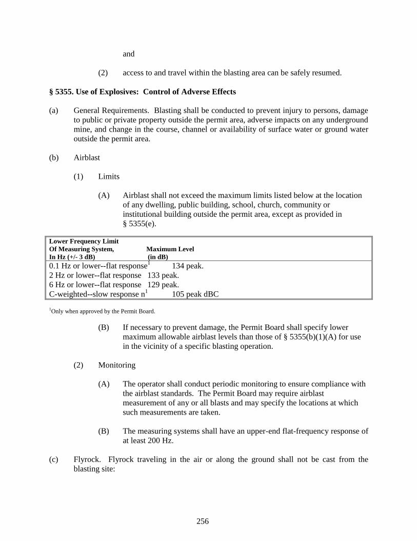
256
and
(2) access to and travel within the blasting area can be safely resumed.
§ 5355. Use of Explosives: Control of Adverse Effects
(a) General Requirements. Blasting shall be conducted to prevent injury to persons, damage
to public or private property outside the permit area, adverse impacts on any underground
mine, and change in the course, channel or availability of surface water or ground water
outside the permit area.
(b) Airblast
(1) Limits
(A) Airblast shall not exceed the maximum limits listed below at the location
of any dwelling, public building, school, church, community or
institutional building outside the permit area, except as provided in
§ 5355(e).
Lower Frequency Limit
Of Measuring System, Maximum Level
In Hz (+/- 3 dB) (in dB)
0.1 Hz or lower--flat response1 134 peak.
2 Hz or lower--flat response 133 peak.
6 Hz or lower--flat response 129 peak.
C-weighted--slow response n1 105 peak dBC
1Only when approved by the Permit Board.
(B) If necessary to prevent damage, the Permit Board shall specify lower
maximum allowable airblast levels than those of § 5355(b)(1)(A) for use
in the vicinity of a specific blasting operation.
(2) Monitoring
(A) The operator shall conduct periodic monitoring to ensure compliance with
the airblast standards. The Permit Board may require airblast
measurement of any or all blasts and may specify the locations at which
such measurements are taken.
(B) The measuring systems shall have an upper-end flat-frequency response of
at least 200 Hz.
(c) Flyrock. Flyrock traveling in the air or along the ground shall not be cast from the
blasting site:
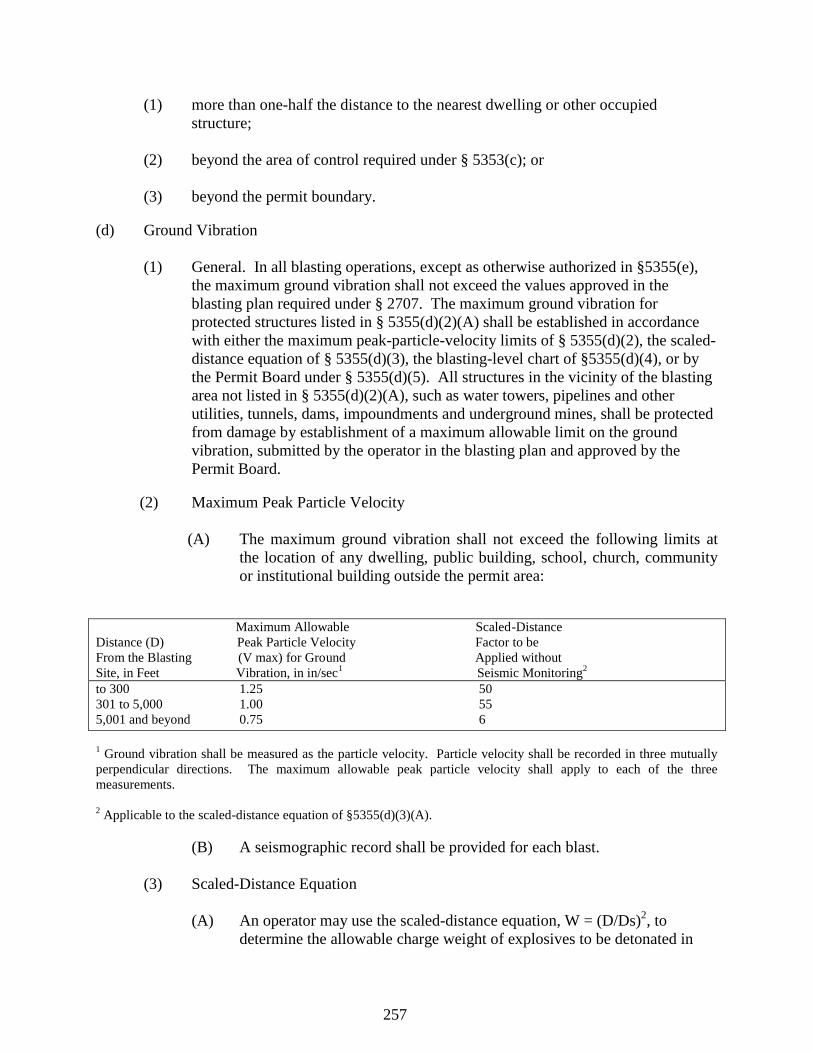
257
(1) more than one-half the distance to the nearest dwelling or other occupied
structure;
(2) beyond the area of control required under § 5353(c); or
(3) beyond the permit boundary.
(d) Ground Vibration
(1) General. In all blasting operations, except as otherwise authorized in §5355(e),
the maximum ground vibration shall not exceed the values approved in the
blasting plan required under § 2707. The maximum ground vibration for
protected structures listed in § 5355(d)(2)(A) shall be established in accordance
with either the maximum peak-particle-velocity limits of § 5355(d)(2), the scaled-
distance equation of § 5355(d)(3), the blasting-level chart of §5355(d)(4), or by
the Permit Board under § 5355(d)(5). All structures in the vicinity of the blasting
area not listed in § 5355(d)(2)(A), such as water towers, pipelines and other
utilities, tunnels, dams, impoundments and underground mines, shall be protected
from damage by establishment of a maximum allowable limit on the ground
vibration, submitted by the operator in the blasting plan and approved by the
Permit Board.
(2) Maximum Peak Particle Velocity
(A) The maximum ground vibration shall not exceed the following limits at
the location of any dwelling, public building, school, church, community
or institutional building outside the permit area:
Maximum Allowable Scaled-Distance
Distance (D) Peak Particle Velocity Factor to be
From the Blasting (V max) for Ground Applied without
Site, in Feet Vibration, in in/sec1
Seismic Monitoring2
to 300 1.25 50
301 to 5,000 1.00 55
5,001 and beyond 0.75 6
1 Ground vibration shall be measured as the particle velocity. Particle velocity shall be recorded in three mutually
perpendicular directions. The maximum allowable peak particle velocity shall apply to each of the three
measurements.
2 Applicable to the scaled-distance equation of §5355(d)(3)(A).
(B) A seismographic record shall be provided for each blast.
(3) Scaled-Distance Equation
(A) An operator may use the scaled-distance equation, W = (D/Ds)2, to
determine the allowable charge weight of explosives to be detonated in
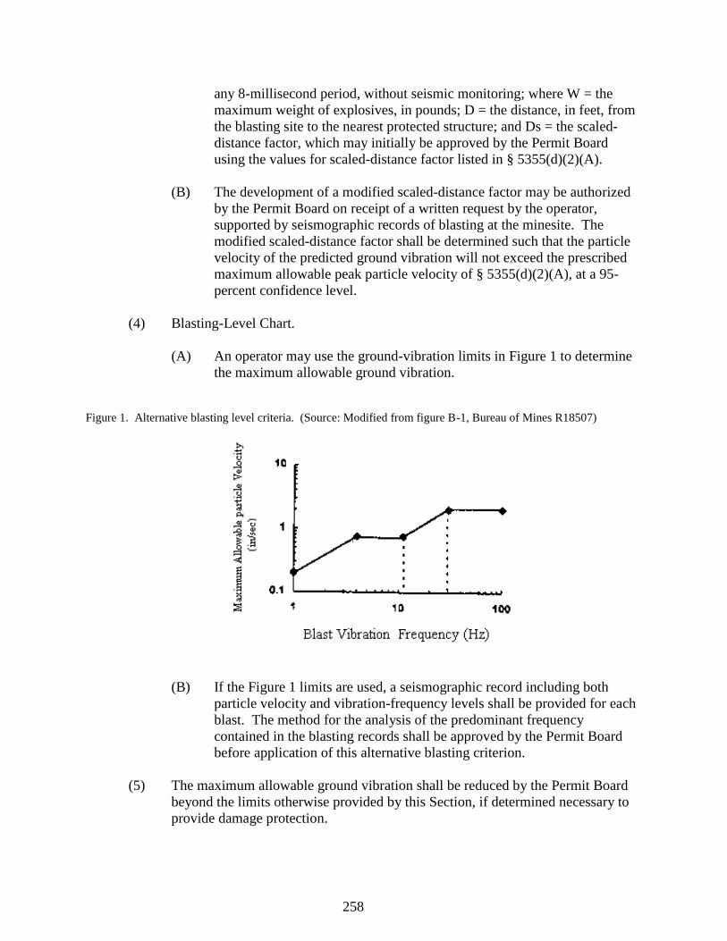
258
any 8-millisecond period, without seismic monitoring; where W = the
maximum weight of explosives, in pounds; D = the distance, in feet, from
the blasting site to the nearest protected structure; and Ds = the scaled-
distance factor, which may initially be approved by the Permit Board
using the values for scaled-distance factor listed in § 5355(d)(2)(A).
(B) The development of a modified scaled-distance factor may be authorized
by the Permit Board on receipt of a written request by the operator,
supported by seismographic records of blasting at the minesite. The
modified scaled-distance factor shall be determined such that the particle
velocity of the predicted ground vibration will not exceed the prescribed
maximum allowable peak particle velocity of § 5355(d)(2)(A), at a 95-
percent confidence level.
(4) Blasting-Level Chart.
(A) An operator may use the ground-vibration limits in Figure 1 to determine
the maximum allowable ground vibration.
Figure 1. Alternative blasting level criteria. (Source: Modified from figure B-1, Bureau of Mines R18507)
(B) If the Figure 1 limits are used, a seismographic record including both
particle velocity and vibration-frequency levels shall be provided for each
blast. The method for the analysis of the predominant frequency
contained in the blasting records shall be approved by the Permit Board
before application of this alternative blasting criterion.
(5) The maximum allowable ground vibration shall be reduced by the Permit Board
beyond the limits otherwise provided by this Section, if determined necessary to
provide damage protection.
259
(6) The Permit Board may require an operator to conduct seismic monitoring of any
or all blasts or may specify the location at which the measurements are taken and
the degree of detail necessary in the measurement.
(e) The maximum airblast and ground-vibration standards of §5355(b) and (d) shall not
apply at the following locations:
(1) at structures owned by the permittee and not leased to another person; or
(2) at structures owned by the permittee and leased to another person, if a written
waiver by the lessee is submitted to the Department before blasting.
§ 5357. Use of Explosives: Records of Blasting Operations
The operator shall retain a record of all blasts for at least three years. Upon request, copies of
these records shall be made available to the Department and to the public for inspection. Such
records shall contain the following data:
(a) name of the operator conducting the blast;
(b) location, date and time of the blast;
(c) name, signature and certification number of the blaster conducting the blast;
(d) identification, direction and distance, in feet, from the nearest blast hole to the
nearest dwelling, public building, school, church, community or institutional
building outside the permit area, except those described in § 5355(e);
(e) weather conditions, including those which may cause possible adverse blasting
effects;
(f) type of material blasted;
(g) sketches of the blast pattern including number of holes, burden, spacing, decks
and delay pattern;
(h) diameter and depth of holes;
(i) types of explosives used;
(j) total weight of explosives used per hole;
(k) the maximum weight of explosives detonated in an 8-millisecond period;
(l) initiation system;
(m) type and length of stemming;
260
(n) mats or other protections used;
(o) seismographic and airblast records, if required, which shall include:
(1) type of instrument, sensitivity and calibration signal or certification of
annual calibration;
(2) exact location of instrument and the date, time and distance from the blast;
(3) name of the person and firm taking the reading;
(4) name of the person and firm analyzing the seismographic record; and
(5) the vibration and/or airblast level recorded;
(p) reasons and conditions for each unscheduled blast.
§ 5359. Disposal of Excess Spoil: General Requirements
(a) General. Excess spoil shall be placed in designated disposal areas within the permit area,
in a controlled manner to
(1) Minimize the adverse effects of leachate and surface water runoff from the
fill on surface and ground waters;
(2) Ensure mass stability and prevent mass movement during and after
construction; and
(3) Ensure that the final fill is suitable for reclamation and revegetation
compatible with the natural surroundings and the approved postmining
land use.
(b) Design certification.
(1) The fill and appurtenant structures shall be designed using current, prudent
engineering practices and shall meet any design criteria established by the
Department. A qualified registered professional engineer experienced in
the design of the earth and rock fills shall certify the design of the file and
appurtenant structures.
(2) The fill shall be designed to attain a minimum long-term static safety
factor of 1.5. The foundation and abutments of the fill must be stable
under all conditions of construction.
(c) Location. The disposal area shall be located on the most moderately sloping and
261
naturally stable areas available, as approved by the Department, and shall be placed,
where possible, upon or above a natural terrace, bench, or berm, if such placement
provides additional stability and prevents mass movement.
(d) Foundation
(1) Sufficient foundation investigations, as well as any necessary laboratory
testing of foundation material, shall be performed in order to determine the
design requirements for foundation stability. The analyses of foundation
conditions shall take into consideration the effect of underground mine
workings, if any, upon the stability of the fill and appurtenant structures.
(2) Where the slope in the disposal area is in excess of 2.8h:1v (36 percent),
or such lesser slope as may be designated by the Department based on
local conditions, keyway cuts (excavations to stable bedrock) or rock toe
buttresses shall be constructed to ensure stability of the fill. Where the toe
of the spoil rests on a downslope, stability and analyses shall be performed
in accordance with § 2735 (c) to determine the size of rock toe buttresses
and keyway cuts.
(e) Placement of Excess Spoil.
(1) All vegetative and organic materials shall be removed from the disposal
area prior to placement of the excess spoil. Topsoil shall be removed,
segregated and stored or redistributed in accordance with § 5311. If
approved by the Department, organic material may be used as mulch or
may be included in the topsoil to control erosion, promote growth of
vegetation or increase the moisture retention of the soil.
(2) Excess spoil shall be transported and placed in a controlled manner in
horizontal lifts not exceeding 4 feet in thickness; concurrently compacted
as necessary to ensure mass stability and to prevent mass movement
during and after construction; graded so that surface and subsurface
drainage is compatible with the natural surroundings; and covered with
topsoil or substitute material in accordance with § 5311 of this Rule. The
Department may approve a design which incorporates placement of excess
spoil in horizontal lifts other than 4 feet in thickness when it is
demonstrated by the operator and certified by a qualified registered
professional engineer that the design will ensure the stability of the fill and
will meet all other applicable requirements.
(3) The final configuration of the fill shall be suitable for the approved
postmining land use. Terraces may be constructed on the outslope of the
fill if required for stability, control of erosion, to conserve soil moisture, or
to facilitate the approved postmining land use. The grade of the outslope
between terrace benches shall not be steeper than 2h:1v (50 percent).
262
(4) No permanent impoundments are allowed on the completed fill. Small
depressions may be allowed by the Department if they are needed to retain
moisture, minimize erosion, create and enhance wildlife habitat, or assist
revegetation; and if they are not incompatible with the stability of the fill.
(5) Excess spoil that is acidic- or toxic- forming or combustible shall be
adequately covered with nonacidic, nontoxic and noncombustible
material, or treated, to control the impact on surface and groundwater in
accordance with § 5325, to prevent sustained combustion, and to minimize
adverse effects on plant growth and the approved postmining land use.
(f) Drainage control.
(1) If the disposal area contains springs, natural or manmade water courses, or
wet weather seeps, the fill design shall include diversions and underdrains
as necessary to control erosion, prevent water infiltration into the fill, and
ensure stability.
(2) Diversions shall comply with the requirements of § 5317.
(3) Underdrains shall consist of durable rock or pipe, be designed and
constructed using current, prudent engineering practices and meet any
design criteria established by the Department. The underdrain system
shall be designed to carry the anticipated seepage of water due to rainfall
away from the excess spoil fill and from seeps and springs in the
foundation of the disposal area and shall be protected from piping and
contamination by an adequate filter. Rock underdrains shall be
constructed of durable, nonacid-, nontoxic-forming rock (e.g., natural sand
and gravel, sandstone, limestone, or other durable rock) that does not slake
in water or degrade to soil material, and which is free of coal, clay or other
nondurable material. Perforated pipe underdrains shall be corrosion
resistant and shall have characteristics consistent with the long-term life of
the fill.
(g) Surface area stabilization. Slope protection shall be provided to minimize surface erosion
at the site. All disturbed areas, including diversion channels that are not riprapped or
otherwise protected, shall be revegetated upon completion of construction.
(h) Inspections. A qualified registered professional engineer, or other qualified professional
specialist under the direction of the registered professional engineer, shall periodically
inspect the fill during construction. The registered professional engineer or specialist
shall be experienced in the construction of earth and rock fills.
(1) Such inspections shall be made at least quarterly throughout construction
and during critical construction periods. Critical construction periods shall
263
include at a minimum:
(A) Foundation preparation, including the removal of all organic
material and topsoil;
(B) placement of underdrains and protective filter systems;
(C) installation of final surface drainage systems; and
(D) the final graded and revegetated fill. Regular inspections by the
registered professional engineer or specialist shall also be
conducted during placement and compaction of fill materials.
(2) The qualified registered professional engineer shall provide a certified
report to the Department promptly after each inspection that the fill has
been constructed and maintained as designed and in accordance with the
approved plan and this Rule. The report shall include appearances of
instability, structural weakness, and other hazardous conditions.
(3) (A) The certified report on the drainage system and protective filters
shall include color photographs taken during and after
construction, but before underdrains are covered with excess spoil.
If the underdrain system is constructed in phases, each phase shall
be certified separately.
(B) Where excess durable rock spoil is placed in single or multiple lifts
such that the underdrain system is constructed simultaneously with
excess spoil placement by the natural segregation of dumped
materials, in accordance with § 5363, color photographs shall be
taken of the underdrain as the underdrain system is being formed.
(C) The photographs accompanying each certified report shall be taken
in adequate size and number with enough terrain or other physical
features of the site shown to provide a relative scale to the
photographs and to specifically and clearly identify the site.
(4) A copy of each inspection report shall be retained at or near the mine site.
(A) Coal mine waste. Coal mine waste may be disposed of in excess
spoil fills if approved by the Department and, if such waste is —
(i) Placed in accordance with § 5371;
(ii) Nontoxic and nonacid forming; and
(iii) Of the proper characteristics to be consistent with the
264
design stability of the fill.
(i) Underground disposal. Excess spoil may be disposed of in underground mine workings,
but only in accordance with a plan approved by the Department and MSHA under 30
C.F.R. § 784.25.
§ 5361. Disposal of Excess Spoil: Valley Fills/Head-of-Hollow Fills.
Valley fills and head-of-hollow fills shall meet the requirements of § 5359 and the additional
requirements of this section.
(a) Drainage control.
(1) The top surface of the completed fill shall be graded such that the final
slope after settlement will be toward properly designed drainage channels.
Uncontrolled surface drainage may not be directed over the outslope of the
fill.
(2) Runoff from areas above the fill and runoff from the surface of the fill
shall be diverted into stabilized diversion channels designed to meet the
requirements of § 5317 and, in addition, to safely pass the runoff from a
100-year, 6-hour precipitation event.
(b) Rock-core chimney drains. A rock-core chimney drain may be used in a head-of-hollow
fill, instead of the underdrain and surface diversion system normally required, as long as
the fill is not located in an area containing intermittent or perennial streams. A rock-core
chimney drain may be used in a valley fill if the fill does not exceed 250,000 cubic yards
of material and upstream drainage is diverted around the fill. The alternative rock-core
chimney drain system shall be incorporated into the design and construction of the fill as
follows:
(1) The fill shall have, along the vertical projection of the main buried stream
channel or rill, a vertical core of durable rock at least 16 feet thick which
shall extend from the toe of the fill to the head of the fill, and from the
base of the fill to the surface of the fill. A system of lateral rock
underdrains shall connect this rock core to each area of potential drainage
or seepage in the disposal area. The underdrain system and rock core shall
be designed to carry the anticipated seepage of water due to rainfall away
from the excess spoil fill and seeps and springs in the foundation of the
disposal area. Rocks used in the rock core and underdrains shall meet the
requirements of § 5359(f).
(2) A filter system to ensure the proper long-term functioning of the rock core
shall be designed and constructed using current, prudent engineering
practices.
265
(3) Grading may drain surface water away from the outslope of the fill and
toward the rock core. In no case, however, may intermittent or perennial
streams be diverted into the rock core. The maximum slope of the top of
the fill shall be 33h:1v (3 percent). A drainage pocket may be maintained
at the head of the fill during and after construction, to intercept surface
runoff and discharge the runoff through or over the rock drain, if stability
of the fill is not impaired. In no case shall this pocket or sump have a
potential capacity for impounding more than 10,000 cubic feet of water.
Terraces on the fill shall be graded with a 3 to 5 percent grade toward the
fill and a 1 percent slope toward the rock core.
§ 5363. Disposal of Excess Spoil: Durable Rock Fills
The Department may approve the alternative method of disposal of excess durable rock
spoil by gravity placement in single or multiple lifts, provided the following conditions
are met:
(a) Except as provided in this section, the requirements of § 5359 are met.
(b) The excess spoil consists of at least 80 percent, by volume, durable, nonacid- and
nontoxic-forming rock (e.g., sandstone or limestone) that does not slake in water and will
not degrade to soil material. Where used, noncemented clay shale, clay spoil, soil or
other nondurable excess spoil materials shall be mixed with excess durable rock spoil in
a controlled manner such that no more than 20 percent of the fill volume, as determined
by tests performed by a registered professional engineer and approved by the
Department, is not durable rock.
(c) A qualified registered professional engineer certifies that the design will ensure the
stability of the fill and meet all other applicable requirements.
(d) The fill is designed to attain a minimum long-term static safety factor of 1.5, and an
earthquake safety factor of 1.1.
(e) The underdrain system may be constructed simultaneously with excess spoil placement
by the natural segregation of dumped materials, provided the resulting underdrain system
is capable of carrying anticipated seepage of water due to rainfall away from the excess
spoil fill and from seeps and springs in the foundation of the disposal area and the other
requirements for drainage control are met.
(f) Surface water runoff from areas adjacent to and above the fill is not allowed to flow onto
the fill and is diverted into stabilized diversion channels designed to meet the
requirements of § 5317 and to safely pass the runoff from a 100-year, 6-hour
precipitation event.
§ 5365. Disposal of excess spoil: Preexisting benches.
266
(a) The Permit Board may approve the disposal of excess spoil through placement on a
preexisting bench if the affected portion of the preexisting bench is permitted and the
standards set forth in § § 5391(c), 5391(e) through 5391(h), and 5391 (j) and the
requirements of this section are met.
(b) All vegetation and organic materials shall be removed from the affected portion of the
preexisting bench prior to placement of the excess spoil. Any available topsoil on the
bench shall be removed, stored and redistributed in accordance with § 5311. Substitute
or supplemental materials may be used in accordance with § 5311(b).
(c) The fill shall be designed and constructed using current, prudent engineering practices.
The design will be certified by a registered professional engineer. The spoil shall be
placed on the solid portion of the bench in a controlled manner and concurrently
compacted as necessary to attain a long term static safety factor of 1.3 for all portions of
the fill. Any spoil deposited on any fill portion of the bench will be treated as excess
spoil fill under § 5359.
(d) The preexisting bench shall be backfilled and graded to:
(1) Achieve the most moderate slope possible which does not exceed the angle of
repose;
(2) Eliminate the highwall to the maximum extent technically practical;
(3) Minimize erosion and water pollution both on and off the site; and
(4) If the disposal area contains springs, natural or manmade water courses, or wet
weather seeps, the fill design shall include diversions and underdrains as
necessary to control erosion, prevent water infiltration into the fill, and ensure
stability.
(e) All disturbed areas, including diversion channels that are not riprapped or otherwise
protected, shall be revegetated upon completion of construction.
(f) Permanent impoundments may not be constructed on preexisting benches backfilled with
excess spoil under this regulation.
(g) Final configuration of the backfill must be compatible with the natural drainage patterns
and the surrounding area, and support the approved postmining land use.
(h) Disposal of excess spoil from an upper actively mined bench to a lower preexisting
bench by means of gravity transport may be approved by the Department provided that--
(1) The gravity transport courses are determined on a site-specific basis by the
operator as part of the permit application and approved by the Permit Board to
minimize hazards to health and safety and to ensure that damage will be
267
minimized between the benches, outside the set course, and downslope of the
lower bench should excess spoil accidentally move;
(2) All gravity transported excess spoil, including that excess spoil immediately
below the gravity transport courses and any preexisting spoil that is disturbed, is
rehandled and placed in horizontal lifts in a controlled manner, concurrently
compacted as necessary to ensure mass stability and to prevent mass movement,
and graded to allow surface and subsurface drainage to be compatible with the
natural surroundings and to ensure a minimum long-term static safety factor of
1.3. Excess spoil on the bench prior to the current mining operation that is not
disturbed need not be rehandled except where necessary to ensure stability of the
fill;
(3) A safety berm is constructed on the solid portion of the lower bench prior to
gravity transport of the excess spoil. Where there is insufficient material on the
lower bench to construct a safety berm, only that amount of excess spoil
necessary for the construction of the berm may be gravity transported to the lower
bench prior to construction of the berm.
(4) Excess spoil shall not be allowed on the downslope below the upper bench except
on designated gravity transport courses properly prepared according to § § 5309-
5311. Upon completion of the fill, no excess spoil shall be allowed to remain on
the designated gravity transport course between the two benches and each
transport course shall be reclaimed in accordance with the requirements of this
Rule.
§ 5367. Protection of Underground Mining
No surface mining activities shall be conducted closer than 500 feet to any point of either an
active or abandoned underground mine, except to the extent that -
(a) The activities result in improved resource recovery, abatement of water pollution, or
elimination of hazards to the health and safety of the public; and
(b) The nature, timing, and sequence of the activities that propose to mine closer than 500
feet to an active underground mine are jointly approved by the Department, the Mine
Safety and Health Administration, and the State agency, if any, responsible for the safety
of underground mine workers.
§ 5369. Coal Mine Waste: General Requirements
(a) General. All coal mine waste disposed of in an area other than the mine workings or
excavations shall be placed in new or existing disposal areas within a permit area, which
are approved by the Department for this purpose. Coal mine waste shall be hauled or
conveyed and placed for final placement in a controlled manner to:
268
(1) Minimize adverse effects of leachate and surface-water runoff on surface
and ground water quality and quantity;
(2) Ensure mass stability and prevent mass movement during and after
construction;
(3) Ensure that the final disposal facility is suitable for reclamation and
revegetation compatible with the natural surroundings and the approved
postmining land use;
(4) Not create a public hazard; and
(5) Prevent combustion.
(b) Coal mine waste material from activities located outside a permit area may be disposed of
in the permit area only if approved by the Department. Approval shall be based upon a
showing that such disposal will be in accordance with the standards of this section.
(c) Design certification.
(1) The disposal facility shall be designed using current, prudent engineering
practices and shall meet any design criteria established by the Department.
A qualified registered professional engineer, experienced in the design of
similar earth and waste structures, shall certify the design of the disposal
facility.
(2) The disposal facility shall be designed to attain a minimum long-term
static safety factor of 1.5. The foundation and abutments must be stable
under all conditions of construction.
(d) Foundation. Sufficient foundation investigations, as well as any necessary laboratory
testing of foundation material, shall be performed in order to determine the design
requirements for foundation stability. The analyses of the foundation conditions shall
take into consideration the effect of underground mine workings, if any, upon the
stability of the disposal facility.
(e) Emergency procedures. If any examination or inspection discloses that a potential hazard
exists, the Department shall be informed promptly of the finding and of the emergency
procedures formulated for public protection and remedial action. If adequate procedures
cannot be formulated or implemented, the Department shall be notified immediately. The
Department shall then notify the appropriate agencies that other emergency procedures
are required to protect the public.
(f) Underground disposal. Coal mine waste may be disposed of in underground mine
workings, but only in accordance with a plan approved by the Department and MSHA
under 30 C.F.R. § 784.25.
269
§ 5371. Coal mine waste: Refuse piles.
Refuse piles shall meet the requirements of § 5369, the additional requirements of this section,
and the requirements of 30 C.F.R. § § 77.214 and 77.215.
(a) Drainage control.
(1) If the disposal area contains springs, natural or manmade water courses, or
wet weather seeps, the design shall include diversions and underdrains as
necessary to control erosion, prevent water infiltration into the disposal
facility and ensure stability.
(2) Uncontrolled surface drainage may not be diverted over the outslope of
the refuse piles. Runoff from the areas above the refuse pile and runoff
from the surface of the refuse pile shall be diverted into stabilized
diversion channels designed to meet the requirements of § 5317 to safely
pass the runoff from a 100-year, 6-hour precipitation event. Runoff
diverted from undisturbed areas need not be commingled with runoff from
the surface of the refuse pile.
(3) Underdrains shall comply with the requirements of § 5359(f)(3).
(b) Surface area stabilization. Slope protection shall be provided to minimize surface erosion
at the site. All disturbed areas, including diversion channels that are not riprapped or
otherwise protected, shall be revegetated upon completion of construction.
(c) Placement.
(1) All vegetative and organic materials shall be removed from the disposal
area prior to placement of coal mine waste. Topsoil shall be removed,
segregated and stored or redistributed in accordance with § 5309 and §
5311. If approved by the Permit Board, organic material may be used as
mulch, or may be included in the topsoil to control erosion, promote
growth of vegetation or increase the moisture retention of the soil.
(2) The final configuration of the refuse pile shall be suitable for the approved
postmining land use. Terraces may be constructed on the outslope of the
refuse pile if required for stability, control of erosion, conservation of soil
moisture, or facilitation of the approved postmining land use. The grade
of the outslope between terrace benches shall not be steeper than 2h:1v (50
percent).
(3) No permanent impoundments shall be allowed on the completed refuse
pile. Small depressions may be allowed by the Department if they are
needed to retain moisture, minimize erosion, create and enhance wildlife
270
habitat, or assist revegetation, and if they are not incompatible with
stability of the refuse pile.
(4) Following final grading of the refuse pile, the coal mine waste shall be
covered with a minimum of 4 feet of the best available, nontoxic and
noncombustible material, in a manner that does not impede drainage from
the underdrains. The Department may allow less than 4 feet of cover
material based on physical and chemical analyses which show that the
requirements of § § 5389-53103 will be met.
(d) Inspections. A qualified Registered Professional Engineer, or other qualified professional
specialist under the direction of a registered professional engineer shall inspect the refuse
pile during construction. The registered professional engineer or specialist shall be
experienced in the construction of similar earth and waste structures.
(1) Such inspections shall be made at least quarterly throughout construction
and during critical construction periods. Critical construction periods shall
include at a minimum:
(A) Foundation preparation including the removal of all organic
material and topsoil;
(B) placement of underdrains and protective filter systems;
(C) installation of final surface drainage systems; and
(D) the final graded and revegetated facility. Regular inspections by
the registered professional engineer or specialist shall also be
conducted during placement and compaction of coal mine waste
materials. More frequent inspections shall be conducted if a
danger of harm exists to the public health and safety or the
environment. Inspections shall continue until the refuse pile has
been finally graded and revegetated or until a later time as required
by the Department.
(2) The qualified registered professional engineer shall provide a certified
report to the Department promptly after each inspection that the refuse pile
has been constructed and maintained as designed and in accordance with
the approved plan and this Rule. The report shall include appearances of
instability, structural weakness, and other hazardous conditions.
(3) The certified report on the drainage system and protective filters shall
include color photographs taken during and after construction, but before
underdrains are covered with coal mine waste. If the underdrain system is
constructed in phases, each phase shall be certified separately. The
photographs accompanying each certified report shall be taken in adequate
271
size and number with enough terrain or other physical features of the site
shown to provide a relative scale to the photographs and to specifically
and clearly identify the site.
(4) A copy of each inspection report shall be retained at or near the
minesite.
§ 5373. Coal Processing Waste: Burning and Burned Waste Utilization
(a) Coal processing waste fires shall be extinguished by the person who conducts the surface
mining activities in accordance with a plan approved by the Permit Board and the Mine
Safety and Health Administration. The plan shall contain, at a minimum, provisions to
ensure that only those persons authorized by the operator, and who have an understanding
of the procedures to be used, shall be involved in the extinguishing operations.
(b) No burning or burned coal mine waste shall be removed from a permitted disposal area
without a removal plan approved by the Permit Board. Consideration shall be given to
potential hazards to persons working or living in the vicinity of the structure.
§ 5375. Disposal of Noncoal Wastes
(a) Noncoal wastes including, but not limited to, grease, lubricants, paints, flammable
liquids, garbage, abandoned mining machinery, lumber and other combustibles generated
during surface mining activities shall be placed and stored in a controlled manner in a
designated portion of the permit area. Placement and storage shall insure that leachate
and surface runoff do not degrade surface water or ground water, that fires are prevented,
and that the area remains stable and suitable for reclamation and revegetation compatible
with the natural surroundings.
(b) Final disposal of noncoal wastes shall be in a designated disposal site in the permit area
or a State-approved solid waste disposal area. Disposal sites in the permit area shall be
designed and constructed with appropriate water barriers on the bottom and sides of the
designated site to ensure that leachate and drainage from the noncoal mine waste area
does not degrade surface or underground water. Wastes shall be routinely compacted and
covered to prevent combustion and wind-borne waste. When the disposal is completed, a
minimum of two feet of soil cover shall be placed over the site, slopes stabilized, and
revegetation accomplished in accordance with § § 5389-53103. Operation of the disposal
site shall be conducted in accordance with all local, state and federal requirements.
Nothing in these regulations shall exempt a permittee from compliance with the
Mississippi Nonhazardous Waste Management Regulations.
(c) At no time shall any solid waste material be deposited at refuse embankments or
impoundment sites, nor shall any excavation for solid waste disposal be located within
eight feet of any coal outcrop or coal storage area.
§ 5377. Coal mine waste: Impounding structures.
272
New and existing impounding structures constructed of coal mine waste or intended to impound
coal mine waste shall meet the requirements of § 5369.
(a) Coal mine waste shall not be used for construction of impounding structures unless it has
been demonstrated to the Department that the stability of such a structure conforms to the
requirements of this part and the use of coal mine waste will not have a detrimental effect
on downstream water quality or the environment due to acid seepage through the
impounding structure. The stability of the structure and the potential impact of acid mine
seepage through the impounding structure shall be discussed in detail in the design plan
submitted to the Department in accordance with § 2725.
(b) (1) Each impounding structure constructed of coal mine waste or intended to
impound coal mine waste shall be designed, constructed and maintained in
accordance with § 5327(a) and (c). Such structures may not be retained
permanently as part of the approved postmining land use.
(2) Each impounding structure constructed of coal mine waste or intended to
impound coal mine waste that meets the criteria of 30 C.F.R. § 77.216(a)
shall have sufficient spillway capacity to safely pass, adequate storage
capacity to safely contain, or a combination of storage capacity and
spillway capacity to safely control, the probable maximum precipitation of
a 6-hour precipitation event, or greater event as specified by the
Department.
(c) Spillways and outlet works shall be designed to provide adequate protection against
erosion and corrosion. Inlets shall be protected against blockage.
(d) Drainage control. Runoff from areas above the disposal facility or runoff from surface of
the facility that may cause instability or erosion of the impounding structure shall be
diverted into stabilized diversion channels designed to meet the requirements of § 5317
and designed to safely pass the round off from a 100-year, 6-hour design precipitation
event.
(e) Impounding structures constructed of or impounding coal mine waste shall be designed
so that at least 90 percent of the water stored during the design precipitation event can be
removed within a 10-day period.
(f) For an impounding structure constructed of or impounding coal mine waste, at least 90
percent of the water stored during the design precipitation event shall be removed within
the 10-day period following the design precipitation event.
§ 5379. Stabilization of surface areas.
(a) All exposed surface areas shall be protected and stabilized to effectively control erosion
and air pollution attendant to erosion.
273
(b) Rills and gullies which form in areas that have been regraded and topsoiled and which
either disrupt the approved postmining land use or the reestablishment of the vegetative
cover or cause or contribute to a violation of water-quality standards for receiving
streams shall be filled, regraded, or otherwise stabilized; topsoil shall be replaced; and the
areas shall be reseeded or replanted.
§ 5381. Air Resources Protection
(a) Fugitive Dust. Each person who conducts surface mining activities shall plan and
employ fugitive dust control measures as an integral part of site preparation, coal mining
and reclamation operations. The Department shall approve the control measures
appropriate for use in planning, according to applicable federal and state air quality
standards, climate, existing air quality in the area affected by mining, and the available
control technology.
(b) Control Measures. The fugitive dust control measures to be used, depending on
applicable federal and state air quality standards, climate, existing air quality, size of
operation and type of operation, shall include, as necessary, but not be limited to:
(1) periodic watering of unpaved roads, with the minimum frequency of
watering approved by the Department;
(2) chemical stabilization of unpaved roads with proper application of
nontoxic soil cement or dust palliatives;
(3) paving of roads;
(4) prompt removal of coal, rock, soil and other dust-forming debris from
roads and frequent scraping and compaction of unpaved roads to stabilize
the road surface;
(5) restricting the speed of vehicles to reduce fugitive dust caused by travel;
(6) revegetating, mulching or otherwise stabilizing the surface of all areas
adjoining roads that are sources of fugitive dust;
(7) restricting the travel of unauthorized vehicles on other than established
roads;
(A) enclosing, covering, watering or otherwise treating loaded haul
trucks and railroad cars to reduce loss of material to wind and
spillage;
(B) substituting conveyor systems for haul trucks and covering
conveyor systems when conveyed loads are subjected to wind
274
erosion;
(C) minimizing the area of disturbed land;
(D) prompt revegetation of regraded lands;
(E) use of alternatives for coal handling methods, restriction of
dumping procedures, wetting of disturbed materials during
handling, and compaction of disturbed areas;
(F) planting of special windbreak vegetation at critical points in the
permit area;
(G) control of dust from drilling using water sprays, hoods, dust
collectors or other controls;
(H) restricting the areas to be blasted at any one time;
(I) restricting activities causing fugitive dust during periods of air
stagnation;
(J) extinguishing any areas of burning or smoldering coal and
periodically inspecting for burning areas whenever the potential for
spontaneous combustion is high;
(K) reducing the period of time between initially disturbing the soil and
revegetating or other surface stabilization;
(L) restricting fugitive dust at spoil and coal transfer and loading
points with water sprays, negative pressure systems and baghouse
filters, chemicals or other practices.
(c) Additional Measures. Where the Department determines that application of fugitive dust
control measures listed in § 5381(b) is inadequate, the Department may require additional
measures and practices as necessary. Nothing in these regulations will lessen the
responsibility of a surface coal mining and reclamation operation to comply with the air
pollution control regulations promulgated by the Commission and enforced through the
Office of Pollution Control.
(d) Monitoring. Air monitoring equipment shall be installed and monitoring shall be
conducted in accordance with the air monitoring plan required under § 2711 and
approved by the office.
§ 5383. Protection of Fish, Wildlife and Related Environmental Values
(a) Any person conducting surface mining activities shall, to the extent possible using the
275
best technology currently available, minimize disturbances and adverse impact of the
activities on fish, wildlife and related environmental values, and achieve enhancement of
such resources where practicable.
(b) Endangered and Threatened Species. No surface mining activity shall be conducted
which is likely to jeopardize the continued existence of endangered or threatened species
listed by the secretary of interior or which is likely to result in the destruction or adverse
modification of designated critical habitats of such species in violation of the Endangered
Species Act of 1973, as amended (16 U.S.C. 1531, et seq.). The operator shall promptly
report to the Department any state- or federally-listed endangered or threatened species
within the permit area of which the operator becomes aware. Upon notification, the
Department shall consult with appropriate state and federal fish and wildlife agencies
and, after consultation, shall identify whether, and under what conditions, the operator
may proceed.
(c) Bald and Golden Eagles. No surface mining activity shall be conducted in a manner
which would result in the unlawful taking of a bald or golden eagle, its nest or any of its
eggs. The operator shall promptly report to the Department any golden or bald eagle nest
within the permit area of which the operator becomes aware. Upon notification, the
Department shall consult with the U.S. Fish and Wildlife Service and also, where
appropriate, the state fish and wildlife agency and, after consultation, shall identify
whether, and under what conditions, the operator may proceed.
(d) Nothing in these regulations shall authorize the taking of an endangered or threatened
species or a bald or golden eagle, its nest or any of its eggs in violation of the Endangered
Species Act of 1973, as amended, (16 U.S.C. 1537, et seq.), or the Bald Eagle Protection
Act, as amended, (16 U.S.C. 668, et seq.).
(e) Each operator shall, to the extent possible using the best technology currently available -
(1) Ensure that electric powerlines and other transmission facilities used for,
or incidental to, surface mining activities on the permit area are designed
and constructed to minimize electrocution hazards to raptors, except where
the Department determines that such requirements are unnecessary;
(2) Locate and operate haul and access roads so as to avoid or minimize
impacts on important fish and wildlife species or other species protected
by State or Federal law;
(3) Design fences, overland conveyors, and other potential barriers to permit
passage for large mammals, except where the Department determines that
such
(4) Fence, cover, or use other appropriate methods to exclude wildlife from
ponds which contain hazardous concentrations of toxic-forming materials.
276
(f) Wetlands and habitats of unusually high value for fish and wildlife. The operator
conducting surface mining activities shall avoid disturbances to, enhance where
practicable, restore, or replace, wetlands, and riparian vegetation along rivers and streams
and bordering ponds and lakes. Surface mining activities shall avoid disturbances to,
enhance where practicable, or restore, habitats of unusually high value for fish and
wildlife.
(g) Where fish and wildlife habitat is to be a postmining land use, the plant species to be used
on reclaimed areas shall be selected on the basis of the following criteria:
(1) Their proven nutritional value for fish or wildlife.
(2) Their use as cover for fish or wildlife.
(3) Their ability to support and enhance fish or wildlife habitat after the
release of performance bonds. The selected plants shall be grouped and
distributed in a manner which optimizes edge effect, cover, and other
benefits to fish and wildlife.
(h) Where cropland is to be the postmining land use, and where appropriate for wildlife- and
crop-management practices, the operator shall intersperse the fields with trees, hedges, or
fence rows throughout the harvested area to break up large blocks of monoculture and to
diversify habitat types for birds and other animals.
(i) Where residential, public service, or industrial uses are to be the postmining land use, and
where consistent with the approved postmining land use, the operator shall intersperse
reclaimed lands with greenbelts utilizing species of grass, shrubs, and trees useful as food
and cover for wildlife.
§ 5385. Slides and Other Damage
(a) An undisturbed natural barrier shall be provided beginning at the elevation of the lowest
coal seam to be mined and extending from the outslope for such distance as may be
determined by the Permit Board as is needed to assure stability. The barrier shall be
retained in place to prevent slides and erosion.
(b) At any time a slide occurs which may have a potential adverse affect on public property,
health, safety or the environment, the person who conducts the surface mining activities
shall notify the Department by the fastest available means and comply with any remedial
measures required by the Department or the Commission.
§ 5387. Contemporaneous Reclamation
Reclamation efforts, including but not limited to backfilling, grading, topsoil
replacement, and revegetation, on all land that is disturbed by surface mining activities
277
shall occur as contemporaneously as practicable with mining operations.
§ 5389. Backfilling and Grading: Time and distance requirements.
(a) Except as provided in § 5389(b) of this section, rough backfilling and grading for surface
mining activities shall be completed according to one of the following schedules:
(1) Contour mining. Within 60 days or 1,500 linear feet following coal removal; or
(2) Area mining. Within 180 days following coal removal, and not more than four
spoil ridges behind the pit being worked, the spoil from the active pit constituting
the first ridge.
(3) Other Surface Mining Methods. Rough backfilling and grading shall occur in
accordance with the time schedule approved by the Permit Board, on the basis of
the materials submitted under § 2715, which shall specifically establish in stated
increments the period between surface mining activities and completion of back
filling and grading.
(b) The Department may extend the time allowed for rough back-filling and grading for the
entire permit area or for a specified portion of the permit area if the permittee
demonstrates in accordance with § 2715 that additional time is necessary.
§ 5391. Backfilling and Grading: General Grading Requirements
(a) Disturbed areas shall be backfilled and graded to:
(1) Achieve the approximate original contour, except as provided in § 5391(k);
(2) Eliminate all highwalls, spoil piles, and depressions, except as provided in §
5391(h) (small depressions) and in § 5391(k)(3)(iii) (previously mined highwalls)
of this section;
(3) Achieve a postmining slope that does not exceed either the angle of repose or
such lesser slope as is necessary to achieve a minimum long-term static safety
factor of 1.3 and to prevent slides;
(4) Minimize erosion and water pollution both on and off the site; and
(5) Support the approved postmining land use.
(b) Spoil, except excess spoil disposed of in accordance with § § 5359 through 5365, shall
be returned to the mined-out area.
(c) Spoil and waste materials shall be compacted where advisable to ensure stability or to
prevent leaching of toxic materials.
278
(d) Spoil may be placed on the area outside the mined-out area in nonsteep slope areas to
restore the approximate original contour by blending the spoil into the surrounding terrain
if the following requirements are met:
(1) All vegetative and organic material shall be removed from the area.
(2) The topsoil on the area shall be removed, segregated, stored, and redistributed in
accordance with § 5311.
(3) The spoil shall be backfilled and graded on the area in accordance with the
requirements of this section.
(e) Disposal of coal processing waste and underground development waste in the mined-out
area shall be in accordance with §§ 5369-5373, except that a long-term static safety
factor of 1.3 shall be achieved.
(f) Exposed coal seams, acid- and toxic-forming materials, and combustible materials
exposed, used, or produced during mining shall be adequately covered with nontoxic and
non-combustible material, or treated, to control the impact on surface and ground water
in accordance with §§ 5313 and 5325-5343, to prevent sustained combustion, and to
minimize adverse effects on plant growth and the approved postmining land use.
(g) Cut-and-fill terraces may be allowed by the Department where:
(1) Needed to conserve soil moisture, ensure stability, and control erosion on final-
graded slopes, and control erosion on final-graded slopes, if the terraces are
compatible with the approved postmining land use; or
(2) Specialized grading, foundation conditions, or roads are required for the approved
postmining land use, in which case the final grading may include a terrace of
adequate width to ensure the safety, stability, and erosion control necessary to
implement the postmining land-use plan.
(h) Small depressions may be constructed if they are needed to retain moisture, minimize
erosion, create and enhance wildlife habitat, or assist revegetation.
(i) Permanent impoundments may be approved if they meet the requirements of §§ 5327 and
5341 and if they are suitable for the approved postmining land use.
(j) Preparation of final-graded surfaces shall be conducted in a manner that minimizes
erosion and provides a surface for replacement of topsoil that will minimize slippage.
(k) The postmining slope may vary from the approximate original contour when:
(1) The standards for thin overburden in § 5393 are met;
279
(2) The standards for thick overburden in § 5395 are met; or
(3) Approval is obtained from the Department for —
(A) Mountaintop removal operations in accordance with 30 C.F.R. §
785.14, which is adopted by reference for this purpose;
(B) A variance from approximate original contour requirements in
accordance with § 2905; or
(C) Incomplete elimination of highwalls in previously mined areas in
accordance with 30 C.F.R. § 816.106.
§ 5393. Backfilling and grading: Thin Overburden
(a) Definition. Thin overburden means insufficient spoil and other waste materials available
from the entire permit area to restore the disturbed area to its approximate original
contour. Insufficient spoil and other waste materials occur where the overburden
thickness times the swell factor, plus the thickness of other available waste materials, is
less than the combined thickness of the overburden and coal bed prior to removing the
coal, so that after backfilling and grading the surface configuration of the reclaimed area
would not:
(1) Closely resemble the surface configuration of the land prior to mining; or
(2) Blend into and complement the drainage pattern of the surrounding
terrain.
(b) Performance standards. Where thin overburden occurs within the permit area, the
permittee at a minimum shall;
(1) Use all spoil and other waste materials available from the entire permit
area to attain the lowest practicable grade, but not more than the angle of
repose; and
(2) Meet the requirements of § 5391(a)(2)-j of this Rule.
§ 5395. Backfilling and Grading: Thick Overburden
(a) Definition. Thick overburden means more than sufficient spoil and other waste materials
available from the entire permit area to restore the disturbed area to its approximate
original contour. More than sufficient spoil and other waste materials occur where the
overburden thickness times the swell factor exceeds the combined thickness of the
overburden and coal bed prior to removing the coal, so that after backfilling and grading
280
the surface configuration of the reclaimed area would not:
(1) Closely resemble the surface configuration of the land prior to mining; or
(2) Blend into and complement the drainage pattern of the surrounding
terrain.
The provisions of this Section apply only when surface mining activities cannot be
carried out to comply with § 5391 to achieve the approximate original contour.
(b) Performance standards. Where thick overburden occurs within the permit area, the
permittee at a minimum shall:
(1) Restore the approximate original contour and then use the remaining spoil
and other waste materials to attain the lowest practicable grade, but not
more than the angle of repose;
(2) Meet the requirements of § 5391 (a)(2) through (j) of this Rule; and
(3) Dispose of any excess spoil in accordance with § § 5359-5365.
§ 5397. Revegetation: General Requirements
(a) Each person who conducts surface mining activities shall establish on regraded areas and
on all other disturbed areas, except water areas and surface areas of roads that are
approved as part of the post-mining land use, a vegetative cover that is in accordance
with the approved permit and reclamation plan and that is:
(1) diverse, effective and permanent;
(2) comprised of species native to the area, or of introduced species where
desirable and necessary to achieve the approved post-mining land use and
approved by the Permit Board;
(3) at least equal in extent of cover to the natural vegetation of the area; and
(4) capable of stabilizing the soil surface from erosion.
(b) The reestablished plant species shall:
(1) be compatible with the approved post-mining land use;
(2) have the same seasonal characteristics of growth as the original
vegetation;
(3) be capable of self-regeneration and plant succession;
281
(4) be compatible with the plant and animal species of the area;
(5) meet the requirements of applicable state and federal seed, poisonous and
noxious plant, and introduced species laws or regulations; and
(6) not be Kudzu, Pueraria lobata or any vine of the Kudzu family.
(c) The Permit Board may grant exception to the requirements of § § 5397(b)(2)-(3) when
the species are necessary to achieve a quick-growing, temporary, stabilizing cover, and
measures to establish permanent vegetation are included in the approved permit and
reclamation plan.
(d) When the Permit Board approves a cropland post-mining land use, the Permit Board may
grant exception to the requirements of § 5397(a)(1) and (3) and § 5397(b)(2) and (3). In
addition, the requirements of Rule 55 apply to areas identified as prime farmland.
§ 5399. Revegetation: Timing
Disturbed areas shall be planted during the first normal period for favorable planting conditions
after replacement of the plant-growth medium. The normal period for favorable planting is that
planting time generally accepted locally for the type of plant materials selected. When necessary
to effectively control erosion, any disturbed area shall be seeded and planted, as
contemporaneously as practicable with the completion of backfilling and grading, with a
temporary cover of small grains, grasses or legumes until a permanent cover is established.
§ 53101. Revegetation: Mulching and Other Soil Stabilizing Practices
(a) Suitable mulch and other soil stabilizing practices shall be used on all regraded and
topsoiled areas to control erosion, promote germination of seeds, or increase the moisture
retention capacity of the soil. The Permit Board may waive this requirement if seasonal,
soil, or slope factors result in a condition where mulch and other soil stabilizing practices
are not necessary to control erosion and to promptly establish an effective vegetative
cover.
(b) When required by the Permit Board, mulches shall be mechanically or chemically
anchored to the soil surface to assure effective protection of the soil and vegetation.
(c) Annual grasses and grains may be used alone, as in situ mulch, or in conjunction with
another mulch, when the Permit Board determines that they will provide adequate soil
erosion control and will later be replaced by perennial species approved for the post-
mining land use.
(d) Chemical soil stabilizers alone, or in combination with appropriate mulches, may be used
in conjunction with vegetative covers approved for the post-mining land use.
282
§ 53103. Revegetation: Standards for Success
(a) Success of revegetation shall be judged on the effectiveness of the vegetation for the
approved post-mining land use, the extent of perennial cover compared to the cover
occurring in natural vegetation of the area, the general requirements of § § 5397-53103,
and the specific requirements of Appendix A, “ Revegetation Success Standards”, where
specific standards for the designated postmining land use are stated in Appendix A.
Appendix A is incorporated by reference into these regulations as if set out fully herein,
and the provisions of Appendix A are enforceable provisions of these regulations. If a
postmining land use is selected and approved by the Permit Board for which standards
are not specified in Appendix A, or to the extent that Appendix A does not specify a more
specific standard of success for a postmining land use, the following general standards of
success shall apply.
(b) (1) Standards for success shall include criteria representative of unmined
lands in the area being reclaimed to evaluate the appropriate vegetation
parameters of ground cover, production, or stocking. Ground cover,
production, or stocking shall be considered equal to the approved success
standard when they are not less than 90 percent of the success standard.
The sampling techniques for measuring success shall use a 90-percent
statistical confidence interval (i.e., one-sided test with a 0.10 alpha error).
(2) The period of extended responsibility for successful revegetation shall
begin after the last year of augmented seeding, fertilizing, irrigation, or
other work, excluding husbandry practices that are approved by the
Department in accordance with § 53103 (b)(3) of this section.
(3) In areas of more than 26.0 inches of annual average precipitation, the
period of responsibility shall continue for a period of not less than:
(A) Five full years, except as provided in § 53103(b)(2)(B) of this
section. The vegetation parameters identified in paragraph §
53103(b) of this section for grazing land, pasture land, or cropland
shall equal or exceed the approved success standard during the
growing season of any 2 years of the responsibility period, except
the first year. Areas approved for the other uses identified in §
53103(b) of this section shall be equal or exceed the applicable
success standard during the growing season of the last year of the
responsibility period.
(B) Two full years for lands eligible for remining included in permits
issued before September 30, 2004, or any renewals thereof. To the
extent that the success standards are established by § 53103 (a) of
this section, the lands shall equal or exceed the standards during
283
the growing season of the last year of the responsibility period.
(4) The Permit Board may approve selective husbandry practices, excluding
augmented seeding, fertilization, or irrigation, provided it obtains prior
approval from the Director in accordance with 30 C.F.R. § 732.17 that the
practices are normal husbandry practices, without extending the period of
responsibility for revegetation success and bond liability, if such practices
can be expected to continue as part of the postmining land use or if
discontinuance of the practices after the liability period expires will not
reduce the probability of permanent revegetation success. Approved
practices shall be normal husbandry practices within the region for
unmined lands having land uses similar to the approved postmining land
use of the disturbed area, including such practices as disease, pest, and
vermin control; and any pruning, reseeding, and transplanting specifically
necessitated by such actions.
§ 53105. Cessation of Operations: Temporary
(a) Each person who conducts surface mining activities shall effectively secure surface
facilities in areas in which there are no current operations, but in which operations are to
be resumed under an approved permit. Temporary abandonment shall not relieve a
person of his, her, or its obligation to comply with any provisions of the approved permit.
(b) Before temporary cessation of mining and reclamation operations for a period of 30 days
or more, or as soon as it is known that a temporary cessation will extend beyond 30 days,
persons who conduct surface mining activities shall submit to the Department a notice of
intention to cease or abandon mining and reclamation operations. This notice shall
include a statement of the exact number of acres which will have been affected in the
permit area prior to such temporary cessation, the extent and kind of reclamation of those
areas which will have been accomplished and identification of the backfilling, regrading,
revegetation, environmental monitoring and water treatment activities that will continue
during the temporary cessation.
§ 53107. Cessation of Operations: Permanent
(a) Persons who cease surface mining activities permanently shall close, backfill or
otherwise permanently reclaim all affected areas, in accordance with these regulations
and the permit approved by the Permit Board.
(b) All underground openings, equipment, structures or other facilities not required for
monitoring, unless approved by the Permit Board as suitable for the post-mining land use
or environmental monitoring, shall be removed and the affected land reclaimed.
§ 53109. Post-mining Land Use
284
(a) General. All affected areas shall be restored in a timely manner to conditions that are
capable of supporting the uses which they were capable of supporting before any mining,
or to higher or better uses achievable under the criteria and procedures of this Section.
(b) Determining Premining Use of Land. The premining uses of land to which the post-
mining land use is compared shall be those uses which the land previously supported, if
the land has not been previously mined and has been properly managed. The post-mining
land use for land that has been previously mined and not reclaimed shall be judged on the
basis of the land use that existed prior to any mining, provided that, if the land cannot be
reclaimed to the land use that existed prior to any mining because of the previously
mined condition, the post-mining land use shall be judged on the basis of the highest and
best use that can be achieved which is compatible with surrounding areas and does not
require the disturbance of areas previously unaffected by mining.
(c) Criteria for alternative postmining land uses. Higher or better uses may be approved by
the Permit Board as alternative postmining land uses after consultation with the
landowner or the land management agency having jurisdiction over the lands, if the
proposed uses meet the following criteria:
(1) There is a reasonable likelihood for achievement of the use.
(2) The use does not present any actual or probable hazard to public health or safety,
or threat of water diminution or pollution.
(3) The use will not--
(A) Be impractical or unreasonable;
(B) Be inconsistent with applicable land use policies or plans;
(C) Involve unreasonable delay in implementation; or
(D) Cause or contribute to violation of Federal, State, or local law.
(d) Approximate original contour: Criteria for variance. Surface coal mining operations that
meet the requirements of this Paragraph may be conducted under a variance from the
requirement to restore disturbed areas to their approximate original contour, if the
following requirements are satisfied:
(1) The Permit Board grants the variance under a permit issued in accordance with §
2905.
(2) The alternative postmining land use requirements of § 53109(c) are met.
(3) All applicable requirements of the Act and the regulatory program, other than the
requirement to restore disturbed areas to their approximate original contour, are
285
met.
(4) After consultation with the appropriate land use planning agencies, if any, the
potential use is shown to constitute an equal or better economic or public use.
(5) The proposed use is designed and certified by a qualified registered professional
engineer in conformance with professional standards established to assure the
stability, drainage, and configuration necessary for the intended use of the site.
(6) The watershed of the permit and adjacent areas is shown to be improved.
(7) The highwall is completely backfilled with spoil material, in a manner which
results in a static factor of safety of at least 1.3, using standard geotechnical
analysis.
(8) Only the amount of spoil as is necessary to achieve the postmining land use,
ensure the stability of spoil retained on the bench, and meet all other requirements
of the Mississippi program is placed off the mine bench. All spoil not retained on
the bench shall be placed in accordance with § § 5359-5365.
(9) The surface landowner of the permit area has knowingly requested, in writing,
that a variance be granted, so as to render the land, after reclamation, suitable for
an industrial, commercial, residential, or public use (including recreational
facilities).
(10) Federal, State, and local government agencies with an interest in the proposed
land use have an adequate period in which to review and comment on the
proposed use.
§ 53111. Roads: General
(a) Road Classification System
(1) Each road, as defined in § 105, shall be classified as either a primary road
or an ancillary road.
(2) A primary road is any road which is:
(A) used for transporting coal or spoil;
(B) frequently used for access or other purposes for a period in excess
of six months; or
(C) to be retained for an approved post-mining land use.
(3) An ancillary road is any road not classified as a primary road.
286
(4) A limited use vehicular pathway is not classified as a road if it meets all
the following:
(i) the pathway has no improved roadbed, which means it has no
constructed crown, compacted base, roadway ditches, or surface
material added to enhance use as a pathway which precludes
vegetation;
(ii) the pathway has no bridges or other cross-drainage structures;
(iii) the pathway is not located in and/or does not cross or ford any
channel of an intermittent or perennial stream;
(iv) the pathway has only limited clearing, if any, of woody vegetation,
typically wide enough only for the safe passage of one vehicle;
(v) the pathway is located so as to control erosion and siltation; and
(vi) maintenance of the pathway is limited to maintenance consisting
only of the occasional filling of potholes and ruts in order to
remain passable.
(5) A limited use vehicular pathway:
(i) shall be reclaimed with vegetation sufficient to prevent erosion
prior to phase II bond release;
(ii) along with the area it disturbs, is a mining related activity and must
be covered by an appropriate reclamation bond;
(iii) will be reclassified as a road if upgraded by construction activities
such as blading, construction, placement of a compacted surface,
cut and fill of the natural grade, construction of drainage ditches or
low water crossings, or installation of drainage structures. The
submittal and approval of plans and drawings required by these
regulations must be completed prior to the upgrading of a limited
use vehicular pathway.
(b) Performance Standards. Each road shall be located, designed, constructed, reconstructed,
used, maintained and reclaimed so as to:
(1) control or prevent erosion, siltation, and the air pollution attendant to
erosion, including road dust as well as dust occurring on other exposed
surfaces, by measures such as vegetating, watering, using chemical or
other dust suppressants, or otherwise stabilizing all exposed surfaces in
287
accordance with current, prudent engineering practices;
(2) control or prevent damage to fish, wildlife or their habitat and related
environmental values;
(3) control or prevent additional contributions of suspended solids to stream
flow or runoff outside the permit area;
(4) neither cause nor contribute to, directly or indirectly, the violation of state
or federal water quality standards applicable to receiving waters;
(5) refrain from seriously altering the normal flow of water in streambeds or
drainage channels;
(6) prevent or control damage to public or private property, including the
prevention or mitigation of adverse effects on lands within the boundaries
of units of the National Park System, the National Wildlife Refuge
System, the National System of Trails, the National Wilderness
Preservation System, the Wild and Scenic Rivers System, including
designated study rivers, and National Recreation Areas designated by act
of Congress; and
(7) use nonacid- and nontoxic-forming substances in road surfacing.
(c) Design and Construction Limits and Establishment of Design Criteria. To ensure
environmental protection appropriate for their planned duration and use, including
consideration of the type and size of equipment used, the design and construction or
reconstruction of roads shall incorporate appropriate limits for grade, width, surface
materials, surface drainage control, culvert placement and culvert size, in accordance
with current, prudent engineering practices, and any necessary design criteria established
by the Department.
(d) Location
(1) No part of any road shall be located in the channel of an intermittent or
perennial stream unless specifically approved by the Permit Board in
accordance with applicable § § 5313 - 5343.
(2) Roads shall be located to minimize downstream sedimentation and
flooding.
(e) Maintenance
(1) A road shall be maintained to meet the performance standards of this
Section and any additional criteria specified by the Permit Board.
288
(2) A road damaged by a catastrophic event, such as a flood or earthquake,
shall be repaired as soon as is practicable after the damage has occurred.
(f) Reclamation. A road not to be retained under an approved post-mining land use shall be
reclaimed in accordance with the approved reclamation plan as soon as practicable after it
is no longer needed for mining and reclamation operations. This reclamation shall
include:
(1) closing the road to traffic;
(2) removing all bridges and culverts unless approved as part of the post-
mining land use;
(3) removing or otherwise disposing of road-surfacing materials that are
incompatible with the post-mining land use and revegetation requirements;
(4) reshaping cut and fill slopes as necessary to be compatible with the post-
mining land use and to complement the natural drainage pattern of the
surrounding terrain;
(5) protecting the natural drainage patterns by installing dikes or cross drains
as necessary to control surface runoff and erosion; and
(6) scarifying or ripping the roadbed; replacing topsoil or substitute material,
and revegetating disturbed surfaces in accordance with § § 5309-5311 and
5397-53103.
§ 53113. Primary Roads
Primary roads shall meet the requirements of § 53111 and the additional requirements of this
Section.
(a) Certification. The construction or reconstruction of primary roads shall be
certified in a report to the Department by a qualified, registered
professional engineer. The report shall indicate that the primary road has
been constructed or reconstructed as designed and in accordance with the
approved plan.
(b) Safety Factor. Each primary road embankment shall have a minimum
static factor of 1.3 or meet the requirements established under § 2737(c).
(c) Location
(1) To minimize erosion, a primary road shall be located, insofar as is
practicable, on the most stable available surface.
289
(2) Fords of perennial or intermittent streams by primary roads are
prohibited unless they are specifically approved by the Permit
Board as temporary routes during periods of road construction.
(d) Drainage Control. In accordance with the approved plan:
(1) Each primary road shall be constructed, or reconstructed, and
maintained to have adequate drainage control, using structures
such as, but not limited to, bridges, ditches, cross drains and ditch
relief drains. The drainage control system shall be designed to
safely pass the peak runoff from a 10-year, six-hour precipitation
event, or greater event as specified by the Permit Board.
(2) Drainage pipes and culverts shall be installed as designed, and
maintained in a free and operating condition and to prevent or
control erosion at inlets and outlets.
(3) Drainage ditches shall be constructed and maintained to prevent
uncontrolled drainage over the road surface and embankment.
(4) Culverts shall be installed and maintained to sustain the vertical
soil pressure, the passive resistance of the foundation, and the
weight of vehicles using the road.
(5) Natural stream channels shall not be altered or relocated without
the prior approval of the Permit Board in accordance with
applicable § § 5313 - 5343.
(6) Except as provided in § 53113(c)(2), structures for perennial or
intermittent stream channel crossings shall be made using bridges,
culverts, low-water crossings, or other structures designed,
constructed and maintained using current, prudent engineering
practices. The Permit Board shall ensure that low-water crossings
are designed, constructed and maintained to prevent erosion of the
structure or streambed and additional contributions of suspended
solids to streamflow.
(e) Surfacing. Primary roads shall be surfaced with material approved by the
Permit Board as being sufficiently durable for the anticipated volume of
traffic and the weight and speed of vehicles using the road.
§ 53115. Utility installations
All surface coal mining operations shall be conducted in a manner which minimizes damage,
destruction, or disruption of services provided by oil, gas, and water wells; oil, gas, and coal-
slurry pipelines; railroads; electric and telephone lines; and water and sewage lines which pass
290
over, under, or through the permit area, unless otherwise approved by the owner of those
facilities and the Permit Board.
§ 53117. Support Facilities
(a) Support facilities shall be operated in accordance with a permit issued for the mine or
coal preparation operation to which it is incident or from which its operation results.
(b) In addition to the other provisions of this part, support facilities shall be located,
maintained, and used in a manner that--
(1) Prevents or controls erosion and siltation, water pollution, and damage to public
or private property; and
(2) To the extent possible using the best technology currently available--
(A) Minimizes damage to fish, wildlife, and related environmental values; and
(B) Minimizes additional contributions of suspended solids to streamflow or
runoff outside the permit area. Any such contributions shall not be in
excess of limitations of State or Federal law.
Source: Miss. Code Ann. §§ 53-9-11, 53-9-25, 53-9-47, 53-9-51, 53-9-53, 53-9-85, 53-9-87 and
53-9-1, et seq.
Rule 55. Special Permanent Program Performance Standards: Operations on Prime
Farmland
§ 5501. Prime Farmland: Scope and Purpose.
This part sets forth special environmental protection performance, reclamation, and design
standards for surface coal mining and reclamation operations on prime farmland.
§ 5503. Prime Farmland: Soil Removal and Stockpiling.
(a) Prime farmland soils shall be removed from the areas to be disturbed before drilling,
blasting, or mining.
(b) The minimum depth of soil and soil materials to be removed and stored for use in the
reconstruction of prime farmland shall be sufficient to meet the requirements of § 5311
and § 5507 of this Rule.
(c) Soil removal and stockpiling operations on prime farmland shall be conducted to:
(1) Separately remove the topsoil, or remove other suitable soil materials where such
other soil materials will create a final soil having a greater productive capacity
than that which existed prior to mining. If not utilized immediately, this material
291
shall be placed in stockpiles separate from the spoil and all other excavated
materials; and
(2) Separately remove the B or C soil horizon or other suitable soil material to
provide the thickness of suitable soil required by § 5311 and § 5507 of this Rule,
except as approved by the Department where the B or C soil horizons would not
otherwise be removed and where soil capabilities can be retained. If not utilized
immediately, each horizon or other material shall be stockpiled separately from
the spoil and all other excavated materials. Where combinations of such soil
materials created by mixing have been shown to be equally or more favorable for
plant growth than the B horizon, separate handling is not necessary.
(d) Stockpiles shall be placed within the permit area where they will not be disturbed or be
subject to excessive erosion. If left in place for more than 30 days, stockpiles shall meet
the requirements of § 5311 and § 5507 of this Rule.
§ 5505. Prime Farmland: Soil Replacement
Surface coal mining and reclamation operations on prime farmland shall be conducted according
to the following:
(a) The minimum depth of soil and substitute soil material to be reconstructed
shall be 48 inches, or a lesser depth equal to the depth to a subsurface
horizon in the natural soil that inhibits or prevents root penetration, or a
greater depth if determined necessary to restore the original soil
productive capacity. Soil horizons shall be considered as inhibiting or
preventing root penetration if their physical or chemical properties or
water-supplying capacities cause them to restrict or prevent penetration by
roots of plants common to the vicinity of the permit area and if these
properties or capacities have little or no beneficial effect on soil
productivity capacity.
(b) Replace soil material only on land which has been first returned to final
grade and scarified according to § § 5389-5395 unless site-specific
evidence is provided and approved by the Permit Board showing that
scarification will not enhance the capability of the reconstructed soil to
achieve equivalent or higher levels of yield.
(c) Replace and regrade the soil horizons or other suitable soil material with
proper compaction and uniform depth.
(d) Replace the B horizon, C horizon, or other suitable material specified in §
5503 (c) to the thickness needed to meet the requirements of § 5505 (a).
In those areas where the B or C horizons were not removed but may have
been compacted or otherwise damaged during the mining operation, the
operator shall engage in deep tilling or other appropriate means to restore
292
pre-mining capabilities.
(e) The operator shall replace the topsoil or other suitable soil materials
specified in § 5503 (c) (1) as the final surface soil layer. This surface soil
layer shall equal or exceed the thickness of the original surface soil layer,
as determined by the soil survey.
(f) Apply nutrients and soil amendments as needed to quickly establish
vegetative growth.
§ 5507. Prime Farmland: Revegetation and Restoration of Soil Productivity
(a) Following prime farmland soil replacement, the soil surface shall be stabilized with a
vegetative cover or other means that effectively controls soil loss by wind and water
erosion.
(b) Each person who conducts surface coal mining and reclamation operations on prime
farmland shall meet the following revegetation requirements during reclamation:
(1) Prime farmland soil productivity shall be restored in accordance with the
following provisions:
(A) Measurement of soil productivity shall be initiated within 10 years
after completion of soil replacement.
(B) Soil productivity shall be measured on a representative sample or
on all of the mined and reclaimed prime farmland area using the
reference crop determined under § 5507(b)(1)(F). A statistically
valid sampling technique at a 90-percent or greater statistical
confidence level shall be used as approved by the Permit Board in
consultation with the U.S. Natural Resources Conservation
Service.
(C) The measurement period for determining average annual crop
production (yield) shall be a minimum of three crop years prior to
release of the operator's performance bond.
(D) The level of management applied during the measurement period
shall be the same as the level of management used on nonmined
prime farmland in the surrounding area.
(E) Restoration of soil productivity shall be considered achieved when
the average yield during the measurement period equals or exceeds
the average yield of the reference crop established for the same
period for nonmined soils of the same or similar texture or slope
phase of the soil series in the surrounding area under equivalent
293
management practices.
(F) The reference crop on which restoration of soil productivity is
proven shall be selected from the crops most commonly produced
on the surrounding prime farmland. Where row crops are the
dominant crops grown on prime farmland in the area, the row crop
requiring the greatest rooting depth shall be chosen as one of the
reference crops.
(G) Reference crop yields for a given crop season are to be determined
from:
(i) the current yield records of representative local farms in the
surrounding area, with concurrence by the U.S. Natural
Resources Conservation Service; or
(ii) the average county yields recognized by the U.S.
Department of Agriculture, which have been adjusted by
the U.S. Natural Resources Conservation Service for local
yield variation within the county that is associated with
differences between non-mined prime farmland soil and all
other soils that produce the reference crop.
(H) Under either procedure in § 5507(b)(1)(G), the average reference
crop yield may be adjusted, with the concurrence of the U.S.
Natural Resources Conservation Service, for:
(i) disease, pest and weather-induced seasonal variations; or
(ii) differences in specific management practices where the
overall management practices of the crops being compared
are equivalent; or
(iii) differences in annual precipitation.
Source: Miss. Code Ann. § 53-9-11 and 53-9-1, et seq.
Rule 57. Special Permanent Program Performance Standards: Operations on Steep
Slopes
§ 5701. Applicability
(a) Any surface coal mining and reclamation operations on steep slopes shall meet the
requirements of this Rule.
(b) The standards of this Rule do not apply to mining conducted on a flat or gently rolling
294
terrain with an occasional steep slope through which the mining proceeds and leaves a
plain or predominantly flat area.
§ 5703. Steep Slopes: Backfilling and grading: Steep slopes
(a) Surface mining activities on steep slopes shall be conducted so as to meet the
requirements of § § 5389-5395, and the requirements of this section except where mining
is conducted on flat or gently rolling terrain with an occasional steep slope through which
the mining proceeds and leaves a plain or predominantly flat area.
(b) The following materials shall not be placed on the downslope:
(1) Spoil.
(2) Waste materials of any type.
(3) Debris, including that from clearing and grubbing.
(4) Abandoned or disabled equipment.
(c) Land above the highwall shall not be disturbed unless the Department finds that this
disturbance will facilitate compliance with the environmental protection standards of this
Subpart.
(d) Woody materials shall not be buried in the backfilled area unless the Department
determines that the proposed method for placing woody material within the backfill will
not deteriorate the stable condition of the backfilled areas.
Source: Miss. Code Ann. §§ 53-9-11 and 53-9-1, et seq.
Rule 59. Special Permanent Program Performance Standards: Coal Preparation
Plants and Support Facilities Not Located At or Near the Minesite or Not
Within the Permit Area for a Mine
§ 5901. Applicability
Each person who conducts surface coal mining and reclamation operations, which includes the
operation of a coal preparation plant which is not located within the permit area for a specific
mine, shall obtain a permit in accordance with § 2909 to conduct those operations, obtain a bond
in accordance with Subpart IV, and comply with § 5903.
§ 5903. Coal Preparation Plants: Performance Standards
The construction, operation, maintenance, modification, reclamation, and removal activities at
coal preparation plants shall comply with the following:
295
(a) Signs and markers for the coal preparation plant, coal processing waste disposal area, and
water-treatment facilities shall comply with § 5301.
(b) Any stream channel diversion shall comply with § 5317.
(c) Drainage from any disturbed area related to the coal preparation plant shall comply with
§ § 5319-5325, and all discharges from these areas shall meet the requirements of § §
5313 and 5315 and any other applicable State or Federal law.
(d) Permanent impoundments associated with coal preparation plants shall meet the
requirements of § § 5327 and 5341 of this Rule. Dams constructed of, or impounding,
coal processing waste shall comply with § 5377.
(e) Disposal of coal processing waste, noncoal mine waste, and excess spoil shall comply
with § § 5359-5365 and 5369-5377.
(f) Fish, wildlife, and related environmental values shall be protected in accordance with §
5383.
(g) Support facilities related to the coal preparation plant shall comply with § 53117.
(h) Roads shall comply with § § 53111 and 53113.
(i) Cessation of operations shall be in accordance with § § 53105 and 53107.
(j) Erosion and air pollution attendant to erosion shall be controlled in accordance with §
5379.
(k) Adverse effects upon, or resulting from, nearby underground coal mining activities shall
be minimized by appropriate measures including, but not limited to, compliance with §
5367.
(l) Reclamation shall follow proper topsoil handling, backfilling and grading, revegetation,
and postmining land use procedures in accordance with § § 5309, 5311, 5387, 5389,
5391, 5393, 5397 - 53103, and 53109.
Source: Miss. Code Ann. § 53-9-11 and 53-9-1, et seq.
Rule 61. Special Permanent Program Performance Standards: In Situ Processing
§ 6101. In Situ Processing: Performance Standards
(a) The person who conducts in situ processing activities shall comply with Rule 53.
(b) In situ processing activities shall be planned and conducted to minimize disturbance to
296
the prevailing hydrologic balance by:
(1) avoiding discharge of fluids into holes or wells, other than as approved by
the Permit Board;
(2) injecting process recovery fluids only into geologic zones or intervals
approved as production zones by the Permit Board;
(3) avoiding annular injection between the wall of the drill hole and the
casing; and
(4) preventing discharge of process fluid into surface waters.
(c) Each person who conducts in situ processing activities shall submit for approval as part
of the application for permit under § 2911, and follow after approval, a plan that ensures
that all acid-forming, toxic-forming, or radioactive gases, solids or liquids constituting a
fire, health, safety or environmental hazard and caused by the mining and recovery
process are promptly treated, confined or disposed of in a manner that prevents
contamination of ground water and surface water, damage to fish, wildlife and related
environmental values, and threats to the public health and safety.
(d) Each person who conducts in situ processing activities shall prevent flow of the process
recovery fluid:
(1) horizontally beyond the affected area identified in the permit; and
(2) vertically into overlying or underlying aquifers.
(e) Each person who conducts in situ processing activities shall restore the quality of affected
ground water in the permit and adjacent area, including ground water above and below
the production zone, to the approximate premining levels or better, to ensure that the
potential for use of the ground water is not diminished.
§ 6103. In Situ Processing: Monitoring
(a) Each person who conducts in situ processing activities shall monitor the quality and
quantity of surface water and ground water and the subsurface flow and storage
characteristics, in a manner approved by the Permit Board under § 5333, to measure
changes in the quantity and quality of water in surface- and ground-water systems in the
mine plan and in adjacent areas.
(b) Air and water quality monitoring shall be conducted in accordance with monitoring
programs approved by the Permit Board as necessary according to appropriate federal
and state air and water quality standards.
Source: Miss. Code Ann. §§ 53-9-11 and 53-9-1, et seq.
297
Rule 63. Inspections
§ 6301. Inspections
(a) Authorized representatives of the Executive Director may conduct inspections of surface
coal mining and reclamation operations as necessary to enforce the provisions of the act,
these regulations and any permit, and to determine whether any notice of violation or
cessation order issued during an inspection authorized under this Section has been
complied with.
(b) Basis for Inspections
(1) An authorized representative of the Executive Director shall immediately
conduct an inspection to enforce any requirement of the act, these
regulations, or any condition of a permit or an exploration or development
operations approval imposed under the act or these regulations, when the
authorized representative has reason to believe, on the basis of information
available to him or her (other than information resulting from a previous
inspection), that there exists a violation of the act, these regulations, or any
condition of a permit or an exploration or development operations
approval, or that there exists any condition, practice or violation which
creates an imminent danger to the health or safety of the public or is
causing or can reasonably be expected to cause a significant, imminent
environmental harm to land, air or water resources. This paragraph does
not limit the routine inspections to be performed under § 6301(c).
(2) An authorized representative shall have reason to believe that a violation,
condition or practice exists if the facts alleged by the informant or facts
indicated by the representative’s personal knowledge would, if true,
constitute a condition, practice or violation referred to in § 6301(b)(1).
(c) The Department shall conduct inspections of all coal exploration, development operations
and surface coal mining and reclamation operations under its jurisdiction. These
inspections shall average at least:
(1) one partial inspection per month of each surface coal mining and
reclamation operation, and shall conduct such partial inspections of each
inactive surface coal mining and reclamation operation as are necessary to
ensure effective enforcement of these regulations. A partial inspection is
an onsite or aerial review of a person's compliance with some of the
permit conditions and requirements imposed under these regulations,
during which the inspector collects evidence with respect to every
violation of any such condition or requirement observed;
(2) one complete inspection per calendar quarter of each active or inactive
298
surface coal mining and reclamation operation. A complete inspection is
an onsite review of a person's compliance with all permit conditions and
requirements imposed under these regulations within the entire area
disturbed or affected by surface coal mining and reclamation operations,
including the collection of evidence with respect to every violation of any
such condition or requirement;
(3) periodic inspections of all coal exploration operations required to comply
in whole or part with the act, or these regulations, including the collection
of evidence with respect to every violation of any condition of the
exploration or development operations approval, or any requirement of the
act or these regulations;
(4) (A) Aerial inspections shall be conducted in a manner which
reasonably ensures the identification and documentation of
conditions at each surface coal mining and reclamation site
inspected;
(B) Any potential violation observed during an aerial inspection shall
be investigated on-site within three days, provided, that any
indication of condition, practice, or violation constituting cause
for the issuance of a cessation order under § 6501 shall be
investigated on-site immediately, and provided further that an on-
site investigation of a potential violation observed during an aerial
inspection shall not be considered to be an additional partial or
complete inspection for the purposes of § 6301(c)(1) and (2).
(d) The inspections required under § 6301(c) shall:
(1) be carried out on an irregular basis so as to monitor compliance at all
operations, including those which operate nights, weekends or holidays;
(2) occur without prior notice to the person being inspected or any of his
agents or employees, except for necessary onsite meetings; and
(3) include the prompt filing of inspection reports adequate to enforce the
requirements of, and to carry out the terms and purposes of the act and
these regulations.
(e) For the purposes of § 6301, an inactive surface coal mining and reclamation operation is
one for which:
(1) the Department has secured from the permittee the written notice provided
for under § 53105 or 53107.
(2) Reclamation Phase II as defined at Rule 45 has been completed and the
299
liability of the permittee has been reduced by the Commission in
accordance with these regulations.
(f) For the purposes § 6301, an abandoned site is as defined at § 105.
(g) In lieu of the inspection frequency established § 6301(c)(1) and (2), the Department shall
inspect each abandoned site on a set frequency commensurate with the public health and
safety and environmental considerations present at each specific site, but in no case shall
the inspection frequency be set at less than one complete inspection per calendar year.
(1) In selecting an alternate inspection frequency authorized under § 6301(g),
the Department shall first conduct a complete inspection of the abandoned
site and provide public notice under § 6301(g)(2). Following the
inspection and public notice, the Department shall prepare and maintain
for public review a written finding justifying the alternative inspection
frequency selected. This written finding shall justify the new inspection
frequency by affirmatively addressing in detail all of the following
criteria:
(A) How the site meets each of the criteria under the definition of an
abandoned site under § 105 and thereby qualifies for a reduction in
inspection frequency;
(B) Whether, and to what extent, there exist on the site impoundments,
earthen structures or other conditions that pose, or may reasonably
be expected to ripen into, imminent dangers to the health or safety
of the public or significant environmental harms to land, air, or
water resources;
(C) The extent to which existing impoundments or earthen structures
were constructed and certified in accordance with prudent
engineering designs approved in the permit;
(D) The degree to which erosion and sediment control is present and
functioning;
(E) The extent to which the site is located near or above urbanized
areas, communities, occupied dwellings, schools and other public
or commercial buildings and facilities;
(F) The extent of reclamation completed prior to abandonment and the
degree of stability of unreclaimed areas, taking into consideration
the physical characteristics of the land mined and the extent of
settlement or revegetation that has occurred naturally with them;
and
300
(G) Based on a review of the complete and partial inspection report
record for the site during at least the last two consecutive years,
the rate at which adverse environmental or public health and safety
conditions have and can be expected to progressively deteriorate.
(2) The public notice and opportunity to comment required under §
6301(g)(1) shall be provided as follows:
(A) The Department shall place a notice in the newspaper with the
broadest circulation in the locality of the abandoned site providing
the public with a 30-day period in which to submit written
comments.
(B) The public notice shall contain the permittee's name, the permit
number, the precise location of the land affected, the inspection
frequency proposed, the general reasons for reducing the
inspection frequency, the bond status of the permit, the telephone
number and address of the Department where written comments on
the reduced inspection frequency may be submitted, and the
closing date of the comment period.
§ 6303. Citizens' Requests for Inspections
(a) A citizen may request an inspection under § 6301(b) by furnishing to an authorized
representative of the Executive Director a signed, written statement, or an oral report
followed by a signed, written statement, giving the authorized representative reason to
believe that a violation, condition or practice referred to in § 6301(b)(1) exists and setting
forth a phone number and address where the citizen can be contacted.
(b) The identity of any person supplying information to the Department relating to a possible
violation or imminent danger or harm shall remain confidential with the Department, if
requested by that person, unless that person elects to accompany the inspector on the
inspection, or unless disclosure is required under other state law.
(c) If an inspection is conducted as a result of information provided to the Department by a
citizen as described in § 6303(a), the citizen shall be notified as far in advance as
practicable as to when the inspection is to occur and shall be allowed to accompany the
authorized representative of the Executive Director during the inspection. Such person
has a right of entry to, upon and through the coal exploration, development or surface
coal mining and reclamation operation about which he or she supplied information, but
only if he or she is in the presence of and is under the control, direction and supervision
of the authorized representative while on the mine property. Such right of entry does not
include a right to enter buildings without consent of the person in control of the building
or without a search warrant.
(d) Within 10 days of the inspection or, if there is no inspection, within 15 days of receipt of
301
the citizen's written statement, the Department shall send the citizen the following:
(1) if an inspection was made, a description of the enforcement action taken,
which may consist of copies of the inspection report and all notices of
violation and cessation orders issued as a result of the inspection or an
explanation of why no enforcement action was taken;
(2) if no inspection was conducted, an explanation of the reason why;
(3) an explanation of the citizen's right, if any, to review of the action or
inaction of the Department under § 6309.
(e) The Department shall give copies of all materials in § 6303(d)(1) and (2) within the time
limits specified in those Paragraphs to the person alleged to be in violation, except that
the name of the citizen shall be removed unless disclosure of the citizen's identity is
permitted under § 6303(b).
§ 6305. Right of Entry
(a) Each authorized representative of the Executive Director conducting an inspection under
§ 6301:
(1) shall have a right of entry to, upon and through any coal exploration,
development or surface coal mining and reclamation operation, without
advance notice or a search warrant, upon presentation of appropriate
credentials;
(2) may, at reasonable times and without delay, have access to and copy any
records and inspect any monitoring equipment or method of operation
required under the act, these regulations, or any condition of an
exploration or development operations approval or permit imposed under
the act or these regulations.
(3) shall have a right to gather physical and photographic evidence to
document conditions, practices, or violations at the site.
§ 6307. Review of Adequacy and Completeness of Inspection
Any person who is or may be adversely affected by a surface coal mining and reclamation
operation or a coal exploration or development operation may notify the Executive Director in
writing of any alleged failure on the part of the Department to make adequate complete or
periodic inspections as provided in § 6301(b)(1), (c) and (d). The notification shall include
sufficient information to create a reasonable belief that § 6301(b)(1), (c) and (d) are not being
complied with and to demonstrate that the person is or may be adversely affected. The
Executive Director shall within 15 days of receipt of the notification determine whether §
6301(b)(1), (c) and (d) are being complied with and, if not, shall immediately order an inspection
302
to remedy the noncompliance. The Executive Director shall also furnish the complainant with a
written statement of the reasons for such determination and the actions, if any, taken to remedy
the noncompliance.
§ 6309. Review of Decision Not to Inspect or Enforce
(a) Any person who is or may be adversely affected by a coal exploration, development or
surface coal mining and reclamation operation may ask the Commission to review the
decision of the Executive Director or his authorized representative not to inspect or take
appropriate enforcement action with respect to any violation alleged by that person in a
request for inspection under § 6303. The request for review shall be in writing and
include a statement of how the person is or may be adversely affected and why the
decision merits review.
(b) The Commission shall conduct the review and inform the person, in writing, of the results
of the review within 30 days of his or her receipt of the request. The person alleged to be
in violation shall also be given a copy of the results of the review, except that the name of
the citizen shall not be disclosed unless confidentiality has been waived or disclosure is
required under applicable state law. If the person bringing the matter before the
Commission is aggrieved by the action or inaction of the Commission in the matter, he or
she may appeal the Commission’s action pursuant to § 53-9-77.
(c) Review under this Section shall not affect any right to a citizen's suit under § 53-9-67.
§ 6311. Availability of Records
(a) Copies of all records, reports, inspection materials or information obtained by the
Department under the act or these regulations shall be made immediately available to the
public in the area of mining so that they are conveniently available to residents of that
area, except that the Department may refuse to make available:
(1) investigatory records compiled for civil or criminal law enforcement
purposes; and
(2) information not required to be made available under § § 2109 or 3111.
(b) The Department shall ensure compliance with § 6311(a) by either:
(1) making copies of all records, reports, inspection materials and other
subject information available for public inspection at a federal, state or
local government office or library in the county where the mining is
occurring or proposed to occur; or
(2) at the Department's option and expense, providing copies of subject
information promptly by mail at the request of any resident of the area
where the mining is occurring or is proposed to occur, provided, that the
303
Department shall maintain for public inspection, at a federal, state or local
government office or library in the county where the mining is occurring
or proposed to occur, a description of the information available for mailing
and the procedure for obtaining such information.
(c) The Department and the Director may enter into agreements regarding procedures for the
special handling of investigative and enforcement reports and other such materials.
(d) The Department shall make available to the Director, upon request, copies of all
documents relating to applications for and approvals of existing, new, or revised coal
exploration approvals or surface coal mining and reclamation operations permits and all
documents relating to inspection and enforcement actions.
Source: Miss. Code Ann. §§ 53-9-11, 53-9-51, 53-9-69 and 53-9-1, et seq.
Rule 65. Enforcement
§ 6501. Cessation Orders
(a) (1) The executive director or his or her authorized representative shall
immediately order a cessation of surface coal mining and reclamation
operations or of the relevant portion thereof, if he or she finds, on the basis
of any inspection, any condition or practice, or any violation of the Act,
these regulations, or any condition of an exploration or development
operations approval or permit imposed under any such program, the Act or
these regulations, which:
(A) creates an imminent danger to the health or safety of the public; or
(B) is causing or can reasonably be expected to cause significant,
imminent environmental harm to land, air or water resources.
(2) Surface coal mining and reclamation operations conducted by any person
without a valid surface coal mining permit constitute a condition or
practice which causes or can reasonably be expected to cause significant,
imminent environmental harm to land, air or water resources, unless such
operations:
(A) are an integral, uninterrupted extension of previously permitted
operations, and the person conducting such operations has filed a
timely and complete application for a permit to conduct such
operations; or
(B) were conducted lawfully without a permit under the interim
regulatory program because no permit has been required for such
operations by the state.
304
(3) If the cessation ordered under § 6501(a)(1) will not completely abate the
imminent danger or harm in the most expeditious manner physically
possible, the authorized representative shall impose affirmative obligations
on the person to whom it is issued to abate the condition, practice or
violation. The order shall specify the time by which abatement shall be
accomplished and may require, among other things, the use of existing or
additional personnel and equipment.
(b) (1) The executive director or his or her authorized representative shall
immediately order a cessation of coal exploration, development or surface
coal mining and reclamation operations, or of the relevant portion thereof,
when a notice of violation has been issued under § 6503(a) and the person
to whom it was issued fails to abate the violation within the abatement
period fixed or subsequently extended by the authorized representative.
(2) A cessation order issued under this Paragraph shall require the person to
whom it is issued to take all steps the authorized representative deems
necessary to abate the violations covered by the order in the most
expeditious manner physically possible.
(c) A cessation order issued under § 6501(a) or (b) shall be in writing, signed by the
executive director or his or her authorized representative who issues it, and shall set forth
with reasonable specificity:
(1) the nature of the condition, practice, or violation;
(2) the remedial action of affirmative obligation required, if any, including
interim steps, if appropriate;
(3) the time established for abatement, if appropriate, including the time for
meeting any interim steps; and
(4) a reasonable description of the portion of the coal exploration,
development or surface coal mining and reclamation operation to which it
applies. The order shall remain in effect until the condition, practice or
violation has been abated or until vacated, modified or terminated in
writing by the executive director or is or her authorized representative or
until the order expires pursuant to § 6509.
(d) Reclamation operations and other activities intended to protect public health and safety
and the environment shall continue during the period of any order unless otherwise
provided in the order.
(e) The executive director or his or her authorized representative may modify, terminate or
vacate a cessation order for good cause, and may extend the time for abatement if the
305
failure to abate within the time previously set was not caused by lack of diligence on the
part of the person to whom it was issued.
(f) The executive director or his or her authorized representative shall terminate a cessation
order, by written notice to the person to whom the order was issued, when he or she
determines that all conditions, practices, or violations listed in the order have been
abated. Termination shall not affect the right of the Commission to assess civil penalties
for those violations under Rule 67or 69.
(g) Within 60 days after issuing a cessation order, the Department shall notify in writing any
person who has been identified under § § 3123(f) and 2305(c) as owning or controlling
the permittee that the cessation order was issued and that the person has been identified
as an owner or controller.
§ 6503. Notice of Violation
(a) The executive director or his or her authorized representative shall issue a notice of
violation if, on the basis of an inspection he finds a violation of the Act, these regulations,
or any condition of a permit or an exploration or development operations approval
imposed under the Act or these regulations which does not create an imminent danger or
harm for which a cessation order must be issued under § 6501.
(b) A notice of violation issued under this Section shall be in writing, signed by the
authorized representative who issues it, and shall set forth with reasonable specificity:
(1) the nature of the violation;
(2) the remedial action required, which may include interim steps;
(3) a reasonable description of the portion of the coal exploration,
development operation, or surface coal mining and reclamation operation
to which it applies; and
(4) a reasonable time for abatement which may include time for
accomplishment of interim steps.
(c) The executive director or his or her authorized representative may extend the time set for
abatement or for accomplishment of an interim step, if the failure to meet the time
previously set was not caused by lack of diligence on the part of the person to whom it
was issued. The total time for abatement under a notice of violation, including all
extensions, shall not exceed 90 days from the date of issuance, except upon a showing by
the permittee that it is not feasible to abate the violation within 90 calendar days due to
one or more of the circumstances in § 6503(f). An extended abatement date pursuant to
this Section shall not be granted when the permittee's failure to abate within 90 days has
been caused by a lack of diligence or intentional delay by the permittee in completing the
remedial action required.
306
(d) If the person to whom the notice was issued fails to meet any time set for abatement or
for accomplishment of an interim step, the authorized representative shall issue a
cessation order under § 6501(b).
(e) The executive director or his or her authorized representative shall terminate a notice of
violation by written notice to the person to whom it was issued, when he or she
determines that all violations listed in the notice of violation have been abated.
Termination shall not affect the right of the Commission to assess civil penalties for those
violations under Rule 67 or 69.
(f) Circumstances which may qualify a surface coal mining operation for an abatement
period of more than 90 days are:
(1) where the permittee of an ongoing permitted operation has timely applied
for and diligently pursued a permit renewal or other necessary approval of
designs or plans but such permit or approval has not been or will not be
issued within days after a valid permit expires or is required, for reasons
not within the control of the permittee;
(2) where there is a valid judicial order precluding abatement within 90 days
as to which the permittee has diligently pursued all rights of appeal and as
to which he or she has no other effective legal remedy;
(3) where the permittee cannot abate within 90 days due to a labor strike;
(4) where climatic conditions preclude abatement within 90 days, or where,
due to climatic conditions, abatement within 90 days clearly would cause
more environmental harm than it would prevent; or
(5) where abatement within 90 days requires action that would violate safety
standards established by statute or regulation under the Mine Safety and
Health Act of 1977.
(g) Whenever an abatement time in excess of 90 days is permitted, interim abatement
measures shall be imposed to the extent necessary to minimize harm to the public or the
environment.
(h) If any of the conditions in § 6503(f) exists, the permittee may request the executive
director to grant an abatement period exceeding 90 days. The abatement period granted
shall not exceed the shortest possible time necessary to abate the violation. The permittee
shall have the burden of establishing by clear and convincing proof that he or she is
entitled to an extension under the provisions of § 6503(c) and (f). In determining whether
or not to grant an abatement period exceeding 90 days, the executive director may
consider any relevant written or oral information from the permittee or any other source.
The executive director shall promptly and fully document in the file his or her reasons for
307
granting or denying the request.
(i) Any determination made under 6503(h) shall contain a right of appeal to the Commission
in accordance with § 53-9-69(e).
(j) No extension granted under § 6503(h) may exceed 90 days in length. Where the
condition or circumstance which prevented abatement within 90 days exists at the
expiration of any such extension, the permittee may request a further extension in
accordance with the procedures of § 6503(h).
§ 6505. Suspension or Revocation of Permits
(a) (1) When, on the basis of an inspection, the executive director has reason to
believe that a pattern of violations of this Rule, any regulation
promulgated under this Rule or any condition of a permit exists or has
existed, and if the executive director also finds that the violations are
caused by the unwarranted failure of the permittee to comply with this
Rule, any regulation promulgated under this Rule or any condition of a
permit , or that the violations are willfully caused by the permittee, the
executive director shall issue an order to the permittee to show cause as to
why the permit should not be suspended or revoked by the permit board.
If the permittee files a written response to the show cause order and
requests an informal conference, the Executive Director or his designee
shall conduct an informal conference in an open meeting at the mine site
or at a nearby convenient location. The Executive Director shall give
thirty (30) days written notice of the date, time and place of the informal
conference to the permittee and to any interested party who has notified
the Executive Director that he or she wishes to present information at the
informal conference. Upon issuance of the notice, the Executive Director
shall publish it in a newspaper of general circulation in the area of the
surface coal mining and reclamation operations, and shall post it at the
State or field office closest to those operations. Upon the permittee’s
failure to show cause to the satisfaction of the executive director or the
executive director’s authorized representative as to why the permit should
not be suspended or revoked, the executive director or the executive
director’s authorized representative shall present this information to the
permit board and request that the permit board suspend or revoke the
permit. The permit board shall decide the executive director’s request
under the procedures of Section 49-17-29(4) and (5). Any request by an
interested party for a formal hearing regarding the permit board’s initial
decision on suspension or revocation of the permit or any appeal of the
final decision following the formal hearing by any person who participated
as a party in the formal hearing may be taken as provided under Section
49-17-29(4) and (5).
(2) The Executive Director or Permit Board may determine that a pattern of
308
violations exists or has existed, based on two or more inspections of the
permit area within any 12-month period, after considering the
circumstances, including:
(A) the number of violations, cited on more than one occasion, of the
same or related requirements of the Act, these regulations or the
permit;
(B) the number of violations, cited on more than one occasion, of
different requirements of the Act, these regulations or the permit;
and
(C) the extent to which the violations were isolated departures from
lawful conduct.
(3) The Executive Director shall promptly review the history of violations of
any permittee who has been cited for violations of the same or related
requirements of the act, these regulations, or the permit during three or
more inspections of the permit area within any 12-month period. If,
after such review, the Executive Director determines that a pattern of
violations exists or has existed, he shall issue an order to show cause as
provided in § 6505(a)(1).
(b) Within 60 days after the formal hearing, the Permit Board shall issue a written
determination as to whether a pattern of violations exists and, if appropriate, shall revoke
or suspend the permit. If the Permit Board revokes or suspends the permit and the
permittee's right to mine under the Act, the permittee shall immediately cease surface
coal mining operations on the permit area and shall:
(1) if the permit and the right to mine under the Act are revoked, complete
reclamation within the time specified in the order;
(2) if the permit and the right to mine under the Act are suspended, complete
all affirmative obligations to abate all conditions, practices or violations,
as specified in the order.
(c) Whenever a permittee fails to abate a violation contained in a notice of violation or
cessation order within the abatement period set in the notice or order or as subsequently
extended, the Executive Director shall review the permittee's history of violations to
determine whether a pattern of violations exists pursuant to this Section, and shall issue
an order to show cause as appropriate pursuant to § 6505(a)(1).
§ 6507. Service of Notices of Violation and Cessation Orders
(a) Except as otherwise expressly provided, any notice or other instrument issued by or under
authority of the Commission, the Executive Director, or the Permit Board may be served
309
on any affected person personally or by publication, and proof of that service may be
made in the same manner as in case of service of a summons in a civil action. The proof
of service shall be filed in the office of the Commission. Service may also be made by
mailing a copy of the notice, order, or other instrument by certified mail, directed to the
person affected at the person’s last known post-office address as shown by the files or
records of the Commission. Proof of service may be made by the affidavit of the person
who did the mailing and shall be filed in the office of the Executive Director.
(b) Designation by any person of an agent for service of process, notices and orders shall be
made in writing to the Department.
§ 6509. Termination of Order
(a) Except as provided in this section, a notice of violation or cessation order which requires
cessation of mining, expressly or by necessary implication, shall expire within thirty (30)
days after it is served unless a formal hearing has been held within that time. The hearing
shall be held at or reasonably close to the mine site, so that the site may be viewed during
the hearing, or at any other location acceptable to the Commission and the person to
whom the notice or order was issued. Expiration of a notice or order shall not affect the
Commission’s right to assess civil penalties with respect to the period during which the
notice or order was in effect. No hearing will be required where the condition, practice,
or violation in question has been abated or the hearing has been waived. For purposes of
this section only, “mining” includes (1) extracting coal from the earth or from coal waste
piles and transporting it within or from the permit area, and (2) the processing, cleaning,
concentrating, preparing or loading of coal where such operations occur at a place other
than at a mine site.
(b) A notice of violation or cessation order shall not expire as provided in paragraph (a) of
this section if the formal hearing has been waived, or if, with the consent of the person to
whom the notice or order was issued, the formal hearing is held later than thirty (30) days
after the notice or order was served. For purposes of this subsection:
(1) The formal hearing will be deemed waived if the person to whom the notice or
order was issued:
(A) is informed, by written notice served in the manner provided in paragraph
(b)(2) of this section, that he or she will be deemed to have waived a
formal hearing unless he or she requests one within 30 days after service
of the notice; and
(B) fails to request a formal hearing within that time.
(2) The written notice referred to in paragraph (b)(1)(A) of this section shall be
delivered to such person by an authorized representative or sent by certified mail
to such person no later than 5 days after the notice or order is served on such
person.
310
(3) The person to whom the notice or order is issued shall be deemed to have
consented to an extension of the time for holding the formal hearing if his or her
request for a formal hearing is received on or after the 21st day after service of the
notice or order. The extension of time shall be equal to the number of days
elapsed after the 21st day.
(c) The Commission shall give as much advance notice as is practicable of the time, place,
and subject matter of the formal hearing to:
(1) the person to whom the notice or order was issued; and
(2) any person who filed a report which led to that notice or order.
(d) The Commission shall also post notice of the hearing at the State or field office closest to
the mine site and, where practicable, publish it in a newspaper of general circulation in
the area of the mine.
(e) Within five days after the close of the formal hearing, the Commission shall affirm,
modify, or vacate the notice or order in writing. The decision shall be sent to:
(1) the person to whom the notice or order was issued; and
(2) any person who filed a report which led to the notice or order.
(f) The Commission shall determine whether the mine site should be viewed during the
hearing. In making this determination the only consideration shall be whether a view of
the mine site will assist the Commission in reviewing the appropriateness of the
enforcement action or of the required remedial action.
§ 6511. Formal Review of Citations
(a) Any interested party aggrieved by an action of the Commission, Executive Director or
Executive Director’s authorized representative taken pursuant to the Act or these
regulations may request a formal hearing before the Commission as provided in § § 53-
9-77 and 49-17-41. A request for formal review must be filed within thirty days of the
date the Commission, the Executive Director, or the Executive Director’s authorized
representative took the action to be contested during the formal review. The
Commission, through the Department, shall notify the parties in writing of the time and
place of the hearing at least five working days prior to the hearing date. Any person who
participated as a party in a formal hearing before the Commission may appeal from a
final decision of the Commission made under the Act and these regulations as provided in
§ § 53-9-77 and 49-17-41.
(b) The filing of an application for review and request for a hearing under this Section shall
not operate as a stay of any notice or order, or of any modification, termination or
311
vacation of either.
(c) Temporary Relief From Notices Of Violation and Cessation Orders. Any party to a
proceeding that is the result of the issuance of a notice of violation or cessation order,
including, but not limited to, the person to whom a notice of violation or cessation order
is directed, may apply to the Commission for temporary relief from the notice or
cessation order. The application shall be filed with the office of the Executive Director,
and a copy shall be filed at the same time with the State Geologist and the General
Counsel of the Department.
(d) The application for temporary relief shall include:
(1) A detailed written statement setting forth the reasons why relief should be
granted;
(2) A showing that there is a substantial likelihood that the findings and decisions of
the Commission in the matters to which the application relates will be favorable
to the applicant;
(3) A statement that the relief sought will not adversely affect the health or safety of
the public or cause significant, imminent environmental harm to land, air, or
water resources;
(4) If the application relates to an order of cessation, a statement of whether the
requirement of § 6511(f) for decision on the application within 5 days is waived;
and
(5) A statement of the specific relief requested.
(e) Except as provided in § 6511(f), all parties to the proceeding to which the application
relates shall have 5 days from the date of their receipt of the application to file a written
response. Except as provided in § 6511(f), the Commission may hold a hearing on any
issue raised by the application. The Commission may designate a hearing officer to
conduct any proceedings necessary under this section. The Commission may designate
the Executive Director as a hearing officer. Where the application seeks temporary relief
from a notice of violation, the Commission shall expeditiously issue an order granting or
denying such relief.
(f) If the application seeks temporary relief from a cessation order, the order granting or
denying the request shall be issued within 5 days of its receipt by the Commission. If the
5-day requirement is waived by the applicant, the Commission shall expeditiously
conduct a hearing and render a decision on the application. If the applicant does not
waive the 5-day requirement, the following special rules of procedure shall apply:
(1) The 5-day period shall not begin to run until the application is filed in the
office of the Executive Director, or a copy is received in the office of the
312
General Counsel of the Department, or a copy is received in the office of
the State Geologist, whichever is later.
(2) Prior to or at the hearing on the application, the applicant shall file with
the Commission an affidavit stating the date upon which the application
was filed with the Executive Director and the copies were delivered to the
General Counsel of the Department and the State Geologist. In the
alternative, the applicant may make an oral statement on the record at the
hearing setting forth that information.
(3) In addition to the service requirements of paragraph (c), the applicant shall
serve any other parties with a copy of the application simultaneously with
the filing of the application. If service is accomplished by mail, the
applicant shall inform such other parties by telephone at the time of
mailing that an application is being filed, the contents of the application,
and with whom the application was filed.
(4) The Department, through the General Counsel his designee, and all other
parties may indicate their objection to the application by communicating
such objection to the Commission and the applicant in person or by
telephone through the Executive Director. The Department and all other
parties shall simultaneously reduce their objections to writing. The
written objections must be immediately filed with the Commission and
immediately served upon the applicant.
(5) Upon receipt of communication that there is an objection to the request,
the Commission shall immediately order a location, time, and date for the
hearing by communicating such information to the General Counsel of the
Department, the State Geologist, all other parties, and the applicant by
telephone or facsimile transmission. The Commission also shall post
notice of the hearing as required by the Mississippi Open Meetings Law.
The Commission shall reduce the communications to the parties and the
applicant to writing and shall attach the writing to the minutes of the
hearing, along with the notice posted pursuant to the Mississippi Open
Meetings Law.
(6) If a hearing is held -
(i) The Commission may require the parties to submit proposed
findings of fact and conclusions of law at the hearing which may
be orally supplemented on the record at the hearing. Where
written proposed findings of fact and conclusions of law have been
submitted at the hearing, they may be orally presented for the
record at the hearing.
(ii) The Commission shall either rule from the bench on the
313
application, orally stating the reasons for its decision, or it shall
within 24 hours of completion of the hearing reconvene to issue its
decision. The decision shall be memorialized as written findings
of fact and conclusions of law either issued by the Commission at
its next meeting or issued by the Executive Director in the interim.
If the Commission makes an oral ruling, its approval of the record
of the hearing, combined with any order memorializing the
decision, shall constitute its written findings of fact and
conclusions of law.
(7) The order or decision of the Commission shall be issued within 5 working
days of the receipt of the application for temporary relief.
(8) If at any time after the initiation of this expedited procedure, the applicant
requests a delay or acts in a manner so as to frustrate the expeditious
nature of this proceeding or fails to supply the information required by §
6511(d), such action shall constitute a waiver of the 5-day requirement.
(g) Any party desiring to appeal a decision of the Commission granting or denying
temporary relief may appeal to and seek relief from the appropriate chancery
court pursuant to § 53-9-77.
(h) An application for expedited review of an order of cessation may be filed under
this section, whenever temporary relief has not been granted under this section, by
the following:
(1) A permittee who has been issued an order of cessation by the
Commission; or
(2) Any interested party to the cessation order.
Except as provided in this section, expedited review of a cessation order shall be
conducted by the Commission, and a decision made on the application, within 30
days of receipt of the complete application for expedited review from a party
entitled to expedited review. A permittee or other interested party waives his or
her right to expedited review upon being granted temporary relief pursuant to this
section. The application for expedited review shall be filed in the same manner as
that described in § 6511(c). If the party filing the application was served with the
cessation order, the application must be filed within 30 days of receipt of the
order. If the party filing the application was not served with the order, the party
must file the application within 40 days of issuance of the order. Prior to filing
the application, a person who was served with the cessation order must notify the
General Counsel of the Department within 15 days of receipt of the order of his or
her intent to file an application. If the applicant was not served with the order, he
or she must so notify the General Counsel of the Department within 20 days of
issuance of the order.
314
(i) Any person filing an application for expedited review under this section shall
incorporate the following in that application regarding each claim for relief:
(1) A statement of facts entitling that person to administrative relief;
(2) A request for specific relief;
(3) A specific statement which delineates each issue to be addressed by the
applicant during the expedited proceeding;
(4) A copy of the order to be reviewed;
(5) A list identifying each of the applicant’s witnesses by name, address, and
place of employment, including expert witnesses and the area of expertise
to which they will address themselves at the hearing, and a detailed
summary of each witness’s expected testimony;
(6) Copies of all exhibits and other documentary evidence that the applicant
intends to introduce as evidence at the hearing and descriptions of all
physical exhibits and evidence which is not capable of being copied or
attached; and
(7) Any other relevant information.
(j) If the applicant for expedited review fails to comply with all the requirements of §
6511(i), the Commission may find that the applicant has waived the 30-day
decision requirement or the Commission shall order that the application be
perfected and the application shall not be considered filed for purposes of the 30-
day decision until perfected. Failure to timely comply with the Commission’s
order shall constitute a waiver of the 30-day decision requirement.
(k) In computing the 30-day time period for an expedited decision, intermediate
Saturdays, Sundays, and State of Mississippi legal holidays shall be excluded in
the computation.
(l) Any person qualified to receive a 30-day decision may waive that right:
(1) by filing an application pursuant to § 6511(a);
(2) by failing to comply with all the requirements of § 6511(h) and (i); or
(3) in accordance with § 6511(n)(8).
(m) Any person qualified to receive a 30-day decision shall waive that right:
315
(1) by obtaining temporary relief pursuant to § 6511(c) - (f);
(2) by failing to perfect an application for expedited review pursuant to §
6511(h) and (i); or
(3) in accordance with § 6511(n)(7).
(n) If the applicant does not waive the 30-day requirement, the following special rules
shall apply:
(1) The applicant shall serve all known parties with a copy of the application
simultaneously with the filing of the application with the General Counsel
of the Department. If service is accomplished by mail, the applicant shall
inform all known parties by telephone at the time of mailing that an
application is being filed and shall inform the Commission, through the
Executive Director, that such notice has been given.
(2) Any party desiring to file a response to the application for review shall file
a written response within 5 working days of service of the application.
(3) If the applicant has requested a hearing, the Commission, through the
Executive Director, shall act immediately upon receipt of the application
to notify the parties of the time and place of the hearing at least 5 working
days prior to the hearing date.
(4) The Commission may require the parties to submit proposed findings of
fact and conclusions of law at the hearing which may be orally
supplemented on the record at the hearing. Where written proposed
findings of fact and conclusions of law have been submitted at the hearing,
they may be orally presented for the record at the hearing.
(5) The Commission shall either rule from the bench on the application, orally
stating the reasons for its decision, or it shall within 30 days of the filing
of the perfected application reconvene to issue its decision. The decision
shall be memorialized as written findings of fact and conclusions of law
either issued by the Commission at its next meeting or issued by the
Executive Director under the authority of the Commission in the interim.
If the Commission makes an oral ruling, its approval of the record of the
hearing in combination with any subsequent order memorializing the
decision shall constitute its written findings of fact and conclusions of law.
(6) If all parties waive the opportunity for a hearing and the Commission,
either en banc or through the Executive Director, determines that a hearing
is not necessary, but the applicant does not waive the 30-day decision
requirement, the Commission shall issue an initial decision on the
application within 30 days of receipt of the perfected application. The
316
decision shall contain findings of fact and an order disposing of the
application. The decision shall be served upon all the parties.
(7) If at any time after the initiation of this expedited procedure, the applicant
requests a delay or acts in a manner so as to frustrate the expeditious
nature of this proceeding or fails to supply the information required by §
6511(i), such action shall constitute a waiver of the 30-day requirement.
(8) If the applicant seeks to offer witnesses, exhibits, or testimony at the
hearing in addition to those identified, submitted, described, or
summarized in the application for expedited review perfected in
accordance with the requirements of § 6511(i), upon objection by an
opposing party to such offer, the Commission may allow such objecting
party additional time in order to prepare for cross-examination of
unidentified witnesses or to identify and prepare rebuttal evidence or
otherwise uncover any additional prejudice which may result to such
party. The Commission may rule that the running of the 30-day time for
decision is stayed for the period of any additional time allowed pursuant to
this subsection or may determine that the applicant has waived his right to
the 30-day decision.
(9) Any party desiring to appeal a decision of the Commission granting or
denying an application for expedited review may appeal to and seek relief
from the appropriate chancery court pursuant to § 53-9-77.
(o) Any hearing held under this section before the Commission shall be deemed the
formal hearing allowed by § § 53-9-77, 49-17-41, or 49-17-29 concerning the
issues addressed by the Commission’s decision stemming from that hearing. The
Commission shall not be required to conduct any additional public or formal
hearings on those matters. A hearing regarding temporary relief will be deemed
the only hearing before the Commission regarding temporary relief due the
applicant for relief, but the Commission shall conduct an additional hearing on the
merits of the notice of violation or cessation order as is necessary for the full
adjudication of all issues raised in a timely manner by the person on whom the
notice or order is served or any other interested party.
§ 6513. Failure to Give Notice and Lack of Information
No notice of violation, cessation order, show cause order or order revoking or suspending a
permit may be vacated because it is subsequently determined that the Executive Director or his
authorized representative did not have information sufficient, under § 6301(b)(1) and (2), to
justify an inspection.
§ 6515. Inability to Comply
(a) No cessation order or notice of violation issued under this Rule may be vacated because
317
of inability to comply.
(b) Inability to comply may not be considered in determining whether a pattern of violations
exists.
(c) Unless caused by lack of diligence, inability to comply may be considered only in
mitigation of the amount of civil penalty under Rule 67 and of the duration of the
suspension of a permit under § 6505 (b).
§ 6517. Compliance Conference
(a) A permittee may request an on-site compliance conference with an authorized
representative of the Executive Director to review the compliance status of any condition
or practice proposed at any coal exploration, development operation, or surface coal
mining and reclamation operation. Any such conference shall not constitute an
inspection within the meaning § 6301.
(b) The Executive Director or his authorized representative may accept or refuse any request
to conduct a compliance conference under § 6517(a).
(c) The authorized representative at any compliance conference shall review such proposed
conditions and practices in order to advise whether any such condition or practice may
become a violation of any requirement of the Act, these regulations, or any applicable
permit, development, or exploration approval.
(d) Neither the holding of a compliance conference under this section nor any opinion given
by the Executive Director or his authorized representative at such a conference shall
affect:
(1) Any rights or obligations of the Executive Director, his authorized representative,
the Department or of the permittee with respect to any inspection, notice of
violation or cessation order, whether prior or subsequent to such compliance
conference; or
(2) The validity of any notice of violation or cessation order issued with respect to
any condition or practice reviewed at the compliance conference.
§ 6519. Enforcement Actions at Abandoned Sites
The Executive Director or his authorized representative may refrain from issuing a notice of
violation or cessation order for a violation at an abandoned site, as defined in § 105, if abatement
of the violation is required under any previously issued notice or order.
Source: Miss. Code Ann. §§ 53-9-11, 53-9-55, 53-9-69 and 53-9-1, et seq.
Rule 67. Civil Penalties
318
§ 6701. How Assessments are Made
The Commission shall review each notice of violation and cessation order in accordance with the
assessment procedures described in § § 6703, 6705, 6707, 6709 and 6711 to determine whether a
civil penalty will be assessed, the amount of the penalty, and whether each day of a continuing
violation will be deemed a separate violation for purposes of the total penalty assessed.
§ 6703. When Penalty will be Assessed
(a) The Commission shall assess a penalty for each cessation order.
(b) The Commission shall assess a penalty for each notice of violation, if the violation is
assigned 31 points or more under the point system described in § 6705.
(c) The Commission may assess a penalty for each notice of violation assigned 30 points or
less under the point system described in § 6705. In determining whether to assess a
penalty, the Commission shall consider the factors listed in § 6705(b).
§ 6705. Point System for Penalties
(a) The Commission shall use the point system described in this Section to determine the
amount of the penalty and, in the case of notices of violation, whether a mandatory
penalty should be assessed as provided in § 6703(b).
(b) Points shall be assigned as follows:
(1) History of Previous Violations. The Commission shall assign up to 30
points based on the history of previous violations. One point shall be
assigned for each past violation contained in a notice of violation. Five
points shall be assigned for each past violation (but not a condition or
practice) contained in a cessation order. The history of previous
violations, for the purpose of assigning points, shall be determined and the
points assigned with respect to a particular coal exploration, development
or surface coal mining operation. Points shall be assigned as follows:
(A) A violation shall not be counted if the notice or order is the subject
of pending administrative or judicial review or if the time to
request such review or to appeal any administrative or judicial
decision has not expired, and thereafter it shall be counted for only
one year.
(B) No violation for which the notice or order has been vacated shall
be counted.
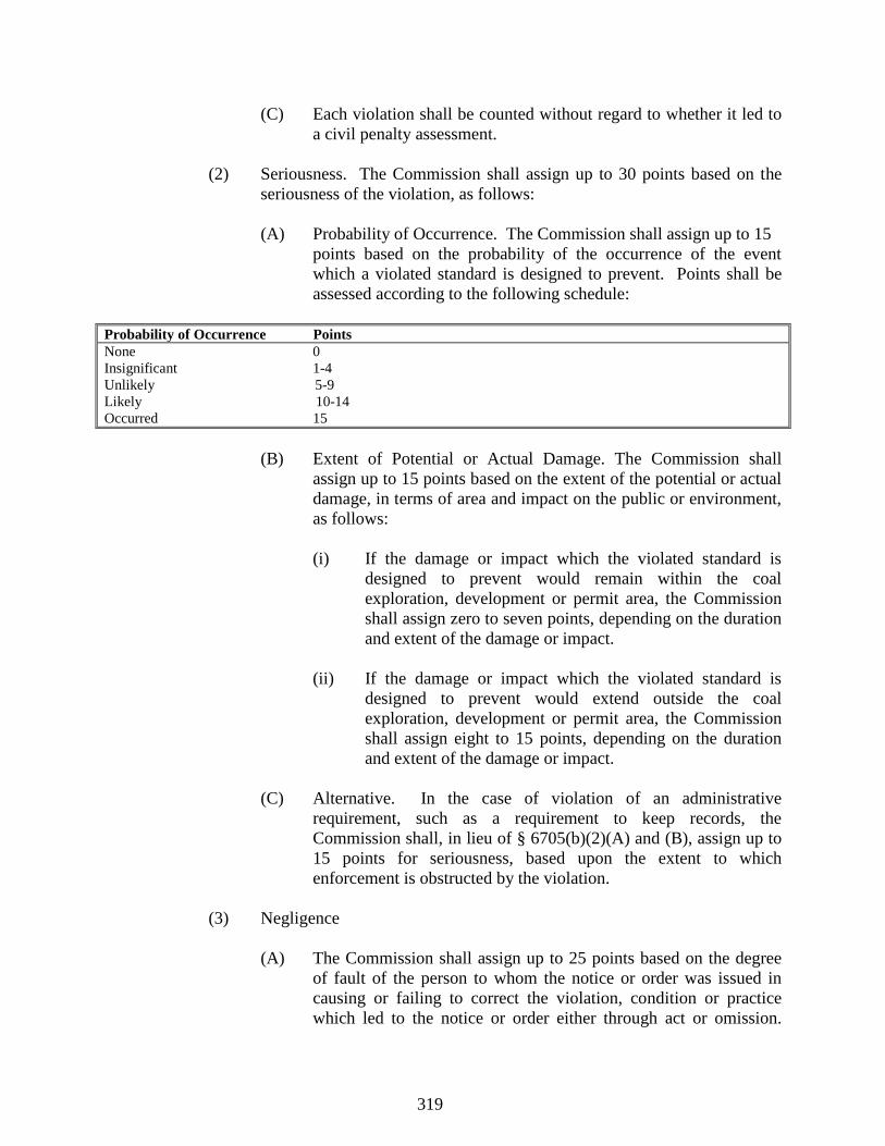
319
(C) Each violation shall be counted without regard to whether it led to
a civil penalty assessment.
(2) Seriousness. The Commission shall assign up to 30 points based on the
seriousness of the violation, as follows:
(A) Probability of Occurrence. The Commission shall assign up to 15
points based on the probability of the occurrence of the event
which a violated standard is designed to prevent. Points shall be
assessed according to the following schedule:
Probability of Occurrence Points
None 0
Insignificant 1-4
Unlikely 5-9
Likely 10-14
Occurred 15
(B) Extent of Potential or Actual Damage. The Commission shall
assign up to 15 points based on the extent of the potential or actual
damage, in terms of area and impact on the public or environment,
as follows:
(i) If the damage or impact which the violated standard is
designed to prevent would remain within the coal
exploration, development or permit area, the Commission
shall assign zero to seven points, depending on the duration
and extent of the damage or impact.
(ii) If the damage or impact which the violated standard is
designed to prevent would extend outside the coal
exploration, development or permit area, the Commission
shall assign eight to 15 points, depending on the duration
and extent of the damage or impact.
(C) Alternative. In the case of violation of an administrative
requirement, such as a requirement to keep records, the
Commission shall, in lieu of § 6705(b)(2)(A) and (B), assign up to
15 points for seriousness, based upon the extent to which
enforcement is obstructed by the violation.
(3) Negligence
(A) The Commission shall assign up to 25 points based on the degree
of fault of the person to whom the notice or order was issued in
causing or failing to correct the violation, condition or practice
which led to the notice or order either through act or omission.
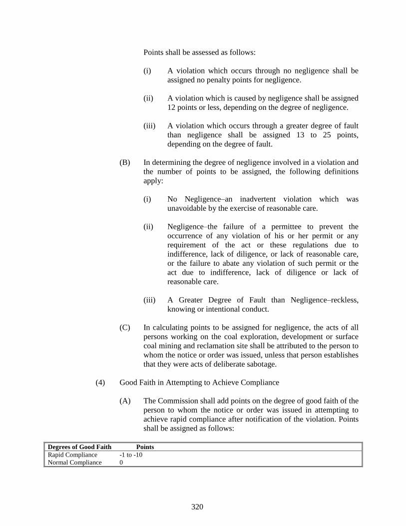
320
Points shall be assessed as follows:
(i) A violation which occurs through no negligence shall be
assigned no penalty points for negligence.
(ii) A violation which is caused by negligence shall be assigned
12 points or less, depending on the degree of negligence.
(iii) A violation which occurs through a greater degree of fault
than negligence shall be assigned 13 to 25 points,
depending on the degree of fault.
(B) In determining the degree of negligence involved in a violation and
the number of points to be assigned, the following definitions
apply:
(i) No Negligence–an inadvertent violation which was
unavoidable by the exercise of reasonable care.
(ii) Negligence–the failure of a permittee to prevent the
occurrence of any violation of his or her permit or any
requirement of the act or these regulations due to
indifference, lack of diligence, or lack of reasonable care,
or the failure to abate any violation of such permit or the
act due to indifference, lack of diligence or lack of
reasonable care.
(iii) A Greater Degree of Fault than Negligence–reckless,
knowing or intentional conduct.
(C) In calculating points to be assigned for negligence, the acts of all
persons working on the coal exploration, development or surface
coal mining and reclamation site shall be attributed to the person to
whom the notice or order was issued, unless that person establishes
that they were acts of deliberate sabotage.
(4) Good Faith in Attempting to Achieve Compliance
(A) The Commission shall add points on the degree of good faith of the
person to whom the notice or order was issued in attempting to
achieve rapid compliance after notification of the violation. Points
shall be assigned as follows:
Degrees of Good Faith Points
Rapid Compliance -1 to -10
Normal Compliance 0
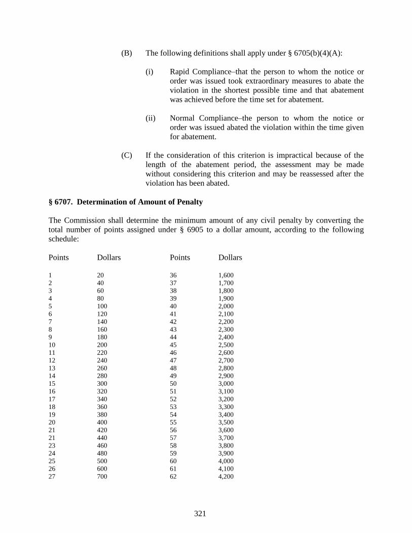
321
(B) The following definitions shall apply under § 6705(b)(4)(A):
(i) Rapid Compliance–that the person to whom the notice or
order was issued took extraordinary measures to abate the
violation in the shortest possible time and that abatement
was achieved before the time set for abatement.
(ii) Normal Compliance–the person to whom the notice or
order was issued abated the violation within the time given
for abatement.
(C) If the consideration of this criterion is impractical because of the
length of the abatement period, the assessment may be made
without considering this criterion and may be reassessed after the
violation has been abated.
§ 6707. Determination of Amount of Penalty
The Commission shall determine the minimum amount of any civil penalty by converting the
total number of points assigned under § 6905 to a dollar amount, according to the following
schedule:
Points Dollars Points Dollars
1 20 36 1,600
2 40 37 1,700
3 60 38 1,800
4 80 39 1,900
5 100 40 2,000
6 120 41 2,100
7 140 42 2,200
8 160 43 2,300
9 180 44 2,400
10 200 45 2,500
11 220 46 2,600
12 240 47 2,700
13 260 48 2,800
14 280 49 2,900
15 300 50 3,000
16 320 51 3,100
17 340 52 3,200
18 360 53 3,300
19 380 54 3,400
20 400 55 3,500
21 420 56 3,600
21 440 57 3,700
23 460 58 3,800
24 480 59 3,900
25 500 60 4,000
26 600 61 4,100
27 700 62 4,200
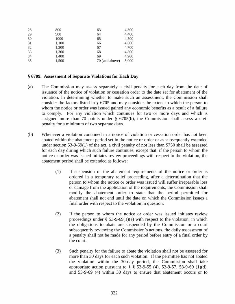
322
28 800 63 4,300
29 900 64 4,400
30 1000 65 4,500
31 1,100 66 4,600
32 1,200 67 4,700
33 1,300 68 4,800
34 1,400 69 4,900
35 1,500 70 (and above) 5,000
§ 6709. Assessment of Separate Violations for Each Day
(a) The Commission may assess separately a civil penalty for each day from the date of
issuance of the notice of violation or cessation order to the date set for abatement of the
violation. In determining whether to make such an assessment, the Commission shall
consider the factors listed in § 6705 and may consider the extent to which the person to
whom the notice or order was issued gained any economic benefits as a result of a failure
to comply. For any violation which continues for two or more days and which is
assigned more than 70 points under § 6705(b), the Commission shall assess a civil
penalty for a minimum of two separate days.
(b) Whenever a violation contained in a notice of violation or cessation order has not been
abated within the abatement period set in the notice or order or as subsequently extended
under section 53-9-69(1) of the act, a civil penalty of not less than $750 shall be assessed
for each day during which such failure continues, except that, if the person to whom the
notice or order was issued initiates review proceedings with respect to the violation, the
abatement period shall be extended as follows:
(1) If suspension of the abatement requirements of the notice or order is
ordered in a temporary relief proceeding, after a determination that the
person to whom the notice or order was issued will suffer irreparable loss
or damage from the application of the requirements, the Commission shall
modify the abatement order to state that the period permitted for
abatement shall not end until the date on which the Commission issues a
final order with respect to the violation in question.
(2) If the person to whom the notice or order was issued initiates review
proceedings under § 53-9-69(1)(e) with respect to the violation, in which
the obligations to abate are suspended by the Commission or a court
subsequently reviewing the Commission’s actions, the daily assessment of
a penalty shall not be made for any period before entry of a final order by
the court.
(3) Such penalty for the failure to abate the violation shall not be assessed for
more than 30 days for each such violation. If the permittee has not abated
the violation within the 30-day period, the Commission shall take
appropriate action pursuant to § § 53-9-55 (4), 53-9-57, 53-9-69 (1)(d),
and 53-9-69 (4) within 30 days to ensure that abatement occurs or to

323
ensure that there will not be a reoccurrence of the failure to abate.
§ 6711. Waiver of Use of Formula to Determine Civil Penalty
(a) The Commission, upon its own initiative, at the request of the Department, or upon
written request received within 15 days of issuance of a notice of violation or a cessation
order, may waive the use of the formula contained in § § 6705 and 6707 to set the civil
penalty, if the Commission determines that, taking into account exceptional factors
present in the particular case, the penalty is demonstrably excessive or inadequate. Cause
for waiving the formula in order to increase the penalty may include, solely by way of
example and without limitation, a demonstration that the violation occurred in willful and
knowing disregard of any law, regulation, order, or permit condition, a demonstration that
the violation caused significant harm to human health and/or the environment, or a
demonstration that the violator incurred significant economic benefit as a result of the
noncompliance. However, the Commission shall not waive the use of the formula or
reduce the proposed assessment on the basis of an argument that a reduction in the
proposed penalty could be used to abate violations of the act, these regulations, or any
condition of any permit or exploration approval. The basis for every waiver shall be fully
explained and documented in the records of the case.
(b) If the Commission waives the use of the formula, it shall use the criteria set forth in §
6705(b) and in § 49-17-43 to determine the appropriate penalty. When the Commission
has elected to waive the use of the formula, it shall give a written explanation of the basis
for the assessment made to the person to whom the notice or order was issued.
§ 6713. Procedures for Assessment of Civil Penalties
(a) Within 15 days of service of a notice or order, the person to whom it was issued may
submit written information about the violation to the Department and to the inspector
who issued the notice of violation or cessation order. The Commission shall consider any
information so submitted in determining the facts surrounding the violation and the
amount of the penalty.
(b) The Department shall serve a copy of the proposed assessment and of the worksheet
showing the computation of the proposed assessment on the person to whom the notice or
order was issued, by certified mail, within 30 days of the issuance of the notice or order.
If the mail is tendered at the address of that person set forth in the sign required under §
5301, or at any address at which that person is in fact located, and he or she refuses to
accept delivery of or to collect such mail, the requirements of this Subsection shall be
deemed to have been complied with upon such tender.
(c) Failure by the Department to serve any proposed assessment within 30 days shall not be
grounds for dismissal of all or part of such assessment unless the person against whom
the proposed penalty has been assessed:
324
(1) proves actual prejudice as a result of the delay; and
(2) makes a timely objection to the delay. An objection shall be timely only if
made in the normal course of administrative review.
(d) Unless the Department and the permittee reach agreement on the amount of the penalty,
the Department shall issue a complaint letter pursuant to § 53-9-55(1) and (2) scheduling
the matter for a formal hearing before the Commission.
(e) The order of the Commission in the matter shall determine the penalty, if any, shall state
the Commission’s findings of fact and conclusions of law used as a basis for assessing
the penalty, if any, and shall determine the date the penalty is due to be paid by the
permittee.
(f) Any party aggrieved by the decision of the Commission may appeal the matter pursuant
to § § 53-9-77 and 53-9-55(3). Upon the issuance of an order finding that a violation has
occurred, the person found to be in violation s shall have thirty (30) days to pay the
proposed penalty in full or, if the person wishes to appeal either the amount of the penalty
or the fact of the violation or both, to forward the proposed amount as a penalty payment
bond to the executive director for placement in as escrow account. The executive
director shall forward any money submitted for placement in an escrow account that is a
fully insured interest-bearing account. If, through administrative or judicial review of the
violation or proposed penalty, the Commission or a court of appropriate jurisdiction
determines that no violation occurred or that the amount of the penalty should be
reduced, the executive director shall within thirty (30) days remit the appropriate amount
to the person with any interest earned on the money while in escrow. The rate of interest
shall be the prevailing Department of Treasury rate. Failure to forward the proposed
penalty amount to the executive director within thirty (30) days shall result in a waiver of
all legal rights to contest the violation or the amount of the penalty.
Source: Miss. Code Ann. §§ 53-9-55, 53-9-67 and 53-9-1, et seq.
Rule 69. Individual Civil Penalties
§ 6901. When an Individual Civil Penalty May Be Assessed
The Commission may assess an individual civil penalty against any corporate director, officer or
agent of a corporate permittee who knowingly and willfully authorized, ordered or carried out a
violation, failure or refusal. The Commission shall not assess an individual civil penalty in
situations resulting from a permit violation by a corporate permittee until a cessation order has
been issued by the Commission to the corporate permittee for the violation, and the cessation
order has remained unabated for thirty (30) days.
§ 6903. Amount of Individual Civil Penalty
325
(a) In determining the amount of an individual civil penalty assessed under § 6901, the
Commission shall consider the criteria specified in § 49-17-43 and § 53-9-55 (2), as well
as the following:
(1) the individual's history of authorizing, ordering or carrying out previous
violations, failures or refusals at the particular surface coal mining
operation;
(2) the seriousness of the violation, failure or refusal (as indicated by the
extent of damage and/or the cost of reclamation), including any irreparable
harm to the environment and any hazard to the health or safety of the
public; and
(3) the demonstrated good faith of the individual charged in attempting to
achieve rapid compliance after notice of the violation, failure or refusal.
(b) The penalty shall not exceed $25,000 for each violation. Each day of a continuing
violation may be deemed a separate violation and the Commission may assess a separate
individual civil penalty for each day the violation, failure or refusal continues, from the
date of service of the underlying notice of violation, cessation order or other order
incorporated in a final decision issued by the Commission until abatement or compliance
is achieved.
§ 6905. Procedure for Assessment of Individual Civil Penalty
The Department and Commission shall follow the procedure set forth in § 6713 in the
assessment of the individual civil penalty.
§ 6907. Payment of Penalty
(a) If an individual does not appeal the Commission’s order imposing an individual civil
penalty, the penalty shall be due ten (10) day from the issuance of the order.
(b) If an individual named in a notice of proposed individual civil penalty assessment files a
petition for review, the penalty shall be due ten (10) days after issuance by the reviewing
court of a judgment affirming the penalty.
Source: Miss. Code Ann. §§ 53-9-11, 53-9-55, 53-9-67 and 53-9-1, et seq.
Rule 71. Petitions for Award of Costs and Expenses
§ 7101. Who May File
Any person may file a petition for award of costs and expenses including attorney's fees
reasonably incurred as a result of that person's participation in any administrative proceeding
under the act which results in a final order being issued by the Commission or in a permit action
326
or bond release action being taken by the Permit Board.
§ 7103. Where to File; Time for Filing
The petition for an award of costs and expenses including attorneys' fees must be filed with the
Commission or Permit Board within 45 days of receipt of such order or of notice of such permit
action or bond release action. Failure to make a timely filing of the petition may constitute a
waiver of the right to such an award.
§ 7105. Contents of Petition
(a) A petition filed under this Section shall include the name of the person from whom costs
and expenses are sought and the following shall be submitted in support of the petition:
(1) an affidavit setting forth in detail all costs and expenses including
attorneys' fees reasonably incurred for, or in connection with, the person's
participation in the proceeding;
(2) receipts or other evidence of such costs and expenses; and
(3) where attorneys' fees are claimed, evidence concerning the hours
expended on the case, the customary commercial rate of payment for such
services in the area, and the experience, reputation and ability of the
individual or individuals performing the services.
§ 7107. Answer
Any person served with a copy of the petition shall have 30 days from service of the petition
within which to file an answer to such petition.
§ 7109. Who May Receive an Award
Appropriate costs and expenses including attorneys' fees may be awarded:
(a) to any person from the permittee, if the person initiates any administrative
proceedings reviewing enforcement actions, upon a finding that a
violation of the act, regulations or permit has occurred, or that an
imminent hazard existed, or to any person who participates in an
enforcement proceeding where such a finding is made if the Commission
determines that the person made a substantial contribution to the full and
fair determination of the issues and that prior to the person’s involvement,
the Department had not commenced or was not diligently pursuing an
administrative or civil enforcement action regarding the matter, which
may include an inspection of the surface coal mining and reclamation
operation in response to a complaint;
327
(b) to any person other than a permittee or his representative from the
Department, if the person initiates or participates in any proceeding under
the act, upon a finding by the Commission or Permit Board, as
appropriate, that the person made a substantial contribution to a full and
fair determination of the issues and that the person substantially prevailed
in the proceeding;
(c) to a permittee from the Department when the permittee demonstrates and
the Commission finds that the Department issued or recommended that the
Commission issue an order of cessation, a notice of violation, or an order
to show cause why a permit should not be suspended or revoked, in bad
faith and for the purpose of harassing or embarrassing the permittee;
(d) to a permittee from any person where the permittee demonstrates that the
person initiated an administrative proceeding under the act or participated
in such a proceeding in bad faith for the purpose of harassing or
embarrassing the permittee; or
(e) to the Department where it demonstrates that any person applied for
administrative or judicial review of a Department, Permit Board, or
Commission decision made under the act or that any party participated in
such a proceeding in bad faith and for the purpose of harassing or
embarrassing the government.
§ 7111. Awards
An award under these Sections may include:
(a) all costs and expenses including attorneys' fees and expert witness fees,
reasonably incurred as a result of initiation and/or participation in a
proceeding under the act; and
(b) all costs and expenses, including attorneys' fees and expert witness fees,
reasonably incurred in seeking the award.
§ 7113. Appeal
Any person aggrieved by a decision concerning the award of costs and expenses in an
administrative proceeding under this act may appeal such award pursuant to § 53-9-77.
APPENDIX A
TO THE REGULATIONS GOVERNING SURFACE COAL MINING IN MISSISSIPPI
328
REVEGETATION SUCCESS STANDARDS
INDEX
Rule 1. Phase III Revegetation Success Standards for Commercial Forest Land
Rule 2. Phase III Revegetation success Standards for Cropland
Rule 3. Phase III Revegetation success Standards for Industrial or Commercial Land
Rule 4. Phase III Revegetation success Standards for Pasture and Previously Mined Areas
Rule 5. Phases II/III Revegetation Success Standards for Prime Farmland
Rule 6. Phase III Revegetation Success Standards for Recreation Land
Rule 7. Phase III Revegetation Success Standards for Residential Land
Rule 8. Phase III Revegetation Success Standards for Wildlife Habitat
ADDENDA
Addendum A. Selection of Random Sampling Sites
Table 1 - A Set of Random Numbers
Figure 1 - Random Sample Locations Grid Overlay
Addendum B. Productivity: Summary Data Form for Sampling Frames
Addendum C. Cover: Part 1. Line Point Transect Data Summary Sheet
Addendum C. Cover: Part 2. Line Point transect Sheet
Addendum D. Data Form for Row Crop Production Data
Addendum E. Statistical Analysis on Ground Cover Measurements
Addendum F. Density: Part 1. Sampling Circles Summary sheet
Addendum F. Density: Part 2. Sampling Circles Data Sheet
Addendum G. Values with a one-tailed t distribution for various degrees of freedom
Addendum H. Statistical Analysis on Tree and shrub Stocking Measurements
Addendum I. Example Use of Sample Adequacy Formula for Ground Cover Measurement
329
Addendum J. Example Use of Sample Adequacy Formula for Hay Production Measurements
Addendum K. Example Use of Sample Adequacy Formula for Tree and Shrub Counts
Addendum L. Statistical Analysis on Ground Cover Measurements
Addendum M. Statistical Analysis on Tree and Shrub Stocking Measurements
Addendum N. Statistical Analysis on Sampling Frame Data
Addendum O. Data Form for Forage Crop Production Data Harvested as Baled Hay
Addendum P. Statistical Analysis on Whole Release Area Harvesting
Addendum Q. Yield Adjustments for Release Areas Due to Differing Soil Series
Addendum R. Yield Adjustment for Moisture
Addendum S. Crop Surveyor’s Affidavit of Qualifications and Crop production Yields 92
Addendum T. Federal noxious Weed list
List of Federal noxious Weeds Found in Mississippi
List of Federal Noxious Weeds Probable to Mississippi
Addendum U. Procedure for Manually Sampling Row Crops
Addendum V. Summary Data Form for Line-Point Transects
Addendum W. Pastureland and Grazing Land Forage Production Standards for Post Mined Soils
Addendum X. References
330
Rule 1. Phase III Revegetation Success Standards for Commercial Forest Land
I. Introduction
II. General Revegetation Requirements
III. Success Standards and Measurement Frequency
A. Ground Cover
B. Tree/Shrub Stocking
IV. Sampling Procedures
A. Random Sampling
B. Sampling Techniques
C. Sample Adequacy
V. Data Analysis
VI. Maps
VII. Mitigation Plan
I. Introduction
This policy describes the criteria and procedures for determining Phase III success standards for
areas being restored to commercial forest land.
Revegetation success on commercial forest land must be determined on the basis of the
following conditions:
A. General revegetation requirements of the approved permit;
B. Ground cover; and
C. Tree/shrub stocking and survival.
The permittee is responsible for measuring the vegetation and for submitting the data to the
Department for analysis. Measurements of the vegetation must be made in accordance with the
procedures outlined in this document.

331
II. General Revegetation Requirements
The general requirements for revegetation shall be considered satisfied upon the determination
by the Permit Board that:
A. The permittee has established on regraded areas and all other disturbed areas, except
water areas, surface areas of roads and areas around buildings that are approved as part of
the postmining land use, a vegetative cover that is in accordance with the approved
reclamation plan in the approved permit and that is:
1. diverse, effective, and permanent;
2. comprised of species native to the area, or of introduced species which are
necessary to achieve the postmining land use and approved by the regulatory
authority;
3. at least equal in extent of cover to the natural vegetation of the area; and
4. capable of stabilizing the soil surface from erosion.
B. The Permit Board must also make the determination that the reestablished plant
species are:
1. compatible with the approved postmining land use;
2. of the same seasonal characteristics of growth as the original vegetation;
3. capable of self-regeneration and plant succession;
4. compatible with the plant and animal species of the area; and
5. allowed for planting under applicable state and federal laws and regulations
which control the growth of poisonous and noxious plants and introduced species.
III. Success Standards and Measurement Frequency
A. Ground Cover
1. Ground cover shall be considered acceptable if it is at least equal to ninety
percent of the approved success standard at a ninety percent statistical confidence
level (one sided test with a .10 alpha error) for the last year of the five year
responsibility period. The success standard for commercial forest land ground
cover shall be a ground cover density of seventy percent .
2. The aggregate of areas with less than seventy percent ground cover must not
exceed five percent of the release area. These areas must not be larger than 1 acre
332
and must be completely surrounded by desirable vegetation which has a ground
cover of seventy percent. Areas void of desirable vegetation may not be larger
than one quarter of an acre and must be surrounded by desirable vegetation which
has a ground cover of seventy percent.
3. The ground cover shall be sampled once during the last year of the five year
responsibility period.
4. No more than thirty-five percent of the stand can consist of volunteer species
not listed in Addendum T.
B. Tree and Shrub Stocking Rate
1. The stocking rate for trees and shrubs shall be determined on a specific permit
basis with consultation and approval of the Mississippi Forestry Commission.
The five year responsibility period may begin when the following requirements
are met.
a. The tree or shrub shall be in place at least two growing seasons.
b. The tree or shrub shall be alive and healthy.
c. The tree or shrub shall have at least one-third of its length in live
crown.
d. The number of woody plants established shall be equal to or greater
than ninety percent of the stocking rate approved in the permit.
2. The tree and shrub stocking rate shall be sampled again during the last year of
the five year responsibility period.
3. The stocking shall be considered successful if it is equal to or greater than
ninety percent of the stocking rate approved in the permit with ninety percent
statistical confidence at the time of final bond release. At least eighty percent of
the trees and shrubs used to determine success shall have been in place for sixty
percent of the applicable minimum period of responsibility. The operator may not
interplant trees within two years of doing sampling for final release.
IV. Sampling Procedures
A. Random Sampling
1. To assure that the samples truly represent the vegetative characteristics of the
whole release or reference area, the permittee must use methods that will provide
1) a random selection of sampling sites, 2) a sampling technique unaffected by the
333
sampler's preference, and 3) sufficient samples to represent the true mean of the
vegetation characteristics.
2. Sampling points shall be randomly located by using a grid overlay on a map of
the release or reference area and by choosing horizontal and vertical coordinates
as described in Addendum A. Each sample point must fall within the release area
boundaries and be within an area having the vegetative cover type being
measured. Additionally, if the release area does not consist of a single unit, at
least one sample point must be measured in each noncontiguous unit.
3. The permittee shall notify the Office of Geology ten days prior to conducting
sampling or other harvesting operations to allow any authorized representative of
the Department an opportunity to monitor the sampling procedures.
B. Sampling Techniques
1. Ground cover shall be measured as the area covered by the combined aerial
parts of the plant species approved in the permit, and the leaf litter that is
produced naturally onsite, expressed as a percentage of the total area of
measurement. Ground cover derived from parts of the plant species approved in
the permit, and the leaf litter that is produced naturally onsite may be up to ninety-
five percent of the total.
2. Trees and shrubs shall be measured as the number of countable approvable
woody stems, expressed as stems per acre for the total area of measurement.
3. Because ground cover and tree/shrub density are measured differently, the
techniques for sampling each must also be different. For ground cover, the
permittee will count and identify species using a line-point transect method.
Trees and shrubs will be measured using randomly selected one-fiftieth of an acre
sampling circles. Refer to Addenda A, F and I.
4. Each transect or sampling circle must be entirely within a homogeneous area
that accurately represents the vegetative cover type being measured. Samples
must be taken in pure vegetation types and not in transition zones between
adjacent types. Also, the sample sites must be located so they avoid the effects of
neighboring vegetation types, roads, stream courses, ponds, etc.
a. Line-Point Transect (Ground Cover)
A line-point transect shall be a series of 100 points spaced one foot apart
along a straight line. The permittee shall establish a transect at each of the
randomly selected sampling points. The direction of the transect shall also
be determined randomly. This can be done as easily as spinning a pencil
on a clipboard or throwing the pencil up in the air and using the direction
where it points.
334
The permittee shall classify the ground cover at each 1-foot interval along
the entire length of the transect (starting at 1 foot from the random point).
The area of measurement shall be a line projected downward and
perpendicular to the ground at each one foot interval (100 in total).
At each point along the transect, ground cover shall be classified by
species as acceptable or unacceptable as follows, except that as long as
there is sufficient cover to adequately control erosion, any volunteer
species not on the state and Federal Noxious Weeds List (Addendum T) is
acceptable:
Acceptable Unacceptable
Vegetation approved Rock or bare ground
in permit
Vegetation and litter
Dead vegetation or litter from list in Addendum T
from acceptable species
All data gathered from the line-point transects shall be recorded in the
format shown in Addendum C, Part 2.
b. Sampling Circles (Trees/Shrubs)
A sampling circle shall be a round area one-fiftieth of an acre in size (16.7
feet in radius). The permittee shall establish a sampling circle at each of
the randomly selected sampling points, such that the center of the
sampling circle is the random point. Permittee may draw the circle by
attaching a 16.7 foot string to a stake fixed at the random point and then
sweeping the end of the string (tightly stretched) in a circle around the
stake. The permittee shall count all living trees and shrubs within each of
the sampling circles. In more mature tree/shrub areas, the stakes may need
to be extended to elevate the string above the growth.
To count as a living tree or shrub, the tree or shrub must be alive and
healthy; must have been in place for at least two years; and must have at
least one-third of its length in live crown. At the time of bond release, 80
percent must have been in place for three years. The operator may not
replant or interplant within two years of sampling for final release.
All data gathered from the sampling circles shall be recorded in the format
presented in Addendum F.
C. Sample Adequacy.
Refer to Addenda I and K for sample adequacy.
335
V. Data Analysis
If the data show that revegetation success has been met, the permittee shall submit the data to the
Department for review in the format shown in Addenda C and F within four months of
collection.
When the data indicate that the average ground cover and/or tree and shrub average stocking
density is insufficient, but close to the standards, the permittee may submit the calculations to the
Department that demonstrates that the vegetation is acceptable when statistically compared to the
standards using a 90 percent statistical confidence interval. Addenda E and H explain how the
statistical analysis will be performed.
VI. Maps
A. Whenever a new Phase III plan is submitted to the Permit Board, it must be
accompanied by maps showing the location of the area proposed for release covered by
the plan.
B. Whenever data from a previously approved plan are submitted to the Permit
Board, it must be accompanied by maps showing:
1. The location of each transect and sample frame point.
2. The area covered by the sampling.
3. All permit boundaries.
VII. Mitigation Plan
Ground cover must be greater than or equal to seventy percent coverage, and tree and shrub
stocking must achieve the standards set in the permit, the fifth year following completion of the
initial seeding. If they do not achieve these standards, the permittee must submit a mitigation
plan to the Permit Board which includes the following:
1. a statement outlining the problem;
2. a discussion of what practices, beyond normal agronomic practices, the
operator intends to use to enable the area to finally meet the release standards; and
3. A new Phase III liability release plan.
If renovation, soil substitution or any other practice which constitutes augmentation is employed,
the five-year responsibility period begins again.
Source: Miss. Code Ann. §§ 53-9-11 and 53-9-1, et seq.
336
Rule 2. Phase III Revegetation Success Standards for Cropland
I. Introduction
II. Success Standards and Measurement Frequency
A. Ground Cover
B. Crop Production
C. Selection of Success Standard
III. Sampling Procedures
A. Random Sampling
B. Sampling Techniques
1. Sampling Frames
2. Whole Area Harvesting
3. Manual Sampling on Row Crops
C. Representative Test Plots
D. Reference Areas
E. Other Requirements for Productivity Testing on Cropland
IV. Data Submission and Analysis
V. Maps
VI. Mitigation Plan
I. Introduction
This policy describes the criteria and procedures for determining Phase III success standards for
areas being restored to cropland.
Ground cover and soil productivity success of revegetation on cropland, shall be determined on
the basis of crop production. The permittee is responsible for determining and measuring
production, and submitting this data to the Department for evaluation. Procedures for making
these determinations are described in this document.
337
II. Success Standards and Measurement Frequency
A. General Revegetation Requirement for Ground Cover
1. Following cropland soil replacement, the soil surface shall be stabilized with a
vegetative cover or other means that effectively controls soil loss by wind and
water erosion.
2. Ground cover shall consist of the species or species mixture which has been
approved in the permit. Unacceptable plant species are listed in Addendum T.
Whenever the cropland is planted to a perennial cover, then up to thirty-five
percent of the cover may consist of volunteer species not listed in Addendum T.
B. Crop Production on Cropland
1. The success standard for cropland shall be determined on the basis of crop
production. Crop production shall be considered successful if it is not less than
ninety percent of the production of the approved success standard with a ninety
percent statistical confidence interval.
Crop production shall be measured for any two (2) of the last four (4) years of the
five (5) year responsibility period. Hay may be used twice, but other crops
commonly grown in the area may also be used.
2. Crop Production for cropland shall be determined by one of the following
methods:
a. Randomly selected representative samples, see Addenda A, B, J, N, Q,
and S.
b. Whole site harvest, see Addenda D, O, P, Q, R, and S.
c. Representative test plots, see Addenda A, B, D, J, O, P, Q, R, and S.
C. Selection of Success Standard
1. The sampling techniques shall use a ninety percent statistical confidence
interval (i.e., one sided test with a .10 alpha error).
2. Whenever production is equal to or exceeds ninety percent of the approved
standard, the statistical confidence interval test does not have to be performed.
3. Areas selected for the success standard or reference area for production shall:
a. consist of similar plant species and diversity as approved in the permit.
338
b. currently be managed under the same land use designation as the
proposed mined release area.
c. consist of soils of the same or similar texture, slope phase, similar soil
series, and be in the same land capability class.
d. receive the same high level of management using acceptable, approved
practices common to the area.
e. be located in the general vicinity of the mined test area to eliminate
weather variations.
4. If the permittee chooses to use a technical standard for determination of crop
productivity, the permittee shall use the most current United States Department of
Agriculture/Natural Resources Conservation Service soil survey for the county
where the mining operation is located. Actual crop specific yield will be those
from Table 5 of the county soil survey.
5. County average yields will vary from year to year because of fluctuations in
the local weather patterns. Because of this variability, target yields must be
adjusted by the USDA/NRCS each year that data is submitted. The target yields
shall be representative of yields expected when using high management practices
common to the area.
III. Sampling Procedures
A. Random Sampling
1. To assure that the samples truly represent the vegetative characteristics of the
whole release and reference area, the permittee must use methods that will
provide 1) a random selection of sampling sites, 2) a sampling technique
unaffected by the sampler's preference, and 3) sufficient samples to represent the
true mean of the vegetation characteristics.
2. Sampling points shall be randomly located by using a grid overlay on a map of
the release or reference area and by choosing horizontal and vertical coordinates
as described in Addendum A. Each sample point must fall within the release or
reference area boundaries and be within an area having the vegetative cover type
being measured. Additionally, if the release area does not consist of a single unit,
at least one sample point must be measured in each noncontiguous unit.
3. The permittee shall notify the Office of Geology ten days prior to conducting
sampling or other harvesting operations to allow any authorized representative of
the Department an opportunity to monitor the sampling procedures.
339
B. Sampling Techniques
1. Sampling Frames (Forage Production)
A sampling frame shall be an enclosure measuring 24" x 11-1/2" capable of
enclosing the sample location. A sample location shall be established at each of
the randomly chosen sites, such that the center of the sampling frame is the
random point. The permittee shall clip all the biomass within the sampling frame
2" above ground level. The biomass to be clipped shall be from all plant species
growth whose base lies within the sampling frame. This biomass shall then be
weighed and recorded. As each frame is clipped and weighed, the biomass shall
be put into a bag for later oven drying. Samples shall be oven dried to a constant
weight and re-weighed to determine dried weight. All data collected from the
clippings within the sampling frame shall be recorded in the format presented in
Addendum B.
2. Whole Area Harvesting (Forage Production or Row Crops)
If whole release area harvesting is chosen as the method for data collection, the
entire area or representative test plots shall be harvested and the system as outlined
in Addenda D, O, P, and Q shall be used for data analysis. This entails counting all
bales produced on the harvested areas and multiplying this number by the average
weight of a randomly selected number of bales. The number of bales to count and
weigh for any site would consist of ten percent, or fifteen large round bales,
whichever is greater; or ten percent or fifteen small round bales whichever is
greater and converted to lbs./ac by taking their average weight and multiplying that
figure times the total number of bales, divided by the number of acres harvested.
To determine which bales to weigh, randomly select a number from one to ten then
count and weigh every tenth bale thereafter until the minimum number or ten
percent of the bales have been weighed. The first and last bale of any
noncontiguous field or site should not be weighed. The bales shall be counted, but
if the random number falls on either of the two bales mentioned, either advance
one bale or select the immediate bale previous to the last bale produced.
If row crops are being used, the entire test plot will be harvested.
See Addenda I and K for sample adequacy.
3. Manual Sampling on Row Crops
If weather conditions or other factors prevent mechanical harvesting, the Permit
Board may approve a manual sampling method for row crops. Generally, this will
involve harvesting a statistically adequate number of randomly chosen measured
row lengths on the reference plot and the test plot. Operators will not be allowed to
340
use this system without the prior approval of the Permit Board. Testing procedures
will follow Addendum U for this sampling method.
C. Establishment of Representative Test Plots
The permittee may establish and harvest test plots to prove productivity if the
permittee can demonstrate that the test plot statistically represents the cropland
areas in the Phase III release area of which it is a part. Representative test plots
may not represent more than 400 acres. This can be demonstrated as follows:
Step 1 - Finding Statistically Representative Plots
1. In order for this system to be used, all the cropland areas which are being
considered for release must be in grass/legumes.
2. After twelve months have elapsed of the five year responsibility period, the
entire cropland area shall be sampled for hay production using the sample frame
procedure. A statistically adequate number of samples must be taken over the
entire cropland area, as outlined in Addenda A and J.
3. Additionally, several subareas of the cropland shall be chosen as possible
candidates for the representative test plots. These subareas must consist of a
minimum of three plots, no smaller than one acre each and total at least five
percent of the entire cropland acres or a combined total of four acres, whichever is
greater, of the area for which Phase III release is desired. These areas shall also be
sampled using the sample frame method and a statistically adequate number of
samples at a 0.1 alpha level.
4. Then, the data from the sample frame procedure of the entire cropland area shall
be statistically compared to the chosen subplots using a t-test, to determine if the
subplots are truly representative of the entire cropland area. If the first chosen
subplot fails the test, the next chosen subplot shall be compared, and so on, until
the required number of plots are found that have statistically equal production to
the entire cropland area. Variation of the subplots should not vary ten percent
more or less than the entire cropland area being considered representative of the
release area. It is suggested that enough subplots be chosen as prospective test
plots to guarantee there will be adequate acreage to statistically represent
production equal to the entire cropland area.
Step 2 - Use of the Test Plots
1. Once statistically representative test plots have been chosen, they shall become
the test plots which will represent all the cropland in a particular bond release.
2. The level of management on the reclaimed area must be the same as the level of
management on the area used to establish the success standard.
341
3. At harvest, the yields from the test plots shall be compared to the yields from
the reference plot to determine if the test plot yields are equal to ninety percent or
greater than the yield on the unmined cropland reference plot. The yield data from
the test plots and reference plot shall be recorded on a form as outlined in
Addendum D.
D. Reference Areas
Reference areas must be representative of soils, slope, aspect, and vegetation in the
pre-mined permit area. However, in cases where differences exist because of the
mixing of several soil series on the reclaimed area or unavailability of a reference
area as herein described, yields must be adjusted as outlined in Addendum Q. For
ease of calculation, this adjustment shall always be made to the reference area
yield.
Reference area crops must be under the same management as crops in the
reclaimed cropland area. This means:
- the same seed, fertilizer, and pest management techniques shall be used;
- fertilizer rates shall be based on the same yield goal;
- the same tillage methods shall be used for seedbed preparation;
- the same planting and harvest dates, row spacing, and plant populations shall be
used; and
- any other commonly used management techniques not listed above such as
adequate weed and insect control may be used provided the cropland test sites
and/or test plots, and the reference plot are treated identically.
Reference areas shall consist of a single plot (whole plot) at least four acres in size. Either
statistically adequate subsampling or whole plot harvesting may be used to determine
yields. All reference areas must have prior approval from the Permit Board before
production data can be used.
Reference plot crop yields must be reasonably comparable to the county average for the
given crop. Reference yields which are less than eighty percent of the county average are
highly suspect and may be rejected.
Reference areas may be used as a standard for several mines or bond release areas in the
vicinity, with prior approval of the Permit Board. Reference areas may be located on
undisturbed acreage within permitted areas. If not so located, the permittee must obtain
from the landowner(s) a written agreement allowing use of the property as a reference area
and allowing right of entry for any authorized representative of the Department.
342
When release areas and reference plots fall on different soil series, adjustments must be
made to compensate for the productivity difference. Section II of the NRCS Field Office
Technical Guide shall be used for this purpose. For ease of calculation, this adjustment
shall always be made to the reference area yield. Each reference plot sampling frame or
whole field reference plot yield must be adjusted before yield comparison or t-test
statistics may be calculated. See Addendum Q.
E. Other Requirements for Productivity Testing on Cropland.
Crops chosen for proving productivity on cropland must:
- be selected from crops commonly grown in the county. Hay may be used for
both of the two years.
- be fertilized and top-dressed according to soil tests;
- be comprised of certified seed, preferably a cultivar which is resistant to common
crop specific diseases (e.g., Phytophora root rot on soybeans).
- be properly inoculated with appropriate rhizobia. Herbaceous crops must be an
approved grass or grass and legume mixture;
- receive the same management practices as crops on unmined cropland in the
surrounding area. This includes proper application and timing of herbicides and
insecticides in general use in the surrounding area;
- have row crop yields adjusted for moisture (Addenda D and R). Moisture content
shall be documented by the individual performing the test and the method used
shall be identified. Furthermore, all crop yields must be verified by an individual
who is knowledgeable of agronomic practices but is not directly affiliated with the
mining company. An affidavit, which must be signed by the individual verifying
crop yields, must accompany any submitted yield data. Refer to Addendum S.
If row crops are used, all mechanically harvested row crop yield data must be
accompanied by:
- a weight ticket from a government certified scale, which
includes the name of the scale operator;
- a completed Crop Surveyor Affidavit as shown in Addendum S;
- a statement of the crop moisture content, the system used
to make that determination, and the name of the operator;
- copies of the soil amendment test reports and amounts of
amendments applied.
343
IV. Data Submission and Analysis
Refer to Addendum U for procedure to manually sample row crops. If the data show that
the average production success has been met, the permittee shall submit the data to the
Department in the format shown in Addenda B, D, and O.
When the data indicate that the average production was insufficient, but close to the
standards, the permittee may submit the data to the Department to determine if the
production was acceptable when statistically compared to the standards using a t-test at a
90 percent statistical confidence interval. (See Addenda N and P.)
Row crop and raw sampling frame yield data from reclaimed (mined) areas and reference
areas must be adjusted for moisture. (See Addendum R)
V. Maps
A. Whenever a new Phase III plan is submitted to the Permit Board, it must be
accompanied by maps showing:
1. the location of the area proposed for release covered by the plan;
2. the location of test and reference plots; and
3. all permit boundaries.
B. Whenever data from a previously approved plan are submitted to the Permit Board
it must be accompanied by maps showing:
1. the location of test and reference plots;
2. the location of each transect and sample frame point;
3. the area covered by the sampling; and
4. all permit boundaries.
VI. Mitigation Plan
Productivity must meet or exceed these standards at least two sampling years by the fifth
year. If productivity is not achieved by these dates, the permittee must submit a mitigation
plan to the Permit Board which includes the following:
A. a statement outlining the problem;
B. a discussion of what practices, beyond normal farming practices, the operator
intends to use to enable the area to finally meet the release standards; and
344
C. a new Phase III liability release plan.
If renovation, soil substitution, or any other practice which constitutes augmentation is
employed, the five-year responsibility period shall restart when the mitigation plan is approved
and the practices are completed.
Source: Miss. Code Ann. §§ 53-9-11 and 53-9-1, et seq.
Rule 3. Phase III Revegetation Success Standards for Industrial or Commercial Land
I. Introduction
II. General Revegetation Requirements
III. Success Standards and Measurement Frequency
A. Ground Cover
B. Sampling Period and Frequency
IV. Sampling Procedures
A. Random Sampling
B. Sampling Techniques
C. Sample Adequacy
V. Data Analysis
VI. Maps
VII. Mitigation Plan
I. Introduction
This policy describes the criteria and procedures for determining Phase III success standards for
areas being restored to an industrial or commercial land use.
These standards do not apply to areas such as buildings, parking lots, and roads which are part of
an industrial or commercial land use and are not intended to be vegetated. The revegetation
standards described here only apply to those parts of the industrial or commercial land use which
will require vegetative erosion control.
345
Revegetation success on industrial or commercial land use areas must be determined on the basis
of the following conditions:
- general revegetation requirements of the approved permit; and
- ground cover density.
The permittee is responsible for measuring the vegetation and for submitting the data to the
Department for analysis. Measurements of the vegetation must be made in accordance with the
procedures outlined in this document.
II. General Revegetation Requirements
The general requirements for revegetation shall be considered satisfied upon the determination
by the Department that:
A. The permittee has established on regraded areas and all other disturbed areas,
except water areas, and surface areas of roads and areas around buildings that are
approved as part of the postmining land use, a vegetative cover that is in
accordance with the reclamation plan in the approved permit and that is:
1. diverse, effective, and permanent;
2. comprised of species not listed in Addendum T, and which are necessary to
achieve the postmining land use and approved by the regulatory authority;
3. at least equal in extent of cover to the natural vegetation of the area; and
4. capable of stabilizing the soil surface from erosion.
B. The Department must also make the determination that the reestablished plant
species are:
1. compatible with the approved postmining land use;
2. of the same seasonal characteristics of growth as the original vegetation;
3. capable of self-regeneration and plant succession;
4. compatible with the plant and animal species of the area; and
5. allowed for planting under applicable State and Federal laws and regulations
which control the growth of poisonous and noxious plants and introduced species.
See Addendum T.
346
III. Success Standards and Measurement Frequency
A. Ground Cover
1. In areas developed for industrial or commercial land use within two years of
regrading, ground cover shall not be less than seventy percent at a ninety percent
statistical confidence level.
2. If the area is not developed for industrial or commercial use within two years of
regrading, any areas that are vegetated must be designated with another acceptable
land use and evaluated under the appropriate success standard.
3. The aggregate of areas with less than seventy percent ground cover must not
exceed five percent of the release area. These areas must not be larger than one
acre and must be completely surrounded by desirable vegetation which has a
ground cover of seventy percent. Areas void of desirable vegetation may not be
larger than one quarter of an acre and must be surrounded by desirable vegetation
which has a ground cover of seventy percent.
4. No more than thirty percent of the stand can be approved species not listed in
the permit.
B. Sampling Period and Frequency
1. Ground cover shall be sampled once during the last year of the five-year
responsibility period.
2. The permittee shall notify the Office of Geology ten days prior to conducting
sampling or other harvesting operations to allow any authorized representative of
the Department an opportunity to monitor the sampling procedures.
IV. Sampling Procedures
A. Random Sampling
1. To assure that the samples truly represent the vegetative characteristics of the
whole release area, the permittee must use methods that will provide 1) a random
selection of sampling sites, 2) a sampling technique unaffected by the sampler's
preference, and 3) sufficient samples to represent the true mean of the vegetation
characteristics.
2. Sampling points shall be randomly located by using a grid overlay on a map of
the release area and by choosing horizontal and vertical coordinates as described in
Addendum A. Each sample point must fall within the release area boundaries and
be within an area having the vegetative cover type being measured. Additionally,
347
at least one sample point must be measured in each noncontiguous unit, if the
release area does not consist of a single unit.
B. Sampling Techniques
1. Ground cover shall be measured as the area covered by the combined aerial
parts of the accepted plant species approved in the permit, and the litter that is
produced naturally onsite, expressed as a percentage of the total area of
measurement. Up to fifteen percent of the acceptable cover may be litter from
acceptable plant species.
2. A line-point transect shall be a series of 100 points spaced one foot apart along a
straight line. The permittee shall establish a transect at each of the randomly
selected sampling points. The direction of the transect shall also be determined
randomly. This can be done as easily as spinning a pencil on a clipboard, or
throwing the pencil up in the air and using the direction where it points.
3. The permittee shall identify the species or type of ground cover at each one foot
interval along the entire length of the transect (starting at one foot from the random
point). The area of measurement shall be a line projected downward and
perpendicular to the ground at each one foot interval (100 in total).
4. Each transect must be entirely within a homogeneous area that accurately
represents the vegetative cover type being measured. Samples must be taken in
pure vegetation types and not in transition zones between adjacent types. Also, the
sample sites must be located so they avoid the effects of neighboring vegetation
types, roads, stream courses, ponds, etc.
5. At each point along the transect, ground cover shall be classified by species as
acceptable or unacceptable as follows, except that as long as there is sufficient
cover to adequately control erosion, any volunteer species not on the state and
Federal Noxious Weeds List (Addendum T) is acceptable:
Acceptable Unacceptable
Vegetation approved Rock or bare ground
in permit
Vegetation or litter from
Dead vegetation or litter list in Addendum T
from acceptable species
6. All data gathered from the line-point transects shall be recorded in the format
shown in Addendum C.
C. Sample Adequacy
Refer to Addenda G, I and K for sample adequacy.
348
V. Data Analysis
A. If the data show that revegetation success has been met, the permittee shall submit
the data to the Department for review in the format shown in Addendum C within
four months of collection.
B. When the data indicate that the average ground cover density was insufficient, but
close to the standards, the permittee may submit the data to the Department to
determine if the vegetation is acceptable when statistically compared to the
standards using a ninety percent statistical confidence interval. Addendum L
explains how the statistical analysis shall be performed.
VI. Maps
A. Whenever a new Phase III plan is submitted to the Permit Board, it must be
accompanied by maps showing the location of the area proposed for release
covered by the plan.
B. Whenever data from a previously approved plan is submitted to the Permit Board,
it must be accompanied by maps showing:
1. the location of each transect;
2. the area covered by the sampling; and
3. all permit boundaries.
VII. Mitigation Plan
Ground cover must be greater than or equal to seventy percent coverage the fifth year following
completion of the last augmented seeding. If it is not, the permittee must submit a Mitigation
Plan to the Permit Board which includes the following:
A. a statement outlining the problem;
B. a discussion of what practices, beyond normal agronomic practices, the operator
intends to use to enable the area to finally meet the release standards; and
C. a new Phase III liability release plan.
If any practice which constitutes augmentation is employed, the five-year responsibility period
shall restart when the mitigation plan is approved and the practices are completed.
Source: Miss. Code Ann. §§ 53-9-11 and 53-9-1, et seq.
349
Rule 4. Phase III Revegetation Success Standards for Pasture and Previously Mined
Areas
I. Introduction
II. General Revegetation Requirements
III. Success Standards and Measurement Frequency
A. Ground Cover
B. Forage Production
C. Reference Area Requirements
IV. Sampling Procedures
A. Random Sampling
B. Sampling Techniques
1. Line Point Transect
2. Sampling Frames
3. Whole Area Harvesting
C. Representative Test Plots
D. Sample Adequacy
V. Data Submission and Analysis
VI. Maps
VII. Mitigation Plan
I. Introduction
This policy describes the criteria and procedures for determining Phase III ground cover and
production success for areas being restored to pasture and previously mined areas.
Ground cover and production success on pasture must be determined on the basis of the
following conditions:
- general revegetation requirements of the approved permit;
- ground cover density; and
350
- production.
The permittee is responsible for determining and measuring ground cover and production and
submitting this data to the Department for evaluation. Procedures for making these
determinations are described in this document.
For areas previously disturbed by mining that were not reclaimed to the standards of these
regulations and that are remined or otherwise redisturbed by surface coal mining operations, as a
minimum, the vegetative ground cover shall not be less than the ground cover existing before
redisturbance and shall be adequate to control erosion. This ground cover standard must have
been determined and incorporated into the permit prior to disturbance. There is no productivity
standard.
II. General Revegetation Requirements
The general requirements for revegetation shall be considered satisfied upon the determination
by the Department that:
A. The permittee has established on regraded areas and all other disturbed areas,
except water areas, surface areas of roads and areas around buildings that are
approved as part of the postmining land use, a vegetative cover that is in
accordance with the reclamation plan in the approved permit and that is:
1. diverse, effective, and permanent;
2. comprised of species native to the area, or of introduced species which are
desirable and allowable, not listed in Addendum T, and are necessary to achieve
the postmining land use and approved by the regulatory authority;
3. at least equal in extent of cover to the natural vegetation of the area; and
4. capable of stabilizing the soil surface from erosion.
B. The Department must also make the determination that the reestablished plant
species are:
1. compatible with the approved postmining land use;
2. of the same seasonal characteristics of growth as the original vegetation;
3. capable of self-regeneration and plant succession;
4. compatible with the plant and animal species of the area; and
351
5. allowed for planting under applicable state and federal laws and regulations
which control the growth of poisonous and noxious plants and introduced species.
See Addendum T.
III. Success Standards and Measurement Frequency
A. Ground Cover
1. Ground cover shall be considered acceptable if it is at least ninety percent of the
approved success standard at a ninety percent statistical confidence level for any
two of the last four years of the five year responsibility period. The success
standard for ground cover shall be ninety percent density. Other approved success
standards could be other areas that are representative of unmined lands in the area
being reclaimed or through the use of technical guidance procedures published by
the United States Department of Agriculture (USDA) or United States Department
of Interior (USDI) for assessing ground cover and productivity.
Ground cover must be measured over each noncontiguous area which is proposed
for release. The aggregate of areas with less than 90 percent ground cover must not
exceed five percent of the release area. These areas must not be larger than one
acre and must be completely surrounded by desirable vegetation which has a
ground cover of ninety percent. Areas void of desirable vegetation may not be
larger than one quarter of an acre and must be surrounded by desirable vegetation
which has a ground cover of ninety percent.
2. Ground cover shall consist of the species mixture which has been approved in
the original permit or an approved acceptable species mixture as recommended by
the USDA/Natural Resources Conservation Service (NRCS) for use in that area.
No more than fifteen percent of the stand can be approved species not listed in the
permit. If the area was previously mined, thirty-five percent can be approved
species not listed in the permit. See Addendum T for unacceptable plant species.
3. The sampling techniques for measuring success shall use a ninety percent
statistical confidence interval (i.e., one sided test with a .10 alpha error). Whenever
ground cover is equal to or exceeds the success standard, the statistical confidence
interval test does not have to be determined.
4. Ground cover success and forage production success need not be met during the
same year.
5. Ground cover shall be sampled twice during any two of the last four years of the
five-year responsibility period to verify cover data.
B. Forage Production
352
Production shall be considered acceptable if it is at least ninety percent of the
approved success standard, at a ninety percent statistical confidence level, for any
two of the last four years of the five year responsibility period. If a reference area
is used, the standard will be the annual crop yield for the reference area for the
same year that the yield for the release area is being measured. If the permittee
chooses to use a technical standard for determination of crop productivity, the
permittee shall use the most current USDA/NRCS soil survey for the county where
the mining operation is located. Actual crop specific yield will be from Table 5 of
the county soil survey. See Addendum W.
C. Reference Area Requirements
1. Reference areas must be representative of soils, slope, aspect, and vegetation in
the pre-mined permit area. In cases where differences exist because of mixing of
several soil series on the reclaimed area or unavailability of a reference area as
herein described, yields must be adjusted as outlined in Addendum Q.
Reference area pasture must be under the same management as pasture in the
reclaimed area.
This means:
a. They must consist of similar plant species and diversity as approved in
the permit;
b. They must be currently managed under the same land use designation
as the proposed mined release area;
c. They must consist of soils in the same land capability class;
d. They must be located in the general vicinity to the mined test area to
minimize weather fluctuations;
e. the same fertilizer and pest management techniques shall be used;
f. fertilizer rates shall be based on the same yield goal;
g. that, if the reference plot was mowed prior to sampling, the reclaimed
area must also have been mowed at the same time to the same height;
h. identical harvest dates, row spacing, and plant populations shall be
used; and
i. any other commonly used management techniques not listed above
such as adequate weed and insect control may be used provided the
pasture area and the reference plot are treated identically.
353
Reference areas shall consist of a single plot (whole plot) at least four acres in size.
Either statistically adequate subsampling or whole plot harvesting may be used to
determine yields.
Reference plot crop yields must be at a level which is reasonably comparable to the
county average for the given crop. Reference plot yields which are less than eighty
percent of the county average are highly suspect and may be rejected.
Reference areas may be used as a standard for several mines or bond release areas
in the vicinity, with prior approval of the Permit Board. Reference areas may be
located on undisturbed acreage within permitted areas. If not so located, the
permittee must obtain from the landowner(s) a written agreement allowing use of
the property as a reference area and allowing right of entry for any authorized
representative of the Department.
2. When release areas and reference plots fall on different soil series, adjustments
must be made to compensate for the productivity difference. Section II of the
NRCS Field Office Technical Guide shall be used for this purpose. For ease of
calculation, this adjustment shall always be made to the reference area yield. Each
reference plot sampling frame or whole field reference plot yield must be adjusted
before yield comparison or t-test statistics can be calculated. See Addenda B and
O.
IV. Sampling Procedures
A. Random Sampling
1. To assure that the samples truly represent the vegetative characteristics of the
whole release or reference area, the permittee must use methods that will provide:
a) a random selection of sampling sites,
b) a sampling technique unaffected by the sampler's preference, and
c) sufficient samples to represent the true mean of the vegetation
characteristics.
2. Sampling points shall be randomly located by using a grid overlay on a map of
the release or reference area and by choosing horizontal and vertical coordinates as
described in Addendum A. Each sample point must fall within the release or
reference area boundaries and be within an area having the vegetative cover type
being measured. Additionally, at least one ground cover sample point must be
measured in each noncontiguous unit, if the release area does not consist of a single
unit.
3. The permittee shall notify the Office of Geology ten days prior to conducting
sampling or other harvesting operations to allow any authorized representative of
the Department an opportunity to monitor the sampling procedures.
354
B. Sampling Techniques
1. Line Point Transect (Ground Cover)
A line point transect shall be a series of 100 points spaced one foot apart along a
straight line. The permittee shall establish a transect at each of the randomly
selected sampling points. The direction of the transect shall also be determined
randomly. This can be done as easily as spinning a pencil on a clipboard or
throwing the pencil in the air and using the direction where it points.
Ground cover shall be measured as the area covered by the combined aerial parts of
the accepted plant species and the litter that is produced naturally onsite, expressed
as a percentage of the total area of measurement. Up to fifteen percent of
acceptable cover may be litter from acceptable plant species.
The permittee shall classify the ground cover by species at each 1-foot interval
along the entire length of the transect (starting one foot from the random point).
The area of measurement shall be a line projected downward and perpendicular to
the ground at each one foot interval (100 in total).
At each point along the transect, ground cover shall be classified by species as
acceptable or unacceptable as follows, except that as long as there is sufficient
cover to adequately control erosion, any volunteer species not on the state and
Federal Noxious Weeds List (Addendum T) is acceptable:
Acceptable Unacceptable
Vegetation approved in permit Rock or bare ground
Dead vegetation or litter Vegetation or litter from
from acceptable species list in Addendum T
All data gathered from the line point transects shall be recorded in the format
shown in Addendum C, Part 2 and summarized in the format shown in Addendum
V.
2. Sampling Frames (Productivity)
A sampling frame shall be an enclosure measuring 24" x 11-1/2" capable of
enclosing the sample location. A sample location shall be established at each of
the randomly chosen sites, such that the center of the sampling frame is the random
point. The permittee shall clip the biomass 2" above ground level within the frame.
The biomass to be clipped shall be from all plant species growth whose base lies
within the sampling frame. This biomass shall then be weighed and recorded. As
each frame is clipped and weighed, the biomass shall be put into a bag for oven
355
drying. Samples shall be oven dried to a constant weight and re-weighed to
determine dried weight. All data collected from the clippings within the sampling
frame shall be recorded in the format presented in Addendum B.
3. Whole Area Harvesting (Productivity)
If whole release area harvesting is chosen as the method for data collection, the
entire area or representative test plots shall be harvested and the system as outlined
in Addenda O, P, and Q shall be used for data analysis. This entails counting all
bales produced on the harvested areas and multiplying this number by the average
weight of a randomly selected number of bales. The number of bales to count and
weigh for any site would consist of ten percent, or fifteen large round bales,
whichever is greater; or ten percent or fifteen small round bales whichever is
greater and converted to lbs./ac by taking their average weight and multiplying that
figure times the total number of bales, divided by the number of acres harvested.
To determine which bales to weigh, randomly select a number from one to ten then
count and weigh every tenth bale thereafter until the minimum number or ten
percent of the bales have been weighed. The first and last bale of any
noncontiguous field or site should not be weighed. The bales shall be counted, but
if the random number falls on either of the two bales mentioned, either advance
one bale or select the immediate bale previous to the last bale produced.
C. Representative Test Plots
The permittee may establish and harvest a test plot to prove productivity if it can be
demonstrated that the test plot statistically represents the pasture areas in the Phase III
release that it is a part of. No representative test plot may represent more than 400 acres.
This can be demonstrated as follows:
Step 1 - Finding Statistically Representative Plots
1. In order for this system to be used, all the pasture areas which are being considered for
release must be in grass/legumes.
2. After 12 months have elapsed of the five-year responsibility period, the entire area shall
be sampled for hay production using the sample frame procedure (Addendum B). A
statistically adequate number of samples must be taken over the entire area, as outlined in
Addendum I.
3. Additionally, several subareas of the pasture shall be chosen as possible candidates for
the representative test plots. These subareas must consist of a minimum of three plots, no
smaller than one acre each and total at least five percent of the entire pasture acres or a
combined total of four acres, whichever is greater, of the area for which Phase III release is
356
desired. These areas shall also be sampled using the sample frame method and a
statistically adequate number of samples at a 0.1 alpha level.
4. Then, the production of the entire pasture area shall be statistically compared to the
chosen subplots using a t-test to determine if the subplots are truly representative of the
entire pasture area. If the first chosen subplot fails the test, the next chosen subplot shall
be compared, and so on, until the required number of plots are found that have statistically
equal production to the entire pasture area. It is suggested that enough subplots be chosen
as prospective test plots to guarantee there will be adequate acreage to represent
production that is representative of the entire pasture area.
Step 2 - Use of the Test Plots
1. Once statistically representative test plots have been chosen, they shall become the test
plots which will represent all the pasture in a particular bond release. At this time, soil
series productivity adjustment factors shall be calculated.
2. The test plots and the reference plot must henceforth be managed the same.
3. At harvest, the yields from the test plots shall be compared to the yields from the
reference plot to determine if the test plot yields are at least ninety percent of the unmined
pasture reference plot yield. The yield data from the test plots and reference plot shall be
recorded on a form as outlined in Addenda B or O.
D. Sample Adequacy
Refer to Addenda I and J for sample adequacy.
V. Data Submission and Analysis
If the data shows that revegetation success has been met, the permittee shall submit the
data to the Department for review in the format shown in Addenda B, C, and O.
When the data indicates that the average ground cover and average forage production was
insufficient, but close to the standards, the permittee may submit the data to the
Department to determine if the production was acceptable when statistically compared to
the standards using a t-test at a ninety percent statistical confidence interval. See
Appendices B, O, and P.
Raw yield data from reclaimed (mined) areas and raw data from reference (unmined) areas
must be oven dried to remove moisture. This must be done before statistical comparisons
can be made.
VI. Maps
A. Whenever a new Phase III plan is submitted to the Permit Board, it must be
accompanied by maps showing:
357
1. the location of the area proposed for release covered by the plan;
2. the location of test and reference plots; and
3. all permit boundaries.
B. Whenever data from a previously approved plan is submitted to the Permit Board,
it must be accompanied by maps showing:
1. the location of test and reference plots;
2. the location of each transect and sample frame point;
3. the area covered by the sampling; and
4. all permit boundaries.
VII. Mitigation Plan
Ground cover and forage productivity must equal or exceed the standards for Phase III liability
release for at least two sampling years during the second through the fourth years following
completion of the last augmented seeding. If productivity is not achieved by these dates, the
permittee must submit a mitigation plan to the Permit Board which includes the following:
A. a statement outlining the problem;
B. a discussion of what practices, beyond normal farming practices, the operator
intends to use to enable the area to finally meet the release standards; and
C. a new Phase III liability release plan.
If any practice which constitutes augmentation is employed, the five year responsibility period
shall restart after the mitigation plan is approved and the practices are completed.
Source: Miss. Code Ann. §§ 53-9-11 and 53-9-1, et seq.
Rule 5. Phases II/III Revegetation Success Standards for Prime Farmland
I. Introduction
II. Success Standards and Measurement Frequency
A. Ground Cover
B. Crop Production

358
C. Selection of Reference Crop
359
III. Sampling Procedures
A. Random Sampling
B. Sampling Techniques
1. Sampling Frame
2. Whole Area Harvest
3. Manual Sampling on Row Crops
C. Representative Test Plots
D. Reference Area
E. Other Requirements for Productivity Testing on Prime Farmland
IV. Data Submission and Analysis
V. Maps
VI. Mitigation Plan
I. Introduction
This policy describes the criteria and procedures for determining Phase II/III success standards
for areas being restored to prime farmland.
Ground cover and soil productivity success of revegetation on prime farmland, shall be
determined on the basis of crop production.
The permittee is responsible for determining and measuring production and submitting this data
to the Department for evaluation. Procedures for making these determinations are described in
this document.
II. Success Standards and Measurement Frequency
A. General Revegetation Requirement for Ground Cover
1. Following prime farmland soil replacement, the soil surface shall be stabilized
with a vegetative cover or other means that effectively controls soil loss by wind
and water erosion.
2. Ground cover shall consist of the species or species mixture which has been
approved in the permit. Whenever the Prime Farmland is planted to a perennial
cover, then up to five percent of the cover may consist of volunteer species not
listed in Addendum T. Unacceptable plant species are listed in Addendum T.
360
B. Crop Production on Prime Farmland
1. The success standard for prime farmland shall be determined on the basis of
crop production. Crop production shall be considered acceptable if it is at least one
hundred percent of the approved success standard at a ninety percent statistical
confidence level (one sided test with a .10 alpha error) for an average of any three
of the last four years of the five year responsibility period.
2. Production shall be considered acceptable if it is at least one hundred percent of
the approved success standard, at a ninety percent statistical confidence level, for
an average of any three of the last four years of the five year responsibility period.
If a reference area is used, the standard will be the annual crop yield for the
reference area for the same year that the yield for the release area is being
measured.
3. Areas selected for the success standard or reference area for production shall:
a. consist of similar plant species and diversity as approved in the
permit.
b. currently be managed under the same land use designation as the
proposed mined release area.
c. consist of soils of the same or similar texture, slope phase, similar soil
series, and be in the same land capability class.
d. all receive the same high level of management using acceptable
approved practices common to the area.
e. be located in the general vicinity to the mined test area to minimize
weather variations.
4. The sampling techniques shall use a ninety percent statistical confidence
interval (i.e., one sided test with a .10 alpha error).
5. Whenever production is equal to or exceeds the success standard, the statistical
confidence interval test does not have to be performed.
C. Selection of Reference Crop
1. The reference crops chosen must consist of forages and/or row crops commonly
grown in the area. The reference crops chosen shall be selected from crops that are
commonly grown on the surrounding prime farmland. If row crops are the
dominant crops grown in the area, then the crop with the greatest rooting depth
shall be chosen as one of the reference crops for one of the three years.
361
If hay is used for two of the three cropping years, the county USDA Natural
Resources Conservation Service (NRCS) must verify that hay crops are commonly
grown on prime farmland in that county. The row crop selected must be verified
by the USDA/NRCS as the most commonly grown crop with the greatest rooting
depth. This verification will be done when the plan is approved by the Permit
Board.
III. Sampling Procedures
Crop production on prime farmland shall be measured by one of the following methods:
1. Randomly selected representative samples, see Addenda A, B, N, Q, S, and U.
2. Whole site harvest, see Addenda D, O, P, Q, R, and S.
3. Representative test plots, see Addenda A, B, D, N, O, P, Q, R and S.
A. Random Sampling
1. To assure that the samples truly represent the vegetative characteristics of the
whole release and reference area, the permittee must use methods that will provide
1) a random selection of sampling sites, 2) a sampling technique unaffected by the
sampler's preference, and 3) sufficient samples to represent the true mean of the
vegetation characteristics.
2. Sampling points shall be randomly located by using a grid overlay on a map of
the release or reference area and by choosing horizontal and vertical coordinates as
described in Addendum A. Each sample point must fall within the release or
reference area boundaries and be within an area having the vegetative cover type
being measured. Additionally, at least one ground cover sample point must be
measured in each noncontiguous parcel of the release area.
3. The permittee shall notify the Office of Geology ten days prior to conducting
sampling or other harvesting operations to allow any authorized representative of
the Department an opportunity to monitor the sampling procedures.
B. Sampling Techniques
1. Sampling Frames (Forage Production)
A sampling frame shall be an enclosure measuring 24" x 11-1/2" capable of
enclosing the sample location. A sample location shall be established at each of
the randomly chosen sites, such that the center of the sampling frame is the random
point. The permittee shall clip all the biomass within the sampling frame 2" above
ground level. The biomass to be clipped shall be from all plant species growth
362
whose base lies within the sampling frame. This biomass shall then be weighed
and recorded. As each frame is clipped and weighed, the biomass shall be put into
a bag for later oven drying. Samples shall be oven dried to a constant weight and
re-weighed to determine dried weight. All data collected from the clippings within
the sampling frame shall be recorded in the format presented in Addendum B.
2. Whole Area Harvesting (Forage Production or Row Crops)
If whole release area harvesting is chosen as the method for data collection, the
entire area or representative test plots shall be harvested and the system as outlined
in Addenda D, O, P and Q shall be used for data analysis. This entails counting all
bales produced on the areas and multiplying this number by the average weight of a
randomly selected number of bales. The number of bales to count and weigh for
any site would consist of ten percent, or fifteen large round bales, whichever is
greater; or ten percent or fifteen small round bales whichever is greater and
converted to lbs./ac by taking their average weight and multiplying that figure
times the total number of bales, divided by the number of acres harvested.
To determine which bales to weigh, randomly select a number from one to ten then
count and weigh every tenth bale thereafter until the minimum number or ten
percent of the bales have been weighed. The first and last bale of any
noncontiguous field or site should not be weighed. The bales shall be counted, but
if the random number falls on either of the two bales mentioned, either advance
one bale or select the immediate bale previous to the last bale produced.
If row crops are being used, the entire test plot shall be harvested.
Refer to addenda O, P, and Q for hay production. Refer to Addendum D for row
crop production.
See Addendum J for sample adequacy.
3. Manual Sampling on Row Crops
If weather conditions or other factors prevent mechanical harvesting, the Permit
Board may approve a manual sampling method for row crops. Generally, this will
involve harvesting a statistically adequate number of randomly chosen measured
row lengths on the reference plot and the test plot. Operators will not be allowed to
use this system without the prior approval of the Permit Board. Testing procedures
as described in Addendum U will be followed in this sampling method.
C. Establishment of Representative Test Plots
The permittee may establish and harvest test plots to prove productivity if the
permittee can demonstrate that the test plot statistically represents the prime
363
farmland areas in the Phase II/III release area of which it is a part. Representative
test plots may not represent more than 400 acres.
This can be demonstrated as follows:
Step 1 - Finding Statistically Representative Plots
1. In order for this system to be used, all the prime farmland areas which are being
considered for release must be in grass/legumes.
2. After 12 months have elapsed of the five year responsibility period, the entire
prime farmland area shall be sampled for hay production using the sample frame
procedure. A statistically adequate number of samples must be taken over the
entire prime farmland area, as outlined in Addenda A and E.
3. Additionally, several subareas of the prime farmland shall be chosen as possible
candidates for the representative test plots. These subareas must consist of a
minimum of three plots, no smaller than one acre each and total at least five
percent of the entire prime farmland acres or a combined total of four acres,
whichever is greater, of the area for which Phase II/III release is desired. These
areas shall also be sampled using the sample frame method and a statistically
adequate number of samples at a 0.1 alpha level.
4. Then, the data from the sample frame procedure of the entire prime farmland
area shall be statistically compared to the chosen subplots using a t-test, to
determine if the subplots are truly representative of the entire prime farmland area.
If the first chosen subplot fails the test, the next chosen subplot shall be compared,
and so on, until the required number of plots are found that have statistically equal
production to the entire prime farmland area. Variation of the subplots should not
vary ten percent more or less than the entire prime farmland area being considered
representative of the release area. It is suggested that enough subplots be chosen as
prospective test plots to guarantee there will be adequate acreage to statistically
represent production equal to the entire prime farmland area.
Step 2 - Use of the Test Plots
1. Once statistically representative test plots have been chosen, they shall become
the test plots which will represent all the prime farmland in a particular bond
release.
2. Where row crops such as corn, soybeans, or cotton are the dominant crops
grown on prime farmland in the area, the row crop requiring the greatest rooting
depth shall be chosen as one of the reference crops for one of the three years. The
Department will consult with the county USDA/NRCS in which the site is located
to determine which of the three row crops is more commonly grown in their area.
This will be done prior to approval of the revegetation plan.
364
The level of management on the reclaimed area must be the same as the level of
management on the area used to establish the success standard.
3. At harvest, the yields from the test plots shall be compared to the yields from
the reference plot to determine if the test plot yields are equal to or greater than the
yield on the unmined prime farmland reference plot. If the yield from the test plots
is not greater than the yield of the reference plot, then a statistical confidence
interval test will need to be determined. The yield data from the test plots and
reference plot shall be recorded on a form as outlined in Addenda D and O. Refer
to Addenda Q for yield adjustments for different soil series and Addenda R for
yield adjustments for moisture.
D. Reference Areas
Reference areas must be representative of soils, slope, aspect, and vegetation in the
pre-mined permit area. However, in cases where differences exist because of the
mixing of several soil series on the reclaimed area or unavailability of a reference
area as herein described, yields must be adjusted as outlined in Addendum Q. For
ease of calculation, this adjustment shall always be made to the reference area
yield.
Reference area crops must be under the same management as crops in the
reclaimed prime farmland area. This means:
- the same seed, fertilizer, and pest management techniques shall be used;
- fertilizer rates shall be based on the same yield goal;
- the same tillage methods shall be used for seedbed preparation;
- the same, planting and harvest dates, row spacing, and plant populations shall be
used; and
- any other commonly used management techniques not listed above such as
adequate weed and insect control may be used provided the prime farmland test
sites and/or test plots, and the reference plot are treated identically.
Reference areas shall consist of a single plot (whole plot) at least four acres in size.
Either statistically adequate subsampling or whole plot harvesting may be used to
determine yields. All reference areas must have prior approval from the
Department before production data can be used.
Reference plot crop yields must be reasonably comparable to the county average
for the given crop. Reference yields which are less than eighty percent of the
county average are highly suspect and may be rejected.
365
Reference areas may be used as a standard for several mines or bond release areas
in the vicinity, with prior approval of the Permit Board. Reference areas may be
located on undisturbed acreage within permitted areas. If not so located, the
permittee must obtain from the landowner(s) a written agreement allowing use of
the property as a reference area and allowing right of entry for any authorized
representative of the Department.
When release areas and reference plots fall on different soil series, adjustments
must be made to compensate for the productivity difference. These must all be
Prime Farmland soil series. Section II of the NRCS Field Office Technical Guide
shall be used for this purpose. For ease of calculation, this adjustment shall always
be made to the reference area yield. Each reference plot sampling frame or whole
field reference plot yield must be adjusted before yield comparison or t-test
statistics may be calculated. See Addendum Q.
E. Other Requirements for Productivity Testing on Prime Farmland
Crops chosen for proving productivity on prime farmland must:
- be selected from crops commonly grown in the county. If row crops are the most
common crops in the county, corn, soybeans, or cotton shall be chosen for one of
the three years as one of the reference crops. Hay may not be used for more than
two of the three years;
- be fertilized and top-dressed according to soil tests;
- be comprised of certified seed, preferably a cultivar which is resistant to common
crop specific diseases (e.g., Phytophora root rot on soybeans).
- be properly inoculated with appropriate rhizobia. Herbaceous crops must be an
approved grass or grass and legume mixture;
- receive the same management practices as crops on unmined prime farmland in
the surrounding area. This includes proper application and timing of herbicides
and insecticides in general use in the surrounding area;
- have crop yields adjusted for moisture (Addenda D or R). Moisture content shall
be documented by the individual performing the test and the method used shall be
identified. Furthermore, all crop yields must be verified by an individual who is
knowledgeable of agronomic practices but is not directly affiliated with the mining
company. An affidavit, which must be signed by the individual verifying crop
yields, must accompany any submitted yield data. (See attached "Crop Surveyor's
Affidavit of Qualifications" form, Addendum S)
All mechanically harvested row crop yield data must be accompanied by:
366
- a weight ticket from a government certified scale, which includes the name of the
scale operator;
- a completed Crop Surveyor Affidavit as shown in Addendum S;
- a statement of the crop moisture content, the system used to make that
determination, and the name of the operator;
- copies of the soil amendment test reports and amounts of amendments applied.
IV. Data Analysis
If the data show that production success has been met, the permittee shall submit the data
to the Department for review in the format shown in Addenda B, D, and O.
When the data indicate that the average crop or average forage production was insufficient,
but close to the standards, the permittee may submit the data to the Department to
determine if the production was acceptable when statistically compared to the standards
using a t-test at a ninety percent statistical confidence interval. (See Addenda N and P.)
Row crop and raw sampling frame yield data from reclaimed (mined) areas and reference
areas must both be adjusted for moisture. Addendum R.
V. Maps
A. Whenever a new Phase II/III plan is submitted to the Permit Board, it must be
accompanied by maps showing:
1. the location of the area proposed for release covered by the plan;
2. the location of test and reference plots; and
3. all permit boundaries.
B. Whenever data from a previously approved plan is submitted to the Permit Board,
it must be accompanied by maps showing:
1. the location of test and reference plots;
2. the location of each transect and sample frame point;
3. the area covered by the sampling; and
4. all permit boundaries.
367
VI. Mitigation Plan
Productivity must meet or exceed these standards at least two sampling years by the fifth
year; and three sampling years by the sixth year. If productivity is not achieved by these
dates, the permittee must submit a mitigation plan to the Permit Board which includes the
following:
A. a statement outlining the problem;
B. a discussion of what practices, beyond normal farming practices, the operator
intends to use to enable the area to finally meet the release standards; and
C. a new Phase II/III liability release plan.
If any practice which constitutes augmentation is employed, the five-year responsibility period
shall restart when the mitigation plan is approved and the practices are completed.
Source: Miss. Code Ann. §§ 53-9-11 and 53-9-1, et seq.
Rule 6. Phase III Revegetation Success Standards for Recreation Land
I. Introduction
II. General Revegetation Requirements
III. Success Standards and Measurement Frequency
A. Ground Cover
B. Tree and Shrub Stocking Rate
IV. Sampling Procedures
A. Random Sampling
B. Sampling Techniques
1. Line Point Transect (Ground Cover)
2. Sampling Circles (Trees/Shrubs)
C. Sample Adequacy
V. Data Analysis
VI. Maps
VII. Mitigation Plan
368
I. Introduction
This policy describes the criteria and procedures for proving Phase III ground cover and stocking
success for areas being restored to a recreation land use.
Revegetation success on a recreation land use must be determined on the basis of the following
conditions:
- general revegetation requirements of the approved permit;
- ground cover density; and
- tree and shrub stocking and survival.
The permittee is responsible for determining the ground cover and stocking rate and submitting
the data to the Department for evaluation. Procedures for making these determinations are
described in this document.
II. General Revegetation Requirements
The general requirements for revegetation shall be considered satisfied upon the determination
by the Department that:
A. The permittee has established on regraded areas and all other disturbed areas,
except water areas and surface areas of roads and areas around buildings that are
approved as part of the postmining land use, a vegetative cover that is in
accordance with the reclamation plan in the approved permit and that is:
1. diverse, effective, and permanent;
2. comprised of species native to the area, or of introduced species which are
desirable, not listed in Addendum T, and are necessary to achieve the postmining
land use and approved by the Permit Board;
3. at least equal in extent of cover to the natural vegetation of the area; and
4. capable of stabilizing the soil surface from erosion and not be less than that
required to achieve the approved postmining land use.
B. The Department must also make the determination that the reestablished plant
species are:
1. compatible with the approved postmining land use;
2. of the same seasonal characteristics of growth as the original vegetation;
369
3. capable of self-regeneration and plant succession;
4. compatible with the plant and animal species of the area; and
5. allowed for planting under applicable state and federal laws and regulations
which control the growth of poisonous and noxious plants and introduced species
(see Addendum T).
III. Success Standards and Measurement Frequency
A. Ground Cover
1. Vegetative ground cover shall not be less than that required to achieve the
approved postmining land use.
2. Ground cover shall be considered acceptable if it is equal to a density of
seventy percent at a ninety percent statistical confidence level (one sided test with
a .10 alpha error). This does not mean seventy percent of a reference area; ground
cover must average seventy percent of all the points sampled.
The aggregate of areas with less than seventy percent ground cover must not
exceed five percent of the release area. These areas must not be larger than one
acre and must be completely surrounded by desirable vegetation which has a
ground cover of seventy percent. Ground cover must be measured over the entire
area which is proposed for release. Areas void of desirable vegetation may not be
larger than 1/4 acre and must be surrounded by desirable vegetation which has a
ground cover of seventy percent.
3. Ground cover shall be sampled once during the last year of the five-year
responsibility period. Follow procedures outlined in Addenda A and I.
4. No more than thirty percent of the stand can consist of approved species not
listed in the permit.
B. Tree and Shrub Stocking Rate
The success standard for the tree and shrub stocking rate shall be determined on a
specific permit basis with consultation and approval of the Mississippi Forestry
Commission. Also, eighty percent of the countable trees and shrubs must have been in
place for three years. The permittee must provide documentation of this in the form of
paid receipts, reclamation status reports, and normal correspondence. The inspection
section shall also verify plantings by noting in their inspection reports planting dates of
specified areas.
370
The tree and shrub stocking rate shall be sampled once during the last year of the
five-year responsibility period.
IV. Sampling Procedures
A. Random Sampling
1. To assure that the samples truly represent the vegetative characteristics of the
whole release area, the permittee must use methods that will provide 1) a random
selection of sampling sites, 2) a sampling technique unaffected by the sampler's
preference, and 3) sufficient samples to represent the true mean of the vegetation
characteristics.
2. Sampling points shall be randomly located by using a grid overlay on a map of
the release area and by choosing horizontal and vertical coordinates as described
in Addendum A. Each sample point must fall within the release area boundaries
and be within an area having the vegetative cover type being measured.
Additionally, at least one sample point must be measured in each noncontiguous
unit, if the release area has more than one unit.
3. The permittee shall notify the Office of Geology ten days prior to conducting
sampling or other harvesting operations to allow any authorized representative of
the Department an opportunity to monitor the sampling procedures.
B. Sampling Techniques
Ground cover shall be measured as the area covered by the combined aerial parts
of the accepted plant species and the litter that is produced naturally onsite,
expressed as a percentage of the total area of measurement. Up to fifteen percent
of acceptable cover may be litter from acceptable plant species.
1. Line-Point Transect (Ground Cover)
A line-point transect shall be a series of 100 points spaced one foot apart along a
straight line. The permittee shall establish a transect at each of the randomly
selected sampling points. The direction of the transect shall also be determined
randomly. This can be done as easily as spinning a pencil on a clipboard or
throwing the pencil in the air and using the direction where it points.
Each transect must be entirely within a homogeneous area that accurately
represents the vegetative cover type being measured. Samples must be taken in
pure vegetation types and not in transition zones between adjacent types. Also,
the sample sites must be located so they avoid the effects of neighboring
vegetation types, roads, stream courses, ponds, etc.
371
The permittee shall classify the ground cover by species at each 1-foot interval
along the entire length of the transect (starting one foot from the random point).
The area of measurement shall be a line projected downward and perpendicular to
the ground at each one foot interval (100 in total).
At each point along the transect, ground cover shall be classified by species as
acceptable or unacceptable as follows, except that as long as there is sufficient
cover to adequately control erosion, any volunteer species not on the state and
Federal Noxious Weeds List (Addendum T) is acceptable:
Acceptable Unacceptable
Vegetation Rock or bare ground
approved in permit
Vegetation or litter from
Dead vegetation or litter list in Addendum T
from acceptable species
All data gathered from the line-point transects shall be recorded in the format shown in
Addendum C.
2. Sampling Circles (Trees/Shrubs)
If tree and shrub stocking is included as a part of this land use, the stocking rate
shall be no less than what is approved in the permit. For a complete discussion of
measuring the stocking rate for woody stems, see Rule one, Commercial Forest
land.
C. Sample Adequacy
See Addenda I and K for sample adequacy.
V. Data Analysis
If the data show that revegetation success has been met, the permittee shall submit the data to the
Department for review in the format shown in Addendum C within thirty days of collection.
When the data indicate that the average ground cover density is insufficient, but close to the
standard, the permittee may submit the data to the Department to determine if the vegetation is
acceptable when statistically compared to the standards using a ninety percent statistical
confidence interval. Addendum L explains how the statistical analysis shall be performed.
372
VI. Maps
A. Whenever a new Phase III plan is submitted to the Permit Board, it must be
accompanied by maps showing the location of the area proposed for release
covered by the plan.
B. Whenever data from a previously approved plan is submitted to the Permit Board,
it must be accompanied by maps showing:
1. the location of each transect and sampling circle location;
2. the area covered by the sampling; and
3. all permit boundaries.
VII. Mitigation Plan
Average ground cover must be greater than or equal to seventy percent, and tree and shrub
stocking must achieve the standards set forth in the permit the fifth year following completion of
the initial seeding. If they are not, the permittee must submit a mitigation plan to the Permit
Board which includes the following:
1. a statement outlining the problem;
2. a discussion of what practices, beyond normal agronomic practices, the operator
intends to use to enable the area to finally meet the release standards; and
3. a new Phase III liability release plan.
If any practice which constitutes augmentation is employed, the five-year responsibility period
shall restart when the mitigation plan is approved and the practices are completed.
Source: Miss. Code Ann. §§ 53-9-11 and 53-9-1, et seq.
Rule 7. Phase III Revegetation Success Standards for Residential Land
I. Introduction
II. General Revegetation Requirements
III. Success Standards and Measurement Frequency
IV. Sampling Procedures
A. Random Sampling
B. Sampling Techniques
373
C. Sample Adequacy
V. Data Analysis
VI. Maps
VII. Mitigation Plan
I. Introduction
This policy describes the criteria and procedures for determining Phase III success standards for
areas being restored to a residential land use.
Revegetation success on a residential land use must be determined on the basis of the following
conditions:
- general revegetation requirements of the approved permit, and
- ground cover density.
The permittee is responsible for measuring the vegetation and for submitting the data to the
Department for analysis. Measurements of the vegetation must be made in accordance with the
procedures outlined in this document.
II. General Revegetation Requirements
The general requirements for revegetation shall be considered satisfied upon the determination
by the Department that:
A. The permittee has established on regraded areas and all other disturbed areas,
except water areas, surface areas of roads and areas around buildings that are
approved as part of the postmining land use, a vegetative cover that is in
accordance with the approved reclamation plan and that is:
1. diverse, effective, and permanent;
2. comprised of species native to the area, or of introduced species which are
allowable under Addendum T, necessary to achieve the postmining land use, and
approved by the Permit Board;
3. at least equal in extent of cover to the natural vegetation of the area; and
4. capable of stabilizing the soil surface from erosion.
374
B. The Department must also make the determination that the reestablished plant
species are:
1. compatible with the approved postmining land use;
2. of the same seasonal characteristics of growth as the original vegetation;
3. capable of self-regeneration and plant succession;
4. compatible with the plant and animal species of the area; and
5. allowed for planting under applicable state and federal laws and regulations
which control the growth of poisonous and noxious plants and introduced species.
See Addendum T.
III. Success Standards and Measurement Frequency
A. Ground Cover
1. In areas developed for residential land use within two years of regrading,
ground cover shall not be less than seventy percent at a ninety percent statistical
confidence level.
2. If the area is not developed for residential use within two years of regrading,
any areas that are vegetated must be designated with another acceptable land use
and evaluated under the appropriate success standard.
3. The aggregate of areas with less than seventy percent ground cover must not
exceed five percent of the release area. These areas must not be larger than one
acre and must be completely surrounded by desirable vegetation which has a
ground cover of seventy percent. Areas void of desirable vegetation may not be
larger than one quarter of an acre and must be surrounded by desirable vegetation
which has a ground cover of seventy percent.
4. No more than thirty percent of the stand can be approved species not listed in
the permit.
B. Tree and Shrub Stocking Rate
1. The stocking rate for trees, shrubs, or half-shrubs shall be determined on a
specific permit basis with consultation and approval of the Mississippi Forestry
Commission. The stocking of live woody plants shall be equal to or greater than
ninety percent of the stocking of woody plants of the same life form approved in
the permit. When this requirement is met and acceptable ground cover is
achieved, the five year responsibility period shall begin.
375
A countable tree, shrub, or half-shrub shall:
a. have been in place at least two growing seasons;
b. be alive and healthy; and
c. have at least one-third of its length in live crown.
2. Tree and shrub stocking rate shall be sampled once during the last year of the
five year responsibility period. The woody plants established on the revegetated
site must be equal to or greater than ninety percent of the stocking rate approved
in the permit with ninety percent statistical confidence. At the time of final bond
release at least eighty percent of the trees and shrubs used to determine success
shall have been in place for sixty percent of the applicable minimum period of
responsibility.
IV. Sampling Procedures
A. Random Sampling
1. To assure that the samples truly represent the vegetative characteristics of the
whole release or reference area, the permittee must use methods that will provide
1) a random selection of sampling sites, 2) a sampling technique unaffected by the
sampler's preference, and 3) sufficient samples to represent the true mean of the
vegetation characteristics.
2. Sampling points shall be randomly located by using a grid overlay on a map of
the release or reference area and by choosing horizontal and vertical coordinates
as described in Addendum A. Each sample point must fall within the release area
boundaries and be within an area having the vegetative cover type being
measured. Additionally, if the release area does not consist of a single unit, at
least one sample point must be measured in each noncontiguous unit.
3. The permittee shall notify the Office of Geology ten days prior to conducting
sampling or other harvesting operations to allow any authorized representative of
the Department an opportunity to monitor the sampling procedures.
B. Sampling Techniques
1. Ground cover shall be measured as the area covered by the combined aerial
parts of the plant species approved in the permit and the leaf litter that is produced
naturally onsite, expressed as a percentage of the total area of measurement. Up
to fifteen percent of acceptable cover may be litter from acceptable plant species.
2. Trees and shrubs shall be measured as the number of countable plantings,
expressed as stems per acre for the total area of measurement.
376
3. Because ground cover and tree/shrub density are measured differently, the
techniques for sampling each must also be different. For ground cover, the
permittee shall identify the species or type of cover using a line-point transect
method. Trees and shrubs will be measured using randomly selected one-fiftieth
of an acre sampling circles. For ground cover density refer to Addenda A, C, I, L,
and V. For tree and shrub density refer to Addenda A, F, H, K, and M.
4. Each transect or sampling circle must be entirely within a homogeneous area
that accurately represents the vegetative cover type being measured. Samples
must be taken in pure vegetation types and not in transition zones between
adjacent types. Also, the sample sites must be located so they avoid the effects of
neighboring vegetation types, roads, stream courses, ponds, etc.
a. Line-Point Transect (Ground Cover)
A line-point transect shall be a series of 100 points spaced one foot apart along a
straight line. The permittee shall establish a transect at each of the randomly
selected sampling points. The direction of the transect shall also be determined
randomly. This can be done as easily as spinning a pencil on a clipboard or
throwing the pencil in the air and using the direction where it points.
The permittee shall classify the ground cover at each one foot interval along the
entire length of the transect (starting one foot from the random point). The area of
measurement shall be a line projected downward and perpendicular to the ground
at each one foot interval (100 in total).
At each point along the transect, ground cover shall be classified as acceptable or
unacceptable as follows, except that as long as there is sufficient cover to
adequately control erosion, any volunteer species not on the state and Federal
Noxious Weeds List (Addendum T) is acceptable:
Acceptable Unacceptable
Vegetation approved in permit Rock or bare ground
Dead vegetation or litter Vegetation or litter from
from acceptable species list in Addendum T
All data gathered from the line-point transects shall be recorded in the format
shown in Addendum C, Part 2.
b. Sampling Circles (Trees/Shrubs)
A sampling circle shall be a round area one-fiftieth of an acre in size (16.7 feet in
radius). The permittee shall establish a sampling circle at each randomly selected
sampling points such that the center of the sampling circle is the random point.
377
Permittee may draw the circle by attaching a 16.7-foot string to a stake fixed at
the random point and then sweeping the end of the string (tightly stretched) in a
circle around the stake. The permittee shall count all living trees and shrubs
within each of the sampling circles. In more mature tree/shrub areas, the stakes
may need to be extended to elevate the string above the growth.
To count as a living tree or shrub, the tree or shrub must be alive and healthy;
must have been in place for at least two years; and must have at least one-third of
its length in live crown. At the time of liability release, 80 percent must have
been in place for three years.
All data gathered from the sampling circles shall be recorded in the format
presented in Addendum F.
C. Sample Adequacy
See Addenda I and K for sample adequacy.
V. Data Analysis
If the data show that revegetation success has been met, the permittee shall submit the data to the
Department for review in the format shown in Addenda C and F within four months of
collection.
When the data indicate that the average ground cover and/or tree and shrub average stocking
density is insufficient, but close to the standards, the permittee may submit the data to the
Department to determine if the vegetation is acceptable when statistically compared to the
standards using a 90 percent statistical confidence interval. Addenda E and M explain how the
statistical analysis will be performed.
VI. Maps
A. Whenever a new Phase III plan is submitted to the Permit Board, it must be
accompanied by maps showing the location of the area proposed for release
covered by the plan.
B. Whenever data from a previously approved plan is submitted to the Permit Board,
it must be accompanied by maps showing:
1. the location of each transect and sampling circle location;
2. the area covered by the plan; and
3. all permit boundaries.
378
VII. Mitigation Plan
Ground cover must be greater than or equal to an average of seventy percent coverage, and/or
tree and shrub stocking must achieve the standards set in the permit, the fifth year following
completion of the initial seeding. If they do not achieve these standards, the permittee must
submit a mitigation plan to the Permit Board which includes the following:
1. A statement outlining the problem.
2. A discussion of what practices, beyond normal agronomic practices, the operator
intends to use to enable the area to finally meet the release standards.
3. A new Phase III liability release plan.
If renovation, soil substitution or any other practice which constitutes augmentation is employed,
the five-year responsibility period begins again.
Source: Miss. Code Ann. §§ 53-9-11 and 53-9-1, et seq.
Rule 8. Phase III Revegetation Success Standards for Wildlife Habitat
I. Introduction
II. General Revegetation Requirements
III. Success Standards and Measurement Frequency
A. Ground Cover
B. Tree and Shrub Stocking
IV. Sampling Procedures
A. Random Sampling
B. Sampling Techniques
C. Sample Adequacy
V. Data Analysis
VI. Maps
VII. Mitigation Plan
I. Introduction
379
This policy describes the criteria and procedures for determining Phase III success standards for
areas being restored to wildlife habitat.
Revegetation success on wildlife habitat must be determined on the basis of the following
conditions:
- General revegetation requirements of the approved permit;
- Ground cover; and
- Tree/shrub/ or half-shrub stocking and survival.
The permittee is responsible for measuring the vegetation and for submitting the data to the
Department for analysis. Measurements of the vegetation must be made in accordance with the
procedures outlined in this document.
II. General Revegetation Requirements
The general requirements for revegetation shall be considered satisfied upon the
determination by the Department that:
A. The permittee has established on regraded areas and all other disturbed areas,
except water areas, surface areas of roads and areas around buildings that are
approved as part of the postmining land use, a vegetative cover that is in
accordance with the reclamation plan in the approved permit and that is:
1. Diverse, effective, and permanent;
2. Comprised of species native to the area, or of introduced species which are
allowable under Addendum T, necessary to achieve the postmining land use, and
approved by the Permit Board;
3. At least equal in extent of cover to the natural vegetation of the area; and
4. Capable of stabilizing the soil surface from erosion.
B. The Department must also make the determination that the reestablished plant
species are:
1. Compatible with the approved postmining land use;
2. Of the same seasonal characteristics of growth as the original vegetation;
3. Capable of self-regeneration and plant succession;
380
4. Compatible with the plant and animal species of the area; and
5. Allowed for planting under applicable state and federal laws and regulations
which control the growth of poisonous and noxious plants and introduced species.
See Addendum T.
III. Success Standards and Measurement Frequency
A. Ground Cover
1. The success standard for wildlife ground cover shall be considered acceptable
if it has at least seventy percent density with ninety percent statistical confidence
interval (one sided test with a .10 alpha error) for the last year of the five year
responsibility period.
2. The aggregate of areas with less than seventy percent ground cover must not
exceed five percent of the release area. These areas must not be larger than one
acre and must be completely surrounded by desirable vegetation which has a
ground cover of seventy percent. Areas void of desirable vegetation may not be
larger than one quarter acre and must be surrounded by desirable vegetation
which has a ground cover of seventy percent.
3. No more than thirty-five percent of the stand can consist of approved species
not listed in the permit.
B. Tree and Shrub Stocking Rate
1. The stocking rate for trees, shrubs, or half-shrubs shall be determined on a
specific permit basis with consultation and approval of the Mississippi
Department of Wildlife, Fisheries and Parks. The stocking of live woody plants
shall be equal to or greater than ninety percent of the stocking of woody plants of
the same life form approved in the permit.
A countable tree, shrub, or half-shrub shall:
a. have been in place at least two growing seasons;
b. be alive and healthy; and
c. have at least one-third of its length in live crown.
2. Tree and shrub stocking rate shall be sampled once during the last year of the
five year responsibility period. The woody plants established on the revegetated
site must be equal to or greater than ninety percent of the stocking rate approved
in the permit with ninety percent statistical confidence. At the time of final bond
release at least eighty percent of the trees and shrubs used to determine success
381
shall have been in place for sixty percent of the applicable minimum period of
responsibility. The operator may not interplant trees within two years of doing
sampling for final bond release.
IV. Sampling Procedures
A. Random Sampling
1. To assure that the samples truly represent the vegetative characteristics of the
whole release or reference area, the permittee must use methods that will provide
1) a random selection of sampling sites, 2) a sampling technique unaffected by the
sampler's preference, and 3) sufficient samples to represent the true mean of the
vegetative characteristics.
2. Sampling points shall be randomly located by using a grid overlay on a map of
the release or reference area and by choosing horizontal and vertical coordinates
as described in Addendum A. Each sample point must fall within the release area
boundaries and be within an area having the vegetative cover type being
measured. Additionally, if the release area does not consist of a single unit, at
least one sample point must be measured in each noncontiguous unit.
3. The permittee shall notify the Office of Geology ten days prior to conducting
sampling or other harvesting operations to allow any authorized representative of
the Department an opportunity to monitor the sampling procedures.
B. Sampling Techniques
1. Ground cover shall be measured as the area covered by the combined aerial
parts of the plant species approved in the permit and the leaf litter that is produced
naturally onsite, expressed as a percentage of the total area of measurement. Up
to fifteen percent of acceptable cover may be litter from acceptable plant species.
2. Trees and shrubs shall be measured as the number of countable approvable
woody stems, expressed as stems per acre for the total area of measurement.
3. Because ground cover and tree/shrub density are measured differently, the
techniques for sampling each must also be different. For ground cover, the
permittee shall identify the species or type of cover using a line-point transect
method. Trees and shrubs will be measured using randomly selected one-fiftieth
of an acre sampling circles.
4. Each transect or sampling circle must be entirely within a homogeneous area
that accurately represents the vegetative cover type being measured. Samples
must be taken in pure vegetation types and not in transition zones between
adjacent types. Also, the sample sites must be located so they avoid the effects of
neighboring vegetation types, roads, stream courses, ponds, etc.
382
a. Line-Point Transect (Ground Cover)
A line-point transect shall be a series of 100 points spaced one foot apart
along a straight line. The permittee shall establish a transect at each of the
randomly selected sampling points. The direction of the transect shall also
be determined randomly. This can be done as easily as spinning a pencil
on a clipboard or throwing the pencil in the air and using the direction
where it points.
The permittee shall classify the ground cover at each one foot interval
along the entire length of the transect (starting one foot from the random
point). The area of measurement shall be a line projected downward and
perpendicular to the ground at each one foot interval (100 in total).
At each point along the transect, ground cover shall be classified as
acceptable or unacceptable as follows, except that as long as there is
sufficient cover to adequately control erosion, any volunteer species not
on the state and Federal Noxious Weeds List (Addendum T) is acceptable:
Acceptable Unacceptable
Vegetation approved Rock or bare ground
in permit
Vegetation or litter from list in
Dead vegetation or litter list in Addendum T
from acceptable species
All data gathered from the line-point transects shall be recorded in the
format shown in Addendum C.
b. Sampling Circles (Trees/Shrubs)
A sampling circle shall be a round area one-fiftieth of an acre in size (16.7
feet in radius). The permittee shall establish a sampling circle at each
randomly selected sampling point such that the center of the sampling
circle is the random point. Permittee may draw the circle by attaching a
16.7 foot string to a stake fixed at the random point and then sweeping the
end of the string (tightly stretched) in a circle around the stake. The
permittee shall count all living trees and shrubs within each of the
sampling circles. In more mature tree/shrub areas, the stakes may need to
be extended to elevate the string above the growth.
To count as a living tree or shrub, the tree or shrub must be alive and
healthy; must have been in place for at least two years; and must have at
least one-third of its length in live crown. At the time of liability release,
eighty percent must have been in place for three years.
383
All data gathered from the sampling circles shall be recorded in the format
presented in Addendum F.
C. Sample Adequacy
See Addenda I and K for sample adequacy.
V. Data Analysis
If the data show that revegetation success has been met, the permittee shall submit the data to the
Department for review in the format shown in Addenda C and F within thirty days of collection.
When the data indicate that the average ground cover and/or tree and shrub average stocking
density is insufficient, but close to the standards, the permittee may submit the data to the
Department to determine if the vegetation is acceptable when statistically compared to the
standards using a ninety percent statistical confidence interval. Addenda E and M explain how
the statistical analysis will be performed.
VI. Maps
A. Whenever a new Phase III plan is submitted to the Permit Board, it must be
accompanied by maps showing the location of the area proposed for release
covered by the plan.
B. Whenever data from a previously approved plan is submitted to the Permit board,
it must be accompanied by maps showing:
1. the location of each transect and sampling circle location,
2. the area covered by the plan, and
3. all permit boundaries.
VII. Mitigation Plan
Ground cover must be greater than or equal to seventy percent coverage and tree and shrub
stocking must achieve the standards set in the permit the fifth year following completion of the
initial seeding. If they do not achieve these standards, the permittee must submit a mitigation
plan to the Permit Board which includes the following:
1. a statement outlining the problem;
2. a discussion of what practices, beyond normal agronomic practices, the operator
intends to use to enable the area to finally meet the release standards; and
3. a new Phase III liability release plan.

384
If renovation, soil substitution, or any other practice which constitutes augmentation is
employed, the five-year responsibility period begins again.
Source: Miss. Code Ann. §§ 53-9-11 and 53-9-1, et seq.
385
All Rules Addendum A
Selection of Random Sampling Sites
The permittee shall use x and y grid coordinates in establishing the location of sampling sites on
the reclaimed area (and on the reference area, if a reference area standard is used).
A grid shall be placed or drawn on the map containing the areas to be sampled. The grid must be
large enough so that all of the release or reference area is covered by the grid (see drawing in
Figure 1). Also, the grid pattern shall be such that the axes are 200 feet apart or closer.
The x and y axes shall be numbered in consecutive order beginning at the extreme lower left
point of the grid (this point being 1).
The permittee shall generate random number pairs for each x and y axis combination needed.
For example, if five sampling locations are to be established, the permittee must generate five
random number pairs.
The random numbers table shown in Table 1 may be used to choose the numbers needed. The
table is used as follows:
Step 1) Choose an axis to work on (x or y).
Step 2) Flip a coin twice to determine a column on which to start (refer to coin flip combinations
at the head of each column).
Step 3) By beginning at the top of the column selected, begin reviewing the numbers until a
number that falls within the range of those on the chosen grid axis is found. If the range
of numbers on the axis is less than 10, then you will only review the last digit of the
numbers in the column. If the range of numbers is more than 10 but less than 100, then
the last two digits will be reviewed.
Step 4) Record the first number found.
Step 5) Beginning after the last number found, continue down the column until another number is
located within the given range. Record this number and continue following the above
procedure until the required amount of numbers is found and recorded. If you reach the
bottom of the column before you locate enough numbers, proceed to one of the adjacent
columns, starting again at the top. When all columns have been used, begin again with
the first column used, except review only the first (instead of the last) one or two digits
of the numbers in the column.
Step 6) After enough numbers are generated for the first axis chosen, restart the process at step 1
for the other axis.
After enough random number pairs have been generated for each axis, locate the sample points
386
Addendum A, Page 2
on the grid. If a point(s) falls outside the release or reference area, a new point(s) must be
chosen as explained above.
Step 6) After enough numbers are generated for the first axis chosen, restart the process at step 1
for the other axis.
After enough random number pairs have been generated for each axis, locate the sample points
on the grid. If a point(s) falls outside the release or reference area, a new point(s) must be
chosen as explained above.
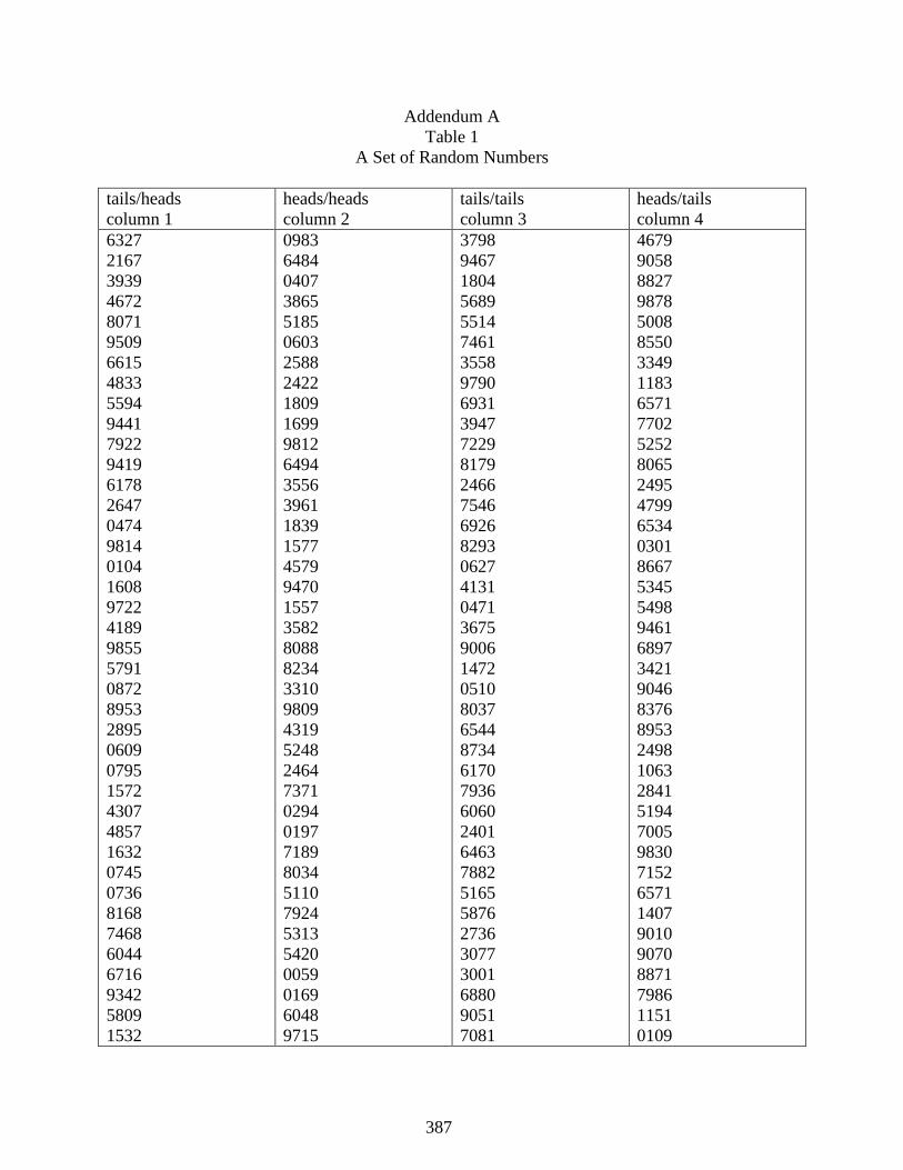
387
Addendum A
Table 1
A Set of Random Numbers
tails/heads
column 1
heads/heads
column 2
tails/tails
column 3
heads/tails
column 4
6327
2167
3939
4672
8071
9509
6615
4833
5594
9441
7922
9419
6178
2647
0474
9814
0104
1608
9722
4189
9855
5791
0872
8953
2895
0609
0795
1572
4307
4857
1632
0745
0736
8168
7468
6044
6716
9342
5809
1532
0983
6484
0407
3865
5185
0603
2588
2422
1809
1699
9812
6494
3556
3961
1839
1577
4579
9470
1557
3582
8088
8234
3310
9809
4319
5248
2464
7371
0294
0197
7189
8034
5110
7924
5313
5420
0059
0169
6048
9715
3798
9467
1804
5689
5514
7461
3558
9790
6931
3947
7229
8179
2466
7546
6926
8293
0627
4131
0471
3675
9006
1472
0510
8037
6544
8734
6170
7936
6060
2401
6463
7882
5165
5876
2736
3077
3001
6880
9051
7081
4679
9058
8827
9878
5008
8550
3349
1183
6571
7702
5252
8065
2495
4799
6534
0301
8667
5345
5498
9461
6897
3421
9046
8376
8953
2498
1063
2841
5194
7005
9830
7152
6571
1407
9010
9070
8871
7986
1151
0109

388
5506
4045
5966
6062
4097
6793
7960
1321
5812
1751
9930
3296
8379
3999
4853
4067
5917
2817
6437
5093
5670
4645
0583
8503
4415
9958
7279
2503
0614
5143
1920
1604
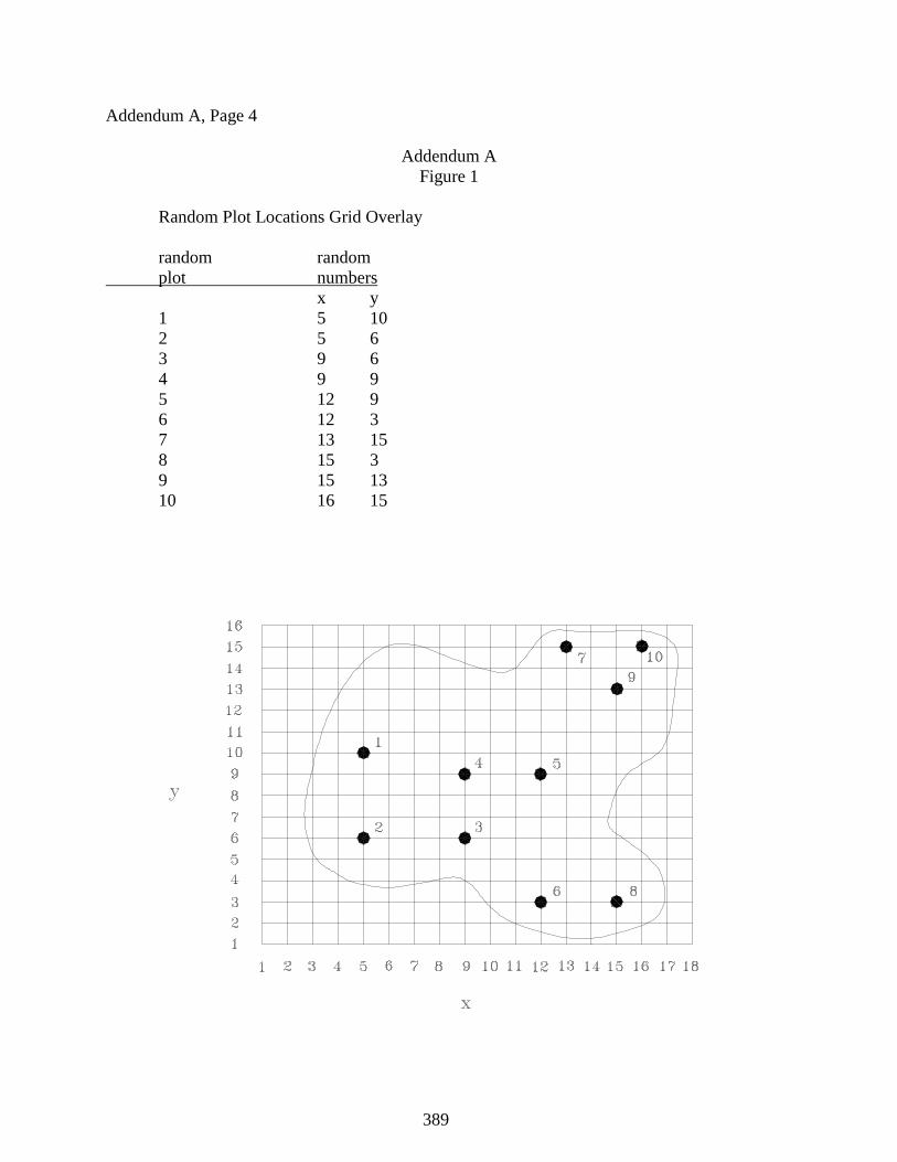
389
Addendum A, Page 4
Addendum A
Figure 1
Random Plot Locations Grid Overlay
random random
plot numbers
x y
1 5 10
2 5 6
3 9 6
4 9 9
5 12 9
6 12 3
7 13 15
8 15 3
9 15 13
10 16 15
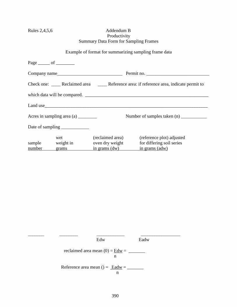
390
Rules 2,4,5,6 Addendum B
Productivity
Summary Data Form for Sampling Frames
Example of format for summarizing sampling frame data
Page _____ of ________
Company name____________________________ Permit no. ___________________________
Check one: ____ Reclaimed area ____ Reference area: if reference area, indicate permit to
which data will be compared. _____________________________________________________
Land use______________________________________________________________________
Acres in sampling area (a) ________ Number of samples taken (n) ___________
Date of sampling ____________
wet (reclaimed area) (reference plot) adjusted
sample weight in oven dry weight for differing soil series
number grams in grams (dw) in grams (adw)
_______ ________ ____________ _________________
dw adw
reclaimed area mean () = dw = _______
n
Reference area mean () = adw = _______
n
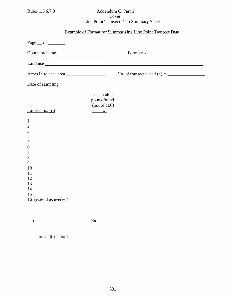
391
Rules 1,3,6,7,8 Addendum C, Part 1
Cover
Line Point Transect Data Summary Sheet
Example of Format for Summarizing Line Point Transect Data
Page of _______
Company name ____ Permit no. ________________________
Land use _____________________________________________________________________
Acres in release area No. of transects used (n) = ________________
Date of sampling ____________________
acceptable
points found
(out of 100)
transect no. (n) (x)
1
2
3
4
5
6
7
8
9
10
11
12
13
14
15
16 (extend as needed)
n = x =
mean () = x/n =
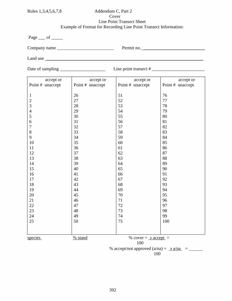
392
Rules 1,3,4,5,6,7,8 Addendum C, Part 2
Cover
Line Point Transect Sheet
Example of Format for Recording Line Point Transect Information:
Page ___ of _____
Company name _________________________ Permit no. ___________________________
Land use _____________________________________________________________________
Date of sampling Line point transect # _______________________
accept or
Point # unaccept
1
2
3
4
5
6
7
8
9
10
11
12
13
14
15
16
17
18
19
20
21
22
23
24
25
accept or
Point # unaccept
26
27
28
29
30
31
32
33
34
35
36
37
38
39
40
41
42
43
44
45
46
47
48
49
50
accept or
Point # unaccept
51
52
53
54
55
56
57
58
59
60
61
62
63
64
65
66
67
68
69
70
71
72
73
74
75
accept or
Point # unaccept
76
77
78
79
80
81
82
83
84
85
86
87
88
89
90
91
92
93
94
95
96
97
98
99
100
species % stand % cover = accept =
100
% accept/not approved (a/na) = a/na =
100
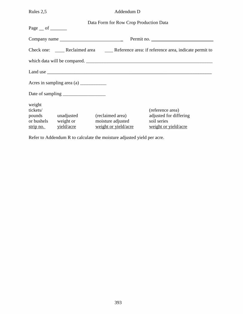
393
Rules 2,5 Addendum D
Data Form for Row Crop Production Data
Page of _______
Company name _ Permit no. __________________________
Check one: Reclaimed area Reference area: if reference area, indicate permit to
which data will be compared. _____________________________________________________
Land use _____________________________________________________________________
Acres in sampling area (a) ___________
Date of sampling __________________
weight
tickets/ (reference area)
pounds unadjusted (reclaimed area) adjusted for differing
or bushels weight or moisture adjusted soil series
strip no. yield/acre weight or yield/acre weight or yield/acre
Refer to Addendum R to calculate the moisture adjusted yield per acre.
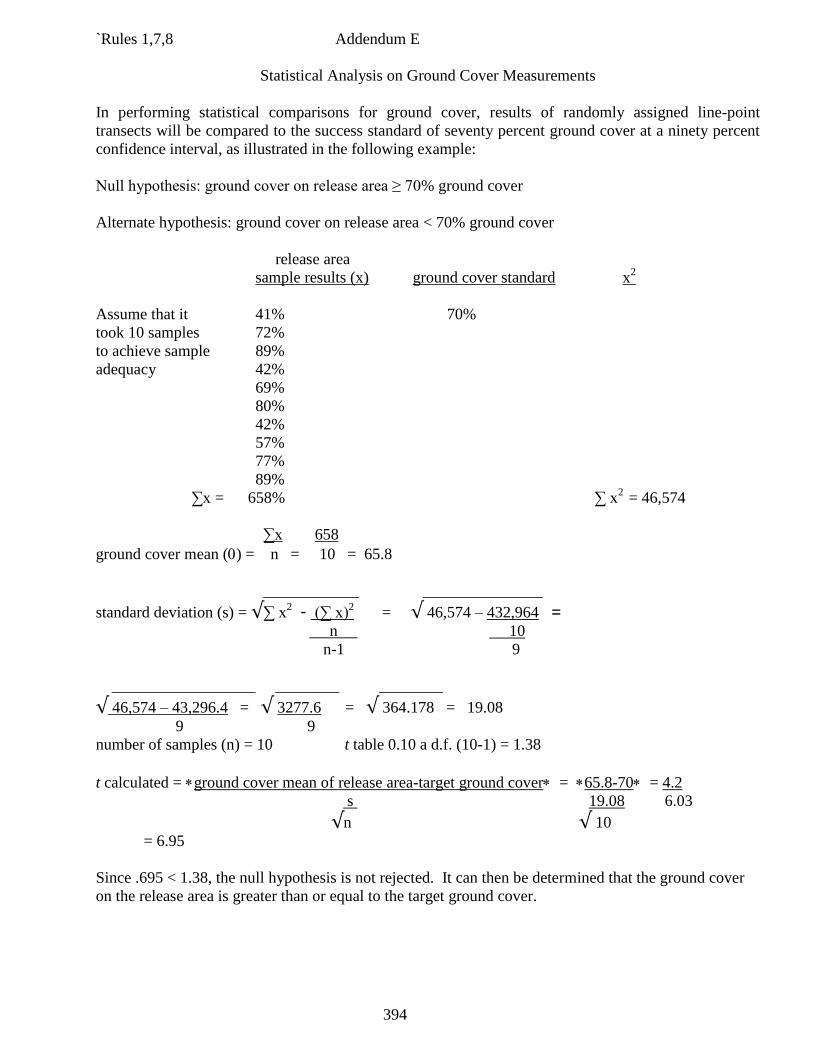
394
`Rules 1,7,8 Addendum E
Statistical Analysis on Ground Cover Measurements
In performing statistical comparisons for ground cover, results of randomly assigned line-point
transects will be compared to the success standard of seventy percent ground cover at a ninety percent
confidence interval, as illustrated in the following example:
Null hypothesis: ground cover on release area ≥ 70% ground cover
Alternate hypothesis: ground cover on release area < 70% ground cover
release area
sample results (x) ground cover standard x2
Assume that it 41% 70%
took 10 samples 72%
to achieve sample 89%
adequacy 42%
69%
80%
42%
57%
77%
89%
∑x = 658% ∑ x2
= 46,574
∑x 658
ground cover mean () = n = 10 = 65.8
____________ _______________
standard deviation (s) = √∑ x2 - (∑ x)
2 = √ 46,574 – 432,964 =
n 10
n-1 9
__________________ ________ ________
√ 46,574 – 43,296.4 = √ 3277.6 = √ 364.178 = 19.08
9 9
number of samples (n) = 10 t table 0.10 a d.f. (10-1) = 1.38
t calculated = ground cover mean of release area-target ground cover = 65.8-70= 4.2
s 19.08 6.03
√n √ 10
= 6.95
Since .695 < 1.38, the null hypothesis is not rejected. It can then be determined that the ground cover
on the release area is greater than or equal to the target ground cover.
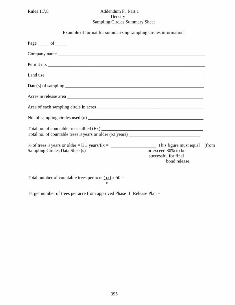
395
Rules 1,7,8 Addendum F, Part 1
Density
Sampling Circles Summary Sheet
Example of format for summarizing sampling circles information.
Page _____ of _____
Company name ________________________________________________________________
Permit no. ____________________________________________________________________
Land use ____________________________________________________________________
Date(s) of sampling ____________________________________________________________
Acres in release area ___________________________________________________________
Area of each sampling circle in acres ______________________________________________
No. of sampling circles used (n) __________________________________________________
Total no. of countable trees tallied (x) ____________________________________________
Total no. of countable trees 3 years or older (3 years) _______________________________
% of trees 3 years or older = 3 years/x = This figure must equal (from
Sampling Circles Data Sheet(s) or exceed 80% to be
successful for final
bond release.
Total number of countable trees per acre (x) x 50 =
n
Target number of trees per acre from approved Phase III Release Plan =
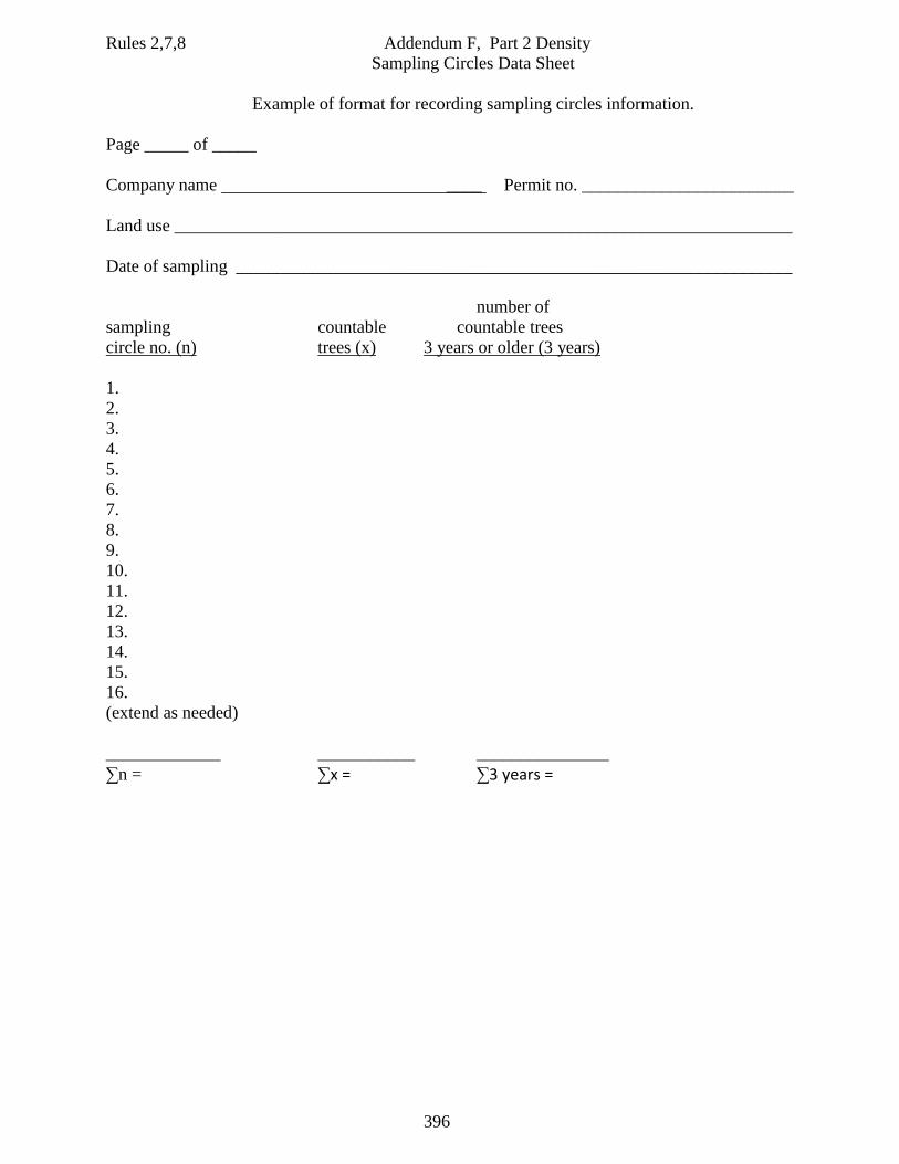
396
Rules 2,7,8 Addendum F, Part 2 Density
Sampling Circles Data Sheet
Example of format for recording sampling circles information.
Page _____ of _____
Company name ____ Permit no. ________________________
Land use ______________________________________________________________________
Date of sampling _______________________________________________________________
number of
sampling countable countable trees
circle no. (n) trees (x) 3 years or older (3 years)
1.
2.
3.
4.
5.
6.
7.
8.
9.
10.
11.
12.
13.
14.
15.
16.
(extend as needed)
_____________ ___________ _______________
∑n = ∑x = ∑3 years =
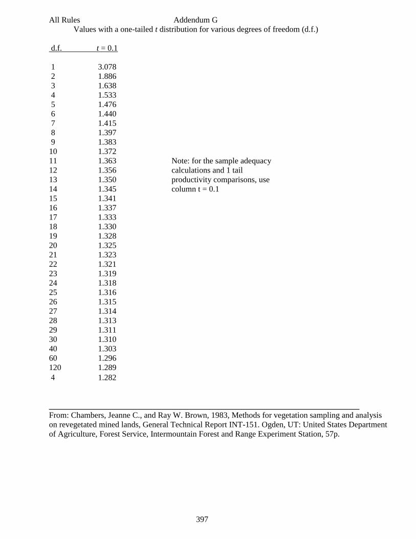
397
All Rules Addendum G
Values with a one-tailed t distribution for various degrees of freedom (d.f.)
d.f. t = 0.1
1 3.078
2 1.886
3 1.638
4 1.533
5 1.476
6 1.440
7 1.415
8 1.397
9 1.383
10 1.372
11 1.363 Note: for the sample adequacy
12 1.356 calculations and 1 tail
13 1.350 productivity comparisons, use
14 1.345 column t = 0.1
15 1.341
16 1.337
17 1.333
18 1.330
19 1.328
20 1.325
21 1.323
22 1.321
23 1.319
24 1.318
25 1.316
26 1.315
27 1.314
28 1.313
29 1.311
30 1.310
40 1.303
60 1.296
120 1.289
1.282
____________________________________________________________________________
From: Chambers, Jeanne C., and Ray W. Brown, 1983, Methods for vegetation sampling and analysis
on revegetated mined lands, General Technical Report INT-151. Ogden, UT: United States Department
of Agriculture, Forest Service, Intermountain Forest and Range Experiment Station, 57p.
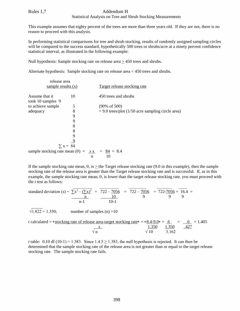
398
Rules 1,7 Addendum H Statistical Analysis on Tree and Shrub Stocking Measurements
This example assumes that eighty percent of the trees are more than three years old. If they are not, there is no
reason to proceed with this analysis.
In performing statistical comparisons for tree and shrub stocking, results of randomly assigned sampling circles
will be compared to the success standard, hypothetically 500 trees or shrubs/acre at a ninety percent confidence
statistical interval, as illustrated in the following example:
Null hypothesis: Sample stocking rate on release area > 450 trees and shrubs.
Alternate hypothesis: Sample stocking rate on release area < 450 trees and shrubs.
release area
sample results (x) Target release stocking rate
Assume that it 10 450 trees and shrubs
took 10 samples 9
to achieve sample 5 (90% of 500)
adequacy 8 = 9.0 trees/plot (1/50 acre sampling circle area)
9
9
8
8
9
9
∑ x = 84
sample stocking rate mean () = x = 84 = 8.4
n 10
If the sample stocking rate mean, , is > the Target release stocking rate (9.0 in this example), then the sample
stocking rate of the release area is greater than the Target release stocking rate and is successful. If, as in this
example, the sample stocking rate mean, , is lower than the target release stocking rate, you must proceed with
the t test as follows:
_________ _________ ________ _______ ____
standard deviation (s) = ∑x2 – (∑x)
2 = 722 – 7056 = 722 – 7056 = 722-7056 = 16.4 =
______n_ _____10_ 9 9 9
n-1 10-1
_____
√1.822 = 1.350; number of samples (n) =10
t calculated = stocking rate of release area-target stocking rate= 8.4-9.0= .6 = _ .6 = 1.405
__s_ 1.350 1.350 .427
√ n √ 10 3.162
t table: 0.10 df (10-1) = 1.383. Since 1.4.5 ≥ 1.383, the null hypothesis is rejected. It can then be
determined that the sample stocking rate of the release area is not greater than or equal to the target release
stocking rate. The sample stocking rate fails.
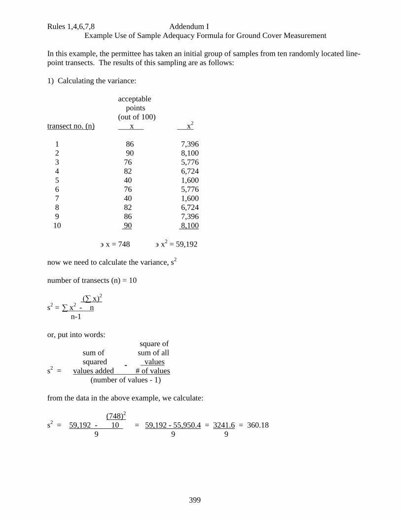
399
Rules 1,4,6,7,8 Addendum I
Example Use of Sample Adequacy Formula for Ground Cover Measurement
In this example, the permittee has taken an initial group of samples from ten randomly located line-
point transects. The results of this sampling are as follows:
1) Calculating the variance:
acceptable
points
(out of 100)
transect no. (n) x x2
1 86 7,396
2 90 8,100
3 76 5,776
4 82 6,724
5 40 1,600
6 76 5,776
7 40 1,600
8 82 6,724
9 86 7,396
10 90 8,100
x = 748 x2 = 59,192
now we need to calculate the variance, s2
number of transects (n) = 10
(∑ x)2
s2 =
∑ x
2 - n
n-1
or, put into words:
square of
sum of sum of all
squared values
s2 = values added # of values
(number of values - 1)
from the data in the above example, we calculate:
(748)2
s2 = 59,192 - 10 = 59,192 - 55,950.4 = 3241.6 = 360.18
9 9 9
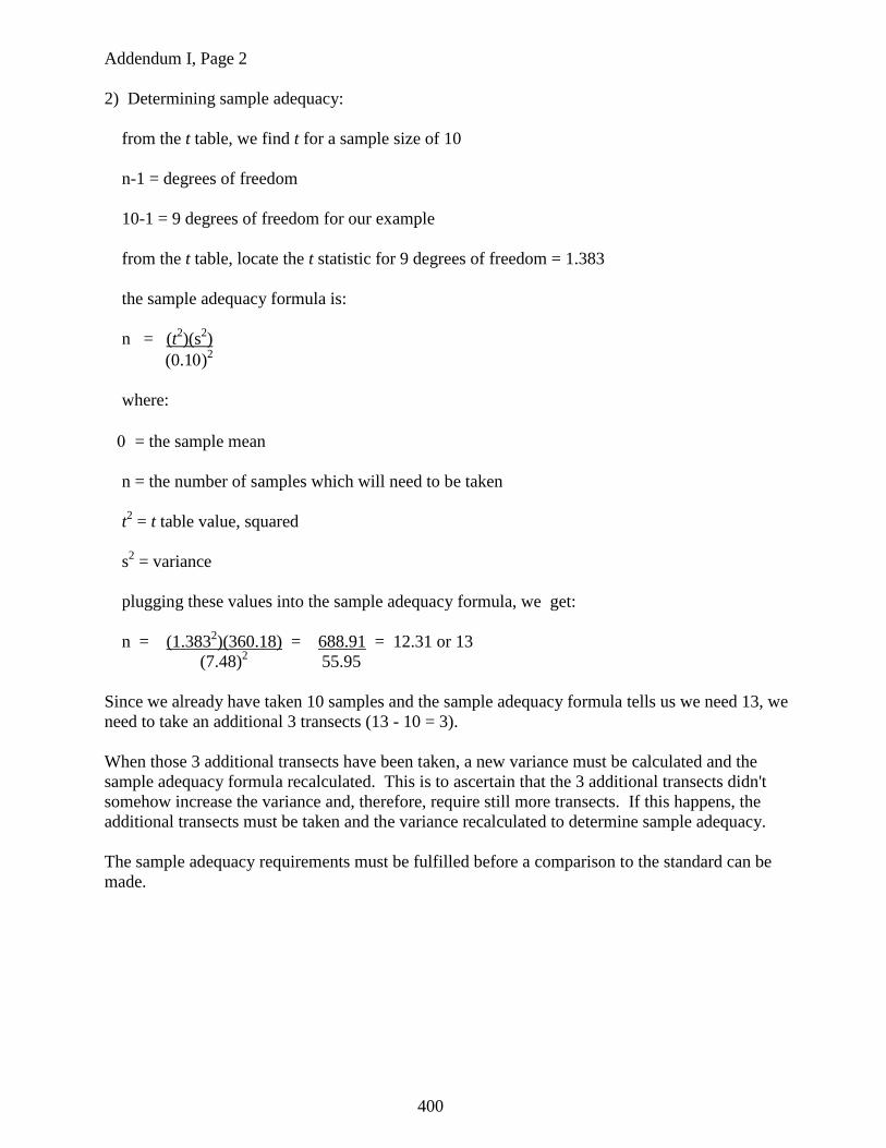
400
Addendum I, Page 2
2) Determining sample adequacy:
from the t table, we find t for a sample size of 10
n-1 = degrees of freedom
10-1 = 9 degrees of freedom for our example
from the t table, locate the t statistic for 9 degrees of freedom = 1.383
the sample adequacy formula is:
n = (t2)(s
2)
(0.1)2
where:
= the sample mean
n = the number of samples which will need to be taken
t2 = t table value, squared
s2 = variance
plugging these values into the sample adequacy formula, we get:
n = (1.3832)(360.18) = 688.91 = 12.31 or 13
(7.48)2 55.95
Since we already have taken 10 samples and the sample adequacy formula tells us we need 13, we
need to take an additional 3 transects (13 - 10 = 3).
When those 3 additional transects have been taken, a new variance must be calculated and the
sample adequacy formula recalculated. This is to ascertain that the 3 additional transects didn't
somehow increase the variance and, therefore, require still more transects. If this happens, the
additional transects must be taken and the variance recalculated to determine sample adequacy.
The sample adequacy requirements must be fulfilled before a comparison to the standard can be
made.
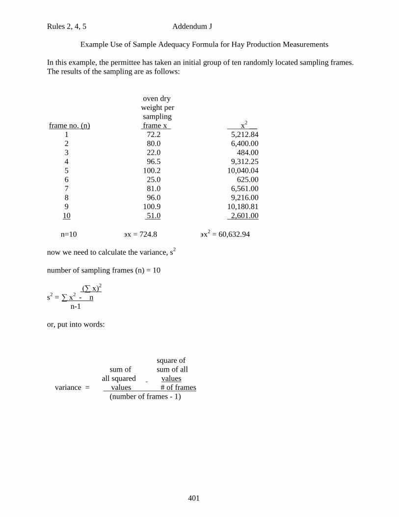
401
Rules 2, 4, 5 Addendum J
Example Use of Sample Adequacy Formula for Hay Production Measurements
In this example, the permittee has taken an initial group of ten randomly located sampling frames.
The results of the sampling are as follows:
oven dry
weight per
sampling
frame no. (n) frame x x2 __
1 72.2 5,212.84
2 80.0 6,400.00
3 22.0 484.00
4 96.5 9,312.25
5 100.2 10,040.04
6 25.0 625.00
7 81.0 6,561.00
8 96.0 9,216.00
9 100.9 10,180.81
10 51.0 2,601.00
n=10 x = 724.8 x2 = 60,632.94
now we need to calculate the variance, s2
number of sampling frames (n) = 10
(∑ x)2
s2 =
∑ x
2 - n
n-1
or, put into words:
square of
sum of sum of all
all squared values
variance = values # of frames
(number of frames - 1)
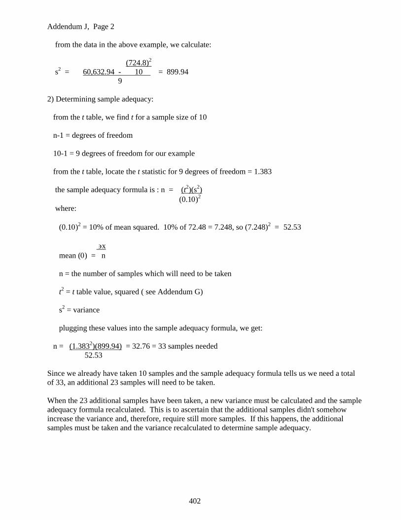
402
Addendum J, Page 2
from the data in the above example, we calculate:
(724.8)2
s2 = 60,632.94 - 10 = 899.94
9
2) Determining sample adequacy:
from the t table, we find t for a sample size of 10
n-1 = degrees of freedom
10-1 = 9 degrees of freedom for our example
from the t table, locate the t statistic for 9 degrees of freedom = 1.383
the sample adequacy formula is : n = (t2)(s
2)
(0.1)2
where:
(0.1)2 = 10% of mean squared. 10% of 72.48 = 7.248, so (7.248)
2 = 52.53
x
mean () = n
n = the number of samples which will need to be taken
t2 = t table value, squared ( see Addendum G)
s2 = variance
plugging these values into the sample adequacy formula, we get:
n = (1.3832)(899.94) = 32.76 = 33 samples needed
52.53
Since we already have taken 10 samples and the sample adequacy formula tells us we need a total
of 33, an additional 23 samples will need to be taken.
When the 23 additional samples have been taken, a new variance must be calculated and the sample
adequacy formula recalculated. This is to ascertain that the additional samples didn't somehow
increase the variance and, therefore, require still more samples. If this happens, the additional
samples must be taken and the variance recalculated to determine sample adequacy.
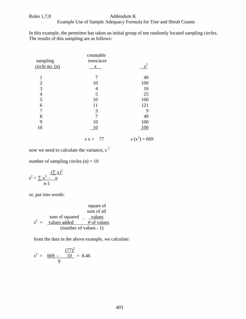
403
Rules 1,7,8 Addendum K
Example Use of Sample Adequacy Formula for Tree and Shrub Counts
In this example, the permittee has taken an initial group of ten randomly located sampling circles.
The results of this sampling are as follows:
countable
sampling trees/acre
circle no. (n) x x2
1 7 49
2 10 100
3 4 16
4 5 25
5 10 100
6 11 121
7 3 9
8 7 49
9 10 100
10 10 100
x = 77 (x2) = 669
now we need to calculate the variance, s 2
number of sampling circles (n) = 10
(∑ x)2
s2 =
∑ x
2 - n
n-1
or, put into words:
square of
sum of all
sum of squared values
s2 = values added # of values
(number of values - 1)
from the data in the above example, we calculate:
(77)2
s2 = 669 - 10 = 8.46
9
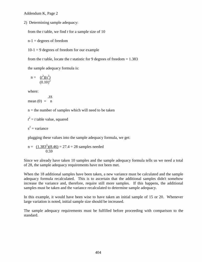
404
Addendum K, Page 2
2) Determining sample adequacy:
from the t table, we find t for a sample size of 10
n-1 = degrees of freedom
10-1 = 9 degrees of freedom for our example
from the t table, locate the t statistic for 9 degrees of freedom = 1.383
the sample adequacy formula is:
n = (t2)(s
2)
(0.1)2
where:
x
mean () = n
n = the number of samples which will need to be taken
t2 = t table value, squared
s2 = variance
plugging these values into the sample adequacy formula, we get:
n = (1.3832)(8.46) = 27.4 = 28 samples needed
0.59
Since we already have taken 10 samples and the sample adequacy formula tells us we need a total
of 28, the sample adequacy requirements have not been met.
When the 18 additional samples have been taken, a new variance must be calculated and the sample
adequacy formula recalculated. This is to ascertain that the additional samples didn't somehow
increase the variance and, therefore, require still more samples. If this happens, the additional
samples must be taken and the variance recalculated to determine sample adequacy.
In this example, it would have been wise to have taken an initial sample of 15 or 20. Whenever
large variation is noted, initial sample size should be increased.
The sample adequacy requirements must be fulfilled before proceeding with comparison to the
standard.
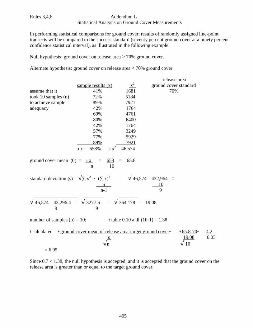
405
Rules 3,4,6 Addendum L
Statistical Analysis on Ground Cover Measurements
In performing statistical comparisons for ground cover, results of randomly assigned line-point
transects will be compared to the success standard (seventy percent ground cover at a ninety percent
confidence statistical interval), as illustrated in the following example:
Null hypothesis: ground cover on release area > 70% ground cover.
Alternate hypothesis: ground cover on release area < 70% ground cover.
release area
sample results (x) x2 ground cover standard
assume that it 41% 1681 70%
took 10 samples (n) 72% 5184
to achieve sample 89% 7921
adequacy 42% 1764
69% 4761
80% 6400
42% 1764
57% 3249
77% 5929
89% 7921
x = 658% x2 = 46,574
ground cover mean () = x = 658 = 65.8
n 10
____________ _______________
standard deviation (s) = √∑ x2 - (∑ x)
2 = √ 46,574 – 432,964 =
n 10
n-1 9
__________________ ________ ________
√ 46,574 – 43,296.4 = √ 3277.6 = √ 364.178 = 19.08
9 9
number of samples (n) = 10; t table 0.10 a df (10-1) = 1.38
t calculated = ground cover mean of release area-target ground cover = 65.8-70= 4.2
s 19.08 6.03
√n √ 10
= 6.95
Since 0.7 < 1.38, the null hypothesis is accepted; and it is accepted that the ground cover on the
release area is greater than or equal to the target ground cover.
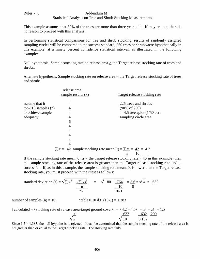
406
Rules 7, 8 Addendum M
Statistical Analysis on Tree and Shrub Stocking Measurements
This example assumes that 80% of the trees are more than three years old. If they are not, there is
no reason to proceed with this analysis.
In performing statistical comparisons for tree and shrub stocking, results of randomly assigned
sampling circles will be compared to the success standard, 250 trees or shrubs/acre hypothetically in
this example, at a ninety percent confidence statistical interval, as illustrated in the following
example:
Null hypothesis: Sample stocking rate on release area > the Target release stocking rate of trees and
shrubs.
Alternate hypothesis: Sample stocking rate on release area < the Target release stocking rate of trees
and shrubs.
release area
sample results (x) Target release stocking rate
assume that it 4 225 trees and shrubs
took 10 samples (n) 4 (90% of 250)
to achieve sample 4 = 4.5 trees/plot (1/50 acre
adequacy 4 sampling circle area
6
4
4
4
4
4
∑ x = 42 sample stocking rate mean() = ∑ x = 42 = 4.2
n 10
If the sample stocking rate mean, , is > the Target release stocking rate, (4.5 in this example) then
the sample stocking rate of the release area is greater than the Target release stocking rate and is
successful. If, as in this example, the sample stocking rate mean, , is lower than the Target release
stocking rate, you must proceed with the t test as follows:
____________ __________ __
standard deviation (s) = √∑ x2 - (∑ x)
2 = √ 180 – 1764 = 3.6 = √.4 = .632
n 10 9
n-1 10-1
number of samples (n) = 10; t table 0.10 d.f. (10-1) = 1.383
t calculated = stocking rate of release area-target ground cover = 4.2 – 4.5= .3 = .3 = 1.5
s .632 _.632 .200
√n √ 10 3.162 Since 1.5 ≥ 1.383, the null hypothesis is rejected. It can be determined that the sample stocking rate of the release area is
not greater than or equal to the Target stocking rate. The stocking rate fails

407
Rules 2,4,5 Addendum N
Statistical Analysis on Sampling Frame Data
In performing statistical comparisons for hay production when sample areas are harvested, harvest results of the
randomly assigned sample areas will be compared using a t-test to ninety percent of the target or reference yield
with a ninety percent confidence interval. The hypotheses should be set up as follows:
Null hypothesis: hay yield on release area > 90% of target yield.
Alternate hypothesis: hay yield on release area < 90% of target yield.
If USDA/NRCS target yield is used as a standard, the tonnage of forage produced must be divided by 22,687.5
to convert it to sample frame weights.
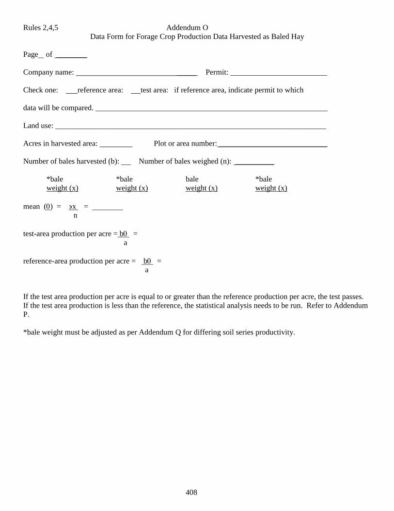
408
Rules 2,4,5 Addendum O
Data Form for Forage Crop Production Data Harvested as Baled Hay
Page of ________
Company name: _____ Permit: _________________________
Check one: reference area: test area: if reference area, indicate permit to which
data will be compared. ____________________________________________________________
Land use: ______________________________________________________________________
Acres in harvested area: Plot or area number: ____________________________
Number of bales harvested (b): Number of bales weighed (n): __________
*bale *bale bale *bale
weight (x) weight (x) weight (x) weight (x)
mean () = x =
n
test-area production per acre = b =
a
reference-area production per acre = b =
a
If the test area production per acre is equal to or greater than the reference production per acre, the test passes.
If the test area production is less than the reference, the statistical analysis needs to be run. Refer to Addendum
P.
*bale weight must be adjusted as per Addendum Q for differing soil series productivity.
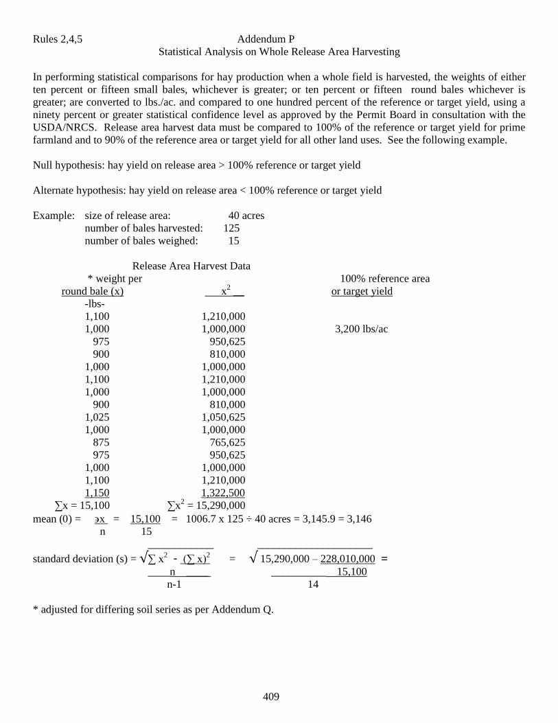
409
Rules 2,4,5 Addendum P
Statistical Analysis on Whole Release Area Harvesting
In performing statistical comparisons for hay production when a whole field is harvested, the weights of either
ten percent or fifteen small bales, whichever is greater; or ten percent or fifteen round bales whichever is
greater; are converted to lbs./ac. and compared to one hundred percent of the reference or target yield, using a
ninety percent or greater statistical confidence level as approved by the Permit Board in consultation with the
USDA/NRCS. Release area harvest data must be compared to 100% of the reference or target yield for prime
farmland and to 90% of the reference area or target yield for all other land uses. See the following example.
Null hypothesis: hay yield on release area > 100% reference or target yield
Alternate hypothesis: hay yield on release area < 100% reference or target yield
Example: size of release area: 40 acres
number of bales harvested: 125
number of bales weighed: 15
Release Area Harvest Data
* weight per 100% reference area
round bale (x) x2 __ or target yield
-lbs-
1,100 1,210,000
1,000 1,000,000 3,200 lbs/ac
975 950,625
900 810,000
1,000 1,000,000
1,100 1,210,000
1,000 1,000,000
900 810,000
1,025 1,050,625
1,000 1,000,000
875 765,625
975 950,625
1,000 1,000,000
1,100 1,210,000
1,150 1,322,500
∑x = 15,100 ∑x2 = 15,290,000
mean () = x = 15,100 = 1006.7 x 125 ÷ 40 acres = 3,145.9 = 3,146
n 15
____________ _____________________
standard deviation (s) = √∑ x2 - (∑ x)
2 = √ 15,290,000 – 228,010,000 =
____n ____ __________ 15,100
n-1 14
* adjusted for differing soil series as per Addendum Q.
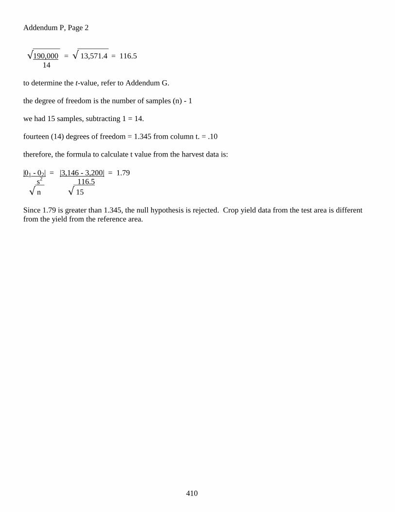
410
Addendum P, Page 2
_______ ________
√190,000 = √ 13,571.4 = 116.5
14
to determine the t-value, refer to Addendum G.
the degree of freedom is the number of samples (n) - 1
we had 15 samples, subtracting 1 = 14.
fourteen (14) degrees of freedom = 1.345 from column t. = .10
therefore, the formula to calculate t value from the harvest data is:
|1 - 2| = |3,146 - 3,200| = 1.79
s2 116.5
√ n √ 15
Since 1.79 is greater than 1.345, the null hypothesis is rejected. Crop yield data from the test area is different
from the yield from the reference area.
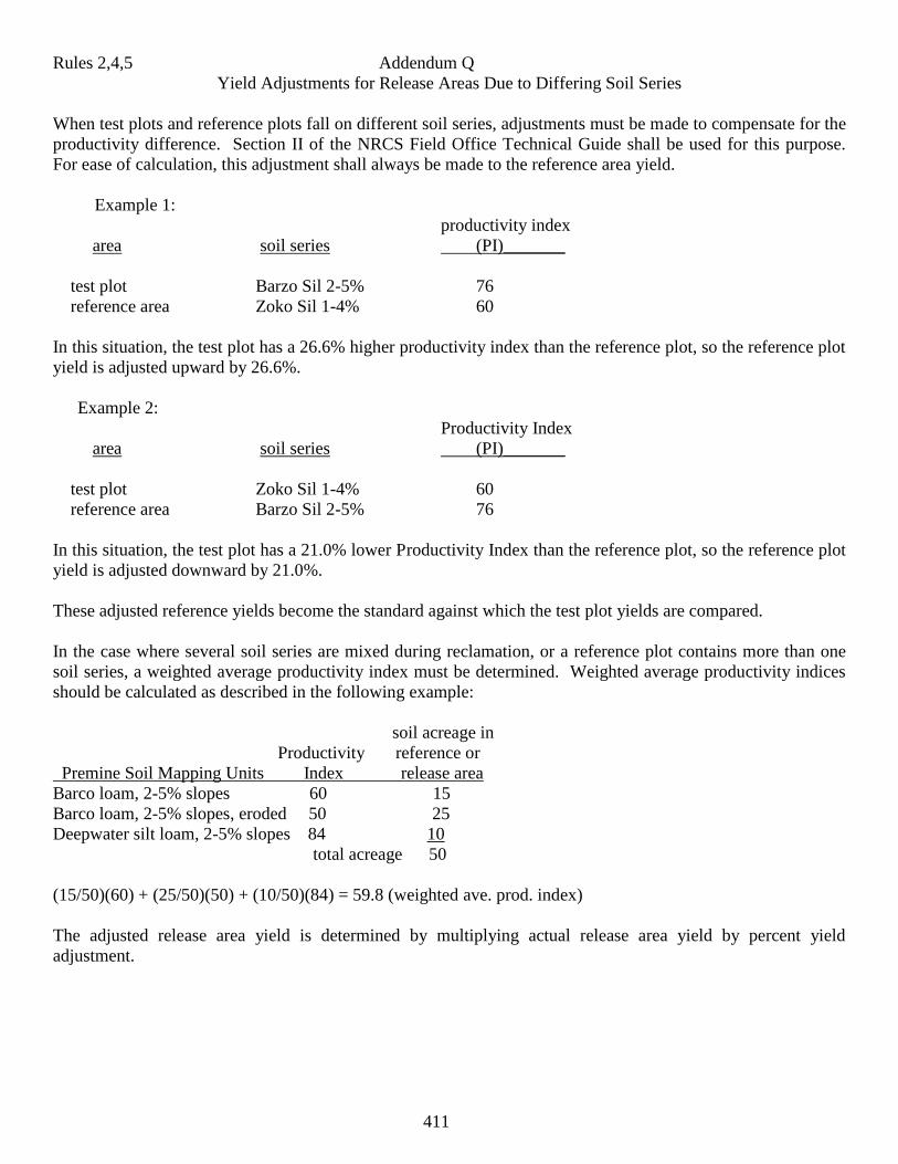
411
Rules 2,4,5 Addendum Q
Yield Adjustments for Release Areas Due to Differing Soil Series
When test plots and reference plots fall on different soil series, adjustments must be made to compensate for the
productivity difference. Section II of the NRCS Field Office Technical Guide shall be used for this purpose.
For ease of calculation, this adjustment shall always be made to the reference area yield.
Example 1:
productivity index
area soil series (PI)_______
test plot Barzo Sil 2-5% 76
reference area Zoko Sil 1-4% 60
In this situation, the test plot has a 26.6% higher productivity index than the reference plot, so the reference plot
yield is adjusted upward by 26.6%.
Example 2:
Productivity Index
area soil series (PI)_______
test plot Zoko Sil 1-4% 60
reference area Barzo Sil 2-5% 76
In this situation, the test plot has a 21.0% lower Productivity Index than the reference plot, so the reference plot
yield is adjusted downward by 21.0%.
These adjusted reference yields become the standard against which the test plot yields are compared.
In the case where several soil series are mixed during reclamation, or a reference plot contains more than one
soil series, a weighted average productivity index must be determined. Weighted average productivity indices
should be calculated as described in the following example:
soil acreage in
Productivity reference or
Premine Soil Mapping Units Index release area
Barco loam, 2-5% slopes 60 15
Barco loam, 2-5% slopes, eroded 50 25
Deepwater silt loam, 2-5% slopes 84 10
total acreage 50
(15/50)(60) + (25/50)(50) + (10/50)(84) = 59.8 (weighted ave. prod. index)
The adjusted release area yield is determined by multiplying actual release area yield by percent yield
adjustment.
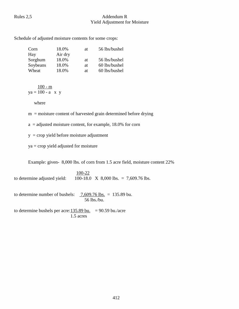
412
Rules 2,5 Addendum R
Yield Adjustment for Moisture
Schedule of adjusted moisture contents for some crops:
Corn 18.0% at 56 lbs/bushel
Hay Air dry
Sorghum 18.0% at 56 lbs/bushel
Soybeans 18.0% at 60 lbs/bushel
Wheat 18.0% at 60 lbs/bushel
100 - m
ya = 100 - a x y
where
m = moisture content of harvested grain determined before drying
a = adjusted moisture content, for example, 18.0% for corn
y = crop yield before moisture adjustment
ya = crop yield adjusted for moisture
Example: given- 8,000 lbs. of corn from 1.5 acre field, moisture content 22%
100-22
to determine adjusted yield: 100-18.0 X 8,000 lbs. = 7,609.76 lbs.
to determine number of bushels: 7,609.76 lbs. = 135.89 bu.
56 lbs./bu.
to determine bushels per acre: 135.89 bu. = 90.59 bu./acre
1.5 acres
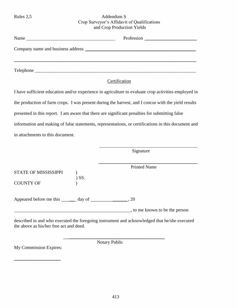
413
Rules 2,5 Addendum S
Crop Surveyor’s Affidavit of Qualifications
and Crop Production Yields
Name Profession ______________________
Company name and business address _______________________________________________
______________________________________________________________________________
Telephone _____________________________________________________________________
Certification
I have sufficient education and/or experience in agriculture to evaluate crop activities employed in
the production of farm crops. I was present during the harvest, and I concur with the yield results
presented in this report. I am aware that there are significant penalties for submitting false
information and making of false statements, representations, or certifications in this document and
in attachments to this document.
__________________________________________
Signature
__________________________________________
Printed Name
STATE OF MISSISSIPPI )
) SS.
COUNTY OF )
Appeared before me this __ day of ______ , 20
, to me known to be the person
described in and who executed the foregoing instrument and acknowledged that he/she executed
the above as his/her free act and deed.
_________________________________________
Notary Public
My Commission Expires:
____________________
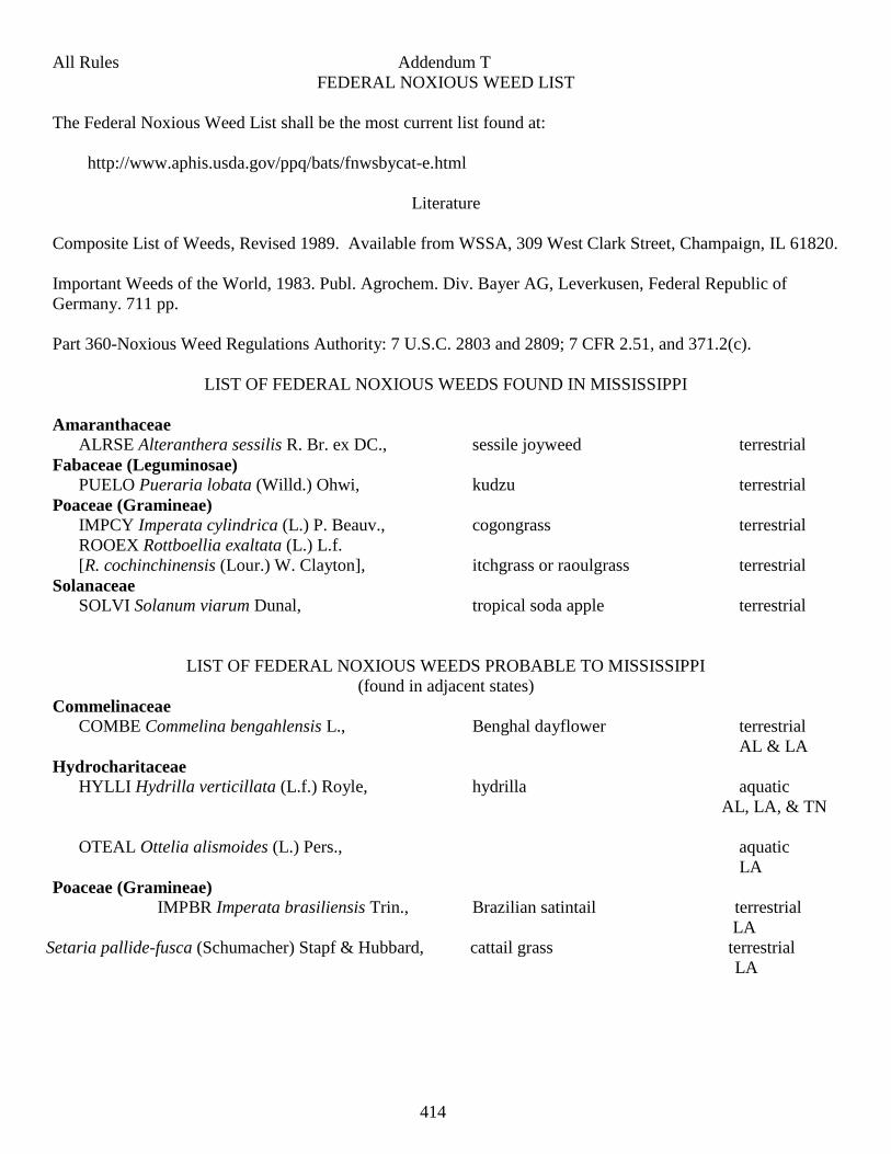
414
All Rules Addendum T
FEDERAL NOXIOUS WEED LIST
The Federal Noxious Weed List shall be the most current list found at:
http://www.aphis.usda.gov/ppq/bats/fnwsbycat-e.html
Literature
Composite List of Weeds, Revised 1989. Available from WSSA, 309 West Clark Street, Champaign, IL 61820.
Important Weeds of the World, 1983. Publ. Agrochem. Div. Bayer AG, Leverkusen, Federal Republic of
Germany. 711 pp.
Part 360-Noxious Weed Regulations Authority: 7 U.S.C. 2803 and 2809; 7 CFR 2.51, and 371.2(c).
LIST OF FEDERAL NOXIOUS WEEDS FOUND IN MISSISSIPPI
Amaranthaceae ALRSE Alteranthera sessilis R. Br. ex DC., sessile joyweed terrestrial
Fabaceae (Leguminosae) PUELO Pueraria lobata (Willd.) Ohwi, kudzu terrestrial
Poaceae (Gramineae) IMPCY Imperata cylindrica (L.) P. Beauv., cogongrass terrestrial
ROOEX Rottboellia exaltata (L.) L.f.
[R. cochinchinensis (Lour.) W. Clayton], itchgrass or raoulgrass terrestrial
Solanaceae SOLVI Solanum viarum Dunal, tropical soda apple terrestrial
LIST OF FEDERAL NOXIOUS WEEDS PROBABLE TO MISSISSIPPI
(found in adjacent states)
Commelinaceae COMBE Commelina bengahlensis L., Benghal dayflower terrestrial
AL & LA
Hydrocharitaceae HYLLI Hydrilla verticillata (L.f.) Royle, hydrilla aquatic
AL, LA, & TN
OTEAL Ottelia alismoides (L.) Pers., aquatic
LA
Poaceae (Gramineae) IMPBR Imperata brasiliensis Trin., Brazilian satintail terrestrial
LA
Setaria pallide-fusca (Schumacher) Stapf & Hubbard, cattail grass terrestrial
LA
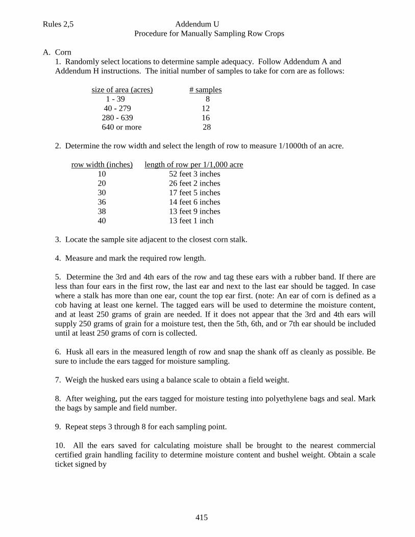
415
Rules 2,5 Addendum U
Procedure for Manually Sampling Row Crops
A. Corn
1. Randomly select locations to determine sample adequacy. Follow Addendum A and
Addendum H instructions. The initial number of samples to take for corn are as follows:
size of area (acres) # samples
1 - 39 8
40 - 279 12
280 - 639 16
640 or more 28
2. Determine the row width and select the length of row to measure 1/1000th of an acre.
row width (inches) length of row per 1/1,000 acre
10 52 feet 3 inches
20 26 feet 2 inches
30 17 feet 5 inches
36 14 feet 6 inches
38 13 feet 9 inches
40 13 feet 1 inch
3. Locate the sample site adjacent to the closest corn stalk.
4. Measure and mark the required row length.
5. Determine the 3rd and 4th ears of the row and tag these ears with a rubber band. If there are
less than four ears in the first row, the last ear and next to the last ear should be tagged. In case
where a stalk has more than one ear, count the top ear first. (note: An ear of corn is defined as a
cob having at least one kernel. The tagged ears will be used to determine the moisture content,
and at least 250 grams of grain are needed. If it does not appear that the 3rd and 4th ears will
supply 250 grams of grain for a moisture test, then the 5th, 6th, and or 7th ear should be included
until at least 250 grams of corn is collected.
6. Husk all ears in the measured length of row and snap the shank off as cleanly as possible. Be
sure to include the ears tagged for moisture sampling.
7. Weigh the husked ears using a balance scale to obtain a field weight.
8. After weighing, put the ears tagged for moisture testing into polyethylene bags and seal. Mark
the bags by sample and field number.
9. Repeat steps 3 through 8 for each sampling point.
10. All the ears saved for calculating moisture shall be brought to the nearest commercial
certified grain handling facility to determine moisture content and bushel weight. Obtain a scale
ticket signed by
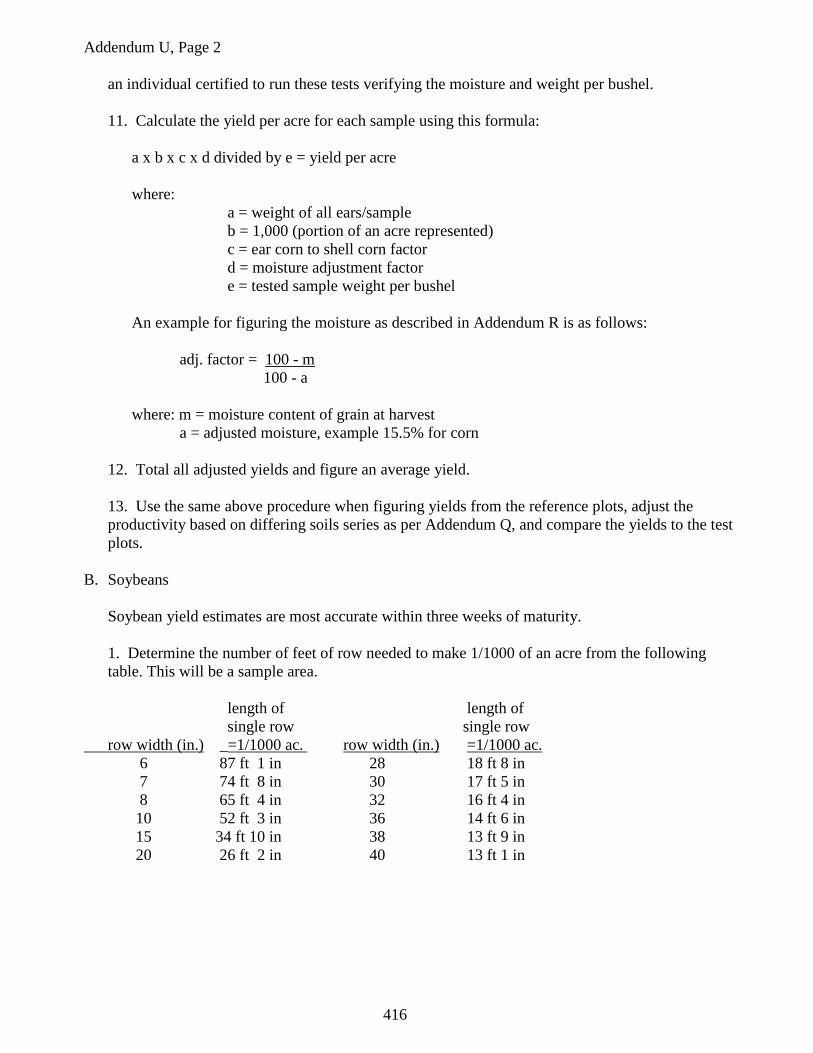
416
Addendum U, Page 2
an individual certified to run these tests verifying the moisture and weight per bushel.
11. Calculate the yield per acre for each sample using this formula:
a x b x c x d divided by e = yield per acre
where:
a = weight of all ears/sample
b = 1,000 (portion of an acre represented)
c = ear corn to shell corn factor
d = moisture adjustment factor
e = tested sample weight per bushel
An example for figuring the moisture as described in Addendum R is as follows:
adj. factor = 100 - m
100 - a
where: m = moisture content of grain at harvest
a = adjusted moisture, example 15.5% for corn
12. Total all adjusted yields and figure an average yield.
13. Use the same above procedure when figuring yields from the reference plots, adjust the
productivity based on differing soils series as per Addendum Q, and compare the yields to the test
plots.
B. Soybeans
Soybean yield estimates are most accurate within three weeks of maturity.
1. Determine the number of feet of row needed to make 1/1000 of an acre from the following
table. This will be a sample area.
length of length of
single row single row
row width (in.) _=1/1000 ac. row width (in.) =1/1000 ac.
6 87 ft 1 in 28 18 ft 8 in
7 74 ft 8 in 30 17 ft 5 in
8 65 ft 4 in 32 16 ft 4 in
10 52 ft 3 in 36 14 ft 6 in
15 34 ft 10 in 38 13 ft 9 in
20 26 ft 2 in 40 13 ft 1 in
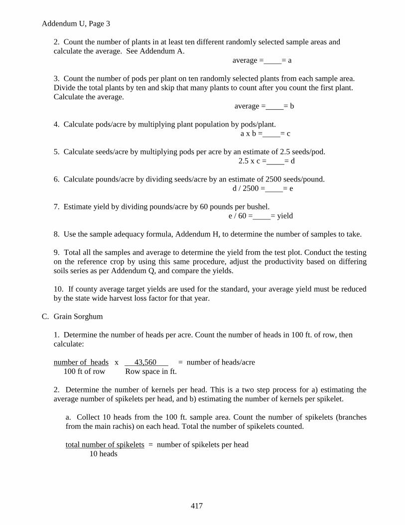
417
Addendum U, Page 3
2. Count the number of plants in at least ten different randomly selected sample areas and
calculate the average. See Addendum A.
average = = a
3. Count the number of pods per plant on ten randomly selected plants from each sample area.
Divide the total plants by ten and skip that many plants to count after you count the first plant.
Calculate the average.
average = = b
4. Calculate pods/acre by multiplying plant population by pods/plant.
a x b = = c
5. Calculate seeds/acre by multiplying pods per acre by an estimate of 2.5 seeds/pod.
2.5 x c = = d
6. Calculate pounds/acre by dividing seeds/acre by an estimate of 2500 seeds/pound.
d / 2500 = = e
7. Estimate yield by dividing pounds/acre by 60 pounds per bushel.
e / 60 = = yield
8. Use the sample adequacy formula, Addendum H, to determine the number of samples to take.
9. Total all the samples and average to determine the yield from the test plot. Conduct the testing
on the reference crop by using this same procedure, adjust the productivity based on differing
soils series as per Addendum Q, and compare the yields.
10. If county average target yields are used for the standard, your average yield must be reduced
by the state wide harvest loss factor for that year.
C. Grain Sorghum
1. Determine the number of heads per acre. Count the number of heads in 100 ft. of row, then
calculate:
number of heads x 43,560 = number of heads/acre
100 ft of row Row space in ft.
2. Determine the number of kernels per head. This is a two step process for a) estimating the
average number of spikelets per head, and b) estimating the number of kernels per spikelet.
a. Collect 10 heads from the 100 ft. sample area. Count the number of spikelets (branches
from the main rachis) on each head. Total the number of spikelets counted.
total number of spikelets = number of spikelets per head
10 heads
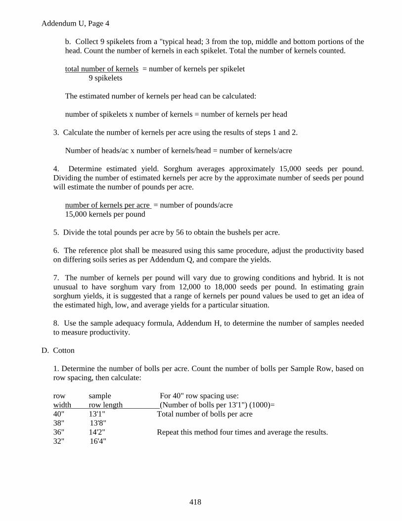
418
Addendum U, Page 4
b. Collect 9 spikelets from a "typical head; 3 from the top, middle and bottom portions of the
head. Count the number of kernels in each spikelet. Total the number of kernels counted.
total number of kernels = number of kernels per spikelet
9 spikelets
The estimated number of kernels per head can be calculated:
number of spikelets x number of kernels = number of kernels per head
3. Calculate the number of kernels per acre using the results of steps 1 and 2.
Number of heads/ac x number of kernels/head = number of kernels/acre
4. Determine estimated yield. Sorghum averages approximately 15,000 seeds per pound.
Dividing the number of estimated kernels per acre by the approximate number of seeds per pound
will estimate the number of pounds per acre.
number of kernels per acre = number of pounds/acre
15,000 kernels per pound
5. Divide the total pounds per acre by 56 to obtain the bushels per acre.
6. The reference plot shall be measured using this same procedure, adjust the productivity based
on differing soils series as per Addendum Q, and compare the yields.
7. The number of kernels per pound will vary due to growing conditions and hybrid. It is not
unusual to have sorghum vary from 12,000 to 18,000 seeds per pound. In estimating grain
sorghum yields, it is suggested that a range of kernels per pound values be used to get an idea of
the estimated high, low, and average yields for a particular situation.
8. Use the sample adequacy formula, Addendum H, to determine the number of samples needed
to measure productivity.
D. Cotton
1. Determine the number of bolls per acre. Count the number of bolls per Sample Row, based on
row spacing, then calculate:
row sample For 40" row spacing use:
width row length (Number of bolls per 13'1") (1000)=
40" 13'1" Total number of bolls per acre
38" 13'8"
36" 14'2" Repeat this method four times and average the results.
32" 16'4"
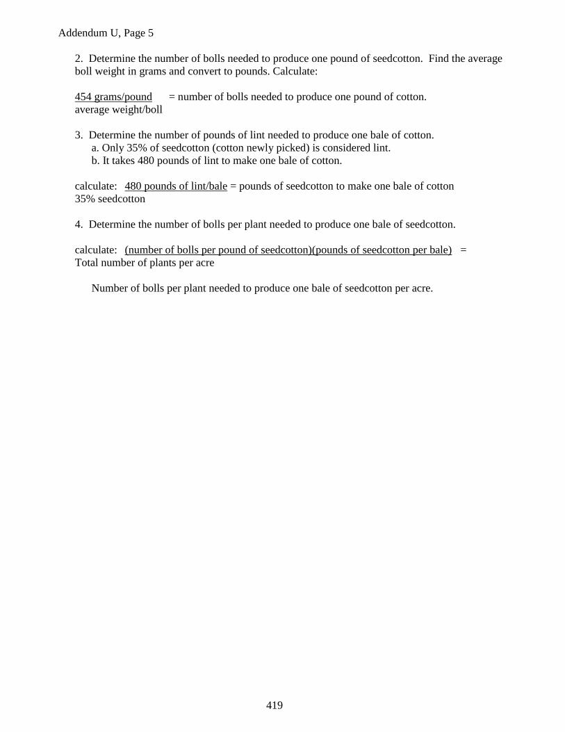
419
Addendum U, Page 5
2. Determine the number of bolls needed to produce one pound of seedcotton. Find the average
boll weight in grams and convert to pounds. Calculate:
454 grams/pound = number of bolls needed to produce one pound of cotton.
average weight/boll
3. Determine the number of pounds of lint needed to produce one bale of cotton.
a. Only 35% of seedcotton (cotton newly picked) is considered lint.
b. It takes 480 pounds of lint to make one bale of cotton.
calculate: 480 pounds of lint/bale = pounds of seedcotton to make one bale of cotton
35% seedcotton
4. Determine the number of bolls per plant needed to produce one bale of seedcotton.
calculate: (number of bolls per pound of seedcotton)(pounds of seedcotton per bale) =
Total number of plants per acre
Number of bolls per plant needed to produce one bale of seedcotton per acre.
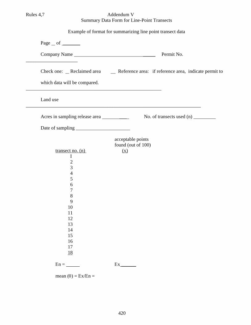
420
Rules 4,7 Addendum V
Summary Data Form for Line-Point Transects
Example of format for summarizing line point transect data
Page of _______
Company Name _____ Permit No.
_____________________
Check one: Reclaimed area Reference area: if reference area, indicate permit to
which data will be compared.
_______________________________________________________
Land use
_______________________________________________________________________
Acres in sampling release area ___ No. of transects used (n) _________
Date of sampling ______________________
acceptable points
found (out of 100)
transect no. (n) (x)
I
2
3
4
5
6
7
8
9
10
11
12
13
14
15
16
17
18
n = x ______
mean () = x/n =
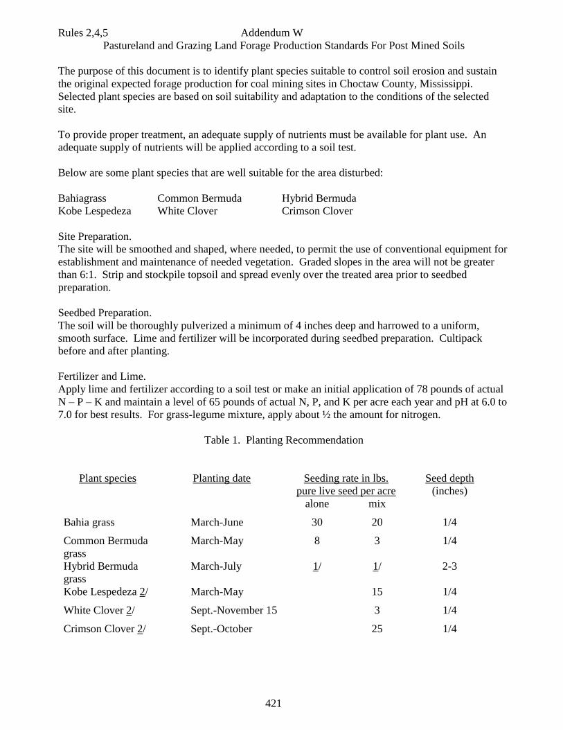
421
Rules 2,4,5 Addendum W
Pastureland and Grazing Land Forage Production Standards For Post Mined Soils
The purpose of this document is to identify plant species suitable to control soil erosion and sustain
the original expected forage production for coal mining sites in Choctaw County, Mississippi.
Selected plant species are based on soil suitability and adaptation to the conditions of the selected
site.
To provide proper treatment, an adequate supply of nutrients must be available for plant use. An
adequate supply of nutrients will be applied according to a soil test.
Below are some plant species that are well suitable for the area disturbed:
Bahiagrass Common Bermuda Hybrid Bermuda
Kobe Lespedeza White Clover Crimson Clover
Site Preparation.
The site will be smoothed and shaped, where needed, to permit the use of conventional equipment for
establishment and maintenance of needed vegetation. Graded slopes in the area will not be greater
than 6:1. Strip and stockpile topsoil and spread evenly over the treated area prior to seedbed
preparation.
Seedbed Preparation.
The soil will be thoroughly pulverized a minimum of 4 inches deep and harrowed to a uniform,
smooth surface. Lime and fertilizer will be incorporated during seedbed preparation. Cultipack
before and after planting.
Fertilizer and Lime.
Apply lime and fertilizer according to a soil test or make an initial application of 78 pounds of actual
N – P – K and maintain a level of 65 pounds of actual N, P, and K per acre each year and pH at 6.0 to
7.0 for best results. For grass-legume mixture, apply about ½ the amount for nitrogen.
Table 1. Planting Recommendation
Plant species Planting date Seeding rate in lbs.
pure live seed per acre
Seed depth
(inches)
alone mix
Bahia grass March-June 30 20 1/4
Common Bermuda
grass
March-May 8 3 1/4
Hybrid Bermuda
grass
March-July 1/ 1/ 2-3
Kobe Lespedeza 2/ March-May 15 1/4
White Clover 2/ Sept.-November 15 3 1/4
Crimson Clover 2/ Sept.-October 25 1/4
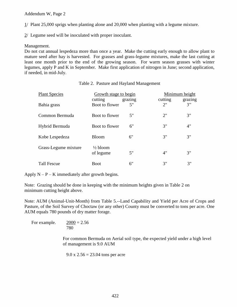
422
Addendum W, Page 2
1/ Plant 25,000 sprigs when planting alone and 20,000 when planting with a legume mixture.
2/ Legume seed will be inoculated with proper inoculant.
Management.
Do not cut annual lespedeza more than once a year. Make the cutting early enough to allow plant to
mature seed after hay is harvested. For grasses and grass-legume mixtures, make the last cutting at
least one month prior to the end of the growing season. For warm season grasses with winter
legumes, apply P and K in September. Make first application of nitrogen in June; second application,
if needed, in mid-July.
Table 2. Pasture and Hayland Management
Plant Species Growth stage to begin Minimum height
cutting grazing cutting grazing
Bahia grass Boot to flower 5" 2" 3”
Common Bermuda Boot to flower 5" 2" 3"
Hybrid Bermuda Boot to flower 6" 3" 4"
Kobe Lespedeza Bloom 6" 3" 3"
Grass-Legume mixture ½ bloom
of legume 5" 4" 3"
Tall Fescue Boot 6" 3" 3"
Apply N – P – K immediately after growth begins.
Note: Grazing should be done in keeping with the minimum heights given in Table 2 on
minimum cutting height above.
Note: AUM (Animal-Unit-Month) from Table 5.--Land Capability and Yield per Acre of Crops and
Pasture, of the Soil Survey of Choctaw (or any other) County must be converted to tons per acre. One
AUM equals 780 pounds of dry matter forage.
For example. 2000 = 2.56
780
For common Bermuda on Aerial soil type, the expected yield under a high level
of management is 9.0 AUM
9.0 x 2.56 = 23.04 tons per acre

423
All Rules Addendum X
References
Bonham, Charles D., 1989, Measurements for Terrestrial Vegetation: Wiley, New York, 338p.
Chambers, Jeanne C., and Ray W. Brown, 1983, Methods for vegetation sampling and analysis on
revegetated mined lands, General Technical Report INT-151. Ogden, UT: United States Department
of Agriculture, Forest Service, Intermountain Forest and Range Experiment Station, 57p.
Natural Resources Conservation Service and Mississippi Cooperative Extension Service, no date,
NRCS Field Office Technical Guide: Natural Resources Conservation Service in cooperation with the
Mississippi Cooperative Extension Service, variously paginated.