abstracts accepted for presentation - citeseerx
TRANSCRIPT
Abstracts Accepted
for presentation 2009
1. All abstracts first sorted by Track.
2. Individual paper abstracts including those in pre-organized sessions are listed first followed by roundtable and poster abstracts.
3. Within the three categories, abstracts are sorted by the presenting au-thor’s last name.
All abstracts are unedited and published as submitted by the author(s) for peer review.
Keyword Index and Author Index provided – referenced to the abstract as numbered in this document, not the page number of the document.
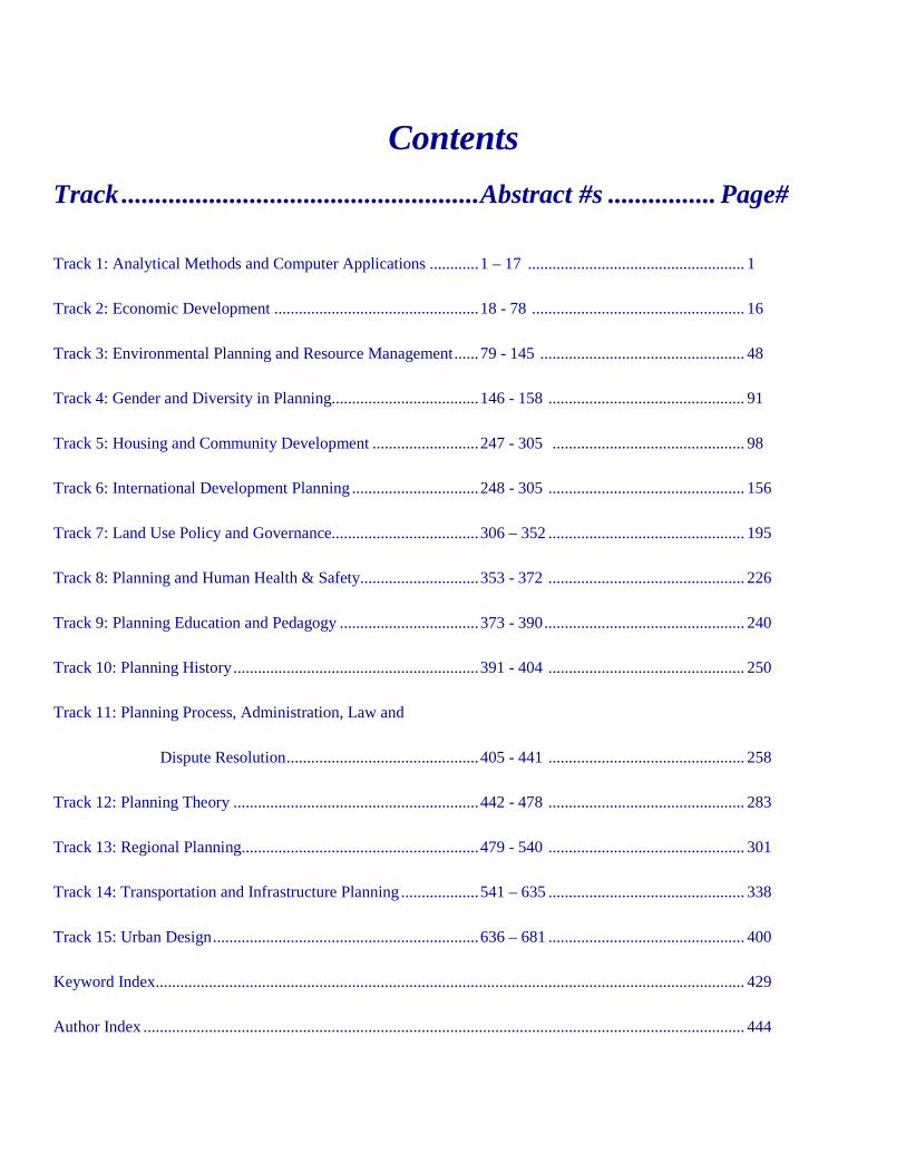
Contents Track ..................................................... Abstract #s ................ Page#
Track 1: Analytical Methods and Computer Applications ............ 1 – 17 ..................................................... 1
Track 2: Economic Development .................................................. 18 - 78 .................................................... 16
Track 3: Environmental Planning and Resource Management ...... 79 - 145 .................................................. 48
Track 4: Gender and Diversity in Planning.................................... 146 - 158 ................................................ 91
Track 5: Housing and Community Development .......................... 247 - 305 ............................................... 98
Track 6: International Development Planning ............................... 248 - 305 ................................................ 156
Track 7: Land Use Policy and Governance.................................... 306 – 352 ................................................ 195
Track 8: Planning and Human Health & Safety ............................. 353 - 372 ................................................ 226
Track 9: Planning Education and Pedagogy .................................. 373 - 390 ................................................. 240
Track 10: Planning History ............................................................ 391 - 404 ................................................ 250
Track 11: Planning Process, Administration, Law and
Dispute Resolution ............................................... 405 - 441 ................................................ 258
Track 12: Planning Theory ............................................................ 442 - 478 ................................................ 283
Track 13: Regional Planning.......................................................... 479 - 540 ................................................ 301
Track 14: Transportation and Infrastructure Planning ................... 541 – 635 ................................................ 338
Track 15: Urban Design ................................................................. 636 – 681 ................................................ 400
Keyword Index ................................................................................................................................................ 429
Author Index ................................................................................................................................................... 444

3
TRACK 1:
ANALYTICAL METHODS AND COMPUTER APPLICATIONS
[1] LANDSCAPE CHARACTERISTICS AND REAL ESTATE DYNAMICS IN NORWAY: EXAMINING DIFFERENCES IN THE CONSUMPTION OF NATURE BETWEEN RESIDENTIAL AND RECREATIONAL REAL ESTATE. Bjorn, Andrew [University of Washington] [email protected] This paper provides results from research that explores interactions between housing market dynamics and the natural and cultural landscape in the greater Oslo region of Norway. The form and pace of real estate development have been of considerable concern to public authorities at all levels in Norway, especially in light of recent neoliberal shifts in Norwegian real estate development and discussions of possible reforms to the Planning and Building Act, the main enabling legislation for planning activities. As mounting development pressures have posed a definite challenge to the preservation of natural, historic and working landscapes, understanding how preferences for real estate are influenced by landscape features will be helpful for public authorities in developing plans and policies under the Act to address these issues. An analysis of the Norwegian real estate market for this purpose is notably different than in other countries. First, despite some historical state involvement in the real estate market, Norwegian rate of homeownership is extremely high, higher than in the United States and among the highest in Europe. Second, a significant number of households in Norway tend to split their housing consumption between permanent residential properties and vacation homes, typically in more natural settings with recreation opportunities. These aspects of the Norwegian real estate system suggest that revealed preference methods are quite useful for an analysis of overall preferences for landscape features. However, they also suggest that both residential and recreational real estate products should be included in any overall analysis of the value of landscapes to households, and that this type of valuation may be distinctly different between these classes. The demand for landscape amenities and the differences in demand between these two distinct but related markets may have a significant impact on regional real estate price dynamics, the siting of new development projects, and overall changes in the human and natural landscape. A more in-depth examination and comparison would provide a more complete understanding of broader household demands for local landscape amenities through the consumption of real estate services, and would help to value the social and economic impacts of changes to the landscape. In this research, I assess the correlations between landscape features and real estate market behavior for the Oslo, Norway
region from January 2000 to October 2006. Using data from the national land register, real estate brokerage data compiled by a third-party source, and government geospatial data sets describing land cover and landscape characteristics, I constructed hedonic price models to assess the correlations between features of the landscape and housing prices both for residential properties and vacation homes (Tyrvainen and Miettinen, 2000; Irwin, 2002). For these models, forest cover, agriculture, open space, water and shoreline were the primary landscape characteristics of interest. A hazard modeling approach was used in an analysis of each real estate class to assess how time-to-sale for properties on the market may be related to landscape features and characteristics of the local environment (Huang and Palmquist 2001). A Bayesian model combining time-on-market and sale price data was also developed to combine these two distinct types of models, based on similar work in the labor economics literature (Boys et al. 2007). The final results are compared to determine the implicit valuation of landscape characteristics and draw conclusions about the relative importance of landscape features for these two interrelated markets. References: Boys, R.J., Dolton, P.J., Walker, N.R. 2007. Adapting the optimal job search model for active labour market policy. Journal of the Royal Statistical Society A 170(3): 759-779. Huang, J-C., Palmquist, R.B. 2001. Environmental conditions, reservation prices, and time on the market for housing. Journal of Real Estate Finance and Economics 22(2-3): 203-219. Irwin, E.G. 2002. The effects of open space on residential property values. Land Economics 78(4): 465-480. Tyrvainen, L., Miettinen, A. 2000. Property prices and urban forest amenities. Journal of Environmental Economics and Management 39(2): 205-223. [2] RECYCLING THE SUBURBS BY ENVISIONING BOWOTOD SUSTAINABLE NEIGHBORHOODS Bossard, Earl [San Jose State University] [email protected] “The American suburb as we know it is dying...Environmentalists will celebrate the demise of sprawling suburbs, which left the nation addicted to cars...The suburbs need to be remade Not every suburb will make it...It´ll be the older suburbs that have the mass transit to thrive postrecession.” says Bryan Walsh in the March 23, 2009 issue of Time Magazine. This paper presents computer based analytical methods to find and understand suburban neighborhoods that have good prospects to be recycled and thrive because of effective combinations of Bicycle Or Walking Or Transit-Oriented Development (BOWOTOD). The Envisioning Neighborhoods techniques - developed by the author over the past decade and presented to ACSP conferences in Tempe, Pasadena, Baltimore, and Chicago - use indices built on degrees of pass-fail success of factors representing sustainable development prospects to find and understand census tract neighborhoods with long term viability prospects in the post – petroleum based automobile age. The methodology includes building general indices for places with good sustainability prospects and then using specific queries to find places with significant amounts of bicycle and transit use to be likely to fit in with a proposed ideal model of urban development.
That ideal model includes a grid of moderate to high capacity transit corridors with major transit center stops about 4 miles apart. (The transit may be heavy rail, LRT or BRT depending on the region´s scale and density of development.) Around these major transit center stops would be a set of land uses of decreasing densities going out for up to five miles. Closest to the transit centers would be what has been commonly called transit-oriented development (TOD) with the highest densities within ¼ mile easy walking distance and slightly lesser densities with ½ mile walking distance. This development could also be called Walking–Oriented Development (WOD), as almost all transit trips begin and end with walking and the best transit center vicinities are also mixed use areas with job sites, shopping, services, and residences located in close proximity so that transit is often not needed for many trips. The WOD would be surrounded by lesser density Bicycle-Oriented Developments (BOD) within easy bicycling distance (< 2 miles) and lesser densities within bicycling distance of less than 5 miles. The effectiveness of bicycling oriented development is estimated using weighted miles of bicycle paths and lanes per square mile, giving higher weights to lighted bikeways and paths. GIS applications include thematic maps of bicycle access effectiveness, as well as maps showing how some of the Sanborn Principles of Sustainable Development can be quantified, mapped, and used to find neighborhoods with good BOWOTOD prospects. The socially just, villagifie multi-generational, and non-exclusionary Sanborn principles are quantified using census data. This paper suggests that recycling the suburbs for a more sustainable future can be achieved with the help of a GIS enabled planning support information system using envisioning neighborhood techniques to find and understand places with bicycling or walking or transit oriented development potential. References: Bossard, Earl. Discovering Sustainable Urban Neighborhoods ACSP/AESOP Joint Congress, July 2008; Bossard, Earl et all. Envisioning Neighborhoods with Transit-Oriented Development Potential, MTI Report 01-15 (San Jose, CA: Mineta Transportation Institute, 2002) 134 pp. with CD-ROM files; Bossard, Earl. “Finding and Envisioning Sustainable Urban Development Neighborhoods,” Computers in Urban Planning and Urban Management (CUPUM´07) Conference, Iguassu Falls, Brazil, July 2007; Edwards, Andres. The Sustainability Revolution. Gabriola Island, BC: New Society Publishers, 2005 is source for Sanborn Principles; Wheeler, Stephen. Planning for Sustainability. New York: Routledge, 2004.
[3] A STRUCTURE/AGENCY APPROACH TO SOCIO-SPATIAL ANALYSIS Chakravarty, Surajit [University of Southern California] [email protected] This paper proposes a methodological model for thinking socio-spatially (Soja, Madanipour, Zukin among others) about places (especially in the case study design) and analyzing them accordingly. The theoretical foundation of the model is the structure-agency framework. We begin with the assumption that the place being studied is a socio-spatial phenomena (dependent variable), produced by the combined influence of factors of structure and agency (independent variables). To answer “how” and “why” questions about such places we need to reconcile the distinct effects of both structure and agency. The model is designed as a guiding framework for mixed methods approaches to organize the study of social, political and economic processes that
create places. The formulation responds to longstanding critiques of structural arguments (see for example Michael Peter Smith´s critique of David Harvey in Transnational Urbanism), without compromising their basic explanatory power. At the same time the model creates space for incorporating the “insurgent” aspects of agency that contribute to the meanings of places. “Space” is conceptualized as a product of the specific forces (or phenomena that form the investigator´s principal areas of interest). The roles of structure and agency, within these forces, are distinguished and also analyzed dialectically. This allows us to study the forces and their impact (i.e. the space they have created). Researchers may narrow or broaden their scope, by rescaling the dialectics of structure and agency to suit the scale at which the study is conducted. The (separate) impacts of structure and agency, in the given place, are studied through mixed methods as applicable to the scale and context of the case. This is done by first enumerating the constituents of 'structure' and 'agency' and then using appropriate methods to evaluate their role in "producing" the place. These specific methods could be quantitative or qualitative. Broadly speaking, this model represents an evolution of methodology specifically designed for urban planning and urban theory. The model synthesizes qualitative and quantitative methods, and establishes a conversation between “fuzzy” grounded theory on one hand, and a “rational”, Popperian approach on the other. Further, it creates space for inquiry without a positivist or structuralist (or other) bias built into the research design. Finally, it creates a framework that can give direction to applied fieldwork while bringing cases to bear upon the development of theory. I have used this model in my dissertation for a case study of an ethnic enclave in Hong Kong. Experiences based on the research conducted are also presented. The paper presents some basic findings that the model allowed, including contributions to the theories engaged, and to the debate over structure and agency. References: Soja (1980). The Socio-Spatial Dialectic. Annals of the American Association of Geographers 70(2). Zukin (1990). Socio-Spatial Prototypes of a New Organization of Consumption: The Role of Real Cultural Capital. Sociology 24(1). Madanipour (1996). Design of urban space: an inquiry into a socio-spatial process. Wiley. Smith (1980). Transnational Urbanism: Locating Globalization. Blackwell. [4] SYSTEMATIC ANALYSIS OF CREATIVE MANPOWER AND R&D TECHNOLOGY LEVEL Choi, Haeok [The University of Tokyo] [email protected] This study focuses on analyzing the relationship between culture industry and creative class in Seoul for upbringing culture industry from the dynamic point of view as representative regional development city in Korea. These policies are classified into two groups: technology development and human resource development policies. Their relative effectiveness is examined using casual loop and stock-flow diagrams, all of which are derived from system dynamics(SD).
5
Based on various employment and technology data in the cultural sector from the mid-1990s to the mid-2000s in Seoul, Korea, this research examines whether technology- and human resource-oriented programs exert significant impact on creative manpower and R&D technology level. After briefly introducing Seoul´s trends in the culture industry, it tries to explain major reinforcing and balancing loops. The stock-flow diagram of the culture industry in Seoul is applied to estimate relative effectiveness of major cultural programs. Judging from a series of simulated experiments, technology-oriented cultural programs are essential to increase creative manpower and R&D technology level in the short term. For the first half of research period, this research finds that human resource-oriented cultural programs put forth minimal impact, if they even exist at all. The trends, however, are reversed in the long term: Both size of creative manpower and R&D technology level absolutely depend on human resource-oriented cultural programs in the second half. References: Boschma Ron A., and Michael Fritsch(2007), Creative Class and Regional Growth: Empirical Evidence from Eight European Countries, Jena Economic Research Papers, 2007-066. Choo, Sungjae(2006), “Development of the Korean Film Industry and Its Spatial Characteristics: Gangnam Region of Seoul as a New Cluster in a New Renaissance?,” Journal of the Korean Geographical Society, 41(3): pp.245-266. Feser, E. J.(2003), “What Regions Do Rather than Make: A Proposal Set of Knowledge-based Occupation Clusters,” Urban Studies, 40(10): pp.1937-1958. Florida, R.(2002), The Rise of the Creative Class, New York: Basic Books. Florida, R.(2005), Cities and the Creative Class, New York: Routledge. Glaeser, Edward L.(2005), “Review of Richard Florida´s The Rise of the Creative Class,” Regional Science and Urban Economics, 35(5): pp.593-596. Goo, Moon-Mo(2005a), “An Analysis on the Economic Performance of Creative Industry and Clustering in Seoul,” Journal of Korean Regional Development Association, 17(1): pp.197-223. Goo, Moon-Mo(2005b), “Economic Contributions of Creative Industries and Some Policy Implications for Seoul Metropolitan Area,” Research on Seoul & Other Cities, 6(4): pp.101-120. Jeon, Jae-Ho(2003), “A Dynamic Analysis on the Relative Effectiveness of Promoting Policies for Information Security Industry,” Journal of Korean System Dynamics Society, 4(2): pp.5-44. Jeon, Yoo-Shin, and Tae-Hoon Moon(2005), “Establishment of the Measurement Model about the Adequate Urban Development Density Using System Dynamics,” Journal of Korean System Dynamics Society, 4(2): pp.71-94. Kim, Kwang-Sun(2007), The Organization of Production and Industrial Clustering of Cultural Content Industries, Seoul National University, Ph.D Dissertation. Kwon, Oh-Hyuk, and Hong-Suk Kim(2000), Regional Culture Industry Promoting Alternative, Korea Research Institute for Local Administration. Kim, Eui-Joon, and Kab-Sung Kim(2004), Economical Impact of Cultural Content Industry, Korea Content Export Information System.
Kim, Hyo-Jung(2004), Promotion Alternatives of Culture, Korea Culture & Tourism Institute. Kim, Suk-Hee(2006), Innovation of Administration Processes Based on Ubiquitous Information Technology, Yonsei University, Master Thesis. Korea Content Export Information System(2004), Economical Impact of Cultural Content Industry. Korea Institute for Industrial Economics & Trade(2001), Culture Industry and Urban Development. Korea National Statistical Office(1995 to 2005), Basic Business Statistics. Landry, C.(2000), The Creative City: A Toolkit for Urban Innovators, London: Earthscan. Lang, R., and K. Danielsen(2005), “Review Roundtable: Cities and the Creative Class,” Journal of the American Planning Association, 71(2): pp.203-220. Lee, Ho-Young, and Ji-Yeen Ryu(2005), Socio-Cultural Impact of Ubiquitous Telecommunication Environment, Korea Information Development Institute. Lim, Keung-Soo(2004), “The Development Measures for Local Cultural Industry as a Regional Development Strategy,” Journal of the Korean Regional Development Association, 14(1): pp.69-90. Markusen, A.(2004), “Targeting Occupations in Regional and Community Economic Development,” Journal of the American Planning Association, 70(3): pp.253-268. Markusen, A., and Schrock G.(2006), “The Artistic Dividend: Urban Specialization and Economic Development Implications, Urban Studies, 43: pp.1661-1686. Ministry of Culture(2002), Adjustment and Supporting Criteria of Regional Culture Industry Cluster Measurement Ministry of Culture(2003), White Paper of Culture Industry. Ministry of Culture(2004a), Report of Global Cultural Content Business. Ministry of Culture(2004b), Report of Culture Industry. Ministry of Culture(2004c, 2006), Culture Industry Statistics. Park, Sang-Hyun, Seung-Joon Yeon and Sang-Wook Kim(2003), “The Application of SD for Supply & Demand Plan of Manpower in Case of Information Security Industry for the UIT Environment,” Journal of Korean System Dynamics Society, 4(1): pp.98-119. Peck, J.(2005), “Struggling with the Creative Class,” International Journal of Urban and Regional Research, 29(4): pp.740-770. Pratt, A. C.(1997), “The Cultural Industries Production System: A Case Study of Employment Change in Britain, 1984-91,” Environment and Planning A, 29: pp.1953-1974. Putnam, Robert D.(2000), Bowling Alone: The Collapse and Revival of American Community, New York: Simon & Schuster. Rantisi, Norma M., Deborah Leslie and Susan Christopherson(2006), “Placing the Creative Economy: Scale, Politics, and the Material,” Environment and Planning A, 38: pp.1789-1797. Rushton, Michael(2006), “The Creative Class and Urban Economic Growth Revisited,” Paper Prepared for the 14th International Conference of the Association for Cultural Economics International, Vienna, Austria, July 6-9, 2006. Ryu, Jae-Youn, and Young-Ho Jin(2002), “Urban Culture Industry and Urban Policy, ” Urban Information Service, pp.3-16. Sasaki Masayuki(1998), “Market Economies and Tradition in the East Asia: Perspectives of Global and Creative City,” Han Lim Japanese Research, 3: pp.88-96. Scott, Allen J.(2006), “Creative Cities: Conceptual Issues and Policy Questions,” Journal of Urban Affairs, 28(1): pp.1-17.

Shea, C.(2004), “The Road to Riches?,” Boston Globe, February 29, D1. Shin, Sung-Hee(2007), “Urban Regeneration in the View of Creative City Index and Creative Group's Distribution Characteristics,” Seoul Economic Focus, February: pp.23-38. Sterman, J. D.(2000), Business Dynamics: System Thinking and Modeling for a Complex World, Boston: Irwin McGraw-Hill. Wojan, Timothy R., et. al.(2007), “Emoting with Their Feet: Bohemian Attraction to Creative Milieu,” Journal of Economic Geography, 7: pp.711-736. Yeon, Seung-Joon(2003), System Dynamics Approach to Building an Integrated Diffusion Model Combining Expectation Management and Customer Satisfaction, Chungbuk National University, Ph.D Dissertation. Yusuf, Shahid, and Kaoru Nabeshima (2005), “Creative Industries in East Asia,” Cities, 22(2): pp.109-122.
[5] GEOSPATIAL WEB APPLICATIONS IN LOCAL GOVERNMENT CITIZEN PARTICIPATION Ganapati, Sukumar [Florida International University] [email protected] Geospatial Web represents an evolution of Geographical Information Systems (GIS) adapted to the Web 2.0 environment. Traditional Public Participation GIS (PPGIS) took advantage of the powerful mapping capabilities of desktop GIS to increase citizen participation in local government decision making processes, such as land use planning, zoning, and community development (Craig, Harris and Weiner, 2002). With the rise of Internet during the 1990s, the GIS has since been adapted into Web based GIS, whereby interactive features such as querying, searching, and mapping dynamically have further expanded the use of GIS for citizen participation (Kingston, 2007; Tang and Waters, 2005). Geospatial Web represents the latest evolution of Web-GIS to the Web 2.0 environment. It is characterized by two central features: it enables location based search; and it allows for third party interfaces through Web 2.0 features (e.g. mashups). NASA´s World Wind, the Google Earth, Google Maps, Live Search Maps, are examples of Geospatial Web. This paper will examine the use of Geospatial Web for citizen participation in local governments. Over 60 percent of the local governments in the United States have adopted Web-GIS (Kaylor, 2005). However, the adoption of Geospatial Web is still at its infancy. The strength of the Geospatial Web for enhancing citizen participation is that it is not only accessible to expert professionals, but also to lay citizens with little training. However, the literature on Geospatial Web is still emerging, and there is little coverage of how local governments can utilize the technology for enhancing citizen participation. This paper aims to fill this gap by identifying the opportunities and challenges of implementing Geospatial Web for participation. The paper is based on selected case studies from five states (California, Florida, Georgia, Massachusetts, and Virginia) representing a broad array of local government services, including parks, economic development, land use, public safety, and transportation. Interviews were conducted with key government officials and technical personnel. Relevant government documents and secondary literature were also reviewed. I argue that Geospatial Web offers new potential for e-participation at three levels: information provision; interaction; and participatory decision making. With respect to information, governments can
provide routine data to citizens in real time. Many transit agencies, for example, use Google Transit to provide information on routing and real time location of buses. Public domain information such as property taxes, crime rates, school quality, and other related information is also at the click of a button. At the second level of interaction, Geospatial Web allows citizens themselves to act as sensors, democratizing the use of GIS (Goodchild, 2007). Users can add real time information (e.g. potholes, water leaks, accidents) to the online maps, which is powerful for government agencies to tap into local knowledge. Lastly, Geospatial web holds potential for collaborative participatory decision making. For example, combined with the 3G mobile phones that provide internet capability, Radio Frequency Identification (RFID) sensory devices that can be read remotely, Global Positioning Systems (GPS) devices that provide the location, and social networking sites such as Facebook, the Geospatial Web has the power to harness public participation in real time (Turner and Forrest, 2008; Rinner et al, 2008). The empirical study of local governments in the five states indicates that the first level of information provision has been largely achieved. Challenges, however, exist for implementing the second and third levels of citizen participation. The challenges are not technological per se; they are organizational and legal in nature. The paper concludes with recommendations for how local governments can overcome these challenges. References: Craig, W.J., Harris, T.M. and Weiner, D. (2002) Community Participation and Geographic Information Systems. Taylor and Francis, New York. Goodchild, M. (2007) “Citizens as sensors: the world of volunteered geography,” GeoJournal, 69, pp. 211-221 Kaylor, C. H. (2005) “The Next Wave of E-Government: The Challenges of Data Architecture,” Bulletin of the American Society for Information Science and Technology, (December-January) pp. 18-22. Kingston, R. (2007) “Public Participation in Local Policy Decision-making: The Role of Web-based Mapping,” The Cartographic Journal, 44, pp. 138–144. Tang, K. X., and Waters, N. M. (2005) “The Internet, GIS and Public Participation in Transportation Planning,” Progress in Planning, 64, pp. 7–62. Turner, A., and Forrest, B. (2008) Where 2.0: The State of the Geospatial Web. An O'Reilly Radar Report. Accessed from http://radar.oreilly.com/research/where2-report.html, 30 September, 2008. Rinner, C., Keßler, C., and Andrulis, S. (2008) “The use of Web 2.0 concepts to support deliberation in spatial decision-making,” Computers, Environment and Urban Systems, 32, pp. 386-395.
[6] DEVELOPING A LOCAL PLANNING MODEL FOR MEASURING IMPACTS OF LAND USE SCENARIOS ON TRANSPORTATION Hu, Hsi-Hwa [Southern California Association of Governments] [email protected]; Uhm, Jung A [Southern California Association of Governments] [email protected]; Choi, Simon [Southern California Association of Governments] [email protected]; Lee, Cheol-Ho [Southern California Association of Governments] [email protected]
7
The purpose of this research is to develop a local planning model for local jurisdictions to easily analyze the impact of different land use scenarios on vehicle use and vehcile miles travelled (VMT) in the context of developing a regional transportation plan (RTP). The model instantly quantifies changes in vehicle use and VMT from different land use scenarios. The model helps local planners or policy makers to identify sustainable communities strategy (SCS) or alternative planning strategy (APS) for meeting the region´s GHG emissions reduction goal. The recent passage of Senate Bill No. 375 has placed the issue of strengthening coordination between land use and transportation planning at the forefront of sustainable development efforts in California. At the core is an emphasis on more intense and efficient use of land, seeking to reduce the reliance on auto use and GHG emissions. SB375 offers a path forward by providing incentives for more compact, mixed-use, and transit supportive development. As SB 375 suggests, large MPOs in California are currently in the process of developing the complex land use or activity based models for the accurate measurement of the relationship between land use changes and trip generation/VMT. The Regional Blueprint Planning Program is intended to better inform regional and local decision making, through proactive involvement of citizens and stakeholders, to build consensus on a preferred land use pattern. The more simplified local planning model is a more effective tool for building consensus on growth patterns. The most important reason for a need of a simplified local planning model is that many local jurisdictions do not have appropriate modeling tools to analyze the impacts of changing land use scenarios on trip making, transit use, and VMT. Second, the widely-used four step travel demand model oftentimes has difficulty in directly measuring the impacts of changing land use changes on trip making, transit use, and VMT. Land use-transportation relationship can sometimes be properly measured through the direct linkage of the small area socioeconomic data (SED) and transportation. The intrazonal land use-transportation relationship still remains a puzzle. There have been efforts of quantifying the intrazonal land use changes and trip generation/VMT. They are not always successful. Third, the locally specific statistical model is preferred to the national data based statistical model due to the better incorporation of locally unique elements (SED, urban form and land uses, transportation networks, etc). But, the recent and past studies show the significantly weaker relationship between land use changes and travel behavior in the Southern California region. The national household travel survey (NHTS) will be used to develop parameters of the local planning model. In this paper, we first provide a review of modeling practices in California with respect to sustainable and smart growth strategies. Second, we test and develop statistical models using 2001 NHTS. The models are used to examine the significance and magnitude of the relationship between land use characteristics and two travel measures (household vehicle ownership, and daily VMT), which are closely related to vehicle use as well as GHG emissions. Additional independent variables include transit accessibility within a half-mile radius from household, population density and local access of opportunity at census tract level, demographic and economic characteristics, travel capability, and regional accessibility. A preliminary statistical test has shown that there was a modest correlation between estimated and observed VMT at census tract level and a high correlation at a more aggregated
community level in the Southern California region. Third and last, we present how the developed model can be used in a planning environment, and discuss issues and challenges. References: Cevero, R. (2006). Alternative Approaches to Modeling the Travel-Demand Impacts of Smart Growth. Journal of the American Planning Association. 72(3), 285-295. Chapin, F. S. Jr. (1974). Human activity patterns in the city: Things people do in time and space. Wiley, New York. Ewing, R., Bartholomew, K., Winkelman, S., Walters, J. & Chen, D. (2008). Growing Cooler: The Evidence on Urban Development and Climate Change. Washington, D.C.: Urban Land Institute. Giuliano, Genevieve (1998). Urban travel patterns. In B. Hoyle and R. Knowles (Eds.) Modern Transport Geography (2nd ed.). Chichester, GB: John Wiley & Sons. Giuliano, Genevieve. (2000). Residential location differences in people of color. Travel patterns of people of color. Washington DC: U.S. Department of Transportation. Giuliano, Genevieve with D. Narayan. (2003) Another look at travel patterns and urban forms: The U.S. and Great Britain. Urban Studies, 40(11): 2295-2312. Hägerstrand, T. (1970). What about people in regional science? Papers of the Regional Science Association, 24, pp.7-21. Reilly, M., & Landis, J. (2002). Influence of urban form and land use on mode choice: Evidence from 1996 Bay Area travel survey. (Paper No. IURD WP 2002 – 4(1)). Berkeley: Institute of Urban and Regional Development, University of California. Waddell, P., Ulfarsson, G.F., Franklin, J.P., & Lobb, J. (2007). Incorporating Land Use in Metropolitan Transportation Planning. Transportation Research PartA. 41, 382-410.
[7] TALENTED YOUNGS AND YOUNG OLDS IN A CONSUMER CITY: AN AGENT-BASED SIMULATION OF HOUSING LOCATION DECISION DYNAMICS Kim, Yuseung [University of Colorado Denver] [email protected] Research of demographic distribution of residential location in metropolitan areas has traditionally focused on more static demographic characteristics such as race or economic class, which are generally consistent over a life time (Myers, 1999). Less effort has been made to trace spatial distribution of more fluid and dynamic dimension of population: age, family status, education, or job type. However, this dimension of the demographic characteristics needs more academic attention. With increased discussion on the issue of human capital and amenity-based growth theory among urban scholars (Glaeser, 2008; Clark, 2004; Florida, 2002; Lucas, 1988; Romer, 1994), the role of demographic attribute change as a driver of other urban changes and the spatial distribution of different groups based on these dynamic characteristics of demography become more significant. Metropolitan areas in the US are experiencing an unprecedented change of geographic redistribution of population in dynamic dimension. Two conspicuous demographic trends are worth noting: (1) Well-educated and amenity-seeking young people´s disproportionate migration to certain locations with some degree of local governments´ efforts to attract talented young people. (2) Increasing number of retiring baby-boomers who are healthy, affluent and have preferences for urban residence. We can postulate that collective location decisions made by individuals in
one of these two dynamic demographic classes will have substantial influences on the economic, social, and political fates of the metropolitan areas. However, we don´t have yet enough understanding of their class behaviors and the consequences of the class behaviors. To explore the magnitude of the issue, an agent-based model (ABM) of housing location choice is constructed in a virtual metropolitan area with three agent types: immigrant young professionals, immigrant baby-boomers, and existing residents. Housing location decisions for immigrant agents are based on a three step scanning process: regional scanning, neighborhood scanning, and site selection. At each stage, agents select housing location based on a selective combination of individual preferences including physical environment, neighborhood composition, public policy, and amount, type, and distribution of amenities. The agent location decision is filtered through the level of agent financial power and the strength of social network inside and between agent types. Migration decisions for existing resident agents are constrained by housing tenure and filtering process. Finally, public policy effects are tested by using scenarios designed to depict various amounts, types, and distributions of urban amenities. Generated spatial distribution pattern of agents from each scenario is analyzed and the results inform a discussion on policy implications. Drawn from an approved dissertation proposal. Chair: Brian Muller([email protected]) References: Chen, Y., and Rosenthal, S., 2008. Local Amenities and Life Cycle Migration: Do People Move for Jobs or Fun? Journal of Urban Economics 64. Clark, T. N., 2004. The City as an Entertainment Machine. Research in Urban Policy, Vol. 9. Camberly, UK: Elsevier. Cortright, J., 2005. The Young and Restelss in a Knowledge Economy. Chicago: CEOs for Cities. Fainstein, S., 2005. Cities and diversity: should we want it? Can we plan for it? Urban Affairs Review 41. Fishman, R., 1999. The American Metropolis at Century´s End: Past and Future Influences. Housing Facts & Findings 1(4), Washington, DC: Fannie Mae Foundation. Florida, R., 2002. The Rise of the Creative Class. New York: Basic Books. Glaseser, E., 2008. Social Capital and Urban Growth, unpublished draft essay. Hagestad, G.O. and Uhlenberg, P., 2005. The Social Separation of Old and Young: A Root of Ageism. Journal of Social Issues 61. He, W., Sengupta, M., Velkoff, V., and DeBarros, K., 2005. U.S. Census Bureau, Current Population Reports, 65+ in the United States. Washington DC, US Government Printing Office. Lucas, R. Jr., 1988. On the Mechanics of Economic Development, Journal of Monetary Economics 22.
Meen, D. and Meen, G., 2003. Social Behaviour as a Basis for Modelling the Urban Housing Market: a Review, Urban Studies 40. Myers, D., 1999. Demographic Dynamism and Metropolitan Change: Comparing Los Angeles, New York, Chicago, and Washington, DC. Housing Policy Debate 10 (4). Oldenburg R., 1989. The Great Good Place. New York: Paragon House. Romer, P., 1994. The Origins of Endogenous Growth, Journal of Economic Perspectives 8 (1). Sandercock, L., 1998. Towards Cosmopolis: Planning for Multicultural Cities. New York: Wiley. Schelling, T. C., 1978. Micromotives and Macrobehaviour. New York: Norton.
[8] AN ASSET-BASED APPROACH TO COMMUNITY TECHNOLOGY Lee, Ming-Chun [University of Texas at Austin] [email protected] Community technology is a grassroots community response to provide access to technology resources where the digital divide exists. Community technology centers (CTCs), one of the actual practices of the community technology movement, allow low-cost or free access to all sorts of computer technologies in an environment supportive of learning and close to homes (Pinkett, 2003; Servon & Nelson 2001; Strover et al., 2004). This research investigates how city-sponsored CTCs in a dense urban area operate and sustain their services. Based on three major bodies of literature: 1) the digital divide, 2) CTC practice, and 3) asset-based community development (Kretzmann & McKnight, 1993), this research establishes a three-layered CTC operation model, which identifies 15 key factors relating to CTC operation and sustainability. The current research, by testing the applicability of this theoretical model, further characterizes these locally-led and community-based CTC initiatives in greater depth. The key concepts and methodologies emerging from the theoretical model together build the empirical framework for the current research, which in turn guides the qualitative analysis of the study. The primary research tools include: 1) semi-structured interviews, 2) surveys, and 3) document reviews and secondary sources. The research findings emerge from examining five community technology projects in the City of Seattle. These findings confirm that the five study cases help empower individual learners by providing a supportive learning environment and offering useful and practical learning materials. The findings also show that the five programs maintain their functioning and service capacities by building a strong foundation and securing three critical operating resources: 1) technological, 2) facility, and 3) personnel resources. The evidence also shows that these programs nurture community partnerships with other organizations and institutions as a means to leverage key operating resources from within the communities, which they serve. The research findings prove that these five organizations take an asset-based approach to identifying resources already existing within their communities. They focus internally on community needs and relate their services to issues facing
9
community members. They also employ relationship-driven strategies to maintain and strengthen partnerships with community members and other concerned parties, including issuing newsletters or other publications to keep members informed and fostering personal relationships among volunteers and support groups. The empirical findings identify two additional factors and lead to a revision of the theoretical model. This re-conceptualization of the community technology practice helps clarify the actual working relations among all CTC operating factors identified in the theoretical model. The current research also offers policy recommendations for both public and non-profit sectors, which suggest more tangible forms of assistance from both city agencies and community-based organizations. References: Kretzmann, John P. & John L. McKnight. (1993). Building Communities from The Inside Out: A Path Toward Finding and Mobilizing a Community Assets, Evanston, Ill.: Center for Urban Affairs and Policy Research, Northwestern University. Pinkett, R. (2003). “Community technology and community building: early results from the Creating Community Connections project”. The Information Society, 19, 365-379. Servon, Lisa J. & Marla K. Nelson, (2001). Community technology centers: Narrowing the digital divide in low-income, urban communities. Journal of Urban Affairs 23: 279-290 Strover, Sharon, Gary Chapman, Dr. Jody Waters, (2004). “Beyond community networking and CTCs: access, development, and public policy”. Telecommunications Policy. 28, 465-485
[9] THE CLUSTERING OF EMPLOYMENT AND MODIFIABLE AREAL UNIT PROBLEM Matsuo, Miwa [Harvard University] [email protected] Many urban planners and economists have analyzed the spatial dispersion and concentration of economic activities using data on the population and employment by zone. Although researchers have discussed their strengths and weaknesses of the methods to identify employment centers, they often overlook the issues of modifiable areal unit problem (MAUP). The problem is that the results of spatial analyses are sensitive to the definitions and sizes of the zones or areal units (Openshaw and Taylor, 1981). This research examines how MAUP affects the results of employment centers identified by the clustering method, one of the most common methods in spatial analyses of employment distributions. The method identifies clusters of zones whose employment density is higher than the density threshold D and whose size is larger than the size threshold E, which is intuitively appealing and useful in identifying large employment concentrations in absolute size. The clustering method was developed by Giuliano and her colleagues in their seminal work on employment centers in Los Angeles (Giuliano and Small, 1991; Giuliano et al., 2007) and widely used by researchers (for example: Small and Song, 1994; Cervero and Wu, 1997). This study uses Giuliano´s basic approach to identify employment centers within
four U.S. metropolitan areas – Atlanta, Boston, Phoenix, and Washington DC – which vary both in their distribution of employment and in the average size of zones used for the analysis. The employment distribution data used in the analysis are obtained from census transportation planning package of year 2000. This work tests how the numbers, shares, and locations of identified centers vary with different thresholds and traffic analysis zone sizes. The differences in zone sizes within and across the metropolitan areas significantly affect the employment centers identified. Moreover, the effects of zone size differ by the density and size thresholds used to identify employment centers. Fortunately, the variation in zone size has less effect on the identified employment centers for the most commonly used center density and size thresholds. References: Cervero, R. and K-L Wu. (1997) Polycentrism, commuting, and residential location in the San Francisco bay area. Environment and Planning A 29 pp. 865-86. Giuliano, G., C. L. Redfearn, A. Agarwal, C. Li, and D. Zhuang. (2007) Employment concentrations in Los Angeles, 1980 - 2000. Environment and Planning A 39 pp. 2935-57. Giuliano, G., and K. A. Small. (1991) Subcenters in the Los Angeles region. Regional Science and Urban Economics 21(2) pp. 163-82. Openshaw, S., and P. J. Taylor. (1981) The modifiable areal unit problem. Quantitative Geography: A British View pp. 60-69. Small, K, A., and S. Song. (1994) Population and employment densities: Structure and change. Journal of Urban Economics 36(3) pp. 292-313.
[10] ESTIMATE THE EFFECTS OF HIGHWAY BRIDGE COLLAPSE ON FREIGHT FLOWS FOR NATIONAL HIGHWAY NETWORK Pan, Qisheng [Texas Southern University] [email protected] National highway infrastructures, especially highway bridges, are vulnerable to structural deficiency due to time deterioration, natural disasters, or terrorist attacks. The collapse of Interstate 35W highway bridge during rush hour at Minneapolis in 2007 has given a warning to planners and decision makers about the safety of highway bridges and possible negative effects on highway network performance and local economy. However, it is still a puzzle how the shut down of highway bridge will change freight flows at both regional and national levels. This study intends to extend the regional freight transportation models discussed in Gordon and Pan (2001), Pan (2006), and Giuliano et al. (2007) to analyze interregional and interstate freight flows. It utilizes the data from Freight Analysis Framework (FAF) and the extended freight model to establish baseline freight flows in the national highway network. It also creates multiple scenarios in different states including Texas, Louisiana, and Minnesota, etc. to estimate the impacts of highway bridge down on freight transportation costs measured by time and distance. It also discusses their possible impacts on regional and national economy. References: Ambite, J. L., Giuliano, G., Gordon, P., Pan, Q., and Bhattacharjee, S., 2002, Integrating heterogeneous data sources for better freight flow analysis and planning, Second National Conference on Digital Government Research, Redondo Beach, California.
Beckman, M., McGuire, C. B., Winsten, C. B., 1956, Studies in the Economics of Transportation, Yale University Press, New Haven, Connecticut. Byrne, G. E., Mulhall, S. M., 1995, Congestion management data requirements and comparisons, Transportation Research Record 1499, 28-36. Cho, S., Gordon, P., Moore, J. E. II, Richardson, H., Shinozuka, M., Chang, S. E., 1999, Integrating Transportation Network and Regional Economic Models to Estimate the Costs of a Large Earthquake, NSF Draft Report, Los Angeles, California. Evans, S. P., 1973, Some applications of mathematical optimization theory in transport planning, Ph.D Thesis, Research Group in Traffic Studies, University College, London. Evans, S. P., 1976, Derivation and analysis of some models for combining trip distribution and assignment, Transportation Research 12, 241-46. Florian, M., Nguyen, S., Ferland, J., 1975, On the combined distribution-assignment of traffic, Transportation Science 9, 43-53. Giuliano, G., P. Gordon, Q. Pan, J. Park, L. Wang (2007) "Estimating Freight Flows for Metropolitan Area Highway Networks Using Secondary Data Sources," Journal of Networks and Spatial Economics (Published online) Gordon, P., J. Moore, H. W. Richardson, and Q. Pan (2006) “The costs of a terrorist attack on Terminal Island at the twin ports of Los Angeles and Long Beach, ” in J. Haveman and H. Schatz, eds., Protecting the Nation´s Seaports: Balancing Security and Cost, Public Policy Institute of California. Gordon, P., J. Moore, H. W. Richardson, and Q. Pan (2005) “The economic impacts of a terrorist attack on the twin ports of Los Angeles – Long Beach,” in H. W. Richardson, P. Gordon, and J. E. Moore, eds., The Economic Impacts of Terrorist Attacks, Cheltenham, UK: Edward Elgar Publishing. Gordon, P., Pan, P., 2001, Assembling and processing freight shipment data: developing a GIS-based origin-destination matrix for Southern California Freight Flows, Final Report, METRANS, Los Angeles, California. Leontief, W. W., Strout, A., 1963, Multi-Regional Input-Output Analysis, In Structural Interdependence and Economic Development, Ed. T. Barna, Macmillan and Company Ltd., London. Miller, E.J., Kriger D.S. and J.D. Hunt, 1998, Integrate Urban Models for Simulation of Transit and Land-use Policies, TCRP Web Document 9. Final Report, TCRP Project H-12. Miller, H. J., 2001, Toward Consistent Travel Demand Estimation in Transportation Planning: A Guide to the Theory and Practice of Equilibrium Travel Demand Modeling, Final Report to U.S. DOT and BTS. University of Utah, Salt Lake City. Ogden, K. W., 1992, Urban Goods Movement: A Guide to Policy and Planning. Aldershot, Hants : Ashgate Ortuzar, J. de D., Willumsen, L. G., 1994, Modelling Transport, John Wiley & Sons, Chichester.
Pan. Q. (2006) “Freight Data Assembling and Modeling: Methodologies and Practice,” Journal of Transportation Planning and Technology, Vol. 29, No. 1. Pan, Q., Gordon, P., J. Moore, and H. W. Richardson (2008) “Economic impacts of terrorist attacks and natural disasters: Case studies of Los Angeles and Houston,” in Daniel Z. Sui and Susan L. Cutter (ed.) Geospatial Technologies and Homeland Security: Research Frontiers and Challenges, Springer. Putman, S. H., 1983, Integrated Urban Models: Policy Analysis of Transportation and Land Use. Pion Ltd., London. Richardson, H. W., P. Gordon, J. E. Moore, J. Park and Q. Pan (2008), “The economic impacts of alternative terrorist attacks on the twin ports of Los Angeles – Long Beach,” in J. M. Quigley, and L. A. Rosenthal, eds., Risking House and Home: Disasters, Cities, Public Policy, Berkeley, California: Berkeley Public Policy Press. Sheffi, Y., 1985, Urban Transportation Networks: Equilibrium Analysis with Mathematical Programming Methods, Prentice Hall, New Jersey.
[11] DEVELOPING A MULTIREGIONAL SOCIAL ACCOUNT MATRIX (MSAM) FOR PROJECTING HOUSEHOLD INCOME DISTRIBUTION IN THE SCAG REGION Park, Jiyoung [University at Buffalo, The State University of New York] [email protected]; Choi, Simon [Southern California Association of Governments] [email protected]; Wen, Frank [Southern California Association of Governments] [email protected] This research is to develop an extended model for economic-demographic projection. Projecting future demands on a region´s socio-economic situation such as housing, transportation, energy, land use, and other local planning issues, usually depends on the status changes of persons, households and employees. This research targets on the Southern California Association of Government (SCAG) for constructing a model linking households, employees, and income distribution. While diverse projecting methods for examining income distribution linking economic-demographic variables have been suggested, recent development of Southern California Income Distribution Model (SCIDM) is dominant because it introduced directly industry sectors to the demographic variables (Choi, 2007). In the case, the employee variable is a key component connecting demographic variables and economic variables. Another way to combine the economic situation with demographic variables is to use Social Account Matrix (SAM), which already includes Input-Output transaction flows and transferring flows of non-market sectors, among industry sectors and institutions of households, private company, and federal and local governments (Pyatt and Round, 1985). This research is to intend developing a multiregional SAM (MSAM) model for the SCAG region. The MSAM, which consists of 6 counties of SCAG region, will be combined with Demographic-Industry-Income matrix (DIIM) which already developed at SCAG, although an industrial bridge connecting different industrial classifications is necessary.
11
Constructing a new MSAM model for the SCAG region requires developing several technical procedures and methodologies. Steps to construct MSAM for SCAG are composed as 1. Industry sectors in different data sets are matched to the industry sectors scheme of DIIM. 2. Once data have a consistent sectors scheme, then county-to-county trade flows for each industry are estimated. 3. The estimated trade flows are tuned using Doubly-constrained Fratar Model (DFM). 4. The final industrial trade flows matrices are combined with migration flow matrices of household income levels. 5. The SAM data sets of each county available via IMPLAN program are prepared. 6. The final step produces a multiregional SAM (MSAM) based on the constructed flows matrices and IMPLAN´s SAMs. A MSAM involving 6 counties of SCAG region are produced. Income distribution for the SCAG region is projected, interlocking with SCAG´s DIIM data. Compared to the dominant studies of income distributions linking population, industries, and migration, all other studies except this research seem not to involve regionally disaggregated connections. The suggested MSAM approach to updating income distribution contains the regional interaction, and hence provides county based income distribution changes. Especially, using inverse MSAM, income distribution changes resulted from government investments or trade changes can be simulated. The simulation can justify the SCAG´s planning proposals for various local issues in the SCAG region. References: Choi, S., 2007, Developing an Expanded Economic-Demographic Projection Model: Linking Population, Employment, and Income Distribution, presented at the 48th Annual Association of Collegiate Schools of Planning (ACSP), Milwaukee, Wisconsin, October 18-21. G. Pyatt and J. Round. 1985. Social Accounting Matrices: A Basis for Planning, The World Bank Press, Washington DC. Gordon, P., J.Y. Park, and H. W. Richardson, 2009, Modeling Economic Impacts in light of Substitutions in Household Sector Final Demand, Economic Modelling (in print). Chenery, H.B., 1953, Regional Analysis, in The Structure and Growth of the Italian Economy, edited by H.B. Chenery, P.G. Clark and V.C. Pinna, U.S. Mutual Security Agency, Rome: 98-139. Moses, L.N., 1955, The Stability of Interregional Trading Patterns and Input-Output Analysis, American Economic Review, 45: 803-832 Park, J.Y., P. Gordon, J. E. Moore II, and H. W. Richardson, 2008, A Two-Step Approach Estimating State-by-State Commodity Trade Flows, The Annals of Regional Science, Online first published.
[12] USING THE LAND USE CONFLICT IDENTIFICATION STRATEGY (LUCIS) TO DEVELOP STRATEGIES FOR RESOLVING URBAN AND NATURAL CONFLICTS IN
THE APALACHICOLA-CHATTAHOOCHEE-FLINT (ACF) BASIN Patten, Iris [University of Florida] [email protected]; Arafat, Abdulnasar [University of Florida] [email protected] The Apalachicola-Chattahoochee-Flint (ACF) watershed and the rivers that it feeds extends from western North Carolina southward into Georgia and Alabama and then into Florida where it meets the Gulf of Mexico near the small community of Apalachicola. The ACF is composed of the Apalachicola River and its two main tributaries, the Chattahoochee and Flint Rivers. The watershed contributes to supporting aquatic based industries and ecologies, providing water for household use, and supporting thermoelectric power generation. The ACF basin includes approximately 75 counties across Alabama, Florida and Georgia. According to the 2000 Census these counties had a total population of a little over 5.5 million people and by the year 2015 more than 2 million additional people are projected to reside in this region. The majority of the greater Atlanta metropolitan area sits within the upper third of the watershed and this and other rapidly growing urban areas in the watershed are placing increased pressure on the finite quantity of available water resulting in altered quality. The basin is 6% residential, 2% commercial, 25% agricultural and the remaining area is primarily undeveloped forest land. The ACF basin plays an integral part in supporting urban and natural environments yet satisfying the demands of all land uses and stakeholders requires a delicate balance, which has yet to be realized. This paper evaluates the unresolved conflict between nature and people. More specifically, using the land use conflict identification strategy (LUCIS) this paper evaluates the conflict within the ACF basin using the inherent suitability of land to recommend strategies that support a new metropolitan agenda which considers the water needs of future urban development and supports the economic goals of industries that rely upon the ecology of the basin for their viability. The LUCIS is a goal-driven geographic information system (GIS) scenario modeling tool that utilizes 3 steps to determine land use conflict. First, the intrinsic suitability of land is determined given existing physical, access or location characteristics and economic value. Next, the factors that contribute to suitability are summarized for each land use type (i.e. agricultural, conservation, or urban) and LUCIS assists in determining which lands are preferred for each specific use. Lastly, conflict between multiple land uses is determined based upon whether the intrinsic value of land can support multiple uses. Most importantly, the LUCIS conflict identifies the degree to which one future use is preferred over another. The LUCIS strategy is a tool that facilitates developing urban policies and strategies which considers the needs of the land and demands of its people and industry. References: "Alabama Coosa Tallapoosa Apalachicola Chattahoochee Flint River Basins Comprehensive Water Resources Study" (Northwest Florida Water Management District, 2008). http://www.nwfwmd.state.fl.us/rmd/acfcomp/cstudy.htm (March 15, 2009). Nicole T. Carter, M. Lynne Corn, Amy Abel, Stan Mark Kaplan, Eugene H. Buck, Cynthia Brougher, and Kristina Alexander, "Apalachicola-Chattahoochee-Flint (ACF) Drought: Federal Water Management Issues," CRS Report for Congress (Washington, DC: Congressional Research Service, 2008).

Brian Richter, Ruth Matthews, David L. Harrison, and Robert Wigington, "Ecologically Sustainable Water Management: Managing River Flows for Ecological Integrity," Ecological Applications 13, no. 1 (February 2003): 206-224.
[13] ESTIMATING COST OF GREEN SPACE LOSS IN METRO ATLANTA USING G.I.S. LAND USE FORECASTING MODEL: IN THE CONTEXT OF CLIMATE CHANGE MITIGATION PLAN Sung, Sangwoo [Georgia Institute of Technology] [email protected] One of critical issues in future planning in metropolitan areas must be how local government should prepare climate change action plans to mitigate global warming effect in the context of balancing urban growth and environmental protections. Preserving urban forest and green spaces in metro region is one of effective strategies for climate change planning; however, convincing the public of the benefit of healthy urban ecosystems in climate change perspective is not easy task for local/regional planning bodies. One of effective approach to discuss consequences of sprawls and deforestation is to visualize such green space loss under certain given land cover change scenarios so that we can estimate the economic cost/benefits of green infrastructures in dollar values. Recent G.I.S. technologies allows researchers to quantify the mass of urban forest changes over time and calculate the economic opportunity cost associated with air pollution reduction or energy savings. In this context, this study aims to show how G.I.S. can be used to measure the economic cost we may have to pay caused by the future loss of urban forest and green spaces due to absence of appropriate land use policies in local and regional climate change plans. Two major questions are to be answered in this case study; (1) Having GIS analysis result of LULC change patterns in the past, how can we effectively simulate future LULC under different policy scenarios? (2) Given different LULC scenarios, how much of quantity (in dollars as well) of air pollution reductions, atmospheric CO2 sequestrations, and energy savings by atmospheric cooling effect will we be able to get? Three different growth scenarios will be applied to answer these questions, which are; (a) business as usual (i.e. rapid sprawl), (b) moderate growth in urban edges and (c) strong smart/compact growth policy implementation case. For this case study, I chose 13 counties of Atlanta metro region in GA where rapid sprawl has occurred and lost significant green spaces for the past decades. A series of GIS datasets in past 30 years including most recent year 2006 in metro region is be used in IDRISI software which offers `Land use change modeler´ modules such as logistic regression modeling and Marcov Cellular-Automata model. Additionally, `CITYgreen for ArcGIS´ developed by American Forest is also be used to compare the result of economic values of urban forest in terms of air pollution reductions / sequestration and energy savings by atmospheric cooling effects from different LULC scenarios above. In sum, the degree of mass of urban green infrastructure correlates strongly with the degree of air pollution reductions, atmospheric CO2 sequestrations, and energy savings. Therefore, I will also discuss how this study results and methodological approach may help local and regional governments to develop
climate change mitigation action plan in terms of balancing urban growth and environmental resource conservations. References: American Forests. (2001). Urban ecosystem analysis – altanta Metor Area. Washington, D.C. America Forest, (2002). CITYgreen: Calculating the value of Nature User Manual, American Forest, PO Box2000, Washington DC20013. Clarke, K.C.,Hoppen, S., & Gaydos, L. (1997) A self-modifying cellular automation model of historical urbanization in the San Francisco Bay area. Environment and planning B: Planning and Design, 24, p 247-261. Eastman, J.R. (2006) IDRISI Andes Guide to GIS and Image Processing, IDRISI Production in Clark University, Worchester, MA. Hu, Zhiyoung and C.P. Lo. (2007) Modeling urban growth in Atlanta using logistic regresssion., Computers, Environment and urban systems, 31 p667-688. McPherson, E.G. (1994) Using urban forests for energy efficeicy and carbon storage. Journal of Forestry 92:10, p 36 – 41. McPherson, E. Gregory, and et al. (2008), Los Angeles 1 million tree canopy cover assessment, General technical reportPSW-GTR-207, Untied State Department Agriculture. Nowak, D. J. (200) A modeling study of the impact of urban trees on ozone. Atmospheric Environment 34:10, p 1601-1613 Pijanowski, Bryan C. and et al. (2002) Using neural networks and GIS to forecast land use changes: a Land Transformation Model, Computers, Environment and Urban Systems 26 p. 553-575. Sarasota County Forestry Division Report, (2004). Urban Ecosystem Analysis for Sarasota County, Sarasota County Forest Division, FL. Stone, Brian, Adam C. Mednick, Tracey Holloway, and Scott N. Spack (2007) Is Compact Growth Good for Air Quality?, Journal of America Planning Association, 73:4, p 404-418. Yang, X., & Lo, C.P. (2003). Modeling urban growth and landscape changes in the Atlanta Metropolitan area. International Journal of Geographical Information Science, 17 (5) p 463-488.
[14] EVALUATION OF LIDAR TECHNOLOGY FOR FLOOD MODELING AND CLIMATE CHANGE IMPACT ANALYSIS ON TRANSPORTATION Wang, Zun [University of Florida] [email protected]; Peng, Zhong-Ren [University of Florida] [email protected]; Shen, Suwan [University of Florida] [email protected] Although uncertainties still exist, recently, the scientific community practically reached a consensus that global climate change will most likely increase the frequency and severity of extreme weather in the near future. (Oreskes, 2004) Caused by such weather as extreme precipitation and cyclones, flooding, especially in coastal areas, is one of the most important consequences and may severely affect urban transportation
13
systems. (Suarez, Anderson, Mahal, & Lakshmanan, 2005) (Transportation Research Board, 2008) The impact analysis of flooding on transportation depends on terrain data and hydrological models. The Digital Elevation Model (DEM) is widely used as a terrain data source, with a resolution of about 25m. (Vaze & Teng, 2007)There are two kinds of limitations when using this DEM data, namely, 1) the horizontal resolution of DEM significantly limits the detection of terrain features and thereby affects the accuracy of flood prediction results, (POULTER & HALPIN, 2008)and 2) the rough vertical resolution is unable to reflect the elevation of the transportation infrastructure and may consequently affect the assessment of the impacts of flooding on transportation networks and corresponding adaptation strategies. The use of LiDAR technology significantly increases the accuracy of the elevation data and DEM. This paper focuses on the comparison of the traditional DEM (including 30m and 10m resolution) and LiDAR derived DEM regarding the accuracy of the flooding maps generated from these terrain data. Terrain features are extracted from both types of DEM and fed into Hydrologic Engineering Centers River Analysis System (HEC-RAS) to generate predicted flooding maps. The experimental results indicate that LiDAR data has better performance in most of the tested scenarios. We empirically verified the accuracy of LiDAR data in flood modeling, and used LiDAR data to extract the elevation information of transportation infrastructure for analyzing the impacts of flooding on transportation networks. Data from Pensacola, Florida was used as a case study. We found that using LiDAR derived DEM data in flood prediction provided an easier, more accurate method for identifying specific parts of transportation networks that may be inundated by certain intensities of flooding. The research results indicate the importance of LiDAR data to assess the impacts of flooding on transportation networks and corresponding planning adaptation strategies in response of climate change. References: Transportation Research Board. (2008). Impacts of Climate Change and Variability on Transportation Systems and Infrastructure: Gulf Coast Study, Phase I. Transportation Research Board. Oreskes, N. (2004). BEYOND THE IVORY TOWER: The Scientific Consensus on Climate Change. SCIENCE , 1686. POULTER, B., & HALPIN, P. N. (2008). Raster modelling of coastal flooding from sea-level rise. International Journal of Geographical Information Science , 167-182. Suarez, P., Anderson, W., Mahal, V., & Lakshmanan, a. T. (2005). Impacts of flooding and climate change on urban transportation: A systemwide performance assessment of the Boston Metro Area. Transportation Research Part D , 231-244. Vaze, J., & Teng, J. (2007). Impact of DEM Resolution on Topographic Indices and Hydrological Modelling Results. MODSIM 2007 International Congress on Modelling and Simulation. Modelling and Simulation Society of Australia and New Zealand (pp. 706-712). ISBN: 978-0-9758400-4-7.
[15]
MICRO-LEVEL ESTIMATION OF LAND USE PATTERN: MEASURING DENSITY FACTORED ACCESSIBILITY FROM HOMES TO JOBS, SERVICES AND OPEN SPACES Yi, Young-Jae [Texas A&M University] [email protected] Density and land use mix are two primary land use attributes in sustainable urbanism concepts such as compact city and smart growth. Despite the advancement of measures of density and land use mix, there remain two issues in need of investigation. First, traditional measures illustrate only one attribute of land use. That is, density measures only focus on the size of population while land use mix measures only illustrate the spatial distribution of land use. Thus, it is hard to interpret them as an integrated system (e.g., how to interpret an area where shows high density and low level of land use mixture?). Second, the geographic unit of the measures is too aggregated to capture actual land use patterns on the ground. Modifying accessibility measure, this study develops an advanced measure of land use pattern that can capture density and land use mix in an integrated system in finer geographic unit. In specific, the study proposes density factored accessibility toward jobs, services and open spaces by residential block. Tasks include (1) description of how density factored accessibility measure is able to capture density and land use mix in an integrated system; (2) disaggregation of socioeconomic data into physical land use block level in use of parcel-level data, geographic information system software and statistical software; and (3) computation of density factored accessibility from each residential block to other land use blocks in metropolitan statistical areas using the disaggregated socioeconomic data and environmental data. To illustrate the difference in ability to capture land use pattern, the measure will be compared to models of traditional density and land use mix measures in various simulated land use patterns. The density factored accessibility measure is expected to capture land use pattern in more sophisticated manner. Also, the fine spatial resolution of the measure can improve the compatibility of vector-based socioeconomic data with raster-based environmental data. This study is for doctoral dissertation but the proposal has not been approved by committee yet. References: Hess, P.M., and A.V. Moudon. 2000. Measuring land use patterns for transportation research. Washington, DC: Transportation Research Board. Knaap, Gerrit-Jan, Yan Song, and Zorica Nedovic-Budie. 2007. Measuring Patterns of Urban Development: New Intelligence for the War on Sprawl. Local Environment 12(3): 239-257. Kockelman, K.M. 1996. Travel behavior as a function of accessibility, land use mixing, and land use balance. In City and regional planning. Berkeley: University of California Press.
[16] ASSESSING CHILDREN´S PLAYING ENVIRONMENT: A CASE STUDY OF ERIE COUNTY, NEW YORK Yin, Li [University at Buffalo] [email protected]; Raja, Samina [University at Buffalo] [email protected]; Roemmich, James [University at Buffalo] [email protected]; Epstein, Leonard [University at Buffalo] [email protected]; Li, Xiao [University at Buffalo] [email protected]
Current research on the relationship between the built environment and physical activity often use self-reported locations of physical activities or arbitrarily defined neighborhoods of studied subjects to measure and study built environment. The self-reported data on locations in the forms of survey or diary is problematic because subjects may recall wrong locations or inaccurate times (Brog et al., 1982). The definition of what constitutes a neighborhood differs across studies and differs across individuals perceptually. A half mile radius around people´s residence is often used to define their neighborhood (Roemmich, et al., 2006; 2007). Other studies use a quarter mile or 10-minutes´ walking area. Theses differences and unreliable self-reported locations due to faulty or selective memories may introduce bias, affect the validity of statistical models, and make studies that examine associations between the built environment and physical activity incomparable. Data on time and location of physical activity is critical in furthering urban planners´ understanding of the relationship between built environment and physical activity. Moreover, a significant proportion of planning and public health literature overlooks the impact of built environment on children´s physical activity, even though the trajectory of obesity among individuals is established at a very young age. Children´s play environment around their homes is rarely studied. Children´s play spaces are often available at particular locations shaped by built environment. This study focuses on spaces where children play around their residences. This study uses global positioning system (GPS) data to supplement self-reported data and activity data on active travel to help delineate each child´s playing neighborhood where the child is physically active and examine how a child uses the built environment in that neighborhood. We used GPS units and dairy to collect position and time data as well as track walking and other types of travel occurred outdoors for each of a total of 40 children randomly selected who are between 9 and 15 years old and who are living in Erie County, New York, U.S. This data, together with a database that includes a range of GIS datasets such as street centerline, parcel, building footprint and orthophotos provide rich sources of information for the analysis of travel time, route, speed, and other travel and physical activity information and for the study of children´s playing environment or neighborhood. The detailed space-time trajectories at the individual level helped us define the spaces used most often by subjects for playing and the farthest distance children are willing to walk and bike. The findings provide information to help assess the built environment of children´s neighborhoods for playing and understand what built environment characteristics of that neighborhood would encourage children to play and being physically actively. This study also provides a prototype for future studies on physical activities using GPS and accelerometer. We discuss the problems related to the implementation of GPS data collection, data quality and reliability of GPS measurements. References: Quiroga, C.A., Bullock, D., 1998. Travel time studies with global positioning and geographic information systems: an integrated methodology. Transportation Research C 6C (1), 101-127. Roemmich, J. N., Epstein, L. H., Raja, S., and Yin, L. 2007. “The Neighborhood and Home Environments: Disparate Relationships with Physical Activity and Sedentary Behaviors in Youth” Annals of Behavioral Medicine, 33 (1) pp 29-38
Roemmich, J. N., Epstein, L. H., Raja, S., Yin, L., Robinson, J., and Winiewicz, D. 2006. “Influence of Access to Parks and Recreational Facilities on the Physical Activity of Young Children” Preventive Medicine, 43 (6) pp 437-441
[17] POSTER PARCEL LEVEL IMPERVIOUSNESS BY DEVELOPMENT TYPES ACROSS URBAN TO RURAL GRADIENT IN THE SEATTLE REGION Jiang, Yan [University of Washington] [email protected] The relationship between impervious surface and runoff has been well documented in the environmental literature. Moreover, imperviousness is one of the few variables that can be quantified, managed and controlled at different stage of land development. Therefore, imperviousness has been widely accepted as an important indicator with which to measure the impact of land development on aquatic systems. The purpose of this study is to compare the imperviousness among various development types, examine whether the imperviousness of various development types vary across the urban to rural gradient and acorss the Urban Growth Boundary (UGB). This study overlays impervious data, parcel data and urban-suburban-exurban-rural gradient data for 6 development types including Single Family Residential (SFR), Multi-Family Residential (MFR), commercial, institutional and parking. The impervious data is developed using linear spectral unmixing classification applied to 10m SPOT imagery. The urban gradient data is developed from Principle Component Analysis (PCA) of three selected variables — population density, distance from urban centers and elevation. 30 parcels built before the Growth Management Act (GMA) and 30 parcels built after the GMA are randomly sampled respectively for each development type in 4 gradient zones. The results show that: (1) the imperviousness decreases along urban to rural gradient for all 6 development types; (2) SFR parcels have the lowest imperviousness in all gradient zones, with MFR and institutional parcels coming in second. (3) GMA has significant effect in increasing imperviousness for SFR parcels across urban to rural gradient, while the change inside the Urban Growth Boundary (UGB) is greater than the change outside the UGB. This study is not based on my dissertation research. Please contact my advisor Dr. Marina Alberti ([email protected]) for any question. References: Alberti, M., Weeks, R., and S. Coe. (2004). Urban Land Cover Change Analysis for the Central Puget Sound: 1991-1999. Journal of Photogrammetry and Remote Sensing 70:1043-1052. Luck, M. and Wu, J. (2002) A gradient analysis of urban landscape pattern: a case study from the Phoenix metropolitan region, Arizona, USA. Landscape Ecology 17(4): 327-339 Powell, S., Cohen, W., Yang, Z., Pierce, J., and M. Alberti. (2008). Quantification of impervious surface in the Snohomish water resources inventory area of Western Washington from 1972- 2006. Remote Sensing of Environment. 112(4): 1895-1908. Robinson, L., Newell.,J.P. and Marzluff, J.M.(2005). Twenty-five years of spawl in the Seattle region: growth management responses
15
and implication for conservation. Landscape and Urban Planning 71: 51-72.
TRACK 2:
ECONOMIC DEVELOPMENT [18] IDENTIFICATION OF SHARED LABOR POOLS FOR WORKFORCE AND INDUSTRIAL CLUSTER DEVELOPMENT Chrisinger, Colleen [University of Washington] [email protected]; Fowler, Christopher [University of Washington] [email protected]; Kleit, Rachel [University of Washington] [email protected] Many states pursue economic development by supporting promising clusters of industries. Industry clusters can be defined in a variety of ways, including based on the shared occupational traits of the labor pools from which they draw. Identification of labor pools is a first step in the process of establishing an economic development policy that matches the needs and skills of local workers with business demand in the same location, rather than emphasizing relocation of workers and businesses from other areas. A labor-based approach to economic development also is well suited to assisting workers to make transitions to jobs utilizing similar skills in other industrial clusters, or to move from low quality to high quality jobs. This paper uses recent data from the Occupational Information Network (ONET) database to identify labor pools that share similar occupational characteristics, and then locates those labor pools geographically based on the number of workers employed in each pool across the United States. Building on research by Feser (2003), Markusen (2004), and Koo (2005), innovations of this paper are a focus on lower skill occupations rather than just knowledge-based clusters, use of more recent and extensive data, and detailed spatial analysis of labor locations. We believe that defining clusters in terms of where suitable labor pools exist is a key step in directing local economic development resources toward workforce development and poverty alleviation. Note: One of the authors of this paper is a student, but the paper is not part of her doctoral dissertation. References: Feser, E. J. (2003). What Regions Do Rather than Make: A Proposed Set of Knowledge-based Occupation Clusters. Urban Studies, 40(10), 1937-1958. Markusen, A. (2004). Targeting Occupations in Regional and Community Economic Development. Journal of the American Planning Association, 70(3), 253-268. Koo, J. (2005). How to Analyze the Regional Economy with Occupation Data. Economic Development Quarterly, 19(4), 356-372.
[19]
SUBSIDIES TO FILM PRODUCERS: WHAT ARE STATE RETURNS? Christopherson, Susan [Cornell University] [email protected] The entertainment media industries are particularly attractive economic development targets because of their knowledge-intensive jobs. They also bring additional benefits to state and local economies in the form of multiplier effects, and spin-off benefits in tourism and image creation. The presence of film crews entertains tourists, and the resulting movies or TV shows may help market the city or state where scenes are shot. Film crew activity is also highly visible to the public and creates attention for policy makers who want to be seen as taking action to improve their economy. Since the mid 1990s, state policy makers across the U.S. have ramped up efforts to attract film and television production to their states through tax-based subsidies that provide producers with “soft money” to finance their productions. These subsidies are justified on the grounds that this branch of the creative economy -- media production activities promotes economic development and injects thousands of dollars into the state economy. However, as subsidies to film and television producers have increased questions are being raised about the use of public money to lure media producers to states and cities. Skeptics ask whether the costs of attracting media producers outweigh benefits to the state´s economy. They particularly question whether new, sustainable industries can be built in cities and states where there is no history of media industry investment nor a sizable skilled production workforce. To better understand the role that tax-incentive based financing plays in film and television production and whether it pays off for state economies, we look at how the subsidies-oriented approach has emerged from the service-oriented incentives that were the norm until the late 1990s. We assess the claims put forward regarding economic development benefits and the assumptions underlying those claims. We examine available evidence concerning the fiscal impacts of the film and television subsidy programs, and at the methods used to calculate subsidy-produced job creation. We also look at the potential for developing film and television industries outside the industry centers of Los Angeles and New York. How likely is it that the more stable pre-production and post-production activities will follow footloose film and television shooting to states offering subsidies? Are political leaders realistically assessing what it takes to establish a full-fledged industry in their state? Finally, we assess what the debate over entertainment media subsidies means for contemporary economic development policy and practice. Our findings reinforce concerns about transparency and inefficient uses of public money as states compete for inward investment. [20] THE EFFECT OF IMPORTS ON THE DEVELOPMENT OF LOCAL RECORDED MUSIC INDUSTRIES Chu-Shore, Jesse [MIT] [email protected] The cultural industries, especially music, have attracted significant attention among economic development scholars in recent years, in part because less developed regions and nations are likely to have important ingredients of global competitiveness (innovation and
cultural capital). However, the music industry is not well understood and it is difficult to formulate policies that would support economic development outcomes. Two complications characterize the complexity of the problem: success of producers depends highly on shifting consumer tastes, and local cultural assets are under the constant influence of global competitors. My research question is therefore, "what are the effects of imports on local industry?" I report results in two domains: the influence of imports on the likelihood of developing exports, and the influence of imports on growth of domestic industries. For the former, I relate the level of imports to growth outcomes in a cross-national comparison during the period of upheaval in the music industry immediately after advent of online distribution of music. For the latter, I conduct a longitudinal network analysis on the pattern of trade in music recordings. In both cases, imports can have salutary economic consequences, but only under certain conditions, and with effects on domestic market structure that may represent disruption of local cultural assets. Additionally, in both cases economic development outcomes can only be understood analytically by incorporating an analysis of consumer tastes through the lens of path-dependency in consumption. I present my results and discuss their implications for policy and economic development theory. This research is drawn from two chapters of a nearly complete dissertation supervised by Alice Amsden ([email protected]), Michael J. Piore, and Christopher O. Wheat. References: Snijders, Tom A.B. (2005). “Models for Longitudinal Network Data” Chapter 11 in P. Carrington, J. Scott, & S. Wasserman (Eds.), Models and methods in social network analysis. New York: Cambridge University Press Kozul-Wright, Zeljka and Lloyd Stanbury (1998) “Becoming a globally competitive player: The case of the music industry in Jamaica” UCTAD discussion paper no. 138. Scott, A.J. (2004) “Cultural-Products Industries and Urban Economic Development: Prospects for Growth and Market Contestation in Global Context” Urban Affairs Review 39: 461-490.
[21] VACANT PROPERTY AS URBAN ASSET: REDISCOVERING THE VALUE OF THE URBAN CORE Coffin, Sarah [Saint Louis University] [email protected] Almost a decade ago the Brookings Institution reported that underutilized land in cities “ remains a key competitive asset for implementing a number of economic development strategies: creating jobs, increasing tax revenue, improving transportation infrastructure, and attracting residents” (Pagano and Bowman 2000). Yet vacant and abandoned properties remain a serious problem for the social, economic, and fiscal health of central cities and inner-ring suburbs. These neglected properties harm communities by further limiting tax revenue opportunities, stimulating higher maintenance costs for municipal and county governments, and generally causing a variety of community, environmental and public health problems. Additionally, the current foreclosure crisis only adds to the potential for more abandoned and vacant properties in regions across the US. Over the past several years a number of cities have taken effective
actions to stop the spread of property abandonment and to reclaim such property for productive use. Organizations such as the National Vacant Properties Campaign have helped cities like Philadelphia, Cleveland, Dayton, and Buffalo target vacant properties as opportunities to strengthen communities and spark well-planned redevelopment. Yet we are facing an unparalleled economic crisis that has slowed down many of these efforts. The Obama administration has implemented an ambitious and hopeful economic agenda and as the stimulus funds begin to filter down to the community level, time will tell whether redevelopment plans include a vacant property reclamation agenda. Last summer the St Louis region initiated a conversation with the National Vacant Properties Campaign to determine how best to address their regional vacant property issues. The Campaign spent two days in the region examining a series of issues ranging from regionalism to land banking to foreclosure. To date no follow up has occurred although local government officials needed to redirect their attention to federal stimulus proposals that began to filter down following the campaign visit. Local government officials are now reconsidering the campaign observations. Per the City of St. Louis 2002 assessor´s data, 15.7% of the city's more than 130,000 parcels were categorized as vacant land. These assets are `disguised´ as derelict buildings, boarded storefronts, and vacant residential structures. Those who live near such structures suffer adverse impacts on property values, their sense of community, and overall quality of life. Furthermore, vacant properties often contain an array of conditions (illegal dumping, leaking sewage, asbestos, lead, and fire hazards) that pose serious threats to public health and safety. The volume of distressed properties, the transaction complexities, and the redevelopment costs serve as barriers to bringing redevelopment efforts to scale. This paper will examine the St. Louis case for the National Vacant Properties Campaign using the context of four prior campaigns; Philadelphia, Cleveland, Dayton, and Buffalo. The aim of this paper is to provide a focus for the St Louis region using a sound vacant properties strategy. References: Michael A. Pagano and Ann O´M.Bowman. 2000. “Vacant Land in Cities: An Urban Resource,” The Brookings Institution Survey Series. December. Michael A. Pagano and Ann O´M.Bowman. 2003. Terra Incognita: Vacant Land and Urban Strategies. Georgetown University Press. Alan Mallach, “Managing Neighborhood Change: A Framework for Sustainable and Equitable Revitalization” National Housing Institute 2008. Joseph Schilling and Jonathan Logan. 2008. Greening the Rustbelt: A Green Infrastructure Model for Right Sizing America´s Shrinking Cities 74:4 pp 451-466.
[22] INFREQUENCY AND URGENCY OF ECONOMIC DATA IN NORTH CAROLINA: THE WESTERN NORTH CAROLINA ECONOMIC INDEX AND ITS USEFULNESS AS PLANNING INTELLIGENCE Crepeau, Richard [Appalachian State University] [email protected] Since August of 2003, The Western North Carolina Economic Index and Report has provided basic economic information for 25 counties and two Metropolitan Statistical Areas on a monthly basis. Local economic development agencies and local planning

17
offices use this information to supplement their information gathered from census updates in order to make more informed decisions. However, economic data in rural areas is very sparse, especially those data that allow decision makers to act in a timely manner. This paper proposes to introduce the method of analysis used to construct the Western North Carolina Economic Index and extend its more immediate analysis to assess the utility of the Index when supplemented by richer (though less frequent) data to draw inferential conclusions of a spatial and non-spatial nature. Given what is possible with information that is available not only to academics but also to local governments, this paper ultimately assesses the utility of these data for planners, public administrators and policy makers in rural areas. References: Christopher Fawson, Dawn Thilmany, and John E. Keith, “Employment Stability and the Role of Sectoral Dominance in Rural Economies,” American Journal of Agricultural Economics 80, no. 3 (August 1998): 521-533, doi:10.2307/1244554. Jacqueline Geoghegan, Lisa A. Wainger, and Nancy E. Bockstael, “Spatial landscape indices in a hedonic framework: an ecological economics analysis using GIS,” Ecological Economics 23, no. 3 (December 1997): 251-264, doi:10.1016/S0921-8009(97)00583-1. Loren C. Scott, Lewis H. Smith, and Brian Rungeling, “Labor Force Participation in Southern Rural Labor Markets,” American Journal of Agricultural Economics 59, no. 2 (May 1977): 266-274, doi:10.2307/1240016. ELDON D. SMITH, “Economic Stability and Economic Growth in Rural Communities: Dimensions Relevant to Local Employment Creation Strategy,” Growth and Change 21, no. 4 (1990): 3-18, doi:10.1111/j.1468-2257.1990.tb00530.x. [23] INTRO TO PRE-ORGANIZED SESSION: ARTS, CULTURE, AND ECONOMIC DEVELOPMENT: CULTURAL INDUSTRY DYNAMICS AND THE LOCAL PLANNING RESPONSE Currid, Elizabeth [University of Southern California] [email protected] Undeniably, the arts and culture have become significant components of local and regional economic development. Arts and cultural activities are attributed with generating significant revenue, attracting tourism, and serving as important conduits for community development. Yet, the true roles and impacts of the arts and culture in economic development are often misunderstood or ill-defined. The arts and cultural industries possess very systematic and geographically specific production systems that are only now being explored. Further, artists can often be removed from these production systems, operating as freelancers in various economic sectors. Our sessions on the arts, culture, and economic development focus in particular on the social and economic planning imperatives for cities around the world. These sessions will not only provide a deeper understanding of the cultural economy for planners and economic developers, but also shed light on new approaches to economic development in a globally comparative perspective.
[24] TWO INDUSTRIES, FIVE CITIES: SIMILARITIES AND DIFFERENCES WITHIN AND BETWEEN CULTURAL INDUSTRIES IN LOS ANGELES AND NEW YORK Currid, Elizabeth [University of Southern California] [email protected] Geographers have long been interested in how space (and place) impacts economic functions and vice versa. It has long been assumed that geography shapes industrial dynamics. Yet recent work has pointed towards the possibility that industries are not tied to their specific urban location as much as to their linkages with particular types of infrastructure and to their social and economic networks. In this paper we sought to see how such clustering dynamics played out on a more micro level and to compare the clustering patterns of each distinct sector. Using Bureau of Labor Statistics data on the zip code level, we conducted Geographical Information Systems (GIS) analysis, including spatial-auto correlations to compare Los Angeles and New York City, two very different types of geographies and urban environments. Three distinct findings emerged: 1) When the cultural industries are disaggregated into distinct industrial sectors (art, fashion, music), important differences between them emerge. 2) Each type of cultural industry "behaves" similarly in LA and NYC despite differences in scale, geography and urban configuration. 3) Some cultural industries tend to co-locate (e.g. art with design), and this co-location remains constant in both locations. Recent qualitative work studying the dynamics of creativity and the cultural industries may inform these industrial patterns. Cultural industries desire dense industrial and social networks that rely on ad hoc labor pools and informal social exchanges for career mobilization. Cultural industries tend to seek out and cluster around particular types of high-values infrastructure (e.g. recording studios, film sets). Due to the taste-driven nature of cultural goods and services, being in the same place and in close proximity to create, evaluate and distribute may matter more to cultural production than other industrial groups. The analysis helps inform local economic development and allows us to provide some suggestions for how cities can take advantage of or encourage the use of creative industries for development purposes.
[25] INTRO TO PRE-ORGANIZED SESSION: METROPOLITAN LAND RECYCLING I De Sousa, Christopher [University of Wisconsin-Milwaukee] [email protected] Considerable progress has been made over the last decade to facilitate the reuse of previously used land, but broad sustainability objectives and current economic conditions bring a host of new challenges and opportunities. These papers are the first part of a two panel series that critically examine policies, institutional approaches, and stakeholder practices that seek to enhance the reuse and recycling of brownfields, vacant, and other derelict lands scattered throughout metropolitan America. Moderator: Christopher De Sousa, University of Wisconsin-Milwaukee ([email protected]) Discussant: Kris Wernstedt, Virginia Tech ([email protected]) Participants: - Laura Solitare and Karen Lowrie ([email protected])
- Lauren Heberle ([email protected]) - Chris De Sousa ([email protected]) - Nancey Green Leigh ([email protected])
[26] RESIDENTIAL BROWNFIELDS DEVELOPMENT, SPRAWL, AND SUSTAINABILITY: A DEMAND SIDE PERSPECTIVE De Sousa, Christopher [University of Wisconsin-Milwaukee] [email protected] Over the last three decades, policy makers and urban planners have been paying significantly more attention to methods designed to foster sustainable development and manage sprawl in America´s cities. One initiative that has gained widespread political support, during this period, is the reclamation and redevelopment of the over 650,000 brownfield sites that dot the country, most of which are located in the core sections of urban areas and, as such, are prime candidates for urban revitalization efforts (Deason et al. 2001). While the initial focus of brownfields redevelopment was on devising policies and programs to encourage industrial and commercial reuse, there has been growing interest in promoting residential development because it is seen as redirecting growth back into inner cities, curbing sprawl, and bringing about numerous socio-economic and environmental benefits associated with land reuse and more compact urban form. While some research has ventured into residential brownfields development, most has focused on the type of development that is taking place or the developers, government agencies, and other stakeholders involved in supplying it. The present research, however, provides a consumer, demand-oriented, perspective and addresses the central question: What is the nature of the demand for housing built on urban brownfields and what implications does this have on curbing sprawl and promoting more sustainable development. The specific goals of the project are to: 1. Obtain demographic information on the consumers of residential brownfield projects; 2. Identify their motivations for purchasing housing on reclaimed urban land; 3. Ascertain the perceived positive and negative attributes of these residential projects and their neighborhoods, as well as measures for addressing problems; 4. Determine what consumers will do next in terms of housing; 5. Examine the change in their consumption patterns, activities, and environmental impacts as they relate to housing and transportation. A mail survey of selected projects was used to gather information on demographics, purchasing motivations, project perceptions, resident´s next steps, and consumption behavior. A general comparison of “before and after” consumption activity and a more formal application of the Ecological Footprint model is used to examine this issue. Data to calculate the footprint was obtained from survey responses and other sources of information on shelter, mobility, goods, and food consumption in Greater Milwaukee. Results contribute to the scholarly literature by adding to the limited research on residential brownfields redevelopment. The research also helps better understand how households view such residential reuse generally and project attributes specifically. This adds to our knowledge of the factors that shape urban form and provides information that can be utilized by developers and policy
makers more directly to plan future projects and develop the city in a more sustainable manner. Discussant: Kris Wernstedt ([email protected]) References: Deason, J., Sherk, G. W., and Carrol, G. 2001 Public Policies and Private Decisions Affecting the Redevelopment of Brownfields: An Analysis of Critical Factors, Relative Weights and Areal Differentials. Washington: Environmental and Energy Management Program, The George Washington University, project funded by the Office of Solid Waste and Emergency Response & the U.S. EPA. Greenberg, M., Lowrie, K., Mayer, H. and Miller, K. T. 2001. Brownfield redevelopment as a smart growth option for the United States. The Environmentalist 21(2): 129-143. Heberle, L. and Wernstedt, K. 2006. Understanding brownfields regeneration in the US, Local Environment, 11, 479-497 Meyer, P., Wernstedt, K., and Alberini, A. 2004. All Incentives for Infill Development on Contaminated Land are not Equal: Developers' Ratings of Different Forms of Support. Urban Land, 28-31.
[27] LAND LEASING, INFRASTRUCTURE FINANCE, AND ECONOMIC GROWTH IN CHINA Ding, Chengri [University of Maryland College Park] [email protected]; Lichtenberg, Erik [University of Maryland College Park] [email protected] China has achieved remarkable economic advance mainly driven from fixed asset investments and international trade. The investment ratio (total fixed investment over GDP) was 43 percent in 2003. Urban expansion is, of course, a normal concomitant of economic growth, and empirical studies of China find a strong association between economic growth and urban spatial expansion on one hand. Institutional arrangements over land use and land supply have empowered local governments to generate substantial extra-budgetary incomes from land development. Land revenue becomes cities´ largest sources of extra-revenues that primarily spend on infrastructure and transportation. The research questions are: 1) what are roles of land revenues in local pubic finance and infrastructure finance? 2) what are roles of infrastructure investments in urban economic growth. These two questions suggest the roles of land development in urban economic growth. These questions will be address by developing a theoretical model to examine relationships among land development, infrastructure, and urban economic growth. Recognizing that land may play dual roles (derived demand for housing and urban growth and production factor), we will conduct our analyses based on a simultaneous equation system. We will then develop empirical models based on panel data that include GDP as proxy for economic growth, construction investment, total tax revenues, land revenues from land development, along other control variables such as population, fixed asset investments, foreign direct investments. The panel data cover 215 prefecture cities from 1999 to 2003. Empirical results will be obtained from a two-stage regression analysis and various tests such as Hausman test will be carried to address any statistic issues. References: Lichtenberg, E. and C. Ding, 2009 Local Officials as Land Developers: Urban Land Expansion in China, Journal of Urban Economics (forth Seto, K.C. and R.K. Kaufman (2003) Modeling the drivers of urban land use
19
change in the Pearl River Delta, China. Land Economics, 79, 106-121. Deng, X., J. Huang, S. Rozelle, and E. Uchida (2008) Growth, population and industrialization, and urban land expansion in China, Journal of Urban Economics 63, 96-115.
[28] RETHINKING IMMIGRANT EMPLOYMENT IN LOW-WAGE LABOR MARKETS: AN INDUSTRY-BASED APPROACH Doussard, Marc [Northwestern University] [email protected] This paper addresses the problem of immigrant incorporation into the workforce by focusing on the employers and urban institutions that structure low-wage labor markets and circumscribe potential organizing and policy strategies. Community efforts to upgrade these labor markets face long odds. The conventional interpretation of urban labor markets emphasizes strong structural barriers (particularly the deconcentrated structure of service industries and workers' undocumented status) to upward mobility for immigrant workers. Although illuminating in many ways, this line of analysis suggests few options for the worker centers, labor unions and other urban actors struggling to upgrade immigrant employment opportunities. In many cases, the strong emphasis on the structural barriers to upgrading may even discourage community action. Drawing on years of mixed-methods research on immigrant employment in Chicago´s food retail sector, my paper complicates this traditional understanding by placing employer strategy and labor-market dynamics at the center of the analysis. In doing so, it identifies new policy and organizing opportunities, as well as new challenges. The paper focuses on three sets of actors and institutions that shape labor-market options for immigrant workers. The first is employers. Due to the labor-intensiveness of the industries in which these workers are clustered, employers have an especially strong incentive to hold down wages and speed up the pace of work. Drawing on forty-five interviews with food retail business owners and workers, I document the specific profit-making strategies under which undocumented workers are employed. Where the orthodox narrative emphasizes the ability of employers to downgrade wages and working conditions, I instead focus on the extent to which low wages and a fast pace of work contribute to a cost-cutting sales model. Second, I locate food retail employment within the broader labor market options for undocumented workers. Existing accounts of employment for undocumented workers typically compare their wages and working conditions to those of native-born workers. Instead, I compare employment conditions in these food retail establishments to the other employment options available to undocumented workers. While pay rates and working conditions are uniformly poor across the industries employing these workers, I demonstrate that achieving employment in food retail in fact marks upward mobility for job-seekers who would otherwise be confined to short-term, temporary or day-labor work. Third, I examine the ability of community organizations and labor unions to upgrade employment options for these workers. Existing accounts of community organizing in support of undocumented workers emphasize the vulnerability of those workers to reprisals from employers. My research complicates this account by demonstrating the instability of community coalitions whose
members are caught between dueling identities as workers in low-wage labor-markets, and as consumers dependent on the price-cutting businesses in which other undocumented workers are employed. This paper provides conceptual, empirical and methodological refinements to studies of immigrant labor-market incorporation. While the conventional narrative of immigrant labor-market exploitation successfully identifies key problems that immigrant workers face, the treatment of these problems as structural and existing outside the scale of urban action suggests limited hope for local policy and organizing measures. By analyzing firm-level competitive strategies and conflicts within the immigrant communities that play a key role in responding to poor labor-market outcomes, my analysis identifies concrete agents, institutions, business strategies and regulations on which policy responses can act. References: Bernhardt, Annette, Siobhan McGrath and James DeFilippis. 2007. “Unregulated work in the global city.” New York: Brennan Center for Social Justice. Fine, Janice. 2006. Worker centers: organizing communities at the edge of the dream. Ithaca, N.Y.: Cornell University Press. Massey, Douglas, Jorge Durand and Noland J. Malone. 2003. Beyond Smoke and Mirrors: Mexican Immigration in an Era of Economic Integration. New York: Russell Sage Foundation.
[29] DIVERSITY AND CONCENTRATION: HOW DOES INDUSTRIAL STRUCTURE RELATE TO REGIONAL PERFORMANCE AND DEVELOPMENT? Drucker, Joshua [University of Illinois at Chicago] [email protected] Regional economist Benjamin Chinitz was one of the earliest proponents of the idea that regional industrial structure is an important determinant of economic performance. His influential 1961 article in the American Economic Review prompted substantial research measuring industrial structure at the regional scale and examining its relationships to economic outcomes (e.g., see Glaeser et al. 1992; Gerking 1994; Hanson 2001). Much of this work operationalized the concept of regional industrial structure as sectoral diversity, the degree to which the composition of an economy is spread across heterogeneous activities. Diversity is a relatively simple construct to measure and interpret, but does not capture fully the implications of Chinitz´s ideas. The structure within regional industries may also influence the performance of business enterprises. In particular, regional intra-industry concentration—the extent to which an industry is dominated by a few relatively large firms in a locality—has not appeared in empirical work studying economic performance apart from individual case studies, principally because accurately measuring concentration within a regional industry requires firm-level information. Multiple establishments of varying sizes in a given locality may be part of the same firm. Therefore, secondary data sources on establishment size distributions (such as County Business Patterns or the Census of Manufactures) yield deceptive portrayals of the level of regional industrial dominance.
In this paper, I use the Longitudinal Research Database and the Longitudinal Business Database, confidential establishment-level datasets compiled by the U.S. Census, to compare the influences of industrial diversity and intra-industry concentration upon economic productivity at the firm level. For selected manufacturing industries, I aggregate establishments into firms and calculate a variety of regional industrial dominance measures, including regional analogues to the concentration ratio measure commonly used in the industrial organization literature (Pryor 2001). These indicators of the structure of regional industries are incorporated into plant productivity estimations along with standard measures of regional sectoral diversity, to examine and distinguish the relationships between the differing aspects of regional industrial structure and establishment productivity. A better understanding of the particular links between regional industrial structure and economic performance can lead to substantial improvements in economic development planning efforts. With continuing economic restructuring and associated workforce dislocation in the U.S. and worldwide, industrial concentration and over-specialization are separate mechanisms by which regions may “lock in” to particular competencies and limit the capacity to adjust quickly and efficiently to changing markets and technologies (Grabher 1993). The most appropriate and effective policies for improving economic adaptability should reflect the structural characteristics that limit flexibility. This paper gauges the consequences of distinct facets of regional industrial structure, adding new depth to the study of regional industries by economic development planning researchers. References: Chinitz, B. 1961. Contrasts in agglomeration: New York and Pittsburgh. The American Economic Review, 51 (2): 279-289. Gerking, S. 1994. Measuring productivity growth in U.S. regions: a survey. International Regional Science Review, 16 (1-2): 155-185. Glaeser, E. L., H. D. Kallal, J. A. Scheinkman, and A. Schleifer. 1992. Growth in cities. Journal of Political Economy, 100 (6): 1126-1152. Grabher, G. 1993. The weakness of strong ties: the lock-in of regional development in the Ruhr area. Ch.12. In G. Grabher (ed.), The Embedded Firm: On the Socio-Economics of Industrial Networks. London, United Kingdom: Routledge. Hanson, G. H. 2001. Scale economies and the geographic concentration of industry. Journal of Economic Geography, 1 (3): 255-276. Pryor, F. L. 2001. New trends in U.S. industrial concentration. Review of Industrial Organization, 18 (3): 301-326.
[30] SOCIAL ENTREPRENEURSHIP IN EDUCATION: A SUCCESS STORY OF LEARNING AND WORKING IN THE DIGITAL AGE Foley, Dolores [University of Hawaii] [email protected] This paper will describe a project efforts and achievements in promoting a social enterprise through a multi-faceted educational reform collaborative. The Wai`anae Coast Community-Based Youth Education, Entrepreneurship and Economic Development Initiative: Digital Media Halau (Learning Communities) was a WK Kellogg Foundation funded initiative funded from 2006-2009. The project was designed to provide students access to a seamless pathway of learning and personal enrichment. The program is centered on the development of digital media skills and that engages vulnerable youth in learning communities to encourage
them to achieve their personal and professional goals while at the same time building partnerships to accomplish significant socio-economic development in their home community. The program is based in a low-income area with few employment opportunities. The community of Wai´anae has a higher percentage of families living in poverty (25.7) and on public assistance (26.4%) than the state averages (11.2% and 7.6% respectively). It has been documented that students in public high schools on the Wai´anae Coast face additional obstacles to their success that lead to attrition. The Waianae high schools have high drop rates estimated to be above 60%. President Obama in his Education Plan has stated that America's competitiveness demands a focus on the needs of our lowest-performing students and schools. He stated that middle- and high- schools must identify students at-risk of dropping out, and should scale-up models that keep students on a path toward graduation. This project has demonstrated success in this area as well as achieving the goal to create a viable social enterprise that has become an important resource for economic development and program sustainability. In 2006, the Wai`anae Digital Halau evolved from several independent hui (groups) into a cohesive partnership committed to facilitating student´s personal growth, academic success, and career prospects. Highly interactive education is at the core of the programs, which immerse students in the fundamentals of culture, storytelling, journalism, print and digital media arts and production to help them succeed in college and the professional workforce. In less than three years the private-public model for social enterprise has already achieved successes in their ongoing multi-year effort to improve the education and economy of the Leeward Coast of O`ahu. Former students have graduated from college and are working at Makaha Studios LLC, the community based social enterprise. The successful launch of the company, and their efforts to secure significant contract work from some of Hawai`i´s top clients is testament to their success. The program is both a source of success and pride and serves as a model of what´s possible for so many vulnerable youth living along the impoverished Wai`anae Coast. The launch of this stand-alone for-profit company is helping the partners to realize three critical social and community development goals: (1) enhanced education, (2) new avenues for gainful employment, and (3) the eventual sustainability of the SP program at Wai`anae High School. In spite of the reputation of Waianae high schools as restructured and “failing” schools, the program has increased access and opportunities for many youth. The grants from the Kellogg Foundation and other grants have made this possible. However with the end of grants in 2008 and 2009 many of the staff and the supports to students do not appear to have funding beyond June 2009. The success is due to a small group of innovative and committed teachers and entrepreneurs made these achievements despite a cumbersome bureaucracy and unsupportive environment. The Obama administration has provided new hope that this program and others that support education innovation and social enterprise will continue and find a more supportive environment in the future. References: Bornstein, David (2007) How to Change the World: The Power of Social Entrepreneurs. New York: Oxford.

21
Fullan, Michael (2001) Leading in a Culture of Change. San Francisco: Jossey-Bass. Freeman, Barbara (2009) Reclaiming Democracy Through Civil Society: The Role of Education, Local Institutions and Community Organizing. Paper prepared for the Urban Affairs Annual Conference. National Evaluation of High School Transformation (2005) Creating Cultures of Learning. Washington, DC: American Institutes for Research. Toch, Thomas (2003) High Schools on a Human Scale: How Small Schools Can Transform American Education. Boston: Beacon Press. Weiss, Carol (1995) “Nothing as Practical as a Good Theory” in James Connell, Anne Kubisch, Lisbeth Schorr, Carol Weiss (eds) New Approaches to Evaluating Community Initiatives. Wahington, DC : Aspen Institute. [31] DISENTANGLING AGGLOMERATION ECONOMIES AND ZONING: THE CASE OF SOUTHERN CALIFORNIA´S INDUSTRY CLUSTERS Funderburg, Richard [University of Iowa] [email protected] Emerging interest in industry clusters among economic development planners, expanded availability of establishment location microdata, and advancements in Geographic Information Systems software and hardware have spawned a surge of academic inquiry into intrametropolitan spatial distributions of economic activities. In addition to challenges of scale and the modifiable areal unit problem posed in agglomeration studies across metropolitan areas, intrametropolitan analyses encounter land use zoning regulations as another potential confounder in the detection and estimation of production externalities. Using the method proposed by Duranton and Overman (2005), this paper tests for localization economies among the 20 southern California industry clusters identified by Funderburg and Boarnet (2008). The estimated probability that a pair of plants in a trading industry cluster are situated any given distance apart is compared to that estimated for a counterfactual where plants in the cluster choose locations randomly among viable locations zoned for the manufacturing activity. The simulations reveal the importance of accounting for zoning effects in measurement of the geographic reach of industry linkages. Only 4 of the industry clusters exhibit strong agglomeration effects, without evidence of dispersion at scales less than their median bilateral distance; five additional clusters exhibit agglomeration over some distances and dispersion over others; and 2 clusters test positive for dispersion and negative for agglomeration over all distances between pairs of establishments. References: Burger, Martijn J., Frank G. van Oort, and Bert van der Knaap. (2008). “A Treatise on the Geographical Scale of Agglomeration Externalities and the Modifiable Areal Unit Problem,” Erasmus Research Institute of Management Report Series ERS-2008-076-ORG. Rotterdam, The Netherlands: Erasmus Research Institute of Management.
Duranton, Gilles and Henry G. Overman. (2005). “Testing for Localization Using Micro-Geographic Data,” Review of Economic Studies, 72, 1077-1106. Feser, Edward J. and Stuart H. Sweeney. (2000). “A Test for the Coincident Economic and Spatial Clustering of Business Enterprises,” Journal of Geographical Systems, 2, 349-373. ___________. (2002). “Spatially Binding Linkages in Manufacturing Product Chains,” in Global Competition and Local Networks, by Rod B. McNaughton and Milford B. Green (ed.). Burlington, VT: Ashgate. Funderburg, Richard and Marlon G. Boarnet. (2008). “Agglomeration Potential: The Spatial Scale of Industry Linkages in the Southern California Economy,” Growth and Change, 39, 24-57. Giuliano, Genevieve, Christian Redfearn, Ajay Agarwal, Chen Li, and Duan Zhuang. (2007). “Employment Concentrations in Los Angeles, 1980-2000,” Environment and Planning A, 39, 2935-2957. Picone, Gabriel A., David B. Ridley, and Paul A. Zandbergen. (in press). “Distance Decreases with Differentiation: Strategic Agglomeration by Retailers, International Journal of Industrial Organization. Rosenthal, Stuart S. and William C. Strange. (2003). “Geography, Industrial Organization, and Agglomeration,” The Review of Economics and Statistics, 85, 377-393. Sweeney, Stuart H. and Edward J. Feser. (2004). “Business Location and Spatial Externalities: Tying Concepts to Measures,” in Spatially Integrated Social Science, by Michael F. Goodchild and Donald G. Janelle (ed.). New York: Oxford University Press.
[32] CULTURAL SPACE: DEFINING, MEASURING, AND COMPARING PUBLIC INVESTMENT OUTCOMES Gadwa, Anne [Humphrey Institute of Public Affairs, University of Minnesota] [email protected]; Markusen, Ann [Humphrey Institute of Public Affairs, University of Minnesota] [email protected] Cities, states and communities often invest in brick and mortar arts infrastructure to create and enhance human, social, and cultural capital and contribute to economic development (jobs, tax revenue, neighborhood revitalization). Our paper presents a methodology for evaluating these investments, applied to two types of physical arts infrastructure: artist live-work buildings and artists´ centers. The methodology is designed to answer the following questions at three scales: the building itself, the neighborhood, and city/region. What social, physical, and economic benefits do proponents of artist centers and live-work spaces expect? How does an artists/arts space benefit resident artists and arts groups? Does the creation of such space enable artists to share equipment, engage in collaborations, increase time devoted to art making and improve their incomes? At the neighborhood scale, does the dedicated space contribute to new business formation or the emergence of creative clusters? Does the development help increase or stabilize property
values without displacement? Is the project associated with reductions in crime, emergence of new community gathering places, or increased diversity of income, race or educational status? Can the development be linked to physical upgrades in the surrounding neighborhood, such as a reduction in vacancies, new streetscaping or other development/redevelopment? At the larger city and regional scale, does the development enliven and bring citizens into the area as visitors, arts patrons and consumers? We present an integrated methodological framework, evaluating each desired impact with appropriate quantitative and qualitative methods and evidence from our ongoing research on live-work buildings around the country and 22 decentralized artists´ centers in Minnesota. Our mixed methods approach can be applied more generally to single site physical infrastructure projects in community and economic development. It is designed to help communities, cities and states shape cultural policy and investments in future and ongoing cultural space. *This work is not based on a doctoral dissertation, but expands the focus of a professional paper for a Masters of Urban and Regional Planning. The professional paper is completed. Prof. Ann Markusen (co-author for this expanded version) served as the advisor to the professional paper. References: Americans for the Arts. 2003. Arts & economic prosperity: The economic impact of nonprofit arts organizations and their audiences: National report. Washington, DC: Americans for the Arts. Arnsberger, Paul, Melissa Ludlum, Margaret Riley, and Mark Stanton. 2007. A history of the tax-exempt sector: An SOI perspective. Statistics of Income, 90 1917-2007 Statistics of Income, A Collection of Historical Articles, www.irs.gov/pub/irssoi/08rpsoi90.pdf (accessed August 26, 2008). Audience Research & Analysis. 2006. The Museum of Modern Art: An economic impact study. Economic Impact Study ed., www.audienceresearch.com. Bartik, Timothy J. 1993. Who benefits from local job growth: Migration or the original residents? Regional Studies 27, (4): 297-312. Bartik, Timothy J., and Richard D. Bingham. 1997. Can economic development programs be evaluated? In Dilemmas of urban economic development: Issues in theory and practice., eds. Richard D. Bingham, Robert Mier. Vol. 47, 246. Thousand Oaks, CA: Sage. Beyers, William B., and GMA Research Corporation. 2004. An economic impact study of arts and cultural organizations in King County: 2003. Seattle, WA: ArtsFund. Cummings, Jean L., and Denise DiPasquale. 1999. The Low-Income Housing Tax Credit: An analysis of the first ten years. Housing Policy Debate 10, (2): 251-307, www.fanniemaefoundation.org/programs/hpd/pdf/hpd_1002_cummings.pdf (accessed August 26, 2008). Day, Stephen J. An overview of opportunities (and pitfalls) in the federal historic preservation tax credits program. in American Bar Association [database online]. Chicago, 2005. Available from http://www.abanet.org/genpractice/newsletter/lawtrends/0506/realestate/preservationtaxcred.html (accessed August 26, 2008).
Ding, Chengri, and Gerrit-Jan Knaap. 2003. Property values in inner-city neighborhoods:The effects of homeownership, housing investment, and economic development. Housing Policy Debate 13, (4): 701-728. Ellen, IG, and I. Voicu. 2006. Nonprofit housing and neighborhood spillovers. Journal of Policy Analysis and Management 25, (1): 31-52. Florida, Richard L. 2002. The rise of the creative class: And how it's transforming work, leisure, community and everyday life. New York: Basic Books. Freeman, Lance, and Hillary Botein. 2002. Subsidized housing and neighborhood impacts: A theoretical discussion and review of the evidence. Journal of Planning Literature 16, (3) (February 2002): 359-378. Jackson, Maria R., and Kabwasa-Green, Florence. Artist space development: Making the case. New York, NY: Leveraging Investments in Creativity, 2007. Jones, K., T. Lea, T. Jones, and S. Harvey. 2003. Beyond anecdotal evidence: The spillover effects of investments in cultural facilities. Paper presented at Creative Places + Spaces Conference, Tortonto, ON. Kotval, Zenia, and John Mullin. 2005. Fiscal impact analysis: Methods, cases, and intellectual debate. paper ed. Lloyd, Richard, and Terry Nichols Clark. 2001. The city as entertainment machine. In Critical perspectives on urban redevelopment. ed. Kevin Fox Gotham, 357-378. New York: JAI. Markusen, Ann R., and David King. 2003. The artistic dividend: The hidden contributions of the arts to the regional economy. Minneapolis, MN: Project on Regional and Industrial Economics, Humphrey Institute of Public Affairs, University of Minnesota. Markusen, Ann, and Amanda Johnson. 2006. Artists' centers: Evolution and impact on careers, neighborhoods, and economies. Minneapolis, MN: Project on Regional and Industrial Economics, University of Minnesota. Markusen, Ann, and Greg Schrock. 2006. The artistic dividend: Urban artistic specialization and economic development implications. Urban Studies 43, (9) (September): 1661-86. Markusen, Ann, Anne Gadwa and Pat Shifferd. 2008. San José Creative Entrepreneur Project: Artists´ resource and space study. San José, CA: Center for Cultural Innovation, September. Matarasso, François. 1997. Use or ornament?: The social impact of participation in the arts. Stroud, England: Comedia. Putnam, Robert D. 2000. Bowling alone: The collapse and revival of American community. New York: Simon & Schuster. Rubin, David M. 2001. Staying afloat: The business of thirteen ensembles. Chamber Music 18, (2): 27-31-47.

23
Scanlon, Rosemary, and Lainer, Catherine. Arts as an industry: Their economic impact on New York City and New York State. New York, NY: Alliance for the Arts, 2006. Seaman, Bruce A. 2000. Arts impact studies: A fashionable excess. In The politics of culture: Policy perspectives for individuals, institutions and communities., eds. Gigi Bradford, Michael Gary and Glenn Wallach, 266-285. New York, NY: New Press. Sheppard, Stephen. Empowering cultural organizations: Tools for evaluating and articulating impact. in C3D [database online]. North Adams, MA, 2008. Available from http://www.c-3-d.org/Toolkit (accessed August 26, 2008). Sheppard, Stephen C., Kay Oehler, Blair Benjamin, and Ari Kessler. 2006. Culture and revitalization--the economic effects of MASS MoCA on its community. North Adams, MN: Center for Creative Community Development, C3D Report NA3.2006, http://www.c-3-d.org/ (accessed July, 1 2008). Sheppard, Stephen, Blair Benjamin, and Laurence K. Dworkin. 2007. Network analysis and the social impact of cultural arts organizations North Adams, MA: C3D: Center for Creative Community Development, C3D Report NA4.2007. Stern, Mark J. 2002. Performing miracles: As an economic tool, culture is a hot ticket. City Limits, October 17, 2002. Sterngold, Arthur H. 2004. Do economic impact studies misrepresent the benefits of arts and cultural organizations? Journal of Arts Management, Law & Society 34, (3) (Fall): 166-87. Strom, Elizabeth. 2008. Artist garret as growth machine? Local policy and artist housing in US cities. Paper presented at Urban Affairs Association Annual Meeting, Baltimore. Walker, Chris. Artist space development: Financing. New York, NY: Leveraging Investments in Creativity, 2007. Zukin, Sharon. 1982. Loft living: Culture and capital in urban change. Johns Hopkins studies in urban affairs. Baltimore, MD: Johns Hopkins University Press.
[33] INTRO TO PRE-ORGANIZED SESSION: ARTS, CULTURE, AND ECONOMIC DEVELOPMENT: COMMUNITY IMPACTS OF THE ARTS AND CULTURE Grodach, Carl [University of California, Los Angeles] [email protected] Undeniably, the arts and culture have become significant components of local and regional economic development. Arts and cultural activities are attributed with generating significant revenue, attracting tourism, and serving as important conduits for community development. Yet, the true roles and impacts of the arts and culture in economic development are often misunderstood or ill-defined. The arts and cultural industries possess very systematic and geographically specific production systems that are only now being explored. Further, artists can often be removed from these production systems, operating as freelancers in various economic sectors. Our sessions on the arts, culture, and economic development focus in particular on the social and economic
planning imperatives for cities around the world. These sessions will not only provide a deeper understanding of the cultural economy for planners and economic developers, but also shed light on new approaches to economic development in a globally comparative perspective. [34] PLANNING FOR THE CULTURAL ECONOMY: IMPLICATIONS FOR LOCAL ECONOMIC DEVELOPMENT Grodach, Carl [University of Texas Arlington] [email protected]; Whelan, Robert [University of Texas Arlington] [email protected] Over the last decade, there has been growing recognition of the arts and culture as economic drivers. Due to the structure of the cultural economy, strategies in this arena potentially shift the focus of economic development away from the disconnected and reactive deal making that has characterized much economic development practice and toward promoting economic competitiveness through more wide-ranging and long-term investments in place and human capital (Florida, 2002; Markusen and Schrock, 2006; Scott, 2004). However, little research has examined how cities actually fashion their cultural economy initiatives. How do economic developers support and promote the local cultural economy? How do economic and political conditions influence strategy development? To address these questions, we will conduct comparative case studies of cultural economic development activity in Montreal and Toronto Canada. The purpose of the research is to determine if and how cultural economy initiatives shift the economic development agenda toward strategies that concentrate on more equitable and sustainable economic development practice. To this end, the study will document and compare 1) the objectives and scope of cultural economic development planning in each city, 2) the factors that shape their programs, and 3) the conditions under which the cities pursue different sets of cultural economic development strategies. References: Florida, R. 2002. The Rise of the Creative Class. (New York, Basic Books). Markusen, A and Schrock, G. 2006. The artistic dividend: Urban artistic specialisation and economic development implications, Urban Studies, 43(10), pp. 1661-1686. Scott, A. 2004. Cultural-products industries and urban economic development: prospects for growth and market contestation in global context, Urban Affairs Review, 39(4), pp. 461-490.
[35] POVERTY ALLEVIATION AND PUBLIC ECONOMIC ASSISTANCE IN IOWA: SPATIAL MATCHING OR MISMATCHING? Haddad, Monica [Iowa State University] [email protected] In the U.S., public human services programs include various funds to assist low-income populations. Federal government antipoverty programs such as Temporary Assistance for Needy Families and Social Services Block Grant have been implemented differently in states across the country. This is because program funds come from the federal level but states are responsible for defining their own allocation strategies. Effective and efficient distribution of
these funds is becoming increasingly important given the current worldwide economic crisis, which may increase the incidence of poverty or change the distribution of low-income populations. As a consequence, many states may also alter their budgets in order to dedicate more funds to human services programs. Moreover, the high unemployment rate that Americans are facing motivates a careful investigation about the economic assistance component of human services. From a social planning perspective, poverty alleviation is a key ingredient in achieving social equity. In places with persistent poverty, planners should assist human services efforts to assure effective and efficient outcomes. This paper will focus on the economic assistance component of public human services in Iowa, addressing the following two questions. How does the public sector help low-income populations improve their economic status in Iowa? Is the economic assistance the public sector provides effectively targeting the counties that need it the most? To answer these questions we will first understand in detail all of the existing public programs related to economic assistance in Iowa. We will then spatially analyze the relationship between incidence of poverty and allocation of public economic assistance funds. The spatial analysis will be based on tests for global and local spatial autocorrelation, and regressions estimations. To assess how well funds and needs match, the following hypothesis will be tested: counties characterized by higher levels of poverty also have higher levels of public economic assistance. The results of this research will contribute to our objective of informing policy makers in Iowa about the match and/or mismatch that may exist in these spatial distributions. Additionally, we expect to expand our findings to other states in an attempt to promote social equity in other regions.
[36] INEQUALITY IN THE THE PROFESSIONAL SERVICES SECTOR: THE EXPERIENCE OF AFRICAN AMERICANS IN THE CHICAGO REGION Harper-Anderson, Elsie [Chicago Urban League] [email protected] Professional Services constitute a vital component of the Chicago metropolitan regional economy and are a significant contributor of job growth and high wage employment. After making some progress within professional services in the early 1990s, African American participation has been stagnating both in terms of entrepreneurship and employment. The recent economic recession and its impact on professional services raises ever more pressing questions as to how African Americans will fare. This study provides a portrait and analysis of African American entrepreneurs and workers in the professional services sectors of the Chicago regional economy. By combining statistical analysis with survey responses and interviews, this study provides an in-depth look at the factors underlying the current conditions of inequality, underrepresentation and factors limiting growth opportunities. Overall the study finds that African American employees and business owners in the professional services sector of the Chicago region are more severely disadvantaged relative to their white peers than they are in other sectors of the economy. The cost of underrepresentation and unequal earnings is astounding. In order to insure that the Chicago metropolitan regions builds on the strengths that presently exist, addresses challenges and capitalize on opportunities that are on the horizon, it is critical to address issues in this sector in a socially responsible and economically sustainable way.
References: Benner, C. Work in the new economy : flexible labor markets in Silicon Valley. Malden, MA: Blackwell Publishers, 2002. Hackler, D., & Mayer, H. “Diversity, Entrepreneurship and the Urban Environment.” Journal of Urban Affairs. 30.3. (2008): 273-307 Harper-Anderson, Elsie L., “Benchmarks and Barriers: Rewards for African Americans in the New Economy Sector of Corporate America,” Journal of Planning Education and Research 27(4), 2008. Harrison, Bennett. Lean and Mean: The Changing Landscape of Corporate Power in the Age of Flexibility. Guilford Press, 1997 [37] INDUSTRIAL CONCENTRATION, CLUSTERING SIZE, AND THE LOCATIONAL CHOICE OF NEW ESTABLISHMENTS: AN EMPIRICAL STUDY ON THE TELECOMMUNICATIONS MANUFACTURING INDUSTRY IN U.S. METROPOLITAN AREAS He, Zekai [University of Cincinnati] [email protected] The most striking feature of the geographic distribution of economic activities is the concentration of production observed by many academics. High tech manufacturing activities in the U.S. are highly clustered in U.S. metropolitan areas. Empirical data from 1994 to 2003 show that the growth of most of the high tech manufacturing establishments was boosted by being within a cluster, while the growth of those that initially scattered and dispersed outside a cluster was reduced or totally disappeared. However, some scholars argue that growth of high tech sectors like semiconductor does not exhibit particular cluster characteristics or evolutionary trajectories. Competition in markets, rising land price and congestion costs from over concentration drive existing firms out and discourage new firms from locating in those clusters. This conflict raises a question: to what extent of industrial concentration and clustering size will attract new firms to locate? Many scholars have examined the costs and benefits of clustering and agglomeration effects on the locational decision of traditional manufacturing industries in the perspectives of vertical integration. But these studies can not answer the above question. Few have directly confronted the impact of concentration level and clustering size on a new firm´s locational behavior. This paper empirically investigates the effects of both industrial concentration level of establishments and their clustering size on the locational choice of new telecommunications manufacturing establishments in the U.S. metropolitan areas, using County Business Patterns data from 1994 to 2003. Two main questions addressed are as follows: (1) does the size of existing telecommunications cluster in a metropolitan area influence where the telecommunications industry locates new establishments? and (2) how does the variation in the concentration of telecommunications manufacturing establishments shape the location decision of new establishments in a metropolitan area? The locational choice of new telecommunications manufacturing is modeled as a function of existing concentration level and clustering size. I build spatial regression models taking spatial information into consideration to examine the magnitude effects of concentration level and clustering size of telecommunications manufacturing on the locational choice of new telecommunications manufacturing. Maximum likelihood techniques are used to
25
estimate the constant and concentration level coefficient and size coefficient. Various adaptations to the spatial regression models have been tried in preliminary analysis to estimate the robustness of the results. The relative telecommunications manufacturing concentration level for each U.S. metropolitan area is measured through an adjusted Ellison-Glaeser geographic concentration index based on 1994 county level data. The size of telecommunications cluster is calculated through the number of telecommunications establishments in a metropolitan area. The new telecommunications establishments are those entrants over the period 1994 to 2003 in U.S. metropolitan areas. The employment data for those variables have also been used to compare with the results using the number of establishment data. Mainly based on County Business Patterns database, I aggregate the county level data into metropolitan area level and build a database of 363 U.S. metropolitan areas defined by the U.S. Office of Management and Budget. I will also use major employment centers and employment data from Berkeley/Penn Urban & Environmental Modeler´s Datakit. This study offers policy implications for local and state policy makers to tackle countervailing co-location benefits problems like congestion costs, rising land prices, and competition, and create industrial cluster milieu with proper concentration level and cluster size to attract new telecommunications manufacturing firms, which bring high-paying jobs and increase manufacturing innovation and development. This paper is drawn from my ongoing doctoral dissertation research. My academic advisor is Professor Michael Romanos, [email protected] References: Audretsch, David. 1998. Agglomeration and the location of innovative activity. Oxford Review of Economic Policy, 14(2): 18-29. Cohen, Jeffrey and Catherine Morrison Paul. 2005. Agglomeration economies and industry location decisions: the impacts of spatial and industrial spillovers. Regional Science and Urban Economics, 35(3): 215-237. Devereux, Michael, Rachel Griffith, and Helen Simpson. 2007. Firm location decisions, regional grants, and agglomeration externalities. Journal of Public Economics, 91(3-4): 413-435. Dumais, Guy, Ellison, Glenn, Glaeser, Edward. 2002. Geographic concentration as a dynamic process. Review of Economics and Statistics, 84 (2), 193–204. Ellison, Glenn, and Edward Glaeser. 1997. Geographic concentration in U.S. manufacturing industries: A dartboard approach. The Journal of Political Economy, 105(5): 889-927. Maurel, Francoise and Beatrice Sedillot. 1999. A measure of the geographic concentration in French manufacturing industries. Regional Science and Urban Economics, 29 (5): 575–604.
[38] MOVING FROM SITE-BASED TO AREA-WIDE BROWNFIELDS REDEVELOPMENT: WHAT HAPPENS TO "COMMUNITY"?
Heberle, Lauren [University of Louisville] [email protected] Recently area-wide brownfield redevelopment practices have received more attention and some communities have taken this approach as opposed to site-based revitalization plans. This means that, more often than not, multiple neighborhoods will be impacted by a particular area-wide brownfield revitalization project. Issues surrounding the redevelopment of vacant, and underutilized properties, especially those with perceived or real contamination in areas adjacent to residential neighborhoods, can be especially complicated and contentious. This paper examines the opportunities and obstacles that confront stakeholder groups when addressing large scale multi-neighborhood brownfield revitalization projects. Using the efforts to increase community participation in brownfield redevelopment in Louisville, KY that are focused on Louisville´s former industrial corridor, Park Hill, as an exemplary case study, the paper explores three central questions: •What are the opportunities and obstacles to working with multiple neighborhoods that have different, often conflicting perspectives, on the same area-wide planning effort? •How does “community” and “stakeholder” get defined an area-wide revitalization process and by whom do these terms get defined? What impact do the definitions have on participation in the effort? •What effect does increasing “community” participation in brownfields redevelopment efforts have on city-led area-wide planning efforts? Each of these questions explores a vital component of area-wide redevelopment, and is framed by social, political, historical, and economic contexts. In each, the outcomes center on finding common ground, consensus, and shared networks. In the story of Park Hill, sustainable redevelopment, adaptive reuse, urban agriculture and public art are subjects that the convened stakeholders found to have the potential to unify their interests in the revitalization of the corridor.
[39] ECONOMIC DEVELOPMENT IN THE SHADOW OF ANGKOR WAT: MEANING, LEGITIMATION AND MYTH Heikkila, Eric [University of Southern California] [email protected]; Peycam, Philippe [Center for Khmer Studies] [email protected] This paper uses a triangular framework to examine the interplay between the cultural heritage legacy of a place [H], the local or indigenous residents [L] of that place, and economic considerations (E). It argues in favor of economic development strategies that assign priority to the [HL] link, refering to the meaning of that heritage in the lives of local place dwellers. To delve further into this meaning we deploy a semiotic analysis, inspired by the works of Roland Barthes and of Jean Beaudrillard, whereby meaning is rooted in distinct notions of value: use value, exchange value, sign value and myth. We apply this framework to the case of economic development in the shadow of Angkor Wat, by examining how these value designations have evolved over

successive historical eras in Cambodia. We conclude that contemporary myths regarding “preservationism” have led to economic development strategies that distort and distend the ties between the local population and their cultural heritage inheritence, and we prescribe policies that aim to restore more balanced economic development. We posit that the analytical framework provided here has broad applicability beyond this particular case study.
[40] THE QUADRUPLE BOTTOM LINE: PROFIT, PEOPLE, PLANET, AND PLAY IN SEATTLE´S RAINIER VALLEY Herranz, Joaquin [University of Washington] [email protected] The proposed paper will provide a conceptual framework for clarifying and categorizing four inter-related outcomes of urban planning: economic development, social equity, environmental stewardship, and cultural vitality. This perspective extends the triple bottom line approach that focuses on developing projects that simultaneously yield economic, social, and environmental benefits. Several researchers argue that creative individuals and industries increasingly drive regional economic growth as part of global restructuring (Florida 2005; Scott 2004) and that cultural vitality is an under-emphasized yet measurable asset and process of community development (Jackson et al 2006). However, few studies examine cultural creativity in the comparative context of economic, social, and environmental development. The proposed paper addresses the question of whether a cultural/creative vitality outcome is conceptually and empirically distinct from economic, social, and environmental outcomes. The paper will provide a case analysis of a community economic development initiative in Seattle´s Rainier Valley that examines the trade-offs associated with quadruple bottom line community economic development. The Rainier Valley is Seattle´s most racially diverse and lowest income area, as well as the location of housing, commercial, and light rail development during the past several years. Case data—collected annually between 2005 and 2009 by graduate researchers in a Community Economic Development course at the University of Washington—include field studies, key informant interviews, documents review, and photo and video documentaries. The paper will discuss the implications of a quadruple bottom line approach for researchers and practitioners of community economic development. References: Florida, Richard. 2005. Cities and the Creative Class. New York: Routledge. Jackson, Maria Rosario, Florence Kabwasa-Green, and Joaquin Herranz, Jr. 2006. Cultural Vitality in Communities: Interpretations and Indicators. Washington DC: Urban Institute Press. Scott, Allen. 2004. “Cultural-Products Industries and Urban Economic Development,” Urban Affairs Review 39(4):461-490. Wheeler, Stephen. 2004. Planning for Sustainability: Creating Livable, Equitable, and Ecological Communities. New York: Routledge.
[41] CONNECTING ECONOMIC DEVELOPMENT STRATEGY AND BUSINESS STRATEGY
Hill, Edward [Cleveland State University] [email protected] Effective economic development planing provides a connection between the competitive assets of a regional economy and a company or an industry's competitive advantage. This paper builds on a model of agglomeration economies that Hill and Brennan (2000) formulated in their quantitative examination of Northeast Ohio's regional economy. Since then the model has been used in three regionally-based economic development strategy projects (manufacturing in Pennsylvania and Wisconsin and an analysis of Ohio's regional economies). Latter work with the furniture, automotive parts, and industrial design industries is used to demonstrate the ability to frame industry strategy with the model. In the last section of the paper the economic development model is connected to business strategy models, using data from the Pennsylvania and Ohio reports. References: Hill, Edward W. and John F. Brennan, A methodology for identifying the drivers of industrial clusters: The foundation of regional competitive advantage, Economic Development Quarterly 14(1) (February 2000): 65-96. Industry-based Competitive Strategies for Ohio: Managing three portfolios, co-author and co-principal investigator, Ohio Department of Development, May 2005. Manufacturing Pennsylvania´s Future: Regional strategies that build from competitive strengths and address competitive challenges, one of nine co-authors (Harrisburg: Team PA Foundation, January 2004).
[42] THE FUTURE OF SUBURBAN INDUSTRY IN A POST INDUSTRIAL ECONOMY Howland, Marie [University of Maryland College Park] [email protected] Pressure from advanced services, housing, and commercial activities are pushing or have pushed much of the industrial sector out of central cities. In spite of the wide spread view that industry has moved far afield to rural America and offshore, a large share of these industrial activities shifted to suburbs and remain suburban based. This paper explores the types of activities that have remained anchored in metropolitan suburbs and the challenges of keeping and accomodating these industries. We define industry as the activities that fall into the categories of manufacturing, warehousing, transportation, and repair services. Continuing population decentralization to the suburbs, rising land values, concerns about environmental quality, and the transition to less land and labor intensive production presents a new set of challenges for suburban planning. Based on a study of Prince George's County, Maryland, this paper explores the challenges and proposed solutions to a suburban counties changing industrial sector.
[43] EVENT SPACE IN THE SPANISH URBAN CONTEXT Huntoon, Laura [University of Arizona] [email protected] Spanish cities have produced rather more than the predicted share of event spaces. When compared to other nation-states of a similar population size, Spain has proportionately more recently developed event spaces. Perhaps because the Spanish regions view
27
themselves as nations and desire to make a statement on a world stage, Spanish regional cities might invest more in mega-events and public spaces than similar cities in other national contexts. In Spain, these event spaces represent one of the expressions of a shift to economic entrepreneurialism at sub-national scales as cities redevelop in pursuit of global competitiveness. This European form of the `new regionalism´ still represents `old´ regionalist politics of culture and identity expressed through urban planning Using case studies of two Spanish autonomous regions and their recent event space development I explore how political regionalism and economic competitiveness create a form of regional entrepreneurship. Planners are part of this regional entrepreneurialism that responds to global and local imperatives just as these spaces represent a symbolic and an actual landscape. The beauty of an event space as a political expression is that it can be many things simultaneously. The design process of this working landscape, the working landscape of an event in process, the post-event landscape which may also be a working, functional landscape will all carry social and political meanings. Regional power is displayed symbolically by these landscapes while the regional economy is developed simultaneously over these landscapes. The economic potential of post-event development has become a more important justification among the possibilities presented when rationalizing the public expense of developing these spaces. This paper considers six factors that lead regional politics to support event spaces and mega-events as economic development ventures. These six factors are 1. Regional politics need events to manifest themselves. 2. Events make extraction of benefits from the nation and EU more likely. 3. Glamour infrastructure built in segments can become an integrated network. 4. Event spaces may be suitable in supporting the tourist economy. 5. Leverage from big events helps small and medium-sized enterprises that characterize the Spanish economy. 6. Infrastructure for event space serves the dual purpose of the special events and the city´s daily routines. These factors lead to a partial solution of a planning puzzle – why jurisdictions make investments in events and spaces that do not have straightforward economic benefits. References: Gold, John R. and Margaret M. Gold. 2005. Cities of Culture: Staging International Festivals and the Urban Agenda, 1851-2000. (Burlington VT: Ashgate Publishing Co.) Gordon, David L.A. 1997. Battery Park City: Politics and Planning on the New York Waterfront. (New York: Gordon and Breach). Huntoon, Laura. 2007. “Innovations in the Sustainability of the Built Environment at Lisbon 1998.” Bulletin du Bureau International des Expositions, (B.I.E.):181-199. Paris. Prytherch, David, and Laura Huntoon. 2005. Entrepreneurial Regionalist Planning in a Rescaled Spain: The Cases of Bilbao and Valencia. GeoJournal 62:41-50.
Wilson, Mark I. and Laura Huntoon. 2001. "World's Fairs and Urban Development: Lisbon and EXPO98," International Review of Comparative Public Policy, Vol. 12:371-393.
[44] HOW INVISIBLE SKILLS TRAVEL: MEXICAN CONSTRUCTION AND SKILLS TRANSFER BETWEEN THE US AND MEXICO Iskander, Natasha [New York University] [email protected]; Lowe, Nichola [University of North Carolina, Chapel Hill] [email protected] Economic development scholars have long raised concerns that immigration from developing to advanced industrial nations results in a `brain drain´—that is a loss of skills and talent for developing nations when nationals move to the United States, Canada or Europe. This, in turn, results in a loss of human capital that could be better served as a resource for business management, entrepreneurship and innovation in immigrant-sending communities. In recent years, immigration scholars have painted a more optimistic picture of the link between immigration and economic development, documenting a counter trend of `brain circulation.´ Through detailed immigrant career histories, they not only document the eventual return of highly-skilled immigrants to their homelands, but their larger economic development impact through a transference of skills, work experiences and institutional practices. One recent example is Saxenian´s widely acclaimed book, The New Argonauts, which describes the contribution that former Silicon Valley (Palo Alto and San Jose, California) engineers from India and China have had on information technology, biotechnology and venture capital industries back home. In particular, Saxenian demonstrates the role that formal and informal immigrant and employer networks play in facilitating transnational skills transference. This paper seeks to contribute to this growing body of work by studying knowledge circulation of Mexican construction workers with U.S. work experience. Mexican construction workers in the United States are often presumed to be unskilled given low educational attainment levels (i.e., a high school degree or less). Our research challenges this assumption by looking at the rich learning process and skills contribution of Mexican construction workers in the United States. In particular, we focus on the social and institutional factors that enable Mexican immigrants in North Carolina and Pennsylvania to acquire and harness construction skills for occupational advancement. Our interviews also indicate that some Mexican immigrants acquire considerable work experience in the construction industry in their home communities before they migrate to the United States. This work experience generates styles of learning and training that are replicated in U.S. labor markets. Still other immigrants transfer skills learned here in the United States back to local labor markets upon their return to Mexico. According to our preliminary interviews, these skills function as an important economic development tool and resource in Mexico. Returning migrants, in sharing and harnessing their skills and experiences, contribute to improvements in the quality of housing stock and public infrastructure in urban and rural communities. They create important mentoring and training supports for Mexican youth in the building and construction trades. Finally, they create new
employment opportunities by tapping these skills to develop new business and entrepreneurial ventures. Building on these second hand accounts, we are conducting field research in Mexico in order to more systematically study and analyze the process and impact of skills transference. We have selected two sending communities in Mexico from which large numbers of immigrant construction workers arrive. Drawing on contacts from our existing study of immigrant construction workers in North Carolina and Pennsylvania, we trace the processes through which construction skill are initially transferred from Mexico to the United States and then back to Mexico. While in Mexico, we are interviewing construction workers with work experience in the U.S. construction industry, along with their employers/supervising contractors, their co-workers and a handful of key leaders in institutions associated with the Mexican construction industry. The goal of this phase of research will be to examine the extent to which home communities contribute to and benefit from skills development of Mexican immigrants. It will also assess the extent to which migration has facilitated a transnational labor market for construction workers, a finding that will be especially important in the context of the current construction industry slowdown in the United States. Ultimately, the findings from these community studies in Mexico will allow us to fill a research and theoretical gap by studying the transference of skills and knowledge through immigrant, employer and industry association networks, processes that have only been studied for highly educated immigrants from Asia. References: Saxenian, Annalee. 2006. The New Argonauts: Regional Advantage in a Global Economy. Cambridge, MA: Harvard University Press Williams, Alain. 2007. “Listen to Me, Learn with Me: International Migration and Knowledge Transfer.” British Journal of Industrial Relations. 45 (2): 361-382 Lave, Jane and Etienne Wegner. 1991. Situated Learning: Legitimate Peripheral Participation. Cambridge: Cambridge University Press. Leavitt, Peggy. 2001. The Transnational Villagers. Berkeley: University of California Press Cook, Scott. 1998. Mexican Brick Culture in the Building of Texas, 1800s-1980s. College Station: Texas A&M Press [45] EVALUATING ARTS ECONOMIC DEVELOPMENT: THE PIED PIPER STRIKES AGAIN? Johnson, Amanda [University of Pennsylvania] [email protected] Dissertation Supervisor: Dr. Eugenie Birch ([email protected]) Advisor: Dr. Laura Wolf-Powers ([email protected]) Dissertation Stage: Dissertation proposal in review process To remain globally competitive and locally sustaining, many cities are investing in physical, social, and economic infrastructure to attract knowledge workers and innovation-driven industries. One increasingly popular revitalization strategy is arts-economic development (AED). Mayors, economic developers, and arts activists believe that culture can drive tourism, anchor
redevelopment projects, enhance a city´s image, add to an amenity portfolio, catalyze innovative production, and drive community development. Consequently, they have developed or adapted AED policies, strategies, and financing mechanisms that encompass a wide array of both place-based and people-based efforts. Popular media headlines and marketing reports proclaim numerous cities´ competitive advantage in creative industries, cultural workers, and arts clusters. Politicians hail cultural assets as a key driver in economic revitalization. However, though city staff are feverishly implementing and advertising their efforts, many have not stopped to assess whether these public sector interventions are effective in jumpstarting or stabilizing economic growth. Scholars, while covering a broad range of topics relating to cultural-led urban regeneration, have also typically overlooked evaluation issues, neglecting opportunities to create new measurement mechanisms. As part of a doctoral dissertation, this paper analyzes problems with traditional economic development assessment tools and explores the unique features of AED that make it resistant to existing evaluation mechanisms. The paper proposes a new quantitative evaluation model that seeks to answer the question of whether arts economic development is effective urban policy, particularly for mature cities seeking to re-invent themselves. The data underlying this new evaluation tool include population census information, industrial and occupational data from the Economic Census and Bureau of Labor Statistics, state and municipal legislative documents, and scholarly and popular media publications. The model´s design also draws on literature from general economic development evaluation, political analyses of urban development, cultural and economic geography, urban social policy, and economic assessments of arts contributions. A better understanding of the relationship between AED interventions and outcomes is vital for advancing current practice and scholarship. It guides policymaking by offering insight into what AED strategies are most effective under a given set of conditions. It gives practitioners access to an evidence-based tool for evaluating cultural initiatives. Further, it bridges theory and practice by addressing ways to make smart economic development decisions in a challenging fiscal climate. As economic development officials become core players driving urban revitalization in a deregulated, globalized world, effective evaluation is becoming indispensable. References: Bartik, Timothy. 2002. Evaluating the Impacts of Local Economic Development Policies on Local Economic Outcomes: What Has Been Done and What Is Doable? In OECD's Local Economic and Employment Development Programme: Evaluating Local Economic and Employment Development. Vienna, Austria: The W.E. Upjoh Institute for Employment Research. Currid, Elizabeth. 2007. How Art and Culture Happen in New York: Implications for Urban Economic Development. Journal of the American Planning Association. 73(4):454-467 Lloyd, Richard D. 2005. Neo-Bohemia: Art and Commerce in the Postindustrial City. Routledge. Markusen, Ann, and David King. 2003. The Artistic Dividend: The Arts Hidden Contributions to Regional Development. Minneapolis: Humphrey Institute of Public Affairs, University of Minnesota.
29
Stern, Mark J., and Susan C. Seifert. 2007. Cultivating 'Natural' Cultural Districts. In Social Impact of the Arts Project, University of Pennsylvania: Funded by the Rockefeller Foundation.
[46] IMAGINNING AND IMPLEMENTING A NEW APPROACH TO SOCIAL ORGANIZATION OF PRODUCTION Jung, Namji [Cornell University] [email protected]; Blakely, Edward J. [University of Sydney] [email protected] This paper proposes to explore an alternative form of social organization of production in high-tech industry clusters focusing on large-small interfirm relationships. Many studies on innovative regions view the collaborations among small firms and supportive local institutions as the major power driving local and regional innovation. Consequently, much attention has been paid to local actors and locally embedded institutions and governments (Saxenian, 1997; Audretsch, 2005). Recently, some scholars have argued that although this framework has some merits for illuminating phenomena in some regions and countries,it is mute about an apparent and important dimension: the reciprocal relationship between large and small firms. Although less noted in academic research and less adapted in public policy, one line of study views large firms as central in the social organization of industry clusters (Harrison, 1994; Markusen, 1996; Francise and Young, 1999). Considering the recent phenomenon of transnational corporations becoming more actively involved in the local learning process and in local knowledge exploitation, expanding the discussion on industry districts to large firms is appropriate (Lawson and Lorenz, 1998; Sternberg, 1998). However, the existing studies overlooks the possibility that small-large interfirm relations can take advantage of possible synergic cooperation between resource and information-rich large corporations and agile and flexible small firms. Indeed, large firms hold dominant power in the market structure—higher wages and exports, stronger brand power, and extensive marketing channels—and thus influence the access to public subsidies and control the interfirm relationship such that they are favorable for large firms, even in knowledge-based industry sectors (Markusen, 1996; Christopherson, 2007). A recent empirical study on large and small interfirm relationships in Teheran Valley, Seoul, a leading digital content industry cluster, presents somemeaningful observations: the small and large firms in Teheran Valley established reciprocal relationships such that small digital content firms function as providers of creative content and large corporations function as the major pipeline to reach out to global consumers. In doing so, small firms are positioned as independent partners because they own specific know-how and the capacity to produce competitive content. Second, through the multi-scalar approach, my research also demonstrates that economic actors´ reciprocal relationships are not only conditioned by the economy, but also shaped by multi-level institutional influences. In response to a series of external pressures arising from economic liberalization, the Korean state flexibly adapted its big-firm centered industrial policies into high-tech SMEs, forming a venture capital sector and promoting start-ups in high-tech industry sectors. Building on thesefindings, this paper will expand thescope of investigation to include a comparative study on the large-small
interfirm relationships in online game industry clusters in Seoul and L.A. I expect to observe distinctive small-large interfirm relationships between Seoul and LA, with LA showing more non-cooperative (or somehow antagonistic) small-large interfirm relationships that are influenced by the dominating idea of arms length interfirm relationships stemming from the industrial era. I believe that the comparison between Seoul and LA cases will offer meaningful policy suggestions in terms of which interfirm relationship model will likely contribute to regional economic resilience and equality, how we can implement the desirable model, and what kind of roles state and local level institutions should play. References: Audretsch, David, Heike Grimm, and Charles W. Wessner. 2005. Local heroes in the global village: globalization and the new entrepreneurship policies. New York, NY: Springer Science+Business Media. Christopherson, S and Clark, J. 2007. Power in firm networks: What it means for regional innovation systems. Regional Studies. 41. 9.: 1223-1236 Gray, M., E. Golob, and A. Markusen. 1996. "Big firms, long arms, wide shoulders: The 'hub-and-spoke' industrial district in the Seattle region." Regional Studies 30:651-666. Harrison, Bennett. 1994. Lean and mean: the changing landscape of corporate power in the age of flexibility. New York: Basic Books. Jung, Namji. 2007. "Sources of Creativity and Strength in the Digital Content Industry in Seoul: Place, Social Organization, and Public Policy." Doctoral Dissertation. Cornell University. Saxenian, AnnaLee. 1994. Regional advantage: culture and competition in Silicon Valley and Route 128. Cambridge, Mass.: Harvard University Press. Sternberg, Rolf and Tama'sy, Christine. 1999. "Munich as Germany's No. 1 High Technology Region: Empirical Evidence, Theoretical Explanations and the Role of Small Firm/Large Firm Relationships." Regional Studies 33:367.
[47] DO THE ENDS JUSTIFY THE MEANS? RETHINKING COMMUNITY REDEVELOPMENT POLICY IN FLORIDA Khan, Heather [Michigan State University] [email protected] Tax Increment Financing (TIF) is one of the most popular means employed by state and local governments to facilitate urban redevelopment efforts. TIF adoption establishes a geographic area for which bonds are issued to finance public improvements that will presumably foster economic development or redevelopment. When it comes to assessing outcomes of TIF practices, the literature has been preoccupied with the notion of effectiveness, typically operationalized as an increase in property values through investments in infrastructure improvements. While these evaluations of TIF have yielded consistently mixed results (Man and Rosentraub, 1998; Dye & Merriman, 1999; Klacik, 2001; Weber, Bhatta and Merriman, 2003; Carroll, 2008), to date there has been little evaluation of the process by which TIF outcomes are a function of a community´s redevelopment needs and goals. In short, concentrating instead on measurable outcomes, extant studies on TIF have typically overlooked the planning process. This paper examines if the adoption of TIF supported redevelopment policies and projects in Florida is a function of a community´s redevelopment needs and goals. Passed in 1969, the
Community Redevelopment Act granted municipal governments in Florida the authority to target areas within their jurisdictions suffering from general disinvestment and fund the redevelopment of such areas through the use of TIF. Data on redevelopment needs, goals and adopted policies and projects come from two primary state-mandated TIF-related redevelopment documents, the blight study and the redevelopment plan. The data analyzed in this study includes existing blight conditions, redevelopment needs, goals and adopted redevelopment policies as documented by local governments for a large sample of Florida TIF districts. Utilizing a content analysis, this approach allows for a more comprehensive examination of the relationships between the means and ends of TIF sponsored redevelopment efforts. This analysis provides insight into the operations of the TIF model of urban redevelopment by examining the relationship between the existing conditions of a proposed TIF district and the policies adopted to remedy those conditions. Does a community´s redevelopment narrative change once the power to TIF has been established? The research findings suggest that there are few links and little internal consistency between the data collected, or the means to establish a TIF district, and the adoption of redevelopment policies or projects. Beyond this examination, however, the paper provides insights into the intermediary relationships that contribute to the TIF policy adoption process. This paper represents the first effort to detail the means and ends of the TIF planning process. Lastly, the findings presented in this work serve as a cautionary tale for other states as they craft and (re)evaluate their legislative directives concerning TIF. References: Carroll, D.A. (2008). Tax increment financing and property values: An examination of business property using panel data. Urban Affairs Review, 43(4), 520-552. Dye, R. F. and D. F. Merriman. (1999). The Effects of Tax Increment Financing on Economic Development. Working Paper #75, Institute of Government and Public Affairs, University of Illinois, Chicago. Klacik, J. D. (2001). Tax Increment Financing in Indiana. In C.L. Johnson and J. Y. Man (Eds.), Tax Increment Financing and Economic Development: Uses, Structure, and Impact, (179-192). Albany, NY: State University of New York Press. Man, J. and M. Rosentraub. (1998). Tax Increment Financing: Municipal Adoption and Effects on Property Values Growth. Public Finance Review, 26(6), 523-547. Weber, R., S.D. Bhatta, and D. Merriman. (2003). Does tax increment financing raise industrial property values? Urban Studies, 40(10), 2001-2021.
[48] INVESTIGATING THE INFORMAL/FORMAL DIVIDE: BLENDED LABOR MARKET PARTICIPATION IN AN ETHNIC ENCLAVE Kim, Anna [University of California, Los Angeles] [email protected] Koreatown, an ethnic enclave in Los Angeles, is one example of a local economy that is largely dependent on informal production and consumption. Ethnic firms and workers are often categorized as part of the secondary economy, theoretically more reliant on the
informal sector, with heavier use of informal employment and/or informal business practices. The relationship between formal and informal labor markets, however, is problematic in an ethnic enclave economy, because complex training systems and co-ethnic hiring networks blur the line between primary and secondary. Reconceptualizing local economies as “blended” is a necessary step to identifying new approaches to spur economic growth. This project focuses on describing and analyzing the “blended labor market”, constituting workers who simultaneously hold both formal and informal jobs. The purpose of this paper is to test the hypothesis that the informal labor market is not static, nor rigidly distinct from the formal labor market. This paper will present the results of an in-depth qualitative study that focuses on interviews with non-English speaking Korean and Latino immigrant workers in Koreatown (N=25). Census PUMS data (2000-2005) suggest that non-English speaking immigrant worker populations in Koreatown include both Koreans and Latinos/Hispanics. The analysis will illustrate the conceptual model of “blended” labor market participation among immigrant workers in Koreatown in Los Angeles. This project is part of the initial data-gathering for dissertation research, to be approved by my committee. Dissertation adviser: Lois Takahashi [email protected] References: Bonacich, Edna and Light, Ivan, 1988. Immigrant Entrepreneurs: Koreans in Los Angeles 1965-1982. University of California Press, Berkeley and Los Angeles. Chen, Martha, 2001. “Supporting Workers in an Informal Economy: A Policy Framework”, ILO Task Force on Informal Economy. Women in Informal Employment: Globalizing and Organizing (WIEGO) Doeringer, Peter and Michael Piore, 1971. Internal Labor Markets and Manpower Analysis. DC Heath and Company, Lexington, MA. Sassen, Saskia. 1994. “The Informal Economy: Between New Developments and Old Regulations”, Yale Law Journal, Vol 103. No.8 p. 2289. Portes, Alejandro and Saskia Sassen-Koob, 1987. “Making it Underground: Comparative Material on the Informal Sector in Western Market Economies”, American Journal of Sociology, Vol. 93, No. 1, p. 30-61.
[49] REGIONAL ECONOMIC DEVELOPMENT PLANNING: AN ANALYSIS OF INDUSTRY TARGETING AND CLUSTER APPROACHES Kumar, Mukesh [Jackson State University] [email protected] One of the common economic development strategies – industry targeting is largely driven by standard regional economic analysis tools of economic base analysis and shift-share analysis. Criticisms of similarly driven industry targeting and the recent growth in the importance of literature on industry clusters as the driving idea behind regional development strategies have led to the questioning
31
of the analytic justifications for such approaches. This paper presents a brief survey of regional science tools that have been used in justifications - sometimes appropriately or not, for regional economic development planning. The survey of literature is followed with a comparative analysis of the regional economy of Greater New Orleans using standard regional economic analysis tools and recently popularized cluster analysis using I-O tables. The results are remarkably different and point to important gaps between analytical justifications and regional economic development strategies as carried out by economic development practitioners. It is unclear if the case of Greater New Orleans can be generalized but similar analyses could be carried out to advance the foundations of regional economic analysis and planning. References: Czamanski, S. (1974) Study of Clustering of Industries (Halifax, Canada: Institute of Public Affairs, Dalhousie University). Feser, E.J. and Bergman, E.M. (2000) “National Industry Cluster Templates: A Framework for Applied Regional Cluster Analysis.” Regional Studies, 34(1): 1-19. Feser, E. J., Sweeney, S. H. and Renski, H. C. (2005) “A Descriptive Analysis of Discrete U.S. Industrial Complexes.” Journal of Regional Science, 45(2): 395-419. Hughes, David W. (2005) “Industry Targeting: Theoretical Underpinning and Practical Application.” Paper Presented at the Industry Targeting Workshop, Sponsored by the Northeast Regional Center for Rural Development, Orlando, FL, December 1-3, 2005. Waits, M.J. (2000) “The Value Added of the Industry Cluster Approach to Economic Analysis, Strategy Development, and Service Delivery.” Economic Development Quarterly, 14(1):35-50. Wiewel, W. and Siegel, W. (1990) “Industry Task Forces as Pragmatic Planning: The Effect of Ideology, Planning Processes, and Economic Context on Strategy Selection.” Journal of Planning Education and Research, 9(2):107-115.
[50] SMALL WORLD OF KNOWLEDGE SPILLOVER AND REGIONAL ECONOMIC GROWTH Lee, Cheol-Ho [University of California, Los Angeles] [email protected] Recent studies related to innovation and economic development provide new perspectives of spatial development. In the perspectives, industrial clustering is understood through the process of localized learning and dynamic uncertainty reduction. The key spatial implication of renewed perspectives of agglomeration economies is that geographical proximity still matters. One of the most important emphases of the perspectives is that innovation and dynamic improvement generate benefits of proximity. Many studies have attempted to validate patents as an indicator for technological change by connecting them to the number of innovations. Since the USPTO patent data include the information of citation of each patent, it is possible to build a matrix which
describes where new knowledge is created and where it goes by tracking patent records. This paper argues that knowledge spillover is in a small world network which is a type of mathematical graph. The small world network theory explains that most nodes are not neighbored, but most nodes can be reached from every other by a small number of hops or steps. In this context, this study considers patent citations as a process of knowledge spillover, and explains the complex network of patent citation is actually in a small network. The main data used in the study is patent data provided by the USPTO from 1975 to 2005. Each patent is categorized by geography, industry, and time period. Through identifying important hops of this complex network, this paper explains the process of innovation effects on regional economic growth. References: Acs, ZJ. 2002. Innovation and the Growth of Cities: Edward Elgar Publishing. Audretsch, David B., and Maryann P. Feldman. 2004. Knowledge Spillover and Geography of Innovation. In Hanbook of Urban and Regional Economics, Volume IV: Cities and Geography, edited by H. J. Vernon and J. F. Thisse. Amsterdam: North-Holland Publishing Company. Jaffe, Adam B, Manuel Trajtenberg, and Rebecca Henderson. 1993. Geographic localization of knowledge spillovers as evidenced by patent citations. Quarterly Journal of Economics 108 (3):577-598. Watts, D. and S. Strogatz (1998). "Collective dynamics of 'Small world' networks." Nature 393(4): 440-442. Barrat, A. and M. Weigt (2000). "On the properties of small-world network models." The European Physical Journal B-Condensed Matter 13(3): 547-560.
[51] THE ECONOMIC DEVELOPMENT-URBAN DESIGN LINK IN BROWNFIELD REDEVELOPMENT: INSIGHTS FROM ATLANTIC STATION FOR SUSTAINABLE METROPOLITAN LAND RECYCLING Leigh, Nancey Green [Georgia Institute of Technology] [email protected] Large brownfield sites are valued real estate development opportunities for the high density, commercial and housing mixed-use projects that exemplify the changing form of the metropolitan landscape. This paper argues that large brownfield sites present two major opportunities to increase urban sustainability. First, most large brownfields were originally stand-alone industrial sites. Recent redevelopment efforts suggest they continue to be perceived as stand-alone sites even though they may be occupied by a variety of business, residential and public uses. This paper argues that the redesign and redevelopment of large brownfield sites should result in integration with the surrounding city and neighbourhoods rather than maintaining their status as stand-alone sites. Maximizing integration of the large brownfield site results in greater approval from a myriad of local, regional and national stakeholders. It helps to achieve lasting and maximum contributions to the local economy. Second, large brownfield sites offer greater opportunities to implement green redevelopment options from site treatment, to building construction, to jobs and skills development. The larger scale efforts on these sites create important opportunities to develop local capacity for green

redevelopment that can help to transfer knowledge and practice to the rest of the urban economy. In both opportunities, there is an essential role for urban design in maximizing the economic development benefits of brownfield redevelopment with respect to site, community and long-term frameworks. The key points of this paper are illustrated through a critical analysis of Atlantic Station in Atlanta, GA. Highly profiled and winner of the national Phoenix Brownfield Redevelopment Award, this is one of the nation´s largest urban brownfield redevelopments. References: Blakely, Edward J. and Nancey Green Leigh, Planning Local Economic Development, Thousand Oaks: SAGE Publications, Inc., 4th edition, Forthcoming 2009. Dagenhart, R., Leigh, N.G., & Skach, J. (2006). Brownfields and urban design: learning from Atlantic Station. In C.A. Brebbia & U. Mander (Eds.), Brownfields III: Prevention, assessment, rehabilitation, and development of brownfield sites (pp. 185-194). Ashurst, UK: WIT Press. Farr, Douglas, Sustainable Urbanism, Hoboken, NJ: Wiley, 2007. Leigh, Nancey Green. Testimony regarding “Revitalization of the Environmental Protection Agency´s Brownfields Program,” U.S. House of Representatives Committee on Transportation and Infrastructure, Subcommittee on Water Resources and Environment, Honorable Eddie Bernice Johnson, MC, February 14th, 2008.
[52] DISTRIBUTED RESEARCH UNIVERSITIES IN REGIONAL ECONOMIC DEVELOPMENT Licher, Monica [Virginia Polytechnic Institute and State University] [email protected]; Mayer, Heike [Virginia Polytechnic Institute and State University] [email protected]; Provo, John [Virginia Polytechnic Institute and State University] [email protected] Universities are readily recognized as a partner in innovation. However, the focus has been on established universities that fit into the classic or Stanford model (Saxenian, 1994). In these scenarios, universities establish a park or incubator that facilitates interaction between the university and industries. Lester (2005) challenged the “on-size-fits-all” notion that every university could develop a Silicon Valley. Lester pushed for universities to broaden the role that they play in innovation to include services and interactions beyond patents and licensing. Duderstadt et al (2009) argue for a distributed network of regional energy innovation institutes to more effectively move technologies from federal and corporate laboratories. This paper takes the role of the university in innovation and broadens the scope further to include distributed or satellite campuses that are used to spur regional economic development. In this paper we examine Virginia Tech´s move toward a distributed research model. Four typologies are developed based upon examples in Virginia Tech´s system. Regions face varying economic scenarios and the distributed university research model provides a more accurate description of the role of universities in innovation in these regions. Perkmann and Walsh´s (2007) university and industry interactions (research partnerships, research services, informal interactions, human resource transfers, academic entrepreneurship, commercialization of IP, and scientific publications) are used to describe these distributed research
universities and how their role in innovation differs from the classical model. (This is not based on a dissertation.) References: Duderstadt, J. et al (2009) Energy Discovery-Innovation Institutes: A Step Toward America´s Energy Sustainability. Washington, DC: Metropolitan Policy Program at Brookings. Lester, R. K. (2005). Universities, Innovation, and the Competitiveness of Local Economies: Summary Report from the Local Innovation Project - Phase 1 (MIT-IPC-05-010 ed., pp. 36). Cambridge, MA: Massachusetts Institute of Technology. Perkmann, M., & Walsh, K. (2007). University-industry relationships and open innovation: Towards a research agenda. International Journal of Management Reviews, 9(4), 259-280. Saxenian, A. (1994). Regional Advantage: Culture and Competition in Silicon Valley and Route 128. Cambridge, MA: Harvard University Press.
[53] METROPOLITAN OPPORTUNITY STRUCTURE AND IMMIGRANT ENTREPRENEURSHIP: A CASE STUDY Liu, Cathy Yang [Georgia State University] [email protected] The rapid increase of immigrant population in metropolitan areas across the United States brings significant changes to urban labor market. While many immigrants integrate into the formal labor market through participation in wage and salaried work, a substantive and growing proportion of Latino and Asian immigrants are making their way into ethnic entrepreneurship through setting up their own businesses (Borjas 1986, Fairlie 2004). Using the greater Atlanta region as case study, this study locates immigrants´ entrepreneurship activities in the larger metropolitan economic and spatial context and examines the role of intrametropolitan employment distribution and neighborhood opportunity structure on the formation and performance of ethnic enterprises. In the current economic climate, small business startup and performance has important bearings on planning for sound local economies and healthy communities. Despite the importance of self-employment and ethnic entrepreneurship in immigrants´ economic assimilation in host society and in the economic development of ethnic communities, there has been limited research on the topic and existing literature is missing crucial linkages. Much attention has been paid to the individuals´ human capital, skill set and experience and the financial capital and preparedness of the family in fostering entrepreneurship (e.g. Fairlie and Woodruff 2008). Studies that incorporate urban economic factors and the effect of ethnic clustering are mostly conducted on the national level and find that the decline of manufacturing employment in both central city and suburban areas contributes to the rise in self employment (Oh 2008) and residential segregation in ethnically-concentrated enclaves has either no significant effect on the incidence of self-employment (Yuengert 1995) or even lowers the likelihood of entrepreneurship beyond very moderate levels (Fischer and Massey 2000). This study investigates the causes and consequences of immigrant entrepreneurship in the Greater Atlanta Region. The selection of Atlanta as one of the prominent emerging immigrant gateways (Singer 2004) exemplifies immigrants´ economic performance among cities in the same camp and complements the research
33
accounts of established destinations. U. S. Census 2000 Public Use Microdata Sample (PUMS) for the greater Atlanta region is the primary data source for this study and employment statistics on the census tract level for years of 1990 and 2000 are also gathered from Atlanta Regional Commission (ARC) to track employment growth by industry during the 10 year period. This study places particular emphasis on the effect of intrametropolitan opportunity structure and neighborhood context, especially urban employment pattern and ethnic concentration, on immigrants´ participation in entrepreneurship activities. It further assesses the earnings payoff of immigrants engaging in wage employment and self employment. References: Borjas, G. J. (1986) The self-employment experience of immigrants, Journal of Human Resources, 21, pp. 485-506. Fairlie, R. W. (2004) Recent trends in ethnic and racial business ownership, Small business Economics, 23, pp. 203-218. Fairlie, R. W. and Woodruff, C. (2008) Mexican-American entrepreneurship, working paper. Fischer, M. J. and Massey, D. S. (2000) Residential segregation and ethnic enterprise in US metropolitan areas, Social Problems, 47, pp. 408-424. Singer, A. (2004) The rise of new immigrant gateways, Center on Urban and Metropolitan Policy, The Brookings Institution. Yuengert, A. M. (1995) Testing hypotheses of immigrant self-employment, Journal of Human Resources, 30, pp. 194-204.
[54] INTRO TO PRE-ORGANIZED SESSION: IMMIGRANT LABOR MARKET PARTICIPATION IN THE UNITED STATES: A PLACE-BASED APPROACH Lowe, Nichola [University of North Carolina, Chapel Hill] [email protected] Studies of immigrant labor market incorporation in the United States tend to fall into two distinct camps. First are those that consider the precarious employment position of immigrants, especially those with less education, and specifically their vulnerability in the hands of exploitative employers. Second are those that look instead at the tight knit ethnic social networks that less educated immigrants tap to secure jobs and develop business opportunities, and the growing use of these networks to improve the socio-economic standing of immigrant communities. While seemingly different, when looked at together both suffer a similar flaw—they pay insufficient attention to the particular institutions that govern labor markets in specific places and how they shape the labor force participation of immigrants. Those studying immigrant exploitation, for example, are foremost concerned with documenting industry restructuring and its role in repositioning immigrants as part of a flexible, yet expendable U.S. workforce. What they often overlook, however, is how the specific institutions in a labor market can offer immigrant workers channels to contest and challenge their marginalized position. These channels have produced novel organizing efforts that are helping to improve the status of immigrant workers in certain labor market environments and in the process, protect immigrant labor rights. Perspectives that instead emphasize ethnic networks as vehicles for upward mobility often ignore broader industry and place-specific labor market dynamics that can severely limit immigrant worker power. Additionally, there is a tendency within network theory to study ethnic enclaves in isolation, thus ignoring dynamic interactions between mainstream and immigrant-centered
economic activities and how these interactions affect immigrant workers differently across distinct industrial and labor market settings. In this panel, we bring together a set of papers that allow us to explore the themes raised by these two dimensions of immigration scholarship as they play out in specific places and are shaped by the particular institutions that govern urban labor markets. Each paper focuses on immigrant-heavy industries within a particular urban labor market setting: construction in Philadelphia and Raleigh-Durham, food retail in Chicago and immigrant self-employment and entrepreneurial activities in Atlanta´s service industry. In studying these industries in particular urban settings, we are able to move away from standard ways categorizing the immigrant worker experience, as either exploited or empowered. Instead, we seek to examine the particular institutional and industrial context that mediates the local labor market experience. In doing so, we are able to see how and when social networks might matter for improving the status of certain immigrant workers, but also how these same social relations can sometimes foreclose mobility pathways. Similarly, we are able to look at the way industries restructure in a particular place and how local institutional environments can shape this restructuring in ways that can shut out immigrant advancement opportunities in one setting, yet open them up in others. By looking at these cases together, we are able to see how the immigrant labor market experience differs across urban landscapes. The differences and commonalities that emerge among these cases also allow us to identify how specific institutions produce opportunities and challenges for immigrant workers, thus enabling us to consider the implications for local planning and policy-making. Equally, we can begin to consider the specific localized challenges facing immigrant workers in this current economic downturn and the pathways that might emerge for helping them adjust to this worsening economic environment. Suggested Discussants: Ingrid Gould; Peter Drier; Karen Chapple; Nina Martin; Lorlene Hoyt
[55] LEARNING IN PLACE: TACIT SKILL DEVELOPMENT AMONG MEXICAN CONSTRUCTION WORKERS IN PHILADELPHIA, PENNSYLVANIA AND THE RESEARCH TRIANGLE PARK AREA, NORTH CAROLINA Lowe, Nichola [University of North Carolina, Chapel Hill] [email protected]; Iskander, Natasha [New York University] [email protected] Skills play a central role in enabling immigrant workers to navigate U.S. labor markets. This is recognized by immigration scholarship, which has long emphasized the importance formal education can play in immigrant labor market participation. But what happens when these educational credentials are limited, or in the case of many immigrant heavy industries, fail to capture informal and on-the-job learning processes through which skills are developed with time? How do immigrant workers in these environments reveal, develop and defend their skills? This paper investigates these questions by looking at the labor market participation of Mexican immigrants in the U. S. construction industry. Mexican immigrants comprise a workforce
that scholars and policy makers alike have long considered low-skilled because of their lack of formal education, but one on which the construction industry relies heavily, even in the face of the current downturn. Building on a multi-year study, our paper examines the relationship between immigrant learning processes and labor market participation in an industry with low educational requirements. To understand this relationship, we draw on the concept of tacit skill, a term that is increasingly used in organizational management scholarship but until now has not been incorporated into studies of low-skilled immigrant labor market participation. Tacit skill is skill that is learned through hands-on experience, rather than through formal training or classroom instruction. It is skill that cannot be easily articulated, nor easily parsed out from social interactions on the job site or from physical movements required to complete job tasks. These skills are especially important in the construction and building trades, and are typically developed through worker interaction and guided experimentation with different tasks. Because of the centrality of tacit skills to the construction industry, training programs in the building trades incorporate apprenticeship situations to formalize the social relations and guided experimentation needed for tacit skill development. For the most part, however, immigrant workers are excluded from these programs. As a result, the empirical documentation of ways they acquire, develop, and demonstrate tacit skill, as well as the implications for immigrant social mobility, remain as unclear and underdeveloped as the theoretical models that inform understandings of tacit skill acquisition among low-skilled immigrant workers. To fill this gap, our paper draws on a micro-level study of immigrant learning processes at specific worksites with an analysis of the institutional context that shapes and reinforces these learning processes and practices. Because labor market environments differ considerably across U.S. regions, our paper examines the processes through which tacit skill is acquired, demonstrated, defended and shared in two distinct urban areas that fall on opposite ends of the institutional spectrum: Philadelphia, Pennsylvania, where industry training and credentialing processes are tightly controlled by labor unions, and the Research Triangle Park Area of North Carolina, a region in a non-union or “right-to-work” state where union density is extremely low and where skill formation is traditionally governed by industry associations and community colleges. These institutional differences, in turn, affect the location and type of jobs that are available to immigrant workers. The present downturn in the construction industry appears to accentuate these institutional effects. Both contexts, therefore, create distinct challenges for Mexican immigrant workers trying to acquire, demonstrate and defend their skills. By basing our paper on a difference-in-difference research model, our study shows that institutions not only affect the social process of learning on-the-job differently but also inform the types of alternative and emergent pathways that have opened up to immigrants for overcoming institutional obstacles to skills-based occupational security and advancement. References: Gertler, M. (2004). Manufacturing culture: The institutional geography of industrial practice. Oxford: Oxford University Press. Polanyi, M. (1966). The tacit dimension. Garden City: Doubleday and Co. Portes, A. (1987). The social origins of the Cuban enclave economy of Miami. Sociological Perspectives, 30(4), 340-372.
Saxenian, A. (2006). The new Argonauts: Regional advantage in a global economy. Cambridge: Harvard University Press. Waldinger, R. (1986). Through the eye of the needle: Immigrants and enterprise in New York's garment trades. New York: New York University.
[56] DEEPENING OUR UNDERSTANDING OF DECENTRALIZATION: DALLAS AND MONTREAL Maret, Isabelle [University of Montreal] [email protected] In order to address key planning challenges like strong suburbanization, one needs to understand the types and factors of this process. Kenneth Jackson´s award-winning classic, CRABGRASS FRONTIER (1985) traces the suburbanization of the United States. Among other things, Jackson notes ten phases of land conversion in the United States. In the suburbanization process, Jackson found numerous crucial factors. These included: inexpensive land and transport, governmental intervention, and the capitalist system. Richard Harris´s CREEPING CONFORMITY (2004) examines Canadian suburbanization in the first 60 years of the 20th century, from a geographical perspective. Harris identifies transportation and government intervention as crucial factors. Both authors emphasize residential development in their studies. Commercial real estate, the location of real estate and offices, and the suburbanization of industry receive far less attention. One author who directed our attention to non-residential development was Joel Garreau in EDGE CITY (1991). By definition, Garreau´s Edge City includes five million square feet of leasable office space, 600,000 square feet or more of leasable retail space, and has more jobs than bedrooms.(1991:6-7). Many scholarly studies followed testing and elaborating Garreau´s ideas. Still, our understanding of the decentralization process is incomplete, especially in regard to commercial development. Our purpose, in this presentation, is to move toward the development of a typology of the decentralization process. We will do this through an analysis of two metropolitan areas, which might be at opposite ends of a centralization-decentralization continuum: Dallas-Fort Worth and Montréal. This comparison will help us analyze the characteristics of the different decentralization processes as well as their factors in two different contexts. Dallas-Fort Worth presents an example of extreme decentralization. Montreal may be viewed as a polar opposite of DFW. Despite suburbanization, the center city remains a viable hub for the metropolitan area and the province. Thus, the planning challenges in these metropolitan areas are quite different.
[57] CAUSES AND INSTRUMENTS IN REGIONAL INNOVATION Marques, Pedro [Newcastle University] [email protected] The aim of this paper is to present a comprehensive theory of regional innovation that combines previous existing frameworks with new insights derived from empirical work on the Portuguese molds industry. This case study focused on the impact of power asymmetries in the decisions of small and medium firms regarding their innovation strategies. It concluded that there are three key areas where such power asymmetries are present and have an impact on innovation strategies: relations with external clients;

35
access to support from the national and regional governments; and hierarchies within the firms in the sector. The results of this investigation question certain assumptions in theories of regional innovation that put too much emphasis on the role of networks, trust and business climate and ignore the importance of economic and political structures. It argues instead that a holistic understanding of innovation needs to recuperate notions of politics and power to understand how these determine the allocation of resources across space, time and socio-economic structures. The conclusions of this case study were used as the basis for an improvement of the concept of regional innovation systems, where three problems were identified: first of all the concept of institutions has been used loosely to mean different things, making it difficult to stabilize around a set of core analytical dimensions. It will be argued here that a distinction between formal institutions (such as labour laws or industrial policy) informal institutions (such as openness and trust) and organizations would be a step forward. Second, space is often taken as a competitive agent, when in fact economic innovation happens in firms. The region may be a source of support and the nexus of important social dynamics, but it does not engage actively in the market. Finally it argues that it is important to provide a clear distinction between causes of innovation (shifts in economic and political structures) and the instruments that firms use to achieve their objectives (such as participation in networks or utilization of local resources). This theoretical model is expected to provide a more comprehensive description of regional innovation but also to inform better policy-making. This abstract is based on research made for my PhD dissertation that will be near completion in October 2009. References: Christopherson, S. and Clark, J. (2007) 'Power in firm networks: What it means for regional innovation systems', Regional Studies, 41, pp. 1223-1236. Pike, A., Rodríguez-Pose, A. and Tomaney, J. (2006) Local and Regional Development. Oxon: Routledge. Storper, M. (1997) The regional world : territorial development in a global economy. New York: Guilford Press. [58] URBAN PUBLIC MARKETS: POTENTIAL CATALYSTS FOR NEIGHBORHOOD REGENERATION Mclean, Beverly [University at Buffalo] [email protected] The Project for Public Spaces postulates that public markets have the potential to play a catalytic role for neighborhood redevelopment. Estimates from the USDA are that the number of farmer markets increased from 1,755 in 1994 to 3,700 in 2004. The benefits of this growth are today over three million consumers shop at these local markets and that 30,000 small farmers and entrepreneurs sell their local products at these markets. While there has been a rapid growth of farmers markets, the once thriving public markets in U.S. cities have experienced an opposite trend. Across U.S, public markets have struggled to survive. It has not been uncommon for market halls in U.S to be torn down or converted into alternative uses. Yet, markets such as Pike Place in Seattle, the French Market in New Orleans, and the Reading Terminal in Philadelphia demonstrate public markets can anchor
neighborhood regeneration. Public markets, according to the Project for Public Places, are not theme parks, but real places. Public market-centered neighborhood redevelopment has turned once declining neighborhoods into vibrant neighborhood districts. But little research has examined what worked for one neighborhood, but did not work for another neighborhood. Carr and Servon (2009) call for alternative way of pursuing neighborhood economic development, one that leverages local culture. According to their research results, at least three types of anchors need to be present to pursue a vernacular culture development strategy: “1) markets; 2) ethnic areas and heritage sites; 3) and arts-and-culture venues and districts. Although the success of neighborhood redevelopment following this type of approach varied, Carr and Servon found applicable lessons from their fieldwork: a) involve residents; b) find assets in local needs; c) transfer lessons rather than replicating others´ work; d) create opportunities for ownership; e) if it doesn´t exist, invent it; and f) balance culture and commerce. The purpose of this paper is to explore the viability of a public market to serve as an anchor for neighborhood revitalization. The paper utilizes the six indicators identified by Carr and Servon to explore the impacts of four public markets have played in neighborhood redevelopment of their surrounding neighborhoods. The paper is based upon a case study conducted for Broadway Market in Buffalo, New York in 2007. The case study consisted of literature review, precedent fieldwork conducted at the Findlay Market in Cincinnati, Ohio, the West Side Market in Cleveland, Ohio, and the Rochester Public Market in Rochester, NY, in-person observations, and informal discussions with market staff to examine the extent the public market revitalization strategies have been integrated into the surrounding neighborhood revitalization strategies. The relevance of this research for planning practice is the illustration of the benefits of locally-embedded neighborhood redevelopment to reverse neighborhood decline. . The paper will conclude with discussion on the challenges facing the market and its surrounding neighborhoods, collaborative relations between the markets and City Hall, and the role of planning strategies for a public market anchored neighborhood redevelopment strategy, and the obstacles and strengths of a public-market anchored redevelopment strategies. References: Campbell, M.C. 2004. “Building a common table: the role for planning in community food systems,” Journal of Planning Education and Research 23:341-55. Carr, J. H. and Servon, L.J.(2009)'Vernacular Culture and Urban Economic Development: Thinking Outside the (Big) Box',Journal of the American Planning Association,75:1,28-40 Mayer, Heike & Knox, Paul. 2006. “Slow cities: sustainable places in a fast world,” Journal of Urban Affairs 28(4): 321-34. Pothukuchi, K. and Kaufman, J.L. 2000. The food system: a Stranger to the Planning Field. Journal of the American Planning Association 66(2): 113-24.
[59] “CLEAN AND SAFE” FOR ALL? BUSINESS IMPROVEMENT DISTRICTS AND THE PROVISION OF LOCAL PUBLIC SERVICES
Meltzer, Rachel [New York University] [email protected] Business Improvement Districts (BIDs) have become a popular mechanism for revitalizing and sustaining urban commercial corridors. BIDs provide supplemental services, such as street cleaning, maintenance, security and marketing to a prescribed commercial area, and are funded by binding assessments that are levied on the BID members. While proponents hail BIDs for their potential to more efficiently provide local services, increase property values and reduce crime, public officials, property owners, and academics remain concerned about their potential to threaten the equitable distribution of publicly provided services. Specifically, observers worry that the public sector will either withdraw services from neighborhoods with BIDs and download service responsibilities onto private actors, or funnel more investments into BID neighborhoods and leave non-BID neighborhoods disproportionately underserved. The direction and extent of this public-private interaction in service provision is theoretically ambiguous, and is tested in the current analysis. Using a unique, neighborhood-level dataset of BIDs and public services in New York City, I regress different types of police and sanitation expenditures and inputs on measures of BID coverage, controlling for other determinants of local service provision over a 10- to 15-year period. This sub-jurisdiction level of analysis, which has not yet been applied to private associations and service provision, offers the opportunity to study neighborhood adjustments in public services instead of citywide outcomes. Results suggest that BIDs have a modest to no effect on public sanitation and police service provision. Specifically, BIDs seem to have the greatest impact on the distribution of police spending and both sanitation and police vehicles; however the magnitudes of these effects are substantively small. For example, for every one percent increase in BID square foot coverage, police spending decreases by .004 percent and vehicles by .01 percent on average per year. These results allay concerns about persistent service discrepancies across BID and non-BID neighborhoods. However, they also raise questions as to whether the benefits of public-private collaboration across BIDs and the local government are being fully realized. This paper is one of three essays that comprise my dissertation. This paper is complete and I intend to defend my dissertation by early Summer 2009. My primary advisor is Professor Ingrid Gould Ellen, who can be contacted at [email protected]. References: Antunes, George E. and John P. Plumlee. 1977. “The Distribution of an Urban Public Service: Ethnicity, Socioeconomic Status, and Bureaucracy as Determinants of the Quality of Neighborhoods Streets.” Urban Affairs Quarterly, 12(3): 313-332. Briffault, Richard. 1999. “A Government for our Time? Business Improvement Districts and Urban Governments.” Columbia Law Review, 99(2): 365-477. Helsley, Robert W. and William C. Strange. 2000a. “Potential Competition and Public Sector Performance.” Regional Science and Urban Economics, 30(4): 405-428. Lineberry, Robert L. 1977. Equality and Urban Policy: The Distribution of Municipal Public Services. Beverly Hills, CA: Sage.
Mitchell, Jerry. 2001. “Business Improvement Districts and the “New” Revitalization of Downtown.” Economic Development Quarterly, 15(2): 115-123.
[60] HOUSING MARKET DYNAMICS, LAND USE PATTERNS AND SUSTAINABILITY IN PUERTO RICO: FIVE REGIONAL ECONOMIC DEVELOPMENT INITIATIVES IN THE KNOWLEDGE AND SERVICES ECONOMY Navarro-Diaz, Criseida [University of Puerto Rico] [email protected] Puerto Rico has adopted a Science-and-Technology Policy, thus choosing a high-skill-dependent development path. On 1999 the Puerto Rico Industrial Development Corporation started to implement this policy with the establishment of a Techno-Caribbean Corridor in the West of the Island. Since then other four high-tech initiatives have spurred in four regions throughout Puerto Rico. However, several conditions suggest that the Island´s land market could become increasingly inelastic. First, Puerto Rico has adopted a Sustainable Development Strategy that translates to the protection of natural resources and growing restriction of developable land, with the intention of guaranteeing that future generations would be able to enjoy these riches. Second, due to its location, Puerto Rico is subject to natural phenomena, such as hurricanes, which make its coast and valleys susceptible to flooding and inadequate for conventional development. Lastly, as an island, Puerto Rico not only has finite land area but also is subject to rising sea levels due to global warming. The compounded effect of the latter two processes makes its coast high-risk zones for investment. Notwithstanding, most knowledge-intensive investment in the Island has been injected into coastal towns. Moreover, most economic activities promoted in Puerto Rico´s economic development model are dependent on water access, including nearly all tourism niches that the Island has explored. While a hike in cost-of-living, emigration and income inequality has been perceived in Puerto Rico since 1999; no one has taken up the initiative of testing whether or not an associative relationship may in fact exist among that hike, the Island´s economic development policy and its impact over an increasingly inelastic land market. It has been tested that in the U.S. mainland regions adjust to adverse patterns through interregional migration, which had relatively low social and economic transaction costs in the continental states (Navarro-Díaz 2005). However, one would expect island land markets to react differently, especially in those areas susceptible to natural disasters along or near the coast. A better understanding of these dynamics would allow planners and policy makers to device adequate instruments (i.e., affordable housing measures, development practices, urban design regulation, zoning mechanisms, incentives, etc.) that, in place, would make Puerto Rico´s development model socially, economically and environmentally sustainable. The objective of this paper is to answer the following questions: Have there been significant land use changes in regions that have established economic development initiatives that are dependent on knowledge-and-services sectors? Have there been significant changes in housing stock and prices in those regions? Do these patterns differ from those in regions that do not have economic
37
development initiatives that are dependent on knowledge-and-services sectors? This paper looks at changes in housing-market and land-use patterns of four regions that since 1999 have established development initiatives that are dependent on knowledge-and-services sectors, and two that have not. It considers changes in their housing stock and prices based on the analysis of regional housing market databases. It combines regression analyses and measurement of actual land-use conversions using GIS on 1990-through-2003 maps and simulation of potential land-use changes with an agent-based, cellular-automata model of Puerto Rico, called Xplorah, developed by the University of Puerto Rico and the Research Institute of Knowledge Systems in The Netherlands. References: Archibugi, D. and Lundvall, B. (eds.). The Globalizing Learning Economy (New York: Oxford University Press). Bartik, T. (1991). Who Benefits From State and Local Economic Development Policies? (Kalamazoo, Michigan: Upjohn Institute for Employment Research). Batty, Michael (2005) Cities and Complexity: Understanding Cities with Cellular Automata, Agent-Based Models, and Fractals (Cambridge, Massachusetts: The MIT Press). Dale-Johnson, David and Hyang K. Yim (1990). Coastal Development Moratoria and Housing Prices, Journal of Real Estate Finance and Economics, Vol. 3 No. 2, pp. 165-184. Kluwer Academic Publishers. Fingleton, Bernard, Danilo Igliori, Barry Moore, and Raakhi Odreda, (2007). "Employment Growth and Cluster Dynamics of Creative Industries in Great Britain." Chapter 4 in The Economic Geography of Innovation. Edited by Karen R. Polenske. Cambridge, UK: Cambridge University Press. Harris, Jonathan M. and Neva R. Goodwin (2001). Volume Introduction. A Survey of Sustainable Development: Social and Economic Dimensions. Edited by Jonathan M. Harris, Timothy A. Wise, Kevin P. Gallagher, and Neva R. Goodwin. Washington, DC: Island Press. Johansson, Borje, and John M. Quigley, (2004). "Agglomeration and Networks in Spatial Economies." Papers in Regional Science: Journal of the Regional Science Association International 83, no. 1 (2004): 165-176. Kleppel, G.S., M Richard DeVoe, and Mac V. Rawson eds. (2006). Changing Land Use Patterns in the Coastal Zone: Managing Environmental Quality in Rapidly Developing Regions. New York, NY: Springer Science + Business Media, LLC. Lash, S. (1994). Economies of signs and space (Thousand Oaks, California: Sage Publications). Milken Institute (1999). America´s High-Tech Economic Growth: Growth, Development, and Risks for Metropolitan Areas (Santa Monica, California: Milken Institute).
Miller, Donald (2000) Compact Cities and Sustainable Urban Development - A Critical Assessment of Policies and Plans From An International Perspective. With G. de Roo, eds. Aldershot, UK: Ashgate. Navarro-Diaz, Criseida. (2008). `Balancing economic growth and social equity: less-educated workers in high-tech region.“ In Local Sustainable Economic Development in a Globalized World. Edited by Lauren Heberle and Susan Opps. Hampshire, England: Ashgate Publishing Limited. Navarro-Diaz, Criseida. (2005). Economic Development or Social Exclusion?: Less-Educated Workers, Costs of Living and Migration in High-Tech Regions, Doctoral Dissertation: MIT. Page, Talbot (1997). On the Problem of Achieving Efficiency and Equity, Intergenerationally. Land Economics 73, 4 (November 1997), pp. 580-596. Polenske, Karen R. (2003). "Clustering in Space versus Dispersing over Space: Agglomeration versus Dispersal Economies." In Innovation, Entrepreneurship, Regional Development, and Public Policy in the Emerging Digital Economy. Trollhätten, Sweden: Universities of Trollhätten/Uddevalla (Papers from Symposium 2002), June 6-8, pp. 393-411. Porter, M. (1995). `Global Competition and the Localization of Competitive Advantage´, in Proceedings of the Integral Strategy Collegium, (Graduate School of Business, Indiana University, Greenwich, Connecticut; JAI Press). Salkin, Patricia E. (2002). Land Use. Chapter 16 in Stumbling Towards Sustainability. Edited by John C. Dernbach. Schienstock, G. (2001). `Social Exclusion in the Learning Economy´, in Archibugi and Lundvall, eds. Skinner, Jonathan (2006). Disaster Creation in the Caribbean and Planning, Policy and Participation Reconsidered. Chapter 5 in Environmental Planning in the Caribbean. Edited by Jonathan Pugh and Janet Henshall Momsen. Hampshire, England: Ashgate Publishing Limited.
[61] TARGETING CULTURAL AND ARTISTIC INDUSTRIES: LOCAL ECONOMIC DEVELOPMENT FAD OR OPPORTUNITY ? Oden, Michael [University of Texas at Austin] [email protected] Regional economic development planning in OECD countries traditionally focuses on promoting high growth industries and fostering backward and forward linkages to these sectors in the local economy. For the past 30 years high technology industries, defined as having high R&D/sales ratios or high shares of scientists, engineers and technicians in their work force, have been a major focus of regional economic development strategy. More recently the traditional set of high tech industries has been augmented by new high growth sectors defined more broadly as "new economy" sectors. Among the presumably attractive new economy sectors are an array of cultural, artistic and media-related industries. The aim of this paper is to review the recent literature
on the economic development prospects of these artistic and cultural industries, define the target sectors more rigorously, and evaluate economic development strategies geared to their development at the local or regional levels. The paper will begin by discussing the various rationales advanced for the development of local artistic and cultural industries including their import substituting characteristics, their complementarities to other “knowledge based” industries including high-tech, and their export base potential in terms of direct exports and their role in stimulating tourism. I the second section, I will discuss the multiple and confusing definitions of artistic and cultural industries and propose a definition based on the occupational composition of the industries and adequate consideration of single proprietors and part time cultural and artistic workers. Based on these definitions, I will then analyze the actual growth performance of these industries nationally and demonstrate that many cannot in fact be characterized as high growth sectors. Finally, various regional strategies to promote these industries will be analyzed drawing on the longer lived and more articulated strategies in Europe and recent initiatives in the U.S. This work seeks to provide a more coherent and sophisticated framework to evaluate the potential of A&C industries and delineate regional economic development strategies that have significant promise in leveraging these sectors in broader development initiatives. References: Clark, David E and William Hunter. 2002. “The Impact of Economic Opportunity, Amenities and Fiscal Factors on Age Specific Migration Rates,” Journal of Regional Science, Vol. 32, No 3, pp.349-365. Currid, Elizabeth, 2008, "Patterns of Knowledge: The Geography of Advanced Services and the case of Arts and Culture, Annals of Associateion of American Geographers, Vol 98, June, pp. 414-434. Florida, Richard. 2001. " Technology and Tolerance: The Importance of Diversity to High Technology Growth," Brookings Institution Survey Series, pp. 1-12. Florida, Richard. 2002. The Rise of the Creative Class, New York: Basic Books. Glaeser, Edward and Joshua Gottlieb. 2006. “Urban Resurgence and the Consumer City” Urban Studies, Vol. 43, No. 8, pp. 1275-1299. Markusen, Ann.2006. “Urban Development and the Politics of a Creative Class: Evidence from the Study of Artists”, Environment and Planning A, Vol. 38, No 10: pp. 1921-1940. Shapiro, Jessie. 2005. “Smart Cities: Quality of Life, Productivity and the Growth Effects of Human Capital,” Working Paper No. 11615, NBER, Cambridge, MA. Storper, Michael and AJ Venables. 2004. “Buzz: Face-to-Face Contact and the Urban Economy,” Journal of Economic Geography, Number 4, pp. 351-370. Storper, Michael and Michael Manville. 2006. “Behaviour, Preferences and Cities: Urban Theory and Urban Resurgence.,Urban Studies, July 2006, Vol. 43 Issue 8, pp.1247-1274.
[62] THE NEW ECONOMY AND AGGLOMERATION ECONOMIES IN THE U.S. Park, In Kwon [Ohio State University] [email protected]; Von Rabenau, Burkhard [Ohio State University] [email protected] Deindustrialization and the emergence of the knowledge-based economy have affected U.S. city regions for decades. Faced with this global shock, old industry regions and their central cities in particular, are struggling to reinvent themselves. This paper looks at the readiness of old industry regions to do so. It argues that these regions may systematically differ from new economy regions in consumers´ preferences and firms´ cost functions including agglomeration factors representing a region´s scale, infrastructure intensity, and service quality. Further, such differences will provide plausible explanations of why some regions are more easily able to recover from external shock than others. This in turn explains the development path of old industry regions and suggests difficulties that must be overcome by policy makers in changing the path. The purpose of the paper is to deal with these key issues: How does the valuation by consumers and firms of agglomeration factors vary between old vs. new industry regions? How will the valuation shape the future of old industry regions? Florida (2002) suggests that `creative workers´ in highly innovative regions may have different preferences from those elsewhere, including a stronger taste for amenities, culture and a living style most easily supported by large and dense cities. Similarly new industries highly value agglomeration factors related to innovation such as size, density, and technology infrastructure, while traditional industries likely do not put similar emphasis on these factors. The future of an old industry region and particularly its central city depends on their consumers´ and firms´ valuation of various agglomeration factors. If both consumers and firms put little value on these factors in an old region, then the old central city will continue to decline; if consumers in both economy types of regions have comparable taste for agglomeration factors, then the old central city can grow as a `consumer city´ even under the decline of its traditional firms. U.S. metropolitan areas are grouped into new and old economies, and the values of various agglomeration factors are estimated and contrasted between the two groups. In order to capture the values on individual consumers and firms separately, we employ a simultaneous equations model to describe consumers´ preferences and firms´ cost functions. We look not only at population size but also other agglomeration factors, in particular factors influencing a region´s internal spatial structure such as concentration in the central city. The empirical model is constructed using the data for U.S. metropolitan areas in 2000. Most of the data come from sources published or open to the public such as U.S. Census, Census of Governments, Regional Economic Information System (REIS), Highway Performance Monitoring System (HPMS), National Transit Database, and NOAA Comparative Climatic Data. References: Florida, R. (2002). The rise of the creative class: And how it´s transforming work, leisure, community and everyday life. New York: BasicBooks. Glaeser, E. L., and J.D. Gottlieb. (2006). Urban resurgence and the consumer city. Urban Studies, 43(8), 1275-1299. Gordon, I. R. and P. McCann. (2005). Innovation, agglomeration, and regional development. Journal of Economic Geography, 5, 523-543.
39
Park, I. and B. von Rabenau. (2007). Regional wages, rents and agglomeration economies in Ohio. ACSP 48th Annual Conference, November 2007, Milwaukee, Wisconsin. Tabuchi, T. and A. Yoshida. (2000). Separating urban agglomeration economies in consumption and production. Journal of Urban Economics, 48, 70-84.
[63] EVALUATING ECONOMIC DEVELOPMENT PROGRAMS USING MATCHED EMPLOYEE-EMPLOYER DATA IN A QUASI-EXPERIMENTAL FRAMEWORK Renski, Henry [University of Massachusetts Amherst] [email protected] In the wake of shrinking public coffers, policy makers are demanding greater accountability from their economic development initiatives. In a discipline known for `claiming anything that falls,´ attempts to objectively evaluate economic development programs have been stymied by ill-suited data sources and methods. Survey research is expensive and responding firms have an incentive to lie about the effectiveness of subsidies. Publicly available data on employment, wages, and other outcomes are highly aggregated and lack the power to capture impacts from anything other than the most dramatic, large-scale initiatives. Confidential employee- and establishment-level (micro) data holds considerable promise for more rigorous and objective approaches to program evaluation, but have rarely been used for this purpose. This paper uses data on employee and employer characteristics to evaluate the short-term impacts of a training-subsidy initiative in the State of Maine. I match employee records in the state´s Unemployment Insurance database to establishment records in the Quarterly Census of Employment and Wages to create a longitudinal database containing both firm and worker characteristics. This database is matched to program information on participating businesses and trainees and analyzed using a quasi-experimental approach with propensity-score matching. I found little impact on participant wages, but some evidence of employment growth among participating employers. References: Bartik , T. J. (2004). Evaluating the Impacts of Local Economic. Development Policies on Local Economic Outcomes: What has been done and what is doable? In A. Nolan & G. Wong (Eds.), Evaluating Local Economic and Employment Development: How to assess what works among programmes and policies (pp. 113-141). Paris: Organisation for Economic Cooperation and Development. Elvery, J.A. (2009). The Impact of Enterprise Zones on Resident Employment: An Evaluation of the Enterprise Zone Programs of California and Florida. Economic Development Quarterly 23: 44-59. Isserman, A. M., & Beaumont, P. M. (1989). New directions in quasi-experimental control group methods for project evaluation. Socio-Economic Planning Sciences, 23(1-2), 39-53.
Isserman, A., & Rephann, T. (1995). The economic effects of the Appalachian Regional Commission: An empirical assessment of 26 years of regional development planning. APA Journal, 61(3), 345-364. Smith, J. (2004). Evaluating Local Economic. Development Policies: Theory and Practice. In A. Nolan & G. Wong (Eds.), Evaluating Local Economic and Employment Development: How to assess what works among programmes and policies (pp. 287-332). Paris: Organisation for Economic Cooperation and Development.
[64] FINANCIAL BEHAVIOR OF THE UNBANKED POPULATION IN LOW-INCOME NEIGHBORHOODS: CASE STUDY OF SAVANNAH, GEORGIA Rukmana, Deden [Savannah State University] [email protected] Nearly 10% of American families lived without any bank account (unbanked) and about 35% of American poor families were without any type of transaction account (Aizcorbe, Kennickell and Moore 2003; Hogarth, Anguelov, and Lee 2004). Unbanked population tended to be minority and lived in poor neighborhoods (Hogarth and O´Donnell 1997; Rhine, Greene, Toussaint-Corneau 2006). People without any bank account are also more likely to be less educated, younger, female, unmarried or unemployed (Rhine et al. 2006). Several policies have been implemented to reduce the number of unbanked population including the Debt Collection Improvement Act (DCIA) of 1996 and the provision of Electronic Transfer Accounts (ETAs). The DCIA of 1996 was enacted to save millions of dollar in costs by moving away from a paper check payment system to an electronic payment system for payment of recurring federal benefits including social security, social security income, and federal retirement (Hogarth et al. 2004). The U.S. Treasury created ETAs, in July 1999, to promote low cost deposit accounts for unbanked recipients. Yet, only less than 1% of unbanked federal benefit recipients have opened ETAs (Hogarth et al. 2004). Unbanked population rely upon the nonmainstream financial services providers for their basic financial services. The high cost basic financial services certainly exacerbate poverty within unbanked families. Hundreds of dollars could potentially saved by unbanked family by shifting from predatory financial services to the mainstream financial services. This study attempts to identify the financial services usage and attitudes of residents of low-income neighborhoods and will conduct a multivariate analysis of the differences between the banked and unbanked population in low-income neighborhoods to explain the use of mainstream financial institutions. Data from the Savannah Neighborhood Financial Service Survey will be used for this study. This survey was conducted in August 2008 by the StepUp Savannah´s Poverty Reduction Initiative to residents in six census tracts of high poverty in Savannah, Georgia. By more fully understanding the financial behavior of unbanked population, policies can be better directed to address the need of unbanked population, particularly those living in low-income
neighborhoods, for financial services. Bringing the unbanked population to the mainstream financial services and providing them with the financial education will certainly alleviate poverty in low-income neighborhoods. References: Aizcorbe, A.M., Kennickell, A.B., and Moore, K.B. (2003). Recent changes in U.S. family finances: evidence from the 1998 and 2001 Survey of Consumer Finance. Federal Reserve Bulletin 89(1): 1-32 Hogarth, J.M., Anguelov, C.E., and Lee, J. (2004). Why don´t households have a checking account? The Journal of Consumer Affairs 38(1): 1-34 Hogarth, J.M. and O´Donnell, K.H. (1997). Being accountable: a descriptive study of unbanked households in the U.S. Proceedings of the Association for Financial Planning and Counseling Education. 58-67 Rhine, Sherrie L.W. and Greene, William H. (2006). The determinants of being unbanked for U.S. immigrants. The Journal of Consumer Affairs 40(1): 21-40 Rhine, Sherrie L.W., Green, William H., and Toussaint-Comeau, Maude. (2006). The importance of check-cashing businesses to the unbanked: racial/ethnic differences. The Review of Economics and Statistics 88(1): 146-157 Washington, Ebonya. (2006). The impact of banking and fringe banking regulation on the number of unbanked Americans. The Journal of Human Resources 41(1): 106-137
[65] MUSIC AT THE NEXUS OF CREATIVITY, DIVERSITY AND PLACE-MAKING IN MEMPHIS Santo, Charles [University of Memphis] [email protected] The importance of harnessing creativity in cities has been made abundantly clear in both academic literature and popular press; however, class discussion on this topic often leads to difficult questions about how cities can appropriately operationalize the quest to tap into and capture the “creative class.” This paper reflects on the experience of developing a workshop class designed to explore the potential to generate economic development and neighborhood revitalization by promoting creativity, arts, and culture. The course focused on applying related tools in a community-based project, dubbed the “Memphis Music Magnet,” with the specific purpose of attracting and supporting musicians and the music industry in Memphis. There is reason to believe that music is both an important heritage industry worthy of special attention in Memphis, as well as a toehold that can be used to climb into the new creative economy. The class examined successful arts-based revitalization programs to determine the feasibility of creating neighborhood level change in Memphis through implementing “musician relocation incentives” alongside other original neighborhood-based amenities. The paper provides a justification for a unique approach to economic and community development, which focuses on supporting people and soft infrastructure (creative content producers and associated networks) over firms and hard infrastructure; examines appropriate elements of such an approach; and explores the historical relationship between creativity,
diversity and place-making in Memphis. The paper also discusses the pedagogical lessons learned from the challenges of operationalizing a non-traditional approach to community development (arts-based), within a non-traditional framework for a planning applications course (leading to a product very different than the typical studio-produced neighborhood plan), while arranging partnerships with non-traditional stakeholders (musicians). References: Brown, A., O´Connor, J. and Cohen, S. (2002) Local music policies within a global music industry: cultural quarters in Manchester and Sheffield. Geoforum. 31 (437-451). Flew, T., Ching, G., Stafford, A. and Tacchi, J. (2001). Music industry development and Brisbane´s future as a creative city. Report prepared for Brisbane City Council. Flew, T. (2003). Music, cities and cultural policy: a Brisbane experience. Conference paper. Florida, R. (2003). Cities and the Creative Class. City & Community. 2:1 (3-19). Hall, P. (2000). Creative Cites and Economic Development. Urban Studies. 37:4. (639-649). Landry, C. (2000). The Creative City: A Toolkit for Urban Innovators. London: Earthscan. Leadbetter, C. (2000). Living on Thin Air: The New Economy. London: Pengiun. McCarthy, J. (2005). Cultural quarters and regeneration: the case of Wolverhampton. Planning Practice and Research. 20:3 (297-311). Montgomery, J. (2003) Cultural quarters as mechanisms for urban regeneration part 1: conceptualizing cultural quarters. Planning Practice and Research. 18:4 (293-306). Montgomery, J. (2004). Cultural quarters as mechanisms for urban regeneration part 2: a review of four cultural quarters in the UK, Ireland, and Australia. Planning Practice and Research. 19:1 (3-31). Scott, A. (2004) Cultural-products industries and urban economic development: prospects for growth and market contestation in global context. Urban Affairs Review. 39:4 (461-490). Scott, A. (2006). Creative Cities: Conceptual Issues and Policy Questions. Journal of Urban Affairs. 28:1 (1-17). Street, J. (1993). Local differences? Popular music and the local state. Popular Music. 12:1 (43-55).
[66] THE IMPACT OF MILITARY BASE CLOSINGS: PREDICTING COMMUNITY RESILIENCE Schliemann, Bernd [University of Massachusetts Amherst] [email protected]; Renski, Henry [University of Massachusetts Amherst] [email protected]
41
Why do some communities quickly recover after the closure of a major employment center such as a military base, while others suffer through years of high unemployment, depressed wages, weak demand for housing, and fiscal stress? Neoclassical models of adjustment predict regional income convergence as out-migration and capital inflows act as relief valves that gradually equalize incomes and unemployment rates. Yet these equilibrium-tending processes can be slow and operate unevenly across places. Adjustment may not even operate in some places that face a continually downward slide following a dramatic negative shock. This paper conducts an empirical examination of regional recovery, adaptation, and decline in the wake of major military base closures resulting from the Base Realignment and Closure (BRAC) processes of 1988, 1991, 1993, and 1995. While previous studies have examined the economic mechanisms of adjustment (e.g. migration, capital flows) few have considered how community characteristics and base-specific assets influence these mechanisms. Using an integrated quasi-experimental/econometric research design, we evaluate the influence of regional characteristics such as unemployment, poverty, education, income, past growth, and industrial diversity on post-BRAC recovery. Additionally, we consider base-specific characteristics such as military and civilian employment levels, developable land area, proximity to transportation nodes, and environmental remediation issues. We find that while many communities emerge from the BRAC process as more economically vibrant and diverse, rejuvenation is not a forgone conclusion. The ability to redevelop base-related assets is heavily conditioned by the general health of the regional economy and access to growing markets. key data sources: Census, 1980-2006 REIS, 1988-2006 Regional Department of Defense Base Structure Reports, 1989-2007 student disclosure: This paper represents collaborative research with my advisor, Dr. Renski. It is related to, but distinct from my dissertation. I have not yet written my dissertation proposal. References: Bradshaw, Ted K. 1999. Communities not fazed. Journal of the American Planning Association 65, no. 2: 193-209. Daniels, Thomas L. 1989. Small Town Economic Development: Growth or Survival? Journal of Planning Literature 4, no. 4: 413-429. Malizia, E. and Feser, E. (1999). Understanding Local Economic Development. New Brunswick, New Jersey, Rutgers University Press. Poppert, Patrick E. “Base Closure Impacts and the General Effects of Military Installations on Local Private Employment” (PhD dissertation), University of Tennessee, Knoxville, 2001.
[67] PATHWAYS OR BETTER JOBS? WORKFORCE DEVELOPMENT AND JOB QUALITY IN LOW-WAGE SERVICE SECTORS Schrock, Greg [University of Illinois at Chicago] [email protected]
Since the 1990s, “career pathways” have achieved widespread acceptance as a paradigm within the field of workforce development. This paradigm emphasizes the importance of ongoing skills development, career and earnings advancement as an outcome of efforts to prepare individuals for entry-level employment opportunities, often in low-wage segments of the service sector such as retail, food service and hospitality. Often used interchangeably with career “ladders,” the “pathways” concept emerged as a response to “work first” policies embodied both in welfare reform and the federal Workforce Investment Act, which de-emphasized job training and formal skills development in favor of rapid labor market attachment. The issue of whether the career pathways paradigm complements, or instead competes with, other policy efforts to improve job quality in low-wage industry sectors remains unexplored. This paper examines this issue through the case of the Chicago´s recent workforce development efforts in the retail and hospitality sector. In 2005 the City of Chicago established a workforce center dedicated to helping employers in those sectors recruit workers from federally-funded employment and training programs. In response to concerns about the low-wage nature of jobs in the sector, the center was charged with working with employers and job seekers to promote career ladders from entry-level positions. Around the same time, a coalition of community activists and labor organizations pushed unsuccessfully for a city ordinance that would have raised wage and benefit levels for “big box” retail workers. The ambivalence of workforce development policy makers and practitioners toward the proposed measure can be traced in part to their adherence to the pathways paradigm, which effectively strengthened the “stepping stone” discourse used by business and industry groups in fighting the measure. Industry-developed formulations of the pathway paradigm emphasizing external career mobility (i.e., across firms and industries) further elided the job quality debate, downplaying the role of businesses in providing advancement opportunities and reinforcing the stepping stone discourse, whereby “any job could be a good job.” This paper offers both practical and theoretical lessons for the planning field. Although strengthening internal and external systems for workers´ career advancement remains an important role for the public workforce development system, policy makers and practitioners need to be careful about how the metaphorical formulations they use, such as career pathways, contain embedded normative assumptions that are linked to political agendas of the actors deploying them. In this regard, the paper affirms the Weberian notion that “ideas matter” in how policy ideas and frameworks are developed and argued in the public realm. This paper is drawn from completed dissertation research under the supervision of Associate Professor Nik Theodore, [email protected]. References: Benner, Chris, Laura Leete and Manuel Pastor. 2007. Staircases or Treadmills? Labor Market Intermediaries and Economic Opportunity in a Changing Economy. New York: Russell Sage Foundation. Fischer, Frank. 2003. Reframing Public Policy: Discursive Politics and Deliberative Practices. New York: Oxford University Press.
Fitzgerald, Joan. 2006. Moving Up in the New Economy: Career Ladders for U.S. Workers. Ithaca, NY: Cornell University Press. Lakoff, George, and Mark Johnson. 1980. Metaphors We Live By. Chicago: University of Chicago Press. Osterman, Paul. 2005. “Making Bad Jobs Good: Strategies for the Service Sector.” Pp. 237-252 in Job Quality and Employer Behaviour, edited by S. Bazen, C. Lucifora and W. Salverda. New York: Palgrave Macmillan.
[68] IMMIGRANT NEIGHBORHOODS AND THE SPATIAL CLUSTERING OF EMPLOYMENT Smart, Michael [University of California, Los Angeles] [email protected]; Blumenberg, Evelyn [University of California, Los Angeles] [email protected] Immigrants to the United States tend to carpool more frequently than do native-born Americans. Data from the 2006 Census show that almost a fifth (17%) of all immigrants commute by carpool compared to 9 percent of native-born workers. Our research examines one reason for this finding—the relationship between ethnic residential neighborhoods and the geographic clustering of employment destinations. Only a portion of immigrants´ higher rates of carpooling can be explained by socioeconomic and demographic factors such as income and education; a significant “immigrant carpool effect” remains after controlling for these factors. We thus theorize that immigrants—perhaps because of their extensive ethnic networks and strong familial ties—carpool more frequently than comparable native-born workers. In previous research on Los Angeles and New York, we have shown that controlling for other factors, indeed residents living in ethnic neighborhoods—regardless of where these neighborhoods are located within regions—tend to carpool in higher percentages than residents living outside of ethnic neighborhoods (Blumenberg and Smart, 2008). However, we can only speculate as to the reasons for this finding. New immigrants seek to maximize their utility by co-locating with family members, friends, and other co-ethnics, thereby facilitating dense ethnic social networks. As part of this process, they also may be more likely to share transportation resources such as cars (Choldin, 1973). Moreover, family and kinship networks might allow adults to find carpooling partners more easily, thereby avoiding one of the principal barriers to carpooling: the increased travel time associated with picking up and dropping off carpool members (Charles and Kline, 2006). Finally, residents of ethnic neighborhoods may be more likely to travel to common employment destinations, easing yet another challenge associated with carpooling – dispersed destinations. This paper focuses on this last explanation: that a resident of an ethnic enclave, controlling for other factors, is simply more likely to have neighbors who work at or near to his or her own jobsite. From previous research, we know that many immigrants find employment—particularly their first jobs—through friends and relatives; and they are highly likely to find employment in jobs at work-sites that consist mainly of co-ethnics (Catanzarite and Aguilera, 2002; Tilly, 1990; Wilson (2003).** However, we do
not know whether there is a relationship between residential and employment clustering. To address this issue, we draw on data from the U.S. Census Bureau´s Longitudinal Employment and Household Dynamics (LEHD) program for the Los Angeles Metropolitan Statistical Area. These data provide information on home-to-work flows by census tract. We will combine these data with previously constructed datasets in which we have used spatial statistics to identify ethnic neighborhoods in Los Angeles. Using both of these data sets, we will test the relationship between the extent of ethnic clustering and the likelihood of traveling to common workplace destinations. Moreover, we will examine variation in this relationship by ethnicity and the cluster's location within the region (urban/suburban, etc.). The findings of this analysis will enhance our understanding of the employment and travel patterns of immigrants. ** In a study of IRCA-amnestied immigrants in Los Angeles, Catanzarite and Aguilera (2002) find that 64 percent of Latino men and 67 percent of women were employed at jobsites where coworkers are primarily Latinos. (Her sample includes individuals who worked alone such as housecleaners or childcare providers.) References: Catanzarite, L. and M. Aguilera (2002). “Working with Co-Ethnics: Earnings Penalties for Latino Immigrants at Latino Jobsites,” Social Problems, 49(1): 101-127. Choldin, H. (1973). “Kinship Networks in the Migration Process. International Migration Review,” 7(2): p. 163-175. Charles, K.K. and P. Kline (2006). “Relational costs and the production of social capital: Evidence from carpooling,” Economic Journal, v. 116(511): p. 581-604. Tilly, C. (1990). Transplanted Networks, in Immigration Reconsidered: History, Sociology, and Politics, V.Y. McLaughlin, Editor. Oxford: Oxford University Press. p. 79-95. Wilson, F. (2003). “Ethnic niching and metropolitan labor markets,” Social Science Research, 2003. 32(3): p. 429-466.
[69] PROMOTING COMMUNITY-BASED BROWNFIELDS REDEVELOPMENT BY BUILDING THE CAPACITY OF COMMUNITY DEVELOPMENT CORPORATIONS Solitare, Laura [Texas Southern University] [email protected]; Lowrie, Karen [Rutgers University] [email protected] Although originally developed and funded as a program with outcome measures focused on environmental cleanup and job creation, brownfields redevelopment can be directly tied to broader community development goals in many ways. Cleanup and reuse of brownfields sites has the potential to improve the quality of life, remove blight, reduce environmental risk, and depending on the reuse, provide new community-oriented land use opportunities ranging from housing to mixed use space to recreational or passive greenspace. While traditional processes will continue and may be appropriate for those properties with high market potential for example, there is room for another approach that will complement and expand the scope of current redevelopment activities to reach further into disadvantaged neighborhoods and be more inclusive and responsive to urban residents´ needs.
43
This study proposes an alternate model for redeveloping brownfields that is premised on the meaningful participation of community development corporations (CDCs). In our paper, we lay out what we call the “community-based” approach to brownfields redevelopment and we compare and contrast this with the “conventional” model of brownfields redevelopment. The community-based approach requires the building of CDC capacity for brownfields redevelopment, which we qualify in our paper. Next, we present a set of proposals designed to increase CDC capacity. Our first proposal focuses on providing training and technical assistance to CDCs, the second proposal is about working with community development intermediaries (CDIs) to engage in brownfields, and our final proposal calls for stronger governmental (national, state, and local) incentives for including CDCs. References: Bratt, Rachel and William Rohe. 2007. Challenges and dilemmas facing community development corporations in the United States. Community Development Journal. 42(1):63-78. Dewar, Margaret and Sabina Deitrick. 2004. The Role of Community Development Corporations in Brownfield Redevelopment. In Recycling the City: The Use and Reuse of Urban Land, ed. Rosalind Greenstein and Yesim Sungu-Eryilmaz, 159-174. Cambridge, MA: Lincoln Institute of Land Policy. Glickman, Norman and Lisa Servon. 2003. By the Numbers: Measuring Community Development Corporations Capacity. Journal of Planning Education and Research. 22: 240-256. Greenberg, Michael, Karen Lowrie, Laura Solitare, and Latoya Duncan. 2000. Brownfields, TOADS, and the struggle for neighborhood redevelopment: a case study of the State of New Jersey. Urban Affairs Review. 35(5):717-733.
[70] CULTURAL INDUSTRIES AND RAPID ECONOMIC DEVELOPMENT: THE CASE OF DONG KY CRAFT VILLAGE IN VIET NAM Spencer, James [University of Hawaii] [email protected]; Nguyen To, Lang [Ha Noi Architecture University] [email protected]; Ishii, Chihiro [University of Hawaii] [email protected] Viet Nam has been described as undergoing an “urban transition”, an “economic transition,” and an “agrarian transition”. Whatever the disciplinary approach, Vietnamese society is currently undergoing a major shift in its social structure and institutions, its policy and economic orientation, and its demographic makeup. This paper will examine this transitional phase of Vietnamese society through the lens of a peri-urban area of Ha Noi. Dong Ky craft village is a production center of Bac Ninh province on the outskirts of the Ha Noi metropolitan area, and has a thriving small-scale industry in furniture production for sale throughout Northern and Southern Viet Nam, as well as major trading routes across the land border into southern China. This historic industry is currently enjoying a production boom that has led to improved livelihoods in the district, but which also have led to a number of policy and planning concerns related to land use and production, such as the threat of industrial zones for larger-scale production and the conversion of the craft industries into production based on cheap labor, securing land for
housing and economic activities even as the region remains zoned for largely agricultural purposes, and the provision of affordable housing as the commuting range of Ha Noi begins to encroach on the village. This paper will use field visit data and secondary data to outline key challenges and planning decisions faced by local authorities as Viet Nam´s urban transition incorporates the peri-urban areas into metropolitan economies.
[71] CULTURAL AGGLOMERATION AND NEIGHBORHOOD DEVELOPMENT: AN EMPIRICAL INVESTIGATION OF PHILADELPHIA 1997-2006 Stern, Mark [University of Pennsylvania] [email protected]; Seifert, Susan [University of Pennsylvania] [email protected] Contemporary cities have witnessed the agglomeration of cultural resources—either to promote the hospitality industry or to increase the productivity of cultural producers—as a strategy for promoting economic development. Yet, this focus on direct economic impacts has largely ignored the social impact of cultural development and its indirect economic spill-over effects. This paper uses a regional cultural asset database—that includes data on nonprofit and commercial cultural firms, artists, and cultural participants—to identify the concentration of these assets in metropolitan Philadelphia. It finds that these concentrations are associated with diversity and socio-economic status and with indicators of neighborhood well-being, including declines in poverty and improvements in housing markets.
[72] RETHINKING COMMERCIAL REVITALIZATION: A NEIGHBORHOOD PERSPECTIVE Sutton, Stacey [Columbia University] [email protected] Since the early 1990s numerous inner-city commercial corridors have been transformed into vibrant retail destinations. Under-retailed neighborhoods in high-growth “hot-market” cities, such as New York, Chicago and Boston, and smaller second-tier cities, including Philadelphia and Washington, DC, experienced the emergence of viable shops and eateries along previously moribund and perilous commercial thoroughfares. This retail renaissance follows decades of disinvestment by the public sector and corporate-capital, which resulted in the transience, vacancy and disinviting aesthetics, as well as the preponderance of corner stores, check cashing and fast-food take-out, believed to typify inner-city commerce. The concept “commercial revitalization” is used to characterize an array of retail typologies - from the resurgence of downtown business resulting from corporate-capital investment to neighborhood-level “Main Street” initiatives, buy-local campaigns, and the emergence promising independently-owned enterprises. The broadly conceived notion of commercial revitalization engenders vigorous public and political debate. However, its underlying features and core characteristics are implicitly assumed in most instances, yet conceptually and empirically underdeveloped. While equitable access to retail amenities and economic investment in inner-city markets are central planning concerns, there is a dearth of scholarly attention to policies and
practices animating commercial revitalization, and ways that it should be understood as a distinct from other forms of investment, such as economic development. The proliferation of national chain stores, big-box retailers, and similar capital-intensive developments in poor and working-class black and brown inner-city neighborhoods is often uncritically touted as commercial revitalization and evoked as a marker of inner-city vitality and progress. This article explores the meaning of commercial revitalization, and suggests that rather than subsuming all commercial investment under one rubric it is important to disentangle processes and practices that lead to revitalization and investment strategies that generate other economic development outcomes. This article does not negate the role of corporate-capital business development within inner-city neighborhoods. Instead it calls for more critical attention to nomenclature, intended ends, and varied approaches to retail transformation that more appropriately represent commercial revitalization. References: Loukaitou-Sideris, Anastasia. 2000. “Revisiting Inner-City Strips: A Framework for Community and Economic Development.” Economic Development Quarterly 14(2): 165-181. Immergluck, Daniel. 1999. Neighborhood, Race and Capital: The Effects of Residential Change on Commercial Investment Patterns.” Urban Affairs Review, 34(3): 397-411 Seidman, Karl. 2004. “Inner-City Commercial Revitalization: A Literature Review” Working Paper: MIT. Zukin, Sharon, Valerie Trujillo, Peter Frase, Danielle Jackson, Tim Recuber, Abraham Walker. 2009. New Retail Capital and Neighborhood Change: Boutiques and Gentrification in New York City.” City & Community, 8(1): 47-64.
[73] MOTIVATED BUYERS, HAZARDOUS MORALS: AN AUTOPSY OF THE LAST URBAN CONSTRUCTION BOOM Weber, Rachel [University of Illinois at Chicago] [email protected] In this paper, I document the growing role of financial markets in urban development and the resultant oversupply of commercial space experienced by major U.S. cities between 1996 and 2007. I document the parallels between the public and private debt and equity markets (new instruments, new methods of securitization) that, combined, pushed overheated markets past their boiling points. I rely on time-series building data, national-level comparisons (of Atlanta, New York City, and Chicago), and stories of the interaction between high finance and on-the-ground development in American cities (e.g., the purchase of Sam Zell´s Equity Office Properties Trust by the Blackstone Group). I argue that this last round of commercial development was primarily supply or finance-led as opposed to demand-driven as most of these cities´ post-recession recoveries were relatively jobless ones. In other words, the financial market system – itself more geographically flexible and autonomous due to recent regulatory and market changes -- was the main lever for overproduction but that looser local regulatory played a complementary role. The expectation of appreciation, faith in the
solvency of the investment, and appetite of secondary and tertiary markets lowered the coverage requirements of lenders and equity investors. Developers were bolder in these highly liquid markets; they built not because of the pressing need for space on the part of occupants but because of the availability of capital and the active acquisitions market ready to pay top dollar for whatever they could quickly bring to market. Urban planners in these cities, for the most part, were accomplices in the build-ups. After decades of disempowerment, they affected a deal-making posture that required them to put public money and regulatory incentives on the table in order to gain a modicum of influence over the built environment. Hungry for property tax dollars and eager to take credit for “celebritect” designed office towers, planners loosened construction restrictions, relaxed occupancy requirements, and upzoned in and around the CBD. Regulatory changes took place within the tax-backed debt markets that allowed municipalities to contribute more of their own capital to the growing real estate frenzy, which they did by generously subsidizing development with public financial incentives. References: Beauregard, R. 2005. The textures of property markets: Downtown housing and office conversions in New York City, Urban Studies, 42: 13, 2431-2445. Fainstein, S. 1994; 2001. The City Builders: Property, Politics, and Planning in London and New York. Cambridge, MA: Blackwell. Hackworth, J. 2006. The Neoliberal City: Governance, Ideology, and Development in American Urbanism. Ithaca: Cornell University Press. [74] INTRO TO PRE-ORGANIZED SESSION: METROPOLITAN LAND RECYCLING II Wernstedt, Kris [Virginia Tech] [email protected] NOTE: Per Chris DeSousa conversation with Kirsten Dazevedo on 13 March, please manually add Marie Howland ([email protected]) abstract to this pre-organized panel. Marie had already submitted her abstract as individual paper, but she and we want her as part of this pre-organized session. Thanks. Considerable progress has been made over the last decade to facilitate the reuse of previously used land, but broad sustainability objectives and current economic conditions bring a host of new challenges and opportunities. These papers are the second part of a two panel series that critically examine policies, institutional approaches, and stakeholder practices that seek to enhance the reuse and recycling of brownfields, vacant, and other derelict lands scattered throughout metropolitan America. Discussant: Christopher De Sousa, University of Wisconsin-Milwaukee ([email protected]) Moderator: Kris Wernstedt, Virginia Tech ([email protected]) Participants: - Marie Howland ([email protected]) - Kris Wernstedt ([email protected]) - Sarah Coffin ([email protected])
[75] A NATIONAL PROFILE OF DISTRESSED PROPERTIES
45
Wernstedt, Kris [Virginia Polytechnic Institute and State University] [email protected] A litany of well-known economic, social, and political changes in the U.S. over the last half century—together with perversities of well-intentioned policies, lax regulatory oversight, and market failures—have contributed to the appearance of hundreds of thousands of vacant, abandoned, contaminated, underutilized, obsolete, or unwanted sites (VACUOUS) nationwide. Left unattended, this stock of distressed properties can depress local economies, pose threats to public health and the natural environment, and impose additional socioeconomic and psychological stresses on already disadvantaged populations. To address this challenge, a range of national level programs have emerged from such entities as the Departments of Housing and Urban Development (HUD) and Treasury, as well as the U.S. Environmental Protection Agency (EPA). VACUOUS are sometimes assumed to be an phenomenon largely concentrated in older deindustrializing urban cores of the Northeast and Midwest, but their spatial distribution and political economy are far more nuanced. Bowman and Pagano show, for instance, that while vacant land appears ubiquitous—15 percent of total city area on average among cities responding to their survey—cities in the Southeast appear to have the most vacant land and those in the Northeast the least (Pagano and Bowman 2000). In addition, we know that the the majority of the nation´s most contaminated sites in the federal Superfund program lie not in urban areas—which have less than 20 percent of the program´ sites—but rather in rural or suburban settings (Wernstedt and Hersh 1998). Beyond such generalities, however, the distribution of VACUOUS across the country is poorly understood. Moreover, absent better knowledge of their location, the demographic and socio-economic features of the communities in which they are located are largely opaque. To the best of our knowledge, with the exception of the Pagano and Bowman (2000) survey of roughly one-hundred cities and analyses of EPA brownfields program awards (Greenberg and Hollander 2006; Greenberg and Issa 2005; Solitare and Greenberg 2002) no systematic, national-level studies of VACUOUS have appeared. We argue that both types of information—the distribution of VACUOUS and the characteristics of communities that host them—are essential for designing effective, efficient, and equitable national programmatic efforts to address them and the socio-economic stresses they impose. This paper addresses this gap on both fronts. Our approach has three parts. First, we draw on existing datasets from the joint HUD-U.S. Postal Service database on address vacancies, and a database of EPA brownfield program applicants since 2002 to develop spatial representation of the distribution of VACUOUS. Second, we aggregate these datasources—the first from a census tract and the second from a local government level—to the county level to construct a profile of the socio-economic and government environment of VACUOUS settings. Data for this profile largely come from the U.S. Census of Population and Census of Government. Third, using a county-level unit of analysis, we develop a statistical model to examine the relationship between the prevalence of VACUOUS and socio-economic and government capacity features.
References: Greenberg, M., and J. Hollander. 2006. “The EPA´s Brownfield Pilot Program as a Worthwhile Federalist Environmental Innovation.” American Journal of Public Health 96 (2): 277-281. Greenberg, Michael R., and Lori Issa. 2005. “Measuring the Success of the Federal Government's Brownfields Program.” Remediation 15 (3): 83-94. Pagano, Michael A., and Ann O'M. Bowman. 2000. Vacant Land in Cities: An Urban Resource. Washington, DC: The Brookings Institution. Solitare, Laura, and Michael Greenberg. 2002. “Is the U.S. Environmental Protection Agency Brownfields Assessment Pilot Program Environmentally Just?” Environmental Health Perspectives 110 (S2): 249-257. Wernstedt, K., and R. Hersh. 1998. “Urban Land Use and Superfund Cleanups.” Journal of Urban Affairs 20 (4): 459-474.
[76] FAIR LEGACY: THE ROLE OF WORLD'S FAIRS IN URBAN REDEVELOPMENT Wilson, Mark [Michigan State University] [email protected] World´s fairs frequently have been used as vehicles for urban and economic development, utilizing the popularity of the event to fund and raise support for new urban spaces. Many of the public spaces that grace cities today are remnants of past fairs, such as parks and landmarks in Paris (Champ de Mars, Eiffel Tower, Trocadero), New York (Unisphere, Flushing Meadow), Brussels (Atomium, Bruparc) or Seattle (Space Needle, Science Center). While these events historically were celebrations of science and technology, more recently they have also been driven by local desires to elevate the global standing of cities and make major investments in infrastructure and urban redevelopment. Only rarely do cities undertake massive redevelopment of existing urban districts. World´s Fairs offer opportunities for the remaking of large tracts of host cities and regions. Usually, hundreds of hectares are redeveloped for the site of the events, accompanied by large scale infrastructure projects to serve the needs of participants and visitors. While often popular, these events do not always receive the critical evaluation such major projects deserve. The popularity of the event may blind residents to the decisions and opportunity costs associated with hosting a major global event. The central theme concerns the rationale and impact of world´s fairs on urban economies and their development. This paper will address the urban/regional, political, economic, and planning contexts for World´s Fairs over the past fifty years. Evidence is drawn from studies of twenty world´s fairs since 1958. Emphasis will be placed on the urban and economic development contexts of these events, and the impact of world´s fairs on the host neighborhoods, cities and regions. Examination of these ephemeral events informs planning and practice by analyzing the forces and interests using the event as justification for urban development, and outlining the positive and negative consequences of this motivation for urban economic development.
References: Heller, A. 1999 World´s Fairs and the End of Progress Corte Madera CA: World´s Fair, Inc. Preuss, H. 2004. The Economics of Staging the Olympics. Cheltenham UK: Edward Elgar. Rydell, Robert W. 1993. World of Fairs: The Century-of-Progress Expositions Chicago: University of Chicago Press. Rydell, R. W., Findling, J. E., and Pelle, K. D. 2000 Fair America Washington DC: Smithsonian Institution Press.
[77] ROUNDTABLE ARTS AND CULTURE IN THE NEW METROPOLITAN PLANNING AGENDA Markusen, Ann [University of Minnesota] [email protected]; Herranz, Joaquin [University of Washington] [email protected]; Carl, Grodach [University of Texas at Arlington] [email protected] This roundtable will provide an opportunity to learn about and discuss the status of arts and culture in the current economic crisis as well as the role of arts and culture in the emerging urban and metropolitan policy agenda of the federal government. Presenters will focus on the administration of the $50M allocated to the National Endowment for the Arts in the federal stimulus plan; the role of artists and arts organizations in New Deal programs; as well as developing a creativity infrastructure for the 21st century´s creative economy. Presenters will provide an overview of these topics and facilitate a discussion of the implications of these issues for policy and research at the federal, metropolitan, and local levels.
[78] POSTER THE IMPACT OF ECONOMIC RESTRUCTURING: COMPARISON OF CLEVELAND AND MINNEAPOLIS METROPOLITAN AREAS Namgung, Mi [Ohio State University] [email protected]; Lee, Sugie [Cleveland State University] [email protected] The purpose of this study is to examine the impact of economic restructuring in two metropolitan areas of Cleveland and Minneapolis. Comparing two metropolitan areas of Cleveland and Minneapolis on economic and societal trends from 1970 through 2000, this study demonstrates to what extent two metropolitan areas have experienced totally different societal and economic shifts during the same period. These two metropolitan areas once had similar economic structures by steel and manufacturing industries. However, economic restructuring accelerated by globalization and fundamental changes in national and regional labor markets has had different impacts on their economic growth during the past several decades. As the Cleveland metropolitan area underwent subsequent economic restructuring from manufacturing to services, it exemplified the consequences of the changing Rustbelt economy: deindustrialization, population decrease, and rising poverty and unemployment. In contrast to the Cleveland region, the Minneapolis metropolitan area has experienced continuous economic growth over time. The difference and its causal factors in economic growth from two metropolitan areas contribute to regional economic policies that expedite economic growth in the Rust Belt cities.
TRACK 3:
ENVIRONMENTAL PLANNING AND RESOURCE MANAGEMENT [79] WATER SHARING EQUITY ALONG ARID TRANS-BOUNDARY WATERWAYS IN THE CONTEXT OF BILATERAL, INTERNATIONAL WATER ALLOCATION TREATIES: A TRANSFORMATIVE STRATEGY TO CONFLICT RESOLUTION Abukhater, Ahmed [University of Texas at Austin] [email protected] - This proposal is based on my doctoral dissertation, which was approved by my committee, passed the data gathering phase, and is in the final writing stage. - Dissertation supervisor: Dr. Kent Butler - Email: [email protected] We cannot live without water. Water is essential to human survival and development. The significance of water has led to the creation of many dramatic and complicated conflicts among different nations throughout human history, all of whom vie for their fair share of water. In arid regions in particular, water is an extremely confined and precious natural resource that evidently triggered wars in the past and could possibly be the reason for peace in the future. I contend, however, that the water problem in arid regions is not simply a matter of water shortage, but rather it is related to the lack of equitable water allocation. It is often the case that water resources allocation is challenged by the question of equity, which is a major concern in water conflict management. Understanding the true meaning and implications of such an elusive concept is crucial in order to successfully manage shared natural resources among multiple users, and meanwhile, boost environmental justice for all. Cognizant of the importance of water sharing equity, this paper, reflecting my doctoral dissertation research, is intended to examine the interplay of water allocation and equity attainability in the context of arid regions through a multinational, geopolitical analysis of three selected cases. Equity however is a vague and disputable concept. The literature is unclear on what constitutes universal parameters for equitable water allocation. Although compelling and desirable, boosting equitable allocation of water resources seems insurmountable when the determinants of the term equity are inconclusive. Therefore, there is a need to identify and define an agreeable interpretation of the notion of water sharing equity. Because delineating clear and well-rounded criteria for equity is essential to resolving the main issues surrounding water allocation disputes in arid regions, establishing such parameters of “process equity,” as distinguished from “outcome equity,” is both warranted and useful. The research seeks to explicate two key questions: (1) why is equity an important element (in moving from a non-cooperative to cooperative state) in bilateral water allocation negotiations, treaties, and other arenas of international law? And (2) what are the key predictors (process equity) that explain equitable outcomes in bilateral water allocation treaties and what are their policy
47
implications? (i.e. what criteria/parameters constitute water allocation equity?) The study employs a mixed-method approach of qualitative and quantitative research that incorporates various methods of inquiry. This includes case study analysis and in-depth explanatory one-on-one interviews (with experts, negotiators, and water authority) to identify key independent variables (process equity), inform the theory of equitable water negotiation, and assess the possibility of explicating the findings learned from relevant cases to a future context. The research engages with a plethora of methods and approaches with the planning and environmental justice disciplines. Within the overall field of planning, the research is focused on water resources management and conflict resolution. As such, it engages (and will contribute to the advancement of the theory and practice of a continuum of various disciplines, ranging from environmental justice to trans-boundary water negotiation, social science, conflict resolution (ADR) and mediation, political ecology, geopolitics, and studies of international law. The research particularly introduces two controversial issues pertinent to distributive and operational justice in water allocation, which are environmental equity and power structure imbalance (hydro-hegemony). Deciphering dynamics and processes of equitable water allocation falls under the broad rubric of environmental justice, a growing field of scholarship to which this project will make new contributions. References: - Brams, Steven J. and Taylor, Alan D. (1996). Fair Division: From Cake-cutting to Dispute Resolution. Cambridge University Press. - Giordano, M. and A. Wolf. (2001). “Incorporating Equity into International Water Agreements,” Social Justice Research, 14(4): 349-366. - Lipper, J. (1967). Equitable utilization. In Garretson et al (eds), The law of international drainage basins. - Lowi, M. R. (1995). Water and Power: the Politics of a Scarce Resource in the Jordan River Valley. Cambridge University Press. - Peet. R and Watts, M. (2004). Liberation Ecologies: Environment, Development, Social Movements. Routledge, London, UK. - Rawls, John and Kelly, Erin. (2001). Justice as Fairness: A Restatement. Harvard University Press. - Rawls, John M.. (1971). A Theory of Justice. Harvard University Press. Ribot, J. and N. Peluso. (2003). “A Theory of Access,” Rural Sociology, 68(2): 153-182. - Rouyer, Alwyn R. (2000). Turning Water into Politics: The Water Issue in the Palestinian-Israeli Conflict. Department of Political Science, University of Idaho. - Selby, Jan. (2005). The Geopolitics of Water in the Middle East: Fantasies and Realities. Department of International Relations& Politics, University of Sussex, UK. - Shiva, V. (2002).Water Wars: Privatization, Pollution and Profit. Cambridge, MA: South End Press. - Stake, R. (1995). The Art of Case Study Research. New York, Sage Publications. - Walker, P. (2006) “Political Ecology: Where is the Policy?” Progress in Human Geography, 30(3), pp. 382-295. - Wolf, Aaron T. (1999). “Criteria for Equitable Allocations: The heart of international water conflict.” Natural Resources Forum. Vol. 23 #1, February 1999. pp. 3-30.
- Wolf, Aaron T. (1996). Middle East Water Conflicts and Directions for Conflict Resolution. International Food Policy Research Institute, Washington, D.C. - Wolf, A. and A. Dinar. (1994). Middle East Hydropolitics and Equity Measures for Water-Sharing Agreements, Journal of Social, Political, and Economic Studies, 19(4). - Wolf, A. (1994). A hydro-political history of the Nile, Jordan, and Euphrates River Basins. In Asit K. Biswas (Ed.), International Water of the Middle East from Euphrates-Tigris to Nile (pp. 5-43). Oxford University Press. - Yin, Robert K. (2003). Case study research, 3rd edition. Thousand Oaks, CA: Sage Publications. - Yin, R. (1994). Case study research: Design and methods (2nd ed.). Beverly Hills, CA: Sage Publishing. - Zeitoun, Mark. (2005). Hydro-Hegemony Theory – a Framework for Analysis of Water-related Conflicts. King´s College – London.
[80] UPGRADING OUR ENERGY INFRASTRUCTURES Andrews, Clinton [Rutgers, The State University of New Jersey] [email protected] Global warming, growing concerns about the availability and affordability of fossil energy, and evidence of deteriorating energy infrastructures have sparked widespread interest in new energy sources and delivery systems that will mitigate multiple problems. Portions of these infrastructures are vulnerable to impacts from sea level rise and other effects of climate change, and adaptation investments are also needed. Coordinating expectations about these evolving, large-scale, highly-technological systems is a problem that private actors, localities, and the federal government cannot solve working on their own. The purpose of this paper is to identify the roles for planners in upgrading our energy infrastructures. The paper extracts lessons for the future from the historical development of electricity, natural gas, and oil pipeline infrastructures as they have evolved within a federal public policy context. It then identifies the common elements of a set of national energy policy proposals and considers implementation issues. Historically, energy infrastructures have always evolved locally and only later expanded to serve regional, national or global markets. Local preferences, capabilities, and circumstances make some jurisdictions more fertile ground for the seeds of innovation to sprout. The core of the current infrastructure challenge is to upgrade the existing electric power network rather than create any entirely new systems. Ad hoc regional electricity transmission grids need to be interconnected into an efficient, yet resilient national network capable of bringing renewable energy to market. Aged local electricity distribution systems need to become smarter and better suited to the objective of electrifying the transportation sector. In the longer run, states and localities will continue to be a primary source of infrastructure experiments, and the federal government should monitor and subsidize those experiments with an eye toward helping the successes scale up. Planners need to facilitate the siting of the new class of local energy facilities so as to avoid adverse effects on neighbors and adverse impacts from climate change. The biggest focus at the regional level will be on developing a new set of long-distance electricity transmission corridors. Additionally, some planners

should develop the topical expertise to guide the profession in assessing the maturity and fit of emerging energy technologies within varied local contexts. References: Andrews, C.J. "Energy conversion goes local: Implications for planners," Journal of the American Planning Association Spring 2008, 74(2):231-254. Andrews, C.J. “Formulating and implementing public policy for new energy carriers,” Proceedings of the IEEE 94(10): 1852-1863, special issue on the hydrogen economy, October 2006. Randolph, J. and G.M. Masters. Energy for Sustainability: Technology, Planning and Policy. Washington, DC: Island Press, 2008. [81] IMPROVING RESOURCE MANAGEMENT AND PLANNING DECISIONS THROUGH MULTI-DIMENSIONAL RESOURCE VALUATION Bardenhagen, Eric [Texas A&M University] [email protected] The places in which humans live, work and recreate are home to diverse sets of natural and cultural resources that each hold value to users, observers or participants. Many of these resources, however, do not have easily discernible market values. In resource management and comprehensive planning activities, understanding the underlying value structures of resources provides better (or critical) information for decision makers, which presumably leads to better decision-making potential. Representations of value can be obtained for many resources and the field of ecological economics provides many methods for obtaining these measures. These measures can be used to provide valuable information for resource planning but they only provide a single dimension of that resource´s value to the community. However, natural and cultural resources provide value across multiple dimensions. These values associated with a community resource provide a comprehensive understanding of the underlying meaning of the resources in the context of the community. This paper presents a case study of the Storm Recovery Plan for Cape Lookout National Seashore in North Carolina. Cape Lookout is one of 75 ocean and coastal parks within the National Park Service. It is an uninhabited 90 km barrier system composed of three major barrier islands along the southern portion of North Carolina´s Outer Banks. The park is home to complex sets of coastal ecosystems, endangered and protected species, and numerous culturally significant historic structures. In this planning process, a multi-dimensional valuation methodology was used to measure park user resource priorities to be considered in post-storm recovery efforts. Data was obtained via a web-based resource valuation survey administered to park staff, users and community members in September 2009. In addition to basic resource rankings, users provided values for priority resources along the dimensions of 1) importance to the fundamental character of the park, 2)scenic beauty, 3) importance to visitation, 4) the ability of a resource to be replaced and 5) the importance of a resource to the operation of the park. By combining park user resource valuation and priority listings, local natural and cultural resource expert opinions and physical and logistical information,
the plan provides short–, medium– and long–term guidance related to post–storm resource management issues. This line of inquiry holds several implications for planning and land use decisions at the local and regional levels. In these decision-making processes, leaders are often missing a full representation or understanding of the value of the services that natural and cultural resources provide the community in relation to other built resources. Without an effective means to measure the valuation of these resources, leaders cannot equitably weigh land use or development options in their community. This paper provides an example of how incorporating a multi-dimensional resource valuation methodology, as one of the tools used in the planning and decision making process, can help a community achieve a more equitable and empirical basis upon which to justify planning guidance. Student Status - This presentation is based on data obtained during a planning process that will be used as a part of my doctoral dissertation. At the time of abstract submission, a dissertation proposal has not been approved by my committee, though this is expected prior to the ACSP conference. Questions can be directed to my committee chair. Dr. George Rogers Professor, Department of Landscape Architecture and Urban Planning Senior Fellow, Hazard Reduction and Recovery Center Texas A&M University [email protected] References: Beatley, T. (1994). Ethical land use : principles of policy and planning. Baltimore: Johns Hopkins University Press. Daly, H. E. F., Joshua C. (2004). Ecological economics : principles and applications. Washington: Island Press. Farber, S., Costanza, R., Childers, D. L., Erickson, J., Gross, K., Grove, M., et al. (2006). Linking Ecology and Economics for Ecosystem Management. BIOSCIENCE -WASHINGTON-, 56(2), 121-134. Forman, R. T. T. (1995). Land mosaics : the ecology of landscapes and regions. Cambridge ; New York: Cambridge University Press.
[82] POLICY INNOVATION IN PLANNING: AN EXAMINATION OF CLIMATE ACTION PLANNING IN US CITIES Bassett, Ellen [Portland State University] [email protected]; Shandas, Vivek [Portland State University] [email protected] Cities play a fundamental role in the production of greenhouse gases (GHGs) and, as such, are places where proactive mitigation and adaptation can occur. Over the past few years, an increasing number of municipalities have developed climate action plans—yet our understanding of the processes by which local governments are developing these plans, the types of new policies or policy innovations contained within them, and the effectiveness of these responses to the climate challenge is remarkably limited. The rapid increase in the number of cities developing climate change plans offers an exceptional opportunity to learn the factors that drive innovation in public policy and improve society´s ability to adapt to the consequences of a changing climate.

49
Building off of previous research on the content of state and municipal level climate plans (Wheeler 2008), our research examines local level climate action plans to see to what extent these new types of plans constitute policy innovation. Briefly, the theoretical literature in the broader social sciences identifies two main models of why governments formulate new policies: the “internal determinants model” in which internal or local level factors like demographics affect policy-making and the “regional diffusion model” in which external (e.g., regional or state level) factors are seen as driving institutional change (e.g., Walker, 1969, Berry & Berry 1990, Wejnert 2002.) Our research paper is focused around three questions: (1) What types of policy innovation are taking place in local governments relative to climate change and how has innovation in climate planning changed over time? (2) Given the range of innovation we hypothesize exists, why are some cities more innovative than others? To what extent do internal versus external factors explain the difference in the quality of innovation taking place? (3) What are the chief drivers of and obstacles to policy innovation by cities? Our paper employs a mixed method approach that combines qualitative analysis of plans with survey and archival research. Twenty five local climate action plans stratified by city size have been read and scored using plan content analysis procedures; these plans have, in turn, been compared to pre-existing local comprehensive and sustainability plans. To be considered an “innovation” a particular strategy (e.g., conversion of vehicle fleet to biofuels) must not have been previously adopted in a prior plan. To further understand drivers and obstacles to innovation, we also report the findings of a national survey of planning directors, lead environmental planners, and community residents. While this research is on-going, our preliminary findings based upon plan evaluation show that climate action plans do represent policy innovation and contain significant new areas of activity for local government planners, in particular, and professional planners, in general. References: Berry, F. S. and W. D. Berry. (1999). “Innovation and Diffusion Models in Policy Research.” Theories of the Policy Process. P. A. Sabatier. Boulder, CO, Westview: 169-200. Walker, J. L. (1969). The diffusion of innovations among the American states. The American Political Science Review, 63(3), 880-899. Wejnert, B. (2002). "Integrating Models of Diffusion of Innovations: A Conceptual Framework." Annual Review of Sociology 28: 297-326. Wheeler, SM. (2008). State and Municipal Climate Change Plans: The First Generation, Journal of the American Planning Association, 74(4): 481-496.
[83] COMPARING THE EXPLANATORY AND PREDICTIVE CAPACITY OF TWO MARKOV MODELS TO PREDICT LAND-COVER CHANGE: THE “LANDSCAPE VARIABLES” VERSUS THE “HOUSEHOLD VARIABLES” APPROACH. A CASE STUDY OF SMALL FARMERS AND DEFORESTATION IN RONDõNIA, BRAZIL.
Becerra-Cordoba, Nancy [Virginia Polytechnic Institute and State University] [email protected] The tremendous land cover change (LCC) in the Brazilian Amazon has been linked to many forces, in particular: the extension of the Brazilian highway network, large-scale development projects and colonization projects. Research has grown around the study of social and biophysical changes linked to colonization projects in the Amazon Frontier (Browder, 1996,1988; Evans, 2001; Binswanger, 1991). Small farmers (owning less than or equal to 100 ha) are regarded by many researchers and policy makers as “major deforesters” in the Amazon mainly because of their clearing practices for agricultural and cattle ranching purposes. Research estimates indicate that these farmers are responsible for about 30% of the deforestation in the Brazilian Amazon (Fearnside, 1999). They are important deforestation agents because of their large number, their incentives to clear land to prove land occupation, and their mobility. The present research has two purposes: the first one is to predict anthropogenic deforestation caused by small farmers firstly using only pathways of past land cover change and secondly using demographic, socioeconomic and land cover data at the farm level. The second purpose is to compare the explanatory and predictive capacity of both approaches when applied to the case study of deforestation among small farmers in Rondõnia, Brazil. This study uses the following data: household surveys, maps, satellite images and their land cover classification at the pixel level, and pathways of past land cover change for each farm. Pathways of past land cover change are graphic representations in the form of flow charts that depict Land Cover Change (LCC) in each farm during the ten-year period of study. These data are available for a panel sample of farms in three municipios in Rondõnia, Brazil (Alto Paraiso, Nova União, and Rolim de Moura) and cover a ten-year period of study (1992-2002). A panel data analysis of the estimated empirical probabilities was conducted to test for subject and time effects using a Fixed Group Effects Model (FGEM), specifically the Least Square Dummy Variable (LSDV1) fixed effects technique. Two predictive modeling approaches are compared. The first modeling approach predicts future LCC using only past land cover change data in the form of empirical transitional probabilities of LCC obtained from pathways of past LCC. These empirical probabilities are used in a LSDV1 for fixed –group effects, a LSDV1 for fixed-time effects, and an Ordinary Least Square model (OLS) for the pooled sample. Results from these models are entered in a modified Markov chain model. The second modeling approach predicts future LCC using socio-demographic and economic survey variables at the household level. The survey data is used to perform a multinomial logistic regression model, which is entered into a Markov chain model. In order to compare the explanatory and predictive capacity of both modeling approaches, LCC predictions at the pixel level are summarized in terms of percentage of cells in which future LC was predicted correctly. Percentage of correct predicted land cover class is compared against actual pixel classification from satellite images. Changes in the total area of landholdings proved a stronger influence in farmer´s LCC decisions in their main property (primary lot) when compared to changes in the area of the primary lot. When applying the results of the panel data analysis to a modified Markov chain model the LSDV1-farmer model provided a slightly better accuracy (59.25% accuracy) than the LSDV1-time and the OLS-pooled models (57.54% and 57.18%, respectively). The main finding for policy and planning purposes is that owners type 1 –
with stable total landholdings over time-- tend to preserve forest with a much higher probability (0.9033) than owner with subdividing or expanding properties (probs. of 0.0013 and 0.0030). References: Browder, 1996. Reading colonists landscapes: social interpretations of tropical forest patches in an Amazonian agriculture frontier. In: Schelhas J., Greenberg, R. (Eds.) Forest Patches in Tropical Landscapes. Island Press, Washington, D.C., pp. 285-299. Browder, J. 1988. Public Policy and deforestation in the Brazilian Amazon. In: Repetto R. and Gillis. (eds), Public policies and the misuse of forest resources. Cambridge University Press, Cambridge, UK, pp. 247-297 Evans T. P., Manire, A., De Castro, F., Brondizio, E., McCracken, S., 2001. A dynamic model of household decision-making and parcel level land cover change in the eastern Amazon. Ecological Modeling, 143 ( 1-2), 95-11 Binswanger H.P., 1991. Brazilian Policies that encourage deforestation in the Amazon. World Development 19 (7), 821-829 Fearnside P.M. 1999 Forests and global warming mitigation in Brazil: opportunities in the Brazilian forest sector for responses to global warming under the clean development mechanism. Biomass and Bioenergy, 16(3) 171-189 Lambin, E.F., Rounsevell, M.D.A., Geist, H.J., 2000. Are agricultural land-use models able to predict changes in land-use intensity? Agriculture, Ecosystems & Environment 82 (1-3), 321-331. Baker, W.L., 1989. A review of models of landscape change. Landscape Ecology 2(2) 111-133
[84] URBAN PLANNING AND ECOSYSTEM SERVICE MARKETS Bendor, Todd [University of North Carolina at Chapel Hill] [email protected]; Doyle, Martin [University of North Carolina at Chapel Hill] [email protected] Markets for pollution credits and ecosystem services have been promoted as efficient ways of minimizing and rectifying environmental damage associated with economic expansion and urban growth. However, policy makers and environmental managers have separated the ecological, social, and economic effects of these markets from broader urban development and planning processes. In 2008, a new federal rule on compensatory aquatic resource mitigation began actively promoting the use of markets in mitigating wetland and stream damage. However, ecosystem service markets, such as those for wetland, stream, and conservation mitigation, have been shown to contribute to resource losses while promoting substantial unintended side-effects, including relocation of resources across space, time, important ecological boundaries, and socioeconomic gradients. We aim to explore how watershed planning and coordination between federal regulators and local/regional urban planners can better inform the design of successful and equitable ecosystem service markets. We performed a case study of the North Carolina Ecosystem Enhancement (EEP) program, a state-level restoration agency. We
also analyzed new state and federal mitigation regulations, EEP watershed planning efforts, and institutional partnerships enabling the EEP to perform advanced mitigation for aquatic impacts from private developers and the North Carolina Department of Transportation. In August 2008, a stakeholder forum was convened to assess the impact of the new federal rule in North Carolina. The N.C. market for aquatic resource credits exhibits many of the same problems as existing ecosystem and pollution credit markets in other regions. Many of these problems stem from a lack of coordination between federal regulators, state managers, and local/regional planners. We find that Corps and EEP decisions are commonly isolated, reactionary, and do not account for local-level urban development patterns, nor do they utilize land use planning resources. We define a new institutional arrangement aimed at enhancing information exchange between land use planners and regulators to increase the quality and sustainability of restoration in aquatic ecosystem service markets. The recent promotion of markets at the federal and state level will fundamentally alter how resource damage, ecosystem restoration, and environmental protection occur in the United States. Addressing the current ecological, social, and economic criticisms of markets will require input on planned development activities (environmental impacts) through coordination between regulators and planners. This coordination will necessitate institutional arrangements that promote information sharing between federal regulators, state managers, and regional and local planning and development coordinators. Only by fully considering ecosystem impacts and their offsets in the development process, can resource protection and permitting systems improve the ecological quality of ecosystem restoration, reduce the equity effects of resource relocation, and promote the protection of our nation´s resources (aquatic and otherwise). References: Berke, P., D. Godschalk, E. Kaiser and D. A. Rodriguez. 2006. Urban Land Use Planning (5th edition). Urbana, IL: University of Illinois Press. Bernhardt, E. S. and 23 Others. 2005. Synthesizing U.S. River Restoration Efforts. Science 308(636-637). NRC. 2001. Compensating for Wetland Losses Under the Clean Water Act. Washington, D.C.: National Academy Press. National Wetlands Policy Forum. 1988. Protecting America's Wetlands: An Action Agenda, The Final Report of the National Wetlands Policy Forum. Washington, D.C., The Conservation Foundation.
[85] INTEGRATING BIO-CONSERVATION AND LAND USE PLANNING FOR STEWARDSHIP OF NATURAL LANDSCAPES Berke, Philip [University of North Carolina at Chapel Hill] [email protected] Problem. Losses in biodiversity continue to grow because of a failure to effectively make use of knowledge from conservaion sciences that helps to determine where to act, what to conserve, and how to create strategies that support bioversity in local land use planning. Purpose. This article examines the critical role of local land use planning in bio-conservation.
51
Method. I appraise secondary sources of primary scholarship and practice to describe and synthesize the main themes that influence integration of bio-conservation into land use planning practice. Results and conclusions. Research-based findings indicate that land use plans have failed to integrate conservation science and action policies. Communities typically adopt high quality plans and plan implementation practices only after critical natural resources they intend to protect have already been lost. Emerging research supports the existence of this pattern of community behavior across different ecosystem threats. Recommendations. I present three sets of critical choices that land use planners, elected officials, and the public can make to advance land use planning for bio-conservation and green community design: 1) choices to strengthen public participation in the bio-conservation planning process, 2) choices in the design of land use plans aimed at bio-conservation, and 3) choices to support principles of land use plan quality for bio-conservation. References: Berke, Philip, David Godschalk, and Edward Kaiser with Daniel Rodriguez. 2006. Urban land use planning, 5th ed. Urbana, IL: University of Illinois Press. Brody, Samuel. 2003. Examining the effects of biodiversity on the ability of local plans to manage ecological systems. Journal of Environmental Planning and Management, 46 (6): 817-37. Brown, Roger and David N. Laband. 2006. Species imperilment and spatial patterns of development in the United States. Conservation Biology, 20: 239-44. Kihslinger, Rebecca and Jessica Wilkinson, eds. 2007. Lasting landscapes: Reflection on the role of conservation science in land use planning. Washington, D.C.: Environmental Law Institute Press. The Hienz Center. 2002. The state of the nation´s ecosystems: Measuring the lands, waters, and living resources of the United States. Cambridge, U.K.: Cambridge University Press.
[86] A TALE OF TWO SITINGS: CONTENTIOUS POLITICS IN LIQUEFIED NATURAL GAS FACILITY SITING IN CALIFORNIA Boudet, Hilary Schaffer [Stanford University] [email protected] The siting of locally unwanted land uses (LULUs) – hazardous waste facilities, landfills, prisons, power plants, etc – often serves as a lightning rod for community mobilization. Recent attempts to site liquefied natural gas (LNG) terminals in California have been no exception. Due to increasing demand and dwindling domestic supply of natural gas, as well as incentives provided by the Bush Administration, LNG offload facilities have been proposed in many coastal locations in the US. To produce LNG, gas is cooled to cryogenic temperatures for transportation in tankers. Offload terminals receive these tankers and vaporize the LNG for distribution. Only eight such facilities have been built in the US, and no such facility has ever been built on the West Coast. This paper tracks the events surrounding two proposals in California, specifically focusing on the efforts of community members to rally
opposition. Analyses of interviews with active participants, newspaper articles, comments at meetings and letters-to-the-editors trace opponents´ creation and use of resources, political opportunities and issue framing to mobilize community members. Research findings provide important insights for social movement theory – e.g., the role of existing organizations in the formation of the opposition – and research on public participation in environmental decision-making – e.g., the importance of trust relationships between the company and decision makers. With over 50 LNG terminals proposed in North America over the last decade, this research has important implications for the communities and companies currently embroiled in similar siting controversies, as well as for energy infrastructure planning within California and beyond. This proposal is based on my doctoral dissertation, which has been approved by my committee and is very near completion. Advisor: Leonard Ortolano, UPS Foundation Professor of Civil Engineering in Urban and Regional Planning, Stanford University, [email protected] References: Carmin, Joann. "Resources, Opportunities and Local Environmental Action in the Democratic Transition and Early Consolidation Periods of the Czech Republic." Environmental Politics 12, no. 3 (2003): 42-64. Schively, Carissa. "Understanding the Nimby and LULU Phenomena: Reassessing Our Knowledge Base and Informing Future Research." Journal Of Planning Literature 21, no. 3 (2007): 255-66. Walsh, Edward J., Rex H. Warland, and D. Clayton Smith. Don't Burn It Here: Grassroots Challenges to Trash Incinerators. University Park, Pennsylvania: The Pennsylvania State University Press, 1997.
[87] AN EVALUATION OF OPEN SPACE QUALITY IN SUBURBAN RESIDENTIAL COMMUNITIES: A COMPARISON OF NEOTRADITIONAL, CLUSTER, AND CONVENTIONAL DEVELOPMENTS Brabec, Elizabeth [University of Massachusetts Amherst] [email protected] This paper analyzes the success of protected open spaces in fifteen suburban residential developments across the United States. Using case studies from five regions across the country, neotraditional, conservation and conventional residential developments are analyzed and compared for their habitat, recreational, visual landscape quality and water quality goals. The paper identifies and analyzes the original open space and green infrastructure protection goals of the developments and their outcomes, along with pre-and post-development forest stand and open space protection success. The flight of homeowners out of cities to relatively inexpensive land and housing in the suburban fringe has placed tremendous pressure on ecosystems, water quality, visual quality and recreation opportunities. For these reasons, the goals for green infrastructure (open space) in many suburban developments over the past two decades have been to provide active and passive recreational areas,
to serve as stormwater quality enhancements, wildlife habitat, and as a visual buffer to the hard surfaces of urban areas. This was certainly the case with neotraditional and conservation developments of the late 1980´s and 90´s which were simultaneously seen as an antidote to the placeless sprawling suburbs and the environmental degradation that ensued. However, almost 20 years after neotraditional and conservation developments were brought into common use the question remains: How effective have they been, particularly in comparison with other more conventional development styles, in protecting functioning open space systems? In the literature, post occupancy assessments of suburban forest and open space systems have been few. These have largely focused on the total land area protected (and in some cases patch size) (Brabec 2001), rather than the functionality and condition of the protected area. Specific assessments of Kentlands and other neotraditional communities have focused on the increased real estate values achieved (Tu and Eppli 2001), walkability (Lee and Ahn 2003), and sense of community (Kim and Kaplan 2004) rather than on the open space system. This paper, therefore, serves as an initial step in the analysis of the success of suburban developments for recreational, habitat, visual landscape quality and water quality goals. The paper identifies and analyzes: 1. Open space and green infrastructure protection goals through two methods: a content analysis of public documents filed in connection with development and site plan approvals, and interviews with the developer, planners and designers; 2. Evaluation of pre-development forest stand protection through the comparison of current and pre-development aerial photographs and site level inventory, resulting in a finding of the amount and quality of existing forest stands that were protected during the development process; 3. Forest stand and open space protection measures and outcomes, using aerial photographs, a detailed site-level inventory of ecosystem, recreational, visual and water quality indicators, and an analysis of local regulatory and homeowners association codes; and 4. Level of compliance and achievement of green infrastructure protection goals through a comparison of current conditions and intended outcomes. The findings from this analysis are mixed. Success in open space conservation and optimal function with respect to habitat, stormwater, recreation and visual quality, depends as much on the vision and sophistication of the developer as in the method chosen. In many cases, no matter which method is chosen, the execution contained serious flaws that compromised the ecological system. For example, water quality goals hampered by direct discharge of stormwater into the stream system, and an inability of protected stream buffers and other BMP´s to absorb levels of site runoff created by new development. In addition, the mix of jurisdictional control of protected areas and the lack of removal of invasive exotics in many instances compromised the ability of the areas to serve as native habitat, and attractive, passive recreational areas. References: Brabec, Elizabeth. 2001. An Evaluation of the Effectiveness of Cluster Development in the Town of Southampton, New York. Urban Ecosystems 4: 27-47.
Kim, J. and R. Kaplan (2004). "Physical and Psychological Factors in Sense of Community: New Urbanist Kentlands and Nearby Orchard Village." Environment and Behavior 36(3): 313-340. Lee, C.-M. and K.-H. Ahn (2003). "Is Kentlands better than Radburn? The American Garden City and the new urbanist paradigms." Journal of the American Planning Association 69(1): 50-72. Tu, C. C. and M. J. Eppli (2001). "An Empirical Examination of Traditional Neighborhood Development." Real Estate Economics 29(3): 485- 501.
[88] EXAMINING THE WILLINGNESS OF AMERICANS TO ALTER BEHAVIOR TO MITIGATE CLIMATE CHANGE Brody, Samuel [Texas A&M University] [email protected]; Grover, Himanshu [Texas A&M University] [email protected]; Vedlitz, Arnold [Texas A&M University] [email protected] Never before has the issue of climate change been so prominent in the United States. Increasing media attention, a new federal administration committed to mitigating greenhouse gas emissions, and a proliferation of state and local policy initiatives have all contributed to a heightened awareness of the climate change problem. Indeed, our most recent national survey indicated that over 68 percent of respondents perceive climate change as having negative economic, health, and environmental impacts (an increase from a similar survey conducted five years earlier). While risk perception associated with climate change and global warming has been well-studied (Brody et al., 2008; O´Conner et al., 2002; Dunlap, 1998, Kempton, 1997, among others), very little research has been conducted in recent years on the willingness of individuals to change their behavior to reduce climate change impacts. It has been argued that perception of the problem is a key factor in the causal chain explaining climate change policy acceptance (Brody et al., 2008). However, willingness to embrace mitigation or adaptation behaviors is a far better indicator of whether a policy will actually be implemented. Understanding behavior change is critical for gauging the success of both local volunteer and federal regulatory climate change efforts. We address this timely but under-studied aspect of climate change policy by examining the degree to which residents living in the U.S. are willing to alter their behaviors to mitigate the problem and identifying major factors contributing to this behavioral change. Based a national survey of approximately 720 respondents, we describe the reported willingness of individuals to alter behaviors, such as driving habits, use of public transportation, and take other specific steps to reduce their contribution to global warming. By building on our previous climate change research, we are able to apply more recent data, more accurate measures, and a refined conceptual framework to explain willingness to alter behavior in response to the growing evidence of human-induced climate change. Specifically, we identify and measure the effects of multiple variables arranged into the components of risk, stress, and capacity. Using multivariate regression models that control for contextual variables, we evaluate the individual contributions of the risk, stress, capacity components in explaining the degree to which individuals are willing to alter their behavior to mitigate the adverse impacts of climate change. Our findings provide critical insights into the specific biophysical, socioeconomic, and attitudinal characteristics that influence individuals in the U.S. to make a commitment to change consumption-based behavioral patterns that reduce their impact on the climate change problem.
53
Results also provide guidance to planners on how best to implement forthcoming policies and programs. References: Brody, S. D., S. Zahran, A. Vedlitz, and H. Grover. 2008. Examining the relationship between physical vulnerability and public perceptions of global climate change in the United States. Environment and Behavior 40 (1):72-95. Dunlap, RE. 1998. Lay Perceptions of Global Risk: Public Views of Global Warming in Cross-National Context. International Sociology 13 (4):473. Kempton, W. 1997. How the public views climate change. Environment(Washington DC) 39 (9):12-21. O'Connor, Robert E, Richard J Bord, Brent Yarnal, and Nancy Wiefek. 2002. Who wants to reduce greenhouse gas emissions? Social Science Quarterly 83 (1):1-17.
[89] THE MIDDLE MAN: A MULTI-STATE LEVEL EVALUATION OF NONPOINT SOURCE POLLUTION CONTROL Byun, Seung Ah [University of Pennsylvania] [email protected] Nonpoint source pollution, including runoff from agricultural and urban land, is the leading water quality challenge in many of the nation´s waterbodies. The U.S. Environmental Protection Agency (USEPA) has reported that over 45% of the nation´s waterbodies are impaired and has identified that nonpoint sources are the major contributors to water quality problems. Although federal and state government bodies have largely controlled pollution from point sources through infrastructure grants and permit programs, few statutes and regulations target nonpoint sources. One exception is the Clean Water Act´s (1972) Total Maximum Daily Load (TMDL) regulation that requires the U.S. EPA and states to identify causes and sources of impairments and allocate pollutant loads for point and nonpoint sources. However, little implementation of TMDLs and other nonpoint source pollution control efforts has occurred. Concurrently, the states have approached nonpoint source pollution primarily through best management practices (BMPs). Federal legislation, such as developing water quality standards, administering NPDES permits, and preparing TMDLs, shifts the responsibility of enforcement and implementation to the states. The states have several tools for controlling runoff from agricultural and urban lands. USEPA has authorized states to issue permits for stormwater collection system dischargers and construction sites under the NPDES program. Furthermore, some states have implemented programs using funding obtained through Section 319 of the CWA to reduce pollution from nonpoint sources. Levels of TMDL implementation vary depending on the states. State level statutory provisions may include general provisions against pollution discharges, enforcement actions triggered by fish kills or threats to public health, sedimentation and erosion laws, and statutes designed to protect specific areas for conservation. States have means to prevent and reduce nonpoint source pollution ranging from regulatory authority handed down from federal government to specific programs that target farms or development sites. Unless the states authorize and promote
regulatory programs and provide guidance, local governments do not have any incentive to execute activities, which will lead to meeting water quality standards and reducing impairments to waterways. This research conducts a multi-state comparison of nonpoint source pollution policies and programs at the state level for three states in Chesapeake Bay watershed. This study will determine the types of regulations and programs that government entities have implemented within a multi-state watershed and assess their impacts on water quality. Using qualitative and quantitative measures, this research evaluates the environmental impacts, economic effects, and program structure and implementation. This study identifies the factors that contribute to the success or failure of nonpoint source pollution reduction programs. The research will identify the major aspects that result in effective programs and policies and suggest program and policy improvements. This research is important because, policymakers, scientists, and planners cannot effectively tackle water pollution without an understanding of the ecological, economic, and institutional systems to effectuate appropriate implementation and make environmental progress. This research is part of the author´s PhD dissertation. The dissertation committee has approved the research proposal. To date, the dissertation work has progressed past data collection and is at the analysis stage. The primary advisor is Thomas Daniels ([email protected]). References: Novotny, V. 2003. Water Quality: Diffuse Pollution and Watershed Management. New York: Wiley and Sons. Rabe, Barry G. 2006. “Power to the States.” Environmental Policy: New Directions for the Twenty-First Century. Edited by Norman J. Vig and Michael E. Kraft. Washington, D.C.: CEQ Press. pp. 34-56. USEPA, National Summary of Impaired Waters and TMDL Information. Available at http://iaspub.epa.gov/waters10/attains_nation_cy.control?p_report_type=T#imp_water_by_state (Last viewed February 14, 2009). U.S. Environmental Protection Agency. Watershed Assessment, Tracking and Environmental Results, National Summary of State Information. Available at http://iaspub.epa.gov/waters10/attains_index.control (Last viewed June 1, 2008). U.S. EPA, Region III, Chesapeake Bay Program Office (2003). Economic Analyses of Nutrient and Sediment Reduction Actions to Restore Chesapeake Bay Water Quality. Annapolis, Maryland, U.S. EPA.
[90] AN EVALUATION OF HABITAT PROTECTION PLANNING IN URBAN COMMUNITIES Carson, Ed [Texas Southern University] [email protected] Dissertation proposal has been accepted and dissertation is currently in the data gathering and analysis phase. Type of Abstract
The research presented in this paper is an analysis of habitat protection planning, which has been understudied in urban areas (Miller and Hobbs 2002). First, this research reviews existing species´ protection practices as well the limitations of current protection efforts. Next, from a review of the literature, this study offers a definition of localized habitat protection planning and the need for localized habitat protection planning and its link to urban issues. Thirdly, the paper provides guidelines for developing and incorporating principles of habitat protection into local plans. Lastly, through case study analysis and triangulation of data from interviews and reviews of planning documents, this study illustrates what processes lead to successful community level habitat protection planning. This study answers three specific research questions. First, what is the state of habitat protection planning in urban communities with regard to the places where it is occuring and a socioeconomic statistical analysis of those places. Secondly, using established principles of habitat protection and specific criteria for selecting which communities to study, this research uses content analysis to evaluate the content and and assess the quality of several urban habitat protection plans. Thirdly, this research reports on the processes that led to the higher quality habitat protection plans. In addition to content analysis, the other research methods are: 1) the collection of data from published dataset and from case study research with local stakeholders in each urban community, and 2) analysis using statistical analyses, geographic information systems, and qualitative interpretation of case study interviews. The findings of this research provide a preliminary answer to the question of whether and to what extent urban communities use habitat protection planning as a tool to protect species´ habitats and biodiversity. These findings will also assist federal, state, and local agencies, as well as environmental advocacy groups by providing a lessons learned typology of the communities engaged in habitat protection planning. References: Beatley, Timothy. 1994. Habitat conservation planning : Endangered species and urban growth. Austin: University of Texas Press. Beatley, Timothy. 2000. Preserving biodiversity. Journal of the American Planning Association 66, no. 1: 5-20. Berke, Philip R. and Maria Manta Conroy. 2000. Are we planning for sustainable development? Journal of the American Planning Association 66, no. 1: 21-33. Duerksen, C.hristopher J. and Cara Snyder. 2005. Nature-friendly communities: Habitat protection and land use: Island Press. Miller, James R. and Richard J. Hobbs. 2002. Conservation where people live and work. Conservation Biology 16, no. 2: 330-337. [91] TURNING THE SUPERTANKER: PERCEPTION AND SUSTAINABLE DEVELOPMENT AT THE OHIO STATE UNIVERSITY Conroy, Maria Manta [The Ohio State University] [email protected]
The implementation of sustainable development across communities in the U.S. has been varied both in terms of “seriousness” and activities (e.g., Portney, 2004; Conroy & Iqbal, 2009). The variation is due in part to differences in resource levels, political leanings, and development pressures. University campuses face many of the same issues as small and medium cities in trying to promote sustainability. However, universities have an added complexity. Universities have a central mission to educate and prepare their student citizenry for professional careers and to be contributors to society, while supporting the research and administrative environment of faculty and staff. The university environment then presents challenges not faced by prototypical municipality such as ever-changing and time / season dependent citizenry and varied building construction responsibilities. Sustainability at the university level is a consideration both in terms of institutional practice as well as curriculum development. Adoption of sustainability courses and policies has varied over the past two decades as shown in the cases presented by Barlett and Chase (2004). Moore (2005) examined a range of institutional barriers that impede the implementation of sustainability education. Barriers to institutional change and potential incentives to change, outside the case study analysis, have not been readily addressed in the literature. This research is focused on answering three main research questions: 1. What is the level of awareness in the campus community regarding sustainability activities on campus? 2. What are the perceived barriers the campus community face in terms of implementation of sustainability efforts? 3. What incentives would enhance adoption of policies for institutional and curricular sustainability at Ohio State? The study uses a survey of the campus community at The Ohio State University (OSU). OSU is one of the largest universities in the U.S. with over 60,000 students, faculty, and staff; it covers over 1,700 acres on its main campus in Columbus (http://www.osu.edu). A variety of faculty, student, and administrative sustainability initiatives have been undertaken over the past 5 years, but there remains no central sustainability office or administrator. The survey attempts to understands factors that influence awareness and perceptions related to campus sustainability issues. Survey response information, along with university related data and curriculum, provide the means to address the three principle research questions of this work. The work will be in put in a comparitive context with case reviews such as from Sharp (2002), Gudz (2004), and Alshuwaikhat & Abubaker (2008). References: Sharp, Leith. 2002. Green campusus: the road from little victories to systemic transformation. International Journal of Sustainability in Higher Education 3(2): 128 - 145. Portney, Kent E. 2004. Taking Sustainable Cities Seriously. MIT Press: Cambridge, MA. Gudz, Nadine A. 2004. Implementing the sustainable development policy at the Univesrity of Britsh Columbia: An analysis of the implications for organizational learning. International Journal of Sustainability in HIgher Education 5(2): 156-168.
55
Conroy, Maria Manta, and Al-Azad Iqbal. 2009. Adoption of Sustainability Initiatives in Indiana, Kentucky, and Ohio. Local Environment 14(2): 111–127. Barlett, Peggy F.; Chase, Geoffrey W. (Editors). 2004. Sustainability on Campus: Stories and Strategies for Change. MIT Press: Cambridge, MA. Alshuwaikhat, Habib M.; Abubaker, Ismaila. 2008. An integrated approach to achieving campus sustainability: assessment of the current campus environmental management practices. Journal of Cleaner Production 16: 1777-1785.
[92] LOCAL PLAN QUALITY STUDIES – QUO VADIS? Dalton, Linda [Cal State East Bay] [email protected] Over the past two decades a number of planning scholars have developed and applied methods to evaluate the quality of local government plans. Berke and French published one of the earlier versions, applied to natural hazard mitigation. Since then, other scholars have adapted the Berke and French approach to other environmental issues such as sustainable development and climate change; and also used increasingly sophisticated analytical techniques to interpret the results of their studies. This paper reviews recent manuscripts and published studies of plan quality in order to address two questions: (1) how is the method evolving? And (2) what are practitioners learning about plans as a result of these studies? With respect to the first question, most studies use ordinal-scale rating systems to score plans on a variety of factors. Scholars weight and normalize the results in various ways to form an index that represents plan quality as a dependent variable. Then they use regression analysis and other statistical methods to study situations and factors that account for higher quality plans. With respect to the second question, with the number of plan evaluation studies that have now been conducted it would be interesting to see if communities with strong plans for one topic would have similarly strong plans for another. My hypothesis would be yes, particularly as the important independent variables – such as state mandates, political will, and measures of capacity – are common. Also, most of this research focuses on plan content, typically including implementation measures, but most studies do not address how effectively they are being carried out. This paper will conclude with recommendations about how scholars can further refine plan quality research so as to increase its usefulness to planning practice. References: Baer, W. C. 1997. General Plan Evaluation Criteria: An Approach to Making Better Plans. Journal of the American Planning Association 63, 3: 329-344. Berke, P.R. and S. P. French. 1994. The influence of state planning mandates on local plan quality. Journal of Planning Education and Research 13:237-50. Brody, S. D. 2003. Measuring the effects of stakeholder participation on the quality of local plans based on the principles of
collaborative ecosystem management. Journal of Planning Education and Research 22:407-19. Conroy, M. M. and P. R. Berke. 2004. What makes a good sustainable development plan? Environment and Planning A, 36:1381-96. Nelson, A.C. and S. P. French. 2002. Plan quality and mitigating damage from natural disasters. Journal of the American Planning Association 68: 194-207. Tang, Z. and S. D. Brody. 2009. Link planning theories with factors influencing local environmental plan quality. Environment and Planning B, (in press)
[93] THE GOLDEN NECKLACE: TOWARDS A REGIONAL MULTI-USE GREENWAY AND OPEN SPACE SYSTEM FOR SOUTHERN CALIFORNIA Delgado, Julianna [California State Polytechnic University, Pomona] [email protected] Imagine a walkable route across southern California, the Golden State, from the mountains to the sea, a 130-mile byway along the Los Angeles and San Gabriel Rivers and their tributaries for hikers, bicyclists, and equestrians to connect via Nature with each other and the area´s rich ecosystems and history. This study explores the progress made towards a regional greenway and open space system to improve the health of inhabitants and watersheds by providing quality recreation sites, especially in areas that are park poor. How did this vision for Southern California´s Golden Necklace emerge? The roots can be traced to the late 1870s, when Boston was feeling the negative side effects of the Industrial Revolution. Although cities grew to be stimulating centers for art, intellect, and invention, they also brought squalor and overcrowding, while eliminating the connection to the natural environment. To improve their quality of life, Bostonians would call upon Frederick Law Olmsted, America´s premier landscape architect and visionary behind New York´s Central Park, to clean up a marshy area of the city in dire need of drainage and flood control measures. Olmsted proposed instead a winding stream directed to the Charles River, laying out for the Boston Parks Department a network of parks and parkways, called the Emerald Necklace. This linear urban parkland would provide over 1,000 acres of urban parkland, providing weary city dwellers with seven miles of pleasurable walking and biking paths connecting Boston Common with other green `jewels,´ becoming the first US municipal park system. Over the following century, cities from Buffalo to Kansas City to Cleveland would adapt Olmsted´s model to bring Nature back into urban life while managing flood hazards and conserving precious open space resources. In the late 1920s, a blue-ribbon committee of the Los Angeles Area Chamber of Commerce would hire with some urgency Olmsted Brothers (Frederick Law Olmsted´s sons), and planners Harland Bartholomew and Associates to identify future needs and develop a comprehensive plan for managed growth in Los Angeles County
aimed at addressing the decline in recreational space brought on by competing land uses. The result was Parks, Playgrounds and Beaches in the Los Angeles Region, known as the 1930 Olmsted-Bartholomew Plan. It called for massive public investment in a system of landscaped parkways integrated with new park space acquisitions to provide an aesthetic framework for regional planning. It also called for halting further development in riparian and other sensitive landscapes, recommending instead a 440-mile park and flood-control system to transform into a greenbelt the Los Angeles River, which by then had become an industrial sewer. Unfortunately, the Plan was summarily shelved. By 1959, the fifty-one miles of the LA River, once the City´s original source of life, along with the San Gabriel River and their tributaries had been sealed in concrete flood control channels. For all intents and purposes, Southern California´s rivers and streams had disappeared. By 2004, a study of park access in seven large US cities by the Trust for Public Lands showed LA ranked at the bottom. Only 33% of children in Los Angeles, compared to 97% in Boston, live within a quarter mile of a park. Furthermore, because of unequal park distribution, those in the lower socio-economic communities are the most deprived. Since the 1980´s, federal, state, and local planning studies came on the heels of several well-publicized battles for parkland acquisition (Taylor Yards; the Cornfields). Growing public awareness and involvement by scores of civic, recreational, and environmental organizations led to revitalization efforts for the region´s rivers and watersheds. However, to date there has been no consolidated effort to foster collaboration among stakeholders and ensure connectivity to produce a comprehensive vision, a Golden Necklace, along the lines of the 1930 Olmsted-Bartholomew Plan. To implement that vision, a joint project with the Arroyo Seco Foundation raises the following questions: 1. What are the existing conditions (e.g. the LA region´s demographics, natural history of its rivers, location and use of historic trailways, physical inventories and site assessments, current planning efforts for multi-use trails and open space sites, local park planning and zoning measures in affected jurisdictions, and linkages to public transportation)? 2. From a physical design standpoint, where are the critical connectivity `gaps´ in the Golden Necklace? What alignments can be recommended to ensure park poor areas will benefit most? What are possible designs for improvements and what non-traditional methods can be used (roof gardens, green streets, utility easement reuse, etc.)? 3. Who are the stakeholders? What are their common goals and objectives and how can they form a set of “Golden Principles” to increase cooperation and opportunity-building? How can community participation be increased? There is little research on implementing a comprehensive, open space system in an urbanized area that is essentially built out. This study will thus serve as a model for planners and scholars to evaluate opportunities in park poor areas that have suffered from too little open space planning too late. It also provides a case study on increasing non-motorized transit in an era concerned about health risks of auto dependency, impact of fossil fuels on the natural environment and role in climate change, and continued development pressures resulting in a lack of open space and natural habitats. References: Ahern, Jack. 2003. "Greenways in the USA: theory, trends and prospects. In Ecological Networks and Greenways:
Concept, design, implementation, edited by Rob Jongman and Gloria Pungetti. Cambridge University Press. Chapter 3, pp. 34 -56. California Resources Agency. 2001. Common Ground from the Mountains to the Sea. Watershed and Open Space Plan, San Gabriel and Los Angeles Rivers. The California Resources Agency, San Gabriel and Lower Los Angeles Rivers and Mountains Conservancy, Santa Monica Mountains Conservancy. City of Los Angeles Department of Public Works and Ad Hoc Committee on the Los Angeles River, City of Los Angeles City Council. 2007. Los Angeles River Revitalization Master Plan. Los Angeles, California. http://www.lariver.org Davis, Mike. 1996. “How Eden Lost Its Garden: A Political History of the Los Angeles Landscape.” In The City: Los Angeles and Urban Theory at the End of the Twentieth Century, Allen J. Scott and Edward W. Soja, Eds. Berkeley: University of California Press, 1996. pp 160 - 185. Deverell, William and Gregory Hise. 2001. Land of Sunshine: An Environmental History of Metropolitan Los Angeles. University of Pittsburg Press. Garvin, Alexander and Gaye Berens. 1997. Urban Parks and Open Space. Washington, DC: Urban Land Institute. Hise, Greg and William Deverell. 2000. Eden By Design, The 1930 Olmsted-Bartholomew Plan for the Los Angeles Region. University of California Press. Little, Charles E. 1995. Greenways for America. John Hopkins University Press. Sister, Chona; Wilson, John; and Wolch, Jennifer. 2007. The Green Visions Plan for 21st Century Southern California. 15. Park Congestion and Strategies to Increase Park Equity, University of Southern California GIS Research Laboratory and Center for Sustainable Cities, Los Angeles, California.
[94] STATEHOUSE VERSUS GREENHOUSE: CAN CLIMATE ACTION PLANS AND/OR POLICY ENTREPRENEURSHIP REDUCE STATE-LEVEL GREENHOUSE GAS EMISSIONS? Drummond, William [Georgia Institute of Technology] [email protected] Barry Rabe´s 2004 book, Statehouse and Greenhouse, provides intriguing case studies of a number of state-level policy entrepreneurs and their efforts to develop innovative approaches to address the problem of global climate change. His optimistic conclusion is that a significant number of states “are making greenhouse gas reductions possible and in the process outlining a reasonable set of approaches that could be expanded and might achieve major reductions (Rabe 2004 p. 180).” Recently Steven Wheeler (2008) has analyzed the content of 29 state climate action plans. He comes to the largely pessimistic finding that most plans “lack the strong actions and political and institutional commitment needed to mitigate emissions (Wheeler 2008 p. 488).” It would a great oversimplification to assume that Rabe is right and Wheeler wrong, or vice versa. But we have now accumulated a substantial body of data that can help us reach preliminary
57
conclusions about the effectiveness of Rabe´s policy entrepreneurs and Wheeler´s climate action planners. The basic data source is an Environmental Protection Agency 1990-2005 database of state-level CO2 energy emissions (EPA 2008). However several modifications to this data are necessary in order to use it to evaluate the effectiveness of state plans and policies. These include (1) modifying emission totals to account for exports and imports of electricity, (2) subtracting industrial emissions since the products produced are (largely) exported, (3) converting emission totals to emissions per capita so comparisons can be made between states with wide differences in population, and (4) computing the change in each year´s emissions from the base year of 1990 since states with a large 1990 proportion of hydropower or nuclear power will begin the period with substantially lower per capita emissions. These modifications produce a dependent variable which is the change in non-industrial per capita emissions, resulting in one observation for each combination of 48 states and 15 years for a total of 720 observations. The independent variables are two sets of dummy variables: one for Rabe´s classification of states into six categories, and a second to indicate the years following the development of a state climate action plan. A number of control variables are also included. Preliminary results of the regression analysis show that Rabe´s prime-time states (those which have been most innovative in policy) have reduced per capita non-industrial emissions by .35 metric tons (770 pounds). States with climate action plans have reduced per capita non-industrial emissions by .45 metric tons (990 pounds). These are relatively modest reductions (in the range of 2% to 3%) since the U.S. average level of non-industrial emissions is about 15 metric tons per capita. However, when a state has both policy entrepreneurs and a climate action plan the reduction is .91 metric tons (2000 pounds), a reduction of more than 6%. These findings indicate that planning and policy entrepreneurship can both lower emissions, but better results occur both are used together. There is one additional finding of interest to planners. The regression model shows that when a state´s percentage urban population increases by 10% overall, per capita non-industrial emissions decline by .42 metric tons. This implies that the urban population produces about 4 metric tons (8800 pounds) less of CO2 per year than the non-urban population. This is a dramatic reduction, but one that is surprisingly close to those found by other researchers using completely different methods (Glaser and Kahn 2008). In conclusion, policy entrepreneurship and climate action planning have both been modestly successful in reducing emissions, but the most effective way to achieve a substantial reduction is to encourage more people to live in cities. References: Environmental Protection Agency. (2008). “Energy CO2 Emissions by State.” http://www.epa.gov/climatechange/emissions/state_energyco2inv.html. Last retrieved March 2, 2009. Glaeser, Edward L. and Matthew E. Kahn. (2008). “The Greenness of Cities: Carbon Dioxide Emissions and Urban Development.” NBER Working Paper 14238, Cambridge, MA: National Bureau of Economic Research.
Rabe, Barry G. (2004). Statehouse and Greenhouse: The Emerging Politics of American Climate Change Policy. Washington D.C.: Brookings Institution Press. Wheeler, Steven M. (2008). “State and Municipal Climate Change Plans.” Journal of the American Planning Association, 74(4), 481-492.
[95] INNOVATIONS IN STATE-LEVEL COASTAL MANAGEMENT PLANNING Dyckman, Caitlin [Clemson University] [email protected]; St. John, Courtney [Office of the Oceanographer of the Navy] [email protected]; London, James [Clemson University] [email protected]; Allen, Jeffrey [Clemson University] [email protected] U.S. Coastal areas have rapidly developed since the early 20th Century. Once sparsely populated and purely a location for recreation, now more than 53% of the population lives in the coastal zone that constitutes only 17% of the total U.S. land area (NOAA 2004). Originally adopted in 1972 and last substantively amended in 1996, the Coastal Zone Management Act (CZMA) was the first national attempt to manage the persistent paradigm of numerous people flocking to the ever shifting, environmentally sensitive and hazardous coastal areas. However, the coast continues to experience an unprecedented population increase that is on a collision course with observed and anticipated acceleration in climate change-generated shoreline change and sea level rise. Climate scientists anticipate both intensification and frequency of isolated storm events, as well as varying levels of accelerated shoreline change and sea level rise (IPCC 2007; Pew Center 2007). There was a Congressional wave of attempts over the past two years to amend the CZMA, enhancing and reauthorizing the act to fund planning for climate change and renewable energy (S.B. 1579 (2007), H.R. 5451 (2008)). Neither bill became law. But in anticipation, NOAA and the Coastal States Organization (CSO) instituted a three-part project to assess the direction of the CZMA revision. Phase II involved an informal set of interviews with state coastal managers, public officials, and researchers to glean their perspective on shared issues and potential future directions/solutions. However, the Phase II interviews were “ . . . not intended to be a scientifically rigorous survey of managers´ perspectives, but rather to provide an overview of common viewpoints and stimulate innovative thinking about solutions” (NOAA 2007, 2). Picking up where Phase II left off, the authors applied an empirical methodology built, in part, on Moser & Tribbia´s (2007) climate change work with local governments in California to confirm and augment the findings from the joint NOAA/CSO 2006 – 2007 process. Shoreline management is limited to engineering (hard structures), accommodation/adaptation, and retreat (Burby & Nelson 1991). These approaches are only as successful as the innovation in their combination and implementation. The authors´ research sought to reveal objectively innovative coastal state-level shoreline management strategies, particularly those related to climate change-accelerated sea level rise (or lack thereof for Great Lake states). The authors conducted a preliminary survey of state-level coastal managers and extensive legal and primary source research for each state from which they could establish criteria for innovation, and
empirically identified 9 innovative states (HI, ME, MD, NC, NY, OR, RI, SC, and TX). These states´ coastal managers or assistant coastal managers then engaged in two-hour long interviews to provide a more nuanced explanation of the inception, function, public reception, and successes and failures of their innovative shoreline management strategies. The surveys were compared with statutory and administrative code authorities, growth per mile of coastline, and other measures at the state level for verification. The responses captured the latest shoreline management approaches to accelerated sea level rise, which were otherwise undocumented, and provided insight into future CZMA substantive amendment. They revealed gaps between state and local coastal planning and incorporation of hazard and resiliency concepts. References: Burby, Raymond J. and Arthur C. Nelson. December 1991. “Local Government and Public Adaptation to Sea-Level Rise.” Journal of Urban Planning and Development, 117(4): 140 – 153. Deyle, Robert E., Katherine C. Bailey, and Anthony Matheny. October 2007. “Adaptive Response Planning to Sea Level Rise in Florida and Implications for Comprehensive and Public-Facilities Planning.” 48th annual Conference of the Association of Collegiate Schools of Planning. Milwaukee, WI. Moser, Susanne C. and John Tribbia. October 2007. Vulnerability to Coastal Impacts of Climate Change: Coastal Managers´ Attitudes, Knowledge, Perceptions, and Actions. California Energy Commission, PIER Energy-Related Environmental Research. CEC-500-2007-082. National Oceanic and Atmospheric Association and Coastal States Organization. 2007. Envisioning the Future of Coastal Management: Key Findings of Manager Interviews. Available from: www.coastalmanagement.noaa.gov/czm/czma_vision.html Pew Center on Global Climate Change. February 2007. “Adaptation Planning – What U.S. States and Localities are Doing.” Available from: www.pewclimate.org/docUploads/State_Adapation_Planning_final8%2008%2007tcedits%20(2).pdf.
[96] TOP-DOWN / BOTTOM-UP EFFORTS FOR GREENHOUSE GAS EMISSIONS INVENTORIES AND CLIMATE CHANGE ACTION PLANNING Flamm, Bradley [Temple University] [email protected]; Graff, Robert [Delaware Valley Regional Planning Commission] [email protected] With the change of federal administration in January 2009, climate change has risen to the top of the national agenda, at last catching up with the many states, metropolitan regions and municipalities that have made it a high priority in the past decade (Lutsey and Sperling 2008). In the absence of political support at the national level, experimentation and diversity of approaches have defined the efforts of sub-national governments and large organizations to measure greenhouse gas (GHG) emissions and develop action plans to address climate change (Knuth, Nagle et al. 2007; Willson and Brown 2008). Several important initiatives—including the development of the Clean Air and Climate Protection software by ICLEI-Local Governments for Sustainability and efforts by the US EPA to support metropolitan GHG emissions inventories—are
helping to develop consistent methodologies for regional and local governments. Still, no single model has been embraced by sub-national governments, in part because varying levels of government bring different strengths to the process. Metropolitan regions in the United States, represented by Metropolitan Planning Organizations (MPOs), can contribute substantial financial, analytical, and collaborative resources that local municipalities often lack. But local governments are better placed for some aspects of detailed analysis at the municipal level: community-wide emissions, such as those associated with solid waste, where local data may not be feasible to evaluate at the regional level, and emissions directly associated with local government operations. Local governments are also better suited to develop action plans for those areas that are under local control, and to assure they are well suited to local conditions. Does an approach that brings regional and local government efforts together have the potential to provide a model of efficient, consistent, accurate and detailed planning for GHG emissions reductions? This paper examines this question by assessing the efforts of regional planners at the Delaware Valley Regional Planning Commission (DVRPC is the nine-county, bi-state MPO for the Philadelphia metropolitan region), local government leaders and planners, and researchers to develop a methodology for local municipalities within metropolitan regions. Building on the results of DVRPC´s March 2009 regional GHG emissions inventory (DVRPC 2009), five suburban communities in the region are using a top-down / bottom-up approach to climate change action planning that combines the efficiency and resources of the MPO and the on-the-ground knowledge and effectiveness of local stakeholders. The authors are using a participatory case study approach in working with these communities throughout 2009 as they develop their inventories and climate change action plans. Though in the early stages of this effort, several findings seem likely. DVRPC´s allocation of GHG emissions by sector to the county and municipal levels will provide consistency, rigor, and accuracy to municipal efforts. Direct comparisons between Philadelphia area communities will be possible with this baseline, region-wide source, permitting municipalities to learn from the experiences of their immediate neighbors. And municipalities will be able to focus their resources on data collection and analysis of municipal operations and local initiatives that best respond to local action. References: DVRPC (2009). Regional Greenhouse Gas Emissions Inventory. Philadelphia, PA, Delaware Valley Regional Planning Commission. Knuth, S., B. Nagle, et al. (2007). "Universities and Climate Change Mitigation: Advancing Grassroots Climate Policy in the US." Local Environment 12(5): 485. Lutsey, N. and D. Sperling (2008). "America's bottom-up climate change mitigation policy." Energy Policy 36(2): 673. Willson, R. W. and K. D. Brown (2008). "Carbon Neutrality at the Local Level: Achievable Goal or Fantasy?" Journal of the American Planning Association 74(4): 497.
[97] ARE CONSERVATION SUBDIVISIONS LIVING UP TO THEIR PROMISE? FINDINGS FROM WISCONSIN Gocmen, Asli [University of Wisconsin-Madison] [email protected] The goals of the conservation subdivision design are to preserve the unique elements, environmentally sensitive areas, and open
59
spaces of a subdivision while at the same providing an interconnected network of open spaces and habitats in the larger region (see Arendt 1996; Arendt 1999). In these significant aspects, conservation subdivision design promotes itself as a more environmentally sound alternative to the popular large-lot and low-density residential neighborhood types. However, empirical evidence to determine whether or not conservation subdivision design is actually living up to its environmental goals is very limited (see Lenth et al., 2006; Nassauer et al., 2004; Taylor et al., 2007). The proposed paper addresses the gap in the literature by tackling the question: does conservation subdivision design, as practiced, deliver on its promised environmental goals at the local and regional scales? This research investigates conservation subdivisions in Waukesha County, southeastern Wisconsin, built between 1990 and 2005. Specifically, this paper is an attempt to evaluate to what extent conservation subdivisions fulfill their intended goals of: 1) preserving open space and environmentally sensitive areas and 2) creating a regional green network. The study makes use of geospatial data and analysis of 23 conservation and 23 conventional subdivisions built under the same land use ordinances during the same time frame. The study finds that while design guidelines could be improved, conservation subdivisions are still an environmentally better alternative to conventional subdivisions. References: Arendt, R. G. 1999. Growing Greener: Putting Conservation into Local Plans and Ordinances. Washington, DC: Island Press. Arendt, R. G. 1996. Conservation Design for Subdivisions: a Practical Guide to Creating Open Space Networks. Washington, DC: Island Press. Lenth, B. A., Knight, R. L., and W. C. Gilbert. 2006. Conservation Value of Clustered Housing Developments. Conservation Biology. 5: 1445-1456 Nassauer, J. I., Allan, J. D., Johengen, T., Kosek, S. E., and D. Infante. 2004. Exurban Residential Subdivision Development: Effects on Water Quality and Public Perception. Urban Ecosystems 7(3): 267-281. Taylor, J. J., Brown, D. G., and L. Larson. 2007. Preserving Natural Features: A GIS-based Evaluation of a Local Open-space Ordinance. Landscape and Urban Planning. 82 1-16.
[98] LOCAL RESPONSE TO THE GLOBAL CHALLENGE OF CLIMATE CHANGE: PLANNING FOR CLIMATE CHANGE MANAGEMENT Grover, Himanshu [Texas A&M University] [email protected] Cities not only contribute to the problem of global climate change through increased greenhouse gas emissions, but are also the locations where impacts of climate change will be most acutely felt (Bulkeley and Betsill 2003; Zahran et al. 2008a). Changes in the global climatic system will manifest themselves as changes in our immediate environment through events such as sea-level rise, increasing temperatures, and extreme weather conditions.
Response to global climate change has so far been dominated by broad sectoral policies to control carbon emissions. Although numerous researchers and international agencies including the Intergovernmental Panel on Climate Change (IPCC) have repeatedly expressed the need for increased role of urban planning in climate change management, there continues to be a lack of sensitivity to climate change issues in planning (Wilbanks 2003; Betsill 2000; Zahran et al. 2008b). Absence of planning scholarship and research evidence in support of urban planning impact on global climate change, contributes to this gap in planning practice. In this research, I provide empirical evidence to prove that even though urban planning is yet to incorporate climate change management considerations as a planning goal, development plans have a significant impact on climate change management (both mitigation and adaptation impacts). Numerous earlier studies have evaluated the impact of plan quality on various aspects of sustainability (Conroy and Berke 2004; Brody 2003; Berke and Godschalk 2008). I contend that local planning actions also influence global climate change. Urban planning provides an effective institutional and implementation framework for undertaking climate change mitigation and adaptation actions at local level; thereby limiting the need for a parallel institutional framework for climate change management action. Using plan quality as an independent variable, I analyze its impact on the community´s change in climate change stress and risk from 1990 to 2000. I use a 25 percent stratified random sample (92 cities) of central cities for this study. Plan quality is measured using a 60 item plan quality protocol, with each plan being evaluated twice to maintain inter-coding reliability. This plan quality protocol estimates the mitigation impact index, the adaptive impact index and the cumulative plan quality index for climate change management. Climate change stress is measured using geo-spatial analysis of the change in carbon emissions from 1990 to 2000 based on the Emissions Database for Global Atmospheric Research (EDGAR). Climate change risk measures the change in the population exposure to various physical risks anticipated to be exacerbated by climate change including flooding, hurricanes and sea-level rise. Multiple regression analysis is utilized to analyze the impact of plan quality on climate change risk and stress while controlling for civic capacity, implementation time and state policy framework. Civic capacity measures include human capital variables such as income, employment and economic activities. These indicate cities´ access to resources for climate change management action. Implementation time, controls for the duration in which the development plan had been in effect prior to the year 2000. State climate change policy measure is derived from the existing state climate change action plans. Preliminary results indicate that higher the quality of the development plan lower were the increases in, climate change stress (mitigation benefit) and risk (adaptation benefit). All civic capacity variables also have significant impact on the change in climate change stress and risk. These results provide empirical evidence of local planning impact on global climate change. Local governments can limit their impact on the local environment through land use and developmental controls thereby providing climate change mitigation benefits. Local planning authorities are in direct contact with the community and thus can recognize local opportunities and challenges to climate change adaptation. This research lays the foundation for urban planning to stake claim as a serious tool for global climate change management by filling in the existing research gap between climate change and urban planning.
Integrated urban planning can thus be the ideal conduit for translating global climate change policy debate into local action. *Based on Doctoral Dissertation (near completion) Dissertation Chair: Dr. S. Brody ([email protected]) References: Berke, Philip, and David Godschalk. 2008. "Searching for the Good Plan: A Meta-Analysis of Plan Quality Studies." Journal of Planning Literature:0885412208327014. Betsill, M. 2000. Localizing Global Climate Change: Controlling Greenhouse Gas Emissions in US Cities: Belfer Center for Science and International Affairs, Harvard University, John F Kennedy School of Government. Brody, S. D. 2003. "Implementing the Principles of Ecosystem Management Through Local Land Use Planning." Population & Environment 24 (6):511-40. Bulkeley, H., and M. M. Betsill. 2003. Cities and Climate Change: Urban Sustainability and Global Environmental Governance: Routledge. Conroy, M. M., and P. R. Berke. 2004. "What makes a good sustainable development plan? An analysis of factors that influence principles of sustainable development." Environment and Planning A 36 (8):1381-96. Wilbanks, Thomas J. 2003. "Integrating climate change and sustainable development in a place-based context." Climate Policy 3 (Supplement 1):S147-S54. Zahran, S., S. D. Brody, A. Vedlitz, H. Grover, and C. Miller. 2008a. "Vulnerability and capacity: explaining local commitment to climate-change policy." Environment and Planning C-Government and Policy 26 (3):544-62. Zahran, S., H. Grover, S. D. Brody, and A. Vedlitz. 2008b. "Risk, stress, and capacity - Explaining metropolitan commitment to climate protection." Urban Affairs Review 43 (4):447-74.
[99] INTRO TO PRE-ORGANIZED SESSION: PLANNING FOR CLIMATE CHANGE: THE RELATIONSHIP BETWEEN MITIGATION AND ADAPTATION Hamin, Elisabeth [University of Massachusetts Amherst] [email protected]; Howard, Jeff [University of Texas at Arlington] [email protected] With the quickening pace of global climate change and growing awareness of the unprecedented threat it poses, planners are beginning to take up the challenge of developing strategies to make communities and regions more resilient. At the same time, the acceleration of climate change makes it abundantly clear that local, regional, national, and international efforts to reduce emissions of greenhouse gases must be dramatically escalated. This panel will explore the potential for conflict – or, alternatively, synergism – between strategies to meet the twin goals of adaptation and mitigation at the local and regional levels. What factors increase the risk that adaptation measures will undermine mitigation measures, and what kinds of approaches can effectively blend the two? What is the planner´s responsibility in an era when sustainability requires both preparing for climate change that is inevitable and preventing such change from becoming so extensive that communities and regions cannot successfully adapt? The urgency of effectively responding to climate change makes these questions central to what ACSP is hailing as “The New Metropolitan Planning Agenda.” Participants Jeff Howard, U. Texas at Arlington (co-organizer)
Elisabeth Hamin, U. Massachusetts Amherst (co-organizer and moderator) Clinton J. Andrews, Rutgers University Richard Langlais, U. Massachusetts Amherst Peter B. Meyer, U. Louisville References: Davoudi, Simin, Jenny Crawford, and Abid Mehmood, eds. Forthcoming. Planning for Climate Change: Strategies for Mitigation and Adaptation for Spatial Planners. Earthscan. Hamin, Elisabeth M., and Nicole Gurran. Forthcoming. Urban form and climate change: Balancing adaptation and mitigation on two continents. Habitat International.
[100] LOCAL CLIMATE CHANGE PLANNING: ADAPTATION, MITIGATION, CONFLICT AND CONFLUENCE Hamin, Elisabeth [University of Massachusetts Amherst] [email protected]; Kemer, Nedim [University of Massachusetts Amherst] [email protected] Researchers have become fairly clear that cities need to undertake planning for both mitigation of greenhouse gases and adaptation to coming climate change (Intergovernmental Panel on Climate Change 2007; Pielke et al. 2007). A key challenge is that these two actions may conflict, particularly in the need for increased density for mitigation, while adaptive measures often require less density (Gill et al. 2007; Hamin and Gurran 2008). For example, increased urban trees are helpful in reducing urban heat island (encourages adaptation), but require space that by definition is not available for development, and thus may encourage sprawl and increase travel miles (harms mitigation). It seems likely that there will be a stronger impetus for local action on adaptation since these outcomes (averted flooding, cooler cities) are locally experienced, while with mitigation the benefits (greenhouse gas reduction) are global while the costs are local. This is particularly unfortunately in that without significant mitigation, all the adaptation we can do will be unlikely to be enough to prevent devastating climate changes; the ethical and practical implications of this are troubling (Howard 2009). While this theory is clear and fairly logical, it needs to be tested to the reality of local climate change planning. Empirical research is needed on the extent to which communities that are undertaking both kinds of planning (adaptive and mitigative) are recommending actions that conflict, and which types of actions seem more locally attractive. To address this gap, this research examines six case study areas that have undergone extensive climate change planning processes. The goal of the research is to determine whether in these instances consideration of the two goals is combined, separate, conflicting or supportive, and to what extent adaptation or mitigation seems to be gathering more local support. The cities chosen include three global cities (New York, Sydney, London), two regional center (Halifax N.S. and King County WA) and a small town (Keene N.H.). Major planning initiatives have been undertaken for both climate mitigation and adaptation in each place. These plans, and in some cases interviews with key actors, are analyzed for policy content and narrative in order to better understand the impetus behind each plan and its outcomes and institutional structure. The adaptation and mitigation plans for each
61
are compared within and across geographies. The findings suggest that usually different task forces do adaptation plans and mitigation plans, that mitigation planning typically comes first, and that actions recommended have both supportive and conflicting roles. The overall goal of the research is to encourage integration of climate planning into the overall comprehensive planning process. References: Gill, S. E., J. F. Handley, A. R. Ennos, and S. Pauleit. (2007). "Adapting Cities for Climate Change: The Role of the Green Infrastructure." Built Environment, 33(1), 115 - 133. Hamin, E., and N. Gurran. (2009). "Urban Form and Climate Change: Balancing Adaptation and Mitigation in the U.S. and Australia." Habitat International, forthcoming. Howard, J. (2009). "Climate change mitigation and adaptation in developed nations: A critical perspective on the adaptation turn in urban climate planning." Planning for Climate Change: Strategies for Mitigation and Adaptation, S. Davoudi, J. Crawford, and A. Mehmood, eds., Earthscan, London. Intergovernmental Panel on Climate Change. (2007). "Climate Change 2007: Synthesis Report, Fourth Assessment Report.", IPCC and Cambridge University Press, Cambridge. Pielke, R., G. Prins, S. Rayner, and D. Sarewitz. (2007). "Climate Change 2007: Lifting the Taboo on Adaptation." Nature, 445(February), 597-598.
[101] SOCIAL NETWORKS AND THE CHALLENGE OF LEARNING FOR SUSTAINABLE PLANNING Henry, Adam [West Virginia University] [email protected] Transportation and land use planning is a prototypical issue of sustainable development. Most regions of the world—and nearly all regions of the United States—will be forced to deal with rising populations and corresponding demand for infrastructure and services. At the same time, it is increasingly clear that promoting human well-being in the long term depends on the preserving the integrity of environmental systems. The successful practice of sustainable planning requires striking a balance between these seemingly incommensurate goals. In order to do this, planning processes must overcome a number of challenges. One prominent challenge is to design decision-making institutions that promote successful social and policy learning (Sabatier and Jenkins-Smith 1993; Social Learning Group 2001). “Learning” refers to the process by which stakeholders and decision-makers hone their ability to deal with complex problems by drawing upon diverse sources of information, developing common understandings of problems to be addressed, and collectively produce innovative policy solutions. Many regions recognize the need for planning processes that promote increased agreement and policy innovation, and have thus begun to experiment with various types of “collaborative” planning efforts. These processes typically seek to engage a broad array of stakeholders, enhance cooperation between local jurisdictions and vertical levels of government, and integrate multiple functional domains such as transportation, land use, and habitat. It is commonly assumed that collaborative processes lead to improved
outcomes because they create social networks that span traditional schisms that cause friction between policy participants (Schneider et al. 2003). Although collaborate processes are generally recognized to improve the outcomes of planning efforts (Booher and Innes 2002; Burby 2003), we still lack a reasonable understanding of the determinants of learning and the process by which it occurs (Henry 2009; Bennett and Howlett 1992). Despite the strength of the many arguments in support of collaborative policy, they do not offer an explicit, positive theory of policy-oriented learning. This paper contributes to such a theory by testing empirically whether collaborative planning efforts actually create new types of social networks, and whether these network structures lead to increased learning and innovation. This study draws on network-theoretic perspectives to explain learning as a function of information-exchange relationships amongst multiple policy actors. Survey data on learning and networks are collected from policy elites involved in five regional transportation and land-use planning processes in California (N = 752). Each of these regions has implemented a collaborative process overlaid on the traditional planning process. The results demonstrate that the success of collaborative institutions depends greatly on the types of networks they promote. In particular, this study underscores the importance of non-hierarchical information exchange relationships in promoting learning within complex issue domains, although the results also suggest that persistent ideological conflict is an important barrier to learning. References: Bennett, Colin J. and Michael Howlett (1992). “The lessons of learning: Reconciling theories of policy learning and policy change.” Policy Sciences, 25: 275 – 294. Booher, David E. and Judith E. Innes (2002). “Network Power in Collaborative Planning.” Journal of Planning Education and Research, 21: 221 – 236. Burby, Raymond J. (2003). “Making Plans that Matter: Citizen Involvement and Government Action.” Journal of the American Planning Association, 69(1): 33 – 49. Henry, Adam Douglas (2009). “The Challenge of Learning for Sustainability: A Prolegomenon to Theory.” Human Ecology Review, 16(2): 131 – 140. Sabatier, Paul A. and Hank C. Jenkins-Smith (Eds.) (1993). Policy Change and Learning: An Advocacy Coalition Approach. Westview Press. Schneider, Mark, John Scholz, Mark Lubell, Denisa Mindruta, and Matthew Edwardsen (2003). “Building Consensual Institutions: Networks and the National Estuary Program.” American Journal of Political Science, 47(1): 143 – 158. Social Learning Group. (2001). Learning to Manage Global Environmental Risks. Volumes 1 and 2. The MIT Press.
[102] CLIMATE CHANGE MITIGATION AND ADAPTATION IN DEVELOPED NATIONS: A CRITICAL PERSPECTIVE ON THE ADAPTATION TURN IN URBAN CLIMATE PLANNING
Howard, Jeff [University of Texas at Arlington] [email protected] Even as planners are gradually becoming more cognizant of the extraordinary dangers that climate change poses – prompting greater recognition that adaptation measures are urgent – most communities are failing to take sufficient steps to prevent climate destabilization from presenting even larger dangers in the future. As planners make the “adaptation turn,” then, it is fundamentally important that they also push harder than ever for changes in land use, transportation systems, energy systems, water systems, and built environment that will dramatically reduce emissions of greenhouse gases. Planning scholars´ early efforts to address the adaptation challenge sometimes appear to betray muddy thinking about the relationship between the need to prepare for climate change that is already unavoidable and the need to minimize the magnitude of change that becomes unavoidable. Adaptation and mitigation are organically related in ways that have important ramifications for effective “climate change planning.” This paper argues that the conceptual model underlying planners´ typical understanding of the intersection of mitigation and adaptation is simplistic and dangerous, failing to account for the non-local and intergenerational ramifications of local decisions and for the mitigatory obligations of developed nations as understood in sustainable development and critical environmental theory. The paper´s main task is development of an alternative model for adaptation that incorporates these considerations. It recognizes the growing importance of adaptation but holds that for theoretical, moral, and thoroughly practical reasons, planners in developed nations must regard climate change mitigation as the most fundamental and urgent goal of climate change planning – indeed, as the most fundamental and urgent goal of climate change adaptation itself. Planners are on the front lines of local and regional decision making about climate. Failing to intelligently and responsibly approach the interface between mitigation and adaptation could tragically extend the planning community´s historical role in the emergence of climate change (e.g., via its promotion of design standards that ignored efficiency and land use planning standards that induced sprawl). At the same time, careful attention to the dynamics of this interface presents an opportunity for planners to begin confronting and making amends for this role and for the professional, practical, theoretical, and ethical failings that underlie it – while helping to move our communities, and humanity itself, toward rational postures on climate change. References: Davoudi, Simin, Jenny Crawford, and Abid Mehmood. Forthcoming. Planning for Climate Change: Strategies for Mitigation and Adaptation for Spatial Planners. Earthscan. Hansen, James. 2008. “Global warming twenty years later: Tipping points near; briefing to the House Select Committee on Energy Independence & Global Warming, June 23.” http://www.columbia.edu/%7Ejeh1/2008/TwentyYearsLater_20080623.pdf. Intergovernmental Panel on Climate Change. 2007. Climate Change 2007: Impacts, Adaptation and Vulnerability. Cambridge: Cambridge University.
Ludwig, Fred. 2007. “Too much water or too little? Coping with the inevitable.” Planning 73 (8):28-33. McEvoy, D., S. Lindley, and J. Handley. 2006. Adaptation and mitigation in urban areas: Synergies and conflicts. Municipal Engineer 159 (4):185-91.
[103] SPATIAL AND TEMPORAL ANALYSIS OF THE ECONOMIC EFFECT OF ENVIRONMENTALLY CRITICAL AREA POLICY ON RESIDENTIAL HOUSING AND VACANT LAND PRICES BETWEEN 1989 AND 2009 IN KING COUNTY, WA Jiang, Yan [University of Washington] [email protected] King county´s critical area policy which limits development in environmentally critical areas are regarded as one of the country´s most restrictive environmental regulations ((Somerville, 2006). The policy first implemented when King County adopted Sensitive Area Ordinance (SAO) in 1990,was then replaced by more rigorous Critical Areas Ordinances (CAO) in 2004. The new ordinance requires wider buffers around critical areas (e.g., 165 feet along major salmon streams) and even stipulate that rural landowners who haven't already cleared their land to leave between 50 percent and 65 percent of their property in a natural state. The critical area regulations have faced continuing oppositions from many citizens since SAO was approved in 1990. Responses include a push for eastern rural areas to secede from King County (rejected by Supreme County in 1998), two property right initiatives requiring the state and local governments to compensate for critical area regulations (rejected in 1995 and 2006 respectively). Seattle-King County Association of Realtors claimed CAO compromised up to 65 percent of rural land by stopping rural families from building their own homes. The attitude of the affected landowners highlights the difficulties local governments face in protecting environmentally sensitive but privately owned land. One of the major legal debates on CAO is the adverse impact on property value. Despite the general expectation of the land owners and property right groups, the price effect of critical area regulations is ambiguous because in economic theory the land use regulations both limit the development opportunities and increase environmental amenities. For example, in the Bear Creek area, where 65%-natural-vegetation requirements have been in place for a decade, property value increase have kept pace with or even exceeded other areas of King County (Seattle Times Article August 02, 2004). This study uses a GIS-based spatial hedonic price model with spatially and temporally varying coefficients proposed by Gelfand et al. (2004) to explore the economic impacts of critical area regulations on both developed parcels and vacant parcels, by type of critical area, across urban to rural gradient and in different market conditions. Housing sale data and housing attribute data dating back to 1980 are obtained from King County Department of Assessment. The neighborhood and accessibility variables are measured from GIS analysis. Critical area GIS data are collected from various jurisdictions. This study will also evaluate many ways that jurisdictions try to provide flexibilities for landowners when critical areas are present. Therefore permit data are also collected from various jurisdictions to determine whether an exemption from SAO or CAO for reasonable use is approved. The results from such studies are expected to help planner, law makers and property owners to understand the full impacts of
63
environmental regulations on real estate market before we update or create even more environmental regulations. This study is based on my dissertation. The dissertation prospectus has been approved by my committee. The data collection has been completed and I am running the analysis at this stage. Please contact my advisor Dr. Marina Alberti ([email protected]) for any question. References: Gelfand, A. E., Ecker, M. D., Knight, J. R., and Sirmans, C. F. (2004). The dynamics of location in home price. Journal of Real Estate Finance and Economics, 29(2), pp. 149-166. Seattle Times Article August 02, 2004. Rules might not lower land's value. Available at: http://archives.seattletimes.nwsource.com/cgi-bin/texis.cgi/web/vortex/display?slug= landownersside02m&date=20040802&query=critical+areas+ordinance Somerville, T. D., (2006). King County, Washington Ordinance 15053: is "the most restrictive land-use law in the nation" constitutional? Environmental Law, 36(1), pp.257-287
[104] INTEGRATING FLOOD MITIGATION POLICIES IN LOCAL COMPREHENSIVE PLANS IN FLORIDA Kang, Jungeun [Texas A&M University] [email protected]; Brody, Samuel [Texas A&M University] [email protected] Flooding remains one of the greatest hazard threats in the United States. Planning researchers (Godschalk, Kaiser et al. 1998; Burby 2005; Burby 2006) believe that integrating flood policies into local comprehensive plans would contribute to mitigating damages from flood events. In particular, land use elements that guide a community´s future land use and development pattern can support flood mitigation initiatives by regulating development in flood prone areas (White 1936). When flood mitigation is integrated in a comprehensive plan, flood issues can be considered in a broader context of community planning and can be extended to other elements of plans such as infrastructure, conservation, housing, transportation, and coastal management. While previous studies have focused mainly on the influence of state mandates on the quality of plans associated with natural hazards, there is little empirical research examining the variation of specific flood mitigation policies adopted by local governments. This study evaluates the extent to which local comprehensive plans integrate flood mitigation policies in Florida. Also, it examines what factors influence local plans to adopt flood mitigation policies. Fifty-three local jurisdictions in Florida were randomly sampled and evaluated based on a protocol of flood management policies suggested in the literature. The protocol is categorized into 12 components, which include 54 specific flood policies. Using multiple regression analysis, I identify the various factors influencing the quality of flood mitigation policies incorporated in local comprehensive plans. The results highlight the relative strengths and weakness of the local governments to effectively integrate flood mitigation policies in the plan documents. The mean score for total flood mitigation
policy quality is 38.55 points, which represent only 35.69% of the possible points. The scores of local plans varied widely, with coastal communities receiving significantly higher scores than non-coastal communities. The results also show that incentive-based tools/taxing tools and acquisition tools are rarely adopted by local jurisdictions. On the contrary, most communities adopt land use management tools such as permitted land use and wetland permits as primary flood mitigation tools. The statistical analysis suggests that planning capacity (number of staff and budget), Community Rating System class, coastal location and the degree of development (impervious surface) have a significant impact on the quality of flood mitigation policies adopted in local comprehensive plans. Developing a high quality plan is a starting point to accomplish stated goals and implement policies adopted in plans (Brody 2003). The findings of this study will inform future efforts to develop high quality of local comprehensive plans and improve their flood mitigation policies. In addition, it adds to the scholarly literature on plan quality and plan evaluation focused on flood mitigation through land use planning. References: Brody, S. D. (2003). Are we learning to make better plans? A longitudinal analysis of plan quality associated with natural hazards. Journal of Planning, Education and Research 23, 191-201. Burby, R. (2005). Have state comprehensive planning mandates reduced insured losses from natural disasters? Natural Hazards Review, 6(2), 67-81. Burby, R. J. (2006). Hurricane Katrina and the paradoxes of government disaster policy: Bringing about wise governmental decision for hazardous areas. The Annals of the American Academy 604, 171-191. Godschalk, D. R., E. J. Kaiser, et al. (1998). Integrating hazard mitigation and local land use planning. Cooperating with nature: Confronting natural hazards with land use planning for sustainable communities. R. J. Burby. Washington, D. C., Joseph Henry/National Academy Press: 85-118. White, G. (1936). Notes on flood protection and land use planning. Planners Journal 3(3), 57-61
[105] BIODIVERSITY CONSERVATION PLANNING FRAMEWORK FOR URBAN REGIONS Kato, Sadahisa [University of Massachusetts Amherst] [email protected] The following work is based on my dissertation, whose proposal has been approved by the committee. The dissertation is very near completion. My adviser is Jack Ahern and his e-mail address is [email protected]. The loss of biodiversity is a global concern and biodiversity conservation can arguably be integrated into urban regional planning goals. An urban region includes a major city, its metropolitan area, the suburbs, scattering towns, villages, and green space in the urban-region ring (Forman 2008). An urban region is a complex adaptive system—highly heterogeneous with multidirectional dynamic processes (e.g., land development and
abandonment, water and species movement) occurring continuously. Urban regions are also where most people in the United States live and coincide with the areas of high biodiversity (McKinney 2002). An urban region is also a relevant scale of planning/design/management, especially for species that have a large home range and a long dispersal distance. Therefore, if we want to protect biodiversity, it needs to be integrated in land use plans for urban regions (Ahern et al. 2006). The paper describes an original planning model to address biodiversity conservation at the urban regional scale, in relation to other major concepts such as resilience, ecosystem services, and sustainability. Resilience is defined as “the capacity (or ability) of a system to absorb disturbance and still retain its basic function and structure” (Walker and Salt 2006, p. xiii). The main research question is: What would be a more optimal spatial configuration of land uses across a broad urban region that would support greater biodiversity and ecosystem services, build resilience, and finally contribute to the development of sustainable landscapes? I attempt to answer this question by proposing a spatially explicit planning framework for biodiversity conservation as the central planning goal. The proposed landscape planning method would help decision makers identify important biodiversity conservation areas and prioritize areas for biodiversity conservation. By proposing a spatial configuration of land uses that would provide greater support for biodiversity and ecosystem services (e.g., Colding 2007), the model can enhance the resilience of the urban region as a whole. To develop the planning model, established landscape planning methods (e.g., Steinitz 1990, Steiner 1991, Leitão and Ahern 2002) were reviewed for their strengths and limitations. The proposed planning framework has the following general steps: (1) goal setting, (2) alternative future scenarios, (3) plan development, (4) plan implementation, (5) monitoring, and (6) evaluation. In goal setting, problems are identified and existing conditions are assessed. Public input and spatial concepts are used to develop scenarios. Alternative futures are developed according to the scenarios. Landscape metrics can be used to evaluate the consequences of alternative futures on abiotic, biotic, and cultural resources, and with public/stakeholder input, a scenario is selected. A plan is developed based on the scenario. Monitoring is conducted before, during, and after the plan´s implementation. Landscape metrics can be used here as well as indicators to be monitored. Adaptive learning is encouraged by adapting the plan, its implementation, and even the original goals based on the evaluation of monitoring results. The proposed planning model (1) is iterative and cyclic—common with previous planning models, (2) has adaptive components (monitoring and continuous evaluation, integration of new knowledge generated through the process), (3) is transdisciplinary, involving the public and stakeholders in the planning process, (4) is spatially explicit in that the model helps decision makers to identify areas of high biodiversity conservation priority, (5) is prescriptive rather than prescriptive, and proactive rather than reactive, (6) addresses resiliency—none of the previous models addressed resiliency, or even recognized this concept as important, and (7) can be adapted to multiple scales. References: Ahern, J., E. Leduc, and M. L. York. 2006. Biodiversity planning and design: Sustainable practices. Washington, D.C.: Island Press.
Colding, J. 2007. 'Ecological land-use complementation' for building resilience in urban ecosystems. Landscape and Urban Planning 81, (1-2): 46-55. Forman, R. T. T. 2008. Urban regions: Ecology and planning beyond the city. Cambridge, U.K.: Cambridge University Press. Leitão, A. B., and J. Ahern. 2002. Applying landscape ecological concepts and metrics in sustainable landscape planning. Landscape and Urban Planning 59, (2): 65-93. McKinney, M. L. 2002. Urbanization, biodiversity, and conservation. Bioscience 52, (10): 883-90. Steiner, F. R. 1991. The living landscape: An ecological approach to landscape planning. New York, NY: McGraw-Hill, Inc. Steinitz, C. 1990. A framework for theory applicable to the education of landscape architects (and other environmental design professionals). Landscape Journal 9, (2): 136-43. Walker, B., and D. Salt. 2006. Resilience thinking: Sustaining ecosystems and people in a changing world. Washington, D.C.: Island Press.
[106] AN INTEGRATIVE AREA PRIORITIZATION METHOD FOR BIODIVERSITY CONSERVATION Kim, Jin-Oh [University of Minnesota] [email protected] Among the increasing number of sites whose biodiversity are significantly threatened in the world, the Demilitarized Zone (DMZ) and its buffer Civilian Control Zone (CCZ) in Korea have received considerable attentions nationally and internationally for their valuable status of nature and biodiversity. DMZ and CCZ, the last remaining Cold War-style frontier after the fall of the Berlin wall in 1989, have largely been undisturbed for the last 50 years under tight security measures. After the end of the Korean War in 1953, the 4-km wide DMZ was designated along the 250-km military demarcation line on both sides of North Korea and South Korea. Along the southern boundary of DMZ, the CCZ was also established with a variable width of 5 to 20-km as a buffer for military security by South Korea. However, significant encroachment from the southern boundary of CCZ has occurred by urban and agricultural development without systematic planning, and destruction of potentially valuable areas for wildlife habitat has significantly increased for the last decade, threatening biodiversity in the region. The purpose of this research is to propose an effective framework to select areas for biodiversity conservation in the CCZ and the DMZ in South Korea. In spite of increasing public awareness on the significance of natural environment in CCZ, extremely limited public access for military security, buried landmines, and the lack of data have been significant barriers for biodiversity conservation planning. It is also controversial on how to measure the value of biodiversity in the region to select areas for conservation, simultaneously considering stakeholders´ concerns in the CCZ. In this study, after examining existing conceptual framework and methods developed for area selections for biodiversity conservation, I applied an integrative approach in the context of CCZ. The approach integrates two primary methods: 1) a systematic area selection method that combines MaxEnt, ResNet, and MultCSync for biodiversity content analysis and 2) a focus group study to understand local residents´ values and perceptions about natural environment and biodiversity conservation. Using the species occurrence data from the Ministry of Environment in Korea and environmental variable information from a variety of internet web resources, the study employed MaxEnt program for

65
modeling spatial distributions of each species. The 47 models of species distribution were analyzed using ResNet program to select areas for conservation, based on area prioritization rules such as complementarity and rarity. The ResNet analysis produced three options of area selection for biodiversity conservation, and these three were finally evaluated using MultCsync program to apply multiple criteria that were elicited from a focus group interview. The focus group interview was conducted with eight local farmers in Cholwon village in the CCZ, and the criteria identified include the area of crop land, the area of red-crown crane distribution, the distance from demarcation line, and the distance from the Sorak National park. MultCsync systematically evaluated three spatial solutions to find ones that have the least distance from the demarcation line and Sorak National Park, and that have less amount of crop land area and a larger amount of red-crown crane distribution area. The integrative model applied in this study is iterative process and thus, should be improved by updated data and identification of dynamic socio-cultural issues to be addressed for more effective biodiversity conservation. Consequently, the improved model will help provide regional agencies or central governments with useful frameworks for regional land use policy, proactive conservation strategies, and natural resource management, not only for the region of DMZ and CCZ but also for other significant places in the world where species and biodiversity are greatly threatened in the world. References: Ahern, J., Leduc, E., and York, M. (2006). Biodiversity planning and design. Washington D.C., Island Press. Beatley, T. (2000). "Preserving biodiversity: Challenges for planners." Journal of the American Planning Association 66: 5-20. Brooke, J. (2006). “Koreans find prime property near the DMZ.” The New York Times. New York (January 15, 2006). Brown, G., Smith, C., Alessa, L., and Kliskey, A. (2004). “A comparison of perceptions of biological value with scientific assessment of biological importance.” Applied Geography 24: 161-180. Collins, M., Steiner, F., and Rushman, M. (2001). “Land-use suitability analysis in the United States: Historical development and promising technological achievements.” Environmental Management 28(5): 611-621. Groves, C. (2003). Drafting a conservation blueprint: A practioner's guide to planning for biodiversity. Washington D.C., Island Press. Hills, G. (1961). The ecological basis for land-use planning. Research report no. 26. Toronto, Ontario Department of Lands and Forests. John, K., Youn, Y., and Shin, J. (2003). “Reserving conflicting ecological and economic interests in the Korean DMZ: a valuation based approach.” Ecological Economics 46: 173-179. Kim, K.-G. (2001). A study on the feasibility as well as an operational strategy to develop DMZ Transboundary Biosphere Reserve between DPR Korea and Republic of Korea (A research
report submitted to the UNESCO Jakarta office under the Special Agreement). Kim, K.-C. (1997). “Preserving biodiversity in Korea's Demilitarization Zone.” Science. 278: 242-243. Kim, K.-C. (2007). “Preserving Korea´s Demilitarized Corridor for conservation: A green approach to conflict resolution.” In Peace Parks: Conservation and conflict resolution (edited by Ali, S.). Cambridge, Massachusetts, The MIT Press. Kim, K.-G. and Cho, D. (2005). "Status and ecological resource value of the Republic of Korea's De-militarized Zone." Landscape Ecological Engineering 1: 3-15. Margules, C., Pressey, R., and Williams P. (2002). “Representing biodiversity: data and procedures for identifying priority areas for conservation.” Journal of Bioscience 27(4): 311. McHarg, I. (1969). Design with nature. New York, The Natural History Press. Ministry of Environment of the Republic of Korea (2004). Ecosystem approach for the investigation, analysis and impact assessment of Demilitarized Zone of Korea. Gwacheon-Si, Republic of Korea. Montgomery, C. (2002). "Ranking the benefits of biodiversity: an exploration of relative values." Journal of Environmental Management 65: 313-326. Ndubisi, F. (2002). Ecological planning: A historical and comparative synthesis. Baltimore, The Johns Hopkins University Press. Peck, S. (1998). Planning for biodiversity. Washington, D.C., Island Press. Perlman D. and Milder J. (2005). Practical ecology for planners, developers, and citizens. Washington D.C., Island Press. Pressey, R. (1999). "Systematic conservation planning for the real world." Parks 9: 1-6. Pullin, A. (2002). Conservation biology. Cambridge, U.K., Cambridge University Press. Sarkar, S. (2005a). Biodiversity and environmental philosophy. New York, Cambridge University Press. Sarkar, S. (2005b). Systematic conservation planning: A primer. Biodiversity and Biocultural Conservation Laboratory, Section of Integrative Biology, University of Texas at Austin. Sarkar, S., Aggarwal, A., Garson, J., Margules, C., and Zeidler, J. (2002). "Place prioritization for biodiversity content." Journal of Bioscience 27(4): 339-346 Sarkar, S., Pressey, R., Faith, D., Margules, C., Fuller, T., Stoms, D., Moffett, A., Wilson, K., Williams, K., Williams, P., and Andelman, S. (2006). “Biodiversity conservation planning tools:
Present status and challenges for future.” Annual Review of Environment and Resources 31: 123-159. Soh, J. (2000). "DMZ - Ecological paradise in jeopardy." Retrieved September 30, 2006, from www.mtholyoke.edu/~jeehan/ppage4p.html. Soule, M. (1985). "What is conservation biology?" BioScience 35: 727-734. Steiner, F. (2000). The living landscape: An ecological approach to landscape planning. New York, McGraw-Hill. Steinitz, C., Binford, M., Cote, P., Edwards, T., Ervin, S., Forman, R., Johnson, C., Kiester, R., Mouat, D., Olson, D., Shearer, A., Toth, R., and Wills, R. (1996). Biodiversity and landscape planning: Alternative futures for the region of Camp Pendleton, California. Cambridge: Harvard University, Graduate School of Design. Stewart, D., Shamdasani, P., and Rook, D. (1990). Focus groups: Theory and practice. Newbury Park, CA, Sage Publications, Inc. Stoms, D. (2001). “Integrating biodiversity into land use planning.” American Planning Association 2001 National Planning Conference. Westing, A. (1998). "A transfrontier reserve for peace and nature on the Korean Penninsula." International Environmental Affairs 10(1): 8-17. Wilson, E. (1988). "The current state of biological diversity." In Biodiversity (edited by Wilson, E.). 3-18, Washington D.C., National Academy Press.
[107] REDUCED TRAFFIC DURING THE WEEKEND: IS IT GOOD FOR URBAN AIR QUALITY? Kim, Youngkook [The Ohio State University] [email protected]; Guldmann, Jean-Michel [The Ohio State University] [email protected] Pollutants emitted by motor vehicles influence the spatial and temporal concentrations of ambient air pollution. Generally, pollution concentrations in urban regions are determined by diverse factors, such as the intensity and duration of emissions, the topographic variations of sources and receptors, the uptake and assimilation of pollutants by vegetative areas, the chemical and physical reactions of pollutants in the atmosphere, and the meteorological factors inducing transport of pollutants and chemical reactions. Among these factors, vehicle emissions are a key determinant of air quality in urban regions, because urban transportation is known to be responsible for a substantial share of urban air pollution emissions (Kim, 2007; Kim & Guldmann, 2008; Lau, Hung, Cheung, & Yuen, 2008; Roorda-Knape et al., 1999). It is commonly observed that traffic flows during weekends are lower than during weekdays. Therefore, it is reasonable to expect lower pollution concentrations during the weekend. In this research, the hourly concentrations of air pollution between weekday and weekend are compared in relation to traffic flow ratios between these two time periods. The traffic count data used in this research were collected at traffic monitoring stations located within the Seoul Metropolitan area (38 stations at a cordon line; 26 at the CBD; 36 at arterial roads; 19 at Han River bridges). Air
pollution concentrations have been measured at 34 air quality monitoring stations (AQM) in 2003. Out of these 34 AQMs, 27 are classified as urban background AQMs and the other 7 are located near crowded traffic roads to measure roadside air quality. It has been demonstrated that heavily traveled areas display higher pollution concentrations of directly emitted pollutants, such as nitrogen oxides, carbon monoxide, sulfur dioxide, and particulate matter. The comparison of directly emitted air pollutants and traffic flows between weekend and weekday produces the expected results, lower during weekend and higher during weekdays. On the other hand, in case of ozone (O3), the hourly average concentrations of O3 in weekend are higher than those in weekdays. These results are consistent with the studies by California's South Coast Air Basin (Chinkin et al., 2003; Yarwood, Stoeckenius, Heiken, & Dunker, 2003; Yarwood, Grant, Koo, & Dunker, 2008). The ground O3 is produced by photochemical reaction, which includes forerunner chemicals, such as VOCs and NOx. The formation of O3 is highly non-linear, depending on the concentrations of forerunner pollutants and their mixing ratio. One possible reason of higher O3 concentrations in weekends is that the reduced traffic flows create better condition for ozone generation. As weekends are periods of outdoor recreation for the population, and hence higher exposure to O3, these results must be accounted for in both transportation and public health policies. References: 1. Chinkin, L. R., Coe, D. L., Funk, T. H., Hafner, H. R., Roberts, P. T., Ryan, P. A., et al. (2003). Weekday versus weekend activity patterns for ozone precursor emissions in California's south coast air basin. Journal of the Air & Waste Management Association, 53, 829(15). 2. Kim, Y. (2007). Air pollution concentration, urban traffic flow and vegetation area: Focus on cities in Gyeonggi province. Gyeonggi Research Institute Paper Competition, Gyeonggi-do, South Korea. 2-33. 3. Kim, Y., & Guldmann, J. (2008). Traffic volumes and wind directions impacts on air pollution concentrations in Seoul, Korea. Paper presented at the 7Th Annual Community Modeling and Analysis System Conference, Chapel Hill, North Carolina. 4. Lau, J., Hung, W. T., Cheung, C. S., & Yuen, D. (2008). Contributions of roadside vehicle emissions to general air quality in Hong Kong. Transportation Research Part D, 13(1), 19-26. 5. Roorda-Knape, M. C., Janssen, N. A. H., de Hartog, J., Van Vliet, P. H. N., Harssema, H., & Brunekreef, B. (1999). Traffic related air pollution in city districts near motorways. The Science of the Total Environment, 235(1-3), 339-341. 6. Yarwood, G., Grant, J., Koo, B., & Dunker, A. M. (2008). Modeling weekday to weekend changes in emissions and ozone in the Los Angeles basin for 1997 and 2010. Atmospheric Environment, 42(16), 3765-3779. 7. Yarwood, G., Stoeckenius, T. E., Heiken, J. G., & Dunker, A. M. (2003). Modeling weekday/weekend ozone differences in the Los Angeles region for 1997. Journal of the Air & Waste Management Association, 53, 864(12).
[108] ADAPTING TO CLIMATE CHANGE IN SWEDISH PLANNING PRACTICE Langlais, Richard [Nordregio - Nordic Centre for Spatial Development] [email protected]; DyméN, Christian [Nordregio - Nordic Centre for Spatial Development] [email protected]
67
The Nordic countries have incorporated the climate change challenge into their panoply of concerns. This is reflected in a variety of ways in their planning practices, from country to country. Sweden, the largest of the Nordics, has primarily concentrated on mitigation issues for more than a decade, with emphasis on developing comprehensive energy plans at municipal level, wide-scale conversion to renewable energy and more focused approaches as more efficient district heating being the dominant themes (Fudge & Rowe, 2001; Feichtinger & Pregernig, 2005). These emphases have in turn been influential in planning processes in many localities. In the last three years, there has been a marked increase in the awareness of the need for adaptation, not just with regard to energy-related questions, but across most, if not all, sectors. The publication of the final report of Sweden´s Commission on Climate and Vulnerability (Sweden, 2007) was a dramatic step in bringing this awareness onto the public agenda. Mitigation and adaptation are now approaching equal standing, with planners facing the challenge of incorporating both mitigation and adaptation into their work. In spite of a decade of working on mitigation issues, there is a surprising uncertainty in the majority of planning organizations about how to integrate and cope with the call for adaptation as an additional concern. Several exceptional cases where, however, strategies are being developed that grapple with both perspectives have been observed and studied, using actor network theory, comparative case studies and 580 telephone interviews (Langlais, et al., 2007). At the national level, the government has launched a comprehensive bill to integrate climate change response strategies. At the local level, we have observed that those municipalities that are most active in responding to climate change are examining both synergies and conflicts in integrating mitigation and adaptation in their planning activities. One illustration involves the issue of public green spaces. By viewing climate change not only as a problem, but also as an opportunity, green spaces can be used simultaneously, for adaption, cooling urban spaces and buffering floods and, for mitigation, as “sinks” for greenhouse gases. Seeing green spaces as not only creative elements of urban environments, but also as a way of dealing with climate change is relatively new. Other examples that illustrate both synergies and conflicts in adaptation and mitigation are examined. References: - Feichtinger, J. & M. Pregernig. 2005. Imagined citizens and participation: Local Agenda 21 in two communities in Sweden and Austria. Local Environment. 10(3), 229–242. - Fudge, C. & J. Rowe. 2001. Ecological modernisation as a framework for sustainable development: a case study in Sweden. Environment & Planning A 33(9), 1527-46. - Langlais, R., P. Francke, J. Nilsson & F. Ernborg. 2007. Turning Point on Climate Change? Emergent Municipal Response in Sweden. Nordregio Working Paper 2007: 3. - Sweden. 2007. Sweden Facing Climate Change - Threats and Opportunities. Final Report From the Swedish Commission on Change and Vulnerability. Swedish Government Official Reports. SOU 2007: 60. Stockholm.
[109] CONSERVATION EASEMENTS' EFFECTS ON URBAN GROWTH Lauria, Mickey [Clemson University] [email protected]; Dyckman, Caitlin [Clemson University] [email protected]
A direct manifestation of neoliberal economic precepts in urban planning and geography, conservation easements have proliferated over the past thirty years in rapidly urbanizing areas. Their popularity corresponds to federal and state tax laws creating incentives for private preservation of natural and scenic resources with significant public benefit. But there is no public input in the easements´ employment or location. This creates public subsidy of private actions with little to no planning oversight, limited (if any) public access to the private land under easement, and possible preservation of land with limited ecologic value. However individually and arguably socially beneficial as an open space preservation tool, cumulative private easement decisions may also directly affect municipal taxes and indirectly shape urban fabric through tax effects and raw land prices. This research examines the relationship between cumulative conservation easements in rapidly urbanizing areas and municipal property taxes and land prices. The researchers collected municipal property tax data and generated a GIS database with individual conservation easement data from select counties in seven states around the country, including the easement location, size, pre- and post-conservation easement assessed valuation and distance to city center, as well as pre- and post-assessment valuation for all properties in the county. They hypothesize that these easements diminish the municipal property tax base and increase raw land prices in the long run. The researchers build on Sundberg & Dye´s (2006) model to analyze the short- and long-term effects, controlling for state and municipal property and income tax laws, neighborhood effects, and variability with respect to easements. The findings support the critique of a purely neoliberal approach to land conservation, advance theory by quantifying the effects of conservation easements on municipal taxes and raw land prices, and argue for local and regional planning oversight in the conservation easement process. References: Beatley, Timothy. Winter 2000. “Preserving Biodiversity: Challenges for Planners.” Journal of the American Planning Association 66(1), 5-20. Hollis, Linda E. and William Fulton. April 2002. “Open Space Protection: Conservation Meets Growth Management.” Discussion Paper. Washington D.C.: Brookings Institution Center on Urban and Metropolitan Policy. King, Mary Ann and Sally K. Fairfax. Winter 2006. Public Accountability and Conservation Easements: Learning from the Uniform Conservation Easement Act Debates. Natural Resources Journal 46, 65-129. Sundberg, Jeffrey O. and Richard F. Dye. 2006. “Tax and Property Value Effects of Conservation Easements.” Working Paper WP06JS1, Lincoln Institute of Land Policy.
[110] ESTIMATING THE BENEFITS OF URBAN FORESTS IN THE LOS ANGELES (CA) MULTI-FAMILY HOUSING MARKET - A SPATIAL HEDONIC APPROACH
Li, Wei [University of California, Irvine] [email protected]; Saphores, Jean-Daniel [University of California, Irvine] [email protected] A number of hedonic studies have examined the impact of trees on the housing market (Anderson & Cordell, 1988), but with a few exceptions (Tyrvainen & Miettinen, 2000) they focused on single family houses. More specifically, we did not find any published hedonic study of the impacts of trees on the value of multi-family buildings in the United States, especially in a Mediterranean climate. This paper starts filling this gap. We use spatial hedonic models (Anselin, 2000) to quantify the benefits of urban forests for multi-family buildings in the City of Los Angeles. We analyze a sample of 728 transactions that took place in 2004, and use GIS to create a number of neighborhood and environmental variables. In particular, for each transaction, we measure tree canopy cover at the parcel level and at the local level (using circles centered on the centroid of each parcel). This paper makes two contributions. First, it provides an estimate of the value of urban trees in urban, Mediterranean climates, in relation to multi-family buildings. Second, our models explicitly account for spatial interactions between the buildings in our sample; by contrast, most published hedonic studies still rely on models that do not seem to properly account for spatial effects. Spatial diagnostics suggest that the spatial-lag approach is superior to the spatial-error approach in modeling spatial autocorrelations for this study. Zip Codes are selected to define neighborhoods in spatial regressions after comparing results from models based on Zip Codes with those from models based on Census Tracts. We find that the elasticity of multi-family house value with respect to local tree canopy cover (in a radius of 300 meters from each multi-family building) is small (~0.09.) but statistically significant. However, the elasticity with respect to parcel tree canopy cover and with areas beyond 300 meters is not significantly different from zero. Finally, our paper explores the spatial distribution of the urban forest with respect to multi-family buildings and relates it to various census variables. Our results should be useful to inform the Million Tree Initiative, a large tree planting effort currently underway in Los Angeles. References: Anderson, L. M., & Cordell, H. K. (1988). Influence of Trees on Residential Property Values in Athens, Georgia (U.S.A.): A Survey based on Actual Sales Prices. Landscape and Urban Planning, 15, 153-164. Anselin, L. (2000). Spatial Econometrics. In B. H. Baltagi (Ed.), A Companion to Theoretical Econometrics (pp. 310-330). Malden, Massachusetts: Blackwell Publishers. Brasington, D.-M., & Hite, D. (2005). Demand for Environmental Quality: A Spatial Hedonic Analysis. Regional Science and Urban Economics, 35(1), 57-82. Tyrvainen, L., & Miettinen, A. (2000). Property Prices and Urban Forest Amenities. Journal of Environmental Economics and Management, 39, 205-223.
[111] A THEORETICAL RATIONALE FOR THE ROLE OF LANDSCAPE PLANNING Marcucci, Daniel [East Carolina University] [email protected] Forty years ago Eugene Odum wrote that “society needs a way to deal with the landscape as a whole.” If not, he feared, our technological power would cause impacts that were unforeseen and
unknown. Prescient as his warning was, we are still lacking in dealing with these complex, dynamic systems. Landscape planning is a field that endeavors to work holistically across space and dynamically across time. While landscape planning has an intellectual heritage going back more than a hundred years, it has gained renewed currency as we increasingly understand our landscapes – from urban to rural to wild – as coupled human and natural systems that are constantly evolving. Landscape planning is perhaps the best means we have to create environments that are protective of biological integrity and abundant for human sustenance and experience at a scale that individuals normally live and intervene. Four goals have a long tradition in landscape planning: creation of community benefits, environmental fitness, sense of place, and sustainability. The goal of creating community benefits was established by the forerunners of landscape planning from a variety of environmental design professions: Jefferson, Olmsted, Geddes, MacKaye, Mumford, and McHarg regarded planning as the method to create landscapes that can be the instruments to an improved society. Environmental fitness is a goal as well as a requisite in that planned interventions need to have a harmonious fit with natural conditions and processes. Landscape planning inherited this goal as a legacy from landscape architecture as well as regional planning in the nineteenth and early twentieth centuries. The third goal of landscape planning, a sense of place, values the uniqueness of individual landscapes and the expression of diverse cultures. Closely connected to the sense of place in human landscapes is Yi Fu Tuan´s concept of topophilia. Spirn (1998) develops this further as part of a language of landscape. Attention to topophila and aesthetics distinguishes landscape planning. The goal of sustainability comes from the resource management tradition in landscape planning and entered the world stage in 1987 with the release of the Brundtland Commission´s report, Our Common Future. While sustainability has become a household word, for landscape planning, it is directed towards the development of renewable or reusable resources, especially as they relate to land management. This theoretical rationale for landscape planning is developed through an analysis of historical and contemporary literature. This analysis of landscape planning is important to planning scholarship and practice because a greater connection between landscape planning and city and regional planning would be beneficial. Despite the promise it holds, policy structures and planning institutions in the United States are not organized in a way that landscapes can be effectively planned in many cases. Arguably, landscape architects, commentators, and academic geographers have contributed more to landscape planning than have city and regional planners. Landscape planning is an effective way to plan environments as coupled natural and human systems, that is, physical planning involving the community structures in place. At the same time, city and region planning has much to offer landscape planning through policy and regulatory knowledge, planning processes, and planning theory. References: Babbitt, Bruce. Cities in the Wilderness: A New Vision of Land Use in America. Island Press. 2005. Nassauer, Joan Iverson (ed.). Placing Nature: Culture and Landscape Ecology. Island Press. 1997.
69
Spirn, Anne Whiston. The Language of Landscape. Yale University Press. 1998. Steiner, Frederick R. The Living Landscape: An Ecological Approach to Landscape Planning. Second Edition. Island Press. 2008. Steinitz, Carl. “Landscape planning: A brief history of influential ideas.” Journal of Landscape Architecture. Pp. 68-74. Spring 2008.
[112] USING SPATIAL METRICS TO CHARACTERIZE RURAL PARCELIZATION Mcfarlane, Dan [University of Wisconsin - Stevens Point] [email protected]; Haines, Anna [University of Wisconsin - Stevens Point] [email protected] The land division process, or parcelization, is considered a key step in the change in rural landscape from areas that rely on natural resource extraction to communities that package and sell the landscape itself for real estate development. Despite a growing perception of an increased rate of parcelization in rural Wisconsin and elsewhere, the land division process has rarely been studied. In fact, we have no accurate sense of whether or not parcelization is increasing. Furthermore, there is no commonly used statistic among planners to characterize the parcelization phenomenon. Historically, research that does look at land division trends only extends to the recent past and is mainly tied to the growing number of landowners or change in average parcel size. Because the parcelization process operates in numerous dimensions, including space and time, it is difficult to track. However, recent advances in Geographic Information Systems (GIS) provide an abundance of new tools and methods for measuring and assessing spatial patterns. Despite research documenting the impacts of parcel and landscape fragmentation (Gobster and Schmidt 2000; Sampson and DeCoster 2000; Brown 2003), researchers have given little attention to the actual process of parcelization. With amenity-rich rural areas experiencing dramatic demographic changes, fueled by in-migration, one would expect that the rates and degree of parcelization to be at an all time high. In this article, we explore the use of GIS and spatial metrics to assess the pattern of parcelization over time in a set of rural Wisconsin communities. Specifically, we examine this pattern by tracking historic parcelization over time by digitally reconstructing parcel boundaries in six rural Wisconsin communities back to 1950 and apply landscape ecology metrics at the parcel level to create an overall parcelization score. By applying landscape ecology metrics to rural parcelization, we were able to characterize the spatial pattern of parcelization. Very few people have sought to analyze land division through historic parcel reconstruction. Some researchers have measured parcelization by tracking the change in average parcel size or through the number of new landowners in a given region (Brown 2003; LaPierre and Germain 2005). Their research is fairly straightforward, where the average parcel size is a function of the total number of landowners. They do not capture rates, spatial configuration, or the geographic variation of new lots over time. The non-spatial nature of these studies limits their utility for a more impact-focused, performance approach to quantifying
parcelization. The fact that few, if any people have been actively tracking and analyzing the creation of parcels in a longitudinal and spatial sense makes it difficult to say with any certainty whether or not parcelization is more of a problem now than it has been historically. There has been little consistent effort in quantifying the geographic pattern of parcelization for any region. The time series parcelization analysis shows that the number of new tax parcels in each town has varied. We measured the spatial pattern of parcelization in each community with landscape ecology metrics at the parcel-level for newly created lots at each time period. Five metrics that are characteristic of fragmentation and sprawl were used to characterize the geographic pattern of parcelization (Hasse and Lathrop 2003). Measurements include, number of parcels, size, nearest neighbor, distance to urban area, and shape complexity. We were surprised to find that the overall rate of parcelization, in terms of new parcels, has in fact declined since 1953. Our analysis suggests that the pattern of parcelization can be measured and that such measures can be used to explain differences in land division patterns within our study area. References: Brown, D. G., 2003. Land use and forest cover on private parcels in the Upper Midwest USA, 1970 to 1990. Landscape Ecology 18, 770-790. Gobster, P. H. and Schmidt, T. L., 2000. The Use of Amenity Indicator in Anticipating Private Forestland Parcelization: A Look at the Lake States' Northwoods. Fragmentation 2000 Conference. Hasse, J. and Lathrop, R. G., 2003. A Housing-Unit-Level Approach to Characterizing Residential Sprawl. Photogrammetric Eng. & Remote Sensing 69, 1021-1030. LaPierre, S. and Germain, R. H., 2005. Forestland Parcelization in the New York City Watershed. J. of Forestry, 106, 139-145. Sampson, N. and DeCoster, L., 2000. Forest Fragmentation: Implications for Sustainable Private Forests. J. of Forestry 98, 4-8.
[113] ECONOMICS STRESS AND CLIMATE CHANGE PLANNING DECISIONS: DISTORTED PERSPECTIVES ON ADAPTATION – MITIGATION TRADEOFFS Meyer, Peter [University of Louisville] [email protected] Climate change policy debates tend to confuse mitigation and adaptation (M&A) actions and their possible interactions. Mitigation dominates discussions and policies, the focus on immediate action ignores the need to adapt to climate shifts that cannot now be reversed. In 2009, pressures to plan more coherently for, and to take action on, climate change are compounded by another set of pressures, those emanating from economic decline and fiscal stress. The planning problem facing localities – and states - then combines not merely climate change M&A, but also job creation, cost-saving, and current revenue generation as well as access to debt capital. Any resources available have to be employed in such a manner as to pursue multiple objectives simultaneously and produce evident short-term returns. A short-term bias in decision-making always weakens the quality of the resultant planning, but has especially pernicious effects in distorting choices when the risks and uncertainties associated with alternatives are high. With science still emerging, technologies changing and the global balance of economic power potentially
shifting in the relatively short term, and temperature increases causing poorly understood climatic and water level impacts over the longer term, high risk and uncertainty clearly characterizes efforts to address climate change. A further compounding factor that serves to accentuate the distorted perspectives that may guide decisions is the spatial, not just temporal, diversity of the planning objectives. Jobs, cost-savings, and balancing public budgets are municipal, county and state or provincial level concerns, but climate change is a global matter. Mitigating adverse local economic conditions may involve competition with other regions, but mitigating climate change necessitates extra-local cooperation, or at least is facilitated by extra-local sharing of information, technological discoveries and the like. Finally, adaptation is a recognized element in climate change planning, associated with the acceptance of the reality of some climatic change altering growing or skiing seasons – and even economic adjustments responding to the new physical realities. The distress associated with economic change, however, is less likely to involve any acceptance of loss of quality of life or need to fundamentally change economic behaviors since it is more likely to be viewed as controllable. Emotions run higher when job losses can be ascribed to specific human actions (or failures to act) than when the same losses appear due to “natural” forces (even is cases such as declining fish stocks, mine closings due to depleted ores, etc. that have anthropogenic causes). This paper will begin with the distinction drawn by Howard on the interactions of climate change mitigation and adaptation and, introduce decision-complicating factors as follows in order to examine their distortive effects, individually and in combination: 1) Expectations that local planning serve local, not global, priorities, especially economic ends; 2) An historically high priority on current returns, even at the possible cost of long term losses; 3) Falling property values, associated local fiscal stress, and possible rising homelessness; 4) High unemployment, leading to rising pressures for local job creation and immediate income generation. References: Center for Climate Strategies. 2008. Economic Stimulus, Recovery, and Climate Mitigation: Policy and Program Opportunities from the States. White Paper Draft for Discussion. Washington, DC: Authors. Dawson, R. J., et alia. 2009. A blueprint for the integrated assessment of climate change in cities. Working Paper 129. Newcastle-upon-Tyne, UK: Tyndall Centre for Climate Change Research, U. of Newcastle. Howard, J., Climate change mitigation and adaptation in developed nations: A critical perspective on the adaptation turn in urban climate planning. In S.Davoudi, J. Crawford and A. Mehmood (Eds.) Planning for Climate Change: Strategies for Mitigation and Adaptation.. Forthcoming, 2009, Earthscan.
[114] ASSESSING DETERMINANTS OF BROWNFIELD REDEVELOPMENT: THE CASE OF CINCINNATI, OHIO Mihaescu, Oana Pusa [University of Cincinnati] [email protected]; Vom Hofe, Rainer [University of Cincinnati] [email protected]
Decisions to redevelop Brownfields often have been associated with low cleanup costs, low or government subsidized initial investments, accurate information on the level of contamination and on cleanup standards, significant levels of community involvement, and characteristics of the contaminated properties such as large size or proximity to major transportation routes (Howland 2000; Alberini et al 2005; Green-Leigh and Coffin 2005 among others). While economic and legal factors of Brownfield redevelopment have been thoroughly investigated in the relevant literature, little attention has been paid to what must be considered a key issue in Brownfield redevelopment: How do individual Brownfield site characteristics influence a site´s probability for redevelopment? Using Cincinnati, Ohio, as a case study, the main objective of the proposed research is to determine how individual selected Brownfield site characteristics influence an individual site´s probability for redevelopment. Cincinnati, once heavily based on light and heavy industrial activities, has a large number of Brownfields within close proximity of downtown. The City of Cincinnati´s Strategic Program for Urban Redevelopment identifies as many as sixteen `districts´ with large concentrations of Brownfields in Cincinnati. Together they form what is called the “Mill Creek Corridor” – an area known for increased rates of population and businesses loss, health-related problems, and increased levels of soil and groundwater pollution. The Mill Creek Corridor serves as the study region of the proposed research. Thus, the hypothesis for the proposed research states that a Brownfield´s site probability of being redeveloped depends to a large extent on: i) the site´s property size, ii) its locational characteristics, such as property location or proximity to major transportation routes, iii) its land use characteristics, such as zoning, land use or vacancy status, iv) existing contamination levels, and v) on-site existing infrastructure, such as number of available buildings, building space or available utilities. The hypothesis is tested by using a logit regression model. This research adds significantly to the existing body of literature related to Brownfield redevelopment, as there are no previous studies that exclusively focus on how Brownfield site specific characteristics influence an individual site´s probability to be redeveloped. It is further of significance to the field because it uses a quantitative approach to studying Brownfield redevelopment, whereas, traditionally, most research on Brownfield redevelopment applied qualitative methods, such as observational case studies. Compared to observational case studies, the proposed quantitative logit model is a more appropriate framework for drawing generalizable conclusions and as such will allow policy and other decision makers to determine which Brownfield sites are the most promising ones for redevelopment and why. This proposal is based on my doctoral dissertation. The dissertation proposal has not been approved by my committee yet. I will defend my dissertation proposal in May 2009. I have already obtained most of the data needed for my dissertation and I currently prepare these data for analysis. My dissertation chair is Dr. Rainer vom Hofe, [email protected]. References: Alberini, Anna, Alberto Longo, Stefania Tonin, Francesco Trombetta, and Margherita Turvani. 2005. The Role of Liability, Regulation and Economic Incentives in Brownfield Remediation and Redevelopment: Evidence from Surveys of Developers. Regional Science & Urban Economics 35(4): 327-351.
71
Green-Leigh, Nancey and Sarah L. Coffin. 2005. Modeling the Relationship among Brownfields, Property Values, and Community Revitalization. Housing Policy Debate 16(2): 257-280. Howland, Marie. 2000. The Impact of Contamination on the Canton/Southeast Baltimore Land Market. Journal of the American Planning Association 66(4): 411-420.
[115] URBAN ASSETS AT RISK DUE TO ACCELERATED SEA LEVEL RISE Mitsova-Boneva, Diana [Florida Atlantic University] [email protected]; Vos, Jaap [Florida Atlantic University] [email protected] With its extensive coastal resources, both natural and economic, Florida is likely to face some of the most severe impacts of climate change. The low-lying areas of the lower east coast of Florida, in particular, with its vast beach/dune systems, mangrove forests, estuarine habitats and wetlands, increasing population densities and extensive infrastructure are to a great extent exposed to the physical impacts of sea level rise (FCOC 2008). These physical impacts include but are not limited to increased risk of inundation and migration of lowlands and wetlands, altered tidal ranges and shoreline erosion, increased wave heights and vulnerability to storm surge damage, saltwater intrusion into freshwater aquifers and estuaries, and increased sedimentation (Nicholls and Lowe 2004, Casenave et al. 2008, FCOC 2008). These effects will impact the health of Florida´s unique natural resources and threaten the stability of the existing costal property and infrastructure. Studies of sea level change in Florida based on data from the tide gage stations indicate that over the past few decades there has been a trend of accelerated sea level rise rates ranging from 0.20 cm/yr to 0.41 cm/yr which are significantly higher than those of previous extended periods (Wanless 1989, Maul and Martin 1993). To prepare for the impacts of climate change such as rising sea level, intense storm surges and flooding, coastal communities need to forge policies for protection, mitigation and adaptation of existing infrastructure and other urban assets. Hence, the objective of this study is to develop sea level rise scenarios for the coastline of Broward County, Florida. High resolution digital elevation data based on the Light Detection and Ranging (LiDAR) datasets compiled by the Laboratory for Coastal Research at the Florida International University is used to examine the configuration, morphology and topography of the coastline. Furthermore, the resulting changes in the 10-year and 100-year floodplains under the proposed sea level rise scenarios are estimated and tax appraisals parcel data is used to evaluate the total value of the property assets at risk. References: Cazenave, A., A. Lombard and W. Lovel. 2008. Present-day sea level rise: A synthesis. C.R. Geoscience, doi: 10.1016/j.crte.2008.07.008. Florida Coastal and Ocean Coalition (FCOC). 2008. Preparing for a sea change in Florida: A strategy to cope with the impacts of global warming on the state´s coastal and marine systems. Available at http://www.flcoastalandocean.org/ (accessed December 15, 2008).
Maul, G.A. and D.M. Martin. 1993. Sea level rise at the Key West, Florida, 1846-1992: America´s longest instrument record. Geophysical Research Letters, 10 (18): 1955-1958. Nicholls, R.J. and J.A. Lowe. 2004. Benefits of mitigation of climate change for coastal areas. Global Environmental Change, 14: 229-244. Wanless, H.R. 1989. The inundation of our coastline: Past, present and future with a focus on South Florida. Sea Frontiers, 35(5):264–271.
[116] CLOSING THE FRONTIER ONCE AGAIN: BUILDING A SUSTAINABLE REGULATORY REGIME FOR RECREATIONAL TRAVEL Muller, Brian [University of Colorado Denver] [email protected] Off-highway travel and creation of social or illegal roads and trails has been a key source of disturbance on open spaces and natural lands in the United States over at least the past 50 years. In recent decades patterns of off-highway travel have been motivated by demand for recreation. A significant effort is underway to regulate recreational travel on public lands accompanied by widespread controversy about the modes of regulation to be adopted. In this paper, I report on a three-year project to develop support tools and assess travel planning processes at five case study areas in New Mexico, Idaho, Oregon, Arizona and Colorado. This project, undertaken in conjunction with US Forest Service and Bureau of Land Management, is rooted in four questions. How do off-highway vehicle (OHV) users select routes? What patterns of landscape disturbance are caused by OHV use? What regulatory regimes are emerging to manage OHV use? To what degree and in what ways are OHV users willing to adjust patterns of use to different types of regulatory regimes? We addressed these questions in four project phases. First, we constructed portraits of recreational travel experience and demand based on travel diaries and interactive map-based surveys. Second, we used historical remote sensing data evaluated with an object-oriented method to assess landscape change. We then developed an agent-based model framed by patterns of landscape change at sample sites. Third, we examined plans and case study experiences to assess changing regulatory practice. Fourth, we engaged groups of users in focus groups using model simulations to evaluate response to different regulatory regimes. This research is innovative in its integration of survey, focus group, simulation and landscape measurement tools as a framework for environmental and resource planning. The analysis suggests a fundamental quandary in the evolution of governance over open spaces, public lands, recreation, and sustainability in a broad sense. On the one hand, users appear willing to accept restrictive regulation if designed around their site-level experience. On the other hand, management agencies have limited resources and capacities to construct or implement locally-specific regulation. References: Turner, Frederick Jackson. 1935. The Frontier In American History. Henry Holt and Company, New York.
[117]
ASK NOT WHAT FEMA CAN DO FOR YOU, BUT WHAT YOU CAN DO FOR FEMA: EXAMINING THE CAPACITY OF IMMIGRANT COMMUNITIES TO PREPARE, RESPOND, AND RECOVER FROM A DISASTER Nguyen, Mai [University of North Carolina Chapel Hill] [email protected]; Dave, Salveson [university of north carolina chapel hill] [email protected]; Phillip, Berke [university of north carolina chapel hill] [email protected] The aftermath of Hurricane Katrina exposed some of America´s most enduring social problems, most strikingly, the extreme poverty and vulnerability of residentially segregated and socially isolated minorities. Nowhere was this more evident than in the ninth ward in New Orleans, where African Americans failed to evacuate and were stranded atop rooftops, desperately seeking to be rescued. As planners, Hurricane Katrina made us realize that our emergency management and disaster preparedness plans lacked adequate and appropriate considerations for the most vulnerable populations. This is no doubt due in large part because these plans were developed based on rational planning models that maximized efficiency over all else and lacked any authentic participation by those who would ultimately be the most detrimentally affected by a disaster. Due to the events in the aftermath of Hurricane Katrina, it was evident that the Federal Emergency Management Administration´s (FEMA) current system of emergency management and disaster planning needed retooling if they wanted to avoid the mistakes made before, during, and after Hurricane Katrina. Funded by FEMA, this study examines the barriers to disaster preparedness, relief, and recovery among three low-income Southeast Asian immigrant groups: Vietnamese, Laotian, and Cambodian, in Mobile, Alabama. Although all three groups live within several miles from one another, near a small fishing town named Bayou La Batre, they live in geographically and ethnically concentrated neighborhoods, separate from one another. There is very little co-mingling between the three Asian groups. Language, cultural, and religious differences also pose barriers to integration into mainstream American society. Analyzing semi-structured face-to-face interviews with key informants (working in governmental and non-governmental organizations) and focus groups conducted in the summer of 2008, we examine: 1) the barriers to receiving aid and assistance among Southeast Asian immigrants after Hurricane Katrina, 2) cultural differences in leadership, decision-making, and power among Southeast Asian immigrant groups, and 3) the skills, assets, and capacity of immigrant groups to prepare and respond to future disasters. The results from this study suggest that there was very little awareness about the importance of outreach, education, and evacuation planning for non-English speaking immigrant groups. The cultural and linguistic barriers to disaster preparedness, relief, and recovery were not well understood among local government officials, County Emergency Management staff or staff working in the non-profit sector. Staff members working for faith-based organizations had greater understanding of the needs of immigrant groups, yet these organizations were still inadequately staffed with bilingual employees with whom immigrants trusted. Initial results also indicate that successful emergency management and disaster planning may involve identifying key trusted leaders within each ethnic group that can quickly disseminate information and aid in a culturally appropriate manner before and after a disaster.
Moreover, immigrants and immigrant communities have unique and valuable skills, assets, and capacity to contribute to the area of emergency management and disaster planning. References: Olshanksy, Robert. “Planning After Hurricane Katrina.” Journal of the American Planning Association, 72(2):147-153. Hartman, Chester and Gregory D. Squires. 2006. There is No Such Thing as a Natural Disaster: Race, Class, and Hurricane Katrina. New York, NY: Routledge. Thornton, Sharyne, Joseph Balabis, Kirsten Senturia, Aracely Tamayo, and Mark Oberle. 2007. “Disaster preparedness for limited English proficient communities: medical interpreters as cultural brokers and gatekeepers.” Public Health Report, 122(4): 466-471.
[118] DO EXISTING STATE PLANNING MANDATES MATTER IN FEMA-APPROVED PLANS UNDER THE DISASTER MITIGATION ACT OF 2000: A COMPARISON OF CITIES IN STATES WITH EXISTING PLANNING MANDATES VERSUS CITIES IN STATES WITHOUT MANDATES? Olonilua, Oluponmile [Texas Southern University] [email protected] Prior to DMA2K, several states mandated their local governments to include hazard mitigation elements into their comprehensive land-use plans while some states did not mandate such plans. Past research has investigated the effect of existing planning mandates on the quality of local hazard mitigation plans by comparing the quality of the plans of localities within states that have such mandates with localities in states that do not have such a mandate. The results showed that mandates encouraged local governments to have plans that include provisions for land use regulations to reduce impact of hazards than those in states without mandate. This research thus answers the question: Do cities within states that have existing mandates for the incorporation of hazard mitigation elements in their land use plans include required and recommended issues common to most hazards in their FEMA-approved hazard mitigation action plans than cities in states that do not have such a mandate? The assumption being that cities in states with such mandates have more “experience” in responding to mandates about hazard mitigation plans and would therefore incorporate these important issues into their hazard mitigation action plans than cities in states that do not mandate hazard mitigation elements into their local land use plans. The issues that are focused on for this study are collaboration, public information and awareness, evacuation, sheltering, special needs population, terrorism, and technological hazards. FEMA approved hazard mitigation plans from the following cities within states with existing planning mandates were evaluated: Miami-Dade, Florida; Charleston, South Carolina; and Randolph, North Carolina for cities in states with planning mandates while the cities in states without such mandates are; H-GAC, Texas; GBRA, Texas and Jefferson, Alabama. The results of the t-statistics comparing these cities show that there are no statistically significant differences at alpha level 0.05, between the two groups of cities. References: Berke, P. R., Roenigk, D.J., Kaiser, E. J.,& Burby, R. J. (1996). Enhancing Plan Quality: Evaluating the Role of State Planning Mandates for Natural Hazard Mitigation. Journal of Environmental Planning and Management, 39(1), 79-96.
73
Brody, S.D. (2003) Are We Learning to Make Better Plans? A Longitudinal Analysis of Plan Quality Associated with Natural Hazards. Journal of Planning, Education and Research, 23, 191-201. Brody, S.D., Godschalk, D. R., & Burby, R. J. (2003) Mandating Citizen Participation in Plan Making: Six Strategic Planning Choices. Journal of the American Planning Association 69(3), 245-264. Burby, R. J., & Dalton, L.C. (1994). Plans Can Matter! The Role of Land Use Plans and State Planning Mandates in Limiting the Development of Hazardous Areas. Public Administration Review. 54(3) 229-238. Norton, R. K. (2005). More and Better Local Planning: State Mandated Local Planning in Coastal North Carolina. Journal of the American Planning Association, 71(1), 55-71.
[119] UNDERSTANDING GREENHOUSE GAS EMISSIONS FROM METROPOLITAN AREAS Page, G. William [University at Buffalo] [email protected] Central theme or hypothesis: The central theme of this paper is exploratory research to understand the factors influencing the great variation in greenhouse gas emissions from urban areas. More than half the world´s population now live in urban areas where the energy that is consumed is driving global warming. What can we learn about the factors associated with this great variation in GHG emissions may help us focus research on reducing urban GHG emissions and on promoting sustainable urban development. Approach and methodology: This paper uses various statistical methods to identify the various characteristics associated with the emission of GHGs in large metropolitan areas. The characteristics investigated are identified from reviews of the literature on urban energy consumption. Different statistical techniques are used to tease out and measure the contribution of important characteristics many of which are inter-correlated. Relevance of your work to planning education, practice, or scholarship: Understanding the factors influencing the great variation in greenhouse gas emissions from urban areas may help us plan interventions in existing cities and plan for new urban growth that helps reduce greenhouse gas emissions and the extent of the negative effects from global warming. Key data sources: 1. Emissions per capita by selected sources for the 100 largest metropolitan areas in the USA for 2000 and 2005 of carbon dioxide, which by volume is the greatest of the greenhouse gases. 2. Descriptive characteristics of the 100 largest US metropolitan areas, including: a. Total Population of the metropolitan areas
b. Size of the metropolitan areas c. Population density of the metropolitan areas d Climate measures (heating degree day and cooling days data for the metropolitan areas) e. VMT for the metropolitan areas f. Miles of rail transit for the metropolitan areas g. Some measure of GDP for each metropolitan area h. The economic base of the metropolitan areas studied i. Age of residential structures for the metropolitan areas j. Residential energy source mix (electricity, natural gas, fuel oil) of the metropolitan areas k. Educational levels of population of the metropolitan areas Key Words: Greenhouse Gas Emissions, Metropolitan Areas, Metropolitan Characteristics, Green Urbanism References: Marilyn A. Brown, Frank Southworth, and Andrea Sarzynski 2008. Shrinking the Carbon Footprint of Metropolitan America, the Brookings Institution. Jonathan A. Foley, Ruth DeFries, Gregory P. Asner, Carol Barford, Gordon Bonan, Stephen R. Carpenter, F. Stuart Chapin, Michael T. Coe, Gretchen C. Daily, Holly K. Gibbs, Joseph H. Helkowski, Tracey Holloway, Erica A. Howard, Christopher J. Kucharik, Chad Monfreda, Jonathan A. Patz, I. Colin Prentice, Navin Ramankutty, Peter K. Snyder 2005. Review Global Consequences of Land Use, Science, Vol. 309, Issue 5734, 570-574, 22 July. Edward Glaeser 2005. Smart Growth: Education, Skilled Workers, & the Future of Cold-Weather Cities, Harvard University Rappaport Institute/Taubman Center Policy Briefs. Edward Glaeser and Mathew Khan 2008. The Greenness of Cities, Harvard University Rappaport Institute/Taubman Center Policy Briefs. Frank Southworth, Anthon Sonnenberg, and Marilyn A. Brown 2008. The Transportation, Energy, and Carbon Footprints of the 100 Largest U.S. Metropolitan Areas, Working Paper # 37, Georgia Tech, Ivan Allen School of Public Policy working Paper Series.
[120] DO GREEN CITIES INCREASE REGIONAL ECONOMIC PERFORMANCE? Park, Jiyoung [University at Buffalo, The State University of New York] [email protected] Diverse indices are developed for ranking the U.S. green cities and publically reported every year. Usually a green city involving a clean industry is believed to attract employees, which would make labor-supply competitive. At the same time, some industries will move to the city due to the increased labor supplies while other industries will move out from the green city due to increased costs of production stemming from higher taxes and tighter regulations. These factors will make GDP and personal income by MSA more complex. This paper examines whether or not a greener city can contribute to evolving the economic aspects of the city. Two-stage
econometrics approach is the method applied, where the difference of each variable between 2000 and 2005 are used. At the first stage, the changed GHG emission will be regressed based on i. the changes in residential variables such as density, education level, the cost index of utility and fuel, the indices of renter cost and owner housing value, the percentage of old age of residential building, and the percentage of clean fuels for housing heating, ii. the changes in policy variables such as government expenditures to eco-environment, regulations (or pollution tax) and research funds lowering GHG and iii. the changes in environment variables of heating and cooling degrees by MSA. While the ranking indices evaluate each city´s sustainability and degrees of green based on several primary and secondary data sources, most overall-rankings of the approaches to the evaluations seem to cumulate (or average) the rankings of individual variables (with some weights if necessary). In that sense, greenhouse gas (GHG) emissions for residences as a green-city index at the Metropolitan Statistical Area (MSA) level is used, instead of using a green-city ranking generally gathered from the public. At the second stage, the change in GDP and per capita person income will be tested by the predicted GHG emission change to scrutinize whether or not a metropolitan city benefits from being a greener city. To capture industrial differences of employment to the GHG emission, random coefficient models will be applied for the second stage. Data sources include 2000 and 2005 emissions of carbon dioxide, 2000 Census, 2005 American Community Survey (ACS), and 2000 and 2005 GDP and per capital person income of Bureau of Economic Analysis (BEA). Major outcome will be the directions and estimated coefficients of GHG emission by each industry, which will provide the diverse marginal effects of GHG emission to the industrially different economic performances. The contribution of this paper will be made in distinguishing concerns about sustainability and green city from concerns about economic performances. References: O´Sullivan, A. (2007), Urban Economics (7th ed). McGraw-Hill, Inc. Tietenberg, T. (2000), Environmental and Resource Economics (5th ed). Addison Wesley Longman, Inc. Raudenbush, S. W. and A. S. Bryk. (2002), Hierarchical Linear Models: Applications and Analysis Methods (2nd ed). Thousand Oaks: Sage Publications. Southworth, F., A. Sonnenberg, and M.A. Brown (2008), The Transportation, Energy, and Carbon Footprints of the 100 Largest U.S. Metropolitan Areas, Ivan Allen School of Public Policy working Paper Series # 37, Georgia Institute of Technology. Available at http://hdl.handle.net/1853/22231 Gruber, J. (2005), Public Finance and Public Policy, Worth Publishers.
[121] THE DIFFUSION OF CLIMATE PROTECTION PLANNING POLICY AMONG U.S. MUNICIPALITIES Pitt, Damian [Virginia Polytechnic Institute and State University] [email protected]
While climate change is a global problem, it is influenced in many ways by actions and behaviors at the community level. This global-local nexus is acknowledged by a growing number of communities, now numbering in the hundreds, that are actively working to inventory their greenhouse gas (GHG) emissions, establish emission reduction targets, and achieve those targets through a variety of energy, land use, transportation, and other policies. Two major non-governmental programs – Cool Cities and ICLEI Cities for Climate Protection – have emerged to assist local governments in these “climate protection” planning efforts. There is little data available on the emission reductions that have been achieved thus far via these initiatives. However, the sheer quantity of municipalities that have recently begun climate protection planning processes demonstrates a potential for significant future GHG reductions – if the plans they prepare can be implemented into effective policies. Prior research has uncovered many institutional obstacles that municipalities face when trying to adopt and implement climate protection plans and policies. More information is needed on the ways in which municipalities can overcome those obstacles. This includes identifying the characteristics that make municipalities more likely to have adopted climate protection plans and policies. This study explores these issues, focusing on the following research questions: • To what extent are U.S. municipalities adopting climate protection policies? • Is the adoption of climate protection policies driven primarily by the internal characteristics of a given community or the external characteristics of its surrounding metropolitan area, region, or state? • To what extent is the adoption of climate protection policies motivated by the pursuit of “co-benefits,” such as air quality improvements, energy cost savings, or traffic alleviation? This study is based upon a survey of U.S. municipal leaders in which the respondents identified the specific climate protection policies that have been adopted in their jurisdictions, described the political characteristics of their communities with respect to environmental issues, and shared their personal opinions and experiences with respect to climate protection planning. Secondary data was gathered from the U.S. Census and other sources on a number of environmental, demographic, and political characteristics of the municipalities represented in the survey responses. A series of multiple regression analyses were conducted to estimate the impact of these environmental, demographic, political, and social variables on the extent of local government climate protection planning in the subject municipalities. Follow-up telephone interviews were conducted to further elaborate on the findings from the survey analysis. This abstract describes research conducted for the author´s doctoral dissertation. It has been approved by the dissertation committee, is near completion, and will be complete by the scheduled conference date. The doctoral advisor is Professor John Randolph, Department of Urban Affairs and Planning, Virginia Tech ([email protected]). This study´s findings will contribute to the growing body of literature on climate protection planning and will be among the first quantitative analyses of the factors behind local government climate protection policy adoption. Understanding the characteristics that make a municipality more likely to adopt
75
climate protection policies will pave the way for future research on the specific ways in which municipalities overcome institutional barriers to the adoption of these policies, and will help organizations such as ICLEI Cities for Climate Protection to refine their recruitment and implementation strategies so that more municipalities can adopt these policies in the future. References: Betsill, M. (2001). "Mitigating Climate Change in US Cities: Opportunities and Obstacles." Local Environment 6(4): 393-406. Bulkeley, H. and M. Betsill (2003). Cities and Climate Change: Urban Sustainability and Global Environmental Governance. London, UK; New York, NY, Routledge. Pitt, D. and J. Randolph (2008). Identifying Obstacles to Municipal Climate Protection Planning. Association of Collegiate Schools of Planning. Chicago, IL. Zahran, S., S. D. Brody, et al. (2008). "Vulnerability and Capacity: Explaining Local Commitment to Climate-Change Policy." Environment and Planning C: Government and Policy 26(3): 544-62.
[122] BUILDING “THE GREENEST CITY IN AMERICA”: STRATEGIC INTERVENTIONS BY POLITICIANS AND PLANNERS Quick, Kathryn [University of California, Irvine] [email protected] Planning scholars and practitioners are familiar with a number of prominent examples of American cities that are planning and managing their communities for sustainability. The contribution of this paper is to examine how cities initiate a commitment to environmental sustainability and gather energy to that framework. Through its focus on planners and commu-nity leaders who are building “the greenest city in America,” it contributes practical examples to support ongoing planning education and practice. I analyze the leadership behind an ambitious agenda for sustainability in a midsized city in the American rust belt, the city of Grand Rapids, Michigan. Data were gathered through ethno-graphic fieldwork over a three-year period involving participant observation and 110 semi-structured interviews with 65 city staff, political leaders, and residents of the city over a three-year period. The paper builds upon interpretive analysis of these data as well as documents such as commission meeting minutes and media coverage. The data point to key practices by politicians and staff to both create and seize opportunities for a diverse coalition of local businesses, politicians, senior government managers, community organizers, and religious leaders to constitute themselves as “green” actors and to collaborate on an ambitious agenda for the city. These practices include framing a citywide master plan update as “Green Grand Rapids” in order to provide a highly inclusive umbrella through which to coalesce a variety of previously unrelated community efforts in a process that participants have described as “articulating `green´ as we go along.” Another is to celebrate “green” successes – both planned and serendipitous – as a way of creating enthusiasm for further commitments to changes in personal behavior and to public and
private investments in conservation infrastructure. Others include efforts, to date unsuccessful, to reformulate community´s environmental agenda to be more inclusive of the concerns and people from socioeconomically marginalized groups. In the analysis, I examine the impacts of channeling disparate organizing efforts through a “green” framework and common policy-making platform. I consider how such framing choices may amplify, diminish, or otherwise transform the energies and influence of organizations and issues that are reconstituted as “green.” In addition, I analyze the implications of these practices for the success of the sustainability effort in terms of the implementation commitments, capacities, and follow-through that it generates to improve environmental stewardship and quality. The paper thus contributes to practical knowledge and theorization of common dilemmas in building urban green coalitions through critical examination of a heretofore unexplored case of exemplary environmental leadership by the city of Grand Rapids. In addition, it contributes to the scholarly literature of sustainable cities, civic leadership, the framing work of coalition-building, and inclusive management through evaluating what strategic actions public managers, politicians, and neighborhood leaders take to build an environmental agenda. This proposal is to present part of my dissertation, which I will submit in summer 2010 after wrapping up data collection in summer 2009. It is based upon a dissertation prospectus approved by a committee chaired by Martha S. Feldman ([email protected]). Previously I co-authored two published journal articles and an award-winning teaching case analyzing prior civic engagement efforts in Grand Rapids. References: Baumgartner, Frank and Bryan Jones. 1991. Agenda dynamics and policy subsystems. The Journal of Politics 53 (4): 1044-1074. Chrislip, David D. and Carl E. Larson. 1994. Collaborative Leadership: How Citizens and Civic Leaders Can Make a Difference. San Francisco: Jossey-Bass. Feldman, Martha S. and Kathryn S. Quick. 2009. Generating resources and energizing frameworks through inclusive public management. Forthcoming in International Public Management Journal 12 (2). Meyer, David, Val Jenness, and Helen Ingram, editors. 2005. Routing the Opposition: Social Movements, Public Policy, and Democracy. Minneapolis, MN: University of Minnesota Press. Wheeler, Stephen M. 2004. Planning for Sustainability: Creating Livable, Equitable, and Ecological Communities. London and New York: Routledge.
[123] INTRO TO PRE-ORGANIZED SESSION: SUSTAINABLE AND GREEN COMMUNITIES: EMERGING PRACTICES, PLANS, AND POLICIES Randolph, John [Virginia Polytechnic Institute and State University] [email protected] The movement toward more sustainable and green communities has been gathering significant momentum each year with
increasing awareness of energy and climate problems and continuing environmental problems related to water, land use, and biodiversity. This movement has been enhanced by emerging policies at the state and federal level, and increased citizen action in neighborhoods and communities. As is the case with many planning sub-disciplines, in sustainability planning the community has been the laboratory with a wide range of experimentation initiated by local governments, citizen groups, and the states. This session is organized around the theme of emerging policies, practices and plans for sustainable and green communities, with an eye toward the future. Participants: John Randolph, Virginia Tech: “Toward the Sustainable Community: Technologies, Ratings, Codes and Policies” Joe Schilling, Virginia Tech: “Greening the Rust Belt” Phil Berke, UNC-Chapel Hill: “Integrating Bio-conservation and Land Use Planning” Stephen Wheeler, UC-Davis: “Climate Change Planning for Sustainable Communities” Damian Pitt, Virginia Tech: “Community Climate Action Planning: A National Survey”
[124] TOWARD THE SUSTAINABLE COMMUNITY: TECHNOLOGIES, RATINGS, CODES AND POLICIES Randolph, John [Virginia Polytechnic Institute and State University] [email protected] The movement toward sustainable communities in the U.S. has taken hold, and there is considerable activity and experimentation going on in more than a thousand cities and counties across the nation. It is important to learn from that experience, create a composite vision of the sustainable community, and share lessons learned with others joining the movement. This paper highlights the elements of a sustainable and livable community including environmental objectives of energy and climate protection to water management to land use to bio-conservation as well as economic and social criteria. Sustainability measures are implemented at various scales from individual buildings and sites to neighborhoods to city to region. The implementation of these measures is affected by emerging technologies which are reflected in the market through green and sustainable development rating systems, regulatory and non-regulatory policies, and consumer and community choice. This paper provides a composite vision of a sustainable community as well as an implementation pathway based on emerging technologies, rating systems, and policy and planning innovations being developed throughout the U.S. References: Randolph, J. 2004. Environmental Land Use Planning and Management. Island Press. Randolph, J. and G.M. Masters. 2008. Energy for Sustainability: Technologies, Planning, Policy. Island Press. Wheeler, S. , J. Randolph, and J. London. 2009. Planning for Climate Change: An Emerging Research Agenda. Progress in Planning. In press.
Pitt, D., and J. Randolph. 2009. Identifying Obstacles to Community Climate Protection Planning. Environment and Planning C. In press.
[125] THE USE OF LEADERSHIP IN ENERGY AND ENVIRONMENTAL DESIGN (LEED) IN PLANNING IN THE U.S. Retzlaff, Rebecca [Auburn University] [email protected] Green Buildings are a way for the construction industry to contribute positively to sustainable development goals and to portray their responsibility toward protecting the environment. Green buildings in the U.S. have evolved from being voluntarily practiced by building owners, developers, and architects, to mandates and the subject of incentives at the federal, state, county, and local levels. Most green building policies and programs are based on a building assessment system, which rates buildings based on certain sustainability criteria. Many systems exist and all are gaining some market recognition. This research focuses on how one building assessment system (Leadership in Energy and Environmental Design, developed and administered by the U.S. Green Building Council) has been used in planning and policy, although the experiences policies using different systems may differ. Policies and programs for green buildings are rarely discussed in the planning literature. The details of the regulatory tools that cities and counties use for green buildings, the nature of the use of building assessment systems in such policies, and the experiences of planners and other administrators have not been analyzed in the planning literature. The purpose of this paper is to examine how local and county governments use LEED in development regulations and incentives, and their experiences in doing so. This paper is based on a survey of administrators of LEED policies in the U.S., to provide answers to the following questions: (1) what types of policies and incentives exist for the use of LEED at the local and county levels, (2) what is the role of planners and planning departments in administering LEED policies and incentives; (3) given that there is a wide range of building assessment systems to choose from, why are many cities and counties using the LEED system (4) what lessons can be learned regarding the major obstacles to adopting and implementing LEED policies and incentives; and, (5) what are the physical results of LEED policies and incentives? Some of these questions (particularly number one) are also answered through a comparative analysis of policies from jurisdictions that have adopted the LEED building assessment system. References: Cole, Raymond. 2005. Building Environmental Assessment Methods: redefining Intentions and roles. Building Research and Information 35 (5): 455-67. Cooper, Ian. 1997. Environmental Assessment Methods for Use at the Building and City Scales: Constructing Bridges or Identifying Common Ground? In Evaluation of the Built Environment for Sustainability, edited by P. S. Brandon, P. L. Lombardi, and V. Bentivegna, 1-5. London: E & FN Spon. Liu, Yu, Deo Prasad, Jing Li, and Jinghua Liu. 2006. Developing Regionally Specific Environmental Building Tools for China. Building Research and Information 34 (4): 372-86.
77
Rainwater, Brook. 2007. Local Leaders in Sustainability: A Study of Green Building Programs in our Nation's Communities. Washington, D.C.: American Institute of Architects. Retzlaff, Rebecca. 2008. Green Building Assessment Systems: A Framework and Comparison for Planners. Journal of the American Planning Association 74 (4): 505-519
[126] ESTIMATING THE BENEFITS OF URBAN FORESTS - AN APPLICATION TO THE LOS ANGELES (CA) SINGLE FAMILY HOUSING MARKET Saphores, Jean-Daniel [University of California, Irvine] [email protected]; Li, Wei [University of California, Irvine] [email protected] Many cities across the U.S., including New York, Chicago, and Los Angeles, have recently started large urban tree planting programs for fighting global warming, improving local air quality, creating habitats for various species, or simply for beautifying neighborhoods and providing recreational opportunities. One of the most ambitious programs is to the Million Tree Initiative in Los Angeles, which aims at planting hundreds of thousands of trees over the next few years. Surprisingly, however, the amenities provided by urban trees are typically not quantified because there is limited knowledge about the role played by green spaces in the quality of urban life (Tyrväinen and Miettinen, 2000). This is partly due to the complex nature of amenities provided by green spaces in urban areas, which range from aesthetic and ecological to economic benefits, not to mention physical or psychological effects on human health. In this paper, we build hedonic models to estimate the impact of urban trees and more generally of urban green spaces on the sale price of single family homes sold in Los Angeles, CA during 2004. We use geographic information systems (GIS) software to calculate tree canopy cover, as well as irrigated and non irrigated grass areas (our “green” variables) on the parcels of over 13,000 properties and in their neighborhood (a 200 meters radius centered on the centroid of each parcel). We also calculate distances from parks, lakes, rivers, cemeteries, and golf courses, and allow the effects of proximity to depend on amenity size and different census variables. To control for neighborhood characteristics, location, and omitted spatial variables, we estimate models with local fixed effects (Anderson and West, 2006) at the census block group level. Our log-log model shows that neighborhood tree canopy cover has a small, positive, and statistically significant impact on the sale price of single family houses, but not parcel level tree canopy cover. This suggests that, although Angelinos enjoy trees, they either do not care to pay for tree maintenance or they are concerned by potential damage caused by trees (due to winds, fire, earthquakes, or tree roots). We also calculate the price elasticity of each “green” variable for each parcel sold in 2004 and its neighborhood. Combined with a map showing available planting space, our map depicting the price elasticity of neighborhood tree canopy cover could help guide tree planting efforts motivated primarily by economic considerations. This approach should, however, be tempered by equity considerations based on the availability of neighborhood trees and green spaces and the socio-economic status of its local residents.
References: Alberti, M. (1999), “Urban Patterns and Environmental Performance: What Do We Know?” Journal of Planning Education and Research 19 (Dec), 151 - 163. Anderson, S.-T., & West, S.-E. (2006), “Open Space, Residential Property Values, and Spatial Context” Regional Science and Urban Economics 36(6), 773-789. Tyrvainen, L. (1997), “The amenity value of the urban forest: An application of the Hedonic pricing method” Landscape Urban Planning 37(3-4), 211-222. Tyrvainen, L., & Miettinen, A. (2000), “Property Prices and Urban Forest Amenities” Journal of Environmental Economics and Management 39, 205-223.
[127] HUES OF GREEN: AN ASSESSMENT TOOL FOR ECO-INDUSTRIAL DEVELOPMENT Schaaf, Rebecca [University of Maryland College Park] [email protected]; Cohen, James [University of Maryland College Park] [email protected] Growing awareness of the negative environmental, economic and social equity consequences of fossil fuel over-reliance in the U.S. has accelerated interest in developing a more sustainable economy. A variety of leaders, including governments at all levels, businesses, and NGOs, are pursuing sustainability through a wide of initiatives. For example, cities such as Seattle, San Francisco, Santa Monica and Austin have developed what they call sustainable city plans. Activities undertaken towards sustainable goals often employ the world “green” as an operative adjective – green buildings, green products, green-collar jobs, green industrial development. This raises questions of what principles underlie this descriptor and what it means in different contexts. This paper explores principles and considerations that inform green local economic development strategies, and proposes a template for local governments to use in planning and/or designating a green industrial cluster. We begin with a review of literature on green economic development, including case studies of green industrial clusters and what characteristics have given them the “green” moniker. We build on the literature and case studies to create the assessment template. The assessment tool will include indicators related to product (what is produced), process of manufacture (how are things made, using what resources), and people (who gets the jobs and how the industrial cluster relates to the local community). We intend that the template facilitates discussion of what “green” means in the local economic development context, and that it will be modified as sustainable economic activity increases and matures. References: Allen, J. H., & Potiowsky, T. 2008. “Portland's Green Building Cluster: Economic Trends and Impacts.” Economic Development Quarterly, 22,4 (November): 303-315. Campbell, S. “Green Cities, Growing Cities, Just Cities”. Journal of the American Planning Association 62,3 (Summer 1996):296-312. Ilinitch, A. Y., & Schaltegger, S. C. 1995. Developing a Green Business Portfolio. Long Range Planning, 28,2: 29-38.
Tudor, T., Adam, E., & Bates, M. 2007. Drivers and Limitations for the Successful Development and Functioning of EIPs (Eco-Industrial Parks): A Literature Review. Ecological Economics, 61(2-3), 199-207. Jones, V. 2008. The Green Collar Economy: How One Solution Can Fix Our Two Biggest Problems. New York: HarperOne.
[128] GREENING THE RUST BELT—REVITALIZING OLDER INDUSTRIAL COMMUNITIES THROUGH SUSTAINABILITY Schilling, Joseph [Virginia Polytechnic Institute and State University] [email protected] Existing planning and redevelopment models offer little guidance for addressing the challenges confronting many of our older industrial cities, such as continuous and sustained population losses, blight and neighborhood decay, vacant and abandoned properties, dysfunctional housing markets, dwindling jobs and industry, etc. With an abundance of vacant properties these shrinking cities provide fertile ground for neighborhood-scale and citywide sustainability strategies that can revitalize urban environments, empower community residents, and stabilize dysfunctional markets. We set forth a three prong green infrastructure model as the first and necessary step to address one of the primary barrier to revitalization and private reinvestment—blight caused by vacant properties: 1) green infrastructure planning; 2) land banks; and 3) collaborative neighborhood reuse plans (Schilling and Logan, 2008). Building on our stabilization model, this paper will examine emerging initiatives throughout the Rust Belt that promote sustainable development as a reuse and revitalization strategy. It will focus on cutting edge designs, plans and projects from Cleveland, Ohio, Flint, Michigan, Buffalo, NY, and Pittsburgh, PA. We contend that older industrial cities could easily transition to the new green economy by converting surplus vacant and abandoned properties into sources of green energy (biofuels) and sites for community-based renewable energy substations. Vacant lands could also become urban forest for long term carbon sequestration or for urban farms and community supported agriculture. Given the current priorities for green collar jobs and energy initiatives under the Obama Administration´s FY 2010 budget and 2009 Stimulus Act, older industrial cities now have even greater potential to leverage these new sources of revenue if they can focus their infrastructure and development policies through the lens of sustainability. As Tumber emphasizes, “Sustainability advocates could be missing the large, strategic, regional and economic advantages smaller cities can offer a national policy over the long term.” Finally the paper will discuss pending federal legislation, the Community Regeneration Sustainability and Innovations Act of 2009 (HR 932 and SB 453) that could authorize the funding of more than 30 demonstration communities to pilot test many of the ideas set forth in this paper. References: Nassauer, Joan, Rebekah VanWieren, Zhifang Wang, Danielle Kahn, Vacant Land as Natural Asset—Enduring land values created by care and ownership, Research Report for the Genesee Institute, Flint, Michigan ( 2008), available at www.thelandbank.org
Reimaging and More Sustainable Cleveland—Citywide Strategies for Managing Vacancy (November 2008) developed through the Cleveland Land Lab project by Kent State´s Cleveland Urban Design Collaborative, available at www.cudc.kent.edu/shrink Schilling, Joseph and Jonathan Logan, Greening the Rust Belt—a Green infrastructure Model for right Sizing America´s Shrinking Cities, Vol. 74. No.4 Journal of the American Planning Association, pgs 451-466 (Autumn 2008). Tumber, Catherine, Small, Green, and Good—the role of neglected cities in a sustainable future, Boston Review (March/April 2009) available at http://bostonreview.net/BR34.2/tumber.php
[129] GENERATING AND COMMUNICATING INFORMATION IN COLLABORATIVE ENVIRONMENTAL DECISION-MAKING PROCESSES Schively Slotterback, Carissa [University of Minnesota] [email protected]; Pitt, David [University of Minnesota] [email protected] This paper will examine approaches to generating and communicating information in collaborative planning processes, focusing specifically on the context of a multi-stakeholder environmental planning process in a fast-growing exurban county. The paper will explore three key questions: (1) what are the most effective methods for integrating highly detailed environmental information into decision-making processes, (2) how can such information be integrated in decision processes to ensure understanding among diverse stakeholders, and (3) how can stakeholder knowledge be integrated with technical information to inform environmental decision-making. These questions acknowledge the importance of information in collaborative decision-making processes, particularly the joint exploration and search for information (Margerum 2002, Innes and Gruber 2005). Also acknowledged is the importance of stakeholder knowledge and the use of collaborative processes that allow stakeholders to learn from each other (Bentrup 2001). This and other collaborative planning literature emphasizes that the use and sharing of information has the potential to transform participants´ perceptions (Innes 1992, Forester 1999). These questions will be explored in the context of an in-depth, year-long collaborative process facilitated by the researchers with a diverse group of stakeholders. Multiple sources of evidence will be considered in documenting the collaborative process and its outcomes. In addition to meeting observation, the researchers will present the results of extensive meeting-by-meeting tracking of stakeholder perceptions gathered through meeting exercises, post-meeting surveys, and post-process interviews. The intent of the analysis is to examine the effectiveness of approaches to integrate both technical information and stakeholder knowledge into the collaborative process. Approaches to generating this information, as well as approaches to communicating it, will be evaluated based on stakeholder reaction and the evolution of stakeholder perceptions throughout the collaborative process. These findings provide a useful contribution to the collaborative planning literature by exploring a key input into collaborative decision-making processes – information. The research provides an in depth view of the nature of information itself and its impacts on stakeholder perceptions and collaborative decision-making. At the
79
same time, the research provides important insights for the practice of environmental decision-making, highlighting approaches to organizing collaborative decision-making processes and crafting meeting exercises used to communicate and collect information from participants. References: Bentrup, G. 2001. Evaluation of a collaborative model: A case study analysis of watershed planning in the intermountain west. Environmental Management 27(5): 739-748. Forester, J. 1999. The deliberative practitioner. Cambridge: Massachusetts Institute of Technology Press. Innes, J.E. 1992. Group processes and the social construction of growth management: Florida, Vermont, and New Jersey. Journal of the American Planning Association 58(4): 440-458. Innes, J.E. and J. Gruber. 2005. Planning styles in conflict: The Metropolitan Transportation Commission. Journal of the American Planning Association 71(2): 177-188. Margerum, R.D. 2002. Evaluating collaborative planning: Implications from an empirical analysis of growth management. Journal of the American Planning Association 68(2): 179-193.
[130] DECONSTRUCTING THE SUSTAINABILITY OF LOTUS LAND: ASSESSING GHG EMISSIONS IN THREE VANCOUVER NEIGHBORHOODS Senbel, Maged [University of British Columbia] [email protected]; Kissinger, Meidad [University of British Columbia] [email protected] Vancouver, Canada, is often promoted as a model of compact high-density development, and by extension, environmental sustainability. The City of Vancouver enacted the “Ecodensity Charter” to replicate the perceived success of its high-density model in neighborhoods throughout the city. Meanwhile the Province of British Columbia, as well as numerous jurisdictions across North America have set GHG emissions targets that require cities to reduce their overall emissions. While numerous authors have espoused the GHG savings of compact high-density development, the life cycle emissions of neighborhoods are relatively understudied and inter-city comparisons are absent from the literature. This work builds on a number of studies in Canadian cities that calculate transportation and operating energy emissions but not emissions from embodied energy. The significance of transportation related emissions versus the energy demands of buildings and the embodied energy of those buildings as applied to specific neighborhoods have not been undertaken or compared across cities. This study analyses the emissions from three Vancouver area neighborhoods; i) False Creek North, Vancouver´s poster child high density neighborhood a ten minute walk from the CBD; ii) Coquitlam Town Centre, a suburban high density development adjacent to a mall with no rapid transit; and iii) East Clayton, a mixed density New Urbanist community in a suburban city and driving distance from the nearest employment center. Using embodied energy modeling software, energy use data from a local utility provider, and a number of transportation demand models, this research constructs a GHG inventory and decision model of each of the neighborhoods. We then compared our results
to analysis in Toronto and Whitehorse, Canada. While the transportation related emissions of Vancouver´s poster child neighborhood are relatively low, the emissions from embodied energy, maintenance and operating energy were high relative to other neighborhoods. The overall emissions call into question the sustainability label attached to the Vancouver model. Our assessment further reveals that the living area per person is almost as significant a variable as density and proximity to employment centers in determining a neighborhood´s GHG emissions. We propose that planners must assess an array of variables, in addition to density, in order to reduce GHG emissions from future developments. References: Ewing, R., et al., Growing cooler: The evidence on urban development and climate change 2007. Ewing, R. and F. Rong, The impact of urban form on U.S. residential energy use Housing policy debate 2008. 19(1): p. 1-30. Krizek, K., Residential Relocation and Changes in Urban Travel: Does Neighbourhood -Scale Urban Form Matter? . Journal of the American Planning Association, 2003. Vol. 69 (No. 3 ): p. pp. 265-279. Norman, J., et al., Comparing high and low residential density: Life-cycle analysis of energy use and Greenhouse Gas emissions Journal of Urban Planning and Development 2006: p. 10-21 VandeWeghe, J.R. and C. Kennedy, A spatial analysis of residential Greenhouse Gas emissions in the Toronto Census Metropolitan Area Journal of Industrial Ecology, 2007. 11(2).
[131] COMMUNITY GARDENS AND THE LOCALIZATION OF FOOD PRODUCTION IN CHICAGO Smith, Christopher [Northern Illinois University] [email protected]; Blue, Sarah [Northern Illinois University] [email protected]; Hayes, Jessica [Northern Illinois University] [email protected] This research examined the degree to which community gardens in the greater Chicago area facilitate beneficial social ecological functions. Community gardens--broadly defined by the American Community Gardening Association (ACGA) as "any piece of land gardened by a group of people"--have increasingly been held up by progressive food movement advocates as a means to re-orient conventional or dominant food pathways which are thought to be resource intensive, unjust and alienating. Specifically, the localization of food production via community gardening is described as a way to enhance an array of primary public health functions such as food security and adequate nutrition in addition to satisfying secondary functions such as community empowerment, psychological restoration, and environmental aesthetics. This project examined whether and how benefits commonly attributed to community gardening are manifest both on the physical landscape and through human-human and human-nature interactions. Using northeastern Illinois as a case study, this research carried out three inter-related activities. First, a dataset of community gardens within the city of Chicago was compiled using information accessed both in the field and from secondary sources. The dataset includes physical characteristics of community gardens (e.g., location, size) as well their respective organizational and operational attributes (e.g., good produced, land ownership, membership characteristics, seasonal activity, food provision services). The dataset was used to develop a general typology of community gardens based on shared physical and functional
attributes. Next, a variety of network-based accessibility measures were employed to better understand how these gardens influence food security or mitigate food deserts, especially in traditionally underserved communities. Lastly, an in-depth, interpretive study of a sample community gardens was carried out. This field-based research component contextualized community gardens by characterizing the variety of roles they play within the communities in which they are situated. Insights gleaned from these three activities inform a broader urban policy conversation concerning how Chicago's planning and zoning rules both advance and undermine community food security. References: Beck, U. (1995). Ecological Politics in an Age of Risk. Cambridge, Polity Press. Block, D., N. Chavez, et al. (2008). Finding Food in Chicago and the Suburbs, Northeastern Illinois Community Food Security Assessment: 60. Block, J. P., R. A. Scribner, et al. (2004). "Fast food, race/ethnicity, and income: A geographic analysis." American Journal of Preventive Medicine 27(3): 211-217. Bullard, R. D. and G. S. Johnson, Eds. (1997). Just transportation : dismantling race and class barriers to mobility. Gabriola Island, BC, New Society Publishers. CFPAC (2008). Building Chicago's Community Food Systems. Chicago, Chicago Food Policy Advisory Council: 30. Giddens, A. (1998). Risk Society: the Context of British Politics. The Politics of Risk Society. J. Franklin. Oxford, England, Blackwell Publishers. Kain, J. (1968). "Housing Segregation, Negro Employment and Metropolitan Decentralization." The Quarterly Journal of Economics 82(2): 175-197. Kasarda, J. D. (1994). Industrial restructuring and changing job locations. Presented at the Annual Meeting of the Population Association of America., Miami, Florida. Smith, C. S. (2003). Modeling opportunity: Employment accessibility and the economic performance of metropolitan Phoenix neighborhoods. Integrated Land Use and Environmental Models: Survey of Current Applications and Research. S. Guhathakurta. Tempe, Arizona, Herberger Center for Design Excellence. Talen, E. and L. Anselin (1998). "Assessing spatial equity: an evaluation of measures of accessibility to public playgrounds." Environment-and-Planning-A. 1998; 30(4): 595-613. USDA (2007). Household Food Security in the United States. Washington D.C., United States Department of Agriculture: 66. USFDA (2008). FDA Warns Consumers in New Mexico and Texas Not to Eat Certain Types of Raw Red Tomatoes. Rockville, MD, United States Food and Drug Administration. Wacquant, L. (1998). "Negative social capital: state breakdown and social destitution in America's urban core." Netherlands-Journal-of-Housing-and-the-Built-Environment. 1998; 13(1): 25-40.
Wilson, W. J. (1996). When Work Disappears: The World of the New Urban Poor. New York, Vintage Books.
[132] PRESERVE NATURE OR PRESERVE JOBS? THE PLANNING EXPERIENCES OF TWO COASTAL LOUISIANA PARISHES FOLLOWING HURRICANES KATRINA AND RITA Solet, Kimberly [University of New Orleans] [email protected] In the wake of the 2005 Gulf Coast hurricanes, residents of affected Louisiana coastal parishes participated in long-term community recovery planning to determine where recovery dollars should be spent to benefit local coastal projects that protect the marsh, sustain jobs, enhance drainage, improve highways, and secure evacuation routes, among other priorities. This paper will analyze the formulation, funding, and prospective implementation trajectory of two long-term community recovery plans for Terrebonne and Lafourche parishes, neighboring coastal counties within the Houma-Thibodaux metropolitan area outside New Orleans that suffered extensive damages from Hurricanes Katrina and Rita. Using case study methodology, the research will measure how well each parish´s plan captures the coastal-environmental and resource-management goals established by the state´s post-disaster recovery agency, the Louisiana Recovery Authority, namely, to protect the state´s coastal waters for fisheries users and ecotourists; to maintain fishing industry employment; to preserve and protect Louisiana´s coastal fishing culture; and to improve the economic efficiency and future viability of the state´s fishing industry. The paper also will draw critical distinctions between the economic development priorities emphasized within both parish-level plans and the three broad goals of the 2007 Louisiana Speaks Regional Plan for South Louisiana: “Recovering sustainably, growing smarter, and thinking regionally.” Recovery and reconstruction efforts following previous Gulf Coast storms have exacerbated tensions between public and private interests in the use and demarcation of valuable waterfront land (Freudenberg et al. 2008; Charlier and Bologa 2003; Griffith 2000). Research shows that surges in reconstruction following damaging coastal storms often stimulate development pressures because of the change opportunities that frequently surface after disasters (Colton, Kates, and Laska 2008; Flint and Luloff 2005; Platt 1999). Furthermore, federal, state, regional, and local governments often promote coastal urbanization and tourism development through the provision of infrastructure, investment schemes, permissive zoning regulations, and other initiatives in the name of promoting economic development (Freudenberg et al. 2008; Bagstada, Stapleton, and D'Agostino 2007; Smith and Brent 2001; Dean 1999; Logan, Whaley, and Crowder 1997). The research question guiding this project seeks to examine whether the state´s professed concerns about increased development within the coastal zone are reflected specifically within a growing metropolitan region´s disaster recovery plans following recent storms. The context of a flood-vulnerable south Louisiana metropolitan community is important because the extent of hurricane-induced damages makes the region a major recipient of federal disaster dollars at the same time the local economy is dependent upon a healthy, accessible coast to sustain the oil and industry, fisheries, and tourism tax bases. The research will make a timely contribution to our understanding of coastal land-use policy and post-disaster planning. It also will shed light on the myriad ways in which government intervention in the market via taxes, subsidies, and insurance influences coastal development patterns and decisions
81
across the U.S. coasts (Bagstad, Stapleton, and D'Agostino 2007; Rappaport and Sachs 2003). This proposal loosely draws from the author´s doctoral dissertation, which is comparing coastal development experiences in Florida and Mississippi to post-hurricane planning efforts in south Louisiana. The dissertation proposal was approved in 2008, field work completed by summer 2009, and the final document scheduled for completion by early spring 2010. Dr. David Gladstone is the dissertation committee chair and advisor: [email protected]. References: Bagstada, K. J., K. Stapleton, and J. R. D´Agostino. (2007). “Taxes, Subsidies, and Insurance as Drivers of United States Coastal Development,” Ecological Economics 63(2-3): 285-98. Charlier, R. H. and A. S. Bologa. (2003). “Coastal Zone Under Siege—Is There Realistic Relief Available?” Journal of Coastal Research 19(4): 884-89. Cicin-Sain, B. and R. W. Knecht. (2000). The Future of U.S. Ocean Policy. Washington, D.C.: Island Press. Colten, Craig E., Kates, Robert W, Laska, Shirley B. (2008). “Three Years after Katrina: Lessons for Community Resilience” Environment 50(5): 36-47. Dean, C. (1999) Against the Tide: The Battle for America´s Beaches. New York: Columbia University Press. Flint, C. G. and A. E. Luloff. (2005). “Natural Resources-Based Communities, Risk, and Disaster: An Intersection of Theories,” Society and Natural Resources 18: 399-412. Freudenburg, W. R. R. Gramling, S. B. Laska, K. Erikson. (2008). "Organizing Hazards, Engineering Disasters?: Improving the Recognition of Political-Economic Factors in the Creation of Disasters," Social Forces 87(2): 1015-38. Griffith, D. (2000). “Social Capital and Economic Apartheid Along the Coasts of the Americas,” Urban Anthropology 29(3): 255-84 Logan, J.R., R.B. Whaley and Kyle Crowder. (1997). “The Character and Consequences of Growth Regimes,” Urban Affairs Review 32(5): 603-630. Platt, R. (1999). Disasters and democracy: The politics of extreme natural events. Washington DC: Island Press. Rappaport J. and Sachs J. D. (2003). “The United States as a coastal nation,” Journal of Economic Growth 8: 5–46. Smith, V. L. and M. Brent (eds.). (2001). Hosts and Guests Revisited: Tourism Issues of the 21st Century. New York: Cognizant Communication Corp.
[133] LOW IMPACT DEVELOPMENT FOR PROTECTING URBAN RIPARIAN ECOSYSTEM: EVALUATION OF WATERSHED PROTECTION ORDINANCE IN CITY OF AUSTIN, TEXAS Sung, Chan Yong [Texas A&M University] [email protected];
Li, Ming-Han [Texas A&M University] [email protected] Urbanization degrades stream and riparian ecosystems. Impervious surface generates more stormwater runoff, which results in frequent floods and deeper groundwater table. More frequent floods create gaps in canopy layer and provide the opportunities for seed germination. New seedlings in urban riparian zones compete under more xeric environment because impervious surfaces impede groundwater recharge. Along with other anthropogenic disturbances, such as elevated nutrient concentrations, urban riparian plant communities are more likely invaded by disturbance-tolerant alien species, which then decreases a regional biodiversity. One potential solution is to develop urban watershed with low impact development (LID) strategy through on-site stormwater management to maintain predevelopment hydrology. Examples of LID include stormwater best management practices (BMPs), porous pavement, and site design with less impervious surface. Because hydrology is one of the most determining factors for riparian plant communities, it is expected that LID makes the riparian zones resistant to the biological invasion. Thus, this study aims to examine both hydrologic and ecological benefits of LID. Specifically, this paper answers two questions: 1) whether LID maintains predevelopment hydrology after the development, and 2) whether LID decreases the biological invasion in the urban riparian zones. To evaluate the effect of LID, this study compares stream hydrology and riparian plant communities in Austin, Texas. Austin is selected because it has a long regulatory history of water resource protection. The cornerstone event is the Save Our Springs (SOS) ordinance of 1992, first adopting a non-degradation principle for watersheds hydraulically connected to the Barton Springs. Because developments on SOS watershed are regulated with stringent impervious surface limit, the performance standard for stormwater best management practices (BMPs), and riparian buffer width, the effect of LID could be evaluated by comparing the stream hydrology and riparian plant communities between SOS and non-SOS watersheds. Study sites are twelve riparian zones (6 in SOS, 6 in non-SOS watersheds) within Austin Metropolitan area where U.S. Geological Survey (USGS) has monitored the daily stream discharge before the SOS ordinance was enacted. Watersheds for the study sites are delineated using EPA BASINS and impervious cover percentages are classified from Landsat TM images taken before (September, 1988) and after (September, 2005) the ordinance using a support vector machine algorithm. SOS and non-SOS sites are paired based on pre-SOS hydrologic patterns to control for the natural variations. Autoregressive moving average (ARMA) transfer function models with daily precipitation as an input series are used to examine the hydrologic patterns of each watershed, i.e., how each watershed responds to precipitation, before (January, 1989 to December, 1991) and after (January, 2006 to December, 2008) the ordinance. Plant communities are surveyed using line intercept method. Two 30 m lines parallel to the edges of streams (one abut and the other 5m apart from the first line) are laid out beginning at 10m downstream from the USGS water stations. The canopy lengths for all tree and shrub species taller than 1m intersecting the sampling lines are measured to estimate the cover percentage of native/alien species.
Despite the gaining popularity of LID, there is lack of empirical evidence on the benefit of watershed-wide application of LID. Furthermore, planners have often ignored the ecological benefit of LID. Therefore, the postevaluation of Austin´s SOS ordinance can provide valuable information for planners who wish to adopt the LID strategy. This paper is based on the doctoral dissertation of the first author (Chan Yong Sung) with the advice of the second author (Dr. Ming-Han Li, email: [email protected]). The dissertation proposal was approved by the doctoral committee. Data collection was completed and the analysis is being conducted. References: Arnold, Chester. L. Jr., & C. James Gibbons. 1996. Impervious surface coverage: the emergence of a key environmental indicator. Journal of the American Planning Association, 62, 243-258. Groffman, Peter M., Natalie J. Boulware, Wayne C. Zipperer, Richard V. Pouyat, Lawrence E. Band, and Mark F. Colosimo. 2002. Soil nitrogen cycle processes in urban riparian zones. Environmental Science & Technology, 36: 4547-4552. Hood, Mark J., John C. Clausen, and Glenn S. Warner. 2007. Comparison of stormwater lag times for low impact and traditional residential development. Journal of the American Water Resources Association, 43: 1036-1046. Lite, S. J., and J. C. Stromberg. 2005. Surface water and ground-water thresholds for maintaining Populus-Salix forests, Sand Pedro River, Arizona. Biological Conservation, 125: 153-167. Walsh, Christopher. J., Allison H. Roy, Jack W. Feminella, Peter D. Cottingham, Peter M. Groffman, and Raymond P. Morgan II. 2005. The urban stream syndrome: current knowledge and the search for a cure. Journal of the American Benthological Society, 24: 706-723.
[134] EXAMINING LOCAL ACTION PLANS FOR CLIMATE CHANGE Tang, Zhenghong [University of Nebraska-Lincoln] [email protected]; Brody, Samuel [Texas A&M University] [email protected]; Quinn, Courtney [University of Nebraska-Lincoln] [email protected]; Liang, Chang [University of Illinois at Urbana-Champaign] [email protected] There is increasing scientific evidence and growing concern about climate change from greenhouse gas emissions (GHG) and recognition of their significant adverse impact on the local environment, economy, and safety. Local jurisdictions can play a critical role in addressing the effects of climate change by changing development patterns to reduce GHG emissions. Although some studies have begun to discuss the role of local policy in climate change, little research has directly analyzed local climate change action plans. To date, no empirical model has been provided to measure local climate change action plan quality. In recognition of this gap in the current research, this study proposes a proactive model to empirically examine local climate change action plan quality. Specifically, we address a number of questions related to local jurisdictional efforts to mitigate climate change: 1) To what extent do local jurisdictions indicate awareness of climate
change in their local climate change action plans? 2) How well do local jurisdictions analyze the impacts of climate change in local climate change action plans? 3) What actions have local jurisdictions taken to mitigate and adapt to climate change, and which strategies received the greatest and least attention? 4) Do the traditional contextual variables affect local climate change action plan quality? 5) How can local climate change action plans be improved to address climate change mitigation and adaptations? This study examines 40 recently adopted local climate change action plans in the U.S. and analyzes how well they recognize the concepts of climate change and prepare for climate change mitigation and adaptation. The results indicate that local climate change action plans have a high level of “awareness”, moderate “analysis skills” for climate change, and relatively limited “action approaches” for climate change mitigation. This study also identified specific factors influencing the quality of these local jurisdictional plans. This study will provide important information for decision makers interested in mitigating the adverse impacts of global climate change on local communities. References: Brody, S. D., Zahran, S., Grover, H., Vedlitz, A. 2008a. A spatial analysis of local climate change policy in the U.S.: Risk, stress, and opportunity. Landscape and Urban Planning, 87(1): 33–41. Brody, S.D., Zahran, S, Vedlitz, A., and Grover, H. 2008b. Examining the relationship between physical vulnerability and perceptions of global climate change in the U.S. Environment and Behavior, 40(1): 72–95. Burton I., Bizikova, L., Dickinson, T., Howard, Y. 2007. Integrating adaptation into policy: upscaling evidence from local to global. Climate Policy, 7(4): 371-376. Conroy, M. M., Berke, P. R. 2004. What makes a good sustainable development plan? An analysis of factors that influence principles of sustainable development. Environment and Planning A, 36:1381–1396. Lindseth, G. 2004. The cities for Climate Protection Campaign (CCPC) and the framing of local climate policy. Local Environment, (9)4: 325–336. Tang, Z., 2008. Evaluating the capacities of local jurisdictions' coastal zone land use planning in California. Ocean and Coastal Management, 51(7), 544–555. Tang, Z., Lindell, M., Prater, C., Brody, S.D., 2008. Measuring tsunami hazard planning capacity on the U.S. Pacific Coast. Natural Hazards Review 9(2), 91–100. Zahran, S., Brody, S. D., Vedlitz, A., Grover, H., Miller, C. 2008a. Explaining local commitment to climate change policy in the United States. Environment and Planning C, 26(3): 544–562. Zahran, S., Grover, H., Brody S.D., Vedlitz, A. 2008b. Risk, stress, and capacity: explaining metropolitan commitment to climate protection. Urban Affairs Review, 43: 475–496.
[135] DECISION MAKING UNDER COMPLEXITY: BUILDING RESILIENCE USING AN ECOSYSTEM APPROACH Vasishth, Ashwani [California State University, Northridge] [email protected] Complex systems are best described using an ecosystem approach from nested scale hierarchic ecology. Planners care about complex systems because the large portion of the challenging problems planners deal with are what Rittel & Webber call “wicked problems.” And decision making under sustainability is about making effective descriptions—descriptions that appropriately
83
capture context and that insightfully depict consequence. Asking the right question, they say, is the surest way to proper action. This paper uses the case of New Orleans under Hurricane Katrina to argue that the appropriate, resilient, approach to decision making in this context is found in an ecosystem approach to making depictions across complex landscapes—both literally and figuratively speaking. We can tell the story of New Orleans as one of tidal waves inducing a failure of levies and resulting in the catastrophic flooding of low-lying areas such as the Lower Ninth Ward. Or we can tell the story as that of ecological transformations of the supra-system landscapes over extended periods of time that reduce the resilience of sub-system elements, jeopardizing systemic stability. References: Holling, Crawford S. 1986. “The Resilience of Terrestrial Ecosystems: Local Surprise and Global Change,” 292-317 in William C. Clark & R.E. Munn (eds.), Sustainable Development of the Biosphere, Cambridge, UK: Cambridge University Press. O´Neill, Robert V. & D.L. DeAngelis & J.B. Waide & T.F.H. Allen. 1986. A Hierarchical Concept of Ecosystems. Princeton, NJ: Princeton University Press. Rittel, Horst W.J. & Melvin M. Webber. 1973. “Dilemmas in a General Theory of Planning,” Policy Sciences, v4n2 (June 1973):155-169. Vasishth, Ashwani. 2008. “A Scale-Hierarchic Ecosystem Approach to Integrative Ecological Planning,” Progress In Planning, v70n3, (2008): 99-132. Vasishth, Ashwani. (forthcoming). “An Ecosystem Approach to the Ecological Resurrection of the Lower Mississippi Delta,” in Land Use and Natural Resources: Context of Disaster Reduction and Sustainability, Anil K. Gupta & Amit Pal & Pallavee Tyagi (eds.).
[136] CLIMATE CHANGE PLANNING AS A CATALYST FOR SUSTAINABLE COMMUNITIES Wheeler, Stephen [University of California at Davis] [email protected] For several decades planners and environmental advocates have called for proactive, broad-based approaches toward developing more sustainable communities, in which diverse goals such as “environment, equity, and economy” are integrated and progress is measured through sustainability indicators or other metrics. In recent years many jurisdictions have in fact created sustainability plans. However, these efforts 1) often fail to include initiatives in areas such as social equity and sustainable economic development, 2) may not be strong enough in other areas, 3) have faced many problems of implementation, and 4) are usually not evaluated systematically. This paper explores the extent to which recent state and local climate change plans represent a jumpstart for broader sustainability planning, helping such planning overcome these past failures. It builds upon a previous survey of state and local climate change plans in the United States, reviews literature on the effectiveness of sustainability planning to date, and analyzes California as a particular case study of state climate change
planning which may catalyze state and local sustainability initiatives. Main findings include that climate change plans have frequently brought about a more explicit articulation of a range of sustainability goals and policies than existed before; that equity and economic dimensions of sustainability planning are typically underemphasized within climate change plans as well as within sustainability plans; and that implementation continues to be a major problem, particularly with policies in the areas of land use and transportation, and with actions that require substantial investment or regulatory change. References: Bailey, John. (2007). Lessons From the Pioneers: Tackling Global Warming at the Local Level. Washington, D.C.: Institute for Local Self-Reliance. Berke, Philip R. and Maria Manta Conroy. (2000). “Are We Planning for Sustainable Development?” Journal of the American Planning Association. 66 (1) 21-33. Bulkeley, Harriet and Michele M. Betsill. (2003). Cities and Climate Change: Urban Sustainability and Global Environmental Governance. London: Routledge. Rabe, Barry G. (2002). Greenhouse & Statehouse: The Evolving State Government Role in Climate Change. Arlington, VA: Pew Center on Global Climate Change. Wheeler, Stephen M. (2008). “State and Municipal Climate Change Plans: The First Generation.” Journal of the American Planning Association. 74 (4) 481-496. [137] SUSTAINABILITY AS A DISASTER RECOVERY MODEL? THE “GREENING” OF GREENSBURG, KANSAS White, Stacey [University of Kansas] [email protected] The Category 5 tornado that nearly leveled the small city of Greensburg, Kansas in May 2007 has prompted a flurry of recovery activities centered on sustainability principles. This “greening” of Greensburg includes the promotion of a variety of green building projects, development of a sustainability-oriented comprehensive plan, and the emergence of non-profit initiatives such as “Greensburg GreenTown.” What may be missing in this excitement over the possibilities for a newly sustainable community, however, are the voices of those people who call Greensburg home. Organizations and individuals from outside of the city have spearheaded many of the initiatives noted above. While external assistance is clearly essential in the aftermath of a disaster of this scale, those rendering aid must also take into account the needs and desires of those most directly affected. This paper seeks to understand the extent to which the sustainability aspects of the Greensburg tornado recovery efforts are a priority of its citizens. Because the community is still in a period of great transition, and with ongoing scrutiny of and attention to its recovery efforts, I do not yet feel it is appropriate to conduct interviews with citizens and others involved in the recovery process. Instead, I am using media coverage of the tornado and the subsequent recovery as a proxy for local opinion. I have collected upwards of 100 pertinent articles from local, state,

regional and national newspapers. Using qualitative content analysis methods, I will identify the themes that emerge in newspapers, looking specifically for ways that they differ in their portrayal of the sustainability focus. I expect to find that local media coverage will focus primarily on the essential details of the recovery process (e.g. when stores will reopen, when public services will be available, etc.) and that media coverage from regional and national sources will emphasize the “greening” aspects. While sustainability may well be a key priority for planners focused on disaster recovery (Smith and Wenger, 2006), these planners must also maintain a focus on the public interest. Community innovation in the direction of sustainability may be an appropriate goal (Kendra and Wachtendorf, 2006), but it is essential for planners to ensure that the process reflects authentic community sentiment. This paper will help planners understand how the case of Greensburg, Kansas can inform future disaster recovery efforts. References: Scanlon, Joseph. 2006. Unwelcome Irritant or Useful Ally? The Mass Media in Emergencies, in Havidan Rodriguez, Enrico L. Quarantelli, and Russell R. Dynes, eds. Handbook of Disaster Research. New York: Springer Science +Business Media, LLC, pp. 413-429. Schwab, Jim, Kenneth C. Topping, Charles C. Eadie, Robert E. Deyle, and Richard A. Smith. 1998. Planning for Post-disaster Recovery and Reconstruction. American Planning Association, Planning Advisory Service Report No. 483-484. Smith, Gavin P. and Dennis Wenger. 2006. Sustainable Disaster Recovery: Operationalizing an Existing Agenda, in Havidan Rodriguez, Enrico L. Quarantelli, and Russell R. Dynes, eds. Handbook of Disaster Research. New York: Springer Science +Business Media, LLC, pp. 234-257. Webb, Gary R. 2006. The Popular Culture of Disaster: Exploring a New Dimension of Disaster Research, in Havidan Rodriguez, Enrico L. Quarantelli, and Russell R. Dynes, eds. Handbook of Disaster Research. New York: Springer Science +Business Media, LLC, pp. 430-440.
[138] BEYOND THE INVENTORY: PLANNING AND IMPLEMENTATION FOR CAMPUS GREENHOUSE GAS REDUCTION Willson, Richard [California State Polytechnic University, Pomona] [email protected] Cal Poly Pomona (CPP) was an early signatory of the Presidents Climate Commitment, a university pledge to reach carbon neutrality. Once signatory universities fulfill their obligations to complete a greenhouse gas (GHG) inventory and adopt early actions, they must develop a plan to achieve carbon neutrality. This paper draws lessons from the planning and implementation phase of greenhouse gas reduction activities at CPP. Three themes are explored. The first theme is process oriented, concerning methods of engaging campus stakeholders in technical GHG issues, aligning efforts with organizational culture, and integrating initiatives with broader campus priorities. The second theme concerns targets, addressing technical issues in establishing “no action” baseline projections and realism about the likelihood of achieving neutrality solely with local action. The third theme is
harnessing campus interest in actions that address Scope Three emissions that are not traditionally part of GHG inventories but that contribute to a larger sustainability agenda. The paper concludes with recommendations for other campuses entering the GHG planning stage. References: Willson, R. and K. Brown (2008) “Carbon Neutrality at the Local Level: Achievable Goal or Fantasy?” Journal of the American Planning Association. 74, 4: 497-504. Wheeler, S. (2008) “State and Municipal Climate Change Plans.” Journal of the American Planning Association. 74, 4: 481-496. Rappaport, Ann and Sarah Hammond Creighton. 2007. Degrees that Matter: Climate Change and the University. Cambridge: MIT Press.
[139] DRAINAGE DESIGNS IN THE WOODLANDS, TEXAS: COMPARATIVE STUDY OF OPEN SURFACE AND CONVENTIONAL DRAINAGE SYSTEMS IN COMMUNITY DEVELOPMENT Yang, Bo [Texas A&M University] [email protected]; Li, Ming-Han [Texas A&M University] [email protected] Conventional urban stormwater collection and conveyance systems such as curb and gutter, drop inlet, underground piping are known to concentrate stormwater and may contribute to downstream flooding. In contrast, open surface drainage that mimics the natural flow regime is regarded to mitigate development impacts on watershed. One of the few built examples that used open surface drainage design is The Woodlands, Texas, a town created with Ian McHarg´s ecological planning approach. Open surface drainage was used in the first two villages in The Woodlands while a conventional drainage is installed in other later villages. The objective of this study is to compare both drainage designs on flood mitigation effectiveness. Two sub-watersheds within The Woodlands which employed different drainage designs are compared. Stream data from the gauging station at the outlet of each sub-watershed are used for analysis. Geographic information system is used to quantify the development conditions. Regression analysis is performed using measured precipitation and streamflow data. Results show that from 1974 to 2002, impervious cover in the conventional drainage and open surface drainage watersheds has grown 21% and 32%, respectively. The open surface drainage watershed responds to rainfalls in a way similar to its pre-development natural forest condition. The correlations of precipitation and streamflow remain low in both pre- and post-development conditions (R2<0.1), indicating a high flood mitigation effectiveness. In contrast, in the artificial drainage watershed, the correlation of precipitation and streamflow increases significantly after development (min. R2>0.64), and the greater the precipitation, the higher the correlation is. For intense precipitations (>35 mm), the precipitation-streamflow correlation in the conventional drainage watershed is very high (R2 = 0.96) while the correlation in the open surface drainage watershed remains low (R2 < 0.1). Simultaneously, comparing post- and pre-development conditions, less runoff volume increase and less streamflow-discharge-response (per meter of precipitation) increase are observed in the natural drainage watershed compared with the artificial drainage watershed. The natural drainage design implemented in The Woodlands presents a viable solution to the flooding problems in community development.
85
References: Booth, D.B., Jackson, C.R. 1997. Urbanization of Aquatic Systems: Degradation Thresholds, Stormwater Detention, and the Limits of Mitigation. Journal of the American Water Resource Association, 22, 1-19. Clay, G. 1998. The National Observer: The Woodlands. Landscape Architecture, 88 (9), 131-132. Forsyth, A. 2002. Planning Lessons from Three U.S. New Towns of the 1960s and 1970s: Irvine, Columbia, and The Woodlands. Journal of American Planning Association, 68, 387-415. McHarg, I.L., Sutton, J. 1975. Ecological Plumbing for the Texas Coastal Plain. Landscape Architecture, 65 (1), 80-89.
[140] EXAMINING FACTORS THAT CONTRIBUTE TO HAZARD MITIGATION PLAN PREPAREDNESS Yoon, Dong Keun (D.K.) [North Dakota State University] [email protected] Recent disasters have demonstrated the importance of mitigating the impending impact of disasters to not only protect human lives, but to also put an end to the seemingly unending cycle of repeated damages and reconstruction needs in the wake of natural, manmade, and technological disasters. The Disaster Mitigation Act of 2000 established a new requirement for mitigation plans to be approved by FEMA in order for state, local, and tribal governments to be eligible for certain types of federal funding, such as the Pre-Disaster Mitigation (PDM) and Hazard Mitigation Grant Program (HMGP) project funds. Even with this requirement in place, many local jurisdictions in the U.S. have yet to adopt a FEMA-Approved multi-hazard mitigation plan. While multi-hazard mitigation plans and strategies seem rational for reducing the negative impact of hazards, efforts to prepare plans and implement mitigation-related activities are oftentimes met with resistance at the local jurisdictional level. There are possibly 39,044 local jurisdictions that are eligible to participate in local FEMA-Approved Multi-Hazard Mitigation plans (U.S. Census, 2007). These include county, municipal, and township government, but exclude special and school districts. As of April 30, 2008, only 13,173, or 33.7 percent of local jurisdictions in the U.S. were served by local FEMA-Approved Multi-Hazard Mitigation plans (FEMA, 2008). Even though there is growing consensus toward hazard mitigation planning, challenges do exist that are impeding their adoption and implementation, especially at the local government level. The purpose of this research is to examine the social, financial, and political conditions that contribute to the adoption of hazard mitigation plans in the U.S.; and specifically, to investigate the role of capacity in relation to local jurisdictions´ level of hazard mitigation plan preparedness. This research uses statistical analysis and interview data with local emergency managers to examine factors, such as prior experience with disasters and financial, political, and human resource factors related to capacity, to determine which factors are associated with the adoption of hazard mitigation plans. References: Carr III, Thomas Lyons. (2007). A Study of Local Governments Participating in the Pre-Disaster Mitigation (PDM)
Program and Populations Served. Journal of Homeland Security and Emergency Management, 4(2), Article 2 FEMA. (2008). FEMA-Approved Multi-Hazard Mitigation plans. Retrieved April 31, 2008, from http://www.fema.gov/fima/approved_plans.shtm U.S. Census Bureau. (2007). Local Governments and Public School Systems by Type and State: 2007. http://www.census.gov/govs/cog/GovOrgTab03ss.html
[141] ENVIRONMENTAL HAZARDS AND HOUSING CHOICE Zhang, Yang [Virginia Tech] [email protected] Despite the substantial literature on environmental hazards´ effect on residential property value, the findings are inconsistent. Most studies considered properties´ risk proximity (distance to hazard sources) as a proxy of homebuyers´ risk perception (perceived personal risk). Much less attention has been given to the relationship between risk proximity and risk perception, and their distinct roles in affecting housing values. Moreover, few research studies have examined the property values across multiple environmental hazards. We attempt to fill the aforementioned gaps in the literature by proposing a multistage model in which the influence of hazard proximity on residential property value is mediated by risk perception. The model is tested across three environmental hazards: flood, hurricane, and toxic chemical release in Harris County, Texas. We surveyed a random sample of single family households for their perceived risk of floods, hurricanes, and chemical releases and also measured their proximity to these hazards. Multistage hedonic regression models predicting home values were then applied to examine the effects of risk proximity and risk perception for each case. Results indicated that risk perception correlated with hazard proximity. Increasing proximity to the hazard sources corresponded to a higher level of perceived risk. However, the correlation between hazard proximity and risk perception was much stronger for toxic chemical hazards than flood or hurricane hazards. The results also suggested that risk perception is a mediating factor between hazard proximity and property value, but there is some evidence that the mediation is partial rather than complete. Hazard proximity can be perceived a potential risk and an environmental amenity at the same time for certain types of hazards. These two perceptions operate in opposite directions when affecting housing value. Policies implications: Current natural and technological hazard disclosure legislations primarily focus on informing the public of geographic locations of hazardous areas (hazard proximity). The basic assumption of such legislation is that the disclosure of environmental risks will lead people in hazards prone areas to take preventive measures (i.e. offering lower housing price) to offset the potential losses. This research suggested that simply revealing hazardous areas may not be sufficient because risk proximity can also be perceived as an amenity for some natural hazards. The disclosure legislation should also focus on promoting public risk perception.
References: Bernknopf, R. L., Brookshire, D. S., & Thayer, M. A. (1990). "Earthquake and volcano hazard notices: An economic evaluation of changes in risk perceptions." Journal of Environmental Economics and Management, 18: 35-49 Lee, S., Taylor, P. D., & Hong, S. (2008). Moderating effect of forest cover on the effect of proximity to chemical facilities on property values, Landscape and Urban Planning, 86: 171-176. Murdoch, J.C., Singh, H., & Thayer, M. (1993). "The impacts of natural hazards on property values: the Loma Prieta earthquake." Journal of American Real Estate and Urban Economics Association, 21(2): 167-184 Page, W. G., & Robinowitz, H. (1993). Groundwater Contamination: Its Effects on Property Values and Cities. Journal of American Planning Association, 59(4): 473-481. Palm, R. I. (1991). “Public Response to Earthquake Hazard Information.” Annals of the Association of American Geographers, 71(3): 389-399. Troy, A. & Romm, J. (2004). “Assessing the price effects of flood hazard disclosure under the California Natural Hazard Disclosure Law (AB1195).” Journal of Environmental Planning and Management, 47(1): 137-162.
[142] ROUNDTABLE SUSTAINABLE AND GREEN COMMUNITIES: TEACHING AND LEARNING THROUGH SERVICE STUDIOS Conroy, Maria Manta [The Ohio State University] [email protected]; Andrews, Clinton [Rutgers University] [email protected]; Schilling, Joseph [Virginia Polytechnic Institute and State University] [email protected]; Wheeler, Stephen [University of California at Davis] [email protected] Conroy and Iqbal (2009) note there are two primary implementation challenges facing communities interested in planning for sustainable development: differences with regard to concept definition; and limited examples of successful implementation, complicated by the ambiguity of what constitutes “success.” Planning practitioners must confront those limitations as they try to pursue a sustainable future for their community. However, it is planning educators who are challenged to prepare students with the tools necessary to plan for and implement leading concepts such as sustainable development. Studio or practice-oriented courses are typically structured in a service learning environment. “Service learning is a pedagogical technique by which a student completes the objectives of a course while fulfilling a community need in a coordinated effort between the school and client” (Talbert et al. 2003, p. 211). An urban planning and design studio course focused on sustainable development is a coordinated partnership between students, faculty, and a client community to provide a holistic response to sustainability issues, to find both “low-hanging fruit” opportunities and longer term strategic actions to enhance community sustainability. Studio benefits exist both for the students, in terms of practical experience, personal behavioral change, and professional preparation, as well as for the community at large (Brody & Ryu 2006; Steinemann 2003). As noted by Steinemann (2003, p. 216),
“[c]ourses such as this can create important bridges between theory and application, and between education and professional practice.” The purpose of this roundtable is to provide a discussion forum focused on the pedagogical and outreach components of studio courses focused on urban planning and design for sustainable development. Roundtable participants will present case examples offering varied perspectives in terms of geographic distribution, community type, and class structure. Participants will address pedagogical questions surrounding the often inherent tensions of how to meet community (client) needs within the structure of a graduate level course in urban planning and design: How to address these tensions when the client´s demands may exceed the capacity or capability of the students? and, How to manage student expectations? Substantively, roundtable participants will discuss how they define, communicate, and frame the concept of sustainability and all of its inherent ambiguity for diverse audiences (students, city staff, local elected officials, and residents). Open discussion with the audience will follow the formal roundtable discussion. References: Brody, S. D., & Ryu, H.C. 2006. Measuring the educational impacts of a graduate course on sustainable development. Environmental Education Research. 12(2): 179–199. Steinemann, A. 2003. Implementing Sustainable Development through Problem-Based Learning: Pedagogy and Practice. Journal of Professional Issues in Engineering Education and Practice. 129 (4): 216-224. Talbert, M., Farnkhopf, S., Jones, S.A. & Houghtalen, R. (2003) Combining Service Learning with Graduate Education, Journal of Professional Issues in Engineering Education and Practice, 129(4), pp. 211-215.
[143] ROUNDTABLE WHAT CAN WE LEARN FROM CAMPUS CLIMATE ACTION PLANNING? Hovey, Bradshaw [University of Buffalo] [email protected]; Willson, Richard [California State Polytechnic University, Pomona] [email protected]; Randolph, John [Virginia Polytechnic Institute and State University] [email protected]; Steiner, Ruth [University of Florida] [email protected]; Clapp, Tara Lynne [Iowa State University] [email protected] More than 600 institutions of higher education have signed the American College and University Presidents Climate Commitment and are in one stage or another of preparing climate action plans with the daunting goal of achieving carbon neutrality at some future date. Given a literal meaning of “carbon neutrality” as zero net emissions of carbon, reaching this goal will require profound and fundamental changes in university infrastructure, financing, policies, procedures, organization, values, and behavior. In short, it will require a cultural shift of enormous magnitude. The list of challenges in creating and implementing such plans seems limitless: coordination of climate action planning with campus capital planning; transformations in university facilities design and planning policies and procedures; implications of union contracts for such issues as parking and transit benefits or room temperature control; budgetary constraints and financing
87
mechanisms for capital construction; inter-institutional relationships with local government and agencies about transportation, transit, and land use; staffing and organization for implementation of sustainability programs; interventions on behalf of sustainability into academic processes of curriculum adoption and research management; and communications strategies and mechanisms for delivering the messages needed to change campus culture, just to name a few of the knottier issues. Beyond these immediate issues, campus-based climate action planners need to think about the impossibility of local neutrality for suburban commuter campuses because of hard-to-alter commuting patterns; possibilities for linking GHG initiatives to a broader sustainability agenda; the challenges in establishing a future baseline (assuming no local action); and addressing scope three emissions not included in the Clean Air/ Cool Planet inventory model. This roundtable will attempt to address two basic questions. First, what can we learn from each other working in the university setting about successful climate action planning. And second, what kind of leadership can we provide, consistent with our mission of public service, to our host communities who may also be ready to address the changes that responding to the climate crisis will entail.
[144] ROUNDTABLE PEOPLE, NATURE & CITIES: DIRECTIONS OF URBAN ECOLOGY FOR THE 21ST CENTURY Dooling, Sarah [University of Texas at Austin] [email protected]; Greve, Adirenne [California State Polytechnic University, San Luis Obispo] [email protected]; Simon, Gregory [California State Polytechnic University, San Luis Obispo] [email protected]; Shandas, Vivek [Portland State University] [email protected]; Yocom, Ken [University of Washington] [email protected] This rountable will convene an interdisciplinary group of scholars conducting urban ecology research in diverse teaching and research settings. Participants will discuss, in a roundtable format, findings related to: (1) review of current urban ecology literature and frameworks; (2) synthesis of urban ecological research accomplishments (i.e., bridging research and policy); (3) identification of gaps in the urban ecology literature and in conceptual frameworks; and (4) outline of future research trajectories for urban ecology research. The intended outcome of this roundtable is to further develop research trajectories in interdisciplinary urban ecology among planners and geographers. Audience participation and response to panelists is encouraged. Roundtable participants include: Sarah Dooling, University of Texas-Austin Adirenne Greve, Cal Poly-SLO Gregory Simon, University of Colorado-Denver Vivek Shandas, Portland State University Ken Yocom, University of Washington-Seattle
[145] ROUNDTABLE IMPLEMENTING CLIMATE CHANGE PLANNING AND POLICY
Hamin, Elisabeth [University of Massachusetts Amherst] [email protected]; Peterson, Thomas [Center for Climate Strategies] [email protected]; Hendricks, Bracken [Center for American Progress] [email protected]; Kooris, David [Connitecut Branch of Regional Plan Association] [email protected]; Meyer, Peter [Northern Kentucky University] [email protected] One of the challenges of climate change action is that it must occur at multiple scales – global, national, state, region, community. This panel explores the cross-cutting themes when considering both adaptation and mitigation actions that governments can take, but at these various levels. Our focus in on actions that will influence the built form of communities, but with the awareness that social organizing is both a central input and output of built form. We bring together policy makers working at the variety of scales, with academics who provide a theoretical context for reflecting on these challenges and opportunities of scale in climate change. Participants: Thomas Petersen, President , Center for Climate Strategies. Mr. Petersen is an attorney and long-time leader on climate change. CCS helps states, regions, and national governments tackle climate change by fostering leadership action toward solutions, enabling deliberative democracy on policy and governance choices, and providing advanced technical assistance for stakeholders and policy makers. Bracken Hendricks, Senior Fellow with Center for American Progress. Hendricks works on issues of climate change and energy independence, environmental protection, infrastructure investment, and economic policy, with a focus on broadening progressive constituencies and message framing. Hendricks served in the Clinton Administration as a Special Assistant to the Office of Vice President Al Gore and with the Department of Commerce´s National Oceanic and Atmospheric Administration, where he worked on the Interagency Climate Change Working Group, the President´s Council on Sustainable Development, and the White House Livable Communities Task Force on issues of public safety, electronic government, oceans policy, trade and the environment, and smart growth. David Kooris, Director, Connecticut branch of Regional Plan Association. Mr. Kooris specializes in transit-oriented development and sustainability. His projects incorporate best practices in carbon emissions reduction achieved through participatory planning processes. Recently David has been working with Lincoln Institute of Land Policy on a regional scale mitigation project in the Bridgeport metro area. Peter B. Meyer is Professor Emeritus of Urban Policy and Economics at the University of Louisville, where he ran the Center for Environmental Policy and Management for 15 years. He now directs an effort to improve decision-makers' understanding of the economics of climate change and manages the website, Climate Change Economics.
Elisabeth Hamin is an associate professor of Regional Planning at the University of Massachusetts, Amherst. She will discuss the ways that climate change can be included in comprehensive planning, and how the process of comprehensive planning needs to change to address climate change.
TRACK 4:
GENDER AND DIVERSITY IN PLANNING [146] IN SEARCH OF THE AMERICAN DREAM: IMMIGRANTS IN POSTWAR SUBURBS Hanlon, Bernadette [University of Maryland Baltimore County] [email protected]; Vicino, Thomas [Wheaton College] [email protected] Suburbs are the new immigrant gateways of the U.S. (Singer, Hardwick and Brettell 2008). In a recent report by the U.S. Census Bureau, 40 percent of immigrants by-passed central cities and in-migrated directly to the suburbs (Roberts 2007). This paper examines the extent of foreign immigration in different types of suburbs. We found that, among different suburbs, those built in the postwar period experienced the largest increase in immigration in recent decades. In this study, we examine the policies and planning responses of these postwar suburbs to immigration, particularly responses by those suburbs that have declined in recent decades. Declining postwar suburbs in the metropolitan areas of the Midwest and Northeast typically had much more negative responses to increasing immigration than postwar suburbs in metropolitan areas in the South and West. References: Roberts S. (2007) “In shift, 40% of immigrants move directly to the suburbs” The New York Times October 17. Singer, A., Hardwick, S.W. and Brettell, C.B. eds. (2008). Twenty-first century gateways: Immigrant incorporation in suburban America, Washington, DC: Brookings Institution
[147] BACKLASH: IMMIGRANTS´ RIGHTS POLICIES AND THE COUNTER-MOVEMENTS THEY INSPIRE Martin, Nina [University of North Carolina at Chapel Hill] [email protected] In recent decades, the United States has experienced a resurgence of mass migration to its cities and towns. About 10-12 million migrants live in the US without legal status and these undocumented immigrants have been central to an increasingly contentious politics being fought out in city halls and state houses across the country. Despite widespread agreement by those on both sides of the political spectrum that current policy is ineffective, several attempts to reform federal immigration law have failed. Many cities and states, frustrated by these failures at the federal level, have implemented their own policies regarding undocumented immigrants´ rights to access various social goods,
such as education, health care, and housing. In some instances, these policies have increased undocumented immigrants´ access to these goods, while in other cases they have been restricted. This paper analyses two case studies where a policy proposal to increase the rights of undocumented immigrants met with considerable backlash from other policy makers and the general public. The first looks at former-NY State Governor Eliot Spitzer´s attempt to change NY State´s vehicle laws to allow undocumented immigrants access to drivers´ licenses. The second looks at an attempt by education officials in North Carolina to allow undocumented students access to higher education in the state. I diagram the actors involved in each instance and interviews are conducted with the relevant legislators and their aides, activists, organizations, and other significant players. By analyzing these cases of policy failure and the counter-movements they inspired, this paper seeks to theorize the successful conditions for policy formation and social movement organizing in this realm. I hypothesize that immigrant rights´ activists and organizations have been successful at convincing progressive-leaning elected officials and public administrators about the importance of legislating in favor of undocumented immigrants. However, in many instances they have done a poor job of educating and convincing the voting public of the importance of their cause. This leads to broader theoretical questions about appropriate tactics for activists and policy makers who attempt to make policy for people who are disenfranchised. The integration of undocumented immigrants into cities and communities will depend, in large part, upon the outcomes of these contentious policy debates.
[148] ACTIVE(IST) AGING: ENGAGING PLANNING FOR AGE-FRIENDLY CITIES Milgrom, Richard [University of Manitoba] [email protected]; Raddatz, Becky [University of Manitoba] [email protected] Many planning documents produced recently by the City of Winnipeg note in their introductions that like other Canadian cities (see Hodge) the urban population is ageing. Frequently, this is the only mention of the issue, and connections between aging and the policies that follow are rare. The City continues to promote car-oriented, low-density suburban development patterns and its density and walkability continue to decline as expansion of the urbanized area outpaces the population growth (Leo & Brown). These patterns bare no resemblance the World Health Organization´s recommendations in its promotion of age-friendly cities (WHO). This lack of consideration of older adults in planning documents, and the built form of the city is a reflection of larger issues of ageism (Laws). The Community University Research Alliance (CURA), Age-Friendly Communities -Active Aging Alliance, based at the University of Manitoba, links researchers with advocates and agencies working with older adults to address this issue. The Alliance has the ambitious goal of making Manitoba the most “age friendly province in Canada.” Unfortunately, this is a time-limited endeavour (five years) and even if the initiative is successful, it will take much longer for the built environment to reflect success of the Alliance. The research documented in this
89
paper, therefore, focuses on planning processes and asks how older adults can participate more actively in planning processes and how to raise the profile of aging issues. It also reports on the preliminary results related to the review of the City´s Official Plan that is currently under review. The first phase of this research has involved developing an understanding of the impediments to the production of age-friendly neighbourhoods. Through interviews and focus groups, the authors have also documented the lack of understanding of the planning process among seniors´ groups and the agencies that serve them. Despite the activist nature of groups advocating for older adults, they rarely make the connection between the health and quality of life of their constituents, planning, and the configuration of the built environments. This is further exacerbated by the City´s planners, who do not invite groups representing the interests of seniors to participate in the planning processes. Through the CURA, we are working to engage with agencies serving older adults following an empowerment planning model (see Reardon 1999). Rather than trying to speak for seniors, we are developing educational materials, including brochures, web-based materials, and work sheets, and conducting seminars in concert with the Alliance members. These will be tested with focus groups and then used to help agencies and the older adults that they serve to participate themselves in the current review of Plan Winnipeg. We do not anticipate seeing significant changes in the build environment in five-year span of the CURA. Therefore, we will gauge our progress by evaluating how the issues that we raise are represented in reports, meeting minutes and, since one of our goals is to raise the profile of the issues, in media coverage. We will also follow up the initial participation of agencies and individuals in the planning process with focus groups to evaluate their experiences of engagement and efficacy. We are broadly defining the relevance of this work to education. In planning, aging is emerging as a significant issue as the mismatch between urban environments and aging populations are identified. However, this is also a public education project that will we hope will have impacts in the politics and practice of planning. References: Hodge, G. (2008). The Geography of Aging: Preparing Communities for the Surge in Seniors. Montreal: McGill-Queen's University Press. Laws, G. (2005). “Understanding Ageism: Lessons from Feminism and Postmodernism.” The Gerontologist. 35:112. Leo, C. and W. Brown (1998). “Urban Development in a Slow-Growth City: The Case of Winnipeg.” Winnipeg, Canadian Centre for Policy Alternatives. Reardon, K. M. (1999). “Promoting Community Development through Empowerment Planning in East St. Louis, Illinois.” In W. Dennis Keating and Norm Krumholz (Eds.), America's Poorest Urban Neighborhoods: Urban Policy and Planning, 124-139. Thousand Oaks, CA: Sage Publications, Inc.
World Health Organization (2007). Global Age-friendly Cities: A Guide. Geneva: World Health Organization. [149] MUSLIM WOMEN IN AMERICAN PUBLIC SPACE: IMPLICATIONS FOR PLANNERS Mohamadi, Asal [Florida State University] [email protected] The purpose of this paper is to explore the meaning of American public space as it is experienced by Muslim women and to understand how planning-created space is connected to the lived space of Muslim women. A review of the existing literature indicates that Muslim women in American public spaces are understudied. Scholars have also shown that the American media systematically stereotypes Muslim women as passive objects wrapped in veils (Fallah, 2005; Haddad et al 2006). I argue that Muslim women are different from other users of public space not just because they wear a veil. In fact, many do not. Yet they still are under the influence of religious teachings which might lead them to internalize the meaning of the veil and the piety it represents even without practicing it. I am interested in the experience of Muslim women in public space regarding their religious and cultural identities and beliefs that offer them a special lived space. I would like to see to what extent planers are aware of their presence while they engage in planning processes. My study is informed by the works of the planner and theorist Leonie Sandercock. Leonie Sandercock (1998) in her book “Toward the Cosmopolis” calls the attention of planners to be aware of socio-cultural differences when they plan. The geographical area of interest is in the Brooklyn borough in New York City, and is called the Bay Ridge area. It has a population of 80,990 out of which 8,691 (almost 11 percent) are identified as Arabs (Census 2000).According to my earlier field observations, in these neighborhoods signs of Arab culture are highly visible in public spaces. Helal meat stores, veiled women, Arabic transcripts, Islamic centers, and mosques are omnipresent. I adopt a phenomenological approach to my research because it fits well with my focus on women´s feelings in public space. Grasping the meaning of public space as it is experienced and felt by a Muslim woman is best elicited through in-depth interviews rather than structured surveys. For this paper, I plan to conduct in-depth interviews with eight Muslim women who live in the Bay ridge area. Interview questions will probe how their experiences vary depending on whether they are circulating within and outside their neighborhood. Based on Sandercock (1998), I expect at least some discussion of the issue of “fear”; fear of strangers, fear of different community members. I will use existing data including the US Census, as well as my own observations, to compare the neighborhoods where the 8 interviewees reside, and other Brooklyn neighborhoods. Neighborhood characteristics of interest are those that are associated with greater feelings of safety and security, and that are thought to generate more opportunities for walking and social interaction. This study will include those that can easily be measured with census data and other existing data, such as land use diversity, car dependency, population density, housing density, accessibility to parks, and accessibility to schools and recreational facilities. As is common in neighborhood studies, census tracts will be used as approximations of neighborhoods. I eventually will examine if pleasant experiences and feelings occur in

neighborhoods that feel safer and have more opportunities for social interaction. In my conclusions, I plan to address how planning should deal with difference in this case. This study is part of my dissertation and interviews will be conducted in summer 2009 once my prospectus is approved by my committee in early May 2009. I have submitted a funding proposal incorporating the research described here, to the Mellon Foundation. My advisor for this dissertation is Dr Rebecca Miles at Florida State University ([email protected]) References: de Certeau,M, Giard, L, & Mayol, P. (1998). The practice of everyday life. Minneapolis: University of Minnesota. Falah, G. W., & Nagel, C. (2005). Geographies of Muslim women: Gender, religion, and space. New York: The Guilford Press. Haddad, I., Smith, J., & Moore, K. (2006). Muslim women in America the challenge o Islamic identity today. New York: Oxford University Press. Hammond, H., Keat. (1991). Understanding phenomenology. Cambridge: Basil Blackwell. Sandercock, . (1998). Towards Cosmopolis, Planning for Multicultural Cities , John Wiley and sons Spiegelberg, H. (1960). The phenomenological movement, A historical introduction.Netherlands: Martinus Nijhoff, The Hague.
[150] COOPERATIVES OR COLLECTIVE MICROENTERPRISES: A SELF-EMPLOYMENT ALTERNATIVE AMONG IMMIGRANT LATINAS IN THE CHICAGO AREA Morales-Mirque, Sandra [University of Illinois at Chicago] [email protected] This paper documents the emergence of small co-operatives, or collective micro enterprises, among groups of immigrant Latinas as a self-employment alternative to low-wage work. It utilizes case studies of co-operatives in Chicago to illustrate the working approach, needs identified, and lessons learned in the process of establishing these enterprises. These informal micro-enterprises represent a new model in the sphere of economic development initiatives, and they differ significantly from established entrepreneurial programs which usually provide training on business development, technical assistance, or micro-loans to small entrepreneurs. In contrast, community organizations are housing these projects, often, without any funding specific for this work, and providing mentorship, infrastructure, staff time, and access to financial resources. These groups have started their microenterprises by emulating models commonly found in rural Latin America, where resources are scarce. In this way, these models represent a transnational flow of community economic development strategies from the global south to the global north, challenging traditional development theories which hypothesize an opposite flow of development models. Although the cooperatives are emerging out of economic necessity among the members, other powerful factors that have brought the groups together are: a sense of collaboration that naturally emerges from the experience of coming from homogenous communities; a value of self-initiative also encouraged by the self-reliance nature of communities with limited resources; and the nurturing character of the sponsoring organization. This alternative model of economic development seeks to fill a gap in the community where
options for economic advancement for marginalized populations, especially for economically disadvantaged women, are few. Community organizations that often face the challenge of tackling poverty in their communities are excited to support these initiatives but face many limitations to effectively move the groups from an exploratory project to a sustainable business. In the process women are learning valuable skills and lessons; they have expanded their social networks, learned marketable skills, and have become exposed to basic financial principles, among other things. Research for this paper was compiled primarily from oral histories with members of the cooperatives and leaders of the sponsoring organizations, and from the author´s direct involvement in the founding of one of the groups. References: Edgcomb, Elaine L. and Joyce A. Klein. Opening Opportunities, Building Ownership: Fulfilling the Promise of Microenterprise in the United States. Washington D.C: The Aspen Institute, 2005. Edgcomb, Elaine and Maria Medrano Armington. The Informal Economy: Latino Enterprises at the Margins. Washington D.C: The Aspen Institute, 2003. Fairbairn, Brett. Three Strategic Concepts for the Guidance of Co-operatives: Linkage, transparency, and cognition. Centre for the Study of Co-operatives, University of Saskatchewan, 2003. Schreiner, Mark. Support for Microenterprise as Asset-Building: Concepts, Good Practices, and Measurement. Center for Social Development, Washington University, Saint Louis, 2004
[151] NEW YORK TALK EXCHANGE: IMMIGRANT NEIGHBORHOODS AND TELECOMMUNICATIONS IN A GLOBALIZING CITY Rojas, Francisca [Massachusetts Institute of Technology] [email protected] This paper seeks to understand how global processes are anchored within world cities by examining communications flows at the neighborhood level. It asks: How do a city´s immigrant neighborhoods engage in global processes? What can telecom patterns reveal about a community´s transnational activities? And, how do these patterns of information exchange relate to the socioeconomic characteristics and activities of particular neighborhoods? The often intangible, translocal aspects of life in immigrant neighborhoods are revealed through an analysis of international telephone call patterns in order to better inform planning action. Understanding such dynamics are important in assessing contemporary planning issues such as: where new immigrants are likely to situate themselves within the city; how strongly different immigrant groups are bound to “home” both in their country of origin and in the US; and, the political, social, and economic implications of translocal lifestyles in an age of low-cost global travel and communication. A principal hypothesis of this paper is that, in contrast with earlier waves of migration, the social, cultural and material activities of 21st century immigrant communities are as connected elsewhere as they are to their local neighborhood. If this is so, then how can planning approach neighborhoods where residents have flexible notions of “home”, “community,” and “place”? With New York´s immigrant neighborhoods as its focus, the analysis combines community-level socioeconomic data with international long distance telephone call patterns between New York and cities around the world. Through this method, it is possible to interpret the transnational forces influencing urban
91
neighborhoods populated by foreign-born residents. This is valuable information for urban planners as there are often multiple barriers to action in immigrant neighborhoods – from residents´ language to citizenship status. It is particularly important in places like New York where in the past two decades the city´s growth has been due solely to the dramatic increase in its foreign-born population. Moreover, planners must take into consideration the translocal activities of immigrant neighborhoods if they are to act in ways that help to bridge differences in income, class, citizenship, ethnicity, infrastructure provision, and land use, which are heightened and reinforced by contemporary urban form and functions. In turn, the analysis of telecommunications data give us the opportunity to study an otherwise elusive dynamic – transnational activity – which is being forged by migrant groups that are in many ways politically invisible (due to legal status, for example), though economically and socially consequential. This paper is based on my doctoral dissertation. My committee approved the proposal in December 2008 and I am currently at the data analysis stage of the dissertation. My dissertation supervisor is Professor Frank Levy, who can be reached at [email protected]. References: Castells, Manuel. 1996. The Rise of the Network Society. Oxford: Blackwell. Levitt, Peggy. 2001. The Transnational Villagers. Berkeley and Los Angeles: University of California Press. Sandercock, Leonie. 2003. Cosmopolis II: Mongrel Cities of the 21st Century. London and New York: Continuum. Sassen, Saskia. 2001 (1991). The Global City: New York, London, Tokyo. Princeton, NJ: Princeton University Press. Smith, Michael P. 2001. Transnational Urbanism: Locating Globalization. Malden, MA: Blackwell Publishers. [152] ECONOMIC ACTIVITIES IN RELATION TO ECONOMIC GEOGRAPHY: IMMIGRANT LATINAS AT WORK IN CHICAGO Sweet, Elizabeth [University of Illinois at Urbana-Champaign] [email protected] Immigrant Latinas are part of the fastest growing and largest ethnic population in the United States. Formal workforce participation by Latinas, both immigrant and U.S. born, increased by 74 percent from 1992 to 2004 (Cocchiara, Bell, and Berry, 2006:273) but they are still earning less and have higher rates of poverty then white, black and Asian women (Sweet and Gunzel, 2004). Our understanding of the nature and extent of their economic activities is limited, thereby impeding our ability to develop policies that effectively respond to economic and workforce development needs. At the same time, in the contemporary contexts of globalization and transnationalism, the circumstances of economic activities have changed. While expanding beyond the borders of towns, states, regions, and nation-states at both the macro and micro levels, economic activities have simultaneously been contracting into homes and slipping out of view of traditional economic lenses. What we consider to be economic activities: wage labor, market exchange of products and services, and capital enterprise are only part of how we “produce, exchange and
distribute values” (Gibson-Graham, n.d.: 1). In order to more fully understand the economy we need to broaden our notion of the economy and the activities associated with it. This paper, based on 30 in-depth interviews and eight focus groups with women in four Latino communities in Chicago, will stretch the margins of planning by introducing the economic geography concept of diverse economies (Gibson-Graham, 2006). Empirical evidence will be used to interrogate the diverse economies framework, which to date has been largely theoretically examined. This paper will illuminate a greater empirical understanding and build theory about the growing phenomenon of Latina transnational and local economies. The proposed paper espouses a broad notion of practice and interdisciplinary theoretical perspectives to investigate how gendered transnational economic spaces, places, and activities are (re)shaping communities in Chicago. This paper seeks to examine the ways in which economic activities are organized and carried out as well as the modalities of gendered social/cultural-economic roles of immigrant Latinas in Chicago. Specifically, the research aims to reframe immigrant Latina economic activity within an enlarged and diversified concept of the economy, thereby reframing issues of poverty and poverty alleviation policies in immigrant communities. References: Cocchiara, Gaye, Myrtle P. Bell and Daphne P. Berry (2006) Latinas and black women: key factors for a growing proportion of the U.S. workforce, Equal Opportunities International, 25(4): 272-284 Gibson-Graham, J K (n.d.) A Diverse Economy: Rethinking Economy and Economic Representation. (Available on line at http://www.communityeconomies.org/papers.php Gibson-Graham, J. K. (2006) The End of Capitalism (as We Knew It): A Feminist Critique of Political Economy, Minneapolis, University of Minnesota Press Itzigsohn, José and Silvia Giorguli-Saucedo (2005) Incorporation, Transnationalism, and Gender: Immigrant Incorporation and Transnational Participation as Gendered Processes, International Migration Review, 39(4): 895-920 Ochoa, Gilda L. and Enrique C. Ochoa (2007) Framing Latina/o Immigration, Education, and Activism. Sociology Compass, 1:701-719 Pessar, Patricia R. and Sarah J. Mahler (2003) Transnational Migration: Bringing Gender In, International Migration Review, 37(3): 812-846 Sweet, Elizabeth and Beth Gunzel (2004) Trabajando y Creciendo: Low Income Latinas in the Chicago Workforce, Chicago, IL: Instituto del Progreso Latino, Report.
[153] LAND CLAIMS AND GENDER IN AN ERA OF PROPERTY REGIME CHANGE: HISTORICAL EVIDENCE FROM 19TH CENTURY HAWAI`I LAND COMMISSION GRANTS Tamayose, Beth [University of California, Los Angeles] [email protected]; Takahashi, Lois [University of California, Los Angeles] [email protected]
During the Hawaiian land division of 1848, otherwise known as the Great Mahele, both Hawaiians and non-Hawaiians were able to register land claims in the Islands, seemingly regardless of gender. Many scholars have pointed to the Mahele as a major turning point in the land distribution system – namely, that land was taken from the Hawaiian people and 'redistributed' to non-Hawaiians. Studies on the Mahele have largely focused on the distribution of land between Hawaiians and non-Hawaiians prior to and after the completion of the land grant application review period (McGregor 2007; Kame'eleihiwa 1992). More generally, studies on land tenure in the Pacific Island region have tended to overlook gender (Agarwal 1994). Gender is often minimized because of the emphasis on 'historical cultural significance'; namely, that patriarchal/matriarchal social relations are a significant part of the indigenous culture (Tohe 2000). In other words, gendered power relations are conceptually bundled into 'culture', shielding many inequalities from feminist and other social critique (Trask 1996). To clarify the gender dimensions of land claims, this paper presents an analysis of the Land Patent Grants index, the Mahele book (containing approximately 8,000 references to records of land claimants), and land purchase records from the mid-1800s to the early 1900s. The analysis has two goals: (1) to identify the gendered patterns of land claims in the records of awarded Mahele land grants; and (2) to explore the race/ethnicity dimensions of these gendered land claims by analyzing claims made by Hawaiians and non-Hawaiians. Preliminary findings indicate that, for different islands in the Hawaiian chain, indigenous Hawaiian women alone were associated with 0.5%-2% of land purchases, while indigenous and non-indigenous women together were associated with up to 12.5% of land purchases. Little research exists on gender and land tenure in the Pacific Islands. This paper examines this important yet understudied issue to help clarify the historical and spatial foundations of existing property distributions in Hawaii, and to inform policy makers about the ways that these gendered trends may influence a semi-autonomous governing system for the Hawaiian people (currently under consideration in the US Senate). References: Agarwal, Bina. 1994. A field of one's own : gender and land rights in South Asia. Cambridge [England]; New York, NY, USA: Cambridge University Press. Kame'eleihiwa, L. 1992. Native Land and Foreign Desires (Pehea L E Pono Ai?). Honolulu, HI: Bishop Museum Press. McGregor, D. P. 2007. Na Kua'aina: Living Hawaiian Culture. Honolulu, HI: University of Hawaii Press. Tohe, L. 2000. "There is No Word for Feminism in My Language." Wicazo Sa Review 15 (2):103- 10. Trask, H. K. 1996. "Feminism and Indigenous Hawaiian Nationalism." Signs: Journal of Women in Culture and Society 21 (4):906-16.
[154] LOCAL AND STATE RESPONSES TO LATINO IMMIGRATION: A HISTORICAL VIEW FROM CALIFORNIA
Vazquez Castillo, MaríA-Teresa [California State University of Northridge] [email protected] This paper attempts to provide a historical view of the local and state responses to Latino immigration in California and their effect on cities and planning. Issues of unregulated immigration and forced displacement will be analyzed to trace neighborhood change and gentrification. Grassroots responses will also be addressed such as social and cultural movements. Immigration policy has had planning consequences and this paper highlights those consequences. Thus, this paper proves that immigration policy is a way to segregate and define rights for immigrant populations and, consequently, to define their location and geography in the city. I would also argue that anti-immigrant measures applied to cities in California are disguising a form of racial and immigrant restrictive covenants in the 21st century. These measures are affecting the rights to the city for all immigrants. Since California is one of the states representative of diverse immigrant populations, immigration policy needs to be weight as part of an equity and advocacy city planning. References: Brettell, Caroline. Migration Theory: Talking Across Disciplines. Routledge, 200. Castells, Manuel. The Power of Identity. Blackwell, 1997. Davis, Mike. Magical Urbanism: Latinos Reinvent the U.S. Big City. Verso, 2001. Deverell, Williams. Whitewashed Adobe: The Rise of Los Angeles and the Remaking of Its Mexican Past. University of California Press, 2004. Frey, William H. Melting Pot Suburbs: A Census 2000 Study of Suburban Diversity. The Brookings Institute, Center for Urban and Metropolitan Policy, June 2001. Ngai, Mae M. Impossible Subjects: Illegal Aliens in the Making of Modern America. Princeton University Press, 2005. Wood, Phil and Charles Landry. The Intercultural City. London and Sterling, VA: Earthscan, 2008.
[155] INTRO TO PRE-ORGANIZED SESSION: LOCAL AND STATE RESPONSES TO IMMIGRATION: POLICY, PLANNING, AND SOCIAL MOVEMENTS Vitiello, Domenic [University of Pennsylvania] [email protected]; Martin, Nina [University of North Carolina at Chapel Hill] [email protected]; Hanlon, Bernadette [University of Maryland Baltimore County] [email protected]; Vicino, Thomas [Wheaten College] [email protected]; Vazquez, Teresa [California State University, Northridge] [email protected] This pre-organized session aims to foster a discussion of current and future research on local and state policy, planning, and civil society responses to immigration. It is part of a broader effort among planning scholars to understand the implications of recent immigration for local and regional planning and policy.
93
Since 2006, local and state authorities have passed hundreds of laws related to immigration, especially unauthorized or illegal immigration. What have restrictive and affirmative policies, respectively, meant for cities, suburbs, and states? How have planners, urban development professionals, and civil society organizations influenced and responded to these policies? Papers in this session explore these questions at a variety of scales. Bernadette Hanlon and Thomas Vicino will review the policies and planning responses of different sorts of suburbs across the United States, focusing especially on postwar suburbs with significant immigration. Domenic Vitiello will present a case study of two adjacent formerly industrial towns in suburban Philadelphia, examining why one passed an affirmative sanctuary law while the other passed a restrictive Illegal Immigration Relief Act, and what this has to do with their respective revitalization. Teresa Vazquez will examine cases of local anti-immigrant measures in California. Nina Martin will compare two cases of state level policy initiatives and (successful) counter-movements – New York Gov. Spitzer´s attempt to give undocumented immigrants access to drivers´ licenses, and North Carolina officials´ effort to allow undocumented students access to higher education. Stacy Harwood has offered to serve as discussant. Together, these papers promise to help refine planning scholars´ understanding of policy responses and policy development related to immigration at the local and state levels. Hopefully, they will inspire a rich discussion of opportunities for future research and practice. Everyone involved in this panel has been engaged in research on local responses to immigration; and Hanlon and Vicino, Martin, and Harwood are engaged in or preparing for national-level studies of policy and planning responses to immigration. Suggested order of papers: “In Search of the American Dream: Immigrants in Postwar Suburbs” Bernadette Hanlon, University of Maryland Baltimore County [email protected] Thomas Vicino, Wheaton College [email protected] “The Metropolitics of Immigration and Revitalization: The Sanctuary and Illegal Immigration Relief Acts of Adjacent Pennsylvania Towns” Domenic Vitiello, University of Pennsylvania [email protected] (Title tba) Teresa Vazquez, Cal State Northridge [email protected] “Backlash: Immigrants´ Rights Policies and the Counter-Movements They Inspire” Nina Martin, University of North Carolina [email protected] Discussant: Stacy Anne Harwood, University of Illinois [email protected]
References: Abu-Laban, Y., & Garber, J. (2005). The construction of the geography of immigration as a policy problem: The United States and Canada compared. Urban Affairs Review, 40(4), 52-61. Brookings Institution. Immigration, politics and local responses. Symposium transcript (http://www.brookings.edu/events/2009/0226_immigration.aspx) Harwood, S., & Myers, D. (2002). The dynamics of immigration and local governance in Santa Ana: Neighborhood activism, overcrowding and land-use policy. Policy Studies Journal, 20(1), 70-91. Sandercock, L. (2003). Cosmopolis II: Mongrel cities of the twenty-first century. New York: Continuum.
[156] THE METROPOLITICS OF IMMIGRATION AND REVITALIZATION: THE SANCTUARY LAW AND ILLEGAL IMMIGRATION RELIEF ACT OF ADJACENT PENNSYLANIA TOWNS Vitiello, Domenic [University of Pennsylvania] [email protected] For a generation, advocates of smart growth and the new regionalism have promoted reinvestment in older working class suburbs and towns that have lost population, jobs, and fiscal stability. The rise of immigration and the suburbanization of immigrant settlement raise challenges and opportunities for these “first suburbs” and their revitalization. Municipal governments have taken divergent approaches to immigration, especially undocumented immigrant populations. What has this meant for the politics and practice of planning and community development in these places? This paper will compare two adjacent towns in suburban Philadelphia, which share a common heritage of Italian and Eastern European immigration, deindustrialization, and recent attempts at riverfront and main street revitalization. In 2003, Norristown´s council voted to recognize the Mexican consular ID card as valid for accessing local services, and several local banks followed, partly in an attempt to curb payday robberies. Just across the bridge over the Schuylkill River, in 2006 Bridgeport´s council passed an Illegal Immigration Relief Act modeled after those passed in Hazleton PA and Riverside NJ. What accounts for these different responses to recent immigration, primarily from Mexico, and what did the towns´ respective laws have to do with their revitalization? What have been the terms of debate around immigrants´ roles and impacts in the housing and labor market and in commercial and neighborhood development? How do the social and economic pressures of these “first suburbs” intersect with the politics of race and immigration? How do public sector institutions, immigrant service providers, and private development companies navigate the challenges and opportunities of immigration and revitalization? Based on interviews with elected officials, town managers, planners, police, realtors, developers, and staff of community organizations, this paper contributes to a broader attempt by planning scholars to understand planners´ roles in immigrant and receiving communities. It explores the “controlled experiment” of
Norristown and Bridgeport as an intensive case study of the politics of particular sorts of receiving communities, namely the “first suburbs” and aging towns of formerly industrial regions of the Northeast and Midwest, where Illegal Immigration Relief Acts have been most common. References: Harwood, S., & Myers, D. (2002). The dynamics of immigration and local governance in Santa Ana: Neighborhood activism, overcrowding and land-use policy. Policy Studies Journal, 20(1), 70-91. Sandercock, L. (2003). Cosmopolis II: Mongrel cities of the twenty-first century. New York: Continuum. Spain, D. (1993). Been-heres versus come-heres: Negotiating conflicting community identities. Journal of the American Planning Association, 59(2), 156-171. [157] ROUNDTABLE PARENTAL LEAVE ISSUES IN THE PLANNING ACADEMY Warner, Mildred [Cornell University] [email protected]; Edwards, Mary [University of Illinois at Urbana-Champaign] [email protected]; Deng, Lan [University of Michigan] [email protected]; Loh, Carolyn [University of Michigan] [email protected]; Scally, Corianne [University at Albany, SUNY] [email protected]; Allen, Ryan [University of Minnesota] [email protected]; Schively Slotterback, Carissa [University of Minnesota] [email protected] This roundtable will highlight the results of a study of parental leave issues in the planning academy. This study was initiated in response to the diverse and often confusing range of policies, and sometimes lack of policies, that faculty encounter when pursuing parental leave. The intent of the study is to raise awareness in the planning academy about the uncertainties and challenges that planning faculty, particularly junior faculty, face in navigating institutional rules and internal politics related to parental leave. The study findings will be drawn from a survey of planning faculty, which will gather information on their experience, as well as their perspectives on parental leave policies and outcomes. The findings of a complementary survey of planning administrators will also be highlighted. The roundtable will begin with a brief presentation of the research findings addressing issues such as: 1) timing and amount of leave, 2) extending the tenure clock, 3) teaching load reductions, 4) leave issues related to grants and fellowships, 5) departmental politics and perceptions related to leave, 6) workplace flexibility, and 7) the role of negotiation. A key focus of the presentation will be to compare and contrast leave policies with the actual experiences of planning faculty as documented through the survey. Following presentation of the research findings, a response panel of planning faculty will be engaged in response to the research findings. The facilitated panel discussion will seek reactions to the findings from faculty and provide an opportunity for individuals to share their experiences related to parental leave. There will be an opportunity for audience engagement as well. The roundtable will be of interest to a wide range of faculty concerned about these issues based on their own experiences or those of their colleagues. In addition, the panel discussion and
research findings will be of interest to administrators as they consider the policies of their own institutions. In light of recent studies of leave issues in academia (e.g. Armenti 2004, Phillips et al. 2000, Ward and Wolf-Wendel 2004), this study provides an important contribution to ongoing discourse related to this issue. References: Armenti, C. 2004. May babies and posttenure babies: Maternal decisions of women professors. The Review of Higher Education 27(2): 211-231. Phillips, S.P., B. Richardson, and B. Lent. 2000. Medical faculty´s views and experiences of parental leave: A collaborative study by the Gender Issues Committee, Council of Ontario Faculties of Medicine. Journal of the American Medical Women´s Association 55(1): 23-26. Ward, K. and Wold-Wendel, L. 2004. Academic motherhood: Managing complex roles in research universities. The Review of Higher Education 27(2): 233-257.
[158] ROUNDTABLE PROMOTING DIVERSITY IN PLANNING SCHOOLS: SOME INSTITUTIONAL AND CRITICAL ISSUES Sen, Siddhartha [Morgan State University] [email protected]; Connerly, Charles [The University of Iowa] [email protected]; Wubneh, Mulatu [East Carolina University] [email protected]; Izeogu, Chukudi [Alabama A &M] [email protected]; VáZquez, Teresa [Cal State North Ridge] [email protected] For over a decade, planning educators have recognized the need to incorporate issues of diversity into planning curricula (Fortsyth, 1995; Thomas, 1996; Burayidi, 2000; Sandercock , 2003; Sen, 2005). However, the diversification of faculty and student body continues to be a problem in most planning departments in the United States in spite of the efforts of several chairs and other administrators. There are several critical and institutional dimensions of diversity that need to be explored in order to diversity planning departments. These include, but are not limited to: (a) recruitment of a diverse student body and faculty who are interested in development of diversity; (b) departmental leadership that encourages, fosters and nurtures diversity; (c) a departmental philosophy that is self reflective and critical about what constitutes diversity; (d) an university climate and culture that nurtures diversity; and (e) development of a border definition of diversity that goes beyond issues of race and gender and includes issues such as nationality, sexuality, physical disability, worldviews, religion, and age. This roundtable brings together three department chairs and a junior faculty to discuss these issues. Charles Connerly, Professor and Director of Graduate Program in Urban and Regional Planning at the University of Iowa and former Chair of Department of Urban and Regional Planning at Florida State University, will present the initiatives undertaken at his current and former institutions to diversify the student body. Mulatu Wubneh, Professor and Director of the Urban and Regional Planning Program at East Carolina University, will present the initiatives undertaken by his institution to diversify the faculty and student body. Siddhartha Sen, Professor and Chairperson of the Department of City and Regional Planning at Morgan State University will
95
discuss what diversity means for Historically Black Colleagues and Universities (HBCUs). Using Morgan as case study, he will illustrate how HBCUs can strive to prepare a diverse student body in terms of culture, ethnicity, race, gender, and age for professional planning experience, while maintaining its tradition of serving African Americans. Chukudi Izeogu, Professor and Chair of Community Planning and Urban Studies at Alabama Agricultural and Mechanical University -- a HBCU-- will present the initiatives undertaken at his institution to diversify faculty and student body. Teresa Vázquez, Assistant Professor of the Department of Urban Studies and Planning at California State University, Northridge, will address several critical questions on diversity. These include: who are the professors who are considered “diverse” and who has given them that definition? Are the chairs, deans, and other administrators supporting the efforts to diversify the faculty? Do they have a narrow definition of diversity that does not match the demographic realties of the world in which we are living? Is diversity taken as tokenism every time it is required by the Planning Accreditation Board? What is the campus climate that diverse faculty encounters and how does this affect its progress? If diversity efforts have had good results, should some of the diverse faculty should be deans? Siddhartha Sen of Morgan State University will moderate the session and summarize the discussion. References: Burayidi, M. A. 2000.Tracking the planning profession: from monoistic planning to holistic planning for a multicultural society. In Urban Planning in a Multicultural Society ed. M. A. Burayidi. Westport, CT: Praeger. Forsyth, A .1995. Diversity issues in a professional curriculum: four stories and suggestions for a change. Journal of Planning Education and Research 15 (1): 58-63. Sandercock, L. 2003. Planning in the ethno-culturally diverse city: a comment. Planning Theory and Practice 4(3):319-323. Sen, S. 2005. Diversity and North American planning curricula: the need for reform. Canadian Journal of Urban Research (Supplement) 14 (1): 121-144. Thomas, J. M.1996. Educating planners: unified diversity for social action. Journal of Planning Education and Research 15 (3): 171-182.
TRACK 5:
HOUSING AND COMMUNITY DEVELOPMENT
[159] THE UNRAVELING OF THE AMERICAN DREAM: FORECLOSURES IN THE IMMIGRANT COMMUNITY OF MINNEAPOLIS Allen, Ryan [University of Minnesota] [email protected] Existing research indicates that minority and immigrant households helped to fuel the increase in the home ownership rate in the U.S. during the 1990s and after 2000 (Borjas 2002; Herbert and Belsky 2008; and Myers and Liu 2005). Other research suggests that during this time minority homeowners were significantly more likely than white homeowners to use sub-prime mortgage products to buy and refinance homes (Boehm, Thistle and Schlottman 2006) and that these high-cost mortgage products are more likely than conventional mortgages to go into foreclosure (Immergluck 2008). Thus it is highly probable that minority and immigrant households have suffered disproportionately from mortgage foreclosures that have gripped communities across the U.S. since 2006. Unfortunately, researchers and policy makers know relatively little about the households that actually experience foreclosure. The lack of quantitative research on households experiencing foreclosure is mostly due to data limitations. For example, sheriff´s sales data provide useful information on the spatial aspects of foreclosures, but no information about the characteristics of a household living in the foreclosed housing unit. Similarly, Home Mortgage Disclosure Act (HMDA) data include individual and household characteristics of mortgage borrowers, but do not allow most researchers to connect these characteristics to actual foreclosed properties (see Gerardi and Willen 2008 for an exception). Researchers´ inability to describe the households experiencing foreclosure with certainty is problematic because it constrains the ability of policy makers and service providers to react to the foreclosure crisis. Of particular concern is researchers' inability to discern how many foreclosures affected a non-English speaking household and the extent to which foreclosure prevention services should be offered in languages other than English as a result. This article will answer the question, what is the relationship between speaking a language other than English in the home (a proxy for foreign born households) and residential foreclosure? To answer this question, this article uses a unique data set that describes households that experienced a foreclosure in Minneapolis, Minnesota in fiscal years 2006 and 2007 (July 1, 2006 – June 30, 2008). To create the data set, addresses of 5,405 foreclosed housing units were cross-matched to addresses of students enrolled in Minneapolis Public Schools (MPS). When an address match occurred, data on the race, language spoken in the home, and poverty status of the household residing at the address was entered into the data set. Property characteristics and loan characteristics for the most recent mortgage for the foreclosed housing units were also added to the data set. The final data set will include a comparable number of randomly selected housing units in Minneapolis that have not experienced a foreclosure. These properties will undergo the same matching process described above and be added to the final data set. This step in creating the data set will be complete by June 2009. Logistic regression models will indicate the relationship between foreclosure status and three sets of independent variables:
household, property and loan characteristics. Of particular interest will be the relationship between non-English-speaking households and foreclosure. Since foreign born households speak English with less fluency, have lower credit scores and have lower levels of financial literacy than native born households, they may be more likely to use high-cost, sub-prime loans and may be more susceptible to predatory lending practices. Given the positive relationship between sub-prime and predatory loans and foreclosure, I hypothesize that non-English speaking households will have a positive relationship with a foreclosure occurrence. Research results will help to inform theory surrounding home ownership and immigrant assimilation, as well as improve the construction of more efficient and effective foreclosure prevention counseling programs. References: Boehm, Thomas P., Paul D. Thistle and Alan Schlottman. 2006. “Rates and Race: An Analysis of Racial Disparities in Mortgage Rates,” Housing Policy Debate 17(1): 109-149. Borjas, George J. 2002. “Homeownership in the immigrant population,” Journal of Urban Economics 52: 448-476. Gerardi, Kristopher S. and Paul S. Willen. 2008. “Subprime Mortgages, Foreclosures, and Urban Neighborhoods,” Public Policy Discussion Papers (No. 08-6), Federal Reserve Bank of Boston. Herbert, Christopher E. and Eric S. Belsky. 2008. “The Homeownership Experience of Low-Income and Minority Households: A Review and Synthesis of the Literature,” Cityscape: A Journal of Policy Development and Research 10(2): 5-59. Immergluck, Dan. 2008. “From the Subprime to the Exotic: Excessive Mortgage Market Risk and Foreclosures,” Journal of the American Planning Association 74(1): 59-76. Myers, Dowell and Cathy Yang Liu. 2005. “The Emerging Dominance of Immigrants in the US Housing Market 1970-2000,” Urban Policy and Research 23(3): 347-365.
[160] CAUGHT IN THE MIDDLE OF THE INSIDE GAME/OUTSIDE GAME? EVIDENCE FROM EXPERT INTERVIEWS IN MATURE SUBURBS IN OHIO Anacker, Katrin [Metropolitan Institute] [email protected]; Morrow-Jones, Hazel [Ohio State University] [email protected] Until the 1990s it was commonly assumed that suburbs had steady or increasing incomes and property values. This assumption has been challenged by leaders in mature suburbs in the Midwest who have become concerned that they will see a similar decline that many inner city neighborhoods have witnessed (Bier, 2001; Hudnut, 2003). The recent burst of the house price bubble, the current crisis in subprime lending and foreclosure, and the overall economic crisis that is expected to be deeper, longer, and more protracted than previous U.S. recessions have only added to decade-old fears of decline by leaders in mature suburbs in the Midwest (Joint Center for Housing Studies at Harvard University, 2007). Research supports this fear, but also shows that mature suburbs in the Midwest are diverse, have variable assets, and face varying challenges (Lucy & Phillips, 2006).
Rusk´s (1999) “inside game” refers to past and present efforts of the federal government to address challenges in central city neighborhoods. Over the past decades the “inside game” has been played to a larger degree in Ohio´s central cities but it has only been played to a smaller degree in Ohio´s mature suburbs. Whereas much has been published on the “inside game” in central cities, not much has been published on the “inside game” from the perspective of mature suburbs, some of which have recently encountered challenges similar to those of central cities. Rusk´s “outside game” has been discussed in literature from the perspective of the region with the focus on central cities. However, not much has been published on the “outside game” as played or not played by the mature suburbs. This study addresses the application of Rusk´s two categories of policy efforts to mature suburbs. In the fall of 2003, in the middle of the house price bubble—long before there was widespread concern over subprime lending and foreclosure—we wanted to find out where mature suburbs stood in terms of policy efforts. Thus, we conducted in-person interviews with about 60 experts in select mature suburbs in Ohio in order to find out (1) the status of their “inside game” and (2) the status of their “outside game” from the perspective of their respective municipalities. We analyze three aspects of the inside game (Community Development Block Grants (CDBG), the Federal HOME program and Ohio´s Community Housing Improvement Program (CHIP)) and three components of the outside game (regional land use planning, fair share of low- and moderate income housing and regional revenue sharing). Our results show the “inside game” is played in mature suburbs in Ohio, although funding provided by the federal and state governments seems insufficient to address current and future reinvestment needs. Their limited ability to tap targeted federal programs is a key issue. Our results also show that the “outside game” is only played to a minimal degree. With regards to regional land use planning, we found that transportation “planning,” a subset of land use planning, seems to be conducted in a reactive and piecemeal rather than proactive and regional fashion. With respect to a fair share of low- and moderate income housing, we learn that there was no awareness of a fair share although experts seemed to be overwhelmed with current issues in low- and moderate income housing for both forms of tenure. With regard to regional revenue sharing, we find that in some cases local income revenue sharing agreements had been negotiated but were not renewed, causing mature suburbs to lose revenues. We conclude with a discussion of how the American Recovery and Reinvestment Act of 2009 might affect the ability of these communities to successfully play both “inside” and “outside” games in light of their successes and failures to date. References: Bier, T., 2001, Moving up, filtering down: Metropolitan housing dynamics and public policy. Washington, D.C.: The Brookings Institution Press. Retrieved March 9, 2003 from http://www.brook.edu/dybdocroot/es/urban/publications/bier.pdf. Hudnut, W. H., 2003, Halfway to everywhere: A portrait of America´s first-tier suburbs. Washington, D.C.: Urban Land Institute.
97
Joint Center for Housing Studies of Harvard University, 2007, The state of the nation´s housing. Cambridge, MA: Joint Center for Housing Studies of Harvard University. Retrieved May 15, 2008. http://www.jchs.harvard.edu/publications/markets/son2007/index.htm Lucy, W. H., & Phillips, D. L., 2006, Tomorrow´s cities tomorrow´s suburbs. Chicago, IL: American Planning Association. Rusk, D., 1999, Inside game/Outside game: Winning strategies for saving urban America. Washington, D.C.: Brookings Institution Press.
[161] DOES FORECLOSURE PREVENTION COUNSELING WORK? Anthony, Jerry [University of Iowa] [email protected] The home mortgage foreclosure rate in the U.S. has increased significantly in the past five years. In 2005, 847,000 new foreclosures were filed nationwide – the highest number since 1980 (RealtyTrac, 2006). By December 2008, delinquency rates on prime and subprime loans were 3.58% and 16.77%, respectively. Such high rates are both a cause and consequence of the housing market meltdown of 2007-08 and the current economic recession. This complex relationship explains the importance attached to the Troubled Asset Recovery Program (TARP) and mounting disappointment over TARP´s ineffectiveness to stem the downslide in the housing market and economy overall. In the run up to the housing market meltdown, interest in foreclosure prevention counseling efforts peaked. Since 2006, policy makers at federal , state and local levels have pushed for expansion of foreclosure prevention counseling efforts and appropriated large sums of money for them. But does counseling work --- does it help reverse the trend of increasing delinquency and default in mortgage payments among households that receive counseling? In the study reported in this paper we examined this question using data from about 1,600 households from all over the country that were delinquent on their mortgage payments and were advised to seek foreclosure prevention counseling. Using detailed household data spanning 12 months pre-counseling and 12-18 months post-counseling, we conducted a two-stage analysis to: a) Examine whether households that received foreclosure prevention counseling were able to improve their mortgage payment frequency after counseling, and b) Identify factors that correlate with improved post-counseling payment patterns. We find that after counseling households exhibit a statistically significant and substantive increase in payment patterns that is sustained over an 18-month period. From this we conclude that foreclosure prevention counseling is a moderately effective policy intervention mechanism that must be supported and expanded.
[162] THE BOOM AND BUST NATURE OF THE SHADOW STATE Ashton, Philip [University of Illinois at Chicago] [email protected] As the financial crisis has taken shape since mid-2007, its effects on non-profit and charitable organizations have become increasingly clear. Four decades of welfare state restructuring have seen critical social welfare functions devolved to the non-profit organizations and their extended support structure of intermediaries that Wolch (1990) characterizes as the "Shadow State". However, the ability of this sector to deliver social benefits during periods of economic retrenchment is challenged as declining revenue streams force program cutbacks, staff layoffs, and an overall diminishment of capacity. This paper argues these developments are not accidental but reflect the structural relationship between nonprofit sector growth and periods of economic and financial expansion. This relationship, secured by a revenue environment that creates incentives for nonprofit sector growth, has made the Shadow State pro-cyclical in ways that undermine its ability to coordinate the provision of social benefits during periods of economic distress. I develop this argument by examining two different aspects of nonprofit sector pro-cyclicality in the United States. First, I develop a quantitative analysis of the expansion of nonprofit sector in the US since the early 1990s, focusing on "births" of new organizations, the growth of existing organizations, and trends in foundation giving within different nonprofit sub-sectors and regions of the country. Using data from the National Center for Charitable Statistics and the IRS, this analysis suggests how the growth in nonprofit capacity in selected regions and sectors followed two periods of financial market-led expansion – the Internet bubble of the late 1990s, and the housing market boom of the mid-2000s. Second, I use three focused case analyses – from affordable housing production, community development finance, and workforce development – to flesh out these boom and bust dynamics and examine the different ways that the reliance on finance-led expansion has created structural vulnerability to economic downturns for nonprofit organizations and their intermediary organizations. As nonprofits have become front-line organizations in the provision of social welfare benefits in the US, especially during periods of economic distress, the results of this analysis suggest a need for greater policy attention to the resiliency of community development systems. References: Wolch, Jennifer R. 1990. The Shadow State: Government and Voluntary Sector in Transition. New York, NY: The Foundation Center.
[163] DOES SMART GROWTH MATTER TO URBAN CITIES Boswell, Lynette [University of Maryland College Park] [email protected]; Stewart, Nichole [University of Maryland College Park] [email protected] Smart Growth is an emerging term and planning tool used to guide sustainable development in expanding regions experiencing significant suburban population growth. Smart Growth policies and guiding principles seek to counteract the negative effects of urban sprawl by encouraging regional sharing and growth management policies at the state and regional level. At the local
level, Smart Growth emphasizes directing compact, mixed-use development towards more established settlements, and support of walkable neighborhoods with a range of housing options. These principles allow Smart Growth elements to be quantified and measured, and in practice, principles appear more appropriate to suburban development located at the edges of metropolitan areas. Urban inner-cities inherently contain Smart Growth principles in their urban fabric, but the presence of these elements has failed to counteract the socio-economic challenges caused by urban sprawl. This paper argues that the emphasis of Smart Growth principles on physical elements, which ignore socio-economic stratification at the urban level, create a gap between urban needs and Smart Growth initiatives. Policies that focus on homogeneous suburban development patterns discount the more salient concerns for urban cities and older suburbs, including those associated with race, class, gender, and ethnicity. Therefore, initiatives are inadequate to address urban communities´ challenges. Our research suggests that unless the gap is bridged, Smart Growth practices will not be effective in revitalizing urban neighborhoods. An urban smart growth index and hedonic regression model is used to analyze the usefulness of Smart Growth principles for urban neighborhoods. Initially, an index, which represented the quantification of principles associated with Smart Growth, was applied to the city of Baltimore, MD. We were able to determine the degree to which any given neighborhood fit the traditional Smart Growth model. Neighborhoods with a high Urban Smart Growth Index were more likely to mirror the ideal “Smart Growth” neighborhood than those with a low score. Using a hedonic regression model (observing housing values) as well as socio-economic data at the block group level, we tested our hypothesis which stated that areas with a high Urban Smart Growth Index would have a better quality of life or be healthier than those with lower scores. Our index and analytical analysis showed that a high Urban Smart Growth Index did not necessarily indicate a healthy community. Therefore, traditional Smart Growth indicators may not be sufficient to adequately evaluate the quality of life and socio-economic disparities in older urban areas. Conversely, if it is to help shape more sustainable, yet equitable urban environments, Smart Growth principles must be modified to reflect the challenges therein. References: Benson, Earl D. et al. “Pricing Residential Amenities: The Value of a View”, Journal of Real Estate Finance and Economics, 16 (1998): 1, 55-73. Deitrick, Sabina, Cliff Ellis, “New Urbanism in the Inner City.” Journal of the American Plannign Association, 70 (2004) 4: 426-442 Lee, Sugie, Nancy Green Leigh. “The Role of Inner Ring Suburbs in Metropolitan Smart Growth Strategies.” Journal of Planning Literature, 19 (2005) 3:330-346 Song, Yan and Gerrit J. Knaap, “New Urbanism and Housing Values: A Disaggregate Assessment.” Journal of Urban Economics, 54 (2003) 218 - 238. Song, Yan and Gerrit J. Knaap, “Measuring Urban Form: Is Portland Winning the War on Sprawl?” Journal of the American Planning Association, 70 (2004) 210-224.
[164] BEYOND FORECLOSURES: SUBPRIME LENDING IN BEDFORD-STUYVESANT, BROOKLYN Botein, Hilary [School of Public Affairs, Baruch College, CUNY] [email protected] This paper considers the qualitative effects of subprime lending on a community of several blocks in Bedford-Stuyvesant, Brooklyn, by examining property transactions since the 1960s for all properties in the area. The research hypothesis is that the devastation of communities like Bedford-Stuyvesant by the explosion of subprime lending that began in the early 1990s has been both broader and deeper than revealed by research that focuses primarily on mortgage foreclosures. In hot housing markets like New York City, I hypothesize, many homeowners have averted foreclosure by selling their homes, often to speculators and “flippers”; borrowing money, often from other predatory sources; and cutting back on essentials like food and medical care. Although foreclosure actions were not filed for these properties, the effects are nonetheless substantial. Homeowners and their families have lost equity, stability, and sometimes their health; and neighborhoods have been stripped of economic and social capital. Bedford-Stuyvesant was a classic target for subprime lenders, as many of its homeowners bought decades ago, and built up significant equity as the housing market boomed and parts of the neighborhood began to gentrify. The community was redlined by conventional lenders, moreover, so many owners were unable to secure prime loans for home purchase, refinancing, or improvement. The study uses New York City´s Automated City Register Information System (ACRIS) to search records for all properties in the study area, beginning in 1966, and construct a property history for each property, showing transfers in ownership, mortgages and refinancing, liens, and foreclosures. I also use lis pendens (foreclosure filings) for the study area from 2001 through 2008. In order to verify and expand on this documentary evidence, I am conducting semi-structured interviews with as many homeowners and former homeowners as possible within the study area. Findings will describe the extent of subprime lending in the community and consider how and why homeowners entered into these loans. The link between subprime lending and high foreclosure rates has been well-established (Quercia, Stegman, and Davis 2007; Immergluck and Smith 2005). Scholars have considered the impact of mortgage foreclosures on indicators including property values and conditions for tenants (Been 2008; Immergluck and Smith 2006a), and neighborhood crime (Immergluck and Smith 2006b). They have evaluated the causes and extent of the foreclosure crisis, as well as possible solutions (Crump et all 2008). There has been less research, however, on the impact that subprime lending has had at the neighborhood level, and on the hidden face of the foreclosure crisis – homeowners who are losing their homes and their equity, even if they are not experiencing foreclosure directly. This study seeks to examine this aspect of the crisis. References: Been, Vicki. 2008. External Effects of Concentrated Mortgage Foreclosures: Evidence from New York City. Testimony before

99
U.S. House of Representatives, Committee on Oversight and Government Reform, Subcommittee on Domestic Policy. Crump, Jeff, et al. 2008. Cities Destroyed (Again) for Cash: Forum on the U.S. Foreclosure Crisis. Urban Geography 29(8): 745-784. Immergluck, Dan, and Geoff Smith. 2006a. The External Costs of Foreclosure: The Impact of Single-Family Mortgage Foreclosures on Property Values. Housing Policy Debate 17(1): 57-79. Immergluck, Dan, and Geoff Smith. 2006b. The Impact of Single-family Mortgage Foreclosures on Neighborhood Crime. Housing Studies 21(6):851-866. Immergluck, Dan, and Geoff Smith. 2005. Measuring the Effect of Subprime Lending on Neighborhood Foreclosures: Evidence from Chicago. Urban Affairs Review 40(3):362-289. Quercia, Roberto G., Michael A. Stegman, and Walter G. Davis. 2007. The Impact of Predatory Loan Terms on Subprime Foreclosures: The Special Case of Prepayment Penalties and Balloon Payments. Housing Policy Debate 18(2):311-346.
[165] COMMERCIAL REVITALIZATION AND NEIGHBORHOOD CHANGE: ASSESSING PROPERTY SALE ACTIVITIES IN BALTIMORE MAIN STREET COMMUNITIES Chang, Hsiutzu (Betty) [Rutgers University] [email protected] Central Theme Many claim a live neighborhood commercial corridor is essential for a healthy urban neighborhood. Among various strategies to revive these districts, the “Main Street Approach” has become increasingly popular during the last two decades. This is a revitalization program initially designed by preservationists that focus on design, promotion, organization and economic restructuring to revive traditional commercial districts in small cities. Its success has drawn large cities to institutionalize Main Street Approach in urban neighborhood commercial revitalization. Yet the relationship between such approach to commercial revitalization and neighborhood change is unclear. Critics of Main Street Approach have related it to historic preservation in general. They argue that emphasizing building design, street beautification and theme branding will make the place only appeal to certain population and economic activities, and potentially result in commercial and residential gentrification and displacement. While many studies evaluated Main Street´s impact on economic development by measuring the dollar amount of investments and jobs creations within the commercial district, there has been no attempt to investigate the potential effect of the program on neighborhood change. This paper tries to expand the scope of program evaluation on a larger geographic scale and understand neighborhood change before and after the Main Street designation. Specifically, we will look into the property sale activities in Main Street communities in Baltimore City to examine the relationship between commercial district revitalization efforts and neighborhood change. We hypothesize that Main Street
designation have effect on neighborhood property sale. Funding provided for physical improvements of the district and constant promotional events made these neighborhoods more popular in both commercial and residential real estate market than they were before the designation. Approach/Methodology/Key Data Sources This paper is based on a case study of Baltimore Main Streets, a neighborhood commercial district revitalization program initiated in City of Baltimore at year 2000. This study attempts to be differed from other Main Street studies on two folds: First, this study emphasizes on the potential effect of the program on neighborhood change rather the economic activities that the district generated. As the result, we evaluate the neighborhood as a whole, both on commercial district as well as the nearby residential communities. Second, our data examine the entire city rather than the study communities to eliminate the potential effect from overall trend in the city. This study focuses property sale activities as one of the indicators for measuring neighborhood change. Two longitudinal data are collected within the time frame of program adoption to measure both commercial and residential property sale activities. This study hypothesize the percent change in the commercial sale activities in the Main Street neighborhoods are significantly higher than other similar neighborhood commercial districts in the city as the result of the program designation. We also hypothesize the similar results will appear to the residential side of the community as the result of ripple effect from the main street district. Hedonic regression model and GIS geospatial statistics tools are used to explore the dataset and test the hypothesis. The commercial property sale activities data from 1996-2008 was pooled from Maryland Department of Taxation and Assessment Real Property Sale Database online. Residential sale data includes the single family property sold in Baltimore City from 2000 to 2007. The data was collected by Department of Housing and the geocoded points were created by Department of Planning in Baltimore City. Other secondary data source and GIS datasets come from US Census, Neighborhood Change Database and Enterprise GIS in Baltimore City. Planning Implication The evaluation of Main Street Approach in urban setting should look beyond the commercial district. Urban neighborhoods deserve special attentions to this commercial/residential dynamics since they are different from a downtown to its residential communities. A vital commercial district can provide goods and service, create jobs, and at the same time maintain a great public space for the communities. Meanwhile, this amenity could become a double edge swore that promote growth and change the characteristics of neighborhood. References: Sohmer, Rebecca, and Robert E. Lang. 1998. Beyond this old house: historic preservation in community development. Housing Policy Debate 9 (3):425-430. Coulson, N. Edward, and Michael L. Lahr. 2005. Gracing the Land of Elvis and Beale Street: Historic Designation and Property Values in Memphis. Real Estate Economics 33 (3):487-507.
Coulson, N. Edward , and Robin M. Leichenko. 2004. Historic preservation and neighborhood change. Urban Studies 41 (8):1587-1600. Noonan, Douglas S. 2007. Finding an Impact of Preservation Policies: Price Effects of Historic Landmarks on Attached Homes in Chicago, 1990-1999. This paper is related to the dissertation. Proposal has been approved and currently at data collection stage. Advisor: Briavel Holcomb, [email protected]) [166] SUBURBAN GENTRIFICATION? EXAMINING NEIGHBORHOOD CHANGE IN CHICAGO'S INNER-RING SUBURBS Charles, Suzanne [Harvard University] [email protected] “Suburban gentrification” of older, inner-ring suburbs is an emerging phenomenon that may transform the spatial structure of American metropolitan regions. It may foreshadow shifts in household location patterns and changes in the socio-economic composition of neighborhoods similar to examples of classical gentrification found in central cities. Yet, aside from journalistic accounts, little is known about this transformation of inner-ring suburbs. The phenomenon is most visible through “teardowns”—the incremental, private-sector redevelopment process in which older, single-family housing is demolished and replaced with larger, single-family housing. This study examines varying manifestations of suburban gentrification associated with teardown activity in three inner-ring suburbs of Chicago from 2000 to 2008. Scholars posit that gentrification involves simultaneous physical transformations of the housing stock, changes in the real estate market, and social changes within neighborhoods (Smith, 1987). Although few scholars have studied the gentrification of inner-ring suburban areas, evidence suggests that the teardown process may in fact represent a new variant of the phenomenon (Hackworth & Smith, 2001; Neidt, 2006). Similar to other forms of gentrification, suburban teardowns may reduce the amount of affordable housing, involuntarily displace residents, increase property tax assessments, and alter the physical and social character of neighborhoods. However, by replacing the existing housing stock with higher-value homes, teardowns may raise neighboring property values and thus create additional municipal revenue through increased residential property tax assessments, which is often welcomed by local municipalities that are heavily reliant on local property taxes to fund public services. This paper builds upon my recent study of the nature and magnitude of suburban teardowns in the Chicago suburbs in which I identify several clusters of teardown activity within 100 inner-ring suburbs of Chicago (Charles, 2009). This study focuses on three suburbs, which were chosen for their high rates of teardown activity. Although each of the three suburbs has remarkable amount of teardown activity, the three suburbs vary in terms of geographic location, the physical attributes of the original housing stock, and the initial socio-economic composition of the neighborhoods. Through observations, semi-structured interviews, and examination of real estate transaction documentation, I analyze the physical transformation, the changes in the real estate market, and the social changes associated with teardown activity; and I investigate how residents—both indigenous residents and inmovers—perceive these changes. I conclude with the proposition
of a typology of suburban gentrification and a discussion of appropriate public policies that mitigate the negative effects of the phenomenon. This paper is based upon my doctoral dissertation. My dissertation advisors are Richard Peiser ([email protected]), Susan Fainstein, and Judith Grant Long. The dissertation proposal was accepted by the committee in April 2008, and the dissertation is in the final data-gathering stage. References: Charles, S. L. (2009). Suburban gentrification: examining the demolition and replacement of single-family housing in Chicago's postwar suburbs. Paper presented at the Urban Affairs Association Annual Meeting. Lees, L., Slater, T., & Wyly, E. K. (2008). Gentrification. New York: Routledge/Taylor & Francis Group. Hackworth, J., & Smith, N. (2001). The changing state of gentrification. Tijdschrift voor Economische en Sociale Geografie, 92(4), 464-477. Neidt, C. (2006). Gentrification and the grassroots: popular support in the revanchist suburb. Journal of Urban Affairs, 28(2), 99-120. Smith, N. (1987). Gentrification and the rent gap. Annals of the Association of American Geographers, 77, 462-478. Weber, R., Doussard, M., Bhatta, S. D., & McGrath, D. (2006). Tearing the city down: understanding demolition activity in gentrifying neighborhoods. Journal of Urban Affairs, 28(1), 19-41. [168] UNDERSTANDING THE SCOPE OF THE METROPOLITAN VACANT PROPERTY DILEMMA Dawkins, Casey [Virginia Polytechnic Institute and State University] [email protected] With the recent rise in foreclosures, widespread property abandonment has become a major public policy concern. In response to this problem, several public, private, and nonprofit organizations, including the U.S. Conference of Mayors, the National Association of Realtors, the National Housing Institute, and the National Vacant Properties Campaign among others, have begun to investigate the extent, nature, causes, and cures for property abandonment, largely on a city-by-city basis (National Vacant Properties Campaign 2005). Aside from a few older studies (see, for example, Accordino and Johnson (2000), Pagano and Bowman (2000), Northam (1971)), there have been few recent attempts to investigate the extent of the vacant and abandoned property problem across a large number of metropolitan areas in the wake of the recent housing bust. This study addresses this issue. In particular, this paper addresses the following research questions: • Which metropolitan areas are experiencing the most severe vacant properties dilemma? • Where are vacant properties located? As one moves outward from major urban cores, does the vacant property dilemma improve or worsen? • Did areas experiencing the highest rate of new construction at the height of the boom experience a subsequent rise in property abandonment, as homebuilders faced problems liquidating excess housing supply? Which metropolitan areas experienced this pattern of speculation – abandonment? • How do these trends compare among metropolitan areas that differ in terms of regional location, population, population growth rates, per capita income, racial / ethnic composition, and other metropolitan characteristics?
101
Data for this exercise comes from the HUD USPS Vacancies Data, which is tabulated from quarterly changes in homes identified by the USPS as being vacant or unoccupied. The analysis consists of an examination of spatial trends in vacancies at the census tract level within metropolitan areas, along with a comparison of trends across metropolitan areas for the 50 largest US metropolitan areas in 2008. References: Accordino, John, and Gary Johnson. 2000. Addressing the Vacant and Abandoned Property Problem. Journal of Urban Affairs 22, 3: 301-315. Pagano, Michael A., and Ann O.M. Bowman. 2000. Vacant Land in Cities: An Urban Resource. The Brookings Institution Center on Urban and Metropolitan Policy. National Vacant Properties Campaign. 2005. Vacant Properties: The True Cost to Communities. National Vacant Properties Campaign. Northam, Ray M. 1971. Vacant Urban Land in the American City. Land Economics 47: 345-355.
[169] HAS COMPETITION LED TO HEALTHIER NEIGHBORHOOD EFFECTS? A STUDY OF THE LOW INCOME HOUSING TAX CREDIT PROJECTS BY THREE SECTORS Deng, Lan [University of Michigan] [email protected] The Low Income Housing Tax Credit (LIHTC) program was enacted in 1986 to provide tax credits for owners and investors in low-income rental housing. As of 2008, over 27,000 projects, about 1.5 million housing units, have been placed in service through this program. The program is in general viewed as a success (McClure 2006). Many people in the affordable housing industry have attributed this success to the competition behind the LIHTC allocation process (Smith and Hendelman 2008). Under the LIHTC program, anyone who wishes to build affordable housing is eligible to apply for funding. Since the demand for LIHTC is often far greater than the supply, the competition would allow states to choose better-quality projects. Interestingly, despite this popular belief, few empirical studies have been conducted to assess the quality of the LIHTC developments that were actually built. Most of the existing literature has focused on explaining how the program works or issues related to development efficiency (Cummings and DiPasquale 1999). As part of the larger efforts to fill this gap, this study examines one particular dimension regarding the quality of LIHTC developments, that is, their external impacts on nearby property value. The study is conducted in Santa Clara County, California. Two reasons can explain why it is interesting to study Santa Clara County. First, as a state suffering from severe housing shortage and high development cost, the competition for LIHTC has been especially severe in California. More importantly, in Santa Clara County three types of developers have competed with each other for LIHTC development opportunities. Among the 78 LIHTC projects built in Santa Clara County by 2000, 43 were conducted by nonprofit developers; 22 were conducted by forprofit developers; and 13 were conducted by Santa Clara County of Housing Authority, a local public housing authority.The
involvement of county housing authority is surprising considering that nationwide public housing authorities' participation in the LIHTC program has been very limited. The Santa Clara County thus offers us a unique case to examine LIHTC projects' neighborhood effects across the three sectors. Using single-family housing transaction data purchased from Fidelity National Information Services Inc. (FIS), this study has built a hedonic price model to examine the impacts of LIHTC projects on nearby single-family property value. Specifically, a difference-in-difference technique was used to estimate how nearby property value has changed before and after the LIHTC development, controlling for preexisting variations in development trends (Galster 2004). With a unique dataset that provides detailed information about the LIHTC projects in Santa Clara County, the study was able to examines how the LIHTC projects´ external effects have varied by the three developer types, as well as other development features such as project size, development type, neighborhood context, and development cost. This study is highly relevant to planning education and scholarship. It will improve our understanding of today´s most important low-income housing production program. More importantly, it will inform us the likely ways to improve the administration of LIHTC and to encourage the developments that generate positive neighborhood outcomes so that policymakers and housing practitioners can better achieve their affordable housing and community development goal. Key Data Sources 1. Single-family housing transaction data purchased from Fidelity National Information Services Inc. (FIS). 2. HUD´s LIHTC Database, with supplemental LIHTC Data from California Tax Credit Allocation Committee. 3. 1990 and 2000 Census Data. References: Cummings, Jean L. and Denise DiPasquale. 1999. The Low-Income Housing Tax Credit: An Analysis of the First Ten Years. Housing Policy Debate 10 (2): 251-307. Galster, George. 2004. The Effects of Affordable Housing and Multifamily Housing on Market Values of Nearby Homes. In Growth Management and Affordable Housing: Do They Conflict? Edited by Anthony Downs. P.176-211. Brookings Institution Press. McClure, Kirk, 2006. The Low-Income Housing Tax Credit Program Goes Mainstream and Moves to the Suburbs. Housing Policy Debate, Vol. 17 (3). Smith, David A. and Handelman, Ethan. 2008. How Should States Best Use Their 2009 Affordability Resources? Published by Recap Advisor.
[170] LOAN MODIFICATIONS AND REDEFAULT RISK: AN EXAMINATION OF SHORT-TERM IMPACTS Ding, Lei [University of North Carolina, Chapel Hill] [email protected];

Quercia, Roberto [University of North Carolina, Chapel Hill] [email protected] One promising strategy to stem the flood of home foreclosure is to modify mortgage loans so that borrowers can remain in their homes. However, a primary concern of loan modification efforts is the seemingly high rate of recidivism. We examine the relationship between redefault rates and different types of loan modifications based on a large sample of recently modified loans. We find that the key component to making modified loans more sustainable, at least in the short run, is that mortgage payments are reduced enough to be truly affordable to the borrowers. The findings also show an even lower likelihood of redefault when the payment reduction is accompanied by a principal reduction. Unfortunately, we also find that to reduce redefault for modified loans that are currently underwater (those with negative equity) or were poorly underwritten at origination, more significant loan restructuring or refinancing may be needed. References: Ambrose, B. W. and Capone, C. A. 1996. Cost-Benefit Analysis of Single-Family Foreclosure Alternatives. The Journal of Real Estate Finance and Economics 13(2): 105-20. American Securitization Forum (ASF). 2007. Statement of Principles, Recommendations and Guidelines for the Modification of Securitized Subprime Residential Mortgage Loans. Available at http://www.americansecuritization.com/uploadedFiles/ASF%20Subprime%20Loan%20Modification%20Principles_060107.pdf (last accessed 2/19/09). Aversa, J. and Zibel, A. 2009. Fed Moves to Help Distress Homeowners. Associated Press, Available at http://news.yahoo.com/s/ap/20090128/ap_on_bi_ge/fed_foreclosure_relief (last accessed 2/19/09). Bureau of Labor Statistics. 2009. The Employment Situation: January 2009. Available at http://www.bls.gov/news.release/empsit.nr0.htm (last accessed 2/19/09). Capone, C. A. J., and Metz, A. 2003. Mortgage Default and Default Resolutions: Their Impact on Communities. Available at http://www.chicagofed.org/cedric/files/2003_conf_paper_session2_capone.pdf (last accessed 2/19/09). Credit Suisse. 2007. “The Day After Tomorrow: Payment Shock and Loan Modifcations,” Credit Suisse Fixed Income Research, 05 April 2007. www.credit-suisse.com/researchandanalytics. _____. 2008. Subprime Loan Modifications Update. Credit Suisse Fixed Income Research, October 1 2008. Cutts, A.C., and Green R.K. 2005. Innovative Servicing Technology: Smart Enough To Keep People In Their Houses? In N. Retsinas, & E. Belsky (Eds.), Building Assets, Building Credit: Creating Wealth In Low-Income Communities, 348–377. Washington, DC: The Brookings Institution Press. Cutts, A.C., and Merrill, W.A. 2008. Interventions in Mortgage Default, Policies and Practices to Prevent Home Loss and Lower Costs. Freddie Mac Working Paper, Available at http://www.freddiemac.com/news/pdf/interventions_in_mortgage_default.pdf. (last accessed 2/19/09). Eggert, K. 2004. Limiting Abuse and Opportunism by Mortgage Servicers. Housing Policy Debate 15(3): 753–84. _____. 2007. What Prevents Loan Modifications? Housing Policy Debate 18(2): 279-297. Evers, J. H. 2009. Testimony of Joseph H. Evers before the Subcommittee on Housing and community Opportunity of the U.S. House of Representatives (February 24).
Federal Deposit Insurance Corporation (FDIC). 2008. FDIC Loan Modification Program Overview. Available at http://www.fdic.gov/consumers/loans/loanmod/FDICLoanMod.pdf (last accessed 2/19/09). Federal Housing Finance Agency (FHFA). 2008. Federal Housing Finance Agency Foreclosure Prevention Report: Disclosure and Analysis of Fannie Mae and Freddie Mac Mortgage Loan Data for the Third Quarter 2008. Available at http://www.fhfa.gov/webfiles/404/Q3ForeclosurePrevention.pdf (last accessed 2/19/09). Board of Governors of the Federal Reserve System. 2008. Flow of Funds Accounts of the United States: Flows and Outstandings Third Quarter 2008 . Available at http://www.federalreserve.gov/releases/z1/current/z1.pdf (last accessed 2/19/09). Foote, D. L., Gerardi, K., Goette, L., and Willen, P. S. 2008. Subprime Facts: What (We Think) We Know about the Subprime Crisis and What We Don´t. Federal Reserve Bank of Boston, Public Policy Discussion Paper No. 08-2 Foster, C. and Van Order, R. 1984. An option-based model of mortgage default. Housing Finance Review 3(4): 351-72. Kau, J.B., Keenan, D.C., and Kim, T. 1993. Transaction costs, suboptimal termination and default probabilities. Journal of the American Estate and Urban Economics Association 21(3): 247-63. Immergluck, D. 2008. From the Subprime to the Exotic, Excessive Mortgage Market Risk and Foreclosures. Journal of the American Planning Association 74(1): 59-76. Inside B&C Lending. 2008. Subprime Mods Increase; ASF Extends Rate Freeze. 13(15). Inside Mortgage Finance. 2008. GSEs Launch Streamlined Modification Programs, But Even Lenders Acknowledge More Must be Done. 25(49). _____. 2009. Boosting Mortgage Activity, Consumer Protection Will Preoccupy Congress in 2009, Observers Say. Inside Mortgage Finance 26(1). Mayer, C. and Gan, Y. 2006. Agency Conflicts, Asset Substitution, and Securitization. Available at http://ssrn.com/abstract=917564 (last accessed 2/19/09). Mortgage Bankers Association (MBA). 2008. Delinquencies Increase, Foreclosure Starts Flat in Latest MBA National Delinquency survey Available at http://www.mbaa.org/NewsandMedia/PressCenter/66626.htm (last accessed 2/19/09). Office of the Controller of the Current and Office of Thrift Supervision (OCC and OTS). 2008. OCC and OTS Mortgage Metrics Report: Third Quarter 2008. Washington, DC:. Available at http://files.ots.treas.gov/482028.pdf (last accessed 2/19/09). Pennington-Cross, A., and G. Ho. 2006. Loan Servicer Heterogeneity and The Termination of Subprime Mortgages. Federal Reserve Bank of St. Louis, Working Paper Series 2006-024A. Available at http://research.stlouisfed.org/wp/2006/2006-024.pdf (last accessed 2/19/09). Piskorski, T., Seru, A. and Vig, V. 2008. Securitization and Distressed Loan Renegotiation: Evidence from the Subprime Mortgage Crisis (December 30, 2008). Available at http://ssrn.com/abstract=1321646 (last accessed 2/19/09). Stolberg, S.G. and Andrews, E.L. 2009. $275 Billion Plan Seeks to Address Housing Crisis. http://www.nytimes.com/2009/02/19/business/19housing.html?_r=1&hp, (last accessed 2/19/09). Stegman, M. A., Quercia, R.G., Ratcliffe, J., Ding, L., and Davis, W. 2007. Preventive Servicing Is Good for Business and Affordable Homeownership Policy. House Policy Debate 18(2): 243-278.
103
Vandell, K.D., and Thibodeau, T. 1985. Estimation of mortgage defaults using disaggregate loan history data. Journal of the American Estate and Urban Economics Association 13(3): 292-316. Vandell, K. D. 1995. How Ruthless is Mortgage Default? A Review and Synthesis of the Evidence. Journal of Housing Research 6(2): 245-62. White, A. M. 2008. Rewriting Contracts, Wholesale: Data on Voluntary Mortgage Modifications from 2007 and 2008 Remittance Reports. Fordham Urban Law Journal, Forthcoming. August 26. Available at http://ssrn.com/abstract=1259538 (last accessed 2/19/09). White, A. M. 2009. Deleveraging the American Homeowner: The Failure of 2008 Voluntary Mortgage Contract Modifications. Connecticut Law Review, Forthcoming. January 9. Available at http://ssrn.com/abstract=1325534 (last accessed 2/19/09).
[171] THE DYNAMICS OF NEIGHBORHOOD CHANGE: WHO MOVES INTO AND OUT OF IMPROVING NEIGHBORHOODS? Ellen, Ingrid [New York University] [email protected]; O'Regan, Katherine [NYU/Wagner] [email protected] The 1990s were generally a decade of economic improvement for low-income neighborhoods. The number of high-poverty neighborhoods declined (Jargowsky, 2003), and the number of low-income neighborhoods experiencing a gain in average income greatly exceeded those experiencing a decline (Ellen and O´Regan, 2008). While this general pattern has been documented, there is far less research on how these neighborhoods changed. Is it true, as the stereotypical story of neighborhood gain suggests, that educated, white, childless households moved into low-income, minority neighborhoods, pushing out the original residents, particularly those with fewer resources? This paper seeks to better understand the mechanisms of change by examining who moved into and out of these gaining neighborhoods (and what happened to those who remained there), to add some stylized facts to the discussion of gentrification and displacement. To examine sources of change, we use the internal files of the American Housing Survey (AHS), which follows a nationally representative sample of housing units (and the households who live in them) from 1985 through 2005. These internal files identify the census tract in which each housing unit is located and thus permit us to observe who occupies units in neighborhoods that gain, who has left those units, and what happened to residents who remain in the same housing (and neighborhood) over time. Through the New York Census Data Center (RDC), we have linked these household-level data sets to census tract data included in the Neighborhood Change Database (NCDB), put together by the Urban Institute in partnership with Geolytics. We study and contrast low-income neighborhoods that gained economically during the 1990s, with those low-income neighborhoods that did not gain. We use this comparison to shed light on which of three possible avenues of neighborhood gain appears to be most important: selective entry, selective exit, and incumbent upgrading – that is, income gains among the original residents. Our results show little evidence of displacement of low income renters from these changing neighborhoods, but they do show differences in the composition of entrants between gaining
and non-gaining neighborhoods, and sharp differences between entrants and exiters in gaining neighborhood. Surprisingly, the departure of low income homeowners plays an important role in driving the increases in neighborhood income. Overall, our results paint a picture of neighborhood economic gain that challenges the conventional wisdom in many respects. References: Ellen, Ingrid Gould, and Katherine O´Regan. 2008. “Reversal of Fortunes? Low Income Neighborhoods in the 1990s.” Urban Studies 45(4), 2008: 845-869. Jargowsky, Paul. 2003. Stunning Progress, Hidden Problems: The Dramatic Decline of Concentrated Poverty in the 1990s. The Brookings Institution.
[172] CLOSING GAPS IN LOCAL RECOVERY PLANNING: A FOCUS ON HOUSEHOLD DISPLACEMENT FROM SEVERE HURRICANES Esnard, Ann-Margaret [Florida Atlantic University] [email protected]; Welsh, Mark [Florida Atlantic University] [email protected] Severe hurricane events such as Katrina have taught us that the swaths of uninhabitable homes left in a storm´s wake have the potential to transform a large subset of storm evacuees into de facto “internally displaced households (IDHs)” that lack independent means to reestablish their homes within the same community. To what extent are local municipalities in hurricane-prone areas prepared for or planning for a large number of displaced households? South Florida´s Broward County offers a good case study because of its unique experience with storm-related housing issues as both a receiving area in 1992 after hurricane Andrew and then again as an area directly impacted by a category 1 hurricane, Wilma, in 2005. We used a mixed method approach: (i) an algorithm to derive an estimate of the number of potential displacees following a severe hurricane; (ii) interviews with professionals from federal, county, municipal and non-profit agencies directly involved with IDH recovery following hurricane Wilma; and (iii) review of existing disaster recovery plans for Broward County and several Broward municipalities. We found that local planners have essentially abdicated responsibility for transitioning IDHs from evacuation shelters or interim accommodations to permanent sustainable homes. Innovative, ad hoc solutions developed by a coalition between FEMA, county human service agencies, and private non-profit agencies managed to fill this gap for hundreds of IDHs following hurricane Wilma. But the inherent informal and reactive nature of this ad hoc network highlights missing planning elements that will be necessary to scale this solution to accommodate the thousands of displaced households expected with a more severe storm. Planners, with core competencies in areas such as land use, housing, transportation, and economic development, have the skills to prepare for the complex recovery challenges posed by these large counts of IDHs. By extending the success of the long-term recovery coalition (LTRC) network model into a dedicated, formal 501-3(c) planning agency, planners can begin the ongoing process of defining and integrating best practices, preferred recovery

scenarios, and recovery priorities into municipal comprehensive plans. This process should recognize a community´s potential to either suddenly lose or receive large numbers of IDHs after a severe hurricane. References: Nelson, M., Ehrenfeucht, R., and Laska, S. (2007). Planning, Plans, and People: Professional Expertise, local Knowledge, and Governmental Action in Post-Hurricane Katrina New Orleans. Cityscape: A Journal of Policy Development and Research. 9(3):23-52. Olshansky, R. B. (2006) Planning after Hurricane Katrina, Journal of the American Planning Association, 72(2): 147-153. Peacock, W.G. Morrow, B.H. & Gladwin, H.. (1997). Hurricane Andrew: Ethnicity, Gender and the Sociology of Disasters. (Texas A&M: Hazard Reduction and Recovery Center). London: Routledge. Schwab, J. Topping, K.C., Eadie, C.C., Deyle, R.E. & Smith. R.A. (1998). Planning for Post-Disaster Recovery and Reconstruction. Planning Advisory Service Report Number 483/484.Washington, DC: American Planning Association.
[173] AFTER SPRAWL: THE FINANCIAL CRISIS AND THE FALL OF SUBURBAN GROWTH MACHINE Fishman, Robert [University of Michigan] [email protected] This paper will advance the thesis that the financial crisis has accomplished what decades of land-use planning and growth management could not. It has stopped the suburban growth machine, with important consequences for the “new metropolitan planning agenda” put forward in the call for papers to this conference. As we have learned from the massive write-downs of mortgage backed securities, the multi-trillion-dollar structure of real estate finance was based ultimately on the disastrously wrong assumption that investors literally could not lose on suburban greenfield development. Although the real estate bubble affected both cities and suburbs, it was the long postwar period of rising suburban land values that underlay the arcane risk-assessment formulas that seemingly proved that rising land values would always provide the cushion to protect against foreclosure loss. Thus, it hardly mattered if a subdivision was poorly designed; a shopping center filled with questionable tenants; or home mortgages held by an owners without the income to make the monthly payments. Potential losses would all be covered by continually increasing land values. Moreover, If one spread the risk widely enough through mortgage backed securities that bundled together thousands mortgages from many different developers and different metropolitan regions, then the risk inherent in a local downturn would be overcome, and even a mortgage backed security filled with highly-questionable mortgages could, if properly diversified and “tranched,” be rated AAA. Since such securities paid significantly higher rates of interest than other AAA securities and, more importantly, generated much higher fees to their originators, this disastrous miscalculation of risk ultimately meant a massive misallocation of capital, most disastrously to such exurban sprawl-centers as inland California, Nevada and Florida.
But, as economist Herbert Stein once wisely observed, “in the end, an unsustainable trend cannot be sustained.” It is impossible to say when real estate investment will return to “normal” levels, but I do feel confident in predicting that at that time the financial markets will assess peripheral greenfield developments as the inherently risky operations they are, especially in an era of rising fuel costs. By removing the aura of inevitable price appreciation, such accurate risk assessments will no doubt be more effective in slowing sprawl than any urban growth boundary yet devised. Indeed, even in suburbia, demographic, economic, and cultural trends would seem to dictate that detched, single-family houses on large lots at the edge of the metropolitan region – the embodiment of “AAA” in the older system – would now be more risky than multifamily developments in transit-accessible locations. As real estate finance begins to recognize and support a major retrofitting of the American suburb, one of the main contributions that planning can now make to “reinvesting in America” is clearing away outmoded suburban land-use regulations that continue to privilege the single-family house over higher density mixed-use and mixed income development. References: Financial Times (London), “Insight: Time to Expose those CDOs [Collateralized Debt Obligations],” February 26, 2009, p. 10. Edward Glaeser, “Foreclosing the Crisis,” The New Republic, February 4, 2009, pp. 21-23. Christopher Leinberger, “The Next Slum?” Atlantic (April 2008): 17-21. Jonathan Levine, Zoned Out: regulation, markets and choices in transportation and metropolitan land use (2006).
[174] WHO IS AFFECTED BY NEIGHBOURHOOD INCOME MIX? GENDER, AGE, FAMILY, EMPLOYMENT AND INCOME DIFFERENCES Galster, George [Wayne State University] [email protected] Currently throughout Western Europe and North America there are a variety of public policy initiatives to achieve neighborhood income diversity, despite widespread scholarly controversy about the nature and importance of neighborhood effects. This paper provides new empirical evidence on the degree to which the mixture of low-, middle-, and high-income males in the neighborhood affects the subsequent earnings of individuals, and to test explicitly the degree to which these impacts vary across gender, age, presence of children, employment status, or income at the start of the analysis period. We employ an inter-temporal differences specification of econometric model to eliminate the potential selection bias arising from unmeasured individual characteristics, and investigate data on 1.67 million adults living in Swedish metropolitan areas 1991-1999. We find that there are important differences in the nature and magnitude of neighborhood income mix effects in several dimensions, but many are statistically and economically significant. References: Cheshire, P. (2007). Are Mixed-Income Communities the Answer to Segregation and Poverty? York, UK: Joseph Rowntree Foundation.
105
Galster, G., Andersson, R., Musterd, S., & Kauppinen, T. (2008). The Effect of Neighborhood Income Distribution on Individuals´ Income Prospects. Journal of Urban Economics 83, 858-870. Jencks, C., & Mayer, S. (1990). The Social Consequences of Growing Up in a Poor Neighborhood. In L. Lynn & M. McGeary (Eds.), Inner-city Poverty in the United States (pp. 111-186). Washington, DC: National Academy Press. Joseph, M. (2006). Is mixed-income development an antidote to urban poverty? Housing Policy Debate 17(2), 209-234. Sampson, R., Morenoff, J., & Gannon-Rowley, T. (2002). Assessing `Neighborhood Effects´: Social Processes and New Directions in Research. Annual Review of Sociology 28, 443-478.
[175] FLORIDA SINGLE-FAMILY RESIDENTIAL RESPONSE TO HURRICANE MITIGATION INCENTIVES Ge, Yue [Texas A&M University] [email protected]; Peacock, Walter [Texas A&M University] [email protected]; Lindell, Michael [Texas A&M University] [email protected] In the big picture of emergency management, a range of economic and noneconomic mitigation incentives have been broadly discussed by hazard and disaster researchers and employed into practical planning and management (Berke, 1998; Lindell, Prater & Perry, 2006; Mileti, 1999; Olshansky & Kartez, 1998). On the one hand, economic incentives have been adopted in hazard-prone areas through building codes, land use planning, and emergency preparedness in the forms of hazard insurances, property tax reduction, impact taxes, etc. (Kunreuther, 1998; Peacock & Girard, 1997; Petak, 1998). Noneconomic incentives, such as building inspection, technical and personnel support to LEPCs (Local Emergency Planning Committees), incentives for adaptive behaviors, and so on, on the other hand, have cooperated with the application of various economic incentives (Camerio, 2004; Lindell & Perry, 2004, 2001; Perry, 1979). With well-designed incentives implemented in a feasible and flexible way, it is necessary to evaluate residents´ response to them so that future adjustments can be made. However, it is very rare for empirical research examining the effect of various mitigation incentives. The study intends to fill in the research gap by exploring different single-family households´ responses to five mitigation incentives for hurricane preparation in the forms of shutter and envelop coverage in the State of Florida, including low interest loans, forgivable loans, property tax reductions, insurance incentives, inspection programs with mitigation credits (Peacock, 2003, 2004). The statewide Hurricane Loss Mitigation Baseline (HLMB) Survey was conducted from February to March 2003 by the Institute for Public Opinion Research (IPOR) at Florida International University using telephone interviewing techniques. The final sample size was 1,260 households residing in single-family owner occupied detached homes. For each of the five ordinal dependent variable indicating residents´ response, three groups of independent variables are regressed: demographic/socio-economic characteristics (household income, race, age, years in residence), hazard risk experience (hurricane experience, hurricane damage, risk measure, knowledge measure), and spatial exposure (coastal/inland county, zip code area centroid coordinates in
latitude and longitude). Logistic regression and spatial autoregression (SAR) models will be operated to examine the significance and effect of factors determining single-family households´ response to mitigation incentives. The research is expected to provide governments, NGOs, and policy makers, especially in metropolitan coastal areas, with empirical evidence to design and promote incentives in mitigating hurricane hazards for the affected households. Suggestions for future programs are not limited to a combination of incentives of forgivable loans, lower property tax, and insurance discounts; building inspection; public education; and reduced fee for purchasing homes with hazard protection features. * Drawn from a paper in process. ** Names of Advisors: Walter G. Peacock ([email protected]) and Michael K. Lindell ([email protected]) References: Berke, P.R. 1998. Reducing Natural Hazard Risks through State Growth Management. Journal of the American Planning Association, 64(1), pp. 76-87. Comerio, M.C. 2004. Public Policy for Reducing Earthquake Risks: A U.S. Perspective. Building Research & Information, 32(5), pp. 403-413. Kunreuther, H.C. 1998. A Program for Reducing Disaster Losses through Insurance. In Kunreuther, H.C. & R.J. Roth, Sr. (eds.), Paying the Price: The Status and Role of Insurance against Natural Disasters in the United States, Washington, DC: Joseph Henry Press, pp. 209-228. Lindell, M.K., C.S. Prater & R.W. Perry. 2006. Fundamentals of Emergency Management. Emmitsburg, MD: FEMA Emergency Management Institute. Lindell, M.K. & R.W. Perry. 2004. Communicating Environmental Risk in Multiethnic Communities. Thousand Oaks, CA: Sage. Lindell, M.K. & R.W. Perry. 2001. Community Innovation in Hazardous Materials Management: Progress in Implementing SARA Title III in the United States. Journal of Hazardous Materials, 88(2-3), pp. 169-194. Mileti, D.S. 1999. Disasters by Design: A Reassessment of Natural Hazards in the United States. Washington, DC: Joseph Henry Press. Olshansky, R.B. & J.D. Kartez. 1998. Managing Land Use to Build Resilience. In Burby, R.J., ed., Cooperating with Nature: Confronting Natural Hazards with Land-Use Planning for Sustainable Communities, Washington, DC: Joseph Henry Press, pp. 167-201. Peacock, W.G. 2004. Florida Residential Mitigation Status and Response to Potential Mitigation Incentives: A Brief Narrative. An unpublished narrative accompanying a presentation for the Incentives Workshop at the International Hurricane Research Center, Florida International University, Miami, FL. Peacock, W.G. 2003. HLMP Evaluation Project: the Hurricane loss Mitigation Baseline Survey. In Alvarez, R. & C. Anderson (eds.),
Hurricane Loss Reduction for Housing in Florida Final Report (Vol. 3), The Laboratory for Structural Mitigation, International Hurricane Research Center, Florida International University, Miami, FL, pp. 166–267.. Online available at: http://mitigation.fiu.edu/research/HLMP/hlmp year3.aspx. Peacock, W.G. and C. Girard. 1997. Ethnic and Racial Inequalities in Hurricane Damage and Insurance Settlements. In Peacock, W.G., B.H. Morrow & H. Gladwin (eds.), Hurricane Andrew: Ethnicity Gender and the Sociology of Disasters, London: Routledge, pp. 171-190. Perry, R.W. 1979. Incentives for Evacuation in Natural Disaster: Research Based Community Emergency Planning. Journal of the American Planning Association, 45, pp. 440-447. Petak, W. 1998. Mitigation and Insurance. In Kunreuther, H.C. & R.J. Roth, Sr. (eds.), Paying the Price: The Status and Role of Insurance against Natural Disasters in the United States, Washington, DC: Joseph Henry Press, pp. 155-170.
[176] REINVESTING VIA AMERICA´S SCHOOLS: THE LINK BETWEEN SCHOOL FACILITIES AND MONETARY HOUSING VALUE Gibson, Huston [Florida State University] [email protected] The relationship between public K-12 school quality and housing choice is seemingly multi-directional and multi-dimensional. Though, possibly the most basic explanation of the relationship is that there is an underlining desire for parents to send their children to “good” schools. While several factors go into housing choice, it is reasonable to assume that parents will seek out housing in the best school zone they can afford, net of other decision factors. Essentially, when shopping for housing, consumers simultaneously shop for schools in this case, deciding whether or not to pay higher home prices to live in “better” school zones (Fischel 2000; Tiebout 1956). While the exact extent of the effect is debated, school quality is repeatedly professed to influence monetary housing value. Studies in various decades and US locations have observed relatively similar findings, suggesting a significant and positive relationship between school qualities and housing value (Jud and Watts 1981; Figlio and Lucas 2004). Critically, previous studies limit school quality considerations to mostly test scores, not including a full range of school attributes, such as facility age. This is important because, while also debated, there is evidence suggesting that facility characteristics, often due to age and the associated available resources, do affect a student´s education (Schneider 2002). Perhaps this is why it has become a recurring theme that newer school facilities are generally perceived to be better than older school facilities; mainly due to the assumption that newer facilities possess more current, and thereby better, resources compared to older facilities (Baum 2004; Briggs 2005; Gurwitt 2004; Schneider 2002). This study addresses the central question: is there a relationship between school facility age and housing price; and, if so, what is the direction and magnitude of this relationship? The hypothesis is that school facility age will have a significant inverse relationship with housing sale price due to its ancillary variables and associated `newer equals better´ perceptions. The research design is a cross-sectional study, employing multivariate regression. The unit of
analysis is the sale price of owner-occupied, primary single-family homes in the Orlando, Florida area during tax year 2005. Home sale prices with corresponding land and structural attributes are provided by the Florida Department of Revenue. The Florida Department of Education and Orange and Seminole county school districts provide school quality data such as school grade, facility age, facility resources, faculty credentials and student body socio-economic characteristics. In addition, auxiliary regression analysis based on the designated key auxiliary variables of classroom technology, faculty quality, and school achievement is also employed as part of this study. For all auxiliary models the unit of analysis is the individual school. The auxiliary analysis is also a cross-sectional research design and will use academic school year 2004/05 data for comparative purposes within the associated school attendance zones in the Orlando, Florida area. The auxiliary models help give a more robust look at the function of school facility age on classroom technology, faculty quality, and school achievement. In summation, including facility age as a measure of how perceived school quality influences housing value expands theoretical and policy discourse; with the implication that new schools, if built in older communities as part of community development initiatives, could help diminish urban inequalities and aid in smart growth initiatives. This research is derived from my dissertation work, which is an approved dissertation proposal. The dissertation is nearing completion. The conference paper will include the results from the defended dissertation. In addition, this paper provides a broadly expanded follow-up to the pilot study presented at the 2008 ACSP-AESOP Joint Congress [paper #580]. My academic advisor and dissertation supervisor is Timothy S. Chapin ([email protected]). References: Briggs, Xavier de Souza, editor. (2005). The Geography of Opportunity: Race and Housing Choice in Metropolitan Community. Washington D.C.: Brookings Institution Press. Baum, Howell S. (2004). “Smart Growth and School Reform: What If We Talked About Race and Took Community Seriously.” Journal of the American Planning Association 70(1): 14-26. Figlio, David N and Maurice E. Lucas. (2004). “What´s in a grade? School Report Cards and the Housing Market.” The American Economic Review 94(3): 591-604. Fischel, William A. (2000). The Homevoter Hypothesis. Cambridge, Massachusetts: Harvard University Press. Gurwitt, Rob. (2004). “Edge-ucation: What compels communities to build schools in the middle of nowhere?” Governing: The Magazine for State and Localities March 2004 issue. Retrieved from the web February 11, 2006: www.governing.com Jud, G. Donald and James M. Watts. (1981). “Schools and Housing Values.” Land Economics 57(3): 459 – 470. Schneider, Mark. (2002). “Do School Facilities Affect Academic Outcomes?” Washington D.C: National Clearinghouse for Educational Facilities.
107
Tiebout, Charles M. (1956). “A Pure Theory of Local Expenditures.” Journal of Political Economy 64: 416 – 24.
[177] COMMUNITY DEVELOPMENT AND PHYSICAL INFRASTRUCTURE IN UNDERSERVED COMMUNITIES: A CASE STUDY. Giusti, Cecilia [Texas A&M University] [email protected]; Lee, Chanam [Texas A&M University] [email protected]; Wieters, K. Meghan [Texas A&M University] [email protected] Background: Colonia is a Spanish term for neighborhood or community. According to the Office of the Attorney General (OAG, 2006), a colonia generally refers to a residential area along the Texas-Mexico border that may lack basic water and wastewater systems, electricity, paved roads, and safe and sanitary housing. Colonias are mainly populated by Hispanics, most of them of Mexican heritage, and the reasons for the emergence of colonias are not unlike the reasons for the emergence of slums in Latin America. Colonia-type developments are created by rapid urban and population growth in a context of little or no public housing and minimal state support (Ward et al., 2004). Objectives: A multidisciplinary research was completed in El Cenizo in Webb County, Texas, a well-established colonia in the border region. The research explored multi-dimensional factors that may be associated with physical activity behaviors among the residents of this underserved, rural, low-income, minority community. The overall objective was to explore the transportation, urban design and planning, public health, and socioeconomic dimensions as potential determinants of the residents´ mobility behaviors, environmental perception, and quality of life. The results may suggest policies to address these populations along the border in terms of improvements to the built environment, targeted approaches for small businesses, and mobility. Methodology: The research had two phases: The first phase included a survey and field audit and the second phase involved a travel diary supplemented by a portable GPS unit. In phase one, 89-respondent survey s were collected through a promotora. The promotora was an individual from the community, trained in both interviewing and surveying residents within the community. Besides, researchers performed extensive field audits to collect detailed information about the built environment. This primary data was complemented with GIS data from census, and County Planning Department and County´s Appraisal Office data. In phase two, a sub-sample of 35 residents volunteered to wear GPS units and to complete a travel diary. Participants in this phase were asked to wear a GPS unit that fit on their wrist like a watch and document all of their travel, including origin, destination, time of departure, time of arrival, mode choice, and trip purpose Findings: The findings of this study show a strong social network and social support despite the limited physical infrastructure. There is a positive perception by residents about their colonia, and higher than expected residential satisfaction. The majority of the respondents stated that they intended to raise their children and live
in this colonia for a long time. Most of the respondents declare that they know many of the neighbors and regularly interact with them. Walking is an important travel mode among the residents, serving both utilitarian and social/recreational purposes. About two third of the respondents stated that they walk within the colonia, most of the cases accompanied by family members and friends. Combined with the field audits, the small size of the community and residential being the dominant land use, most walking was done for social reasons to visit or speak with neighbors. Residents responded that they walk both during the day and at night, with no concerns about safety. While recreational walking was more popular than transportation walking, common walking destinations included utilitarian destinations, such as local stores, community centers, mailboxes, and bus stops. Finally, colonia residents use their houses, to generate additional income that the local labor markets cannot provide (Rowe et al 1999). This means that many different types of microbusinesses were observed, most of them located in their houses. This suggests that that these businesses not only generate alternative income or provide self-employment, but also show the capacity to be centers for gathering and social networking, and travel destinations for local residents (see also Alwitt and Donley 1997). This “informal” mix of land uses begins to address livable communities in a different way than traditional zoning functions in larger and more affluent communities. Finally, promoting local microbusinesses may also have the capacity to increase the supply of fresh produce, improve the social fabric, contributing to more livable neighborhoods References: - Alwitt, L., and T. Donley. 1997. “Retail Stores in Poor Urban Neighborhoods.” The Journal of Consumer Affairs 31 (1), 139-164. - Giusti, C., J. Larson, P. Ward, F. de Souza, and M. May. 2007. Land titling in Starr County colonias along the Texas-Mexico border: planning and stability issues. Projections (MIT Journal of Planning) Volume 6 (“Mismatched Boundaries”): 36-55. - OAG (Office of the Attorney General of Texas). 2006. “Glossary of Terms & Abbreviations Related to Colonias-Prevention Laws.” http://www.oag.state.tx.us/consumer/border/glossary.shtml. Undated web page; accessed March 12, 2009. - Rowe, B., G. Haynes, and K. Stafford (1999). “The Contribution of Home-Based Business Income to Rural and Urban Economies.” Economic Development Quarterly 13 (1), 66-77. - Ward, P. M., F. de Souza, and C. Giusti. 2004. `Colonia´ Land and Housing Market Performance and the Impact of Lot Title Regularization in Texas. Journal of Urban Studies 41 (13), 2621-2646.
[178] DISPARATE RACIAL IMPACT OF PUBLIC HOUSING DEMOLITION Goetz, Edward [University of Minnesota] [email protected] For the past two decades the U.S. Department of Housing and Urban Development has pursued an aggressive strategy of downsizing the nation´s public housing stock. This has been accomplished to date through a mix of demolition, redevelopment, and the sale of public housing units in cities across the country. Some cities have been very aggressive in demolishing more than 50% of existing public housing, while other cities have not pursued this strategy. This paper examines public housing demolition in the 150 largest U.S. cities, and attempts to understand the variation
in the rate at which cities are dismantling their public housing stocks. Several hypotheses are tested, including explanations that focus on housing market trends, degree of concentrated poverty, crime, and economic trends. In the end, the multivariate analysis indicates that race is the most consistent determinative factor in explaining public housing demolition. Cities with larger black populations have been the most aggressive in dismantling public housing. This finding is then followed up by an analysis at the level of individual projects. Data on the racial occupancy of public housing projects demolished since 1995 show that projects with disproportionately high rates of African-American residents are more likely to have been demolished by public housing authorities over the past 14 years. This is true even accounting for the fact that blacks are already disproportionately represented among public housing residents.
[179] NEW URBANISM AND THE BARRIO Gonzalez, Erualdo [University of California, Irvine] [email protected]; Lejano, Raul [University of California, Irvine] [email protected] The last decade has seen a growing turn toward New Urbanism in the redevelopment of urban neighborhoods. In October 2007, the City of Santa Ana released a draft Renaissance Plan to revitalize a transit oriented district and government center supported by two neighborhoods. The plan exemplifies New Urbanist design principles that promote mixed income residential neighborhoods and respect local culture. Using a case study in two Mexican and working-class immigrant barrios and the adjacent downtown district, we investigate these principles. We describe different community-wide perspectives concerning redevelopment and employ a textual analysis of the Renaissance Plan. One salient finding is that local planning codes reflect and support cultural and class beliefs that alienate Latino barrios. Another finding is that it is in the construction of a new science of form that the disciplinary gaze of New Urbanism reshapes places upon cultural and class-alien norms. We conclude by suggesting research on the tensions between ethno-cultural dominant city councils and ethno-cultural and economically marginalized neighborhoods while exploring how policy and discourse impact urban place. References: Bohl C, 2000, New Urbanism and the city: potential applications and implications for distressed inner-city neighborhoods Housing Policy Debate 11 761 – 801 Brian D, 2005, From good neighborhoods to sustainable cities: social science and the social agenda of the New Urbanism International Regional Science Review 28(2) 217–238 Congress for the New Urbanism, 2001 Charter of the New Urbanism, http:/www.cnu.org/cnu_reports/Charter. Diaz D, 2005 Barrio Urbanism: Chicanos, Planning, and American Cities (Routledge, London) Foucault M, 1977, Discipline and Punish (Pantheon, New York)
Foucault M, 1991, Governmentality in The Foucault Effect: Studies in Governmentality Eds G Burchell, G P Miller (Harvester Wheatsheaf, Hemel Hempstead, Herts) pp 87-105. Katz P, 1994, The New Urbanism: Toward an Architecture of Community (McGraw-Hill, New York) Villa H R, 2000 Barrio Logos: Space and Place in Chicano Literature and Culture (University of Texas Press, Austin TX) Wacquant L, 2008 Urban Outcasts: Towards a Sociology of Advacned Marginality (Polity Press, Cambridge, UK) [180] THE DECONSTRUCTION OF MINORITY COMMUNITIES: A CASE STUDY OF HOUSTON, TEXAS Goodwin, Ron [Prairie View A&M University] [email protected] In his study of 19th Boston, Sam Bass Warner highlighted the relationship between streetcars and suburban developments. Streetcar Suburbs also infers that the increased presence of new immigrants was another factor leading the region´s new middle-class to seek new housing; housing that allowed for the physical separation of classes and cultures. Regional demographic shifts continued into the 20th century and came to be known by several different monikers, each with their own distinct meaning and significance. White flight initially signified the escape of middle class whites from the minority dominated urban cores to new predominately white suburban communities. This definition ultimately became simply urban flight, which encompassed the new black middle class post civil rights movement. In addition to definitions that find race as the motive for regional population shifts, sprawl and suburbanization each describe the effects upon a given region´s land uses. While suburbanization simply describes the movement from urban communities to the urban-rural fringe, defining sprawl is more complex. Within the urban literature, sprawl not only encompasses the process of suburbanization, it also characterizes low population densities, increased regional traffic congestion, and oftentimes a lack of ethnically diverse communities and schools. While much has been written about the detrimental effects of sprawl-induced factors on land uses and environmental impacts, little attention has been given to the negative impacts upon minority communities. This essay will examine the impacts of sprawl/suburbanization upon select African American communities in Houston, Texas, and determine if the communities that existed before the Supreme Court decision in the landmark Brown v. the Board of Education were deconstructed. The methodology involves a careful examination of several variables (i.e. population, income, housing availability) from the US census to measure demographic trends within the Houston metropolitan region. It is anticipated that this essay will illustrate that a population shift did occur post WWII throughout the Houston metropolitan region that ultimately resulted in decayed and neglected black communities. References: Fishman, Robert. 1988) Bourgeois Utopias (1988). Jackson, Kenneth. 1985. Crabgrass Frontier (1985). Massey, Douglas S. and Nancy A. Denton, 1986. "Hypersegregation in U. S. Metropolitan Areas: Black and
109
Hispanic Segregation Along Five Dimensions." Demography 26(3), (August): 373-391. Massey, Douglas S. and Nancy A. Denton. 1986. "The Dimensions of Residential Segregation." Social Forces 67(2), (December): 281-351. Massey, Douglas S., and Zoltan L. Hajnal. 1995. “The Changing Geographic Structure of Black-White Segregation in the United States.” Social Science Quarterly 76 (3), (September): 527-542. Meyer, Stephen Grant. 2000. As Long As They Don´t Move Next Door, Rowan and Littlefield Publishers. Taeuber, Karl and Alma Taeuber. 1965. Negroes in Cities: Residential Segregation and Neighborhood Change. Warner, Sam Bass. 1973. Streetcar Suburbs. [181] A DIFFERENT LENS: ADMINISTRATIVE PERSPECTIVES ON PORTABILITY IN ILLINOIS´ HOUSING CHOICE VOUCHER PROGRAM Greenlee, Andrew [University of Illinois at Chicago] [email protected] In recent years, the housing policy community has carried on a vibrant debate around the use of residential mobility as a strategy for ameliorating the effects of poverty upon low-income households (see for instance Imbroscio (2008) and Goering (2003)). This debate has only been heightened since the amalgamation of the Federal Section 8 Certificate and Voucher programs into the Housing Choice Voucher Program in 1998. Since this time, the Housing Choice Voucher Program (HCVP) has ascended to become the primary strategy for providing tenant-based affordable housing with provisions for residential mobility to very low income households. The promise of opportunity through mobility has been well explored through the voluminous work around the Gautreaux Consent Decree in Chicago (Rubinowitz and Rosenbaum (2000), the Federal Moving to Opportunity Program (Leventhal and Brooks-Gunn (2003), Rosenbaum and Harris (2001)), and through public housing transformation (Popkin, et al. 2000). This research has illustrated how neighborhood economic, social, and physical conditions can result in both positive and negative outcomes for households who move with their housing vouchers. Despite the significant work around voucher-based mobility within these demonstration programs, less attention has been paid to the outcomes of mobility for the general Housing Choice Voucher Program population. An even more scant body of research examines how public housing authorities and local social support institutions (such as hospitals and clinics, food pantries, social work agencies, and local governments) play a strategic role in managing and producing the outcomes observed as part of the larger “geography of opportunity”. In this analysis, I take a first step toward connecting research on housing mobility, the geography of opportunity, and the management strategies of public housing authorities and related social service agencies which count voucher households as part of their core clientele. This research utilizes emerging quantitative techniques and in-depth qualitative work to connect the administrative data used to make policy decisions with the “on the ground” observations and experiences of housing authority managers. Specifically, I draw from the quantitative analytical methodology employed by Feins and Patterson (2005) and Climaco et al, (2008) to construct a
longitudinal dataset (years 2000-2007) of all Illinois voucher households using data from MTCS/PIC (HUD Form-50058). Using these data, I identify those housing authorities and regions in the state that have experienced high rates of voucher portability, and conduct 20 in-depth interviews with administrators at housing authorities, social service agencies, and in local government in order to better understand how these local institutions strategically deal with a mobile low-income population. The preliminary findings of this research which I present here will prove invaluable to program administrators, policymakers, and local government in their continuing work to create high-quality, supportive communities for Housing Choice Voucher participants to call home. References: Climaco, Carissa G., Christopher N. Rodger, Judith D. Feins, and Ken Lam. 2008. “Portability Moves in the Housing Choice Voucher Program, 1998-2005.” Cityscape 10(1): 5-40. Feins, Judith D., and Rhiannon Patterson. 2005. “Geographic Mobility in the Housing Choice Voucher Program: A Study of Families Entering the Program, 1995-2002.” Cityscape 8(2): 21-47. Goering, John. 2003. "Comments on future research and housing policy." In J. Goering and J.D. Feins (Eds.), Choosing a better life: Evaluating the Moving to Opportunity social experiement. Washington D.C.: Urban Institute Press. Inbroscio, David. 2008. “´[U]nited and Actuated by Some Common Impulse of Passion´: Challenging the Dispersal Consensus in American Housing Policy Research”. Journal of Urban Affairs. 30(2): 111-130. Leventhal, Tama and Jeanne Brooks-Gunn. 2003. “Moving to Opportunity: an Experimental Study of Neighbourhood Effects on Mental Health.” American Journal of Public Health. 93(9), 1576-1582. Popkin, Susan J., Larry F. Buron, Diane K. Levy, and Mary K. Cunningham. 2000. “The Gautreaux Legacy: What Might Mixed-Income and Dispersal Strategies Mean for the Poorest Public Housing Tenants?” Housing Policy Debate. 11(4): 911-942. Rosenbaum, Emily and Laura Harris. 2001. “Residential Mobility and Opportunities: Early Impacts of the Moving to Opportunity Demonstration Program in Chicago.” Housing Policy Debate 12(2): 321-346 Rubinowitz, Leonard, and James E. Rosenbaum. 2000. Crossing the Class and Color Lines: Low-Income Black Families in White Suburbs. Chicago: University of Chicago Press.
[182] WORKFORCE HOUSING POLICIES AND STRATEGIES: MODELS AND TOOLS TO CONTRIBUTE TO AFFORDABILITY Gurstein, Penelope [University of British Columbia] [email protected]; Hofer, Nancy [University of British Columbia] [email protected]

There is an increasing gap between the cost of housing and the incomes earned by lower and middle class people. Because of this there is a substantial market failure in housing with respect to the needs of low- to middle-income families such as service workers and the essential workforce such as police, firemen, nurses, teachers, etc. This research, focusing on Vancouver, BC documents the shortage of affordable housing because of the surge in real estate prices (tempered somewhat by the recent global economic decline), the declining share of rental housing stock, and the disappearance of senior governments in building new social housing and providing policies and incentives for the building of affordable housing by the private sector. The implications for climate change is significant as greater numbers of low- and middle-income people move out of the city to seek affordable housing in suburban areas (or even out of Metro Vancouver entirely), long commutes contribute to both higher GHG emissions and lower quality of life. Because of this migration, Vancouver´s current and future development will be adversely affected by the dispersion of families with children, and essential service workers, with a direct linkage to increasing transportation emissions. In the City of Vancouver, families with children accounted for a mere 27% of households in 2006, compared to 41% for the rest of Metro Vancouver, at the same time as density has increased. In 2001, 28% of Vancouver households lived in single-detached homes; by 2006, this fell to 19%. We argue in this paper that increased density does not equate to affordability and that mechanisms need to be implemented to ensure an expansion of affordable housing. To address affordability for the workforce, this study investigates models and tools to provide affordable housing options beyond social housing. “Affordable housing” is housing, that is affordable (does not cover 33% of income) to those whose income is between 60% and 120% of Average Mean Income in a locality. “Workforce housing” is that which is affordable to those with income between 80% and 200% of AMI in a locality. In the lower ranges that will necessarily be rental housing, but in the mid to higher ranges, it can be purchased housing. The research focuses on affordable housing strategies employed outside of Canada, the roles and responsibilities employed in these strategies, and their applicability to the Canadian context. Models and tools that are analyzed include: financial demand site tools such as asset building, employer assisted housing and shared equity financing; supply side cost savings tools such as incremental housing, manufactured housing, self-build, non-profit developer created, and energy savings; organization of housing delivery such as centralized housing organizations in communities; and housing delivery such as co-ops, co-housing, life leases and options for homes; and land distribution such as land leases and community land trusts. Two case studies of Whistler, BC and UniverCity at Simon Fraser University, Vancouver in British Columbia where some of these tools have been applied will be analyzed to learn their effectiveness in the Canadian context. Recognizing that an `intermediate´ housing sector (which is not eligible for public housing and is not having its housing needs met by the free market) does exist which requires special policies to meet its needs, the study intends to demonstrate effective policies and strategies that can be employed at all levels of government to encourage affordable housing. References: Berry, M. 2003. “Why is it important to boost the supply of affordable housing in Australia--and how can we do it?” Urban Policy and Research 21(4): 413-435(23).
Crawford, M. 1995. Building the Workingman's Paradise: The Design of American Company Towns. London and New York: Verso. Curran. D. and T. Wake. 2008. Creating Market and Non-market Affordable Housing: A Smart Growth Toolkit for BC Municipalities. Vancouver: SmartGrowth BC (March). Downs, A. (ed). 2004. Growth Management and Affordable Housing: Do they Conflict? Washington DC: Brookings Institution Press. Haughey, R. 2002. Workforce Housing: Barriers, Solutions, and Model Programs. Washington DC: The ULI Workforce Housing Forum website Myntti, C. 2007. “Restructuring Large Housing Estates in Europe.” Journal of Urban Affairs 29(4): 425-427.
[183] FORECLOSURES AND MORTGAGE LOAN CHARACTERISTICS IN LUCAS COUNTY, OHIO Hammel, Daniel [University of Toledo] [email protected]; Shetty, Sujata [University of Toledo] [email protected] Central Theme Mortgage foreclosures have ravaged neighborhoods across the United States and brought significant hardships to millions of homeowners. In doing so, they have created a serious challenge to community activists, organizers and planners. Yet despite their impact we are only beginning to understand the causes, the process and the effects of foreclosures. Immergluck and Smith (2006b) for example have documented the substantial property value impact of foreclosures and some impact on crime rates (2006a) while Duda and Apgar (2005) and Kaplan and Sommers (2009) have charted some of the patterns of foreclosure activity and its causes. In all of the research on foreclosures it is becoming clear that there is a significant regional and even intra-metropolitan variation to the process, its causes and its effects. This paper seeks to examine foreclosures in Lucas County, Ohio, the central county of the Toledo metropolitan area. Toledo, like much of Ohio and Michigan has a longstanding problem with mortgage foreclosure that predates the recent economic crisis, but like everywhere else, the problem has intensified. Foreclosures in Lucas County have traditionally been highly concentrated in five areas within the city of Toledo. While the entire county has experienced a substantial increase in foreclosures, these same five areas have experienced an even greater concentration of activity (Hammel and Lindquist 2009). In addition, recent exploratory analysis indicates that high cost lending is the only statistically significant predictor of foreclosures at the census tract level with one high cost in loan yielding nearly half a foreclosure in the proceeding year. At the level of an individual foreclosure, however, there is not yet evidence of this link, nor is there good information on other features of loans (loan to value ratios, etc.). This research uses publically available data to examine those links and to explore the timing and result of the judicial foreclosure process in Lucas County.
111
Approach and Method; Key Sources of Data This study is based data collected from a sample of 100 foreclosure complaint filings from 2004 – 2007. Using public information from the Lucas County Clerk of Courts, the Auditor's Office and the Recorder's Office, foreclosure complaints can be traced through the court system to determine the eventual result of the filing (remedy, sheriff's sale, etc.). The complaint can also be linked with the original mortgage document, any transfers of the mortgage and the original deed of sale. Using all the available information, we have drawn out significant characteristics of the mortgage (in the case of adjustable rate mortgages and balloon notes, the original interest rate and any stipulations about changes in the rate and prepayment penalties). We have calculated loan to value ratios and have identified all the originating lenders. In a few cases we have even been able to link loans to the pool that they were securitized in and obtained information about the pool and its subsequent performance from the SEC EDGAR database. We have also been able to estimate the importance of the displacement of renters by foreclosures. In sum a complicated and nuanced picture of mortgage foreclosures and their link to subprime lending has begun to emerge, and although the sample is small to make intra-metropolitan geographic comparisons, some clear differences in the pace and result of the foreclosure process within the county have begun to emerge. Relevance to Scholarship and Planning Practice Foreclosures have been identified as a significant problem facing many American cities and resources from state and federal government are increasingly available. However, policy makers at most levels do not yet seem to have a good understanding of foreclosures and in some cases do not seem to even understand the important differences in the foreclosure process from state to state. At the local level planners have begun to see the impact of foreclosures on the ground, but are struggling to identify ways to use stabilization funds effectively. This research provides information about the causes of foreclosures and the pace of the foreclosure process that is needed by local officials, but also will provide a basis for comparison to other metropolitan areas and will assist in fully documenting the relationship between changes in housing finance and the foreclosure crisis. References: Duda, M and Apgar, W.C. (2005) Mortgage Foreclosures in Atlanta: Patterns and Policy Issues, report prepared for NeighborWorks America. http://www.nw.org/network/pubs/applied/default.asp Hammel, D.J. and Lindquist, P.S. (2009). "Foreclosures in Neighborhood Context: Lucas County, Ohio, 1988 – 2007," paper presented at the 39th Annual Meeting of the Urban Affairs Association, Chicago, IL March 6. Immergluck, D., and Smith, G. (2006a). "The Impact of Single Family Mortgage Foreclosures on Crime." Housing Studies 21 (6): 851-866. Immergluck, D., and Smith, G. (2006b). "The External Costs of Foreclosure: The Impact of Single-Family Mortgage Foreclosures on Property Values." Housing Policy Debate, Volume 17(1): 57-80.
Kaplan, D.H. and Sommers, G. G. (2009). "An Analysis of the Relationship Between Housing Foreclosures, Lending Practices, and Neighborhood Ecology: Evidence from a Distressed County." The Professional Geographer 61 (1): 101-120.
[184] CAPTURING CONTEMPORARY HOUSING DYNAMICS: NEIGHBORHOOD VALUE VERSUS CHANGE Hanka, Matthew [University of Louisville] [email protected]; Gilderbloom, John [University of Louisville] [email protected] This study analyzes how the operationalization of the dependent variable on neighborhood housing valuation models shapes the coefficients on the predictors. We demonstrate that traditional ways of measuring housing valuation (neighborhood median value) may mismeasure the contemporary impacts of social conditions and policy interventions with effects only detectable in the short-run. A more-traditional approach overstates the negative impact of race in its analysis when the impact of race may actually diminish, disappear, or switch signs when examining contemporary changes. Such traditional analysis reinforces racism and segregationist tendencies; and may miss the impacts of contemporary housing policy interventions (historic preservation, HOPE VI, and university-community partnerships). This leads us to question the use of median neighborhood values in contemporary housing analysis. Rather, dependent variables capturing contemporary dollar or percentage changes better allow researchers to identify current neighborhood-level trends in the housing market. References: Berry, Mike and Jon Hall. (2005) Institutional investment in rental housing in Australia: A policy framework and two models. Urban Studies. 42(1): 91. Case, K.E. & Mayer, C.J. (1996). Housing price dynamics within a metropolitan area. Regional Science and Urban Economics, 26, 387-407. Coulson, N. Edward and Robin M. Leichenko. 2001. “The Internal and External Impact of Historic Designation on Property Values.” Journal of Real Estate Finance and Economics 23: 113. Keating, D. W. (1998) Rent Control Legislation and Administration. In D. W. Keating, M.B. Teitz, & A. Skaburskis (Eds.), Rent Control: Regulation and the Rental Housing Market. New Brunswick, NJ: Center for Urban Policy Research, Rutgers The Sate University. Kim, S. (2000). Race and home price appreciation in urban neighborhoods: Evidence from Milwaukee, Wisconsin. The Review of Black Political Economy, 9-28.
[185] RACE, SUBURBS, AND INVESTORS: PREDICTING HIGH-FORECLOSURE NEIGHBORHOODS Hanka, Matthew [University of Louisville] [email protected]; Gilderbloom, John [University of Louisville] [email protected] Few researchers have examined spatial variation in neighborhood foreclosure rates, despite the US foreclosure crisis. This study
predicts inter-neighborhood variation using two independent datasets of foreclosure starts for one mid-sized US city—Louisville, Kentucky. Regression analyses of both data sources confirm previous findings on median housing value (negative) and percent nonwhite (positive). We further find that foreclosure rates are higher in high-crime neighborhoods and lower in older neighborhoods and those experiencing high appreciation over the 2000-2006 housing boom. We also observe geographic differences by splitting the sample into urban and suburban submarkets. Interestingly, outer-ring suburbs exhibit higher foreclosure proportions than inner-ring suburbs. Examinations of foreclosures´ mortgage terms and loan amounts provide additional context. We also examine the role of investor foreclosures and how that has caused an increase in foreclosures throughout Louisville. We conclude with specific recommendations on the individual and neighborhood level for policymakers wishing to address the current flood of foreclosures and protect other homeowners from defaulting on their mortgages. References: Anselin, L., Bera, A. K., Florax, R., and Yoon, M. J. (1996) Simple diagnostic tests for spatial dependence, Regional Science and Urban Economics, 26(1), pp. 77-104. Baxter, V. and Lauria, M. (2000) Residential mortgage foreclosure and neighborhood change, Housing Policy Debate, 11(3), pp. 675-699. Immergluck, D. and Smith, G. (2005) Measuring the effect of subprime lending on neighborhood foreclosures: Evidence from Chicago, Urban Affairs Review, 40(3), pp. 362-389. Immergluck, D. and Smith, G. (2006a) The external costs of foreclosure: The impact of single-family mortgage foreclosures on property values, Housing Policy Debate, 17(1), pp. 57-79. Immergluck, D. and Smith, G. (2006b) The impact of single-family mortgage foreclosures on neighborhood crime, Housing Studies, 21(6), pp. 851-866. Lauria, M. (1998) A new model of neighborhood change: Reconsidering the role of white flight, Housing Policy Debate, 9(2), pp. 395-424.
[186] HOUSING, REMITTANCES AND RETURN: IMMIGRANTS IN THE US HOUSING MARKET Hardman, Anna [Tufts University] [email protected] International migration today is characterized by multiple trips and extended transnational ties between home and receiving countries. Some migrants, such as refugees, enter the US expecting to stay. Others retain ties to home and plans for or expect to return to their home country (Massey and Akresh, 2006; Aydemir and Robinson, 2008). Ties to home include sending money home to purchase or upgrade housing and residential land, remittances to family members and sometimes to the community of origin. Plans for and expectations of return may remain unfulfilled, but still influence behavior including housing choices in the US and in the migrants´ home countries. Similarly, Cortes (2004) finds that migrants from refugee-sending countries have distinctive patterns of investment in US-specific human capital. Moreover, transnational ties' influence may be magnified in this period of economic and housing market crisis, when there is already evidence of increased
return migration from the US. Whether the planned return is temporary or permanent, these ties have important implications for housing markets such as those in US regions where immigrants are concentrated and are correspondingly important for policy. In the United States, the foreign-born are a significant share of the housing market and were widely identified by both scholars (Myers and Liu, 2005) and real estate interests as an important source of new home buyers in the decade before the current housing market crisis. We know that immigrants´ housing consumption in the US is driven not only by their economic and demographic characteristics, and by prices in the housing market where they live, but also by distinctive features are distinctive (Painter, Gabriel and Myers, 2001). Recent immigrants are more likely to share housing and to live in extended family households(Myers and Lee, 1996; Van Hook and Glick, 2007); they are less likely to own than otherwise similar natives (Borjas, 2002), and their housing choices come increasingly over time to resemble those of economically and demographically similar natives (Kossoudji, 2006: McConnell and Akresh, 2008). This paper explores immigrants´ housing choices (tenure choice, expenditure, investment, and borrowing) in the US and in their home countries, using a unique dataset that collected information on housing and property assets in both countries, as part of a detailed survey of immigrants´ previous experience in the US, their links to their home country, and their remittance and consumption patterns. Most analyses of immigrants and housing in the US has used household level data from the US census which permit identification of immigration status as a function only of place of birth, date of arrival and citizenship status. The census does not permit tracing immigrants´ experience over time directly, nor does it provide data on immigrants´ visa status. The New Immigrant Survey (NIS) which is used in this analysis is a survey of a sample of the cohort of US legal permanent residents admitted in 1996 (the pilot survey) and 2003 (Jasso et. al. 2000; 2008). The sample is composed of new legal immigrants, but it provides insights into a much broader spectrum of immigrants in the US. A large fraction of the sample (about two thirds) had experience in the US before they were granted `green cards´; about a third of the cohort had previous illegal experience in the US. It includes an extensive retrospective survey. Most recent immigrants retain an option not generally available to households or workers in the US: exit in the form of return migration to the home country (or onward migration to a new host country). In particular, immigrants with green cards as well as those who ultimately become citizens acquire with their immigration status the option to leave the US and return freely, unlike those who are present with temporary visas or illegally. Immigration shocks can have a significant impact on host city housing markets: recent migrants remain relatively concentrated (although they have become more dispersed over the past two decades)and hence an immigration shock will have a disproportionate impact on those housing markets (Saiz, 2003). The states most hit by the current crisis include several with a disproportionate share of immigrants such as Florida and California. Highly skilled immigrants (who are more likely to own) live disproportionately in cities such New York and San Francisco. In 2000, the foreign-born were 40.9 per cent of the population of Los Angeles; in the same year the foreign born were between 35 and 54.9 per cent of the population in the ten US metropolitan areas with the largest immigrant populations. Immigrants were on average 26.9 per cent of the population in the central cities of
113
metropolitan areas with a population of five million or more and 16.2 per cent in their suburbs (Hardman, 2008). Moreover, immigrants remain disproportionately concentrated in 'enclave' census tracts (Pamuk, 2004; Cutler et. al.2008). The hypothesis underlying the study is that housing choices of immigrants are influenced by the strength of ties to the home country and financial claims associated with those ties, as well as by household and neighborhood characteristics that influence the housing choices of the native-born. One manifestation is a greater prevalence of sharing as a housing tenure among new immigrant households than among the native-born in the US or in their home countries. The paper uses New Immigrant Survey data to explore the relevance of home country property and other ties to the housing choices of recent immigrants to the US both before and after migration, in their home countries or (as temporary or illegal migrants) in the US. Understanding more about these choices can shed light on immigrants´ responses to the current crisis in US housing markets and on the potential impact of the crisis on different sub-groups of the immigrant population. Accelerated return migration will directly affect rental and ownership markets in regions with a large share of immigrants. Is home-ownership among immigrants in the US negatively associated with weaker ties of other kinds to the country of origin? The study has longer term policy implications: if in the future, US housing markets come to be perceived as riskier assets than home country housing, larger numbers of immigrants may redirect resources set aside for purchase of housing and real estate as an asset to home countries. Finally, it also has policy implications for migrant sending countries. Linkages between remittances and expenditures on housing may amplify the financial crisis´s effects on the migrants´ home countries and cities throughremittances and investments in housing at home. References: Aydemir, Abdurrahman and Chris Robinson. 2008. "Global labour markets, return and onward migration" Canadian Journal of Economics Vol. 41, No. 4. Borjas, George. J. 2002. “Homeownership in the immigrant population”. Journal of Urban Economics 52: 448–76. Cortes, Kalena E. 2004. “Are Refugees Different from Economic Immigrants? Some Empirical Evidence on the Heterogeneity of Immigrant Groups in the United States.” Review of Economics and Statistics, 86(2): May: 465-480. Cutler, David M., Edward L.Glaeser and Jacob L. Vigdor. “Is the Melting Pot still Hot? Explaining the Resurgence of Immigrant Segregation". The Review of Economics and Statistics, August 2008, 90(3): 478–497. Hardman, Anna. 2008 “Immigrants in Cities.” The New Palgrave Dictionary of Economics. Second Edition. Eds. Steven N. Durlauf and Lawrence E. Blume. Palgrave Macmillan, . Jasso, Guillermina., Douglas S. Massey, Mark R. Rosenzweig, and James P. Smith. 2000. "The New Immigrant Survey Pilot (NIS-P): Overview and New Findings About U.S. Legal Immigrants at Admission." Demography, 37:127-138. Jasso, Guillermina, Douglas S. Massey, Mark R. Rosenzweig, and James P. Smith. 2008. “From Illegal to Legal: Estimating Previous Illegal Experience among New Legal Immigrants to the United States.” International Migration Review 42:803-843. Kossoudji, Sherrie. 2006. Immigrant and native asset accumulation in housing. In Barry R. Chiswick (Ed.), Immigration: Trends,
consequences, and prospects for the United States (pp. 185-214). JAI Press. Massey, Douglas S. and I.R. Akresh. 2006. "Immigrant Intentions and Mobility in a Global Economy: The Attitudes and Behavior of Recently Arrived U.S. Immigrants". Social Science Quarterly Vol. 87, No.5, December, 954-971 McConnell, E.D., and I.R. Akresh. 2008. "Through the Front Door: Housing Outcomes of New Lawful Immigrants." International Migration Review, 2(1): 134-163. Myers, Dowell, and S. W. Lee, 1996. Immigration cohorts and residential overcrowding in southern California. Demography 33, 51–65. Myers, Dowell and Cathy Yang Liu. 2005. “The Emerging Dominance of Immigrants in the US Housing Market 1970-2000,” Urban Policy and Research 23(3): 347-365. NIS: The New Immigrant Survey http://nis.princeton.edu/ Painter, Gary, Stuart Gabriel and Dowell Myers. 2001. "Race, Immigrant Status and Housing Tenure Choice." Journal of Urban Economics, 2001, 49 150-167. Pamuk, Ayse. 2004. “Geography of immigrant clusters in global cities: A case study of San Francisco, 2000” International Journal of Urban and Regional Research. Saiz, Albert. 2003. Room in the kitchen for the melting pot: immigration and rental prices. Review of Economics and Statistics 85, 502–21. Van Hook, Jennifer and Jennifer E. Glick. 2007 "Immigration and living arrangements: moving beyond economic need versus acculturation". Demography, Vol. 44, No. 2 May. [187] I STAY BECAUSE I CAN AFFORD TO, BUT THAT DOESN´T MAKE ME HAPPY. Hur, Misun [Ohio State University] [email protected]; Li, Yanmei [Florida Atlantic University] [email protected] The National Delinquency Survey from Mortgage Bankers Association of America reports that 8.97 percent of mortgages were past due or in the foreclosure inventory for the second quarter of 2008 (Quercia, R.G. & Ratcliffe, J. 2008). The number of foreclosure homes has been increasing and this crisis may seem to be continued. Foreclosures have profound impact on every aspect of our society and the effect of foreclosures has reached far beyond lenders and borrowers who are directly involved in the mortgage. Factors that affect housing foreclosure have been well researched. But the impact of foreclosures has been significantly neglected until in recent years, with the exceptional work done by Immergluck & Smith (2006a, 2006b), other scholars, and intensive media coverage. Foreclosures create a large volume of vacant and/or abandoned properties, and thus contribute to the degrade of neighborhood quality. They may reduce the value of nearby properties, lower overall satisfaction with neighborhood, and thus provoke intentions to move out, which may make the situation worse. In terms of neighborhood impact of foreclosures, a few scholars have explored how foreclosures are related to neighborhood change (Li, 2006; Baxter and Lauria, 2000), how foreclosures contribute to property and violent crime (Immergluck, 2006a), and how housing price changes in the neighborhood due to foreclosures (Leonard & Murdoch, 2007; Lin et. al., 2009; Schuetz et. al., 2008). However, none of the research has investigated
whether residential mortgage foreclosures trigger residents´ negative reaction to the neighborhoods, thus become less satisfied. This research will try to explore how foreclosures are related to neighborhood satisfaction, objective neighborhood characteristics, and perceived impact of foreclosures on neighborhoods. It hypothesized that: increase of foreclosing homes in the neighborhood (1) decreases property values of the neighborhood, (2) increases perceived fear-of-crime to the residents, (3) decreases their satisfaction of the upkeep and landscape of the neighborhood, and (4) decreases their overall neighborhood satisfaction. This study uses questionnaire, U.S. census data, HUD neighborhood stabilization data, foreclosure property data, and property deed transfer data to test the hypotheses. The questionnaire obtains residents´ perceptions of the fear-of-crime and overall neighborhood satisfaction, and the other datasets include foreclosure rates at the census tract level, housing transaction data in the neighborhoods where the survey respondents live, foreclosure homes in the neighborhoods, and the neighborhood characteristics. A sample of neighborhood satisfaction of 321 households from Franklin County, Ohio, is included for analysis. GIS techniques and statistical models (two-stage least square regression model or structural equation regression model) will be used to analyze the data. This paper will bring a different perspective about the impact of foreclosure and thus contributes to the literature on this topic. The research suggests that in order to stabilize neighborhoods suffered from moderate to severe foreclosures local communities need to take measures to maintain the upkeep and landscape of the neighborhoods, prevent vacant properties from further degrading, strengthen code enforcement and policy patrol, educate residents, and help stabilize property values in the neighborhood. References: • Baxter, V. & Lauria, M. (2000). Residential Mortgage Foreclosure and Neighborhood Change. Housing Policy Debate, 11: 675-699. • HUD (2004). Housing Goals for Fannie Mae and Freddie Mac for the Years 2005-2008. The U.S. Housing and Urban Development Department. • Hur, M. (2008). Neighborhood Satisfaction, Physical and Perceived Characteristics. Unpublished doctoral dissertation, The Ohio State University. • Immergluck, D. & Smith, G. (2006a). The Impact of Single Family Mortgage Foreclosures on Neighborhood Crime. Housing Studies, 21(6): 851-866. • Immergluck, D. & Smith, G. (2006b). The external costs of foreclosure: the impact of single-family mortgage foreclosures on property values. Housing Policy Debate, 17(1), 57–79. • Li, Y. (2006). The Dynamic Interaction Between Residential Mortgage Foreclosure, Neighborhood Characteristics, and Neighborhood Change. Dissertation Abstract International, 67(7), 268A. (UMI No. AAT 3226471)
[188] IN THE WAKE OF THE DEBACLE: THE SPATIAL DISTRIBUTION OF LENDER-OWNED HOMES IN METROPOLITAN AMERICA Immergluck, Dan [Georgia Institute of Technology] [email protected] Even before the U.S. mortgage crisis, which is generally viewed as beginning in 2007, a key concern among policy makers and
community developers was the extent to which lender-owned homes, often called real estate owned or “REO” properties, accumulated in different local housing markets and submarkets. Policy attention to this problem has increased markedly in recent years as foreclosures have mounted. In this paper, I REO inventories as of late 2008 across and within metropolitan areas. In addition to causing financial and social hardship to families and individuals, high foreclosure rates can have negative effects on neighborhoods, cities or metropolitan regions (Apgar and Duda, 2005; Immergluck and Smith, 2006). The negative impacts of foreclosures on neighborhoods and communities are expected to be significantly greater if foreclosed properties sit vacant for significant periods of time and are not readily absorbed back into the market in some productive way (Mallach, 2008). The inventory of REO properties in a local housing market or submarket may become not just a symptom of housing market decline but an impediment to recovery. As REO inventory grows in a local housing market, it may discourage price stabilization and the return of even moderate levels of home purchase activity and financing. More specifically, a particular concern over the accumulation and aging of REOs in a local market involves the negative effects of spatially concentrated vacant homes, especially if their physical condition deteriorates. At the same time, there are some important variations in the nature of REO properties that are important to take note of and that will be difficult to ascertain without more localized or stylized data. Not all properties that exit from REO inventories are quickly returned to a productive use that is beneficial to a community. Properties may continue to sit vacant or may be purchased by “bottom feeders,” which may not rehabilitate dilapidated properties and seek to flip them quickly for a small marginal profit. In the longer term, some properties may become tax-delinquent and abandoned. (The analysis in this paper will not address the nature or disposition of the property after it exits REO status.) I will examine data on single family (1-4 unit) and condominium REO properties from November 2006 to November 2008. Data will be disaggregated at the metropolitan and zip code levels (the smallest geography available in the data). Data on foreclosures and post-foreclosure properties, such as REO, are not compiled on a regular, uniform basis by any public agency at a multistate level. In any one locality or region, the best data on REO property may well be local or state real estate transaction records. The objective of this paper is to compare trends in REO activity across metropolitan housing markets. Therefore, using local property records data is not practical. Instead, I use a large, private national database of mortgages, the Lender Processing Services Inc. (LPS) Applied Analytics data set (formerly referred to as the “McDash Analytics” data), to describe residential, single-family (1-4 unit properties and condominiums) REO inventories across and within metropolitan areas in the U.S. References: Apgar, W. and Duda, M. 2005. Collateral Damage: The Municipal Impact of Today´s Mortgage Foreclosure Boom . Minneapolis: Homeownership Preservation Foundation. Retrieved on February 12, 2009 at http://www.995hope.org/content/pdf/Apgar_Duda_Study_Short_Version.pdf. Immergluck, D. and Smith, G. 2006. The External Costs of Foreclosure: The Impact of Single-Family Mortgage Foreclosures on Property Values. Housing Policy Debate 17 (1): 57-79.
115
Mallach, A. 2008. How to Spend $3.92 Billion: Stabilizing Neighborhoods by Addressing Foreclosed and Abandoned Properties. Federal Reserve Bank of Philadelphia Discussion Paper. October. Accessed on November 15, 2008 at http://www.philadelphiafed.org/community-development/publications/discussion-papers/DiscussionPapers_Mallach_10_08_final
[189] “THIS IS WHAT HOME SEEMS TO ME”: PUBLIC HOUSING RESIDENTS´ EXPERIENCES WITH DISLOCATION AND RESETTLEMENT Johnson, Laura [School of Planning, University of Waterloo] [email protected] Interviews with residents of a Canadian public housing project undergoing redevelopment reveal that the sense of community in such housing is underestimated. An art project in Regent Park, Canada´s oldest and largest public housing project currently undergoing redevelopment, attests to residents´ connection with that community. Working with a professional photographer, youth from Regent Park produced outsized grayscale portraits of individual residents ranging in age from young to old. They affixed these photographs onto the exterior walls of medium-rise brick buildings slated for demolition. These giant wheatpaste portraits reached two storeys high. In the words of a 15-year-old participant in the art project, who had lived most of her life in Regent Park: “Those portraits express our feelings that when these buildings are broken down, part of ourselves will be lost. The rest of the city thinks this a dangerous and frightening place. For us it is home.” Regent Park´s redevelopment is a public-private partnership planned in six phases over 12 years. This qualitative research longitudinal study has been tracking the first cohort of residents from eviction in 2006 through relocation. Unlike redevelopment initiatives in the US HOPE VI program, the relocated low income tenants from this project have a precedent-setting legal right of return to rebuilt Regent Park homes. The ongoing research is following the original relocated residents through the stages of their eventual return (slated to start May 2009) and re-settlement (or not) in their re-built rent-geared-to-income homes in what will be a higher-density, mixed income redevelopment built to a LEED gold standard. Using interviews and documentary video, the research has followed the experiences of a sample of tenant households from the first phase of the redevelopment. Younger and older residents describe feelings about leaving, dislocation, and returning. References: Clampet-Lundquist, S. (2004). HOPE VI relocation: Moving to new neighbourhoods and building new ties. Housing Policy Debate. 15 (2): 415-447. Gibson, K.A. (2007) Relocation of the Columbia Villa community: Views from residents. Journal of Planning Education and Research 27:5-19. Manzo, L.C., Kleit, R.G., and Couch, D. (2008) “Moving three times is like having your house on fire once”: The experience of place and impending displacement among public housing residents. Urban Studies 45 (9): 1855-1878.
Venkatesh, S.A. (2000) American Project: The Rise and Fall of a Modern Ghetto. Cambridge: Harvard University Press.
[190] VALUING LOSS: UNDERSTANDING AND ASSIGNING VALUE TO LOSSES SUFFERED BY THOSE RELOCATED FROM GOVERNMENT SUBSIDIZED HOUSING Jourdan, Dawn [University of Florida] [email protected] In 2004, 80 public housing residents were displaced from the Kennedy Homes apartment complex in Gainesville, FL after a fire made the complex unsafe to inhabit. As is customary, HUD worked with the property manager to relocate the families into emergency housing at a nearby motel. What began as a temporary displacement became a permanent one when the property manager failed to repair the apartment complex to required standards. This permanent displacement resulted in feelings of dispair for many of the apartment complexes' previous residents so much so that these residents sought legal representation in an effort to compensate them for their losses. Attorneys with Three Rivers Legal Services filed a complaint on the residents' behalves claiming that actions of HUD and the property manager constituted an intentional infliction of emotional distress. By their own accounts, the plaintiffs' lawyers struggled to substantiate the damages suffered by the displaced residents of Kennedy Homes. Deposing each of the litigants, the lawyers sought to ascribe value to the stresses caused by loss of familiarity with the neighborhood, effect of changing schools on children, difficulty of travelling from a new home to work and the store, among other concerns expressed by the residents. This proved particularly difficult for the plaintiffs' attorneys as the litigants often had a difficult time explaining the degree of loss they were suffering as a result of the relocation. While this matter concluded in a settlement agreement with a non-disclosure provision, this case study provides a unique opportunity for planning and legal scholars to reconsider the grief effects associated with unwanted relocations. Analyzing the pleadings, as well as the plaintiffs' depositions, this research will endeavor to explore an array of tools available for measuring grief effects as well as mechanisms which may be used to compensate such effects. References: Brown, B.B., Perkins, D., & Brown, G. (2003). Place attachment in a revitalizing neighborhood: Individual and block levels of analysis. Journal of Environmental Psychology. 23, 259-271. Bonaiuto, M, Aiello, A., Perugina, M., Bonnes, M. & Ercolani, A. (1999). Multidimensional perception of residential environment quality and neighborhood attachment in the urban environment. Journal of Environmental Psychology, 19(4), 331-352. Clampet-Lundquist, S. (2004). HOPE VI relocation: Moving to neighborhoods and building new ties. Housing Policy Debate, 15(2), 415-449. Feldman, R. M. (1996). Constancy and change in attachments to types of settlements. Environment and Behavior, 28(4), 419-445.

Fried, M. (1963). Grieving for a lost home. In L. Duhl (Ed.), The urban condition: People and policy in the metropolis (pp. 151-171). New York: Basic Books, Inc. Kleinhaus, R. (2003). Displaced but still moving upwards in the housing career? Implications of forced residential relocation in the Netherlands. Housing Studies 18(4), 473-499. Krislov, M. (1988). Ensuring tenant consultation before public housing is demolished or sold. Yale Law Journal, 97(8), 1745-1764. Manzo, L. C. & Perkins, D. D. (2006). Finding common ground: The importance of place attachment to community participation and planning. Journal of Planning Literature, 20(4), 335-350. Manzo, L.C., Kleit, R. G., & Couch, D. (2008). “Moving three times is like having your house on fire once”: The experience of place and impending displacement among public housing residents. Urban Studies, 45(9), 1855-78.
[191] THE DETERMINANTS OF NEIGHBORHOOD CHANGE: A MULTILEVEL ANALYSIS OF 35 MSAS BETWEEN 1970 AND 2000 Jun, Hee-Jung [Ohio State University] [email protected]; Morrow-Jones, Hazel [Ohio State University] [email protected] This study seeks to explain diverging paths in neighborhood change. The main research question is why some neighborhoods stay healthy and others do not. Numerous studies of neighborhood change have identified the factors associated with neighborhood change, yet most of them address only the symptoms of neighborhood change not the causes. Recognizing this gap in the current literature, this study tries to uncover the causes of neighborhood change. We claim that there are three main reasons that neighborhoods follow different paths. First, we argue that neighborhood change is produced by interactions of metropolitan, municipality and neighborhood contexts. That is, neighborhood change results from a neighborhood´s own characteristics interacting with aspects of its metropolitan area and specific municipality. Second, the processes associated with neighborhood change may have altered over time with traditional factors giving way to new issues. For example, racial effects on neighborhood change may have weakened over time while aging baby boomers and increasing number of childless people may positively affect older neighborhoods. Finally, we claim that the politics of scale is an important factor leading to different paths and outcomes of neighborhood change. Adapting Olson´s (1965) logic on the relationship between group size and the behavior of individuals in the group, we argue that neighborhoods in smaller municipalities are more likely to be healthy. People are more likely to be concerned with their neighborhoods in a small city because they play relatively larger role in the community and accordingly because their nonparticipation is more noticeable. Also, in a smaller city, decline of one particular neighborhood becomes a collective concern for the rest of the city because there are fewer neighborhoods and neighborhoods are closely located to each other. Following this logic, then we argue that these conditions make neighborhoods in smaller cities more resistant to decline than neighborhood in larger cities. In addition, we develop the concept of homogeneity of household interests and argue that neighborhoods in a homogeneous city are more likely to be
healthy. When household interests based on such factors as race, income level, age, and family type are homogeneous in a city, a neighborhood´s interests are better represented in the city´s legislative body. Thus, tighter rules can be applied with the homogeneous interests and this allows neighborhoods in homogeneous cities more resistance to decline than those in heterogeneous cities. We test our arguments using Geolytics´ Neighborhood Change Data Base which includes the decennial census data across the country from 1970 to 2000 at the census tract level. We randomly select 35 MSAs among the largest 100 MSAs in the U.S. and analyze the data set with Hierarchical Linear Modeling (HLM). HLM allows us to simultaneously analyze data at different levels (i.e. metropolitan, municipality and neighborhood contexts) and thus avoids statistical problems (e.g. heteroskedasticity). We develop the index of neighborhood condition and use the change of the index as the dependent variable in our analysis. The findings show that metropolitan and municipality contexts as well as neighborhood context affect neighborhood change. Metropolitan economic condition is positively related to neighborhood change. At the neighborhood level, racial variables are not related to neighborhood change when we consider larger contexts. At the municipality level, the politics of scale matters on neighborhood change as we hypothesized. That is, as city size is smaller and household interests in a municipality are more homogeneous, the constituent neighborhoods are more likely to stay healthy and improve. Finally, many explanatory variables on neighborhood change have altered over time. References: Baxter, V. and M. Lauria. 2000. Residential mortgage foreclosure and neighborhood change. Housing Policy Debate 11, 3: 675-699. Ellen, I.G. and K. O'Regan. 2008. Reversal of fortunes? Lower-income urban neighbourhoods in the US in the 1990s. Urban Studies 45, 4: 845-869. Hoyt, H. 1939. One Hundred Years of Land Values in Chicago. Chicago, Illinois: University of Chicago Press. Leven, C. L., J. T. Little, H. O. Nourse, and R. B. Read. 1976. Neighborhood Change: Lessons in the Dynamics of Urban Decay, New York, NY: Prager. Olson, M. 1965. The Logic of Collective Action: Public Goods and the Theory of Groups. Cambridge: Harvard University Press. Tempkin, K. and W. Rohe. 1996. Neighborhood change and urban policy. Journal of Planning Education and Research 15: 159-170. Zielenbach, S. 2000. The Art of Revitalization: Improving Conditions in Distressed Inner-City Neighborhoods. New York, NY: Garland Publishing. This study is based on Hee-Jung Jun's doctoral dissertation and is near completion. Advisor: Dr. Hazel Morrow-Jones ([email protected])
[192] TRANSFORMATIVE PLANNING IN THE 21ST CENTURY: LEARNING FROM KATRINA´S FAILURES Kamel, Nabil [Arizona State University] [email protected] The paper shows that post-disaster actions and plans following Hurricane Katrina have significantly undermined affordable housing, social justice, and urban sustainability in the New Orleans Metropolitan Statistical Area. Areas with a higher concentration of socially marginalized groups (such as minority, renter, and low-income households) received less assistance for residential and personal losses than other areas – controlling for flood water levels and losses. In turn, access to assistance was a factor determining

117
rebuilding and repopulation, whereby areas with restricted access to assistance were less likely to rebuild and incurred relatively higher population losses. The review of recovery plans at various governmental levels indicates that a number of additional factors contributed to the uneven recovery. These factors question two fundamental principles of planning theory and practice: citizen participation and rational decisionmaking. In the absence of a genuinely transformative planning agenda that holds issues of social justice at its center, adopted planning models are likely to reinforce structures of inequality and injustice. References: Burns, P. F. and Thomas, M. O. 2008. “A New New Orleans Understanding the Role of History and the State-Local Relationship in the Recovery Process.” Journal of Urban Affairs. Vol. 30, No. 3. Harvey, D. 1996. Justice, Nature, and the Geography of Difference. Cambridge, MA: Basil Blackwell. Hewitt, K., 1998. “Excluded perspectives in the social construction of disaster” in: E. L. Quarantelli (Ed.) What Is a Disaster?: Perspectives on the Question. New York: Routledge. Slater, T. 2006. “The Eviction of Critical Perspectives from Gentrification Research.” International Journal of Urban and Regional Research. Vol. 30, No. 4. Smith, N. 1996. New Urban Frontier: Gentrification and the Revanchist City. London: Routledge.
[193] REDEVELOPMENT OF VACANT LAND IN CLEVELAND'S BLIGHTED NEIGHBORHOODS Keating, Dennis [Cleveland State University] [email protected] Cleveland, Ohio is one of the cities hardest hit by the subprime mortgage and predatory lending crises. Beginning around 2000, without any housing bubble, foreclosures began to increase notably. It quickly became evident that this was largely attributable to real estate "flipping" by speculators and the targeting of poor and minority neighborhoods by mortgage brokers peddling subprime loans and engaging in predatory lending practices. Slavic Village has been one of the most devastated neighborhoods as a result. Since then, community organizations including the Slavic Village Development CDC, Neighborhood Progress, Inc. (NPI), the city of Cleveland, Cuyahoga County Treasurer Jim Rokakis, and Cleveland Housing Court Judge Ray Pianka have all been leaders in attempting to stop the worst lending practices and ameliorating the problems caused by the thousands of abandoned homes left in the wake of this destructive trend. Their efforts have included attempts to better regulate mortgage brokers through both municipal and state legislation, homeowner counseling to prevent foreclosures, lawsuits against the owners of foreclosed properties based upon the theory that their blighted buildings are public nuisances, and most recently the creation of a countywide land bank. Despite all of these activities, the foreclosure wave has continued and has undermined much of the efforts of CDCs over the past three decades to revitalize Cleveland's neighborhoods. This paper will focus on ongoing efforts to address the future of vacant land resulting from this crisis. The city has greatly increased its demolition program and will use the majority of its funding from the federal Neighborhood Stabilization program for demolition of abandoned housing. NPI, along with several partners, is engaged in a targeted demonstration program in six
neighborhoods to redevelop key areas affected by abandonment. There is renewed interest in expanding community gardens and food production on empty lots. And there is a emerging effort aimed at "Re-Imagining a More Sustainable Cleveland". I am involved in planning a series entitled "Beyond Foreclosure" to be held in 2009 by the Center for Civic Education of the Levin College of Urban Affairs, Cleveland State University. References: Federal Reserve Bank of Cleveland. 2008 (Winter). Vacancy & Abandonment: Tackling the Problem. Lind, Kermit. 2008 (Spring). "The Perfect Storm: An Eyewitness Report from Ground Zero in Cleveland's Neighborhoods" J. Affordable Housing & Community Development Law, Vol. 17, No. 3. Mallach, Alan. 2006. Bringing Buildings Back: From Abandoned Properties to Community Assets. National Housing Institute. Neighborhood Progress, Inc. Opportunity Homes: A Comprehensive Approach to the Foreclosure Crisis in Six Cleveland Neighborhoods: www.neighborhoodprogress.org
[194] CIVIC PARTICIPATION IN THE POLICY-LED URBAN REDEVELOPMENT IN SEOUL Kim, Jieun [University of Illinois at Chicago] [email protected] This paper examines how civil actors´ participation influence the decision making process of the policy-driven residential redevelopment project in Seoul. Of particular interest is how, when, and why key stakeholders of the city government´s redevelopment initiative—the Gang-Buk New Town Plans (GNTP)—participate in the planning process, and how their participation changed actual directions and contents (spatial and social) of the redevelopment plan. These questions will be examined through a case study of the Wangsimri New Town Redevelopment Plan. In order to expose dynamic power relations underlying the policy documents and spatial practices, I will interview with various civic actors (residents, public officials, planners, non-profit organizations) and conduct discourses analysis of planning documents. Since redevelopment policy provides limited opportunities to participate in the planning process (e.g. public hearing), some civic actors may rely on other strategies to articulate their values and interests (e.g. direct confrontation, protest, online community, etc.). Through various modes of participation, stakeholders of the GNTP enter into the contested relations that may alter the taken-for-granted power dynamics that shapes the social and physical contents of the redevelopment plan. This paper seeks to expand our understanding of the role of civic participation in the contemporary urban restructuring process in which local government plays an integral role. References: Arnstein, S. 1969. A ladder of citizen participation. Journal of the American Institute of Planners, 35, 216-224. Atkinson, R., & Bridge, G. (2005). Gentrification in a global context : The new urban colonialism. London; New York: Routledge. Certeau, M. d. (1984). The practice of everyday life. Berkeley: University of California Press. Cho, M. (2003). Developmentalism in korea, history and where we are. (In Korean) Journal of Environment and Life, 37, 31-53.
Cho, M. (2004). Commodification of desire and nature: Stop the neodevelopmentalism. (In Korean) Journal of Environment and Life, 41, 26-39. Davidoff, P. 1965. Advocacy and pluralism in planning, Journal of the American Institute of Planners, 1, 331-338. Fairclough, N. (1995). Critical Discourse Analysis: The Critical Study of Language. London; New York: Longman. Flyvbjerg, B. (1998). Rationality and Power: Democracy in Practice. Chicago: The University of Chicago Press. Ha, S. (2004). Housing renewal and neighborhood change as a gentrification process in seoul. Cities, 21(5), 381-389. Healey, P. 1996. The communicative turn in planning theory and its implications for spatial strategy formation. Environment & Planning B: Planning and Design, 23, 217-34. Jacobs, Keith. (2006). Discourse analysis and its utility for urban policy research. Urban Policy and Research 24(1): 39-52. Lefebvre, H. (1991). Production of Space. Cambridge: Blackwell. Taylor, Marilyn. 2007. Community Participation in the Real World: Opportunities and Pitfalls in New Governance Spaces. Urban Studies 44(2):297-317. Sandercock, L. (1998). The death of modernist planning: the radical praxis for a postmodern age. In M. Douglass & J. Friedman (Eds), Cities for Citizens, Planning and the rise of civil society in a global age. New York: John Wiley and Sons. [195] THE TRADE-OFF BETWEEN LOCATION AND HOUSING QUALITY IN RESIDENTIAL LOCATION DECISIONS Kim, Moon Jeong [Ohio State University] [email protected]; Morrow-Jones, Hazel [The Ohio State University] [email protected] The monocentric bid-rent model – the standard residential location model in urban economics – explains that households choose their residences through the trade-off between commuting cost and land rent (Alonso, 1964; Mills, 1972; Muth, 1969). A number of researchers have studied residential rent gradients based on the bid-rent concept and provided empirical evidence. The bid-rent model, however, failed to estimate commuting distance correctly (Cropper and Gordon, 1991; Hamilton, 1982) and commuting as a central determinant in residential location decisions has been questioned very often. Over time, the change in the U.S. urban structure from the monocentric city to a more polycentric city has required the assumptions of the standard model to be modified. The diversity of modern lifestyles has also created more variations in individual preferences for residence and location. These days, many studies have focused on these other aspects of residential location decisions; for example, school quality, housing preferences, neighboring and other factors (Guiliano and Small, 1993; Kim and Morrow-Jones, 2005; OHRN, 1994). The recent studies, however, are limited to describing only households´ preferences, and do not provide a strong theoretical model to explain those preferences. Phe and Wakely (2000) introduce the concept of housing status to residential location decisions, defining housing status as a marker
of social status such as wealth, income, religion, education, and so on. Social status that people want to express through housing may vary depending on the values of the society. They argue that residential location is determined by a trade-off between housing status and dwelling quality rather than the trade-off between commuting and land cost. In the U.S. it is common to use one´s housing as a reflection of one´s status (Adams, 1984, Rowles, 1993) and such status is generally associated with the location of the house at least as much as the quality of the house. Some valued characteristics in the U.S. include good educational systems, accessibility, local history, suburban amenities, etc. and the social values are reflected in preferred residential locations. A preferred location is a neighborhood or an area to which people are attracted by the area´s socio-economic characteristics and in which they expect an increase in property values. We hypothesize that households choose their residential locations through a trade-off between a preferred location and desired housing characteristics; for example, choosing a smaller home in a high quality neighborhood rather than a similarly priced larger home in a poorer neighborhood. We further hypothesize that different categories of households will have different preferences and thus make different trade-offs. For example, households with children are more likely to prefer a house in a good school district but they may have to tradeoff the size or quality of house in order to stay within their budget constraint. We use the nested logit model to explore the various trade-offs by different types of households. Community characteristics in the model include property tax, school quality, safety (crime rates), commuting distance, percentage of newly developed housing, etc. To measure housing quality we use standard variables such as age of the house, the number of bedrooms, the square footage of the house, and the square footage of the lot. The data set used is the 2006 deed transfer data set and related repeat homebuyers´ survey done in the greater Columbus, Ohio metropolitan area. The empirical analysis of the different trade-offs of different categories of households will be able to broaden the perspective of residential location decisions. This proposal was partly drawn from Moon Jeong Kim´s dissertation proposal in the work with Dr. Hazel A. Morrow-Jones ([email protected]). The dissertation proposal was approved by the committee and is very near completion. References: Giuliano, G., and Small, K. A. (1993). Is the journey to work explained by urban structure? Urban Studies, 30(9), 1485-1500. Gordon, P., and Richardson, H. W. (1996). Beyond Polycentricity: The Dispersed Metropolis, Los Angeles, 1970-1990. Journal of the American Planning Association, 63(1), 95-106. Hamilton, B. (1982). Wasteful Commuting. Journal of Political Economy, 90, 1035-1053. Kim, M. J., and Morrow-Jones, H. A. (2005). Current Determinants of Residential Location Choices: An Empirical Study in the Greater Columbus Metropolitan Area. In D. M. Levinson, and Krizek, Kevin J. (Ed.), Access to Destinations (pp. 149-170): Elsevier. Morrow-Jones, H.A. (1998). Repeat home Buyers and American Urban Structure. Urban Geography, 19(8) Muth, R. F. (1985). Models of Land-Use, Housing, and Rent: An Evaluation. Journal of Regional Science, 25(4). Phe, H. H., and Wakely, P. (2000). Status, Quality and the Other Trade-off: Towards a New Theory of Urban Residential Location. Urban Studies, 37(1), 7-35.
119
[196] LOCAL COMMUNITY CAPACITY IN PARTICIPATORY URBAN GOVERNANCE Kitsuse, Alicia [University of Southern California] [email protected] Note: This abstract is based on my dissertation, the proposal for which has been approved by my committee and which I am scheduled to defend in August 2009. Advisor: Juliet Musso, [email protected]. Support for community-led urban governance, a signature feature of the War on Poverty, is notably absent from the Obama administration´s urban policy agenda. Yet cities and citizens continue to grapple with participatory arrangements that make room for a meaningful politics of local self-determination, often with limited success. This paper seeks to reconcile competing frameworks of local community capacity to consider how the institutional environment of local governance interacts with resources indigenous to local places to support successful neighborhood governance structures in low-material-resource urban districts. Case studies of three Los Angeles communities are examined. References: Berry, J. M., Portney, K. & Thomson, K. 1992. Rebirth of urban democracy. Washington, D.C.: Brookings Institution. Chaskin, R.J. 2003. Fostering Neighborhood Democracy: Legitimacy and Accountability Within Loosely Coupled Systems. Nonprofit and Voluntary Sector Quarterly, 32(2), 161-189. Chaskin, R. J., Brown, P., Venkatesh, S. & Vidal, A. 2001. Building Community Capacity. Hawthorne, NY: Aldine de Gruyter. Fung, A. 2004. Empowered participation: Reinventing urban democracy. Princeton, NJ: Princeton University Press. [197] THE SPATIAL DISTRIBUTION OF MORTGAGE FORECLOSURES IN MARYLAND Knaap, Gerrit [University of Maryland College Park] [email protected]; Lewis, Selma [University of Maryland College Park] [email protected]; Schintler, Laurie [The School of Public Policy] [email protected] The mortgage crises is a topic of direct concern to the Obama administration and the subject of considerable interest to urban scholars. Of interest to both scholars and policy makers is the cause of the crisis. Some, for example, have speculated the the crisis is largely the result of rising unemployment; others argue that the cause is falling housing prices that stem from previous forclosures; still others blame rising gas prices and the inevitable steepening of housing price gradients. In this paper we analyze the spatial distribution of mortgage foreclosures in Maryland. Using time series data and spatial econometric methods we test various hypotheses of the sources of the crises. Preliminary results suggest that the spread of foreclosures is related to job losses and the proliferation of foreclosures nearby. We find no evidence that the
spatial pattern of foreclosures are related to spikes in gasoline prices. References: Been, Vicki. “External Effects of Concentrated Mortgage Foreclosures: Evidence from New York City.” Testimony before the Committee on Oversight and Government Reform, Subcommittee on Domestic Policy. Washington, DC: U.S. House of Representatives, May 21, 2008. Immergluck, Dan and Geoff Smith. “The External Costs of Foreclosure: The Impact of Single-Family Mortgage Foreclosures on Property Values.” Housing Policy Debate, 17.1 (2006): 57-79. Lin, Z., E. Rosenblatt, and V. Yao. “Spillover Effects of Foreclosures on Neighborhood Property Values.” Journal of Real Estate Finance Economics, 38.4 (forthcoming). Maric, Ivan, Roberto Quercia, and Robert A. Simons. “The Value Impact of New Residential Construction and Neighborhood Disinvestment on Residential Sales Price.” Journal of Real Estate Research, 15.1/2 (1998): 147-161. Mikelbank, Brian. “Spatial Analysis of the Impact of Vacant, Abandoned and Foreclosed Properties.” (Forthcoming). . The Subprime Lending Crisis: The Economic Impact on Wealth, Property Values, and Tax Revenues, and How We Got Here. Washington, D. C.:Majority Staff of the Joint Economic Committee, October 2007. Subprime Spillover: Foreclosures Cost Neighbors $202 Billion; 40.6 Million Homes Lose $5,000 on Average. Center for Responsible Lending Issue Paper. Durham, NC: Center for Responsible Lending, January 18, 2008.
[198] THE SYNERGY OF FORECLOSURES, SUBPRIME LENDING, HOUSE PRICES AND EMPLOYMENT IN CUYAHOGA COUNTY Kobie, Timothy [Cleveland State University] [email protected] At the turn of the century, the housing market in the United States was strong. Homeownership rates were continuing to climb and the gap between white and minority homeownership rates was shrinking somewhat. The public sector was able to limit its presence in the market. This was due to what was seen at the time as the “success” of the subprime market to provide credit to borrowers who could not qualify for mortgages in the prime market. While there were some concerns about the possibility of the housing bubble bursting or at least deflating and low-income households stretching their budgets too far to become homeowners, the positives appeared to outweigh the negatives. Despite the general good health of the housing market, Cuyahoga County in Northeast Ohio and the City of Cleveland in particular were starting to show signs of a downturn. The economy and the housing market were weak compared with most of the country. The metropolitan area was losing manufacturing jobs and the industries with the greatest shares of employment tended to be low wage jobs. Property values were increasing, but at a much slower rate than what were seen in other parts of the country. The area also had its share of subprime lending. These loans were mostly seen in minority and low-income neighborhoods. Along with the
above trends, the number of foreclosure filings started to increase. There were just over 6,000 foreclosure filings in Cuyahoga County in the year 2000. In 2003, there were almost 9,000 filings. By 2006 and 2007 when the foreclosure crisis was a nationwide phenomenon, the numbers of filings were over 14,000 and 15,000 respectively. Much of the housing market´s recent problems have been linked to the subprime mortgage market, and rightfully so. However, there are other factors in play that have also contributed to the problem, creating a cycle that continues to result in foreclosures. Using foreclosure filing data from the Cuyahoga County Clerk of Court, sales data from the Cuyahoga County Auditor, employment data from the US Census and Bureau of Labor Statistics, and mortgage lending data from HMDA, this paper will analyze the synergy between subprime lending, employment and home values over time and the relationships between those factors and foreclosures in Cuyahoga County from 2005 to 2008. By better understanding the roles of different factors in the foreclosure crisis, policies can be more successfully targeted in areas of need. References: Calem, P., Hershaff, J. & Wachter, S. (2004) Neighborhood patterns of subprime lending: Evidence from disparate cities. Housing Policy Debate, 15 (3), pp. 603-622. Carr, J. (2007) Responding to the foreclosure crisis. Housing Policy Debate, 18 (4), pp. 837-860. Gerardi, K., Hale Shapiro, A. & Willen, P. (2007) Subprime Outcomes: Risky Mortgages, Homeownership Experiences, and Foreclosures (Boston, MA: Federal Reserve Bank of Boston, Working Papers). Immergluck, D. & Smith, G. (2005) Measuring the effect of subprime lending on neighborhood foreclosures: Evidence from Chicago. Urban Affairs Review, 40 (3), pp. 362-89. Weicher, J. (2007) Focus on the problem: Subprime borrowers in trouble. Housing Policy Debate, 18 (4), pp. 830-836.
[199] BULLDOZING A PATH TO RIGHTSIZING Koebel, Charles [Virginia Tech] [email protected] The collapse of financial markets and the volume of home foreclosures associated with the subprime mortgage crisis have promoted increased interest in the problems associated with excess inventories of buildings, particularly housing. Although the amount of current excess housing inventories has focused attention on the problem, excess inventory problems have a long association with urban development and planning. The problems associated with excess building inventories associated with rapid urbanization in the early 1900s, particularly with excesses of economically and technically obsolete buildings, led to the urban renewal programs in the mid-1900s. Negative experiences with urban renewal, particularly inequities in the displacement of racial and ethnic minorities, produced a backlash that made the issue a political third rail until recently. The National Vacant Properties Campaign reflects the persistence of the problem, as well as its migration from central cities to inner suburbs.
Recent policy prescriptions have focused on rightsizing cities and on targeting redevelopment investments. These strategies focus on massing vacant land to increase urban amenities and on rebuilding where demand is most likely to be responsive. This paper explores the available metrics and analytical approaches to rightsizing and targeting. A market analysis approach is provided for the case of commercial redevelopment along Route 36 in Petersburg, Va, a distressed satellite city along the southern tier of the Richmond Va MSA. The case demonstrates the site-specific 'dirtiness' of redevelopment, as the Rt 36 commercial corridor is constrained within 100 feet by residential neighborhoods, which render the corridor virtually obsolete for any new commercial property investment. Three levels of redevelopment are identified with increasing degrees of difficulty and potential for impact on the commercial corridor and its visual appeal as a gateway to historic Petersburg. The case illustrates the difficulty of implementing a rightsizing strategy and the stickiness of the ethical and strategic challenges presented by excess building inventories. References: Accordino, John, George Galster, and Peter Tatian. 2005. “The Impacts Targeted Public and Nonprofit Investment on Neighborhood Development.” Community Affairs Office of the Federal Reserve Bank of Richmond. Alexander, Frank S. 2009. Land Banking as Metropolitan Policy, The Brookings Institution. Kromer, John. 2000. Neighborhood recovery: reinvestment policy for the new hometown. Rutgers University Press. Mallach, Alan. 2008. Managing Neighborhood Change: A Framework for Sustainable and Equitable Revitalization, National Housing Institute. Mayer, Heike and Paul L. Knox. 2006. “Slow Cities: Sustainable Places in a Fast World.” Journal of Urban Affairs 28 (4): 321–334. Puentes, Robert and D. Warren, 2006. One-Half of the Nation: America´s First Suburbs, Brookings Institution. Rybczynski, Witold. 1995. “Downsizing Cities: To Make Cities Better, Make Them Smaller.” The Atlantic Monthly. October, pp. 36–40. Rybczynski, Witold and Peter D. Linneman. 1999. “How to Save Our Shrinking Cities.” Public Interest. Spring, pp. 30–44. Schilling, Joseph, Schamess, Lisa, and Logan, Jonathan. 2006. Blueprint Buffalo (Action Plan)-Regional Strategies and Local Tools for Reclaiming Vacant Properties in the City and Suburbs of Buffalo. U.S. Conference of Mayors, 2006. Combating Problems of Vacant and Abandoned Properties: Best Practices in 27 Cities.
[200] NEIGHBORHOOD REVITALIZATION: QUANTITATIVE INDICATORS AND PREDICTIVE MODEL

121
Kontokosta, Constantine [Columbia University] [email protected] There has been much critical debate over the costs and benefits of gentrification and their distribution among different income groups. On the one hand, property owners and politicians view gentrification as a means of bringing the middle-class back to the city, revitalizing neighborhoods with new investment and expanding tax revenues. On the other hand, existing residents, disproportionately lower-income minorities, are often directly or indirectly displaced by the increasing housing costs associated with gentrification processes. This policy debate is predicated on efficiency arguments that suggest that neighborhood revitalization, even if some level of displacement occurs, creates a net positive social benefit (Byrne 2003). However, this calculus dramatically and categorically underestimates the value of social networks and neighborhood solidarity to existing residents, as well as the economic, social, and psychological transaction costs of moving from one´s home. There has been an increasing volume of empirical research that has attempted to quantify the effects of gentrification on existing residents, particularly low-income households. One of the most fundamental steps in these analyses is the selection of treatment and control groups – gentrifying and non-gentrifying neighborhoods. Methodologies for this selection process have ranged from the application of experiential knowledge of specific geographic areas (Freeman and Braconi 2004; Newman and Wyly 2006) to limited attempts at utilizing a small number of potential quantitative indicators (Atkinson 2000; Vigdor 2002). Efforts at defining a more robust set of quantitative indicators have often been constrained by data limitations, particularly the reliance on decennial Census data (Galster and Peacock 1986; Melchert and Naroff 1987; Meligrana and Skaburskis 2005). Recent attempts at predicting gentrification, while promising, also suffer from the lack of availability of a broad range of socioeconomic, demographic, and neighborhood quality data. This paper presents both objective quantitative indicators for, and a predictive model of, gentrification that expands on the previous literature by (1) incorporating a robust set of socioeconomic, demographic, economic, and spatial indicators, together with measures of building and neighborhood quality, that occur at annual or triennial intervals; (2) introducing a weighted gentrification index based on relative and absolute threshold values; and (3) developing a predictive model that employs these neighborhood-level data. My analysis uses data for New York City between 1991 and 2005; this timeframe extends most recent gentrification research by examining the effects of the period of expansion in real estate markets beginning in the late 1990s. Data sources include the New York City Housing and Vacancy Survey, the Home Mortgage Disclosure Act, the New York City Department of Finance, and the New York City Department of Buildings. While these sources are specific to New York City (with the exception of the HMDA), consideration was given to incorporate variables that are available for other metropolitan areas. Therefore, my model can be employed in other cities, particularly when full implementation of the American Community Survey is achieved.
The results of this analysis suggest significant policy implications for the identification of gentrifying areas and neighborhoods that may be susceptible to future gentrification. By objectively defining gentrifying neighborhoods, policies can be targeted to mitigate potential negative impacts on existing residents. Furthermore, by anticipating what areas may gentrify, policymakers and community organizations can be better prepared to address concerns raised over incoming residents and increased development. By eliminating some of the subjective selection of neighborhoods that are gentrifying, political debates over where targeted responses should be applied can be minimized and more efficient and effective policies could be initiated. References: Atkinson, Rowland. 2000. “Measuring Gentrification and Displacement in Greater London.” Urban Studies 37: 149-165. Bryne, Peter J. 2003. “Two Cheers for Gentrification.” Howard Law Journal 405-432. Freeman, Lance and Frank Braconi. 2004. “Gentrification and Displacement in New York City.” Journal of the American Planning Association 70: 39-52. Galster, George and Stephen Peacock. 1986. “Urban Gentrification: Evaluating Alternative Indicators,” Social Indicators Research 18: 321-337. Galster, George and Peter Tatian. 2008. “Predictive Model of Neighborhood Gentrification for Washington D.C.” Paper presented at AREUEA annual meetings, New Orleans, Jan. Kerstein, Robert. 1990. “Stage Models of Gentrification: An Examination,” Urban Affairs Quarterly 25: 620-639. London, Bruce, Barrett A. Lee, and S. Gregory Lipton. 1986. “The Determinants of Gentrification in the United States: A City-Level Analysis,” Urban Affairs Quarterly 21: 369-387. Melchert, David and Joel L. Naroff. 1987. “Central City Revitalization: A Predictive Model,” AREUEA Journal 15: 664-683. Quercia, Roberto G. and George C. Galster. 1997. “Threshold Effects and the Expected Benefits of Attracting Middle-Income Households to the Central City,” Housing Policy Debate 8: 409-435.
[201] AFFORDABLE HOUSING AND CALIFORNIA HOUSING POLICY—IS PROGRESS TIED TO POLICY? Kroll, Cynthia [University of California, Berkeley] [email protected]; Wyant, Jenny [University of California Berkeley] [email protected] This paper explores housing affordability as a policy concern in California. The major questions are: 1) What is meant by affordability? 2) Is affordability improving or worsening in California? 3) What role do assistance programs play in addressing the affordability situation?
The study considers a range of measures that can be used to assess affordability and to evaluate trends. More than one type of measure may be needed to understand whether affordability is improving or worsening, and differences among places. The analysis in this paper uses two different share-of-income approaches and a residual-income approach, making comparisons among California counties, the state, and the US. The indicators are: - Share of household income spent on housing and the percent of households spending 30% or more of their income on housing costs (Census data) - Percent of a full time wage for the 25th percentile or median wage earner necessary to pay the fair market rent (FMR) as defined by the US Department of Housing and Urban Development - The salary remaining after paying the FMR for the 25th percentile and median wage earners. We use these indicators to examine trends over time and to assess the impact of the distribution of affordable housing spending across counties on affordability. Overall, we find the share of income spent on housing increased between 2000 and 2007, but that changes are sensitive to the time increment chosen and economic events during the period. Trends varied sharply among places. There were noticeable improvements in rental affordability measures in some of the larger, more central counties of the San Francisco Bay Area, while there was equally noticeable worsening of affordability in several of the largest Southern California counties. Statistical models analyzed the change in affordability indicators between 2000 and the most current period (2005-2007, 2007 or 2008, depending on the indicator). The model results showed sensitivity to initial economic characteristics. Affordability for homeowners worsened more in places that initially had high labor force to employment by place of work ratios, indicating a suburban trend in price increases, perhaps consistent with higher run-ups in prices experienced in suburban markets where subprime mortgages were most prevalent. Denser places also saw worsening affordability over the period. The models tested for significance of per capita spending in 5 separate housing programs (using spending from 2000 to 2004 for construction-assistance programs and spending through 2007 for Housing Choice Section-8 vouchers) on the change in affordability. Higher per capita levels of tax increment financing and low income housing tax credits were significantly related to improvements in affordability, compared to places with lower per capita spending in these programs. Section 8 funds were associated with worsening affordability (most likely reversed causality--funds were spent where needs were greatest and growing--although there are other possible explanations as well). Analysis of how funds were allocated showed that most programs were sensitive to affordability needs, but some also had other agendas, including improving the jobs-housing balance. Nonprofit developer capacity was a significant factor in where some funds are allocated. Case examples of three cities in California further support the statistical findings on the role of funding assistance in improving affordability. Tax increment financing, the low income housing tax credit, and nonprofit capacity were highlighted by housing officials as key factors in the construction of affordable housing.
The paper concludes with suggestions for further research, including an examination of the role of mortgage revenue bonds in supporting ownership affordability and further statistical work at the individual household and city levels. References: Hancock, K.E. 1993. "'Can Pay? Won't Pay? or Economic Principles of 'Affordability.'" Urban Studies. 30 (1): 127-145. Hulchanski, J. David. 1995. "The Concept of Housing Affordability: Six Contemporary Uses of the Housing Expenditure-to-Income Ratio." Housing Studies. 10 (4):471-491. October. McClure, Kirk. 1998. “Housing Vouchers versus Housing Production: Assessing Long-Term Costs.” Housing Policy Debate. 9 (2): 355-371. Schwartz. 2006. Housing Policy in the United States: An Introduction. New York: Routledge. Stone, Michael E. 2006. "What is Housing Affordability? The Case for the Residual Income Approach." Housing Policy Debate. 17 (1): 151-184.
[202] UNMET HOUSING NEEDS DURING HURRICANE KATRINA AND RITA EVACUATION Lee, Jee Young [Texas A&M University] [email protected]; Bame, Sherry [Texas A&M University] [email protected]; Van Zandt, Shannon [Texas A&M University] [email protected] During a disaster, housing needs are both immediate and critical. The purpose of this paper is to compare unmet housing needs for evacuees from Hurricanes Katrina and Rita over time and across evacuation locations in Texas, 2005. Whereas number of evacuees reaching shelter has been well studied, little is known about the volume and types of unmet housing needs during this period. The Department of Homeland Security has funded a study to compile and analyze 2-1-1 caller data in Texas collected during Fall 2005. Like 9-1-1 for emergency needs, 2-1-1 is an FCC-approved number for callers to find information and referral help for non-emergency needs. In Texas during Katrina-Rita, 2-1-1 served as a communication hub between available community resources, volunteering and donation efforts, and callers looking for help with a broad spectrum of unmet needs. The magnitude and scope of the 2-1-1 database of unmet community needs is unprecedented, including over 850,000 calls handled by twenty-five 2-1-1 programs in Texas during the fall of 2005. Variations in volume and types of unmet housing needs will be examined according to disaster sites (Hurricanes Katrina vs. Rita) compared to: a) pre- vs. post-landfall, b) immediate (+/- 2 days of landfall) vs. intermediate (+/- 3-7 days from landfall) time period, and c) urban vs. rural differences in host communities. These findings will be compared to data about available sheltering resources used in Texas during these disasters for a more complete portrayal of actual demand for emergency housing during these disasters. Implications of sheltering special needs populations will also be described, presenting variations over time and evacuation locations. As more and more communities face threats of natural and man-made disasters, the findings of this study will be valuable to determine shelter and temporary housing considerations over
123
time during disasters for their own residents as well as hosting nearby evacuees. Thus, these unique findings about volume and types of unmet housing needs over time can be used by disaster and evacuation host communities for this dynamic and critical aspect of community planning for disaster management. This abstract is based on project 2-1-1 Texas Database Analysis for Katrina-Rita Community Needs 2005. References: Comerio, M. C. 1997. Housing Issues after Disasters. Journal of Contingencies and Crisis Management, 5(3), 166-178. Green, R., L. K. Bates, and A. Smyth. 2007. Impediments to recovery in New Orleans´ Upper and Lower Ninth Ward: One year after Hurricane Katrina. Disasters, 31(4), 311-335. Katz, B., A. Liu, M. Fellowes, and M. Mabanta. 2005. Housing Families Displaced by Katrina: A Review of the Federal Response to Date. Washington, DC: Brookings Institution Metropolitan Policy Program. Levine, J. N., A. Esnard, and A. Sapat. 2007. Population Displacement and Housing Dilemmas Due to Catastrophic Disasters. Journal of Planning Literature, 22(1), 3-15. Peacock, W. G., N. Dash, and Y. Zhang. 2006. “Shelter and Housing Recovery following Disaster.” pp 258-274, in The Handbook of Disaster Research, edited by Havidan Rodriguez, E. L. Quarantelli, and Russell Dynes. New York: Springer. Quarantelli, E. L. 1995. Pattern of sheltering and housing in US disasters. Disaster Prevention and Management, 4(3), 43-53.
[203] ROLE OF NEIGHBORHOOD CHANGES IN HOUSING TENURE AND INVESTMENT Lee, Kwan Ok [University of Southern California] [email protected] According to an analysis of the Panel Study of Income Dynamics (PSID), more than 30% of transition into homeownership takes place in the same census tract as where renter households have resided. Moreover, nearly half of homeowners who purchase more expensive homes do so in the same tact as where they have owned. This indicates that transition into homeownership and higher housing investment are often made after households´ moving to the current neighborhood and that households are likely to limit their housing search within geographically proximate areas to their current homes. On the other hand, neighborhoods are not static and the degree of neighborhood changes can be significantly different between neighborhoods. Therefore, households who have lived in a particular neighborhood for several years have likely observed neighborhood changes and take them into account when buying homes there. This simple observation raises an intriguing question: what is the potential role that observable neighborhood changes play in housing tenure and investment decisions? Existing literature suggests two underlying mechanisms how observable neighborhood characteristics can change the level of households' housing demand and influence their housing tenure and investment decisions. First, potential homebuyers may assess neighborhood changes because neighborhood externalities can be a major source
of investment risk of homeownership. One hypothesis is that if households find the reduction in crime rate, improvement in educational environment, or other signs of gentrification in their current neighborhood, their housing investment demand is likely to increase and they may consider buying homes earlier than they would otherwise do. Second, since different households have different preferences for their surrounding environment, neighborhood changes can increase or decrease their utility, and in turn, alter the level of their housing demand. A testable hypothesis is that if neighborhoods have experienced substantial in-migration of whites and out-migration of blacks, white households who are sensitive to racial composition of their neighborhood may wait shorter before transitioning into homeownership or investing more in housing. As the first attempt to test these hypotheses, this study utilizes a dynamic framework with time-varying measures for explanatory variables of observable neighborhood socioeconomic status and household specific control variables. An opportunity to better understand effects of neighborhood changes on tenure and investment decisions is presented by linking interpolated annual data of the decennial census with the geo-coded PSID through census tract identifiers. A sample is limited to spells that households remain in the same neighborhood between 1968 and 2005. The study applies a survival analysis which examines and models the time it takes for events of transitions into homeownership or purchases of higher-price houses to occur. The analysis focuses on the relationship between survival (remaining as renters or in current homes) and its primary predictor of variation in neighborhood changes. Therefore, the major output will be on the extent to which time-varying variables of neighborhood changes increase or decrease durations prior to tenure and investment decisions, relative to impacts of household specific control variables. A role of neighborhood changes in housing tenure and investment decisions is of vital planning interest because such decisions can have substantial impacts not only on individual outcomes including wealth, employment, and education of children but also on neighborhood outcomes such as social capital and inner city problems. By exploring households´ responsiveness to neighborhood changes, this study will partly explain the cause of racial gaps in housing achievement through segregated residential patterns that could lead African-Americans to reside in declining neighborhoods. It will also add important insights about large spatial differences in homeownership rates and the level of housing investment and particularly why they are lower in inner-city neighborhoods. References: Dawkins, C.J., 2005. Racial gaps in the transition to first-time homeownership: the role of residential location. Journal of Urban Economics 58, 537–554. Galster, G., R. Quercia, and A. Cortes, 2000. Identifying neighborhood thresholds. Housing Policy Debate 11 (3), 701-732. Hilber, C.A.L., 2005. Neighborhood externality risk and the homeownership status of properties. Journal of Urban Economics 57 (2), 213–241. Ioannides, Y.M. and J.E. Zabel, 2003. Neighbourhood effects and housing demand, Journal of Applied Econometrics 18, 563–584. Turner, T.M., 2003. Does investment risk affect the housing decisions of families? Economic Inquiry 41, 675–691. Note: This proposal is based on my doctoral dissertation for which the data gathering is almost completed and the analysis will be started soon. My dissertation advisor is Gary D. Painter and his email address is [email protected].
[204] EXPLORING THE DETERMINANTS OF REHABILITATION AND REDEVELOPMENT IN BALTIMORE CITY Lewis, Rebecca [University of Maryland College Park] [email protected]; Boswell, Lynette [University of Maryland] [email protected]; Knaap, Gerrit [University of Maryland College Park] [email protected] Despite declining population over the past few years, some neighborhoods in Baltimore City have witnessed renovation and redevelopment. From 2000 to 2006, population growth returned to Baltimore City after a decade of decline. Further, after 2000, indicators of urban form show that the entire metropolitan area is “growing smarter” by concentrating into existing urbanized areas. (Knaap et al 2008) Both to gain insights into the causes of recent redevelopment and to identify strategies that might produce even more, this analysis explores the determinants of redevelopment. Urban economic theory states that a parcel will be redeveloped when the value of redevelopment exceeds the sum of the current value and the cost of redeveloping the parcel. (Rosenthal and Helsley 1994, Brueckner 1980, and Wheaton 1982). In this analysis, a probit model is used to analyze the probability of rehabilitation. The independent variables include three types: (1) characteristics of the individual properties, such as the size, type and quality of the existing structure; (2) characteristics of the neighborhood such as crime, location, and access to public services and facilities; and (3) characteristics of applicable public policies, such as neighborhood revitalization designations, historic preservation districts, and enterprise zones. The inclusion of these latter policy variables moves the analysis beyond previous research by Rosenthal and Helsley (1994), Helms (2003) and Munneke (1994) by providing new information about the efficacy of revitalization tools. References: J. Brueckner, A vintage model of urban growth, Journal of Urban Economics 8 (1980), 389-402. A. Helms, Understanding gentrification: an empirical analysis of the determinants of urban housing renovation, Journal of Urban Economics 54 (2003) 474-498. G. Knaap, R. Lewis, S.Lewis, and J. Carruthers, The spatial structure of cities in the US: a multi-indicator analysis, presented at “Are cities more important than countries?” conference Rotterdam, Netherlands, October 2008. H. Munneke, Redevelopment decisions for commercial and industrial properties, Journal of Urban Economics 39 (1996) 229-253. S. Rosenthal, R. Helsley, Redevelopment and the urban land price gradient, Journal of Urban Economics 35 (1994) 182-200. W. Wheaton, Urban residential growth under perfect foresight, Journal of Urban Economics 12 (1982) 1-21.
[205] IMPACTS AND EFFECTIVENESS OF CDBG NEIGHBORHOOD STABILIZATION PROGRAM IN LOCAL COMMUNITY MORTGAGE FORECLOSURE MITIGATION
Li, Yanmei [Florida Atlantic University] [email protected]; Bursa, Karl [Florida Atlantic University] [email protected] The mortgage market and the current economic crises throw millions of homeowners into the ruthless adversity of losing their homes through foreclosure. Mortgage foreclosure has profound negative impact on every aspect of our society and its effect has reached far beyond lenders and borrowers who are directly involved in the mortgage. It generates a large volume of vacant and/or abandoned housing, and thus significantly contributes to the decline in property values and neighborhood quality (Immergluck and Smith, 2006a, 2006b). The impact of foreclosures on individuals and neighborhoods calls for solid initiatives on foreclosure prevention and mitigation (Immergluck, 2008). Although the local foreclosure prevention and mitigation programs face various challenges these programs have positive impact on those who received the service (Quercia and Cowan, 2008). Due to the current housing market conditions the available housing stock is not easily absorbed. Many properties in foreclosure have tremendous difficulty finding buyers. In addition to the economic stimulus package, the U.S. federal government enacted multiple legislations trying to reinvest and revitalize the economy and neighborhoods. Authorized under Title III of the Housing and Economic Recovery Act of 2008, Neighborhood Stabilization Program (NSP) was established by HUD to respond to the worsening foreclosure situation. NSP allocates funds to state and local governments to acquire, rehabilitate, redevelop, and resell foreclosed or abandoned properties in order to stabilize neighborhood quality (HUD, 2009). State and local governments can also use NSP to establish land banks and other financial mechanism to help pursue these activities. In order to maintain or provide affordable housing NSP requires all activities to benefit low-moderate income persons. Twenty-five percent of the funds should be used to redevelop homes for low to extremely low income persons. Since the initiation of the program local communities have actively participated in the foreclosure mitigation process by purchasing foreclosed or abandoned properties. However, in housing markets where foreclosures are concentrated not only in low-income neighborhoods but also in wealthy communities it is a challenge to bundle expensive foreclosed properties and sell them to low-moderate income buyers. At the same time potential market destabilization due to NSP buying properties at a discount has become a concern in the real estate field while the intervention power of local governments is limited due to insufficient funding. This research tries to address the following questions: 1) how does this program work at the local level? 2) how effective is this program to alleviate foreclosure problems and maintain or increase the provision of affordable housing? and 3) what are the impacts of this program on the market, neighborhoods and individuals? In order to answer these questions the research will explore the NSP program in detail by comparing the program with other mitigation programs, followed by careful examination of neighborhood stabilization efforts in selected local communities. The paper will start with a brief introduction of the residential mortgage foreclosure situation in the U.S. since 2006 and how it has negatively affected property values and other neighborhood indicators. Then mitigation programs, especially those dealing with foreclosed or abandoned properties such as NSP, will be introduced. The research will track the top markets of foreclosures since 2006 (Detroit/Livonia/Dearborn, MI; Ft. Lauderdale, FL; Miami-Dade, FL; Las Vegas, NV; Riverside/San Bernardino, CA),
125
and then use these markets as case studies. Quantitative analysis of the grant allocation, activities, and outcomes will be used, in conjunction with interviews and/or surveys of the program administrators. Through this research we hope to contribute to the literature in the evaluation of various programs in foreclosure mitigation and thus help local communities respond to the foreclosure crisis more effectively. References: HUD (the U.S. Department of Housing and Urban Development). 2009. Neighborhood Stabilization Program. Retrieved on 3/12/2009 from http://www.hud.gov/offices/cpd/communitydevelopment/programs/neighborhoodspg/. Immergluck, Dan. 2008. Community Response to the Foreclosure Crisis: Thoughts on Local Interventions. Community Affairs Discussion Paper. Federal Reserve Bank of Atlanta: Community Affairs Immergluck, Dan, and Geoff Smith. 2006a. The External Costs of Foreclosure: The Impact of Single-Family Foreclosures on Property Values. Housing Policy Debate, 17(1): 57-79 Immergluck, Dan, and Geoff Smith. 2006b. The Impact of Single Family Mortgage Foreclosures on Neighborhood Crime. Housing Studies, 11(6): 851-866 Quercia, Roberto, and Spencer M. Cowan. The Impacts of Community-Based Foreclosure Prevention Programs. Housing Studies, 23(3): 461-483
[206] FIFTY SEVEN YEARS OF D.C. PUBLIC SCHOOL FACILITIES, ADMINISTRATION, AND POLITICS AND THE JOINT IMPLICATIONS FOR URBAN PLANNERS AND EDUCATION POLICYMAKERS Makarewicz, Carrie [University of California, Berkeley] [email protected] Despite planners´ awareness of the relationship between school quality and many of the goals they seek to achieve, urban planners are generally detached from policies intended to improve school quality. Yet, a large body of research shows that school quality is not only affected by the internal inputs to schools, such as teacher quality, classroom size, and curriculum, but also by the complex external environment in which schools and school districts operate, including the state and local budgeting process, the job market for the parents of students, the location, types, affordability, and quality of housing in which the students and their families live (Quigley, J. 1998 & Nechyba, T.J., 2004), and partnerships with the community (Henderson 2007). These are all things that planners attempt to influence or plan, but planners do not always connect how their actions related to economic development, job creation, housing markets, and community development might affect the nearby schools, students, families, or teachers (McCoy & Vincent, 2008). In this paper, I provide a detailed case study of the Washington D.C. Public School (DCPS) system from 1950 to 2007 in comparison to the population and planning trends in the city. I analyze this data in the context of the local and national sociopolitical landscape to illustrate the implicit relationship between internal school operations, decisions, and student
outcomes and external events, policies, and demographic trends. A variety of sources provide the content for the case study, including historical newspapers, archival planning and budget documents from the City and DCPS, US Congressional records on District funding and policy, Census data on population, housing, and government spending, reports by non-profit groups and researchers, and interviews with school advocates and administrators. During this time period, the District´s governing structure changed to an elected mayor, DCPS had 13 superintendents appointed and dismissed, several different School Board structures, and a Federally-appointed Financial Control Board. Enrollment fluctuated from 93,000 students in 1950, to 153,000 students in 1968, to the current 49,000 students, while school buildings went from 175 in 1950 to 194 in 1978 to the current 143. Currently, DCPS is downsizing and renovating its remaining schools whilst the rapid growth in Charter schools—83 new schools enrolling 19,733 students in just 12 years—is making school facility planning and funding highly unpredictable. This preliminary research suggests that at least some of the factors related to urban school problems have been outside the school district´s control, and that these same factors could be addressed by planners acting in a coordination role between the school, its operations, users, funders, and the surrounding community. In D.C., decisions made by the City and Congress had significant and long term affects on the D.C. school system, and likewise, decisions and actions of the school system affected the city. Thus, planners need to consider how the work they do, whether it is related to housing, zoning, economic development, or transportation, potentially impacts a local school or entire school district. Further, planners also need to pay attention to school reform proposals and develop scenarios of how those proposals may affect neighborhoods or the entire city. The current federal proposals to invest in school facilities, and for states to lift limits on charter schools and institute merit pay for teachers, each potentially have spatial and community impacts, depending on how they are designed and implemented (Ladd 2002 & Shober, Manna, and Witte, 2006). The D.C. case illustrates some of the potential impacts from such policies and offers lessons for planners and policymakers considering school reforms. [This paper is based on background research for my dissertation proposal which has been reviewed with my advisor and other committee members but not formally proposed or approved. My advisor is Elizabeth Deakin, [email protected]] References: Quigley, J. M. 1998. Urban diversity and economic growth. The Journal of Economic Perspectives, 12(2), 127-138. Nechyba, T.J. 2004. Urban Sprawl. Journal of Economic Perspectives, 18(4), 177-200. McKoy, Deborah L. and Jeffrey M. Vincent. 2008. “Housing and Education: The Inextricable Link,” in Segregation: The Rising Costs for America, edited by James H. Carr and Nandinee Kutty. London: Routledge. Henderson, Anne T., Karen L. Mapp, Vivian R. Johnson, and Don Davies. 2007. Beyond the Bake Sale; The Essential Guide to Family-School Partnerships. New York: The New Press.
Ladd, H. F. 2002. School Vouchers: A Critical View. Journal of Economic Perspectives, 16(4), 3-24. Shober, A. F., Paul Manna, John F. Witte. 2006. Flexibility Meets Accountability: State Charter School Laws and Their Influence on the Formation of Charter Schools in the United States. Policy Studies Journal, 34(4), 563-587.
[207] SUBPRIME WEALTH, MYTH OR REALITY:HAS SUBPRIME LENDING LED TO NET POSITIVE WEALTH GAINS FOR LOW-INCOME MINORITY HOUSEHOLDS? Mamgain, Abhishek [University of Southern California] [email protected] Research Proposal: Based on Doctoral Dissertation (Approved) TIme to Dissertation Completion: May 2010 Dissertation Committte Chair: Prof Raphael Bostic ([email protected]) INTRODUCTION Homeownership rates in US during the period 1995 – 2005 significantly expanded from 64% to 69% before starting on a steady decline (67.5% by the fourth quarter of 2008) (Callis & Cavanaugh, 2009). Much of this expansion in homeownership was a result of innovations in mortgage markets and increased access to mortgage finance (Chambers, Garriga, & Schlagenhauf, 2007). While the increased subprime credit availability led to unprecedented expansion in homeownership amongst low income and minority households it also led to loss of accumulated equity and increased foreclosures. These negative impacts of subprime lending have grown in severity during the current recession and have erased a significant proportion of homeownership gains made by low income and minority households. Further, even the households that have serviced their subprime mortgage have felt the significant contraction in their housing and non housing wealth. RESEARCH QUESTION However, very few studies have empirically explored the impact of subprime lending on housing and non housing wealth of households. While subprime lending exposes borrowers to higher cost interest payments and even foreclosures, it has also led to wealth accumulation through appreciation and savings, especially for lower income minority households. Thus even though concerns about high proportion of subprime failures and its disproportionate impact on low income minority households and neighborhoods are valid, any policy for regulating subprime lending would also need to consider the benefits that accrue from subprime lending. Therefore the research will explore if subprime lending has led to net positive wealth gains for low-income minority households? METHODOLOGY Housing wealth accumulation is a dynamic process and is impacted by the timing, duration as well as the transition from one from of tenure to another (Boehm & Schlottmann, 2004). Also, both housing and non housing wealth accumulation will be impacted by the choice of mortgage instruments and will vary across different income and racial groups. This study will model cumulative likelihood of homeownership for households (across different income and racial groups) using different mortgage instruments to estimate the potential housing and non housing wealth accumulation. The study will identify different combinations of mortgage instruments based on the mortgage
characteristics of the first and second mortgages (Leary, Newhouse, & Mihaly, 2004). Also the study will estimate the housing expenditure as well house price appreciation and will utilize these to model dynamic shifts in tenure during the study period. The study can thus provide the wealth accumulation propensities for households across income and racial groups and conclusively prove if subprime lending led to net positive wealth gains for low-income minority households. Further the study can be used to simulate an appropriate threshold for subprime lending beyond which wealth benefits from subprime lending no longer exist. KEY DATA SOURCES The study will utilize the Panel study of income dynamics (PSID) dataset that is collected by the Survey research center at the University of Michigan. The data identifies households at the census tract level and provides information on household´s tenure, mortgage debt, expenditure, income and wealth. The PSID data will be further merged with Census data level for constructing other neighborhood level demographics and housing market variables. NEED FOR RESEARCH The study can inform the debate on the validity of increasing homeownership through subprime lending among low income and minority households. This information in conjunction with the other private and social impacts of subprime lending can inform public policy in formulating sustainable homeownership goals for low income and minority households. Further, such sustainable homeownership goals would also minimize the private and social costs that are being increasingly borne by households that are not even participating in the subprime market. References: Boehm, T. P. (1993). Income, wealth accumulation and first time homeownership: An intertemporal analysis. Journal of Housing economics , 8, 217-232. Boehm, T. P., & Schlottman, A. M. (2001). Housing and Wealth Accumulation: Intergeneration Impacts. Joint Center of Housing Studies of Harvard University Working Paper LIHO-01.15 , 1-20. Boehm, T. P., & Schlottmann, A. M. (2004). The Dynamics of Race, Income and Homeownership. Journal of Urban economics , 55, 113-130. Boehm, T. P., & Schlottmann, A. M. (2004). Wealth Accumulation and Homeownership, Evidence for Low-Income Households. US Department of Housing and Urban Development, Office of Policy Development and Research , 1-39. Bostic, R. W., & Lee, K. O. (2007). Homeownership: America's Dream? Access, Assets and Poverty Conference (pp. 1-48). University of Michigan National Poverty Center. Callis, R. R., & Cavanaugh, L. B. (2009, February 3). U.S. Census Bureau News, U.S. Department of Commerce. Retrieved March 11, 2009, from http://www.census.gov/hhes/www/housing/hvs/qtr408/files/q408press.pdf Chambers, M., Garriga, C., & Schlagenhauf, D. E. (2007). Accounting for Changes in the Homeownership Rate. Federal Reserve Bank of Atlanta, Working Paper 2007-21 , 1-50. Dietz, R. D., & Haurin, D. R. (2003). The Social and Private Micro-Level Consequences of Homeownership. Journal of Urban Economics , 54, 401-450. Gerardi, K., Shapiro, A. H., & Willen, P. S. (2007). Subprime Outcomes: Risky Mortgages, Homeownership Experiences, and Foreclosures. Federal Reserve bank of Boston, Working Paper 07-15 .
127
Leary, J. B., Newhouse, D., & Mihaly, K. (2004, December 7). The Dynamics and Wealth Effects of High Rate Mortgage Loans. Retrieved December 10, 2008, from www.econ.duke.edu: http://www.econ.duke.edu/~km12/sipp%20paper%201207.doc Schloemer, E., Li, W., Ernst, K., & Keest, K. (2006). Losing Ground: Foreclosures in Subprime Market and their Cost to Homeowners. Center for Responsible Lending . Schumer, C. E., & Maloney, C. B. (2007). The Subprime Lending Crisis: The Economic Impact on Wealth, Property Values and Tax Revenues and how We Got Here. Joint Economic Committee. [208] SAVE OUR CITIES? SUPPORT FOR NATIONAL URBAN POLICY, 1974-2008 Manville, Michael [University of California, Los Angeles] [email protected] The promise of new investment in American cities begs the question of why Americans do or not support increased spending to help big cities. Americans have long viewed large central cities with a mixture of hope, resignation and fear. In the United States, citizens have associated big cities with opportunity, excitement and more recently sustainability, but also with seemingly intractable social problems like poverty (particularly minority poverty) and crime. In this paper I examine the determinants of support for national urban policy, using 34 years of data from the General Social Survey (GSS). The hypothesis I test is as follows: the level of support for federal aid to cities will depend in part on what individuals associate cities with. For example, if individuals associate cities with residential density and economic innovation, they may associate national urban policy with the expansion of mass transit service and infrastructure investment. If, on the other, hand, individuals associate large cities with crime, poverty and racial minorities, they may associate urban policy with more controversial redistributive policies. I test the idea that support for urban policy rises when cities are not associated with crime, poverty and racial minorities. The GSS allows me to correlate support for federal urban policy with opinions about assistance to the poor, assistance to African-Americans, increased funding for police, and increased funding for infrastructure. Further, the unique construction of the GSS questions on social policy allows me to partially control for biases introduced by the manner in which questions are worded, and the time-series nature of the data allows me to partially control for unobserved events (the 1970s urban crisis, the boom of the 1990s) that plausibly shaped individual´s attitudes about urban areas. I analyze the data using logistic regression, linear time-series regression, and seemingly-unrelated regression. The results suggest a strong correlation in the public´s mind between big cities, crime, poverty and race. The results should help planners and other advocates of federal urban policy understand the obstacles to increased support for big cities. References: Beauregard, Robert. 2001. Federal Policy and Postwar Urban Decline. Housing Policy Debate. 12 (1): 129 - 151.
Gillens, Martin. 1999. Why Americans Hate Welfare. Chicago: University of Chicago Press. Luttmer, Erzo. 2001. Group Loyalty and the Taste for Redistribution. Journal of Political Economy. 109(3):500-526. Storper, Michael and Michael Manville. 2006. Behaviour, Preferences and Cities: Urban Theory and Urban Resurgence. Urban Studies. 43(8): 1247-1274.
[209] REBUILDING RESILIENT COMMUNITIES: EFFICIENT AND RENEWABLE PRACTICES IN HOLY CROSS, NEW ORLEANS Maret, Isabelle [University of Montreal] [email protected]; Brooks, Jane [University of New Orleans] [email protected]; Pradi, Camilla [University of Montreal] [email protected] `Resiliency is the capacity to adjust to threats and mitigate or avoid harm. Resilience can be found in hazard resistant buildings or adaptive social systems.´ (Marc Pelling, 2003). It can be understood as the ability to rebuild a neighbourhood with stronger and more viable components. More than 3 years after hurricane Katrina, New Orleans is an open laboratory to examine the level of resiliency of its communities. Hence, the rebuilding status of New Orleans´s communities is different from one neighbourhood to the other as well as within neighbourhoods. Holy Cross is one of the oldest neighbourhoods in the city. Its heritage is witnessed not only in its architecture (shotguns, Creole Cottages, Steamboat houses ) but also in its communities, as Holy Cross residents have been living there for decades. The first step is to understand the vulnerability of the neighbourhood. This community oriented area was composed, before hurricane Katrina, of low to mid income African American families, most of whom were renter, but also homeowners. Some of the historic building were blighted and needed to be restored. Rebuilding a resilient community would mean reconstructing its physical components, using cutting edge green technologies and infrastructures while keeping its historical character. It would also mean creating affordable opportunities for former residents to come back so as to rebuild their community in a viable way. Is it possible to include efficient and renewable practices in the rebuilding process? How can we rebuild green communities and preserve their affordable and historic status? Many stakeholders can play a key role in that strategy; what is the link between stakeholders like Global Green, the National Trust for Historic Preservation, the Preservation Resource Center of New Orleans, the state historic preservation office, state, local and federal officials, and obviously the homeowners? We will investigate the efforts currently in process in Holy Cross so as to help this vibrant community to come back in a sustainable way.
[210] DO HOUSEHOLD CHOICE VOUCHER HOLDERS REVEAL A PREFERENCE FOR LOW-POVERTY NEIGHBORHOODS? Mcclure, Kirk [University of Kansas] [email protected]
The Housing Choice Voucher (HCV) program, formerly known as Section 8, offers poor households the opportunity to move to neighborhoods of their choice provided that the housing selected meets a set of price and physical conditions requirements. There is a widely held belief that poor households will be better off if they move away from concentrated poverty and move into areas with low levels of poverty. It is known that HCV households tend to concentrate in areas with high concentrations of poverty. However, it is now possible to tract this tendency over time. This study will determine the extent to which households in the program are demonstrating any change in their preference for living in areas with low levels of poverty. The national data sets of HCV households for multiple years will be analyzed at the tract level and block group levels to determine the distribution of each year´s portfolio of households in the program across all neighborhoods categorized by level of poverty. Separate analyses will be performed by race and ethnicity as well as metropolitan and non-metropolitan areas. The results should provide insights on the extent to which the HCV program can be redesigned to further the goal of poverty deconcentration. References: Devine, D. J., Gray, R. W., Rubin, L., & Taghavi, L. B. (2002). Housing Choice Voucher location patterns: Implications for participant and neighborhood welfare. Washington, D.C.: United States Department of Housing and Urban Development, Office of Policy Development and Research, Division of Program Monitoring and Research. Ellen, I. G., & Turner, M. A. (2003). Do neighborhoods matter and why? In J. Goering, & J. Feins (Eds.), Choosing a better life? Evaluating the Moving to Opportunity experiment (pp. 313-328). Washington, DC: The Urban Institute Press. Galster, G. C. (2005). Consequences from the redistribution of urban poverty during the 1990s: A cautionary tale. Economic Development Quarterly, 19(2), 119-25. Goering, J., & Feins, J. (2003). Choosing a better life?: Evaluating the Moving to Opportunity experiment. Washington, DC: The Urban Institute Press. McClure, K. (2008). “Deconcentration of the Poor through Housing Programs,” Journal of theAmerican Planning Association, Vol. 74, Issue 1, pp. 90-99. [211] HOUSING, HERITAGE AND THE MOUNTAIN WAY: AN APPALACHIAN CASE STUDY Milstead, Terence [Appalachian State University] [email protected] Mountainous Western North Carolina is an area with topographic, economic and political features that have uniquely influenced the overall “housing situation” in this area. In addition, one might argue that Western North Carolina is part of a larger culturally-distinct region, namely Appalachia. A culturally-informed perspective, an oft over-looked perspective in housing policy discussions, might thus prove useful in fully understanding the dynamics of housing provision and consumption in this region. Towards this end, this paper seeks to not only add to the current U.S. housing literature by bringing to it an underutilized socio-cultural and historical analytical perspective, but also by incorporating into it a specific regional and sub-regional focus. In particular, this article examines whether four separate Affordable
Housing (AH) initiatives in or around Asheville, North Carolina are influenced, either in their conception, content or implementation, by “culturally-based determinants.” In answering this question, the author draws on: 1) a broad literature pertaining to housing, Western North Carolina and to the broader region known more generally as “Appalachia”; 2) in-depth key person interviews, conducted between Fall 2008 and Spring 2009, with individuals involved with the administration and management of housing programs in and around Asheville and its surrounding counties, as well as with regional scholars of Appalachian culture; 3) planning and policy documents, including a recently-developed affordable housing strategy for the City of Asheville; and 4) secondary quantitative and qualitative housing, economic and demographic data related to the region. The findings from this research suggest that culturally-based determinants may indeed be influencing how individuals perceive and/or consume housing, as well as how affordable housing policies and programs are crafted and presented to the public and subsequently received by that public. At the same time, changing national and regional population demographics, the “homogenization of the built environment”, and the fluid nature of “culture” itself raises questions about the continued influence on housing concerns of what might be thought of as indigenous, placed-based cultural elements. The author concludes with a discussion of the implications of these findings for the success of current and future governmental and non-governmental affordable housing programs and policies in Western North Carolina, the Appalachian region and beyond. References: Firey, W. (1941). Sentiment and Symbolism as Ecological Variables. In Lin, J. and Meles, C. (eds.) (2005), The Urban Sociology Reader. NY: Routledge. Pp. 89-96. Turner, J.F.C. (1972). Housing as a Verb. In: Turner, J.F.C and Fichter, R. Freedom to Build. New York: Macmillan. Turner, J.F.C. (1976). The Value of Housing. In: Turner, J.F.C., Housing By People, towards autonomy in building environments. London: Marion Boyars. Drake, R. (2001). A History of Appalachia. U of Kentucky Press. Ballard, S. & Weinstein, L. (2007). Neighbor to Neighbor. A Memoir of Family, Community and Civil War in Appalachian North Carolina. Center for Appalachian Studies, Boone, NC.
[212] INTEGRATING THE SOCIAL AND ECOLOGICAL IMPLICATIONS OF CHANGING URBAN FORM Mueller, Elizabeth [University of Texas at Austin] [email protected]; Dooling, Sarah [University of Texas at Austin] [email protected] In the postwar United States, poverty in metropolitan areas has been largely concentrated in central core neighborhoods. In recent years we see evidence of a change in this pattern as suburban areas show faster increases in their poverty populations. In fast growing cities, where policies and market conditions are encouraging redevelopment and housing costs are rising rapidly, poor households are leaving historically low income central city neighborhoods. Where they resettle will have social and ecological implications.

129
Our paper offers a conceptual framework for identifying and integrating social and ecological implications of these settlement patterns. We build upon existing bodies of literature that identify relationships between neighborhood context and living conditions and life chances for low-income residents, that describe the functional characteristics of urban ecological systems, and that identify tensions between social and ecological systems. From this review, we derive key questions and relationships that must be jointly investigated to understand the connections between social and environmental sustainability. Finally, we use our Austin, Texas pilot study to outline a methodology for following the movement of poor households from central poor neighborhoods and for investigating the social and ecological implications of their resettlement. We also present our preliminary findings about what drives where the poor resettle and the consequences of their movement for their own lives and for the broader community. Integrating the ecological consequences of the movement of central city poor people into central city densification strategies and concepts of sustainability will make significant contributions to the scholarly literature and to understanding regional spatial patterns. References: Agyeman, Julian. 2003. “Toward Just Sustainability in Urban Communities: Building Equity Rights with Sustainable Solutions,” The ANNALS of the American Academy of Political and Social Science, Vol. 590, No. 1, 35-53. Berube, Alan, and Elizabeth Kneebone. 2006. Two Steps Back: City and Suburban Poverty Trends 1999–2005. Washington, DC: The Brookings Institution. Capek, Stella M. "The 'environmental justice' frame: a conceptual discussion and an application. (Special Issue on Environmental Justice) Social Problems v40, n1 (February 1993): 5-25. Ellen, Ingrid Gould , Tod Mijanovich & Keri-Nicole Dillma. 2003. “Neighborhood Effects on Health: Exploring the Links and Assessing the Evidence,” Journal of Urban Affairs, 23 (3): 391-408. Ellen, Ingrid Gould and Margery Austin Turner. 1997. “Does Neighborhood Matter?” Housing Policy Debate, 8, 4: 833-866. Jargowsky, Paul. 2003. Stunning Progress, Hidden Problems: the Dramatic Decline of Concentrated Poverty in the 1990s. Washington, DC: Brookings Institution. Weinstock, Matthew P. "Tired of being dumped on." Occupational Hazards v56, n4 (April 1994): 48-52. Zimmermann, Rae. "Social equity and environmental risk." Risk Analysis v13, n6 (1993): 649-666.
[213] INTRO TO PRE-ORGANIZED SESSION: IMMIGRANTS AND HOUSING Pamuk, Ayse [San Francisco State University] [email protected] Foreign-born population is a significant driver of housing demand. Understanding housing attainment behavior of the foreign-born population is therefore important in understanding the likely impacts of the current housing market crisis in areas where immigrants have clustered. This panel brings together scholars
researching different aspects of housing attainment of immigrant populations in major US metropolitan regions. Anna Hardman argues that housing choices of immigrants are influenced by the strength of ties to the home country and financial claims associated with those ties. Based on an analysis of data from the New Immigrant Survey, the paper documents the relative incidence of sharing as housing tenure when compared to housing tenure choices of the native born population. Zhou Yu shows how immigrants are more likely to suffer from the boom and bust cycle of housing markets. Using American Community Survey and Decennial Census data from the U.S. Census Bureau he tracks Southern California´s immigrant cohorts between 2005 and 2007. He examines how immigrants have coped with the market gyrations during this period. Ayse Pamuk focuses on housing attainment and the location of immigrants in the San Francisco metropolitan region. She provides a framework to understand the extent to which immigrant homeowners are exhibiting signs of resilience or gloom in the current housing market crisis. Ryan Allen shows how foreclosures may be affecting immigrant groups adversely. He uses a unique dataset that describes households that experienced a foreclosure in Minneapolis, Minnesota in fiscal years 2006 and 2007. The dataset links foreclosures to household characteristics such as foreign language spoken at home (a proxy for foreign-born households). The paper examines the relationship between foreclosures and foreign-born status. The panel will provide important analysis and new insights about immigrants and housing markets and inform current policy dialogue. References: Herbert, Christopher E. and Eric S. Belsky. 2008. “The Homeownership Experience of Low-Income and Minority Households: A Review and Synthesis of the Literature,” Cityscape: A Journal of Policy Development and Research 10(2): 5-59. Immergluck, Dan. 2008. “From the Subprime to the Exotic: Excessive Mortgage Market Risk and Foreclosures,” Journal of the American Planning Association 74(1): 59-76. Massey, Douglas S. and Ilana Redstone Akresh Dec. 2006. "Immigrant Intentions and Mobility in a Global Economy: The Attitudes and Behavior of Recently Arrived U.S. Immigrants". Social Science Quarterly Vol. 87, No.5. Myers, Dowell and Cathy Yang Liu. 2005. “The Emerging Dominance of Immigrants in the US Housing Market 1970-2000,” Urban Policy and Research 23(3): 347-365. Pamuk, Ayse. 2004. “Geography of immigrant clusters in global cities: A case study of San Francisco, 2000” International Journal of Urban and Regional Research. Yu, Zhou and Dowell Myers. 2007. “Convergence or divergence in Los Angeles: Three distinctive ethnic patterns of immigrant residential assimilation.” Social Science Research. 36: 254-285.
Van Hook, Jennifer and Jennifer E. Glick May 2007 "Immigration and living arrangements: moving beyond economic need versus acculturation". Demography, Vol 44, No. 2. [214] HOUSING ATTAINMENT AND LOCATION BEHAVIOR OF IMMIGRANTS IN SAN FRANCISCO: SIGNS OF RESILIENCE OR GLOOM AMIDST THE HOUSING MARKET FALL? Pamuk, Ayse [San Francisco State University] [email protected] Foreign-born population is a significant driver of housing demand. In 1910, immigrants accounted for 14.7 percent of the U.S. population. Immigration declined during the depression of the 1930s, during World War II and until 1970. It has rebounded dramatically from 4.7 percent in 1970 to 12.5 percent in 2006. At present, minority and foreign-born households make up a significant share of homeowners with high incomes—particularly in the West (Joint Center for Housing, 2008). Understanding housing attainment and location patterns of the foreign-born population is therefore important in understanding the likely impacts of the current housing market crisis in areas where immigrants have clustered. This paper focuses on the residential choice behavior of immigrants in the nine county San Francisco metropolitan region in 2006 using 1 percent household level Public Use Microdata Sample (PUMS) data from the U.S. Census Bureau. It juxtaposes this information with more recent housing market data (including foreclosures) and provides a framework to understand the extent to which immigrant homeowners are exhibiting signs of resilience or gloom in the current housing market crisis. An earlier study of locational attainment aspects of residential assimilation in the San Francisco, New York, and Los Angeles metropolitan areas using 2000 U.S. census data at the census tract level showed that cities have become increasingly heterogeneous as a result of international migration and that new and different forms of spatial ethnic clustering have emerged. Residential choice in an ethnic cluster is not necessarily a marker of segregation or a measure of low adaptation. Affluent China-born homeowners were found clustered in neighborhoods of their own group (e.g., China-born cluster in the Sunset neighborhood). A debate in the literature now centers on the timing and geographies of immigrant dispersion. The existence of Chinatowns, for example, shows that spatial assimilation is by no means universal in time and space. Immigrants choose ethnic concentrations to help maintain transnational lifestyles and networks and live in locations other than what their socio-economic condition and time in the country would predict. Furthermore, housing finance patterns of immigrants differ when compared to the native born population at the same income level. The paper will present an analysis of 2006 ACS data and discuss how foreign-born concentrations are likely to change (spatially) given the new housing finance conditions. References: American Community Survey Data. http://factfinder.census.gov/home/en/acs_pums_2006.html Washington, D.C.: U.S. Census Bureau. Pamuk, Ayse. 2006. Mapping Global Cities: GIS Methods in Urban Analysis. Redlands, Calif.: Environmental Systems Research Institute (ESRI) Press.
Pamuk, Ayse. 2004. “Geography of immigrant clusters in global cities: A case study of San Francisco, 2000” International Journal of Urban and Regional Research. Yu, Zhou and Dowell Myers. 2007. “Convergence or divergence in Los Angeles: Three distinctive ethnic patterns of immigrant residential assimilation.” Social Science Research. 36: 254-285.
[215] THE EFFECT OF AFFORDABLE HOUSING ON PROPERTY VALUE Park, Miseon [Cleveland State University] [email protected] The purpose of this research is to find the relationship between affordable housing and nearby property value. This study will specifically examine which characteristics of affordable housing have positive or negative effects on housing prices. Affordable housing is defined as housing provided by social mix policy which tries to achieve a socioeconomic mix in neighborhood level. The most popular method to achieve social mix is tenure mix: mixing together both owner-occupied and public housing in close proximity. Hence, affordable housing is public housing in mixed tenure development. Empirical research of affordable housing effect on nearby property value has shown inconsistent results. Some have revealed that affordable housing has a negative effect on neighboring housing price while others have a positive effect or no significant negative effect. For example, the United States and Korea have extremely contrasting results; much of the US research has found positive effects while most of Korean research has revealed negative ones. It reflects the fear of lowering property value which is typically the single biggest asset of the household. Without a better understanding and investigation of the relationship between affordable housing and property value, resistance to mixed neighborhoods will continue, thus it will be an obstacle to provide affordable housing where needed. Ten neighborhoods of mixed tenure development will be selected in each country for comparison. Tenure mix development tools have various features such as affordable housing requirements (percentage of affordable housing), an affordability period (from five years to perpetuity), and trigger point (minimum volume of housing development). This study will investigate the following questions: what percentage of affordable housing produces a positive effect or a negative effect; how long an affordability period has a positive effect or a negative effect; how closely located housing has a positive effect or a negative effect on property value. Therefore, the intended result is to identify which factor has the least detrimental effect on nearby housing value. To find out the threshold, housing price data will be gathered on the neighborhoods selected along with various housing and neighborhood characteristics data. Using those data, hedonic regression and spatial lag model will be applied to capture the effect of affordable housing on property value. This work will contribute to a better understanding for planners and policy makers who want to make the neighborhood diverse. A higher percentage of affordable housing will meet the needs of the underprivileged who have difficulty finding decent housing; however, it will also give a negative sign to the market that is operated by the economic incentives and profit, subsequently

131
discouraging the housing production. Thus, knowing threshold will be useful to set a guideline for social mix policy. References: Ellen, G., and Voicu, I. 2006. Non-Profit Housing and Neighborhood Spillovers. Journal of Policy Analysis and Management 25(1): 31-51. Galster, G., Quercia, R., and Cortes, A. 2000. Identifying Neighborhood Thresholds: An Empirical Exploration. Housing Policy Debate 11(3): 701-732. Quericia, R., and Galster, G. 1997. Threshold Effects and the Expected Benefits of Attracting Middle-Income Households to the Central City. Housing Policy Debate 8(2): 409-435. Santiago, A., Galster G., and Tatian, P. 2001. Assessing the Property Value Impacts of the Dispersed Housing Subsidy Program in Denver. Journal of Policy Analysis and Management 20(1): 65-88. Schwartz, E., Ellen, I., Voicu, I., and Schill, M. 2006. The External Effects of Place-based Subsidized Housing. Regional Science and Urban Economics 36: 679-707.
[216] THE SITING OF LOW-INCOME HOUSING TAX CREDIT UNITS IN SOUTHERN CALIFORNIA: KEY DETERMINANTS AND IMPLICATIONS FOR EDUCATIONAL OPPORTUNITY Pfeiffer, Deirdre [University of California, Los Angeles] [email protected] Since the late 1980s, the Low-Income Housing Tax Credit (LIHTC) program has funded the bulk of subsidized development nationwide, enabling the construction of over 90,000 units targeted to lower income households in California alone. Yet, since the program is administered by the Department of the Treasury´s Internal Revenue Service (IRS) instead of the Department of Housing and Urban Development (HUD), it is not subject to siting restrictions developed from decades of segregation in public housing that require units to be located in racially and economically integrated areas. Therefore, a major concern is that units funded through the LIHTC program, specifically those targeted to families, are located in segregated areas (Freeman 2004; Orfield 2005; Khadduri et al. 2006). This study tests this claim in Southern California and examines how siting decisions affect families´ educational opportunities. In the counties of Los Angeles, Orange, Riverside, San Bernardino, Ventura and Imperial, poverty was a key determinant of a neighborhood´s receipt of LIHTC family units between 2000 and 2005, with a 10% increase in the poverty rate associated with an 87% increase in the odds of receiving family units. Latino composition and the receipt of family units between 1995 and 1999 also were positively associated with a neighborhood´s receipt of family units. A primary outcome of LIHTC family units´ concentration in poor, minority neighborhoods is that they feed into segregated and underperforming schools—conditions that exacerbate cycles of poverty and disadvantage. The typical high school assigned to a teenager living in a LIHTC family unit in Southern California was 85% minority and 60% free and reduced lunch eligible, substantially higher than the average high school´s 74% minority and 45% free and reduced lunch enrollment. In turn, the typical LIHTC family high school in Los Angeles and Ventura County had API and SAT scores more than 100 and 200 points below the average respectively. Changes to LIHTC law—namely
the privileging of projects located in integrated areas for financing and the consideration of need within a regional, rather than local, context—are needed to enable the social mobility of children served. References: Freeman, Lance. 2004. “Siting Affordable Housing: Location and Neighborhood Trends of Low Income Housing Tax Credit Developments in the 1990s.” In Census 2000 Survey Series. Washington, D.C.: Center on Urban and Metropolitan Policy, The Brookings Institution. Khadduri, Jill, Larry Buron, and Carissa Climaco. 2006. Are States Using the Low-Income Housing Tax Credit to Enable Families with Children to Live in Low Poverty and Racially Integrated Neighborhoods? Washington, D.C.: Poverty and Race Research Action Council and the National Fair Housing Alliance. Orfield, Myron. 2005. “Racial Integration and Community Revitalization: Applying the Fair Housing Act to the Low Income Housing Tax Credit.” Vanderbilt Law Review 58: 1747. Sidney, Mara S. 2005. “Fair Housing and Affordable Housing Advocacy: Reconciling the Dual Agenda.” In The Geography of Opportunity: Race and Housing Choice in Metropolitan America, edited by Xavier de Souza Briggs. Washington, D.C.: Brookings Institution, 266-286. Vincent, Jeffery M. 2006. “Public Schools as Public Infrastructure: Roles for Planning Researchers.” Journal of Planning Education and Research 25: 433-437.
[217] THE RELATIONSHIP BETWEEN HOUSING AND IMPROVED HEALTH, EDUCATION AND EMPLOYMENT OUTCOMES - THE VIEW FROM AUSTRALIA Phibbs, Peter [University of Western Sydney] [email protected] There has been a large body of recent research in Australasia that has measured what has been called the non-shelter impacts of housing (see for example, Phibbs and Young, 2005;Bridge et al,2007). In other words, the research aims to test the relationship between improved housing and better educational, social, employment and health outcomes for low to moderate income households. This research has largely been funded by a national housing research body (AHURI). The research to some extent mirrors earlier work in the USA although on a smaller scale (see for example details provided in Mueller and Tighe, 2007 and Varady and Walker, 2003). The Australian research, using a variety of techniques, has found significant positive impacts of improved housing on a variety of outcomes for low to moderate income households especially in the area of education. The Australian research suggests that the better housing generates improved non-shelter outcomes through dwelling, neighbourhood and income effects. In the case of education the dwelling effects are things like less crowding and more space for children to study; the neighbourhood effects are a result of better schools and better motivated classmates and the income effects result from lower housing costs which translates
into greater disposable household income which can be spent on the educational needs of children. However, it is clear that like in the USA there has not been consistent findings within and across studies, leading to considerable debate in the literature about the impacts of improved housing. It is hypothesized that the inconsistency in findings can at least be partly explained by differences in the individual resources available to each household which can place barriers to households achieving improved social outcomes as a result of better housing. Ozuekren and Van Kempen (2002) provide a framework that categorises these individual resources into four groups: 1. material 2. cognitive 3. political and 4. social In the absence of sufficient resources, it is argued that some individuals and hence households suffer from a type of cognitive overload which makes it very difficult for them to realise the potential benefits provided by improved housing. Given that there is likely to be an uneven distribution of these individual resources, particularly cognitive and social resources in any community, it is not suprising that social scientists are measuring uneven outcomes as a result of housing intervention programs. References: Bridge C, Flatau P, Whelan S, Wood G and Yates J (2007) How does housing assistance affect employment, health and social cohesion. Research and Policy Bulletin for AHURI (available from www.ahuri.edu.au) Mueller EJ and Tighe JR (2007) Making the Case for Affordable Housing: Connecting Housing with Health and Education Outcomes. Journal of Planning Literature 21(4) 371-383 Ozuekren AS and Van Kempen R(2002) Housing Careers of Minority groups: Experiences, Explanations and Prospects,. Housing Studies 17(3) 365-379. Phibbs P and Young P (2005) The non shelter benefits of Housing. Sydney AHURI Research Centre. Final project report for AHURI (available from www.ahuri.edu.au). Varady D and Walker C (2003) Housing Vouchers and Residential Mobility Journal of Planning Literature 18(1) 17-30
[218] LOFT LIVING IN SKID ROW: PLANNING, POLITICS, AND EVERYDAY PRACTICES IN AN ECONOMICALLY-POLARIZED NEIGHBORHOOD Powe, Michael [University of California, Irvine] [email protected] Day after day and night after night, the destitute and affluent of Los Angeles cross paths in their everyday lives. New loft residents walk pampered dogs past impoverished men and women sleeping slumped against walls. Private security workers serve a janitorial function and push trash carts down the sidewalks, armed with pepper spray and two-way radios, working to keep the streets and sidewalks “clean and safe.” Long-tenured lunch spots and drinking holes close their doors to be reopened as upscale clothing boutiques and sushi restaurants. Scenes such as these are oft replayed in cities across North America and are likely familiar to scholars interested in the urban built environment. While at first glance the case of Los Angeles may seem to be another simple case of gentrification, this story is complicated by
intersections of historical traditions of loft living and the persistence of L.A.'s Skid Row. Lofts, originally the preferred residence and workspace for poor artists in the SoHo neighborhood of Manhattan, are now a hot-selling real estate product for white-collar young professionals interested in the “gritty ... adventure of real city living” (Little Tokyo Lofts, n.d.; Zukin, 1989). In the case explored here, the so-called 'adventure' takes place in an area home to the largest concentrated homeless population in the Western United States (DiMassa, 2006; Harcourt, 2005; Lopez, 2006). For over half a century, Skid Row has had a reputation for being highly dangerous and disorderly (Davis, 1991; Harcourt, 2005; Pool, 2006 ). From the perspective of some city planners, today's lofts represent a gamble; L.A. planners worry that loft conversions are pushing out industrial uses and endangering the city's long-term financial viability by removing jobs for the working class (DiMassa, 2007). The landscapes of loft districts are unmistakably socially, politically, and economically unequal, and are the sites of complex political contestation and intense policing. This paper explores the tensions surrounding loft development in L.A.'s Skid Row and argues that loft districts present not just threats of displacement and social injustice, but also novel opportunities for more socially inclusive neighborhood revitalization. The allure of living in a loft in Skid Row draws individuals interested in engaging a social and political environment that is often unlike residents' previous neighborhoods. Residents of single room occupancy (SRO) hotels and lofts, meanwhile, both say that the addition of lofts to Skid Row has brought greater stability and political attention to the neighborhood. Business proprietors and business improvement district officials attempt to navigate the disparate landscape and provide products and policies that are useful and palatable to the diverse individuals living in the area. Building on data collected through interviews, archival research, and field observations, this paper reports on the sometimes-counterintuitive lessons taught by the case of L.A.'s Skid Row. Results are presented through photographs, maps, interview quotations, and researcher vignettes. Though the long-term viability of Skid Row as a mixed-income, socially inclusive neighborhood remains an open question, early indications are unexpectedly positive. This proposal is based on my doctoral dissertation work. Defense of the dissertation proposal took place in January 2008, and collection of data will be completed by July 2009. The final defense is projected to take place in April 2010. Dr. Kristen Day ([email protected]) serves as my faculty advisor and the dissertation committee chair. References: Davis, M. (1991). Essay: Afterword – A logic like hell´s: Being homeless in Los Angeles. UCLA Law Review, 39, 325-331. DiMassa, C. M. (2006, July 12). In a shinier skid row, hard questions linger: As revitalization efforts for downtown move forward, advocacy groups say the homeless are being swept away. Los Angeles Times, p. B1. DiMassa, C.M. (2007b, March 19). Developers, industry battle for L.A.´s heart. Los Angeles Times, p. A1.
133
Harcourt, B. E. (2005). Policing L.A.'s skid row: Crime and real estate development in downtown Los Angeles [A experiment in real time]. The University of Chicago Legal Forum. Little Tokyo Lofts. (n.d.). Little Tokyo Lofts: The historic Westinghouse Building. [Sales pamphlet]. Los Angeles: Little Tokyo Lofts. Lopez, S. (2005, October 20). Urban renaissance meets the middle ages. Los Angeles Times. Pool, B. (2006, June 1). A sign of pride in a maligned area: In L.A.'s skid row, street people and loft dwellers know the district has a bad rap. But they object to a plan to erase the name from fire vehicles. Los Angeles Times, p. A1. Zukin, S. (1982). Loft living: Culture and capital in urban change. Piscataway, NJ: Rutgers University Press.
[219] FORECLOSURE AND IT´S AFTERMATH: AN URBAN PLANNER´S PERSPECTIVE Rao, Nandini [U.S. Department of Housing & Urban Development] [email protected]; Scheessele, Randall [U.S. Department of Housing & Urban Development] [email protected] “Have a buck? Buy a house!” An ABC News report on March 8, 2009 reported that there are more than 40,000 vacant properties in Detroit with the median home price at a stunningly low $7,000 (Horng 2009). Similar reports on foreclosures and late payments in different cities across the nation have been rampant in the news media for the last eighteen months. Nationwide, at the end of December 2008, 3.3 percent of all mortgages, i.e. 1.5 million houses were in foreclosure, and an additional 8 percent of all homeowners were late on their mortgage payments (Mortgage Bankers Association 2008). And, one in five homeowner´s mortgage debt was more than the value of their home (First American Core Logic 2009). The reasons for the foreclosure crisis are complex and can be attributed to a number of inter-related factors pervasive in the housing and credit markets such as the credit crunch, illiquidity in the money markets, excessive housing inventory and declining house prices. Among other factors these conditions are exacerbated by regional issues such as the economic recession and increasing unemployment. Using data from First American CoreLogic´s Loan Performance databases, the US census and other federal and local government sources, this paper documents the current foreclosure trends and examines the reasons behind these trends. The paper also looks at the various attempts being made by Federal and local governments to stave off the tide of rising foreclosures. The impact of foreclosures can be significant on the individual households and neighborhoods. Vacant and boarded houses bring down property rates in neighborhoods, increase crime and discourage the formation of social capital, leading to further disinvestment, as is seen in media reports on cities like Cleveland (Immergluck and Smith 2005). As urban planners, what happens to the physical and social fabric of communities is very important to us. This paper looks at the impact of the foreclosure inventory on
the housing market and examines the attempts being made by the local governments to deal with rising inventory. References: First American Core Logic. "Loan Performance Mortgage Risk Intelligence." Loan Performance HPI. March 04, 2009. http://www.loanperformance.com/infocenter/library/FACL%20Negative%20Equity_final_030409.pdf (accessed March 12, 2009). Horng, Eric. Have a Buck? Buy a House! March 8, 2009. http://abcnews.go.com/Business/Economy/story?id=7034770&page=1 (accessed March 9, 2009). Immergluck, Daniel, and Geoff Smith. "Research." Woodstock Institute. June 2005. http://www.woodstockinst.org/publications/research-reports/ (accessed September 2007). Mortgage Bankers Association. National Delinquency Survey Results, Fourth Quarter 2008. Survey Results, Washington D.C.: Mortgage Bankers Association, 2008.
[220] DOES PARTICIPATION IN INDIVIDUAL DEVELOPMENT ACCOUNT PROGRAMS LEAD TO SUSTAINABLE HOMEOWNERSHIP? Rohe, William [University of North Carolina at Chapel Hill] [email protected]; Grinstein-Weiss, Michal [University of North Carolina at Chapel Hill] [email protected]; Sherraden, Michael [Washington University in St. Louis] [email protected]; Gale, William [Brookings Institution] [email protected]; Schreiner, Mark [Washington University in St. Louis] [email protected] Does Participation in Individual Development Account Programs Lead to Sustainable Homeownership? In recent years, the idea of asset building as a strategy for social and economic development for lower-income, lower-wealth families has caught the attention of policy makers. By providing opportunities for low-income individuals to build assets, such as purchasing a home, is seen as a complement to traditional income transfer programs that aim to help families meet daily needs. The Individual Development Account (IDA) is one example of an asset-building policy. IDAs provide low-income individuals with financial education, and with saving accounts where withdrawals are matched if they are used for “qualified” purposes, such as purchasing a home, opening a business or furthering education. IDA programs have proven to be quite popular in the United States. Yet, to date there has been no analyses of the long-term impacts of their effectiveness. Thud, this paper will address the following questions: Are lower-income families who participate in IDA programs more likely to purchase homes than similar households who don´t participate in those programs? Are participants more likely to be current on their mortgages, have better maintained homes and to still own their homes six years after completing an IDA program?
These questions will be addressed with findings from a long-term study of individuals who participated in a randomized experiment conducted in Tulsa, Oklahoma. In 1998 a total of 1,103 individuals with family incomes below 150 percent of the federal poverty level were recruited to participate in this experiment. After the study participants completed a baseline interview (Wave 1) they were randomly assigned to either the program group (N=537), or to a control group (N=566). The IDA program ran for four years (1998 to 2002), with the first follow-up interviews conducted at 18 months (Wave 2), and the second follow-up interviews (Wave 3) conducted at the end of the program (48 months). At the present time we are completing a fourth wave of interviews with those in both the program and control groups approximately six years after the program ended. The response rate at this point is 79 percent. The interviewing will be completed by the end of this month (March 2009). The findings presented in the paper will compare the changes in the rates of homeownership, mortgage delinquency and other housing variables between the program participants and control group members. These findings will clearly be important in informing asset building public policies and in helping us to understand the potential of IDA programs to help low-income people build assets.
[221] GENTRIFICATION IN THE PUBLIC INTEREST OR HOPE SF: REDEVELOPMENT, REAL ESTATE, AND RESIDENTS Rongerude, Jane [University of California, Berkeley] [email protected] This paper presents a case study of HOPE SF, the City of San Francisco´s answer to a depleted federal HOPE VI program. At first glance, these efforts to redevelop the city´s distressed public housing can be understood within a fairly standard framework of urban expansion. Given the high land values in San Francisco, its location on a peninsula, and the strong local preferences for buildings under four stories, there are few opportunities for expansion within the borders of the city. The proposed HOPE SF sites encompass most of the remaining large parcels of land within the city which could be considered to be underutilized. As one housing authority staff person explained, “It´s about the highest and best use of the land.” This program was envisioned at a time when the San Francisco housing market seemed to have a limitless skyward trajectory, and the costs of rebuilding public housing units was to be financed at least in part through a cross subsidy created by the sale of market rate units on the site. Program policies include a significant increase of density on the sites, one for one replacement of public housing units, a right to remain for residents, phased development, and an aggressive pre-development program of services and human development for residents. Gentrification is seen as neither friend nor foe in this context, but instead a powerful force to be watched carefully and used with caution. As the US turns its eyes once again toward a new metropolitan agenda, the case of HOPE SF provides important insights into the planning challenges that emerge when cities engage in a policy of gentrification in the public interest and attempt to reclaim public housing communities as their own. It illuminates the challenges and opportunities created when redevelopment is used as a tool to
bring both residents and real estate back into the territory of the city. I am currently a student at UC, Berkeley. This paper is based on some of my dissertation research. At the time of the conference, my dissertation will be completed. My advisor is Ananya Roy ([email protected]). References: Beauregard, R. A. 1986. The chaos and complexity of gentrification, in: N. Smith and P. Williams (Eds) Gentrifi cation of the City, pp. 35–55. London: Allen and Unwin. Freeman, Lance. 2006. There goes the 'hood : views of gentrification from the ground up. Philadelphia, PA : Temple University Press. Smith, Neil. 1996. The new urban frontier: gentrification and the revanchist city. London ; New York : Routledge Press. Wyly, Elvin and Daniel Hammel. 1999."Islands of Decay in a Sea of Renewal: Housing Policy and the Resurgence of Gentrification," in Housing Policy Debate. 10(4): 711-771.
[222] RESTORING THE RUSTBELT: COMMUNITY DEVELOPMENT AND HISTORIC PRESERVATION IN CLEVELAND, OHIO Ryberg, Stephanie [University of Pennsylvania] [email protected] For the past three decades, a small percentage of the United States´ approximately 4,600 community development corporations (CDCs) have turned to historic preservation as a revitalization strategy—an important and interesting niche approach. Scholars have not thoroughly documented this phenomenon, much less questioned CDCs´ motivations for choosing or ignoring preservation. To begin to fill this gap, and building upon previous research examining the breadth of CDCs utilizing preservation, this paper focuses on the work of Cleveland´s Famicos Foundation, one of that city´s nearly 50 CDCs, and an innovator in using historic preservation as a community development tool. In particular, this paper tests the hypothesis that in neighborhoods facing little development pressure, CBOs proactively employ preservation to spur revitalization, stimulate reinvestment and encourage gentrification, using cultural heritage as a marketable asset to further reinvestment. Famicos focuses on Cleveland´s Hough and Glenville neighborhoods, the site of Cleveland´s 1966 and 1968 race riots. Despite a prime location adjacent to the University Circle cluster of anchor institutions, these districts have high rates of vacancy and poverty (over 30%) and median household incomes below $25,000. Beginning in 1994 with the restoration of Hough´s historic Crawford Tilden apartments, Famicos has completed (or is anticipating) at least nine major preservation projects and a community-based preservation planning effort. Among the projects are: adaptively reusing a historic school as senior housing, restoring a building to house the formerly homeless, and preserving Heritage Lane as market-rate units. The paper presents research on Famicos´ preservation efforts (using interviews, site visits and archival work), analyzing how it takes on projects both strategically and opportunistically and seeks to catalyze additional neighborhood reinvestment by transforming
135
landmark sites that have a blighting influence on the neighborhood. Famicos takes advantage of preservation-specific funding streams and sees the restoration of the neighborhood´s physical, social and economic components as intricately intertwined. Expertise in historic preservation has also given it an advantage in Cleveland´s competitive community development industry. It is not a historic preservation organization, though, and is willing to demolish buildings when in the neighborhood´s best interests. The many barriers to Famicos´ preservation efforts include meeting both preservation and affordable housing regulations and revitalizing neighborhoods that have experienced high levels of demolition. Furthermore, the community´s socioeconomic situation combined with Cleveland´s overall decline pose serious questions about the potential for preservation and revitalization. This research contributes to scholarly and practical work in community development, historic preservation and neighborhood revitalization. As CBOs that are on the front lines of neighborhood revitalization strive to build upon existing assets for improvement and stabilization without the disruption of gentrification, this research illuminates the role of heritage, history and the built environment in equitable community development. This paper is part of my dissertation – a national study comparing CDCs using preservation in Cleveland, Providence, Houston and Seattle. My dissertation committee, chaired by Professor Randall F. Mason, Associate Professor of City and Regional Planning ([email protected]) and including Professors Eugenie Birch and Laura Wolf-Powers approved the dissertation proposal in June 2008. The data was collected during 2008 and I anticipate defending in late 2009. References: Bright, Elise M. Reviving America´s Forgotten Neighborhoods: An Investigation of Inner City Revitalization Efforts. New York: Garland Publishing, 2000. Ferguson, Ronald F. and William T. Dickens, eds. Urban Problems and Community Development. Washington, DC: Brookings Institute Press, 1999. National Trust for Historic Preservation. Rebuilding Community: A Best Practices Toolkit for Historic Preservation and Redevelopment. Washington, DC: National Trust for Historic Preservation, 2002. Sohmer, Rebecca and Robert E. Lang, eds. “Beyond This Old House: Historic Preservation in Community Development.” Housing Policy Debate 9 (1998): 425-495.
[223] HOMEOWNERSHIP AND RESIDENTIAL SEGREGATION: A FOCUS ON THE BABY BOOM GENERATION Ryu, Sungho [University of Southern California] [email protected] Due to its large size, the Baby Boom generation has wielded major impact in the housing market throughout its adult career. These cohorts´ passage through the life course has coincided with entry into homeownership and upward movement into larger and higher quality homes, forcing up prices by their oversized demand. The nation is now poised for a reversal of this effect, when the Boomers are getting older and begin to sell their homes in coming decades.
Housing demographers have closely studied the interactions between age groups and homeownership, in particular. One of the earliest studies was Chevan (1989), but John Pitkin´s (1990) cohort economic study of elderly homeownership was especially notable. That work showed how much future homeownership of the baby boom generation was derived from investments made decades earlier. More recent studies of particular note include Myers and Ryu (2008), Krivo and Kaufman (2004), Myers and Lee (1998), Myers (2005), and Masnick (2002). Residential segregation linked to homeownership is a recent important issue in the housing demography field. Across all types of segregation research, definitions of segregation vary immensely. Indices of segregation have mostly settled on five major conceptual definitions of segregation: 1)evenness, 2)exposure, 3)concentration, 4)clustering, and 5)centralization. The two most commonly deployed measures have been evenness, measured by the Index of Dissimilarity (D), and exposure, measured by the xP*y family of indices (Lieberson 1981; Lieberson and Carter 1982). I will propose a new combination of segregation measures by plotting the Isolation (xP*x) against the Diversity (H) indices, which yields a four-category typology of the variant experiences of segregation for each race-ethnic group: A (diverse integration), B (minority integration); C (majority isolation) and D (diverse segregation). This paper will trace the impact of residential segregation of the Baby Boom generation (born in between 1946 and 1964) on home ownership trajectories, from 1980 through 2007. In particular, the homeownership pattern and demographic composition by each residential segregation types will prove valuable to planners who are trying to gauge the extent of demand for homeownership in the coming decade versus the last. It also will assist in the identification of areas that are likely to become more affordable for future home buyers. For this analysis, data will be drawn from the Public Use Microdata Samples (PUMS) of the decennial census from 1980 to 2000 and also from the American Community Survey (ACS). We will focus on SCAG region where covers Los Angeles six-county as a study area. A binary logit model and decomposition method will be employed to analyze tenure choice and homeownership gap. References: Chevan, A. (1989), “The Growth of Home Ownership: 1940-1980”, Demography, 26(2):249-266. Ermisch, J. F. (1991), “An ageing population, household formation and housing”, Housing Studies, 6(4):230-239. Gyourko, J. and P. Linneman, (1997), “The Changing Influences of Education, Income, Family Structure, and Race on Homeownership by Age over Time”, Journal of Housing Research, 8(1):1-25. Krivo, Lauren Joy, and Robert L. Kaufman (2004), “Housing and Wealth Inequality: Racial-Ethnic Differences in Home Equity in the United States”. Demography 41 (3):585-605. Lieberson, Stanley (1981), “An Asymmetrical Approach to Segregation,” in Ethnic Segregation in Cities, edited by Ceri Peach, Vaughn Robinson an Susan Smith (Athens, GA: The University of Georgia Press, 1981): 61-82. Lieberson, Stanley, and Carter, Donna K. (1982) “Temporal Changes and Urban Differences in Residential Segregation: A

Reconsideration,” American Journal of Sociology, 88:2 pp. 296-310. Lee, Seong Woo and D. Myers (2003), “Local housing-market effects on tenure choice”, Journal of Housing and the Built Environment, 18:129-157. Mankiw, N.G., and D. Weil (1989), "The Baby Boom, the Baby Bust, and the Housing Market." Regional Science and Urban Economics, 19(2):235-258. Masnick, G. S. (2002), “The New Demographics of Housing”, Housing Policy Debate, 13(2):275-322. Myers, Dowell, and Seong Woo Lee (1998), “Immigrant Trajectories into Homeownership: A Temporal Analysis of Residential Assimilation”. International Migration Review 32 (3):593-625. Myers, Dowell and SungHo Ryu (2008), “Aging Baby Bommers and the Generational Housing Bubble: Foresight and Mitigation of an Epic Transition”, Journal of the American Planning Association, 74(1):17-33 Myers, D. (2005), “Cohorts and Socioeconomic Progress”, Edited by R. Farley and J. Haaga, The American People, New York City and Washington, DC: Russell Sage Foundation and Population Reference Bureau. Pitkin, J. (1990), “Housing Consumption of the Elderly: A Cohort Economic Model”, Edited by D. Myers, In Housing Demography: Linking Demographic Structure and Housing Market, Madison, WI: University of Wisconsin Press.
[224] IMMIGRANTS AND REVITALIZATION: A CASE STUDY OF MACARTHUR PARK IN LOS ANGELES Sandoval, Gerardo [Iowa State University] [email protected] This study considers how a low income immigrant community was able to take advantage of a large scale redevelopment plan. City planning professionals have been deeply involved in efforts to redevelop low income neighborhoods (Anderson, 1964). Attempts to “improve” marginal areas have generally led to the displacement of the areas´ low income residents, and part of the resulting hostility has been directed at city planners. This difficult relationship has been a key theme within the field of planning (Gans, 1982). The Mesoamerican immigrant neighborhood of MacArthur Park in Los Angeles may be unique in not following the patterns outlined above, and that difference, that anomaly, makes this case study potentially important. How was that low-income immigrant neighborhood able to absorb a large-scale redevelopment project – centered around a new subway station -- and actually make the redevelopment work to the benefit of the neighborhood? This study takes a revelatory case study approach to understand how the changing Mesoamerican neighborhood adapted to the city´s redevelopment pressures and actions. I argue that a process of co-evolutionary adaptation occurred between the Mesoamerican endogenous institutions and the city´s redevelopment/revitalization institutions. Using a complex adaptive systems conceptual framework to understand changes in the neighborhood and in the institutions affecting it, I describe how agents and institutions both endogenous and exogenous to the neighborhood evolved as they adapted to each other (Innes, 1999). The process of neighborhood change has not been framed this way previously. Researchers have missed much of the complexity and power of the political and economic dynamics in immigrant neighborhoods, as well as the potential that such dynamics hold for revitalizing cities.
The research method used was a revelatory case study (Yin, 2003). I conducted 32 in-depth, open-ended, semi-structured interviews with key stakeholders involved in endogenous and exogenous institutions shaping the neighborhood, including representatives of community-based organizations (CBOs), local businesses, residents, informal workers, city politicians, city planning staff members, and police, seeking to understand and explain the mechanisms the immigrant community used to make redevelopment work for its members. My findings reveal that various forms of capital (social, political, financial, and cultural) present in immigrant neighborhoods may not only increase the neighborhoods´ attractiveness as targets for redevelopment but also help them sustain their immigrants´ milieux in spite of such challenges. The case study of MacArthur Park shows that the processes of adaptation and co-evolution between the neighborhood´s endogenous organizations and city institutions could proceed because three critical factors – Immigrant capital, Community Based Organization´s grassroots network power, and Latino city-wide political power – converged to sustain the Mesoamerican immigrants´ milieu. The study´s contributions address new insights into emerging forms of local economic development in an increasingly globalized world (M.P. Smith, 2001). Redevelopment specialists need to consider new spatial relationships such as the often strong transnational linkages found in immigrant communities. Redevelopment in low income communities has to be addressed with attention to cultural continuity and the particular possibilities for adaptation that exist in these communities. Planners, in their training and practice, need to acquire and safeguard the ability to assess and build upon the strengths and resources of multicultural neighborhoods. References: Gans, Herbert. 1982. The Urban Villagers: Group and Class in the Life of Italian Americans. New York: The Free Press. Innes, Judith and Booher, David. “Consensus Building and Complexity Adaptive Systems”, Journal of the American Planning Association, 65: 4, 412-423, 1999. Yin, Robert. 2003. Case Study Research: Design and Methods, 3rd edition. Sage Publications, Thousand Oaks. Smith, Michael Peter. 2001. Transnational Urbanism: Locating Globalization. Oxford: Blackwell. Anderson, M. 1964. The Federal Bulldozer: A critical analysis of urban renewal, 1949-1962. Cambridge, MA: MIT Press.
[225] STATEHOUSE ADVOCACY FOR HOUSING & COMMUNITY DEVELOPMENT: THE ORIGINS, EVOLUTION, AND INFLUENCE OF STATE ASSOCIATIONS OF COMMUNITY DEVELOPMENT CORPORATIONS Scally, Corianne [University at Albany, SUNY] [email protected] Federal devolution and financial retrenchment have increased the responsibilities of state and local government, as well as the nonprofit sector, for addressing the nation's housing and community development needs. Much attention has been paid to
137
changes in the community development field at the national level – federal policies and budgetary decisions, the rise of intermediary networks – and at the local level – the birth and growing pains of a professionalized industry centered on Community Development Corporations (CDCs). Little work has focused on the evolution of community development work at the state level. States are important planners, facilitators and implementers of community development policy and programs. They dictate the use of their portions of federal Community Development Block Grant and HOME funds to further state goals. They design, allocate and monitor the Low-Income Housing Tax Credit program, the most significant multifamily housing development assistance program in existence today. Most recently, they are major recipients of federal Neighborhood Stabilization Grant funds and economic stimulus dollars for the purpose of limiting, if not reversing, the domino effect of economic decline in the nation´s most distressed communities. In addition to these federal programs, states have developed their own initiatives to address state housing needs, including new planning and legislation (e.g. state comprehensive planning, fair share housing, anti-predatory lending regulations) and new programs and funds (e.g. housing trust funds, housing tax credits, and rental assistance programs). Given the increased ability and willingness of states to engage in housing and community development, many interest groups have increasingly targeted state government by advocating for state policy reforms and innovations. Since the 1980s, CDCs have often joined together through statewide associations to gain political power and influence state policy, programs, and funding for affordable housing and community development. However, little is known about how and why these organizations were created, how they have evolved over time, and the various successes and failures they have experienced over the past three decades. This research therefore asks (1) what explains the formation and mobilization of state CDC associations, and (2) how and why have they succeeded and/or failed in influencing state housing and community development policy? This study utilized a mixed methodology. A variety of historic documents – including archived state association files and publications of the former National Congress of Community Economic Development – and contemporary documents from existing state associations were analyzed. A survey of existing state CDC associations provides a first-ever snapshot of association activities and influence. Finally, three case studies of one mature (Massachusetts), one failed, and one young association (both in Florida) were conducted, including over 40 interviews with representatives of national-, state- and local-level housing and community development organizations, public agencies, funders, and other partners. As the new Obama Administration focuses its attention on stabilizing neighborhoods against worsening foreclosures, unemployment, and economic uncertainty, the work of CDCs and the needs of the disadvantaged communities they serve will come increasingly to the forefront. Understanding CDC efforts to organize at the state level will give important insight into how they might successfully mobilize state government to respond quickly and effectively for the benefit of some of the hardest hit neighborhoods. It will also highlight obstacles – historic and contemporary – that thwart CDCs from winning gains for housing
and community development from state executives, legislators, and administrative agencies, and suggest ways for circumventing them in the future. References: National Congress of Community Economic Development. 1997. State Associations: Models for CDCs. Washington, D.C.: Author. Glickman, N. J., and L. J. Servon. 1998. More than bricks and sticks: Five components of community development corporation capacity. Housing Policy Debate 9 (3): 497-539. Goetz, E. G. 1993. Shelter burden: Local politics and progressive housing policy. Philadelphia: Temple University Press. Nownes, A. J., and G. Neeley. 1996. Public interest group entrepreneurship and theories of group mobilization. Political Research Quarterly 49 (1): 119-146. Roberts, B.F., R.O. Zdenek, and W.E. Bivens. 1980. Community Development Corporations and State Development Policy: Potential for Partnership. Washington, D.C.: National Congress for Community Economic Development. Rohe, W. M., and R. G. Bratt. 2003. Failures, downsizings, and mergers among community development corporations. Housing Policy Debate 14 (1/2): 1-46. Walker, J. L. 1983. The origins and maintenance of interest groups in America. American Political Science Review 77 (2): 390-406.
[226] RETHINKING THE LOW INCOME HOUSING TAX CREDIT IN THE WAKE OF THE FINANCIAL CRISIS Schwartz, Alex [Milano the New School for Mgt. and Urban Policy] [email protected] Until recently, the Low Income Housing Tax Credit (LIHTC), was widely considered one of the most successful subsidy programs for low-income renters. In a span of twenty years, it produced nearly 1.5 million housing units, more than the entire stock of public housing, and was subject to very little controversy. The program gradually became extremely efficient over the years in generating equity for developers of low-income housing. By the mid 2000s, developers received more than 90 cents in equity for each tax credit dollar, up from a about 40 cents on the dollar when the program first began. In some states, developers actually received more than one dollar in equity for each tax-credit dollar. For most intents and purposes, the program appeared stable and successful. The mortgage crisis that began in 2007 and the broader financial and economic crisis it in large part ignited, have undermined the LIHTC. The dominant investors in tax-credit housing were the Government Sponsored Enterprises (GSEs) in the secondary mortgage market (Fannie Mae and Freddie Mac) and major banks. The GSEs started to reduce their tax-credit investments in 2007 as they hit against the Alternative Minimum Tax. Their investments in LIHTC projects came to a complete stop when the federal government took them into conservatorship in September 2008. Banks have also curtailed their investments; with billions of mortgage-related losses, they now have little if any need for tax credits.
As a result of these developments, the market for tax-credits has dried up. Developers now receive about 75 cents or less per dollar per credit, but many, LIHTC projects are unable to attract buyers at any price. State Housing Finance Agencies are worried that they will have to forfeit their credits for lack of investor interest. The federal stimulus bill of Feb. 2008 provides some relief, in the form of cash grants for gap financing, but does not address the more fundamental challenges facing the program. This paper examines the impact of the financial crisis on the LIHTC and reflects on how the program will need to change if it is to become vibrant again. Based on interviews with policy makers, technical assistance providers, and major syndicators of tax-credit developments, as well as a review of the trade literature, the paper will discuss how the program may need to be reformed in order to attract a broader set of investors. It also examines the wisdom of relying on the federal tax code to produce most of the nation´s affordable rental housing. References: Donna Kimura, "LIHTC Prices May Fall Further." Affordable Housing Finance (March 2009). Alex Schwartz, Housing Policy in the United States. (New York: Routledge, 2006)
[227] THE IMPACT OF SUBSIDIZED PROPERTIES ON NEIGHBORHOOD PROPERTY VALUE IN CLEVELAND, OHIO Seo, Youngme [Cleveland State University] [email protected] This study empirically examines the impact of proximity of these subsidized properties through the lease-purchase (LP) program and also those through the Section 8 program on neighborhood property values, using the hedonic price model. From 1983 to 2007, the Cleveland Housing Network (CHN) has rehabilitated approximately 2,000 properties and provided them for tenants to rent and ultimately own through the LP program. The LP program aims to expand the opportunity for ownership for low income households since ownership increases neighborhood stability and vitality. It is still controversial whether or not subsidized housing has negative impact on the neighborhood property value. This study also examines the different impact of subsidized properties on the property value in the high-income and low-income neighborhoods. Results of different impacts help program decision makers determine in which neighborhood these subsidized properties should be targeted to minimize negative and maximize positive impacts. They also lead to better achieve the goals and objectives of the program. References: Balfour, Danny L. and Janet L. Smith. (1996). “Transforming lease-purchase housing programs for low income families: Towards empowerment and engagement.” Journal of Urban Affairs, Vol. 18 (2), pp. 173-188. Guy, Donald C., John L. Hysom, and Stephen R. Ruth. (1985). “The effect of subsidized housing on values of adjacent housing.” AREEA Journal, Vol. 13 (4), pp. 378-387. Freeman, Lance and Hilary Botein. (2002), “Subsidized housing and neighborhood impacts: Theoretical discussion and review of the evidence.” Journal of Planning Literature, Vol. 16 (3), pp. 359-378.
Galster, George C., Peter Tatian, and Robin Smith. (1999). “The impact of neighbors who use Section 8 certificates on property value.” Housing Policy Debate, Vol. 10 (4), pp. 879-914. Santiago, Anna M., George C. Galster, and Peter Trtian. (2001). “Assessing the property value impacts of the dispersed housing subsidy program in Denver.” Journal of Policy Analysis and Management, Vol. 20 (1), pp. 65-88.
[228] RISKY BUSINESS: A BLACK AND WHITE STORY OF SUBPRIME LENDING IN BALTIMORE Shamsuddin, Shomon [Massachusetts Institute of Technology] [email protected] Conspicuous racial disparities in subprime mortgage lending and foreclosure prompted the City of Baltimore to file an unprecedented lawsuit alleging discrimination by a major lender. This paper answers an empirical question raised by the case: how much do measures of neighborhood lending risk explain differential treatment of Baltimore's African American communities? Median home values and the denial rate on non-subprime loans are hypothesized to explain most of the differences in subprime lending patterns. Unobserved variables such as individual credit scores might explain the remaining gap, but the narrow focus on lending variables ignores a crucial stage in the purchasing process. Interviews with housing counselors suggest that buyers were shown homes at the high end of their price range; many buyers, including relatively high income families, stretched their financial limits; and higher purchase prices contributed to worse loan terms, bad financial planning, and higher default rates. The simple model of lenders preying on low-income, financially illiterate borrowers does not tell the full story—rising house prices encouraged questionable decisions by realtors and buyers of all income levels. In addition to individual harm, subprime loans can damage entire neighborhoods and cities as a result of an increased likelihood of foreclosure. High concentrations of subprime lending and foreclosures in unstable neighborhoods could have major consequences for those areas least able to sustain economic shocks (Calem, Hershaff, and Wachter 2004, p. 604). Foreclosures can cost millions of dollars in reduced home values, lost property tax revenue, increased crime, additional social services, and ongoing legal fees (Immergluck and Smith 2006a, Immergluck and Smith 2006b). Preliminary evidence indicates that the latest round of foreclosures has already eliminated the gains in minority homeownership in recent years (Gerardi and Willen 2008). Regression analysis identifies the relative importance of geographic risk factors in determining mortgage origination patterns and default outcomes. In contrast with previous studies, this research focuses on the neighborhood, not census tract level, and examines all communities in Baltimore to identify risk characteristics linked to intra-city subprime lending patterns (Calem, Gillen, and Wachter 2004). Home Mortgage Disclosure Act (HMDA) data and foreclosure filing information from the Baltimore City Court form the primary data sources. Neighborhood characteristics are drawn from the 2000 Census and supplemented with more recent information from the American Community Survey. (This proposal is not based on my doctoral dissertation. Advisor: Frank Levy, e-mail: [email protected])
139
References: Calem, Paul S., Kevin Gillen, and Susan Wachter. (2004) “The Neighborhood Distribution of Subprime Mortgage Lending.” Journal of Real Estate Finance and Economics. Vol. 29, No. 4. Calem, Paul S., Jonathan E. Hershaff, and Susan M. Wachter. (2004) “Neighborhood Patterns of Subprime Lending: Evidence from Disparate Cities.” Housing Policy Debate. Vol. 15, No. 3. Gerardi, Kristopher and Paul Willen. (2008) “Subprime Mortgages, Foreclosures, and Urban Neighborhoods.” Paper prepared for the UCLA-Berkeley Mortgage Meltdown Conference, October 30-31, 2008. Immergluck, Dan and Geoff Smith. (2006a) “The External Costs of Foreclosure: The Impact of Single-Family Mortgage Foreclosures on Property Values.” Housing Policy Debate. Vol. 17, No. 1. Immergluck, Dan and Geoff Smith. (2006b) “The Impact of Single-Family Mortgage Foreclosures on Neighborhood Crime.” Housing Studies. Vol. 21, No. 6.
[229] KNOWLEDGE TRANSFER ON AFFORDABLE HOUSING: THE CASE OF TEL AVIV-JAFFA, ISRAEL. Silverman, Emily [Technion- Israel Institute of Technology] [email protected] Many Western countries have been experimenting with new affordable housing policies. Recent research reports on leading examples of these policies, and begins to provide a knowledge base for comparative policy analysis (Whitehead and Scanlon 2007; Gurran, Milligan et al. 2008; Calavita and Mallach 2009) . This paper adds to the knowledge base by presenting the experience of Tel Aviv-Jaffa, in Israel. The local context has much in common with high-demand housing markets in other financial and cultural centres. Central government had largely retreated from previously exemplary policies of social housing, leaving a vacuum. (Housing prices had risen steeply, and the resurgence of demand for city-centre living threatened to exclude young and moderate income household. Spatial concentration of poverty was projected to increase without external intervention (Silverman 2009). With housing as a hot topic in upcoming municipal elections, and with the media reporting on international experience requiring affordable housing as a percentage of all new build (`inclusionary housing´, the incumbent mayor commissioned research to generate a locally appropriate version of inclusionary housing. However, formidable local obstacles to adopting the international experience soon became apparent. Municipalities in Israel have very limited legal authority concerning housing, and voluntary density bonuses for affordable housing would compete with already entrenched planning priorities, particularly for historical preservation. The potential for corruption raised serious concerns, as did the predilection of city counsellors to propose criteria for eligibility that would privilege only certain sectors of society. A later stage in the research looked beyond the international experience with inclusionary housing to identify three other policy
directions: lowering regulatory barriers to more affordable housing; retaining existing low-cost housing, and land-release to increase the supply of lower-cost housing. The paper will present the potential contributions of each of the policy directions, comparing the political viability, costs, and limitations of each approach for different population groups. The paper concludes with reflections on lessons for policy transfer. References: Alterman, R. (2002). Planning in the face of Crisis. London, New York, Routledge. Calavita, N. and A. Mallach (2009). Inclusionary housing, incentive and land value recapture, Land Lines: Lincoln Institue of Land Policy (January): 15-21. Gurran, N., V. Milligan, et al. (2008). New Directions in Planning for Affordable Housing: Australian and international evidence and implications. AHURI final report No. 120 Sydney, Australian Housing and Urban Research Institute. Silverman, E. (2009). Tools for Affordable Housing in Tel Aviv -Jaffa. Tel Aviv. Whitehead, C. and K. Scanlon, Eds. (2007). Social Housing in Europe. London, LSE. [230] ALTERNATIVES TO RESIDENTIAL MORTGAGE FORECLOSURES: TRADING DOWN AND STAYING ON THE EQUITY LADDER Simons, Robert [Cleveland State University] [email protected]; Zelin, Michael [Kent State University] [email protected] The recent increased number of residential mortgage foreclosures has stimulated a search for new solutions to keep people in their houses. Out of the existing standard options, loan modification has been considered as the only option allowing borrowers to reduce their mortgage payments. While more than fifty varieties of loan modifications have been developed, they are based on principal and/or interest reduction. While this option reduces financial stress from defaulted borrowers, it shifts the burden to lenders struggling to sustain losses. Ongoing changes in US government policy further cloud the issue. This paper proposes a different approach, a systems-based look at the lender´s foreclosure pool, and matching willing defaulted borrowers with other available houses at lower and more affordable price points. This system, with a working marketing name of “Affordable Dream” deals with the key point of the foreclosure problem: borrowers who can not afford their property. Instead of sending them to the streets or using taxpayers´ money to pay their loans, the new method provides distressed borrowers with an opportunity to move into a more affordable house. Willing participants are organized into value chains within each lending institution´s portfolio of defaulted loans. They are offered a set of choices, one of which is to trade down to a proximate lower valued house. Obviously not all defaulted borrowers will agree, but among those that do, the bank can reap substantial potential benefits. Instead of having all the houses go into foreclosure, they can instead seek to have only the top (house) and bottom (defaulted borrower) with substantial losses, with the intervening properties remaining occupied, but with different borrowers. After
addressing potential regulatory problems, a pilot study is modeled and proposed to demonstrate this potential solution, and its limitations, which can minimize losses for both lenders and borrowers and provide a number of other important benefits. References: www.affordabledream.org USA today foreclosure data the Economist February 2008 Standard and Poors, Case Shiller House Price Index other academic articles available on request and will be presented at conference
[231] EVALUATING PUBLIC PARTICIPATION OUTCOMES: THE IMPACT OF MEGACHURCHES IN COMMUNITY DEVELOPMENT Simpkins, Nycole [Texas Southern University] [email protected] America has witnessed the spread of poverty in urban areas. Over time, there has been an increase of how various entities have attempted to solve some of our communities´ most disproportionate concerns. In particular, churches are widespread institutions providing community development initiatives to help the disadvantaged communities with projects to improve physical, social, and economic conditions. Even more, with their recent growth in many neighborhoods, megachurches are now performing community development activities. Like other faith-based organizations, megachurches can promote changes in neighborhood and help the poor improve their socioeconomic status. The megachurch is a part of the 21st century phenomenon that exhibits the ability to make a significant contribution in improving the quality of life in neighborhoods. Their distinct characteristics such as size and location afford them the opportunity to improve the social, economic, and physical status of declining neighborhoods. While initiatives by megachurches are developed for the various needs of residents in a community, the decisions and outcomes would not be effective unless inclusion from various stakeholder groups exist. To ensure these community development activities are most effective in disadvantage communities, planning efforts by megachurches need to incorporate a collaborative planning process that would engage various stakeholder groups affected by decisions. This research will add to the existing literature on community development by offering scholarly evidence of these institution´s efforts to engage in community development activities. It addresses the internal and external factors affecting the decisions of megachurches to engage in community development. The research will also examine the impact of megachurches in producing community development outcomes. By studying cities in the state of Texas, this study evaluates the public participation outcomes of megachurches by documenting the stakeholders involved in the planning process. The research study will address the following research questions(s): 1). What are the internal and external factors affecting participation by megachurches to engage in community development? 2). How are different stakeholder groups participating in the planning process of community development
projects performed by megachurches; what are the outcomes from stakeholder´s participation? Approach and Methodology/ Key Data Sources: This research will consist of a qualitative case study using data from observations, interviews with local stakeholders, and documentation. Relevance of work to planning education, practice, or scholarship: The findings of this research will provide preliminary answers to the research questions on the factors affecting community development activities by megachurches and how public participation outcomes are evaluated. These findings will also assist federal, state, and local agencies, non-profit organizations become familiar with the impacts megachurches have on the community development of urban communities. Student Information: Abstract is based upon my doctoral dissertation in which the dissertation proposal has been approved by the committee and very near completion. Chairperson information: Dr. Laura Solitare Assistant Professor - Urban Planning and Environmental Policy Ph.D., Rutgers University SPA/COLABS Bldg. Faculty Suite 402K Phone: (713) 313-7772 E-mail: [email protected] References: Healy, P. (1997). Collaborative Planning: Making Frameworks if Fragmental Societies. London, Macmillan. Innes, J. E. and D. E. Booher. (2004). "Reframing Public Participation: Strategies for the 21st Century." Planning Theory & Practice 5(4): 419-436. Thomas, J. M. and R. N. Blake (1996). Faith-based Community Development and African American Neighborhoods. Revitalizing Urban Neighborhoods. W. D. Keating, N. Krumholz and P. Star. Kansas, University Press of Kansas: 131-143. Tucker, T. (2002). Bringing the Church Back In: Black Megachurches and Community Development. Department of Government and Politics, University of Maryland College Park. PhD: 322. Thumma, S. and D. Travis. (2007). Beyond Megachurch Myths: What We Can Learn from America's Largest Churches. San Francisco, Jossey-Bass and Leadership Network. Vidal, A. (2001). Faith-Based Organizations in Community Development. Washington, D.C., U.S. Department of Housing and Urban Development. [232] THE USE OF LOW-INCOME HOUSING TAX CREDITS BY PUBLIC HOUSING AUTHORITIES IN PORTLAND AND SEATTLE Skuzinski, Thomas [University of Michigan] [email protected] As the ripples of the subprime mortgage crisis continue to be felt worldwide, much policy debate has necessarily centered on creating effective strategies for homeownership. However, the provision of affordable rental housing remains critical to sustaining
141
our cities, especially as the option of renting becomes the response to the ongoing credit crisis for households nationwide. Unfortunately, affordable rental stock has long been in short supply, particularly for households at the lowest end of the income distribution. One entity that is mandated to provide for these households is the local public housing authority (PHA), an agency once focused on the working poor but now required, since the Housing Act of 1949 and subsequent Brooke amendments in the 1960s and 1970s, to provide as much affordable, decent-quality housing as possible to those households whose incomes are very low relative to area median income, or who are otherwise in a worst-case situation (most often today, this refers to those households facing an extremely high rent burden). PHAs accomplish their mission through work on both the demand side and the supply side, but on the supply side a surprising disconnect exists between PHAs and the primary federal supply-side program: the low-income housing tax credit (LIHTC). This disconnect is the focus of my research. The LIHTC is a competitive program open to for-profit and non-profit developers as well as PHAs, and it can provide a significant equity stream for an affordable housing development. Despite this, according to Orlando Cabrera (HUD´s former Assistant Secretary for Public and Indian Housing), through 2005 only 230 PHAs had used LIHTCs to develop 775 projects with about 98,000 units—in relative terms, three percent of all LIHTC projects and nine percent of all LIHTC units. This is also minor involvement when one considers that as of 2003 more than 3,200 PHAs nationwide administered about 1.2 million units of affordable housing. Moreover, the geographic distribution is not uniform: while PHAs that employ LIHTCs are located in most states, more than half of the LIHTC-using developments done by PHAs are concentrated in the Northwest and another fifth are in the Northeast. Multnomah County, Oregon (home to Portland) and King County, Washington (home to Seattle), which together boast three PHAs that have been very active in using tax credits since 1995, were chosen as case study sites. By examining PHA´s LIHTC developments in these locations, I will address four questions: (1) what characteristics—both exogenous and endogenous to these PHA organizations—promoted LIHTC use; (2) were the tax credits used “successfully,” where success is proxied by a number of measures of neighborhood improvement; (3) are such results desirable and/or replicable for other PHAs nationwide; and (4) to the extent they are, how might such policy dispersal occur? The first two questions were mainly answered by examining state qualified allocation plans; interviewing PHA officials, state housing officials, and others; and studying census tract-level data from 1970 to 2000 (as well as mapping the results using GIS). These inquiries formed the core of a committee-approved master's-level thesis which is very near completion and will be finished in April 2009, at the end of my first year of doctoral study at the University of Michigan. Dr. Lan Deng ([email protected]) served as a primary advisor. Questions three and four involve more subjective policy recommendations framed by an organizational theory lens; I anticipate an expanded treatment of these at the dissertation stage. References: Cummings, J. & DiPasquale, D. (1999). The Low-Income Housing Tax Credit: An Analysis of the First Ten Years. Housing Policy Debate, Vol. 10/2, 251-308.
Nelson, K., et al., (2003). Trends in Worst Case Needs for Housing, 1978-1999. HUD Office of Policy & Development Research. Retrieved September 22, 2007, from http://www.huduser.org/publications/PDF/trends.pdf Orlebeke, C. (2000). The Evolution of Low-Income Housing Policy, 1949 to 1999. Housing Policy Debate, Vol. 11/2, 489-520. Quercia, R. & Galster, G. (1997). The Challenges Facing Public Housing Authorities in a Brave New World. Housing Policy Debate, Vol. 8/3, 535-570. Stegman, M. (1999). Comment. Housing Policy Debate, Vol. 10/2, 321-332.
[233] GOOD NEIGHBORS? THE UNIVERSITY OF NORTH CAROLINA - CHARLOTTE AND SURROUNDING NEIGHBORHOODS Sorensen, Janni [University of North Carolina at Charlotte] [email protected]; Apaliski, Claire [University of North Carolina at Charlotte] [email protected]; Lynch, Sylvio [University of North Carolina at Charlotte] [email protected]; Siegal, Amanda [University of North Carolina at Charlotte] [email protected]; Southard, Michael [University of North Carolina at Charlotte] [email protected]; Sun, Chengxiu [University of North Carolina at Charlotte] [email protected]; Zhou, Yuhong [University of North Carolina at Charlotte] [email protected] A university is a powerful institution. For good or bad, it has great affect and plays a major role in the socio-spatial dialectic of the urban landscape, specifically its surrounding communities. Such affects include economics, politics, housing, traffic, public space, culture, and future development (Salopek, 2008). Historically, the university also garners support from other powerful segments of society, further lending the ability of the university to dictate the socio-spatial relationships and networks that it comes in contact with. This is not to disregard the dialectical relationship that the university maintains with its surrounding communities; that exert their own influence on the university. Communities, and their representational bodies, have such affect as regulating land use, designating areas of student parking, deciding if students will be allowed to vote in local elections, and support of the university through operational labor and services. There are also indirect points of influence including crime and poverty. This intimate relationship between the university and its surrounding communities is the topic of this paper. In particular we explore the relationship between the University of North Carolina – Charlotte (UNCC) and the neighborhoods surrounding it. The intimate relationships of campus and community have roots of disconnect in town-gown conflict and hostility. In reviewing this conflict, it is important to place the university in its historical context as a medieval institution existing in a time-period characterized by violence (Ridder-Symoens, 2003). The town-gown clashes that at its extreme produced bodily harm or the death

of student or townsperson is a product of `masters and scholars´ viewing themselves as not of the town (Bender, 1998). This concept of the university as separate from its local communities reoccurs thorough university histories. Division of campus and community seen in town-gown conflict is a product of the university maintaining privileges over the townspeople. Universities of today are much more engaged in surrounding communities than the medieval university, but still exists the echo of cultural clash between campus and community seen in town-gown conflict. The university is often seen as an aloof institution that resists involvement in its surrounding communities. From the community´s point-of-view, the university could be seen as self-absorbed, wealthy, politically dominating, insincere and land hungry. Furthermore, the employment opportunities provided by the university contrasted with traffic congestion, real estate fluctuations, and a landscape inundated by students, leaves many in the community reserved in their opinion of the university. The influx of students is one of the primary sources of this tension between campus and community (Ulam, 2007). The studentification of university communities heavily influences surrounding communities and has a high impact on the local economy (Hubbard). Hubbard touches on how the student population is seen as the `other´ by its lack of participation in community activities and living a lifestyle that is out of sync with the local population. UNCC recognizes the importance of its surrounding communities. If neighborhood decline starts to affect the safety of students, or its appeal as a place for faculty to work, the basic interest of revitalization becomes one of sustaining the environment of the university itself (Bender, 1998). As part of a larger scale project focused on social capital and interracial trust that explores what course Charlotte-Mecklenburg will chart for all its residents over the next ten years dealing with issues of access, equity, inclusion, and trust in the social, political, economic, and cultural life of the community (Crossroads Charlotte), UNCC has started a process of self-reflection, exploring the universities role in maximizing the chance of a positive scenario (contrasted by other scenarios ranging from maintaining status quo to frightening scenarios of violence and neglect) being the outcome for the university and its surrounding community. UNC Charlotte is increasing its efforts to teach the importance of community engagement and, using the Crossroads Charlotte model, is creating a vision of what the University will look like in 2015. An important component of the way the university looks at possible scenarios of the future involves the conditions of the neighborhoods in the university area and the university's relationship with those neighbors. With this as our starting point for wishing to understand the complex relationships between the university and the neighborhoods around it, we have explored the following key areas: •Background research on the history on UNCC – why is it located where it is? What alternative locations were there? The expansions over the years and how they impacted the local community? How the decisions were made – what type of community participation? The data for this part consists of the following: Library Research (Newspaper archives, planning documents etc.) Interview with key people who were around at the time. •Profiles of the “front line” neighborhoods, using the Charlotte Neighborhoods Quality of life Study, US Census data and information on current physical conditions (Housing and infrastructure, business), local neighborhood organizing efforts etc. Windshield surveys and short answer surveys inform this topic.
•Analyses of access to campus – what are the physical/mental barriers between campus and the surrounding community? Results consist of maps, photos and narrative to illustrate the analysis. Using a mixed methods approach with qualitative data consisting of archival research, surveys, interviews and observations in the field, this paper reports on the history and current state of the relationship between UNCC and the neighborhoods surrounding it. It concludes with a set of recommendation for improved relationships and suggests additional research to be conducted to further the desired increase in positive relationships between the neighborhoods and Campus. References: Auburn, N. P., (1953). Akron´s Municipal University: An Example of Town and Gown Rapport. New York: Newcomen Society in North America. Baum H. S. (2000). Fantasies and Realities in University-Community Partnerships. Journal of Planning Education and Research. 20, 234-246. Bender, T. (Ed.). 1998. The university and the city: From medieval origins to the present. New York: Oxford University Press. Bruning, S.D., McGrew, S., Cooper, M. (2006). Town-gown relationships: Exploring university-community engagement from the perspective of community members. Public Relations Review. 32 (2), 125-130. Crossroads Charlotte. http://www.crossroadscharlotte.org/ Davies, S. W. (2007). Project Town Gown. Diverse: Issues in Higher Education. 23 (25), 16-19. Ezarik, M. (2005). Got to Grow But Where to Go? University Business. 8 (12), 52-56. Gilderbloom, J.I. and Mullins Jr., R,L. (2005). Promise and Betrayal: Universities and the Battle for Sustainable Urban Neighborhoods. Albany: State University of New York Press. Gugerty, C.R., & Swezey, E.D. (1996). Developing campus-community relationships. In B. Jacoby & Associates (Eds.), Service learning in higher education: Concepts and practices (pp. 92-107). San Francisco, CA: Jossey-Bass. Holland, B. A. (2005). Chapter 1 Reflections on Community-Campus Partnerships: What Has Been Learned? What are the Next Challenges? In P. A. Pasque, R. E. Smerek, B. Dwyer, N. Bowman & B. L. Mallory (Eds.). Higher Education Collaboratives for Community Engagement and Improvement (pp.10-17). Ann Arbor: National Forum on Higher Education for the Public Good. Kellogg Commission on the Future of State and Land-Grant Institutions. (1999). Returning to our roots: The engaged institutions. Washington, D.C.: National Association of State Universities and Land-Grant Colleges. Maurrasse, D.J. (2001). Beyond the Campus. New York: Routledge. Ostrander, S. A., Portney, K. E. (Eds). (2007). Acting Civically: From Urban Neighborhood to Higher Education. Lebanon: Tuffs University Press. Prins, E. (2005). Framing a Conflict in a Community-University Partnership. Journal of Planning Education and Research. 25, 57-74. Ruch, C.P. and E.P. Trani. 1995. “Scope and Limitations of Community Interactions.” Pp. 231-43 in Metropolitan Universities: An Emerging Model in American Higher Education. Ed. D.M. Johnson and D.A. Bell. Denton: University of North Texas Press. Salopek, J. J. (2008). Good neighbors. Currents, September, www.case.org/CURRENTS/ViewArticle.cfm? contentItemID=8343.
143
Ridder-Symoens, Hilde (2003) A History of the University in Europe: Volume 2, Universities in Early Modern Europe (1500-1800) Smith, D. (2008). The Politics of Studentification and '(Un) balanced' Urban Populations: Lessons for Gentrification and Sustainable Communities? Urban Studies, 45(12), 2541-2564. Steinacker, A. (2005). The economic effect of urban colleges on their surrounding communities. Urban Studies, 42(7) 1161-1175. Taylor, M. C., Dwyer, B., & Pacheco, S. (2005). Chapter 5 Mission and Community: The Culture of Community Engagement and Minority Serving Institutions. In P. A. Pasque, R. E. Smerek, B. Dwyer, N. Bowman & B. L. Mallory (Eds.). Higher Education Collaboratives for Community Engagement and Improvement (pp.32-37). Ulam, A. (2007). Campus cloister - Berkeley student housing ignites a town vs. gown debate. Landscape Architecture, 97(2), 104-109. [234] THE USE OF HOUSING CHOICE VOUCHERS IN LOW INCOME HOUSING TAX CREDITS DEVELOPMENTS Strambi-Kramer, Marta [University of Florida] [email protected] Central theme or hypothesis: what question are you trying to address? The Low Income Housing Tax Credit (LIHTC) program and the Housing Choice Voucher (HCV) program are currently the two major federal programs that target rental housing and rental assistance for low-income households. The LIHTC program offers private developers a financial incentive for the construction of affordable rental housing, while the HCV program provides tenants with a voucher they can use anywhere in the private market. Voucher recipients often rent apartments in tax credit developments. This paper assesses the use of vouchers within LIHTC developments in three Florida counties where the share of LIHTC units that receive vouchers is among the highest in the state: Alachua, Duval and Hillsborough counties. Is there a pattern in the way each of these programs is distributed across Census block groups in these Florida counties? How does the use of vouchers in LIHTC developments differ from the use of vouchers outside of LIHTC developments? Does the use of vouchers in LIHTC developments lead assisted families to live in areas not characterized by poverty and racial segregation? Approach and methodology: how will you address that question? This study relies on Geographically Weighted Regression (GWR) to measure the influence of various socio-economic indicators of poverty and minority segregation on the availability and use of these two rental assistance programs. GWR accounts for spatial autocorrelation and spatial non-stationarity within the framework of a traditional regression model. Instead of producing global coefficients as an average for the relationships between variables, GWR is a geographically local regression method in which proximity increases the magnitude of the relationship between variables, allowing the regression coefficients to vary across space, and thus providing for a better understanding of the correlations inside each county.
Relevance of your work to planning education, practice, or scholarship This research improves the understanding of today´s most important federal programs for assisted rental housing, and it raises two fundamental questions about the combination of LIHTC and HCV. First, if assistance is not available to all households, should some households simultaneously receive the benefits of those two programs? Second, does the usage of vouchers in LIHTC projects attain the goal of deconcentrating poverty and minority populations? A significant contribution of this study is that it refines the socio-economic examination using Census block groups instead of tracts to properly describe the neighborhoods and variations within the three counties, and its reliance on spatial statistics to model the influence of the several socio-economic indicators on the distribution of the rental units. Key data sources Assisted Housing Inventory maintained by the University of Florida´s Shimberg Center for Housing Studies. Tenant Income Certification records. HUD regional offices in Jacksonville and Miami. U.S. Census 2000. This paper is based on my doctoral dissertation, which has been approved by my committee in April 2008, and is very near completion. My dissertation supervisors are Dr. Paul D. Zwick ([email protected]) and Dr. Anne R. Williamson ([email protected]). References: Basolo, Victoria; Mai Thi Nguyen. 2005. Does Mobility Matter? The Neighborhood Conditions of Housing Voucher Holders by Race and Ethnicity. Housing Policy Debate 16(3/4): 297-324. Fotheringham, A. Stewart; Chris Brunsdon; Martin Charlton. 2002. Geographically Weighted Regression. West Sussex, England: John Wiley & Sons, LTD. McClure, Kirk. 2006. The Low-Income Housing Tax Credit Program Goes Mainstream and Moves to The Suburbs. Housing Policy Debate 17(3):419-446. Fannie Mae Foundation. Rohe, William M.; Lance Freeman. 2001. Assisted Housing and Residential Segregation: The Role of Race and Ethnicity in The Sitting of Assisted Housing Developments. APA Journal 67(3): 279-292. Varady, David P.; Carole C. Walker. 2000. Vouchering Out Distressed Subsidized Developments: Does Moving Lead to Improvements in Housing and Neighborhood Conditions? Housing Policy Debate 11(1): 115-162. Fannie Mae Foundation.
[235] THE ROLE OF COMMUNITY-BASED ORGANIZATIONS (CBOS) IN FORECLOSURE PREVENTION Sungu-Eryilmaz, Yesim [Lincoln Institute of Land Policy] [email protected];
Greenstein, Rosalind [Lincoln Institute of Land Policy] [email protected] At the end of the fourth quarter of 2008, national statistics reflected a 7.88 percent delinquency rate (loans 90 days or more past due), and a 3.30 percent foreclosure rate. However, one community-based affordable housing model, Community Land Trusts (CLT) which serves low-income households, performed better than the national average during that period; 1.42 percent of CLT home mortgages were delinquent and 0.52 percent of CLT home mortgages were in foreclosure. This paper examines the foreclosure prevention and intervention strategies used by CLTs, and discusses what role CBOs, in general, can play in foreclosure prevention. The survey data was collected from 50 CLT organizations. Four main factors played an important role in the lower delinquency and foreclosure rates: affordability of the house, household preparation, loan monitoring, and post-purchase help. This paper suggests that although the most significant achievement of community-based organizations has been the production of affordable housing, they may also play an important role in foreclosure prevention.
[236] STEREOTYPES AND PREJUDICE: INFLUENCES ON AFFORDABLE HOUSING ATTITUDES Tighe, Jenna [University of Texas at Austin] [email protected] Primary Author: J. Rosie Tighe PhD Candidate: Dept. of Community & Regional Planning The University of Texas at Austin School of Architecture, Sutton Hall Austin, TX 78751 Phone: 512-350-6393 E-mail: [email protected] Drawn from a Recently Completed Dissertation: Dissertation Advisor – Elizabeth Mueller ([email protected]) Methodology: Focus Groups and Survey Title: Public Attitudes toward Affordable Housing: How Perceptions of Race and Poverty Influence Views The development of affordable housing often involves a contentious siting process. Proposed housing developments frequently trigger concern among neighbors and community groups about potential negative impacts on neighborhood quality of life and property values. Advocates, developers, and researchers have long suspected that some of these concerns stem from racial or class prejudice, yet these assumptions have not been measured empirically. My research seeks to examine the roles that perceptions of race and class play in shaping opinions that underlie public opposition to affordable housing. The results provide advocates, planners, developers, and researchers with a more accurate portrayal of affordable housing opposition, thereby allowing the response to be shaped in a more appropriate manner. If concerns about property values and crime are simply masking negative views toward minorities and the poor, community outreach and education efforts will fail to resonate with the public. Opposition to affordable housing is often labeled “Not in my Backyard” (NIMBY). This term implies that those who oppose its construction agree with the need for such housing, but simply do not want it built near them. This type of response is widely assumed to be based primarily in self-interest. Concerns such as
loss of property value, increased crime, unsightly design, and poor management are those most often voiced when affordable housing is proposed. In response to these concerns, considerable time and money has been committed by housing researchers to study the evidence to support or refute claims by neighbors. For the most part, the research evidence demonstrates that well-managed housing that fits the scale of the neighborhood seldom produces the negative impacts mentioned above. Despite this evidence, neighborhood opposition continues to be a major barrier to the successful development of affordable housing. In order to address the gaps in our current knowledge of affordable housing attitudes, I pose the following questions: 1. How do public attitudes toward minorities shape the propensity for individuals to oppose affordable housing? 2. How do public attitudes toward the poor shape the propensity for individuals oppose affordable housing? 3. What is the role of ideology in shaping attitudes toward the poor, toward minorities, and toward affordable housing? In the proposed ACSP session, I will share the results from a national survey I recently implemented. This approach provides a rich understanding of the underlying attitudes that trigger opposition to affordable housing when it is proposed nearby. Results from the survey demonstrate that stereotypes and perceptions of the poor and minorities are particularly strong determinants of such views. This research improves our understanding of how public attitudes toward affordable housing attitudes are shaped, leading to a more focused and appropriate response when such opposition arises. References: Belden, N., Shashaty, A., & Zipperer, J. (2004). What we know about public attitudes on affordable housing: A review of existing public opinion research: The Campaign for Affordable Housing. Galster, G. e. a. (2003). Why not in my backyard? Center for Urban Policy Research, Rutgers University. Pendall, R. (1999). Opposition to housing: Nimby and beyond. Urban Affairs Review, 35(1), 112-136. Sears, D. O., Laar, C. v., Carrillo, M., & Kosterman, R. (1997). Is it really racism? The origins of white americans´ opposition to race-targeted policies. Public Opinion Quarterly(26). Somerman, F. B. (1993). Value, attitude, and belief determinants of willingness to accept a facility for the homeless. Journal of Social Distress and the Homeless (Historical Archive), 2(3), 177.
[237] ADDRESSING THE CONSEQUENCES OF GENTRIFICATION: THE POLICY DISCOURSE ON THE CLOSURE OF MANUFACTURED HOME PARKS IN OREGON Tremoulet, Andree [Portland State University] [email protected] The frontier of scholarship on gentrification has shifted from the causes of gentrification to a focus on its consequences (Lees, Slater and Wylie, 2008). In 2007, the Oregon legislature struggled to address the consequences of a particular type of gentrification that had displaced more than 2,800 households during the prior seven years. More than 200 manufactured home parks had closed in Oregon from 2001 to 2007, dislocating low income families and individuals.
145
Geographer and gentrification scholar David Harvey states, “the production of discourses is an important facet of activity that has to be analyzed as part and parcel of the reproduction and transformation of any symbolic order” (Harvey, 1989, p. 355). This presentation analyzes the discourse about gentrification that occurred among Oregon policymakers and key stakeholders who developed state laws to address the consequences of the closure of manufactured home parks. Interviews, public testimony and observations are used to explore two themes that arise in the discourse, property rights and the role of government. This presentation makes a case for the primacy of these themes in determining the kinds of solutions that were adopted by the Oregon legislature in 2007. It preliminarily explores whether these solutions represent a departure from past practices and a movement toward a new understanding of gentrification and a new way of dealing with its consequences. Based on Doctoral Dissertation very near completion (defense anticipated fall 2009). Doctoral Advisor: Sy Adler, [email protected] References: Clark, E. (2005). The order and simplicity of gentrification—a political challenge. In R. Atkinson & G. Bridge (Eds.), Gentrification in a global context (pp. 256 – 264). New York: Routledge. Harvey, D. (1989). The condition of postmodernity. Oxford: Blackwell. Lees, L., Slater, T. & Wyly, E. (2008). Gentrification. New York: Routledge. Smith, N. (1996). The new urban frontier: Gentrification and the revanchist city. New York: Routledge. Toulan, N. (1994). Housing as a state planning goal. In C. Abbott, D. Howe & S. Adler (Eds.), Planning the Oregon way. Corvallis: Oregon State University Press.
[238] HOUSING INEQUALITIES AND SOCIAL VULNERABILITY TO NATURAL DISASTERS: FINDINGS FROM 2008´S HURRICANE IKE Van Zandt, Shannon [Texas A&M University] [email protected]; Peacock, Walter [Texas A&M University] [email protected]; Highfield, Wesley [Texas A&M University] [email protected]; Xiao, Yu [Texas A&M University] [email protected] Community resilience can be defined as the ability of a community to resist or absorb the social and physical impacts of natural hazards and to rapidly recover from those impacts. Characteristics of the built, natural, and social environment may exacerbate or mitigate such vulnerability and impede or facilitate the ability of residents and businesses to recover. The same forces that expose populations to hazards also lead to spatial inequities, exposing the most vulnerable populations to the most hazardous conditions. Social vulnerability refers to the variation by person or group in their ability to “anticipate, cope with, resist, and recover from the impacts of a natural hazard” (Blaikie, et al., 1994, p. 9). Although
work over the past ten years has made great strides in understanding and assessing social vulnerability, less is known about the variation in household responses to disaster, particularly as they are related to household dislocation and decisions to return and rebuild. A better understanding of household exposure and decision-making is critical to systems for responding to and recovering from disasters. Analysis of primary data collected during the aftermath of Hurricane Ike, which struck the Texas Coast on September 12, 2008, allow us to assess how social vulnerability factors—including the spatial distribution of housing—facilitated or impeded decision-making with regard to dislocation and early repair/rebuilding. The research uses results from primary surveys from more than 300 households conducted soon after Hurricane Ike. These data are combined with parcel-level data on pre-existing development and demographic patterns in Galveston, Texas to examine the extent to which residential land use patterns and social inequalities contributed to damage incurred during the storm as well as post-disaster recovery. References: Major Sources: Blaikie, P., T. Cannon, I. Davis, and D. Wisner. 1994. At Risk: Natural Hazards, People´s Vulnerability, and Disasters. New York: Routledge. Cutter, S.L., B.J. Boruff, and W.L. Shirley. 2003. Social Vulnerability to Environmental Hazards. Mileti, D. 1999. Disasters by Design. New York: Joseph Henry Press. Peacock, Walter Gillis, Nicole Dash, and Yang Zhang. 2006. Shelter and Housing Recovery following Disaster. Pp 258-274, in The Handbook of Disaster Research, edited by Havidan Rodriguez, E. L. Quarantelli, and Russell Dynes. New York: Springer.
[239] THE IMPACTS OF SMART GROWTH STRATEGIES ON HOUSING PRICES FOCUSING ON TRANSPORTATION IMPROVEMENT PROGRAMS Wang, Kyungsoon [Georgia Institute of Technology] [email protected]; Woo, Myungje [Georgia Institute of Techonology] [email protected] Many planners believe that lower density and automobile-oriented development patterns, which are typical patterns in sprawled areas, contribute to traffic congestion, longer trip distances, reliance on the automobile use, and higher energy consumption. In this context, local governments have adopted smart growth strategies, promoting mixed-use development, transit-oriented development, and pedestrian infrastructure design, to counter low-density sprawled developments (Handy, Cao, & Mokhtarian, 2005). Handy (1996) shows that smart growth principles, including higher densities, better accessibility, and pedestrian-oriented design, decrease automobile dependence while Boarnet & Sarmiento (1998) argues that the results of the effects of such land use policies on travel behavior are different depending on the methodologies. Most previous research on the impacts of smart growth policies has focused on the relationships between smart growth principles and travel demand (Giuliano & Narayan, 2003). While Staley et al. (1999) and Brueckner (1995) mention that growth management policies increase housing price, they focus on growth controls, such as growth boundaries and impact fees, which
are expected to negatively affect housing supply. However, little is known about the impacts of the smart growth strategies, focused on transportation improvement programs, on housing prices. As smart growth strategies are increasingly applied for local infrastructure planning and urban developments, their economic effects become crucial in decision making process. The purpose of this research is to analyze how much different type of smart growth strategies affect housing prices of which increase may contribute to local tax revenues and homeowners´ gain while it may negatively affect the consumer´s side. Specifically, the Livable Centers Initiative (LCI) programs of Atlanta metropolitan area, Georgia are examined. The LCI programs have been administered by the Atlanta Regional Commission (ARC) with smart growth principles, such as mixed-use, walkable, and transit-accessible development, since 1999. Since the program´s inception in 2000, more than 79 cases have been completed or under construction in centers and corridors throughout the Atlanta metropolitan area. In order to analyze the LCI´s effect on housing prices, the housing price data are gathered at the parcel level for two time periods (before and after the year 2000 when the LCI program began) from county assessor´s offices along with GIS shape files. 12 LCI cases in Gwinnett and Fulton Counties are selected as case study areas based on their functional and geographical characteristics, which classify the cases into six categories including the transit-oriented development, activity center, and town center in centers and suburban areas, respectively. The analysis is divided into two parts: using a hedonic model and density gradients. In a hedonic model, the housing price per square feet of each parcel is used as a dependent variable, and independent variables include distances from the centroid of the LCI boundary, a dummy variable where “1” denotes parcels within the LCI boundary and “0” for others, and other independent variables. The result can show how much housing prices are sensitive to the LCI projects. This model is analyzed for different type of cases separately. In the second model, the density gradients, which measure a geographical extent of the LCI´s impacts in term of housing prices, are estimated using a geographically weighted regression (GWR) model where all cases of the LCI projects are simultaneously considered as centers. Unlike a global regression model, the GWR generates density gradients for each parcel and displays how much each parcel is affected by the LCI sites. Since smart growth strategies are increasingly adopted at the local level for the efficient urban form, energy savings, and livable environments in the U.S. communities as well as in the Atlanta area, the results may help decision makers set priorities on public infrastructure investment. References: Brueckner, J.K. 1995. Strategic Control of Growth in a System of Cities. Journal of Public Economics (57). 393-416. Giuliano, G. & D. Narayan. 2003. Another Look at Travel Patterns and Urban Form: The US and Great Britain. Urban Studies (40) 11. 2295-2312. Handy, S., X. Cao, & P. Mokhtarian. 2005. Correlation or causality between the built environment and travel behavior? Evidence from Northern California.. Transportation Research D 10. 427-444. Handy, S. 1996. Methodologies for Exploring the Link between Urban Form and Travel Behavior. Transportation Research D 1(2). 151-165. Staley, S.R., J.G. Edgens, & G.C.S. Milder. 1999. A Line in the Land: Urban-Growth Boundaries, Smart Growth, and Housing
Affordability. Reason Public Policy Institute. Policy Study No. 263.
[240] WIN-WIN AREAS: EXAMINING THE VALUE OF SCHOOL QUALITY IN SINGLE FAMILY HOME PRICES IN FRANKLIN COUNTY, OHIO Washco, Jennifer [Ohio State University] [email protected]; Morrow-Jones, Hazel [Ohio State University] [email protected] *not related to doctoral dissertation research* This study examines the extent to which school district quality is capitalized into residential property values. It will focus on residential properties in Franklin County, Ohio. Due to the City of Columbus´ annexation history and the fact that school districts were not required to match municipal boundaries between 1955 and 1986, Franklin County contains jurisdictional patterns that allow for the effect of the school district to be isolated. These “Win-Win” properties, named for the agreement that unified the municipality and school district boundaries of future annexations but preserved the boundaries of those annexed previously, have the unusual quality of paying Columbus municipal taxes and receiving municipal services but paying suburban school district taxes and attending suburban schools. Controlling for school district quality, the sale values of homes with lower tax rates are expected to have higher values (Palmon & Smith, 1998). Research on property values in Ohio have shown that homeowners values high quality schools more than the increased tax burden associated with them (Bogart & Cromwell, 1997) and that school quality has the greatest effect on prices (Haurin & Brasington, 1996). It is hypothesized that school quality is the major amenity households consider themselves to be paying for in their local taxes, and thus, the tax “discount” seen by Win-Win households who enjoy the same school quality but at a lower tax rate, will be capitalized into the sale price of Win-Win properties. The research question is to determine whether increased school district graduation rates contribute additional value, above and beyond that captured by the tax rate, to single family homes found in Win-Win areas. Hedonic pricing is used to infer the extent of school district quality capitalization. The data used are single family homes in Franklin County sold between 1995 and 1998. A variety of variables are controlled for in order to isolate the effect of the school district and tax rate on the sale price. These variables reflect aspects of the parcel, neighborhood, school district, and municipality. Both a County-Wide model and three sub area models, each of which hone in on a specific municipality´s boundary with the City of Columbus, are examined. The OLS regression estimation results are also compared with more robust estimation techniques, Huber and Median estimation. Preliminary results indicate that as the graduation rate increases, the effect of an increased tax rate on the sales price of a single family home becomes less negative, providing evidence that homebuyers value increased graduation rates, the proxy for school quality, beyond the amount which is captured in the tax rate. Likewise, initial results indicate that as the tax rate increases, the effect of an increase in the school district graduation rate becomes increasingly positive. This provides some indication that households who are willing to pay increased taxes increasingly value school quality relative to other households.
147
Further studies which incorporate an improved accessibility measure, measures of recreational quality and residential character, as evidenced by the percent of the land area which is zoned residential, may yield more informative results. Other measures that may help include improving the resolution of several variables, such as crime rates by Census tract for the suburban municipalities and graduation rates by school rather than district. Were data available which included standardized test scores, which have been shown to have a greater effect on parents´ esteem of school districts than graduation rates (Goodman & Thibodeau, 1998; Brasington & Haurin, 2006; Black, 1999), this would most likely improve the estimation as well. References: Black, S.E. (1999). Do Better Schools Matter? Parental Valuation of Elementary Education. The Quarterly Journal of Economics, 114(2), 577-599. Bogart, W.T. & Cromwell, B.A. (1997). How Much More is a Good School District Worth? National Tax Journal, 50(2), 215-232. Brasington, D. & Haurin, D.R. (2006). Educational Outcomes and House Values: A Test of the Value Added Approach. Journal of Regional Science, 46(2), 245-268. Goodman, A.C. & Thibodeau, T.G. (1998). Housing Market Segmentation. Journal of Housing Economics, 7, 121-143. Haurin, D.R. & Brasington, D. (1996). School Quality and Real House Prices: Inter- and Intrametropolitan Effects. Journal of Housing Economics, 5, 351-368. Palmon, O. & Smith, B.A. (1998). Confirmations and Contradictions: New Evidence on Property Tax Capitalization. Journal of Political Economy, 106(5), 1099-1111.
[241] MORE THAN MONEY: WHAT WOULD A POST-CRISIS HOUSING COALITION LOOK LIKE IN CLEVELAND? Yin, Jordan [Western Michigan University] [email protected] In a recent cover article in the Sunday New York Times Magazine, the urban affairs journalist Alex Kotlowitz zeroed in on Cleveland as one of the epicenters of the nation´s economic and housing finance crisis, writing: “Foreclosures are a problem all over the country now, but Cleveland got to this place a while ago”. However, Kotlowitz also observes some irony in Cleveland´s unenviable position as “Cleveland has long been known for its unusually large number of nonprofit housing groups, and in the 1990s their impact on the city was noticeable” (Kotlowitz 2009). Indeed, the case of Cleveland represents the intersection of two elements of the housing finance crisis: first, the economic destabilization of the city´s housing market and, second, a complicating and perhaps an equally important destabilization of local political interests that constitute the city´s housing coalition. This paper examines Cleveland´s housing coalition, the new challenges facing these interests, and the prospects for a post-crisis coalition. I. Cleveland´s Housing Coalition: From the 1960s through the 1990s, Cleveland developed an effective and well-regarded community development industry, centered on a housing-based neighborhood redevelopment program carried out by CDCs (community development corporations) and their supporters (Yin
1998, Glickman and Nye 2000, Lowe 2008). Beyond their “bricks and mortar” achievements, this coalition of interests – including CDCs, financial institutions, philanthropy, business elites and others – also represented a politically necessary “subregime” presenting credible evidence that the city´s leadership was materially interested in reversing the decline of Cleveland´s neighborhoods (Kochinsky and Swanstrom 2001). II. New Challenges: In this current environment, Cleveland´s housing coalition faces four key challenges. Prior to the turbulence of the housing finance crisis, Cleveland´s housing coalition was already challenged by both (1) the continued overall decline of the city´s neighborhoods, as well as (2) evolutionary changes in the role of CDCs in neighborhood redevelopment that limited their capacity (Bratt and Rohe 2007). Moreover, the onset of the housing finance crisis presents an unprecedented threat to Cleveland´s housing coalition by (3) curtailing access to housing finance resources and (4) provoking an upheaval of the local housing market in which they operate. In particular, the paper identifies specific elements of the financial sector crisis which have had an immediate economic impact on local housing conditions and the organizational viability of Cleveland´s housing coalition, of which financial institutions have traditionally played an important political role. III. Future Prospects: The paper concludes by asking “What would a post-crisis housing coalition look like?” – in terms of not just the policies and financial tools that might provide resources for the stabilization of the city´s housing, but also organizational and political elements that may be necessary to reconstruct the city´s battered housing coalition, capitalize on new federally-driven policies and market conditions, and facilitate a revival of reinvestment in urban housing. References: Bratt, R. and W. Rohe (2007). “Challenges and Dilemmas Facing Community Development Corporations in the United States”. Community Development Journal, 42(1): 63-78. Kotlowitz, A. (2009). “All Boarded Up”. New York Times Magazine, 8 March 2009. Lowe, J. (2008). “Limitations of Community Development Partnerships”. Cities, 25(1): 37-44. Nye and Glickman (2000). “Working Together: Building Capacity for Community Development”. Housing Policy Debate, 11(1): 163-198. Swanstrom, T. and J. Kochinsky (2001). “Confronting Policy Fragmentation: A Political Approach to the Role of Housing Nonprofits”. Review of Policy Research, 18(4): 111-127. Yin, J. (1998). “The Community Development Industry System: A Case Study of Politics and Institutions in Cleveland, 1967-1997”. Journal of Urban Affairs, 20(2): 137-157.
[242] HAS RENTER DISTRESS INFLATED HOMEOWNERSHIP RATES FROM 1990 TO 2006? THE PITFALL OF IGNORING HOUSEHOLD FORMATION Yu, Zhou [University of Utah] [email protected];
Myers, Dowell [University of Southern California] [email protected] Despite ominous signs of housing market stress, the homeownership rate reached an all time high in 2006 and only declined slightly in the years followed. The search for understanding of the housing “bubble” is clouded by a fundamental distortion in the conventional definition of homeownership, which is based on the share of households and ignores the effects of household formation. People adjust their household formation to respond to changes in the labor market and the housing market. However, such adjustment does not always manifest itself in the changes in homeownership. We rely on U.S. census public use microdata in 1990 and 2000 and American Community Survey public use microdata in 2006. We examine whether renter distress or declining renter household formation has affected homeownership from 1990 to 2006 in the 100 most populated metropolitan areas in the U.S. We further study the extent to which renter distress has led to an overestimation of homeownership over time. We expect to find that renter distress has delayed the formation of renter households over time, which inadvertently elevated homeownership rates. The effect of renter distress on homeownership became more significant in the early 2000s when incomes stagnated and housing prices significantly increased across the country. We further examine the effect of household formation in samples stratified by income, by race/ethnicity, by age, by marital status, and by metropolitan areas of variable housing prices and rent. Renter distress is particularly evident among the poor, among Asians and Latinos, among those who are not currently married, among young people and the elderly, and in metropolitan areas where housing prices are higher relative to rent. In the absence of renter distress, homeownership rate would have been 2-3 percentage points lower in 2006. It is important to consider the role of renter distress in understanding the housing bubble. References: Borsch-Supan, Axel. 1986. Household formation, housing prices, and public policy impacts. Journal of Public Economics 30 (2): 145-164. Carliner, Geoffrey. 1975. Determinants of household headship. Journal of Marriage and the Family 37 (1): 28-38. Chevan, Albert. 1989. The Growth of Home Ownership: 1940-1980. Demography 26 (2): 249-266. Ermisch, John F. 1991. An ageing population, household formation and housing. Housing Studies 6 (4): 230-239. ———. 1999. Prices, parents, and young people's household formation. Journal of Urban Economics 45 (1): 47-71. Freeman, Lance. 2005. Black Homeownership: The Role of Temporal Changes and Residential Segregation at the End of the 20th Century. Social Science Quarterly 86 (2): 403-426. Haurin, Donald R. , Patric H. Hendershott, and Dongwook Kim. 1994. Housing Decisions of American Youth. Journal of Urban Economics 35 (1): 28-45. Haurin, Donald R., Patric H. Hendershott, and Susan M. Wachter. 1997. Borrowing Constraints and the Tenure Choice of Young Households. Journal of Housing Research 8 (2): 137-154. Haurin, Donald R., and Stuart S. Rosenthal. 2007. The Influence of Household Formation On Homeownership Rates Across Time and Race. Real Estate Economics 35 (4).
Leppel, Karen. 1986. A Trinomial Logit Analysis of Household Composition. AREUEA Journal 14 (4): 537-556. Masnick, George S., Nancy McArdle, and Eric S. Belsky. 1999. A Critical Look at Rising Homeownership Rates in the United States Since 1994. Cambridge, MA: Joint Center for Housing Studies, Harvard University. formation, and housing demand. Kingston, [Ont.]: McGill-Queen's University Press. Myers, Dowell. 1992. Analysis with Local Census Data: Portraits of Change. Boston: Academic Press. ———. 2001. Advances in Homeownership Across the States and Generations: Continued Gains for the Elderly and Stagnation Among the Young. Fannie Mae Foundation Census Notes 08. Myers, Dowell, Gary Painter, Zhou Yu, Sung Ho Ryu, and Liang Wei. 2005. Regional Disparities in Homeownership Trajectories: Impacts of Affordability, New Construction, and Immigration Housing Policy Debate 16 (1): 53-83. Myers, Dowell, and Julie Park. 1999. The Role of Occupational Achievement in Homeownership Attainment by Immigrants and Native Borns in Five Metropolitan Areas. Journal of Housing Research 10 (1): 61-93. Myers, Dowell, Richard Peiser, Greg Schwann, and John Pitkin. 1992. Retreat from Homeownership: A Comparison of the Generations and the States. Housing Policy Debate 3 (4): 945-975. Rohe, William, Shannon Van Zandt, and George McCarthy. 2002. Home Ownership and Access to Opportunity. Housing Studies 17 (1): 51-61. Skaburskis, Andrejs. 1994. Determinants of Canadian Headship Rates. Urban Studies 31 (8): 1377-1390. ———. 1999. Modeling the choice of tenure and building type. Urban Studies 36 (13): 2199-2215. Smith, Lawrence B., Kenneth T. Rosen, Anil Markandya, and Pierre-Antoine Ullmo. 1984. The Demand for Housing, Household Headship Rates, and Household Formation: An International Analysis. Urban Studies 21 (4): 407-414. Sweet, James A. 1990. Changes in the Life-Cycle Composition of the United States Population and the Demand of Housing. In Housing Demography: Linking Demographic Structure and Housing Markets, edited by D. Myers. Madison, WI: University of Wisconsin Press. Yu, Zhou, and Dowell Myers. 2007. Convergence or Divergence in Los Angeles: Three Distinctive Ethnic Patterns of Immigrant Residential Assimilation. Social Science Research 36 (1): 254-285 [243] IMMIGRANTS CAUGHT IN THE HOUSING BUBBLE: HOW HAVE THE RECENT HOUSING BOOM AND BUST AFFECTED IMMIGRANTS' HOMEOWNERSHIP AND LIVING ARRANGEMENT IN GATEWAY METROPOLITAN AREAS Yu, Zhou [University of Utah] [email protected] Housing market has fluctuated greatly in areas where there are large numbers of immigrants. As a result, immigrants may have experienced more ups and downs during the recent housing boom and bust than native-born residents. This proposed paper will track specific birth and immigrant cohorts from 2000 to 2007 and examine how immigrants have fared in the housing market differently from native-born residents. The study will focus on selected country-of-origin immigrant groups in five immigrant gateway metropolitan areas—Los Angeles, San Francisco, Chicago, New York, and Washington D.C. I will use American Community Survey and Decennial Census public use microdata in the analysis.
149
I expect to find that immigrants saw a steady increase in homeownership rates during the housing boom when housing prices increased rapidly. However, the homeownership increases were at the expense of living arrangement. Relative to native-born cohorts, immigrants experienced a larger increase in residential overcrowding and a more significant decline in the formation of independent households. Mexican immigrants, who are less educated and more concentrated in the construction and service sectors, are expected to experience a greater increase in overcrowding and a more significant decline in household formation than other immigrant groups. In contrast, Chinese immigrants are expected to increase homeownership rates significantly without a large corresponding increase in overcrowding. During the housing market downturn, immigrants have suffered more than native-born residents with respect to homeownership and living arrangement. The Chinese and Koreans are expected to experience large decreases in homeownership. Immigrants were further squeezed in the housing market. Housing stress is more evident in Los Angeles, New York and Chicago where housing prices had fluctuated more dramatically and where subprime lending was more prevalent. Immigrants appear to be an unwilling victim of the boom and bust cycle. References: Bianchi, Suzanne M., Reynolds Farley, and Daphne Spain. 1982. Racial Inequality in Housing: An Examination of Recent Trends. Demography 19 (1): 37-51. Borsch-Supan, Axel. 1986. Household formation, housing prices, and public policy impacts. Journal of Public Economics 30 (2): 145-164. Carliner, Geoffrey. 1975. Determinants of household headship. Journal of Marriage and the Family 37 (1): 28-38. Chevan, Albert. 1989. The Growth of Home Ownership: 1940-1980. Demography 26 (2): 249-266. Ermisch, John F. 1991. An ageing population, household formation and housing. Housing Studies 6 (4): 230-239. Haurin, Donald R., and Stuart S. Rosenthal. 2007. The Influence of Household Formation On Homeownership Rates Across Time and Race. Real Estate Economics 35 (4). Kendig, H.L. 1990. A Life Course Perspective on Housing Attainment. In Housing Demography: Linking Demographic Structure and Housing Markets, edited by D. Myers. Madison, WI: University of Wisconsin Press. Myers, Dowell, and Seong Woo Lee. 1998. Immigrant Trajectories into Homeownership: A Temporal Analysis of Residential Assimilation. International Migration Review 32 (3): 593-625. Myers, Dowell, Isaac Megbolugbe, and Seong Woo Lee. 1998. Cohort Estimation of Homeownership Attainment Among Native-Born and Immigrant Populations. Journal of Housing Research 9 (2): 237-269. Myers, Dowell, Gary Painter, Zhou Yu, Sung Ho Ryu, and Liang Wei. 2005. Regional Disparities in Homeownership Trajectories: Impacts of Affordability, New Construction, and Immigration Housing Policy Debate 16 (1): 53-83. Myers, Dowell, and Julie Park. 1999. The Role of Occupational Achievement in Homeownership Attainment by Immigrants and Native Borns in Five Metropolitan Areas. Journal of Housing Research 10 (1): 61-93. Painter, Gary, Lihong Yang, and Zhou Yu. 2001. Heterogeneity in Asian American Homeownership: The Impact of Household
Endowments and Immigrant Status. Lusk Center Working Paper Series 2001-1010. ———. 2003. Heterogeneity in Asian American Homeownership: The Impact of Household Endowments and Immigrant Status. Urban Studies 40 (3): 505-530. Pitkin, John. 1990. Housing Consumption of the Elderly: A Cohort Economic Model. In Housing Demography: Linking Demographic Structure and Housing Markets, edited by D. Myers. Madison, WI: University of Wisconsin Press. Rohe, William, Shannon Van Zandt, and George McCarthy. 2002. Home Ownership and Access to Opportunity. Housing Studies 17 (1): 51-61. Rossi, Peter H., and Eleanor Weber. 1996. The Social Benefits of Homeownership: Empirical Evidence from National Surveys. Housing Policy Debate 7 (1): 1-36. Smith, Lawrence B., Kenneth T. Rosen, Anil Markandya, and Pierre-Antoine Ullmo. 1984. The Demand for Housing, Household Headship Rates, and Household Formation: An International Analysis. Urban Studies 21 (4): 407-414. Sweet, James A. 1990. Changes in the Life-Cycle Composition of the United States Population and the Demand of Housing. In Housing Demography: Linking Demographic Structure and Housing Markets, edited by D. Myers. Madison, WI: University of Wisconsin Press. Wachter, Susan M., and Isaac Megbolugbe. 1992. Racial and Ethnic Disparities in Homeownership. Housing Policy Debate 3 (2): 333-370. Yu, Zhou, and Dowell Myers. 2007. Convergence or Divergence in Los Angeles: Three Distinctive Ethnic Patterns of Immigrant Residential Assimilation. Social Science Research 36 (1): 254-285 [244] AN ECONOMETRIC EVALUATION OF THE COMMUNITY DEVELOPMENT BLOCK GRANT IN RURAL AREAS Zhang, Sumei [University of Louisville] [email protected]; Addison, Carey [University of Louisville] [email protected] The U.S. Department of Housing and Urban Development (HUD) sponsors many programs to improve housing affordability of low- and moderate-income (LMI) households. The Community Development Block Grant (CDBG) is one of the most population programs. CDBG programs are designed (1) to directly assist LMI households to maintain the ownership, (2) to help LMI communities to improve neighborhood quality, and (3) to revitalize economically distressed areas. This research focuses on an evaluation of the effectiveness of such programs in rural areas. The State of Ohio is used as a case study. 1997-2007 data (covering the geographical locations and demographic features of grantees of federal funds) are collected from the Ohio Department of Development. Additional economic and demographic data are collected from the Bureau of the Census at the tract level. The geographical distribution of the grantees is first analyzed, and the dynamics of the distribution over time is studied. In addition, an Econometric model is developed to test whether areas receiving federal funds have healthier economic and community development trends than similar areas without such funds.
[245] ROUNDTABLE
INSTRUMENTS FOR SECURING AFFORDABLE HOUSING: CROSS-NATIONAL KNOWLEDGE TRANSFER Alterman, Rachelle [Technion-Israel Institute of Technology] [email protected]; Calavita, Nico [San Diego State University] [email protected]; Mallach, Alan [The Brookings Institution] [email protected]; Silverman, Emily [Technion- Israel Institute of Technology] [email protected] One of the side-effects of the globalization malaise has been the gradual erosion of national housing policies even in those countries previously acclaimed for their exemplary social housing. More and more affluent countries are looking for modest, usually local-level instruments on the margins of mainstream regulation, in order to deliver even small amounts of affordable housing that otherwise won't be there because government bodies have phased out the housing programs of the past and because the market does not deliver them on its own. This trend precedes the "economic meltdown" by several years and is not likely to be rendered obsolete by the real estate crisis. Why this transformation? Why are even countries such as France, the Netherlands and Israel, whose social housing policies used to be a target for international envy, also joining the club? The proposed Roundtable is stimulated by two cross-national housing research projects currently under way. The first project is headed by Nico Calavita and Alan Mallach and focuses on inclusionary housing in the US, Canada, Italy, Spain, France Ireland and England. The second is headed by Rachelle Alterman and Emily Silverman and covers the experiences of the USA, Canada (selected provinces), the UK, Ireland, Spain, France, the Netherlands, Germany and Israel and focuses on any instrument that stimulates the market to deliver more affordable housing. The Roundtable will explore the attributes of the affordable housing crisis in several countries, seeking to identify shared underlying trends. The participants will also report about the toolkit with which each country is currently experimenting and its projected degree of success. Special focus will be given to the issue of transferability: To what extent are the instruments developed in the USA being successfully transplanted to other countries? And what is the likelihood for "bilateral" exchanges? Proposed participants: Rachelle Alterman – Roundtable chair and facilitator Edwin Buitelaar - Environmental Assessment Agency, the Netherlands not yet confirmed Nico Calavita – San Diego State University Alan Mallach - Non-resident Senior Fellow, The Brookings Institution Emily Silverman – Israel Institute of Technology References: Alterman, Rachelle and Emily Silverman (forthcoming 2009). Instruments for Securing Affordable Housing: Opportunities for Cross-National Learning. Center for Urban and Regional Studies, Technion – Israel Institute of Technology, Haifa. Calavita, Nico and Alan Mallach (2009). Inclusionary housing, incentive and land value recapture. Land Lines: Lincoln Institue of Land Policy, January: 15-21. Crook, Tony, Currie, Jennie, Jackson, Alastair, Monk, Sarah, Rowley, Steven, Smith, Kerry and Whitehead, Christine. 2002. Planning Gain and Affordable Housing: Making It Count York: Joseph Rowntree Foundation.
Downs, Anthony (ed. 2004) Growth management and affordable housing: do they conflict? The Brookings Instittution. Iglesias, T. and R. Lento, Eds. (2006). The Legal Guide to Affordable Housing Development, American Bar Association. Katz, B., K. Brown, et al. (2003). Rethinking Local Affordable Housing Strategies: Lessons from 70 Years of Policy and Practice, Brookings Institution Center on Urban and Metropolitan Policy: Urban Institute. Oxley, M. (2008), `Implicit land taxation and affordable housing provision in England´, in Housing Studies, 23(4), pp. 661-671. Whitehead, C. and K. Scanlon, Eds. (2007). Social Housing in Europe. London, LSE.
[246] ROUNDTABLE COMMUNITY DEVELOPMENT AT THE CROSSROADS Vidal, Avis [Wayne State University] [email protected]; Dewar, Margaret [University of Michigan] [email protected]; Bratt, Rachel [Tufts University] [email protected]; Mueller, Elizabeth [University of Texas at Austin] [email protected] One of the less visible casualties of the current mortgage crisis is the health of the nation´s community development corporations (CDCs) and the organizational infrastructure that supports their work. This system is beset on several fronts. The residents of the types of neighborhoods CDCs serve have been heavily hit by the on-going wave of foreclosures, especially in those communities of color targeted by predatory lenders. Even some of the most capable and highly regarded CDCs – including those working in so-called strong market cities -- are seeing the community improvement work of two decades undermined. Many that responded to federal encouragement and resident demand for more affordable home ownership opportunities are left holding inventory they cannot sell, losing anticipated fee income and incurring the unanticipated costs of holding that inventory. Lost development fees are also an issue for producers of rental housing, since the banks that have been the largest purchasers of low income housing tax credits now lack both cash to invest and profits to shelter; tax credit sales have faltered as a result. Banks have also been important supporters of the intermediaries, both at the national level and in the areas of concentration where they have local offices. Other traditional partners in the CDC support system are also under stress: foundations are seeing funding requests rise as their endowment portfolios are losing value, while declining tax revenues pose serious problems for many local governments, especially those serving weak market cities. The federal stimulus package will certainly help on several of these fronts, at least in the near-to-medium term, although exactly how and how much remain unclear. In any event, much damage has been done, and there seems little doubt that despite increased problems in the neighborhoods CDCs serve, retrenchment has already begun and loss of hard-won organizational capacity is a serious threat. What forms retrenchment takes and how capacity can best be conserved are urgent issues for the field. The proposed roundtable will take advantage of the Washington conference location to provide a forum for scholars in the field to discuss these issues with researchers and program developers from the national community development intermediaries. Proposed participants are Margaret Dewar, University of Michigan ([email protected]); a scholar familiar with a strong market area (possibly Rachel Bratt, possibly Elizabeth Mueller); Chris Walker, LISC ([email protected]), and Diana Meyer, Enterprise
151
Community Partners ([email protected]). Dewar is confirmed; Walker & Meyer will be confirmed after the conference managers concur that they do not need to register (this session will be their only participation in the conference) and that the session will be on a weekday. Given their prominence, I request a 90-minute roundtable session. References: Immergluck, D. & Smith, G. (2006). The external costs of foreclosure: The impact of single-family mortgage foreclosures on property values. Housing Policy Debate 17(1), 57-79. Immergluck, D. (2008). From the subprime to the exotic: Excessive mortgage market risk and implications for metropolitan communities and neighborhoods. Journal of the American Planning Association 74(1), 59-76. Keyes, L. & Vidal, A. (2004). Beyond housing: Growing community development support systems. Washington, DC: Urban Institute. Galster, G., Levy, D., Sawyer, N., Temkin, K., & Walker, C. (2005). The impact of community development corporations on urban neighborhoods. Washington, DC: Urban Institute.
[247] POSTER FIXING FORECLOSURE CRISIS: MACRO-AND MICRO-INNOVATION APPROACHES Zelin, Michael [Kent State University] [email protected] With foreclosures reaching record numbers, search for solutions preventing foreclosures becomes very important. This paper reviews existing and new alternatives to foreclosure from the point of view of Macro-and Micro-Innovation dealing with general and specific aspects of inventing, respectively. Standard options including re-payment plans, special forbearance, loan modification, pre-foreclosure sale, and deed-in-lieu of foreclosure rely on financial compromise. In contrast, a new alternative to foreclosures, which is being developed under the name: Affordable Dream solution, is based on systems analysis. The concept of trade-down allows distressed borrowers to move into a more affordable property of a lesser value. Benefits for borrowers: the paid portion of their original loan is pro-rated into matching property and current payments are reduced. Benefits for lenders: reduced number of foreclosures. Examples of savings from implementing this solution based on actual data are presented. Limitations of the proposed solution are reviewed. Additional solutions derived from analysis of more complete system including both residential and commercial lending are analyzed. In addition to analysis of Macro-and Micro-Innovation aspects of the concept of trade down, ways of its implementation are discussed. Lessons learned from working with different lending institutions, government agencies, and non-profit organizations dealing with housing crisis are reviewed, including evaluation of openness of different institutions to new ideas. References: US Pat. Application 10/894,263 http://www.Affordable Dream.org http://www.GameofBeads.com/AffordableDream http://www.IdealInvention.com Articles
TRACK 6:
INTERNATIONAL DEVELOPMENT PLANNING
[248] MOBILIZING LOCAL CAPITAL FOR INFRASTRUCTURE INVESTMENT: EVIDENCE FROM NIGERIA Acey, Charisma [University of California, Los Angeles] [email protected] How can local capital in its various forms (finance, social, human) be mobilized to improve infrastructure in rapidly urbanizing and impoverished areas of the developing world? What is the potential for making a real impact on urban infrastructure and form that can improve livelihoods, health outcomes and poverty alleviation? What are the obstacles? While there is a large literature on capital inflows from multilateral aid, foreign investment, and remittances, there has been less focus on the extent to which internal resources can be raised or leveraged through strategic public investment policies that target poor households and communities (World Bank 2004, UN 2006). In the foreword to de Soto´s The Other Path, Mario Vargas Llosa describes how the socially excluded in Latin America, the poor driven to cities from the countryside, escape underdevelopment by transforming their exclusion into the informal economy. Others question the depiction of the poor as isolated or excluded from urban citizenry. Gilbert, writing of self-help accommodation in Latin American cities, notes that the poor participate fully in the economics and political life of cities, and that “their problem is less a lack of integration than the form that integration takes” (1987, p. 44) This paper furthers this discussion in an additional region—Sub-Saharan Africa—by comparing resource mobilization in the urban water sector across neighborhoods in Lagos and Benin City, Nigeria. The trend towards the informalization of urban governance and the evolution of voluntary associations has been described as responses to discontent with the performance of the postcolonial state in Africa (Simone 2001). Findings from this study show that there is great variety in the forms of local capital being harnessed to solve infrastructure problems related to growing populations. These include formal private sector participation, official licensing allowing individual investors to resell municipal water, informal entrepreneurship and community-based entrepreneurship. Fieldwork was collected in the form of household ethnographic surveys on access to water supply (n=783) drawn from 18 neighborhoods, and 7 local governments in Lagos and Benin City. Additional information was collected in the form of observations, and semi-structured and in-depth interviews with officials and residents in 2007 and 2008. While informal private provision of water is common throughout the study area, residents in only 5 of the 18 areas had organized to improve their water supply—either through community self-provision, or successfully demanding installation of community water boreholes from local government authorities. In one case, residents were able to obtain public pipestands by exerting pressure on a locally based multinational corporation that had ignored their complaints for years. Respondents were asked about their willingness to organize.
Survey findings show that there is some relationship between the desire to organize for water improvements and membership in voluntary associations (especially religious and neighborhood associations), the average length of residence, and number of migrants in an area. Surprisingly, it is not these variables themselves, but the extent to which they facilitate or inhibit a climate of mutual trust that is connected with successful community resource mobilization. This research comes out of completed fieldwork from a doctoral dissertation approved in March 2007 and now very near completion. Advisor: Professor Randall Crane (Chair), Email: [email protected]. References: Gilbert, Alan. 1987. Latin America´s Urban Poor: Shanty Dwellers or Renters of Rooms? Cities 4, pp. 43-51. Llosa, Mario Vargas. 1989. Foreword to `The Other Path: The Invisible Revolution in the Third World´ by Hernando de Soto. Pp xiii-xxii. New York: Harper and Row. Osaghae, Eghosa. 1999. Exiting from the State in Nigeria. African Journal of Political Science 4(2): 83-98. World Bank 2003. Overview of 2004 World Bank Development Report: Making Services Work for Poor People. New York: Oxford University Press for the World Bank. Simone, Abdoumaliq. 2001. Straddling the Divides: Remaking Associational Life in the Informal African City. International Journal of Urban and Regional Research 25 (1) March: 102-117. United Nations. 2006. Human Development Report 2006. Beyond Scarcity: Power, Poverty and the Global Water Crisis. New York: United Nations Development Program. [249] TRANSIT (CORRIDOR!) DISPUTE BETWEEN BANGLADESH AND INDIA: CONSTRAINTS AND OPPORTUNITIES Alam, Bhuiyan [The University of Toledo] [email protected] Bangladesh separates India into two major parts: mainland (ML) in the west and north-eastern region (NER) in the east. The NER, popularly known as Seven Sisters that includes Arunachal, Assam, Mizoram, Meghalay, Monipur, Nagaland and Tripura provinces are linked to the ML by a narrow corridor at Siliguri in the north of Bangladesh. However, the corridor is approximately two and half times longer than distance through Bangladesh and the terrain is rugged. This compels India to spend more money for freight and passenger transport from ML to NER and vice versa. Therefore, India has had pressed Bangladesh for transit through its heart to connect ML with NER. While India claims that it will be used solely for easy freight and goods transport between two remotely connected parts of India and will be economically beneficial for Bangladesh, the latter has persistently denied any such agreement fearing it a threat to its national security. Bangladesh believes that India has its own hidden agenda, and providing such transit facility will help India infiltrate its military in Bangladesh easily. It also fears that such agreement will help infiltrate those from India to Bangladesh who are convicted in India but on run. Bangladesh further fears that transit agreement between two neighbors will increase already high black market trade. The Asian High Way and Trans Asian Railway Link are two other issues that India uses to press hard for the transit. India has been trying hard to modify the Asian High Way and Trans Asian Railway Link to its advantage. Many term this as corridor and not transit as it passes through a sovereign country to the other part of the same country. Recently, India avoided the word transit in their proposal owing to its sensitivity and instead, called for discussion
on setting up a new bus line between Agartala (Indian city in the east of Bangladesh) and Kolkata (Indian city in the south-west of Bangladesh) via Dhaka (capital of Bangladesh). Whatever words it may have used, the Bangladesh foreign officials insists, India was essentially seeking transit once again. Historically India´s relation with her neighbors in South Asia has not been good although theoretically every one terms as “friendly neighbors.” Other than Pakistan, all others more or less have succumbed to the Indian pressure! Today´s India is in more advantageous position to exert pressure on her neighbors because of emerging economic and military power at the world stage and changing strategic scenario with China. Taking the stock of events over the years, India has not been all that liberal in dealing with Bangladesh on `win-win´ basis as many feel in the smaller partner Bangladesh, be it under any form of government – military, democratic, or military backed! Unfortunately there had not been objective analysis of the transit issue keeping Bangladesh´s interest at the fore front. Bangladesh believes that it needs to trade off – India´s geographic, military and economic interest vis-à-vis Bangladesh´s security, political and economic compulsions. India presses hard for transit through Bangladesh on the plea of regional trade, but remains silent over the transit from Bangladesh to Nepal and Bhutan through the very same narrow corridor at Siliguri in India north of Bangladesh! Bangladeshis believe that the analogy of EU to the transit issue here is not relevant as the social, political and economic environment of EU is unlike South Asians. A close scrutiny of events will reveal that the deal may not lead to a `win win´ situation unless this is done in the holistic approach with focus on multilateralism tagging in Nepal, Bhutan, Myanmar, China and even Pakistan & beyond! With the help of Geographic Information Systems (GIS) this paper explains India-Bangladesh relationships in last few decades, India´s attitude towards its small neighbors, responses of the neighbors and, finally, discusses the dispute resolution constraints, opportunities and alternatives feasible for both India and Bangladesh. References: 1) Ghani, E. 2004. South Asia Regional Integration: Benefits, Opportunities and Challenges. World Bank/IMF, Washington, DC. 2) Harshe, R. 1999. South Asian Regional Co-operation: Problems and Prospects. Economic and Political Weekly. 3) Keman, AR. 2004. SAFTA and Economic Cooperation. South Asian Journal. 4) Khosla, I. 2005. Bangladesh-India Relations. South Asian Journal. 5) Sisson, R. and Rose, L. 1990. War and Secession: Pakistan, India and the Creation of Bangladesh, University of California Press. 6) Yasmin, L. 2004. Bangladesh-India Tussles. South Asian Journal.
[250] INTRAURBAN SUBCENTERS IN TWO COUNTRIES WITH DIFFERENT LEVELS OF DEVELOPMENT. COMPARATIVE RESEARCH BETWEEN SAN DIEGO, U.S.A, AND TIJUANA, MÉXICO
153
Alegria, Tito [El Colegio de la Frontera Norte] [email protected] The object of this paper is to show that the market economy generates different intraurban land use structures in a city from a first world country and another from a developing country. Specifically, it will test whether the organization of tertiary subcenters (trade and services) in San Diego, California, U.S.A., is different from that of Tijuana, Baja California, Mexico in the following aspects: spatial distribution of the hierarchy of subcenters (urban form), and the weight of both the economies of scale (supply side) and the population's income, segregation by income and density (demand side) in the generation of subcenters. This research draws on the literature that critiques the monocentric standard model of intraurban land uses and supports the point of view that modern cities are polycentric. To test the differences between both cities mentioned above, I first define the concept of tertiary subcenter and construct an indicator of the degree of centrality (GCj) by neighborhood: the number of central functions. Second, the urban form of each city is defined with indicators of the spatial distribution of the social groups and the hierarchy of centers (relative localization). Third, demand and supply behavior are defined separately with regression models for each city, where the dependent variable is GCj and the independent ones are indicative of business' production scale and of the population's income and density. Fourth, I will compare statistically, on the one hand, the two functions of urban form, and on the other hand, the two regression equations. This comparison will tell us whether Tijuana and San Diego are different in both the urban form and the generating mechanism of the hierarchy of subcenters. In this research, the assumption about institutional influence on intraurban land uses is that urban plans generally follow the spatial allocation of resources driven by market mechanisms in both countries. The data used is for the 1990s and comes from population and economic censuses of Mexico and the United States; the geographical unit of analysis is the census tract. References: ANDERSON, N. and W. BOGART (2001). "The Structure of Sprawl. Identifying and Characterizing Employment Centers in Polycentric Metropolitan Areas". American Journal of Economics and Sociology, Vol. 60, No. 1, pp 147 -169. MCMILLEN, D. P. and J. F. MCDONALD (1998). “Suburban subcenters and employment density in metropolitan Chicago”. Journal of Urban Economics, Vol. 43, # 2. GORDON, Peter and Harry RICHARDSON (1996). "Beyond policentricity. The Dispersed Metrópolis, Los Angeles, 1970 - 1990". Journal of the American Planning Association, Vol. 62, No. 3, pp. 289 - 295. WEST, Von HOHENBALKEN and KRONER (1985). "Test of Intraurban Central Place Theories". The Economic Journal, Vol. 95, pp. 101 - 117.
[251] BRIDGING THE URBAN/RURAL DIVIDE IN INDIA: A LAST CHANCE FOR URBAN PLANNING? Angotti, Thomas [Hunter College, The City University of New York] [email protected] ndia is one of the last major agrarian nations in the world and accounts for 17% of world population. The majority of Indians live in small towns, villages and medium-sized cities, and about half of the labor force are farmers or farm laborers. Yet India continues to urbanize and already has 35 cities over one million population.
Over the last two decades, the Indian government, following neoliberal principles of deregulation and free market capitalism, has encouraged the industrialization of agriculture and the concentration of food production in a smaller number of producers. Following the Green Revolution, farming in India now utilizes significant inputs of commercial seeds, chemical fertilizers and insecticides, and the traditional Indian diet is being replaced by processed food that may have long-term negative public health impacts. The theory and practice of urban planning in India contributes to this trend. Urban planning continues to follow 19th and 20th century British colonial traditions that reinforce the sharp divisions between urban and rural land use. As cities develop, official plans exclude or marginalize agricultural production. At the same time government planning favors large-scale rural infrastructure projects that make village and small town preservation difficult. Even as Western planning begins to incorporate food security and urban agriculture in its theory and practice, the current trends in India are producing greater food insecurity and cities that are losing their ties with the land. References: Guzman, Rosario Bella 2008. The Global Food Crisis: Hype and Reality. Pesticide Action Network Asia and the Pacific and People´s Coalition on Food Sovereignty. Issue No. 7, July. Kaufman, Jerome, Ed. 2004 “Planning for Community Food Systems,” Special issue, Journal of Planning Education and Research. 23: 4, Summer. Mougeot, L.J.A., Ed. 2005. Agropolis: The Social, Political and Environmental Dimensions of Urban Agriculture (London: Earthscan and the International Development Research Centre). Patel, Raj 2007 Stuffed and Starved: The Hidden Story of the World Food System (New York: Melville House). Shiva, Vandana. 2000 Stolen Harvest: The Hijacking of the Global Food Supply. (Cambridge, MA: South End Press). Sivaramakrishnan, K.C. 2005 Handbook of Urbanization in India. (New Delhi: Oxford University Press).
[252] RECLAIMING PUBLIC SPACE IN MARGINALIZED URBAN NEIGHBORHOODS: AN ANALYSIS OF ENVIRONMENTAL DEMANDS IN LIMA, LA HAVANA, BARCELONA, AND BOSTON. Anguelovski, Isabelle [MIT] [email protected] Over the last decade, cities around the world have witnessed the development of demands from marginalized neighborhoods for greater access to environmental benefits, especially in public spaces, focusing particularly on abandoned and degraded areas. In fact, since the 1990s, environmental advocates have begun to redefine open space in urban neighborhoods as the need to re-envision community spaces and reclaim them. For instance, today, a growing number of agricultural activities are taking place in backyards, around abandoned building and brownfields, and fulfill multiple functions related to poverty reduction, food security, and environmental sustainability (Lyson 2004, Santandreu and Dubbeling 2001). Similarly, minority and low-income neighborhoods have been mobilizing for the development of parks and other green and open spaces as vehicles for creating welcoming and agreeable communities, improving their quality of life and health, and decreasing criminality (Gottlieb 2005; Cradock et al. 2005; Bell et al. 2008, Takano and Tokeshi 2007).
However, today, most studies analyzing the environmental conditions of historically marginalized communities in cities have focused on the environmental INjustices themselves and on struggles against contaminating industries or “brown” facilities. For instance, environmental justice scholarship has shown that locally Unwanted Land Uses (LULUs) such as incinerators, landfills, or refineries have been traditionally located in poor, black or Latino communities rather than in affluent suburbs (Bullard 1990, Pellow 2000, Schlosberg 2007, Agyeman 2003, Carruthers 2008). Scholars have argued that this unequal distribution of environmental risks violates the idea of justice as the appropriate division of social advantages (Rawls 1971) and that environmental inequities have prompted local communities to mobilize against contaminating industries, using either confrontational or more cooperative strategies (Pellow 2001, 2007, Newell 2001, Macey & Susskind 2004, Green 1999). Recent research has paid little attention to local fights to achieve “green” environmental benefits for marginalized neighborhoods. Studies have rarely looked at emerging arenas of environmental demands and at the ways in which communities (re)claim greater environmental justice at the spatial urban neighborhood level. Yet, long-term environmental improvements in cities and communities will require creating livable and healthy neighborhoods, and overcoming historic structural and spatial inequalities that prevent poor and minority communities from living in agreeable, beautiful, and green neighborhoods. Thus achieving such goals for cities requires researchers to develop a greater understanding of the processes and mechanisms that have allowed some marginalized neighborhoods to challenge structural environmental and spatial inequalities in urban areas and improve their access to environmental benefits. In this context, my research looks to answer the following question: despite historic marginalization and adverse local conditions, how have some urban low-income and minority neighborhoods managed to gain greater access to environmental benefits? This research is built around four critical case studies of marginalized neighborhoods in four large and diverse cities – La Havana, Lima, Barcelona, and Boston. Those neighborhoods have all been able to achieve greater access to environmental benefits in public spaces and gain leverage over decision-makers and planners. This study is focused on the following key emerging demands for environmental benefits in urban neighborhoods (Gottlieb, 2005): accessible green and recreational spaces and plazas, land for urban agriculture and farmers´ markets, beautiful walkable and bicycable areas, and improved solid waste management. Through semi-structured interviews, cognitive mapping, and archival research, I analyze (1) how local organizations and groups in marginalized neighborhoods of developed and developing cities construct an identity around the space they defend, (2) what are the broader political and social meanings of their environmental engagement, and (3) what conditions, strategies, and narratives allow them to leverage power over decision-makers and planners on land use issues in a wide variety of political and socio-economic contexts. References: Agyeman, J., Bullard, R. D., & Evans, B. (2003). Just sustainabilities : development in an unequal world (1st MIT Press ed.). Cambridge, Mass.: MIT Press.
Bell, J. F., Wilson, J. S., & Liu, G. C. (2008). Neighborhood Greenness and 2-Year Changes in Body Mass Index of Children and Youth. American Journal of Preventive Medicine, 35(6), 547-553. Bullard, R. D. (1990). Dumping in Dixie : race, class, and environmental quality. Boulder: Westview Press. Carruthers, D. V. (2008). Environmental justice in Latin America : problems, promise, and practice. Cambridge, Mass.: MIT Press. Cradock, A. L., Kawachi, I., Colditz, G. A., Hannon, C., Melly, S. J., Wiecha, J. L., et al. (2005). Playground safety and access in Boston neighborhoods. American Journal of Preventive Medicine, 28(4), 357-363. Gottlieb, R. (2005). Forcing the spring : the transformation of the American environmental movement (Rev. and updated ed.). Washington, DC: Island Press. Green, K. (1999). An analysis of the Supreme Court's resolution of the emergency planning and community Right-To-Know Act citizen suit debate. Boston College Environmental Affairs Law Review, 26(2), 387-434. Hastings, A. (2007). Territorial justice and neighbourhood environmental services: a comparison of provision to deprived and better-off neighbourhoods in the UK. Environment and Planning C(25), 896-917. Lyson, T. A. (2004). Civic agriculture : reconnecting farm, food, and community. Medford, Mass. Newell, P. (2001). Campaigning for Corporate Change: Global Citizen Action on the Environment. In M. Edwards & J. Gaventa (Eds.), Global Citizen Action. Boulder, Colo.: Lynne Rienner Publishers. Pellow, D. N. (2000). Environmental Inequality Formation: Toward a Theory of Environmental Injustice. American Behavioral Scientist, 43(4), 581-601. Pellow, D. N. (2001). Environmental justice and the politica process: Movements, corporations, and the state. Sociological Quarterly, 42(1), 47-67. Pellow, D. N. (2007). Resisting Global Toxics: Transnational Movements for Environmental Justice. Cambridge: MIT Press. Rawls, J. (1971). A theory of justice. Cambridge, Mass.,: Belknap Press of Harvard University Press. Santandreu, A., & Dubbeling, M. (2001). Los qué, como, y por qué en el proceso participativo y constructivo de diagnostico para la agricultura urbana. Quito: PGU-ALC/UNHABITATo. Document Number) Schlosberg, D. (2007). Defining environmental justice : theories, movements, and nature. Oxford ; New York: Oxford University Press. Susskind, L., & Macey, G. (2004). Using Dispute Resolution Techniques to Address Environmental Justice Concerns: Case Studies: Harvard Program on Negotiation and US EPA.
155
Takano , G., & Tokeshi, J. (2007). Espacio público en la ciudad popular: reflexiones y experiencias desde el Sur. Lima.
[253] PLANNING UNDER DEEP POLITICAL CONFLICT: THE RELATIONSHIP BETWEEN SPATIAL PLANNING AND THE STRUGGLE OVER SPACE IN THE OCCUPIED PALESTINIAN TERRITORIES/FROM THE BRITISH MANDATE TO THE CURRENT ISRAELI OCCUPATION Araj, Fidaa [university of Illinois at Urbana-Champaign] [email protected] Struggle over space is at the core of the Palestinian/Israeli conflict. Different actors are involved in this struggle. The Israeli occupation with its planning system, since the beginning of the occupation, has been enforcing different policies of using space to achieve control over the Palestinians. The Palestinian authority with its planning system under the Israeli policies of control does not have enough power to deal with the different spatial problems that face planning endeavor. Palestinian planners find their autonomy challenged and abilities limited under Israeli policies of control. Among different actors in the spatial struggle in the Palestinian Territories (PT) are Palestinian people who despite their deep suffering from the Israeli policies of control continue making claim to their rights to use space through their spatial practices. Within this complexity of struggle over space in the context of occupation, between actors seeking control and those who resist that control and groups claiming their conflicting rights to the same space, I aim to understand whether and how spatial planning could play a role by understanding the relationship between space, power, and planning. Existing literature is limited in its ability to explain this role. For example, post colonial planning literature, theoretically, addresses the problem of planning as becoming a tool to achieve control (Yiftachel, 1995). Additionally, radical planning and insurgent planning approaches discuss how in authoritarian political contexts, transformation can be achieved by the engagement of populace in a kind of covert radical or insurgent planning (Beard, 2003); Holston (2009); Liggett (2009); Miraftab & Wills (2005); Miraftab (2006) & (2008); Perera (2009); Roy (2009a) & (2009b); and Yiftachel (2009). However, existing literature is mostly focused on conflict between authoritarian state and its citizens, not a state of occupation that involves an occupation of indigenous state and citizens. In order to achieve its goal, the research asks this main question: what is the relationship between spatial planning and the struggle over space (control and resistance) in the complex context of occupation, and what are the probabilities and the constraints of professional planners´ intervention in such complex context? Since Palestine has a long history of occupation and domination and the phenomenon of the use of planning in the struggle over space in the Palestinian areas is historically rooted, the research takes an historical approach and examines this relationship in two distinct historical colonial periods: the British Mandate in Palestine and the current Israeli occupation. The study hopes to result into conceptual contributions for spatial planning in the PT. The conceptualization of this research will provide an understanding for future studies about planning in cities under deep political conflict such as occupation. It will develop the idea of `planning as a form of resistance´ or `resistant planning´. The significance of this research lies in its addressing lack of knowledge about planning within the complex context of colonial/occupational
areas. It has practical and conceptual contributions. Practically, it documents processes and decisions of planning under occupation. Conceptually, the study contributes to scholarship in planning and political geography by illuminating the spatial practices of different actors in their spatial struggle. To planning scholarship it adds voice to those who have called for an expanded definition of planning. That is planning is not limited to practices of trained professionals. Rather it includes everyday spatial practices of people that are powerful in shaping the space and its territorial control. my proposal depends on my doctoral disseration. and my proposal has been approved by my committee. and I am in the earlier stage of my disseration research. my supervisor is: Prof. Faranak Miraftab, e-mail: [email protected] References: El-Eini, R. (2006). Mandated Landscape: British Imperial Rule in Palestine 1929-1948. Routledge. Falah, G. W., & Colin, F. (2004). Geopolitical Spaces: The Dialectic of Public and Private Space in the Palestine/Israel Conflict. Arab World Geographer, Le Geographe Du Monde Arabe, Vol. 7, No. i., p. 117-134. Forbidden Roads: Israeli´s Discriminatory Road Regime in the West Bank, (2004, August). Restrictions on Movements. Jerusalem: B´Tselem. Retrieved November 9, 2006 from B´Tselem online,http://www.btselem.org. Hass, A. (2002, spring). Israeli´s Closure Policy: An Ineffective Strategy of Containment and Repression. Journal of Palestine Studies, Vol. 31, No. 3, p. 5-20. Holston, J. (2009). Dangerous Spaces of Citizenship: Gang Talk, Rights Talk and Rule of Law in Brazil. Planning Theory, Special Issue: Strangely Familiar, Vol. 8(1), p. 12-31. Home, R. (2003). An Irreversible Conquest? Colonial and Postcolonial Land Law in Israel/Palestine. Social and Legal Studies, Vol. 12, No. 3, p. 291-310. Retrieved 06/24/2008, online, http://sls.sagepub.com. Howell, M. & Prevenier, W (2001). Reliable Resources: an Introduction to Historical Methods. Cornell Unevirsity Press, Ithaca and London. Khalidi, W. (Autumn, 1988). Plan Dalet: Master Plan for the Conquest of Palestine. Journal of Palestine Studies, Vol. 18, No. 1, Special Issue: Palestine 1948, p. 4-33. Retrieved 24/06/2008, online, http://www.jstor.org. Khamaisi, R. (July, 1997). Israeli Use of the British Mandate Planning Legacy As a Tool for the Control of Palestinians in the West Bank. Planning Perspectives, Vol. 12, Issue 3, p. 321–340.
Lein, Y. (2001, January). Civilians under Siege: Restrictions on Freedom of Movement as Collective Punishment. Restrictions on Movement, Tranz. Zui Shulman. Jerusalem: B´tselem. Retrieved November 9, 2006 from B´Tselem online, http://www.btselem.org. Liggett, H. (2009). Cities and Citizens: Situating the Planning Process. Planning Theory, Special Issue: Strangely Familiar, Vol. 8(1), p. 101-108. Ministry of Planning and International Cooperation (MOPIC), (2008). Existing Situation in Refugee Camps. Miraftab, F. & Wills, S. (2005). Insurgency and Spaces of Active Citizenship: the Story of Western Cape Anti-eviction Campaign in South Africa. Journal of Planning Education andResearch, 25, p. 200-217. Miraftab, F. (2006). Feminist Praxis, Citizenship and Informal politics. International Feminist Journal of politics, 8(2), p. 194-218. Miraftab, F. (2008). Insurgent Planning: Situating Radical Planning in the Global South. Planning Theory, Vol. 8 (1), p. 32-49 Mitchell, D (2000). Cultural Geography: A critical Introduction. Blackwell Publishing Ltd. Mitchell, T. (1988). Colonizing Egypt. Cambridge University Press. Mitchell, W. J. T. (1994). Landscape and Power. The University of Chicago Press, Chicago and London. Hahett Publishing Company, Indianapolis, Cambridge. Nielsen, H. K., & Petersen, J. S. (2001). Middle Eastern Cities, 1900-1950: Public Places and Public Spheres in Transformation. Aarhus: Aarhus University Press. Perera, N. (2009). People´s Spaces: Familiarization, Subject formation and emergent Spaces in Colombo. Planning Theory, Special Issue: Strangely Familiar, Vol. 8(1), p. 51-75. Rishmawi, K., & Safar A. (n.d.). The Impact of Israel´s Unilateral Actions on the Palestinian Environment. ISAAC. J. Applied Research Institute- Jerusalem. Roy, S. (2004). A Nightmare Peace: Destroying the Basis of a Palestinian State. Palestine-Israel Journal of Politics, p. 90-95. Roy, A. (2009a). Strangely Familiar: Planning and the Worlds of Insurgence and Informality. Planning Theory, Special Issue: Strangely Familiar, Vol. 8(1), p. 7-11. Roy, A. (2009b). Why India Cannot Plan its Cities: Informality, Insurgence and the Idiom of Urbanization. Planning Theory, Special Issue: Strangely Familiar, Vol. 8(1), p. 76-87.
Samara, Ali S. (September, 2006). Urban Development and Planning in the Occupied Palestinian Territories: Impacts on Urban Form. Paper presented at the Conference on Nordic and International Urban Morphology: Distinctive and Common Themes, Organized by the International Seminar on Urban Form (ISUF), Royal Institute of Technology (KTH), Stockholm, Sweden. Sharp, J. P. & Routledge, P. & Philo, C. Paddison R. (2000). Entanglements of Power: Geographies of Domination/Resistance. Routledge, London and New York. Thomas, J. (1994). Planning History and the Black urban Experience: Linkages and contemporary Implications. Journal of Planning Education and Research, 14 (1), p. 1- 11 Thompson, S. (2000). Ch. 13: Diversity, Difference and the Multi-Layered City. In Urban Planning in a Changing World: the Twentieth Century Experience, ed. Robert Freestone. London: E&FN Spon ; New York : Routledge Tuan, Y. (1977). Space and Place: The Perspective of experience. University of Minnesota Press. Minneapolis. Wikipedia, the freeensyclopedia. www.wikipedia.org Wikipedia, the freeensyclopedia. History of the Southern Levant. http://en.wikipedia.org/wiki/History_of_Palestine Yiftachel, O. (1995). The Dark side of Modernism: Planning as Control of an Ethnic Minority. In Postmodern Cities and space, ed. S. Watson and K. Gibson. Oxford: Blackwell. p. 216-242. Yiftachel, O. (2009). Theoretical Notes on Gray Cities: The Coming of Urban Apartheid. Planning Theory, Special Issue: Strangely Familiar, Vol. 8(1), p. 88-100. Zinn, H. (1990). The Politics of History. University of Illinois Press, Urbana and Chicago.
[254] DESIRED OUTCOMES, UNEXPECTED PROCESSES: TWO STORIES OF SANITATION MAINTENANCE IN ERODE TENEMENTS, INDIA Balakrishnan, Sai [Harvard University] [email protected] During my visit to Erode Municipality, South India, I was struck by a contrast. Within the same municipality, the septic tanks of one tenement (or public housing, as they are called in India), Poompuhar Nagar (PN) were extremely well-maintained, and any clogging of the septic tank was promptly attended to by the residents and local municipality. The septic tanks of the neighboring tenement, Sathya Nagar (SN) were in a neglected condition, choked beyond capacity with sewage and rendered unusable. This raised the question: within the same municipality, why are residents of some tenements more willing to contribute towards septic tank maintenance than others? Why is the same municipality more willing to extend maintenance support to the residents of one tenement compared to the other? In short, though
157
located in same municipality, what are the institutional arrangements and incentive structures that make PN more successful in septic tank maintenance than SN? The Erode question falls within a larger theoretical body of work on collective action and the community management of public services. In the mid-1980s, state provision of public services was discredited by the international donor community as inefficient and unresponsive to the needs of the people. A paradigm shift in service delivery was pioneered by the works of Ostrom and others, who argued for alternative institutional arrangements which recognized the role of the community in these processes. Within service delivery, international organizations that fund infrastructure projects, like the World Bank, have been conducting extensive research on different institutional arrangements for infrastructure maintenance because they recognize that billions of dollars spent on infrastructure reconstruction could have been saved through regular infrastructure maintenance (Khwaja, 2004). This research provides empirical evidence on the variables that do matter for successful sanitation infrastructure maintenance at the local level. It challenges dominant assumptions, like asset ownership leads to better asset maintenance, and points to often ignored variables in the sanitation infrastructure literature that can contribute to better infrastructure maintenance. This research finds that the following variables contributed to better maintenance of PN septic tanks: 1) Design matters: The location of sanitation infrastructure played an important role as a psychological motivator for the better maintenance of PN septic tanks. 2) Bundling services: The PN residents linked a high-priority, excludable service (like use of public taps) to a low-priority, non-excludable one (like septic tank maintenance), thus giving the residents a strong sanctioning mechanism to enforce septic tank maintenance. 3) Bureaucracy more effective than political patronage: The PN residents successfully established vertical linkages with the local municipality through the route of the bureaucracy, and their relationship with the street-level bureaucrats was similar to a commercial transaction. This was markedly different from the patron-client relationship between SN residents and the municipality. The findings of this research are based on four months of field work, during which I interviewed 52 respondents, including tenement residents, the bureaucracy and elected council of the local municipality, state level policy makers framing the tenement policies, and the media. Footnotes: Tenements, as public housing units are called in India, are 3-4 story flats constructed by the state for housing re-located slum dwellers. Septic tanks are decentralized, on-site sewage treatment systems, common in areas that are not connected to sewerage pipes. Septic tanks vary in size from small ones individually serving households to larger ones shared by a community; the Erode tenement septic tanks belong to the latter category.
References: Khwaja, A., 2004 “Is Increasing Community Participation Always a Good Thing”, Journal of the European Economic Association, 2(2–3), pp. 427– 436. Lam, W.F., 1996, “Institutional Design of Public Agencies and Co-production: A Study of Irrigation Associations in Taiwan”, World Development, 24(6), pp.1039–1054. Ostrom, E., 1990, “Governing the Commons: The Evolution of Institutions for Collective Action”, New York: Cambridge University Press. Wade, R., 1988, “The Management of Irrigation Systems: How to Evoke Trust and Avoid Prisoners´ Dilemma”, World Development, 16 (4), pp. 489–500. Whittington, D., J. Davis, H. Miarsono and R. Pollard, 2000, “Designing a Neighborhood Deal for Urban Sewers: A Case Study of Semarang, Indonesia”, Journal of Planning Education and Research, 19, pp. 297-308.
[255] COMMUNITY-BASED PLANNING, COLLECTIVE ACTION AND ELITE CAPTURE IN CHIANG MAI, THAILAND Beard, Victoria [University of California, Irvine] [email protected] Planning practitioners and scholars are shifting their focus from state policies, plans and solutions to more community-based, decentralized approaches. One factor supporting this shift is the now well-documented limitations of modernist, top-down, rational-comprehensive approaches. A second factor, closely related to the first, is the focus on participatory, more open and inclusive planning and development approaches. A third factor is the growth and spread of decentralization policies globally. Common to all these strategies is that local residents play a central role in planning, management and self-governance. The emphasis on local residents raises a number of important questions. For example, why do these strategies work better in some communities than in others? What types planning problems and public goods are communities capable of resolving and distributing? Under what conditions are these efforts vulnerable to corruption by local elites? Theoretical work in a number of areas helps address these questions. First and foremost planning at the community-level is a collective action problem. Early work on collective action was pessimistic about the ability of local people to self-organize. However, more recent theoretical and empirical work in this area has questioned some of the basic assumptions underlying this earlier work and has resulted in more optimistic conclusions about the ability of individuals to create institutions, rules and system of self-governance to protect both the process as well as resources or public good from the overuse and exploitation. Central to community level collective action is the quality of the social relationship between individuals. For example, question about the nature of social networks, reciprocity, and at the most basic level: do individuals trust one another? These questions are addressed in the research on social capital. Finally, there is the problem of capture by local elites. Here local elites are powerful individuals who can control and corrupt these community level processes.

The paper examines these questions in the context of a poor urban settlement located along the Mai Kah canal in Chiang Mai, Thailand. These questions are particularly interesting in light of Thailand´s struggles with decentralization and the establishment of the political and administrative designation of chumchon for some communities in urban areas. This designation provides a institutional framework for communities to organize and engage with other communities, municipal government and non-governmental organizations. The paper presents a theoretical framework that combines contributions from work on collective action and social capital to highlight important variables for examining planning at the community level. Then it explains the research strategy and methods used in the analysis. Finally the paper presents the findings from an in-depth community-level case study of a single chumchon. The findings highlight the difficulty of collective action in urban communities due to the decline in the territorial basis of social networks, problems associated with tenure and linguistic and socio-cultural diversity, and barriers to cooperation due to the urban built environment. References: Beard, V. A., and A. Dasgupta. 2006. Collective action and community-driven development in rural and urban Indonesia. Urban Studies 43(9): 1-17. Carpenter, J. P., A. G. Daniere, and L. M. Takahashi. 2004. Social capital and trust in South-East Asian cities. Urban Studies 41(4): 853-74. Daniere, A., L. M. Takahashi and A. NaRanong. 2002. Social capital, networks, and community environments in Bangkok, Thailand. Growth and Change 33(4): 453-84. Dasgupta, A. and V.A. Beard. 2007. Community Driven Development, Collective Action and Elite Capture in Indonesia. Development and Change 38(2): 229-249. Duongchan Apavatjrut Charoenmuang. 2007. Sustainable Cities in Chiang Mai: A Case of a City in a Valley. Chiang Mai: Urban Studies Section, Social Research Institute, Chiang Mai University. Ostrom, E. 1990. Governing the commons: The evolution of institutions for collective action. Cambridge: Cambridge University Press.
[256] INFORMAL URBAN DYNAMICS: A MODEL OF THE ARTICULATIONS BETWEEN THE FORMAL AND THE INFORMAL MECHANISMS OF HOUSING PRODUCTION Blanco, Andres [University of Florida] [email protected] In this paper, I present a model of the articulations between the formal and informal mechanisms of housing production in Bogota, Colombia, a city known by its prevalence of informal real estate markets and its rich experience in the implementation of different public policies to deal with informality. The model is based in System Dynamics, a method of simulation that offers two advantages for modeling the formal-informal articulation: first, it allows a comprehensive approach since it deals with complex systems characterized by dynamic rather than static behavior, multiple interactions between internal and external elements, nonlinear relations, feedback, history dependence, adaptive agents, and trade-offs. Second, System Dynamics allows the simultaneous analysis of quantitative and qualitative variables in contexts of little availability of `hard´ data. The working hypothesis is that
informal settlements, the main characteristic of Third World urbanization, are the natural product of the formal process of creation of the built environment under the specific conditions of peripheral capitalism. Structural inequality impedes large-scale production of standardized housing by capital-intensive industries. Weak mechanisms of land management allow private developers and landowners to privatize the benefits of city growth and socialize its costs causing under-investment in infrastructure and retention of serviced land from the market. `Filtering down´ as an alternative for the poor is prevented by the small scale housing production caused by inequality and the rapid renovation of the housing stock caused by the scarcity of serviced land. This argument controverts the influential theories of the Peruvian economist Hernando de Soto (1989), who propose that the solution to informality is to grant legal title so the residents “can reap the legal benefits of investing labor or capital in developing it” (De Soto, 1989: 251). As I will show, the reason for this divergence is derived from de Soto´s narrow concept of informality and his oversimplified vision of the dynamics of land and housing markets. First, de Soto´s informality is confined to the lack of property titles, however, the central problem of informality is not the lack of legal ownership but the inability to enjoy the positive externalities of human agglomeration. Second, according to de Soto the poor are pushed to informality because of the high costs of doing things `the legal way´ produced by the administrative procedures to build formal low-income housing: adjudication of state land, approval of development, and building permits. De Soto´s argument ignores that, because of the specific characteristics of the `housing commodity´, most notably the impossibility for the capitalist to reproduce by himself a required factor of production (land), the final price of housing is not determined by the cost of production but by the purchasing power of the demand according to the competition dynamics. The final conclusion of this paper is that the study of the causes of informality must go beyond the analysis of the `bad laws´ that prevent legal ownership because informality is functional to formality. Therefore, a real answer to informality in developing countries is not the simple formalization of the informal, but the reformation of the formal process of creation of the built environment. To support this conclusion, different policy regimes are tested showing that policies that change the formal development process discouraging land retention, controlling land prices, and creating competition for informal promoters are more effective in reducing informality than policies that reinforce the current process of formal development like demand subsidies, up-grading, and titling. This proposal is based on my doctoral dissertation. The proposal has been approved by my committee and the dissertation is near completion. Advisor: Mildred Warner. Professor City and Regional Planning Cornell University [email protected] References: Baross, Paul and Jan Van Der Linen (1990) The Transformation of Land Supply Systems in Third World Cities. Gower Pub Co. De Soto, Hernando (1989) The Other Path: The Economic Answer to Terrorism. Basic Books, New York Doebele, William A. (1977) The private market and low-income urbanization in developing countries: the `pirate´ subdivisions of Bogota. The American Journal of Comparative Law Vol. 25 1977 Gilbert, Alan and Peter Ward (1985) Housing, the State and the Poor: Policy and Practice in Three Latin American Cities. Cambridge University Press, Cambridge. Jaramillo, Samuel (1980) Producción de Vivienda y Capitalismo Dependiente: el Caso de Bogotá [Housing production and
159
dependent capitalism: the case of Bogotá]. Universidad de los Andes, Bogotá. Sassen, Saskia. (1994) The informal economy: between new developments and old regulations. The Yale Law Journal Vol. 103 (1994), pp. 2289 – 2304. Vernez, Georges. (1973) Pirate Settlements, Housing Construction by Incremental Development, and Low Income Housing Policies in Bogotá, Colombia.
[257] CONSULTATION AND CONFLICT: OIL AND GAS PIPELINE PROJECTS IN THE DEVELOPING WORLD Boudet, Hilary Schaffer [Stanford University] [email protected] Planning and development scholars have long argued that increasing public participation in decision-making around development projects can do anything from building trust between decision makers and the public to improving technical aspects of the project itself to establishing more fair and feasible projects that better reduce poverty and inequality. These espoused benefits of participatory processes have also been incorporated into the practitioner literature, in the form of guidelines and credos for facility siting and development. However, despite all of this normative emphasis in the literature and in practice on participation and consultation, empirical studies of the relationship between consultation and project outcomes have been mixed. Using Ragin´s fuzzy set/Qualitative Comparative Analysis (fs/QCA), we examined the relationship between a number of different contextual and project factors, including public consultation, and resultant political and legal conflict surrounding 11 oil and gas pipeline projects spanning 16 different countries in the developing world. We found that consultation was actually associated with conflict (both political and legal) in oil and gas pipeline projects, thus contradicting the normative emphasis in the literature. I offer several possible explanations, both theoretical and methodological, for this contradictory finding, with the intent of contributing to the ongoing debate about the relationship between public participation and project outcomes. This proposal is not based on my doctoral dissertation. Advisor: Doug McAdam, Professor of Sociology, Stanford University, [email protected] References: Beierle, T. C. and J. Cayford (2002). Democracy in Practice: Public Participation in Environmental Decision Making. Washington, DC, Resources For the Future. Coelho, V. S. P. and A. Favareto (2008). "Questioning the Relationship between Participation and Development: A case study of the Vale do Ribeira, Brazil." World Development 36(12): 2937–2952. Nance, E. and L. Ortolano (2007). "Community Participation in Urban Sanitation: Experiences in Northeastern Brazil." Journal of Planning Education and Research 26: 284-300. Ragin, C. C. (2008). Redesigning Social Inquiry: Fuzzy Sets and Beyond. Chicago, University of Chicago Press.
[258] REFORM VERSUS RESPONSIBILITY: A STUDY OF GLOBAL CONSENSUS ON PUBLIC SECTOR FINANCIAL MANAGEMENT AND LOCAL INTERPRETATIONS OF INVESTMENT PRIORITIES IN MOZAMBIQUE Carolini, Gabriella [Rutgers - The State University of New Jersey] [email protected] Knowledge production and dissemination is an increasingly global exercise. Within the field of international development, however, this cross-border production remains laden with power imbalances in establishing the definition of "best" practice and/or principles. This is especially the case where public financial management in low-income countries is concerned. My paper focuses on how an emerging global consensus around best practices in public sector financial management relates to local interpretations of public service responsibility in Mozambique's peri-urban capital city zones. Mozambique represents an excellent low-income country case for study due to a number of reasons. The country receives heavy international or supra-national consultation on its public administration reforms. International stakeholders include regional groups like the Southern African Development Community, national development agencies like the Danish and Swedish aid agencies, and international financial institutions like the World Bank or the African Development Bank. There are also several recently established international consortia specifically dedicated to countries like Mozambique and the improvement of public management systems therein, including the Public Expenditure and Financial Accountability partnership, the Programme Aid Partnership, and the Collaborative African Budget Reform Initiative. Finally, supra-national efforts to harmonize public management and accounting systems led by the International Federation of Accountants and the UN Statistical Commission are also of consequence. This paper explores whether there is any evidence that the above-mentioned international consensus (and its national adoption) in financial management responsibility influences the Mozambican government´s definition of its general public service responsibility. What areas of public investment, if any, emerge as beneficiaries under a regime of public financial management reform? What areas of public investment, if any, have experienced downturns in allocation levels in correlation with reforms? What explains the presence or absence of evidence in this regard? This study uses early evidence gathered during fieldwork of trends in public investments recorded in the general financial statements of Mozambique (which show sub-national allocations) and in records of international aid (i.e. from DANIDA, SIDA, and World Bank) from 1997 through to 2007 – a period of heavy administrative reform. The specific public investments tracked are: basic services (water and sanitation), roads and transportation, drainage, housing, solid waste management and social services (e.g., schools, health centers). Special attention is paid to the movement of such investments targeting the peri-urban districts of Maputo, the capital city. This data is complimented with qualitative interview material describing the budget allocation decision-making process, and is overlaid with a time scale of the implementation of public financial management reforms and the evolution of the presence of international public financial management reform stakeholders in Mozambique. The paper concludes by exploring the relevance of
the ownership of the means of public financial management “knowledge production” (i.e., who decides what in “best practice” definitions) for the scale and type of public investments potentially privileged under reforms. The implications for planning scholarship lie in better understanding whether (and how) seemingly abstract international standards prescribing public sector operational behavior are actually influencing (positively and/or negatively) investments in living conditions and development opportunities in vulnerable urban and peri-urban locations. References: CEDH (2006) Mozambique Report – Cities without Slums: Analysis of the Situation & Proposal of Intervention Strategies. Report prepared by the Centro de Estudos para o Desenvolvimento do Habitat, Eduardo Mondlane University. E-resource: http://www.unhabitat.org/downloads/docs/4399_91753_CWS%20Moz_final%20engl%20ver%20with%20figs.pdf Jenkins, P. (2000) “Urban management, urban poverty and urban governance: planning and land management in Maputo”, in Environment and Urbanization, Vol. 12, No.1. Lawson, A. de Renzio, P. and Umarji, M. (2006) Assessment of Public Finance Management in Mozambique 2004/05. Report prepared for the Government of Mozambique and to the Programme Aid Partners. March 2006. Stevens, M. (2004) Institutional and Incentive Issues in Public Financial Management Reform in Poor Countries, Prepared with funding support from the Public Expenditure and Financial Accountability (PEFA) Program, Washington, D.C.: The World Bank, Warren-Rodriguez, A. (2008) Putting Aid on Budget: Mozambique, A Study for the Collaborative Africa Budget Reform Initiative (CABRI) and the Strategic Partnership with Africa (SPA). Oxford: Mokoro, Ltd.
[259] COLLABORATIVE CONSERVATION APPROACH TO INTERGRATED RURAL PLANNING AND DEVELOPMENT IN THE INDIAN HIMALAYAS Chalana, Manish [University of Washington] [email protected] This work focuses on the intersection of rural planning, sustainable development and community based tourism development in the Indian Himalayas. The study area is defined by the Johar Valley (and the gateway villages); portions of which are located in the buffer area of the Nanda Devi Biosphere (NDBS), a UNESCO World Heritage Site that contains two national parks (Nanda Devi and Valley of Flowers). The study area is a unique cultural landscape that has been shaped over centuries of interactions by the Bhotiya people. In recent decades however it has seen several major changes, including disruption of trade with Tibet; decreasing transhumance and abandonment of upper villages, In this work I examine how these changes are impacting the traditional livelihoods (including systems of resource management and distribution) and how the indigenous communities are adapting to them. Using a framework of collaborative conservation this work challenges dominant approaches to integrated rural development (IRD) in understanding the issues specific to the area. Using data from fieldwork conducted in 2008-09, including site reconnaissance and open interviews with community members and
establishments, this works proposes a post-IRD approach to rural planning and development based on principles of collaborative conservation. References: Dalal-Clayton, D. B., et al. (2003). Rural Planning in Developing Countries: Supporting Natural Resource Management and Sustainable Livelihoods. London: Earthscan. Gibson-Graham, J. K. (2006). A Postcapitalist Politics. Minneapolis: University of Minnesota Press. Libiszewski, S. and G. Bachelor (1997). Conflicts in Mountain Areas: A Predicament for Sustainable Development. Mountains of the World. B. Messerli and J. D. Ives. London: Parthenon. Shiva, Vandana (2005). Earth Democracy: Justice, Sustainability and Peace. Cambridge: South End Press. Wearing, S and Neil J (1999). Ecotourism: Impacts, Potentials, and Possibilities. Oxford: Butterworth-Heinemann.
[260] THE GEOGRAPHY OF THE DIGITAL DIVIDE IN A DEVELOPING COUNTRY: A SPATIAL ECONOMETRIC ANALYSIS OF REGIONAL-LEVEL DATA FROM KENYA Cheruiyot, Kenneth Koech [University of Cincinnati] [email protected] Historically, many scholars agree that different technologies (e.g., steam engine, electricity, telephone) have revolutionized the world in various ways. As such, both the old and the new information and communication technologies (ICTs) occupy a particular position in the way they act as pre-requisites for development. For instance, Hirschmann shows that older ICTs improved the functioning of Ethiopian coffee traders´ markets as a result of the development of a long distance telephone network (1967). Similarly, Meng and Li state that the Internet, a product of the convergence of both information and communications technologies, and its widespread application is believed by some scholars to be the dawn of the third industrial revolution, comparable to the role played by the internal combustion engine and the railroad in the second industrial revolution (2001). However, it is feared that a digital divide, defined as an information poverty gap among individuals, households, businesses within and among regions, and countries, poses a threat to balanced world, national, and regional development. By citing Tony Venables, Kenny (2006) confirms that past innovations in communications technologies have further concentrated income in a few countries, a legitimate concern has been raised that if the existing digital divide is to persist or get worse, then what would happen to developing countries´ development now that we live in a world characterized by economic globalization and accelerated international competition? Needless to say, with the digital divide wider, as exhibited by statistics from various sources, in the African continent – regionally, between rural and urban areas, and within the urban areas – the threat it poses is unfathomable. By employing spatial econometric analysis and using the district as a geographical unit of analysis, the focus of the research is to fill the existing void in research at a specific country level by carrying out a detailed study of ICTs development potential and challenges in Kenya. It addresses the following questions: (1) What is the extent of the local (also inter-regional) digital divide in Kenya? (2)
161
What are the factors that determine the local digital divide in Kenya? and (3) How can the local digital divide be substantiated using regional-level data? The data required for the research include socio-economic, infrastructural, and geographic variables and were obtained from Kenya´s government district development plans, among others. Interpretation of findings will include the following. Chloropleth maps showing visual display of quantitative sub-entities of the variables in a map in terms of symbols or gradient of colors, global Moran´s I, and Local Indicators of Spatial Association (LISA) indices will be used to describe the presence (or absence) of the global and the local spatial dependence in variables that determine Kenya´s local digital divide. Similarly, interpretation of regression results will shed light on the extent and the factors that determine Kenya´s local digital divide. It is expected that the research findings will bring clarity to the potential of ICTs in national and regional development in Kenya and similar economies. Research Status: The abstract is based on my dissertation. I finished my fieldwork and currently at the data analyzing phase. Dissertation Chair: Professor Johanna Looye ([email protected]) References: Baliamoune-Lutz, Mina. 2003. An analysis of the determinants and effects of ICT diffusion in developing countries. Information Technology for Development 10, no. 3: 151-169. Bonaccorsi, Andrea, Lucia Piscitello, and Cristina Rossi. n.d. Measuring and modeling Internet diffusion. Pisa, Italy: St. Anna School of Advanced Studies. Kenny, Charles. 2006. Overselling the web? Development and the Internet. Boulder, Colorado: Lynne Rienner Publishers. Meng, Qingxuan and Mingzhi Li. 2001. New Economy and ICT development in China. World Institute for Development Economics Research Discussion Paper No. 2001/76. Torero Cullen, Máximo and Joachim Von Braun, eds. 2006. Information and communication technologies for development and poverty reduction: The potential of telecommunications. Baltimore, Md.: Johns Hopkins University Press.
[261] BUILDING GREEN HOUSING IN LOW INCOME COMMUNITIES IN THE US/MEXICO SOUTHWEST BORDER Dandekar, Hemalata [Arizona State University] [email protected] Aid institutions have in recent decades ceased to directly support self-help and other forms of housing interventions in low-income settlements of developing countries. The effort to address self-help and owner-initiated housing improvements have often devolved to local non profit groups or local, municipal housing authorities. These are at times funded by more centralized sources of financing. (1) In the US southwest border region there are pockets on both sides of the border of poor housing in communities often referred to as colonias or irregular settlements. (2) This housing of lower-income people in “irregular settlements” on either side of
the border, is often constructed of lower quality, recycled materials or consists of manufactured housing units that has been resold many times. Not very efficient when new, older manufactured units are extremely poor in energy efficiency. (3) Climate in the Southwest US/Mexico border region is extreme, with desert conditions and a topography of high altitudes. The temperature range is wide and there are a number of days outside standard comfort zones for human habitation. This places a significant financial burden of artificial climate control on low-income residents. Building with passive climate control design and materials is a strategy which can serve to alleviate this burden and build sustainable communities. This paper presents the findings of a research project to investigate the social, economic, political as well as technical parameters that come into play when designing and attempting to build “green” in such low-income communities. (4) It suggests policy interventions to ameliorate some of the challenges to building green when resident incomes are low. References: 1. Dandekar, Hemalata C. and Surabhi Dabir, “Innovating Financing Strategies for Affordable, Self-Help Housing in Rural Areas of the USA.” Lincoln Institute of Land Policy Course Irregular Settlement and Self-Help Housing in the United States: Memoria of a Research Project,” CPO1B05, 2001 http://www.lincolninst.edu/pubs/pub-detail.asp?id=578. Dempsey, Melina, “Funding Implications for Colonia Housing in Yuma County Arizona and Imperial County California” Unpublished Manuscript: 2005. 2. Cruz, Teddy. “Border Postcard: Chronicles from the Edge,” Knowledge Communities American Institute of Architects: 2006. http://www.aia.org/cod_lajolla_042404_teddycruz (cited December 6, 2006) 3. Dandekar, Hemalata C., “Chapter Three: Characteristics of Housing Construction in Tecate colonias” in Building Sustainable housing on the U.S.-Mexico Border: Insights from Tecate, Baja California, School of Planning, ASU: 2007 4. Dandekar, Hemalata, Harvey Bryan, Kenneth Walsh, “Housing and Sustainable Communities in Rapidly Urbanizaing Border Regions” Southwest Center for Environmental Research Policy (SCERP) 2004.
[262] INTRO TO PRE-ORGANIZED SESSION: CIVIC ENGAGEMENT AND SOCIAL CAPITAL IN DEVELOPING COUNTRIES Daniere, Amrita [University of Toronto] [email protected] This session is composed of papers that examine the role of collective action and social capital (in its various component parts) in places where the nature of the state, civil society and alternate civilities is changing rapidly. The operating premise of the session is that the "productivity" of civc engagement in terms of enhancing the economic and political vitality of local communities depends, to a large extent, on the responsiveness of the local government and the nature of civil society/alternate civilities in the region in question. As such, empirical research that seeks to discover and document how social capital and civic engagement interact with other aspects of social and political life to enhance, or perhaps diminish, well being is important to policy and planning debates. Further, research that focuses on developing countries is well positioned to contribute to theoretical debates about the usefulness of the concept of 'social capital' and associated terms such as social cohesion, cooperation,
public participation, empowerment and community as ways of comprehending the complex dynamics of urban settings in much of the global South. This session seeks to bring empirical research on this topic into a valuable dialogue. The authors contributing to this session include Charisma Acey ([email protected]), Amrita Daniere ([email protected]), Priyam Das ([email protected]) and Lois Takahashi ([email protected]). Faranak Miraftab is the tentative discussant ([email protected]).
[263] CIVIC ENGAGEMENT IN ASIA: LESSONS FROM LOCAL EFFORTS TO EMPOWER THE MARGINALIZED Daniere, Amrita [University of Toronto] [email protected]; Takahashi, Lois [University of California, Los Angeles] [email protected] There has been an explosion of research on civic engagement in the urban developing world. This paper synthesizes recent research on civic engagement and social capital research undertaken in various Asian countries over the past two years to identify conceptual innovations and best practices. The paper stems from a conference held in May 2009 (organized by the first author) in Toronto which brings together several of the most prominent scholars using these concepts to study Asian communities. The critical literature review includes research based in Northeast Thailand (Parnwell 2005) that focuses on environmental issues, evidence from urban slums in India (Woolcock 2007) and poverty alleviation and governance among Mainland Chinese migrants to Hong Kong (Wong 2007). The conceptual innovations identified will focus both on socio-political dimensions (such as empowerment and political participation) and spatial dimensions (such as characterizing civic spaces at multiple scales, Daniere and NaRanong 2009). The paper will also draw lessons on best practice based on examples that document the positive and negative impact of social organizations and networks in terms of contributing to political and economic well-being, with a particular emphasis on members of the most disadvantaged groups or communities. Best practices will be selected based on their capacity for scaling up and transferability. References: Amrita Daniere and Anchana NaRanong, 2009, “Tangible and intangible civic spaces in Bangkok´s slums,” in The Politics of Civic Space in Asia: Building urban communities, Amrita Daniere and Mike Douglass, eds.(Routledge). Michael J.G. Parnwell, 2005, “Crowding Out and Clawing Back: Local Institutions and Sustainable Livelihoods in North-East Thailand, ” International Development Planning Review , 27, 2, 143-68. Michael Woolcock, 2007, “Governance in the Gullies: Democratic Responsiveness and Community Leadership in Delhi´s Slums,” (with Saumitra Jha and Vijayendra Rao) World Development 35, 2, 230-46. Sam Wong, 2007, Exploring `Unseen´ Social Capital in Community Participation: Everyday lives of poor Mainland Chinese Migrants in Hong Kong (Amsterdam University Press).
[264] SMALL CAPITAL, LARGE AMBITION: MICROFINANCE WITH COMPREHENSIVE SLUM UPGRADING IN INDONESIA Das, Ashok [San Francisco State University] [email protected]
Microfinance has become a popular poverty alleviation tool in the developing world (Buckley 1997; Woller and Woodworth 2001). A host of actors/institutions provide microfinance – from informal money lenders and community revolving credit associations to formal NGOs and banks (Robinson 2001). By packaging it with other urban development initiatives (integrated microfinance) (Ledgerwood 1999; Smets 2005), urban planners and policymakers are helping to transform what was a hitherto isolated financial intervention (minimalist). Comprehensive slum upgrading is one such integrated urban poverty alleviation initiative. This paper investigates the microfinance component, managed by formal community-based organizations (CBOs), of a comprehensive slum upgrading program (CKIP) in Surabaya, Indonesia. While Indonesia has the world´s oldest and largest network of state banks providing microfinance (Robinson 2002) as well as a tradition of small women´s microfinance groups (Geertz 1962), CBO-managed microfinance integrated with slum upgrading is quite recent. In a post-decentralization setting, the CKIP is a local government-supported but community-led program in which CBOs manage a community revolving fund. There is yet limited evidence, especially about Indonesia (Beard et al 2008; Das 2008), that explains how community-managed microfinance fares as an integrated component of slum upgrading. This paper aims to further our understanding in that regard. Based on multi-method comparative analysis of data – semi-structured interviews, personal observations, a household survey (N=200), and some secondary data – gathered from 4 CKIP projects over four months of field research, I find that the microfinance part of a project is independent of the success of its physical upgrading components. Factors such as project design and size, the composition and expertise of CBOs, the emphasis on savings, the level of guidance and targeting provided by the local government, community cohesiveness, and the broader socio-political context tend to impact the efficacy of microfinance. For it to be an effective development catalyst, microfinance must respond adequately to the uniqueness of a place, its institutions, and its people. References: Beard, Victoria A., Menno Pradhan, Vijayendra Rao, Randi S. Cartmill, and Rivayani. 2008. “Community-driven development and elite capture.” In Planning and decentralization: contested spaces for public action in the global south, edited by Victoria A. Beard, Faranak Miraftab, and Christopher Silver, 137-157. New York: Routledge. Buckley, Graeme. 1997. Microfinance in Africa:is it either the problem or the solution? World Development 25(7): 1081-1093. Das, Ashok K. 2008. Lofty ideal, hefty deal: empowerment through participatory slum upgrading in India and Indonesia. Ph.D. dissertation, University of California, Los Angeles, CA. Geertz, Clifford. 1962. The Rotating Credit Association: a `middle rung´ in development. Economic Development and Cultural Change 10 (3): 241-263. Robinson, Marguerite S. 2001. The micro-finance revolution, Volume 1: sustainable finance for the poor. Washington D.C.: IBRD/Word Bank. Robinson, Marguerite S. 2002. The micro-finance revolution, Volume 2: lessons from Indonesia. Washington D.C.: IBRD/Word Bank. Smets, Peer. 2006. Small is beautiful, but big is often the practice: Housing microfinance in discussion. Habitat International 30(3): 595-613. Woller, Gary M., and Warner Woodworth. 2001. Microfinance as a grass-roots policy for international development. Policy Studies Journal 29(2): 267-282.
163
[265] COLLECTIVE ACTION AROUND SERVICE DELIVERY: PROVIDING WATER FOR THE URBAN POOR IN INDIA Das, Priyam [University of Hawaii at Manoa] [email protected] Most debates about appropriate institutional arrangements for water supply services to the urban poor highlight the dichotomy between public and private provision, and focus on the relationship between service providers and state agencies as the defining criteria for effectiveness. However, recent shifts in policy and research agendas prescribe a larger role for users. Studies indicate that people´s participation (and women´s participation in particular) in water supply projects result in better project outcomes and in sustainability (Narayan 1995; Regmi & Fawcett 1999; Prokopy 2005). The renewed focus on community participation also highlights the importance of collective action, including factors such as the characteristics of the collective problem, characteristics of the group, institutional arrangements (Poteete & Ostrom 2004; Joshi and Moore 2000); and social capital or relations based on trust, reciprocity and social networks (Carpenter et al., 2004; Daniere et al., 2002). This paper analyzes three community managed water supply projects in slum settlements in the cities of Gwalior, Indore, and Jabalpur in Madhya Pradesh, India. It provides insight into how, in a context of decentralized planning and governance, collective action created incentives or disincentives based on complex state-community collaboration that influenced the provision and expansion of water supply services. The paper uses primary data collected during seven months of fieldwork in 2007-2008 and includes a household survey (n=625), in-depth interviews and observations. Although empirical evidence suggests that community managed water supply services have been successful in rural areas, there is less evidence of success in urban areas, where factors affecting service delivery are not only different but also far more complex. Moreover, most studies on urban water supply have tended to focus on large cities (national capitals) and on private sector participation. The findings from such studies cannot always be generalized to smaller urban centers. This paper therefore attempts to i) provide a conceptual framework for understanding community managed water supply services to broaden our understanding of institutional arrangements for service delivery in smaller urban centers and ii) empirically examine how different actors collaborate in the provision of water supply services which can inform the design and implementation of such services for the urban poor. The paper is based on a doctoral dissertation which is very near completion. Advisor/Chair: Randall Crane ([email protected]) References: Agarwal, Bina. 2000. Conceptualizing environmental collective action: Why gender matters. Cambridge Journal of Economics 24: 283–310. Agrawal, Arun. 2001. Common property institutions and sustainable governance of resources. World Development 29:1649-1672. Beard, V.A. and A. Dasgupta. 2006. Collective action and community driven development in rural and urban Indonesia. Urban Studies 43(9): 1451-1468. Budds, Jessica and Gordon McGranahan. 2003. Are the debates on water privatization missing the point? Experiences from Africa,
Asia and Latin America. Environment & Urbanization 15(2): 87-113. Carpenter, Jeffrey P, Amrita G. Daniere and Lois M. Takahashi. 2004. Social capital and trust in Southeast Asian cities. Urban Studies 41(4): 853–874. Crane, Randall. 1994. Water markets, market reform, and the urban poor: Results from Jakarta, Indonesia. World Development 22 Daniere, Amrita G., Lois M. Takahashi and Anchana NaRanong. 2002. Social capital, networks, and community environments in Bangkok, Thailand. Growth and Change 33(4): 453–484. Joshi, Anuradha and Mick Moore. 2000. Enabling environments: Do anti-poverty programs mobilize the poor? Journal of Development Studies 37(1): 25–56. Mason, D.R. and V.A. Beard. 2008. Community-Based Planning and Poverty Alleviation in Oaxaca, Mexico. Journal of Planning Education and Research 27(2): 245-260. Narayan, Deepa. 1995. The contribution of people's participation: Evidence from 121 rural water supply projects. Washington, D.C.: The World Bank. Poteete, Amy and Elinor Ostrom. 2004. Heterogeneity, group size and collective action: The role of institutions in forest management. Development and Change 35(3): 435–461. Prokopy, Linda. S. 2005. The relationship between participation and project outcomes: Evidence from rural water supply projects in India. World Development 33(11): 1801–1819. Regmi, Shibesh Chandra and Ben Fawcett. 1999. Integrating gender needs into drinking-water projects in Nepal. Gender and Development 7(3).
[266] EFFECTS OF PERI-URBAN RESIDENTIAL RELOCATION ON HOUSEHOLD SATISFACTION IN SHANGHAI, CHINA Day, Jennifer [The University of Melbourne] [email protected] Classical theories of urban relocation in market economies frame a household residential move as a way for a household to reset itself to a desired level of satisfaction – that is, to make itself as happy as possible given a set of constraints. In Chinese cities, where not all who relocate are willing movers, the picture is more complicated. Currently, Shanghai´s development policies encourage housing development at and population migration to at the urban edge. This includes not only housing for those that made a choice to move, but also housing designated as resettlement housing for those households forced to move due to urban redevelopment projects. Often, this housing is situated in locations lacking convenient transportation options and other urban infrastructure. Right now, urban policy is being made and practiced in China that continues to resettle unwilling central-city denizens at the edges of the city, without an understanding of how these policies affect the well-being of the resettled population. And although citizen protests have made clear the unwelcome nature of these dislocations, very little research focuses on the actual outcomes for displaced households. This research attempts to fill this knowledge gap, examining the factors influencing mover satisfaction in Shanghai, specifically in the context of new movers to the urban periphery. Using a survey or more than 800 households that have recently moved to the urban edge, data were collected on movers´ relative satisfaction with a variety of aspects of the current and previous residential locations. Household members answered twenty-three
questions about their happiness with the current and former residential locations – questions ranging from their satisfaction with their commute trip, to the quality of the local public schools and other amenities. For each question, they indicated: i) I am happier now than before; ii) I am less happy now than before; or iii) I feel the same as before. These responses were then condensed into five satisfaction indices using factor analysis: access to regional jobs and attractions, community and social networks, local amenities and public goods, housing and environment, and parking and traffic. An overall satisfaction metric was also constructed. Using these indices as dependent variables, ordinary-least-squares equations test the hypothesis that income and mover choice status (voluntary versus involuntary) play a role in the amount of satisfaction that a household derives from a move to the urban periphery. The roles of other key variables was also considered. The results, in general, disagree with the findings of some researchers and the assumption of many Chinese planners that relocated households are happier, as they are moving from low-quality housing into better accommodations. The results presented here suggest that this is a flawed assumption. Of the five happiness indices analyzed in this paper, non-choice movers reported themselves to be less happy than their choice mover counterparts in four of the five categories. On balance, the negative effects for involuntary movers, then, outweigh the negative effects for those who moved by choice. Also, the research finds that location near transit hubs and in mature neighborhoods can mitigate the negative feelings associated with suburban relocation. Out of these research findings come several policy recommendations. First, Chinese policy makers should rethink public participation in the planning process. Currently, only government and developers have a say in development and resettlement, and perhaps because of this, residential displacement is becoming an increasingly-contentious issue among displacees. These findings indicate a need for Chinese city governments and developers to engage communities in the planning and relocation process. Also, the findings indicate that involuntary movers should be resettled to mature neighborhoods, and affordable and resettlement housing should be planned near transit hubs. References: Fang, Y. (2006) Residential Satisfaction, Moving Intention and Moving Behaviours: A Study of Redeveloped Neighbourhoods in Inner-City Beijing, Housing Studies 21(5), pp. 671-694. Fried, M. and P. Gleicher (1961) Some Sources of Residential Satisfaction in an Urban Slum, Journal of the American Planning Association 27(4), pp. 305-315. Heller, T. (1982) The Effects of Involuntary Residential Relocation: A Review, American Journal of Community Psychology 10(4). Kapoor, M., S. V. Lall, et al. (2004) Location and Welfare in Cities: Impacts of Policy Interventions on the Urban Poor. World Bank Policy Research Working Paper 3318. Kolkma, W., A. Anabo, et al. (2006) Special Evaluation Study on Involuntary Resettlement Safeguards. Operations Evaluation Department. Asian Development Bank.
Wu, F. (2004) Intraurban Residential Relocation in Shanghai: Modes and Stratification, Environment and Planning, A 36, pp. 7-25. Zhang, T. (2002) Urban Development and a Socialist Pro-Growth Coalition in Shanghai, Urban Affairs Review 37, pp. 475-499. Zhang, Y. and K. Fang (2004) Is History Repeating Itself? From Urban Renewal in the United States to Inner-City Redevelopement in China, Journal of Planning Education and Research 23, pp. 286-298.
[267] PLANNING FOR A VOLATILE INDUSTRY— TOURISM AND DEVELOPMENT IN KENYA Doan, Petra [Florida State University] [email protected]; Harris, John [Florida State University] [email protected]; Wilson, Kate [Florida State University] [email protected] Over the past fifty years tourism industry has grown 25 million visitors in 1950 to 807 million in 2005 and tourism receipts have similarly climbed from $2.1 billion to 683 billion during the same period. While the overall growth of this sector at the world and regional levels has been strong and steady, some locations have experienced a great deal more variability due to local and regional instability (Doan, 2006). The financial crisis which began in 2008 and continued into 2009 has had a powerful effect on the tourism industry throughout the developing world. A number of scholars who focus on tourism (Murphy, 1985; Brohman, 1996, Tosun, 2000) have argued that there should be greater local participation in the tourism sector in the developing world because community based tourism planning is a more sustainable approach to developing tourist facilities. In the African context others have reiterated the importance of such approaches (Teye 1999; Gössling, 2001; Diagne, 2004). This paper considers the case of Kenya where in recent years tourism has become the leading source of foreign exchange. The tourism industry in Kenya is suffering from both the current world wide decline but also from its disastrous recent history of long standing political feuds that take on long standing regional and ethnic animosities and have resulted in frequent out breaks of “politically instigated violence” (Akama 1999), The post election violence in January of 2008 has resulted in as many as 1500 deaths and as the massive relocation of 600,000 people of the Luo and Kikuyu tribes (Gettleman 2008). In response tourist arrivals in 2008 dropped between 30 and 40%. After previous periods of volatility the government of Kenya has spent large sums on major marketing efforts to entice tourists to return. This paper uses media reports, Kenyan government documents, World Tourism organization statistics and projections, a review of academic literature, and first hand experiences of one of the authors to assess the prospects for tourism in Kenya. The paper asks whether a return to a marketing strategy is likely to be successful or whether a focus on investments geared to support local level tourism infrastructure would be more appropriate. Furthermore the paper will explore the extent to which community based tourism planning is likely to enable greater participation in and benefit from tourism planning capacity building at the local level. References: Akama, J. (1999). The evolution of tourism in Kenya. Journal of Sustainable Tourism, 7(1) Brohman, John. 21996. “New Directions in Tourism for Third World Development,” Annals of Tourism Research. 23, 1: 48-70
165
Diagne, Abdou Khadre. 2004. “Tourism Development and its Impacts in the Senegalese Petit Côte: a Geographical Case Study in Centre-Periphery Relations., Tourism Geographies, 6,4: 472-492. Doan, Petra. 2006. “Tourism and Regional Instability: the Consequences of Rapid Expansion of the Tourism Sector in Jordan,” International Development Planning Review, 28, 3: 26-46. Gettleman, Jeffrey. 2008. “Signs in Kenya of a Land Redrawn by Ethnicity” The New York Times February 15, 2008 Gössling, Stefan. (2001). “Tourism, economic transition, and ecosystem degradation: interacting process in a Tanzanian coastal community,” Tourism Geographies, 3, 4: 430-453. Murphy, P.E. (1985). Tourism: A Community Management Approach. New York: Methuen. Teye, Victor. 1999. “Commentary: tourism plans and planning challenges in Ghana,” Tourism Geographies, 1,3: 2830292. Tosun, C. (2000). Limits to community participation in the tourism development process in developing countries. Tourism Management, 21(6), 613-633.
[268] THE REVITALIZATION OF HISTORIC CAIRO: FACTORS OF THE DECLINE. Gharib, Remah [University of Nottingham] [email protected] Historic Cairo is one of the major World Heritage sites due to the massive amount of built heritage and traditional societies it embraces. Since the 1980´s, the historic quarters of greater Cairo have undergone many preservation efforts either by the local government or the international organizations. Plenty of resources are being poured into the urban revitalization process, however, with less significant outcomes except for two or three examples undertaken by non-governmental bodies. On the other hand, several policies have been generated by the government to facilitate the revitalization of Historic Cairo with its different quarters; nevertheless, the majority continues to be ineffective and unhelpful to the local communities. The focus of this paper is research examining how the government manages the historic quarters through policies generated during the last three decades; who are the key players in the implementation process; and what are the major challenges. This study is addressed through a qualitative and narrative analysis with the users, officials and contributors to the process of revitalization in the Al-Gamalia Quarter. The paper will show that government policies as well as the 1980 UNESCO Plan and 1997 UNDP Plan for Old Cairo´s Rehabilitation neglect the communities´ rights and focus more on the preservation of single buildings without a comprehensive methodology of urban revitalization and sustainable development. This research is part of a doctorate research study at the near completion stage at the University of Nottingham - UK, under the supervision of: 1. Professor Taner Oc Head of the Institute of Planning, School of The Built Environment Faculty of Social Sciences, Law and Education University of Nottingham Lenton Firs House University Park NG7 2RD
[email protected] 2. Professor Timothy Heath Head of School, School of The Built Environment Faculty of Social Sciences, Law and Education University of Nottingham Lenton Firs House University Park NG7 2RD [email protected] References: Punter, J. (2007), `Developing Urban Design as Public Policy: Best Practice Principles for Design Review and Development Management´ Journal of Urban Design, Vol.12, No.2: pp.167-202. Spiekermann, M. (2006), `Cultural Heritage and Urban Development.´ In: Raymond Lemaire International Centre for Conservation, Conservation in Changing Societies: Heritage and Development. May 22-25 2006. Leuven – Belgium. Stewart, D. (2003), `Heritage Planning in Cairo; Multiple Heritages in a Mega-City.´ Journal of International Development Planning Review Vol. 25, No.2: pp.129-152. UNSECO, (1985), The Conservation of the Old City of Cairo. Paris: UNESCO Publications. Werner, A. (2004), A Guide to Implementation Research. Washington: Urban Institute Press.
[269] AN EMPIRICAL ANALYSIS OF THE ACCESS TO WATER BY INDIGENOUS MUNICIPALITIES IN MEXICO Gonzalez Rivas, Marcela [Cornell University] [email protected] Access to water is very unequal in Mexico and indigenous municipalities are particularly disadvantaged. This paper identifies the different factors that contribute to the unequal access to water across Mexican municipalities for the period of 2000-2005 using regression analysis. The findings show that indigenous populations experience lower water access even when one accounts for population density (the main explanation that government provides for their lack of progress) as well as other factors. I also show that one of the reasons for this lack of progress is that indigenous municipalities receive fewer per capita transfers from the central government, all else equal.
[270] MOVING FROM OPPOSITION TO PROPOSITION: PRESIDENT MORALES AND THE BOLIVIAN STATE´S PLANNING AGENDA Heaton, Lisa [Pacific Lutheran University] [email protected] Bolivia´s decentralization legislation and changes to electoral laws have been credited by scholars with providing opposition groups space at the municipal level to garner political strength and to gain development planning skills since the 1990s (Kohl and Farthing 2008, Postero 2007, Yashar 2005). The stunning electoral success of Evo Morales, Bolivia´s first indigenous president, and his MAS
party in 2005 attests to the strength of these counter-hegemonic movements. Since assuming power, how has President Morales navigated the transition from opposition to the proposition of viable state planning policies (Kohl and Farthing 2008)? In this paper, I argue that President Morales and his MAS party have taken a politically and economically expedient approach by recreating state planning that fuses both neoliberal and “social communitarian” policies. Although studies on Bolivian decentralization and oppositional movements have focused attention on the capacity of these groups to contest neoliberal policies and to form broad-based political parties and coalitions (Kohl and Farthing 2006, Van Cott 2005), it is less understood how the opposition and its leadership will make good on their promises once in power and in charge of state planning. Bolivia´s new Constitution passed in a national referendum in January 2009, the General Plan for Economic and Social Development, and official planning decrees provide key insights into how a former opposition leader transforms his anti-establishment rhetoric toward charting an alternative vision for planning. Although President Morales has acknowledged that public administration and finance are not his areas of expertise, he draws from individuals within his broad-based coalition to frame his planning agenda. To illustrate, little attention has been paid in the literature concerning the social learning process of indigenous people working within the state planning bureaucracies at the national, departmental, and interdepartmental levels prior to the Morales administration. Some indigenous organizations, such as the Assembly of Guaraní People (Asamblea del Pueblo Guaraní, APG) and the Coordinatorship of the Ethnic Peoples of Santa Cruz (Coordinadora de los Pueblos Etnicos de Santa Cruz, CPESC) have argued that indigenous people must gain access to professional spaces within the state bureaucracy while simultaneously launching resistance to official state policies from the outside in the wider political arena. Technocratic planning and networking skills within a government bureaucracy can later serve marginalized groups interests once they assume a leadership position in state planning. Once in power, parties such as the MAS, draw on this pool of indigenous expertise while tapping into the experience of center-left professionals and intellectuals that have vast experience in universities, NGO administration, and have developed networks with like-minded international donor organizations (Van Cott 2006, Yashar 2005). Based on multiscaled, qualitative research funded through a Fulbright-Hays Doctoral Dissertation Award in 2004 and discourse analysis of recent official planning documents, I examine practices from the period prior to the election of President Morales to highlight lessons learned by indigenous professionals within the state bureaucracy. To move from a role in the opposition to proposition as a head of state, Mr. Morales has drawn from individuals in his center-left constituencies with governmental and non-governmental experience to craft state planning policy. References: Abers, R.N. (2000) Inventing Local Democracy: Grassroots Politics in Brazil, Boulder, CO: Lynne Rienner. Fraser, N. (1997) Justice Interruptus: Critical Reflections on the “Postsocialist” Condition, New York: Routledge. Friedmann, J. (1987) Planning in the Public Domain: From Knowledge to Action, Princeton, NJ: Princeton University Press.
Kohl, B. and Farthing, L. (2008) “New Spaces, New Contests: Appropriating decentralization for political change in Bolivia,” in V.A. Beard, F. Miraftab and C. Silver, (eds.) Planning and Decentralization: Contested spaces for public action in the global South, New York: Routledge, pp. 69-85. Van Cott, D.L. (2005). From Movements to Parties in Latin America: The Evolution of Ethnic Politics, New York: Cambridge University Press.
[271] (UN)PLANNING COSTA RICAN COASTAL DEVELOPMENT: TOURISM AND THE NATURE-CITY PARADOX IN JACó Irazabal, Clara [Columbia University] [email protected] In the last decade, Costa Rica has experienced a phenomenal rise of tourism and real estate development in several areas of its territory, but it has been particularly directed to its coastal areas. While Costa Rican development agencies have for a few decades explicitly promoted tourism in the country, the current dynamics, which combines tourism and real estate development along the Pacific central and northern coastal areas of the country, is a much recent phenomenon that has surpassed government control. In effect, previous waves of tourism development had had a more modest growth and a more controlled impact on the country´s fragile environment and social fabric. In fact, Costa Rican government has prided itself for its promotion of `ecological tourism,´ a fundamental pillar of its much-trumpeted “Marca País” (country brand). This research project responds to the question, how are new coastal developments in Costa Rica faring vis-à-vis the country´s needs and expressed values in the areas of community development and sustainable tourism? I posit that if current chaotic conditions of planning and development persist in Costa Rica´s coastal areas, and most particularly its cities, substantive achievements in the areas of sustainable development the country became widely recognized for could soon erode. Other areas of Costa Rica´s Marca País—namely, its democracy, political stability, and peace—can also be severely compromised as socio-spatial inequality and polarization grows. Recent socio-economic indicators already mark those trends. Current tourist development planning in Costa Rica overemphasizes the “natural” component of its assets, consequently veiling, and occasionally altogether ignoring, the urban development consequences of tourism growth. I argue that this produces a “nature-urban paradox”: On the one hand, nature-based tourism requires urban infrastructure (airports, transit facilities, roads, hotels, food and service facilities, etc.); therefore, tourist development relies on and produces urbanization. Yet, on the other hand, the disengagement of Costa Rican authorities from appropriately and effectively managing the resulting urban growth is causing it to occur in a way that is damaging to the sustainability and equitability of the process, ultimately threatening the tourism industry altogether. To balance out the prevalence of economic considerations that has reigned so far in coastal development, this study suggests a series of measures directed to define an integrative planning approach focused on equity and sustainability, and on nature preservation and city development. Such an endeavor required qualitative research (i.e. interviews, surveys, land use inventories, etc.)
167
undertaken in situs in order to study and document the following conditions: Institutional and legal frameworks that guide tourism development in Costa Rica, with particular attention to the Costa Rican Tourism Institute and local governments; impacts of current tourism development on local ecosystems and social fabrics; access to tourism markets for local vis-à-vis international entrepreneurs; accountability of decision makers and public administration practices (and potential vices such as corruption and clientelism) by national/regional/city authorities as related to tourist development; and tourist development reliance on and causation of urbanization (creation and expansion of airports, transit facilities, roads, hotels, food and service facilities, etc.). The effects of the current financial crisis that has slowed real estate and tourist development in the country, the rising and sobering awareness of the effects of global climate change and rising sea levels in coastal areas, the increased global interest in sustainable and pro-poor development, and the increased success of Costa Rican leadership in securing international development cooperation should be seen as opportunities to rethink current planning and development practices so as to re-mold them more in tune with the country´s Marca País. The significance of this study cannot be overemphasized, given the expansion of the tourist industry and the second-home/ retirement housing industry in the world, their recent concentration in Central American coastal destinations, and the growing fragility of their receiving ecosystems—particularly considering the effects of global climate change and rising sea levels. Costa Rica had heralded itself as a model of sustainable tourist development before the negative externalities of its current planning and development practices became evident. If policymakers, developers, visitors, and residents in the country rapidly redress their current course, the country may recuperate its leadership relevance and attain the full socio-economic and environmental benefits of community-based sustainable tourist development before its much-advertised paradisiacal condition is lost. References: Ashley, C., & Roe, D. (2001). Making tourism work for the poor: strategies and challenges in Southern Africa. Development Southern Africa, 19, 61–82. Choia, HwanSuk Chris and Ercan Sirakayab. Sustainability indicators for managing community tourism. Tourism Management 27 (2006) 1274–1289 Cottrell, S., R. v. d. Duim, et al. (2004). "Measuring the sustainability of tourism in Manuel Antonio and Texel: a tourist perspective." Journal of Sustainable Tourism 12(5): 409-431. Font, Xavier and Catherine Harris. Rethinking standards from green to sustainable. Annals of Tourism Research, Vol. 31, No. 4, pp. 986–1007, 2004 Fürst, E. and W. Hein (2002). Turismo de larga distancia y desarrollo regional en Costa Rica : estudios sobre las relaciones económico-ecológicas entre turismo y desarrollo sostenible en los ámbitos globales, nacionales y micro-regionales. San José, Costa Rica, Asociación Ecuménica de Investigaciones. Hall, C. Michael (Ed.), Pro-Poor Tourism – Who Benefits? Perspectives on Tourism and Poverty Reduction, Current Themes in Tourism. Channel View Publications, Clevedon 2007 Higgins-Desbiolles, Freya. More than an “industry”: The forgotten power of tourism as a social force. Tourism Management 27 (2006) 1192–1208
International Federation of Surveyors (2008). Costa Rica Declaration: Pro-Poor Coastal Zone Management. International Federation of Surveyors Publication #43. Copenhagen, Denmark. Kakwani, N., & Pernia, E. M. (2000). What is pro-poor growth? Asian Development Review, 18(1), 1–16. Klasen, S. (2003). In search of the holy grail. How to achieve pro-poor growth? In B. Tungodden, & N. Stern (Eds.), Towards pro-poor policies. Washington, DC: World Bank. Liua, Abby and Geoffrey Wall. Planning Tourism Employment: A Developing Country Perspective. Tourism Management 27 (2006) 159–170 Moscardo, G. Building community capacity for tourism development, Wallingford, UK: CABI, 2008 Mowforth, Martin and Ian Munt. Tourism and Sustainability: Development and New Tourism in the Third World 2nd ed. Routledge 2003. Rivera, J. (2002). "Assessing a voluntary environmental initiative in the developing world: the Costa Rican Certification for Sustainable Tourism." Policy Sciences 35: 333-360. Rivers-Moore, M. (2007). "No Artificial Ingredients?: Gender, Race and Nation in Costa Rica's International Tourism Campaign." Journal of Latin American Cultural Studies 16(3): 341 - 357. Ryan, Chris. Equity, Management, Power Sharing and Sustainability Issues of The `New Tourism´. Tourism Management 23 (2002) 17–26 Scheyvens, R. (2002). Tourism for Development: Empowering Communities. Harlow: Prentice Hall. Stem, C. J., J. P. Lassoie, et al. (2003). "How 'eco' is ecotourism? A comparative case study of ecotourism in Costa Rica." Journal of Sustainable Tourism 11(4): 322-347. Tsaura, Sheng-Hshiung Yu-Chiang Linb, Jo-Hui Linc. Evaluating ecotourism sustainability from the integrated perspective of resource, community and tourism. Tourism Management 27 (2006) 640–653 Wherry, F.F. (2006). The nation-state, identity management, and indigenous crafts: Constructing markets and opportunities in Northwest Costa Rica. Ethnic and Racial Studies 29(1): 124-152. World Tourism Organization (Eds.). Sustainable Development of Tourism: A Compilation of Good Practices. World Tourism Organization (WTO), Madrid, 2000
[272] ENTERPRISE RESTRUCTURING AND INDUSTRY TECHNOLOGY CAPACITY DEVELOPMENT IN CHINA: BUSINESS GROUPS V.S. “GRASSROOT” ENTERPRISES Jin, Xin [Cornell University] [email protected] As the largest developing country, China is facing many challenges in its industry technology capacity (ITC) development. With unique internal (e.g. enterprise reforms) and external institutional and non-institutional (e.g. factor market) settings, China´s ITC development trajectory will bear some unique characteristics. Given China´s sheer size, the changing technological capacity of Chinese industries and thus the changing status of Chinese industries in the global value chain will have repercussions on the rest of the world (U.S. in particular). This potential is fueled by the current crisis. Therefore, understanding the technological dynamics of Chinese industry sectors before the crisis is important to postulate China´s industry development path as well as monitoring structural changes in the global value chain.

In the last two decades, nevertheless, the theory and practice of economic development have converged on a remarkably simple view of growth fundamentals: technology and institutions. Technological advance accounted for `the lion´s share´ of growth in the worker productivity. Developing countries obtain technologies mainly from the industrialized world in the early stage of industrialization. In the latter stage, unfortunately, technology dependence becomes a barrier to industrialization deepening. In order to further transform the economy, developing countries have to pursue technology independence. However, huge profit margin by capitalizing on market share and labor-intense production lures entrepreneurs away from long-term ITC building efforts. On the other hand, the embedded market failure of technology – uncertainty, cumulativeness, tacitness, and externalities of technology learning, makes it institutional dependent. While there has been a substantial amount of research emphasizes the important role that government and government industry policies (the institutional environment) play on ITC building, seldom does research go further into the case where not only the institutional environment within a static system changes but the system itself is under fundamental restructuring. In China, the radical change of not only the institutional structure of the enterprises but the State makes the uncertainty of innovation paramount. Entrepreneurs would rather seek short-turn profit than long-turn capacity building. The enterprise ownership reform since the end of last century formed the current configuration of Chinese industries: the foreign enterprises, the big state-owned (or related) business groups and the small- or medium sized private firms. The incentive structures for ITC building in the latter two groups determine the overall outcome of Chinese industries. The special arrangement of Chinese Business Groups also has unique implications for ITC building by providing innovation infrastructures. This research is thus designed to examine the different status and paths of China´s ITC development in big and small businesses as well as the factors affect ITC building (with a focus on institutional restructuring of Chinese enterprises since 1996) by monitoring the patenting behaviors of over 3,900 Chinese firms from year 1997 to 2002 in 23 large and medium-sized Chinese cities (data from World Bank Enterprise Survey 2002-2003) and the interviews with chosen business owners from the big and small businesses. References: Cyhn, J. W. (2001). Technology transfer and international production: The development of the electronics industry in Korea Edward Elgar. Evans, P. (1998). Transferable lessons? Re-examining the institutional prerequisites of East Asian economic policies. Journal of Development Studies, 34(6), 66-86. Hausemann, R., & Rodrik, D. (2003). Economic development as self-discovery. Journal of Development Economics, 72(2), 603-633. Kim, L., & Nelson, R. R. (Eds.). (2000). Technology, learning, and innovation: Experiences of newly industrializing economies Cambridge University Press. Mahmood, I. P., & Mitchell, W. (2004). Two faces: Effects of business groups on innovation in emerging economies. Management Science, 50(10 ), 1348-1365.
[273]
"WHO REMAINS LOCAL IN GLOBALIZATION?: THE SUCCESS STORY OF THE CITY OF GUMI, SOUTH KOREA AND ITS TEXTILE INDUSTRY" Joo, Yu Min [Massachusetts Institute of Technology] [email protected]; Kwak, Jooyoung [Yonsei University] [email protected] In today´s globalization, international relocations of manufacturing industries continue across countries (Gereffi, 1994). Among many motives behind this global industrial relocation, one of the most widely accepted explanations is the difference of labor costs between countries (Vernon, 1966; Krugman and Obstfeld, 1997). Many developed and even some developing countries seem to witness the exodus of the domestic manufacturing firms due to their increasing labor costs, whereas other developing countries benefit from the influx of foreign direct investments. While firms can maximize profit by freely moving to other countries, it calls for other sources of regional competitiveness especially in the developing countries, which began with labor intensive industries but have been losing the advantage as a production site when they become better off. In other words, the ability to attract and keep industrial activities over time, both in national and local scales, is becoming increasingly important (Porter, 1990; Markusen, 1996). Our case is South Korean (Korea hereafter) textile industry in the city of Gumi. During 1960s to 1980s, textile was one of Korea´s leading export industries, making up of 24% of its total manufacturing output. However, as wage increased with its economic development in Korea, much of its textile industry has been threatened by the challenges from other developing countries. As a result, many Korean textile firms have moved their production sites abroad. However, unlike other Korean cities, Gumi successfully coped with the changing environments, and investments in its textile industry have been increasing recently. Therefore, our research question is, “why do some firms in the labor-intensive industries, remain local despite its increasing disadvantage of rising wages in the global competition?” With this question, we are concerned with solving two puzzles, treating the Korean textile industry as our research setting. One is to understand why some Korean textile firms increase the investments, reinforcing their local attachment in Korea, while the industrial environment suggests the opposite. The other is to understand why textile firms locate and invest specifically in Gumi, with emphasis on the roles of national and local governments in determining industrial locations in Korea. To address these puzzles, we conduct in-depth interviews with four largest textile corporations of Korea, which are located in Gumi and composes 37% of total national textile sales. We also refer to historical and statistical data and other secondary materials to gain knowledge of Korean textile industries and its connection to the city of Gumi. Briefly introducing our findings, the four textile firms have been connected with other industries in Gumi, as the city successfully developed to be important hub for inter-industrial linkages. Gumi also has had close relationship with its neighboring metropolitan area, which provided excellent resources and motivations for promoting the eletro-textile industry. Through these channels, the textile firms in Gumi have been transformed into focusing on R&D-oriented textile businesses. Student: not based on my doctoral dissertation
169
References: Gereffi, G. 1994. “Introduction: Global Commodity Chains.” In Gary Gereffi and Miguel Korzeniewicz (eds.). Commodity Chains and Global Capitalism. Praeger. Krugman, P. and M. Obstfeld. 1997. International Economics (4th edition). Addison-Wesley. Markusen, A. 1996. “Sticky Places in Slippery Space: a Typology of Industrial Districts.” Economic Geography 72: 293-313. Porter, M. 1990. The Competitive Advantage of Nations. Free Press. Vernon, R. 1966. “International Investment and International Trade in the Product Cycle.” Quarterly Journal of Economics 80(2): 190-206. [274] CIVIC ASSOCIATIONS AND CONFLICT PREVENTION IN INDONESIA Kobayashi, Hisako [University of Southern California] [email protected] Can civic associations contribute to peace building? This research explored how democratic local governance contributes to preventing ethnic violence in Indonesia, focusing on civic associations. Recently, the idea of civil society has flourished as an important component of democratic society. Two theories of the relationships of civic associations and peace have attracted attentions. Varshney argues that civic associations across ethnic boundaries can prevent conflict by building trust and networks between them. While, Fearon and Laitin's theory deals with in-group policing, in which each ethnic group punishes those members who endanger inter-ethnic peace by committing wrongs against other groups´ members. In this way, peace and order are maintained by intra-ethnic associations. Nevertheless, the notion of a positive civic society needs careful examination because civil society is also an arena for competitions. Because of differences in social structures and circumstances, not all civic associations bring positive consequences to society. In Indonesia, reformasi, or two reforms of decentralization and democratization have started after the downfall of Soeharto in 1998. The decentralization framework was introduced in 1999 and enforced in 2001. Decentralization and democratization have initiated changes in local governance, especially in civil society and its relationship with government. A number of civic associations have emerged and started taking an active role in local society. To address the research question above, the author analyzed types of associations, i.e. inter-ethnic or intra-ethnic, that can prevent violence, and the relationship between informal/formal associations and conflict in rural/urban settings. This research also studied impacts of decentralization on local governance and relationships between civic associations and peace building. This research is a multiple-case study of ethnic conflict in West Kalimantan Province, Indonesia. The author compared a conflict-prone district, Greater Sambas and a peaceful district, Ketapang, in
West Kalimantan. West Kalimantan has known for ethnic violence since the 1960s. One of the most serious ethnic violence broke out in 1999. A mixed research method consisting of in-depth open-ended interviews and a household survey was used in this research. More than 150 interviews and 680 samples of the household survey were analyzed. This paper is based on the author´s doctoral dissertation, which is very near completion and supervised by Professor Shui Yan Tang ([email protected]). References: Varshney, Ashutosh. 2002. Ethnic Conflict and Civic Life: Hindus and Muslims in India. 2nd ed. New Heaven; London: Yale University Press. Fearon, James D. and David D. Laitin. 1996. “Explaining Interethnic Cooperation.” American Political Science Review 90 (4) December 1996: 715-735. Ghai, Yash. 1998. 4.2. The Structure of the State: Federalism and Autonomy. In Democracy and Deep-Rooted Conflict: Options for Negotiation, edited by P. Harris and B. Reilly. Stockholm: International Institute for Democracy and Electoral Assistance.
[275] LEVELING THE FIELD: EQUITY AND COMPETITION AMONG OLYMPIC CITIES Kontokosta, Constantine [Columbia University] [email protected] The growing competition for the Olympic Games among top-tiered cities raises several questions about the compatibility of urban economic growth and social justice. It has been argued that an inherent conflict exists between urban economic competitiveness and equity in a capitalist economy (Harvey 1973, Okun 1975). Although the history of GDP per capita in welfare states indicates a potential positive correlation between productivity and equity (Lindert 2004), the tendency toward inequality (an indication of the absence of social justice) appears more pronounced in cities with the strongest global connections. Recent literature has shown that economic development results in greater segmentation, social exclusion, and inequality (Sassen 1991; Fainstein 2001). Given the perceived benefits, the Olympics are expected to provide an opportunity to boost the international image and standing of the host city within the global marketplace. This expectation often creates tension between a concern for efficiency in economic development and equity in the distribution of costs and benefits. Two critical questions emerge. First, how do power differentials among local actors affect what groups gain from hosting the Olympics and what groups bear the costs? The frequently uneven outcome may be explained by the fact that urban competitiveness, within a context of globalization, demands deference to the needs of unconstrained global capital flows and the ability to attract both investment and individuals. By favoring external forces over internal needs, competing cities contribute – intentionally or otherwise – to conditions of income polarization, inequity, and social injustice. Second, if the Olympics do, in fact, provide an economic, social, political, or cultural stimulus for the host city, why are cities in emerging and developing nations not being given the opportunity to host? This paper addresses these two questions by examining previous and future Olympic host and candidate cities to determine the distribution of economic and social costs and benefits at the global,
national, and local scale. Particular attention is paid to the Beijing 2008 Olympics and the impact of current fiscal crises on the Vancouver 2010 and London 2012 events. My research also analyzes the bidding and selection process to identify potential structural and institutional reforms that would result in greater opportunities for cities in less developed nations. New concerns about the relationship between economic growth and inequity are addressed. This is particularly important as more cities in emerging countries seek greater integration into global markets, as evidenced by the competitive bid of Rio de Janeiro for the 2016 Games. References: Burbank, Matthew J., Charles H. Heying and Greg Andranovich. 2000. “Antigrowth Politics or Piecemeal Resistance?: Citizen Opposition to Olympic-Related Economic Growth.” Urban Affairs Review, 35: 334-357. Fainstein, S.S. 2001. “Competitiveness, Cohesion, and Governance: Their Implications for Social Justice.” International Journal of Urban and Regional Research. 25:884-888. Harvey, D. 1973. Social Justice and the City. Baltimore: Johns Hopkins University Press. Hiller, Harry H. 2000. “Mega-Events, Urban Boosterism and Growth Strategies: An Analysis of the Objectives and Legitimations of the Cape Town 2004 Olympic Bid.” International Journal of Urban and Regional Research, 24: 439-458. Matheson, Victor A. and Robert A. Baade. 2004. “Mega-Sporting Events in Developing Nations: Playing the Way to Prosperity?” South African Journal of Economics 72: 1085-1096. [276] EXAMINING `GRAY AREAS´ OF URBAN DEVELOPMENT: THE ROLE OF FORMAL-INFORMAL NEXUS IN SHAPING THE POLITICS OF ACCESS TO LAND IN PERI-URBAN KOLKATA, INDIA Kundu, Ratoola [University of Illinois at Chicago] [email protected] Traditionally, the peri- urban region has been marginal to the processes of urban development and excluded from investment (Dupont). Today however, the urban fringe of cities in developing countries represents the deeper political and economic shifts and social transformations that are repositioning the peripheral reaches of mega- cities as central to the process of global economic integration (Roy, Leaf, Kelly,Shatkin). This paper is based upon a research study that proposes to examine the contemporary dynamics of the social and spatial production of peri-urban areas adjoining cities in the developing world, using the fringe areas of Kolkata as a case study. The study will highlight certain `gray areas´ of urban planning theory and practice –the production of interstitial urban spaces through the manifold interactions of informal and formal practices of urban development and its implication on the urban poor. The paper, based upon the preliminary findings, argues that our understanding of this emergent yet rapid process of urbanization in developing countries is incomplete without investigating the connections between urban local politics, local participation and forms of urban informality. The broad question the study has posed is: How are certain forms of urban formal-informal nexuses in the periphery better positioned than others to shape urban development outcomes that will embrace and include hitherto marginalized urban populations (i.e. the urban poor) who inhabit the fringes in informal settlements?
Using the case study of New Town Rajarhat development project in Kolkata, this paper shall illuminate some of the types of relationships between formal and informal processes of urbanization that characterize the city fringes given the particular regulatory regimes and geopolitical context. The paper shall discuss how certain new institutional spaces are being carved out through not just urban struggle, resistance and opposition but also through incremental acceptance, unsteady negotiations and strategic participation by the urban poor. A multi-method approach is used to examine distinct types of urban development outcomes in Kolkata´s peri-urban area. An eight month long data collection trip (2008-2009) in Kolkata observed how these outcomes are socially, politically and spatially produced, the actors and institutions involved and the underlying set of practices (formal, semi-formal, informal) that they engage in to lay multiple, contested, contradictory claims to the fringe. First, a policy and discourse analysis of the broad politico-economic conditions driving development in urbanizing fringes was conducted. Next, a case study approach was adopted to examine in depth the formation of different settlement patterns in Rajarhat area through observation of ongoing negotiations and deals, open-ended interviews with key actors, and archival research. The final round involved an ethnographic presence at one of the informal settlements in Rajarhat New Town to understand how the poor encountered and dealt with developmental forces. This research draws from several bodies of inter-related urban theory. From looking upon informality as an urbanizing logic (Roy and Al Sayyad, Benjamin) to theories of urban participation and representation in urban local governance that emphasize a host of new institutional spaces and actors (Appadurai, Purcell, Sassen, Chatterjee), particularly the informal relationships, to broader theories of the social production of space (Lefebvre) and importance of everyday practices(de Certeau). It is closely aligned to my background in sociology, urban planning and work experiences in India dealing with urban poverty alleviation, developmental planning, social justice and rights to the city. This paper will focus on my preliminary findings and initial formulations based on analysis of the field data. The dissertation research was approved in August 2008 by my doctoral committee chaired by Dr. David C. Perry ([email protected]). I received a generous dissertation grant from the Lincoln Institute of Land Policy to conduct my fieldwork. References: AlSayad, Nezar and Roy, Ananya. (Eds.). 2004. Urban Informality- Transnational Perspectives from the Middle East, Latin America, and South Asia. Lanham: Lexington Books Appadurai, Arjun.(2002). Deep Democracy: Urban governmentality and the horizon of politics. Public Culture. Vol 14. No. 1. Benjamin, S. and Bhuvaneshwari, R. May 2001. Democracy, Inclusive Governance and Poverty in Bangalore. Working Paper 26. The University of Birmingham Chatterjee, Partha. December 2002. The Rights of the Governed in Identity, Culture and Politics Vol. 3 No 2 de Certeau, Michel. 2002.The Practice of Everyday Life. University of California Press (1st edition) Dupont, V. (ed.). 2005. Peri-urban dynamics: population, habitat and environment on the peripheries of Large Indian Metropolises, CSH Occasional Paper, No. 14. Publication of French Research Institute in India. Kelly, Philip F. 1999 “Everyday urbanization: The social dynamics of development in Manila´s extended metropolitan region,”
171
International Journal of Urban and Regional Research, 23, 2, pp. 283–303. Leaf, Michael 2002 “A Tale of Two Villages: Globalization and Peri-Urban Change in China and Vietnam”, Cities, Vol. 19, No. 1, pp. 23-31. Lefebvre, Henri. 1991. Production of Space. Cambridge, Massachusetts: Blackwell Publishers Purcell, M. 2002. “Excavating Lefebvre: The Right to the City and its Urban Politics of the Inhabitant,” GeoJournal, vol. 58, no. 2-3, pp. 99-108 Roy, Ananya. City Requiem, Calcutta: Gender and the Politics of Poverty (Globalization and Community) 2002 University of Minnesota Press Sassen, S. 1996. Losing control? Sovereignty in the age of globalization. New York: Columbia University Press. Sassen, S. 2000. “Spatialities and temporalities of the global: Elements for a theorization” Public Culture, 12(1), 215-232. Schenck, Hans. India´s urban fringe in Dupont, V. (ed.). 2005. Peri-urban dynamics: population, habitat and environment on the peripheries of Large Indian Metropolises, CSH Occasional Paper, No. 14. Publication of French Research Institute in India Shatkin, Gavin. 2007.Global cities of the South: Emerging perspectives on growth and inequality. Cities, Vol. 24, No. 1, p. 1–15
[277] EVALUATING MUNICIPAL SUSTAINABLE DEVELOPMENT POSSIBILITIES ALONG THE US-MEXICO BORDER: AN INTERDISCIPLINARY EFFORT Licon, Carlos [Utah State University] [email protected]; Balarezo, Tomas [Border Environmental Cooperation Commission] [email protected] After 15 years of created, the Border Environmental Cooperation Commission (BECC, in spanish COCEF, Comisión de Coperación Ecológica Fronteriza) is interested in measuring sustainability in the Mexican municipalities along the US-Mexico border. BECC is an international organization created by the Governments of the United States and Mexico under the side agreements to the North American Free Trade Agreement (NAFTA). According to their mission, the purpose of the BECC is to help conserve, protect and enhance the environment in the U.S.-Mexico border region, through the development and certification of environmental infrastructure projects that incorporate innovative sustainability and public participation concepts (www.cocef.org). This assessment of municipal sustainability can help understand the impact of BECC actions and guide future plans and projects on the region. The evaluation of sustainability is done through a series of indices. Each one is the result of comparative interpretation of indicators based on a graphic display of weighted interactions of environmental, social, and economic nature (Licon 2003, 2006). Through different working sessions, a group of experts in BECC built the model, defining how indicators of each domain (environmental, for example) impact or limit the other two domains (social or economic development). Indicators were assembled from different federal and state agencies. Through the graphic display, several results are analyzed, such as areas for sustainable development possibilities, areas of conflicts and areas of overlaps between pairs of domains. Scores, percentages, and
rankings are produced by the model allowing a stronger and detailed diagnosis for each Municipality. This exercise is an application of an interdisciplinary assessment of sustainability, not only because the number and expertise of the participants in the assessment, but also because each of the three basic dimensions of development, human, physical, and the outcome produced, are defined by the limitations the other two impose. This project has also created needs for more information and it is expected subsequent phases will look into producing the data required to create stronger and more meaningful descriptions of the sustainability of a place. A report will be distributed by BECC to help municipalities understand their sustainable development possibilities assessment. Sustainability requires interdisciplinary approaches to address the complex interactions of the different expressions of development. The model applied in this project requires an understanding of development beyond a single or dominant discipline. At the same time methods for sustainable planning and evaluation need to be more communicative and transparent tools to produce convincing, powerful and shared evaluations leading to real implementation efforts towards long term sustainable planning goals. References: Campbell, Scott. 1996. Green Cities, Growing Cities, Just Cities?: Urban Planning and the Contradictions of Sustainable Development. Journal of the American Planning Association 62 (3):296-312. Daly, Herman E. 1999. Sustainable development: From concept and theory to operational principles. Population and Development Review 16 (Supplement: Resurces, Environment, and Population):25-43. Licon, Carlos V. 2006. Evaluation Model of Sustainable Development Possibilities. In I International Conference on Sustainibility Measurement and Modelling, edited by E. Carrera, J. J. d. Felipe, B. Sureda and N. Tollin. Barcelona, Spain. McDonald, Geoffrey T. 1996. Planning as Sustainable Development. Journal of Planning Education and Research 15:225-236. Prescott-Allen, Robert. 1997. Barometer of Sustainability [Box 2J]. In Sustainability Indicators: A Report on the Project on Indicators of Sustainable Development, edited by B. Moldan, S. Billharz and R. Matravers. New York: John Wiley & Sons.
[278] NEW TOWN DEVELOPMENT IN TAIZHOU, CHINA, AND BRASILIA, BRAZIL Looye, Johanna [University of Cincinnati] [email protected] Central theme or hypothesis. I propose to compare two “new towns” in Brazil and China: Brasília and Taizhou, with a focus on housing. The key commonality is the size of the countries I will examine. Further, both are capital cities, Brasília of the nation and Taizhou a regional capital in the Province of Zhejiang in SE China. Both cities are part of an urban complex: Brasília is surrounded by its “satellite cities,” and Taizhou has three preexisting neighbors (Jiaojiang, Huangyan and Luqiao). The key focus will be on the type of housing available to people of different backgrounds and social classes.

Approach and methodology. The comparison will be based largely on years of familiarity with urban areas in Brazil, to which I can add personal observations and information gleaned from interviews in China and bibliographic work that I will carry out to follow these and other relevant threads that emerge. In addition, I have photocopies of original plans for Taizhou, which I will have a student translate for me. Relevance of your work to planning education, practice, or scholarship. This is largely exploratory research on my part. From the interviews and the site visits in China I could see many things to compare; I will rely on the literature to lead me to comparisons I can substantiate. The ideal situation would be to present this work to other scholars familiar with either Brazilian or Chinese cities, or those of other very large developing countries. This is a continuation on earlier work comparing housing in the two countries in general. The focus on the two newly constructed towns promises to yield important insights about how a city, and the housing within it “ought" to be, and, more likely, is allowed to be. References: Preliminary bibliography. Cornish, Edward. Building Utopia: Lessons from Brasilia. The Futurist. July-August 1991. Dowall, David E. and Paavo Monkkonen. Consequences of the Plano Piloto: The Urban Development and Land Markets of Brasília. Urban Studies, Vol. 44, No. 10, pp 1871-1887, September 2007. Madaleno, Isabel Maria. Brasilia: the frontier capital. Cities, Vol. 13. No. 4, pp. 274-280, 1996. Wang Chengxin, et al. The urbanization pattern of China in the 21st Century, China. Journal of Population and Environment, l3: 55-63, 2005. Zhuoyong, Chen. Urbanization and Spatial Structure Evolution of Urban System in China. IDE-JETRO No. 439, http://www.ide.go.jp/English/Publish/Download/Vrf/pdf/439.pdf, accessed 13 March 2009.
[279] TEN YEARS OF INTERVENTION: EVALUATING AN INFORMAL SETTLEMENT IN BRAZIL Macedo, Joseli [University of Florida] [email protected] Urbanization processes in Latin American cities have pushed informal settlements to the periphery of metropolitan areas. The informal settlement known as Guarituba is located in the municipality of Piraquara, in the Metropolitan Region of Curitiba (RMC), Brazil. It was established in 1994 and quickly became the second largest informal settlement in a metropolitan area of 2.7 million people. The acceleration of extra-legal occupation of land in the State of Paraná has always been attributed to rural to urban migration set off by mechanization of agriculture and also by the industrialization of the state capital´s region in the 1970s; however, Census data indicates that the more intense occupation process in the RMC actually started in 1990. The municipality of Piraquara had the highest increase in number of invasions of all municipalities in the RMC in the 1990s: two percent of its total population lived in informal settlements in 1992; by 1998, the rate
had increased to 30 percent. If only urban population was taken into account, that percentage went up to 56 percent. Guarituba´s land area corresponds to less than six percent of the municipality´s total area, but 79 percent of land invasions in the municipality of Piraquara are in the Guarituba settlement area. In the late 1990s, there were 3,300 families living in the settlement; today, it is estimated that more than 20,000 people live there. Some of this growth occurred within water supply watersheds, despite land use restrictions imposed by local and state legislation. The settlement evaluated in this paper is located in an environmentally sensitive area within the watershed and upstream from one of the catchment areas that supplies water to Curitiba, the state capital with 1.8 million inhabitants. Most families settled in flood-prone areas; the construction quality of their dwellings is such that a heavier rain can seriously damage them; the area is inappropriate for development and the informal pattern of occupation precludes any installation of proper infrastructure that would protect surface waters from urban wastes. The residents of Guarituba, particularly those involved in associations, have actively participated in the political processes that continue to change their neighborhood. They followed the approval of the watershed legislation very closely because of the potential impact it could have in all watershed areas of the metropolitan region, Guarituba in particular. Through participation in meetings with local authorities and regional planners, as well as legislators, they kept themselves apprised of the potential changes in plans and regulations and consequent changes in land use and development approaches. Community leaders are politically savvy and constantly remind local politicians of the residents´ voting power when bargaining and negotiating their position. In fact, community leaders have run for elected office. This paper evaluates several interventions in the Guarituba settlement area in the last ten years, including changes in land use and environmental legislation enacted with the purpose of urbanizing and regularizing the area. I also look at some legal instruments that have been used in the process of urbanization and regularization and some innovative urban tools and land tenure arrangements that would be potentially appropriate given the characteristics and limitations of the area.
[280] INFORMING THE INFORMAL: GROWTH PATTERNS OF RAPIDLY GROWING CITIES AND THE IMPACT ON URBAN MORPHOLOGY AND POVERTY ALLEVIATION Mccartney, Shelagh [Harvard University] [email protected] This paper examines the growth patterns of rapidly growing cities and the impact that these patterns have on informal urban morphology. The physical fabric of rapidly growing metropolises of the Rest has changed dramatically in the past 50 years. Nowhere was this truer than in the pervasive growth of the so-called informal settlements. These settlements foreshadow a shift in the growth patterns of cities due to unprecedented and uncharted growth. Informal urbanization is a normal concomitant to migration and not a new phenomenon in the world, however as urban population grows it is having powerful spatial implications on metropolitan regions of the global South and is challenging classic urban models. To date, great effort has been made to gather and
173
examine national level demographic data, by international institutions and academics, which then are broadly used to outline the current status and possible futures of the city. For all their success, researchers failed to take into account that despite the increasing importance of the city, much of this data is analyzed, compared and reported at a national scale, and that the city is as much of a physical entity as it is a product of a specific demographic population, ignoring the critical importance of urban infrastructure and spatial explanations for informal urbanization activity and poverty alleviation. Classic urban models suggest that growth is guided by demographics, and that every city has a pattern of development. My study, the first on the growth patterns of rapidly growing cities and the impact that these patterns have on informal urban morphology, examines the phenomenon and offers a new perspective on the variation of informal urbanization activity among fast growing cities. The research will contribute new sources and innovative approaches to the fields of planning, urban economics, poverty alleviation and public policy. Using demographic and statistical data, historical maps, geographic information systems, satellite imagery, field mapping, and a series of interviews with key stakeholders this paper will explore the growth patterns of rapidly growing cities and the impact that these patterns have on informal urban morphology. The paper first examines the growth phenomenon at the global scale using a new database of United Nations statistics and measured physical relationships from each chosen city, it uses statistical methods to describe the demographic and physical aspects of the growth phenomenon and evaluate relationships among the factors of informal urbanization in the fastest growing cities of the world. The first section concludes with the creation and use of original metropolitan data that outlines the strong relationships between United Nations selected factors, measured demographics, city scale to growth rates and poverty alleviation within informal urbanization. Challenging the current thinking of which information is gathered and reported on in the discussion of cities. Second, the paper identifies and compares growth patterns of high growth rate cities across eight diverse regions and the relationship of those patterns to development of informal areas. Factors related to these patterns of growth and physical characteristics at the metropolitan scale are then examined in the framework of the first section database to illustrate the strong relationships between growth patterns, other physical and demographic factors of the cities and the influence of these factors on urban morphology and the location of informal housing. The paper concludes by asserting that informal urbanization is the future generic city and that the pattern of growth of the city has an effect on the location and infrastructural relationships of the informal housing areas within that city and thus has an effect on poverty alleviation. (Doctoral Candidate: Drawn from completed phases 1 and 2 of dissertation. Advisor: Joan Busquets, [email protected]) References: Burgess, Rod (1985). "Problems in the Classification of Low-income Neighborhoods in Latin America." Third World Planning Review 7 (4): 287-306.
Busquets, Joan and F. Correa (2006). Cities X Lines: A New Lens for the Urbanistic Project. Rovereto: Nicolodi; Cambridge, Massachusetts: Harvard University Graduate School of Design. Forman, Richard T. T. (2008). Urban Regions: Ecology and Planning Beyond the City. New York; Cambridge: Cambridge University Press. Hall, Peter (1983). "Metropolitan Settlement Strategies." In Shelter, Settlement, and Development. Edited by Lloyd Rodwin. Boston: Allen & Unwin. Rodwin, Lloyd and Bishwapriya Sanyal (1987). "Shelter, Settlement, and Development: An Overview." In Shelter, Settlement, and Development. Boston: Allen & Unwin. Turner, John F. C. (1973). Urbanization and housing in developing countries. Hosken, Fran P. The functions of cities, 221-232. United Nations (2008). Statistical Office. Statistical Yearbook. New York: United Nations. University of Maryland. (2005) The Earth Science Data Interface Centre of the University of Maryland: Landsat satellite images. UN-Habitat (2006). State of the World´s Cities. Nairobi, Kenya: James & James Ltd. UN-Habitat (2008). State of the World´s Cities: Harmonious Cities. Nairobi, Kenya: James & James Ltd. [281] THE HOUSING TRANSITION IN MEXICO: LOCAL IMPACTS OF NATIONAL HOUSING POLICY Monkkonen, Paavo [University of California, Berkeley] [email protected] The cities of Mexico are in the midst of dramatic change. Reform and expansion of the national housing finance system that began in the early 1990s has transformed the housing production system from one dominated by the informal sector, in which households build their own houses incrementally and without permits, to one in which most housing is built by private homebuilding firms and purchased with mortgages. Yet the majority of housing finance comes from government agencies in Mexico, with tight restrictions on access to loans and the housing that can be purchased with them. These two structural aspects of the finance system have consequential secondary effects on urban and regional development. This paper documents the transition in Mexico´s housing production system quantitatively. Impacts of the restricted structure of the lending system are explored at three scales: the household, the city, and the region. Results of the analysis show the effects of restricting mortgage lending to salaried employees, and directing housing investment towards large, peri-urban tract developments. Households headed by salaried workers are more likely to live in new, consolidated houses than are those with part-time or informally employed head. Cities that have received more lending tend to sprawl more, but have a higher peri-urban housing unit density. Finally, cities with more salaried workers receive
more housing investment, a trend that functions as an implicit industrial and regional development policy and directs investment to manufacturing centers in the north of Mexico. In spite of these potentially negative impacts and other critiques of the housing developments being built under the new financing system, the achievement of the Mexican government in providing mortgage financing to a large share of the population should not be understated. Nonetheless, policymakers should consider secondary impacts of the housing finance system in further reforms. Note: I am a PhD candidate and this paper is from my dissertation, which will be very near completion in October. My dissertation committee is comprised of David Dowall (Chair, email: [email protected]), Karen Christensen, John Quigley and Steven Raphael. References: Anas, Alex, Richard Arnott and Kenneth Small. 1998. “Urban Spatial Structure,” Journal of Economic Literature, 36: 1426-1464. Babatz, Guillermo. 2004. “The Role of the Sociedad Hipotecaria Federal in the Development of the Mexican Mortgage Market,” Housing Finance International 18(3):42-51. Bertaud, Alain and Stephen Malpezzi. 2003. The Spatial Distribution of Population in 48 World Cities: Implications for Economies in Transition, World Bank Report, World Bank: Washington DC. Centro de Investigación y Documentación de la Casa (CIDOC) and Sociedad Hipotecaria Federal (SHF). 2006. Estado Actual de la Vivienda. CIDOC and SHF: México, DF. Comisión Nacional de la Vivienda (CONAVI). National Housing Statistics. www.conafovi.gob.mx (last accessed December 12th, 2008). Comisión Nacional de la Vivienda (CONAVI). 2007. The National Housing Program 2007 – 2012: Towards Sustainable Residential Development. Comisión Nacional de Vivienda: México. Comisión Nacional de la Vivienda (CONAVI). 2005. Vivienda: Evidencia del Cambio. Colección Editorial del Gobierno del Cambio, Comisión Nacional de Fomento a la Vivienda: México. Coulomb, René and Martha Schteingart (eds.) 2006. Entre el Estado y el Mercado. La Vivienda en el México de Hoy. Miguel Angel Porrúa/UAM-A: México. Cummings, Jean and Denise DiPasquale. 2002. “The Spatial Implications of Housing Policy in Chile,” in Edward L. Glaeser y John R. Meyer (eds.), Chile: The Political Economy of Urban Development. Harvard University Press: Cambridge. Diario Oficial de la Federación. 2006a. Ley Federal de Trabajo. Secretaría de Gobernación: México. Edwards, Sebastian. 1998. “The Mexican Peso Crisis: How much did we know? When did we know it?” World Economy 21(1):1-30. Herbert, Christopher and Natalie Pickering. 1997. The State of Mexico´s Housing. Joint Center for Housing Studies of Harvard University: Cambridge, MA.
Instituto Nacional de Geografía y Estadística (INEGI). 2000. Censo de Población y Hogares. INEGI: Aguascalientes. Instituto Nacional de Geografía y Estadística (INEGI). 2005. II Conteo de Población y Hogares. INEGI: Aguascalientes. IPUMS. 2008. Integrated Public Use Microdata Series – International: Version 4.0. Minnesota Population Center, University of Minnesota: Minneapolis, MN. Joint Center for Housing Studies (JCHS). 2004. The State of Mexico´s Housing – 2004. Joint Center for Housing Studies of Harvard University: Cambridge, MA. Jones, Gareth and Peter Ward. 1998. “Privatizing the Commons: Reforming the Ejido and Urban Development in Mexico,” International Journal of Urban and Regional Research 22(1): 76–93. Maisel, Sherman. 1953. Housebuilding in Transition. University of California Press: Berkeley. Malpezzi, Steven. 1998. Housing Finance Subsidies in Mexico with Special Reference to the PROSAVI program. Report to the World Bank and the Government of Mexico: Washington, DC. Maya, Ester and Jorge Cervantes (eds.). 1999. La producción de vivienda del sector privado y su problemática en el municipio de Ixtapaluca, Estado de México. Plaza, Valdés y Facultad de Arquitectura, UNAM: México. McFadden, Daniel. 1978. “Modeling the Choice of Residential Location,” in Karlquist, Anders, Lars Lundqvist, Folke Snickers, and Jurgen W. Weibull (eds), Spatial Interaction Theory and Planning Models. Elssevir North-Holland: New York. Mclellan, Duncan and Alison More. 1999. “Evidence, What Evidence? The Foundations for Housing Policy,” Public Money and Management 19(1): 17-23. Mumford, Lewis. 1961. The City in History. Harcourt, Brace and World: New York. Pardo, María del Carmen and Ernesto Velasco Sanchez (eds). 2006. El proceso de modernización del INFONAVIT 2001- 2006. Estrategia, redes y Liderazgo, El Colegio de México: México. Perló Cohen, Manuel. 2000. “Mexico,” The American Journal of Economics and Sociology 59(5): 129-136. Pickering, Natalie. 2000. “The SOFOLES: Niche Lending or New Leaders in the Mexican Mortgage Market,” Joint Center for Housing Studies of Harvard University: Cambridge, MA. Puebla, Carmen. 2002. Del intervencionismo estatal a las estrategias facilitadoras: Cambios en la política de vivienda en México. El Colegio de México: México. Quigley, John M. 1976. “Housing demand in the short run: an analysis of polytomous choice,” Explorations in Economic Research 3(1): 76-102.
175
Secretaría de Desarrollo Social (SEDESOL). 1995. Programa Nacional de Desarrollo Urbano y Ordenación del Territorio 1995-2000. Subsecretaría de Desarrollo Urbano y Ordenación del Territorio, SEDESOL: Mexico. Secretaría de Desarrollo Social (SEDESOL). 2001. Programa Nacional de Desarrollo Urbano y Ordenación del Territorio 2001-2006. Subsecretaría de Desarrollo Urbano y Ordenación del Territorio, SEDESOL: Mexico. Skelton, Edward. 2006. “Laying the Foundation for a Mortgage Industry in Mexico,” Economic Letter 1(10). Whitehead, Christine M. E. 1991. “From Need to Affordability: An Analysis of UK Housing Objectives,” Urban Studies 28(6): 871-887. World Bank. 1993. Enabling Markets to Work. The World Bank: Washington, DC. World Bank. 2004. Affordable Housing and Urban Poverty Sector Adjustment Loan Program Document. Report No. 2.7 627-MX. The World Bank: Washington, DC. World Bank. 2005. Second Affordable Housing and Urban Poverty Sector Adjustment Loan Program Document. Report No. 33412-MX. The World Bank: Washington, DC. Zanetta, Cecilia. 2004. The Influence of the World Bank on National Housing and Urban Policies: A Comparison of Mexico and Argentina during the 1990s. Ashgate: London. Zanforlin, Luisa and Marco Espinosa. 2008. “Housing Finance and Mortgage-Backed Securities in Mexico,” International Monetary Fund (IMF) Working Paper 08/105. IMF: Washington, DC. Zearley, Thomas Lee. 1993. “Creating an Enabling Environment for Housing: Recent Reforms in Mexico,” Housing Policy Debate 4(2): 855-76. [282] POST-INDUSTRIAL SHANGHAI: CULTURAL ECONOMY POLICIES AND SPATIAL IMPLICATIONS Muller, Larissa [University of Calagary] [email protected] The Shanghai Municipal government, in an attempt to accelerate the shift to a post-industrial economy, has been promoting the development of cultural industries for the last five years, with significant implications for the city´s built/spatial form. The cultural economy is expected to account for 15-20% of Shanghai´s economy by 2020. This dynamic is supported by a shift in China´s national economic development policy from a “Made in China” strategy to a “Designed in China” strategy, intended to accelerate the transition out of low-value manufacturing. This paper focuses on two aspects of the Shanghai´s cultural economy. First, it seeks to understand the composition of the municipality´s cultural economy – which areas are growing quickly, which are lagging – and explain differential performance vis-à-vis the other leading Chinese cities (Beijing, Guangzhou and Shenzen) in terms of market, economic structure, and policy support.
The second focus is on the spatial implications of Shanghai´s cultural industry. The paper will examine the existing and shifting location of cultural industries, including traditional clusters and spatial impacts of government industrial location policies. Three types of spaces are explored: (i) Reuse of abandoned factories in brownfield sites, e.g., Shanghai´s 75 creative nodes policy; (ii) Historical preservation and restoration of cultural sites; e.g., Bund, Xintiandi; and (iii) Greenfield or infill sites with no strong cultural connotations, e.g., the Zhangjiang Animation Valley in Pudong, Shanghai. The success of industrial heritage preservation efforts based on the development of cultural industries, drawing comparisons and learning from comparable efforts elsewhere in China and the world, and the new geography of fast-growing new cultural industries, such as digital media, compared to more traditional culture and media sectors are discussed. This paper is based on extensive research by a team that included the author and several professors and researchers from two North American Universities and the Chinese Academy of Science studying the cultural resources industry in Shanghai in July 2008. Data analysis was based on interviews with government officials and cultural firms, observations, firm location mapping, and statistical information. References: Florida, Richard. 2007. Flight of the Creative Class. Harper Collins: New York. Keane, Michael A. 2004. "Brave new world: Understanding China´s creative vision," International Journal of Cultural Policy 10(3) 265-279. Rantisi N M, and L D Christopherson S. 2006. "Placing the creative economy: scale, politics, and the material," Environment and Planning A 38(10) 1789 – 1797 Scott, Allen J. 2004. “Cultural-Products Industries and Urban Economic Development: Prospects for Growth and Market Contestation in Global Context,” Urban Affairs Review, 39, 461. Weiping Wu. 2007. "State Policies, Enterprise Dynamism, and Innovation System in Shanghai, China," Growth and Change, 38(4), 544-566. Weiping Wu. 2004. “Cultural strategies in Shanghai: regenerating cosmopolitanism in an era of globalization,” Progress in Planning 61, pp 159-180 Yusuf, Shahid and Kaoru Nabeshima. 2006. Postindustrial East Asian Cities: Innovation for Growth. Stanford University Press: Palo Alto, CA and The World Bank: Washington DC.
[283] FDI, GEOGRAPHICAL AND ORGANIZATIONAL DISTANCE, AND TECHNOLOGICAL LEARNING: LESSONS FROM THE CASE OF CHINA´S AUTOMOBILE INDUSTRY Nam, Kyung-Min [Massachusetts Institute of Technology] [email protected] China adopted an eclectic model, which combines Korea´s protectionist model and Latin America´s foreign direct investment
(FDI)-dependent model, in the path of building its automobile sector. The heart of the model is an attempt to exchange market for technology. China attracted global auto manufacturers to its passenger car market in order to reduce time and economic costs for absorbing advanced knowledge and skills, while keeping strict control on foreign capital at the same time in order to incubate technologically independent local automakers. The Chinese model, on the one hand, was effective in the stage of import substitution. Since the arrival of the American Motors Corporation (AMC) in 1983, it took only two decades or so for China to create world´s second largest passenger car market and to build world´s third largest output capacity. As of 2007, over 90 percent of the local passenger car demand was fulfilled by China-produced volume, and the majority of Sino-foreign joint ventures (JVs) sourced locally at least 80 percent of the total value of the cars they produced in China. On the other hand, this model failed to incubate local firms that equipped competitive degrees of in-house technological capabilities. Chinese automakers, which operate JVs with foreign firms, still focus on production and sales of foreign-licensed passenger car models. Their own brand models do not exist yet or account for only a negligible share of their product portfolios. In this situation, a series of recent moves that the Shanghai Automotive Industry Corporation (SAIC) showed seem noteworthy. In late 2006, the firm launched its first own brand division Roewe. Passenger car models under the Roewe brand were developed to compete in China´s passenger car market in the short run, and will target global markets as well in the mid-run. SAIC, which is equipped with independent design and development capabilities, has an ambitious plan to develop 5 platforms and 30 own brand models by 2010. The national sales champion is now spurring itself to move on from an original equipment manufacturing (OEM) producer to an independent automaker. One puzzle that strikes me here is the fact that only SAIC has followed the expected development path (assembly-specialized Sino-foreign JVs - R&D-equipped Sino-foreign JVs - technologically independent local automakers) in a timely manner. Most other Chinese automakers, though having also been loyal to the identical government-devised catch-up formula (Sino-foreign JVs), were stuck in earlier stages of the expected path for a long time. My paper is motivated by this puzzle. My research question is why SAIC alone is near the last stage of JV-based catch-up to become a technologically independent local automaker, while most other Chinese firms which have employed a similar form of Sino-foreign JV arrangement as a main mode of technological learning still remain as OEM producers of foreign-licensed passenger car models. I take a close look at this issue on the basis of detailed case studies of SAIC and its current and former subsidiaries, and of comparative analysis of SAIC with other major Chinese automakers. In the conclusion section of the paper, I argue that a higher spatial concentration and a tighter integration of SAIC´s sub-organizations, compared with other major Chinese automakers such as the First Auto Works (FAW) or Dongfeng, contributed substantially to the firm´s more effective FDI-based catch-up mechanism by encouraging knowledge diffusion from one subsidiary to another in a timely and complementary manner.
References: Amsden, Alice H. 1989. Asia's Next Giant: South Korea and Late Industrialization. Oxford: Oxford University Press. Amsden, Alice H. 2001. The Rise of `the Rest´: Challenges to the West from Late-Industrializing Economies. New York: Oxford University Press. Amsden, Alice H., and Wan-Wen Chu. 2003. Beyond Late Development: Taiwan´s Upgrading Policies. Cambridge, MA: MIT Press. Asheim, Bjørn T. 1996. Industrial Districts as `Learning Regions´: A Condition for Prosperity? European Planning Studies 4 (4): 379-400. Blomstrom, Magnus. 1986. Foreign Investment and Productivity Efficiency: The Case of Mexico. The Journal of Industrial Economics 35 (1): 97-110. Cooke, Philip. 2001. Regional Innovation Systems, Clusters, and the Knowledge Economy. Industrial and Corporate Change 10 (4): 945-974. Edquist, Charles. 2005. Systems of Innovation: Perspectives and Challenges. In The Oxford Handbook of Innovation, edited by J. Fagerberg, D. Mowery and R. Nelson. Oxford: Oxford University Press. Evans, Peter. 1995. Embedded Autonomy: States and Industrial Transformation. Princeton, NJ: Princeton University Press, Chapter 1-3, 10. Gallagher, Kelly S. 2006. China Shifts Gears: Automakers, Oil, Pollution, and Development. Cambridge, MA: MIT Press. Harwit, Eric. 1995. China´s Automobile Industry: Policies, Problems, and Prospects. Armonk, NY: M. E. Sharpe. Harwit, Eric. 2001. The Impact of WTO Membership on the Automobile Industry in China. The China Quarterly 167: 655-670. Huang, Yasheng. 2002. Between Two Coordination Failures: Automotive Industrial Policy in China with a Comparison to Korea. Review of International Political Economy 9 (3): 538-573. Huang, Yasheng. 2003. Selling China: Foreign Direct Investment during the Reform Era. Cambridge, UK: Cambridge University Press. Javorcik, Beata S. 2004. Does Foreign Direct Investment Increase the Productivity of Domestic Firms?: In Search of Spillovers through Backward Linkages. American Economic Review 94 (3): 605-27. Kim, Linsu. 1997. Imitation to Innovation: The Dynamics of Korea's Technological Learning. Boston: Harvard Business School Press. Lipsey, Robert E., and Fredrik Sjoholm. 2005. The Impact of Inward FDI on Host Countries: Why Such Different Answers? In Does Foreign Direct Investment Promote Development?, edited by Moran, Theodore H., E. M. Graham, and M. Blomstrom. Washington, DC: Institute for International Economics. Lundvall, Bengt-Åke, ed. 1992. National Innovation Systems: Towards a Theory of Innovation and Interactive Learning. London: Pinter. Mann, Jim. 1997. Beijing Jeep: A Case Study of Western Business in China. Boulder, CO: Westview Press. Marukawa, Tomoo. 2006. The Supplier Network in China´s Automobile Industry from a Geographical Perspective. Modern Asian Studies Review 1 (1): 77-102. Moran, Theodore H. 2005. How Does FDI Affect Host Country Development? Using Industry Case Studies to Make Reliable Generalizations. In Does Foreign Direct Investment Promote Development?, edited by Moran, Theodore H., E. M. Graham, and M. Blomstrom. Washington, DC: Institute for International Economics. Nelson, Richard R., ed. 1993. National Systems of Innovation: A Comparative Study. Oxford: Oxford University Press.

177
Noble, Gregory W., John Revenhill, and Richard F. Doner. 2005. Executioner or Disciplinarian: WTO Accession and the Chinese Auto Industry. Business and Politics 7 (2): 1-33. Peng, Mike W. 2000. Controlling the Foreign Agent: How Governments Deal with Multinationals in a Transition Economy. Management International Review 40: 141-165. Piore, Michael J., and Charles F. Sabel. 1984. The Second Industrial Divide: Possibilities for Prosperity. New York: Basic Books. Porter, Michael E. 1990. The Competitive Advantage of Nations. New York: The Free Press. Rodrik, Dani. 1995. Getting Interventions Right: How South Korea and Taiwan Grew Rich. Economic Policy 10 (20): 53-107. Rodrik, Dani. 1997. Has Globalization Gone Too Far?. Washington, DC: Institute for International Economics. Saxenian, AnnaLee. 1996. Regional Advantage: Culture and Competition in Silicon Valley and Route 128. Cambridge, MA: Harvard University Press. Saxenian, Annalee, and Jinn-Yuh Hsu. 2001. The Silicon Valley-Hsinchu Connection: Technical Communities and Industrial Upgrading. Industrial and Corporate Change 10 (4): 893-920. Schoors, Koen, and Bartoldus van der Tol. 2002. Foreign Direct Investment Spillovers within and between Sectors: Evidence from Hungarian Data. Working Paper. Belgium: Universiteit Gent. Storper, Michael. 1997. The Regional World: Territorial Development in a Global Economy. New York: Guilford. Thun, Eric. 2006. Changing Lanes in China: Foreign Direct Investment, Local Governments, and Auto Sector Development. Cambridge, UK: Cambridge University Press. Tsuji, Masatsugu, and Quan Wu. 2005. Chinese Automotive and Parts Industries. In Industrial Clusters in Asia: Analyses of Their Competition and Cooperation, edited by A. Kuchiki and M. Tsuji. New York: Palgrave Macmillan. Wade, Robert. 1990. Governing the Market: Economic Theory and the Role of Government in East Asian Industrialization. Princeton, NJ: Princeton University Yan, A., and B. Gray. 1994. Bargaining Power, Management Control, and Performance in U.S.-China Joint Ventures. Academy of Management Journal 37: 1478-1517. Zhang, Wei, and Robert Taylor. 2001. EU Technology Transfer to China: the Automotive Industry as a Case Study. Journal of the Asia Pacific Economy 6 (2): 261-274. Zhao, Min. 2005. Five Competitive Forces in China´s Automobile Industry. Journal of American Academy of Business 7 (1): 99-105. Zhao, Zheng, Jaideep Anand, and Will Mitchell. 2005. A Dual Networks Perspective on Inter-Organizational Transfer of R&D Capabilities: International Joint Ventures in the Chinese Automotive Industry. Journal of Management Studies 42 (1): 127-160.
[284] EXPLORING REGIONAL INEQUALITIES IN GHANA: DO URBANIZATION AND THE NATURAL ENVIRONMENT MATTER? Oduro, Charles [Florida State University] [email protected] Widening regional inequalities are one of the debilitating problems many African countries are grappling with. In Ghana, inequalities exist between the north, where abject poverty is widespread, and the south, where living standards are relatively high. However, there are districts in the north with levels of development comparable to those in the south while some districts in the south
are as underdeveloped as some districts in the north. Regional inequality has been a source of tension and conflicts in many African countries, especially when regions coincide with ethnicity. Although such conflicts have not occurred in Ghana, there is potential threat to the country´s long-term security if pragmatic efforts are not made to reverse the current trend of inequalities. Since independence, several policies meant to address this problem have been experimented but little success has been achieved, partly because of inadequate understanding of the complexities and dynamics involved. The findings from this study will add to the knowledge of planners, policy makers and scholars about the problem. Commentators and politicians often attribute regional inequalities in Africa to government policies, which they claim have been discriminatory against certain areas. While not dwelling on the veracity, or otherwise, of this claim, my paper will be premised on the fact that regional inequality has multi-faceted dimensions that can be better understood if they are explored empirically. My focus will be to investigate the causal relationships between levels of regional development, urbanization and the natural environment. A cursory scan of the literature points to two apparently contradictory explanations of the correlation between regional development and urbanization: (a) urbanization creates spatial concentration of economic activities, and hence socio-economic development, by producing agglomeration economies in the form of close proximity between labour, producers/sellers and buyers; and (b) highly developed regions become urban because they attract migrants from deprived regions, thereby creating high concentrations of population (e.g. Mutlu, 1989; Agesa, 2001; Alonso-Villar, 2001; Handerson, 2002). I will proceed with the hypothesis that both explanations are simultaneously valid. I also add that both urbanization and socio-economic development are influenced by the natural environment. An aggregate index of socio-economic development will be constructed from several indicators (e.g. housing quality, access to safe water and sanitation, literacy, etc). Urbanization will be measured as percentage of population living in urban centres while the natural environment will be represented by variables such as climate/vegetation and soil fertility. Two-stage least squares (2SLS) regression will be used to test the hypothesized relationships between these variables. Unlike ordinary least square (OLS) regression, 2SLS regression will make it possible to simultaneously estimate the effects of urbanization and the natural environment on socio-economic development as well as the relative effects of socio-economic development and the natural environment on urbanization. The analysis will involve Ghana´s 110 districts. Data on socio-economic development and urbanization levels will be extracted from the Ghana 2003 Core Welfare Indicators Questionnaire (CWIQ II) Survey and the 2000 Population and Housing Census, both conducted by the Ghana Statistical Service. Data on the natural environment will be gleaned from the Ministry of Food and Agriculture´s statistics on agricultural production and other sources. ADDITIONAL INFORMATION: *Proposal not based on doctoral dissertation *Major Professor: Prof. Petra Doan, [email protected]
References: Agesa, R. U. (2001): Migration and the urban to rural earnings difference: A sample selection approach. Economic development and cultural change, vol. 49, no. 4. Alonso-Villar, O. (2001): Large Metropolises in the third world: An explanation. Urban Studies, Vol. 38, No. 8. Handerson, V. (2002): Urbanization in developing countries. The World Bank research observer, vol. 17, no. 1 Mutlu, S. (1989): Urban Concentration and Primacy Revisited: An analysis and some policy conclusions, Economic development and cultural change vol. 37, no. 3
[285] COMPARING INDUSTRIAL CLUSTERS IN CHINA AND INDIA: LEAD FIRMS VS. LOCAL INSTITUTIONAL CONDITIONS Okada, Aya [Nagoya University] [email protected] This study examines how local institutional conditions help to shape the patterns of regional cluster formation, and how the patterns of industrial clustering differ in China and India. Various strands of the recent literature on agglomeration and clustering postulate that clustered firms and industries gain localized external benefits, such as increasing returns to scale, pooling of skilled labor, and knowledge spillovers; they suggest that lead firms play an important role in developing regional industrial clusters. Particularly in the context of developing countries, lead firms operated through FDI play a crucial role. But this widely accepted assertion does not sufficiently explain why the presence of the same FDI firm as a lead firm may bring about different patterns of cluster development in different locations. The literature also points to regional innovation systems (RIS) or local innovation systems (LIS), characterized by close local networks among firms, universities, government offices, and industrial associations, as playing an important role in cluster formation and development. It is often difficult, however, to understand how important such local institutional factors are vis-à-vis the lead firms in developing industrial clusters. Therefore, this study compares two leading automobile industrial clusters, one in Bangalore, India and the other in Tianjin, China. Both have developed with Toyota as a lead firm. This comparative study is of particular interest for several reasons. First, as the automobile industry is a key industry significantly affecting the economy, both nationally and globally, automobile clusters make an important contribution to regional and national economic development. Second, China and India, ranked as the second and fourth largest car-producing countries in Asia respectively, are both expected to play a more prominent role in shaping the global automobile industry in coming years. Third, the governments, both regional and national, of China and India have played an important role in developing industrial clusters, but have used different policies and strategies. Fourth, the case study of the two clusters in different countries but sharing the same lead firm allows us to focus on institutional conditions embedded in the respective regions. Finally, China and India exhibit very different patterns of economic and industrial development: China has focused on export-oriented manufacturing, while India´s recent economic development has mainly been driven by services, such as software and IT-enabled services. This research employs a case study approach focusing on two industrial clusters. Thus, the unit of analysis is the cluster. I draw on the data collected through interviews with key auto firms, their suppliers, and government offices at national and regional levels, and industrial associations in these two clusters. The findings of
this study shed light on a complex set of institutional conditions, such as local market structures, incentives and institutional constraints set by governments, and geographical conditions, that together shape the patterns of regional cluster development. References: Breschi, Stefano, and Franco Malerba. (eds.) (2005). Clusters, Networks, and Innovation. Oxford: Oxford University Press. Cumbers, Andy, and Danny MacKinnon. (eds.). (2006). Clusters in Urban and Regional Development. New York: Routledge. Okada, Aya. (2004). “Skills Development and Interfirm Learning Linkages under Globalization: Lessons from the Indian Automobile Industry,” World Development, 32 (7); 1265-1288. Okada, Aya, and N.S. Siddharthan. (2008). “Automobile Clusters in India: Evidence from Chennai and the National Capital Region,” in Akifumi Kuchiki and Masatsugu Tsuji (eds.) The Flowchart Approach to Industrial Cluster Policy. London and New York: Palgrave-Macmillan, pp. 109-144. Porter, Michael. (2000). “Locations, Clusters, and Company Strategies,” in G. L. Clark, M. Feldman, and M. Gertler. (eds.), The Oxford Handbook of Economic Geography. Oxford: Oxford University Press. [286] PARTIAL PLANS FOR URBAN RENEWAL IN COLOMBIA, NEW STRATEGIES FOR SPATIAL EQUITY? Ortiz, Catalina [University of Illinois at Chicago] [email protected] How do mechanisms of urban land readjustment deal with non-ownership interests in the process of city center regeneration? This paper explores the relationship between city center renewal and the public management of risk. The call for redevelopment is strong in the areas immediately surrounding many Latin American downtowns. However, local governments face the challenge of balancing spatial equity, rights, responsibilities, and interests in the redevelopment process. The Colombian case is considered a paradigmatic example of planning practices that seek to balance city interests with private interests since it has experienced a decade of implementation of urban land reform. In this context, the main tool of urban land management introduced is the Partial Plan (PP). This tool enables the construction of urban projects that require associative management through land readjustment [a voluntary land-pooling system]. PP uses the principles of equitable distribution of rights and responsibilities, `equal´ treatment of landowners, and self-funding to provide acceptable standards of public infrastructure. In this paper, I look at the shift in the role of the state in balancing the allocation of public and private rights and responsibilities through the implementation of this novel form of regulatory intervention. This paper presents a preliminary analysis that seeks to disentangle how land readjustment and urban design deal with the negotiation of power, rights, and vulnerabilities in shaping the new urban form and the protection of non-landowners. PP-based strategies provide one type of solution for balancing benefits and costs across space, time, and interests. In the formulation of partial plans, cost and benefits are calculated based on investment and profit associated with built interventions, but social costs and non-landowner involvement becomes the contentious issue. I argue that partial plans provide an important lens for understanding how efficiency and equity are negotiated and treated in renewal projects, particularly at the scale of the urban fragment.
179
In this research, I construct a case study around the Ciudad Victoria Renewal Partial Plan, an exceptional case located in Pereira that was not only nationally awarded for its achievements but also set precedents in the implementation of renewal projects in the entire country. I conduct archival research focused around public documents and newspaper articles, and present a preliminary analysis of the Ciudad Victoria case that suggests areas for continued inquiry. I posit that municipal governments diminish risks for private investors while using new ways for financing public facilities and infrastructure deepening a differential citizenship approach. This paper contributes to the understanding of theoretical and qualitative analyses of the process and spatial outcomes that forge Partial Plans. In addition, it explores the implementation of emerging land management tools, an area where little scholarly work has been done. Finally, this paper seeks to understand how differential citizenship is handled in the negotiation of spatial arrangements in land readjustment processes in renewal projects in Latin America. The results of this work will help policy-makers, planning practitioners and scholars interested in how spatial planning is displayed in the global south. References: Harvey, D. (1989) From managerialism to entrepreneurialism: the transformation in urban governance. Geografiska Annaler. Vol 71. N. 1. Blackwell. Holston, J. (2007). Insurgent Citizenship: Disjunctions of Democracy and Modernity in Brazil: Princeton University Press. Sagalyn, L. B. (2006). Land Assembly, Land Readjustment and Public/Private Redevelopment. Smolka, M., & Furtado, F. (2003). The value capture debate in Latin America en Land Lines, julio 2003, vol. 15, no. Lincoln Institute of Land Policy, Cambridge. Weber, R. (2002). Extracting Value from the City: Neoliberalism and Urban Redevelopment. Antipode, 34(3), 519-540.
[287] PARTICIPATORY DEVELOPMENT POLICY: THE CASE OF KENYA'S LOCAL AUTHORITY SERVICE DELIVERY ACTION PLAN (LASDAP) Owolabi, Sade [Cornell University] [email protected] A shift has taken place in the local governance structures of many developing countries. Whereas in the past, the central government provided local infrastructure (water and sanitation systems, roads, electricity, schools, and healthcare), today communities face these responsibilities themselves. The shift has been prompted and accompanied by changing global thoughts on appropriate development approaches and forced by difficulties in fiscal affairs. The shift matches a belief that more participation and more decentralization result in more democracy and better development. Decentralization policies have been enacted in various countries to promote this "bottom-up" strategy. The strategy favors decision-making at the local level, through an alliance between local governments, NGOs, CBOs, private firms, and citizens to identify, prioritize, implement, and monitor projects.
This study examines the impact of the participatory approach in two communities in Kenya—one of several East African countries to have instituted participatory development programs over the last decade—by assessing the social, economic, and political effects of one participatory development program, the Local Authority Service Delivery Action Plan (LASDAP). The findings are based on interviews conducted with government and local officials, reviews of documents pertaining to the LASDAP process, interviews with local residents, and visits to project sites within the boundaries of two local government councils, Gusii County Council and the Municipal Council of Nakuru. I argue that in order to improve the state of development in these two communities, participatory nation-building strategies such as the LASDAP program need to be embedded within concrete planning systems. A focus on participatory decision-making alone is not enough. Unawareness of the program, low participation rates, local politics, misused power, minimal outputs, and general apathy among residents and the local government all indicate that improved planning capabilities are essential for the nation's development. This includes human and material resources to provide institutionalized short and long-term planning services at the regional and community level. Yet, few local governments in Kenya have planners, adequate resources, or up-to-date strategic development plans. This research reflects work from my dissertation. The dissertation proposal has been approved by my committee and fieldwork has been completed. I am in the early writing stage. I hope to have it completed by October 2009. The work is being supervised by Professor Bill Goldsmith ([email protected]) References: Cooke, B. and Kothari, U. (eds.) 2001. Participation: The New Tyranny? London; New York: Zed Books Hickey, S. and Mohan, G. (eds.) 2004. Participation: From Tyranny to Transformation? London; New York: Zed Books Oyugi, L and T. Kibua (2006) Planning and Budgeting at the Grassroots Level: The Case of Local Authority Service Delivery Action Plan. Institute for Policy Analysis and Research (IPAR), Discussion Paper no. 79, Nairobi, Kenya
[288] THE IMPACT OF METRO TO PROPERTY PRICE: SHANGHAI CASE STUDY Pan, Haixiao [Department of Urban Planning, Tongji University] [email protected]; Zhong, Baohua [Department of urban Planning,Tongji University] [email protected] This paper firstly reviews the research works about the impact of metro to the property price. Then the hedonic price method and variance analysis method were used in this paper to analyze the impacted area around metro station, and influence of other factors including neighborhood, structural and location on the price of property. It argues that the factors which impact the price of property are different for from the center to the suburb. In suburban area the impact area around metro station is much extended than in the center, and the impact of the distance to the
rail station on the property price is significant from the center to suburban
[289] PLANNING FOR ECONOMIC DEVELOPMENT IN THE GLOBAL ECONOMY: THE DUTCH AND COLOMBIAN CUT FLOWER AGRO-INDUSTRIES IN COMPARATIVE PERSPECTIVE Patel-Campillo, Anouk [The Pennsylvania State University] [email protected] The intensification of product flows across political boundaries is a defining feature of today´s global market. Export-oriented development strategies led by international financial institutions (IFIs), and domestic and foreign governments encourage the incorporation of leading economic sectors from developing countries into northern markets. Yet, as their participation in world market increases, leading economic sectors are often faced with the challenges of a rapidly changing world economy and increased competitive pressures. This paper provides an in-depth comparative case study analysis of the restructuring of the Dutch and Colombian cut flower agro-industries, the world´s leading cut flower suppliers, to examine the differentiated articulation of global market pressures in two spatially-differentiated, institutionally distinct, and developmentally dissimilar sites. While studies of transnational commodity flows mainly focus on the organization and coordination of economic activities over geographic space, this paper places distinct planning contexts, cultures and ideologies at the core of national economic development strategies and economic restructuring. Through the comparative study of supply chain restructuring, this paper aims to situate global economic activity within differentiated institutional and developmental contexts, draw associations and connections between them, and shed light on the challenges for local development planning as they articulate sector restructuring and global market change. This paper contributes to the literature in international planning and development studies by comparatively analyzing two distinct approaches to development planning and their respective articulations of global-local economic processes and pressures.
[290] GLOBALIZATION AND TRANSBORDER SPACES: EL PASO-CIUDAD JUAREZ Pena, Sergio [El Colegio de la Frontera Norte] [email protected] The objective of this paper is to analyze how globalization has transformed the structure of a transborder urban landscape. El Paso and Ciudad Juarez are located at the U.S.-Mexico border and they are only separated by the Rio Grande; the two cities formed a contiguous urban area with a population of about two million. According to Sassen (2007) studies of globalization have focused in the processes that are typically global in scale such as finance and trade; however, globalization is a multiscalar phenomenon that needs to pay attention to how regions and other spaces have been affected by it. Cities located along the U.S.-Mexico border have been by globalization in many ways; among the most important changes has been the fact that cities in the Mexican side have become typical export processing zones whereas some cities in the U.S, side are becoming logistic centers. The spatial contiguity of contrasting levels of development is what makes transborder spaces in the U.S.-Mexico border a very interesting case study. So, the main questions driving this study are: How globalization processes have transformed the urban
structure of El Paso and Ciudad Juarez? Are there elements to determine whether globalization has triggered a convergence or have deepened the divergence of urban structures? The study will employ a spatial analysis of common indicators related to population, economic and housing characteristics. The methodological contribution and challenge is to merge into a single database census data of the two countries. The study will use 2000 census data at the scale of bock group for the U.S.A. and basic geographical statistics areas or AGEBS for its Spanish acronym. Census block and AGEBS are relatively close in scale and size and this will allow us to make some comparisons. The study will employ factor analysis to determine the commonalities factors between the two cities. References: Friedmann, J. & G. Wolff (1982) “World City Formation: An Agenda for Research and Action. International Journal of Urban and Regional Research. 15.1 269-283. Herzog, L. (1991) Cross-national Urban Structure in the Era of Global Cities: The US-Mexico Transfrontier Metropolis. Urban Studies 4: 519-33. Sassen, S. (2007). A Sociology of Globalization. W.W. Norton Sassen, S. (2006) Cities in a World Economy. Pine Forge Press. Thousand Oaks, CA Sassen, S. 2001. The Global City: New York, London, Tokyo. Princeton University Press; 2nd. Edition; Princeton, NJ.
[291] STUDY ON ADMINISTRATIVE POLICY OF WUHAN URBAN AGGLOMERATION BASED ON REGIONAL COOPERATION Peng, Kai [Huazhong University of Science and Technology] [email protected]; Zhou, Junqing [Huazhong University of Science and Technology] [email protected] Wuhan urban agglomeration, located in central China, was constructed with strongly administrative support which is totally different from the spontaneous development of American metropolitan areas. Begin with the concept of Wuhan economic coordination region at the last period of planned economy in the late 80's, the idea of Wuhan urban agglomeration construction was formally proposed in 2002 and finally gained state approval in 2007. It is also “the pilot zone for overall reform of resource-conserving and environment-friendly society construction”. (i.e. “two types society”.) As a special policy, various system constructions were permitted to have the priority in those jurisdictions, including the exploration of land-use systems and the management coordination structure across the administrative jurisdiction. According to the construction situation over the past few years, there are still many problems in this project, administrative bulwark and disorderly competition are in this case. Thus how to carry on this antecedence policy successfully has become the decisive step in Wuhan urban glomeration construction. This paper mainly focuses on the development and current system-building process of Wuhan urban agglomeration and attempts to discuss the problems of coordination and cooperation within urban agglomerations. Combing with the international experience in metropolitan area, try to discuss from the view of the land management, financial and tax management, aims at providing
181
some developing strategic suggestions of international view for Wuhan urban agglomeration, China. References: 1 Chaplain, I. Urban regeneration and the sustainability of collabration, China [J]. Advances in Architecture Series, v 14, Sustainable City II: Urban Regeneration and Sustainability, 2002, p 367-376. 2 Chukwunyere C. Ugochukwu. Urban neighborhood revitalization and heritage conservation: the architecture of urban redesign [M]. Lewiston, N.Y. : Edwin Mellen Press, 2006. 3 zhou J.The economics of urban agglomerations management [J]. Archaeologies, 2006(8). 4 D. R. Vaughan. The cultural heritage: An approach to analyzing income and employment effects [J]. Journal of Cultural Economics, 1984(12). [292] WHERE ARE THE JOBS IN THE DEVELOPING METROPOLIS? Perez-Burgos, Javier [Cornell University] [email protected] Developing cities have often tried to control rapid urban growth through policies that influence the location of firms and thus of employment. Such policies tend to be inefficient and costly because they attempt to reverse trends that are poorly understood and well fixed through the operations of markets (Ingram 1997). What kind of policy instruments should be enhanced by local authorities to promote urban investment alternatives that incorporate the location dynamics of jobs in the demand for space within the city? This paper analyzes the spatial distribution of jobs in Bogota, Colombia, over the 1992-2007 period, and contrasts the results with the predicted spatial structure of the urban area in the 80´s (Lee 1989). With information at the firm level from Colombia´s National Statistics Department (DANE) and its industrial directory, the study shows weak evidence of a spatial employment decentralization trend. I made a demographic analysis by estimating firm´s birth, mortality, mobility, and permanence rates. The findings showed that Bogota´s Central Business District (CBD) has lost its power to create new jobs; instead, distant zones from the CBD are beginning to play the role of employment incubation areas. The previous indicates an incomplete employment specialization process of the urban space (Andersson, Burgess and Lane 2007), meaning that recent trends in terms of urban planning and zoning have not been coherent with the firm´s location logics. Structural changes in the national and regional economies as well as shifts in the political administration of the city may explain part of the story. However, the empirical findings of this article offer an alternative view to the probable effects of urban employment location policies in developing contexts. References: Ingram, Gregory K.,Patterns of Metropolitan Development: What Have We Learned? (August 1997). World Bank Policy Research Working Paper No. 1841. Lee, K. S., (1989), The Location of Jobs in a Developing Metropolis, New York, Oxford, University Press.
Andersson, F., Burgess, S., & Lane, J. I. (2007). “Cities, matching and the productivity gains of agglomeration”, Journal of Urban Economics, 61(1), 112-128.
[293] RETHINKING THE CITY AS INFORMAL AND CONTESTED Perry, David [University of Illinois at Chicago] [email protected]; Gaffikin, Frank [Queens University Belfast] [email protected] A central problem facing contemporary urban theory is its emphasis on the first world city, to the neglect of the significant ramification for an urban world of the emergence of intensive urbanization in the global south, and of the increasing transnational character of urbanism almost everywhere. Such reconstituted urbanism exemplifies the interaction of the `formal´ and `informal´ city, an interface that holds the promise of opportunity and cultural hybridity, but also contains the threat of accentuated conflict, and thereby reveals a great deal about the contemporary city. This paper uses two sets of cities( set one: Chicago and Belfast and set two: Kolkata and Capetown)_to reinforce the informal and contested conditions of the city as central to urbanism, comprising a “mode” of urbanism as some would argue, not marginal to it. The contested city is found first, where conflict is centered on divisions of class, race, and ethnicity; and second, where these fractures and frissons, and the state´s role in addressing related issues of pluralism and equity, are inter-penetrated with long-standing dispute about the sovereignty and legitimacy of the state itself. In both cases, the concept of identity is assuming greater prominence in a politics of recognition and representation. It is a period that encompasses what appears to be contradictory dynamics of uniformization and differentiation, reflected in both the extension of globalism and the resurgence of tribalism. The former offers the potential of multiple identities, but within a power structure that mostly privileges the images, artefacts and idioms of neo-liberal (and, perhaps, post-neoliberal) capitalism. The latter offers retreat to forms of local bonding and cultural purity that contrast the intimacy and safety of familiar solidarities with the distance and dominance attached to global determinations. Identity finds spatial expression in territory, which itself is socially shaped. While in many instances, territory will be accepted as natural and authentic, it is when its legitimacy, meaning, and ownership are contested that the role of power in its determination is most clearly exposed. This paper examine the contested and informal urban relations in these two sets of cities in both the global north and south to underscore a fuller conceptual and empirical “globalizing” understanding of contemporary urbanism.
[294] BUILDING HANGZHOU'S NEW CITY CENTER: MEGA PROJECT DEVELOPMENT AND ENTREPRENEURIAL URBAN GOVERNANCE IN CHINA Qian, Zhu [University of Waterloo] [email protected] Politico-economic landscapes in China have experienced profound changes since the country´s economic reforms in the late 1970s.
Consequently, local governments have transformed their role in urban governance from conventional regulator to entrepreneurial agent. Although such entrepreneurial urban governance is also a trend in the West, the Chinese counterpart has its own distinctive characteristics. Entrepreneurial urban governance defines the relationships between local government, emerging non-state interest groups, and affected general public in the urban development process. These issues can be most clearly observed in mega urban project development such as new city center development, where municipalities have been encouraged to use the opportunity of those mega projects to enhance city competitiveness in the region, promote city place marketing, enlarge urban space for development, test out land-based urban policy initiatives, and eventually to sustain urban growth and influence. Using entrepreneurial urban governance as an analytical approach, this study examines the so called “government led but market oriented operation” of a new city center development process, and the nature of local government as a leading urban entrepreneurial agent. Specifically, this paper investigates Hangzhou´s new city center development. Starting the development from 2000, Hangzhou set its ambitions for the new city center to enhance and reorganize economic growth, form a dual-nucleus urban spatial structure, and develop a new administrative and commercial center with more integrated urban functions in the city´s largest urban center. The study uncovered a dominant role of local government in entrepreneurial urban governance, which featured participation by other interest groups in new city center development. The study also revealed the applicability and variations when applying the concept of urban entrepreneurialism to a socialist economy in transition. Issues concerning development motivations and strategies, civil society, and political elitism make entrepreneurial urban governance in China unique. References: Harvey, D. (1989). From managerialism to entrepreneurialism: the transformation in urban governance in late capitalism. Geografiska Annaler. 71B: 3-18. Mollenkopf, J. (1983). Who (or what) runs cities, and how? Sociological Forum. 4: 119-137. Oi, J. C. (1995). The role of the local state in China´s transitional economy. China Quarterly. 144: 1132-1149. Qian, Z. (2008). Empirical evidence from Hangzhou´s urban land reform: evolution, structure, constraints and prospects. Habitat International. 32: 494-511. Wei, D.W. and W. Li. (2002). Reforms, globalization, and urban growth in China: The case of Hangzhou, Eurasian Geography and Economics 43(6): 459–475.
[295] WHAT EXPLAINS SURVIVAL OF COMMUNITY BASED ORGANIZATIONS (CBOS) IN THE GLOBAL SOUTH?: RESULTS FROM A SURVEY OF CBO LEADERS IN AHMEDABAD, INDIA Russ, Laura [UCLA] [email protected] Reliance on decentralization has meant that central and local governments across the globe have increased their dependence on non-public provision of key public services. This trend is growing in the slum upgrading sector in the Global South, where
nongovernmental organizations (NGOs) and local civil society groups have taken on roles not only as community organizers but also as developers of large-scale public service and housing projects. In India, where slums now account for 25 percent of all urban housing, the Ahmedabad Slum Networking Program (SNP) is one frequently studied “best-practice” of decentralized service delivery where the local government relies heavily on local Community-Based Organizations (CBOs) to provide and maintain infrastructure in their neighborhoods. Researchers and decision makers, however, still know little about the factors that impede/enable CBOs to survive, especially with reductions in funding, organizational training by NGOs, or local government incentives to participate. Much existing research has focused on large structural forces, such as the globalizing economy, or micro-level individual behavior, such as whether women feel empowered by participating in programs. There has been much less research on the intermediate – or meso – scale, focusing on civil society institutions directly. This paper addresses this research gap, focusing directly on community institutions in Ahmedabad to shed light on how individual behavior and structural forces influence, but do not determine, the sustainability of local community-based organizations. The argument is that organizational structures – especially with respect to gendered leadership – lead to different organizational abilities to make choices and act effectively. The primary hypothesis is that it is this organizational ability to make choices and act on them that determines whether a community-based organization remains active or becomes defunct. The paper presents the results of a recent survey of leaders of community-based organizations affiliated with the Ahmedabad Slum Networking Program (N=300). Leaders of both active and defunct organizations were targeted for the sample. Descriptive and multivariate statistical analyses of the survey data highlight the importance of organizational and demographic characteristics in explaining organizational survival. Preliminary results indicate that effective organizations, including women-run groups, depend on male leaders (de jure and de facto) to legitimize their authority with other community residents, particularly when it comes to physical infrastructure work and financial matters. Findings also suggest that the geographical scale of CBOs may both enable and constrain their path toward sustainability. As a representative of a small community, CBOs are able to base their organizational legitimacy on close relations with their neighbors. These groups, however, are restricted to working with residents of a designated neighborhood area, which may ultimately make it more difficult for the organizations to expand their programs and support networks. Implications of the analysis for further research on civil society organizations and policy prescriptions for urban development are provided. This paper is based on dissertation-research approved by my dissertation committee and chair and conducted between March 2008 and May 2009. At the time of the ACSP convention this dissertation will be in the final stages of writing and very near completion. Dissertation chair, Lois M. Takahashi, may be contacted via email at [email protected]. References: Cornwall, A. 2003. Whose Voices? Whose Choices? Reflections on Gender and Participatory Development. World Development 31(8): 1325–1342.
183
Carpenter, JP, AG Daniere, and LM Takahashi. 2006. Space, Trust, and Communal Action: Results from Field Experiments in Southeast Asia. Journal of Regional Science 46(4): 681-705. Narayan, D (Ed.). 2005. Measuring empowerment: cross-disciplinary perspectives. Washington. D.C.: World Bank. Peterson, NA and MA Zimmerman. 2004. Beyond the Individual: Toward a Nomological Network of Organizational Empowerment. American Journal of Community Psychology 34 (1/2): 129-145.
[296] A COMPARATIVE ANALYSIS OF DISTRIBUTION CHARACTERISTICS AND REAL SCALE BENEFITS OF URBAN AGGLOMERATIONS IN CHINA Shao, Jun [Huazhong University of Science and Technology] [email protected]; Zhou, Junqing [Huazhong University of Science and Technology] [email protected]; He, Botao [JiangHan University] [email protected] Since the discussion of the spatial integration of Beijing-Tianjin-Tangshan district in 1998, China has started the research and construction of seven urban agglomerations (circles)on a nationwide scale, i.e: Economic Cooperation Belts along Bohai circle with the Beijing-Tianjin-Tangshan district as leading, urban agglomerations in central plains trade area with Zhengzhou city as the core, Wuhan “8+1” urban agglomeration, Chang-Zhu-Tan(ChangSha, ZhuZhou&XiangTan) urban agglomerations, the Economic Corridor of Chengdu-Chongqing with these two cities as the driving core, the West-strait Economic Cooperation Union with Fuzhou and Xiamen city as the guidance, the industry belt in northeast old industrial base relying on Jilin province, and to speak just a few. According to the research of space zone development, it can be concluded that the distribution of the seven urban agglomerations shows “T” pattern, and extended from the eastern coastal areas to the central and western inland areas. It basically tallies with the main function division in China. However, with the influence of land-use mechanism and administrative jurisdiction, there are still two problems need to be further studied since the establishment of seven urban agglomerations cooperation mechanism, i.e, how about the real scale benefits of each urban agglomeration and what are the existing problems? Thereforethis paper attempts to make a research from the following three aspects: 1.Analysis on the differentiation characteristics of distribution characteristics and cooperation mechanism in these seven urban agglomerations (circles), then to discuss the city regionalization strategy further based on China´s current solutions to the financial crisis. 2.Analysis of the real scale benefits of seven urban agglomerations comparatively, and discuss both the advantages and disadvantages of space zone characteristics as well as the their cooperation mechanism in each urban agglomeration. 3.Comparatively analyze on the experience of American metropolitan area extension in order to give an object comment on the existing problems of China´s urban agglomerations policy and meanwhile try to discuss the noticable problems. As a result to provide reference experience and advice for the development of urban agglomerations in China relying on international experience.
References: [1] Hu Min;Xie Shaodong, etc, urban agglomerations in china, Second Edition, Chemical Industry Press, 2005, 7. [2] Dang Anrong, Jia Haifeng, Yi Shanzhen and Liu Zhao, etc, ArcGis 8 Desktop Application Guides of Geographic Information System.,Qinghua University Press, 2003, 1. [3] Lu Shuyu, New Cities in china, Higher Education Press, 2001, 7. [4] Li Xiaozhong, and Houqizong. “Study on Model of Classification of Urban Air Stabilization”, Industrial Safety and Dust Control, 2007 (4) volume 2. [297] GROPING THROUGH LEGAL ACTIONS: CHALLENGING AND SEEKING PARTICIPATION IN LOCAL PLANNING PROCESS Shih, Mi [Rutgers University] [email protected] In recent years, studies on urbanization in China have begun to discuss the emergence of community participation and grass-roots resistance in China´s still top-down, state-led development process. While researchers have emphasized the significance of using government policy and legal language by ordinary citizens who seek to participate in local politics, how this strategy, called “rightful resistance” by some China scholars, helps facilitate negotiation and confrontation with local governments in the planning process has not been adequately examined. This paper aims to examine the legal actions taken by residents in court to challenge the planning decision which leads to community displacement. Recently, in response to the increasingly social discontent with land-centered disputes, China has greatly legislated regulations on property rights and rights protection. The central question addressed in this paper is what dialogue has been sanctioned, opened up and what has been eschewed, repressed in residents´ legal actions? Using Shanghai as a case study, the paper first presents an ethnographic account of a Shanghai resident´s disputes over a redevelopment project which directly led to community displacement. Secondly, it analyzes the resident´s years-long lawsuits which demand the public release of government documents relevant to her neighborhood redevelopment. This part of analysis includes both the original litigation letters and the court decisions. Lastly, the paper discusses the results of the legal actions and the impacts on public participation in the local planning process. This paper shows that although the China law allows little space for residents to raise fundamental challenges to the existing property regime and development pattern, it does facilitate rights protection, especially in the areas of economic remediation and monetary compensation. Residents, who are involved and struggle in legal actions, have deepened their rights consciousness and, in turn, the demand for a possibly broader public participation in local politics. These results, small, tentative, yet inspiring, show both the strength and work in progress of “rightful resistance” in urban China. Data used in this paper, including litigation letters, court verdicts, government documents, legal texts, are collected through archival studies and in-depth interviews during fieldwork research in Shanghai and Nanjing, China in 2005 and 2006.
This paper is work in progress towards the completion of a dissertation chapter Dissertation supervisor: Robert W. Lake [email protected] References: Ginsburg, Tom and Tamir Moustafa. eds. 2008. Rule by Law: The Politics of Courts in Authoritarian Regimes. New York: Cambridge University Press. Lee, Ching Kwan. 2007. Against the Law: Labor Protests in China's Rustbelt and Sunbelt. CA: University of California Press. O'Brien, Kevin and Lianjiang Li. 2006. Rightful Resistance in Rural China. New York: Cambridge University Press. Pils, Eva. 2005. Land disputes, rights assertion, and social unrest in China: A case from Sichuan. Columbia Journal of Asian Law, V. 19, N.1, p. 235-92. Zhang, Li and Aihwa Ong. eds. 2008. Privatizing China: Socialism from Afar. NY: Cornell University Press.
[298] THE EFFECT OF LAND USE REGULATION ON HOUSING PRICE AND INFORMALITY: A MODEL APPLIED TO CURITIBA, BRAZIL Souza, Maria Teresa [University of Maryland College Park] [email protected] Developing countries have been experiencing an accelerated urban growth with high levels of informal housing (houses that do not comply with property rights regime and urban regulations). This trend has brought renewed attention to the study of developing cities in general, and of informal housing in particular. This paper examines the relationship between land use regulation, housing price, and informality in the metropolitan area of Curitiba, Brazil. Three hypotheses are tested: (a) more restrictive land use regulation increases housing price in the formal housing market; (b) an increase in formal housing price causes the quantity of informal housing to rise; and (c) an increase in formal housing price in one geographic area causes the quantity of informal housing to rise in neighboring geographic areas. Using a simultaneous equation model, the study conducts a spatial regression analysis to understand the magnitude of the effect of land use regulation on formal housing price and the effect of rising formal housing price on the quantity of informal housing. The units of observation are 108 geographic zones in 13 municipalities in the metropolitan area of Curitiba. The data sources are the 2000 Brazilian census, the municipal property tax cadastres for 2000, and the land use regulations applied in 1999 in the study area. The study shows that for three regulatory variables – minimum plot area, minimum front setback and minimum frontage – land use regulations that limit the density of occupation have a significant positive effect on price. Regulatory variables that affect building height – maximum number of floors and floor-to-area ratio – have the opposite effect, possibly because single and multi-family units are not being analyzed separately. The study finds that the price of formal housing has a negative effect on the quantity of informal housing in the same geographic location, but this effect turns positive in the adjacent and more distant locations. As expected, the rise in formal housing price in one locality pushes
people to the informal sector in more distant neighborhoods. However, in the same locality, a rise in price decreases the quantity of informal housing. The results indicate that high priced areas act as a bar to the development of the informal sector in the same locality (explaining the negative coefficients of formal housing price) while the informal sector is being pushed to the outskirts of the city (explaining why the spatially lagged price variables become positive and have an increasing effect on the quantity of informal housing as the geographic locations move further away from each other). This paper is based on my doctoral dissertation, advised by Dr. Gerrit J. Knaap ([email protected]), from the University of Maryland, scheduled for defense on March 24th, 2009; and on the results of a research financed by the Lincoln Institute of Land Policy. References: Angel, S., S.C. Sheppard and D.L. Civco. 2005. The Dynamics of Global Urban Expansion. Washington, DC: The World Bank. Brueckner, J. K. and H. Selod. 2008. A Theory of Urban Squatting and Land-Tenure Formalization in Developing Countries. Working Paper Series 2328. Munich: Center for Economic Studies and IFO Institute for Economic Research. Lall, S.V., H.G. Wang, and D.D. Mata. 2006. Do Urban Land Regulations Influence Slum Formation? Evidence from Brazilian Cities. Paper prepared for the World Bank for the program grant “Dynamics of Slum Formation and Strategies to Improve Lives of Slums Dwellers”. Malpezzi, S., G.H. Chun, and R. Green. 1998. New Place-to-Place Price Indexes for US Metropolitan Areas and their Determinants. Real Estate Economics 26(2): 235-274. Quigley, J.M. and L.A. Rosenthal. 2005. The Effects of Land Use Regulation on the Price of Housing: What do we know? What can we learn? Cityscape 8: 69-137.
[299] COMPREHENDING CONJOINED TWINS: PLANNED NEIGHBORHOODS AND ADJOINING SLUMS Vidyarthi, Sanjeev [University of Illinois at Chicago] [email protected] This paper explores the interrelated origin and longitudinal development of two formally planned neighborhoods and abutting Kachhi Bastis (informal settlements) in the Indian city of Jaipur. My intentions here are twofold. First, I explain how and why the two spatial entities are closely interconnected. Second, I explain how the informality of Kachhi Basti has gradually begun to penetrate the formality of the planned neighborhood as much as can be stated the other way around. In the first part of the paper, I describe how the informal settlements began with the initiation of the planned neighborhoods. I also explain the significance of land ownership patterns at the periphery of Indian cities, which facilitated the phenomena, and highlight the overlapping networks between the two spatial entities. In the second part of the paper, I explain the incremental informalization of the formally planned and formalization of the informally planned settlement. Here, my analysis centers upon highlighting the role and micropolitics of plebian characters that straddle the realms of both the subaltern and elite. Thomas Blom Hansen (2001, 9) has suggested that the
185
extension of democracy to many groups secluded earlier has given rise to new and multi-dimensional plebian identities such as the low-caste but high profile constable of local police and the part-time pickpocket and political worker in Indian cities. Similarly many elites, notwithstanding their global aspirations and modern orientations, betray characteristics usually identified with the subaltern. I explain the everyday strategies of these plebian characters in order to underline the gradual city-building processes that transform the urban form of both the Kachhi Basti and the planned neighborhood over time. This paper is based on fieldwork conducted during 2006 and 2007. Four methods were employed in this study: Geographical Information System (GIS), open ended and semi-structured interviews, neighborhood calendar technique, and archival research. References: Beard, V.A. 2002. Covert Planning for Social Transformation in Indonesia. Journal of Planning Education and Research, 22(1): 15-25. Hansen, Thomas Blom. 2001. Wages of Violence: Naming and Identity in Postcolonial Bombay. Princeton: Princeton University Press. Haynes, Douglas and Gyan Prakash (Eds.). 1991. Contesting power: Resistance and everyday social relations in South Asia. Berkeley: University of California Press. Holston, James. 2008. Insurgent citizenship: Disjunctions of democracy and Modernity in Brazil. Princeton: Princeton University Press. Shatkin, Gavin. 2002. Working with the community: Dilemmas in Radical planning. Planning Theory and Practice, 3(3): 301-317
[300] INTERNATIONAL POLICY MAKING FOR PARTICIPATION: A COMPARATIVE ANALYSIS Yabes, Ruth [Arizona State University] [email protected] Much of the literature on participation is oriented towards projects and decision-making in the U.S. and in activities by multi-lateral or bi-lateral organizations (Schnell et al. 2005). Banks make loans on projects with project goals, budgets, finite time frames and lessons learned upon completion. The implementing agency (borrowing country or bank client; public agency, private corporation or non-profit organization) or their hired consultants engage stakeholders in the decision-making process and implementation stages of such projects to varying degrees of success. A different research angle is to look at stakeholder interests and participation at a programmatic or policy level, moving away from individual projects to participation in policy making and policy reform (Holland 2007; Kvam 2008). National and international frameworks of citizen engagement vary widely across cultures, countries, agencies and organizations. With this great variation, agencies, organizations and private corporations often face challenges of working through or with government, and complexity and inconsistency in the ways that participation is actually done in practice despite what theory says. This paper examines how participation is designed and structured in policy making by multilateral organizations in response to issues of poverty alleviation, urban development and housing. How is participation in policymaking operationalized in complex organizations? How do organizations and agencies deal with ambiguity, contradictions and politics when implementing participation in policy making? Participation in policy making by organizations and during past conventions and conferences has been documented to different degrees, but a systematic cross-
analysis of participation at the policy level has not been undertaken across international agencies, organizations and conventions. Approach and Methodology. A literature review will serve as the foundation for later fieldwork not addressed in this paper. I will compare and contrast participation policies by selected multilateral agencies during the past 25 years. Organizations, policies and laws that will be reviewed include the World Bank and Poverty and Social Impact Analysis (PSIA); the United Nations Cardoso Report regarding the UN´s work including the United Nations Educational, Scientific and Cultural Organization (UNESCO); the World Urban Forum; and the Aarhus Convention. I will examine how participation in policymaking (not project-based) has evolved and common and divergent approaches employed for participation in policymaking. I will also interview the heads of organizations deeply engaged in participatory activities in policymaking such as the International Association for Public Participation (IAP2) and the Institute for Development Studies (IDS). Key Data Sources. Archival and Internet research of documents and policies of various organizations in Washington DC. (World Bank, USAID), Ottawa (CIDA), Paris and Rome (UN), London (DFID), Eschborn, Germany (GTZ) and Australia (AusAID). Relevance. The new contribution to international planning scholarship from this research is the systematic, cross-comparative analysis of participation in policymaking by international agencies, organizations and conventions, supplementing existing documentation of participation efforts by individual efforts. The International Association of Public Participation (IAP2) does not have many examples of rigorous research on participation to complement its strength in public involvement practice. A template for gathering data and interviews will be included for any future, additional cases that other researchers could use to create new cases or to update existing cases. References: Holland, Jeremy. 2007. Tools for Institutional, Political and Social Analysis of Policy Reform: A Sourcebook for Development Practitioners. Washington, DC: The World Bank. Kvan, Reidar. 2008. Lead Social Scientist, Social Development, World Bank. Personal communication. Schnell, S., P. Poulsen, A. Condy, M. Tertsunen, and J. Holland. 2005. “Principles for PSIA Process in Policy Cycles and Stakeholder Participation. Joint document for the PSIA Network, October. Department for International Development with the German Agency for Technical Cooperation.
[301] HOUSING MARKET AND LAND MARKET BEHAVIOR IN TRANSITIONAL CHINA: EVIDENCE FROM BEIJING Zhao, Xingshuo [University of Maryland College Park] [email protected]; Ding, Chengri [University of Maryland] [email protected] Land and housing reforms initiated in 1980s and 1990s have promoted rapid development of land markets and housing industry, and urban forms have been remarkably reshaped. With rising land and housing markets, one of the fundamental questions is to what extent they are influencing or related to urban spatial structure that
is expanding greatly driven by rapid urbanization and industrialization. This will be focused in this paper. Studies on urban land values provide important insights into land market behaviors as well as urban housing problems. The demand for land is considered to be derived demand since land is treated as input factor in housing production function. Accordingly, the elasticity of capital-land substitution substantially affects land rent gradient, population density, factor shares of land and housing capital, and the elasticity of housing supply. Based on data sample of 280 observations that have prices information for both land and housing (same lots) in Beijing for the period of 1999-2003, we will develop an empirical model that will be tested for not only the spatial variations of land and housing prices but more importantly the elasticities of land and housing prices with respect to distance. We will also estimate price elasticity for residential land. Empirical results show that both land and housing prices decay significantly away from the city center and land prices decay faster than that of housing prices as predicted by housing production theory. It is further revealed that price elasticity increases over time as land prices go up. References: Brueckner, J.K. 1987. The structure of urban equilibria: a unified treatment of the Muth-Mills model, in E.S.Mills (Ed.) Handbook of Regional and Urban Economics, Vol. II, pp. 821-845. Boston. MA: Elsevier Science. Ding, C. 2004. Urban spatial development in the land policy reform era: evidence from Beijing. Urban Studies. Vol.41, No. 10. 1889-1907. McDonald, J.F. 1981. Capital-land substitution in urban housing: a survey of empirical estimates. Journal of Urban Economics. 9, 190-211.
[302] ROUNDTABLE INTERNATIONAL CHINA PLANNING EDUCATION AND RESEARCH COLLABORATIONS Lam, Alven [U.S. Department of Housing and Urban Development] [email protected]; Webster, Chris [Cardiff University] [email protected]; Zhang, Tingwei [University of Illinois at Chicago] [email protected]; Polenske, Karen [Massachusetts Institute of Technology] [email protected]; Shi, Nan [Nanjing University] [email protected]; Legates, Richard [San Francisco State University] [email protected] This roundtable is being convened by the International Association for China Planning, an ACSP-recognized special interest group. The IACP is an independent non-profit organization of scholars, students, and practitioners interested in planning issues in China. It serves as a bridge between urban planning researchers and practitioners in China and their counterparts in other countries, provides a forum for scholarly and professional dialogue, and forms a lively and supportive community for its members. The IACP currently has over 200 members and friends in North America, Asia, Europe and elsewhere in the world. The IACP holds its annual membership meeting concurrently with the ACSP annual meeting. This roundtable will bring together distinguished panelists from North America, China and Europe to discuss the current status of international collaborations involving research and education on urban planning in China.
The roundtable participants are leaders in the field of China planning—well known to each other, the IACP board, members of the IACP who will be at the ACSP conference, and other China planning scholars, but they have never been assembled together in one place at one time to discuss international collaborations on Chinese planning education and research. This roundtable will be of particular interest to members of the IACP board, IACP members, members of the Global Planning Educators Interest Group (GPEIG), attendees from Global Planning Educators Association Network (GPEAN) network schools, and participants in other sessions of the international development track. All of the nine members IACP board plan to be present at this ACSP roundtable and can join in discussions with the panelists after the initial presentations. Board members are from PAB-accredited universities in California, Georgia, Illinois, Massachusetts, Maryland, New York, Texas, Washington and Cardiff, Wales. The roundtable will also afford IACP members and other conference attendees the opportunity to interact with the panelists at the roundtable session itself, the IACP annual membership meeting, and informal meetings during the conference. The following roundtable will consist of the following people: Richard LeGates, Professor of Urban Studies, Dept of Urban Studies & Planning, San Francisco State University and IACP board member moderator Alven Lam, Director of International Research, Office of International Affairs, U.S. Department of Housing and Urban Development. Karen Polenske, Professor of Regional Political Economy and Planning, Massachusetts Institute of Technology and Director (M.I.T). Professor Polenske has directed M.I.T.´s multiregional planning (MRP) research team since 1972. Christopher Webster, Professor of Urban Planning, and Director of Research Cardiff University (Wales). Professor Webster is the director of the Centre for Education in the Built Environment. He also holds an Honorary Chair in Hong Kong University´s Department of Real Estate and Construction. Tingwei Zhang, Professor of Urban Planning and Policy, University of Illinois, Chicago. Director, Center for Southeast Asian Studies, UIC Great Cities Institute. Visiting Professor Tongji University. It is difficult for scholars from China to commit to attend foreign conferences such as the ACSP conference this far in advance without completing lengthy review processes within their universities related to their internal budget cycles. We will seek to add up to two additional representatives from China to the roundtable later as the board has clearer information on who will be attending the ACSP conference.

187
References: Friedman, John. China's Urban Transition. Minneapolis: University of Minnesota, 2005. Laquian, Apodico. 2005. Beyond Metropolis: The Planning and Governance of Asia´s Mega-urban Regions. Washington, D.C. Wilson Center Press. Ma, Lawrence and Fulong Wu. 2004. Restructuring the Chinese City: Changing Society, Economy, and Space. New York: Rouledge. LeGates, Richard and Tingwei Zhang. 2007. The Chinese Planner´s Guide to Western Planning Literature. (In Chinese) Urban Planning Forum. Fall. _____________. 2006b. Urban Development Patterns in China: The New, Renewed, and Ignored Urban Spaces. Cambridge. Lincoln Institute of Land Policy. Wu, Fulong. China's emerging cities : the making of new urbanism. London and New York. Routledge. 2007. _________. Globalization and the Chinese City. London and New York. Routledge. 2006. Xu, Jiang Urban Development in Post-Reform China: State, Market, and Space Zhang, Tingwei. 2006. Planning Theory as an Institutional Innovation: Diverse Approaches and NonlinearTrajectory of the Evolution of Planning Theory 30 City Planning Review . Vol. 30 (8) 9-18. [303] ROUNDTABLE INNOVATIVE PLANNING AND POLICY-MAKING FOR DEVELOPMENT IN UNCERTAIN TIMES Smoke, Paul [New York University] [email protected]; Iskander, Natasha [New York University] [email protected]; Coslovsky, Salo [MIT] [email protected]; Gershman, John [New York University] [email protected] As the global economic situation deteriorates and new obstacles to progress emerge at every turn, governments around the world will have to learn to be more creative and more flexible in working to meet their objectives under increasingly difficult circumstances. The challenges are likely to be particularly daunting in developing countries. The idea of a creative and adaptable state stands in contrast to its common portrayal as a creaking behemoth badly in need of overhaul. Mainstream prescriptions for reform continue to focus on making sure that the state fulfills its functions with as little wastage as possible. Transparency, accountability, and efficiency are the ubiquitous catchphrases, and efforts to develop and/or refurbish dysfunctional and dreary state bureaucracies have combined a drive to reduce the size of government with a bureaucratic obsession for standardizing the procedures that remain. Cultivating the ability of governments to come up with innovative approaches is rarely on the reform agenda in a meaningful way. But as planners and policymakers are confronted with new conditions,
with social dislocation, and with economic crises, fostering state creativity will be more and more indispensable. This roundtable pulls together planners and policy analysts who work on a range of issues regarding state reform and performance in developing countries. Each of the panelists will make comments on the topics they are currently working on, and we will then open the session up for discussion. John Gershman will comment on the political strategies used by different groups of stakeholders to advance their reform agendas in today's rapidly changing political and economic landscape. John will draw on his extensive work on the politics of international financial institutions and multilateralism, the political economy of democracy and development, and the strategies and responses of social movements and NGOs to globalization. Salo Coslovsky will comment on the role of interdisciplinary and improvised approaches to regulation intended to meet what are often seen as competing development objectives and how these might unfold in a changing economic environment. Salo will draw from his research on the Brazilian Prosecutorial Agency to advance a more nuanced image of street-level bureaucracies, claiming that there is considerable opportunity for regulatory interventions that are more responsive, constructive, and attuned to context than has been portrayed in the existing literature. Natasha Iskander will comment on creative processes of public policy elaboration and the development of new knowledge at the state level in a time of growing uncertainty. Natasha will draw on her recent research on these topics, particularly on the experiences of Mexico and Morocco in elaborating ground-breaking migration and development policy to show not only that the state can indeed be a source of new understandings and new policy approaches, but also to outline the on-going process of interpretation on which state creativity depends. Paul Smoke will comment on the challenges of financing development in the context of great expectations regarding near-terms progress (e.g., Millennium Development Goals) and the unfolding economic crisis, both with respect to the roles and behaviors of international development assistance agencies and the roles and behaviors of various levels of government in delivering on development objectives. Paul will draw on his extensive work on fiscal reform and public sector decentralization, examining how moving away from recommended mainstream reforms can lead to more appropriate, productive and potentially sustainable outcomes. The panelists intend to keep their comments relatively brief and to leave ample time for discussion and questions. References: NOTE: The panlists cover a wide range of related development planning and policy topics and the specific issues they are using to frame their comments are rather recent, so this list of references draws selectively on illustrative literature that has influenced or resulted from their work. P. Bardhan and D. Mookherjee (eds), Decentralization and Local Governance in Developing Countries (Cambridge, MA: MIT Press, 2006).
D. Brinkerhoff and A. Goldsmith, “Institutional Dualism And International Development: A Revisionist Interpretation Of Good Governance,” Administration and Society, Vol. 37 (2005), No. 2, pp. 199-224. J. Brinkerhoff (ed). Diasporas and Development: Exploring the Potential (Boulder, CO: Lynne Rienner Publishers, 2008). G. S. Cheema and D. Rondinelli (eds), Decentralized Governance: Emerging Concepts and Practice (Washington, DC: Brookings Press, 2007). S. Coslovsky, R. Pires and S. Silbey. “The Politics of Regulatory Compliance and Enforcement” in Handbook on the Politics of Regulation, edited by D. Levi- Faur ((Cheltenham, UK and Northampton, MA: Edward Elgar, 2009). S. Coslovsky. “The Prosecutor as Problem-Solver: Why Brazilian Prosecutors Depart from Business as Usual and Produce Legal Compliance”, Regulation and Governance, forthcoming 2009 W. Easterly. “The Cartel of Good Intentions: The Problem of Bureaucracy in Foreign Aid,” Journal of Policy Reform, Vol. 5, No. 4, 2002, Pages 223 – 250. P. Evans, “Development as Institutional Change: The Pitfalls of Monocropping and the Potentials of Deliberation.” Studies in Comparative International Development, Vol. 38, No. 4 (2004). pp.30-52. T. Falleti, “A Sequential Theory of Decentralization: Latin American Cases in Comparative Perspective,” American Political Science Review Vol. 99, No. 3 August 2005, pp. 327-346. J. Fox and J. Gershman. “The World Bank and Social Capital: Lessons from Ten Rural Development Projects in the Philippines and Mexico,” Policy Sciences, 2000, Vol. 33 Issue 3/4, pp. 399-419. N. Iskander. “Informal Work and Protest: Undocumented Immigrant Activism in France, 1996–2000,” British Journal of Industrial Relations, June 2007, Vol. 45 Issue 2, pp. 309-334. P. Smoke. “Fiscal Decentralization Policy in Developing Countries: Bridging Theory and Reality,” in Yusuf Bangura, ed., Public Sector Reform in Developing Countries. (London: Palgrave McMillan, 2006). P. Smoke, E. Gomez and G. Peterson (eds). Decentralization in Asia and Latin America: Toward A Comparative Interdisciplinary Perspective. Edited with Eduardo Gomez and George Peterson. (Cheltenham, UK and Northampton, MA: Edward Elgar, 2007). D. Rodrik, “Goodbye Washington Consensus, Hello Washington Confusion,” Journal of Economic Literature, Vol. 44 (2006), pp. 973-987. . J. Scott. Seeing Like a State: How Certain Schemes to Improve the Human Condition Have Failed (New Haven, CT: Yale University Press, 1999).
[304] ROUNDTABLE
THE OXFORD HANDBOOK OF URBAN PLANNING: PREVIEW AND DISCUSSION Beard, Victoria [University of California, Irvine] [email protected]; Corburn, Jason [University of California, Berkeley] [email protected]; Currid, Elizabeth [University of Southern California] [email protected]; Hopkins, Lewis [University of Illinois at Urbana-Champaign] [email protected]; Kim, Annette [Massachusetts Institute of Technology] [email protected]; Sager, Tore [Norwegian University of Science and Technology] [email protected]; Crane, Randall [University of California, Los Angeles] [email protected]; Weber, Rachel [University of Illinois at Chicago] [email protected] This roundtable will assemble as many of the 45 chapter authors of the forthcoming Oxford Handbook of Urban Planning (R. Weber and R. Crane, eds.) -- a state of the art assessment of current planning research -- as practical, to preview their contributions and to discuss the project as a whole.
[305] POSTER EVENING THE DIVIDE IN CHINA´S COUNTRYSIDE: AN EXAMINATION OF THE DETERMINANTS OF SURFACE WATER IRRIGATION INVESTMENT IN NORTHERN CHINA´S VILLAGES Boyle, Christine [University of North Carolina] [email protected]; Wang, Jinxia [Center for Chinese Agricultural Policy] [email protected]; Huang, Qiuqiong [University of Minnesota] [email protected]; Rozelle, Scott [Stanford University] [email protected]; Huang, Jikun [Center for Chinese Agricultural Policy] [email protected] Over the last three decades, local irrigation systems have struggled to adapt to China´s changing rural economic and environmental landscape. Scholars attribute the current state of China´s irrigation infrastructure´s disrepair to large cuts in the national budgets for irrigation funds (Wang, Ren et al. 2000), local fiscal constraints (Lohmar, Wang et al. 2003), and lack of clear ownership of network canals (Lohmar and Wang 2002) following the 1978 reforms. Increasing financial pressure at the local level, combined with inefficient management have likewise been identified as two of the major sources of problems related to under provision of working irrigation systems (Tang 1992). Despite over 6.7 billion yuan investment into irrigation development in 2005 alone (MWR 2006), local irrigation systems, referring to the raw water resource, the physical infrastructure for distributing water, and the management institutions overseeing irrigation operations, continue to lag behind other modernization efforts in China´s countryside including transportation, power, and industry (Fan, Zhang et al. 2002). Compounding the seriousness of the poor irrigation conditions, problems are exacerbated by a chronic drought and increasing regional competition for water resources which has re-allocated water from agriculture to industry and cities (Shalizi 2006). As rural communities in northern China attempt to adapt to growing water scarcity and land degradation, irrigation systems must modernize in order to sustain agricultural livelihoods. The goal of this paper is to see what types of villages are investing local funds into irrigation infrastructure, which are being targeted
189
for upper-level government investment funds, and what factors impact investment levels into irrigation infrastructure. The paper aims to meet three objectives. First, we create village-level irrigation investment profiles to describe the relationship between village socio-economic conditions, levels of irrigation development, and irrigation investment in northern Chinese villages. Second, we investigate the magnitude and allocation of irrigation infrastructure provision by examining irrigation investment disparities to see if public irrigation investment allocations are made in order to equalize gross levels of irrigation infrastructure stock across provinces and within counties. Lastly, we examine the growing pattern of farmer investment into surface water irrigation development by looking to see in which cases farmers follow conventional patterns and rely solely on public investment funds, or alternatively in which types of villages farmers contribute private funds for surface water irrigation infrastructure. We conduct descriptive and multivariate analysis using a panel data set for 80 villages in northern China to track irrigation investment patterns over a 10-year period. Analysis reveals that irrigation provision disparities are growing and that villages with high levels of functioning irrigation serviced area continue to have higher investment than villages with lower levels of surface water irrigation capacity. Results also suggest that under certain economic and water resource conditions, farmers are willing to self finance irrigation infrastructure within their village. Such a finding yields interesting speculation in farmers´ decision making under water scarcity conditions. References: Fan, S., L. Zhang, et al. (2002). "Growth, Inequality, and Poverty in Rural China: the Role of Public Investments." Washington D.C.:International Food Policy Research Institute. Lohmar, B., J. Wang, et al. (2003). "China's Agricultural Water Policy Reforms: Increasing Investment, Resolving Conflicts, and Revising Incentives." Washington DC: USDA Economic Research Service Report. Ministry of Water Resources (2006). "2005 Statistic Bulletin on China Water Activities." Beijing, China: Ministry of Water Resources. Shalizi, Z. (2006). "Addressing China's Growing Water Shortages and Associated Social and Environmental Consequences." Washington D.C.:World Bank Research Report. Tang, S. Y. (1992). "Institutions and Collective Action: Self - governance in Irrigation." San Francisco, Institute for Contemporary Studies Press. Wang, R. S., H. Z. Ren, et al. (2000). "China Water Vision: The Ecosphere of Water, Life, Environment and Development." Beijing: China Meteorological Press.
TRACK 7:
LAND USE POLICY AND GOVERNANCE
[306] PROPERTY, PARTICIPATION, AND THE PUBLIC INTEREST IN THE PLANNING OF CHINA´S URBANIZATION Abramson, Daniel [University of Washington] [email protected] Among the societies that are moving from a centrally planned economy with weak property rights toward a market-oriented economy with stronger and more privatized property rights, China is undergoing an especially rapid and large-scale urbanization. Although there are apparent contradictions between rapid urban growth and strong private property rights, legal and institutional formalizations of both property rights and the urban planning profession in China are actually key elements of the broader “Opening and Reform” of the post-Mao economy. In official discourse, formal property rights and professionalized planning are expressions of a teleological ideology of developmental gradualism that excuses socially unequal impacts and benefits of urbanization as the short-term costs of long-term betterment of the entire society. In informal, popular practice and discourse, however, the relationship of property rights to urban planning reflects the continuing political relevance of both revolutionary and traditional notions of rights to urban space that create an equalizing “friction” in the development process. This paper discusses current debates about the potential impact of property rights law and broad notions of property rights in China on urban planning and developmental politics. Of special concern is the relation of property rights to urban redevelopment, particularly with respect to demolition, relocation and compensation to residents. The paper first compares the recent evolution of legal clarification of property rights with the parallel evolution of legalized urban planning powers and obligations; then proceeds to examine cases of popular resistance to official planning and development which invoke property rights in various ways. The cases range from collective and individual protests, lawsuits and negotiations that have gained much publicity in the media, to less publicized compromises and localized practices. An important variable is the degree to which local authorities – either officially or unofficially – recognized the property rights of residents in redeveloped areas. The paper argues that property rights are embedded in local histories and cultures, and are therefore not easily subject to global protocols of either socialist or capitalist regimes. Furthermore, the intersection of property rights with planning demonstrates that development is fundamentally dialectical and unpredictable, and therefore, to be politically sustainable, urban policy must be founded on locally accepted principles of fairness rather than an end-state vision of development. References: Abramson, Daniel B. 2008. The Dialectics of Urban Planning in China. In China's Emerging Cities: The Making of New Urbanism, edited by F. Wu. London; New York, Routledge. Chen, Chih-Jou, J. 1999. Local Institutions and the Transformation of Property Rights in Southern Fujian. In Property Rights and Economic Reform in China, edited by J. Oi and A.G. Walder. Stanford, Calif.:, Stanford University Press. Deng, F. Frederic. 2003. Political Economy of Public Land Leasing in Beijing, China. In Leasing Public Land: Policy Debates and International Experiences, edited by S. C. Bourassa, Y.-h.
Hong and Lincoln Institute of Land Policy. Cambridge, Mass.: Lincoln Institute of Land Policy. Ellis, Geraint. 2004. Discourses of objection: towards an understanding of third-party rights in planning. Environment and Planning A, 36 (9):1549-1570. Haila, Anne. 2007. The Market as the New Emperor. International Journal of Urban and Regional Research 31 (1):3-20. Ho, Peter. 2005. Institutions in Transition: Land Ownership, Property Rights and Social Conflict in China. Oxford: Oxford University Press. Hsing, You-tien. 2006. Brokering Power and Property in China's Townships. The Pacific Review 19 (1):103-124. Johnson, Ian. 2004. Wild Grass: Three Stories of Change in Modern China. New York: Pantheon Books. Li, Shaomin, Seung Ho Park, and Shuhe Li. 2004. The Great Leap Forward: The Transition from Relation-Based Governance to Rule-Based Governance. Organizational Dynamics 33 (1):63-78. Phan, Pamela N. 2005. Enriching the Land or the Political Elite? Lessons from China on Democratization of the Urban Renewal Process. Pacific Rim Law & Policy Journal 14 (3):607-657. Potter, Pitman B. 2004. Legal Reform in China: Institutions, Culture, and Selective Adaptation. Law & Social Inquiry 29 (2):465-495. Read, B. L. 2003. Democratizing the Neighbourhood? New Private Housing and Home-Owner Self-Organization in Urban China. China Journal 49:31-59. Smart, Alan, and George C. S. Lin. 2007. Local Capitalisms, Local Citizenship and Translocality: Rescaling from Below in the Pearl River Delta Region, China. International Journal of Urban and Regional Research 31 (2):280-302. Tomba, Luigi. 2005. Residential Space and Collective Interest Formation in Beijing's Housing Disputes. China Quarterly (184):934-951. Tsai, Lily Lee. 2002. Cadres, Temple and Lineage Institutions, and Governance in Rural China. The China Journal (48):1-27. Verdery, Katherine. 1999. Fuzzy property: rights, power, and identity in Transylvania's decollectivization. In Uncertain transition: ethnographies of change in the postsocialist world, edited by M. Burawoy and K. Verdery. Lanham, Md., Rowman & Littlefield, pp. 53-81. Verdery, Katherine. 2003. The vanishing hectare: property and value in postsocialist Transylvania. Ithaca, Cornell University Press. Wu, Fulong, Jiang Xu, and Anthony G. O. Yeh. 2007. Urban Development in Post-Reform China: State, Market, and Space. London; New York: Routledge. Zhang, Xiaobo. 2006-2007. Asymmetric Property Rights in China's Economic Growth. William Mitchell Law Review 33 (2):567-590. Zhe, Xiaoye, and Yingying Chen. 2006. Defining Property Rights: A Social Text on the Privatization of Collective Property Rights. Chinese Sociology & Anthropology 39 (1):21-73. Zhu, Jieming. 2002. Urban Development under Ambiguous Property Rights: A Case of China's Transition Economy. International Journal of Urban and Regional Research 26 (1):41-57.
[307] PLANNING AND URBAN FORM: CASE STUDIES FROM THE LOS ANGELES REGION Agarwal, Ajay [University of Southern California] [email protected]
The purpose of this research is to explore the role of local governments in the evolution of metropolitan spatial structure, particularly with respect to the growth of employment centers – locations with substantial concentration of economic activity and hence employment. There has been little systematic analysis of the role of local governments in spatial evolution. Traditional urban economic theory ascribes employment center growth to economic factors such as agglomeration economies, labor force accessibility, transportation network access, etc conspicuously ignoring the role of local governments (Anas et al 1998, Fujita 1989, Giuliano and Small 1999). Local governments could potentially influence employment center growth by an array of local development policies and regulations including land use regulations, local economic development strategies, growth management, etc. This paper presents detailed case studies of two cities from the Los Angeles metropolitan region – Pasadena and Burbank – to allude to the role of local governments in employment center growth. The goal of this qualitative analysis is not merely verification or falsification, but explanation of the ways in which a local government may affect employment center growth within their jurisdiction and how those efforts are conditioned by the market/ economic forces. The preliminary analysis indicates that local governments may have some potential to influence employment center growth. However, local governments often tend to focus on promoting discrete large projects, predominantly retail oriented, with the intention of generating additional sales tax revenues. But by its very nature, retail activity tends to disperse with population and does not necessarily lend itself to large agglomerations that result in formation and growth of employment centers. It is therefore not surprising that previous quantitative research (for example Agarwal 2008) does not find an explicit association between local development policies and employment center growth. References: Agarwal A (2008) "Do Local Governments Influence Employment Center Growth: Evidence from the Los Angeles Region," Unpublished paper presented at the 2008 Joint ACSP-AESOP Conference held in Chicago, IL Anas A., R. Arnott, and K. Small (1998) “Urban spatial structure,” Journal of Economic Literature, 36 (3), 1426-1464. Fujita, M. (1989) Urban Economic Theory: Land Use and City Size, Cambridge, UK: Cambridge University Press. Giuliano G and K Small (1999) “The determinants of growth of employment subcenters,” Journal of Transport Geography, 7(3), 189-201.
[308] SMART GROWTH PRACTICES IN THE CAPITAL REGION, MARYLAND. Ali, Amal K. [Salisbury University] [email protected] Despite the adoption of Maryland´s smart growth initiative since the 1990s urban sprawl has continued (Downs 2005). The incentive based approach of smart growth does not ensure local compliance with state policies. Therefore, the application of smart growth policies relies mainly on local government decisions to
191
adopt such policies, which raises concerns on the success of smart growth to alter sprawling development patterns in Maryland (Knapp 2005). These concerns point to needs to examine how smart growth is practiced at the local level to reduce urban sprawl in Maryland. The research paper addresses two major questions: to what extent are the State´s smart growth visions integrated into local land use planning? and whether local governments have adopted additional smart growth policies to reduce urban sprawl in Maryland? Case study analysis was applied to examine the research questions in the Capital Region of Maryland. The region has faced significant development pressures due to its proximity to Washington DC, which has threatened its valuable farmlands and quality of life. The research units of analysis are counties and municipalities located in the Capital Region, which reflect development patterns in incorporated and unincorporated areas and decision-making processes in county and municipal governments. The research relies on three sources of evidence: documentation (regional and local plans, regulations, and memorandums), focused interviews with professional planners in county and municipal governments, and archival records obtained from the Census Bureau and Maryland´s Department of Planning. Research findings indicate variations in county and municipal compliance with the State´s smart growth visions and in local land use policies to reduce urban sprawl. Montgomery County has adopted its own growth management program since the 1970s, while Prince George´s County has applied its smart growth initiative in the late 1990s. However, Frederick County had not taken serious actions to stop urban sprawl until 2008 despite its loss of thousands of acres of farmlands for urban development. Some municipal governments have approved residential and commercial development that disagrees with state smart growth policies. Variations in local applications of smart growth policies can be explained by differences in local priorities and problems, the voluntary nature of smart growth, and levels of resident support of smart growth policies, among others. The research provides important policy implications helping improve our understanding of smart growth practices at the local levels. It suggests useful recommendations to states and local governments seeking to apply smart growth successfully to reduce urban sprawl. References: Downs, A. (2005). Smart Growth: Why We Discuss It More than We Do It. Journal of the American Planning Association, 71(4), 367-378. Frece, J. (2005). Twenty Lessons From Maryland´s Smart Growth Initiative. Vermont Journal of Environmental Law, 6 (2004-2005). Found at: http://www.vjel.org/journal/VJEL10023.html Last Date of Access: June 24, 2007. Godschalk, D. R. (2000). Smart Growth Efforts around the Nation. Popular Government, Fall, 12-20. Knaap, G. (2005). A Requiem for Smart Growth? In D. Mandelker (ed.), Planning Reform in the New Century. APA Planners Press. Shen, Q.; & Zhang, F. (2007). Land Use Changes in a Pro-Smart Growth State: Maryland, U.S.A. Environment and Planning A, 39(6), 1457-1477.
[309] REVISITING "WINDFALLS AND WIPEOUTS" AFTER ONE CENTURY: A GLOBAL COMPARATIVE ANALYSIS Alterman, Rachelle [Technion-Israel Institute of Technology] [email protected] In every country where land-use regulations function, they often cause either an increase or a reduction in the current or potential economic value of real property. Two questions arise: Do landowners have a right to claim compensation from a public authority for injurious regulatory decisions? And the converse: do planning or local authorities have the right to levy some of the increment in value attributable to planning decisions? Some had hoped (Hagman and Misczynsky in their seminal book of 1978) that the windfall side would be able to make amends for the wipeout side. The effect of planning regulations on property values is the inherent "raw nerve" of planning law and practices everywhere. It has deep economic, social, and distributive-justice implications. The UK's 1909 Housing, Town Planning Etc. Act, which celebrates its centennial this year, was the first time in the world that the notions of compensation and betterment were addressed by a national statute (though still in rudimentary forms). The purpose of this paper is to revisit the compensation and betterment issue from the perspective of global comparative research on current laws and policies. Although the British "invented" these concepts, after many decades of rich experimentation and vicissitudes regarding one or both sides of the property-values question, current UK law no longer features these concepts in a direct manner (indirect or negotiated modes are another topic). Have the questions about the relationship between planning regulation and property values traveled to other countries? This paper will report on the findings of the first large-scale systematic comparative research conducted on this topic. The research – to appear in a book in July 2009 (Alterman forthcoming) – covers thirteen countries located on four continents. Five of the countries share the British-derived common law tradition, eight share the civil law tradition, five are federal jurisdictions; the rest are unitary. Nine are members of the European Union, yet exhibit markedly different laws and practices. The findings show that, in most countries (though not all), the direct levy of the betterment side of the formula has either never been adopted or has been abolished (but there may be ways of collecting cost coverage, not discussed here). By contrast, the compensation side of the formula, while dormant in some countries, is very much alive in several others. The findings indicate that countries may be grouped into three clusters: countries with minimal, moderate, or with broad compensation rights. The differences are many, and required fine-grained analysis. There is a surprisingly high degree of variation among countries – including among the countries with the same legal tradition, and there are no easy explanatory variables. There are dramatic differences even among EU countries that all come under the jurisdiction of the European Charter of Human Rights and Fundamental Freedoms.
The comparative research show that the questions concerning the relationship between planning regulation and property values have not gone away, but the degree of visibility and interest by the public differ greatly from country to country, even among adjacent countries with similar language and cultural traditions. The findings of the cross-national research may rekindle the interest of planning scholars in the inescapable dilemmas about the relationship between property values and planning regulation. The conclusions offer opportunities for cross-national learning, especially by Americans, who, among all countries in the sample, are engaged in the most intensive "property rights debate". References: Alexander, Gregory S (2006). The Global Debate over Constitutional Property: Lessons for American Takings Jurisprudence. Chicago University Press Alterman, Rachelle (with others). 2009 forthcoming. Takings International: A Comparative Perspective on Land Use Regulations and Compensation Rights. American Bar Association Books. Alterman, Rachelle . 1982. Land value recapture: Design and evaluation of alternative policies. Occasional Paper No. 26, Center for Human Settlements, University of British Columbia, Oct. 1982 Barzel, Y (1989): `Economic Analysis of Property Rights´, Cambridge: Cambridge University Press Fischel, William (1995). Regulatory Takings: law, economics and politics. Cambridge, Mass.: Harvard University Press Grant, Malcolm (1999). Compensation and Betterment. Chapter 5 in: Barry Cullingworth (Ed.) British Planning. The Athlone Press. Hagman D.G. and Misczynski D.J. Eds. (1978), Windfalls for Wipeouts: Land Value Recapture and Compensation. Chicago: American Society of Planning Officials. Jacobs, Harvey M. (Ed. 1998). Who Owns America? Social Conflict over Property Rights. University of Wisconsin Press. Kotaka, Tsuyoshi and David L. Callies (Eds.). Taking Land: Compulsory Purchase and Regulation in Asian-Pacific Countries. (University of Hawai'i Press, 2002) Yandle, Bruce (ed., 1995). Land Rights: The 1990s´ Property Rights Rebellion. Rowman & Littlefield.
[310] REVISITING FISCAL IMPACT ANALYSIS: THE MISSING FISCAL IMPACT ANALYSIS – LAND USE LINK Auffrey, Christopher [University of Cincinnati] [email protected]; Vom Hofe, Rainer [University of Cincinnati] [email protected] Some 30 years after Fiscal Impact Analysis (FIA) emerged as a tool for land use and fiscal planning, issues remain about the use of conventional FIA techniques. The benefits of FIA are generally accepted and it has flexibility in terms of methodological approaches—including average and marginal multiplier techniques (Kotval & Mullin, 2006). Yet, the link between local government service costs (and to a lesser extent local government revenues) remains poorly developed, and as a consequence, FIA has never quite made it into the land use planner´s standard toolkit. Heikkila & Davis (1997) contended a decade ago that conventional FIA approaches were flawed as they used “inputs as a proxy measure of outputs” (201). Yet, deriving service-based and welfare-based impact measure through a three-stage least-squares regression as described by the authors has data and computational
requirements that far exceed the capacity of local planning agencies, making it impractical as a land use decision-making tool. In the proposed presentation we argue that the issues of FIA extend beyond assessment of the relative precision of simplistic multiplier techniques and sophisticated regression modeling. Rather, we are concerned that a more fundamental principle has yet to be satisfactory addressed—that is, the need to better link fiscal impacts to land use changes. From a practical perspective, the assessment of changes in land use resulting from proposed real estate development is the essence of land use planning, and FIA should directly these changes if it is to be useful. For instance, developing a declining shopping mall into a mixed-use residential/commercial site can imply far-reaching consequences for a jurisdiction´s future stream of costs and revenues. Clearly there is a need to operationalize the conceptual link between the proposed land use changes and FIA. Our presentation will describe our development of a fiscal impact analysis model that connects land use with fiscal impacts. Our basic conceptual building block links costs and revenues directly and indirectly to distinct land use types via site-specific data about costs and revenues, and the demographic and physical factors that drive local government service costs. These include items such as the number of housing/business units, size of buildings, property values and acreage. With the establishment of links between costs and revenues, and these cost factors, the fiscal impacts of changes in land use type or intensity can be reliably estimated. A second goal of our research has been to empirically compare the results of our FIA approach with those of both (1) the regression approach recommended by Heikkila & Davis and (2) a conventional FIA average cost multiplier approach. We do this using empirical data for the Cincinnati-Hamilton CMSA. Budget, land use, population, employment and traffic data for the study communities was collected as part of the development of a regional fiscal impact model for the Ohio-Kentucky-Indiana regional Council of Governments. The results are compared and differences explored. The results of this study have important implications for how local government understand and use fiscal impact analysis to inform reinvestment decisions, a topic central to the theme of the conference. References: Burchell RW and D Listokin. 1978. The Fiscal Impact Handbook. New Brunswick: The Center for Urban Policy Research. Heikkila EJ and W Davis. 1997. Rethinking Fiscal Impacts. Journal of Planning Education and Research 16:201-211. Kotval, Z. and J. Mullin. 2006. Fiscal Impact Analysis: Methods, Cases, and Intellectual Debate. Lincoln Institute of Land Policy.
[311] DOES MANDATING COMPREHENSIVE PLANS HELP OR HINDER THE PREPARATION OF PERSUASIVE PLANS? REPORT ON RESEARCH FINDINGS Bunnell, Gene [University at Albany, SUNY] [email protected]; Jepson, Edward [University of Tennessee- Knoxville] [email protected]
193
The idea that communities should prepare comprehensive plans is widely supported by members of the planning profession, and many states have passed legislation either requiring or encouraging local governments to prepare comprehensive plans. McClendon (2003) argues that comprehensive planning is what “brands” the planning profession. Nevertheless, during the decades following publication of T.J. Kent Jr.´s The Urban General Plan in 1964, surprisingly little attention was paid to developing agreed upon standards of plan quality (Berke and Godschalk 2009). Baer (1997) and Berke, Godschalk and Kaiser (2006) addressed this gap to a considerable extent by developing all-encompassing check-lists enumerating all the attributes and factors that could potentially affect plan quality. Other researchers (Berke and French 1994; Burby and May 1997; Berke et al. 1997; Norton 2005; Hoch 2007; Edwards and Haines 2007) have addressed the issue of plan quality by focusing on plan content, and evaluating the extent to which the specific policies, strategies and regulations called for in plans sufficiently address stated planning goals. The research reported on in this paper differs in that it concerns itself with the persuasive, communicative and narrative quality of plans—attributes of plan quality strongly endorsed by Hopkins and Zapata (2007)-- and the extent to which plans present alternative scenarios to communicate and underscore policy choices, as encouraged by Avin (2004, 2007). It is also driven by a research question which some planning professionals might consider heretical: how do the persuasive qualities of plans prepared in states which mandate comprehensive plans compare to those of plans prepared in states which don´t mandate comprehensive plans? Are plans prepared in states which mandate comprehensive plans more or less persuasive than those prepared in states which don´t mandate planning? A methodology has been developed for evaluating the extent to which selected plans tell a clear and compelling story of a community´s past and present, how clearly they describe possible future outcomes, and how well they link alternative futures to alternative policies and courses of action. This methodology was initially presented at the 2008 ACSP/AESOP Conference, and revisions were made based on input received. In this paper we report on the findings obtained when this revised methodology was applied to guage the persuasiveness of comprehensive plans prepared by sets of communities in Wisconsin and Tennessee after those states passed legislation mandating the preparation of comprehensive plans, as well as to comprehensive plans prepared by municipalities of roughly comparable size in New York State and Massachusetts (states which have not mandated the preparation of comprehensive plans). Possible explanations for the observed differences are offered. References: Avin, U. 2007. "Using Scenarios to Make Urban Plans." In Hopkins and Zapata (2007), pp. 103-134. Edwards, M. and A. Haines 2007. "Evaluating Smart Growth: Implications for Small Communities," Journal of Planning, Education and Research 27(1), 49-64. Baer, W.C.1997. General Plan Evaluation Criteria: An Approach to Making Better Plans. Journal of the American Planning Association 69(3), 329-344.
Berke, P.R., J. Crawford, J. Dixon, and N. Ericksen 1997. "Coercive and cooperative intergovernmental mandates: A comparative analysis of Florida and New Zealand experience. Environment and Planning B: Planning and Design 26: 643-64. Berke, P.R. and French, S. 1994. "The influence of state planning mandates on local plan quality." Journal of Planning Education and Research 13(4): 237-250. Berke, P.R., D.R. Godschalk, and E.J. Kaiser 2006. Urban Land Use Planning (fifth edition). Urbana and Chicago, Illinois: University of Illinois Press. Burby, R.J. and May, P.J. 1997. Making governments plan: State experiments in managing land use. Baltimore: Johns Hopkins University Press. Hoch, C. 2007. "How Plan Mandates Work: Affordable Housing in Illinois." Journal of the American Planning Association 73(1), 86-99. Hopkins, L.D. and Zapata, M.A. 2007. Engaging the Future: Forecasts, Scenarios, Plans and Projects. Cambridge, MA.: Lincoln Institute of Land Policy. Kent, T.J. Jr. 1964. The Urban General Plan. San Francisco: Chandler Publishing Co. McClendon, B.W. 2003. "A Bold Vision and a Brand Identity for the Planning Profession." Journal of the American Planning Association 69(1), 221-229. Norton, R.K. 2005. "More and better local planning: State-mandated planning in coastal North Carolina." Journal of the American Planning Association 71(1): 55-71. [312] EQUITY IN LAND USE PLANNING AND DEVELOPMENT THROUGH LAND VALUE CAPTURE: THE CASE OF ITALY AND SPAIN Calavita, Nico [San Diego state University] [email protected]; Torre, Carmelo [Politecnico di Bari] [email protected] Land use planning has two main purposes: First, to ensure the efficient use of land and, second, to ensure some equity in its use. Equity is particularly difficult to achieve as planning decisions are often influenced by political-economic considerations that often privilege powerful urban actors while harming less powerful ones (Babcock 1966, Logan and Molotch 1987). In the classic volume Windfall for Wipeouts Hagman and Misczynski (1978) argued for a system that would capture part of the increases in land values resulting from public actions (windfalls) – called “betterment´ by the British - to help compensate for reduction in values (wipeouts) caused by governmental projects and regulations, “thus reducing inequalities.” This paper will look at the ways in which two European countries, Italy and Spain, have dealt with the issue of land use planning equity and will argue that, while there are similarities in their planning systems, the two countries have dealt with this issue in fundamentally different ways.
In Spain the principle of “distributive equity,” i.e., that the increases in land values resulting from plan designations for development are to be shared equally among property owners was enshrined in the 1956 Planning Act and implemented with later legislation through the reparcelization or land adjustment process. Another and related concern of the Spanish planning system is to “prevent speculation” and “share in the benefits accruing from the town planning policies of public bodies” as mandated by the 1978 Spanish Constitution. This has resulted in a “betterment” tax of 10% of the profits of development generated through the reparcelizaton process, significant exactions, competitions among developers and more recently, a 30% Inclusionary Housing requirement. Italy´ s planning system, at least until a couple of decades ago, has been heavily influenced by an eagerness to recapture unearned increments in land value and has and focused its attention on eliminating private ownership of land as a factor affecting urban development (Campos Venuti & Oliva 1993 : 21-22). Attempts have included generalized expropriation of land or separating the right of development from the right of ownership, which would effectively nationalize development rights. Similarly, attempts have been made to reimburse landowners at less than market value in cases of expropriation proceedings. All those efforts failed because they were declared unconstitutional. The reaction has included calls for deregulation, public-private partnerships, and more “reformist” proposals that bring more equity and flexibility to the planning process. The most promising of these approaches is called “perequazione,” or the equitable assignation of the costs and benefits of development. It might seem similar to the Spanish approach, but there is a major difference. With the Italian approach, property owners similarly situated are assigned low densities which are then concentrated on a portion of the site to be developed by the private sector, with the remainder given to the locality for free for public facilities. In Spain instead, by restricting the amount of land that can be developed and by assigning and establishing an exact value for each parcel of land, the cost of developable land had reached one of the highest levels in Europe. In Spain then, the system is geared toward capturing value after substantial value is assigned – equitably – to all property owners in a development area; in Italy value is captured at the moment of plan making. The Italian approach, however, is in need of further technical and legislative improvements. The pros and cons of each system will be discussed. References: Babcock, Richard. 1966. The zoning game. Madison: University of Wisconsin Press. Hagman, Donald and Dean Misczynski, editors. 1978. Windfall for Wipeouts: Land Value Capture and Compensation. Washington, D.C. Planners Press. Logan, John and Harvey Molotch. 1987. Urban Fortunes: The Political Economy of Place. Berkeley: University of California Press.
[313]
ADAPTIVE REUSE OF SACRED BUILDINGS IN US: DETERMINANTS OF REUSE OUTCOMES AND THE ROLE OF TAX CREDITS Choi, Eugene [Cleveland State University] [email protected] Although it is true that the change to reuse and adaptation of historic buildings including historic sacred buildings is a trend in US when buildings are no longer viable, there has been very little empirical research that examines factors which are associated with redevelopment outcomes of adaptive reuse projects. Moreover, the impact of tax credit policies such as low income housing tax credit and historic preservation tax credit on conversions of historic buildings have never been academically evaluated even if tax credits play a significant role in reuse project financing. The purpose of this study is to determine factors which affected outcomes of adaptive reuse projects of sacred buildings, and is to examine the role of tax credits in conversions of sacred buildings in US. Many sacred buildings in US have been adaptively reused as different purposes such as condominiums, apartments, retail shops, offices or cultural centers. These outcomes of reuse projects are a nominal dependent variable in this study indicating the multinomial logit regression model is appropriate, and literature driven supply side factors and demand side factors will be included as independent variables for the study. Especially, this study will include tax credits in the multinomial logit model to determine the role of tax credits. In addition to this statistical model, several case studies will be included in the study to examine factors which determined project outcomes. Doctoral Dissertation It is not approved by the committee yet. It is in data gathering stage. Advisor: Robert A. Simons, Ph.D., Cleveland State University, [email protected] References: Bullen, P. A. 2007. Adaptive reuse and sustainability of commercial buildings. Facilities. Vol. 25. No. 1/2. Burchell, R. W. and Listokin, D. 1981.The Adaptive Reuse Handbook. New Jersey: The Center for Urban Policy Research, Rutgers, The State University of New Jersey. Garrod, G. D., Willis, K. G., Bjarnadottir, H., and Cockbain, P. 1996. The non-priced benefits of renovating historic buildings: A case study of Newcastle´s Grainger Town. Cities. Vol. 13. Issue: 6. pp. 423-430. Gunnelin, Åke. 2002. The Option to Change the Use of a Property when Future Property Values and Construction Costs are Uncertain. Managerial and Decision Economics. 22. pp. 345-354. Latham, Derek. 2000. Creative Re-use of Buildings. UK: Donhead Publishing Ltd Luehrman, T. 1998. Strategy as a Portfolio of Real Options. Harvard Business Review 7: 13-37. Mian, Nadia A. 2008. `Prophets-for-Profits´: Redevelopment and the Altering Urban Religious Landscape. Urban Studies. 45 (10) 2143-2161.
195
Martin, T. J., M. A. Gamzon, N. G. Griffin, W. Paul O´ Mara, F. H. Spink, Jr., J. D. Steller, Jr., and Thomas, M. A.. 1978. Adaptive Reuse: Development Economics, Process and Profile. Washington, D.C: Urban Land Institute. Rhodes, Lee. 2006. New build or conversion?: Stakeholder preferences in inner city residential property redevelopment. Structural Survey. Vol. 24. No. 4. pp. 311-318 Simons, Robert. A. and Choi, Eugene. 2009. A Statistical Model to Predict Outcomes of Sacred Building and School Rehabs. Forthcoming ULI Book Chapter 7. Smit, H. T. J., and Trigeorgis, L. 2004. Strategic Investment: Real Options and Games. Princeton, NJ: Princeton University Press. Tyler, N. 2000. Historic Preservation: An Introduction to Its History, Principle, and Practice. New York, NY: W.W Norton & Company, Inc. Zielenbach, S. 2000. The art of revitalization : improving conditions in distressed inner-city neighborhoods. New York: Garland.
[314] DISPARATE NEIGHBORHOOD IMPACT: MORTGAGE LENDING AND NEIGHBORHOOD TRAJECTORIES IN ATLANTA Crossney, Kristen [Rutgers University ] [email protected]; Rengert, Kristopher [Independent Scholar] [email protected] Like many Sunbelt metropolitan areas, Atlanta has grown rapidly over the past several decades. Atlanta metropolitan region is somewhat unique with regard to the diverse array of racial and economic characteristics of its constituent parts. For instance, Atlanta includes upper-income white areas, upper-income black areas, middle-income white areas, middle-income black areas, and so on, as well as some areas that are more economically and racially integrated. The geographic distribution of socioeconomic and racial characteristics makes Atlanta a particularly interesting case study for examining how high-cost lending impacted different types of neighborhoods differently, even within the same regional/metropolitan housing market. In this study, we use the Neighborhood Change Database to examine the developmental trajectories of different areas of the Atlanta metropolitan areas from 1970 to 2000. We then use Home Mortgage Disclosure Act (HMDA) data from 2004-2007 to examine the distribution of high-cost mortgage lending across the different types of areas that had developed in Atlanta by 2000. Finally, we use the USPS Administrative Data to examine the distribution of vacant properties across the different areas in Atlanta as of the end of 2008. We weave the results of these analyses into a narrative of how different types of neighborhood demographic, economic and housing market trajectories attracted different types of mortgage lending, and how this lending, in turn, has had a disparate, destabilizing impact on certain types of neighborhoods. References: An, Xudong and Bostic Raphael. 2006. Have the affordable housing goals been a shield against subprime?
Regulatory incentives and the extension of mortgage credit. Unpublished working paper. Los Angeles: USC Lusk Center for Real Estate. http://www.usc.edu/schools/sppd/lusk/research/pdf/wp_2006-1006.pdf Holloway, Steven R. and Elvin K. Wyly. 2001. “The Color of Money” Expanded: Geographically Contingent Mortgage Lending in Atlanta. Journal of Housing Research 12(1):55-90. Immergluck, Dan. 2008 From the Subprime to the Exotic: Excessive Mortgage Market Risk and Foreclosures. JAPA 74(1): 59-76. Wyly, Elvin K., and Steven R. Holloway. 1999. The Color of Money Revisited: Racial Lending Patterns in Atlanta´s Neighborhoods. Housing Policy Debate 10(3): 555-600.
[315] THE USE OF METROPOLITAN GREEN BELTS TO CONTROL SPRAWL IN THE UNITED STATES Daniels, Thomas [University of Pennsylvania] [email protected] 1. The central theme of the paper is that metropolitan areas are anticipated to absorb the large majority of population growth and development between now and 2050. Over than time, the US population is projected to increase by more than 100 million people. If metro areas continue to sprawl as they have in the past, then there will be enormous environmental, social, and economic costs. In short, the suburban sprawl model is not sustainable. 2. The paper uses a case study approach to analyze the growth management performance of six counties that are using a combination of urban growth boundaries, strict zoning in the countryside, and the purchase of development rights to agricultural land to create green belts to curb sprawl. The performance is measured according to; 1) the amount of farmland converted to non-farm uses compared to the amount of farmland preserved 1987-2007; 2) the change in the value of agricultural production 1987-2007; 3) housing affordability 1990-2007; and 4) the fiscal condition of the county government in 2008. Additional measures of success include: the contiguity of preserved lands, and population growth inside and outside a growth boundary. 3. Since Oregon´s land use program was nearly eviscerated in 2004, there has been a need to find workable metropolitan growth management models that can accommodate growth without creating sprawl. Planners should learn about how zoning, growth boundaries, and land preservation can work together in a growth management system. The scholarship on “smart growth” has been focused on critiques of Maryland´s and Oregon´s state land use programs rather than examining the performance of specific metropolitan counties. 4. Key data sources include: the recently published 2007 Census of Agriculture, a variety of data from the US Census, Fitch´s rating service. References: a) Daniels, Tom and Mark Lapping. 2005. Land Preservation: A Key Element of Smart Growth, Journal of Planning Literature 19 (3): 316-329.
b) Daniels, Tom. 1999. When City and Country Collide: Managing Growth in the Metropolitan Fringe. Washington, D.C.: Island Press. c) Freestone, Robert. 2002. Greenbelts in city and regional planning. In, K.C. Parsons and D. Schuyler, eds., From garden city to green city: The legacy of Ebenezer Howard. Baltimore: Johns Hopkins University Press. d) Fulton, William, Rolf Pendall, Mai Nguyen, and Alicia Harrison. 2001. Who Sprawls Most? How Growth Patterns Differ Across the U.S. Washington, D.C.: Brookings Institution.
[316] PLANNING FOR SMALLER, BETTER CITIES IN THE CONTEXT OF ABANDONMENT Dewar, Margaret [University of Michigan] [email protected]; Morrison, Hunter [Youngstown State University] [email protected]; Kelly, Christina [Genesee County Land Bank] [email protected] Urban and regional planning and land use planning in particular focus on encouraging and managing development and growth. Little literature exists on what cities should become following population loss and abandonment or on how planners should guide the transition to a smaller, better place. Over the last 30 years urbanists have intermittently proposed measures that sounded radical to political leaders and to practitioners involved in the day-to-day efforts to address abandonment—relocating residents out of sections of cities and shutting off services, for instance, or setting aside large tracts of abandoned property for suburban style development (Rybczynski 1995; Starr 1976). The Lincoln Institute has tackled the topic (Greenstein & Sungu-Eryilmaz 2004), and Alan Mallach published Bringing Buildings Back (2006) aimed at practitioners. A growing literature, much of it fugitive, is emerging from groups such as the Cleveland Urban Design Collaborative, the National Vacant Properties Campaign, and Smart Growth America, with major influence from the thinking of policy analysts and lawyers. This body of work has not yet had much impact on what we teach planners or what planners do. As population and employment loss proceed, fiscally strained cities cut their planning departments to the point where they cannot address the issues facing abandoned neighborhoods. Where they do plan in such areas, the focus is on redevelopment, on transitioning from old, obsolete uses, to new development. In the sections of cities that experience the most abandonment, community development corporations often become the de facto planning offices, and their emphasis is often on making development happen. However, where little demand for land exists, a focus on development does not provide enough guidance for improving the quality of life of residents and transitioning to a new kind of place. This paper argues that a critical challenge for planners is to guide the transformation of areas with little demand for land into places where good quality of life exists, with fewer people and fewer jobs. Planners in two medium-sized cities—Youngstown, Ohio, and Flint, Michigan—have led the nation in explicitly articulating how to plan for smaller, better places. Other cities´ leaders have also confronted this issue somewhat, as they begin to use targeted approaches in the use of CDBG funds, for instance, but elected
officials and planners are usually unwilling to admit their cities are not going to grow or to articulate how to plan for shrinkage. Drawing on the authors´ experiences in planning in Youngstown, Cleveland, Flint, and Detroit, the first section of the paper will look at how to articulate a vision for a smaller city and to use processes that lead to acceptance of that vision. The second part of the paper will consider principles to follow and specific ways to plan for a smaller, better city. References: R. Greenstein & Y. Sungu-Eryilmaz (eds.), Recycling the city: The Use and Reuse of Urban Land (Cambridge, MA: Lincoln Institute of Land Policy, 2004). A. Mallach, Bringing Buildings Back (Montclair, NJ: National Housing Institute, 2006). W. Rybczynski, “Downsizing Cities,” Atlantic Monthly, Oct. 1995. R. Starr, “Making New York Smaller,” New York Times, Nov. 14, 1976. Youngstown 2010 Citywide Plan (Youngstown, OH: City of Youngstown, 2005).
[317] THE INCONVENIENT TRUTH ABOUT EXURBAN SPRAWL: RE-STRATEGIZING THIS PERVASIVE PROBLEM Dotson, A. Bruce [University of Virginia] [email protected] Exurban sprawl is an inconvenient truth impacting every US metropolitan area. It occurs in every region, in the largest metropolitan areas as well as the smallest, and even occurs in localities losing population. The consequence of this pervasive exurban growth is that the footprint of development has made significant inroads into the very lands that communities across the nation desire to protect. The carbon footprint resulting from this more scattered development pattern has increased accordingly. Exurban growth begins an irreversible process that alters the rural landscape making it less and less distinguishable as a place of farming and open space. Simply declaring the countryside beyond a community´s urban growth boundary to be “off limits” to development, has not made it so over the past twenty years, even in those states and localities with a longstanding reputation for being tough on growth. Two things are needed: first, an admission that exurban sprawl, an inconvenient truth, is pervasive and second, a candid reconsideration of strategies to more effectively respond to this clearly documented and continuing problem. The first part of this paper presents the results of a new study of sixty-four metropolitan areas over a twenty year period which confirms the pervasiveness of exurban sprawl. The second part applies these findings and examines three potential strategies for communities and the profession to respond to exurban sprawl. The analysis in this study is based on block group level US Census data from 1980-2000 using CD's created by Geolytics that express 1980 data in 2000 geographies. A stratified random sample of
197
metropolitan areas is drawn that reflects four regions and four size groups. A surprising finding, compared to that of other researchers using different methodologies, is that region and size grouping make very little consistent difference - exurban sprawl is pervasive. The expanding footprint of exurban sprawl - the land area impacted by growth and the location of that land - is the most significant consequence of exurban growth from a spatial planning perspective. The results of this study show that the median amount of land impacted by exurban growth in the 1980 - 2000 period is a very significant 700 square miles or 30% of the exurban land in the typical metropolitan area. GIS mapping of block group patterns reveal that some metro's have sprawled well beyond the 30% median and can serve as warnings for others. Other metro's, however, exhibit more concentrated patterns that impact a much smaller overall portion of their countryside - these can serve as models and sources of encouragement. All metro's experienced exurban growth, the difference is in how this growth was accommodated. Based on these findings, the paper turns to a discussion of how communities and the profession might re-strategize our approach to urban containment and to minimizing the impacts of exurban sprawl. Times of great challenge, such as our nation is now facing, are when we are most able to look to the future as we question past approaches. Three ideas are advanced for re-strategizing our approach to exurban development: rethinking our goals to be more experience based; preparing more detailed plans for our rural areas that include concentrating the exurban development that does occur in as few contiguous locations as possible; and planning neighborhoods inside the urban growth boundary that appeal to those who might otherwise choose an exurban location. These three need to be essential elements of a new metropolitan planning agenda. References: Berube, A., Singer, A., Wilson, J.H., and Frey, W.H. (2006). Finding Exurbia: America's Fast-Growing Communities at the Metropolitan Fringe. Brookings Institution, Metropolitan Policy Program. Retrieved on March 11, 2009 from www.brookings.edu/reports/2006/10metropolitanpolicy_berube.aspx. Brown, M. A., Southworth, F.,and Sarzynski, A. (2008). Shrinking the Carbon Footprint of Metropolitan America. Brookings Institution, Metropolitan Policy Program. Retrieved on March 11, 2009 from http://www.brookings.edu/reports/2008/05_carbon_footprint_sarzynski.aspx. Dotson, A.B. (2009 forthcoming). The Footprint of Development at the Rural-Urban Fringe: A US - UK Comparison. in The Dynamics of Land Use and Ecosystem Interactions. New York, Springer Publishing. Ewing, R., Pendall, R., Chen, D. (2002). Measuring Sprawl and Its Impact. Smart Growth America. Retrieved March 11, 2009 from www.smartgrowthamerica.org/sprawlindex/sprawlindex.html. Fulton, W., Pendall, R., Nguyen, M and Harrison, A. (2001) Who Sprawls Most? How Growth Patterns Differ Across the U.S. Brookings Institution, Center on Urban and Metropolitan Policy. Retrieved on March 11, 2009 from www.brookings.edu/es/urban/publications/fulton.pdf.
Nelson, A.C., and Dawkins, C. (2004). Urban Containment in the United States: History, Models, and Techniques for Regional and Metropolitan Growth Management. PAS Report 520. Washington, D.C.: American Planning Association. Pendall, R. (2003). Sprawl Without Growth: the Upstate Paradox. Brookings Institution, Center on Urban and Metropolitan Policy. Retrieved on March 11, 2009 from www.brookings.edu/reports/2003/10demographics_pendall.aspx. Thomas, J.V. (2009). Residential Construction Trends in America's Metropolitan Regions. Retrieved on March 11, 2009 from http://www.epa.gov/smartgrowth/construction_trends.htm. Theobold, D.M. (2005). Landscape Patterns of Exurban Growth in the USA from 1980 to 2020. Ecology and Society, 10 (1):32. Retrieved on March 11, 2009 from www.ecologyandsociety.org/vol10/iss1/art32/ES-2005-1390.pdf. Wheeler, S. M. (2008). The Evolution of Built Landscapes in Metropolitan Regions. Journal of Planning Education and Research, 27 (4),400-416. [318] PLANNING REGULATIONS AND SOCIAL EXCLUSION FROM RESIDENTIAL AREAS Frankel-Cohen, Iris [Technion- Israel Institute of Technology] [email protected]; Alterman, Rachelle [Technion- Israel Institute of Technology] [email protected] The exclusion of certain individuals or groups from residential areas is a well- known phenomenon, which influences both the demographic space and social cohesion. We would like to focus on a "hidden" factor concerning exclusion - planning regulations and the legal and public-policy dilemmas they present. We will argue that the role of planning regulation (and the legal basis on which it stands) can either intensify the phenomenon of residential exclusion or reduce it. The way and the extent this instrument will be used is influenced by the social, economic and political circumstance in each locality and in each country. Our argument is based on a literature review concerning this issue in U.S.A., Britain and Israel. This review is the first stage in a doctoral dissertation supervised by Prof. Rachelle Alterman ([email protected]) that is intended to compare the laws and policies about the exclusionary planning regulation in selected countries. The dissertation's proposal has been approved but the research is currently at the data gathering stage. Exclusion from residential areas is a process which leads to displacement of the "other", usually socially or politically disadvantaged, from certain housing areas – residential complex, neighborhoods or even entire local authorities. One of the elusive – and in many countries, as yet unspoken - ways to do so is through land use regulation and development control. In most countries, planning regulation is a statutory instrument which perceived as a technical tool. In practice, planning regulation can change, indirectly, the residential composition and influence exclusion from housing as well. As a generic tool, planning regulations can be used both as a tool to intensify exclusion from housing or as means to reduce it. For example, low density and large size housing units will probably attract wealthy residents. These units will be out of reach for low
income groups. Regulation of fair housing might enable some of these low income residents to live in a middle or higher-income areas. In this paper, we examine and compare current knowledge about this duality of planning regulations - exclusion or inclusion. We examine the academic literature, legislation and court decisions in three countries: the U.S.A., Britain and Israel. These countries differ in their legal planning systems and their political structure, yet, in all three, planning regulations can potentially be used in similar ways. Our findings show that these countries differ significantly in the manifestation of exclusion from residential areas as well as in the degree to which exclusion has become a topic for judicial review and for legal research. In the USA, many, if not most, residential areas are quite uniform in the class of income and, as consequence - in their ethnic composition. The role of the planning regulation in this context has become a topic for considerable academic writing and some court decisions (These, however, have had little bearing "on the ground"). In the UK, exclusion through planning regulation has not surfaced as a topic of discussion or of legal analysis. This does not mean that there are no neighborhoods in the UK which are uniquely for high income or low-income residents. Perhaps the absence of discussion of this topic reflects the strength of the current policies to encourage and enforce mixed-income areas. Israel seems to be mid-way between these two countries: Its history was of considerable mixed-income residential areas. In recent years, this has been changing. The topic of exclusion through planning regulation has only recently reached the awareness of some mayors and legislators, but we hypothesize that it will soon become a topic for greater discussion in Israel References: 1.Atkinson R. & J. Flint, Fortress UK? Gated Communities, the Spatial Revolt of the Elites and Time-Space Trajectories of Segregation, 19 HOUSING STUD. 875 (2004) 2. Cheshire, P& Sheppard S., Land Markets and Land Market Regulation: Progress Towards Understanding, 34 REG. SCI. & URBAN ECON. 619 (2004). 3. Edward E. Glaeser, Jenny Schuetz & Bryse Ward, Regulation and the Rise of Housing Prices in Greater Boston: A Study Based on New Data from 187 Communities in Eastern Massachusetts (2006). 4. Inlanfeldt, K. Exclusionary Land Use Regulations within Suburban Communities: A Review of the Evidence and Policy Prescriptions, 41 URBAN STUD. 261, 272 (2004) 5. Yiftachel, O., Social Control, Urban Planning and Ethno-Class Relations: Mizrahi Jews in Israel's 'Development Towns', 24(2) INT. J. URBAN & REGIONAL RES. 418 (2000).
[319] TEARDOWN SALES AND LAND VALUES IN NEW YORK CITY Gedal, Michael [New York University] [email protected] This study aims to improve our understanding of the determinants of land values in large cities, exploiting the case of teardown sales. A “teardown sale” occurs when a buyer purchases a property intending to demolish the existing structure and rebuild; the value of the land can be estimated as the purchase price of teardown properties plus the demolition costs. As Dye and McMillen (2007) show, teardown sales provide a unique opportunity to measure land values in dense urban areas, where sales of vacant land are relatively rare. We focus on New York City, where teardowns have been relatively frequent in the past decade, given the city´s rapidly rising housing prices. We are able to identify more than 3,000 teardown sales occurring in New York between 1994 and 2006 by
matching a unique data set of all property sales to a full listing of demolition permits. For each teardown sale, we estimate the value of land as the purchase price plus the estimated demolition costs: the value of land per square foot is calculated as this amount divided by the lot area. Prior studies of teardowns have generally assumed for simplicity that demolition costs equal zero. In lieu of assuming zero demolition costs, this paper improves on prior studies by using a novel method for estimating demolition costs that considers the structural characteristics of the building being demolished, as well as lot coverage. We then use the variation in these estimated land values across sites to explain the determinants of land values in New York City using regression techniques. In particular, we focus on the following factors: proximity to the central business district; proximity to public amenities (subway stations, parks) and disamenities; neighborhood demographics; the quality of local public services (schools); and zoning restrictions (maximum allowable development, location in a designated historic district). Understanding how the market values these amenities and disamenities is critical for planners in deciding what investments to encourage in neighborhoods. References: Dye, Richard F. and Daniel P. McMillen. 2007. Teardowns and land values in the Chicago metropolitan area. Journal of Urban Economics. 61:45-63. McMillen, Daniel P. 2003. The return of centralization to Chicago: using repeat sales to identify changes in housing price distance gradients. Regional Science and Urban Economics. 33: 287-304. McMillen, Daniel P. 2006. Teardowns: Costs, Benefits, and Public Policy. Land Lines: 18(3). McMillen, Daniel P. 2008. Teardowns and Hedonic Land Value Function Estimation using Non-Sample Information. Lincoln Institute of Land Policy Working Paper. Rosenthal, S.S. and R.W. Helsley. 1994. Redevelopment and the urban land price gradient. Journal of Urban Economics. 35:182-200. Weber, R., M. Doussard, S. Dev Bhatta and D. McGrath. 2006. Tearing the city down: understanding demolition activity in gentrifying neighborhoods. Journal of Urban Affairs. 28(1): 19-41.
[320] PLANNING AND REGULATION OF EMERGENCY HOMELESS SHELTERS IN AMERICA'S TOP 100 CITIES Gilderbloom, John [University of Louisville] [email protected]; Habig, Jennifer [University of Louisville] [email protected]; Hanka, Matthew [University of Louisville] [email protected] This study provides a comprehensive review of the municipal regulation of emergency homeless shelters in the United States´ 100 most populous cities. Although homelessness has been with us since well before Mary and Joseph rented a haystack in a manger, the evolution and institutionalization of American homeless shelters is a relatively recent phenomenon. Homeless shelters exist in every city among the top 100, yet little has been published regarding how cities ensure through their municipal code that shelters provide safe, properly-sited, and appropriately-sized accommodations, effective social service delivery, and efficient
199
administration. Through a survey of the top 100 city governments and local homeless advocacy organizations in those cities, this study presents a fuller picture of how cities have – or have not-- regulated emergency homeless shelters. The study uncovers how cities have regulated the operation of emergency homeless shelters according to numerous factors: size of the shelter and number of clients served; inspections and evaluations; safety and security, the ratio of social service providers and their qualifications; and administrative oversight and abuse. This paper examines the regulations among the top 100 cities and makes the case for a model ordinance that could serve as a best practice. Policy and planning recommendations are made for cities to enact. References: Gilderbloom, John, & Applebaum, Richard. Rethinking Rental Housing, Temple University Press. Gilderbloom, John I Invisible City: Poverty, Housing & New Urbanism. University of Texas Press. Barber, R., Stone, R., Deck, S., Morris, V., Seelye, S., Clark, A. Cost of Homelessness in Metropolitan Louisville. Louisville Metro Government. Culhane, D.P. The Quandaries of Shelter Reform: An Appraisal of Efforts to 'Manage' Homelessness. Social Service Review.
[321] LOCAL POLICY CHOICE: EXPLAINATIONS FOR CLUSTER SUBDIVISION DESIGN Hawkins, Christopher [University of Central Florida] [email protected] As communities face more residential development pressure, elected officials and municipal planners are under pressure to protect open space land and enact policies that reduce sprawl. Citizens generally support a government´s role in protecting open space through direct acquisition. This strategy, however, can be very costly. Local governments have therefore have turned to a variety of regulatory and non-regulatory mechanisms to protect land and mitigate the effects of development on the environment (Anthony, 2000). There is now extensive variation across communities in the complexity and restrictiveness of regulations at the local level to achieve local planning goals (Lubell, Feiock and Ramirez, 2005). This study explains variation across communities in the adoption of cluster and non-conventional subdivision design ordinances. Data is generated from a survey of local planning officials in Massachusetts. The findings suggest that concerns over sprawl is a factor in policy adoption. References: Anthony, J., 2004. Do State Growth Management Regulations Reduce Sprawl? Urban Affairs Review 39 (3), 376-397. Feiock, R. C., 2004. Politics, institutions and local land-use regulation. Urban Studies 41 (2), 363-276. Lubell, M., Feiock, R., Ramirez, E., 2005 Political institutions and conservation by local governments. Urban Affairs Review 40(6), 706-739.
[322] INTRO TO PRE-ORGANIZED SESSION: ECONOMIC DECLINE, LAND USE, AND NEIGHBORHOOD CHANGE: WHAT THE RECESSION MEANS FOR SUNBELT CITIES While the current recession spreads pain and difficulty throughout
the U.S. and the world, the perennially growing Sun Belt has seen particularly challenging times. This session seeks to provide an overview of some of the latest research on how economic decline leads to demographic and land use change primarily through housing abandonment in the Sun Belt.
[323] THE NEW AMERICAN GHOST TOWN: FORECLOSURE, ABANDONMENT AND THE PROSPECTS FOR CITY PLANNING IN THE SUNBELT Hollander, Justin [Tufts University] [email protected] In only the last few years, there has been a drastic change in the physical landscape of Sun Belt cities due to widespread foreclosures, a growing fiscal crisis, and a severe economic recession. This unprecedented change in the U.S.´s fastest growing regions has been met with disbelief and frustration by planners and policy makers. In the past, public policy and planning responses to decline have been widely seen as failures, particularly in the exemplary Rust Belt cities of Detroit, Buffalo, and St. Louis (Bradbury, et al. 1982; Logan & Molotch 1987; Beauregard 2003; Lucy & Phillips 2000). However, an emerging group of practitioners and scholars have found a new way to talk about population and economic decline and their work has a remarkable timeliness given the changes afoot in the Sun Belt. These proponents of “shrinking cities” reject the growth-based paradigm that feeds much of urban planning and local government intervention in North America (Oswalt 2006; Pallagst 2007; Hollander et al. 2009). Rather than trying to grow every declining city, the shrinking cities approach argues that not all cities must grow back to their former glory. Instead of chasing industry with hefty incentives and the other standard economic development tools, for some cities it might be prudent to just focus on improving the quality of life for those left behind. For much of the history of the Sun Belt, this approach was seen as heretical, but its message today is salient and holds the potential to transform disaster into hope and promise. Over the last year, growing public attention has centered on the fall-out from the sub-prime lending debacle that has resulted in massive foreclosures and widespread housing vacancy in what happened been the perennially growing Sunbelt (Goodman 2007; Leland 2007). From Atlanta, to Fort Meyers, to Phoenix, massive new housing developments sit largely unoccupied while older housing is emptied due to increased foreclosure rates. Many of these Sunbelt cities are facing depopulation and housing vacancy on a level matched by the depressed, former industrial Rustbelt cities. With economic conditions uncertain, employment levels unstable, and the high likelihood for greater population loss, can these cities plan for decline like cities in the Rustbelt? In my research, I ask how neighborhoods change in depopulating cities and whether a shrinking cities approach might offer possibilities for improved quality of life for remaining residents. For this session, I will present the results of an empirical study beginning to answer those questions. I collected residential delivery statistics data from the U.S. Postal Service for every zip code in the Sunbelt for February 2006 (roughly the peak of the real estate market) and February 2009 (the most recent available data). I analyzed the data to determine how housing unit density changed during this time period, what other factors might have been at
work, and how those other factors are correlated with one another. Lastly, I studied how these depopulating neighborhoods might learn lessons from the shrinking cities movement to physically right-size for lower density. References: Beauregard, Robert A. 2003. Voices of decline: The Postwar fate of U.S. cities. 2nd ed. New York: Routledge. Hollander, Justin B., Karina Pallagst, Terry Schwarz, and Frank Popper. 2009 – in press. Planning shrinking cities. Progress in Planning 72, 1 (special issue: Emerging Research Areas). Lucy, William H. and David L. Phillips. 2000. Confronting suburban decline: Strategic planning for metropolitan renewal. Washington, DC: Island Press Pallagst, Karina. 2007. Patterns of shrinking cities in the USA. In The future of shrinking cities: Problems, patterns, & strategies of urban transformation in a global context. Berkeley, CA..
[324] LAND USE POLICY INNOVATION: JURISDICTIONAL EXPERIENCES IN ADOPTION AND IMPLEMENTATION Howe, Deborah [Temple University] [email protected]; Dill, Jennifer [Portland State University] [email protected] Well-maintained sidewalks, bike routes and jogging paths; safe crosswalks; convenient public transit; and walking distance between homes, workplaces, schools and other destinations, defines opportunities for people to be physically active on a daily basis. Zoning is the dominant means for communities to frame this built environment; other tools include subdivision regulations, impact fees and public infrastructure. This study, funded by the Robert Wood Johnson Foundation Active Living Research Program, focuses on the dynamics of adoption of innovative zoning. The innovation proxy is the presence of mixed use developments and associated zoning. Best practice communities participated in a web-based survey that examined the impetus for innovation, sources of information, basis of support, relationship between the adoption of mixed use zoning and support for other active living-oriented policies, and perceptions of long term potential for mixed uses. A second web-based survey sent to both randomly selected jurisdictions and members of the American Planning Association with the word `director´ in their job title measured the extent to which communities across the US are embracing land use policy innovation. Results of both surveys reveal strong support for mixed uses. Dominant concerns are density, parking, scale, development costs and traffic. Public goals include livability, revitalization and enabling physical activity. The impetus for innovation is internal to the community; state and regional plans and policies have little influence. There is a transformative impact of mixed use zoning on the types and capacities of developers now working in the jurisdictions. Respondents perceive a positive relationship between the adoption of mixed use zoning and the acceptability of other land use planning innovations. Insights from this study will be helpful in enabling other communities to be more innovative. References: Ben-zadok, E., & Gale, D. E. (2001). Innovation and reform, intentional inaction, and tactical breakdown: The implementation record of the Florida concurrency policy. Urban Affairs Review, 36(6), 836-871. Mintrom, M. (1997b). Policy entrepreneurs and the diffusion of innovation. American Journal of Political Science, 41(3), 738-770.
Walker, R. M. (2006). Innovation type and diffusion: An empirical analysis of local government. Public Administration, 84(2), 311-335.
[325] MICHIGAN BROWNFIELD REDEVELOPMENT INNOVATION: TWO DECADES OF SUCCESS (?) Jones, Robert [Eastern Michigan University] [email protected] In 1988 Michigan voters passed a brownfield remediation and redevelopment bond measure that included $45 million specifically for site redevelopment purposes. By the mid 1990s the concern for brownfield redevelopment led Michigan to become a leader in crafting innovative brownfield policies. Through both administrative and legislative action, Michigan cast aside the singular federal focus on cleanup of toxic sites and the imposition of strict liabilities placed on property owners. The new Michigan approach was specifically targeted to encourage redevelopment, relying on a combination of private initiative and public support (Hula 1999; Hula and Bromley 2008). Michigan accomplished this through the implementation of policies and programs that: • limit the liability of those who purchase contaminated property; • allow flexibility in clean up standards; • rely heavily on voluntary clean up and redevelopment action; • recognize economic redevelopment as a brownfield policy goal; and • enhance public funding for redevelopment activities. To aid with this last point, state voters approved a second bond measure, the Clean Michigan Initiative (CMI) in 1998, authorizing $675 million in general obligation bond funds for environmental clean up efforts, with half of the funding dedicated to programs specifically supporting local redevelopment efforts. For adminsitrative reporting purposes, the state has combined the programs that have grown out of the 1988 and 1998 bond measures (Michigan Department of Environmental Quality 2008). Now a decade after implementation of CMI programs, bond monies available to local communities for brownfield redevelopment have become scarce, and the state's long-term financial prospect to supplement CMI funds does not look bright. Thus, it is critical to assess the success of Michigan's brownfield redevelopment efforts in order to better understand the causes, consequences, and potential correctives of brownfields with an emphasis on common elements of “successful” redevelopment projects. How can those elements of success be incorporated into prospective future projects? In the first part of the paper the question of how success can be defined in the context of brownfield redevelopment is explored. Currently Michigan's Department of Environmental Quality collects data for only four measures of success: number of new housing units created (residential projects), number of new jobs created (industrial and commercial projects), amount of private sector investment, and amount of land redeveloped (Michigan Department of Environmental Quality 2008). Although these measures represent a relatively straightforward starting point, they are woefully inadequate when it comes to assessing the true impact of brownfield redevelopment efforts. Other measures are
201
suggested, not the least of which are the ability of a project to create linkages with other state economic development programs, and how well a proposed project fits with the state's land use and development objectives put forth by the Michigan Land Use Leadership Council in 2003. This second part of the paper examines several Michigan cities, including Monroe, Muskegon, Bay City, and Traverse City, that are generally considered to be reasonably successful in their brownfield redevelopment efforts. State CMI funds have helped support seventy major brownfield redevelopment projects in these four localities with nearly $38 million in grants and loans. In return, project proponents and local officials claim that these funds have helped to leverage nearly a billion dollars in private sector investment (a ratio of 23:1), and the projects have directly led to the creation of over 7,000 new jobs. What, specifically, have these cities done to address the various criteria for successful brownfield redevelopment success as outlined in the first part of the paper? References: Hula, Richard C. 1999. An Assessment of Brownfield Redevelopment Policies: The Michigan Experience. Washington, DC: The PricewaterhouseCoopers Endowment for the Business of Government. Hula, Richard C. and Rebecca Bromley. 2008. "Cleaning up the Mess: Redevelopment of Urban Brownfields." Conference paper presented at the meeting of the Midwest Political Science Association, Chicago. Michigan Department of Environmental Quality. 2008. Consolidated Report on the Environmental Protection Bond Fund, Cleanup and Redevelopment Fund, and Clean Michigan Initiative Bond Fund: Fiscal Year 2007. Lansing, MI: Department of Environmental Quality. Accessed at http://www.michigan.gov/deq on October 15, 2008. Michigan Land Use Leadership Council. 2003. Michigan's Land, Michigan's Future: Final Report of the Michigan Land Use Leadership Council. Accessed at http://www.michiganlanduse.org/finalreport.htm on September 22, 2003.
[326] STATE POLICIES TO SUPPORT WATERSHED-BASED COLLABORATIVE LAND USE: THE OHIO BALANCED GROWTH PROGRAM Kellogg, Wendy [Levin College of Urban Affairs] [email protected] Growth management policies that have been adopted in over 30 states in the United States and dozens of localities and regions seek to affect the location, timing and/or rate of land urbanization. Most states that developed policies in the 1970s or 1980s to address low-density urbanization were characterized by increasing population from in-migration. A second more recent set of policies in the Great Lakes basin address a different problem: how to mitigate or reverse population out-migration and protect ecological and cultural resources at the metropolitan fringe. This paper describes the research conducted for the Ohio Balanced Growth Program ) (BGP) of the Ohio Lake Erie Commission (OLEC), which consists of six cabinet-level state agencies (development, health, agriculture, natural resources, transportation and environmental protection). The BGP focuses on the negative impacts of low density sprawl on the ecological integrity of Lake
Erie and its tributary watershed. It is a non-regulatory and incentive-based program developed through a multi-year collaboration among state agencies, local and regional government associations, nonprofit environmental organizations, development industry organizations, and academic institutions (Kellogg 2009). The research focus was the mechanisms (OLEC agency policies, program changes, and incentives) to support implementation of the Balanced Growth Program, both in terms of direct state action and incentives for the watershed-based land use planning framework of the program (which entails identification of priority development and priority conservation areas--much as had been done in Maryland--but identified through collaborative local watershed partnerships to designate local land use and state actions and investment). The paper describes research that was undertaken to assist OLEC in reviewing its own policies, programs, and funding streams that could be used to support development of three pilot watershed-based land use plans and changes to agency practices. The research design included a review of academic and policy-center literature on the effectiveness of growth management policies (e.g., Carruthers, 2002), and the relationship of landscape and watershed planning to growth management (Bengston, et al 2004; Ryder 1995 ); creation of a database of relevant programs of the OLEC agencies to analyze the related programs and their funding levels; and conduct of focus groups of developers in the region to ascertain which factors most directly influence their decisions on development location. A comparative analysis of these data sources identified key leverage points for state agency policies and incentives. Recommendations made to OLEC and subsequent changes to programs are also described. The paper is relevant to planning practice, as it adds new information to our understanding of the development and implementation of “smart” growth management programs at the state level. It also offers insight into collaborative planning processes between state agencies and stakeholders. It explores the context of planning, describing efforts to address issues related to sprawl in metropolitan regions with stable or declining populations and a foundation in watershed planning, which differs from other state-led growth management programs. References: Bengston, David, J. Fletcher, K. Nelson. Public policies for managing urban growth and protecting open space: policy instruments and lessons learned in the United States. Landscape and Urban Planning, 69, 271-286, 2004. Carruthers, J. 2002. The impacts of state growth management programs: a comparative analysis Urban Studies 39: 1959-1982. Kellogg, W. 2009. Ohio´s Balanced Growth Program: A Case Study of Collaboration for Planning and Policy Design. Journal of Environmental Planning and Management (forthcoming in June edition). Nelson, Arthur and Terry Moore. 1996. Assessing growth management policy implementation: cases study of the United State´s leading growth management state. Land Use Policy 13, 4: 241-259. Ryder, Barbara. 1995. Greenway planning and growth management: partners in conservation? Landscape and Urban Planning 33, 417-432.

[327] INTRO TO PRE-ORGANIZED SESSION: INSTITUTIONAL INNOVATIONS IN PROPERTY RIGHTS TOWARDS EQUITY Kim, Annette [MIT] [email protected]; Sorensen, Andre [University of Toronto] [email protected]; Abramson, Daniel [University of Washington] [email protected]; Webster, Chris [Cardiff University] [email protected] The concept of property rights in land is fundamental to social science theories about the economy. For example, in micro-economic theory, it is treated as a unique form of capital that is attributed special powers to unleash investment in the capitalist economy (Mas-Colell, Whinston, & Green, 1995). Meanwhile, Marxist theories also view private property ownership as fundamental to capitalism while also threatening its demise as society struggles with its internal contradictions (Burawoy, 2001). However, while establishing that property rights are key to the economy, these conceptualizations are quite broad-brush. They do not explain well the significant variations in property rights regimes we observe around the world. And one of the important aspects of variation, even just amongst the capitalist economies, concerns how equitably property rights benefits are distributed. For example, Demsetz´ seminal work uses a rational actor model to explain when and why society institutes private property rights (1967). However, in this calculus there is little reason given for why a segment of the population´s costs and benefits are counted sometimes and not others. While political science focuses on interest groups within society, property rights outcomes are often not a simple manifestation of group power. As other scholars have noted, in many of the transition economies either a propertied bourgeosie is missing and/or the former political elites have not benefited accordingly in the new market economy (Eyal, Szelenyi, & Townsley, 1998; Nee, 1996). While theories may be under-developed, we are currently in a period in history where property rights controversies and social movements are proliferating in both developed economies and transition economies (Jacobs, 2003; Kim, 2009). Many scholars have identified that this upheaval is not a coincidence but a result of the decentralization and privatization of public finance where the alliances built between local government and private business is contested by the general public (Harvey, 1989; Hsing, 2006; Zhu, 1999). However, in the midst of these structural forces, we also can find surprising instances where the least privileged members of society have been able to affect significant changes in bargaining power and compensation institutions in their favor. The under-theorized state of property rights lies in part due to much of the literature in law and economics being more ideological than empirical while some of the most prominent studies are marred by questionable research design and assumptions (de Soto, 2000; La Porta, Lopez-de-Silanes, Schleifer, & Vishny, 1998). Meanwhile, on the other hand, anthropological and cultural studies of property rights have long provided grounded field data but it is often difficult to see how local cases add up to a general understanding of how property rights change. As other have critiqued, the current state of the literature does not give us a theory of how property rights institutions change nor their particular patterns or manifestations (refer to special issue of Journal of Legal Studies, v31, 2002). However, careful research has shown that using first-hand accounts and primary data,
institutional analysis, and historical context have produced findings that have uncovered mistaken assumptions about property rights and provided promising avenues for future research (Greif, 2006; Sorensen, 1999). The authors in this panel each present individual cases of property rights institutional change that increased equity. Our working definition of equity is an expansion in the number of rights holders within a property rights regime and/or expanding the entitlements and obligations conferred to non-dominant rights holders. Their improvements in property rights should exhibit quantifiable economic gains. Our research question asks how these changes came about. Our cases happen to be located in Asia which help to extend theory for a number of reasons. One of the major issues in the literature about institutional change regards path dependence. Different studies have tried to account for the variation in institutions by looking at origins or key events or factors from the past. However, most of these studies in regards to property right institutions have primarily dealt with comparisons between American and European formal legal institutions, common law v. civil law, etc. Most of the countries in our issue either could not be characterized as having a strong rule of law or at least not as long a tradition of it. Also, they do not have western-style democracies. Examining the property rights changes in this context can further elucidate the role of institutional inheritance in processes of changing property rights institutions. And these attributes also imply that the nature and avenues for social conflict and discourse will be constrained differently, which help to further articulate their role in institutional change. Our preliminary findings are that improvements in equity were institutional innovations derived through a social discursive process interacting with and between multiple levels of government. It was not the case that equity was consistently advocated by either central government or local government. Rather, social discourse worked to de-legitimize hegemonic property rights institutions by playing in the interstitial spaces of inter-governmental layers. Another finding was the persistence and significance of collective goals. Whereas previous property rights literature often pits collective action against private interests and focuses on its limits, in these cases private property rights were invoked for varied goals and for group interests. This adds to the recent strategies of those pursuing improvements in the environment and indigeneous people´s lives. References: Burawoy, M. (2001). Dwelling in Capitalism, Traveling Through Socialism. In R. Baldoz, C. Koeber & P. Kraft (Eds.), The Critical Study of Work (pp. 21-44). Philadelphia: Temple University Press. de Soto, H. (2000). The Mystery of Capital: Why Capitalism Triumphs in the West and Fails Everywhere Else. New York: Basic Books. Demsetz, H. (1967). Toward a Theory of Property Rights. American Economic Review, 57(May), 347-359. Eyal, G., Szelenyi, I., & Townsley, E. (1998). Making Capitalism without Capitalists: The New Ruling Elites in Eastern Europe. New York: Verso. Greif, A. (2006). Institutions and the Path to the Modern Economy. New York: Cambridge University Press.
203
Harvey, D. (1989). From Managerialism to Entrepreneurialism: The transformation in Urban Governance in Late Capitalism. Geografiska Annaler. Series B, Human Geography, 71(1), 3-17. Hsing, Y.-S. (2006). Brokering power and property in China's townships. The Pacific Review, 19(1). Jacobs, H. M. (2003). The Politics of Property Rights at the National Level. Signals and Trends. Journal of American Planning Association, 69(2), 181-189. Kim, A. M. (2009). Takings in the Private Interest: comparisons of urban land development controversies in the US, China, and Vietnam. Cityscape, forthcoming. La Porta, R., Lopez-de-Silanes, F., Schleifer, A., & Vishny, R. W. (1998). Law and Finance. Journal of Political Economy, 106(6), 1113-1155. Mas-Colell, A., Whinston, M. D., & Green, J. (1995). Microeconomic Theory. New York: Oxford University Press. Nee, V. (1996). The Emergence of a Market Society: changing mechanisms of stratification in China. American Journal of Sociology, 101(4), 908-949. Sorensen, A. (1999). Conflict, consensus or consent: implications of Japanese land readjustment practice for developing countries. Habitat International 24(2000), 51-73. Zhu, J. (1999). Local Growth Coalition: The Context and Implications of China's Gradualist Urban Land Reforms. International Journal of Urban and Regional Research, 23(3), 534-548. [328] PROPERTY RIGHTS CHANGES IN VIETNAM: THE ROLE OF PUBLIC FINANCE AND SOCIAL DISCOURSE Kim, Annette [MIT] [email protected] As in other rapidly growing economies, Vietnam´s urban land development has been a source of social conflict as those who are relocated contest the distribution of economic gains. More recently, the relocated have increased their bargaining power and receive better compensation packages. This paper first outlines the changes in actual compensation practices, the legal and regulatory reforms, and social discourse about property rights. This paper discusses how the change in institutions resulted from the interaction of two factors largely ignored in property rights theory literature: the inter-governmental dynamics behind the police power of the state to enforce property rights and the social discursive processes which create spaces for institutional changes even in settings with limited formal arenas for participation. References: Abrami, R., Malesky, E., & Zheng, Y. (2007). Vietnam through Chinese eyes: Comparing vertical and horizontal accountability in single-party regimes. Paper presented at the Why Communism didn´t collapse: Exploring regime resilience in China, Vietnam, Laos, North Korea, and Cuba, Dartmouth College. Acemoglu, D. (2003). Why not a political Coase theorem? Social conflict, commitment, and politics. Journal of Comparative Economics, 31(4), 620-652. Acheson, J. M. (1988). The Lobster Gangs of Maine. In The Lobster Gangs of Maine (pp. 48-49, 73-76, 142-144): University Press of New England. anonymous. (2008). Residential redevelopment and entrepreneurial local state: the implication of Beijing's shifting emphasis on urban redevelopment policies. Urban Studies, forthcoming.
Bentham, J. (1802). Security and Equality of Property. In C. B. MacPherson (Ed.), Property (pp. 39-58). Toronto: University of Toronto Press. Blackstone, W. (1766). Commentaries on the Laws of England. In Commentaries on the Laws of England (Vol. 2, pp. 2-11). Chicago: University of Chicago Press. Block, F. (2003). Karl Polanyi and the writing of The Great Transformation. Theory and Society, 32, 275-306. Buckley, C. (2004, March 15, 2004). China Approves Amendments on Property and Human Rights. New York Times, p. a12. Burawoy, M. (2001). Neoclassical Sociology: From the End of Communism to the End of Classes. American Journal of Sociology, 106(4), 1099-1120. Citynet. (1995). Municipal Land Management in Asia: A Comparative Study: United Nations. Cole, D. H., & Grossman, P. Z. (2002). The meaning of property rights: law versus economics? Land Economics, 78(3), 317-330. Coulthart, A., Quang, N., & Sharpe, H. (2006). Urban Development Strategy: Meeting the challenges of rapid urbanization and the transition to a market oriented economy. Washington World Bank. de Soto, H. (2000). The Mystery of Capital: Why Capitalism Triumphs in the West and Fails Everywhere Else. New York: Basic Books. Demsetz, H. (1967). Toward a Theory of Property Rights. American Economic Review, 57(May), 347-359. DiMaggio, P. J., & Powell, W. W. (1983). The Iron Cage Revisited: Institutional Isomorphism and Collective Rationality in Organizational Fields. American Sociological Review, 48(2), 147-160. Duckett, J. (1998). The entrepreneurial state in China: Real estate and commerce departments in reform era Tianjin. New York: Routledge. Ellickson, R. (1991). Order Without Law: How Neighbors Settle Disputes. Cambridge MA: Harvard University Press. Gainsborough, M. (2003). Changing Political Economy of Vietnam: The Case of Ho Chi Minh City. New York: Routledge Curzon. Gillespie, J. (2008). Towards a Discursive Analysis of Transfer into Developing East Asia. International Law and Politics, publication forthcoming. Gold, T. B., & Bonnell, V. (2002). Introduction. In T. B. Gold & V. Bonnell (Eds.), New Entrepreneurs of Europe and Asia: Patterns of Business Development in Russia, Eastern Europe and China. Armonk NY: M.E. Sharpe. Granovetter, M. (1985). Economic Action and Social Structure: The Problem of Embeddedness. The American Journal of Sociology, 91(11), 481 - 510. Harvey, D. (1989). From Managerialism to Entrepreneurialism: the Transformation in Urban Governance in Late Capitalism. Geografiska Annaler: Series B, Human Geography, 7(1), 3-17. Hejeebu, S., & McCloskey, D. (1999). The Reproving of Karl Polanyi. Critical Review, 13(3/4), 285-314. Henrich, J., Boyd, R., Bowles, S., Camerer, C., Fehr, E., & Gintis, H. (Eds.). (2004). Foundations of Human Sociality: Economic Experiments and Ethnographic Evidence from Fifteen Small-Scale Societies. New York: Oxford University Press. Heritage Foundation. (2004). Index of Economic Freedom. Washington D.C.: Heritage Foundation and the Wall Street Journal.
Hohfeld, W. N. (1923). Fundamental Legal Conceptions as Applied in Judicial Reasoning and Other Legal Essays. New Haven CT: Yale University Press. Human Rights Watch. (1997). Rural Unrest in Vietnam: Human Rights Watch. Jacobs, H. M. (Ed.). (2003). Private property in the 21st Century: the Future of an American Ideal. Northampton: Edward Elgar. Jenkins, G. (1999). Stakeholder impacts: Evaluation of stakeholder impacts in cost-benefit analysis. Impact Assessment and Project Appraisal, 17(2), 87-96. Kim, A. M. (2004). A Market Without the "Right" Property Rights: Ho Chi Minh City, Vietnam's Newly-Emerged Private Real Estate Market. Economics of Transition, 12(2), 275-305. Kim, A. M. (2007). North Versus South: the impact of social norms in the market pricing of private property rights in Vietnam. World Development, publication forthcoming. Kim, A. M. (2008). Learning to be Capitalists: entrepreneurs in Vietnam's transition economy. New York: Oxford University Press. Kim, A. M. (2009). Takings in the Private Interest: comparisons of urban land development controversies in the US, China, and Vietnam. Cityscape, forthcoming. Leaf, M. (1994). Legal Authority in an Extralegal Setting: The Case of Land Rights in Jakarta, Indonesia. Journal of Planning Education and Research, 14, 12-18. Li, L., & O'Brien, K. J. (1996). Villagers and Popular Resistance in Contemporary China. Modern China, 22(1), 28-61. Locke, J. (1690). Second Treatise of Government. In Political Writings of John Locke (pp. Ch. 5). New York: Mentor Books. Lueck, D. (2002). The Extermination and conservation of the American bison. Journal of Legal Studies, 31(2002), 609-650. Marx, K. (1867). Capital. Chicago: Encyclopaedia Britannica. Merrill, T. W. (2002). Introduction: The Demsetz Thesis and the Evolution of Property Rights. Journal of Legal Studies, XXXI. North, D. (1990). Institutions, institutional change, and economic performance. New York: Cambridge University Press. Oi, J. (1995). The Role of the Local State in China's Transitional Economy. The China Quarterly, 144, 1132-1149. Polanyi, K. (2001). The Great Transformation. Boston: Beacon Press. Quynh, V. H. (2000a, September 22, 2000). Final Decision on Complaints About "An Lac" Supermarket To Be Announced in October. Tuio Tre, p. 14. Quynh, V. H. (2000b, September 23, 2000). State General Inspector Ta Huu Thanh. Resolving Complaints Must Be In Accordance With Both Feeling and Reason/Sensibility Tuoi Tre, p. 3. Read, B. L. (2003). Democratizing the Neighbourhood? New Private Housing and Home-Owner Self-Organization in Urban China. The China Journal, 49, 31-59. Rodrik, D. (1999). Governing the Global Economy: Does One Architectural Style Fit All?, Brookings Institution Trade Policy Forum Conference on Governing in a Global Economy. Cambridge MA. Rose, C. (1985). Possession as the Origin of Property. University of Chicago Law Review, 52, 73-88. Rose, C. (1990). Property As Storytelling: Perspectives from Game Theory, Narrative Theory, Feminist Theory. Yale Law Journal, 2, 37-57. Shi, L. (2008). Thu Thiem New Urban Center: Ho Chi Minh City, Vietnam (masters student paper). Cambridge. Silbey, S., & Ewick, P. (2003). Narrating social structure: Stories of resistance to legal authority. American Journal of Sociology, 108(6), 1328-1372.
Silver, M. (1983). Karl Polanyi and Markets in the Ancient Near East: the Challenge of the Evidence. The Journal of Economic History, 43(4), 795-829. Sorensen, A. (2000). Conflict, consensus or consent: implications of Japanese land readjustment practice for developing countries. Habitat International, 24, 51-73. Susskind, L., & Agnuelovski, I. (2007). Addressing the Land Claims of Indigenous Peoples.Unpublished manuscript. Trung, X. (2000). Three cross-sector governmental delegates worked in Ha Tay, Dong Nai, HCM City: listens to complaints$about the Anlac supermarket project. Tuoi Tre, p. 3. Whiting, S. (2008). Fiscal Reform and 'Land Public Finance'. Paper presented at the Local Public Finance and Propert Taxation in China, Cambridge. World Bank. (2002). World Development Report 2002: Building Institutions for Markets. Washington D.C.: World Bank. Zald, M. N. (1996). Culture, ideology, and strategic framing. In D. McAdam, J. D. McCarthy & M. N. Zald (Eds.), Comparative Perspectives on Social Movements: political opportunities, mobilizing structures, and cultural framings (pp. 261-274). New York: Cambridege University press. Zhu, J. (1999). Local Growth Coalition: The Context and Implications of China's Gradualist Urban Land Reforms. International Journal of Urban and Regional Research, 23(3), 534-548. [329] THE EFFECTS OF LAND USE REGULATION ON INTERREGIONAL AND INTRAREGIONAL JOB-PEOPLE INTERACTION Kim, Jae Hong [University of Illinois at Urbana-Champaign] [email protected]; Hewings, Geoffrey [University of Illinois at Urbana-Champaign] [email protected] Land use regulation often delays the development process and increases the cost of development, although it may contribute to addressing market failures and realizing a well-organized spatial structure. Raising barrier to development may prevent a region from satisfying the growing demand of labor and housing in a timely manner, even if there are significant opportunities for rapid economic growth. Some recent studies, such as Glaeser et al. (2006), Saks (2008), and Vermeulen & Ommeren (2008), highlight this issue and claim that land use regulation limits housing and thus labor supply, thereby hindering regional economic growth. The same claim would be valid at intra-regional level. Within a highly regulated region, workers could not respond to job relocations or job growth at certain locations within a region, because local housing supply might be inflexible or limited. This situation may result in greater jobs-housing imbalances or longer commuting distances, times, and costs. To empirically test these possible adverse effects of the regulation in the U.S. context, the present study analyzes how inter-regional and intra-regional responsiveness of population to employment change are affected by residential development regulation (measured by the Wharton Residential Land Use Regulatory Index). This is accomplished by employing a regional adjustment framework (See e.g. Carlino & Mills 1987; Boarnet 1994), in which population and employment interaction is explicitly modeled in the manner of a simultaneous equation system. Note: The presenting author is a Ph.D. candidate under the supervision of Professor Geoffrey J. D. Hewings
205
([email protected]). This paper is drawn from an on-going research, which is a part of the author´s dissertation. References: Boarnet, M. G. 1994. “An Empirical Model of Intrametropolitan Population and Employment Growth”, Papers in Regional Science 73, 135-152. Carlino, G. A. and E. S. Mills. 1987. “The Determinants of County Growth”, Journal of Regional Science 27, 39-54. Glaeser, E. L., J. Gyourko, and R. E. Saks. 2006. “Urban Growth and Housing Supply”, Journal of Economic Geography 6, 71-89. Saks, R. E. 2008. “Job Creation and Housing Construction: Constraints on Metropolitan Area Employment Growth”, Journal of Urban Economics 64, 178-195. Vermeulen, W. and J. van Ommeren. 2008. Does Land Use Planning Shape Regional Economies? A Simultaneous Analysis of Housing Supply, Internal Migration and Local Employment Growth in the Netherlands, Tinbergen Institute Discussion Paper TI 2008-004/3.
[330] THE AMERICAN WAY OF LAND USE: A SPATIAL ECONOMETRIC ANALYSIS OF REGIONAL FORM Lewis, Selma [University of Maryland College Park] [email protected]; Carruthers, John [Department of Housing and Urban Development] [email protected]; Knaap, Gerrit [University of Maryland College Park] [email protected]; Renner, Robert [Department of Housing and Urban Developement] [email protected] In their classic paper The Urban Field, Friedmann and Miller (1965, page 314) suggested that the city should no longer be viewed as a “physical entity,” but, instead, as “a pattern of point locations and connecting flows of people, information, money, and commodities.” The work was important because it identified a fundamental break in the American way of land use — a break brought on by the outright disintegration of clear demographic, socioeconomic, and spatial boundaries between urban, suburban, exurban, and rural settings . Over the nearly 45 years since, land use patterns have continued to evolve along this trajectory and essentially all development is now anchored, somehow, to one or more of 967 core based statistical areas (CBSAs). As shown in Figure 1, the contemporary urban field — defined, following Friedmann and Miller (1965), as the area located within about an one-hour drive, or a 100-kilometer radius, of a CBSA — covers most of the continental United States. Not only is the nation personally urbanized, with about 83% and 10% of the population living in metropolitan and micropolitan areas, respectively, it is spatially urbanized, with 72.65% of its territory located within 100 kilometers of one class of CBSA or the other. Because of its extensive geographic scope, the urban field poses daunting problems for the study of land use and, especially, land use change through time. In particular, the underlying pattern of development is exceptionally diverse and so, too, are the activities it accommodates and the various landscapes on which it is situated. Consider, for instance, the vast differences between the Northeast Corridor and Southern California conurbations, or between the
environments of the Atlantic Southeast and the Pacific Northwest — they confound both the simplifying assumptions of most theoretical models of land use and the practical limits of empirical methods of describing it: to wit, perfectly smooth, monotonic, negative exponential rent and density gradients can be hard to justify theoretically, and are often even harder to locate empirically (see Kau and Lee 1976a, 1976b, 1977; Johnson and Kau 1980; Kau et al 1983). As a result, researchers have struggled through the years to find ways of characterizing land use in a way that enables a consistent, objective analysis of similarities and dissimilarities from place-to-place and time-period to time-period. But, in spite of this effort, a definitive scientific approach has yet to be discovered. As soon as a team (Burchfield et al 2006, most recently) claims to have come up with one, another (Irwin and Bockstael 2007, in that case) delivers convincing evidence to the contrary. In short, generalizing about the way of land use across a nation as variegated as the United States remains problematic. The challenge must be overcome, though, because social scientists and policymakers alike need to be able to be able to compare and contrast outcomes in order to address them on the grounds of credible evidence. Toward that end, this paper evaluates the ability of proportional hazard models to detect changes in land use through time — it builds off of a previous analysis (Carruthers et al 2009) which establishes them as a viable tool for studying spatial point patterns generated by urbanization. The specific objectives are the following: (i) to review previous research on land use modeling with an emphasis on the inherent complexity of development and how the spatial hazard framework accommodates that complexity; (ii); to estimate a series of spatial hazard models characterizing land use in the 25 largest metropolitan areas of the United States in 1990, 2000, and 2006; and (iii) to use survival functions derived from the estimation results to track land use change over the 16-year timeframe. The analysis reveals that spatial hazard models, though by no means Rosetta stones, are an effective method of systematically describing changes in land use through time and, along the way, it illustrates that the classic (Alonso 1964; Muth 1969; Mills 1972) model of land use continues to hold in an evermore complex world — albeit, in a stochastic manner. Future research should focus on examining the applicability of the framework in smaller micropolitan areas and on rigorously evaluating its usefulness for evaluating public policies aimed at shaping land use outcomes. References: An L, Brown DG (2008) Survival Analysis in Land Use Change Science: Integrating with GIScience to Address Temporal Complexities. Annals of the American Association of Geographers, 98: 323 – 344. Batty M (~1992) Fractal Cities. Batty M, Kim KS (1992) Form follows Function: Reformulating Urban Population Density Functions. Urban Studies, 29: 1043 – 1070. Burchfield M, Overman HG, Puga D, Turner MA (2006) Causes of Sprawl: A Portrait From Space. Quarterly Journal of Economics, 121: 587 – 633. Clark J, Monroe D, Irwin E — see OSU Center on Exurbanization. Griffith DA, Wong DW (2007) Modseling Population Density Across Major US Cities: A Polycentric Spatial Regression Approach. Journal of Geographical Systems, 9: 53 – 75. Friedmann J, Miller J (1965) The Urban Field. Journal of the American Planning Association312 – 320.
Longley PA Mesev V (2002) Measurement of Density Gradients and Space-filling Urban Systems. Papers in Regional Science, 81: 1 – 28. Marshall JD (2007) Urban Land Area and Population Growth: A New Scaling Relationship for Metropolitan Expansion. Urban Studies, 44: 1889 – 1904. McMillen DP (2004) Employment Densities, Spatial Autocorrelation, and Subcenters in Large Metropolitan Areas. Journal of Regional Science, 44: 225 – 243. McMillen DP (2001) Nonparametric Employment Subcenter Identification. Journal of Urban Economics, 50: 448 – 473. McMillen DP, Smith SC (2003) The Number of Subcenters in Large Urban Areas. Journal of Urban Economics, 53: 321 – 338. Overman HG, Puga D, Turner MA (2008) Decomposing Growth in Residential Land in the United States. Regional Science and Urban Economics, forthcoming. Pieser, RB (1989) Density and Urban Sprawl. Land Economics, 65: 193 – 204. Redfearn CL (2008) Persistence in Urban Form: The Long-run Durability of Employment Centers in Metropolitan Areas. Regional Science and Urban Economics, forthcoming. Schneider A, Woodcock CE (2008) Compact, Dispersed, Fragmented, Extensive? A Comparison of Urban Growth in Twenty-five World Cities Using Remotely Sensed Data, Pattern Metrics, and Census Information. Urban Studies, 45: 659 – 692. Talen E (2003) Measuring Urbanism: Issues in Smart Growth Research. Journal of Urban Design, 8: 195 – 215. Torrens PM (2006) Simulating Sprawl. Annals of the American Association of Geographers, 96: 248 – 27
[331] RECYCLING URBAN INDUSTRIAL LAND IN CHINA Li, Xin [Massachusetts Institute of Technology] [email protected] [My proposal is based on my doctoral dissertation, which has been approved by my committee and is at data gathering stage. Dissertation supervisor: Dr. Karen R. Polenske / Email: [email protected]] Since the year 2000 or so, China has experienced a major shift in its industrial bases. Many cities have been relocating polluting and energy-intensive plants from urban areas to the less-developed periphery. In Beijing alone, between 2000 and 2005, a total of 144 traditional manufacturing plants were moved outside urban areas. These include a large portion of state-owned enterprises (SOEs) that are engaged in heavy manufacturing activities, such as coke making, iron and steel making, and chemical production. Although this government-led movement helps reduce air, water, and noise pollution in the urban areas, the officials and the public seem less aware of land contamination as former industrial sites are converted into alternative uses. From our field trips to China, I have found that former industrial sites, usually polluted, are typically quickly converted to residential or commercial uses without appropriate remediation; whereas, in the United States the cleanup period of comparable industrial sites takes far longer, partially because of the relatively well-established U.S. brownfield development regulations (Bartsch 2002; McGrath 2000). In this research, I use the term “land recycling” to refer to the redevelopment of contaminated or potentially contaminated sites. In China, central/provincial government sets up environmental rules, while local municipalities play a major role in implementing environmental policies, setting local development priorities, and overseeing the disbursement of land and other city-owned
resources. There have existed sorts of general guidelines for brownfields redevelopment from the higher-level government, but how the municipal governments and local practitioners respond to the guidelines differs. From my preliminary research, I discover variation in decision-making arrangements and involvement of the key players. I argue that rather than solely relying on reform from the top, local governments have the ability to ensure a sustainable and healthy industrial land redevelopment. The puzzle to be solved in this research is under what circumstances land environmental problems are properly handled? The goal of my research is to understand the social, economic, and political relations among different stakeholders in plant-relocation projects, focusing on the land-conversion process. Shareholders consist of local planning departments, environmental bureau, land bureau, industrial enterprises, real estate companies, research institutes, and other local public or quasi-public agencies. The constellation of stakeholders varies from case to case. I intend to analyze (1) with the absence of a strong national/provincial brownfield legislative system, why some brownfields are taken care of while some are not?; (2) how can the interactions among polluting factories, profit-driven developers, and public agencies affect the cost-benefit sharing arrangement in land-recycling process? (3) What are the sources of variation in municipal regulation, and what institutional arrangement is favorable to pollution remediation? I examine who the principal actors are in the redevelopment process, their preferences and power resources, and the way their choices and interactions are shaped by formal institutions. I hypothesize that a relatively equitable distribution of decision power among shareholders who are involved in relocation projects leads to sustainable land recycling. An even distribution of decision power means that each key shareholder has the right and the ability to disagree or disrupt the project progress in various ways from the project design through the completion of the construction. I will determine how these shareholders have been influencing the land-recycling procedure in the context of current political and economic structure. I test my hypothesis through comparative project-level case studies in several cities. References: Bartsch, C. 2002. Financing Brownfield Cleanup and Redevelopment. Government Finance Review. 18(1): 26-31. McGrath, D. T. 2000. Urban Industrial Land Redevelopment and Contamination Risk. Journal of Urban Economics. 47:414-442.
[332] SITTING ON GOLD MINES? WHY LOTS STAY UNDERDEVELOPED. Madar, Josiah [New York University] [email protected]; Been, Vicki [New York University] [email protected]; Ellen, Ingrid [New York University] [email protected]; Mcdonnell, Simon [New York University] [email protected] In response to soaring housing prices, expectations for one million additional residents by 2030 and a stated commitment to improving the City´s environmental performance, the current mayoral administration in New York City spearheaded an ambitious planning program over the last eight years designed to remake large portions of the City. Among the many rezonings initiated by the City are several that aim to encourage housing

207
development by increasing the amount of permitted building area. However, even before such rezonings, observers and policymakers suspected that many areas of the City remained built-out well below their zoning capacity. This study aims to better understand what factors inhibit the redevelopment of lots in such areas in the face of evident market demand. Previous research posits several hypotheses as to why landowners would decline to fully develop their property, including low expectations of returns from alternative uses, uncertainty about those future returns, or the presence of institutional or regulatory barriers. Our study combines quantitative and qualitative measures to better understand which of these factors contributed to the failure of the New York City housing market to better respond to high price signals. Our quantitative research begins with identifying all lots in New York City as of 2003 that were built out at less than 50% of their zoning capacity. Then, we determine which of these lots were subsequently redeveloped (based on an increase in building area of at least 25%). Finally, through regression analysis, we determine which lot attributes, regulatory conditions and neighborhood characteristics were most associated with redevelopment of underused lots and with persistent underuse. In addition to our quantitative analysis, through case studies and interviews with stakeholders, we provide a more detailed understanding of regulatory barriers and the decision-making process employed by property owners. Our preliminary results indicate that about one quarter of all residentially zoned lots in New York City were developed by our standard in 2003. Of these, about 8% were subsequently redeveloped by 2007. Our analysis should provide policymakers, with new insight about market failures and regulatory and other barriers that impede desirable development in mature cities. The analysis also will provide evidence about which lands are vulnerable to redevelopment in neighborhoods that cities wish to preserve at current density.
[333] A COMPARATIVE EVALUATION OF LOCAL COMPLIANCE WITH STATE GROWTH MANAGEMENT MANDATES: THE CASES OF GOLD COAST, SOUTH EAST QUEENSLAND, AND MIAMI, FLORIDA Mayere, Severine [Queensland University of Technology] [email protected]; Dedekorkut, Aysin [Griffith University] [email protected] South East Queensland, Australia and Florida, USA, have distinct similarities in terms of physical characteristics such as geography and climate as well as population growth trends, development history and structure. Both states are experiencing higher than average growth rates within their respective countries as a result of being desirable tourism and retirement destinations. Similarly, both try to cope with the development pressures they face through the adoption and implementation of growth management programs. In Florida the 1985 Florida Growth Management Act (GMA) governs the growth management process whereas in South East Queensland (SEQ), the 2005 SEQ Regional Plan provides the framework for managing the expected growth. While Florida´s GMA establishes a state oversight of local planning and requires consistency between plans, the SEQ Regional Plan requires any
local plans, policies and codes that relate to the SEQ region to reflect and align with the Regional Plan. The Florida GMA imposes the requirement for local jurisdictions that development should not proceed without the proper infrastructure in place to service it. The SEQ plan requires local jurisdictions to prepare growth management strategies demonstrating how state objectives in terms of population growth will be accommodated not only in terms of residential dwellings, but also employment, infrastructure and open spaces The present paper evaluates the effectiveness of these mandates in insuring local compliance with state goals and objectives by investigating two cases, Gold Coast, South East Queensland, and Miami-Dade, Florida. Both jurisdictions share similarities in terms of their population trends, location along the coast, climate and economic activities. The first section will include a review of the statutory requirements governing growth management in each state, as well as an examination of the local planning schemes and regulations for Gold Coast and Miami. The second section will include an analysis of structured interviews with planners and decision-makers in both locations. The survey instrument includes questions on the strengths and weaknesses of each program, problems in implementation and areas needing improvement and change with the compliance system of the programs.
[334] MEASURING EXTERNALITY EFFECT OF VOLUNTARILY PROTECTED LAND ON THE SURROUNDING HOME PRICES IN WORCESTER, MA Mittal, Jay [University of Cincinnati] [email protected]; Chifos, Carla [University of Cincinnati] [email protected] My dissertation research will measure the externality effect of voluntary land protection on the surrounding home prices in the city of Worcester, MA. More precisely, the study will measure the impacts of properties protected under Conservation Easements — on the prices of surrounding single family homes. Substantial literature exist that measures externality impact or relationship between open spaces, parks and house prices (Fik et al. 2003). Most studies have used contingency valuation (survey) or hedonic estimation techniques to estimate this impact (Boyle and Kiel 2001, Geoghegan 2002; McConell and Walls 2005; Sirmans et al. 2005). The impacts are measured for lands under different uses such as public parks and open spaces (Crompton 2000; NAR 2001; Troy and Grove 2008), waterfronts (Lansford and Jones 1995; Benson et al 2000; Mahan and Adams 2000; Shultz and Schmitz 2008) on the home prices. However, there are limited studies (Boykin and McLaughlin 2006) that have measured the impact of land under Conservation Restrictions on the surrounding homes. In my dissertation research, I am going to study the same. What are the impacts of Conservation Restrictions or Conservation Easement programs on the neighboring home prices? What specific features of protected properties contribute to the positive and negative externality effect on surrounding property prices? Does Conservation Easement create value for the community by increase in the property prices and thus taxes? These questions will be addressed using the local hedonic models for the properties in the City of Worcester, MA.

The questions are important from the land use policy perspective as CE is the most important tool applied in conserving private lands. The data for CE property data is available in (*.shp) GIS format from the Office of Geographic and Environmental Information (MassGIS), Commonwealth of Massachusetts Executive Office of Environmental Affairs in MA. Computerized Sales data and structural characteristic of homes will be obtained from the City Assessor´s office and will be geocoded. Using the House Price Index (OFHE, 2009) for Worcester MSA, the sales price will be adjusted and transformed to Log Sale Price (Ln Sales) as dependent variable for a specific base year. Using GIS, in this paper, I will develop four key explanatory variables to measure the externality impact of CE. These are : home to CE inverse distance (Hidano 2002), viewability to the protected property using view shed analysis (Shultz and Schmitz 2008; Lake et al. 1998; Benson et al. 1998; Wolverton 1996), weighted sum of inverse distance i.e., geographical accessibility index (Goegheghan et al. 1997; Pooler and Saskatoon 1987) and land use diversity index of surrounding land uses (Acharya and Bennett 2001; Bastian et al. 2002; Goegheghan et al. 1997) – all impact property price. These explanatory variables will be tested using OLS based regression and local regression models to measure the impacts on the surrounding property prices. The control variables are: structural home features (lot area, built sqft, baths, age, house quality, fireplace, deck and pool) and to capture neighborhood effects, dummy sub market variables will be developed using socio-economic and housing data of census block groups (Varady et al. 2007) including percentage open space in each census block groups. The research is important from the land use policy and environmental valuation perspective as CE is the most important tool applied in conserving private lands. References: Boyle, Melissa A. and Katherine A. Kiel. 2001. A Survey of House Price Hedonic Studies of the Impact of Environmental Externalities. Journal of Real Estate Literature. Vol. 9 (2): 117-144. Gustanski, Julie Ann and Squires Roderick H. 2000. Protecting the land : Conservation easements past, present and future, California : Island Press Chapter 1. Hidano, Noboru. 2002. The Environmental Valuation of the Environmental and Public Policy, North Hampton, MA: Edward Elgar Publishing Inc. Ingram, Gregory K and Yu-Hung Hong. 2007. ed. Land policies and their outcomes. Cambridge, MA: Lincoln Institute of Land Policy. Pooler, James. 1987. Measuring Geographical Accessibility: a Review of Current Approaches and Problems in the Use of Population Potentials, Geoforum, Vol 18 (3): 269-289. Ko, Wang and Marvin L. Wolverton 2002. ed. Real Estate Valuation Theory Boston: Kluwer Academic Publishers.
[335] BEFORE THE BUST: A LOOK AT PROFITS FROM SINGLE-FAMILY RESIDENTIAL SUBDIVISIONS DURING THE BOOM DAYS Mohamed, Rayman [Wayne State University] [email protected] Planners have long recognized that residential land use change in the U.S. is a function of potential profits from development on different sites. Yet, despite the many volumes written on
residential land use change and more recently on smart growth, little is known about actual profits from single-family residential development. Instead profits, as measured by internal rates of return (IRR), are generally thought to be 12 to 15 percent based on case studies of proposed projects (see, e.g., Floyd and Allen 2002, 322-326, 355-357). Others note that the return on U.S. Treasury Bills plus a premium for risk is a good indication of expected profits (Peiser and Frej 2003, 93). Based on this standard, Peiser and Frej suggest that returns for unleveraged investments in land development—where developers provide 100-percent equity—should be in the low 20-percent range. I could find no empirical research on profits from actually built single-family residential subdivisions to verify these numbers: Actual profits from such developments largely remain hidden from planners and developers are reluctant to reveal such information. Given the difficulties of ascertaining these profits—which may explain the dearth of research in this area—the objective of this article is modest: to provide preliminary empirical evidence of the magnitude of profits from subdivision development, using data that improve upon those used in previous studies and that permit some cautious conclusions. Employing public data and some assumptions about ancillary costs, this study provides a peek at the numbers to examine profits from a sample of 20 completed single-family residential subdivisions in South Kingstown, RI. Most of the subdivisions were built between the mid 1990s and 2001 but the sale of lots continued until 2006. Although the sample is small, it is a vast improvement given the absence of other research. This study found an average return of 31 percent with a standard deviation of 18 percent and a median of 30 percent. Notwithstanding the high standard deviation, most of the subdivisions had respectable profit margins. Eighteen subdivisions had profits greater than the mid teens, a level considered to be an acceptable profit. Fourteen subdivisions had profits of 20 percent or more. The results suggest that planners can use `time´ as an incentive to achieve objectives and that planners have room to argue for inclusionary housing. The results also show that the phasing of subdivisions can reduce profits. The results suggest that attracting developers away from greenfields development to smart growth will be challenging. References: Floyd, C.F., and M.T. Allen. 2002. Real Estate Principles. 7th ed. Chicago, Ill.: Dearborn Real Estate Education. Peiser, R.B., and A. Baggerman Frej. 2003. Professional Real Estate Development: The ULI Guide to the Business. 2nd ed. Washington, DC: Urban Land Institute.
[336] GROWING A MOVEMENT: PLANNING AND KNOWLEDGE IN THE EMERGENCE OF NORTH AMERICAN URBAN AGRICULTURE Nasr, Joseph [Ryerson University] [email protected] Feeding urban populations has long been thought of as a challenge for the global South, not cities of the industrialized north. But many cities of the North have also had a strong urban food production presence. Until recently, urban agriculture had been seen as a useful but minor activity in North America, primarily as contributor to leisure and nutrition enhancement. More recently,
209
this narrow focus has been reassessed. Some scholars and practitioners, including many in the planning field, are starting to recognize a far more significant potential for urban agriculture in this region, including within Toronto and its surroundings. Indeed, numerous efforts to expand urban food production in Toronto are under way, and combined with mounting interest in local and direct food procurement, these initiatives suggest the moment is right for a coordinated and long-term urban food production implementation strategy. The City has a Food Charter, is preparing to adopt an associated Food Strategy, and identifies local food production as one of the key actions within its climate change mitigation and adaptation strategy. Urban food production is viewed as an integral part of all these strategic developments, yet significant measures remain unrealized. The new initiatives in Toronto include the formation of a new group – the Toronto Urban Growers – whose purpose is to coalesce the extensive but disparate actors in Toronto´s urban agriculture movement into an alliance that organizes and strengthens the individuals and organizations who are part of it, and provides a platform for actions that promotes its vitality. Exciting new projects underway include the establishment of a major pilot urban agriculture centre, to lead ultimately to a “cultivation campus”, and new possibilities for food production on lands owned by private and public actors who are exploring how to make their properties suitable sites for food production. Lack of land for urban agriculture hence may not be the major constraining factor as is often supposed. Rather, other major constraints are recognized: limits on land access, marketing, knowledge sharing, institutional capacity, etc. These constraints can be described in terms of a series of infrastructural challenges confronting urban food production in Toronto and its region. The infrastructure requirements to be developed in the paper flow from three knowledge bases: · Toronto practitioners and researchers have developed an extensive understanding of barriers to urban food production, and have started to express the needs in regards to infrastructure to support it. · While various researchers have started to undertake feasibility studies, planning reports, GIS analysis, and project proposals related to urban food production infrastructure issues, these elements remain fragmented, as exchanges have been limited until recently. · Some knowledge exists in different municipal jurisdictions attempting to implement comparable elements, though this knowledge is quite scattered so far. Thus, while the needs for developing urban agriculture in and around Toronto are progressively better understood, the biggest obstacles for the further growth of the urban agriculture movement are increasingly seen as lying in better knowledge, rather than in resources. The role of planning (and planners) in helping generate, shape or disseminate this knowledge may be crucial. This paper would reflect, based on the first-hand participation of its author, on Toronto´s urban agriculture as an illustration of the relation between knowledge and planning in the future development of the North American urban agriculture movement. References: APA (American Planning Association). 2007. Policy guide on community and regional food planning. Mustafa Koc et al., eds. For Hunger-proof Cities: Sustainable Urban Food Systems, ed. (IDRC, 1999). R. MacRae et al., “Building an urban food production system: Could Toronto provide 10% of its fresh vegetable requirements from within its own boundary?,” unpublished report, York University, Toronto, 2009. K. Pothukuchi and J. Kaufman. 2000. The food system: A stranger to the planning field. Journal of the American Planning Association 66 (2): 112 – 124. Special issue on Planning for Food Systems,
Journal of Planning Education and Research, vol. 23, no. 4 (June 2004).
[337] WHO SHOULD DECIDE, HOW, AND WHY? PLANNING FOR THE JUDICIAL REVIEW OF LOCAL LEGISLATIVE ZONING DECISIONS Norton, Richard [University of Michigan] [email protected] Ideally, local governments engage in land use planning to inform their decision-making on land use regulations. Through that process, citizens, planners, and elected officials work together to develop the local master plan, but the politically-accountable legislature ultimately makes the regulatory decisions that implement it. Sometimes, however, property owners, neighbors, or community activists are so dissatisfied with those decisions, especially decisions that change—or that refuse to change—allowable land uses (e.g., rezoning decisions), that they litigate. A claim typically made when they do is that the government´s decision was so unreasonable as to be fundamentally unfair, that it violated the basic constitutional protection of substantive due process. When such a claim is raised, the question becomes: Who ultimately gets to decide whether the regulation was reasonable or not—the local legislature or the court? Practically, that question translates to: When should a court defer to the local legislature and when should it intervene? These are important questions for planning practice. Given the potential for judicial review, how should localities undertake their land use planning efforts and how should they use their plans to support their regulatory decisions? Answering those questions requires thinking first about how courts should (or actually do) evaluate the reasonableness of local planning when engaging in substantive due process review of local zoning—a question little studied in either the planning or legal literatures. For this paper I use a land use zoning dispute currently before the Michigan courts to clarify these questions, illustrate their complexities, and suggest answers. That case involves a rezoning request to allow gravel mining in a Michigan township. It has been a problematic case because of a 1982 MI Supreme Court decision that flipped well-settled, deferential judicial review on its head, compelling a trial court in a mining case to become a “local zoning commission” and substitute its policy judgment for that of the local legislature. The case thus illustrates well the perils of aggressive judicial review of local zoning decisions, getting at the questions of which branch of government—the legislature or the judiciary—is best able to make land use policy and why. The case also highlights the difficulty of judicially evaluating the reasonableness of a locality´s planning and regulatory decision-making. Should a court defer to mere assertions of reasonableness by local officials, evaluate the technical competence of a plan, or employ some other adjudicatory calculus? Using the Michigan case to illustrate and drawing from both the planning law (e.g, Juergensmeyer and Roberts 2003) and land use planning and policy literatures (e.g., Goldstein 1984; Fischer and Forester 1993; Burby and May 1997; Berke et al. 2006; Norton 2008), I argue that courts should evaluate the reasonableness of a locality´s legislative zoning decision from an argumentative perspective: Can the locality show that it collected the right kinds
of facts, conducted the right kinds of analyses, articulated coherent and reasonable goals, and then linked facts to goals to yield appropriate decisions in a reasonable way? If so, the courts should defer. This standard of review, then, clearly has implications for good land use planning and decision-making practice, as well as for the defense of legislative zoning decisions, as I discuss more fully in the paper. It also raises a new question, however, because sometimes localities can make compelling arguments to justify for one purpose (e.g., protecting property values or community character) decisions that can clearly yield wrong or bad outcomes (racial segregation or sprawl). So when should courts step in? I conclude the paper by considering this conundrum briefly. References: Berke, Philip R., David R. Godschalk, Edward J. Kaiser, and Daniel A. Rodriguez. 2006. Urban Land Use Planning. 5th ed. Urbana and Chicago: University of Illinois Press. Burby, Raymond J., and Peter J. May. 1997. Making Governments Plan: State Experiments in Managing Land Use. Baltimore, MD: Johns Hopkins University Press. Fischer, Frank, and John Forester, eds. 1993. The Argumentative Turn in Policy Analysis and Planning. Durham, NC: Duke University Press. Goldstein, Harvey A. 1984. Planning as argumentation. Environment and Planning B: Planning and Design 11:297-312. Juergensmeyer, Julian C., and Thomas E. Roberts. 2003. Land Use Planning and Development Regulation Law. St. Paul, MN: Thompson West. Norton, Richard K. 2008. Using content analysis to evaluate local master plans and zoning codes. Land Use Policy 25:432-454.
[338] LAND USE PLANNING NEAR TRANSMISSION PIPELINES IN NORTH CAROLINA Osland, Anna [University of North Carolina at Chapel Hill] [email protected] Using data collected from a recent survey of municipal and county-level planning directors across North Carolina, this paper examines the factors which contribute to mitigation of development encroachment on hazardous material transmission pipelines. North Carolina is transected by a major east-coast transmission pipeline corridor which extends from Texas/Louisiana to New York. The transmission pipelines range in diameter from 2 to 42 inches and carry large volumes of petroleum and natural gas products. Nation-wide, damage from excavators or third parties plays a large role in release of pipeline products. Land-use planning may play a strong role in mitigation of these types of accidents and in reduction of risk for nearby communities should any type of pipeline rupture occur. The data are analyzed using multivariate regression to evaluate how communities use land-use planning techniques to keep new development from encroaching on transmission pipelines. Perceptions of pipeline risk, community characteristics, local capacity, knowledge about transmission pipelines, and experience with mitigation of other non-pipeline hazards are considered in the model. The paper has implications for both practicing planners and planning scholars. The results of the paper provide practitioners with insight into the land-use planning
strategies that communities in North Carolina use to address development near transmission pipelines. The paper also contributes to improving knowledge of the factors which play a role in the use of hazard mitigation in land-use planning. Advisor: Dr. Daniel Rodriguez, email: [email protected] This paper is part of an approved dissertation that is nearing completion References: Burby, R. J., Beatley, T., Berke, P. R., Deyle, R. E., French, S. P., Godschalk, D. R., Kaiser, E. J., Kartez, J. D., May, P. J., Olshansky, R., Paterson, R. G., and Platt, R. H. (1999). "Unleashing the power of planning to create disaster-resistant communities." Journal of the American Planning Association, 65(3), 247-258. Cutter, S. L. (1996). "Vulnerability to environmental hazards." Progress in Human Geography, 20(4), 529-539. Transportation Research Board. (2004). "Transmission Pipelines and Land Use: A Risk Informed Approach, Special Report 281." Transportation Research Board of the National Academies, Washington, DC.
[339] CAUSES OF METROPOLITAN SPATIAL EXPANSION, 1980-2000 Paulsen, Kurt [University of Wisconsin-Madison] [email protected] Panel estimation of land use change models in the United States has been limited by adequate cross-metropolitan, temporally consistent data with enough policy, institutional and/or socio-demographic variation to allow for adequate identification of land use change determinants in addition to the usual AMM variables of population, income, agricultural land prices, and transportation costs. [See, for example, (Brueckner & Fansler, 1983; McGrath, 2005)]. Extant studies utilize either the National Resources Inventory (USDA) survey data of generalized estimates of metropolitan land use patterns (Carruthers & Ulfarsson, 2008; Fulton, Pendall, Nguyen, & Harrison, 2001), a “Nightime lights” data set from NASA (Dawkins, Lewis, & Knapp, 2007), the Census bureau´s estimates of urbanized land area in the 33 largest statistical areas (McGrath, 2005), or attempt to infer land use change from inconsistently interpreted remote-sensed data (Burchfield, Overman, Puga, & Turner, 2006). While each of these approaches has added to our knowledge of the causes and consequences of land use change, each approach also has drawbacks. In this paper, I report on the construction of a new database which allows for time-consistent estimates of the extent of urbanized land in all US MSA/NECMAs for the time periods 1980, 1990, and 2000. Using a commercial product of consistent census-block group level data for 1980-2000, I am able to utilize GIS methods to apply the Census´ 2000 definition of “urbanized area” in a consistent manner to 1990 and 1980 data. Among other measures of “urban form,” this data set allows for a consistent estimate of the amount of urbanized land across all metropolitan areas for three time periods. MODIS satellite products and National Land Cover Data are used for consistency verification. Using this data, I then estimate variants of the standard AMM (monocentric) model ala McGrath and Brueckner for all MSAs in the US. With a larger sample of metropolitan areas, I test for other policy determinants or correlates of metropolitan spatial expansion
211
as suggested in the literature: public finance structure, municipal fragmentation, racial composition, and employment composition variables. References: Brueckner, J., & Fansler, D. (1983). The Economics of Urban Sprawl: Theory and Evidence on the Spatial Size of Cities. Review of Economics and Statistics, 55, 479-482. Burchfield, M., Overman, H., Puga, D., & Turner, M. (2006). Causes of Sprawl: A Portrait from Space. Quarterly Journal of Economics, 121(2), 587-633. Carruthers, J., & Ulfarsson, G. (2008). Does "Smart Growth" Matter to Public Finance? . Urban Studies, 45(9), 1791-1823. Dawkins, C., Lewis, S., & Knapp, G. (2007). Understanding Urbanization: A Comparative Review of Land Use Change Models. Paper presented at The Transatlantic Land Use Conference, Washington, D.C., September 2007. Fulton, W., Pendall, R., Nguyen, M., & Harrison, A. (2001). Who Sprawls Most? How Growth Patterns Differ Across the U.S. Washington, D.C.: Brooking Institution, Center on Urban and Metropolitan Policy. McGrath, D. (2005). More Evidence on the Spatial Scale of Cities. Journal of Urban Economics, 58, 1-10.
[340] REGIONAL DECLINE AND REGIONAL REDEMPTION IN THE LOWER MISSISSIPPI DELTA Popper, Frank [Rutgers University] [email protected]; Popper, Deborah [College of Staten Island, City University of New York] [email protected] Like the Great Plains today and northern New England at the turn of the twentieth century, the Lower Mississippi River Delta is undergoing long-term, large-scale population and economic decline. The main planning solutions for the Plains and New England have been environmentally restorative--the reintroduction of buffalo-related land uses in the Plains and second-growth forest ones in New England. We foresee and specify a socially restorative planning approach for the Delta. We define the Delta as running roughly five counties both east and west of the River, from Cairo, Illinois, in the north through the river's mouth in wetlands Louisiana. The region, which consists of parts of seven states, is largely rural and agricultural, often majority or near-majority African American. Its rural portions have been steadily losing population and relative income since early in the twentieth century, as have its cities--for instance, Memphis, New Orleans, and Greenville, Vicksburg, and Natchez, Mississippi. We show how the Delta's socially restorative planning approach is likely to proceed and the surprising results it will achieve. References: 1. Deborah Popper and Frank Popper, "The Onset of the Buffalo Commons," Journal of the West, Spring 2006. 2. Deborah Popper and Frank Popper, "How America Finally Solved Its Race Problem," Planning, forthcoming, May 2009. 3. Harold Fisher Wilson, The Hill Country of Northern New England: Its Social and Economic History, 1790-1930. New York: Columbia University Press, 1936.
[341]
STREETSCAPE COMMERCE AND CULTURAL IDENTITY IN THE COMMUNITY Rausch, Jeannette [Milano, The New School for Management and Urban Policy] [email protected]; Servon, Lisa [Milano The New School for Management and Public Policy] [email protected] Our paper looks at two neighborhood streetscapes poised for change: Oretha Castle Haley Blvd in Central City, New Orleans; and 125th Street in Harlem, New York City. Both streets were once thriving thoroughfares of urban Black culture followed by decline, typical of Americas´ inner-city main streets. Today each street is the subject of considerable effort to reclaim some of this past identity while accommodating shifting demographics and encouraging economic growth. Our work examines these streets and their respective revitalization processes - one representing “bottom up” local activity; the other “top down” public/private partnerships, but both recognizing the economic value of distinctive places rich in local culture. Our aim is to identify a path toward economic prosperity by which business thoroughfares can serve their communities and visitors without suppressing vernacular culture. Specifically, we seek to avoid rapid shifts in neighborhood character that threaten local establishments and the communities they serve. To clarify our goals, we first outline a definition of culture with respect to commercial neighborhood streetscapes. Our reference is to culture with a small “c” as opposed to the high art world of Culture. Thus, building on the work of Zukin (1995) culture is placed in an anthropological context. Our definition considers both spatial (e.g. specific structures and neighborhood demographics) and temporal (e.g. historic references and population shifts) reflections. In this sense, culture is multifaceted and rarely static. Further, while we look to streetscapes as external expressions of cultural characteristics of a community, we pay careful attention to the misdirection of streetscape signs that reflect purely economic strata. Our research is centered on the planning processes directed at each street and the relationship between economic and cultural goals. Our data collection and methodology involved multiple field visits and interviews with key stakeholders in both New Orleans and New York City. This data assisted us in understanding both physical and mental cultural streetscape expressions in each community. Underlying differences among stakeholder visions are categorized along a trajectory of neighborhood change. Our research builds on the literature assessing culturally led urban development. This work highlights the complicated relationship between urban revitalization, the arts and culture, and community impacts. In addition, we examine the more practice-based literature addressing major retail strategies toward inner-city main streets including: business improvement districts; regulations limiting chain-establishments; and the main street approach. This later body of work provides a framework for identifying new policy initiatives. Our paper presents a brief history of each street, its current neighborhood context, and existing conditions to situate the reader. Thereafter we discuss our data and outline the different processes of revitalization now underway. Based on the literature and our
data analyses we consider the advantages and disadvantages of each approach. While our analysis presents no magic formula, it is useful to both scholars and practitioners as it highlights the tradeoffs communities and government must consider when “revitalization” is focused on a street. Clearly zoning and good will are insufficient. Strong community leaders are critical as are trusting partnerships between local cultural-focused organizations and government. Catalyst entrepreneurs who are sensitive to the local community are equally important. Further, a realistic notion of timing must be considered. Our paper concludes with a set of considerations that can assist communities in balancing streetscape commerce and local culture. Please Note: This paper is co-authored by Professor Lisa Servon and Jeannette Rausch. Ms. Rausch is a PhD student, however, our proposal is not based on her doctoral dissertation. Professor Servon is a member of Ms. Rausch's dissertation committee. References: References Evans, Graeme. 2001. Cultural planning: an urban renaissance? London & New York: Routledge. Hayden, Dolores. 1995. The power of place: Urban landscapes as public history. Cambridge. MA: MIT Press Kennedy, Maureen and Paul Leonard. 2001. Dealing with neighborhood change: A primer on gentrification and policy choices. A discussion paper prepared for The Brookings Institution Center on Urban and Metropolitan Policy and Policy Link. Massachusetts Miles, Malcom. 2005. Interruptions: Testing the rhetoric of culturally led urban development. Urban Studies 42(5/6): 889-911. Nowak, Jeremy. 2007. Creative society & neighborhood revitalization: A culturally-driven community investment framework, Draft Report: The Reinvestment Fund & the University of Pennsylvania´s Social Impact of the Arts Project. Zukin, Sharon. 1995. The Culture of Cities. Oxford: Blackwell. [342] INFRASTRUCTURE COST AND REGIONAL DEVELOPMENT PATTERN: DOES SMART GROWTH MATTER? Shin, Jung Ho [University of Maryland, College Park] [email protected] Note - This proposal is based on PhD dissertation. - Proposal is imminent, but has not been approved yet. Data has been run. - Advisor: Professor Gerrit Knaap ([email protected]) Providing basic infrastructure is one of the government's key functions. Roads, water/sewer system, schools, and police/fire facilities among others service residents' daily needs. Infrastructure also costs a lot, requiring long-term considerations of both benefits and costs. The fiscal criteria plays a prominent role in the planning and development process, often overshadowing other important criteria such as equity or environment. While planners have long argued that how and where you develop creates significant
differences in the cost of infrastructure - that more compact growth leads to lower costs compared to sprawled development - development pattern has not been a key factor in most planning decisions. There are several reasons for this. First, there is relatively little concrete and empirical evidence on the relationship between development pattern and the cost of infrastructure, beyond hypothetical models with various assumptions. Second, development decisions are mostly made at local government level, with little considerations for regional development pattern outcome. Third, the models employed to evaluate the cost of infrastructure are mostly not appropriate for analysis at regional scale. Models are also often distrusted for lacking transparency required for planning process in public arena. This study attempts to 1) improve current methodology of evaluating the cost of infrastructure, and 2) apply the method to different development scenarios to assess how infrastructure costs differ at a regional scale. More specifically, GIS is used to incorporate both economies of scale (marginal cost of providing public services decreases) and economies of geographic scope (cost of providing infrastructure decreases as population live closer to public facilities). 1 mile * 1 mile grids are applied over the statewide property parcel layer to adjust standard cost estimates. In the next step, 'Trend' and 'Smart Growth' Scenarios for Maryland in 2030 are evaluated to compare infrastructure costs in each category. Two key results are as follows. First, road costs are far higher than any other infrastructure category - followed distantly by schools and water/sewer costs. Second, there is relatively small difference between Trend and Smart Growth Scenarios. This is due to the fact that the Smart Growth Scenario used in this study is based upon constraints of zoning and projection at local level, making it very realistic but also not as compact and dense as planners would like. The results lead to the following policy implications. First, development patterns matter. And discussion of future development patterns has to consider how to reduce the need for road infrastructure. Building less roads is the most effective approach to free up public funding for other infrastructure possible. Second, a much stronger compact and higher density development is required to achieve significant cost savings. Simply building single-family units at closer proximity is not enough. Finally, planning at regional level may be needed for meaningful discussion and coordination to build infrastructure more efficiently and effectively. References: Bosch, D. J., Lohani, V. K., Dymond, R. L., Kibler, D. F., & Stephenson, K. (2003). Hydrological and Fiscal Impacts of Residential Development: Virginia Case Study. Journal of Water Resources Planning and Management, 129(2), 107-114. Burchell, R. W., Downs, A., McCann, B., & Mukherji, S. (2005). Sprawl Costs: Economic Impacts of Unchecked Development. Washington D.C.: Island Press. Burchell, R. W., Lowenstein, G., Dolphin, W. R., Galley, C. C., Downs, A., Seskin, S., et al. (2002). Costs of Sprawl - 2000 (TCRP Report 74). Washington D.C.: Transportation Research Board.
213
Dekel, G. P. (1995). Housing Density: A Neglected Dimension of Fiscal Impact Analysis. Urban Studies, 32(6), 935-951. Heikkila, E. J., & Davis, W. (1997). Rethinking Fiscal Impacts. Journal of Planning Education and Research, 16(3), 201-211. Kotval, Z., & Mullin, J. (2006). Fiscal Impact Analysis: Methods, Cases, and Intellectual Debate (Working Paper). Cambridge, MA: Lincoln Institute of Land Policy. Ladd, H. F. (1992). Population Growth, Density and the Costs of Providing Public Services. Urban Studies, 29(2), 273-295. Muro, M., & Puentes, R. (2004). Investing in a Better Future: A Review of the Fiscal and Competitive Advantages of Smarter Growth Development Patterns (Discussion Paper). Washington D.C.: The Brookings Institution Center on Urban and Metropolitan Policy. Thomas, J. V. (2006). Dividing Lines and Bottom Lines: The Forces Shaping Local Development Patterns. Journal of Planning Education Research, 25(3), 275-293. Urban Land Institute. (2009). Beltway Burden: The Combined Cost of Housing and Transportation in the Greater Washington, DC Metropolitan Area. Presentation File.
[343] JAPAN´S NEW LANDSCAPE LAW: PROPERTY RIGHTS VS THE RIGHT TO THE CITY Sorensen, Andre [University of Toronto] [email protected] Property rights, particularly when enshrined in a written constitution, are often regarded as among the most inflexible of the institutional structures that shape urban change. This paper argues that in fact, the meaning and practice of property rights in the city are continually contested and in flux, that the evolving practice of city planning is a significant element that contributes to such change, and that a better understanding of such processes of change will be valuable both for our understanding of city planning, and of property rights. This paper employs a historical institutionalist approach, suggesting that property rights display significant elements of path dependence, yet also show characteristic processes of change over time. These processes are illustrated with case studies of two recent change processes in contemporary Japan, the top-down revisions to the national building code since the early 1990s, and the bottom-up activism that led to the passage of the Landscape Law in 2005. These processes engage different actors, different change mechanisms, and produce contradictory outcomes. This paper examines recent conflicts over property rights in Japan, and the ways in which these conflicts are expressed politically, to better understand the mechanisms by which property rights are contested and change over time. References: Jacobs, H. M. (2006). The "Taking" of Europe: Globalizing the American Ideal of Private Property? Working Paper, Lincoln Institute of Land Policy. Blackmar, E. (2006). Appropriating "the Commons": The Tragedy of Property rights Discourse. The Politics of Public Space. S. Low and N. Smith. New York, London, Routledge: 49-80.
Streeck, W. and K. Thelen (2005). Introduction: Institutional Change in Advanced Political Economies. Beyond Continuity: Institutional Change in Advanced Political Economies. W. Streeck and K. Thelen. Oxford, Oxford University Press: 1-39. Mahoney, J. (2000), Path dependence in historical sociology, Theory and Society, 29, pp.507 - 548. Krueckeberg, D. A. (1995), The Difficult Character of Property: To whom do things belong?, Journal of the American Planning Association, 61,(3), pp.301-309. [344] “REINVESTING IN AMERICA” AND REINVENTING THE ROLE OF THE PUBLIC IN THE NEW PLANNING AGENDA Spiess, Daniel [University of Michigan] [email protected] “Reinvesting in America” – as the theme of this year´s conference promotes – must also include a reimagining and realigning of policy and programs that encourage meaningful public participation. Without increased access to the decision making process, this historic federal reinvestment will result in a continued entrenchment of government and institutional control of local impacts and a lack of community empowerment. How do new federal programs interact with often-traditional methods for public participation? In my case studies in Seattle, WA, a new environmental program interacted and often clashed with methods that did not allow for significant local determination of new uses. New brownfield policies and programs provided unprecedented opportunities for cleanup and redevelopment and many called for increased participation by community stakeholders. Yet as the focus of planners, politicians, and developers increasingly turned to brownfield sites, what these sites turned into and what they should turn into remained unclear. Brownfields represent competing agendas, unequal access to power and decision making, neoliberal “professionalization” of public programs, and larger issues of gentrification and change to neighborhoods that are often ill-prepared to plan for these sites. As shown in the case studies, increased calls for public participation in brownfield programs appear at odds with public programs that increasingly benefit private interests I apply multiple qualitative research methods in this study. Qualitative research methods allow me to conduct in-depth studies, discuss issues of process, relationships, and meaning, and identify complex dynamics that are at play in each planning situation. I collected evidence from initial interviews with officials; site identification and clarification; documentation and secondary data collection; and three dozen follow-up interviews with officials, organization leaders, residents, and other relevant stakeholders. This research is relevant for several reasons. Participation, in the eyes of many scholars and practitioners, could provide local knowledge, express community needs, empower individuals, and influence policy. Participation, generally, is fundamental to citizenship and the democratic process. Despite calls for increased participation in brownfields, however, many factors prevent organizations and individuals from fulfilling this role: economic conditions, outside capital and control, and political relationships are but a few of the conditions that affect influence. Additionally, brownfields have become an increasingly visible planning issue in recent years for a variety of reasons: brownfields often represent
the last remaining land available for development in cities; smart growth advocates see these sites as a viable alternative to developing virgin land on the outskirts of cities and combating urban sprawl; brownfield sites are often in residential areas and areas of high-minority and low-income populations who have traditionally been left out of the planning process; and federal and state brownfield programs, like new federal reinvestments, are relatively recent creations and are still `testing the waters´ in terms of program components and effectiveness. This research will inform scholars and planning practitioners on better methods to integrate and rectify traditional participation policies with new programs. References: Berry, J.M.; Portney, K.E.; Bablitch, M.B.; Mahoney, R. (1984). Public involvement in administration: the structural determinants of effective citizen participation. Nonprofit and Voluntary Sector Quarterly, 13. 7-19. Brenner, N. & Theodore, N. (2002). Cities and the geographies of “actually existing neoliberalism.” Antipode, 34. 349-379. Ellwood, S. (2004). Partnerships and participation: reconfiguring urban governance in different state contexts. Urban Geography, 25 (8). 755-770. Portney, K.E. (2005). Civic engagement and sustainable cities in the United States. Public Administration Review, 65 (5), 579-591. Yiftachel, O. (1998). Planning and social control: exploring the dark side. Journal of Planning Literature, 12. 395-406.
[345] PUBLIC PARTICIPATION IN LOCAL GOVERNMENT REVIEW OF DEVELOPMENT PROPOSALS IN HAZARDOUS LOCATIONS: DOES IT MATTER, AND WHAT DO LOCAL GOVERNMENT PLANNERS HAVE TO DO WITH IT? Stevens, Mark [University of North Carolina at Chapel Hill] [email protected]; Berke, Philip [University of North Carolina at Chapel Hill] [email protected]; Song, Yan [University of North Carolina at Chapel Hill] [email protected] Hazard investigators recommend that local governments in the U.S. adopt natural hazard mitigation plans to help reduce hazard losses. Such plans are unlikely to be effective unless a wide range of public stakeholders is involved in their creation, which is problematic given that public participation levels in hazard mitigation plan making processes are typically low. We expand upon previous research by further exploring connections between local government planners and public participation levels. Previous research and planning theory suggest that planners´ choices and role orientations (i.e. beliefs regarding appropriate behavior in the workplace) have implications for public participation levels. We examine the importance of planners´ choices and role orientations for participation levels in site plan review, the process wherein local governments review site plans for proposed development projects to ensure compliance between project design and applicable plans and policies. Building upon previous findings, we examine whether participation levels during site plan review depend upon planners´ choices and role orientations, and whether participation levels affect the incorporation of hazard mitigation techniques into development projects. We use telephone interviews and a paper survey questionnaire to measure relevant aspects of the
site plan review processes for a national sample of 65 development projects located in areas subject to natural hazards. We then use these data in bivariate and multivariate analyses to evaluate the correlation between public participation levels and the use of hazard mitigation techniques, and the degree to which public participation levels vary with planners´ choices and role orientations. We find a significant correlation between participation levels and planners´ choices during site plan review, with some choices apparently fostering participation and others having no significant affect. We also find a significant correlation between participation levels and the incorporation of hazard mitigation techniques. Lastly, we find a significant correlation between participation levels and planner´s role orientations, suggesting that planners´ behaviors during site plan review can either increase or decrease participation levels. Since we the incorporation of natural hazard mitigation techniques into development projects is bolstered by public participation, we encourage local government planners to revisit their beliefs, choices, and behaviors regarding public participation in site plan review. References: Benveniste, G. 1989. Mastering the Politics of Planning: Crafting Credible Plans and Policies that Make a Difference. Jossey-Bass, San Francisco and London. Berke, P.R. 1998. Reducing natural hazard risks through state growth management. J Am Plann Assoc, 64 (1), 76-87. Berke, P., Backhurst, M., Day, M., Ericksen, N., Laurian, L., Crawford, J., & Dixon, J. 2006. What makes plan implementation successful? An evaluation of local plans and implementation practices in New Zealand. Environ Plann B, 33, 581-600. Berke, P.R., Song, Y., Stevens,M.R. 2009. Integrating hazard mitigation into New Urban and conventional developments. J Plan Educ Res, DOI: 10.1177/0123456789123456. Briassoulis, B. 1999. Who plans whose sustainability: Alternative roles for planners. Journal of Environmental Planning & Management, 42 (6), 889-902. Brody, S.D., Godschalk, D.R., Burby, R.J. 2003. Mandating citizen participation in plan making: Six strategic planning choices. J Am Plann Assoc, 69 (3), 245-264. Burby, R.J. 2003. Making plans that matter: Citizen involvement and government action. J Am Plann Assoc, 69 (1), 33-49. Burby, R.J. 2006. Hurricane Katrina and the paradoxes of government disaster policy: Bringing about wise governmental decisions for hazardous areas. Ann Am Acad Polit Ss, 604, 171-191. Burby, R.J., with Beatley, T., Berke, P.R., Deyle, R.E., French, S.P., Godschalk, D.R., Kaiser, E.J., Kartez, J.D., May, P.J., Olshansky, R., Paterson, R.C., Platt, R.H. 1999. Unleashing the power of planning to create disaster-resilient communities. J Am Plann Assoc, 65 (3), 247-258. Burby, R.J., May, P.J. 1998. Intergovernmental environmental planning: Addressing the commitment conundrum. Journal of Environmental Planning & Management, 41 (1), 95-110. Burby, R.J., May, P.J., with Berke, P.R., Dalton, L.C., French, S.P., Kaiser, E.J. 1997. Making Governments Plan: State Experiments in Managing Land Use. The Johns Hopkins University Press, Baltimore and London. Burby, R.J., with Cigler, B.A., French, S.P., Kaiser, E.J., Kartez, J., Roenigk, D., Weist, D., Whittington, D. 1991. Sharing Environmental Risks: How to Control Governments´ Losses in Natural Disasters. Westview Press, Boulder, San Francisco, and Oxford.
215
Correia, F.N., Fordham, M., Saraiva, M.D.G., Bernardo, F. 1998. Flood hazard assessment and management: Interface with the public. Water Resources Management, 12, 209-227. Cutter, S. 2001. American Hazardscapes: The Regionalization of Hazards and Disasters. Joseph Henry Press, Washington, D.C. Downs, A. 2005. Smart growth: Why we discuss it more than we do it. J Am Plann Assoc, 71 (4), 367-378. Edelenbos, J., Klijn, E-H. 2006. Managing stakeholder involvement in decision making: A comparative analysis of six interactive processes in the Netherlands. Journal of Public Administration Research and Theory, 16, 417-446. Faber, S. 1996. On Borrowed Land: Public Policies for Floodplains. Lincoln Institute of Land Policy, Cambridge. Godschalk, D.R., Kaiser, E.J., Berke, P.R. 1998. Integrating hazard mitigation and local land use planning, in: Burby, R.J. (Ed.), Cooperating with Nature: Confronting Natural Hazards With Land-use Planning for Sustainable Communities. Joseph Henry Press,Washington, D.C., pp. 85-118 Godschalk, D.R., Beatley, T., Berke, P., Brower, D.J., Kaiser, E.J., Bohl, C.C., Goebel, R.M. 1999. Natural Hazard Mitigation: Recasting Disaster Policy and Planning. Island Press, Washington D.C. Godschalk, D.R., Brody, S., Burby, R. 2003. Public participation in natural hazard mitigation policy formation: Challenges for comprehensive planning. Journal of Environmental Planning & Management, 46 (5), 733-754. Haque, C.E. 2000. Risk assessment, emergency preparedness and response to hazards: The case of the 1997 Red River Valley flood, Canada. Natural Hazards, 21, 225-245. Howe, E. 1994. Acting On Ethics in City Planning. Center for Urban Policy Research, New Brunswick. Insurance Information Institute, http://www.iii.org/media/facts/statsbyissue/hurricanes/, accessed March 12, 2009 International Panel on Climate Change. 2007. Climate Change 2007: Synthesis Report. Valencia, Spain. Laurian, L. 2004. Public participation in environmental decision making. J Am Plann Assoc, 70 (1), 53-65. Long, J.S. 1997. Regression Models for Categorical and Limited Dependent Variables. SAGE Publications, Thousand Oaks, London, and New Delhi. Long, J .S., Freese, J. 2006. Regression Models for Categorical Dependent Variables Using Stata. Stata Press, College Station. Lorch, R. 2005. What lessons must be learned from the tsunami? Building Research & Information, 33 (3), 209-211. Pearce, L. 2003. Disaster management and community planning, and public participation: How to achieve sustainable hazard mitigation. Natural Hazards, 28, 211-228. Petak, W.J., Atkisson, A.A. 1982. Natural Hazard Risk Assessment and Public Policy: Anticipating the Unexpected. Springer-Verlag, New York, Heidelberg, and Berlin. Prater, C.S., Lindell, M.K. 2000. Politics of hazard mitigation. Natural Hazards Review, 1 (2), 76-82. Reddy, S.D. 2000a. Examining hazard mitigation within the context of public goods. Environmental Management, 25 (2), 129-141. Reddy, S.D. 2000b. Factors influencing the incorporation of hazard mitigation during recovery from disaster. Natural Hazards, 22, 185-201. Song, Y., Berke, P.R., Stevens, M.R. 2009. Smart developments in dangerous locations: A reality check of existing New Urbanist
developments. International Journal of Mass Emergencies and Disasters, 27 (1). United States Geological Survey. 2007. Natural hazards - A national threat. Fact Sheet 2007-3009. Warner, J., Waalewijn, P., Hilhorst, D. 2002. Public participation in disaster-prone watersheds: Time for multi-stakeholder platforms? Paper for the Water and Climate Dialogue. Disaster Studies, Irrigation and Water Management Group, Wageningen University.
[346] RETROFITTING PHOENIX Talen, Emily [Arizona State University] [email protected] The sprawling metropolis of Phoenix – now 5th largest in the country – is a quintessential sunbelt city organized almost entirely to accommodate private modes of consumption. Unfettered growth over the past 60 years has resulted in a predictably harsh, automobile-dependent environment that is largely unsustainable (Gober, 2006). Until recently, developers had been making vast fortunes building large-scale, leap-frog residential development of homogenous “product”, with little regard for the cumulative effect on Phoenix´s social and environmental quality. This has left Phoenix´s collective institutions, civic quality and public realm in an immature and often dysfunctional state. In light of its reputation as a sprawl poster-child, some of Phoenix´s civic boosters have fought back by casting Phoenix as an emerging, environmentally enlightened town that will ultimately prevail in its quest for a more sustainable approach to urbanism. This spirit has been channeled in two directions: green building and regional planning. The first is enthusiastically embraced by the private sector as a means of economic growth. Developers and entrepreneurs make money by increasing their market share of sustainable product, consumers save money on energy bills, and no one is restrained from being able to pursue their existing, auto-dependent lifestyle. Regional planning, on the other hand, is embraced by policy analysts who advocate for renewed cooperation between local governments and more and better planning at the largest scale. New concepts like “megapolitan” are used to frame Phoenix´s problems and solutions in broad terms, an approach where “land use, commerce, and transportation planning” are meant to consider “vast areas as single entities” (Morrison Institute, 2008). This paper argues that while both green building technologies and regional planning are necessary responses to Phoenix´s urbanization problems, missing from the dialogue is the middle scale, i.e., the scale of neighborhood, node, and corridor. The middle scale is where everyday life is lived – school, work, home, shopping – and the retrofitting of this context for daily life requires more concerted attention. While green building technologies do not conflict with existing lifestyles and regional planning is safely removed from every life, retrofitting the middle scale requires behavioral change and could impact daily life in Phoenix in immediate ways. In the first half of the paper I review the conceptual background. I first review the reasons the middle scale of planning has been avoided or only weakly articulated, including the political difficulties and historically-rooted lifestyle choices. I then review the ramifications of this, including the existing responses and why they do not seem to go far enough to address some of the largest
problems facing Phoenix. The section concludes with a definition and rationale for the retrofitting of Phoenix at the middle scale. The second half of the paper presents a specific methodology for how middle scale planning could proceed, focusing on retrofitting the existing urban fabric. I present a method for reviving a workable framework for Phoenix that takes its suburban, low-density form and auto dependency into account. The approach involves both analysis and design, and the end product is an alternative framework for future investment. It begins by first looking at the Phoenix landscape in terms of potential assets – parking lots, major intersections, abandoned rail lines, canals – and thinking through a method of prioritization based on spatial demographics, public transit, and design potential. The method can be used to present more than one framework, and is not intended to be a top-down master plan but rather an informed way to make Phoenix more sustainable by addressing the middle-scale. References: Dunham-Jones, Ellen and June Williamson. 2009. Retrofitting Suburbia: Urban Design Solutions for Redesigning Suburbs. Hoboken, NJ: John Wiley & Sons, Inc. Ellin, Nan. 2006. Integral Urbanism. New York: Routledge. Farr, Douglas. 2008. Sustainable Urbanism: Urban Design with Nature. Hoboken, NJ: John Wiley & Sons, Inc. Gober, Patricia. 2006. Metropolitan Phoenix: Placemaking and Community Building in the Desert. Philadelphia, PA: University of Pennsylvania Press. Morrison Institute for Public Policy. 2008. Megapolitan: Arizona´s Sun Corridor. Phoenix, AZ: Arizona State University. Talen, Emily. 2009. Urban Design Reclaimed: Tools, Techniques and Strategies for Planners. Chicago: Planners Press.
[347] THE ADAPTIVE EFFICIENCY OF EUROPEAN PLANNING SYSTEMS: THE CASE OF BELGIUM, THE NETHERLANDS AND POLAND Van Der Krabben, Erwin [Radboud University Nijmegen] [email protected] At a time of continuous changes, there is a need for constant adaptations and innovations. Spatial planning systems, like many other systems, also have to be adapted continuously to a world of increasing variations and recurrent changes of various types. In this paper we address this issue of the adaptability of planning systems. We analyse the adaptive efficiency of the planning systems in Belgium, Poland and the Netherlands. Aiming to explain the differences between the three countries we focus on differences in the land-use regimes of those countries. We consider the land-use regime as the interaction between the property rights regime, the land-regulation regime and the co-operative regime: the co-ordinating mechanism regarding the use of land. The concept of adaptive efficiency has been introduced by North (1990). He defines it, from an economic perspective, as `the kinds of rules that shape the way an economy evolves through time´, as well as, `the willingness of a society to acquire knowledge and learning, to induce innovation, to undertake risk and creative activity of all sorts, as well as to resolve problems and bottlenecks
of the society through time´ (North, 1990: p. 80). From a planning perspective, the adaptive efficiency concept can be linked to (1) the capacity of the planning system to offer resistance to external pressures that may bring the related land-use regime towards a less desired state, (2) the capacity of the planning system to take advantage from external pressures that may bring the related land-use regime into a more desired state, and (3) the capacity of the planning system to develop new initiatives to bring the related land-use regime towards a more desired state (or to avoid lock-in). We distinguish the adaptive efficiency concept from theories of institutional change. The first concept evaluates whether `the society´ is better off with the changes in the planning system, while institutional change theories explain why changes took place. To demonstrate the impact of the land-use regime on the adaptive efficiency of the planning systems three case studies have been carried out in, respectively, Belgium, Poland and the Netherlands, of (national) policies to control urban sprawl. The case studies also pay attention to the external effects that may be caused by policies to control urban sprawl and the ability of the planning system to respond to them efficiently. Finally, the results of those case studies will be analysed in an international and more global context. References: Alexander, E.R. (1988) The Netherlands' unique planning system: a visitor's comparisons. Rooilijn, 21 (5), 145-150. Keogh, G. & D'Arcy, E. (1999) Property market efficiency: an institutional economics perspective. Urban Studies, 36 (13), 2401-2414. North, D.C. (1990) Institutions, institutional change and the economic performance. Cambridge, Cambridge University Press. Wassenberg, F. (2006) The Netherlands: Adaptation of the Carefully Planned Structure. Built Environment, 32 (1), 12-31
[348] EXAMINING THE RELATIONSHIP BETWEEN CHANGES IN FARMLAND AND POPULATION GROWTH: 1982-2007 Warnken, Charles [University of Oklahoma] [email protected] A concern about population growth and subsequent urbanization and its threats to existing agricultural land exists widely in both the popular and academic press. Using newly released 2007 census of agriculture data, this paper examines the relationship between population growth and changes in a) farmland acreage, b) the market value of agricultural products produced, and c) the market value of farmland and farm buildings in the top agricultural producing states between 1982-2007. A county-level analysis of changes in farmland and population growth is examined and compared to the time period of 1959-1978. With this examination two important findings can be generated: First, rates of agricultural land changes are set in better historical perspective and second, one can assess rates of agricultural land change in metropolitan compared to non-metropolitan counties. References: American Farmland Trust. 2006. Farming on the edge: Sprawling development threatens America´s best farmland. Report available at www.farmland.org Daniels, T. and D. Bowers. 1997. Holding our own: Protecting America´s
217
farms and farmland. Washington, DC: Island Press Knaap G., and A. Nelson. 1992. The regulated landscape: Lessons in state land use planning from Oregon. Cambridge, MA: Lincoln Institute Nelson, A. 1992. Preserving prime farmland in the face of urbanization: Lessons from Oregon. Journal of the American Planning Association. 58, 4: 467-488
[349] DIVIDING THE SPOILS FROM CHINESE URBAN LAND VALUE UPLIFT Webster, Chris [Cardiff University] [email protected]; Zhao, Yanjing [Xiamen City Planning Bureau] [email protected] China's economic miracle is intrisically linked to its rapid urbanisation. This is true not only in the sense that econonmic and urban growth indicators are closely correlated but in a more instrumental, even causal sense. The business model of the local state in China has relied heavily on land leasing as a source of municipal revenue. For the last ten years or so, Chinese cities have operated like firms, covering the fixed cost of expansion by expropriating, converting and leasing former village land and covering the variable costs of urbanisation from taxes on industry and commerce. In this model, the cost of land is determined adminisratively and the price of land is determined via the lease-hold market. The cost is set by law and equals the compensation payable to displaced farmers. The price is set by the second-highest bidder in the market. The difference becomes profit for the local governent. In this talk I review the business model of Chinese local government and show how urban planning is central to it. I also present evidence from the city of Xiamen to show that as the urban land premium has risen, farmers have gained more power to claim a cut in the urban land value created on their former land. I comment on the efficiency and equity issues. On the efficiency side, this slippage from the adminsitratively-set compensation regime represents a leakage of local government investment in infrastructure, which compromises a crucial dynamic in the municipal business model. On the other hand, it seems naturally just to give famers a share of the betterment value arising from their land not just compensation related to the land's agricultural productivity. I reflect on this quandary and suggest alternative property rights arrangements appropriate to China's state-led urbanisation process.
[350] DO LARGE RESIDENTIAL SUBDIVISIONS INDUCE FURTHER DEVELOPMENT? A SPATIALLY EXPLICIT HAZARD ANALYSIS OF LAND USE CHANGE. Wilson, Bev [University of North Carolina at Chapel Hill] [email protected]; Song, Yan [University of North Carolina at Chapel Hill] [email protected] Large, residential subdivisions represent a very intense, localized change in land use. As such, we hypothesize that they exert a detectable “priming effect” and influence the rate and character of subsequent development in the vicinity. This relationship is
inherent (assumed) in much of the literature surrounding urban sprawl and growth management, but there are few studies that attempt to empirically establish and examine these linkages. In this study, we use parcel-level data from Mecklenburg County, NC to test for evidence of the hypothesized “priming effect” and employ survival analysis as well as spatial data processing and analysis techniques. Mecklenburg County, NC is home to the City of Charlotte and six smaller municipal jurisdictions and according to the U.S. Census Bureau, the population of the county increased by 19% between 2000 and 2006 to just over 827,000 residents. Sustained population growth has meant corresponding high rates of land development, which has far-reaching implications for the environment and land development has outpaced population growth in the county (Mecklenburg County, 2008). A recent study by Wilson and Song (2009) found that new single-family residential construction tends to be concentrated in the urban fringe. The environmental impacts of low-density, auto-dependent, homogenous, dispersed patterns of development are widely documented and include: hydrology (Arnold and Gibbons, 1996), open space (Geoghegan, 2002; Irwin, 2002; Kline, 2006), air quality (Stone Jr., 2008), and energy consumption (Ewing and Rong, 2008). Earlier studies have identified a list of determinants of land use conversion, including physical characteristics of land (e.g., soils, topography), accessibility (Carrión-Flores and Irwin, 2004), public services (Zax and Skidmore, 1994), and “priming actions” such as the location of industry, commercial uses, or transportation which are conceived as facilitating secondary actions like residential location choices (Chapin and Weiss, 1962; Weiss et al., 1966; Kaiser, 1968). We extend the investigation of drivers of land conversion to include major residential subdivisions, which represent an intense land use change and potentially influence subsequent development patterns. We use spatial data to identify which land parcels that were vacant in 2001 were subdivided in subsequent years. Parcel boundaries were collected for 2001 through 2008 in one year intervals and these datasets are the basis for identifying if and when each vacant parcel in the sample (N = 6103) experienced a subdivision event. An event is defined as a vacant land parcel at year yi splitting into two or more land parcels at year yi+1. The next step is to estimate the discrete-time hazard model, where the dependent variable is the probability of observing a land parcel subdivision event, conditional on not having experienced an event during a previous time period. Here, the key predictor is a measure of the hypothesized “priming effect” operationalized as the number of large residential land parcel subdivision events observed in the previous time period in the immediate vicinity. The primary hypothesis is that large subdivision events induce a higher degree of development in later time periods. However, an alternate hypothesis could be that it is clusters of smaller parcel subdivision events that pave the way for large subdivision events and thus, we test (and show to be less plausible) this alternate hypothesis in the study. Finally, a sensitivity analysis is performed to examine how the parameters estimates respond to variation in the distance radius used to derive this key predictor. The results of the sensitivity analysis provide insight into the spatial extent of the hypothesized “priming effect.” The policy implications of the study with respect to the management of urban growth, as well as linkages to energy consumption via urban form and travel behavior, are discussed.
References: Arnold, C.L. and C.J. Gibbons. 1996. Impervious surface coverage: the emergence of a key environmental indicator. Journal of the American Planning Association. 62 (2): 243-257. Carrión-Flores, C. and E.G. Irwin. 2004. Determinants of residential land-use conversion and sprawl at the rural-urban fringe. American Journal of Agricultural Economics. 86 (4): 889-904. Chapin, Jr., F.S. and S.F. Weiss. 1962. Factors Influencing Land Development: Evaluation of Inputs for a Forecast Model. Chapel Hill, NC: University of North Carolina, Institute for Research in Social Science. Ewing, R. and F. Rong. 2008. The impact of urban form on U.S. residential energy use. Housing Policy Debate. 19 (1): 1-30. Geoghegan, J. 2002. The value of open spaces in residential land use. Land Use Policy. 19 (1): 91-98. Irwin, E.G. 2002. The effects of open space on residential property values. Land Economics. 78: 465-480. Irwin, E.G. and N.E. Bockstael. 2002. Interacting agents, spatial externalities and the evolution of residential land use patterns. Journal of Economic Geography. 2(1): 31-54. Kaiser, E.J. 1968. Locational decision factors in a producer model of residential development. Land Economics. 44 (3): 351-362. Kline, J.D. 2006. Public demand for preserving local open space. Society and Natural Resources. 19: 645-659. Mecklenburg County. 2008. State of the Environment Report 2008. Charlotte, NC. Available at: http://www.charmeck.org/Departments/LUESA/SOER+2008.htm (accessed January 5, 2009). Stone Jr., B. 2008. Urban sprawl and air quality in large U.S. cities. Journal of Environmental Management. 86: 688-698. Weiss, S.F., J.E. Smith, E.J. Kaiser, and E.B. Kenney. 1966. Residential Developer Decisions: A Focused View of the Urban Growth Process. Chapel Hill, NC: University of North Carolina, Institute for Research in Social Science. Wilson, B. and Y. Song. 2009. Comparing apples to apples: how different are recent residential development patterns in Portland and Charlotte? Journal of Urbanism. (forthcoming) Zax, J.S. and M. Skidmore. 1994. Property tax rate changes and rates of development. Journal of Urban Economics. 36 (3): 314-332.
[351] URBAN SPRAWL AND CONCURRENCY PLANNING: A STUDY OF DEVELOPMENT PATTERNS IN MIAMI-DADE COUNTY, 1990-2000 Yang, Yizhao [University of Oregon] [email protected]; Zhang, Yang [Virginia Tech] [email protected] Since 1985, Florida State has adopted state-wide enforcement of “Concurrency” planning that mandates permits of development
only be allowed in places where the capacity of infrastructure is deemed adequate to serve new and existing development. In Florida´s concurrency planning, facility adequacy is ensured by achieving desired levels of services (LOS), which is defined and adopted by local governments. Currently the areas of concurrency planning cover: roads, water and sewer, opens space, and schools (Ben-Zadok and Gale, 2001). Despite its intuitive appeal, several problems have contributed to the difficulty in Florida´s concurrency planning implementation: 1. technical complexity in defining and enforcing the appropriate levels of service, 2. political conflicts in intergovernmental coordination, and 3. Florida´s political system and attitude that favor low-tax climate (Ben-Zadock and Gale, 2001; Downs, 2003). Given all these problems, Downs (2003) pointed out that lack of public commitment to infrastructure finance and lack of political collaboration among jurisdictions may in effect turn concurrency planning into conflict with other planning goals. Particularly, it may cause sprawl (deHaven-Smith 1998; Turner 1990, 93). In this paper, we assess urban development patterns in relation to the implementation of transportation concurrency planning in the Miami-Dade County. We compare characteristics of development (e.g., overall distribution of new development, density, land use mix, and development in relation to road network) in two periods 1. pre- 1996, when concurrency planning was strictly enforced 2. post-1996, when several types of concurrency exemptions were allowed in a number of urbanized places (see Ben-Zadok and Gale, 2001).Our primary research question is: did developments exhibit lesser of sprawl characteristics when exemptions of the concurrency planning were allowed? We use data from two sources to answer the question. We use 2000 Census data to study changes in new housing development distribution from 1990 to 2000. We use property parcel files from 1992 to 2000 for the Miami-Dade County area and other GIS data to create GIS-based urban form indicators, which allows us to see the changes in residential development patterns in relation to other land uses (i.e., land use mix) and major transportation infrastructure (e.g., roads and public transportation). Our research shows that relaxation of the concurrency requirements was associated with greater development in higher density area. But it did not necessarily reduce development in lower density places. As more and more communities have begun adopting ordinances based on adequate public facility requirement, it is important that communities be aware of the “potential, unintended” consequences from those policies. Knowledge generated from this paper will be useful to improve our understanding of the potential link between land use policies and urban form. References: Ben-Zadok, E. and D. Gale, 2001 Innovation and Reform, Intentional Inaction, and Tactical Breakdown: The Implementation Record of the Florida Concurrency Policy, Urban Affairs Review 2001; 36; 836. deHaven-Smith, L. 1998. The unfinished agenda in growth management and environmental protection. In Government and politics in Florida, edited by R. J. Huckshorn, 233-65. Gainesville: Univ. Press of Florida. Downs, A. 2003 Why Florida's Concurrency Principle For Controlling New Development By Regulating Road Construction
219
Does Not - And Cannot - Work Effectively, Eno Transportation Foundation's Transportation Quarterly, Winter 2003, pp. 13-17 Turner, R. S. 1990. Intergovernmental growth management: A partnership framework for state-local relations. Publius: The Journal of Federalism 20 (Summer): 79-95. Turner, R.S. 1993. Growth management decision criteria: Do technical standards determine priorities? State and Local Government Review 25 (3): 186-96.
[352] ROUNDTABLE STATE DEVELOPMENT PLANS: GHOST FROM THE PAST OR GLIMPSE OF THE FUTURE Knaap, Gerrit [University of Maryland College Park] [email protected]; Hopkins, Lewis [University of Illinois at Urbana-Champaign] [email protected]; Meck, Stuart [Rutgers, The State University of New Jersey] [email protected]; Hall, Richard [Maryland Department of Planning] [email protected]; Chapin, Tim [Florida State University] [email protected] In the 1970s, during the first wave of "The Quiet Revolution", several states passed statutes that required state governments to develop and adopt state development plans. A handful of primarily small, northeastern states actually did so. Other states rejected the idea or never got around to adopting plans. Maryland is one of the latter. In the last year, however, Maryland Governor Martin O'Malley committed to developing and adopting such a plan, as required by statute since 1974. This will be the first such plan developed and adopted in the post-carbon era and will thus offer a potential model of how states can integrate development plans with climate change plans. This panel brings together scholars from states with state development plans, scholars and practitioners from Maryland, and scholars who have thought and written a great deal about planning for multiple purposes and at multiple scales. References: Harold F. Wise, History of State Planning – An Interpretive Commentary (Washington: Council of State Planning Agencies, 1977) National Resources Committee, The Future of State Planning: A Report to the Advisory Committee by the State Planning Review Group (Washington, D.C.: U.S. GPO, March 1938) National Resources Board, State Planning: Review of Activities and Progress (Washington, D.C.: U.S. GPO, June 1935); American Society of Planning Officials, Newsletter I, no. 11 (December 1935) (special issue on state planning) Fred Bosselman and David Callies, The Quiet Revolution in Land-Use Control (Washington, D.C.: U.S. GPO, 1971); John M. DeGrove, Land, Growth, and Politics (Chicago, IL: APA Planners Press, 1984);
John M. DeGrove with Deborah A. Miness, The New Frontier for Land Policy: Planning and Growth Management in the States (Cambridge, Mass.: Lincoln Institute for Land Policy, 1992). American Planning Association, Growing Smart Legislative Guidebook, Chicago: American Planning Association, 1997. Stephen Wheeler, State and Municipal Climate Change Plans: The First Generation. 2008. Journal of the American Planning Association. 74 (4) 481-496.
TRACK 8:
PLANNING AND HUMAN HEALTH AND SAFETY
[353] NEIGHBORHOOD CHARACTERISTICS, DIET, PHYSICAL ACTIVITY, AND OBESITY: A PATH ANALYSIS Ahn, Yongjin [University of Southern California] [email protected]; Lee, Bumsoo [University of Illinois at Urbana-Champaign] [email protected] The rate of obesity has been rapidly increasing in the U.S. and there is growing interest among planning community in the relationships between the built environment and obesity. A primary planning issue regarding obesity is whether and to what extent the physical environment influences the obesity rate and public health. Whereas the relationships between diet/physical activity and health outcomes are well established, the links between these human behaviors and the physical environment are less evident. To address these gaps in the literature, this paper investigates the links between the neighborhood characteristics, diet/physical activity, and obesity in Los Angeles County. We apply a path model to sort out the chain of causal relationships among the four groups of variables as well as individual level characteristics. Our path model consists of a system of equations, each representing a causation link in the chain path. In the diet behavior model, we examine how the availability of fast-food restaurants and grocery markets with fresh produce in the neighborhood affects people´s food consumption habit after controlling individual level covariates. The physical activity model tests the impacts of access to workout facilities and walkability in the neighborhood on residents´ physical activity level. Finally, these diet and physical activity behaviors are associated with an individual level Body Measure Index (BMI). Diet behavior model: Diet = f (Demographic, SES, Exposure to fast-food restaurant, Grocery market availability) Physical activity model: Physical activity index = f (Demographic, SES, Accessibility to activity facilities, Walkability) Obesity model: BMI = f (Demographic, SES, diet, physical activity index)
The key data source of this research is the 2005 Los Angeles County Health Survey which provides individual level BMI, food consumptions and physical activity related variables as well as individual level demographic and socio-economic variables. We obtain some neighborhood variables from the US Census and Zipcode Databook. We also construct other important zipcode level variables using various sources such as park data base, business inventories, Yellow Pages, and GIS data.
[354] COMMUNITY PLANNING FOR SPECIAL NEEDS DURING DISASTERS: NUMBER AND TYPES OF EVACUEE SPECIAL NEEDS IN TEXAS DURING KATRINA-RITA, 2005 Bame, Sherry [Texas A&M University] [email protected] Communities need to plan for special needs populations in disasters, ranging from setting up special communication warning systems, special evacuation transportation arrangements, special accommodations for sheltering, and special support system resources (Greenough & Kirsch, 2005; Kailes, 2005; Litman, 2006). Types of disaster special needs populations typically include elderly, children, and disabled individuals dependent on another adult´s supervision and care (Aldrich & Benson, 2008; Greenough & Kirsch, 2005; Landesman, 2005). Many times individuals with special needs function independently with occasional medical or social support services. However, in a disaster, the worst-case scenario must be anticipated so that the wellbeing of these individuals is not jeopardized, and in some cases, deaths prevented (Stopford, 2005). The purpose of this paper is to present the magnitude and types of unmet special needs encountered during Hurricanes Katrina and Rita in Texas, 2005. The Department of Homeland Security funded a study of 2-1-1 caller data reported by twenty-five 2-1-1 programs in Texas during Fall 2005 (N= > 850,000 calls). The statewide Texas 2-1-1 network was completed in 2004 and served during Katrina-Rita hurricanes in 2005 as a communication hub providing information and referrals to available community support services for callers with non-emergency unmet needs. The findings reflect differences in volume and types of unmet special needs over time and location regarding: a) pre- vs. post-disaster (Katrina vs. Rita); b) immediate (+/- 2 days of landfall) vs. short-term (+/- 3-7 days of landfall) vs. intermediate (up to 4 months post disaster); c) disaster site vs. evacuation destination, and d) urban vs. rural differences in hosting evacuees with special needs. Whereas disaster victims receiving community support services for their disability, mental health and medical needs have been well studied (Allan, 2005; Bloodworth et al., 2007; Gulitz et al., 1990;), this is the first study of this magnitude and scope about those with unmet special needs during disasters. Thus, with increasing emphasis on planning community support systems for natural and man-made hazards (DeBlasio 2008), the findings of this study will enable better understanding of the magnitude and variation of special needs during disasters, in turn, facilitating more effective strategies to predict and provide community support services to these vulnerable populations. References: Aldrich, N and Benson, WF. (2008) Disaster Preparedness and the Chronic Disease Needs of Vulnerable Older Adults. Preventing Chronic Disease: Public Health Research, Practice, and Policy, 5 (1): 1-6.
Allan, K. (2005) Trial by wind and water: How 2-1-1 played a vital role during the 2004 Florida hurricanes. Alexandria, VA: United Way of America. Bloodworth DM, Kevorkian CG, Rumbaut E, Chiou-Tan FY. (2007) Impairment and disability in the Astrodome after Hurricane Katrina: Lessons learned about the needs of the disabled after large population movements. Am J Phys Med Rehabil, 86: 770-775. DeBlasio, Stephen M. (Ed.) (2008) Hurricane Ike Impact Report. Washington, DC: FEMA. Greenough PG and Kirsch TD. (2005) Public health response -- Assessing needs. NEJM, 353 (15): 1544-1546. Kailes, JI. (2005) Disaster services and “special needs”: Term of art or meaningless term? Nobody left behind: Disaster Preparedness for Persons with Mobility Impairments. University of Kansas: Research and Training Center on Independent Living. (Retrieved 3/14/09: http://www.nobodyleftbehind2.org/findings/pdfs/SpecialsNeeds.pdf). Landesman, LY. (2005) Public health management of disasters: The Practice Guide, 2nd Ed. NY: American Public Health Association. Litman, Tod. (2006) Lessons from Katrina and Rita: What major disasters can teach transportation planners. J. Transp. Engrg., Volume 132 (1), pp. 11-18. Stopford. BM. (2005) The National Disaster Medical System—America's Medical Readiness Force. Disaster Management & Response. Volume 3 (2), Pages 53-56.
[355] APPROACHES TO FIXING THE GROCERY GAP Born, Branden [University of Washington] [email protected] With a growing understanding within planning about the importance of grocery stores for food security and public health comes a practical question about how to overcome grocery gaps--areas where there are few healthful food retail options. Opportunities exist to blend practice and theory to answer this question in ways appropriate to individual locations. This paper will examine three different models for closing the grocery gap, using both tested methods and conceptual approaches. One model will examine bringing large grocers into neighborhoods through case study and literature review; another will examine more subtle shifts in the neighborhood food environment by changing the offerings of extant corner stores using both primary and secondary case studies and literature and electronic information sharing network (specifically on healthy corner stores) review; the third will detail a potential alternative small-store format that works by using several current large-format grocer technologies in small, satellite-type stores. The paper compares and contrasts the approaches and identifies local characteristics that may determine success or failure of each model. This work is part of the growing food system awareness in planning and could be seen as “second wave” research, building on the growing wealth of neighborhood health and built environment
221
assessment knowledge. It contributes to both academic knowledge of food system function and practice in transforming neighborhood scale food environments and developing key critical urban infrastructure for healthy places. As such, it builds on two applied research projects done in partnership with the University of Washington´s Department of Urban Design and Planning and the Delridge neighborhood in Seattle. Key data sources will be the Delridge Healthy Corner Store Project, the Visualize Delridge planning process, the national Healthy Corner Store Network database of projects and their members, as well as the planning and public health literature on grocery stores and neighborhood stores. References: Raja, Samina, Changxing Ma, and Pavan Yadav. 2008. Beyond Food Deserts Measuring and Mapping Racial Disparities in Neighborhood Food Environments. Journal of Planning Education and Research, Vol. 27, No. 4, 469-482. Born, Branden, and Alon Bassok. In submission. Beyond Bodegas: Affordable Groceries Through an Innovative Store Format. Under review at Journal of Urbanism. Pothukuchi, Kameshwari. 2005. Attracting supermarkets to the inner city: Economic development outside the box. Economic Development Quarterly 19 (3): 232-44. Short, Anne, Julie Guthman, and Samuel Raskin. 2007. Food deserts, oases, or mirages? Journal of Planning Education and Research 26 (3): 352-64.
[356] THE IRVINE MINNESOTA INVENTORY: RELIABILITY TESTING AND REFINEMENT Bose, Mallika [Pennsylvania State University] [email protected]; Ivy, Mark [Pennsylvania State University] [email protected] The prevalence of obesity in this country has been recognized as a public health issue requiring timely attention. It has prompted researchers and policy makers to focus on factors that are causally linked to obesity and chronic diseases associated with obesity. Research indicates that obesity is related to both physical activity (active living) and eating habits (healthy eating). Moreover, ecological perspectives that focus on environmental factors (in addition to individual level behaviors) have been recognized as more effective to deal with obesity at the population level. According to the CDC, regular physical activity has many benefits, including, reduced incidence of obesity, reduced risk of cardiovascular diseases, type 2 diabetes and some types of cancers. Moreover, the recommended levels of physical activity can be accrued through moderate intensity activities like walking, gardening and household activities in small bouts of 10 minutes or more. Research also indicates that moderate levels of physical activity integrated into daily activities (like walking) are more effective interventions than vigorous physical activity regiments. Thus it is important to understand features related to the built environment that encourages regular levels of moderate physical activity. A first step in this process is the development of validated instruments to assess built environment features related to physical activity – especially moderate physical activity like walking.
The Irvine Minnesota Inventory (IMI) is a recently developed comprehensive environmental audit tool for assessing built environment features theorized to be related to walking and biking. It consists of 162 items organized into four domains: accessibility (62 items), pleasurability (56 items), perceived safety from traffic (31 items) and perceived safety from crime (15 items). The IMI is used to record built environment elements in a sample of segments (or blocks) in a given neighborhood. These variables can then be examined with respect to physical activity levels of the residents of the neighborhood. However, in its present form its length (162 variables) is a deterrent to its use in the field. In this study we test the reliability of the IMI and aim to refine it (by developing a shorter version) for future use. The original IMI was used to collect data from two inner city low socio-economic status neighborhoods (111 segments in Neighborhood 1 and 122 segments in Neighborhood 2) in Harrisburg Pennsylvania by five pairs of trained raters. To establish reliability we computed kappa scores and correlation coefficients of the variables in the original instrument by two methods: 1) by segment and 2) by variable. The mean kappa scores varied between (0.42 – 0.62) when computed by variables, and from (0.69 – 0.82) when computed by segment. The correlation coefficients varied between (0.44 – 0.62) and (0.71 – 0.90) when computed by variables and segments respectively. Thus the instrument exhibits moderate to good reliability in the field. To achieve the second goal (refinement of tool), we are using principle components analysis as a data reduction technique to arrive at a smaller number of variables within each of the four domains specified in the instrument. This part of the analysis is ongoing and we expect to complete it by May 2009, and will report the results at the ACSP conference. This will result in a shorter version of the IMI instrument that can be subject to further rounds of validation. The availability of validated resource friendly instruments capable of measuring built environment variables associated with walking and biking (key elements of active living) is important to further our understanding of the complex linkages between built environment elements and public health. It is our hope that a shortened validated form of the IMI will give planners, community groups and researchers a tool to evaluate and monitor different aspects of the built environment with respect to active living. References: Boarnet M., Day K., Alfonzo M., Forsyth A., and Oakes M. 2006. The Irvine–Minnesota Inventory to Measure Built Environments: Reliability Tests. American Journal of Preventive Medicine, 30(2), 153-153. Day K., Boarnet M., Alfonzo M., and Forsyth A. 2006. The Irvine–Minnesota Inventory to Measure Built Environments: Development. American Journal of Preventive Medicine, 30(2), 144-152. Frumkin H., Frank L. D., and Jackson R. 2004. Urban Sprawl and Public Health: Designing, Planning, and Building for Healthy Communities. Washington DC: Island Press. Ogden C. L., Carroll M. D, Curtin R. L., McDowell M. A., Tabak C. J., and Flegal K.. M. 2006. Prevalence of Overweight and Obesity in the United States, 1999-2004. The Journal of the American Medical Association, 295(13), 1549-1555.
Sallis J. S., Cervero R. B., Ascher W, Henderson K. A., Kraft M. K., and Kerr J. 2006. An ecological approach to creating active living communities. Annual Review of Public Health, 27, 297-322.
[357] UNDERSTANDING DISASTER RESILIENCE IN SAVANNAH, GA Carpenter, Ann [Georgia Institute of Technology] [email protected]; Hodges, Mark [Georgia Institute of Technology] [email protected]; Huff, Claudia [Georgia Institute of Technology] [email protected]; Mccook, Leigh [Georgia Institute of Technology] [email protected] Resilience is a concept evoked in a variety of disciplines, including urban planning, ecology, and psychology. Essentially, resilience is a function of an entity´s ability to “absorb disturbance and still retain its basic function and structure” (Walker and Salt, 2007, p.1). From an urban planning perspective, resilience is a vital component of a thriving community, however, it is a difficult concept to quantify or otherwise characterize, particularly in periods of relative calm. Resilience to natural and human-made disasters is not easily measured in the absence of a large-scale upheaval such as a hurricane or terrorism event. The ability to rebound effectively from a disaster is influenced by a variety of factors, including income disparities, development patterns, and the presence of organizations and agencies that help residents survive and recover from events. The Georgia Tech Research Institute (GTRI) has begun examining resilience factors in Savannah, Georgia, a city at high risk for multiple types of disasters. In the first year of this case study funded by the Department of Homeland Security, Southeast Region Resilience Initiative (SERRI), GTRI researchers identified key functions of community resilience and networks of organizations (formal and informal) that are responsible for maintaining these functions. The research included separate surveys for local businesses and residents, aimed at understanding the distinct perspectives of these two populations with respect to disaster response. Facilitated discussions, including a tabletop exercise simulating an actual disaster scenario, were conducted with each group. The first year of this study found that after basic needs (food, shelter, water and electricity), community members and businesses valued functions such as public health and medical services, police services, and adequate and accessible housing most. Businesses and residents overwhelmingly turn to the county emergency management authority and the American Red Cross in surviving and recovering from a disaster. Results differed somewhat by level of community involvement (in the case of residents) and number of employees (in the case of businesses), but a structured system for disaster response was revealed in the survey and facilitated discussion results. Savannah would appear to be well prepared for disasters, however, the gaps in the results clearly indicate that vulnerable populations have not been reached and, given the misinformation that exists within the population of relatively well-connected households, it is necessary to understand the needs and challenges of those most at risk. The results of this analysis of community resilience in Savannah revealed various strengths and weaknesses of the area´s robust emergency management planning efforts. Although additional
information gathering is underway, it is clear that the city relies on a top-down approach to surviving and recovering from disasters. However, until a major disaster strikes Savannah, the effectiveness of this approach cannot be tested. Although resilience factors may vary by location and even within communities, this study emphasizes the need for planners to understand the terrain of resilience before, during, and after events in order to increase the resilience of the local population, particularly those who are most vulnerable. Many aspects of planning influence community resilience and planners are in a position to improve resilience through increased knowledge and consideration of the factors identified in this study. For instance, knowledge that affordable housing is a top priority after a disaster should inform, to the extent possible, the provision of housing and shelters by housing specialists. Required disclaimer: This is not an approved dissertation topic. Ms. Carpenter is a doctoral student at Georgia Institute of Technology and will be ABD at the time of the conference. Her advisor is Dr. Michael Elliott, [email protected]. References: Adger, W.N., Hughes, T.P., Folke, C., Carpenter, S.R., & Rockström, J. (2005). Social-Ecological Resilience to Coastal Disasters. Science, 309(12), 1036-9. Holling, C.S. (1973). Resilience and Stability of Ecological Systems. Annual Review of Ecology and Systematics, 4, 1-23. Paton, D. & Johnson, D. (2001). Disasters and communities: vulnerability, resilience and preparedness. Disaster Prevention and Management, 10(4), 270-276. Tobin, G.A. (1999). Sustainability and community resilience: the holy grail of hazards planning? Environmental Hazards, 1(1), 13-25. Walker, B. & Salt, D. (2006). Resilience Thinking: Sustaining Ecosystems and People in a Changing World. Washington: Island Press.
[358] THE ROLE OF REGIONAL URBAN STRUCTURE ON THE ASSOCIATION BETWEEN THE LOCAL BUILT ENVIRONMENT AND PHYSICAL ACTIVITY Cho, Gihyoug [University of North Carolina at Chapel Hill] [email protected]; Rodriguez, Daniel [University of North Carolina at Chapel Hill] [email protected]; Evenson, Kelly [University of North Carolina at Chapel Hill] [email protected] Over the last thirty years, the obesity rate in the United States has risen from 15 to 30 percent of the population (Flegal et al., 2002). Accordingly, social losses incurred by medical costs and energy consumption have increased dramatically. Facing this serious and widespread social problem, scholars and professionals in many disciplines have suggested modifying the built environment to increase the population´s physical activity and thereby address one of the root causes of obesity (Handy et al. 2002). Although researchers investigate the association between built environment and physical activity and using various methodologies, a notable characteristic in much of their research is the manner in which the spatial scope of the built environment is defined. The microscopic studies often confine the spatial scope of the built environment within a walkable area, typically the area within 10 to 20 minutes from where a person lives, and define this as a neighborhood environment. These studies disaggregate the physical attributes of the neighborhood environment into a number
223
of measurable components, such as street connectivity, population density, and land use mixture. In macroscopic studies, the dominant approaches for defining urban environments are classification of environment or development of indexes. Researchers classify the urban environment into several categories, such as urban, suburban, or rural areas, and compare the physical activity in one area with physical activity in another type of environment. Alternatively researchers quantify the degree of urbanization or walkability with one or more global measures to examine the association between physical activity and the indexes. Since a microscopic approach is effective for exploring human interactions with an environment, many researchers have adopted this approach in explaining walking behavior or physical activity in relation to built environments (Saelens and Handy, 2008). In contrast, a macroscopic approach has been preferred in studies that address regional variations in physical activity or urban sprawl issues (Handy et al., 2002). Neither approach, however, takes into account the fact that a neighborhood environment is not an independent and segregated entity, but rather a part of a continuous and hierarchical urban structure. A neighborhood environment is a part of a regional urban structure, and the economic structure of the cities is the main source of the spatial relationship between the micro and macro urban environments (Anas et al, 1998). This study considers the neighborhood environment as part of a regional urban structure, with the built environment of each neighborhood partly determined by the interactions among neighborhoods and activity centers within a regional scope. We use regional job accessibility (Cervero and Duncan, 2006) to characterize a regional urban structure; presumably the neighborhoods with higher job accessibility are more likely to be developed to higher density and mixed-use developments. The main hypothesis of this study is that the regional urban structure measured by regional job accessibility affects local built environments, which are related to individual physical activity. This hypothesis is more clearly defined in the following three sub-hypotheses: H1) Neighborhoods with higher level of regional job accessibility are more likely to have more mixed land uses and compact environments. H2) Residents who are living in the neighborhoods with more supportive local attributes for physical activity will engage in a higher level of overall physical activity. H3) Residents who are living in the neighborhoods with higher regional accessibility will engage in a higher level of overall physical activity after controlling for local neighborhood attributes. References: Anas, A., Arnott, R. and Small, K., 1998, Urban Spatial Structure, Journal of Economic Literature. 36, 1426-1464. Cervero, R., and Duncan, M., 2006, Which Reduces Vehicle Travel More: Jobs-Housing Balance or Retail-Housing Mixing? Journal of the American Planning Association. 72, 475-490. Flegal, K., Carroll, M. and Ogden, C., 2002, Prevalence and Trends in Obesity among US Adults, 1999-2000, Journal of American Medical Association. 288(14):1723-1727. Handy, S. Boarnet, M. Ewing, R. and Killingsworth, R., 2002. How the built environment affects physical activity -Views from planning. American Journal of Preventive Medicine 23, 64-73.
Saelens, B. and Handy, S., 2008. Built Environment Correlates of Walking: A Review. Medicine & Science in Sports & Exercise, S550-556.
[359] ROUNDTABLE HEALTHY CITY PLANNING PEDAGOGY Corburn, Jason [UC Berkeley] [email protected]; Takahashi, Lois [University of California, Los Angeles] [email protected]; Sloane, David [University of Southern California] [email protected]; Botchwey, Nisha [University of Virginia] [email protected]; Miles, Rebecca [Florida State University] [email protected]; Forsyth, Ann [Cornell University] [email protected] This roundtable session will bring together scholars from six different universities to discuss how links between public health and urban planning are being addressed in the planning curriculum. As the relationships between human health and place, built environments and cities more generally gain attention in the fields of planning and public health, there is a growing need for professionals capable of working on research and practice issues at this intersection. Planning schools are increasingly offering classes, joint-degree programs and focused research and practice initiatives to further the growing field of healthy city planning. Yet, little sharing of experiences, challenges and successes have occurred between scholars teaching and leading these efforts in American schools of planning. This roundtable asks participants to discuss the knowledge-base, skill sets and practical experiences that schools of planning ought to be providing to graduate students interested in pursuing a career that combines the fields of planning, public health and possibly other related disciplines. Each roundtable participant will discuss their own teaching philosophies, offer specific examples used in their courses, and discuss opportunities and challenges they face within their department and universities more generally to expanding course offerings and practical experiences integrating public health and planning. Each participant will respond to a series of questions, including: What classes or projects does your program offer that raise awareness of the links between public health and urban planning, and/or discuss approaches to addressing these? What are your teaching and learning objectives for the planning and health courses or new units within existing courses that are offered in your department and what do you expect students to be able to do after taking your course? What new collaborations, if any, have your courses and/or programs generated with other units on your campus and/or with local practitioners? What types of collaborations with other institutions and/or support from the ACSP could further your efforts? Those attending this session will learn about different types of courses, analytic and theoretical approaches, degree programs and service-learning projects aiming to integrate planning and public health in graduate degree-granting planning schools across the United States.
[360] GREENHOUSE WORKERS´ EXPOSURE TO AGRICULTURAL PESTICIDES: EVIDENCE FROM THE SULTANATE OF OMAN Esechie, Jovita [Texas Southern University] [email protected]; Ibitayo, Olurominiyi [Texas Southern University] [email protected]
Greenhouses offer warm micro-climate most of the year, and therefore facilitate production of horticultural crops. However, growing conditions in greenhouses include extensive use of pesticides, high temperatures, high levels of atmospheric carbon dioxide, and humidity. The high temperature and humidity conditions make it uncomfortable for greenhouse workers to wear heavy protective clothing or equipment. The need for information regarding greenhouse workers is exacerbated by the observation of high levels of exposure of these workers to pesticide poisoning. The exposure of greenhouse workers to pesticide poisoning occurs when a fogging sprayer is used as this leaves a fine mist on the pesticide applicator. Also, as greenhouse workers walk up and down the confined rows of the greenhouse, they come in contact with plants that have been treated with pesticides. Apart from exposure to pesticides, other hazardous or dangerous elements of the greenhouse environment include extreme heat and high humidity hence a potential for heat stroke. Notwithstanding the high level of exposure of greenhouse workers to potential agricultural pesticide poisoning, there is paucity of studies on the health risks faced by these workers. This study was therefore designed to investigate the health risks posed to greenhouse pesticide applicators in Sultanate of Oman. The results of the study which includes a survey questionnaire showed that the highest education level attained by almost all (93.3%) the respondents is the completion of primary school. Most (94.6%) of the respondents were migrant workers, that means they are non-Omanis, and almost 60% live less than one kilometer from the green house. Most (72.9%) have been applying pesticides for at least five years, 43.2% re-enter the greenhouse within one hour after pesticide application, 86.5% reported applying pesticides at least once a week, and 62.2% spent an average of at least 7 hours in the greenhouse every day. Some (33.8%) indicated that they used some of the pesticides to kill insects in their homes. Most (85.4%) either “never” read or only “sometimes” read labels on pesticide containers. More than 50% of the respondents reported that they have “never” used/wear eye goggles, boots or overalls, when applying pesticides. At least 25% of respondents indicated that the following protective clothing or equipment are “not necessary”-gloves, face mask, eye goggles, boots, and hats. At least 90% indicated that they “don´t know” if pesticides cause any of the following adverse health effects – asthma, nerve damage, liver disease, sexual dysfunction, chest pain, nervousness, irritability and impaired concentration. Overall the study showed that the workers are exposed to high levels of pesticides, they are not aware of the adverse health effects of agricultural pesticides, and therefore do not take necessary precautions. References: Ergonen, A.T., Salacin, S., Ozdemir, H. M. (2005). Pesticide Use Among Greenhouse Workers in Turkey. Journal of Clinical Forensic Medicine. (12) 205 – 208. Giannandrea, F., Settimi, L., and Talamanca, I.F. (2008). The use of personal protective equipment in pregnant greenhouse workers. Occupational Medicine. 58:52-57. Illing, H.P.A. (1997). Is Working in greenhouses healthy? Evidence concerning the toxic risks that might affect greenhouse workers. Occupational Medicine. 47(5) 281-293.
Stone,J.,Padgitt,S.,Wintersteen, W., Shelley, M. and Chisholm, S. (1994). Iowa Greenhouse Applicators´ Perceptions and Use of Personal Protective Equipment. Journal of Environmental Health. Vol57 (3) 16-22.
[361] ADDRESSING OIL DRILLING AND PRODUCTION IMPACTS IN URBAN AREAS Fricano, Russell [Los Angeles County Department of Regional Planning] [email protected] The U.S. Energy Information Administration (2009) projects a steady increase in consumption of petroleum and natural gas to the year 2030. Higher prices of imported oil have also stimulated domestic petroleum and natural gas production. To meet these demands, domestic oil and gas extraction has received new impetus; this includes drilling in urban areas. Oil well drilling and extraction poses potential impacts which include public health, safety and risk of upset, air quality, geotechnical, noise, vibration, biota and visual blight. In addition, oil producers and owners of property where drilling occurs have entitlements established through mineral rights, leases and other legal arrangements which the planning process does not regulate. Under these circumstances planners face a challenge of making oil drilling and production compatible with the urban environment. This paper shows how planners can evaluate oil drilling impacts and develop regulatory strategies that address these impacts. Three facets in developing a program of oil drilling and production regulations are explored. The first considers evaluation of oil drilling impacts. Planners rely on two sources of information: 1) technical information based upon conventional environmental analysis and, 2) information provided through community participation techniques, which involve community surveys and workshops where planners receive input from those who live and work in the vicinity of oil fields. The second part proposes strategies for addressing existing and potential impacts. This includes implementing environmental mitigation through zoning-related tools. Consideration is given to overlay zones which address areas with unique impacts, discretionary review procedures that ensure various measures are taken prior to drilling and a program for monitoring and enforcement. Discussion of regulation is also extended to include issues of indemnification and financial responsibility for accidents and oil field remediation. The third part considers strategies which monitor the effectiveness of regulations and ensure that issues will be addressed during drilling and production operations and after these operations are complete. Some approaches include periodic review, annual reporting and public information, and outreach using advisory bodies of technical experts and community representatives. References: Chilingar, G.V. and Endres, B. (2005). Environmental hazards posed by the Los Angeles basin oil fields: A historical perspective of lessons learned. Environmental Geology 47 (2), 302-317. Edwards, W. and von Winterfeldt, D. (1987). Public values in risk debates. Risk Analysis. 7 (2), 141-158.
225
Endres, B, Chilangarian, G.V. and Yen, T.F. (1991). Environmental hazards of urban oilfield operations. Journal of Petroleum Science and Engineering. 6, 95-105. Lloyd, A. C. and Cackette, T. A. (2001). Diesel engines: Environmental impact and control. Journal of the Air and Waste Management Association. 51, (June) 809-847. Los Angeles County, Department of Regional Planning (2008). Baldwin Hills Community Standards District. O´Rourke, D. and Connolly, S. (2003). Just oil? The distribution of environmental and social impacts of oil production and consumption. Annual Review of Environment and Resources. 2, 587-617. Strozzi, T., Wegmuller, U., Tosi, L., Bitelli, G. and Spreecherls, V. (2001). “Land subsidence monitoring with Differential SAR Interferometry.” Photogrammetric Engineering and Remote Sensing. 87(11), 1261-1270. U. S. Energy Information Administration. (2009). Annual energy outlook. Retrieved March 14, 2009, from http://www.eia.doe.gov/oiaf/aeo/overview.html#production. 6-10. Viehe, F.W. (1981). Black gold suburbs: The Influence of the extractive industry on the suburbanization of Los Angeles: 1890 - 1930. Journal of Urban History. 8 (1), 3-26.
[362] THE URBAN SPATIAL STRUCTURE ON THE INCIDENCE OF TRAFFIC ACCIDENTS IN CIUDAD JUAREZ, CHIH., MEXICO Fuentes, Cesar [El Colegio de la Frontera Norte] [email protected] The objective of this paper is to analyze the role the urban spatial structure (traffic flows, land use mix and socioeconomic characteristics) on the incidence of traffic accidents, specially the classified as car crashes in Ciudad Juarez, Chih., Mexico. The methodology used was spatial analysis and a negative binomial regression model was estimated. The primary sources of the accidents database is Ciudad Juarez´s Public Security Direction through the Crimes´ Analysis Unit (2004-2005), the information were georeferencing and grouping at census tract level. The others variables were constructed from the Housing and Population Census (INEGI), 2005 and Economic Census (INEGI), 2004, both of them at census tract level. The findings showed that the proxy variables of traffic flows, commerce and service land use and proportion of population with income higher than 5 minimum wages are statistically significant to explain higher incidence of traffic accidents. In contrast, variables like population density and industrial land use are statistically significant to explain lower incidence of car crashes. These findings could help to design public policies that seeks reduce the number of traffic acciKey words: traffic accidents, urban spatial structure, land use, Ciudad Juarez, negative binomial modeldents. References: Graham, D. y S. Glaister. “Spatial Variation in Road Pedestrian Casualties: The Role of Urban Scale, Density and Land Use Mix” Urban Studies, Vol. 40, Núm. 8, 2003, pp. 1591-1607. Graham, D., S. Glaister y R. Anderson. “The effects of area
deprivation on the incidence of child and adult pedestrian casualties in England” Accident Analysis & Prevention, Vol. 37, Núm.1, 2005, pp. 125-135. Lenze, D. “A Micro-Location Model of Public Investment in Pedestrian Safety Capital”, Bureau of economic and Business, University of Florida, 2003. McMahon, P.J. et al “Analysis of Factors Contributing to Walking Along Roadway Crashes” Transportation Research Record 1674, TRB, National Research Council, Washington, D.C., 1999, pp. 41-48.
[363] VULNERABILITY TO HEAT-RELATED MORTALITY IN NEW YORK CITY´S NEIGHBORHOODS Klein Rosenthal, Joyce [Columbia University, Urban Planning Program] [email protected]; Metzger, Kristina [NYC Department of Health and Mental Hygiene] [email protected]; Kinney, Patrick [Mailman School of Public Health] [email protected]; Matte, Thomas [NYC Department of Health and Mental Hygiene] [email protected] In New York City (NYC), as in other cities around the world, excessive heat can lead to general elevations in mortality and morbidity rates across a range of causes (O´Neill & Ebi, 2009). Populations may be at increased risk because of greater heat exposure – for example, due to the urban heat island (UHI) – or by virtue of demographic, social, or medical risk factors. Important urban risk groups include those who are elderly, poor, socially isolated, chronically ill, members of certain racial or ethnic groups, or lacking access to public facilities and transportation (Klinenberg 2002). While prior studies have mapped the UHI, most often using surface temperature, and others have mapped population risk factors, none have examined the relations of neighborhood characteristics and the urban heat island to the public health impacts of hot weather. There is a need to investigate these factors, as climate models project an increase in average temperatures and extreme heat events for New York and other American cities in the near future (Knowlton et al., 2006). We used an ecologic design to assess the relations of neighborhood-level characteristics to heat-associated excess mortality amongst seniors to improve our understanding of geographic variation in heat related risk within NYC. As a measure of relative vulnerability to heat, our preliminary analysis used the natural cause mortality rate ratio among those aged 65+ (MRR65+), comparing extremely hot days (maximum heat index 100+) to other warm season days. Data were pooled across the years 1997-2006. We evaluated associations of MRR65+ with neighborhood characteristics, including: demographics such as neighborhood-level poverty concentration and educational attainment; social factors, such as prevalence of non-English speaking households; physical characteristics, such as proportion of vegetative ground cover and summertime surface temperatures; and housing factors, such as lack of home air conditioning among seniors. Several neighborhood characteristics were correlated with MRR65+ in our ecologic analysis; the prevalence of residential air conditioning access and use (r=.34) and residential property tax delinquencies, (r=.35) had the strongest association with MRR65+. Other neighborhood characteristics correlated with MRR65+ (r>0.2) included: percent of age 65 and older with hypertension
diagnosis (r=.31) or with diabetes (r=.28); percent of total population below poverty level (r=.25); measures of educational attainment, such as percent of adult population that are high school graduates or higher (r=.24), rate of housing violations (r=.24), percent at risk for social isolation (r=.23); percent of occupied housing units with no phone service (r=0.21); percent renter occupied of total housing units (r=0.21). Other characteristics that did not have a notable correlation with MRR65+ included the percentage of seniors living alone; percent of population that is Black/African-American, White, or of Hispanic origin (of any race); percent of population that speaks a language other than English at home; percent obese (BMI>=30); number of households per square kilometer; percent of vegetative cover in residential tax lots; and the mean daytime surface temperature by Community District during a heatwave, August 14, 2002. These findings are limited by an ecologic design, coarse spatial scale, the lack of near surface ambient temperature measure of the UHI, the lack of control for correlated neighborhood characteristics and the dichotomous heat index measure used to estimate excess mortality. Further analyses will incorporate multivariate regression to identify factors with independent associations with heat associated mortality excess. Despite limitations, these findings affirm the importance of neighborhood characteristics and social determinants in targeting heat emergency response activities. In addition, the findings suggest that urban design strategies to mitigate the urban heat island (e.g., changes in building materials, water, vegetation and plazas) should incorporate local data on neighborhood vulnerability to reduce health impacts of climate extremes and variability. References: O'Neill MS, Ebi KL (2009). Temperature extremes and health: impacts of climate variability and change in the United States. J Occup Environ Med 51(1): 13-25. Klinenberg E (2002). Heat wave: A social autopsy of disaster in Chicago. Chicago, The University of Chicago Press. Knowlton K, Lynn B. Goldberg R, Rosenzweig C, Hogrefe C, Rosenthal J, Kinney P (2007). Projecting heat-related mortality impacts under a changing climate in the NYC region. American Journal of Public Health 97:2028-2034. Advisor and dissertation supervisor, Elliott Sclar; [email protected]. This abstract is based on my doctoral dissertation; my proposal has been approved and I expect my dissertation to be completed in 2009.
[364] PUBLIC TRANSIT USE, ACTIVE TRANSPORTATION AND PHYSICAL ACTIVITY: A TIME USE APPROACH Lachapelle, Ugo [University of British Columbia] [email protected]; Frank, Lawrence [University of British Columbia] [email protected]; Sallis, Jim [San Diego State University] [email protected]; Saelens, Brian [Seattle Children's] [email protected]; Conway, Terry [San Diego State University] [email protected]
Using public transit for daily commuting has been associated with the practice of active transportation and with meeting daily physical activity requirements. To confirm this health benefit, we explore the hypothesis that public transit users´ increased active transportation may reduce time spent on other forms of physical activity, with little to no net increase in overall physical activity. Furthermore, these relationships may vary according to a person´s level of dependency on using public transit. This paper more specifically asks: Is public transit use only associated with active transportation or is it also associated with other forms of physical activity? Does the time spent in active transportation displace time practicing leisure physical activities for transit users? Moreover, does this relationship vary between “captive” and “choice” transit riders? Using the Neighbourhood Quality of Life Study (n=1734) (see: www.nqls.org) relationships were examined between transit use and four domains of self-reported weekly physical activity measured using the International Physical Activity Questionnaire (IPAQ) (household, work, leisure related, and active transportation) and two domains of sedentary activity (sitting time, time in vehicle). We also estimate models of leisure time physical activity stratified by transit use, with active transportation as an independent covariate. Other covariates include car ownership, driver license status, self-reported neighbourhood characteristics, perceived lack of time and socio-demographics. Finally, we explore the correlates of active transportation for the subset of transit users. Transit users typically walk more for transportation, and are on average more active than non-users, but transit use did not have a significant influence on other domains of physical activity. The time they spend in active transportation does not seem to be impacting the amount of leisure time physical activity they engage in, as more time spent in active transportation was positively associated with leisure physical activity both for transit users and non-users. Choice riders, defined as having a license and one car or more per adult in household, walked less for transportation and more for leisure than their transit dependent counter-parts. A better understanding of the relationship between public transit and different health outcomes may influence political support, public perception, cost-benefit analysis, and design of future public transit infrastructures. Doctoral Student: Dissertation approved by committee. References: Besser LM, Dannenberg AL. Walking to Public Transit: Steps to Help Meet Physical Activity Recommendations. American Journal of Preventive Medicine 2005;29(4):273-280. Frank LD, Engelke PO, Schmid TL. Health and Community Design: The Impact of the Built Environment on Physical Activity. Washington: Island Press; 2003. Lee C, Moudon AV. Physical Activity and Environment Research in the Health Field: Implications for Urban and Transportation Planning Practice and Research. Journal of Planning Literature 2004;19(2):147-181. Pratt M, Macera CA, Sallis JF, O'Donnell M, Frank LD. Economic interventions to promote physical activity: Application of the SLOTH model. American Journal of Preventive Medicine 2004;27(Supplement 1):136-145.
227
Transportation Research Board and Institute of Medicine. Does the Built Environment Influence Physical Activity? Examining the evidence. TRB special report 282. Washington, DC: Transportation Research Board; 2005.
[365] A SPACE FOR EQUITY: SOCIOECONOMIC VARIATIONS IN THE PROVISION OF PUBLIC PARKS IN A MEXICAN CITY Lara-Valencia, Francisco [Arizona State University] [email protected]; Garcia-Perez, Maria Hilda [Arizona State University] [email protected] Public parks, as other forms of urban open space, are a critical resource for city residents because they enhance social, economic, environmental and health opportunities. However, a large body of research reports that people living in socioeconomically deprived neighborhoods are more likely to have less access to public open space and experience the negative consequences of its absence. This study explores the availability and accessibility to urban public parks as a function of the socioeconomic status of residents in a midsize city in Northwest Mexico. Using small area analysis, the paper investigates the associations between multiple indicators of socioeconomic status and the presence and proximity of neighborhoods parks, community gardens, and plazas in the City of Hermosillo, Sonora. Overall, the number and distribution of public parks in this city show a pattern of inequity with socially deprived neighborhoods having limited access to open space. The study also demonstrates that a geographical approach to open space distribution can be helpful identifying intraurban disparities and pinpointing neighborhoods deprived of this vital local public good. References: Barbosa, Olga, Tratalos, Jamie A., Armsworth, Paul R., Davies, Richard G., Fuller, Richard A., Johnson, Pat, Gaston, Kevin J.. 2007. Who benefits from access to green space? A case study from Sheffield, UK. Landascape and Urban Planning, 83(2-3):187-195 Coen, Stephanie E. and Ross, Nancy A. 2006. Exploring the material basis for health: characteristics of parks in Montreal neighborhoods with contrasting health outcomes, Health and Place, 12 (4):361-371. Cohen, D. et al. 2007. Contribution of public parks to physical activity. American Journal of Public Health, 97(3):509-514. Comber, A., Brunsdon, C. and Green E., 2000. Using a GIS-based network analysis to determine urban greenspace accessibility for different and religious groups. Landscape and Urban Planning, 86:103-114. Estabrooks, P., Lee, R., and Gyuresik, N. (2003), “Resources for physical activity participation: does availability and accessibility differ by neighborhood socioeconomic status”, Annals of Behavioral Medicine 25:100-1004 Sallis J.F. et al Distance between homes and exercise facilities related to frequency of exercise among San Diego residents, Public Health Report, 1990 (105): 179-185.
Smoyer-Tomic KE, Hewko JN, Hodgson MJ. 2004. Spatial accessibility and equity of playgrounds in Edmonton, Canada. Canadian Geographer, 48(3):287-302 Talen E. 1997. The social equity of urban service distribution an exploration of park access in Pueblo, Colorado, and Macon, Georgia. Urban Geography, 18 (6):521-541 Timperio A., Ball K., Salmon J., Roberts R., and Crawford D. (2007), “Is availability of public open space equitable across areas?”, Health & Place 13, 335-340.
[366] BUILT ENVIRONMENT AND MENTAL HEALTH IN A DIVERSE URBAN AREA Miles, Rebecca [Florida State University] [email protected]; Coutts, Christopher [Florida State University] [email protected]; Mohamadi, Asal [Florida State University] [email protected] Research question. In this paper we examine the association between neighborhood physical and social environments and mental health. The creation of `livable´ communities is often justified at least in part by invoking links between characteristics of the built environment such as mixed use and availability of green spaces and greater mental well-being. Critics contend that to the contrary, mixed use and higher residential density are detrimental to mental health. Such links however are seldom investigated empirically. There is a substantial body of literature dedicated to neighborhood effects and mental health, but few studies use well-established measures of psychological function or include consideration of the built environment. Methods. We address this gap with an analysis that includes well-recognized measures of depression and anxiety for individuals, and the physical and social characteristics of the neighborhoods in which they live. Individual-level data were obtained from a 2002 cross-sectional survey carried out in Miami, Florida including 1980 individuals in 178 census tracts. We merged with these data, tract-level measures of neighborhood socioeconomic conditions, housing and residential density, proportion vacant units, car dependency, age composition, and immigrant concentration from the US Census 2000, and tract-level measures of the physical aspects of place (land use diversity, percent residential use, percent green space, proportion vacant lots) based on parcel data from the 2002 Miami-Dade Department of Revenue. We use the Center for Epidemiological Studies-Depression Scale (CES-D), a 20-item instrument developed by the National Institute of Mental Health, to measure major or clinical depression. We use OLS regression for the models explaining levels of depression, and Tobit regression for the anxiety models. Because the elements of the sample were independently selected, hierarchical models are not appropriate. Findings. Preliminary findings indicate that neighborhood immigrant concentration is significantly associated with both depression and anxiety while controlling for the race and ethnic heritage of the individual, age, sex, marital status, education, disability, employment status and home ownership. This suggests that people who live in communities with a large proportion of foreign born residents experience higher levels of both anxiety and depression. A greater land use mix in the neighborhood of residence however is not associated either with better or worse mental health. Our analysis plan includes a number of other model specifications that test for the possibility that these associations are different in neighborhoods of high and low economic deprivation,
or for individuals of lower or higher socioeconomic status or different racial/ethnic backgrounds. References: Faris and Dunham (1939). Mental Disorders in Urban Areas. Chicago: University of Chicago Press. Halpern, David (1995). Mental Health and the Built Environment: More than Bricks and Mortar? London: Taylor & Francis, Ltd. [367] WHAT ABOUT THE AGE? A COMPARATIVE EXAMINATION OF THE CORRELATES OF SCHOOL TRAVEL MODES FOR CHILDREN AND THE YOUTH Mitra, Raktim [University of Toronto] [email protected]; Buliung, Ron [University of Toronto] [email protected] The importance of walking to and from school as a regular source of physical activity for children and youth is widely recognized by researchers and professionals alike. While the literature on children´s school travel behavior continues to emerge (Panter, et. al., 2008), the differences between children and youth (e.g., between grade 5 and grade 8 students) with regards to their mode choice processes remain poorly understood. Empirical evidence suggests that the likelihood of walking for school transportation is sensitive to a child´s age (Buliung et al., 2009; Evenson, et. al., 2003; McDonald, 2008), but the existing literature is unclear about the potential causes of the age related differences in walking trip rates. Some have argued that increased independence over mobility decisions, coupled with increased distance between residence and school, might provide some explanation for the phenomenon (Buliung, et. al. 2009; Frumkin, et. al. 2004). It is within this context that this study addresses the following research questions: (1) How does the relationship between mode choice and the built environment vary across age-groups? and (2) Does independent mobility (i.e, traveling alone or with parents/caregivers) moderate the sensitivity of mode choice to distance and the built environment? The study employs a step-wise logistic regression approach to examine the relative influences of trip distance, the built environment (e.g., land use mix, supply and design of streets), socio-demographics, and autonomous mobility, on mode choice for school trips, in the City of Toronto, Canada. Separate models are developed for children (11-13 years) and youth (14-15 years), and for trips to and from school. School-travel data are drawn from the 2001 version of the Transportation Tomorrow Survey (TTS). The TTS collects travel behavior data for a single fall-weekday of the year once every five years, from a 5% sample of all households in the Greater Toronto Region, Canada. The survey involves proxy reporting of household travel, with specific questions about travel for school and work activities. The 2001 version of the survey includes school trips by children and youth aged 11 years and older. The paper ends with a discussion of the implications of the findings for urban policies focused on physical activity and the child and youth travel decision processes and outcomes. Doctoral dissertation status: in progress, currently at the data exploration stage. This work is closely related to my dissertation. Supervisors: Dr. Ron Buliung ([email protected]) and Dr. Paul M. Hess ([email protected]) References: Buliung, R., Mitra, R. & Faulkner, G. (2009). Active school transportation in the Greater Toronto Area, Canada: An exploration of trends in space and time (1986-2006). Preventive Medicine (Forthcoming).
Evenson, K. R., Huston, S. L., McMillen, B. J., Bors, P., & Ward, D. S. (2003). Statewide prevalence and correlates of walking and bicycling to school. Archives of Pediatrics and Adolescent Medicine, 157(9), 887-892. Frumkin, H., Frank, L, & Jackson, R. (2004). Urban Sprawl and Public health: Designing, Planning and Building for Healthy Communities. Washington, D. C.: Island Press. McDonald, N. C. (2008). Children´s mode choice for the school trip: The role of distance and school location in walking to school. Transportation, 35(1), 23-35. Panter, J. R., Jones, A. P., & Van Sluijs, E. M. F. (2008). Environmental determinants of active travel in youth: A review and framework for future research. International Journal of Behavioral Nutrition and Physical Activity, 5(34).
[368] ROUNDTABLE POST-DISASTER RECOVERY PLANNING: Mukherji, Anuradha [Boston University] [email protected]; Ganapati, Emel [Florida International University] [email protected]; Olshansky, Robert [University of Illinois at Urbana-Champaign] [email protected]; Johnson, Laurie [Earthquake Engineering Research Institute] [email protected]; Oliver-Smith, Anthony [University of Florida] [email protected]; Comerio, Mary [University of California at Berkeley] [email protected] Among the four phases of a disaster (mitigation, preparedness, response, and recovery) (Drabek, 2002), post-disaster recovery not only remains the longest and most expensive, it also presents planners with opportunities to implement mitigation strategies, such as comprehensive plans, zoning, and building codes, to better prepare urban areas for future hazards (Vale & Campanella, 2005; Schwab, 1998; Cuny, 1979). Yet, there remains a fundamental lack of understanding of post-disaster recovery processes, a field that is largely understudied (Comerio, 1998; Berke and Beatley, 1997). Consequently, post-disaster recovery planning and policy is often plagued with problems such as housing aid that does not meet the needs of socio-economically weaker groups; outside donor programs (private or public) that exclude local involvement and lack public participation; and poor co-ordination and conflicting demands between various government agencies (Comerio, 1998; Berke & Beatley, 1997; Blaikie et al, 1994; Bates & Peacock, 1993; Oliver-Smith, 1990; Anderson & Woodrow, 1989). A panel of papers on reconstruction and recovery planning presented at the last year´s ACSP showed the global nature of these issues, which in turn begs for a comparative look at post-disaster recovery planning. The proposed roundtable thus intends to bring together scholars and practitioners, who have worked on disaster recovery issues not only in the United States but also internationally (e.g., Peru, India, Turkey, Japan) [see below for the list of proposed participants], for a timely and critical discussion on some of the topical issues in recovery planning that remain largely unanswered in the sparse literature on post-disaster recovery. Moreover, through a comparative examination of the issues the roundtable aims to globalize the discussion on recovery planning. Specifically, the panel will explore some of the critical factors that impact post-disaster recovery processes through questions such as: 1. How does the scale of a disaster, the cost of rebuilding, the availability of reconstruction funds, the loan terms and conditions
229
of international donor agencies such as the World Bank, and the enormous public pressure on governments to rebuild rapidly, shape public policies and the planning process in post-disaster contexts? 2. Is public participation a luxury in post-disaster recovery? Scholars and practitioners emphasize the need for public participation in recovery planning. Yet, public officials and planners often see participation as a greater challenge in post-disaster situations than under normal circumstances, and a necessary trade off to achieve rapid, efficient, and timely completion of recovery projects. 3. What are the socio-economic, political, and legal factors that enable or constrain groups such as ethnic and racial minorities, women, the elderly, the urban poor, immigrants, lower castes, renters, and squatters to recover after disasters? A growing body of literature has long recognized what Hurricane Katrina starkly demonstrated, that the impact of disasters fall most heavily on socio-economically disadvantaged groups who often struggle to recover and rebuild. Yet, there is little knowledge on how planners can better address the unique recovery needs of these groups. 4. How should success be measured in housing recovery? Public agencies and private organizations usually evaluate housing reconstruction projects on cost effectiveness and timely completion of housing units. While these goals are important, they reflect the perspectives of the state and/or the donor agencies. There is little emphasis in recovery planning on identifying alternative or additional measures of success that would more appropriately reflect the perspectives of local communities, who are after all the real consumers of reconstruction projects. PROPOSED PANELISTS Comerio, Mary (Tentative, University of California at Berkeley) Ganapati, N. Emel (Florida International University) Johnson, Laurie (Earthquake Engineering Research Institute) Mukherji, Anuradha (Boston University) Oliver-Smith, Anthony (University of Florida) Olshansky, Robert (University of Illinois at Urbana-Champaign) References: Anderson, Mary B. & Woodrow, Peter J. 1989. Rising from the Ashes: Development strategies in times of disaster. Boulder; San Francisco: Westview Press Bates, Frederick L. & Peacock, Walter Gillis. 1993. Living Conditions, Disasters and Development: An approach to cross-cultural comparisons. Atlanta: University of Georgia Press Berke, Philip R. & Beatley, Timothy. 1997. After the Hurricane: Linking recovery to sustainable development in the Caribbean. Baltimore; London: John Hopkins University Press Blaikie, Piers, Cannon, Terry, Davis, Ian, and Wisner, Ben. 1994. At Risk: Natural hazards, people´s vulnerability, and disasters. London; New York: Routledge Comerio, Mary C. 1998. Disaster Hits Home: New policy for urban housing recovery. Berkeley; Los Angeles: University of California Press Cuny, Frederick C. 1979. “Scenario for a housing improvement program in disaster-prone areas” in Disasters, vol. 3, no. 3, p. 253–257.
Drabek, Thomas, E. 2002. “Following some dreams: Recognizing opportunities, posing interesting questions, and implementing alternative methods” in Robert A. Stallings (ed.), Methods of Disaster Research. Xlibris Publishing. Oliver-Smith, Anthony. 1990. “Post-disaster housing reconstruction and social inequality: A challenge to policy and practice” in Disasters, vol. 14, no. 1, p. 7-19 Schwab, J. (ed.). 1998. Planning for post-disaster recovery and reconstruction. Planning advisory service report 483/484. Chicago: American Planning Association. Vale, Lawrence & Campanella, T.J. (eds.). 2005. The Resilient City: How modern cities recover from disaster. New York: Oxford University Press
[369] ECONOMIC AND WELFARE LOSS CAUSED BY AIR POLLUTION IN EUROPE: A COMPUTABLE GENERAL EQUILIBRIUM (CGE) ANALYSIS Nam, Kyung-Min [Department of Urban Studies and Planning, Massachusetts Institute of Technology] [email protected]; Selin, Noelle [Joint Program on the Science and Policy of Global Change, Massachusetts Institute of Technology] [email protected]; Reilly, John [Joint Program on the Science and Policy of Global Change, Massachusetts Institute of Technology] [email protected]; Paltsev, Sergey [Joint Program on the Science and Policy of Global Change, Massachusetts Institute of Technology] [email protected] The first step to formulate appropriate environmental planning and policy is to produce reasonable estimates for society-wide costs and benefits that are involved in changes in environmental quality. Currently prevailing methods, however, often underestimate society-wide impacts of degraded environmental quality, and are not complete to provide solid foundations for relevant environmental policies. This paper aims to introduce a more integrated method, with which we can evaluate socio-economic impacts of pollution more appropriately by taking the case of air pollution in Europe as an example. Air pollution results in considerable burdens to society. Degraded air quality reduces socio-economic welfare substantially (in the form of lost work-days, lower crop yields, leisure loss, etc.), and causes critical damages to natural resource assets, physical capital, and long-term human capital. Outcomes related to human health, of the damages listed above, account for the vast majority of the socio-economic costs induced by air pollution (EPA 1997; Holland et al. 1999). Measuring the impacts of air pollution on economy is a challenging task, however. It not only requires thorough understanding of highly complex dynamics among human activities and the atmosphere/Earth system, but also involves quantification of the health related impacts of pollution exposure as it affects economic activity. We make use of recent developments in the field that provide an improved foundation for such work, including the concept and figures of exposure-response functions, proposed by recent epidemiological studies.
Conventional methods employed in other studies to quantify the health impacts of air pollutants are static, and provide estimates of damages at a single point in time. Point estimates may substantially underestimate health impacts of air pollution, because air pollution can affect health outcomes that only appear years later, and the effects of pollution can be cumulative (e.g., premature death caused by chronic exposure to particulates). Existing studies, which discuss the health impacts of air pollution in the European region, are not free from this problem, either. They simply neglect a substantial portion of the pollution-induced economic outcome, which is cumulative over time, or deal with chronic mortality in the same manner as acute mortality which inaccurately captures the flow of lost labor over time. We go beyond these previous studies by analyzing the economic impacts on health that result from cumulative and acute exposure as it occurs over time. We apply to Europe a method developed and applied to the United States (Matus et al. 2008). We consider 14 separate health endpoints (e.g. hospital admissions, restricted activity days, premature death, etc.) in combination with historical air pollution data from [year-year] to estimate the lost time and additional expenditures on health care. We then apply a computable general equilibrium (CGE) model of the economy to estimate the total economic impact, valuing both work (i.e., wage) and non-work (i.e., leisure) time as well as the economic cost of reallocating economic resources to the health care sector. Our most recent simulation outcomes show that even in Europe, where air quality is relatively high compared with other part of the world, health-related damages alone caused by air pollution were substantial—as of 2005, they reached 4 percent of gross domestic produce and 2 percent of social welfare, measured as the sum of lost consumption and leisure. This result suggests that environmental protection is not necessarily a conflicting concept to development; they in fact can go hand in hand. References: Aunan, Kristin, Jinghua Fang, Haakon Vennemo, Kenneth Oye, and Hans M. Seip. 2004. Co-Benefits of Climate Policy—Lessons Learned from a Study in Shanxi, China. Energy Policy 32 (4):567-581. Aunan, K., G. Pátzay, H. Asbjørn Aaheim, and H. Martin Seip. 1998. Health and Environmental Benefits from Air Pollution Reductions in Hungary. The Science of The Total Environment 212 (2-3):245-268. Bell, Michelle L., Devra L. Davis, Luis A. Cifuentes, Alan J. Krupnick, Richard D. Morgenstern, and George D. Thurston. 2008. Ancillary Human Health Benefits of Improved Air Quality Resulting from Climate Change Mitigation. Environmental Health 7 (1):41-58. Bickel, Peter, and Rainer Friedrich, eds. 2005. ExternE—Externalities of Energy: Methodology 2005 Update. Luxembourg: European Commission. Davis, Devra L., Tord Kjellstrom, Rudi Slooff, and Albert McGartland. 1997. Short-Term Improvements in Public Health from Global Climate Policies on Fossil Fuel Combustion: An Interim Report. The Lancet 350 (9088):1341-1349. Dockery, Douglas W., C. Arden Pope, Xiping Xu, John D. Spengler, James H. Ware, Martha E. Fay, Benjamin G. Ferris, and Frank E. Speizer. 1993. An Association between Air Pollution and Mortality in Six U.S. Cities. The New England Journal of Medicine 329 (24):1753-1759. Hartunian, Nelson S., Charles N. Smart, and Mark S. Thompson. 1981. The Incidence and Economic Costs of Major Health Impairments: a Comparative Analysis of Cancer, Motor Vehicle
Injuries, Coronary Heart Disease, and Stroke. Lexington, MA: LexingtonBooks. Holland, Mike, Jacquie Berry, and Dan Forster, eds. 1999. ExternE: Externalities of Energy. Vol. 7: Methodology 1998 Update. Luxembourg: European Commission. Holland, Mike, Paul Watkiss, Steve Pye, Ana de Oliveira, and Deise Van Regemorter. 2005. Cost-Benefit Analysis of Policy Option Scenarios for the Clean Air for Europe Programme. Place Published: AEA Technology Environment. http://cafe-cba.aeat.com/files/CAFE%20CBA%20Thematic%20Strategy%20Analysis%20version%203%20-%20final.doc (accessed December 1, 2008). Hurley, Fintan, Alistair Hunt, Hilary Cowie, Mike Holland, Brian Miller, Steve Pye, and Paul Watkiss. 2005. Methodology for the Cost-Benefit Analysis for CAFE. Volume 2: Health Impact Assessment. Place Published: AEA Technology Environment. http://europa.eu.int/comm/environment/air/cafe/pdf/cba_methodology_vol2.pdf (accessed December 1, 2008). Krupnick, Alan J., Winston Harrington, and Bart D. Ostro. 1990. Ambient Ozone and Acute Health Effects: Evidence from Daily Data. Journal of Environmental Economics and Management 18 (1):1-18. Krupnick, Alan J., Kenneth Harrison, Eric nickell, and Michael Toman. 1996. The Value of Health Benefits from Ambient Air Quality Improvements in Central and Eastern Europe: An Exercise in Benefits Transfer. Environmental and Resource Economics 7 (4):307-332. Künzli, N, R Kaiser, S Medina, M Studnicka, O Chanel, P Filliger, M Herry, Jr. F Horak, V Puybonnieux-Texier, P Quénel, J Schneider, R Seethaler, J-C Vergnaud, and H Sommer. 2000. Public-Health Impact of Outdoor and Traffic-Related Air Pollution: a European Assessment. The Lancet 356 (9232):795-801. Matus, Kira, Trent Yang, Sergey Paltsev, John Reilly, and Kyung-Min Nam. 2008. Toward Integrated Assessment of Environmental Change: Air Pollution Health Effects in the USA. Climatic Change 88 (1):59-92. Miller, Wilhelmine, Lisa A. Robinson, and Robert S. Lawrence, eds. 2006. Valuing Health for Regulatory Cost-Effectiveness Analysis. Washington DC: National Academies Press. Olsthoorn, Xander, Markus Amann, Alena Bartonova, Jcelyne Clench-Aas, Janusz Cofala, Kees Dorland, Cristina Guerreiro, Jan Fr. Henriksen, Huib Jansen, and Steinar Larssen. 1999. Cost Benefit Analysis of European Air Quality Targets for Sulphur Dioxide, Nitrogen Dioxide and Fine and Suspended Particulate Matter in Cities. Environmental and Resource Economics 14 (3):333-351. Ostro, Bart D., and Lauraine Chestnut. 1998. Assessing the Health Benefits of Reducing Particulate Matter Air Pollution in the United States. Environmental Research 76 (2):94-106. Paltsev, Sergey, John M. Reilly, Henry D. Jacoby, Richard S. Eckaus, James McFarland, Marcus Sarofim, Malcolm Asadoorian, and Mustafa Babiker. 2005. The MIT Emissions Prediction and Policy Analysis (EPPA) Model: Version 4. Cambridge, MA: MIT Joint Program on the Science and Policy of Global Change. Pope, C. Arden III, Richard T. Burnett, Michael J. Thun, Eugenia E. Calle, Daniel Krewski, Kazuhiko Ito, and George D. Thurston. 2002. Lung Cancer, Cardiopulmonary Mortality, and Long-term Exposure to Fine Particulate Air Pollution. The Journal of the American Medical Association 287 (9):1132-1141. Samet, Jonathan M., Francesca Dominici, Scott L. Zeger, Joel Schwartz, and Douglas W. Dockery. 2000. National Morbidity, Mortality, and Air Pollution Study. Part I: Methods and Methodologic Issues. Cambridge, MA: Health Effects Institute.

231
US Environmental Protection Agency. 1997. The Benefits and Costs of the Clean Air Act 1970 to 1990. Washington, DC: US EPA. ———. 1999. The Benefits and Costs of the Clean Air Act 1990 to 2010. Springfield, VA: National Technical Information Service. Venners, Scott A., Binyan Wang, Zhonggui Peng, Yu Xu, Lihua Wang, and Xiping Xu. 2003. Particulate Matter, Sulfur Dioxide, and Daily Mortality in Chongquing, China. Environmental Health Perspectives 111 (4):562-567. Viscusi, W. Kip. 1993. The Value of Risks to Life and Health. Journal of Economic Literature 31 (4):1912-1946. West, J. Jason, Arlene M. Fiore, Larry W. Horowitz, and Denise L. Mauzerall. 2006. Global Health Benefits of Mitigating Ozone Pollution with Methane Emission Controls. Proceedings of the National Academy of Sciences of the United States of America 103 (11):3988-3993. World Bank, and PRC State Environmental Protection Administration. 2007. Cost of Pollution in China: Economic Estimates of Physical Damages. Washington DC: World Bank.
[370] LATINO PERSPECTIVES AND COMMUNITY ENVIRONMENTS: ENCOURAGING PHYSICAL ACTIVITY FOR BETTER HEALTH Polanco, Victor [University of California, Berkeley] [email protected] This proposal is based on doctoral dissertation research that is very near completion. Dissertation Advisor: David E. Dowall e-mail: [email protected] In the United States, most racial or ethnic minorities tend to be more physically inactive, more obese, and more likely to disproportionately suffer from chronic conditions associated with physical inactivity. Identifying environmental variables that can influence physical activity among these groups is a public health and city planning priority. The purpose of this study was to investigate the extent to which dominant planning concepts of neighborhood and walkability applied in two Latino majority neighborhoods by exploring the perception of neighborhood environmental correlates hypothesized to have an impact on adult physical activity levels. The examination of neighborhood perceptions was conducted using a combination of complementary qualitative methods: photographs taken by the residents, neighborhood maps drawn by the residents, and a survey of respondents that included self-reported measures of height, weight, reasons for moving into the area, and physical activity levels (walking and biking). A matched pairs design guided the selection of 80 participants from two San Francisco Bay Area neighborhoods with distinct urban forms. A “more walkable neighborhood” and a “less walkable neighborhood” were selected using a combination of geographic information systems (GIS) and Census 2000 databanks.
A census tract in the City of South San Francisco became the more “walkable” neighborhood and a census tract in the city of Gilroy became the less walkable neighborhood. This approach builds upon other research that has applied measures of density, land-use diversity, and design to associate physical activity and built environments. The results of this exploratory research suggest that dominant-planning concepts of neighborhood and walkability did not readily apply in these two Latino majority communities. Regardless of neighborhood urban form, there were no significant differences in levels of physical activity and obesity rates between participants of the “less-walkable” neighborhood and the “more walkable” neighborhood. A more “walkable neighborhood” was not a critical factor in the decision to relocate to the area. These results however, should be interpreted with caution as the lack of statistical significance may be a sample size issue rather than anything intrinsically tied to the influence of built environments on walking or bicycling. Further research is needed to uncover what particular built environment features may encourage involvement of physical activity among Latinos. Sensitivity to the built environment may vary with income and acculturation level so distinguishing physical activity by type (leisure, occupational, transportation, household) and correlating it with time in the United States may also help clarify what environmental factors matter most for physical activity among this and other racial/ethnic minority groups. Such nuances of physical activity are rarely assessed and likely get washed over by treating everything in the aggregate. References: Cervero, Robert, and Kara Kockelman. 1997. “Travel demand and the 3Ds: density, diversity, and design”. Transportation Research. Part D, Transport and Environment. 2D (3). Crespo, Carlos J. 2000. "Encouraging Physical Activity in Minorities: Eliminating Disparities by 2010". Physician and Sportsmedicine. 28 (10): 36-40,43-46. Frank, Lawrence D., Peter O. Engelke, and Thomas L. Schmid. 2003. Health and community design: the impact of the built environment on physical activity. Washington, DC: Island Press. Sallis, James F, Adrian Bauman, and Michael Pratt. 1998. "Environmental and Policy Interventions to Promote Physical Activity". American Journal of Preventive Medicine. 15 (4): 379. United States, National Center for Chronic Disease Prevention and Health Promotion (U.S.), and President's Council on Physical Fitness and Sports (U.S.). 1996. Physical activity and health: a report of the Surgeon General. Atlanta, Ga: U.S. Dept. of Health and Human Services, Centers for Disease Control and Prevention, National Center for Chronic Disease Prevention and Health Promotion.
[371] SITE AND NEIGHBORHOOD ENVIRONMENTS ASSOCIATED WITH OLDER ADULTS´ WALKING Wang, Zhe [Texas A&M University] [email protected]; Lee, Chanam [Texas A&M University] [email protected]
Background: Walking among older adults can bring significant health and mobility benefits, and thereby can reduce societal demands for senior services. Building onto the previous literature on the neighborhood environment-walking relationships, this research examines micro-scale site designs at the individual residential lot level in addition to the neighborhood factors. This is an important yet overlooked component of the built environment where many people, especially older adults, spend most of their time. Methods: This cross-sectional study includes a survey of 114 older adults recruited from five assisted-living facilities in Houston, TX. The survey instrument was developed by the authors incorporating previously validated or tested questions. The survey asked about walking behaviors and environmental features of the residential site/lot and the neighborhood before moving to current retirement facilities. Due to limited Geographic Information System (GIS) data availability, a subset of 61 older adults´ residential sites and neighborhoods were included in the GIS analysis. Site environments were assessed for each survey respondent´s residential lot/parcel. Neighborhood environments were assessed at four levels: areas within a quarter mile, a half mile, one mile and two miles of airline distance from home. To estimate older adults´ neighborhood walking (two models estimating the odds of walking at least once a day and walking at least 10 minutes per time) as a function of the environmental factors, bivariate tests were used first to identify significant variables. Multivariate logistic regression models were then used to control for personal and social factors, employing a step-wise model fitting process. Results: From the multivariate analysis, number of walking destinations, safety from crime, and road-side benches/seating were significant neighborhood environmental variables in both models. Having choices for walking routes in the neighborhood was associated with the odds of walking at least 10 minutes per time only. For the site variables, landscaping of the lot was important for the odds of walking once a day, while the corner lot type was associated with the odds of walking 10 minutes per time. Among the personal and social variables, self-reported ability to walk 1 mile and social cohesion of the neighborhood were significant in both models. From the bivarate tests, five site features (corner lot, walkability, landscaping, indoor sunshine, and window view) and ten neighborhood features (interesting things to see, number of walking destinations, proximity to the nearest drugstore, walking-route choices, street networks within a ½ mile radius of home, sidewalks, road-side benches/seating, safety from crime and traffic, and lighting conditions) showed significance at the 0.05 level. Conclusion: Both site and neighborhood environments influence older adults´ walking in their neighborhoods. Environmental approaches to physical activity and walking among older adults require considerations of micro-scale design features of the residence that are more intimately related to their behaviors, in addition to the neighborhood-level environmental characteristics. More empirical studies are needed to further understand the interactive and independent roles of micro-scale design features in promoting walking and physical activity among different population groups.
Acknowledgements: This research was funded in part by the American Institute of Architects RFP Program and the Center for Health Systems & Design at Texas A&M University. References: 1. Boer, R., Zheng, Y., Overton, A., Ridgeway, K. G., & Cohen, A. D. (2007). Neighborhood Design and Walking Trips in Ten U.S. Metropolitan Areas. American Journal of Preventive Medicine, 32(4), 298-304. 2. Michael, Y., Beard, T., Choi, D., Farquhar, S., & Carlson, N. (2006). Measuring the influence of built neighborhood environments on walking in older adults. Journal of Aging and Physical Activity, 14(3), 302-312. 3. Strath, S. J., Isaacs, R., & Greenwald, M. J. (2007). Operationalizing Environmental Indicators for Physical Activity in Older Adults. Journal of Aging and Physical Activity, 15(4), 412-424. 4. Suminski, R. R., Poston, S. W., Petosa, L. R., Stevens, E., & Katzenmoyer, M. L. (2005). Features of the neighborhood environment and walking by U.S. adults. American Journal of Preventive Medicine 28(2), 149-155. 5. Zimring, C., Joseph, A., Nicoll, G. L., & Tsepas, S. (2005). Influences of building design and site design on physical activity, research and intervention opportunities. American Journal of Preventive Medicine, 28(2S2), 186-193.
[372] POSTER WALKABILITY AND NEIGHBORHOOD CONTEXT: BUILT ENVIRONMENT, SOCIAL CAPITAL, AND SAFETY Nam, Yunwoo [University of Nebraska] [email protected] This study analyzes the interrelationship between urban walkability, built environment, and neighborhood characteristics such as social capital and safety. Both theoretical and methodological issues are addressed. Neighborhood walkability has gained increasing attention from planners in policy-making for active and healthy communities. As theories of New Urbanism and TOD (Transit Oriented Development) indicate, neighborhoods with relatively high densities of development, diversity of land use, pedestrian friendly streets with attractive features are characteristics of a walkable community. Walking is an important physical activity that produces many health benefits such as preventing obesity, diabetes, and high blood pressure. The development of walkable neighborhood is one effective way to encourage active living. Walkability is also a critical component of non-motorized transportation planning. A community´s land use patterns and urban design features affect travel behavior and mode choice. Walkable neighborhoods stimulate more walking and biking, and less driving. While a considerable amount of walkability studies have been devoted to linking built environment and walkability, relatively less attention has been paid to the connection to the nature of social dimension and process of neighborhood characteristics in empirical research. Theoretically walkable neighborhoods are expected to increase the chance of social interactions and to enhance the sense of community, which leads to the activation of social capital, social control and civic engagement. Social capital mobilizes social resources that have the potential to facilitate modes of collective
233
action which can be translated into the willingness to intervene for the common good. It develops as a form of informal social organization that helps neighborhoods to achieve shared expectations and collective actions such as lowering crime rates and facilitating civic engagement, which are important for community health and quality of life. The objective of this research is to examine the relationship among built environment, walkability, social capital and neighborhood safety. It is related to the streams of research questions: What are the critical neighborhood characteristics and physical environments that influence the differences of walkability across a region? Do more pedestrian-friendly environments influence the higher level of social capital and civic engagement? How are walkable neighborhoods associated with lower crime rates? The research methodology used here is a combination of analytical reasoning based on theories and empirical tests. This research includes a wide array of objective measures available for city-wide analysis as well as field observation methods for the street level analysis. Geographic Information System (GIS) provides a useful tool to evaluate the quality of built environment for walking, visually as well as quantitatively. Using GPS data and GIS methods, this study attempts to create proxy measures of specific attributes of built environment and to develop a walkability composite index. This paper also develops and uses walkability audit tools to measure the physical environment features that are related to neighborhood walkability. The study area is Lincoln, NE. Four neighborhoods are selected by the design types and neighborhood characteristics. The field observation method provides detailed measures of both physical conditions and social behaviors along street segments. Data will be collected from various sources such as census, business patterns, crime reports from the police department, voting data from the county election commission, various city wide features and built environment datasets from the Lincoln planning department and other government statistics. Variables of social capital and physical activity will be collected through interviews and surveys. This study contributes to the methodological improvement and the planning knowledge of the interconnectedness of built environment, walkability and neighborhood characteristics. From the planning practice perspective, this study provides policy implications for strategies to enhance the feasibility and the attractiveness of walkable community by reducing physical and social barriers. References: Frank, Lawrence and Peter Engelke. 2001. The built environment and human activity patterns: exploring the impacts of urban form on public health, Journal of Planning Literature, 16 (2): 202-218. Neckerman, Kathryn, Gina Lovasi, Stephen Davies, Marnie Purciel, James Quinn, Eric Feder, Nakita Raghunath, Benjamin Wasserman, and Adrew Rundle. 2009. Disparities in urban neighborhood conditions: evidence from GIS measures and field observation in New York city. Journal of Public Health Policy. 30: 264-285. Toit, Lorinne, Ester Cerin, Evie Leslie, and Neville Owen. 2007. Does walking in the neighborhood enhance local sociability? Urban Studies. 44(9): 1677-1695.
Clifton, Kelly, Andrea Livi Smith, Daniel Rodriguez. 2007. The development and testing of an audit for the pedestrian environment. Landscape and Urban Planning. 80: 95-110.
TRACK 9:
PLANNING EDUCATION AND PEDAGOGY TRACK
[373] SOME THOUGHTS ON STUDIO TEACHING Agrawal, Sandeep [Ryerson University] [email protected] Studio courses are courses "in which students devise solutions to specific problems and then defend them in front of a panel of jury" (Lang, 1983 pp 122). The objective of this paper is to provide a description of the studio-type educational experience for planning students, and its strengths and weaknesses. The paper largely draws on author's studio experience in teaching at Ryerson's School of Urban and Regional Planning as well as his own training through studio-laden graduate and undergraduate programs. Ryerson School of Planning has built a strong studio-based undergraduate curriculum since the late 60s and recently incorporated the same pedagogical approach in its new graduate curriculum. The School's studio model integrates skills and knowledge from planning, physical and social sciences, and the humanities, and above all, integrates various forms of literacies in an applied, problem-solving context. The paper argues for the studio as an important means of providing education to planning students. At the same time, it recognizes the limitations and potential pitfalls of the studio. References: Lang, Jon. Teaching Planning to City Planning Students. An Argument for the Studio/worskhop Approach. Journal of Planning Education and Research. Vol. 2 No. 2. pp 122-129.
[374] PARTNERSHIP OF ENGAGEMENT: THE UNIVERSITY - THE HIGH SCHOOL - THE COMMUNITY Chen, Alexander [University of Maryland College Park] [email protected] For the past four years, the Urban Studies and the Planning (URSP) Program at the University of Maryland has shared with high school students the principles and practices of the urban planning profession. Through lectures, discussions, group activities, field projects and the support of the local community, high school students have been introduced to the idea of engaging in the study of community. Over this period of time, high school students have sought to apply the skills and knowledge learned in the classroom to a nearby community. The community, largely minority and of moderate income, has been the target of substantial revitalization resulting in a significant change in the community´s social, physical and economic fabric. Over this period of time, students have documented the diversity of the area, examined the impact of

change on the neighborhood´s businesses, assessed the potential for a “green” community and currently, are assessing the viability of a local food initiative. Regardless of the topic, high school students conduct a community audit, interact with community residents, make recommendations for future actions, and share their results with the local residents and planning officials. To accomplish such tasks, students have learned to conduct first hand research, and developed familiarity in data gathering methods including field observation and in person interviewing. They were also provided instruction and hands-on experience in the use of technology, such as the use of personal data assistants (PDAs) as a data collection tool, video recording of interviews, and the application of graphic software to help visualize their ideas. As a result, students have learned to connect with their community and have become much more observant and aware of their surroundings. Most important, however, is that these students have learned that they can have a voice in the community. A large part of the student success has been due to the active engagement by planning students and the local community. Graduate planning students have been an integral part of all phases of a project. Through these projects the planning students have been able to apply the knowledge and hone their skills learned in their classroom including leadership and group process skills, technical skills such as GIS and research methods, and insight into the dynamics of neighborhood change and economic development. For most of the planning students, the experience offered their first insight into working with the public. The local community also was an active participant, willing to share their time to discuss the questions at hand, and to participate in the final presentation of the students. In many instances, the student work provided timely information regarding the community that would not have been otherwise gained. This paper discusses the expected and realized project benefits to the local school; the institutions involved, and the local community as well as the processes used to engage students. We conclude that projects such as these provide an effective mechanism for students to learn about the physical, social and economic aspects of community, and provide a basis for them to become involved in an informed civic discourse about where they live, learn and play. However, we argue that the success of projects like these, where there is an active engagement in the project by all parties involved, lies in their ability to be mutually beneficial to all. The Planning Program, the local high school and the community are all able to identify specific benefits that can be attributed to their participation. Finally, we discuss how the long term success of projects such as these lie in the ability to institutionalize the relationship among the partners.
[375] PLANNING'S CORE CURRICULUM: KNOWLEDGE, PRACTICE AND IMPLEMENTATION Edwards, Mary [University of Illinois at Urbana-Champaign] [email protected]; Bates, Lisa [University of Illinois at Urbana-Champaign] [email protected] This paper examines the core curricula of the Masters degree programs of twenty-five accredited U.S. planning schools based on Friedmann's (1996) framework. We discuss patterns in core offerings, comparing current planning core curricula to those described by Friedmann ten years ago. We analyze specific course content through a content analysis of selected syllabi. We then
explore several questions surrounding core curricula and planning practice. To what extent do core offerings reflect planning practice, including the demands of employers and specific skill requirements of professional practice. To what extent do core offerings reflect the vision of academic planners and the demands of academic legitimacy? We delve into some of the tensions surrounding these questions and conclude the paper with a brief case study highlighting the implementation of a new core curriculum at the University of Illinois at Urbana-Champaign. References: Friedmann, John. 1996. The core curriculum in planning revisited. Journal of Planning Education and Research 15: 89-104. Kaufmann, S. and Simons, R. 1995. Quantitative and research methods in planning: Are schools teaching what practitioners practice? Journal of Planning Education and Research 15: 17-33. Ozawa, C. and Seltzer, E. 1999. Taking our bearings: Mapping a relationship among planning practice, theory and education. Journal of Planning Education and Research 18: 257-66. Seltzer, E. and Ozawa, C. 2002. Clear Signals: Moving on to planning´s promise. Journal of Planning Education and Research 22: 77-86. [376] THE USE AND IMPORTANCE OF PLANNING JOURNALS: PEER JUDGMENT VERSUS IMPACT FACTORS Goldstein, Harvey [Vienna University of Economics and Business] [email protected]; Maier, Gunther [Vienna University of Economics and Business Administration] [email protected] Journal impact factors have been increasingly used in the assessment of the quality and importance of individual and departmental scholarly output and performance, despite questions raised about the validity of such a measure. In this paper we examine which journals faculty in North American planning departments use and value the most and then compare these results with journal impact factors. The principal questions we address are: (1) to what extent is there variation in the pattern of use and perceived value of different journals among planning faculty and what factors best account for the variation; (2) what is the correlation between use and perceived value of journals and their respective impact factors. We utilize the results of an on-line planning faculty survey conducted in 2008 to measure the use and value of journals by planning faculty, and the Institute for Scientific Information's published annual journal impact factors. References: G. Maier (2006), "What do we think are the most important journals in regional science?" Science Regionali, Italian Journal of Regional Science 6 (1): 5-34. H. Goldstein and J. Carmin (2006), "Compact, diffuse, or would-be discipline? Assessing cohesion in planning scholarship, 1963-2002." JPER, 26, 1 : 66-79.
[377] SEE YOU AT THE MOVIES: USING FILM AS A TEACHING TOOL IN MULTICULTURAL ENVIRONMENTS

235
Liggett, Helen [Cleveland State University] [email protected]; Krumholz, Norman [Cleveland State University] [email protected] This paper conceptualizes our experience using film to create active pedagogical spaces within an undergraduate curriculum in planning and urban studies. Based on several years designing and teaching two film courses: “The City in Film” and “African American Experience in Film”, we discuss how film can function as an instrument of thought and occasion for the production of new knowledge. Movies are a component of culture. In this role they both mirror and shape systems of meanings that enable negotiation of the urban landscape. Here we look at how Hollywood both preserved and broke down racial separation. Watching film creates a teaching environment in which is it possible to have discussions that create face to face exchange about topics that are difficult and might not be addressed openly otherwise. The film becomes the explicit subject at the same time it is also a vehicle for articulating beliefs and values. Here we look racial and ethnic difference and at Hollywood´s dance with the Production Code As an active space of encounter the film class is the occasion for the production of new understanding. Here we explore breaks in the classical narrative in films directed by African American film directors as a non-while articulation of African American experience. The encounter within each film between the story and the visual presentation is doubled in the classroom as students deal with the issue of the truth of the film. In so doing they confront the limitations of conventional narrative and the use of images that can exceed those limitations. Here we look at the subject/city connection as a template for particular time/space configurations of the American urban experience. References: Selected Film References: Annie Hall Chinatown Guess who´s coming to dinner Milk Swing Time Sugar Cane Alley The Boyz N the Hood The Maltese Falcon Selected Text references: James Donald, Imagining the Modern City (Minneapolis: University of Minnesota Press 1999) Helen Liggett, Urban Encounters (Minneapolis: University of Minnesota Press 2003) Robert J Massood, Black City Cinema (Philadelphia: Temple University Press 2003) Jacques Ranciére, Film Fables (Oxford: Berg Press 2006) Mark Shiel and Tony Fitzmaurice, Eds., Screening the City (London: Verso 2003)
[378]
CONTEMPORARY DEBATES IN PLANNING STUDIO PEDAGOGY Long, Judith [Harvard University] [email protected] Session Organizer, Moderator/discussant: Judith Grant Long, Assistant Professor and Program Director, Harvard University ([email protected]) Session participants: Sandeep Agrawal, Associate Professor and Graduate Program Director, Ryerson University ([email protected]) Judith Grant Long, Assistant Professor and Program Director, Harvard University ([email protected]) Vinit Mukhija, Associate Professor, UCLA ([email protected]) Brent D. Ryan, Assistant Professer, Harvard University ([email protected]) Overiew Abstract The majority of US planning programs require their students to engage in studio-based instruction as part of their core curriculum, yet studio as distinct pedagogical approach is not well understood by most planning academics. As currently conceived, most planning “studios” and “workshops” seek primarily to replicate practice, thus mimicking the practicum element found in social science disciplines that focus on principles and norms of community practice. Emphasis on this practica-approach can oversimplify the task of planning studio instruction, and subvert critical thinking about important theoretical and methodological questions. The purpose of this session is to collect and recount the experiences of ladder planning faculty who regularly teach planning students using studio pedagogy as a part of their program´s required curriculum. We will exchange ideas, not only about the best ways to introduce students to practice, but also about how we use studio as a space to engage central questions of planning theory, to test new approaches for thinking about planning problems, and to find new ways of producing planning knowledge. Four papers highlight related themes. The first paper examines the role of studios in the core curricula of planning schools, defining its contemporary debates and tensions, with a particular emphasis on engaging planning theory in studio. The second paper discusses approaches to sequencing planning studios—moving from basic knowledge, skills, and techniques, to the more advanced—from the perspective of a school that relies heavily on studio pedagogy in both its undergraduate and graduate programs. The third paper proposes studios as a uniquely positioned pedagogical space for teaching students new ways to think about planning problems, focusing on the role of creativity, the use of expressive media in fostering creative solutions, and the differences between planning and design studios. The fourth paper argues that studios offer a unique space for the creation of new kinds of knowledge, and a space for engaging diversity and conflict, using the case of informal settlements. References: References are provided in individual papers. General references on studio pedagogy include:
Lang, J. 1983. Teaching Planning to City Planning Students: An Argument for the Studio/Workshop Approach. JPER 2(2): 122-129. Schön, Donald A. 1983. The Reflective Practitioner: How Professionals Think in Action (New York: Basic Books). Heumann, L. and Wetmore, L. 1984. A Partial History of Planning Workshops: The experience of 10 schools from 1955 to 1984. JPER, 4(2): 120-130. Schön, Donald A. 1987. Educating the Reflective Practitioner: Toward a New Design for teaching and Learning in the Professions (San Francisco: Jossey-Bass). Forester, John. 1999. The Deliberative Practitioner: Encouraging Participatory Planning Processes (Cambridge, Mass.: The MIT Press).
[379] TEACHING PLANNING STUDIOS: TOWARDS A COMMON FRAMEWORK Long, Judith [Harvard University] [email protected] “Teaching Planning Studios: Towards a Common Framework” calls for planning academics to renew their understanding of, and commitment to, the role of studio pedagogy in educating planning students. It begins by tracing the evolution of studio pedagogy through three eras of urban planning education in the US, mapped alongside important and transformative writing (Lang 1983, Schon 1983, 1987, Heumann and Wetmore 1984, Baum 1997, Forrester 1999). It reports that the influence of studio pedagogy--once the keystone of professional planning curricula—has eroded such that contemporary studio courses are driven more often by client objectives than teaching objectives, and delivered more often by adjunct faculty, with little participation from ladder faculty. Arguing that these circumstances represent a missed opportunity for both our students and our discipline, the paper calls for a renewed dialogue on studio pedagogy, and lays out a common framework in aid of the discourse. Recent writing, while providing the merits of insightful case studies of particular course experiences (e.g. Abramson 2005, Hirt and Luescher 2007), has not sought to clarify or update our understanding of planing studio pedagogy. Thus this paper proposes a common framework and language that is specific to the planning discipline under contemporary circumstances, and is centered on a set of major tensions and debates, including: • determining the unique pedagogic value of studios beyond simulating practice; • defining “planning studio” versus “design studio” versus “workshop”; • revealing the hidden curriculum of professional socialization and creating a healthy studio culture; • assessing what can and cannot be taught effectively in studio; • balancing the emphasis between process and product; • bounding the role of criticism and external juries; • clarifying the role and expectations of the “client”; • selecting and training those best-suited to teach studios; • issues in evaluating student work; and, • the attributes and importance of a dedicated studio space.
Providing the essential backdrop to the discussion are the results of an original survey of the studio, workshop, capstone and practicum courses in ACSP-accredited planning schools in recent years. Data will be presented summarizing `the state of the studio”, including the number of accredited programs that require studios and/or offer elective studios, measured in credit hours; a review of studio subject matter; and the profile of faculty instructors. References: Abramson, D. 2005. "The 'Studio Abroad' as a Mode of Trans-cultural Engagement in Urban Planning: A Reflection on Nine Years of Sino-Canadian Educational Exchange," JPER 25(1): 89-102. Baum, H. 1997. "Teaching Practice," JPER 17(1): 21-30. Forester, J. 1999. The Deliberative Practitioner: Encouraging Participatory Planning Processes. Cambridge, Mass.: The MIT Press. Heumann, L. and Wetmore, L. 1994. A Partial History of Planning Workshops: The Experience of Ten Schools from 1955 to 1984. JPER: 120-130. Hirt, S. and A. Luescher. 2007. Collaboration between Architects and Planners in an Urban Design Studio: Potential for Inter-disciplinary Learning. Journal of Design Research 6 (4): 422-443 Lang, J. 1983. Teaching Planning to City Planning Students: An Argument for the Studio/Workshop Approach. JPER: 122-129. Schön, D.. 1983. The Reflective Practitioner: How Professionals Think in Action. New York: Basic Books. Schön, D. 1987. Educating the Reflective Practitioner: Toward a New Design for Teaching and Learning in the Professions. San Francisco: Jossey-Bass.
[380] THE INFORMAL CITY AND PLANNING STUDIOS Mukhija, Vinit [University of California, Los Angeles] [email protected] Planning practice and planning education have always struggled with recognizing and addressing informal activities that are difficult to regulate and control (Peattie 1968). While informality is recognized as the dominant mode of activity in developing countries, increasingly many cities in the United States, particularly places like Los Angeles, are coming to grips with the growing presence of everyday, informal activities, including sidewalk vendors, painted street signs, spontaneous outdoor stores, illegal garage houses, and skid row housing (Chase, Crawford, and Kaliski 2008). These everyday practices are defined by the built environment and help define it. Planning cannot ignore these activities, but it is not clear what planners can or should do about most informal practices. The planning studio might be the ideal avenue to explore planning responses to informality. Not only does the studio format provide an opportunity for students to interact and exchange ideas with potential end-users, it also allows for a varying degree of regulation, control and openness in proposals and design interventions. Nonetheless, adequately comprehending and addressing informality is still a challenge for planners. I will draw
237
on examples from Los Angeles and a recent planning studio to illustrate the inherent prospects and problems. Some of the key pedagogical opportunities include the possibility of creatively engaging with diversity and conflict, and creating more liberal and inclusive cities. The recognition and emphasis on informality might also make planners look more appreciatively to the global south for solutions and ideas. Such studios are also likely to make students critically aware of the limits of planning interventions. References: Chase, John L., Margaret Crawford and John Kaliski (2008). Everyday Urbanism: Expanded Edition. New York: Monacelli Press. Peattie, Lisa (1968). The View from the Barrio. Ann Arbor: University of Michigan Press.
[381] COMMUNITY MATTERS--A SERVICE LEARNING EXPERIMENT Petrie, Pattsi [University of Illinois at Urbana-Champaign] [email protected] In the fall of 2005, a collaborative agreement was developed between the University of Illinois extension, community and economic development advisors, and UIUC Department of Urban and Regional Planning. The purpose of the agreement was to use the strengths of both entities to work with rural Illinois communities on identified community planning issues during a three-year window of time. The communities would be chosen through an application process and a commitment to help fund some of the work to be done by students, extension, and faculty. Basically, this is a “best practice” approach. Yet, this is not the result. The project was cancelled after two years. Why? What happened to the four communities that were chosen for the Community Matters project? What were the systems of evaluation both formative and summative? What did the students learn—was this really service learning? Using as analytic tools—the Holland Matrix, Gelmon Assessment Approach, Four Dimensions of Quality Outreach, and Virginia Valiam´s work on equity—this paper and presentation will be an analysis of the project, why it worked, why it did not work, what the students learned, resultant end products for each of the four communities, lessons learned, and suggestions to improve service learning. As a service learning project, Community Matters worked very well, yielding summer internships and permanent jobs for the students. As a collaborative project, there were "too many cooks in the kitchen" and time tables for completion were unrealistic laid over the semester schedule. The students' designs were better than the work of professionals. And the one in four communities that implemented a lot of the students' suggestions has a population just under 400 people; celebrated their accomplishments a year after the students' made their end of the semester presentations; and six months after this, the community was awarded the governor's award. The community was ready for change--"Deming ready for change."
References: 1. Barbara A. Holland, “Analyzing Institutional Commitment to Service,” Michigan Journal of Community Service Learning, Vol. 4, Fall, 1997. 2. Sherril Gelmon et al, Health Professions Schools in Service to the Nation: 1996-1997 Evaluation Report. August 1997. 3. Four Dimensions of Quality Outreach, University Outreach and Engagement, Kellogg Center, Michigan State University, `1996, 2006. 4. Virginia Valian http://maxweber.hunter.cuny.edu/psych/faculty/valian/valian.htm 5. Deming, W. Edwards, Out of Crisis, 2000, MIT.
[382] PLANNING EDUCATION: ARE WE PREPARING OUR STUDENTS TO MEET CONTEMPORARY PLANNING CHALLENGES? Ramasubramanian, Laxmi [Hunter College, The City University of New York] [email protected] Planners entering the workplace in 2009 can celebrate the fact that planning as a field and as a profession has regained some of its lost luster, in part, because the current political environment favors a stronger role for the State. However, new planners are also likely to encounter innumerable challenges. Contemporary planning practice is a global enterprise being shaped and defined by myriad demographic and cultural shifts, as well as technological transformations. In this context, the papers in this session ask - how are we preparing our students to meet these challenges? We present four papers; each paper examines a specific element of a typical Master in Urban Planning curriculum – i) diversity, ii) skills, iii) the planning studio/workshop, and iv) study abroad activities. The purpose of creating an organized session is two-fold. All four papers are self-reflective; each paper examines how these issues are addressed in one planning program (at Hunter College). At the same time, each paper includes some baseline data about how these issues are addressed in other planning schools in the North America. The first paper examines the issue of inclusiveness - asking the question; to what extent do planning curricula engage critically with issues of diversity, considering issues related to race, class, gender, and sexual orientation. The second paper examines the issues of skills - specifically to understand whether the skills acquired through a conventional graduate planning education are appropriately suited to the needs of planning marketplace. The third paper takes on the issue of the planning studio, examining different models of studio/planning workshop instruction and implementation to assess the pros and cons of these approaches in terms of process and the final product. The final paper showcases a study abroad program model that is being developed within one planning program in order to better articulate the benefits of undertaking study abroad activities while highlighting some of the difficulties encountered. References: Bauman, J. (2002). Race, class, gender and sexuality in planning history: A look at trends in the literature. Journal of Planning History (1), 225-229. Planning Accreditation Board. (1992). The accreditation document: Criteria and procedures. Washington, DC: PAB.
Drummond, William J. and French, Steven P.(2008)'The Future of GIS in Planning: Converging Technologies and Diverging Interests',Journal of the American Planning Association,74:2,161 — 174 Groat, L.N. & S. Ahrentzen. February 1996. Reconceptualizing Architectural Education for a More Diverse Future: Perceptions and Visions of Architectural Students. Journal of Architectural Education, 49/3: 165-182. Sanyal, B. 2005. Contemporary Planning Cultures. New York: Taylor & Francis
[383] PLANNING IN THE FACEBOOK AGE: EXAMINING CURRICULAR GOALS, EMPLOYERS´ NEEDS, AND SOCIETAL EXPECTATIONS Ramasubramanian, Laxmi [Hunter College, The City University of New York] [email protected]; Ervin, Kate [Hunter College, City University of New York] [email protected] All urban planning programs in North America emphasize the acquisition of technical skills as necessary preparation to enter the professional planning arena. Historically, quantitative data analysis and written communication skills have been considered essential. Aside from this, individual educators and programs have emphasized Geographic Information Systems (GIS), graphical communication, qualitative data analysis, and verbal presentation. In this paper, we focus particular attention on the role of GIS and the acquisition of GIS skills as part of a conventional Master in Urban Planning degree. Recently, Drummond and French (2008) argued that technological advances have created two distinct GIS communities – mass market users and technology experts. They encourage planning students to acquire new technical skills (e.g., programming and scripting skills) so that they can tailor emergent web-based planning support systems to meet the needs of planning practice. The authors caution that leaving GIS systems development to GIS professionals alone will be detrimental to the field and the profession. In this context, our research reviews syllabi for GIS courses from a sample of accredited planning schools in order to better understand what kinds of GIS skills are being provided to planning students. We will compare this data with an inventory of GIS skills sought by prospective employers. This data will be gathered through a content analysis of job advertisements appearing in mainstream planning publications. Interviews with GIS and planning educators as well as prospective employers in the New York/New England region will help to place the data we gather in perspective. The authors will draw some conclusions about potential disconnects between the GIS education offered in graduate planning programs and the needs and expectations of prospective employers. In addition, the authors will also discuss the consequences of taking on particular educational approaches to extend the ideas that were raised Drummond and French. References: Drummond, William J. and French, Steven P.(2008)'The Future of GIS in Planning: Converging Technologies and Diverging Interests',Journal of the American Planning Association,74:2,161 — 174
Klosterman, Richard E.(2008)'Comment on Drummond and French: Another View of the Future of GIS',Journal of the American Planning Association,74:2,174 — 176 Ferreira Jr., Joseph(2008)'Comment on Drummond and French: GIS Evolution: Are We Messed Up by Mashups?',Journal of the American Planning Association,74:2,177 — 179
[384] THE URBAN PLANNING STUDIO: A COMPARATIVE ANALYSIS Rocco, Mary [Hunter College, The City University of New York] [email protected]; Ramasubramanian, Laxmi [Hunter College, The City University of New York] [email protected] Urban planning studios are a ubiquitously embraced capstone to a planning degree. The word studio, derived from the Latin word studium: to study, originated from an architectural tradition in which students work collaboratively on a project to learn practical applications. Studios provide an opportunity for students to put into practice what they have learn over the course of their planning education. From the selection of a client to the final presentation, students are involved in all aspects of planning process and shape the outcome of the project. The collaborative nature of studios can provide challenges to those who oversee these courses. Through the examination of three different studio classes at Hunter College, we hope to discover the benefits and drawbacks of various instructional styles and structures. The analysis will include a survey of the professors and students engaged in yearlong studio courses for the 2008-2009 year. For many urban planning programs, studio gives prospective planners tangible skills that allow the development of critical thinking, problem solving and collaborative group work. The studios under examination each address urban planning issues and require concrete deliverables to be completed at the close of the semester and presented to a client. The clients include a community based organization, a state senator and a church group engaged in community development activities. Studios will be evaluated on instruction, content, client relations, process and final projects. References: Ali, A.K. & Doan, P. (2006). A survey of undergraduate course syllabi and a hybrid course on global urban topics. Journal of Planning Education and Research, 26(2), 222-236. Lang, J. (1983). Teaching Planning to City Planning Students. An Argument for the Studio / Workshop Approach. Journal of Planning Education and Research, vol. 2, 122-129. Roakes, S. L. & Norris-Tirrell, D. (2000). Community Service Learning in Planning Education: A Framework for Course Development. Journal of Planning Education and Research, vol. 2, 100 - 110. Thomas, J.M. (1996). Educating planners: Unified diversity for social action. Journal of Planning Education and Research, 15(3), 171-182. Not part of a dissertation.
[385]
239
URBAN PLANNING STUDY ABROAD PROGRAMS Rocco, Mary [Hunter College, The City University of New York] [email protected]; Ramasubramanian, Laxmi [Hunter College, The City University of New York] [email protected] In addition to satisfying the requirements of the PAB accreditation process, more and more planning programs diversify their curriculum with additional course offerings. Study abroad opportunities in urban planning are part of an effort to offer a comparative international planning experience. The programs range in focus. Some partner with similar disciplines or include a service learning component. In an effort understand the study abroad opportunities available across planning programs, we will evaluate the newly developed study abroad programs in the Department of Urban Affairs and Planning at Hunter College and two other urban planning study abroad programs. Through interviews with students, faculty and program organizers, we will identify different models of study abroad. We will request itineraries from each of the programs to compare the site visits in the destination city as well as the required preparation prior to departure in the form of classes, readings and language or cultural competencies. This research will result in the development of different models of study abroad that can be used in developing an international learning experience for urban planning students and faculty. References: Tammy L. Lewis and Richard A. Niesenbaum. Extending the Stay: Using Community-Based Research and Service Learning to Enhance Short-Term Study Abroad. Journal of Studies in International Education, Sep 2005; vol. 9: pp. 251 - 264. Mark McLeod and Philip Wainwright. Researching the Study Abroad Experience.Journal of Studies in International Education, Mar 2009; vol. 13: pp. 66 - 71. Harvey A. Goldstein, Scott Bollens, Edward Feser, and Christopher Silver. An Experiment in the Internationalization of Planning Education: The NEURUS Program Journal of Planning Education and Research, Jun 2006; vol. 25: pp. 349 - 363. Not part of a dissertation.
[386] PLANNING, STUDIO EDUCATION, AND THE CREATIVE ACT Ryan, Brent [Harvard University] [email protected] In recent decades, planning has oscillated between rationalism and radicalism. The role of creative thought or assertion in generating planning ideas has been neglected (Sanyal and Rodwin 2000, Teitz 1996, Hopkins 2001). Planning education has similarly deemphasized creativity in favor of analytic methods and quantitative reasoning matched with training in advocacy and organization. But with the resurgence of studio as a method for planning education, the role of creativity in planning practice is open to reexamination as well. Studio and creative thinking are closely intertwined- or are they? This paper will examine the role of creativity in urban planning, and draw upon the dialogue on creativity in the planning profession to consider the potential role of the studio as a
mechanism for fostering creative thinking in planning education.Particular questions of interest are: - What does creativity mean in a planning setting, and how, if at all, should it be distinguished from creativity as traditionally considered in a design school setting? - How are creatively derived ideas to be valued and evaluated next to those derived from rational analysis, community dialogue, and other traditional planning data sources and methods? - Is creativity in urban planning tied only to spatial planning and urban design, or can creativity also be productively related to nonspatial planning education and practice? The paper will argue that although creativity in planning has traditionally been considered as subservient to rational, policy, and communicative decisions, there is also evidence to argue that planning practice is heavily dependent upon intuition, instinct, and creative thought (Hoch 1994) as a counterfoil to these often more circumscribed methods of producing ideas. By extension, although creativity in studio education has traditionally been associated with the design disciplines (Lynch 1980), the paper will argue that creativity can be conceived of in both spatial and non-spatial terms, and thus that creative thought should be considered an essential component of studio education beyond its traditional link to visual culture and design language. References: Hoch, Charles. 1994. What Planners Do: Power, politics, and persuasion. Washington: Planners Press. Hopkins, Lewis D. 2001. Urban Development: The logic of making plans. Washington: Island Press. Lynch, Kevin. 1980. “Urban Design: What it is and how it might be taught”. In City Form and City Design: The writings of Kevin Lynch. Southworth and Banerjee, eds. 1990, Cambridge: MIT Press. Ryan, Brent D. 2008. “A Place for Planning.” Unpublished MS. Sanyal, Bishwapriya, and Rodwin, Lloyd. The Profession of City Planning: Changes, images, and challenges, 1950-2000. 2000. New Brunswick: CUPR Press. Teitz, Michael B. 1996. “American Planning in the 1990s: Evolution, Debate and Challenge.” Urban Studies, Volume 33, Numbers 4-5, 1 May 1996 , pp. 649-71.
[387] A PROPOSAL FOR GLOBAL LITERACY: DISLOCATING PLANNING EDUCATION Shieh, Leslie [University of British Columbia] [email protected] Within planning education´s relevancy discourse, a central concern is the transferability of what is being taught in North American planning schools to non-Western contexts. While I also argue against the international versus domestic practice divide, the perspective that I put forth in this paper is that because contexts matter, planning education should not be about training for specific contexts but about training for changing and shifting contexts. Practitioners who are working internationally convey that while there is technical knowledge to working internationally, there

exists, nevertheless, a more fundamental aptitude integral to working in a multi-cultural and cross-national environment. Through constant shifts in context, the international planner hones his/her ability to grasp, adapt, and respond to changing environments. And, while the shift in context may not be so constant or extreme for domestic planners, the globalizing world demands that we move away from uni-cultural planning. The relevancy debate therefore does not have to be about developing and developed or domestic and international practices, but about preparing all students to adapt and respond to change, differences, and uncertainty. This paper is structured in three parts. It begins with a brief review of the concerns raised over the last two decades on globalization and planning education and my rationales for re-visiting the question. Specifically, increasingly students come to planning schools with second language proficiencies and extensive travels abroad, which when sharpened for planning practice will facilitate their ability to work or to conduct research in multi-cultural contexts and abroad. So, whether or not our curriculum has kept up with the globalizing present, our students and their background already reflect a generation with multicultural interests facilitated by an increasingly interconnected world. Then, based on interviews and discussions with practitioners in reflecting the international aspects of their planning education on their current work, section two examines the skills, knowledges and qualities they believe to be integral for practice. While in academia we often discuss the identity crisis of the discipline, each practitioner I spoke to portrayed a strong self-image of themselves as planners. What they convey to be fundamental for practice is not necessarily specific to the developing or developed world, and for international or domestic practices. Section three, bridging practice and theory, brings the reflections of the practitioners to comment on the recent attention on the geographies of urban theory. This literature argues that in our understanding of urbanism, we need to break away from the core-periphery and North-South binary, towards dislocating the global North as the centre of knowledge production and an adaptation to the fluidity of positions where there are multiple and shifting centres. Combined with the reflections of the practitioners, this has implications for urban research as well as our approach to planning education. I conclude with a proposal for global literacy in planning education. This paper comes in part from dissertation fieldwork reflexivity. My fieldwork began as an empirical study of cases in the global South, but continually called into question the spatiality of my planning knowledge. Discussions with practitioners and educators have turned this cross-cultural fieldwork experience beyond fieldwork methodology into a pedagogical question of building global literacy in planning education. References: Amirahmadi, H. 1993. Globalization and Planning Education. Environment and Planning B, 20: 537-55. Robinson, Jennifer (2006). Ordinary Cities: Between Modernity and Development. London and New York: Routledge. Roy, Ananya (2008). The 21st-Century metropolis: New Geographies of Theory. Regional Studies, iFirst article.
Sandercock, L. 1998. Towards Cosmopolis. Chichester, UK: Wiley. Sanyal, B. ed. 1990. Breaking the Boundaries: A One-World Approach to Planning Education. New York and London: Plenum Press.
[388] DETERMINING THE INCLUSIVENESS OF SYLLABI USED IN THE URBAN PLANNING CURRICULUM Shipp, Sigmund [Hunter College, The City University of New York] [email protected] This study seeks to answer the question: How is inclusiveness being achieved in the urban planning curriculum? Toward that end, we analyzed more than 100 syllabi from 28 accredited urban planning schools to determine if courses included race, class, gender, and sexual orientation issues. Our findings indicated that progress has been made but there is still much more to be done in the urban planning academy to create courses that are truly inclusive. The following background about national trends and the planning curriculum describes the need for this research. Considerable discussion has been engendered about diversity in corporations, government agencies, and certainly in higher education. Diversity in our universities has led to endless conversations that sometimes are contradictory and perhaps hypocritical. Nonetheless, an inclusive education reaps benefits. Alumni armed with an understanding of the societal role of diversity are likely to be better citizens and decision makers. In terms of the urban planning academy, the Planning Accreditation Board guidelines require planning faculty to create a diverse curriculum that will make future professionals sensitive to inclusiveness issues involving race, class, gender, and sexual orientation. Put another way, the lack of diversity in the planning curriculum has a consequence. Students may graduate naïve about the significance of diversity if they have attended planning schools where a mono-cultural curriculum defines the graduate study process. As a result, this study attempts to examine the present state of affairs pertaining to inclusiveness in the urban planning curriculum. References: Bauman, J. (2002). Race, class, gender and sexuality in planning history: A look at trends in the literature. Journal of Planning History (1), 225-229. Carter, S. (2008, July 6). Affirmative distraction. The New York Times, p. B10. Contant, C., Fisher P., & Kragt, J. (1994). Guide to Graduate Education in Urban and Regional Planning. Ninth edition. Association of Collegiate Schools and Planning. Chicago: Planning Press Dubrow, G & Sies, M. (2002). Letting our guard down: Race, class, gender, and sexuality in planning history. Journal of Planning History, 1(3), 203-214. Feiner, S. & Robert, B. (1995) Using alternative paradigms to teach about race and gender: A critical thinking approach to introductory economics. American Economic Review; 85(2), 367-373.
241
Hooper, B. (1992). “Split at the roots”: A critique of the philosophical and political sources of modern planning doctrine. Frontiers: A Journal of Women Studies, 13(1), 45-80. Looye, J. & Sesay A. (1998). Introducing diversity into the planning curriculum: A method fordepartment-wide implementation. Journal of Planning, Education and Research, 18(161), 161-170. Mars, J.H. and J. Springer. (1993). Who are we serving? A comparison of the students in graduate and undergraduate planning programs. Paper presented at Association of Collegiate Schools of Planning, Philadelphia, Pennsylvania, October 29. Mier, R. (1994). Some observations on race in planning. Journal of the American Planning Association, 59(2), 152-155. Nieves, A.D. (2002). With them the pen must be mightier than the sword: Writing and gendering and racializing planning history. Journal of Planning History, 1, 215-219. Planning Accreditation Board. (1992). The accreditation document: Criteria and procedures. Washington, DC: PAB. Quinn, K. (2002). Planning history/planning race, gender, class and sexuality. Journal of Planning History, 1(3), 1240-244. Ray, N. (2007). Lesbian, gay, bisexual, and transgender youth: An epidemic of homelessness. New York: National Gay and Lesbian Task Force Policy Institute and National Coalition for the Homeless. Ritzdorf, M. (1994). Diversifying the planning curriculum: A modest bibliography. Unpublished annotated bibliography. (Available from Ritzdorf at Blackburg, Virginia Polytechnic) Servon, L. (1993). The Intersection of Planning with Gender Issues. Bibliography No. 303,Chicago: Council of Planning Librarians and the American Planning Association. Sandercock, L.(1998). Making the invisible visible: A multicultural planning history. Los Angeles: University of California Press. Thomas, D. & Ely, R. (2001). Cultural diversity at work: The effects of diversity perspectives on work group processes and outcomes. Administrative Science Quarterly, 46(2), 229-273. Thomas, J. M. (1993). Race, poverty and planning: An academic agenda. Colloqui, 8 34-36. Thomas, J.M. (1996). Educating planners: Unified diversity for social action. Journal of Planning Education and Research, 15(3), 171-182. Walker, A.J. (1993). Teaching about race, gender, and class diversity in United States families. Family Relations, 42, 342-350.
[389] ASSESSING THE OUTCOMES OF SERVICE LEARNING IN URBAN PLANNING COURSES: A CASE FOR A
SERVICE LEARNING COMPONENT DESIGNED FOR GENERAL EDUCATION COURSES Toker, Zeynep [California State University Northridge] [email protected]; Covington, Kenya [California State University Northridge] [email protected] Urban planning departments prepare students to become professionals who work in applied settings tackling the many challenges facing our communities. Consequently, there is a pedagogical emphasis in urban planning departments on the provision of applied experience opportunities that dominate the professional setting. Although it is critical that service learning takes place at every stage of training, systematic offering of service learning opportunities for students is often confined to the upper division courses. It is our belief that introductions to these experiences must occur much earlier in the undergraduate experience. There is evidence that these experiences will peak interest and cause students to genuinely become engaged much earlier in their academic experience. Moreover, research suggests that these applied experiences will translate into student success (Bain, 2004). Those that are engaged will read and comprehend better what they are reading. These experiences are also likely to continue to fuel student excitement for learning and critical thinking beyond the general education course experience. A service learning component was designed to be integrated to two general education courses offered in the Urban Studies and Planning Department at California State University Northridge (CSUN). This six-week long learning component was meant to enhance both the learning experience of CSUN students and high school students that potentially may come to CSUN. The component focused on conducting a study on strengthening economic vitality of MacArthur Park Area in Los Angeles. The collaboration was between CSUN and two community partners: Los Angeles Housing Partnership (LAHP) and Heart of Los Angeles (HOLA). LAHP is a non-profit affordable housing developer in MacArthur Park that finances and constructs/ rehabs low-income housing developments throughout Los Angeles. HOLA is a center that serves the Rampart community with programs in academics, the arts and athletics, with a mission to empower inner city youth to advance their lives and revitalize their communities through enrichment, personal development and leadership programs. The problem identified by LAHP was the loss of business in the area due to problems related to transportation. The Asbury Building, which is one of LAHP´s low-income housing developments, accommodates one of those businesses. During the six weeks CSUN students completed assignments to prepare for the fieldwork activities, participated in two fieldwork activities working with HOLA students in the MacArthur Park Area, and analyzed the gathered information for a final report. Councilman Ed Reyes attended the final presentation, which documented the insufficiency of available parking and lack of viable alternative modes of transportation to support the retail businesses in the area. The assessment of the service learning component included evaluating CSUN students who participated in the service learning component based on their understanding of service learning in
general and their skill sets in particular. Moreover, for most of the CSUN students who participated in the service learning component, this fieldwork experience was the first time they were exposed to the problems of inner cities. For the HOLA students, this experience proved to be a rewarding learning process about their own community and about urban planning profession in general. For the LAHP, this collaboration provided justification for intervention regarding the problems of retail businesses in the area from the Councilman´s Office. Implementation of this service learning component consecutively in different sections of both courses provided even more convincing evidence for the positive influence of such a service learning component. References: Bain, K. (2004) What the Best College Teachers Do. Cambridge, MA: Harvard University Press.
[390] ROUNDTABLE ASSESSING OUTCOMES OF STUDENT PERFORMANCE Margerum, Richard [University of Oregon] [email protected]; Hoch, Charles [University of Illinois at Chicago] [email protected]; Nocks, Barry [Clemson University] [email protected]; Lewis, David [University at Albany, SUNY] [email protected]; Mathur, Shishir [San Jose State University] [email protected]; Pallathucheril, Varkki [University of Illinois at Urbana-Champaign] [email protected] As part of the new criteria of the Planning Accreditation Board, planning programs are being asked to track and monitor outcomes of student performance. For planning programs, this presents both opportunities and challenges. There are questions about the data that can be collected, including the sources of the data and the strategies used for data collection. Outcomes assessment also raises broader issues about the effective linking of objectives and data, the links between assessment and program direction, and issues of assessment within the university. In this roundtable, participants will discuss the issue of outcomes assessment from the perspective of both the Planning Accreditation Board and programs that have been collecting assessment data. They will also share information that has been gathered to help planning programs use and development an assessment process. The roundtable will be designed to maximize discussion with audience members to discuss these issues and share their perspectives. References: PAB. 2008. Outcomes Assessment Manual. Chicago, IL: Planning Accreditation Board. http://www.planningaccreditationboard.org/index.php?s=file_download&id=62
TRACK 10:
PLANNING HISTORY
[391] ENVIRONMENTAL PROTECTION AS EXPLOITATION: THE 1972 CLEAN WATER ACT, THE 1973
CHATTAHOOCHEE RIVER CORRIDOR PLAN, AND METROPOLITAN ATLANTA Basmajian, Carlton [Iowa State University] [email protected] When the steel gates of the intake structure on Buford Dam were first closed in 1956 and the waters of the Chattahoochee River began to back up into the wide but relatively shallow 38,000-acre Lake Sidney Lanier, the Army Corps of Engineers had created a remarkable new water supply for Atlanta´s increasingly thirsty suburbs. Taking advantage of their good fortune, suburban governments moved to build capacity to withdraw enough water to support dreams of future growth and flush away the waste such growth would inevitably produce. With water at the ready, developers salivated at the prospect of spreading houses and strip malls across a broad swath of North Georgia´s countryside. Because the Chattahoochee holds such a vital position in the ecological network of watersheds in the southeastern United States, federal and state politicians had long recognized that local governments were in no position to manage such a precious resource on their own. But dire predictions of a crippling drought had been consistently wrong, and turf battles among the politicians prevented the passage of any legislation strong enough to protect the river. Not until of the federal Clean Water Act (CWA) in 1972 was a major change in the management of the river´s water in the offing. Sensing an opportunity, in early 1973 the executive director of the Atlanta Regional Commission (ARC), Atlanta´s newly formed public regional planning agency, pushed his organization into the fray by quickly writing and adopting a Chattahoochee River Corridor Plan. At first resisted by local politicians, the Commission asserted its power by suing one of its constituent governments over a decision to issue a building permit for a parcel adjacent to the river. When the local government backed down and rescinded the permit, the Commission´s influence had become clear. By the end of 1973, with the backing of Governor Jimmy Carter ARC had pushed the Georgia General Assembly to enshrine its authority over Atlanta´s primary water source in state law. The struggle to control the river suggests that interest in environmental resource protection shifted the focus of regional planning in the 1970s. Beginning with the 1968 Intergovernmental Cooperation Act, the role of regional agencies in the expression of federal and state power over land development expanded steadily. With the passage of the Clean Water Act, this power was extended to confront long-standing piecemeal efforts to rehabilitate the nation´s surface waters. Designed to channel billions of dollars into modernizing the national patchwork of wastewater treatment systems, the CWA attempted to introduce a more coordinated dimension to water resource planning. More specifically, Section 208 of the Act required local governments in areas with water quality control problems to submit their water management plans to a state-designated regional agency for review and comment, before those plans could be transmitted to EPA. While the quality of the resulting plans can be debated, the mandating of the review process clearly underscored an emerging regional lens through which federal domestic policy was focused. Using archival resources documenting the historical development of water resource planning in Georgia, I reconstruct the complex relationship between ARC, local governments, the state, and the federal government that emerged during the early 1970s. In particular, the role of the Atlanta Regional Commission in determining the fate of the Chattahoochee River provides a close

243
up view of how federal and state action have deeply influenced the character of regional planning, and how efforts to protect and manage fragile surface water resources became an important factor in underwriting massive suburban sprawl in the last three decades of the 20th century. References: Samuel Hays, Beauty, Health, and Permanence (New York: Cambridge University Press, 1987) Paul Milazzo, Unlikely Environmentalists (Lawrence: University Press of Kansas, 2006) Adam Rome, Bulldozer in the Countryside (New York: Cambridge University Press, 2001) William Fulton, The Reluctant Metropolis (Point Arena, CA: Solano Press, 1997) Philip Selznick, TVA and the Grassroots (Berkeley: University of California Press, 1949)
[392] FREE-MARKETERS ON THE WAY UP BUT PLANNING INTERVENTIONISTS ON THE WAY DOWN? ECONOMIC CRISIS AND PLANNING´S RESCUE NARRATIVE FROM THE GREAT DEPRESSION TO THE CRASH OF 2008-9 Campbell, Scott [University of Michigan] [email protected] “The political environment in Washington may be the most favorable for planners since the Great Society era of the 1960s. It is timely that we recognize the 50th anniversary of ACSP at a moment when planning is once again on the rise and that we meet in the nation´s capital at a moment of expanding federal support.” (ACSP 2009 Call for Papers) In this current crisis in labor, finance and housing markets, will support for strong, interventionist planning intensify? This paper critically re-examines one planning mythology: American planning´s finest hour occurred during crisis (specifically the Great Depression and World War II). More broadly, does the nation turn to planning and government intervention in times of crisis, only to jettison planning for free market ideology during civilian boom times? This assumption is arguably based on an inaccurate assessment of the relationship between crisis and planning in our profession´s past. The underlying logic of this model is simple: the free-market and public planning are counter-cyclical, periodically exchanging roles as the dominant or recessive forces in society. But this abstract model is complicated in several ways. First, this view presumes a unitary sense of planning, obscuring the widely uneven support of various “planning” activities (e.g., significant efforts in public housing, urban renewal and infrastructure during the ostensibly “weak planning” decade of the 1950s). Second, the assumption conflates public perceptions about planning vs. the actual use of planning (e.g., the stated opposition to centralized regional planning and yet its tacit support by other names). Third, there are competing variants of the model: (a) Planning serves as the understudy to capitalism, waiting patiently in the wings as the free market performs nightly on stage, with planning ready to step in when the market periodically falls ill (e.g., crises of accumulation). (b) The lack of planning regulation helped trigger the crisis, and early, proactive planning would have prevented the crisis. Add to these a third, hybrid variant: (c) the
cycles of planning support and rejection do not mirror the cycles of economic crisis and growth; instead, planning arises to address the crisis of rapid growth itself (urban overcrowding, housing shortages, environmental and social ills). This hybrid model arguably better fits much of planning history, including the birth of modern planning itself during the Progressive Era. Fourth, the belief in “crisis as planning´s finest hour” arises largely from the specific experience of the New Deal and wartime planning – and the ricochet effect of the depression-war sequence. (Similarly, the anti-planning ideology after 1945 was not simply a generalized response to renewed economic vitality, but also a specific outcome of cold war rhetoric against communist central planning). These are historically unique, contingent moments, rather than universal models of crisis/planning response. Eighty years later, we are experiencing a considerably different crisis, in an era of remarkably different cities, economic and government institutions. The public´s response to – and support of – planning will correspondingly be quite different. One example: massive public works (e.g., TVA, WPA, Robert Moses´ swimming pools) shaped the New Deal link between Keynesianism and urban/regional planning – and catalyzed national interest in local planning efforts. Despite the renewed call for “shovel-ready” projects to create jobs today, planning projects will not automatically be at the forefront of contemporary national economic revitalization. Finally, planning is not a static entity with eternal, unwavering values and ideology, ready to respond to social emergencies. Crises are transformative, not only for cities and industries, but for the nature and purpose of planning itself. Crises trigger not just increased demand for planning, but also planning´s adaptation, innovation and redefinition in both positive and troubling ways, with progressive or regressive trajectories. Planning both discovered new progressive agendas during the New Deal and abandoned some cherished values that didn´t fit into the exigencies of the FDR era. Planning emerged as a different field in 1945 than it was in 1933. The same will arguably apply to planning´s predicted resurgence today: the field will likely re-emerge, not just as a hopefully a more powerful field, but also as a different institution with dramatically altered values and priorities. References: Ballon, Hilary, and Kenneth T. Jackson. 2007. Robert Moses and the modern city : the transformation of New York. 1st ed. New York: W. W. Norton & Co. Campbell, Heather and Robert Marshall, Utilitarianism´s Bad Breath? A Re-evalution of the Public Interest Justification for Planning. Planning Theory, 1(2) (2002), 163-87 Fishman, Robert. 2009 (forthcoming). 1808–1908–2008: National Planning for America. In American 2050: Megaregions and National Planning, edited by A. Carbonell. Philadelphia: University of Pennsylvania Press. Flyvbjerg, Bent, Nils Bruzelius, and Werner Rothengatter. 2003. Megaprojects and risk : an anatomy of ambition. Cambridge; New York: Cambridge University Press. Galbraith, John Kenneth. 1997. The great crash, 1929. Boston: Houghton Mifflin Co. Harvey, David. 1985. On Planning the Ideology of Planning. In The Urbanization of Capital. Baltimore: Johns Hopkins University Press. [393]
HISTORIC PATTERNS IN URBAN REDEVELOPMENT AND EMINENT DOMAIN IN NEWARK, NEW JERSEY Cander, Alan [Rutgers, The State University of New Jersey] [email protected] Cander, Alan [Rutgers University] [email protected] This is a presentation proposal drawn from a dissertation which is about half completed. Doctoral advisor and dissertation chair: Dr. Robert Lake, Rutgers University-New Brunswick ([email protected]) Newark, New Jersey was one of the first cities to take advantage of the federal urban renewal programming and funding made available through the Housing Acts of 1949 and 1954. I have been tracking Newark´s approach to municipally supported urban renewal and redevelopment during from the height of the 1960s urban renewal period through the present. Within this fifty-year time frame, my research has focused on several issues: 1) what has motivated Newark´s support of urban renewal and redevelopment activities 2) how has the public use concept evolved in Newark; 3) how has the use, or threatened use, of eminent domain evolved in Newark; and 4) what are the implications of these changes. In order to explore my research questions I have been conducting in-depth case studies of specific urban renewal and redevelopment projects in Newark spanning a fifty-year period. Within that context, I have focused on the roles of political and nonpolitical actors, funding, blight designation, approaches to land acquisition, displacement of residents and businesses, and the reactions of impacted communities. I will be presenting my preliminary findings on three case study projects from my dissertation that represent different periods in Newark´s redevelopment history. These projects are as follows: 1) the NJ-R-38 urban renewal project, which impacted the city´s Central Ward and Clinton Hill neighborhood and represents the late 1950s and early 1960s federal urban renewal period; 2) the NJ-R-196 urban renewal project that facilitated the relocation of the New Jersey College of Medicine and Dentistry from Jersey City to Newark and reflects the influence of the Model Cities Program on Newark´s late 1960s urban renewal period; and 3) the Mulberry Street Redevelopment Project, which represents the current period in which redevelopment and funding have been dominated by private sector initiatives that have focused on high-end, mixed residential and non-residential uses. I have used a qualitative case study methodology based on analysis of archives and newspaper reports combined with semi-structured, in-person interviewing and field visits. This approach has been the most effective way to conduct in-depth analyses of specific redevelopment projects and use the richly detailed data to address my research questions. In addition, there are no reliable databases available on the use of eminent domain at the local or state level in New Jersey that would facilitate a more quantitative approach. Among the tentative conclusions I will present based on my case study analyses are the following: 1) there are significant discrepancies between the official rhetoric on redevelopment approaches and the use of eminent domain and the underlying reasons behind those approaches as revealed in in-depth analysis of the archival record and interviews with participants; 2) redevelopment proponents, including pro-redevelopment municipal officials, have consistently valued privately held lands
more as potentially transferrable commodities than as residences or businesses; 3) the 2005 U.S. Supreme Court decision, Kelo v. City of New London, represents a turning point that has made it harder for municipalities to undertake or support redevelopment projects involving eminent domain or displacement. Historical analysis of redevelopment activities in Newark is significant because it sheds light on how redevelopment has worked in practice, permits the identification of consistencies and changes in the meaning of public use, and the use, or threatened use, of eminent domain, and provides perspectives on the bases for current redevelopment practices. Insights about what motivated Newark´s redevelopment and eminent domain activities over time can be theoretically generalized to better understand what motivates these processes in other cities. References: Bellush, Jewel and Murray Hausknecht (ed.). 1967. Urban Renewal: People, Politics, and Planning. Garden City, NY: Anchor Books/Doubleday & Company, Inc. Clarke, Susan E. and Gary L. Gaile. 1998. The Work of Cities. Minneapolis: University of Minnesota Press. Kaplan, Harold. 1963. Urban Renewal Politics: Slum Clearance in Newark. New York: Columbia University Press. Weber, Rachel. (2002). Extracting value from the city: neoliberalism and urban redevelopment. Antipode (3): 519-540. Wilson, James Q. 1967. Urban Renewal: The Record and the Controversy. Cambridge, MA: MIT Press.
[394] MOTIVES AND FEARS BEHIND THE MODEL CITIES PROGRAM Gaber, John [Auburn University] [email protected] The research presented in this paper documents a consistent series of motives and fears that played an important guiding role in the development of the Model Cities Program. Knowledge of these internal framing factors provides new insight about the Model Cities Program and why it was considered as the unfinished “revolution.” Observations made in this paper are based on archival research at the Lyndon B. Johnson Presidential Library. A latent content analysis of internal White House documents, some of which have recently been “de-classified,” include letters, memos, meeting minutes, research reports, secrete notes passed between committee members, phone logs, and voting logs are analyzed according to one research question: what was the Johnson Administration thinking when they developed the Model Cities Program. This information helps highlight the gulf between program intent (motives) and outcomes (“failures”) which partially led to the pre-mature ending of this urban program. References: Gaber, John and Sharon Gaber.2007. Qualitative Analysis for Planning & Policy: Beyond the numbers, Chicago:IL, APA Planners Press. Haar, Charles. 1975. Between the Idea and the Reality: A study in the origin, fate, and legacy of the Model Cities Program. Boston: MA, Little, Brown and Co.

245
Haveman, Robert (ed.) 1977, A Decade of Federal Anitipoverty Programs: Achievements, Failures, and Lessons, New York: NY, Academic Press. Kapalan, Marshall, Sheldon Gans, and Howard Kahn. 1970. The Model Cities Program: The Planning Process in Atlanta, Seattle, and Dayton, New York: NY, Praeger. Sasso, John and Priscilla Foley (eds.) 2005. A Little Noticed Revolution: An oral history of the Model Cities Program and its transition to the Community Development Block Grant Program, Berkeley, CA, University of California Press.
[395] TRANSFORMING SAN FRANCISCO Hu, Richard [University of Sydney] [email protected] San Francisco´s urban planning philosophy and practice have experienced fundamental changes since the early 1980s. In the post-War decades, San Francisco´s urban planning were dominated by a powerful pro-growth alliance of the business sector and the City government. They believed in the efficacy of large scale urban redevelopment to respond to the expected rise of post-industrial economy throughout America. One of the direct results was that another Manhattan was built in downtown San Francisco. In this process, important factors such as community participation, social equity, pressure on infrastructure and environment, and historical preservation were not accounted for. Some activist-led community groups began to argue for actions to mitigate the negative impacts of rapid Manhattanization, but the post-War urban hegemonism did not change until 1985 when Downtown Plan was ratified by the Board of Supervisors – the legislative branch of San Francisco – which ushered in a new urban planning direction towards growth control and balanced development. This paper addresses two questions of the urban planning transformation in San Francisco: 1) what are the factors which ultimately led to consensus on change among stakeholders? 2) what are the thematic patterns of the new planning strategy and practice? This paper begins with a historical narrative of the background and factors which had shaped the change, and then makes a content analysis of three benchmark planning documents – Downtown Plan 1985, Proposition M 1986, and SoMA Plan 1996 – through three thematic spectrums: economic planning, physical planning and social planning for patterns. Essentially this is a qualitative study of literature and plan documents, even though quantitative tabulation is employed to display thematic patterns in the content analysis. This work adds to the scholarship of planning history of San Francisco and helps explain current planning culture in the City. (This proposal is based on the author´s doctoral dissertation with the dissertation proposal approved and dissertation very near completion. Dissertation supervisor: Professor Edward Blakely; Email: [email protected]) References: DeLeon, Richard. 1992. Left Coast City: Progressive politics in San Francisco, 1975-1991. Kansas: University Press of Kansas.
Dowall, David. 1987. Back Offices and San Francisco's Office Development Growth Cap. Cities (May), 119-127. Hartman, Chester. 2002. City for Sale: the transformation of San Francisco. Berkeley and Los Angeles: University of California Press. McGovern, Stephen. 1998. The Politics of Downtown Development: Dynamic political cultures in San Francisco and Washington, D. C. Lexington: The University Press of Kentucky. Simmie, James. 1987. Planning Theory and Planning Practice: An analysis of the San Francisco Downtown Plan. Cities (November), 304-324.
[396] TWELVE PLANNING SUCCESSES Landis, John [University of Pennsylvania] [email protected] It has become popular in recent years to highlight the failures of planning (Hall 1982, O'Toole 2008). Using the following definition of success—a local and public initiative focusing on the built or natural environment that results in a net private and social benefit, and which can serve as model for similar efforts—this paper identifies twelve planning initiatives of the last 35 years that succeeded. They include, in rough chronological order: the California Coastal Act and the Chesapeake Bay Program; planning consistency laws, the Northeast Corridor (Rail) Improvement Project; New York City´s Times Square and Battery Park City; Portland´s urban growth boundary; the low-income housing tax credit and the historic preservation tax credit; New Urbanist communities; downtown ballparks; Millenium Park; and land trusts. By avoiding over-reaching, framing favorable and image-able outcomes, adhering to clear goals within an adaptable approach, and investing in institutional and implementation capacity, this paper demonstrates how major public planning efforts can succeed. References: Peter Hall, 1982, Great Planning Disasters, Berkeley: University of California Press. Randal O'Toole, 2008, Why Government Planning Always Fails, Wharton Real Estate Review. (Fall). Lynne Sagalyn, 2002, Times Square Roulette, Cambridge: MIT Press.
[397] PRESERVATION PLANNING AS PUBLIC HISTORY Li, Na [University of Massachusetts Amherst] [email protected] Historic preservation has expanded from a handful of scattered efforts to salvage elite houses to an organized social movement during the 20th century. It has achieved admirable progress as arguably one of “the broadest and longest-lasting land-use reform efforts” (Page & Mason, 2004:3). The field has undergone a gradual change from an antiquarian and elitist pursuit to grass roots participation, from saving individual buildings to protecting a realm of physical structures, landscapes, and built environment. A central outcome of this change is that preservation becomes an integral part of a larger planning practice. The notion of “a shared authority”(Frisch, 1990), borrowed from public history, sheds light on how to interpret and preserve the multiple meanings of the built

environment, a perpetually contested intersection of power, rationality, and culture. Built on the major current works on historic preservation, communicative planning, and public history, this article starts from locating the intellectual context of preservation, and examines its basic premises and core issues. First, it identifies an untenable premise, i.e. preservation is a normative project with a taken-for-granted social good, on which the principles of preservation is based. Second, it challenges a long cherished professional myth, i.e. historic authenticity. Third, it questions the ad-hoc method of inquiry in most preservation practices. Last, it argues, despite the inherently conservative image, there exists sufficient common ground between preservation and planning. It also adds the psychological, especially the role of collective memory, as well as the cultural dimensions to preservation planning. Methodologically, narrative analysis such as storytelling (Throgmorton, 1996) and oral history (Hayden, 1995) helps answer the question about who has the real interpretive authority to the past. The richness of stories that threatens their generalizability enable them to show, to explain, to connect as well, a point well recognized by John Forester, so he advocated planners to tell and learn from practice stories (Forester, 1999), because stories convey the “emotional demands” and enrich planners´ “emotional awareness and responsiveness”(Forester, 1999: 40). Leonie Sandercock also argued that story has a special importance in planning that has neither been fully understood nor sufficiently valued (Sandercock, 2003). Since the social dimension of urban fabric is unique in its locale, and cultural understanding is often not directly transferrable, this article will argue for a culturally sensitive narrative approach to preservation planning. References: Forester, J. 1999. The deliberative practitioner : encouraging participatory planning processes. Cambridge, Mass.: MIT Press. Frisch, M. H. 1990. A shared authority : essays on the craft and meaning of oral and public history. Albany: State University of New York Press. Hayden, D. 1995. The power of place : urban landscapes as public history. Cambridge, Mass.: MIT Press. Page, M. & Mason, R. 2004. Giving preservation a history : histories of historic preservation in the United States. New York: Routledge. Sandercock, L. 2003. Out of the Closet: The Importance of Stories and Storytelling in Planning Practice. Planning Theory & Practice, 4(1): 11. Throgmorton, J. A. 1996. Planning as persuasive storytelling : the rhetorical construction of Chicago's electric future. Chicago: University of Chicago Press.
[398] REMAKING THE BOTTOMS: A BRIEF HISTORY OF AMERICAN PLANNING THOUGHT ABOUT LOW-LYING URBAN DISTRICTS Moga, Steven [Massachusetts Institute of Technology] [email protected]
Recent catastrophic floods such as the inundation of New Orleans following Hurricane Katrina have brought poor, low-lying areas to the attention of planners and the nation. This paper traces debates about the development and redevelopment of urban lowlands in American planning history. For more than a hundred years, planners, landscape architects, and urban designers have expressed concern about poorly drained and flood-prone areas within cities. In the nineteenth century, low-lying urban districts often became notorious as places of cheap housing, cultural or behavioral separateness, racial mixing, ethnic difference, industrial and flood dangers, poor access, and crime. Often these places were known as the worst parts of the city and the name “The Bottoms” came to mean both alluvial land and the place where poor people lived. As early as 1890, the pioneer landscape architect Charles Eliot expressed concern about the possibility of “a continuous dense city of low-lying and badly drained slums.” This paper places current debates about lowland parks (“green dots” in post-Katrina New Orleans planning parlance) and redevelopment in historic context. Urban renewal documents, newspaper articles, photographs, city plans, and field observations are employed in this analysis of the “lower section” of the American city, with specific examples drawn from Washington D.C., including Foggy Bottom and Anacostia Flats. This proposed paper is based on my doctoral dissertation in urban studies and planning at the Massachusetts Institute of Technology titled “Bottoms, Hollows, and Flats: Making and Remaking the `Lower Section´ of the American City.” I successfully defended my dissertation proposal in December 2008. As of March 2009, I am at the research and data gathering stage. My advisor is Professor Lawrence J. Vale. He can be reached at [email protected]. References: Allen, Irving Lewis. The City in Slang: New York Life and Popular Speech. New York and Oxford: Oxford University Press, 1993. Eliot, Charles W. Charles Eliot, Landscape Architect. Boston, New York: Houghton, Mifflin, 1902. Mumford, Lewis. The City in History: Its Origins, Its Transformations, and Its Prospects. New York: Harcourt, Brace & World, 1961. Peterson, Jon. The Birth of City Planning in the United States, 1840-1917. Baltimore and London: The Johns Hopkins University Press, 2003. Schultz, Stanley K. Constructing Urban Culture: American Cities and City Planning, 1800-1920. Philadelphia: Temple University Press, 1989. [399] THE RISE AND FALL OF THE URBAN PLEASURE GROUND: L.A.´S FAIRFAX DISTRICT IN AN AGE OF SOCIAL DIFFERENCE Morrow, Gregory [University of California, Los Angeles] [email protected] Following the Second World War, nearly every American city experienced an exodus of whites to the suburbs, resulting in what Eric Avila (2004) calls “chocolate cities” and “vanilla suburbs”. Scholars have most often told the story of Los Angeles´ racial segregation through the lens of economic re-structuring following the Second World War, resulting in L.A.´s status as the
247
penultimate late capitalist city. Meanwhile, over the past decade, sociologists and historians have also unearthed a wealth of information on L.A.´s changing social fabric, tracing its phenomenal transformation from a heavily Protestant, white city (“the seaport of Iowa”) to one of the most ethnically and culturally diverse regions in the world. And yet, without denying the importance of economic re-structuring, the military-industrial complex, and federal programs that encouraged suburbanization, few histories of L.A. have adequately positioned the confrontation with social differences as central to the spatial transformation of the city and region. The two bodies of literature -- on social and physical change-- have remained largely divorced. This paper attempts to bridge these two bodies of work by using the case of one district of L.A. (the Fairfax district) -- to understand post-war white flight/suburbanization as a response to social difference (race, ethnicity, class, religion). I situate Fairfax´s transformation from a lively, publicly-oriented pleasure ground, known locally as Gilmore´s `Island of Fun´, to its subsequent period of disinvestment (and inward-looking orientation) as a response to white anxieties over social difference. Among these social forces were the influx of Jewish residents from Boyle Heights in the early 1940s, the arrival of African-American residents following the abolishment of racial covenants in the 1950s and 60s, the arrival of Mexicans in the 1970s and 80s, and the anxieties over public space following repeated civil disturbances. A study of Fairfax´s evolution provides a window into some of the key social and economic forces that have shaped Los Angeles generally. Fairfax´s modest agricultural beginnings, the discovery of oil, the ensuing car culture, the birth of film and baseball, the rise of private communities and privately-controlled `public´ spaces -- all influential to Fairfax´s development -- are also consistent with the broader framing of L.A.´s transformation from a public/urban place to private/suburban one. While much of the recent literature on L.A. (Soja, Dear, Davis, etc.) has sought to demonstrate this `postmodern´ landscape through an exploration of its gated communities, suburban corporate office parks and suburban malls -- that is, by looking to the low-density periphery of Los Angeles - - this paper attempts to locate cultural-spatial change at the heart of the city. I will argue that social unrest has helped shape the physical transformation of Los Angeles. Thus, this paper is organized around four social events that occurred in public space: the 1871 Chinese Massacre, the 1943 Zoot Suit Riots, 1965 Watts Riots and the 1992 Rodney King Civil Unrest. Primary evidence is drawn from several sources: popular press accounts, most notably the archives of The Los Angeles Times, environmental impact reports (and other government and non-profit planning documents), as well as historic photographs and Sanborn fire insurance maps. Informal interviews and oral histories also provide first-hand accounts. Secondary sources will also locate the specifics of Fairfax within the broader context of Los Angeles. The rise and fall of the urban pleasure ground at Fairfax and 3rd, then, bears witness to the social and physical segregation of Los Angeles in an age of social difference. References: Avila, Eric. (2004). Popular Culture in the Age of White Flight: Fear and Fantasy in Suburban Los Angeles. Los Angeles and Berkeley: University of California Press.
Fogelson, Robert M. (2005). Bourgeois Nightmares: Suburbia 1870-1930. New Haven, CT: Yale University Press. Japanese American National Museum (2002). The Boyle Heights Oral History Project: A Multiethnic and Collaboration Exploration of a Los Angeles Neighborhood, Interview Summaries and Essays. Los Angeles. Klein, Norman M. (1997). The History of Forgetting: Los Angeles and the Erasure of Memory. London and New York: Verso. Soja, Edward W. (2000). Postmetropolis: Critical Studies of Cities and Regions. Oxford: Basil Blackwell.
[400] KNOWLEDGE, POWER AND COOPERATION: COMPARATIVE ANALYSES OF WATER METERING IN PROGRESSIVE-ERA CITIES Sloan, Mellini [Queensland University of Technology] [email protected] This paper, building upon previous work, further examines the interactions between knowledge and power in the adoption of technologies central to municipal water supply plans, offering insights from comparative case studies of adoption of water meters in Progressive Era Chicago and Cleveland. The invention and introduction into use of the reliable water meter early in the Progressive Era allowed planners and engineers to gauge water use, and enabled communities willing to invest in the new infrastructure to allocate costs for provision of supply to consumers relative to use. Chicago and Cleveland, similar in their dependence upon provision of prodigious water supplies to ensure continued economic growth, both endeavoured to meet their communities´ demands, but differed in their approaches. Chicago, beset with levels of per capita consumption nearly twice that of comparable cities and acknowledged levels of waste nearing half of system production, undertook costly continued expansions to its water supply infrastructure and, disregarding contemporary crusades for efficiency, failed to adopt metering until compelled by federal authorities. Although the city´s water supply experts drafted technical report after report, their words fell on seemingly deaf ears – the council wanted no part of metering. While it is possible that the powerful knew what they wanted and would not let data interfere with their conclusions (Flyvbjerg 1998), or that simple issues of communication and technical literacy muddled the arguments for adoption (Benveniste 1972), perhaps fault lay with the experts themselves. The technocrat sees information as a source of power, adopting a “benign view of politics” and assuming that his work stands on its own merit, free from political context (Forester 1989, 29). In this instance, such assumptions were clearly mistaken. For while Chicago struggled with metering for decades, Cleveland, with its noted Mayor Johnson, adopted universal metering within less than five years of its proposal, owing as much to the amicable relationship between the city´s technical experts and the seated political power as to the logic of the experts´ arguments. Indeed, Chicago´s continued failure to adopt metering indicates that, as found by Smith (1977) in his study of nineteenth century armories, planners´ failure to recognize and appropriately respond to the underlying characteristics of a political system and its elite stymies implementation of plans.
Dissertation Advisor Dr. Bruce Stiftel, [email protected] References: Benveniste, Guy. 1972. The politics of expertise. Berkeley: Glendessary. Flyvbjerg, B. 1998. Rationality and power: Democracy in practice. Chicago: The University of Chicago Press. Forester, John. 1989. Planning in the face of power. Berkeley: University of California Press. Smith, Merritt Roe. 1977. Harpers Ferry Armory and the new technology: The challenge of change. Ithaca: Cornell University Press.
[401] MARY KINGSBURY SIMKHOVITCH: PIONEER PLANNER Spain, Daphne [University of Virginia] [email protected] Mary Kingsbury Simkhovitch, one of the organizers of the first National Conference on City Planning, is recognized as one of the central advocates of the City Social Movement. Simkhovitch gained a reputation as a formidable housing reformer. She began her work at New York City´s College Settlement House in 1897, served briefly as head resident of Friendly Aid Settlement House, and ended her career at the Greenwich Settlement House she founded in 1902. This paper describes her activities as head resident of Friendly Aid House between 1898 and 1901. Simkhovitch stayed at Friendly Aid only a short time, but these early years form an important chapter in Simkhovitch´s life-long commitment to neighborhood planning. References: M.K. Simkhovitch, Neighborhood: My Story of Greenwich House (New York: W.W. Norton & Company, Inc., 1938):80. R.A. Woods and A.J. Kennedy, eds. Handbook of Settlements (New York: Arno Press, 1970; reprinted from 1911 edition.) Friendly Aid Settlement, Ninth Annual Report, 1900: 30, Goddard Riverside Community Center Records, Columbia University, Butler Library Archives. New York. S.M Wirka, “Housing: Mary Kingsbury Simkhovitch,” in The American Planner: Biographies and Recollections, Second Edition, ed. D.A. Krueckeberg (New Brunswick, NJ: Center for Urban Policy Research, 1994
[402] JOSEPHINE GOMON´S PUBLIC HOUSING AS DETROIT REDEVELOPMENT STRATEGY Thomas, June [University of Michigan] [email protected] Because of the Public Works Administration´s efforts to create a low-income housing strategy, several years before the Housing Act of 1937 was actually implemented, the Detroit Housing Commission was one of the first public housing commissions in the nation to actually build subsidized units. Its first housing director, Josephine Fellow Gomon, began in 1933 to launch a program that after several years constructed some of the first housing funded under the 1937 act. Gomon was not a professional planner or even a professional houser, but rather a competent and well-connected secretary who rose to lead this essential agency and to establish its initial agenda in spite of consideration local opposition and bureaucratic inertia. She negotiated the shoals of race to get public housing planned through any means possible, such as what she saw as the necessary strategy of setting up racially segregated housing projects.
We will use this historical setting to explore the difficult intersections of poverty, gender, and race during the 1930s. We will confirm the findings of others that progressive elements pushed for the original public housing, and that women were particularly prominent in this movement. The works of Eugenie Birch and Daphne Spain are especially important in explaining this context, and others have described the results of foiled progressive dreams in cities such as Boston, Chicago, and Philadelphia, as have Lawrence Vale, Arnold Hirsch, and John Bauman. As we will note, Detroit is particularly instructive as an example of these trends, but offers us the opportunity to explore the special role of this woman in a context fraught with racial tension. Gomon, who became a major champion of the New Deal and of the working class, teaches us much about the lost potential of public housing as a redevelopment tool. During this crucial period, the task of envisioning the redevelopment of Detroit fell to the housing commission rather than to the professional planners, in an uncoupling that was never actually overcome but rather widened with the Housing Act of 1949. Gomon's dismissal as housing director and subsequent efforts to assist labor unions and working women were possibly the inevitable result of having doors close on her dreams of redevelopment. We will look at the specific scope and dimensions of plans for public housing during its first few years in Detroit, but also assess its early prospects and basic challenges. Key opportunities in Detroit included the support of Eleanor Roosevelt and the political savvy of Josephine Gomon, as well as the obvious housing needs associated with the Great Depression. Key challenges included the context of racial conflict, local opposition to the concept of government housing, battles with federal agencies, and possibly resistance to an agency run by a woman. We suggest that some of the locally-generated shortcomings of the program were due to the triumph of challenges over opportunities. The last portion of the paper will offer a brief review of the inevitable problems the program faced after its beginning years and suggest the implications for the present-day region. The primary resources for this paper are archives available at the Bentley Historical Library in Ann Arbor, Michigan. Resources include scrapbooks of newspaper clippings kept by Ms. Gomon and other archival records, including photographs, letters, and annual reports of the Detroit Housing Commission. We will also refer to other writings about public housing during this era, such as those sources referenced above. References: Alexander, H. W., (1936). A housing policy – and planning discussion. Journal of the American Planning Association 2 (2), 38-39. Augur, T. B. (1944). An analysis of the plan of Stuyvesant Town. Journal of the American Planning Association, 10(1), 8-13. Augur, T. B., Ihlder, J., Bigger, F., Binns, A., Mott, S. H., Rosenman, S. I., Crane, J., & Woodbury, C. (1941). Housing and planning. Journal of the American Planning Association, 7(2), 15-18. Bauer, C. (1957). The dreary deadlock of public housing. Architectural Forum, 105(5), 140-142, 219, 221-222. Bauman, J. F. (1987). Public housing, race, and renewal: Urban planning in Philadelphia 1920-1974. Philadelphia: Temple University Press.
249
Birch, E. L. (1978). Woman-made America: The case of early public housing policy. Journal of the American Planning Association, 44(2), 13-144. Burdell, E. S. (1945). Rehousing needs of the families on Stuyvesant Town site. Journal of the American Planning Association, 11(4), 15-19. Capeci, D. J. (1984). Race relations in wartime Detroit: the Sojourner Truth housing controversy. Philadelphia: Temple University Press. Detroit Housing Commission. Annual Report. Several years. Gomon, J. Collection (1937). Clippings dated and undated contained in Scrapbooks 1 and 2. Josephine Fellows Gomon Collection, Michigan Historical Collections, Bentley Historical Library. Spain, D. (2001). How Women Saved the City. Minneapolis: University of Minnesota Press. Sugrue, T. J. (1996). The origins of the urban crisis: Race and inequality in postwar Detroit. Princeton, N. J.: Princeton University Press. Thomas, J. M. (1997). Redevelopment and race: Planning a finer city in postwar Detroit. Baltimore, MD: The Johns Hopkins University Press. Vale, L. J. (2000). From the puritans to the projects: Public housing and public neighbors. Cambridge, MA: Harvard University Press. Vale, L. J. (2002). Reclaiming public housing: A half century of struggle in three public neighborhoods. Cambridge, MA: Harvard University Press.
[403] TELLING HISTORY WITH DIVERSE VOICES IN SUBURBIA: INSTITUTIONS Whitaker, Ana Maria [California State Polytechnic University, Pomona] [email protected] There is a renewed interest on historic preservation in the suburban areas of Southern California. This interest has been triggered by the realization that, in addition to the preservation of their heritage, historic preservation is a useful tool in urban design, economic development and sustainable planning practices. Although it is said that “in America there is a greater emphasis on pluralism in preservation” (Barthel.1996) the existing preservation process does not always reflect the unique historic periods and activities in the region, nor the contributions of different gender, racial, ethnic, religious or national groups to the development of the area. A previous study (July, 2008) addressed the traditional process of designating historic buildings, structures and districts at the national, state, and local levels and, as presented in the literature. The emphasis was on designations by different land uses, and in
relation to diverse groups (women, racial/ ethnic groups, and working environments). The study then assessed the implementation of historic designations in a large geographical area, the San Gabriel Valley and portions of the Pomona Valley in Southern California and its thirty-three cities and communities. The study clearly established the limited numbers of designated landmarks (169) and, of landmarks that reflect diverse groups (only 38 of the designated landmarks, or 22 percent, represent diverse groups such as women, racial/ethnic groups and working environments). In addition, current designations do not fully reflect the importance of “institutions” in describing the rich history of the region, nationally and internationally known for its many holdings. Although women concerns are better represented (seven of the nine designated landmarks are “women” institutions, the designations fail to identify key institutions which served diverse groups. It also ignores the `workers” that built many of these famous institutions. This study identifies, compares and analyzes categories of designated and non-designated institutional land uses (governmental, educational, cultural, social, religious, and labor groups) in the different historic periods, and their role in the development of the area. It highlights resources (existing and lost) that illustrate ”themes” such as social function (exchange, celebration and ritual), places of struggle, segregation, cultural symbolism, and fusion of cultures. In addition to preservation literature resources, the study draws its information from local, state and national historical surveys, the holdings of local historical museums and historical societies, existing city and institutional web pages, and an extensive number of local histories. In particular, the study highlights the contributions of incentive programs during the Depression era of the 20´ & 30´ in establishing and expanding institutions and their impact on the cultural life of the region. This is part of a larger effort to train urban planners on the importance of identifying local historical resources, of various kinds, and integrating them in the constant process of development and change. This effort is supported by a new web page on historic preservation in the San Gabriel Valley. These materials will also allow local cities and groups to evaluate current efforts and key gaps. The intent is to identify an innovative approach that helps identify and celebrate the many identities in the Valley while serving as a model for other cities. References: Barthel, Diane.1996.Historic Preservation. Collective Memory and Historical Identity. New Brunswick: Rutgers University Press. Dubrow, Gail Lee and Jennifer B. Goodman. 2003.Restoring Women´s History through Historic Preservation. Baltimore: John Hopkins University Press. Kaufman, Ned.2004.” Historic Places and the Diversity Deficit in Historic Preservation” in CRM: The Journal of Heritage Stewardship. Volume 1. Number 2
Lee, Antoinette. Fall, 2004.” From Historic Architecture to Cultural Heritage: A Journey through Diversity, Identity and Community”. Future Anterior. Volume 1, Number 2.
[404] POSTER THE TYRANNY OF THE SHOVEL: EXPLORING CHANGES IN PLANNING PROCESS DURING PERIODS OF ECONOMIC CRISIS Tulach, Nicholas [Rutgers, The State University of New Jersey] [email protected] The United States faces a major shift in policy toward funding infrastructure projects as leaders attempt to address economic recession with new spending provisions. The Obama administration has called on all States to submit lists of "shovel-ready" projects for immediate economic stimulus. The upcoming federal transportation reauthorization coincides with this strategic stimulus package. But it is not well understood how local decision making will be impacted by these changes. This paper explores the lessons learned by local agencies from recent financial crises in the 1970s, 1980s, and 1990s. In it, I address the questions: what happens to decision making in periods of economic crises? Do these crises mark significant shifts in the local practice of planning? If so, in what ways? New York City is the setting for this study, and I present two historical case studies of financial crisis periods in the city's recent history. First is the near-bankruptcy of the City that occurred in 1975 as it underwent significant deindustrialization. Second is the long period of recession in the early 1990s during which New York, despite tough economic times, ended a trend of stagnant population growth. The case studies are based on newspaper reports, city and metropolitan planning organization budget documents, planning reports, policy statements, Transportation Improvement Program plans, local project public meetings minutes, and interviews with public officials. Through these sources, I explore the themes of crisis, devolution, privatization, public-private partnership, and public participation in terms of how they fluctuate under the effects of periodic economic crisis. The primary sources (interviews, minutes, plans, and budget documents) provide an "official" narrative of changes in planning process and outcomes, while the secondary sources (newspaper reports, policy statements, online materials) expand the context of the study. I also conduct interviews of local transportation planners to fill gaps in public records and to probe for details on specific findings uncovered in the archival portion of the study. The last three federal transportation reauthorization acts marked a policy shift toward devolution of decision making to the regional planning organizations and local transportation agencies (Blumenberg and Schweitzer, 2006). I argue that this devolution has made local transportation agencies more vulnerable to budgetary pressures and calls for short-term fixes such as privatization during increasingly frequent global financial crises. By taking an historical approach, this study presents a narrative of continuous change marked by significant moments of crisis, differing from other historical studies that claim a more gradual change (Brown, 2006). Placing these crises in a political economic context allows us to understand: 1) how privatization, public-private partnership, and public participation are implemented as part of the transportation planning process, and 2) how those changes connect to other scales of social, political and economic relations, such as the upcoming federal transportation reauthorization or the economic recovery plan.
References: Blumenberg, Evelyn and Lisa Schweitzer. 2006. Devolution and Transport Policy for the Working Poor: The Case of the US Job Access and Reverse Commute Program. Planning Theory and Practice, Vol. 7, 7-25. Brown, Jeffrey. 2006. From Traffic Regulation to Limited Ways: The Effort to Build a Science of Transportation Planning. Journal of Planning History, Vol. 5, No. 1, 3-34. Taylor, Brian. 2000. When Finance Leads Planning: Urban Planning, Highway Planning, and Metropolitan Freeways in California. Journal of Planning Education and Research, Vol. 20, No. 2, 196-214. Harvey, David. 2008. The Right to the City. New Left Review 53, September-October 2008. Lefebvre, Henri. 2003. The Urban Revolution. Minneapolis: The University of Minnesota Press.
TRACK 11:
PLANNING PROCESS, ADMINISTRATION, LAW AND DISPUTE RESOLUTION
[405] MORE OF THE SAME IS NOT ENOUGH! Albrechts, Louis [Catholic University of Leuven] [email protected] The environment, the energy crisis, the financial crisis and the subsequent economic crisis, just to name these, cause an outcry for change, even structural change, in our society. Change is the sum of a great number of acts (individual, group, institutional) of re-perception and behavior change at every level. This takes decision-makers, planners, institutions and citizens out of their comfort zones and compels them to confront the key beliefs, to challenge conventional wisdom, and to look at the prospects of `breaking-out-of-the-box´. It is clear that not every one (individual planners, groups, institutions, citizens) wants to give up power associated with the status quo. Increasingly change agents start to reflect on new concepts and new ways of thinking that transform the way resources are used, (re)-distributed and allocated and the way the regulatory powers (market versus state) are exercised. As the call for change has been central to planning, a main challenge for planning is to develop the power to make these ideas and concepts `travel´ and to translate them into an array of practice arenas and to transform these arenas rather than merely being absorbed within them. The spectrum for change cannot be so open that anything is possible, as if we could achieve anything we wanted to achieve. Conditions and structural constraints on `what is´ and `what is not´ possible are placed by the past and the present. These conditions and constraints have to be questioned and challenged in the process, given the specific context of place and time. So, in order to imagine the conditions and constraints differently, we need to deal with history and to overcome history. This defines the boundaries of a fairly large space between openness and fixity. Thus change becomes the
251
activity whereby (within certain boundaries) that which may become is confronted - enters a dialogue- with that which is, for the purpose of transforming what is into what might be. It differs from the established or traditional way of thinking, in which there is no choice and we are not even aware of other possibilities. The paper argues for an approach that approach invents, or creates, practices – in relation to the context, the social and cultural values to which a particular place/society is historically committed – as something new rather than as a solution arrived at as a result of existing trends. It is only by working backwards (`reverse thinking´, `back casting´) that planning is able to open up and use other directions. The paper therefore reflects on (structural) change as a core business of planning. It relies, among others, on work by Chia, Friedmann, Healey, Kotter, Hames. References: The paper relies, among others, on work by Chia, Friedmann, Healey, Kotter, Hames.
[406] REGIMES OF EXCEPTION IN URBAN GOVERNANCE: THE STRATEGIC WILLINGNESS TO IGNORE CONFLICT IN PLANNING Baptista, Idalina [University of California, Berkeley] [email protected] In this paper, I examine the consequences of how policymakers frame urban governance innovations that reflect trends towards efficiency and flexibility by creating `regimes of exception.´ I argue that in seeking to reform planning institutions towards governance efficiency, policymakers show a strategic willingness to ignore conflict. This is problematic because conflict is so endemic to planning that any attempts to artificially tame it will inevitably result in the failure to address complex problems in cities. The common wisdom about cities today is that cities need to be attractive in order to be competitive. Large-scale urban development projects have been at the heart of this sort of entrepreneurial nostrum. As the common wisdom tells us, the fragmentation and cumbersomeness of planning bureaucracies has proved unsuitable to deal with the complexity of these projects, often driving away private investment and ruining unique chances for economic development. Therefore, faced with many failed attempts at reforming planning institutions, governments began looking for more efficient ways to deliver large-scale urban projects. One way in which governments have attempted to do so since the late 1970s onwards is by creating urban development partnerships (or corporations). Since then, many other cities have experimented with different kinds of partnerships, with varying combinations of public, private, and voluntary sector organizations. Despite the differences, these partnerships share a common feature: they operate under regimes of exception, which temporarily suspend the formal planning procedures to grant partnerships decision-making power over plan-making and project delivery. From the governance point of view, existing research shows that one of the reasons policymakers advance for setting up partnerships is to change the way public agencies operate by infusing them with a private-sector entrepreneurial culture of efficiency. However, research shows that despite the proclaimed
intentions of policymakers, partnerships don´t always perform as efficiently as expected. And one reason for that, researchers found out, is that partnerships continue to be vulnerable to political struggles that participating agents bring to the partnerships. Considering the problems raised in the literature about urban development partnerships and their regimes of exception, why is it that they became so widespread? Why has the exception become the rule, while we seem unable, or perhaps unwilling, to make more profound reforms in urban planning and governance institutions? The paper addresses these questions by examining the case study of the Polis Program, an urban rehabilitation and environmental improvement program defined by the Portuguese central government from 2000 to 2009. Research was conducted using an in-depth case study approach, in-depth interviews, and content analysis of official documents and newspaper articles. Note: This paper is part of my doctoral dissertation research, which very near completion. Advisor: Judith E. Innes ([email protected]) References: Lewicki, Roy J., Barbara Gray, and Michael Elliott. 2003. Making Sense of Intractable Environmental Conflicts: Concepts and Cases. Covelo, CA: Island Press. Ong, Aihwa. 2006. Neoliberalism as Exception: Mutations in Citizenship and Sovereignty. Durham, NC: Duke University Press. Pierre, Jon. 2005. “Comparative Urban Governance: Uncovering Complex Causalities.” Urban Affairs Review 40(4):446-462. Salet, Willem, and Enrico Gualini, eds. 2007. Framing Strategic Urban Projects: Learning from Current Experiences in European Urban Regions. London, UK: Routledge. Tarrow, Sidney G. 1998. Power in Movement: Social Movements and Contentious Politics. 2nd ed. Cambridge, UK: Cambridge University Press.
[407] FIRST NATIONS & THE INSTITUTIONS OF GOVERNMENT-TO-GOVERNMENT PLANNING IN BRITISH COLUMBIA, CANADA: A CASE STUDY OF THE NANWAKOLAS COUNCIL Barry, Janice [University of British Columbia] [email protected] Collaborative planning with indigenous peoples is a relatively new area of scholarly study, characterized by contrasting claims about these processes´ role in the reconciliation of indigenous-State relations. Lane and Hibbard (2004) suggest that the development of collaborative planning models is a key factor in the resolution of competing sovereignty claims. Others take a more cautious view and suggest that, without fundamental institutional and cultural changes, planning is simply another avenue for the systematic marginalization and exclusion of indigenous peoples (Porter 2007). This study contributes to this evolving body of literature examining government-to-government planning, an institutional model that recognizes and is rooted in indigenous peoples´ need for self-determination.
Government-to-government (G2G) planning is an increasingly common phenomenon in British Columbian natural resource planning. These bilateral arrangements have not, however, received a great deal of scholarly attention. This research gap is approached through a case study of the Nanwakolas Council, a First Nations coalition actively engaged in the planning and management of the famed Great Bear Rainforest. Known for a large concentration of un-logged watersheds and the genetically distinct white `spirit bear,´ the Great Bear Rainforest was a key site for a larger provincial re-imagining of the possibilities for a “New Relationship” with Aboriginal Peoples. This land use planning process has led to the development of new institutional arrangements to facilitate and support First Nations´ status as collaborating governments. How did this institutional interface develop and what role do First Nation planning coalitions, such as the Nanwakolas Council, play in the maintenance and further development of G2G planning arrangements, as well as larger processes of institutional change? The project is informed by new institutionalist approaches to the study of collaborative planning (Healey 2007; 2006). It examines the structural arrangements that are created to support G2G and their affect on informal institutional norms, practices and procedures. Qualitative methods are used, including semi-structured in-depth interviews, document analysis and participant observation. This conference paper represents a portion of my larger research project. It examines the evolution of G2G on the Central Coast: the antecedents and institutional changes that facilitated this new approach to working with First Nations. The Supreme Court of Canada has been a major driver of G2G in its call for “deep consultation” processes aimed at the reconciliation of Aboriginal and Provincial interests. These legal changes coalesced with an unstable timber market and the emergence of new political strategies and regional coalition-building efforts amongst First Nations to fundamentally alter the discursive and political terrain of British Columbian resource planning. This historical analysis sets the stage for the next phase of research, which examines whether and how the institutions of British Columbian resource management continue to evolve as the G2G agreements move towards implementation. Relationship to Dissertation Work: This paper contributes to the development of the first empirical chapter of my dissertation. Data collection and analysis for the remaining chapters is ongoing. My dissertation prospectus was defended in November 2008 and I advanced to candidacy shortly thereafter. PhD Supervisor: Anthony H. J. Dorcey, [email protected] References: Healey, P. 2007. The New Institutionalism and the Transformative Goals of Planning. In Institutions and Planning, ed. N. Verma, 61-87. Amsterdam: Elsevier. Healey, P. 2006. Collaborative Planning: Shaping Places in Fragmented Societies, 2nd Ed. Houndsmills, UK: Palgrave MacMillan. Hibbard, M. and M.B. Lane. 2004. By the Seat of Your Pants: Indigenous Action and State Response. Planning Theory & Practice 5(1): 97-104.
Porter, L. 2007. Producing Forests: A Colonial Genealogy of Environmental Planning in Victoria, Australia. Journal of Planning Education & Research 26(4): 466-477.
[408] REINVESTING IN DEEP DEMOCRACY? DEMOCRATIC REPERTOIRES AND PLANNING ACTION IN POST-KATRINA NEW ORLEANS AND THE GULF COAST Brand, Anna Livia [Massachusetts Institute of Technology] [email protected] A renewed commitment to metropolitan issues brings with it the need to reevaluate and reinvest in deeper democratic practices. Planners value deliberative democracy as a core goal for planning projects and urban reinvestment to gain legitimacy and reflect the ideas of the community. Despite these laudable goals, democratic practices continue to be weak. Residents are often allotted only a few minutes to voice their concerns in front of an apathetic planning body. They are often excluded in deliberations concerning the types of development that will be promoted in their community and are invited to share their views only after these decisions have been made. Furthermore, democratic planning often leaves aside the spatial and social dimensions of cities, how ties to place and history are active within citizens´ narratives and ideas about the future. Differences in power, consideration of the scale and time at which participation takes place, and competing ideas about development are often ignored in a framework of democratic planning by majority rule. This research argues that our new metropolitan commitments necessitate a renewed commitment to deepening democratic practices and a concern for just outcomes. It explores the tensions between these normative commitments within the context of post-Katrina New Orleans and the Gulf Coast. Specifically, it asks what we can learn from the extensive deliberative planning that residents in the recovering Gulf Coast have undertaken and evaluates their continued commitments to expansive democratic repertoires. This research draws on over two years of qualitative research with communities in New Orleans, Louisiana and Gulfport and Biloxi, Mississippi. Through grounded theory, from extensive interviews with neighborhood organizers and civic engagement activists as well as observations at planning meetings, I construct a critique of current deliberative democracy and democratic repertoires. This research analyzes residents´ spatial and historical narratives and claims in the context of top-down versus bottom-up and process versus outcome based planning. Narratives about democratic planning are considered from the scale of the city planning commission to the scale of the neighborhood. Local initiatives to institutionalize citizen participation and to give planning the force of law are analyzed alongside neighborhood level activism and development proposals. This research advances an argument that our current democratic repertoires and deliberative democracy specifically, under-emphasize the problem of social and spatial boundaries, the premise of equality, and the condition of democratic sacrifice and citizenship. Ultimately, this paper argues that an emphasis on process often ignores inequitable outcomes and that as planners we must expand democratic repertoires to achieve just outcomes. This research is based on research I have conducted in preparation for my dissertation. While my dissertation will move beyond the recovering Gulf Coast, this research serves as the exploratory
253
research that has prepared me to ask similar questions in other contexts. This portion of my research is however, complete. My academic and dissertation advisor is J. Phillip Thompson, Associate Professor of Urban Politics, Department of Urban Studies and Planning, MIT ([email protected]). I have completed my qualifying examinations and I am currently working on my dissertation proposal. References: Allen, Danielle S. (2004). Talking to Strangers: Anxieties of Citizenship since Brown v. Board of Education. Chicago and London: University of Chicago Press. Flyvbjerg, Bent. (1998). Rationality and power. In Scott Campbell and Susan S. Fainstein (Eds.), Readings in Planning Theory (pp. 318-329). Malden, MA: Blackwell Publishing. Forester, John. (1988). Planning in the Face of Power. Berkeley and Los Angeles: University of California Press. Fung, Archon. (2006). Empowered Participation: Reinventing Urban Democracy. Princeton, NJ and Oxford: Princeton University Press. Gutman, Amy and Thompson, Dennis. (1996). Democracy and Disagreement. Cambridge, MA and London: Belknap Press.
[409] SEARCHING FOR OUR COMMUNITY: A METHODOLOGICAL ASSESSMENT OF A SOFT SYSTEM DYNAMICS METHOD AS A SOCIAL LEARNING TOOL FOR WATER RESOURCE MANAGEMENT Brown, Stephan [Portland State University] [email protected] This dissertation research study will contribute to a participatory action research methodology of institutional analysis and design in collaborative natural resource management. It proposes a social inquiry process, the Soft System Dynamics Method (SSDM), and evaluates its efficacy as a decision support tool to assist stakeholder groups in exploring the challenges and opportunities for building effective inter-organizational partnerships. Specifically, the methodological study will explore the following research question: does SSDM promote stakeholder group learning among its users about the institutional factors and conditions influencing successful collaborative water resource management and, if so, how? For this study, “group learning” is defined as any change in a group´s mental model of inter-organizational coordination with respect to water resource management (cf. Dienes and Altmann, 2003). The study will draw on three case-studies of stakeholder groups in Oregon who are working on a water resource management problem. There is growing recognition within the theory and practice of natural resource management of the importance of social and policy learning, particularly in the contemporary context of adaptive network governance (Pahl-Wostl et al., 2007). Stakeholders and decision-makers in natural resource management face increasing uncertainties associated not only with the interactions of environmental processes across multiple media and scales but also with the increasing complexity of the governance context itself (Koopenjan and Klijn, 2005). In this context, to make organizational partnerships enduring, stakeholders must
learn how to design institutions that promote inter-organizational coordination of resources and activities towards a common purpose. The SSDM process consists of a set of individual in-depth interviews followed by two workshops in which the stakeholder group explores the institutional constraints on, and opportunities for, effective collaboration in a particular water resource management problem. The two workshops are linked by a methodological framework that combines the storytelling richness of Soft Systems Methodology (SSM) and the quantitative rigor of System Dynamics (SD) modeling (Rodriguez-Ulluoa and Paucar-Caceres, 2005). Consistent with the study´s action research design, data collection will be embedded in the SSDM process and will include: interviews and surveys, participants´ own reflections, participant-observation, and audio and video recordings of the interviews and workshops. The study will draw on Mohammed and Dumville´s (2001) integrative framework of group learning to develop a coding schema to qualitatively analyze changes in the groups´ mental models of the institutional context governing water resource management. The study will rely on self-reports and theories of action learning to investigate any links between learning outcomes and SSDM intervention. The study will contribute to planning education, practice, and scholarship in a number of ways. First, it will contribute to the general understanding of how institutional context mediates natural resource management. All too often, environmental policymakers and planners treat the inter-organizational coordination so critical to successful implementation as a given rather than as a problematic outcome requiring explanation and planning (cf. Alexander, 1993). The study proposes to develop an action research tool, the Soft System Dynamics Method (SSDM), which aims to not only contribute knowledge about the specific institutional contexts in the water resource management case-studies, but also to contribute to the development of middle-range theories of collaborative capacity. Additionally, a major expectation of the study is that decision support tools like SSDM promote stakeholder group learning by providing an action research setting for collectively reflecting on and subsequently experimenting with underlying assumptions about institutional relationships and their enactment in water resource management. This study has been approved by the dissertation research committee and is currently in the subject recruitment phase. The committee chair is Dr. Vivek Shandas ([email protected]). References: Alexander, E. (1993). Interorganizational coordination: Theory and practice. Journal of Planning Literature, 7(4), 328-43. Dienes, Z. and Altmann, G. (2003). Measuring learning using an untrained control group: Comment on R. Reber and Perruchet. The Quarterly Journal of Experimental Psychology, 56a(1), 117-23. Koppenjan, J. & Klijn, E-H. (2005). Managing uncertainties in networks: A network approach to problem solving and decision making. London: Routledge. Mohammed, S. & Dumville, B.C. (2001). Team mental models in a team knowledge framework: Expanding theory and measurement

across disciplinary boundaries. Journal of Organizational Behavior, 22, 89-106. Pahl-Wostl, C., Craps, M., Dewulf, A., Mostert, E., Tabara, D., & Taillieu, T. (2007). Social learning and water resources management. Ecology & Society, 12(2): 5. Rodriguez-Ulloa, R. & Paucar-Caceres, A. (2005). Soft System Dynamics Methodology (SSDM): Combining Soft Systems Methodology (SSM) and System Dynamics (SD). Systemic Practice and Action Research, 18(3), 303-34.
[410] THE SMALL AND THE SLOW IN RESILIENT SOCIAL-ECOLOGICAL SYSTEMS Carp, Jana [Appalachian State University] [email protected] A primary purpose of resilience theory is to understand how to sustain ecosystems and people in a world that changes unpredictably. Certain aspects of resilience theory are immediately applicable to planning concerns such as improved natural resource management, hazard mitigation, and interdisciplinary collaboration. Yet there are also aspects of resilience theory that pose a more fundamental challenge to planning as it is now practiced, and to the wider world of society, (e.g., adaptive cycles). These elements of resilience theory indicate the necessity of “transformability”: “the capacity to create a fundamentally new system when the existing system is untenable” (Walker et al., 2006). This paper explores the direction and implications of such transformation. By applying the propositions of resilience theory to social practice and lived experience rather than, as is customary, to systems as objects of study, this approach decenters resilience theory from its primary position in abstract space and attempts to ground its insights in the practice of everyday life (Carp 2008). Contradictions in resilience theorizing stem from its situatedness within an industrial paradigm and the difficulty of reflecting on its own transformability, a condition shared with planning, higher education, and other professions and fields. In addressing these contradictions, the paper reviews the fit of human-scaled knowledge, social learning, and influence to the conceptual framework of resilience. Two interrelated aspects of both human societies and ecologies – the small and the slow – significantly contribute to resilience despite their relatively low value in our political economy. References: Sources (examples) Abram, David. 1996. The Spell of the Sensuous. Vintage Books. Carp, Jana. 2008. “Groundtruthing Representations of Social Space: Using Lefebvre´s Conceptual Triad”. Journal of Planning Education and Research. Goldstein, Bruce. 2008. “Skunkworks in the Embers of the Cedar Fire: Enhancing Resilience in the Aftermath of Disaster”. Human Ecology. Hawken, Paul. 2007. Blessed Unrest. Viking. Hinchliffe et al. 2005. “Urban Wild Things”. Environment and Planning D.
Horvath, Ronald. 1974. “Machine Space”. Geographical Review . Kane, Hal. 2001. “Speed”. In Triumph of the Mundane. Island Press. Rost, Joseph C. 1991. Leadership for the Twenty-First Century. New York: Praeger Walker et al. 2006. “A Handful of Heuristics and Some Propositions for Understanding Resilience in Social-Ecological Systems”. Ecology and Society. Walker and Salt. 2006. Resilience Thinking. Island Press.
[411] MAKING SENSE OF “PLANNING” IN THE POST-DISASTER RECOVERY CONTEXT: ON PLANS, PROJECTS AND POLICY Chandrasekhar, Divya [University of Illinois at Urbana-Champaign] [email protected] Traditional conceptualizations of planning view plan-making as a consensus-building activity involving multiple actors as part of one comprehensive, composite event. More recently however, planning academics and practitioners have begun to question this view, instead trying to visualize planning as a more ad-hoc, loosely structured process, involving multiple actors making multiple plans at different times (Hopkins and Zapata, eds., 2008, Berke et al, 2006). This new way of looking at planning reflects the uncertainties, the complexity and the constant information flows (Hopkins, 2001) that often form the background to the planning process to show not how planning should be done, but in fact how it is done. This sort of `partially decomposed´ planning (Hopkins and Zapata, eds., 2008) is even more evident in contexts where uncertainties and time constraints abound – such as that of post-disaster recovery. This paper examines the post-disaster recovery processes in three communities affected by the 2004 Indian Ocean tsunami in Tamil Nadu (India), to show how reconstruction planning in these communities was rarely a comprehensive, unified process as traditional conceptions of planning purport. In most cases, “the plan” was essentially a housing relocation and/or reconstruction project, while other development `agendas´ (such as provision of health and education infrastructure, economic (re)development, and natural resource management) were add-ons to the housing projects, conducted either on an ad-hoc basis with aid of different organizations at different times, or not at all. This paper shows how the changing capacities of the non-governmental organizations involved in recovery planning, reflected in the constantly changing policy on the part of the State and District governments, as well as the varying planning needs of the communities themselves, together impacted the ad-hoc manner in which planning was finally conducted in these post-tsunami communities. Through this, the paper will argue that the new, more dynamic view of the planning process is a much more useful way of explaining the state-of-affairs of post-disaster recovery planning, and an important lesson for recovery managers to keep in mind for practice. The paper forms part of an on-going doctoral dissertation study on the dynamics of stakeholder participation in planning for post-disaster recovery. The dissertation study relied on qualitative
255
inquiry methods such as interviews of key informants, participant-observation and a review of secondary documentation for data collection, and uses content analysis techniques and the use of narratives for data analysis. (The author is an ABD doctoral candidate in the dissertation writing phase of her degree.) References: Hopkins, L.D, and Zapata, M.A. eds., (2008). Engaging the Future: Forecasts, Scenarios, Plans, and Projects. Lincoln Institute of Land Policy Hopkins, L.D. (2001). Urban Development: The Logic of Making Plans. Island Press. Berke, P., Backhurst, M., Laurian, L., Crawford, J., Day, M., Ericksen, N., Dixon, J. (1006). “What Makes Successful Plan Implementation? An Evaluation of Implementation Practices of Permit Reviews in New Zealand”. Environment and Planning B, Vol. 33 (4): 581-600. Berke, P., Godschalk, D., and Kaiser J, with Rodríguez, D. (2006). Urban Land Use Planning, 5th Edition, University of Illinois Press: Chicago.
[412] PLANNING FOR FLOODS AT THE UNIVERSITY OF IOWA: A CHALLENGE FOR RESILIENCE AND SUSTAINABILITY Connerly, Charles [University of Iowa] [email protected]; Laurian, Lucie [University of Iowa] [email protected]; Scott, John [University of Iowa] [email protected]; Throgmorton, James [University of Iowa] [email protected] In June 2008, the upper Midwest – especially the Iowa/Cedar River part of eastern Iowa – was hit with a massive flood that far exceeded the “Great Flood of 1993.” Common wisdom held that the 1993 event had been a “100-year flood,” a flood so extreme that there would not be another one like it in our lifetimes. Consequently, when the 2008 flood struck, many people who thought they lived in safe areas were caught off guard. Moreover, even though the 2008 flood did not come close to being a “500-year flood,” water inundated areas that were thought to be well above the 100-year flood plain. The University of Iowa was hit very hard by the 2008 flood: 22 buildings were affected, especially the Arts Campus, at a monetary cost of roughly $220 million. Part I of this paper will introduce key themes and briefly describe the magnitude and consequences of the flood for the University. Very broadly speaking, the core question is: how shall we humans (the University) live with “nature” (the river) now, when the “natural” has already been modified by humans; i.e., when there is no longer any such thing as a “natural” disaster? Embedded in a humanly-modified “Cyborg watershed,” the University confronts a “wicked problem” when trying to figure out how to recover from the flood in a sustainable and resilient way. Part II will identify the damaged buildings located along the river, emphasizing how many of them (both singularly and as a collective ensemble) made a powerful contribution to the University´s sense of place and identity, and have/had unique qualities that cannot easily be replicated. Part III will discuss why the University chose to build in the floodplain at various moments in time. This will focus on at least three primary
periods of construction: mid-1920s prior to 1958, 1958 (when Coralville Dam was built upstream from the University) to 1993, and post-1993. Part IV will critically discuss what the University is currently doing to prepare for future floods. The topic is quite complex, and the University seems likely to make some very pragmatic decisions about how to deal with this “wicked problem,” especially in the context of the global economic recession and associated budget cuts at the state level. This part will draw heavily on Prof. Lucie Laurian´s participation in the University´s flood recovery task force, and will included a constructive critique of the task force´s work from a collaborative planning point of view.
[413] THE EFFECTIVENESS OF SYSTEMIC FEDERAL EFFORTS TO PROMOTE COLLABORATION IN LOCAL PLANNING AND BROWNFIELDS REDEVELOPMENT: AN EVALUATION OF THE U.S. ENVIRONMENTAL PROTECTION AGENCY´S FACILITATION PILOT PROGRAM Elliott, Michael [Georgia Institute of Technology] [email protected] This research fills a vital need to assess the value and role of facilitated decision making as a tool for systemic dispute management, and the role of the federal government in promoting such a system. To date, most research into the effectiveness of environmental collaborative problem solving processes has focused on individual, unique cases. These cases provide significant insight into the dynamics of specific disputes and their resolution, but do not shed light on the role of collaborative decision making in reconciling interests associated with a system of disputes, nor do they examine the potential for federal agencies to promote national goals by initiating and supporting local collaborative processes. Brownfields disputes represent a unique opportunity to do so. While of significant benefit to many stakeholders and communities, effective brownfield redevelopment requires cooperation amongst disparate stakeholders. Yet the conditions found in lower-income communities often militate against community collaboration, generating significant inertia, community pessimism, and conflict. The numerous brownfields pilots funded by EPA provide an excellent “laboratory” for conducting this evaluation. They represent a system of disputing that occurs within a context of shared regulatory, economic and political dynamics. Yet they occur in localities across the United States and are therefore subject to unique local pressures. Of the 362 EPA Brownfields Assessment Demonstration Pilots extant at the time of this study, 13% incorporated third-party facilitated consensus building into the process. These included projects in which local community leaders identified the need for a third-party intervener (locally initiated collaborations) and ones where consensus building services were obtained with the direct support and encouragement of EPA´s Headquarters office through an experimental pilot program designed to overcome barriers to redevelopment found in “stalled” pilots (nationally initiated collaborations). Based on a 3-year EPA-sponsored assessment, this paper examines the characteristics of facilitation, convening, dispute systems
design and related third-party services that promoted or inhibited collaborative community decision making. It also examines the degree to which local initiation and ownership of the process is essential, and whether a federal agency (in this case, the US EPA) can actively promote collaboration in the absence of local initiation. Finally, it explores specific strategies that have helped federal agencies, local officials, and planners build the capacity for community collaboration. The research consisted of 24 comparative case studies, half of which were nationally initiated facilitated collaborative processes and half locally initiated processes. More than 275 interviews were conducted. Overall, locally initiated collaborative processes incorporated a wider range of facilitations, attracted stronger local support, and lead to more substantial outcomes. At the same time, the national program, which assisted already stalled projects, was able to overcome some degree of impasse present in two-thirds of the cases, while catalyzing significant change in a quarter of the cases. References: Bartsch, C. (Wells, B., ed.). (2003). Community Involvement in Brownfield Redevelopment. Washington DC: Northeast-Midwest Institute, March. Crowfoot, J. and Wondelluck, J. (1990). Environmental Disputes: Community Involvement in Conflict Resolution. Washington, DC: Island Press. Forester, J. (2006). Making Participation Work When Interests Conflict: Moving from Facilitating Dialogue and Moderating Debate to Mediating Negotiations. Journal of the American Planning Association, 76(4): 447-456. Howland, M. (2003). Private Initiative and Public Responsibility for the Redevelopment of Industrial Brownfields: Three Baltimore Case Studies. Economic Development Quarterly, 17(4): 367 - 381. International City/County Management Association. (2003). Local Government and Community Engagement in Brownfields Redevelopment. Washington DC: ICMA.
[414] DEALING WITH DIFFERENCES AND THE CAPACITY FOR MULTI-STAKEHOLDER DELIBERATION Forester, John [Cornell University] [email protected] Based on sabbatic research in Holland in 2008-2009 and the Spring 2009 publication of my recent book, Dealing with Differences: Dramas of Mediating Public Disputes, I will explore governance capacities for democratic deliberation as informed by the requirements of practical processes of dialogue, debate, and deliberation encouraged in turn, correspondingly, by the practices of facilitation, moderation, and mediation. I will explore implications for professionalism and advocacy, power and critical pragmatic judgment as these are involved in a range of deliberative political designs. References: Aletta Norval, Aversive Democracy.Cambridge University Press. John Forester, Dealing with Differences: Dramas of Mediating Public Disputes. Oxford. Lawrence Susskind, Breaking Roberts Rules. Oxford. Jim Diers. Neighbor Power. U. Washington Press.
Tony Gibson, Interface Symposium, Planning Theory and Practice, 2008.
[415] COLLABORATION AND THE STATUS QUO Frank, Kathryn [Georgia Institute of Technology] [email protected] Albert Einstein famously said, “We cannot solve our problems with the same thinking we used when we created them.” Our most pressing problems relate to society´s unsustainable course, whether one is looking at climate, biodiversity, or use of scarce natural resources. Our current laws, institutions, and decision making processes have more often contributed to the problems rather than resolved them, and governance must undergo fundamental reformation to support sustainability. A swift transition to sustainability will require adaptive governance, i.e., deliberate, responsible innovation of governance to meet sustainability objectives and the building of governance capacity for future adaptation (Folke et al. 2005, Scholz and Stiftel 2005). The emerging theory of adaptive governance associates the approach with collaborative decision making processes and social networks (Folke et al. 2005, Scholz and Stiftel 2005, Susskind 2005). The impacts of collaboration that relate to adaptive governance include the ability of collaboration to reorganize governance around new problem-sheds (such as ecosystems), generate novel solutions to vexing problems, build political support for change, and foster relationships between diverse groups (Innes and Booher 1999). Researchers are beginning to explicitly evaluate collaboration in terms of its contribution to adaptive governance. Innes et al. (2006, 5), for example, found that the CALFED program of California water management “unlocked many of the paralyzing stalemates” and “allowed just-in-time decision making which is adaptive to rapidly changing natural conditions and needs.” This paper complements the limited existing research with findings from a qualitative study of three decades of collaborative decision making and coordinating processes for Everglades restoration in South Florida. The study found that scores of collaborative processes from project to ecosystem scales did not spur significant transformation to adaptive governance, and in some cases collaboration reinforced the status quo. These findings are in keeping with Gunderson and Light´s (2006, 328) observation that “the management approach used in the Everglades is focused on resolving past conflicts rather than discovering sustainable futures” and that “the scientific [rather than adaptive] approach persists and has proven to be resilient to dramatic change.” This paper examines why this occurred and what changes in collaboration and its governance context are needed for collaboration to more fully enable adaptive governance. The answers focus on traditional governance´s domination of collaboration, collaboration´s unrealistic optimism for technical-financial solutions and consensus, and society´s idealistic assumptions about collaboration and its outcomes. This paper is based on dissertation research conducted at Georgia Tech under the advisement of Dr. Michael Elliott ([email protected]). The dissertation was completed in May 2009.
257
References: Folke, Carl, Thomas Hahn, Per Olsson, Jon Norberg (2005). "Adaptive Governance of Social-Ecological Systems." Annual Review of Environmental Resources 30: 411-73. Gunderson, Lance, and Stephen S. Light. 2006. “Adaptive Management and Adaptive Governance in the Everglades Ecosystem.” Policy Sci 39:323-34. Innes, Judith E., and David E. Booher. 1999. Consensus Building and Complex Adaptive Systems: A Framework for Evaluating Collaborative Planning. Journal of the American Planning Association 65(4):412-23. Innes, Judith E., Sarah Connick, Laura Kaplan, and David E. Booher. 2006. Collaborative Governance in the CALFED Program: Adaptive Policy Making for California Water. Institute of Urban and Regional Development, University of California, Berkeley, and Center for Collaborative Policy, California State University, Sacramento. http://repositories.cdlib.org/iurd/wps/WP-2006-01 Scholz, John T., and Bruce Stiftel. 2005. “The Challenges of Adaptive Governance.” Adaptive Governance and Water Conflict: New Institutions for Collaborative Planning. John T. Scholz and Bruce Stiftel, Eds. Washington, DC: Resources for the Future. 1-11. Susskind, Lawrence (2005). “Resource Planning, Dispute Resolution, and Adaptive Governance.” Adaptive Governance and Water Conflict: New Institutions for Collaborative Planning. John T. Scholz and Bruce Stiftel, Eds. Washington, DC: Resources for the Future. 141-149.
[416] DEFINING THE PLANNING PROCESS Gebhardt, Matthew [email protected] Planning at the local level takes place within an environment where information, resources, and influence are dispersed. Within this context, planning necessarily involves interaction between stakeholders possessing these different assets and negotiation of viable solutions to problems. These interactions and negotiations are often mediated and framed by a specific planning process. This research explores the ways in which the structure and institutions of the planning and policy formation process are shaped to serve the interests of specific actors. Pierson (2002, 259) argues that, “when certain actors are in a position to impose rules on others, the employment of power may be self-reinforcing”. In creating formal institutions and structures that govern a planning process, conflicts between actors are placed in a venue that allows actors with the authority to define the `rules of the game´ to reinforce their positions of power. The planning process may be structured in a manner that reduces access, limits debate and limits the agenda. This use of formal institutions and processes to restrict access and reinforce relationships of power is in contrast to the institutions and processes designed to promote access and distribute power advocated by both proponents of collaborative planning and civic capacity. The use of the formal structure and institutions of the planning and policy formation process to serve the interests of specific actors is explored through examination of the redevelopment planning processes underway at three former public housing projects in Chicago, IL. Extensive interviews will
supplement a review of planning and administrative documents. This paper will contribute to the knowledge of the urban planning and policy process and planning theory by both describing the current configuration of public housing and redevelopment decision-making and by exploring the use of these processes to shape and legitimize outcomes. This paper is drawn from an approved and nearly completed dissertation. Advisor: Susan S. Fainstein, [email protected]; Reader: Peter Marcuse, [email protected] References: Briggs, Xavier de Souza. 2008. Democracy as Problem-Solving: Civic Capacity in Communities Across the Globe. Cambridge, MA: MIT Press. Fainstein, Susan S. 2005. "Planning Theory and The City". Journal of Planning Education and Research 25:121-30. Flyvbjerg, Bent. 1998. Rationality and Power: Democracy in Action. Chicago: University of Chicago Press. Forester, John. 1999. The Deliberative Practitioner: Encouraging Participatory Planning Processes. Cambridge, MA: MIT Press. Healy, Patsy. 2003. "Collaborative Planning in Perspective". Planning Theory 2(2): 101-23. Hoch, Charles. 2007. "Pragmatic Communicative Action Theory". Journal of Planning Education and Research 26: 272-83. Pierson, Paul. 2000. "Increasing Returns, Path Dependence, and the Study of Politics". The American Political Science Review 94(2): 251-267. Stone, Clarence N., Jeffrey R. Henig, Bryan D. Jones and Carol Pierannunzi. 2001. Building Civic Capacity: The Politics of Reforming Urban Schools. Lawrence, KS: University Press of Kansas. Yiftachel, Orem. 1995. "Planning as Control: Policy and Resistance in a Deeply Divided Society". Progress in Planning 44: 116-87.
[417] INTRO TO PRE-ORGANIZED SESSION: PLANNING FOR RESILIENCE TO CATASTROPHIC EVENTS: RESILIENCE AND COMMUNICATIVE ACTION Goldstein, Bruce [Virginia Polytechnic Institute and State University] [email protected] Disasters such as hurricanes, tsunami, and wildfires have been occurring with dreadful frequency over the past decade. Technological failure such as the Chernobyl disaster and overuse and exhaustion of fisheries, forests, oil, and other resource stocks also threaten the integrity of communities and societies. Planners are focusing on these disruptions to the natural environment, human well-being and ways of life, in a decade marked by focusing events such as Hurricane Katrina, food shortages, peak oil, and the global economic crisis. The conventional planning response to both immediate and long-term threats such as these has been increased governmental or private sector response capacity through instrumental approaches to prevention, anticipation, and mitigation to reduce threats to

vulnerable populations who cannot adequately protect themselves. Contributors to these three panels explore an alternative, examining how collaborative planning procedures can link civil society, markets and states to diversify responses to change and uncertainty, sustain new forms of collective knowledge and identity, and reform and even reshape governance. While communicative planning has traditionally focused on resolving intractable disputes, these panels are part of a broader trend in planning to promote collaborative governance by supporting networks and coalitions that voluntarily coalesce around a common task or issue, relying on a coordinating leadership to facilitate rather than direct activity. These papers address the difficulties of collaborative planning when communities lack experience coping with crisis conditions, the situation is beyond their understanding and control, or their dominant mode of reasoning provides false analogies for the situation at hand. Papers address how collaborative planning can enable reflection about the causes of vulnerability and mobilization of resources and will to respond to enhance participation, collective action, and social learning. These panels are the second in a series of inquiries into how collaboration can cultivate resilience to respond to or anticipate disaster, crisis, and catastrophe. The first was an international symposium held on November 16-18, 2008 at Virginia Tech, which was attended by most of the participants in this panel. This panel series is loosely divided into three themes. The first panel will survey the different meanings of resilience across fields and address how resilience thinking can expand the domain of communicative planning. These papers will also consider how persistent barriers to resilience can be enhanced through collaborative engagement that builds trust and enhances individual cognition, group learning, and collective sensemaking. The second panel will consider how collaboration can contribute to community resilience by promoting learning and rapid diffusion of innovation, enabling marginal voices to speak and be heard, and mobilize resources and collective will to act. The third panel will examine how collaborative governance can build resilience in cities and regions facing problems of increasing complexity and uncertainty and the fragmentation of traditional authority. These papers explore how collaboration can enhance understanding of the vulnerability of social-ecological systems, such as regime change thresholds that endanger system continuity and integrity, as well as thresholds for desirable system transformation when existing ways of living and governing are untenable. Panel 1: Resilience and Communicative Action 1. Resilience To Surprises Through Communicative Planning Bruce Evan Goldstein Urban Affairs and Planning Program, School of Public and International Affairs, Virginia Tech 2. The Small and the Slow in Resilient Social-Ecological Systems Jana Carp Appalachian State University 3. Leaping Forward: Building Resilience By Communicating Vulnerability Moira L. Zellner, Charles J. Hoch, Eric W. Welch College of Urban Planning and Public Affairs, University of Illinois at Chicago
4. Complex Systems, Anticipation, and Communicative Planning Sanda Kaufman Levin College of Urban Affairs Cleveland State University
[418] INTRO TO PRE-ORGANIZED SESSION: PLANNING FOR RESILIENCE TO CATASTROPHIC EVENTS: RESILIENT COLLABORATIVE PLANNING Goldstein, Bruce [Virginia Polytechnic Institute and State University] [email protected] Disasters such as hurricanes, tsunami, and wildfires have been occurring with dreadful frequency over the past decade. Technological failure such as the Chernobyl disaster and overuse and exhaustion of fisheries, forests, oil, and other resource stocks also threaten the integrity of communities and societies. Planners are focusing on these disruptions to the natural environment, human well-being and ways of life, in a decade marked by focusing events such as Hurricane Katrina, food shortages, peak oil, and the global economic crisis. The conventional planning response to both immediate and long-term threats such as these has been increased governmental or private sector response capacity through instrumental approaches to prevention, anticipation, and mitigation to reduce threats to vulnerable populations who cannot adequately protect themselves. Contributors to these three panels explore an alternative, examining how collaborative planning procedures can link civil society, markets and states to diversify responses to change and uncertainty, sustain new forms of collective knowledge and identity, and reform and even reshape governance. While communicative planning has traditionally focused on resolving intractable disputes, these panels are part of a broader trend in planning to promote collaborative governance by supporting networks and coalitions that voluntarily coalesce around a common task or issue, relying on a coordinating leadership to facilitate rather than direct activity. These papers address the difficulties of collaborative planning when communities lack experience coping with crisis conditions, the situation is beyond their understanding and control, or their dominant mode of reasoning provides false analogies for the situation at hand. Papers address how collaborative planning can enable reflection about the causes of vulnerability and mobilization of resources and will to respond to enhance participation, collective action, and social learning. These panels are the second in a series of inquiries into how collaboration can cultivate resilience to respond to or anticipate disaster, crisis, and catastrophe. The first was an international symposium held on November 16-18, 2008 at Virginia Tech, which was attended by most of the participants in this panel. This panel series is loosely divided into three themes. The first panel will survey the different meanings of resilience across fields and address how resilience thinking can expand the domain of communicative planning. These papers will also consider how persistent barriers to resilience can be enhanced through collaborative engagement that builds trust and enhances individual cognition, group learning, and collective sensemaking. The second panel will consider how collaboration can contribute to community resilience by promoting learning and rapid diffusion of innovation, enabling marginal voices to speak and be heard, and mobilize resources and collective will to act. The third panel will examine
259
how collaborative governance can build resilience in cities and regions facing problems of increasing complexity and uncertainty and the fragmentation of traditional authority. These papers explore how collaboration can enhance understanding of the vulnerability of social-ecological systems, such as regime change thresholds that endanger system continuity and integrity, as well as thresholds for desirable system transformation when existing ways of living and governing are untenable. Panel 2: Resilient Collaborative Planning 1. Building Resilience to Climate Change through Collaborative Adaptive Planning John Randolph Urban Affairs and Planning at Virginia Tech 2. Planning for Floods at the University of Iowa: A Challenge for Resilience and Sustainability Charles Connerly, Lucie Laurian, John Beldon Scott, and James A. Throgmorton 3. Bonding Social Capital and Gendered Resiliencies: A Look at Family Evacuation Planning Lisa Schweitzer Assistant Professor School of Policy, Planning, and Development University of Southern California, Claudia Avendano Graduate Research Assistant School of Policy Planning, and Development University of Southern California Henry Sullivan Center for Neighborhood Technology Chicago, IL Pam Murray-Tuite Civil and Environmental Engineering Virginia Tech 4. Planning to Anticipate Potential Catastrophe in the Case of Risky Technologies Connie P. Ozawa Nohad A. Toulan School of Urban Studies and Planning Portland State University
[419] INTRO TO PRE-ORGANIZED SESSION: PLANNING FOR RESILIENCE TO CATASTROPHIC EVENTS: RESILIENT COLLABORATIVE GOVERNANCE Goldstein, Bruce [Virginia Polytechnic Institute and State University] [email protected] Disasters such as hurricanes, tsunami, and wildfires have been occurring with dreadful frequency over the past decade. Technological failure such as the Chernobyl disaster and overuse and exhaustion of fisheries, forests, oil, and other resource stocks also threaten the integrity of communities and societies. Planners are focusing on these disruptions to the natural environment, human well-being and ways of life, in a decade marked by
focusing events such as Hurricane Katrina, food shortages, peak oil, and the global economic crisis. The conventional planning response to both immediate and long-term threats such as these has been increased governmental or private sector response capacity through instrumental approaches to prevention, anticipation, and mitigation to reduce threats to vulnerable populations who cannot adequately protect themselves. Contributors to these three panels explore an alternative, examining how collaborative planning procedures can link civil society, markets and states to diversify responses to change and uncertainty, sustain new forms of collective knowledge and identity, and reform and even reshape governance. While communicative planning has traditionally focused on resolving intractable disputes, these panels are part of a broader trend in planning to promote collaborative governance by supporting networks and coalitions that voluntarily coalesce around a common task or issue, relying on a coordinating leadership to facilitate rather than direct activity. These papers address the difficulties of collaborative planning when communities lack experience coping with crisis conditions, the situation is beyond their understanding and control, or their dominant mode of reasoning provides false analogies for the situation at hand. Papers address how collaborative planning can enable reflection about the causes of vulnerability and mobilization of resources and will to respond to enhance participation, collective action, and social learning. These panels are the second in a series of inquiries into how collaboration can cultivate resilience to respond to or anticipate disaster, crisis, and catastrophe. The first was an international symposium held on November 16-18, 2008 at Virginia Tech, which was attended by most of the participants in this panel. This panel series is loosely divided into three themes. The first panel will survey the different meanings of resilience across fields and address how resilience thinking can expand the domain of communicative planning. These papers will also consider how persistent barriers to resilience can be enhanced through collaborative engagement that builds trust and enhances individual cognition, group learning, and collective sensemaking. The second panel will consider how collaboration can contribute to community resilience by promoting learning and rapid diffusion of innovation, enabling marginal voices to speak and be heard, and mobilize resources and collective will to act. The third panel will examine how collaborative governance can build resilience in cities and regions facing problems of increasing complexity and uncertainty and the fragmentation of traditional authority. These papers explore how collaboration can enhance understanding of the vulnerability of social-ecological systems, such as regime change thresholds that endanger system continuity and integrity, as well as thresholds for desirable system transformation when existing ways of living and governing are untenable. Panel 3: Resilient Collaborative Governance 1. Resilient Governance For Megaregions: the Case of Northern California Judith E. Innes Department of City and Regional Planning University of California Berkeley
Sarah Di Vitoria Environmental Sciences, Policy, and Management University of California Berkeley David E. Booher Center for Collaborative Policy California State University Sacramento 2. Characterizing Resiliency in Socio-Ecological Systems during Times of Rapid Change Vivek Shandas Toulan School of Urban Studies and Planning, Portland State 3. Memory-work In Wounded Cities: Resilience and Place-based Ethics Of Care Karen E. Till School of Public and International Affairs, Virginia Tech 4. Community Resilience, Changing Social Imaginaries and Polycentricity Max Stephenson Urban Affairs and Planning Program, School of Public and International Affairs, Virginia Tech
[420] RESILIENCE TO SURPRISES THROUGH COMMUNICATIVE PLANNING Goldstein, Bruce [Virginia Polytechnic Institute and State University] [email protected] An international symposium was held at Virginia Tech in late 2008 to discuss how collaboration could cultivate resilience to catastrophic events. 25 researchers from two interdisciplinary fields were invited to share ideas and consider how cross-pollination of their fields could improve society´s responses to a wide range of surprises, from Hurricane Katrina to fisheries collapse to climate change. One group of researchers was grounded in communicative planning theory, which focuses on collaboration that accommodates different forms of knowledge and styles of reasoning to promote social learning and yield creative and equitable agreements. The other group of researchers was grounded in social-ecological resilience theory, and their work was principally associated with adaptive resource management. Presentations converged on their common interest in collaborative efforts to adapt to surprise and enhance the potential that surprise offers to catalyze transformative change. This paper will focus on how these two fields converged on these common themes. Communicative planning researchers' interest in resilience is an expression of the broadening of the field's concerns beyond dispute resolution, as well as a dawning appreciation for social-ecological relationships, as opposed to approaching ecology as another set of stakeholder claims that require balancing (Goldstein and Butler In preparation). I will also consider resilience researchers' growing interest in collaboration, linking it to their recognition that voluntary coordination could be more effective than hierarchical leadership in building trust, managing conflict, linking actors and initiating partnerships, promoting rapid communication, fostering innovation, and mobilizing support for change (Folke, Hahn, Olsson, and Norberg 2005). In addition, drawing from breakout discussions at the symposium as well as the broader literature, I describe how these two
interdisciplinary fields differ in the way they define resilience and conceptualize human agency. While drawing these distinctions, I suggest what these two fields can learn from each other and define a common practice. Collaborative planners have limited their ability to address surprises by adopting a conventional planning definition of resilience as the restoration and maintenance of an optimal stable condition. There are broader possibilities offered by the concept of social-ecological resilience, which encompasses a capacity to withstand loss and recover identity and retain structural and functional complexity (Gunderson and Holling 2002). Conversely, resilience thinking can benefit from collaborative planning's understanding of the dialectic between social-ecological dynamics and collective knowledge and identity. Communicative planning is a particularly useful framework for advancing transformative social-ecological change by diversifying responses to change and uncertainty, sustaining new forms of collective knowledge and identity, and reshaping governance possibilities (Innes 1995). The paper will conclude by proposing a synthesis between these two fields. Taking social-ecological resilience seriously requires that ecology be given voice in collaborative resilience, and the phenomenological commitment that all knowledge practice is situated (Haraway 1996) requires attention to how expertise is subtlety invested in the social order. Accordingly, achieving communicative resilience requires careful reflexive awareness of our own influence on the process, as planning advisors and scientists. Communicative resilience is responsive to local circumstances and local knowledge and emergent from interaction, and so unknowable before collaborative interaction takes place– it is generated dialogically through joint fact-finding and collective sensemaking, as capable and knowledgeable individuals collaborate. Communicative resilience may provide a conceptual foundation for shared practice across the two fields, combining both rigorous scientific analysis and communicative action to bridge political, cultural and epistemic difference and co-produce new ways of living and forms of life. These ideas will be developed further in an edited volume of symposium papers, and through joint initiatives between members of the two fields. References: Folke, Carl, Thomas Hahn, Per Olsson, and Jon Norberg. 2005. "Adaptive Governance of Social-Ecological Systems." Annual Review of Environment and Resources 30:441-73. Goldstein, Bruce E. and William Butler. In preparation. "Network Imaginaries: Binding Together a Network of Landscape Collaboratives Into the Fire Learning Network." Journal of Environmental Planning and Management . Gunderson, L. and C. S. Holling, eds. 2002. Panarchy: Understanding Transformations in Human an Natural Systems. Washington, D.C. : Island Press. Haraway, Donna J. 1996. "Situated Knowledges: the Science Question in Feminism and the Privilege of a Partial Perspective." Pp. 183-202 in Simians, Cyborgs and Women: the Reinvention of Nature, London: Routledge. Innes, Judith E. 1995. "Planning Theory´s Emerging Paradigm: Communicative Action and Interactive Practice." Journal of Planning Education and Research 14(3):183-89.
[421]
261
WHEN “RIPENESS” IS NOT ENOUGH: FACTORS INFLUENCING INTERGOVERNMENTAL COLLABORATION IN POST-KATRINA MISSISSIPPI Gough, Meghan Z. [Virginia Commonwealth University] [email protected] Planning literature has identified the importance of collaborative planning, especially within the context of rapid land use change, social and political fragmentation, and where a high level of interdependence on planning issues exists. Coastal Mississippi encompasses all of these characteristics as it continues to rebound from the devastation of Hurricane Katrina, making it an ideal location to investigate collaborative planning. Following Katrina, Mississippi Governor Barbour established a structure for planning and rebuilding that encouraged, but did not mandate, collaboration among local, regional, and state governments. In the absence of a mandate, this was a state experiment in influencing planning and planning process on the Mississippi Gulf Coast to create an inclusive and participatory planning process. Given these conditions, and because the literature suggests that crises foster collaboration, post-Katrina Mississippi offers a model opportunity to identify and understand the factors that influence the proclivity for intergovernmental collaboration. Using collaborative planning and network literatures as the theoretical basis, a framework was developed to identify the factors that influenced decisions for local, regional, and state governments to work collaboratively through the planning process instead of independently in post-Hurricane Katrina Mississippi. Attention to collaborative planning is certainly not new to the planning field, but recently there has been a call to pull ideas from other schools of thought to address planning challenges. Networks are being explored as the “new context” for planning, as theory underlying networks is built on assumptions that help provide explanations for when, why, and how actors decide to engage collaboratively. Synthesis of these two related but separate literatures resulted in four categories of factors that were examined to determine how they affect actors´ willingness to collaborate. Semi-structured interviews were conducted with twenty-three local, regional, and state level individuals who were involved with planning and rebuilding in Mississippi. Questions were designed to encourage discussion about decisions to collaborate horizontally (i.e., between local governments) and vertically (i.e., between local, regional, and state governments). Data in the form of respondents´ experiences, accounts, and opinions were documented, transcribed, and coded using qualitative methods that tested the theoretical factors. The flexibility of these methods allowed for the identification of emergent themes outside of the hypothesized framework. These emergent factors provided additional explanations for intergovernmental collaboration. Qualitative analysis of the interviews revealed that decisions to engage in intergovernmental collaboration were related to many of the hypothesized factors proposed in network and collaborative planning literatures. The highest cited explanations for decisions to collaborate with other entities involved concerns about inclusion of actors, capacity potential, trust, and leadership. Costs of collaboration, planning knowledge, and cultural norms emerged as important influences on decisions to collaborate. While more complex forms of collaboration were rare among Mississippi Gulf Coast communities, facilitated leadership and interdependence
played important roles in establishing and maintaining sophisticated collaborative relationships. Although planning literature stresses value in collaboration, more attention needs to be paid to exploring factors that form and sustain collaborative relationships for planning. The findings of this study contribute to a more holistic understanding about what factors are important and how they can be utilized to build collaborative relationships for planning. This study furthers the much needed “cross-fertilization” of planning and network literature as a means to push forward the scholarship on collaborative planning. This applied research study also provides important insights for practice by identifying actions that create barriers to collaboration and actions that lead to support for collaboration. References: Agranoff, Robert & Michael McGuire. (2003). “Inside the Matrix: Integrating the Paradigms of Intergovernmental and Network Management,” International Journal of Public Administration, 26(12): 1401-1422. Booher, David E. and Judith E. Innes (2002). "Network Power in Collaborative Planning." Journal of Planning Education and Research, 21: 221-236. Gray, Barbara (1989). Collaborating: Finding Common Ground for Multiparty Problems. San Francisco, CA: Jossey-Bass Publishers. Margerum, Richard D. (2002). “Evaluating Collaborative Planning: Implications from and Empirical Analysis of Growth Management,” Journal of the American Planning Association, 68(2): 179-193.
[422] RESILIENT GOVERNANCE FOR MEGAREGIONS: THE CASE OF NORTHERN CALIFORNIA Innes, Judith [University of California, Berkeley] [email protected]; Di Vittorio, Sarah [University of California] [email protected]; Booher, David E. [California State University Sacramento] [email protected] Today many metropolitan areas are embedded in megaregions which include big and small cities, farms, industries and crucial watersheds in a complex mix of social, political, and ecological relationships. Government is fragmented, with an array of federal, state, regional and local agencies often working at cross purposes. But in these times of rapid change interconnected megaregions must be resilient and adaptive, able to respond quickly and alter practices as needed. This paper makes the case that we can understand how this resilience can work if we look through the lens of complexity theory, which argues that the system needs diversity, ample opportunities for interaction, and effective methods for selection of appropriate actions. We need to think in terms of governance rather than the rigid practices of government. Networks are at the core of a resilient region. We argue, based on the Northern California experience, that a kind of shadow governance system is emerging alongside government responding to the need for resilience. We offer five examples of these
governance practices, including collaborative governance in water management, regional land use/transportation planning, and civic leaders filling the gaps left by formal government. We also look at the National Estuary Program and two network based programs in European cities that addressed economic development. Finally we outline a set of tools for resilient governance and discuss possible roles for formal government to enhance resilience in megaregions. References: Robert Axelrod and Michael Cohen (1999) Harnessing Complexity: Organizational Implications of a Scientific Frontier New York City, Free Press Berkes, F., J. Colding, and C. Folke (2003) Navigating Social-Ecological Systems: Building Resilience for Complexity and Change Cambridge University Press. Judith Innes and David Booher (1999) “Metropolitan Development as a Complex System: A New Approach to Sustainability” Economic Development Quarterly 13 (2) 141-156.
[423] DEMOCRATIC ASSESSMENT OF A TELEVISED TOWN HALL MEETING Johnson, Bonnie [University of Kansas] [email protected] The Metropolitan Planning Organization for the greater Kansas City region, the Mid-America Regional Council (MARC), is used to organizing the region´s governments around such diverse issues as telecommunications infrastructure, emergency management, roads construction, air quality, watershed management, and trails. With their “Green Region” initiative MARC is seeking not only to provide its organizing and coordination services but it is also seeking to be more of a “policy entrepreneur” (Kingdon, 1995) placing sustainability on the region´s agenda. However, it does not want to be a policy entrepreneur without public support. As a result, to gauge public interest and commitment to sustainability, MARC is organizing a televised town hall meeting for April 22, 2009 (Earth Day) to see what the public thinks of Kansas City becoming a “Green Region.” The big question is, can a televised town hall meeting help move 120 cities in 9 counties across 2 states closer to a shared vision for a sustainable future? To assess the impact of the April 22nd televised event, surveys of participants, elected officials, and other knowledgables along with data on participation rates will be evaluated using internal and external criteria. The televised event is made possible through a grant from the Federal Highway Administration. The internal criteria are based on requirements of the grant. The grant proposes evaluating the effectiveness of the event based on the following goals: diverse participation (reaching those who do not normally participate in public deliberations), process performance (efficient use of the public´s time along with educating and engaging the public), public conversation (a 2-way dialogue that is in-depth), and valued input (input leads to action). The external criteria are based on Agger and Löfgren´s (2008) “norms” for democratic assessment of collaborative planning processes. The norms consist of principles of open access, public deliberation, adaptiveness (able to handle conflict), accountability, and political identities (empowerment). The televised event will consist of a studio audience at the local public television station in Kansas City, Missouri along with 4 televised satellite locations at area community colleges. The event will be live and people at home will be able to phone in with
comments along with being able to log onto a website and provide their input. Data evaluating the event will be gathered through pre- and post-surveys of participants at the main studio and the 4 satellites. A group of elected officials gathered at the main studio will be surveyed as well. The website will include a survey asking for input on becoming a Green Region and asking for people to evaluate the effectiveness of the event. During the broadcast, viewers will be asked to go to a website where they can find information on taking action themselves to help Kansas City become a Green Region. Website hits and volunteer rates before and after the event will be used to see if people were inspired by the event. Viewers will be able to join online chats during and after the event as well. Planners are always looking for new ways of reaching and involving the public, but often there is little information on the effectiveness of different techniques. This evaluation will help planners understand how television and the Internet fit in their “toolbox” of public participation methods. References: Agger, A., & Löfgren, K. (2008). Democratic assessment of collaborative planning processes. Planning Theory, 7(2), 145-164. Carmona, M., & Sieh, L. (2004). Measuring quality in planning: Managing the performance process. London: Spon Press. Innes, J. E., & Booher, D. E. (1999). Consensus building and complex adaptive systems: A framework for evaluating collaborative planning. Journal of the American Planning Association, 65(4), 412-423. Kingdon, J. W. (1995). Agendas, alternatives, and public policies (Second ed.). New York: Longman. Leach, W. D. (2006). Collaborative public management and democracy: Evidence from western watershed partnerships. Public Administration Review, December (Special Issue), 100-110.
[424] RESILIENCE, ANTICIPATION AND COMMUNICATIVE PLANNING WITHIN COMPLEX SYSTEMS Kaufman, Sanda [Levin College of Urban Affairs] [email protected] What can enhance the resilience of communities, and can communicative planning play any role in such an effort? To identify the potential contributions to resilience of communicative and other planning approaches and tools, it is important to understand the mechanisms underlying various threats to community integrity, and how individuals and communities react to such threats. These mechanisms can be examined at three levels, all related to the individual decisions of community members as well as to the ways in which they come together to make joint decisions regarding their complex physical and societal environments. At the first level of response to catastrophic events – individual decisions – we can gain some understanding of the commons dilemma nature of community members´ actions and choices that account for at least some of the threats to resilience. They are manifest, for example, in the slow-acting sets of daily choices that undermine environmental sustainability, as well as in individual reactions to natural catastrophes that appear collectively unwise in
263
retrospect (Dörner). Also at the individual decision level several cognitive biases impede community members´ ability to respond to catastrophic events in ways that sustain and restore their social system (Dörner). At the second level we need to examine individuals´ and communities´ ability to anticipate at least some of the consequences of others´ actions or of natural disasters (Bazerman), in order to enable preparation and restorative responses to shocks. At this level too, some cognitive biases impede individuals´ and communities´ ability to act, and understanding them may enhance the effectiveness of planning tools. At the third level, the study of complex systems suggests that a factor playing a critical role in responses to catastrophic events is the increasing degree of complexity in our society´s organization, coupled with lack of redundancy (Bar-Yam, McKenzie, Werfel & Bar-Yam). The resulting tightly coupled systems quickly propagate shocks, while the lack of redundancy robs communities of their ability to cope with disasters. Thus a key threat to resilience is the very (too) efficient set of vital networks supplying communities with energy, food, water, and information, whose vulnerability to even small disturbances has become evident in recent decades. Besides its direct effects, complexity underlies individuals´ and communities´ ability to engage in anticipation, and their effectiveness in making individual and joint decisions. This paper examines the three categories of obstacles to resilience – individual decisions, obstacles to effective anticipation, and organizational complexity. It derives recommendations for how communicative planning and collaborative tools might compensate for individual and joint decision deficiencies to enhance resilience. References: Bar-Yam, Y., 2006. Complexity rising: From human beings to human civilization, a complexity profile. UNESCO: Encyclopedia of Life Support Systems. Bazerman, M. and M. Watkins, 2004. Predictable surprises: The disasters you should have seen coming, and how to prevent them. Harvard Business School Press. Dörner, Dietrich, 1989. The logic of failure: Recognizing and avoiding error in complex situations. Perseus Book. Mckenzie, D., 2008. Why the demise of civilization may be inevitable. New Scientist. Werfel, J. and Y. Bar-Yam, 2004. The evolution of reproductive restraint through social communication. PNAS Vol. 101 #30, 11019-11024.
[425] `THE BATTLEFIELD OF OUR GENERATION´: NEGOTIATING OUTCOMES IN HEATHROW´S EXPANSION Martindale, Katharine [Cities Research] [email protected] The proposed extension to Heathrow Airport has received much media coverage; as have the protests against it. Plans for the development detail the construction of a third runway and sixth terminal capable of increasing Heathrow´s current capacity by 50%. Pro-expansion groups claim that majority of local people are in favour of expansion because the airport is vital both to the local and the national economy in remaining competitive within the market, helping to secure jobs and business long term, although that is not clear. Objections to the proposal have been voiced by
key members of the Conservative and Liberal Democrat parties, the London Mayor Boris Johnson, Hollywood actors, the former boss of British Airways, Transport 2000 and Greenpeace, giving this side of the debate a much higher profile. Protesters have employed a range of tactics to deliver their message including acts of civil disobedience, rallies, online petitions and buying land within the development area, later sold off in much smaller parcels with the intention of complicating the compulsory purchase process. Eight different, locally based protest groups have been established to contest the plans citing three key objections; the increase in air traffic and related noise, impacts of air travel on climate change, and the loss of existing settlements and structures. Greatest attention has been paid to the environmental impacts of increased air traffic, notably the anticipated increase in Carbon Dioxide levels, and the complete demolition of the established community of Sipson, forcing 1,600 people to relocate. However, the high profile campaigners and organised networks of the protest groups have failed to dim the British Government´s determination to press ahead with the project which was granted planning permission in January 2009. Using government reports, media articles, and data from social networking sites and protest group web sites, this paper reviews the British Government´s consultation with stakeholders for the proposed expansion to Heathrow Airport. The discussion reflects on how governments negotiate with community groups when developing large, contentious infrastructure projects, and the complexity of urban policy formulation in relation to resolving disputes linked to compulsory purchase and environmental issues. References: Blanchet, K. (2001). “Participatory development: Between hopes and reality.” International Social Science Journal 170: 637-642. Burton, M. G. (1984). "Elites and Collective Protest." The Sociological Quarterly 25(1): 45-66. Garcia-Zamor, J.-C. (2001). "Conundrums of Urban Planning in a Global Context: The Case of the Frankfurt Airport." Public Organization Review 1(4): 415-435. Griggs, S. and D. Howarth (2004). "A transformative political campaign? The new rhetoric of protest against airport expansion in the UK." Journal of Political Ideologies 9: 181-201. Griggs, S. and D. Howarth (2008). "Populism, Localism and Environmental Politics: the Logic and Rhetoric of the Stop Stansted Expansion campaign." Planning Theory 7(2): 123-144.
[426] BEAUTY OR SOCIAL IDENTITY AND STABILITY? RATIONALES IN DEBATING HISTORIC PRESERVATION IN AMERICAN AND ISRAELI JURISPRUDENCE Mualam, Nir [Technion- Israel Institute of Technology] [email protected] In his predominant essay on "law & aesthetics", professor John J. Costonis (1981) analyzed the rationales which underpin the aesthetic-regulation debate in the USA, including the debate
concerning historic preservation. Costonis maintained that the trend was to justify aesthetic policy in a simplistic, naïve and subjective manner. In his view, policy makers as well as the judiciary tended to rely on "Beauty" whilst justifying an aesthetic course of action, including the designation of historic places. Costonis criticized this as an abuse of the aesthetic idea, and dismissed the idea of "Beauty". He suggested that courts should de-emphasize subjective trends in justifying aesthetic policy. The reason behind this predication was to encourage a policy that could be framed in a way which prevents or at least minimizes the possibility of successful constitutional 5th and 14th amendment challenges. Instead of "Beauty", Costonis portrayed an opportunity for the judiciary to base its decisions on rationales which are more defensible from a constitutional point of view. Costonis acknowledged that aesthetics is a social construct. Accordingly, rather than being hypnotized by the futile idea of "Beauty", he advised the judiciary to rely on Social Stability and Social Identity as key considerations in justifying aesthetic-based policies, including the policy of historic preservation. Such considerations, he stressed, are better suited for the judiciary's role in preventing an abuse of aesthetic policy-making. Costonis' aim is to better the aesthetic debate in the US. However, his recommendations are transferrable to other countries which face the constraints of historic preservation. We allege that those countries as well, face the need to justify current practice whilst preventing arbitrariness as well as constitutional harms. Accordingly, the paper draws upon Costonis' recommendations as guidelines for reinforcing the practice of historic preservation inside and outside the boundaries of the US. It looks at recent legal reasoning in Israeli and American jurisprudence and explores comparatively, whether courts have fallen into the naïve and somewhat appealing idea of "Beauty" as a rationale for justifying historic preservation. Further, we seek alternative, clearer and more intelligible rationales for historic preservation measures in state jurisprudence, such as the ones prescribed by Costonis (namely, achieving community stability and protecting its identity). The paper concludes with an observation regarding the relevance of Costonis' argument in 2009, almost 30 years after it was first presented. References: John J. Costonis, Law and Aesthetics: A Critique and a Reformulation of the Dilemmas, 80 Mich. L. Rev. 355 (1981).
[427] INTEREST BASED NEGOTIATION BY LOCAL PLANNERS: CASE STUDIES AND SKILL DEVELOPMENT Nocks, Barry [Clemson University] [email protected] A number of proposals for rezoning, variances and other local land use reviews involve conflicts among developers, neighboring residents and local government staff. Large, unique or otherwise contentious proposals require considerable time and expense for developers, challenges for staff and elected officials and perceived threats for neighborhoods. These situations can occur when a “different” land use (e.g, multifamily near single family residences), a large project, or mixed use when single use projects are the norm is proposed. A considerable body of literature has developed recently around negotiation processes for land use dispute resolution, including work by Susskind, Innes, Ozawa, Fisher & Ury, Fulton, Forrester, Kaufman & Smith, etc). In addition, states such as Oregon include
negotiation processes in local planning legislation. The premise of this paper is that while these processes can be effective in specific cases, further exploration in how such processes are carried out in local planning agencies is needed. This is particularly the case in a state with a strong property rights and a limited government tradition. The purpose of this paper is to explore the nature of negotiation processes used by local planners in their day to day work related to rezoning, variance and design review proposals. In particular, this study will seek to find ways in which “interest based” negotiation processes might be applied in local planning situations. Case studies in five urbanizing areas in South Carolina (Greenville, Columbia, Myrtle Beach, Charleston and Beaufort) will be identified. Interviews will be conducted with staff planners, developers, and local officials. Based on a review of these cases, suggestions for points at which negotiation can take place and additional skills desired for planning staff will be identified. Means of developing these skills will also be discussed. Initially, respondents will be asked to share their recollection of a contentious situation. Based on that narrative, the interviews will seek to identify: 1. Points at which negotiation/discussion of project components occurred; (prior to submission, initial review, revision stages); 2. The characteristics of negotiation that took place (use of interest based discussion, roles taken, authority of planner, issues addressed, process followed, results achieved); 3. Perceived authority of the planner and public agency in the process; 4. What each party sought to achieve in project negotiations; 5. The degree of satisfaction by each party in the results of these negotiations (in terms of project improvement, greater understanding of issues, cost savings and project success); 6. Aspects of the situation that created opportunities; which limited their effectiveness; 7. Skills and experience that would be helpful to them in making future negotiations more successful. Results from each case will be summarized, and suggestions will be made on current practices and more specific research questions regarding steps in the process in which interest based negotiation can take place, issues to consider for discussion, mechanisms to use, participation and staff training. References: Roger Fisher & William Ury. Getting to Yes (New York: Penguin Books, 1981). John Forester. “Challenge of mediation and deliberation in the design professions”. Journal of Architectural & Pl Research, Vol. 16, #2 (1999). Fulton. Reaching Consensus in Land Use Negotiations (PAS report). Judith Innes. “Group processes and the social construction for growth management”. (JAPA 58; 4: 440- 53). Sanda Kaufman & Smith. “Framing & reframing in land use change conflicts: consensus building & complex systems”. (JAPA, 65, 4: 412-23). Ozawa, C. 1991. Recasting science: consensual procedures in public policy making. Boulder, CO: Westview Press.
[428]

265
PLANNING TO ANTICIPATE POTENTIAL CATASTROPHE IN THE CASE OF RISKY TECHNOLOGIES Ozawa, Connie [Portland State University] [email protected] Planning for the use of risky technologies presents an opportunity to consider how to build resiliency in our communities. I posit that building strong social relationships is an essential element of planning and that trust is an essential element of strong relationships. Communicative planning theory together with negotiation theory provides a lens for examining behaviors that have caused officials and public managers to lose the trust of their citizenry during catastrophic events in the past. Based on a review of two cases of dealing with risky technologies, the infamous "event" at the Three Mile Island nuclear facility and the Exxon Valdez oil spill, I describe how key elements of social trust were diminished during and after crises. This retrospective review underscores the importance of relationships, how they may be asserted and reaffirmed by public authorities and planners both during the unfolding of catastrophic events, and perhaps more importantly, as part of the planning process for risky technologies. References: Bush, Robert A. Baruch and Joseph P. Folger. 2005. The Promise of Mediation: The Transformative Approach to Conflict. San Francisco: Jossey-Bass. Carpenter, Susan and W.J.D. Kennedy. 1988. Managing Public Disputes: San Francisco, CA: Jossey-Bass. Carlson, Chris. 2007. A Practical Guide to Collaborative Governance. Portland, OR: Policy Consensus Initiative. Clarke, Lee. 2005. Worst Cases: Terror and Catstrophe in the Popular Imagination. Chicago and London: University of Chicago Press. Fisher, Roger and Scott Brown. 1987. Getting Together: Building a Relationship that Gets to Yes. Boston: Houghton Miflin Company. ------------- and William Ury. 1981. Getting to Yes: Negotiating Agreement Without Giving In. Boston, MA: Houghton Miflin. ------------ and Daniel Shapiro. 2005. Beyond Reason: Using Emotions as You Negotiate. New York: Viking. Forester, John. 1999. The Deliberative Practitioner. London and New York: Oxford University Press. Goldsteen, Raymond L. and John K. Schorr. c1991. Demanding Democracy After Three Mile Island. Gainesville, FL: University of Florida Press. Healey, Patsy. 1997. Collaborative Planning: Shaping Places in Fragmented Societies. Vancouver, BC: UBC Press. Hillier, Jean. 2002. Shadows of Power: An Allegory of Prudence in Land-Use Planning. London and New York: Routledge. Kasperson, Roger, Dominic Golding and Seth Tuler. 1992. “Social Distrust as a Factor in Siting Hazardous Facilities and Communicating Risks.” Journal of Social Issues. 48(4): 161-187.
Kolb, Deborah and Judith Williams. 2003. Everyday Negotiation: Navigating the Hidden Agendas in Bargaining. San Francisco, CA: Jossey Bass. Kolb, Deborah and Judith Williams. 2000. The Shadow Negotiation: How Women Can Master the Hidden Agendas that Determine Bargaining Success. New York: Simon & Schuster. Kosfeld, Michael, Markus Heinrichs, Paul J. Zak, Urs Fischbacher and Ernst Fehr. 2005. “Oxytocin increases trust in humans.” Nature. 435(2): 673-676. Lyons, R.D. 1983.“Crews at Reactor Criticize Cleanup,” The New York Times. 28 March 1983, A1. Living on Earth. March 1999. Three Mile Island: 20 Years Later. Accessed 10-25-08. http://www.loe.org/series/three/part1.htm . Ozawa, Connie P. 2004. The Portland Edge: Challenges and Successes of Growing Communities. Covelo, CA: Island Press. Ozawa, Connie P. 2005. “Putting Science in Its Place.” In John T. Scholz and Bruce Stiftel, eds., Adaptive Governance and Water Conflict: New Institutions for Collaborative Governance. Washington, DC: RFF Press. President´s Commission on the Accident at Three Mile Island. October 30, 1979. Report of the President´s Commission on the Accident at Three Mile Island. http://www.pddoc.com/tmi2/kemeny/. Seaman, Paul. 2006. The BBC and Three Mile Island: getting it wrong after over a quarter of a century. Cherynobyl Legacy.com http://www.chernobyllegacy.com/index.php?cat=3&sub=8&storyid=77 Shmueli, Deborah, Sanda Kaufman and Connie Ozawa. 2008. “Mining Negotiation Theory for Planning Insights.” Journal of Planning Education and Research. 27(3):359-364. Susskind, Lawrence and Patrick Field. 1996. Dealing with an Angry Public: The Mutual Gains Approach to Resolving Disputes. New York: The Free Press.
[429] MEDIATING LAND USE DISPUTES - THE DEVIL IS IN THE DETAILS: PLANNING FOR REINVESTMENT IN ALBUQUERQUE´S NORTH 4TH STREET CORRIDOR Richardson, James [University of New Mexico, Albuquerque] [email protected] As President Obama signed the 2009 Economic Stimulus Bill and established the White House Office of Urban Policy, cities and states throughout the nation are planning for capital infrastructure and redevelopment to revitalize older parts of their communities. Over the past year Albuquerque, New Mexico, has worked on a Corridor Plan for a 4 1/2 mile commercial street connecting its downtown to the city edge. The redevelopment plan is aimed at channeling new investment as well as creating a more pedestrian friendly environment, enhancing transit and bus service and incorporating mixed residential and commercial uses. The plan

was a major point of contention between commercial interests, which did not want the “urbanist” redevelopment, and neighborhood interests, which wanted a more vital, pedestrian friendly, locally serving corridor. With capital funding set aside, the plan was mediated and has proceeded through the regulatory approval process. While collaborative planning and facilitated negotiations are increasingly important in professional practice, the methods to structure participation vary widely (Kretzman and McKnight 1993) (Rubin and Faure 1993) (Forster 1999) (Herr 1994) (Richardson and Renz 2005). Land use and redevelopment negotiations are driven by conflicting assumptions about impacts, technical studies, data collection methods, timing and the degree to which design and planning regulations will be effective. (Ozawa 1991) (Richardson et. al. 1996) (Susskind, McKernan and Thomas-Larmer 1999) (Wondollack and Yaffee 2000) (Susskind 2000) (Netter 2009). This paper focuses on the resolution of an acrimonious land use dispute and the analysis of an innovative constituency-driven mediation process. The paper discusses how the mediation process produced principles to revise and implement a disputed complex land use and redevelopment plan. While a White Paper articulating the principles provided the basis to revise the plan, key negotiators remained actively involved in redrafting the planning and advocating for its passage through the City Environmental Planning Commission and the City Council. At each stage of the regulatory approval process new issues emerged to challenge the consensus, as well as clarify and focus the intentions of the negotiators. After a hearing with the City Environmental Planning Commission, which elicited broad public support, the plan faltered under scrutiny of the Commission. Lead negotiators for the residents and the merchants and their technical consultants carefully considered the Planning Commission´s questions and recommendations producing changes and clarifications that strengthened the plan. This paper highlights dilemmas in negotiating consensus for a community-driven vision as well as the dynamics of defining principles to guide planning and investment decisions. The paper argues that broad consensus on clear principles is not sufficient to resolve complex land use and redevelopment issues. The paper identifies key steps in the process where proactive joint fact-finding and development of working knowledge of legal and technical implications of land use plans are deciding factors about whether the plan can be implemented. [430] INTRO TO PRE-ORGANIZED SESSION: COLLABORATIVE PLANNING AND THE ROLE OF CIVIL SOCIETY Saunders, Melissa [Florida State University] [email protected]; Forester, John [Cornell University] [email protected]; Brand, Anna Livia [Massachusetts Institute of Technology] [email protected]; Zapata, Marisa [University of Cincinnati] [email protected] This year´s conference theme focuses on metropolitan areas, where planning decision making increasingly depends on collaboration. At the same time actors from civil society play important roles in a range of activities of interest to planners such as participants in deliberative forums, advocates of specific planning issues and insurgents to government activities. Civil organizations and actors thus play critical roles in supporting, protesting, augmenting or
even prompting government action, but they are often overlooked in planning research. This session presents papers considering the multi-faceted roles civil society plays in collaborative planning processes and democratic governance. The session is set in the broader language of participation, collaboration and deliberation in democratic planning practice. Despite work to increase public participation in planning practice, many of these democratic practices remain weak. Participatory planning processes theoretically offer the opportunity for diverse and disparate community members to engage in planning decision making. The promise of participation includes not only the opportunity to have multiple voices heard, but also to create more just solutions. Issues surrounding power, difference and justice challenge how and when this can be achieved in planning practice. This panel focuses on how civil society expands planning scholars´ understanding of participatory planning in light of these conversations. These papers offer rich insights into what deliberative democrats dub `micro´ and `macro´ deliberative spaces by considering the role of civil society in various planning activities and processes. Contributing to the `empirical turn´ of deliberative democracy, the authors discuss real instances of deliberation and/or collaboration in urban design, disaster recovery, land-use planning and mediation. They draw on different geo-political contexts across the United States and Holland, demonstrating the pervasiveness of collaboration, deliberation and civil society. The findings from the papers offer important insights into the practice of planning. These papers directly question governance capacities for democratic deliberation as informed by the requirements of practical processes of dialogue, debate and deliberation. They enrich our understanding of the role and outcomes of inclusivity in planning practice, offering varying perspectives on the purpose, utility and incorporation of multiple stakeholders. Collectively these papers offer differing understandings of how power shapes participatory planning. They address questions about advocacy and its role in planning practice. The authors describe organizations and actors with social change agendas, as they represent a politically active subset of civil society that seeks to participate directly in deliberative venues sponsored by the state, and/or challenge the legitimacy of those venues from their location in civil society. The authors of the papers in this panel offer rich descriptions of specific instances in planning practice that explain the contribution civil society organizations and actors make to deliberative democracy and participatory planning. Presenting Authors Reinvesting in Deep Democracy? Democratic Repertoires and Planning Action in Post-Katrina New Orleans and the Gulf Coast Anna Livia Brand Massachusetts Institute of Technology The Capacity for Multi-stakeholder Deliberation John Forester Cornell University Civic Design Organizations Melissa Saunders Florida State University
267
Nonprofit Organizations and the Deliberative System Marisa A. Zapata University of Cincinnati References: Dryzek, J. (2000). Deliberative democracy and beyond. Oxford: Oxford University Press. Flyvberg, B. (1998). Rationality & power: Democracy in practice. Chicago: The University of Chicago Press. Forester, J. (1999). The deliberative practitioner: Encouraging participatory planning processes. Cambridge, Massachusetts: The Massachusetts Institute for Technology. Frumkin, P. (2005). On being nonprofit: A conceptual and policy primer. Cambridge: Harvard University Press. Healey, P. (1997). Collaborative planning: Shaping places in fragmented societies. Vancouver: UBC Press. Orum, Anthony and James Gramlich. “Civic Capital and the Construction (and Reconstruction) of Cities.” Colluqui; Cornell Journal of Planning and Urban Issues 14 (March 1999): 45 - 54. Rosenberg, S. W. (Ed.). (2007). Deliberation, participation and democracy: Can the people govern? New York, NY: Palgrave MacMillan. Sandercock, L. (1998). Towards cosmopolis: Planning for multicultural cities. New York: John Wiley & Sons.
[431] CIVIC DESIGN ORGANIZATIONS Saunders, Melissa [Florida State University] [email protected] Civic design organizations demonstrate an independently constituted approach to identifying civic visions. There are several eras in the politics of implementing civic visions. Nineteenth century elites influenced planning and development projects believing that an attractive city offered a competitive advantage. In the mid-twentieth century government agencies took responsibility for civic design projects. At the end of the twentieth century government and business disengaged as firms lost local leadership and governments lost fiscal resources. Civic design organizations—self-governing, interdisciplinary, mission-driven—gathered to create a comprehensive understanding of shared issues previously misunderstood or about which people felt no compelling reason to act. This study examines how exogenous and endogenous forces influence the structure and work of civic design organizations. It examines their operation as instruments of change and their position within broader cultural issues. How do they become compatible with local culture? How do they position themselves within the established landscape of development constituents? A survey maps the movement´s terrain. Three case studies explore the hypothesis that such organizations advocate for alternative approaches because the aggrieved citizens disagree with the practices of traditional development coalitions. Believing that the established approach focuses on market demands at the expense of civic character and quality of life, they form to expand the
conversation so that a larger constituency might be better served. Scholars have not considered how these organizations, as an activist movement, enlarge the vision of development possibilities. This study reveals that civic visions created through an inclusive process results in a built environment that is sympathetic to the local context. It identifies how groups without legal authority or financial resources foster public discourse. They mobilize civic capital to campaign for alternative development scenarios. Civic coalitions empower decision-makers providing new information and community knowledge. They speak for issues that have no vocal champions in the business-dominated forum thereby informing development with the wisdom of the many rather than the power of the few. They form to mediate solutions. In so doing they have the opportunity to influence long-term development. References: Dees, Gregory J. “The Meaning of “Social Entrepreneurship.”” Duke Fuqua School of Business, Center for the Advancement of Social Entrepreneurship. May 30, 2001. //www.fuqua.duke.edu/centers/case/documents/dees_sedef.pdf>. Frumkin, Peter. On Being Nonprofit: A Conceptual and Policy Primer. Cambridge, MA: Harvard University Press, 2002. Orum, Anthony and James Gramlich. “Civic Capital and the Construction (and Reconstruction) of Cities.” Colluqui; Cornell Journal of Planning and Urban Issues 14 (March 1999): 45 - 54. Pressman, J. and A. Wildavsky. Implementation: How Great Expectations in Washington are Dashed in Oakland. Berkeley, CA: University of California Press, 1973. Stone, Clarence. “Urban Regimes and The Capacity to Govern: A Political Economy Approach.” Journal of Urban Affairs, 15. No. 1, 1993. 1 -28. [432] BONDING SOCIAL CAPITAL AND GENDERED RESILIENCIES: A LOOK AT FAMILY EVACUATION PLANNING Schweitzer, Lisa [University of Southern California] [email protected]; Avendano, Claudia [School of Policy Planning, and Development] [email protected]; Sullivan, Henry [Center for Neighborhood Technology] [email protected]; Murray-Tuite, Pamela [Virginia Polytechnic Institute and State University] [email protected] Disaster research has shown vulnerability to be gendered. Research was undertaken in three Chicago neighborhoods surrounding major industrial and hazardous materials shipping sites. Interviews were conducted with over 300 individuals over the course of 2008 and 2009. We examine one particular aspect of vulnerability: household evacuation options and the use of both place-based and dispersed social networks. Throughout this research, vulnerability is defined through a broad conceptualization of both private resources and social capital available to the respondent. Our preliminary findings show a complex, multi-dimensional, and mutually reinforcing set of gendered expectations, resources, and social `capital´ that serve to support women in everyday activities and mobilities. But this same high level of `bonding´ social capital
based on place proved to be a disadvantage in terms of regional resources and `bridging´ social capital for women, particularly immigrants. Latino women who are recent arrivals in the US report having a) more spatially restricted social networks upon which to draw, a) much less experience with travel and mobility systems outside of their communities, and c) language barriers to emergency communication. Male respondents also pay a gender penalty in terms of social resources, and this is particularly marked in difference between older men and women. Older women more readily reported that they could expect help or that they would seek help from place-based social networks than men of similar ages and family status. References: Airriess, Christopher A., Wei Li, Karen J. Leong, Angela Chia-Chen Chen, and Verna M. Keith. 2008. Church-based social capital, networks and geographical scale: Katrina evacuation, relocation, and recovery in a new orleans vietnamese american community. Geoforum 39, (3) (5): 1333-46. Bateman, Julie M., and Bob Edwards. 2002. Gender and evacuation: A closer look at why women are more likely to evacuate for hurricanes. Natural Hazards Review August, : 107-17. Bourque, Linda B., Judith M. Siegel, Megumi Kano, and Michele M. Wood. 2006. Weathering the storm: The impact of hurricanes on physical and mental health. The ANNALS of the American Academy of Political and Social Science 604, (1) (March 1): 129-51. Hess, Daniel, and Julie C. Gotham. 2007. Multi-modal mass evacuation in upstate new york: A review of the disasters plans. Journal of Homeland Security and Emergency Management 4, (3): 1-19. James, Chrissie. 2007. Hurricane evacuation and the vulnerability of older adults: Hurricane katrina as a case example. Chicago Policy Review 11, : 21-32. [433] CHARACTERIZING RESILIENCY IN SOCIO-ECOLOGICAL SYSTEMS DURING TIMES OF RAPID CHANGE Shandas, Vivek [Portland State University] [email protected] In studies of ecosystems, research suggests that natural habitats with low resiliency were susceptible to sudden, unexpected, and large changes in response to disturbance, and that an overwhelming rate of disturbance creates unpredictable system responses in ecosystems with diminishing resiliency. While the study of resiliency is becoming common place in ecosystem research, few studies have characterized resiliency within social-ecological systems. Questions regarding the conditions for enabling a community to withstand loss and recover identity and retain structural and functional complexity remain largely unanswered. This paper attempts to use complexity theory to develop a framework for assessing the resiliency of social systems. The paper proposes a Resiliency Analysis Diagram (RAD), which represents a deliberation tool for examining the capacity of a community to retain structural and functional complexity during times of rapid change. The RAD is a graphical device designed to organize information on exposures, sensitivities, and adaptive capacities obtained through a dialectic process with community groups and local informants. By linking the RAD to on-going research in South Asia, this paper aims to identify methodological approaches for characterizing resiliency within communities
undergoing rapid change. The paper concludes with a resiliency perspective that highlights those community groups and geographic areas where the effects of rapid change may be expected to be relatively fleeting, given robust adaptive capacities, versus those areas where the impacts may be lasting, given weak adaptive capacities. References: Berkes, F., J Colding, and C Folke, 2003. Navigating Social–Ecological Systems: Building Resilience for Complexity and Change. Cambridge University Press, Cambridge (United Kingdom). Holling, CS.,2001. Understanding the complexity of economic, ecological, and social systems. Ecosystems 4, 390–405. Innes, Judith E. 1995. "Planning Theory´s Emerging Paradigm: Communicative Action and Interactive Practice." Journal of Planning Education and Research 14(3):183-89. Mathur, OP., 2003. Impact of globalisation on cities and city-related policies in India. 2006. The Urban Partnerships Foundation. Polsky, C., Neff, R., Yarnal, B. 2007. Building comparable global change vulnerability assessments: The vulnerability scoping diagram. Global Environmental Change, 17: 472-485. Robbins, P., 2004. Political Ecology: a Critical Introduction, Blackwell. [434] EVALUATION OF COLLABORATIVE PROCESSES - COMPATIBILITY (OR NOT) OF SURVEY INSTRUMENT EFFECTIVENESS AT DIFFERENT SCALES Shmueli, Deborah [University of Haifa] [email protected]; Ozawa, Connie [Portland State University] [email protected]; Kaufman, Sanda [Cleveland State University] [email protected] Evaluation is an important source of validation for individual interventions, the funder community, and the field of conflict management as a whole. Evaluation is inevitably a political act - it serves someone and some purpose. It is often argued that evaluation and systematic reflection play a key role in efforts to manage conflicts and to engage in collaborative planning. Results of evaluations are essential to the learning and knowledge necessary for the design, implementation and recalibration of these processes. Theory and experience tell us that useful evaluations require a clear sense of: the desired outcomes, how they are to be used, the intended audiences, who might best conduct the evaluation, and the tools and techniques to be used to conduct them. In practice, we see effort, time and resources spent developing instruments expected to serve multiple audiences and purposes, and possibly serving none very well. Although project evaluation is an established practice in other areas, the field of conflict management and collaborative planning is still coming to terms with evaluation as a routine component of any project. Conflict contexts have posed challenges to evaluation design, which can be characterized as plagued by methodological anarchy (Lewis, 2004). Evaluation efforts are often funder-driven, and therefore necessarily motivated by the funders´ interest in ensuring accountability of interventions. Not surprisingly, such evaluations “deliver” but do not necessarily provide the kinds of insights that can contribute to the improvement of conflict management or to planning practice.
269
We propose to explore the usefulness of one such evaluation tool that strives to serve multiple audiences, designed by the U.S Institute of Environmental Conflict Resolution (USIECR) for the evaluation of large numbers of cases. We find that the resulting database is useful for extracting general trends across varying contexts regarding specific factors. However, to build up its database, USIECR depends on participants to various projects using this instrument. Herein lies an inherent clash – a tool developed on a national scale, for national purposes, which relies on data from the implementation of projects at local scales that do not always generalize meaningfully to the intended national scale. We study here the application of the USIECR survey instrument to the following case: At the encouragement of USIECR, the Oregon Consensus Program, a program of the National Policy Consensus Center at Portland State University, applied the USIECR instrument to ten of their collaborative problem solving cases. At this time, the relatively small number of Oregon cases does not allow the Oregon Consensus Program to draw statistically meaningful conclusions from the data collected for the USIECR. As Oregon Consensus gathers more data, this limitation may be overcome. We examine to what extent using the instrument (which requires scarce time and resources) serves the local participants or mediators, and we find that its current contribution is rather marginal. Can the current USIECR (participant and mediator) survey instruments be adapted to better inform the Oregon Consensus Program, while still providing USIECR the data it seeks? Are there data that can be useful at both scales (USIECR and Oregon)? If not, what must be added to enable formative, summative and knowledge-based evaluations (Elliot et al. 2003) at the more immediate level of local program effectiveness? Our approach involves analysis of the participant and mediator USIECR survey responses for the ten Oregon Consensus Program cases, and follow-up interviews with participants and mediators. We aim to develop recommendations for the kinds of data apt to provide insight that can make generic multi-scale evaluation instruments more effective for their own (national-scale) purposes as well as for the local scales from which the data are collected. References: Church, C. and J. Shouldice, 2002. The Evaluation of Conflict Resolution Interventions: Framing the State of Play. Letterkenny: INCORE. d'Estree, T.P. , Fast, L.A., Weiss, J.N., & Jakobsen, M. S., 2001. Changing the Debate About "Success" in Conflict Resolution Efforts. Negotiation Journal, 17(2), 101-113. Elliott, M., d´Estree T.P. and S. Kaufman, 2003. The Role of evaluation in Resolving Intractable Conflicts. Beyond Intractability. Ed. Guy Burgess and Heidi Burgess. DATE. Conflict Research Consortium, University of Colorado, Boulder, Colorado, USA. Innes, J. E., 1999. Evaluating consensus building, In The Consensus Building Handbook: a Comprehensive Guide to Reaching Agreement. L. Susskind, S. McKearnan and J. Thomas-Larmer. Thousand Oaks, CA:Sage. Lewis, H., 2004. Evaluation and Assessment of Interventions. Beyond Intractability. Ed. Guy Burgess and Heidi Burgess. Conflict Research Consortium, University of Colorado, Boulder, Colorado, USA.
[435] IMPLEMENTING PERFORMANCE BASED PLANNING: A COMPARISON OF AUSTRALIA AND ENGLAND Sipe, Neil [Griffith University] [email protected]; Baker, Douglas [Queensland University of Technology] [email protected] Performance-based planning is becoming increasingly applied to the public sector around the world as a means to increase the efficiency and effectiveness of decision-making. Performance-based (also termed “effects” or “results based”) approaches have been used in England, Australia, New Zealand and the USA to improve decisions for land use and natural resource planning. Performance-based planning is built upon the assumption that the impacts of land use are a function of intensity rather than specific use. Thus, performance-based approaches set standards that describe the desired end-result and acceptable limits of impacts. This type of planning is supposed to be more flexible, require fewer regulations, speed up the approval process, and encourage a greater dialogue amongst stakeholders (Kendig 1980; Porter et al. 1988). Performance-based planning means different things to different stakeholders. Land use developers and governments have embraced performance-based planning as a means to reduce “red tape” in the development application process. Planners also applaud performance-based approaches as a means to improve land use decision-making. A diversity of interests has been accommodated by performance-based planning, yet there is very little literature that critically assesses its implementation (Baker et al. 2006), particularly between Australia and England. This is curious given the regular exchange of planning professionals and ideas between the two countries. The purpose of this paper is to evaluate of the implementation of performance-based planning in Australia and England. In Australia we will focus on Queensland´s Integrated Planning Act (1997). This act has been in place since 1998 and as of 2005, all local councils have prepared their planning schemes using performance-based standards (Wypych et al., 2005). In England we will look at spatial plans and their efforts to use outcome indicators that are plan and objectives-derived (Healey 2006; Centre for Urban Policy Studies 2008). The paper will provide an empirical comparison of performance-based plan implementation between the two countries for the first time. This is an extension of the research that we began in 2005 through an examination of performance-based planning in Australia, New Zealand and the USA. References: Baker, D, N. Sipe, and B. Gleeson. 2006. “Performance-based Planning: Perspectives from the United States, Australia and New Zealand” in The Journal of Planning Education and Research. Centre for Urban Policy Studies. 2008. Measuring the Outcomes of Spatial Planning in England. London: RTPI. Healey, P. 2006. Collaborative Planning: Shaping Places in Fragmented Societies. London: Palgrave Macmillan. Porter, D.R., P.L. Phillips, and T.J. Lassar. 1988. Flexible zoning: how it works. Washington, DC: The Urban Land Institute.

Wypych, S., Sipe, N., and D. C. Baker. 2005. “Performance-based Planning in Queensland” Australian Planner. Vol. 42, No.3, pp. 26-31.
[436] FIRE MANAGEMENT, KNOWLEDGE PRODUCTIONS, AND THE MEANINGS OF PROTECTED LANDSCAPES IN THE GRAN SABANA, VENEZUELA Sletto, Bjorn [University of Texas at Austin] [email protected] In the Gran Sabana, Venezuela, state agencies have developed environmental management strategies based in part on institutional narratives of desertification, which is blamed on the indigenous Pemon and their traditional fire use. Because of strongly held convictions that indigenous fire use is irrational and uncontrolled, state agents emphasize fire suppression and environmental education to prevent indigenous burning. Such fire suppression is seen as central to producing a tropical landscape where natural and social processes are predictable, unambiguous and controlled, and hence “more protected” from natural disasters such as wildfires. However, Pemon burning practices have important environmental benefits, including reducing fuel loads in grasslands and thus preventing the incursion of grasslands fires in forest patches. Drawing on several years of fieldwork in Venezuela and insights from post-structuralist political ecology, this paper suggests that rigid state management systems overlook or devalues indigenous knowledges, which simultaneously fuels indigenous resistance, forestalls effective, collaborative environmental management practices, and leads to greater risk from disastrous fire events. References: Baker, Alan. 1992. Introduction: On ideology and landscape. In Ideology and Landscape in Historical Perspective: Essays on the Meanings of Some Places in the Past, ed. Alan Baker and Gideon Biger, 1-14. Cambridge: Cambridge University Press. Bassett, Thomas and Koli Bi Zueli. 2000. Environmental discourses and the Ivorian savanna. Annals of the Association of American Geographers 90, 67-95. Biddulph, Jason and Martin Kellman. 1998. Fuels and fire at savanna-gallery forest boundaries in southeastern Venezuela. Journal of Tropical Ecology 14: 445-461. Brown, James K. 1981. “Bulk densities of nonuniform surface fuels and their application to fire modeling.” Forest Science 27 (4): 667-683. Coronil, Fernando. 1997. The Magical State: Nature, Money, and Modernity in Venezuela. Chicago: University of Chicago Press. Cosgrove, Denis. 1984. Social Formation and Symbolic Landscape. Sidney, Australia: Croom Helm. Cosgrove, Denis. 1997. Spectacle and society: Landscape as theater in premodern and postmodern cities. In Understanding Ordinary Landscapes, 99-110. New Haven: Yale University Press. Cousins, Andrew. 1991. La Frontera Étnica Pemon y el Impacto Socio-economico de la Mineria de Oro. PhD Dissertation. Caracas: Instituto Venezolano de Investigaciónes Científicas. Dezzeo, Nelda. 1994. “Ecology of the Gran Sabana uplands (Venezuelan Guayana). Scientia Guaianae 4: xv-xxxviii. Dryzek, John. 1997. The Politics of the Earth: Environmental Discourses. Oxford: Oxford
University Press. Espeland, Wendy. 1998. The Struggle for Water. Chicago: University of Chicago Press. Ferguson, J., 1995. The Anti-politics Machine: “Development,” Depoliticization and Bureaucratic Power in Lesotho. Minneapolis, University of Minnesota Press. Foucault, M., 1972. The Archaeology of Knowledge. Andover, Hants, Tavistock Publications. Foucault, M., 1980. Power/Knowledge: Selected Interviews and Other Writings, 1972-1977, ed. Colin Gordon, trans. Colin Gordon, Leo Marshall, John Mepham, and Kate Soper. New York, Pantheon Books. Fischer, F., 2000. Citizens, Experts and the Environment: The Politics of Local Knowledge. Durham, Duke University Press. Fischler, Raphael. 1998. Toward a genealogy of planning: zoning and the Welfare State. Planning Perspectives 13, 389-410. Flyvbjerg, Bent. 1998. Rationality and Power: Democracy in Practice. Chicago: University of Chicago Press. Flyvbjerg, Bent. 2001. Beyond the limits of planning theory: response to my critics. International Planning Studies 6, 285-292. Flyvbjerg, Bent. 2002. Bringing power to planning research: one researcher´s praxis story. Journal of Planning Education and Research 21, 353-366. Folster, Horst. 1986. “Forest-savanna dynamics and desertification processes in the Gran Sabana.” Interciencia 11: 311-316. Folster, Horst. 1995. “Local population concentrations in the Venezuelan Guayana and the breakdown of traditional swidden agriculture.” Scientia Guayanae 5: 65-78. Forester, John. 1999. Reflections on the future understanding of planning practice. International Planning Studies 4, 175-193. Foucault, Michel. 1972. The Archaeology of Knowledge. Andover: Tavistock Publications. Friedmann, John. 1998. Planning theory revisited. European Planning Studies 6. Groth, Paul. 1997. Frameworks for cultural landscape study. In Understanding Ordinary Landscapes, ed. Paul Groth and Todd Bressi, 1-21. New Haven: Yale University Press. Gunder, Michael. 2004. Shaping the Planner´s ego-ideal: a Lacanian interpretation of planning education. Journal of Planning Education and Research 23, 299-311. Gunder, Michael. 2003. Passionate planning for the others´ desire: an agonistic response to the dark side of planning. Progress in Planning 60, 235-319. Gupta, A., 1998. Postcolonial Developments: Agriculture in the Making of Modern India. Durham, Duke University Press. Gupta, A. and Ferguson, J., 1992. “Beyond culture: space, identity and the politics of difference. Cultural Anthropology (1): 6-23. Gutting, G., 1989. Michel Foucault´s Archaeology of Scientific Reason. New York, Cambridge University Press. Hajer, Maarten. 1995. The Politics of Environmental Discourse: Ecological Modernization and the Policy Process. Oxford: Clarendon Press. Hayden, Dolores. 1997. Urban landscape history: The sense of place and the politics of space. In Understanding Ordinary Landscapes, ed. Paul Groth and Todd Bressi,
271
111-135. New Haven: Yale University Press. Hernández, Lionel. 1987. “Degradación de los bosques de la Gran Sabana.” Pantepui 3: 11-25. Jasanoff, S., 1996. Science and Norms in Global Environmental Regimes. In Hampson, F. and Reppe, J. (Eds.), Earthly Goods: Environmental Change and Social Justice. Ithaca, Cornell University Press. Keane, Robert E., Robert Burgan and Jan van Wagtendonk. 2001. Mapping wildland fuels for fire management across multiple scales: Integrating remote sensing, GIS, and biophysical modeling. International Journal of Wildland Fire 10: 301-319.. Kellman, M. and R. Tackaberry. 1993. Disturbance and tree species coexistence in tropical riparian forest fragments. Global Ecology and Biogeography Letters 3: 1-9. Kingsbury, Nancy. 1999. Increasing Pressure on Declining Resources: A Case Study of Pemon Amerindian Shifting Cultivation in the Gran Sabana, Venezuela. PhD dissertation. Toronto: York University. Mansutti, Alexander. 1981. Penetración y Cambio Social entre los Akawaio y Pemon. PhD Dissertation. Caracas: Instituto Venezolano de Investigaciónes Científicas. Matless, D., 1992. An occasion for geography: Landscape representation and Foucault´s corpus. Environment and Planning D: Society and Space 10, 41-56. Milton, K., 1996. Environmentalism and Cultural Theory: Exploring the Role of Anthropology in Environmental Discourse. London, Routledge. Moore, Donald S. 1997. Remapping resistance: “Ground for struggle” and the politics of place. In Geographies of Resistance, ed. Steve Pile and Michael Keith, 87-106. London: Routledge. Moore, Donald S. 1998. Clear waters and muddied histories: Environmental history and the politics of community in Zimbawbe´s Eastern Highlands. Journal of Southern African Studies 24 (June): 377-404. Morales, Luis Castro and Alberto Blanco-Uribe. 1991. Scientific research and management of the Caroni Basin. In Rain Forest Regeneration and Management, ed. A. Gomez-Pompa, 437-440. London: Parthenon Publishing Group Limited. Nygren, A., 1999. Local knowledge in the environment-development discourse. Critique of Anthropology 19 (3), 267-288. Peluso, Nancy. 1994. Rich Forests, Poor People: Resource Control and Resistance in Java. Berkeley: University of California Press. Philo, C. 2000. Foucault´s geography. In Crang, M., Thrift, N. (Eds.), Thinking Space. London, Routledge, pp. 205-238. Pile, Steve. 1996. The Body and the City: Psychoanalysis, Space and Subjectivity. New York: Routledge. Routledge, Paul. 1997. A spatiality of resistance: Theory and practice in Nepal´s revolution of 1990. In Geographies of Resistance, ed. Steve Pile and Michael Keith, 68-86. London: Routledge. Rull, Valentí. 1992. “Successional patterns of the Gran Sabana (Southeastern Venezuela) vegetation during the last 500 years and its responses to climatic fluctuations and fire.” Journal of Biogeography 19: 329-338.
Samoff, J. and Stromquist, N., 2001. Managing knowledge and storing wisdom? New forms of foreign aid? Development and Change 32, 631-656.. Scott, James. 1985. Weapons of the Weak: Everyday Forms of Peasant Resistance. New Haven: Yale University Press.. Sharp, J. et al., 2000. Entanglements of power: geographies of domination/resistance. In Sharp, J., Routledge, P., Philo, C., Paddison, R. (Eds.), Entanglements of Power: Geographies of Domination/Resistance. New York, Routledge, pp. 1-42. Sunderlin, W. 1995. Managerialism and the conceptual limits of sustainable development. Society and Natural Resources 8, 481-492 Thomas, David. 1982. Order Without Government: The Society of the Pemon Indians of Venezuela. Urbana: University of Illinois Press. Urbina, Luis Alfredo. 1979. Adaptacion Ecologico-cultural de los Pemon-Arekuna: el Caso de Tuauken. PhD Dissertation. Caracas: Instituto Venezolano de Investigaciónes Científicas.
[437] COMMUNITY RESILIENCE, CHANGING SOCIAL IMAGINARIES AND POLYCENTRICITY Stephenson, Max [Virginia Polytechnic Institute and State University] [email protected] Creating more resilient communities often requires that large shares of community populations rethink or change existing and often deeply felt norms and practices or community imaginaries. These frequently demand epistemic change. Indeed, community imaginaries by definition exist at the epistemic scale (Taylor, 2004). Changing them therefore implies both individual and social scale conflict. Elinor and Vincent Ostrom have long explored the implications of polycentric institutional arrangements for democratic governance regimes (1961, 1973, 1991, 1999, 2006, 2008). These overlapping institutional networks allow for considerable decentralization and may create more resilient institutional arrangements. But they require specific conditions to develop and to operate. This paper draws on relevant research to identify and sketch those circumstances. Thereafter, it suggests whether, how and under what conditions polycentric arrangements may lead to shifts in community imaginaries and whether such networks can adequately address the conflict such shifts imply. Polycentric networks now typify a number of policy regimes. Understanding their possibility and portent for basic community change is vital for charting paths to improved resilience and mitigating the conflicts such steps often trigger. References: Bibliography Ostrom, V. (1973, Fall). Can federalism make a difference? Publius, 3, 197-238. Ostrom, V. (1987). The political theory of a compound republic: Designing the American experiment (Rev. ed.). Lincoln: University of Nebraska Press. Ostrom, V. (1991). The meaning of American federalism: Constituting a self-governing society. San Francisco: Institute for Contemporary Studies.
Ostrom, V., Tiebout, C. M., & Warren, R. (1961). The organization of government in metropolitan areas: A theoretical inquiry. American Political Science Review, 55, 831-842. Ostrom, E. (1999). Polycentiricty, Complexity and the Commons, The Good Society: A PEGS Journal/Committee on the Political Economy of the Good Society 9(2), 37-41. Ostrom, E. (2008). Analyzing Decentralized Resource Regimes from a Polycentric Perspective (with Krister Andersson). Policy Sciences 41:71–93. Ostrom, E. 2006.A Frequently Overlooked Precondition of Democracy: Citizens Knowledgeable About and Engaged in Collective Action.” In Preconditions of Democracy, The Tampere Club Series, vol. 2, ed. Geoffrey Brennan, 75–89. Tampere, Finland: Tampere University Press. Polanyi, M. (1965). The logic of liberty: Reflections and rejoinders. Chicago: University of Chicago Press. Original work published 1951 Stephenson, M. (2009). Forthcoming. Exploring the Connections Among Adaptive Leadership, Facets of Imagination and Social Imaginaries, Public Policy and Administration, 24, (3), July 2009. Stephenson, M. and Marcy Schnitzer. (2009). Exploring the Challenges and Prospects for Polycentricity in International Humanitarian Relief,” American Behavioral Scientist, 52(6), 919-932. Taylor, C. (2004). Modern social imaginaries. Durham, NC: Duke University Press. Thompson, G. (2003). Between hierarchies and markets: The logic and limits of network forms of organization. Oxford, UK: Oxford University Press.
[438] MEMORY WORK AS AN EMPOWERMENT DEVELOPMENT STRATEGY IN POSTCOLONIAL CITIES Till, Karen E. [Virginia Polytechnic Institute and State University] [email protected] In 2003, construction workers unexpectedly uncovered close to 3000 human remains at a development site for a future boutique apartment and business complex in Cape Town (Johnker and Till, in press). This was once a part of a larger area where slaves, indigenous peoples and the colonial underclass buried their dead. The past that emerged at this development site known as Prestwich Place became an object of urgent concern for private capital and activists alike. In the debates and public discussions that emerged, however, forms of collaborative governance and attempts at creating a partnership were far from successful in addressing basic concerns over human rights and forgetful national and urban histories. Despite the advances made in collaborative planning, when practiced in sensitive cases such as these, it remains an inadequate approach to address conflicts resulting from histories of structural inequality and violence (Till 2005). Consultation and deliberation with different stakeholders addresses symptoms (coming to some
sort of consensus and compromise over a particular conflict), rather than seeks to change the larger processes of decision-making, development and knowledge production. Further, the model of the city, as an entrepreneur competing with other cities in the global hierarchy, remains unquestioned; concepts of development (as generating economic vitality) or ground (as private property) are simply assumed. In the context of postcolonial cities, however, these approaches and models continue to reproduce inequalities. As the example of Prestwich Place demonstrates, most urban development projects in postcolonial cities are built upon histories and geographies of structural racism, traumatic displacements and human rights violations resulting from conquest, slavery and colonialism. This paper seeks alternative models of collaborative planning and governance by building upon Leonie Sandercock´s (2003) discussion of therapeutic and empowerment planning, and her call to imagine the city as a space for memory, spirit and desire. Significantly, I look to the ongoing memory work of the District Six Museum in Cape Town, South Africa, for an alternative urban development model that is based within a history of activist resilience in the face of histories of structural and violent exclusion from full rights to the city. The District Six Museum emerged out a history of anti-apartheid struggle based within a framework of land restitution and human rights. More than ten years after the change to democracy, it has taken a leading role in creating new models for memory, heritage and museum practices, and community and urban development. I outline the Museum´s proposed model of development within a human rights, restitution, memory and healing framework of urban and national growth. I interpret their development strategy in terms of a place-based ethics of care tied to memory work. I argue that the concept of `wounded´, rather than entrepreneurial, cities is a more appropriate metaphor to acknowledge the legacies and lived realities of violence, displacement, injustice and racism that continue to haunt the lived realities of the contemporary, and imagined future, city. References: Julian Jonker and Karen E. Till, Mapping and excavating spectral traces in post-apartheid Cape Town, _Memory Studies_ (in press) Leonie Sandercok, _Cosmopolis II: Mongrel Cities in the 21st Century_ (New York: Continuum, 2003) Karen E. Till, _The New Berlin: Memory, Politics, Place_ (Minneapolis MN: University of Minnesota Press, 2005)
[439] COMMUNITY PLANNING AS COMMUNITY BUILDING Umemoto, Karen [University of Hawaii] [email protected]; Miao, Tai-An [University of Hawaii] [email protected]; Gonda, Deanna [University of Hawaii] [email protected] There are contrasting uses of the term, “community planning,” each emphasizing a different aspect including the subject of planning, the process of planning and the locus of planning. Community planning emphasizing the subject of planning refers to the unit of analysis for which planning is conducted; in this case it would be the community level as opposed to the regional, state or national levels. Community planning emphasizing the process of planning refers to the characteristics of community or citizen participation in a planning process, regardless of the unit of analysis. And community planning emphasizing the locus of planning refers to the role of community members and organizations in decision-making, including their role in shaping the substance of the plans as well as designing the planning
273
processes themselves. In this article, we posit the importance of community planning that emphasizes the outcomes of planning on the capacity of a community to realize and participate in the implementation of plans that they may help to create. The emphasis on community outcomes remains an understudied and underemphasized area of community planning, but has become increasingly important as community-based organizations are being asked to play a greater role in addressing community-level problems from resource management to delinquency prevention. This article presents a conceptual model of community capacity that merges existing concepts of social, human, spatial and material capital as four types of capital that shape the level and character of community capacity. Community capacity is defined as the ability of community organizations and individuals working individually or collectively to shape their social, physical, political and cultural environment and the dynamic forces that exert influence upon it. The level of community capacity can be described as one that simply responds to change, that reforms the institutions that effects its well being, or that can reformulate the constellation of institutions and institutional frames through which policies and actions are taken with or upon a community. The emphasis on community capacity as an outcome of planning redirects the attention of planners towards designing processes that would increase community capacity through the participatory process and towards evaluating the outcomes of community planning processes in relation to increased community capacity or "community building." A case study of a community planning process to develop a comprehensive youth and family center illustrates the various ways in which capacity building can be built into the design of a planning process and how a focus on capacity building can shape the discourse and interactions between the planners and the community leaders and participants in the process. The planning process emphasized relationship building, networking, skill building, leadership development, access to knowledge and information, sharing of cultural knowledge and values, consensus building around shared visions and values, engaging in acts of collaboration, normalizing open communication and conflict resolution, providing multiple modes and levels of participation, creating access to training in non-profit management, engaging elected officials, policy makers, and funders, and other social processes. Facilitating the development of a plan with the major goal being capacity building leaves a community not only with a plan that reflects their sentiments, but with a greater ability to see that plan to fruition. In the case of a community-based initiative, building greater community capacity can lead to greater success and sustainability well beyond the tenure of the planner. References: Forester, John. 2008. "Interface: Practice Challenging Theory in Community Planning." Planning Theory & Practice 9, no. 1: 99-128. Foster-Fishman, Pennie G., Daniel Cantillon, Steven J. Pierce, and Laurie A. Van Egeren. 2007. "Building an active citizenry: the role of neighborhood problems, readiness, and capacity for change." American Journal of Community Psychology 39, no. 1/2: 91-106. Fabricant, Michael, and Robert Fisher. 2002. "Agency Based Community Building in Low Income Neighborhoods: A Praxis Framework." Journal of Community Practice 10, no. 2: 1-22.
Reardon, Kenneth M. 2005. "Empowerment planning in East St. Louis, Illinois." City 9, no. 1: 85-100. Fraser, Jim, and Edward Kick. 2005. "Understanding Community Building in Urban America." Journal of Poverty 9, no. 1: 23-43. Pinkett, Randal, and Richard O'Bryant. 2003. "Building Community, Empowerment and Self-sufficiency." Information, Communication & Society 6, no. 2: 187. [440] NONPROFIT ORGANIZATIONS AND THE DELIBERATIVE SYSTEM Zapata, Marisa [University of Cincinnati] [email protected] Deliberative democracy and collaborative planning scholars ask policy makers to consider alternative approaches to decision making that move beyond aggregate voting models. They argue that deliberative spaces will lead to more just outcomes, in part through the inclusion of broader community representation. These conversations have been loosely divided between `micro´ spaces of deliberation such as consensus-building activities and `macro´ spaces of deliberation that examine broader political discourses and the opportunities for a deliberative system. As deliberative and collaborative scholars look to understand the larger deliberative system, the role of civil society takes on renewed importance. Despite its long-term influence on planning practice, civil society organizations are often under-theorized in deliberative and collaborative theory. The influence and behavior of civil society organizations challenges many of the theoretical principles of deliberative democracy, especially given their strategic action. Further, the indirect effects of civil organizations on planning and policy decisions are rarely considered in the literature. In this paper I explore the role of a nonprofit organization in contributing to new political interest in regional governance in California's Central Valley. Demonstrated through their programmatic activities and organizational literature, this organization has adopted a strategy of identifying as a neutral body disseminating information while openly advocating for marked changes in governance. This dual identity has allowed them to operate in deliberative spaces where government actors are viewed with skepticism and address power relationships with unique techniques. These deliberations and the materials produced from them have, in turn, shaped more conventional public policy arenas, such as city council and county board debates. This research draws attention to the role of nonprofit organizations in advancing issues outside of formal policy decision-making processes. It also examines the tension this organization has faced in creating an image that is seen as credible while advocating for certain changes. These findings help planning practitioners understand how they might advocate for political change, even in profession with an affinity to a value-neutral planning practice. The results from this case study also enrich conversations about how civil society organizations shape planning and policy decisions and discourses.
References: Dryzek, J. (2000). Deliberative democracy and beyond. Oxford: Oxford University Press. Forester, J. (1999). The deliberative practitioner: Encouraging participatory planning processes. Cambridge, Massachusetts: The Massachusetts Institute for Technology. Healey, P. (1997). Collaborative planning: Shaping places in fragmented societies. Vancouver: UBC Press. Hendriks, C. M. (2006). Integrated deliberation: Reconciling civil society's dual role in deliberative democracy. Political Studies, 34(4), 1-32. Rosenberg, S. W. (Ed.). (2007). Deliberation, participation and democracy: Can the people govern? New York, NY: Palgrave MacMillan.
[441] LEAPING FORWARD: BUILDING RESILIENCE BY COMMUNICATING VULNERABILITY Zellner, Moira [University of Illinois at Chicago] [email protected]; Hoch, Charles [University of Illinois at Chicago] [email protected]; Welch, Eric [University of Illinois at Chicago] [email protected] The institutional relationships that organize the complex flow of goods and services required in modern life rely upon trust in the competence, sincerity, honesty and legitimacy of others. The more complex the flows and the more heterogeneous the actors involved, the greater the vulnerability to violations of these social habits; violations become more attractive and they can more easily be hidden in the web of interactions. When violations occur, they generate ripples of uncertainty that undermine confidence in the institutions and infrastructure that make the conduct of modern living reliable, predictable and secure. Lacking social resilience, human systems cannot adapt to either internal or external disruptions. We believe that purposeful democratic deliberation provides an important resource for improving the prevention of and the response to serious disruptions, by helping to identify the vulnerability of social systems to these disruptions and by harnessing human ingenuity to create innovative institutional and infrastructure solutions that enhance adaptability. We compare three empirical planning cases that describe how civic deliberation can improve the grasp of system complexity, the understanding of the link between the actions of planners and stakeholders and overall system vulnerability and adaptability, and the long-term social learning of complex problems. The cases include a water conservation plan, a housing plan for homeless populations, and a farmland management plan to prevent disease outbreaks. We evaluate the effectiveness of civic deliberation against adversarial and bureaucratic response strategies to disruptions, identifying the conditions and incentives that are required to support each approach. This paper frames the terms for comparison and sets an agenda for testing the social resilience of plans for different resource and infrastructure threats. References: Blomqvist, K., P. Hurmelinna-Laukkanen, N. Nummela, and S. Saarenketo. 2008. The Role of Trust and Contracts in the Internationalization of Technology-intensive Born Globals. Journal of Engineering and Technological Management 25:123-135.
Butzen, J. 1996. Lakefront SRO Corporation: Reviving Single Room Occupancy Housing. In Under One Roof: Issues and Innovations in Shared Housing, edited by G. Hemmens, C. Hoch and J. Carp. Albany, NY: SUNY Press. Hoch, C., and R. Slayton. 1989. New Homeless and Old: Community and the Skid Row Hotel. Philadelphia: Temple University Press. Nye, Jr., J. 1997. Introduction: The Decline of Confidence in Government. In Why People Don´t Trust Government, edited by J. J. Nye, P. Zelikow and D. King. Cambridge: Harvard University Press. Page, S. E. 2007. The Difference: How the Power of Diversity Creates Better Groups, Firms, Schools, and Societies: Princeton University Press. Putnam, R. 2000. Bowling Along: The Collapse and Revival of American Community. New York: Simon & Schuster. Welch, E. W., and F.J. Marc-Aurele, Jr. 1999. Implementation of Environmental Policy in Katowice, Poland: Is There Cause for Concern? The International Journal of Environmental Studies 56:259-284. Zellner, M. L. 2008. Embracing Complexity and Uncertainty: The Potential of Agent-Based Modeling for Environmental Planning and Policy. Planning Theory and Practice 9 (4):437 - 457.
TRACK 12:
PLANNING THEORY [442] FINDING OUR WAY: FILM AS RESEARCH AND PUBLIC EDUCATION IN NATIVE/NON-NATIVE RELATIONS IN NORTHERN BRITISH COLUMBIA Attili, Giovanni [University of Rome La Sapienza] [email protected] This and a related paper by Leonie Sandercock report on a film-based action research project with two First Nations bands in northern British Columbia, Canada. It is a work in progress. Using a public education approach developed in our previous work (Attili and Sandercock 2007, Sandercock and Attili 2009), we are simulanteously doing research on and making a documentary film with and about the Burns Lake band and the Cheslatta Carrier Nation, two Carrier bands located in north central BC. We have two overarching research questions. How can First Nations bands devastated by colonisation move beyond the resulting dysfunction and find their own ways towards social and economic development? And how can non-metropolitan communities that have been divided, indeed segregated, along Native/non-Native lines for more than a hundred years find their way towards reconciliation, reparation, and productive co-existence?
275
A third question concerns the role of film in public education about these challenges. This presentation focuses on the third question: the use of digital ethnography and film languages in research and public education. We will screen a 20 minute section of our documentary in progress and discuss how and why it will be used in public education. References: Attili, G. 2007. `Digitial Ethnographies in the Planning Field´, Planning Theory and Practice, 8, 1: 90-97. Sandercock, L. and G. Attili 2009. Where Strangers Become Neighbours: integrating immigrants in Vancouver, Canada (Dordrecht: Springer)
[443] PLAN VS. PROJECT DILEMMA IN URBAN STUDIES REVISITED Banai, Reza [University of Memphis] [email protected] Contentiously held views of planning theory and practice that are asserted in urban studies literature in the form of dilemmas are nothing new to either the theorist or to the practitioner. Among them are the dilemmas of procedure vs. substance, comprehensive vs. incremental and the like that are asserted in the discussion about effective modes of planning theory and practice. The literature of the late twentieth century devoted much attention to them, and even provided some strategies toward the reconciliation of the dilemmas. The “big“ dilemma of plan vs. project, however, is a starting point of the discussion in the “classic” urban studies, since key planning ideas originate from either plans or projects or from both. How has the relation between “the plan” and “the project” evolved since the 1950s, particularly in the face of the recent flurry of empirical studies about major projects, with substantial share of public investments or expenditures? A progress review with European and North American studies is provided in this paper with implications for planning theory and practice. References: Meyerson M, 1956, “Building the middle-range bridge for comprehensive planning” Journal of the American Institute of Planners 22, 2:58-64 Hirschman A O,1967 Development Projects Observed (Brookings Institution Washington, D C) Flyvbjerg B, Bruzelius N, Rothengatter W, 2003 Megaprojects and Risk, An Anatomy of Ambition (Cambridge University Press, Cambridge) Altshuler A, Luberoff D, 2003, Mega-Projects, The Changing Politics of Urban Public Investment (Brookings Institution Press, Washington DC) Salet W, Gualini, eds.,2007, Framing Strategic Urban Projects: Learning from Current Experiences in European Urban regions (Routledge, London and New York)
[444] CONTRADISTINCTIONS OF POWER? PARTICIPATION AND REPRESENTATION IN THE NEIGHBORHOOD GOVERNANCE OF LOS ANGELES Basolo, Victoria [University of California, Irvine] [email protected]; Sarmiento, Carolina [University of California, Irvine] [email protected]; Young, Alyssa [University of California, Irvine] [email protected]
Participation and representation are often posed as separate democratic processes. The former emphasizes inclusive public deliberation, while the latter is considered a legitimate form of agency. Planning has a long standing concern with enhanced participation in shaping the future of civil society, and a goal of empowering people through participatory processes. Governance studies and political science focus on the process of representing interests and the location and exercise of power. Consequently, it has been common to treat participation and representation as distinct objects of theory and neglect their potential connection in practice. In this paper, we argue that participatory and representative processes intersect conceptual planes, particularly in the expression of power and in the dynamics of scale in governance structures. Therefore, our paper contributes to Planning theory and practice by proposing a more nuanced understanding of participation within larger, democratic structures. The argument in this paper is informed by our study of the neighborhood governance system (NGS) in the City of Los Angeles. Initiated In 2002, the NGS was created to give voice and power to citizens over the future of their neighborhoods. Eighty-nine neighborhood councils were formally certified by the City, each with its own local leaders, history, and agendas. We use data from several sources including interviews with the councils' leadership, council certification applications, council public records, and existing literature to identify the types of participatory and representative processes and the loci of power present in the system, and more generally, to analytically interpret how participation and representation unfold within the NGS context. References: Beaumont, J. and W. Nicholls. 2008. Plural Governance, Participation and Democracy in Cities. International Journal of Urban and Regional Research 32(1):87-94. Lukes, S. 2005. Power: A Radical View. New York, NY: Palgrave MacMillan. Sirianni, C. 2007. Neighborhood Planning as Collaborative Democratic Design. Journal of the American Planning Association 73(4):373-387.
[445] PLANNING AND THE PROBLEM OF EVIL Baum, Howell [University of Maryland College Park] [email protected] Central theme A rationalist bias in planning hinders understanding and dealing with evil. Planning theorists and practitioners assume that people are self-interested but reasonable, that they seek to act in ways that realistically serve their interests, that they recognize the importance of subordinating passion to reason in doing so, and that they can easily control their emotions. These assumptions make it impossible for planners to understand how ordinary human aggression and destructive wishes lead people to inflict evil on others by depriving them of sustenance and meaning. Two common examples are the racialization of human relations and the subordination of human needs to economic profit. Planners´ inability to understand how normal emotions contribute to such
practices leaves them to explain the practices solely in terms of material interests. Resulting analyses of social problems are incomplete and prescriptions inadequate. Followers of the traditional rational planning model take the simplest view of people´s interests and propose the most stringent planning process; they assume interests are economic, and they exclude “political” and “emotional” considerations in a calculation of optimal interventions. Political approaches recognize political interests in additional to economic interests and encourage strategizing to get agreement but, like the rationalists, mistrust emotion. Communicative approaches accept expressions of political interest and emotion but aim to structure them in “communicatively rational” agreements. “Postmodern” approaches accept political and emotional expression but are least confident about or interested in reconciling perspectives and interests. Planning theorists challenged the optimism of simple rational models by noting that many problems are “wicked,” but no one concluded that people are wicked. Later theorists identified a “dark side” to planning but located the “sides” externally, in society and politics: bad actors victimized the good. Still, these theorists assumed that most people could make reasonable, moral decisions; planning should serve the good against the evil. The rationalist bias in planning has resisted recognizing that all human beings contain a “dark side,” with aggressive, destructive impulses that can lead to victimizing others. Acknowledging the duality of human motivations (reasonable and passionate, loving and destructive) is necessary for understanding how people can find it appropriate and acceptable to take sustenance and meaning from others recognizably similar to themselves. Approach and methodology The paper has four parts. (1) It discusses the racialization of human relations as an example of evil and examines the interplay of human motivations with societal interests in shaping certain racial practices. (2) The paper analyzes assumptions about human motivation and behavior in planning theories, including traditional rational theories, political theories, communicative theories, and postmodern theories. (3) The paper looks at how common planning theoretical assumptions about human behavior fail to comprehend the motivations that produce the racial practices described earlier. (4) The paper suggests theoretical and educational directions for understanding human desires that produce evil. Relevance to planning education and practice The paper shows how normal theoretical assumptions about human behavior make it difficult for planners to understand evil social practices and institutions. The paper suggests ways that planners can better understand the causes of evil and design interventions to limit the harm from aggressive, destructive desires. Key data sources The paper draws on theoretical and empirical literature on race relations and planning theory literature. References: C. Fred Alford, What Evil Means to Us, Ithaca: Cornell University Press, 1997. Isaac D. Balbus, “The Psychodynamics of Racial Reparations,” Psychoanalysis, Culture & Society, 9 (2004), 159-185
John Forester, The Deliberative Practitioner, Cambridge: MIT Press, 1999. Karl Mannheim, Man and Society in an Age of Reconstruction, New York: Harcourt, Brace and World, 1940; Leonie Sandercock, Cosmopolis II, London: Continuum, 2003.
[446] BEYOND THE LADDER: WHAT HAVE WE LEARNED ABOUT RESIDENT ROLES IN U.S. COMMUNITY DEVELOPMENT INITIATIVES? Bratt, Rachel [Tufts University] [email protected]; Kenneth, Reardon [The University of Memphis] [email protected] During the second half of the 20th century, the role of residents, or lack thereof, in U.S. community development efforts gained considerable attention. Driven, in large part, by the demands of local civil rights leaders and their supporters, local governments and their federal partners were challenged to develop more participatory and inclusive planning processes. Sherry Arnstein´s seminal 1969 paper: “A Ladder of Citizen Participation,” has framed much of the discourse on this topic in the U.S. This paper revisits the Arnstein Ladder, assesses its strengths and limitations, explores the dramatic changes in the context in which community development work takes place, and discusses evolving roles for residents. Based on these observations and experiences, we suggest that the Arnstein framework be broadened and we offer three categories of resident participation that complement the original Ladder. We further discuss how particular forms resident participation should be linked to the local community development context and we offer recommendations both for future research and for the development of two new guides to promote and support resident initiatives. Hopefully, this effort will help a new generation of planning students and practitioners to incorporate a wide range of resident voices into their work. NOTE: At the joint ACSP-AESOP Congress held in Chicago in July 2008, we convened a roundtable discussion to examine the topic of this paper. Roundtable participants included a number of academics from across the U.S. The session attracted dozens of participants who offered may important observations. The paper being proposed builds on that interchange, as well as our research and experiences with resident participation initiatives. References: Angotti, Tom. 2007. “Advocacy and Community Planning: Past, Present & Future: The Legacy.” Progressive Planning. Spring. http://www.plannersnetwork.org/publications/2007_spring/angotti.htm (accessed September 23, 2008) Arnstein, Sherry R. 1969. “A Ladder of Citizen Participation.” Journal of the American Institute of Planners. Volume 35, No. 4, 216-224. Clavel, Pierre, 1984. The Progressive City: Planning and Participation 1969-1984. New Brunswick, NJ: Rutgers University Press. Davidoff, Paul. 1965. “Advocacy and Pluralism in Planning.” Journal of the American Institute of Planners. 31 (4), 331-38. Forester, John. 1989. Planning in the Face of Power. Berkeley: The University of California Press. Forester, John. 1999. The
277
Deliberative Practitioner: Encouraging Participatory Planning Processes. Cambridge: MIT Press. Kennedy, Marie. 2007. “From Advocacy Planning to Transformative Community Planning.” Progressive Planning. Spring. http://www.plannersnetwork.org/publications/2007_spring/kennedy.html (accessed September 23, 2008) Krumholz, Norman and John Forester. 1990. Making Equity Planning Work: Leadership in the Public Sector. Philadelphia, PA. Temple University Press. Krumholz, Norman and Pierre Clavel. 1994. Reinventing Cities: Equity Planners Tell Their Stories. Philadelphia: Temple University Press, 1994. Reardon, Kenneth M. (2000). An Experiential Approach to Creating a Community/ University Partnership That Works: The East St. Louis Action Research Project. Cityscape: A Journal of Policy Development and Research, 5-1, 59-74.
[447] MAKING SPACE FOR JUSTICE Campbell, Heather [University of Sheffield] [email protected]; Tait, Malcolm [University of Sheffield] [email protected]; Watkins, Craig [University of Sheffield] [email protected] Neo-liberal policy rhetoric is premised on an imperative that not just economic well-being, but social and even environmental well-being too, are most effectively advanced through facilitation of the interests of the market. Economic growth is regarded as a pre-requisite for social (and environmental) goods. While policy rhetoric suggests that the facilitation of economic growth is the only show in town, analysis indicates that increasing inequalities are the result. These inequalities are understood as extending beyond simply issues of class, to include concerns about political and social exclusion or recognition. The state is therefore regarded as colluding, by accident or design, with capital to deliver outcomes which tend to yield the least benefit to the most vulnerable. It might be expected that the question to flow from such analyses is: what should be done? How can public policy be used to encourage the creation of more equitable and / or just environments? However, normative concerns have largely concentrated on matters of process, most especially of achieving more inclusionary and deliberative forms of democracy, rather than with the substance of planning policies. Justice therefore has become a matter of due process rather than of distributive outcomes. Notwithstanding the very different intellectual and ideological origins of neo-liberal and critical intellectual perspectives, they share a common scepticism about state initiated intervention. From a planning perspective this has tended to render inappropriate focus on substantive notions of justice: of questions of better and worse, good and bad, beyond the (undoubtedly important) challenges of designing and securing a more inclusionary political realm. Injustices can be identified but little is said about justice or equity, beyond the achievement of the thread-bare transparency of performance targets or the high aspirations of deliberative democracy. However, developments in thinking about the `just city´, and more recently in the policy sphere remarkable interventions prompted by the economic crisis, point to the need to
focus more concern on the substantive and distributional aspects of justice. The question for this paper is whether it is inevitable that such a concern with justice slides into utopianism. Our aim is not to construct a `manifesto´ for just planning, but rather to explore whether opportunities exist for more just actions to be taken. Many practising planners as well as research studies conclude that, “there are no alternatives”. This might be caricatured by the following: “We would do otherwise if government or the development industry would let us, but they don´t”. Our purpose in this paper is to combine our inter-disciplinary understandings of the workings of the development industry with knowledge of planning, to seek out the extent of the room-for-manoeuvre and hence the possibilities for alternative, more substantively just, agendas to hold sway. If possibilities for alternatives exist, then engagement with substantive notions of justice might appear less utopian in nature. The paper is grounded in a case study of a large scale retail development in Exeter, in south-west England. References: Campbell, H. (2006) Just planning: the art of situated ethical judgement, Journal of Planning Education and Research, 26(1), 92-106. Fainstein, S. (2000) New directions in planning theory, Urban Affairs Review, 35(4), 451-78. Marcuse, P. et al. (2009) Searching for the Just City, Routledge: New York. Marquand, D. (2004) Decline of the Public, Polity Press: London. Nussbaum, M. (2000) Women and Human Development, Cambridge University Press: Cambridge. O´Neill, O. (2000) Bounds of Justice, Cambridge University Press: Cambridge.
[448] AFRICAN URBANISMS AND WORLDING EXTRACTIONS: MAPPING LUANDA'S PLANNING FORMS Cardoso, Ricardo [University of California, Berkeley] [email protected] Luanda is a divided city. The capital, and largest city of Angola, it is characterized both by large swathes of informal settlements and an astonishing concentration of enclaved prosperity. The former phenomena results from various decades of rapid urbanization, while the latter is largely funded by a globally-linked economy based on the overabundance of oil off the coast of northern Angola. Mainstream discourses on Luanda's urban space and correspondent planning forms as an African city seem to be largely organized along parallel narratives of failing absenteeism and institutional/infrastructural regularization. These discourses, in turn, are increasingly contravened by critiques that focus on the presumably conflicting significance of everyday practices and extractive governance. This paper analyzes both emerging scholarship on African urbanism and accounts on worlding extractions in African cities by taking into consideration Luanda's development and planning forms. In doing that, it aims at making sense of the ways in which traditional forms of infrastructural
regularization and institutional assemblage in the African context have ostensibly ignored the incessantly provisional intersection of bodies, landscapes and objects, just as seemingly innovative efforts to decentralize decision-making infrastructures and facilitate local solidarity through popular participation many times prove to be undisguisedly disciplinary and oblivious to the tactical abilities of surviving residents. It also intends to problematize current forms of planning discourse and practice employed by transnational managerial elites and national politicians alike by engaging critically with the systemic predicaments of dispossession and primitive accumulation at the urban level.
[449] JUSTICE, URBAN POLITICS, AND POLICY Fainstein, Susan [Harvard University] [email protected]; Campbell, Heather [University of Sheffield] [email protected] Ever since the urban protest movements of the 1960s, demands for participation have topped the agenda of urban activists in Western liberal democracies and have, at least to some extent, resulted in the establishment of participatory institutions. Participation has been valued in itself and also been considered as the vehicle through which a fair distribution of benefits would be achieved. During these same decades, however, proponents of neo-liberalism have succeeded in framing urban policy in terms of competitiveness, and in most cities the triumph of neo-liberal ideology has been accompanied by increasing inequality. Seemingly, increased democracy alone is insufficient to force redistribution of resources. Although arguably even greater openness might have produced different, more equitable results, so far the hope that urban social movements would pressure governments into promoting a more egalitarian society has not borne fruit. Moreover, some of the more successful movements have used participatory mechanisms to push policy toward regressive outcomes, as they have pressed for tax reductions and restrictions on immigrants. Response on the left to growing inequality has prompted a renewed emphasis on just outcomes within the urban political arena. At the grass roots, activists have framed redistributive demands within the World Social Forum and the Right to the City Alliance. Among theorists, distress over rising inequality in urban regions has stimulated an outpouring of conferences, articles, and books dealing with the question of spatial justice. Concern with the meaning of justice in the urban arena has nudged theorists to examine the works of formal philosophers, especially those of John Rawls and his supporters and critics, and to seek to make them applicable within the practice of urban politics and policy making. It has also stimulated a renewed interest in the writings of Henri Lefebvre, whose call for a “right to the city” has been associated with the concept of justice. This paper summarizes discussions of the definition of justice, identifies key debates over its political content and the role of the state in ensuring it, examines the way in which the issue is framed in the US and UK, then discusses the importance of the national context for urban politics, and finally indicates an agenda for future scholarship. Our purpose is both to analyze the implications of different theoretical approaches and to evaluate urban politics and policy in relation to justice. References: Lefebvre, Henri.1996. The right to the city. Pp. 147-59 in Writings on Cities. (Trans. and edit. by Eleonore Kofman and Elizabeth Lebas). Oxford: Blackwell.
Marcuse, Peter, et al. (eds.) 2009. Searching for the Just City. New York: Routledge. Merrifield, Andrew.2002. Dialectical Urbanism. New York: Monthly Review Press. Mitchell, Don.The Right to the City: Social Justice and the Fight for Public Space. New York: Guilford Press. Nussbaum, Martha.2000. Women and Human Development. Cambridge: Cambridge University Press. Purcell, Mark. 2008. Recapturing Democracy. New York: Routledge. Rawls, John.1971. A Theory of Justice. Cambridge, MA: Harvard University Press.
[450] THESES ON URBAN PLANNING AND URBAN PLANNERS Fischler, Raphael [McGill University] [email protected] The proposed paper is not the result of a particular research project but, rather, the outcome of 15 years of inquiry and practice as a researcher, teacher and consultant. It contains a synthesis of my thinking on what urban planning is, on what urban planners do and on how they ought to practice their profession. In other words, it is a concise statement of planning theory and history, a summary statement of what good planning is and what a good planner is. Some of the formulations will easily be the object of agreement; others will likely raise some controversy. The paper, which has already been written for the most part, is divided in several sections. The first contains general theses in which I define urban planning, outline its historical roots and sketch out its contemporary evolution. The second pertains to the basic values that urban planning generally serves and the main social functions it fulfills. The third part presents theses on good planning and good plans, on what criteria may be used to assess quality and on the factors that help to make for good practice. The final section deals with urban planners, their identity, their education and the skills and virtues they ought to possess. Neither the paper nor the presentation will contain bibliographic references. As Thorstein Veblen stated in his preface to The Theory of the Leisure Class, the works that have inspired me in writing this paper are “of the more familiar and accessible kind and should be readily traceable to their source by fairly well-read persons . . . without the guidance of citation” (Veblen 1918). The presentation will start with a brief introduction explaining the reasons for which I wrote the paper and the sources of inspiration that fed its writing. The bulk of the presentation will be devoted to presenting the theses. Because it would be impractical to read aloud several dozens of statements, some a good paragraph in length, and hope that the audience will be able to absorb, let alone memorize, them, only a dozen items will be highlighted as a representative sample of the whole. Members of the audience will receive a printed handout with the theses, so that they can more easily follow the presentation and raise questions about it. References: Veblen, Thorstein, The Theory of the Leisure Class: An Economic Study of Institutions (New York: B. W. Huebsch, 1918).
279
[451] DOES RESILIENCE THINKING OFFER A NEW CONSTRUCT FOR PLANNING THEORY? Frank, Nancy [University of Wisconsin-Milwaukee] [email protected] The resilience concept appears to be gaining substantial traction in the planning literature—especially related to hazard mitigation planning (Vale and Campanella 2005) and environmental and sustainability planning (Newman, Beatley, and Boyer, 2009), as well as the intersection between these two fields, climate change mitigation. In 2005, just one ACSP session (on flooding) included the word resilience in the session title, and only one paper in that session used the word in the paper title. In 2008, the conference featured nineteen papers that referred to the concept of resilience. Many of these papers concerned hazard mitigation, while another large set concerned environmental and sustainability issues. A small set of papers, however, expanded the resilience notion beyond these earlier roots. A number of authors extended resilience ideas to the problems of shrinking cities, distressed downtowns, and Large Urban Distressed Areas. This latter set of papers focused on outcomes such as population loss, strained institutional structures, weakening interpersonal and inter-organizational ties, and reduced capacity to compete in the marketplace. None of these papers, however, appear to have explicitly attempted to apply resilient thinking as it is developing in the field of ecology. I am interested in further exploring the potential applications of Walker and Salt´s version of Resilience Thinking to urban planning, encompassing the full range of values that urban planning traditionally is concerned with: prosperity, public health and safety, natural resource conservation, social justice, empowerment, and civic beauty. Walker and Salt define resilience as “The ability of a social-ecological system to deal with disturbance while retaining its essential function and structure” (Walker, Salt, and Reid 2006, 13). Other important concepts, based on Holling's work in this emerging field of social-ecological resilience, include: thresholds, panachy, ecosystem regime change, and phases in the adaptive cycle. In order to explore the applicability of these constructs, I need to explore ways of answering the following questions for cities as systems: 1. How can urban system “regime change” or system collapse be recognized and measured? 2. How can urban planners distinguish between a system that has lost resilience and one that has lost so much of its original structure and function that it is no longer the same system? Does this distinction matter? 3. How does the historical tendency of planning to focus on finding the optimum or efficient solution to presenting problems undermine our efforts to recommend resilient solutions? 4. How would the resilience approach change the way planners go about the task of making plans?
5. How can these ideas help planners to plan better and to make better plans, especially to plan better in the face of climate change? I draw on my own work on resilience planning over the past three years, including participating in writing a white paper invited by the U.S. Forest Service on urban resilience as applied to urban forest systems. I find the concept of resilience to be enticing and but elusive. My purpose is to better understand resilience—to understand whether “resilience thinking” simply repackages familiar concepts or adds new ideas that have value for planning. References: Fiksel, J. 2006. Sustainability and Resilience: Toward a Systems Approach. Sustainability: Science, Practice, & Policy 2(2):14-21 Folke, C. 2006. Resilience: The emergence of a perspective for social-ecological systems analyses. Global Environmental Change 16: 253-267. Holling, C.S. 1973. Resilience and stability of ecological systems. Annual Review of Ecology and Systematics 4:1-23. Olsson, P. C. Folke & F. Berkes. (2004). Adaptive co-management for building resilience in social economic systems. Environmental Management 31(1): 75-90. Pendall, Rolf, Kathryn Foster and Margaret Cowell. 2007. "Resilience and Regions: Building Understanding of the Metaphor." Working Paper for the Building Resilient Regions Network, 2007. Pickett, S.T.A., Cadenasso, M.L. and Grove, J.M. (2004) Resilient cities: meaning, models, and metaphor for integrating the ecological, socio-economic, and planning realms, Landscape and Urban Planning, 69(4): 369-384. Walker, Brian, and David Salt (2006) Resilience thinking: Sustaining ecosystems and people in a changing world. Washington, DC: Island Press.
[452] SOCIAL URBANISM AS THE URBANISM OF THE SOCIAL: THE CASE OF MEDELLIN Guerra, Monica [University of California, Berkeley] [email protected] Social Urbanism was designed to lessen inequality and violence in the city of Medellin, Colombia. Major Sergio Fajardo (2004-2007) introduced the concept as part of a project to make physical changes to the built environment in promoting a social agenda, including the regulated municipal master plans, the construction of library parks, public housing, and pedestrian and historic walkways. Urban policies during Fajardo´s administration targeted spaces historically neglected by the state and its “development” policies – prostitution corridors, squatter settlements, and drug dealer havens. The policies first implemented by Fajardo have continued under the leadership of Mayor Alonso Salazar Jaramillo (2008-2011) to promote socially based forms of redistribution – investments in areas neglected from access to state services, including health, education, and safety. This paper analyzes the processes used to legitimize the state-led interventions of Social
Urbanism. In the case of Medellin, the successes of Social Urbanism have developed parallel to state-led displacement, privatization, and high levels of surveillance in areas of intervention. While Social Urbanism has helped the state to mobilize capital and partner with international organizations to create a world city safe for travel and investment, it is the formulation of the “social” that remains in question. The contradictions between state and private have served as the impetus to justify planning interventions in areas previously (un)planned. The state-led interventions of Social Urbanism satisfy a logic of both the social and the market to create a new worlding practice.
[453] SPATIAL PLANNING AS STRATEGIC NAVIGATION Hillier, Jean [GURU, Newcastle University] [email protected] As a practice of speculation in the face of doubt and uncertainty, spatial planning evolves, functions, adapts, somewhat chaotically, always pragmatically, concerned with what can be done – how new things, new foldings and connections can be made experimentally, yet still in contact with reality. Spatial planning engages attempts to strategically navigate towards a future not characterised by continuity of the present nor by repetition of the past. I adopt the ontological conceptualisation of planes used by Gilles Deleuze and Félix Guattari to develop a multiplanar theorisation of strategic spatial planning as involving both the broad charting out of a vision or trajectory of the longer-term future and also shorter-term, location-specific detailed plans and projects with collaboratively determined tangible goals. I develop a methodology (cartography) for translating multiplanar theory into practices of strategic navigation. It incorporates a critical engagement with actual conditions and how they came to be (tracing) together with an attempt to go beyond those conditions to unpack what are the conditions for change (mapping). Conflicts and tensions, paradoxes and contradictions, opportunities and risks would be explored, allowing the potentials of new trajectories to emerge and be identified. I conclude that since the future is inherently unpredictable, the role of spatial planning as strategic navigation is to remain attentive to the `unknown knocking at the door´, to recognise existing relationalities and to facilitate the making of new connections. References: Albrechts L. (2006) `Bridge the gap: from spatial planning to strategic projects´, European Planning Studies, 14(10): 1487-1500. Deleuze G. and Guattari F. (1987) [1980] A Thousand Plateaus: capitalism and schizophrenia, (trans. Massumi B.) Athlone Press, London. Hames R. (2007) The Five Literacies of Global Leadership, Jossey-Bass, San Francisco. Healey P. (2008) `Making choices that matter: the practical art of situated strategic judgment in spatial strategy-making´, in Van den Broeck J., Moulaert F. and Oosterlynck S. (eds) Empowering the Planning Fields: ethics, creativity and action, Acco, Leuven: 23-41. Hillier J. (2007) Stretching Beyond the Horizon: a multiplanar theory of spatial planning and governance, Ashgate, Aldershot. Hillier J. (2008) `Interplanary practice: towards a deleuzean-inspired methodology for creative experimentation in strategic spatial planning´, in Van den Broeck J., Moulaert F. and
Oosterlynck S. (eds) Empowering the Planning Fields: ethics, creativity and action, Acco, Leuven: 43-77.
[454] THRESHOLDS AND HORIZONS FOR JUDGING PLANNING CONDUCT Hoch, Charles [University of Illinois at Chicago] [email protected] How should planning educators, professionals and practitioner activists decide what norms and standards to use in judging the quality of urban planning conduct? Against the pursuit of a unified notion of planning as a foundation for this judgment I offer a pragmatic outlook that identifies the relevant context for each type of practice: the planning field, profession and movement. We can acknowledge and respect big differences in conduct once we appreciate the meaning of this conduct within these different contexts for practice. Common practice should not bind the planning community together, but a commitment to shared purpose and meaningful consequences for those planners serve; whether students, clients or citizens. Important differences in perception and belief about planning persist among planning educators, professionals and practitioner activists. Instead of treating this as a problem I consider the difference as a good thing and distinguish how we might characterize a relevant contextual domain for each type of practice: the planning field, movement and profession ( See Myers & Banerjee 2005). I use a long standing conflict to illuminate the argument: planning educator indifference to professional insistence that educators join AICP. I briefly describe some of the persistent conflicts about planning conduct between the leadership of the American Collegiate Schools of Planning (ACSP) and the American Institute of Certified Planners (AICP). As I sketch out the case I rely on the research by Dalton and Howe (2007) who studied the beliefs and conduct of US planners. They sampled both planning school alumni and APA-AICP membership lists therefore including planners who are not members of APA or AICP. I believe the evidence helps clarify important differences in planning context that can inform interpretations about legitimate planning conduct. If we judge planning conduct using a wider range of practical contexts then we need to put aside the pursuit for unified norms. I briefly describe how a pragmatic outlook offers a coherent way to tame the conflict without insisting upon joint membership. As we shift our attention to mission and outcome we find reasons strong enough to bind diverse planning conduct together. References: Dalton, Linda C. (2007). Preparing planners for the breadth of practice: What we need to know depends on whom we ask, Journal of the American Planning Association, 73(1): 35-48. Myers, D. and T. Banerjee. (2005). Toward greater heights for planning: Reconciling the differences between profession, practice, and academic field. Journal of the American Planning Association, 71(2):121-29. Ozawa, C., and E. Seltzer. (1999). Taking our bearings: Mapping a relationship among planning practice, theory, and education. Journal of Planning Education and Research, 18(3):257-66.
[455]
281
USING PLANS IN NEW ORLEANS: INTERACTING PLANS, PEOPLE, AND ORGANIZATIONS Hopkins, Lewis [University of Illinois at Urbana-Champaign] [email protected]; Olshansky, Robert [University of Illinois at Urbana-Champaign] [email protected]; Chandrasekhar, Divya [University of Illinois at Urbana-Champaign] [email protected]; Iuchi, Kanako [University of Illinois at Urbana-Champaign] [email protected] Many plans have been made for New Orleans since Hurricane Katrina, and many plans had been made prior to the hurricane (Nelson, Ehrenfeucht, & Laska, 2007). Seeing these plans as an interacting ecosystem of plans, people, and organizations helps to make sense of why they were made and how they have been used. Finding coherent arguments and evidence among these plans to advocate, legitimate, and choose actions in timely fashion is more useful than trying to create “a plan for New Orleans” (Donaghy & Hopkins, 2006). This paper presents three focused decision cases to illustrate how plans made at different times, by different organizations, for different immediate reasons can be used to achieve action. Summary narratives of these cases provide backing for theoretical claims about disaster recovery planning (Olshansky, 2006) and about using multiple plans (Hopkins & Zapata, 2007). The creation of a biomedical complex just north of downtown New Orleans has a decades long history. Organizations involved include the Federal government through the Veterans Administration, the state government through Louisiana State University Medical School, the city government as beneficiary and regulator, the nonprofit sector through Tulane University Medical School, the private sector through real estate interests, and the civic sector through organized leadership groups. Recent commitments (decisions) emerged in relation to several distinct planning activities within and among organizations and connected in part by people involved in more than one planning activity. A salient, recent planning activity identifies target areas for city investment of CDBG and other funds. One target area, the Lafitte Corridor, includes a major greenway initiative, reconstruction of a large public housing site, rejuvenation of a commercial node, and infrastructure including schools. The target area concept is one way to comprehend these proposals, but it is insufficient. These proposals emerged from different constituencies, relied on particular champions, and were expressed in distinct historical plans. These proposals will continue to evolve under the authority of different organizations. Seeing a target area as a continuing interaction of plans, people, and organizations is more effective for influencing change than seeing it as the implementation of a single plan. The Pontilly section of New Orleans covers a transect from Lake Pontchartrain to Pontilly Ridge, which includes some of the most deeply flooded residential areas, one of the early middle class African American subdivisions, and commercial strips. In this case, we focus on the highly disaggregated strategies of individual home owners, small businesses, and projects of the New Orleans Redevelopment Authority. Based on these cases, we develop explanations that contribute to filling two gaps in planning theory. First, they link the literature on
facilitated mediation (e.g., Forester, 2006), which focuses on getting good decisions made, to the literature on plans (e.g., Berke, Godschalk, Kaiser, & Rodriguez, 2006), which focuses on making good plans. Second, they explain how decision making and plan making are compressed in time in disaster recovery and the implications of such compression for making and using plans. References: Berke, P. R., Godschalk, D. R., Kaiser, E. J., & Rodriguez, D. A. (2006). Urban Land Use Planning (5th edition ed.). Urbana, IL: University of Illinois Press. Donaghy, K. P., & Hopkins, L. D. (2006). Coherentist Theories of Planning are Possible and Useful. Planning Theory, 5(2), 173-202. Forester, J. (2006). Making Participation Work When Interests Conflict: Moving from Facilitating Dialogue and Moderating Debate to Mediating Negotiations. Journal of the American Planning Association, 72(4), 447-456. Hopkins, L. D., & Zapata, M. A. (Eds.). (2007). Engaging the Future: Using Forecasts, Scenarios, Plans, and Projects. Cambridge, MA: Lincoln Institute of Land Policy. Nelson, M., Ehrenfeucht, R., & Laska, S. (2007). Planning, Plans, and People: Professional Expertise, Local Knowledge, and Governmental Action in Post-Hurricane Katrina New Orleans. Cityscape: A Journal of Policy Development and Research, 9(3), 23-52. Olshansky, R. B. (2006). Planning after Hurricane Katrina. Journal of the American Planning Association, 72(2), 147-153.
[456] THE GLOBAL IN THE LOCAL, A SMALL CITY-REGION IN SOUTHERN INDIA Kudva, Neema [Cornell University] [email protected] This paper is based on an on-going project that examines urban transformations in a small city-region in coastal Karnataka, a southern Indian state. Drawing on data collected through surveys, interviews, archives and other secondary sources, the project has mapped urban transformations through history, and engaged in a dialog on the formation and continued vitality of the region. Despite the region being in the periphery of ruling empires in southern India, it has—as a coastal city—been engaged with the global for centuries. The resulting rooted cosmopolitanism has been crucial to its vibrancy, but that is beginning to unravel under the pressures of contemporary Indian politics, growth and uneven governance. In this paper, I am interested in examining the disconnect between the vibrancy of the region and the lack of effective planning mechanisms. This is particularly important in light of the massive investments in urban (and special economic zone) infrastructure being made by multilateral and government agencies in the name of promoting sustainable economic development. Understanding transformation and governance in such smaller cities—that often lack planning capacity and are unable to respond to the challenges of rapid change—is crucial to the contemporary project of sustainable urbanism. References: Arrighi, Giovanni, Takeshi Hamashita and Mark Selden. 2003. The Resurgence of East Asia; 500, 150 and 50 year Perspectives. London, New York: Routledge Champion, Tony and Graeme Hugo eds. 2004. New Forms of Urbanization: Beyond the Rural-Urban Dichotomy. Aldershot, Uk and Burlington, Vermont: Ashgate Publishing.
Mahadevia, Darshini. ed. 2008. Inside the transforming urban Asia: processes, policies, and public actions. New Delhi: Concept Publishing Company. Robinson, Jennifer. 2006. Ordinary Cities, Between Modernity and Development. London, New York: Routledge. Sanyal, Bishwapriya. ed. 2005. Comparative Planning Cultures. London: Routledge. Sattherthwaite, David. 2006. Outside the large Cities: the demographic importance of small urban centers and large villages in Africa, Asia and Latin America. Human Settlements Discussion Paper # 3. London: IIED [457] PLANNING THEORY, CULTURE, AND THE GLOBAL ECONOMIC CRISIS Legates, Richard [San Francisco State University] [email protected]; Zhang, Tingwei [University of Illinois at Chicago] [email protected] The current global economic crisis is forcing planning theorists everywhere in the world to rethink planning theory paradigms and adapt them to the changing cultures of the places where they live. This paper proposes an approach to better understand how planning theory evolves and adapts to different cultures based on material from the U.S., UK, and China. This article builds on ideas about the relationship of planning theory to culture developed by Bish Sanyal (Sanyal, 2005) and how planning theory evolves by Tingwei Zhang (Zhang, 2006). Sanyal argues that planning theory must be adapted to different cultures. Zhang argues that as institutional arrangements between governments, the private sector and civil groups in a given society change in response to social demands, planning theory evolves in a nonlinear way. This paper argues that fine-grained adaptation to different aspects of culture—social, political, and economic—is necessary at the subnational and city levels. Much classic planning theory originated in the United Kingdom between 1870 and 1950 (LeGates and Stout, 1999, Hall, 2002) and in North America since 1950 (Allmendinger, 2002, Fainstein and Campbell, 2001, Friedmann, l987, Mandelbaum 1996, Taylor, 1998). There are now regional associations of planning educators from Asia, Australia and New Zealand, Brasil, Canada, Europe, France and other francophone nations, Latin America, and North America. The Global Planning Association Educators Network (GPEAN) helps disseminate this planning literature and promotes development of new culture-specific planning theory. The first issue we will address in this paper is balance between the state and markets. Every society relies on a mixture of politics and markets to allocate resources (Lindblom, 1980). Liberal theorists in the U.S. and UK guided and justified almost complete reliance on private markets through the 1930´s. Socialist theorists in Soviet Russia advocated collective ownership of the means of production, land, and property and centralized state planning to build socialist society. Liberal U.S. New Deal theorists advocated expanded government regulation and more centralized political resource allocation—even planning as a “fourth power” in American politics along with the president, congress, and supreme court (Tugwell, 1939). Post World War II UK Labour governments nationalized important sectors of the British economy (including development rights in land) and constructed a national planning apparatus that approximated Tugwell´s vision. However, since the latter part of the twentieth century governments informed by
neoliberal planning theory have returned to market-based planning and dismantled most central state planning and urban programs in the U.S. and UK. Today, the global economic crisis is shaking faith in market-based planning everywhere in the world. Our paper will advocate a “post neo-liberalism” paradigm. This would involve more government planning, direct investment, and regulation in fundamental sectors of the U.S. and UK economies. In China, it would favor greater Chinese government intervention in social development issues neglected or ignored in the 1990s. These would include quality of life issues, such as improvement of air quality and product quality matters such as food safety. Our post neo-liberalism planning theory would encourage stronger government requirements for pricing externalities and judicial mechanisms to enforce them. We argue that all three countries need to implement new mixed public/private mechanisms such as cap-and-trade carbon reduction programs. The second issue in planning theory our paper will address involves centralization and distribution of the power to plan. Power in the U.S. federal system is shared between the federal government and 50 states along lines proposed in The federalist papers (Madison et al, 1788) more than two centuries ago. Federal authority has expanded during times of crisis (the American civil war, the great depression, both world wars) and contracted during the terms of conservative Presidents Ronald Reagan (1981 – 1989) and George W. Bush (2001 – 2009). China decentralized much economic planning to provinces as part of the economic reform that preceded its rapid economic growth and is struggling to define the proper distribution of power between the central government and provinces during this period of economic crisis. The third issue we will address involves roles and means of implementing plans, using urban growth management, sustainable urban development, and environmental planning as foci. Most planning theorists in the U.S., UK, and China favor compact city-centered development of metropolitan regions (Burchell, Downs, Mukherji, and McCann, 2005). But population pressure and local governments´ desire for revenue from development have made it difficult to control sprawl and achieve compact urban forms. Cultural constraints have limited growth management in all three countries. Planning theorists in China´s poorer and less developed Northwest and Western regions, for example, argue that it is inequitable for political elites in the south and east to impose higher environmental standards on them higher than existed when the relatively well-off regions developed. Planning practices based on design with nature, ecological design, sustainable development, and green urbanism need to be articulated in a theoretical framework that takes these cultural difference into account. The final section of our paper will re-examine theory about racial discrimination (Wilson, 2009) and social exclusion (Madanipour, Gars, and Allen 1996) in relation to our theory. Racial and ethnic groups in all three countries face social exclusion and discrimination. Tensions among social groups are particularly important for planning theorists in these countries now, because economic crises often exacerbate social tensions. In The United States international migration from Mexico and Asia is of greatest concern. In China vast rural migration from poorer interior provinces to prosperous new economic zones on China´s Eastern and Southern coasts poses serious challenges. The demographics of UK cities is changing as immigrants from Pakistan, the Caribbean, and East European countries recently admitted to the European Union move in. The governments of all three countries

283
are rhetorically committed to planning for inclusion and eliminating discrimination, but their policies fall short of their proclaimed ideals. China is striving to modify or eliminate the Hukou system that requires restricts and regulates migrants from rural China to Chinese cities. The U.S. is striving to reduce racial segregation in U.S. schools that is now greater than at any time since racially segregated schools were prohibited in 1954. References: Allmendinger, Philip. 2002. Planning Theory. New York: Palgrave Macmillan. Fainstein, Susan and Scott Campbell. 2001. Readings in Urban Theory. London: Blackwell. Friedmann, John. 1987. Planning in the Public Domain: From Knowledge to Action. Princeton: Princeton University Press. Hall, Peter. 2002. Cities of Tomorrow: An Intellectual History of Urban Planning and Design in the Twentieth Century, 3rd edition. Oxford. Blackwell. LeGates, Richard and Frederic Stout (eds). 1998. “Editors Introduction” in Volume 1 Selected Essays of Richard LeGates and Frederic Stout Early Urban Planning 1870 – 1950. 10 Volumes. London. Routledge Thoemmes. Lindblom, Charles. 1970. Politics and Markets: The World's Political Economic Systems. New York: Basic Books. Madanipour, Ali, Goran Cars, and Judith Allen. 1996. Social Exclusion in European Cities: Processes, Experiences, and Responses. London: Jessica Kingsley. Madison, James et al. 1788. The Federalist Papers. Philadelphia. J. and A. McClean. Reprinted 2003 in an edition edited by Clinton Rossiter. New York. Signet books. Mandelbaum, Seymour (ed.). 1996. Explorations in Planning Theory. New Brunswick, N.J.: Rutgers Center for Urban Policy Research Press. Sanyal, Bish (ed.). 2005. Comparative Planning Cultures. London and New York. Routledge. Taylor, Nigel. Urban Planning Theory since 1945. 1998. Thousand Oaks, CA: Sage. Tugwell, Rexford G. 1939. “The Fourth Power” Planning and Civic Comment. Harrisburg, PA: J. Horace McFarland. Zhang, Tingwei. 2006. “Planning Theory as an Institutional Innovation: Diverse Approaches and Nonlinear Trajectory of the Evolution of Planning Theory” 30 City Planning Review. Vol. 30 (8) 9-18.
[458] THE BUILT ENVIRONMENT & DISTRIBUTIVE JUSTICE: A REVISION TO THE ACTIVE LIVING CURRICULUM MODEL Lewis, Ferdinand [University at Buffalo] [email protected] The Robert Wood Johnson Foundation´s Active Living (AL) program of built environment-physical activity research is aimed at reducing the incidence of disease associated with physical inactivity, particularly as it affects the wellbeing of marginalized
populations (Sallis, JF, Linton, LS et al. 2009). AL researchers have noted with frustration the lack of interdisciplinary collaboration between the urban planning and public health fields, and in response to this, a “model curriculum for a course on the built environment and public health” was included in a recent supplement to the American Journal of Preventive Medicine (Botchwey, ND, Hobson, SE et al. 2009). The model curriculum is meant to guide the development of interdisciplinary graduate-level courses in planning and public health (p. S63). I assert that while the curriculum introduces criticality into the evaluation of marginalized social groups, it may perpetuate that same marginalization, by obviating the role of distributive justice in evaluations of the built environment. I argue that the model curriculum asks students to assume that collective goods provisioned in the built environment are value-neutral, leaving students to assume that certain goods––a set of traffic slowing measures, for example––are justly distributed if A) all residents seem to be satisfied with them on average, or else B) if everyone seems to have equal geographic access to them. I will show that such assumptions of distributive justice cannot but fall short of an effective evaluation of the built environment: For instance, in the case of an evaluation according to average satisfaction, we might note that invalids who never step outside could understandably say they are `satisfied´ with the traffic slowing measures, even though it is of no actual use to them. In the second instance, the evaluator cannot say that a child has actual access to a park if violent crime in the neighborhood frightens that child into staying indoors. Such assumptions about the role of the built environment in collective wellbeing could leave student evaluators short of practical information about what individuals are actually able to do with the resources of the built environment. With the above argument I bring the model curriculum into an ongoing moral-philosophical debate regarding the theories of JS Mill (Mill, JS 1993), John Rawls (Rawls, J 1999), and Amartya Sen (Sen, A 2000), about their definitions of distributive justice and the evaluation of collective wellbeing. I consider examples of evaluative "audit instruments" from the extensive AL literature in light of Mill, Rawls and Sen, and conclude that evaluations of the built environment are always normative, and can be typologized according to one of three underlying definitions of collective wellbeing, as either 1) “satisfactions,” 2) “general resources,” or 3) “capability.” I subsequently revise the AL model curriculum, introducing the typology (in various forms) into the model´s learning goals, session topics, bibliography, and suggested assignments. References: Botchwey, Nisha D, Hobson, Susan E, Dannenberg, Andrew L, Mumford, Karen , Contant, Cheryl K, McMillan, Tracy E, Jackson, Richard J, Lopez, Russell and Windle, Curtis (2009). "A Model Curriculum for a Course on the Built Environment and Public Health: Training for an interdisciplinary workforce." American Journal of Preventive Medicine 36 (2S): S63-S71. Mill, John Stuart (1993). On Liberty and Utilitarianism. New York: Bantam Books. Rawls, John (1999). A Theory of Justice. Cambridge, Mass.: Belknap Press of Harvard Univeristy Press.
Sallis, James F., Linton, Leslie S., Kraft, M. Katherine, Cutter, Carmen L., Kerr, Jacqueline, Weitzel, Julie, Wilson, Amanda, Spoon, Chad, Harrison, Irvin D., Cervero, Robert, Patrick, Kevin, Schmid, Thomas L. and Pratt, Michael (2009). "The Active Living Research Program: Six Years of Grantmaking " American Journal of Preventive Medicine 36(2): S10-S21. Sen, Amartya (2000). Development as Freedom. New York: Anchor Books: Random House. [459] THREE PERSPECTIVES ON TRANSNATIONAL DEVELOPMENT, IMPLICATIONS FOR PLANNING THEORY Miraftab, Faranak [University of Illinois at Urbana-Champaign] [email protected] This panel continues a conversation on the relevance of planning scholarship that theorizes based on the experience of metropolitan centers and big cities for development and planning processes in other contexts. Panelists focus on transnational processes in smaller towns and cities that have been at the margins of global cities and globalization literature, but are intensely shaping and shaped by local and trans-local development processes. Examining transnational development processes in small towns and cities in Peru, India and the Midwest United States, these papers offer perspectives less explored but important for understanding the complexities of transnational development and planning. Collectively the papers help us to rethink some of the taken-for-granted assumptions that shape theories of planning and transnational development. Spaces of Multiplicity in Cosmopolitan Cusco Miriam Chion, Clark University Rural America and transnational communities: Insights for planning theory and practice Faranak Miraftab, University of Illinois, Urbana-Champaign The Global in the Local, a Small City-region in Southern India Neema Kudva, Cornell University
[460] RURAL AMERICA AND TRANSNATIONAL COMMUNITIES: INSIGHTS FOR PLANNING THEORY AND PRACTICE Miraftab, Faranak [University of Illinois at Urbana-Champaign] [email protected] This paper draws on an ethnographic study of a small Midwestern town that has changed from an all-White sundown town to a multi-racial multi-lingual and multi-cultural society in the span of the last decade. This has been due to transnational labor recruitment strategies of the local meat packing plant among Francophone West African and Spanish speaking Latino immigrants. The paper discusses how such shifts have increased the racial and ethnic diversity of many small communities in the US whose formal structures of decision making and planning are ill equipped to deal with the resulting social heterogeneity. It points out that much of the inclusive planning literature and theorizations in that regard are based on the experience of metropolitan areas and large cities—i.e., global cities. To look at multiculturalism and planning rather through the lens of rural communities, the paper argues we gain insights useful both to the ongoing dialogue in planning theory and
practice on inclusive planning and to literature on transnational urbanism. References: Friedmann, J. 2002. The Prospect of Cities. Minnesota: University of Minnesota press. Grey, M. 1998. “Meatpacking in Storm Lake, Iowa: A Community in Transition.” In E. Paul Durrengerger and Kendall M. Thu (ed.) Pigs, Profits, and Rural Communities. State University of New York Press. Lamphere, L. (ed.) 1992. Structuring Diversity: Ethnographic Perspectives on the New Immigration. Chicago: University of Chicago press. Introduction, pp.1-34. Sandercock, L. and B. Kliger (1998). "Multiculturalism and the Planning System, Part One." The Australian Planner 35(3): 127-132. Sandercock, L. and B. Kliger (1998). "Multiculturalism and the Planning System, Part Two." The Australian Planner 35(4): 231-235. Smith, Michael Peter. 2001. Transnational Urbanism. Smith, M.P. and Guarnizo, L. 2003. Transnationalism from Below. Stull, D. D., M. J. Broadway, et al., Eds. (1995). Any Way You Cut It: Meat Processing and Small-Town America. Lawrence, KS, University Press of Kansas. [461] CREATING A TV DOCUMENTARY AS A CATALYST FOR INTEGRATIVE RESEARCH AND ACTION: A CASE STUDY INVOLVING THE UNION OF PLANNING THEORY, GLOBAL ENVIRONMENTAL HEALTH AND SCHOLARSHIP OF ENGAGEMENT. Pezzoli, Keith [University of California, San Diego] [email protected] TV documentaries and on-line multimedia can help researchers meet new “Research Translation” objectives required by a growing number of large federal funding agencies in the USA (e.g., NSF, NIEHS). This paper—in unison with a related paper by Hiram Sarabia—examines the creation/use of a TV documentary as a form of research translation for promoting global environmental health and sustainability. The National Institute of Environmental Health Sciences (NIEHS), Superfund Basic Research Program (SBRP), defines research translation as “communicating and facilitating the use of research findings.” The author of this paper (Pezzoli) is the PI of the Research Translation Core (RTC) for a $20 million multiyear SBRP (2005-2011) involving ten departments and research centers located at the University of California, San Diego. There are currently 14 SBRPs operating in the USA. The NIEHS requires each SBRP to develop a holistic research agenda. The intent is to protect human health by addressing environmental contamination challenges such as health risks, toxicity, exposure predictions, fate and transport, and the need for cost-effective treatments for hazardous waste sites. There are a wide variety of approaches among the nation´s 14 SBRPs –but the basic design is accomplished through interdisciplinary approaches that link and integrate biomedical research with related engineering, hydrogeologic, and ecologic components. UCSD´s SBRP RTC applies toxicogenomics and biomolecular technologies to real-life problems concerning hazardous substances, regional watershed-based planning and environmental health. The TV documentary is a story about this effort with a focus on the water/climate/poverty nexus in low-income human settlements at risk along the U. S. –Mexico border. The PI (Pezzoli) and lead environmental scientist (Sarabia) of UCSD´s SBRP RTC are both based in UCSD´s Urban Studies and Planning Program. Together
285
they have made it a priority to join planning theory and praxis with the environmental health sciences and scholarship of engagement. We launched the TV documentary project as a catalyst to enable this type of integration. We raised the funds necessary to produce the TV documentary (roughly $60,000) from a half-dozen partner organizations (NIEHS-SBRP, Worldwide Universities Network, Scripps Institution of Oceanography, Center for Iberian and Latin American Studies, UCSD Office of International Affairs, and UCSD-TV ). The case study focuses on a rapidly urbanizing transborder watershed called Los Laureles Canyon. This canyon, located in Tijuana, Mexico, is populated by 80,000 poor people lacking piped water, sewer, drainage and paved roads. The documentary's story line has two intertwined perspectives: one practical and one process-oriented. The practical perspective highlighs community-based practices, the built environment, land use and pollution. The process perspective draws attention to knowledge integration models, and strategic methods for joining research-to-action. This paper is part of a pre-organized session focused on the use of film as a form of social inquiry, public education and community engagement. Various theories inform our work including digital ethnography (Attili 2007, Sandercock and Attili 2009) and the scholarship of engagement (Hale, 2008; Sonnert and Holton, 2002; Lindberg Christensen, 2007), among others. References: Attili, G. 2007. `Digitial Ethnographies in the Planning Field´, Planning Theory and Practice, 8, 1: 90-97. Sandercock, L. and G. Attili 2009. Where Strangers Become Neighbours: integrating immigrants in Vancouver, Canada (Dordrecht: Springer) Hale, C. R. (2008) Engaging contradictions : theory, politics, and methods of activist scholarship, University of California Press, Berkeley. Lindberg Christensen, L. (2007) The hands-on guide for science communicators : a step-by-step approach to public outreach, Springer, New York. Sonnert, G. and Holton, G. J. (2002) Ivory bridges : connecting science and society, MIT Press, Cambridge, Mass. [462] PRIMITIVE URBANISM, HOMEGROWN NEOLIBERALISM: THE POLITICS OF THE “WORLD-CLASS” INDIAN CITY Roy, Ananya [University of California, Berkeley] [email protected] The liberalization of the Indian economy has coincided with a brutal brand of urbanism central to which is the logic of primitive accumulation. With the aim of remaking Indian cities as “world-class” icons, the Indian state, ranging from metropolitan authorities to the central government, has authorized widespread dispossession and displacement. Instruments such as urban renewal and special economic zones now proliferate as does the criminalization and delegitimation of informal settlements. This paper analyzes such processes as an instance of `homegrown neoliberalism.´ While it is tempting to read primitive accumulation in India as an effect of neoliberal globalization imposed by the “West” on the “rest,” such a mapping ignores the complex ways in which Indian cities actively produce schemes of neoliberalism. Of course, homegrown neoliberalism is inevitably
implemented in a global register. In other words, it is a `worlding practice´ that mobilizes global capital, allies with transnational investors and international development organizations, and references international models. In the case of Indian cities, such forms of worlding have a distinctive `Asian flavor´ with the important role of Dubai or Singapore based capital, the expertise of the Asian Development Bank, and dream-images of cities such as Shanghai. Inevitably, `primitive accumulation´ and `homegrown neoliberalism´ have limits, evidenced in India by new mobilizations against displacement. References: Chatterjee, Partha. 2006. The Politics of the Governed. (New York: Columbia University Press). Harvey, David. 2005. A Brief History of Neoliberalism (New York: Oxford University Press). Ong, Aihwa. 2006. Neoliberalism as Exception: Mutations in Citizenship and Sovereignty (Durham: Duke University Press). Roy, Ananya. 2007. Calcutta Requiem: Gender and the Politics of Poverty (Delhi: Pearson Books, India, second edition of City Requiem, Calcutta).
[463] INTRO TO PRE-ORGANIZED SESSION: URBANISMS, WORLDING PRACTICES, AND THE THEORY OF PLANNING (II) Roy, Ananya [University of California, Berkeley] [email protected] This session, organized in two clusters of papers, seeks to return the “urban” to the heart of planning theory. In doing so, it has three objectives. First, it highlights particular urbanisms, how they are produced, lived, and negotiated, from New York to Bogota. The session thus draws attention to the multiplicity of urbanisms that constitute the contemporary world-system, thereby disrupting the rather restricted analytics of global cities and world cities. Second, the papers pay careful attention to the forms of “worlding” at work in such urbanisms, demonstrating how the production of the urban takes place in the crucible of imperialism, development, immigration regimes, homegrown neoliberalism, and so forth. Third, the session explores the implications of such research and analysis for the field of ideas currently constituted as `planning theory.´ How does the study of urbanisms allow a rigorous understanding of planning as the `organization of space´? How can planning theory make sense of seemingly unplanned spaces that lie outside the grid of visible order? In what ways is planning itself a `worlding´ practice, such that models, best practices, expertise, and capital circulate in transnational fashion creating new worlds of planning `common sense´? Presenters (Session I) Ananya Roy, [email protected] Ricardo Cardoso, [email protected] Rachel Berney, [email protected] Pietro Calogero, [email protected] Presenters (Session II) Enrique Silva, [email protected] Monica Guerra, [email protected] Ryan Devlin, [email protected]

Discussant (to be placed in Session II) Gavin Shatkin, [email protected]
[464] INTRO TO PRE-ORGANIZED SESSION: URBANISMS, WORLDING PRACTICES, AND THE THEORY OF PLANNING (I) Roy, Ananya [University of California, Berkeley] [email protected] This session, organized in two clusters of papers, seeks to return the “urban” to the heart of planning theory. In doing so, it has three objectives. First, it highlights particular urbanisms, how they are produced, lived, and negotiated, from New York to Bogota. The session thus draws attention to the multiplicity of urbanisms that constitute the contemporary world-system, thereby disrupting the rather restricted analytics of global cities and world cities. Second, the papers pay careful attention to the forms of “worlding” at work in such urbanisms, demonstrating how the production of the urban takes place in the crucible of imperialism, development, immigration regimes, homegrown neoliberalism, and so forth. Third, the session explores the implications of such research and analysis for the field of ideas currently constituted as `planning theory.´ How does the study of urbanisms allow a rigorous understanding of planning as the `organization of space´? How can planning theory make sense of seemingly unplanned spaces that lie outside the grid of visible order? In what ways is planning itself a `worlding´ practice, such that models, best practices, expertise, and capital circulate in transnational fashion creating new worlds of planning `common sense´? Presenters (Session I) Ananya Roy, [email protected] Ricardo Cardoso, [email protected] Rachel Berney, [email protected] Pietro Calogero, [email protected] Presenters (Session II) Enrique Silva, [email protected] Monica Guerra, [email protected] Ryan Devlin, [email protected] Discussant (to be placed in Session II) Gavin Shatkin, [email protected]
[465] THE RESPONSIBILITY OF PLANNING THEORISTS FOR END-USE Sager, Tore [Norwegian University of Science and Technology] [email protected] The paper analyzes the responsibilities of planning theorists for end-uses of their work. Recent criticism of communicative planning theory (CPT) suggests that it may sometimes serve authorities in repressive ways (as can other planning theories), and thus not always fulfil communicative planning theorists´ aim of empowering the citizenry. Can planning theorists do anything to protect against unintended use of their ideas? Responsibility for consequences depends on theorists´ possibilities of foreseeing and controlling end-uses. The structure of the paper is as follows: 1 Four examples of critique of CPT are presented to give an idea of what planning theorists can be held morally responsible for: Co-
opting protest group leaders, consensus building at the expense of making dialogue inclusive, facilitating neo-liberal urban development. The fourth example is the possible consequences of the inclusion of CPT on the reading list of courses for officers in the Israeli Defence Forces. 2 The concept of responsibility is briefly discussed. Questions of responsibility usually arise when certain actions cause problems for another party. For theorists to be responsible, they must have information about end-use, and they must have power to affect end-use. 3 Conditions limiting theorists´ information about end-use: - Dual planning theory A planning theory is here defined as dual when it can be used for organizing both bottom-up and top-down processes. Such theories are likely to serve very different masters, purposes, and ideologies. This makes it hard to predict applications. - Unintended consequences Theory travels; with modern media, search motors, and publication channels, a particular planning theory can be picked up on the other side of the world, possibly by interests outside urban planning. Its application can have unexpected consequences in foreign cultures, political systems, and professional traditions. - Creative reading and re-writing Every reader has his or her own reference points and interprets a theoretical exposition slightly differently from the original author. The theory can be developed by cross-fertilization with other theories and be re-written as a hybrid with effects that could not be foreseen by the original theorist. 4 Conditions limiting the power of the theorist to affect end-use - The problem of many hands Theory production is not always the lone endeavour of a single scholar: Clients and principals influence commissioned research, power may be shared with team members, and intermediaries (planners) strongly affect applications. - There is no copy right on a planning theory, and no monitoring of theory development (fortunately). As soon as the work is published, the planning theorist looses control with others´ further development of the theory. - Loose theory-practice relationship in the planning field Practitioners do not seem to make much use of planning theory, and when they occasionally do, it is mostly in a pragmatic way and quite independent of the theorists. Practitioners are free to apply bits and pieces of theory as they see fit. The uncertainties of the process of implementing plans further diminish the theorist´s ability to control effects on physical and economic reality. 5 Conclusion The information and power of planning theorists are most often insufficient to make them morally responsible for end-use of their theories. The responsibilities of theorists lie elsewhere, for example, in propagating inclusive dialogue, or in keeping alive the critical self-examination of the planning community. References: - Gunder, M. and J. Hillier (2007): “Problematising responsibility in planning theory and practice: on seeing the middle of the string?”, Progress in Planning 68(2)57-96. - Jonas, H. (1984): The Imperative of Responsibility. Chicago: University of Chicago Press. - Thompson, D.F. (2005): Restoring Responsibility. New York: Cambridge University Press. [466] INTRO TO PRE-ORGANIZED SESSION: FILM AND THE SCHOLARSHIP OF ENGAGEMENT: INTEGRATING RESEARCH, EDUCATION AND ACTION Sandercock, Leonie [University of British Columbia] [email protected]
287
Presenters: Keith Pezzoli ucsd.edu> Hiram Sarabia ucsd.edu> Giovanni Attili gmail.com> Leonie Sandercock interchange.ubc.ca> The four presenters are all experimenting with the use of film as a form of social inquiry, public education and community engagement. Various theories inform our work: phronetic social science (Flyvbjerg 2002), digital ethnography (Attili 2007, Sandercock and Attili 2009), media advocacy and the scholarship of engagement, for example. In this session, we propose to show excerpts from our works in progress, and discuss the theories that inform them. Stories and storytelling are part of an emergent, post-positivist paradigm of inquiry which goes by various names, including phronetic social science. New information and communication technologies today provide the opportunity to explore storytelling through multimedia, including video/film making as a form of digital ethnography. Linked with work around `the scholarship of engagement´, our projects seek to integrate research, education and action. Two of the four papers (Attili and Sandercock) report on a shared three year, three stage research project (in progress) in which we experiment with the use of film as a mode of inquiry, a form of meaning making, a way of knowing, and a way of provoking public dialogue around planning and policy issues (in this case, the challenge of social and economic development in First Nations communities in Canada in the context of recent histories of colonization and changes demographics and resource management issues). The third and fourth papers (Pezzoli and Sarabia) discuss the practical and process perspectives of a TV documentary project aimed at highlighting the value and challenges of transboundary research, scholarship of engagement, and science communication through stories about integrated, watershed-based efforts at advancing sustainability and global environmental health. The TV documentary examines challenges in theory-building and practice at the water/climate/poverty nexus in low-income human settlements at risk along the US-Mexico border. Suggested discussant: Jim Throgmorton, or Ken Reardon, or Jacob Wagner References: Attili, G. 2007. `Digitial Ethnographies in the Planning Field´, Planning Theory and Practice, 8, 1: 90-97. Flyvbjerg, B. 2002. Making Social Science Matter. (Cambridge: Cambridge University Press) Sandercock, L. and G. Attili 2009. Where Strangers Become Neighbours: integrating immigrants in Vancouver, Canada (Dordrecht: Springer)
[467] FINDING OUR WAY: A JOURNEY FROM COLONISATION TO PARTNERSHIP IN NATIVE/NON-NATIVE RELATIONS Sandercock, Leonie [University of British Columbia] [email protected]
This and a related paper by Giovanni Attili report on a film-based action research project with two First Nations bands in northern British Columbia, Canada. It is a work in progress. Using a public education approach developed in our previous work (Attili and Sandercock 2007, Sandercock and Attili 2009), we are simulanteously doing research about and making a documentary film with and about the Burns Lake band and the Cheslatta Carrier Nation, two Carrier bands located in north central BC. We have two overarching research questions. How can First Nations bands devastated by colonisation move beyond the resulting dysfunction and find their own ways towards social and economic development? And how can non-metropolitan communities that have been divided, indeed segregated, along Native/non-Native lines for more than a hundred years find their way towards reconciliation, reparation, and productive co-existence? A third question involves the role of film in public education about these challenges. The specific contemporary context is the community of Burns Lake, with a demography that is 50% Native, 50% non-Native, but where Native people will soon outnumber the non-Native settler society. The paper begins with a brief outline of the destruction of a precontact way of life by the three technologies of power embedded in colonisation: the Reserve system of Indian lands; the Indian Act of 1876; and the Residential School system. It then introduces our two case studies, with a brief history of the struggle between the Burns Lake band and the Village (municipality) of Burns Lake over the past 50 years, and the story of the eviction of the Cheslatta Carrier from their ancestral lands by a hydro-electric project. This is a story of the descent into social chaos experienced by both bands as a result of the cumulative effects of colonisation. The main focus of the paper will be on the changes of the past decade, during which both bands have undertaken their own healing processes and simultaneously engaged in a social and economic rebuilding in the face of resistance from the white settler society in the region. Examples of the shift towards collaborative planning and partnership in community based economic development will be discussed, such as a community forest and mill, cross-cultural health clinic, and a Gathering Place which hosts various forms of social and economic innovation. Potential explanations for this remarkable shift from racism to partnership will be explored. The related presentation by Attili will explain how we are planning to use the documentary as the action research component of this multi-year research project. Suggested discussant: Jim Throgmorton References: Cole Harris The Resettlement of British Columbia : Essays on Colonialism (University of British Columbia Press, 1997) Cole Harris Making Native Space: colonialism, resiastance and reserves in British Columbia (University of British Columbia Press, 2002)
Royal Commission on Aboriginal Peoples, vols 1-5, 1996 Giovanni Attili and Leonie Sandercock "Where Strangers become Neighbours", DVD, National Film Board of Canada, 2007. Leonie Sandercock and Giovanni Attili Where Strangers become Neighbours: the integration of immigrants in Vancouver (Heidelberg: Springer 2009)
[468] EXPLORING AND COMMUNICATING COMPLEX GLOBAL HEALTH AND SUSTAINABILITY ISSUES IN THE U.S.-MEXICO BORDER THROUGH THE USE OF FILM: THE CASE OF THE LAURELES CANYON, TIJUANA, MEXICO Sarabia-Ramirez, Hiram [University of California, San Diego] [email protected] Our film focuses on the global health and sustainability challenges facing the U.S.-Mexico border with special emphasis on the community of the Laureles Canyon, Tijuana, Mexico. The Laureles Canyon is a microcosm of the socioeconomic, political, environmental and public health issues facing the border (Pezzoli and Sarabia 2006; Sarabia 2008). Lack of infrastructure on the Mexican side of the U.S.-Mexico border, is in large part responsible for solid waste and wastewater issues that contribute significantly to the presence of toxicants in the border environment (EHP 2000). Adding to these challenges is the fact that international borders bisect natural boundaries such as watersheds. The later not only introduces important political, legal, economic and cultural challenges to an already complex problem but has also contributed to the rise to cross-border flows that pose potential risks to the environment and human health. Transboundary flows (north-to-south, as well as south-to-north) of water, air, people, capital, goods, wastes and disease are part of daily-life in the region and are at the heart of what gives rise to many unique health and environmental concerns along the border. These issues require in-depth dialogue, research and hands-on collaboration across international borders as well as a transdisciplinary approach that joins academic, government, industry and community groups. Our film explores the complex relationships between globalization, climate change, politics, economy, environment and public health in a model urban border community. Our documentary is based on interviews with experts, government official and residents, as well as case studies of cross-border efforts to develop more sustainable border communities. We aim to obtain and communicate a more complete understanding of the global health and sustainability challenge in the U.S.-Mexico border and identify opportunities for action. . References: Pezzoli K and Sarabia H. 2006. Addressing Global Environmental Health Issues Along the U.S-Mexico Border. Newsletter of the Global Planning Educators Interest Group. University of California, San Diego / Superfund Basic Research Program, Research Translation Core: (San Diego, CA) November Sarabia, H. 2008. “Toxics in Tijuana´s Laureles Canyon: Irregular Settlements, Human Health and Ecosystem Integrity.” GPEIG: Newsletter of the Global Planning Educators Interest Group. Summer. Available: http://www.gpeig.org/index.php/resources/newsletters Environmental Health Perspectives. 2000. Bordering on Environmental Disaster. EHP 108:A308-315
[469]
TRANSNATIONAL COMMUNITY-BASED PLANNING: TRUST, COLLECTIVE ACTION AND SOCIAL MOVEMENTS Sarmiento, Carolina [University of California, Los Angeles] [email protected]; Beard, Victoria [University of California, Irvine] [email protected] Much of the community-based planning literature focuses on establishing collaborative social relationships in small territorial based communities. It is argued that these relationships are based on closed social relationships, trust and the ability of participants to control or punish potential defectors. The paper examines how community based planning and the social relationships that underlie it emerge and are maintained across national borders. The research focuses on migrants from three pueblos in the Villa Alta region of Oaxaca, Mexico who have relocated to Southern California and established hometown associations. These associations remit money back to their pueblos and through a community-based planning process this money is allocated to poverty alleviation efforts. The paper explores (1) individual´s transnational social and political ties to migrant community in California as well as their pueblo of origin, (2) what factors facilitate some migrants supporting their hometown associations, while others choose to distance themselves from these organizations, and (3) how participation in these associations and transnational social networks affect community-based planning and poverty in Southern California as well as in Oaxaca. The data analyzed in the paper is based on in-depth interviews with migrants in Southern California.
[470] FRANCHISE URBANISM: HIGHWAY CONCESSIONS AND POST-AUTHORITARIAN URBAN POLITICS IN SANTIAGO, CHILE, 1990-2005 Silva, Enrique R. [Boston University] [email protected] Chile´s democratic re-turn in the early 1990s produced an angst-inducing urbanism that epitomizes the country´s broader struggle to reconcile its processes of political and economic liberalization. The capital, Santiago, blew up and out physically and politically to the awe and dismay of many thanks to a post-authoritarian commitment to `growth with equity´, Chile´s brand of neoliberalism. Growth with equity signaled a political commitment to market-led development, but with targeted forms of state-led resource distribution and interventions in the public realm. For the city and its planners, this translated clearly into a renaissance of public works, namely highways, and the adoption of public-private partnerships or franchises as the preferred instrument for planning and executing projects. What Chilean neoliberalism did not spell out as clearly was the role democratic politics, specifically public debate, would play in shaping government policies and the city. Growth with equity quickly produced a city with world-class bones—modern highways and gateway facilities—and Latin-style urban protests and claims to the city. This paper analyzes Santiago´s highway franchise program and the anti-highway protests it triggered as an instance of `deliberate improvisation´, the conscious decision to control without a full plan. Deliberate improvisation is the planning mode that emerges out of Chile´s internal battle over political and economic liberalism. Ultimately, deliberate improvisation points a critical eye towards the ways that this mode of governance-planning undermines democratic goals and practices in a country that has only recently re-embraced the ideals of democracy.
289
References: Insurgent Citizenship: Disjunctions of Democracy and Modernity in Brazil, Holston, J. Princeton Univ. Press 2008. Democracy, Tilly, C. Cambridge Univ. Press. 2007 The Spectacular City: Violence and Performance in Urban Bolivia, Goldstein, D. Duke Univ. Press. 2004 Militants and Citizens: The Politics of Participatory Democracy in Porto Alegre, Baiocchi, G. Stanford Univ. Press. 2005. Splintering Urbanism: Networked Infrastructures, Technological Mobilities and the Urban Condition, Graham, S. & Marvin, S. Routledge. 2001 Post-Liberalism: On the Ethico-Politics of Planning, Roy, A. in Planning Theory. 2008 Urban Informality: Toward an Epistemology of Planning, Roy, A. in Journal of the American Planning Association, V. 71 N. 2 2005 L´Urbanisme des Reseaux, Dupuy. G A. Colin Presse. 1991
[471] THE IDEA OF "EMERGENCE" IN PLANNING Stein, Stanley [University of Calgary] [email protected]; Harper, Thomas [University of Calgary] [email protected] We frequently hear predictions of catastrophic environmental change which could be catastrophic for urban settlements. How should planners respond? We believe that effective planning to avert catastrophe requires the emergence of a different way of thinking. We see the threat of environmental catastrophe as a wicked problem of a particular type (Stein and Harper 2006). This type of wicked problem has no apparent “solutions” which can satisfy expectations re shared goals. Each known option “solves” one problem only at the cost of creating (or worsening) another “problem”. What is required to deal with this type of problem is a creative change in the way we think about the city, broadening perspectives to change concepts and expectations, facilitating the emergence of new vocabularies. How can this happen? Any event (or set of events) can be described in many different ways (using different vocabularies, each with their own concepts, norms, rules of evidence etc.). For example, humans can be described as persons (with intentions), as animals (exhibiting behaviour), as physiological systems (skeletal, circulatory etc), as biological entities, as molecules, as atoms, as sub-atomic particles etc. All descriptions are equally valid, and each is useful for particular purposes. No one description is superior because it better explains (or corresponds to) reality. The choice of appropriate description depends on our interests and (human) purposes – the one which will best enable us to deal with the most pressing concerns. When dealing with complex human settlements, it is sometimes useful to view them as systems. What kind of system, what are its components, where are its boundaries – all depend on our purposes. When new problems are perceived as crucial, then the description(s) currently being used may no longer be useful for our
purposes. New properties of the system may then be seen as emergent, or we may define and describe the system itself as emergent. This may be facilitated by emergent concepts, vocabularies and ways of thinking (Stein and Harper 2008). An example: older systems models of cities were mechanistic, based on average states, and focussed on equilibrium. Recently, a concept from ecology – “resilience” (Holling 1973) – has been applied to cities, referring primarily to their ability to recover from disasters (Value, Campanella 2005; Coafee, Wood, Rogers 2008). However, the idea of resilience could be used to enable us to focus urban and regional planning on anticipating and adapting urban systems in order to enable the continuation of regional eco-systems in states which not only enables human survival, but supports the living of meaningful lives. This concern has arisen as human intervention results in an increasing number of ecosystems apparently approaching thresholds (“tipping points”) where sudden, irreversible change occurs. The resilience approach to ecological systems focuses on (1) dynamics, rather than comparative statics, because rapid change is the focus; (2) system adaptation to extreme states (out-liers), rather than average or normal states; (3) different scales of “ecological systems”, because extreme states in smaller-scale systems are recognized as triggering changes in larger-scale systems; (4) integrating an understanding of social institutions into “bio-social” systems, (5) a recognition of the centrality of human values (ethics) to decision-making about activities which impact ecological systems. This paper examines how planners can facilitate emergent thinking about human settlements, using the “resilience” approach as an example. References: J. Coafee, D.M. Wood, P.Rogers. 2008. The Eveyday Resilience of the City. Palgrave-Macmillan. J. Diamond. 2005. Collapse. Viking T. Homer-Dixon 2006.The Upside of Down. Random House. C.S. Holling. 1973. Resilience and stability of ecological systems, Annual Review of Ecology & Systematics, 4:1-23. S.M. Stein, T.L. Harper. 2008. Conflicting rationalities – The good, the bad, and the ugly. Paper delivered at the Joint Congress of the Association of Collegiate Schools of Planning and the Association of European Schools of Planning in Chicago IL. July. S.M. Stein, T.L. Harper. 2006. Wicked problems: A Pragmatic approach. Paper delivered at the World Planning Schools Congress, Mexico City, July, and at the annual meeting of the Association of Collegiate Schools of Planning in Fort Worth, TX, October. L.J. Value, T.J. Campanella 2005. The Resilient City. Oxford University Press.
[472] SOCIALIZED SPACE AND THE ATROPHY OF SPATIAL AWARENESS
Sternberg, Ernest [University at Buffalo, State University of New York] [email protected] The concept of socially constructed space is now pervasive in planning and geography. Some of it traces to the work of the French philosopher Henri Lefebvre who, in particularly dense and abstruse work, insists that capitalism produces spaces that perpetuate domination. By means of simple examples (the meaning of an acre, length of an easy walk, and the perception of distance to a rock versus a mountain crag) this article argues, to the contrary, that spatial awareness is a human universal, though subject to individual perspective and life experience. By mystifying an ordinary kind of experience--a kind accessible to all competent persons--the social-constructivist theorizing has been deletrious to planners' craft. It has inserted a comlex, epistomologically overloaded language of spatiality where a vocabulary of acres, cypresses, ponds, buildings, spires, and meadows would have been far more apt. What is more, with the rise of republican rule of law has come recognition of rights-of-way, public squares, home privacy, places for public assembly, and freedom of domestic movement--all exemplifying moral and political progress accompanying the rise of capitalism. By portraying space as something produced by oppressive political structures, the literature of socialized space has not only hampered design professionals' spatial acuity; it has also impoversihed the intellectual scope for city design for human freedoms. References: Arnheim, Rudolf, Dynamics of Architectural Form, University of California Press, 1977 Brown, Donald E, Human Universals, Temple University Press, 1991 Cavell, Stanley, The Claim of Reason, Oxford UP, 1974 Gibson, Walker, Seeing and Writing, David McKay Company, 1974 Lefebvre, Henri, The Production of Space, D. Nicholson-Smith trans, Blackwell, 1991 Linlater, Andro, Measuring America, Plume, 2002 Licklider, Heath, Architectural Scale, Architectural Press, 1965 Stilgoe, John R., Outside Lies Magic, Waker, 1998 Zupan JM Urban Space for Pedestrians, MIT Press, 1975
[473] BUILDING TRUST IN PLANNING: UNDERSTANDING THE CONTESTED LEGITIMACY OF A PLANNING DECISION Tait, Malcolm [University of Sheffield] [email protected] The trust held in governments has become an increasingly-discussed issue not only in popular discourse but also in academic analysis of politics and institutions. Despite this, it has not been the subject of sustained analysis in planning (Swain and Tait, 2007). Some discussion of the concept of trust has occurred in relation to participatory and deliberative practices in planning (Kumar and Paddison, 2000, Yang, 2006), but the everyday governmental contexts in which trust may be situated have not been fully explored. This paper seeks to address the phenomenon of trust as it is built, and eroded, in the decision-making spaces of local government. It does so through an examination of a proposal to develop an inner-city site into housing and the decision-making processes through which this was dealt. Drawing on long-term participant observation, interviews with key actors and documents produced by planners and others, the paper traces the means by which trust was built and destroyed not only between individuals but also within the institutional contexts in which their decisions
were framed. It draws on a four stage typology of trust to initially define the versions of trust which are held within these contexts. Further examination of the case allows a detailed understanding of the processes and mechanisms by which trust is built through an analysis of indicators of reliability, competency, openness and concern (Mishra, 1996). Findings reveal that trust is built and destroyed not only through interpersonal relations between actors, but also through institutional considerations which allow for trust to be held in abstract systems (such as planning) and in the values of such a system. The role of professionals (including planners) in negotiating between individual relationships and institutional contexts is crucial to understanding how trust is built in planning systems. This has broader implications for understanding the contested legitimacy of planning professionals and planning systems and how claims to legitimate action might be framed. References: Kumar, A. & Paddison, R. (2000) Trust and Collaborative Planning Theory: The Case of the Scottish Planning System, International Planning Studies, 5(2), pp.205-223. Mishra, A. (1996) Organizational Responses to Crisis: The Centrality of Trust, 261-288 in Kramer, R. and Tyler, T. (Eds.) Trust in Organizations: Frontiers of Theory and Research, Thousand Oaks: Sage Swain, C. & Tait, M. (2007) The Crisis of Trust and Planning, Planning Theory and Practice, 8(2), 229-247 Yang, K. (2006) Trust and Citizen Involvement Decisions: Trust in Citizens, Trust in Institutions, and Propensity to Trust, Administration and Society, 38(5), pp.573-595
[474] DELIBERATING ENCLAVES AND INTERNET TECHNOLOGIES IN PLANNING Verma, Niraj [University at Buffalo] [email protected] Deliberative democracy is predicated on the possibility of vibrant and deep civic discourse (Dryzek 2000, Elster 1998). In this paper I explore how planning might use new communication technologies to facilitate this kind of discourse: How might it construct “deliberating enclaves?” (Sunstein 2001). How might it help us to realize the elusive ideals of “community without propinquity?” (Webber 1963). I respond to these questions in the context of the growing reach of Internet Communication technologies (ICT). A two year old survey reported that an astonishing 77% of American households have internet access (Estabrook et.al. 2007). Others report the increasing popularity of social networking sites like Facebook and Myspace. But, even as the path towards the “flat world” continues, there is increasing concern that the digital divide is growing, both globally and nationally. Two “big” ideas, both of which embrace ICT in different ways, illustrate the problem and suggest some solutions. The first is the idea of e-governance. There is considerable optimism among its protagonists that through e-governance ICT will overcome spatial divisions (Docter and Dutton 1998). The contrasting idea is of “new social movements.” Manuel Castells (1996), one of the chief architects of the idea, argues that these movements arise when marginalized groups use ICT to further reinforce their insularity. If e-governance sees greater connectivity, new social movements see greater polarization through geographically dispersed identity based movements (Verma and Shin 2004). Using Hirschman´s (1977) classic distinction between “passions” and “interests,” I argue that e-governance promotes interests

291
without passion and is thus unlikely to build enclaves that deliberative democracy demands. New social movements, on the other hand, promote enclaves but they are not easily socialized into the mainstream – in Hirschmann's terms, their passion is hard to convert to interest. The discussion suggests that open and unfettered discourse can only come into play once enclaves are vibrant and well-established. This helps us towards a more sophisticated understanding of deliberation and public participation in planning. References: Castells, Manuel. 1996. The Information Age. Backwell. Docter, S. & Dutton, W. H. (1998). The first amendment online: Santa Monica´s public electronic network. In R. Tsagarousianou, D. Tambini, & C. Bryan (Eds.), Cyberdemocracy: Technology, cities, and civic networks (pp. 125-151). London: Routledge. Dryzek, J. (2000). Deliberative democracy and beyond: Liberals, critics, and contestations. Oxford: Oxford University Press. Elster, Jon (ed). (1998) Deliberative Democracy. Cambridge: Cambridge University Press. Hirschman, Albert O. (1977). The Passions and the Interests. Princeton, NJ: Princeton University Press. Sunstein, Cass. 2001. Designing Democracy: What Constitutions Do. Oxford: Oxford University Press. Verma, Niraj and HaeRan Shin. 2004. “Communicative Action and the Network Society: A Pragmatic Marriage?” Journal of Planning Education and Research, 24, 131-140. Webber, Melvin M. 1963. “Order in Diversity: Community Without Propinquity,” in Lowdon Wingo (Ed.), Cities and Space. Baltimore: Johns Hopkins Press, pp. 25-54;
[475] THE USES OF PLANNING THEORY IN CHINA Zhang, Tingwei [University of Illinois at Chicago] [email protected] Based on the American experience, Friedmann indicates three tasks of planning theory: the philosophical base task, the planning practice adaption task, and the knowledge translation task. (Friedmann, 2008) Planning theory and uses of planning theory could not be separated from the function of planning in a society. In China where urbanization and urban development are at an unprecedented scale and speed, the role of planning theory demonstrates similarity as well as difference to the American case, reflecting similar and different functions of planning in the two contexts. The research explores the uses/ uselessness of planning theory in the public domain and in non-public invested urban development projects in China. In generally, only the planning academic circle is interested in planning theory while most practitioners are busy on projects with limited concerns to impacts of the projects. This reflects the function of planning as a tool to promote economic
growth rather than to redistribute social resource and service in China. Information and data are collected from interviews and research publications in China from 2005 to 2009. References: Friedmann, J. 2008, The Uses of Planning Theory: A bibliographic Essay, JPER 28:247-257 Rodwin, L. and B. Sanyal, 2000, The Profession of City Planning, Rutgers University Sanyal, B. 2005, Comparative Planning Cultures, Routledge Zhang, T. 2002. Challenges Facing Chinese Planners in Transitional China, JPER, 22: 64-76
[476] ROUNDTABLE CITIZENSHIP AND PLANNING Miraftab, Faranak [University of Illinois at Urbana-Champaign] [email protected]; Sandercock, Leonie [University of British Columbia] [email protected]; Sanyal, Bishwapriya [Massachusetts Institute of Technology] [email protected]; Angotti, Tom [Hunter College, The City University of New York] [email protected]; Harwood, Stacy [University of Illinois at Urbana-Champaign] [email protected]; Marcuse, Peter [Columbia university] [email protected] This panel concerns the relationships between planning and citizenship. Panelists discuss how planning responds to the project of citizenship and what are the implications of the new formulations and modalities of citizenship for planning theory, practice and pedagogy. In particular in light of the global economic crisis of capitalism what are the implications for substantive, social and political citizenship and how does planning as a field respond to these changes. In this discussion citizenship is defined broadly. Not only as a legal status, granted by the state, but also as a project constructed from below by citizens through practices that materialize certain substantive, social and political rights and responsibilities with or without formal citizenship status. This roundtable, bringing together a number of scholars with focus on citizenship practices in the global North and South, embarks a collective discussion that brings an important and necessary debate to the ACSP meeting in October. Confirmed panel participants include: Tom Angotti Hunter College/CUNY Stacy Harwood University of Illinois, Urbana-Champaign Peter Marcuse Columbia University (emeritus) Faranak Miraftab University of Illinois, Urbana-Champaign Leonie Sandercock University of British Columbia
Bish Sanyal MIT
[477] ROUNDTABLE RIGHT TO THE JUST CITY? Fainstein, Susan [Harvard University] [email protected]; Purcell, Mark [University of Washington] [email protected]; Campbell, Heather [University of Sheffield] [email protected]; Wolf-Powers, Laura [University of Pennsylvania] [email protected]; Thompson, Phil [Massachusetts Institute of Technology] [email protected]; Potter, Cuz [.] [email protected] Two approaches to attaining social justice in our cities have gained prominence over the last decade. The Right to the City continues the long Western discourse on rights, while the Just City orients itself toward the capabilities approach. Can these two approaches be reconciled? Should they be? Or do they function best as complements? What are their implications for the development of urban policy in the context of the current crisis? References: Fainstein, S. (2000) “New Directions in Planning Theory,” Urban Affairs Review 35(4), 451–478. Harvey, D. (2003), "The Right to the City", International Journal of Urban and Regional Research 27:939-41. Lefebvre, H. (1968) Le droit à la ville, Paris: Anthopos, in H. Lefevbre (1996) Writings on Cities, trans. E. Kofman and E. Lebas, Oxford: Blackwell.
[478] ROUNDTABLE SHARED DESTINY: INTERNATIONALISM IN THE NEW METROPOLITAN PLANNING AGENDA Campbell, Scott [University of Michigan] [email protected]; Guhathakurta, Subhrajit [Arizona State University] [email protected]; Najam, Adil [Boston University] [email protected]; Rosan, Tina [Temple University] [email protected]; Sanyal, Bish [Massachusetts Institute of Technology] [email protected] There has been a marked shift in the definition of Metropolitanism in urban planning efforts in the last 100 years, since the creation of the APA in 1909. The contemporary understanding of the term has been influenced by the global flows of capital, finance, trade, labor and technology. This panel seeks to investigate how this shift in the material basis of Metropolitanism from a city-region to an internationally networked space has affected the way planners understand the concept, and more importantly, how this understanding has affected governments´ ability to influence the quality of life at the metropolitan level. Do current public policies still reflect the traditional local bias of planners in the US; or are there indicators of the emergence of a new planning ethos? How can planners remain rooted in the specificity of the “local”, and yet be fully aware of how their cities are interconnected with national and global networks? How can the notion of Metropolitanism be expanded to account for the international forces that shape cities today, and thereby bridge the traditional bifurcation between the local and international? Are there institutional factors that are shaping the way American
planners now think of metropolitanism? Are there needs for new planning institutions to respond to the new challenges posed by globally connected metropolitan regions? Panel: Bish SANYAL (Moderator) Scott CAMPBELL Subhro GUHATHAKURTA Peter MARCUSE Adil NAJAM Tina ROSAN
TRACK 13:
REGIONAL PLANNING
[479] METROPOLITAN PLANNING CHALLENGES – UNDERSTANDING AND MANAGING UNCERTAINTIES ABOUT THE FUTURE OF METROPOLITAN REGIONS Abbott, John [University of Queensland] [email protected] Metropolitan planning occurs within a complex adaptive urban system. Plans for metropolitan regions give guidance to local plans, cover larger geographic areas and a wider range of issues, and involve more governments and other organisations and a longer timeframe. The planning challenges and opportunities they deal with are complex and the future regional outcomes are uncertain. To address these uncertainties about the future of metropolitan regions, traditional planning approaches that emphasise what is known, or thought to be known, need to be turned on their head and the focus of planning efforts aimed at what is unknown or needs to be known. Uncertainties about the future are perceived in social processes. Following Abbott (2005), the conceptual framework used in this paper distinguishes between environmental uncertainties, which are perceived by all people in a community, and process uncertainties, which are perceived by people actively involved in a planning process. The framework identifies five types of uncertainties that need to be understood and managed in planning processes: external uncertainties; chance events; causal uncertainties; organisational uncertainties; and value uncertainties. Planning processes envisage and construct alternative futures and each of these contains different uncertainties. In this research, planning is conceived as a social process of exploring alternative futures by visioning and analytical methods and agreeing on a preferred/ planned future and on how to get there. This conceptual framework has been used to collect data and analyse two case studies of the preparation of metropolitan plans: Greater Vancouver, Canada; and South East Queensland, Australia. These case studies show that, in exploring alternative futures and a preferred future, the planning process generally raises uncertainties and these have to be addressed and dealt with in order to reach agreement about the final plan.

293
This paper will outline the results, conclusions and proposals arising from this research. How uncertainties are managed in the planning process, and particularly how uncertainties are dealt with in reaching agreement about the planned future are shown to directly affect the nature of the metropolitan plan produced. A framework for managing uncertainties is proposed involving five main stages in the metropolitan planning process, namely: • Initiating the planning process and gaining political support; • Identifying the main uncertainties and the planning approach; • Identifying the Preferred Future and the uncertainties raised by it; • Dealing with these uncertainties and agreeing on the Planned Future (and final plan); and • Implementing the plan and responding to contingent events. The framework also involves specific methods and processes for addressing and resolving particular types of uncertainties which will be discussed. The aim of the framework is to agree on a better future for the metropolitan region, compared to the trend, and with more certainty of achieving desired outcomes. References: Abbott, John. 2009. Planning for Complex Metropolitan Regions: A Better Future or a More Certain One? Journal of Planning Education and Research. OnlineFirst, published as doi:10.1177/0739456X08330976. Abbott, John. 2005. Understanding and Managing the Unknown: the Nature of Uncertainty in Planning. Journal of Planning Education and Research. 24 (3): 237-251. Christensen, Karen. 1999. Cities and Complexity: Making Intergovernmental Decisions. Thousand Oaks, CA: Sage Publications. Innes, Judith and David Booher. 1999. Metropolitan Development as a Complex System: A New Approach to Sustainability. Economic Development Quarterly. 13 (2): 141-157. Marris, Peter. 1987. Meaning and action: Community planning and conceptions of change. 2nd rev. ed. London: Routledge and Kegan Paul.
[480] IMPLICATIONS OF SUSTAINABLE MUNICIPAL SOLID WASTE MANAGEMENT FOR METROPOLITAN PLANNING Ai, Ning [Georgia Institute of Technology] [email protected] Compared with the considerable attention that the public has paid to the economy´s growth rate, the implications of increasing waste generated by socioeconomic activities has not been widely studied. In the past half-century, annual municipal solid waste (MSW) generation in the U.S. has steadily increased from 88 million tons to 254 million tons. The per capita waste generation rate has also been rising and is positively correlated to the per capita gross domestic product (GDP) (U.S. EPA, 2008; U.S. Census Bureau, 2009). Timely and effective waste management is particularly critical in metropolitan areas, which have more than 80% of the nation´s population and employment and will generate an estimated 94% of the economic growth over the next two decades (U.S. Conference of Mayors, 2008; 2009). With the dynamics of urbanization process in metropolitan areas, waste management presents great challenges and opportunities for planners. Sustainable waste planning, however, is not on the conventional metropolitan planning agenda.
For decades, MSW management has relied primarily on landfill disposal, regardless of the commonly perceived pollution to the air, water, and land (El-Fadel et al., 1997; U.S. EPA, 2008). To pursue economies of scale, waste management facilities have become more concentrated and regionalized (Gandy, 2002; U.S. EPA, 2008). This changing pattern of waste management not only widens the distance between consumers and waste destinations, but also expands the environmental and socioeconomic disparities among regions. In response to the waste exporting activities, former New York City Mayor Rudy Giuliani commented, “the city´s waste was a fair exchange for the city´s cultural and economic contributions to national life” (quoted from Gandy, 2002, p. 211). This view represents another facet of the relationship associated with the material and energy flows across the regions with different political and socioeconomic status. Historically a public service provided by the municipal government, waste management has evolved into more than an environmental problem—it affects other important components of planning, such as infrastructure development, social justice, public participation, economic development, and community education and development. However, previous research on waste planning has been largely limited to the environmental field, with a focus on facility siting in particular (see Lober, 1995; Hostovsky, 2000; Farhan and Murray, 2006). This study fills in this gap by investigating the multi-facet implications of sustainable waste management practices for metropolitan planning. The discussion of sustainable waste management originated from the notion of “city metabolism” proposed by Wolman (1969) and the measurement of ecological footprint. From an environmental planning viewpoint, this study provides a review of the present waste management paradigm and discusses the factors that may undermine the “metabolism” process. From an economic development viewpoint, this study examines the relevance of theories of regional economic growth and development and employs a full cost accounting approach to quantify the short- and long-term impacts of different waste management options (i.e., exporting the waste, expanding the current landfill capacity, constructing a new landfill, and promoting recycling) using secondary data. From a land-use planning viewpoint, this study adopts a case-study approach, compiling and comparing the opposing factors of urban forms that may affect the waste collection, transportation, processing, and disposal process. Through theoretical and empirical discussions, this study aims to demonstrate the consequences of continuing the current waste management practices and the importance of incorporating sustainable waste management programs into new metropolitan planning agendas. The paper concludes with a discussion of planning programs that may facilitate sustainable waste management activities in both socioeconomic and environmental terms. Student note: This paper is an extension from the author´s PhD qualifying paper and potentially could be two chapters of the dissertation. Co-advisors: Nancey Green Leigh, [email protected]; Steven P. French, [email protected].
References: El-Fadel, M., A. N. Findikakis, & J. O. Leckie. 1997. Environmental impacts of solid waste landfilling. Journal of Environmental Management 50: 1–25. Farhan, B. and A. T. Murray. 2006. Distance decay and coverage in facility location planning. The Annals Regional Science 40: 279–295. Hostovsky, C. 2000. Integrating planning theory and waste management—an annotated bibliography. Journal of Planning Literature 15 (2): 305–332. Lober, D. J. 1995. Resolving the siting impasse: modeling social and environmental location criteria with a Geographic Information System. Journal of the American Planning Association 61(4): 482–495. U.S. Census Bureau. 2009. The 2009 Statistical Abstract: The National Data Book. U.S. Conference of Mayors. 2008. U.S. Metro Economies: Gross Metropolitan Product with Housing Update. June 2008. U.S. Conference of Mayors. 2009. US Metro Economies: Metro Unemployment Forecast (Key Findings). January 2009. U.S. EPA. 2008. Municipal Solid Waste in the United States: 2007 Facts and Figures. Wolman, A. 1969. “The Metabolism of Cities.” In Water, Health and Society: Selected Papers by Abel Wolman, Gilbert F. White (Eds.) Bloomington and London: Indiana University Press, pp. 276–296.
[481] REGIONAL SCENARIO ANALYSIS IN THE 21ST CENTURY: IS THE CLIMATE RIGHT? Bartholomew, Keith [University of Utah] [email protected] During the 1990s a style of regional integrated land use-transportation planning emerged that employed scenario analysis techniques originally developed by business and military strategic planners. The borrowed techniques were effectively merged with the alternative analysis and systems planning practices developed under the National Environmental Policy Act and the 3C requirements of the Federal-Aid Highway Act of 1962. The resulting hybrid, known as land use-transportation scenario planning, became common enough by 2007 for some to refer to it as part of the state of the practice (Ewing, 2007). A number of nationally-known projects helped to popularize the technique, including Portland´s LUTRAQ and Region 2040 projects, Salt Lake City´s Envision Utah project, and the Sacramento Region Blueprint Transportation Land Use Study. The latter project has become a model for a statewide planning program administered by the California department of transportation, and a template for recent California legislation on metropolitan-level climate change planning (SB 375). Meta-analysis of projects completed between 1989 and 2003 (Bartholomew, 2009) showed the potential power of scenario-based approaches in addressing regional environmental and climate concerns. The analysis highlighted, however, serious limitations in the theoretical approaches used by scenario planning
practitioners, particularly the practice of excluding broad-scale economic and environmental variables. Moreover, the explanatory strength of the meta-analysis was limited because of severe constraints in the availability of data. This paper presents a subsequent reassessment of the dataset used in the 1989-2003 meta-analysis, and an update of that dataset to include scenario planning projects completed since 2003. Using advanced hierarchical modeling techniques, this improved database demonstrates the relative importance of the “D variables” (density, diversity, design, destination accessibility, and distance to transit), as well as the influences of transportation investment and demand management policies. These results show the importance that scenario analysis may play in the development of future transportation and climate change legislation. References: Bartholomew, K. (2009). “Land Use-Transportation Scenarios and Future Vehicle Travel and Land Consumption: A Meta-Analysis.” Journal of the American Planning Association, 75, 1-15. Ewing, R. (2007, March). “Research you can use: Regional scenario plans and meta-analysis.” Planning, 38.
[482] FISCAL REGIONALISM AND METROPOLITAN POVERTY POCKETS IN THE UNITED STATES Boston, David [University of North Florida] [email protected]; Choi, Hyunsun [University of North Florida] [email protected] This paper assesses development and pitfalls of the current fiscal regionalism practices to build mid-21st century equitable regionalism in the United States. In regional governance, fiscal management is one of the important dynamics for development. Within metropolitan regions, several factors have all led to constantly widening gaps between wealthy and poor municipalities (Miller, 2002). Those factors are fiscal mercantilism, government fragmentation, and the ability of wealthy municipalities to lower tax rates while still providing equal or better services than their poorer neighbors. There are two consequences of these gaps. Pockets of highly concentrated poverty develop within the poor municipalities of a metropolitan region, and these pockets are self-perpetuating (Orfield, 2002). In response to these problems, this paper proposes more use of the fiscal regionalism concept to lower poverty rates within metropolitan regions as a whole. This refers to the creation of regional funding mechanisms while recognizing the existing governmental structures. The paper will use descriptive analysis of important cases with literature review. The main question is how the metropolitan regions of Pittsburgh and the Twin Cities of St. Paul and Minneapolis have been affected by forms of fiscal regionalism, which were passed in legislation within relatively recent years by tracking differences in municipality budgets, economic Census data since 1970, social program funding, and by interviewing officials working for the Metropolitan Council and the Allegheny Regional Asset District (RAD). Most importantly, this research aims to address the question of whether or not these strategies have actually had a positive effect on poverty within the region by measuring indicators such as changes in poverty rates, unemployment rates, tax rates, and home values in the poorest municipalities, and if so, to what degree. The paper also focuses on the metropolitan region of Detroit since it shows an increase in its
295
Gini coefficient among municipalities after receiving aid from the State of Michigan according to a set of simulations put together by Myron Orfield. This aid from the State of Michigan is meant to lower the Gini coefficient, which measures the level of revenue inequality among municipalities. The research in this paper aims to point out why the state aid system in Michigan could be unintentionally expanding the wealth gap between municipalities in the Detroit metropolitan area, how fiscal regionalism legislation similar to what was passed in Pittsburgh and the Twin Cities could reverse this negative trend, and, most importantly, what effects this could have on metropolitan poverty pockets in the Detroit area. The paper will compare municipality budgets, tax rates, state aid beneficiaries, funded programs and services, poverty differences, and through government data/documents and interviews with officials from the City of Detroit. Findings based on these case studies indicate that forms of fiscal regionalism could be implemented in many more metropolitan areas as a means of drastically lowering municipal fiscal inequalities, reducing incentives to zone out the poor and fighting poverty. References: Colman, William G. (1975). Cities, Suburbs, and States: Governing and Financing Urban America. The Free Press. New York, NY. Fishman, Robert. (2000). “The Death and Life of American Regional Planning.” Katz, Bruce, ed. Reflections on Regionalism. Brookings Institution Press. Washington, DC. Horan, James F. and G. Thomas Taylor. (1977). Experiments in Metropolitan Government. Praeger Publishers. New York, NY. Miller, David Y. (2002). The Regional Governing of Metropolitan America. Westview Press. Boulder, CO. Orfield, Myron. (2002). American Metropolitics: The New Suburban Reality. Brookings Institution Press. Washington, DC.
[483] THE CORPORATE REGION Boyle, Robin [Wayne State University] [email protected] Business has always played a key role in the governance of the USA. After all, to quote President Coolidge, “ the business of America, is business”. For much of the 20th century the impact of the corporation was clearly seen and felt in the central city. In the early years of that century, private business supported, funded and led ambitious plans for central city development. Often in partnership with elected governments, corporate leaders were powerful architect of cities across America: from Chicago, to Philadelphia, to Kansas City, to Fort Worth and beyond. (Burgess, 1994; Warner, 1968; Smith, 2006). After WWII, business interests were once again central stage in urban America as the federal government used private developers as the agents of change in the Urban Renewal program (Anderson, 1964). And in the aftermath of the urban riots/uprisings in the sixties private corporations were instrumental in attempting to stem the loss of jobs and families from the central cities (Barnekov, Boyle and Rich, 1989). They failed.
In 2009, the corporation is again active in urban America. Just as the US economy has assumed a new spatial concentration in the metropolitan region (Brookings 2007), so to has the focus of attention for organized business interests. This paper will trace the evolution of corporate engagement in urban America from the central city to the urban region, discuss the impact this is having on civic affairs writ-large (city and region) and review the linkages between organized business interests and the metropolitan economy. At the US level, it will draw upon several recent studies, including the work of Hanson, et.al. (2006) and will focus attention on two contrasting case studies in Michigan: in the Grand Rapids metropolitan area and in greater Detroit. References: Anderson, Martin. The Federal Bulldozer. Cambridge, Mass.: MIT Press, 1964. Barnekov, Timothy, Robin Boyle and Daniel Rich. Privatism and Urban Policy in Britain and the United States. Oxford: Oxford University Press, 1989. Brookings Institution. Metro Nation. Washington DC: Brookings Institution, 2007. Burgess, Patricia. Planning for the Private Interest. Columbus, OH.: The Ohio State University Press, 1994. Hanson, Royce, Hal Wolman, David Connolly and Katherine Pearson. Corporate Citizenship and Urban Problem Solving. Washington DC: The George Washington Institute of Public Policy, 2006. Smith, Carl. The Plan of Chicago. Chicago, Ill.:University of Chicago Press, 2006. [484] FROM MODELING TO COMMUNICATING REGIONAL LAND USE SCENARIOS Chakraborty, Arnab [University of Illinois at Urbana-Champaign] [email protected]; Deal, Brian [University of Illinois at Urbana-Champaign] [email protected] This paper will focus on the lessons in modeling and communicating land use scenarios for Maryland. The work is part of developing a multi-dimensional regional integrated modeling framework using economic futures to drive a loosely coupled Land use and Transportation Model. We use the simulated differential impacts among scenarios to argue that public policies should be robust under likely futures and provide examples of how this framework may be used for decision-making by various entities within Maryland. The land use model used here, Land use Evolution and impact Assessment Model (LEAM), is a disaggregate cellular automata model that takes into account both static development probability of cells (based on distances and travel times to attractors) and dynamic growth based on neighboring cells. The amount of development is constrained by the outcomes of the econometric model but their location is influenced by the proximity to attractors such as employment centers, schools and parks. This in turn influences loading on the transportation network that then, through the transportation model, provides feedback to the land use model through speeds on links. The scenarios tested involve, among others, rise in health care spending over the next few years and dramatic increases in energy prices and Federal government spending. In addition to challenges in linking disparate datasets and modeling this region (64 counties, over 180 million, 30 meter
X 30 meter cells), we also discuss our experiences in communicating this information through a new content management and visualization tool called LEAM Geoportal. References: Brail, R. K., & Klosterman, R. E., 2001. Planning support systems : integrating geographic information systems, models, and visualization tools. Redlands, Calif.: ESRI Press. Budthimedhee, Li, and George, 2002. ePlanning: A Snapshot of the Literature on Using the World Wide Web in Urban Planning Journal of Planning Literature, Vol. 17, No. 2, 227-246 Deal, B., and Schunk, D. 2004, Spatial dynamic modeling and urban land use transformation: a simulation approach to assessing the costs of urban sprawl. Ecological Economics, 51(1-2), 79-95. doi: 10.1016/j.ecolecon.2004.04.008. Deal, B. and Chakraborty, A. 2009, Cyber-physical planning support systems: Advancing participatory decision making in complex urban environments. International Journal of Operations and Quantitative Management. Under Review. Onstad, D.W., 1988. Population dynamics theory: The roles of analytical, simulation, and supercomputer models. Ecological Modelling 43, pp111-124.
[485] EVALUATING THE SCENARIO PLANNING REVOLUTION: A COMPARATIVE ANALYSIS Chapin, Tim [Florida State University] [email protected] When thinking about the future, what Hopkins and Zapata (2007) call “engaging the future”, planners, public officials, and business leaders have often done so via regional visioning and scenario planning (Myers and Kitsuse, 2000). Scenario planning is a tool employed by many local and regional entities to develop and evaluate possible, probable, and/or desirable scenarios for an area of interest. These processes typically involve the engagement of key stakeholders and the public at large in efforts to think about the future. Scenario planning is valuable because it helps regions to identify a variety of plausible future conditions and then conceive of response strategies given different visions of the future. In the last decade many regions in the United States have used visioning and scenario planning to identify and address issues of regional significance, to better connect transportation and land use planning, and/or to engage key stakeholders in planning processes. Proponents of these initiatives argue that the benefits of these approaches are many, including process-based benefits (better connected and more engaged stakeholders and public officials) and outcome-based benefits (better plans that have more success in being implemented), although others have argued that these efforts often promise much but deliver little meaningful change to the region (Helling, 1998; Margerum, 2002; McCann 2001). Also of note, most previous studies of these efforts have focused upon single cases, with few offering comparisons across multiple cases. For this project we studied eight efforts that were identified as exemplars of the scenario planning process: Portland´s 2040 Growth Concept, Orlando´s MyRegion.org, Chicago´s 2040 Regional Framework Plan, Charlottesville´s UnJAM 2025, Olympia´s 2025 Regional Transportation Plan, Philadelphia´s Regional What-If Scenarios, Sacramento´s Blueprint, and Pittsburgh´s 2035 Transportation and Development Plan. For each of our case studies we analyzed the genesis of the planning initiative, the attributes of the process, the form the scenarios took
in each initiative, and the implementation process once a preferred scenario was identified. This information was obtained from a review of project documents and interviews with key actors from each initiative. In this paper we report our findings from these case studies and offer a comparative analysis of these initiatives. One of the principle contributions of this paper is its investigation of the level and form of the implementation efforts related to these exercises. The paper reports on how emergent regional visions have been implemented by regional agencies, local governments, and by non-public sector actors, including business associations and advocacy groups. Our preliminary findings indicate that initiatives typically focus heavily upon process, with little attention and few resources paid to the implementation of these visions through regulatory changes, amendments to local comprehensive plans, or changes in development permitting processes. Ultimately, the paper illuminates the power and limitations of scenario planning exercises that are being undertaken in regions across the United States. References: Helling, A. 1998. Collaborative Visioning: Proceed with Caution! Results from Evaluating Atlanta's Vision 2020 Project. Journal of the American Planning Association 64(3): 335-49. Hopkins, L., and M. Zapata (Ed.). 2007. Engaging the Future: Forecasts, Scenarios, Plans, and Projects. Cambridge, MA: Lincoln Institute of Land Policy. Margerum, Richard D. 2005. Collaborative growth management in metropolitan Denver: “Fig leaf or valiant effort?”. Land Use Policy, 22: 373-386. McCann, E. 2001. Collaborative Visioning or Urban Planning as Therapy? The Politics of Public-Private Policy Making. Professional Geographer 53(2): 207-218. Myers, D., and A. Kitsuse. 2000. Constructing the Future in Planning: A Survey of Theories and Tools. Journal of Planning Education and Research 19(1): 221-231.
[486] WHICH ONE IS WINNING THE RACE? A COMPARISON OF THE POLITICS AND OUTCOMES OF INFORMAL AND FORMAL ARTS DISTRICTS Chapple, Karen [University of California, Berkeley] [email protected]; Jackson, Shannon [Unviersity of California, Berkeley] [email protected] In recent years, cities have increasingly invested resources in creating such districts, typically a “well-recognized, labeled, mixed-use area of a city in which a high concentration of cultural facilities serves as the anchor or attraction” (Stern & Seifert 2005). At the same time, informal arts districts are emerging -- clusters of arts activity that emerge as the result of individual agents´ decisions to locate near one another and often occupying a variety of multi-functional spaces, including community centers, cafes, churches, libraries, parks, and streets (Jackson et al. 2003, Stern & Seifert 1998). Public investment and policy plays a critical role here: formal arts districts depend on supportive zoning regulations and public financing for new facilities, while informal arts districts are often
297
bolstered by city-funded marketing or small-scale public improvements. Arguably, both are “race to the top” strategies focused on a long-term return in terms of human capital, cultural capital, and neighborhood revitalization, and a growing literature is using innovative methods to demonstrate those returns (Jackson et al. 2006; Markusen et al. 2006; Stern & Seifert 2005). Yet, little is understood about which strategy is most appropriate for city policymakers to adopt—and what these districts mean for local artists. This paper compares formal and informal arts districts: their origins, underlying political dynamics, outcomes, and equity impacts. Then, drawing from the performance studies literature, it examines how each type of district instrumentalizes art by using it to enhance commercial power. We conduct archival research and interviews in three arts districts in the San Francisco Bay Area: the Art Murmur, an informal arts district in Oakland (documented in Wodsak, Suzcynski, & Chapple 2008); the Berkeley Downtown Arts District, a nationally acclaimed theater district; and the Mid-Market Nonprofit/Arts District in San Francisco, a failed attempt by the Newsom administration to create a district via new space and zoning protections. Can publicly-supported arts districts be effective “race to the top” strategies, by acting as tools for economic revitalization while enhancing human and cultural capital? Our preliminary findings suggest that the reality is more complicated. Whether informal or formal, arts districts seem to create new winners and losers in the arts world, with little net gain. Our cross-disciplinary lens combining performance studies and city planning shows how the production of art in each type of district is reshaping the art itself. In sum, while arts districts are probably not the silver bullet cities seek, they do help some “win the race,” in the process transforming the artistic process. References: Jackson, M-R., F. Kabwasa-Green and J. Herranz. 2006. Cultural vitality in communities: Interpretation and indicators. Washington, DC: The Urban Institute. —, J. Herranz, Jr. and F. Kabwasa-Green. 2003. Art and culture in communities: Unpacking participation. Washington, DC: The Urban Institute. Markusen, Ann, Sam Gilmore, Amanda Johnson, Titus Levi, and Andrea Martinez. 2006. Crossover: How artists build careers across commercial, nonprofit and community work. Minneapolis, MN: Project on Regional and Industrial Economics, University of Minnesota Stern, M and S. Seifert. 1998. “Community Revitalization and the Arts in Philadelphia.” Philadelphia: University of Pennsylvania, Social Impact of the Arts Project (SIAP). —. October 2005. “`Natural´ Cultural Districts: Arts Agglomerations in Metropolitan Philadelphia and Implications for Cultural District Planning.” Philadelphia: University of Pennsylvania, Social Impact of the Arts Project (SIAP). Wodsak, A., Suczynski, K. & K. Chapple. 2008. Building arts, building community?: Informal arts districts and neighborhood change in Oakland, California. Berkeley, CA: Center for Community Innovation.
[487] SPECIALIZATION AND DIVERSITY IN EMPLOYMENT CENTERS: OHIO AND ITS NEAR STATES Chin, Jae Teuk [The Ohio State University] [email protected]
This paper focuses on recent changes in the employment structure of central cities and metropolitan subcenters. Central cities over past fifty years have lost employment both in absolute and relative term in the metropolitan areas of the Midwest. Having been once dominated by what today would be described as `old industries´, their employment has been decimated over the past fifty years. Today little remains in downtown areas of the once thriving manufacturing and retail sectors. Policy makers are grappling with the question on how to attract new industries, and how to put centers on the road to revitalization. This paper looks at recent employment changes in metropolitan employment centers, both as determined by the closure of businesses and by the opening of new establishments. The paper focuses in particular on new establishments and their contribution to the growth of `new industries´ seen as critical to recovery and sustained regional growth. The paper focuses on two issues. First, it looks at the spatial distribution of new establishments, i.e the extent to which they choose to locate in central cities and suburban subcenters, or whether they disperse outside existing centers, perhaps contributing to the evolution of future new centers. Second, we look at the industry composition of new establishments, and how it varies according to its spatial distribution. New establishments could duplicate the existing industry composition at their choice of location, that is they might co-locate with similar establishments already in place. On the other hand, they might locate elsehwer, thereby contributing to change in the industrial structure, and the development of new specializations or perhaps the diversification of the sectoral composition. The paper proceeds in three steps. First, it determines the employment centers of ten metropolitan areas located in Ohio, Indiana, Kentucky, and western Pennsylvania using the Census Transportation Planning Package 2000. To identify employment centers, the employment density at the level of the census tract is used as a unit of analysis, based on the exploratory spatial data analysis (ESDA) method suggested by Baumont et al. (2004). This method is generally considered most appropriate in dealing with different regions with comparability problems. Second, it explores the industrial composition for each center to determine their degree of specialization or diversification making use of density, size, and location quotient to classify employment centers. This allows us to describe how centers vary in terms of their current structure, and the forces behind their centrality. Finally, we consider the location behavior of firms using the Dun & Bradstreet new establishments database for the Years 2001-2008, testing hypothesis regarding the distribution of new establishment location and co-location. Study findings may help regional policy makers understand new business formation and the locational preferences of firms in different industries. This in turn should assist in influencing this behavior and to promote a more target-oriented regional policy. References: Baumont, C., Ertur, C. and Le Gallo, J. (2004) Spatial analysis of employment and population density: the case of the agglomeration of Dijon, 1999, Geographical Analysis, 36, pp. 146–176. Desmet, K. and Rossi-Hansberg, E. (2008) Spatial growth and industry age, Journal of Economic Theory, doi:10.1016/j.jet.2008.11.001. Duranton, G. and Puga, D. (2000) Diversity and specialization in cities: why, where and when does it matter?, Urban Studies, 37, pp. 533–555.

Kohlhase, J. and Ju. X. (2007) Firm location in a polycentric city: the effects of taxes and agglomeration economies on location decisions, Environment and Planning C: Government and Policy, 25, pp. 671–691. Rosenthal, S. and Strange, W. (2005) The geography of entrepreneurship in the New York metropolitan area, Federal Reserve Bank of New York Economic Policy Review, December, pp. 29–53.
[488] SEARCHING THE OPTIMAL AND ACCEPTABLE URBAN FORM FOR REGIONAL SUSTAINABLE PLANNING Choi, Simon [Southern California Association of Governments] [email protected]; Hu, Hsi-Hwa [Southern California Association of Governments] [email protected]; Ryu, Sungho [University of Southern California] [email protected]; Yoon, Sung Su [Southern California Association of Governments] [email protected] This paper searches the optimal and locally acceptable urban form to achieve the regional greenhouse gas (GHG) emission (measured in vehicle miles of travel) reduction targets in the Southern California region. The paper assesses the local acceptability of the optimal urban forms meeting the emission reduction targets. The paper also discusses issues and challenges in identifying the optimal and locally acceptable urban form. In recent years, the State of California has made efforts to deal with the global climate change. California has introduced two major laws to reduce Greenhouse Gas (GHG) emissions. The first bill (AB32: Global Warming Solutions Act) is signed by Governor of California Arnold Schwarzenegger in 2006. AB32 is intended to reduce GHG emissions to 1990 levels by the year 2020. As a way of implementing AB32, SB375 is passed by the State legislature and signed by Governor Schwarzenegger in September 2008. A major planning element of SB 375 is to develop a sustainable communities strategy (SCS) in the regional transportation plan (RTP) to reduce GHG emissions. SB375 also acknowledges that the transportation sector contributes to the generation of GHG emissions, and it suggests that MPO reduce the GHG emissions from cars and light trucks through the stronger coordination of land use and transportation. SCS includes the general location of diverse land uses, residential densities and building intensities as a land use element in the RTP. SCS, however, is limited in its applicability, because local governments´ own General Plans don´t have to conform to SCS. The land use plan element and its relevant strategies in the RTP would encourage smart growth and sustainable development such as transit oriented development; mixed use development; provision of housing opportunities near job centers, and job opportunities in housing-rich communities; focus of growth along transit corridors and nodes to utilize available capacity. As a result, transit use or walking becomes more popular, and the planned reductions of GHG emissions will be achieved by the target date. If SCS still can not meet the emission reduction targets, an alternative planning strategy (APS) should specify alternative development patterns, infrastructure, or additional transportation measures or policies to reduce the target emissions. It would be the best case scenario that the regional SCS be properly aligned with the current local planning efforts to improve sustainability and livability through the local general plans. The smaller gap between SCS and local
general plans would likely increase the local acceptability of the regional SCS. This paper asserts that the identification of the optimal and locally acceptable urban form would warrant the successful implementation of SCS. This paper searches the optimal and locally acceptable urban form to achieve the regional greenhouse gas (GHG) emission (measured in vehicle miles of travel) reductions target by applying growth visioning strategies (e.g., transit oriented development and transportation efficient development) through land use regulation tools such as density and mixed-use in the Southern California region. A number of urban forms could be found optimal as a result of iterative search and modeling process. The paper assesses the political acceptability of optimal urban form meeting the emission reduction target by using the spatial distribution indicators. The more acceptable urban form will be closer to the planned urban form based on the current planning framework. The paper also discusses issues and challenges in identifying the optimal and acceptable urban form. Two major issues include: 1) how do we define the “business as usual” land use scenario?; 2) How do we establish the regional GHG emissions reduction target? References: Baldassare, Mark, Dean Bonner, Jennifer Paluch, and Sonja Peteket (July 2008). “Californians and the Environment,” PPIC Statewide Survey. San Francisco, California: Public Policy Institute of California Beatley, Timothy (1999). Green Urbanism: Learning from European Cities. Washington, D.C: Island Press. Birch, Euginie L. (ed) (2009). The Urban and Regional Planning Reader, New York: Routledge. California Air Resources Board (October 2008). “Climate Change Proposed Scoping Plan: A Framework for Change,” Pursuant to AB 32 The California Global Warming Solutions Act of 2006, Sacramento, California:California Air Resources Board. Cervero, Robert (1998). Harmony from the Transit Metropolis; A Global Inquiry. Washington, D.C: Island Press. Giuliano, G. and K. A. Small (1991). "Subcenters in the Los Angeles Region," Regional Science and Urban Economics, 21, 163–182. Iceland, John and Weinberg, Daniel H. with Steinmetz, Erika (2002). Racial and Ethnic Residential Segregation in the United States: 1980-2000. Census 2000 Special Reports. Washington, D.C: U.S Bureau of the Census. Massey, Douglas S. and Denton, Nancy A. (1988). "The Dimensions of Residential Segregation," Social Forces, Vol 67:2. 281-315. Nolan, John R. (2008). “Shifting Ground to Address Climate Change: the Land Use law Solution,” Law & Policy Journal 23.
[489] BIOENERGY IN AN ISLAND ECONOMY: STATE AND COMMUNITY LEVEL IMPACTS Coffman, Makena [University of Hawaii] [email protected] The future of biofuels is contentious. As an island State where land is scarce and all goods are shipped long distances, Hawaii is an illustrative case-study to better understand the economic, environmental, and land-use implications of various bioenergy technologies. Hawaii is currently over 90% dependent on imported fossil fuels to meet its energy needs and much of the agriculturally-zoned lands sit fallow. Bioenergy has been particularly appealing as an energy solution for Hawaii because it is easily transportable between islands, from islands with a larger agricultural potential to
299
islands with a larger urban core. In addition, it is seen as a way to revitalize rural communities. There is considerable concern, however, regarding environmental impacts such as the use of water and soil degradation. To address these questions, this study combines both a State- and community-level assessment of Hawaii´s growing biofuel industry. At the State level, a Computable General Equilibrium (CGE) model of Hawaii´s economy is created to assess the impacts of a sugarcane-based bioenergy sector that offsets 20% of current petroleum demand. The model, based on the Hawaii Input-Output Table, demonstrates how bioenergy provides a viable import-substitution mechanism to offset imported crude oil. Agricultural production increases by 19%, while petroleum refinery operations decrease by 21%. This additionally results in significant rural job creation, as the petroleum manufacturing industry provides fewer than one job per million dollars of industrial output while the bioenergy sector provides nearly 11. While a Statewide perspective shows significant gains to bioenergy advances, a look through the lens of a rural community brings to light important barriers and areas of caution. To better understand the nuances of bioenergy development, this study provides a case study of the Hamakua region of Hawaii Island. As a former sugarcane plantation community, Hamakua is of great interest to potential biofuel producers. Now much of the sugarcane land is underutilized and has been planted in Eucalyptus to mitigate soil erosion. When several large land-owners, including the State, began negotiating long-term leases (up to 100 years) with biofuel companies, however, the community strongly opposed the signing without further inquiry. Interviews with biofuel-related companies, vegetable agriculturalists, cattle ranchers, dairy farmers, environmental and community organizations are conducted to better understand community-level impacts in terms of land use changes, conflict between agricultural activities, opportunities for industry partnering, and region-specific environmental impacts such as soil run-off and invasive species. An assessment of community preferences and priorities is used to inform recommendations for best management practices, land- and water-use criteria, and identify potential win-win outcomes. References: Baker, M., Hayes, D., Babcock, B. (2008). “Crop-Based Biofuel Production under Acreage Constraints and Uncertainty,” Center for Agricultural and Rural Development, Working Paper 08-WP 460. McDonald, S., Robinson, S., Thierfelder, K. (2006). “Impact of Switching Production to Bioenergy Crops: The Switchgrass Example,” Energy Economics (28) 243-265. Reilly, J., Paltsev, S. (2008). “Biomass Energy and Competition for Land,” GTAP Working Paper No. 46. [490] RESPONDING TO ECONOMIC SHOCKS: ELEMENTS OF REGIONAL RESILIENCE IN METROPOLITAN DETROIT Cowell, Margaret [Cornell University] [email protected] As the historical epicenter of American automobile manufacturing, the Detroit metropolitan area has long grappled with economic stressors both small and large. Throughout recent history, economic downturns in the United States economy have tended to
hit harder and last longer in Detroit than in most other metropolitan areas. One of the most important downturns in recent history began with a brief recession that occurred between January 1980 and July 1980 and was then quickly followed by another that lasted from July 1981 through November 1982. In Detroit, where the majority of US auto manufacturing jobs were located, these recessions proved extremely challenging and prompted a variety of responses from the private, public and non-profit sectors. The nature of these responses, and an analysis of their results as they contribute to regional resilience in Detroit, is the subject of this paper. The following study draws upon data collected from interviews with current and past Detroit leaders about the local responses that they helped to craft in the wake of the early-1980s economic downturn. By analyzing the local response through the lens of resilience, this study will help us to understand how the local reactions to this prolonged economic downturn were crafted, who they involved, and in what way they may have contributed to increased resilience in metropolitan Detroit. More specifically, the primary research questions include the following: • To what extent did Detroit actors engage in efforts to move the region towards recovery? • What did they undertake to make that happen as a metropolitan phenomenon? • In what ways did local decisions about economic development contribute to or detract from regional resilience? I am a doctoral student at Cornell University. This proposal is based on my doctoral dissertation, which I expect to complete in May 2010. My dissertation proposal has been approved. My advisor is Rolf Pendall ([email protected]). References: DiGaetano, Joe and Paul Lawless. 1999. “Urban Governance and Industrial Decline: Governing Structure and Policy Agendas in Birmingham and Sheffield, England, and Detroit, Michigan, 1980-1997.” Urban Affairs Review 34(4): 546 – 577. Jacobs, Brian. 2000. Strategy and Partnerships in Cities and Regions: Economic Development and Urban Regeneration in Pittsburgh, Birmingham, and Rotterdam. (New York: Palgrave Macmillan). Mayer, Henry J. and Michael R. Greenberg. 2001. “Coming Back from Economic Despair: Case Studies of Small- and Medium-Size American Cities." Economic Development Quarterly 15(3): 203 – 216. Reese, Laura. 2006. “Economic Versus Natural Disasters: If Detroit Had a Hurricane...” Economic Development Quarterly 20(3):219-231.
[491] WHY COOPERATE? AN EVALUATION OF THE FORMATION AND PERSISTENCE OF VOLUNTARY REGIONAL LAND USE COOPERATIVE ARRANGEMENTS IN MICHIGAN David, Nina [Eastern Michigan University] [email protected] For more than a century, planning scholars have been both frustrated and fascinated with the notion of regional cooperation,
which has become one of the most sought after yet elusive ideals of land use planning (Florida Governor´s Task Force 1989; Innes 1993; Downs 1994; New Jersey Office of State Planning 1997; Porter 1997; Lowery 2000; Michigan Land Use Leadership Council 2003). While scholars view regional cooperation as the answer to most land use problems, they debate whether regional cooperation can be achieved without substantial mandates, incentives, or both. My paper contributes to this planning literature by focusing on the problematic of regional cooperation in Michigan, which is regarded in the planning literature as a state with permissive planning institutions that are unfavorable to cooperation. In doing so, this paper builds on both the intergovernmental cooperation and growth management literatures (see Healy 1978; Innes 1993; Burby and May 1997; Talen and Knaap 2003; Norton 2005; Norton and David 2005) There are two parts to the puzzle of cooperation in Michigan: first, whether municipalities voluntarily cooperate, and second, whether this ensuing regional cooperation produces desirable planning outcomes. This paper focuses on the first part. Using a mixed methodology approach comprised of surveys of local elected officials and case studies of selected municipalities, I focus on whether regional cooperative arrangements can be crafted voluntarily around land use issues, and assess the factors that affect the formation of such arrangements. Results show that half of the surveyed Michigan municipalities cooperate on land use issues. These municipalities, however, differ considerably in the cooperative arrangements they employ. While some municipalities cooperate informally by just conversing, others establish formal cooperative mechanisms such as joint master plans and zoning ordinances. Results also reveal several nuances in terms of how land use cooperation evolves. For example, the factors that determine whether a municipality makes the initial decision to cooperate are not the same factors that determine whether a cooperative effort is formalized. The perception of future growth pressure and the internal support for cooperation in a municipality are important in explaining a municipality´s initial decision to cooperate. The roles of informal institutions and county and regional planning agencies serve as important explanatory factors of the extent to which municipalities formalize their cooperative efforts. Finally, and somewhat surprisingly, a high degree of regional governance culture appears to make it less likely that localities will engage in formal cooperation. Examining cooperation in this light using a mixed methodology approach not only allows an in-depth view into decision makers´ calculus of cooperation but also offers insight into the underlying causal mechanisms of the key factors predicting cooperation. References: Burby, Raymond J., and Peter J. May. 1997. Making governments plan: State experiments in managing land use. Baltimore, MD: Johns Hopkins University Press Downs, Anthony. 1994. New Visions for Metropolitan America. Brookings Institution Press Florida Governor´s Task Force on Urban Growth Patterns. 1989. Final Report. Tallahassee: Florida Department of Community Affairs. Innes, Judith E. 1993. Implementing State Growth Management. In, The United States: Strategies for Coordination. In, J. M. Stein ed. Growth Management: The Planning Challenge Of The 1990´s. Newbury Park, CA: Press. Lowery, David. 2000. A transaction costs model of metropolitan governance: Allocation vs. redistribution in urban America. Journal of Public Administration Research and Theory 10: 49-78.
Michigan Land Use Leadership Council. 2003. Michigan's land, Michigan's future: Final report of the Michigan Land Use Leadership Council. Lansing, MI: Michigan Land Use Leadership Council, August. New Jersey Office of State Planning. 1997. Statewide Planning and Growth Management Programs in the United States. New Jersey: State Planning Department. Norton, Richard K. 2005. More and better planning: State-mandated local planning in coastal North Carolina. Journal of the American Planning Association 71 (1):55-71. Norton, R. and David, N. 2005. The Promise of Coordinated Planning in a Quasi-Home Rule Civil Township State. Paper Presented at the Annual Conference of the Association of Collegiate Schools of Planning. Porter, Douglas R. 1997. Managing Growth in America´s Communities. Washington, DC: Island. Talen, Emily, and Gerrit Knaap. 2003. Legalizing smart growth: An empirical study of land use regulation in Illinois. Journal of Planning Education and Research 22 (4):345-359.
[492] NEXT GENERATION PLANNING SUPPORT SYSTEMS: ADVANCING PARTICIPATORY DECISION MAKING IN COMPLEX URBAN ENVIRONMENTS Deal, Brian [University of Illinois at Urbana-Champaign] [email protected] Technologies are emerging that have the ability to transform planning from a slow and costly, paper driven, black box process of expert analysis and report production to a transparent and democratized way of delivering information relevant to making policy and investment decisions quickly and easily. Technological advances can bridge the chasm between making, using, and evaluating plans across varying space, time, and functional areas. In this paper I use my experiences and lessons learned in the development and application of a large-scale urban model to argue that advances in computational techniques allow greater interactivity, speed, versatility, and accessibility that enable the next generation of planning support systems to be developed and operationalized. I then discuss the results of my work in McHenry County Illinois on the implementation of a prototype system and its contribution to the development of a comprehensive plan in the county. Additional ideas on the use of such tools to democratize and inform the planning process through a virtual organization of users that interact with both the system and the information generated on a regular basis is also noted. The hope is that greater and more direct access to models and the information they generate will help lead to better, more sustainable planning decisions in our communities. References: Deal, Brian. 2008. Sustainable Land-Use Planning: The Integration of Process and Technology. Academic Publishing. VDM Verlag. Saarbrücken, Germany Geertman, S., J. Stillwell. 2008. Planning Support Systems: Proven Methodologies and Best Practices. New York, NY: Springer. Brail R. 2008. Land Use Modeling and Planning Support. Cambridge MA: Lincoln Institute for Land Policy
301
Hopkins L. D., M. A. 2007. Zapata Engaging the Future: Forecasts, Scenarios, Plans, and Projects. Cambridge MA: Lincoln Institute for Land Policy. [493] RECONCILING THE AGENDAS OF REGIONAL ECONOMIC DEVELOPMENT AND COMMUNITY DEVELOPMENT Etienne, Harley [Georgia Techincal Institute] [email protected] This descriptive paper explores the trajectory of scholarship in both regional economic development and community development and the points at which the two subfields converge. The current economic downtown and political transition in Washington creates an opportunity to revive community development and regional economic development and place them more prominently in the national policy agenda. Regional economic development´s focus on high-tech growth, the creative economy and firm attraction distracts from the need for policy that emphasizes endogenous growth, entrepreneurialism and workforce development. Conversely community development practice has experienced increasing professionalization and a turn away from advocacy and their original neighborhood level orientations towards housing production and physical neighborhood development. This paper argues that the overall focus of each subfield has grown increasingly narrow to the detriment of each. Arguments for interdependence and overlap between the two subfields are either dated, rare or ambiguous. A renewed focus on the labor force and workforce development stands to become critical feature of both subfields. For community developers, analyses of regional connections are too often missing from discourse on healthy and stable neighborhoods. Similarly regional economic development scholarship fails to consider how dependent regional growth schemes are on stable neighborhoods and small towns to become fully realized. This paper suggests how economic development and community development scholarship and practice may symbiotically revive their practice and scholarship through the exploration of common points of interest between the two subfields. Moreover, this paper suggests how planners can improve planning practice by thinking comprehensively and across geographic scales to create and manage growth both locally and regionally. References: Chapple, Karen. 2006. Overcoming Mismatch: Beyond Dispersal, Mobility and Development Strategies. In Journal of the American Planning Association, Vol. 72(3): 322-336. Harrison, Bennett and Marcus Weiss. 1998. Labor Market Restructuring and Workforce Development: The Changing Dynamics of Earnings, Job Security, and Training Opportunities in the United States. In Jobs and Economic Development: Strategies and Practice. Thousand Oaks: Sage Publications. Pastor, Manuel, Chris Brenner and Martha Matsuoka. 2006. “The Regional Nexus: The Promise and Risk of Community-Based Approaches to Metropolitan Equity.” pg. 63-87. in Jobs and Economic Development in Minority Communities: Realities, Challenges and Innovation. Paul Ong and Anatasia Loukaitou-Sideris, editors. Philadelphia: Temple University Press.
Stoecker, Randy. 1997. "The CDC Model of Urban Redevelopment: A Critique and Alternative." Journal of Urban Affairs 19 (1): pp. 1-43. Vidal, Avis. 1995. Reintegrating Disadvantaged Communities into the Fabric of Urban Life: The Role of Community Development. Housing Policy Debate, 6 (1) pp. 169-230.
[494] SOCIO-SPATIALLY INTEGRATED CONFIGURATIONS OF URBANISM: COEXISTENCE OF AGGLOMERATION, SUBURBANIZATION, GENTRIFICATION, AND SEGREGATION Fan, Yingling [University of Minnesota] [email protected] Nobody can dispute the significant reshaping of the U.S. urban fabric brought by the massive outflow of people, business, and industry from central cities to urban fringe areas. Across the U.S., land consumption far outpaces population growth; newly-built suburban neighborhoods are often exclusively residential with no mix of retail, office, or recreational spaces; strip malls have ample space for parking but are often located in the middle of nowhere. Such development patterns have gained increasing attention from scholars. Much attention has been paid to the evolving spatial dimension of metropolitan America since World War II as well as social, cultural, and political changes that took place there. Many researchers have recognized the dynamics between urban social change and spatial restructuring (Teaford, 2006; Beauregard, 2006; Fairbanks, 2008). On one hand, social and culture change came with suburbanization. On the other hand, urban spatial structure adapted to increasing socio-cultural differentiations and societal fragmentation via “a vast, centerless, edgeless expanse”. The intellectual community appears to come to consensus that landscape transformation and social/cultural revolution are both a catalyst and doorway to each other as opposed to being a reflection of each other. However, despite widespread recognition that social and spatial change dynamically interact each other, the empirical literature in urban geography and related field has witnessed a sharpening division between research on spatial structure and studies of social differentiation. This paper constructs a socially and spatially integrated framework to depict emerging urbanism in US metropolitan areas. Implementation of the integrated framework is facilitated by coupling the traditional factorial ecology approach with novel spatial interpolation techniques. The new approach is demonstrated on a mid-size, decentralized metropolitan area in the US. Findings from the case study suggest coexistence of agglomeration, suburbanization, gentrification, and segregation in the study region and that homogeneity, nodality, and hierarchy appear to be as evident as fragmentation, fluidity, plurality, and diffusion. The coexistence is not explainable by existing models of urbanism, lending support to the notion of a new metropolitan reality as well as persistence of early urbanism. The socio-spatial configurations also reveal a growing threat of geographic inequity and spatial injustice in US metropolitan areas. References: Beauregard, R. A. (2006). When America became suburban. Minneapolis: University of Minnesota Press.
Fairbanks, R. (2008). The new metropolitan reality. Journal of Planning Literature Online First, 1-7. Teaford, J. C. (2006). The metropolitan revolution : the rise of post-urban America. New York: Columbia University Press.
[495] THE PROVISION OF BUSINESS LOCATION INCENTIVES AS A PLANNING SITUATION: THE IMPLEMENTATION AND USE OF FISCAL IMPACT MODELS IN ECONOMIC DEVELOPMENT PRACTICE Feser, Edward [University of Illinois at Urbana-Champaign] [email protected] A vast literature examines the strengths and weaknesses of models designed to assess the economic impact of proposed business location incentives packages. Most research of this kind focuses on the technical design of such models; the existing scholarly conversation is mainly a debate about what kinds of quantitative methodologies are most likely to produce an accurate result, where accuracy is usually conceived as an unbiased point estimate of net fiscal impact. In this paper, I explore the public policy value of recasting cities´ and states´ business location incentives programs as ongoing planning situations in which fiscal impact models are used as flexible tools to explore multiple possible development project scenarios, to better understand underlying assumptions driving model results, to subject unstated normative views of development outcomes to systematic scrutiny, and to inform adjustments in tax and other policies aimed at maximizing the net benefits of incentives policies. Sources of evidence include a review of the location incentives modeling literature, a review of the literature on the use of plans in other areas of practice (especially land use planning), and interviews with academics, economic development practitioners, and consultants who have first-hand experience with location incentives projects. The paper also includes a case study of the implementation and use of the fiscal impact model used to inform location investment decisions under North Carolina´s Job Development Investment Grant (JDIG) program. The paper concludes with a set of recommendations for how cities and states can design the procedures they use to consider location projects, evaluate investment packages, and ultimately make incentives decisions so that the value of impact modeling rests more heavily on its ability to explore scenarios and options rather than a technical exercise in generating inherently uncertain fiscal forecasts. References: Bartik, T J. 2005. Solving the problems of economic development incentives. Growth and Change 36 (2): 139-66. Hopkins, L D and M Zapata, Eds. 2007. Engaging the Future: Forecasts, Scenarios, Plans, and Projects. Cambridge, MA: Lincoln Institute of Land Policy. Markusen, A, Ed. 2007. Reining in the Competition for Capital. Kalamazoo, MI: Upjohn Institute.
[496] INTRO TO PRE-ORGANIZED SESSION: RACE TO THE TOP: INVESTMENTS IN HUMAN, SOCIAL, CULTURAL, POLITICAL, AND ENVIRONMENTAL CAPITAL AS ECONOMIC DEVELOPMENT STRATEGIES Finn, Donovan [Hunter College, City University of New York] [email protected] Pursuant to the theme of the 2009 ACSP conference, the proposed session includes research conducted for an ongoing initiative by
the Lincoln Institute of Land Policy entitled “Race to the Top: Investments in Human, Social, Cultural, Political, and Environmental Capital as Economic Development Strategies.” The initiative seeks to investigate how communities and regions can invest in land, people and places for the purposes of economic and community development. In contrast to the commonly used “race to the bottom” development strategies that often seek to minimize local government spending and investment, “race to the top” strategies involve public investments that produce a long-term public return. Current research interest is on the analysis of investments aimed at creating and enhancing economic, human, social, cultural, political and environmental capital. The five papers represent a range of the twelve research projects that are part of this initiative. The session analyzes innovative approaches to enhancing urban development and management across a range of approaches and geographies. (NOTE: The session is, by nature, interdisciplinary. Although the papers focus on individual cities, placement in the Regional Planning track seemed the most logical from our perspective, as this track appears to have the most explicitly interdisciplinary focus.) Proposed papers for the session: 1. “Accounting for Development: Assessing Social and Triple Bottom Line Returns of Public Development Investments” Janet M. Hammer (Social Equity & Opportunity Forum, Portland State University) [email protected] Jennifer H. Allen (College of Urban and Public Affairs, Portland State University) [email protected] 2. “Are Green Plans Good Enough? Analyzing the Economic and Social Impacts of Urban Environmental Initiatives” Donovan Finn (Department Urban Affairs & Planning, Hunter College) [email protected] Lynn McCormick (Department Urban Affairs & Planning, Hunter College) [email protected] 3. “Public Markets in the Race to the Top” Alfonso Morales (Urban and Regional Planning, University of Wisconsin – Madison) [email protected] 4. “Setting a Course for the Race to the Top: Transforming Development Decisions and Outcomes Through Community Benefits Programs” Kathleen Mulligan-Hansel (Partnership for Working Families) [email protected] 5. “Which one is winning the race? A comparison of the politics and outcomes of informal and formal arts districts” Karen Chapple (City & Regional Planning, University of California, Berkeley) [email protected]
303
Shannon Jackson (Dance & Performance Studies, University of California, Berkeley) [email protected] Suggested Discussants: Roz Greenstein (Lincoln Institute of Land Policy) [email protected] And/Or Yesim Sungu-Eryilmaz (Lincoln Institute of Land Policy) [email protected]
[497] ARE GREEN PLANS GOOD ENOUGH? ANALYZING THE ECONOMIC AND SOCIAL IMPACTS OF URBAN ENVIRONMENTAL INITIATIVES Finn, Donovan [Hunter College, City University of New York] [email protected]; Mccormick, Lynn [City College of New York, The City University of New York] [email protected] Introduction: This study addresses the concept of “race to the top” development by analyzing the effects of local environmental sustainability initiatives and asking: In local planning initiatives that invest primarily in protecting the natural environment, what are the associated, measurable effects on social equity and local economic development? Rationale: Many American cities have recently begun to address the threats of natural resource depletion and degradation caused by urbanization. Mitigating the ecological impacts of development through local planning has been a compelling strategy employed by city governments seeking to promote and instigate sweeping plans for more environmentally sustainable urban futures. New York City´s PlaNYC 2030, Chicago and San Francisco´s Climate Action Plans, Los Angeles´ EnvironmentLA program and others have harnessed citizen concern over climate change and ecological issues in attempts to return visionary planning to the forefront of urban management. These environmentally-focused sustainability plans exemplify “race to the top” approaches by allocating substantial municipal resources such as capital budgeting, creation of new departments and programs, staff reallocation, and development incentive programs in attempts to promote new, more environmentally sustainable urban forms and systems. Such expenditures might, for instance, attempt to change how and where urban land development occurs, protect existing natural resources, modify citizen behavior (e.g. transportation mode choice) or otherwise influence impacts of urban life on the natural environment. Moreover, most of these plans argue either explicitly or implicitly that focusing on urban environmental issues will have trickle-down benefits for social equity and local economic development, the other two components of the so-called “triple bottom line.” This presents, potentially, an emerging twist on what Campbell (1996) called “trickle-down environmentalism,” as emerging trends in some cities show environmental protection taking on, at least
rhetorically, a top-level focus in urban management initiatives and generating its own positive externalities for other sectors. However, much of the existing analysis of environmental sustainability initiatives has only analyzed the degree to which they exhibit commitment to the “triple bottom line” but not the measurable impacts. One approach has been to analyze the content of so-called “sustainability plans” to assess how the content of the plans appears to address each of the three aforementioned themes (Berke and Conroy 2000). Another approach has gone a step further, evaluating the resulting programs and initiatives that have arisen from such plans as evidence of municipal commitment to action (Portney 2003; Saha and Paterson 2008). Finally, another strand of this work, including Marcuse (1996) and Gunder (2006) question the utility of a focus on environmental sustainability for planning in general, arguing that the “trickle down” benefits are minimal at best. We argue, though, that the existence of a growing number of urban sustainability plans demands a move beyond measurement of rhetorical commitments to action. Given that environmental issues are becoming increasingly salient justifications for many of these sweeping and visionary planning initiatives, we seek to better understand the intra-city implications of such strategies; that is, if and how such approaches are also producing social equity and economic development benefits within communities. For this project, we measure the social and economic development impacts of municipal “race to the top” initiatives within three urban regions that are currently utilizing environmental sustainability as a justification for planning and budgeting decisions: New York City, Chicago and San Francisco, and evaluate the relationships between investments in environmental capital and impacts on economic and social measures of development. Focusing specifically on the effects of “race to the top” environmental initiatives as they relate to two specific groups: marginalized populations (e.g. low wage earners, non-English speakers, communities of color) and local entrepreneurs and firms, we add a focus on intra-city distribution of costs and benefits to the ongoing dialogue regarding these initiatives. Using a combination of stakeholder interviews and spatial analysis, we analyze the impacts of “race to the top” environmental efforts within the targeted regions, disaggregating the impacts from the metro scale at which previous analysts such as Portney (2003) have operated, to a more fine-grained scale. This allows for more detailed examination of the localized impacts of environmentally-centric planning and budgeting on particular racial, ethnic, and income groups. For instance, what are the types of firms, amenities and changes in urban morphology that have appeared as a result of public policy and investment focused on environmental sustainability? What are their spatial distribution patterns? What population groups are likely to benefit from or be harmed by these changes in urban spatiality and resource distribution? Additionally, we analyze firm behavior within these metropolitan regions in order to understand how or if such municipal initiatives appear to affect decisions and actions of local businesses. Is there evidence that local firms have benefited from public investments or commitments to action toward the goals of ecological protection/restoration? For example, have these investments been more beneficial to small businesses versus large business, or certain sectors over others? What has been the spatial distribution
of these decisions by firms and what is the relationship between jobs and workers (e.g. are jobs being retained or added in places where they can be accessed by marginalized populations)? The goal of the research is to examine the relationships among municipal expenditures in pursuit of environmental sustainability and the impacts of those expenditures on marginalized population groups and local businesses. We seek to understand how such “race to the top” initiatives influence both qualitative aspects of decisions (i.e. what types of businesses are started or expand, what types of urban amenities are provided) as well as the spatial implications of those decisions (e.g. land use patterns, business location choices, placement of urban amenities and infrastructure) resulting from municipal investments in environmental sustainability. Conclusion: Most arguments supporting an ecological focus for urban planning and policy-making suggest that strategies focused on environmental protection have “trickle-down” benefits for all citizens and stakeholders in a region. However, as Gunder (2006) has argued, shifting those externalities to other regions or within metropolitan areas is not sufficient to attain the elusive goal of sustainability. Increasing or re-allocating municipal expenditures in order to promote more ecologically benign urbanism should also take into account the impact of these expenditures on the social and economic aspects of local sustainability; developing a more nuanced understanding of these connections is the focus of this project. References: Berke, Philip, and Maria Manta Conroy (2000) Are we planning for sustainable development? An evaluation of 30 comprehensive plans. Journal of the American Planning Association. 66 (1): 21-33. Campbell, Scott (1996) Green Cities, Growing Cities, Just Cities? Urban Planning and the Contradictions of Sustainable Development. Journal of the American Planning Association (Summer, 1996). Gunder, Michael (2006) Sustainability: Planning´s Saving Grace or Road to Perdition? Journal of Planning Education and Research. 26: 208-221. Marcuse, Peter (1998) Sustainability is Not Enough. Environment and Urbanization. 10 (2): 103-111. Portney, Kent E. (2003) Taking sustainable cities seriously: Economic development, the environment, and quality of life in American cities. Cambridge: MIT Press. Saha, Devashree and Robert G. Paterson (2008) Local Government Efforts to Promote the "Three Es" of Sustainable Development: Survey in Medium to Large Cities in the United States. Journal of Planning Education and Research. 28; 21-37.
[498] INTRO TO PRE-ORGANIZED SESSION: BUILDING RESILIENT REGIONS REDUX Foster, Kathryn [University at Buffalo] [email protected] Two years ago, the ACSP conferences hosted a pre-organized session on Building Resilient Regions, titled after a MacArthur Foundation-sponsored effort to explore this emerging field of
inquiry. Papers in that session presented preliminary thinking on the meaning and drivers of resilience and mused about potential research to pursue. Sessions at subsequent ACSP conferences continued the conversation, reflecting and reinforcing interest in a concept that has proven useful in fields from psychology to engineering. The 50th Anniversary Annual ACSP Conference´s focus on metropolitan issues offers an opportunity to check in with the Building Resilient Regions network to learn more about its work and findings. Each of the four papers in this proposed pre-organized session addresses a different application or facet of resilience. Margaret Cowell´s examination of the Detroit metropolitan region in the 1980s assesses the logic, scope and effectiveness of actor choices and local policy responses in the wake of a particularly severe economic downturn that proved especially devastating to that older manufacturing region. Rolf Pendall´s investigation of an opposite kind of challenge—rapid economic growth—uses comparative case studies of water, housing, and transportation challenges in metropolitan Phoenix, Atlanta, Houston, Orlando and other Sunbelt regions to test propositions about links between metropolitan response and resilience. Karen Chapple and Bill Lester´s timely research on the definition and resilience of both traditional and emerging “green” economies provides a new methodology and concepts for understanding this current policy area. Kate Foster and Bill Barnes´s study of modes of regional governance probes fundamental questions about if and how a region´s approaches to regional problem solving link to its resilience capacity and outcomes. Suggested Discussant: Susan Christopherson, Cornell University ([email protected])
[499] REGIONAL GOVERNANCE MODES AND PATHWAYS TO RESILIENCE Foster, Kathryn [University at Buffalo] [email protected]; Barnes, William [National League of Cities] [email protected] Are certain kinds of regions better than others at responding effectively to acute and chronic challenges? Does having a certain approach to problem solving— a particular mode of regional governance—best position a region to anticipate, prepare for, react to and recover from its economic, social, and environmental tests? Or do all regions, regardless of governance mode, have equal potential for resilience in the face of challenges via pathways expressing varied governance choices and cultures? Most anyone who has lived in different regions is aware that modes of regional governance—the you-know-it-when-you-see-it wiring of attitudes, practices, structures, and institutions reflecting and shaping policy choices and regional relations—differ across places. Shaped by economic, political and social options and conditions, different regions have governance systems that reflect both their values and priorities, on the one hand, and their organizational structures and operational capacities on the other.
305
The way that Portland, with its empowered and active community groups and strong regional entity-centered structures, manages metropolitan planning challenges, for example, differs from how Philadelphia, with its powerful local governments and non-public partners, or Houston, with its relatively laissez-faire and corporate-centered approach, attack similar questions of metropolitan development. In the paper, we draw upon emerging analyses of regional governance structures and problem-solving approaches (see, for example, Hamilton, Miller and Paytas 2004, Miller and Lee 2009 and Feiock and Scholz 2009) to elaborate the concept and measurement of modes of regional governance and hypothesize about its links to regional resilience outcomes. The exploration starts with a set of premises, including agnosticism about normative claims about the preferability of a centralized regional as opposed to a decentralized local approach to problem-solving, and the assumption that regions use different modes of governance for different policy areas (e.g., housing, economic development, and transportation) and challenges (e.g., decentralization of poverty, immigrant incorporation, rapid economic growth. We then outline potential dimensions of regional governance, from state capacity to consensuality amongst regional actors, relevant to measurement of the complex concept. From these discussions and methodological guidance from Tilly 2007, we propose a two-axis framework with one axis plotting the concentration or diffusion of authority across many or few actors to shape regional outcomes, and the other the inclination of interest, either regional/common or local/individual, of those regional actors. We apply the two-axis framework in multiple ways. Different regions position differently in the governance mode space (contrasting, for example, the diffuse authority across many actors with a regional inclination found in Chicago or Los Angeles with the relatively few actors shaping regional outcomes from a local interest in Detroit or Atlanta. For individual and paired regions, we distinguish variation in governance modes across different policy areas and common challenges, noting, for example, that one community may have highly concentrated and regionalized approach to the influx of immigrants while another has a diffuse and localized response. A third application plots a single region´s governance history over time, offering insights on the governance impact of policy choices as varied as state annexation laws and charismatic leadership. The paper ends by formalizing hypotheses about the links between regional governance mode and resilience. As such, the analysis moves us closer to definitive testing and findings on how a region´s governing mode, now more directly defined, may influence a region´s capacity and effectiveness in responding to its challenges. References: Rick Feiock and John Scholz, Self-Organizing Federalism (forthcoming from Cambridge University Press, 2009). David Hamilton, David Miller, and Jerry Paytas, “Exploring the Horizontal and Vertical Dimensions of the Governing of Metropolitan Regions.” Urban Affairs Review 40, no. 2 (2004): 147-182.
David Y. Miller and Joo Hun Lee, “Making Sense of Metropolitan Regions: Dimensional Approach to Regional Governance.” Working Paper in Progress, University of Pittsburgh, 2009. Charles Tilly. Democracy. (Cambridge University Press, 2007).
[500] DISASTER RECOVERY THROUGH CULTURAL PLANNING: THE NEW ORLEANS, LA CASE Frisch, Michael [University of Missouri-Kansas City] [email protected]; Wagner, Jacob [University of Missouri-Kansas City] [email protected] The disaster recovery process may be split into four stages: emergency response, restoration, reconstruction and redevelopment (Haas, Kates, and Bowden 1977). Cities suffering disasters face critical interruptions in everyday processes (Vale and Campanella 2005). These processes include cultural activities that both reflect the lived experience of a city as well as a mode of production for the global industries of tourism and entertainment (Wagner 2008). Through deindustrialization and as a locale of an extraordinary North American culture, pre-Katrina New Orleans increasingly relied on the tourism and entertainment industries for employment and income (Whelan 2006). This reliance might be thought of as New Orleans´ tourist bubble and is spatially represented by particular neighborhoods (Judd, 1999). How then might cultural planning be used to facilitate disaster recovery in a heritage rich city (Wagner, Frisch, and Fields 2008)? This paper examines four types of cultural planning responses in post-Katrina New Orleans. First, art and design exhibitions have been used to generate interest and response to instances of government and social inaction. Second, state government has developed a cultural district policy. Thirdly, arts and cultural industries have been seen as a target industry for urban development. Finally, some neighborhood planning efforts recognize the necessity of including the lived culture as part of the planning and preservation efforts in devastated neighborhoods. This paper concludes by assessing these four types of cultural policies within the framework of adopted citywide plans and neighborhood organizing for recovery (Nelson, Ehrenfeuct, and Laskia 2007). References: Haas, J. Eugene, Robert W. Kates, and Martyn J. Bowden, eds. 1977. Reconstruction Following Disaster. Cambridge, MA: MIT Press. Judd, Dennis R., and Susan S. Fainstein, eds. 1999. The Tourist City. New Haven, CT: Yale University Press. Nelson, Marla, Renia Ehrenfeucht, and Shirley Laska. 2007. “Planning, Plans, and People: Professional Expertise, Local Knowledge, and Government Action in Post-Hurricane Katrina New Orleans,” Cityscape 9 (3): 23–52. Vale, Larry J., and Thomas J. Campanella. 2005. “Conclusion, Axioms of Resilience.” In The Resilient City, edited by Larry J. Vale and Thomas J. Campanella. New York: Oxford University Press, 335–356. Wagner, Jacob. 2008. “Understanding New Orleans: Creole Urbanism.” In What is a City? Rethinking the Urban After Hurricane Katrina, edited by Phil Steinberg and Rob Shields. Athens, GA and London: University of Georgia Press, 172–185. Wagner, Jacob; Michael Frisch, William B Fields. 2008. “Building Local Capacity: Planning for Local Culture and neighborhood Recovery in New Orleans.” Cityscape. 10, 3: 39-56. Whelan, Robert K. 2006. “An Old Economy for the “New” New Orleans? Post-Hurricane Katrina Economic Development Efforts.” In There
Is No Such Thing as a Natural Disaster: Race, Class, and Hurricane Katrina, edited by Chester Hartman and Gregory D. Squires. New York: Routledge.
[501] SPREAD-BACKWASH EFFECTS ON POPULATION GROWTH IN NON-METROPOLITAN U.S. COMMUNITIES Ganning, Joanna [University of Illinois at Urbana-Champaign] [email protected] The spread-backwash concept began in the 1950s with the nearly simultaneous publications of Hirschman (1959) and Myrdal (1957). Hirschman´s “trickling down” effects are Myrdal´s spread effects—those effects of urban influence which benefit the outlying areas. According to Hirschman, the purchase and investments of the affluent region in the outlying region are the most important of these effects. The negative (backwash or polarization effects) effects include migration to the more developed region, especially of the more skilled and trained workers, and weak production in the outlying region, caused by superior competition in the more developed area. At its simplest, spread and backwash can be measured by either population change or income change as a function of distance to the nearest city. To date, the spread-backwash literature has focused almost exclusively on small regions or the effects of a few cities on the surrounding countryside. This paper measures spread and backwash effects of cities on non-metropolitan community population growth rates across the U.S. The results will provide meaningful information regarding the effects of urban-rural linkages for rural development. This information is important for the deliberation of urban-centered regional development strategies and for regional transportation development. This paper builds on a partial adjustment model that was developed to measure the spread-backwash effects of cities on community population growth in Canada (Partridge, Bollman, Olfert, and Alasia, 2007). This model assumes a steady-state population density that represents the well-being of the average household and is a function of the amenities and economy (utility and productivity) of the local community. Population density in year t is assumed to be a weighted average of year 0 actual population and the equilibrium population density. The dependent variable is approximated by percentage change in population. The independent variables include measures of the place that influence population change, plus population density in the initial year and the spatially lagged value of population change. Additionally, the independent variables include distance to the nearest Metropolitan Statistical Area (MSA), plus characteristics of the full set of MSAs that influence each community. The MSA characteristics that influence each community are determined by weighting MSAs according to two weights matrices, based on commuting flows and distance, between each community and MSA. This approach captures the full set of MSAs that influence each community, rather than measuring the characteristics of only the nearest MSA. One of the key innovations of this paper is the distinction of the impacts of urban amenities and, separately, urban employment, on non-metropolitan community growth. The independent variables, as a result of this theoretical setup, are initial year (2000) measures, and are assumed to affect household utility and firm productivity over time in the location. The model uses a spatial two stage least squares regression approach to accommodate the inclusion of the lagged value of the dependent variable on the right hand side.
References: Hirschman, Albert O. 1959. Chapter 10: Interregional and international transmission of economic growth. In "The strategy of economic development," pg. 183-201. New Haven: Yale University Press. Myrdal, Gunnar. 1957. The drift towards regional economic inequalities in a country. In "Economic theory and under-developed regions," pg. 23-38. London: Gerald Duckworth. Partridge, Mark D., Ray D. Bollman, Rose Olfert, and Alessandro Alasia. 2007. Riding the wave of urban growth in the countryside: Spread, backwash, or stagnation? Land Economics 83(2): 128-52.
[502] FEDERAL AND STATE GOVERNANCE OF STANDARDS POLICIES: LESSONS TO INFORM THE RENEWED CALL TO EDUCATION REFORM AND REINVESTMENT Goldman, Janice [University of Massachusetts Boston] [email protected] In the past decade, federal and state policies have shaped a school reform agenda of standards-based education, to both improve academic performance and level the playing field between low income, underperforming schools and wealthy, high achieving schools. Education standards and accountability systems have been externally mandated and implemented by states; student achievement is measured by high stakes, standardized tests; and schools are required to report math and reading literacy test scores annually. Despite the passage of NCLB (2001) in the wake of state mandated standards, the education statistics recently reported by the Obama Administration are dismal. High school drop-out rates are the highest among industrialized nations, and this problem is crippling both higher education and the nation´s competitiveness, as our lagging percentage of college graduates is inadequate to meet global labor standards and job requirements. The governance and reform of public education continues to be administered by state government, which is challenged in its implementation of reform by differences across the schools it governs. This paper employs grounded research in a comparative case study of two contrasting public high schools in Massachusetts in order to examine two questions: How have two divergent schools enacted a uniform standards policy; and what role has the state played as purveyor of a common set of achievement goals, equity goals and distributor of funds. The paper draws from 120 open-ended interviews and 65 classroom observations to document the standards reform process and its impact on the institutional capacity of a Massachusetts low income Urban School and a wealthy Suburban School. The two schools, one urban and one exurban have historically been tied to different regional economies within the state, which have shaped their communities and consequently, each school's organizational culture. The paper draws lessons from the schools´ respective enactments of the standards policy to inform the current policy environment and newly allocated education funds. References: DiMaggio, Paul and Powell, Walter (1991) “The Iron Cage Revisited: Institutional Isomorphism and Collective Rationality in Organizational Field,” in (eds. Powell, Walter and DiMaggio, Paul) The New Institutionalism in Organizational Analysis, Chicago: University of Chicago Press Markusen, Ann
307
(1999) Fuzzy Concepts, scanty evidence and policy distance: The case for rigour and policy relevance in critical regional studies. Regional Studies 33(9) Noguera, Pedro A., (1996) “Confronting the Urban in Urban School Reform”, The Urban Review, Vol. 28, No. 1, pp. 1-19 Tyack, David (1974) The One Best System: A History of Urban Education, Cambridge: Harvard University Press
[503] METROPOLITICS IN WEST VIRGINIA Grady, Bryan [Rutgers, The State University of New Jersey] [email protected] Much has been made of the alleged benefits of local government consolidation, while comparatively little attention has been paid to political processes that lead to mergers. A common yet often unsuccessful tactic has been consolidating the governments of a central city and the county that contains it. The most active such effort at present is in Charleston/Kanawha County, West Virginia. The effort has been largely galvanized by State Sen. Brooks McCabe, a prominent local lawyer and developer who made the initial push to author and pass metro government enabling legislation and has since played a major role in attracting support for a merger in the context of statewide economic development and rebranding efforts, as well as the forthcoming 2010 Census. This paper presents findings gleaned from interviews with stakeholders, analysis of reports from both traditional and Internet-based media, and other sources in a grounded theory case study format to determine what forces are acting in favor of and opposition to reorganization of local governance, why these beliefs are held, and how both sides are formulating their appeals to a public that would have to agree to a merger in a ballot referendum. Ultimately, the paper evaluates a potential merger's prospects for success. This work will build on existing studies to determine the best course for those seeking to bring about consolidation and other varieties of metropolitan public sector reform to increase cost efficiency and foster job growth, especially compelling arguments in a time of economic crisis. This work is derived from my dissertation, which is currently being authored and is mostly complete. I will be ABD by October and plan to receive my PhD in mid-2010. My advisor is Dr. Michael L. Lahr ([email protected]), who chaired the committee that approved my proposal in February 2008. References: Fleischmann, Arnold. "Regionalism and City-County Consolidation in Small Metro Areas." State and Local Government Review 32:3 (2000), 213-226. Leland, Suzanne and Kurt Thurmaier. Case Studies of City-County Consolidation: Reshaping the Local Government Landscape. M.E. Sharpe: Armonk (NY), 2004. Orfield, Myron. Metropolitics: A Regional Agenda for Community and Stability. Brookings Institution Press: Washington, 1997. Savitch, H.V. and Ronald A. Vogel. “Suburbs without a City: Power and City-County Consolidation,” Urban Affairs Review 39:6 (2004), 758-790.
[504]
SCENARIO PLANNING FOR A LARGE REGION USING AN INTEGRATED LAND USE/TRANSPORT MODEL Hadden-Loh, Tracy [University of North Carolina at Chapel Hill] [email protected]; Song, Yan [University of North Carolina at Chapel Hill] [email protected]; Morton, Brian [Center for Urban and Regional Studies] [email protected]; Rodriguez, Daniel [University of North Carolina at Chapel Hill] [email protected]; Zhong, Shaopeng [University of North Carolina at Chapel Hill] [email protected] Large, rapidly growing metropolitan regions around the world face a similar set of concerns that represent two sides of a single issue: as the urban population expands and incomes rise, congested transport networks generate air pollution, while open space and agricultural land disappear under a layer of impervious surface that generates nonpoint source pollution from stormwater runoff (Grimm et. al. 2008). Communities want to know what choices are available that directly address these issues. However, in a system containing millions of actors and dozens of major processes operating at different scales, connected by feedback loops (only some of which are well understood), defining and contrasting these choices effectively is a challenge. Scenario planning is an approach uniquely suited to this challenge (Bartholomew 2007, Shearer 2005). In this paper, we describe the application of the integrated land use and transport model TRANUS to the Charlotte, North Carolina metropolitan area in order to test hypotheses about the impact of development and travel patterns on air quality. A theoretically- and empirically-grounded model contains these major components: data on economic sectors, population sectors, and intersectoral flows of commodities and labor; a transportation network; sectoral demands for land, predicting both the quantity and location demanded; elastic trip generation; transportation mode choice including non-motorized modes as a function of built-environment characteristics; a traffic assignment algorithm; and a MOVES-like module that estimates emission factors. Furthermore, in order to test hypotheses, alternative scenarios for the future must be developed. These require estimates of population and employment growth, changes in the structure of the economy, policy-based constraints on land development, and transportation network changes. Developing these components and estimates is data- and labor-intensive, and involves quite a bit of uncertainty. This paper presents some unique methods for addressing these methodological barriers to regional scenario planning and modeling, including the development of a built environment typology and ad hoc techniques for incorporating land use constraints into TRANUS. References: Bartholomew K. (2007) Land use-transportation scenario planning: promise and reality. Transportation 34: 397 – 412. Grimm N.B., Stanley H.F., Golubiewski N.E., Redman C.L., Wu J., Bai, X., & Briggs J.M. (2008) Global change and the ecology of cities. Science 319: 756 – 760. Shearer A. W. (2005) Approaching scenario-based studies: Three perceptions about the future and considerations for landscape

planning. Environment and Planning B: Planning and Design 32: 67 - 87.
[505] INVESTING FOR SUSTAINABILITY: ASSESSING THE TRIPLE BOTTOM LINE OF DEVELOPMENT INVESTMENT Hammer, Janet [Portland State University] [email protected] As communities and regions strive to ensure that development investments contribute to environmental, economic, and social viability, the need for tools to evaluate investments with respect to this “triple bottom line” has emerged. Significant questions exist regarding the content of sustainability assessment and the process of implementation (e.g., what to measure, participatory data collection and use, successful institutionalization, adaptive governance). Progress evaluating the social bottom line and its integration with economic and environmental bottom lines has particularly lagged. Responding to identified research needs, this paper addresses the following: • How has the social bottom line of triple bottom line development investment been conceptualized and measured? In what ways, if any, is the social bottom line integrated with environmental and economic bottom lines? • What has facilitated adoption of social bottom line and triple bottom line assessment processes in governmental settings? • How are government processes to assess the social bottom line and triple bottom line of development investment working (e.g., are they being implemented, are they yielding meaningful results, are the results being used and, if so, how)? The research includes two components: 1) analysis of existing local and regional governmental approaches to social/triple bottom line assessment and 2) interviews with key decision-makers from local and regional government entities that assess or have previously performed assessments of the social and triple bottom line of development investment. For the first research component, existing SBL/TBL assessment tools are being identified in the literature, web searches and by contacting industry associations and snowball sampling (e.g., APA, ICLEI, NACO, relevant listserves). For the second research component, interviews are being conducted with approximately twenty local and regional government entities that assess or previously performed assessments of the social and triple bottom line of development investment. Sampling accounts for variation in geography, size of population, and duration of program. This research responds to gaps in the literature while offering pragmatic assistance to communities and regions that want to ensure that development investments achieve social, economic, and environmental returns. References: Dixon, T., Colantonio, A. & Shiers, D. (2007). Measuring social sustainability: Best practice from urban renewal in the EU. EIBURS Working Paper Series. Oxford, UK: Oxford Brookes University. Eales, R., Smith, S., Twigger-Ross, Sheate, W., Ozdemiroglu, E., Fry, C., Tomlinson, P., & Foan, C. (2005). Integrated appraisal: Emerging approaches to integrated appraisal in the UK. Impact Assessment and Project Appraisal, 23(2): 113-123.
Hemphill, L., Berry, J., & McGreal, S. (2004). An indicator-based approach to measuring sustainable urban regeneration performance: Part 2, empirical evaluation and case-study analysis. Urban Studies, 41(4): 757-772. Mitchell, M., Curtis, A., & Davidson, P. (2008). Evaluating the process of triple bottom line reporting: Increasing the potential for change. Local environment, 13(2): 67-80. Newman P. (2005). Sustainability assessment and cities. International Review for Environmental Strategies, 5(2): 383-398. Pope, J., Annandale, D., & Morrison-Saunders, A. (2004). Conceptualising sustainability assessment. Environmental Impact Assessment Review. 24: 595-616. Retzlaff, R. (2008). Green building assessment systems: A framework and comparison for planners. Journal of the American Planning Association, 74(4): 505-519. Roberts, B. & Cohen, M. (2002). Enhancing Sustainable Development by Triple Value Adding to the Core Business of Government. Economic Development Quarterly, 16 (2): 127-132. Vanclay, F. (2004). The Triple Bottom Line and Impact Assessment: How do TBL, EIA, SIA, SEA and EMS relate to each other? Journal of Environmental Assessment Policy and Management, 6 (3): 265-288.
[506] NOT YOUR FATHER´S PLANNING ANALYSIS! NEW WAYS OF USING QUANTITATIVE METHODS IN REGIONAL PLANNING PRACTICE Isserman, Andrew [University of Illinois at Urbana-Champaign] [email protected] Recent developments in planning theory and related case studies of planning practice take a very different view of experts and technicians than was the case when the Association of Collegiate Schools of Planning first met 50 years ago. Around that time books like Isard´s Methods of Regional Analysis and Lowry´s A Model of Metropolis fed a growing hope that quantitative methods of population and economic change and evolving urban spatial structure could help build better cities and regions. The notion did not seem far fetched at a time when intermediate economics courses were teaching teenaged collegians to create jobs by manipulating tax rates and government spending. Doing so was merely a matter of algebra, quite simple algebra at that, made credible by professors and journalists who assured us that the Kennedy and Johnson administrations were using the very same models, albeit a bit more complex, to manage the national economy and ensure there would never again be a depression or even a deep recession. Skeptics who thought planners lacked the expertise to understand regions so well were swept aside by the enthusiastic, energizing influx of social science Ph.D.´s into Planning, who were warmly welcomed by the generation of planning practitioners-academics who led the nation´s leading planning programs. Today´s planning theorists who emphasize consensus building (Innes 1996), communicative planning (Innes 1998), collaborative planning (Healey 1997), participatory processes (Forester 1999), and story telling (Eckstein and Throgmorton 2003; Sandercock 2004) and offer impressive examples of their practice sometimes take a dim or unappreciative

309
view of quantitative planning methods. These views, often expressed casually, marginalize the expert/technical/bureaucratic planner as a remnant of the naïve, harmful rational/technical model of planning, chide planning educators for continuing to teach outmoded approaches as if the world had not changed, and even ostracize the modeling expert as an outdated modernist relic who has no role in post-modern planning. This situation may largely be the fault of the modelers and methods specialists, who have not told the stories of their planning practice and engaged the new planning paradigms more directly in the planning literature in the same forums that the scholars of planning theory and practice use. The three authors in this session, Brian Deal, Edward Feser, and Andrew Isserman, describe their use of quantitative regional planning methods in real places with real people. Each paper discusses innovations in methods and process, highlighting the importance of participation, communication, collaboration, consensus building, and story telling. By describing how experienced experts in modeling use their skills and by demonstrating that skilled modelers use far more than quantitative skills in today´s planning contexts, the three papers should dissolve the simple caricatures of expert planners and promote the evolution of planning methods education and practice quite consistent with the thus far independent evolution of planning theory. The discussant, Lewis Hopkins, will put these three examples of planning practice into their broader context drawing on his own work on making and using plans (Hopkins 2001; Hopkins and Zapata 2007). References: Eckstein, Barbara, and James A. Throgmorton, eds. 2003. Story and Sustainability: Planning, Practice, and Possibility for American Cities. Cambridge, MA: MIT Press. Forester, John. 1999. The Deliberative Practitioner: Encouraging Participatory Planning Processes. Cambridge, MA: MIT Press. Healey, Patsy. 1997. Collaborative Planning. London: Macmillan. Hopkins, Lewis D. 2001. Urban Development: The Logic of Making Plans. Washington, DC: Island Press. Hopkins, Lewis D., and Marisa Zapata, eds. 2007. Engaging the Future: Forecasts, Scenarios, Plans, and Projects. Cambridge, MA: Lincoln Institute of Land Policy. Innes, Judith E. 1996. Planning through consensus building: A new view of the comprehensive planning ideal. Journal of the American Planning Association 62,4: 460-472. Innes, Judith E. 1998. Information in communicative planning. Journal of the American Planning Association 64,1: 52-63. Sandercock, Leonie. 2004. Cosmopolis II: Mongrel Cities in the 21st Century. London: Continuum.
[507] THE METHODS ARE DEAD! LONG LIVE THE METHODS! REGIONAL ANALYSIS AND FORECASTING, EXPERTS, STORY TELLING, PARTICIPATION, AND COMMUNICATIVE PLANNING Isserman, Andrew [University of Illinois at Urbana-Champaign] [email protected] This paper attempts to make three intertwined contributions. First, it breaks out of the widely practiced, conventional mode in which an expert or data service simply provides numbers for others to use in plan making. Breaking out and going beyond offering only a forecast of the most likely future has various components: (1) becoming a human being who claims the artistic power and responsibility to envision, design, and offer a compelling future,
(2) making evident for each step of regional analysis and forecasting how arbitrary and judgmental the methodological choices are, (3) inviting participation in making those choices and making transparent the reasoning and consequences of the choices that are made, and (4) telling a compelling story that invites actions and collaboration to affect the future. Second, the paper discusses the prospects and limitations of this open planning practice and its implications for planning education and practice. It constructively engages the planning literature on styles of planning, participation, story telling, communicative rationality, collaborative planning, and post-modernism, which sometimes caricatures and marginalizes the so-called expert/technician/bureaucrat. Third, the paper offers several new twists while using the old methods in new ways. They are made possible by changes in data sources and computing resources and by the perspectives gained from decades of planners´ experience with the old methods. Among the new twists are (1) defining regions and interaction within them using commuting data, (2) analyzing the economic base with detailed six-digit data and estimates for all suppressed data, (3) using population instead of total employment to measure economic specialization, (4) decomposing the population-employment ratio to focus on labor force participation, unemployment, commuting, and age composition, (5) making tens of trends projections quickly and efficiently and then focusing on the identification of likely futures, (6) making interregional cohort-component projections by estimating migration rates for multiple time periods before focusing on most likely futures, (7) making consistent population and employment forecasts paying attention to their implications for commuting, labor force participation, and other components of the population-employment relationship, and (8) making planning-driven forecasts that put numbers on compelling place stories. References: Hopkins, Lewis D., and Marisa Zapata, eds. 2007. Engaging the Future: Forecasts, Scenarios, Plans, and Projects. Cambridge, MA: Lincoln Institute of Land Policy. Innes, Judith E. 1998. Information in communicative planning. Journal of the American Planning Association 64,1: 52-63. Innes, Judith E., and Judith Gruber. 2005. Planning styles in conflict: The Metropolitan Transportation Commission. Journal of the American Planning Association 71,2: 177-188. Isard, Walter. 1960. Methods of Regional Analysis. Cambridge, MA: MIT Press. Myers, Dowell, and Alicia Kitsuse. 2000. Constructing the future in planning: A survey of theories and tools. Journal of Planning Education and Research 19: 221-231. Sandercock, Leonie. 2004. Cosmopolis II: Mongrel Cities in the 21st Century. London: Continuum.
[508] ECONOMIC SCENARIOS AND DEVELOPMENT PATTERNS IN THE BALTIMORE-WASHINGTON REGION Kaza, Nikhil [University of Maryland College Park] [email protected]; Knaap, Gerrit [University of Maryland College Park] [email protected]; Clifton, Kelly [University of Maryland College Park] [email protected] This paper illustrates the application of various forecasting methodologies in constructing multiple scenarios for the state of Maryland using Long term Inter Industry Forecasting Tool that tracks inter-industry outputs at a macro scale, and State
Employment Model that disaggregates these outputs to the states. We then use accessibility, land availability and observed relationships of employment categories to distribute of employment at a county level. In this paper we identify the possible advantages and pitfalls of using large scale economic models to drive employment forecasts at the county level. This framework allows for simulating the implications of macroeconomic scenarios such as changes in exchange rates and unemployment levels as well as local land use and transportation policies on local employment and demographics. In particular, we focus on two scenarios as test cases both of which involve very different ideas about how futures might unfold and their effects on land use and transportation policy prescriptions. One of the scenarios involve among others, rises in health care spending over the next few years and the other involves increases in energy prices. As will be shown, they have different spatial effects and suggest different policy actions on the part of various governments. References: Meade, D., 2001, The Lift Model, Inforum Working Paper, WP01-002, Available at http://inforumweb.umd.edu/papers/wp/wp/2001/wp01002.pdf McCarthy, M. B. 1991, LIFT: INFORUM's Model of U.S. Economy, Economic Systems Research, 3(1):15-36 National Center for Smart Growth, 2006, Today´s Vision, Tomorrow´s Reality: Summary Report of the “Reality Check” Growth Visioning Exercise. Carlino, G. A. and Mills, E. S. 1987, The determinants of County Growth, Journal of Regional Science, 27(1): 39-54 Clark, D.E. and Murphy, C.A. 1996. Countywide Employment and Population Growth: An analysis of the 1980s, Journal of Regional Science, 36(2):235-56
[509] THE MEASUREMENT OF MEGAREGIONAL SUSTAINABILITY Kim, Gyungwon [Georgia Institute of Technology] [email protected]; Ross, Catherine [Georgia Institute of Technology] [email protected] As climate change has become a worldwide concern and globalization transforms urban economies around the world, there have been many studies in the literature addressing issues about sustainability and the ways to measure it since the publication of the Brundtland report by World Commission on Environment and Development (1987). Unlike the traditional concept, assuming that sustainability is a `fixed state´ of a certain economic, environmental and social system, in the age of globalization and increasingly mobile labor and capital, we are required to define and measure sustainability beyond existing political boundaries. Stephen (2008) also argued; “Sustainability planning makes sense to consider many planning challenges at a regional scale since they are regional in nature and cross the boundaries of local jurisdictions”.
While large-scale urbanization has caused sustainability problems, a regional approach might allow policy-makers to meet goals efficiently and effectively defined by values of sustainability as well. Recently, there are some voluntary efforts by which the creation of regional cooperative organizations have attempted to discuss certain issues such as providing and maintaining adequate infrastructure to move goods and services, sharing of the natural resources, reducing environmental pollutions, efficient consumption of the energy, and continued global competitiveness. Fisken and Norris (2001) demonstrated these phenomena as the “new regionalism”, with political changes corresponding to the globalization on a regional scale. In terms of environmental concerns over natural resources, particularly, a greater focus on regionalism can lead to a greater emphasis on the context of sustainability. Meanwhile, the Center for Quality Growth and Regional Development (2008) shows that more than half of the nation´s population growth, and many portions of international trades as well as domestic trades are taking place in “megaregions”, at least eight network groups of metropolitan centers and their hinterlands. Also, Glaeser (2007) and Sassen (2007) state that megaregional approaches in spatial planning and transportation infrastructure investment have led to the benefits in terms of specializing infrastructure investment, sharing existing infrastructure, and diversifying economic activities. The emerging megaregions will have significant impacts as the geographic unit for sustainable planning and future analysis. Therefore, using a megaregional approach, this paper will attempt to measure the most important characteristics of regional sustainability. The purpose of this research is to provide a framework for assessing regional sustainability in order to guide present and future urban development policies. For this, the methodology will; 1. Review of existing system of indicators to measure sustainability 2. Re-identify indicators based on the regional scale 3. Measure each indicators using economic, environmental, social and infrastructure data, derived from U.S. Census Bureau (1970-2004), Bureau of Economic Analysis, Bureau of Labor Statistics, Official Energy Statistics, National Center for Education Statistics. Through measuring indicators, the paper will examine the implications of the policy and management issues to be addressed within the formalization of megaregions in order to promote a sustainable future and ensure quality of life. References: Center for Quality Growth and Regional Development (CQGRD), Georgia Institute of Technology. (2008). Megaregions: Literature Review of the Implications for U.S. Infrastructure Investment and Transportation Planning, prepared for the U.S. Department of Transportation, Federal Highway Administration. Frisken, F. & Norris, D. F. (2001). Regionalism reconsidered, Journal of Urban Affairs Vol. 23(5), p.467-478. Glaeser, E. (2007). Do Regional Economies Need Regional Coordination? In The Economic Geography of Megaregions, ed. K. S. Goldfeld. The Policy Research Institute for the Region, Princeton University.

311
Sassen, S. (2007). Megaregions: Benefits beyond Sharing Trains and Parking Lots? In The Economic Geography of Megaregions, ed. K. S. Goldfeld. The Policy Research Institute for the Region, Princeton University. Stephen Wheeler (2008). Regions, Megaregion, and Sustainability, Regional Studies, April 2008, p. 1-14.
[510] INTRO TO PRE-ORGANIZED SESSION: SCENARIOS, MODELS, AND REGIONAL PLANNING: ADVANCING THE USE OF PLANNING SUPPORT SYSTEMS FOR REGIONAL PLANNING Knaap, Gerrit [University of Maryland College Park] [email protected] This session will include papers that use advanced land use and related models to build and evaluate alternative scenarios in regional planning contexts.
[511] ASSESSING THE IMPACT OF INCENTIVES FOR THE ENTERTAINMENT INDUSTRY IN THE SOUTH Kolenda, Richard [Georgia State University] [email protected] The 2005 Georgia Entertainment Investment Act began offering tax incentives to film and television production companies of between 9 and 14 percent of base investment, and even more if they employed Georgia residents. This incentive was increased to up to 30 percent of base investment in 2009 if the production included a promotional film promoting Georgia´s entertainment industry. North Carolina initiated direct tax incentives in 2006, and increased them in 2008. And Louisiana has been offering incentives since 2002, and is often used as the model for other states in the Southeast. So are states getting their money´s worth with these incentives? And can they find additional resources, such as federal stimulus funding, to develop a growing core industry? After several years, and with many southeastern states facing serious budget shortfalls and record-high unemployment, the value of these investments can and should be investigated. According to Entertainment Productions, a production management company that tracks incentives for the film and video industry, 44 states and the federal government have some sort of production incentive in place or pending, many of which have increased over previous years. So with this much competition, does the region have a comparative advantage, and if so, do incentives generate economic benefits? This study seeks to answer these questions. The hypotheses for this research are: H1: The southeast region has existing assets (in addition to tax incentives) that are attractive to film producers relative to other regions H2: Incentives generate more benefits in tax revenues and economic development than the monetary cost of the reduced taxes on production. In order to evaluate these hypotheses, the study will look at data from and at least 3 of the following states: Georgia, North Carolina, Florida, Louisiana, and Texas. These state all have
incentive programs several years, and therefore some historical data. Data collected for this case study will be state revenue data, census data from the American Community Survey, and data on film production from the state film commissions involved. This data will be used to estimate the total cost of the subsidies, to estimate the marginal change in film production base investment, and the indirect increases in economic activity associated with this change. In addition to presenting descriptive data, the methods may include some combination of panel data, ordinary least squares and logistic regressions. The benefits of this study for regional planners will be to more accurately estimate the positive impacts, if any, of film incentive programs, and to hopefully better estimate the optimum level for future subsidies to the entertainment industries. Policy recommendations may also include ways to leverage federal economic stimulus funding to develop infrastructure that might both create jobs and to keep film production in the U.S. References: Christopherson, S., & Storper, M. (1989). The Effects of Flexible Specialization on Industrial Politics and the Labor Market: The Motion Picture Industry. Industrial and Labor Relations Review, 42(3), 331-347. Storper, M., & Christopherson, S. (1987). Flexible Specialization and Regional Industrial Agglomerations: The Case of the U.S. Motion Picture Industry. Annals of the Association of American Geographers, 77(1), 104-117. Weinstein, B. L., & Clower, T. L. (2000). Filmed Entertainment and Local Economic Development: Texas as a Case Study. Economic Development Quarterly, 14(4), 384-394. Riley, R. W., & Van Doran, C. S. (1992). Movies as Tourism Promotion: A 'Pull' Factor in a 'Push' Location. Tourism Management, 13(3), 267-274.
[512] METROPOLITAN GROWTH PATTERNS AND SOCIOECONOMIC INEQUALITIES IN U.S. METROPOLITAN AREAS 1970-2000 Lee, Sugie [Cleveland State University] [email protected] The purpose of this research is to investigate the impact of regional growth patterns on socioeconomic inequality within U.S. metropolitan areas. Since the early 20th century, most U.S. metropolitan regions have experienced significant decentralization. The negative consequences of uncontrolled decentralization, or urban sprawl, have been extensively documented in terms of housing, environment, and transportation. As an alternative to urban sprawl, urban containment has also received significant attention because it not only controls urban sprawl but also directs future development to designated areas in established communities. However, very little research that examines the impact of urban containment policies on socioeconomic disparity and polarization within a metropolitan area has been conducted. Urban scholars and policy makers have focused their attention on the widening socioeconomic disparity in urban and suburban communities because such disparity in socioeconomic conditions
matters when it leads to the exclusion of the disadvantaged groups from opportunities to jobs, housing, education, and public services. Theoretically, an urban containment policy such as an Urban Growth Boundary (UGB) can control urban sprawl on the fringe of metropolitan areas and directs development and investment to designated areas in established communities. The redirection of development and investment to established communities should increase socioeconomic integration among subareas. In contrast, urban sprawl may increase socioeconomic disparity because it stratifies intra-metropolitan space, increasing socioeconomic disparity among subareas. In order to examine the impact of metropolitan growth patterns and policies on the socioeconomic inequality, this research categorized U.S. metropolitan areas according to their growth patterns (slow growth vs. fast growth) and growth policies (sprawl vs. urban containment). The primary data source, produced by GeoLytics, is the Neighborhood Change Database (NCDB), which contains longitudinal Census Long and Short Form Data for 1970, 1980, 1990, and 2000. For an analysis of socioeconomic disparities and polarization in the metropolitan subareas, this research will focus on dynamic changes in socioeconomic indicators such as income, poverty, occupation, and racial segregation from 1970 to 2000. Applying analytical methods, this study will employ diverse inequality measurements (e.g., the Gini, Dissimilarity, Isolation, and Entropy Indices), statistical methods with regression analyses, and spatial analyses using GIS. This research claimes that urban containment is an effective policy tool that reduces socioeconomic segregation and contributes significantly to the growing body of knowledge on the relationship between metropolitan growth patterns and intra-metropolitan socioeconomic disparity. Narrowing socioeconomic disparity within a given metropolitan area will increase regional economic prosperity and stability. Furthermore, it is hoped that the results of this research will aid urban scholars and policy makers who seek to foster metropolitan growth patterns that maximize the efficiency, equity, and sustainability of resource allocation within the metropolitan region. References: Lee, Sugie and Nancey Green Leigh. 2007. Intra-Metropolitan Spatial Differentiation and Decline of Inner-Ring Suburbs: A Comparison of Four U.S. Metropolitan Areas. Journal of Planning Education and Research 27, 2: 146-64. Lucy and Phillips. 2006. Tomorrow´s cities, tomorrow´s suburbs. Washington, DC: American Planning Association, Planners Press. Nelson, Arthur, Raymond J. Burby, Edward Feser, Casey J. Dawkins, Emil E. Malizia, and Roberto Quercia. 2004. Urban containment and central-city revitalization. Journal of the American Planning Association 70, 4:411-25. Yang, Rebecca and Paul A. Jargowsky. 2006. Suburban development and economic segregation in the 1990s. Journal of Urban Affairs 28, 3: 253-273.
[513] RESILIENCE IN THE GREEN ECONOMY: RESPONSE TO CLIMATE CHANGE LEGISLATION IN SIX CALIFORNIA REGIONS Lester, T. [University of California, Berkeley] [email protected]; Chapple, Karen [University of California, Berkeley] [email protected]
Researchers and policymakers have long recognized innovation as a fundamental factor in the promotion of economic development. Regional competitiveness comes from a collective process of experimentation, learning, and innovation, which help regions adapt to fast-changing markets and technologies (Cooke, 1998; Saxenian, 1994). This collective process might best be understood as a regional innovation system, a system in which firms and other organizations are systematically engaged in interactive learning through an institutional milieu characterized by embeddedness in a particular region (Asheim & Gertler, 2005). These actors rely heavily on tacit knowledge, which is difficult to exchange over long distances (Gertler, 2003). One emerging regional innovation system is around the green economy, or economic activity with the goal of reducing energy consumption or improving environmental quality. In California regions, these systems are emerging in part because of a policy shock, AB 32, the California Global Warming Solutions Act, which established the first comprehensive program of regulatory and market mechanisms to reduce greenhouse gases (GHG). In its implementation, which is currently taking place, AB 32 (and its sister land use planning bill, SB 375) is requiring substantial changes in how California businesses—and regions—operate. This paper explores how regional actors are responding to climate change legislation by innovating new green solutions and/or simply organizing businesses, universities, and other key economic players to implement the new regulations. We look at six California regions that vary in innovative and institutional capacity to determine which are the most resilient in their response. The most resilient regions will be those that are transforming the way they do business in order to reduce GHG emissions. Though it is too early to measure actual outcomes in terms of GHG, we look at the ability to organize actors across sectors and mobilize resources to solve problems as a proxy for regional resilience. We conduct archival research and 75 interviews across the six regions to determine the extent of this activity. Our preliminary findings suggest, not surprisingly, that capacity differs widely across regions; more interesting, perhaps, is our finding that regions with more innovative capacity are not necessarily those with the most active institutional response. References: Asheim, B.T. & M.S. Gertler. 2005. “The Geography of Innovation: Regional Innovation Systems,” in J. Fagerberg, D. C. Mowery & R. R. Nelson (Eds.), The Oxford Handbook of Innovation. NY: Oxford University Press. Cooke, Philip. 1998. “Introduction: origins of the concept,” in H.-J. Braczyk, P. Cooke & M. Heidenreich (Eds.), Regional Innovation Systems. London: UCL Press. Gertler, M.S. 2003. “Tacit knowledge and the economic geography of context” Journal of Economic Geography, 3, 75-99. Saxeninan, AnnaLee. 1994. Regional advantage: culture and competition in Silicon Valley and Route 128. Cambridge, MA: Harvard University Press. [514] PROSPECTS FOR EXPANDING REGIONAL PLANNING EFFORTS Loh, Carolyn [Wayne State University] [email protected]; Gerber, Elisabeth [University of Michigan] [email protected]
313
This research seeks to understand the potential for expanding regional planning efforts. Regional planning is often presented as a solution to land use, transportation and environmental/resource management problems whose externalities affect an area larger than the local level at which decisions are made. Yet local control of planning is firmly entrenched in the political structure and culture of many eastern and Midwestern states. Local officials often face strong political pressures to resist regional control over planning and other land use decisions, and must balance these political costs against the benefits of potentially more efficient and effective regional planning efforts. Beyond the question of whether localities can and should move towards more regional approaches to land use planning and policy, there is also a practical question of how such efforts should be organized. Two obvious possibilities exist: create new regional institutions or expand the role of existing regional institutions. Our research seeks to assess the potential for expanding regional governance by asking local officials their perspectives on the two sets of questions raised above. Our study involves analyzing data from a survey of local elected officials collected by the University of Michigan, Center for Local, State and Urban Policy´s “Michigan Public Policy Survey” (MPPS). MPPS surveys the top administrative official in a large sample of Michigan cities, villages and townships on a variety of topics, including regional planning. We first ask local officials to characterize their jurisdiction´s involvement in a variety of regional cooperation efforts. We then ask whether they believe their involvement is too much, just right, or not enough. The combination of responses to those two questions tells us a lot about prospects for expanding regional planning activities. If jurisdictions across the board believe there is too little regional planning at present, then efforts to expand these activities are likely to be met with a basic acceptance across jurisdictions. If only those communities with low levels of current involvement say more regional planning is warranted, there may be natural limits to the capacity to expand regional efforts. If most communities say their current involvement is too much, especially those with minimal involvement already, this implies even greater limits on the ability to expand regional planning efforts. Second, we are interested in whether local governments that seek an expanded regional role prefer to achieve regional planning outcomes via new institutions or whether they believe they can achieve their regional planning objectives via existing institutions. Finally, given the current economic climate, we ask whether cost savings are the primary motivation for regional cooperation. If so, the current fiscal crisis could actually present opportunities to make regional connections in land use planning. The empirical analysis will also include controls for the type of local unit, local and county growth pressures, and other characteristics of the community and its region that may affect the perceived value of regional planning. Given the structure of the data, we will conduct a cross-sectional, fixed effects analysis where the unit of analysis is an individual local government i located in locality j. We believe this research will provide the basis for assessing the potential for expanding regional planning, and will provide
guidance for helping local units understand the potential costs and benefits of pursuing different approaches to regional planning. While citizens and officials in states with a long history of local control of the planning process may not be ready to turn all their planning responsibilities over to a regional entity, a high level of local tolerance for regional planning would suggest that more regional-scale solutions should be put on the table when discussing important planning problems. References: Baldassare, Mark, Joshua Hassol, William Hoffman, and Abby Kanarek. “Possible Planning Roles for Regional Government.” Journal of the American Planning Association. Winter 1996; 62; 1. McCarthy, Linda. “The Good of the Many Outweighs the Good of the One: Regional Cooperation instead of Individual Competition in the United States and Western Europe?” Journal of Planning Education and Research. 2003; 23; 140. Nunn, Samuel, and Mark S. Rosentraub. “Dimensions of Interjurisdictional Cooperation.” Journal of the American Planning Association; Spring 1997; 63; 2.
[515] FUTURECASTING: EVALUATING REGIONAL SUSTAINABILITY POLICIES THROUGH SCENARIO PLANNING Low Choy, Darryl [Griffith University] [email protected] Contemporary regional plans for rapidly growing metropolitan regions have typically adopted a range of growth management strategies which seek sustainable outcomes. However, in the face of increasing uncertainty associated with climate change, peak oil, continued globalisation, emergent `green´ economies, trends towards localisation and-the-like, what levels of confidence can we have about the appropriates and robustness of the policies of these growth management strategies? This paper will discuss the methodology and findings of a scenario planning exercise that was undertaken as the concluding phase of a two year national research project into the peri-urbanisation associated with Australia´s two fastest growing metropolitan regions - South East Queensland (SEQ) and the greater Melbourne region. It involved the development of two opposing scenarios to address a theoretical debate in the contemporary literature which provides two opposing views that endeavour to explain the ability of peri-urban areas to withstand certain drivers of change associated with the forces of urbanisation. The resulting Agriculturally Declining and Agricultural Revival scenarios served as a “test bed” to assess the likely performance of the region´s current land use planning and natural resource management (NRM) instruments. These `wind tunnel tests” provided an insight into the Focal Question which asked: What are the plausible changes in the case study region´s agricultural industry over the life of the official Regional Plan and the Regional NRM Plans, and what will be the consequences of those changes for existing peri-urban areas in these regions? They also served to address the secondary question: What steps are necessary to achieve sustainable peri-urban landscapes in these regions in the medium to long term? The scenarios also served as a useful `hypothetical´ tool to engage the stakeholders about the uncertainties of the future, especially in the context of the wider
regional planning and visioning exercise currently being undertaken in both case study regions. References: Audirac. I (1999) "Unsettled views about the fringe: rural-urban or urban-rural frontiers?" in O. J. Furuseth and M. B. Lapping (Eds.) Contested Countryside: The Rural Urban Fringe in North America, Ashgate, Aldershot, UK. Barr, N. (2003) "Future Agricultural Landscapes", Australian Planner, 40(2), 123-127. Barr, N. (2005) The Changing Social Landscape of Rural Victoria, Department of Primary Industries, Tatura, Victoria. Bunce, M. and Walker, G. (1992) "The Transformation of Rural Life", in I. Bowler, B. C and C. M. Nellis (Eds.) Contemporary Rural Systems in Transition, Volume 2, Economy and Society, Redwood Press, Melksham, pp. 49-61. Friedberger, M. (2000) "The Rural-Urban Fringe in the Late Twentieth Century", Agricultural History, 74(2), 502-514. Low Choy, D., Sutherland, C., Gleeson, B., Sipe, N. and Dodson, J. (2008) Change and Continuity in Peri-Urban Australia: Peri-Urban Futures & Sustainable Development, Monograph 4, Urban Research Program, Griffith University, Brisbane (ISBN 978 1 921291 28 9).
[516] POWER AND COOPERATION IN REGIONAL DECISION-MAKING: MASS TRANSIT INFRASTRUCTURE INVESTMENT IN MIAMI AND ORLANDO Lowe, Catherine [Cornell University] [email protected] Each year local, state and federal government agencies spend billions of dollars on public transit infrastructure expansion in the United States. Due to lower than projected ridership, congestion reduction and air quality benefits often fail to materialize. At the same time, project selection is usually locally contentious as different communities in metropolitan areas vie for service. Investments frequently leave communities of color and low-income neighborhoods with insufficient bus service, while more affluent communities gain new mobility options through public investment in light or commuter rail. Given the multitude of local, regional, state and federal actors in a field shaped by complex mechanisms at each level, accountability for and access to decision-making is unclear to the public. This paper uses decision-making around mass transit investments in two regions to demonstrate how power and government structure continue to influence the outcomes of governance processes. The popularity of governance and networks as concepts has brought attention to relationships among policy actors and informal institutions, but even governance scholars note the continued structuring role of the nation state (Pierre, 2005). Moulaert and Cabaret (2006) argue the network concept has blurred the normative and the real. They identify the need to “empower” network approaches, which to date have largely overlooked power. This empirical work responds to this need by incorporating structural and institutional features that contribute to unequal influence in governance processes. I use two case study regions in Florida, Miami/South Florida and Orlando/Central Florida, with data from document review and semi-structured interviews. Initial analysis suggests cooperation across organizations and sectors, particularly business and government, helps explain how transit infrastructure projects come to fruition under complex and challenging circumstances. However power and formal decision-making structures may help explain which projects materialize and
those that stay on paper. Findings will aid practitioners navigating the challenges of metropolitan transportation planning and scholars seeking to incorporate the insights of governance and network theories while accounting for the role of the state and power. This proposal is based on preliminary research for my dissertation; my committee has not yet approved my proposal. Advisor: Rolf Pendall, [email protected] References: Altshuler, A., & Luberoff, D. (2003). Mega-projects: The changing politics of urban public investment. Washington, D.C.: Brookings Institution Press. Moulaert, F., & Cabaret, K. (2006). Planning, networks and power relations: Is democratic planning under capitalism possible? Planning Theory, 5(1), 51-70. Pierre, J. (2005). Comparative urban governance: Uncovering complex causalities. Urban Affairs Review 40(4), 44-462.
[517] SOCIAL AND ENVIRONMENTAL OUTCOMES OF REGIONAL WATERSHED PARTNERSHIPS Mandarano, Lynn [Temple University] [email protected]; Paulsen, Kurt [Univeristy of Wisconsin Madison] [email protected] The aim of this study is to understand the influence of stakeholder participation in collaborative regional watershed management partnerships on improving social and environmental conditions. Since 1999, the City of Philadelphia´s Water Department, Office of Watersheds (PWD) formed six regional partnerships for its watersheds, which range in size from 21.5 square miles encompassing four municipalities to the Delaware River watershed, which encompasses an area of more than 13,539 square miles and 838 municipalities. Each watershed presents a host of management issues including, for example: physical, biological and chemical impacts; impaired source water quality; and combined sewer overflows. Research methods include a survey mailed to more than 500 partnership participants, follow-up interviews with key stakeholders and primary document review. The collected data was assess to ascertain the level of stakeholder participation, formation of new or improved relationships, changes in level of stakeholder trust, changes in stakeholder knowledge regarding the watershed and implementation of restoration projects. In addition, in order to address the concern of when collaborative environmental planning processes can be expected to result in changes in environmental conditions the evaluation assessed the correlations between the social outcomes and number of restoration projects implemented to determine if any of the social outcomes are predictors of environmental change. This presentation builds on the preliminary findings of the pilot study presented last year and highlights the results of the full study of the six watershed partnerships. Findings of this study are relevant to academics studying the effectiveness of collaborative planning at mediating distrust and conflicts of interests and practitioners using partnerships to facilitate regional watershed management. References: Gray, B. 1989. Collaborating. Finding Common Ground for Multiparty Problems. San Francisco: Jossey-Bass Publishers. Leach, W.D., and P.A. Sabatier. 2005. Are Trust and Social Capital the Keys to Success? Watershed Partnerships in California and Washington. In Swimming Upstream. Collaborative Approaches to Watershed Management, edited by P. A. Sabatier,
315
W. Focht, M. Lubell, Z. Trachtenberg, A. Vedlitz and M. Matlock. Cambridge, MA: The MIT Press. Sabatier, P.A., W. Focht, M. Lubell, Z. Trachtenberg, A. Vedlitz, and M. Matlock. 2005. Collaborative Approaches to Watershed Management. In Swimming Upstream: Collaborative Approaches to Watershed Management, edited by P. A. Sabatier, W. Focht, M. Lubell, Z. Trachtenberg, A. Vedlitz and M. Matlock. Cambridge: The MIT Press. Scholz, J.T., and B. Stiftel, eds. 2005. Adaptive Governance and Water Conflict. Washington, DC: Resources for the Future. Wondolleck, J.M., and S.L. Yaffee. 2000. Making Collaboration Work. Lessons from Innovation in Natural Resource Management. Washington, D.C.: Island Press.
[518] COLLABORATIVE REGIONALISM: EVALUATING THE EFFECTIVENESS OF LAND USE AND TRANSPORTATION DECISION MAKING Margerum, Richard [University of Oregon] [email protected]; Brody, Susan [Portland State University] [email protected]; Parker, Robert [University of Oregon] [email protected] Throughout the United States, practitioners and researchers have called for better integration of land use and transportation decision making on a regional level. . In 2002 and 2003, the US Department of Transportation conducted domestic scans of state approaches that highlighted a number of specific mechanisms for integration, including collaborative processes, public-private partnerships, and the physical design of places. Furthermore, several states have conducted studies focusing on transportation and land use coordination, including North Carolina (Rodíguez and Godschalk 2003), Virginia (Miller et al. 2004) and Florida (Hendricks and Seggerman 2005). One of the needs identified in these studies is to identify institutional mechanisms that allow state and regional transportation planners “to reach out to local land use planners to increase collaboration among parties and improve planning outcomes” (Rodíguez and Godschalk 2003, 40). In this research project, we evaluated the role and experiences of Oregon´s Area Commissions on Transportation and compared the findings to case studies of similar structures in other states. The evaluation methodology was based on a review of the literature on evaluation and group process (Susskind, et al. 1999, Gray 1989, Selin, et al. 2000, Gigone and Hastie 1997, McKearnon and Fairman 1999, Beierle 2002, Mattessich, et al. 2004, Innes and Booher 1999, Margerum 2002, Frame, et al. 2004, Schulz, et al. 2003). For the Oregon evaluation, the research team conducted 48 individuals with key stakeholders and administered an on-line survey to 350 individuals familiar with the ACTs. The survey, which garnered 178 valid responses (51% response rate), asked respondents to evaluate current collaboration efforts of ACTs, assess effectiveness, and describe collaboration arrangements. The research team also prepared summaries of all ACTs and MPOs in Oregon, and conducted detailed investigations of three case ACTs using document reviews, interviews with key individuals, and focus groups with participants. The findings from the Oregon study were compared with reviews of collaborative arrangements for state transportation and land use decision making in Washingon, California and Iowa. For each state, the research team conducted 5-
10 telephone interviews of individuals affiliated with these efforts, and reviewed state DOT websites and links, websites of the regional decision-making bodies, and documents provided by interviewees. A draft of these findings was also sent for review and comments, which were incorporated in the final summary. The study found that the arrangements in Oregon have significantly improved the process for transportation investment decisions, increased communication with local government, and improved local government understanding about transportation planning and funding decisions. However, the arrangements have been less successful at providing input into regional and state transportation planning, and the limited capacity of these groups have led to a very limited role in integrating transportation and land use decision making. In comparison, states such as California and Iowa have more closely integrated their regional organizations into transportation planning functions, including using overlapping policy boards. However, these entities have also played a limited role in integrating transportation planning and land use decision making. The findings suggest that there is a need to explore alternative arrangements for coordinating these decision processes, particularly for regional issues like commuter-sheds and travel corridors that span metropolitan and sub-state boundaries. References: Beierle, Thomas C. "The Quality of Stakeholder-Based Decisions." Risk Analysis 22, no. 4 (2002): 739-49. Frame, Tanis M., Thomas Gunton, and J.C. Day. "The Role of Collaboration in Environmental Management: An Evaluation of Land and Resource Planning in British Columbia." Journal of Environmental Planning and Management 47, no. 1 (2004): 59-82. Gigone, Daniel, and Reid Hastie. "The Impact of Information on Small Group Choice." Journal of personality and social psychology 72, no. 1 (1997): 9. Gray, Barbara. Collaborating: Finding Common Ground for Multiparty Problems. San Francisco, CA: Jossey-Bass, Inc., 1989. Innes, Judith E., and David E. Booher. "Consensus Building and Complex Adaptive Systems: A Framework for Evaluating Collaborative Planning." Journal of the American Planning Association 65, no. 4 (1999): 412-23. Margerum, Richard D. "Collaborative Planning: Building Consensus and Building a Distinct Model for Practice." Journal of Planning Education and Research 21, no. 2 (2002): 237-53. Mattessich, Paul W., Marta Murray-Close, and Barbara R. Monsey. Collaboration: What Makes It Work. 2nd Edition ed. Saint Paul, Minnesota: Amherst H. Wilder Foundation, 2004. McKearnon, Sarah, and David Fairman. "Producing Consensus." In Consensus Building Handbook: A Comprehensive Guide to Reaching Agreement, edited by L. Susskind, S. McKearnon and S. Carpenter, 325-73. Thousand Oaks, CA: Sage, 1999. Rodíguez, Daniel A, and David R Godschalk. "The Connection between Land Use and Transportation in Land Use Plans." Raleigh, North Carolina: North Carolina Department of Transportation, 2003. Schulz, A.J., B.A. Israel, and Paula Lantz. "Instrument for Evaluating Dimensions of Group Dynamics within Community-Based Participatory Research Partnerships." Evaluation and Program Planning 26, no. 3 (2003): 249-62. Selin, Steve, Michael A. Schuett, and Debbie Carr. "Modeling Stakeholder Perceptions of Collaborative Initiative Effectiveness." Society and Natural Resources 13 (2000): 735-45. Susskind, L., S. McKearnon, and S. Carpenter. Consensus Building Handbook. Thousand Oaks CA: Sage, 1999.
[519] PLANNING FOR GROWING AND DECLINING REGIONS IN QUEENSLAND, AUSTRALIA Mayere, Severine [Queensland University of Technology] [email protected]; Donehue, Paul [Queensland University of Technology] [email protected] Queensland is currently the fastest growing state in Australia. However this growth is not homogeneous in terms of its spatial distribution. Queensland faces tremendous growth pressures in some regions, while also facing economic and demographic decline in other parts. South East Queensland, where the state capital is located, accounts for 72.6% of the state growth, and an annual population increase of 2.6% between 2001 and 2007(Queensland Department of Infrastructure and Planning, 2008). Mining and coastal regions such as the Bowen Basin and Far North Queensland are also among the fastest growing regions in the state, due to the increasing demand for natural resources, largely as a consequence of economic growth in China, and the movement of retired baby-boomers to attractive locations. However, remote and rural areas of Queensland are affected by opposite trends. Fluctuations in agricultural commodity prices and a subsequent restructuring and rationalisation of the farm sector combined with an extended period of drought have resulted in population decline and a withdrawal of essential services from many rural areas. There has been increasing pressure to plan for both the growth and decline of Queensland´s various regions. In both cases the provision and management of social and physical infrastructure is of critical concern. In the case of rapidly growing regions the funding, integration and sequencing of infrastructure provision is of great importance for planners attempting to manage growth in a sustainable manner. However, for planners in regions undergoing decline, the management of existing infrastructure with a decreasing revenue base and ensuring the continuing equitable access to social services, often in areas that are remote, is an important challenge to address. In 2006, the state government adopted a planning reform agenda for the whole of Queensland. The reform agenda is an attempt to accelerate regional planning in regional and rural Queensland by introducing a consistent planning framework relying on the implementation of statutory regional plans throughout the state. This paper explores the different strategies adopted by the State government which rely on both statutory and cooperative arrangements. These strategies will be evaluated with particular reference to the manner in which infrastructure planning is utilised to manage the growth and decline of regions within the state. Comparisons will also be drawn with international examples of regions attempting to cope with parallel patterns of growth and decline, especially in North America and Europe. References: Department of Infrastructure and Planning, (2008), Queensland population update No.13, Queensland Government Printing Office, Brisbane
[520] COLLABORATION, POWER AND CAPACITY: LESSONS FOR METROPOLITAN REGIONAL PLANNING FROM SOUTH EAST QUEENSLAND, AUSTRALIA. Minnery, John [The University of Queensland] [email protected]
The changing approaches to the planning of the metropolitan region centred on the Queensland State capital of Brisbane since the 1990s reflect three different planning paradigms built around collaboration, the centralised exercise of power, and urban governance. The changes have occurred as the needs of the planning and implementation processes have altered over time. When it started in 1990 as SEQ2001 the approach was deliberately collaborative and inclusive (Margerum 2002). The result was an agreed but purely advisory framework for growth management, which provided guidance for local government, the private sector and State government agencies, but was often ignored. Collaboration was not enough for implementation (Ansell and Gash, 2008; Weir, Rongerude & Ansell, 2009). Under pressure from stakeholders seeking some certainty over future developments, the new Office of Urban Management (OUM) was tasked with devising and implementing a revised and statutory regional plan (OUM 2005). The OUM was given authority to be both the planning and the implementation agency. It was not so much a case of planning in the face of power but planning through the use of power. The dual roles of the new agency led to it becoming overwhelmed by the resource requirements of administering its regional plan. In addition the government recognised the need for statutory regional planning that covered the whole State. As a result there were governance changes: the OUM was abolished and rolled into the structure of the new Department of Infrastructure and Planning, which assumed the State-wide responsibility for developing and implementing regional plans. The story of metropolitan regional planning in South East Queensland became the first chapter in the story of State-wide regional planning. The changes in planning paradigms – from collaboration to the exercise of power to a focus on governance – provide lessons which may be applicable to metropolitan planning outside South East Queensland, as well as providing pointers to the efficacy of three planning paradigms. References: Ansell, Chris and Gash, Alison (2008) Collaborative governance in theory and practice, Journal of Public Administration Research and Theory, 18: 543-571. Margerum, Richard (2002) Evaluating collaborative planning: Implications from an empirical analysis of growth management, Journal of the American Planning Association, 68(2): 179-193. Office of Urban Management (2005) South East Queensland Regional Plan 2005-2026, OUM, Brisbane. Weir, Margaret, Rongerude, Jane and Ansell, Christopher K. (2009) Collaboration is not enough: Virtuous cycles of reform in transportation policy, Urban Affairs Review, 44(4): 455-489.
[521] PUBLIC MARKETS AND URBAN DEVELOPMENT Morales, Alfonso [University of Wisconsin - Madison] [email protected] This presentation reviews the many roles public markets play in urban development and planning. The presentation will set the research agenda for scholars and show how markets resolve a variety of social and economic problems manifested in people, cities, and regions. The presentation will review how markets are created and the many benefits they have for economic and community development, public health, and civic engagement.
317
The presentation will provide examples of how markets are created by and interwoven with people, organization, and government. References: Cross, John and Alfonso Morales. 2007 Street Entrepreneurs: People, Place, & Politics in Local and Global Perspective. UK Routledge Press, (312 pages). Morales, Alfonso. 2000. Peddling Policy: Street vending in historical and contemporary context. International Journal of Sociology and Social Policy 20(3): 14. Morales, Alfonso. “Public Markets as Community Development Tools,” Journal of Planning Education and Research. 28:4 pages TBD. Morales, Alfonso, and Gregg Kettles. “Zoning for Markets and Street Merchants.” Zoning Practice. 25:1. Tangires, H. 2003. Public markets and civic culture in nineteenth-century America. Johns Hopkins University Press. Whyte, William. 1988. City: Rediscovering the center. New York: Doubleday.
[522] STATE GROWTH MANAGEMENT NOT ENOUGH: A CASE FOR RURAL REGIONAL PLANNING IN THE NORTHERN FOREST OF MAINE, NEW HAMPSHIRE, VERMONT AND THE ADIRONDACKS Moscovici, Dan [University of Pennsylvania] [email protected] The Northern Forest remains one of the last intact, privately owned forests in the United States. Rural areas of Maine, New Hampshire, and Vermont, and the Adirondack region of New York struggle to survive in an economy driven by timber, tourism, retirees, and a propensity for rural residential sprawl. Despite recent and pending land sales involving millions of acres and problematic state growth-management techniques, the Northern Forest has a chance to maintain its economic, environmental, and social character. Preserving the forest through a regional network of conservation easements may be the best way to ensure a sustainable future for the region. The paper evaluates three of the most unique growth management techniques in the country: Act 250 in Vermont, the Adirondack Park Agency of New York, and the Land Use Regulation Commission in Maine. Based on this investigation, GIS mapping, and statistical analysis the case for a coordinated regional land preservation strategy is made. The multiple regression analysis underscores the importance of preservation parcels towards the triple bottom line factors of sustainability: environment, economy, and societal wellbeing. Data sources include USDA Forest Service Forest Inventory and Analysis Program (FIA), US Census Bureau American Factfinder economic and social indicators, and cartographic data from states and individuals for graphical representation and analysis. Doctoral Student: “very near completion”. Advisor: Thomas Daniels - [email protected] References: References
Daniels, T.L., Keller, J.W., & Lapping, M.B. (2007). The Small Town Planning Handbook. Chicago, IL: APA Planners Press. Governors´ Task Force on Northern Forest Lands. (1990). The Northern Forest Lands: A Strategy for their Future. Irland, L.C. (1999). The Northeast´s Changing Forests. Petersham, MA: Harvard University Press. McWilliams, William H. et. al (2003). The Forests of Maine 2003. USDA Forest Service Northeastern Forest Inventory & Analysis. Reidel, C. (1993). “Endgame for the Northern Forest?” American Forests Magazine. March/April 1993, 29-32,55-56.
[523] WHEN HARVARD COMES TO JAPAN: THE CLUSTER THEORY AND ITS GAP WITH PRACTICE Motoyama, Yasuyuki [University of California, Santa Barbara] [email protected] The cluster theory proposed by Michael Porter (1998; 2000), a famous Harvard business professor, called for a wide range of debates among both academics and practitioners. Regardless of the novelty of the theory (Kitson et al., 2004; Martin & Sunley, 2003), especially in relation to the economic development and geography literature, the theory has undoubtedly become popular at local, national, and even international levels since the late 1990s. To analyze how the theory was implemented in practice, this study will examine how the national and regional governments in Japan have identified their 17 clusters and attempted to foster the development of them since 2003. The main purpose is not to evaluate the effectiveness of the cluster policy per se, but to analyze how a theory of economic development can affect policy making and implementation. More specifically, this paper will highlight four limitations at the policy level, which came from a lack of clarity in the theory. First, there is little guidance about the geographic scale of a cluster in the theory. A cluster can range from a city or a region to multi-prefecture level, in the Japanese context. This brings enormous ambiguity in the identification of a cluster, assessing the strength of a region, and methods to enhance it. Second, the current theory does not address the heterogeneity of industries and aimss for a universalistic approach. This is almost self-contradictory because each cluster is supposed to be unique. Third, the theory explains the interaction among economic actors only vaguely, despite this is the critical source for innovation. We know that competition and collaboration between firms, suppliers, universities, and customers are important. Nonetheless, we know little about how the actual mechanism within the interaction is structured and how they lead to the creation of innovation. As a result, networking has become the end of the current policy rather than the mean. Fourth, the Japanese cluster policy was formulated in a complicated way and intertwined with the science and technology policy, industrial policy, and regional equity policy. Consequently, it lost the power and direction of what a cluster, as well as a
government, can do. A legacy of previous policy and political pressure changed the direction of the cluster policy, as well as the meaning of it. References: Kitson, Michael, Ron Martin, and Peter Tyler. 2004. Regional Competitiveness: An Elusive yet Key Concept? Regional Studies 38-39:991-999. Martin, Ron, and Peter Sunley. 2003. Deconstructing Clusters: Chaotic Concept or Policy Panacea? Journal of Economic Geography 3:5-35. Porter, Michael E. 1998. Clusters and the New Economics of Competition. Harvard Business Review 76 (6):77-90. Porter, Michael E. 2000. Location, Competition, and Economic Development: Local Clusters in a Global Economy. Economic Development Quarterly 14 (1):15-34.
[524] SETTING A COURSE FOR THE RACE TO THE TOP: TRANSFORMING DEVELOPMENT DECISIONS AND OUTCOMES THROUGH COMMUNITY BENEFITS PROGRAMS Mulligan-Hansel, Kathleen [Partnership for Working Families] [email protected] The proposed paper establishes a framework for conceptualizing community benefits programs as a mechanism for moving local governments toward a “race to the top” regime. The paper traces the evolution of the community benefits movement, focusing on the transformation of political officials and development decision-makers understandings of their responsibilities and their assessments of the role of development in their regions. The paper then analyzes data collected for this project on the outcomes of two diverse agreements. Documenting concrete gains around job quality, job access, affordable housing and community services provides a critical starting point for calculating returns to public investment.
[525] HOUSING MARKET DYNAMICS, LAND USE PATTERNS AND SUSTAINABILITY IN PUERTO RICO: FOUR REGIONAL ECONOMIC DEVELOPMENT INITIATIVES IN THE KNOWLEDGE AND SERVICES ECONOMY Navarro-Diaz, Criseida [University of Puerto Rico] [email protected] Puerto Rico has adopted a Science-and-Technology Policy, thus choosing a high-skill-dependent development path. On 1999 the Puerto Rico Industrial Development Corporation started to implement this policy with the establishment of a Techno-Caribbean Corridor in the West of the Island. Since then other four high-tech initiatives have spurred in four regions throughout Puerto Rico. However, several conditions suggest that the Island´s land market could become increasingly inelastic. First, Puerto Rico has adopted a Sustainable Development Strategy that translates to the protection of natural resources and growing restriction of developable land, with the intention of guaranteeing that future generations would be able to enjoy these riches. Second, due to its location, Puerto Rico is subject to natural phenomena, such as hurricanes, which make its coast and valleys susceptible to flooding and inadequate for conventional development. Lastly, as
an island, Puerto Rico not only has finite land area but also is subject to rising sea levels due to global warming. The compounded effect of the latter two processes makes its coast high-risk zones for investment. Notwithstanding, most knowledge-intensive investment in the Island has been injected into coastal towns. Moreover, most economic activities promoted in Puerto Rico´s economic development model are dependent on water access, including nearly all tourism niches that the Island has explored. While a hike in cost-of-living, emigration and income inequality has been perceived in Puerto Rico since 1999; no one has taken up the initiative of testing whether or not an associative relationship may in fact exist among that hike, the Island´s economic development policy and its impact over an increasingly inelastic land market. It has been tested that in the U.S. mainland regions adjust to adverse patterns through interregional migration, which had relatively low social and economic transaction costs in the continental states (Navarro-Díaz 2005). However, one would expect island land markets to react differently, especially in those areas susceptible to natural disasters along or near the coast. A better understanding of these dynamics would allow planners and policy makers to device adequate instruments (i.e., affordable housing measures, development practices, urban design regulation, zoning mechanisms, incentives, etc.) that, in place, would make Puerto Rico´s development model socially, economically and environmentally sustainable. The objective of this paper is to answer the following questions: Have there been significant land use changes in regions that have established economic development initiatives that are dependent on knowledge-and-services sectors? Have there been significant changes in housing stock and prices in those regions? Do these patterns differ from those in regions that do not have economic development initiatives that are dependent on knowledge-and-services sectors? This paper looks at changes in housing-market and land-use patterns of four regions that since 1999 have established development initiatives that are dependent on knowledge-and-services sectors, and two that have not. It considers changes in their housing stock and prices based on the analysis of regional housing market databases. It combines regression analyses and measurement of actual land-use conversions using GIS on 1990-through-2003 maps and simulation of potential land-use changes with an agent-based, cellular-automata model of Puerto Rico, called Xplorah, developed by the University of Puerto Rico and the Research Institute of Knowledge Systems in The Netherlands. References: Archibugi, D. and Lundvall, B. (eds.). The Globalizing Learning Economy (New York: Oxford University Press). Bartik, T. (1991). Who Benefits From State and Local Economic Development Policies? (Kalamazoo, Michigan: Upjohn Institute for Employment Research). Batty, Michael (2005) Cities and Complexity: Understanding Cities with Cellular Automata, Agent-Based Models, and Fractals (Cambridge, Massachusetts: The MIT Press). Dale-Johnson, David and Hyang K. Yim (1990). Coastal Development Moratoria and Housing Prices, Journal of Real Estate
319
Finance and Economics, Vol. 3 No. 2, pp. 165-184. Kluwer Academic Publishers. Fingleton, Bernard, Danilo Igliori, Barry Moore, and Raakhi Odreda, (2007). "Employment Growth and Cluster Dynamics of Creative Industries in Great Britain." Chapter 4 in The Economic Geography of Innovation. Edited by Karen R. Polenske. Cambridge, UK: Cambridge University Press. Harris, Jonathan M. and Neva R. Goodwin (2001). Volume Introduction. A Survey of Sustainable Development: Social and Economic Dimensions. Edited by Jonathan M. Harris, Timothy A. Wise, Kevin P. Gallagher, and Neva R. Goodwin. Washington, DC: Island Press. Johansson, Borje, and John M. Quigley, (2004). "Agglomeration and Networks in Spatial Economies." Papers in Regional Science: Journal of the Regional Science Association International 83, no. 1 (2004): 165-176. Kleppel, G.S., M Richard DeVoe, and Mac V. Rawson eds. (2006). Changing Land Use Patterns in the Coastal Zone: Managing Environmental Quality in Rapidly Developing Regions. New York, NY: Springer Science + Business Media, LLC. Lash, S. (1994). Economies of signs and space (Thousand Oaks, California: Sage Publications). Milken Institute (1999). America´s High-Tech Economic Growth: Growth, Development, and Risks for Metropolitan Areas (Santa Monica, California: Milken Institute). Miller, Donald (2000) Compact Cities and Sustainable Urban Development - A Critical Assessment of Policies and Plans From An International Perspective. With G. de Roo, eds. Aldershot, UK: Ashgate. Navarro-Diaz, Criseida. (2008). `Balancing economic growth and social equity: less-educated workers in high-tech region.“ In Local Sustainable Economic Development in a Globalized World. Edited by Lauren Heberle and Susan Opps. Hampshire, England: Ashgate Publishing Limited. Navarro-Diaz, Criseida. (2005). Economic Development or Social Exclusion?: Less-Educated Workers, Costs of Living and Migration in High-Tech Regions, Doctoral Dissertation: MIT. Page, Talbot (1997). On the Problem of Achieving Efficiency and Equity, Intergenerationally. Land Economics 73, 4 (November 1997), pp. 580-596. Polenske, Karen R. (2003). "Clustering in Space versus Dispersing over Space: Agglomeration versus Dispersal Economies." In Innovation, Entrepreneurship, Regional Development, and Public Policy in the Emerging Digital Economy. Trollhätten, Sweden: Universities of Trollhätten/Uddevalla (Papers from Symposium 2002), June 6-8, pp. 393-411. Porter, M. (1995). `Global Competition and the Localization of Competitive Advantage´, in Proceedings of the Integral Strategy Collegium, (Graduate School of Business, Indiana University, Greenwich, Connecticut; JAI Press).
Salkin, Patricia E. (2002). Land Use. Chapter 16 in Stumbling Towards Sustainability. Edited by John C. Dernbach. Schienstock, G. (2001). `Social Exclusion in the Learning Economy´, in Archibugi and Lundvall, eds. Skinner, Jonathan (2006). Disaster Creation in the Caribbean and Planning, Policy and Participation Reconsidered. Chapter 5 in Environmental Planning in the Caribbean. Edited by Jonathan Pugh and Janet Henshall Momsen. Hampshire, England: Ashgate Publishing Limited. [526] MEGAPROJECTS AND POLYCENTRIC METROPOLITAN FORM IN GLOBAL ERA: THE CASE OF ISTANBUL, TURKEY Oner, Asli [Florida Atlantic University] [email protected]; Prosperi, David [Florida Atlantic University] [email protected]; Enlil, Zeynep [Yildiz Technical University] [email protected]; Diker, Nazire [Yildiz Technical University] [email protected] This paper is mainly concerned with the impact of megaprojects on restructuring the metropolitan form. The case of Istanbul is used to explain the conscious effort of using megaproject development in transforming metropolitan form in a megacity, which aspires to become the leading financial and business center in the international regional context of Middle East and Balkans. Metropolitan form refers to the spatial arrangements of elements and their internal linkages within the bounded space of an urbanized agglomeration. Megaprojects, with their scale and size, become defining elements of metropolitan form (Altshuler and Luberoff 2003, Flyvbjerg et al 2003). Once built, these megaprojects have the capacity to transform functional and physical character of different parts of metropolitan areas and shift the center of gravity from old centers to new ones. As a consequence, megaprojects contribute to the polycentric development of metropolitan areas, which is a process highly associated with globalization and based on promoting alternative specialized centers for global flows (Hall and Pain 2006). This is the reason why we see more and more megaprojects being developed especially in global city regions around the world as cultural venues, high-tech quarters, new iconic business districts, and transportation and infrastructure projects that enable the “network society”. In terms of the impact of megaprojects on metropolitan form, Istanbul provides an interesting case study. Istanbul, as being a historic global city, always had megaprojects altering its urban landscape. Contemporary Istanbul is once more facing an era of megaproject developments. The urban landscape of Istanbul is being “transformed” in several ways. Mega infrastructure projects (Marmaray, world´s deepest submersed tunnel) and recycling empty industrial sites (Kartal, Zaha Hadid Project) through large scale development plans undertaken by star architects and planners are just two examples. The main ideas behind megaprojects in Istanbul are to decentralize the existing central business district to ensure more balanced economic growth and urban development
throughout the metropolitan region, relocating manufacturing further out of the metropolitan area, providing more office space for the service sector, attracting global capital, and placing Istanbul higher in the hierarchy of global cities. Whether or not these strategies of further globalizing Istanbul will be successful remains a question yet to be answered, but it is a fact that in Istanbul metropolitan area, megaprojects will hugely alter the metropolitan form by changing the spatial arrangement and internal linkages of different parts. This paper explains the dynamics of megaproject planning as a conscious effort to create polycentric urban form that will increase the efficiency of global flows in Istanbul. In explaining these dynamics the role of two leading institutions, Istanbul Metropolitan Municipality (IMM) and Istanbul Metropolitan Planning Organization (IMP), will specifically be discussed. References: Altshuler, A.A. & D.E. Luberoff. 2003. Mega-Projects: The Changing Politics of Urban Public Investment. Brookings Institution Press and Lincoln Institute of Land Policy. Crilley, D. 1993. 'Megastructures and urban change: aesthetics, ideology and design', in P. Knox (ed.) The Restless Urban Landscape, Englewood Cliffs, New Jersey: Prentice Hall, pp. 127-164. Flyvberg, B., N. Bruzelius, and W. Rothengatter. 2003. Megaprojects and Risk: An Anatomy of Ambition. Cambridge University Press. Hall, P. & K. Pain. 2006. The Polycentric Metropolis. Learning from the Mega-City Regions in Europe. London: Earthscan. Olds, K. 2001. Globalization and Urban Change : Capital, Culture, and Pacific Rim Mega-projects. Oxford University Press, Oxford; New York.
[527] FAST GROWTH AND THE FUTURE OF METROPOLITAN NEIGHBORHOODS Pendall, Rolf [Cornell University] [email protected] This paper will discuss the future of residential neighborhoods in between two and four U.S. metropolitan areas that are expected to experience fast growth in the next 40 to 50 years, including at least Houston and Denver and potentially also Miami, Orlando, Charlotte, Houston, or Riverside-San Bernardino. Two main research questions are in play. First, to what extent do different governance modes associate with different ways of imagining and responding to the challenge of residential development? Colorado and Texas are both historically states that permit but do not require local land-use planning. Houston has not embraced planning; Denver, by contrast, has increasingly done so, at both the local and the regional scale. The paper will offer some understanding how actors and institutions from the public, private, and civic sectors negotiate within these differing cultures of planning (or non-planning). The other metropolitan areas offer yet other examples of growth governance, with public, private, and civic actors playing different roles within a fairly diverse array of state frameworks for local planning. Second, are any actors engaged in reimagining their regions' established neighborhoods in light of shifting demographics, environmental constraints, and economic shifts? And what are
explanations can we offer for variations both within and among regions in treatments of established neighborhoods? Much attention has been focused on the transformation of undeveloped areas, but over the next 30 to 40 years, increasing reinvestment may occur in neighborhoods built between 1950 and 1980. I expect today's actors (at the local and the regional scale) to vary broadly in the extent to which they are making efforts to ensure a positive process of change in existing neighborhoods. Together, the answers to these questions will allow me to provide evidence about the regions' ability and plans to provide or maintain -- through (re)development of residential neighborhoods -- good outcomes for people, the economy, and the environment, and to distribute the costs and benefits of growth equitably. The research will rely on interviews currently underway, continuing through summer 2009, in the regions in questions, with stakeholders in and observers of local and regional planning. It also uses detailed analysis of local and regional plans for land use and transportation and background research on state planning legislation. Case selection of local governments for detailed analysis has involved identifying a range of cities where high concentrations of "neighborhoods of interest" are located.
[528] RE-INVESTMENT IN AMERICA:IMPLEMENTING A REGIONAL PLAN FOR "RECOVERY"IN THE NAVAJO NATION Pijawka, K. David [Arizona State University] [email protected]; Dworkin, Judith [sacks Tierney P.A.] [email protected] In the early 1960s the land dispute between the Navajos and the Hopis in Arizona resulted in a Congressional mandated freeze on all development in an area covering 1.7 million acres of land (size of Delaware) centered around Tuba City Arizona. This resulted in 40 years of neglect, lack of development, outmigration of around 10,000 Navajos from the area, poverty and severe environmental capacity issues. Housing and infrastructure deteriorated to alarming levels. Resolving the land dispute last year resulted in "unfreezing" the area by Congress for regional development and recovery for the region in question. A regional plan has been proposed by the Navajo Nation known as the "Former Bennett Freeze Recovery Area Plan" (Navajo Nation, 2009) The paper will discuss how the plan was developed given overwhelming data deficiencies, enormous complexities in spatial analysis, and diferences in public preferences. As the plan was being unfolded and reviewed, the Federal government's "stimulus package" was announced supporting infrastructure development, job creation, facilty re-development of governmental buildings and recovery. the recovery area was eligible for federal government funding. The paper provides a case study of one of the largest regional planning efforts in the United States for development and recovery but embedded within tribal planning, culture and decision-making. with its own history, weakness and strengths (Arizona State University, 2008). A major part of the paper deals with the significant issues of implementing the plan and mitigating its complexities.The challenges are huge given the need to prioritize projects and faciltiies under the "stimulus package" criteria, reconcile differences among locales and groups in their adopted strategies for recovery and the limited data for decisions. The implementation falls within planning characterized by high levels
321
of complexity and uncertainty embedded within strong native American cultural traditions of decision-making and outlooks (NCAI and DOI, 2007) Involved in the review of the "recovery plan" and development of the implementation plan, the author of the paper will demonstrate the approaches taken to recover this region through processes leading to project prioritization, establishing approaches for community-level (Chapters) particpation, and establishing a needs- based strategy for long-term regional recovery. Planning this impoverished region is a major challenge for planning and it will question many of the discipline's earlier principles, tools and approaches and yet will present new tools (such as advanced scenario planning) required to deal with alll the complexities and objectives of the recovery. References: 1. Navajo Nation. "The Former Bennett Freeze Recovery Area Plan". 2009. 2. Arizona State University. School of Planning. "Visioning 21st Century Tribal Community Planning". A report of the 2007 Workshop. Published in 2008. 113 Pages. 3.National Congress of American Indians (NCAI)and the Department of the Interior (DOI) "Native American Economic Policy Report:Developing Tribal Economies to Create Healthy,Sustainable and Culturally Vibrant Communities." washinton, D.C. 2007.
[529] SPATIAL IMPACTS OF MEGAPROJECTS ON THE FORM OF URBAN REGIONS: A THEORETICAL INQUIRY Prosperi, David [Florida Atlantic University] [email protected]; Enlil, Zeynep [Yildiz Technical University] [email protected]; Oner, Asli Ceylan [Florida Atlantic University] [email protected]; Diker, Nazire [Yildiz Technical University] [email protected] This paper outlines a theoretical framework to evaluate the spatial impact of megaprojects on the form of urban regions and provides examples of its use in Guadalajara, Mexico and Istanbul, Turkey. The theoretical framework rests on a series of theoretical primitives or insights as well as the perhaps seemingly intractable differences in the methodologies of different types of planners. Three theoretical insights form the intuition pump for this effort. The first is from Thompson´s (1917) famous dictum: “growth creates form, form limits growth.” The second theoretical insight is that the definition of the areal unit of interest, the urban region, remains a problematic idea for scholars and practitioners to embrace and/or understand. It is not synonymous with the word phrases “city”, “urban” etc., and is probably not even synonymous with the word phrase “metropolitan” when it is used in the sense of standard governmental definitions. The final insight is that it is precisely these urban regions which constitute the major portion of both population distribution and economic wealth (Brookings, 2007; OECD, 2006) – yet because of language and imprecision, we lack firm understanding of their social, cultural, environmental, and political dynamics of these places. Clearly, a new language and grammar are needed (Prosperi, 2007).
The paper also explores the differences between planners who emphasize the “project” versus those that emphasize spatial functionality and structure. In regard to megaprojects, or even mega-events, the criticism is often stated in terms of overstating benefits and understating costs in a context of non-transparency. This is more than a problem of “marketing” and “lies”: it is a fundamental misunderstanding of scalar realities. So, do megaprojects alter the form (spatial functionality and structure) of urban regions? The better question is how, and under what circumstances, such projects – or even collection of projects – could alter urban region form and/or under what circumstances such projects simply improve the performance of an existing urban region form. The theoretical framework ultimately rests on the principle of multi-scalar realities and systems representation. The framework is illustrated with examples from Istanbul, Turkey (precipitated by the current construction of the Marmaray rail tunnel under the Bosphorus) and Guadalajara, Mexico (based on the planning of housing, mobility, and venue projects associated with the 2011 Pan American Games). References: Brookings. 2007. Metropolitan Nation. Washington, DC: Brookings Institution. Flyvberg, B., N. Bruzelius, and W. Rothengatter. 2003. Megaprojects and Risk: An Anatomy of Ambition. Cambridge University Press. OECD. 2006. The Emerging Role of Metropolitan Regions. In OECD, Competitive Cities in the Global Economy (chapter 1). Prosperi, D.C. 2007. Towards an Epistemology of Metropolitan Form. Paper presented at New Concepts in Planning conference, Leuven, Belgium, March. Simmonds, R. & G. Hack. 2000. Global City Regions. Their Emerging Forms. London and New York: Spon Press (Taylor and Francis Group). Thompson, D.W. (J.T.Bonner). 1992(1917). On Growth and Form. Place: Cambridge University Press.
[530] DOES THE STRUCTURE OF METROPOLITAN PLANNING AGENCIES MATTER FOR METROPOLITAN GOVERNANCE? Rosan, Christina [Massachusetts Institute of Technology] [email protected] Metropolitan areas across the U.S. are characterized by sprawling development which uses larger amounts of open space than necessary, leads to the inefficient use of energy and water, increases social inequality, and causes a variety of other negative externalities. One way to prevent this type of development is to promote coordinated land use planning at the metropolitan scale. Metropolitan coordination is a challenge, however, in a country where most land use decisions are made at the local level and most states have not encouraged metropolitan planning. This paper examines several different models of metropolitan coordination – or what I call metropolitan governance – and asks how they compare in term of their relative effectiveness. Given the growing interest in voluntary forms of governance, I explore whether metropolitan planning agencies without authority are as effective at influencing local land use planning as metropolitan planning agencies with greater authority. My research uses a case
study methodology to focus on metropolitan planning agencies in Boston, Denver, and Portland where each agency has a different level of authority over land use planning and a different level of control over certain financial tools. My hypothesis is that metropolitan planning agencies with more tools at their disposal (such as state-mandated planning authority and the power to allocate transportation improvement funds) will be more successful at influencing local land use planning so that it meets metropolitan goals. I find that agencies with financial and regulatory incentives are better able to engage local stakeholders and influence local land use planning. References: Drier, Peter, John Mollenkopf, and Todd Swanstrom. Place Matters: Metropolitics for the Twenty-First Century. USA: University of Kansas Press, 2001. Innes Judith and Jane Rongerude. “Collaborative Regional Initiatives: Civic Entrepreneurs Work to Fill the Governance Gap.” Institute of Urban and Regional Development, University of California at Berkeley. Working Paper 2006, 04. Innes, Judith. “Evaluating Consensus Building,” in The Consensus Building Handbook, eds. Lawrence Susskind, Sarah McKearnan, and Jennifer Thomas-Larmer. California: Sage Publications, 1999. Innes, Judith and David Booher. “The Impact of Collaborative Planning on Governance Capacity.” Institute for Urban and Regional Development. University of California at Berkeley, April 2003.
[531] OPTIMIZING LAND USE IN THE CHESAPEAKE BAY AREA TO REDUCE NUTRIENT POLLUTION Sahajpal, Ritvik [University of Maryland College Park] [email protected]; Yeo, In-Young [Ohio State University] [email protected] In the near future, the increased cultivation of corn to produce ethanol is expected to add to the nutrient pollution problems in the Chesapeake Bay area. The increase in nitrogen is expected to be as much as 5 million pounds a year. To mitigate this increase, we present an optimization model for deciding the best management practices that should be implemented in order to minimize the nutrient pollution. The economic feasibility of implementing best management practices is currently addressed at the watershed scale (Gitau 2004; Veith 2004; Yeo 2007). No effort is made to distribute the burden of implementing best management practices equitably amongst the many land owners who occupy the watershed. The current top down approach is to use an optimization algorithm to generate a combination of site specific practices that meet pollution reduction requirements at the minimum economic cost. An alternative bottom-up approach is to incentivize farmers to adopt farm-specific best management practices by guaranteeing any potential loss in income will be compensated (American Farmland Trust). The problem with the bottom-up approach is that it will not achieve the pollution reduction targets as efficiently as the top down approach, even though it is a far more equitable solution as compared to the top down approach. Equity matters, since it lowers the barriers to adoption by farmers. Efficiency is important since we want the maximum possible return on our investment. The aim of this research is highlight a common middle ground between the
two approaches and come with solutions which are both equitable and efficient. References: American Farmland Trust. http://www.farmland.org/default.asp (accessed Feb 26, 2009). Gitau, MW and Veith, TL and Gburek, WJ. "Farm-level optimization of BMP placement for cost-effective pollution reduction." Transactions of the ASAE 47, no. 6 (2004): 1923-1931. Veith, TL and Wolfe, ML and Heatwole, CD. "Cost-Effective BMP Placement: Optimization Versus Targeting." Transactions of the ASAE 47, no. 5 (2004): 1585-1594. Yeo, IY and Guldmann, JM and Gordon, SI. "A hierarchical optimization approach to watershed land use planning." Water Resour. Res 43 (2007).
[532] FOR THE MANY OR FOR THE FEW? A COMPARISON OF URBAN REGENERATION STRATEGIES IN TWO SHRINKING CITIES - YOUNGSTOWN, OHIO AND SUDBURY, ONTARIO Schatz, Laura [University of Waterloo] [email protected] While much attention has been paid in both academia and the popular media to the increasing number of people living in cities, a relatively understudied but related phenomenon is silently gaining strength: that of shrinking cities. A “shrinking city” is one which has experienced long-term population decline, whether in the form of persisting decline or reduction to a lower, more or less stable level. In industrialized countries such as the United States, Canada, and Germany, the number of shrinking cities is growing; this trend can be attributed to a number of factors, including economic restructuring and declining fertility rates. Unfortunately, since its inception, urban planning research and practice has dealt almost exclusively with how to manage growth, not decline or stagnation. Planners in shrinking cities now find themselves in a situation in which the traditional planning models and theories largely do not apply. The question I ask in this presentation is: how can planners in shrinking cities address physical, economic, social, and environmental challenges in a balanced and effective way? Recently, a body of literature has emerged which addresses the issues faced by shrinking cities, including what the goals of planning in shrinking cities should be (e.g. quality of life, not growth and balance in addressing physical, social, economic, and environmental concerns), how these goals should be accomplished (e.g. through participatory strategic planning processes, not through traditional master plans), and what role planners should play in the process (e.g. planning proactively for decline or stagnation, not waiting passively for growth). I use this literature as a point of departure in assessing the urban planning exercises recently undertaken by two shrinking cities: Youngstown, Ohio, which is “breaking the planning mold” and proactively planning for population decline and Sudbury, Ontario, which has adopted a traditional growth-oriented approach. My findings point to the importance of leadership, a willingness to innovate, and an honest assessment of demographic trends as critical to the success of planning in shrinking cities. This comparative case study takes a combined quantitative-qualitative approach. Quantitative data (gathered from published statistics) are used to identify broad economic, land use, and demographic trends in each city while qualitative data (collected from interviews and document review) provide a contextualized narrative of the development and
323
implemention of the approach taken in each city. This presentation is drawn from my dissertation research, which is nearing completion under the supervision of my supervisor, Laura Johnson ([email protected]). References: Andersen. L. 2005. Shrinking cities and the need for a reinvented understanding of the city. Retrieved October 31, 2007 from http://www.aod.aau.dk/staff/llan/AESOP_paper.pdf Pallagst, K. 2005. The end of the growth machine – New requirements for regional governance in an era of shrinking cities. Paper for the Association of Collegiate Schools of Planning´s Annual Conference, Kansas City. Polese, M. & Shearmur, R. 2006. Why some regions will decline: A Canadian case study with thoughts on local development strategies. Papers in Regional Science, 85(1), 23-46. Popper, D. & Popper, F. 2002. Small can be beautiful. Planning, 68(7), p.20. Retrieved January 23, 2007 from Proquest Database. Rieniets, T. 2005. Global Shrinkage. In P. Oswalt (Ed.), Shrinking Cities Volume 1: International Research (p.20). Ostfildern, Germany: Hatje Cantz Verlag.
[533] PLANNING AFTER THE PORK BARREL: METROPOLITAN RESPONSES TO CONGRESSIONAL EARMARKING IN TRANSPORTATION Sciara, Gian-Claudia [University of California, Berkeley] [email protected] Since the landmark 1991 transportation law ISTEA, U.S. transportation policy has gradually strengthened metropolitan level authority over federal transportation investments. In urban regions, metropolitan planning organizations (MPOs) choose transportation infrastructure projects and programs informed by local planning objectives and public input. Federal law requires MPOs to plan for investing federal dollars using openly deliberated goal setting and project selection. Yet members of the U.S. Congress have increasingly used language in funding bills to “earmark” federal transportation funds to specific projects. The practice can transfer hard won discretion from metropolitan regions to members of Congress, who may hand-pick transportation projects for funding, regardless of a project´s relationship to metropolitan priorities. What happens to metropolitan planning – and the MPOs responsible for the process – when Congress hand-picks, or earmarks, projects for federal transportation investment? Drawing from a nearly complete doctoral dissertation, this paper explores how earmarking alters the decisionmaking environment for metropolitan transportation. How does earmarking erode or bolster MPO authority to aggregate diverse interests in often fragmented urban regions? Do earmarked projects conform with, coerce, or co-opt metropolitan priorities? In particular, this paper examines how MPOs and their members respond to earmarks after earmarks are designated in law. It delineates the challenges earmarking can pose for MPOs (and state transportation departments) when Congress picks projects outside regional and state capital programs and long range plans. The paper presents and analyses organizational responses to these challenges, and
shows how they enhance their own discretion as much as possible when addressing unexpected earmarks. It reports on 55 open-ended interviews with transportation stakeholders across the nation. Interview respondents, identified by emergent sampling, include metropolitan, state and local transportation leaders, Congressional staff, lobbyists and national interest group representatives. References: Goldman, Todd, and Elizabeth Deakin. "Regionalism through Partnerships? Metropolitan Planning since ISTEA." Berkeley Planning Journal 14 (2000): 46-75. Innes, Judith, and Judith Gruber. "Planning Styles in Conflict: The Metropolitan Transportation Commission." Journal of the American Planning Association 71, no. 2 (2005): 177-88. Krohe Jr., James. "Our Daunting to-Do List." Planning 74, no. 9 (2008): 6-13. McDowell, Bruce. "Improving Regional Transportation Decisions: MPOs and Certification." Washington, D.C.: The Brookings Institution, 1999. Puentes, Robert, and Linda Bailey. "Increasing Funding and Accountability for Metropolitan Transportation Decisions." In Taking the High Road: A Metropolitan Agenda for Transportation Reform, edited by Bruce Katz and Robert Puentes, 139-68. Washington, D.C.: The Brookings Institution Press, 2005. Wildavsky, Aaron, and Naomi Caiden. The New Politics of the Budgetary Process. 5th ed. New York: Pearson Education, Inc., 2004.
[534] THINKING REGIONALLY, ACTING LOCALLY: REGIONALISM AND RACE IN METRO DETROIT Shetty, Sujata [University of Toledo] [email protected]; Morgan, Jane [JFM Consulting Group] [email protected] Central Theme As cities in the U.S. have continued to grow outward, public resources have been increasingly directed to these newly developing areas, leading to what Lee and Leigh (2007) refer to as intra-metropolitan socioeconomic disparity. This pattern of development has also taken strong tax bases, economic opportunity and services away from central cities, leading to a body of literature that makes a strong connection between sprawl and regional inequality (Blackwell 2005; powell, 1999). One of the planning responses to these disparities has been the idea of regionalism. Pastor et al (2000) propose that there are three variants of regionalism: promoting efficiency, protecting the environment, and promoting equity. However, some have argued that discussions of regionalism rarely focused on race and equity and largely failed to engage communities of color (Rast, 2006; Glover Blackwell and Fox, 2004). Regional equity, which focuses on racial and economic differences, is a planning approach based on the belief that people in all communities should participate in and benefit from economic growth and investment throughout a metropolitan region (Glover Blackwell and Fox, 2004).
A three year pilot project to implement the idea of regional equity, based on bridging the central city/suburb divide through local planning projects has just concluded in metropolitan Detroit. Three coalitions, consisting of Detroit-based non-profit organizations and suburban governments, worked collaboratively on projects that addressed physical development, social development/programming as well as the specific race and cultural contexts in which they were located. Given the history of contentious city-suburb relationships in the Detroit region, this project was unprecedented. Funded by the Ford Foundation and local foundations, the Detroit Local Initiatives Support Corporation (Detroit LISC) coordinated the effort to facilitate community-based planning projects that crossed city-suburb boundaries. Approach and Method; Key Sources of Data This paper employs a multiple case study method to examine the implementation of this project. Within the case study, qualitative methods are used. These consist of focus groups with members of the community and interviews with staff at Detroit LISC. Secondary data on regional equity will be used to provide context. Relevance to Scholarship and Planning Practice Regional equity is a relatively new idea, one that is just beginning to make the transition from theory to practice. Documenting one of the early examples of regional equity planning in a large U.S. city adds to our body of planning knowledge. A critical examination provides the opportunity to refine theories of regional equity and find specific lessons for practice. References: Glover Blackwell, A. 2005. Building Policy from the Ground up: Regionalism, Equitable Development, and Developing New Leaders. National Civic Review 1. pp 29-35. Glover Blackwell, A. and R. Fox. 2004. Regional Equity and Smart Growth: Opportunities for Advancing Social and Economic Justice in America. Funders´ Network for Smart Growth and Livable Communities. Lee, S. and Leigh, N. 2007. Intrametropolitan Spatial Differentiation and Decline of Inner-Ring Suburbs: A Comparison of Four U.S. Metropolitan Areas. Journal of Planning Education and Research 27(2) pp. 146-164. Pastor, M. et al. 2000. Regions That Work: How Cities and Suburbs Can Grow Together. Minneapolis: University of Minnesota Press. powell, j.a. 1999. Race, Poverty, and Urban Sprawl: Access to Opportunities Through Regional Strategies. Forum on Social Economics 28(2) pp. 1–20. Rast, J. 2006. Environmental Justice and the New Regionalism. Journal of Planning Education and Research 25(3) pp. 249-263. [535] SPATIAL VARIATIONS IN U.S. POVERTY: BEYOND METROPOLITAN AND NON-METROPOLITAN Wang, Man [University of Washington] [email protected]; Kleit, Rachel [University of Washington] [email protected]; Cover, Jane [University of Washington] [email protected]
Definitions of urban and rural influence our understanding of both the populations of urban and rural places and the distribution of poverty among them. Yet over two dozen definitions of urban and rural are currently in use by federal agencies, let alone those that researchers, organizations, and local governments employ both for research and to decide where to target services. The Obama administration´s focus on urban areas heightens the importance of these definitions. The focus of the White House´s Office of Urban Affairs is “develop a strategy for metropolitan America and to ensure that all federal dollars targeted to urban areas are effectively spent on the highest-impact programs.” (White House, 2009a) Yet, metropolitan regions and urban areas are not the same geographies. Urban area is a census definition, and the Census considers only 3 percent of national land mass as urban. The Office of Management and Budget defines metropolitan areas, and they comprise 26 percent of the national land mass. However, many researchers and policymakers use metropolitan and non-metropolitan interchangeably with urban and rural, but about 41 percent of the population in non-metropolitan areas (rural) are actually urban residents under the Census definition, and there are rural places within metropolitan areas. That is, these definitions of urban, rural, metropolitan and non-metropolitan differ and have areas that overlap and that do not. For places that are mixed--not urban centers and not remote rural places--these differences in definition matter for understanding opportunities and challenges. While metropolitan areas may be economic drivers, places within metropolitan regions are not always urban. Similarly, places outside of metropolitan areas are not always remote rural. How do different definitions change the picture of the rural and urban areas and population distribution of the nation? How does our understanding of poverty, who is poor, and what places are poor change when we alter definitions of rurality? To design effective anti-poverty policies, what is the best definition? Or is there a best definition? To answer these questions, we employ data from a variety of sources, including county and census tract level data from the 2000 U.S. Census and 2008 release of the American Community Survey. Key variables include population size, poverty rates (100% and 200% below FPL and by race and by age), and socioeconomic outcomes such as child health insurance coverage, Earned-Income Tax Credit usage rates, food stamp usage, educational attainment, median income, and unemployment rate. The general method is to use GIS techniques and descriptive statistics to map locations and population distributions of rural and urban areas and to examine whether and how poverty and inequality are depicted differently under various urban-rural definitions. In this paper, we focus on five classification schemes: the Census definition, OMB´s metropolitan, micropolitan, and noncore classification, Isserman´s Rural Density Codes (2005), Waldorf´s Index of Relative Rurality (2006), and USDA Economic Research Services´ Rural Urban Commuting Areas (RUCA) (ERS, 2005). The first four definitions use county as the unit of analysis while RUCA uses census tract as the unit of analysis. Since data aggregated at larger scale (as counties) often hide the complexities of spatial variation, results based on RUCA are compared with those at the county level to examine the scale effect. References: The Economic Research Service (ERS) of the USDA. Rural-Urban Commuting Area Codes. Available at:
325
http://www.ers.usda.gov/Data/RuralUrbanCommutingAreaCodes/ (accessed October 25, 2008). Isserman, Andrew. (2005). In the national interest: Defining rural and urban correctly in research and public policy. International Regional Science Review 28(4): 465-499. U.S. Census Bureau. 2000. 2000 Population and Housing Census, Summary File 3. Waldorf, Brigitte (2006). A Continuous Multi-dimensional Measure of Rurality: Moving Beyond Threshold Measures. American Agricultural Economics Association 2006 Annual meeting, July 23-26, Long Beach, CA. The White House. (2009a). Executive Order: Establishment of the White House Office of Urban Affairs. Press Release dated February 19, 2009. Available at: http://www.whitehouse.gov/the_press_office/Executive-Order-Establishment-of-the-White-House-Office-of-Urban-Affairs/ (accessed March 9, 2009).
[536] INTEGRATING LESS EDUCATED WORKERS INTO GREATER PHILADELPHIA´S LIFE SCIENCES SECTOR: ACHIEVEMENTS AND CHALLENGES Wolf-Powers, Laura [Universitiy of Pennsylvania] [email protected] Scholars of regional economic development in the U.S. have established a clear link between skilled labor and metropolitan prosperity. Particularly since service industries began to assume prominence in regions´ economic base, population growth, income growth, and fiscal stability have been most durable in places where a combination of innate advantage and shrewd public policy has succeeded in building “knowledge-oriented” industry sectors and providing attractive environments for their employees. Particularly in older metropolitan regions, however, the focus of the “knowledge economy” transition has been on the development and attraction of high-skilled talent, with less attention going toward helping less educated workers access entry-level jobs and achieve career mobility. Researchers have begun to investigate how regional adaptation to a knowledge economy might be paired successfully with efforts to integrate less-educated workers and employees displaced from declining industry sectors. When policymakers target opportunity for the less educated, however, they must often combat dysfunction among public sector institutions that prepare people for the workforce. The well-documented failures of urban public school systems have led to the emergence locally of so-called “second chance” systems for employment and training, but these systems are resource-poor and marked by low-level conflict – between people- and place-oriented policies, between human capital development and welfare caseload reduction, between local governance and regional labor markets. Making regional workforce development governance effective requires difficult political work as well as an understanding of labor market opportunities.
This paper analyzes workforce development in Greater Philadelphia´s life sciences cluster (which includes healthcare, biotechnology and pharmaceuticals), asking whether public and sector efforts and public/private partnerships have been effective in integrating less-educated workers into a key regional industry and whether they are helping to transform the politics of the “second chance” workforce development system in the City of Philadelphia and its surrounding counties. I benchmark Philadelphia´s efforts against those of other bioscience hubs (Boston, Raleigh-Durham, San Diego and Seattle), highlighting the work of innovative organizations such as the Life Science Career Alliance and the Delaware Valley Innovation Network in addition to profiling the federal and state-funded workforce development organizations most concerned with labor market attachment for the less skilled. I conclude that despite considerable success in making human capital attraction and development a centerpiece of their region´s bioscience industry growth strategy, Philadelphia institutions continue to struggle with basic challenges posed by skills deficits on the first rungs of the career ladder, lack of intra-regional coordination, and a lack of incentives to invest in unemployed and working poor populations. This distinguishes the region from others – particularly Boston and Raleigh-Durham – where political entrepreneurship has made workforce development governance mechanisms more effective in integrating non-college-educated workers into regional economic transformation. References: Bartelt, D. 2004. Workforce Systems Change in a Politically Fragmented Environment. In R.Giloth (ed.) Workforce Development Politics: Civic Capacity and Performance. Philadelphia: Temple University Press. Christopherson, S. and J. Clark. 2007. Remaking Regional Economies: Power, Labor and Firm Strategies in the Knowledge Economy. New York: Routledge. Cortwright, J. and H. Mayer. 2002. Signs of Life: The Growth of Biotechnology Centers in the U.S. Washington, DC: Brookings Institution Center on Urban and Metropolitan Policy. Giloth, R.P. 2004. The “Local” in Workforce Development Politics: An Introduction, pp. 1-29 in R.Giloth (ed.) Workforce Development Politics: Civic Capacity and Performance. Philadelphia: Temple University Press. Glaeser, E.L. and A. Saiz. 2003. The Rise of the Skilled City. NBER Working Paper No. 10191. Cambridge, MA: National Bureau of Economic Research. Glaeser, E.L. 2005. Re-inventing Boston 1630-2003. Journal of Economic Geography 5 (2):119–153 Gottlieb, P.D. and M. Fogarty. 2003. Educational Attainment and Metropolitan Growth. Economic Development Quarterly 17(4): 325-336. Life Science Career Alliance. 2008. Three-Year Strategic Plan. Lowe, N.J. 2007. Job Creation and the Knowledge Economy: Lessons From North Carolina's Life Science Manufacturing Initiative. Economic Development Quarterly 21 (4): 339-353.
Philadelphia Workforce Investment Board. 2007. A Tale of Two Cities. Stone, C. and D. Worgs. Poverty and the Workforce Challenge. Pp. 249-280 in R.Giloth (ed.) Workforce Development Politics: Civic Capacity and Performance Philadelphia: Temple University Press. [537] THE PHYSICAL AND FUNCTIONAL DELINEATION OF MEGAREGIONS Woo, Myungje [Georgia Institute of Technology] [email protected]; Ross, Catherine [Georgia Institute of Technology] [email protected]; Barringer, Jason [Georgia Institute of Technology] [email protected] Megaregion planning has been discussed as a response to challenges presented by de-bordering, increasing global competitiveness, environmental resources planning and management (including climate change), and transportation planning and infrastructure investment in a global economy. One of the key issues in megaregion planning is how to define and identify megaregions. Diverse criteria have been considered in the efforts of delineating megaregions in the previous literature (Lang and Dhavale, 2005; Contant et al., 2005; Delgado et al., 2006). However, most primary variables of previous studies account for agglomerations or essential characteristics of regions rather than relational and operational characteristics between regions. The previous methodologies employed in the megaregions delineation rely on descriptive analysis and GIS mapping perhaps because only a few main variables had significant influences on determining the boundaries and they did not explain economic relationships between regions. More elaborate methods suggest that the spatial elements of the point and network patterns, described by Unwin (1981), would be used in identifying core areas and measuring the agglomerations and interactions between regions. Mathematical and statistical models have been applied for a metropolitan level spatial analysis, but not for megaregion analysis. Since these methods are useful in identifying urban core areas and in the delineation of the boundaries of their areas of influences, they can be used effectively with diverse criteria. The purpose of this paper is to propose a potential spatial structure of megaregions in the United States, which include both core areas and their areas of influences, and empirically identify those regions using mathematical and statistical methodologies. Specifically, the procedure for identifying megaregions, suggested in this paper, includes three stages: delineating Metro regions, which include both core areas and their areas of influences, as a component of megaregions, identifying functional regions consisting of clusters of interacting metroregions, and delineating the boundaries of megaregions consisting of geographically contiguous and close functional regions. Diverse criteria, derived from the literature, are used in each stage. In the first stage, core areas are identified using factor analysis and a threshold method with agglomeration, measured by population, employment, and emissions, productivity, globalization, innovation, and infrastructure and transportation network criteria. Areas of influence are delineated by measuring interactions between core areas and areas of influence with commuting data. The origin and destination data of commutes are analyzed using an interaction model and cluster analysis. In the second stage, the same methods are applied for identifying functional regions with
commodity origin-destination data and migration data. Finally, megaregions are determined among functional regions in consideration of contiguity and proximity conditions. While specific multivariate analyses and mathematical models are used in the first and second stages, GIS techniques are applied to analyze spatial data and display the results throughout all procedures. This paper incorporates the methodologies of measuring both physical and functional relationships between regions into the procedure of delineating megaregions at the national scale. The empirical analysis identifies 10 megaregions throughout the United States, which share approximately 30 percent of the total area of the country and accommodate more than 76 percent of the total U.S. population and employment. The results may help policy makers frame future transportation and infrastructure investment and environmental planning in these megaregions. References: Contant, C., C. L. Ross, J. Barringer, C. Blengini, K. L. d. Nie, L. Lyman, E. Sundquist, K. Smith-Davids, L. Valletti, J. McQueen, K. Royal, E. Keysar & J. Lombard. 2005. The Piedmont Atlantic Megalopolis (PAM). In Working Paper Series. College of Architecture, Georgia Institute of Technology. Delgado, E., D. Epstein, Y. Joo, R. Mann, S. Moon, C. Raleigh, E. Rhodes & D. Rutzick. 2006. Methods for Planning the Great Lakes MegaRegion. Ann Arbor: Urban and Regional Planning Program, University of Michigan. Lang, R. E. & D. Dhavale. 2005. Beyond Megalopolis: Exploring America's New "Megapolitan" Geography. In Metropolitan Institute Census Report Series.
[538] OREGON - FROM "FRONTIER" ECONOMY TO SUSTAINABLE BIOREGION? Young, Robert [University of Oregon] [email protected] The state of Oregon has been identified as an innovator in the field of sustainability (Brugmann 1997). Recent state policy in Oregon has declared the intention of confirming this reputation by making Oregon a leader in the development of sustainable technologies and economic activity (Caldwell 2009). However, during the past 150 years the unsustainable extraction of natural resources for export such as timber has been a central feature of the state´s economy (Prudham 2005). Political economist Harold Innis has identified this type of activity as describing a “frontier economy.” Such economies, according to Innis, are highly dependent and develop distortions that pose considerable obstacles to the sustainable accumulation and equitable distribution of wealth. These distortions and obstacles, he argues, carry over into the industrial phase of these economies (Innis 1995). In this paper I draw upon contemporary economic data to test the validity of Innis´s theory in regard to Oregon´s present economy. I then review the State´s recent sustainable economic development strategies to explore whether they offer the possibility of establishing the ground work for a post-frontier, sustainable economy. References: Brugmann, J. Is there a method in our measurement? The use of indicators in local sustainable development planning. Local Environ. Vol. 2, no. 1, pp. 59-72. Feb 1997.
327
Caldwell, R. "Kulongoski wisely goes green to position Oregon for federal stimulus cash" February 16, 2009, Portland: The Oregonian. 2009. Innis, H. Staples, Markets, and Cultural Change, Montreal: McGill , Queens University Press. 1995. Prudham, S. Knock on Wood. New York: Routledge. 2005.
[539] ROUNDTABLE THIS COULD BE THE START OF SOMETHING BIG: HOW SOCIAL MOVEMENTS FOR REGIONAL EQUITY ARE RESHAPING METROPOLITAN AMERICA Pastor, Jr., Manuel [University of Southern California] [email protected]; Matsuoka, Martha [Occidental College] [email protected]; Benner, Chris [University of California, Davis] [email protected] For nearly two decades, progressives have been dismayed by the steady rise of the right in U.S. politics. On a parallel track, planners have grappled with approaches to address regional scale inequity no longer isolated to urban core areas. In a confluence of approaches, examples of progressive regional scale planning and policy has emerged from urban coalitions, including labor, faith groups, and community-based organizations, who have come together to support living wage laws and fight for transit policies that can move the needle on issues of working poverty. Just as striking as the rise of this progressive and regional scale resurgence has been its reception among unlikely allies. In places as diverse as Chicago, Atlanta, and San Jose, the usual business resistance to pro-equity policies has changed, particularly when it comes to issues like affordable housing and more efficient transportation systems. To see this change and its possibilities requires that we recognize a new thread running through many local efforts: a perspective and politics that emphasizes "regional equity." Momentum for these metropolitan scale equity approaches is building as new policies addressing regional infrastructure, housing, and workforce development bring together business and community groups who share a common desire to see their city and region succeed. This roundtable discussion will begin with a presentation of a national picture of metropolitan scale equity methods, noting what has and has not worked in various campaigns to achieve regional equity. Discussion with roundtable participants will focus on the promise and pitfalls of this new approach, new research and organizing efforts that advance metropolitan equity efforts, and the ways that social movement regionalism might offer an important contribution to regional planning and the revitalization of progressive politics in America.
[540] ROUNDTABLE MEGAREGIONS: PLANNING FOR GLOBAL COMPETITIVENESS Ross, Catherine [Georgia Institute of Technology] [email protected]; Nelson, Arthur (Chris) [Virginia Polytechnic Institute and State University] [email protected]; Banerjee, Tridib [University of Southern California] [email protected]; Campbell, Scott [University of Michigan] [email protected];
Luce, Thomas Moderator and Roundtable Organizer: Catherine L. Ross Participants: Arthur Christopher Nelson, Thomas Luce, Tridbid Banerjee, Scott Campbell This session brings together a number of researchers and academicians that are linked by a common interest in the emergence of megaregions within the United States. Each participant is a contributor to the recently published book entitled, Megaregions: Planning for Global Competitiveness, edited by Catherine L. Ross. Megaregions are networks of metropolitan centers and their surrounding areas. They are spatially and functionally linked through environmental, economic, and infrastructure interactions. Today the spatial and functional dimensions of activities that are most vital to the quality of life--economic, environmental, physical, and social--are not contained within traditional jurisdictional boundaries. Increasingly, the most appropriate unit of social organization and economic coordination is not the city, not even the metropolitan area; it is the city-region or the region-wide network of cities. Globalization is forcing us to recognize the growing interdependency of social and economic networks. By one estimate, there are now 300 city-regions with populations exceeding one million and at least twenty city-regions (Ross and Harbor 2006) with populations of 10 million or more. In 50 years, 400 million people will reside in the United States according to estimates by the U.S. Census Bureau (2000), and approximately 70 percent will reside in or close to the country's projected eight to ten megaregions. Many projections show greater connectivity and interdependence occurring between economic sectors and regions in different areas of the United States. Although cities will remain the center of these regions, changes will take place as America grapples with issues of spatial planning and its increasing importance in a changing global environment. Mega-regions represent a geography that can span cities, counties, regions and states They are economic and population agglomerations that contain the majority of our population and economic activity. This roundtable discussion will examine these economic units through different lenses and situate them within the context of urban and regional planning. Participants will examine the geographic and spatial basis for defining and identifying mega-regions and the quality growth benefits or costs that may be associated with these new spatial phenomena. Lastly, the roundtable will include a focused discussion on the value of megaregions within the context of the global economy. References: Levine, J. N. 2001. The role of economic theory in regional advocacy. Journal of Planning Literature 16(2):183<\#208>201. Porter, M. E. 2001. Regions and the new economics of competition. Pp. 139<\#208>157 in A. J. Scott, ed. Global City-Regions: Trends, Theory, Policy. Oxford University Press, Oxford. Ross, C. L., and J. Harbour. 2006. Footprint for an international city: Transportation and redevelopment. Georgia State University Law Review 22(4). Scott, A. J. 2001. Global City-Regions: Trends, Theory, Policy. Oxford University Press, Oxford. Wheeler, S. M. 2002. The new regionalism: Key characteristics of an emerging movement. Journal of the American Planning Association, 68(3):267,208,278.
TRACK 14:
TRANSPORTATION AND INFRASTRUCTURE PLANNING [541] ACTIVITY CHOICE AND TRAVEL: A NEW ACTIVITY CHOICE FRAMEWORK Akar, Gulsah [University of Maryland] [email protected] Activity based approaches have taken hold in travel behavior aiming to understand the underlying motivations for travel, which are rooted in the need to engage in spatially separated activities (Bhat and Koppelman 1999; Kitamura et al. 1997; Pas and Harvey 1996). As the observed travel patterns are the results of our activity choice and scheduling decisions, better understanding of activity choice, planning time horizons, and activity attributes affecting the choice process will improve the current activity-based models and allow for more realistic travel demand forecasts. This study extends the current activity choice modeling by incorporating the characteristics of the individuals´ schedules and focusing on the attributes of the activities. The main contribution of this research is the way the choice set is structured. Instead of using the traditional activity types, (such as work, leisure, etc.) this study groups the activities based on their important attributes. This approach is inspired by the earlier work of Doherty (2006). The motivation for this approach is the fact that the boundaries between leisure, mandatory, and maintenance activities are fading due to the multi-attribute nature of activities (Mokhtarian et al. 2006) and the characteristics of the activities are changing with the increasing use of technology leading to increased choices in terms of timing, space, etc. (Akar et al. 2007; Doherty 2006; Handy and Yantis 1997). In this study, first, activities are categorized under 8 main groups based on their important attributes, such as duration, frequency, involved people and spatial, temporal and interpersonal flexibilities. The results yielded new activity groups such as temporally and personally flexible in-home activities; long and infrequent activities in-home activities; short, personally flexible activities out-of-home activities, etc. Then the distributions of the traditional types (work, social, meals, etc.) among these new groups are identified. As a result, the activities are categorized into groups which are defined both by their functional types and their attributes, such as long and infrequent social activities; temporally flexible and spatially fixed meals, etc. resulting into 34 choices. The 2003 CHASE (Computerized Household Activity Scheduling Elicitor) dataset is used for the empirical studies. This dataset provides a rich source of detailed information about the scheduling of daily activities, their location, travel incurred and the behavioral processes underlying activity choices of individuals for a seven-day period. The CHASE data were collected from 354 adult individuals residing in the Toronto metropolitan area, who recorded nearly 29,000 total activity episodes (Doherty et al. 2004) .
The main analytical techniques used in this research are the Principal Components Analysis (PCA) and discrete choice models. Principle Components Analysis (PCA) is used to define the new activity groups. The activity choice model is developed using mixed logit formulation (with error components) which allows for introducing correlation patterns among the activities with similar attributes. In addition, the logsum from a mode choice model (estimated with the same dataset) is introduced in the analysis to account for travel characteristics. The model results reveal the significant associations of household and individual characteristics, temporal characteristics, travel, and characteristics of the activity-schedule on activity choice. The findings of these models could be integrated in the activity choice modules of the existing activity-travel simulation models. This could be done either by applying the comprehensive model (which may face limitations due to the availability of data) or integrating the findings of the models in the decision rules. *This research is a part of author´s doctoral dissertation. Her dissertation proposal is approved by the committee members and the dissertation is near completion. The name and email address of the author's advisor: Kelly J. Clifton, [email protected] References: Akar G, Clifton J K, Doherty S T. "Discretionary Activity Location Choice: An Examination of Temporal Dimensions and Activity Attributes of In-Home or Out-of-Home Location Choice." World Conference on Transportation Research (WCTR), UC-Berkeley. Bhat C R, Koppelman F S (1999). "A retrospective and prospective survey of time-use research." Transportation, 26, 119-139. Doherty S T (2006). "Should we abandon activity type analysis? Redefining activities by their salient attributes." Transportation, 33(6), 517-536. Doherty S T, Nemeth E, Roorda M, Miller E J (2004). "Design and assessment of the Toronto area computerized household activity scheduling survey." Journal of the Transportation Research Board, 1894, 140-149. Handy S, Yantis T. (1997). "The impacts of telecommunications technologies on nonwork travel behavior." SWUTC/97/721927–1F, Southwest Region University Transportation Center, Center for Transportation Research, The University of Texas at Austin. Kitamura R, Fujii S, Pas E I (1997). "Time-use data, analysis and modeling: toward the next generation of transportation planning methodologies." Transport Policy, 4(4), 225-235. Mokhtarian P L, Salomon I, Handy S L (2006). "The impacts of ICT on leisure activities and travel: A conceptual exploration." Transportation, 33, 263-289. Pas E I, Harvey A S. (1996). "Time use research and travel demand analysis and modeling." Understanding travel behavior in an era of change, P. Stopher and M. L. Gosselin, eds., Elsevier Science Ltd., Oxford.
[542] TRANSIT STATION ACCESS IN THE ERA OF CLIMATE CHANGE: Appleyard, Bruce [University of California, Berkeley] [email protected] Rapid transit can play an important role in weaning our society from automobile dependence, and hence lowering greenhouse gas emissions and reliance on foreign oil -- but to do so we must improve connections between riders and their rapid transit systems
329
. By retrofitting existing, and building future transit stations so they provide effective, livable and safe access, the contributions of this research could help draw drivers out of their cars during environmentally damaging “cold start” trips , that in many cases may be relatively short in distance and thereby substitutable via walking or cycling. For years travel behavior research has consistently identified travel time, cost and comfort as powerful influences on mode choice (Ben Akiva, Lerman 1985; Train 2003). Furthermore, parking has been shown to carry enormous influence. For example, having access to a car coupled with free parking at one´s workplace will predictably draw one to choose driving over most other modal options (Shoup 2005). While many studies have looked at mode choice at an aggregated, journey-to-work level, less research has been done at a disaggregated level with a particular focus on the attributes an individual considers when choosing a mode to access rapid rail transit. The main purpose of this research is not only to gain a better understanding of the various factors influencing rapid rail transit access mode choice, but also to look forward to help identify realistic and actionable policies and practices that will overcome obstacles and leverage opportunities in order to effectively encourage transit access via Non-Motorized modes (i.e. walking and cycling). In sum, this research looks simultaneously at the current conditions while keeping an eye towards future implementation of policies and practices to achieve environmental and public health benefits, with a particular focus on reducing greenhouse gas emissions. References: Cervero, R. (1998). The Transit Metropolis. Washington, D.C., Island Press. O'Toole, Randal (2008, April 14). Does Rail Transit Save Energy or Reduce Greenhouse Gas Emissions? Retrieved February 9, 2009, from The Cato Institute Web site: http://www.cato.org/pub_display.php?pub_id=9325 David Weaver, PhD, Shari Beth Libicki, PhD Katie Davis, MS VMT, GHG Reduction and Planning: Looking Under the Hood http://www.hogleireland.com/ccapa/docs/Weaver%20VMT%2020080922%20-%20FINAL.pdf GHG per VMT are increased for short trips by up to: 50-75% for distances less than 1 mile; 10-20% for distances of about 5 miles. Ben-Akiva, M. and Lerman, S., Discrete Choice Analysis: Theory and Application to Travel Demand, MIT Press, 1985. Train, K., Discrete Choice Methods with Simulation, Cambridge University Press, 2003.
[543] RISKS FROM NATURAL HAZARDS IN MEGACITIES Bardet, Jean-Pierre [University of Southern California] [email protected] The paper examines the risks from earthquakes and natural hazards to megacities facing rapid growth. According to the United Nations, the twenty-first century will see an urbanization of the Planet unprecedented in human history, marked by the rise of
many megacities in the world, i.e., cities with more than 10 million inhabitants. The urban population has expanded faster than anticipated, and is predicted to continue expanding. Unfortunately this population growth is poorly supported by physical infrastructures that have become overloaded, obsolete and improperly maintained. In view of this unprecedented population growth, and inadequate and interdependent infrastructure systems, engineers and planners need to re-evaluate risk-assessment strategies that estimate casualties and economic losses, as well as emergency responses, recovery and resilience. The presentation reviews past works and present methodologies and results of risk assessments in major cities, and stresses the importance of accounting for rapid growth in assessing risks in megacities.
[544] CONGESTION PRICING AND ASSOCIATED EQUITY CONCERNS IN THE METROPOLITAN ATLANTA REGION Barringer, Jason [Georgia Institute of Technology] [email protected]; Ross, Catherine [Georgia Institute of Technology] [email protected]; Guensler, Randall [Georgia Institute of Technology] [email protected]; Zuyeva, Lyuba [Georgia Institute of Technology] [email protected] Traffic congestion is an increasing burden for American cities. Congested highways delay truck transport and commuters, causing economic and social losses to local businesses and residents and making the area as a whole less attractive to potential residents, investors, and visitors. Drivers suffer increased stress and the resulting negative health effects. In addition, long delays in car travel leads to greater amounts of pollutants being emitted into the atmosphere, increasing air pollution. Due to these impacts, city and state transportation agencies have a strong interest in reducing congestion. One strategy recently introduced is congestion pricing. The idea is to reduce demand, and thus the number of cars competing for space on the road, by making more explicit the costs of adding an additional driver to the lane. The results are freer-flowing travel in the managed lane and a more efficient use of all of the lanes in the managed corridor. Congestion pricing is still relatively new in the United States and, in the past, has proven politically unpopular. Some of this unpopularity has stemmed from concerns over potential inequities of congestion priced facilities. Terms such as “Lexus Lanes” are often used to describe the projects, reflecting a perception that these facilities extend the privilege of a congestion-free drive only to those who can afford it (Evans et al., 2007, Douma et al., 2007). Equity concerns frequently center on the question of whether an additional toll would be an unacceptable cost burden for low-income communities (Ungemah, 2007). However, survey results from around the country suggest that people across income groups support the idea of congestion pricing once they are given the choice of selecting a tolled lane with minimum speed guarantees, an alternative route, or a different mode of transportation (Weinstein and Dill, 2007) .
The Georgia DOT commissioned Georgia Tech to conduct a comprehensive assessment of public perceptions of potential congestion pricing mechanisms in the metropolitan Atlanta area. It is expected that a congestion-pricing project in this area will face similar obstacles to those seen in other areas of the country, such as resentment based on the perception that residents are being asked to pay for a previously “free” service and concerns about impacts on lower-income drivers. This paper analyzes results from 19 Atlanta-area focus groups (183 participants segmented by income, corridor, and commute type) and associated surveys to discover what public perceptions exist with regards to the equity concerns surrounding congestion pricing programs. The findings show that there are some concerns about the equity of congestion pricing, and some drivers consider these programs to be taking away a previously “free” service, but in general, congestion pricing programs are perceived as fair. Additionally, there were no statistically significant differences among socio-economic groups (e.g. race, income, education level) in stated willingness-to-pay or willingness-to-use a hypothetical congestion-priced facility. Results from this study and projects around the country suggest that while there may be some concerns about equity issues with respect to congestion pricing, these issues are becoming less of a factor in congestion pricing. Moreover, these results suggest that the perception of potential inequity is generally higher than the actual incidence of inequity. References: Douma, F., Zmud, J., and Patterson, T. (2006). Pricing Comes to Minnesota: Baseline Attitudinal Evaluation of the I-394 HOT Lane Project. Paper presented at the Transportation Research Board 86th Annual Meeting. Evans, A., Gougherty, M., Morris, E., and Smirti, M. (2007). Politics, Public Opinion, and Project Design in California Road Pricing. Paper presented at the Transportation Research Board 86th Annual Meeting. Ungemah, D. (2007). This Land Is Your Land, This Land Is My Land: Addressing Equity and Fairness in Tolling and Pricing. Paper presented at the Transportation Research Board 86th Annual Meeting. Weinstein, A., and Dill, J. (2007). How to Pay for Transportation? A Survey of Public Preferences. Paper presented at the Transportation Research Board 86th Annual Meeting.
[545] ACCESSIBILITY-BASED TRANSPORTATION PLANNING: WHY AREN´T WE THERE YET? Bartholomew, Keith [University of Utah] [email protected] Though the practice of transportation planning predates the passage of the Federal-Aid Highway Act of 1962, that Act marks the formal commencement of a national system for transportation planning practice. Although a range of practices subsequently emerged, a central group of planning concepts became routinized with the adoption of planning practice guidances, first by the Bureau of Public Roads and then by the Federal Highway Administration. These concepts orbited around a central theme based on mobility and methods for increasing it (Bartholomew, 2007; Ewing, 1995). Concurrent with the rise of these professional
norms was a growing recognition by academic researchers of the importance of accessibility as a primary organizing theme for transportation (Handy, 2005). By the time of the passage of the Intermodal Surface Transportation Efficiency Act of 1991 (ISTEA) , many policymakers understood the underlying tensions between a mobility-based planning system and one founded on accessibility (Krizek & Levinson, 2005), and yet passage of ISTEA seemed to have only limited effect in transitioning professional practice toward an accessibility based model (Handy, 2005). Recent work by Bartholomew (2009), based on Miller (2005), posits a meta-structure for an accessibility-centered planning system using four policy levers—infrastructure investment; transportation pricing and demand management; education and social marketing; and land use (utilizing the “5 Ds” of density, diversity, destination access, distance to transit, and design). This paper presents analysis of long-range transportation system plans in the nation´s 20 largest metropolitan areas using this meta-structure as a framework. The analysis indicates some movement toward accessibility-based systems and identifies significant opportunities for further advancement. The paper closes with an outline of how the analytical meta-structure integrates with current and anticipated future federal and state transportation, environment, and climate change legal mandates. References: Bartholomew, K. (2007). “The Machine, the Garden, and the City: Toward an Access-Efficient Transportation Planning System.” Environmental Law Reporter, 37(8), 1059310614. Bartholomew, K. (2009). “Cities and Accessibility: The Potential for Carbon Reductions and the Need for National Leadership.” Fordham Urban Law Journal (in press). Ewing, R. (1995). “Measuring Transportation Performance.” Transportation Quarterly, 49, 91-104. Handy, S. (2005). “Planning for Accessibility: In Theory and in Practice,” in K. Krizek and D.Levinson, eds., Access to Destinations (Oxford: Eslevier, Ltd). Krizek, K. & Levinson, D. (2005). “The Machine for Access,” in K. Krizek and D.Levinson, eds., Access to Destinations (Oxford: Eslevier, Ltd). Miller, H. (2005). “Place-Based Versus People-Based Accessibility,” in K. Krizek and D.Levinson, eds., Access to Destinations (Oxford: Eslevier, Ltd).
[546] CONGESTION: ARE IMMIGRANTS TO BLAME? Blumenberg, Evelyn [University of California, Los Angeles] [email protected]; Smart, Michael [University of California, Los Angeles] [email protected] Historically, immigrants have been blamed for a host of urban problems including overcrowded housing, stealing jobs from native-born workers, consuming public services without paying for them, and on. In recent years, this list has expanded to include traffic congestion and the environmental externalities associated with congestion. For example, in 2008, a number of anti-immigration organizations ran advertisements in The New York Times, The Los Angeles Times, The Nation, and Foreign Affairs
331
claiming that immigrants are responsible for traffic congestion since they comprise much of the population increase in the U.S. Unquestionably, immigrants have entered the U.S. in record numbers and, therefore, have contributed to the growth and change in the ethnic composition of U.S. cities. Further, immigrants largely migrate to the U.S. in search of improved employment opportunities and quality of life, both of which necessitate travel oftentimes by car. Indeed, approximately three quarters of all immigrants rely on automobiles. But are immigrants responsible for traffic congestion? And if so, is their contribution to congestion reason to restrict immigration? Our analysis addresses both of these questions. We combine data from the 1990 and 2000 U.S. Censuses with congestion data from the Texas Transportation Institute to examine the relationship between congestion and immigration across 85 large urbanized areas in the U.S. We begin by exploring the simple relationship between congestion and the immigrant composition of the population. We, then, use regression analysis to model the determinants of congestion focusing on the following independent variables: the percentage of the population that is foreign born and the growth rate of the foreign- and native-born populations from 1990 to 2000. We control for other factors that influence congestion including: population size, density, the economic robustness of the local economy, and the extent of both roadway and transit infrastructure. We conclude by examining the implications of our findings for both immigration and transportation policy. The data show a positive relationship between immigration and traffic congestion. However, on average, immigrants contribute less to congestion than native-born adults since they are more likely to travel by alternative modes such as carpooling and public transit. Moreover, their growth rate has been fastest in smaller urban areas where congestion is less problematic. Finally, immigrants also have contributed to the economic robustness of urban areas that gives rise to congestion. A 2007 report from the Council of Economic Advisors under President George W. Bush concluded that “immigrants not only help fuel the Nation's economic growth, but also have an overall positive effect on the income of native-born workers.” Therefore, to determine the net effect of immigration on our cities and, in particular, on traffic congestion, the costs of immigration must be weighed against its benefits. References: Blumenberg, Evelyn (forthcoming). “Immigrants and Travel Behavior: A Tale of Migration, Mobility, and Assimilation,” Transportation Letters. Capps, Randy, Karina Fortuny, and Michael Fix (2007). Trends in the Low-Wage Immigrant Labor Force, 2000-2005. Washington, DC: Urban Institute. Downs, Anthony (2004). Still Stuck in Traffic. Coping with Peak-Hour Traffic Congestion. Washington, DC: Brookings Institution. Shrank, David and Tim Lomax (2007). 2007 Urban Mobility Report. Texas Transportation Institute, The Texas A&M University System, September. http://mobility.tamu.edu
Singer, Audrey (2004). The Rise of New Immigrant Gateways. Washington, DC: Brookings Institution. http://www.brookings.edu/urban/pubs/20040301_gateways.pdf Sorenson, Paul, Martin Wachs, Endy Y. Min, Aaron Kofner, Liisa Ecola, Mark Hanson, Allison Yoh, Thomas Light, and James Griffin (2008). Moving Los Angeles. Short-Term Policy Options for Improving Transportation. Santa Monica: Rand Corporation. [547] PLANNING TO REDUCE FINE PARTICULATE EXPOSURE NEAR ARTERIAL STREETS Boarnet, Marlon [University of California, Irvine] [email protected]; Edwards, Rufus [UC Irvine] [email protected]; Ferguson, Gavin [UC Irvine] [email protected]; Princevac, Marko [UC Riverside] [email protected]; Wu, Jun [UC Irvine] [email protected]; Lejano, Raul [University of California, Irvine] [email protected] It is well-established that exposure to fine particle air pollution is associated with serious health problems. The California Air Resources Board (2008) estimates that thousands of premature deaths occur each year in California due to exposure to fine particulates. Recent attention has emphasized that this is a land use planning problem – sensitive land uses, including schools, day care centers, and parks, have been built near freeways and roads which are sources of elevated particulate emissions (Houston, et al., 2006). The health implications are important, and the land use challenges for regions that are focusing on infill development are also substantial. Yet the literature and policy activity has focused almost exclusively on freeways, with little attention to relatively busy arterial streets. There is ample reason for concern about particulate concentrations near major arterial streets: urban settings bring pedestrians and residents closer to arterials than to freeways, and buildings can trap particles, elevating concentrations in arterial corridors. This paper uses field measurements of fine particle concentrations from study sites around five Southern California arterials to examine this issue. The arterial streets are in neighborhoods selected to bring a range of densities, from downtown Los Angeles and downtown Long Beach, to more suburban locales that include Pasadena, Anaheim, and Huntington Beach. Particulates were measured using six to eight stationary DustTrak particle monitors at each study site for three days, with measurements timed to include morning and afternoon peak periods and an off-peak mid-day period. Measured particulate concentrations at times reached levels comparable to those reported in the literature (Rodes, et al, 1998; Westerdahl et al., 2005; Zhu et al., 2008) for busy freeways such as I-405 and I-710 in the Los Angeles area, indicating that fine particle air pollution around arterials is a problem. The authors further use data on meteorological conditions, traffic flow, and building density at the study sites to analyze the determinants of particulate concentrations at the micro scale. The goal of the paper is not to simply measure particulate concentrations, but to link particulate concentrations to development patterns in ways that can inform planning. Results show that the density of development is associated with elevated particulate emissions. The authors discuss the implications of this for monitoring and policy efforts, including identifying locations in the Los Angeles metropolitan area with urban densities and traffic flows similar to the areas with

elevated particulate levels in this study. The authors also discuss the implications for infill development, which without proper planning could increase exposure to fine particulates. Policy suggestions include buffer areas, placement of land uses in consideration of prevailing wind directions and traffic flows, and traffic interventions designed to reduce idling of vehicles. Vehicle technology improvements are also considered, and the challenges of land use planning efforts that, in this domain, will require fine-grained, block-by-block granularity are discussed. References: Rodes, C., Sheldon, L., Whitaker, D., Clayton, A., Fitzgerald, K., Flanagan, J., et al. (1998). /Measuring concentrations of selected air pollutants inside California vehicles/. Sacramento, CA: California Environmental Protection Agency, Air Resources Board, Research Division. Westerdahl, D., Fruin, S., Sax, T., Fine, P. M., & Sioutas, C. (2005). Mobile platform measurements of ultrafine particles and associated pollutant concentrations on freeways and residential streets in Los Angeles./ Atmospheric Environment, 39/(20), 3597-3610. Zhu, Y., Fung, D. C., Kennedy, N., Hinds, W. C., & Eiguren-Fernandez, A. (2008). Measurements of ultrafine particles and other vehicular pollutants inside a mobile exposure system on Los Angeles freeways. Journal of the Air & Waste Management Association, 58/(3), 424-434. California Air Resources Board, “More premature deaths than previously thought from particles in vehicle exhaust,” press release, May 22, 2008, http://www.arb.ca.gov/newsrel/nr052208.htm, accessed February 4, 2009. Houston, Douglas, Paul Ong, Jun Wu, Arthur Winer. (2006). Proximity of Licensed Childcare to Near-Roadway Vehicle Pollution. American Journal of Public Health, 96(9), 1611-1617.
[548] THE ROLE OF SYSTEMS PLANNING IN RAIL TRANSIT SUCCESS Brown, Jeffrey [Florida State University] [email protected]; Thompson, Gregory [Florida State University] [email protected] Between 1980 and 2005, sixteen U.S. metropolitan areas opened rail transit systems. These metropolitan areas joined ten others whose systems predate the recent rail transit renaissance. Some of these rail transit metropolises have enjoyed increased riding habit and/or service productivity in recent years, while others have experienced stagnant or declining riding habit and/or service productivity. (The term riding habit refers to ridership per capita while service productivity refers to load factor.) The purpose of this study is to explain why some metropolitan areas with rail transit have experienced performance success and others have not done so. A specific focus of the paper is to better understand the role that systems planning decisions have played in rail transit success or failure. This paper examines the transit development history of 10 mid-sized U.S. metropolitan areas that adopted rail transit during the past 30 years: Atlanta, Dallas-Fort Worth, Denver, Miami, Minneapolis-St. Paul, Pittsburgh, Portland, Sacramento, Salt Lake City, and San Diego. Planners in these metropolitan areas have
followed different conceptualizations for how rail investments serve larger transit development goals. We call such conceptualization, systems planning, and we demonstrate that it matters in subsequent transit performance. All 10 metropolitan areas have become increasingly decentralized over the past century in employment as well as in residential location, and urban decentralization has posed significant challenges for transit planners. Some planners either by design or inadvertently have used rail transit investments to increase the usefulness of the overall transit network in reaching decentralized destinations. Others have used rail transit to provide superior service to the regional central business district (CBD) in competition with bus services also serving the CBD. We hypothesize that the decision to either decentralize service to reach dispersed destinations or focus service on the CBD accounts for the variation in transit system performance across the 10 metropolitan areas. This paper examines the link between systems planning and transit performance using a combination of agency data, data drawn from sources such as the U.S. Census Bureau and Federal Transit Administration´s National Transit Database, and interviews with key informants in each study area. Our method is based on categorization of the 10 metropolitan areas based on how their transit systems have been conceived at the regional level. We organize the metropolitan areas into three categories based on their systems planning approach. Then, we observe the performance of the median-ranked metropolitan area in each category, and we use it to represent the performance of a typical metropolitan area that follows this systems planning approach. The timeframe for our study is 1984 to 2006, a period for which we were able to obtain key transit performance variables. The key finding of the paper is that planning matters, as the variation in transit performance among the ten metropolitan areas is due to differences in their transit systems planning decisions. References: Brown, Jeffrey and Gregory L. Thompson. 2008a. “The Relationship Between Transit Ridership and Urban Decentralization: Insights from Atlanta.” Urban Studies 45 (5&6): 1119-1139. Brown, Jeffrey and Gregory L. Thompson. 2008b. “Service Orientation, Bus-Rail Service Integration, and Transit Performance: Examination of 45 U.S. Metropolitan Areas.” Transportation Research Record 2042:82-89. Gomez-Ibanez, Jose A. 1996. “Big-City Transit Ridership, Deficits, and Politics: Avoiding Reality in Boston.” Journal of the American Planning Association 62 (1): 30-50. Thompson, Gregory L. and Thomas. G. Matoff. 2003. “Keeping Up with the Joneses: Planning for Transit in Decentralizing Regions.” Journal of the American Planning Association 69 (3): 296-312.
[549] EXPLAINING TRANSIT RIDERSHIP: WHAT HAS THE EVIDENCE SHOWN? Brumbaugh, Stephen [University of California, Los Angeles] [email protected]; Taylor, Brian [University of California, Los Angeles] [email protected]; Fink, Camille [University of California, Los Angeles] [email protected]
333
Public transit investment is a key component of the new metropolitan planning agenda, and will receive even more attention from planners as sustainability and urban infrastructure become increasingly prominent concerns. At the same time, however, four decades of increasing transit investment have had little effect on per capita transit use in the United States, and transit continues to lose market share to automobiles. Before investing even greater amounts of money in transit, it seems worthwhile to step back and ask two questions. First, what factors explain transit ridership, and to what degree? Second, can public policy and transit agency programs significantly influence transit use, or is transit use mostly determined by the nature of metropolitan areas? These questions are central to transit investment debates, yet the research literature on transit ridership is surprisingly uneven and often produces ambiguous or contradictory answers. This paper attempts to answer these questions by reviewing the existing literature on transit use, in particular aggregate analyses that use transit systems as the unit of analysis. The paper evaluates the strengths and weaknesses of these studies, draws conclusions from the more rigorous studies, and identifies the research needed to address significant gaps in the literature. We find that factors which directly or indirectly measure automobile access and utility -- for example, automobile ownership and parking availability -- explain the greatest amount of variation in ridership. Economic factors such as employment and income levels also explain substantial portions of transit use, as do spatial factors such as population and employment density. For factors within the control of transit agencies, service levels appear to be more important than pricing in determining ridership. While many of these factors are outside the control of transit agencies, they are not beyond the bounds of public policy, and policies that support private vehicle use ultimately have a greater effect on transit ridership than policies that explicitly encourage transit use. References: European Commission Transport Research. 1996. Effectiveness of measures influencing the levels of public transport use in urban areas. Luxembourg: European Commission Transport Research. Gómez-Ibáñez, José A. 1996. Big city transit ridership, deficits, and politics: avoiding reality in Boston. Journal of the American Planning Association 62, no. 1: 30-50. Taylor, Brian D., Douglas Miller, Hiroyuki Iseki, and Camille Fink. 2009. Nature and/or nuture? Analyzing the determinants of transit ridership across US urbanized areas. Transportation Research Part A 43: 60-77.
[550] MAKING PUBLIC TRANSPORT FINANCIALLY SUSTAINABLE Buehler, Ralph [Virginia Tech] [email protected]; Pucher, John [Rutgers University] [email protected] Since the passage of the Intermodal Surface Transportation Efficiency Act (ISTEA) subsidies for public transport in the USA have increased considerably: from $14 billion in 1991 to $30 billion in 2006. At first glance, it appears that increased funding was successful. Over the same period, vehicle miles of public transport supply grew by almost 50% and passenger trips increased
by 14%. However, controlling for population growth, public transport passenger miles and trips per capita have hardly increased at all. Moreover, the share of operating expenses covered by farebox revenue fell from 37% to 33%. With political will and funding in place, public transport agencies in the USA need to develop policies to improve public transport´s competitiveness, attract more passengers, and increase productivity and financial efficiency. A better utilized and more efficient public transport system could improve mobility options, reduce energy use, and decrease greenhouse gas emissions. Germany provides insights to successful promotion of public transport in face of increasing car ownership, suburbanization, and a dominant car industry. Public transport in Germany captures five times as high a market share as in the USA (8% vs. 1.6% of all trips). Moreover, public transport use per capita increased in Germany by 20% since 1991. Productivity and financial efficiency have also grown dramatically in Germany. From 1992 to 2006 the share of operating expenses covered by passenger fares increased from 59% to 74%, and farebox revenue per employee grew by 40%. This paper describes trends in public transport supply and demand in Germany and presents an analysis of policies that increased productivity and reduced costs. Since most policies were implemented locally, we supplement our analysis with a case study of the city of Freiburg. Since 1983, Freiburg´s public transport ridership more than doubled, and the share of operating expenses covered by farebox revenue grew from 59% to 90%. Several factors contribute to the growing ridership and efficiency of German public transport. First, regional public transport authorities coordinate timetables, fares, and policies in all German metropolitan areas. Regional and multi-modal coordination makes public transport attractive, convenient, and seamless for customers. Second, regional authorities offer region-wide monthly or annual tickets that provide a 60% discount compared to single trip fares. In 2006, 76% of Germany´s public transport users had either a monthly or annual ticket. Third, German municipalities fully integrate public transport with walking and cycling, thus fostering all three environmental modes of transport. Fourth, municipalities have coordinated their long-range transport and land use plans. For example, Freiburg centered its new development in close proximity of public transport stops. Fifth, German cities have limited car travel speeds and parking in neighborhoods and commercial centers, thus making car use less attractive. Sixth, German public transport agencies have undergone organizational restructuring in anticipation of new EU regulation that will introduce more competition among public transport operators. Public transport agencies purchased larger and newer vehicles, laid off full-time workers, and sped-up service through automatic signal priority at intersections. Seventh, public transport agencies have increased their revenue through fare hikes, mainly for single rides, while maintaining deep discounts on monthly tickets. Each of these successful strategies in Germany provides lessons for public transport in the USA. Most importantly, financially sustainable public transport requires a multifaceted approach. American public transport systems should streamline their organizational structures, modernize their vehicle fleet, improve tickets and pricing, and coordinate services with other operators
and modes. Additionally, planners have to level the playing field between the car and public transport by limiting car parking and use, increasing the cost of car travel, dedicating lanes for busses, and integrating transport and land use planning to curb suburban sprawl. References: APTA (2008). Public Transportation Fare Database. American Public Transportation Association, Washington, D.C. APTA (1990-2008). Transportation Factbook (various years). American Public Transport Association, Washington, D.C. BMVBS (1991-2008). German Transport in Figures (various years), German Federal Ministry of Transportation and Urban Development, Berlin. Buehler, R. (forthcoming). Promoting Public Transportation: A Comparison of Passengers and Policies in Germany and the U.S. Transportation Research Record: Journal of the Transportation Research Board. Buehler, R., Pucher, J. and U. Kunert (forthcoming). Making Transportation Sustainable: What the U.S. Can Learn from Germany. The Brookings Institution, Metropolitan Policy Program. FitzRoy, F. and I. Smith (1998). Public transport demand in Freiburg: why did patronage double in a decade? Transport Policy 5, 163-73. German Federal Government (1999). The Current State of Public Transport in Germany. German Federal Government, Berlin. Pucher, J. (2004). Public Transportation. In S. Hanson and G. Giuliano (eds.), Geography of Urban Transportation, Guilford Press, New York, 199-236. Pucher, J. (1998). Urban Transport in Germany: How to Provide Feasible Alternatives to Auto Use. Transport Reviews 18, 285-310. Pucher, J. and C. Kurth (1996). Verkehrsverbund: The success of regional public transport in Germany, Austria and Switzerland. Transport Policy 2, 279-291. Pucher, J. and S. Clorer (1992). Taming the automobile in Germany. Transportation Quarterly 46, 383-95. Rönnau, H.J., K.-O. Schallaböck, R. Wolf and M. Hüsing (2002). Financing Public Transportation in Germany. Der Staedtetag 12. TRB (2001). Making transit work: Insight from Western Europe, Canada and the United States. Transportation Research Board, National Research Council, National Academy Press, Washington DC. UBA (2003). A blueprint for financing environmentally sustainable public transportation. German Environmental Protection Agency, Dessau. U.S. Department of Transportation (2008). National Transit Database 2007, Federal Transit Administration, Washington, D.C.
VDV (2006). Annual Report 2008. German Association of Public Transportation Agencies, Berlin. VDV (1990-2008). VDV Statistics (various years). German Association of Public Transportation Agencies, Berlin. Yago, G. (1984). The decline of transit: Urban transportation in German and U.S. cities, 1900-1970. Cambridge University Press, New York.
[551] CHILDREN´S VHT: IS CAR TIME, FAMILY TIME? Burnier, Carolina [University of Maryland College Park] [email protected]; Clifton, Kelly [University of Maryland College Park] [email protected] The U.S. Department of Transportation reports that between 1977 and 2001, the U.S. population grew by 30% but the person miles of travel increase disproportionally by 114% (Polzin, 2006). As people spend more time in their cars, researchers and policy makers have been analyzing people´s travel patterns in an effort to reduce auto-dependency. Historically, travel behavior research has mostly focused on adult travel; whereas children and teenagers remain an understudied population. The school-aged population has increased over the years, now encompassing one quarter of the total population (Ewing et al. 2004; Yarlagadda & Srinivasan 2008; Shin 2005). In addition, recent research has revealed that children are responsible for a large number of trips made by a household and their travel needs have shown significant implications for the travel patterns of adults (Copperman & Bhat 2009). Thus understanding activity patterns for children has become increasingly more important. Travel patterns in families with children often follow a very tight schedule in order to reach a variety of activities during each day (Hjorthol & Fyhri, 2009) and therefore families may have to opt for automobiles for fast and convenient means of transportation. Based on the author´s analysis, the 2001 National Household Travel Survey data shows that a significant percentage of children´s trips (approximately 60%) are accompanied by another member of the household and that each day children spend a considerable amount of time in a car with family members. This paper will advance the understanding of the children´s travel patterns through the analysis of joint travel by car between children and other members of the household. We hypothesize that as families have more daily activities and tighter time constraints, children spend more time in cars traveling to various activities accompanied by family members. The empirical analysis of this paper will be conducted using the household travel survey data from the 2001 National Household Travel Survey (NHTS). The data set includes information on households, demographic characteristics of the population as well as detailed information on mode, purpose and location of travel. This analysis will include an examination of children´s vehicle hours traveled (VHT) and what differences in children and households affect the amount of time spent in a car accompanied by other family members. Variables such as number of trips, trip purpose, distance to activities, household composition variables, and socio-economic demographics of the household and child will be taken into consideration in the analysis.
335
The motivation of this paper is to investigate what influences children´s travel by car accompanied by other members of the household. The findings may inform programs and policies that aim to decrease of automobile dependence and promote independent travel for children. References: Copperman, R. & Bhat, C., 2009. Empirical Analysis of Children´s After-School Out-of-Home Activity-Location Engagement Patterns and Time Allocation. In TRB 88th Annual Meeting Compendium of Papers DVD. Washington, DC Ewing, R., Schroeer, W. & Greene, W., 2004. School Location and Student Travel Analysis of Factors Affecting Mode Choice. Transportation Research Record: Journal of the Transportation Research Board, 1895(1), 55-63. Hjorthol, R. & Fyhri, A. 2009. Do Organized Leisure Activities for Children Encourage Car-use? Transportation Research Part A, 43, 209–218. Polzin, S., 2006. The Case for Moderate Growth In Vehicle Miles of Travel: A Critical Juncture In U.S. Travel Behavior Trends. Report prepared for the U.S. Department of Transportation, available at: http://www.cutr.usf.edu/pdf/The%20Case%20for%20Moderate%20Growth%20in%20VMT-%202006%20Final.pdf Shin, H.B., 2005. School Enrollment-Social and Economic Characteristics of Students: October 2003, U.S. Census Bureau. Available at: http://www.census.gov/prod/2005pubs/p20-554.pdf [Accessed February 19, 2009] Yarlagadda, A. & Srinivasan, S., 2008. Modeling Children´s School Travel Mode and Parental Escort Decisions. Transportation, 35(2), 201-218.
[552] DISENTANGLING THE INFLUENCE OF NEIGHBORHOOD TYPE AND SELF-SELECTION ON DRIVING BEHAVIOR: AN APPLICATION OF SAMPLE SELECTION MODEL Cao, Xinyu (Jason) [University of Minnesota] [email protected] Over the past decade, causality has emerged as one of the critical issues in understanding the relationships between the built environment and travel behavior. Numerous studies have investigated these connections and found evidence of associations. This points to the movement of using land use and transportation policies to reduce auto dependence and its negative impacts on the environment and society. However, association does not necessarily mean causality. It is possible that residential self-selection is at work – individual who prefer walking may choose to live in a walkable neighborhood and walk more. The goal of research regarding self-selection is to establish whether there is a causal relationship between the built environment and travel behavior, and ultimately to determine the magnitude of this relationship. Such evidence provides a basis for the adoption of policies that aim to change travel behavior by changing the built environment. The existence of self-selection does not mean that the built environment is irrelevant, but it must be accounted for in estimating the effect of the built environment
on travel behavior if we want to produce valid estimates of the impact of land use policies on behavior. Recently, a number of studies have investigated the causal relationships between the built environment and travel behavior. Many concluded the evidence of residential self-selection, and found a statistically significant influence of the built environment on travel behavior, controlling for self-selection. That is, the total influence of the built environment on travel behavior (without the correction for self-selection) constitutes the influence of the built environment itself and the influence of self-selection. This finding intrigues planners and make them interested in knowing if the influence of the built environment on travel behavior diminishes substantially once we control for self-selection. Few studies have shed light on the relative impacts of the built environment and self-selection on travel behavior, however. In particular, three studies produced a broad range of estimates for the proportion of the built environment itself in the total influence of the built environment on travel behavior. Moreover, a few studies indicated whose effect of the self-selection and the built environment itself is stronger, but not how much stronger. Using the 2003 data collected from Northern California, this study applied Heckman's sample selection model to identify the respective effects of neighborhood type and self-selection on driving behavior. It was found that the effect of neighborhood type itself on driving distance was 25.8 miles per week, which on average accounted for 16% of individuals' overall driving. This considerable influence provides a supportive evidence for the ability of changes in the built environment to stimulate meaningful changes in travel behavior. Further, the effect of self-selection was eight miles per week. This effect accounted for about a quarter of the total influence of neighborhood type. If there is a large amount of undersupply and residents can now live in new alternative developments to match their predispositions toward travel, the impact of the built environment is likely to be compounded. That is, self-selection can produce an additional contribution to the effect of neighborhood type itself, which can be as large as 5% of individuals' overall travel. This contribution seems to be not negligible because a marginal decrease in vehicle miles travelled may produce a large reduction in traffic congestion. Overall, this study showed that although both the built environment and self-selection influence driving behavior, the built environment tends to play a dominant role. This study also summarizes the strengths and limitations of using sample selection models to address the self-selection issue in the relationship between the built environment and travel behavior. References: Crane, Randall. 2000. The influence of urban form on travel: An interpretive review. Journal of Planning Literature 15, (1): 3-23. Ewing, R., and R. Cervero. 2001. Travel and the built environment: A synthesis. Transportation Research Record 1780: 87-113. Frank, L. D., B. E. Saelens, K. E. Powell, and J. E. Chapman. 2007. Stepping towards causation: Do built environments or neighborhood and travel preferences explain physical activity, driving, and obesity? Social Science & Medicine 65: 1898-914.
Krizek, Kevin. 2003. Residential relocation and changes in urban travel: Does neighborhood-scale urban form matter? Journal of the American Planning Association 69, (3): 265-81. Wells, N. M., and Y. Yang. 2008. Neighborhood design and walking - A quasi-experimental longitudinal study. American Journal of Preventive Medicine 34, (4): 313-9.
[553] RESIDENTIAL CHOICE, SCHOOL ENROLLMENT, TRAVEL, AND PARKING IN NEW JERSEY TRANSIT-ORIENTED DEVELOPMENTS: DISTINGUISHING ISSUES OF DEMAND AND SUPPLY Chatman, Daniel [Rutgers, The State University of New Jersey] [email protected] Transit-oriented development is a planning idea continuing to gain momentum across the United States, including within the state of New Jersey, where there are 18 passenger rail lines with more than 200 stations, and a fairly dense bus network. But municipalities and developers proposing high-density housing near transit stations are almost always faced with opposition from residents who believe it will bring an influx of children into the school district, increasing the costs of government and leading to higher property taxes, and that new residents will exacerbate or create parking and traffic problems. Our interviews with municipalities, real estate professionals, and developers suggest that barriers to transit-oriented development in New Jersey are significant and persistent. In one recent case a mayor's support of a residential development near his town's commuter rail station led to his being voted out of office. Most research on these questions tends to conclude that transit access enables less auto use and ownership, causing fewer parking problems and less road traffic than conventional development--partly because households choose where to live based on their expected travel (Arrington and Cervero 2008). However, some research has found higher auto use in new transit-oriented developments than the average (Chatman 2006). And some have argued that new, small housing units in dense multifamily buildings are unlikely to attract families with children. This study investigates these claims for the case of selected station areas in New Jersey, but also addresses the question of TOD supply. Even when household differences exist between TODs and other areas, they could be misleading, because permitting decisions are not random but are in fact highly political and take into account anticipated impacts (Fischel 1985, Levine 2005). School district quality, parking availability, and the quality of transit access in rail station areas may all affect the propensity of households with school-age children, or auto-reliant households, to locate there. Because proposed development may encounter the least opposition in places where parking is already regulated and scarce, and school districts are not of high quality, transit-oriented developments may be permitted only in cases where development is expected not to cause traffic problems and result in swelling school enrollment;. Previous research has more or less ignored these supply-side issues, particularly school quality. This study is based on a survey of 800 households near and far away from ten selected rail stations, along with field observations of parking supply and usage at the street segment level. We chose ten station areas that provided a representative cross section to enable us to distinguish the issues discussed above, taking account
residential population, multifamily housing units, recent multifamily development (certificates of occupancy and recent permits), at-station parking, station area parking supply, school district quality (test scores, college enrollment, student to teacher ratio, and high school graduation rate), and station usage by patrons. We included some station areas where new developments have been proposed and have encountered opposition. We have completed parking counts by street segment within a quarter-mile of the stations, and are currently fielding a mail survey (with telephone follow up) of households clustered near (within 1/4-mile) and farther away (within two miles) from those stations, with an oversample of households in new high-density housing within walking distance. The survey includes questions about travel habits, auto ownership, and children attending public and private schools, as well as ques tions about their opinions of high density development, and how they chose where to live. The paper will include a two-stage model of housing and neighborhood choice and travel, conditioned on household characteristics including the presence of school-age children. We conclude by discussing policies to mitigate opposition to TOD, including parking requirements, on-street parking management (Shoup 2005), and alternative school financing options, all of which might reduce local opposition to such development. References: Arrington, G. B. and Robert Cervero. 2008. Effects of TOD on housing, parking and travel: Transit Cooperative Research Program Report 128. Washington DC: Transportation Research Board. Chatman, Daniel G. 2006. Transit-oriented development and travel: A study of California cities. Sacramento: California Department of Transportation. Fischel, William A. 1985. The economics of zoning laws: A property rights approach to American land use controls. Baltimore MD: The Johns Hopkins University Press. Levine, Jonathan. 2005. Zoned out: regulation, markets, and choices in transportation and metropolitan land-use. Washington, DC: Resources for the Future. Shoup, Donald C. 2005. The high cost of free parking. Chicago [554] DO MICROSCALE URBAN FORM DATA IMPROVE UNDERSTANDING OF WALKING BEHAVIOR? Clifton, Kelly [University of Maryland College Park] [email protected]; Livi Smith, Andrea [University of Mary Washington] [email protected] Studies of pedestrian behavior have long called for more detailed urban form data, often asserting that this information was the missing link in understanding the built environment influences on walking. More aggregate measures of urban structure, including residential and employment density, jobs housing balance, street network configuration, open space, and accessibility, have become more widely available as communities have archived spatial data. However, information about design are rarely available. Desired information include the presence and quality of sidewalks and other infrastructure, landscaping, lighting, crossing aids, street furniture, land uses and evaluations of cleanliness, safety and aesthetics. The costs associated with collecting this information on
337
a large scale prevent inclusion of these data in a regional travel surveys and available to researchers and practitioners. Recently a number of audit instruments have been developed to collect this type of information and have been implemented in studies of walking and physical activity (see Clifton et al. 2006 and Vernez-Moudon and Lee 2003 for reviews). These audits have been applied in the field and collect a range of different variables thought influential in the decisions related to walking. These audits evaluate a large number of elements of the environment, often exceeding 50 measures, and are assessed at the block, street segment or intersection. However, the contributions of these microscale data in explaining behavior have yet to be fully tested. Given the calls for collecting these data, the effort and expense involved, and the large number of measures collected, there is a need for closer examination of their merits for travel behavior research. This paper will make use of a unique data set collected for the purpose of testing associations between the built environment and physical activity among adults. The study was conducted in Montgomery County, Maryland. Information about the socio-economics of nearly 300 study participants, their perceptions and transportation and physical activity behavior are collected from an in-depth, computerized survey administered in person, a one-week travel diary and accelerometers over the same period. Macro-scale built environment data are collected from archived sources and calculated at various scales around each participant´s household. These data include measures of residential and employment density, street network, land use, access to transit, acres of park land, etc. To complement these data, microscale data representing over 80 measures were collected along every street in the study area and aggregated to various scales around each participant´s home. These data were collected using a pedestrian audit – PEDS (Clifton et al. 2006). The analysis will focus on the relative contributions of these microscale data in explaining walking behaviors compared to the traditional macro-scale measures, and psycho-social attributes of participants. Specifically the analysis will examine: • What microscale attributes are strongly associated with pedestrian activity? • How are these microscale design variables correlated with macroscale measures of the physical environment? • What is the relative importance of these microscale built environment measures, relative to macroscale measures, attitudes, perceptions, and socio-demographics in models of pedestrian behavior? Results will help inform future studies of pedestrian activity as well as help planners focus on those critical elements in creating walkable environments. The findings can help create more parsimonious audit instruments by eliminating those variables not associated with walking. In circumstances where audit elements are strongly correlated with macro-scale measures, the more readily measures may be substituted in their analysis. Finally the paper will offer a critique of these efforts to collect detailed pedestrian environmental data given to their cost and contribution to the field of study.
References: Clifton, Kelly J., Livi Smith, Andrea D., and Rodriguez, Daniel. 2007. The development and testing of an audit for the pedestrian environment. Journal of Landscape and Urban Planning, 80(1-2), 95-110 Vernez-Moudon, A., & Lee, C. (2003) Walking and Bicycling: An Evaluation of Environmental Audit Instruments. American Journal of Health Promotion. September/October, Volume 18, Number 1.
[555] SEX CHANGES EVERYTHING: THE RECENT NARROWING AND WIDENING OF TRAVEL DIFFERENCES BY GENDER Crane, Randall [University of California, Los Angeles] [email protected]; Takahashi, Lois [University of California, Los Angeles] [email protected] The average U.S. male historically commutes further and longer than his female counterpart. Yet pivotal changes at home, as younger women especially increase their influence on household location and work decisions, and in the labor market, as women´s participation rates and profiles approach men´s, both strongly suggest that gender´s influence on travel might be changing as well. Further, the independent and interactive influence of other demographic factors, not least age and race, remain unclear. This study analyzes national micro-data covering the past twenty years to examine both issues. We find sources of both convergence and divergence in travel behaviors by sex. The gender gap in commute length of older workers is growing, even while that of younger workers steadily closes. At the same time, racial differences in mode choice and commute times are becoming less pronounced – both by race and by gender. Thus, gendered elements of travel demand are indeed evolving, if not always predictably. References: Chapple, K. (2001) Time to work: Job search strategies and commute time for women on welfare in San Francisco. Journal of Urban Affairs 23, 155-173. Chapple, K. (2006) Overcoming mismatch: Beyond dispersal, mobility, and development strategies. Journal of the American Planning Association 72, 322-336. Crane, R. (2007) Is there a quiet revolution , Journal of the American Planning Association. Crane, R. (1996) The influence of uncertain job location on urban form and the journey to work. Journal of Urban Economics 37, 342-56. Crane, R. and D. Chatman (2003) Traffic and sprawl: Evidence from U.S. commuting, 1985 to 1997. Planning and Markets 6, 14-22. Doyle, D. and B. Taylor (2000) Variation in metropolitan travel behavior by sex and ethnicity. in Travel Patterns of People of
Color: Final Report. Washington, D.C.: U.S. Department of Transportation, Federal Highway Administration, 181-244. Erickson, J. (1977) An analysis of the journey-to-work for women. Social Problems 24, 428–435. Giuliano, G. (1979) Public transportation and the travel needs of women. Traffic Quarterly 33, 607-616. Giuliano, G. and K. Small (1993) Is the journey to work explained by urban structure?” Urban Studies 30, 1485–1500. Goldin, C. (1990) Understanding the Gender Gap: An Economic History of American Women. Oxford University Press. Goldin, C. (2006) The quiet revolution that transformed women´s employment, education, and family. American Economic Review 96, 1-21. Goldin, C., L. Katz and We. Kuziemko (2006) The homecoming of American college women: The reversal of the college gender gap. Journal of Economic Perspectives 20, 133-156. Hanson, S. and G. Pratt (1991) Job search and the occupational segregation of women. Annals of the Association of American Geographers 81, 229-253. Hanson, S. and G. Pratt (1995) Gender, Work, and Space. New York: Routledge. Ihlanfeldt, K. and D. Sjoquist (1998) The spatial mismatch hypothesis: A review of recent studies and their implications for welfare reform. Housing Policy Debate 9, 849-892. Kain, J. (1968) Housing segregation, negro employment, and metropolitan decentralization. Quarterly Journal of Economics 82, 175-97. Law, R. (1999) Beyond `women and transport´: towards new geographies of gender and daily mobility. Progress in Human Geography 23, 567-588. Lorber, J. (1994) Paradoxes of Gender. Yale. MacDonald, H. (1999) Women's employment and commuting: Explaining the links. Journal of Planning Literature 13, 267-283. Madden, J. (1981) Why women work closer to home. Urban Studies 18, 181-194. Madden, J. and L. Chen Chui (1990) The wage effects of residential location and commuting constraints on employed married women. Urban Studies 27, 353-369. Madden, J. and M. White (1978) Women´s work trips: An empirical and theoretical overview. in S. Rosenbloom, ed., Women´s travel issues: Research needs and priorities. Washington, DC: U.S. Department of Transportation. McLafferty, S. and V. Preston (1997) Gender, race, and determinants of commuting: New York in 1990. Urban Geography 18, 192-212.
Ong, P. and E. Blumenberg (1998) Job access, commute and travel burden among welfare recipients. Urban Studies 35, 77-93. Rosenbloom, S. and E. Burns. (1993) Gender differences in commuter travel in Tucson: Implications for travel demand management programs. Transportation Research Record 1404, 82-90. Rosenbloom, S. (1993) Women's travel patterns at various stages of their lives. in C. Katz and J. Monk, eds., Full circles: Geographies of Women Over the Life Course, New York: Routledge. Rosenbloom, S. (1995) Travel by women. In Demographic special reports. 1990 NPTS report series. Washington, DC: Government Printing Office. Rosenbloom, S. (2004) The mobility of the elderly: There´s good news and bad news. in Transportation in an Aging Society. Transportation Research Board Conference Proceedings 27, Washington D.C.: National Research Council, 3-21. Rosenbloom, S. (2006) Understanding women and men´s travel patterns: The research challenge. in Research on Women´s Issues in Transportation, Vol. 1: Conference Overview and Plenary Papers. Transportation Research Board Conference Proceedings 35, Washington D.C.: National Research Council, 7-28. Stoll, M. (2006) Job sprawl, spatial mismatch and black employment disadvantage. Journal of Policy Analysis and Management 25, 827 – 854. Wachs, M. (1987). Men, women, and wheels: The historical basis of sex differences in travel patterns. Transportation Research Record 1135, 10-16. Wachs, M. (1991) Men, women, and urban travel: The persistence of separate spheres. in M. Wachs and M. Crawford, eds. The Car and the City: The Automobile, the Built Environment, and Daily Urban Life. Ann Arbor: University of Michigan Press. White, M. (1986) Sex differences in urban commuting patterns. American Economic Review 76, Papers & Proceedings, 368-372.
[556] INDIVIDUALIZED MARKETING PROGRAMS FOR TDM: LONG-TERM EFFECTS AND THE ROLE OF PSYCHOLOGICAL THEORIES Dill, Jennifer [Portland State University] [email protected]; Mohr, Cynthia [Portland State University] [email protected] Background Over the past 30+ years, public agencies have used transportation demand management (TDM) to address a wide range of problems, with varying success. Historically in the U.S., programs have focused on commute trips and employers or broad-based awareness campaigns. More recently, the concepts of social and individualized marketing are being applied to TDM at the household level and for all types of trips. Proponents believe that these programs are more effective. Some of the new programs are based on theories of behavior developed in the field of psychology, rather than the traditional economic theories that provide the foundation for most travel behavior models. One such model is the
339
theory of planned behavior (TPB) that considers behavior as a function of the person´s attitudes, social norms and perceived behavioral control. The TPB allows for the estimation of relative contributions of each predictive factor, which provides marketing programs guidance in directing their program efforts. Starting in 2003, the City of Portland has undertaken a series of household-based, individualized marketing programs aimed at reducing drive alone trips. The programs are based on the TravelSmart concept, used extensively in Australia, where it has been shown to significantly reduce drive alone trips. Each year the City of Portland targets a different neighborhood with the SmartTrips program. Residents receive personalized information about different travel options (walking, cycling, transit, and car sharing), receive incentives (e.g. coupons for local stores, and token gifts), and can participate in guided walks, rides, and other events. The program is based on the strategy of showing people how to use alternative modes and rewarding them for doing so. With all of these programs, the City conducted pre- and post-surveys of a random sample of neighborhood residents, collecting data about all of the trips a person made the previous day. The post-surveys have been conducted immediately following the project. Between 2003 and 2007, all of the surveys have shown a reduction in the share of trips made driving alone and an increase in the share of trips made by walking and bicycling. Objectives and Methods This paper will present the results from a research project that had two specific aims: (1) to evaluate whether the benefits of these individualized marketing programs continue to at least one year after the project ends; and (2) to examine whether the theory of planned behavior can help explain travel behavior and behavior changes. To do so, we conducted several surveys in 2008. To answer the first question, we conducted additional follow-up surveys of randomly-selected residents from neighborhoods where SmartTrips occurred in 2006 and 2007. To answer the second question, we conducted pre- and post-surveys of a panel of randomly selected residents of the target area for 2008. These surveys included the same travel behavior information included in previous City surveys, in addition to questions about attitudes and beliefs that contribute to the TPB model. These questions were also included on the surveys of the 2006 and 2007 neighborhoods. Findings The findings from the 2006 and 2007 neighborhoods show that rates of driving alone remained at levels comparable to the surveys immediately following SmartTrips implementation, which were significantly below levels from the pre-surveys. This indicates that the program may have had a longer-term effect. Our pre- and post-surveys from the 2008 neighborhood did not show a significant change in mode share for daily trips. This may be explained by the lack of good options in the area. The TPB analysis did show that the model is useful in explaining mode choice, particularly for walking and bicycling. References: Ajzen, Icek, and Thomas J. Madden. "Prediction of Goal-Directed Behavior: Attitudes, Intentions, and Perceived Behavioral Control." Journal of Experimental Social Psychology 22, no. 5 (1986): 453-74.
Bamberg, Sebastian, Marcel Hunecke, and Anke Blobaum. "Social Context, Personal Norms and the Use of Public Transportation: Two Field Studies." Journal of Environmental Psychology 27, no. 3 (2007): 190-203. Brog, Werner. "Individualized Marketing Implications for Transportation Demand Management." Transportation Research Record 1618 (1998): 116-21. Eriksson, Louise, Jorgen Garvill, and Annika M. Nordlund. "Interrupting Habitual Car Use: The Importance of Car Habit Strength and Moral Motivation for Personal Car Use Reduction." Transportation Research Part F: Traffic Psychology and Behaviour 11, no. 1 (2008): 10-23. Fujii, Satoshi, and Tommy Garling. "Application of Attitude Theory for Improved Predictive Accuracy of Stated Preference Methods in Travel Demand Analysis." Transportation Research Part A: Policy and Practice 37, no. 4 (2003): 389-402. Gardner, B., and C. Abraham. "What Drives Car Use? A Grounded Theory Analysis of Commuters' Reasons for Driving." Transportation Research Part F-Traffic Psychology and Behaviour 10, no. 3 (2007): 187-200. Haustein, Sonja, and Marcel Hunecke. "Reduced Use of Environmentally Friendly Modes of Transportation Caused by Perceived Mobility Necessities: An Extension of the Theory of Planned Behavior." Journal of Applied Social Psychology 37, no. 8 (2007): 1856-83. Konstadinos G. Goulias, Werner W. Broeg, Bruce James, and Colin Graham. "Travel Behavior Analysis of South Perth Individualized Marketing Intervention." Transportation Research Record 1807 (2002): 77-86. Richardson, Tony, Stephen Roddis, David Arblaster, David Attwood, and Julie Newman. "The Role of Trend Analysis in the Evaluation of a Travelsmart Program." Road & Transport Research 15, no. 2 (2006): 51-66. Taniguchi, Ayako, and Satoshi Fujii. "Promoting Public Transport Using Marketing Techniques in Mobility Management and Verifying Their Quantitative Effects." Transportation 34, no. 1 (2007): 37-49. [557] "MANAGING TRANSPORTATION INFRASTRUCTURE TRANSITION IN A DYNAMIC COMMODITY FLOW MODEL" Donaghy, Kieran [Cornell University] [email protected] The U.S. DOT projects exponential growth in freight shipments resulting from worldwide economic growth and increased international trade. It also identifies a need to replace aging transportation infrastructure and expand capacity for goods movement, while reducing environmental impacts of transport-related activities. This paper introduces and demonstrates the workings of a dynamic network model for determining the timing and location of investments in infrastructure systems to manage the impacts of evolving goods movement and promote sustainable regional economic development. This model departs from the

static commodity-flow modeling tradition of Wilson (1970) and Boyce (2002) and takes on both a dynamic cast and behavioral micro-foundations for different actors who act strategically, as in Friesz and Holguin-Veras (2005), Donaghy and Scheffran (2006), and Donaghy (2009). The model is calibrated from three decades of commodity-flow data, comprising both official benchmark data and data derived from a regional econometric input-output model of the Midwestern United States. (See Donaghy et al. (2005) and Donaghy et al. (2006).) The model lends itself to testing hypotheses about the evolution of economic geography, forecasting developments, and supporting transportation infrastructure planning. When linked with local transportation/land-use models, the dynamic commodity flow model presented can support regional-to-local and local-to-regional infrastructure planning. References: Boyce, D. (2002) Combined Model of Interregional Commodity flows on a Transportation Network, in Hewings, G.J.D., Sonis, M., and Boyce, D. (eds.) Trade, Networks, and Hierarchies: Modeling Regional and Interregional Economies, pp. 29-40. Heidelberg: Springer-Verlag. Donaghy, K.P. (2009) Modeling the Economy as an Evolving Space of Flows: Methodological Challenges, in Nijkamp, P. and Reggiani, A. (eds.) Complexity, Evolution, and Learning: In Search of Simplicity, pp. xx-xx. Heidelberg: Springer-Verlag. Donaghy, K.P., Scheffran, J., Piras, G. and Hewings, G.J.D., "A Micro-foundataions Approach to Modeling the Evolution of Commodity Flows in the Mid-West United States," paper presented at the North American Meetings of the Regional Science Association, Toronto, Canada, November 2006. Donaghy, K.P. and Scheffran, J. "A Dynamic Game Analysis of Network Externality Management," paper presented at the 12th International Symposium on Dynamic Games and Applications, Sophia Antipolis, France, July 2006. Donaghy, K.P., Vial, J.F., Hewings, G.J.D., and Balta, N. (2005) A Sketch and simulation of an Integrated Modelling Framework for the Study of Interdependent Infrastructure-Based Networked Systems, in Reggiani, A. and Schintler, L.A. (eds.) Methods and Models in Transport and Telecommunications: Cross Atlantic Perspectives, pp. 93-120. Heidelberg: Springer-Verlag. Friesz, T.L. and Holguin-Veras, J. (2005) Dynamic Game-Theoretic Models of Urban Freight: Formulation and Solution Approach, in Reggiani, A. and Schintler, L.A. (eds.) Methods and Models in Transport and Telecommunications: Cross Atlantic Perspectives, pp. 143-162. Heidelberg: Springer-Verlag. Wilson, A.G. (1970) Interregional Commodity Flows: Entropy Maximizing Procedures, Geographical Analysis, 2: 255-282.
[558] LAND USE PLANNING AND SECONDARY METROPOLITAN AIRPORTS: SOME FINDINGS FROM AUSTRALIA. Donehue, Paul [Queensland University of Technology] [email protected] Secondary airports are vital and often highly controversial component of the transportation infrastructure that supports metropolitan areas, but the question of the precise nature of their contribution to the city region remains largely unanswered (DITRE, 2008). They are an important home to general aviation, and training, frequently support a range of specialist aviation related industries, and are increasingly being considered as an option to relieve some of the pressures being faced by major capital city airports. However they are frequently beset by a range
of challenges. Within the Australian context they have often become the victims of urban encroachment and poor land use planning decision making. This situation has led to conflict between airports that may wish to expand or alter their operations in response to a volatile aviation industry and a range of potentially incompatible surrounding land uses (Baker and Freestone, 2008). A further challenge to the viability of secondary metropolitan airports is that of responding to the cost burden of compliance with a complex regulatory environment. The necessity for constant infrastructure development in response to safety and security is a major challenge for airports in a highly unstable global aviation industry (BITRE, 2008; AAA, 2008). While it is possible to view the potential loss of some secondary metropolitan airports as being a necessary aspect of economic restructuring, decision makers are also faced with the loss of a major aspect of transport infrastructure that would be prohibitively expensive to replace at a later point in time. This paper will examine the important role played by secondary airports in Australian capital cities, and they opportunities and challenges that they face in a rapidly evolving global air transport system. In Australia, and indeed globally, there has been comparatively little research conducted with respect to secondary airports, and the nature of their significance to the metropolis is poorly understood. The paper will present findings gathered from consultation and surveys conducted during the 2008 State chapter meetings of the Australian Airports Association during which the impacts of the current economic situation, global concerns such as terrorism, the nature and impact of government regulation, and the future prospects of these airports were discussed. In addition, detailed interviews have been conducted with key stakeholders from two secondary metropolitan airports, Archerfield in Brisbane, and Parafield in Adelaide in order to obtain a greater understanding of the issues surrounding these important aspects of metropolitan transportation infrastructure. The paper will conclude by addressing the potential relevance of the Australian experience for similar airports in North America and Europe. References: Australian Airports Association, 2008, The Significance and Sustainable Management of Remote, Rural and Regional Airports: A National Research Program. Unpublished. Baker, D., Freestone, R., “Reconciling Public and Private Interests in the Planning and Development of Airports: The Australian Experience 1995-2008”, International Planning History Society (IHPS) 13th Biennial Conference, Chicago 10-13 July 2008, pp 474 – 484 BITRE, 2008, Air transport services in regional Australia: trends and access, Bureau of Infrastructure, Transport and Regional Economics Report 115, Canberra ACT. Department of Infrastructure, Transport, Regional Development and Local Government (DITRE) (2008) Towards a National Aviation Policy Statement, DITRE, Canberra
[559] DETERMINANTS OF THE CONSTRUCTION OF PARKING FACILITIES AT RAIL STATIONS Duncan, Michael [University of North Carolina at Charlotte] [email protected] A big part of the planning for rail transit service is determining whether to include a park-and-ride facility at a station. This research will explore the determinants of the choice to include a parking facility for recently (1990-present) constructed rail stations across the US.

341
A multi-level logit model will be used to predict the probability of a given station having a parking facility. A multi-level structure will allow an assessment of how various characteristics of a neighborhood, municipality, transit operator, and region influence the decision to build station parking. Some of these characteristics will have an endogenous relationship with parking construction (i.e., if a transit system wants to build a station with parking, they may pick a station site with cheap land and plenty of space). These endogenous variables will treated with an instrumental variables approach. Transportation planners often look to transit-oriented development (TOD) as an important component of a more sustainable transport system. However, the areas around rail stations are frequently dominated by park-and-ride lots. Station parking may boost ridership by making the rail system accessible to a larger group of people but, at the same time, it may undercut the prospect of providing a sustainable alternative to auto travel. Further, station parking creates a conflict with TOD because parking facilities use much of the prime land adjacent to a station and generally disrupt the pedestrian environment surrounding stations. As such, understanding the determinants park-and-ride at the level of a neighborhood, city, or region can prove useful in planning rail systems where TOD can occur more readily. The data used for this analysis will come from various publicly available sources. The station locations and the presence of parking at these stations are generally available on transit agency web pages. Census data will also be used to determine the demographic and land use characteristics around each station. Finally, characteristics about municipalities and transit agencies (e.g., form of government and spending priorities) will be gathered from the census of governments. Where necessary, data will be gathered directly from the relevant government body. References: Transit Cooperative Research Program (2004) Transit-Oriented Development in the United States: Experiences, Challenges, and Prospects. Washington DC: TCRP Report 102. Willson, R. & Menotti, V. (2007) Commuter Parking Versus Transit-Oriented Development: an Evaluation Methodology, Transportation Research Record, 2021. Shirgaokar, M. & Deakin E. (2005) Study of Park-and-Ride Facilities and Their Use in the San Francicso Bay Area of California, Transportation Research Record, 1927. Middleton, W. (2003) Metropolitan Railways: Rapid Transit in America. Bloomington, IN: Indiana University Press. Parkhurst, G. (1995) Park and Ride: Could It Lead to an Increase in Car Traffic?, Transport Policy, 2:15-23.
[560] FINDING LOCAL EXPERTISE WHEN DEVELOPING AN ITS ARCHITECTURE FOR A RURAL UNIVERSITY CAMPUS Dunning, Anne [Clemson University] [email protected]; Fries, Ryan [Southern Illinois University Edwardsville] [email protected]; Chowdhury, Mashrur [Clemson University] [email protected]; Robinson, Geary [Clemson University] [email protected]
Although intelligent transportation systems (ITS) architectures are becoming more common-place, little is known about their applicability to rural college campuses. The Virginia Tech shooting incident raised awareness of the need for emergency communications and response even in these environments usually considered safe. This study was conducted as part of a campus mobility research effort at Clemson University in South Carolina to identify practices to improve safety and mobility on and around campus. Because a significant portion of the study examined technological solutions, an ITS architecture was developed to guide future deployments. This research explored how a collaborative planning approach could be applied to the traditional engineering and law-enforcement realm of ITS and emergency communications. The objective of this paper was to characterize issues that arise when applying the traditionally large-scale concept of an ITS architecture to a less sophisticated local environment. To identify rural campus needs for ITS, the authors iteratively identified stakeholders from local communities and agencies and organized and held a workshop. During this half-day event, existing infrastructure and plans were identified; needs, goals, and responsibilities were also discussed. The findings of the workshop showed that expertise existed to support an ITS architecture, though local practitioners did not have the knowledge to make the final link to developing it. A primer presentation on basic ITS concepts is necessary to begin group discussions and to maintain the conversation focus. The workshop discussions illuminated that many of the needs were focused around times when the local population greatly increases, such as during sporting events. During workshop planning efforts it was found that traffic management and ITS experience did exist in the local community, though not from transportation engineers. Overall, this architecture development indicated that rural areas have traffic management challenges that justify the need for ITS architecture. References: Kane, T., T. H. Maze, and V. P. Pearce. Intelligent Transportation Systems Planning in a Medium-Sized, Relatively Uncongested Urban Area. Transportation Research Record: Journal of the Transportation Research Board, No. 1679, Transportation Research Board of the National Academies, Washington, D.C., 1999, pp. 10–14. McGregor, R. Development of an ITS Architecture for a Medium Sized City – Calgary, Alberta. Proc. Transportation: from vision to Reality, Annual Conference and Exhibition of the Transportation Association of Canada. Winnipeg, 2002. Regional ITS Architecture Development: A Case Study Southern California ITS Priority Corridor. Corridor. Report prepared for the US DOT, FHWA, 1999. Sadek, A. W.., R. Chamberlin, P. R. Keating. Use of the National Architecture to Develop and Intelligent Transportation Systems Strategic Plan. Transportation Research Record: Journal of the Transportation Research Board No. 1774. Transportation Research Board of the National Academies. Washington, D.C., 2001, pp. 71-79.
US DOT FHWA. Rural ITS – Real World Solutions. http://www.its.dot.gov/rural/default.asp [561] RELATING HOUSEHOLD ACCESSIBILITY MEASURES TO GLOBAL ONES El-Geneidy, Ahmed [Portland State University] [email protected] Since the late 1950s accessibility has been discussed as the most comprehensive measure of land use and transportation interaction. Recently with the increase in the level of congestion in major metropolitan regions accessibility started to gain more attention. The simplified definition of accessibility is that it is the number of opportunities a person can reach using a specific mode in a given travel time. In the transportation planning literature accessibility is usually measured at the city or metropolitan region scale using cumulative opportunities (the simplest measure of accessibility) or gravity based measures (the most common used measure). These measures are generally used by municipal governments and planning authorities. Individuals do pay premiums for high levels of accessibility at the regional level. Several researchers claim that household accessibility is valued more by individual since it measures their actual behavior. In this research paper we propose to compare and correlate between personal and regional accessibility measures. This is done through using a sample of 5,000 households in the Montreal, Canada metropolitan region as a case study. First regional accessibility is generated for the entire region with concentration on accessibility to jobs and accessibility to retails using transit and auto as the modes of transport. Second personal accessibility is measured for each household in the sample using data obtained from the Montreal Origin-Destination survey. Each household in the selected sample had at least three reported trips in the OD survey. Having at least three reported trips enable the generation of time space measure of accessibility for each household. The generated model shows that individuals with high levels of transit and auto accessibility to jobs and retail have more compact area assigned to their time space accessibility compared to households with lower levels of accessibility. Accordingly even though they have high access to opportunities at the regional level they tend to be more local in terms of their travel patterns. This study will help transportation planners and engineers to better understand the effects of land use and transportation planning at the regional level on individual households through some well known and reliable measures. References: Handy, S., & Niemeier, D. (1997). Measuring accessibility: An exploration of issues and alternatives. Environment and Planning A, 29(7), 1175-1194. Hansen, W. (1959). How accessibility shape land use. Journal of the American Institute of Planners, 25(2), 73-76. Miller, H. (2007). Place-based versus people-based Geographic Information Science. Geography Compass, 1(3), 503-535. Miller, H. J. (2005). Necessary space -- time conditions for human interaction. Environment & Planning B, 32(3), 381-401.
[562] END OF THE ROAD?: LOSS OF (AUTO)MOBILITY AMONG SENIORS AND THEIR ALTERED MOBILITIES AND NETWORKS Fisker, Christian [Aalborg University, Denmark] [email protected] North America has been characterized as a `young´ society. Some have argued that the community planning and infrastructure
decisions made since World War 2 have reflected the needs and wants of the post-war era where many young families were seeking out homes in the suburbs so that children could have large yards to play in while parents could drive to work in the city or elsewhere. In North America there is a deep rooted acceptance of the automobile as an integral part of making one´s way within a community and between communities, which has created a community structure that is dependent upon the ability to drive a car (automobility) (Urry 2007). Automobility can be maintained as long as there is an ability to drive. At the same time, the North American population is aging. A massive wave of baby boomers is starting to enter their senior years, having spent their adult lives with everyday life practices (Jensen 2007) holding a strong reliance on the automobile for mobility. With age comes the potential for issues which will make driving no longer safe or physically possible. This will bring a significant number of seniors to a point where they may have to make a decision to stop driving, or alternatively the decision will be made for them through a medical of regulated licensing process. For seniors who can no longer drive, they can become the immobilized others of automobility (Thomsen 2004). This loss in ability to use a key form of technology (car), within an environment that was designed for its exclusive, or nearly exclusive use, and it continues to be `locked in´ to this technology (see Urry 2003 and Richardson and Jensen 2008), can place the non-users in a considerable predicament. How do seniors faced with this situation retain their mobility? So what happens if automobility disappears completely or there is a lessened comfort in driving? How does one compensate for this loss and what do the altered mobilities and networks look like? Fildes (2008) has recently noted that ` There are anecdotal accounts of older people moving to a new home to minimize their need for personal car mobility, but this topic is not well researched. Further effort to appreciate the needs, actions, and responses of older people faced without a car yet requiring personal mobility would be a very fruitful area of research in the future.´ (p.391) The findings of a wide cross disciplinary literature review, including planning, sociology, geography, gerontology, psychology, architecture, engineering, occupational therapy, nursing, medical and other perspectives, will be presented in a proposed preliminary theoretical framework that will be carried forward and tested through an upcoming case study phase of this research. In the near future two case studies will be undertaken to compare and contrast the circumstances of seniors living in a Canadian car-centred city (Mississauga, Ontario, Canada) and a Danish city (Århus, Denmark). Utilizing both quantitative and qualitative approaches, these case studies will examine the current mobility and networks of seniors who can drive, those who used to drive and have remained in their own homes, and those who used to drive and have moved to alternative housing. In addition, there will be an exploration of the perceived past and future mobility and networks, from the participants´ current vantage point. Some preliminary findings of this research may be available at the time of the annual conference. References: Fildes, B.N. 2008 `Future Directions for Older Driver Research´, Traffic Inquiry Prevention, v.9, n.4, pp.387-393
343
Jensen, O.B. 2007 `On the Fluid Production of Meaning and Identity – Urban Mobility as Meaningful Everyday Life Practice´, paper presented at the Annual Meeting of the Association of American Geographers, April 17-21, 2007, San Francisco, Cal. Richardson, T. and Jensen, O.B. 2008 `How Mobility Systems Produce Inequality: Making Mobile Subject Types on the Bangkok Sky Train´, Built Environment, v.34, n.2, pp.218-231 Thomsen, T.U. 2004 `Children – Automobility´s Immobilized Others?´, Transport Reviews, v.24, n.5, pp.515-532 Urry, J. 2003 Global Complexity, Polity Press, Cambridge, UK Urry, J. 2007 Mobilities, Polity Press, Cambridge, England / Malden, Mass.
[563] REBUILDING THE NATION´S ELECTRICAL GRID: DO PLANNERS HAVE A ROLE? French, Steven [Georgia Institute of Technology] [email protected] The nation´s electric power transmission grid consists of 157,000 miles of high voltage electric transmission lines. These high voltage transmission lines (>230kV) form the backbone of the nation´s electric power system and transport electricity from where it is generated to substations that feed local distribution lines. Local distribution lines that operate at much lower voltages carry electricity from the substations to individual consumers, including firms, institutions and households. The demand for electricity has increased steadily over the past three decades, but investments in the electric power grid have not kept pace. The US now operates an antiquated power grid that needs major expansion and renovation. New transmission lines can have significant economic, environmental and aesthetic impacts on local communities. But because transmission lines are usually owned and operated by private utilities or cooperatives and the construction of new lines is regulated by states public utility commissions (if at all), planners have had little familiarity with development and expansion of the electric power grid. Since improvements in the electric power transmission grid are key to the utilization of new green technologies, such as solar and wind generation, planners need to become familiar with the issues facing associated with rebuilding the electric power grid. Electricity demand in the US has increased by about 25 percent since 1990, while the annual investment in new transmission facilities has been declining over the last 20 years. This paper will analyze data from the energy Information Agency (EIA) on historic and projected electricity use by state. Our poorly connected and overly congested grid produces lower levels of reliability and greater line losses in the transmission process. The paper will document the age of existing transmission lines and the amount of new construction by region over the past decade and compare it to the increases in demand. The utilization of new green generation technologies such as solar and wind will require the construction of major new transmission facilities. Case studies of several major transmission projects, including the Mid-Atlantic Power Pathway and the Central California Clean Energy Power project, will be included to highlight the issues that arise with constructing major transmission facilities.
In many urban areas new transmission lines often precipitate major conflicts between utilities and local residents. While underground construction can alleviate many of the aesthetic and environmental issues, it is more expensive and usually resisted by utility companies. In addition to replacing and expanding the existing grid, new “smart grid” technologies that incorporate network sensors and information technology promise to balance loads more efficiently, draw power from the cheapest source at any particular time and allow small scale electricity producers (even individual households with wind turbines) to sell there excess energy back into the grid. The electric power transmission grid is a crucial piece of the nation´s infrastructure. Planner have a lot to offer in terms of facility siting, estimating the environmental and community impacts of new transmission lines and developing land use plans that anticipate the location of new transmission lines and substations. This paper will provide and overview of the problems and opportunities associated with renewal of the electric transmission grid and suggest roles that planners should play to support rebuilding of this critical infrastructure system. References: Central California Clean Energy Transmission Project downloaded from http://www.c3etproject.com/public/index.php on March 10 2009. Electric Power Research Institute. 2006. EPRI-GTC Overhead Electric Transmission Line Siting Method. Palo Alto, CA: EPRI. Fine, Howard. 2005. Transmission system vulnerable if hit by even slightest problem. Los Angeles business journal. Downloaded from http://www.highbeam.com/doc/1G1-137230701 html on March 9, 2009. Legislative Review Commission. 2007. Siting of Electric Transmission Lines. Frankfort, KY: Kentucky Legislative Research Commission. Mid Atlantic Power Pathway downloaded from http://www.powerpathway.com on March 10, 2009.
[564] HOW DO CITIES APPROACH SUSTAINABLE TRANSPORT POLICY INNOVATION AND POLICY LEARNING? IMPLICATIONS FOR POLICY, PRACTICE AND ACADEMIA Frick, Karen [University of California, Berkeley] [email protected]; Marsden, Gregory [University of Leeds] [email protected]; May, Anthony [University of Leeds] [email protected]; Deakin, Elizabeth [University of California, Berkeley] [email protected] There is considerable interest in the identification of good practice examples in sustainable urban transportation. Academics and practitioners alike are interested in studying new policies, programs and projects and reporting on their implementation. In contrast to the interest in the policies and projects in operation, there is little tradition of studying the process of the development and transfer of policy ideas. This is particularly important given
the recent heightened focus at all levels of government on sustainability and climate change in an era of constrained financial resources, mounting traffic congestion and existing transportation infrastructure in need of major maintenance and repair. This paper describes a research project which was commissioned to understand how cities approach finding out about sustainable transport policies and projects which are new to their context. Building on a literature review, the project took an interview-led approach to studying the process of policy transfer for a range of innovations in 10 cities, 4 in North America and 6 in Europe (including San Francisco, Seattle, Vancouver, Dallas, Lyon, Copenhagen and Edinburgh). This paper presents the results of the synthesis of the findings from the interviews with the 10 cities covering the following main topics: • What role does policy context play? • What are the main policies that will make a difference and how are these identified? • Who is involved in policy development and policy transfer? • How do cities approach policy transfer, what gets learnt and what is applied? • How and why do cities share their best practice? • What are the important interfaces for research and practice? The paper concludes with a series of proposals for ways in which the policy transfer process could be improved and, in particular, the role of research and education in achieving these.
[565] PUBLIC TRANSIT INVESTMENTS AND URBAN FORM : A LITERATURE REVIEW Giuliano, Genevieve [University of Southern California] [email protected]; Agarwal, Ajay [University of Southern California] [email protected] Two goals of investment in public transit are 1) reduce automobile use and 2) achieve a more compact urban form. It is argued that a high density transit oriented urban form is more sustainable, both environmentally and economically, than the existing automobile oriented low density urban form. Led by such reasoning, substantial investments have been made in providing public transit during the past several decades. A counterpoint is that investment in public transit, or other transport modes, by itself is no longer sufficient to influence urban form in contemporary metropolitan areas where the land use is heavily proscribed. Transport infrastructure investments, in both highway and transit, may influence land use outcomes only marginally. Such arguments have led to a rich literature on the influence of public transit investments on urban form. The purpose of this paper is to evaluate public transit investment as a growth management tool. Specifically, the paper reviews the literature on the influence of public transit on land use, urban form, and travel behavior to draw conclusions about the efficacy of public transit as a growth management tool. Our findings indicate that in absence of supporting policies, such as incentives and subsidies for high density development, investment in public transit may not have any marked influence on urban form.
[566] TRANSPORTATION FUNDING VIA THE AMERICAN RECOVERY AND REINVESTMENT ACT: IMPLICATIONS FOR SUSTAINABILITY Golub, Aaron [Arizona State University] [email protected] In the American Recovery and Reinvestment Act of 2009 (ARRA), roughly 45 billion dollars have been allocated to transportation investments. The specific projects to be funded have yet to be decided by the various implementing agencies. While the stated goal of the act was short-term job creation, the impacts of infrastructure can be substantial and long-term. Long-term effects include direct transportation impacts but also implicate a range of sustainability outcomes, such as energy use, safety, air quality, or social equity issues (Black, 2005). In this paper we attempt a preliminary evaluation of the projects funded by the ARRA, along a range of sustainability measures, focusing only on surface transportation projects. While definitions of sustainable transportation refer to impacts well beyond the scope of a single project, a basic assessment can be made of how the project will likely contribute to those larger and longer-term outcomes. Here, a project can be evaluated for "performance" impacts on the larger system (CST, 2003). These measures will depend on the level of detail about projects available in September of 2009. For example, we may evaluate the projects for their impact on car-pooling, transit use, or more general goals of travel demand management, among other things. From this evaluation, we can have a general discussion about the implications of the act for sustainability outcomes in the long-run. References: Black, W., 2005. "Sustainable Transport: Definitions and Responses”, pp. 35-43 in Transportation Research Board, Integrating Sustainability into the Transportation Planning Process, 2005. Center for Sustainable Transportation (CST), 2003. Sustainable Transportation Indicators. Accessed at: cst.uwinnipeg.ca/completed.HTML [567] INTERMETROPOLITAN COMPARISON OF TRANSPORTATION ACCESSIBILITY: WHICH REGIONS ARE MOST ACCESSIBLE? Grengs, Joe [University of Michigan] [email protected]; Levine, Jonathan [University of Michigan] [email protected]; Shen, Qing [University of Maryland College Park] [email protected] Transportation planners use the measure of mobility as the standard benchmark for evaluating the performance of a transportation system, commonly using indicators such as delay per capita, dollars wasted while waiting in traffic , and level-of-service. The problem with a mobility-based model of transportation policy is that movement is not what people ultimately want from their transportation system. What travelers want is the interaction in the form of personal contact with the people and places they like to do business with. Accessibility is a measure not of the speed with which people are able to travel, but of how much interaction people can accomplish in a given time. We argue that accessibility, not mobility, ought to be the primary criterion by which success is evaluated. But nearly all empirical research on accessibility has been focused on case studies of single metropolitan regions. Without a systematic analysis of a cross-section of metropolitan areas, policy makers have little guidance in understanding which arrangements of transportation infrastructure
345
and which types of urban form lead to better accessibility outcomes. Which metropolitan regions offer high levels of accessibility to the largest share of regional population? Can we explain differences in regional accessibility by infrastructure provision, levels of congestion, or land-use patterns? This paper calculates automobile and transit accessibility, to jobs and to nonwork destinations, on a common scale for eight of the largest metropolitan regions in the United States (Atlanta, Boston, Chicago, Detroit, Los Angeles, Seattle, San Francisco, and Washington, DC). We use a gravity model to calculate accessibility indices at the level of the Transportation Analysis Zone in each region. We then use population data at the level of a census block group to evaluate each region´s population distribution relative to accessibility. And, finally, we decompose the differences in accessibility between metropolitan regions into a land-use effect and a travel-speed effect, to determine whether a region´s advantage in accessibility is primarily due to urban form or to higher mobility. Data include travel demand modeling data collected from Metropolitan Planning Organizations; data on business establishments that we purchased from Claritas, Inc.; the 2001 National Household Travel Survey, which we used to calculate a nonwork attractiveness index; and population at the block group level from the 2000 Census of Population and Housing. The paper demonstrates a method for making meaningful comparisons of regional accessibility across multiple metropolitan areas, and finds that even regions with relatively slow mobility can yield high accessibility if large shares of the population live near concentrations of important destinations. Results suggest a two-part recipe for becoming a high-accessibility metropolitan region: create high accessibility zones, and ensure that significant shares of the population have the opportunity to reside in those zones. References: Cervero, R., T. Rood, and B. Appleyard. 1999. Tracking Accessibility: Employment and Housing Opportunities in the San Francisco Bay Area. Environment and Planning A 31:1259-1278. Handy, S.L., and D.A. Niemeier. 1997. Measuring Accessibility: An Exploration of Issues and Alternatives. Environment and Planning A 29:1175-1194. Hansen, Walter G. 1959. How Accessibility Shapes Land Use. Journal of the American Institute of Planners XXV (2):73-76. Shen, Qing. (1998). Location Characteristics of Inner-City Neighborhoods and Employment Accessibility of Low-Wage Workers. Environment and Planning B, 25, 345-365. Wachs, Martin, and T. Gordon Kumagai. (1973). Physical Accessibility as a Social Indicator. Socio-Economic Planning Science, 7, 437-456.
[568] INTRO TO PRE-ORGANIZED SESSION: PSYCHOLOGICAL FACTORS OF TRAVEL: ATTITUDES, PERCEPTIONS, AND COGNITIVE MAPS Guo, Zhan [New York University] [email protected] This session explores the psychological aspect of travel behavior: how social trends and life styles affect travel preferences, how transportation infrastructure and information provision influence people´s perception of space, and how such a mental map further reshapes or constrains people´s travel options and social
opportunities. The objective is to explore policy options that could target these psychological factors more directly and actively and induce behavioral changes in a profound and sustainable way.
[569] MIND THE MAP? THE IMPACT OF SYSTEM MAP ON PASSENGERS´ TRAVEL DECISION IN THE LONDON UNDERGROUND Guo, Zhan [New York University] [email protected] Background Public transit in major cities like New York and London are complex systems, and even long-time users can make mistakes when plan their trips in the networks. Information about the systems is always scarce and only available through a few means such as system maps, timetables, and lately online planning tools. These information sources could have a significant impact on how a system is perceived and how its service is utilized. Recent studies have focused on the impact of real time information, while this research targets a fundamental but overlooked transit information source— the system map. Hypothesis A system map represents a network in a simplified but distorted way. It provides geographic information of a system such as the direction of a line and the location of a station. More importantly, it helps passengers formulate a cognitive map of the system, which likely affects their judgment on direction and distance as well as their travel decisions. Case Study This research investigates how system maps affect passengers´ path choice decisions in the London Underground network. London is a perfect example for this study because the Underground map, a symbol of the city for many years, has largely represented London´s spatial structure, where locations are usually recognized by nearby Underground stations and distance is often measure by number of stations instead of miles. Models A path choice model is developed for passengers who have multiple path options given the origin and destination stations in the network. Alternative path options are generated in RailPlan, a network model developed for the London Underground. Only OD pairs with multiple path options are included. Path correlation is partially controlled for by including shared transfer stations. A series of Multinomial logit models are estimated for all and different demographic groups of travelers. Data and Variables Two map attributes are defined for each path option: map distance and the number of stations. The former is measured manfully for all links in the Underground network, while the latter is calculated during path choice generation process together with other path attributes: entry/exit time within a station, initial waiting time, transfer walking and waiting time, number of transfers, in-vehicle time, etc. Main dataset is the Rolling Origin and Destination Survey (RODS) conducted by Transport for London (TfL) from 1998 to 2005. Path
attributes are obtained from the RailPlan model, Network Journey Time Metric (JTM), Station Inventory Database, and field surveys. Results Comparison between the Underground map and an actual map indicates that the system map distance only explains about four percent of the variation of the real distance, indicating a serious distortion of spatial information by the Underground map. Both map attributes are highly significant in all models. Actually the elasticity of map distance is almost twice that of the actual in-vehicle time (0.042 vs. 0.019). The coefficient of in-vehicle time becomes much smaller after map attributes are included. Passengers indeed judge the “quickness” of a path through multiple sources: eye measure the distance on a map, count number of stations along the path, and experience the ride personally. The same relationship holds across demographic groups but with variation. For example, for frequent users of the system, the map effect becomes weaker but is still strong than the in-vehicle time effect (0.039 vs. 0.023). Policy Implications The findings raise interesting questions on transit operation and planning: Would passengers respond to travel time improvement if they are seriously influenced by the system map? Could map design be used to “switch” some passengers from a crowded line to a line with more capacity? References: 1. Dziekan, K., 2008. Ease-of-Use in Public Transportation: A User Perspective on Information and Orientation Aspects. PhD Dissertation, Royal Institute of Technology, Stockholm, Sweden 2. Golledge, R. G. 1999. Human wayfinding and cognitive maps. In R. G. Golledge, (Ed). Wayfinding behavior: Cognitive mapping and other spatial process (pp. 5–45). Baltimore, MD: The Johns Hopkins University Press. 3. Mondschein, A., Blumenberg, E., Taylor, B.D., 2008. Accessibility and cognition: the effect of transportation mode on spatial knowledge. Paper presented at the 87th meeting of the Transportation Research Board, Washington, DC, US 4. Soh, B. K., and Smith-Jackson, T. L. 2004. Influence of Map Design, Individual Differences, and Environmental Cues on Wayfinding Performance. Spatial Cognition & Computation, 4, 2,137-165 5. Vertesi, J. 2008. Mind the Gap: The London Underground Map and Users' Representations of Urban Space. Social Studies of Science, 38, 7
[570] USING SIMPLE CONCEPTS TO DESCRIBE COMPLEX PHENOMENA: MEGACITIES AS FUZZY URBAN SETS Heikkila, Eric [University of Southern California] [email protected]; Wang, Yiming [University of Southern California] [email protected] This paper shows how the concept of fuzzy urban sets can be used to summarize in a succinct fashion complex urban phenomena such as megacities. Geographical units such as census tracts, neighborhoods or even pixels can comprise the basic elements of a fuzzy urban set. Category data pertaining to density, ethnicity, income, industrial composition or other salient characteristics provide a basis for determining the degree of membership for any
geographical element in the aggregate fuzzy urban set. Straightforward descriptions of the mathematical properties of these fuzzy sets leads to ready interpretations in terms of both the attributive and spatial character of the urban area being investigated. The result of such characterization can help planners to better recognize the local urban context within the broader national or even global urban system and can thus further support planning decision making. We demonstrate the utility of our approach through analyzing service industry composition of the nineteen Census Metropolitan Statistical Areas (CMSAs) from the 2000 U.S. Census. We identify different types of CMSAs in terms of overall percentage of service jobs in the local economy (i.e., cardinality), the degree of mix between service and non-service jobs (i.e., fuzziness), and the geographic distribution of service employment (i.e., entropy). We submit that planning interventions aiming at promoting local economic development needs to be differentiated across different types of CMSAs, while common strategies might be shared between CMSAs of similar fuzzy urban service set properties. References: Berry, B.J.L. (1964). Cities as Systems within Systems of Cities, Papers of the Regional Science Association, 13, 147-163. Heikkila, E., Shen, T. Y., & Yang, K. Z. (2003). Fuzzy Urban Sets: Theory and Application to Desakota Regions in China. Environment and Planning B: Planning and Design, 30, 239-254. Ioannides, Y. M., & Overman, H. G. (2004). Spatial Evolution of the US Urban System. Journal of Economic Geography, 4(2), 131-156.
[571] POPULARITY OF HYBRID VEHICLES: IMPLICATIONS TO TRANSIT ORIENTED DEVELOPMENT AND TRAVEL DEMAND MANAGEMENT Hostovsky, Chuck [University of Toronto] [email protected] In the popular yet controversial cartoon series “South Park”, episode 141, a cloud of smugness overwhelmed the town when hybrid automobiles become de rigueur with newly converted “environmentalists”. As planners look toward smart growth principles to curb urban sprawl, reductions in vehicle miles traveled is viewed as superior to improvements in fuel mileage in terms of mitigating the public health (obesity), environmental, social and economic impacts traffic congestion. Research in the “conservation rebound effect” suggests that owners of highly fuel efficient vehicles drive from 10 to 30% more, potentially exacerbating the cycle of automobile dependency. Furthermore, a recent environmental life cycle assessment ranked hybrid vehicles middle-of-the-pack in comparison to a range of vehicles from sub-compact through to large SUVs. As a result of these studies the environmental benefits of hybrids may be over-stated and government polices that subsidize the purchase of hybrid vehicles may be counter-productive to travel demand management and transit-oriented development. This exploratory research reviews the literature on high mileage vehicles and their users, as well as participant perceptions at a recent workshop facilitated by the author at a transportation conference, and future focus groups and interviews with hybrid car owners in terms of the conservation rebound effect and the alleged environmental smugness phenomenon.
347
References: de Haan, Peter, Mueller, Michel G.; Peters, Anja. 2006. “Does the hybrid Toyota Prius lead to rebound effects? Analysis of size and number of cars previously owned by Swiss Prius buyers” (Swiss Federal Institute of Technology, Department of Environmental Sciences); Ecological Economics, 58, 3, 592-605. Greening, L.A. Energy efficiency and consumption - the rebound effect - a survey, Energy Policy (2000) 28: 389-401 University of California Energy Institute: Policy & Economics."The Effect of Improved Fuel Economy on Vehicle Miles Traveled: Estimating the Rebound Effect Using U.S. State Data, 1966-2001". http://repositories.cdlib.org/ucei/policy/EPE-014. Retrieved March 2009.
[572] LOW-INCOME INDIVIDUALS' JOB ACCESSIBILITY IN THE URBAN SPATIAL TRANSFORMATION Hu, Lingqian (Ivy) [University of Southern California] [email protected] This study intends to examine whether changing urban structure has affected low-income job seekers´ labor market outcomes differently. This research is an extension of Kain´s (1968) Spatial Mismatch Hypothesis (SMH hereafter) under new circumstances – polycentric urban spatial structure and diversified demographic composition. Kain´s SMH is based on the observation of Black people´s labor market prospects in the urban transformation at that time - rapid suburbanization in a monocentric urban form. Four decades later, urban spatial structure has been transformed dramatically. Jobs have suburbanized more extensively, but employment is not evenly distributed in the suburbs; instead, there are multiple employment centers (Anas, et al. 1998). Minority people have relative more options in their housing locations and have moved to the suburbs as well. However, housing market is still segregated by race and economic status (Kain, 1985). Concentration of jobs and segregation of housing in the polycentric urban structure might still create longer distance between minority people´s residences and job opportunities. Then Spatial Mismatch still matters. On the other hand, Blacks become a smaller minority group while Hispanics and Asians immigrants become larger minorities. Race still matters, but income and other characteristics become more important. Therefore, instead of examining race and ethnicity minorities, this research will focus on economic minority people, specifically, low-income job seekers. Under the new circumstances, I propose the research question: has the changing urban spatial structure affected job accessibility for various income groups differently? Two hypotheses will be tested to answer the research question. First, low-income job seekers have lower job accessibility than the affluent majority. Second, the differential of job accessibility between income groups has increased as low-income job seekers have decreasing job accessibility over time relative to the high-income. The specific study area is the urbanized portion of the Los Angeles region, which provides a perfect setting for this research as a polycentric region with diversified demographics. 1990 and 2000
census tract level demographic data and individual level PUMS data come from the U.S. census. Employment data are provided by Southern California Association of Governments (SCAG). 1990 and 2000 network data provided by SCAG will be used to generate travel time matrix, which will be fed in job accessibility measure as the travel impedance. This research will apply a revised gravity-based accessibility measure based on Shen (1998), which captures not only geographic proximity, but also other spatial characteristics, such as potential commute mode, spatial distribution of both demand and supply of jobs, etc. Preliminary results show that downtown Los Angele actually has relative lower job accessibility, considering the huge demand of jobs around. Further empirical analysis will be conducted to test the research hypothesis. This research has great policy and planning implications, especially for long-range transportation planning, which requires efficiency and equity considerations of capital investment and land use decisions. Understanding the accessibility gaps between low- and high-income job seekers is an essential step toward making land use and transportation investment plans to safeguard social equity and environmental justice, as well as enhancing social benefits through targeting population segments and identifying their specific demands of transportation and housing investments. This research is based on my doctoral dissertation, which is near completion. My advisor is Dr. Genevieve Giuliano at University of Southern California. Her e-mail address is: [email protected]. References: Anas, A., R. Arnott, and K. A. Small (1998) “Urban spatial structure,” Journal of Economic Literature, Vol. 36, No. 3, 1426-1464. Kain, J. F. (1968) “Housing segregation, negro employment, and metropolitan decentralization,” Quarterly Journal of Economics, Vol. 82, 175–97. Kain, J. F. (1985) “Black suburbanization in the Eighties: a new beginning or a false hope?” in J. M. Quigley and D. Rubinfeld (Ed.) American Domestic Priorities: An Economic Appraisal, Berkeley: University of California Press Shen, Q. (1998). "Location Characteristics of Inner-City Neighborhood and Employment Accessibility of Low-Wage Workers," Environment and Planning B, Vol. 25, 345–65.
[573] HOW LONG OF A WAIT IS TOO LONG? EVALUATING THE EFFECTS OF WAITING ON TRAVELERS´ PERCEPTIONS OF PUBLIC TRANSIT. Iseki, Hiroyuki [University of New Orleans] [email protected]; Taylor, Brian [University of California, Los Angeles] [email protected]; Smart, Michael [UCLA Department of Urban Planning] [email protected] According to travel behavior and economics literatures, public transit riders generally perceive out-of-vehicle travel time as more onerous than in-vehicle time. The relative weight of out-of-vehicle time vis-à-vis in-vehicle time varies widely, depending on, among other things, safety and security, service reliability, service frequency, user familiarity with the system, comfort, and convenience. In a previous phase of this research focusing on travelers´ perceptions of walking to/from, waiting for, and transferring among transit vehicles, we found safety and security,
and short, reliable waits contributed more to a positive overall experience than did a wide array of transit stop/station amenities. This finding suggests that, ceteris paribus, it is more important to focus on safety/security and vehicle scheduling/on-time performance than on improving the amenities and aesthetics of transit facilities (Figure 1). In addition the characteristics of transit stops and station, some research suggests that perceived wait time burdens are non-linear; for example, travelers may perceive a 15 minute wait as more than three times as onerous as a 5 minute wait. In this next phase of this research, we examine the effects of wait time on transit users´ perceptions of various transit stop/station attributes. Specifically, we hypothesize that travelers do not place much value on various attributes of transit facilities when they do not have to spend much time there. To test this we conduct a statistical analysis of transit user valuation of both the importance and satisfaction of an array of transit stop/station services and attributes. Our data come from a survey of more than 1,500 transit users who were queried at more than 30 transit stops and stations (ranging simple bus stops to elaborate multi-modal transit centers) around California. We also draw for this analysis from interviews with (1) transit users who take advantage of quick “timed-transfers,” and (2) those who, for one reason or another, waited 20 minutes or more for their bus or train at selected facilities to compare how their ratings of the importance and satisfaction of stop/station attributes vary. Given broad public policy goals to increase public transit use in U.S. cities, and the focus in many of these jurisdictions on increasing in-vehicle travel speeds through often expensive rail and rapid bus investments, this research examines potentially cost-effective ways to increase transit use by decreasing users´ perceived burdens of out-of-vehicle travel time. Our goal is to determine (1) which transit stop/station amenities most influence users´ perceptions of transit travel, and (2) under what circumstances (such as when consistently short headways are not possible) these amenities are most valued by travelers. We further aim to show that these perceptions depend significantly on how long travelers spend waiting for their vehicle. The findings of this research will help transit planners better understand the relative importance of service frequency, timed-transfers, schedule reliability, real time vehicle arrival/departure information, lighting, security guards, etc. in encouraging transit use. : Moreau, A. (1992). “Public transport waiting times as experienced by customers: marketing research involving the Grenoble system,” Public Transport International, 41(3): 52–68. Hess, D., Brown, J. and Shoup, D. (2005). “Waiting for the bus,” Journal of Public Transportation, 7(4): 67–84. Parsons Brinckerhoff Quade and Douglas Inc. (1993). “Calibration of the Mode Choice Models for the Minneapolis, St. Paul Region.” Report prepared for the Metropolitan Council. Dziekan, K. and Kottenhoff, K. (2007). “Dynamic at-stop real-time information displays for public transport: effects on customers,” Transportation Research Part A: Policy and Practice, 41: 489–501.
Dziekan, K. and Vermeulen, A. (2006). “Psychological effects of and design preferences for real-time information displays,” Journal of Public Transportation, vol. 9, no. 1: 71–89. Iseki, Hiroyuki and Brian D. Taylor (forthcoming). “Not All Transfers Are Created Equal: Towards a Framework Relating Transfer Connectivity to Travel Behaviour.” Transport Reviews. Dessouky, Maged, Randolph Hall, Ali Nowroozi, and Karen Mourikas (1999). “References and further reading may be available for this article. To view references and further reading you must purchase this article,” Transportation Research Part C: Emerging Technologies, 7(4): 187-208, August. Abkowitz, Mark, Robert Josef, John Tozzi, and Mary K. Driscoll (1987). “Operational Feasibility of Timed Transfer in Transit Systems,” Journal of Transportation Engineering, 113(2): 168-177, March/April.
[574] WHY THERE ARE MORE PEDESTRIAN COLLISIONS ON SOME LOCATIONS THAN OTHERS: USING GIS METHOD TO ASSESS THE RISK OF PEDESTRIAN COLLISION OCCURRENCE ON CITY STREETS IN SEATTLE, 2001-2004. Jiao, Junfeng [University of Washington] [email protected] (I´m a PhD student. This research is not based on my dissertation.) Over the past few decades, walking, as one of the oldest and greenest transportation methods, has regained its popularity among the public. However, pedestrian safety issue has always been a big concern when people choose to walk rather than use other travel modes(Hess, Moudon et al. 2004; Lee and Abdel-Aty 2005). Limited research has explored the physical characteristics around the collisions location, which might provide useful information as to WHERE safety measures should be targeted and WHAT specific aspects of the collision environment needs attention to prevent future collisions. In order to fill this knowledge gap, this study focused on the pedestrian collisions on city streets in city of Seattle and examined the associations between the road and neighborhood environment characteristics with the risk of collisions occurring between pedestrians and motor vehicles. For the detailed research design, this was an individual-level case control study, which analyzed the risk of a location with pedestrian collisions compared with a location without a pedestrian collision from 2001-2004 on city streets in city of Seattle, Washington. The collision data was developed from the original police officer records. Based on these records, 1622 collisions, which happened on the City streets from 2001-2004, were successfully geo-coded in the GIS datasets. These 1622 collisions were included as case points in the analysis. For the control points, in order to increase the analysis precision, all the candidate locations were grouped into 4 clusters: local, primary, minor and collector based on their road classes. Then Hawths Tools (GIS extension) were used to do a random selection in each cluster based on a ½ case-control ratio, which generated 3244 control points. Another customized GIS extension was used to capture the road design, built environment, and social economic characteristics around these cases and controls.
349
Binomial logit models were used to estimate the odds of a collision occurring accounting for road design characteristics and the presence of pedestrian activity generators, and adjusting for the pedestrian exposure. The final model found that the presence of crosswalks with or without signals, the average posted speed limit, and the number of retail stores, bus stops, residential units, and high school parcels around the collision or control location were strongly related to the risks of collisions occurring. References: Hess, P. M., A. V. Moudon, et al. (2004). "Pedestrian Safety and Transit Corridors." Journal of Public Transportation 7(2): 73-93. Lee, C. and M. Abdel-Aty (2005). "Comprehensive analysis of vehicle-pedestrian crashes at intersections in Florida." Accident Analysis & Prevention 37(4): 775-786.
[575] CAN BUILT AND SOCIAL ENVIRONMENTAL FACTORS ENCOURAGE WALKING AMONG INDIVIDUALS WITH NEGATIVE WALKING ATTITUDES? Joh, Kenneth [University of California, Irvine] [email protected]; Nguyen, Mai [University of North Carolina at Chapel Hill] [email protected]; Boarnet, Marlon [University of California, Irvine] [email protected] An interdisciplinary group of scholars and practitioners, including urban designers, transportation planners, and public health professionals, have converged on the notion that walkable neighborhoods provide a multitude of benefits to society, such as creating a stronger sense of community and place, reducing traffic congestion, and improving health through physical activity. However, despite the broad ranging consensus about the positive benefits of walking, scholars are less certain about the factors that promote walking in neighborhoods. Is it the built environment, social environment, or lifestyle attitudes that can explain why some individuals walk more than others? Which of these factors has a greater influence on walking behavior? One of the key questions emerging from the travel behavior literature is whether the design of the built environment encourages more walking above and beyond individuals´ attitudes towards walking or their predisposition to walk. In other words, can physical design of neighborhoods encourage people to walk even if they hold negative attitudes towards walking? This paper examines these questions using survey information from 2,125 residents of eight neighborhoods in the South Bay area of Los Angeles, California. Using nested regression models, we compare individuals who have positive attitudes about walking (“pro-walk”) to individuals who have negative attitudes towards walking (“anti-walk”) to determine whether physical or social environments differentially affect walking trips to their neighborhood shopping center, controlling for sociodemographic characteristics. Four models are presented: 1) sociodemographic variables only; 2) sociodemographic and social environment variables (crime and attitude towards neighborhood safety); 3) sociodemographic, social environment, and built environment variables (concentration of neighborhood businesses and average block size); and 4) sociodemographic, social environment, built environment, and a dichotomous variable to proxy for distance from the neighborhood center. Crime data were obtained from the Bureau of Justice Statistics and built environment data were from
multiple sources, including the InfoUSA database and GIS parcel data. Additionally, we also run a series of hypothesis tests to verify whether the differences in characteristics between pro-walk and anti-walk individuals are statistically significant. Our results show distinct differences in walking behavior between those who are predisposed to walking and those who are not. Persons with pro-walk attitudes were more responsive to neighborhood businesses and less deterred by crime and fear of safety, while anti-walk individuals were more sensitive to crime and concerns about neighborhood safety. This suggests that differences in walking behavior are mostly shaped by personal attitudes rather than the built environment: those who favor walking are more likely to walk as long as there are nearby destinations to walk to while persons with negative attitudes toward walking will find reasons not to walk, such as crime and safety concerns. These results are illuminating and provide windows into behavioral differences between pro-walk and anti-walk individuals and also insights into the complex interactions between travel behavior, social environment, and built environment characteristics. Ph.D. Candidate - This proposal is drawn from an almost completed dissertation. Ph.D. Advisor: Marlon G. Boarnet ([email protected]) References: Boarnet, M., Greenwald, M., & McMillan, T. (2008). Walking, urban design, and health: Toward a cost-benefit analysis framework. Journal of Planning Education and Research, 27, 341-358. Greenwald, M. & Boarnet, M. (2001). Built environment as determinants of walking behavior: Analyzing nonwork pedestrian travel in Portland, Oregon. Transportation Research Record, 1780, 33-41. Handy, S., Cao, X., & Mokhtarian, P. (2005). Correlation or causality between the built environment and travel behavior? Evidence from Northern California. Transportation Research D, 10, 427-444. Kitamura, R., Mokhtarian, P., & Laidet, L. (1997). A micro-analysis of land use and travel in five neighborhoods in the San Francisco Bay Area. Transportation, 24, 125-158. Lee, C. & Moudon, A. (2006). The 3Ds + R: Quantifying land use and urban form correlates of walking. Transportation Research D, 11, 204-215. Loukaitou-Sideris, A. (2006). Is it safe to walk? Neighborhood safety and security considerations and their effects on walking. Journal of Planning Literature 20 (3), 219-232.
[576] THE RELATIONSHIP BETWEEN WOMEN'S HOUSEHOLD RESPONSIBILITIES AND COMMUTE LENGTHS: A STUDY OF WOMEN IN THE UNITED STATES AND GREAT BRITAIN Karsi, Elif [Appalachian State University] [email protected] The research to date about the effects of household responsibilities on commute lengths is not conclusive. Further, little has been
done to test the hypothesis cross-culturally. This study is an international comparative analysis of the relationship of household responsibilities and women´s commute lengths. I hypothesize that household responsibilities are social constraints in women´s lives which shorten their commute lengths. As a result, they are context-dependent, and the ways in which they affect women´s commute lengths should be different in divergent cultures. I test this hypothesis by analyzing nationwide data from the U.S. and Great Britain. Women in U.S. should have a stronger household responsibility-commute length relationship due to higher continuity in full time labor force, and weaker institutional support for balancing home and work responsibilities in in the U.S than Great Britain. The results conform my hypotheses. Controlling for household characteristics and land use variables, I find that household responsibilities affect women´s commute lengths differently than men and that the relationship between women´s household relationship and commute lengths are weaker in Great Britain. References: Giuliano. G. and J. Dargay (2006).“Car Ownership, Travel and Land Use: The US and Great Britain” Transportation Research, A. 40: 106-124. Hanson, S. and G. Pratt. (1991). “Job Search and the Occupational Segregation of Women” Annals of the Association of American Geographers 81: 229-53. Hjorthol, R.J. (2000). “Same City – Different Options: An Analysis of the Work Trips of Married Couples in the Metropolitan Area of Oslo” Journal of Transportation Geography, 8: 213-220. Kamiya H. (1999). “Day Care Services and Activity Patterns of Women in Japan”. Geojournal, Volume 48, Number 3, July. Kawase M. (2004). “Changing Gender Differences in Commuting in the Tokyo Metropolitan Suburbs”. Geojournal 61: 247-253.
[577] LESSON´S LEARNED FROM TRANSPORTATION PLANNING FOR THE OLYMPICS – ARE THE INNOVATIVE SHORT-TERM MEASURES APPLICABLE TO METROPOLITAN TRANSPORT SYSTEMS? Kassens, Eva [Massachusetts Institute of Technology] [email protected] American metropolises are facing higher demands for their transport services: people migrating from the hinterland to the cities or commuters switching to public transport due to high gas prices are only few examples. Yet, city leaders are strapped for cash to build new transport infrastructure in order to improve service and efficiency. A solution is needed fast. Innovative measures to handle large increases of ridership during a short period of time have been created by cities hosting mega events. A mega-event generally draws large numbers of tourists into the region, most of whom use public transport. The city council also has to provide continuous service to its residents, while offering exclusive infrastructure and capacity for attendees of the Olympics. Thus, some of the measures implemented during mega events can be applied to metropolitan areas in order to
increase transport efficiency in the short-run and could suggest alternative solutions for efficient investments. This paper attempts to give an insight into the combination of measures used to handle peak travel demands on a transport system by analyzing the strategic and operational transportation planning for four Summer Olympic Games, namely Barcelona (1992), Atlanta (1996), Sydney (2000), and Athens (2004). The author interviewed Olympic Games´ leaders comprised of professionals in governmental agencies, the IOC (International Olympic Committee) transport division, local transport authorities and independent research centers. The findings are supported by archival analysis of transport planning and evaluation documents as well as an analysis of secondary data from household transport surveys and data collections by other public entities. The findings reveal that measures used during events can be grouped into three sets: economic incentives, prohibitive regulations and informative actions. The key to implementation lies, however, in the carful integration of all transport services. In order to do so, the best investment for sustainable transport might be the creation of a powerful entity for coordination. References: ACOG. (1994). Olympic Transportation System Plan for the 1996 Centennial Olympic Games. Obtained June 2006. from Research Archives. Olympic Museum, Lausanne CIO / Summer Olympic Games - Atlanta 1996. ATHOC. (2001). Olympic Transport Strategic Plan. Obtained August, 28th 2007. from J. Frantzeskakis. Banister, D. (2008). The sustainable mobility paradigm. Transport Policy, 15, pp. 73-80. Black, J., Paez , A., and Suthanaya, P. (2002). Sustainable Urban Transportation: Performance Indicators and some analytical approaches. Journal of Urban Planning and Development, pp. 184-209. ORTA. (1998). Sydney 2000 Olympic and Paralympic Games transport strategic plan. Obtained February 2008. from Olympic Research Collection. UTS library. Sydney, Australia. * I am a doctoral candidate near completion (General Exams passed in 2006, abstract drawn from dissertation section). By the time the conference is being held, I will have completed the Ph.D. program. My dissertation supervisor is Karen R. Polenske ([email protected]).
[578] ECONOMIC IMPACT OF IN-HOUSE AND FOR-HIRE TRUCKING - FORWARD LINKAGE ANALYSIS Kawamura, Kazuya [University of Illinois at Chicago] [email protected]; Rashidi, Laya [University of Illinois, Chicago] [email protected] Freight transportation has profound impacts on the social and economical well-being of the U.S. For example, on some of the major expressways, trucks can account for as much as 40% of total traffic, and also the user cost (i.e. excluding passenger vehicles) of delays to trucks alone exceeds $7.8billion a year. More than 10 million people, one out of every 14 jobs in this country, work in

351
the transportation-related industries. For many communities in the U.S. that have lost manufacturing jobs, freight industry is regarded by policy makers and business communities as the potential economic base for the future. Nevertheless, as indicated by the local resistance to the building of large intermodal facilities in the Chicago area and the public battle between the supporters and opponents of the proposal by the Canadian National Railroad to detour rail traffic through Chicago suburbs, freight activities are largely perceived as nuisances rather than economic opportunities. There seems to be a disconnection, at the intuitive level, between the freight and the consumption of the necessities for day-to-day living that includes commercial goods, services and energy. The same can be said for the economic contribution in the forms of job and wage generations. This paradox between the economic and social importance of freight and the public perception and the attention, or lack thereof, from the planning community can be attribute to the lack of knowledge. The overarching aim of this study is to fill such knowledge gap by examining economic contributions associated with the trucking of various types of commodities on per equivalent passenger miles of travel bases. Undoubtedly, transporting certain types of commodity is more economically beneficial (or detrimental) than others. Currently, there is no reliable information for the government and decision makers to evaluate those impacts. For example, the transport of sand and gravel is one of the most common trucking activities in any urban region. In terms of the utilization of road space, transporting sand and grave is similar to the trucking of retail goods. Obviously, the latter is more expensive per truckload, but it is premature to conclude that the trucks carrying retail goods are more economically important than those moving sand and gravel since often the load factor for the former is comparatively lower than that for the latter. Also, it is difficult to say whether not having cement at a construction site is more economically damaging than the empty shelves at a department store. We will start with the forward linkage analysis framework of Rasmussen-Hirschman, which is designed to capture the economic impact of each additional unit of intermediate supply (of trucking). However, in terms of policy decisions regarding infrastructure, the more important insights can be gained by examining the impact of change in the direct coefficients of the I-O tables. We will apply the "field of influence" technique to examine the effect of changes in coefficients for for-hire and in-house trucking. Connecting freight activities to the economic sectors presents arguably the greatest challenge. The weight-to-truckload conversion factor from the Freight Analysis Framework (FAF) 2.2, and Vehicle Inventory and Use Survey (VIUS) (2002) are used to translate the commodity-by-industry transaction (in dollars) used in the I-O table to the dollars by truck-mile. Without the explicit representation of the in-house transportation sector in the SAM, the model does not accurately estimate all transport-related economic impacts. We use the Transportation Satellite Account (TSA) (1997), developed by the Bureau of Transportation Statistics (BTS) and the Bureau of Economic Analysis (BEA), to extract the information on the inter-industry transactions involving in-house services. References: Hirschman, A.O. (1958), Interdependence and Industrialization, in The Strategy of Economic Development, New Haven, Yale University Press.
Rasmussen, P.N. (1957), Studies in Inter-sectoral Relations, Amsterdam, North-Holland. Hewings, G. J.D, F. Cuello, M. Sonis and F. Mansouri, (1996) “The role of regional interaction in regional growth: Competition and Complementarity in the U. S. Regional System,” Australasian Journal of Regional Studies 2, 133-149. Cuello, F.A., F. Mansouri and G.J.D. Hewings (1992), `The Identification of Structure at the Sectoral Level: a Reformulation of the Hirschman-Rasmussen Key Sector Indices´, Economic Systems Research, Vol. 4, No. 4, pp. 285-296. Michael Sonis, Geoffrey J.D. Hewings and Jiemin Guo, (1996) “Sources of structural change in input-output systems: a field of influence approach,” Economic Systems Research, 8, 15-32. Bureau of Transportation Statistics, (1999). 1997 Transportation Satellite Accounts, Bureau of Transportation Statistics, Washington D.C.
[579] STIMULATING INFRASTRUCTURE: ASSESSING THE ROLE OF LOCAL PLANNING FOR BROADBAND EXPANSION Kaylor, Charles [University of Michigan, Ann Arbor] [email protected] The 2009 American Recovery and Reinvestment Act directed over $7 billion to the expansion of broadband Internet infrastructure. While the development and expansion of infrastructures has often historically been the special purview of technocrats from both the private and public sector, the challenges of broadband expansion, particularly in underserved areas, have been occasioned by renewed enthusiasm for the public planning process (Flyvbjerg, Bruzelius et al. 2003). In part, this phenomenon is attributable to the core rationale for private sector reticence to build: perceived lack of demand. In many underserved areas, such as California, Kentucky, and Minnesota, public participation in broadband planning has been directed at stimulating, proving, and, in some instances, aggregating demand, making a better business case for investment. This paper explores the role of the local planning process in broadband infrastructure deployment in underserved areas. Given that such access is taken to be an essential to economic viability, more and more communities are engaged in both demand- and supply-side efforts at increasing their use of and infrastructure for high-speed Internet access (Graham and Marvin 1996; Castells 2000; Lehr, Osorio et al. 2005; Hackler 2006). I argue that the local planning serves two important functions: on the demand side, it can reveal pockets of demand for services while b) providing an institutional base to mobilize expansion of supply. In this paper, I work with longitudinal, spatial data generated through a statewide broadband planning initiative in Kentucky, analyzing these in tandem with a set of statewide survey data on broadband adoption, and US Census data on demographic factors. Controlling for the latter demographic factors as well as spatial autocorrelation, I demonstrate that the planning process is, indeed,
correlated positively with and as an antecedent to subsequent private and public sector infrastructure deployment. In this sense, I argue, these community-based planning projects focused on broadband infrastructure suggest an important role for the planning processes generally, noting that it can be relevant to the task of articulating both demand and potential institutional frameworks for mobilizing supply. Perhaps most interesting, this example suggests that the institutional hurdle is perhaps best overcome through the ad hoc involvement of local stakeholders and coalitions rather than through “top-down” or system-wide implementations. This finding may provide an important criterion by which to assess the success of federal reinvestment. References: Castells, M. (2000). Information Technology and Global Development. Economic and Social Council of the United Nations. New York. Flyvbjerg, B., N. Bruzelius, et al. (2003). Megaprojects and risk: an anatomy of ambition. Cambridge; New York, Cambridge University Press. Graham, S. and S. Marvin (1996). Telecommunications and the City: Electronic spaces, urban place. New York, Routledge. Hackler, D. L. (2006). Cities in the technology economy. Armonk, N.Y., M.E. Sharpe. Lehr, W. H., C. A. Osorio, et al. (2005). Measuring Broadband´s Economic Impact. 33rd Research Conference on Communication, Information, and Internet Policy (TPRC), Arlington, VA.
[580] DISCOVERING THE LEARNING NEEDS OF MEGACITIES Kelly, Anthony Eamonn [George Mason University] [email protected]; Kim, Tschangho [University of Illinois at Urbana-Champaign] [email protected] Central theme: How can city planners learn to respond to emergent problems facing major cities, which often arise from the interplay of nonlinear and dynamical, multi-level factors? According to the US Census Bureau, more than 80 million more people will need to be housed in urban areas between now and the year 2050. To complicate matters, a huge proportion of current and future populations will live in megacities, which have emergent properties due to their sheer size and complexity. The design challenges facing planners of megacities are not simply ones of making more judicious use of available space, resources and construction materials. Megacities create emergent problems across multi-dimensional factors (such as pollution, public health, transportation, and logistics, to name a few). Additionally, major cities face predictable catastrophes involving earthquakes, infectious diseases, terrorist threats and calamitous weather events (see www.megacities.usc.edu). Participants at two recent workshops: one supported by the USC Engineering Department (www.megacities.usc.edu), and one supported by the NSF (Kelly, 2008) agreed that megacities describe dynamic, complexly interacting structural, material, biological and social phenomena that overwhelm an isolated, project-by-project perspective. How can city planners develop a grounded understanding of the difficulties of integrating computational and physical processes, conjoining analog and continuous digital data simultaneously and over many time scales,
while, not incidentally, being forced to confront serious ethical dilemmas? City planners must learn to use data from multiple sources to manage what is, in essence, a complex system under stress (www.megacities.usc.edu). Approach, methodology and education. This paper will address this problem by describing recent attempts to transform engineering education. The core idea is to present students with problem-solving situations or contexts that require them to make their thinking explicit by constructing a model, not simply applying an algorithm. This approach is in contrast to traditional problem formats, where there is an emphasis on procedural knowledge, calculation, or choosing an option among distracters (e.g., Wu et al., 2008). The new approach deploying model-eliciting activities has been used extensively for mathematical reasoning, and reasoning in engineering (e.g., Diefes-Dux et al., 2004). Model-eliciting activities are not summative grading exercises; rather, the student-generated models are refined with the instructor over an extended period of time, and judged, iteratively, for fit with the presented problem (e.g., Olds & Miller, 2008; Kelly & Bannan-Ritland, 2008). These new problem formats recruit the creativity of students and instructors not only in prototyping solutions, but also in enacting and implementing the innovation, and in documenting the constraints, complexities and trade-offs that mold the behavior of innovative solutions in classrooms and other contexts for learning. Together, the faculty and students observe and participate in the struggles of the design, implementation or diffusion of an innovative solution. Students conduct just-in-time theory generation and testing concerning design processes, and the learning and teaching of relevant content. This instructional approach strives to mine for learning the massive “information loss” that can occur when simplistic, text-book interventions are applied with little revision, and with little attention to how students learn, or, too often, fail to learn. References: Diefes-Dux, H. A, et al. (2004). A framework for posing open-ended engineering problems: Model-eliciting activities. Proceedings, 34th ASEE/IEEE Frontiers in Education Conference. Savannah, GA Kelly, A.E., & Bannan-Ritland, B. (2008). Modeling Cyber-Enabled Learning and Teaching: Addressing Methodological and Measurement Issues. National Science Foundation (# 0816216 ) ($200,000). Kelly. A. E. (2008). “Distributed Learning and Collaboration (DLAC)”: STEM issues bearing on sustainability and megacities. National Science Foundation ($41,890). Olds, B. M. and R. L. Miller (2008). Formative assessment for program improvement. Designing Better Engineering Education Through Assessment: A Practical Resource for Faculty and Department Chairs on Using Assessment and ABET Criteria to Improve Student Learning. J. Spurlin, S. Rajala, & J. Lavelle, eds. Sterling Virginia: Stylus Publishing, 266-284. Wu, S., L. Shuman, B. Bidanda, O. Prokopyev, M. Kelley, K. Sochats, and C. Balaban, (2008a). “Simulation-based Decision Support System for Real-time Disaster Response Management,” IIE Annual Conference and Expo 2008 Industrial Engineering Research Conference, Vancouver, BC, May 18-20.
353
[581] TRANSPORTATION ALTERNATIVES OF THE ELDERLY WHEN THEY CAN NO LONGER DRIVE Kim, Sungyop [University of Missouri-Kansas City] [email protected] A rapid increase in the older population poses a significant challenge in transportation, specifically in providing decent mobility for the elderly. Aging or retirement of an individual does not necessarily mean that her or his mobility need decreases. Personal automobiles can provide flexible and instantaneous mobility for people, particularly in suburban or exurban communities where accessibility is limited. Personal automobile is the most popular mode of transportation among the older population in terms of use and preference. However, cognitive and physical deteriorations are inevitable in the aging process, and these lead to loss of driving ability or driver´s license. Transportation mobility of the elderly declines significantly as they are forced to reduce or cease driving. Therefore, it is imperative to identify and develop feasible transportation alternatives in an aging society. This study investigates stated transportation alternatives of the elderly aged 65 or older when they could no longer drive using a national survey conducted by AARP (the American Association of Retired Persons) in 2004. The survey consists of more than 1,000 telephone interviews among a nationally representative sample of Americans. This study analyzes various personal, household, and built environment factors associated with transportation alternatives employing a discrete choice modeling approach. The alternatives range from other transportation modes such as walking to residential relocation. The study will shed more light on developing transportation alternatives and transportation and spatial development strategies for the growing older population by providing systematic effects of various related factors on transportation alternatives when they no longer able to drive. References: Banister, D. and Bowling, A. (2004) Quality of life for the elderly: the transport dimension. Transport Policy, 11, pp. 105-115. Burkhardt, J., Berger, A., Creedon, M. and McGavock, A. (1998) Mobility and Independence: Changes and Challenges for Older Drivers. National Academy Press, Washington, D.C. Evans, E.L. (2001) Influences on mobility among non-driving older Americans. Transportation Research Record Circuluar E-C026: Personal Travel: The Long and Short of It. TRB, National Research Council, Washington, D.C. Rosenbloom, S. and Waldorf, B. (2001) Older travelers: Does place or race make a difference? Transportation Research Circular E-C026: Personal Travel: The Long and Short of It. TRB, National Research Council, Washington, D.C., pp. 103-120. Rosenbloom, S. and Winsten Bartlett, C. (2002) Asking the right question: Understanding the travel needs of older women who do not drive. Transportation Research Record, 1818, pp. 78-82.
[582] INTRO TO PRE-ORGANIZED SESSION: MEGACITIES: DESCRIBING, LEARNING, ANALYZING AND PRESCRIBING
Kim, Tschangho [University of Illinois at Urbana-Champaign] [email protected] The United Nations predicted in March of 2008 that by the end of 2008, half of the world´s 6.7 billion people would live in urban areas for the first time in history. At the same time, the United Nations defined megacity as cities where more than 10-million inhabitants live. In 2008, there are 26 megacities in the world accommodating 10% of the world urban population and the UN forecasted that more than 40 cities in the world would become megacities by 2015. Megacities depend on mega-infrastructure systems that are not linear extension of large city systems. Resources needed to supports daily activities for citizens in a megacity would be enormous. Problems and issues facing megacities are complicated and interdependent that they are not well understood by planners. The purpose of the proposed session is to describe issues and problems, discover the learning needs of megacities, analyze the impacts of natural hazards on megacities, and describe how newly emerging information and communication technologies could help to mitigate foreseen problems in megacities. The following five papers will be presented and discussed: 1.Using Simple Concepts to Describe Complex Phenomena: Megacities as Fuzzy Urban Sets by Eric J. Heikkila ([email protected]) and Yiming Wang ([email protected]), University of Southern California. 2.Discovering the Learning Needs of Megacities by Anthony E. Kelly ([email protected]), George Mason University. 3.Megacities of the Developing World by Harry Richardson ([email protected]), University of Southern California. and C.-H. Christine Bae ([email protected]), University of Washington. 4.RISKS from natural hazards in Megacities by Jean-Pierre Bardet ([email protected]), University of Southern California. 5.Technology and Cities: Review and Prospects for Megacities by Tschangho John Kim ([email protected]), University of Illinois at Urbana-Champaign. References: The United Nations, 2008, The 2007 Revision of World Urbanization Prospects, http://www.un.org/apps/news/story.asp?NewsID=25762&Cr=population&Cr1
[583] TECHNOLOGY AND CITIES: REVIEW AND PROSPECTS FOR MEGACITIES Kim, Tschangho [University of Illinois at Urbana-Champaign] [email protected] Among 20 greatest technologies achievements of the 20th Century identified below by the National Academy of Engineering (2007) , all but one (spacecraft) have manifested themselves most visibly in the geography of human settlement on earth: 1. Electrification, 2. Automobile 3. Airplane 4. Water Supply and Distribution 5. Electronics 6. Radio and Television 7. Agricultural Mechanization 8. Computers
9. Telephone 10. Air Conditioning and Refrigeration 11. Highways 12. Spacecraft 13. Internet 14. Imaging 15. Household Appliances 16. Health Technologies 17. Petroleum and Petrochemical Technologies 18. Laser and Fiber Optics 19. Nuclear Technologies 20. High-performance Materials Canals, railroads, electric streetcars, and automobiles led to successive and dramatic reorganizations of urban space. Likewise for water and sewer technologies, assembly line manufacturing technologies, and building technologies from the skyscraper to the intelligent building have caused the urban areas distinctive from the rural areas. New technologies alter the physical possibilities of human settlement, as well as the economic, cultural, and political relations of everyday urban life. The United Nations predicted in March of 2008 that by the end of 2008, half of the world´s 6.7 billion people would live in urban areas for the first time in history. In addition, the United Nations defined megacity as cities where more than 10-million inhabitants live. In 2008, there are 26 megacities in the world accommodating 10% of the world urban population and the UN forecasted that more than 40 cities in the world would become megacities by 2015. Megacities depend on advanced technologies and mega-infrastructure systems that are not linear extension of large city systems. Problems and issues facing megacities are complicated and interdependent that they are not well understood by planners. Today, much is being written about how new information and communication technologies (ICTs)–the Internet, personal computers, and wireless communications–are transforming the world as we know it. But how will that transformation really take shape for megacities? Will the information technology revolution alter the megacity landscape as significantly as the automobile? What policies have harnessed the full potential of technologies to make megacities better places for human settlements and what would harness the potential of ICTs to make cities better? The ICT revolution may not be the biggest technological revolution in history and it certainly is not the last. To contemplate the future of cities in the context of the ongoing information technology revolution, this paper will first consider the impact of technologies of the past. I will explore the impact of technologies to cities by examining how transportation, building and construction, and water, waste and pollution technologies--among others-- have helped to shape the places in which we live. I have used data from the 100 largest cities in the USA for the period of 1910-2000 and analyzed the impacts of technologies on urban densities using the Granger Test. The paper will then turn to the possible applications of ICTs and consider various wildly futuristic, cautiously circumspect, depressingly pessimistic, and cheerfully optimistic accounts of what ICTs might mean for urban life in the future, particularly in megacities.
References: 1. I. Audirac, “Information Technology and Urban Form: Challenges to Smart Growth,” International Regional Science Review 28; 119 (2005). 2. Kingsley Haynes, “Infrastructure: The Glue of Megacities,” Megacities Lecture 9, The Hague: Kenniscentrum Grote Steden. (2006) 3. Tschangho John Kim, “Planning for Knowledge Cities in Ubiquitous Technology Spaces: Opportunities and Challenges,” in Yigitcantlar, Tan, Koray Velibeyoglu and Scott Baum. Creative Urban Regions: Harnessing Urban Technologies to Support Knowledge City Initiatives. (New York: Hersey, 2008). 4. Peter Newman “Transport and Energy”, in T. J. Kim (ed), Transportation Engineering and Planning, in Encyclopedia of Life Support Systems (EOLSS) (Paris, France, Oxford, UK: EOLSS Publishers/UNESCO, 2004). 5. G. K. Roberts and P. Steadman, The American Cities Technology: Wilderness to Wired City (London: Routledge, 1999).
[584] THE APPEAL OF CURBSIDE BUSES: LESSONS FROM INTERCITY PRIVATE TRANSPORTATION Klein, Nicholas [Rutgers, The State University of New Jersey] [email protected] Since 1998, curbside buses have steadily grown from a niche service for Chinese immigrants to an industry that carried more than 50 percent of the nearly seven million intercity bus riders on the Northeast Corridor in 2007. During this time, overall intercity bus ridership in this region grew by 75 percent while ridership on traditional intercity bus companies, such as Greyhound and Peter Pan, declined by 25 percent. While curbside buses have been successful in attracting riders, it is not clear why riders are flocking to this new transportation sector. Understanding the appeal of curbside buses can offer lessons for transportation planners on how to improve service and increase ridership on shared ride modes. Further, the variety modes on the Northeast Corridor provide an opportunity to study the impact of competition on public and private transit providers. Finally, for policy-makers, the rapid growth of the curbside buses raises questions about the appropriate role of regulation. This paper addresses the question of why passengers choose curbside buses based on a series of focus groups with passengers of curbside buses between Philadelphia and New York City (in progress). Between these two cities, curbside buses compete with traditional bus companies, Amtrak, private automobile and public transit (commuter rail). The focus groups will address the reasons that passengers choose particular travel modes; the purpose of their trips; their satisfaction with curbside buses; and how their intercity travel behavior has changed over time. In the paper, I also discuss how the focus group findings will be used to inform a subsequent survey of riders to understand ridership demographics and to evaluate the generalizability of the focus findings to wider populations. This project builds upon initial research documenting the history, growth and economics of the curbside bus industry (Klein forthcoming). This research is situated within several transportation literatures. First, there is a significant body of research on regulatory regimes in transportation (Gómez-Ibáñez and Meyer 1993). Second, this research speaks to the development of community-based and informal forms of transportation (Cervero

355
1997). Third, this research speaks to literature on immigrant oriented transportation services (Valenzuela, Schweitzer and Robles 2005, Hernández-León 2008). The author is a doctoral student of urban planning and public policy at the Edward J. Bloustein School of Planning and Public Policy at Rutgers University advised by Daniel Chatman and Robert Noland, where he is conducting research on private shared transportation with a focus on immigrant communities. References: Cervero, R. (1997). Paratransit in America: Redefining Mass Transportation. Westport, Connecticut: Praeger. Gómez-Ibáñez, J. A. & Meyer, J. R. (1993). Going Private: The International Experience with Transport Privatization. Washington, D.C.: Brookings Institution. Hernández-León, R. (2008). Metropolitan Migrants: The Migration of Urban Mexicans to the United States. Berkeley and Los Angeles: University of California Press. Klein, N. J. (forthcoming). The Emergent Curbside Intercity Bus Industry: Chinatown and Beyond. Transportation Research Record. Valenzuela, A. J., Schweitzer, L., & Robles, A. (2005). Camionetas: Informal Travel Among Immigrants. Transportation Research A, 39(10), 895-911.
[585] CAUSAL INFERENCE ON THE RELATIONSHIP BETWEEN LAND USE AND TRAVEL BEHAVIOR: A STUDY OF HOUSTON-GALVESTON METROPOLITAN REGION Lee, Jae Su [Texas A&M University] [email protected] Driving has become indispensible in the U.S. over past decades for sustaining a wide variety of activities including commuting, shopping and social gathering. Between 1970 and 2005, vehicle registration and vehicle miles traveled (VMT) have increased by 124% and 165%, respectively, while the number of residents and households have only grown by 45% and 78% each. This fast-growing automobile dependence has brought negative impacts on our economy, society and environment in many ways. These concerns and recent policy changes in the U.S. have required comprehensive approach in both transportation and urban planning, termed sustainable development. In this context, a number of studies have been conducted in terms of land use impact on travel behavior since Newman and Kenworthy addressed the issue in 1989. As a consequence, great advances have been made in the theory, methodology, measurement, and insight to the linkage. These studies are significant in that they enhanced our knowledge of complicated relationship between land use and transportation; suggested policy implications for reducing automobile dependence and achieving sustainability; and improved travel demand models. Most of the studies, however, were limited in examining the correlation between land use and travel behavior patterns. They were not able to explain causal connections between them (Crane 2000; Boarnet and Crane 2001). Although some research focused on causal connections based on theories, academic interests have increased in causal relationship between them and causal notion for the explanatory variables. This study supports that land use patterns are closely connected with travel behavior outcomes such as mode choice, trip frequency
and travel distance. This study further investigates the causal connections between land use characteristics and household trip frequency by introducing structural equation modeling (SEM) approach. The main question lies in whether changes in land use around trip-makers causally affect their behavioral changes in the travel decisions on the number of trips made. It is hypothesized that the changes in land use measures are causally influence the changes in the number of trips by each mode. It is also hypothesized that the causal relationship between them is significant both directly and indirectly through the change of travel cost. For the purpose of the study, the 2008 Houston-Galveston Area Council (HGAC) Household Travel Survey, transportation system such as travel time and cost, and parcel-based land use data for the HGAC area will be analyzed. In more detail, the number of household trips as a travel behavior outcome will be examined for total household trips as well as for different trip purposes to understand different causal connections: home-based work trips and home-based other trips. Land use measures will be categorized into density, diversity and design. Density will cover population and employment density; diversity will include share of commercial and residential use, dissimilarity index and entropy index; design will comprise street pattern and connectivity and ratio of sidewalk miles. They will be measured based on quarter-mile buffers around each origin and destination to minimize aggregation problems. This research contributes in several ways. Causal relationship between land use and travel behavior will be examined beyond conventional travel demand models. Second, it will suggest land use policies for connecting land use and transportation system in terms of causal relationship. Lastly, Houston metropolitan area is one of the biggest regions in the U.S. Little research, however, has been conducted so far in this academic area. Moreover, no zoning regulation has been adopted in this region, which shed light on our knowledge of land use impact on travel behavior outcomes. References: Bagley, M. N., and Mokhtarian, P. L. (2002). The impact of residential neighborhood type on travel behavior: A structural equations modeling approach. The Annals of Regional Science, 36(2), 279-297. Boarnet, M. G. and R. Crane (2001). "The influence of land use on travel behavior: specification and estimation strategies." Transportation Research Part A: Policy and Practice 35(9): 823-845. Crane, R. (2000). "The influence of urban form on travel: An interpretive review." Journal of Planning Literature 15(1): 3-23. Handy, S., Cao, X., & Mokhtarian, P. (2005). Correlation or causality between the built environment and travel behavior? Evidence from Northern California. Transportation Research: Part D, 10(6), 427-444. Krizek, K. J. (2003). Residential Relocation and Changes in Urban Travel: Does neighborhood-scale urban form matter? Journal of the American Planning Association, 69(3), 265-281.
[586]
BUS VS. RAIL IN METROPOLITAN TRANSIT REINVESTMENT POLICY: SUBSTITUTES OR COMPLEMENTS? Levine, Jonathan [University of Michigan] [email protected] Transportation economists who compare rail investment against bus improvements conclude that in many U.S. metropolitan contexts, rail´s performance per dollar falls far short of that of the bus. (Balaker and Kim 2006, 576) Underlying the choice to juxtapose these two modes is the supposition that spending on rail and bus are substitutes, with bus and rail competing against each other for limited metropolitan transit dollars. In this way, the high-quality bus system foregone may be seen as the opportunity cost of deploying expensive rail. This tradeoff view is explicit in much of this writing: -Transportation scholars have argued that an unintended consequence of rail transit expansion is bus coverage deterioration due to budget reallocations to pay for the new transit lines.” (Baum-Snow and Kahn 2005:50) -Instead of building light-rail systems to provide transportation for the poor, communities could expand bus service, offer more express bus routes or expand on-demand services; these would still realize the benefits of providing public transportation to the poor. (Castelazo and Garrett 2004, 13) -[E]limination of rail service would lead to a concomitant expansion in bus service and jobs for rail transit workers at their former pay because unions typically represent all transit workers and state-level regulations mandate changes in payscales to be the same for rail and bus occupations. (Winston and Maheshri 2007, 375). The supposition of a tradeoff relationship between rail transit spending and bus transit spending need not be accepted axiomatically; rather it is empirically testable. If the hypothesis were true, all else being equal, one would expect areas that spend little or nothing on rail to spend relatively large amounts per capita on bus systems. This paper tests this hypothesis for largest 90 metropolitan regions in the United States using National Transit Database data on transit spending from 1992 to 2006. While controlling for measured attributes of a city´s geography and historical development, rail spending per capita is one of the most significant predictors of bus spending per capita—and the relationship is positive, suggesting that rail and bus investments are complementary—a significantly different view that supposed by the literature surrounding the bus-train debate. While the causes for this positive correlation of bus spending train spending are beyond the scope of this paper, one can imagine several families of causes: -Metropolitan regions that are politically inclined to support rail spending also tend toward bus spending; -Metropolitan regions that create transit-amenable environments with one mode are likely to augment their transit offerings with other modes; -Rail-rich areas are more inclined to invest in bus-based feeder systems. The results presented in this paper suggest that on aggregate, rail spending overall does not come at the expense of bus spending,
but rather is drawn from other sources. These could include both transportation and non-transportation investments, and public- and private-sector spending. The paper concludes by interpreting opportunity-cost theory in light of these findings. While opportunity costs of an investment are by definition the best alternative use of the resources, the construct remains theoretical since there is no assurance that absent the investment, resources would in fact flow to the identified best alternative opportunity. When analysts argue that underinvestment in buses is attributable to rail spending, they are frequently mistaking the theoretical construct of opportunity costs for real-world causal relations. In this way, the opportunity-cost concept sometimes serves as a rhetorical tool for advocates of one position or another. The paper argues for greater empirical checks on this use of the opportunity-cost concept. References: Balaker, Ted and Cecilia Joung Kim (2006). Do Economists Reach a Conclusion on Rail Transit? Econ Journal Watch 3(3):551-602. Baum-Snow, Nathaniel and Matthew E. Kahn (2005). The Effects of Urban Rail Transit Expansions: Evidence from Sixteen Cities from 1970 to 2000, Brookings-Wharton Conference on Urban Affairs 2005, Volume edited by Gary Burtless and Janet Rothenberg Pack. Castelazo, Molly D., Thomas A. Garrett. 2004. Light rail: boon or boondoggle? The Regional Economist. Federal Reserve Bank of Saint Louis, July, 12-13. Winston, Clifford and Vikram Maheshri (2007). On the Social Desirability of Urban Rail Transit Systems. Journal of Urban Economics 62:362-382.
[587] CHILDREN COMMUTING TO SCHOOL AND THE ENVIRONMENT: AN ECOLOGICAL STUDY OF ASSOCIATIONS OF NEIGHBORHOOD ENVIRONMENT OF HOME, SCHOOL, AND WORK, HOUSEHOLD CHARACTERISTICS, AND PARENTS´ TRAVEL PATTERNS ON CHILDREN´S COMMUTING TO SCHOOL Lin, Lin [University of Washington] [email protected] This is developed based on my PhD dissertation proposal which will be under reviewed by my committee. Dissertation Committee Chair: Anne Vernez Moudon u.washington.edu> Background Substantial research in the area of travel behaviors has focused on adults. On the other hand, studies on children are lacking. Obesity prevalence has steadily increased over the past three decades not only in adults, but also in children. Understanding the travel modes to schools and what factors affect the mode choices to school are prerequisites to promote active commuting to school. Considerable research on travel behavior and physical activity has focus on home environment characteristics only. However, environmental characteristics of destinations and path or route taken for these trips, which are also very important in making decision on travel modes, are missing from majority of the studies. Objectives
357
This study will investigate neighborhood environment of school and parents´ work place, and parents´ travel patterns on children´s commuting to school, in addition to household characteristics and neighborhood environment of home. It will contribute to understanding the travel patterns of school children. Conceptual Frameworks A social ecological framework, which consider several levels of influence, ranging from intrapersonal factors; interpersonal processes; institutional, community, and environmental factors; to public policy, is developed to conceptualize decision making on how children travel to school. Behavioral model of environment (BME) proposed by Lee and Moudon (2004) will be used to select built environment variables. Method I will use 2006 Puget Sound Regional Council Household Activity and Travel Survey which collected basic demographics, activities, and tour and travel characteristics for every member (including children) of 4,746 households in King County, Kitsap, Pierce, and Snohomish during a consecutive 48-hour travel period. About 28% of households surveyed have children aged 0-19. The household locations, schools, and work locations have been geocoded with IDs enabling linking those together. Given a household in the survey, information on the household location, how many people in the household, demographic information (age, sex, education, etc) of each household member, where they go to work and school, the distance between their home to their work and the schools, etc. would be obtained. For those 1349 households with children aged 0-19 in the survey, 5048 household members are included, 2354 of which are household members aged 0-19 and 2694 of which are household members aged 20 and above. The neighborhood built environment variables around home, school, and work will be measured using GIS. Multinomial hierarchical regressions are proposed to examine the effects of neighborhood environment of home, school, and work, household characteristics, and parents´ travel patterns on children commuting to school. Results The results will identify not only environmental factors around homes, but also environmental factors around schools, constraints from households, and environment around the work places of parents that have impact on how children travel to schools. References: Lee, Chanam, and Anne Vernez Moudon. 2004. Physical Activity and Environment Research in the Health Field: Implications for Urban and Transportation Planning Practice and Research. Journal of Planning Literature 19 (2):147-181. Davison, K. K., J. L. Werder, and C. T. Lawson. 2008. Children's active commuting to school: current knowledge and future directions. Prev Chronic Dis 5 (3): A100. Yarlagadda, A. K., and S. Srinivasan. 2008. Modeling children's school travel mode and parental escort decisions. Transportation 35 (2):201-218. Brownson, R. C., C. M. Kelly, A. A. Eyler, C. Carnoske, L. Grost, S. L. Handy, J. E. Maddock, D. Pluto, B. A. Ritacco, J. F. Sallis, and T. L. Schmid. 2008. Environmental and policy approaches for
promoting physical activity in the United States: a research agenda. J Phys Act Health 5 (4):488-503.
[588] THE LINK BETWEEN PROGRAM DESIGN, PARTICIPATION AND OUTCOMES IN VOLUNTARY ENVIRONMENTAL PROGRAMS; A CASE STUDY OF THE VESSEL SPEED REDUCTION PROGRAM Linder, Alison [University of Southern California] [email protected] An increase in global trade has worsened environmental problems in gateway cities. Particularly noticeable is a decline in air quality due to emissions released from ships, trucks and other cargo handling equipment. To address these problems, voluntary, incentive based programs have emerged as an alternative to traditional top down regulation. This paper examines the Vessel Speed Reduction program at the Ports of Los Angeles and Long Beach; a voluntary, incentive based program that asks vessels to slow down as they approach the coast, thereby burning less fuel and emitting fewer emissions close to shore. This paper contributes to an understanding of the relationship between the design of voluntary programs, participation rates and outcomes. Using data collected by the Marine Exchange to monitor the speeds of ships as they approached the shore, participation rates and air quality outcomes of this program will be presented. The assessment method used in this paper goes beyond a base year to current year comparison and provides a comparison of the current year emissions to a hypothetical business as usual scenario. This research is part of my doctoral dissertation, and the proposal has been approved by my committee, led by my advisor Dr. Giuliano. I am in the data analysis stage of the research.
[589] THE IMPACT OF URBAN FORM ON HOUSEHOLD TRANSPORTATION ENERGY CONSUMPTION AND CO2 EMISSIONS Liu, Chao [University of Maryland College Park] [email protected]; Shen, Qing [University of Maryland College Park] [email protected] Scientific consensus has been reached that greenhouse gas accumulations due to human activities are contributing to global climate change with potentially disastrous consequences (IPCC, 2007). According to the Energy Information Administration (EIA, 2007), about 33 percent of total U.S. greenhouse gas emissions are generated from the transportation sector, and CO2 accounts for 95 percent of the greenhouse gas emitted from mobile transportation sources. Planners play a leading role in reducing energy consumption from personal travel—by investigating transportation alternatives and land-use patterns that would improve fuel efficiency and mitigate CO2 emissions. There is a substantial body of literature that examines the connection between urban form and travel behavior (Crane, 2000 and Ewing and Cervero, 2001 provide good reviews of this literature). However, so far relatively few researchers have empirically investigated the influence of urban form on transportation energy use and vehicle emissions. The aim of this paper is to examine the impacts of alternative urban forms on transportation energy consumption and CO2 emissions by applying structural equation models (SEMs).
This research aims to answer two questions: first, how responsive are transportation energy consumption and CO2 emissions per household to alternative urban forms? And second, how important are urban form characteristics compared with household socio-economic characteristics in affecting household transportation energy consumption and CO2 emissions? SEMs are a suitable tool to empirically address these questions. Several causal links will be examined in the models. First, urban form variables directly affect household vehicle mile travel (VMT), because households in less dense areas tend to drive more due to the separation of residential and activity sites. Second, households that choose to live in lower density areas may also choose to own vehicles with lower fuel economy. Third, household VMT directly affect household fuel usage and related CO2 emissions. In these models, the dependent variables are, respectively, household vehicle mile travel, household transportation energy consumption, and CO2 emissions. The independent variables are urban form characteristics (such as density, diversity and accessibility) and household socio-economic characteristics (such as income, education, race, age, and household composition), and vehicle types. The primary data source for this research is the 2001 National Household Travel Survey (NHTS). In order to compare different urban forms in terms of their effects on transportation energy consumption and CO2 emissions, we analyze data for Baltimore and San Francisco metropolitan areas. We expect our research findings to help better understand the relationship between urban form and energy consumption as well as CO2 emissions. Gaining new knowledge of this critical connection is vital for making sustainable transportation and land use policies aimed at combating climate change. References: Crane, R. 2000. The Influence of Urban Form on Travel: An Interpretive Review. Journal of Planning Literature, Vol. 15, No. 1, pp. 3–23. Ewing, R., and R. Cervero. 2001. Travel and the Built Environment: A Synthesis. In Transportation Research Record: Journal of the Transportation Research Board, No. 1780, TRB, National Research Council, Washington, D.C., pp. 87–113. Energy Information Administration (EIA). Annual Energy Outlook 2007. Washington D.C: U.S. Department of Energy. Frank, L.D., Stone, B., and Bachman, Jr. W., Linking Land Use with Household Vehicle Emissions in the Central Puget Sound: Methodological Framework and Findings. Transportation Research Part D 5 (2000), pp. 173-196. Intergovernmental Panel on Climate Change (IPCC). Climate Change 2007: The Physical Science Basis, Summary for Policymakers. Working Group I contribution of the Intergovernmental Panel on Climate Change: Fourth Assessment Report, 2007, www.ipcc.com
[590] INCREASE IN TRANSIT RIDERSHIP: EFFECT OF ECONOMIC CONSTRAINTS OR ENVIRONMENTAL AWARENESS
Maghelal, Praveen [Florida Atlantic University] [email protected]; Zahran, Sammy [Colorado State University] [email protected] The American Public Transportation Association (APTA) reports that public transit ridership has increased up to 10.7 billion trips in 2008, the highest in 52 years. Some of the factors presumed to be the reasons for this increase are the fuel price increase and lower affordability due to increased cost of living and reduced job opportunities. Public transportation is also seen as the part of the solution for our country´s national goals of energy independence and carbon emissions reduction (Miller 2009). Conversely, various advocacy groups including the healthy modes of travel advocates promote less use of private vehicles and increased use of public transportation to reduce the ill effects of carbon emissions from vehicles (AASHTO 2008). While the discussions of how green-friendly is public transit (Glaeser and Kahn 2008) and its ability to reduce congestion and pollution (Harford 2006) is still continuing, the impact of fuel price, affordability, carbon emission, advocacy groups, and federal support on this current increase in public transit ridership remains to be studied. Therefore, this study investigated the association of the measures of economic constraints and environmental awareness on the use of public transportation for 188 major metropolitan cities throughout the U.S. Three indicators of economic constraints i.e., Federal Operational support for public transit, cost of living index per city, and fuel cost, were used to predict the ridership in cities across the U.S.. Three environmental awareness variables (Carbon monoxide emission, walking and bike organizations, and environmental non-profit organizations), six socioeconomic variables (percent minority, percent under poverty, per capita income, percent of household without cars, percent college education and median household values), and two built-environment predictors (number of parks and miles of highway within city limits) were also tested in this model to predict transit ridership. Two transit-related models - transit users in the U.S. cities for 2007 and 2008, were analyzed. The dependent variables were measured as the number of rail and bus users across U.S. cities for the first two quarters of 2007 and 2008. The ridership data for both the years were obtained from the APTA, where ridership statistics per agency affiliated with each city are listed. This study isolated the effects of multiple economic, environmental, socio-demographic, and built-environment variables that increase transit ridership and therefore provides policy recommendations to support the use of public transit as means of transportation. Analysis of this study was performed and reported for the years of 2007 and 2008 in two stages. The first model tested only the role of economic and environmental indicators on transit ridership. The expanded model included socio-demographic and built-environment indicators along with other two indicators. Federal support for transit use reported significant positive associations with transit ridership for both 2007 and 2008. The 2008 model also reported significant positive association of walking and biking organization with transit ridership. The expanded model for both the years reported significant association of federal support, minority population and highway miles with transit ridership. This study has several policy implications. The role of advocacy groups in increasing awareness of environmental benefits of using public transit needs to be encouraged. Also, increased federal support for efficient functioning of public transit needs to be emphasized. Implications from such studies can help direct policies under discussion as part of the 2009 American Recovery
359
and Reinvestment Act. Benefits of the use of public transit span beyond reduction of traffic congestion. As reported by Lachapelle and Frank (2009) increased provision of transit service and policy incentives that favor transit use can support a physically active lifestyle. References: Glaeser EL. and Kahn ME. 2008. The Greenness of Cities: Carbon Dioxide Emissions and Urban Development. White Paper No: WP-2008-07 accessed at http://www.hks.harvard.edu/taubmancenter/pdfs/working_papers/glaeser_08_greencities.pdf on Feb 12, 2009 Harford JD. 2009. Congestion, pollution, and benefit-to-cost ratios of US public transit systems. Transportation Research Part D: Transport and Environment, 11 (1): 45-58 Lachapelle U and Frank LD. 2009. Transit and Health: Mode of Transport, Employer-Sponsored Public Transit Pass Programs, and Physical Activity. Journal of Public Health Policy, 30: S73–S94. American Association of State Highway and Transportation Officials (AASHTO). 2008. Primer on Transportation and Climate Change. Miller V. 2009. 10.7 Billion Trips Taken On U.S. Public Transportation In 2008 : Highest Level in 52 Years; Ridership Increased as Gas Prices Decline and Jobs Were Lost. American Public Transportation Association. Transit News
[591] ROAD SAFETY AS A PROBLEM OF FRAMING AND PROFESSIONAL PRACTICE Mcandrews, Carolyn [University of California, Berkeley] [email protected] By most indicators, road transportation is safer in Scandinavian countries than in other parts of the world. Road safety in the US is poor compared to most developed countries. Comparing the metropolitan areas of Stockholm and San Francisco presents a similar pattern, despite the similarity of urban transport in both cities. The differences in road safety between countries and cities could be explained by the quality of infrastructure, the culture of drivers, or the power of enforcement – but each of these elements is shaped by institutional contexts such as design, planning, and policy-making processes. Indeed, research on other technical systems has shown the powerful effect of organization, norms, and communication on safety. This leads me to ask: How do our cultural and professional interpretations of safety influence the way we plan, design, and manage streets? My dissertation project is a comparative study of how professionals in California and Sweden work on road safety. In the research I ask a pair of related questions. First, how do professionals frame the issue of road safety in their work? Second, what is the relationship between their framing of the issue and their professional practices? The research uses multiple methods in a case study framework, and considers a range of professions that have roles in designing, managing, and regulating road environments and road users, including planning, traffic engineering, law enforcement, and urban design. The research also considers non-human actors such roads and vehicles. My paper for ACSP will be based on my ongoing dissertation research. Elizabeth Deakin is the chair of my dissertation
committee. I started collecting data and conducting interviews for the dissertation in December 2008, and I expect to have 70% of the dissertation drafted by early October. I also anticipate being on the job market in fall 2009.
[592] NATURE OR NURTURE: THE INFLUENCE OF PARENTAL TRANSIT USE ON THEIR ADULT CHILDREN´S TRANSIT USE Mcdonald, Noreen [University of North Carolina at Chapel Hill] [email protected]; Rodriguez, Daniel [University of North Carolina at Chapel Hill] [email protected]; Owen, Ben [University of North Carolina at Chapel Hill] [email protected] Advocates of children´s transport policies often suggest early exposure to alternative travel modes will lead to higher use of these modes as adults. However, there have been no tests of these assertions due to the lack of data. Our project addresses this gap in the research by testing whether children of transit commuters have higher rates of transit use as adults. Data We utilized data from the Panel Study of Income Dynamics (PSID), a longitudinal survey conducted since 1968, to explore the relationship between exposure to public transportation as a child and use of it as an adult. Between 1969 and 1986, the PSID asked household heads and wives about means of transportation for travel to and from work. We used this data to determine whether children in the household were `exposed´ to transit. Between 1999 and 2005, the survey asked for a family´s transit fare expenditures in the month prior to surveying. From this, we develop our measure of whether the (now grown) children use transit as adults. The complete PSID dataset contains 67,271 observations, which represents all individuals that have participated in the survey since its inception. From this group, we selected the 993 individuals that were children (under 18) in a PSID household with a commuting parent in at least one year between 1969 and 1986, had formed their own single-person household between 1999 and 2005, lived in a non-rural area as adults, were not students between 1999 and 2005, and were employed in at least one of the adult survey years. Methods Our aim was to measure the difference in the proportion using transit between grown children of transit commuters and the grown children of non-transit commuters. Simple comparisons of proportions are not appropriate because there are socioeconomic and demographic differences between the two groups. We used non-parametric matching to overcome this issue. In this method, we calculated transit use for those that were exposed by their parents and then compared to demographically-similar individuals whose parents did not ride transit. Demographically similar was defined by matching on age in 2005, average income in years as a single-member household (1999-2005), education (at least one year of post-secondary/no post-secondary education), race (white/non-white), and sex. Results
We found that transit use was higher among those whose parents had ridden transit even after controlling for demographic factors. The effect was particularly strong among women and those with incomes above the median. References: Baslington, H. 2008. Travel Socialization: A Social Theory of Travel Mode Behavior. International Journal of Sustainable Transportation 2(2): 91-114. Heath, Y. and R. Gifford. 2006. Extending the Theory of Planned Behavior: Predicting the Use of Public Transportation. Journal of Applied Social Psychology 32(10):2154-2189.
[593] MINIMUM PARKING REQUIREMENTS: A CONTINUING ROLE IN A DENSE METROPOLIS? Mcdonnell, Simon [New York University] [email protected]; Been, Vicki [New York University] [email protected]; Madar, Josiah [New York University] [email protected] It is widely recognized that higher-density development patterns yield significant environmental benefits. New York City is perhaps the clearest example of high-density living in the United States, made up largely of transit rich neighborhoods occupied by residents who are far less likely to own cars than their compatriots elsewhere. Despite relatively low levels of car usage and a stated commitment to affordability and improved environmental performance, city planners still mandate minimum parking requirements in most of the City´s residential zoning regulations. These mandates force developers to incorporate a regulated minimum number of parking spaces into their plans, even if they would choose not to otherwise. These requirements have clear implications for housing affordability, forcing upon potential homebuyers additional costs not inherently associated with the construction cost of their dwelling. At the limit, minimum parking standards may also act as a de facto cap on density whilst reducing or even eliminating the incentive to build on sites that would be otherwise attractive. However, the costs associated with minimum parking standards are not limited to decreased affordability, the chilling effect on new construction, or the opportunity cost of the space itself. The presence of parking may encourage car ownership and travel by car among residents, increasing associated congestion and environmental externalities. Additionally, limits on density may undermine the accessibility and attractiveness of public transportation alternatives for residents, further inducing environmentally unsustainable transportation patterns. In this research, we explore the impacts of minimum parking standards on some of New York City´s neighborhoods. Firstly, we describe the current standards and their origin and evolution. Then, adopting a case study approach, we look at certain neighborhoods with relatively high minimum parking requirements and describe how they might impact development patterns there. Specifically, we investigate whether there is a coherent relationship between minimum parking standards, on the one hand, and the availability of on-street parking and proximity to transit, on the other. Finally, we identify the minimum parking requirements applicable to the City´s underdeveloped sites to assess their possible impact on potential residential development.
[594] INFRASTRUCTURE PUBLIC-PRIVATE PARTNERSHIPS: VALUE MAXIMIZING? Mcguire, Vanessa [University of Pennsylvania] [email protected] In the U.S. infrastructure improvement is becoming a top political priority. Responding to budgetary constraints and political-ideological trends, governments look to co-development as a way to maintain or recover fiscally sound budgets and to do more with less. Meanwhile the potentially strong and predictable cash flows attached to these large infrastructure deals entice private sector involvement. Though motivated by different objectives, public and private sector players pursue an alignment of interests through partnership. PPPs thus represent a viable and increasingly popular format for infrastructure financing. However, rigorous valuation of such partnerships is lacking. How can the private and public sector actor value its participation? Given the availability of other mechanisms, how can we assess the PPP? In short, what methods exist to quantify value, for each sector individually, and overall? This paper surveys the different methods currently available to value the infrastructure PPP and analyzes how these tools stack up. Specifically, it examines how the various approaches fit the task of delivering for the public sector net social benefits and for the private sector net risk-adjusted profits. I comb through the complexities of the PPP format as regards monetizing the various aspects comprising a deal, and pay particular attention to attempts to place a monetary value on the tradeoffs inherent in allocating risk. The paper is unique in its consideration of both the public and the private sector perspectives; my premise is that a solid assessment of PPP must incorporate the tension and reconciliation of these two sets of interests. Toward this end it unites three discrete areas of inquiry. Literature on overall partnership valuation comprises mainly economic and legal models that devise normative, birds-eye-view prescriptions. I synthesize in plain language these technical analyses, and comment on their usefulness for PPP. The juxtaposition of case study experiences against these models sheds light on the effects of politics and policy intentions in practice. The literature serving the public sector perspective primarily comes from abroad; governments in Australia, the UK and Canada have begun to institutionalize valuation methods based on their relatively strong PPP experience. This process indicates a range of tools available, from cost-benefit analysis to value for money studies to option pricing theory. None is without controversy, and the field is far from setting a standard. The paper describes each major approach and presents a comprehensive and comparative view of a fragmented literature. Interviews with public agency decision-makers document practitioners´ views on the tradeoffs and shortcomings of the available evaluative methods for infrastructure PPPs. On the private sector side, the paper examines how an infrastructure PPP fits into the universe of investment alternatives available to institutions. In theory an investor should be indifferent among all investment alternatives sharing the same risk-return profile; I dissect the firm´s internal underwriting of infrastructure partnership deals, and contrast it with arguably more straightforward real estate underwriting practices. What are the principal compelling reasons for deploying capital in the
361
infrastructure space, and do the returns match the risk and complexity involved in these deals? This part of the investigation draws upon portfolio investment strategy, real estate and corporate finance, and personal interviews with deal principals responsible for investment decision-making in this arena. The work is important because it will facilitate more efficient resource allocation. If we can value the PPP, we can test the claim that these projects result in Pareto improvement among investors. The research could thereby assist governments in meeting pressing infrastructure investment goals as well as heighten the prudence with which financial institutions deploy capital. [This research comprises part of a dissertation proposal. My advisor is Professor Lynne Sagalyn, [email protected].] References: de Bettignies, J. and T.W. Ross. 2004. “The Economics of Public-Private Partnerships,” Canadian Public Policy Vol. XXX No. 2, 135-154. Alonso-Conde, A., C. Brown, J. Rojo-Suarez. 2007. “Public private partnerships: Incentives, risk transfer and real options,” Review of Financial Economics 16, 335-349. Grimsey, D. and M. Lewis. 2005. “Are Public Private Partnerships value for money? Evaluating alternative approaches and comparing academic and practitioner views,” Accounting Forum 29, 345-378. Grimsey, D. and M. Lewis, eds. 2005. The Economics of Public-Private Partnerships. Northampton: Edward Elgar. United States Department of Transportation. 2004. Report to Congress on Public-Private Partnerships, December.
[595] EXPANDING THE MAP: TRAVEL MODE AND THE PROCESS OF SPATIAL LEARNING Mondschein, Andrew [University of California, Los Angeles] [email protected] As with all information, knowledge of the city and the opportunities within it must be learned. The theory of spatial learning posits that travel experience, specifically the cognitive process of wayfinding and navigation, is the primary means by which individuals learn their urban environment. Not all individuals share the same wayfinding and navigation experiences, and thus are unlikely to develop the same sets of information about a given setting. Because information about destinations and routes is a factor in individual accessibility, differences in spatial knowledge and learning are important to consider and potentially address for planners and policymakers seeking to improve accessibility. Learning often proceeds in developmental stages, and in the case of urban spatial knowledge, it progresses through stages including landmark, route, and configurational, or “map” knowledge (Golledge and Stimson 1997). Travel modes – driving, transit, walking, riding as a passenger – are experientially quite different from one another, but how they affect the process of spatial learning and thus knowledge of opportunities in the built environment is little understood. In terms of the navigational
burden they place on the traveler, travel modes can be categorized as either active or passive. A cognitive mapping survey of individuals from the Watts and Compton neighborhoods of Los Angeles and at UCLA reveals a fundamental difference between the cognitive maps of active and passive travelers. In this analysis, differences in the construction of the cognitive maps of active and passive travelers are revealed through multiple measures such as route sketch maps that build upon the cognitive mapping methods introduced by Lynch in Image of the City (1960) and verbal methods that do not rely on respondents´ drawing ability. Spatial and aspatial analytic methods highlight the significant differences between the cognitive maps constructed by individuals travelling by different modes, as well as controlling for other factors that might influence spatial knowledge such a time in living in the neighborhood and gender. The results underscore that active and passive travelers rely on wholly different elements of the built environment in order to think about and navigate through the same urban space. In particular, passive travelers are heavily reliant on landmarks to navigate through the city rather than drawing on the route and configurational knowledge. This reliance on landmarks is shown to reduce the accuracy and clarity of passive travelers cognitive maps. The strong linkage between physical form – landmarks and pathways – and travelers´ navigation strategies at the regional scale suggests that both physical planning and non-formal strategies can be marshaled to address the apparent information gap between active and passive travelers and improve individual accessibility for those traveling by a wide variety of modes. References: Dabbs, J. M., E.-L. Chang, et al. (1998). "Spatial Ability, Navigation Strategy, and Geographic Knowledge among Men and Women." Evolution and Human Behavior 19(2): 89-98. Downs, R. M. and D. Stea, Eds. (1973). Image and Environment: Cognitive Mapping and Spatial Behavior. Chicago, Aldine Publishing Co. Golledge, R. G. and T. Gärling (2004). Cogntive Maps and Urban Travel. Handbook of Transport Geography and Spatial Systems. D. A. Hensher, K. J. Button, K. E. Haynes and P. R. Stopher. Amsterdam, Elevesier. Golledge, R. G. and R. J. Stimson (1997). Spatial Behavior: A Geographic Perspective. New York, The Guilford Press. Kitchin, R. M. (1996). "Methodological convergence in cognitive mapping research: investigating configurational knowledge." Journal of Environmental Psychology 16: 163-185. Liben, L. S., A. H. Patterson, et al., Eds. (1981). Spatial Representation and Behavior Across the Life Span: Theory and Application. New York, Academic Press, Inc. Lynch, K. (1960). The image of the city. Cambridge Mass., Technology Press. Spiers, H. J. and E. A. Maguire (2008). "The dynamic nature of cognition during wayfinding." Journal of Environmental Psychology 28: 232-249. Weston, L. and S. Handy (2004). Mental Maps. Handbook of Transport Geography and Spatial Systems. D. A. Hensher, K. J. Button, K. E. Haynes and P. R. Stopher. Amsterdam, Elevesier.
[596] WALKING THE WALK: THE ASSOCIATION BETWEEN COMMUNITY ENVIRONMENTALISM AND GREEN TRAVEL BEHAVIOR
Morris, Eric [University of California, Los Angeles] [email protected]; Kahn, Matthew [University of California, Los Angeles] [email protected] The transportation sector is an important contributor to greenhouse gas production. Increased use of transit, more walking and biking, and the reduced consumption of gasoline could sharply cut greenhouse gas emissions. However, it is an open question as to which policy interventions might promote more sustainable behavior. We seek to explore whether "green" beliefs and values may play a role in fostering green travel behavior. To do so, we measure whether residents of “environmentalist” communities drive fewer miles, consume less gasoline, and are less likely to commute by private vehicle. Our demographic and built environment data are drawn from the census and from GIS sources on urban geography. We construct our indicators of green beliefs and values using data on political choices (i.e. voting records and party membership) and on hybrid auto ownership. We estimate OLS regression and linear probability models. First, we find that “greens” are more likely than “browns” to be located in communities with characteristics that are conducive to environmentally-friendly travel (i.e. those with high population densities, that are close to the city center, and that are near rail transit stations). This indicates green beliefs may lead to green travel behavior by encouraging sorting into communities that permit/promote a greener lifestyle. We also find that residents of green communities engage in more sustainable travel patterns than residents of brown communities, even controlling for the effects of built environment, the transportation system, and demographic characteristics. Although the direction of causality between green ideas and green behavior cannot be determined with certainty, we discuss alternative explanations for the associations we measure. Explanations for a direction of causality flowing from green beliefs to green travel include voluntary restraint (greens derive utility from conservation), residential sorting due to community characteristics that we do not observe in our data set, or a political economy process by which citizens in environmentally-conscious communities "green" their surroundings (e.g. by lobbying for and securing better bus service). Alternatively, it is possible that green travel behavior may cause green beliefs, for example if transit riders adopt green political positions because they believe green representatives are likely to improve transit service. Finally, the communities that we identify as "environmentalist” are also politically liberal communities. This raises the possibility that liberal political ideology causes both green beliefs and sustainable travel behavior. In all, we find the voluntary restraint hypothesis the most plausible. Our findings on residential self-selection and community choice indicate that the demand for environmentally-friendly urban characteristics may rise if green consciousness does as well. Moreover, they suggest that communities with such characteristics may be more successful in metropolitan areas with large numbers of greens. Our findings also indicate a strong possibility that increased green consciousness will lead to green behavior. If the voluntary restraint hypothesis is correct, it seems likely that environmental education and persuasion could promote more sustainable travel behavior. It is also possible that attracting more travelers to alternate modes and reducing VMT, for example by improving transit service or promoting infill development, may increase environmental consciousness. This may in turn promote other types of pro-environment behavior. References: Ewing, R., & Cervero, R. (2001). Travel and the built environment: A synthesis. Transportation Research Record, 1780, 87-114.
Hunecke, M., Blöbaum, A., Matthies, E., & Höger, R. (2001). Responsibility and environment: Ecological norm orientation and external factors in the domain of travel mode choice behavior. Environment and Behavior, 33, 830–852. Kurani, K., & Turrentine, T. S. (2004). Automobile buyer decisions about fuel economy and fuel efficiency (Paper UCD-ITS-RR-04-31.) Davis, CA: Institute of Transportation Studies, University of California, Davis. Retrieved January 18th, 2007, from http://repositories.cdlib.org/itsdavis/UCD-ITS-RR-04-31/ Nordlund, A. M., & Garvill, J. (2003). Effects of values, problem awareness, and personal norm on willingness to reduce personal car use. Journal of Environmental Psychology, 23, 339–347. Van Vugt, M., Meertens, R. M., & Van Lange, P. A. M. (1995). Car versus public transportation? The role of social value orientations in a real-life social dilemma. Journal of Applied Social Psychology, 25(3), 258-278. [597] LAND USE AND TRANSPORTATION EFFICIENCY AT THE REGIONAL SCALE, THE CASE OF THE CENTRAL PUGET SOUND. Moudon, Anne [University of Washington] [email protected]; Jiao, Junfeng [University of Washington] [email protected]; Sohn, Dongwook [Hongik University] [email protected] Over the past two decades, a growing body of research examining the relationship between land use, urban form, and transportation mode choice has shown that different land use patterns significantly affect people´s travel behaviors (Frank and Pivo 1994; Cervero and Kockelman 1997; Ewing and Cervero 2001; Hess, Moudon et al. 2001; Krizek 2003). This research makes it possible to insure that land development patterns and transportation systems concur in an efficient manner. However, new tools are needed that take into account these interactions when making decisions about transportation systems planning and investments. This paper introduces an approach that policy makers and planners can use to decide WHERE investments should be targeted and WHAT specific aspect of land use can serve to improve transportation efficiency. Transportation efficiency is defined as the ability of a given transportation system to insure mobility and accessibility targets for the largest numbers of travelers; to accommodate the multiple modes of travel that could effectively and economically serve metropolitan regions; and to lower the social and environmental costs associated with travel in built up-regions. A three-step research method was employed to demonstrate how to use available land use information to assess the transportation efficiency at the regional scale. In the first step, five transportation “hubs” were selected from the central Puget Sound area. These five hubs included two pre-war neighborhoods; two suburban downtowns; and one post-war suburban neighborhood. The Delphi method was used to rank and categorize the land use characteristics in these five selected hub areas into three predefined (high, latent, and low) transportation efficiency categories. A panel of nine local and national experts in transportation and land use participated in two rounds of questions to determine transportation efficiency. Questions addressed nine land use characteristics, which previous research had shown to be significantly related to transportation efficiency. These characteristics included density
363
(residential and employment), mix of uses (shopping and school traffics, the presence of neighborhood center), network connectivity (block size), parking supplying (amount of parking at grade), pedestrian environment (slope), and affordable housing. The Delphi panel identified threshold values for each land use characteristic as related to the three transportation efficiency categories. In the second step, spatial analyses were performed in GIS to calculate the level of transportation efficiency achieved by each of the nine land use characteristics. Thirty-meter raster maps captured zones of transportation efficiency for the central Puget Sound region. In the last step, a binary logistic model using bus ridership as the dependent variable estimated the significance and relative strength of the nine land use characteristics. All the land use variables were significant except that of affordable housing. Model coefficients served to weigh each of the land use variables to create a composite index of land use transportation efficiency. Mapped for the entire region, the index showed that in the most urbanized county, high transportation efficiency zones covered only 8% of the land, but contained 20 percent of the residential units and almost 50 percent of the jobs. This research provides a method to assess transportation efficiency based on available land use data. It is a tool to evaluate and monitor the impact of land use changes on overall transportation efficiency. References: Cervero, R. and K. Kockelman (1997). "Travel demand and the 3Ds: Density, diversity, and design." Transportation Research Part D: Transport and Environment 2(3): 199-219. Ewing, R. and R. Cervero (2001). "Travel and the Built Environment: A Synthesis." Transportation Research Record: Journal of the Transportation Research Board 1780(-1): 87-114. Frank, L. D. and G. Pivo (1994). "Impacts of Mixed Use and Density on Utilization of Three Modes of Travel: Single-Occupant Vehicle, Transit, and Walking." Transportation Research Record: Journal of the Transportation Research Board 1466: 44-52. Hess, P., A. Moudon, et al. (2001). "Measuring Land Use Patterns for Transportation Research." Transportation Research Record: Journal of the Transportation Research Board 1780(-1): 17-24. Krizek, K. J. (2003). "Residential Relocation and Changes in Urban Travel." Journal of the American Planning Association 69(3): 265.
[598] EVALUATING THE IMPACT OF WORKPLACE BUILT ENVIRONMENT ON TRAVEL BEHAVIOR OF EMPLOYEES IN FLORIDA Neog, Dristi [Florida State University] [email protected] In the past, research efforts that aimed at understanding the impact of built environment on travel behavior have generally focused on residential settings (Handy et. al. 2006, Greenwald and Boarnet 2001, Boarnet and Sarimento 1998, Cervero and Kockelman 1997). This leaves us ample scope for studying the manner in which environments at other settings, for example, workplaces, may influence travel decisions (TRB special report 282 2005). The
proposed research is an attempt to test the land use-transportation relationship in general, and the effect of workplace built environment on travel behavior of employees in particular. Workplace environments need attention for many reasons. As both trip ends can influence travel decisions equally, it may not be enough to consider just the residential setting, or the origin end of the commute trip. Destination characteristics may be as important. Secondly, as Chatman (2003) points out, workplace settings are different as the phenomenon of self selection can be ruled out to an extent. As people do not choose workplaces to match their preferences, if found, impacts of the built environment on travel behavior can be attributed to the same more confidently. Lastly, with growing interest in encouraging physical activity for health, it may be a missed opportunity if workplace environments, where individuals spend a large part of their day and engage in midday travel activities, are not evaluated. The few studies that concentrated on workplaces were conducted for larger geographical areas, or did not have comprehensive models. These have, however, found evidence of a relationship between the built environment and the decisions for travel taken by the employees (Chen et. al. 2008, Chatman 2003, Frank and Pivo 1994). The proposed study thus aims to contribute towards literature by examining the said relationship for lower levels of geographic aggregation, and control for employees´ socioeconomic status, transit service and accessibility at home and work, as well as travel costs. It seeks to test not just the relationship, but also the relative magnitudes of the four components of the built environment, that is, density, diversity, design and accessibility. The study will be cross-sectional in nature and will use logistic regression to conduct the analysis in the Southeast Florida Region for the year 2000. This analysis at the Traffic Analysis Zone (TAZ) level will draw data from the Southeast Florida Travel Characteristic Study, regional transportation model, local land use data and Census 2000 Tiger line data. The study will add to the existing body of literature by examining not one, but both ends of trips and testing the relationship at a smaller geography. It will also contribute by using a more comprehensive model that examines not just the existence of the relationship, but also the relative impact of each component of the built environment. It will also test the relationship in Florida which is not typically studied and contain workplace environments that are more representative of the country rather than sites in the west or outliers in the east. The results of this study will inform site design, land use planning, and transit service planning practices. In the event that built environment measures show up as significant, it could lead to actual implementation of policies. Such intervention may be easier owing to less resistance when compared to residential settings where higher densities or mix of uses may not be accepted by residents. This proposal is the topic for my doctoral dissertation and has been approved by my committee. I am at the data gathering stage and intend to complete by Summer 2009. Advisor: Dr. Jeffrey Brown Email: [email protected] 850-644-8519
References: Boarnet, M. and S. Sarimento. 1998. Can Land Use Policy Really Affect Travel Behavior? A Study of the Link Between Non Work Travel and Land Use Characteristics. Urban Studies, Vol.35, No 7.pp. 1155-1169. Cervero, R., and K. Kockelman. 1997. Travel Demand and the Three D´s: Density, Diversity and Design. Transportation Research Part D 2 (3): 199-219. Chatman, D. G. 2003. How Density and Mixed Uses at Workplace Affect Personal Commercial Travel and Commute Mode Choice. Transportation Research Record: Journal of the Transportation Research Board. No. 1831.pp.193-201. Chen, C., Gong, H., and R. Paaswell.2008. Role of Built Environment on Mode Choice Decisions: Additional Evidence on Impact of Density. Transportation 35(3): 285-299. Frank, L. D. and G. Pivo. 1994. Impacts of Mixed-Use and Density on Utilization of Three Modes of Travel:Single Occupant Vehicle, Transit and Walking. Transportation Research Record: Journal of the Transportation Research Board. No. 1466, TRB, National Research Council, Washington D.C. pp. 44-42. Greenwald, M. and M. Boarnet.2001. Built Environment as Determinant of Walking Behavior: Analyzing Nonwork Pedestrian Travel in Portland, Oregon. Transportation Research Record: Journal of the Transportation Research Board. No. 1780, TRB, National Research Council, Washington D.C. pp. 33–42. Handy, S. L., Cao, X., and P.L. Mokhtarian.2006. Self-selection in the Relationship Between Built Environment and Walking: Evidence from Northern California. Journal of the American Planning Association, 72 (1): 55-74. TRB.(2005). Special Report 282. Does the Built Environment Influence Physical Activity: Examining the Evidence. National Research Council, Washington, D.C.
[599] TEXAS URBAN TRIANGLE: CREATING A SPATIAL DECISION SUPPORT SYSTEM FOR MOBILITY POLICY AND INVESTMENTS THAT SHAPE GROWTH SUSTAINABLY Neuman, Michael [Texas A&M University] [email protected] The Texas Urban Triangle – comprised of the metropolises of Dallas-Fort Worth, Houston, San Antonio, and Austin – contains over 17 million people, almost 70 percent of the State´s population. Projections indicate that over the next 20 years, population in the area will account for over 80 percent of the State´s total. This makes Texas an urban state, despite its cowboy and open plains image. Moreover, the most rapid urban growth and land consumption in the State is in the Triangle cities´ fringes. Not surprisingly then, most pollution and other environmental problems, along with unemployment and other social inequities, are generated in these metropolises, and therefore, in the Triangle itself. The Texas Urban Triangle is a singular, new, complex, and important urban phenomenon. The results of this project provide the most comprehensive data set available to form the basis for such discussions and research. The basic research questions we
ask are spatial in nature, so accordingly, GIS will be the primary method of data analysis: • where should the growth go in the future? • What are the impacts of that growth? • are those locations vulnerable to hazards both natural and human? • what scale/type/location of infrastructures are necessary to support it? FINDINGS OF THE STUDY: The Texas Urban Triangle is a new urban phenomenon in North America, if not the globe, in two significant ways. First, it is distinguished among megalopolises because it is not linear, but rather triangular. Second, the urban development between its metropolises is not physically contiguous. The axis from San Antonio to Dallas is on its way to becoming fully urbanized due to the proximity of the string of cities along Interstate 35: New Braunfels, San Marcos, Austin, Georgetown, Temple, Killeen, and Waco. In contrast, along Interstate 45 between Dallas and Houston, and Interstate 10 between Houston and San Antonio, there are only small villages and towns along these arteries. So on the one hand it corroborated findings of prior work on multiple-metropolis mega cities in the United States that regional growth is polycentric, as it has been for metropolises. On the other hand, unlike megalopolises in the past, much of the Texas Urban Triangle´s urban development is not continuous or contiguous, suggesting that connections among the metropolises that make it up take advantage of telecommunications and transportation infrastructure networks to make the links, indicating a new socio-spatial order, the networked region. The Texas Urban Triangle has been the fastest growing region of the state for decades, along with parts of the eastern Rio Grande Valley. In the year 2030, population for the counties that make up the Triangle is projected to be 23,067,000, compared to 31,831,000 for the entire state, according to our calculations derived from scenario .5 of the State Demographer. In other words, the 2030 population of the Triangle alone is projected to exceed the 2000 population of the entire state by over two million persons. As Texas continues to grow steadily – population in the Triangle is projected to increase 57% between 2000 and 2030. This compares to 53% growth for the entire state. The Texas Urban Triangle is projected to account for 8,407,000 of the state´s 10,979,000 new inhabitants, or 77% of all Texas´s growth. The attendant impacts of growth – new homes, new jobs and businesses, new transportation and infrastructure networks, less farm and ranch lands, and more pollution – are easy to predict based on past experience. How we handle this new growth will determine to a large degree whether we continue to prosper and enjoy a high quality of life. Our analysis revealed that two issues will dominate the Texan landscape and imagination over the next decades: water and energy. Data, analysis, and findings, and policy and planning recommendations for water and energy are contained in the report. Overall findings provide a baseline foundation for policy guidance to decision makers at all levels of government – especially state and federal – and the private sector. Unlike most sector-specific studies, it took a broad and synthetic view of the key factors that drive regional growth so that in the future it can be accommodated in a more sustainable regional design. They also inform and
365
extend the debate about the future of the city region (Neuman and Hull, 2008). Related literature: Michael Neuman and Angela Hull. 2008. “The Futures of the City Region” Introduction to the eponymous special issue of Regional Studies, July 2009, forthcoming. Margaret Dewar and David Epstein. 2007. “Planning for “Megaregions” in the United States” Journal of Planning Literature. 22:108-124. Seberg K. (Ed.) (2007) The Making of Global City Regions, Johns Hopkins University Press, Baltimore. Motte A., (Ed) (2007) Les agglomérations françaises face aux défis métropolitains, Economica Anthropos, Paris. Hall P. and Pain K. (2006) The Polycentric Metropolis: Learning from Mega-City Regions in Europe, Earthscan, London. Marvin S., Harding A. and Robson B. (2006) A Framework for City Regions, ODPM, London. Carbonell A. and Yaro R. (2005) American spatial development and the new megalopolis, Land Lines 17 (2). References: Why are spatial decision support systems not used? Some experiences from the Netherlands Oddrun Uran*, Ron Janssen Institute, Computers, Environment and Urban Systems, 27 (2003) 511–526. Agent-based modelling environment for spatial decision support Raja R. Sengupta a; David A. Bennett, 2003, International Journal of Geographical Information Science,17:2,157 — 180. A Knowledge-Based Systems Approach to Design of Spatial Decision Support Systems for Environmental Management, XUAN ZHU, et al., 1998, Environmental Management Vol. 22, No. 1, pp. 35–48.
[600] A PANEL MODEL OF INDUCED TRAVEL DEMAND Noland, Robert [Rutgers University] [email protected]; Graham, Daniel [Imperial College London] [email protected] This research updates previous work by Noland (2001) on the phenomenon of induced travel. We first examine various potential problems with some of the data series used in previous analysis and test whether this distorts parameter estimates. We then extend the data series from previous analysis up to the year 2005 and estimate models using both fixed effects (least squares dummy variable) and with appropriate instrumental variable estimators. The latter allows for endogeneity of independent variables. We also examine the ability of this type of model to forecast aggregate growth in vehicle miles of travel using measures of GDP, gasoline
prices, and lane miles, and use this to forecast future greenhouse gas emissions from vehicles. References: Cervero, Robert, 2002, Induced Travel Demand: Research Design, Empirical Evidence, and Normative Policies, Journal of Planning Literature, 17(1): 4-19. Cervero, Robert and Mark Hansen, 2002, Induced Travel Demand and Induced Road Investment: A Simultaneous Equation Analysis, Journal of Transport Economics and Policy, 36(3): 469-490. Goodwin, Phil B., 1996, Empirical evidence on induced traffic, a review and synthesis, Transportation, 23: 35-54. Noland, Robert B., 2001, Relationships Between Highway Capacity and Induced Vehicle Travel, Transportation Research A, 35(1): 47-72. Noland, Robert B., and William A. Cowart, 2000, Analysis of Metropolitan Highway Capacity and the Growth in Vehicle Miles of Travel, Transportation, 27(4): 363-390.
[601] THE EFFECTS OF URBAN FORM ON RAIL AND BUS TRANSIT Ozbil, Ayse [Georgia Institute of Technology] [email protected]; Peponis, John [Georgia Institute of Technology] [email protected]; Bafna, Sonit [Georgia Institute of Technology] [email protected] This study addresses the impact of street network connectivity and land use compositions on rail and bus transit patronage. The aim is to better understand how connectivity and land use affect the decision to use public transportation after we control for population density and the effect of walking distance from the transit station – two factors that have already been shown to support the use of public transportation (Cervero & Kockelman 1997). We compare annual average daily boardings per MARTA rail and bus station in the city of Atlanta. For each station the density of population at 1, 0.5 and 0.25 mile ranges are established using US 2000 census data. Using currently available GIS-based land use compositions at the parcel level, mixed-use entropy index (Cervero 2006) is used to measure the impact of land use mix around stations on ridership levels. Street connectivity is measured for the same surrounding areas using standard measures such as the number of intersections per square mile, the average distance between intersections and urban block size (Siksna 1997; Hess et al. 1999), as well as metric reach which measures the street length that is accessible within a walking range, and directional reach which measures that average number of turns needed to get to all accessible spaces (Peponis et al. 2008). In the end, linear models that predict the volume of boardings per station are computed on the basis of variables discussed above, controlling for station-area population densities, household income, housing densities, distance to CBD, and transit service features such as supply of park-and-ride facilities, service frequency, and feeder bus services. Initial results of an ongoing research, which investigates how street connectivity affects rail ridership across Chicago (CTA), Dallas (DART) and Atlanta (MARTA), showed that metric reach is a stronger predictor of transit use than station area population densities (Ozbil et al. 2009). However; due to limitation of access
to rich parcel-level land-use data for cities other than Atlanta, land use did not enter into the model. Building on the preliminary findings of the current research, this meso-scale study extends its scope by incorporating land use as an independent variable and including bus transit, on which little research has been conducted. Street level GIS-based connectivity measures, parcel-level land use compositions, and block-level densities that this study employ have the potency to elucidate the different attributes of urban form in explaining transit ridership and to address some of the criticisms (Cervero 2006) regarding incoherent scales of datasets, removing the predictive advantage of densities over connectivity and land use variables by measuring three groups of data at comparable levels. Street connectivity, as discussed above, is the interface between design and planning variables. It is related to land use and population density (Peponis et al. 2007) as well as to architecturally significant factors such as block size and intersection distances. By better understanding the effect of street connectivity and land use compositions upon transit use, we can better integrate the knowledge base that informs not only planning but also architectural design. This link becomes critical as we try to develop cities that help to reduce energy consumption thereby assisting the control of climate change. Also, it can contribute to an understanding of the ways in which transit systems can become integrated within urban culture. advisor: John Peponis; [email protected] This paper is drawn from a doctoral proposal, which has not yet been approved by the Committee. References: Badoe DA and Miller EJ 2000, `Transportation-Land-use interaction: empirical findings in North America, and their implications for modeling´, Transportation Research Part D, 5, 235-263. Boarnet MG and Crane R 2001, Travel by Design: The Influence of Urban Form On Travel, New York: Oxford University Press. Cervero R 1993, Ridership Impacts of Transit-Focused Development in California, IURD Monograph 45, Berkeley: University of California Institute of Urban and Regional Development. Cervero R & Kockelman, K 1997, `Travel demand and the three Ds: Density, diversity, and design´, Transportation Research D, 2, 199–219. Cervero R 2006, 'Alternative Approaches to Modeling the Travel-Demand Impacts of Smart Growth', Journal of the American Planning Association, 72:3, 285–295. Hess PM, Moudon AV, Snyder MC, Stanilov K 1999, `Site design and pedestrian travel´, Transportation Research Record, no. 1674, pp. 9-19. Ozbil A, Peponis J, Bafna S 2009, `The Effects of Street Configuration on Transit Ridership´, working paper. Peponis J, Bafna S, Zhang Z, 2008, `The connectivity of streets: reach and directional distance´, Environment & Planning (B): Planning & Design, 35, 881-901. Peponis J, Allen D, French S, Scoppa M, Brown JU 2007, “Street connectivity and urban density: spatial measures and their correlation”, in Kubat A S, Ertekin Ö, Güney Y I, Eyübolu E (eds): Proceedings, 6th International Space Syntax Symposium (Istanbul: ITU Faculty of Architecture) 004-1 – 004-12 Siksna A 1997, `The evolution of block size and form in North American and Australian city centers´, Urban Morphology, 1:1, 19-34.
[602]
PORT NATIONALIZATIONAL: A SCALAR SOLUTION TO THE REGIONAL ECONOMIC IMPACTS OF CONTAINERIZATION? Potter, Cuz [Columbia University] [email protected] This paper combines quantitative and qualitative analysis to argue that port planning should be scaled up to the national level. Multilevel modeling employing spatial correlation to simulate industrial clustering demonstrates that containerization and intermodalism have attenuated the historically tight geographical relation between concentrations of production and transportation. As is well known, this hinterland expansion has also increased competition between ports for cargo terminals and shipping traffic. An examination of competition between Halifax, New York, and Baltimore for a Maersk-Sealand terminal in 1998-9 illustrates that while increasing port activity benefits some local groups, competitive bargaining diminishes conditions for labor and local governments as a whole. The attenuation of colocation suggests that the benefits of transportation investment are increasingly accruing to actors nationwide, while destructive competition increases the local cost of providing logistics infrastructure. Therefore, this paper's findings imply that the coordination of the nation's logistics infrastructure, especially port management, should be coordinated at the national level rather than the local or regional. This paper relates to the conference theme in that it argues for enlarging the federal government's role in coordinating and funding the nation's transportation infrastructure. This paper is part of my dissertation, which is near completion. References: Brenner, Neil. New State Spaces : Urban Governance and the Rescaling of Statehood. Oxford: Oxford University Press, 2004. de Langen, P.W. "Analysing the Performance of Seaport Clusters." In Shipping and Ports in the Twenty-First Century : Globalization, Technological Change and the Environment, edited by David Pinder and Brian Slack, 82-98. London New York: Routledge, 2004. Graham, Stephen, and Patsy Healey. "Relational Concepts of Space and Place: Issues for Planning Theory and Practice." European Planning Studies 7, no. 5 (1999): 623-46. Graham, Stephen, and Simon Marvin. Splintering Urbanism : Networked Infrastructures, Technological Mobilities and the Urban Condition. London ; New York: Routledge, 2001. Heaver, T., H. Meersman, and E. Van De Voorde. "Co-Operation and Competition in International Container Transport: Strategies for Ports." Maritime Policy & Management 28, no. 3 (2001): 293-305. Levinson, Marc. The Box : How the Shipping Container Made the World Smaller and the World Economy Bigger. Princeton, N.J.: Princeton University Press, 2006. Markusen, Ann, ed. Reining in the Competition for Capital. Kalamazoo: W.E. Upjohn Institute for Employment Research, 2007.
367
Notteboom, Theo, and Jean-Paul Rodrigue. "Port Regionalization: Towards a New Phase in Port Development." Maritime Policy & Management 32, no. 3 (2005): 297-313. Van der Lugt, Larissa M., and Peter W. De Langen. "Port Authority Strategy: Beyond the Landlord: A Conceptual Approach." 200x.
[603] MASS EXODUS Renne, John [University of New Orleans] [email protected] Mass evacuations due to natural disasters and anthropogenic causes have become an increasingly important topic in the United States since Hurricane Katrina. The evacuation of New Orleans for Hurricane Katrina in 2005 proved to be incredibly successful with an estimated 1 million people fleeing by automobile in about 48 hours. This success was overshadowed because many of the carless, which included vulnerable populations were unable to leave. The evacuation of New Orleans during Hurricane Gustav in 2008 went relatively unnoticed by the national media despite being one of the most successful evacuations in US history, as it was arguably the largest publicly funded and assisted evacuations. The City of New Orleans, Jefferson Parish, and State of Louisiana implemented the City Assisted Evacuation Plan (CAEP), which resulted from two and a half year ongoing planning process, post-Katrina, that included hundreds of stakeholders from all levels of government, as well as nonprofit and private organizations. While not perfect the CAEP corrected many of the problems during Katrina. This paper documents progress of evacuation planning for carless and vulnerable populations in New Orleans from Katrina to Gustav. It also draws on research conducted in Chicago, New York, Miami, and San Francisco. Research is based on focus groups and interviews with stakeholders and case studies which have documented the state of carless evacuation planning in these city-regions. References: Bryan, Marguerite, and Dahlia V. Kirkpatrick. 2007. Hurricane Emergency Planning by Home Health Providers Serving the Poor. Journal of Health Care for the Poor and Underserved 18: 299-314. Cameron, Carl. 2007. T. Emergency Preparedness for People with Disabilities and Other Special Needs: Another Look After Katrina. Center for Disability and Special Needs Preparedness. Accessed 10 July 2007, http://www.disabilitypreparedness.org. Cutter, Susan L., Jerry T. Mitchell, and Michael S. Scott. 2000. Revealing the Vulnerability of People and Places: A Case Study of Georgetown County, South Carolina. Annals of the Association of American Geographers. 90.4: 713-37. Hess, Daniel Baldwin and Gotham, Julie C. 2007. Multi-Modal Mass Evacuation in Upstate New York: A Review of Disaster Plans. Journal of Homeland Security and Emergency Management. Vol. 4 : Iss. 3, Article 11. Available at: http://www.bepress.com/jhsem/vol4/iss3/11. Litman, Todd. 2006. “Lessons from Katrina and Rita: What Major Disasters Can Teach Transportation Planners.” Victoria Transportation Policy Institute //www.vtpi.com> Accessed 15 September 2006.
Renne, John L., Thomas W. Sanchez, and Todd Littman. 2008. National Study on Carless and Special Needs Evacuation Planning: A Literature Review, prepared for the Federal Transit Administration. U.S. Department of Transportation. 2005. Effects of Catastrophic Events On Transportation System Management And Operations: New York City- September 11. U.S. Department of Transportation; at www.itsdocs.fhwa.dot.gov//JPODOCS/REPTS_te/14129.htm. U.S. Department of Transportation, in cooperation with the U.S. Department of Homeland Security. 2006. Report to Congress on Catastrophic Hurricane Evacuation Plan Evaluation, June 1, 2006. //www.fhwa.dot.gov/reports/hurricanevacuation> Accessed 5 September 2006. U. S. Government Accountability Office. 2006. Transportation-Disadvantaged Populations: Actions Needed to Clarify Responsibilities and Increase Preparedness for Evacuations (GAO-07-44), Report to Congressional Committees, December. [604] DO PUBLIC TRANSIT INVESTMENTS PROMOTE URBAN ECONOMIC DEVELOPMENT? EVIDENCE FROM BOGOTá Salon, Deborah [University of California, Davis] [email protected]; Jack, Darby [Columbia University] [email protected]; Heres, David [University of California, Davis] [email protected] Transit advocates argue that good transit systems promote urban economic development by improving job matching between employers and workers who do not commute by car. As urban economies enter an era of high fuel prices, high traffic congestion, and increasing concern about our global climate, increasing numbers of commuters will be looking to alternatives to the private car, including transit. In this paper, we test the strength of the relationship between transit expansion and employment outcomes using the case of Bogotá, Colombia – a city that recently made an enormous investment in transit with economic development as an explicit goal (TransMilenio, 2008). We focus on Bogotá because it presents a rare “natural experiment” in transit investment. In 2000, the city of Bogotá embarked on a grand land use and transportation system experiment. The specifics of the transformation of Bogotá include taking back the sidewalks for pedestrians, building approximately 350 kilometers of bicycle paths - many of them through poor neighborhoods - and building the TransMilenio bus rapid transit (BRT) system. The TransMilenio is a city-wide system that offers speed and convenience similar to that of an underground metro. Buses run in dedicated lanes and riders purchase tickets as they enter covered bus stations. Though transit advocates often suggest that transit investments lead to economic development, most existing work focuses on an indirect measure – property values near transit lines – to provide evidence for this claim (e.g. Bajic 1983; Forrest et. al. 1996; McMillen and MacDonald 2004; Rodriguez and Mojica, 2008).
Existing work that has attempted to measure the direct impact of transit on employment outcomes has been plagued by the lack of cases of substantial transit expansions, and findings have been either statistically insignificant or extremely small (e.g. Sanchez 1999; Sanchez et. al. 2004; Chang 2006). This paper provides a rare empirical test of whether a real-world major investment in urban transit infrastructure actually improved employment outcomes across a city, and if so, for whom. We use a geo-referenced time series labor market dataset gathered by the Colombian government (DANE, 2000-2005) to test whether there is a meaningful uptick in wages or a downtick in unemployment rates when a neighborhood gains access to the TransMilenio system. The core empirical method used is a variant of the “differences-in-differences” approach to estimating wage differentials across treatment categories. This approach compares changes over time in census blocks that received the treatment (i.e., census blocks that were within walking distance of TransMilenio) with changes over time in census blocks that did not receive the treatment. Our preliminary findings indicate that the TransMilenio system has had a positive and statistically significant effect on wages in Bogotá, albeit a relatively small one. References: Bajic, V. 1983. The effects of a new subway line on housing prices in Metropolitan Toronto. Urban Studies, 20(2): 147-158. Chang, Y. 2006. Impact of public transit on employment status: disaggregate analysis of Houston, Texas. Transportation Research Record, 1986: 137-144. Departamento Administrativo Nacional de Estadística (DANE). 2000-2005. Encuesta Continua de Hogares, data files. Forrest, D., J. Glen, and R. Ward. 1996. The impact of a light rail system on the structure of house prices. Journal of Transportation Economics and Policy, 30(1): 15-27. McMillen, D. P., and J. F. MacDonald. 2004. Reaction of house prices to a new rapid transit line: Chicago´s midway line, 1983-1999. Real Estate Economics, 32(3): 462-486. Rodriguez, D.A. and C.H. Mojica. 2008. Capitalization of BRT network effects into land prices. Working Paper, Lincoln Institute of Land Policy. Sanchez, T.W. 1999. The connection between public transit and employment the cases of Portland and Atlanta. Journal of the American Planning Association, 65(3): 284-296. Sanchez, T.W., Q. Shen, and Z.R. Peng. 2004. Transit mobility, jobs access and low-income labour participation in US metropolitan areas. Urban Studies, 41(7): 1313-1331. TransMilenio website : www.transmilenio.gov.co. Accessed May 2008.
[605] A NEW PEDESTRIAN INTERSECTION CROSSING VOLUME MODEL: HOW WELL DOES IT WORK? Schneider, Robert [University of California, Berkeley] [email protected]; Arnold, Lindsay [University of California, Berkeley] [email protected];
Ragland, David [University of California, Berkeley] [email protected] Improving the safety and convenience of pedestrian travel is central to the new metropolitan planning agenda. As urban regions make investments in denser, more mixed-use, and more sustainable built environments, a growing number of communities are establishing policies to promote walking, bicycling, and public transportation. Planners seeking to provide better transportation systems need new approaches to assess potential projects and programs from a multimodal perspective. This paper will present a pilot model for estimating pedestrian volumes at roadway intersections. Good estimates of pedestrian volumes can account for exposure in crash risk analysis, predict the number of pedestrians who use roadway crossings, analyze pedestrian access to transit, and quantify the potential for land use planning and transportation infrastructure investments to increase the amount of walking in a community. The central research question is: what factors can be used to estimate of the number of weekly pedestrian crossings at any arterial or collector roadway intersection? The paper will describe the intersection sampling strategy, data collection, and statistical analysis used to create the pilot model in Alameda County, CA in 2008. Pedestrian counts were collected at sample of 50 intersections with a variety of surrounding land uses, transportation system attributes, and neighborhood socioeconomic characteristics. Results showed that there were higher pedestrian volumes at intersections with the following characteristics: greater population within a 0.5-mile radius, greater number of jobs within a 0.25-mile radius, greater number of commercial retail properties within a 0.25-mile radius, and a regional transit station within a 0.1-mile radius. The pilot model has a good overall fit (adjusted-R2=0.897). The model has a simple structure, and it can be implemented by practitioners using geographic information systems and a basic spreadsheet program. Since the initial study was based on a relatively small number of intersections in one urban area, this paper will also focus on the process of testing the accuracy of the model in Alameda County and the City of San Francisco in 2009. While several other researchers have developed pedestrian volume models (e.g., Clifton et al. 2008, Pulugurtha and Repaka 2008, Raford and Ragland 2004), this is one of the first studies to attempt to validate a model. The validation process will identify types of locations where the model predicts accurately and other types of locations where it requires refinement. Paper conclusions will provide lessons learned throughout the process, including ideas for improving pedestrian volume prediction in the future. This project has been funded by grants from the Alameda County Transportation Improvement Authority and California Department of Transportation. This student paper proposal is not based on a doctoral dissertation. References: 1) Schneider R.J., L.S. Arnold, and D.R. Ragland. “A Pilot Model for Estimating Pedestrian Intersection Crossing Volumes,” Forthcoming, Transportation Research Record, 2009. 2) Clifton, K.J., C.V. Burnier, S. Huang, M.W. Kang, and R. Schneider. “A Meso-Scale Model of Pedestrian Demand,” Paper presented at the 4th Joint Meeting of the Association of Collegiate Schools of Planning and the Association of European Schools of Planning, Chicago, IL, July 6-11, 2008.
369
3) Pulugurtha, S.S. and Repaka, S.R. “Assessment of Models to Measure Pedestrian Activity at Signalized Intersections,” Transportation Research Record 2073, pp. 39-48, 2008. 4) Raford, N. and D. Ragland. “Space Syntax: Innovative Pedestrian Volume Modeling Tool for Pedestrian Safety,” Transportation Research Record 1878, pp. 66-74, 2004.
[606] THE POLITICAL-ECONOMICS OF PRIVATE INFRASTRUCTURE FINANCE: THE NEW SUB PRIME Sclar, Elliott [Columbia University] [email protected] State and local governments are seeking to lease elements of public infrastructure to close budgetary gaps. Private capital markets find any items of public infrastructure that have an actual or potential revenue stream attached to them attractive. Favored items include water and sanitation systems, toll roads, airports, parking structures, etc. Because these individual items of infrastructure are vital components of larger transport and public service networks that support modern urban life, their true value resides in the broader externalities that the networks create. Once private control of these individual items of portions of the network are privately monopolized, an inherent disjuncture emerges between the long-term goals of the private bondholders and the needs of urban regions to maximize the positive social, environmental and economic externalities of the infrastructure network. This paper explores the long term implications of this new political economy of public-private finance for sustainability, social equity and economic efficiency through a review of recent experiences.
[607] SCENARIO-BASED VULNERABILITY ANALYSIS FOR CLIMATE CHANGE ADAPTATION IN LONG RANGE TRANSPORTATION PLANNING Shen, Suwan [University of Florida] [email protected]; Peng, Zhong-Ren [University of Florida] [email protected]; Wang, Zun [University of Florida] [email protected] The National Research Council (2008) recently announced that climate change would greatly affect the performance of transportation networks. Rising sea levels, more frequent precipitations, and storms will significantly increase the frequency and magnitude of flooding, which will threaten the reliability of transportation networks. Consequently, it is necessary to consider climate change in the evaluation and optimization of the transportation network planning process. Few studies have been conducted with regards to climate change adaptation in transportation planning, resulting in several research gaps. First, while numerous efforts have been made to assess the system vulnerability under extreme conditions, few address the frequency and magnitude of extreme events as a changing variable in their analysis. Second, most of the traditional reliability analyses merely use mathematical model to simulate the worst case, which is too conservative (Berdica, 2002; Bell et al, 2008). On the other hand, case studies of flooding impact on transportation network usually use only one or two flood risk maps (i.e. 100 year floodplain map or 500 year floodplain map), which is too optimistic (Sohn, 2006; Suarez et al, 2005). Few studies fill the gap between the most conservative case and the most optimistic case.
To help decision makers consider adaptation measures and allocate transportation funding, we propose a vulnerability analysis that is based on hydrologic model outputs. By analyzing the historical discharge trend and adjusting the magnitude and frequency of discharge based on the climate change prediction for the coming decades, we can generate several floodplain maps under different scenarios. Areas at risk during different time periods (e.g. 20 years, 50 years, 100 years, etc.) can also be identified. Based on these flood maps, each link and node in the transportation network is identified with different possibilities of being flooded at a given time period. Serviceability is then defined by both the level of flooding and design expectation. Finally, vulnerability analysis is conducted to identify vital infrastructures that should be given priority for adaptation to climate change. Data from Pensacola, Florida is used as a case study. The methodology in this study could be applied to other MPOs and regions and the results of the study could help decision makers make more informed decisions about adaptation strategies for climate change. References: Bell, M.G.H., Kanturska, U., Schmocker, J-D and Fonzone, A. 2008. Attacker-defender models and road network vulnerability. Philosophical Transactions of the Royal society A, 366, 1893-1906. Berdica, K. 2002. An introduction to road vulnerability: What has been done, is done and should be done. Transportation Policy, 9, 117-127 National Research Council Committee on Climate Change and U.S. Transportation, 2008. Potential Impacts of Climate Change on U.S. Transportation, Transportation Research Board, Washington, D.C. available at http://onlinepubs.trb.org/onlinepubs/sr/sr290.pdf Sohn J., 2006. Evaluating the significance of highway network links under the flood damage: an accessibility approach. Transportation Research Part A: Policy and Practice 40:6, pp. 491-506 Suarez, P., W. Anderson, V. Mahal, and T.R. Lakshmanan, 2005, Impacts of Flooding and Climate Change on Urban Transportation: A Systemwide Performance Assessment of The Boston Metro Area. Transportation Research Part D 10:3, pp. 231-244
[608] INTRO TO PRE-ORGANIZED SESSION: REINVESTING IN URBAN INFRASTRUCTURE: PAST EXPERIENCES, FUTURE OPPORTUNITIES Siemiatycki, Matti [University of Toronto] [email protected] Across America and around the world, investing in high quality urban infrastructure has risen up the political agenda, as a strategy to stimulate economic growth and create jobs, ameliorate the environment and promote social equity. As governments rush to spend billions of dollars on a whole range of upgraded or new transportation, water and clean energy facilities, there is a critical need to reflect on the lessons learned from recent experiences delivering infrastructure projects. How successful have project planners been at controlling construction costs and delivering on expected project benefits? What have been the planning processes followed to select favorable projects and involve communities in
decision making. And how has the growing role of the private sector in all stages of delivering infrastructure, either through outright privatization or new models of private-public partnerships, impacted on the way that projects are planned and the benefits they deliver to the public. This session presents papers by Mildred Warner ([email protected]), Elliott Sclar ([email protected]), Jan Whittington ([email protected]) and Matti Siemiatycki ([email protected]) that examine the current challenges and emerging practices that will be used to deliver the next generation of urban infrastructure.
[609] FREQUENCY, CAUSES AND CURES FOR COST OVERRUNS ON TRANSPORTATION INFRASTRUCTURE PROJECTS Siemiatycki, Matti [University of Toronto] [email protected] Across America and around the world, governments are ramping up programs to re-invest in urban infrastructure, as a way to stimulate economic growth and create jobs, ameliorate the environment and promote social inclusion. As these billion dollar plans take shape on a fast-tracked timeline, there is a need to examine one of the key challenges that has plagued the delivery of large infrastructure projects in the past: cost overruns. Cost overruns can burden governments with hundreds of millions of dollars in unexpected expenses, put the financial viability of projects at risk, crowd out funds available for other much needed investments, and undermine public confidence in the effectiveness of infrastructure spending. This paper examines how common cost overruns are during the delivery of transportation infrastructure projects such as roads, bridges and public transit facilities, and what explains their occurrence? This analysis is carried out by systematically comparing the findings of studies by academics and independent government auditors, two groups that have demonstrated a keen interest in the topic, but have different mandates, methodological capabilities and access to data. Through a review of 13 independent audits and over 35 academic articles examining projects based in the United States, Britain and Canada, it is shown that there is a high level of consistency in the finding that transportation projects regularly experience escalating costs. Yet there are sharp divergences between the technical and managerial explanations prioritized by the auditors, and the political, economic and psychological explanations prioritized in the academic literature. The differences in explanations point to diverse remedies for the challenge of cost overruns, which focus on processes to improve the rigor and completeness of early plans, as well as new mechanisms to increase the accountability and responsibility for escalating costs. References: Altshuler, A. and Luberoff, D. (2003) Mega-Projects: The Changing Politics of Urban Public Investments. Washington D.C.: Brookings Institute Press. Flyvbjerg, B. (2007). Cost Overruns and Demand Shortfalls in Urban Rail and Other Infrastructure. Transportation Planning and Technology, 30(1), pp. 9-30.
Pickrell, D.H. (1992). A desire named streetcar: fantasy and fact in rail transit planning. Journal of the American Planning Association, 58, pp. 158-176. van Wee, B. (2007). Large infrastructure projects: a review of the quality of demand forecasts and cost estimation, Environment and Planning B, 34, pp. 611-625.
[610] VEHICLE-MILES-OF-TRAVEL-BASED METHOD OF TRAFFIC IMPACT ASSESSMENT Steiner, Ruth [University of Florida] [email protected]; Srinivasan, Siva [University of Florida] [email protected]; Arafat, Abdulnaser [University of Florida] [email protected]; Provost, Russell [University of Florida] [email protected]; Delarco, Lauren [University of Florida] [email protected] Background: Vehicle-miles-of-travel (VMT) based methodologies are increasingly being discussed in response to concerns about climate change, infrastructure finance, and sprawling development patterns. Three states – Oregon and Rhode Island – have already begun to implement legislation to use VMT as a part of their transportation planning process. Policy makers in Florida have begun to explore the use of VMT-based methodologies as a part of their climate change initiative and the reevaluation of the transportation concurrency requirement. The VMT-based methodology of traffic impact is seen by many as a means of enhancing the evaluation of the impact of new development on the transportation system and providing a fairer mechanism to pay for that impact (FDOT 2008). Aims of the Research: Reducing automobile travel through more integrated planning requires an understanding of land use attributes directly impacting travel demand. Empirical research has long recognized the influence of such characteristics as density, design, diversity of land uses, and destination accessibility (also known as the 4 Ds) to reduce or increase trip rates as well as affect mode choice decisions (Cervero & Kockelman 1997; Ewing & Cervero 2001). Communities assimilating high levels of accessibility, connectivity, and diversity may have differing elasticity´s of VMT compared to conventional suburban communities (Khattak and Rodriguez 2005; Handy 1996). While these studies have documented the reduction in the amount of travel, they have been criticized for their lack of rigor in the research methodology and the applicability of the results to a variety of urban and suburban contexts (TRB/IOM, 2005). This research attempts to get around these criticisms by developing a methodology to calculate Florida-specific the VMT associated with different types of land uses. Research Methodology and Expected Results: This research uses travel survey diaries from three regions in Florida – the Miami metropolitan area (Miami-Dade, Broward, and Palm Beach Counties), the Gainesville urban area and Volusia County (Daytona Beach) – to develop a draft generalized methodology using Florida-specific data for measuring the transportation impact of various forms of development using vehicle miles of travel. The travel-survey data will be augmented with detailed GIS data on land-use and transportation system characteristics in the region. Statistical analysis will be used to develop mathematical equations to relate trip distances (and travel durations) with the land-use / transportation descriptors (such as land-use mix and accessibility). Separate equations will be developed for the different trip purposes and for different time-of-day periods. This VMT-based methodology should more closely reflect the impacts of specific types and intensities of land uses, the
371
connectivity of the street network, and the location within the region for a variety of trip purposes (home-based work, non-home based, etc.). It also highlights development patterns that increase internal capture and non-automobile travel, reduces trip length and travel time, and reduces the overall impact of development on major arterials. The paper will also highlight the challenges to using travel survey diaries to develop VMT-based methodologies of traffic impact. This paper is consistent with the conference theme of urban and suburban redevelopment and rethinking sustainable transportation priorities. References: Cervero, R., & Kockelman, K.(1997). Travel demand and the 3Ds: Density, diversity and design. Transportation Research, 2, 199-212. Ewing, R. and R. Cervero. 2001. Travel and the Built Environment: A Synthesis. Transportation Research Record 1780: 87–114. Florida Department of Transportation (no date - b). Moving Together: 2025 Florida Transportation Plan. Accessed on March 12 at: http://www.dot.state.fl.us/planning/2025ftp/2025FTP.pdf Handy, S.. (1996a, 2). Methodologies for exploring the link between urban form and travel behavior, Transportation Research D 1: pp. 151–165. Khattak, A. and D. Rodriguez. (2005, July). Travel behavior in neo-traditional neighborhood developments: A case study in USA. Transportation Research Part A: Policy and Practice, Volume 39, Issue 6: 481-500. Transportation Research Board and Institute of Medicine. (2005). Does the Built Environment Affect Physical Activity: Examining the Evidence. TRB Special Report 282. Washington, DC: Transportation Research Board. Available at: http://onlinepubs.trb.org/onlinepubs/sr/sr282.pdf
[611] THE SPATIAL PATTERNS OF HOME AND WORK LOCATIONS OF TWO-WORKER HOUSEHOLDS IN MONTRéAL, QC, CANADA Surprenant-Legault, Julien [McGill University] [email protected]; El-Geneidy, Ahmed [Portland State University] [email protected] Round-trips between home and work represent, for the majority of people, most of their daily commuting time (Levinson & Wu, 2005). Referring to the economical literature, people need to be compensated for living far from their work place, either through a higher wage, or through lower land prices than those prevailing in the central business district where their employers locate (White, 1986). Interested by sex differences in commuting time, White (1986) found that women travel shorter distances than men. Turner and Niemeier (1997) proposed the hypothesis that it would be due to household responsibilities assumed by women, whereas Clark and Wang (2005) showed that distance between home and work place increase with income, which tends to be inferior for women. Transportation researchers, on their side, thoroughly investigated journey-to-work travel time. Levinson and Wu (2005) showed that commuting times tend to have risen between 1957 and 1988 in the Washington, DC, Metropolitan Area, and in Minneapolis-Saint Paul, MN, between 1990 and 2000. They also observed a correlation between the increase in travel times and urban expansion. Clark, Huang, and Withers (2003) noted that distance
and time separating residence and work places decreased after one- or two-worker households had moved to a new house, improvements being more significant for women than for men. Nevertheless, no research tends to explain the link existing between the two spouses´ work places. In addition, the assumptions that women depend on their husband and have lower incomes could probably be put aside in Montréal in 2009. Instead, one should examine the interdependency between the choices made by all members of a household. This research attempts to describe the interrelationship between choices of work and residence places of the members of a household, to discover if there exists a spatial equilibrium for a determined household, and to find out if some norms prevail in Montréal, which would allow for a better adaptation of the supply of transportation in a region. In this research, we use the Montréal 2003 Origin-Destination survey as our primary data source. Montréal OD survey is a comprehensive travel behaviour survey covering 5% of all residents in the metropolitan region. We will analyze information gathered from all households with two working people. This data will enable us to generate three distances that constitute the key variables of study. First is the distance linking both work places and second the ones linking each work place to home. After measuring these three distances we will apply several spatial and statistical techniques to identify the existence of correlations or constants, or to show a particular relationship concerning the sum of all variables or concerning their relative proportion. In order to validate our findings we will generate a statistical model including several control variables such as household demographics, mode choices and accessibility to jobs. During the past two decades, several researchers discussed job-housing relationship. To our knowledge, studies concentrating on analyzing the equilibrium between trip distances in a household with two workers is limited, if not absent. Identifying the presence of one or many geometrical norms of the triangle formed by home and the two work places is useful in implementing a transportation policy that seeks to modify spatial location of households. For instance, the City of Montréal is presently running an advertising campaign to prevent families from moving to the suburbs. Understanding the characteristics affecting Home-Work-Work triangle could help the City in adopting policies that can help in reaching its objective. References: Clark, W., Huang, Y., & Withers, S. (2003). Does commuting distance matter? Commuting tolerance and residential change. Regional Science and Urban Economics, 33, (2), 199-221. Clark, W. & Wang, W. (2005). Job access and commute penalties: Balancing work and residence in Los Angeles. Urban Geography, 26, (7), 610-626. Levinson, D. & Wu, Y. (2005). The rational locator reexamined: Are travel times still stable? Transportation, 32, (2), 187-202. Turner, T. & Niemeier D. (1997). Travel to work and household responsibility: new evidence. Transportation, 24, (4), 397-419.

White, M. (1986). Sex Differences in Urban Commuting Patterns. American Economic Review, 76, (2), 368-372.
[612] CONGESTION´S COST: REVISITING OUR MEASUREMENTS Sweet, Matthias [University of Pennsylvania] [email protected] The Texas Transportation Institute serves as an industry standard for congestion research, estimating the cost of lost time in excess of $78 billion each year (Schrank and Lomax 2007). Econometric studies and travel demand models (e.g. Boarnet 1998, Hymel 2009, Weisbrod et. al. 2001) further support the notion that congestion functions as one means through which transportation infrastructure is a limiting factor in cities´ economic capacities. However, congestion is a consequence of (and endogenous to) economic prosperity, resulting in many challenges when examining its economic impacts, including causal misspecifications, confounding variables, and spurious relationships. Therefore, particular conclusions on the cost of congestion have been a function of study purposes, means of measuring congestion and economic productivity, and research methods. This research reviews and categorizes the literature on congestion and economic costs and concludes with a meta-analysis of impacts. It focuses on three study dimensions. First, to synthesize existing literature, this paper identifies the previous studies´ various purposes. Planners prepare predictive studies to compare alternate infrastructure investment strategies, choose new investments, or plan transportation policies. In contrast, researchers design ex post studies to investigate the process of suburbanization, explore regional economic conditions, or compare previous transportation policies to guide future decision making. Second, this paper explores conceptual and operational definitions of congestion and economic development. Measurements of congestion range from its influence on cognition to limitations of physical infrastructure, including travel speed, capacity utilization, change in delay, travel time variability, and the availability of alternate travel routes. Similarly, means of measuring economic impacts vary and include the value of time due to travel delay, employment growth, business scheduling and manufacturing costs, metropolitan decentralization, and the price of labor. Third, the paper identifies previous means used to evaluate the link between congestion and economic growth. Methods include predictive cost-benefit studies, econometric modeling, travel demand modeling, and personal travel surveys. Furthermore, this research discusses whether (and if so, how) each study treats congestion as endogenous in the economy. While some studies do not explicitly control for this, others specify control variables such as demographic, network, and political characteristics. By exploring previous studies on the economic impact of congestion, this paper discusses the utility of the most common study approaches and identifies observed difficulties in linking individual projects and broader economic impacts (e.g. Weisbrod and Treyz 1998). As economic growth and transportation efficiency guide federal transportation policy, the role of congestion in economic growth is instrumental in both policy objectives. This research uncovers and discusses existing understandings of this relationship based on previous studies to support future policy-making and implementation.
References: Boarnet, Marlon. 1997. “Services and Productivity of public capital: the case of streets and highways,” National Tax Journal 50: 39-57. Hymel, Kent. 2009. “Does traffic congestion reduce employment growth,” Journal of Urban Economics 65: 127-135. Schrank, David, and Tim Lomax. 2007. “The 2007 Urban Mobility Report,” Texas Transportation Institute, Texas A & M University. Weisbrod, Glen and Frederick Treyz. 1998. “Productivity and Accessibility: Bridging Project-Specific and Macroeconomic Analyses of Transportation Investments,” Journal of Transportation and Statistics 1 (3): 65-79. Weisbrod, Glen, Donald Vary, and George Treyz. 2001. “Economic Implications of Congestion.” National Cooperative Highway Research Program, Report 463.
[613] BRIDGING THE GAP BETWEEN INVENTORIES AND POLICIES Tal, Gil [University of California, Berkeley] [email protected]; Kanagy, Megan [University of California, Berkeley] [email protected]; Wampler, Elizabeth [University of California, Berkeley] [email protected]; Gould, Brian [University of California, Berkeley] [email protected] This study is intended to help cities select appropriate policies to reduce transportation sector greenhouse gas (GHG) emissions. It reviews the efforts of other cities to formulate policy and forecast impacts, recommends complementary local studies to fill gaps in data and knowledge, and suggests a framework to tie measurement to action. There is an emerging scientific and political consensus that cities need to reduce transportation sector GHG emissions – the creation of metropolitan targets under California´s SB 375, for example, represents a formalization of this consensus. However, requirements to reduce GHG emissions through land use and local transportation policy lack measurement and forecasting frameworks that ensure local impacts can be properly assessed. Local greenhouse gas inventories are a common first step toward understanding a city´s climate change impacts. Inventories are simple in concept – the emissions produced by a city that contribute to global warming are identified and summed. However, in many cases, the inventory process fails to reflect changes caused by VMT reduction strategies, especially those strategies that focus on land-use patterns and travel demand management policies. Inventories are not substitutes for forecasting and are based on activity inputs that vary in time and space. This paper will explore the measurement-action gap and will suggest a framework to overcome this gap. Our interviews with city and county staff in the Chicago and the San Francisco Bay Area provide insight into the motivations and methods for preparing GHG inventories as well as their uses and limitations. An extensive literature review demonstrates the available tools to measure and forecast the impact of land use and transportation strategies at the city level. The result is a road map to transportation sector GHG emissions reduction for city planners and policy makers.
[614]
373
THE EFFECTS OF TRANSIT USER CHARACTERISTICS ON EVALUATION OF SERVICE ATTRIBUTES AT TRANSIT FACILITIES Taylor, Brian [University of California, Los Angeles] [email protected]; Iseki, Hiroyuki [University of New Orleans] [email protected]; Yoh, Allison [University of California, Los Angeles] [email protected]; Smart, Michael [UCLA Department of Urban Planning] [email protected] Outside of Manhattan and the centers of the oldest and largest U.S. cities, public transit is at considerable disadvantage vis-à-vis private vehicles, due significantly to the much larger amounts of time required to (1) walk to and from stops and stations, (2) wait for buses and trains, and (3) transfer between vehicles. Thus, the “out-of-vehicle” walking, waiting, and transferring experience is a central part of transit travel. Because research has found that transit users usually perceive walking, waiting, and transferring out-of-vehicle time as more onerous on a minute-by-minute basis than in-vehicle travel, understanding travelers´ perceptions of the out-of-vehicle travel experience presents planners with perhaps overlooked opportunities to make public transit more attractive to users. Perceptions are, of course, in the eye of the beholder, and we hypothesize that travelers´ views on transit depend on factors (1) internal to the traveler (familiarity with the system, urgency of the trip, physical health, etc.), (2) external to the traveler but internal to the transit system (service frequency, schedule reliability, etc.), and (3) external to both the traveler and transit system (weather, crime frequency, etc.). Accordingly, this paper examines the factors that most influence transit riders´ satisfaction with their transit trip, focusing on reducing travelers´ perceived burdens of walking, waiting, and transferring. Particular attention is paid to how traveler perceive the quality of both transit service and the physical attributes of stops, stations, and intermodal transfer facilities. In this analysis we focus on what transit planners can do to most cost-effectively influence (1) traveler perceptions (such as by making the transit network more “legible” to occasional users), (2) transit system attributes (such as by improving service attributes – such as schedule adherence – found to most influence user satisfaction), and (3) external factors (such as by targeting areas around stops/stations perceived by users as dangerous for physical and policing interventions). The data for this analysis are drawn from a survey of transit users regarding their perceptions of various factors affecting waiting, walking, and transferring at transit stops and stations in California. In an earlier phase of this research, we found that factors related to safety/security and connections/reliability are far more important in determining users´ higher satisfaction of transit service than other factors—in particular provision of stop/station amenities. This new analysis builds upon this earlier, aggregate work to examine travelers´ valuation of various services and attributes at transit facilities in considerably more detail. Specifically, we will more than double the size of data set, 750 transit users to more than 1500 at more than 30 transit facilities, and conduct a series of statistical analysis to examine how the levels of importance on and satisfaction with the quality of services and attributes at transit facilities vary by various characteristics of travelers´ demographics
and their trips. In addition, to make the findings of this effort more generalizable and transferable, the survey data will be collected from transit systems in various cities, not limited to Los Angeles County in the previous study. The results of this analysis will help transit planners better understand relative importance of features and attributes at transit facilities among different types of users – young, old, men, women, those with and without access to cars, regular and occasional users, and so on. Such improvements may cost-effectively enhance the transit travel experience thereby increasing transit use. References: Iseki, Hiroyuki and Brian D. Taylor (forthcoming). “Not All Transfers Are Created Equal: Towards a Framework Relating Transfer Connectivity to Travel Behaviour,” Transport Reviews. Iseki, Hiroyuki and Brian D. Taylor (2008). “Style versus Service? An Analysis of User Perceptions of Transit Stops and Stations in Los Angeles,” presented at the Transportation Research Board (TRB) 87th annual meeting, Washington, D.C., January, 2008. Guo, Z. and N.H.M. Wilson (2004). “Assessment of the Transfer Penalty for Transit Trips: Geographic Information System-Based Disaggregate Modeling Approach,” Transportation Research Record, 1872: 10-18. Evans, J.E. (2004). “Chapter 9 - Transit Scheduling and Frequency,” in TCRP Report 95: Traveler Response to Transportation System Changes. Washington, DC: Transportation Research Board. Pages 41-X. Liu, R., R.M. Pendyala, and S. Polzin (1997). “Assessment of intermodal transfer penalties using stated preference data,” Transportation Research Record, 1607: 74-80. Wardman, M. (2001). “A review of British evidence on time and service quality valuations,” Transportation Research, Part E: Logistics and Transportation Review, 37E(2-3): 107-128.
[615] THE RELATIONSHIP BETWEEN TRANSIT OPTIONS, COMMUTING MODE AND RECREATIONAL PHYSICAL ACTIVITY: WASHINGTON, D.C., AND ELSEWHERE Terzano, Kathryn [Ohio State University] [email protected]; Chaney, Victoria [Ohio State University] [email protected] Terzano, Kathryn [The Ohio State University] [email protected] Chaney, Victoria [The Ohio State University] [email protected] PhD Student Advisor: Jack L. Nasar, City & Regional Planning The Ohio State University [email protected] [Note: This paper is a student paper unrelated to either student's dissertation.]
Health researchers are quick to emphasize that adequate physical activity is an essential component of good, long-term health; conversely, physical inactivity relates to health risk factors, such as obesity. Accordingly, many groups have shown interest in finding ways to encourage the public to exercise. Previous studies have shown that decreasing the reliance on cars and increasing physical activity during the commute may improve public health. Our study furthers this research by examining whether there is a relationship between the type of transportation used to commute to and from work and the total amount of exercise engaged in independent of the commute. That is, unlike other studies such as “A morning stroll: Levels of physical activity in car and mass transit commuting” (Wener and Evans 2007) that have considered overall physical activity dependent on (i.e. including) the commute, we sought to see if a relationship existed between mode of transit and total exercise separate from the commute. We examined survey data collected from persons working in three cities that differ in size, mass transit availability, and walkability: Columbus, Ohio; Youngstown, Ohio; and Washington, D.C. Due to the walkability and mass transit availability of Washington D.C., we hypothesized that persons working in this city would use more physically active means to commute to and from work compared to persons living in the other cities. We also hypothesized that, in general, persons who walked or biked to work would be more physically active outside of the commute, perhaps because of design differences or lifestyle variations. Our results indicated that choice of transit mode is significantly related to overall recreational physical activity independent of the commute. Persons who walked or biked during the commute were much more likely to exercise outside of the commute, whereas mass-transit use had little effect on exercise. These finding suggests that by encouraging people to use physical means to commute, policy makers may indirectly affect physical activity levels outside of the commute, resulting in a healthier population. Further, our data did not support our Washington D.C. hypothesis—city size and transit availability did not affect total exercise nearly as much as whether one lived within or outside of the city limits of the three cities sampled. These conclusions arguably raise more questions than answers. Perhaps the relationships found are due to unexamined similarities in urban design between the three cities or to differences in lifestyle choice. This is an area for future research. Likewise, health researchers, urban planners, and others would benefit from further studying the connections found in this study. References: Craig, C. L., Brownson, R. C., Cragg, S. E., & Dunn, A. L. (2002). Exploring the effect of the environment on physical activity: a study examining walking to work. American Journal of Preventive Medicine, 23(2 Suppl), 36-43. Lee, C. & Moudon, A.V. (2006). Correlates of walking for transportation or recreation purposes. Journal of Physical Activity and Health, 3, S-77-S98. Leslie, E., McCrea, R., Cerin, E., & Stimson, R., (2007). Regional variations in walking for different purposes: The south east queensland quality of life study. Environment and Behavior, 39(4), 557-577
Sallis, J.F., Frank, L.D., Saelens, B.E., & Kraft, M.K. (2004). Active transportation and physical activity: Opportunities for collaboration on transportation and public health. Transportation Research Part A: Policy and Practice, 38(4),249-268 Wener, R.E., & Evans, G.W. (2007). A morning stroll: Levels of physical activity in car and mass transit commuting. Environment and Behavior, 39(1), 62-74
[616] HOW THE BUILT ENVIRONMENT INFLUENCES DRIVING: INSIGHTS FROM GLOBAL POSITIONING SYSTEMS Wang, Xiaoguang [University of Michigan] [email protected]; Grengs, Joe [University of Michigan] [email protected]; Kostyniuk, Lidia [University of Michigan] [email protected] Automobile travel accounts for a significant portion of fuel consumption and air pollution in many metropolitan areas in the United States. While automobile travel patterns have been related to the built environment in current literature (Cervero and Kockelman 1997; Boarnet and Crane 2001; Ewing and Cervero 2001), few studies have made the connections between the built environment and vehicle fuel consumption and emissions. This paper establishes a methodology for understanding the relationships between specific attributes of the built environment, driving behavior, and the associated vehicle fuel consumption and emissions. Our study uses a disaggregated analysis scheme, through which an individual driver´s travel behavior and travel outcomes are related to the built environment. We measure the built environment from four different dimensions: business density, business diversity, network connectivity, and road functionality. The former two dimensions measure the quantity and quality of destination choices, and the latter two measures the directness and convenience of travel route choices. Not only are built environment features near home and work locations studied, features along major commuting routes are also evaluated. Using a rich Global Positioning Systems (GPS) dataset collected from 78 automobile drivers over 30 days on a second-by-second basis in the Detroit metropolitan region, we quantify nonwork driving behavior by vehicle miles traveled (VMT), trip frequency, travel time, and speed variation. We apply an instantaneous emission model to estimate the second-by-second fuel consumption and vehicle tailpipe emissions of carbon dioxide, carbon monoxide, hydrocarbon, and nitrogen oxides. We use multivariate statistical techniques to test the influences of the built environment on VMT, trip generation, fuel consumption and emissions, controlling for other factors. We find that built environment features near home and work locations do not have significant associations with total VMT and total fuel consumption and emissions on non-work travel. Rather, the influences of built environment along commuting routes on these travel outcomes are statistically significant, with denser and more diverse non-work destination choices associated with lower level of driving, less fuel consumption and less air pollution. Our study also indicates that denser and more diverse land use patterns near drivers´ homes lead to lower vehicle fuel efficiency with higher emissions per mile.
375
Note: this abstract is based on Xiaoguang Wang´s doctoral dissertation. Xiaoguang´s dissertation proposal has been approved by her dissertation committee and her dissertation is near completion. The chair of her committee is Prof. Joe Grengs from the Urban and Regional Planning program at the University of Michigan ([email protected]). References: Boarnet, M. G. and R. Crane (2001). Travel by Design: The Influence of Urban Form on Travel, New York: Oxford University Press. Cervero, R. and K. M. Kockelman (1997). "Travel Demand and the 3Ds: Density, Diversity, and Design." Transportation Research D 2(3): 199-219. Ewing, R. and R. Cervero (2001). "Travel and the Built Environment: A Synthesis." Transportation Research Record 1780: 87-114. Newman, P. W. G. and J. R. Kenworthy (1989). "Gasoline Consumption and Cities." American Planning Association. Journal of the American Planning Association 55(1): 24.
[617] LOCAL GOVERNMENT INFRASTRUCTURE – AND THE FALSE PROMISE OF PRIVATIZATION Warner, Mildred [Cornell University] [email protected] Public infrastructure is largely managed in America by state and local governments, which also provide most of the financing. In fact, local government has more fiscal responsibility in the U.S. than do local governments in any other nation in the developed world. There are serious concerns over the quality of infrastructure in US cities and the need for new financing mechanisms to address our infrastructure crisis. One popular answer to more effective use of funds has been to bring market and business principles to such services, and in particular to privatize them. This paper presents research on water services and waste collection - two services where the greatest experience with private delivery is found. A meta-analysis of all studies of privatization and costs in these two sectors over the past 30 years, finds little support for the notion that privatization results in lower costs. In addition to the empirical evidence, I present a theoretical discussion that shows how these results should have been expected under the economic theories of property rights, transaction costs and industrial organization. Cost data is complemented by studies of US local government contracting behavior – both the decision to privatize and to reverse privatize service delivery in these two sectors. The data for this part of the analysis come from International City County Management surveys of US local governments from 1992-2007 and show a continuing process of experimentation and switching between public and market delivery in search of cost efficiencies and service quality. This study is part of a broader series of papers on infrastructure commissioned as part of a Century Foundation project on the role of infrastructure in the new federal administration. Additional issues covered are finance and renovation of existing
infrastructure, rebuilding the public workforce, and ensuring accountability. References: Bel, Germà and Mildred E. Warner, “Does privatization of solid waste and water services reduce costs? A review of empirical studies,” Resources, Conservation & Recycling, (2008), 52: 1337-1348 EPA Clean Water and Drinking Water Infrastructure Gap Analysis. (Washington, DC: US Environmental Protection Agency, 2003). Food and Water Watch. “Faulty Pipes: Why Public Funding (not Privatization) is the Answer for U.S. Water Systems.” (Washington, DC: Food and Water Watch, 2006). Hefetz, Amir and Mildred E. Warner. “Beyond the Market vs. Planning Dichotomy: Understanding Privatisation and its Reverse in US Cities,” Local Government Studies, 33(4)(2007):p 555-572. Hefetz, Amir and Mildred E. Warner. “Privatization and Its Reverse: Explaining the Dynamics of the Government Contracting Process” Journal of Public Administration, Research and Theory. 14(2)(2004):171-190. Warner, Mildred E. “Reversing Privatization, Rebalancing Government Reform: Markets, Deliberation and Planning,” Policy and Society (2008). 27(2): 163-174. Warner, M.E. and Amir Hefetz 2009. “Cooperative Competition: Alternative Service Delivery, 2002-2007.” in The Municipal Year Book 2009. Washington, DC: International City County Management Association.
[618] HOW WOULD YOU LIKE YOUR ECONOMIC STIMULUS DELIVERED? Whittington, Jan [University of Washington] [email protected] Government officials and the American public are grappling with competing notions of economic stimulus. Not all forms of federal spending are welcome; as much as people need employment and private financing for their homes, they are not pleased to hear accounts of the wasteful use of tax dollars. For planners engaged in infrastructure management, funds from the latest economic stimulus package thus carry considerable weight of concern for their quick, yet efficient use. In these times - as in times of public financial crisis, emergency reconstruction or post-war rehabilitation - alternative forms of contract, the relaxation of competitive bidding requirements, and the privatization of public services rise to the agenda for infrastructure planning and implementation. This paper builds on empirical analyses of alternative contracts in transportation, with secondary research in water, energy, and public schools, to inform discussion of the choice of contract. To wit, the same features of contract we are urged to deploy to speed the flow of funds can place those funds at risk for grossly inefficient moral hazards, compromises in quality, and cost overruns. References: Williamson, Oliver. 1985. The Economic Institutions of Capitalism. New York: The Free Press, 1985.
Gomez-Ibanez, Jose. Regulating Infrastructure. Cambridge: Harvard University Press, 2003. Miller, Roger and Donald R. Lessard (eds.). The Strategic Management of Large Engineering Projects. Boston: MIT Press, 2000. Altshuler, Alan and David Luberoff. Mega-Projects: The Changing Politics of Urban Public Investment. Washington, DC: Brookings Institution, 2003. Dowall, David E. and Jan Whittington. Making Room for the Future: Rebuilding California´s Infrastructure. San Francisco: Public Policy Institute of California, 2003.
[619] MOVING GOODS IN THE METROPOLIS: THE POTENTIAL IMPACTS OF EXCLUSIVE TRUCK FACILITIES Woudsma, Clarence [University of Waterloo] [email protected]; Roorda, Matthew [Department of Civil Engineering, University of Toronto] [email protected]; Abdulhai, Baher [University of Toronto] [email protected]; Smith, Cameron [School of Planning, University of Waterloo] [email protected] In the modern, global metropolitan city, the movement of goods remains a critically mundane aspect of urban life. Yet, these activities are inextricably interwoven into the transportation system, and as such, should be part of the new metropolitan planning agenda. One potential area of reinvestment with links to urban liveability, sustainability, and economic vitality is the development of exclusive truck roadway facilities for goods movement. Exclusive truck facilities have been developed in locations where the volume of truck traffic warrants their separation from the regular traffic stream. This is particularly true where persistent congestion is a major concern. The major highway network (the 400 series of highways) in the Greater Toronto Area (GTA) includes highway segments which meet these criteria and subsequently, a research project was launched to explore the potential for exclusive truck facilities. This paper presents the context and fundamentals of the project, with a focus on an investigation of the impact of these facilities on regional level accessibility and land development potential. The link between accessibility and land development has been long recognized and more recently, the importance of transportation costs (based on accessibility) as part of industrial location theory is argued to be increasing in the era of modern logistics and globalization influences. Firms relocating to new metropolitan regions seek good access to major highways and in turn, new highway developments and improvements tend to increase adjacent property values and exert development pressures. The core methodology involves a microscopic traffic simulation of the 400 series highways in the GTA under two facility scenarios: a) new structurally isolated infrastructure and b) conversion of existing lane capacity. The impact of these truckway alternatives on patterns of accessibility in the metro area is explored through the analysis of Accessibility Indices constructed using numerous geographic points of interest (airport, ports, intermodal terminals, interchanges, core) at a zonal level and further differentiated based
on freight and non-freight perspectives. Preliminary results are reviewed and integrated into the concluding discussion of the implications for strategic metropolitan planning.
[620] CONTRIBUTIONS OF THE PHYSICAL AND SOCIAL ENVIRONMENT TO BICYCLING Xing, Yan [UC, Davis] [email protected]; Handy, Susan [University of California, Davis] [email protected] Bicycling is widely used as a zero-polluting means of transportation, as well as a form of physical activity, thus both bicyclists and communities benefit from bicycling and accordingly to achieve a high bicycling level is a desirable societal goal. However, the level of bicycling is low in the United States compared to Canada and some European countries with similar living standards and auto ownership. An important question for transportation planners in the US is, thus, can the US create conditions here, within the context of its physical and social environments, that will increase levels of bicycling? The experience of the City of Davis suggests that cities in the U.S can. The conditions in Davis are conducive to biking: good weather, flat topography, a large university, and a town that extends just 6.5 miles in its longest dimension. Further, public policy has also supported bicycling: Davis City Council makes a constant effort to invest in bicycle infrastructure, and locates services conveniently within each neighborhood with the explicit goal of moderating the length of trips and facilitating walking, biking, and transit as alternatives to driving. Meanwhile, the city develops many innovative designs and programs to encourage bicycling. The engineering, education, enforcement, and encouragement efforts resulting in higher level of bicycle infrastructure and culture may explain the widely use of bicycle in Davis residents. However, the extent to which public policies have contributed to high bicycling levels in Davis through improving bicycle infrastructure and strengthening culture has not been rigorously assessed. Previous bicycling research has established an association between physical and social environment and bicycling. However, empirical knowledge about whether physical-environment and, especially social-environment, has direct impact on bicycling is limited. Previous travel behavior studies which confirm the existence of causal links from physical environment factors to driving by employing structural equations modeling shed light on this research. This study uses data from an online survey conducted in 2006 in Davis, CA, which presents a high bicycling level, and 5 comparison small US cities. To examine the causal relationship between environmental factors and bicycling, a more robust model, than single equation models, will be employed. This study aims to address the questions in the following by using structural equations modeling. The purpose of this study is to provide a stronger empirical basis for policy decisions promoting bicycling by contributing to an improved understanding of physical and social environment influencing bicycling. In particular, this study is designed to address the following research questions: 1. Do the physical and social environments for bicycling have a direct influence on bicycling if we isolate the spurious association caused by residential preference for bicycling?

377
2. The physical environment and social environment may have reciprocal relationships. Can the impacts of the social environment and physical environment on bicycling be separately identified and be compared, if impacts of physical and social environment on bicycling are confirmed? 3. Which has a greater direct impact on bicycling, bicycle infrastructure, or land use patterns, if direct effects of both aspects of the physical environment on bicycling exist? 4. What is the relative importance of preference for bicycling on bicycling behavior? And, do bicycling behaviors, in turn, influence individuals´ affection for bicycling? Or, which is greater if the causal relationships exist for both sides? 5. Does bicycle ownership contribute to bicycling and to what extent? Is the influence of bicycle ownership on bicycling overestimated by ignoring the interactions between observed socio-demographic characteristics, preference for bicycling, as well as residential self selection effect, and bicycle ownership?
[621] METROPOLITAN TRANSPORTATION IN CHINA AND USA: PLANNING INSTITUTIONS AND DEVELOPMENT OUTCOMES Yang, Jiawen [Georgia Institute of Technology] [email protected] Urban transportation planning in China increasingly borrows concepts and methods from the USA, where urban transportation planning has a relatively long history. The applicability of the USA concepts and methods to the different geographical, cultural and resource contexts in China, however, is seldom discussed. This research starts to examine this issue of knowledge transferability by revealing the institutions for metropolitan transportation planning and the associated urban transportation outcomes in China, with a comparative reference to their counterparts in the USA. First, institutions for China´s transportation planning and investment stand at the opposite of those in the USA. China has strong institutions for comprehensive metropolitan planning but relative weak institutional capacity for transportation planning. Metropolitan transportation planning generally appears as a sector plan in the comprehensive metropolitan plan that covers land use, utility, disaster prevention, historical preservation, and short-term construction plans. The ability of the metropolitan city to finance the transportation infrastructure is also linked to how the metropolitan areas are planned as a whole. In a contrast, USA metropolitan areas have very limited comprehensive metropolitan planning but relative strong transportation planning. A particular fiscal reason is the creation of the gasoline tax and the establishment of the federal act for metropolitan transportation planning. Second, USA and China´s metropolitan organizations/governments have employed similar strategies when prioritizing alternative transportation projects, but different strategies for land development. Facing income growth and motorization pressure, China´s metropolitan city governments have allocated increased percentages of total urban land for motorized transportation. But
widen roads still provide good access to the land parcels on both sides. Limited access highway seldom penetrates into the city center. Instead, multiple ring roads have been constructed in China´s megacities to provide maximum access to land parcels with relative limited infrastructure input. Third, the above practice of transportation and land development makes China´s metropolitan areas different from its USA counterparts. Particularly, China´s urban transportation in terms of mode split and commuting time have spatial patterns different from those in the USA. Zonal level indicators will be used to illustrate the differences in the spatial variation of population density, employment density, mode split and commuting. Spatial patterns will be visualized with maps and tested with spatial statistics. The USA data sets include USA census and PUMS micro data. The China data sets include population census, employment census and two household surveys (1996 and 2006). References: Stephens, Ross. and Nelson Wikstrom. 2000. Metropolitan Government and Governance. Oxford University Press. Stiftel, Bruce, Vanessa Watson and Henri Acselrad, Global commonality and regional specificity, chapter 1 in Dialogues of Urban and Regional Planning, vol. 2. Routledge, NY. Yang, Jiawen, and Changchun Feng, Guangzhong Cao, 2007, “Land and Transportation Development in China: An Economic Analysis of Government Behavior,” Transportation Research Record, No. 2038, pp. 78-83. Zhang, Jingxiang, Fulong Wu, 2006. China's changing economic governance: Administrative annexation and the reorganization of local governments in the Yangtze River Delta, Regional Studies, 40 (1), 3 - 21.
[622] REFORMING TRANSIT FARE POLICIES: RECONCILING ACADEMIC, ORGANIZATIONAL, AND POLITICAL PERSPECTIVES Yoh, Allison [University of California, Los Angeles] [email protected]; Gahbauer, John [University of California, Los Angeles] [email protected]; Taylor, Brian [University of California, Los Angeles] [email protected] For decades, transportation scholars have argued for the use of flexible transit fares (Cervero and Wachs 1982, Cervero 1981, Hodge 1995, Taylor et. al. 2000). Such fares vary by mode, distance, and/or time-of-day to reflect differences in marginal costs. Low fares for short, off-peak trips would encourage passengers to consume more inexpensive-to-serve trips, while higher fares for long, peak-trips would make travelers more judicious in the consumption of expensive-to-serve trips. Such fare policies, many researchers have argued could greatly increase both the efficiency and effectiveness of transit service. Despite this long and established body of research, however, few transit agencies have implemented variable fares, and over the past two decades, many have actually moved toward simpler fare structures by dropping long-standing zone systems. Additionally, recent technological advances (e.g. smart card technology), have
made many of the prior operational and administrative obstacles of collecting distance-based fares moot. U.S. transit agencies that have adopted smart card technology, however, are nearly unanimous in not implementing variable fares. Why the lack of interest in variable fares among decision-makers when so many researchers have argued their benefits? This paper incorporates literature from a range of fields including organizational theory and public administration to examine this question. Many observers have argued that despite the availability of innovative solutions, public agencies are risk-adverse, preferring status quo practices over policy changes (Howitt and Wintrobe 1995, Fernandez and Rainey 2006) to minimize mistakes and to avoid public scrutiny (Leaver 2004, Grigg 1988). Additionally, Bozeman and Kingsley (1998) argue that the amount of risk-taking is a function of the clarity of agency goals, and public sector goals are often too broad, too vague, or too controversial to evaluate for efficiency and effectiveness (Nutt 2005). Specifically addressing transit pricing, Cervero (1990) finds that transit managers must satisfy multiple goals (e.g. capture the cost of service, maximize revenue, reflect the value of service to the user, promote equity, encourage transit use, and redress the underpricing of automobile travel). Because public organizations address complex social functions, they are expected to provide goods and services that cannot be easily packaged for exchange in economic markets (Pandey and Wright 2006). Additionally, transportation scholars have observed that the provision of capital subsidies have distorted agencies´ abilities to understand the costs of providing transit services and to make financially efficient decisions (Kain 1997, Fielding 1982, Taylor 2002). Compounding this problem, agencies often lack meaningful data on the effects of their fare-setting policies, since it is rare that a fare policy is changed in isolation from other service changes (Cervero 1990). Collectively, these works have explained public sector outcomes, but few have attempted to discern the relative effects of multiple goals, distortion of costs, and low risk tolerance – particularly in the case of transit fare pricing. To address this, we survey a variety of people in transit agencies about their understanding of marginal costs, the clarity of agency objectives, and whether they have considered using smart cards to move toward marginal cost forms of pricing. We also use in-depth interviews to test for differences among three groups (academics, practitioners, and policymakers) in their rationales for pricing transit services, their levels of risk tolerance, and the kinds of information they deem relevant to making fare policy. Is it reasonable to expect transit agencies to employ market-based principles of efficiency, given their complex sets of goals, distortions in their understanding of costs, and organizational constraints? Findings from the study inform the adoption of innovative policies like marginal cost pricing of transit fares, and such changes can lead to more effective, equitable, and efficient transit services. References: Bellante, Don, and Albert N Link. "Are Public Sector Workers More Risk Averse Than Private Sector Workers?" Industrial and Labor Relations Review 34, no. 3 (April 1981): 408-412. Cervero, Robert. “Flat versus Differentiated Transit Pricing: What´s a Fair Fare?” Transportation 10 (1981): 211-232
Cervero, Robert and Martin Wachs. “An Answer to the Transit Crisis: The Case for Distance-Based Transit Fares.” Journal of Contemporary Studies 5 (1982): 59-70. Dur, Robert A.J. "Why do policy makers stick to inefficient decisions?" Public Choice, 2001: 221–234. Fernandez, Sergio, and Hal G. Rainey. "Managing Successful Organizational Change in the Public Sector." Public Administration Review, 2006: 168-176. Fielding, Gordon J., Roy E. Glauthier, and Charles A. Lave. "Performance Indicators for Transit Management." Transportation 7 (1978): 365-379. Garrison, William L., and David M. Levinson. The Transportation Experience: Policy, Planning and Deployment. New York: Oxford University Press, 2005. Grigg, Trevor. "Managing with declining resources." Transport Reviews 8, no. 4 (1988): 351-362. Hikichi, Lynda K., and Edward A. Beimborn. "Examination of Process of Innovation at Transit Systems." Transportation Research Record, no. No. 1986 (2006): 61-68. Hodge, D.C. “My Fair Share: Equity Issues in Urban Transportation.” The Geography of Urban Transportation 2nd Edition, Susan Hanson, editor. New York: Guillford Press. 359-375. Howitt, Peter, and Ronald Wintrobe. "The political economy of inaction." Journal of Public Economics 56 (1995): 329-353. Kain, John F. "Cost-Effective Alternatives to Atlanta's Rail Rapid Transit System." Journal of Transport Economics and Policy 31, no. 1 (January 1997): 25-49. Kirby, Ronald F. "Pricing Strategies for Public Transportation." Journal of the American Planning Association 43, no. 3 (1982): 327-334. Leaver, Clare. "Bureaucratic Minimal Squawk Behaviour: Theory and Evidence from Regulatory Agencies." Oxford University Research Archive . 2007. http://ora.ouls.ox.ac.uk/objects/uuid:ee101809-dc7a-4feb-99bb-7bc120d7a7c5 (accessed February 26, 2009). Li, Jianling, and Martin Wachs. "The effects of federal transit subsidy policy on investment decisions: The case of San Francisco´s Geary Corridor." Transportation 31 (2004): 43-67. Nutt, Paul C. "Comparing Public and Private Sector." Journal of Public Administration Research and Theory, 2005: 289-318. Ongkittikul, Sumet, and Harry Geerlings. "Opportunities for innovation in public transport: Effects of regulatory reforms on innovative capabilities." Transport Policy 13 (2006): 283-293. Pandey, Sanjay K., and Bradley E. Wright. "Connecting the Dots in Public Management: Political Environment, Organizational Goal Ambiguity, and the Public Manager´s Role Ambiguity." Journal of Public Administration Research and Theory, 2006: 512-532.
379
Taylor, Brian D., Mark Garrett, and Hiroyuki Iseki. “Measuring Cost Variability in the Provision of Transit Service” Journal of the Transportation Research Board 1755 (2000): 101-112. Taylor, Brian D., and Kelly Samples. "Jobs, Jobs, Jobs: Political Perceptions, Economic Reality, and Capital Bias in U.S. Transit Subsidy Policy." Public Works Management & Policy, 2002: 250-263. Weiss, J.A. “Coping with Complexity: An Experimental Study of Public Policy Decision-Making” Journal of Policy Analysis and Management 2, No.1 (Autumn 1982): 66-87.
[623] VALUE TO CAPTURE TO SUSTAIN MASS TRANSIT? A CASE STUDY OF CHICAGO Zegras, Chris [MIT] [email protected]; Jiang, Shan [MIT] [email protected] Public transport systems have the potential to bring important societal benefits to metropolitan areas, possibly helping to increase accessibility levels, alleviate traffic congestion, reduce energy consumption and greenhouse gas emissions, facilitate economic agglomeration and development (Granham, 2007), etc. Such systems may also carry important private benefits, including potentially increasing land values for properties in the area of influence (e.g., McMillen and McDonald, 2004). Despite their societal and private benefits, public transport systems across the U.S. find themselves facing increasing financial difficulties. These difficulties partly stem from inappropriate transportation finance systems, seen in the failure to accurately price the overall transport system, dependence on imperfect subsidy mechanisms and revenue raising schemes (e.g., sales taxes), distortionary grant-making approaches for infrastructure financing, among others. Chicago exemplifies these problems. For example, Antos´ (2007) analysis of the metropolitan area´s public transport operations´ impacts on energy use, emissions, safety, congestion, and mobility suggests that system operations produce societal benefits twice as great as current operational subsidies. Building on Antos, the considerable empirical research base on land value effects of public transport (Smith and Gihring, 2006), and prior empirical examinations in Chicago (McMillen and McDonald, 2004), this paper aims to derive estimates of land value impacts of public transportation accessibility in Chicago and, based on those estimates, derive a viable mechanism for capturing that value to sustain public transport in the city. To develop full estimates of the impacts of public transportation systems on land values in the Chicago metropolitan area, we will examine residential and non-residential land uses at the disaggregate level in a cross-sectional way. The analysis will include micro- and macro-level measures of transportation accessibility derived from network models, land and property values and characteristics obtained from public and private databases, and a number of other socio-economic, demographic and other variables (e.g., school performance and crime). We will employ different analytical techniques to estimate the land value effects, including the traditional spatial hedonic price models (Rosen, 1974) and/or propensity score matching (PSM), which
strengthens causal inference in quasi-experimental designs (e.g., Dehejia and Wahba, 2002). We will then use the resulting estimates of land value impacts to explore the viability of alternative financing schemes – such as land value taxation and tax increment financing (TIF) – to help sustain public transportation in Chicago. In practice, this research aims to provide a reasonable approach to help decision makers in Chicago and other cities (in the U.S. and elsewhere) understand whether and how value capture can be effectively employed to support public transportation. Key Data Sources This research uses: 1) data on residential and non-residential property sales prices and characteristics for years 2003 through 2005, obtained from the City of Chicago and a private commercial provider; 2) the 2004 Chicago transportation system operations data, including from the CATS transportation network model and the RTA transit network; 3) neighborhood socioeconomic data derived from 2000 census data; and 4) other neighborhood characteristics (land uses, school performance levels, etc.) gathered from a number of public sources. References: Antos, J. (2007). Paying for Public Transportation: The Optimal, The Actual, and The Possible. Thesis submitted to the Dept. of Urban Studies and Planning in partial fulfillment of the requirements for the degree of Master in City Planning, Massachusetts Institute of Technology, Cambridge, MA. Dehejia, R.H. and Wahba, S (2002). Propensity Score-Matching Methods for Nonexperimental Causal Studies. Review of Economics and Statistics, 84(1), pp. 151-161. Granham, D. (2007). Agglomeration, Productivity and Transport Investment. Journal of Transport Economics and Policy, Volume 41, Part 3, pp. 317–343. McMillen, D. and McDonald, J. (2004). Reaction of House Prices to a New Rapid Transit Line: Chicago´s Midway Line, 1983-1999. Real Estate Economics, Vol. 32, No. 3, 463-486. Rosen, S. (1974). Hedonic prices and implicit markets: product differentiation in pure competition. Journal of Political Economy, Vol. 82, No. 1, pp. 34-55. Smith, J. and Gihring, T. (2006). Financing Transit Systems through Value Capture: An Annotated Bibliography. The American Journal of Economics and Sociology, Vol. 65, No. 3, July, pp. 751-786. [624] CALIBRATING THE POTENTIAL EFFECTS OF TRANSIT-ORIENTED DEVELOPMENT ON TRIP MAKING: CASE STUDY OF AUSTIN, TEXAS Zhang, Ming [University of Texas at Austin] [email protected] Transit Oriented Development (TOD) integrates transit and land use through creation of an urban form featured with moderate to high densities, mixed land-use, and pedestrian/cyclist friendly environmental design around transit stations. TOD is gaining
worldwide popularity because of the potential it offers to tackle the many problems related with urban sprawl. The City of Austin´s TOD program lists a number of benefits associated with TOD. They include enhancing transit ridership, providing greater mobility choice (walking, bicycling, transit, etc.), decreasing roadway congestion and pollution, and improving the design quality of the built environment, along with others. Although TOD is expected to generate a range of travel benefits, it has not been fully incorporated by most Metropolitan Planning Organizations (MPOs) in their long-range travel demand forecasting. Two constraints contribute to the exclusion of TOD in travel demand analysis. First, TOD is still new; there are only approximately 100 established TODs nationwide. The most recent study by Cervero and Arrington (2008) reported evidence on TOD´s trip degeneration effects. The findings, however, are based on 17 TODs in four coastal regions: Philadelphia, PA, Portland, OR, San Francisco, CA, and Washington, D.C. Transferability of the findings to other regions remains a concern. Austin´s first rail transit line will not begin its services until 2009 and the related TOD plans will require additional time to be implemented. Consequently, there have been no empirical TOD data from the Austin region to update the base trip rates needed for refining its long-range transportation plan to capture the potential effects of TOD. Second, there has been lack of capable tools available for the MPO staff to process urban form data and to derive the TOD-feature measures such as land use mixture, network connectivity, and pedestrian friendliness. The conventional tools employed by MPOs for demand analysis typically use Traffic Analysis Zone (TAZ) as the basic spatial unit of analysis. These existing tools are quite insensitive to changes in the TOD-promoted micro-scale environment. As demand forecasting results provide critical input to decision making on future transportation investments, inclusion of TOD in demand analysis will likely influence funding distributions among various urban transportation systems (i.e., highway, transit, and walk/bike), which in turn affects the fulfillment of the social, economic, and environmental responsibilities of transportation. This study aims at calibrating the potential effects of TOD on trip-making in the Austin, TX area. The study method includes the following elements: 1) deriving TOD-promoted urban form metrics in terms of development intensity, mixed use, and pedestrian/cyclist friendly environmental design; 2) geocoding trip ends, i.e., activity origins and destinations of individuals reported in the 2005 Austin Activity Travel Survey; 3) correlating the urban form metrics with trip ends as well as individuals´ socioeconomic and demographic characteristics; and 4) calibrating trip rates along the urban form dimension in addition to the conventional income and vehicle ownership dimensions. Additional analyses will also be conducted to explore TOD´s potential effects on vehicle ownership, parking, and travel modal split. The study is expected to contribute to 1) improving travel forecasting and transportation plan-making with incorporation of alternative land use development strategies in the Austin, TX region and 2) adding to existing knowledge base on TOD´s potential effects on travel. All datasets needed for this study are in house and the study is scheduled to complete by August, 2009. References: Cervero, R. and Arrington, G. B. (2008). TCRP Report 128, Effects of TOD on Housing, Parking, and Travel. Washington, D.C.: Transportation Research Board.
Evans IV, J.E., Pratt, R., Stryker, A., & Kuzmyak, R.J. (2008). Chapter 17-Transit Oriented Development. In Transit Cooperative Research Program Report 95 Traveler Response to Transportation System Changes. Washington, D.C.: Transportation Research Board. Willson, R., & Menotti, V. (2006). Commuter Parking versus Transit-Oriented Development: An Evaluation Methodology. Transportation Research Board (2007), 2-16.
[625] TRANSPORT PLANNING AS PREFERENCE SHAPING: EVOLUTION OF TRAVEL PREFERENCES AND IMPLICATIONS FOR TRANSPORT POLICY Zhao, Jinhua [MIT] [email protected] The standard economic theory of travel behavior assumes fixed preferences (and therefore focuses mainly on the mapping between behavior and environment), and so this is assumed in most transport agencies. The fixed-preference assumption is implicitly embedded throughout the processes in which travel behavior is monitored, projects are appraised, future demand is forecasted and transport service is planned. This paper challenges the fixed-preference assumption and examines three questions: 1) Have travel preferences changed in recent decades in London? 2) What factors influence travel preferences? 3) What opportunities can we bring to transport policy by taking advantage of preference changes? I use discrete choice methods to measure travel mode choice preference and test parameter stability based on the London Household Travel Surveys in 1991, 2001 and 2006. The evolution of preferences may follow a different pace for different people. This research examines if there are significant variations among individuals because of their different sensitivity towards social image concerns, different attitude towards environment and climate change, or different pace of accepting new social trends or life styles. Both the observed and unobserved variations among individuals in terms of their preference changes are examined. To analyze the factors that influence travel preferences, I use Structural Equation Modeling (SEM) to abstract latent constructs such as “environmental responsibility”, “attitude toward government actions”, “like to be in control”, “value personal space”, “social image concern”, “intention to reduce car use” and “decision making style” from the attitudinal and perceptional statements in the London Lifestyle and Car Dependency Survey. I examine the relationship among the latent variables, and between them and travel behavior. Using multiple group SEM models, I introduce land use patterns and socio-economic status and examine how they influence the latent attitudinal and perceptional variables. Factor scores are calculated for the latent variables based on the SEM models. The distributions of these latent variables in the population offer powerful insights into Londoners´ attitudinal blending. They are useful to differentiate the population beyond socio-economic segments and develop more targeted policy interventions. Two points of views are taken to discuss the implications of preference change for transportation policy: a passive view regards transportation planning as preference accommodating: to respect people's preferences by matching what we assume about how people behave with how they actually behave. I propose a more active view in this paper: transportation planning as
381
preference shaping. Recognizing preference changes enhances our understanding of travel behavior, enables us to make more realistic forecasts and project evaluation, and more importantly, opens a significant opportunity to solve transport problems by actively leading or influencing changes in travel preferences, and suggests a need to rethink the balance between our efforts and investments targeted at changing the transportation system and those targeted at influencing people's preferences. Note: This paper is based on my PhD dissertation, which is near completion. My dissertation advisory committee includes Prof. Nigel Wilson, Prof. Joseph Ferreira, Prof. Ralph Gakenheimer, Prof. Joan Walker. References: Ashok, Kalidas, William R. Dillon, and Sophie Yuan (2002): Extending discrete choice models to incorporate attitudinal and other latent variables, Journal of Marketing Research, 39 (1): 31– 46. Lachaab, Mohamed, Asim Ansari, Kamel Jedidi, and Abdelwahed Trabelsi (2006), “Modeling Preference Evolution in Discrete Choice Models: A Bayesian State Space Approach,” Quantitative Marketing and Economics, 4 (1), 57–81. Thaler, Richard H. and Sunstein, Cass R. “Libertarian Paternalism.” American Economic Review, 2003 (Papers and Proceedings), 93(2), Pp. 175–79. Vredin Johansson, Maria, Tobias Heldt, and Per Johansson (2006): The effects of attitudes and personality traits on mode choice, Transportation Research Part A: Policy and Practice, 40 (6): 507–525. Walker, Joan L. and Moshe Ben-Akiva (2002): Generalized random utility model, Mathematical Social Sciences, 43 (3): 303–343. [626] A MULTI-CLASS AND MULTI-CRITERIA DYNAMIC TRAFFIC CONGESTION PRICING MODEL FOR ADVANCED TRAVELER INFORMATION SYSTEMS WITH ENDOGENOUS MARKET PENETRATION AND GLOBAL ELASTIC DEMAND Zhong, Shaopeng [Southeast University] [email protected]; Deng, Wei [Southeast University] [email protected] BACKGROUND With the process of industrialization, many metropolitans in the world are facing serious transportation problems, such as congestion, traffic accidents and air pollution. The traditional methods that rely on the increase for new roads and expanding existing roads to solve traffic congestion will induce new demand and further deterioration of the urban environment. Moreover, the city always has limited space that can be used for new roads. Therefore, in order to alleviate traffic congestion in the urban areas, we should focus on traffic management measures, rather than building new road networks. Transportation scientists have proposed a range of tools of traffic demand management, among which traffic congestion pricing is one of the most effective measures to control traffic demand and ease traffic congestion. It is well known that under the traditional assumption of homogeneous value of time, congestion pricing theory suggests that a so-called marginal-cost toll can drive a user equilibrium flow pattern to a system optimum. But there are four significant flaws with the assumptions of the traditional congestion pricing model. The first flaw is that the traditional models assume all users select
travel route based on User Equilibrium (UE) criteria and all users can completely seize the route information. In reality users select their travel route using their previous experience with little or no reliable information concerning the actual road travel time and situation, thus users choose their route in a stochastic manner not a user optimum manner. Therefore, separate implementations of either Advanced Traveler Information Systems (ATIS) or road pricing cannot drive a stochastic network flow pattern towards a system optimum in a Wardropian sense. Secondly, in the traditional models, Value of Times (VOTs) are assumed to be identical for all users (homogeneous users), therefore, these models can not describe how users make trade-off between cost and time in response to toll charges, and the welfare implications on different classes of users becomes difficult to assess. It is necessary to extend the traditional homogenous users assumption to transportation networks with multi-class users. Thirdly, in most of previous congestion pricing models, attention is given on the static pricing schemes, where travel demand and costs will not change with time. Static theory could not analyze the queue process of vehicles, neither could it could analyze the travel time decision-making behavior of users. Thus a study of dynamic traffic congestion pricing will have significance in both theory and practice. Finally, we extend the fixed network demand and exogenous market penetration assumptions by addressing the congestion pricing and ATIS system with elastic demand and endogenous market penetration. In transportation science, to our best knowledge, there is no literature considering the four aspects mentioned above synthetically. AIM The task is to develop a multi-class, multi-criteria dynamic traffic congestion pricing model for advanced traveler information systems with endogenous market penetration and global elastic demand. Note that in the multi-criteria model, users select their routes according to two criteria: travel time and travel cost (for example, toll charge). We will also answer the following questions: How does the integration of ATIS and congestion pricing improve or affect different classes of users´ travel behavior with respect to determining whether or not to travel, selecting route choice, departure time? How does the integrated model influence private travel time saving of equipped and unequipped drivers with different value of times? How is travel demand distributed in the networks when the networks are charged or/and equipped of ATIS? METHOD First of all, we define the travelers´ travel disutility (or generalized cost), we assume that travelers of a class perceive their travel disutility or generalized cost on a route as a weighting of travel time and travel cost. The weights are not only class-dependent but also link-dependent. Therefore, this model can consider such link-dependent factors as safety, view, and comfort. Secondly, users are divided according to their Value of Time (VOT) and users are further divided into two groups, equipped and unequipped with ATIS respectively. The equipped drivers have lower perception variations on disutility than the unequipped. Besides, the market penetration of ATIS is determined by a continuous increasing function of the information benefit and the whole travel demand is determined by the expected minimal perceived effective travel time between the O-D pair. Finally, through the combined application of the Space-Time Expanded Network (STEN) and the

conventional network equilibrium modeling techniques, we extend the problem into dynamic state. CONCLUSION AND RESULTS We have proposed a multi-class and multi-criteria dynamic traffic congestion pricing model for advanced traveler information systems with endogenous market penetration and global elastic demand. Numerical examples illustrate the efficiency of the proposed model and solution algorithm and prove that joint implementation of ATIS and congestion pricing technologies can efficiently optimize network operation performance. We drew the conclusion through proving that provided the integration of ATIS and congestion pricing there existed a uniform (anonymous) link toll pattern that can drive a multi-class user equilibrium flow pattern to a system optimum when the system´s objective function was measured in money. By imposing a toll exactly equal to the externality in the congested bottleneck, we can ensure that in deciding whether to depart and when to depart each commuter considers not only his or her own cost (i.e. the perceived trip-cost) but also the social cost which he or she imposes on others. [627] THE NEW SUSTAINABILITY: CO-BENEFITS OF SECURE AND GREEN INFRASTRUCTURE FOR CITIES AND THEIR REGIONS Zimmerman, Rae [New York University] [email protected] Climate change and the green infrastructures to address it are now on an equal footing with security issues that have dominated urban planning for almost a decade. Both are critical elements for sustainability. Given constraints on public funds for multiple objectives, innovative infrastructure solutions can achieve co-benefits simultaneously for both climate change and security. Transportation faces climate and security problems due to transportation network configurations and resulting congestion (Sperling and Gordon 2009). From a climate change perspective, transportation accounts for the largest share of and the largest increase in carbon emissions. Dependence on energy to support transportation is also increasing adding to the carbon burden. From a security perspective, transportation systems are vulnerable - - hundreds of recorded attacks on rail systems occurred outside the U.S., e.g., Madrid and London subway attacks, and bombings of roads, bridges, and the vehicles. Few efforts have been made to reconcile security and climate change needs using co-benefits, especially through system design and user behavior, though integrating “blue” and “green” was explored by Zimmerman (2008). The co-benefit concept has generally been narrowly confined to tradeoffs and synergies in environmental fields, e.g., between air quality and climate change. This paper broadens the co-benefit concept to incorporate the multiple dimensions of climate change and security for urban infrastructure. Financial implications for cities can be enormous. Infrastructure density and centralization/decentralization are common elements that cut across economics, sustainability (including climate change) and security, and thus are valuable perspectives for exploring and applying co-benefits. For security, greater density can concentrate resources to protect a system more effectively, however, a more centralized system is an easier target causing greater damage if attacked, whereas the magnitude of consequences of an attack on decentralized infrastructure is less. For climate change, concentrated and centralized infrastructure promotes less consumption per capita, but decentralized and dispersed infrastructure reduces environmental impacts. Services
can be decentralized without development being decentralized, thus avoiding sprawl. The objective of this paper is to determine how density concepts for urban infrastructure can be applied at the scale of both infrastructure service areas and cities. First, the integration of infrastructure security and climate needs at the city scale is examined by reviewing compatibility of city and infrastructure footprints for carbon. Brookings (Brown, Southworth, and Sarsynski 2008) and Sustainlane footprint analyses incorporated infrastructure contributions but not infrastructure density in heightening footprints. Infrastructure density has been calculated as facility or capacity ratios to population or land area in Europe, but infrastructure network density has not been used – the objective of this paper. Second, a set of cities and their regions is selected whose footprints population densities vary. Using data by Hansen et al. (1988) and others, infrastructure network densities are calculated for transportation systems using ratios of nodes to links, e.g., the ratio of transit stations to miles of track. Third, relationships between the degree of concentration and dispersion indicated by node-link ratios and climate change and security needs are described. How newer technologies for automobiles (Randolph and Masters 2008; Beatley 2000) and transit can affect the ratios is discussed and their potential to reduce climate change impacts and enhance security. Finally, cities vary in interconnectedness of their infrastructures. Infrastructure interdependency, climate change impact, and security will be identified for the selected cities using the Zimmerman and Restrepo (2005) approach for infrastructure recovery following power recovery. These findings, the methods developed, and applications provide important guidance for cities for infrastructure design to meet two key sustainability issues confronting cities. References: Brown, M.A., Southworth, F., Sarsynski, A. (2008) Shrinking the Carbon Footprint of Metropolitan America. Washington, DC: The Brookings Institution. Herman, R., Ardekani, S.A., Govind, S. and Dona, E., (1988) “The Dynamic Characterization of Cities,” in Cities and Their Vital Systems. Infrastructure Past, Present and Future, edited by Ausubel, J.H. and Herman, R. Washington, DC: National Academy Press, pp. 22-70. Beatley, T. (2000) Green Urbanism. Washington, DC: Island Press. Randolph, J. and Masters, G.M. (2008) Energy for Sustainability. Washington, DC: Island Press. Sperling, D. and Gordon, D. (2009) Two Billion Cars. Driving Toward Sustainability. New York, NY: Oxford University Press. Zimmerman, R. (2008) “New Paradigms to Simultaneously Achieve Environmental Sustainability and Security for Infrastructure,” Public Entity Risk Institute (PERI) Web Symposium, Infrastructure Risk and Renewal: The Clash of Blue and Green.
383
https://www.riskinstitute.org/peri/component/option,com_bookmarks/Itemid,44/catid,14/navstart,0/task,detail/mode,0/id,884/search,*/. Zimmerman, R. and C. Restrepo (2006) “The Next Step: Quantifying Infrastructure Interdependencies to Improve Security,” International Journal of Critical Infrastructures, Vol. 2, Nos. 2/3, pp. 215-230.
[628] WHAT DRIVES PARENTS? DENVER PARENTS´ PERCEPTIONS OF ELEMENTARY SCHOOL TRAVEL Zuniga, Kelly [University of Colorado] [email protected] This research has been approved by my dissertation committee. I completed data collection and will finish writing before the ACSP conference. Three chapters are currently written and have been approved by the committee chair. Dissertation Chair: Willem van Vliet Email: [email protected] The purpose of this research is to examine Denver parents´ perceptions of the commute to elementary school. Findings from the study contribute to a second research phase, which uses a sorting exercise and cluster analysis to examine subgroups of parents differentiated by their attitudes about the elementary school commute. Decreasing rates of active travel over the past several decades are associated with a number of problems including traffic congestion and pollution around schools, childhood asthma, obesity and related diseases, and poor quality of life for caregivers who spend time chauffeuring children from place to place. Through active travel programs such as Safe Routes to School, the US Department of Transportation aims to encourage students to walk to school. To that end, active travel program facilitators need to know why parents choose to walk or drive their children to school. Exploratory planning studies in England, New Zealand, Canada, California and Oregon, among other places have interviewed parents and identified a range of environmental, socio-demographic and psychological/attitudinal factors associated with travel mode for school trips. Other studies on the topic survey parents using pre-defined lists of factors and use statistical methods to determine which factors are most significant to parents´ travel mode decisions. However, reasons that parents walk or drive children to school may differ geographically and pre-defined lists of factors may not account for local behavioral norms, environmental conditions and other contextual factors. This qualitative study aims to find out how parents in Denver Colorado perceive the school commute: how they get their children to school and why they choose certain travel modes for their school trips. Data include transcripts from 58 voice-recorded, semi-structured interviews with parents and participant-observation of four Safe Routes to School programs´ meetings and events, both at thirteen Denver public elementary schools during the 2007-2008 school year. Content analysis identified 881 statements explaining parents´ travel mode choices, relating to three broad themes: life-pace, nurture, and context.
Findings from this study indicate a need for Denver´s active travel programs to address parents´ attitudes and habits as much as their opportunities to walk to school, and to recognize shades of travel preference between `usually walk´ and `usually drive´. Many of the parents interviewed expressed values consistent with walking behavior and remorse for failing to adequately plan for active travel. Also, many parents frequently drive to school but also walk on occasion, indicating an opening through which behavioral intervention might use leverage to encourage additional walking trips. References: Ahlport, K. N., L. Linnan, et al. (2007). "Barriers to and facilitators of walking and bicycling to school: Formative results from the non-motorized travel study." Health Education & Behavior 35(2): 221-244. Bradshaw, R. (1995). "Why do parents drive their children to school?" Traffic Engineering and Control 36: 16-19. Joshi, M. S. and M. MacLean (1995). "Parental attitudes to children's journeys to school." World Transport Policy & Practice 1(4): 29-36. McMillan, T. E. (2006a). "The relative influence of urban form on a child's travel mode to school." Transportation Research Part A 41: 69-79. Timperio, A., K. Ball, et al. (2006). "Personal, family, social and environmental correlates of active commuting to school." American Journal of Preventive Medicine 30(1): 45-51.
[629] ROUNDTABLE THE NEXT "TEA": TRANSPORTATION REAUTHORIZATION IN A NEW REGIME Scheer, Brenda [University of Utah] [email protected]; Sanchez, Thomas [University of Utah] [email protected]; Bartholomew, Keith [University of Utah] [email protected]; Ewing, Reid [University of Utah] [email protected]; Nelson, Arthur [University of Utah] [email protected] From ISETEA to TEA-21 to SAFETEA-LU, America's transportation policies and associated spending have, gradually, moved to address multi-modalism, environmental concerns, development patterns, and accessibility with varying degrees of success and failure. Transportation reauthorization is due in 2009. For the first time in nearly a generation, the presidency and both houses of Congress are controlled by the Democratic Party. This change in regime will certainly influence how the next transportation reauthorization act will be shaped. This roundtable will engage participants with discussants to explore planning policy areas the new act should address such as social equity, transportation options for a changing society, enhancing the transportation and land use connection, and the challenges of global climate change, among others. The roundtable is organized by the Metropolitan Research Center of the University of Utah. References: Reid Ewing, Keith Bartholomew, et al. (2008), Growing Cooler: The Evidence on Urban Development and Climate Change, Urban Land Institute (Washington, DC).
Arthur C. Nelson and Robert E. Lang (2009), The New Politics of Planning, Urban Land Institute (Washington, DC). Thomas W. Sanchez and Marc Brenman (2007), The Right to Transportation: Moving to Equity, American Planning Association (Chicago, IL).
[630] POSTER THE IMPACTS OF LAND USE AND URBAN FORM ON TRAVEL BEHAVIOR: A PARCEL-LEVEL DESTINATION-CHOICE MODEL FOR SHOPPING TRAVEL IN SOUTH-EAST FLORIDA Arafat, Abdulnaser [University of Florida] [email protected]; Srinivasan, Siva [University of Florida] [email protected]; Steiner, Ruth [University of Florida] [email protected] The coordination between land use and transportation had been the focus of several research studies. Giuliano (2004) identifies the relationship between land use and transportation as being bi-directional: the impact of transportation on land use (captured via the accessibility measure; see for example, Hanson, 2004 and Giuliano, 2004) and the impact of land use on transportation (captured via land-use descriptors such as diversity, density, design, destinations and distance; see for example, Ewing and Cervero, 2001). The focus of this research is on the latter effect. In this context, discrete-choice models have been used to capture the effect of traveler demographics, transportation-network, and other spatial variables on the choice of destinations for various trip purposes (Pozsgay and Bhat, 2001). However, many of these studies have focused on modeling destination choices at the coarser spatial resolution of Traffic Analysis Zones (TAZs) and have incorporated relatively fewer land-use descriptors in their models. Aim of the Research and Expected Results The main purpose of this paper is to study the impact of land use and urban form on destination choice for shopping activities using discrete-choice models. Land parcels will be used as the spatial resolution of the destination choices. The research will employ the regional travel survey data from Southeast Florida (Miami-Dade, Broward, and Palm Beach Counties) and very detailed parcel-level land-use data from the region. Several land-use- and urban-form- indices will be used including the density, land use mix, accessibility, connectivity and distance. In addition, the demographic characteristics of the traveler will also be used as explanatory factors. Implication of the suggested model on land use policy, transportation modeling and air quality and greenhouse gas emissions models will be discussed in the paper. Mr. Arafat is a Professor at Birzeit University. This research is a part of Professor Arafat's dissertation that is being completed under the direction of Drs. Ruth Steiner and Siva Srinivasan. The paper was prepared in a course on Discrete Choice modeling under the direction of Dr. Srinivasan and it is a part of a pilot study for Professor Arafat's dissertation. While the dissertation is in the early stages, this research is a part of a much larger study that is developing vehicle-miles-of-travel-based methodologies of traffic impact. Dr. Steiner's e-mail address is: [email protected]. References: Bhat, C.R., and F.S. Koppelman (1993). “An endogenous switching simultaneous equation system of employment, income and car ownership,” Transportation Research, 27A, 447-459. Bhat C.R., and J.Y. Guo (2001). Representation and Analysis Plan and Data Needs Analysis for The Activity-Travel System. Research Report (9/99–8/00). Texas Department of Transportation. Research and Technology Transfer
Section/Construction Division Giuliano, G. 2004. “Land Use Impacts of Transportation Investments: Highway and Transit.” In: S. Hanson and G. Giuliano, Editors, The Geography of Urban Transportation (third ed). Handy, Suzan (2004), Planning for Accessibility: In Theory and In Practice, Proceeding of the Access to Destination Conference, November 8–9, 2004 • Minneapolis, Minnesota. Hanson S. 2004, “The Context of Urban Travel: Concepts and Recent Trends”. In: S. Hanson and G. Giuliano, Editors, The Geography of Urban Transportation (third ed). Hess, P. M., A. V. Moudon, and M. G. Logsdon. (2001). Measuring land use patterns for transportation research. Transportation Research Record , no. 1780: 17-24. Pozsgay, M. A., & Bhat, C. R. (2001) Modeling attraction-end choice for urban recreational trips: Implications for transportation, air quality and land-use planning. Research Report SWUTC/0 1/167800-1, Southwest Regional University Transportation Center, Center for Transportation Research, University of Texas at Austin, Texas. Waddell, P. (2002). UrbanSim: Modeling Urban Development for Land Use, Transportation and Environmental Planning. Journal of the American Planning Association.
[631] POSTER AN IN-DEPTH TRANSPORTATION ANALYSIS FOR THE NORTHEAST MEGAPOLITAN AREA Chen, Xueming [Virginia Commonwealth University] [email protected] The Northeast Megapolitan Area (“the Northeast Mega”), also called BosWash megalopolis [Jean Gottmann coined the term “Megalopolis” for the Northeastern Seaboard in 1961], refers to a group of metropolitan areas in the northeastern United States, roughly extending from the north of Boston all the way to the south of Washington, D.C. With only less than 2% of the nation's land area, the Northeast Mega has 18 percent of the nation´s population and produces 20 percent of the nation's gross domestic product, clearly demonstrating its powerhouse status in the nation. The Northeast Mega is currently facing serious transportation challenges, including traffic congestion, aging infrastructure, network deficiency, high cost, and funding shortfall. All of these challenges require an in-depth transportation analysis and immediate action plans. However, there are very few intercity and interregional transportation analysis conducted so far for this corridor due to lack of reliable data. This study intends to answer the following key questions: • What are the existing commuting patterns between the core cities, New York in particular, and the remaining areas within the Northeast Mega? • What are the emerging corridorwide transportation issues, including transportation demand/supply imbalance issue? • How does the Northeast Mega compare with other Megas in the world? • How do we build a sustainable transportation system and a green infrastructure? This study relies on both qualitative and quantitative approaches. The qualitative approach includes literature review and fact description. The quantitative approach combines statistical analysis and geographic information system (GIS) applications. Statistical analysis includes regression models simulating the relationships between commuting patterns (flows and mode splits) and land use, socioeconomic, and transportation characteristics. GIS applications
385
use Census TIGER/Line shapefiles and other county-level and/or more detailed-level transportation, land use, and other related data inputs. In addition, this paper also links the Northeast Mega to the global network of world cities, including, notably, Japan´s Tokaido Mega, England´s London Mega, and Northwestern European Mega. This international comparison would put the locally oriented Northeast Mega transportation study into a global perspective. This study is directly relevant to the ongoing U.S. transportation planning education, practice, and scholarship today. A thorough and clear understanding about the transportation in the Northeast Mega would help set the new metropolitan planning agenda in America. The key data sources for this study include, but are not limited to, the following: • Census Transportation Planning Package; • National Household Travel Survey; • Public Use Microdata Sample; • American Community Survey; • County and City Data Book; and • Published books, journal articles, and planning reports. References: Derudder, Ben, Frank Witlox and Peter J. Taylor. 2007. U.S. Cities in the World City Network: Comparing Their Positions Using Global Origins and Destinations of Airline Passengers. Urban Geography, 28, 1, pp. 74–91. Gottmann, Jean. 1961. Megalopolis: The Urbanized Northeastern Seaboard of the United States. New York: Twentieth Century Fund. Lang, Robert E. and Dawn Dhavale. 2005. Beyond Megalopolis: Exploring America´s New “Megapolitan” Geography. Metropolitan Institute Census Report 05:01, July. New York Metropolitan Transportation Council. 1999. Mobility for the Millenium: A Transportation Plan for the New York Region. Short, John Rennie. 2007. Liquid City: Megalopolis and the Contemporary Northeast. Resources for the Future.
[632] POSTER SUSTAINABLE PLANES?: TAKING A CLOSER LOOK AT THE ECONOMIC BENEFITS OF AIR TRAVEL Doyle, Jessica [Georgia Institute of Technology] [email protected] The increasing awareness of the potential climate-changing power of greenhouse-gas (GHG) emissions has prompted reevaluations of traditional practices in much of transportation planning. Public policy related to commercial aviation and air travel is currently an exception, though there is reason to believe it will not remain one for long. The current unpopularity of the United Kingdom government´s decision to sponsor the building of a third runway at London´s Heathrow Airport, with much of the criticism centered on the GHG emissions of planes using the new facility, is one example where public policy usually driven by a calculation of
economic benefits must now take into account potential environmental costs. In the past, discussions of the role of air travel on regional economic development have included not only traditional input-output analyses but the potential “catalytic” impacts of the accessibility of air travel on the region. Proposed catalytic impacts for businesses in the region include access to a larger pool of labor, the ability to bring employees from far-flung offices together, and enhanced networking that can facilitate technology transfer and knowledge sharing. Yet such impacts, which could be vital to the continued economic growth of a region, have received very little attention in the literature (Green, 2007). Economic-impact reports, often commissioned by airport authorities or aviation groups, often either use weak surveys to guess at such impacts or simply assert that they are too large and too important to be measured. Such vagueness as to the economic benefits of air travel to the region is much harder to justify in a framework of sustainable transportation planning: having learned more about the potential environmental costs, we now need to know more about the presumed economic benefits. It may be that the catalytic impacts of air travel have been consistently overstated, or that they are subject to diminishing returns, or that certain types of regions benefit from air-travel investment much more than others. These are all questions that need to be addressed if policy makers should be able to decide whether or not to encourage increased air travel for the region, given the attendant GHG emissions. This paper will set up further research into the economic benefits of air travel by reviewing and summarizing previous literature. What literature exists to date suggests that air travel does promote economic growth (Irwin and Kasarda, 1991; Brueckner, 2003; Green, 2007), although the verdict is not unanimous (Nunn, 2005). Some studies have also suggested that the performance of high-skilled industries is more closely tied to accessibility of air travel (e.g. Debbage, 1999). This paper will examine those conclusions, as well as economic-impact reports and qualitative analyses of the relationship between knowledge-sharing and air travel (e.g. Faulconbridge and Beaverstock, 2007). It will include a preliminary quantitative analysis of previous findings of economic impact multipliers associated with air travel, and will conclude with suggestions for directions of future research. This paper is based on the student's expected dissertation topic. The student is not yet at the data-gathering stage. The dissertation advisor is Dr. Catherine L. Ross ([email protected]). References: Brueckner, J.K. (2003) Airline Traffic and Urban Economic Development. Urban Studies 40(8): 1455-1469. Debbage, K.G. (1999) Air transportation and urban-economic restructuring: competitive advantage in the US Carolinas. Journal of Air Transport Management 5(4): 211-221. Faulconbridge, J.R., and Beaverstock, J.B. (2007) Geographies of International Business Travel in the Professional Service Economy. Globalization and World Cities (GaWC) Research Bulletin #252, Loughborough University. Green, R.K. (2007) Airports and Economic Development. Real Estate Economics 35(1): 91-112.
Irwin, M.D., and Kasarda, J.K. (1991) Air Passenger Linkages and Employment Growth in U.S. Metropolitan Areas. American Sociological Review 56(4): 524-537. Nunn, S. (2005) Flight Plans for Development: Aviation Investments and Outputs in Nine Metropolitan Regions, 1990 to 2002. Economic Development Quarterly 19(4): 295-312. [633] POSTER TRANSPORTATION ENHANCEMENTS: INVALUABLE RESOURCE FOR PRACTITIONERS & RESEARCHERS Hadden-Loh, Tracy [National Transportation Enhancements Clearinghouse] [email protected]; Livi Smith, Andrea [University of Mary Washington] [email protected] There is a growing awareness of the limitations of American transportation infrastructure with regards to meeting social, environmental, and public health goals that has been increasingly reflected in each omnibus transportation bill since 1991. Similarly, significant research activity has focused on the role of the built environment, particularly transportation infrastructure, in creating just (Kelly et al., 2007), green (Frank. et al., 2006), active (Handy 1996, Sallis et al., 2004), meaningful, and beautiful (Treiman & Gartner, 2006) communities. Understanding the effects of the built environment is crucial, but equally important to planners and citizens are the funding and policy mechanisms that are used to shape communities. Transportation Enhancements (TE) are the largest source of Federal funding for bicycle and pedestrian infrastructure, in addition to funding historic preservation and environmental mitigation projects. Overall, since its inception 18 years ago, TE has been celebrated by practitioners of many fields but bypassed by researchers. As part of the Surface Transportation Program under Federal-aid Highways, TE funds twelve categories of “enhancements” that range from rail-trails to public art. In all, over $6.4 billion from the Highway Trust Fund have been spent on TE projects nationwide. The program also received almost $800 million in the 2009 American Recovery and Reinvestment Act, also known as the stimulus package. Although TE is almost two decades old, with more than 23,500 projects throughout the nation, the distribution of these projects and the impact on American communities has not been systematically studied as other federal programs have (Manski, Newman, and Pepper 2002, Bennear and Coglianese 2005, etc). This study investigates the comprehensive TE spending database kept by the National Transportation Enhancements Clearinghouse in order to document and analyze the TE program. Illustrative analyses of the geographic scope, the types of projects funded through the program, and TE spending trends over the history of the program are discussed. One particular goal of this paper is to inform researchers about the unique resource embodied by the TE database: a longitudinal, national level database, it has yet to be analyzed in any meaningful manner. Furthermore, current funding issues surrounding TE are explored. Particularly important to program implementation is the impact of recent budget rescissions that provide a “backdoor” mechanism for budget cuts to the TE program. Moreover, the recent stimulus package includes provisions for TE, which has policy implications. Finally, with reauthorization of the transportation bill looming, the future of the TE program is also of interest. The potential
consequences of these recent developments on pedestrian and bicycle policy and implementation are discussed. References: Bennear, L. & Coglianese, C. (2005) Measuring progress: Program evaluation of environmental policies. Environment 47(2), pp. 22 – 39. Frank, L., Sallis, J., Conway, T., Chapman, J., Saelens, B. & W. Bachman. (2006) Many pathways from land use to health. Journal of the American Planning Association 72(1), pp. 75 – 87. Handy, S. (1996) Methodologies for Exploring the Link Between Urban Form and Travel Behavior. Transportation Research Part D 1(2), 151-165. Kelly, C., Schootman, M., Baker, E., Barnidge, E., & A. Lemes. (2007) The association of sidewalk walkability and physical disorder with area-level race and poverty. Journal of Epidemiology & Community Health 61(11), pp. 978 – 983. Manski, C., Newman, J. & J. Pepper. (2002) Using performance standards to evaluate social programs with incomplete outcome data: general issues and application to a higher education block grant program. Evaluation Review 26, pp. 355 – 381. Sallis, J., Frank, F., Saelens, B., & K. Kraft. (2004) Active transportation and physical activity: opportunities for collaboration on transportation and public health research. Transportation Research Part A 38 pp. 249 – 268. Treiman, T. & J. Gartner. (2006) Are residents willing to pay for their community forests? Results of a contingent valuation survey in Missouri, USA. Urban Studies 43(9), pp. 1537 – 1548.
[634] POSTER DOES DISTRIBUTION OF URBAN SERVICES IMPACT WALKING TO PUBLIC TRANSIT? ASSESSMENT OF FLORIDA TRI-COUNTY Maghelal, Praveen [Florida Atlantic University] [email protected] The availability of good public service is shown to influence the lifestyle of individuals of the community (Kawabata & Shen, 2007). Availability of public transportation is one such public/urban service that can assist individuals for everyday travel. Currently, the use of public transportation such as light-rail, commercial /passenger trains, and bus rapid transit system is encouraged even more due to the increase in fuel prices, global climate change and decreasing environmental health due to pollution. Several studies have investigated the association of various land use destinations with walking in general (Saelens et al, 2003). Fewer studies investigate the association of these destinations with walking to transit (Schlossberg and Brown, 2004). However, none of these studies have investigated the association of proximity to various urban services on walking to transit. It is important to investigate the accessibility of other services with respect to public transit services because accessibility, especially by walk, to such opportunities is increasingly recognized as an essential component of sustainable development and transport (Banister, 2002; Richardson, 2005).
387
Therefore, this study investigates the impact of availability of various urban services on the use of tri-rail commuter train by pedestrian users in the tri-county region (Palm Beach, Broward, and Miami-Dade) of South Florida. In doing so, this study seeks to answer the questions: Does the availability of any particular type of urban service or bundling of all services at origin of trips have a greater association with walking to the tri-rail station? Based on the location of responses of the 2007 Tri-rail on-board survey (conducted and collected by the tri-rail service in association with the South Florida Regional Transportation Authority (SFRTA) in the Fall of 2007), the Traffic Analysis Zones (TAZs) of users who walked to transit stations were identified and investigated for their accessibility to the urban services in each TAZ. In all, 175 TAZs were selected based on the location of tri-rail users who walk to the station. Over 55% of these TAZs reported one user who walked to tri-rail station per TAZ (97 of 175). The maximum distance of walking from the study TAZs to the station was reported as 2.24 miles with a mean distance of 0.37 miles for all the TAZs to their respective stations. Since a large number of TAZs reported only one user who walked to tri-rail, the data was analyzed using Poisson regression to account for skewed data. Findings indicate that presence of urban services such as public education (schools and universities) and public recreation facilities (libraries and parks) have a positive association with walking to commuter-rail. Bundling these services together can help in increased access to public transit by walk. Therefore, Capital Improvement Projects such as libraries located in close proximity to schools and colleges should be planned and proposed for increased access by walk. Also, new and proposed train stations should be located in proximity to urban services such as school, colleges, and libraries for maximum benefit for users who walk to transit stations. Juxta-positioning of attractive destinations close to mass transit can encourage people to walk, thus meeting their everyday activity levels of 30min or more and travel using mass transit systems. Careful planning to provide such urban services that positively influence walking to public transit should be recommended. This is even more important considering that health professionals and environmental planners, along with transportation planners, encourage walking on an everyday basis and using public transportation to avoid further detrimental effects on the natural environment. References: Banister, D. 2002. Transport Planning, 2nd edn. London: Spon Press. Kawabata, M and Q. Shen. 2007. Commuting Inequality between Cars and Public Transit: The Case of the San Francisco Bay Area, 1990–2000. 44(9): 1759-1780 Richardson, BC. 2005. Sustainable transport: analysis frameworks. Journal of Transport Geography 13: 29–39. Saelens, BE., Sallis, JF., and LD., Frank. 2003. Environmental correlates of walking and cycling: Findings from the transportation, urban design, and planning literatures. Annual Behavior Medicine 25(2):80-91. Schlossberg, M., and Brown, N. 2004. Comparing transit-oriented development sites by walkability indicators. Transportation Research Record 1887: 34-42
[635] POSTER ATTITUDINAL DIVERSITY AND PARENTS´ MODE CHOICE FOR ELEMENTARY SCHOOL TRIPS: AN APPLICATION OF Q-METHODOLOGY IN URBAN PLANNING Zuniga, Kelly [University of Colorado] [email protected] This research has been approved by my dissertation committee. I completed data collection and will finish writing before the ACSP conference. Three chapters are currently written and have been approved by the committee chair. Dissertation Chair: Willem van Vliet Email: [email protected] The purpose of this study is to establish a local typology of parents´ attitudes about travel mode for school trips in order to tailor active travel intervention to specific target populations in Denver Colorado. This portion of the research represents the improved follow-up to a pilot study that I presented at the ACSP conference last year. Over the past century, the US has become increasingly automobile-centered. More recently, the trend towards private automobile travel has extended to include children´s trips to and from school. Researchers associate several health and environmental problems with the decrease of active school travel and corresponding increase in short car trips. In response, the USDHHS and the USDOT have allocated funds to programs aiming to increase rates of active travel to school by approximately 20%. To that end, active travel program facilitators need to know which families are likely to change from driving to walking and why. Planning research identifies a range of environmental, socio-demographic and psychological/attitudinal factors associated with travel mode for school trips. However, researchers often use statistical analyses to pinpoint a few factors, such as travel distance, that affect the largest population. That approach dismisses the smaller portion of the population who are unaffected by the `most significant´ factors. It also dismisses the `less significant´ factors that actually pertain to that minority. As a result, researchers´ conclusions support policy design that targets the people least likely to make the desired behavioral change. This study applies Q-methodology by using a sorting exercise and cluster analysis to examine subgroups of parents differentiated by their attitudes about the elementary school commute. I derived 36 statements about school travel from a previous, qualitative research phase. Parents ordered the statements relative to each other and according to their level of agreement or disagreement. They also completed a short questionnaire about neighborhood, family, personal and school commute characteristics. Data include 650 responses from parents, representing 31% of student enrollment at seven Denver elementary schools. All data collection occurred in Fall 2008. A small number of respondents from each school were selected for cluster analysis because they live within 10 blocks of their schools, because they are not on a school bus route, and because their children have entered or completed 1st grade. The sampling focused analysis on those families most likely to walk to school.
Findings from this study indicate a need to assess attitudinal diversity within and between communities in order to guide the design of school-based active travel intervention, and to reconsider the theoretical framework that focuses on traditional socio-demographic variables as indicators of parents´ propensity to choose active travel. While those indicators may help to predict mode choice at the aggregate level, attitudinal characteristics provide a more meaningful basis for directing local active travel intervention. References: Black, C., A. Collins, et al. (2001). "Encouraging Walking: The Case of Journey-to-school Trips in Compact Urban Areas." Urban Studies 38(7): 1121-1141. Brown, S. R. (1980). Political Subjectivity: Applications of Q Methodology in Political Science. New Haven, Yale University Press. Chapin, S. (1974). Human Activity Patterns in the City: Things People Do in Time and in Space. New York, John Wiley & Sons. Joshi, M. S. and M. MacLean (1995). "Parental attitudes to children's journeys to school." World Transport Policy & Practice 1(4): 29-36. McMillan, T. (2005). "Urban Form and a Child's Trip to School: The Current Literature and a Framework for Future Research." Journal of Planning Literature 19(4).
TRACK 15:
URBAN DESIGN
[636] THE PUBLIC REALM AS A PLACE OF EVERYDAY URBANISM: A THEORETICAL FRAMEWORK FOR REDEFINING PUBLICNESS Adhya, Anirban [Lawrence Technological University] [email protected] Traditional urban design theories often represent public space as a homogeneous formal entity with universal access. Public life traditionally combined a number of facets: common benefit; common tradition and continuity; open and accessible for observation or participation; shared by a diverse group of people necessitating tolerance of different interests and behaviors (Sennett, 1974; Arendt, 1959; Brill, 1989; Warner 2002). Yet, public places are increasingly complex in contemporary post-modern culture with evolving notions of human diversity and “micro-publics” (Amin, 2002). Within the debate between a traditional morphological understanding of the public realm and a post-modern multiple notions of public sphere; there exists a contemporary paradox in understanding the “public.” To address this gap between the spatial and the social facets of the city, I
postulate a people-oriented theoretical framework of the public realm in this research. To develop this people-oriented approach to publicness, study of human diversity, human behavior, and human everyday experience is undertaken. The human connection is examined through a review of five theoretical themes related to the public realm: (1) historic roots of the word ”public,” coming from the Old French and Latin term publicus, which derives its meaning from poplicus—of the people (Oxford English Dictionary, 2005), (2) the changing role and meaning of the public sphere reinforcing the human connection in evolution of public space (Habermas, 1962), (3) postmodern urban theories addressing growing diversity and differences in the city (Ellin, 1999; Sandercock, 2003), (4) everyday urbanism celebrating the spontaneous experience and relevance of otherwise ordinary places in everyday life (Chase et al., 1999; Certeau, 1984; Lefebvre, 1974), and (5) the model of place describing a “place” as juxtaposition of human “conceptions, activities, and physical attributes” (Canter, 1977; Habraken, 1992). From the study of these theoretical themes, an important connection of the public realm with the shifting everyday values and uses of publicness is constructed. The everyday perspective illustrate that publicness can be sustained beyond historic romantic typologies (such as parks, plazas, streets, markets, and public buildings) and singular defining criterion (such as ownership or accessibility). In the process, the study reveals three critical ways of understanding publicness: (1) the public realm is a human construction, (2) the public realm is a temporal phenomenon, and (3) the public realm is a creative process of placemaking. Through the proposed notion of the public realm, I argue that different types of publicness can exist simultaneously. These diverse forms of publicness are constructed, appropriated, controlled, and contested through human action in everyday urban environments. I also posit that informal adaptive public places are the human counterpoint against the formal and dogmatic framework of political-social ideologies and morphological typologies. The people-oriented approach framed in this paper has three important contributions. First, the paper postulates a critical theoretical framework—a comprehensive and adaptive theory that enables one to describe and understand the human appropriations and interpretations of the public realm. Second, the paper has methodological implications—toward possible recognition and application for design and planning of people-oriented places. Finally, the emphasis of this human-centric philosophy of the public realm is critical in questioning and reimagining the role designers and planners can play in making places relevant to everyday life. References: Amin, A. & Thrift, N. (2002). Cities: Reimagining the Urban. Cambridge: Polity Press. Arendt, H. (1958). The Human Condition. Chicago, IL: The University of Chicago Press. Brill, M. (2001). Problems with Mistaking Community Life for Public Life. Places, 14(2), pp. 48-55. Canter, D. (1977). The Psychology of Place. London: Architectural Press. Certeau, M. de (1984). The Practice of Everyday Life. Berkeley, CA: University of California Press. Chase, J., Crawford, M. & Kaliski, J. (Eds.). (1999). Everyday Urbanism. New York, NY: Monacelli Press. Ellin, N. (1999). Postmodern Urbanism. New York, NY: Priceton Architectural Press. Habermas, J. (1962). The Structural Transformation of the Public Sphere: An Inquiry into a Category of Bourgeois Society. Cambridge, MA: MIT Press.

389
Habraken, N.J. (1992). J. Teicher (ed.). The Structure of the Ordinary: Form and Control in the Built Environment. Cambridge, MA; London, England: The MIT Press. Harvey, D. (2001). Spaces of Capital: Towards a Critical Geography. New York: Routledge. Hatuka, T. & D´Hooghe, A. (2007). After Postmodernism: Readdressing the Role of Utopia in Urban Design and Planning. Places, 19(2), pp. 20-27. Hayden, D (1995). The power of place: urban landscapes as public history. Cambridge, MA: The MIT Press. Lefebvre, H. (1991). The Production of Space. (D. Nicholson-Smith, Trans.). Malden, MA: Blackwell. (Original work published 1974) Loukatiou-Sideris, A; Banerjee, T. (1998). Urban Design Downtown: Poetics and Politics of Form. Berkeley, CA: University of California Press. Oldenburg, R. (2000). Celebrating the Third Place: Inspiring Stories about the "Great Good Places" at the Heart of Our Communities, Marlowe & Company. Oxford English Dictionary (2005, 2nd edition). Retrieved on Oct 24, 2005 from http://www.oed.com. Oxford, UK: Oxford University Press. Sandercock, L. (2003). Cosmopolis II: Mongrel Cities of the 21st Century. New York, NY: Continuum. Sennett, R (1974). The Fall of Public Man. New York, NY: Alfred A. Knopf. Warner, M. (2002). Public and Counterpublics. New York, NY: Zone Books.
[637] STREET CONFLICT, POWER, AND PROMISE: Appleyard, Bruce [University of California, Berkeley] [email protected] STREET CONFLICT, POWER, AND PROMISE: LIVABLE STREETS HUMANIZING THE AUTO-MOBILITY PARADIGM Livable Streets, written by Donald Appleyard and published in 1981, was one of the most influential urban design books of its time because it effectively argued for the needs of non-drivers in the design and operations of urban streets. The research and findings remain particularly relevant today as we seek to design for street livability in ever larger and more complex cities across the world. As Donald Appleyard was killed by a speeding drunk driver within a year after the publication of Livable Streets, it has been out of print for almost 30 years, has become expensive and rare. Therefore this paper provides the reader with a comprehensive understanding of the works of Donald Appleyard and the subtle and complex findings of Livable Streets, and insight as to why it´s finding´s instantly resonated with so many over a quarter of a century ago, and why it still serves as a siren call for the re-design of our streets today. This paper builds on both the writings of Donald Appleyard and others, as well as extensive interviews with those who offer unique insight into the importance of the work when it was first published, and why it is still important today.
While there may be many reasons for the enduring legacy of Livable Streets and the work of Donald Appleyard: 1) it was one the first guidebooks for US planners and engineers for reshaping and enhancing the livability of neighborhood streets; and 2) has left a powerful legacy in academic research. But one reason emerges over all others -- Livable Streets uncovered, articulated and perhaps more importantly, pictured the emerging conflict in our streets between traffic and people -- This power struggle was felt by many, but until Livable Streets, was not fully understood, or imagined. Livable Streets and the work of Donald Appleyard provides a thoughtful, in depth look at the processes we should apply to the design and redesign of our streets, providing case studies, tools and practical strategies. And while Appleyard´s work provides compelling evidence as to the need to improve street livability, he respects the complexity of the problem by promoting processes over quick-fixes or “one-size-fits” all prescriptions. These insights from Donald Appleyard and Livable Streets are particularly relevant today in light of current street livability movements such as “Complete the Streets”, “Safe Routes to School”, and “Context Sensitive Design/Context Sensitive Solutions” (CSD/CSS) for highways and streets, as well as the accelerating encroachment on neighborhood streets by cars in emerging economies, such as China and India. References: Appleyard. D. 1981, Livable Streets, UC Press Appleyard, Lynch, Myer. 1965, The View From the Road, MIT Press Michael Southworth and Eran Ben-Joseph, “Street Standards and the Shaping of Suburbia,” APA Journal (Winter 1995), pp. 65-81 Allan Jacobs, Elizabeth Macdonald, et al., “The Uses and Re-uses of Major Urban Arterials: A Study of Recycling, Revitalizing, and Restructuring “Gray Area” Transportation Corridors”, IURD Working Paper 695, September 1997. Kuhn, Thomas S. 1970. The Structure of Scientific Revolutions. 2nd edition, enlarged. Chicago: University of Chicago Press Eduardo Vasconcellos, Associac¸a˜o Nacional de Transportes Pu´ blicos (ANTP), Sa˜o Paulo, Brazil, (2004) “The Use of Streets: A Reassessment and Tribute to Donald Appleyard”Journal of Urban Design, Vol. 9, No. 1, 3–22, February Eduardo Vasconcellos, Associac¸a˜o Nacional de Transportes Pu´ blicos (ANTP), Sa˜o Paulo, Brazil, (2007) “Road space and equity: A presentation in honor of Donald Appleyard” WCTR Conference Session - Livable Streets: Reflection on a Legacy and Critical Analysis of current practices, , Berkeley, CA, June, 2007
[638] THE FUTURE OF PUBLIC SPACE: CHALLENGES OF ENCLOSURE, ENCROACHMENT, AND EXCLUSION Banerjee, Tridib [University of Southern California] [email protected] In this paper I will examine some of the contemporary trends in conceptualizing the meaning, function, and production of public

space. I will review both theoretical and pragmatic positions about the future of public space – the role of urban design and planning, in particular. On the theoretical front, I will argue that of the extant theoretical constructs and the arguments for public space derived from social, political, end economic theories, the new institutional approach poses some challenging issues about public policy and urban design. One such issue is whether public space, when considered as the commons, should be defined as a residual space after efficient distribution of property rights, and whether the “enclosure of the commons” (see Webster 2003, Webster and Lai 2003) should be seen as an efficient outcome, notwithstanding the possibilities of social exclusion. I will review the new institutional economic arguments, and how they stack up against the conventional arguments of social and political theories that have historically emphasized the imperatives of conviviality and public life on the one hand, and the first amendment rights on the other (see Kohn, 2004). I will consider whether the “enclosure” of the commons is in fact a form of encroachment into the commons. This aspect of encroachment lately has become quite commonplace because of the growing fear of crime and terrorism (Banerjee and Loukaitou-Sideris 2009). This has led to an expanding regime of surveillance in the form of close circuit TV and digital software for screening or profiling users of urban space (Davis, 2006; Lyon, 2000). In the context of a global economy, and a multicultural labor force, the victims of such surveillance and screening are often the immigrant working population or the poor who are likely to be most dependent on public space for leisure activities and social life. I will conclude by discussing implications of these trends for urban design. References: Banerjee, T. and Loukaitou-Sideris, A. 2009 Suspicion, Surveillance, and Safety: A New Social Contract for Public Space? Paper to be presented at “Planning with/for People” International Workshop at Technion, Haifa, Israel. June 14-16. Davis, M. 2006 City of quartz. London: Verso. Kohn, M. 2004 Brave new neighborhoods: The privatization of public space. New York: Routledge. Lyon, D. 2001 Surveillance society: monitoring everyday life. Buckingham [England], Philadelphia, PA: Open University. Webster, C. 2003 The nature of neighbourhood. Urban Studies. 40(13): 2591-2612. Webster, C.J. and Lai, L.W.C. 2003 Property rights, planning, and markets: Managing spontaneous cities. Cheltenham, UK: Edward Elgar.
[639] USING URBAN FORM MEASURES TO ASSESS WALKABILTY TO SCHOOL FOR UNDERSTANDING THE EFFECTS OF COORDINATION OF URBAN GROWTH LEGISLATION AND SCHOOL SITING Bejleri, Ilir [University of Florida] [email protected]; Steiner, Ruth [University of Florida] [email protected]; Provost, Russell [University of Florida] [email protected]; Arafat, Abdulnaser [University of Florida] [email protected]; Fischman, Allison [University of Florida] [email protected] Background: In 1969, 48 percent of students walked or biked to school. By 2001 that proportion had fallen to 15 percent. Increasing children´s active travel to school is important for a variety of reasons, among them rising rates of childhood obesity and rising fuel costs. Recent studies indicate that elements of the built environment impact the amount of time people engage in physical activity. Florida
provides an appropriate context to study this because growth management legislation passed in the 1980s and 1990s aimed to reverse the trend of sprawling development patterns. This paper presents results of research being conducted with funding from the Robert Wood Johnson Foundation. Aims of the Research: The major objective of this research is to understand how changing attitudes towards school siting and residential development have shaped the built environment around schools. Historic school sites (pre-1950), early suburban school sites (1950-1985), schools sited in the beginning years of growth management (1985-1995), and schools sited after Florida legislation began requiring coordination between local governments and school boards (post-1995) will be compared. Study Design: This study evaluates two indicators of the urban form as measures of walkability potential; street connectivity and residential density around elementary schools in Pasco, Hillsborough, Orange and Seminole counties in Florida. By controlling for school age based on the growth management legislation history in Florida, comparisons are made between four growth management eras. Pedestrian sheds of half-mile and one mile radii around school points are used as study areas. These indicators offer insight into the evolution of the urban form around elementary schools and its implications on students´ ability to walk to school. Measures: (a) Street connectivity was analyzed using three parameters; street density (linear miles per square mile), intersection density (number of intersection per square mile), and pedestrian route directness (the ratio between the network distance and straight line distance between each residential parcel and its zoned school). Higher connectivity is generally understood to indicate a higher potential for walking. (b) Residential density around schools was analyzed by using number of housing units located within a ½ mile and 1 mile of a school as an indication of the proximity of the school site to residential areas where children potentially live. Both gross density (dwelling units for gross acres) and net density (dwelling units per residential parcel acre) were measured. Findings: We hypothesize that schools sited after the Growth Management Act was passed will display higher levels of potential walkability than older schools. Similarly, pre-1950 schools in traditional-grid neighborhoods will have higher levels of potential walkability than many post-1950 schools. Findings suggest that areas within the vicinity of schools built prior to 1950 or after 1995 generally exhibit better-connected street networks and higher concentrations of residences. Areas within the vicinity of schools built from 1950-1995 generally exhibit lower connectivity and lower concentrations of residences, suggesting lower potential for walkability. Some counties exhibit higher consistency to this pattern than others. References: Environmental Protection Agency. (2003). Travel and Environmental Implications of School Siting. EPA 231-R-03-004. Washington: USEPA, October, 2003. Available: http://www.epa.gov/smartgrowth/pdf/school_travel.pdf

391
Dellinger A.M. and C.E. Staunton. (2002). “Barriers to children walking and bicycling to school – United States, 1999.” Morbidity and Mortality Weekly Report, 51(32), 701-704. Frank, L.D., Schmid, T.L., Sallis, J.F., Chapman, J., & Saelens, B.E. (2005). Linking objectively measured physical activity with objectively measured urban form: Findings from SMARTRAQ. American Journal of Preventive Medicine, 28(2S2), 117-125. Dill, J. (2004). Measuring Network Connectivity for Bicycling and Walking. Presented at the Annual TRB meeting, Washington D.C., 2004. Forsyth, A.J., Oakes, M., Schmitz, K.H., Hearst, M. (2007). Does residential density increase walking and other physical activity? Urban Studies, 44(4), 679-697. Steiner, R.L., Bejleri, I., Wheelock, J.L., Boles, C.E., Cahill, M., & Perez, B.O. (2008) Understanding and mapping institutional impediments to walking and bicycling to school: A case study of Hillsborough county. Transportation Research Record: Journal of the Transportation Research Board (In publication
[640] URBAN DESIGN STUDIO AS ADVOCATE TO DISADVANTAGED COMMUNITIES Brazley, Michael [Southern Illinois University] [email protected] What role and responsibility does the urban design studio have in today´s society? Granted the urban design studio is the vehicle in which students are taught the principles of urban design. In academia, the urban design studio instructs and reinforces sustainable, cultural, environmental contexts and the interrelationship of people, structures, and resources to the site. Granted, the urban design studio helps students develop a coherent rationale for the programmatic and formal precedents employed in the conceptualization and development of architecture and urban design solutions; but should we not be doing more? The urban design studio is in a position to make `contributions to knowledge´ (research studio) by becoming advocates to disadvantaged communities; and by helping with the preservation and rebirth of our cities This research paper is the result of an ongoing longitudinal study of the Holy Cross/Lower Ninth Ward neighborhood in Post-Katrina New Orleans. This case study documents the efforts of a community trying too recover from the worst natural disaster in our nation´s history. This study examines the role of urban design studio as advocates in the Post-Katrina reconstruction of the Holy Cross community. Survey data found that the majority of students: did develop an understanding of urban design, thought that the urban design studio should act as advocate for under represented communities and agreed that there was value in the `interaction between studio and community´.
[641] ANATOMY OF A FAD: USING DIFFUSION OF INNOVATION THEORY TO EXPLAIN THE POPULARITY OF THE NEIGHBORHOOD UNIT CONCEPT Brody, Jason [Kansas State University] [email protected]
When we dismiss something as just a fad we place it in a negative light. Nevertheless, because fads are highly effective disseminators of information they can potentially play a useful role in the development of metropolitan regions: All things being equal, we might hope that our best, most well-founded and well-tested ideas become fads. This is particularly true in times like the present, when economic crisis demands rapid action and “shovel-ready” projects. This paper seeks to develop a theoretical model that explains the anatomy of a fad. First I develop the model through review of classic and modern theories of diffusion of innovation (Rogers 2003) in the fields of communication and management. Then I examine the model´s salience by developing a historical case study of the well-known Neighborhood Unit concept (Banarjee & Baer 1984). Adopted by at least twenty major professional and governmental organizations, the Neighborhood Unit was perhaps the preeminent urban design fad in the twentieth century. Four points are made. First, while fad theory offers some promise in explaining the adoption of urban design concepts, refinement is needed. Use of the Neighborhood Unit largely followed the S-curve adoption cycle that diffusion of innovation literature would suggest. The literature has focused on explaining organizational adoption, however. While this may suit some of our purposes, further work is needed to adapt fad theory to heterogeneous (i.e. multidisciplinary) contexts common in urban design problems. Second, more research is needed to understand why some urban design fads become trends or conventional wisdom (as in the case of the Neighborhood Unit) while others are abandoned. Third, while recent literature (Garde 2008) identified integrative paradigms and degenerative variations as two forms of innovation, I argue that the dyad innovation and entropy is simpler and more accurate. Finally, a note of caution: both the theoretical model and the historical case examined here suggest that adoption of fads is pragmatic and opportunistic. Planning and design theorists seeking to make their ideas into fads should be prepared for unintended consequences. References: Banarjee, T., & Baer, W. C. (1984). Beyond the Neighborhood Unit: Residential Environments and Public Policy. New York: Plenum Press. Garde, A.M. (2008). Innovations in Urban Design and Urban Form. Journal of Planning Education and Research, 28(1), 61-72. Rogers, E.M. (2003). Diffusion of Innovations (5th ed.). New York: Free Press.
[642] EVOLUTION OF A CAMPUS MODEL: SCIENCE CITIES Crewe, Katherine [Arizona State University] [email protected]; Forsyth, Ann [Cornell University] [email protected] Cities designed as high technology settings have been the focus of much attention in the literatures on regional planning and economic development, particularly for their capacity to generate technological innovation. Typically planned along college campus lines for easy internal circulation and secluded research, many technopoles center around artfully designed public plazas, with ample linked green spaces and pleasant walking paths connecting research facilities with nearby residences. Many, particularly
outside the U.S., have been government-sponsored on large land parcels. As campus settings, however, many technopoles or science cities have had problems addressing broader social and economic townmaking components such as a diversity of employment, transportation, and entertainment. Opposition has often come from citizen groups (often low-income or farm-based) outside the campus, and non-research groups such as spouses and domestic workers. Complaints have been made about lack of shops, food and industry, transportation to metropolitan centers, and pressure from private sponsors. This paper examines how the design features of technopoles have adapted to pressing needs since their inception in the 1970s. The paper focuses on the free-standing science city of Tsukuba, 70 miles from Tokyo; the garden suburb of Izumi Park Town which later became part of the Japanese technopolis program in suburban Sendai; and Kansai Science City, a network of developments including a signature campus area between Kyoto, Nara, and Osaka. All were chosen as highly ranked and comprehensively designed technology centers, together covering an important range among science cities. While these three Japanese cases are different in age and the relationship between public and private sponsors they share a campus style of urban design, with ample green space linking nearby housing.. We also consider the science cities of Mawson Lakes (former “Multi-functional Polis”) near Adelaide in South Australia and Kista, Sweden, along with two heavily planned cities that have become high tech hubs (Irvine and Singapore). In Japan, adaptations from a campus-model have included Tsukuba´s inclusion of childcare, better schools, playgrounds, and employment opportunities, and its inclusion of longstanding rural communities within its parcel in spite of the resulting fragmentation. The college campus has been a powerful model in the history of urban design. Adaptations by technopoles mark a significant evolution of this model to accommodate contemporary needs. References: Bass, S. 1998. Japanese research parks: National policy and local development. Regional Studies 32, 5: 391-403. Castells, M. and P. Hall. 1994. Technopoles of the World. London: Routledge. Masuda, S. 1991. The science parks in Japan: the state in 1990. Conference paper, Portland Oregon. Technology Management : the New International Language: 689-692. Nishimaki, H. 2001. The Making of Garden Cities: Case Studies of Milton Keynes, Irvine and Tsukuba. PhD Dissertation, University of California, Berkeley. Park, Sang-Chul. 2001. Globalisation and local innovation system: the implementation of government policies to the formation of science parks in Japan. AI and Society 15: 263-279. Park, Sang-Chul. 1999. The comparative role of high-tech-oriented public institutions and private companies in Tsukuba Science City. AI and Society 13: 301-311. Tatsuono, Sheridan. 1986. The Technopolis Strategy: Japan, High Technology, and the Control of the Twenty-first Century. New York: Prentice Hall.
Yokohari, M., M Amemiya, M. Amati. 2006. The history and future directions of greenways in Japanese New Towns. Landscape and Urban Planning 76: 210-222.
[643] PUBLIC SPACE AND THE CONTRACTING-OUT OF PUBLICNESS: A FRAMEWORK FOR ANALYSIS De Magalhaes, Claudio [Bartlett School of Planning, University College London] [email protected] Over the last two decades the literature on public space has registered the emergence of alternative forms of pubic space provision which depart from the traditional model of direct state ownership and management. IN the UK, apart from privately owned public spaces there has been a proliferation of business improvement districts, town centre management schemes, user-led neighbourhood management initiatives and other arrangements through which provision and management have been transferred to organisations outside the public sector. Overall, the picture that emerges is a complex one, not so much one of privatisation of public space as often portrayed in the literature, but instead one of complex redistribution of rights and responsibilities over public space provision and management to a range of social actors beyond the state, varying in degree and form from place to place and from one type of public space to another. As with other public goods and services, different stakeholders have assumed a variety of roles in policy design and service provision as a response to changing demands that have challenged the capacities of pre-existing governance arrangements. These new forms of public space provision and management require a rethinking of the concept of `publicness´, how it is constructed and how the values it embodies can be secured in changing urban governance contexts. Most of the literature on the subject assumes an absolute and invariable definition of publicness, often based upon state ownership, and see in those new arrangements the potential for exclusion and a narrower definition of entitlement to use public space, for the erosion of accountability for the running of those spaces, and for the increase of inequality in public spaces reinforcing other inequalities present in society. Whilst acknowledging that these risks are real, this paper takes at its core the idea that `publicness´ is a relative concept, which needs to be understood as a result of changing patterns of distribution of rights over urban spaces, shaped by social, economic and historical processes, in which societal objectives for public, semi-public and private spaces are negotiated, defined and secured. On that basis, the paper explores the concept of publicness implicit in emerging alternative forms of public space provision and management in the UK, and how issues of rights, access, accountability and image have been addressed in public space governance arrangements based on contracts, legal agreements and performance management mechanisms, rather than traditional public sector processes of policy delivery and accountability. The paper suggests a framework for Investigating how `publicness´ is constructed and maintained through these arrangements and what the implications are for our understanding of the roles and nature of public spaces and for policies to deal with them. References: Carmona M, C De Magalhaes and L Hammond, 2008, Public Space: The Management Dimension, London: Routledge
393
De Magalhaes C and M Carmona, 2009, “Dimensions and models of contemporary public space management in England”, Journal of Environmental Planning and Management, Vol . 52 (1), 111-129 Peel D, G Lloyd and A Lord, 2009, “Business Improvement Districts and the discourse of contractualism”, European Planning Studies, Vol. 17 (3), 401-422 Webster C, 2002, “Property rights and the public realm: Gates, green belts and Gemeinschaft”, Environment and Planning B, Vol. 29, 397-412 [644] LESSONS FROM THE SOUTH: THE URBANISM OF SMART GROWTH IN MEXICO AND BRAZIL Del Rio, Vicente [California Polytechnic State University San Luis Obispo] [email protected]; Main, Kelly [California Polytechnic State University San Luis Obispo] [email protected] Urbanism is moving fast towards a new paradigm of smart growth and more sustainable practices. New ways of thought and new values have changed the planning and design cultures deeply. Stakeholders are accepting the new paradigm as they become more aware of the full spectrum of the environmental, social, and economic impacts of urbanism. The full development of this new paradigm and of new planning and design models will also depend on the critical analysis of past and existing practices, and in the case of Smart Growth of international models and experiences from countries with stronger “urban” traditions. Such is the case, for instance, of the needed abilities of cities to reinvent their downtowns and the more critical role of public spaces and residential uses there, which are still strong in most of Europe and Latin America (Herzog, 2006). This paper will address our research on this topic in cities of Mexico and Brazil, and will discuss some of implications of their urban culture, models and experiences, to the debate on Smart Growth in the US. Mexico has a long urban history and most of their cities are highly influence by their original designs that followed the Law of the Indies. The grid and the placement of plazas and major public buildings had a strong impact in urban structures, as did the Spanish culture of dense urban tissues, inward looking architecture, and a lively social life. The spatial design of Mexican cities carries some degree of socio-cultural mix and coincidences between indigenous and European models (Gutierrez, 1997; Rothe, 2008). In studying the cities of Puebla and Uaxaca, three major elements called our attention as lessons for smart growth. Firstly, the intense and lively use all public spaces, not only those that are formally called plazas. Secondly, the walkability and mixture of uses that still prevail in their downtowns, with virtually all buildings carrying some type of residential use. Thirdly, the historic-architectural type of the building organized around a central courtyard, not unusually with some kind of retail in the front, originally built by rich families and that have long been partitioned into apartments. Compared to Mexico, Brazil´s urban history is not as long, the Portuguese colonizers never imposed strict codes such as the Law of the Indies, and there was never such a strong indigenous culture. The Portuguese mandates were more flexible and adapted to site and circumstances however highly influenced by the Church and its religious orders, and more often than not the design of cities was an amalgam of European models to the action of private
developments. Most Brazilian large cities consolidated only during the late 18th century and have a strong “modern feeling”, and the Brazilian contemporary urbanism is rich in interesting experiences (del Rio & Siembieda, 2009). In studying the cities of Curitiba and Rio de Janeiro, we find strong similarities to Puebla and Uaxaca in regards to the first two elements, although the downtown residential component is not so intense. Neither we observe a strong historical architectural type as the courtyard houses of Puebla. However, in both Curitiba and Rio de Janeiro, contemporary planning practices can be of inspiration to the smart growth paradigm such as the public transit system in Curitiba and extensive investments in revitalizing commercial areas and historical places in Rio de Janeiro. The final discussion will point out some of the lessons learned that could contribute to the development of Smart Growth models and to the idea of “reinvesting in America”. It is important to note, for instance, that some of the principles of new urbanism are already present in many California Latino communities which operate extremely well in the social and cultural aspects (Mendez, 2005). Like Robinson (2006), we believe that it is time to decentralize the reference points of international scholarship. In doing so, we should reconsider the traditional “north-to-south” theory model–building to a two-way model through which the US can also learn from the experiences of both traditional and contemporary urbanism from Latin American, and more particularly from Mexico and Brazil. References: del Rio, Vicente and Siembieda, William; eds. 2009. Contemporary Urbanism in Brazil: Beyond Brasilia. Gainesville: University Press of Florida. Gutierrez, Ramon. 1997. Arquitectura y Urbanismo en Iberoamerica. 3rd edition. Madrid: Ediciones Catedra. Herzog, Larry. 2006. Return to the Center: Culture, Public Space, and City Building in a Global Era. Austin: The University of Texas Press. Mendez, Michael. 2005. “Latino New Urbanism: Building on Cultural Preferences”. In Opolis vol. 1, No. 1: Winter 2005, pp. 33-48. Robinson, Jennifer. 2006. Ordinary Cities: Between Modernity and Development. London: Routledge. Rothe, Hector Quiroz. 2008. Ciudades Mexicanas del Siglo XX. Mexico, DF: Facultad de Arquitectura, Universidad Autonoma de Mexico.
[645] IMAGES AS ARGUMENTS: FINDING A PLACE FOR PLANNING´S VISUAL PRACTICES IN PLANNING THEORY Drake Reitan, Meredith [University of Southern California] [email protected] Despite a strong tradition in practice, the study of planning´s visual elements is largely absent from contemporary theoretical perspectives. For example, Friedmann´s (1996) influential genealogy of the field traces the influence of neo-classical

economics, public administration, sociology and many other disciplines, but excludes all reference to planning´s graphic traditions. While comprehensive and far-reaching, Friedmann´s definition reveals a blind spot with respect to the profession´s visual elements. To address this gap, this paper introduces a theoretical framework that will shed light on the visual material so fundamental to the practice of planning. Specifically, the paper explores how the visual medium has been used to document, to analyze and to communicate the urban context and its possibilities. The paper will also introduce a typology to facilitate the study of the sketches, models, graphic notation systems and technically-mediated views that characterize planning across the 20th Century. In developing a visually-oriented framework, I draw from a wide array of professional planners and academics including Daniel Burnham, Kevin Lynch, Gordon Cullen, Donald Appleyard and others. The framework is also inspired by the theorists of Visual Studies, who have pushed the study of graphic representations beyond a focus on art objects to a broader analysis of the visual in everyday life. Barbara Stafford´s (1996) comparative, historical analysis of brain scans, technical drawings and other visual phenomena is particularly relevant, as is the writing of literary theorist, W.J.T. Mitchell (1994). A point of consensus for these authors is their position against what they perceive as the currently dominant, deconstructive and linguistic modes of inquiry and their search for ways to understand the world beyond the simple metaphor of reading. Recent planning theory has been particularly beholden to these linguistically-oriented models. In their analysis of planning practice, theorists have engaged in lengthy examinations of planning discourses, narratives, stories and debates (Fischer and Forester 1993; Throgmorton 1996). This research has generated significant new knowledge about the field, but the many images found in planning have received substantively less attention (although see Neuman 1996; Duhr 2006). Yet the choice of image, what it portrays and how it is presented has very real consequences for the future form of cities. During the documentation and analysis phase, images contribute to the construction of new ways of looking at the urban environment. As the distillation and practical representations of policy, graphics strongly influence the decision-making process. Further, because the images in plans may have a wider circulation than a plan´s text, they often become the criteria on which a particular planning effort is evaluated by current and future generations. Research into the visual practices of planning will push recent theory beyond its preoccupation with language and may challenge long held assumptions about the transparency of the profession´s visual representations. The paper represents work towards an accepted dissertation proposal. At this time, much of the preliminary data has been collected. I anticipate completing analysis and write up by the summer of 2010. Professor Tridib Banerjee, chair of the dissertation committee can be reached at [email protected]. References: Duhr, S. (2006). The Visual Language of Spatial Planning: Exploring Cartographic Representations for Spatial Planning in Europe. London; New York, Routledge Fischer, F. and J. Forester, Eds. (1993). The Argumentative Turn in Policy Analysis and Planning. Durham; London, Duke University Press Friedmann, J. (1996). "Two Centuries of Planning Theory: An Overview". Explorations in Planning Theory. S. Mandelbaum, L.
Mazza and R. W. Burchell Ed(s). New Brunswick, NJ, Center for Urban Policy Research: 10-29 Mitchell, W. J. T. (1994). Picture Theory: Essays on Verbal and Visual Representation. Chicago; London, University of Chicago Press Neuman, M. (1996). "Images as Institution Builders: Metropolitan Planning in Madrid." European Planning Studies 4(3): 293-312 Stafford, B. M. (1996). Good Looking: Essays on the Virtue of Images. Cambridge, MA, MIT Press Throgmorton, J. A. (1996). Planning as Persuasive Storytelling: The Rhetorical Construction of Chicago's Electric Future. Chicago; London, University of Chicago Press
[646] SAFE URBAN FORM: REVISITING THE RELATIONSHIP BETWEEN COMMUNITY DESIGN AND TRAFFIC SAFETY Dumbaugh, Eric [Texas A&M University] [email protected]; Rae, Robert [Kimley-Horn] [email protected] While concerns about traffic safety were central to the development of conventional community design practice, there has been very little empirical examination into the relationship between community design and the incidence of traffic-related crashes, injuries, and deaths. This study revisits the relationship between community design and traffic safety. It begins by recounting the safety assumptions that encouraged designers to adopt design strategies such as designing roadways according to their intended traffic function, disconnecting local street networks, and relocating non-residential uses to arterial thoroughfares. It then proceeds to analyze these assumptions using negative binomial regression models developed from a GIS-based database of traffic safety and urban form developed for the city of San Antonio. It finds that many of the safety assumptions embedded in contemporary community design practice are not substantiated by the empirical evidence. While it may be true that disconnecting local street networks and relocating non-residential uses to arterial thoroughfares can reduce neighborhood traffic volumes, these community design configurations appear to be substitute one set of safety problems for another. Surface arterial thoroughfares, arterial-oriented commercial uses, and big box stores were all found to be associated with an increased incidence of traffic-related crashes and injuries, while higher-density communities containing more traditional, pedestrian-oriented retail configurations were associated with fewer crashes. Intersections were found to have a mixed effect on crash incidence. This study concludes by discussing the likely reasons for these findings – vehicle operating speeds and systematic design error – and outlining three general design considerations that may help address them. References: Dumbaugh, E. (2005). Safe streets, livable streets. Journal of the American Planning Association 71:3, pp. 283-298. Lee, C.M, & Ahn, K.H. (2003). Is Kentlands better than Radburn? The American garden city and new urbanist paradigms. Journal of the American Planning Association, 69(1) 50-71. Southworth, M. & Ben-Joseph, E. (1995). Street standards and the shaping of suburbia. Journal of the American Planning Association, 61(1), 65-81.
395
Stein, C. (1957). Towards new towns for America. Cambridge: MIT Press.
[647] PLANNING CANALSCAPE FOR METRO PHOENIX Ellin, Nan [Arizona State University] [email protected] This paper examines the roles and responsibilities of planners with regards to 362 miles of publicly-accessible canal banks that criss-cross the Phoenix metropolitan region. Owned by the federal Bureau of Reclamation, managed by a local utility, and traversing various municipal jurisdictions, these recreational paths present numerous design, development, and management challenges. A recent “Canalscape” initiative aims to leverage this valuable public space and to seed urban and economic revitalization throughout the region. References: Nan Ellin, Integral Urbanism. NY: Routledge, 2006. Nan Ellin, “´Canal Villages´ Could Become Phoenix Legacy,” Arizona Republic, March 26, 2008.
[648] BEYOND REGULATION: BUSINESS IMPROVEMENT DISTRICTS, DESIGN REVIEW, AND PLACE-MAKING IN THE STATE OF NEW JERSEY Farhat, Ramzi [University of Southern California] [email protected] In urban design, issues pertaining to the perceived erosion of the public sphere with devolution and privatization remain central to the debate on place, democracy, and community. Some dimensions of this debate that have received critical attention are private residential design regulations in common interest developments ( Punter 1999, Ben Joseph 2004), the provision of public space by private entities ( Loukaitou-Sideris and Banerjee 1998), and the regeneration of downtowns through public-private partnerships ( Sandercock and Dovey 2002). This paper examines another dimension of this debate: the regulatory delegation by local governments of the development of design guidelines and the process of design review to Special (Business) Improvement Districts (SIDs) through a pioneering and controversial experiment in New Jersey. Some of the questions this research addresses are: why do cities delegate design review authority to SIDs? What are the downtown development visions that SIDs promote with this expanded scope of design review authority, and do they reflect local residents´ views? How is this delegation of authority legitimized? How is the public interest guarded, and what are the implications for representation given the concerns of commodification, standardization, and exclusion? These questions are approached by a case study of two SIDs: the `urban´ Bayonne Town Center and the `suburban´ Maplewood Village Alliance. Key data sources include design review reports, surveys of residents´ and businesses´ positions on the issue, and focus groups. Two other townships (Ramsey and Montville) serve as control cases. In finding that standard efficiency and strategic rationales for delegation (Kiewiet and McCubbins 1991) do not tell the whole story, it is argued that the cities delegated design review authority when they wished for an SID to transcend playing the role of a
regulator and proactively guide development towards specific policy goals. Furthermore, rather than being legitimized because of the procedural concerns of efficiency and accountability, it the capacity to deliver on substantive `character´ goals that creates the community support for SID control. But while more urban Bayonne favored a classical traditional design vision, suburban Maplewood pushed for a `Euro-chic´ character that did not necessarily reflect the vision of the wider community. These tentative conclusions raise important questions about SID accountability, and suggest that public review of design guidelines is not sufficient and a more rigorous oversight of SID design review process is required. In sum, it is expected that this research will expand our understanding of the issues of public interest in urban design, delegation of government powers, and urban regeneration and redevelopment. This paper is based on a doctoral dissertation. The dissertation proposal has been approved by committee, and is in the data analysis stage. Dissertation Chair: Dr. Tridib Banerjee ( e-mail: [email protected]) References: Ben Joseph, Eran. 2004. Double Standards, Single Goal: Private Communities and Design Innovation. Journal of Urban Design 9 (2): 131–151 Roderick Kiewiet and Mathew D. McCubbins. 1991. The Logic of Delegation. Chicago: The University of Chicago Press. Loukaitou-Sideris, Anastasia and Tridib Banerjee. 1998. Urban Design Downtown: Poetics and Politics of Form. Berkeley: University of California Press. Punter, John. 1999. Design Guidelines in American Cities. Liverpool: Liverpool University Press. Sandercock, Leonie, and Kim Dovey. 2002. Pleasure, Politics, and the Public Interest: Melbourne´s Riverscape Revitalization. Journal of the American Planning Association 68 (2): 151-165.
[649] PUBLIC SPACE, URBAN DESIGN AND SUSTAINABILITY: LESSONS FROM RIO DE JANEIRO, BRAZIL Herzog, Lawrence [San Diego State University] [email protected] This paper reports on a new field research project studying comparative public space and urban design in two locations in the Rio de Janeiro metropolitan region. The sites include the coastal growth corridor of Barra de Tijuca, a new suburb, and a core of older neighborhoods in the Zona Sul (south zone). The study utilized site visits, photography, interviews, maps and archival sources to analyze the relationship between public space and sustainable design in Rio de Janeiro. As an aside, the paper represents an example of cooperation between U.S. and Brazilian scholars, as the author served as Visiting Professor at the Federal University of Rio de Janeiro (UFRJ), as part of a developing exchange program that includes Brazil-U.S. comparative urban research projects. In urban planning research in Brazil, much attention has been focused on the planned city of Brasilia, on crime and violence, especially in
favelas (squatter settlements), and, more recently, on sustainability in Curitiba. These are all worthy topics, however, as recent authors have pointed out, there are other important design questions, especially in Brazil´s booming coastal cities. In particular, this paper explores the design implications of the evolving “globurb” or global suburb of Barra de Tijuca, one of the fastest growing zones of Rio de Janeiro, over the past 3 decades, with more than a quarter million inhabitants. Our research revealed public spaces in Barra to have low sustainability measures (using criteria such as walkability, transit connectivity, frequency of use, sustainable design, etc.). By contrast, older neighborhoods of Rio (Botafogo, Humaita, Jardim Botanico, etc.) were found to have vital public spaces that connect with regional ecology, local culture, and history. These spaces are intensely utilized, are cleverly linked to the natural environment, and enhance community identity. This work is significant on several levels: first, it contributes to the growing literature on the phenomenon of globalizing suburbs or “globurbs” that are forming on the periphery of metropolitan areas in Latin America and other developing nations. One important finding in Rio is that the new suburbs are borrowing design values and motifs from U.S. suburbs, including consumerist-oriented commercial development, and other mechanisms that emphasize private, rather than public space. Studies of the “new periphery” will benefit from understanding the nature of settlement design and planning through the lens of sustainability. Second, the study emphasizes the value of older neighborhood designs in Latin American cities, noting the importance of community-based sustainable urban designs and neighborhood-oriented practices that celebrate community and public space. For example, the study revisits the post-1980 surge of “bloco” or spontaneous neighborhood-based block parties that occur during the carnaval season, as alternatives to the more commercially-oriented samba parades. Finally, it emphasizes the value of grassroots and indigenous practices in sustainable urban design in Latin America. Studies of public space have often focused on design and planning policy challenges, but the connection between public space and sustainability is a relatively new direction, with promising utility for planners in the future. References: 1.Caldeira, Teresa. City of Walls: Crime, Segregation and Citizenship in Sao Paulo. Berkeley: University of California Press, 2000. 2. Del Rio, Vicente and Siembieda, William, eds.. Beyond Brasilia: Contemporary Urbanism in Brazil. Gainesville: University of Florida Press, 2009. 3. Herzog, Lawrence. Return to the Center: Culture, Public Space and City Building in a Global Era. Austin: University of Texas Press, 2006. 4. King, Anthony. Spaces of Global Culture. London: Routledge, 2004. 5. Low, Setha. On the Plaza. Austin: University of Texas Press, 2000.
[650] PREMODERN, MODERN, POSTMODERN? PLACING NEW URBANISM INTO A HISTORICAL PERSPECTIVE Hirt, Sonia [Virginia Polytechnic Institute and State University] [email protected]
Over the last couple of decades, New Urbanism has established itself as one of the leading urban design movements in the United States. Despite (or, perhaps because of) its popularity, New Urbanism has attracted prolific scholarly critique. As Robert Beauregard put it, the New Urbanist philosophical doctrine is conflicted and suffers from “a chronic ambiguity.” One obvious controversy is embedded in the New Urbanist claims to solve the social, economic and environmental problems of the present and the future by denouncing the urban design tenets of New Urbanism´s predecessor, modernism, and by embracing ideals inspired by pre-modernity. The Janus-faced nature of New Urbanism was well captured by Leon Krier in his 1981 article “Forward comrades, we must go back.” The New Urbanists acknowledge building on a number of earlier planning movements. Yet, many believe that the New Urbanist “forward-into-the-past” approach is premised on a rather tormented interpretation of history. Scholars have shown that the New Urbanist proponents admit their intellectual debts to earlier planning movements selectively and ignore some “inconvenient” parallels with historic paradigms that sought social exclusion; that the New Urbanist re-construction of history has a distinctively upper-class flavor; and that the New Urbanist nostalgia for good old times is hardly a realistic recipe for a sustainable future. In this article, I aim to place the rise of New Urbanism within the context of broader historic change—the context of the transition from modernism to postmodernism. I ask how the New Urbanist doctrine relates to the fundamental assumptions of modernism and postmodernism. My thesis is as follows. If we choose a relatively simple definition of postmodernism as the rejection of modernism´s century-long fix on industrialization as salvation, paired with a certain “infatuation with the past,” then New Urbanism makes a textbook case of “postmodern urbanism,” as Nan Ellin has argued. A closer scrutiny, however, reveals that New Urbanists tend to pursue their goals with the heavy-handed regulatory mechanisms that are reminiscent of modernist planning; i.e., through methods which run contrary to postmodernism´s fundamental commitment to pluralism. I further emphasize an inherent challenge facing the New Urbanist planners: how to create pre-modern-looking forms within current economic and technological conditions, a challenge which they tend to solve by reverting to modernist-type controls. I discuss this challenge both by engaging with the literature and by providing examples of New Urbanist developments in the Cleveland region, which I compare to Cleveland´s historic fabric. Empirical sources include master plans and other historic and current planning studies obtained from the local planning departments and the firms involved in designing the New Urbanist developments, media and internet materials, and a dozen in-person interviews. The paper is divided into four parts. The first section attempts to provide a workable definition of postmodernism. The second part places New Urbanism within the context of postmodernism as a broader paradigm. The third section discusses three New Urbanist developments in Cleveland´s region: Beacon Place, the first large New Urbanist housing development near downtown Cleveland; Legacy Village, the first large New Urbanist retail development in the region, located in Lyndhurst; and Crocker Park, the first large mixed-use New Urbanist development in the region, located in the Westlake. I contrast the design features of these projects with those of Cleveland´s historic neighborhoods. Finally, I discuss how this contrast enhances our understanding of postmodernity.
397
References: Beauregard, R. “New Urbanism: Ambiguous certainties,” Journal of Architectural and Planning Research 19 no. 3 (2002): 181-194 Ellin, E. Postmodern Urbanism (New York: Princeton Architectural Press, 1999). Grant, J., Planning the Good Community: New Urbanism in Theory and Practice (London: Routledge, 2005) Krier, L., “Forward comrades, we must go back,” Oppositions 24 (September, 1981): 26-37 Saab, J., “Historical amnesia: New Urbanism and the City of Tomorrow,” Journal of Planning History 6 no. 3 (2007): 191-213 Silver, C., New Urbanism and Planning History: Back to the Future, Paper presented at the Biannual Conference of the International Planning History Society, Barcelona, Spain (July 2004). [651] CONTRADICTION AND COEXISTENCE: HOW DID A SUBURBAN AREA TURN INTO A CITY? Jiang, Peng [Georgia Institute of Technology] [email protected] In order to explore the process of urban growth in new edge cities and understand the mechanism of urban morphogenesis, in this paper, we use the case study of Buckhead (the Lenox Square/Phipps Plaza area), Atlanta. Combining traditional morphology (Conzen 1960; 1985; 1986; 2004) and Space Syntax (Hillier and Hanson 1984; Hillier 1996) methodologies, we trace Buckhead´s urban evolution process for fifty years starting from 1950s, focusing on the changes in land use pattern. During this period, the previous suburban area has developed into a new edge city filled with businesses and new developments. Exploring the whole process in the edge city, we find spatial dynamics occurring to this area – how to develop the urban fabric in the original suburban area. Additionally, we also find spatial conflicts happening in this area. Different land use patterns – the typical spatial patterns of urban central commercial district and suburban residential area coexist in the area. The whole urban evolution is the process of the encroaching of business territory and the receding of residence districts, and shows the conflicts between different land uses, and public regulations and private interests. In summary, the spatial dynamics and spatial conflicts occurring in Buckhead´s development indicate the mechanism of urban growth, and the interactions of different morphological constraints and factors in urban morphogenesis. References: Conzen, M. R. G. 1960. Alnwick, Northumberland: A Study in Town-Plan Analysis. London: Institute of British Geographers, 2nd edition, 1969. Conzen, M. R. G. 1977. “Urban Morphology: A Geographical Approach.” In Thinking about Urban Form: Papers on Urban Morphology, edited by Michael P. Conzen, Chapter 4: 47-59. Bern: Peter Lang. Conzen, M. R. G. 1985. “Morphogenesis and Structure of the Historic Townscape in Britain.” In Thinking about Urban Form:
Papers on Urban Morphology, edited by Michael P. Conzen, Chapter 5: 60-77. Bern: Peter Lang. Conzen, M. R. G. 1986. “Morphogenesis, Morphogenetic Regions, and Secular Human Agency in the Historic Townscape, as Exemplified by Ludlow.” In Thinking about Urban Form: Papers on Urban Morphology, edited by Michael P. Conzen, Chapter 10: 116-142. Bern: Peter Lang. Conzen, M. R. G. 2004. Thinking about Urban Form: Papers on Urban Morphology, edited by Michael P. Conzen. Bern: Peter Lang. Hillier, Bill, and Julienne Hanson. 1984. The Social Logic of Space. Cambridge: Cambridge University Press. Hillier, Bill. 1996. Space is the Machine: A Configurational Theory of Architecture. Cambridge: Cambridge University Press.
[652] IS SUSTAINABLE URBAN FORM ACHIEVABLE IN CAIRO?: AN EVALUATION OF URBAN OPEN SPACE MORPHOLOGY IN THE EGYPTIAN CONTEXT Kafafy, Nezar [Cardiff University, Cairo University (on leave)] [email protected]; Taha, Gamal [University of Sheffield] [email protected] Urban open spaces are considered to be the pores through which the urban fabrics breathe; there is no doubt that the porous constructions of these urban tissues differ from an urban tissue to another, due to different cultural, religious, political conventions and climatic factors. The Egyptian context, like many arid cities, is characterized by high densities, compacted urban form developed through a long cultural heritage and linked to both cultural and climatic factors. This paper investigates the crucial issue of sustainable urban forms and the causes behind the deterioration of urban contexts, with an implementation on the Egyptian Capital urban context; the paper demonstrates as well the different sustainable urban form and urban open space morphology´s concepts and definitions, dropping the shed on the fact that urban open spaces in Cairo are suffering the absence of any defend or care causing its deterioration on one hand, while on the other hand emphasising the expressed need for sustainable urban form which the research assumes will not be comprehensively achieved without having a deep understanding and clear perception of the vital role that urban open space morphology plays in shaping the cities both history and future. This paper, therefore, traces the historical background and the different concepts and definitions of sustainable urban form. Then, it documents and analyses the mutual influence between sustainable form and spatial Morphology of urban open spaces emphasising on their vital roles through the Egyptian history. After which an assessment of the reasons and the missing dimensions causing urban spaces´ deterioration in Cairo will be undertaken through a an empirical study on a space in Cairo. In this regard the previous section will clearly identify the holistic approach of the morphological dimensions influencing the transformation, deterioration and development of urban spaces in Cairo, a conclusion which enhances the overall knowledge of urban morphology within certain deteriorating contexts, and guides the way to how to develop, enhance and sustain such contexts. The key data source on which this paper will be depending in the
analysis of the spatial characteristics of the urban open space morphology is the IGNOS satellite imagery for Cairo. References: Alexander.C. (2002), The Nature of Order: An Essay on the Art of Building and the Nature of the Universe. Book Two, The Process of Creating Life, Berkeley, Centre for Environmental Structure Barrie, B. (1981), Private spaces, Public Spaces ; Dimensions of The Human Landscape Carmona, M. and Tiesdell, S. 2007. Urban Design Reader. Architectural Press. Carmona, M. et al. 2003. Public places Urban Spaces: The dimensions of Urban Design. Architectural Press
[653] DO PLACE-BASED DOWNTOWN REVITALIZATION STRATEGIES HELP ENHANCE SHARED EXPERIENCES OF RESIDENTS? Kim, Hyung Jin [Texas A&M University] [email protected]; Sung, Chan Yong [Texas A&M University] [email protected] Since 1960s when downtown revitalization was introduced, it has becomes a popular concept for urban planners to combat against the downtown decline triggered by urban sprawl and deindustrialization. A recent trend in the downtown revitalization, however, relies too much on place-based strategies, or place marketing, which develops the downtown to re-raise property values. This trend traces back to a long-standing functionalist´s view which considers a downtown as Central Business District (CBD), the most profitable place in a city. Therefore, the current practices of the downtown revitalization inevitably focus on attracting investors, businesses, and tourists in ways of marketing, re-valuing, and privatizing place. Downtown is not just marketable place but also public asset in which people share their everyday life experience. Its historical and social values related to people´s identity should not be ignored. We do not aim to judge a good or evil on the current downtown revitalization practices, but rather seeks people-based strategies, i.e., how to connect the current revitalization practices to shared experience of people on the downtown. To achieve this goal, we focus on how residents have experienced their downtown. Specifically, we examine two questions: (1) which downtown functions attract people, and (2) how the presence or absence of those functions is related to the frequency of people´s visit to the downtown. We will conduct a case study using survey data for residents in large cities in Korea collected via phone by Korea Research Institute for Human Settlements (KRIHS) in 2002. Key questionnaires included the residents´ opinions (in Likert scale) on the current status of downtown functions in the downtown, such as business attractiveness, transit efficiency, entertainment and shopping attractiveness, aesthetics, cultural and historical attractiveness, and so on. We will predict the respondents´ frequency of visit to downtown using those opinions to identify which downtown functions attract people. Hierarchical linear model (HLM) which is a more rigorous methodology than OLS will be used for estimating a linear model for this multi-level data structure of each city and people. It is expected that people visit the downtown not only for functions related to the current downtown revitalization strategies, but also for those related to people-based strategies. It is also expected that there are differences in residents´ needs to the downtown functions
between cities. We will explore what makes the differences of the people´s experience between cities. Based on the results, we will revisit the current downtown revitalization practices and evaluate how they are close to or far from the people´s shared experiences and perceptions on their downtowns. This paper may contribute the planners to rethink the current downtown revitalization strategies. *This paper is not related to Ph.D. dissertation of both authors, but to the previous research of the first author in KRIHS. References: Porter, Michael E. 1996. An economic strategy for America´s inner cities: Addressing the controversy. The Review of Black Political Economy. 24(2-3): 303-336. Schaller, Susanna & Modan, Gabriella. 2005. Contesting public space and citizenship: Implications for neighborhood Business Improvement Districts. Journal of Planning Education and Research, 24:394-407. Spencer, James H. & Ong, Paul. 2004. An analysis of the Los Angeles revitalization zone: Are place-based investment strategies effective under moderate economic conditions? Economic Development Quartery, 18(4): 368-383. Strom, Elizabeth. 2008. Rethinking the politics of downtown development. Journal of Urban Affair, 30(1): 37-61. Turner, Robyne S. 2002. The politics of design and development in the postmodern downtown. Journal of Urban Affair, 24(5): 533-548.
[654] INNOVATION-DIFFUSION PROCESSES IN URBAN DESIGN MOVEMENTS: APPLICATION OF THE MODEL-PROTOTYPE-ADAPTER FRAMEWORK TO NEW URBANISM AND NEIGHBORHOOD DEVELOPMENT PRACTICES IN ATLANTA Kim, Jaecheol [Georgia Institute of Technology] [email protected] This paper will investigate the diffusion and adaptation process of ideal models in urban design movements. The paper will focus on how (and why) urban design models such as the New Urbanism movement are diffused and adapted in practice. Historically, urban design models have included the Garden City Model, the City Beautiful Model, the Modernist Model, and currently the New Urbanism Model. These models were developed and publicized by proponents and have had considerable influence on urban environment. Often, however, this impact has differed significantly from that intended by proponents. Disordered suburban developments emerged from the Garden City model and failed designs for US public housing projects were influenced by the Modernism model. Both are well-known examples of the unexpected consequences resulted from the diffusion and adaptation of urban design models to particular situations. Yet in spite of its important influence on the quality of urban environments, the diffusion and adaptation process of urban design models in implementation has been rarely examined in the urban design literature. The paper will construct a theoretical framework aimed at explaining diffusion and adaptation in urban design movements and conduct an empirical study to test the framework. In the first
399
part of the paper, the Model-Prototype-Adapter (MPA) framework is constructed based upon a literature review on diffusion theories and an historical review of major urban design movements. The proposed MPA framework explains urban design movements according to the following three dimensions: 1) the development of a set of conceptual design principles (a model), 2) the demonstration and examination of the model through real exemplary projects by the model proponents (prototypes), and 3) the mass production of follow-on projects by expedient developers (adapters). The MPA framework also explores two hypothetical transitions: 1) the transition from old prototypes to new prototypes by proponents seeking to more effectively embody the model (evolution), and 2) the differentiation of adapters from prototypes by developers responding to other factors such as market forces (divergence). The second part of the paper consists of an empirical study. The research employs a matched-pair case study and focuses on neighborhood scale New Urbanism projects in the Atlanta area to test the MPA framework. Six pairs of prototypes and adapters will be selected, two each located in urban centers, suburbs, and rural areas. Prototypes are selected from amongst neighborhood developments titled as New Urbanism projects and developed by the New Urbanism proponents. Adapters are selected from similarly situated neighborhood development projects developed by non-proponents who incorporate some design features of the New Urbanism models into their projects. The analyses are both descriptive and explanatory. The data from field observation, planning documents, and GIS data will be used for descriptive analysis, and information from personal interviews will be used for explanatory model building. This proposal is based on the author's doctoral dissertation. The dissertation proposal has been approved by the committee. It is at data analysis stage and planned to be completed by the end of 2009. Co-Advisor: Michael Elliott, [email protected] Co-Advisor: Michael Dobbins, [email protected] References: Baghdadi, M. A. (1999). Changing Ideals in Architecture: From CIAM to Team X Architetural Knowledge and Cultural Diversity: Comportments. Birch, E. L. (1980). "Radburn and the American Planning Movement." Journal of American Planning Association 46(4): 424-431. Brown, L. A. (1981). Innovation Diffusion: A New Perspective. London and New York: Methuen & Co. Christensen, C. A. (1978). The American Garden City and the New Towns Movement. Ann Arbor: UMI Research Press. Corbusier, L. (1973). The Athens Charter (A. Eardley, Trans. French ed.). New York: Grossman Publishers. Ellis, C. (2002). The New Urbanism: Critiques and Rebuttals. Journal of Urban Design, 7(3), 261-291. Forsyth, A. (2007). Innovation in Urban Design: Does Research Help? Journal of Urban Design, 12(3), 461-473. Rogers, E. M. (2003). Diffusion of Innovations (5th ed.). New York: The Free Press. Wilson, W. H. (1989). The City Beautiful Movement. Baltimore, London: The Johns Hopkins University Press.
[655] SUSTAINABLE URBAN DESIGN APPROACHES FOR PHOENIX THROUGH THE TRANSFER OF KNOWLEDGE OF BEST PRACTICES Lara, Jesus [Ohio State University] [email protected] In only fifty years, the Phoenix metropolitan area has expanded from a small desert town into one of the largest urban areas in the United States. Today, it has one of the fastest rates of growth in the nation with an annual rate of 4.5%. This area has grown during a period in urban development that largely ignored local topography, climate, culture, and history. The result has been a sprawling metropolitan area with an ever increasing ecological footprint and a standardized urban design and infrastructure that works against its environmental setting rather than with it. Currently, the city of Phoenix is going through a process of urban revitalization with an increasing demand for urban living and commerce. This research explores sustainable urban design and its potential applications in the metropolitan Phoenix area through an investigation of the Dutch model. The Dutch have successfully dealt with sustainable urban design approaches and their practices represent an unusual learning opportunity for Phoenix. The Netherlands´ experience suggests three strategies/themes for rendering Phoenix a more sustainable urban form. These include the strategic planning and development of urban extensions, compact infill, and modernizing infrastructure. In the quest to find ways to improve the urban condition, getting the design and quality of the urban fabric right are crucial conditions for creating more sustainable communities. The right quality of urban fabric means that we must create well-designed places that put people first and make efficient use of the available space and environmental resources. Well-designed places require critical and multifaceted policy, analysis, and designs, taking into account the land, history, society and economics. In addition, well-designed places are urban interventions that have to be able to respond to current forces that make it difficult to achieve high-quality design such as population migration and growth and rapid urbanization. In order to address these complex issues, we must search new ideas and fresh thinking that can restore and improve degraded communities, rather than utilizing old and obsolete formulas to design our urban areas. The purpose of this research is to examine current sustainable urban design approaches and strategies in the Randstad region of the Netherlands. Very little is currently known about the transfer of knowledge through the exploration of best practices in the fields of planning and urban design. The primary body of knowledge in planning and urban design is contained in the written and visual documentation of case studies (Francis 2003). According to some authors, case studies serve as the collective record of the advancement and development of knowledge in urban design (Coupland 1997; Beatley 2000; Francis 2003). References: Beatley, T. (2000). Green urbanism: learning from European cities. Washington, DC: Island Press. Boonstra, E. v. B. a. C. (2001, July 2001). Sustainable Design in the Netherlands. Architectural Design, 71, 76-81. Hinshaw, M. L. (2007). True urbanism: living in and near the center. Chicago, American Planning Association. Morrison Institute for Public Policy. (2000). The new economy: policy choices for Arizona. Tempe, AZ: Morrison Institute for Public Policy, School of Public Affairs, College of Public Programs, Arizona State University.
Vlassenrood, L. (2004, August 2004). Hybrid Landscapes Designing for Sprawl in the Netherlands 1980-2004. BLAUWE KAMERS
[656] FRINGE URBANISM: LATENT AND OVERLOOKED SEMI-URBAN NODES IN THE SUBURBAN MULTIFAMILY TYPOLOGY Larco, Nico [University of Oregon] [email protected] Suburban multifamily housing has been the largest growing housing market in the United States since 1970 with one in four units currently in suburbia being alternatives to the single-family home. This housing type, typically up to 20 to 30 units per acre, provides an existing and widespread model for bringing density into suburbia. While the growth of suburban multifamily housing has had an increasing impact on the physical and demographic nature of suburbia, the physical development of suburban multifamily housing and its relationship to adjacent uses has remained largely un-investigated. The current planning approach to suburban multifamily housing has been to locate this housing type near arterials and to use it as a buffer between single family housing and commercial uses. While this approach has led to a potentially charged condition of density adjacent to commercial uses, the actual site design of a vast majority of these developments continues to adopt the detached and enclaved single family home development pattern. This negates the potential synergy of suburban multifamily housing developments and creates areas that are often uninviting with minimal connections between uses and overwhelmingly auto-dominated. This paper focuses on understanding the roots of suburban multifamily site design and development and evaluating this in relation to smart growth goals and the potential for creating semi-urban nodes in suburia. Through a series of case studies of suburban multifamily development in Oregon, Arizona, Massachusetts, and Florida, this paper looks at the specific ways in which regulation, typical development practice, and design culture have shaped the current pattern of suburban multifamily development. These case studies include physical analysis, survey of residents, as well as interviews with involved architects, planners, and developers. The paper, then proposes ways in which current planning, development, and design practices might shift in order to take advantage of the potentials of this growing housing trend to create more livable, vibrant, and multi-modal suburban communities. Understanding the physical development patterns of suburban multifamily housing can provide a critical foundation for more sustainable, mixed use, and dense models of suburban development. References: Danielsen, Karen A., Robert E. Lang, and William Fulton. 1999. Retracting Suburbia: Smart Growth and the Future of Housing. Housing Policy Debate 10 (3):513-540. Handy, Susan, Robert G. Paterson, and Kent Butler. 2003. Planning for Street Connectivity: Getting from Here to There. In Planning Adivisory Service Report #515, edited by J. Hecimovisch. Chicago, IL: American Planning Association.
Hess, Paul Mitchell. 2005. Rediscovering the Logic of Garden Apartments. Places 17 (2):30-35. Larco, Nico. 2009-forthcoming. Suburbia Shifted: Overlooked Trends and Opportunities in Suburban Multifamily Housing. Journal of Architectural and Planning Research. Moudon, Anne Vernez, and Paul Mitchell Hess. 2000. Suburban Clusters: The Nucleation of Multifamily Housing in Suburban Areas of the Central Puget Sound. Journal of the American Planning Association 66 (3):243-264.
[657] THE EFFECT OF THE PUBLIC MARKET ON THE REVITALIZATION OF URBAN PUBLIC SPACE Lee, Sungduck [Arizona State University] [email protected] Since the term `urban design´ was first used at a conference on urban design held at Harvard University in 1956, there have been continuous interests to create and manage public spaces of cities. Historically and theoretically, public spaces of cities have a major role to integrate cultural, political, and economic activities of people in the social life of cities. As compared with most historical periods of the past, cities seem to have experienced accelerated changes especially in last 50 years based on the industrialization and the globalization. As results of the societal change, there are number of things which have lost and diminished the significant role of urban public space especially in Western cities. First, the public spaces of cities have become functionally segregated and specialized. Second, the privatization of city has become increased as a result of growing engagement of the individual and the private sector in urban development processes (Madanipour 1999). The economic-based cities compete with each other in the world economy and focus on attracting knowledge economy and creative class. In terms of attracting people and business, improving the quality of urban environment is the major issue in urban design realm. In this sense, much of the recent interest in urban design has concentrated on the urban revitalization project. The revitalization involves several major urban issues such as public space improvements, infill and brown field redevelopment, housing improvements, pedestrian-oriented and streetscape project (Balsas 2007). In the United States, these efforts have intensified in the issue of urban revitalization over the past 50 years to respond the need of public space improvement. Growing attention about urban revitalization project, however, tends to overlook social and economic aspects of revitalization, more concerns about the issue of physical form such as urban gentrification and regeneration. In this sense, the argument of the paper is that public market has a major role as a vehicle of urban revitalization project in terms of social and economic aspects. This research paper intends to suggest the strategies of the viability of public market to promote integration of social activity and sustainability of community economy in the aspect of the revitalization of urban public space. References: Balsas, Carlos. 2007. City center revitalization in Portugal: A study of Lisbon and Porto. Journal of Urban Design. 12/2: 231 – 259. Madanipour, Ali. 1999. Why are the design and development of public spaces significant for cities? Environment and Planning B: Planning and Design. 26/6: 879 – 891.
[658]
401
THE SPATIAL PLANNING OF NATIONAL HIGH-TECHNOLOGY INDUSTRY DEVELOPMENT ZONES IN CHINA Liang, Sisi [Dept of City and Regional Planning, University of Pennsylvania] [email protected] Since 1984, China has experienced massive economic growth. During that time, the national government has helped to accommodate this growth by supporting in five types of large-scale development zones. They are: Economic Technology Development Zones, High-Technology Industry Development Zones, Free Trade Zones, Export Processing Zones, and Border Economic Cooperation Zones. This paper will focus on the spatial planning of one distinct type, the High-Technology Industry Development Zone, whose specific function is to transfer innovative knowledge. Approved between 1991and 1996, they contain one or more science parks and other land uses. The science parks are differentiated by function. Based on a survey of fifty-three government-supported High-Technology Industry Zones, this paper describes their current state of development, distribution, and growth types. It categorizes them by size (extra-large zones [larger than 20 thousand ha.], large zones [2,000 ha. to 20,000 ha.], medium zones [1,000 ha. to 2,000 ha.], and small zones [less than 1,000 ha.]) to demonstrate significant differences among them, including their location relative to host cities; internal organization (types and number of science parks, land use and circulation patterns); and development phasing. The paper pays special attention to the relationship among science parks and their surrounding mixed-use districts in these zones. It concludes that High-Technology Industry Development zones have a distinct set of opportunities and challenges in terms of design features in comparison with other economic development districts in China,. To date, there has been not been a comprehensive analysis of government-supported High-Technology Industry Zones that focuses on their design. With the enthusiasm by China and other developing countries for science and technology parks, the number of high-tech zones keeps growing rapidly. This study provides planners and urban designers with useful information for planning and designing high-tech zones in the future. This paper is drawn from the ongoing research for my dissertation. My dissertation advisor is Professor Gary Hack ([email protected]). References: Walcott, Susan M. Chinese Science and Technology Industrial Parks. Ashgate Publishing, 2003 International Association of Science Parks. Survey of International Science Parks. 2006-2007 ULI Research Division. Large-scale Development: Benefits, Constraints, and State and Local Policy Incentives. Washington D.C: the Urban Land Institute, 1977 Castells, Manuel. and Peter Hall. Technopoles of the World: The Making of 21st Century Industrial Complexes. London: Routledge Press, 1994
[659]
MEDIATING CONFLICTING USES ON U.S. URBAN SIDEWALKS: THE ROLE OF PLANNERS Loukaitou-Sideris, Anastasia [University of California, Los Angeles] [email protected]; Ehrenfeucht, Renia [University of New Orleans] [email protected] Sidewalks have a long history as critical sites of urban life; they are arguably the most public of urban spaces. Pedestrians of all ages, property owners and merchants, street vendors, shoppers, homeless people, street prostitutes, paraders, and political activists all lay claim to the sidewalk, and these narrow stretches of pavement host an array of activities that may overlap, complement each other, or conflict. Negotiation—and even contestation—among differing interests are central to publicness. Subsequently, which activities are allowable and where they can occur has been debated among social groups with competing priorities. What is the role of municipal planners in resolving or mediating conflicts? How do planners influence whose interests are followed or prioritized regarding sidewalk uses? Planners both influence redevelopment to encourage sidewalk use as well as promote ordinances to define appropriate activities. Tensions pervade the desire for both an active street life and a tame and safe urban order. Sidewalk democracy continues to be contested. Planning actions, public private partnerships in commercial districts as well as design and regulatory strategies have implications for first amendment activity. They also have effects on ordinary activities that make the public realm vibrant, including vending, standing, displaying wares outside, sitting as well as, at times, sleeping in public. While an important topic, issues related to sidewalk life have been addressed by legal scholars and sociologists but have received less attention from planners. This paper will draw from our forthcoming book Sidewalks: Conflict and Negotiation over Public Space (MIT Press: 2009), and will detail competing claims to public sidewalks and explore the strategies that city planners use to guide sidewalk activities. We draw information from a survey of municipal codes and general plans, and interviews with officials in the planning and public works departments of the 10 largest California cities, as well as research on 4 cities outside California: Seattle, Boston, Miami and New York. Some of the questions we will address include: 1) How do municipalities mediate between varying or competing sidewalk uses; 2) What types of strategies do planners deploy to control sidewalk uses, and have these strategies changed over the years; 3) How do design strategies, regulations, and public private partnerships influence sidewalk use; 4) Whose interests do various strategies serve; and 5) What can planners do to make sidewalks both vibrant and inclusive public spaces? References: Chase, J. Crawford, M. and Kaliski, J. (1999). Everyday Urbanism. New York: Monacelli Press. Fyfe, N. (Ed.) (1998). Images of the Street: Planning, Identity, and Control in Public Space. London: Routledge. Loukaitou-Sideris, A. and Ehrenfeucht, R. (2009). Sidewalks: Conflict and Negotiation over Public Space (Cambridge, MA: The MIT Press).
Low, S. and Smith, N. (Eds.) (2006). (Eds.) The Politics of Public Space. London: Routledge. Mitchell, D. (2003). The Right to the City: Social Justice and the Fight for Public Space. New York: Guilford Press.
[660] REINVESTING IN SMALL WESTERN TOWN CENTRAL BUSINESS DISTRICTS: PRESERVING RURAL CHARACTER AND ENHANCING SUSTAINABLE DEVELOPMENT THROUGH UNIVERSITY-COMMUNITY PARTNERSHIPS Mcclure, Wendy [University of Idaho] [email protected]; Austin, Gary [University of Idaho] [email protected]; \ Laninga, Tammi [University of Idaho] [email protected] Traditional towns in the Intermountain West, originally platted in the late 19th century as railroad shipping points or centers of resource extraction, are experiencing significant urban form changes as they transform to recreation-based economies of the New West (McClure, 2009). This paper presents three case studies where the preservation of rural character or small town atmosphere was a goal of communities engaged in planning and economic development strategies. Achieving this goal drew the communities into preservation, restoration or redesign of the historic central business district. The project process, resulting policies and physical designs reflect the divergent needs of the three communities. Design responses vary from high-density infill residential development to transportation proposals to focus commercial development in the central business district rather on the strip beyond it. Communities located at the interface between fragile ecosystems and growing populations often lack the resources to adequately deal with comprehensive planning on their own. University design and planning programs can offer strategies, concepts and policies for more sustainable development. This paper suggests that a flexible and robust planning and design outreach structure, characteristic of universities, is needed to respond to the goals of rural towns as they pursue comprehensive planning processes along a spectrum ranging from initial visioning to crafting of design regulation in support of sustainable development. Initial, middle and late planning stages require matching appropriate skill sets of design and planning programs with the needs of community partners. In particular, we examine the engagement of architecture, landscape architecture, and planning faculty and students through service-learning and research venues with three North Idaho towns in different stages of comprehensive planning. A case study approach will be used to illustrate the match between academic opportunities for students, planning and design outreach projects and the mechanisms used to work within rural communities. Organizational diagrams, plan and perspective drawings and photographs will be used to illustrate the case studies, physical design approaches and planning processes. We rely on interviews with key community leaders and stakeholders, and faculty and student observations to develop a comparative framework of the three community cases. This paper addresses two elements of particular interest to urban design. One is how three Intermountain West communities have adopted innovative planning approaches that will lead them toward more sustainable futures. The proposed urban designs of their central business districts serve the larger goal of preserving rural and small town character while serving the sustainability goals of
reducing sprawling strip-commercial and residential development. This work is also important as a model for university-community partnerships in addressing community planning needs while providing hands-on experience to students (Baum 2000). References: Baum, H. S. 2000. Fantasies and Realities in University-Community Partnerships. Journal of Planning Education and Research 20(2): 234-246. McClure, W. “Profiles of Railroad Town Planning and Transformation in the Inland Empire” Chapter 19: Geographical Perspectives of the Inland Northwest: A Regional Exploration and Field Guide. Dick G. Winchell, Editor. Submitted July 2008. (In press) McClure, W. and Hurand, F.. “Re-engaging the Public in the Art of Community Place-making” Downtowns: Revitalizing the Centers of Small Urban Communities, Burayidi, Michael, editor, Garland Publishing, 2002.
[661] EVALUATING PUBLIC SPACE Mehta, Vikas [University of South Florida] [email protected] Our collective memories and attachment to public space are grounded in the past notion that public space is an arena for public life, a meeting place for different social groups, for the creation and exchange of ideas, for everyday discourse and for the display of symbols of society and civic culture. Currently, there is a renewed interest in public space. There is a growing belief that while modern urban societies no longer depend on the town square or the piazza for basic needs, good public space is required for the social and psychological health of modern communities. New types of public spaces are emerging around the world and old public space typologies are being retrofitted to contemporary needs. However, even with this renewed interest in public space, the variety of functions of public life that public space fulfills is diminishing. A significant proportion of public spaces emerging as controlled environments are modifying our needs in public life by separating, segregating, and filtering both the uses and users. In doing so, these environments not only change our expectations from public space but the very meaning of it. Of particular interest to urban designers is the design and performance of public space – its physical, socio-cultural and operational aspects. An important component in the understanding, design and management of public space is the ability to holistically represent and evaluate the multi-dimensional nature of public space. Urban designers have been working toward developing measures of public space. However, generating such tools is a complex and arduous task. Measures of public space cannot be obtained, or computed, from secondary sources, but must be collected through first-hand field observation or interviews. Many methods of evaluation of public space work well at the conceptual level but are not detailed enough to be used as tools to evaluate the quality and performance of the space. Others are largely based on personal visual and aesthetic preferences and provide little or no ability to be generalized. Some measures are at the other extreme; they are mechanistic and focus primarily on the physical aspects of the environment ignoring the link between people and place. While such approaches of evaluating public space are useful as a starting point they are not very comprehensive; are seldom detailed; do not

403
capture the multi-dimensional nature of public space; and they cannot be generalized. What are the characteristics of good public space? And, what are its measures? It is suggested that good public space is responsive, democratic and meaningful (Carr, et al.) and I would add diverse. This is a holistic and comprehensive definition that captures the essence of various paradigms and views on the role of public space. This paper suggests a set of tools to evaluate the quality of public space by examining its responsiveness, level of democracy, diversity, and meaningfulness. To be effective, measures range from general to detailed and document the tangible as well as the intangible. The evaluation is a four-part process that involves, a) defining and identifying public space typologies, b) developing and customizing the measures to document public space, c) developing the evaluation tools and collecting first-hand data through field observations and interviews, and d) analyzing the information to represent and evaluate the physical, social, and emotional performance of public spaces. In this ongoing study several public spaces were examined using structured observations, surveys and interviews in the urban core of Tampa, FL. A set of performance measures was developed to represent the responsiveness, level of democracy, diversity, and meaningfulness of the streets. This paper reports the preliminary findings of a systematic representation and evaluation of public space and suggests a methodology for evaluation of public space based on a holistic set of criteria that represent the true role of public space in contemporary society. References: Arendt, H. (1958). The Human Condition. Chicago: University of Chicago Press. Banerjee, T. (2001). The future of public space - Beyond invented streets and reinvented places. Journal of the American Planning Association, 67 (1), pp. 9-24. Berman, M. (1986). Take it to the streets: Conflict and community in public space. Dissent, 33 (4), 476-485. Brill, M. (1989). Transformation, Nostalgia, and Illusion in Public Life and Public Place. In I. Altman (ed.), Public Places and Spaces. New York: Plenum Press. Carr, S., Francis, M., Rivlin, L. G. and Stone, A. M. (1992). Public Space. New York: Cambridge University Press. Cooper Marcus, C., and Francis, M. (1998). People Places: Design guidelines for urban open space (second ed.). New York: Wiley. Francis, M. (2003). Urban Open Space: Designing for User Needs. Washington, DC: Island Press. Franck, K. and Stevens, Q. (2007). Loose Space: Possibility and Diversity in Urban Life. Routledge: London. Fyfe, N. (ed.) (1998). Images of the Street. London: Routledge. Hester, R. (1984). Planning Neighborhood Space with People. Second edition. New York: Van Nostrand Reinhold. Jacobs, J. (1961). The Death and Life of Great American Cities. New York: Vintage Books. Lofland, L. (1998). The Public Realm: Exploring the City´s Quintessential Social Territory. New York: Aldine De Gruyter. Low, S. M. (2000). On the Plaza: The politics of public space and culture. Austin, TX: University of Texas Press. Low, S., Taplin, D. & Scheld, S. (2005). Rethinking Urban Parks: Public Space and Cultural Diversity. Austin, TX: University of Texas Press. Lynch, K. (1984). Good City Form. Cambridge, MA: MIT Press. Madanipour, A. (1996). Design of Urban Space. New York: Wiley.
Montgomery, J. (1998). Making a City: Urbanity, Vitality and Urban Design. Journal of Urban Design, 3 (1), 93-116. Relph, E. (1976). Place and Placelessness. London: Pion. Sennett, R. (1971). The uses of disorder: personal identity and city life. New York: Vintage Books. Sorkin, M. (ed.) (1992). Variations on a Theme Park. New York: Noonday. Walzer, M. (1986). Pleasures and cost of urbanity. Dissent, 33, 470-484. Whyte, W. H. (1988). City: Rediscovering the Center. New York: Doubleday. Zukin, S. (1996). The Culture of Cities. Cambridge, MA: Blackwell Publishing.
[662] THE DEVELOPMENT OF AN ANATOMICAL APPROACH: THE KEY ROLE OF IDEOLOGICAL DIMENSION IN URBAN MORPHOLOGY WITHIN SOCIAL SUSTAINABILITY EXPLORATION OF A NEW ANALYTICAL METHOD OF OPEN SPACES NETWORKS Mohammed, Gamal Taha [University of Sheffield] [email protected]; Thwaites, Kevin [University of Sheffield] [email protected] Examination of spatial organization of some historic city centres appears to show a more integrated relationship between ideological dimensions of city life and the physicality of city fabric. When city planning and design development separates ideological and physical dimensions there is evidence to suggest that this can lead to detrimental impacts on the well-being of inhabitants and the physicality of city fabric. This paper, therefore, explores and develops a theoretical model, the anatomical approach, based on practical and academic experience as an architect and urban designer in historic city centres and derived from literature review, the previous approaches, graphical sketches and observational methodologies. This analytical method helps to understand the morphological structure of urban spatial morphology; in specific settings that have multi –layers of historic developments, and their relation to the ideological dimension as one of two working models of the anatomical approach, the ideological model and the physical model. Firstly, this approach appears different ally, in different cultures according to different styles of public life which is reshaped by various ideologies and social forces, thereby identifying different applications of anatomical approach according to different ideologies and classifications of open spaces. This leads to the two main concepts of anatomical approach in Western Europe, Latin Europe and Middle Eastern Cities. In this regard, the paper analyses how the ideological model, as a collective of religious, political and cultural values or principles that lie beneath the physicality of the city and has become increasingly separated from the city physical form and spatial organization, develops through three main phases into aesthetical planning conventions. In these three phases, the paper documents the agreement and disagreement between people as an important step towards the refinement of these conventions. In this context, the authors explain the main aspects of the conventions, the valuable aspect, the tactical aspects and the aesthetical aspect. Also, they discuss how the tactical aspects together with aesthetical aspects of the conventions, play the key role to maintain social sustainability and
finally characterize urban spatial morphology within this social sustainability. This will be studied via three samples of urban fabrics, Cairo, Egypt as Middle Eastern space, Rome, Italy as Latin spaces and in Uk as Western Europe spaces by using maps, graphical observational sketches, photos and historic maps. Research for PhD Research stage: Now, the research established the provisional anatomical approach through two phases of literature Review and moved to the primarily anatomical approach after conducting case studies, fieldwork. Authors: Dr. Kevin Thwaites Supervisor BA, Dip LA (Dist), PhD Lecturer Landscape Department University of Sheffield, UK Gamal Taha PhD Researcher Landscape Department University of Sheffield, UK Assistant Lecturer Faculty of Urban & Regional Planning Cairo University (on leave) References: 1. Akbar, J. A. (1984) Responsibility and the Traditional Muslim Built Environment. Architecture. Massachusetts, M.I.T 2. Alexander.C., Ishikawa.S., Silverstein.M., Jacobson.M., Fiksdahl- King.I. and Angel.S. (1977), A Pattern Language. New York: Oxford University Press. 3. Bentley.L, (1999), Urban Transformations: Power, people and urban design, Routlegdge, London 4. Carmona.M. Heath.T, OC.T and Tiesdell.S. (2003), The dimensions of urban design, Public Places-Urban Spaces. Architecture press. An imprint of Elsevier Science, Oxford. PP. 61-87. 5. Carr. S , Francis. M , Riven .LG , Stone . AM. (1992) Human dimension of public space , Public Spaces. PP. 120 6. Lefebvre.H, (1991), The production of Space, Basil Black-well, London 7. N.J.Habraken. (1998) The Structure of the Ordinary, the M.I.T press. Cambridge, Massachusetts. London, England.
[663] HOW DOES HERITAGE FIT INTO THE DIALOGUE ABOUT CREATIVE CITIES IN THE US? Morton, Elizabeth [Virginia Polytechnic Institute and State University] [email protected] The popularity of the notion of the “creative city” has renewed interest in the potential physical, social and economic contributions of “culture” to urban development. Policies designed to encourage a creative city usually encompass arts and “creative industries,” and the historic built environment is often assumed to play an important yet vaguely-defined supporting role.
Although they might both be considered components of “culture,” the fields of the arts and preservation are sharply divided in many ways. The movements are quite similar in terms of historical motivation and contemporary aspiration, yet there are surprisingly few institutional linkages in the public or private sectors. This paper will compare the most important theoretical and practical arguments for the contribution of each of these fields to community building. It will also outline important distinctions in the dynamic between the public and private sectors and in the range of policy tools available in each field. The paper will address deficiencies in the planning literature, which often embraces a generalized notion of “cultural development,” without differentiating the opportunities and limitations of its components. In particular, despite an established track record of contributions to urban revitalization (some problematic), preservation is not studied in detail by most US scholars of “creative cities.” This paper will propose several potential theoretical and policy linkages between the two fields that can yield a more subtle understanding of the role of historic preservation. For example, preservationists have developed methodology for registering and maintaining the “integrity” of publicly funded preservation activity—are there lessons that can help maintain the authenticity of a creative milieu? What can promoters of cultural districts learn from the various types of historic districts? Should adaptive use of historic buildings be considered an important kind of creative enterprise? Finally, the paper will take a close look at several large cities to examine the possible interrelationships between policies promoting the arts, preservation and economic development. References: Avrami, Erica and Randall Mason, eds. 2000. Values and Heritage Conservation. Research report. Los Angeles: Getty Conservation Institute. Landry, Charles. 2000. The Creative City: A Toolkit for Innovators. London: Earthscan Publications. Schuster, J. Mark and John de Monchaux, eds. 1997. Preserving the Built Heritage: Tools for Implementation. Hanover: University of New England. Throsby, David. 2001. Economics and Culture. Cambridge: Cambridge University Press. Towse, Ruth, ed. 1997. Cultural Economics: The Arts, the Heritage and the Media Industries. Cheltenhan, UK: Edward Elgar. [664] "PREFERENCE FOR PEDESTRIAN PROXIMITY TO NEIGHBORHOOD FACILITIES AMONG FLORIDIANS WITH AND WITHOUT FAMILIARITY WITH NEW URBANISM.” Mukhopadhyay, Chandrima [Florida State University] [email protected]; Audirac, Ivonne [Florida State University] [email protected] Walkable mixed-use neighborhoods are the sine-qua-non of New Urbanist communities. As New Urbanism has mainstreamed the planning and urban design discourse as well as the public´s imagination through TV, radio and journalistic diffusion of New
405
Urbanist communities, using a state-wide survey of Florida residents, this paper asks: What is the rate of familiarity with New Urbanism among Floridians? Does familiarity with New Urbanism matter in terms of the preferences and trade-offs that residents would need to make if they were to move to a walkable, mixed-use neighborhood? This survey replicates questions developed by the first author in an earlier survey of Floridians (Audirac 1999) and finds that although in the 12-year interim between the previous and the current survey Floridians´ preference for pedestrian proximity to community amenities has slightly increased, this preference is no significantly different between Floridians familiar and unfamiliar with New Urbanism. The paper further investigates the influence of familiarity with New Urbanism, regional location, individual land consumption, and household life cycle variables on preference for pedestrian proximity to five neighborhood amenities. References: American Lives Inc. 1995. Major Findings from 1995 New Urbanism Report. San Francisco, CA. Audirac I. 1999. “Stated Preference for Pedestrian Proximity: An Assessment of New Urbanist Sense of Community.” Journal of Planning Education and Research 19:53-66. Duany, A., E. Plater-Zyberk, and J. Speck. 2000. Suburban Nation: The Rise of Sprawl and the Decline of the American Dream. North Point Press; 1st edition Southworth, M. 2003. “ New urbanism and the American metropolis,” Built Environment, 29, pp. 210-226.
[665] REINVESTING FOR INCLUSIVE DESIGN: ARE RETROFITTED WHEELCHAIR ENTRIES SEPARATE AND UNEQUAL? Nasar, Jack [Ohio State University] [email protected] Building entries often get special attention to make them appealing to users. To comply with the American with Disabilities Act, ADA (1990), however, many buildings were retrofitted to make at least one entry accessible to people in wheelchairs. ADA called for “full and equal enjoyment;” and as a civil rights act, it follows the precedent from Brown vs. The Board of Education that “separate is not equal.” Do the retrofitted separate entries offer full and equal enjoyment to the older front entries? How do new “universally designed” entries fare? To answer these questions, I conducted two studies. The first one presented respondents with different sequences of photographs of 31 entry routes: 13 front entry routes, 13 retrofitted routes for the same buildings, and five entry routes for new buildings that have a main entrance accessible to people in wheelchairs. Order was varied across respondents to reduce order effects. Thirty participants (17 males, 13 females) viewed and rated the pleasantness of each route. The retrofitted routes received the worst scores, and the universally-designed entry routes received the best scores. The results indicate that the retrofitted separate entries may not provide equal enjoyment and that universally designed entries may be more desirable. However, none of these respondents were wheelchair users, and they represented a relatively narrow group, graduate students in City and Regional Planning. The second study obtained responses from a more diverse group of individuals who used wheelchairs. They responded to the survey
on-line. I e-mailed requests to people who might have access to wheelchair users to ask them to circulate my request for participation. I obtained responses from 24 wheelchair users (8 males, 10 females, and 6 who did not report their gender), which is an adequate sample for the analysis. As in the first study, they saw and rated the 31 entry routes, with order varied across respondents. The results replicated those in the first study. The people who used wheel chairs gave the worst scores to the retrofitted entrances, and the best scores to the new entrances. Universal design has the promise of “lifting the spirit beyond the minimum requirements of the Americans with Disability Act” To lift the spirit and have equitable use, entrances and other aspects of the design should at a minimum look appealing to all users and avoid segregation and stigmatization. They should integrate rather than segregate users. The new entrances we studied tended to do that. The retrofitted ones kept wheelchair users separate and unequal. Perhaps communities should reinvest in replacing the inequitable entrances with entries that give all users "full and equal enjoyment." References: Americans with Disabilities Act. United States Public Law 101-336, 104 Stat. 327, July 26, 1990. Brown vs. The Board of Education. 347 U. S. 483, 1954. Center for Universal Design. Principles of Universal Design, Version 2.0, Center for Universal Design, North Carolina State University, Raleigh, NC, 1997. Cohen, J. Statistical power analysis for the behavioral sciences (2nd ed.), Hillsdale, NJ: Erlbaum, 1988. Heft, H., & Nasar, J. “Evaluating environmental scenes using dynamic versus static displays,” Environment and Behavior, 3: 301-323, 2000. Lawton. P. “Designing by degree: Assessing and incorporating individual accessibility needs.” Universal Design Handbook (pp. 7.1–7.14), W. F. E. Preiser, and E. Ostroff (eds.), NY: McGraw-Hill, 2001. Lynch, K. The Image of the City, Cambridge, MA: MIT Press, 1960. Mace, R. Universal Design, Barrier Free Environments for Everyone. Designers West, Los Angeles, 1988. Mace, R., Hardie, R.G., and Plaice, J. P. “Accessible environments: Toward universal design,” Design Interventions: Towards a More Humane Architecture (pp. 155-176). W. F. E. Preiser, J. C. Vischer, and E. T. White (eds.) NY: Van Nostrand Reinhold, 1991. Preiser, W. F. E. (1983). “The habitability framework: A conceptual approach toward linking human behavior and physical environment,” Design Studies, 4: 84-91. Preiser, W. F. E. “Integrating the Seven Principles of Universal Design into Planning Practice.” Universal Design and Visitability: From Accessibility to Zoning (pp. 11-30), In J. L. Nasar, and J.
Evans-Cowley (eds.), Columbus, OH: Glenn Institute of Public Policy, 2007. Sandu, J. S. “An integrated approach to universal design: Toward the inclusion of all ages, cultures, and diversity,” Universal Design Handbook (pp. 3.3–3.14), W. F. E. Preiser, and E. Ostroff (eds.), NY: McGraw-Hill, 2001. Stamps, A. E. “Demographic effects in environmental preferences: a meta-analysis.” Journal of Planning Literature, 14: 155-175, 1999. Story, M. F. “Principles of universal design.” Universal Design Handbook (pp. 10.3-10.19), W. F. E. Preiser and E. Ostroff (eds.), NY: McGraw-Hill, 2001. United Nations. Standard Rules for the Equalization of Opportunities for Persons with Disabilities. General Assembly resolution A/RES/48/96, http://www.un.org/esa/socdev/enable/dissre00.htm, (accessed July 30, 2007), 1993.
[666] PRIVATELY OWNED PUBLIC SPACES AFTER SEPTEMBER 11 Nemeth, Jeremy [University of Colorado] [email protected]; Schmidt, Stephan [Cornell University] [email protected] Privately owned public spaces (POPS) are parks, plazas, atria or other spaces owned and managed by the private sector but legally obliged to allow public access. POPS are usually provided by developers as part of an incentive zoning program, whereby developers receive additional floor area bonuses in exchange for the construction and maintenance of a publicly accessible space on their lot. Since they were introduced in New York City in 1961, their popularity has only grown: over 520 exist in Manhattan alone. Much has been written about POPS in recent years, and the majority has focused on the extensive New York City experience. Studies have variously: recorded and cataloged all POPS in the city (Kayden et al., 2000); described controversies over rights of POPS users (Miller, 2007); developed a system for assessing the openness of these spaces (Nemeth and Schmidt, 2007); used empirical data to produce a typology of POPS management types (Nemeth, 2009); and empirically denoted differences between POPOS and traditional public spaces (Schmidt and Nemeth, forthcoming). The management of POPS is often predicated on instilling a sense of security for users, especially after September 11, 2001. And while many critics argue that public space has become less public because of this, none has focused specifically on changes occurring in POPS and none have empirically contrasted management types before and after September 11. Analyzing over 150 spaces in New York City, this paper addresses some of these omissions and takes on two important tasks. First, we employ an index developed in a previously published work to determine the statistical relationship between age and the relative publicness of a space. We find that POPS built after September 11 are managed in a fundamentally different fashion than those constructed before these events and we argue that the incentive zoning program (as currently written) prioritizes spectacular, consumption-based spaces. These spaces are without a doubt some of the city´s most popular destinations, but while attracting many users with impressive displays, they simultaneously limit inclusiveness by filtering who uses the space
and how. Second, we develop a set of recommendations for the Department of City Planning to improve the quality and inclusiveness of POPS. This is especially important as this land use type become more and more popular in cities around the world. Specifically, we argue for a more proactive response to these problems and argue it is high time that complex zoning formulas takes a back seat to truly pragmatic, progressive planning. And as global economic challenges slow development cycles, planners now have a real opportunity to focus on the existing stock of POPS (Kayden cited in SPUR, 2009), rather than remain at the mercy of a competitive development process. As such, the planning profession can begin to regain control over the process through which these increasingly prevalent public spaces are permitted, constructed, maintained and controlled. NOTE: This abstract has been invited to a pre-invited session called “Publicly accessible space and the role of the planner” organized by Stephan Schmidt and Jeremy Nemeth. References: Kayden, J., New York City Department of Planning & Municipal Art Society (2000). Privately Owned Public Space: The New York City Experience. New York: John Wiley and Sons. Kohn, M. (2004). Brave New Neighborhoods: The Privatization of Public Space. New York: Routledge. Loukaitou-Sideris, A., & Banerjee, T. (1998). Urban Design Downtown: Poetics and Politics of Form. Berkeley: University of California Press. Miller, K. (2007). Designs on the Public: The Private Lives of New York's Public Spaces. Minneapolis: University of Minnesota Press. Mitchell, D. (2003). The Right to the City: Social Justice and the Fight for Public Space. New York: The Guilford Press. Németh, J. forthcoming. Defining a public: Managing privately owned public space. Urban Studies. Nemeth, J., & Schmidt, S. (2007). Toward a methodology for measuring the security of publicly accessible spaces. Journal of the American Planning Association, 73(3), 283-297. Schmidt, S. and J. Nemeth. forthcoming. Privatization and control of publicly accessible space: An empirical study in New York City. Journal of Urban Affairs. San Francisco Planning and Urban Research Association. 2009. Secrets of San Francisco: Recommendations for improving our city´s privately-owned public open spaces. Accessed on February 27, 2009 at http://www.spur.org/documents/010109_article_01.shtm.
[667] HOW NEIGHBORHOOD WALKABILITY DIFFERS IN A CITY OF HIGH DENSITY AND MIXED USES : PLANNING IMPLICATIONS BASED ON THE RELATIONSHIPS AMONG MEASURED PHYSICAL ELEMENTS, PERCEIVED DESIGN FEATURES, TRANSPORTATION PREFERENCES, AND WALKING HOURS IN SEOUL, KOREA Park, Sohyun [Seoul National University, Seoul, Korea] [email protected];
407
Choi, Yeemyung [Seoul National University, Seoul, Korea] [email protected]; Seo, Hanlim [Seoul National University] [email protected]; Kang, Hyunmi [Seoul National University, Seoul, Korea] [email protected]; Kim, Junhyung [Seoul National University] [email protected] For what reasons would people walk more in their own neighborhoods? Existing studies point that walking preferences and design factors such as the increased accessibility, reflecting housing densities, mixed uses, and street networks, among others, help the traditional residential areas be more walkable than the conventional suburban neighborhoods in the North America (Handy et al, 2006; Heohner et al, 2005; Houston et al, 2003). Would this situation be similar in the residential neighborhoods of Seoul, where 11 million populations reside in an area of 605.5km2? A major housing type in Seoul is apartment complexes of more than 15 stories, and the neighborhood convenience stores are scattered in an average distance of 100 meters, while public transportation are mostly accessible within 400 meters (Park et al, 2006). Referring to the existing studies, this paper examines how different kinds of neighborhood forms and transportation preferences impact residents´ perceptions of design features and their walking behaviors in four representative communities of Seoul, where the densities of housing and population as well as the degrees of mixed-uses and public transportation provisions are relatively higher than most cities in the North America. The goal of this paper is to find out the local relationships among physical elements, walking preferences, design features, and walking hours, so that a bit more research-based design checkpoints could be provided for the street improvement projects that are competitively pursed in various levels and branches of the Korean governments. The research methods for this paper include literature reviews, pedestrian environment audits, GIS analyses, site observations, resident surveys, and statistical analyses. The audit system of 20 indicators has been drawn from the existing studies (Lee et al, 2006; Leslie et al, 2007; Pikora et al, 2002) and got localized by on-site testings. The survey questionnaires have been prepared based on the previous studies (Park et al, 2008; Park et al, 2006; Mouron et al, 2003), and conducted for 720 residents in four neighborhoods from October 13, 2008 through November 3, 2008. The results from the final statistical analyses (SAS) are summarized as follows: 1) Individuals´ walking preferences, among other factors, have a highest impact on residents´ total walking hours, which is about 1.5 to 2 times higher than most physical characteristics of pedestrian environment. 2) Various design features are perceived as certain grouped factors, such as `pleasantness´ `vitality´ `safety´ and `complexity.´ 3) Among the grouped factors, `pleasantness´ a highest impact on residents´ total walking hours, followed by `safety´ and `complexity´ in order, while the `vitality´ factor has meaningful impact only on leisure walking hours. The factors such as `accessibility´ and `destinations,´ which the existing studies of the North American cases recognize as having higher impacts than other factors, show relatively low impacts in the Seoul cases. 4) Each grouped factor reveals certain design features in the order of their relative significances, which could be classified as “characters of roadside buildings”, “sidewalk surface qualities”, “street furniture conditions”, “traffic conditions”, and “convenience facility uses”, along with specific design items under each classification. 5) These design items could be modestly translated into a set of design
checkpoints for various public projects of street improvement in Seoul. This paper contributes to provide substantial references to researches and practices for more walkable neighborhoods in Seoul. It also contributes to illuminate that the relationships between the built environment and walking are meaningful only in certain urban form conditions, the thresholds of which might exist, but have not been studied yet. There are many limitations in this paper, which are to be modified and reinforced in the next phases of this research. References: Bourdeaudhuij, et al. (2003), “Environmental Correlates of Physical Activity in a Sample of Belgian Adults” American Journal of Health Promotion, (18) 1. Cervero, R. et. al. (1997), “Travel demand and the 3Ds: Density, Diversity, and Design” Transport Research Design D (2) 3. Handy et al. (2006), “Self-Selection in the Relationship between the Built Environment and Walking” Journal of American Planning Association (72) 1. Hoehner et al. (2005), “Perceived and Objective Environmental Measures and Physical Activity Among Urban Adults” American Journal of Preventive Medicine (28) 2S2. Huston, et al. (2003), “Neighborhood Environment, Access to Places for Activity, and Leisure-time Physical Activity in a Diverse North Carolina Population” American Journal of Health Promotion (18) 1. Frank, L. et al. (2005) "Linking objectively measured physical activity with objectively measured urban form", American Journal of Preventive Medicine (28) 2S2. Giles-Corti, B. et al. (2002) "Socioeconomic status differences in recreational environmental variables that may influence physical activity levels and real and perceived access to a supportive physical environment" American Journal of Preventive Medicine (36). Lee, C. et al. (2006) “The 3Ds + R: Quantifying land use and urban form correlates of walking” Transportation Research Part D: Transport and Environment 11(3). Lesile, E. et al (2007) “Walkability of Local Communities: Using geographic information system to objectively assess relevant environmental attributes” Health & Place (13). Moudon, A.V. et al. (2003) “Walking and Bicycling: An Evaluation of Environmental Audit Instruments” American Journal of Health Promotion (8) 1. Owen, N. et al. (2004) "Understanding Environmental Influences on Walking: Review and Research Agenda" American Journal of Preventive Medicine 27(1). Park, S. et al. (2008a), “Characteristic Differences of Pedestrian Environments in Residential Neighborhoods” Journal of Architectural Institute of Korea (24) 2. Park, S. et al (2008b) “Measuring Walkability in Urban Residential Neighborhoods” Journal of Architectural Institute of Korea, (24) 1. Park, S. et al. (2006) “Understanding Minimum Neighborhood Units in Historic Residential Districts: A Preliminary Study of the Bukchon Community in Seoul, Korea” Journal of Architectural Institute of Korea (22) 9.
[668] TESTING THE EFFECTS OF NEW URBANIST´S MAIN STREET DESIGN ON TRAVEL BEHAVIOR. Park, Sungjin [University of California, Berkeley] [email protected] There have been many research efforts to test the effect of New Urbanist´s design on housing price and sense of community. But relatively little research has been done to test its effects on real
travel behavior. The purpose of this research is to test the claimed but unproven effects of New Urbanist´s street design on residents´ travel behavior. The author evaluated the design quality of Castro Street corridor in Mountain View, California. Redesigned in the late 1980s by New Urbanist Designer Michael Freedman and Gregory Tung, Castro Street has many design characteristics that represent New Urbanist´s design principles. This New Urbanist´s street design will be compared with the nearby Moffett Boulevard corridor, which represents a typical auto-oriented street often seen in American suburbs. Both streets are major pedestrian corridors leading to the Downtown Mountain View commuter rail station. The author will focus on the transit users´ travel behavior to the station and test whether New Urbanist street design makes any difference in their mode choice and acceptable walking distance to the station. That is, by comparing the travel behaviors of the two groups - those using either Castro Street or Moffett Boulevard – this research will investigate whether New Urbanist design actually encourages transit users to walk over drive and also walk farther to the station. Evaluating the design qualities of the two corridors will be done based on the path walkability indicator, which was developed by the author. Transit users´ travel behavior was collected by a station user survey conducted also by the author. References: Duany, Andres. 1991. Towns and Town-Making Principles. New York: Rizzoli Calthorpe, Peter, and Shelley Poticha. 1993. The Next American Metropolis: Ecology, Community and the American Dream. New York: Princeton Architecture Press. Ewing, Reid, Susan Handy, Ross Brownson, Otto Clemente, and Emily Winston. 2006. “Identifying and Measuring Urban Design Qualities Related to Walkability.” Journal of Physical Activity and Health, 3(s1):s223-s240. Cervero, Robert and Michael Duncan. 2003. “Walking, Bicycling, and Urban Landscapes: Evidence from the San Francisco Bay Area.” American Journal of Public Health, 93 (9): 1478-1483. Tung, Gregory. 1997. Overlap Zones in the Street Section. Places, 11(2)74-79
[669] REFLECTIONS ON “SCALE” IN PLANNING AND DESIGN OF THE BUILT ENVIRONMENTS: CONCEPTION, REPRESENTATION, AND SPATIAL PRACTICE Polakit, Kasama [Florida Atlantic University] [email protected] Planning and designing the built environments requires analysis and synthesis, understanding and projecting. Scale often refers to “level of analysis”, and “level of representation”. It is also used as a “boundary” separating the unit in question in terms of spatial form. Scale plays a significant part to “frame” what we see, what we understand, how we analyze, and what we come into conclusions and productions. Different disciplines in planning and design such as geography, urban planning, landscape architecture, urban design, and architecture, specialize on different scales. The construction of geographical scale inevitably has implications in the limitation of the studies and the production of space. In this regard, the questions about the power of “scale” seem to appear at all levels, epistemological, methodological, and ontological. This makes the possibility to integrate scales of analysis and synthesis become either institutionally difficult or intellectually irrelevant.
As a field, urban design has been recognized as being situated in the overlapping areas between urban planning, landscape architecture and architecture. The construction of the knowledge of urban design has emerged from the gap of scale and the missing links in terms of analysis, synthesis, and representations among those three disciplines. Moreover, the call for interdisciplinary collaboration in planning and design of the built environments to promote holistic approach including cross-scalar analysis and synthesis has raised the questions about “scale” into importance. The paper, thus, aims to understand the notions of scale from various aspects by exploring the constructionist views on scale, and examine how those notions influence current planning and design spatial practices. It is expected to help create multi-scalar spatial conceptions among different disciplines involving in the planning and design of the built environments. References: Agnew J. 1993. Representing space: space, scale and culture in social sciences in Duncan J and Ley D eds. Place/culture/representations. London: Routledge 251-271 Brenner, Niel. 2001. The Limits to Scale? Methodological reflections on scalar structuration. Progress in Human Geography 25 (4): 591-614. Lefebvre, Henri. 1991. The Production of Space. Cambridge: Blackwell Howitt, Richard. 1998. Scale as Relation: musical metaphors of geographical scale. Area 30(1): 49-58 Manson, Steven M. 2006. Does scale exist? An epistemological scale continuum for human-environment systems. Geoforum 39:776-788 Marston, Sallie A. 2000. The Social Construction of Scale. Progress in Human Geography 24 (2): 219-242. Sayre, Nathan F. 2005. Ecological and geographical scale: parallels and potential for integration. Progress in Human Geography 29 (3): 276-290.
[670] INTRO TO PRE-ORGANIZED SESSION: PUBLIC SPACE AND THE ROLE OF THE PLANNER Schmidt, Stephan [Cornell University] [email protected]; Nemeth, Jeremy [University of Colorado] [email protected] Recent research on publicly accessible spaces bemoan the perceived loss of "publicness" in such spaces, criticizing providers of such spaces, whether public or private, of creating privatized, exclusive, inaccessible, militarized, derelict, or consumption-oriented spaces. Yet while many allied fields - urban design, geography, landscape architecture - have made the design and development of public parks and plazas a central component of their professions and curricula, the planning field has been relatively silent about its role in addressing some of these challenges. The goals of this pre-organized session are to examine the roles and responsibilities of the planner and the planning profession in affecting the design, development, and management of publicly accessible spaces. We hope to examine how planning and policy intervention can affect spatial concerns over privatization, security, accessibility, and social exclusion in public spaces and restore the emphasis on the very public role which such spaces serves. Participating authors: 1. Anastasia Loukaitou-Sideris ([email protected]) and Renia Ehrenfeucht ([email protected]) 2. Nan Ellin ([email protected]) 3. Tridib Banerjee ([email protected])
409
4. Claudio De Magalhaes ([email protected]) 5. Jeremy Nemeth ([email protected]) and Stephan Schmidt ([email protected]) References: Suggested Discussants: Emily Talen:[email protected]
[671] DESIGN EMPOWERMENT: LOW TECH VISUALIZATION TOOLS TO ENABLE LOCAL PARTICIPATION IN CLIMATE SENSITIVE NEIGHBORHOOD DESIGN Senbel, Maged [University of British Columbia] [email protected]; Church, Sarah [University of British Columbia] [email protected] While cities throughout North America have adopted GHG emissions targets, communities continue to oppose the kind of high-density walkable neighborhood design that planning policies are calling for. Attitudes of resistance prevail and undermine the political feasibility of attaining emissions targets through urban form. Elevating the discourse around density and place making beyond reactionary NIMBYism would be a valuable contribution to municipal and community planners. This research developed and tested a series of interactive multi-media and visualization tools to help illustrate the relationship between density, land use, walkability, transportation, climate change and peak oil to a lay audience. The tools are deliberately easy to use so that they can be accessible to both non-specialized planners and the public. Our team tested the efficacy of the tools in a public workshop with a series of demonstrations, questionnaires, focus group discussions and interviews. The tools include a 1:400 scale model of a future neighborhood scenario; a SketchUp model of the neighborhood scenario with a fly-through animation; a 3-D energy consumption simulation model; hand drawn perspective renderings; and two documentary films featuring community residents and professional planners discussing climate change and the neighborhood´s future. We sought to determine the relative efficacy of each tool in enabling community residents to participate in the design process. We found that the tools and the process of testing the tools worked in three ways: i) they made complex relationships related to future density more accessible to urban residents; ii) they made the experiences, hopes and aspirations of urban residents, as they relate to housing density, more accessible to professional planners; and iii) the array of tools served to empower residents to participate in the production of future neighborhood designs including higher density. The paper outlines the relative merits of each tool and explores different combinations of the entire set. Our findings suggest that planners can employ relatively simple visualization technology to improve the dialogue around growth and density within their jurisdictions. Planning schools can likewise help students develop an array of visualization tools and train them in using the tools to engage the public. References: Al-Kodmany, K. (1999). “Using visualization techniques for enhancing public participation in planning and design: process, implementation, and evaluation.” Landscape and Urban Planning, 45, pp. 37-45. Frantz, Jonathan. (2007). "Using Participatory Video to Enrich Planning Processes." Planning Theory and Practice, 8 (1), pp.103-107.
Fung, A. (2006). "Varieties of Participation in Complex Governance." Public Administration Review, Volume 66, Supplement 1, December 2006 , pp. 66-75(10) Levy, R. M. (2006). Urban Design and Computer Visualization: Applications in Community Planning. Places and People: Planning New Communities. S. Tsenkova. Calgary, University of Calgary Printing Services. Sanoff, H. (2000). Community Participation Methods in Design and Planning. New York, John Wiley & Sons, Inc. [672] POLICY INTERVENTIONS AND NEIGHBORHOOD DESIGN PROTOTYPES FOR ACTIVE AGING Serda, Daniel [University of Kansas] [email protected] OVERVIEW During the next 30 years, growing numbers of older adults will find themselves unable to meet their daily needs in America's auto-dependent cities. By 2020, some 20% of U.S. residents will be over the age of 65; by 2030, this number will exceed 60 million adults. The questions posed by this shift are enormous, particularly for low-income residents of the inner city. This paper is based on a studio project undertaken to benefit an inner-city neighborhood in Kansas City, Missouri. The primary objective of this project was to devise and evaluate a toolkit of policies and urban design techniques for enhancing personal mobility, livability, and sense of community in a supportive physical environment. SIGNIFICANCE Planners have only recently begun to recognize the inevitability of the profound demographic shift facing the U.S. over the next twenty years. Planning changes contemplated for existing neighborhoods include mixed-used development, allowing a greater diversity of housing types, and improving the walkability of auto-dominated suburban neighborhoods (Alley et al. 2007). Support for affordable housing is also a high priority, as is the examination of alternative housing models, such as co-housing, that enable the provision of supportive social and clinical services in a managed-care environment (Adler 2006). For the elderly in the inner-city, the challenges are much more acute. Older urban residents often face the dual problems of urban crime and neighborhood decline, and are often trapped by the declining equity in their homes. The urban elderly also have less access to appropriate clinical services, are often transit dependent, and reside in neighborhoods with declining physical infrastructure (Lawler 2001). Nonetheless, urban neighborhoods are critically important to an elderly resident´s health and well-being. Over the last 20 years, public health researchers have recognized that the frequent face-to-face contact of urban environments provides potential leverage into issues of aging in place. Naturally-occurring retirement communities (NORCs), neighborhoods where half the population or greater is over age 65, “are not senior housing developments; rather they are communities in which a majority of residents, having aged in place, are now senior citizens" (Lawler 2001). Elderly residents often have a close network of neighbors and friends, a robust social capital that can become tenuous as aging takes its toll and requires hospitalization or long-term institutional
care (Brown et al. 2003). A growing body of clinical research indicates that this supportive social fabric is not only key to emotional well-being, but also to physical health and longevity (Kawachi 1999; Freedman et al. 2008). METHODOLOGY This community planning study was undertaken as a collaboration between faculty and graduate students at the University of Kansas, and the Center for Practical Bioethics, a research and policy institute in Kansas City, Mo. To identify a suitable project location, the study team evaluated data from a neighborhood conditions assessment which rated – on a parcel-by-parcel basis – the quality of the public infrastructure and housing conditions in neighborhoods throughout the city. Based on an initial scoping exercise, the study team targeted Kansas City´s West Side neighborhood, based not only on its deficiencies, but also on its level of social, health and age-related infrastructure, and neighborhood capacity to implement the proposed interventions. During the course of the investigation, the study team investigated multiple social and environmental factors influencing the neighborhood's suitability for aging in place. The elderly are more likely to lead an active lifestyle in neighborhoods with high-quality, accessible parks, trails, and community centers (Freedman et al. 2008). Neighborhood walkability is also highly influenced by traffic safety features, including local street design (Dumbaugh 2008), and physical design characteristics, such as housing density, the size of blocks, and the promixity of food and retail outlets (Southworth 2005; Vernez-Moudon 2006). Given these insights, the study team focused on manageable interventions in physical infrastructure, such as improving pedestrian crossings, legibility of street signs, and accessibility and upkeep of sidewalks and curbs. The study team also identified challenges to personal mobility posed by the neighborhood's dramatic terrain, where point elevations within a single residential parcel can vary by as much as 20 feet. These topographical challenges led the study team to identify areas within the neighborhood where aging in place should be targeted or discouraged. During the second phase of the research, the study team convened a community “conversation”, a local forum based on the AARP “Livable Communities Evaluation Guide” (Kihl et al. 2005), at which semi-structured interviews were undertaken to identify challenges faced by neighborhood residents in day-to-day living, such as buying groceries, traveling to medical appointments, and maintaining the house and yard. The study team then developed a catalogue of measures undertaken in other NORCs, such as the Beacon Hill Village, which offers residents social support and transportation assistance, as well as help with basic home repair and maintenance (Haber 2009). The team then devised housing rehabilitation strategies, focusing on basic home repair and maintenance (especially of physically demanding and dangerous tasks). Finally, the study team explored alternative housing models, including co-housing, that would facilitate the centralized provision of supportive services to neighborhood elderly. These alternatives were coupled with proposed funding and implementation mechanisms, which were then presented and vetted at a final community forum. IMPLICATIONS FOR PRACTICE
As noted above, public health research has established a clear relationship between the "walkability" of a neighborhood and the physical activity levels – and consequently the obesity status, level of disability, and general health – of its residents. The influence of neighborhood form, the quality of local infrastructure, and the provision of traffic safety features for pedestrians pose particular challenges for a sprawling metropolitan area like Kansas City, which often bills itself as being among America´s least “congested” cities. In older urban neighborhoods, there is a high preponderance of inadequate and obsolete curbs and sidewalks, a general decline in the social status and economic well-being of residents, and an uneven public commitment to maintaining and funding recreational facilities and programs. Furthermore, among the lower-income urban elderly, there are profound deficiencies in access to geriatric and specialized health care, including disparities in local availability of Medicaid-eligible facilities. One of the more surprising findings from the initial community conversation was the geograpical disparity in access to public health services. For example, residents reported that many specialized clinical services have been dispersed to far-flung suburbs, creating a care environment that is highly inaccessible to their friends and relatives, many of whom are logical primary caregivers and support for elderly urban residents. Despite these caveats, such neighborhoods nonetheless hold significant promise for concerted policy interventions intended to simultaneously strengthen the built environment and promote active living. The chief challenges to implementing such strategies, however, include the need for supportive neighborhood social infrastructure (such as social service providers, medical services, and faith-based initiatives), the need for alternative zoning and development policies that enable (rather than inhibit) the provision of housing alternatives, and – ultimately – a renewed public focus on reinvestment in housing rehabilitation. The study team is guardedly optimistic that this final strategy can also contribute to a broader community development goal, neighborhood stabilization, since the physical decline of elder housing is often an underappreciated cause of neighborhood decline (Brown et al. 2003). References: Alley, D. et al. 2007. "Creating Elder-Friendly Communities: Preparations for an Aging Society." _Jnl of Gerontological Soc Work_ 49,1/2: 1-18. Brown, B. et al. 2003. "Place Attachment in a Revitalizing Neighborhood: Individual and Block Levels of Analysis." _Jnl of Env Psych_ 23,3: 259-271. Dumbaugh, E. 2008. “Designing communities to enhance the safety and mobility of older adults: a universal approach.” _Jnl of Pl Lit_ 23, 1 (August): 17-36. Freedman, V.A. et al. 2008. “Neighborhoods and disability in later life.” _Soc Sci & Med_ 66: 2253-2267. Haber, D. 2009. "Gerontology: Adding an Empowerment Paradigm." _Jnl of Appl Gerontology OnlineFirst_ (doi:10.1177/0733464808331024). Kawachi, I. 1999. "Social Capital and Community Effects on Population and Individual Health." Ann NY Acad of Sci 896:120-30.
411
Kihl, Mary et al. 2005. _Livable Communities: An Evaluation Guide_. Research Report. Washington, DC: AARP. Lawler, K. 2001. _Aging in place: Coordinating housing and health care provision for America´s growing elderly population._ Cambridge: Jnt Ctr for Hsg Stud of Harvard U. Southworth, M. 2005. "Designing the Walkable City." _Jnl of Urb Pl & Dev_ (December): 246-257. Vernez Moudon, A. et al. 2006. "Operational definitions of walkable neighborhood: Theoretical and empirical insights." _Jnl of Phys Activ & Health_ 3, Sup1: S99-S117.
[673] VISIBILITY ANALYSIS MODEL USED AS EVALUATION TOOL FOR HIGH DENSITY ENVIRONMENTS; USA AS A CASE STUDY Shach-Pinsly, Dalit [University of Washington] [email protected] High environment quality is an important aspect affecting quality of life and plays a critical role in dense urban environments. Urban environmental quality is affected by many different parameters, among them the visual permeability of the built space. One of its important aspects that affect both the public and private domains is the visual openness to the view. Therefore, the development of urban design control and evaluation tools is essential in order to support high quality especially for dense urban environments. In this paper I will introduce a preliminary development of a visual openness analysis evaluation and control model for dense urban environments. This measurable morphological approach could act as a great contribution to the planning and design process of dense urban development for evaluating existing configurations or to be used along the urban design development process. The measurable and analysis model that is introduced in this paper is related to quantitative spatial-analysis models that refer to visibility in space (Benedikt, 1979; Peponis, 1997; Bafna, 2003; Rana, 2006). The comparative evaluation of the models is applied on several selected high density case studies from the US: two case studies in Boston, Rowe´s Warf and Long Warf, Battery Park in New-York, downtown area in Chicago, two case studies at the Waikiki beach area of Honolulu and the downtown area of Portland. All case studies have variant characteristics and morphological features. The visibility evaluation of the case studies enables to rank the variant building morphologies of dense urban environments in regard to their visual openness levels towards the open view. This proposed visibility analysis can contribute to define high density building geometries that enable high levels of visual openness to a desire view. In addition, this research may contribute to the design of future high dense urban fabrics aspiring visual openness in the built environment. Acknowledgment: This paper done by Dr. Dalit Shach-Pinsly (visibility tools) was supported by a Marie Curie International Outgoing Fellowship within the 7th European Community Framework Program.
[674] THE CONTESTED TERRAIN OF THE SUBURBAN “DOWNTOWN,” GROWTH POLITICS IN FOUR DENVER SUBURBS Skartvedt, Virginia Ann [University of Colorado at Denver] [email protected] The design and development media recently seems full of glowing accounts of a new development type, the town center, which is transforming the former strips and shopping centers of suburban communities into urban villages and reconstructed Main Streets. These mixed-use developments are being promoted as new “downtowns” and touted as the solution to a host of social problems. The new centers will provide density to curb sprawl and promote sustainable living, and shared public spaces to promote community interaction, diversity and democracy. Quality of life amenities, including vibrant social gathering places, will attract creative residents and workers enhancing productivity and innovation. The results will be communities with strong social bonds, higher economic productivity and more democratic physical arrangements and practices. In essence the new mixed-use town center is the hopeful vision of an urbanist perspective, supported by smart growth proponents, new urbanists, regionalists, and others in response to the problems and failings of suburban development and low density, fractured land-use patterns. The application of mixed-use concepts to suburban downtown development seems promising but untested. Past studies have shown that redevelopment undertaken by public-private partnerships tends to be based on market-led decisions and responds primarily to private interests. The new vision for more inclusive and interactive communities based on urban-style development patterns raises questions about development processes and values. Development practices have not worked toward public values in the past, is there reason to think that the new paradigm has shifted the way that development occurs in a market driven economy? This research, which forms part of my dissertation, examines four recent and ongoing suburban development projects in the Denver metropolitan area. All four cases represent development that combines commercial elements with municipal uses and public space and that are promoted as new “City Centers.” Adopting a case study approach using interviews with selected public officials, planning staff, developers and project designers, and analysis of planning documents, promotional materials and media records, the research employs a political economy perspective to investigate the development politics of these projects and to evaluate the community outcomes. The fiscal and political arrangements in these communities mean that they compete for tax dollars and development opportunities and so development is required. As a result, growth interests still wield influence. Yet the make-up of growth interests is different than past studies have indicated with more divisions of interest within the public sector, amplified development sector influence, marginalization of local business communities and increased participation by community groups including planning non-profits. Additionally, the development process proves to be permeable to non-growth interests. Community interests do have access to the public sector decision-making process and development interests make adjustments to public demands. The findings suggest

recommendations for planning strategies that can achieve a broader representation of community interests and a more equal balance of public and private outcome benefits. Dissertation Advisor: Fahriye Sancar, [email protected] Expected Defense Date: 4/1/2009. Expected Graduation: 5/8/2009 References: Fainstein, Susan S. (2001). The City Builders. Lawrence, KS, University Press of Kansas. Kohn, Margaret. (2004). Brave New Neighborhoods: The Privatization of Public Space. New York, Routledge. Logan, John R. and Harvey L. Molotch. (2007). Urban Fortunes: The Political Economy of Place. Berkeley, University of California Press. Peiser, Richard B. and Adrienne Schmitz eds. (2007). Regenerating Older Suburbs. Washington, D.C., Urban Land Institute. Smiley, David J. ed. (2002). Sprawl and Public Space: Redressing the Mall. New York, Princeton Architectural Press.
[675] “VANCOUVERISM” IN TORONTO: DYNAMICS AND INTERDEPENDENCIES BETWEEN LARGE-SCALE DEVELOPERS AND CITY PLANNING DEPARTMENTS IN INNOVATIVE MASTERPLANNED PROJECTS White, James [University of British Columbia] [email protected] The commodification of urban design is a prevailing trend in the contemporary metropolis, exemplified in part by the emergence of large masterplanned projects. Such projects are marketed as representing the pinnacle of urban living to affluent consumers and are often produced by large-scale global development companies using a standardized urban design template, with small modifications to cater to particular tastes and aesthetics (Zukin, 1991). This paper will introduce a research project that seeks to interrogate issues associated with the transplanting of urban design models from one metropolitan city to another. The research examines how standardized models of urban form transplanted from city to city impact local design innovation and will seek to understand how large-scale global development companies – often with vast financial and intellectual resources at their disposal – interact with city planning departments. The study will focus on the dynamics and interdependencies between city planning departments, large global developers and their creative consultants. Clearly large-scale masterplanned projects entail possibilities of innovation in urban design, a principal motive force in place-making and marketing. But these possibilities must be set against a perhaps stronger tendency toward conformity, as major developers seek to extract greater value from extant `design capital´ produced from an original city and site, for application in other settings. Over the past fifteen years an innovative approach to urban design emerged in Vancouver, evolving through the masterplanning of False Creek North on the city´s downtown peninsula (Punter, 2003). The project was undertaken by global developer Concord Pacific in conjunction with the City planning department. The urban design model, now commonly known as `Vancouverism´,
has dramatically increased Vancouver´s downtown population and is viewed as an economic development exemplar, as well as an innovative design model. Concord Pacific has consequently developed a sibling project in downtown Toronto using what appears to be a facsimile urban design formula. This apparent design transplantation will be the focus of the research. The study will analyze and evaluate the urban design model´s evolution in Toronto to better understand design commodification and the interaction between global developers and city planning departments. With a focus on two cities and a single developer, the research is grounded in a comparative case study methodology. Within this framework several qualitative methods are being used for triangulation. In-depth interviews with politicians, academics, city officials, urban designers, developers and those operating in the local real estate markets are the primary tool for extracting the information required in each city. These are supported by field observations and secondary documentary research. The research will contribute to the advancement of knowledge by expanding current understandings in the literature of the complex decision-making processes cities face when large-scale urban developments are proposed by global corporations utilizing commodified urban design models. This is timely because “the large size of development companies and their massive productive capacity make possible the production of large parts of the city in short periods of time” (Madanipour, 2006, p. 179). The research will be significant to planning and urban design practice, providing both policy-makers and local citizens with a deeper insight into the range of potential impacts that a large-scale development, using a standardized urban design methodology, might generate when it is proposed in a particular city. Student Info: PhD student at the University of British Columbia, this work is part of my doctorate. The dissertation proposal has not yet been approved by the PhD committee Currently reading for and writing comprehensive examinations (pre-data collection) Supervisor: Professor Thomas A. Hutton [email protected] References: Zukin, S. (1991), Landscapes of Power: From Detroit to Disney World, Berkeley: University of California Press. Punter, J. (2003), The Vancouver Achievement: Urban Planning and Design, Vancouver: UBC Press. Madanipour, A. (2006), Roles and Challenges of Urban Design, Journal of Urban Design, 11 (2), pp. 173-193.
[676] THE THIRD ECOLOGY PROPOSITION: A CRITIQUE OF SUSTAINABILITY DISCOURSES IN URBAN DESIGN AND URBANISM Yang, Perry P. J. [Georgia Institute of Technology] [email protected] The paper examines recent propositions of sustainable urban design and urbanism and engages relevant arguments in landscape urbanism and ecological urbanism through reviewing the sustainability discourses and its articulation to urban design. The

413
contemporary discourses of sustainability have to move from conventional ecologies focusing on sufficiency or efficiency (Huber, 2004). The first ecological thinking social sufficiency regards the human activity as the threat of nature and vice versa. The approach to sustainability relies on the self limitation of human beings to change the consumption pattern and development behavior to mitigate ecological effects of human activity and development. The second thinking ecological efficiency embraces technological optimism, in which efficiency can be increased and environmental carrying capacity is changeable through innovative technology and smarter way of system management. However, efficiency thinking may also reach its limitation given that the rising demand of energy and the speeding depletion of land resources are not reversible processes. We argue that there is a need of the third ecology proposition, which is about the reconstruction of the physical connection of urban and natural systems as well as the making of linkages between urban spatial form, landscape patterns and ecological flows based on the principles of metabolic and symbiotic consistency or ecosystem compatibility. A series of sustainable urban design and urbanism case studies are examined. We have observed some emerging urban design questions such as: how do we go beyond traditional city/nature or human/nature dualism? Can the ecology and its function and process be taken for driving new spatial form and temporal dynamics? How do we nurture bio-diversity in urban environment? We have also identified discrepancies between design and theory in some works of those who occupy the fields and attempt to develop discourses in sustainable urban design or urbanism. Among them, many urban design approaches tend to be descriptive or prescriptive, and lack rigorous way to operate the link between design and analysis toward the aspects of social sufficiency, ecological efficiency or ecosystem compatibility in urban sustainability. The paper concludes with a proposition of the third ecology for urban design: an articulation of design and urban ecological analyses in sufficiency, efficiency and compatibility of form and flow. An effective sustainable design and development of large-scale urban settings is a strategic planning, which emphasizes processes of natural system, design and planning mechanism, rather than the static landscape and urban form. The urban landscape contains the time dimension and is to be transformed over time. The knitting of city fabric, reconnections of ecological networks and reconstruction of new human and nature relationship are to be conducted through micro-scale actions and incremental processes. References: Allen, S., 2003, “Artificial Ecology”, in Reading MVRDV, NAi Publishers, Rotterdam. Balmori D., Benoit G., 2007, Land and Natural Development (LAND) Code: Guidelines for Sustainable Land Development, John Wiley & Son Inc. Calthorpe P., 1993, The Next American Metropolis: Ecology, Community, and The American Dream, Princeton Architectural Press, New York. Chermayeff, S., Tzonis A., 1971, Shape of Community: Realization of Human Potential, Penguin Books. Chertow M. R., 2000, “Industrial Symbiosis: Literature and Taxonomy”, in Annual Review of Energy and the Environment 25: 313-37. Corner, J., 2006, “Terra Fluxus” in The Landscape Urbanism Reader, Waldheim C. ed., Princeton Architectural Press. Czerniak, J., 2001, Case: Downsview Park Toronto, Harvard University Graduate School of Design. Prestel Verlag Press.
Droege P., 2006, The Renewable City: A Comprehensive Guide to an Urban Revolution, John Wiley & Son Inc. Dunham-Jones E., Williamson J., 2008, Retrofitting Suburbia: Urban Design Solutions for Redesigning Suburbs, John Wiley & Sons. Forman, R. T. T., 2001, “The missing catalyst: design and planning with ecology roots”. in Ecology and Design: Frameworks for Learning, B. Johnson and K. Hill (Editors), Washington, D.C.: Island Press. Forman, R. T. T., 1999, "Horizontal Processes, Roads, Suburbs, Social Objectives and Landscape Ecology" in Landscape Ecological Analysis: Issues and Applications, Klopatek, J. and Gardner, R. ed., Springer Press. Forman, R. T. T., 1995, Land Mosaics--The Ecology of Landscapes and Regions, Cambridge University Press. Graedel T. E., Allenby B. R., 2003, Industrial Ecology. (2nd ed.). Prentice Hall, Pearson Education, Inc., Upper Saddle River, New Jersey. Hough M., 1995, Cities and Natural Process, Routledge, New York and London. Huber, J., 2004, New Technologies and Environmental Innovation, Edward Elgar, Northhampton, MA. Jenks, M., Dempsey N. eds., 2005, Future Forms and Design for Sustainable Cities, Architectural Press. McHarg I., 1992, Design with Nature, John Wiley & Sons Inc., New York. Spirn A. W., 1984, The Granite Garden: Urban Nature and Human Design, Basic Books, New York. Thomas R., Fordham M., eds., 2003, Sustainable Urban Design: An Environmental Approach. SPON Press, London. Waldheim C., 2006, “Landscape as Urbanism” in The Landscape Urbanism Reader, Waldheim C. ed., Princeton Architectural Press. Yang P. P. J., Ong B. L., 2004, "Applying Ecosystem Concepts to the Planning of Industrial Areas: A Case Study of Singapore´s Jurong Island", in Journal of Cleaner Production, 12, 8-10, October 2004.
[677] ROUNDTABLE URBAN DESIGN: ROOTS, INFLUENCES AND TRENDS Scheer, Brenda [University of Utah] [email protected]; Birch, Eugenie [University of Pennsylvania] [email protected]; Nasar, Jack [Ohio State University] [email protected]; Day, Kristen [University of California, Irvine] [email protected]; Mukhija, Vinit [University of California, Los Angeles] [email protected]; Verma, Niraj [University at Buffalo] [email protected]; Loukaitou-Sideris, Anastasia [University of California, Los Angeles] [email protected]; Banerjee, Tridib [University of Southern California] [email protected] The field of urban design has emerged as an important area of intellectual pursuit, involving theory, research, and pedagogy, all intended to inform and improve practice. In the early stages of its modern professional identity, the field was defined by the interstices of the more established fields of architecture, landscape architecture, and urban planning with each claiming some proprietary rights. Today the practice of urban design, while still involving participation from architecture, landscape architecture, and planning, has long eschewed its interstitial legitimacy. It has forged a distinctive identity with applications at many different
scales -- ranging from the block or street scale to the scale of metropolitan and regional landscapes, with such intermediate scales of applications as planned new communities, or conservation and design of urban neighborhoods. Because of its multiple scales of application, the practice of urban design now interfaces, if not engages, many aspects of contemporary public policy – multiculturalism, healthy cities, environmental justice, economic development, climate change, energy conservation, protection of natural environments, sustainable development, community livability, and the like. For students of the built environment and urban design, the field now comprises a core body of knowledge that includes a rich history of ideas, paradigms, principles, tools, research, and applications involving aspirations of a good city form, and the consequences of the built environment on human activity. In its remarkable evolution, the field has become increasingly eclectic and interdisciplinary, enriched by influences from the humanities, and social and natural sciences. This roundtable with participants some of the authors of our forthcoming edited book, Urban Design: Roots, Influences, and Trends, will ponder the development of the field of urban design by addressing some of the following questions: • What are the important ideas and paradigms and significant disciplinary influences that have shaped the field and practice of urban design in the last decades? • What are the important research issues related to the practice of urban design? • Which are the important global trends that have influenced the urban design practice • What are the major debates, conflicts, and contradictions in our understanding of the production and consumption of urban space that must necessarily affect the theory and practice of urban design? • How has urban design been utilized as a medium for the achievement of corporate, community, and local government goals? • How have the contemporary challenges of climate change, sustainability, active living initiatives, the information and communication technology revolution, globalization, homeland security, and the like affected or are likely to affect the practice and research related to urban design? • What are the urban design challenges and opportunities presented by the new global economic order and the forces of globalization?
[678] ROUNDTABLE CREATING LIVABLE COMMUNITIES: PERSPECTIVES FROM ACADEMIA Wagner, Fritz [University of Washington] [email protected]; Brooks, Jane [University of New Orleans] [email protected]; Bright, Elise [Texas A&M University] [email protected]; Boyle, Robin [Wayne State University] [email protected]; Amborski, David [Ryerson University] [email protected]; Caves, Roger [San Diego State University] [email protected] This roundtable will present perspectives from a group of academics from across the US and Europe on the topic of creating livable communities. The development of livable communities is becoming an important part of urban planning, urban design and policy planning. With the desire by urban planners throughout
North America and Europe to move from communities that are often described as sterile and boring places to live, it is important to understand the factors that make communities livable. This roundtable will discuss what has gone wrong in many communities and will offer suggestions for making them more livable References: Below are organizations that have a host of articles on this topic. The persons presenting at the roundtable will offer other references as related to their specific research. American Farmland Trust American Planning Association Center for Neighborhood Technology Congress for the New Urbanism Fannie Mae Growth Management Leadership Alliance International City/County Management Association (ICMA) Local Initiatives Support Corporation National Association of Local Government Environmental Professionals National Center for Smart Growth Research and Education National Neighborhood Coalition National Trust for Historic Preservation Natural Resources Defense Council Rails to Trails Conservancy Smart Growth America Surface Transportation Policy Project The Conservation Fund Trust for Public Land Urban Land Institute American Institute of Architects, Center for Communities by Design Association of Metropolitan Planning Organizations Center For Sustainable Communities Environmental Law Institute Funders' Network for Smart Growth and Livable Communities Institute of Transportation Engineers Local Government Commission National Association of Counties National Association of Realtors National Multi-Housing Council National Oceanic and Atmospheric Administration National Wildlife Federation Northeast-Midwest Institute Scenic America
[679] ROUNDTABLE NEW URBANISM, MOBILITY, AND SUSTAINABILITY Saunders, Melisssa [Florida State University] [email protected]; Higgins, Harrison [UCLA] [email protected]; Jung, Namji [Florida State University] [email protected]; Audirac, Ivonne [Florida State University] [email protected] New Urbanism and Transit Oriented Development (TOD) are relatively new approaches to American urban planning and urban design. However, despite its short history, the new urbanists´ normative claims– i.e., that pedestrian-oriented design and mixed land use principles will contribute to anincrease inaccessibility (walkabilty and reduce auto-dependency) and social diversity (mixed income community) - have quickly gained popularity through support from policy makers, planners, urban designers,
415
and transit related transportation planners. However, there have also been mounting debates on the rhetoric and the actual realization of the New Urbanist design principles and what needs to be done to implement the articulatedgoals. Scholars have pointed out that the realization of equity of accessibility, reduction of auto-mobility, and social diversity require a more systematic and comprehensive approach,including:individual´s preference, urban policy, public policies, and existing urban structure, and institutions, beyond physical design (Southworth, 2003). Echoing constructive criticism, this roundtable proposes to explore a more nuanced approach to the New Urbanist Community and (NUC) and residents´ travel behaviors. While there is evidence of increased walking trips within the NUCs, counter-arguments claim that there are no discernable differences in the number of individual driving trips between mixed-use centers and auto-oriented corridors (Joh and Boarnet, et al. 2008). Why? A recent pilot study (conducted by one of the authors) of NUC residents´ mobility lifestyle and preferences revealed that while residents´ short walking trips increased within the neighborhood, most of their daily life functions still rely on automobile trips (commuting, grocery shopping, and takings kids to schools, etc.). One of the most important barriers to realize their preferences was the ineffectiveness of public transit systems that fail to optimize their time resource. Indeed, individual´s mobility lifestyles are complex spatiotemporal processes that involve multiple factors. According to existing studies on mobility (Audirac, 2008), trips involved in higher priority tasks such as work, school, and other business trips usually require metropolitan or regional level mobility that is automobile-based , at least in a majority of American cities. As such, under current urban and regional conditions, individual´s mobility lifestyles and modal habits are substantially influenced by the automobile-centric urban structure and transportation infrastructure, even if the individual prefers an alternative mode of transportation (such as public transportation). There is another important dimension intertwined with the issues of individual preferences, public transit and social diversity. While some walking and transit-conscious residents choose to live in NUC for that very reason, some upper middle class residents are cautious about public transit because they feel it will bring in lower-income families to their residential area. This posits the internal tension among different perspectives of residents in NUCs. As such, the complexity of issues revolving around the NUC and residents´ mobility lifestyle requires a more contextualized and systematic approach. This roundtable hopes to provoke vibrant discussions about how planners, urban designers, and public policy makers can and should approach the compound and almost paradoxical issues in this regard. Questions thatfollow the roundtable will, at minimum, providea good starting point for discussions on the following topics: In what contexts are NUC´s local access opportunities sufficient to offset the pull of regional ones? What kind of barriers exist that may prevent individuals´ voluntary participation in the reduction of auto-oriented travel behavior? What political and public policy considerations should be addressed to attain improvement of transit mobility and social equity in NUCs? References: Audirac, I. 2008. Sharing Fast-Speed and Slow-Speed Roads with Bicyclists and Pedestrians A Source of Female and Male Driver Frustration?. Transportation Research Record, 2067: 65-74.
Joh, K; Boarnet, MG; Nguyen, MT, et al. 2008. Accessibility, Travel Behavior, and New Urbanism Case Study of Mixed-Use Centers and Auto-Oriented Corridors in the South Bay Region of Los Angeles, California. Transportation Research Record. 2082: 81-89 Kaufmann, V. 2002. Re-Thinking Mobility. Burlington. VA: Ashgate. Southwood, M. .2003. New Urbanism and the American Metropolis. Built Environment. 29.3.: 210-226.
[680] POSTER CAIRO'S VANISHING URBAN GREEN SPACES Kafafy, Nezar [Cardiff University, Cairo University (on leave)] [email protected]; Webster, Chris [Cardiff University] [email protected] Green spaces are the lungs of any city. The idea for this research starts from the observations that the amount of green space in Cairo (capital of Egypt) is diminishing through urban encroachment of agricultural land and that residents do not apparently place a high value on green space, even though it is scarce. When talking about arid contexts such as Cairo, the golden thread weaving sustainability concepts together is `greening´. Egyptian cities are historically characterized by high densities, mixed use and compacted urban forms, developed through a long cultural heritage linked to cultural and climatic factors. The sustainability challenge facing such cities is to find new and more appropriate ways of greening high density, mixed use, compact and diverse urban environments. This focuses attention on the way green space is provided in different parts of the city and at different times. The aim of the research reported in this paper is to analyse the pattern of green spaces in Cairo and relate this to underlying processes of provision and supply. This has involved measuring the quantity and distribution of green space (from satellite imagery) and correlating it with the different morphological and institutional patterns in the city. We draw conclusions with respect to the depth and distribution of green-space deprivation and the way this is related to the neighborhood governance regimes operating in different parts of Cairo now and at the time of development. We show that the supply of green space in privately governed neighborhoods is distinctly different to that in publicly governed neighborhoods. Private neighborhoods are a powerful tool in greening the city. They raise significant challenges, however, when it comes to the provision of green space for all. We shall show that the argument is not straightforward, however: most formal green spaces organized by the municipal Cairo government are, in fact, charged for at the point of entry. The issue is therefore not one of charged for versus non-charged for green space. There is always exclusion by price in Cairo´s green spaces: with a poor population and weak municipal finances, cost-recovering charging is necessary if we want quality spaces. The issue is the mechanism for charging: bundled into property rights in private neighborhoods versus entry fee. After commenting on the correlation between green space and governance institution, the paper reflects on what the growth of private neighborhoods might mean for urban ecological sustainability. References: CABE 2004. Green space strategies: A good practice guide. CABESPACE.
Carmona, M. and Tiesdell, S. 2007. Urabn Design Reader. Architectural Press. Kirby, A. 2007. The production of private space and its implications for urban relations. Political Geography [Online]. Available at: http://sciencedirect.com/science?_ob=articleURL&_udi=B6VG2-4PK8JPN-2 [Accessed: 1/2/2009]. Smith, C. & et. 2008. Residential Landscape Sustainability: A checklist tool. Blackwell publishing Webster, C. 2007. Property rights, public space and urban design. TPR 78(1), pp. 81-101.
[681] POSTER THE EFFECTS OF VOTING VENUE ON VOTER CHOICE Kemper, Rebecca [Ohio State University] [email protected] Politician Barbara Boxer once stated that, “I am sure that every one of my colleagues [whether] Democrat, Republican, or Independent agrees with the statement that in the voting booth, everyone is equal”. What if the voting booth, or more generally the voting venue, was a source of inequality. Throughout the country millions of Americans cast their votes in public areas such as churches, schools, and convention centers. All of these spaces have attached socio-behavioral patterns unique to the institution. What if the semantic meaning behind a voting site could affect how voters cast their ballots? Previous research concerning mental conceptualizations of experiences, referred to as schemas, can affect recall tasks (Gordon, et al., 1979). This leads to the question of whether a voting venue causes certain elements of the campaign to become more salient than others (memory of pro-choice statements by a candidate are more salient in a church venue than a school)? Furthermore, research conducted by Krahe et al. (2008) has suggested that demand characteristics within a simulated job interview can change how people score on a personality inventory. These results suggest that peoples´ self-conceptions are sensitive to procedural scripts connected to the testing environment. If self-conceptualizations are sensitive to the contextual schemata it is possible that decisions over candidates could also be affected. In this study, three virtual environments typical of voting environments (church, school, and a control convention center) were constructed in SecondLife. SecondLife is a virtual environment which mimics the real world as participants can have their own identity, social gatherings, communal areas, and residences. Because of this, SecondLife could be a strong tool for researching future city planning issues. Participants were Ohio State undergraduates randomly assigned to the church, school, or control convention center voting venue condition. Participants filled out a voting ballot within their assigned venue. The paper discusses the findings and differences between the conditions and its effects upon voter preferences. Understanding the potential social inequalities caused by different voting venues on voter choice could be an important step in maintaining an equal social structure. Furthermore, by researching the interconnected nature of the environment and choice, planners may better grasp larger social trends as connected to schematic conceptualizations of a place. References: Goldstein, E.B. (2005). Cognitive Psychology. California: Thompson Wadsworth. Howes, M. (2000). Human Memory. New York: Sage. Krahe, B., Becker, J., & Zollter, J.
(2008). Contextual Cues as a Source of Response Bias in Personality Questionnaires. European Journal of Personality. 22, 655-673.
417
Keyword Index The numbers after the keyword reference the ABSTRACT numbers in this book, not the page number. "first submission", 0215 “bio-social” systems, 0471 2-1-1 information and referral programs, 0202, 0354 abandoned, 0075 abandonment, 0193, 0316 aborginal people, 0442 accelerated sea level rise, 0095 accessibility, 0015, 0545, 0561, 0567, 0630 Accessibilty, 0679 accessiblity, 0619 action plan, 0134 action research, 0409, 0467 Active Community, 0372 Active Living, 0356, 0458 active living environments, 0324 active school travel, 0628, 0635 Active transportation, 0364, 0587 Activity analysis, 0587 activity attributes, 0541 activity choice, 0541 adaptation, 0099, 0100, 0102, 0108, 0113, 0451 adaptive efficiency, 0347 adaptive governance, 0415 adaptive reuse, 0313 Addressing Oil Drilling Impacts, 0361 Administrative Policy, 0291 advanced traveler information systems, 0626 advocacy, 0225 Advocate, 0640 Affordability Models and Tools, 0182 Affordable Dream, 0247 affordable housing, 0162, 0201, 0211, 0215, 0216, 0226, 0229, 0232, 0234, 0236, 0245 Africa, 0248, 0448 Age, 0367 age-friendly cities, 0148 Agent Based Modeling, 0531 Agent-based Model, 0007 agglomeration, 0031 Agglomeration Economies, 0062 Aging, 0581 aging in place, 0672 Agricultural Land Change, 0348 agro-industry, 0289 air pollution, 0369 air quality, 0547, 0588 air travel, 0632 Airports, 0558 alluvial land, 0398 alternative redevelopment, 0058 Amenity-based Development, 0007
Americans with Disabilities Act, 0665 Analysis, 0022 anticipation, 0424 apartheid, 0438 Appalachia, 0211 Areas of influences, 0537 arguments for/against planning, 0392 art and culture, 0024 Artistic and Cultural Industries, 0061 arts, 0023, 0032, 0033, 0065 arts and culture, 0071, 0077 arts districts, 0486 Arts Economic Development, 0045 Asia, 0263 Asian planning, 0302 assessment, 0389, 0433 Asset building, 0220 asset-based community development, 0008 Atlanta, 0013, 0601 Atlantic Station, 0051 Attitude, 0568, 0575 Attitude and perception, 0625 attitude measures, 0635 audit instruments, 0554 Austin, TX, 0624 Australia, 0435 automobile dependence, 0585 automobility, 0562 Baby Boom Generation, 0223 Bangladesh-India, 0249 Barriers, 0091 Barriological, 0179 base closures, 0066 base redevelopment, 0066 behavior, 0088 behavioral intervention, 0628 Belgium, 0347 best practice, 0263 Betterment, 0312, 0349 bicycle and pedestrian planning, 0633 bicycling, 0620 biodiversity, 0085, 0105, 0106 Biofuels, 0489 bioscience industry, 0536 Bogotá, 0604 Bogota, Colombia, 0256 border city, 0250 BRAC, 0066 Brazil, 0278, 0279, 0644 Brazilian Amazon's deforestation, 0083 broadband, 0579 brownfield redevelopment, 0021, 0051, 0114, 0331 Brownfields, 0025, 0026, 0038, 0042, 0069, 0074, 0075, 0325 brownfields redevelopment, 0413 Building Assessment System, 0125 Built environment, 0016, 0358, 0366, 0367, 0370, 0371, 0372, 0575, 0587, 0596, 0616 built environment audit instruments, 0458 bus transit, 0601 Business development, 0072

Business Group, 0272 Business Improvement Districts, 0059 Business location incentives, 0495 Business strategy, 0041 California, 0201 campus, 0560 Campus Model, 0642 campus planning, 0143 capacity building, 0414 capstone, 0379 carbon dioxide emissions, 0094 carbon neutrality, 0138 career paths, 0536 carless, 0603 case studies, 0422 Case study, 0003, 0655 Catastrophic Events, 0417, 0418, 0419 causal relationship, 0585 CDBG, 0244 CDCs, 0225 Cellular Automata Model, 0060, 0525 Census Transportation Planning Package, 0631 Central Business District, 0660 Change, 0405 Changes in land use, 0330 Chesapeake Bay, 0089 Chicago, 0623 Children, 0592 children's school travel, 0587 children's travel, 0551 Chile, 0470 China, 0027, 0266, 0278, 0285, 0294, 0301, 0306, 0327, 0331, 0349, 0457, 0475, 0621 China planning, 0302 Chinese automobile industry, 0283 Chinese Urbanization, 0282 Choice, 0681 Cincinnati, 0114 Cities, 0118 citizenship, 0476 City center, 0286, 0294 city planners, 0659 city planning, 0359, 0670 City-building processes, 0299 city-county consolidation, 0503 City-regions, 0540 City-suburb, 0534 Ciudad Juarez, 0362 civic associations, 0274 civic design, 0431 civic engagement, 0248, 0262, 0263, 0408, 0425 Civic leadership, 0122 Civil Society, 0430, 0440 Class, 0236 Cleveland, 0241, 0650 Cleveland, Ohio, 0222 climate action planning, 0082 climate change, 0013, 0014, 0082, 0088, 0096, 0099, 0100, 0102, 0108, 0113, 0115, 0134, 0136, 0143, 0145, 0352, 0589, 0607, 0627, 0671 climate change action plan, 0096 climate change impacts, 0363
climate change legislation, 0513 climate change planning, 0094 Climate change risk, 0098 Climate change stress, 0098 climate commitment, 0138 Climate policy, 0121 Climate protection, 0121 Cluster, 0523 cluster analysis, 0635 Clustering, 0285 CO-evolution, 0004 co-housing, 0672 co-production of public space, 0643 CO2 emission, 0589 Coalition-building, 0122 Coastal Development, 0132, 0271 Coastal Zone Management Act, 0095 Coexistence, 0651 Cognition, 0569 cognitive, 0217 Cognitive Map, 0568 cognitive mapping, 0595 collaboration, 0129, 0389, 0415, 0423, 0518, 0520 Collaborative Conservation, 0259 collaborative planning, 0326, 0407, 0412, 0413, 0430, 0467, 0517 collaborative policy, 0101 collaborative processes, 0434 Collective Action, 0254, 0255, 0265, 0469 collective memory, 0397 Collectively owened microenterprises, 0150 Colombia, 0286, 0452 Colonisation, 0467 commercial development, 0056 Commercial revitalization, 0072, 0165 Commodity Flows, 0557 communication, 0484 communicative and collaborative planning, 0506, 0507 Communicative Planning, 0417, 0418, 0419, 0420, 0424, 0428, 0441 Communicative planning theory, 0465 community, 0439 Community Based Organizations, 0235 community based planning, 0255 community benefits, 0524 Community Design, 0646, 0672 community development, 0023, 0033, 0069, 0071, 0162, 0176, 0177, 0222, 0225, 0231, 0241, 0246, 0267, 0381, 0446, 0486, 0493, 0521 community development finance, 0162 Community economic development, 0072, 0341 Community Engagement, 0671 Community food security, 0131 community identity, 0649 Community Land Trust, 0235 community matters, 0381 Community Organizing, 0028 Community Participation, 0038 community partner, 0389 Community Partnership, 0374 Community Partnerships, 0660 community planning, 0206, 0439 community regeneration, 0431

419
Community regeneration and innovation, 0128 Community Study, 0374 community technology, 0008 community technology centers, 0008 community university partnerships, 0148 Community-Based Development, 0295 community-based planning, 0469 community-university partnership, 0233 Commuting, 0068, 0329, 0555, 0576 Commuting Pattern, 0631 comparative international planning, 0289 comparative land use law, 0309 comparative policy, 0229 comparative study, 0293 comparative urban planning, 0252 Comparison, 0300 Compensation, 0349 compensatory mitigation, 0084 competition, 0602 complex systems, 0424 complexity, 0135, 0422, 0441, 0528 complexity theory, 0224 Comprehensive plan, 0104 comprehensive planning, 0100, 0311 Compulsory Purchase, 0425 concentration, 0029 concept of publicness, 0643 concurrency planning, 0351 conflic prevention, 0274 conflict, 0079, 0249, 0406, 0659 conflict resolution, 0079 conflicting goals, 0113 congestion, 0546, 0612 Congestion Pricing, 0544 connectivity, 0630, 0639 consensus building, 0413 conservation, 0106 conservation development, 0087 Conservation Easement, 0334 conservation easements, 0109 conservation planning, 0105 conservation rebound effect, 0571 conservation subdivision design, 0097 Constitution, 0270 construction, 0044, 0055 construction of risk, 0591 contamination, 0074, 0075 content analysis, 0395 contested cities, 0293 Contradiction, 0651 Coopearives, 0150 cooperation, 0079, 0249 Coordinated Cooperation, 0291 Core areas, 0537 core curriculum, 0378 corporate dominance, 0029 Corporations, 0483 Cost Overruns, 0609 Costa Rica, 0271 Counseling, 0161
County-to-County Trade Flows, 0011 coupled human and natural systems, 0111 Creative Cities, 0045, 0663 Creative City, 0032 Creative Economy, 0045, 0077 Creative manpower, 0004 creativity, 0065, 0386, 0405 crime, 0575 critical issues, 0158 Critical Areas, 0103 Cross-cultural, 0576 cross-culture, 0387 Cultural context, 0678 cultural economy, 0034, 0070 cultural heritage, 0039 cultural industries, 0020, 0023, 0033, 0282 Cultural Planning, 0341, 0500 Culture, 0032, 0040, 0065, 0211 Culture Industry, 0004 curriculum, 0379, 0384, 0385 dallas, 0056 dealing with differences, 0414 decentalization, 0274 decentralization, 0255, 0267, 0270, 0287, 0548 decision making, 0135, 0344 decision making among organizations, 0455 Decision Support, 0492 decision support systems, 0599 decision-making, 0473 deep political conflict, 0253 Deepening Democracy, 0408 definition of urban planning, 0450 Delegation, 0648 Deleuze, 0453 Deliberative Democracy, 0408, 0430, 0440, 0474 demand forecasting, 0600 democracy, 0423 democratic deliberation, 0414 Demographic Change, 0007 Demographic-Industry-Income Matrix, 0011 demographics, 0546, 0555 demolition, 0178 density, 0639, 0673 Denver, 0527, 0674 design, 0373, 0386 Design Guidelines, 0648 Design Preferences, 0665 Design Process, 0671 Detroit, 0402, 0490, 0534 developer agreements, 0245 Developers, 0335 Developing countries, 0260, 0262 Developing nations, 0275 Development Impacts, 0032 Development Patterns, 0593 development planning, 0289 Development Scenario, 0342 Development strategy, 0041 Development Types, 0017 diet, 0353

difference models, 0174 differentiation, 0296 Diffusion and adaptation, 0654 diffusion of innovation, 0641 digital divide, 0008, 0260 Digitial ethnography, 0466 disaster, 0117, 0132, 0238, 0411, 0417, 0418, 0419 Disaster Mitigation Act of 2000, 0118, 0140 disaster planning, 0172, 0357 Disaster planning and management, 0354 disaster recovery, 0137, 0455, 0500 Disaster shelter and housing, 0202 Disaster support systems, 0354 Disasters, 0420 discourse, 0237, 0328 discrete choice models, 0630 Discrimination, 0228 displacement, 0171, 0172, 0189, 0190 dispute resolution, 0429 distributed research, 0052 Distribution Characteristics, 0296 diversity, 0029, 0382, 0403, 0460 Diversity in planning departments, 0158 Doubled-constrained Fratar Model, 0011 Downtown revitalization, 0653 driving, 0562 due process, 0337 dynamic congestion pricing, 0626 e-governance, 0474 earmarking, 0533 eco-industrial, 0127 ecological, 0451 Ecological Planning, 0139, 0420 Ecology, 0420 econometric models, 0508 Economic, 0022, 0040 Economic and social development, 0467 economic assistance, 0035 Economic Constraint, 0590 economic crisis, 0392, 0404, 0457, 0476 Economic decline, 0340 economic development, 0023, 0024, 0032, 0034, 0039, 0041, 0049, 0063, 0065, 0066, 0068, 0071, 0078, 0275, 0289, 0381, 0490, 0497, 0521, 0523, 0524, 0604, 0612, 0632 Economic Development Evaluation, 0045 economic development incentives, 0019 Economic development planning, 0495 Economic Development Policy, 0028 Economic Geography, 0057 Economic growth, 0538 Economic Impact of Freight, 0578 Economic Performance, 0120 Economic Restructuring, 0078 Economic Revitalization, 0647 economic stimulus, 0618 economic stress, 0113 Economic-demographic Projection Modeling, 0011 economy, 0152 ecosystem approach, 0135 ecosystem service market, 0084 Edge City, 0651 Education, 0217, 0384
education reform, 0502 educational facilities, 0206 educational opportunity, 0216 Educational Reform, 0030 Elasticity of substituion, 0301 Elderly, 0581 Electric Power, 0563 electricity, 0080 Embodied Energy, 0130 emergence, 0471 emergency management, 0117, 0357 emergency planning, 0432 emergent systems, 0471 emergent thinking, 0471 emerging planning areas, 0336 Eminent domain, 0393 employee-employer data, 0063 Employment, 0042, 0198 Employment center, 0009, 0307 employment density, 0487 employment location, 0292 empowerment, 0439 enclosure, 0638 encroachment, 0638 energy, 0080, 0489 Energy Consumption, 0589 energy development, 0257 energy infrastructure, 0086 England, 0435 Entrepreneurial Urban Governance, 0294 entrepreneurship, 0036, 0053, 0054 Entreprenurial City, 0307 Envirionmental Planning, 0144 environment, 0092, 0344, 0360, 0391, 0468, 0542, 0681 environmental, 0040 Environmental Awareness, 0590 environmental hazards, 0141 Environmental impact, 0334 Environmental Impacts, 0557, 0563 Environmental Issues, 0425 Environmental Justice, 0069, 0252, 0361 Environmental knowledge production, 0436 environmental legislation, 0279 environmental management, 0331 environmental planning, 0084, 0090, 0129, 0480, 0517 environmental protection, 0413 environmental regulation, 0588 environmental sustainability, 0097 environmentalism, 0596 envisioning neighborhoods, 0002 eppa, 0369 Equal Access, 0665 equity, 0040, 0079, 0160, 0275, 0312, 0365, 0544 Equity planning, 0144 estimating green space value, 0013 ethnic economy, 0048 ethnography, 0442 Europe, 0043, 0369 evacuation, 0432, 0603 Evaluating, 0661 evaluation, 0063, 0390, 0413 evaluation instuments, 0434

421
event space, 0043 Everglades, 0415 Everyday Life, 0149 Everyday Urbanism, 0380, 0636 evil, 0445 Evolution of travel preference, 0625 Exclusion, 0218, 0318, 0638 export development, 0020 expositions, 0076 externalities, 0606 Exurban, 0317 Exxon Valdez, 0428 facility siting, 0086 factorial ecology, 0494 faith-based community devlopment, 0231 Family income, 0161 Farmland Preservation, 0348 Fast growth, 0527 Fear-of-crime, 0187 federal spending, 0633 federal stimulus, 0077 fieldwork, 0389 Film, 0377, 0466, 0511 film and television production, 0019 Finance, 0186, 0606, 0623 Financial behavior, 0064 Financial crisis, 0173, 0188, 0226 Financial Efficiency, 0550 financial management reforms, 0258 financial markets, 0073 Fire management, 0436 first submission, 0012, 0014, 0018, 0048, 0059, 0066, 0081, 0105, 0132, 0149, 0163, 0166, 0175, 0180, 0194, 0202, 0203, 0228, 0240, 0253, 0254, 0260, 0268, 0273, 0292, 0305, 0318, 0341, 0395, 0404, 0426, 0448, 0452, 0503, 0511, 0542, 0562, 0588, 0605, 0607, 0637, 0657 first submission,, 0662 First Submissions, 0057 fiscal impact analysis, 0310 Fiscal Regionalism, 0482 Fixed effects, 0126 flexibility, 0541 flood, 0141 Flood Control, 0139 Flood Mitigation, 0104 Flooding, 0412 Florida, 0104, 0664 Florida planning, 0351 focus group study, 0106 Food accessibility, 0131 food desert, 0355 Food security, 0251 food systems, 0355 Footprint, 0317 forecasting, 0507 Foreclosure, 0161, 0187, 0188, 0197, 0198 Foreclosure Alternatives, 0247 foreclosure crisis, 0230 Foreclosure Mitigation, 0205 Foreclosure Prevention, 0235
Foreclosures, 0159, 0164, 0183, 0185, 0193, 0219 foreign direct investment, 0283 form of urban regions, 0529 formal-informal nexus, 0276 Forprofit, 0169 Foucault, 0179 Freight, 0578, 0619 Freight Analysis Framework (FAF), 0010 Freight Flow, 0010 Freight Transportation Model, 0010 Frontier economy, 0538 Functional delineation, 0537 Future cities, 0582 fuzzy urban sets, 0570 gender, 0152, 0153, 0295, 0388, 0402, 0432, 0555 gentrification, 0166, 0171, 0200, 0204, 0212, 0221, 0237, 0494 Geo Portal, 0492 geodemographic analysis, 0002 Geographic Disparity, 0482 Geographic information systems, 0009, 0616 Geographical Information System(GIS), 0017, 0103 Geographical scale, 0669 Geography of Opportunity, 0181 Geospatial Web, 0005 Germany, 0550 GHG Emissions, 0130 GHG inventories, 0613 GIS, 0005, 0013, 0016, 0024, 0139, 0334, 0383, 0574, 0597, 0624 GIS - geographic information systems, 0002 GIS and Spatial Analysis, 0234 global cities, 0462, 0463, 0464 Global climate change, 0098 Global Economy, 0540 global environmental health, 0461 Global Health, 0468 global industrial relocation, 0273 Global Positioning Systems, 0616 global warming, 0080, 0099, 0102 Globalization, 0290, 0293, 0387, 0526 globalization and global cities, 0459 globurbs, 0649 good planners, 0450 good planning, 0450 good plans, 0450 Good public space, 0661 Governance, 0270, 0422, 0444, 0482, 0514, 0516, 0519, 0520, 0530 governance methods, 0499 governmental cooperation, 0514 Great Depression, 0392 Greater Vancouver, 0479 Green, 0261, 0596 green belts, 0315 Green Buildings, 0125 Green City, 0120 Green communities, 0121, 0209 green development, 0124 green economy, 0051, 0513 green infrastructure, 0085, 0111, 0128, 0627 Green space supply, 0680

Green Urbanism, 0119 Greenhouse Gas Emission, 0134 Greenhouse Gas Emissions, 0006, 0096, 0119, 0138, 0488, 0600 Greenhouses, 0360 Greenways, 0093 grocery gap, 0355 grocery stores, 0355 growth boundaries, 0315 Growth Machine, 0674 growth management, 0333, 0342, 0491, 0522 Growth Manangement, 0017 Growth Patterns, 0280 guadalajara, mexico, 0529 Habitat and watershed restoration, 0093 Habitat Protection, 0090 Hangzhou, 0294 haunted archaeologies, 0438 Hawaii, 0153 Hazard Mitigation, 0118, 0338 Hazard recovery planning, 0081 hazardous elements, 0360 hazardous material transmission pipelines, 0338 Health, 0217, 0547 Health and social services planning, 0354 health disparities, 0363 Health risk, 0360 Heathrow Airport, 0425 hedonic, 0001, 0334 Hedonic Price Model, 0103, 0227, 0288 Hedonic pricing, 0110, 0126, 0240 Heritage, 0211 hierarchy of user needs, 0573 High School, 0374 High Technology Development, 0042 High-Tech Economic Development, 0060 High-technology Industry Development Zones, 0658 Highway Bridge, 0010 Historic Cairo, 0268 historic preservation, 0165, 0184, 0209, 0222, 0397, 0403, 0426, 0663 historical analysis, 0153 History, 0391 Holy Cross, 0209 home values, 0240 homelessness, 0320, 0441 Homeownership, 0207, 0220, 0223, 0242, 0243 Homeownership gaps, 0203 HOPE VI, 0178 horticulture, 0289 House Prices, 0198 household accessibility, 0561 household activities, 0551 household formation, 0242, 0243 household interactions, 0587 household water supply, 0265 Housing, 0026, 0159, 0160, 0161, 0168, 0172, 0176, 0186, 0190, 0212, 0213, 0214, 0217, 0225, 0238, 0241, 0256, 0261, 0278, 0318, 0320, 0656 housing abandonment, 0314, 0323 housing boom and bust, 0242 Housing bubbule, 0243 housing choice, 0141
Housing Choice Voucher, 0181, 0234 Housing Choice Vouchers, 0210 housing crises, 0197 housing finance, 0207, 0281 Housing investment, 0203 Housing Markets, 0060 Housing Mortgage, 0219 Housing needs, 0202 housing policy, 0201, 0237, 0281 Housing price, 0239, 0298 housing prices and rent, 0242 Housing Reconstruction, 0192 Housing Recovery, 0368 housing rehabilitation, 0672 Housing supply, 0301 Housing values, 0163, 0184 Housing wealth, 0207 Housinhg Inventory, 0219 Houston, 0527 human health, 0369, 0468 human scale, 0410 human services, 0035 hurricane, 0141, 0172 Hurricane Katrina, 0117, 0421 hurricanes, 0175 hybrid vehicles, 0571 ICTs, 0260 Ideologies, Religious, Political, Cultural principles, Power,, 0662 imaginaries, 0437 Immigrant, 0152 Immigrant gateway, 0243 immigrant labor market participation, 0054 immigrant rights, 0154 Immigrant suburbs, 0146 immigrant travel, 0584 immigrant workers, 0048 immigrantion in California, 0154 Immigrants, 0053, 0054, 0055, 0117, 0151, 0213, 0214 Immigration, 0028, 0044, 0068, 0147, 0155, 0156, 0159, 0186, 0224, 0476, 0546 immigration and equity planning, 0154 immigration and planning, 0154 immigration to new destinations in the US, 0460 Impact Assessment, 0505 Impact factors, 0376 Impacts on Urban Areas, 0361 Impervious Surface, 0017 Incentive structure, 0272 incentive zoning, 0245 Incentives, 0091 Inclusion, 0218 inclusionary zoning, 0245 Inclusive management, 0122 inclusive planning, 0460 inclusivness, 0388 income-mix, 0189 India, 0251, 0265, 0285, 0295, 0433, 0456, 0462 Indian Himalaya, 0259 Indicators, 0200 indigeneity, 0153 Indigenous people, 0270, 0407, 0436 Indigenous peoples, 0467

423
indigenous planning, 0253 indigenous population, 0269 Individual development accounts, 0220 individualized marketing, 0556 Indonesia, 0264 induced travel, 0600 Industrial clusters, 0018, 0285 Industrial concentration, 0037 industrial ecology, 0676 industrial growth, 0020 industrial land, 0074 industrial location, 0602 industrial structure, 0029, 0042 industrial upgrading, 0283 Industry, 0042 industry cluster, 0031 industry composition, 0487 Industry Technology Capacity (ITC), 0272 Inequality, 0218, 0238 informal economy, 0048, 0150 informal housing, 0298 informal practices, 0306 informal settlements, 0279 Informal Urban Morphology, 0280 Informality, 0256, 0293, 0380 infrastructure, 0080, 0305, 0391, 0400, 0543, 0579, 0583, 0599, 0606, 0608, 0609, 0617, 0618, 0619, 0633, 0647 Infrastructure Cost, 0342 Infrastructure Finance, 0027, 0594 Infrastructure investment, 0627 Infrastructure Maintenance, 0254 Infrastructure Planning, 0557 infrastructure provision, 0519 Inner city, 0653 inner-ring suburbs, 0166 Innovation, 0050, 0052, 0082, 0101, 0247, 0272, 0283, 0564 innovative solution, 0230 Input-Output Model, 0049 insergent planning, 0253 institution, 0327, 0328 institutional capacity, 0502 institutional change, 0143, 0343 institutional design, 0409 Institutional Development and Innovation, 0303 Institutional issues, 0158 institutions, 0403, 0407, 0622 Instrument refinement, 0356 intercity bus, 0584 Interdisciplinarity, 0144 Interdisciplinary, 0458 Interest based negotiation, 0427 interest groups, 0225 Intergovernmental collaboration, 0421 Intergrated Rural Planning and Development, 0259 International, 0070, 0300, 0302, 0382, 0385 International Association for China Planning, 0302 international comparisons, 0435 international design/planning, 0655 International Development, 0278, 0280, 0303 International perspective, 0678
international planning exchange, 0302 international shipping, 0588 International Transit, 0249 Internationalism, 0478 internet, 0474 Intraurban disparities, 0365 Invasive species, 0133 investment, 0305 investors, 0185 Istanbul, 0526 istanbul, turkey, 0529 ISTEA, 0545 ITS, 0560 Jacó, 0271 Japan, 0327 job accessibility, 0358, 0572 Job Housing Balance, 0611 Job-people interaction, 0329 Jobs-housing balance, 0329 jobs/housing balance, 0201 judicial review, 0337 Just city, 0447, 0449, 0477 Justice, 0447 Katrina-Rita disaster planning, 0202 Kenya, 0260, 0267, 0287 Knowledge industry, 0046 Knowledge spillover, 0050 Kolkata, 0276 labor force, 0493 labor markets, 0036, 0067 Labor pools, 0018 Land, 0025 Land banking, 0128 land conservation, 0097, 0317 Land conversion, 0350 land cover, 0001 Land demand, 0301 Land Development, 0027, 0332 Land Economics, 0348 land preservation, 0315, 0522 Land readjustment, 0286 land recycling, 0021, 0074, 0075 land tenure, 0279 land use, 0100, 0145, 0250, 0308, 0310, 0320, 0321, 0332, 0335, 0339, 0429, 0518, 0524, 0530, 0552, 0558, 0585, 0597 Land use and transportation, 0561 land use change, 0314, 0322, 0323 land use conflict identification strategy (LUCIS), 0012 Land use dispute resolution, 0427 land use law, 0309 land use mix, 0015, 0601 land use model, 0013, 0484 land use modeling, 0506 land use models, 0508, 0510 land use pattern, 0015, 0651 Land Use Patterns, 0060, 0525 land use planning, 0085, 0089, 0131, 0337, 0338, 0491 land use policies, 0279 land use policy innovation, 0324 land use regularion, 0245

land use regulation, 0116, 0318, 0329 land use regulation and property values, 0309 land use regulatory decision making, 0337 land use suitability, 0012 land use-transportation, 0481 Land use-Transportation Interaction, 0006 Land Use/Cover Change, 0531 Land values, 0319 land-cover change, 0083 Land-Use, 0312 landscape, 0001 landscape ecology, 0676 landscape planning, 0111 landscape planning method, 0105 Latin America, 0270, 0644 Latin American Cities, 0256 Latina, 0152 Latinos, 0370 learning, 0101 Learning Cities, 0580 Legal Action, 0297 legitimacy, 0473 less educated workers, 0536 LiDAR, 0014 linkages, 0031 Livability, 0678 Livable Centers Initiative, 0239 lived experience, 0410 Loan modification, 0170 Local capacity, 0140 local community capacity, 0196 local economic development, 0048, 0061 local government, 0514, 0617 local jurisdiction, 0134 Local Multi-Hazard Mitigation Plan, 0140 local plan quality, 0092 Local planning, 0098, 0132, 0579 Local Planning Model, 0006 local planning review process, 0427 Local policy, 0155, 0156 Local Policy Adoption, 0321 Local Regulations, 0147 Local Service Provision, 0059 Locational choice, 0037 logistics, 0602 Logit regression, 0114 London, 0569 long-range plan, 0545 Los Angeles, 0024, 0380, 0399 Los Angeles River revitalization, 0093 Loss, 0190 Low Income Housing Tax Credit, 0169, 0226 Low-Income, 0261, 0572 low-income housing, 0210 low-income housing tax credits, 0232 Low-income neighborhood, 0064 Low-Wage Labor Markets, 0028 Lower Mississippi Delta, 0340 Lower Ninth Ward, 0640 Main Street Approach, 0165 managing uncertainty, 0479 manufactured housing, 0237
Mapping, 0661 Marginal cost forms of pricing, 0622 market penetration, 0626 Markov chains, 0083 Mary Kingsbury Simkhovitch, 0401 Maryland, 0308 Mass transit, 0516, 0615 masterplanning, 0675 Mature Suburbs, 0160 Media advocacy, 0466 mediated negotiations, 0414 mediation, 0429 Mega Project, 0294 megacities, 0543, 0570, 0583 Megacity, 0580, 0582 megaprojects, 0526, 0529 Megaregion, 0509, 0537 Megaregions, 0540 memorial cartographies, 0438 mental health, 0366 metaphors, 0067 methodology, 0453 metrics, 0112 Metro, 0288 metro government, 0503 metropolitan, 0145, 0237, 0339, 0530, 0619 Metropolitan Areas, 0119, 0168 Metropolitan Characteristics, 0119 metropolitan cities, 0675 metropolitan economy, 0050 metropolitan form, 0526 Metropolitan growth patterns, 0512 metropolitan planning, 0479, 0520, 0521, 0621 metropolitan planning organizations (MPOs), 0533 metropolitan policy, 0077 Metropolitan Statistical Area, 0120 metropolitan structure, 0494 metropolitan transportation, 0533 Metropolitan Variability, 0119 Metropolitanism, 0478 mexico, 0044, 0250, 0269, 0281, 0290, 0365, 0644 Mexico/US Border, 0261 Michigan, 0325, 0483 Microbusiness, 0177 Microenterprise, 0150 microfinance, 0264 Migration, 0186 Million Tree Initiative, 0126 Minimum Parking, 0593 mitigation, 0099, 0100, 0102, 0108, 0113 Mitigation Action Plans, 0118 mitigation incentives, 0175 mixed logit, 0541 Mixed methods, 0003 mixed use developments, 0324 Mixed-Use Development, 0674 Mobility, 0177, 0567, 0679 mobility and immobility, 0562 mode choice, 0556 Model, 0003, 0605 Model Cities Program, 0394 Model-eliciting activities, 0580

425
modeling, 0549 modernism, 0650 Modifiable areal unit problem, 0009 montreal, 0034, 0056 Mortgage, 0170, 0185 Mortgage Crisis, 0226, 0246 mortgage default, 0230 Mortgage lending, 0228 mortgages, 0188, 0314 Mountain Communities, 0259 Mozambique, 0258 multi-class, 0626 Multi-family housing, 0110 multicultural planning, 0151 Multifamily, 0656 Multilevel Modeling, 0191 multimodal planning, 0610 multinomial logit model, 0313 multinomial logit regression, 0083 multiple plans, 0411 Multiregional Social Account Matrix, 0011 multistakeholder governance, 0414 municipal, 0108 municipal property taxes, 0109 Muslim Women, 0149 National Highway Network, 0010 National Household Travel Survey (NHTS), 0589 national planning system, 0347 National Transit Database, 0586 Natural environment, 0284 Natural hazard mitigation, 0345 natural hazards, 0543 natural resource, 0515 natural resource management, 0106, 0409, 0515 nature-city paradox, 0271 negative binomial model, 0362 negative impact, 0227 Negotiation, 0427 neighborhood, 0171, 0191, 0200, 0233, 0322, 0346, 0371 neighborhood change, 0165, 0191, 0224, 0323 Neighborhood changes, 0203 neighborhood democracy, 0196 neighborhood development, 0177, 0654 Neighborhood Effects, 0169, 0174 neighborhood mobilization, 0252 neighborhood planning, 0641, 0672 Neighborhood regeneration, 0058 Neighborhood retail, 0072 Neighborhood Safety, 0372 Neighborhood satisfaction, 0187 Neighborhood Stabilization Program, 0205 Neighborhoods, 0161, 0184, 0314, 0493, 0527 neo-liberal, 0457 neo-traditional development, 0087 neoliberalism, 0344 neoliberlalism, 0476 Nested Logit Model, 0195 Network management, 0421 network society, 0474 networks, 0422
new economic geography, 0050 New Economy, 0062 New Institutionalism, 0272 New Orleans, 0209 New Orleans, LA, 0500 New Regionalism, 0160 New Town Development, 0278 New Urbanism, 0179, 0650, 0654, 0664, 0668, 0679 New York, 0024, 0631 New York City, 0019, 0059, 0319, 0666 nieghborhood revitalization, 0065 NIMBY, 0236 Non-housing wealth, 0207 Nonprofit, 0169 nonprofit housing developers, 0201 nonprofit organizations, 0162 Nonprofits, 0440 Nonshelter, 0217 North Carolina, 0022, 0055 Northeast Megapolitan Area, 0631 Norway, 0001 Not-In-My-Back-Yard (NIMBY), 0086 obesity, 0353 Occupational clusters, 0018 off-highway travel, 0116 Ohio Lake Erie basin, 0326 Oil Drilling Impacts, 0361 Older adult, 0371 Olympic Games, 0275, 0577 open space, 0087, 0116 Open space planning, 0093 Open Spaces; Spatial Morphology,, 0662 Opportunity Costs, 0586 Optimization, 0531 organization, 0591 Organization theory, 0622 Organizational Empowerment, 0295 Organizational Learning, 0303 organizing, 0539 outcomes assessment, 0390 Overcrowding, 0243 Ozone, 0107 panel data analysis, 0083 Paradigm, 0520 parcelization, 0112 parental leave, 0157 Parents, 0592 parking, 0553, 0559 Partial Plans, 0286 participation, 0129, 0194, 0267, 0297, 0300, 0444 participatory governance, 0196, 0287 participatory planning, 0148 particulate emissions, 0547 passion, 0445 path analysis, 0353 Path Choice, 0569 path dependence, 0400 pedagogy, 0359, 0377, 0378, 0379 pedestrian, 0554, 0605 Pedestrian collision, 0574

Pedestrian Environment, 0667 People-based strategy, 0653 Perception, 0568 performance studies, 0486 performance-based planning, 0435 peri-urban, 0258 Peri-urban development, 0515 Persuasive Plans, 0311 Pesticide poisoning, 0360 Philadelphia, 0055 Phronetic social science, 0466 physical activity, 0353, 0356, 0358, 0367, 0370, 0615 physical environment, 0620 Physical, social, emotional performance, 0661 Place, 0179 Place model, 0636 Place-based strategy, 0653 place-specific design, 0655 Placemaking, 0636 Plan Evaluation, 0104 plan implementation, 0435, 0485 Plan quality, 0098 Planners' role orientations, 0345 planning, 0108, 0136, 0373, 0530, 0558, 0608 planning accreditation, 0390 Planning Action and Just Outcomes, 0408 Planning and design, 0669 planning authorities, 0318 planning by contract, 0643 Planning Conduct, 0454 planning conference, 0401 planning culture, 0343, 0457 planning curriculum, 0388 planning dilemmas, 0443 planning education, 0375, 0387, 0580 Planning Evaluation, 0454 planning history, 0392, 0394, 0395, 0398 Planning implementation, 0396 Planning Institutions, 0478 Planning journals, 0376 planning law, 0306 planning legitimacy, 0343 Planning Mandates, 0118, 0311 Planning models, 0495 planning models and process, 0506 Planning outcomes, 0396 planning practice, 0375, 0386, 0387 planning process, 0411, 0421, 0430, 0439, 0440, 0443, 0495 Planning Skills, 0382 Planning successes, 0396 Planning Support Systems, 0492 planning theory, 0378, 0386, 0445, 0453, 0456, 0457, 0459, 0461, 0472, 0475 planning theory and Practice, 0443 Poland, 0347 Policy, 0184, 0550 policy entrepreneurship, 0094 policy transfer, 0229 policy transfer and learning, 0564 Policymaking, 0300 Political Conflict, 0147 politics, 0400, 0416
politics of urban space, 0472 pollution control, 0089 pollution health cost, 0369 polycentricity, 0437, 0526 popular culture, 0399 Population decline, 0340 Population density, 0330 port, 0602 Portability, 0181 Portland and Seattle, 0232 Post Industrial Built Form, 0282 post occupancy evaluation, 0087 Post-Disaster Recovery, 0192, 0368 Post-Katrina New Orleans and Gulf Coast, 0408 postcolonial cities, 0438 postmodernism, 0650 Poverty, 0064, 0208, 0248, 0482, 0535 poverty alleviation, 0035, 0280 Poverty deconcentration, 0210 power, 0328, 0416, 0440, 0444 Power difference, 0046 Practice, 0637 Pragmatism, 0454 Predictive, 0200 Preference accommodating, 0625 Preference shaping, 0625 Prejudice, 0236 preparedness, relief, and recovery, 0117 preservation planning, 0397 Price elasticity, 0301 private public spaces, 0643 private transportation, 0584 private-public partnership, 0608 Privatism, 0483 privatization, 0404, 0606, 0608, 0617, 0666 Process, 0416 production externality, 0031 productivity, 0612 profession, 0383 professional, 0473 professional services, 0036, 0073 professions, 0591 program evaluation, 0633 progressive movements, 0539 project delivery, 0618 project planning, 0443 project vs. plan, 0443 propensity scores, 0063 property abandonment, 0168 property law, 0306 property rights, 0153, 0327, 0328, 0343, 0349 property sale, 0165 Property value, 0187, 0215, 0227 Proportional hazard models, 0330 protest, 0306, 0425 psychology, 0445 Public & Private green spaces, 0680 public education, 0148, 0442 public health, 0359, 0521 public history, 0397 public housing, 0178, 0221, 0402 Public Housing Assistance, 0244

427
Public Housing Authorities, 0169, 0232 Public Housing Authority, 0181 public housing renewal, 0189 public investments, 0258 public lands, 0116 public market, 0657 Public markets, 0058, 0521 Public Opinion, 0208 Public parks, 0365 Public Participation, 0005, 0086, 0231, 0257, 0344, 0345, 0404, 0423, 0474, 0532, 0579 Public policies, 0046 Public Policy, 0268, 0495 Public realm, 0636 public referendum, 0503 public sector, 0035 Public Space, 0149, 0252, 0399, 0638, 0647, 0649, 0657, 0659, 0666 public space management, 0643 public spaces, 0670 Public transit, 0364, 0567, 0573, 0590, 0634 public transit services and facilities, 0614 Public Transport, 0550, 0623 Public use, 0393 Public Works, 0470 public-private partnership, 0618 Public-Private Partnerships, 0470, 0594 Q methodology, 0635 qualitative methods, 0628 quality, 0134 quiet revolution, 0352 R&D technology level, 0004 race, 0178, 0184, 0185, 0208, 0228, 0236, 0402, 0445, 0534 race and class, 0388 Race and ethnicity, 0156 Race relations, 0340 racial and economic segregation, 0216 racial inequality, 0036 Rail, 0559 rail transit, 0548, 0601 Random Coefficient Model, 0120 Rapidly Growing Cities, 0280 real estate, 0001, 0073 Reciprocal Interfirm relationship, 0046 recorded music, 0020 recovery, 0172, 0238 recovery plan, 0528 recovery planning, 0411 Recycling, 0025 Redevelopment, 0025, 0193, 0194, 0199, 0204, 0218, 0221, 0224, 0325, 0393, 0402 Regime Theory, 0268 Region, 0523 regional, 0481 Regional Analysis, 0489, 0507 regional analysis and forecasting, 0506 Regional and Urban Policy, 0057 regional collaboration, 0096 regional competitiveness, 0273 Regional cooperation, 0491
Regional Development, 0281, 0500 regional economic development, 0052, 0070, 0480, 0493, 0506, 0536 Regional economic growth, 0329 regional economy, 0029 Regional Equity, 0534, 0539 regional governance, 0499 regional growth, 0487 Regional High-Tech Economic Development, 0525 Regional Housing Markets, 0525 Regional inequalities, 0284 regional inequality, 0269 Regional Innovation, 0057 Regional Management, 0482 Regional Planning, 0049, 0322, 0352, 0484, 0504, 0508, 0510, 0514, 0515, 0518, 0519, 0522, 0539, 0599 regional planning process, 0507 regional population and employment change, 0507 Regional Sustainable Planning, 0488 Regional sustatinability, 0509 regional urban structure, 0358 regional visioning, 0485 Regional Watershed Management, 0517 regionalism, 0043, 0391, 0503, 0534 Regions, 0483, 0490, 0498 regulation, 0320, 0659 Regulatory barriers, 0332 regulatory takings, 0309 Reinvesting for Inclusive Design, 0665 reinvestment funds, 0502 relocation grief, 0190 Remote sensing, 0133 rental assistance, 0210 renter distress, 0242 Representation, 0444, 0645 research translation, 0461 resettlement, 0266 resident participation, 0446 resident perceptions, 0667 residential choice, 0171, 0553 Residential Location Choice, 0007 Residential Location Decisions, 0195 Residential preferences, 0664 residential response, 0175 Residential Segregation, 0223, 0234 residential self-selection, 0596 Residential zoning capacity, 0332 Residents, 0026 resilience, 0105, 0135, 0238, 0357, 0410, 0412, 0417, 0418, 0419, 0420, 0424, 0432, 0433, 0437, 0441, 0451, 0490, 0498, 0499, 0513, 0527 resiliency, 0209 resilient cities, 0471 resistant planning, 0253 Resource Management, 0132 Resource Valuation, 0081 Responsibility, 0465 retrofit, 0322, 0346 Revitalization, 0156, 0218, 0224, 0233, 0268 revitalization policies, 0204

Ridership, 0590 right sizing, 0199 right to the city, 0343, 0449, 0477 Rightful Resistance, 0297 rights to the city, 0154 Rio de Janeiro, 0649 risk allocation, 0594 risk assessment, 0115, 0543 Rural, 0022, 0112, 0535, 0560, 0660 rural development, 0305, 0489, 0501 rural industrialization, 0460 rural planning, 0381 Ryerson, 0373 sacred building, 0313 Safe Routes to School, 0628 Safety, 0591 San Francisco, 0395 Sanitation, 0254 satisfaction, 0266 Scale effects, 0350 scenario, 0481 scenario analysis, 0508, 0510 scenario planning, 0484, 0485, 0504, 0515 Scenario writing, 0311 Schema, 0681 scholarship of engagement, 0461, 0466 school quality, 0240, 0553 school siting, 0639 School transportation, 0367 Schools, 0176, 0206 Science and Technology Parks, 0658 Science Cities, 0642 sea level rise, 0115 security, 0627, 0666 Segregation, 0180 seniors, 0562 sense of community, 0189 sense of place, 0111 Seoul, 0194 Service Industries, 0028 Service learning, 0142, 0381, 0389 service sector, 0067 Settlement house movement, 0401 Seven Sisters - India, 0249 sexual orientation, 0388 Shanghai, 0266 Sherry Arnstein Ladder, 0446 shrinkage, 0316 Shrinking Cities, 0128, 0323, 0532 sidewalks, 0659 Site Design, 0656 Site plan review, 0345 siting, 0080 skill development, 0044 skill formation, 0054, 0055 skills, 0383 slow, 0410 slum upgrading, 0258, 0264 slums, 0398 small cities, 0456 Small world network, 0050
Smart Growth, 0130, 0163, 0173, 0176, 0239, 0308, 0326, 0342, 0552, 0644 social area analysis, 0494 social capital, 0248, 0255, 0262, 0372 social difference, 0399 Social diversity, 0679 Social Entrepreneurship, 0030 social environment, 0620 Social equity, 0497 Social Justice, 0192 Social learning, 0091, 0409 Social Marginalization, 0192 social mix, 0215 social mixing, 0174 social movements, 0086, 0147, 0155, 0257, 0469, 0539 social network analysis, 0020 social networks, 0101 Social organization of production, 0046 social production of space, 0276 social relationships and trust, 0428 Social Sustainability, 0662 Social Sustainability and Equity, 0505 Social Urbanism, 0452 social-ecological systems, 0424 socialtechnical systems, 0591 Socio-economic development, 0284 Socio-spatial, 0003 Socioeconomic inequality, 0512 South East Queensland, 0479 Southeast, 0511 Southeast Asia, 0070 Southern California, 0488 space in planning, 0472 space perception, 0472 space-time expanded network, 0626 Spartial practices, 0669 spatial, 0112 Spatial Alienation, 0179 Spatial analysis, 0009, 0035, 0168 Spatial conceptions, 0669 spatial econometrics, 0197, 0501 Spatial justice, 0131, 0494 spatial mismatch, 0572 Spatial models, 0110 Spatial Patterns, 0611 Spatial Planning, 0540, 0658 spatial structure, 0197, 0288 spatial theory, 0472 Special Improvement Districts, 0648 Special needs population, 0354 specialization, 0487 spectral traces, 0438 sprawl, 0056, 0173, 0180, 0315, 0317, 0339, 0346, 0512 standards policy, 0502 State and local policy, 0146 state planning, 0352 state policies, 0326 state policy, 0019, 0155 state's role in industrial location, 0273 state-level coastal planning, 0095 state-local relations, 0333 stochastic hydrology, 0133
429
Stormwater Runoff/Hydrology, 0531 Story-telling, 0311 strategic planning, 0453, 0532 street connectivity, 0601 Street design, 0667, 0668 Streetscape Revitalization, 0341 structural equation modeling, 0585, 0620 Structure and agency, 0003 Studio, 0142, 0373, 0378, 0379 studio education, 0386 Studios, 0382 Study Abroad, 0385 Sub-prime, 0159 subcenter, 0250 subcenters, 0487 subprime, 0188, 0219 Subprime lending, 0164, 0183, 0198, 0207 subsidized housing, 0227 substantive rights, 0476 Substitution, 0364 Suburb, 0656 suburban, 0266 Suburban Development, 0674 Suburban diversity, 0146 Suburbanization, 0180 suburbs, 0166, 0173, 0185 Suggested Discussant: Weiping Wu, 0282 Sun Belt, 0322, 0323, 0346 Survival analysis, 0330 Sustainability, 0006, 0026, 0060, 0101, 0111, 0121, 0123, 0124, 0127, 0128, 0130, 0135, 0136, 0137, 0412, 0415, 0423, 0451, 0468, 0525, 0538, 0550, 0566, 0577, 0606, 0627, 0632, 0678 sustainability assessment, 0277 Sustainability plans, 0497 Sustainable, 0261 Sustainable cities, 0122 sustainable communities, 0123, 0136 sustainable community, 0124 sustainable design, 0649 sustainable development, 0002, 0091, 0125, 0136, 0142, 0212, 0277, 0480, 0505, 0660 sustainable neighborhood development, 0051 sustainable recreation, 0116 sustainable transport, 0564 Sustainable Urban form, 0652 syllabi, 0383 system modeling, 0409 systems approach, 0451 systems of plans, 0352 targeting, 0199 tax credits, 0313 tax incentives, 0073, 0511 Tax increment financing, 0047 tax subsidies, 0019 Teardown sales, 0319 technological learning, 0283 Technologies and Infrastructure, 0582 technology, 0400, 0583 Technology and human resource development policy, 0004 Technopoles, 0642
Telecommunications manufacturing, 0037 Tenure choice, 0203 Thailand, 0255 the bottoms, 0398 the built environment, 0353 the capability approach, 0458 The Golden Necklace, 0093 The Netherlands, 0347 Theme, 0007, 0014, 0030, 0038, 0045, 0049, 0062, 0081, 0099, 0114, 0115, 0122, 0123, 0125, 0149, 0151, 0163, 0173, 0175, 0176, 0206, 0208, 0232, 0241, 0282, 0314, 0315, 0317, 0341, 0355, 0377, 0382, 0391, 0392, 0393, 0404, 0412, 0436, 0479, 0480, 0481, 0491, 0496, 0497, 0498, 0499, 0505, 0510, 0511, 0516, 0520, 0528, 0532, 0533, 0538, 0542, 0544, 0545, 0557, 0558, 0566, 0572, 0579, 0586, 0590, 0597, 0602, 0605, 0607, 0610, 0615, 0616, 0620, 0621, 0623, 0637, 0647, 0651, 0660, 0676, 0681 Theme Green Strategies, 0361 Theme: Planning History, 0396 theory, 0439 theory of planned behavior, 0556 Third World Urbanization, 0256 Three Mile Island, 0428 Time space prism, 0561 Time use, 0364 TOD, 0559, 0624 TOD - transit-oriented development, 0002 toronto, 0034, 0336 tourism, 0267, 0271 toxic chemicals, 0141 Trade-down, 0247 Trade-offs, 0195 traffic accidents, 0362 Traffic Safety, 0646 transaction cost, 0618 Transborder, 0290 transfer of knowledge, 0655 transformative practices, 0405 transit, 0549, 0559, 0592, 0603, 0604 Transit Access, 0668 Transit costs, 0622 Transit dependence, 0364 Transit fares, 0622 Transit Invetment, 0565 Transit Map, 0569 transit performance, 0548 transit planning, 0548 transit riders' perception, 0573 transit ridership, 0549 transit users' perception, 0614 transit-oriented development, 0553 Transmission Line, 0563 transnational, 0044, 0186 transnational communities, 0459, 0469 transnational development, 0456 transnational networks, 0151 transnational urbanism, 0460 Transport planning, 0577
Transportation, 0014, 0432, 0518, 0542, 0545, 0547, 0560, 0566, 0567, 0574, 0583, 0589, 0599, 0600, 0607, 0609, 0619, 0621, 0631, 0637, 0646 Transportation alternatives, 0581 Transportation and Climate Change, 0629 Transportation and Equity, 0629 Transportation and Land Use, 0629 Transportation Bahaviour, 0593 Transportation efficiency, 0597 transportation enhancements, 0633 Transportation Improvement Program, 0239 transportation land use relationship, 0598 Transportation mobility, 0581 transportation models, 0510, 0557 transportation planning, 0533, 0586, 0603 transportation planning tools, 0610 Transportation policy, 0625 Transportation Reauthorzation, 0629 travel, 0553 travel behavior, 0551, 0552, 0554, 0568, 0573, 0575, 0585, 0592, 0596, 0598, 0614, 0615, 0616 Travel demand, 0555 Travel demand forecasting, 0624 Travel demand management, 0556, 0571 travel mode choices, 0628, 0635 travel modes, 0595 travelers characteristics, 0614 treatment effect, 0552 triage, 0199 Tribal planning, 0528 Trip making, 0624 Triple Bottom Line Investment, 0505 Trucking, 0578 trust, 0473, 0517 TV documentary, 0461 Two-stage least squares regression, 0284 Two-Worker Households, 0611 U.S.-Mexico Border, 0277, 0468 U.S.A., 0290 Unbanked population, 0064 unbiased estimators, 0174 uncertainty, 0453 Underdeveloped Sites, 0593 Uneven Urban Development, 0192 Universal Design, 0665 university, 0052 University community, 0091 University outreach, 0142 university planning, 0138 Upkeep, 0187 Uran Green Spaces typology, 0680 Urban, 0290, 0444, 0535 urban adaptation, 0363 Urban Agglomeration, 0291 urban agglomerations, 0296 Urban agriculture, 0131, 0251, 0336 Urban air quality, 0107 Urban China, 0297 Urban containment, 0512 urban design, 0051, 0371, 0380, 0542, 0554, 0637, 0640, 0641, 0644, 0646, 0655, 0656, 0657, 0658, 0661, 0669, 0671, 0675, 0676, 0677, 0678
Urban design movements, 0654 Urban Ecology, 0144 urban economic development, 0076 Urban Economic Growth, 0027 Urban Environments, 0673 Urban Flight, 0180 urban forest, 0087, 0110, 0126 urban form, 0015, 0163, 0330, 0351, 0554, 0565, 0567, 0595, 0630, 0639 Urban Form and Land Uses, 0488 urban governance, 0406 Urban Gradient, 0017, 0103 Urban green space supply assessment, 0680 Urban green spaces in Cairo, 0680 urban growth, 0543 Urban Labor Market, 0053 urban land use, 0252 urban lowlands, 0398 Urban Modeling, 0492, 0504 Urban Morphology, 0652 Urban Open Space, 0652 Urban periphery, 0276 Urban Planning, 0139, 0304 Urban planning and design, 0142 Urban Planning Studio, 0384 urban policy, 0073, 0208, 0320, 0452 Urban Politics, 0241, 0276, 0449, 0470, 0675 urban poor, 0265 Urban Recovery Planning, 0368 Urban redevelopment, 0047 urban regeneration, 0532, 0653 urban regulation, 0298 Urban renewal, 0286 Urban Resurgence, 0062 urban revitalization, 0021, 0647, 0657 Urban riparian ecosystem, 0133 Urban Service, 0634 Urban Spatial Structure, 0281, 0362 Urban Sprawl, 0308, 0350, 0351 urban structure, 0572 urban sustainability, 0676 urban theory, 0462, 0463, 0464, 0636 Urban Villages, 0349 Urban watershed management, 0133 Urban, Planning Conventions,, 0662 Urban/Rural, 0251 Urbanism, 0463, 0464, 0470 urbanisms, 0448 Urbanization, 0284, 0433 USA, 0250, 0621 using plans, 0455 utilitarianism, 0458 Vacancy, 0219 Vacant, 0025 vacant land, 0193, 0316 vacant properties, 0074, 0075, 0168, 0188 vacant property, 0021, 0316 valuation, 0594 value capture, 0623 Vehicle Miles of Travel, 0006, 0488, 0610 Venezuela, 0436 Vietnam, 0070, 0327

431
Visibility Analysis, 0673 visual elements, 0645 Visual openness, 0673 visual practices, 0645 Visualization, 0671 VMT reduction strategies, 0613 volume, 0605 Voluntary Land Land Protection, 0334 voluntary program evaluation, 0588 Voluntary regionalism, 0530 Voting, 0681 Vulnerability Analysis, 0607 vulnerable, 0603 waiting time, 0573 Walkability, 0372, 0615, 0639, 0668 walkability measures, 0667 walkable communities, 0177 Walkable mixed-use neighborhoods, 0664 walkable neighborhoods, 0667 Walking, 0371, 0575, 0634, 0668 waste collection, 0617 waste management, 0480 water, 0617 water access, 0269 water management, 0012, 0441 water quality, 0089 water quality trading, 0084 water resources, 0305, 0433 water resources planning, 0079 water supply, 0248, 0400 waterfront regeneration, 0675 Watershed Assessment, 0139 watershed management, 0089 watershed planning, 0326 web-based system, 0484 Weekend vs. Weekday Traffic, 0107 wetland and stream banking, 0084 white flight, 0399 windfall capture, 0309 Women, 0576 workforce, 0152 Workforce development, 0018, 0063, 0067, 0162, 0493, 0536 Workforce Housing, 0182 workplace built environment, 0598 workshop, 0378, 0379 world cities, 0151 world's fairs, 0076 worlding, 0448, 0452 zoning, 0031, 0337

Author Index The numbers after the author’s name reference the ABSTRACT numbers in this book, not the page number. Abbott, John, 479 Abdulhai, Baher, 619 Abramson, Daniel, 306, 327 Abukhater, Ahmed, 79 Acey, Charisma, 248 Addison, Carey, 244 Adhya, Anirban, 636 Agarwal, Ajay, 307, 565 Agrawal, Sandeep, 373 Ahn, Yongjin, 353 Ai, Ning, 480 Akar, Gulsah, 541 Alam, Bhuiyan, 249 Albrechts, Louis, 405 Alegria, Tito, 250 Ali, Amal K., 308 Allen, Jeffrey, 95 Allen, Ryan, 157, 159 Alterman, Rachelle, 245, 309, 318 Amborski, David, 678 Anacker, Katrin, 160 Andrews, Clinton, 80, 142 Angotti, Thomas, 251 Angotti, Tom, 476 Anguelovski, Isabelle, 252 Anthony, Jerry, 161 Apaliski, Claire, 233 Appleyard, Bruce, 542, 637 Arafat, Abdulnasar, 12 Arafat, Abdulnaser, 610, 630, 639 Araj, fidaa, 253 Arnold, Lindsay, 605 Ashton, Philip, 162 Attili, Giovanni, 442 Audirac, Ivonne, 664, 679 Auffrey, Christopher, 310 Austin, Gary, 660 Avendano Sr., Claudia, 432 Bafna, Sonit, 601 Baker, Douglas, 435 Balakrishnan, Sai, 254 Balarezo, Tomas, 277 Bame, Sherry, 202, 354 Banai, Reza, 443 Banerjee, Tridib, 540, 638 Baptista, Idalina, 406 Bardenhagen, Eric, 81 Bardet, Jean-Pierre, 543 Barnes, William, 499 Barringer, Jason, 537, 544 Barry, Janice, 407 Bartholomew, Keith, 481, 545, 629 Basmajian, Carlton, 391 Basolo, Victoria, 444 Bassett, Ellen, 82
Bates, Lisa, 375 Baum, Howell, 445 Beard, Victoria, 255, 304, 469 Becerra-Cordoba, Nancy, 83 Been, Vicki, 332, 593 Bejleri, Ilir, 639 BenDor, Todd, 84 Benner, Chris, 539 Berke, Philip, 85, 345 Birch, Eugenie, 677 Bjorn, Andrew, 1 Blakely, Edward J., 46 Blanco, Andres, 256 Blue, Sarah, 131 Blumenberg, Evelyn, 68, 546 Boarnet, Marlon, 547, 575 Booher, David E., 422 Born, Branden, 355 Bose, Mallika, 356 Bossard, Earl, 2 Boston, David, 482 Boswell, Lynette, 204, 163 Botchwey, Nisha, 359 Botein, Hilary, 164 Boudet, Hilary Schaffer, 86, 257 Boyle, Christine, 305 Boyle, Robin, 483, 678 Brabec, Elizabeth, 87 Brand, Anna Livia, 408, 430 Bratt, Rachel, 246, 446 Brazley, Michael, 640 Bright, Elise, 678 Brody, Jason, 641 Brody, Samuel, 88, 104, 134 Brody, Susan, 518 Brooks, Jane, 209, 678 Brown, Jeffrey, 548 Brown, Stephan, 409 Brumbaugh, Stephen, 549 Buehler, Ralph, 550 Buliung, Ron, 367 Bunnell, Gene, 311 Burnier, Carolina, 551 Bursa, Karl, 205 Byun, Seung Ah, 89 Calavita, Nico, 245, 312 Campbell, Heather, 447, 449, 477 Campbell, Scott, 392, 478, 540 Cander, Alan, 393 Cao, Xinyu (Jason), 552 Cardoso, Ricardo, 448 Carl, Grodach, 77 Carolini, Gabriella, 258 Carp, Jana, 410 Carpenter, Ann, 357 Carruthers, John, 330 Carson, Ed, 90 Caves, Roger, 678 Chakraborty, Arnab, 484 Chakravarty, Surajit, 3 Chalana, Manish, 259 Chandrasekhar, Divya, 411, 455

433
Chaney, Victoria, 615 Chang, Hsiutzu (Betty), 165 Chapin, Tim, 352, 485 Chapple, Karen, 486, 513 Charles, Suzanne, 166 Chatman, Daniel, 553 Chen, Alexander, 374 Chen, Xueming, 631 Cheruiyot, Kenneth Koech, 260 Chifos, Carla, 334 Chin, Jae Teuk, 487 Cho, Gihyoug, 358 Choi, Eugene, 313 Choi, Haeok 4 Choi, Hyunsun, 482 Choi, Simon, 6, 11, 488 Choi, Yeemyung, 667 Chowdhury, Mashrur, 560 Chrisinger, Colleen, 18 Christopherson XIV, Susan, 19 Chu-Shore, Jesse, 20 Church, Sarah, 671 Clifton, Kelly, 508, 551, 554 Coffin, Sarah, 21 Coffman, Makena, 489 Cohen, James, 127 Comerio, Mary, 368 Connerly, Charles, 158, 412 Conroy, Maria Manta, 91, 142 Conway, Terry, 364 Corburn, Jason, 304, 359 Coslovsky, Salo, 303 Coutts, Christopher, 366 Cover, Jane, 535 Covington, Kenya, 389 Cowell, Margaret, 490 Crane, Randall, 304, 555 Crepeau, Richard, 22 Crewe, Katherine, 642 Crossney, Kristen, 314 Currid, Elizabeth, 23, 24, 304 Dalton, Linda, 92 Dandekar, Hemalata, 261 Daniels, Thomas, 315 Daniere, Amrita, 262, 263 Das, Ashok, 264 Das, Priyam, 265 Dave, Salveson, 117 David, Nina, 491 Dawkins, Casey, 168 Day, Jennifer, 266 Day, Kristen, 677 De Magalhaes, Claudio, 643 De Sousa, Christopher, 25, 26 Deakin, Elizabeth, 564 Deal, Brian, 484, 492 Dedekorkut, Aysin, 333 del Rio, Vicente, 644 Delarco, Lauren, 610 Delgado, Julianna, 93
Deng, Lan, 157, 169 Deng, Wei, 626 Dewar, Margaret, 246, 316 Di Vittorio, Sarah, 422 Diker, Nazire, 526, 529 Dill, Jennifer, 324, 556 Ding, Chengri, 27, 301 Ding, Lei, 170 Doan, Petra, 267 Donaghy, Kieran, 557 Donehue, Paul, 519, 558 Dooling, Sarah, 144, 212 Dotson, A. Bruce, 317 Doussard, Marc, 28 Doyle, Jessica, 632 Doyle, Martin, 84 Drake Reitan, Meredith, 645 Drucker, Joshua, 29 Drummond, William, 94 Dumbaugh, Eric, 646 Duncan, Michael, 559 Dunning, Anne, 560 Dworkin, Judith, 528 Dyckman, Caitlin, 95, 109 Dymén, Christian, 108 Edwards, Mary, 157, 375 Edwards, Rufus, 547 Ehrenfeucht, Renia, 659 El-Geneidy, Ahmed, 561, 611 Ellen, Ingrid, 171, 332 Ellin, Nan, 647 Elliott, Michael, 413 Enlil, Zeynep, 526, 529 Epstein, Leonard, 16 Ervin, Kate, 383 Esechie, Jovita, 360 Esnard, Ann-Margaret, 172 Etienne, Harley, 493 Evenson, Kelly, 358 Ewing, Reid, 629 Fainstein, Susan, 449, 477 Fan, Yingling, 494 Farhat, Ramzi, 648 Ferguson, Gavin, 547 Feser, Edward, 495 Fink, Camille, 549 Finn, Donovan, 496, 497 Fischler XIV, Raphael, 450 Fischman, Allison, 639 Fishman, Robert, 173 Fisker, Christian, 562 Flamm, Bradley, 96 Foley, Dolores, 30 Forester, John, 414, 430 Forsyth, Ann, 359, 642 Foster, Kathryn, 498, 499 Fowler, Christopher, 18 Frank, Kathryn, 415 Frank, Lawrence, 364 Frank, Nancy, 451

Frankel-Cohen, Iris, 318 French, Steven, 563 Fricano, Russell, 361 Frick, Karen, 564 Fries, Ryan, 560 Frisch, Michael, 500 Fuentes, Cesar, 362 Funderburg, Richard, 31 Gaber, John, 394 Gadwa, Anne, 32 Gaffikin, Frank, 293 Gahbauer, John, 622 Gale, William, 220 Galster, George, 174 Ganapati, Emel, 368 Ganapati, Sukumar, 5 Ganning, Joanna, 501 Garcia-Perez, Maria Hilda, 365 Ge, Yue, 175 Gebhardt, Matthew, 416 Gedal, Michael, 319 Gerber, Elisabeth, 514 Gershman, John, 303 Gharib, Remah, 268 Gibson, Huston, 176 Gilderbloom, John, 185, 320, 184 Giuliano, Genevieve, 565 Giusti, Cecilia, 177 Gocmen, Asli, 97 Goetz, Edward, 178 Goldman, Janice, 502 Goldstein, Bruce, 417, 418, 419, 420 Goldstein, Harvey, 376 Golub, Aaron, 566 Gonda, Deanna, 439 Gonzalez Rivas, Marcela, 269 Gonzalez, Erualdo, 179 Goodwin, Ron, 180 Gough, Meghan Z., 421 Gould, Brian, 613 Grady, Bryan, 503 Graff, Robert, 96 Graham, Daniel, 600 Greenlee, Andrew, 181 Greenstein, Rosalind, 235 Grengs, Joe, 567, 616 Greve, Adirenne, 144 Grinstein-Weiss, Michal, 220 Grodach, Carl, 33, 34 Grover, Himanshu, 88, 98 Guensler, Randall, 544 Guerra, Monica, 452 Guhathakurta, Subhrajit, 478 Guldmann, Jean-Michel, 107 Guo, Zhan, 568, 569 Gurstein, Penelope, 182 Habig, Jennifer, 320 Haddad, Monica, 35 Hadden-Loh, Tracy, 504, 633 Haines, Anna, 112 Hall, Richard, 352 Hamin, Elisabeth, 99, 100, 145
Hammel, Daniel, 183 Hammer, Janet, 505 Handy, Susan, 620 Hanka, Matthew, 320, 184, 185 Hanlon, Bernadette, 146, 155 Hardman, Anna, 186 Harper, Thomas, 471 Harper-Anderson, Elsie, 36 Harris, John, 267 Harwood, Stacy, 476 Hawkins, Christopher, 321 Hayes, Jessica, 131 He, Botao, 296 He, Zekai, 37 Heaton, Lisa, 270 Heberle, Lauren, 38 Heikkila, Eric, 39, 570 Hendricks, Bracken, 145 Henry, Adam, 101 Heres, David, 604 Herranz Jr., Joaquin, 40, 77 Herzog, Lawrence, 649 Hewings, Geoffrey, 329 Higgins, Harrison, 679 Highfield, Wesley, 238 Hill, Edward, 41 Hillier, Jean, 453 Hirt, Sonia, 650 Hoch, Charles, 390, 441, 454 Hodges, Mark, 357 Hofer, Nancy, 182 Hollander, Justin, 323 Hopkins, Lewis, 304, 352, 455 Hostovsky, Chuck, 571 Hovey, Bradshaw, 143 Howard, Jeff, 99, 102 Howe, Deborah, 324 Howland, Marie, 42 Hu, Hsi-hwa, 6, 488 Hu, Lingqian (Ivy), 572 Hu, Richard, 395 Huang, Jikun, 305 Huang, Qiuqiong, 305 Huff, Claudia, 357 Huntoon, Laura, 43 Hur, Misun, 187 Ibitayo, Olurominiyi, 360 Immergluck, Dan, 188 Innes, Judith, 422 Irazabal, Clara, 271 Iseki, Hiroyuki, 573, 614 Ishii, Chihiro, 70 Iskander, Natasha, 55, 303, 44 Isserman, Andrew, 506, 507 Iuchi, Kanako, 455 Ivy, Mark, 356 Izeogu, Chukudi, 158 Jack, Darby, 604 Jackson, Shannon, 486 Jepson Jr., Edward, 311 Jiang, Peng, 651 Jiang, Shan, 623

435
Jiang, Yan, 17, 103 Jiao, Junfeng, 574, 597 Jin, Xin, 272 Joh, Kenneth, 575 Johnson, Amanda, 45 Johnson, Bonnie, 423 Johnson, Laura, 189 Johnson, Laurie, 368 Jones, Robert, 325 Joo, Yu Min, 273 Jourdan, Dawn, 190 Jun, Hee-Jung, 191 Jung, Namji, 46, 679 Kafafy Sr., Nezar, 652 Kafafy, Nezar, 680 Kahn, Matthew, 596 Kamel, Nabil, 192 Kanagy, Megan, 613 Kang, Hyunmi, 667 Kang, JungEun, 104 Karsi, Elif, 576 Kassens, Eva, 577 Kato, Sadahisa, 105 Kaufman, Sanda, 424, 434 Kawamura, Kazuya, 578 Kaylor, Charles, 579 Kaza, Nikhil, 508 Keating, Dennis, 193 Kellogg, Wendy, 326 Kelly, Anthony Eamonn, 580 Kelly, Christina, 316 Kemer, Nedim, 100 Kemper, Rebecca, 681 Kenneth, Reardon, 446 Khan, Heather, 47 Kim, Anna, 48 Kim, Annette, 304, 327, 328 Kim, Gyungwon, 509 Kim, Hyung Jin, 653 Kim, Jae Hong, 329 Kim, Jaecheol, 654 Kim, Jieun, 194 Kim, Jin-Oh, 106 Kim, Junhyung, 667 Kim, Moon Jeong, 195 Kim, Sungyop, 581 Kim, Tschangho, 580, 582, 583 Kim, Youngkook, 107 Kim, Yuseung, 7 Kinney, Patrick, 363 Kissinger, Meidad, 130 Kitsuse, Alicia, 196 Klein Rosenthal, Joyce, 363 Klein, Nicholas, 584 Kleit, Rachel, 18, 535 Knaap, Gerrit, 197, 204, 330, 352, 508, 510 Kobayashi, Hisako, 274 Kobie, Timothy, 198 Koebel, Charles, 199 Kolenda, Richard, 511
Kontokosta, Constantine, 200, 275 Kooris, David, 145 Kostyniuk, Lidia, 616 Kroll, Cynthia, 201 Krumholz, Norman, 377 Kudva, Neema, 456 Kumar, Mukesh, 49 Kundu, Ratoola, 276 Kwak, Jooyoung, 273 Lachapelle, Ugo, 364 Lam, Alven, 302 Landis, John, 396 Langlais, Richard, 108 Laninga, Tammi, 660 Lara, Jesus, 655 Lara-Valencia, Francisco, 365 Larco, Nico, 656 Lauria, Mickey, 109 Laurian, Lucie, 412 Lee, Bumsoo, 353 Lee, Chanam, 177, 371 Lee, Cheol-ho, 6, 50 Lee, Jae Su, 585 Lee, Jee Young, 202 Lee, Kwan Ok, 203 Lee, Ming-Chun, 8 Lee, Sugie, 78, 512 Lee, Sungduck, 657 LeGates, Richard, 302, 457 Leigh, Nancey Green, 51 Lejano, Raul, 179, 547 Lester, T., 513 Levine, Jonathan, 567, 586 Lewis, David, 390 Lewis, Ferdinand, 458 Lewis, Rebecca, 204 Lewis, Selma, 197, 330 Li, Ming-Han, 133, 139 Li, Na, 397 Li, Wei, 110, 126 Li, Xiao, 16 Li, Xin, 331 Li, Yanmei, 187, 205 Liang, Chang, 134 Liang, Sisi, 658 Licher, Monica, 52 Lichtenberg, Erik, 27 Licon, Carlos, 277 Liggett, Helen, 377 Lin, Lin, 587 Lindell, Michael, 175 Linder, Alison, 588 Liu, Cathy Yang, 53 liu, chao, 589 Livi Smith, Andrea, 554, 633 Loh, Carolyn, 157, 514 London, James, 95 Long, Judith, 378, 379 Looye, Johanna, 278 Loukaitou-Sideris, Anastasia, 659, 677

Low Choy, Darryl, 515 Lowe, Catherine, 516 Lowe, Nichola, 44, 54, 55 Lowrie, Karen, 69 Luce, Thomas, 540 Lynch, Sylvio, 233 Macedo, Joseli, 279 Madar, Josiah, 332, 593 Maghelal, Praveen, 590, 634 Maier, Gunther, 376 Main, Kelly, 644 Makarewicz, Carrie, 206 Mallach, Alan, 245 Mamgain, Abhishek, 207 Mandarano, Lynn, 517 Manville, Michael, 208 Marcucci, Daniel, 111 Marcuse, Peter, 476 Maret, Isabelle, 56, 209 Margerum, Richard, 390, 518 Markusen, Ann, 32, 77 Marques, Pedro, 57 Marsden, Gregory, 564 Martin, Nina, 147, 155 Martindale, Katharine, 425 Mathur, Shishir, 390 Matsuo, Miwa, 9 Matsuoka, Martha, 539 Matte, Thomas, 363 May, Anthony, 564 Mayer, Heike, 52 Mayere, Severine, 333, 519 McAndrews, Carolyn, 591 McCartney, Shelagh, 280 McClure, Kirk, 210 McClure, Wendy, 660 McCook, Leigh, 357 McCormick, Lynn, 497 McDonald, Noreen, 592 McDonnell, Simon, 332, 593 McFarlane, Dan, 112 McGuire, Vanessa, 594 McLean, Beverly, 58 Meck, Stuart, 352 Mehta, Vikas, 661 Meltzer, Rachel, 59 Metzger, Kristina, 363 Meyer, Peter, 113 Miao, Tai-An, 439 Mihaescu, Oana Pusa, 114 Miles, Rebecca, 359, 366 Milgrom, Richard, 148 Milstead, Terence, 211 Minnery, John, 520 Miraftab, Faranak, 459, 460, 476 Mitra, Raktim, 367 Mitsova-Boneva, Diana, 115 Mittal, Jay, 334 Moga, Steven, 398 Mohamadi, Asal, 149, 366 Mohamed, Rayman, 335 Mohammed, Gamal Taha, 662
Mohr, Cynthia, 556 Mondschein, Andrew, 595 Monkkonen, Paavo, 281 Morales, Alfonso, 521 Morales-Mirque, Sandra, 150 Morgan, Jane, 534 Morris, Eric, 596 Morrison, Hunter, 316 Morrow, Gregory, 399 Morrow-Jones, Hazel, 240, 160, 191, 195 Morton, Brian, 504 Morton, Elizabeth, 663 Moscovici, Dan, 522 Motoyama, Yasuyuki, 523 Moudon, Anne, 597 Mualam, Nir, 426 Mueller, Elizabeth, 212, 246 Mukherji, Anuradha, 368 Mukhija, Vinit, 380, 677 Mukhopadhyay, Chandrima, 664 Muller, Brian, 116 Muller, Larissa, 282 Mulligan-Hansel, Kathleen, 524 Murray-Tuite, Pamela, 432 Myers, Dowell, 242 Najam, Adil, 478 Nam, Kyung-Min, 283, 369 Nam, Yunwoo, 372 Namgung, Mi, 78 Nasar, Jack, 665, 677 Nasr, Joseph, 336 Navarro-Diaz, Criseida, 60, 525 Nelson, Arthur, 629 Nelson, Arthur (Chris), 540 Nemeth, Jeremy, 666, 670 Neog, Dristi, 598 Neuman, Michael, 599 Nguyen To, Lang, 70 Nguyen, Mai, 117, 575 Nocks, Barry, 390, 427 Noland, Robert, 600 Norton, Richard, 337 O'Regan, Katherine, 171 Oden, Michael, 61 Oduro, Charles, 284 Okada, Aya, 285 Oliver-Smith, Anthony, 368 Olonilua, Oluponmile, 118 Olshansky, Robert, 368, 455 Oner, Asli, 526 Oner, Asli Ceylan, 529 Ortiz, Catalina, 286 Osland, Anna, 338 Owen, Ben, 592 Owolabi, Sade, 287 Ozawa, Connie, 428, 434 Ozbil, Ayse, 601 Page, G. William, 119 Pallathucheril, Varkki, 390 Paltsev, Sergey, 369 Pamuk, Ayse, 213, 214 Pan, Haixiao, 288

437
Pan, Qisheng, 10 Park, In Kwon, 62 Park, JiYoung, 11, 120 Park, Miseon, 215 Park, Sohyun, 667 Park, Sungjin, 668 Parker, Robert, 518 Pastor, Jr., Manuel, 539 Patel-Campillo, Anouk, 289 Patten, Iris, 12 Paulsen, Kurt, 517, 339 Peacock, Walter, 175, 238 Pena, Sergio, 290 Pendall, Rolf, 527 Peng, Kai, 291 Peng, Zhong-Ren, 14, 607 Peponis, John, 601 Perez-Burgos, Javier, 292 Perry, David, 293 Peterson, Thomas, 145 Petrie, Pattsi, 381 Peycam, Philippe, 39 Pezzoli, Keith, 461 Pfeiffer, Deirdre, 216 PHIBBS, Peter, 217 Phillip, Berke, 117 Pijawka, K. David, 528 Pitt, Damian, 121 Pitt, David, 129 Polakit, Kasama, 669 Polanco, Victor, 370 Polenske, Karen, 302 Popper, Deborah, 340 Popper, Frank, 340 Potter, Cuz, 477, 602 Powe, Michael, 218 Pradi, Camilla, 209 Princevac, Marko, 547 Prosperi, David, 526, 529 Provo, John, 52 Provost, Russell, 610, 639 Pucher, John, 550 Purcell, Mark, 477 Qian, Zhu, 294 Quercia, Roberto, 170 Quick, Kathryn, 122 Quinn, Courtney, 134 Raddatz, Becky, 148 Rae, Robert, 646 Ragland, David, 605 Raja, Samina, 16 Ramasubramanian, Laxmi, 382, 383, 384, 385 Randolph, John, 123, 124, 143 Rao, Nandini, 219 Rashidi, Laya, 578 Rausch, Jeannette, 341 Reilly, John, 369 Rengert, Kristopher, 314 Renne, John, 603 Renner, Robert, 330
Renski, Henry, 63, 66 Retzlaff, Rebecca, 125 Richardson, James, 429 Robinson, Geary, 560 Rocco, Mary, 384, 385 Rodriguez, Daniel, 358, 504, 592 Roemmich, James, 16 Rohe, William, 220 Rojas, Francisca, 151 Rongerude, Jane, 221 Roorda, Matthew, 619 Rosan, Christina, 530 Rosan, Tina, 478 Ross, Catherine, 509, 537, 540, 544 Roy, Ananya, 462, 463, 464 Rozelle, Scott, 305 Rukmana, Deden, 64 Russ, Laura, 295 Ryan, Brent, 386 Ryberg, Stephanie, 222 Ryu, SungHo, 223, 488 Saelens, Brian, 364 Sager, Tore, 304, 465 Sahajpal, Ritvik, 531 Sallis, Jim, 364 Salon, Deborah, 604 Sanchez, Thomas, 629 Sandercock, Leonie, 466, 467, 476 Sandoval, Gerardo, 224 Santo, Charles, 65 Sanyal, Bish, 478 Sanyal, Bishwapriya, 476 Saphores, Jean-Daniel, 110, 126 Sarabia-Ramirez, Hiram, 468 Sarmiento, Carolina, 444, 469 Saunders, Melissa, 430, 431 Saunders, Melisssa, 679 Scally, Corianne, 157, 225 Schaaf, Rebecca, 127 Schatz, Laura, 532 Scheer, Brenda, 629, 677 Scheessele, Randall, 219 Schilling, Joseph, 128, 142 Schintler, Laurie, 197 Schively Slotterback, Carissa, 129, 157 Schliemann, Bernd, 66 Schmidt, Stephan, 666, 670 Schneider, Robert, 605 Schreiner, Mark, 220 Schrock, Greg, 67 Schwartz, Alex, 226 Schweitzer, Lisa, 432 Sciara, Gian-Claudia, 533 Sclar, Elliott, 606 Scott, John, 412 Seifert, Susan, 71 Selin, Noelle, 369 Sen, Siddhartha, 158 Senbel, Maged, 130, 671 Seo, Hanlim, 667

seo, youngme, 227 Serda, Daniel, 672 Servon, Lisa, 341 Shach-Pinsly, Dalit, 673 Shamsuddin, Shomon, 228 Shandas, Vivek, 82, 144, 433 Shao, Jun, 296 Shen, Qing, 567, 589 Shen, Suwan, 14, 607 Sherraden, Michael, 220 Shetty, Sujata, 183, 534 Shi, Nan, 302 Shieh, Leslie, 387 Shih, Mi, 297 Shin, Jung Ho, 342 Shipp, Sigmund, 388 Shmueli, Deborah, 434 Siegal, Amanda, 233 Siemiatycki, Matti, 608, 609 Silva, Enrique R., 470 Silverman, Emily, 229, 245 Simon, Gregory, 144 Simons, Robert, 230 Simpkins, Nycole, 231 Sipe, Neil, 435 Skartvedt, Virginia Ann, 674 Skuzinski, Thomas, 232 Sletto, Bjorn, 436 Sloan, Mellini, 400 Sloane, David, 359 Smart, Michael, 68, 546, 573, 614 Smith, Cameron, 619 Smith, Christopher, 131 Smoke, Paul, 303 Sohn, Dongwook, 597 Solet, Kimberly, 132 Solitare, Laura, 69 Song, Yan, 345, 350, 504 Sorensen, Andre, 327, 343 Sorensen, Janni, 233 Southard, Michael, 233 Souza, Maria Teresa, 298 Spain, Daphne, 401 Spencer, James, 70 Spiess, Daniel, 344 Srinivasan, Siva, 610, 630 St. John, Courtney, 95 Stein, Stanley, 471 Steiner, Ruth, 143, 610, 630, 639 Stephenson Jr., Max, 437 Stern, Mark, 71 Sternberg, Ernest, 472 Stevens, Mark, 345 Stewart, Nichole, 163 Strambi-Kramer, Marta, 234 Sullivan, Henry, 432 Sun, Chengxiu, 233 Sung, Chan Yong, 133, 653 Sung, Sangwoo, 13 Sungu-Eryilmaz, Yesim, 235 Surprenant-Legault, Julien, 611 sutton, stacey, 72
Sweet, Elizabeth, 152 Sweet, Matthias, 612 Taha, Gamal, 652 Tait, Malcolm, 447, 473 Takahashi, Lois, 153, 263, 359, 555 Tal, Gil, 613 Talen, Emily, 346 Tamayose, Beth, 153 Tang, Zhenghong, 134 Taylor, Brian, 549, 573, 614, 622 Terzano, Kathryn, 615 Thomas, June, 402 Thompson, Gregory, 548 Thompson, Phil, 477 Throgmorton, James, 412 Thwaites, Kevin, 662 Tighe, Jenna, 236 Till, Karen E., 438 Toker, Zeynep, 389 Torre Sr., Carmelo, 312 Tremoulet, Andree, 237 Tulach, Nicholas, 404 Uhm, Jung A, 6 Umemoto, Karen, 439 Van der Krabben, Erwin, 347 Van Zandt, Shannon, 202, 238 Vasishth, Ashwani, 135 Vazquez Castillo, María-Teresa, 154 Vazquez, Teresa, 155 Vázquez, Teresa, 158 Vedlitz, Arnold, 88 Verma, Niraj, 474, 677 Vicino, Thomas, 146, 155 Vidal, Avis, 246 Vidyarthi, Sanjeev, 299 Vitiello, Domenic, 155, 156 vom Hofe, Rainer, 114, 310 von Rabenau, Burkhard, 62 Vos, Jaap, 115 Wagner, Fritz, 678 Wagner, Jacob, 500 Wampler, Elizabeth, 613 Wang, Jinxia, 305 Wang, Kyungsoon, 239 Wang, Man, 535 Wang, Xiaoguang, 616 Wang, Yiming, 570 Wang, Zhe, 371 Wang, Zun, 14, 607 Warner, Mildred, 157, 617 Warnken, Charles, 348 Washco, Jennifer, 240 Watkins, Craig, 447 Weber, Rachel, 73 Webster, Chris, 302, 349, 327, 680 Welch, Eric, 441 Welsh, Mark, 172 Wen, Frank, 11 Wernstedt, Kris, 74, 75 Wheeler, Stephen, 136, 142 Whelan, Robert, 34 Whitaker, Ana Maria, 403

439
White, James, 675 White, Stacey, 137 Whittington, Jan, 618 Wieters, K. Meghan, 177 Willson, Richard, 138, 143 Wilson, Bev, 350 Wilson, Kate, 267 Wilson, Mark, 76 Wolf-Powers, Laura, 477, 536 Woo, Myungje, 239, 537 Woudsma, Clarence, 619 Wu, Jun, 547 Wubneh, Mulatu, 158 Wyant, Jenny, 201 Xiao, Yu, 238 Xing, Yan, 620 Yabes, Ruth, 300 Yang, Bo, 139 Yang, Jiawen, 621 Yang, Perry P. J., 676 Yang, Yizhao, 351 Yeo, In-Young, 531 Yi, Young-jae, 15 Yin, Jordan, 241 Yin, Li, 16 Yocom, Ken, 144 Yoh, Allison, 614, 622 Yoon, Dong Keun (D.K.), 140 Yoon, Sung Su, 488 Young Jr., Robert, 538 Young, Alyssa, 444 Yu, Zhou, 242, 243 Zahran, Sammy, 590 Zapata, Marisa, 430, 440 Zegras, Chris, 623 Zelin, Michael, 230, 247 Zellner, Moira, 441 Zhang, Ming, 624 Zhang, Sumei, 244 Zhang, Tingwei, 302, 457, 475 Zhang, Yang, 141, 351 Zhao, Jinhua, 625 Zhao, Xingshuo, 301 Zhao, Yanjing, 349 zhong, Baohua, 288 Zhong, Shaopeng, 504, 626 zhou, junqing, 291, 296 Zhou, Yuhong, 233 Zimmerman, Rae, 627 Zuniga, Kelly, 628, 635 Zuyeva, Lyuba, 544