division e environmental assessment report
TRANSCRIPT
CITY OF SAN ANTONIO DIVISION E STINSON MUNICIPAL AIRPORT ARCHEOLOGICAL REPORT STINSON HIKE AND BIKE TRAIL
DIVISION E
Division E
Environmental Assessment Report
CITY OF SAN ANTONIO DIVISION E STINSON MUNICIPAL AIRPORT ARCHEOLOGICAL REPORT STINSON HIKE AND BIKE TRAIL
DIVISION E
[This page intentionally left blank]

ARCHEOLOGICAL MONITORING AND SURVEY ALONG THE PROPOSED STINSON HIKE-AND-BIKE TRAIL
(ARPA Permit No. 17-SAAN-1)
SAN ANTONIO, BEXARCOUNTY, TEXAS
October 2017
By
Joshua T. Hamilton and Rachel Feit
Texas Antiquities Permit No. 8064
REPORT 100

REPORT 100

ARCHEOLOGICAL MONITORING AND SURVEY ALONG THE PROPOSED STINSON HIKE-AND-BIKE TRAIL,
SAN ANTONIO, BEXAR COUNTY, TEXAS (ARPA PERMIT NO. 17-SAAN-1)
byJoshua T. Hamilton and Rachel Feit
Antiquities Permit No. 8064
Prepared for
City of San Antonio
Prepared by
AmaTerra Environmental, Inc. Austin, Texas
Technical Report No 216
October 2017
REPORT 100

© 2017 by AmaTerra Environment, Inc. 4009 Banister Lane, Suite 300
Austin, Texas 78704
AmaTerra Project No. 209-009
Cover photograph: Noel Steinle excavating an auger test adjacent to the Espada Acequia.
REPORT 100

Archeological Monitoring and Survey along the Proposed Stinson Hike-and Bike Trail, San Antonio, Bexar County, Texas
AmaTerra Environmental, Inc. i
ABSTRACT This report documents AmaTerra Environmental, Inc.’s (AmaTerra) findings and management recommendations for the archeological monitoring and survey along the proposed 1.25-mile Stinson hike-and-bike trail in San Antonio, Bexar County, Texas. The property in which the trail will be constructed on is owned by the City of San Antonio (COSA) and the National Park Service (NPS). However, the undertaking is being sponsored by the (COSA). Thus, the archeological investigation is regulated by the Antiquities Code of Texas (ACT) and the City of San Antonio’s Unified Development Code. In addition, as the proposed undertaking involves a segment located on NPS property, the project also requires an Archaeological Resources Protection Act (ARPA) permit through the NPS and is subject to review under Section 106 of the National Historic Preservation Act (Section 106). The goal of this study is to locate, identify, and assess any cultural resources that could be adversely affected by the proposed development and to evaluate such resources for their potential eligibility for listing in the National Register for Historic Places (NRHP) or eligibility for listing as a State Antiquities Landmark (SAL).
The survey involves monitoring five geotechnical borings along the trail, as well as conducting shovel and auger tests at those five locations where impacts from trail construction will exceed one foot (0.30 m) in depth. Joshua Hamilton and Noel Steinle conducted fieldwork on August 2, 3, and 15, 2017. An archeologist was present during the geotechnical drilling that occurred at five locations along the proposed trail. Twenty shovel test units were excavated within a close proximity to the geotechnical boring locations. In addition, eight auger tests were excavated along the banks of the Espada Acequia, which intersects the trail. No cultural materials were observed during monitoring or survey, and no new sites were recorded.
No artifacts were collected as part of this survey. All records will be curated at the University of Texas at San Antonio’s Center for Archaeological Research. No further survey work is warranted prior to construction; however, monitoring will be conducted during the construction on NPS property.
REPORT 100

Archeological Monitoring and Survey along the Proposed Stinson Hike-and Bike Trail, San Antonio, Bexar County, Texas
AmaTerra Environmental, Inc. ii
REPORT 100
Archeological Monitoring and Survey along the Proposed Stinson Hike-and Bike Trail, San Antonio, Bexar County, Texas
AmaTerra Environmental, Inc. iii
TABLE OF CONTENTS
ABSTRACT ........................................................................................................................................ i
CHAPTER 1. INTRODUCTION AND MANAGEMENT SUMMARY ........................................................1
CHAPTER 2. ENVIRONMENTAL SETTING ........................................................................................5
Physiography............................................................................................................................... 5
Geology and Soils ....................................................................................................................... 5
Current Setting ............................................................................................................................ 5
CHAPTER 3. CULTURAL BACKGROUND ..........................................................................................9
Regional Chronology and Cultural Background......................................................................... 9
Paleoindian Period ...................................................................................................................... 9
Archaic Period .......................................................................................................................... 10
Late Prehistoric Period .............................................................................................................. 11
Protohistoric and Historic Period .............................................................................................. 11
Stinson Airport .......................................................................................................................... 12
Cultural Resources in Proximity to the APE ............................................................................ 13
CHAPTER 4. METHODOLOGY ........................................................................................................17
Geotechnical Monitoring .......................................................................................................... 17
Auger / Shovel Test .................................................................................................................. 19
CHAPTER 5. RESULTS ....................................................................................................................21
Geotechnical Monitoring .......................................................................................................... 21
Auger / Shovel Test .................................................................................................................. 24
CHAPTER 6. CONCLUSIONS AND RECOMMENDATIONS ................................................................27
REFERENCES CITED ......................................................................................................................29
APPENDIX. SHOVEL TEST LOG .....................................................................................................33
REPORT 100

Archeological Monitoring and Survey along the Proposed Stinson Hike-and Bike Trail, San Antonio, Bexar County, Texas
AmaTerra Environmental, Inc. iv
REPORT 100

Archeological Monitoring and Survey along the Proposed Stinson Hike-and Bike Trail, San Antonio, Bexar County, Texas
AmaTerra Environmental, Inc. v
LIST OF FIGURES Figure 1. Project Location Topographic Map. ............................................................................................... 2 Figure 2. Project Location on a 2016 Aerial Image. ...................................................................................... 3 Figure 3. Soil Types within the APE. ............................................................................................................. 6 Figure 4. Cultural Resources within 0.31-mile (0.5-kilometer) of the APE. ................................................15 Figure 5. Drilling, Auger, and Shovel Test Locations. .................................................................................18 Figure 6. APE on a 1963 USGS Aerial Image. ...........................................................................................22 Figure 7. Drill attached to skid-steer (top); drill attached to flatbed truck (bottom).....................................23 Figure 8. Chert fragments found at Drill Location 3. ...................................................................................24 Figure 9. Auger Test Locations. ..................................................................................................................25
REPORT 100

Archeological Monitoring and Survey along the Proposed Stinson Hike-and Bike Trail, San Antonio, Bexar County, Texas
AmaTerra Environmental, Inc. vi
REPORT 100

Archeological Monitoring and Survey along the Proposed Stinson Hike-and Bike Trail, San Antonio, Bexar County, Texas
AmaTerra Environmental, Inc. 1
CHAPTER 1 INTRODUCTION AND MANAGEMENT SUMMARY
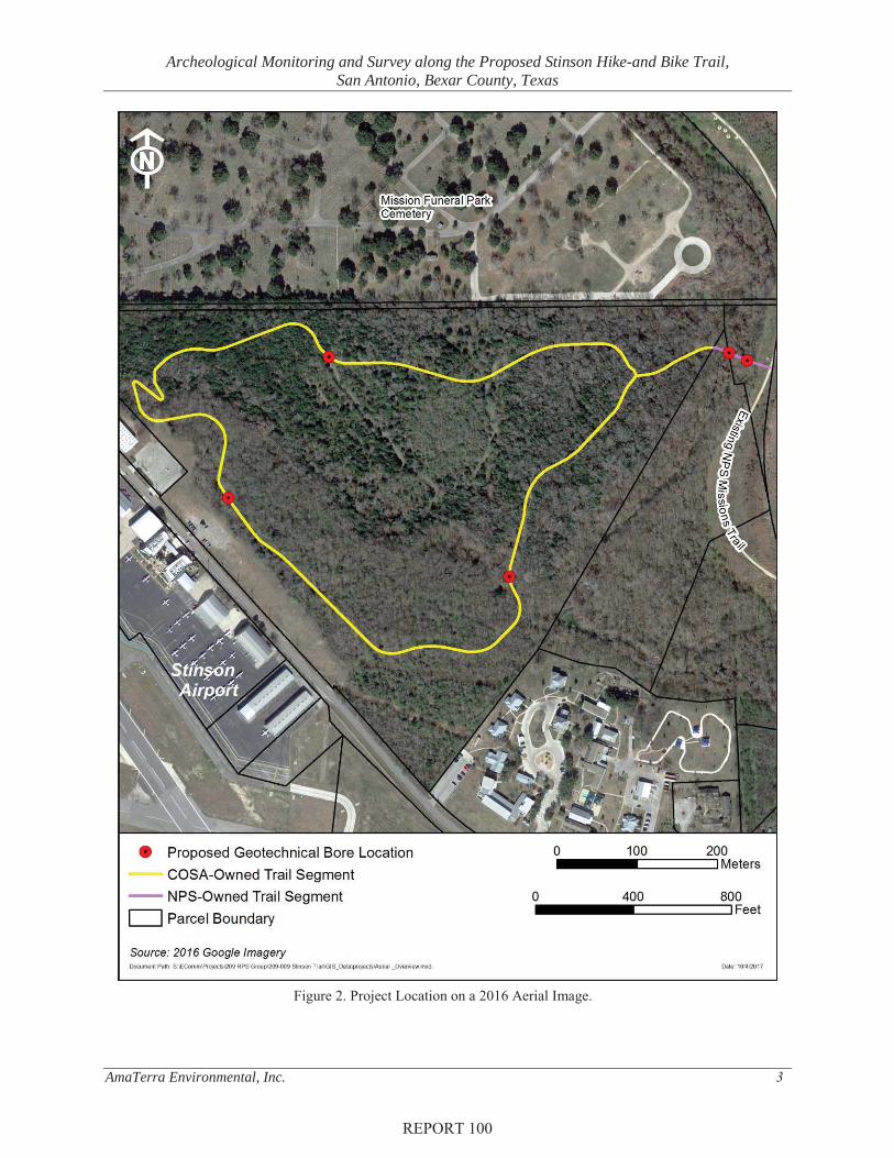
AmaTerra Environmental, Inc. (AmaTerra) conducted archeological monitoring and survey for the proposed Stinson hike-and-bike trail in south San Antonio, Bexar County, Texas. The trail extends for approximately 1.25 miles from the existing Mission Reach hike-and-bike trail along the San Antonio River, across the Espada Acequia and loops around a 66-acre undeveloped parcel located just east of Mission Road (Figure 1 and Figure 2). The project area or Area of Potential Effects (APE) is located on land owned by the City of San Antonio (COSA) as well as the National Park Service (NPS). Therefore, the project is subject to the Antiquities Code of Texas (ACT), the City of San Antonio’s (COSA) Unified Development Code (UDC), Section 106 of the National Historic Preservation Act (Section 106), and the Archaeological Resources Protection Act (ARPA) of 1979. AmaTerra conducted the archeological monitoring and survey under Antiquities Permit No. 8063 and ARPA Permit No. 17-SAAN-1.
The proposed hike-and-bike trail is located within the Mission Parkway National Historic District. Mission Road and Stinson Airport are located to the west, and Mission Funeral Park Cemetery is located to the north. The San Antonio River is to the east. The proposed trail loops through an undeveloped tract controlled by COSA’s Stinson Airport and connects to the Mission Reach river trail system along the San Antonio River. The proposed trail will run for 6,000 linear feet (1,828 m) within the Stinson Airport tract, while 587 linear feet (179 meters) will connect the loop to the San Antonio River Trail system on NPS property. The trail will be 10-feet wide (3 m) and surfaced with poured concrete. In addition, a pedestrian bridge will be constructed over the National Register-listed Espada Acequia. Ground disturbance is expected to be minimal for trail construction; the horizontal limits of construction will generally extend no more than five feet beyond the trail footprint, while the vertical depth of ground disturbing activities will generally be less than one foot (0.30 m) below the surface. However, at the proposed pedestrian bridge over the Espada Acequia, impacts would extend up to eight feet (2.4 meters). Additionally, at three other locations along the loop portion of the trail, project designs call for regrading or down-cutting to depths of up to two feet (0.64 m). To complete the final design plans, preliminary geotechnical borings were necessitated at all of these locations.
The entire area around the hike-and-bike trail was previously surveyed. The NPS portion of the project area was surveyed in 2005 (Peter et al. 2006), while the CoSA-owned portion was surveyed in 2014 (Darnell et al 2014, Peter et al. 2006). The 2006 survey documented no archeological sites on the NPS portion of the project, except the already NRHP-listed Espada Acequia. Of note, the 2014 survey on COSA property documented a widespread 2-3-foot (1 meter) deep layer of fill (most likely spoil from San Antonio River channelization that occurred in the 1950s) scattered across much of the project area.
REPORT 100

Archeological Monitoring and Survey along the Proposed Stinson Hike-and Bike Trail, San Antonio, Bexar County, Texas
AmaTerra Environmental, Inc. 2
Figure 1. Project Location Topographic Map.
REPORT 100
Archeological Monitoring and Survey along the Proposed Stinson Hike-and Bike Trail, San Antonio, Bexar County, Texas
AmaTerra Environmental, Inc. 3
Figure 2. Project Location on a 2016 Aerial Image.
REPORT 100

Archeological Monitoring and Survey along the Proposed Stinson Hike-and Bike Trail, San Antonio, Bexar County, Texas
AmaTerra Environmental, Inc. 4
The 2014 survey documented two prehistoric archeological sites: 41BX2020 and 41BX2021. Site 41BX2020 is a disturbed surface lithic scatter that is not eligible for listing on the National Register of Historic Places (NRHP) or as a State Antiquities Landmark (SAL). Site 41BX2021 is a buried prehistoric occupation site capped with 2-3 feet of the aforementioned fill. The site was recommended for further NRHP/SAL-eligibility testing should it be affected by future development. The current hike-and-bike trail would not impact Site 41BX2021, as ground disturbances in that area will be less than one foot below the surface.
Given that the entire APE for the current hike-and-bike trail was recently surveyed, and given the relatively constrained footprint of the impacts, additional archeological investigations were deemed to be unwarranted for most of the trail except at 1) the NRHP-listed Espada Acequia where construction impacts for bridge piers on either site of the acequia will extend up to eight feet (2.4 m) in depth and 2) at three additional locations along the proposed trail where grading or excavation below 1-foot (30-cm) depths is proposed. Through coordination with the NPS and COSA’s Office of Historic Preservation (OHP), shovel and auger testing was proposed at these locations, with construction monitoring to follow for the portion of the project occurring on NPS property.
This report documents the initial archeological fieldwork for the project in which AmaTerra archeologists monitored geotechnical borings and conducted shovel and auger testing at each of the locations proposed for survey. Archeologists monitored all geotechnical borings, excavated twenty shovel tests, and eight auger tests in support of the project and documented no archeological sites, though two flakes were observed in one geotechnical boring at depths of 2-4 feet below the surface (0.6-1.2 m). This report recommends that the project can proceed to completion, with the provision that that agreed-upon monitoring occur during construction within NPS property.
The cultural resources survey was conducted on August 2, 3, and 15, 2017. Rachel Feit served as the Principal Investigator, Joshua Hamilton as the Project Archeologist, and Noel Steinle as the Archeological Technician. Joshua Hamilton produced the maps and graphics and Margo Gregory served as an editor to the report.
A total of thirty hours were expended in the field in support of this project. Weather conditions were good and the archeologists encountered no difficulties in completing the investigations. No artifacts were collected during field investigations. All project related documents will be curated at the University of Texas at San Antonio’s Center for Archeological Research.
REPORT 100

Archeological Monitoring and Survey along the Proposed Stinson Hike-and Bike Trail, San Antonio, Bexar County, Texas
AmaTerra Environmental, Inc. 5
CHAPTER 2 ENVIRONMENTAL SETTING
Physiography The APE is located within the Northern Blackland Prairie, a sub-region of the Blackland Prairie ecoregion. The Blackland Prairie is a disjunct ecological region characterized by black, clayey soils with a predominately natural prairie vegetation. The Northern Blackland Prairie spans over 300 miles from San Antonio in the south to Sherman in the north. The Blackland Prairie underwent significant transformation when farming replaced ranching during the late 1800s and early 1900s. Only a few small remnant fields and meadows remain, but almost all of the native Blackland vegetation communities are gone (Griffith et al. 2007).
Geology and Soils As the APE is located adjacent to the San Antonio River and its associated terraces, it is underlain by Pleistocene-aged fluviatile terrace deposits (Qt) (McGowen et al. 1974). These terraces are composed of alluvium and were formed when the river abandoned its previous course and the new channel cut deeper into the earth (Scoggins 2004).
Three soil series are located within the APE (Figure 3). Table 1 provides a brief description of the three soils and their percentages within the APE. According to the Soil Survey of Bexar County, Texas (Taylor et al. 1966) and U.S. Department of Agriculture Natural Resources Conservation Service web soil survey data for Bexar County (USDA NRCS 2017), the three soil types that dominate the APE are Loire clay loam, 0 to 2 percent slopes, occasionally flooded, Rock outcrop-Olmos complex, 5 to 25 percent slopes, and Patrick soils, 3 to 5 percent slopes, rarely flooded.
Current Setting The APE is located 275 feet (84 m) northwest from the main building of Stinson Airport. The APE is bounded by Mission Park Cemetery to the north, the San Antonio River to the east, the Mission Road Developmental Center to the south, and the Stinson Airport to the west. The elevation ranges between 547 and 589 feet above mean sea level and, overall, the elevation slopes from the northwest to the southeast. White Creek enters the northwestern portion of the APE and proceeds through the property along a southwesterly direction. The intermittent creek confluences with the San Antonio River 1,280 feet (390 m) southeast of the APE.
REPORT 100

Archeological Monitoring and Survey along the Proposed Stinson Hike-and Bike Trail, San Antonio, Bexar County, Texas
AmaTerra Environmental, Inc. 6
Figure 3. Soil Types within the APE.
REPORT 100

Archeological Monitoring and Survey along the Proposed Stinson Hike-and Bike Trail, San Antonio, Bexar County, Texas
AmaTerra Environmental, Inc. 7
Table 1. Soil Types Located within the APE (USDA-NRCS 2017).
Map Unit Soil Percentage of
the APE
FRLoire clay loam, 0 to 2 percent slopes, occasionally flooded- This component is
described as a clay loam that is located along flood plains. Depth to a root restrictive layer, bedrock, lithic, is more than 80 inches. The natural drainage class is well
drained.
28.5
HgDRock outcrop-Olmos complex, 5 to 25 percent slopes - This component is
described as a very gravelly loam found along ridges. Depth to a root restrictive layer, bedrock, lithic, is between 4 to 20 inches. The natural drainage class is
moderately well drained.
28.1
PaCPatrick soils, 3 to 5 percent slopes, rarely flooded – This component is described as a very gravelly clay loam located along paleoterraces. Depth to a root restrictive layer, bedrock, lithic, is greater than 80 inches. The natural drainage class is well
drained.
43.4
REPORT 100

Archeological Monitoring and Survey along the Proposed Stinson Hike-and Bike Trail, San Antonio, Bexar County, Texas
AmaTerra Environmental, Inc. 8
REPORT 100
Archeological Monitoring and Survey along the Proposed Stinson Hike-and Bike Trail, San Antonio, Bexar County, Texas
AmaTerra Environmental, Inc. 9
CHAPTER 3 CULTURAL BACKGROUND
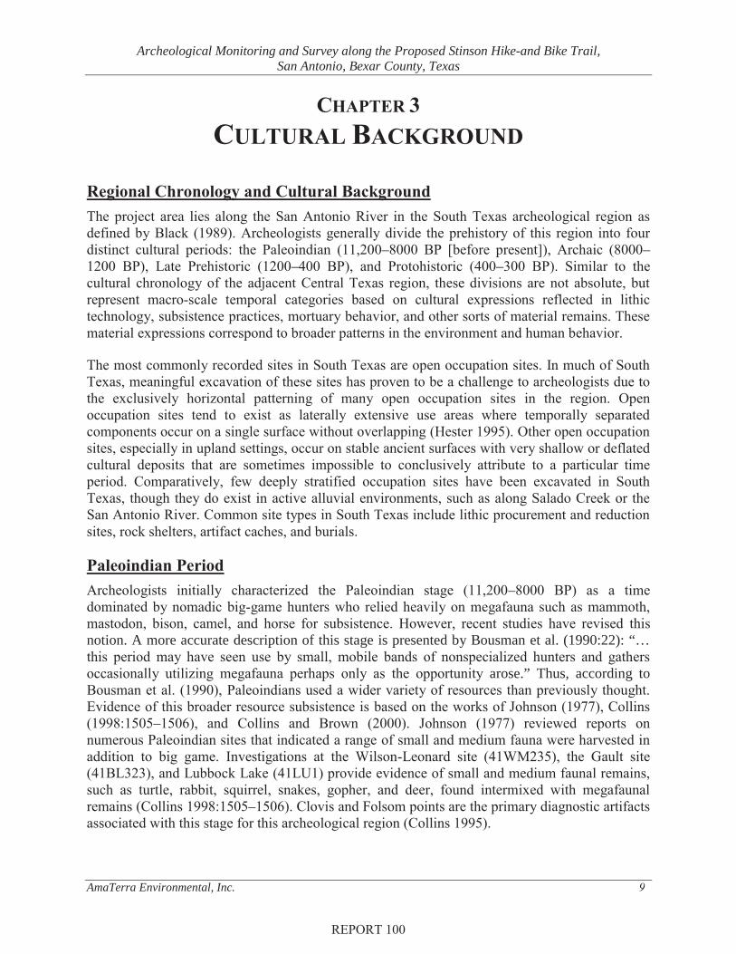
Regional Chronology and Cultural Background The project area lies along the San Antonio River in the South Texas archeological region as defined by Black (1989). Archeologists generally divide the prehistory of this region into four distinct cultural periods: the Paleoindian (11,200–8000 BP [before present]), Archaic (8000–1200 BP), Late Prehistoric (1200–400 BP), and Protohistoric (400–300 BP). Similar to the cultural chronology of the adjacent Central Texas region, these divisions are not absolute, but represent macro-scale temporal categories based on cultural expressions reflected in lithic technology, subsistence practices, mortuary behavior, and other sorts of material remains. These material expressions correspond to broader patterns in the environment and human behavior.
The most commonly recorded sites in South Texas are open occupation sites. In much of South Texas, meaningful excavation of these sites has proven to be a challenge to archeologists due to the exclusively horizontal patterning of many open occupation sites in the region. Open occupation sites tend to exist as laterally extensive use areas where temporally separated components occur on a single surface without overlapping (Hester 1995). Other open occupation sites, especially in upland settings, occur on stable ancient surfaces with very shallow or deflated cultural deposits that are sometimes impossible to conclusively attribute to a particular time period. Comparatively, few deeply stratified occupation sites have been excavated in South Texas, though they do exist in active alluvial environments, such as along Salado Creek or the San Antonio River. Common site types in South Texas include lithic procurement and reduction sites, rock shelters, artifact caches, and burials.
Paleoindian Period Archeologists initially characterized the Paleoindian stage (11,200–8000 BP) as a time dominated by nomadic big-game hunters who relied heavily on megafauna such as mammoth, mastodon, bison, camel, and horse for subsistence. However, recent studies have revised this notion. A more accurate description of this stage is presented by Bousman et al. (1990:22): “… this period may have seen use by small, mobile bands of nonspecialized hunters and gathers occasionally utilizing megafauna perhaps only as the opportunity arose.” Thus, according to Bousman et al. (1990), Paleoindians used a wider variety of resources than previously thought. Evidence of this broader resource subsistence is based on the works of Johnson (1977), Collins (1998:1505–1506), and Collins and Brown (2000). Johnson (1977) reviewed reports on numerous Paleoindian sites that indicated a range of small and medium fauna were harvested in addition to big game. Investigations at the Wilson-Leonard site (41WM235), the Gault site (41BL323), and Lubbock Lake (41LU1) provide evidence of small and medium faunal remains, such as turtle, rabbit, squirrel, snakes, gopher, and deer, found intermixed with megafaunal remains (Collins 1998:1505–1506). Clovis and Folsom points are the primary diagnostic artifacts associated with this stage for this archeological region (Collins 1995).
REPORT 100

Archeological Monitoring and Survey along the Proposed Stinson Hike-and Bike Trail, San Antonio, Bexar County, Texas
AmaTerra Environmental, Inc. 10
Archaic Period The Archaic Period (8000–1200 BP) spans nearly 7,000 years of prehistory. In Texas, the primary cultural marker of this period is the development and use of burned rock middens (Collins 2004:119). These piles of burned limestone, sandstone, and other lithic debris represent the remains of multiple ovens that were used, reused, and discarded over time. Their appearance signifies a shift from a big-game hunting subsistence strategy to a less mobile, generalized subsistence strategy. Projectile points also changed; lanceolate-shaped points gave way to dart points that were stemmed and barbed (Black 1989). During the Archaic period, the climate transitioned from wet and mild conditions seen in the Paleoindian stage to warmer and drier conditions. Researchers believe that the changes in climate influenced prehistoric subsistence strategies (Story 1985:38–39; Weir 1976) Although many Archaic period manifestations in South Texas resemble that of Central Texas, the lithic tradition of South Texas peoples relied heavily on smaller triangular-shaped points and bifaces, over the bifurcated stem points that came to dominate Central Texas assemblages of the same period.
The Archaic period is typically divided into three sub-stages: early, middle and late. The Early Archaic stage is still relatively obscure in the archeological record. The majority of Early Archaic sites are distributed along the eastern and southern margins of the Edwards Plateau, suggesting areas near reliable water sources with a variety of food resources were preferred. These sites are generally described as small in size with highly diverse tool assemblages. The lithic technology associated with Early Archaic sites are Angostura, Early Split Stem, and Martindale-Uvalde atlatl points (Collins 2004), Clear Fork and Guadalupe bifaces, manos, hammerstones, burins, metates, circular scrapers, and various biface styles, which suggests specialized tool usage. A very few burials have been found associated with this cultural stage (Prewitt 1981; Story 1985).
During the Middle Archaic, the climate became more warm and dry. The number, size, and intensification of burned rock middens from this period increased significantly, leading many archeologists to believe an increase of population occurred. Types of projectile points that frequently occur on Middle Archaic sites are Bulverde, Langtry, and Kinney dart points (Hall et al. 1986). Other materials found among Middle Archaic assemblages are an increase of wooden and bone implements and plant processing implements. Burials during this stage become more frequent than in the previous stage.
During the Late Archaic, climatic conditions became more mesic. Similar cultural traditions observed in the Middle Archaic continued into the Late Archaic. Trade increased during this period and materials from distant localities have been found among Late Archaic assemblages. Coastal materials, such as shells used as ornaments, have been reported to have been exchanged for both finished tools and raw material (Story 1985). Rock ovens and hearths were continuously used as a means to prepare food, and bison once again became available. Ritualized mortuary practice became more common during the Late Archaic with interments becoming quite elaborate in terms of associated burial furniture. Large cemeteries were established along drainages suggesting the importance of the location and, perhaps, territorial ties by groups to these localities (Story 1985). The location of these cemeteries “are believed to be the result of the same cultural group using a place on the landscape to reaffirm their rights of descent and control/access to critical resources” (Taylor 1998; Taylor 1995:627–631).
REPORT 100

Archeological Monitoring and Survey along the Proposed Stinson Hike-and Bike Trail, San Antonio, Bexar County, Texas
AmaTerra Environmental, Inc. 11
Late Prehistoric Period Of the prehistoric stages, the Late Prehistoric stage (1200–400 BP) is the best defined and marked by the introduction of the bow and arrow and the production of small arrow points (Hester 1981:122). The emergence of agriculture and ceramics also occurred in the Late Prehistoric. While incipient agricultural and ceramic use is evident in South Texas, most researchers believe that these technologies diffused into South Texas from other regions (Bousman et al. 1990). Much of the ample evidence for late prehistoric practices indicates that people exploited a wide range of animal and plant resources for their diets. Food processing techniques relied heavily on manos (hand held grinding stone), metates (a large slab that plant material was ground against with a mano to process food), and earth ovens for cooking. Diagnostic projectile points of this period include Scallorn, Edwards, and Perdiz arrow points. Sites tend to be more closely clustered around creeks and waterways rather than dispersed along the landforms, which suggests an intensification and nucleation around reliable natural resources.
Protohistoric and Historic PeriodThe Protohistoric period is defined as the period that includes first European contact, but that falls prior to the earliest colonization of Texas by Europeans (ca. 1700). The Protohistoric (ca. AD 1528–1700) is marked by the venture into South and Southeast Texas by Spanish explorer Cabeza de Vaca in 1528. Following his travels through what is today Central and South Texas, Cabeza de Vaca documented his observations of Native American lifeways in the region. He noted a sparsely populated landscape occupied by seasonal hunter and gatherer groups that relied on mesquite beans, prickly pear, pecans, deer and small game that included insects and lizards (Cabeza de Vaca 2002).
In 1690, the expedition party of Domingo Terán de los Rios crossed the San Antonio River on its way to establish missions in East Texas. According to Habig (1968), Terán crossed the river somewhere near the present day site of Mission San Juan De Capistrano, near the current project area, where he stayed several days with a peaceful village of Payaya Indians. Archeological sites representing this subperiod can contain a mix of both European artifacts; including metal and glass arrow points, trade beads, and wheel-made or glazed ceramics, and traditional Native American artifacts (Hester 1995).
The establishment of the first Spanish missions in 1718 and the expansion of the Spanish Colonial Empire mark the transition from the Protohistoric to the Historic Period (ca. 1700–present). Most of our knowledge of this period comes from the written records of early Spanish missionaries though a number of archeological sites have been documented in San Antonio with Spanish Colonial components. In 1718, the Spanish military and Roman Catholic Franciscan missionaries established the Presidio San Antonio de Bexar and the Mission Antonio de Valero on San Pedro Creek. The following year, Mission San Jose y San Miguel de Aguayo was established and, in 1731, three additional missions were founded and formed a chain running along the San Antonio River. Almost immediately the missions began attracting Native American groups seeking shelter and stability from raiding Apaches. The current project area falls within the labores (or farmlands) of the Mission San Francisco de la Espada, which was constructed in 1731. To irrigate the mission lands, using most Native American labor, the Spanish constructed an elaborate system of acequias, dams and an aqueduct extending 15 miles
REPORT 100
Archeological Monitoring and Survey along the Proposed Stinson Hike-and Bike Trail, San Antonio, Bexar County, Texas
AmaTerra Environmental, Inc. 12
along the San Antonio River. The Espada Acequia and Aqueduct were constructed between 1731 and 1745 to irrigate the lands within the current project area (Long 2010). The Espada Aqeduct, located south of the project area is the only operating Spanish Colonial aqueduct in existence in the United States.
The city of San Antonio grew out of these early Spanish settlements and quickly became the largest and most important settlement in Spain’s northern territory. San Antonio de Béxar became the capital of Spanish Texas in 1773. The population of roughly 2,000 included Native Americans, Europeans, mestizos, and a few black slaves. By 1795, all of the missions were at least partially secularized and the San Antonio de Valero Mission (later, the Alamo) became a military barracks (Fehrenbach 2012). After this, mission land around the project APE was redistributed and lots were set aside for government taxes and for common cultivation. According to Rullman’s 1912 map of San Antonio, the land for the current APE was granted to Manuel de Leal.
During the Texas Revolution, San Antonio witnessed several major battles, including the Siege of Bexar and the famous Battle of the Alamo (Fehrenbach 2012). In 1835, the grounds around Mission Concepción were the site of the battle of Concepción in which Texas revolutionaries defeated Mexican troops and the mission came under control of the Republic of Texas. The Catholic Church, represented by Bishop J.M Odin, held the title for the Concepción church and land (Gonzales 2010). Population of San Antonio dwindled during the Republic of Texas years (1836–1845) largely due to repeated attacks from Mexico. However, following the Republic’s annexation by the United States, San Antonio’s population and economy soared as the city became a way station for westward expansion (Fehrenbach 2012).
Following the Civil War, San Antonio became a major player in the cattle industry as railroads made it the shipping center of South Texas. Today, with a population approaching 1.4 million, San Antonio remains one of the most important American cities with education, military, medical, and increasingly tourism contributing to the local economy (Fehrenbach 2012).
Stinson Airport The proposed hike-and-bike loop falls on property owned by COSA and used by Stinson Municipal Airport. Stinson Airport is listed on the NRHP and is a contributing element to the Mission Parkway Historic District. Stinson Airport was the City of San Antonio’s first municipal airport and has been in continuous operation since its opening in 1915. Katherine Stinson, part of the famous Stinson family of aviators, was instrumental in founding the airfield. She became the fourth female licensed pilot in the U.S. and later became one of the nation’s most noted female aviators. Originally, the Stinson Aviation Company was founded in Hot Springs, Arkansas before relocating to San Antonio 1913. Soon after arriving, the family petitioned the San Antonio City Council to lease land for use as a municipal airport and, following approval, 500 acres of farmland were set aside to establish Stinson Field in 1916. At this time, Marjorie Stinson founded the Stinson School of Aviation, which made her the first woman to own and operate a flying school within the country. During this time, Marjorie’s flying school was instrumental in the training of numerous World War I pilots. Charles Lindbergh reported kept a plane a Stinson when he was stationed at Brooks Field. Stinson Field became the city’s first civil airport in 1918 (City of San Antonio 2017).
REPORT 100

Archeological Monitoring and Survey along the Proposed Stinson Hike-and Bike Trail, San Antonio, Bexar County, Texas
AmaTerra Environmental, Inc. 13
In 1927, Stinson Field was renamed “Windburn Field” following a tragic crash of a reporter named Bill Windburn. It was during this time that Stinson Airport received the first scheduled airmail in San Antonio. During the 1930s, the Civilian Conservation Corps (CCC) were stationed at Stinson while they constructed a new terminal building, as well as other improvements (Miller 2016) in the 1930s. It was this time that commercial airlines began to use the field regularly (NPS 2017). The name of the airport was changed back to Stinson Field on July 15, 1936. In 1942 the Army Air Corps leased the airfield as a training facility for World War II pilots, building a drill field, a post garden, a motor pool, as well as constructing warehouses, administrative buildings, mess halls, barracks, commissaries, and recreational facilities (Miller 2016). After the war, the airport returned to civil service and served as the primary general aviation airport for the City of San Antonio until the construction of the San Antonio International Airport in the 1940s (NPS 2017).
Cultural Resources in Proximity to the APE The APE falls entirely within the Mission Parkway Historic-Archeological District. The district is composed of a series of designated sites and locations including mission buildings, acequia segments, dams, aqueducts, and mission labores. The Mission Parkway district boundaries are designed primarily to include the lower four mission lands along the San Antonio River, including Missions San José, San Juan, Conception, and Espada. Generally, the Mission Parkway district covers portions of San Antonio that has been substantially less impacted by urban development, and this has helped to preserve the historic and prehistoric character of the area. The Espada Acequia, built to provide irrigation waters to fertile fields along the San Antonio River’s floodplain, crosses the proposed trail on NPS property near the eastern terminus of the project. This acequia was originally started around 1731, concurrent with the construction of the Mission San Francisco de la Espada, but was not completed until 1745 when the Espada Aqueduct was finished. The Espada Aqueduct, located south of the APE, is still in excellent condition and is still used for local irriagtion. The massive round arches that span Piedras Pintas Creek resemble those of Roman aqueducts and the system is to be the only aqueduct of its kind in the United States. A park has been developed in order to preserve the aqueduct and a small stone house is located on the property that dates from the Colonial Spanish era (Korfmacher 2016).
Mission Funeral Park Cemetery (Cemetery Number BX-C015) is immediately north of the project area. This large cemetery is fully fenced and well maintained. It contains graves dating from the early 1900s to the present. The San Jose Burial Park Cemetery (BX-C014) is located to the northwest of the project area. It is also completely fenced and well maintained, though unmarked graves are known to exist on the west side of Mission Road at the Stinson Airport (Miller 2016). The cemetery contains graves which date from 1900–present.
As the project occurs within Mission Parkway Historic District, there have been numerous surveys in and around the APE, and there are numerous previously recorded sites. The online Texas Archeological Sites Atlas indicates that there are nine archeological sites, two historical markers, and two cemeteries within 1,640 feet (500 m) of the project area (Figure 4). Two of those archeological sites, 41BX2020 and 41BX2021, are directly adjacent to or within the APE. Additionally, the Espada Acequia, a contributing element to the Mission Parkway Historic District is also within the APE.
REPORT 100

Archeological Monitoring and Survey along the Proposed Stinson Hike-and Bike Trail, San Antonio, Bexar County, Texas
AmaTerra Environmental, Inc. 14
The two archeological sites within the APE were recorded during a 2014 survey of the 66-acre Stinson Airport property owned by COSA. These sites are:
• 41BX2020–This site is located along the northern portion of the proposed trail. Site 41BX2020 is a prehistoric open campsite with lithic debitage and burned rock scatter confined mainly to the surface. No features or patterning were observed at the site and no diagnostic or unique finds were among the artifacts observed. Due to the extensive previous disturbances from brush-clearing and heavy machinery, the site was recommended as not eligible for listing as a SAL. Although this site could be affected by the current trail project, it does not contain sufficient integrity to warrant any further research.
• 41BX2021–This site is located along the eastern edge of the trail loop, intersecting the trail connector near the NPS property boundary. This site consists of a multicomponent prehistoric occupation site buried beneath 2-3 feet (60-90 cm) of fill material. Containing an upper and lower component, the site yielded one burned rock feature and contained lithic deposits ranging from 3 to 8.9 feet (0.9 to 2.7 m) beneath the ground surface. Three backhoe trenches were excavated within the site. Recorders recommended further NRHP-eligibility testing only if project impacts extend two feet of more below the surface (Darnell et al 2014). This site would not be impacted by the current trail project because it is buried.
The remaining archeological sites within 1,640 feet of the APE are presented in Table 2 below. None of these would be affect by the current trail project. These sites include three trinomials that appear to represent segments associated with the Espada Acequia and Dam (41BX268, 41BX269, and 41BX280), as well as three farmsteads from the nineteenth century. Only one of the sites, 41BX1902, is prehistoric.
There have been numerous surveys to have intersected or overlapped the APE. As a result, the entire APE has been previously surveyed. The hike-and-bike trail area was first documented during the Texas Historical Commission’s (THC) 1976 survey of the San Antonio Mission area under Antiquities Permit No. 62. A second survey within the project area was conducted in 1980 by the National Park Service (NPS), though little information regarding this survey was found on the THC Atlas (2017). In 1983, a survey of all NPS property along the San Antonio River was conducted, though little information was provided by the THC Atlas. A 2005 survey was conducted along the Espada Acequia on NPS-administered property by the United States Army Corps of Engineers (USACE). Finally in 2014, AmaTerra surveyed the COSA property controlled by Stinson Airport east of Mission Road under TAC permit No.6943. During that survey, 73 shovel tests and five backhoe trenches were excavated. AmaTerra reported that the majority of the surface of the 66-acre tract was extensively disturbed from previous clearing and earth-moving activities.
REPORT 100

Archeological Monitoring and Survey along the Proposed Stinson Hike-and Bike Trail, San Antonio, Bexar County, Texas
AmaTerra Environmental, Inc. 15
Figure 4. Cultural Resources within 0.31-mile (0.5-kilometer) of the APE.
REPORT 100

Archeological Monitoring and Survey along the Proposed Stinson Hike-and Bike Trail, San Antonio, Bexar County, Texas
AmaTerra Environmental, Inc. 16
Table 2. Archeological Sites located within 1,640 feet (500 m) of the APE.
Site Time Period Site Type Cultural Materials Date
RecordedNRHP/SALEligibility
41BX242 Historic Old James House Structures Isham and Ray 1974 undetermined
41BX243 Historic Grothaus House House and fireplace Isham and Ray 1974 undetermined
41BX244 Historic Farmstead Brick house and outbuilding Isham and Ray 1974 undetermined
41BX268 Historic Acequia Irrigation ditch Ivey 1975 undetermined
41BX269 Historic Acequia Espada Irrigation ditch Ivey 1975Contributing
element to NR district
41BX280 Historic Espada Dam Dam and Irrigation ditch Isham and Ray 1974 Listed as NHL
41BX1902 Prehistoric Open campsiteHearthfield, ceramics,
debitage, projectile points, charcoal
Hunt 2010
Tested for NRHP
eligibility. Results
unknown
REPORT 100

Archeological Monitoring and Survey along the Proposed Stinson Hike-and Bike Trail, San Antonio, Bexar County, Texas
AmaTerra Environmental, Inc. 17
CHAPTER 4 METHODOLOGY
As already discussed, the entire project area has been previously surveyed. Advance consultation with the NPS and the COSA’s Historic Preservation Office determined that, given the previous survey work, and given the limited construction footprint for the proposed hike-and-bike trail, additional survey was not warranted for most the APE. However, exceptions to this include areas where impacts would be deeper than two feet below ground surface. This includes locations of geotechnical borings, pier locations for the proposed bridge over the Espada Acequia, and locales where the trail would require downcutting or grading for construction. At these locations—five in all-- survey consisting of shovel and/or auger testing was recommended by the NPS and COSA. Additionally, the NPS requested that the trail building on their property be monitored during construction. This last activity had not occurred as of September 2017, and the results will be included as an appendix to the final report following completion of construction.
In order to finalize project plans, geotechnical borings were required at locations proposed for grading, downcutting, and bridge piers. Under the Texas Antiquities and ARPA permits, AmaTerra monitored these locations during the geotechnical borings, followed by more detailed survey investigation. The monitoring of the geotechnical drilling occurred on August 2 and 3, 2017 and the survey occurred on August 15, 2017. The methods and density of excavating shovel tests met the minimum requirements for field tactics stipulated by the THC and CTA Archeological Survey Standards for Texas (CTA 1996, 2001). Prior to field work, AmaTerra staff conducted a historical and archeological records search to determine what cultural resources have been recorded within the APE and within a 0.31-mile (0.5-km) radius of the APE. Additionally, AmaTerra reviewed ecological, geological, soils data, as well as, historical and recent topographic maps and aerial photography.
Geotechnical Monitoring Prior to trail construction, geotechnical drilling samples were collected at five locations along the trail to assess the soil compactness and density (Figure 5). During the drilling process, soil samples were taken by the geotechnical team in two-foot intervals. The samples collected by the geotechnical staff were not examined by the archeologist as they were removed from the drill and put directly into sampling containers that would keep them compact and ready for geotechnical analyses. However, the soil brought up by the drill in-between the soil samples was examined by the archeologist and screened through a ¼-inch hardware cloth.
REPORT 100

Archeological Monitoring and Survey along the Proposed Stinson Hike-and Bike Trail, San Antonio, Bexar County, Texas
AmaTerra Environmental, Inc. 18
Figure 5. Drilling, Auger, and Shovel Test Locations.
REPORT 100

Archeological Monitoring and Survey along the Proposed Stinson Hike-and Bike Trail, San Antonio, Bexar County, Texas
AmaTerra Environmental, Inc. 19
Auger / Shovel Test The survey component of this project consisted of conducting auger and shovel tests within a close proximity to the five drill locations. Auger tests were excavated using a hand-held auger that had a 4-inch (10-centimeter [cm]) bit. Due to the high percentage of medium to large size gravels and cobbles in the soil matrix, a shovel test was initiated and excavated at each auger location in the attempt to excavate beneath the gravelly fill layer. Once the shovel test encountered hard pan soils, the auger was started and excavated until it encountered large rocks or roots further beneath the surface. In compliance with THC standards, once the dirt had been removed from the matrix it was either screened through a ¼-inch wire mesh, or trowled if too sticky or bulky for screening. After screening, the auger/shovel test was backfilled and tamped down to prevent mounding or sinking of excavated dirt. Archeologists recorded each test’s depth, soil type and color, and other information (Appendix). For identification purposes, all auger tests were given an individual test number that was tied to UTM coordinates recorded by hand-held Garmin global positioning unit (GPS).
Shovel tests were excavated within a close proximity to each drill location. Shovel tests were excavated to 80 cm below the surface or the bottom of culturally sterile deposits, whichever was encountered first. Each shovel test was 30 cm in diameter and was hand excavated in natural stratigraphic levels not exceeding 20 cm in thicknesss. Excavated soil was screened using ¼-inch hardware cloth to test for the presence of buried cultural material. All shovel test units were recorded on maps and plotted using hand-held global GPS units. A total of 20 shovel tests were excavated to appropriately test for archeological resources within the APE.
The survey employed a non-collection strategy. Records, files, field notes, forms, and other documentation will be included in the curation package. All field-generated documents will be temporarily curated at the AmaTerra office. These documents and photographs will be organized and catalogued according to the Curation Standards of the Center for Archaeological Research in San Antonio.
REPORT 100

Archeological Monitoring and Survey along the Proposed Stinson Hike-and Bike Trail, San Antonio, Bexar County, Texas
AmaTerra Environmental, Inc. 20
REPORT 100
Archeological Monitoring and Survey along the Proposed Stinson Hike-and Bike Trail, San Antonio, Bexar County, Texas
AmaTerra Environmental, Inc. 21
CHAPTER 5 RESULTS
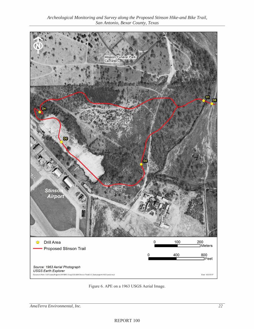
During the monitoring and survey of the APE, archeologists visually inspected and found the terrain to be heavily wooded with early successional vegetation. White Creek proceeds through the APE along a general northwest to southeast direction. Modern trash was observed throughout the APE, particularly around White Creek and minor drainages. The APE has undergone various alterations that have affected the natural environment of the APE (Figure 6). The most notable alteration is the 2-3-foot layer of river dredge fill that covers much of the COSA property. The fill most likely originated from the 1960s channelization of the San Antonio River (Darnell et al. 2014) and was observed within the auger and shovel test units. In addition, dirt two-track roads crisscross throughout the property. The ground surface was obscure in most areas and covered by a dense layer of vegetation that includes poison ivy, Turk’s Cap and other shade-tolerant shrubs. Subsurface exposures including animal burrows, disturbed patches, and cutbanks and drainages along erosional features were also examined.
Geotechnical Monitoring An archeologist was present while the geotechnical staff drilled and collected soils samples. A drill attached to a skid-steer was utilized for excavation at Drill Location 1 since it could navigate through the difficult terrain and dense vegetation (Figure 7). For Drill Locations 2 through 5, a drill attached to a flatbed truck was utilized for excavations.
Drill Location 1 was located in the northeastern portion of the APE and was approximately 50 feet (15 m) west of the Espada Acequia. Soil samples were collected until arriving at 40 feet (12 m) below the ground surface and the water table was present at approximately 14 to 16 feet (4.3 to 4.9 m) below the ground surface. No cultural materials or natural chert fragments were observed.
Drill Location 2 was located in the southeastern portion of the APE and approximately 65 feet (20 m) east of White Creek. Soil samples were collected until arriving at 10 feet (3 m) below the ground surface. No cultural materials or natural chert fragments were observed.
Drill Location 3 was located in the western portion of the APE and 320 feet (98 m) southwest of White Creek. Soil samples were collected until arriving at 10 feet (3 m) below the ground surface. Four pieces of chert were identified between 2 and 4 feet (0.6 m and 1.2 m) below the surface and two additional chert fragments were identified between 4 and 6 feet (1.2 m and 1.8 m) below the surface. Two of the pieces found between 2 and 4 feet (0.6 m and 1.2 m) were potentially cultural (exhibiting bulbs of percussion), while the remaining chert fragments were almost certainly non-cultural, as they exhibited fresh breaks and angular morphology not typical of hand-percussed flakes (Figure 8). All six of the chert fragments demonstrated recent scarring, compression waves, or fresh breaks.
REPORT 100
Archeological Monitoring and Survey along the Proposed Stinson Hike-and Bike Trail, San Antonio, Bexar County, Texas
AmaTerra Environmental, Inc. 22
Figure 6. APE on a 1963 USGS Aerial Image.
REPORT 100

Archeological Monitoring and Survey along the Proposed Stinson Hike-and Bike Trail, San Antonio, Bexar County, Texas
AmaTerra Environmental, Inc. 23
Figure 7. Drill attached to skid-steer (top); drill attached to flatbed truck (bottom).
REPORT 100

Archeological Monitoring and Survey along the Proposed Stinson Hike-and Bike Trail, San Antonio, Bexar County, Texas
AmaTerra Environmental, Inc. 24
Figure 8. Chert fragments found at Drill Location 3.
Drill Location 4 was located in the northwestern portion of the APE and 72 feet (22 m) southwest of White Creek. Soil samples were collected until arriving at 10 feet (3 m) below the ground surface. No cultural materials or natural chert fragments were observed.
Drill Location 5 was located in the northeastern portion of the APE and 82 feet (25 m) southeast of the Espada Acequia. Soil samples were collected until arriving at 40 feet (12 m) below the ground surface and the water table was observed at approximately 14 to 16 feet (4.3 m to 4.9 m) below the ground surface. Three non-cultural chert fragments were found between 2 and 4 feet (0.6 m and 1.2 m) and two non-cultural chert fragments were identified between 4 and 6 feet (1.2 m and 1.8 m). All four pieces of chert had been impacted by the drill.
Auger / Shovel Test A total of eight auger tests were excavated in close proximity to the Espada Acequia (Figure 9).Four auger tests were excavated along the west bank of the acequia and four along the east bank. Auger Test 1 and 2 were excavated 6 feet (1.8 m) east of the acequia. Auger Test 1 was excavated to 4.1 feet (1.25 m) beneath the surface and was terminated due to a large rock preventing further excavation. Auger Test 2 was excavated to 3.3 feet (1 m) beneath the surface and was terminated due to rocky substrate preventing further excavation. Due to a minor drainage paralleling the Espada Acequia, Auger Test 3 and 4 were located approximately 30 feet (10 m) east of the acequia. Auger Test 3 was excavated to 3 feet (0.9 m) beneath the surface and terminated due to a large rock preventing further excavation. Auger Test 4 was excavated to 2.3 feet (0.7 m) beneath the surface and terminated due to large roots preventing further excavation. Auger Test 5 and 6 were located 3 feet (1 m) west of the acequia and soils here were not as rocky as in other locations. Auger Test 5 was excavated to 4.7 feet (1.4 m) below the surface and
REPORT 100

Archeological Monitoring and Survey along the Proposed Stinson Hike-and Bike Trail, San Antonio, Bexar County, Texas
AmaTerra Environmental, Inc. 25
terminated due to a large rock preventing further excavation. Auger Test 6 was excavated to 4.3 feet (1.3 m) below the surface and terminated due to a large rock preventing further excavation. A minor drainage way existed between Drill Location 1 and the Espada Acequia and Auger Test 7 and 8 were excavated along the nearest flat area 54 feet (16.6 m) west of the acequia. Although on a flat landform, the area contained a high density of medium to large size limestone gravels and cobbles which restricted deeper excavations. Auger Test 7 was excavated to 1.9 feet (0.6 m) beneath the surface and terminated due to several large rocks preventing further excavation. Auger Test 8 was excavated to 1.6 feet (0.5 m) beneath the surface and terminated due to large rocks preventing further excavation. None of the auger tests contained any cultural material.
Figure 9. Auger Test Locations.
REPORT 100

Archeological Monitoring and Survey along the Proposed Stinson Hike-and Bike Trail, San Antonio, Bexar County, Texas
AmaTerra Environmental, Inc. 26
During the survey component of the project, a total of 20 shovel tests were excavated none of them contained any cultural material. Shovel tests excavated within the APE were terminated at an average depth of 17 inches (43.5 cm) below the surface. The shovel tests were all excavated in areas proposed for downcutting or grading; moreover, these areas corresponded to geotechnical boring locations. As noted in Darnell et al. (2014), a 2-3-foot deep layer of fill blankets much of the COSA property in the APE and covers any potential cultural strata. The fill is very gravelly and contains abundant medium to large sized limestone gravels and cobbles. This fill was also encountered in many of the shovel tests.
At each of the downcutting or grading locations, investigators excavated between one and six shovel tests to identify any potential artifacts or features buried within the area of impact for trail construction. At Drill Location 1, a total of six shovel tests were excavated. Four of the shovel tests overlapped with the auger testing around the Espada Acequia and the other two shovel tests were excavated within a close proximity to the geotechnical boring location. Only a single shovel test was excavated at Drill Location 2 due to the broad flood plain that stretches southeast of White Creek.
Six shovel tests were excavated around Drill Location 3, where chert material was observed in the geotechnical boring at depths of 2-4 feet below grade. No cultural materials or non-cultural chert fragments were observed. However, shovel testing encountered a dense layer of fill containing medium to large size rocks on the surface and extending to below one foot in depth, which investigators were unable to penetrate. Aerial photography from 1960 depicts this location as being cleared and covered with some sort of fresh fill and it is this same fill that was observed in shovel tests (see Figure 6). According to the 90 percent plans, grading and down-cutting in this area will extend no deeper than one foot below the current grade. Therefore, any cultural materials that might be buried 2-4 feet or deeper below the surface would not be affected by proposed trail construction.
Only a single shovel test was excavated at Drill Location 4 due to the sloping elevation of the area and fluvial erosion displacing soils downhill towards White Creek. Six shovel tests were excavated in close proximity to Drill Location 5. Four of the shovel tests overlapped with the auger testing east of the acequia, and the other two were excavated in close proximity to the geotechnical bore location. None of these tests contained any artifacts.
REPORT 100
Archeological Monitoring and Survey along the Proposed Stinson Hike-and Bike Trail, San Antonio, Bexar County, Texas
AmaTerra Environmental, Inc. 27
CHAPTER 6 CONCLUSIONS AND RECOMMENDATIONS
The City of San Antonio is planning to build a 1.23 mile hike-and-bike trail that extends from the Mission Reach trail along the San Antonio River through an undeveloped 66-acre tract controlled by Stinson Airport. The project will take place on NPS property, as well as COSA property controlled by Stinson Airport. The entire project area falls within the Mission Parkway Historic District, and the proposed trail will cross the Espada Acequia, which is a contributing element to that district. The project is subject to the Antiquities Code of Texas, Section 106, COSA’s UDC, and ARPA, and was conducted under Antiquities Permit No. 8064 and ARPA Permit No. 17-SAAN-1. This report documents the work undertaken to satisfy those requirements.
The scope of work outlined monitoring geotechnical borings, and survey of five different locals along the proposed trail where project plans call for excavation or grading deeper than one foot below the surface. AmaTerra monitored all geotechnical borings, excavated eight auger tests, and 20 shovel tests at these locales in support of this project. Two flakes were observed during the geotechnical drilling at Drill Location 3. These were found at depths of 2-4 feet below the surface, below the actual depth of impact for that location. No artifacts, features or other cultural resources (other than the already-documented Espada Acequia) were encountered at any other location. As described in Darnell et al. (2014), a significant portion of the APE is blanketed with a 2-3-foot layer of fill, while much of the remainder of the property has been disturbed by grading, quarrying, and natural impacts resulting from flooding and erosion. This report recommends that proposed hike-and-bike trail will have no effect on cultural resources within the APE.
AmaTerra recommends that the proposed trail development be permitted to continue without the need for further cultural resource investigations within the COSA-owned portion of the project.Following the scope of work agreed-upon among the NPS, the COSA OHP, and the THC, monitoring will occur during trail construction on NPS property. This work will occur under the current permits and will be included as an appendix to this report following completion of the work.
REPORT 100

Archeological Monitoring and Survey along the Proposed Stinson Hike-and Bike Trail, San Antonio, Bexar County, Texas
AmaTerra Environmental, Inc. 28
REPORT 100

Archeological Monitoring and Survey along the Proposed Stinson Hike-and Bike Trail, San Antonio, Bexar County, Texas
AmaTerra Environmental, Inc. 29
REFERENCES CITED Black, S. L. 1989 Central Texas Plateau Prairie. In From the Gulf to the Rio Grande: Human Adaptation in
Central, South, and Lower Pecos Texas, by T. R. Hester, S. L. Black, D. G. Steele, B. W. Olive, A. A. Fox, K. J. Reinhard, and L. C. Bement, pp. 17–36. Research Series No. 33. Arkansas Archeological Survey, Fayetteville.
Bousman, C. B., S. A. Tomka, and G. L. Bailey 1990 Prehistoric Archeology and Paleoenvironments in Hidalgo and Willacy Counties, South
Texas: Results of the Phase II Test Excavations. Reports of Investigations No. 76. Prewitt and Associates, Inc., Austin.
Cabeza de Vaca 2002 “Chronicle of the Narvaez Expedition.” Harold Augenbraum ed. Penguin. New York,
NY.
City of San Antonio 2017 “History of Stinson.” In Stinson Airport: 100 Years of Aviation. Online at
http://www.sanantonio.gov/SSF/History. Accessed August 2017.
Council of Texas Archeologists (CTA) 1996 Update on Survey Standards. CTA Newsletter, Vol. 20, No. 2. 1997 Revised Archeological Survey Standards for Texas. CTA Newsletter, Vol. 25, No. 2
Collins, M. B. 1995 Forty Years of Archeology in Central Texas. Bulletin of the Texas Archeological Society
66:361–400.2004 Archeology in Central Texas. In The Prehistory of Texas, edited by T. Perttula, pp. 101–
126. Texas A&M University Press, College Station.
Collins, M. B. (assembler and editor) 1998 Wilson-Leonard: An 11,000 Year Archeological Record in Central Texas. 6 vols. Studies
in Archeology 31, Texas Archeological Research Laboratory, The University of Texas at Austin; Archeology Studies Program Report 10, Texas Department of Transportation, Environmental Affairs Division, Austin.
Collins, M. B., and K. M. Brown 2000 Gault Gisement: Some Preliminary Observations. Current Archeology in Texas 2(1):8–
11.
Darnell, B. A., R. Feit, and J. A. Sitters 2014 Archeological Survey of a 66-acre Tract at the Stinson Airport, Bexar County, Texas.
AmaTerra Environmental, Inc. Austin, Texas.
REPORT 100

Archeological Monitoring and Survey along the Proposed Stinson Hike-and Bike Trail, San Antonio, Bexar County, Texas
AmaTerra Environmental, Inc. 30
Fehrenbach, T. R. 2012 San Antonio, Texas. In Handbook of Texas Online (http://www.tshaonline.org/handbook/
online/articles/hds02), accessed February 12, 2012. Published by the Texas State Historical Association.
Gonzales, Anibal A. 2010 “Nuestra Senora De La Purisima Concepcion De Acuna Mission”. Handbook of Texas
Online. Accessed May 25, 2017.
Griffith, G., S. Bryce, J. Omernik, and A. Rogers 2007 Ecoregions of Texas. Texas Commission on Environmental Quality.
Habig, M. A. 1968 The Alamo Chain of Missions, A History of San Antonio’s Fine Old Missions.
Franciscan Herald, Chicago.
Hall, G., T. R. Hester, and S. L. Black 1986 The Prehistoric Sites of Choke Canyon Reservoir, Southern Texas. Choke Canyon Series
No. 10. Center for Archaeological Research, The University of Texas at San Antonio.
Hester, T. R. 1981 Tradition and Diversity Among the Prehistoric Hunters and Gathers of South Texas.
Plains Anthropologist 26(92):119–128.1995 Prehistory of South Texas. Bulletin of the Texas Archeological Society 66:427–459.
Johnson, E. 1977 Animal Food Resources of Paleoindians. The Museum Journal 17:65–77. 20.
Korfmacher, K. 2016 Mission San Franscisco de la Espada Cultural Landscape Report (unpublished).
AmaTerra Environmental Inc. Austin, Texas.
Miller, Mason 2016 “Interim Letter Report on Archeological Investigations and Archival Research for the
Proposed Stinson Airport Executive Hangar Project at Stinson Airport, San Antonio, Texas.” Submitted to the Texas Historical Commission, November 2, 2016. AmaTerra, Environmental, Austin.
McGowen, J.H., C.V. Proctor, W.T. Haenggi, D.F. Reaser, and V.E. Barnes 1987 Geological Atlas of Texas, Dallas Sheet. The University of Texas Austin.
National Park Service (NPS) 2017 Stinson Field, Mission Parkway. United States Department of the Interior. Online
https://www.nps.gov/articles/stinson-field-mission-parkway.htm, accessed August 2017.
REPORT 100

Archeological Monitoring and Survey along the Proposed Stinson Hike-and Bike Trail, San Antonio, Bexar County, Texas
AmaTerra Environmental, Inc. 31
National Park Service 1990 How to Apply the National Register Criteria for Evaluation. National Register of Historic
Places, US Department of the Interior: Washington DC.
Perttula, T. K. (editor) 2004 The Prehistory of Texas. Texas A&M University Press, College Station.
Peter, D.E., D.D. Kuehn, S.N. Allday, A.L. Tine, S.M. Hunt and M.D. Freeman 2006 Archeological Assessment of the Potential Impact of the San Antonio River Improvement
Project—Mission Reach—on Historic Properties. Miscellaneous Reports of Investigations No. 355. Geo-Marine, Inc., Plano, Texas.
Prewitt, E. R. 1981 Culture Chronology in Central Texas. Bulletin of the Texas Archeological Society 52:65–
89.
Scoggins, P. 2004 Surface Geology of Dallas and Tarrant Counties, Texas. http://www.dallaspaleo.org/details/surface_geology.htm.
Story, D. A. 1985 Adaptive Strategies of Archaic Cultures of the West Gulf Coastal Plain. In Prehistoric
Food Production in North America, edited by R. I. Ford, pp. 19-56. Anthropological Papers No. 75. Museum of Anthropology, University of Michigan, Ann Arbor.
Taylor A. J. 1995 Relative Dating of Human Skeletal Remains. In Archaeological Investigations at the
Loma Sandia Site (41LK28): A Prehistoric Cemetery and Campsite in Live Oak County, Texas, by A. J. Taylor and C. L. Highley, pp. 581–631. Studies in Archeology 20. Texas Archeological Research Laboratory, The University of Texas at Austin.
1996 Mortuary Practices and Territoriality: Archaic Hunter-Gatherers of Southern Texas and the Loma Sandia Site (41LK28). PhD dissertation, Department of Anthropology, The University of Texas at Austin. Archeological Survey of a 66-Acre Tract at the Stinson Airport, Bexar County, Texas 39 AmaTerra Environmental, Inc. Taylor A. J., M. L. Marchbank, and F. K. Meskill .
Taylor, F. B., R. B. Hailey, and D. L. Richmond 1966 Soil Survey of Bexar County, Texas. United States Department of Agriculture, Soil
Conservation Service, in cooperation with Texas Agricultural Experiment Station.
Texas Historical Commission (THC) 2017 Texas Historic Sites atlas. Available at https://atlas.thc.state.tx.us/
REPORT 100

Archeological Monitoring and Survey along the Proposed Stinson Hike-and Bike Trail, San Antonio, Bexar County, Texas
AmaTerra Environmental, Inc. 32
United States Department of Agriculture - Natural Resources Conservation Service (NRCS) 2017 Web Soil Survey. Electronic document, http://websoilsurvey.nrcs.usda.gov/app/
WebSoilSurvey.aspx, accessed August, 2017.
Weir, F. A. 1976 The Central Texas Archaic. Unpublished PhD dissertation, Department of Anthropology,
Washington State University, Pullman.
REPORT 100

Archeological Monitoring and Survey along the Proposed Stinson Hike-and Bike Trail, San Antonio, Bexar County, Texas
AmaTerra Environmental, Inc. 33
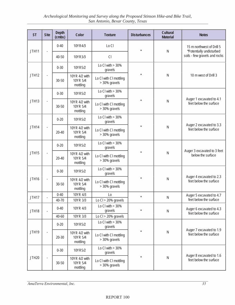
APPENDIX SHOVEL TEST LOG
REPORT 100

Archeological Monitoring and Survey along the Proposed Stinson Hike-and Bike Trail, San Antonio, Bexar County, Texas
AmaTerra Environmental, Inc. 34
ST Site Depth (cmbs) Color Texture Disturbances Cultural
Material Notes
JTH1 -
0-40 10YR5/2 Lo Cl with > 30% gravels
* N 15 m southwest of Drill 1 40-50
10YR 4/2 with 10YR 5/4 mottling
Lo Cl with Cl mottling > 30% gravels
JTH2 -
0-30 10YR5/2 Lo Cl with > 30% gravels
* N 10 m north of Drill 1 30-40
10YR 4/2 with 10YR 5/4 mottling
Lo Cl with Cl mottling > 30% gravels
JTH3 -
0-30 10YR5/2 Lo Cl with > 40% gravels
* N 10 m southwest of Drill 2 30-50
10YR 4/2 with 10YR 5/4 mottling
Lo Cl with Cl mottling > 40% gravels
JTH4 - 0-30 10YR5/2 Lo Cl with > 30% gravels * N 10 m north of Drill 3
JTH5 -
0-30 10YR5/2 Lo Cl with > 30% gravels
* N 8 m southwest of Drill 3 30-50
10YR 4/2 with 10YR 5/4 mottling
Lo Cl with Cl mottling > 30% gravels
JTH6 - 0-30 10YR5/2 Lo Cl with > 30% gravels * N 13 m south of Drill 3
JTH7 -
0-30 10YR5/2 Lo Cl with > 30% gravels
* N 15 m east if Drill 3
30-50 10YR 4/2 with
10YR 5/4 mottling
Lo Cl with Cl mottling > 30% gravels
JTH8 - 0-30 10YR5/2 Lo Cl with > 40% gravels * N 10 m east of Drill 3
JTH9 - 0-20 10YR5/2 Lo Cl with > 40% gravels * N 25 m southeast of Drill 4
JTH10 -
0-30 10YR5/2 Lo Cl with > 30% gravels
* N 13 m southwest of Drill 5
30-50 10YR 4/2 with
10YR 5/4 mottling
Lo Cl with Cl mottling > 30% gravels
REPORT 100
Archeological Monitoring and Survey along the Proposed Stinson Hike-and Bike Trail, San Antonio, Bexar County, Texas
AmaTerra Environmental, Inc. 35
ST Site Depth (cmbs) Color Texture Disturbances Cultural
Material Notes
JTH11 - 0-40 10YR4/3 Lo Cl
* N 15 m northwest of Drill 5 *Potentially undisturbed
soils - few gravels and rocks 40-50 10YR3/3 Cl
JTH12 -
0-30 10YR5/2 Lo Cl with > 30% gravels
* N 10 m west of Drill 3 30-50
10YR 4/2 with 10YR 5/4 mottling
Lo Cl with Cl mottling > 30% gravels
JTH13 -
0-30 10YR5/2 Lo Cl with > 30% gravels
* N Auger 1 excavated to 4.1 feet below the surface
30-50 10YR 4/2 with
10YR 5/4 mottling
Lo Cl with Cl mottling > 30% gravels
JTH14 -
0-20 10YR5/2 Lo Cl with > 30% gravels
* N Auger 2 excavated to 3.3 feet below the surface
20-40 10YR 4/2 with
10YR 5/4 mottling
Lo Cl with Cl mottling > 30% gravels
JTH15 -
0-20 10YR5/2 Lo Cl with > 30% gravels
* N Auger 3 excavated to 3 feet below the surface
20-40 10YR 4/2 with
10YR 5/4 mottling
Lo Cl with Cl mottling > 30% gravels
JTH16 -
0-30 10YR5/2 Lo Cl with > 30% gravels
* N Auger 4 excavated to 2.3 feet below the surface
30-50 10YR 4/2 with
10YR 5/4 mottling
Lo Cl with Cl mottling > 30% gravels
JTH17 - 0-40 10YR 4/3 Lo
* N Auger 5 excavated to 4.7 feet below the surface 40-70 10YR 3/3 Lo Cl > 20% gravels
JTH18 - 0-40 10YR 4/3 Lo Cl with > 30%
gravels * N Auger 6 excavated to 4.3 feet below the surface
40-60 10YR 3/3 Lo Cl > 20% gravels
JTH19 -
0-20 10YR5/2 Lo Cl with > 30% gravels
* N Auger 7 excavated to 1.9 feet below the surface
20-30 10YR 4/2 with
10YR 5/4 mottling
Lo Cl with Cl mottling > 30% gravels
JTH20 -
0-30 10YR5/2 Lo Cl with > 30% gravels
* N Auger 8 excavated to 1.6 feet below the surface
30-50 10YR 4/2 with
10YR 5/4 mottling
Lo Cl with Cl mottling > 30% gravels
REPORT 100

CITY OF SAN ANTONIO DIVISION E STINSON MUNICIPAL AIRPORT ARCHEOLOGICAL REPORT STINSON HIKE AND BIKE TRAIL
DIVISION E
[This page intentionally left blank]