basic environmental assessment for the …projects.gibb.co.za/portals/3/projects/201207...
TRANSCRIPT
Melkhout- Patensie dBAR_v0.4_lowres.doc
ESKOM DISTRIBUTION DIVISION
Basic Environmental Assessment for the installation of
132kV distribution lines from Melkhout to Patensie, Cacadu District
DRAFT
Report date: 19 July 2012 J29224
BASIC ASSESSMENT REPORT
Melkhout- Patensie dBAR_v0.4_lowres.doc 2
Basic Environmental Assessment for the Construction of 132kV distribution lines from Melkhout to Patensie, Cacadu District
DRAFT
CONTENTS
Chapter Description Page
Section A: Activity Information 4 Section B: Site/Area/Property Description 30 Section C: Public Participation 36 Section D: Impact Assessment 40 Section E: Recommendations of Practitioner 57 References 59 Section F: Appendices 60 APPENDICES Appendix A: Site plans A1: Site map A2: Route coordinates at 250 m intervals A3: Landowner details Appendix B: Photographs Appendix C: Illustrations of the proposed development site and infrastructure Appendix D: Specialist reports and declaration of interest D1: Avifauna Impact Assessment D2: Vegetation Impact Assessment D3: Heritage Impact Assessment Appendix E: PPP and Issues and Response Report Appendix F: Environmental Management Programme (EMPr) Appendix G: Details of EAP and declaration of interest NOTE: Additions are highlighted grey
BASIC ASSESSMENT REPORT
Melkhout- Patensie dBAR_v0.4_lowres.doc 3
(For official use only)
File Reference Number:
Application Number:
Date Received:
Basic assessment report in terms of the Environmental Impact Assessment Regulations, 2010, promulgated in terms of the National Environmental Management Act, 1998 (Act No. 107 of 1998), as amended. Kindly note that: 1. This basic assessment report is a standard report that may be required by a competent authority in terms of the EIA
Regulations, 2010 and is meant to streamline applications. Please make sure that it is the report used by the particular competent authority for the activity that is being applied for.
2. The report must be typed within the spaces provided in the form. The size of the spaces provided is not necessarily
indicative of the amount of information to be provided. The report is in the form of a table that can extend itself as each space is filled with typing.
3. Where applicable tick the boxes that are applicable in the report. 4. An incomplete report may be returned to the applicant for revision. 5. The use of “not applicable” in the report must be done with circumspection because if it is used in respect of material
information that is required by the competent authority for assessing the application, it may result in the rejection of the application as provided for in the regulations.
6. This report must be handed in at offices of the relevant competent authority as determined by each authority. 7. No faxed or e-mailed reports will be accepted. 8. The report must be compiled by an independent environmental assessment practitioner. 9. Unless protected by law, all information in the report will become public information on receipt by the competent
authority. Any interested and affected party should be provided with the information contained in this report on request, during any stage of the application process.
10. A competent authority may require that for specified types of activities in defined situations only parts of this report need to be completed.
11. Should a specialist report or report on a specialised process be submitted at any stage for any part of this application,
the terms of reference for such report must also be submitted.
BASIC ASSESSMENT REPORT
Melkhout- Patensie dBAR_v0.4_lowres.doc 4
SECTION A: ACTIVITY INFORMATION
Has a specialist been consulted to assist with the completion of this section?
YES NO X
If YES, please complete the form entitled “Details of specialist and declaration of interest”
for appointment of a specialist for each specialist thus appointed: Any specialist reports must be contained in Appendix D. 1. ACTIVITY DESCRIPTION Describe the activity, which is being applied for, in detail1:
BACKGROUND Eskom’s core business is in the generation, transmission and distribution of electricity. Eskom generates approximately 95% of the South African electricity in accordance with supply and demand requirements. Reliable provision of electricity by Eskom is critical for industrial and sustainable development in South Africa, which inevitably provides and sustains job opportunities for jobseekers. As electricity cannot be stored, power is generated and delivered over long distances as it is required. This is achieved through thousands of kilometres of high voltage distribution, and transmission lines which transmit this power from power stations located outside the Eastern Cape Province, to Eskom’s major substations. At these major substations, the voltage loading is reduced and distributed to smaller substations. From here the voltage is further reduced for distribution to industry, businesses, farms and homes. In order to maintain a reliable power supply within the entire network, the voltages at all substations are required to be within certain desired limits. If the network is operated at voltages below these limits, power outages may be experienced, which results in unreliable electricity supply. In order to avoid this, the distribution network must have the capacity to supply the electricity required by the customers at all times. The network must therefore be designed with reserve distribution capacity in order to ensure an uninterruptable supply of electricity. The electricity network in the Humansdorp area is already operating close to capacity, thus increasing the risk that the entire network could be interrupted. Furthermore, the Eskom Distribution network is increasing rapidly due to vigorous electrification plans. Eskom has identified the Patensie, Humansdorp and Kareedouw areas of the Eastern Cape as locations where strengthening of the network is required to meet current and future demands for electricity. Eskom proposes to construct infrastructure to strengthen and upgrade the network in the Patensie, Humansdorp and Kareedouw areas. The objective of the proposed installation of 132kV distribution lines is thus to increase the reserve capacity on the existing lines, while providing spare capacity for the future electricity needs of the growing local economy. GIBB (Pty) Ltd was appointed by ESKOM Distribution Division to undertake an environmental authorisation process in terms of Section 24 of the National Environmental Management Act, (Act 107 of 1998) for the construction of electrical distribution infrastructure, which will comprise a new 132 kV overhead distribution line and a new substation at Patensie. Several listed activities will be triggered through implementation of the proposed activities. A list of the proposed activities in the new EIA
1 Please note that this description should not be a verbatim repetition of the listed activity as contained in the relevant Government Notice, but should be a brief description of activities to be undertaken as per the project description.
BASIC ASSESSMENT REPORT
Melkhout- Patensie dBAR_v0.4_lowres.doc 5
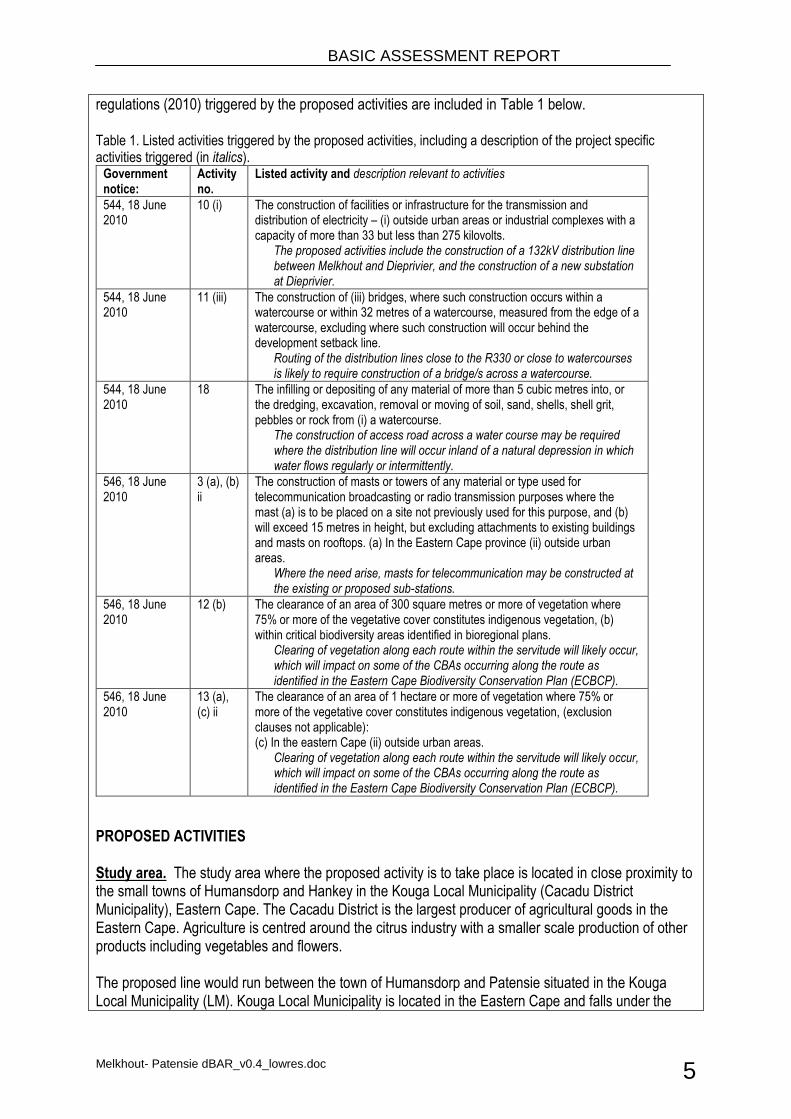
regulations (2010) triggered by the proposed activities are included in Table 1 below. Table 1. Listed activities triggered by the proposed activities, including a description of the project specific activities triggered (in italics).
Government notice:
Activity no.
Listed activity and description relevant to activities
544, 18 June 2010
10 (i) The construction of facilities or infrastructure for the transmission and distribution of electricity – (i) outside urban areas or industrial complexes with a capacity of more than 33 but less than 275 kilovolts.
The proposed activities include the construction of a 132kV distribution line between Melkhout and Dieprivier, and the construction of a new substation at Dieprivier.
544, 18 June 2010
11 (iii) The construction of (iii) bridges, where such construction occurs within a watercourse or within 32 metres of a watercourse, measured from the edge of a watercourse, excluding where such construction will occur behind the development setback line.
Routing of the distribution lines close to the R330 or close to watercourses is likely to require construction of a bridge/s across a watercourse.
544, 18 June 2010
18 The infilling or depositing of any material of more than 5 cubic metres into, or the dredging, excavation, removal or moving of soil, sand, shells, shell grit, pebbles or rock from (i) a watercourse.
The construction of access road across a water course may be required where the distribution line will occur inland of a natural depression in which water flows regularly or intermittently.
546, 18 June 2010
3 (a), (b) ii
The construction of masts or towers of any material or type used for telecommunication broadcasting or radio transmission purposes where the mast (a) is to be placed on a site not previously used for this purpose, and (b) will exceed 15 metres in height, but excluding attachments to existing buildings and masts on rooftops. (a) In the Eastern Cape province (ii) outside urban areas.
Where the need arise, masts for telecommunication may be constructed at the existing or proposed sub-stations.
546, 18 June 2010
12 (b) The clearance of an area of 300 square metres or more of vegetation where 75% or more of the vegetative cover constitutes indigenous vegetation, (b) within critical biodiversity areas identified in bioregional plans.
Clearing of vegetation along each route within the servitude will likely occur, which will impact on some of the CBAs occurring along the route as identified in the Eastern Cape Biodiversity Conservation Plan (ECBCP).
546, 18 June 2010
13 (a), (c) ii
The clearance of an area of 1 hectare or more of vegetation where 75% or more of the vegetative cover constitutes indigenous vegetation, (exclusion clauses not applicable): (c) In the eastern Cape (ii) outside urban areas.
Clearing of vegetation along each route within the servitude will likely occur, which will impact on some of the CBAs occurring along the route as identified in the Eastern Cape Biodiversity Conservation Plan (ECBCP).
PROPOSED ACTIVITIES Study area. The study area where the proposed activity is to take place is located in close proximity to the small towns of Humansdorp and Hankey in the Kouga Local Municipality (Cacadu District Municipality), Eastern Cape. The Cacadu District is the largest producer of agricultural goods in the Eastern Cape. Agriculture is centred around the citrus industry with a smaller scale production of other products including vegetables and flowers. The proposed line would run between the town of Humansdorp and Patensie situated in the Kouga Local Municipality (LM). Kouga Local Municipality is located in the Eastern Cape and falls under the
BASIC ASSESSMENT REPORT
Melkhout- Patensie dBAR_v0.4_lowres.doc 6
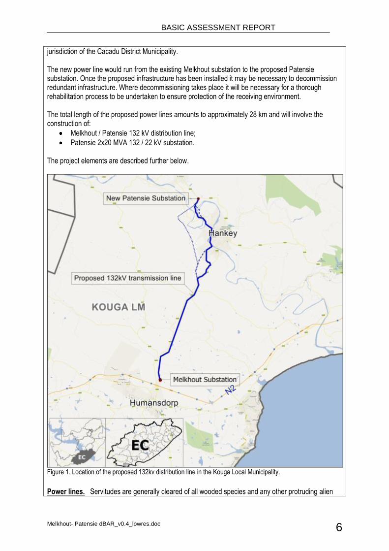
jurisdiction of the Cacadu District Municipality. The new power line would run from the existing Melkhout substation to the proposed Patensie substation. Once the proposed infrastructure has been installed it may be necessary to decommission redundant infrastructure. Where decommissioning takes place it will be necessary for a thorough rehabilitation process to be undertaken to ensure protection of the receiving environment. The total length of the proposed power lines amounts to approximately 28 km and will involve the construction of:
Melkhout / Patensie 132 kV distribution line;
Patensie 2x20 MVA 132 / 22 kV substation. The project elements are described further below.
Figure 1. Location of the proposed 132kv distribution line in the Kouga Local Municipality.
Power lines. Servitudes are generally cleared of all wooded species and any other protruding alien
BASIC ASSESSMENT REPORT
Melkhout- Patensie dBAR_v0.4_lowres.doc 7
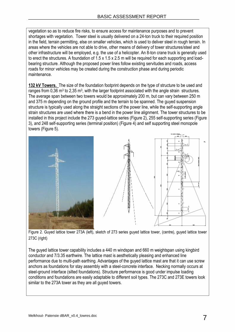
vegetation so as to reduce fire risks, to ensure access for maintenance purposes and to prevent shortages with vegetation. Tower steel is usually delivered on a 24-ton truck to their required position in the field, terrain permitting, else on smaller vehicles, which is used to deliver steel in rough terrain. In areas where the vehicles are not able to drive, other means of delivery of tower structures/steel and other infrastructure will be employed, e.g. the use of a helicopter. An 8-ton crane truck is generally used to erect the structures. A foundation of 1.5 x 1.5 x 2.5 m will be required for each supporting and load-bearing structure. Although the proposed power lines follow existing servitudes and roads, access roads for minor vehicles may be created during the construction phase and during periodic maintenance. 132 kV Towers. The size of the foundation footprint depends on the type of structure to be used and ranges from 0,36 m3 to 2,35 m3, with the larger footprint associated with the angle strain structures. The average span between two towers would be approximately 200 m, but can vary between 250 m and 375 m depending on the ground profile and the terrain to be spanned. The guyed suspension structure is typically used along the straight sections of the power line, while the self-supporting angle strain structures are used where there is a bend in the power line alignment. The tower structures to be installed in this project include the 273 guyed-lattice series (Figure 2), 255 self-supporting series (Figure 3), and 248 self-supporting series (terminal position) (Figure 4) and self supporting steel monopole towers (Figure 5).
Figure 2. Guyed lattice tower 273A (left), sketch of 273 series guyed lattice tower, (centre), guyed lattice tower
273C (right)
The guyed lattice tower capability includes a 440 m windspan and 660 m weightspan using kingbird conductor and 7/3.35 earthwire. The lattice mast is aesthetically pleasing and enhanced line performance due to multi-path earthing. Advantages of the guyed lattice mast are that it can use screw anchors as foundations for stay assembly with a steel-concrete interface. Necking normally occurs at steel-ground interface (silted foundations). Structure performance is good under impulse loading conditions and foundations are easily adaptable to different soil types. The 273C and 273E towers look similar to the 273A tower as they are all guyed towers.
BASIC ASSESSMENT REPORT
Melkhout- Patensie dBAR_v0.4_lowres.doc 8
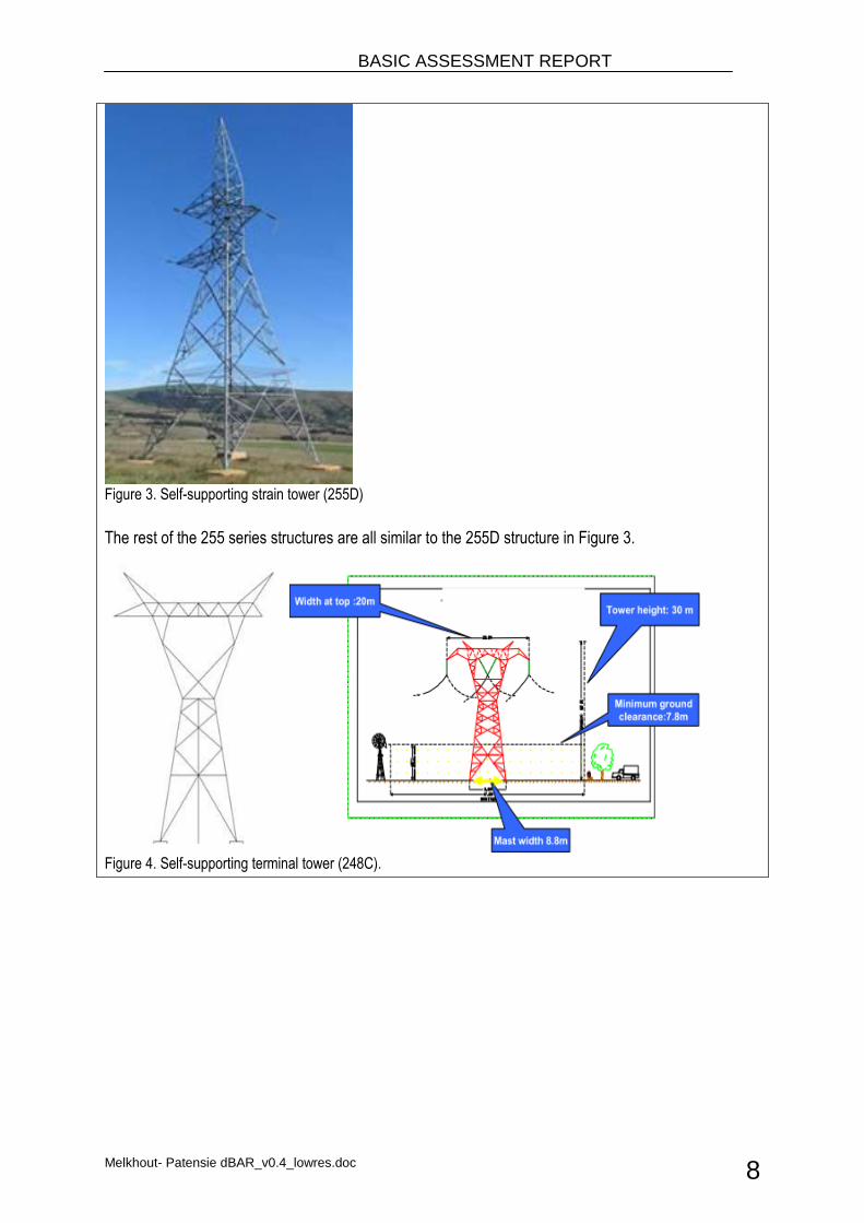
Figure 3. Self-supporting strain tower (255D)
The rest of the 255 series structures are all similar to the 255D structure in Figure 3.
Figure 4. Self-supporting terminal tower (248C).
BASIC ASSESSMENT REPORT
Melkhout- Patensie dBAR_v0.4_lowres.doc 9
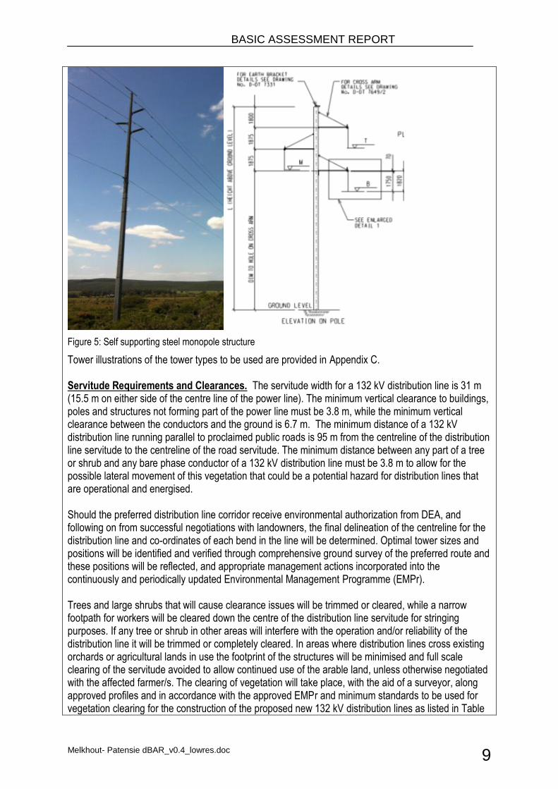
Figure 5: Self supporting steel monopole structure
Tower illustrations of the tower types to be used are provided in Appendix C. Servitude Requirements and Clearances. The servitude width for a 132 kV distribution line is 31 m (15.5 m on either side of the centre line of the power line). The minimum vertical clearance to buildings, poles and structures not forming part of the power line must be 3.8 m, while the minimum vertical clearance between the conductors and the ground is 6.7 m. The minimum distance of a 132 kV distribution line running parallel to proclaimed public roads is 95 m from the centreline of the distribution line servitude to the centreline of the road servitude. The minimum distance between any part of a tree or shrub and any bare phase conductor of a 132 kV distribution line must be 3.8 m to allow for the possible lateral movement of this vegetation that could be a potential hazard for distribution lines that are operational and energised. Should the preferred distribution line corridor receive environmental authorization from DEA, and following on from successful negotiations with landowners, the final delineation of the centreline for the distribution line and co-ordinates of each bend in the line will be determined. Optimal tower sizes and positions will be identified and verified through comprehensive ground survey of the preferred route and these positions will be reflected, and appropriate management actions incorporated into the continuously and periodically updated Environmental Management Programme (EMPr). Trees and large shrubs that will cause clearance issues will be trimmed or cleared, while a narrow footpath for workers will be cleared down the centre of the distribution line servitude for stringing purposes. If any tree or shrub in other areas will interfere with the operation and/or reliability of the distribution line it will be trimmed or completely cleared. In areas where distribution lines cross existing orchards or agricultural lands in use the footprint of the structures will be minimised and full scale clearing of the servitude avoided to allow continued use of the arable land, unless otherwise negotiated with the affected farmer/s. The clearing of vegetation will take place, with the aid of a surveyor, along approved profiles and in accordance with the approved EMPr and minimum standards to be used for vegetation clearing for the construction of the proposed new 132 kV distribution lines as listed in Table
BASIC ASSESSMENT REPORT
Melkhout- Patensie dBAR_v0.4_lowres.doc 10
3 (Eskom, 2000). Foundations. The type of terrain encountered, as well as the underlying geotechnical conditions determines the choice of foundation. The actual size and type of foundation to be installed will depend on the soil bearing capacity (actual sub-soil conditions). Strain structures require more extensive foundations for support than in-line suspension structures, which contribute to the cost of the construction of the line. Foundations will be mechanically excavated where access to the site is readily available. The same applies to the pouring of concrete required for the setting of the foundations. In areas where access to the structure position prohibits the use of concrete mixing trucks, uphill pumping or gravity feeding of concrete up to distances of 200 m will be implemented. Prior to erecting the structures and infilling of the foundations, the excavated foundations will be covered/fenced-off in order to safeguard unsuspecting animals and people from injury. All foundations are back-filled, stabilised through compaction, and capped with concrete at ground level. Insulators. Composite insulators have a glass-fibre core with silicon sheds for insulation and are used to connect the conductors to the towers. Glass and porcelain have been used to connect the conductors for many years, and is the most common. These products are, however, heavy and susceptible to breakage by vandals, as well as contamination by pollution. Composite insulators are lightweight and resistant to both vandalism and pollution. Composite (Long rod type) insulators with silicone based weathershed material will be used. Access. Access is required during both the construction and operation/maintenance phases of lines life cycle. Where possible, existing access roads and tracks will be used to gain access to construction sites and the servitude. Where no access roads/tracks exist, the access points and roads will be negotiated with the relevant landowner, and are to be established during the construction phase. Access roads will enable the transportation of construction material as well as construction teams to the site and facilitate maintenance activities once the power line has been constructed. See Appendix A for map of distribution lines Line clearance. High voltage power lines require a large clearance area for safety precautions. The Occupational Health and Safety Act, 1993 (Act No. 85 of 1993) provides for statutory clearances. Table 2 summarizes some of the key clearances relevant to the proposed 132 kV power line. Table 2. Clearance specifications (Eskom, 2007).
Clearances Minimum Clearance Distance (m)
Ground clearance 6.7
Building structures not part of power line 3.8
Above roads in townships, proclaimed roads 7.5
Telkom telephone lines 2.0
Spoornet tracks 10.9
BASIC ASSESSMENT REPORT
Melkhout- Patensie dBAR_v0.4_lowres.doc 11
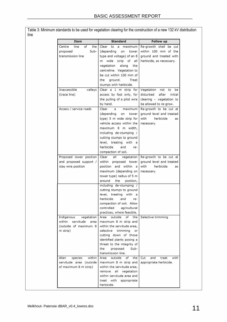
Table 3: Minimum standards to be used for vegetation clearing for the construction of a new 132 kV distribution line
BASIC ASSESSMENT REPORT
Melkhout- Patensie dBAR_v0.4_lowres.doc 12
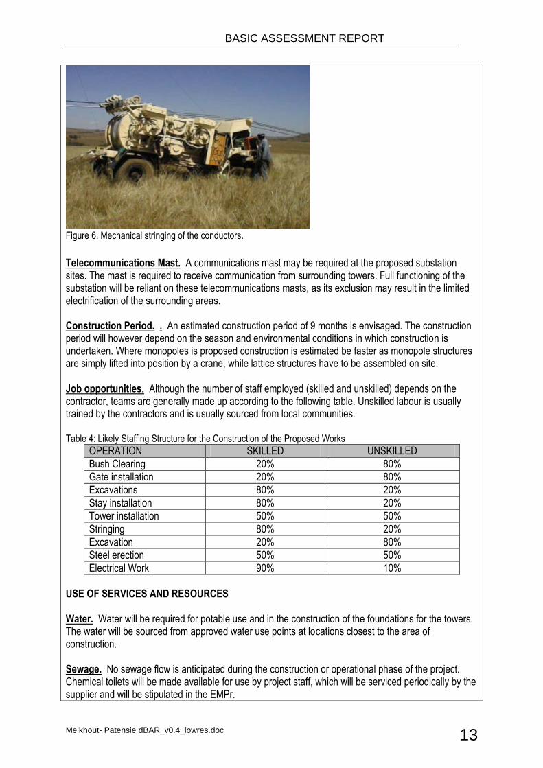
Ongoing Maintenance. During the life span of the power lines, which is approximately 25 years, ongoing maintenance is required to be performed from time to time. Eskom maintenance staff and contractors employed by Eskom will undertake the maintenance works as required. Construction Process for distribution lines and substations. Power lines are constructed in the following simplified sequence: Step 1: Determination of technically feasible distribution line alternatives; Step 2: EIA input into route selection and obtaining of relevant environmental permits; Step 3: Negotiation of final route with affected landowners; Step 4: Survey of the route; Step 5: Selection of best-suited structures and foundations; Step 6: Final design of distribution line and placement of towers; Step 7: Issuing of tenders and award of contract to construction companies; Step 8: Vegetation clearance and construction of access roads (where required); Step 9: Pegging of structures; Step 10: Construction of foundations; Step 11: Assembly and erection of structures; Step 12: Stringing of conductors; Step 13: Rehabilitation of disturbed area and protection of erosion sensitive areas; Step 14: Testing and commissioning; Step 15: Continued maintenance. Substation are constructed in the following simplified sequence: Step 1: Survey of the site; Step 2: EIA and site-specific EMPr; Step 3: Design of substation; Step 4: Issuing of tenders and award of contract; Step 5: Establishment of construction camp, vegetation clearance and construction of access roads (where required); Step 6: Construction of terrace and foundations; Step 7: Assembly and erection of equipment; Step 8: Connection of conductors to equipment; Step 9: Rehabilitation of any disturbed areas and protection of erosion sensitive areas; Step 10: Testing and commissioning; Step 11: Continued maintenance. Stringing of Conductors. A pilot cable is used to string the conductors between towers. This can be undertaken mechanically (see Figure 6) or by hand. The line is strung in sections (from bend to bend). Cable drums are placed at 5 km intervals (depending on the length of the conductor) during this stringing process. In order to minimise any potential negative impacts on the surrounding area, these cable drums should be placed within the servitude.
BASIC ASSESSMENT REPORT
Melkhout- Patensie dBAR_v0.4_lowres.doc 13
Figure 6. Mechanical stringing of the conductors.
Telecommunications Mast. A communications mast may be required at the proposed substation sites. The mast is required to receive communication from surrounding towers. Full functioning of the substation will be reliant on these telecommunications masts, as its exclusion may result in the limited electrification of the surrounding areas. Construction Period. . An estimated construction period of 9 months is envisaged. The construction period will however depend on the season and environmental conditions in which construction is undertaken. Where monopoles is proposed construction is estimated be faster as monopole structures are simply lifted into position by a crane, while lattice structures have to be assembled on site. Job opportunities. Although the number of staff employed (skilled and unskilled) depends on the contractor, teams are generally made up according to the following table. Unskilled labour is usually trained by the contractors and is usually sourced from local communities. Table 4: Likely Staffing Structure for the Construction of the Proposed Works
OPERATION SKILLED UNSKILLED
Bush Clearing 20% 80%
Gate installation 20% 80%
Excavations 80% 20%
Stay installation 80% 20%
Tower installation 50% 50%
Stringing 80% 20%
Excavation 20% 80%
Steel erection 50% 50%
Electrical Work 90% 10%
USE OF SERVICES AND RESOURCES Water. Water will be required for potable use and in the construction of the foundations for the towers. The water will be sourced from approved water use points at locations closest to the area of construction. Sewage. No sewage flow is anticipated during the construction or operational phase of the project. Chemical toilets will be made available for use by project staff, which will be serviced periodically by the supplier and will be stipulated in the EMPr.
BASIC ASSESSMENT REPORT
Melkhout- Patensie dBAR_v0.4_lowres.doc 14
Storm water. Storm water will be managed in line with the Eskom Guidelines for Erosion Control and Vegetation Management, and the EMPr, which will be compiled for the proposed works. Solid waste disposal. All solid waste will be collected at strategic locations along the distribution line route and substation construction site and will be stored temporarily until removed to an appropriately permitted landfill site near the construction site. Electricity. Diesel generators will be utilized for the provision of electricity, where required. GENERARAL DESCRIPTION OF THE RECEIVING ENVIRONMENT Topography. The linear activity in the study area runs in a northerly to easterly direction. The topography in the area steepens from south to north, so the proposed line varies greatly with regards to altitude. The altitude of the preferred line varies from 20 to 390 m above sea level Geology and soils. The proposed line is to be located upon the Cape Supergroup and is expected to pass through the Sandstones and Shales of the Table Mountain Group. Because the dominant lithology is comprised of Sandstones and Shales the soils are generally highly erodible. Mismanagement of rivers and agricultural land can therefore expose the area to erosion degrade rivers to a moderate or high degree.
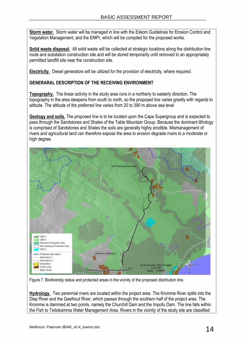
Figure 7. Biodiversity status and protected areas in the vicinity of the proposed distribution line.
Hydrology. Two perennial rivers are located within the project area. The Kromme River splits into the Diep River and the Geelhout River, which passes through the southern half of the project area. The Kromme is dammed at two points, namely the Churchill Dam and the Impofu Dam. The line falls within the Fish to Tsitsikamma Water Management Area. Rivers in the vicinity of the study site are classified
BASIC ASSESSMENT REPORT
Melkhout- Patensie dBAR_v0.4_lowres.doc 15
as critically endangered, with the Kromme and Gamtoos being good examples of such degradation. The Northern section of the line crosses the Gamtoos river and the southern section intersects the Kromme river. Local Climate. The Humansdorp area has a sub-tropical climate with rain falling throughout the year, with peaks in autumn and spring. Mean Annual Precipitation is between 650 and 400 mm and varies seasonally, annually and spatially. Dominant winds in the Humansdorp area are from the South West and can reach gale force strengths, especially during the winter months. Biodiversity. Critical Biodiversity Areas are terrestrial and aquatic features in the landscape which are considered as critical in conserving biodiversity and maintaining ecosystem functioning. The majority of the proposed route crosses agricultural land however sections of line will cross CBA1 and CBA2 areas. Areas classified as CBA 2 are considered as untransformed and used for livestock grazing. These units are however of lower biodiversity value due to incorrect veld management practices such as overstocking and continuous grazing. Vegetation. The proposed power line is situated within the Fynbos Biome. Fynbos can be easily recognised by the occurrence of the families Proteacea (33 species), Ericacacae, the heathers (52 species) and Restionaceac, the Cape reeds (28 species). All life in the Fynbos has evolved with, and is adapted to, fire. Grassy Fynbos, which dominates the Kouga LM, incorporates 2 endemic Proteaceae species. The Kouga Local Municipality is therefore deemed a centre of endemism. Dominant plant families include Daisy (Asteraceae), Protea (Proteaceae), Pea (Fabaceae) and Orchid (Orchidaceae). Renosterveld is characterised by the abundance of shrubs, especially one species, Renosterbos (Elytropappus rhinocerotis). Dominant plant families include Daisy Family (Asteraceae), the Pea Family (Fabaceae), the Gardenia Family (Rubiaceae), the Cocoa Family and the Thyme Family (Thymelaeaceae). Grasses are also abundant and it is believed that a lack of grasses is evidence of extensive grazing.
Vegetation Impact Assessment The presence of potential endangered vegetation in the study area prompted the need to conduct a vegetation impact study. GIBB appointed the vegetation specialist, Mr Jamie Pote to conduct a terrestrial ecological assessment. A summary of the findings of the assessment report is provided below. Vegetation occurring within the study area includes Kouga Grassy Sandstone Fynbos (Least threatened), Humansdorp Shale Renosterveld (Endangered), Loerie Conglomerate Fynbos (Least threatened), Gamtoos thicket (Lease threatened) and Albany Alluvial Vegetation (Endangered). Assessment of the habitat sensitivity indicate that areas scoring an overall LOW vulnerability include the portions of the site that are completely transformed or severely degraded, that have a low conservation status, or where there is very dense alien infestation. Loss of these areas will not significantly compromise the current conservation status of the vegetation unit at a regional level, nor is its loss likely to compromise the ecological functioning of surrounding areas. Areas scoring an overall MODERATE vulnerability include the intact portions of vegetation tend to have a moderate sensitivity score. Areas scoring an overall HIGH to VERY HIGH vulnerability include areas having a Critically Endangered or Endangered conservation status, or critical ecological process and critical biodiversity areas. The proposed development is likely to have a number of impacts on the plants and plant communities within the site. The three key impacts are: (a) loss of habitat; (b) loss of species of
BASIC ASSESSMENT REPORT
Melkhout- Patensie dBAR_v0.4_lowres.doc 16
special concern or SSC habitat and (c) reduction or changes to ecological processes/functioning. These can be further subdivided into sub-impacts as follows: A. Issue 1: Direct loss of natural vegetation habitat as a result of vegetation clearing for servitude;
1. Direct loss of habitat; 2. Direct loss of rocky refugia; 3. Direct loss of thicket or forest vegetation in drainage lines 4. Direct loss of riparian vegetation along drainage lines 5. Direct loss of seep/wetland/seasonal pan vegetation
B. Issue 2: Direct loss of Species of Special Concern and associated habitat: 6. Loss of habitat for species of special concern; 7. Loss of Species of Special Concern
C. Issue 3: Ecological process changes 8. Increased risk of alien invasion in drainage lines; 9. Clearing of alien invasives from within the servitude and drainage lines. 10. Disruptions to ecological processes as a result of habitat fragmentation
In summary, the overall the development of the project is predicted to result in a negative impact of very low to medium significance. The following key conclusions are reached regarding impacts on flora: In general the servitude passes through degraded and transformed vegetation, with segments
passing through areas of intact and near intact vegetation; Only some intact Albany Alluvial Vegetation is present within the Powerline servitude, which has
a NBA (2011) conservation status of Critically Endangered. The proposed activity will NOT result in the clearing of greater than 300 square meters of
Endangered Albany Alluvial Vegetation or Humansdorp Shale Renosterveld and a permit in terms of section 57(1) of NEMBA is NOT required to carry out 'restricted activities' (including uprooting, damaging, destroying specimens) of listed threatened or protected species (as listed in terms of section 56 of NEMBA).
As part of the EMPr, an ECO/ESO should be appointed to manage the identification and relocation of Species of Special Concern and management of vegetation clearing and subsequent revegetation and rehabilitation. A detailed EMPr should be compiled to address these issues before construction commences.
It is recommended that individual screening is undertaken as part of the construction phase EMPr for the areas identified as having elevated sensitivities, including drainage lines and river crossings with intact Thicket and areas with intact Albany Alluvial Vegetation to micro-site the pylons in order to minimise impact.
Some ephemeral/temporary wetlands, pans and dams occur within or adjacent to the powerline servitude. No powerline pylons should be sited within wetlands, pans and dams and a 32 m exclusion buffer should be placed around these features.
Care should be taken that no power line pylons are sited in wetlands and temporary seasonal pans (32 m exclusion zone around these features). Should it be unavoidable, relevant permissions will need to be obtained from DWA.
Powerlines passing through riverine thicket/forest patches should be sited such that impacts to this vegetation is minimised.
The substation and pylons must avoid any wetland areas (including seasonal wetlands, pans and seeps), other sensitive vegetation (thicket and forest), drainage lines and riparian vegetation along river banks. Should it be unavoidable, relevant permissions will need to be obtained from DWA.
BASIC ASSESSMENT REPORT
Melkhout- Patensie dBAR_v0.4_lowres.doc 17
No powerline pylons should be placed within the 1:50 year flood line or on flood plains that may be susceptible to future flooding.
Fauna. Caracal and leopard are the main predators in the area, although very rarely seen. Cape clawless otter, bushpig, aardvark and a host of other smaller mammals are still reasonably common despite being seldom seen. Four tortoise species, including the large leopard tortoise and tent tortoise, occur within the area. Twenty four snake species found in the area with 4 of these being South African endemics. Common species likely to be seen include Cape cobra, puffadder, boomslang, rhombic skaapsteker, Karoo and montane grass snakes and the brown water snake. Two of the 28 lizard species present in the area are newly discovered species (dwarf chameleon Bradypodion sp. and flat gecko Afroedura sp.). A further 7 species are Cape endemics and 7 others are South African endemics. Most of these occur in the mountainous parts. In summer the Nile monitor is commonly seen near water. The ubiquitous Southern rock agama is also common. Avifauna. Species generally found in Fynbos and grassy plateaus includes Cape sugarbirds, Stone chats, Orange-throated longclaw, Greyling francolin, Black harrier, and even Cape rockjumper. Pale chanting goshawk, Karoo korhaan, Namaqua dove, Mountain chat, Pririt batis and Black-breasted snake eagle are also present in the area. The area boasts 25 number of raptor species, including the Little Sparrowhawk, Martial eagle, Crowned eagle and Black Sparrowhead. Eight sunbirds occur in the area. The Orange-breasted sunbird is the characteristic species in the fynbos, while the Greater double-collard and Black sunbirds will usually be found in the low-lying bushy parts. Some threatened and near-threatened species inhabit the area at certain times of the year. These include Blue crane, African marsh harrier, Striped fluff tail, Stanley's bustard, Black harrier, Protea canary, Black stork and Peregrine falcon.
Avifaunal Impact Assessment The nature of the proposed activity, being distribution lines, prompted the need for an avifaunal specialist study. GIBB appointed Indwe Environmental Consulting to conduct an avifaunal impact assessment. A summary of their finding are provided below. Up to approximately 136 bird species could be expected in the study area, based on what has been recorded by the Southern African Bird Atlas Project 2 in the three relevant pentads. Across the three pentads a total of four Red Listed species were recorded, comprising of 2 Vulnerable and 2
Near‐threatened. In addition, the White Stork (Ciconia ciconia) protected internationally under the Bonn Convention on Migratory Species also frequents the area. The most important species for this study are the Blue Crane (Anthropoides paradiseus), Secretary Bird (Sagittarius serpentarius), and White Stork (Ciconia ciconia) These species are all relatively abundant in the area and are highly vulnerable to collision (and electrocution in the case of the eagle) with overhead power lines in South Africa. These species are thus the main focus of most of this study.
The nearest Important Bird Area (IBA – Barnes 1998) IBA SA093‐Baviaanskloof, lies approximately 2 km west of the alternative route for the proposed power line at its closest point. The preferred route is approximately 10 km east of the IBA. Large species are likely to leave the IBA and interact with the powerline, these species include: Black Stork (Ciconia nigra), Booted Eagle (Hieraaetus pennatus), Verreaux’s Eagle (Aquila verreaux), Peregrine Falcon (Falco peregrines), Martial Eagle (Polemaetus bellicocsus,) Blue Crane, Denham’s Bustard (Neotis denhamii), Black Harrier (Circus maurus) and White Stork .With the exception of the Black Stork most of these species are likely to interact with the powerline.
BASIC ASSESSMENT REPORT
Melkhout- Patensie dBAR_v0.4_lowres.doc 18
The broader area within which this project is proposed is particularly well known as a stronghold of the Blue Crane, Denham’s Bustard and White-bellied Korhaan. The habitats that these species favour are the mixture of pastures, natural vegetation and dams and wetlands. All of these are present on the proposed route, particularly in the south on the flatter areas close to Humansdorp. The Denham’s Bustard has proven highly vulnerable to collision with overhead power lines throughout South Africa. Additional mortality due to this unnatural cause should be prevented where
possible. Although few records of collisions of White‐bellied Korhaan exist, other korhaan species have been recorded colliding with power lines and it stands to reason that White‐bellied Korhaan would also be at risk. Although not its core range, the Blue Crane is also common in this area, and is probably the species recorded colliding with power lines most frequently in South Africa. This national bird, also a near endemic to South Africa should also be protected from additional mortality as far as possible. In terms of large raptors in the area, Martial Eagle is probably the most likely Red Listed species to occur, although it is certainly not abundant in the area. This species utilizes massive territories, and so it is possible that just one pair exists in the broader area. This species will certainly utilise power line poles to perch on, and will therefore be at risk of electrocution if incorrect pole structures are used. Although not Red Listed, the Verreaux’s and African Fish Eagle are also large raptors likely to occur in the area. Verreaux’s Eagle would be more towards the mountainous areas north of the proposed line, whilst African Fish Eagle would frequent the Gamtoos River and farm dams in the area. The presence of these three large eagles is sufficient grounds to ensure that a bird friendly pole structure is used for the proposed power line. The impacts of disturbance of birds, and destruction or alteration of habitat are determined to be of relatively low significance for the proposed project, due to the already impacted nature of most of the study area. The impact of collision of birds with certain sections of the proposed line is considered to be of moderate significance and warrants extensive mitigation measures, which have been detailed in the report. This includes the need for an avifaunal walk down to determine the exact spans of line requiring marking. Whilst electrocution is possible on 132 kV lines, the proposed tower structures
(lattice structure with phase‐phase of 2000 mm and cross arm of 2550 mm) should be safe for the birds in area. Vultures do not occur in the area, so the only species large enough to be at risk of electrocution on a 132 kV line are the eagles, which are generally solitary. Three alternative routes have been proposed for the power line, the preferred option and Alternatives A and B. The preferred route for avifauna is ‘The Preferred Route’. Alternative A and Alternative B are, however, not fatally flawed and would not result in unacceptably high levels of impacts on birds.
Population. ECSECC (2009) indicates that the Kouga Local Municipality, in which the majority of the study area lies, has a total population in the order of 73 567 people and the number of households is said to be in the order of 20 081. The Kouga Local Municipality constitutes approximately 19.1 % of the total population of the Cacadu District Municipality. Households contain average family sizes of up to four people. The majority of the population are below 30 years old and women outnumber men by a small margin. The lack of energy resources within rural areas of South Africa is recognised as a major factor retarding socio-economic development. ECSECC (2009) states that approximately 72% of households in the Kouga LM are electrified, however unreliable this supply may be. Land Use and Tenure. Land use within the study area is in the form of commercial agriculture, and urban settlement. The land use of the Kouga municipality is characterised by human settlements and commercial agriculture centred around the citrus industry The urban areas of Hankey and Patensie, situated in the Gamtoos River Valley, provide important services to the surrounding high-density agriculture industry. These two towns are characterised by agricultural related industries. Tourism is
BASIC ASSESSMENT REPORT
Melkhout- Patensie dBAR_v0.4_lowres.doc 19
also a key industry for the Kouga Municipality.
2. FEASIBLE AND REASONABLE ALTERNATIVES “alternatives”, in relation to a proposed activity, means different means of meeting the general purpose and requirements of the activity, which may include alternatives to— (a) the property on which or location where it is proposed to undertake the activity;
The proposed activity is to be constructed across a number of erven located from Melkhout to Patensie as indicated in Appendix A. A preferred location and routing for the proposed distribution line has been developed by the proponent, with the aid of the designing engineers and land surveyors, and in consultation with landowners willing to allow erection of distribution lines across their property. This alternative is referred to the “preferred alternative” throughout this document. Two other routing alternatives have also been considered in this assessment, and although they are considered feasible and reasonable alternatives, they cannot be considered as some landowners along these routes have been reluctant to allow distribution lines across their properties. Nonetheless, these routes have been assessed in fulfilment of the EIA regulations (2010). These alternatives are indicated in Appendix A. ESKOM employs a standard set of criteria in the selection of substation sites. These include the proximity to existing road transport infrastructure, site topography, proximity to human habitation and community facilities, location of infrastructure services (particularly those with above ground components) and land, which is not actively utilised or developed, or is disturbed. All these aspects were considered when the location of the new substation was conceptualised and the proposed locations presented in this environmental assessment were considered most feasible from an environmental, social and economic perspective. No other site alternatives were thus considered..
(b) the type of activity to be undertaken;
Alternative activity types have not been considered as the applicant’s sole business is the generation and distribution of electricity.
(c) the design or layout of the activity;
The design of substations is relatively standard, as they form part of the national electricity supply network and must fit in with the existing network systems, technology and infrastructure. Alternatives cannot be considered.
(d) the technology to be used in the activity;
Alternative technologies have not been considered as the technology to be used is already considered as the most appropriate technology, and in some cases has been specifically designed for the existing environmental conditions and terrain, as specified by standard ESKOM specifications and best international practice.
(e) the operational aspects of the activity; and
No alternative operational aspects have been considered as the operation is standard for all distribution substations and power lines.
(f) the option of not implementing the activity.
This option refers to the “No-Go Alternative”. Although the no-go alternative has been considered, it is not a practical project alternative in terms of providing stable electricity supply in the Humansdorp area. However, in terms of supporting informed decision making and the assessment of environmental impacts associated with bulk electricity supply in the area it is discussed here as required by the EIA legislation. By not increasing the supply to the greater area, development will be constrained as the existing networks are operating at near-capacity already. A new 132kV overhead power line is required to strengthen the grid supply in the Humansdorp area.
BASIC ASSESSMENT REPORT
Melkhout- Patensie dBAR_v0.4_lowres.doc 20
Describe alternatives that are considered in this application. Alternatives should include a consideration of all possible means by which the purpose and need of the proposed activity could be accomplished in the specific instance taking account of the interest of the applicant in the activity. The no-go alternative must in all cases be included in the assessment phase as the baseline against which the impacts of the other alternatives are assessed. The determination of whether site or activity (including different processes etc.) or both is appropriate needs to be informed by the specific circumstances of the activity and its environment. After receipt of this report the competent authority may also request the applicant to assess additional alternatives that could possibly accomplish the purpose and need of the proposed activity if it is clear that realistic alternatives have not been considered to a reasonable extent. Paragraphs 3 – 13 below should be completed for each alternative.
BASIC ASSESSMENT REPORT
Melkhout- Patensie dBAR_v0.4_lowres.doc 21
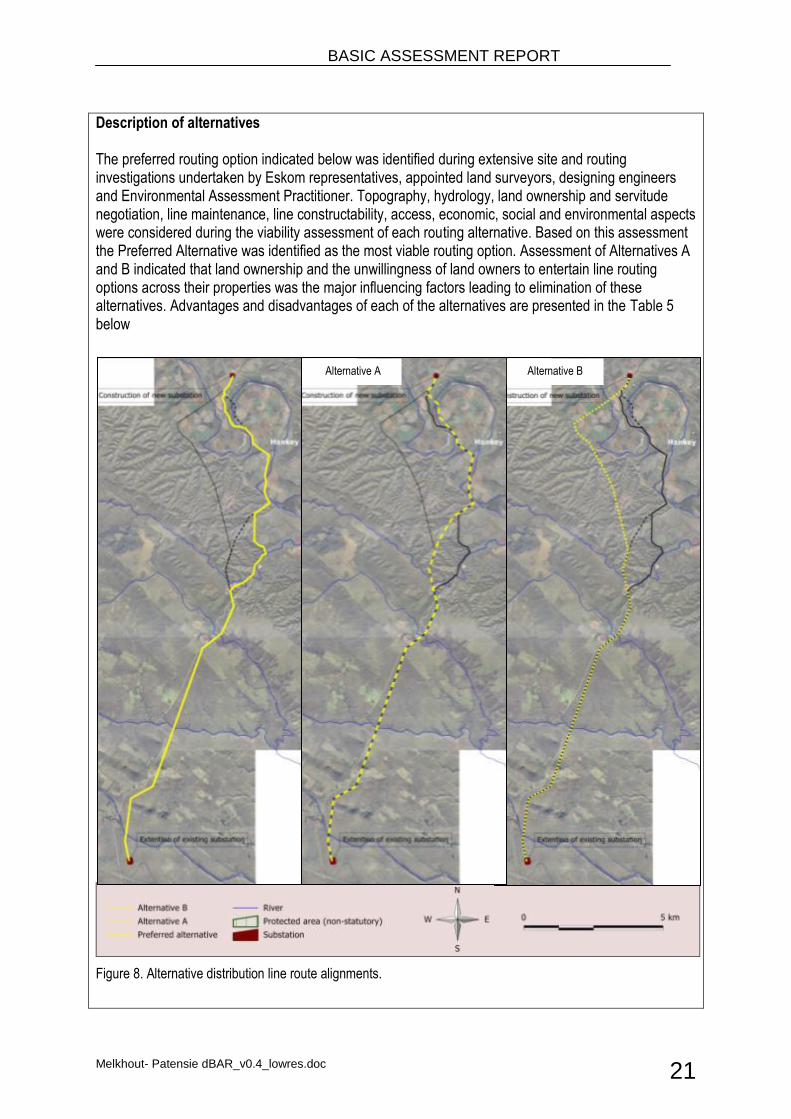
Description of alternatives The preferred routing option indicated below was identified during extensive site and routing investigations undertaken by Eskom representatives, appointed land surveyors, designing engineers and Environmental Assessment Practitioner. Topography, hydrology, land ownership and servitude negotiation, line maintenance, line constructability, access, economic, social and environmental aspects were considered during the viability assessment of each routing alternative. Based on this assessment the Preferred Alternative was identified as the most viable routing option. Assessment of Alternatives A and B indicated that land ownership and the unwillingness of land owners to entertain line routing options across their properties was the major influencing factors leading to elimination of these alternatives. Advantages and disadvantages of each of the alternatives are presented in the Table 5 below
Figure 8. Alternative distribution line route alignments.
Alternative A Alternative B
BASIC ASSESSMENT REPORT
Melkhout- Patensie dBAR_v0.4_lowres.doc 22
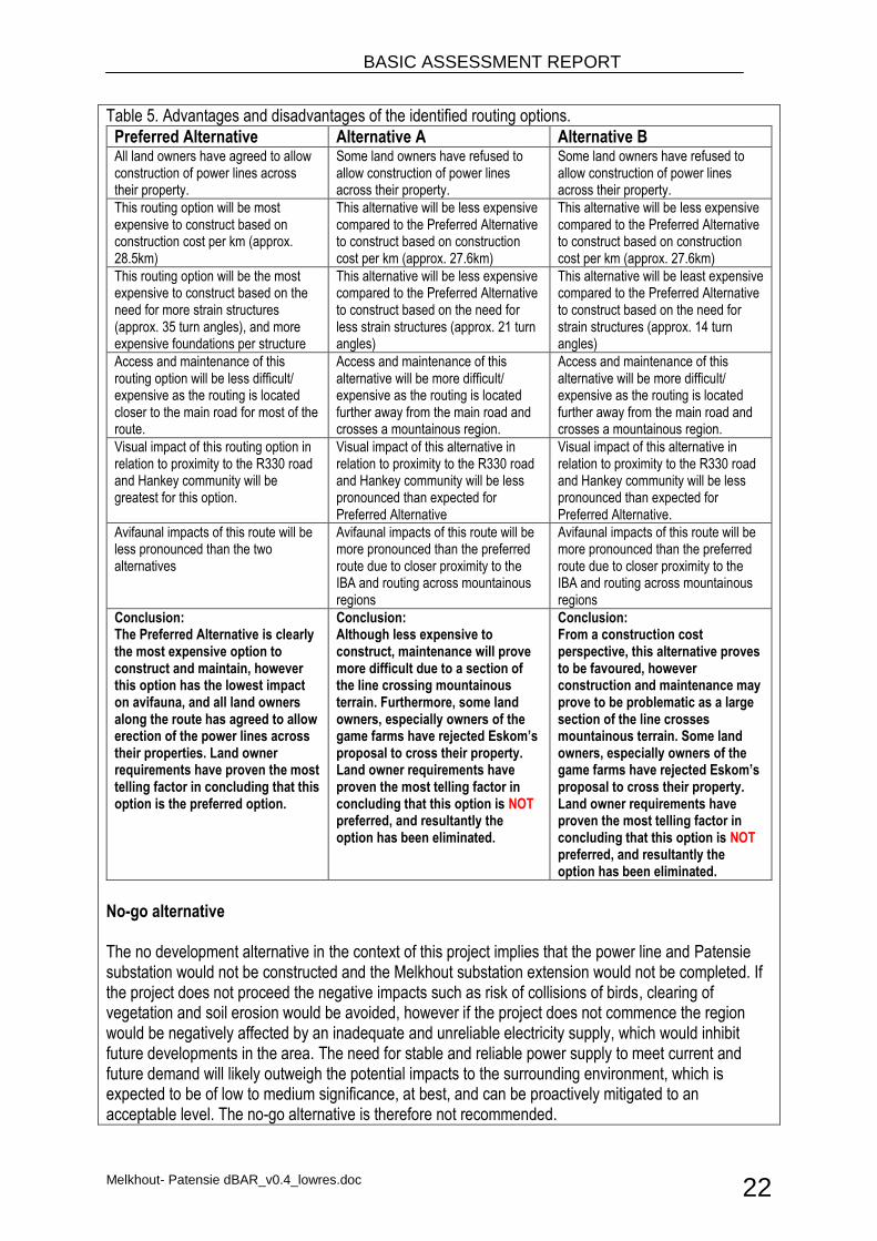
Table 5. Advantages and disadvantages of the identified routing options.
Preferred Alternative Alternative A Alternative B All land owners have agreed to allow construction of power lines across their property.
Some land owners have refused to allow construction of power lines across their property.
Some land owners have refused to allow construction of power lines across their property.
This routing option will be most expensive to construct based on construction cost per km (approx. 28.5km)
This alternative will be less expensive compared to the Preferred Alternative to construct based on construction cost per km (approx. 27.6km)
This alternative will be less expensive compared to the Preferred Alternative to construct based on construction cost per km (approx. 27.6km)
This routing option will be the most expensive to construct based on the need for more strain structures (approx. 35 turn angles), and more expensive foundations per structure
This alternative will be less expensive compared to the Preferred Alternative to construct based on the need for less strain structures (approx. 21 turn angles)
This alternative will be least expensive compared to the Preferred Alternative to construct based on the need for strain structures (approx. 14 turn angles)
Access and maintenance of this routing option will be less difficult/ expensive as the routing is located closer to the main road for most of the route.
Access and maintenance of this alternative will be more difficult/ expensive as the routing is located further away from the main road and crosses a mountainous region.
Access and maintenance of this alternative will be more difficult/ expensive as the routing is located further away from the main road and crosses a mountainous region.
Visual impact of this routing option in relation to proximity to the R330 road and Hankey community will be greatest for this option.
Visual impact of this alternative in relation to proximity to the R330 road and Hankey community will be less pronounced than expected for Preferred Alternative
Visual impact of this alternative in relation to proximity to the R330 road and Hankey community will be less pronounced than expected for Preferred Alternative.
Avifaunal impacts of this route will be less pronounced than the two alternatives
Avifaunal impacts of this route will be more pronounced than the preferred route due to closer proximity to the IBA and routing across mountainous regions
Avifaunal impacts of this route will be more pronounced than the preferred route due to closer proximity to the IBA and routing across mountainous regions
Conclusion: The Preferred Alternative is clearly the most expensive option to construct and maintain, however this option has the lowest impact on avifauna, and all land owners along the route has agreed to allow erection of the power lines across their properties. Land owner requirements have proven the most telling factor in concluding that this option is the preferred option.
Conclusion: Although less expensive to construct, maintenance will prove more difficult due to a section of the line crossing mountainous terrain. Furthermore, some land owners, especially owners of the game farms have rejected Eskom’s proposal to cross their property. Land owner requirements have proven the most telling factor in concluding that this option is NOT preferred, and resultantly the option has been eliminated.
Conclusion: From a construction cost perspective, this alternative proves to be favoured, however construction and maintenance may prove to be problematic as a large section of the line crosses mountainous terrain. Some land owners, especially owners of the game farms have rejected Eskom’s proposal to cross their property. Land owner requirements have proven the most telling factor in concluding that this option is NOT preferred, and resultantly the option has been eliminated.
No-go alternative The no development alternative in the context of this project implies that the power line and Patensie substation would not be constructed and the Melkhout substation extension would not be completed. If the project does not proceed the negative impacts such as risk of collisions of birds, clearing of vegetation and soil erosion would be avoided, however if the project does not commence the region would be negatively affected by an inadequate and unreliable electricity supply, which would inhibit future developments in the area. The need for stable and reliable power supply to meet current and future demand will likely outweigh the potential impacts to the surrounding environment, which is expected to be of low to medium significance, at best, and can be proactively mitigated to an acceptable level. The no-go alternative is therefore not recommended.
BASIC ASSESSMENT REPORT
Melkhout- Patensie dBAR_v0.4_lowres.doc 23
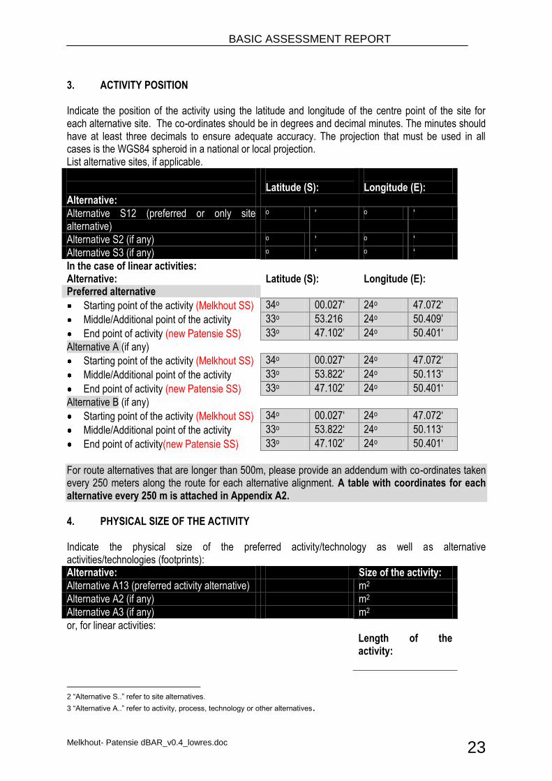
3. ACTIVITY POSITION Indicate the position of the activity using the latitude and longitude of the centre point of the site for each alternative site. The co-ordinates should be in degrees and decimal minutes. The minutes should have at least three decimals to ensure adequate accuracy. The projection that must be used in all cases is the WGS84 spheroid in a national or local projection. List alternative sites, if applicable. Alternative:
Latitude (S):
Longitude (E):
Alternative S12 (preferred or only site alternative)
o ‘ o ‘
Alternative S2 (if any) o ‘ o ‘
Alternative S3 (if any) o ‘ o ‘
In the case of linear activities: Alternative: Latitude (S): Longitude (E): Preferred alternative
Starting point of the activity (Melkhout SS) 34o 00.027‘ 24o 47.072‘
Middle/Additional point of the activity 33o 53.216 24o 50.409’
End point of activity (new Patensie SS) 33o 47.102’ 24o 50.401‘
Alternative A (if any)
Starting point of the activity (Melkhout SS) 34o 00.027‘ 24o 47.072‘
Middle/Additional point of the activity 33o 53.822‘ 24o 50.113‘
End point of activity (new Patensie SS) 33o 47.102’ 24o 50.401‘
Alternative B (if any)
Starting point of the activity (Melkhout SS) 34o 00.027‘ 24o 47.072‘
Middle/Additional point of the activity 33o 53.822‘ 24o 50.113‘
End point of activity(new Patensie SS) 33o 47.102’ 24o 50.401‘
For route alternatives that are longer than 500m, please provide an addendum with co-ordinates taken every 250 meters along the route for each alternative alignment. A table with coordinates for each alternative every 250 m is attached in Appendix A2. 4. PHYSICAL SIZE OF THE ACTIVITY Indicate the physical size of the preferred activity/technology as well as alternative activities/technologies (footprints): Alternative: Size of the activity:
Alternative A13 (preferred activity alternative) m2
Alternative A2 (if any) m2
Alternative A3 (if any) m2
or, for linear activities:
Length of the activity:
2 “Alternative S..” refer to site alternatives.
3 “Alternative A..” refer to activity, process, technology or other alternatives.
BASIC ASSESSMENT REPORT
Melkhout- Patensie dBAR_v0.4_lowres.doc 24
Alternative:
Preferred Alternative 28,511 m
Alternative A 27,522 m
Alternative B 27,599 m
Indicate the size of the alternative sites or servitudes (within which the above footprints will occur): Alternative:
Size of the site/servitude:
Preferred Alternative 883,841 m2
Alternative A 853,182 m2
Alternative B 855,569 m2
5. SITE ACCESS
Does ready access to the site exist? Existing roads and tracks to each of the tower structures and substations will be used during construction and maintenance; however some new access roads will have to be constructed where no tracks exist.
YES X
NO
If NO, what is the distance over which a new access road will be built Unknown at this stage
Describe the type of access road planned:
Ready access to the Melkhout substation exists. Access to the new Patensie substation will be possible using the R330, a short section of road will need to be constructed to allow access to the new substation, which will contain infrastructure that will support the distribution of higher energy voltage. Access to the power line route will be from existing rural access roads and tracks where these exist. Where no access route exists in close proximity to the proposed power line route it will be necessary to construct access tracks. These tracks will as far as possible follow the power line servitude and not entail construction of a formal road/s. Detailed design of new tracks or roads have not yet been conducted.
Include the position of the access road on the site plan and required map, as well as an indication of the road in relation to the site. 6. SITE OR ROUTE PLAN A detailed site or route plan(s) must be prepared for each alternative site or alternative activity. It must be attached as Appendix A to this document. Due to the large scale of the linear activity 1:500 scale site plans is impractical. The site or route plans must indicate the following: 6.1 the scale of the plan which must be at least a scale of 1:500; 6.2 the property boundaries and numbers of all the properties within 50 metres of the site; 6.3 the current land use as well as the land use zoning of each of the properties adjoining the site or
sites; 6.4 the exact position of each element of the application as well as any other structures on the site; 6.5 the position of services, including electricity supply cables (indicate above or underground), water
supply pipelines, boreholes, street lights, sewage pipelines, storm water infrastructure and telecommunication infrastructure;
BASIC ASSESSMENT REPORT
Melkhout- Patensie dBAR_v0.4_lowres.doc 25
6.6 all trees and shrubs taller than 1.8 metres; 6.7 walls and fencing including details of the height and construction material; 6.8 servitudes indicating the purpose of the servitude; 6.9 sensitive environmental elements within 100 metres of the site or sites including (but not limited
thereto): rivers; the 1:100 year flood line (where available or where it is required by DWA); ridges; cultural and historical features; areas with indigenous vegetation (even if it is degraded or invested with alien species);
6.10 for gentle slopes the 1 metre contour intervals must be indicated on the plan and whenever the slope of the site exceeds 1:10, the 500mm contours must be indicated on the plan; and
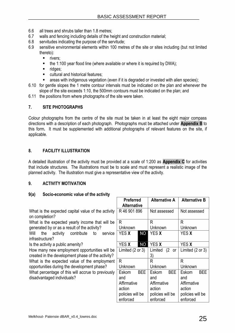
6.11 the positions from where photographs of the site were taken. 7. SITE PHOTOGRAPHS Colour photographs from the centre of the site must be taken in at least the eight major compass directions with a description of each photograph. Photographs must be attached under Appendix B to this form. It must be supplemented with additional photographs of relevant features on the site, if applicable. 8. FACILITY ILLUSTRATION A detailed illustration of the activity must be provided at a scale of 1:200 as Appendix C for activities that include structures. The illustrations must be to scale and must represent a realistic image of the planned activity. The illustration must give a representative view of the activity. 9. ACTIVITY MOTIVATION 9(a) Socio-economic value of the activity
Preferred Alternative
Alternative A Alternative B
What is the expected capital value of the activity on completion?
R 46 901 896 Not assessed Not assessed
What is the expected yearly income that will be generated by or as a result of the activity?
R Unknown
R Unknown
R Unknown
Will the activity contribute to service infrastructure?
YES X NO YES X YES X
Is the activity a public amenity? YES X NO YES X YES X
How many new employment opportunities will be created in the development phase of the activity?
Limited (2 or 3) Limited (2 or 3)
Limited (2 or 3)
What is the expected value of the employment opportunities during the development phase?
R Unknown
R Unknown
R Unknown
What percentage of this will accrue to previously disadvantaged individuals?
Eskom BEE and Affirmative action policies will be enforced
Eskom BEE and Affirmative action policies will be enforced
Eskom BEE and Affirmative action policies will be enforced
BASIC ASSESSMENT REPORT
Melkhout- Patensie dBAR_v0.4_lowres.doc 26
How many permanent new employment opportunities will be created during the operational phase of the activity?
Unknown at this stage.
Unknown at this stage.
Unknown at this stage.
What is the expected current value of the employment opportunities during the first 10 years?
R Unknown
R Unknown
R Unknown
What percentage of this will accrue to previously disadvantaged individuals?
% Unknown
% Unknown
% Unknown
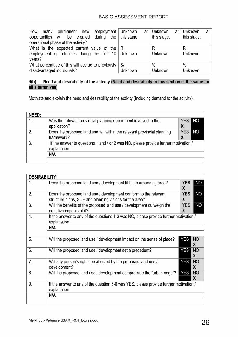
9(b) Need and desirability of the activity (Need and desirability in this section is the same for all alternatives) Motivate and explain the need and desirability of the activity (including demand for the activity):
NEED:
1. Was the relevant provincial planning department involved in the application?
YES X
NO
2. Does the proposed land use fall within the relevant provincial planning framework?
YES X
NO
3. If the answer to questions 1 and / or 2 was NO, please provide further motivation / explanation:
N/A
DESIRABILITY:
1. Does the proposed land use / development fit the surrounding area? YES X
NO
2. Does the proposed land use / development conform to the relevant structure plans, SDF and planning visions for the area?
YES X
NO
3. Will the benefits of the proposed land use / development outweigh the negative impacts of it?
YES X
NO
4. If the answer to any of the questions 1-3 was NO, please provide further motivation / explanation:
N/A
5. Will the proposed land use / development impact on the sense of place? YES NO X
6. Will the proposed land use / development set a precedent? YES NO X
7. Will any person’s rights be affected by the proposed land use / development?
YES NO X
8. Will the proposed land use / development compromise the “urban edge”? YES NO X
9. If the answer to any of the question 5-8 was YES, please provide further motivation / explanation.
N/A

BASIC ASSESSMENT REPORT
Melkhout- Patensie dBAR_v0.4_lowres.doc 27
BENEFITS:
1. Will the land use / development have any benefits for society in general? YES X
NO
2. Explain:
The potential benefit of the proposed power line and substation to the Eastern Cape lies in the stimulation of the local economy through the supply of a reliable electricity supply, which will increasingly benefit the provision of services. Improving network reliability may furthermore decrease the number of residents within the Eastern Cape who are still reliant on domestic fires, which in turn negatively impact the environment through uncontrolled harvesting of woodlands and air quality.
3. Will the land use / development have any benefits for the local communities where it will be located?
YES X
NO
4. Explain:
The provision of electricity may promote local economic development and investment in the Kouga Local Municipality. Electricity provision is critical for economic development, related employment and sustainable development in South Africa. In the context of the project improvement of the 132kV supply is critical to the improvement of provision of household electricity.
10. APPLICABLE LEGISLATION, POLICIES AND/OR GUIDELINES List all legislation, policies and/or guidelines of any sphere of government that are applicable to the application as contemplated in the EIA regulations, if applicable: Title of legislation, policy or guideline:
Administering authority:
Date:
Constitution of the Republic of South Africa Act No. 108 of 1996
South African Government
1996
National Environmental Management Act (NEMA) No. 107 0f 1998
DEA 1998
Environmental Impact Assessment Regulations (Government Notice No. R. 543 and 544)
DEA 2010
National Heritage Resources Act (NHRA) No. 25 of 1999
SAHRA 1999
National Water Act (Act 36 of 1998) DWA 1998
Conservation of Agricultural Resources Act (43 of 1983)
DoA 1983
Occupational Health and Safety Act (OHSA) No. 85 of 1993
Department of Labour 1993
National Environmental Management Biodiversity Act (Act 10 of 2004)
DEA 2004
Electricity Regulations Act (4 of 2006) NERSA 2006
National Energy Bill (2008) 2008
Expropriation Act (63 of 1975) 1975
BASIC ASSESSMENT REPORT
Melkhout- Patensie dBAR_v0.4_lowres.doc 28
Kouga LM Integrated Development Plan Kouga LM 2007-2012
Cacadu DM Integrated Development Plan Cacadu DM 2007-2012
Cape Nature and Environmental Conservation Ordinance (No. 19 of 1974)
1974
Eastern Cape Biodiversity Conservation Plan DEA 2007
11. WASTE, EFFLUENT, EMISSION AND NOISE MANAGEMENT 11(a) Solid waste management
Will the activity produce solid construction waste during the construction/initiation phase?
YES X
NO
If yes, what estimated quantity will be produced per month? Approx. 5 m3
How will the construction solid waste be disposed of (describe)?
All solid waste which is not reusable will be collected at a central location and will be stored temporarily until removed to a recognised landfill site
Where will the construction solid waste be disposed of (describe)?
Recognised landfill site
Will the activity produce solid waste during its operational phase? YES NO X
If yes, what estimated quantity will be produced per month? m3
How will the solid waste be disposed of (describe)?
N/A
Where will the solid waste be disposed if it does not feed into a municipal waste stream (describe)?
N/A
If the solid waste (construction or operational phases) will not be disposed of in a registered landfill site or be taken up in a municipal waste stream, then the applicant should consult with the competent authority to determine whether it is necessary to change to an application for scoping and EIA.
Can any part of the solid waste be classified as hazardous in terms of the relevant legislation?
YES NO X
If yes, inform the competent authority and request a change to an application for scoping and EIA.
Is the activity that is being applied for a solid waste handling or treatment facility?
YES NO X
If yes, then the applicant should consult with the competent authority to determine whether it is necessary to change to an application for scoping and EIA.
11(b) Liquid effluent
Will the activity produce effluent, other than normal sewage, that will be disposed of in a municipal sewage system?
YES NO X
If yes, what estimated quantity will be produced per month? m3
Will the activity produce any effluent that will be treated and/or disposed of on site?
Yes NO X
BASIC ASSESSMENT REPORT
Melkhout- Patensie dBAR_v0.4_lowres.doc 29
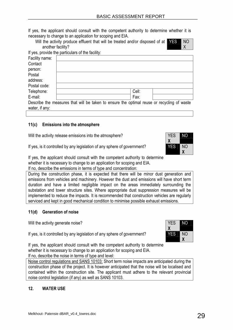
If yes, the applicant should consult with the competent authority to determine whether it is necessary to change to an application for scoping and EIA.
Will the activity produce effluent that will be treated and/or disposed of at another facility?
YES NO X
If yes, provide the particulars of the facility:
Facility name:
Contact person:
Postal address:
Postal code:
Telephone: Cell:
E-mail: Fax:
Describe the measures that will be taken to ensure the optimal reuse or recycling of waste water, if any:
11(c) Emissions into the atmosphere
Will the activity release emissions into the atmosphere? YES X
NO
If yes, is it controlled by any legislation of any sphere of government? YES NO X
If yes, the applicant should consult with the competent authority to determine whether it is necessary to change to an application for scoping and EIA.
If no, describe the emissions in terms of type and concentration:
During the construction phase, it is expected that there will be minor dust generation and emissions from vehicles and machinery. However the dust and emissions will have short term duration and have a limited negligible impact on the areas immediately surrounding the substation and tower structure sites. Where appropriate dust suppression measures will be implemented to reduce the impacts. It is recommended that construction vehicles are regularly serviced and kept in good mechanical condition to minimise possible exhaust emissions.
11(d) Generation of noise
Will the activity generate noise? YES X
NO
If yes, is it controlled by any legislation of any sphere of government? YES NO X
If yes, the applicant should consult with the competent authority to determine whether it is necessary to change to an application for scoping and EIA.
If no, describe the noise in terms of type and level:
Noise control regulations and SANS 10103: Short term noise impacts are anticipated during the construction phase of the project. It is however anticipated that the noise will be localised and contained within the construction site. The applicant must adhere to the relevant provincial noise control legislation (if any) as well as SANS 10103.
12. WATER USE
BASIC ASSESSMENT REPORT
Melkhout- Patensie dBAR_v0.4_lowres.doc 30
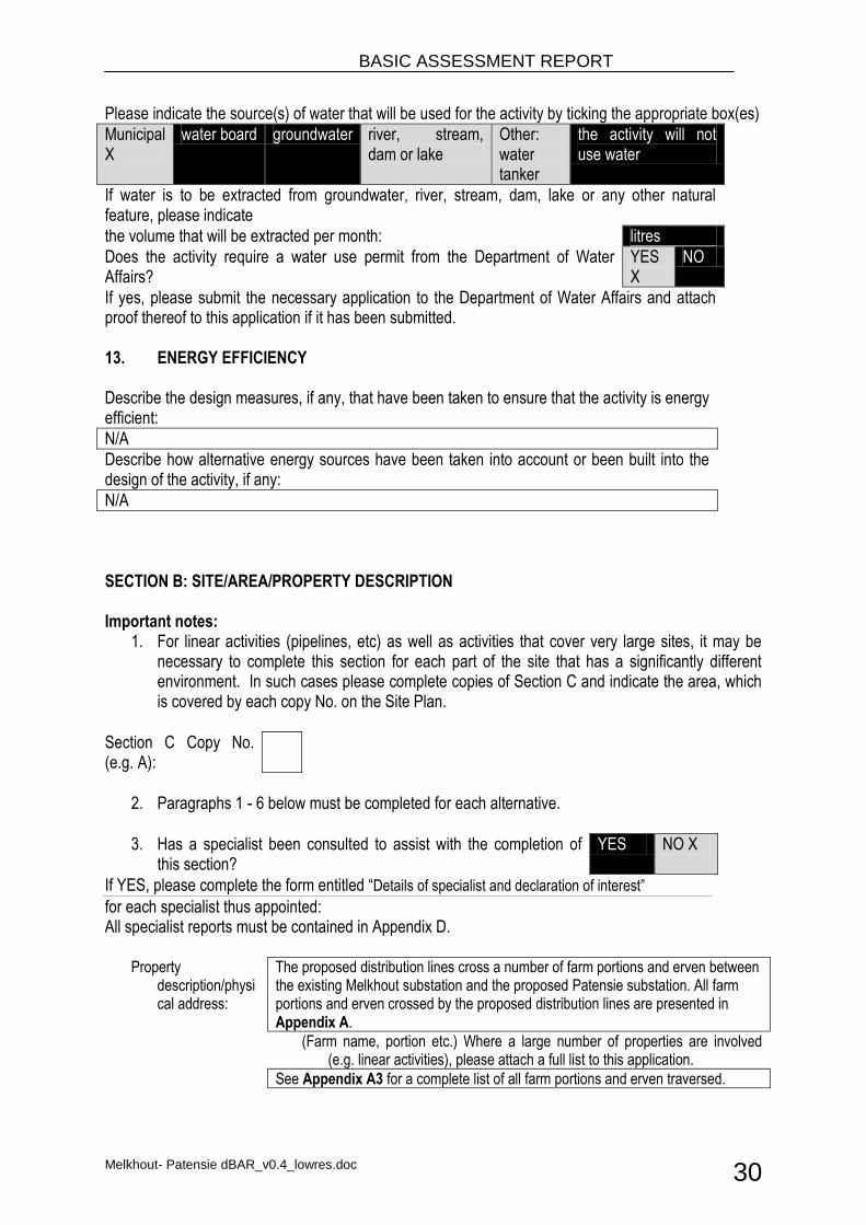
Please indicate the source(s) of water that will be used for the activity by ticking the appropriate box(es)
Municipal X
water board groundwater river, stream, dam or lake
Other: water tanker
the activity will not use water
If water is to be extracted from groundwater, river, stream, dam, lake or any other natural feature, please indicate
the volume that will be extracted per month: litres
Does the activity require a water use permit from the Department of Water Affairs?
YES X
NO
If yes, please submit the necessary application to the Department of Water Affairs and attach proof thereof to this application if it has been submitted. 13. ENERGY EFFICIENCY Describe the design measures, if any, that have been taken to ensure that the activity is energy efficient:
N/A
Describe how alternative energy sources have been taken into account or been built into the design of the activity, if any:
N/A
SECTION B: SITE/AREA/PROPERTY DESCRIPTION Important notes:
1. For linear activities (pipelines, etc) as well as activities that cover very large sites, it may be necessary to complete this section for each part of the site that has a significantly different environment. In such cases please complete copies of Section C and indicate the area, which is covered by each copy No. on the Site Plan.
Section C Copy No. (e.g. A):
2. Paragraphs 1 - 6 below must be completed for each alternative.
3. Has a specialist been consulted to assist with the completion of this section?
YES NO X
If YES, please complete the form entitled “Details of specialist and declaration of interest”
for each specialist thus appointed: All specialist reports must be contained in Appendix D.
Property description/physical address:
The proposed distribution lines cross a number of farm portions and erven between the existing Melkhout substation and the proposed Patensie substation. All farm portions and erven crossed by the proposed distribution lines are presented in Appendix A.
(Farm name, portion etc.) Where a large number of properties are involved (e.g. linear activities), please attach a full list to this application.
See Appendix A3 for a complete list of all farm portions and erven traversed.
BASIC ASSESSMENT REPORT
Melkhout- Patensie dBAR_v0.4_lowres.doc 31
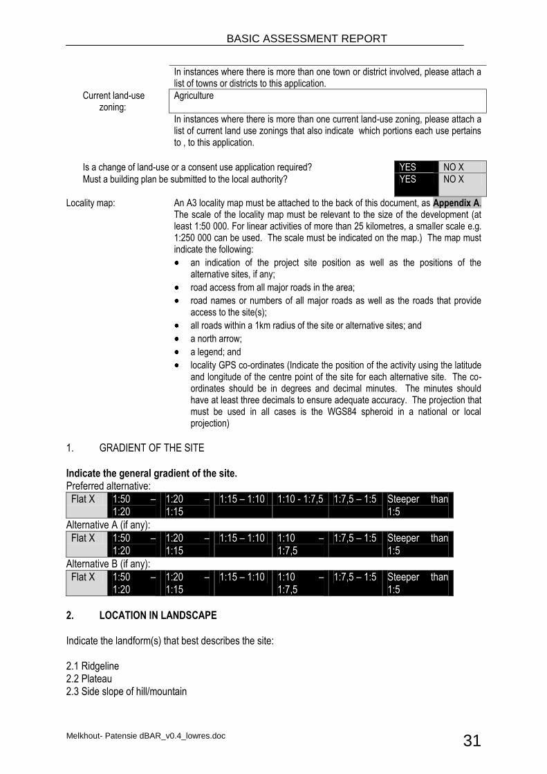
In instances where there is more than one town or district involved, please attach a list of towns or districts to this application.
Current land-use zoning:
Agriculture
In instances where there is more than one current land-use zoning, please attach a list of current land use zonings that also indicate which portions each use pertains to , to this application.
Is a change of land-use or a consent use application required? YES NO X Must a building plan be submitted to the local authority?
YES NO X
Locality map: An A3 locality map must be attached to the back of this document, as Appendix A. The scale of the locality map must be relevant to the size of the development (at least 1:50 000. For linear activities of more than 25 kilometres, a smaller scale e.g. 1:250 000 can be used. The scale must be indicated on the map.) The map must indicate the following:
an indication of the project site position as well as the positions of the alternative sites, if any;
road access from all major roads in the area;
road names or numbers of all major roads as well as the roads that provide access to the site(s);
all roads within a 1km radius of the site or alternative sites; and
a north arrow;
a legend; and
locality GPS co-ordinates (Indicate the position of the activity using the latitude and longitude of the centre point of the site for each alternative site. The co-ordinates should be in degrees and decimal minutes. The minutes should have at least three decimals to ensure adequate accuracy. The projection that must be used in all cases is the WGS84 spheroid in a national or local projection)
1. GRADIENT OF THE SITE Indicate the general gradient of the site. Preferred alternative:
Flat X 1:50 – 1:20
1:20 – 1:15
1:15 – 1:10 1:10 - 1:7,5 1:7,5 – 1:5 Steeper than 1:5
Alternative A (if any):
Flat X 1:50 – 1:20
1:20 – 1:15
1:15 – 1:10 1:10 – 1:7,5
1:7,5 – 1:5 Steeper than 1:5
Alternative B (if any):
Flat X 1:50 – 1:20
1:20 – 1:15
1:15 – 1:10 1:10 – 1:7,5
1:7,5 – 1:5 Steeper than 1:5
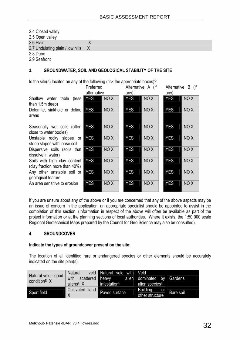
2. LOCATION IN LANDSCAPE Indicate the landform(s) that best describes the site: 2.1 Ridgeline 2.2 Plateau 2.3 Side slope of hill/mountain
BASIC ASSESSMENT REPORT
Melkhout- Patensie dBAR_v0.4_lowres.doc 32
2.4 Closed valley 2.5 Open valley 2.6 Plain X 2.7 Undulating plain / low hills X 2.8 Dune 2.9 Seafront 3. GROUNDWATER, SOIL AND GEOLOGICAL STABILITY OF THE SITE Is the site(s) located on any of the following (tick the appropriate boxes)? Preferred
alternative Alternative A (if
any): Alternative B (if
any):
Shallow water table (less than 1.5m deep)
YES NO X YES NO X YES NO X
Dolomite, sinkhole or doline areas
YES NO X YES NO X YES NO X
Seasonally wet soils (often close to water bodies)
YES NO X YES NO X YES NO X
Unstable rocky slopes or steep slopes with loose soil
YES NO X YES NO X YES NO X
Dispersive soils (soils that dissolve in water)
YES NO X YES NO X YES NO X
Soils with high clay content (clay fraction more than 40%)
YES NO X YES NO X YES NO X
Any other unstable soil or geological feature
YES NO X YES NO X YES NO X
An area sensitive to erosion
YES NO X YES NO X YES NO X
If you are unsure about any of the above or if you are concerned that any of the above aspects may be an issue of concern in the application, an appropriate specialist should be appointed to assist in the completion of this section. (Information in respect of the above will often be available as part of the project information or at the planning sections of local authorities. Where it exists, the 1:50 000 scale Regional Geotechnical Maps prepared by the Council for Geo Science may also be consulted). 4. GROUNDCOVER Indicate the types of groundcover present on the site: The location of all identified rare or endangered species or other elements should be accurately indicated on the site plan(s).
Natural veld - good conditionE X
Natural veld with scattered aliensE X
Natural veld with heavy alien infestationE
Veld dominated by alien speciesE
Gardens
Sport field Cultivated land X
Paved surface Building or other structure
Bare soil
BASIC ASSESSMENT REPORT
Melkhout- Patensie dBAR_v0.4_lowres.doc 33
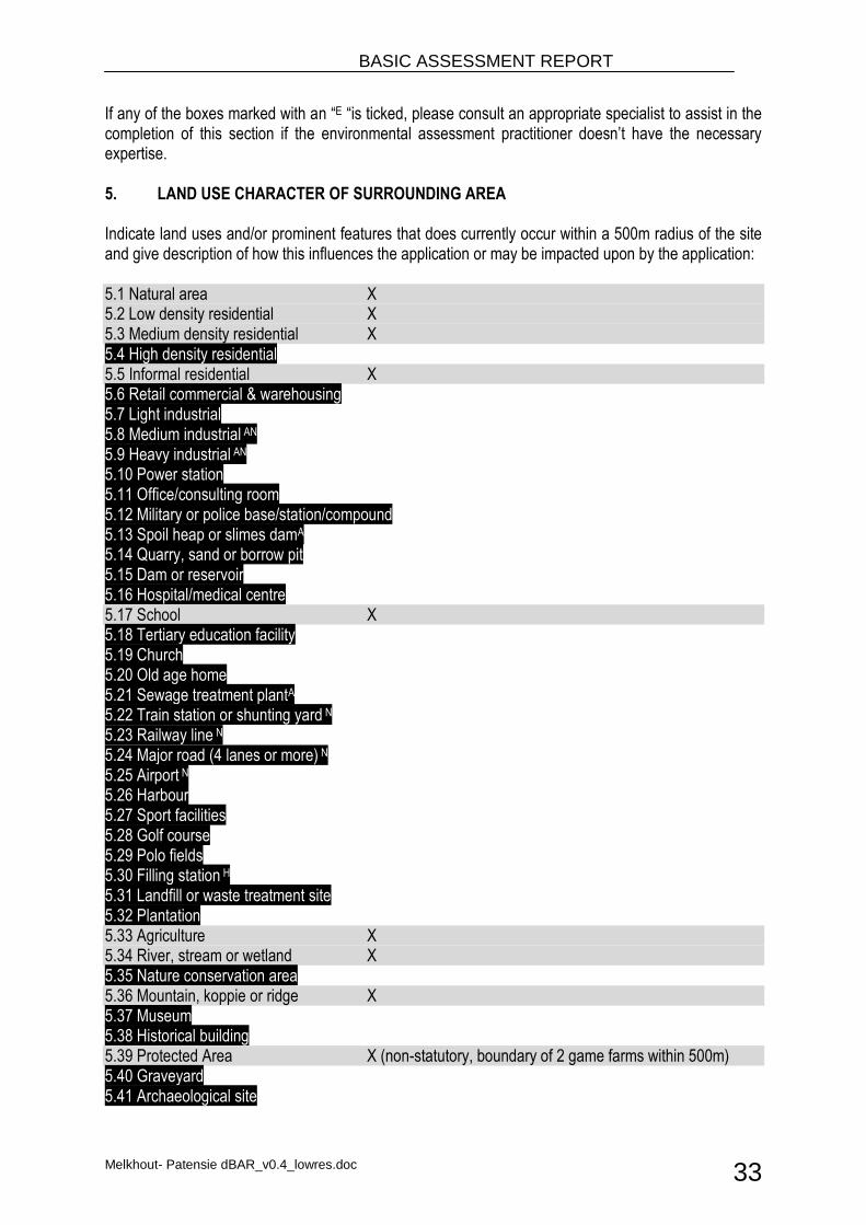
If any of the boxes marked with an “E “is ticked, please consult an appropriate specialist to assist in the completion of this section if the environmental assessment practitioner doesn’t have the necessary expertise. 5. LAND USE CHARACTER OF SURROUNDING AREA Indicate land uses and/or prominent features that does currently occur within a 500m radius of the site and give description of how this influences the application or may be impacted upon by the application: 5.1 Natural area X 5.2 Low density residential X 5.3 Medium density residential X 5.4 High density residential 5.5 Informal residential X 5.6 Retail commercial & warehousing 5.7 Light industrial 5.8 Medium industrial AN 5.9 Heavy industrial AN 5.10 Power station 5.11 Office/consulting room 5.12 Military or police base/station/compound 5.13 Spoil heap or slimes damA 5.14 Quarry, sand or borrow pit 5.15 Dam or reservoir 5.16 Hospital/medical centre 5.17 School X 5.18 Tertiary education facility 5.19 Church 5.20 Old age home 5.21 Sewage treatment plantA 5.22 Train station or shunting yard N 5.23 Railway line N 5.24 Major road (4 lanes or more) N 5.25 Airport N 5.26 Harbour 5.27 Sport facilities 5.28 Golf course 5.29 Polo fields 5.30 Filling station H 5.31 Landfill or waste treatment site 5.32 Plantation 5.33 Agriculture X 5.34 River, stream or wetland X 5.35 Nature conservation area 5.36 Mountain, koppie or ridge X 5.37 Museum 5.38 Historical building 5.39 Protected Area X (non-statutory, boundary of 2 game farms within 500m) 5.40 Graveyard 5.41 Archaeological site
BASIC ASSESSMENT REPORT
Melkhout- Patensie dBAR_v0.4_lowres.doc 34
5.42 Other land uses (describe) If any of the boxes marked with an “N “are ticked, how will this impact / be impacted upon by the proposed activity?
If any of the boxes marked with an "An" are ticked, how will this impact / be impacted upon by the proposed activity? N/A If YES, specify and explain: If YES, specify: If any of the boxes marked with an "H" are ticked, how will this impact / be impacted upon by the proposed activity. N/A If YES, specify and explain: If YES, specify: 6. CULTURAL/HISTORICAL FEATURES
Are there any signs of culturally or historically significant elements, as defined in section 2 of the National Heritage Resources Act, 1999, (Act No. 25 of 1999), including
YES X
NO
Archaeological or palaeontological sites, on or close (within 20m) to the site?
Uncertain
If YES, explain:
The Gamtoos Scenic Route, which has high local and regional significance for its aesthetic and economic (tourism) values. An informal burial site was identified during a specialist study within 20 m of the proposed powerline route near Hankey.
If uncertain, conduct a specialist investigation by a recognised specialist in the field to establish whether there is such a feature(s) present on or close to the site.
BASIC ASSESSMENT REPORT
Melkhout- Patensie dBAR_v0.4_lowres.doc 35
Briefly explain the findings of the specialist:
GIBB Engineering and Science appointed eThembeni Cultural Heritage to undertake a Phase 1 Heritage Impact Assessment of a proposed distribution power line and substation site in the Eastern Cape Province, in terms of the National Environmental Management Act 107 of 1998 as amended, in compliance with Section 38 of the National Heritage Resources Act 25 of 1999, as amended. eThembeni identified the Gamtoos Scenic Route and potential paleontological finds as heritage resources of value. The proposed electrical infrastructure is located along the Gamtoos Scenic Route, which has high local and regional significance for its aesthetic and economic (tourism) values. The unmanaged potential impact on this landscape is medium. As recommended mitigation towers should be located such that they do not interrupt skylines, and are not visible from scenic routes. An informal burial ground is located on the north-west of the town of Hankey between bending towers MP50 and MP51. Graves are marked with stone piles and markers including wooden crosses, the burial ground is still visited by next-of kin. All human remains have high heritage significance due to their spiritual, social and cultural values. The unmanaged potential impact of the development on burial grounds is medium, suggested mitigation restricts development activity within 20 meters of identified burial grounds. Graves may not be altered in any way without permission from the next-of-kin and the relevant heritage and local government authorities. The geology underlying the study area traverses a wide range of geological units. The Table Mountain Group sediments in the southwest are generally poorly fossiligerous, as are Jurassic conglomerates of the Enon Formation on the southwestern side of the Gamtoos River Valley. Early Cretaceous Kirkwood Formation beds near Patensie may contain important fossils of dinosaurs and other terrestrial vertebrates as well as petrified wood, while older alluvial sediments of the Gamtoos drainage systems are potentially fossil-bearing. A heritage practitioner should complete a ‘walk-through’ of the final selected power line route and all other activity areas (access roads, construction camps, materials’ storage areas, etc.) prior to the start of any construction activities and assess direct impacts on discrete resources such as traditional burial places, and archaeological and palaeontological sites. No monitoring was recommended. Conclusion: eThembeni recommends that that the development proceeds with the proposed heritage mitigation as outlined in the full report and with the Heritage Impact Assessment report being submitted to SAHRA in fulfilment of the requirements of the National Heritage Resources Act (Act 25 of 1999). Relevant staff members may be contacted at the SAHRA Cape Town head office (Mariagrazia Galimberti telephone 021 462 4502; [email protected]). The complete HIA is included in Appendix D for reference.
BASIC ASSESSMENT REPORT
Melkhout- Patensie dBAR_v0.4_lowres.doc 36
Will any building or structure older than 60 years be affected in any way? YES NO X
Is it necessary to apply for a permit in terms of the National Heritage Resources Act, 1999 (Act 25 of 1999)?
YES NO X
If yes, please submit or, make sure that the applicant or a specialist submits the necessary application to SAHRA or the relevant provincial heritage agency and attach proof thereof to this application if such application has been made.
SECTION C: PUBLIC PARTICIPATION
See Appendix E for details of Public Participation undertaken.
1. ADVERTISEMENT The person conducting a public participation process must take into account any guidelines applicable to public participation as contemplated in section 24J of the Act and must give notice to all potential interested and affected parties of the application which is subjected to public participation by— (a) fixing a notice board (of a size at least 60cm by 42cm; and must display the required
information in lettering and in a format as may be determined by the competent authority) at a place conspicuous to the public at the boundary or on the fence of— (i) the site where the activity to which the application relates is or is to be undertaken; and
(ii) any alternative site mentioned in the application; (b) giving written notice to—
(i) the owner or person in control of that land if the applicant is not the owner or person in control of the land;
(ii) the occupiers of the site where the activity is or is to be undertaken or to any alternative site where the activity is to be undertaken;
(iii) owners and occupiers of land adjacent to the site where the activity is or is to be undertaken or to any alternative site where the activity is to be undertaken;
(iv) the municipal councillor of the ward in which the site or alternative site is situated and any organisation of ratepayers that represent the community in the area;
(v) the municipality which has jurisdiction in the area; (vi) any organ of state having jurisdiction in respect of any aspect of the activity; and (vii) any other party as required by the competent authority;
(c) placing an advertisement in— (i) one local newspaper; or
(ii) any official Gazette that is published specifically for the purpose of providing public notice of applications or other submissions made in terms of these Regulations;
(d) placing an advertisement in at least one provincial newspaper or national newspaper, if the activity has or may have an impact that extends beyond the boundaries of the metropolitan or local municipality in which it is or will be undertaken: Provided that this paragraph need not be complied with if an advertisement has been placed in an official Gazette referred to in subregulation 54(c)(ii); and
(e) using reasonable alternative methods, as agreed to by the competent authority, in those instances where a person is desiring of but unable to participate in the process due to— (i) illiteracy; (ii) disability; or (iii) any other disadvantage.
BASIC ASSESSMENT REPORT
Melkhout- Patensie dBAR_v0.4_lowres.doc 37
2. CONTENT OF ADVERTISEMENTS AND NOTICES A notice board, advertisement or notices must:
(a) indicate the details of the application which is subjected to public participation; and (b) state—
(i) that the application has been submitted to the competent authority in terms of these Regulations, as the case may be; (ii) whether basic assessment or scoping procedures are being applied to the application, in the case of an application for environmental authorisation;
(iii) the nature and location of the activity to which the application relates; (iv) where further information on the application or activity can be obtained; and (iv) the manner in which and the person to whom representations in respect of the
application may be made. 3. PLACEMENT OF ADVERTISEMENTS AND NOTICES Where the proposed activity may have impacts that extend beyond the municipal area where it is located, a notice must be placed in at least one provincial newspaper or national newspaper, indicating that an application will be submitted to the competent authority in terms of these regulations, the nature and location of the activity, where further information on the proposed activity can be obtained and the manner in which representations in respect of the application can be made, unless a notice has been placed in any Gazette that is published specifically for the purpose of providing notice to the public of applications made in terms of the EIA regulations. Advertisements and notices must make provision for all alternatives. 4. DETERMINATION OF APPROPRIATE MEASURES The practitioner must ensure that the public participation is adequate and must determine whether a public meeting or any other additional measure is appropriate or not based on the particular nature of each case. Special attention should be given to the involvement of local community structures such as Ward Committees, ratepayers associations and traditional authorities where appropriate. Please note that public concerns that emerge at a later stage that should have been addressed may cause the competent authority to withdraw any authorisation it may have issued if it becomes apparent that the public participation process was inadequate.
5. COMMENTS AND RESPONSE REPORT The practitioner must record all comments and respond to each comment of the public before the application is submitted. The comments and responses must be captured in a comments and response report as prescribed in the EIA regulations and be attached to this application. The comments and response report must be attached under Appendix E. 6. AUTHORITY PARTICIPATION

BASIC ASSESSMENT REPORT
Melkhout- Patensie dBAR_v0.4_lowres.doc 38
Please note that a complete list of all organs of state and or any other applicable authority with their contact details must be appended to the basic assessment report or scoping report, whichever is applicable. Authorities are key interested and affected parties in each application and no decision on any application will be made before the relevant local authority is provided with the opportunity to give input. List of authorities informed:
Department of Environmental Affairs (DEA);
Department of Economic Development and Environmental Affairs;
Department of Roads Eastern Cape;
South African Heritage Resources Agency (SAHRA);
Councillors, Municipality Managers and Mayors for Kouga and Kou-Kamma
List of authorities from whom comments have been received:
Acceptance of the application (form) for environmental authorisation has been received from the DEA. See Appendix H for copy of the acceptance letter. No other comments have been received.
BASIC ASSESSMENT REPORT
Melkhout- Patensie dBAR_v0.4_lowres.doc 39
7. CONSULTATION WITH OTHER STAKEHOLDERS Note that, for linear activities, or where deviation from the public participation requirements may be appropriate, the person conducting the public participation process may deviate from the requirements of that subregulation to the extent and in the manner as may be agreed to by the competent authority. Proof of any such agreement must be provided, where applicable.
Has any comment been received from stakeholders?
YES X
NO
If “YES”, briefly describe the feedback below (also attach copies of any correspondence to and from the stakeholders to this application):
See Appendix E for details of Public Participation undertaken.
BASIC ASSESSMENT REPORT
Melkhout- Patensie dBAR_v0.4_lowres.doc 40
SECTION D: IMPACT ASSESSMENT The assessment of impacts must adhere to the minimum requirements in the EIA Regulations, 2010, and should take applicable official guidelines into account. The issues raised by interested and affected parties should also be addressed in the assessment of impacts. 1. ISSUES RAISED BY INTERESTED AND AFFECTED PARTIES List the main issues raised by interested and affected parties.
Issues and concerns that were raised by I&APs have been grouped under common headings: Land use A number of farmers already have power lines crossing their properties and were unwilling to allow additional lines. The spacing of towers must be consistent with existing towers. When placing towers future wind farms must be considered. Roads Power lines must not be constructed within 20 m of a national road reserve fence. The vertical clearance of power lines must not be less than 6.5 meters measured from the crown of the national road to the lowest wire. Wetlands The proposed route crosses wetlands which are rich in flora and fauna, construction work will permanently damage the wetlands. Avifauna Power lines will decimate populations of endangered birds. Planted pastures The power line route crosses over highly productive pastures, the line should be routed across adjacent natural veld with a lower carrying capacity. Visual impact The lines will be visible from the R62 road so impacting upon the sense of place.
Response from the practitioner to the issues raised by the interested and affected parties (A full response must be given in the Comments and Response Report that must be attached to this report as Annexure E):
Land use Power lines do exist in the study area, however new power lines will only be constructed on properties where permission to construct tower structures as been successfully negotiated with the land owners. The spacing of towers will be done according to the specifications of the tower structures used and existing Eskom best practice guidelines. No wind generation projects or developments have been proposed within a distance of 5 km from the proposed power line route. Roads The minimum vertical clearance between the power line conductors and the ground is 6.7 m,
BASIC ASSESSMENT REPORT
Melkhout- Patensie dBAR_v0.4_lowres.doc 41
while the minimum distance of a 132 kV distribution line running parallel to proclaimed public roads is 95 m from the centreline of the distribution line servitude to the centreline of the road servitude. Wetlands No tower structures will be placed in any existing wetlands occurring in the study site. A Water Use License Application (WULA) will be launched for any construction work occurring within 500 m of any existing wetlands. The WULA will investigate and propose mitigation for all identified potential impacts that may result from the activities. Avifauna An avifauna specialist was appointed to conduct a bird specialist study. The specialist report concluded that the impacts on birds are of relatively low significance for the proposed project, provided that the recommended mitigation measures are implemented. The complete avifauna specialist report is included in Appendix D1. Planted pastures The impact of the placement of tower structures in arable land will be negligible. Farming practises on the impacted erven will continue as normal, and placement of the tower structures has been negotiated with the affected land owners. Visual impact Power lines already exist along the roads leading to and from the small towns of Hankey, Patensie and Humansdorp. A Heritage Impact Assessment (HIA) found the visual impact of the power lines on the Gamtoos Scenic Route to be of low significance provided that the mitigation measures proposed by the HIA practitioner are implemented. The complete HIA is included in Appendix D3.
2. IMPACTS THAT MAY RESULT FROM THE PLANNING AND DESIGN, CONSTRUCTION, OPERATIONAL, DECOMMISSIONING AND CLOSURE PHASES AS WELL AS PROPOSED MANAGEMENT OF IDENTIFIED IMPACTS AND PROPOSED MITIGATION MEASURES List the potential direct, indirect and cumulative property/activity/design/technology/operational alternative related impacts (as appropriate) that are likely to occur as a result of the planning and design phase, construction phase, operational phase, decommissioning and closure phase, including impacts relating to the choice of site/activity/technology alternatives as well as the mitigation measures that may eliminate or reduce the potential impacts listed.
The impacts are assessed (rated) in terms of their significance (high, medium, low), status and confidence through a synthesis of the criteria in the table below. The criteria in the impact table is represented by the abbreviations for each criteria presented in brackets and bold italics.
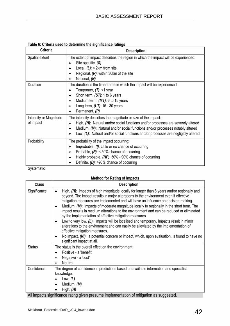
BASIC ASSESSMENT REPORT
Melkhout- Patensie dBAR_v0.4_lowres.doc 42
Table 6: Criteria used to determine the significance ratings
Criteria Description
Spatial extent The extent of impact describes the region in which the impact will be experienced:
Site specific, (S)
Local, (L): < 2km from site
Regional, (R): within 30km of the site
National, (N)
Duration The duration is the time frame in which the impact will be experienced:
Temporary, (T): <1 year
Short term, (ST): 1 to 6 years
Medium term, (MT): 6 to 15 years
Long term, (LT): 15 - 30 years
Permanent, (P)
Intensity or Magnitude of impact
The intensity describes the magnitude or size of the impact:
High, (H): Natural and/or social functions and/or processes are severely altered
Medium, (M): Natural and/or social functions and/or processes notably altered
Low, (L): Natural and/or social functions and/or processes are negligibly altered
Probability The probability of the impact occurring:
Improbable, (I): Little or no chance of occurring
Probable, (P): < 50% chance of occurring
Highly probable, (HP): 50% - 90% chance of occurring
Definite, (D): >90% chance of occurring
Systematic
Method for Rating of Impacts
Class Description
Significance High, (H): impacts of high magnitude locally for longer than 6 years and/or regionally and beyond. The impact results in major alterations to the environment even if effective mitigation measures are implemented and will have an influence on decision-making.
Medium, (M): impacts of moderate magnitude locally to regionally in the short term. The impact results in medium alterations to the environment and can be reduced or eliminated by the implementation of effective mitigation measures.
Low to very low, (L): impacts will be localised and temporary. Impacts result in minor alterations to the environment and can easily be alleviated by the implementation of effective mitigation measures.
No impact, (NI): a potential concern or impact, which, upon evaluation, is found to have no significant impact at all.
Status The status is the overall effect on the environment:
Positive - a 'benefit'
Negative - a 'cost'
Neutral
Confidence The degree of confidence in predictions based on available information and specialist knowledge:
Low, (L)
Medium, (M)
High, (H)
All impacts significance rating given presume implementation of mitigation as suggested.
BASIC ASSESSMENT REPORT
Melkhout- Patensie dBAR_v0.4_lowres.doc 43
Description of impacts during planning, construction, operational and decommissioning phase. Planning phase Minor damage to roads (Direct): Minor damage to roads in the study area could potentially result from continued travelling of vehicles on minor and gravel roads by land surveyors, engineers and Eskom staff during route and site investigations, and land owner negotiations. It is unlikely though that damage to the roads will be noticeable over the short to medium term. * Mitigation: Plan to build access roads on flat surface as far as possible. Restrict construction vehicle speed on access tracks to 20 km/h. Construction phase Impacts identified by EAP Increased stormwater runoff (Direct): Removal of vegetation along the route servitude may result in increased runoff of stormwater and potential associated erosion. Erosion could be further exacerbated by poor design of infrastructure, such as road or tracks, and unmanaged activities such as improper monitoring of tracks regularly used by construction vehicles. * Mitigation: Undertake vegetation clearing during the dry season. Vegetation clearing must be weather dependent in short term. Loss of stockpiled topsoil (Direct): Soil excavated and stockpiled during the preparation of the distribution line tower foundations may be exposed to wind and rain during the construction period, resulting in the erosion and loss of a proportion of the stockpiled topsoil. * Mitigation: Cover stock piles with heavy duty shade cloth to prevent run off. Remove all stockpiles once construction is complete. Disturbance of fauna during construction activities (Direct): Fauna inhabiting the natural vegetation in the corridor that is to be cleared is very likely to be disturbed, injured or killed by the bush-clearing activities during the construction phase. Fauna more vulnerable to disturbance and stress are the slow moving or breeding vertebrates (e.g. tortoise) and invertebrates. * Mitigation: Vegetation clearance should be conducted systematically from the start to end of the route. Avoid strip clearing. Noise pollution (Direct): Minor noise pollution is likely to occur at the construction site for the tower structures and substation construction. Though unlikely, drilling and blasting may be necessary where bedrock is encountered at the tower structures, which will result in a more significant noise impact in these areas. The noise significance level will also be determined by the presence of different noise receptors. * Mitigation: Plant and vehicles must be in good working order and inspected daily. Use silencers on all equipment, were appropriate. Air (dust) pollution (Direct): Construction activities and road construction/upgrade is likely to cause some dust pollution at the construction site. This impact is generally exacerbated by strong winds. * Mitigation: Apply appropriate dust suppression methods. Water to be used sparingly, and only where no water restrictions are in effect.
BASIC ASSESSMENT REPORT
Melkhout- Patensie dBAR_v0.4_lowres.doc 44
Fires (Direct): Fires may be caused through a number of actions or reasons, such as defective equipment, cigarette butts, and spilled fuels and oils. Fires are generally the result of bad or ineffective management, or negligence. * Mitigation: Employ a fire officer for onsite control. Fire fighting equipment to be kept on site and serviced regularly. Damage to roads by construction vehicles (Direct): Damage to roads in the study area could potentially result from continued travelling of vehicles on minor and gravel roads by contractors, engineers and Eskom staff during the construction phase. It is unlikely that damage to the roads will occur or be noticeable over the short to medium term. * Mitigation: Limit construction vehicles to 20 km/h on access roads and keep to the speed limit on public roads. Increase in traffic (Direct): Traffic volumes are likely to increase during the construction period due to the movement of transport and construction vehicles to and from the construction site. * Mitigation: Arrange road travel outside peak traffic periods. Impacts on visual aesthetics (Direct): Negative impacts on the visual aesthetics of the surrounding environment can occur when construction sites close to roads are not managed effectively, resulting in an untidy appearance in a scenic natural environment. * Mitigation: Follow requirement in EMPr to keep construction site presentable. Spillage of hazardous substances (Direct): Several activities can cause the spillage of hazardous substances, causing contamination of receiving environment at the construction site. These include spillages from unmanaged ablution facilities, spillages of fuels and oils, spillage of concrete and cement and runoff of contaminated cement wastewater. All these different types of hazardous spillages are considered under this impact. * Mitigation: Store fuels and chemicals in a bunded area. Provide staff with hazardous materials training. Impacts from unmanaged non-hazardous solid waste (Direct): General waste left unmanaged onsite may attract vermin and result in the environmental contamination. Incorrect storage may result in wind strewn litter and a negative visual impact, and may result in bad odour. * Mitigation: Keep waste in vermin proof bins with lids. Waste to be removed from site regularly. Impacts on vegetation Loss of vegetation cover (Direct): The proposed servitude will result in the removal of intact Fynbos and Renosterveld habitat from the servitude during construction. * Mitigation: Mitigation will not be possible for the loss of intact vegetation where pylon and access road construction footprints are required. Loss of Rocky Refugia (Direct): The proposed servitude may result in the disturbance of Rocky Refugia habitat from the servitude where pylon construction coincides with outcropping. * Mitigation: Rocky Refugia should be avoided as far as reasonably possible. Loss of thicket or forest vegetation in drainage lines (Direct): The proposed servitude could result in the clearing of Forest or Thicket vegetation along the length of the servitude where pylon construction, access road construction and laying of overhead cables require bush clearing. * Mitigation: Clearing must be kept to the minimum necessary. Appropriate permits must be obtained
BASIC ASSESSMENT REPORT
Melkhout- Patensie dBAR_v0.4_lowres.doc 45
from DAFF for removal of protected tree species if necessary. Loss of riparian vegetation along drainage lines (Direct): The servitude may result in the loss of some peripheral riparian vegetation, particularly at road crossings, where necessary. * Mitigation: Riparian areas must be avoided as far as possible and pylons should not be constructed in riparian areas. Loss of seep/wetland/seasonal pan vegetation (Direct): The servitude may, but is unlikely to result in the loss of some peripheral seeps/wetland and or seasonal pan vegetation which commonly occur in the area. * Mitigation: No pylons and access roads should be constructed within 32 m of a seep, wetland and/or seasonal pan, unless no alternative is possible. Loss of habitat for Species of Special Concern (Direct): The power line is likely to result in the loss of necessary habitat for species of special concern through the servitude vegetation clearance activities. * Mitigation: Should species of special concern be identified, all reasonable measures should be implemented to minimise destruction. Loss of Species of Special Concern (Direct): The power line is likely to result in loss of species of special concern, due to destruction of their habitat and physical removal of these species where they occur. * Mitigation: Search and Rescue to be implemented before any construction commences. Increased risk of alien invasion (Direct): Riparian areas and drainage lines already tend to be infested with alien species, although clearing has been undertaken through the Working for Water programme. Without management re-invasion is likely. Additional species may be introduced that may invade riparian habitat. * Mitigation: An alien management plan must be implemented and long-term monitoring conducted. Clearing of alien invasives (Direct): The proposed power line will result in the removal of existing alien vegetation from within the servitude and drainage lines, which will reduce propagules production that may be spreading into adjacent areas. * Mitigation: Must be conducted in accordance with the EMPr. Disruptions to ecological processes as a result of habitat fragmentation (Direct): The proposed power line will result in the removal of existing alien vegetation from within the servitude, which will reduce propagules production that may be spreading into adjacent areas. * Mitigation: Vegetation clearance must be conducted in accordance with the EMPr. Impacts on avifauna Collisions (Direct): Collision of certain bird species, particularly Blue Crane, Denham’s Bustard,
White‐bellied Korhaan and White Stork is highly probable in the study area. * Mitigation: Identified high risk sections of the power line to be installed with a suitable anti bird collision marking device approved by Eskom, and as per Eskom standards. Disturbance of birds (Direct): Construction activities impact on birds and bird communities through disturbance, particularly during bird breeding activities. Disturbance of birds is anticipated to be of low significance in this study area since it is already fairly impacted particularly in the eastern half closer to the N2, railway line and town.
BASIC ASSESSMENT REPORT
Melkhout- Patensie dBAR_v0.4_lowres.doc 46
* Mitigation: Strict control should be maintained over all activities during construction, in particular heavy machinery and vehicle movements, and staff. Construction to be done according to environmental best practice standards. Habitat destruction (Direct): Habitat destruction is not anticipated to be a significant impact in this study area, as most of the natural vegetation has been removed already. * Mitigation: Strict control should be maintained over all activities during construction, in particular heavy machinery and vehicle movements, and staff. Construction to be done according to environmental best practice standards. Impacts of heritage resources Impact on Gamtoos Scenic Route (Direct): The proposed electrical infrastructure is located along the Gamtoos Scenic Route, which has high local and regional significance for its aesthetic and economic (tourism) values. If tower structures are placed on hilltops, visible against the skyline, it is likely to impact on the scenic landscape of the Gamtoos Valley. * Mitigation: Where possible, towers should be located such that they do not interrupt skylines, and are not visible from scenic routes. Impact on Palaeontological Heritage Resources (Direct): Geological formations in the Melkhout-Patensie sector might contain well-preserved plant material, which might be disturbed or destroyed during the preparation and construction of tower structure foundations. * Mitigation: A heritage practitioner should complete a ‘walk-through’ of the final selected power line route and all other activity areas prior to the start of any construction activities. Impact on traditional burial ground (Direct) A burial site was identified outside of Hankey on the powerline route. Burial sites are of high heritage significance due to their spiritual, social and cultural values. The graves may be damaged during construction activities. *Mitigation: Restrict development activity within 20 meters of identified burial grounds. Graves may not be altered in any way without permission from the next-of-kin and the relevant heritage and local government authorities. Impact on conservation status of vegetation (Indirect): The loss of vegetation and biodiversity may cause a change in the conservation status of a vegetation type, e.g. changing the conservation status from endangered to critically endangered. * Mitigation: Minimise destruction of intact vegetation along the power line route. Erosion (Indirect): The increased stormwater runoff along servitude sections where vegetation has been removed may lead to erosion of the topsoil. Erosion can be prevented if cleared areas are effectively managed. * Mitigation: Construction site and cleared areas should be monitored on an ongoing basis. Apply appropriate erosion protection measures where erosion identified. Impacts on agriculture potential and expansion (Indirect): Placement of the tower structures in existing and potential farm lands may result in a minor loss of arable land or potential expansion of farming activities by affected farmers. Eskom has enganged affected landowners and discussed compensation, which does possibly offset these impacts to some extent. * Mitigation: Use self-supporting monopole structures in farming areas to minimise loss or disruption of farming activities or production.
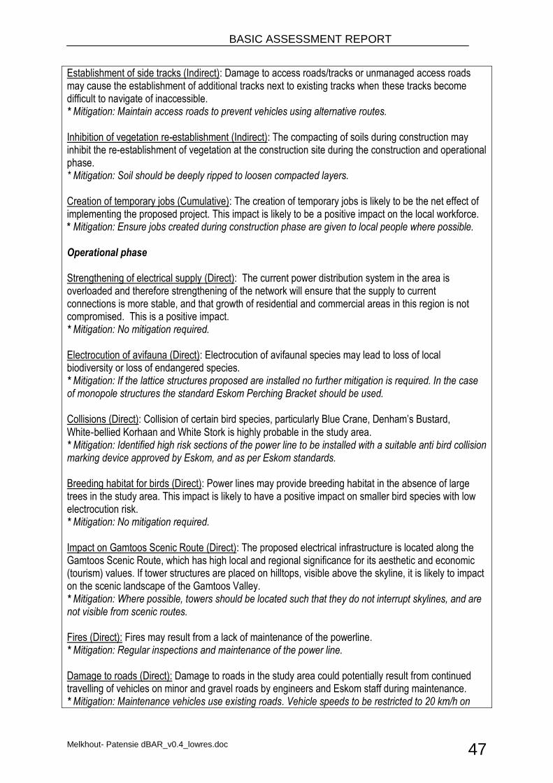
BASIC ASSESSMENT REPORT
Melkhout- Patensie dBAR_v0.4_lowres.doc 47
Establishment of side tracks (Indirect): Damage to access roads/tracks or unmanaged access roads may cause the establishment of additional tracks next to existing tracks when these tracks become difficult to navigate of inaccessible. * Mitigation: Maintain access roads to prevent vehicles using alternative routes. Inhibition of vegetation re-establishment (Indirect): The compacting of soils during construction may inhibit the re-establishment of vegetation at the construction site during the construction and operational phase. * Mitigation: Soil should be deeply ripped to loosen compacted layers. Creation of temporary jobs (Cumulative): The creation of temporary jobs is likely to be the net effect of implementing the proposed project. This impact is likely to be a positive impact on the local workforce. * Mitigation: Ensure jobs created during construction phase are given to local people where possible. Operational phase Strengthening of electrical supply (Direct): The current power distribution system in the area is overloaded and therefore strengthening of the network will ensure that the supply to current connections is more stable, and that growth of residential and commercial areas in this region is not compromised. This is a positive impact. * Mitigation: No mitigation required. Electrocution of avifauna (Direct): Electrocution of avifaunal species may lead to loss of local biodiversity or loss of endangered species. * Mitigation: If the lattice structures proposed are installed no further mitigation is required. In the case of monopole structures the standard Eskom Perching Bracket should be used. Collisions (Direct): Collision of certain bird species, particularly Blue Crane, Denham’s Bustard, White‐bellied Korhaan and White Stork is highly probable in the study area. * Mitigation: Identified high risk sections of the power line to be installed with a suitable anti bird collision marking device approved by Eskom, and as per Eskom standards. Breeding habitat for birds (Direct): Power lines may provide breeding habitat in the absence of large trees in the study area. This impact is likely to have a positive impact on smaller bird species with low electrocution risk. * Mitigation: No mitigation required. Impact on Gamtoos Scenic Route (Direct): The proposed electrical infrastructure is located along the Gamtoos Scenic Route, which has high local and regional significance for its aesthetic and economic (tourism) values. If tower structures are placed on hilltops, visible above the skyline, it is likely to impact on the scenic landscape of the Gamtoos Valley. * Mitigation: Where possible, towers should be located such that they do not interrupt skylines, and are not visible from scenic routes. Fires (Direct): Fires may result from a lack of maintenance of the powerline. * Mitigation: Regular inspections and maintenance of the power line. Damage to roads (Direct): Damage to roads in the study area could potentially result from continued travelling of vehicles on minor and gravel roads by engineers and Eskom staff during maintenance. * Mitigation: Maintenance vehicles use existing roads. Vehicle speeds to be restricted to 20 km/h on
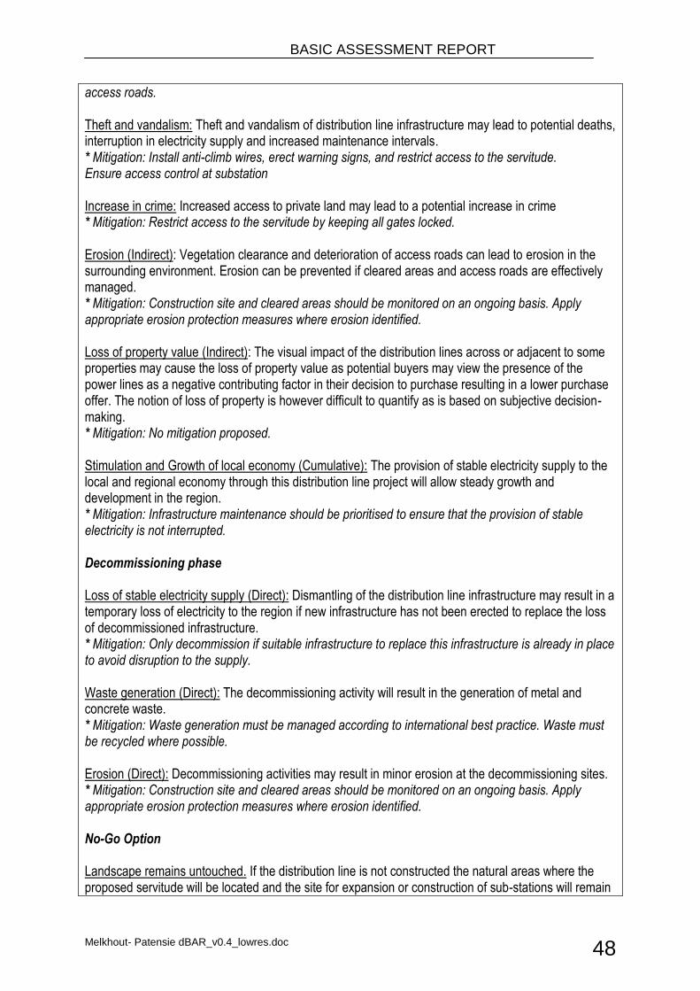
BASIC ASSESSMENT REPORT
Melkhout- Patensie dBAR_v0.4_lowres.doc 48
access roads. Theft and vandalism: Theft and vandalism of distribution line infrastructure may lead to potential deaths, interruption in electricity supply and increased maintenance intervals. * Mitigation: Install anti-climb wires, erect warning signs, and restrict access to the servitude. Ensure access control at substation Increase in crime: Increased access to private land may lead to a potential increase in crime * Mitigation: Restrict access to the servitude by keeping all gates locked. Erosion (Indirect): Vegetation clearance and deterioration of access roads can lead to erosion in the surrounding environment. Erosion can be prevented if cleared areas and access roads are effectively managed. * Mitigation: Construction site and cleared areas should be monitored on an ongoing basis. Apply appropriate erosion protection measures where erosion identified. Loss of property value (Indirect): The visual impact of the distribution lines across or adjacent to some properties may cause the loss of property value as potential buyers may view the presence of the power lines as a negative contributing factor in their decision to purchase resulting in a lower purchase offer. The notion of loss of property is however difficult to quantify as is based on subjective decision-making. * Mitigation: No mitigation proposed. Stimulation and Growth of local economy (Cumulative): The provision of stable electricity supply to the local and regional economy through this distribution line project will allow steady growth and development in the region. * Mitigation: Infrastructure maintenance should be prioritised to ensure that the provision of stable electricity is not interrupted. Decommissioning phase Loss of stable electricity supply (Direct): Dismantling of the distribution line infrastructure may result in a temporary loss of electricity to the region if new infrastructure has not been erected to replace the loss of decommissioned infrastructure. * Mitigation: Only decommission if suitable infrastructure to replace this infrastructure is already in place to avoid disruption to the supply. Waste generation (Direct): The decommissioning activity will result in the generation of metal and concrete waste. * Mitigation: Waste generation must be managed according to international best practice. Waste must be recycled where possible. Erosion (Direct): Decommissioning activities may result in minor erosion at the decommissioning sites. * Mitigation: Construction site and cleared areas should be monitored on an ongoing basis. Apply appropriate erosion protection measures where erosion identified. No-Go Option Landscape remains untouched. If the distribution line is not constructed the natural areas where the proposed servitude will be located and the site for expansion or construction of sub-stations will remain
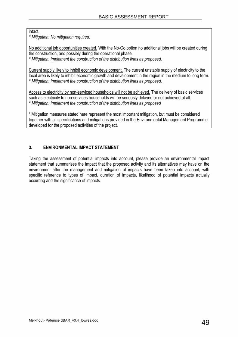
BASIC ASSESSMENT REPORT
Melkhout- Patensie dBAR_v0.4_lowres.doc 49
intact. * Mitigation: No mitigation required. No additional job opportunities created. With the No-Go option no additional jobs will be created during the construction, and possibly during the operational phase. * Mitigation: Implement the construction of the distribution lines as proposed. Current supply likely to inhibit economic development. The current unstable supply of electricity to the local area is likely to inhibit economic growth and development in the region in the medium to long term. * Mitigation: Implement the construction of the distribution lines as proposed. Access to electricity by non-serviced households will not be achieved. The delivery of basic services such as electricity to non-services households will be seriously delayed or not achieved at all. * Mitigation: Implement the construction of the distribution lines as proposed * Mitigation measures stated here represent the most important mitigation, but must be considered together with all specifications and mitigations provided in the Environmental Management Programme developed for the proposed activities of the project.
3. ENVIRONMENTAL IMPACT STATEMENT Taking the assessment of potential impacts into account, please provide an environmental impact statement that summarises the impact that the proposed activity and its alternatives may have on the environment after the management and mitigation of impacts have been taken into account, with specific reference to types of impact, duration of impacts, likelihood of potential impacts actually occurring and the significance of impacts.
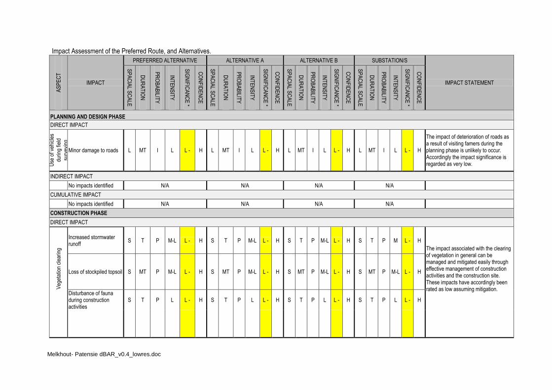
Melkhout- Patensie dBAR_v0.4_lowres.doc
Impact Assessment of the Preferred Route, and Alternatives. A
SP
EC
T
IMPACT
PREFERRED ALTERNATIVE ALTERNATIVE A ALTERNATIVE B SUBSTATION/S
IMPACT STATEMENT
SP
AC
IAL S
CA
LE
DU
RA
TIO
N
PR
OB
AB
ILITY
INT
EN
SIT
Y
SIG
NIF
ICA
NC
E *
CO
NF
IDE
NC
E
SP
AC
IAL S
CA
LE
DU
RA
TIO
N
PR
OB
AB
ILITY
INT
EN
SIT
Y
SIG
NIF
ICA
NC
E *
CO
NF
IDE
NC
E
SP
AC
IAL S
CA
LE
DU
RA
TIO
N
PR
OB
AB
ILITY
INT
EN
SIT
Y
SIG
NIF
ICA
NC
E *
CO
NF
IDE
NC
E
SP
AC
IAL S
CA
LE
DU
RA
TIO
N
PR
OB
AB
ILITY
INT
EN
SIT
Y
SIG
NIF
ICA
NC
E *
CO
NF
IDE
NC
E
PLANNING AND DESIGN PHASE
DIRECT IMPACT
Use
of v
ehic
les
durin
g fie
ld
surv
eyin
g
Minor damage to roads L MT I L L - H L MT I L L - H L MT I L L - H L MT I L L - H
The impact of deterioration of roads as a result of visiting famers during the planning phase is unlikely to occur. Accordingly the impact significance is regarded as very low.
INDIRECT IMPACT
No impacts identified N/A N/A N/A N/A
CUMULATIVE IMPACT
No impacts identified N/A N/A N/A N/A
CONSTRUCTION PHASE
DIRECT IMPACT
Veg
etat
ion
clea
ring
Increased stormwater runoff
S T P M-L L - H S T P M-L L - H S T P M-L L - H S T P M L - H
The impact associated with the clearing of vegetation in general can be managed and mitigated easily through effective management of construction activities and the construction site. These impacts have accordingly been rated as low assuming mitigation.
Loss of stockpiled topsoil S MT P M-L L - H S MT P M-L L - H S MT P M-L L - H S MT P M-L L - H
Disturbance of fauna during construction activities
S T P L L - H S T P L L - H S T P L L - H S T P L L - H

BASIC ASSESSMENT REPORT
Melkhout- Patensie dBAR_v0.4_lowres.doc 51
A S P E C T
IMPACT PREFERRED ALTERNATIVE ALTERNATIVE A ALTERNATIVE B SUBSTATION/S IMPACT STATEMENT U
sage
of c
onst
ruct
ion
plan
t/veh
icle
s Noise pollution L T P L L - H L T P L L - H L T P L L - H L T P L L - H
The impact associated with the use of construction plant and vehicles can be managed and mitigated easily through effective management of the plant and the construction site. Resultantly, these impacts have been rated as low assuming mitigation. These impacts will have no significant influence on any of the proposed alternatives.
Air (dust ) pollution S T P M-L L - H S T P M-L L - H S T P M-L L - H S T P M-L L - H
Fires L ST I M L - H L ST I M L - H L ST I M L - H L ST I M L - H
Damage to roads by construction vehicles
L MT I L L - H L MT I L L - H L MT I L L - H L MT I L L - H
Increase in traffic L T P M-L L - H L T P M-L L - H L T P M-L L - H L T P M-L L - H
Con
stru
ctio
n si
te m
anag
emen
t Impacts on visual aesthetics
S T P L L - H S T P L L - H S T P L L - H S T P L L - H Impact associated construction site and waste can be managed and mitigated easily through effective management of the construction site. These impacts have been rated as low assuming mitigation. These impacts will have no significant influence on any of the proposed alternatives.
Spillage of hazardous substances
S T P M L - H S T P M L - H S T P M L - H S T P M L - H
Impacts from unmanaged non-hazardous solid waste
S T P L L - H S T P L L - H S T P L L - H S T P L L - H
Impa
cts
on v
eget
atio
n
Loss of vegetation cover S P D M-L L - H S P D M-L L - H S P D M-L L - H S P D L L - H A vegetation specialist was appointed to conduct an analysis and assessment of potential impacts associated with the proposed activities. The specialist found that impacts relating to pylon construction are likely to be highly reversible, while impacts relating to road construction are likely to be moderately reversible. If the recommendations of the vegetation specialist is implemented where the vegetation clearance along
Loss of Rocky Refugia S P D M L - H S P D M L - H S P D M L - H S P D M L - H
Loss of Thicket or Forest Vegetation along drainage lines
L P HP M L - H L P HP M L - H L P HP M L - H L P HP M L - H
Loss of riparian vegetation
L P HP M L - H L P HP M L - H L P HP M L - H L P HP M L - H
Loss of seep / wetland / seasonal pan vegetation
L P HP M L - H L P HP M L - H L P HP M L - H L P HP M L - H
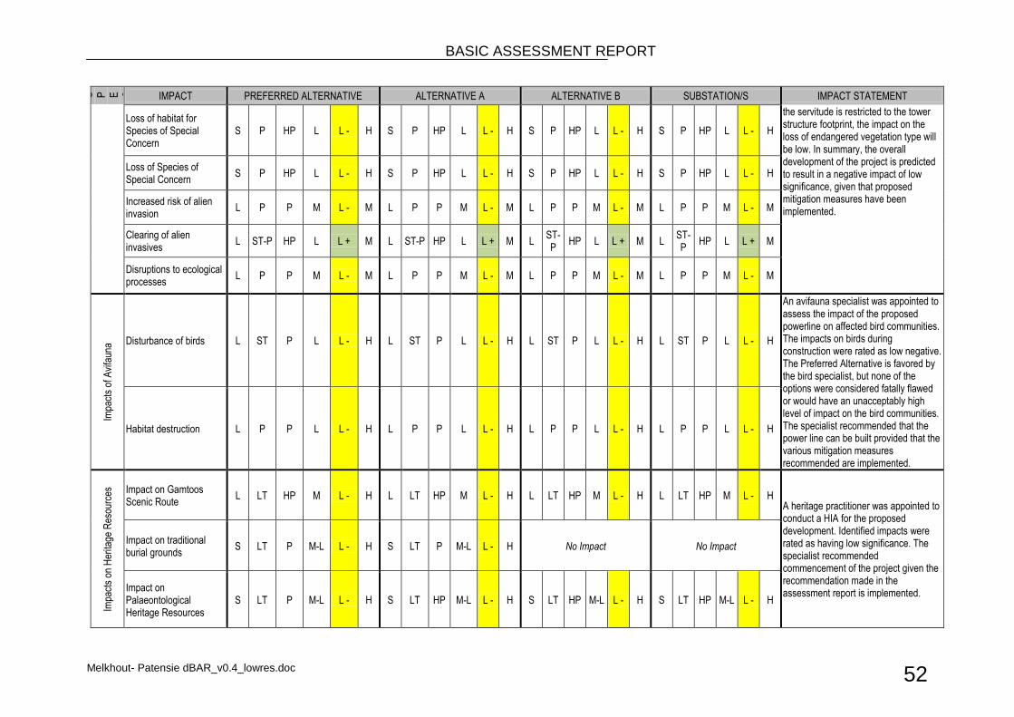
BASIC ASSESSMENT REPORT
Melkhout- Patensie dBAR_v0.4_lowres.doc 52
A S P E C T
IMPACT PREFERRED ALTERNATIVE ALTERNATIVE A ALTERNATIVE B SUBSTATION/S IMPACT STATEMENT
Loss of habitat for Species of Special Concern
S P HP L L - H S P HP L L - H S P HP L L - H S P HP L L - H
the servitude is restricted to the tower structure footprint, the impact on the loss of endangered vegetation type will be low. In summary, the overall development of the project is predicted to result in a negative impact of low significance, given that proposed mitigation measures have been implemented.
Loss of Species of Special Concern
S P HP L L - H S P HP L L - H S P HP L L - H S P HP L L - H
Increased risk of alien invasion
L P P M L - M L P P M L - M L P P M L - M L P P M L - M
Clearing of alien invasives
L ST-P HP L L + M L ST-P HP L L + M L ST-P
HP L L + M L ST-P
HP L L + M
Disruptions to ecological processes
L P P M L - M L P P M L - M L P P M L - M L P P M L - M
Impa
cts
of A
vifa
una
Disturbance of birds L ST P L L - H L ST P L L - H L ST P L L - H L ST P L L - H
An avifauna specialist was appointed to assess the impact of the proposed powerline on affected bird communities. The impacts on birds during construction were rated as low negative. The Preferred Alternative is favored by the bird specialist, but none of the options were considered fatally flawed or would have an unacceptably high level of impact on the bird communities. The specialist recommended that the power line can be built provided that the various mitigation measures recommended are implemented.
Habitat destruction L P P L L - H L P P L L - H L P P L L - H L P P L L - H
Impa
cts
on H
erita
ge R
esou
rces
Impact on Gamtoos Scenic Route
L LT HP M L - H L LT HP M L - H L LT HP M L - H L LT HP M L - H A heritage practitioner was appointed to conduct a HIA for the proposed development. Identified impacts were rated as having low significance. The specialist recommended commencement of the project given the recommendation made in the assessment report is implemented.
Impact on traditional burial grounds
S LT P M-L L - H S LT P M-L L - H No Impact No Impact
Impact on Palaeontological Heritage Resources
S LT P M-L L - H S LT HP M-L L - H S LT HP M-L L - H S LT HP M-L L - H
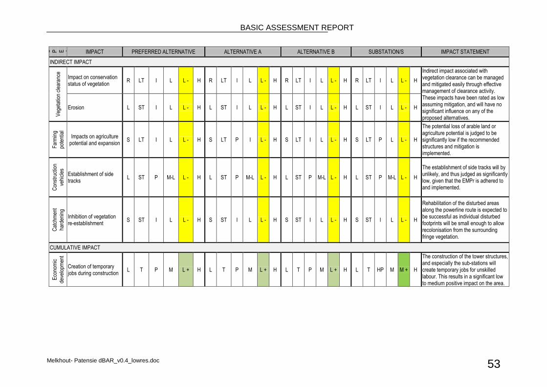
BASIC ASSESSMENT REPORT
Melkhout- Patensie dBAR_v0.4_lowres.doc 53
A S P E C T
IMPACT PREFERRED ALTERNATIVE ALTERNATIVE A ALTERNATIVE B SUBSTATION/S IMPACT STATEMENT
INDIRECT IMPACT V
eget
atio
n cl
eara
nce
Impact on conservation status of vegetation
R LT I L L - H R LT I L L - H R LT I L L - H R LT I L L - H
Indirect impact associated with vegetation clearance can be managed and mitigated easily through effective management of clearance activity. These impacts have been rated as low assuming mitigation, and will have no significant influence on any of the proposed alternatives.
Erosion L ST I L L - H L ST I L L - H L ST I L L - H L ST I L L - H
Far
min
g
pote
ntia
l
Impacts on agriculture potential and expansion
S LT I L L - H S LT P I L - H S LT I L L - H S LT P L L - H
The potential loss of arable land or agriculture potential is judged to be significantly low if the recommended structures and mitigation is implemented.
Con
stru
ctio
n
vehi
cles
Establishment of side tracks
L ST P M-L L - H L ST P M-L L - H L ST P M-L L - H L ST P M-L L - H
The establishment of side tracks will by unlikely, and thus judged as significantly low, given that the EMPr is adhered to and implemented.
Cat
chm
ent
hard
enin
g
Inhibition of vegetation re-establishment
S ST I L L - H S ST I L L - H S ST I L L - H S ST I L L - H
Rehabilitation of the disturbed areas along the powerline route is expected to be successful as individual disturbed footprints will be small enough to allow recolonisation from the surrounding fringe vegetation.
CUMULATIVE IMPACT
Eco
nom
ic
deve
lopm
ent
Creation of temporary jobs during construction
L T P M L + H L T P M L + H L T P M L + H L T HP M M + H
The construction of the tower structures, and especially the sub-stations will create temporary jobs for unskilled labour. This results in a significant low to medium positive impact on the area.
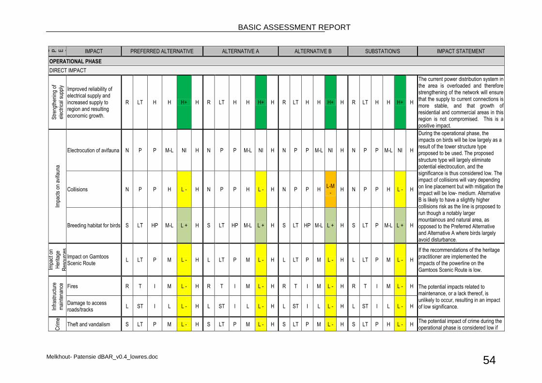
BASIC ASSESSMENT REPORT
Melkhout- Patensie dBAR_v0.4_lowres.doc 54
A S P E C T
IMPACT PREFERRED ALTERNATIVE ALTERNATIVE A ALTERNATIVE B SUBSTATION/S IMPACT STATEMENT
OPERATIONAL PHASE
DIRECT IMPACT
Str
engt
heni
ng o
f
elec
tric
al s
uppl
y
Improved reliability of electrical supply and increased supply to region and resulting economic growth.
R LT H H H+ H R LT H H H+ H R LT H H H+ H R LT H H H+ H
The current power distribution system in the area is overloaded and therefore strengthening of the network will ensure that the supply to current connections is more stable, and that growth of residential and commercial areas in this region is not compromised. This is a positive impact.
Impa
cts
on a
vifa
una
Electrocution of avifauna N P P M-L NI H N P P M-L NI H N P P M-L NI H N P P M-L NI H
During the operational phase, the impacts on birds will be low largely as a result of the tower structure type proposed to be used. The proposed structure type will largely eliminate potential electrocution, and the significance is thus considered low. The impact of collisions will vary depending on line placement but with mitigation the impact will be low- medium. Alternative B is likely to have a slightly higher collisions risk as the line is proposed to run though a notably larger mountainous and natural area, as opposed to the Preferred Alternative and Alternative A where birds largely avoid disturbance.
Collisions N P P H L - H N P P H L - H N P P H L-M
- H N P P H L - H
Breeding habitat for birds S LT HP M-L L + H S LT HP M-L L + H S LT HP M-L L + H S LT P M-L L + H
Impa
ct o
n
Her
itage
Res
ourc
es
Impact on Gamtoos Scenic Route
L LT P M L - H L LT P M L - H L LT P M L - H L LT P M L - H
If the recommendations of the heritage practitioner are implemented the impacts of the powerline on the Gamtoos Scenic Route is low.
Infr
astr
uctu
re
mai
nten
ance
Fires R T I M L - H R T I M L - H R T I M L - H R T I M L - H The potential impacts related to maintenance, or a lack thereof, is unlikely to occur, resulting in an impact of low significance.
Damage to access roads/tracks
L ST I L L - H L ST I L L - H L ST I L L - H L ST I L L - H
Crim
e
Theft and vandalism S LT P M L - H S LT P M L - H S LT P M L - H S LT P H L - H The potential impact of crime during the operational phase is considered low if
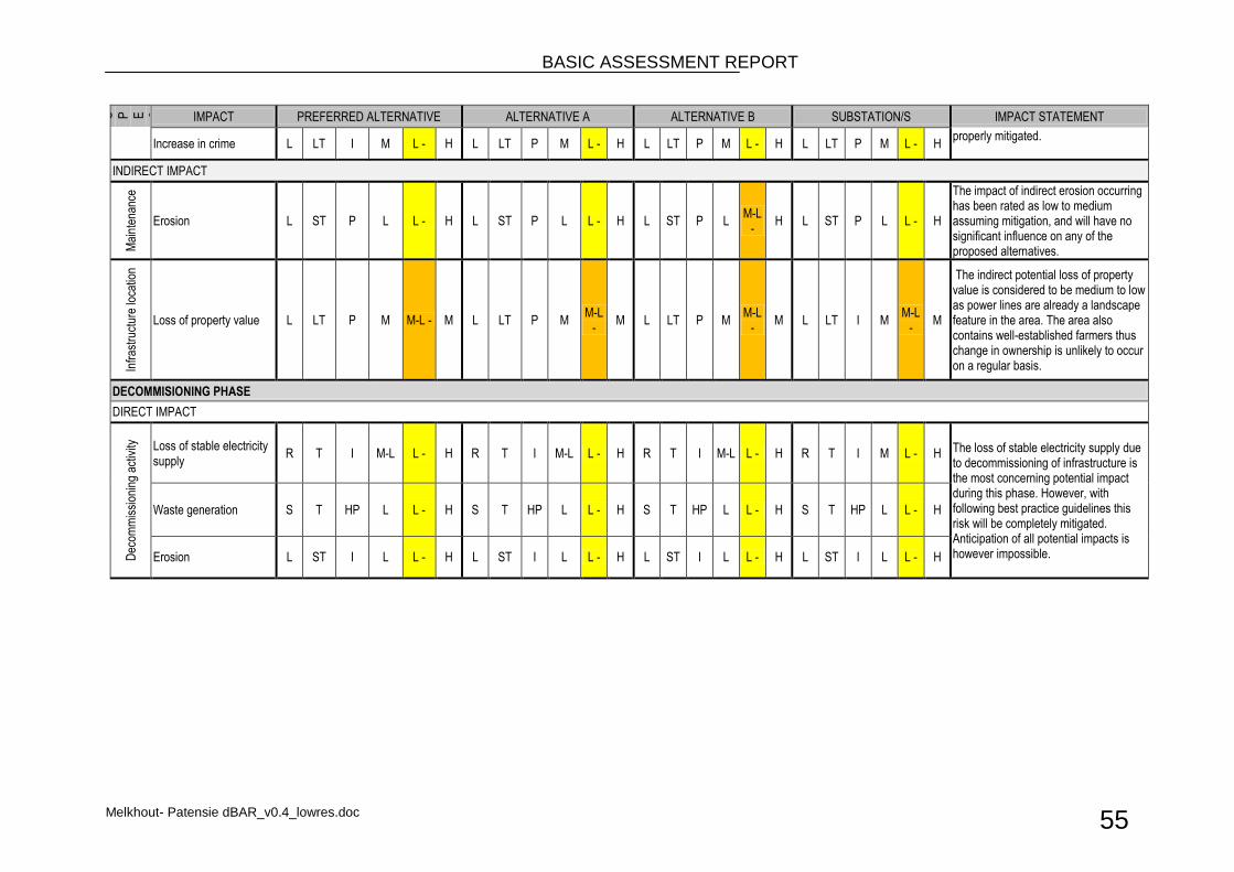
BASIC ASSESSMENT REPORT
Melkhout- Patensie dBAR_v0.4_lowres.doc 55
A S P E C T
IMPACT PREFERRED ALTERNATIVE ALTERNATIVE A ALTERNATIVE B SUBSTATION/S IMPACT STATEMENT
Increase in crime L LT I M L - H L LT P M L - H L LT P M L - H L LT P M L - H properly mitigated.
INDIRECT IMPACT
Mai
nten
ance
Erosion L ST P L L - H L ST P L L - H L ST P L M-L
- H L ST P L L - H
The impact of indirect erosion occurring has been rated as low to medium assuming mitigation, and will have no significant influence on any of the proposed alternatives.
Infr
astr
uctu
re lo
catio
n
Loss of property value L LT P M M-L - M L LT P M M-L
- M L LT P M
M-L -
M L LT I M M-L
- M
The indirect potential loss of property value is considered to be medium to low as power lines are already a landscape feature in the area. The area also contains well-established farmers thus change in ownership is unlikely to occur on a regular basis.
DECOMMISIONING PHASE
DIRECT IMPACT
Dec
omm
issi
onin
g ac
tivity
Loss of stable electricity supply
R T I M-L L - H R T I M-L L - H R T I M-L L - H R T I M L - H The loss of stable electricity supply due to decommissioning of infrastructure is the most concerning potential impact during this phase. However, with following best practice guidelines this risk will be completely mitigated. Anticipation of all potential impacts is however impossible.
Waste generation S T HP L L - H S T HP L L - H S T HP L L - H S T HP L L - H
Erosion L ST I L L - H L ST I L L - H L ST I L L - H L ST I L L - H
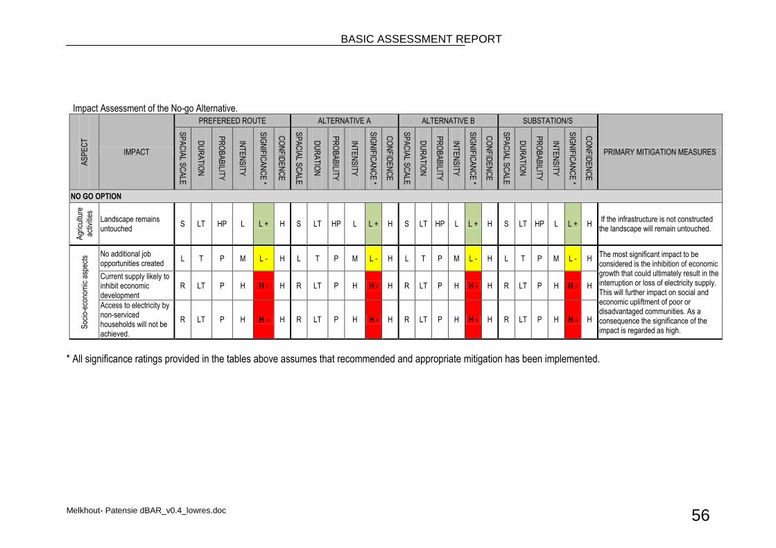
BASIC ASSESSMENT REPORT
Melkhout- Patensie dBAR_v0.4_lowres.doc 56
Impact Assessment of the No-go Alternative.
AS
PE
CT
IMPACT
PREFEREED ROUTE ALTERNATIVE A ALTERNATIVE B SUBSTATION/S
PRIMARY MITIGATION MEASURES
SP
AC
IAL S
CA
LE
DU
RA
TIO
N
PR
OB
AB
ILITY
INT
EN
SIT
Y
SIG
NIF
ICA
NC
E *
CO
NF
IDE
NC
E
SP
AC
IAL S
CA
LE
DU
RA
TIO
N
PR
OB
AB
ILITY
INT
EN
SIT
Y
SIG
NIF
ICA
NC
E *
CO
NF
IDE
NC
E
SP
AC
IAL S
CA
LE
DU
RA
TIO
N
PR
OB
AB
ILITY
INT
EN
SIT
Y
SIG
NIF
ICA
NC
E *
CO
NF
IDE
NC
E
SP
AC
IAL S
CA
LE
DU
RA
TIO
N
PR
OB
AB
ILITY
INT
EN
SIT
Y
SIG
NIF
ICA
NC
E *
CO
NF
IDE
NC
E
NO GO OPTION
Agr
icul
ture
activ
ities
Landscape remains untouched
S LT HP L L + H S LT HP L L + H S LT HP L L + H S LT HP L L + H If the infrastructure is not constructed the landscape will remain untouched.
Soc
io-e
cono
mic
asp
ects
No additional job opportunities created
L T P M L - H L T P M L - H L T P M L - H L T P M L - H The most significant impact to be considered is the inhibition of economic growth that could ultimately result in the interruption or loss of electricity supply. This will further impact on social and economic upliftment of poor or disadvantaged communities. As a consequence the significance of the impact is regarded as high.
Current supply likely to inhibit economic development
R LT P H H - H R LT P H H - H R LT P H H - H R LT P H H - H
Access to electricity by non-serviced households will not be achieved.
R LT P H H - H R LT P H H - H R LT P H H - H R LT P H H - H
* All significance ratings provided in the tables above assumes that recommended and appropriate mitigation has been implemented.
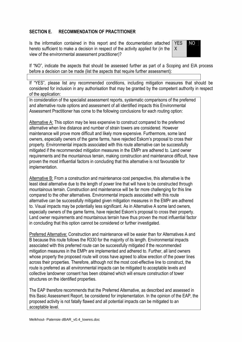
Melkhout- Patensie dBAR_v0.4_lowres.doc
SECTION E. RECOMMENDATION OF PRACTITIONER
Is the information contained in this report and the documentation attached hereto sufficient to make a decision in respect of the activity applied for (in the view of the environmental assessment practitioner)?
YES X
NO
If “NO”, indicate the aspects that should be assessed further as part of a Scoping and EIA process before a decision can be made (list the aspects that require further assessment):
If “YES”, please list any recommended conditions, including mitigation measures that should be considered for inclusion in any authorisation that may be granted by the competent authority in respect of the application:
In consideration of the specialist assessment reports, systematic comparisons of the preferred and alternative route options and assessment of all identified impacts this Environmental Assessment Practitioner has come to the following conclusions for each routing option: Alternative A: This option may be less expensive to construct compared to the preferred alternative when line distance and number of strain towers are considered. However maintenance will prove more difficult and likely more expensive. Furthermore, some land owners, especially owners of the game farms, have rejected Eskom’s proposal to cross their property. Environmental impacts associated with this route alternative can be successfully mitigated if the recommended mitigation measures in the EMPr are adhered to. Land owner requirements and the mountainous terrain, making construction and maintenance difficult, have proven the most influential factors in concluding that this alternative is not favourable for implementation. Alternative B: From a construction and maintenance cost perspective, this alternative is the least ideal alternative due to the length of power line that will have to be constructed through mountainous terrain. Construction and maintenance will be far more challenging for this line compared to the other alternatives. Environmental impacts associated with this route alternative can be successfully mitigated given mitigation measures in the EMPr are adhered to. Visual impacts may be potentially less significant. As in Alternative A some land owners, especially owners of the game farms, have rejected Eskom’s proposal to cross their property. Land owner requirements and mountainous terrain have thus proven the most influential factor in concluding that this option cannot be considered or further investigated. Preferred Alternative: Construction and maintenance will be easier than for Alternatives A and B because this route follows the R330 for the majority of its length. Environmental impacts associated with this preferred route can be successfully mitigated if the recommended mitigation measures in the EMPr are implemented and adhered to. Further, all land owners whose property the proposed route will cross have agreed to allow erection of the power lines across their properties. Therefore, although not the most cost-effective line to construct, the route is preferred as all environmental impacts can be mitigated to acceptable levels and collective landowner consent has been obtained which will ensure construction of tower structures on the identified properties. The EAP therefore recommends that the Preferred Alternative, as described and assessed in this Basic Assessment Report, be considered for implementation. In the opinion of the EAP, the proposed activity is not fatally flawed and all potential impacts can be mitigated to an acceptable level.

BASIC ASSESSMENT REPORT
Melkhout- Patensie dBAR_v0.4_lowres.doc 58
Further, it is recommended that the proposed construction of the substation and distribution lines continue only if all recommendations and mitigation measures stipulated in the EMPr are followed and that an Environmental Control officer be employed throughout the duration of construction.
Is an EMPr attached? YES X
NO
The EMPr must be attached as Appendix F.

BASIC ASSESSMENT REPORT
Melkhout- Patensie dBAR_v0.4_lowres.doc 59
References Eskom 2007 Building Line Restrictions, Servitude Widths, Line Separators and Clearances From Powerlines Eskom 2000 Standards for Bush Clearance and Maintenance Within Overhead Powerline Servitudes Eastern Cape Socio Economic Consultative Council. Statistics At Your Fingertips Database
BASIC ASSESSMENT REPORT
Melkhout- Patensie dBAR_v0.4_lowres.doc 60
SECTION F: APPENDIXES The following appendixes must be attached as appropriate: Appendix A: Site plan(s) Appendix B: Photographs Appendix C: Facility illustration(s) Appendix D: Specialist reports (including terms of reference) Appendix E: PPP and Issues and Response Report Appendix F: Environmental Management Programme (EMPr) Appendix G: Details of EAP and declaration of interest
BASIC ASSESSMENT REPORT
Melkhout- Patensie dBAR_v0.4_lowres.doc 61
APPENDIX A1
Site plans
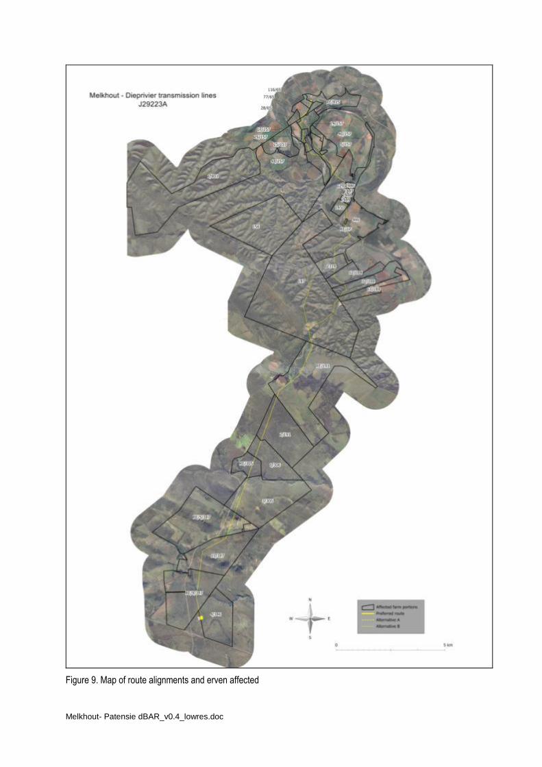
Melkhout- Patensie dBAR_v0.4_lowres.doc
Figure 9. Map of route alignments and erven affected

Melkhout- Patensie dBAR_v0.4_lowres.doc
APPENDIX A2
Route coordinates at 250 m intervals
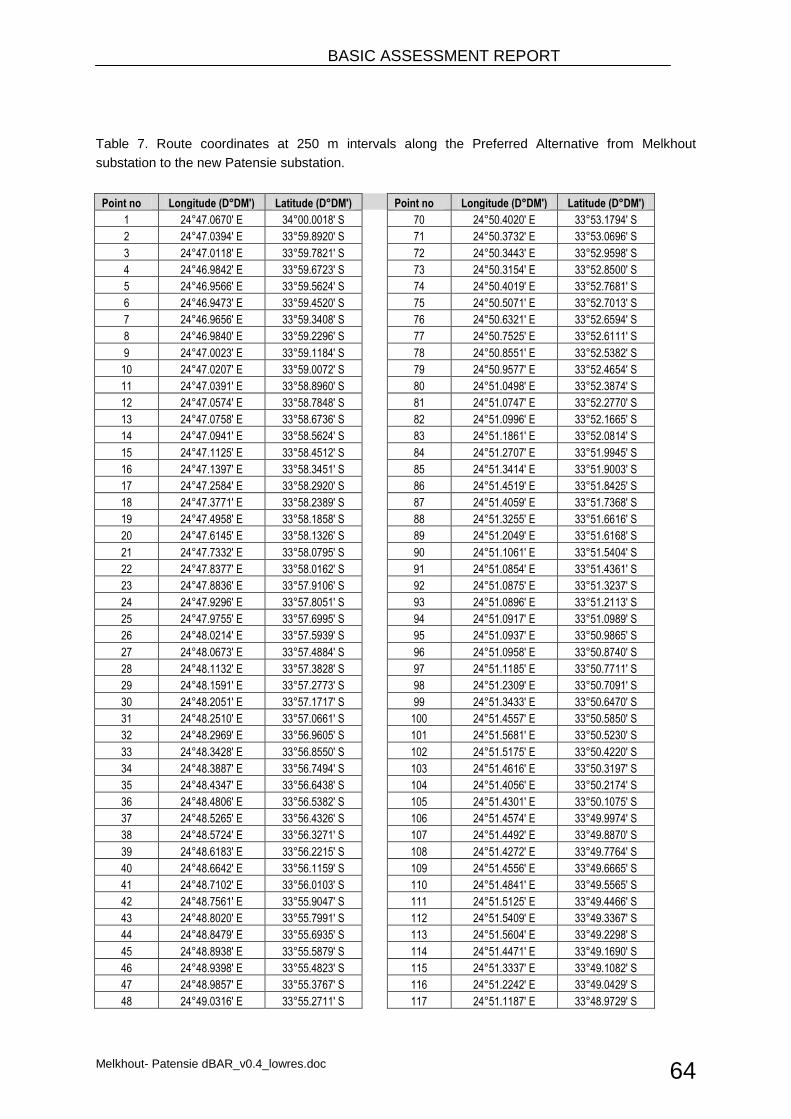
BASIC ASSESSMENT REPORT
Melkhout- Patensie dBAR_v0.4_lowres.doc 64
Table 7. Route coordinates at 250 m intervals along the Preferred Alternative from Melkhout
substation to the new Patensie substation.
Point no Longitude (D°DM') Latitude (D°DM')
Point no Longitude (D°DM') Latitude (D°DM')
1 24°47.0670' E 34°00.0018' S
70 24°50.4020' E 33°53.1794' S
2 24°47.0394' E 33°59.8920' S
71 24°50.3732' E 33°53.0696' S
3 24°47.0118' E 33°59.7821' S
72 24°50.3443' E 33°52.9598' S
4 24°46.9842' E 33°59.6723' S
73 24°50.3154' E 33°52.8500' S
5 24°46.9566' E 33°59.5624' S
74 24°50.4019' E 33°52.7681' S
6 24°46.9473' E 33°59.4520' S
75 24°50.5071' E 33°52.7013' S
7 24°46.9656' E 33°59.3408' S
76 24°50.6321' E 33°52.6594' S
8 24°46.9840' E 33°59.2296' S
77 24°50.7525' E 33°52.6111' S
9 24°47.0023' E 33°59.1184' S
78 24°50.8551' E 33°52.5382' S
10 24°47.0207' E 33°59.0072' S
79 24°50.9577' E 33°52.4654' S
11 24°47.0391' E 33°58.8960' S
80 24°51.0498' E 33°52.3874' S
12 24°47.0574' E 33°58.7848' S
81 24°51.0747' E 33°52.2770' S
13 24°47.0758' E 33°58.6736' S
82 24°51.0996' E 33°52.1665' S
14 24°47.0941' E 33°58.5624' S
83 24°51.1861' E 33°52.0814' S
15 24°47.1125' E 33°58.4512' S
84 24°51.2707' E 33°51.9945' S
16 24°47.1397' E 33°58.3451' S
85 24°51.3414' E 33°51.9003' S
17 24°47.2584' E 33°58.2920' S
86 24°51.4519' E 33°51.8425' S
18 24°47.3771' E 33°58.2389' S
87 24°51.4059' E 33°51.7368' S
19 24°47.4958' E 33°58.1858' S
88 24°51.3255' E 33°51.6616' S
20 24°47.6145' E 33°58.1326' S
89 24°51.2049' E 33°51.6168' S
21 24°47.7332' E 33°58.0795' S
90 24°51.1061' E 33°51.5404' S
22 24°47.8377' E 33°58.0162' S
91 24°51.0854' E 33°51.4361' S
23 24°47.8836' E 33°57.9106' S
92 24°51.0875' E 33°51.3237' S
24 24°47.9296' E 33°57.8051' S
93 24°51.0896' E 33°51.2113' S
25 24°47.9755' E 33°57.6995' S
94 24°51.0917' E 33°51.0989' S
26 24°48.0214' E 33°57.5939' S
95 24°51.0937' E 33°50.9865' S
27 24°48.0673' E 33°57.4884' S
96 24°51.0958' E 33°50.8740' S
28 24°48.1132' E 33°57.3828' S
97 24°51.1185' E 33°50.7711' S
29 24°48.1591' E 33°57.2773' S
98 24°51.2309' E 33°50.7091' S
30 24°48.2051' E 33°57.1717' S
99 24°51.3433' E 33°50.6470' S
31 24°48.2510' E 33°57.0661' S
100 24°51.4557' E 33°50.5850' S
32 24°48.2969' E 33°56.9605' S
101 24°51.5681' E 33°50.5230' S
33 24°48.3428' E 33°56.8550' S
102 24°51.5175' E 33°50.4220' S
34 24°48.3887' E 33°56.7494' S
103 24°51.4616' E 33°50.3197' S
35 24°48.4347' E 33°56.6438' S
104 24°51.4056' E 33°50.2174' S
36 24°48.4806' E 33°56.5382' S
105 24°51.4301' E 33°50.1075' S
37 24°48.5265' E 33°56.4326' S
106 24°51.4574' E 33°49.9974' S
38 24°48.5724' E 33°56.3271' S
107 24°51.4492' E 33°49.8870' S
39 24°48.6183' E 33°56.2215' S
108 24°51.4272' E 33°49.7764' S
40 24°48.6642' E 33°56.1159' S
109 24°51.4556' E 33°49.6665' S
41 24°48.7102' E 33°56.0103' S
110 24°51.4841' E 33°49.5565' S
42 24°48.7561' E 33°55.9047' S
111 24°51.5125' E 33°49.4466' S
43 24°48.8020' E 33°55.7991' S
112 24°51.5409' E 33°49.3367' S
44 24°48.8479' E 33°55.6935' S
113 24°51.5604' E 33°49.2298' S
45 24°48.8938' E 33°55.5879' S
114 24°51.4471' E 33°49.1690' S
46 24°48.9398' E 33°55.4823' S
115 24°51.3337' E 33°49.1082' S
47 24°48.9857' E 33°55.3767' S
116 24°51.2242' E 33°49.0429' S
48 24°49.0316' E 33°55.2711' S
117 24°51.1187' E 33°48.9729' S
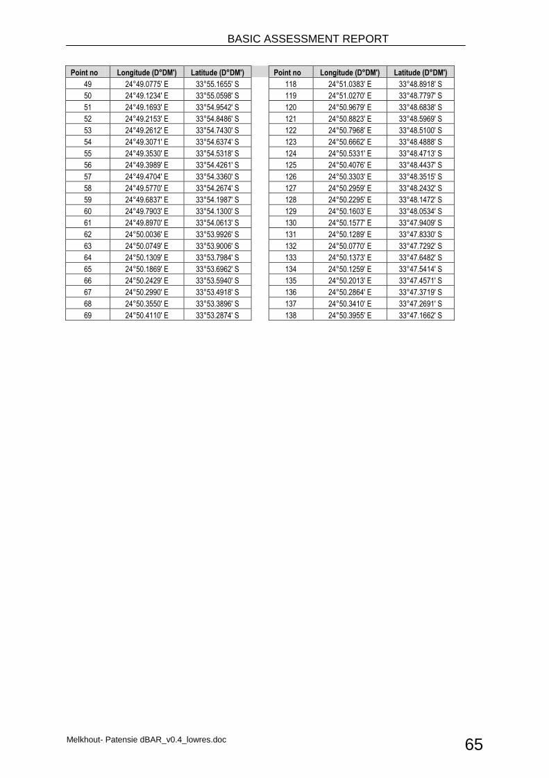
BASIC ASSESSMENT REPORT
Melkhout- Patensie dBAR_v0.4_lowres.doc 65
Point no Longitude (D°DM') Latitude (D°DM')
Point no Longitude (D°DM') Latitude (D°DM')
49 24°49.0775' E 33°55.1655' S
118 24°51.0383' E 33°48.8918' S
50 24°49.1234' E 33°55.0598' S
119 24°51.0270' E 33°48.7797' S
51 24°49.1693' E 33°54.9542' S
120 24°50.9679' E 33°48.6838' S
52 24°49.2153' E 33°54.8486' S
121 24°50.8823' E 33°48.5969' S
53 24°49.2612' E 33°54.7430' S
122 24°50.7968' E 33°48.5100' S
54 24°49.3071' E 33°54.6374' S
123 24°50.6662' E 33°48.4888' S
55 24°49.3530' E 33°54.5318' S
124 24°50.5331' E 33°48.4713' S
56 24°49.3989' E 33°54.4261' S
125 24°50.4076' E 33°48.4437' S
57 24°49.4704' E 33°54.3360' S
126 24°50.3303' E 33°48.3515' S
58 24°49.5770' E 33°54.2674' S
127 24°50.2959' E 33°48.2432' S
59 24°49.6837' E 33°54.1987' S
128 24°50.2295' E 33°48.1472' S
60 24°49.7903' E 33°54.1300' S
129 24°50.1603' E 33°48.0534' S
61 24°49.8970' E 33°54.0613' S
130 24°50.1577' E 33°47.9409' S
62 24°50.0036' E 33°53.9926' S
131 24°50.1289' E 33°47.8330' S
63 24°50.0749' E 33°53.9006' S
132 24°50.0770' E 33°47.7292' S
64 24°50.1309' E 33°53.7984' S
133 24°50.1373' E 33°47.6482' S
65 24°50.1869' E 33°53.6962' S
134 24°50.1259' E 33°47.5414' S
66 24°50.2429' E 33°53.5940' S
135 24°50.2013' E 33°47.4571' S
67 24°50.2990' E 33°53.4918' S
136 24°50.2864' E 33°47.3719' S
68 24°50.3550' E 33°53.3896' S
137 24°50.3410' E 33°47.2691' S
69 24°50.4110' E 33°53.2874' S
138 24°50.3955' E 33°47.1662' S
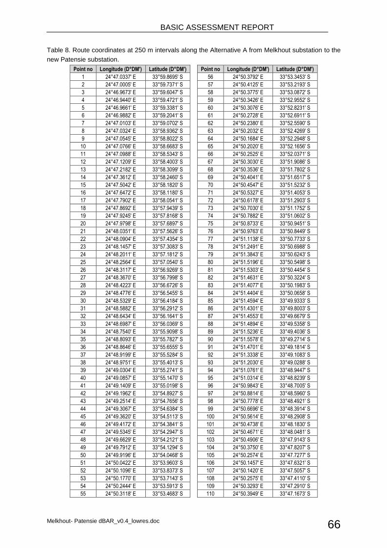
BASIC ASSESSMENT REPORT
Melkhout- Patensie dBAR_v0.4_lowres.doc 66
Table 8. Route coordinates at 250 m intervals along the Alternative A from Melkhout substation to the
new Patensie substation.
Point no Longitude (D°DM') Latitude (D°DM')
Point no Longitude (D°DM') Latitude (D°DM')
1 24°47.0337' E 33°59.8695' S
56 24°50.3792' E 33°53.3453' S
2 24°47.0005' E 33°59.7371' S
57 24°50.4125' E 33°53.2193' S
3 24°46.9673' E 33°59.6047' S
58 24°50.3775' E 33°53.0872' S
4 24°46.9440' E 33°59.4721' S
59 24°50.3426' E 33°52.9552' S
5 24°46.9661' E 33°59.3381' S
60 24°50.3076' E 33°52.8231' S
6 24°46.9882' E 33°59.2041' S
61 24°50.2728' E 33°52.6911' S
7 24°47.0103' E 33°59.0702' S
62 24°50.2380' E 33°52.5590' S
8 24°47.0324' E 33°58.9362' S
63 24°50.2032' E 33°52.4269' S
9 24°47.0545' E 33°58.8022' S
64 24°50.1684' E 33°52.2948' S
10 24°47.0766' E 33°58.6683' S
65 24°50.2020' E 33°52.1656' S
11 24°47.0988' E 33°58.5343' S
66 24°50.2525' E 33°52.0371' S
12 24°47.1209' E 33°58.4003' S
67 24°50.3030' E 33°51.9086' S
13 24°47.2182' E 33°58.3099' S
68 24°50.3536' E 33°51.7802' S
14 24°47.3612' E 33°58.2460' S
69 24°50.4041' E 33°51.6517' S
15 24°47.5042' E 33°58.1820' S
70 24°50.4547' E 33°51.5232' S
16 24°47.6472' E 33°58.1180' S
71 24°50.5327' E 33°51.4053' S
17 24°47.7902' E 33°58.0541' S
72 24°50.6178' E 33°51.2903' S
18 24°47.8692' E 33°57.9439' S
73 24°50.7030' E 33°51.1752' S
19 24°47.9245' E 33°57.8168' S
74 24°50.7882' E 33°51.0602' S
20 24°47.9798' E 33°57.6897' S
75 24°50.8733' E 33°50.9451' S
21 24°48.0351' E 33°57.5626' S
76 24°50.9763' E 33°50.8449' S
22 24°48.0904' E 33°57.4354' S
77 24°51.1138' E 33°50.7733' S
23 24°48.1457' E 33°57.3083' S
78 24°51.2491' E 33°50.6988' S
24 24°48.2011' E 33°57.1812' S
79 24°51.3843' E 33°50.6243' S
25 24°48.2564' E 33°57.0540' S
80 24°51.5196' E 33°50.5498' S
26 24°48.3117' E 33°56.9269' S
81 24°51.5303' E 33°50.4454' S
27 24°48.3670' E 33°56.7998' S
82 24°51.4631' E 33°50.3224' S
28 24°48.4223' E 33°56.6726' S
83 24°51.4077' E 33°50.1983' S
29 24°48.4776' E 33°56.5455' S
84 24°51.4404' E 33°50.0658' S
30 24°48.5329' E 33°56.4184' S
85 24°51.4594' E 33°49.9333' S
31 24°48.5882' E 33°56.2912' S
86 24°51.4301' E 33°49.8003' S
32 24°48.6434' E 33°56.1641' S
87 24°51.4553' E 33°49.6679' S
33 24°48.6987' E 33°56.0369' S
88 24°51.4894' E 33°49.5358' S
34 24°48.7540' E 33°55.9098' S
89 24°51.5236' E 33°49.4036' S
35 24°48.8093' E 33°55.7827' S
90 24°51.5578' E 33°49.2714' S
36 24°48.8646' E 33°55.6555' S
91 24°51.4701' E 33°49.1814' S
37 24°48.9199' E 33°55.5284' S
92 24°51.3338' E 33°49.1083' S
38 24°48.9751' E 33°55.4013' S
93 24°51.2030' E 33°49.0288' S
39 24°49.0304' E 33°55.2741' S
94 24°51.0761' E 33°48.9447' S
40 24°49.0857' E 33°55.1470' S
95 24°51.0314' E 33°48.8239' S
41 24°49.1409' E 33°55.0198' S
96 24°50.9843' E 33°48.7005' S
42 24°49.1962' E 33°54.8927' S
97 24°50.8814' E 33°48.5960' S
43 24°49.2514' E 33°54.7656' S
98 24°50.7778' E 33°48.4921' S
44 24°49.3067' E 33°54.6384' S
99 24°50.6696' E 33°48.3914' S
45 24°49.3620' E 33°54.5113' S
100 24°50.5614' E 33°48.2908' S
46 24°49.4172' E 33°54.3841' S
101 24°50.4738' E 33°48.1830' S
47 24°49.5345' E 33°54.2947' S
102 24°50.4671' E 33°48.0481' S
48 24°49.6629' E 33°54.2121' S
103 24°50.4906' E 33°47.9143' S
49 24°49.7912' E 33°54.1294' S
104 24°50.3750' E 33°47.8207' S
50 24°49.9196' E 33°54.0468' S
105 24°50.2574' E 33°47.7277' S
51 24°50.0422' E 33°53.9603' S
106 24°50.1457' E 33°47.6321' S
52 24°50.1096' E 33°53.8373' S
107 24°50.1420' E 33°47.5057' S
53 24°50.1770' E 33°53.7143' S
108 24°50.2575' E 33°47.4110' S
54 24°50.2444' E 33°53.5913' S
109 24°50.3293' E 33°47.2910' S
55 24°50.3118' E 33°53.4683' S
110 24°50.3949' E 33°47.1673' S
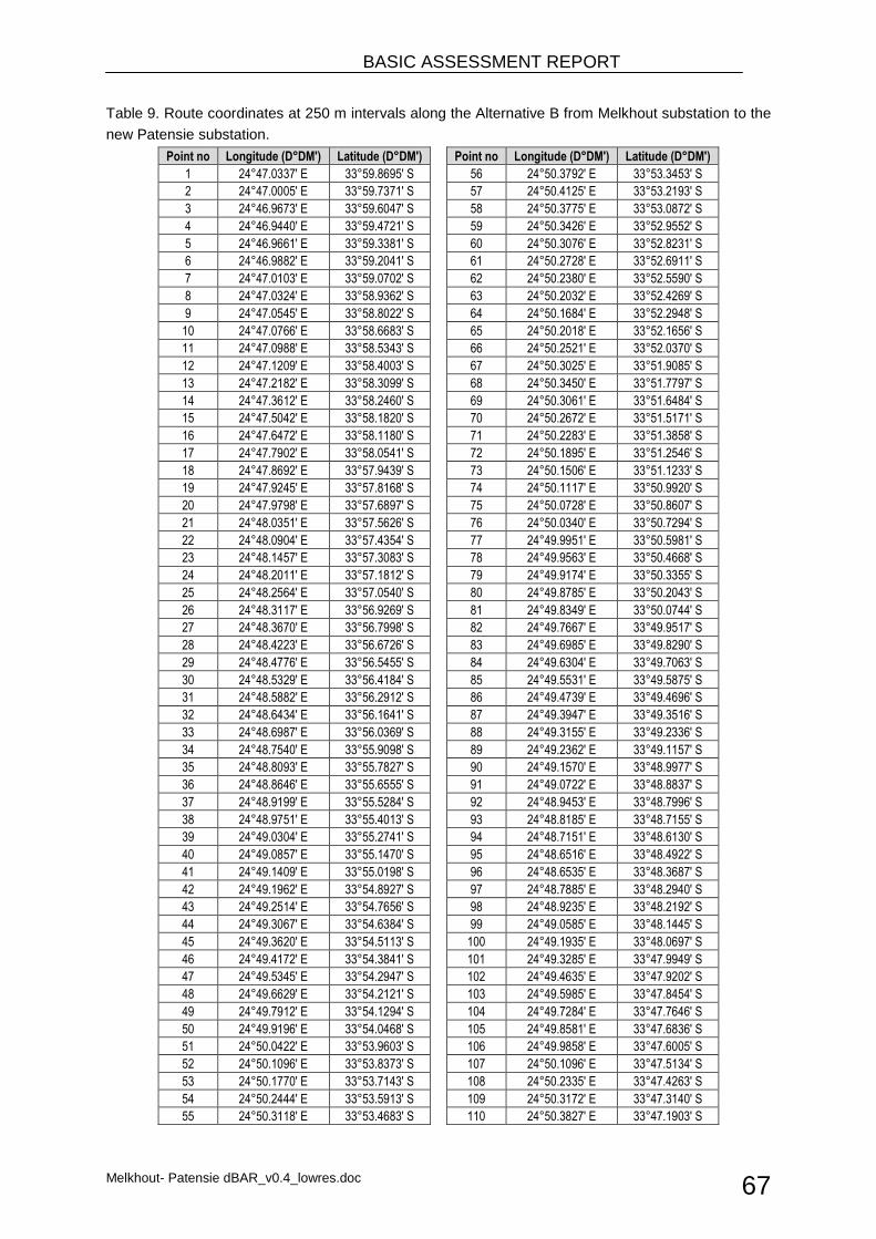
BASIC ASSESSMENT REPORT
Melkhout- Patensie dBAR_v0.4_lowres.doc 67
Table 9. Route coordinates at 250 m intervals along the Alternative B from Melkhout substation to the
new Patensie substation.
Point no Longitude (D°DM') Latitude (D°DM')
Point no Longitude (D°DM') Latitude (D°DM')
1 24°47.0337' E 33°59.8695' S
56 24°50.3792' E 33°53.3453' S
2 24°47.0005' E 33°59.7371' S
57 24°50.4125' E 33°53.2193' S
3 24°46.9673' E 33°59.6047' S
58 24°50.3775' E 33°53.0872' S
4 24°46.9440' E 33°59.4721' S
59 24°50.3426' E 33°52.9552' S
5 24°46.9661' E 33°59.3381' S
60 24°50.3076' E 33°52.8231' S
6 24°46.9882' E 33°59.2041' S
61 24°50.2728' E 33°52.6911' S
7 24°47.0103' E 33°59.0702' S
62 24°50.2380' E 33°52.5590' S
8 24°47.0324' E 33°58.9362' S
63 24°50.2032' E 33°52.4269' S
9 24°47.0545' E 33°58.8022' S
64 24°50.1684' E 33°52.2948' S
10 24°47.0766' E 33°58.6683' S
65 24°50.2018' E 33°52.1656' S
11 24°47.0988' E 33°58.5343' S
66 24°50.2521' E 33°52.0370' S
12 24°47.1209' E 33°58.4003' S
67 24°50.3025' E 33°51.9085' S
13 24°47.2182' E 33°58.3099' S
68 24°50.3450' E 33°51.7797' S
14 24°47.3612' E 33°58.2460' S
69 24°50.3061' E 33°51.6484' S
15 24°47.5042' E 33°58.1820' S
70 24°50.2672' E 33°51.5171' S
16 24°47.6472' E 33°58.1180' S
71 24°50.2283' E 33°51.3858' S
17 24°47.7902' E 33°58.0541' S
72 24°50.1895' E 33°51.2546' S
18 24°47.8692' E 33°57.9439' S
73 24°50.1506' E 33°51.1233' S
19 24°47.9245' E 33°57.8168' S
74 24°50.1117' E 33°50.9920' S
20 24°47.9798' E 33°57.6897' S
75 24°50.0728' E 33°50.8607' S
21 24°48.0351' E 33°57.5626' S
76 24°50.0340' E 33°50.7294' S
22 24°48.0904' E 33°57.4354' S
77 24°49.9951' E 33°50.5981' S
23 24°48.1457' E 33°57.3083' S
78 24°49.9563' E 33°50.4668' S
24 24°48.2011' E 33°57.1812' S
79 24°49.9174' E 33°50.3355' S
25 24°48.2564' E 33°57.0540' S
80 24°49.8785' E 33°50.2043' S
26 24°48.3117' E 33°56.9269' S
81 24°49.8349' E 33°50.0744' S
27 24°48.3670' E 33°56.7998' S
82 24°49.7667' E 33°49.9517' S
28 24°48.4223' E 33°56.6726' S
83 24°49.6985' E 33°49.8290' S
29 24°48.4776' E 33°56.5455' S
84 24°49.6304' E 33°49.7063' S
30 24°48.5329' E 33°56.4184' S
85 24°49.5531' E 33°49.5875' S
31 24°48.5882' E 33°56.2912' S
86 24°49.4739' E 33°49.4696' S
32 24°48.6434' E 33°56.1641' S
87 24°49.3947' E 33°49.3516' S
33 24°48.6987' E 33°56.0369' S
88 24°49.3155' E 33°49.2336' S
34 24°48.7540' E 33°55.9098' S
89 24°49.2362' E 33°49.1157' S
35 24°48.8093' E 33°55.7827' S
90 24°49.1570' E 33°48.9977' S
36 24°48.8646' E 33°55.6555' S
91 24°49.0722' E 33°48.8837' S
37 24°48.9199' E 33°55.5284' S
92 24°48.9453' E 33°48.7996' S
38 24°48.9751' E 33°55.4013' S
93 24°48.8185' E 33°48.7155' S
39 24°49.0304' E 33°55.2741' S
94 24°48.7151' E 33°48.6130' S
40 24°49.0857' E 33°55.1470' S
95 24°48.6516' E 33°48.4922' S
41 24°49.1409' E 33°55.0198' S
96 24°48.6535' E 33°48.3687' S
42 24°49.1962' E 33°54.8927' S
97 24°48.7885' E 33°48.2940' S
43 24°49.2514' E 33°54.7656' S
98 24°48.9235' E 33°48.2192' S
44 24°49.3067' E 33°54.6384' S
99 24°49.0585' E 33°48.1445' S
45 24°49.3620' E 33°54.5113' S
100 24°49.1935' E 33°48.0697' S
46 24°49.4172' E 33°54.3841' S
101 24°49.3285' E 33°47.9949' S
47 24°49.5345' E 33°54.2947' S
102 24°49.4635' E 33°47.9202' S
48 24°49.6629' E 33°54.2121' S
103 24°49.5985' E 33°47.8454' S
49 24°49.7912' E 33°54.1294' S
104 24°49.7284' E 33°47.7646' S
50 24°49.9196' E 33°54.0468' S
105 24°49.8581' E 33°47.6836' S
51 24°50.0422' E 33°53.9603' S
106 24°49.9858' E 33°47.6005' S
52 24°50.1096' E 33°53.8373' S
107 24°50.1096' E 33°47.5134' S
53 24°50.1770' E 33°53.7143' S
108 24°50.2335' E 33°47.4263' S
54 24°50.2444' E 33°53.5913' S
109 24°50.3172' E 33°47.3140' S
55 24°50.3118' E 33°53.4683' S
110 24°50.3827' E 33°47.1903' S
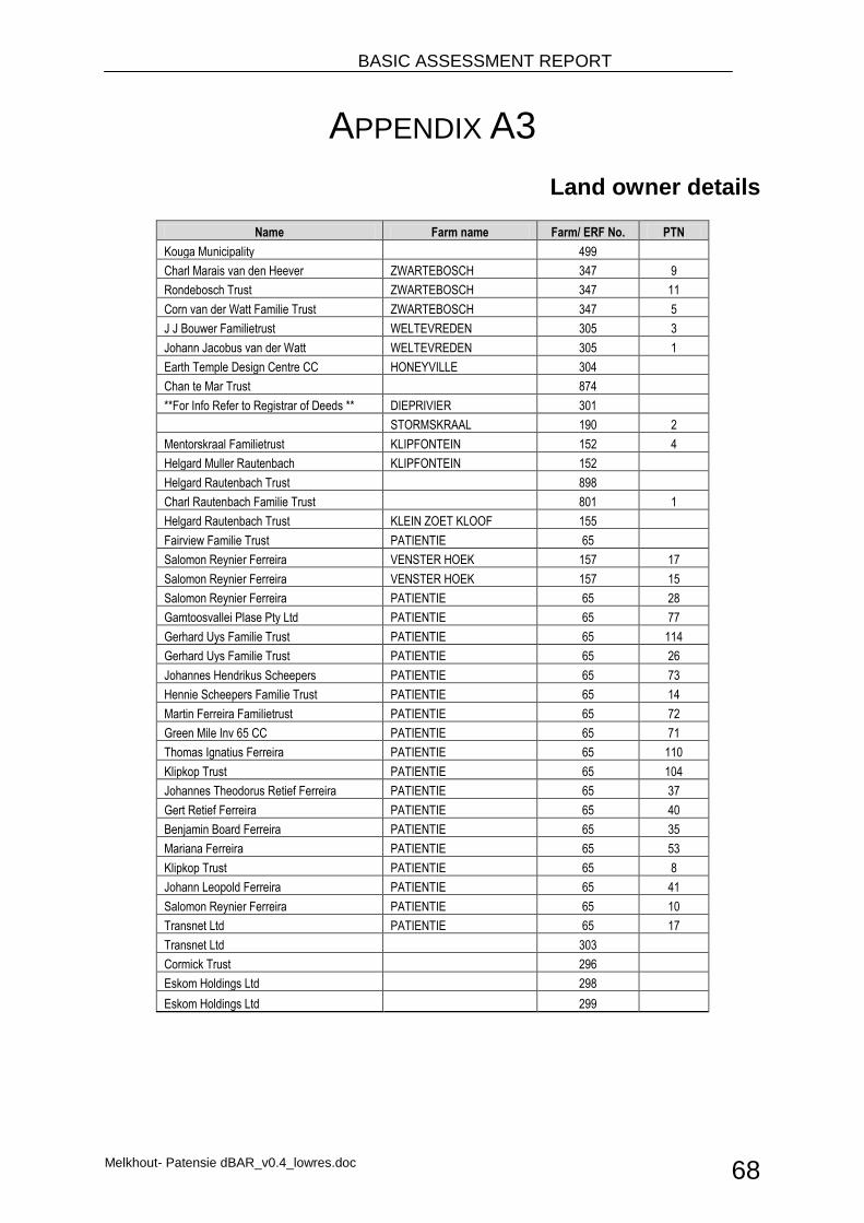
BASIC ASSESSMENT REPORT
Melkhout- Patensie dBAR_v0.4_lowres.doc 68
APPENDIX A3
Land owner details
Name Farm name Farm/ ERF No. PTN
Kouga Municipality 499 Charl Marais van den Heever ZWARTEBOSCH 347 9
Rondebosch Trust ZWARTEBOSCH 347 11
Corn van der Watt Familie Trust ZWARTEBOSCH 347 5
J J Bouwer Familietrust WELTEVREDEN 305 3
Johann Jacobus van der Watt WELTEVREDEN 305 1
Earth Temple Design Centre CC HONEYVILLE 304 Chan te Mar Trust 874 **For Info Refer to Registrar of Deeds ** DIEPRIVIER 301 STORMSKRAAL 190 2
Mentorskraal Familietrust KLIPFONTEIN 152 4
Helgard Muller Rautenbach KLIPFONTEIN 152 Helgard Rautenbach Trust 898 Charl Rautenbach Familie Trust 801 1
Helgard Rautenbach Trust KLEIN ZOET KLOOF 155 Fairview Familie Trust PATIENTIE 65 Salomon Reynier Ferreira VENSTER HOEK 157 17
Salomon Reynier Ferreira VENSTER HOEK 157 15
Salomon Reynier Ferreira PATIENTIE 65 28
Gamtoosvallei Plase Pty Ltd PATIENTIE 65 77
Gerhard Uys Familie Trust PATIENTIE 65 114
Gerhard Uys Familie Trust PATIENTIE 65 26
Johannes Hendrikus Scheepers PATIENTIE 65 73
Hennie Scheepers Familie Trust PATIENTIE 65 14
Martin Ferreira Familietrust PATIENTIE 65 72
Green Mile Inv 65 CC PATIENTIE 65 71
Thomas Ignatius Ferreira PATIENTIE 65 110
Klipkop Trust PATIENTIE 65 104
Johannes Theodorus Retief Ferreira PATIENTIE 65 37
Gert Retief Ferreira PATIENTIE 65 40
Benjamin Board Ferreira PATIENTIE 65 35
Mariana Ferreira PATIENTIE 65 53
Klipkop Trust PATIENTIE 65 8
Johann Leopold Ferreira PATIENTIE 65 41
Salomon Reynier Ferreira PATIENTIE 65 10
Transnet Ltd PATIENTIE 65 17
Transnet Ltd 303 Cormick Trust 296 Eskom Holdings Ltd 298 Eskom Holdings Ltd 299
BASIC ASSESSMENT REPORT
Melkhout- Patensie dBAR_v0.4_lowres.doc 69
APPENDIX B
Photographs
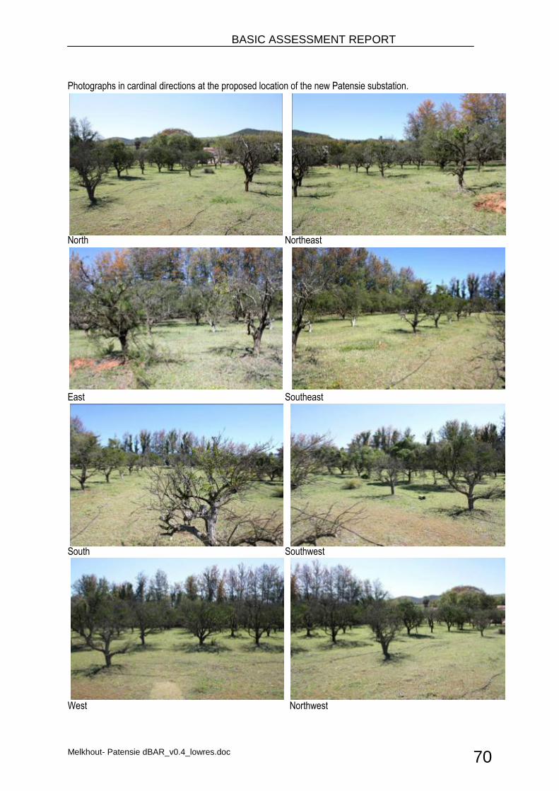
BASIC ASSESSMENT REPORT
Melkhout- Patensie dBAR_v0.4_lowres.doc 70
Photographs in cardinal directions at the proposed location of the new Patensie substation.
North Northeast
East Southeast
South Southwest
West Northwest
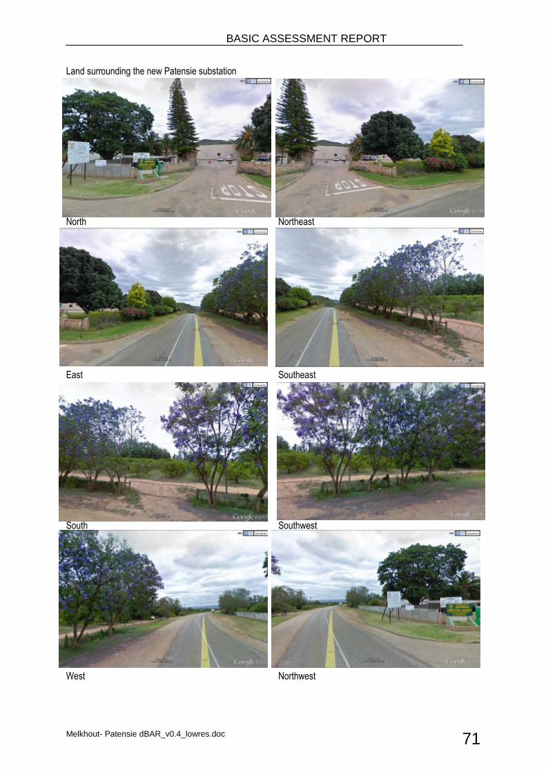
BASIC ASSESSMENT REPORT
Melkhout- Patensie dBAR_v0.4_lowres.doc 71
Land surrounding the new Patensie substation
North Northeast
East Southeast
South Southwest
West Northwest
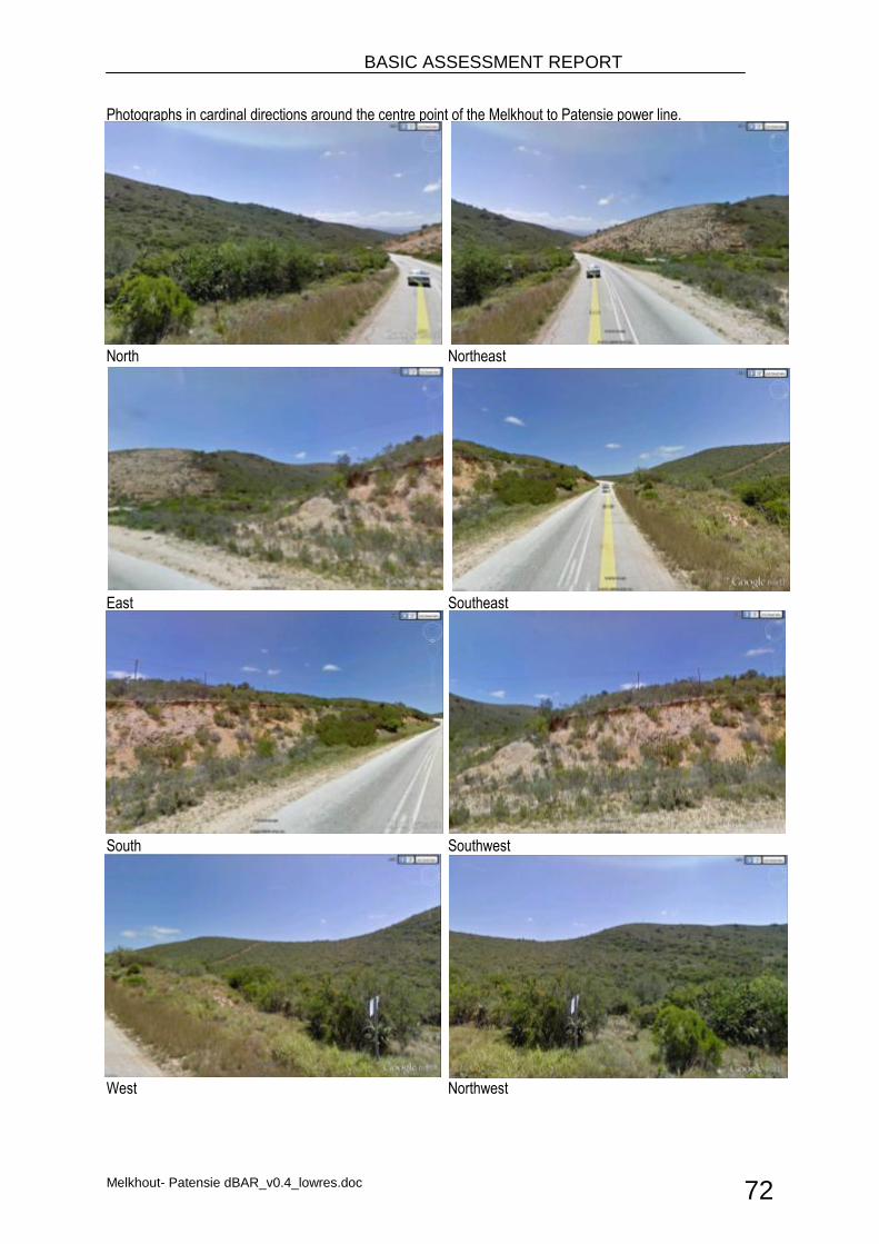
BASIC ASSESSMENT REPORT
Melkhout- Patensie dBAR_v0.4_lowres.doc 72
Photographs in cardinal directions around the centre point of the Melkhout to Patensie power line.
North Northeast
East Southeast
South Southwest
West Northwest
N
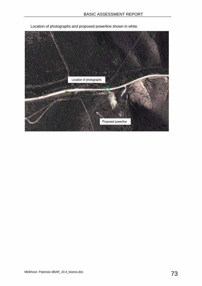
BASIC ASSESSMENT REPORT
Melkhout- Patensie dBAR_v0.4_lowres.doc 73
Location of photographs and proposed powerline shown in white.
Location of photographs
Proposed powerline
BASIC ASSESSMENT REPORT
Melkhout- Patensie dBAR_v0.4_lowres.doc 74
APPENDIX C
Facility Illustrations

Melkhout- Patensie dBAR_v0.4_lowres.doc
Figure 10. Lattice tower structure 248A.
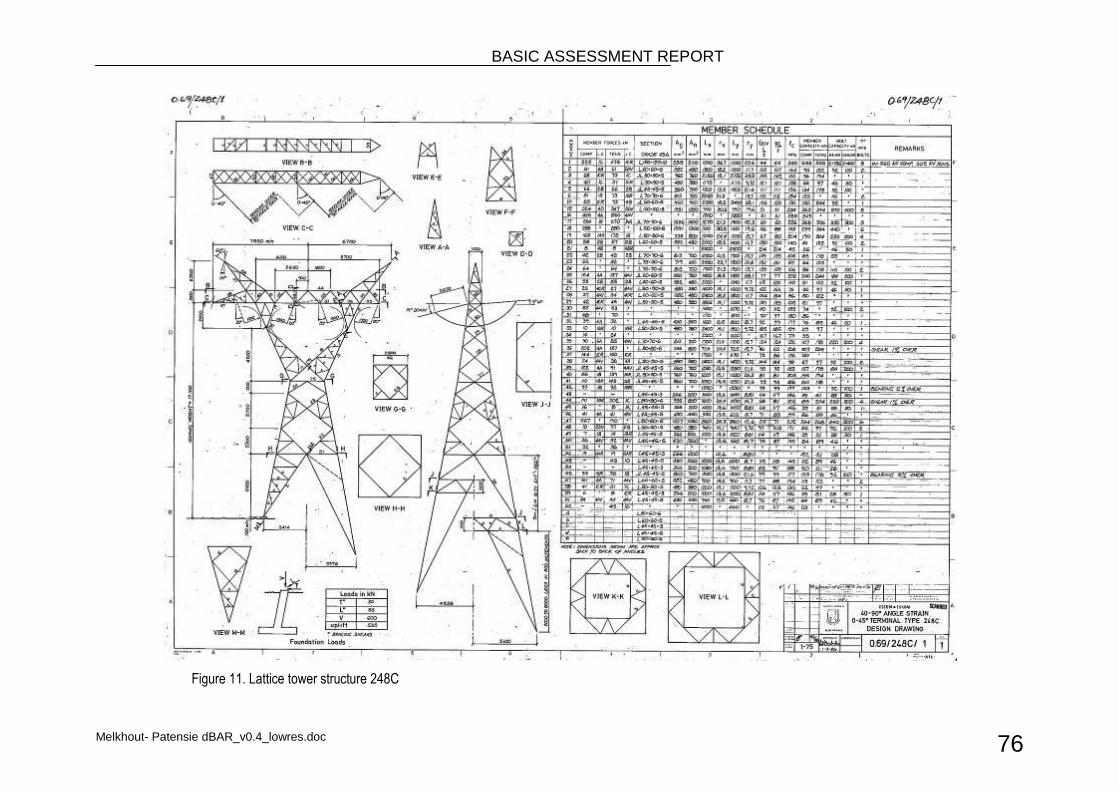
BASIC ASSESSMENT REPORT
Melkhout- Patensie dBAR_v0.4_lowres.doc 76
Figure 11. Lattice tower structure 248C
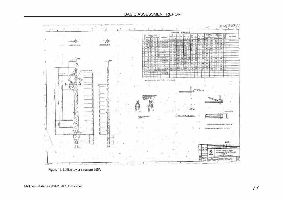
BASIC ASSESSMENT REPORT
Melkhout- Patensie dBAR_v0.4_lowres.doc 77
Figure 12. Lattice tower structure 255A
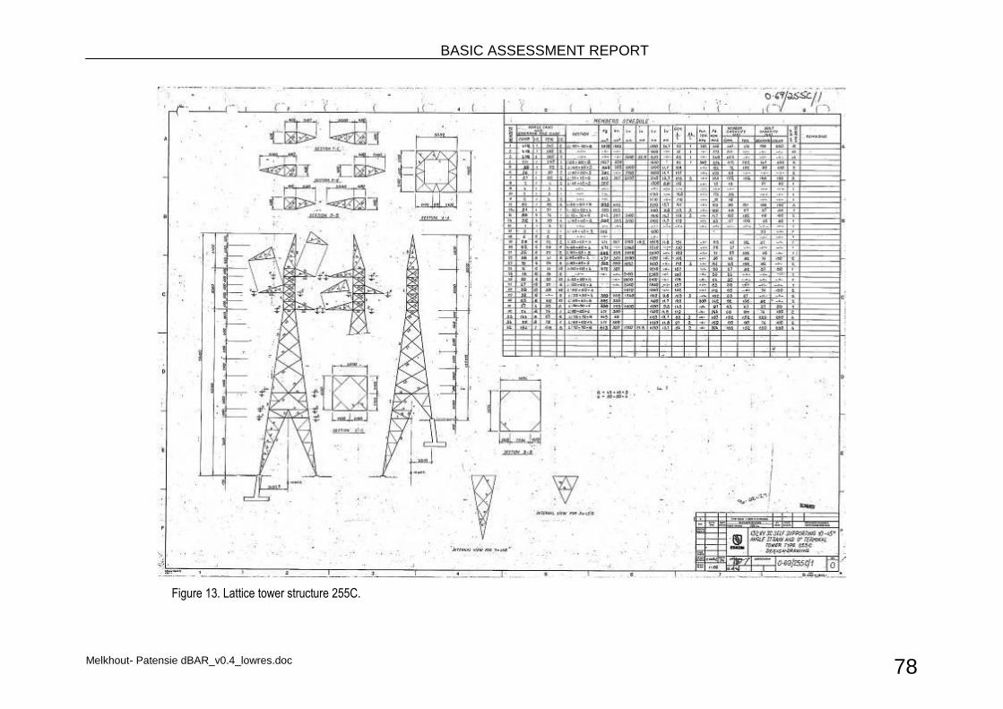
BASIC ASSESSMENT REPORT
Melkhout- Patensie dBAR_v0.4_lowres.doc 78
Figure 13. Lattice tower structure 255C.
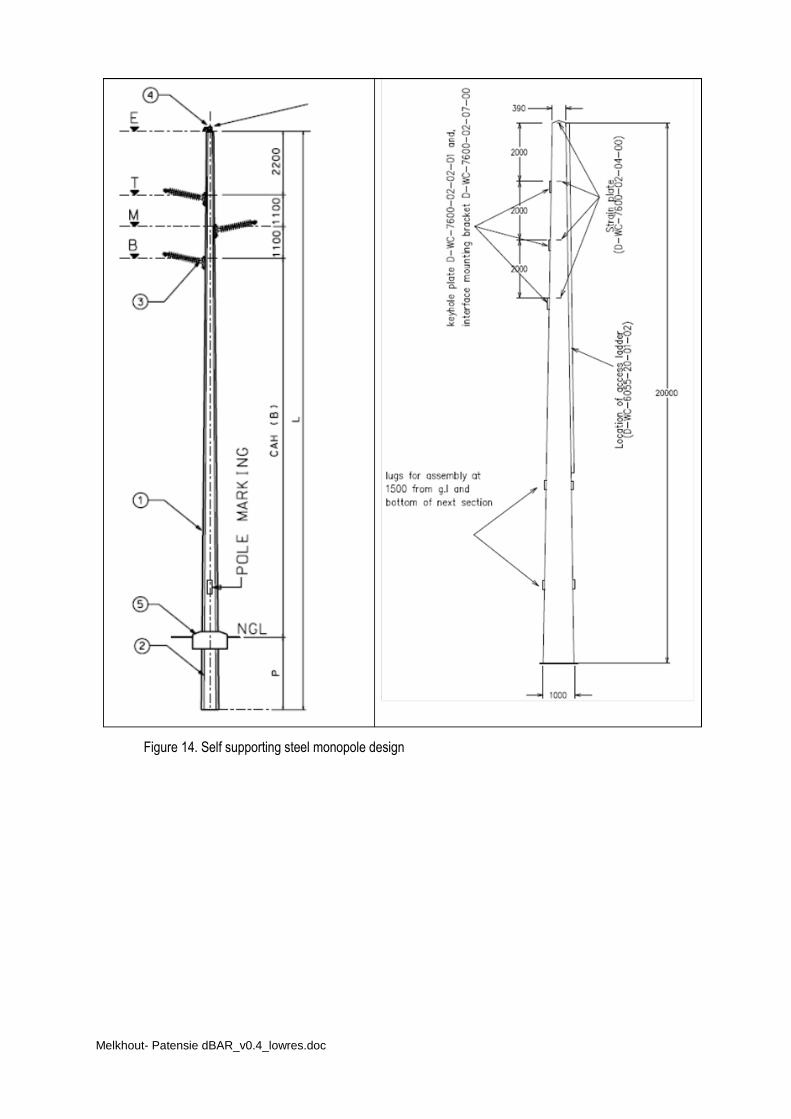
Melkhout- Patensie dBAR_v0.4_lowres.doc
Figure 14. Self supporting steel monopole design
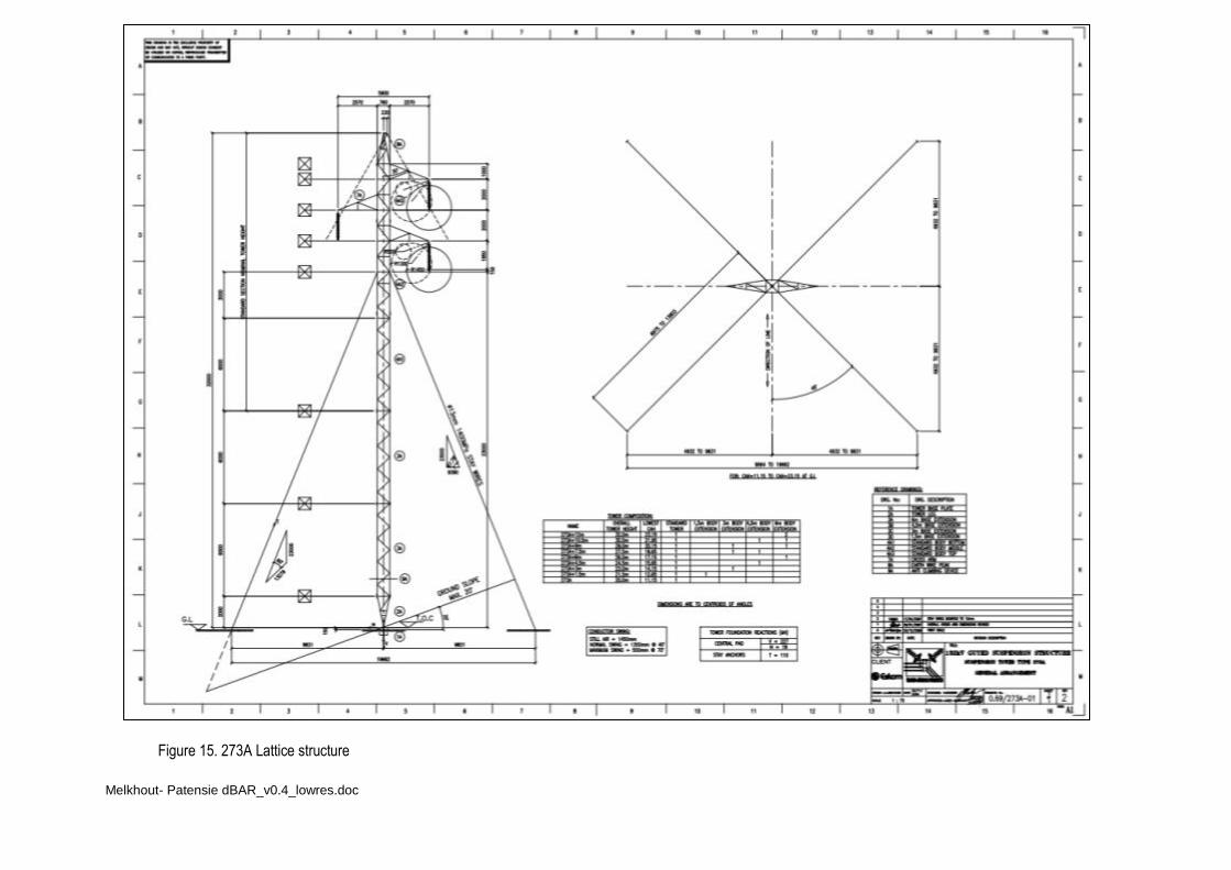
Melkhout- Patensie dBAR_v0.4_lowres.doc
Figure 15. 273A Lattice structure
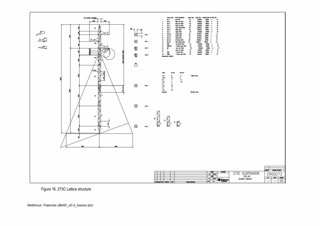
Melkhout- Patensie dBAR_v0.4_lowres.doc
Figure 16. 273C Lattice structure

Melkhout- Patensie dBAR_v0.4_lowres.doc
APPENDIX D
Specialist reports

Melkhout- Patensie dBAR_v0.4_lowres.doc
APPENDIX D1 Avifauna Impact Assessment
Melkhout- Patensie dBAR_v0.4_lowres.doc
GIBB Terms of Reference: Avifaunal Assessment
1. Mapping of sensitive sites: The bird sensitive sections of the study area will be mapped and attached as an annexure to the main document.
2. Describe affected environment and determine status quo: The existing environment will described and
the bird communities most likely to be impacted will be identified. Different bird micro‐habitats will be described as well as the species associated with those habitats.
3. Indicate how a resource or community will be affected. Typical impacts that could be expected from the development will be listed as well as the expected impact on the bird communities. Impacts will be quantified (if possible) and a full description of predicted impacts (direct and indirect) will be provided.
4. Gaps in baseline data. Gaps in baseline data will be highlighted and discussed. An indication of the confidence levels will be given. The best available data sources will be used to predict the impacts, and extensive use will be made of local knowledge.
5. Assessment of impacts: The potential impact on the birds will be assessed and evaluated according to the magnitude, spatial scale, timing, duration, reversibility, probability and significance. Propose and explain mitigation measures. Practical mitigation measures will be recommended and discussed.
6. Summarise residual impacts after mitigation. An impact summary table will be provided, discussing expected impacts before and after mitigation.
7. Indicate a monitoring programme. If a need for a monitoring programme is evident, it will be highlighted and a programme proposed.
8. Draft an impact statement of the proposed development on the identified avifauna communities.
Melkhout- Patensie dBAR_v0.4_lowres.doc
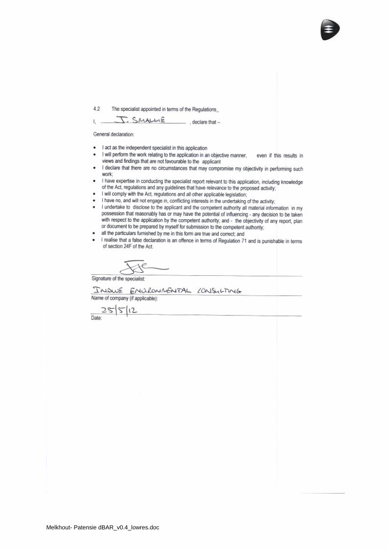
Melkhout- Patensie dBAR_v0.4_lowres.doc
• I• Te
M
Indwe Environel: 043 735 18
MELKH
Avifa
nmental Cons90 • Cell: 083
• Com
HOUT
BASIC
aunal Im
Ap
sulting CC • 9 3 766 7514 • Fmpany Registra
www.
T PATE
ASSESS
mpact A
pril 201
J2012‐09
Tainton AvenFax: 086 513 9ation No.: 200indwecon.co.
ENSIE
SMENT
Assess
12
9
nue • Bonnie 9734 • Email: 06/074394/23.za
132KV
T
ment
Doon • East Lindwecon@te3 •
V
London • 524elkomsa.net •
41 • •
2
Table of contents
Executive summary 3
Declaration of independence 4
1. Introduction 6
2. Methods 9
3. Description of affected environment 9
4. Assessment of impacts 17
5. Comparison of alternatives 23
6. Impact statement 23
7. References 24
Appendix 1 25
Appendix 2 28
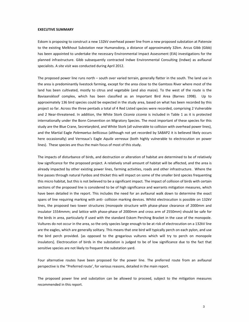
3
EXECUTIVE SUMMARY
Eskom is proposing to construct a new 132kV overhead power line from a new proposed substation at Patensie
to the existing Melkhout Substation near Humansdorp, a distance of approximately 32km. Arcus Gibb (Gibb)
has been appointed to undertake the necessary Environmental Impact Assessment (EIA) investigations for the
planned infrastructure. Gibb subsequently contracted Indwe Environmental Consulting (Indwe) as avifaunal
specialists. A site visit was conducted during April 2012.
The proposed power line runs north – south over varied terrain, generally flatter in the south. The land use in
the area is predominantly livestock farming, except for the area close to the Gamtoos River where most of the
land has been cultivated, mostly to citrus and vegetable (and also maize). To the west of the route is the
Baviaanskloof complex, which has been classified as an Important Bird Area (Barnes 1998). Up to
approximately 136 bird species could be expected in the study area, based on what has been recorded by this
project so far. Across the three pentads a total of 4 Red Listed species were recorded, comprising 2 Vulnerable
and 2 Near‐threatened. In addition, the White Stork Ciconia ciconia is included in Table 1 as it is protected
internationally under the Bonn Convention on Migratory Species. The most important of these species for this
study are the Blue Crane, Secretarybird, and White Stork (all vulnerable to collision with overhead power lines),
and the Martial Eagle Polemaetus bellicosus (although not yet recorded by SABAP2 it is believed likely occurs
here occasionally) and Verreaux’s Eagle Aquila verreaux (both highly vulnerable to electrocution on power
lines). These species are thus the main focus of most of this study.
The impacts of disturbance of birds, and destruction or alteration of habitat are determined to be of relatively
low significance for the proposed project. A relatively small amount of habitat will be affected, and the area is
already impacted by other existing power lines, farming activities, roads and other infrastructure. Where the
line passes through natural Fynbos and thicket this will impact on some of the smaller bird species frequenting
this micro habitat, but this is not believed to be a significant impact. The impact of collision of birds with certain
sections of the proposed line is considered to be of high significance and warrants mitigation measures, which
have been detailed in the report. This includes the need for an avifaunal walk down to determine the exact
spans of line requiring marking with anti‐ collision marking devices. Whilst electrocution is possible on 132kV
lines, the proposed two tower structures (monopole structure with phase‐phase clearance of 2000mm and
insulator 1554mmm; and lattice with phase‐phase of 2000mm and cross arm of 2550mm) should be safe for
the birds in area, particularly if used with the standard Eskom Perching Bracket in the case of the monopole.
Vultures do not occur in the area, so the only species large enough to be at risk of electrocution on a 132kV line
are the eagles, which are generally solitary. This means that one bird will typically perch on each pylon, and use
the bird perch provided. [as opposed to the gregarious vultures which will try to perch on monopole
insulators]. Electrocution of birds in the substation is judged to be of low significance due to the fact that
sensitive species are not likely to frequent the substation yard.
Four alternative routes have been proposed for the power line. The preferred route from an avifaunal
perspective is the “Preferred route’, for various reasons, detailed in the main report.
The proposed power line and substation can be allowed to proceed, subject to the mitigation measures
recommended in this report.
4
DECLARATION OF INDEPENDANCE
Specialist Investigator
The Natural Scientific Professions Act of 2003 aims to “Provide for the establishment of the South African
Council of Natural Scientific Professions (SACNASP) and for the registration of professional, candidate and
certified natural scientists; and to provide for matters connected therewith.”
“Only a registered person may practice in a consulting capacity” – Natural Scientific Professions Act of 2003
(20(1)‐pg 14)
Investigator: Jon Smallie (Pri.Sci.Nat)
Qualification: BSc (hons) Wildlife Science
Affiliation: South African Council for Natural Scientific Professions
Registration number: 400020/06
Fields of Expertise: Ecological Science
Registration: Professional Member
Declaration of Independence
All specialist investigators specified above declare that:
We act as independent specialists for this project.
We consider ourselves bound by the rules and ethics of the South African Council for Natural Scientific
Professions.
We do not have any personal or financial interest in the project except for financial compensation for
specialist investigations completed in a professional capacity as specified by the Environmental Impact
Assessment Regulations, 2006.
We will not be affected by the outcome of the environmental process, of which this report forms part
of.
We do not have any influence over the decisions made by the governing authorities.
We do not object to or endorse the proposed developments, but aim to present facts and our best
scientific and professional opinion with regard to the impacts of the development.
We undertake to disclose to the relevant authorities any information that has or may have the
potential to influence its decision or the objectivity of any report, plan, or document required in terms
of the Environmental Impact Assessment Regulations, 2006.
Should we consider ourselves to be in conflict with any of the above declarations, we shall formally
submit a Notice of Withdrawal to all relevant parties and formally register as an Interested and
Affected Party.
Terms and Liabilities
This report is based on a short term investigation using the available information and data related to
the site to be affected. No long term investigation or monitoring was conducted.
The Precautionary Principle has been applied throughout this investigation.
A
T
a
w
T
A
t
Signed on
Additional inf
no allowance
The specialist
at any stage s
Information,
without prope
This report, in
purpose witho
Acceptance o
terms and liab
n the 20 April
formation ma
could have be
investigator w
should additio
recommenda
er investigatio
n its entirety o
out the specif
of this report,
bilities.
2012 by Jon S
y become kn
een made at t
withholds the
onal informati
ations and co
on.
or any portion
fic and written
in any physic
Smallie in his c
own or availa
the time of th
e right to ame
on become av
nclusions in t
n thereof, may
n consent of t
cal or digital fo
capacity as sp
able during a
his report.
nd this report
vailable.
this report ca
y not be alter
the specialist i
orm, serves to
pecialist invest
later stage of
t, recommend
annot be app
red in any ma
investigator a
o confirm ack
tigator.
f the process
dations and co
plied to any o
nner or form
s specified ab
knowledgmen
5
for which
onclusions
other area
or for any
bove.
nt of these
INTRODUCTION
1.1 Background
Eskom is proposing to construct a new 132kV overhead power line from a new proposed substation at Patensie
to the existing Melkhout Substation near Humansdorp, a distance of approximately 32km. Arcus Gibb (Gibb) has
been appointed to undertake the necessary Environmental Impact Assessment (EIA) investigations for the
planned infrastructure. Gibb subsequently contracted Indwe Environmental Consulting (Indwe) as avifaunal
specialists. A site visit was conducted during April 2012.
Up to approximately 136 bird species can be expected in the area, of which the most important of these species
for this study are the Blue Crane Anthropoides paradiseus, Secretarybird Sagittarius serpentarius, White Stork
Ciconia ciconia, Black Harrier Circus maurus, Martial Eagle Polemaeetus bellicosus and Verreaux’s Eagle Aquila
verreaux. These species all have a strong likelihood of occurring on the site and are highly vulnerable to collision
with (cranes, Secretarybird and storks), and electrocution (eagles) on overhead power lines in South Africa.
These species are the focus of most of this study as explained elsewhere in this report.
In general terms, the impacts that could be associated with a project of this nature include: collision of birds with
the overhead cables; electrocution of birds whilst perched on the tower structures or in the substation;
destruction of habitat; and disturbance of birds.
1.2 Terms of reference
The following terms of reference were utilized for this study:
A desktop review of all existing literature.
Describe the current state of avifauna in the study area, outlining important characteristics which may
be influenced by the proposed infrastructure or which may influence the proposed infrastructure during
construction and operation.
Identify Red Listed species potentially affected by the proposed power lines and substation.
Assess the avifaunal status of the study area with the view to identifying sensitive areas and areas that
may be considered as “no‐go”. If appropriate deviations can be suggested, please do so, and provide
supporting reasons for the choice.
Map all relevant aspects.
Identify potential impacts (positive and negative, including cumulative impacts if relevant) of the
proposed development on avifauna during construction and operation. Particular attention should be
paid to bird collisions and preventative measures.
Pay particular attention to wetlands.
Identify mitigation measures for enhancing benefits and avoiding or mitigating negative impacts and
risks (to be implemented during design, construction and operation of proposed distribution line.
Identify and address any other aspects related to avifauna in the study area that should be incorporated
into the reports.
7
1.3 Description of proposed activities
The following are the proposed project activities (see Figure 1):
Construction of a 132kV overhead power line from the new proposed Patensie Substation to the
existing Melkhout Substation, a distance of approximately 32km.
In the northern section of the route four route alternatives exist for the alignment of the power line, as
shown in Figure 1.
Whilst electrocution is possible on 132kV lines, the proposed two tower structures (monopole structure
with phase‐phase clearance of 2000mm and insulator 1554mmm; and lattice with phase‐phase of
2000mm and cross arm of 2550mm) should be safe for the birds in area, particularly if used with the
standard Eskom Perching Bracket in the case of the monopole. Vultures do not occur in the area, so the
only species large enough to be at risk of electrocution on a 132kV line are the eagles, which are
generally solitary.
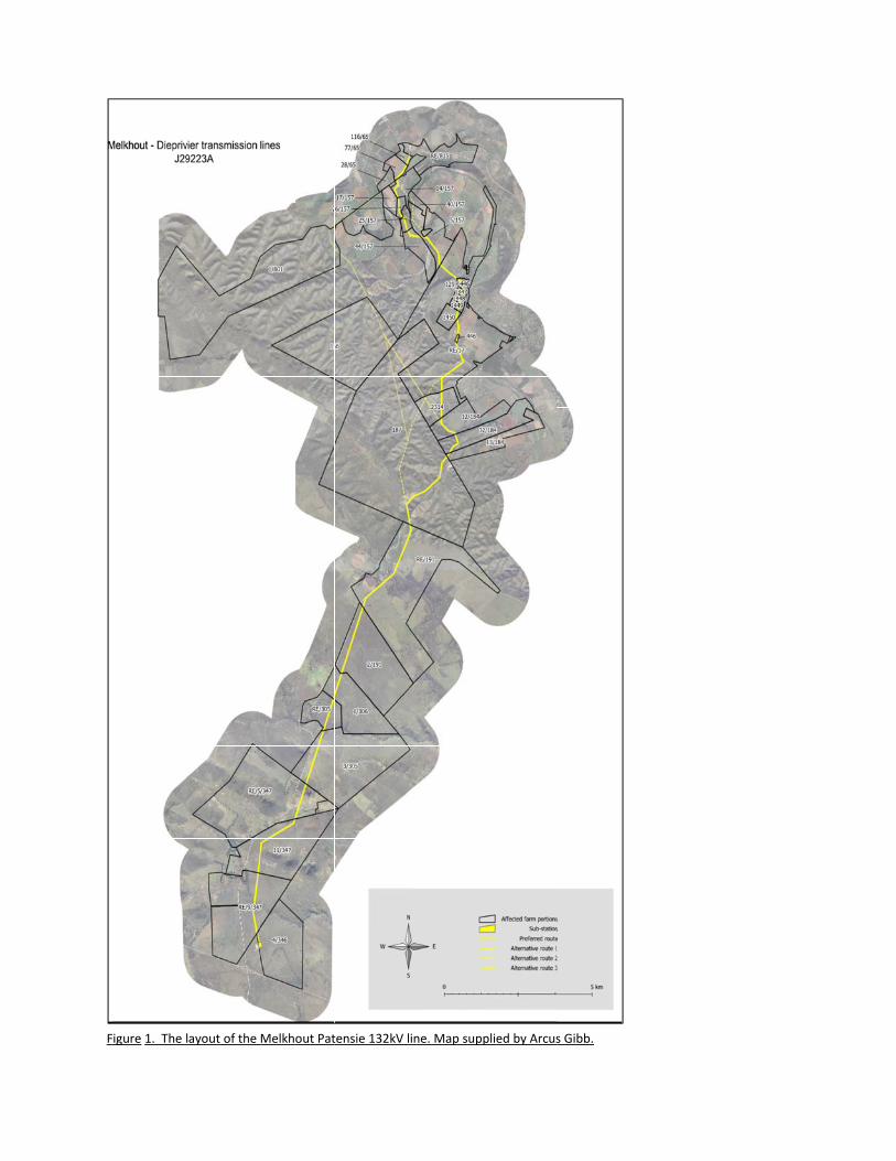
FFigure 1. The llayout of the Melkhout Pattensie 132kV lline. Map supplied by Arcuss Gibb.
2. METHODS
2.1. Methodology
In predicting impacts of a proposed power line on birds, a combination of science, field experience and common
sense is required. More specifically the methodology used to predict impacts in the current study was as follows:
The various data sets discussed below under “sources of information” were collected and examined.
The data was examined to determine the location and abundance of power line sensitive Red Listed
species as well as non‐Red Listed power line sensitive species in the study area.
The area was visited to obtain a first‐hand perspective of the proposed route (and substation site) and
birdlife and to determine which bird micro‐habitats are present and relevant to the study. This involved
driving the study area to see as much as possible of the proposed routes for the power line.
The impacts of the proposed power line on birds were predicted on the basis of experience in gathering
and analysing data on wildlife impacts with power lines throughout southern Africa since 1996 (see van
Rooyen & Ledger 1999 for an overview of methodology), supplemented with first hand data.
2.2 Sources of information
The study made use of the following data sources:
Bird distribution data of the second Southern African Bird Atlas Project (SABAP2 –
http://sabap2.adu.org.za) for the relevant pentads 3345_2445, 3350_2445, and 3355_2445.
The conservation status of all bird species occurring in the aforementioned degree squares was then
determined with the use of The Eskom Red Data book of birds of South Africa, Lesotho and Swaziland
(Barnes, 2000).
A classification of the vegetation types in the study area was obtained from Mucina et al (2005).
Information on the micro‐habitat level was obtained through visiting the area and obtaining a first hand
perspective.
Electronic 1:50 000 maps were obtained from the Surveyor General.
2.3 Limitations & assumptions
This study made the assumption that the above sources of information are reliable. Predictions in this study are
based on experience of these and similar species in different parts of South Africa. Bird behaviour can not be
reduced to formulas that will hold true under all circumstances. However, power line impacts can be predicted
with a fair amount of certainty, based on experience gained by the author through the investigation of hundreds of
localities in southern Africa where birds have interacted with power lines since 1999.
10
3. DESCRIPTION OF AFFECTED ENVIRONMENT
3.1 Study area vegetation
The study area is relatively complex in terms of vegetation. Most of the southern half of the power line route is
classified as “Kouga Grassy Sandstone Fynbos”. The northern half is mostly “Loerie Conglomerate Fynbos” and
“Gamtoos Thicket”. It is widely agreed in ornithological circles that vegetation structure is more important than
species composition, in determining bird species presence and abundance. Taking this into account then the most
important aspect of the above mentioned vegetation types for avifauna is that they are all relatively short, Fynbos
type vegetation types, with the exception of the Thicket, which occurs mostly on the higher ground and in valleys.
This means that we can expect bird species associated with Fynbos to dominate the avifauna of the area.
Interestingly, the botanical diversity of Fynbos is not matched by the avifauna associated with it. The diversity of
avifauna associated with Fynbos is normally relatively low. In addition, due to its dense nature most the species
that are attracted to Fynbos are physically small species, for which predator detection at long distances is not as
important as for large terrestrial species such as cranes and bustards. Various raptors also utilise Fynbos, such as
harriers and Verreaux’s Eagle Aquila verreaux. Much of the study area has however been transformed, making the
below description of the micro habitats actually available to birds on site far more informative than the vegetation
description.
3.2 Bird micro habitats
In addition to the description of vegetation, it is important to understand the habitats available to birds at a
smaller spatial scale, i.e. micro habitats. Micro habitats are shaped by factors other than vegetation, such as
topography, land use, food sources and man made factors. In transformed areas, the micro habitat descriptions
describe what is actually available to birds on site, whereas the vegetation description describes the original
vegetation on site, before any transformation.
Investigation of this study area revealed the following bird micro habitats, examples of which are shown in Figure
2.
Arable lands:
Arable or cultivated land represents a significant feeding area for many bird species in any landscape for the
following reasons: through opening up the soil surface, land preparation makes many insects, seeds, bulbs and
other food sources readily accessible to birds and other predators; the crop or pasture plants cultivated are often
eaten themselves by birds, or attract insects which are in turn eaten by birds; during the dry season arable lands
often represent the only green or attractive food sources in an otherwise dry landscape. Arable lands exist in this
study area, mostly planted to pastures of some type at the time of site visit, and maize closer to the Gamtoos
River. Relevant bird species that will be attracted to these areas include most importantly the Blue Crane,
Denham’s Bustard and White Stork. Fruit orchards also exist in this study area, but these are not attractive to the
larger bird species that are most relevant to this study.
Dams:
Artificially constructed dams have become important attractants to various bird species in the South African
landscape. Several small dams exist in the study area. Various waterfowl frequent these areas and are vulnerable
11
to collision with power lines. More importantly, one of the main focus species of this study, the Blue Crane, uses
dams to roost in communally. This means that large numbers of these birds enter the roost at last light and exit it
at first light, both times when power lines are even less visible and the chances of collisions is greater. Therefore
dams are a key element of this study, and power line passing close to them will require mitigation as detailed
elsewhere in this report. Of particular importance is the dam shown in Figure 4. This area is home to numerous
water fowl and a broad diversity of bird species. Power line close to this area will required effective mitigation for
collision of these bird species. It would be preferable if this portion of the route could be moved further away
from the dam.
Rivers or drainage lines:
Most rivers in southern Africa are in the east and extreme south, in the higher rainfall areas. Various species of
water bird are mostly restricted to riverine habitat in southern Africa. The map distribution of these species
correlates with the river courses in southern Africa. Many of these species, particularly the larger ones, are known
to interact with power lines through collision. These rivers also form significant flight paths for many of these
species, such as ducks, geese, herons, ibises and storks. The proposed power line runs close to and across the
Gamtoos River in the far north of the study area.
Fynbos: This micro habitat is the only remaining natural vegetation in the study area and has been described adequately
above under the vegetation section.
Thicket:
The northern, higher ground along the proposed power line route, consists of natural thicket. These areas will be
most attractive to various raptor species, such as the eagle species mentioned elsewhere in this report.
Cliffs:
Several cliff areas exist along the Gamtoos River valley. These areas will be attractive to cliff roosting and nesting
species in the area. Species such as raptors could utilise these cliffs extensively for breeding in particular.
Table 1 shows the micro habitats that each Red Listed bird species typically frequents in the study area. It must be
stressed that birds can and will, by virtue of their mobility, utilise almost any areas in a landscape from time to
time. However, the analysis below represents each species’ most preferred or normal habitats. These locations are
where most of the birds of that species will spend most of their time – so logically that is where impacts on those
species will be most significant. Table 1 makes use of the authors’ extensive experience gained through personal
observations.
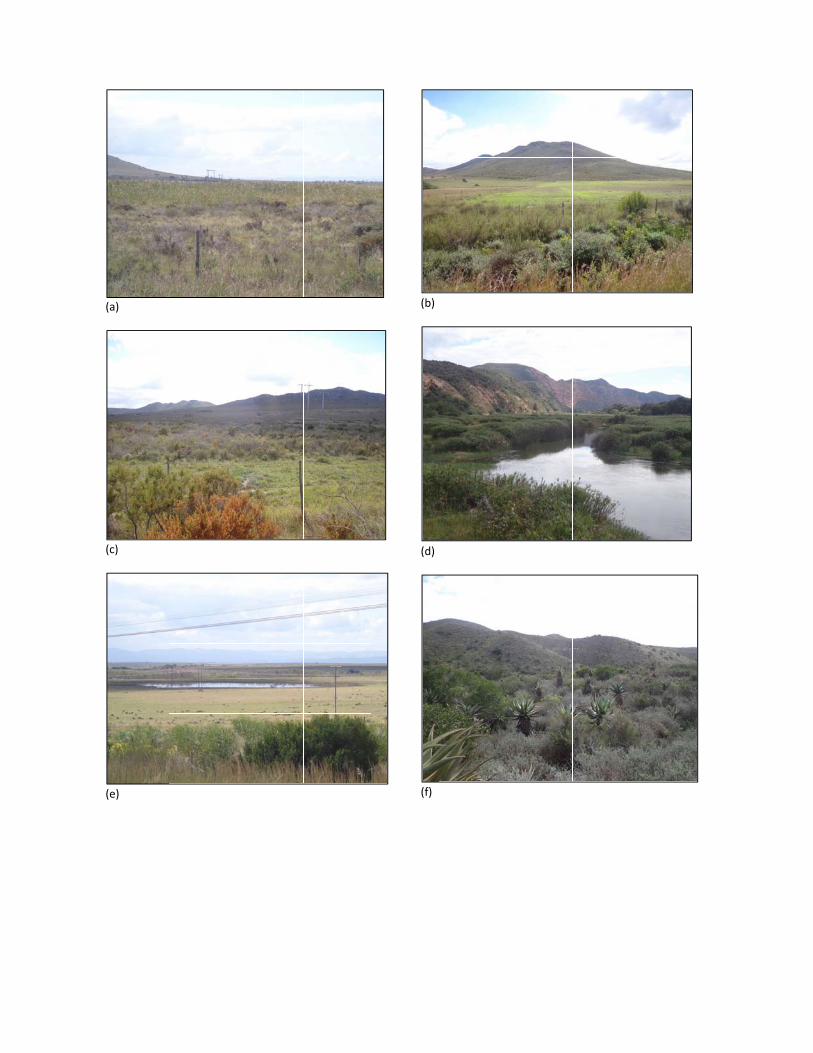
(a)
(c)
(e)
(b)
(d)
(f)
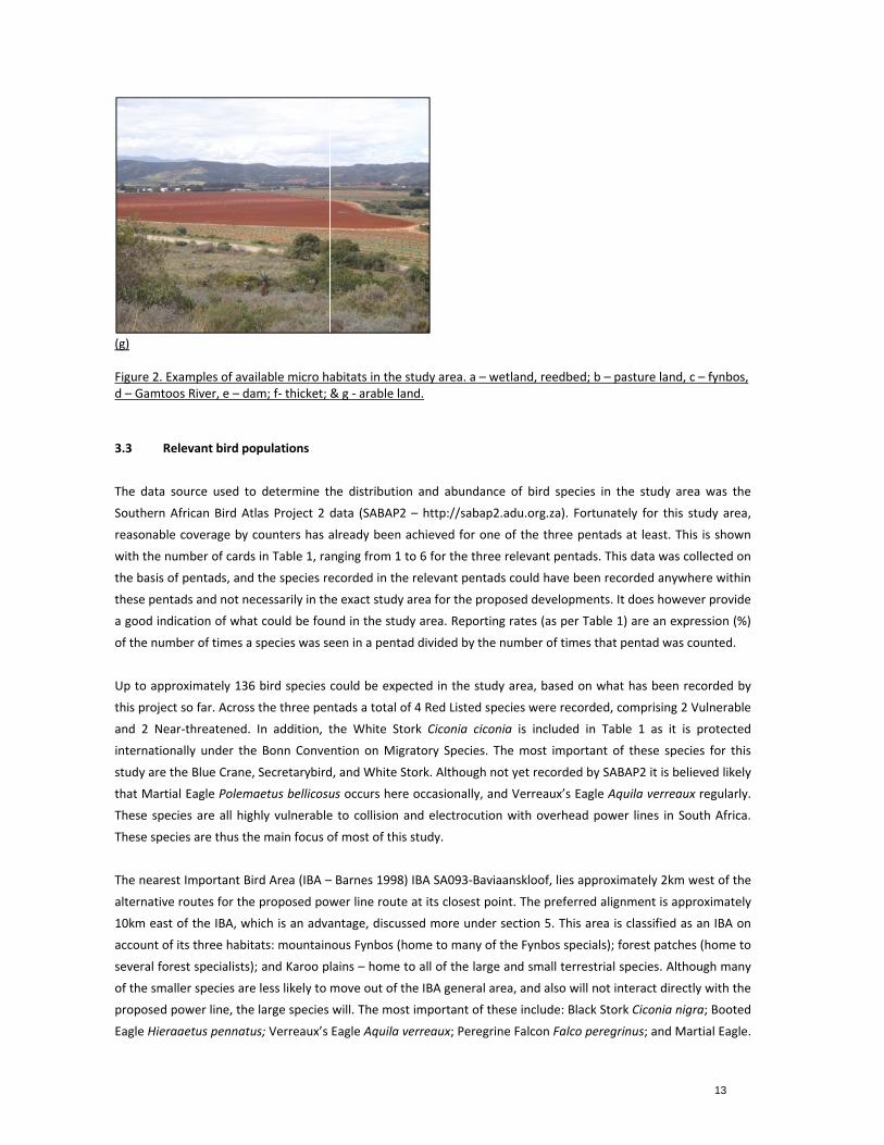
(g) Figure 2. Exad – Gamtoos
3.3 Rele
The data so
Southern Afr
reasonable c
with the num
the basis of p
these pentad
a good indica
of the numbe
Up to approx
this project s
and 2 Near‐
internationa
study are the
that Martial
These specie
These specie
The nearest
alternative ro
10km east o
account of it
several fores
of the smalle
proposed po
Eagle Hieraa
mples of avais River, e – da
evant bird po
urce used to
rican Bird Atl
coverage by c
mber of cards
pentads, and
ds and not nec
ation of what
er of times a s
ximately 136
so far. Across
‐threatened.
lly under the
e Blue Crane,
Eagle Polema
es are all high
es are thus the
Important Bir
outes for the
f the IBA, wh
ts three habita
st specialists);
er species are
ower line, the
etus pennatus
lable micro ham; f‐ thicket; &
pulations
determine t
as Project 2 d
counters has a
in Table 1, ra
the species re
cessarily in th
t could be fou
species was se
bird species
the three pen
In addition, t
Bonn Conve
Secretarybird
aetus bellicosu
hly vulnerable
e main focus o
rd Area (IBA –
proposed pow
ich is an adva
ats: mountain
and Karoo p
less likely to
large species
s; Verreaux’s
abitats in the & g ‐ arable la
he distributio
data (SABAP2
already been
nging from 1
ecorded in the
e exact study
und in the stud
een in a penta
could be expe
ntads a total o
the White St
ntion on Mig
d, and White S
us occurs here
e to collision
of most of this
– Barnes 1998
wer line route
antage, discus
nous Fynbos (h
lains – home
move out of t
will. The mos
Eagle Aquila v
study area. aand.
on and abund
2 – http://sab
achieved for
to 6 for the t
e relevant pen
y area for the p
dy area. Repo
ad divided by
ected in the s
of 4 Red Listed
ork Ciconia c
gratory Specie
Stork. Althoug
e occasionally
and electrocu
s study.
8) IBA SA093‐B
e at its closest
ssed more un
home to many
to all of the la
the IBA gener
st important o
verreaux; Pere
– wetland, re
dance of bird
bap2.adu.org.
one of the th
hree relevant
ntads could h
proposed dev
orting rates (a
the number o
study area, ba
d species wer
ciconia is incl
es. The most
gh not yet rec
y, and Verrea
ution with ov
Baviaanskloof,
t point. The p
nder section 5
y of the Fynbo
arge and sma
al area, and a
of these includ
egrine Falcon
eedbed; b – pa
species in th
za). Fortunate
hree pentads
t pentads. This
ave been reco
velopments. It
as per Table 1
of times that p
ased on what
e recorded, c
luded in Tab
important of
corded by SAB
ux’s Eagle Aq
erhead powe
, lies approxim
preferred align
5. This area is
os specials); fo
all terrestrial s
lso will not in
de: Black Stor
Falco peregri
asture land, c
he study area
ely for this st
at least. This
s data was co
orded anywhe
t does howeve
) are an expre
pentad was co
t has been rec
omprising 2 V
le 1 as it is
f these specie
BAP2 it is belie
uila verreaux
er lines in Sou
mately 2km w
nment is appr
classified as
orest patches
species. Altho
nteract directly
k Ciconia nigr
inus; and Mar
13
– fynbos,
a was the
tudy area,
s is shown
llected on
ere within
er provide
ession (%)
ounted.
corded by
Vulnerable
protected
es for this
eved likely
regularly.
uth Africa.
west of the
roximately
an IBA on
s (home to
ugh many
y with the
ra; Booted
rtial Eagle.
Most of the
predominant
Blue Crane,
disperse from
collision.
Figure 3. The
Area – SA093
The broader
particularly w
proposed pro
the proposed
the report r
Avifaunal Ro
density of D
species favou
the proposed
proven highl
to this unnat
Korhaan exis
White‐bellied
area, and is p
ese species (
tly through e
Denham’s Bu
m the IBA. T
e position of
3 – Baviaansk
r area within
well known a
oject is margi
d power line w
ates in Table
adcount (CAR
Denham’s Bust
ur are the mix
d route, partic
y vulnerable t
tural cause sh
st, other korh
d Korhaan wo
probably the
(exception be
lectrocution,
ustard Neotis
This set of sp
the preferred
loof Complex
which the pr
as a strongho
nally within t
we can theref
e 1, probably
R – Young et a
tard and Wh
xture of pastu
cularly in the
to collision w
hould be prev
haan species h
ould also be a
species recor
eing Black St
making it im
denhamii, Bl
pecies will int
d route for th
(red).
oject is situat
old of the Blu
his broader a
fore expect th
due to inade
al, 2003) proje
ite‐bellied Ko
ures, natural v
south on the
ith overhead
vented where
have been rec
at risk. Althou
ded colliding
tork) are like
portant to co
lack Harrier C
teract with t
e proposed p
ted (from the
ue Crane, Den
rea, on its’ no
hese three sp
equate cover
ect has severa
orhaan of any
vegetation an
flatter areas t
power lines t
e possible. Alt
corded collidi
ugh not its co
with power li
ely to intera
onstruct the p
Circus maurus
he proposed
power line (ye
e Baviaansklo
nham’s Busta
orthern edge.
ecies to occu
age of the ar
l routes in thi
y routes in So
d dams and w
towards Hum
throughout So
though few re
ng with powe
ore range, the
ines most freq
act with the
power line on
s and White S
power line p
ellow) relative
of mountains
ard and White
. Where suita
r (despite this
rea by count
s area, and ha
outh Africa. T
wetlands. All o
mansdorp. The
outh Africa. A
ecords of coll
er lines and it
e Blue Crane
quently in Sou
proposed po
n a safe pole
Stork are also
predominantly
e to the Impo
s down to the
e‐bellied Korh
ble habitat ex
s not being re
ers). The Co‐
as recorded th
The habitats t
of these are p
e Denham’s Bu
dditional mor
lisions of Wh
t stands to re
is also comm
uth Africa. Th
14
ower line
structure.
o likely to
y through
ortant Bird
e coast) is
haan. The
xists along
eflected in
‐ordinated
he highest
that these
present on
ustard has
rtality due
ite‐bellied
eason that
mon in this
is species,
15
South Africa’s national bird, and also a near endemic to South Africa should also be protected from additional
mortality as far as possible.
In terms of large raptors in the area, Martial Eagle is probably the most likely Red Listed species to occur, although
it is certainly not abundant in the area. This species utilizes massive territories, and so it is possible that just one
pair exists in the broader area. This species will certainly utilise power line poles to perch on, and will therefore be
at risk of electrocution if incorrect pole structures are used. Although not Red Listed, the Verreaux’s and African
Fish Eagle are also large raptors likely to occur in the area. Verreaux’s Eagle would be more towards the
mountainous areas in the north of the proposed line, whilst African Fish Eagle would frequent the farm dams and
the Gamtoos River. The presence of these three large eagles is sufficient grounds to ensure that a bird friendly
pole structure is used for the proposed power line, as has been discussed elsewhere in this report.
It must be noted that many “non‐Red Listed” bird species also occur in the study area and could be impacted on by
the power line. Although this impact assessment focuses on Red Listed species, the impact on non‐Red Listed
species is also assessed, albeit in less detail. Furthermore, much of the mitigation recommended for Red Listed
species will also protect non Red Listed species in the study area. It could be argued that if impact assessment does
not focus on non‐threatened species these species will make their way onto threatened status thus making our list
of species to conserve even greater. Whilst this argument does hold some merit, the limited resources available
for most impact assessments make it necessary to prioritise species on the basis of their conservation status.
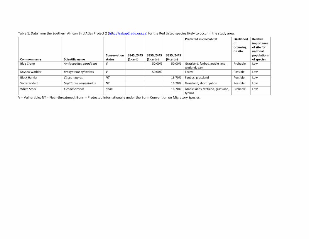
Table 1. Data from the Southern African Bird Atlas Project 2 (http://sabap2.adu.org.za) for the Red Listed species likely to occur in the study area.
Common name Scientific name Conservation status
3345_2445 (1 card)
3350_2445 (2 cards)
3355_2445 (6 cards)
Preferred micro habitat Likelihood of occurring on site
Relative importance of site for national populations of species
Blue Crane Anthropoides paradiseus V 50.00% 50.00% Grassland, fynbos, arable land, wetland, dam
Probable Low
Knysna Warbler Bradypterus sylvaticus V 50.00% Forest Possible Low
Black Harrier Circus maurus NT 16.70% Fynbos, grassland Possible Low
Secretarybird Sagittarius serpentarius NT 16.70% Grassland, short fynbos Possible Low
White Stork Ciconia ciconia Bonn 16.70% Arable lands, wetland, grassland, fynbos
Probable Low
V = Vulnerable; NT = Near‐threatened; Bonn = Protected Internationally under the Bonn Convention on Migratory Species.
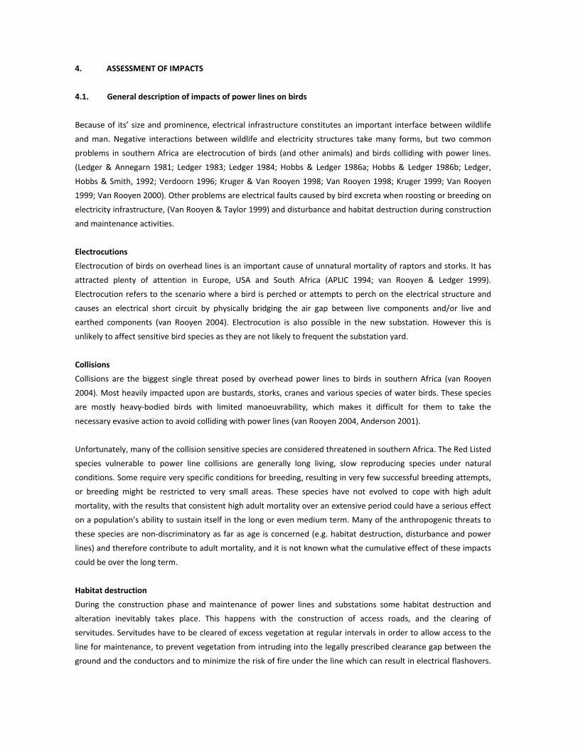
4. ASSESSMENT OF IMPACTS
4.1. General description of impacts of power lines on birds
Because of its’ size and prominence, electrical infrastructure constitutes an important interface between wildlife
and man. Negative interactions between wildlife and electricity structures take many forms, but two common
problems in southern Africa are electrocution of birds (and other animals) and birds colliding with power lines.
(Ledger & Annegarn 1981; Ledger 1983; Ledger 1984; Hobbs & Ledger 1986a; Hobbs & Ledger 1986b; Ledger,
Hobbs & Smith, 1992; Verdoorn 1996; Kruger & Van Rooyen 1998; Van Rooyen 1998; Kruger 1999; Van Rooyen
1999; Van Rooyen 2000). Other problems are electrical faults caused by bird excreta when roosting or breeding on
electricity infrastructure, (Van Rooyen & Taylor 1999) and disturbance and habitat destruction during construction
and maintenance activities.
Electrocutions
Electrocution of birds on overhead lines is an important cause of unnatural mortality of raptors and storks. It has
attracted plenty of attention in Europe, USA and South Africa (APLIC 1994; van Rooyen & Ledger 1999).
Electrocution refers to the scenario where a bird is perched or attempts to perch on the electrical structure and
causes an electrical short circuit by physically bridging the air gap between live components and/or live and
earthed components (van Rooyen 2004). Electrocution is also possible in the new substation. However this is
unlikely to affect sensitive bird species as they are not likely to frequent the substation yard.
Collisions
Collisions are the biggest single threat posed by overhead power lines to birds in southern Africa (van Rooyen
2004). Most heavily impacted upon are bustards, storks, cranes and various species of water birds. These species
are mostly heavy‐bodied birds with limited manoeuvrability, which makes it difficult for them to take the
necessary evasive action to avoid colliding with power lines (van Rooyen 2004, Anderson 2001).
Unfortunately, many of the collision sensitive species are considered threatened in southern Africa. The Red Listed
species vulnerable to power line collisions are generally long living, slow reproducing species under natural
conditions. Some require very specific conditions for breeding, resulting in very few successful breeding attempts,
or breeding might be restricted to very small areas. These species have not evolved to cope with high adult
mortality, with the results that consistent high adult mortality over an extensive period could have a serious effect
on a population’s ability to sustain itself in the long or even medium term. Many of the anthropogenic threats to
these species are non‐discriminatory as far as age is concerned (e.g. habitat destruction, disturbance and power
lines) and therefore contribute to adult mortality, and it is not known what the cumulative effect of these impacts
could be over the long term.
Habitat destruction
During the construction phase and maintenance of power lines and substations some habitat destruction and
alteration inevitably takes place. This happens with the construction of access roads, and the clearing of
servitudes. Servitudes have to be cleared of excess vegetation at regular intervals in order to allow access to the
line for maintenance, to prevent vegetation from intruding into the legally prescribed clearance gap between the
ground and the conductors and to minimize the risk of fire under the line which can result in electrical flashovers.
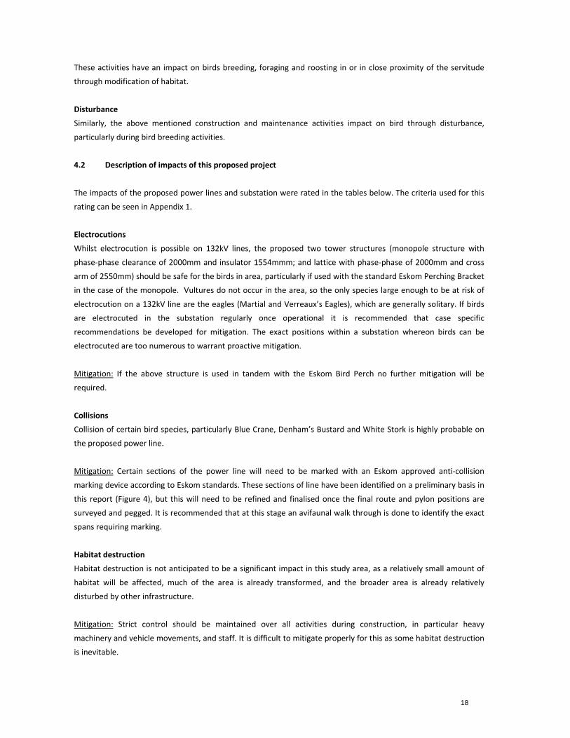
18
These activities have an impact on birds breeding, foraging and roosting in or in close proximity of the servitude
through modification of habitat.
Disturbance
Similarly, the above mentioned construction and maintenance activities impact on bird through disturbance,
particularly during bird breeding activities.
4.2 Description of impacts of this proposed project
The impacts of the proposed power lines and substation were rated in the tables below. The criteria used for this
rating can be seen in Appendix 1.
Electrocutions
Whilst electrocution is possible on 132kV lines, the proposed two tower structures (monopole structure with
phase‐phase clearance of 2000mm and insulator 1554mmm; and lattice with phase‐phase of 2000mm and cross
arm of 2550mm) should be safe for the birds in area, particularly if used with the standard Eskom Perching Bracket
in the case of the monopole. Vultures do not occur in the area, so the only species large enough to be at risk of
electrocution on a 132kV line are the eagles (Martial and Verreaux’s Eagles), which are generally solitary. If birds
are electrocuted in the substation regularly once operational it is recommended that case specific
recommendations be developed for mitigation. The exact positions within a substation whereon birds can be
electrocuted are too numerous to warrant proactive mitigation.
Mitigation: If the above structure is used in tandem with the Eskom Bird Perch no further mitigation will be
required.
Collisions
Collision of certain bird species, particularly Blue Crane, Denham’s Bustard and White Stork is highly probable on
the proposed power line.
Mitigation: Certain sections of the power line will need to be marked with an Eskom approved anti‐collision
marking device according to Eskom standards. These sections of line have been identified on a preliminary basis in
this report (Figure 4), but this will need to be refined and finalised once the final route and pylon positions are
surveyed and pegged. It is recommended that at this stage an avifaunal walk through is done to identify the exact
spans requiring marking.
Habitat destruction
Habitat destruction is not anticipated to be a significant impact in this study area, as a relatively small amount of
habitat will be affected, much of the area is already transformed, and the broader area is already relatively
disturbed by other infrastructure.
Mitigation: Strict control should be maintained over all activities during construction, in particular heavy
machinery and vehicle movements, and staff. It is difficult to mitigate properly for this as some habitat destruction
is inevitable.

19
Disturbance
Disturbance of birds is anticipated to be of low significance in this study area, for the reasons described above for
habitat destruction.
Mitigation: Strict control should be maintained over all activities during construction, in particular heavy
machinery and vehicle movements, and staff. It is difficult to mitigate properly for this as some disturbance is
inevitable.
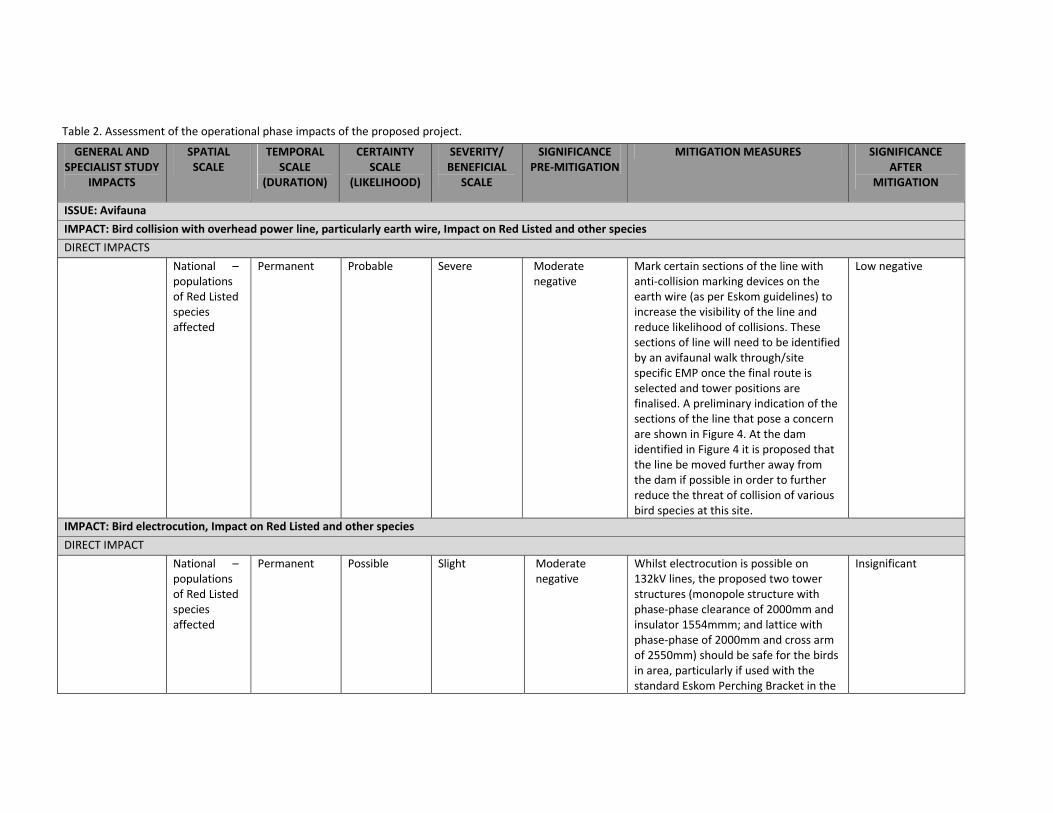
Table 2. Assessment of the operational phase impacts of the proposed project.
GENERAL AND SPECIALIST STUDY
IMPACTS
SPATIAL SCALE
TEMPORAL SCALE
(DURATION)
CERTAINTY SCALE
(LIKELIHOOD)
SEVERITY/ BENEFICIAL
SCALE
SIGNIFICANCE PRE‐MITIGATION
MITIGATION MEASURES SIGNIFICANCEAFTER
MITIGATION
ISSUE: Avifauna
IMPACT: Bird collision with overhead power line, particularly earth wire, Impact on Red Listed and other species
DIRECT IMPACTS
National – populations of Red Listed species affected
Permanent Probable Severe Moderate negative
Mark certain sections of the line with anti‐collision marking devices on the earth wire (as per Eskom guidelines) to increase the visibility of the line and reduce likelihood of collisions. These sections of line will need to be identified by an avifaunal walk through/site specific EMP once the final route is selected and tower positions are finalised. A preliminary indication of the sections of the line that pose a concern are shown in Figure 4. At the dam identified in Figure 4 it is proposed that the line be moved further away from the dam if possible in order to further reduce the threat of collision of various bird species at this site.
Low negative
IMPACT: Bird electrocution, Impact on Red Listed and other species
DIRECT IMPACT
National – populations of Red Listed species affected
Permanent Possible Slight Moderate negative
Whilst electrocution is possible on 132kV lines, the proposed two tower structures (monopole structure with phase‐phase clearance of 2000mm and insulator 1554mmm; and lattice with phase‐phase of 2000mm and cross arm of 2550mm) should be safe for the birds in area, particularly if used with the standard Eskom Perching Bracket in the
Insignificant
21
GENERAL AND SPECIALIST STUDY
IMPACTS
SPATIAL SCALE
TEMPORAL SCALE
(DURATION)
CERTAINTY SCALE
(LIKELIHOOD)
SEVERITY/ BENEFICIAL
SCALE
SIGNIFICANCE PRE‐MITIGATION
MITIGATION MEASURES SIGNIFICANCEAFTER
MITIGATION
case of the monopole. Vultures do not occur in the area, so the only species large enough to be at risk of electrocution on a 132kV line are the eagles, which are generally solitary.
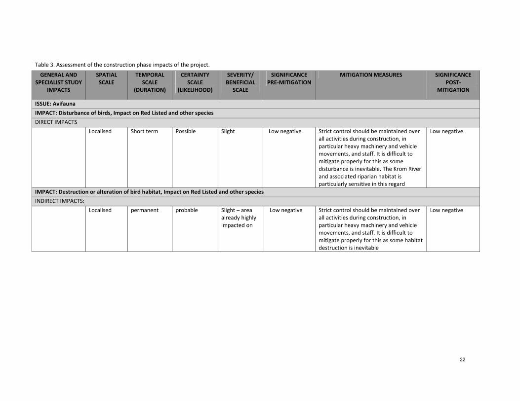
22
Table 3. Assessment of the construction phase impacts of the project.
GENERAL AND SPECIALIST STUDY
IMPACTS
SPATIAL SCALE
TEMPORAL SCALE
(DURATION)
CERTAINTY SCALE
(LIKELIHOOD)
SEVERITY/ BENEFICIAL
SCALE
SIGNIFICANCE PRE‐MITIGATION
MITIGATION MEASURES SIGNIFICANCE POST‐
MITIGATION
ISSUE: Avifauna
IMPACT: Disturbance of birds, Impact on Red Listed and other species
DIRECT IMPACTS
Localised Short term Possible Slight Low negative Strict control should be maintained over all activities during construction, in particular heavy machinery and vehicle movements, and staff. It is difficult to mitigate properly for this as some disturbance is inevitable. The Krom River and associated riparian habitat is particularly sensitive in this regard
Low negative
IMPACT: Destruction or alteration of bird habitat, Impact on Red Listed and other species
INDIRECT IMPACTS:
Localised permanent probable Slight – area already highly impacted on
Low negative Strict control should be maintained over all activities during construction, in particular heavy machinery and vehicle movements, and staff. It is difficult to mitigate properly for this as some habitat destruction is inevitable
Low negative
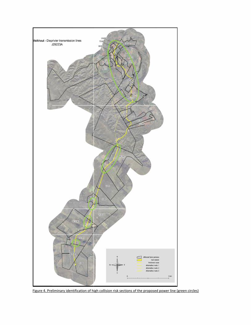
Figure 4. Preliminary identtification of high collision risk sections off the proposed power line
(green circles)
24
Figure 4 identifies the likely high risk sections of power line for collision of birds. From the top, these areas are as
follows:
the Gamtoos River crossings and associated arable area – a flight path for various bird species;
a farm dam and associated pastures – will attract various collision prone species;
a river crossing – flight path for most bird species;
a piggery and dam – this is likely to attract various bird species to forage in the area as the waste from the
piggery will attract various insects and rodents. It is recommended that at this site the route of the power
line be altered if possible to be placed further away from the dam. This will reduce the risk of collision of
various bird species associated with this site. Experience has shown that particularly at dams such as this
one that is frequented by large numbers of birds, marking lines is not always adequate mitigation.
a small wetland – likely to attract various collision prone species.
As mentioned elsewhere in this report, these high risk areas should be considered preliminary. When final pole or
pylon positions and route are available, a more detailed avifaunal ‘walk through’ should be conducted to assess
the collision risk at each of the sites and identify the exact spans of power line that will require marking. At that
time, the most effective marking device available at the time will also be recommended.
5. COMPARISON OF ALTERNATIVES
The preferred alternative from an avifaunal perspective is the preferred route (Figure 1 and 4) for the following
reasons:
The route runs close to the main road for most of its length. This is an advantage as the road is an existing
source of disturbance in the landscape, making it less likely that sensitive bird species will frequent the
area. It is also believed that birds in flight tend to gain altitude when crossing a road as they are aware of
the risk of vehicles. This would mean they would probably be at less risk of collision with the proposed
power line.
The route runs the furthest (approximately 10km) of all alternatives from the IBA described elsewhere in
this report. This is an advantage as threatened bird species dispersing from the IBA are less likely to
interact with the power line than if it were closer.
The route runs adjacent to an existing medium voltage power line for much of its route. This is an
advantage as it is believed that more power lines adjacent to each other become more visible to birds in
flight, partially reducing the risk of collisions. Furthermore fewer new roads would be required for
construction if the proposed power line is placed adjacent to the existing line.
It is therefore recommended that the power line be constructed on the ‘Preferred route’.

25
6. IMPACT STATEMENT
In conclusion, the proposed power line can be built provided that the various mitigation measures recommended
in this report are implemented. Of particular concern is the collision mitigation. Provided that an avifaunal walk
down is done to identify the exact spans requiring collision mitigation in the form of marking devices installed on
the earth wires, this impact should hopefully be restricted to acceptable levels.
7 REFERENCES
Barnes, K.N. (ed.) 1998. The Important Bird Areas of southern Africa. BirdLife South Africa: Johannesburg.
Barnes, K.N. (ed.) 2000. The Eskom Red Listed Book of Birds of South Africa, Lesotho and Swaziland. BirdLife South
Africa: Johannesburg.
Harrison, J.A., Allan, D.G., Underhill, L.G., Herremans, M., Tree, A.J., Parker, V & Brown, C.J. (eds). 1997. The atlas
of southern African birds. Vol. 1&2. BirdLife South Africa: Johannesburg.
Mucina & Rutherford. 2006. The vegetation of South Africa, Lesotho and Swaziland. Strelitzia 19. South African
National Biodiversity Institute, Pretoria.
Young, D.J., Harrison, J.A., Navarro, R.A., Anderson, M.D., & Colahan, B.D. (Eds). 2003. Big Birds on Farms: Mazda
CAR report 1993‐2001. Avian Demography Unit, Cape Town.
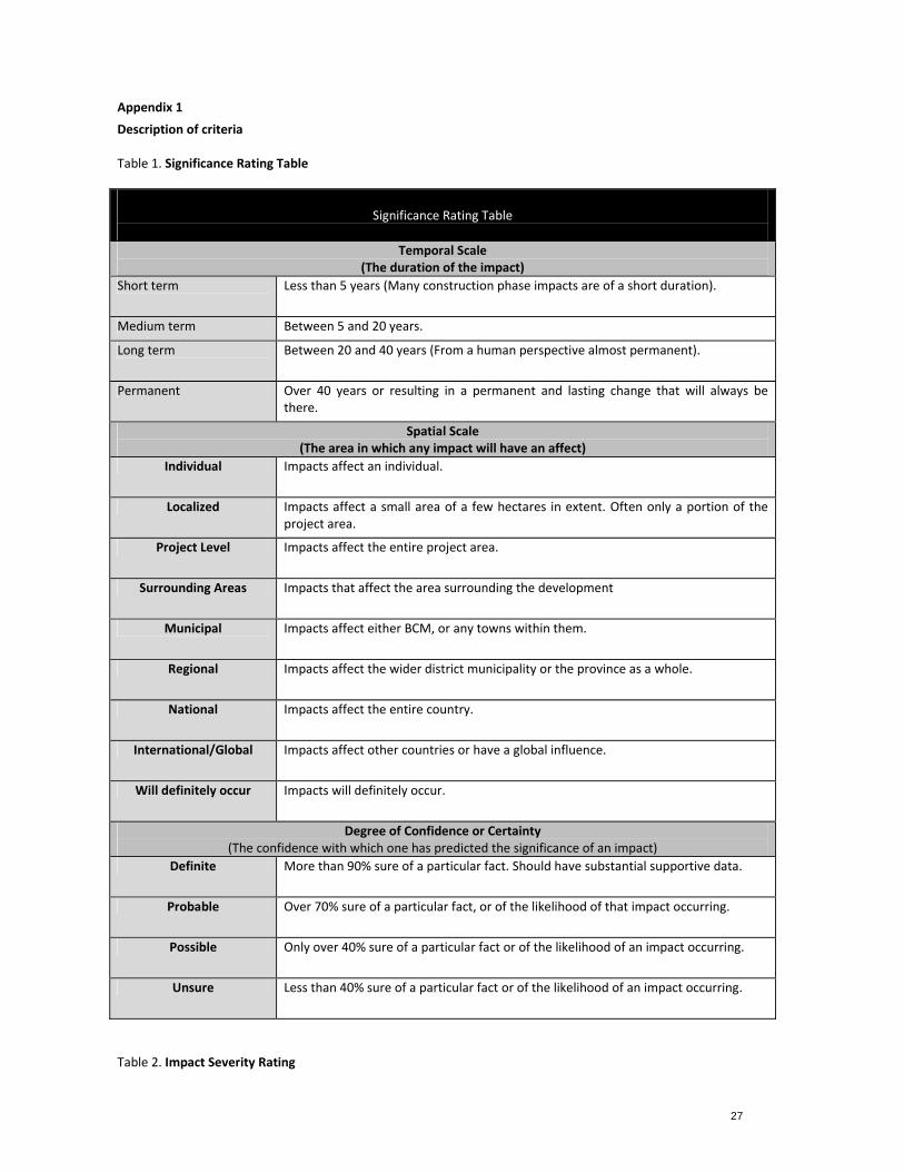
27
Appendix 1
Description of criteria Table 1. Significance Rating Table
Significance Rating Table
Temporal Scale(The duration of the impact)
Short term Less than 5 years (Many construction phase impacts are of a short duration).
Medium term Between 5 and 20 years.
Long term Between 20 and 40 years (From a human perspective almost permanent).
Permanent Over 40 years or resulting in a permanent and lasting change that will always be there.
Spatial Scale(The area in which any impact will have an affect)
Individual Impacts affect an individual.
Localized Impacts affect a small area of a few hectares in extent. Often only a portion of the project area.
Project Level Impacts affect the entire project area.
Surrounding Areas Impacts that affect the area surrounding the development
Municipal Impacts affect either BCM, or any towns within them.
Regional Impacts affect the wider district municipality or the province as a whole.
National Impacts affect the entire country.
International/Global Impacts affect other countries or have a global influence.
Will definitely occur Impacts will definitely occur.
Degree of Confidence or Certainty(The confidence with which one has predicted the significance of an impact)
Definite More than 90% sure of a particular fact. Should have substantial supportive data.
Probable Over 70% sure of a particular fact, or of the likelihood of that impact occurring.
Possible Only over 40% sure of a particular fact or of the likelihood of an impact occurring.
Unsure Less than 40% sure of a particular fact or of the likelihood of an impact occurring.
Table 2. Impact Severity Rating
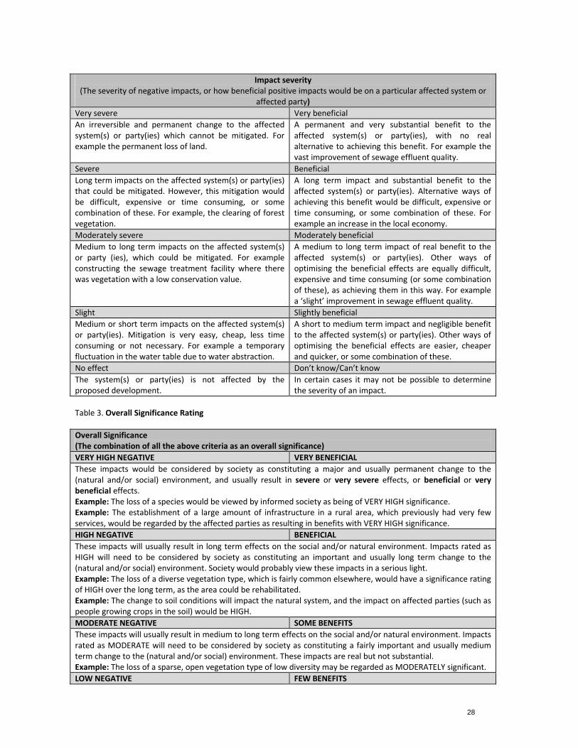
28
Impact severity(The severity of negative impacts, or how beneficial positive impacts would be on a particular affected system or
affected party)
Very severe Very beneficial
An irreversible and permanent change to the affected system(s) or party(ies) which cannot be mitigated. For example the permanent loss of land.
A permanent and very substantial benefit to theaffected system(s) or party(ies), with no real alternative to achieving this benefit. For example the vast improvement of sewage effluent quality.
Severe Beneficial
Long term impacts on the affected system(s) or party(ies) that could be mitigated. However, this mitigation would be difficult, expensive or time consuming, or some combination of these. For example, the clearing of forest vegetation.
A long term impact and substantial benefit to the affected system(s) or party(ies). Alternative ways of achieving this benefit would be difficult, expensive or time consuming, or some combination of these. For example an increase in the local economy.
Moderately severe Moderately beneficial
Medium to long term impacts on the affected system(s) or party (ies), which could be mitigated. For example constructing the sewage treatment facility where there was vegetation with a low conservation value.
A medium to long term impact of real benefit to the affected system(s) or party(ies). Other ways of optimising the beneficial effects are equally difficult, expensive and time consuming (or some combination of these), as achieving them in this way. For example a ‘slight’ improvement in sewage effluent quality.
Slight Slightly beneficial
Medium or short term impacts on the affected system(s) or party(ies). Mitigation is very easy, cheap, less time consuming or not necessary. For example a temporary fluctuation in the water table due to water abstraction.
A short to medium term impact and negligible benefit to the affected system(s) or party(ies). Other ways of optimising the beneficial effects are easier, cheaper and quicker, or some combination of these.
No effect Don’t know/Can’t know
The system(s) or party(ies) is not affected by the proposed development.
In certain cases it may not be possible to determine the severity of an impact.
Table 3. Overall Significance Rating
Overall Significance (The combination of all the above criteria as an overall significance)
VERY HIGH NEGATIVE VERY BENEFICIAL
These impacts would be considered by society as constituting a major and usually permanent change to the (natural and/or social) environment, and usually result in severe or very severe effects, or beneficial or very beneficial effects. Example: The loss of a species would be viewed by informed society as being of VERY HIGH significance. Example: The establishment of a large amount of infrastructure in a rural area, which previously had very few services, would be regarded by the affected parties as resulting in benefits with VERY HIGH significance.
HIGH NEGATIVE BENEFICIAL
These impacts will usually result in long term effects on the social and/or natural environment. Impacts rated as HIGH will need to be considered by society as constituting an important and usually long term change to the (natural and/or social) environment. Society would probably view these impacts in a serious light. Example: The loss of a diverse vegetation type, which is fairly common elsewhere, would have a significance rating of HIGH over the long term, as the area could be rehabilitated. Example: The change to soil conditions will impact the natural system, and the impact on affected parties (such as people growing crops in the soil) would be HIGH.
MODERATE NEGATIVE SOME BENEFITS
These impacts will usually result in medium to long term effects on the social and/or natural environment. Impacts rated as MODERATE will need to be considered by society as constituting a fairly important and usually medium term change to the (natural and/or social) environment. These impacts are real but not substantial. Example: The loss of a sparse, open vegetation type of low diversity may be regarded as MODERATELY significant.
LOW NEGATIVE FEW BENEFITS
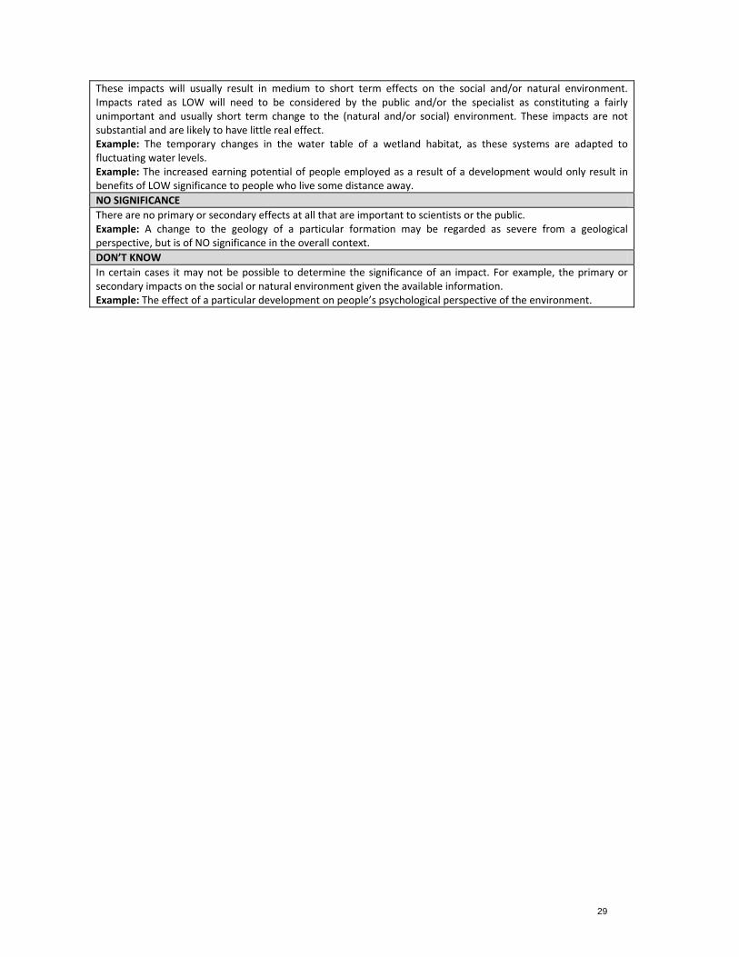
29
These impacts will usually result in medium to short term effects on the social and/or natural environment. Impacts rated as LOW will need to be considered by the public and/or the specialist as constituting a fairly unimportant and usually short term change to the (natural and/or social) environment. These impacts are not substantial and are likely to have little real effect. Example: The temporary changes in the water table of a wetland habitat, as these systems are adapted to fluctuating water levels. Example: The increased earning potential of people employed as a result of a development would only result in benefits of LOW significance to people who live some distance away.
NO SIGNIFICANCE
There are no primary or secondary effects at all that are important to scientists or the public. Example: A change to the geology of a particular formation may be regarded as severe from a geological perspective, but is of NO significance in the overall context.
DON’T KNOW
In certain cases it may not be possible to determine the significance of an impact. For example, the primary or secondary impacts on the social or natural environment given the available information. Example: The effect of a particular development on people’s psychological perspective of the environment.
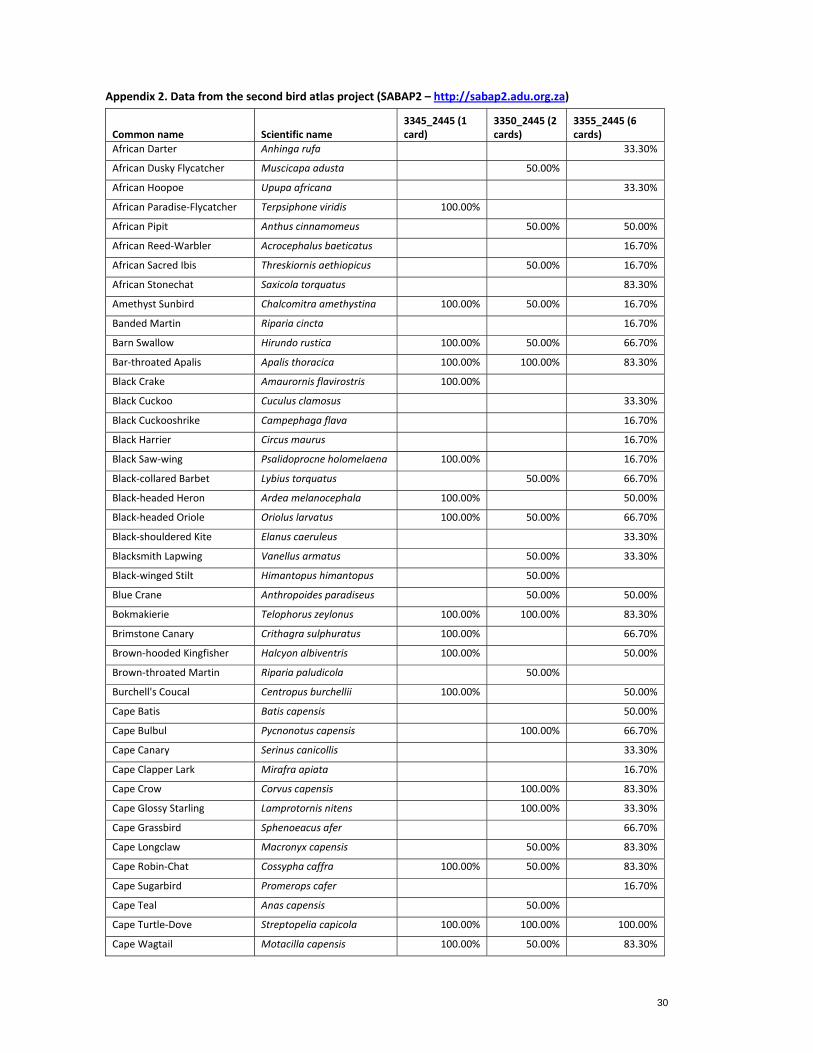
30
Appendix 2. Data from the second bird atlas project (SABAP2 – http://sabap2.adu.org.za)
Common name Scientific name 3345_2445 (1 card)
3350_2445 (2 cards)
3355_2445 (6 cards)
African Darter Anhinga rufa 33.30%
African Dusky Flycatcher Muscicapa adusta 50.00%
African Hoopoe Upupa africana 33.30%
African Paradise‐Flycatcher Terpsiphone viridis 100.00%
African Pipit Anthus cinnamomeus 50.00% 50.00%
African Reed‐Warbler Acrocephalus baeticatus 16.70%
African Sacred Ibis Threskiornis aethiopicus 50.00% 16.70%
African Stonechat Saxicola torquatus 83.30%
Amethyst Sunbird Chalcomitra amethystina 100.00% 50.00% 16.70%
Banded Martin Riparia cincta 16.70%
Barn Swallow Hirundo rustica 100.00% 50.00% 66.70%
Bar‐throated Apalis Apalis thoracica 100.00% 100.00% 83.30%
Black Crake Amaurornis flavirostris 100.00%
Black Cuckoo Cuculus clamosus 33.30%
Black Cuckooshrike Campephaga flava 16.70%
Black Harrier Circus maurus 16.70%
Black Saw‐wing Psalidoprocne holomelaena 100.00% 16.70%
Black‐collared Barbet Lybius torquatus 50.00% 66.70%
Black‐headed Heron Ardea melanocephala 100.00% 50.00%
Black‐headed Oriole Oriolus larvatus 100.00% 50.00% 66.70%
Black‐shouldered Kite Elanus caeruleus 33.30%
Blacksmith Lapwing Vanellus armatus 50.00% 33.30%
Black‐winged Stilt Himantopus himantopus 50.00%
Blue Crane Anthropoides paradiseus 50.00% 50.00%
Bokmakierie Telophorus zeylonus 100.00% 100.00% 83.30%
Brimstone Canary Crithagra sulphuratus 100.00% 66.70%
Brown‐hooded Kingfisher Halcyon albiventris 100.00% 50.00%
Brown‐throated Martin Riparia paludicola 50.00%
Burchell's Coucal Centropus burchellii 100.00% 50.00%
Cape Batis Batis capensis 50.00%
Cape Bulbul Pycnonotus capensis 100.00% 66.70%
Cape Canary Serinus canicollis 33.30%
Cape Clapper Lark Mirafra apiata 16.70%
Cape Crow Corvus capensis 100.00% 83.30%
Cape Glossy Starling Lamprotornis nitens 100.00% 33.30%
Cape Grassbird Sphenoeacus afer 66.70%
Cape Longclaw Macronyx capensis 50.00% 83.30%
Cape Robin‐Chat Cossypha caffra 100.00% 50.00% 83.30%
Cape Sugarbird Promerops cafer 16.70%
Cape Teal Anas capensis 50.00%
Cape Turtle‐Dove Streptopelia capicola 100.00% 100.00% 100.00%
Cape Wagtail Motacilla capensis 100.00% 50.00% 83.30%
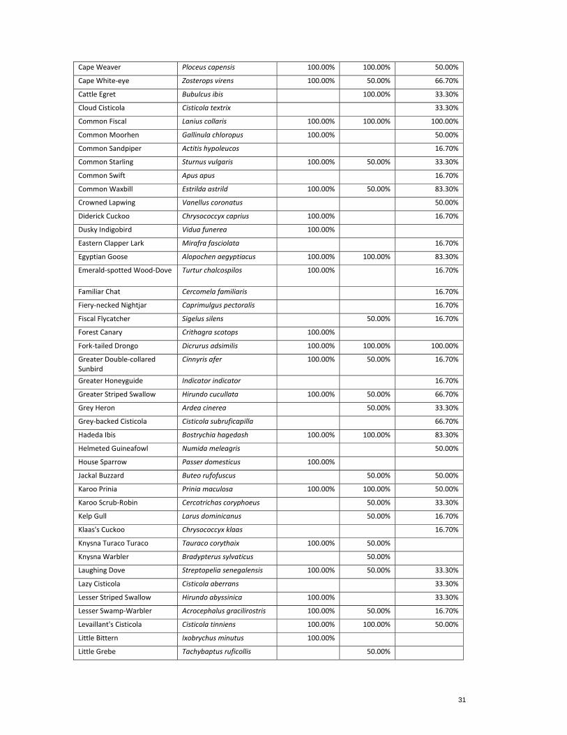
31
Cape Weaver Ploceus capensis 100.00% 100.00% 50.00%
Cape White‐eye Zosterops virens 100.00% 50.00% 66.70%
Cattle Egret Bubulcus ibis 100.00% 33.30%
Cloud Cisticola Cisticola textrix 33.30%
Common Fiscal Lanius collaris 100.00% 100.00% 100.00%
Common Moorhen Gallinula chloropus 100.00% 50.00%
Common Sandpiper Actitis hypoleucos 16.70%
Common Starling Sturnus vulgaris 100.00% 50.00% 33.30%
Common Swift Apus apus 16.70%
Common Waxbill Estrilda astrild 100.00% 50.00% 83.30%
Crowned Lapwing Vanellus coronatus 50.00%
Diderick Cuckoo Chrysococcyx caprius 100.00% 16.70%
Dusky Indigobird Vidua funerea 100.00%
Eastern Clapper Lark Mirafra fasciolata 16.70%
Egyptian Goose Alopochen aegyptiacus 100.00% 100.00% 83.30%
Emerald‐spotted Wood‐Dove Turtur chalcospilos 100.00% 16.70%
Familiar Chat Cercomela familiaris 16.70%
Fiery‐necked Nightjar Caprimulgus pectoralis 16.70%
Fiscal Flycatcher Sigelus silens 50.00% 16.70%
Forest Canary Crithagra scotops 100.00%
Fork‐tailed Drongo Dicrurus adsimilis 100.00% 100.00% 100.00%
Greater Double‐collared Sunbird
Cinnyris afer 100.00% 50.00% 16.70%
Greater Honeyguide Indicator indicator 16.70%
Greater Striped Swallow Hirundo cucullata 100.00% 50.00% 66.70%
Grey Heron Ardea cinerea 50.00% 33.30%
Grey‐backed Cisticola Cisticola subruficapilla 66.70%
Hadeda Ibis Bostrychia hagedash 100.00% 100.00% 83.30%
Helmeted Guineafowl Numida meleagris 50.00%
House Sparrow Passer domesticus 100.00%
Jackal Buzzard Buteo rufofuscus 50.00% 50.00%
Karoo Prinia Prinia maculosa 100.00% 100.00% 50.00%
Karoo Scrub‐Robin Cercotrichas coryphoeus 50.00% 33.30%
Kelp Gull Larus dominicanus 50.00% 16.70%
Klaas's Cuckoo Chrysococcyx klaas 16.70%
Knysna Turaco Turaco Tauraco corythaix 100.00% 50.00%
Knysna Warbler Bradypterus sylvaticus 50.00%
Laughing Dove Streptopelia senegalensis 100.00% 50.00% 33.30%
Lazy Cisticola Cisticola aberrans 33.30%
Lesser Striped Swallow Hirundo abyssinica 100.00% 33.30%
Lesser Swamp‐Warbler Acrocephalus gracilirostris 100.00% 50.00% 16.70%
Levaillant's Cisticola Cisticola tinniens 100.00% 100.00% 50.00%
Little Bittern Ixobrychus minutus 100.00%
Little Grebe Tachybaptus ruficollis 50.00%
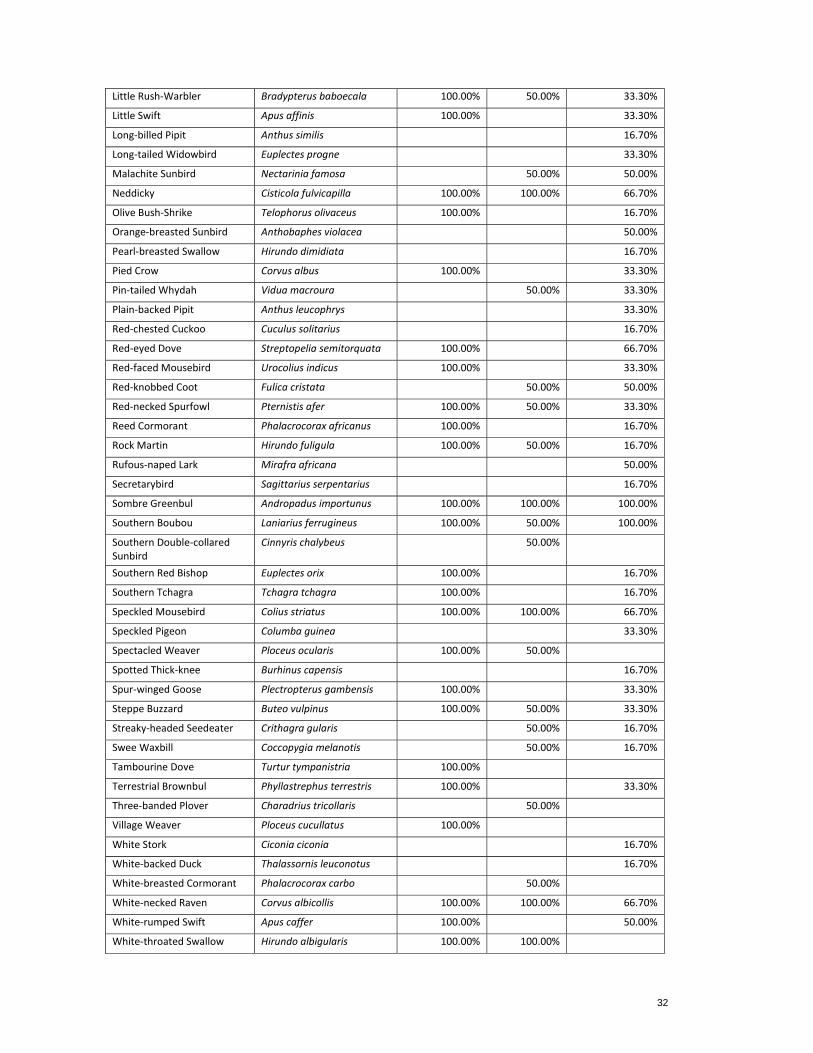
32
Little Rush‐Warbler Bradypterus baboecala 100.00% 50.00% 33.30%
Little Swift Apus affinis 100.00% 33.30%
Long‐billed Pipit Anthus similis 16.70%
Long‐tailed Widowbird Euplectes progne 33.30%
Malachite Sunbird Nectarinia famosa 50.00% 50.00%
Neddicky Cisticola fulvicapilla 100.00% 100.00% 66.70%
Olive Bush‐Shrike Telophorus olivaceus 100.00% 16.70%
Orange‐breasted Sunbird Anthobaphes violacea 50.00%
Pearl‐breasted Swallow Hirundo dimidiata 16.70%
Pied Crow Corvus albus 100.00% 33.30%
Pin‐tailed Whydah Vidua macroura 50.00% 33.30%
Plain‐backed Pipit Anthus leucophrys 33.30%
Red‐chested Cuckoo Cuculus solitarius 16.70%
Red‐eyed Dove Streptopelia semitorquata 100.00% 66.70%
Red‐faced Mousebird Urocolius indicus 100.00% 33.30%
Red‐knobbed Coot Fulica cristata 50.00% 50.00%
Red‐necked Spurfowl Pternistis afer 100.00% 50.00% 33.30%
Reed Cormorant Phalacrocorax africanus 100.00% 16.70%
Rock Martin Hirundo fuligula 100.00% 50.00% 16.70%
Rufous‐naped Lark Mirafra africana 50.00%
Secretarybird Sagittarius serpentarius 16.70%
Sombre Greenbul Andropadus importunus 100.00% 100.00% 100.00%
Southern Boubou Laniarius ferrugineus 100.00% 50.00% 100.00%
Southern Double‐collared Sunbird
Cinnyris chalybeus 50.00%
Southern Red Bishop Euplectes orix 100.00% 16.70%
Southern Tchagra Tchagra tchagra 100.00% 16.70%
Speckled Mousebird Colius striatus 100.00% 100.00% 66.70%
Speckled Pigeon Columba guinea 33.30%
Spectacled Weaver Ploceus ocularis 100.00% 50.00%
Spotted Thick‐knee Burhinus capensis 16.70%
Spur‐winged Goose Plectropterus gambensis 100.00% 33.30%
Steppe Buzzard Buteo vulpinus 100.00% 50.00% 33.30%
Streaky‐headed Seedeater Crithagra gularis 50.00% 16.70%
Swee Waxbill Coccopygia melanotis 50.00% 16.70%
Tambourine Dove Turtur tympanistria 100.00%
Terrestrial Brownbul Phyllastrephus terrestris 100.00% 33.30%
Three‐banded Plover Charadrius tricollaris 50.00%
Village Weaver Ploceus cucullatus 100.00%
White Stork Ciconia ciconia 16.70%
White‐backed Duck Thalassornis leuconotus 16.70%
White‐breasted Cormorant Phalacrocorax carbo 50.00%
White‐necked Raven Corvus albicollis 100.00% 100.00% 66.70%
White‐rumped Swift Apus caffer 100.00% 50.00%
White‐throated Swallow Hirundo albigularis 100.00% 100.00%

33
Willow Warbler Phylloscopus trochilus 100.00% 33.30%
Yellow Bishop Euplectes capensis 50.00% 66.70%
Yellow Canary Crithagra flaviventris 50.00% 16.70%
Yellow‐billed Duck Anas undulata 100.00% 50.00%
Yellow‐breasted Apalis Apalis flavida 50.00%
Yellow‐fronted Canary Crithagra mozambicus 50.00%
Zitting Cisticola Cisticola juncidis 16.70%

Melkhout- Patensie dBAR_v0.4_lowres.doc
APPENDIX D2
Vegetation Impact Assessment
Melkhout- Patensie dBAR_v0.4_lowres.doc
Terms of Reference: Ecological Assessment
1. Carry out fieldwork to locate and describe the terrestrial vegetation on the study area, key focus on the impact footprint(s) for sensitive site(s). No faunal assessments will be undertaken within the scope of this study.
2. Determine the species present and localities within each vegetation types. 3. Determine whether the study area falls wholly or partially within the distribution range of species
listed as Vulnerable, Endangered, Critically Endangered, Protected, IUCN Red Listed or Endemic. 4. Provide a description of the current state of the vegetation on site supported by relevant
photographs. 5. Identify and describe the conservation value and conservation planning frameworks relevant to this site
(Regional Planning) for represented vegetation units. 6. Describe the areas where indigenous vegetation has been transformed. 7. Determine alien species present; their distribution within the study area and recommended
management actions. 8. Note and record the position of unusually large specimens of trees, where applicable. 9. Provide a detailed vegetation sensitivity map of the site, including mapping of disturbance and
transformation on site. 10. Identify and rate potential impacts, outline mitigatory measures and outline additional management
guidelines. 11. Environmental Management Programme (EMPr) recommendations relating to flora and vegetation,
including generic rehabilitation and revegetation guideline will be provided in the report. 12. Draft an impact statement of the proposed development on the identified vegetation units.
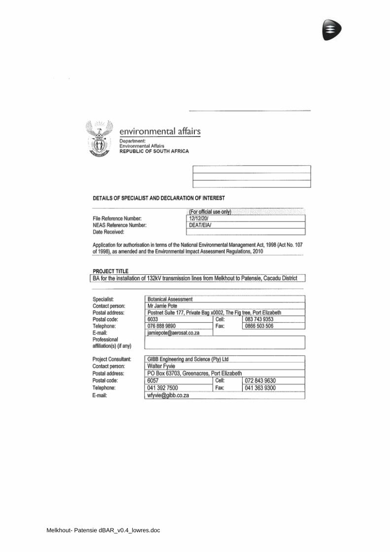
Melkhout- Patensie dBAR_v0.4_lowres.doc
Melkhout- Patensie dBAR_v0.4_lowres.doc
i
27 May 2012
Botanical Assessment for
Proposed Melkhout (Humansdorp) to Hankey
Eskom 132 kV Powerline
Author
Jamie Pote
Postnet Suite 177, Private Bag X0002
Fig Tree, Port Elizabeth, 6033
Email: [email protected]
Cell: 083 743 9353, Fax: 0866 503 506
Client
Arcus Gibb/Eskom
Port Elizabeth
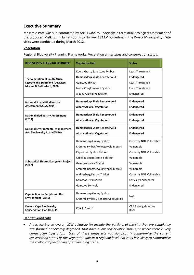
ii
Executive Summary
Mr Jamie Pote was sub-contracted by Arcus Gibb to undertake a terrestrial ecological assessment of the proposed Melkhout (Humansdorp) to Hankey 132 kV powerline in the Kouga Municipality. Site visits were conducted during March 2012.
Vegetation
Regional Biodiversity Planning Frameworks: Vegetation units/types and conservation status.
BIODIVERSITY PLANNING RESOURCE Vegetation Unit Status
The Vegetation of South Africa Lesotho and Swaziland (VegMap; Mucina & Rutherford, 2006)
Kouga Grassy Sandstone Fynbos
Humansdorp Shale Renosterveld
Gamtoos Thicket
Loerie Conglomerate Fynbos
Albany Alluvial Vegetation
Least Threatened
Endangered
Least Threatened
Least Threatened
Endangered
National Spatial Biodiversity Assessment NSBA, 2004)
Humansdorp Shale Renosterveld
Albany Alluvial Vegetation
Endangered
Endangered
National Biodiversity Assessment (2011)
Humansdorp Shale Renosterveld
Albany Alluvial Vegetation
Endangered
Endangered
National Environmental Management Act: Biodiversity Act (NEMBA)
Humansdorp Shale Renosterveld
Albany Alluvial Vegetation
Endangered
Endangered
Subtropical Thicket Ecosystem Project (STEP)
Humansdorp Grassy Fynbos
Kromme Fynbos/Renosterveld Mosaic
Klipfontein Fynbos Thicket
Kabeljous Renosterveld Thicket
Gamtoos Valley Thicket
Kromme Renosterveld/Fynbos Mosaic
Andriesberg Fynbos Thicket
Gamtoos Gwarrieveld
Gamtoos Bontveld
Currently NOT Vulnerable
Vulnerable
Currently NOT Vulnerable
Vulnerable
Vulnerable
Vulnerable
Currently NOT Vulnerable
Critically Endangered
Endangered
Cape Action for People and the Environment (CAPE)
Humansdorp Grassy Fynbos
Kromme Fynbos / Renosterveld Mosaic N/A
Eastern Cape Biodiversity Conservation Plan (ECBCP)
CBA 1, 2 and 3 CBA 1 along Gamtoos River
Habitat Sensitivity
Areas scoring an overall LOW vulnerability include the portions of the site that are completely transformed or severely degraded, that have a low conservation status, or where there is very dense alien infestation. Loss of these areas will not significantly compromise the current conservation status of the vegetation unit at a regional level, nor is its loss likely to compromise the ecological functioning of surrounding areas.
iii
Areas scoring an overall MODERATE vulnerability include the intact portions of vegetation tend to have a moderate sensitivity score.
Areas scoring an overall HIGH to VERY HIGH vulnerability includes areas having a Critically Endangered or Endangered conservation status, or critical ecological process and critical biodiversity areas.
Vegetation and Flora Impacts
The proposed development is likely to have a number of impacts on the plants and plant communities within the site. The three key impacts are: (a) loss of habitat; (b) loss of species of special concern or SSC habitat and (c) reduction or changes to ecological processes/functioning. These can be further subdivided into sub-impacts as follows:
A. Issue 1: Direct loss of natural vegetation habitat as a result of vegetation clearing for servitude; 1. Direct loss of habitat; 2. Direct loss of Rocky Refugia; 3. Direct loss of Thicket or Forest vegetation in drainage lines 4. Direct loss of Riparian vegetation along drainage lines 5. Direct loss of seep/wetland/seasonal pan vegetation
B. Issue 2: Direct loss of Species of Special Concern and associated habitat: 6. Loss of habitat for species of special concern; 7. Loss of Species of Special Concern
C. Issue 3: Ecological Process Changes 8. Increased risk of alien invasion in drainage lines; 9. Clearing of alien invasives from within the servitude and drainage lines.
1. Disruptions to Ecological Processes as a result of habitat fragmentation
In summary, the overall the development of the project is predicted to result in a negative impact of very low to medium significance.
The following key conclusions are reached regarding impacts on flora:
In general the servitude passes through degraded and transformed vegetation, with segments passing through areas of intact and near intact vegetation;
Only some intact Albany Alluvial Vegetation is present within the Powerline servitude, which has a NBA (2011) conservation status of Critically Endangered. Impacts wil be minimal as most of the servitude passes through agricultural areas and along the periphery of some intact and degraded Albany Alluvial Vegetation.
The proposed activity will NOT result in the clearing of greater than 300 square meters of Endangered Albany Alluvial Vegetation or Humansdorp Shale Renosterveld and a permit in terms of section 57(1) of NEMBA is NOT required to carry out 'restricted activities' (including uprooting, damaging, destroying specimens) of listed threatened or protected species (as listed in terms of section 56 of NEMBA).
As part of the EMP, an ECO/ESO should be appointed to manage the identification and relocation of Species of Special Concern and management of vegetation clearing and subsequent revegetation and rehabilitation. A detailed EMP should be compiled to address these issues before construction commences.
It is recommended that individual screening is undertaken as part of the construction phase EMP for the areas identified as having elevated sensitivities, including drainage lines and river crossings with intact Thicket and areas with intact Albany Alluvial Vegetation to micro-site the pylons in order to minimise impact.
iv
Some ephemeral/temporary wetlands, pans and dams occur within or adjacent to the powerline servitude. No powerline pylons should be sited within wetlands, pans and dams and a 32 m exclusion buffer should be placed around these features. Suitable management of these must be addressed in the EMP to minimise impacts during the construction phase, relating particularly to siltation due to soil erosion and permanent changes to drainage lines that may alter wetland processes.
Care should be taken that no power line pylons are sited in wetlands and temporary seasonal pans (32 m exclusion zone around these features). Should it be unavoidable, relevant permissions will need to be obtained from DWAF.
Powerlines passing through riverine thicket/forest patches should be sited such that impacts to this vegetation is minimised.
The substations and pylons must avoid any wetland areas (including seasonal wetlands, pans and seeps), other sensitive vegetation (thicket and forest), drainage lines and riparian vegetation along river banks. Should it be unavoidable, relevant permissions will need to be obtained from DWAF.
No powerline pylons should be placed within the 1:50 year flood line or on flood plains that may be susceptible to future flooding.
v
Indemnity and conditions relating to this project
The findings, results, observations, conclusions and recommendations given in this report are based on the author’s best scientific and professional knowledge as well as available information. The report is based on survey and assessment techniques which are limited by time and budgetary constraints relevant to the type and level of investigation undertaken and the author reserves the right to modify aspects of the report including the recommendations if and when new information may become available from ongoing research or further work in this field, or pertaining to this investigation.
Although the author exercises due care and diligence in rendering services and preparing documents, he accepts no liability, and the client, by receiving this document, indemnifies the author against all actions, claims, demands, losses, liabilities, costs, damages and expenses arising from or in connection with services rendered, directly or indirectly by the author and by the use of this document.
Copyright
This report must not be altered or added to without the prior written consent of the author. This also refers to electronic copies of this report which are supplied for the purposes of inclusion as part of other reports, including main reports. Similarly, any recommendations, statements or conclusions drawn from or based upon this report must make reference to this report. If these form part of a main report relating to this investigation or report, this report must be included in its entirety as an appendix or separate section to the main report.
Limitations of the study
A number of limitations affect the compilation of the report including:
No assessment has been made of ecological aspects relating to wetlands, pans and rivers/seeps outside of the scope of this botanical report.
Botanical Assessments based on a limited sampling time may not reflect species composition completely, but has been supplemented with desktop based distribution data.
vi
Definitions and terminology used in this report:
Annual: Completing the cycle from seed to death in one year or season.
Arboreal: Living in trees
Biennial: Completing the cycle from seed to death in two years or seasons.
Boundary: Landscape patches have a boundary between them which can be defined or fuzzy (Sanderson and Harris 2000). The zone composed of the edges of adjacent ecosystems is the boundary.
Composition: refers to the number of patch types (see below) represented on a landscape, and their relative abundance.
Connectivity: the measure of how connected or spatially continuous a corridor, network, or matrix is. For example, a forested landscape (the matrix) with fewer gaps in forest cover (open patches) will have higher connectivity.
Corridors: have important functions as strips of a particular type of landscape differing from adjacent land on both sides.
Disturbance: an event that significantly alters the pattern of variation in the structure or function of a system, while fragmentation is the breaking up of a habitat, ecosystem, or land-use type into smaller parcels. Disturbance is generally considered a natural process.
ECO/ESO: Environmental Site/Control Officer – person responsible for the Day-to-Day Environmental Management on-site during construction.
Ecocline: a type of landscape boundary, with a gradual and continuous change in environmental conditions of an ecosystem or community. Ecoclines help explain the distribution and diversity of organisms within a landscape because certain organisms survive better under certain conditions, which change along the ecocline. They contain heterogeneous communities which are considered more environmentally stable than those of ecotones.
Ecological processes: Ecological processes are the interactions between plants, animals and the non-living components of the environment like climate or rocks. These processes are crucial for maintaining healthy ecosystems and supporting the long-term persistence of biodiversity.
Ecosystem: All of the organisms of a particular habitat, such as a lake or forest, together with the physical environment in which they live
Ecotone: the transitional zone between two communities. Ecotones can arise naturally, such as a lakeshore, or can be human-created, such as a cleared agricultural field from a forest. The ecotonal community retains characteristics of each bordering community and often contains species not found in the adjacent communities. Classic examples of ecotones include fencerows; forest to marshlands transitions; forest to grassland transitions; or land-water interfaces such as riparian zones in forests. Characteristics of ecotones include vegetational sharpness, physiognomic change, and occurrence of a spatial community mosaic, many exotic species, ecotonal species, spatial mass effect, and species richness higher or lower than either side of the ecotone.
Edge: the portion of an ecosystem near its perimeter, where influences of the adjacent patches can cause an environmental difference between the interior of the patch and its edge. This edge effect includes a distinctive species composition or abundance in the outer part of the landscape patch. For example, when a landscape is a mosaic of perceptibly different types, such as a forest adjacent to a grassland, the edge is the location where the two types adjoin. In a continuous landscape, such as a forest giving way to open woodland, the exact edge location is fuzzy and is sometimes determined by a local gradient exceeding a threshold, such as the point where the tree cover falls below thirty-five percent.
Emergent trees: Trees that grow above the top of the canopy
Endemic: Referring to a species that is native to a particular place and found nowhere else.
vii
Exotic: Non-indigenous; introduced from elsewhere, may also be a weed or invasive species.
Fragmentation: causes land transformation, an important current process in landscapes as more and more development occurs.
Function: refers to how each element in the landscape interacts based on its life cycle events.
Heterogeneity: A landscape with structure and pattern implies that it has spatial heterogeneity or the uneven, non-random distribution of objects across the landscape.
Indigenous: Native; naturally occurring.
Invasive: a non-indigenous plant or animal species that adversely affect the habitats it invades economically, environmentally or ecologically.
Matrix: the “background ecological system” of a landscape with a high degree of connectivity.
Network: an interconnected system of corridors while mosaic describes the pattern of patches, corridors and matrix that form a landscape in its entirety.
Patch: a term fundamental to landscape ecology, is defined as a relatively homogeneous area that differs from its surroundings. Patches are the basic unit of the landscape that change and fluctuate, a process called patch dynamics. Patches have a definite shape and spatial configuration, and can be described compositionally by internal variables such as number of trees, number of tree species, height of trees, or other similar measurements.
Pattern: is the term for the contents and internal order of a heterogeneous area of land.
Refuge: a location of an isolated or relict population of a once widespread animal or plant species
Rill: A very small stream of water
Riparian: pertaining to, situated on or associated with a river bank
Shrub: A woody plant that produces no trunk but branches from the base.
STEP: Sub-Tropical Ecosystem Planning.
Structure: is determined by the composition, the configuration, and the proportion of different patches across the landscape.
Sustainable: The term ‘sustainable’ in relation to biological resources is defined as ‘sustainable’ in relation to the use of a biological resource, means the use of such resource in a way and at a rate that:
o would not lead to its long term decline o would not disrupt the ecological integrity of the ecosystem in which it occurs and o would ensure its continued use to meet the needs and aspirations of present and
future generations of people.
Tributary/Drainage line: A small stream or river flowing into a larger one.
Weed: an indigenous or non-indigenous plant that grows and reproduces aggressively, usually a ruderal pioneer of disturbed areas. Weeds may be unwanted because they are unsightly, or they limit the growth of other plants by blocking light or using up nutrients from the soil. They also can harbour and spread plant pathogens.
viii
Table of Contents
CHAPTER 1: BACKGROUND 13
1.1 TERMS OF REFERENCE 13
1.2 DESCRIPTION OF ASPECTS OF THE PROJECT THAT POTENTIALLY COULD CAUSE IMPACTS ON THE VEGETATION AND FLORA 13
1.3 LAWS AND POLICIES RELATING TO THE NATURAL ENVIRONMENT 14
1.3.1 Constitution of the Republic of South Africa (Act 108, 1996), article 24 (b) – (c) 14
1.3.2 National Environmental Management Act (NEMA) (Act 107 of 1998) 14
1.3.3 National Environmental Management: Biodiversity Act 10 of 2004 15
1.3.4 National Environmental Management Protected Areas Act 57 of 2003 15
1.3.5 National Biodiversity Strategy Action Plan (NBSAP) (DEAT 2005) 16
1.3.6 Draft National Strategy for Sustainable Development (DEAT 2006) 16
1.3.7 Provincial Growth and Development Strategy Green Paper (Department of the Premier 2006) 16
1.3.8 National Spatial Biodiversity Assessment (NSBA) 2004 (Driver et al 2005) 17
1.3.9 Environment Conservation Act and Regulations GN154 17
1.3.10 Conservation of Agricultural Resources Act 43 of 1983 and Conservation of Agricultural Resources Regulations. 18
1.3.11 Forest Act 122 of 1984 18
1.3.12 National Forests Act 84 of 1998 18
1.3.13 Provincial Nature Conservation Ordinance (PNCO) of 1974 18
1.3.14 National Environmental Management: Biodiversity Act, (NEMBA) 18
1.4 RELEVANT AFFECTED ENVIRONMENTAL IMPACT ASSESSMENT REGULATIONS 19
1.4.1 National list of ecosystems that are threatened and in need of protection according to National Environmental Management: Biodiversity Act, 2004 (act no. 10 of 2004) 19
1.5 DESCRIPTION OF THE AFFECTED ENVIRONMENT 20
1.5.1 Site Location 20
1.5.2 Site Topography 20
CHAPTER 2: REGIONAL PLANNING FRAMEWORKS 20
2.1 REGIONAL PLANNING FRAMEWORK 20
2.1.1 Vegetation of Southern Africa 21
ix
2.1.2 National Biodiversity Assessment (2011) 28
2.1.3 Bioregional Plans, Critical Biodiversity Areas and Ecological Process Areas 28
2.1.4 Biodiversity offsets 29
2.2 PROTECTED PLANTS 29
CHAPTER 3: VEGETATION DESCRIPTION AND FLORAL COMPOSITION 30
3.1 ECOLOGICAL STATE AND SENSITIVITY OF VEGETATION 30
3.1.1 Perceived Reference State (PRS) 30
3.1.2 Present Ecological State (PES) 30
3.1.3 Terrestrial Vegetation Vulnerability Assessment 37
3.1.4 Protection status and Species of Special Concern 43
3.1.5 Alien Invasive Plant species 44
3.1.6 Potential Trade-offs and Biodiversity Offsets 44
CHAPTER 4: PREDICTION OF ENVIRONMENTAL IMPACTS 45
4.1 INTRODUCTION 45
4.2 NATURAL HABITATS AND BIODIVERSITY THREATS 45
4.3 EXISTING IMPACTS 45
4.4 PROPOSED PROJECT ACTIONS 45
4.5 GENERAL IMPACT RATING SCALE FOR SPECIALISTS/ BASELINE DATA 46
4.5.1 The Severity/ Beneficial Scale 46
4.5.2 Spatial and Temporal Scales 47
4.5.3 The Degree of Certainty and the Likelihood Scale 48
4.5.4 The Environmental Significance Scale 48
4.5.5 Absence of Data 49
4.6 IDENTIFIED ENVIRONMENTAL IMPACTS 49
4.6.1 Direct loss of habitat 50
4.6.2 Direct loss of Rocky Refugia; 50
4.6.3 Direct loss of Thicket or Forest Vegetation along drainage lines; 50
4.6.4 Direct loss of Riparian vegetation along drainage lines 50
4.6.5 Direct loss of seep/wetland/seasonal pan vegetation 51
4.6.6 Loss of habitat for species of special concern 51
4.6.7 Loss species of special concern 51
x
4.6.8 Increased risk of alien invasion in drainage lines and along cleared servitude51
4.6.9 Clearing of alien invasives from within the site and drainage lines 52
4.6.10 Disruptions to Ecological Processes as a result of habitat fragmentation 52
4.6.11 Cumulative Impacts 52
4.6.12 Assessment of the reversibility of impact 52
4.6.13 Assessment of the degree to which the impact causes irreplaceable loss of resources 52
CHAPTER 5: CONCLUSIONS AND RECOMMENDATIONS 54
5.1 RISKS AND UNCERTAINTIES 54
5.2 REHABILITATION POTENTIAL AND PROCESSES 55
5.2.1 Rehabilitation Objective 55
5.2.2 Rehabilitation Plan 55
5.2.3 Monitoring and Reporting 56
5.3 ENVIRONMENTAL MANAGEMENT PLAN 56
5.3.1 No Go Areas 56
5.3.2 Alien vegetation clearing 57
5.3.3 River crossings 57
5.3.4 Search and Rescue of SSC 57
CHAPTER 6: REFERENCES 58
CHAPTER 7: MAPS 59
List of Tables Table 3.1: Summary of Present Ecological State indicators of the study area. .................................... 39
Table 3.2: Species having protection status under PNCO, NFA or IUCN occurring in the area. ........... 43
Table 3.3: Alien Invasive plants and common weeds present and CARA classification. ...................... 44
Table 4.1: Impact summary table. ........................................................................................................ 53
List of Figures Figure 1-1: Powerline Route between the southern Melkhout and northern Hankey/Patensie substations. ........................................................................................................................................... 20
Figure 2.1: Vegetation units and conservation status (Mucina and Rutherford, 2006). ...................... 22
Figure 3.1: Degraded Kouga Grassy Sandstone Fynbos near Melkhout substation. ........................... 30
xi
Figure 3.2: Kouga Grassy Sandstone Fynbos north of Melkhout substation. ....................................... 30
Figure 3.3: Degraded Kouga Grassy Sandstone Fynbos north of Melkhout substation. ...................... 31
Figure 3.4: Ephemeral Wetland Pans between Humansdorp and Hankey........................................... 31
Figure 3.5: Intact Kouga Grassy Sandstone Fynbos. ............................................................................ 31
Figure 3.6: Clumps of Gamtoos Thicket with Loerie Conglomerate Fynbos near Hankey. .................. 31
Figure 3.7: Clumps of Gamtoos Thicket near Hankey. .......................................................................... 31
Figure 3.8: Hills with Loerie Conglomerate Fynbos near Hankey. ........................................................ 31
Figure 3.9: Hills with Loerie Conglomerate Fynbos near Hankey. ........................................................ 32
Figure 3.10: Hills with Loerie Conglomerate Fynbos near Hankey. ...................................................... 32
Figure 3.11: Slope with Loerie Conglomerate Fynbos near Hankey. .................................................... 32
Figure 3.12: Orchards near Hankey (Transformed Albany Alluvial Vegetation). .................................. 32
Figure 3.13: Cultivated lands outside Hankey (Transformed Albany Alluvial Vegetation). ................. 32
Figure 3.14: Cultivated Lands and Orchards near Hankey (Transformed Albany Alluvial Vegetation). 32
Figure 3-15: Kouga Grassy Sandstone Fynbos with ephemeral pans. .................................................. 33
Figure 3-16: Remnant Humansdorp Shale Renosterveld will not be affected by route. ...................... 34
Figure 3-17: Incised hilly area with Loerie Conglomerate Fynbos. ....................................................... 35
Figure 3-18: Incised hilly area with Loerie Conglomerate Fynbos. ....................................................... 35
Figure 3-19: Gamtoos Thicket elements on hillslopes. ......................................................................... 36
Figure 3-20: Incised drainage lines with Gamtoos Thicket. .................................................................. 36
Figure 3-21: Remnant Albany Alluvial Vegetation north of Hankey. .................................................... 37
Figure 3-22: Remnant Albany Alluvial Vegetation around Hankey. ..................................................... 37
Figure 3.23: Overall terrestrial vegetation habitat and vulnerabilities for the servitude. ................... 39
List of Maps Map 1: Map indicating vegetation composition of the powerline route based on the Vegetation of Southern Africa classification (Overview). ............................................................................................ 60
Map 2: Map indicating vegetation composition of the powerline route based on the Vegetation of Southern Africa classification (South). .................................................................................................. 61
Map 3: Map indicating vegetation composition of the powerline route based on the Vegetation of Southern Africa classification (Central)................................................................................................. 62
Map 4: Map indicating vegetation composition of the powerline route based on the Vegetation of Southern Africa classification (North). .................................................................................................. 63
Map 5: Map indicating vegetation composition of the powerline route based on the Subtropical Ecosystem Planning (STEP) unit classification. ..................................................................................... 64
Map 6: Topographical map with land use indicated. ............................................................................ 65
Map 7: Topographical map with land use indicated (South). ............................................................... 66
Map 8: Topographical map with land use indicated (Central). ............................................................ 67

xii
Map 9: Topographical map with land use indicated (North). ............................................................... 68
Map 10: Map showing rivers and estuaries along the route. ............................................................... 69
Map 11: Aerial photo indicating Powerline route relative to wetlands and dams. .............................. 70
Map 12: Aerial photo indicating Powerline route Vulnerability and river, wetland and dam crossings (South). .................................................................................................................................................. 71
Map 13: Aerial photo indicating Powerline route Vulnerability and river, wetland and dam crossings (Central). ............................................................................................................................................... 72
Map 14: Aerial photo indicating Powerline route Vulnerability and river, wetland and dam crossings (North)................................................................................................................................................... 73
13
CHAPTER 1: Background
Mr Jamie Pote was sub-contracted by Arcus Gibb to undertake a terrestrial ecological assessment of the proposed Eskom Melkhout (Humansdorp) to Hankey 132 kV powerline in the Kouga Municipality. Site visits were conducted during March 2012.
1.1 TERMS OF REFERENCE
Identify and describe the conservation value and conservation planning frameworks relevant to this site (Regional Planning) for represented vegetation units.
Carry out fieldwork to locate and describe the terrestrial vegetation on the study area, key focus on the impact footprint(s) for sensitive sites. No faunal assessments will be undertaken within the scope of this study.
Determine the species present and localities within each vegetation types.
Determine whether the study area falls wholly or partially within the distribution range of species listed as Vulnerable, Endangered, Critically Endangered, Protected, IUCN Red Listed or Endemic.
Provide a description of the current state of the vegetation on site supported by relevant photographs and maps.
Provide a detailed vegetation sensitivity map of the site, including mapping of disturbance and transformation on site.
Describe the areas where indigenous vegetation has been transformed.
Determine alien species present; their distribution within the study area and recommended management actions.
Note and record the position of unusually large specimens of trees, where applicable.
Identify and rate potential impacts, outline mitigatory measures and outline additional management guidelines.
Environmental Management Plan (EMP) recommendations relating to flora and vegetation, including generic rehabilitation and revegetation guideline will be provided in the report.
1.2 DESCRIPTION OF ASPECTS OF THE PROJECT THAT POTENTIALLY COULD CAUSE IMPACTS ON THE VEGETATION AND FLORA
The key components of the project and their respective impacts upon the terrestrial vegetation and floral environment are as follows:
Component Ecological impacts
Powerline
Powerline construction will require clearing of The terrestrial environment will be impacted
14
Component Ecological impacts
vegetation within the development footprint where vegetation clearing is required
Pylons
The installation of pylons will require footprint clearing during installation
The terrestrial environment will be impacted where vegetation clearing is required for hard standing areas, resulting in removal of habitat, associated fauna and flora
Roads
Unsurfaced access roads to pylon structures will be required, where existing roads are not present
The terrestrial environment will be impacted where vegetation clearing is required for road construction, resulting in loss of habitat and associated fauna and flora
Temporary activities during construction
Construction related lay down or storage areas, including work areas around the servitude, and other infrastructure related activities
The terrestrial environment will be impacted where vegetation clearing is required for any temporary hard-standing areas. This may be of a temporary nature and post construction rehabilitation may be possible
1.3 LAWS AND POLICIES RELATING TO THE NATURAL ENVIRONMENT
Relevant administrative, legal and policy requirements which the developer will be responsible for carrying out during the construction and operation of the development:
1.3.1 Constitution of the Republic of South Africa (Act 108, 1996), article 24 (b) – (c)
“everyone has the right to have the environment protected, for the benefit of present and future generations, through reasonable legislative and other measures that prevent pollution and ecological degradation; promote conservation; and secure ecologically sustainable development and use of natural resources while promoting justifiable economic and social development”
1.3.2 National Environmental Management Act (NEMA) (Act 107 of 1998)
The National Environmental Management Act (Act 107, 1998) states in s2(4)(k) that "the environment is held in public trust for the people, the beneficial use of resources must serve the public interest and the environment must be protected as the people’s common heritage."
Section 2(4)(a) specifies that sustainable development requires the consideration of all relevant factors including the following:
that the disturbance of ecosystems and loss of biological diversity are avoided, or, where they cannot be altogether avoided, are minimised and remedied;
15
that the development, use and exploitation of renewable resources and the ecosystems of which they are part do not exceed the level beyond which their integrity is jeopardised;
that a risk-averse and cautious approach is applied, which takes into account the limits of current knowledge about the consequences of decisions and actions
that negative impacts on the environment and on people’s environmental rights be anticipated and prevented, and where they cannot be altogether prevented, are minimised and remedied;
that equitable access to environmental resources, benefits and services be pursued to meet basic human needs and ensure well-being. Special measures may be taken to ensure access by categories of persons disadvantaged by unfair discrimination
Section 28 imposes a ‘duty of care’ obligation for the environment on every person with regard to taking reasonable measures to prevent pollution or degradation of the environment or, where unavoidable, to minimize and rectify such pollution or degradation.
1.3.3 National Environmental Management: Biodiversity Act 10 of 2004
The objectives of this Act are within the framework of the National Environmental Management Act, include:
The management and conservation of biological diversity within the Republic of South Africa and the components of such biological diversity
The use of indigenous biological resources in a sustainable manner; and
The fair and equitable sharing among stakeholders of benefits arising from bio prospecting involving indigenous biological resources; and
Giving effect to ratified international agreements relating to biodiversity which are binding on the Republic.
The Act, amongst others, provides the framework for biodiversity management and planning. Section 52 provides for the listing of threatened (critically endangered, endangered or vulnerable) and protected ecosystems (of high conservation value or of high national or provincial importance although not listed as threatened) and for activities or processes within those ecosystems to be listed as ‘threatening processes’, thus triggering the need to comply with the NEMA EIA regulations. The Act establishes the South African National Biodiversity Institute (SANBI), with a range of functions and powers (Chapter 2 Part 1). It also provides for the listing, control and eradication of invasive species (currently the responsibility of the Conservation of Agricultural Resources Act, 1983).
1.3.4 National Environmental Management Protected Areas Act 57 of 2003
The objectives of this Act within the framework of the National Environmental Management Act, include the protection and conservation of ecologically viable areas representative of South Africa’s biological diversity and its natural landscapes and seascapes in order to:
Protect areas with significant natural features or biodiversity
Protect areas in need of long-term protection for the provision of environmental goods and services
Provide for sustainable flow of natural products and services to meet the needs of a local community; involvement of private landowners.
16
The Act provides for the involvement of parties other than organs of State in the declaration and management of protected areas.
1.3.5 National Biodiversity Strategy Action Plan (NBSAP) (DEAT 2005)
Five main strategic objectives have been identified, namely:
Strategic Objective 1: An enabling policy and legislative framework integrates biodiversity management objectives into the economy.
Strategic Objective 2: Enhanced institutional effectiveness and efficiency ensures good governance in the biodiversity sector.
Strategic Objective 3: Integrated terrestrial and aquatic management across the country minimizes the impacts of threatening processes on biodiversity, enhances ecosystem services and improves social and economic security.
Strategic Objective 4: Human development and well-being is enhanced through sustainable use of biological resources and equitable sharing of the benefits.
Strategic Objective 5: A network of protected areas conserves a representative sample of biodiversity and maintains key ecological processes across the landscape and seascape.
1.3.6 Draft National Strategy for Sustainable Development (DEAT 2006)
This Strategy stems from Section 24 (b) of the Constitution and particular the phrase “secure ecologically sustainable development and use of natural resources while promoting justifiable economic and social development”.
Although still in development, the final product is set to be used by government and stakeholders to enhance South Africa’s long term planning capacity. It would specifically influence national and provincial development strategies, such as the National Spatial Development Perspective, the Provincial Growth and Development Strategies and other cross-sectoral development programmes.
The draft National Strategy notes that the nation’s biodiversity provides critical ecosystem services on which socioeconomic systems depend. Our ecosystems are the basis of our society and our economy; they provide vital services and are of great use and non-use value to society.
1.3.7 Provincial Growth and Development Strategy Green Paper (Department of the Premier 2006)
Economic growth is a prerequisite for boosting job creation, better quality human settlement and improved human well-being. The PGDS notes that:
Environmental integrity is 1 of 4 key pillars of the ‘shared growth and integrated development’ path to 2014, with growth, equity and empowerment.
Biodiversity embraces the richness in species as well as the wealth in endemic plants and animals. Protecting the natural resource base is essential to any economic and socially sustainable system, even when the full economic value of natural resources has not yet been calculated.
Biodiversity protection and the protection of ecological hot spots are internationally recognized imperatives governed by specific international agreements. Land cover change is the most significant driver or decline in ecosystem health.
17
The Strategy aims for a 50% improvement in environmental condition by 2014 (through urban edge and other guidelines, target is to reduce biodiversity loss and urban/agricultural land encroachment).
1.3.8 National Spatial Biodiversity Assessment (NSBA) 2004 (Driver et al 2005)
The NSBA establishes status for terrestrial, inland water, estuarine and marine ecosystems, protection levels and conservation priorities at a 1: 250000 scale nationally and suggested implementation options for priority areas. It provides the national context for development of biodiversity plans at the sub-national and local scale. For each vegetation type a defensible target has been determined, based on protecting 75% of species occurring in that vegetation type. Ecosystem status is thus based on the percentage of the original area remaining untransformed in relation to the biodiversity target, and a threshold for ecosystem functioning. Conservation priority areas indicate where there is a need for finer scale planning, expansion of the protected area system and integration of biodiversity-compatible development and resource management across the landscape and seascape, including on private and communal land.
1.3.9 Environment Conservation Act and Regulations GN154
Development must be environmentally, socially and economically sustainable. Sustainable development requires the consideration of inter alia the following factors:
o that pollution and degradation of the environment is avoided, or, where they cannot be altogether avoided, are minimised and remedied;
o that waste is avoided, or where it cannot be altogether avoided, minimised and re-used or recycled where possible and otherwise disposed of in a responsible manner;
o that the use and exploitation of non-renewable natural resources is responsible and equitable, and takes into account the consequences of the depletion of the resource;
o that the development, use and exploitation of renewable resources and the eco-systems of which they are part do not exceed the level beyond which their integrity is jeopardised; and
o that negative impacts on the environment and on peoples’ environmental rights be anticipated and prevented, and where they cannot be altogether prevented are minimised and remedied.
Environmental management must place people and their needs at the forefront of its concern, therefore any environmental impacts resulting from the development activities are not distributed in such a manner as to unfairly discriminate against any persons, particularly vulnerable and disadvantaged persons.
In terms of section 20, the developer is required to obtain a permit from DWAF in order to establish, provide or operate any waste disposal site within the boundaries of the property.
Where medical, hazardous or domestic wastes are to be removed from the site by contractors, the developer needs to place a contractual obligation on the contractor to dispose of the waste at a licensed site and to ensure that this is properly done.
The developer is required to undertake Environmental Impact Assessments (EIA) for all projects listed as a Schedule 1 activity in the EIA regulations in order to control activities which might have a detrimental effect on the environment. Such activities will only be permitted with written authorisation from a competent authority.

18
1.3.10 Conservation of Agricultural Resources Act 43 of 1983 and Conservation of Agricultural Resources Regulations.
In terms of section 6 of the Act, the Minister may prescribe control measures with which all land users have to comply. The control measure may relate to the following:
the regulating of the flow pattern of run-off water;
the control of weeds and invader plants;
the restoration or reclamation of eroded land or land which is otherwise disturbed or denuded;
1.3.11 Forest Act 122 of 1984
Protected trees
The Forest Act provided for the protection of trees on private land by providing that ‘no person may cut, damage, destroy, disturb or remove any protected tree from the land in question, or collect, remove, transport, export, purchase, sell, donate or in any other manner acquire or dispose of any part or produce thereof’. The Minister was authorised, in respect of any land not forming part of a State forest, to declare a particular tree, a particular group of trees, or trees belonging to a particular species occurring on that land, to be a protected tree or trees (Appendix 6) Regulations published under the Act list 58 species of protected trees to which these prohibitions apply. Although the NFA has repealed the old Forest Act, the majority or regulations promulgated under the Act still remain in force until such time they are replaced by new regulations under the NFA.
1.3.12 National Forests Act 84 of 1998
Protected trees
The Minister may declare a tree, group of trees, woodland or a species of trees as protected. The Minister is required to publish a list of all species protected under this Act, an appropriate warning of the prohibitions set out and the consequences of its infringements, annually in the Government Gazette. The prohibitions provide that ‘ no person may cut, damage, disturb, destroy or remove any protected tree, or collect, remove, transport, export, purchase, sell, donate or in any other manner acquire or dispose of any protected tree, except under a licence granted by the Minister’.
1.3.13 Provincial Nature Conservation Ordinance (PNCO) of 1974
Protected indigenous plants in general are controlled under the relevant provincial Ordinances or Acts dealing with nature conservation. In the Eastern Cape the relevant statute is the 1974 Provincial Nature Conservation Ordinance. In terms of this Ordinance, a permit must be obtained from Department of Economic Affairs Environment and Tourism (DEAET) to remove or destroy any plants listed in the Ordinance.
1.3.14 National Environmental Management: Biodiversity Act, (NEMBA)
The National Environmental Management: Biodiversity Act (Act 10 of 2004) provides a suite of legal tools for biodiversity conservation outside protected areas, including listing of threatened or protected ecosystems, listing of threatened or protected species, bioregional plans and biodiversity management plans for ecosystems or species, and biodiversity management agreements. NEMBA provides for listing of threatened or protected ecosystems in one of the following categories:
19
critically endangered (CR) ecosystems, being ecosystems that have undergone severe degradation of ecological structure, function or composition as a result of human intervention and are subject to an extremely high risk of irreversible transformation;
endangered (EN) ecosystems, being ecosystems that have undergone degradation of ecological structure, function .or composition as a result of human intervention, although they are not critically endangered ecosystems;
vulnerable (VU) ecosystems, being ecosystems that have a high risk of undergoing significant degradation of ecological structure, function or composition as a result of human intervention, although they are not critically endangered ecosystems or endangered ecosystems;
protected ecosystems, being ecosystems that are of high conservation value or of high national or provincial importance, although they are not listed as critically endangered, endangered or vulnerable
A schedule of national list of ecosystems that are threatened and in need of protection was gazetted on 9 December 2011, as per section 52(1)(a) of the National Environmental Management: Biodiversity Act, 2004 (Act No. 10 of 2004) based on the National Biodiversity Assessment (NBA) 2011, which supersedes the terrestrial ecosystem status results in the NSBA 2004.
1.4 RELEVANT AFFECTED ENVIRONMENTAL IMPACT ASSESSMENT REGULATIONS
1.4.1 National list of ecosystems that are threatened and in need of protection according to National Environmental Management: Biodiversity Act, 2004 (act no. 10 of 2004)
The National Environmental Management: Biodiversity Act (Act no. 10 of 2004), lists a single vegetation type as being affected:
Humansdorp Shale Renosterveld (Endangered)
Albany Alluvial Vegetation (Endangered)
The Humansdorp Shale Renosterveld present along the route is largely degraded and transformed as a result of cultivation. A few intact and semi-intact pockets of Albany Alluvial Vegetation remain.
GN R546: Activity 12. The clearance of an area of 300 square metres or more of vegetation where 75% or more of the vegetative cover constitutes indigenous vegetation.
(a) Within any critically endangered or endangered ecosystem listed in terms of section 52 of NEMBA or prior to the publication of such a list, within an area that has been identified as critically endangered in the National Spatial Biodiversity Assessment 2004;
The proposed activity is unlikely to result in the clearing of greater than 300 square meters of Endangered Humansdorp Shale Renosterveld or Albany Alluvial Vegetation and a permit in terms of section 57(1) of NEMBA is NOT required to carry out 'restricted activities' (including uprooting, damaging, destroying specimens) of listed threatened or protected species (as listed in terms of section 56 of NEMBA).
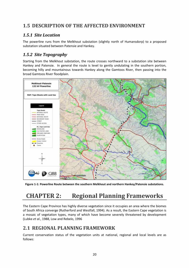
20
1.5 DESCRIPTION OF THE AFFECTED ENVIRONMENT
1.5.1 Site Location
The powerline runs from the Melkhout substation (slightly north of Humansdorp) to a proposed substation situated between Patensie and Hankey.
1.5.2 Site Topography
Starting from the Melkhout substation, the route crosses northward to a substation site between Hankey and Patensie. In general the route is level to gently undulating in the southern portion, becoming hilly and mountainous towards Hankey along the Gamtoos River, then passing into the broad Gamtoos River floodplain.
Figure 1-1: Powerline Route between the southern Melkhout and northern Hankey/Patensie substations.
CHAPTER 2: Regional Planning Frameworks
The Eastern Cape Province has highly diverse vegetation since it occupies an area where the biomes of South Africa converge (Rutherford and Westfall, 1994). As a result, the Eastern Cape vegetation is a mosaic of vegetation types, many of which have become severely threatened by development (Lubke et al., 1988, Low and Rebelo, 1996
2.1 REGIONAL PLANNING FRAMEWORK Current conservation status of the vegetation units at national, regional and local levels are as follows:
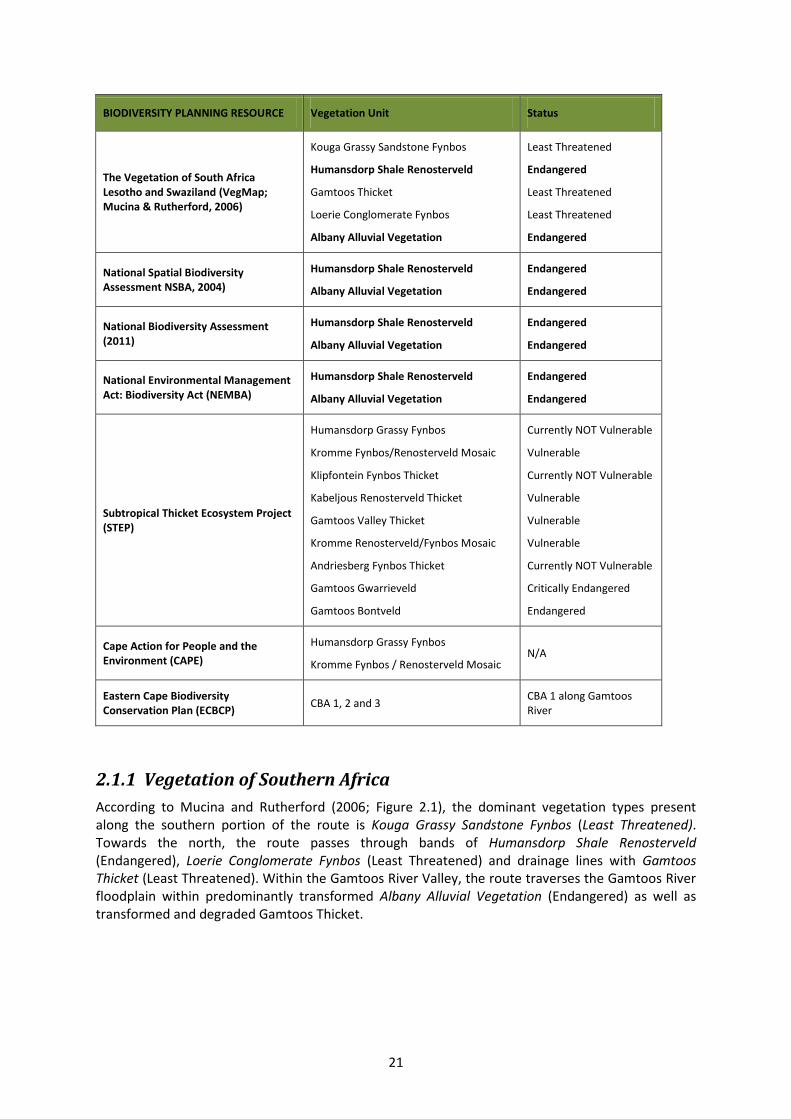
21
BIODIVERSITY PLANNING RESOURCE Vegetation Unit Status
The Vegetation of South Africa Lesotho and Swaziland (VegMap; Mucina & Rutherford, 2006)
Kouga Grassy Sandstone Fynbos
Humansdorp Shale Renosterveld
Gamtoos Thicket
Loerie Conglomerate Fynbos
Albany Alluvial Vegetation
Least Threatened
Endangered
Least Threatened
Least Threatened
Endangered
National Spatial Biodiversity Assessment NSBA, 2004)
Humansdorp Shale Renosterveld
Albany Alluvial Vegetation
Endangered
Endangered
National Biodiversity Assessment (2011)
Humansdorp Shale Renosterveld
Albany Alluvial Vegetation
Endangered
Endangered
National Environmental Management Act: Biodiversity Act (NEMBA)
Humansdorp Shale Renosterveld
Albany Alluvial Vegetation
Endangered
Endangered
Subtropical Thicket Ecosystem Project (STEP)
Humansdorp Grassy Fynbos
Kromme Fynbos/Renosterveld Mosaic
Klipfontein Fynbos Thicket
Kabeljous Renosterveld Thicket
Gamtoos Valley Thicket
Kromme Renosterveld/Fynbos Mosaic
Andriesberg Fynbos Thicket
Gamtoos Gwarrieveld
Gamtoos Bontveld
Currently NOT Vulnerable
Vulnerable
Currently NOT Vulnerable
Vulnerable
Vulnerable
Vulnerable
Currently NOT Vulnerable
Critically Endangered
Endangered
Cape Action for People and the Environment (CAPE)
Humansdorp Grassy Fynbos
Kromme Fynbos / Renosterveld Mosaic N/A
Eastern Cape Biodiversity Conservation Plan (ECBCP)
CBA 1, 2 and 3 CBA 1 along Gamtoos River
2.1.1 Vegetation of Southern Africa
According to Mucina and Rutherford (2006; Figure 2.1), the dominant vegetation types present along the southern portion of the route is Kouga Grassy Sandstone Fynbos (Least Threatened). Towards the north, the route passes through bands of Humansdorp Shale Renosterveld (Endangered), Loerie Conglomerate Fynbos (Least Threatened) and drainage lines with Gamtoos Thicket (Least Threatened). Within the Gamtoos River Valley, the route traverses the Gamtoos River floodplain within predominantly transformed Albany Alluvial Vegetation (Endangered) as well as transformed and degraded Gamtoos Thicket.
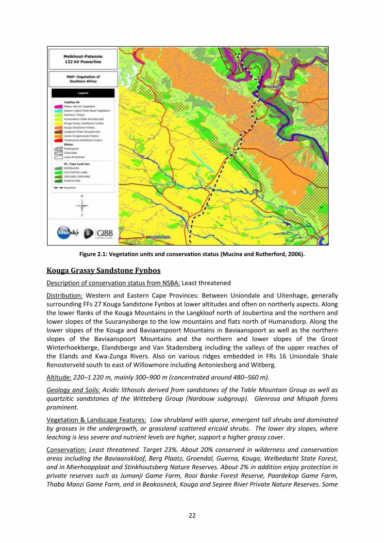
22
Figure 2.1: Vegetation units and conservation status (Mucina and Rutherford, 2006).
Kouga Grassy Sandstone Fynbos
Description of conservation status from NSBA: Least threatened
Distribution: Western and Eastern Cape Provinces: Between Uniondale and Uitenhage, generally surrounding FFs 27 Kouga Sandstone Fynbos at lower altitudes and often on northerly aspects. Along the lower flanks of the Kouga Mountains in the Langkloof north of Joubertina and the northern and lower slopes of the Suuranysberge to the low mountains and flats north of Humansdorp. Along the lower slopes of the Kouga and Baviaanspoort Mountains in Baviaanspoort as well as the northern slopes of the Baviaanspoort Mountains and the northern and lower slopes of the Groot Winterhoekberge, Elandsberge and Van Stadensberg including the valleys of the upper reaches of the Elands and Kwa-Zunga Rivers. Also on various ridges embedded in FRs 16 Uniondale Shale Renosterveld south to east of Willowmore including Antoniesberg and Witberg.
Altitude: 220–1 220 m, mainly 300–900 m (concentrated around 480–560 m).
Geology and Soils: Acidic lithosols derived from sandstones of the Table Mountain Group as well as quartzitic sandstones of the Witteberg Group (Nardouw subgroup). Glenrosa and Mispah forms prominent.
Vegetation & Landscape Features: Low shrubland with sparse, emergent tall shrubs and dominated by grasses in the undergrowth, or grassland scattered ericoid shrubs. The lower dry slopes, where leaching is less severe and nutrient levels are higher, support a higher grassy cover.
Conservation: Least threatened. Target 23%. About 20% conserved in wilderness and conservation areas including the Baviaanskloof, Berg Plaatz, Groendal, Guerna, Kouga, Welbedacht State Forest, and in Mierhoopplaat and Stinkhoutsberg Nature Reserves. About 2% in addition enjoy protection in private reserves such as Jumanji Game Farm, Rooi Banke Forest Reserve, Paardekop Game Farm, Thaba Manzi Game Farm, and in Beakosneck, Kouga and Sepree River Private Nature Reserves. Some

23
9% transformed (cultivation) but in addition much transformed to grassy pasture by too frequent burning. Notable aliens include Pinus pinaster, Acacia cyclops and A. mearnsii.
Erosion: very low and low, but also high in some areas.
Important Taxa: Small tree: Protea nitida. Succulent Tree: Aloe ferox. Tall Shrubs: Aspalathus kougaensis, A. nivea, Dodonaea viscosa var. angustifolia. Low shrubs: Agathosma mucronulata, A. pilifera, A. puberula, A. spinosa, Aspalathus fourcadei, Cliffortia drepanoides, Clutia alaternoides, C. polifolia, Diosma prama, D. rourkei, Disparago ericoides, Erica demissa, E. pectinifolia, E. sparsa, E. thamnoides, Euryops euryopoides, Helichrysum teretifolium, Leucadendron salignum, Leucospermum cuneiforme, Otholobium carneum, Passerina obtusifolia, P. pendula, Phylica axillaris, P. lachneaeoides, Polygala myrtifolia, Protea foliosa, Pteronia incana, Stoebe plumosa, Tephrosia capensis. Herbs: Alepidea capensis, Centella virgata, Gazania krebsiana subsp. krebsiana, Helichrysum felinum, Knowltonia. Geophytic herbs: Bobartia orientalis subsp. orientalis, Geissorhiza roseoalba, Watsonia meriana. Graminoids: Anthochortus crinalis, Brachiaria serrata, Cannomois scirpoides, C. virgata, Cymbopogon marginatus, Digitaria eriantha, Diheteropogon filifolius, Eragrostis curvula, Heteropogon contortus, Hypodiscus albo-aristatus, H. striatus, H. synchroolepis, Ischyrolepis capensis, I. gaudichaudiana, Mastersiella purpurea, Melinis repens subsp. repens, Merxmuellera papposa, M. stricta, Pentameris distichophylla, Pentaschistis eriostoma, P. pallida, Restio triticeus, Rhodocoma fruticosa, Tetraria capillacea, T. cuspidata, T. fourcadei, T. involucrata, Thamnochortus fruticosus, Themeda triandra, Trachypogon spicatus, Tristachya leucothrix.
Endemic Taxa: Tall Shrub: Freylinia crispa. Low Shrubs: Argyrolobium parviflorum, A. trifoliatum, Cullumia cirsioides, Eriocephalus tenuipes, Euchaetis vallis-simiae, Sutera cinerea. Succulent Shrub: Lampranthus lavisii. Herbs: Annesorhiza thunbergii, Aster laevigatus, Centella didymocarpa, Peucedanum dregeanum. Geophytic Herbs: Cyrtanthus flammosus, C. labiatus, C. montanus, Gladiolus uitenhagensis. Succulent Herb: Gasteria glauca. Graminoid: Restio vallis-simius.
Suitability for powerline in terms of NSBA
Vegetation of this type is categorized as Least Threatened, and is most suited for activities ‘of limited extent' and powerline construction will have a limited and acceptable impact.
Existing roads and disturbances should preferably be selected and roads should not be constructed perpendicular to slopes, where erosion risk may be elevated.
Humansdorp Shale Renosterveld
NSBA Conservation status: Endangered
NBA Status: Endangered
Distribution: Eastern Cape Province: Three swathes: from Jeffreys Bay and Marina Glades near the coast inland past Humansdorp to the lower reaches of the Dieprivier near Two Streams; the Mondplaas/Mondhoek area near the mouth of the Gamtoos River stretching inland in a series of patches south of the Gamtoos River to west of Patensie; between thicket and fynbos types from Burghley Hills to Rocklands and the Dell to Nooitgedacht southwest of Uitenhage. Coastal forelands from Humansdorp to Port Elizabeth.
Altitude: 20–360 m.
Geology & Soils: Clay and loams derived from the Ceres Subgroup of the Bokkeveld Group shales. Plinthic catenas prominent.
Vegetation & Landscape Features: Best developed on loamy soils on open flats, mostly derived from sandstone and shale of the Baviaanskloof Formation but also those of the Ceres subgroup of formations. Characteristic is the abundance of Renosterbos (Elytropappus rhinocerotis), often with the grass component (Themeda triandra) well developed soon after a fire. Soon after a fire
24
Aspalathus nivea also tends to be common here, along with other Fynbos elements (e.g. Erica glandulosa), but they are never dominant. Some species (e.g. Cyrtanthus wellandii, Delosperma patersoniae, and Gasteria nitida var. armstrongii) are endemic to this unit. Some parts of this may be of recent (< 300 years) origin as landowners seem to use fire to remove the Thicket vegetation to favour the palatable grass component. The subsequent frequent burning and heavy grazing of the grass component probably enabled Renosterbos to increase in density, to become the present dominant species in most of the areas. Aloe africana is often abundant in this unit, even in the matrix Renosterveld where it may act as a precursor for Thicket clumps, or alternatively be a remnant of the Thicket clumps.
Conservation: Endangered. Target 29%. None conserved in statutory conservation areas and only 6% enjoys protection on private land (Thaba Manzi and Lombardini Game Farms). Some 61% already transformed (cultivation).
Erosion: Very Low and Low.
Important Taxa: Succulent Tree: Aloe africana. Tall Shrubs: Cliffortia strobilifera, Metalasia densa, Morella serrata. Low Shrubs: Elytropappus rhinocerotis, Helichrysum anomalum, Oedera genistifolia, Anthospermum galioides, Barleria pungens, Chaetacanthus setiger, Clutia rubricaulis, Euryops munitus, Felicia filifolia, Hermannia flammea, Indigofera denudata, I. heterophylla, Lotononis acuminata, Metalasia aurea, Muraltia alopecuroides, Passerina rubra, Pelargonium sidoides, Tephrosia capensis, Herbaceous climber: Thunbergia capensis. Herbs: Arctotis acaulis, Berkheya heterophylla, Centella asiatica, Gazania linearis, Gerbera piloselloides, Helichrysum nudifolium, Hibiscus pusillus, Senecio othonniflorus. Geophytic Herbs: Bobartia orientalis, Geissorhiza heterostyla, Ledebouria cooperi, Oxalis punctata, O. smithiana, Satyrium membranaceum. Graminoids: Eustachys paspaloides, Themeda triandra, Aristida junciformis, Brachiaria serrata, Cymbopogon marginatus, Cynodon dactylon, Eragrostis capensis, E. curvula, Ficinia nigrescens, F. tristachya, Merxmuellera disticha, Paspalum dilatatum, Pentaschistis pallida, Restio tetragonus, Sporobolus africanus, Tribolium hispidum, Tristachya leucothrix.
Endemic Taxa: Succulent Shrubs: Delosperma patersoniae, Trichodiadema fourcadei. Geophytic Herb: Cyrtanthus wellandii.
Suitability for powerline in terms of NSBA
Vegetation of this type is categorized as Endangered (NBA: Critically Endangered), and any disturbance relating to powerline construction must be limited to unavoidable requirements.
Proposed disturbance should occur on sites which have already undergone disturbance or impacts rather than on sites that are undisturbed.
Where possible, existing roads servicing the current servitude must be used and pylon footprints must be kept to a minimum and preferably target transformed or disturbed areas.
Where unavoidable, extreme care must be taken and any disturbance kept to an absolute minimum and post construction measures must be implemented ensure rapid and successful rehabilitation.
Any new roads must follow a two track rather than a graded configuration, especially where vegetation is intact and on slopes.
Albany Alluvial Vegetation
NSBA Conservation Status: Endangered
Distribution: Eastern Cape Province: Between East London and Cape St Francis on wide floodplains (usually close to the coast where the topography becomes flatter) of the large rivers such as the
25
Sundays, Zwartkops, Coega, Gamtoos, Baviaanskloof, Great Fish River etc. This alluvial unit is embedded within the Albany Thicket Biome.
Altitude: ranging from 20–1 000 m.
Conservation: Endangered. Target 31%. Only about 6% statutorily conserved in the Greater Addo Elephant National Park, Baviaanskloof Wilderness Area, Loerie Dam, Springs, Swartkops Valley and Yellowwoods Nature Reserves and the Double Drift Reserve Complex. About 2% enjoys protection in eight private conservation areas. More than half of the area has been transformed for cultivation, urban development, road building and plantations. Alien invaders include Acacia saligna, Nerium oleander and Eucalyptus species.
Important Taxa: Riparian thickets: Small Trees: Acacia natalitica, Salix mucronata, Schotia afra, Acacia afra, Acacia caffra, Rhus longispina. Succulent Trees: Aloe africana, A. ferox. Tall Shrubs: Azima tetracantha, Cadaba aphylla. Low Shrubs: Pentzia incana, Asparagus striatus, A. suaveolens, Carissa haematocarpa. Succulent Shrubs: Amphiglossa callunoides, Lycium cinereum. Graminoids: Sporobolus nitens, Digitaria eriantha, Eragrostis curvula, E. obtusa. Reed beds: Mega-graminoids: Cyperus papyrus, Phragmites australis. Flooded grasslands and herblands: Succulent Shrubs: Cotyledon campanulata, Glottiphyllum longum, Malephora lutea, M. uitenhagensis. Semi-parasitic Shrub: Thesium junceum. Succulent Herbs: Haworthia sordida var. sordida, Orbea pulchella. Herb: Rorippa fluviatilis var. fluviatilis. Graminoid: Cynodon dactylon.
Endemic Taxa: None recorded
Suitability for powerline in terms of NSBA
Vegetation of this type is categorized as Endangered, and any disturbance relating to powerline construction must be limited to unavoidable requirements.
Proposed disturbance should occur on sites which have already undergone disturbance or impacts rather than on sites that are undisturbed.
Where possible, existing roads servicing the current servitude must be used and pylon footprints must be kept to a minimum and preferably target transformed or disturbed areas.
Where unavoidable, extreme care must be taken and any disturbance kept to an absolute minimum and post construction measures must be implemented ensure rapid and successful rehabilitation.
Any new roads in intact vegetation must follow a two track rather than a graded configuration, especially on slopes.
Loerie Conglomerate Fynbos
NSBA Conservation status: Least threatened
Distribution: Eastern Cape Province: Hankey Valley on both sides of the Gamtoos River, from Andrieskraal to Mondplaas on the south-western side, and Patensie to Thornhill on the north-eastern side. Also found in the lower Kwazunga Valley above Springfield and Rooikrans near Uitenhage. Altitude: 80–400 m.
Geology & Soils: Acidic, mostly clay-loam, Glenrosa and Mispah soils and conglomerates associated with shales and conglomerates of the Karroo Uitenhage sequence.
Vegetation & Landscape Features: Moderately undulating plains dissected by major rivers. Vegetation low shrubland or grassland with sparse emergent tall shrubs, and rich in succulents and geophytes. Structurally these are graminoid, asteraceous and proteoid fynbos types.
26
Conservation: Least threatened. Target 23%. Some 11% statutorily conserved in the Groendal Wilderness Area. Small patches are also found in the private Kabeljous River Natural Heritage Site. About 9% transformed (cultivation).
Erosion: Very variable, including significant areas of high and moderate erosion, but also very low in some areas.
Important Taxa: Tall Shrubs: Aspalathus nivea, Azima tetracantha, Cliffortia linearifolia, Diospyros pallens, Dodonaea viscosa, Euclea undulata, Grewia occidentalis, Gymnosporia capitata, Protea neriifolia, P. repens, Schotia afra. Low Shrubs: Anthospermum galioides, Asparagus subulatus, Barleria pungens, Cliffortia ruscifolia, Clutia polifolia, Elytropappus rhinocerotis, Erica demissa, E. pectinifolia, Felicia muricata, Galenia secunda, Helichrysum anomalum, H. odoratissimum, H. zeyheri, Indigofera denudata, Leucadendron salignum, Leucospermum cuneiforme, Otholobium pictum, Passerina obtusifolia, Pelargonium odoratissimum, Protea foliosa, Senecio linifolius. Succulent Shrubs: Cotyledon orbiculata var. oblonga, Crassula cultrata, C. tetragona, Euphorbia polygona. Woody Climbers: Capparis sepiaria var. citrifolia, Rhoicissus digitata. Woody Succulent Climber: Zygophyllum foetidum. Small tree: Protea nitida. Herbs: Commelina africana, Hibiscus pusillus, Salvia triangularis. Geophytic Herbs: Babiana patersoniae, Drimia intricata, Geissorhiza bracteata, Gladiolus longicollis, Sansevieria hyacinthoides, Spiloxene trifurcillata. Succulent Herbs: Crassula nemorosa, Haworthia cooperi. Herbaceous Climber: Cyphia sylvatica, Herbaceous Succulent Climbers: Ceropegia cancellata, Pelargonium peltatum. Graminoids: Aristida junciformis, Brachiaria serrata, Cymbopogon marginatus, Cynodon dactylon, Eragrostis obtusa, Eustachys paspaloides, Ficinia tristachya, Ischyrolepis gaudichaudiana, I. sieberi, Pentaschistis angustifolia, P. colorata, Stipa dregeana, Restio triticeus, Sporobolus africana, Stipa dregeana, Tetraria cuspidata, Themeda triandra, Trachypogon spicatus.
Endemic Taxa: Endemic Shrub: Erepsia aristata
Suitability for powerline in terms of NSBA
Vegetation of this type is categorized as Least Threatened, and is most suited for activities ‘of limited extent' and powerline construction will have a limited and acceptable impact.
Existing roads and disturbances should preferably be selected and roads should not be constructed perpendicular to slopes, where erosion risk may be elevated.
Any new roads must follow a two track rather than a graded configuration, especially where vegetation is intact and on slopes.
Where unavoidable, extreme care must be taken and any disturbance kept to an absolute minimum and post construction measures must be implemented ensure rapid and successful rehabilitation.
Where solid intact Thicket is present across drainage lines and along rivers, the line should span these areas, and thicket should not be cleared during construction and spanning activities.
Gamtoos Thicket
NSBA Conservation Status: Least threatened
Distribution: Eastern Cape Province: Coastal basin of the Gamtoos River Valley, south of the Baviaanskloof Mountains and along some smaller river valleys such as that of the Kromme River. Also found north of the Baviaanskloof Mountains in more xeric conditions on some low ridges south and southeast of Steytlerville.
Altitude: 0–700 m.
27
Geology and Soils: Mostly restricted to rocky, sandy-loamy soils derived from shale and sandstone of the Bokkeveld Group (Ceres and Tarka Subgroups) and Table Mountain Group (Nardouw Subgroup) as well as the Jurassic Enon conglomerates. Also found are fairly shallow clayey soils derived from the Gamtoos Group limestone, phyllite and arenite of the Kaan and Klein River Formations (Namibian Erathem). Fc land type covers half of the area, followed by Ae and Ib.
Vegetation & Landscape Features: On the low mountain slopes in steeply sloping areas and on low ridges. Tall, dense thicket, where both the trees and shrubs and the succulent components are well represented. Few distinct strata can be differentiated within much of the vegetation, as the lower and upper canopies are intertwined, often together with a wide variety of liana species linking the understory species with the canopy. Occurs mostly as a fragmented community with large, dense stands restricted to south- and south-west facing slopes that are protected against fires. The structure of the dense stands of Gamtoos Thicket is similar to that of the Sundays thicket, but it differs in the dominant species.
Conservation: Least threatened. Target 19%. A total of 6% of this vegetation unit is protected in statutory conservation areas: Baviaanskloof Conservation Area, Guerna and Berg Plaatz Wilderness Areas as well as Stinkhoutsberg, Kabeljousrivier, Loerie Dam and Seekoeirivier Nature Reserves. Private conservation areas (Hankey Forest Reserve No. 1, Monteaux Game Ranch, Lombardini Game Farm, Kabeljous River Natural Heritage Site, and Kromme River Mouth, Eastcot and Loerie Dam Nature Reserves) also protect some patches of this vegetation type. Some 12% of Gamtoos Thicket has been altered by cultivation and 1% by urbanisation. The alien Atriplex lindleyi subsp. inflata has invaded many degraded arid thicket areas, especially on soils with a high clay content.
Erosion: Variable
Important Taxa: Succulent Trees: Euphorbia triangularis, Aloe africana, A. speciosa, Euphorbia grandidens. Small Trees: Apodytes dimidiata, Canthium spinosum, Cussonia spicata, C. thyrsiflora, Maytenus undata, Pappea capensis, Ptaeroxylon obliquum, Schotia afra var. afra, Sideroxylon inerme, Vepris lanceolata. Tall Shrubs: Allophylus decipiens, Azima tetracantha, Carissa bispinosa, Crotalaria capensis, Ehretia rigida, Elytropappus rhinocerotis, Euclea racemosa, E. undulata, Grewia occidentalis, Gymnosporia capitata, G. heterophylla, G. polyacantha, Hippobromus pauciflorus, Maerua cafra, Mystroxylon aethiopicum, Nylandtia spinosa, Olea europaea subsp. africana, Pterocelastrus tricuspidatus, Putterlickia pyracantha, Rhus glauca, R. incisa, R. longispina, R. lucida, R. pterota, R. refracta, Scolopia zeyheri, Scutia myrtina. Low shrubs: Felecia muricata, Anthospermum aethiopicum, Asparagus striatus, Chaetacanthus setiger, Eriocephalus africanus, E. algoensis, E. spathaceus, Jamesbrittenia microphylla, Lauridia tetragona, Oedera genistifolia, Phyllanthus maderaspatensis, Pteronia incana, Senecio linifolius. Succulent Shrubs: Portulacaria afra, Exomis microphylla, Cotyledon campanulata, Cotyledon orbiculata, C. tomentosa, Crassula cultrata, Delosperma ecklonis, Euphorbia mauritanica, E. polygona, Glottiphyllum linguiforme, Senecio oxyodontus, Tylecodon striatus, Zygophyllum debile. Semi parasitic Shrub: Osyris compressa. Semi parasitic Epiphytic Shrub: Viscum rotundifolium. Woody climbers: Capparis sepiaria, Rhoicissus digitata, Asparagus aethiopicus, A. racemosus, Jasminum angulare, Plumbago auriculata, Rhoiacarpos capensis. Woody succulent climber: Sarcostemma viminale. Herbaceous climbers: Cynanchum ellipticum, Senecio deltoides. Graminoids: Ehrharta calycina, E. erecta, Panicum deustum, Setaria sphacelata, Aristida congesta, Cenchrus ciliaris, Cynodon dactylon, Digitaria natalensis, Enneapogon desvauxii, E. scoparius, Eragrostis obtusa, Eustachys paspaloides, Ficinia indica, F. nodosa, Heteropogon contortus, Karroochloa curva, Leptochloa fusca, Melica racemosa, Panicum maximum, P. stapfianum, Pycreus polystachyos, Sporobolus africanus, S. fimbriatus, Stipa dregeana, Themeda triandra, Tribolium hispidum. Succulent Herbs: Crassula expansa, C. muscosa, C. orbicularis, Plectranthus grandidentatus, P. madagascariensis, Senecio radicans. Geophytic Herbs: Asplenium cordatum, Bonatea speciosa, Bulbine alooides, B. frutescens, Chasmanthe aethiopica, Ornithogalum longibracteatum, Oxalis obtusa, Pelargonium pulverulentum, Sansevieria hyacinthoides. Herbs: Hypoestes aristata, Abutilon sonneratianum, Acalypha ecklonii, Blepharis
28
integrifolia, Hibiscus pusillus, Indigastrum costatum, Indigofera hedyantha, Peristrophe cernua, Stachys aethiopica.
Endemic Taxa: Small Tree: Cussonia gamtoosensis. Succulent Herbs: Huernia bayeri, Gasteria pulchra. Succulent Herb: Lachenalia latimerae.
Suitability for powerline in terms of NSBA
Vegetation of this type is categorized as Least Threatened, and is most suited for activities ‘of limited extent' and powerline construction will have a limited and acceptable impact.
Existing roads and disturbances should preferably be selected and roads should not be constructed perpendicular to slopes, where erosion risk may be elevated.
Any new roads must follow a two track rather than a graded configuration, especially where vegetation is intact and on slopes.
Where unavoidable, extreme care must be taken and any disturbance kept to an absolute minimum and post construction measures must be implemented ensure rapid and successful rehabilitation.
Where solid intact Thicket is present across drainage lines and along rivers, the line should span these areas, and thicket should not be cleared during construction and spanning activities.
2.1.2 National Biodiversity Assessment (2011)
The NBA 2011 assesses the state of South Africa’s biodiversity, across terrestrial, freshwater, estuarine and marine environments, emphasising spatial (mapped) information for both ecosystems and species. It synthesises key aspects of South Africa’s biodiversity science, making it available in a useful form to policymakers, decision-makers and practitioners in a range of sectors.
The NBA is central to fulfilling SANBI’s mandate in terms of the National Environmental Management: Biodiversity Act (Act 10 of 2004) to monitor and report regularly on the state of biodiversity, and includes two headline indicators that are assessed across all environments: ecosystem threat status and ecosystem protection level. The NBA 2011 also deals with species of special concern and invasive alien species, presents new work on geographic areas that contribute to climate change resilience, and provides a summary of spatial biodiversity priority areas that have been identified through systematic biodiversity plans at national, provincial and local scales.
Implications
The only vegetation units indicated in the NBA as needing special attention are Humansdorp Shale Renosterveld and Albany Alluvial Vegetation. No major infrastructure are planned to be sited within these intact areas, and the powerline does not traverses any intact portions of Humansdorp Shale Renosterveld. Although the powerline does traverse intact Albany Alluvial Vegetation, the extent is minor and pylon placements can most likely avoid intact areas. Most of the Albany Alluvial Vegetation has been transformed as a result of intensive agricultural use.
2.1.3 Bioregional Plans, Critical Biodiversity Areas and Ecological Process Areas
No Bioregional Plans have yet been compiled for this area, and no designated Critical Biodiversity Areas or Ecological Process Areas are affected by the proposed powerline. Ecological process areas represent areas that, when functioning ecologically, will serve to sustain evolutionary processes.
29
2.1.4 Biodiversity offsets
Where land uses are proposed that will have a negative impact on biodiversity, such impacts must be assessed, minimised via a "planning with nature" approach, and mitigated to the greatest extent possible. Mitigation measures are extensively utilised in order to reduce the biodiversity impacts of developments or change in land use from a natural state. However, in many instances the impacts on biodiversity will be such that mitigatory measures will be inadequate. Under such conditions the application of biodiversity offsets is generally the most appropriate response. To date, biodiversity offsets have only been used in a few, isolated cases in the municipality, but due to the extent of habitat loss during the last five years, the utilisation of biodiversity offsets is expected to increase substantially (Department of Environmental Affairs and Development Planning, 2007).
Biodiversity off sets are "conservation actions intended to compensate for the residual, unavoidable harm to biodiversity caused by development projects, so as to ensure 'no net loss' of biodiversity".
The key issue is that biodiversity offsets should only be triggered if residual impacts of a medium or higher significance are identified. No Biodiversity offset triggers are indicated in this case.
2.2 PROTECTED PLANTS
In terms of the National Forests Act, 1998 (Act No 84 of 1998) and Government Notice 1339 of 6 August 1976 (promulgated under the Forest Act, 1984 (Act No 122 of 1984) for protected tree species), the removal, relocation or pruning of any protected plants will require a license (Refer relevant Appendix).
Protected indigenous plants in general are controlled under the relevant provincial Ordinances or Acts dealing with nature conservation. In the Eastern Cape the relevant statute is the 1974 Provincial Nature Conservation Ordinance no 19 (PNCO). In terms of this Ordinance, a permit must be obtained from the Department of Economic Affairs Environment and Tourism (DEAET) to remove or destroy any plants listed in the Ordinance.
Threatened or Protected Species (T.o.P.S.): Permits must be obtained from DEDEA or respective conservation office.

30
CHAPTER 3: VEGETATION DESCRIPTION AND FLORAL COMPOSITION
Within the servitude, a number of distinct vegetation communities were observed, with some variation, at a community level.
3.1 ECOLOGICAL STATE AND SENSITIVITY OF VEGETATION
3.1.1 Perceived Reference State (PRS)
The dominant vegetation types present along the southern portion of the route is Kouga Grassy Sandstone Fynbos (Least Threatened). Towards the north, the route passes through bands of Humansdorp Shale Renosterveld (Endangered), Loerie Conglomerate Fynbos (Least Threatened) and drainage lines with Gamtoos Thicket (Least Threatened). Within the Gamtoos River Valley, the route traverses the Gamtoos River floodplain within predominantly transformed Albany Alluvial Vegetation (Endangered) as well as transformed and degraded Gamtoos Thicket.
The perceived reference state of the vegetation is intact natural vegetation, as per Vegetation of Southern Africa (Mucina and Rutherford, 2006) described above.
3.1.2 Present Ecological State (PES)
Present Ecological State has been assessed for the key vegetation types found within the route. A summary of factors assessed is provided in Table 3.1. Historical agriculture related land-use have resulted in degradation of portions of the route, most notably as a result of crops, pastures and orchards in flat lower lying areas especially in the Gamtoos River Valley, and to some extent from regular burning of grazing areas on mountain and hill slopes (refer to Figure 3.5 to Figure 3.14) and in the southern areas having Kouga Grassy Sandstone Fynbos.
Figure 3.1: Degraded Kouga Grassy Sandstone Fynbos near Melkhout substation.
Figure 3.2: Kouga Grassy Sandstone Fynbos north of Melkhout substation.
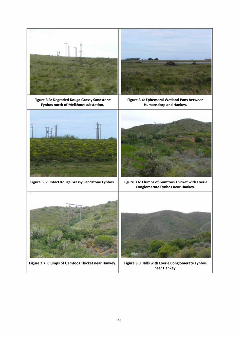
31
Figure 3.3: Degraded Kouga Grassy Sandstone Fynbos north of Melkhout substation.
Figure 3.4: Ephemeral Wetland Pans between Humansdorp and Hankey.
Figure 3.5: Intact Kouga Grassy Sandstone Fynbos. Figure 3.6: Clumps of Gamtoos Thicket with Loerie Conglomerate Fynbos near Hankey.
Figure 3.7: Clumps of Gamtoos Thicket near Hankey. Figure 3.8: Hills with Loerie Conglomerate Fynbos near Hankey.
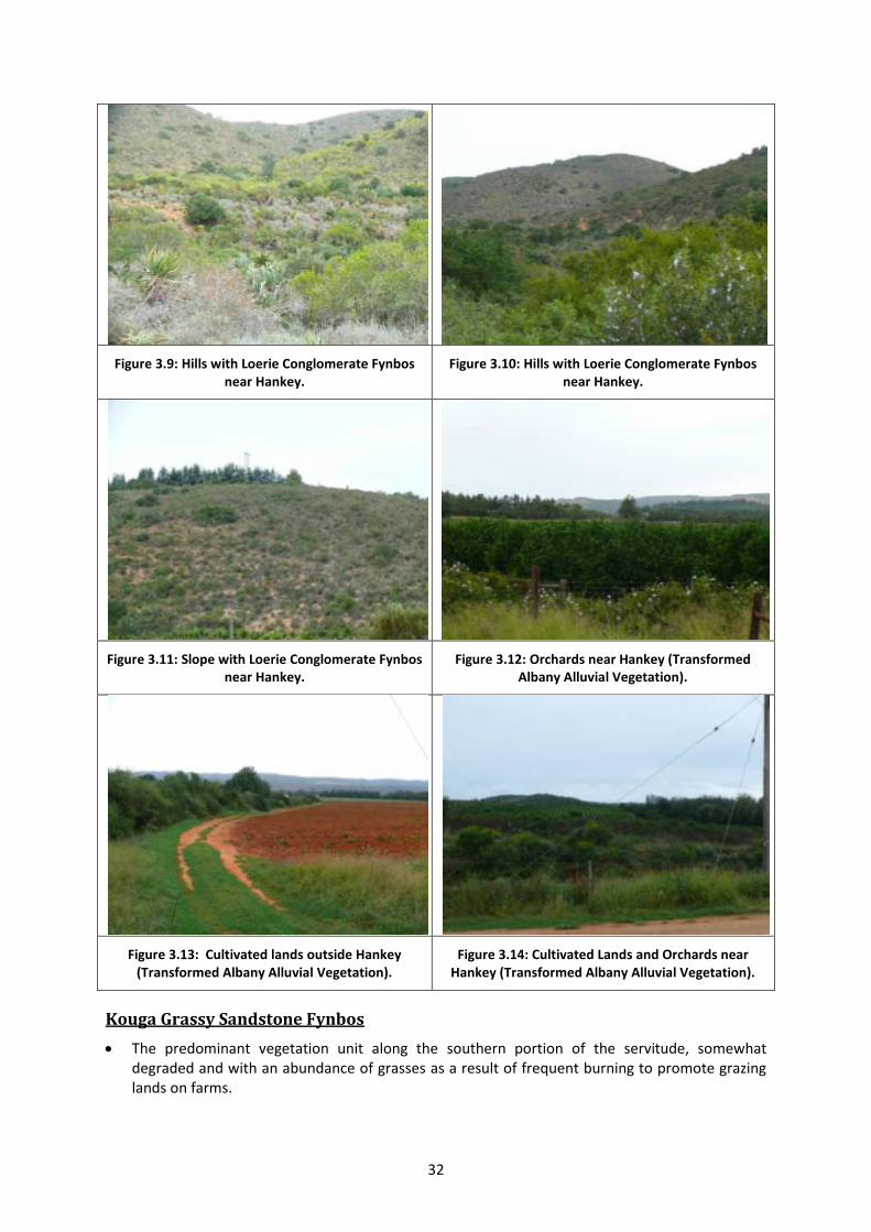
32
Figure 3.9: Hills with Loerie Conglomerate Fynbos near Hankey.
Figure 3.10: Hills with Loerie Conglomerate Fynbos near Hankey.
Figure 3.11: Slope with Loerie Conglomerate Fynbos near Hankey.
Figure 3.12: Orchards near Hankey (Transformed Albany Alluvial Vegetation).
Figure 3.13: Cultivated lands outside Hankey (Transformed Albany Alluvial Vegetation).
Figure 3.14: Cultivated Lands and Orchards near Hankey (Transformed Albany Alluvial Vegetation).
Kouga Grassy Sandstone Fynbos
The predominant vegetation unit along the southern portion of the servitude, somewhat degraded and with an abundance of grasses as a result of frequent burning to promote grazing lands on farms.
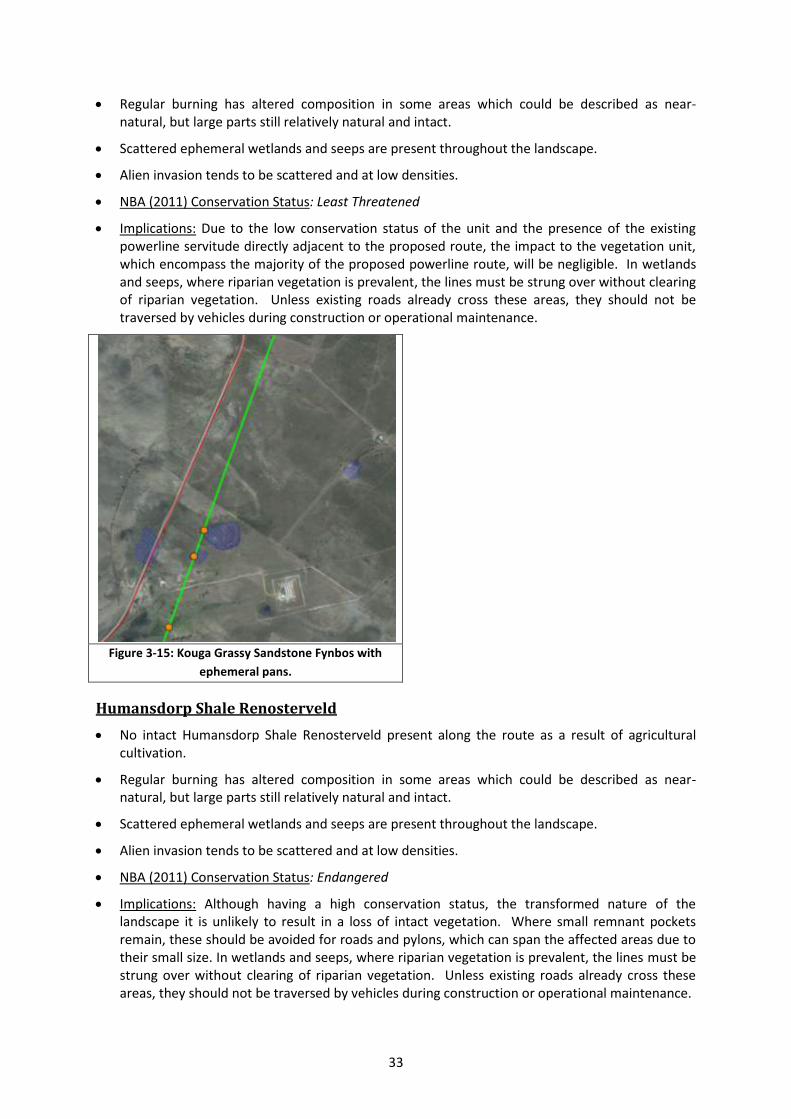
33
Regular burning has altered composition in some areas which could be described as near-natural, but large parts still relatively natural and intact.
Scattered ephemeral wetlands and seeps are present throughout the landscape.
Alien invasion tends to be scattered and at low densities.
NBA (2011) Conservation Status: Least Threatened
Implications: Due to the low conservation status of the unit and the presence of the existing powerline servitude directly adjacent to the proposed route, the impact to the vegetation unit, which encompass the majority of the proposed powerline route, will be negligible. In wetlands and seeps, where riparian vegetation is prevalent, the lines must be strung over without clearing of riparian vegetation. Unless existing roads already cross these areas, they should not be traversed by vehicles during construction or operational maintenance.
Figure 3-15: Kouga Grassy Sandstone Fynbos with
ephemeral pans.
Humansdorp Shale Renosterveld
No intact Humansdorp Shale Renosterveld present along the route as a result of agricultural cultivation.
Regular burning has altered composition in some areas which could be described as near-natural, but large parts still relatively natural and intact.
Scattered ephemeral wetlands and seeps are present throughout the landscape.
Alien invasion tends to be scattered and at low densities.
NBA (2011) Conservation Status: Endangered
Implications: Although having a high conservation status, the transformed nature of the landscape it is unlikely to result in a loss of intact vegetation. Where small remnant pockets remain, these should be avoided for roads and pylons, which can span the affected areas due to their small size. In wetlands and seeps, where riparian vegetation is prevalent, the lines must be strung over without clearing of riparian vegetation. Unless existing roads already cross these areas, they should not be traversed by vehicles during construction or operational maintenance.
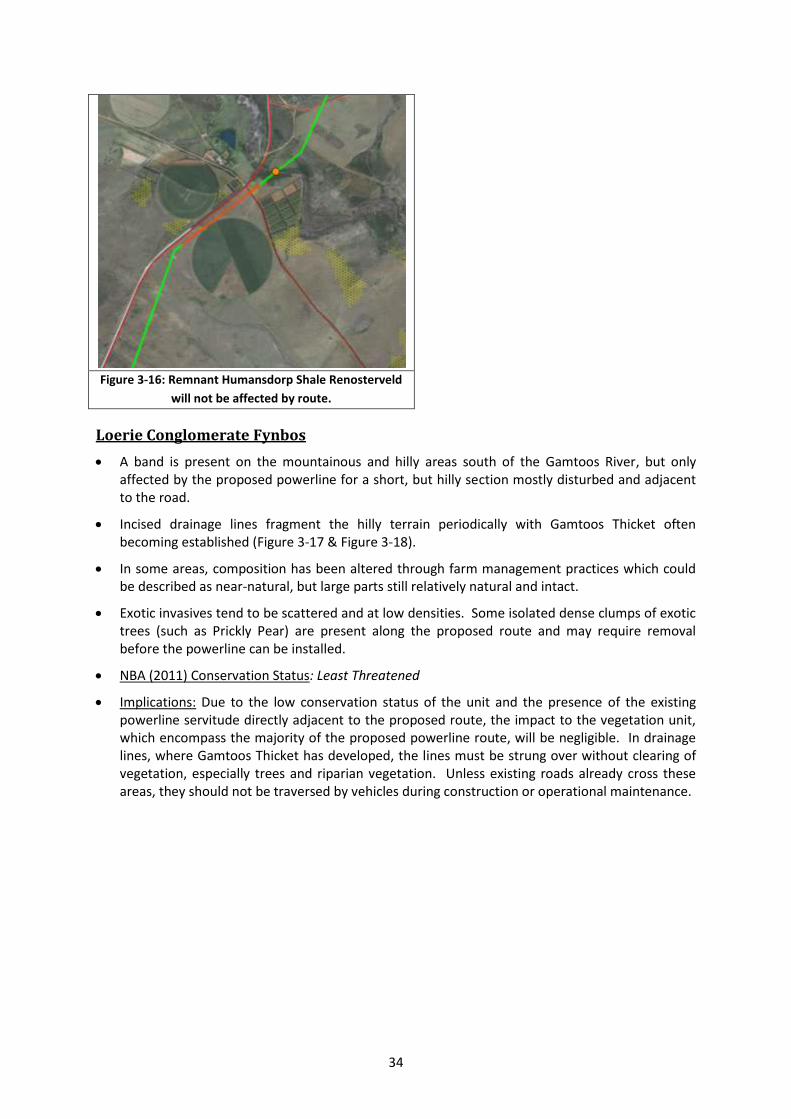
34
Figure 3-16: Remnant Humansdorp Shale Renosterveld
will not be affected by route.
Loerie Conglomerate Fynbos
A band is present on the mountainous and hilly areas south of the Gamtoos River, but only affected by the proposed powerline for a short, but hilly section mostly disturbed and adjacent to the road.
Incised drainage lines fragment the hilly terrain periodically with Gamtoos Thicket often becoming established (Figure 3-17 & Figure 3-18).
In some areas, composition has been altered through farm management practices which could be described as near-natural, but large parts still relatively natural and intact.
Exotic invasives tend to be scattered and at low densities. Some isolated dense clumps of exotic trees (such as Prickly Pear) are present along the proposed route and may require removal before the powerline can be installed.
NBA (2011) Conservation Status: Least Threatened
Implications: Due to the low conservation status of the unit and the presence of the existing powerline servitude directly adjacent to the proposed route, the impact to the vegetation unit, which encompass the majority of the proposed powerline route, will be negligible. In drainage lines, where Gamtoos Thicket has developed, the lines must be strung over without clearing of vegetation, especially trees and riparian vegetation. Unless existing roads already cross these areas, they should not be traversed by vehicles during construction or operational maintenance.
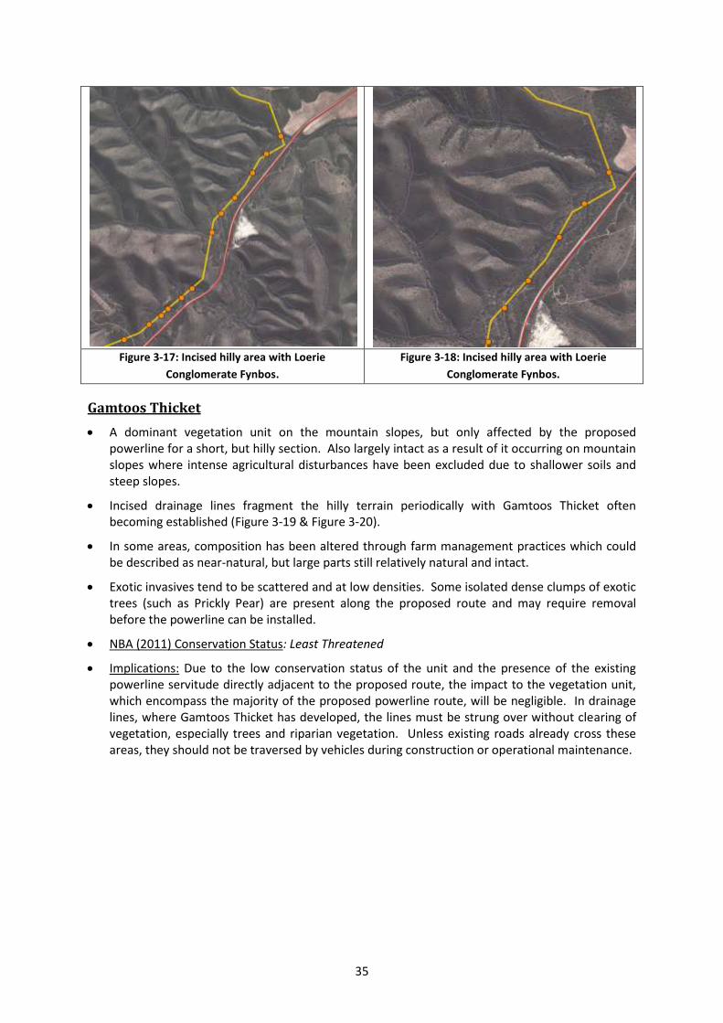
35
Figure 3-17: Incised hilly area with Loerie
Conglomerate Fynbos.
Figure 3-18: Incised hilly area with Loerie
Conglomerate Fynbos.
Gamtoos Thicket
A dominant vegetation unit on the mountain slopes, but only affected by the proposed powerline for a short, but hilly section. Also largely intact as a result of it occurring on mountain slopes where intense agricultural disturbances have been excluded due to shallower soils and steep slopes.
Incised drainage lines fragment the hilly terrain periodically with Gamtoos Thicket often becoming established (Figure 3-19 & Figure 3-20).
In some areas, composition has been altered through farm management practices which could be described as near-natural, but large parts still relatively natural and intact.
Exotic invasives tend to be scattered and at low densities. Some isolated dense clumps of exotic trees (such as Prickly Pear) are present along the proposed route and may require removal before the powerline can be installed.
NBA (2011) Conservation Status: Least Threatened
Implications: Due to the low conservation status of the unit and the presence of the existing powerline servitude directly adjacent to the proposed route, the impact to the vegetation unit, which encompass the majority of the proposed powerline route, will be negligible. In drainage lines, where Gamtoos Thicket has developed, the lines must be strung over without clearing of vegetation, especially trees and riparian vegetation. Unless existing roads already cross these areas, they should not be traversed by vehicles during construction or operational maintenance.
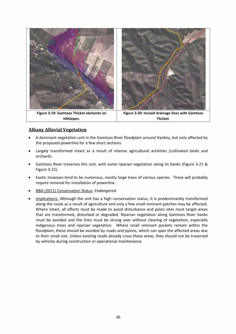
36
Figure 3-19: Gamtoos Thicket elements on
hillslopes.
Figure 3-20: Incised drainage lines with Gamtoos
Thicket.
Albany Alluvial Vegetation
A dominant vegetation unit in the Gamtoos River floodplain around Hankey, but only affected by the proposed powerline for a few short sections.
Largely transformed intact as a result of intense agricultural activities (cultivated lands and orchards.
Gamtoos River traverses this unit, with some riparian vegetation along its banks (Figure 3-21 & Figure 3-22).
Exotic invasives tend to be numerous, mostly large trees of various species. These will probably require removal for installation of powerline.
NBA (2011) Conservation Status: Endangered
Implications: Although the unit has a high conservation status, it is predominantly transformed along the route as a result of agriculture and only a few small remnant patches may be affected. Where intact, all efforts must be made to avoid disturbance and pylon sites must target areas that are transformed, disturbed or degraded. Riparian vegetation along Gamtoos River banks must be avoided and the lines must be strung over without clearing of vegetation, especially indigenous trees and riparian vegetation. Where small remnant pockets remain within the floodplain, these should be avoided by roads and pylons, which can span the affected areas due to their small size. Unless existing roads already cross these areas, they should not be traversed by vehicles during construction or operational maintenance.
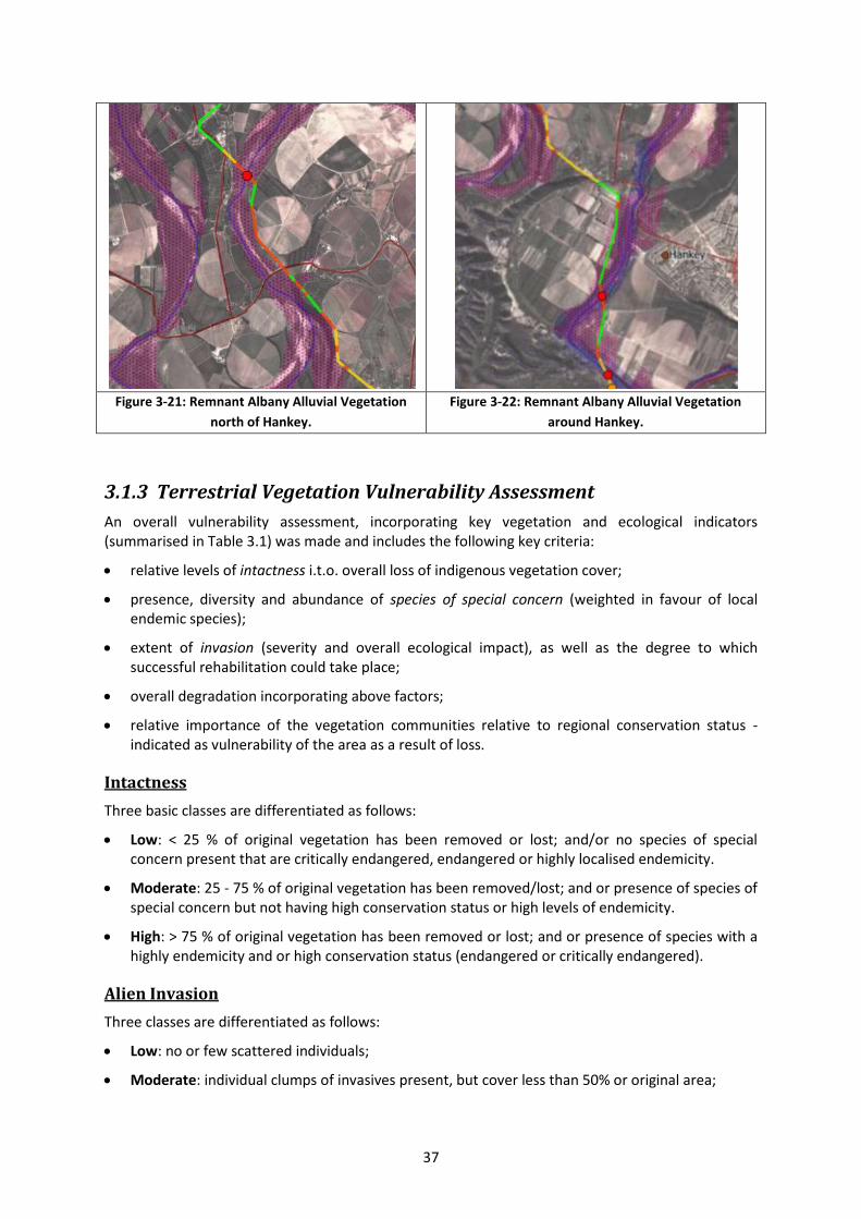
37
Figure 3-21: Remnant Albany Alluvial Vegetation
north of Hankey.
Figure 3-22: Remnant Albany Alluvial Vegetation
around Hankey.
3.1.3 Terrestrial Vegetation Vulnerability Assessment
An overall vulnerability assessment, incorporating key vegetation and ecological indicators (summarised in Table 3.1) was made and includes the following key criteria:
relative levels of intactness i.t.o. overall loss of indigenous vegetation cover;
presence, diversity and abundance of species of special concern (weighted in favour of local endemic species);
extent of invasion (severity and overall ecological impact), as well as the degree to which successful rehabilitation could take place;
overall degradation incorporating above factors;
relative importance of the vegetation communities relative to regional conservation status - indicated as vulnerability of the area as a result of loss.
Intactness
Three basic classes are differentiated as follows:
Low: < 25 % of original vegetation has been removed or lost; and/or no species of special concern present that are critically endangered, endangered or highly localised endemicity.
Moderate: 25 - 75 % of original vegetation has been removed/lost; and or presence of species of special concern but not having high conservation status or high levels of endemicity.
High: > 75 % of original vegetation has been removed or lost; and or presence of species with a highly endemicity and or high conservation status (endangered or critically endangered).
Alien Invasion
Three classes are differentiated as follows:
Low: no or few scattered individuals;
Moderate: individual clumps of invasives present, but cover less than 50% or original area;
38
High: dense, impenetrable stands of invasives present, or cover > 50 % of area with substantial loss functioning. Rehabilitation will most likely require specialised techniques over an extended time period (> 5 years).
Degradation
Overall Degradation is determined from the above alien invasion and intactness scores, according to the following matrix:
Intactness Invasion
Low Moderate High
Low Pristine Near Pristine Moderately Degraded
Moderate Near Pristine Moderately Degraded Severely Degraded
High Moderately Degraded Severely Degraded Transformed
Overall Vulnerability score
Overall vulnerability (or Sensitivity) of the vegetation within the site is calculated according to the following matrix which combines degradation and overall conservation status of the vegetation units of the site (Figure 3.23 and Error! Reference source not found.).
Degradation Conservation Status
Least Threatened Vulnerable Endangered Critically Endangered
Severely degraded/
Transformed Low Low Moderate Moderate - High
Moderately
degraded Low Moderate High High
Ecologically Pristine
or near Pristine Moderate
Moderate -
High High Very High (No-Go area)
Areas scoring an overall LOW Vulnerability are those areas that are:
includes areas that have a low conservation status (Least Threatened).
highly degraded or transformed and it is unlikely that they could be rehabilitated to a normal functioning ecological state without extreme effort and expense.
Includes the predominant Kouga Grassy Sandstone Fynbos, Eastern Inland Shale band Vegetation and Kouga Sandstone Fynbos areas.
This includes the portions of the site that are associated with extensive blanket vegetation clearing for agriculture, or where there is very dense alien infestation. Loss of these areas are unlikely to significantly compromise the current conservation status of the vegetation unit, unless part of a designated critical biodiversity or ecological support area.
Powerline portions that pass through areas that are degraded or are non-restorable such as agricultural lands and adjacent to road servitudes.
Areas scoring an overall MODERATE Vulnerability are those areas that:
have moderate, low or no alien infestation, or where forest/thicket occurs across drainage lines;
contain intact (pristine) to moderately intact (near pristine) habitat with a Vulnerable or lower conservation score and minimal disruptions to ecological functioning.
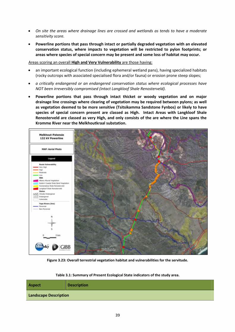
39
On site the areas where drainage lines are crossed and wetlands as tends to have a moderate sensitivity score.
Powerline portions that pass through intact or partially degraded vegetation with an elevated conservation status, where impacts to vegetation will be restricted to pylon footprints; or areas where species of special concern may be present and some loss of habitat may occur.
Areas scoring an overall High and Very Vulnerability are those having:
an important ecological function (including ephemeral wetland pans), having specialized habitats (rocky outcrops with associated specialised flora and/or fauna) or erosion prone steep slopes;
a critically endangered or an endangered conservation status where ecological processes have NOT been irreversibly compromised (intact Langkloof Shale Renosterveld).
Powerline portions that pass through intact thicket or woody vegetation and on major drainage line crossings where clearing of vegetation may be required between pylons; as well as vegetation deemed to be more sensitive (Tsitsikamma Sandstone Fynbos) or likely to have species of special concern present are classed as High. Intact Areas with Langkloof Shale Renosterveld are classed as very High, and only consists of the are where the Line spans the Kromme River near the Melkhoutkraal substation.
Figure 3.23: Overall terrestrial vegetation habitat and vulnerabilities for the servitude.
Table 3.1: Summary of Present Ecological State indicators of the study area.
Aspect Description
Landscape Description
40
Aspect Description
Aspect, Slope, Topography
Variable, flat to gently undulating in the south, becoming hilly and mountainous in the north towards the Gamtoos River. Flat within the Gamtoos River floodplain.
Substrate Generally rocky Sandstone and Shale.
Community Description
Vegetation units
Predominantly Kouga Grassy Sandstone Fynbos and Humansdorp Shale Renosterveld, with Gamtoos Thicket and Albany Alluvial Vegetation around Hankey.
Transformed vegetated with common grasses, ruderal weeds and pioneer thicket species.
Total Cover (%) > 90 %
Tree Canopy Cover (%)
< 10 % (small fynbos trees and forest/thicket along drainage lines
Shrub Cover (%) > 75 % (Intact Fynbos)
Herb Cover (%) ± 5 % (Intact Fynbos)
Grass Cover (%) ± 25 % (Cultivated and disturbed areas and grassy fynbos communities)
Bare soil/rock (%) ± 10 % (Roads and other cleared areas)
Estimated Tree Height (m)
Predominantly < 5 m, but may be taller in drainage lines and tall trees (mostly exotic) within the Gamtoos River floodplain.
Disturbances, current land uses and sources of degradation
Human disturbances/impacts
Gamtoos River area highly transformed as a result of agriculture (lands and orchards.
Habitat fragmentation
Minimal at present in the southern portions, but extensive in the Gamtoos River Valley.
Invasive Alien Plants
Prickly Pear and various tree species extensive in the general area but localised throughout the site.
Relative remaining intact habitat:
In the southern and hilly areas mostly intact to degraded, but highly transformed in the Gamtoos River floodplain.
Grazing (livestock) Livestock grazing evident, especially in the southern portion.
Hunting None evident during the site visits, but most likely does occur on farms.
Conservation No formalised conservation, but some private reserves in the vicinity. Outside of
41
Aspect Description
(flora) heavily cultivated areas, the general area is conducive to conservation farming.
Wetlands Numerous wetland features along the route, especially in the southern portion. Gamtoos River near Hankey and Patensie.
Recreational (sport)
None noted, but hiking and similar activities common in the general area.
Sensitivities
Conservation importance
A moderate to high conservation importance for Humansdorp Shale Renosterveld and Albany Alluvial Vegetation, Low to Moderate for the remaining vegetation units
Topography Topography variable from flat to undulating in the south and hilly or mountainous in the north. Gamtoos River floodplain flat.
Rehabilitation potential
High for disturbed and invaded areas, Low for cultivated and transformed areas.
Community structure
Variable depending on level of degradation and land use, where intact structure typical of Fynbos, Renosterveld and Alluvial communities.
Patterns of Biodiversity
Flora Natural indigenous vegetation contains a number of flora species endemic to the region as discussed in relevant section of the report.
Fauna Provides habitat for a range of faunal species, a number of which are endemic to the region.
Indigenous Species of Special Concern
A number of endemic and protected species present (see Flora SSC tables)
Alien invasion The temporary loss of habitat has occurred where infestation occurs but would likely recover should removal and management be sustained in the short to medium term. Large areas have been cleared by working for water programme.
Ecological Processes
Barriers to gene dispersal
The erection of fences and roads may have prevented the movement of some fauna and hence plant propagules (i.e. as their agents of dispersal). Thicket tends to be bird-dispersed, so fences would not necessarily be a barrier.
Corridors for gene dispersal
Fences and utility structures (e.g. transmission lines, telephone lines) that act as perches for birds may be viewed as corridors for bird mediated seed dispersal (Thicket species). These may not follow the dispersal routes in the PRS (e.g. ridges, drainage lines).
Coastal dunes None present within the site.
42
Aspect Description
(mobile)
Climatic gradients None
Drainage Lines/
Riparian Vegetation
Important from an ecological process perspective within the Kromme River catchment and associated drainage lines. Numerous wetlands present in the area.
Refugia Exposed rocky outcrops abundant within the area, and provide fire refuge for numerous Fynbos and Renosterveld species.
Fire
The frequency of fires has probably changed significantly in relation to the PRS. The frequency of fires in the study area is unknown, but probably moderate in Fynbos and Renosterveld. Thicket along drainage lines is known to be fire resistant.
Ecotones/Tension zones
Ecotones are present and important habitat for fauna and particularly fauna between tree clumps and fynbos areas.
Erosion Largely absent, except along roads on sloped areas.
Carbon storage In general Fynbos and Renosterveld is a low Carbon Accumulator. Thicket tends to be a moderate to high Carbon accumulator.
Medicinal plants Some medicinal plant species are present, but use/harvesting unknown. Numerous species in the area are known for their medicinal properties and some informal collecting is likely.
Food The value of the study area as a source of food is expected to be insignificant, with food plants being limited to a few tree species.
Fuelwood (availability)
No collection observed, although some alien clearing activities would have generated wood which may have been collected for fuelwood.
Building materials None observed, but historical use of large trees may have occurred for fencing and homestead construction in the area.
Grazing Grazing historically prevalent and likely to persist, mostly at low densities.
Conservation importance
Current Distribution (extent)
Humansdorp Shale Renosterveld and Albany Alluvial Vegetation has a limited distribution and tends to have high levels of transformation, Other units tend to have a greater regional distribution.
Relative Conservation importance
Intact remnants of Humansdorp Shale Renosterveld and Albany Alluvial Vegetation both have a limited distribution, and hence have high regional conservation status.
43
3.1.4 Protection status and Species of Special Concern
Within the study area a number of Protected flora are present:
Table 3.2: Species having protection status under PNCO, NFA or IUCN occurring in the area.
Botanical Name* Family Status** Regional Distribution/
Endemism+
*Highlighted Species are cited as being endemic to the vegetation units or region
** PNCO Protected by the Provincial Nature Conservation Ordinance; NFA Protected by the National Forests Act of 1998
+EC - Eastern Cape, WC - Western Cape, KZN - Kwazulu-Natal,
Obtaining permission for the destruction or removal of protected species
It is recommended that before the clearing of the proposed site is authorized, the appropriate permission be obtained from the Department of Economic Development and Environmental Affairs (DEDEA) for the destruction of species protected by the Provincial Nature Conservation Ordinance of 1974 (PNCO).
In order to obtain permission to remove or destroy species occurring under the Provincial Nature Conservation Ordinance a letter needs to be drafted and sent to DEDEA together with an application form. This letter must list the species that will be removed or destroyed and the reason for their removal or destruction.
These permits may be subject to certain conditions, for example allowing various nurseries to collect plants before vegetation clearance commences; the removal of certain species for rehabilitation purposes etc. These conditions will be drafted after the application has been received by DEDEA and a site visit has been undertaken.
All individuals of the protected indigenous species should firstly be avoided if possible, if not then secondly translocated or utilized during rehabilitation and landscaping. If this is not possible permits will be required to either trim or remove individuals.
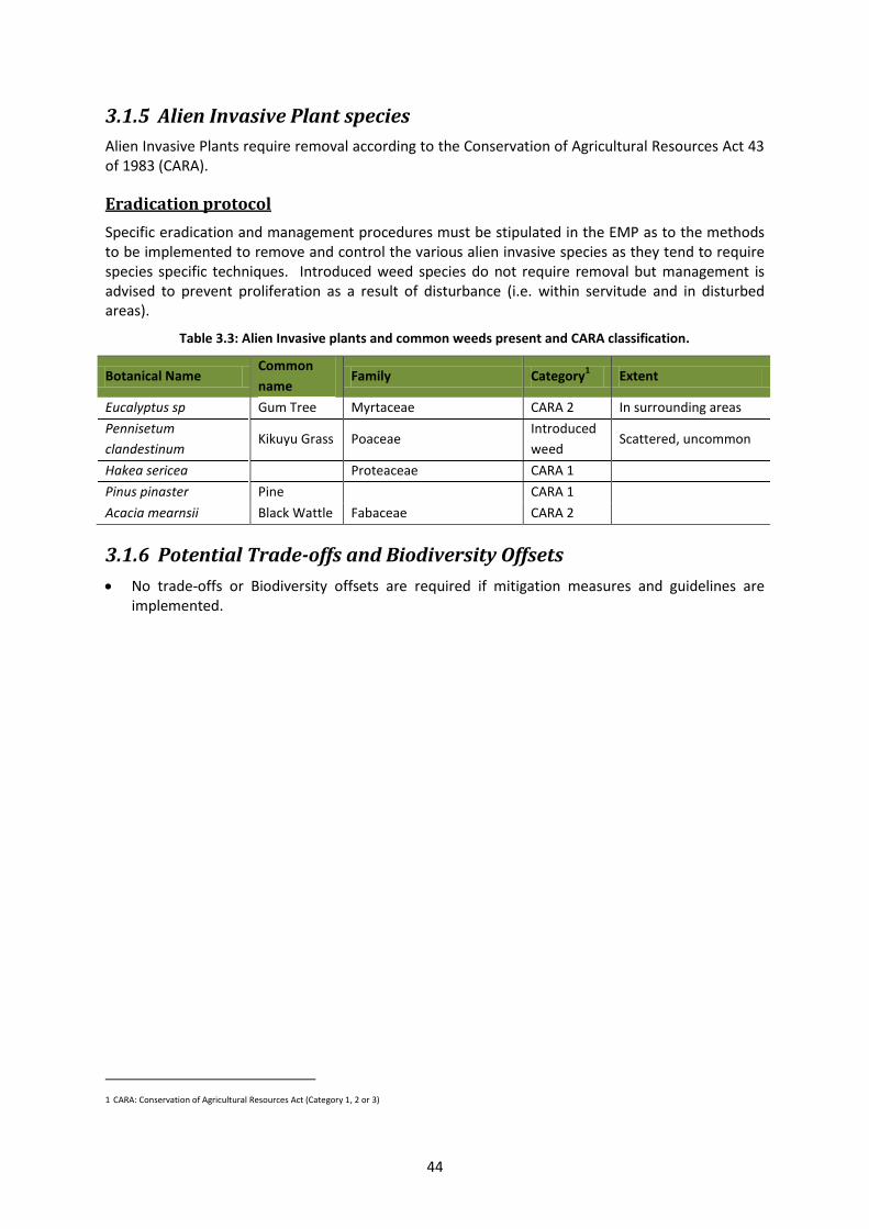
44
3.1.5 Alien Invasive Plant species
Alien Invasive Plants require removal according to the Conservation of Agricultural Resources Act 43 of 1983 (CARA).
Eradication protocol
Specific eradication and management procedures must be stipulated in the EMP as to the methods to be implemented to remove and control the various alien invasive species as they tend to require species specific techniques. Introduced weed species do not require removal but management is advised to prevent proliferation as a result of disturbance (i.e. within servitude and in disturbed areas).
Table 3.3: Alien Invasive plants and common weeds present and CARA classification.
Botanical Name Common
name Family Category
1 Extent
Eucalyptus sp Gum Tree Myrtaceae CARA 2 In surrounding areas
Pennisetum
clandestinum Kikuyu Grass Poaceae
Introduced
weed Scattered, uncommon
Hakea sericea Proteaceae CARA 1
Pinus pinaster Pine CARA 1
Acacia mearnsii Black Wattle Fabaceae CARA 2
3.1.6 Potential Trade-offs and Biodiversity Offsets
No trade-offs or Biodiversity offsets are required if mitigation measures and guidelines are implemented.
1 CARA: Conservation of Agricultural Resources Act (Category 1, 2 or 3)
45
CHAPTER 4: Prediction of environmental impacts
An evaluation and prediction of the likely impacts of the proposed development on the receiving environment has been performed. This report focuses on Botanical Impacts that may result from activities that will affect the flora within the study area and immediate surrounds.
4.1 INTRODUCTION
The proposed powerline servitude will result in some vegetation trimming and pruning along the servitude route, including associated access roads and complete removal of vegetation cover limited to the pylon footprints.
4.2 NATURAL HABITATS AND BIODIVERSITY THREATS
Effects to natural habitats and biodiversity will be related to changes in flora and direct loss of habitat. Key issues are to do with habitat loss or alteration, direct or indirect mortality (death) of locally endemic (native), threatened or endangered species and fragmentation of natural habitats.
Proposed powerline will impact terrestrial flora during construction as a result of the direct linear loss and of habitats, with a consequent loss of biodiversity and possibly loss of a few individuals of species of special concern. This may result from direct land clearance, or occur indirectly via loss or changes in habitats due to consequent changes in drainage patterns, increased fire risk in retained areas, or secondary impacts associated socio-economic factors.
Mitigation measures include translocation of rare plant species and habitat to ecosystem reconstruction sites or for use in Public Open Space, and avoidance of areas that may be conservation worthy.
4.3 EXISTING IMPACTS Existing anthropogenic impacts within the study area include:
1. Disturbances relating to agricultural activities including crops and orchards; 2. Alien invasion in disturbed areas, particularly along drainage lines and within riparian zones. 3. Disturbances relating to excessive fire;
4.4 PROPOSED PROJECT ACTIONS
The project will consist of the following infrastructure, requiring direct removal of vegetation:
1. Temporary pruning and clearing of vegetation associated with pylon construction and associated lay-down areas for powerline construction;
2. Permanent clearing of vegetation where access roads are required;
3. Long term pruning of vegetation where growth may interfere with powerline operations;
46
4.5 GENERAL IMPACT RATING SCALE FOR SPECIALISTS/ BASELINE DATA
To ensure a direct comparison between various specialist studies, six standard rating scales are defined and used to assess and quantify the identified impacts. This is necessary since impacts have a number of parameters that need to be assessed.
These scales are:
1. The Severity/ Benefit Scale, which assesses the importance of the impact from a purely technical perspective.
2. The Spatial Impact Scale, which assesses the extent or magnitude of the impact (the area that will be affected by the impact).
3. The Temporal Impact Scale, which assesses how long the impact will be felt. Some impacts are of a short duration, whereas others are permanent.
4. The Degree of Certainty Scale, which provides a measure of how confident the author feels about their prediction.
5. The Likelihood Scale, which provides an indication of the risk or chance of an impact taking place.
6. The Environmental Significance Scale, which assesses the importance of the impact in the overall context of the affected system or party.
To ensure integration of social and ecological impacts, to facilitate specialist assessment of impact significance, and to reduce reliance on value judgments, the severity of the impact within the scientific field in which it takes place (e.g. vegetation, fauna etc.) was assessed first. Thereafter, each impact was assessed within the context of time and space, and the probability of the impact occurring was quantified using the degree of certainty scale.
The impact was then assessed in the context of the whole environment to establish the “environmental significance” of the impact to the flora and vegetation.
The scales are described in detail below.
4.5.1 The Severity/ Beneficial Scale
The severity scale was used in order to scientifically evaluate how severe negative impacts would be, or how beneficial positive impacts would be on a particular affected system (for ecological impacts) or a particular affected party. This methodology attempts to remove any value judgments from the assessment, although it relies on the professional judgment of the specialist.
Negative Impact Positive Impact
Very severe
An irreversible and permanent change to the affected system(s)) which cannot be mitigated. For example, change in topography resulting from a quarry.
Very Beneficiary
A permanent and very substantial benefit to the affected system(s) with no alternative to achieve this benefit.
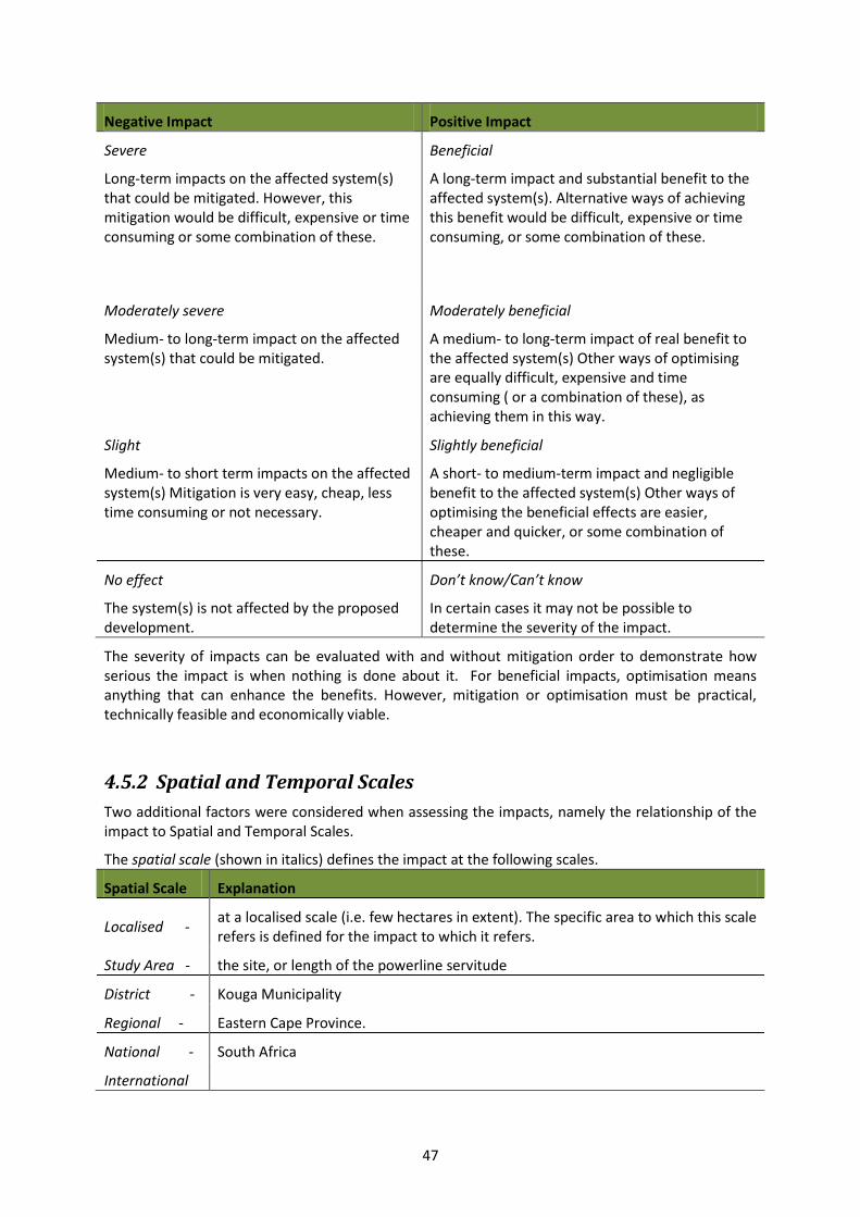
47
Negative Impact Positive Impact
Severe
Long-term impacts on the affected system(s) that could be mitigated. However, this mitigation would be difficult, expensive or time consuming or some combination of these.
Beneficial
A long-term impact and substantial benefit to the affected system(s). Alternative ways of achieving this benefit would be difficult, expensive or time consuming, or some combination of these.
Moderately severe
Medium- to long-term impact on the affected system(s) that could be mitigated.
Moderately beneficial
A medium- to long-term impact of real benefit to the affected system(s) Other ways of optimising are equally difficult, expensive and time consuming ( or a combination of these), as achieving them in this way.
Slight
Medium- to short term impacts on the affected system(s) Mitigation is very easy, cheap, less time consuming or not necessary.
Slightly beneficial
A short- to medium-term impact and negligible benefit to the affected system(s) Other ways of optimising the beneficial effects are easier, cheaper and quicker, or some combination of these.
No effect
The system(s) is not affected by the proposed development.
Don’t know/Can’t know
In certain cases it may not be possible to determine the severity of the impact.
The severity of impacts can be evaluated with and without mitigation order to demonstrate how serious the impact is when nothing is done about it. For beneficial impacts, optimisation means anything that can enhance the benefits. However, mitigation or optimisation must be practical, technically feasible and economically viable.
4.5.2 Spatial and Temporal Scales
Two additional factors were considered when assessing the impacts, namely the relationship of the impact to Spatial and Temporal Scales.
The spatial scale (shown in italics) defines the impact at the following scales.
Spatial Scale Explanation
Localised - at a localised scale (i.e. few hectares in extent). The specific area to which this scale refers is defined for the impact to which it refers.
Study Area - the site, or length of the powerline servitude
District - Kouga Municipality
Regional - Eastern Cape Province.
National - South Africa
International
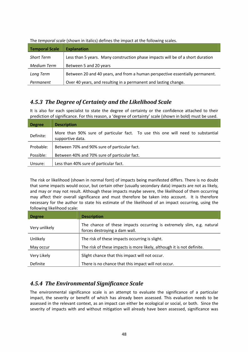
48
The temporal scale (shown in italics) defines the impact at the following scales.
Temporal Scale Explanation
Short Term Less than 5 years. Many construction phase impacts will be of a short duration
Medium Term Between 5 and 20 years
Long Term Between 20 and 40 years, and from a human perspective essentially permanent.
Permanent Over 40 years, and resulting in a permanent and lasting change.
4.5.3 The Degree of Certainty and the Likelihood Scale
It is also for each specialist to state the degree of certainty or the confidence attached to their prediction of significance. For this reason, a ‘degree of certainty’ scale (shown in bold) must be used.
Degree Description
Definite: More than 90% sure of particular fact. To use this one will need to substantial supportive data.
Probable: Between 70% and 90% sure of particular fact.
Possible: Between 40% and 70% sure of particular fact.
Unsure: Less than 40% sure of particular fact.
The risk or likelihood (shown in normal font) of impacts being manifested differs. There is no doubt that some impacts would occur, but certain other (usually secondary data) impacts are not as likely, and may or may not result. Although these impacts maybe severe, the likelihood of them occurring may affect their overall significance and must therefore be taken into account. It is therefore necessary for the author to state his estimate of the likelihood of an impact occurring, using the following likelihood scale:
Degree Description
Very unlikely The chance of these impacts occurring is extremely slim, e.g. natural forces destroying a dam wall.
Unlikely The risk of these impacts occurring is slight.
May occur The risk of these impacts is more likely, although it is not definite.
Very Likely Slight chance that this impact will not occur.
Definite There is no chance that this impact will not occur.
4.5.4 The Environmental Significance Scale
The environmental significance scale is an attempt to evaluate the significance of a particular impact, the severity or benefit of which has already been assessed. This evaluation needs to be assessed in the relevant context, as an impact can either be ecological or social, or both. Since the severity of impacts with and without mitigation will already have been assessed, significance was
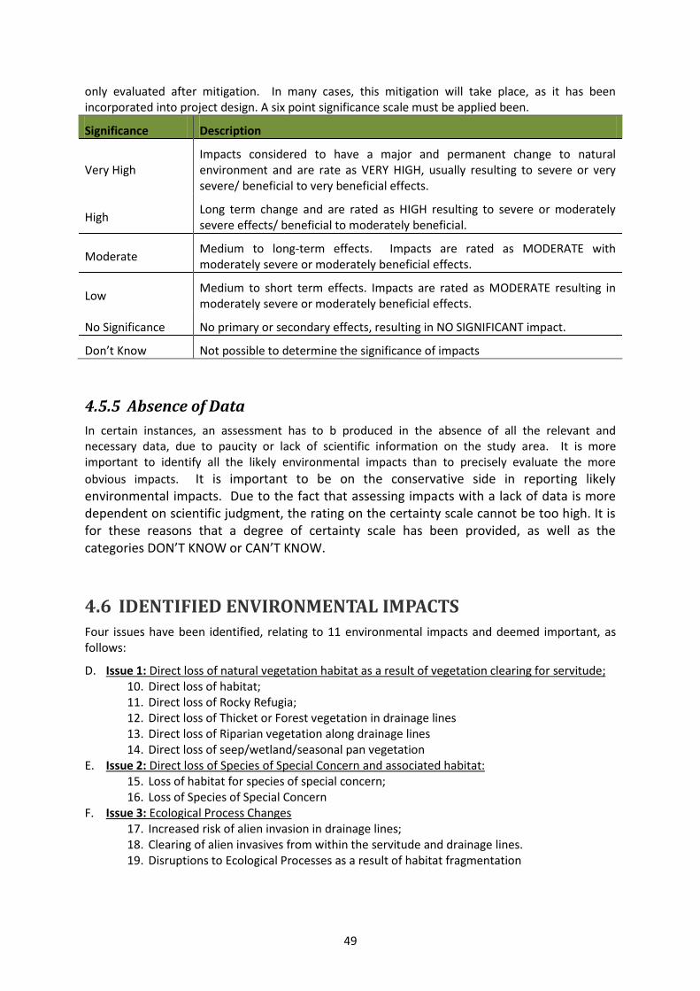
49
only evaluated after mitigation. In many cases, this mitigation will take place, as it has been incorporated into project design. A six point significance scale must be applied been.
Significance Description
Very High Impacts considered to have a major and permanent change to natural environment and are rate as VERY HIGH, usually resulting to severe or very severe/ beneficial to very beneficial effects.
High Long term change and are rated as HIGH resulting to severe or moderately severe effects/ beneficial to moderately beneficial.
Moderate Medium to long-term effects. Impacts are rated as MODERATE with moderately severe or moderately beneficial effects.
Low Medium to short term effects. Impacts are rated as MODERATE resulting in moderately severe or moderately beneficial effects.
No Significance No primary or secondary effects, resulting in NO SIGNIFICANT impact.
Don’t Know Not possible to determine the significance of impacts
4.5.5 Absence of Data
In certain instances, an assessment has to b produced in the absence of all the relevant and necessary data, due to paucity or lack of scientific information on the study area. It is more important to identify all the likely environmental impacts than to precisely evaluate the more
obvious impacts. It is important to be on the conservative side in reporting likely environmental impacts. Due to the fact that assessing impacts with a lack of data is more dependent on scientific judgment, the rating on the certainty scale cannot be too high. It is for these reasons that a degree of certainty scale has been provided, as well as the categories DON’T KNOW or CAN’T KNOW.
4.6 IDENTIFIED ENVIRONMENTAL IMPACTS Four issues have been identified, relating to 11 environmental impacts and deemed important, as follows:
D. Issue 1: Direct loss of natural vegetation habitat as a result of vegetation clearing for servitude; 10. Direct loss of habitat; 11. Direct loss of Rocky Refugia; 12. Direct loss of Thicket or Forest vegetation in drainage lines 13. Direct loss of Riparian vegetation along drainage lines 14. Direct loss of seep/wetland/seasonal pan vegetation
E. Issue 2: Direct loss of Species of Special Concern and associated habitat: 15. Loss of habitat for species of special concern; 16. Loss of Species of Special Concern
F. Issue 3: Ecological Process Changes 17. Increased risk of alien invasion in drainage lines; 18. Clearing of alien invasives from within the servitude and drainage lines. 19. Disruptions to Ecological Processes as a result of habitat fragmentation
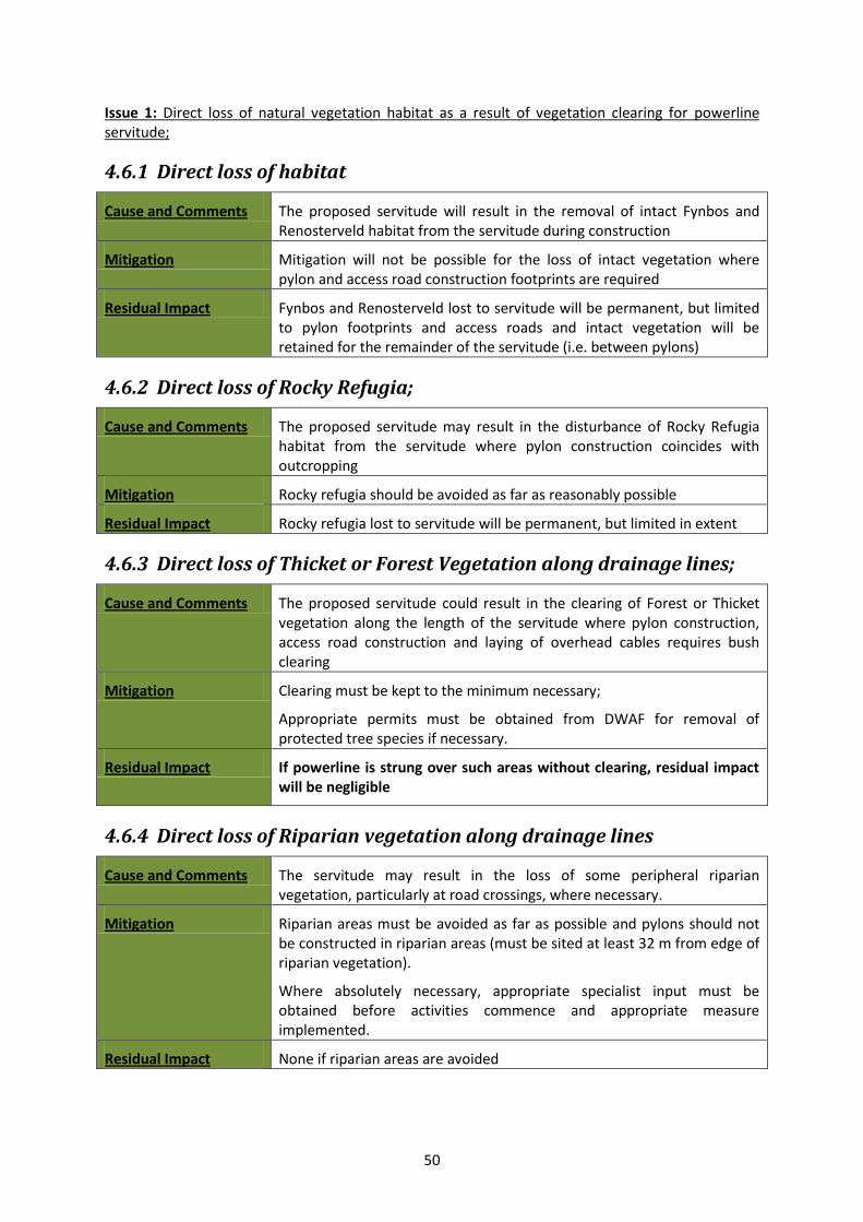
50
Issue 1: Direct loss of natural vegetation habitat as a result of vegetation clearing for powerline servitude;
4.6.1 Direct loss of habitat
Cause and Comments The proposed servitude will result in the removal of intact Fynbos and Renosterveld habitat from the servitude during construction
Mitigation Mitigation will not be possible for the loss of intact vegetation where pylon and access road construction footprints are required
Residual Impact Fynbos and Renosterveld lost to servitude will be permanent, but limited to pylon footprints and access roads and intact vegetation will be retained for the remainder of the servitude (i.e. between pylons)
4.6.2 Direct loss of Rocky Refugia;
Cause and Comments The proposed servitude may result in the disturbance of Rocky Refugia habitat from the servitude where pylon construction coincides with outcropping
Mitigation Rocky refugia should be avoided as far as reasonably possible
Residual Impact Rocky refugia lost to servitude will be permanent, but limited in extent
4.6.3 Direct loss of Thicket or Forest Vegetation along drainage lines;
Cause and Comments The proposed servitude could result in the clearing of Forest or Thicket vegetation along the length of the servitude where pylon construction, access road construction and laying of overhead cables requires bush clearing
Mitigation Clearing must be kept to the minimum necessary;
Appropriate permits must be obtained from DWAF for removal of protected tree species if necessary.
Residual Impact If powerline is strung over such areas without clearing, residual impact will be negligible
4.6.4 Direct loss of Riparian vegetation along drainage lines
Cause and Comments The servitude may result in the loss of some peripheral riparian vegetation, particularly at road crossings, where necessary.
Mitigation Riparian areas must be avoided as far as possible and pylons should not be constructed in riparian areas (must be sited at least 32 m from edge of riparian vegetation).
Where absolutely necessary, appropriate specialist input must be obtained before activities commence and appropriate measure implemented.
Residual Impact None if riparian areas are avoided
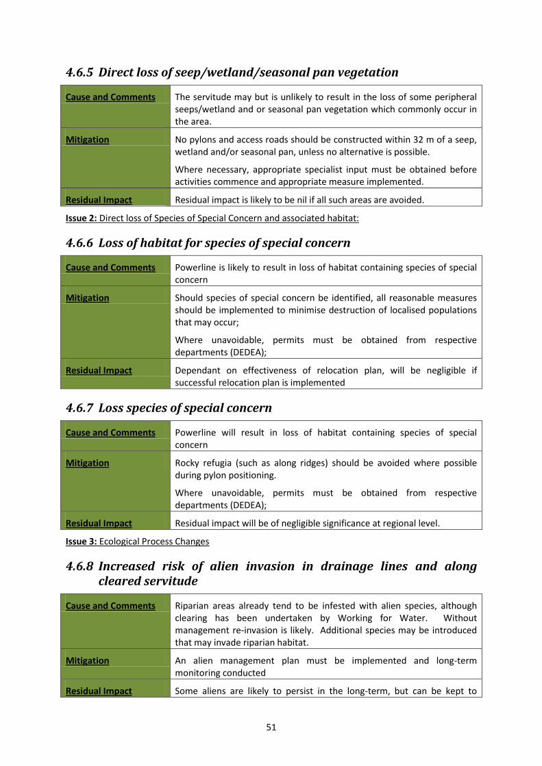
51
4.6.5 Direct loss of seep/wetland/seasonal pan vegetation
Cause and Comments The servitude may but is unlikely to result in the loss of some peripheral seeps/wetland and or seasonal pan vegetation which commonly occur in the area.
Mitigation No pylons and access roads should be constructed within 32 m of a seep, wetland and/or seasonal pan, unless no alternative is possible.
Where necessary, appropriate specialist input must be obtained before activities commence and appropriate measure implemented.
Residual Impact Residual impact is likely to be nil if all such areas are avoided.
Issue 2: Direct loss of Species of Special Concern and associated habitat:
4.6.6 Loss of habitat for species of special concern
Cause and Comments Powerline is likely to result in loss of habitat containing species of special concern
Mitigation Should species of special concern be identified, all reasonable measures should be implemented to minimise destruction of localised populations that may occur;
Where unavoidable, permits must be obtained from respective departments (DEDEA);
Residual Impact Dependant on effectiveness of relocation plan, will be negligible if successful relocation plan is implemented
4.6.7 Loss species of special concern
Cause and Comments Powerline will result in loss of habitat containing species of special concern
Mitigation Rocky refugia (such as along ridges) should be avoided where possible during pylon positioning.
Where unavoidable, permits must be obtained from respective departments (DEDEA);
Residual Impact Residual impact will be of negligible significance at regional level.
Issue 3: Ecological Process Changes
4.6.8 Increased risk of alien invasion in drainage lines and along cleared servitude
Cause and Comments Riparian areas already tend to be infested with alien species, although clearing has been undertaken by Working for Water. Without management re-invasion is likely. Additional species may be introduced that may invade riparian habitat.
Mitigation An alien management plan must be implemented and long-term monitoring conducted
Residual Impact Some aliens are likely to persist in the long-term, but can be kept to

52
manageable levels with appropriate control measures, through implementation of a long-term alien management plan
4.6.9 Clearing of alien invasives from within the site and drainage lines
Cause and Comments The proposed powerline will result in the removal of existing alien vegetation from within the servitude, which will reduce propagules production that may be spreading into adjacent areas
Mitigation Clearing of alien vegetation must be conducted as per the recommendations of an Environmental Management Plan to ensure that the spread of seed into surrounding areas is prevented
Residual Impact Some residual re-infestation is likely to occur as a result of the seed bank and result in the persistence of scattered individuals
4.6.10 Disruptions to Ecological Processes as a result of habitat fragmentation
Cause and Comments The proposed powerline will result in the removal of existing alien vegetation from within the servitude, which will reduce propagules production that may be spreading into adjacent areas
Mitigation Clearing of alien vegetation must be conducted as per the recommendations of an Environmental Management Plan to ensure that the spread of seed into surrounding areas is prevented
Residual Impact Some residual re-infestation is likely to occur as a result of the seed bank and result in the persistence of scattered individuals
4.6.11 Cumulative Impacts
Potential cumulative impacts are likely to fall into the following groups:
Cumulative regional loss of Rocky Refugia:- Negligible, limited to pylon footprints and access roads;
Cumulative regional loss of Fynbos and Renosterveld:- Negligible, limited to pylon footprints and access roads;
4.6.12 Assessment of the reversibility of impact
Impacts relating to pylon construction are likely to be highly reversible.
Impacts relating to road construction are likely to be moderately reversible.
4.6.13 Assessment of the degree to which the impact causes irreplaceable loss of resources
Intact or natural areas having a high conservation statues (Langkloof Shale Renosterveld) have a high irreplaceability, but these are limited in extent and number.
Irreplaceability of habitat is low for the remaining servitude area.
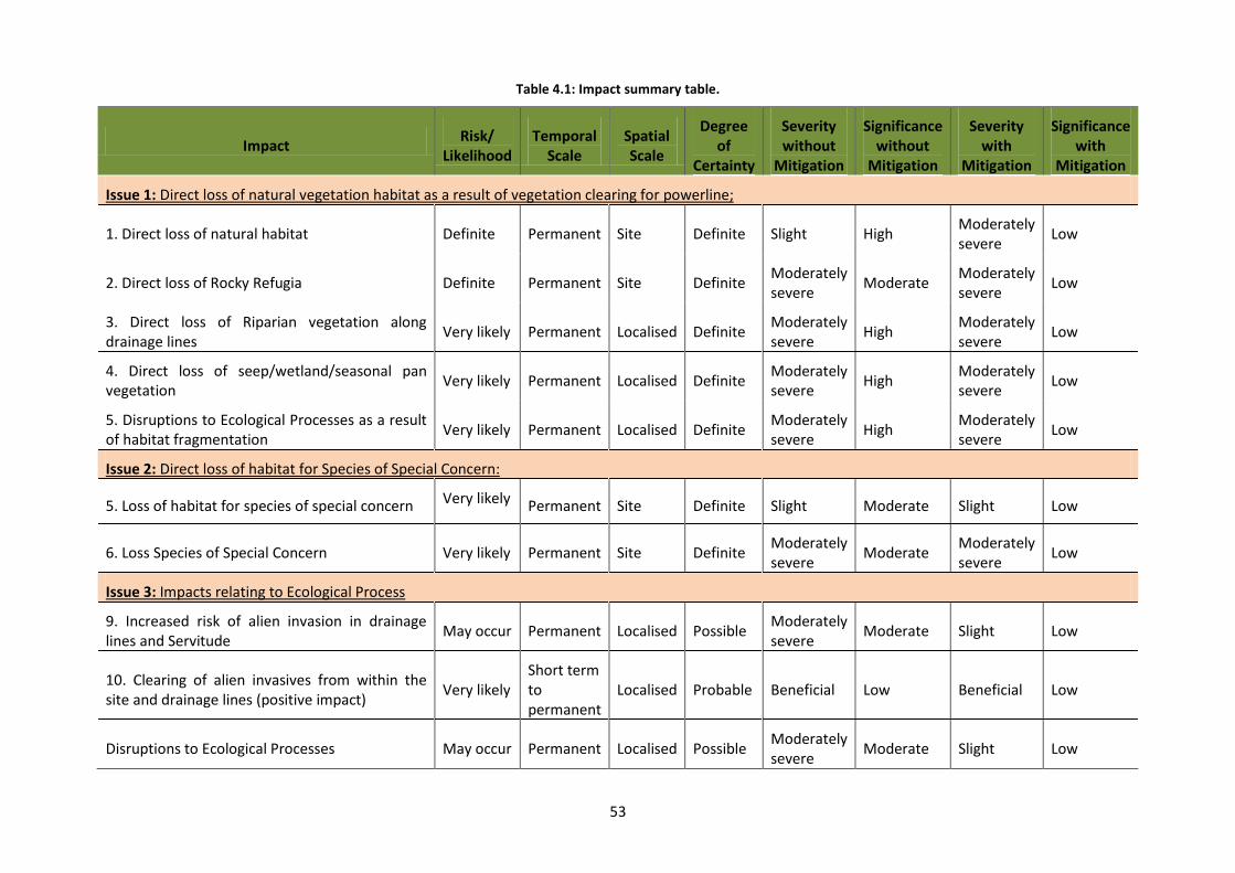
53
Table 4.1: Impact summary table.
Impact Risk/
Likelihood Temporal
Scale Spatial Scale
Degree of
Certainty
Severity without
Mitigation
Significance without
Mitigation
Severity with
Mitigation
Significance with
Mitigation
Issue 1: Direct loss of natural vegetation habitat as a result of vegetation clearing for powerline;
1. Direct loss of natural habitat Definite Permanent Site Definite Slight High Moderately severe
Low
2. Direct loss of Rocky Refugia Definite Permanent Site Definite Moderately severe
Moderate Moderately severe
Low
3. Direct loss of Riparian vegetation along drainage lines
Very likely Permanent Localised Definite Moderately severe
High Moderately severe
Low
4. Direct loss of seep/wetland/seasonal pan vegetation
Very likely Permanent Localised Definite Moderately severe
High Moderately severe
Low
5. Disruptions to Ecological Processes as a result of habitat fragmentation
Very likely Permanent Localised Definite Moderately severe
High Moderately severe
Low
Issue 2: Direct loss of habitat for Species of Special Concern:
5. Loss of habitat for species of special concern Very likely Permanent Site Definite Slight Moderate Slight Low
6. Loss Species of Special Concern Very likely Permanent Site Definite Moderately severe
Moderate Moderately severe
Low
Issue 3: Impacts relating to Ecological Process
9. Increased risk of alien invasion in drainage lines and Servitude
May occur Permanent Localised Possible Moderately severe
Moderate Slight Low
10. Clearing of alien invasives from within the site and drainage lines (positive impact)
Very likely Short term to permanent
Localised Probable Beneficial Low Beneficial Low
Disruptions to Ecological Processes May occur Permanent Localised Possible Moderately severe
Moderate Slight Low
54
CHAPTER 5: Conclusions and Recommendations
In general the servitude passes through degraded and transformed vegetation, with segments passing through areas of intact and near intact vegetation;
Only Langkloof Shale Renosterveld is present within the Powerline servitude, which has a NBA (2011) conservation status of Critically Endangered;
The proposed activity is unlikely to result in the clearing of greater than 300 square meters of Endangered Humansdorp Shale Renosterveld or Albany Alluvial Vegetation and a permit in terms of section 57(1) of NEMBA is unlikely to be required to carry out 'restricted activities' (including uprooting, damaging, destroying specimens) of listed threatened or protected species (as listed in terms of section 56 of NEMBA).
As part of the EMP, an ECO/ESO should be appointed to manage the identification and relocation of Species of Special Concern and management of vegetation clearing and subsequent revegetation and rehabilitation. A detailed EMP should be compiled to address these issues before construction commences.
It is recommended that individual screening is undertaken as part of the construction phase EMP for the areas identified as having elevated sensitivities, including drainage lines and river crossings with intact Thicket and areas with intact Humansdorp Shale Renosterveld or Albany Alluvial Vegetation to micro-site the pylons in order to minimise impact.
Some ephemeral/temporary wetlands, pans and dams occur within or adjacent to the powerline servitude. No powerline pylons should be sited within wetlands, pans and dams and a 32 m exclusion buffer should be placed around these features. Suitable management of these must be addressed in the EMP to minimise impacts during the construction phase, relating particularly to siltation due to soil erosion and permanent changes to drainage lines that may alter wetland processes.
Care should be taken that no power line pylons are sited in wetlands and temporary seasonal pans (32 m exclusion zone around these features). Should it be unavoidable, relevant permissions will need to be obtained from DAFF.
Powerlines passing through riverine thicket/forest patches should be sited such that impacts to this vegetation is minimised.
The substations must avoid any wetland areas (including seasonal wetlands, pans and seeps), other sensitive vegetation (thicket and forest), drainage lines and riparian vegetation along river banks. Should it be unavoidable, relevant permissions will need to be obtained from DWAF.
No powerline pylons should be placed within the 1:50 year flood line or on flood plains that may be susceptible to future flooding.
5.1 RISKS AND UNCERTAINTIES A number of risks and uncertainties relating to the powerline and associated substations and access roads have been identified for the purpose of this report:
Intact Thicket along drainage lines may require clearing during powerline construction. This could lead to loss of vegetation cover and associated removal of both protected and endemic species of special concern as well as potential long-term erosion risk and elevated erosion risk. Where this is heavily invaded, clearing may be beneficial IF alien species ONLY are removed
55
during construction, and natural vegetation is allowed to re-establish. Where thicket/forest is composed of indigenous species, the powerline must be hung without removing trees, unless in areas where a cleared servitude already exists.
Intact rocky refugia may provide niche habitat for a number of species of special concern and local endemics present, and should be avoided during pylon micro-siting and construction.
Intact Albany Alluvial Vegetation and Riparian Vegetation along the Gamtoos River may require clearing during powerline construction. This could lead to loss of vegetation cover and associated removal of both protected and endemic species of special concern as well as potential long-term erosion risk and elevated erosion risk and further fragmentation of already significantly fragmented areas. Where this is heavily invaded, clearing may be beneficial IF alien species ONLY are removed during construction, and natural vegetation is allowed to re-establish. Where thicket is composed of indigenous species, the powerline must be hung without removing trees, unless in areas where a cleared servitude already exists.
5.2 REHABILITATION POTENTIAL AND PROCESSES
5.2.1 Rehabilitation Objective
The overall objective of the rehabilitation plan is to minimize adverse environmental impacts associated with the activity whilst maximizing the future utilization of the property. Additional broad rehabilitation strategies / objectives include the following:
Rehabilitating the post construction areas to take place concurrently within prescribed framework established in the EMP.
All infrastructure, equipment, plant and other items used during the construction period will be removed from the site
Waste material of any description, including scrap, rubble and tyres, will be removed entirely from the construction area and disposed of at a recognised landfill facility. It will not be permitted to be buried or burned on site.
Final rehabilitation shall be completed within a specified period.
5.2.2 Rehabilitation Plan
The overall revegetation plan will be as follows:
Ameliorate the aesthetic impact of the site;
Minimize surface erosion and consequent siltation of natural water courses located along the servitude;
Enhance the physical properties of the soil where necessary;
Re-establish a stable ecological system, through implementing a revegetation plan where necessary.
Drainage and Erosion Control
To control the drainage and erosion at site the following procedures will be adopted:
Existing vegetation must be retained as far as possible to minimize erosion problems.
Adequate measures must be implemented in steep areas where erosion could be a problem through consultation with engineer and/or ECO.
56
Topsoil and Subsoil Replacement
Where topsoil has been removed (around pylon and substation construction, sited, it should be spread over disturbed areas and a suitable cover crop (local grasses) planted.
5.2.3 Monitoring and Reporting
Adequate management, maintenance and monitoring will be carried out annually by the applicant to ensure successful rehabilitation of the property until a closure certificate is obtained.
To minimise adverse environmental impacts associated with the activity it is intended to adopt a progressive rehabilitation programme, which will entail carrying out the proposed rehabilitation procedures concurrently with activities.
Inspecting and Monitoring
Regular monitoring of all the environmental management measures and components shall be carried out to ensure that the provisions of this programme are adhered to.
Ongoing and regular reporting of the progress of implementation of this programme will be done. An environmental audit shall be carried out by an independent consultant on an annual/biannual basis.
Inspections and monitoring shall be carried out on both the implementation of the programme and the impact on plant life.
5.3 ENVIRONMENTAL MANAGEMENT PLAN
A detailed Environmental Management Plan (EMP) must be compiled to address the following key elements, some guidelines for which are provided in this report:
a. Comprehensive rescue and storage in a suitable constructed nursery and storage area of plants deemed to be requiring either rescue for replanting and plants that will be useful during rehabilitation or alternatively a relocation plan should be implemented;
b. Construction Action Plan for clearing of vegetation where construction activities are to commence;
c. Detailed Revegetation and Rehabilitation Plan to be conducted during construction and operation as outlined above.
5.3.1 No Go Areas
1. No go areas must be clearly demarcated (using fencing and appropriate signage where applicable) before any construction commences.
2. Contractors and construction workers must be clearly informed of such no-go areas and held accountable for any infringements that may occur.
3. No access to the demarcated areas should be permitted during the construction phase and contractors must be clearly informed of these areas. A suitable control measure (such as a fine system) must be implemented to discourage infringement by contractors.
4. Activities including but not restricted to the following must not be permitted in designated no-go areas:
a. Dumping of any material during and after construction; b. Turning of vehicles; c. Trampling and urination by construction workers.
57
5.3.2 Alien vegetation clearing
1. An alien removal program must be implemented to remove alien vegetation from within the servitude during construction phase and for the lifespan of the powerline operation;;
2. Cleared alien vegetation must not be dumped on adjacent intact vegetation during clearing but should be temporarily stored in a demarcated area (in consultation with the relevant botanical specialist;
3. Cleared vegetation must be either removed from site or burned in-situ in the temporary storage area, where appropriate;
4. Any seed bearing material should be removed from the drainage areas to prevent the spread of seed.
5. Chopped brushwood can be used to stabilise steep areas that may be susceptible to erosion during clearing activities;
6. A suitable revegetation or rehabilitation plan must be implemented after alien vegetation clearing.
7. A long-term alien maintenance plan must be designed and implemented in conjunction with a suitably qualified expert.
5.3.3 River crossings
1. Powerline siting must be such that it minimises impact to the riparian areas with minimal alterations to riparian vegetation and must be permeable to movement of fauna and flora;
2. River crossing construction must be completed as timeously as possible and efforts must be in place to minimise erosion risk and sedimentation of the stream during the construction phase, especially during high rainfall events.
5.3.4 Search and Rescue of SSC
1. A suitable timeframe must be allowed before construction commences to undertake the plant rescue and relocation operation;
2. Plants that can be used during rehabilitation should be identified and stored appropriately off-site for use after construction and alien vegetation clearing;
3. Plants identified as being suitable for relocation listed above can either be removed from the site or replanted within the proposed buffer areas.
58
CHAPTER 6: References
Cowling, R., Lombard, A., Rouget, M., Kerley, G., Wolf, T., Sims-Castley, R., et al. (2003). A conservation assessment for the subtropical thicket biome. University of Port Elizabeth.
Golding, J. (2002). Workshop Proceedings: Revision of the national list of protected trees as per section 12, National Forests Act of 1998. Roodeplaat. Pretoria.
Kemper, N. P. (2001). Riparian Vegetation Index. Water Research Commission.
Klein, H. (2002). Legislation regarding harmful plants in South Africa. PPRI Leaflet Series: Weeds Biocontrol , 12, 1-4.
Kleynhans, C. (2000). Desktop estimates of the ecological importance and sensitivity categories (EISC), default ecological management classes (DEMC), present ecological status categories (PESC), present attainable EMC (present AEMC), and best AEMC for quat. catchments in SA. Institute for Water Quality Studies.
Lombard, A., Wolf, T., & Cole, N. (2003). GIS coverages and spatial analysis for the Subtropical Ecosystem Planning (STEP) project. Port Elizabeth: University of Port Elizabeth.
Low, A., & Rebelo, A. (1996). Vegetation of South Africa, Lesotho and Swaziland. Pretoria: Department of Environemtal Affairs and Tourism.
Mucina, L., & Rutherford, M. (2006). The Vegetation of South Africa, Lesotho and Swaziland. Pretoria: South African Biodiversity Institute.
Pierce, S. (2003). The STEP Mapbook: Integrating the natural environment into land use decisions at the municipal level: towards sustainable development. Port Elizabeth: University of Port Elizabeth.
Stewart, W., Cowling, R., Martin, A., du Preez, D., & Lombard, A. (2004). A Biodiversity Conservation Assessment and Framework for an Open Space System for the Nelson Mandela Metropole,Cape Floristic Region, South Africa. A report of the C.A.P.E. Project for the Table Mountain Fund (WWF-SA).
Victor, J., & Dold, A. (2003). Threatened plants of the Albany centre of floristic endemism, South Africa. South Africa Journal of Science , 99, 437-446.
Vlok, H., & Euston-Brown, D. (2002). The patterns within, and the ecological proceses that sustain the subtropical thicket vegetation in the planning domain for the Subtropical Thicket Ecosystem, South Africa. Port Elizabeth: University of Port Elizabeth.
59
CHAPTER 7: Maps
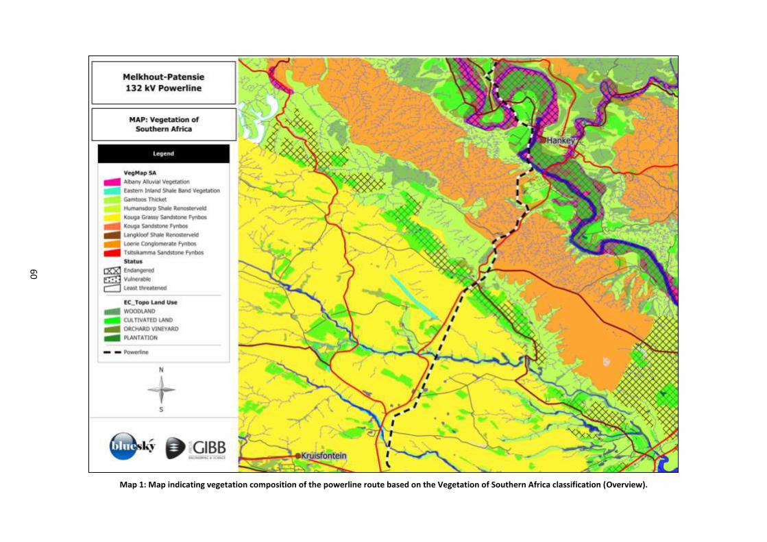
60
Map 1: Map indicating vegetation composition of the powerline route based on the Vegetation of Southern Africa classification (Overview).
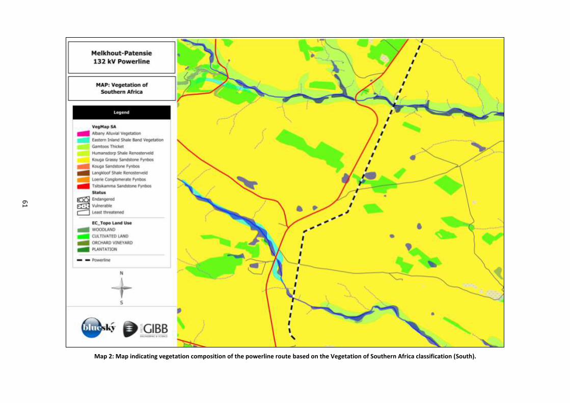
61
Map 2: Map indicating vegetation composition of the powerline route based on the Vegetation of Southern Africa classification (South).
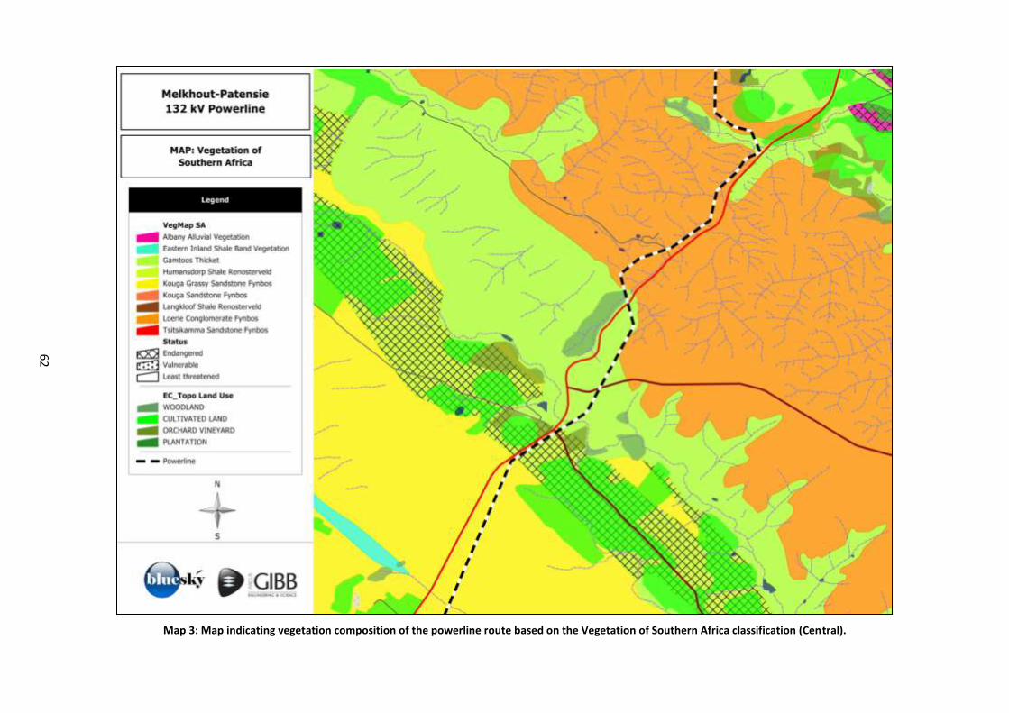
62
Map 3: Map indicating vegetation composition of the powerline route based on the Vegetation of Southern Africa classification (Central).
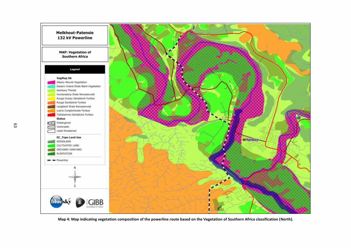
63
Map 4: Map indicating vegetation composition of the powerline route based on the Vegetation of Southern Africa classification (North).
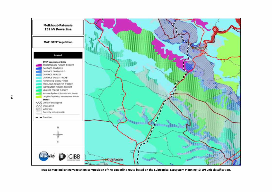
64
Map 5: Map indicating vegetation composition of the powerline route based on the Subtropical Ecosystem Planning (STEP) unit classification.
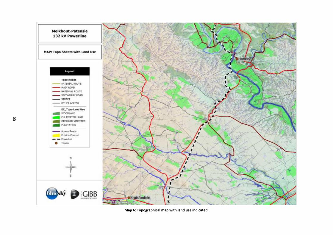
65
Map 6: Topographical map with land use indicated.
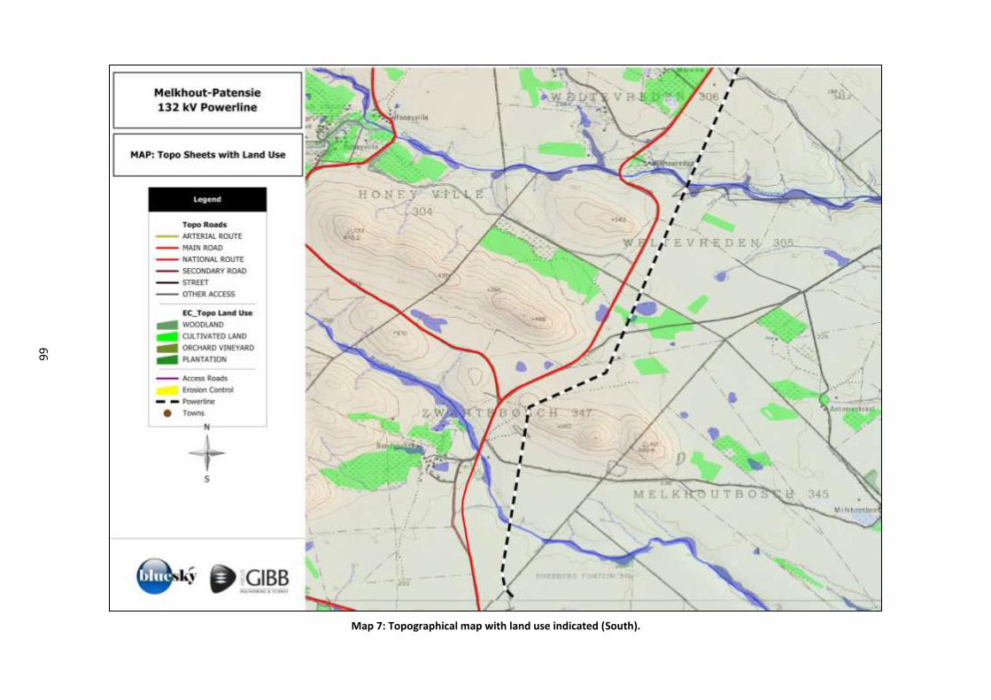
66
Map 7: Topographical map with land use indicated (South).
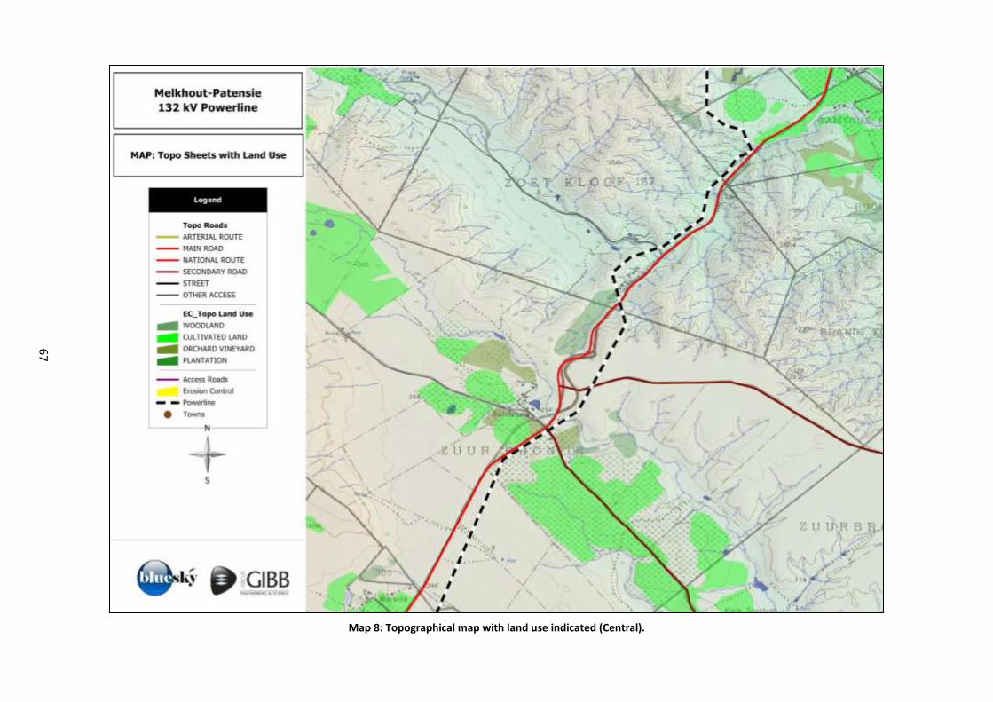
67
Map 8: Topographical map with land use indicated (Central).
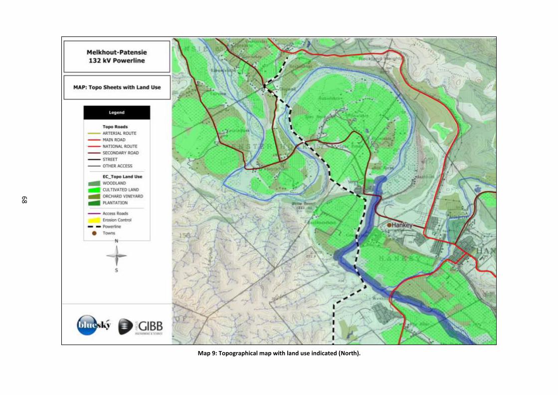
68
Map 9: Topographical map with land use indicated (North).
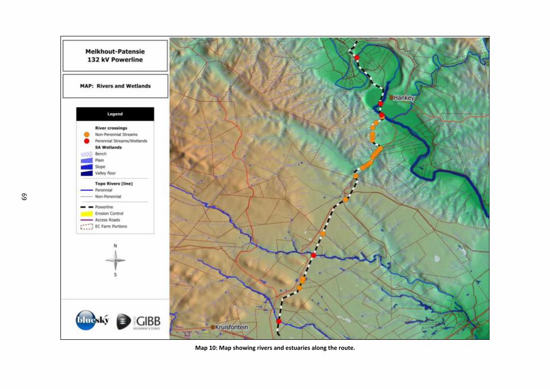
69
Map 10: Map showing rivers and estuaries along the route.
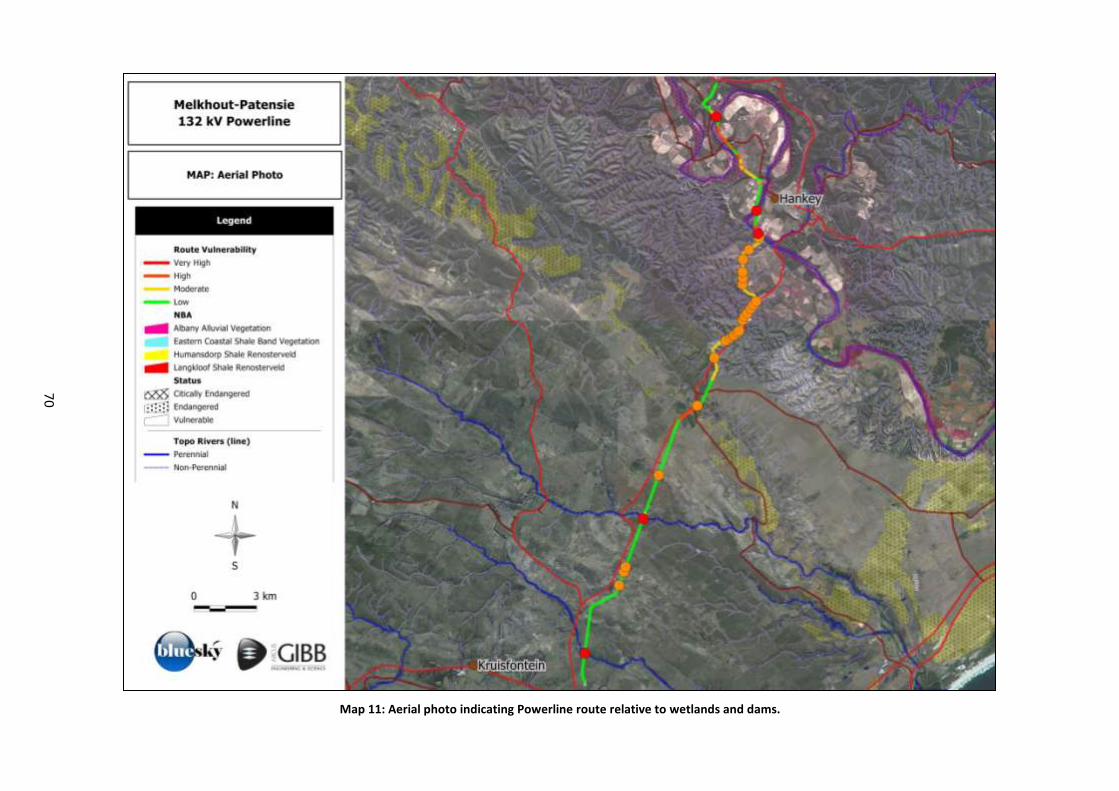
70
Map 11: Aerial photo indicating Powerline route relative to wetlands and dams.
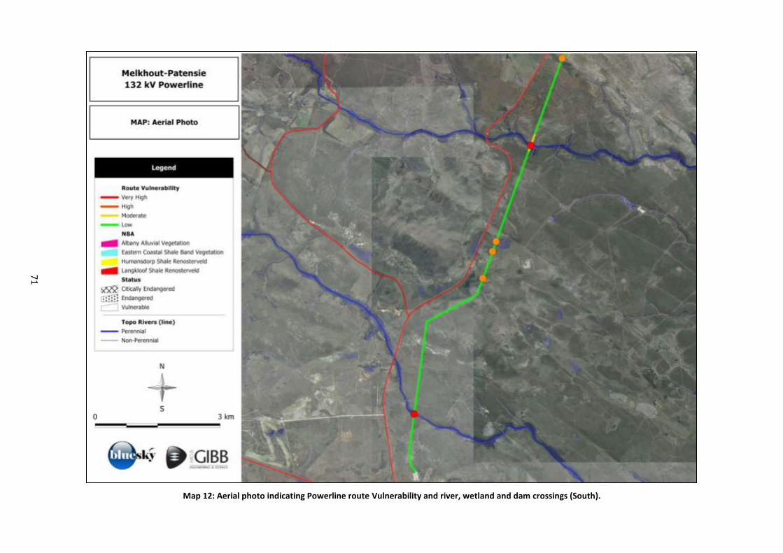
71
Map 12: Aerial photo indicating Powerline route Vulnerability and river, wetland and dam crossings (South).
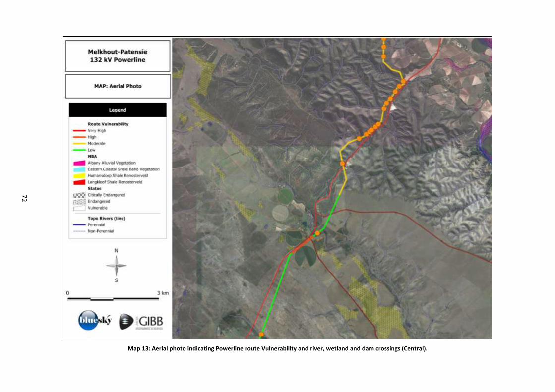
72
Map 13: Aerial photo indicating Powerline route Vulnerability and river, wetland and dam crossings (Central).
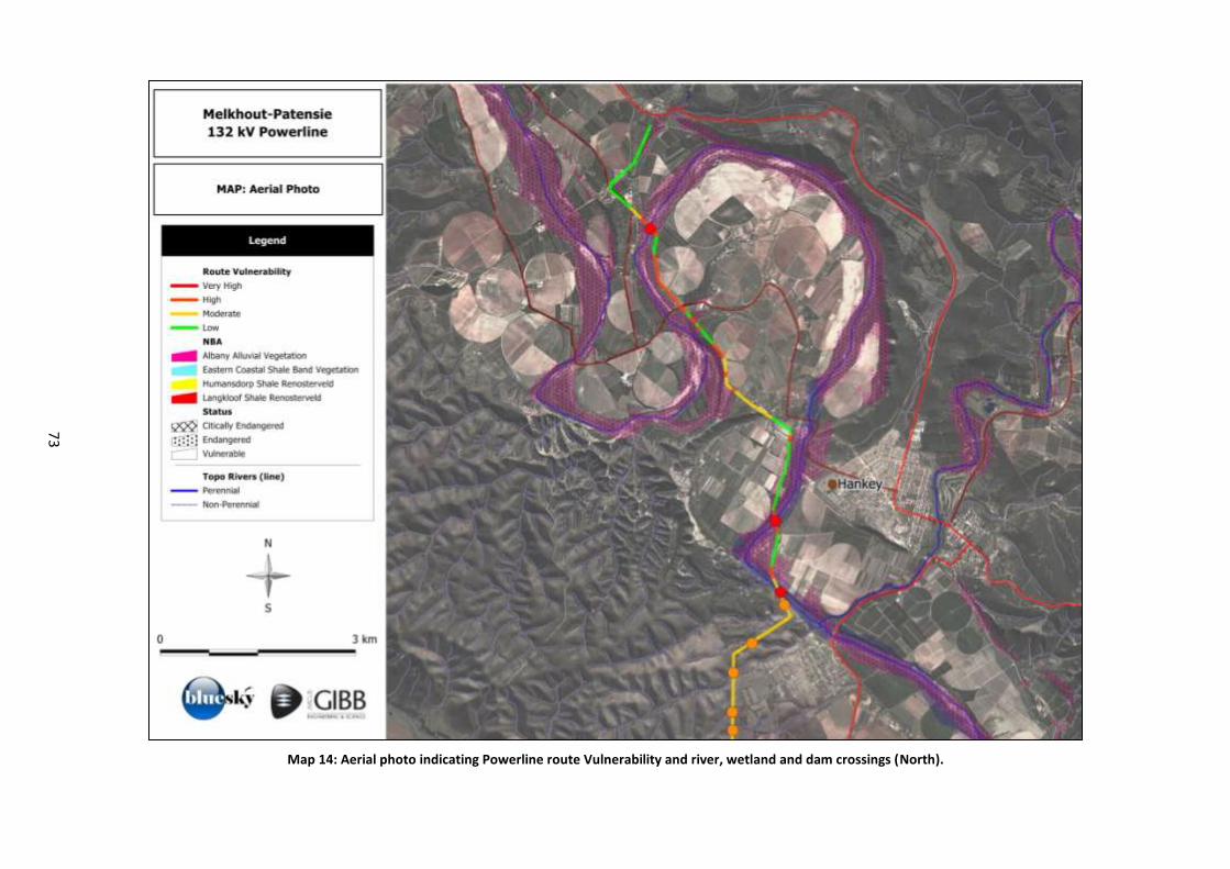
73
Map 14: Aerial photo indicating Powerline route Vulnerability and river, wetland and dam crossings (North).

Melkhout- Patensie dBAR_v0.4_lowres.doc
APPENDIX D3
Heritage (Archaeology and Palaeontology Impact Assessment
Melkhout- Patensie dBAR_v0.4_lowres.doc
Terms of Reference: Heritage Assessment (Archaeology and Palaeontology) The emphasis of the HIA is on resources that are sensitive to visual change, and the disruption of archaeological artefacts/finds at the proposed sites. Visual resources are usually places, structures and landscapes that are or could be publicly celebrated as heritage.
1. Conduct a desktop study within a 100 metre wide servitude over various potential corridors and deviations over a distance of 90 kilometres.
2. Conduct a site visit to verify potential sites or areas that may be of heritage importance. 3. Describe and report on any site or area that may contain potential heritage resources that must be
considered. 4. Assessed and evaluated the potential impact on identified heritage resources according to the
magnitude, spatial scale, timing, duration, reversibility, probability and significance. 5. Propose and explain mitigation measures 6. Summarise residual impacts after mitigation. An impact summary table will be provided, discussing
expected impacts before and after mitigation. 7. Draft an impact statement of the proposed development on the potential heritage resources.
Other factors to be considered:
Electronic databases of visually sensitive heritage resources do not exist for the study area, and paper versions are extremely limited.
In palaeontological terms the Dieprivier – Kareedouw sector is unproblematic (mainly Table Mountain Group) but the other two sections transect rock units of high palaeontological sensitivity (e.g. Early Devonian Lower Bokkeveld Group, Early Cretaceous Kirkwood Formation) and the stratigraphy is quite complex in terms of the number of rock units concerned (Dr John Almond, email communication 14 November 2011).
In open landscape during daylight hours, distribution lines on self-supporting towers are visible (but not necessarily intrusive) from a distance of 2 to 5km. Guidelines for the development of wind energy facilities in the Western Cape have suggested that a buffer zone of 1km be established around significant visually sensitive heritage resources to minimise the change to the ‘sense of place’. The point at which a distribution line may be perceived as intrusive or offensive is subjective.
The presence of an existing distribution line in an area serves as a mitigatory factor rather than a cumulative negative impact, in terms of establishing new distribution lines in the same area (within a distance of 1km of the existing line). Electrical infrastructure is therefore best confined to an existing area or corridor of vertical visual disturbance, rather than introducing new infrastructure to an undisturbed landscape.
Distribution power line routes should be chosen to minimise the requirements for new infrastructure such as access roads, which have the greatest permanent direct and indirect impact on the landscape. This factor supports the previous observation in that new distribution lines located close to existing lines can share access and maintenance roads.
The linear nature of the project where tower positions can be altered (within limits) to avoid direct impacts on heritage resources such as archaeological and palaeontological sites that may have high heritage significance due to their scientific values, but are generally not publicly celebrated as resources sensitive to visual change.
Melkhout- Patensie dBAR_v0.4_lowres.doc
Melkhout- Patensie dBAR_v0.4_lowres.doc
Phase 1 Heritage Impact Assessment Report:
132kV Power Line and Substation Infrastructure,
Melkhout-Patensie,
Kouga Local Municipality,
Cacadu District Municipality,
Eastern Cape Province, South Africa
Prepared for
Arcus GIBB Engineering and Science 2nd Floor, Greyville House, Cnr Greyville & Cape Roads,
Greenacres, Port Elizabeth 6001 Box 63703, Greenacres 6057
Telephone Mathys Vosloo 084 748 3018; 041 392 7518 Fax 041 363 9300; 086 545 8835
Prepared by
eeTThheemmbbeennii
CCuullttuurraall
HHeerriittaaggee Len van Schalkwyk and Elizabeth Wahl
Box 20057 Ashburton 3213 Pietermaritzburg Telephone 033 326 1136 / 082 655 9077 / 082 529 3656
Facsimile 086 672 8557 [email protected]
30 May 2012
PHASE 1 HIA OF MELKHOUT-PATENSIE 132KV POWER LINE AND SUBSTATION SITE, EASTERN CAPE
eThembeni Cultural Heritage for Arcus GIBB Engineering and Science Page 2
Management Summary
eThembeni Cultural Heritage was appointed by Arcus GIBB Engineering and Science to undertake a Phase
1 Heritage Impact Assessment of a proposed transmission power line and substation site in the Eastern
Cape Province, in terms of the National Environmental Management Act 107 of 1998 as amended, in
compliance with Section 38 of the National Heritage Resources Act 25 of 1999, as amended.
Heritage resource descriptions, significance and development impacts
Landscapes
The proposed electrical infrastructure is located along the Gamtoos Scenic Route. This scenic route has high
local and regional significance for its aesthetic and economic (tourism) values. The unmanaged potential
impact on this landscape is medium.
Traditional burial places
An informal burial ground is located between bending towers MP50 and MP51. All human remains have high
heritage significance at all levels for their spiritual, social and cultural values. The unmanaged potential
impact on these burial places is medium.
Palaeontology
The proposed electrical infrastructure between Kareedouw and Patensie is underlain by potentially
fossiliferous bedrocks of Palaeozoic, Mesozoic and Caenozoic age. Early Cretaceous Kirkwood Formation
beds near Patensie may contain important fossils of dinosaurs and other terrestrial vertebrates as well as
petrified wood, while older alluvial sediments of the Gamtoos drainage system are also potentially fossil-
bearing. The unmanaged potential impact on palaeontological remains is low to medium.
Recommended mitigation
Landscapes
Towers should be located such that they do not interrupt skylines, and are not visible from scenic routes.
Traditional burial places
No development activity of any nature may occur within twenty metres of the identified burial ground, with its
boundaries taken to be straight lines between the geographic co-ordinates provided in Section 6.
General, including palaeontology
A heritage practitioner should complete a ‘walk-through’ of the final selected power line route and all other
activity areas (access roads, construction camps, materials’ storage areas, etc.) prior to the start of any
construction activities and assess direct impacts on discrete resources such as traditional burial places, and
archaeological and palaeontological sites.
Recommended monitoring
None at present.
Conclusion
We recommend that the development proceed with the proposed heritage mitigation and have submitted this
report to SAHRA in fulfilment of the requirements of the NHRA. Relevant staff members may be contacted at
the SAHRA Cape Town head office (Mariagrazia Galimberti telephone 021 462 4502;
[email protected]). If permission is granted for development to proceed, the client is reminded
that the NHRA requires that a developer cease all work immediately and follow the protocol contained in
Section 10 of this report should any heritage resources, as defined in the Act, be discovered during the
course of development activities.
PHASE 1 HIA OF MELKHOUT-PATENSIE 132KV POWER LINE AND SUBSTATION SITE, EASTERN CAPE
eThembeni Cultural Heritage for Arcus GIBB Engineering and Science Page 3
Contents
Page
1 Introduction 4
2 Terms of reference 4
3 Project description 5
4 Project location and environmental description 6
5 Method and approach 7
6 Heritage resources and significance 10
7 Assessment of impacts 13
8 Recommended mitigation 14
9 Recommended monitoring 15
10 Protocol for the identification, protection and recovery of
heritage resources during construction and operation 15
11 Conclusion 16
12 Bibliography 17
Appendix A Statutory requirements 18
Appendix B Coordinates of site infrastructure 23
Appendix C Archaeological and historical context of the study area 25
Appendix D Criteria for determination of significance of and impacts on
heritage resources 36
Appendix E Palaeontological Impact Assessment 40
Appendix F Specialist competency and Declaration of independence 42
List of figures Figure 1 Patensie-Kareedouw power line, Eastern Cape. 6
Figure 2 Traditional burial ground near Hankey. 10
Figure 3 Location of burial ground overlooking agricultural fields. 11
Figure 4 Graves marked with stone piles and wooden crosses. 11
Figure 5 The grave of Marily Bosman. 12
Figure 6 Proposed tower positions along the Gamtoos Scenic Route. 14
PHASE 1 HIA OF MELKHOUT-PATENSIE 132KV POWER LINE AND SUBSTATION SITE, EASTERN CAPE
eThembeni Cultural Heritage for Arcus GIBB Engineering and Science Page 4
1 Introduction
eThembeni Cultural Heritage was appointed by Arcus GIBB Engineering and Science to undertake a Phase
1 Heritage Impact Assessment of a proposed transmission power line and substation site in the Eastern
Cape Province, in terms of the National Environmental Management Act 107 of 1998 as amended (NEMA),
in compliance with Section 38 of the National Heritage Resources Act 25 of 1999, as amended (NHRA)
(refer to Appendix A).
South Africa’s heritage resources are both rich and widely diverse, encompassing sites from all periods of
human history. Resources may be tangible, such as buildings and archaeological artefacts, or intangible,
such as landscapes and living heritage. Their significance is based upon their aesthetic, architectural,
historical, scientific, social, spiritual, linguistic, economic or technological values; their representivity of a
particular time period; their rarity; and their sphere of influence.
The integrity and significance of heritage resources can be jeopardized by natural (e.g. erosion) and human
(e.g. development) activities. In the case of human activities, a range of legislation exists to ensure the
timeous identification and effective management of heritage resources for present and future generations.
This report represents compliance with a full Phase 1 HIA for the proposed development, including a
specialist desktop palaeontological study.
2 Terms of reference
An HIA must address the following key aspects:
the identification and mapping of all heritage resources in the area affected;
an assessment of the significance of such resources in terms of heritage assessment criteria set out in
regulations;
an assessment of the impact of the development on heritage resources;
an evaluation of the impact of the development on heritage resources relative to the sustainable social
and economic benefits to be derived from the development;
the results of consultation with communities affected by the proposed development and other interested
parties regarding the impact of the development on heritage resources;
if heritage resources will be adversely affected by the proposed development, the consideration of
alternatives; and
plans for mitigation of any adverse effects during and after completion of the proposed development.
In addition, the HIA should comply with the requirements of NEMA, including providing the assumptions and
limitations associated with the study; the details, qualifications and expertise of the person who prepared the
report; and a statement of independence.
PHASE 1 HIA OF MELKHOUT-PATENSIE 132KV POWER LINE AND SUBSTATION SITE, EASTERN CAPE
eThembeni Cultural Heritage for Arcus GIBB Engineering and Science Page 5
3 Project description1
New 132 kV overhead transmission power lines are proposed to strengthen and upgrade the grid supply in
the Patensie, Humansdorp and Kareedouw area of the Eastern Cape in order to support the recent and
planned growth and development in the area. An upgrade of the existing electrical distribution network is
therefore required to accommodate the new supply. This involves the construction of new 132 kV
infrastructure, new substations as well as the decommissioning of certain facilities. The construction of new
and upgrading of existing substations will further aid in strengthening of the local network. The total length of
the proposed power lines amounts to approximately 90km. Project 2 comprises the following:
Construction of approximately 28km of overhead 132kV power line from Melkhout to Patensie
Substations.
Construction of a new 2x20MVA 132/22 kV substation.
Decommissioning of redundant infrastructure once new infrastructure has been commissioned.
Construction of new or maintenance of existing minor roads.
Potential need for minor bridge/s across a water course.
1 Information obtained from Background Information Document prepared by the client.

PHASE 1 HIA OF MELKHOUT-PATENSIE 132KV POWER LINE AND SUBSTATION SITE, EASTERN CAPE
eThembeni Cultural Heritage for Arcus GIBB Engineering and Science Page 6
4 Project location and environmental description
The proposed power line extends between the town of Patensie in the north, via Hankey, to the north-east of
the town of Humansdorp, in the Kouga Local Municipality of the Cacadu District in the Eastern Cape (Figure
1). The relevant Surveyor-General 1:50 000 maps for the entire route are 3324CC Witelsbos, 3324CD
Kareedouw, 3324DC Andrieskraal and 3324DD Hankey. Given the length of the power line and the
inadequacy of printed maps in this report to indicate the proposed infrastructure we direct the reader to
Appendix B and the following file to access the proposed routes in Google Earth:
Melkhout Patensie power lines.kmz
Figure 1 Patensie-Kareedouw power line, Eastern Cape, with the Melkhout-Patensie section indicated in red.
Much of the proposed power line is located along the Gamtoos Scenic Route in the Gamtoos or Gamptoos
River valley. The river is formed by the confluence of the Kouga River and the Groot River and is
approximately 645 km long with a catchment area of 34 635 km².2 The Gamtoos river system is formed by
the Groot, the Kouga and the Baviaanskloof Rivers. The latter is a tributary of the Kouga. Although the
rainfall in the catchment area is low, it supports a commercial irrigated agriculture in the lower catchment in
which oranges, tobacco, citrus fruit and vegetables are grown. The towns of Hankey, the oldest town
situated in the Gamtoos river valley, and Patensie are situated in the lower catchment (see Appendix C).
Tributaries include the Loerie River, Klein River, Hol River, besides the Groot and the Kouga that form the
Gamtoos. Most of the study area is hilly to mountainous.
2 http://en.wikipedia.org/
PHASE 1 HIA OF MELKHOUT-PATENSIE 132KV POWER LINE AND SUBSTATION SITE, EASTERN CAPE
eThembeni Cultural Heritage for Arcus GIBB Engineering and Science Page 7
5 Method and approach
The methodology used for HIAs of transmission lines is unlike that for projects where impacts primarily
involve physical landscape disturbance. The greatest change invoked by transmission lines is typically above
the ground surface; therefore the emphasis of the HIA is on resources that are sensitive to visual change.
Such resources are usually places, structures and landscapes that are or could be publicly celebrated as
heritage. Accordingly, the purpose of this HIA is to identify a preferred transmission line route based on the
occurrence of, and potential impact on visually sensitive categories of heritage resource. However, SAHRA
also requested a Palaeontological Impact Assessment; a desktop report by independent specialist Dr John
Almond is included in full as Appendix E.
eThembeni staff members drove along the proposed power line route option from 7 to 9 March 2012. The
significance of and potential impact on heritage resources were evaluated using the criteria in Appendix D.
During the assessment of the potential impacts of the project on heritage resources, the following factors
were taken into consideration:
The constraints of fieldwork and a desktop study of a 100 metre wide servitude over the 28km long
corridor.
The constraints of identifying an exact route using maps at a scale of 1:50 000, or even Google Earth
files.
Electronic databases of visually sensitive heritage resources do not exist for the study area, and paper
versions are extremely limited.
In open landscape during daylight hours, 400kV transmission lines on self-supporting towers are visible
(but not necessarily intrusive) from a distance of 2 to 5km. Guidelines for the development of wind
energy facilities in the Western Cape3 have suggested that a buffer zone of 1km be established around
significant visually sensitive heritage resources to minimise the change to the ‘sense of place’. The point
at which a transmission line may be perceived as intrusive or offensive is subjective.
The presence of an existing transmission line in an area serves as a mitigatory factor rather than a
cumulative negative impact, in terms of establishing new transmission lines in the same area (within a
distance of 1km of the existing line). Electrical infrastructure is therefore best confined to an existing area
or corridor of vertical visual disturbance, rather than introducing new infrastructure to an undisturbed
landscape.
Transmission power line routes should be chosen to minimise the requirements for new infrastructure
such as access roads, which have the greatest permanent direct and indirect impact on the landscape4.
This factor supports the previous observation in that new transmission lines located close to existing
lines can share access and maintenance roads.
The linear nature of the project where tower positions can be altered (within limits) to avoid direct
impacts on heritage resources such as archaeological and palaeontological sites that may have high
heritage significance due to their scientific values, but are generally not publicly celebrated as resources
sensitive to visual change.
A heritage practitioner should complete a ‘walk-through’ of the final selected power line route and all
other activity areas (access roads, construction camps, materials’ storage areas, etc.) prior to the start of
any construction activities and assess direct impacts on discrete resources such as archaeological and
palaeontological sites. Mitigation can usually be achieved by micro-adjustment of tower positions, the
exclusion of sensitive areas, basic recording and/or obtaining a permit for alteration, destruction or
removal from SAHRA.
3 Developed by Department of Environmental Affairs and Development Planning, 2006.
4 Guideline on the application of the EIA Regulations to structures associated with communication networks. Developed by the Western Cape Department
of Environment and Cultural Affairs and Sport, September 2001
PHASE 1 HIA OF MELKHOUT-PATENSIE 132KV POWER LINE AND SUBSTATION SITE, EASTERN CAPE
eThembeni Cultural Heritage for Arcus GIBB Engineering and Science Page 8
A guideline issued by the Western Cape Department of Environment and Cultural Affairs and Sport (2001)
on the application of the EIA Regulations to structures associated with communication networks5 explicitly
recognises that:
The power supply services as well as access routes can have greater impacts on biophysical elements
than the communication structure itself (noted above); and
Masts and access routes can have significant visual impacts which can be out of character with the
surrounding area.
This guideline document supports the following decision-making principles that are relevant to this HIA:
Structures associated with communication networks that are proposed where they will be out of
character or disruptive of the sense of place will be discouraged or completely avoided.
Structures associated with communication networks, which are proposed where they will break the
skyline on a scenic landscape, will be discouraged or completely avoided.
Structures associated with communication networks, which are proposed along scenic tourist routes will
be discouraged or completely avoided.
Structures associated with communication networks, which are proposed in a sensitive environment as
listed in Annexure A (see below) of the guideline document will be strongly discouraged or completely
avoided.
Structures associated with communication networks which are proposed in any area, property, adjacent
to sites of cultural or social importance such as historical sites proclaimed in terms of the NHRA,
graveyards, public open spaces and visual corridors or gateways will be strongly discouraged or
completely avoided.
Annexure A of the guideline provides a list of potentially sensitive environmental features/areas that includes
the following:
Properties subject to any statutory conservation status or similar, including, but not restricted to, World
Heritage Sites, National Parks, Provincial, Local Authority or Private nature reserves, Wilderness Areas,
State Forests, Protected Natural Environments, or adjoining properties in so far as the activity or
structure may affect the ecosystem function or aesthetic value of those conservation areas. This
therefore includes locations for communication structures where such structures may be visible from
sites of conservation significance (i.e. statutory conservation status).
Natural Heritage Sites or adjoining properties in so far as the activity or structure may affect the
ecosystem function or aesthetic value of those sites. This therefore includes locations for communication
structures where such structures may be visible from Natural Heritage Sites.
Any area, property or adjacent property that is of cultural or social importance e.g. historical sites, as
proclaimed by the NHRA, graveyards, public open spaces and visual corridors or gateways.
Any areas identified as areas of natural or conservation significance in statutory or non-statutory land
use or development planning documents (structure plans, integrated development frameworks etc.)
and/or maps, including the core areas of biosphere reserves or in close proximity thereto.
Routes of tourism or scenic significance or locations visible from such routes.
With due consideration of the above factors, we evaluated the following visually sensitive categories of
heritage resource:
Places to which oral traditions are attached or which are associated with living heritage.
Historical settlements and townscapes.
5 Developed by the Western Cape Department of Environment and Cultural Affairs and Sport, September 2001.
PHASE 1 HIA OF MELKHOUT-PATENSIE 132KV POWER LINE AND SUBSTATION SITE, EASTERN CAPE
eThembeni Cultural Heritage for Arcus GIBB Engineering and Science Page 9
Landscapes and natural features of cultural significance (including places defined as a site, area or
region; (groups of) buildings and open spaces).
Battlefields.
The assumptions and limitations of this HIA are as follows:
The description of the proposed project, provided by the client, is accurate.
The public consultation process undertaken as part of the EIA is sufficient and adequate, and does not
require repetition as part of the HIA.
Soil surface visibility was moderate. Heritage resources might be present below the surface or in areas
of dense vegetation and we remind the client that the NHRA requires that a developer cease all work
immediately and follow the protocol in Section 10 of this report should any heritage resources, as defined
in the Act, be discovered during the course of development activities.
No subsurface investigation (including excavations or sampling) were undertaken, since a permit from
SAHRA is required to disturb a heritage resource.
A key concept in the management of heritage resources is that of non-renewability: damage to or
destruction of most resources, including that caused by bona fide research endeavours, cannot be
reversed or undone. Accordingly, management recommendations for heritage resources in the context
of development are as conservative as possible, according to the precautionary principle.
Human sciences are necessarily both subjective and objective in nature. eThembeni strives to manage
heritage resources to the highest standards in accordance with national and international best practice,
but recognise that our opinions might differ from those of other heritage practitioners.
Staff members involved in this project have no vested interest in it; are qualified to undertake the tasks
as described in the terms of reference (refer to Appendix F); and comply at all times with the Codes of
Ethics and Conduct of the Association of Southern African Professional Archaeologists.
eThembeni staff members take no personal or professional responsibility for the misuse of the
information contained in this report, although they take all reasonable precautions against such misuse.
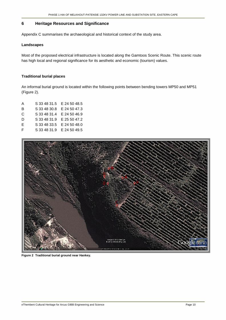
PHASE 1 HIA OF MELKHOUT-PATENSIE 132KV POWER LINE AND SUBSTATION SITE, EASTERN CAPE
eThembeni Cultural Heritage for Arcus GIBB Engineering and Science Page 10
6 Heritage Resources and Significance
Appendix C summarises the archaeological and historical context of the study area.
Landscapes
Most of the proposed electrical infrastructure is located along the Gamtoos Scenic Route. This scenic route
has high local and regional significance for its aesthetic and economic (tourism) values.
Traditional burial places
An informal burial ground is located within the following points between bending towers MP50 and MP51
(Figure 2).
A S 33 48 31.5 E 24 50 48.5
B S 33 48 30.8 E 24 50 47.3
C S 33 48 31.4 E 24 50 46.9
D S 33 48 31.9 E 25 50 47.2
E S 33 48 33.5 E 24 50 48.0
F S 33 48 31.9 E 24 50 49.5
Figure 2 Traditional burial ground near Hankey.
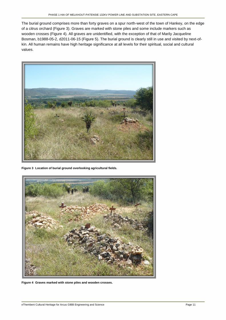
PHASE 1 HIA OF MELKHOUT-PATENSIE 132KV POWER LINE AND SUBSTATION SITE, EASTERN CAPE
eThembeni Cultural Heritage for Arcus GIBB Engineering and Science Page 11
The burial ground comprises more than forty graves on a spur north-west of the town of Hankey, on the edge
of a citrus orchard (Figure 3). Graves are marked with stone piles and some include markers such as
wooden crosses (Figure 4). All graves are unidentified, with the exception of that of Marily Jacqueline
Bosman, b1988-05-2, d2011-06-15 (Figure 5). The burial ground is clearly still in use and visited by next-of-
kin. All human remains have high heritage significance at all levels for their spiritual, social and cultural
values.
Figure 3 Location of burial ground overlooking agricultural fields.
Figure 4 Graves marked with stone piles and wooden crosses.
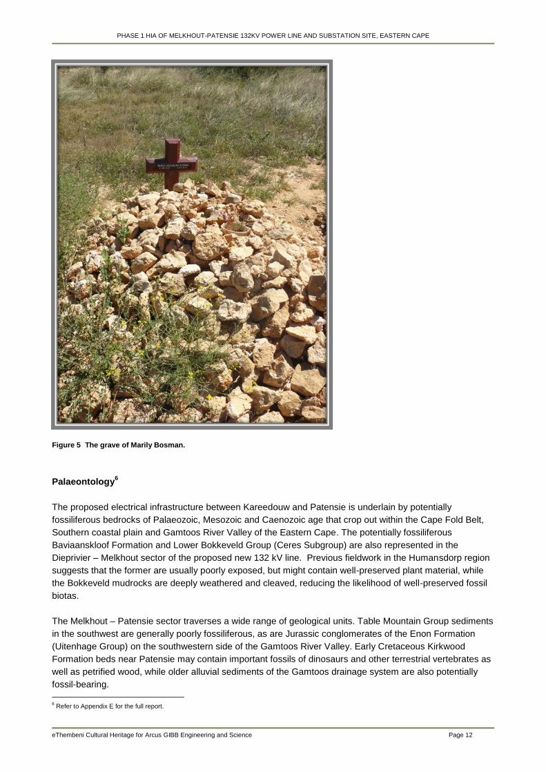
PHASE 1 HIA OF MELKHOUT-PATENSIE 132KV POWER LINE AND SUBSTATION SITE, EASTERN CAPE
eThembeni Cultural Heritage for Arcus GIBB Engineering and Science Page 12
Figure 5 The grave of Marily Bosman.
Palaeontology6
The proposed electrical infrastructure between Kareedouw and Patensie is underlain by potentially
fossiliferous bedrocks of Palaeozoic, Mesozoic and Caenozoic age that crop out within the Cape Fold Belt,
Southern coastal plain and Gamtoos River Valley of the Eastern Cape. The potentially fossiliferous
Baviaanskloof Formation and Lower Bokkeveld Group (Ceres Subgroup) are also represented in the
Dieprivier – Melkhout sector of the proposed new 132 kV line. Previous fieldwork in the Humansdorp region
suggests that the former are usually poorly exposed, but might contain well-preserved plant material, while
the Bokkeveld mudrocks are deeply weathered and cleaved, reducing the likelihood of well-preserved fossil
biotas.
The Melkhout – Patensie sector traverses a wide range of geological units. Table Mountain Group sediments
in the southwest are generally poorly fossiliferous, as are Jurassic conglomerates of the Enon Formation
(Uitenhage Group) on the southwestern side of the Gamtoos River Valley. Early Cretaceous Kirkwood
Formation beds near Patensie may contain important fossils of dinosaurs and other terrestrial vertebrates as
well as petrified wood, while older alluvial sediments of the Gamtoos drainage system are also potentially
fossil-bearing.
6 Refer to Appendix E for the full report.

PHASE 1 HIA OF MELKHOUT-PATENSIE 132KV POWER LINE AND SUBSTATION SITE, EASTERN CAPE
eThembeni Cultural Heritage for Arcus GIBB Engineering and Science Page 13
7 Assessment of Impacts
Landscapes
Criteria Unmanaged Managed
Nature Negative Neutral
Extent Medium Low
Duration High High
Intensity Medium Low
Potential impact on irreplaceable
resources Low Low
Consequence Medium Low
Probability Medium to high Low
Significance Medium Low
Traditional burial places
Criteria Unmanaged Managed
Nature Neutral to negative Neutral
Extent Low Low
Duration High High
Intensity Low to medium Low
Potential impact on irreplaceable
resources
High (if a burial is
directly affected) Low
Consequence Medium to high Low
Probability Medium Low
Significance Medium Low
Palaeontology
Criteria Unmanaged Managed
Nature Neutral to negative Neutral
Extent Low Low
Duration High High
Intensity Low to medium Low
Potential impact on irreplaceable
resources Low Low
Consequence Low to medium Low
Probability Medium Low
Significance Low to medium Low
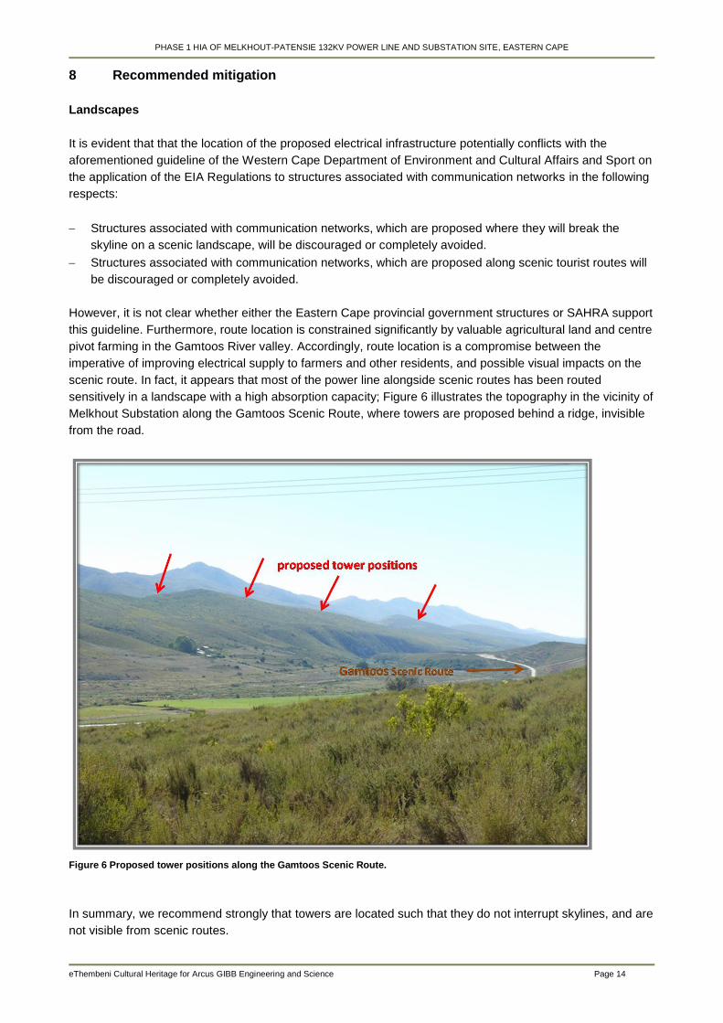
PHASE 1 HIA OF MELKHOUT-PATENSIE 132KV POWER LINE AND SUBSTATION SITE, EASTERN CAPE
eThembeni Cultural Heritage for Arcus GIBB Engineering and Science Page 14
8 Recommended mitigation
Landscapes
It is evident that that the location of the proposed electrical infrastructure potentially conflicts with the
aforementioned guideline of the Western Cape Department of Environment and Cultural Affairs and Sport on
the application of the EIA Regulations to structures associated with communication networks in the following
respects:
Structures associated with communication networks, which are proposed where they will break the
skyline on a scenic landscape, will be discouraged or completely avoided.
Structures associated with communication networks, which are proposed along scenic tourist routes will
be discouraged or completely avoided.
However, it is not clear whether either the Eastern Cape provincial government structures or SAHRA support
this guideline. Furthermore, route location is constrained significantly by valuable agricultural land and centre
pivot farming in the Gamtoos River valley. Accordingly, route location is a compromise between the
imperative of improving electrical supply to farmers and other residents, and possible visual impacts on the
scenic route. In fact, it appears that most of the power line alongside scenic routes has been routed
sensitively in a landscape with a high absorption capacity; Figure 6 illustrates the topography in the vicinity of
Melkhout Substation along the Gamtoos Scenic Route, where towers are proposed behind a ridge, invisible
from the road.
Figure 6 Proposed tower positions along the Gamtoos Scenic Route.
In summary, we recommend strongly that towers are located such that they do not interrupt skylines, and are
not visible from scenic routes.
PHASE 1 HIA OF MELKHOUT-PATENSIE 132KV POWER LINE AND SUBSTATION SITE, EASTERN CAPE
eThembeni Cultural Heritage for Arcus GIBB Engineering and Science Page 15
Traditional burial places
Graves should be managed in situ wherever possible, and may not be altered in any way within the
permission of the next-of-kin and the relevant heritage and local government authorities.
No development activity of any nature may occur within twenty metres of the identified burial ground, with its
boundaries taken to be straight lines between the geographic co-ordinates provided in Section 6.
General, including palaeontology
A heritage practitioner should complete a ‘walk-through’ of the final selected power line route and all other
activity areas (access roads, construction camps, materials’ storage areas, etc.) prior to the start of any
construction activities and assess direct impacts on discrete resources such as traditional burial places, and
archaeological and palaeontological sites. Mitigation can usually be achieved by micro-adjustment of tower
positions, the exclusion of sensitive areas, basic recording and/or obtaining a permit for alteration,
destruction or removal from SAHRA.
9 Recommended monitoring
None at present.
10 Protocol for the identification, protection and recovery of heritage resources during
construction and operation
It is possible that sub-surface heritage resources will be encountered during the construction phase of this
project. The Project Engineer, Environmental Control Officer and all other persons responsible for site
management and excavation should be aware that indicators of sub-surface sites could include:
Ash deposits (unnaturally grey appearance of soil compared to the surrounding substrate);
Bone concentrations, either animal or human;
Ceramic fragments, including potsherds;
Stone concentrations that appear to be formally arranged (may indicate the presence of an underlying
burial); and
Fossilised remains of fauna and flora, including trees.
In the event that such indicator(s) of heritage resources are identified, the following actions should be taken
immediately:
All construction within a radius of at least 20m of the indicator should cease. This distance should be
increased at the discretion of supervisory staff if heavy machinery or explosives could cause further
disturbance to the suspected heritage resource.
This area must be marked using clearly visible means, such as barrier tape, and all personnel should be
informed that it is a no-go area.
A guard should be appointed to enforce this no-go area if there is any possibility that it could be violated,
whether intentionally or inadvertently, by construction staff or members of the public.
No measures should be taken to cover up the suspected heritage resource with soil, or to collect any
remains such as bone or stone.
If a heritage practitioner has been appointed to monitor the project, s/he should be contacted and a site
inspection arranged as soon as possible.
PHASE 1 HIA OF MELKHOUT-PATENSIE 132KV POWER LINE AND SUBSTATION SITE, EASTERN CAPE
eThembeni Cultural Heritage for Arcus GIBB Engineering and Science Page 16
If no heritage practitioner has been appointed to monitor the project, Dr Mariagrazia Galimberti at
SAHRA’s Cape Town head office should be contacted (telephone 021 462 4502).
The South African Police Services should be notified by a SAHRA staff member or an independent
heritage practitioner if human remains are identified. No SAPS official may disturb or exhume such
remains, whether of recent origin or not.
All parties concerned should respect the potentially sensitive and confidential nature of the heritage
resources, particularly human remains, and refrain from making public statements until a mutually
agreed time.
Any extension of the project beyond its current footprint involving vegetation and/or earth clearance
should be subject to prior assessment by a qualified heritage practitioner, taking into account all
information gathered during this initial heritage impact assessment.
11 Conclusion
We recommend that the development proceed with the proposed heritage mitigation and have submitted this
report to SAHRA in fulfilment of the requirements of the NHRA. According to Section 38(4) of the Act the
report shall be considered timeously by the Council which shall, after consultation with the person proposing
the development, decide –
whether or not the development may proceed;
any limitations or conditions are to be applied to the development;
what general protections in terms of this Act apply, and what formal protections may be applied to such
heritage resources;
whether compensatory action shall be required in respect of any heritage resources damaged or
destroyed as a result of the development; and
whether the appointment of specialists is required as a condition of approval of the proposal.
Relevant staff members may be contacted at the SAHRA Cape Town head office (Mariagrazia Galimberti
telephone 021 462 4502; [email protected]).
If permission is granted for development to proceed, the client is reminded that the NHRA requires that a
developer cease all work immediately and follow the protocol contained in Section 10 of this report should
any heritage resources, as defined in the Act, be discovered during the course of development activities.
PHASE 1 HIA OF MELKHOUT-PATENSIE 132KV POWER LINE AND SUBSTATION SITE, EASTERN CAPE
eThembeni Cultural Heritage for Arcus GIBB Engineering and Science Page 17
12 Bibliography
Abrahams, Y. 2001. Colonialism, disjuncture and dysfunction: Sarah Bartmann’s resistance. Paper
presented at the AGI informal seminar series 6 November 2001.
Binneman, J. N. F. 1985. Research along the south eastern Cape coast. In: Hall, S. L. & Binneman, J. N. F.
Guide to archaeological sites in the eastern and north eastern Cape: 117-134. Grahamstown:
Albany Museum.
Binneman, J. N. F. 1996. The symbolic construction of communities during the Holocene Later Stone Age in
the south-eastern Cape. Unpublished D.Phil. University of the Witwatersrand.
Binneman, J. N. F. 1999. Results from a test excavation at Groot Kommandokloof Shelter in the
Baviaanskloof / Kouga region, Eastern Cape Province. Southern African Field Archaeology 8: 100-
107.
Deacon, H. J. 1976. Where hunters gathered: a study of Holocene Stone Age people in the eastern Cape.
Claremont: South African Archaeological Society Monograph 1.
Magubane, Z. 2001. Which Bodies Matter? Feminism, Poststructuralism, Race, and the Curious Theoretical
Odyssey of the "Hottentot Venus". Gender and Society 15(6): 816-834. Sage Publications, Inc.
Qureshi, S. 2004. Displaying Sara Baartman, the ‘Hottentot Venus’. Hist. Sci., xlii: 233-257.
Prins, F. E. 1994-95. Climate, vegetation and early agriculturist communities in Transkei and KwaZulu-Natal.
Azania 29-30: 179-186.
Prins, F. E. and Granger, J. E. 1993. Early farming communities in northern Transkei: the evidence from
Ntsitsana and adjacent areas. Southern African Humanities 5: 153-174.
Whitelaw, G. 1991. Precolonial iron production around Durban and in southern Natal. Natal Museum Journal
of Humanities 3: 29-39.
Whitelaw, G. 1997. What Da Gama missed on his way to Sofala. Natalia 27: 30-41.
Whitelaw, G. 2009. An Iron Age fishing tale. Southern African Humanities 21: 195-212.

PHASE 1 HIA OF MELKHOUT-PATENSIE 132KV POWER LINE AND SUBSTATION SITE, EASTERN CAPE
eThembeni Cultural Heritage for Arcus GIBB Engineering and Science Page 18
Appendix A
Statutory Requirements
General
The Constitution of the Republic of South Africa Act 108 of 1996 is the source of all legislation. Within the
Constitution the Bill of Rights is fundamental, with the principle that the environment should be protected for
present and future generations by preventing pollution, promoting conservation and practising ecologically
sustainable development. With regard to spatial planning and related legislation at national and provincial
levels the following legislation may be relevant:
Physical Planning Act 125 of 1991
Municipal Structures Act 117 of 1998
Municipal Systems Act 32 of 2000
Development Facilitation Act 67 of 1995 (DFA)
KwaZulu-Natal Planning and Development Act 6 of 2008.
The identification, evaluation and management of heritage resources in South Africa is required and
governed by the following legislation:
National Environmental Management Act 107 of 1998 (NEMA)
KwaZulu-Natal Heritage Act 4 of 2008 (KZNHA)
National Heritage Resources Act 25 of 1999 (NHRA)
Minerals and Petroleum Resources Development Act 28 of 2002 (MPRDA)
National Heritage Resources Act 25 of 1999 (NHRA)
The NHRA established the South African Heritage Resources Agency (SAHRA) together with its Council to
fulfill the following functions:
co-ordinate and promote the management of heritage resources at national level;
set norms and maintain essential national standards for the management of heritage resources in the
Republic and to protect heritage resources of national significance;
control the export of nationally significant heritage objects and the import into the Republic of cultural
property illegally exported from foreign countries;
enable the provinces to establish heritage authorities which must adopt powers to protect and manage
certain categories of heritage resources; and
provide for the protection and management of conservation-worthy places and areas by local authorities.
Heritage Impact Assessments
Section 38(1) of the NHRA may require a Heritage Impact Assessment in case of:
the construction of a road, wall, power line, pipeline, canal or other similar form of linear development or
barrier exceeding 300m in length;
the construction of a bridge or similar structure exceeding 50m in length;
any development or other activity which will change the character of a site—
(i) exceeding 5 000m² in extent; or
(ii) involving three or more existing erven or subdivisions thereof; or
(iii) involving three or more erven or divisions thereof which have been consolidated within the past five
years; or
(iv) the costs of which will exceed a sum set in terms of regulations by SAHRA or a provincial heritage
resources authority;
PHASE 1 HIA OF MELKHOUT-PATENSIE 132KV POWER LINE AND SUBSTATION SITE, EASTERN CAPE
eThembeni Cultural Heritage for Arcus GIBB Engineering and Science Page 19
the re-zoning of a site exceeding 10 000m² in extent; or
any other category of development provided for in regulations by SAHRA or a provincial heritage
resources authority.
Reports in fulfilment of NHRA Section 38(3) must include the following information:
the identification and mapping of all heritage resources in the area affected;
an assessment of the significance of such resources in terms of the heritage assessment criteria set out
in regulations;
an assessment of the impact of the development on such heritage resources;
an evaluation of the impact of the development on heritage resources relative to the sustainable social
and economic benefits to be derived from the development;
the results of consultation with communities affected by the proposed development and other interested
parties regarding the impact of the development on heritage resources;
if heritage resources will be adversely affected by the proposed development, the consideration of
alternatives; and
plans for mitigation of any adverse effects during and after completion of the proposed development.
It is incumbent upon the developer or Environmental Practitioner to approach the South African Heritage
Resources Agency (SAHRA) or Amafa to ascertain whether an HIA is required for a project; what categories
of heritage resource must be assessed; and request a detailed motivation for such a study in terms of both
the nature of the development and the nature of the environment. In this regard we draw your attention to
Section 38(2) of the NHRA which states specifically that 'The responsible heritage resources authority must
… if there is reason to believe that heritage resources will be affected by such development, notify the
person who intends to undertake the development to submit an impact assessment report'. In other words,
the heritage authority must be able to justify a request for an Archaeological, Palaeontological or Heritage
Impact Assessment. The Environmental Practitioner may also submit information to the heritage authority in
substantiation of exemption from a specific assessment due to existing environmental disturbance, for
example.
Definitions of heritage resources
The Act defines a heritage resource as any place or object of cultural significance i.e. of aesthetic,
architectural, historical, scientific, social, spiritual, linguistic or technological value or significance. This
includes, but is not limited to, the following wide range of places and objects:
living heritage as defined in the National Heritage Council Act 11 of 1999 (cultural tradition; oral history;
performance; ritual; popular memory; skills and techniques; indigenous knowledge systems; and the
holistic approach to nature, society and social relationships);
ecofacts (non-artefactual organic or environmental remains that may reveal aspects of past human
activity; definition used in KwaZulu-Natal Heritage Act 2008);
places, buildings, structures and equipment;
places to which oral traditions are attached or which are associated with living heritage;
historical settlements and townscapes;
landscapes and natural features;
geological sites of scientific or cultural importance;
archaeological and palaeontological sites;
graves and burial grounds;
public monuments and memorials;
sites of significance relating to the history of slavery in South Africa;
movable objects, but excluding any object made by a living person; and
PHASE 1 HIA OF MELKHOUT-PATENSIE 132KV POWER LINE AND SUBSTATION SITE, EASTERN CAPE
eThembeni Cultural Heritage for Arcus GIBB Engineering and Science Page 20
battlefields.
Furthermore, a place or object is to be considered part of the national estate if it has cultural significance or
other special value because of—
its importance in the community, or pattern of South Africa’s history;
its possession of uncommon, rare or endangered aspects of South Africa’s natural or cultural heritage;
its potential to yield information that will contribute to an understanding of South Africa’s natural or
cultural heritage;
its importance in demonstrating the principal characteristics of a particular class of South Africa’s natural
or cultural places or objects;
its importance in exhibiting particular aesthetic characteristics valued by a community or cultural group;
its importance in demonstrating a high degree of creative or technical achievement at a particular period;
its strong or special association with a particular community or cultural group for social, cultural or
spiritual reasons; and
its strong or special association with the life or work of a person, group or organisation of importance in
the history of South Africa.
Archaeological means –
material remains resulting from human activity which are in a state of disuse and are in or on land and
are older than 100 years, including artefacts, human and hominid remains and artificial features and
structures;
rock art, being any form of painting, engraving or other graphic representation on a fixed rock surface or
loose rock or stone, which was executed by human agency and is older than 100 years including any
area within 10m of such representation;
wrecks, being any vessel or aircraft, or any part thereof, which was wrecked in South Africa, whether on
land, in the internal waters, the territorial waters or in the culture zone of the Republic, as defined
respectively in sections 3, 4 and 6 of the Maritime Zones Act 15 of 1994, and any cargo, debris or
artefacts found or associated therewith, which is older than 60 years or which SAHRA considers to be
worthy of conservation;
features, structures and artefacts associated with military history which are older than 75 years and the
sites on which they are found.
Palaeontological means any fossilised remains or fossil trace of animals or plants which lived in the
geological past, other than fossil fuels or fossiliferous rock intended for industrial use, and any site which
contains such fossilised remains or trace.
A place is defined as:
a site, area or region;
a building or other structure which may include equipment, furniture, fittings and articles associated with
or connected with such building or other structure;
a group of buildings or other structures which may include equipment, furniture, fittings and articles
associated with or connected with such group of buildings or other structures;
an open space, including a public square, street or park; and
in relation to the management of a place, includes the immediate surroundings of a place.
Public monuments and memorials means all monuments and memorials:
erected on land belonging to any branch of central, provincial or local government, or on land belonging
to any organisation funded by or established in terms of the legislation of such a branch of government;
or
PHASE 1 HIA OF MELKHOUT-PATENSIE 132KV POWER LINE AND SUBSTATION SITE, EASTERN CAPE
eThembeni Cultural Heritage for Arcus GIBB Engineering and Science Page 21
which were paid for by public subscription, government funds, or a public-spirited or military organisation,
and are on land belonging to any private individual.
Structures means any building, works, device or other facility made by people and which is fixed to land,
and includes any fixtures, fittings and equipment associated therewith.
Management of Graves and Burial Grounds
Graves younger than 60 years are protected in terms of Section 2(1) of the Removal of Graves and
Dead Bodies Ordinance 7 of 1925 as well as the Human Tissues Act 65 of 1983. Such graves are the
jurisdiction of the National Department of Health and the relevant Provincial Department of Health and
must be submitted for final approval to the Office of the relevant Provincial Premier. This function is
usually delegated to the Provincial Member of the Executive Council for Local Government and
Planning, or in some cases the MEC for Housing and Welfare.
Authorisation for exhumation and reinterment must also be obtained from the relevant local or regional
council where the grave is situated, as well as the relevant local or regional council to where the grave is
being relocated. All local and regional provisions, laws and by-laws must also be adhered to. In order to
handle and transport human remains the institution conducting the relocation should be authorised under
Section 24 of the Human Tissues Act 65 of 1983.
Graves older than 60 years situated outside a formal cemetery administered by a local authority
are protected in terms of Section 36 of the NHRA as well as the Human Tissues Act of 1983.
Accordingly, such graves are the jurisdiction of SAHRA. The procedure for Consultation Regarding
Burial Grounds and Graves (Section 36(5) of NHRA) is applicable to graves older than 60 years that are
situated outside a formal cemetery administrated by a local authority. Graves in the category located
inside a formal cemetery administrated by a local authority will also require the same authorisation as set
out for graves younger than 60 years over and above SAHRA authorisation.
If the grave is not situated inside a formal cemetery but is to be relocated to one, permission from the
local authority is required and all regulations, laws and by-laws set by the cemetery authority must be
adhered to.
The protocol for the management of graves older than 60 years situated outside a formal cemetery
administered by a local authority is detailed in Section 36 of the NHRA:
(3) (a) No person may, without a permit issued by SAHRA or a provincial heritage resources authority—
(a) destroy, damage, alter, exhume or remove from its original position or otherwise disturb the grave of a
victim of conflict, or any burial ground or part thereof which contains such graves;
(b) destroy, damage, alter, exhume, remove from its original position or otherwise disturb any grave or burial
ground older than 60 years which is situated outside a formal cemetery administered by a local authority; or
(c) bring onto or use at a burial ground or grave referred to in paragraph (a) or (b) any excavation equipment,
or any equipment which assists in the detection or recovery of metals.
(4) SAHRA or a provincial heritage resources authority may not issue a permit for the destruction or damage
of any burial ground or grave referred to in subsection (3)(a) unless it is satisfied that the applicant has made
satisfactory arrangements for the exhumation and re-interment of the contents of such graves, at the cost of
the applicant and in accordance with any regulations made by the responsible heritage resources authority.
(5) SAHRA or a provincial heritage resources authority may not issue a permit for any activity under
subsection (3)(b) unless it is satisfied that the applicant has, in accordance with regulations made by the
responsible heritage resources authority—
(a) made a concerted effort to contact and consult communities and individuals who by tradition have an
interest in such grave or burial ground; and

PHASE 1 HIA OF MELKHOUT-PATENSIE 132KV POWER LINE AND SUBSTATION SITE, EASTERN CAPE
eThembeni Cultural Heritage for Arcus GIBB Engineering and Science Page 22
(b) reached agreements with such communities and individuals regarding the future of such grave or burial
ground.
(6) Subject to the provision of any other law, any person who in the course of development or any other
activity discovers the location of a grave, the existence of which was previously unknown, must immediately
cease such activity and report the discovery to the responsible heritage resources authority which must, in
co-operation with the South African Police Service and in accordance with regulations of the responsible
heritage resources authority—
(a) carry out an investigation for the purpose of obtaining information on whether or not such grave is
protected in terms of this Act or is of significance to any community; and
(b) if such grave is protected or is of significance, assist any person who or community which is a direct
descendant to make arrangements for the exhumation and re-interment of the contents of such grave or, in
the absence of such person or community, make any such arrangements as it deems fit.
The Vermillion Accord on Human Remains7
Adopted in 1989 at WAC Inter-Congress, South Dakota, USA
1. Respect for the mortal remains of the dead shall be accorded to all, irrespective of origin, race, religion,
nationality, custom and tradition.
2. Respect for the wishes of the dead concerning disposition shall be accorded whenever possible,
reasonable and lawful, when they are known or can be reasonably inferred.
3. Respect for the wishes of the local community and of relatives or guardians of the dead shall be accorded
whenever possible, reasonable and lawful.
4. Respect for the scientific research value of skeletal, mummified and other human remains (including fossil
hominids) shall be accorded when such value is demonstrated to exist.
5. Agreement on the disposition of fossil, skeletal, mummified and other remains shall be reached by
negotiation on the basis of mutual respect for the legitimate concerns of communities for the proper
disposition of their ancestors, as well as the legitimate concerns of science and education.
6. The express recognition that the concerns of various ethnic groups, as well as those of science are
legitimate and to be respected, will permit acceptable agreements to be reached and honoured.
7 http://www.worldarchaeologicalcongress.org/
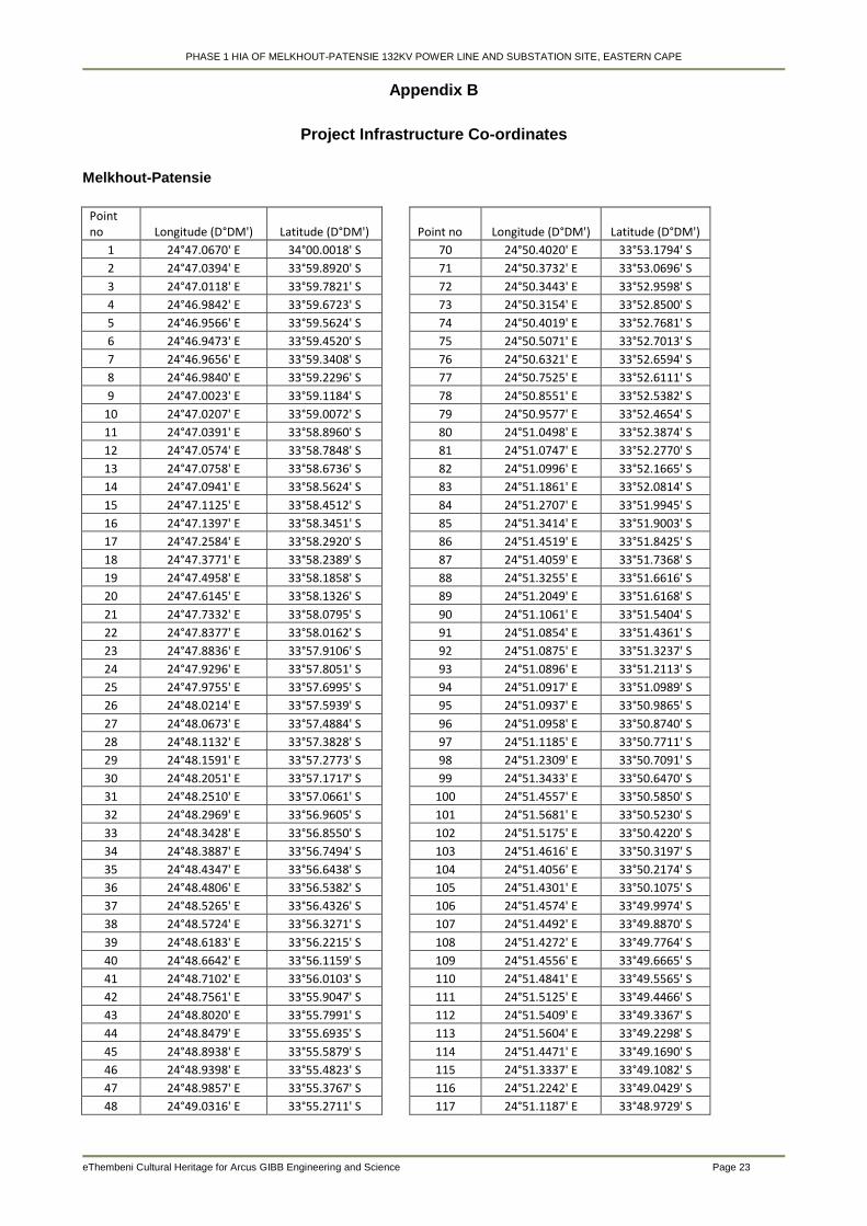
PHASE 1 HIA OF MELKHOUT-PATENSIE 132KV POWER LINE AND SUBSTATION SITE, EASTERN CAPE
eThembeni Cultural Heritage for Arcus GIBB Engineering and Science Page 23
Appendix B
Project Infrastructure Co-ordinates
Melkhout-Patensie
Point no Longitude (D°DM') Latitude (D°DM')
Point no Longitude (D°DM') Latitude (D°DM')
1 24°47.0670' E 34°00.0018' S
70 24°50.4020' E 33°53.1794' S
2 24°47.0394' E 33°59.8920' S
71 24°50.3732' E 33°53.0696' S
3 24°47.0118' E 33°59.7821' S
72 24°50.3443' E 33°52.9598' S
4 24°46.9842' E 33°59.6723' S
73 24°50.3154' E 33°52.8500' S
5 24°46.9566' E 33°59.5624' S
74 24°50.4019' E 33°52.7681' S
6 24°46.9473' E 33°59.4520' S
75 24°50.5071' E 33°52.7013' S
7 24°46.9656' E 33°59.3408' S
76 24°50.6321' E 33°52.6594' S
8 24°46.9840' E 33°59.2296' S
77 24°50.7525' E 33°52.6111' S
9 24°47.0023' E 33°59.1184' S
78 24°50.8551' E 33°52.5382' S
10 24°47.0207' E 33°59.0072' S
79 24°50.9577' E 33°52.4654' S
11 24°47.0391' E 33°58.8960' S
80 24°51.0498' E 33°52.3874' S
12 24°47.0574' E 33°58.7848' S
81 24°51.0747' E 33°52.2770' S
13 24°47.0758' E 33°58.6736' S
82 24°51.0996' E 33°52.1665' S
14 24°47.0941' E 33°58.5624' S
83 24°51.1861' E 33°52.0814' S
15 24°47.1125' E 33°58.4512' S
84 24°51.2707' E 33°51.9945' S
16 24°47.1397' E 33°58.3451' S
85 24°51.3414' E 33°51.9003' S
17 24°47.2584' E 33°58.2920' S
86 24°51.4519' E 33°51.8425' S
18 24°47.3771' E 33°58.2389' S
87 24°51.4059' E 33°51.7368' S
19 24°47.4958' E 33°58.1858' S
88 24°51.3255' E 33°51.6616' S
20 24°47.6145' E 33°58.1326' S
89 24°51.2049' E 33°51.6168' S
21 24°47.7332' E 33°58.0795' S
90 24°51.1061' E 33°51.5404' S
22 24°47.8377' E 33°58.0162' S
91 24°51.0854' E 33°51.4361' S
23 24°47.8836' E 33°57.9106' S
92 24°51.0875' E 33°51.3237' S
24 24°47.9296' E 33°57.8051' S
93 24°51.0896' E 33°51.2113' S
25 24°47.9755' E 33°57.6995' S
94 24°51.0917' E 33°51.0989' S
26 24°48.0214' E 33°57.5939' S
95 24°51.0937' E 33°50.9865' S
27 24°48.0673' E 33°57.4884' S
96 24°51.0958' E 33°50.8740' S
28 24°48.1132' E 33°57.3828' S
97 24°51.1185' E 33°50.7711' S
29 24°48.1591' E 33°57.2773' S
98 24°51.2309' E 33°50.7091' S
30 24°48.2051' E 33°57.1717' S
99 24°51.3433' E 33°50.6470' S
31 24°48.2510' E 33°57.0661' S
100 24°51.4557' E 33°50.5850' S
32 24°48.2969' E 33°56.9605' S
101 24°51.5681' E 33°50.5230' S
33 24°48.3428' E 33°56.8550' S
102 24°51.5175' E 33°50.4220' S
34 24°48.3887' E 33°56.7494' S
103 24°51.4616' E 33°50.3197' S
35 24°48.4347' E 33°56.6438' S
104 24°51.4056' E 33°50.2174' S
36 24°48.4806' E 33°56.5382' S
105 24°51.4301' E 33°50.1075' S
37 24°48.5265' E 33°56.4326' S
106 24°51.4574' E 33°49.9974' S
38 24°48.5724' E 33°56.3271' S
107 24°51.4492' E 33°49.8870' S
39 24°48.6183' E 33°56.2215' S
108 24°51.4272' E 33°49.7764' S
40 24°48.6642' E 33°56.1159' S
109 24°51.4556' E 33°49.6665' S
41 24°48.7102' E 33°56.0103' S
110 24°51.4841' E 33°49.5565' S
42 24°48.7561' E 33°55.9047' S
111 24°51.5125' E 33°49.4466' S
43 24°48.8020' E 33°55.7991' S
112 24°51.5409' E 33°49.3367' S
44 24°48.8479' E 33°55.6935' S
113 24°51.5604' E 33°49.2298' S
45 24°48.8938' E 33°55.5879' S
114 24°51.4471' E 33°49.1690' S
46 24°48.9398' E 33°55.4823' S
115 24°51.3337' E 33°49.1082' S
47 24°48.9857' E 33°55.3767' S
116 24°51.2242' E 33°49.0429' S
48 24°49.0316' E 33°55.2711' S
117 24°51.1187' E 33°48.9729' S
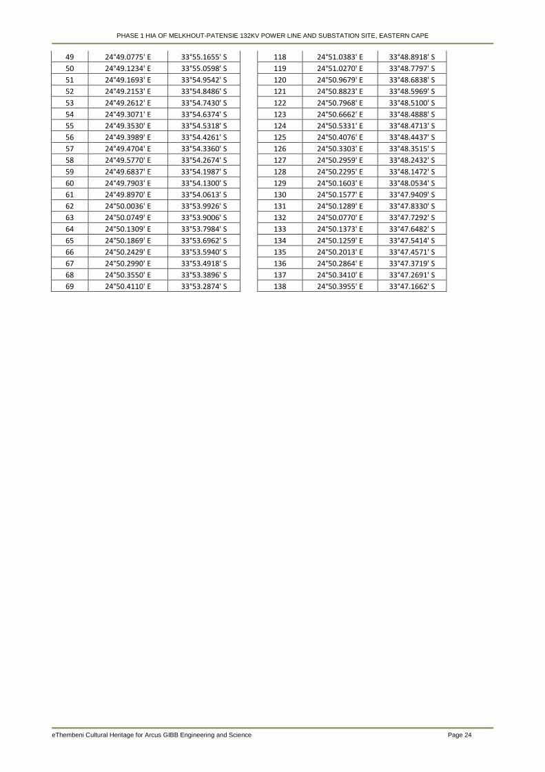
PHASE 1 HIA OF MELKHOUT-PATENSIE 132KV POWER LINE AND SUBSTATION SITE, EASTERN CAPE
eThembeni Cultural Heritage for Arcus GIBB Engineering and Science Page 24
49 24°49.0775' E 33°55.1655' S
118 24°51.0383' E 33°48.8918' S
50 24°49.1234' E 33°55.0598' S
119 24°51.0270' E 33°48.7797' S
51 24°49.1693' E 33°54.9542' S
120 24°50.9679' E 33°48.6838' S
52 24°49.2153' E 33°54.8486' S
121 24°50.8823' E 33°48.5969' S
53 24°49.2612' E 33°54.7430' S
122 24°50.7968' E 33°48.5100' S
54 24°49.3071' E 33°54.6374' S
123 24°50.6662' E 33°48.4888' S
55 24°49.3530' E 33°54.5318' S
124 24°50.5331' E 33°48.4713' S
56 24°49.3989' E 33°54.4261' S
125 24°50.4076' E 33°48.4437' S
57 24°49.4704' E 33°54.3360' S
126 24°50.3303' E 33°48.3515' S
58 24°49.5770' E 33°54.2674' S
127 24°50.2959' E 33°48.2432' S
59 24°49.6837' E 33°54.1987' S
128 24°50.2295' E 33°48.1472' S
60 24°49.7903' E 33°54.1300' S
129 24°50.1603' E 33°48.0534' S
61 24°49.8970' E 33°54.0613' S
130 24°50.1577' E 33°47.9409' S
62 24°50.0036' E 33°53.9926' S
131 24°50.1289' E 33°47.8330' S
63 24°50.0749' E 33°53.9006' S
132 24°50.0770' E 33°47.7292' S
64 24°50.1309' E 33°53.7984' S
133 24°50.1373' E 33°47.6482' S
65 24°50.1869' E 33°53.6962' S
134 24°50.1259' E 33°47.5414' S
66 24°50.2429' E 33°53.5940' S
135 24°50.2013' E 33°47.4571' S
67 24°50.2990' E 33°53.4918' S
136 24°50.2864' E 33°47.3719' S
68 24°50.3550' E 33°53.3896' S
137 24°50.3410' E 33°47.2691' S
69 24°50.4110' E 33°53.2874' S
138 24°50.3955' E 33°47.1662' S
PHASE 1 HIA OF MELKHOUT-PATENSIE 132KV POWER LINE AND SUBSTATION SITE, EASTERN CAPE
eThembeni Cultural Heritage for Arcus GIBB Engineering and Science Page 25
Appendix C
Archaeological and Historical Context of the Study Area
The Stone Age8
No systematic Early and Middle Stone Age research has been undertaken in the proposed development
area, hence the general nature of this section. Open air scatters of stone artefacts, probably with low
heritage significance, could be expected in areas with minimal environmental disturbance.
South Africa’s prehistory has been divided into a series of phases based on broad patterns of technology.
The primary distinction is between a reliance on chipped and flaked stone implements (the Stone Age) and
the ability to work iron (the Iron Age). Spanning a large proportion of human history, the Stone Age in
Southern Africa is further divided into the Early Stone Age, or Paleolithic Period (about 2 500 000–150 000
years ago), the Middle Stone Age, or Mesolithic Period (about 150 000–30 000 years ago), and the Late
Stone Age, or Neolithic Period (about 30 000–2 000 years ago). The simple stone tools found with
australopithecine fossil bones fall into the earliest part of the Early Stone Age.
o The Early Stone Age
Most Early Stone Age sites in South Africa can probably be connected with the hominin species known as
Homo erectus. Simply modified stones, hand axes, scraping tools, and other bifacial artifacts had a wide
variety of purposes, including butchering animal carcasses, scraping hides, and digging for plant foods. Most
South African archaeological sites from this period are the remains of open camps, often by the sides of
rivers and lakes, although some are rock shelters, such as Montagu Cave in the Cape region.
o The Middle Stone Age
The long episode of cultural and physical evolution gave way to a period of more rapid change about 200
000 years ago. Hand axes and large bifacial stone tools were replaced by stone flakes and blades that were
fashioned into scrapers, spear points, and parts for hafted, composite implements. This technological stage,
now known as the Middle Stone Age, is represented by numerous sites in South Africa.
Open camps and rock overhangs were used for shelter. Day-to-day debris has survived to provide some
evidence of early ways of life, although plant foods have rarely been preserved. Middle Stone Age bands
hunted medium-sized and large prey, including antelope and zebra, although they tended to avoid the
largest and most dangerous animals, such as the elephant and the rhinoceros. They also ate seabirds and
marine mammals that could be found along the shore and sometimes collected tortoises and ostrich eggs in
large quantities.
o The Late Stone Age
Basic toolmaking techniques began to undergo additional change about 40 000 years ago. Small finely
worked stone implements known as microliths became more common, while the heavier scrapers and points
of the Middle Stone Age appeared less frequently. Archaeologists refer to this technological stage as the
Late Stone Age. The numerous collections of stone tools from South African archaeological sites show a
great degree of variation through time and across the subcontinent.
The remains of plant foods have been well preserved at such sites as Melkhoutboom Cave, De Hangen, and
Diepkloof in the Cape region. Animals were trapped and hunted with spears and arrows on which were
mounted well-crafted stone blades. Bands moved with the seasons as they followed game into higher lands
in the spring and early summer months, when plant foods could also be found. When available, rock
8 http://www.britannica.com; article authored by Colin J. Bundy, Julian R. D. Cobbing, Martin Hall and Leonard Monteath Thompson
PHASE 1 HIA OF MELKHOUT-PATENSIE 132KV POWER LINE AND SUBSTATION SITE, EASTERN CAPE
eThembeni Cultural Heritage for Arcus GIBB Engineering and Science Page 26
overhangs became shelters; otherwise, windbreaks were built. Shellfish, crayfish, seals, and seabirds were
also important sources of food, as were fish caught on lines, with spears, in traps, and possibly with nets.
Dating from this period are numerous engravings on rock surfaces, mostly on the interior plateau, and
paintings on the walls of rock shelters in the mountainous regions, such as the Drakensberg and Cederberg
ranges. The images were made over a period of at least 25 000 years. Although scholars originally saw the
South African rock art as the work of exotic foreigners such as Minoans or Phoenicians or as the product of
primitive minds, they now believe that the paintings were closely associated with the work of medicine men,
shamans who were involved in the well-being of the band and often worked in a state of trance. Specific
representations include depictions of trance dances, metaphors for trance such as death and flight,
rainmaking, and control of the movement of antelope herds.
Iron Age9
Archaeological evidence shows that Bantu-speaking agriculturists first settled in southern Africa around AD
300. Bantu-speakers originated in the vicinity of modem Cameroon from where they began to move
eastwards and southwards, some time after 400 BC, skirting around the equatorial forest. An extremely rapid
spread throughout much of sub-equatorial Africa followed: dating shows that the earliest communities in
Tanzania and South Africa are separated in time by only 200 years, despite the 3 000 km distance between
the two regions. It seems likely that the speed of the spread was a consequence of agriculturists deliberately
seeking iron ore sources and particular combinations of soil and climate suitable for the cultivation of their
crops.
The earliest agricultural sites in KwaZulu-Natal date to between AD 400 and 550. All are situated close to
sources of iron ore, and within 15 km of the coast. Current evidence suggests it may have been too dry
further inland at this time for successful cultivation. From 650 onwards, however, climatic conditions
improved and agriculturists expanded into the valleys of KwaZulu-Natal, where they settled close to rivers in
savanna or bushveld environments. There is a considerable body of information available about these early
agriculturists.
Seed remains show that they cultivated finger millet, bulrush millet, sorghum and probably the African melon.
It seems likely that they also planted African groundnuts and cowpeas, though direct evidence for these
plants is lacking from the earlier periods. Faunal remains indicate that they kept sheep, cattle, goats,
chickens and dogs, with cattle and sheep providing most of the meat. Men hunted, perhaps with dogs, but
hunted animals made only a limited contribution to the diet in the region.
Metal production was a key activity since it provided the tools of cultivation and hunting. The evidence
indicates that people who worked metal lived in almost every village, even those that were considerable
distances from ore sources.
Large-scale excavations in recent years have provided data indicating that first-millennium agriculturist
society was patrilineal and that men used cattle as bridewealth in exchange for wives. On a political level,
society was organised into chiefdoms that, in our region, may have had up to three hierarchical levels. The
villages of chiefs tended to be larger than others, with several livestock enclosures, and some were occupied
continuously for lengthy periods. Social forces of the time resulted in the concentration of unusual items on
these sites. These include artefacts that originated from great distances, ivory items (which as early as AD
700 appear to have been a symbol of chieftainship), and initiation paraphernalia.
This particular way of life came to an end around AD 1000, for reasons that we do not yet fully understand.
There was a radical change in the decorative style of agriculturist ceramics at this time, while the preferred
9 Whitelaw (1997). See also Prins and Granger (1993), Whitelaw (1991, 2009).
PHASE 1 HIA OF MELKHOUT-PATENSIE 132KV POWER LINE AND SUBSTATION SITE, EASTERN CAPE
eThembeni Cultural Heritage for Arcus GIBB Engineering and Science Page 27
village locations of the last four centuries were abandoned in favour of sites along the coastal littoral. In
general, sites dating to between 1050 and 1250 are smaller than most earlier agriculturist settlements. It is
tempting to see in this change the origin of the Nguni settlement pattern. Indeed, some archaeologists have
suggested that the changes were a result of the movement into the region of people who were directly
ancestral to the Nguni-speakers of today. Others prefer to see the change as the product of social and
cultural restructuring within resident agriculturist communities.
Whatever the case, it seems likely that this new pattern of settlement was in some way influenced by a
changing climate, for there is evidence of increasing aridity from about AD 900. A new pattern of economic
inter-dependence evolved that is substantially different from that of earlier centuries, and is one that
continued into the colonial period nearly 500 years later.
Colonial rule10
By the closing decades of the 18th century, South Africa had fallen into two broad regions: west and east.
Colonial settlement dominated the west, including the winter rainfall region around the Cape of Good Hope,
the coastal hinterland northward toward the present-day border with Namibia, and the dry lands of the
interior. Trekboers took increasingly more land from the Khoekhoe and from remnant hunter-gatherer
communities, who were killed, were forced into marginal areas, or became labourers tied to the farms of their
new overlords. Indigenous farmers controlled both the coastal and valley lowlands and the Highveld of the
interior in the east, where summer rainfall and good grazing made mixed farming economies possible.
A large group of British settlers arrived in the eastern Cape in 1820; this, together with a high European birth
rate and wasteful land usage, produced an acute land shortage, which was alleviated only when the British
acquired more land through massive military intervention against Africans on the eastern frontier. Until the
1840s the British vision of the colony did not include African citizens (referred to pejoratively by the British as
“Kaffirs”), so, as Africans lost their land, they were expelled across the Great Fish River, the unilaterally
proclaimed eastern border of the colony.
The first step in this process included attacks in 1811–12 by the British army on the Xhosa groups, the
Gqunukhwebe and Ndlambe. An attack by the Rharhabe-Xhosa on Graham’s Town in 1819 provided the
pretext for the annexation of more African territory, to the Keiskamma River. Various Rharhabe-Xhosa
groups were driven from their lands throughout the early 1830s. They counterattacked in December 1834,
and Governor Benjamin D’Urban ordered a major invasion the following year, during which thousands of
Rharhabe-Xhosa died. The British crossed the Great Kei River and ravaged territory of the Gcaleka-Xhosa
as well; the Gcaleka chief, Hintsa, invited to hold discussions with British military officials, was held hostage
and died trying to escape. The British colonial secretary, Lord Glenelg, who disapproved of D’Urban’s policy,
halted the seizure of all African land east of the Great Kei. D’Urban’s initial attempt to rule conquered
Africans with European magistrates and soldiers was overturned by Glenelg; instead, for a time, Africans
east of the Keiskamma retained their autonomy and dealt with the colony through diplomatic agents.
However, after further fighting with the Rharhabe-Xhosa on the eastern frontier in 1846, Governor Colonel
Harry Smith finally annexed, over the next two years, not only the region between the Great Fish and the
Great Kei rivers (establishing British Kaffraria) but also a large area between the Orange and Vaal rivers,
thus establishing the Orange River Sovereignty. These moves provoked further warfare in 1851–53 with the
Xhosa (joined once more by many Khoe), with a few British politicians ineffectively trying to influence events.
Between 1811 and 1858 colonial aggression deprived Africans of most of their land between the Sundays
and Great Kei rivers and produced poverty and despair. From the mid-1850s British magistrates held political
power in British Kaffraria, destroying the power of the Xhosa chiefs. Following a severe lung sickness
10
http://www.britannica.com; article authored by Colin J. Bundy, Julian R. D. Cobbing, Martin Hall and Leonard Monteath Thompson
PHASE 1 HIA OF MELKHOUT-PATENSIE 132KV POWER LINE AND SUBSTATION SITE, EASTERN CAPE
eThembeni Cultural Heritage for Arcus GIBB Engineering and Science Page 28
epidemic among their cattle in 1854–56, the Xhosa killed many of their remaining cattle and in 1857–58 grew
few crops in response to a millenarian prophecy that this would cause their ancestors to rise from the dead
and destroy the whites. Many thousands of Xhosa starved to death, and large numbers of survivors were
driven into the Cape Colony to work. British Kaffraria fused with the Cape Colony in 1865, and thousands of
Africans newly defined as Fingo resettled east of the Great Kei, thereby creating Fingoland. The Transkei, as
this region came to be known, consisted of the hilly country between the Cape and Natal. It became a large
African reserve and grew in size when those parts that were still independent were annexed in the 1880s
and ’90s (Pondoland lost its independence in 1894).
Under apartheid blacks were treated like “tribal” people and were required to live on reserves under
hereditary chiefs except when they worked temporarily in white towns or on white farms. The government
began to consolidate the scattered reserves into 8 (eventually 10) distinct territories, designating each of
them as the “homeland,” or Bantustan, of a specific black ethnic community. The government manipulated
homeland politics so that compliant chiefs controlled the administrations of most of those territories. Arguing
that Bantustans matched the decolonization process then taking place in tropical Africa, the government
devolved powers onto those administrations and eventually encouraged them to become “independent.”
Between 1976 and 1981 four accepted independence—Transkei, Bophuthatswana, Venda, and Ciskei—
though none was ever recognized by a foreign government. Like the other homelands, however, they were
economic backwaters, dependent on subsidies from Pretoria.
Conditions in the homelands continued to deteriorate, partly because they had to accommodate vast
numbers of people with minimal resources. Many people found their way to the towns; but the government,
attempting to reverse this flood, strengthened the pass laws by making it illegal for blacks to be in a town for
more than 72 hours at a time without a job in a white home or business. A particularly brutal series of forced
removals were conducted from the 1960s to the early ’80s, in which more than 3.5 million blacks were taken
from towns and white rural areas (including lands they had occupied for generations) and dumped into the
reserves, sometimes in the middle of winter and without any facilities.
Hankey
Hankey is a small town on the confluence of the Klein and Gamtoos rivers in South Africa. It is part of the
Kouga Local Municipality of the Cacadu District in the Eastern Cape. Mr Bart Logie compiled the following
(undated) history of Hankey and surrounds, titled ‘The history of Hankey, the resting place of Sarah
Bartmann’.
The town of Hankey is the site of Sarah Bartmann's grave. Born in 1789 in the Eastern Cape, Sarah
Bartmann moved with her family to the vicinity of Cape Town where she met a ship’s surgeon, William
Dunlop. She accompanied him to London and then Paris, where, in 1815, sad and homesick, she died. Her
remains became the property of the Musée de l’Homme in Paris, where a cast of her body together with
preserved body parts and her skeleton were put on display. Only in 1975 were they removed to the archives
of the museum (Hawthorne 2002). In February 2002, after continued pressure by the South African
government, the French finally agreed that her remains be returned to the land of her birth. On Friday, 9
August, precisely 213 years after her birth, Sarah Bartmann was laid to rest on Vergaderingskop in Hankey,
in the presence of a crowd of 6000 that included President Thabo Mbeki and Eastern Cape Premier
Makhenkesi Stofile. (The Herald 10/08/02).
The town of Hankey is situated beside the Gamtoos River and close to the original drift (on the farm
Wagendrift) which, other than at the river mouth itself, a hazardous undertaking even at low-tide, was the
nearest crossing point to the sea.
The name of the river – in the form Gamtousch – was first recorded on a map drawn by C.D. Wentzel in
1752 (Skead 1993:188) and is of Khoekhoe origin, thought to be derived from the name of the people,
PHASE 1 HIA OF MELKHOUT-PATENSIE 132KV POWER LINE AND SUBSTATION SITE, EASTERN CAPE
eThembeni Cultural Heritage for Arcus GIBB Engineering and Science Page 29
Gamtouers, living beside its waters (Raper 2004:108), although by mid-18th century their numbers may well
have been depleted by the smallpox epidemic that swept through the Colony in 1713 (Coetzee 1984:9).
According to Robert Gordon who visited the area in 1778, the people themselves called the river Tei-qua,
meaning the ‘kaauwdag rivier,’ or cold day river (Skead 2003:27).
The Gamtouer people lived beside the river for probably some three centuries before a combination of
events, including the encroachment of Dutch and the amaXhosa and the introduction of previously unknown
diseases such as smallpox, resulted in their displacement and dispersal.
According to colonial history, Dutch trek-boers settled illegally beside the river during the first half of the 18th
century, but on 23 May 1744, the first official grant of land was made to Maria Botha (Coetzee 1984:16). In
the latter part of the century, Chungwa’s Gqunukhwebe with both Khoekhoe and Xhosa blood flowing in their
veins, began to infiltrate the valley of the Gamtoos. Formerly resident in the Zuurveld, they had been
displaced by Ndlambe and his people.
From 1779 one family in particular, the Stuurmans, first Klaas Stuurman and after his death in 1803, his
brother David, initiated developments in the Hankey area. It was during this era that Sarah Bartmann was
born ca 1789 (Coetzee 1984:33).
At that time, the Eastern Cape was in a state of general unrest. In 1799, Klaas Stuurman led Khoekhoe
resistance to colonial forces on the Eastern Cape frontier. Together with his brothers David, Andries,
Bootman and their Xhosa allies, in one of the most successful campaigns waged by indigenous warriors, he
chased farmers from the Zuurveld as well as those from beside the Gamtoos into the Langkloof and down
the length of it to the vicinity of Plettenberg Bay. Despite his success, Stuurman was well aware that in time,
colonial forces would retaliate, and he drew back in order to regroup his followers and prepare a defensive
position. Acting Governor General Francis Dundas was sympathetic towards the landless Khoekhoe
(Coetzee 1984:26), and in order to persuade Klaas Stuurman to agree to a peace settlement, Dundas
promised him a grant of land if he and the other leaders undertook to return stolen arms and cattle, and bring
their followers under control. By the time the transfer actually took place, British rule had been replaced by a
Batavian government at the Cape and in 1803, the new Batavian Governor, General J.W. Janssens,
concluded peace by granting Khoekhoe leaders lands of their own. By this time, Klaas Stuurman had died
on a hunting expedition, and the mantle of leadership fell upon his brother, David. It was he, together with
his people, nine men and 32 women and children, who moved to the land granted to them beside the Klein
Rivier, where today the town of Hankey is situated (Coetzee 1984:28,34).
But not for long. Local farmers and missionaries noted that officers recruiting for the Cape Regiment
(manned by Khoekhoe) were met with hostility at the Stuurman settlement and this was brought to the
attention of the local landdrost, Jacob Cuyler, who was not sympathetic towards the local Khoekhoe.
Stuurman also refused to accept a staff of office as ‘captain’ of his people. It was also alleged that he
harboured defecting farm workers, and when the Gqunukhwebe leader, Chungwa moved into the area, his
Dutch neighbours feared that David Stuurman, like his brother before him, would seek an alliance with
Chungwa. Cuyler was determined to break up the community, and in April 1809 the grant of land was
rescinded and David, his brother Bootman, two other men, three women and seven children were taken into
custody (Coetzee 1984:28,34). Sent to the Cape, the four men were transferred to Robben Island. Soon
thereafter, David and the others escaped from the island, and all but Bootman managed to return to the
eastern frontier, where David, with his knowledge of the ways of the whites, was welcomed by his Xhosa
hosts. He again played a prominent role in the wars of 1811-12 and 1818-19, but during the latter conflict
was arrested and again sent to Robben Island. Yet again he managed to escape, together with the well-
known Xhosa leader, Nxele Makhanda (Makana). However, their boat overturned in the breakers and Nxele
was drowned. Although Stuurman reached shore safely he was soon recaptured and sentenced to
banishment for life. In February 1823 he was transported to New South Wales, Australia, where he died in
1830 (Logie 1999:31).
PHASE 1 HIA OF MELKHOUT-PATENSIE 132KV POWER LINE AND SUBSTATION SITE, EASTERN CAPE
eThembeni Cultural Heritage for Arcus GIBB Engineering and Science Page 30
With the departure in 1809 of David Stuurman, Frederick Korsten, a former Dutch naval officer turned farmer
and energetic entrepreneur, bought the land vacated by the Khoekhoe as a speculative venture. When in
1817 his daughter, Maria, married John Sancroft Damant, the newly-weds moved to Wagondrift Farm, which
they named Lammas, but in June 1821, the farm having been divided into three portions, it was again put up
for sale.
The London Missionary Society (LMS) because of the shortage of suitable agricultural land at the mission at
Bethelsdorp outside Port Elizabeth, immediately expressed an interest (Rainier 1962:2). On 6 December
1821, an agreement was concluded between John and Thomas Damant, and the Society. On Christmas
day, a down payment of 640 rix dollars was made, and on 29 March 1822 the deed of transfer was issued,
stating inter alia, that the property was being bought for use as a “corn farm” for the Khoekhoe of
Bethelsdorp (Coetzee 1984:61).
The other two portions were acquired by John Parkin and Philip Frost. By 1827 the first residents, together
with their missionary, Mr J.G. Messer, were settled at Kleinrivier, beside the Gamtoos and the new
settlement was given the name Hankey, after the treasurer of the London Missionary Society at the time
(1822), William Allers Hankey (Raper 2004:129).
On hearing of the purchase, the residents of Bethelsdorp at once promised 6000 rix dollars towards the cost,
and set about raising the money by entering into a contract with Frederick Korsten to fell timber for cask
staves. When Jacob Cuyler, the Uitenhage landdrost, who was totally opposed to the missionaries and the
settlement at Bethelsdorp, got to hear of this, he banned the Bethelsdorpers from cutting timber anywhere
other than in Landsman’s Bush, effectively making it impossible for them to fulfil their obligation to Korsten.
Cuyler gave as his reasons the careless way in which the people of Bethelsdorp harvested timber and their
hunting of game without permission. He regarded it as his duty to protect the timber and game for use by
the whites of Graaff-Reinet and Albany (Coetzee 1984:62).
Despite this setback, 256 of the Bethelsdorp Khoekhoe made contributions towards the purchase of the land,
the amounts varying between two and 100 rix dollars. In 1827 a further ten residents made contributions,
and the grand total amounted to 6 055 rix dollars or about 40% of the purchase price of the farm (Coetzee
1984:67).
On 14 April 1827 an agreement was signed by local farmer Mr James Wait on the one hand, and fifty men of
the community on the other, to construct a canal, each man undertaking to pay “one young ox or heifer of
three years old,” as well as to supply the necessary labour and tools. In another contract Messer undertook
to pay Wait 399 Rix dollars, or 12 good oxen “as soon as the water is in the ditch running over Hankey
Institution” (Coulton 1924:7).
The first houses were erected beside the Klein Rivier – today in the vicinity of the Philip graves - and the first
Bethelsdorp families, among them Stilbaai, Januarie, Dragoonder, Kiwiet, Armoed, Windvogel, Diederich,
Scheepers, Abraham and Koemdo, moved in (Coetzee 1984:72).
Education was always considered an important aspect of the society’s missionary endeavours, and in 1826
William Foster arrived in Hankey to establish a school, initially for the sons of the missionaries, which might
later develop into one for the other children of the station. Foster was not impressed with what he saw, and
during his four year stay in the colony did little to advance the educational aims of the society. Despite this, it
was a first step that led eventually in 1900 to the establishment of a college, a pioneer scheme to train
Khoekhoe teachers. When it moved to Uitenhage the college was named after Scottish missionary the
Reverend William Dower (Coetzee 1984:5-6).
PHASE 1 HIA OF MELKHOUT-PATENSIE 132KV POWER LINE AND SUBSTATION SITE, EASTERN CAPE
eThembeni Cultural Heritage for Arcus GIBB Engineering and Science Page 31
The missionary Messer left Hankey in 1831 and was succeeded by John Melvill whose arrival coincided with
the completion of Wait's watercourse, which resulted in an immediate improvement in the production of
crops, although it should be noted that the production of corn, for which the farm was bought, was less
successful because of the prevalence of rust (a plant disease) (Coetzee 1984:113-114).
In 1832 work began on a new church and during the decade further land was acquired, but the mission was
beset by other problems. Its success attracted newcomers who were often made to feel unwelcome by the
original inhabitants.
In November 1837, Melvill was replaced by Edward Williams. In January the following year, James
Backhouse of the Society of Friends visited the mission. Backhouse wrote of the “six miles” of irrigation
ditches that had been cut, and also noted the neat chapel and “good” houses for the inhabitants (Backhouse
1844:147). His visit coincided with a celebration of the emancipation of the slaves four years earlier. The
celebration took the form of a temperance tea party at which Backhouse, together with 159 others, took a
vow of abstinence. He wrote in glowing terms of the little settlement and of the progress made and
remarked how it had been his privilege at the meeting to follow the Reverend Edward Williams “in
recommending total abstinence from intoxicating liquors” (Backhouse 1844:147-148). In the same year one
of the original residents, a sister of David Stuurman, died at the mission.
In the middle of 1842, the 28 year-old son of Dr John Philip, the Reverend William Philip, was appointed to
take charge of the Hankey Mission. With typical Philip energy he set about planning developments at the
settlement. He established a blacksmith’s shop and decided to grow fruit and vegetables instead of
producing wool. He also introduced cattle farming. He determined to put more land under irrigation and to
do so planned to dig a tunnel through a ridge of land (a spur composed of Enon conglomerate) that caused
the waters of the Gamtoos to flow in a loop around it. If water could be made to flow from higher up the river
and through a tunnel in the spur, it could irrigate lands on the side of the spur nearest the mission. First,
William had to negotiate for the land through which the channels and tunnel would pass, as well as on the
mission side of the spur, on the farm Vensterhoek. In 1843, Ignatius Rautenbach exchanged his farm
Vensterhoek for LMS land at Cambria (Coetzee 1984:204-205).
Work began on the tunnel in the same year. It was to be the first of its kind in South Africa. Digging from
either end, the tunnellers worked for more than a year before they met in the middle on the night of Tuesday,
13 August 1844. Jan Bosman, working from the side furthest from the mission, struck the blow that finally
broke through, connecting the two galleries. In his eagerness to pass on the good news, he did not climb
through the hole he had made, but ran back along the tunnel and over the hill to Hankey. There were
scenes of wild rejoicing in the little village. Philip was justifiably proud of his achievement, the first major
irrigation tunnel in the country (Coetzee 1984:211-212).
The area that came under irrigation as a result of the tunnel was named “Backhouse Hoek”, after the 1838
visitor, who also made a donation towards the cost of the tunnel. Today the name – locally at least - has
become completely South African, and the farm is known as Bakkieshoek (Skead 1993:17). The tunnel,
although occasionally blocked by debris, remained in use until the building of the Kouga Dam in the 1960s.
Barely a year after the completion of the tunnel, on the morning of 1 July 1845, William Philip and his
nephew John Philip Fairbairn, aged 11, were drowned in the river. They were buried in the graveyard in the
valley below the manse.
William Philip was succeeded at Hankey by his brother, Durant. A severe flood in 1847 resulted in the loss
of 13 lives. Eighteen houses were completely destroyed and 50 to 60 families left homeless. The Philip
Tunnel was also blocked (Coetzee 1984:230-234). Durant set about establishing a new village and clearing
the tunnel, and work began on the construction of a new church and manse, both the latter being completed
in 1850.

PHASE 1 HIA OF MELKHOUT-PATENSIE 132KV POWER LINE AND SUBSTATION SITE, EASTERN CAPE
eThembeni Cultural Heritage for Arcus GIBB Engineering and Science Page 32
The original mill, built under the direction of William Philip, had also been destroyed, and therefore, another
was built by Durant at his own expense, using water brought by furrow from the tunnel. In 1868 after the
arrival of a Scottish miller, David White, a new iron water-wheel was put in, and other changes were made
that increased its efficiency. White and his sons, James and John, ran the mill for 40 years. The building
was eventually destroyed in the 1932 flood, but its ruins are still visible.
In 1867, while in England, Durant Philip met with the Directors of the LMS and urged that the communities
living at mission stations be allowed to own their land freehold. In the following year the society directed that
as missionaries retired, so the management of the stations should be taken over by representatives of the
residents.
Six years later the Missionary Institutions Reform Bill, very largely the work of Durant Philip, was passed by
parliament, allowing for the gradual transfer of land to the residents of the mission stations (Coetzee
1984:252). At Hankey not all people wanted, or were able to buy their land. By 1876 much land was still
vacant and a decision was made to put it up for public auction. Plots sold for about £7 and irrigable ground
for approximately £28 per morgen (0.856 ha). Most of the buyers were whites, changing the nature of the
settlement (Le Roux 1975:6)
The Society continued its spiritual oversight of the people, but neither of Durant Philip’s successors, the
Reverends H. Riley and H. Kayser, was able to raise the amount of his salary from the congregants.
Perhaps the inability of the people to pay the stipends or to raise the money to buy their plots was an
indication of hard economic times, but there may also have been resentment that mission land had passed
into the hands of outsiders.
From 1881 the administration of the village fell under a Village Management Board of three members, H.A.
Horn, September Februarie and P. Kettledas, and a local trader, John Mackay, was appointed Justice of the
Peace (Le Roux 1975:7).
The LMS, in an effort to restore the relationship between itself and the villagers sent the secretary of the
society, the Reverend R. Wardlaw Thompson to Hankey and he resumed possession of certain of the
society’s land. Then on 6 October 1891, 56 year-old John Mackenzie arrived to take charge of the former
mission, where he remained until his death in 1899.
The “Victoria Tree”, an alien blue gum – Eucalyptus globulus - an impressive example of the species, and
perhaps a suitably regal memorial to Queen Victoria, was planted on 22 July 1897 to commemorate the
jubilee of her reign. It is situated next to the railway crossing on the road to Humansdorp.
It was in 1902 that the London Missionary Society sold the last of the original mission lands. With the society
now out of the way, a municipality was established in 1905. The first mayor was R.W. Metelerkamp, the
council consisting of Messrs I. Ferreira, H. Stumke, D. White, G. Colling and S. Zev (Le Roux 1975:7).
After the completion of the Port Elizabeth-Avontuur railway in December 1906, farmers clamoured for work to
begin on the branch-line from the Gamtoos Bridge to Hankey to begin, but Mr J.W. Sauer, minister of
railways, was hard to convince. He felt that at an estimated cost of £72 000 the line was unlikely to pay its
way carrying a few bundles of ostrich feathers (Moir 1963:65-66; Le Roux 1975:9). But the amount of
agricultural produce from the valley continued to increase and Sauer was finally persuaded to allow work to
begin. Work on the line took three years to complete, and the line was officially opened to traffic on 3 April
1914 (Moir 1963:66). Despite the minister’s forebodings, the branch line was a financial success from the
start, until in the late 20th century, rail gave way to road transport.
PHASE 1 HIA OF MELKHOUT-PATENSIE 132KV POWER LINE AND SUBSTATION SITE, EASTERN CAPE
eThembeni Cultural Heritage for Arcus GIBB Engineering and Science Page 33
The municipality lasted until 1951 when the town was taken under the control of the Divisional Council. On 1
March 1963 Hankey was again given village management board status, and is now – 2008 - a part of the
Kouga Municipality centred on Jeffreys Bay.
In 1963, during work on the irrigation canals connected with the building of the Kouga Dam in the 1960s and
70s, a temporary factory was established just out of town on the road to Patensie to manufacture 8 foot (2.43
metre) diameter concrete pipes (Joubert p.c.). At the time these were the largest pipes manufactured in
Africa. (The factory now houses the headquarters of Wagendrift Boerdery).
On 16 June 2002 on the road to Patensie near the turn-off to Vensterhoek, the Struggle Monument was
unveiled which commemorates Comrades Vuyo Katoo, Vusumzi Landu, Sandile Mjacu, Monde Mjijwa,
Msondezi Sibengile and Sipho Siziba who gave their lives in 1986 during the struggle for democracy.
Mention has been made of the 1847 flood of the Gamtoos River, but it should be noted that throughout the
history of the settlement floods have caused loss of life and destruction of property – and also have brought
down quantities of rich Karoo silts that have replenished the soils of the valley. Major floods occurred in the
years 1832; 1847; 1867; 1905; 1916; 1932; 1944; 1961; 1963 and the worst to date in 1971, after the
completion of the Kouga Dam, which it was hoped would finally put an end to these natural occurrences.
Historical features in the area
There are several historical features in the vicinity of the Sarah Bartmann grave site worthy of mention:
Stuurmanskop As previously mentioned, the leader Klaas Stuurman was offered a grant of land beside the
Klein Rivier. Because of his death, it was not Klaas, but his brother David who actually took possession of
the land. At one time or another Stuurman lived at various locations beside the Gamtoos river and in the
Zuurveld, but Klaas’s last days were spent in the vicinity of Patensie.
It was on the farm Mistkraal, or in the vicinity, that Klaas Stuurman died in 1803. After he was buried there, it
became the custom for passers-by to add a stone to the cairn on the grave and soon there was a
considerable pile. In the early 20th century farmers who were clearing the land removed the stones and out
of curiosity examined the grave they had uncovered. They found a skeleton lying in foetal position. Not far
from Patensie is the farm Stuurmanskop, the only remaining tangible reminder of the former leader.
Vergaderingskop - Assembly hill. One version of how the hill acquired the name involves a practical joke
played by Kalie Wait on the town’s inhabitants. In 1902, during the latter stages of the South African War, a
number of rebel groups were active in the Eastern Cape. Kalie rode into town one day yelling that the rebels
were on their way to Hankey. In the ensuing panic the Town Guard and most of the inhabitants fled to the
hill overlooking the town. In due course the ‘rebel commando’ came into view and turned out to be a platoon
of British soldiers under the command of a Captain Gary (Malan 1970:156-157). The name of the hill
commemorates the incident. The story may well be apocryphal, but Vergaderingskop must often have seen
gatherings of people watching the raging waters of the Gamtoos sweep by during one of its numerous
floods.
Schleringhout’s sundial. Situated beside the road at the foot of Vergaderingskop is an enormous sundial.
It was erected by the late Dirk Schleringhout who arrived in the Gamtoos valley from Holland together with
his family after the Second World War. He worked as a farm manager and after retiring settled in Hankey.
Examples of his paintings and sign-writing are to be seen in various parts of the town. He was 73 when he
began the job of setting up what is reputed to be the largest sundial in southern Africa
Die Philip Kerk The church, known as ‘Die Philip Kerk,’ built in 1850, has plaques within and outside the
building commemorating the missionaries, ministers and benefactors of the church through the years.
Originally the roof of this building was also thatch, but the thatch was replaced by corrugated iron and the
PHASE 1 HIA OF MELKHOUT-PATENSIE 132KV POWER LINE AND SUBSTATION SITE, EASTERN CAPE
eThembeni Cultural Heritage for Arcus GIBB Engineering and Science Page 34
central spire added. The residents of the mission not only built the church, but raised much of the money
required for the materials. Today the building is in good condition and stands in a neatly maintained garden.
The Philip tunnel was the first of its kind in South Africa, built to irrigate crops grown on the mission land.
The tunnel was financed by a fund established by the late James Cropper ‘for the promotion of civilisation in
Southern Africa’ (Coetzee 1984:209). William Philip borrowed what he could. The remainder was raised by
donations. Beside Backhouse’s donation, William Allers Hankey, after whom the mission was named, gave a
large amount. Philip believed that the rental of the irrigated land would make up any shortfall.
The slave tree An indigenous kei-apple tree – Dovyalis caffra – is located on a corner in the main street and
at one time was known as the ‘slave tree,’ possibly because it may date back to that time. It is certainly a
fine and venerable example of the species and used to have painted inscriptions in Afrikaans, English and
isiXhosa pointing out that it was older than any passer-by, and asking only that it might be allowed to remain
standing in order to share its shade with them.
Struggle Monument On 16 June 2002 on the road to Patensie near the turn-off to Vensterhoek, the
Struggle Monument was unveiled which commemorates Comrades Vuyo Katoo, Vusumzi Landu, Sandile
Mjacu, Monde Mjijwa, Msondezi Sibengile and Sipho Siziba who gave their lives in 1986 during the struggle
for democracy.
Sources:
Backhouse, J. 1844. A narrative of a visit to the Mauritius and South Africa. London. Hamilton Adams.
Coetzee, WD. 1984. The Early History of Hankey – 1822-1847. Pretoria. Unpublished thesis submitted for
the degree of Master of Arts and Philosophy, University of Pretoria.
Coulton, JJ. 1924. A short history of Hankey, or the other side of missions in SA. Grahamstown. Grocott
and Sherry.
Hawthorne, P. 2002. Laying the past to rest. Time 22/04/02:36
Le Roux, JJ. 1975. History of Hankey. Hankey. Unpublished manuscript.
Moir, SM. 1963. Twenty-Four Inches Apart. Woodford Wells. The Oakwood Press.
Rainier, M. 1962. The old irrigation works at Hankey. Port Elizabeth. Looking Back. II.4:2. Historical
Society.
Raper, PE. 1987. A dictionary of Southern African place names. Jonathan Ball, Johannesburg.
Raper, PE. 2004. New Dictionary of South African Place Names. Johannesburg, Cape Town. Jonathan
Ball.
Skead, CJ. 1993. The Algoa Gazetteer. Port Elizabeth. ARSC.
2003. Eastwards to the Suurveld – Pre-1820 Afrikaner Penetration. Port Elizabeth. Privately published.
Skead, CJ. 2003. Early frontier footsteps. Privately published, Port Elizabeth.
Oral evidence:
Interview with Mr Pierre Joubert of Patensie, 2006.
Patensie11
Patensie is a small town in the Eastern Cape of South Africa that is considered the gateway to the
Baviaanskloof. Known as the pantry of the Eastern Cape, towns with melodious names such as Loerie,
Hankey and Patensie form the backbone of the Gamtoos Valley. This fertile valley with its interesting history
is the gateway to the vast, brooding mountainous Baviaanskloof Wilderness Area.
The Gamtoos Valley's raison d'être is the packing and export of oranges grown in the valley. Visiting
Patensie’s citrus packhouse, gives you an idea of the extent of the citrus industry in the valley. Besides
11
http://www.drakensberg-tourism.com/patensie-eastern-cape.html
PHASE 1 HIA OF MELKHOUT-PATENSIE 132KV POWER LINE AND SUBSTATION SITE, EASTERN CAPE
eThembeni Cultural Heritage for Arcus GIBB Engineering and Science Page 35
oranges, the valley boasts an extraordinary variety of farm produce like potatoes, tobacco and vegetables.
The Gamtoos Tobacco Co-operative offers not only the usual farm equipment and the likes but is also the
main petrol station on the route.
The Gamtoos Valley-Baviaanskloof area is a treasure chest of scenic views as well as interesting and
noteworthy landmarks of a historical nature such as major floods, family sagas and romantic love stories.
Further down this route you will arrive at the starting point of the Baviaanskloof Wilderness Area, the third
largest wilderness area in South Africa, worth a visit and an unforgettable experience, with excellent game
viewing. 58 species of mammals, 310 bird species, 15 fresh water fish species and 17 protea species. The
area also offers picturesque veld scenes, mountains, indigenous forests with crystal clear mountain streams
fringed with ferns, sheer cliffs and small waterfalls which will enchant every visitor to this wilderness
paradise.
Humansdorp12
Humansdorp is a small town and surrounding district in the Eastern Cape with a population of around 35
000. It is part of the Kouga Local Municipality of the Cacadu District. The town is the centre of the district's
light industry and farming. Humansdorp was founded in 1849, and was named after Johannes Jurie Human
and Matthys Gerhardus Human, who were joint founders of the Dutch Reformed Church congregation there.
The town's residential streets are lined with trees that were planted before the First World War by the then
mayor, Ambrose Saffery. The Apple Express passes through Humansdorp. Heinrich Schörbeck (alias
Hendrik Spoorbek / Skoorbek), was a seer, healer and magician who settled in the Humansdorp district
around 1815. In Afrikaner folklore, he is commonly known as Hendrik Spoorbek / Skoorbek the “Towenaar”
(Magician/Wizard).
12
http://en.wikipedia.org/

PHASE 1 HIA OF MELKHOUT-PATENSIE 132KV POWER LINE AND SUBSTATION SITE, EASTERN CAPE
eThembeni Cultural Heritage for Arcus GIBB Engineering and Science Page 36
Appendix D
Criteria for Determination of Significance of and
Impacts on Heritage Resources
Assessment of heritage resource value and significance
Heritage resources are significant only to the extent that they have public value, as demonstrated by the
following guidelines for determining site significance developed by Heritage Western Cape in 2007 and
utilised during this assessment.
Grade I Sites (National Heritage Sites)
Regulation 43 Government Gazette no 6820. 8 No. 24893 30 May 2003, Notice No. 694 states that:
Grade I heritage resources are heritage resources with qualities so exceptional that they are of special
national significance should be applied to any heritage resource which is
a) Of outstanding significance in terms of one or more of the criteria set out in section 3(3) of the
NHRA;
b) Authentic in terms of design, materials, workmanship or setting; and is of such universal value and
symbolic importance that it can promote human understanding and contribute to nation building, and
its loss would significantly diminish the national heritage.
1. Is the site of outstanding national significance?
2. Is the site the best possible representative of a national issue, event or group or person of national
historical importance?
3. Does it fall within the proposed themes that are to be represented by National Heritage Sites?
4. Does the site contribute to nation building and reconciliation?
5. Does the site illustrate an issue or theme, or the side of an issue already represented by an existing
National Heritage Site – or would the issue be better represented by another site?
6. Is the site authentic and intact?
7. Should the declaration be part of a serial declaration?
8. Is it appropriate that this site be managed at a national level?
9. What are the implications of not managing the site at national level?
Grade II Sites (Provincial Heritage Sites)
Regulation 43 Government Gazette no 6820. 8 No. 24893 30 May 2003, Notice No. 694 states that:
Grade II heritage resources are those with special qualities which make them significant in the context of a
province or region and should be applied to any heritage resource which -
a) is of great significance in terms of one or more of the criteria set out in section 3(3) of the NHRA; and
(b) enriches the understanding of cultural, historical, social and scientific development in the province or
region in which it is situated, but that does not fulfil the criteria for Grade 1 status.
Grade II sites may include, but are not limited to –
(a) places, buildings, structures and immovable equipment of cultural significance;
(b) places to which oral traditions are attached or which are associated with living heritage;
(c) historical settlements and townscapes;
(d) landscapes and natural features of cultural significance;
(e) geological sites of scientific or cultural importance;
(f) archaeological and palaeontological sites; and
(g) graves and burial grounds.

PHASE 1 HIA OF MELKHOUT-PATENSIE 132KV POWER LINE AND SUBSTATION SITE, EASTERN CAPE
eThembeni Cultural Heritage for Arcus GIBB Engineering and Science Page 37
The cultural significance or other special value that Grade II sites may have, could include, but are not limited
to –
(a) its importance in the community or pattern of the history of the province;
(b) the uncommon, rare or endangered aspects that it possess reflecting the province’s natural or cultural
heritage
(c) the potential that the site may yield information that will contribute to an understanding of the
province’s natural or cultural heritage;
(d) its importance in demonstrating the principal characteristics of a particular class of the province’s
natural or cultural places or objects;
(e) its importance in exhibiting particular aesthetic characteristics valued by a community or cultural group
in the province;
(f) its importance in demonstrating a high degree of creative or technical achievement at a particular
period in the development or history of the province;
(g) its strong or special association with a particular community or cultural group for social, cultural or
spiritual reasons; and
(h) its strong or special association with the life or work of a person, group or organization of importance in
the history of the province.
Grade III (Local Heritage Resources)
Regulation 43 Government Gazette no 6820. 8 No. 24893 30 May 2003, Notice No. 694 states that:
Grade III heritage status should be applied to any heritage resource which
(a) fulfils one or more of the criteria set out in section 3(3) of the NHRA; or
(b) in the case of a site contributes to the environmental quality or cultural significance of a larger area
which fulfils one of the above criteria, but that does not fulfill the criteria for Grade 2 status.
Grade IIIA
This grading is applied to buildings and sites that have sufficient intrinsic significance to be regarded as local
heritage resources; and are significant enough to warrant any alteration being regulated. The significances of these
buildings and/or sites should include at least some of the following characteristics:
Highly significant association with a
o historic person
o social grouping
o historic events
o historical activities or roles
o public memory
Historical and/or visual-spatial landmark within a place
High architectural quality, well-constructed and of fine materials
Historical fabric is mostly intact (this fabric may be layered historically and/or past damage should be
easily reversible)
Fabric dates to the early origins of a place
Fabric clearly illustrates an historical period in the evolution of a place
Fabric clearly illustrates the key uses and roles of a place over time
Contributes significantly to the environmental quality of a Grade I or Grade II heritage resource or a
conservation/heritage area
Such buildings and sites may be representative, being excellent examples of their kind, or may be rare: as
such they should receive maximum protection at local level.
Grade IIIB
This grading is applied to buildings and/or sites of a marginally lesser significance than grade IIIA; and such
marginally lesser significance argues against the regulation of internal alterations. Such buildings and sites
PHASE 1 HIA OF MELKHOUT-PATENSIE 132KV POWER LINE AND SUBSTATION SITE, EASTERN CAPE
eThembeni Cultural Heritage for Arcus GIBB Engineering and Science Page 38
may have similar significances to those of a grade IIIA building or site, but to a lesser degree. Like grade IIIA
buildings and sites, such buildings and sites may be representative, being excellent examples of their kind,
or may be rare, but less so than grade IIIA examples: as such they should receive less stringent protection
than grade IIIA buildings and sites at local level and internal alterations should not be regulated (in this
context).
Grade IIIC
This grading is applied to buildings and/or sites whose significance is, in large part, a significance that
contributes to the character or significance of the environs. These buildings and sites should, as a
consequence, only be protected and regulated if the significance of the environs is sufficient to warrant
protective measures. In other words, these buildings and/or sites will only be protected if they are within
declared conservation or heritage areas.
Assessment of development impacts
A heritage resource impact may be defined broadly as the net change, either beneficial or adverse, between
the integrity of a heritage site with and without the proposed development. Beneficial impacts occur wherever
a proposed development actively protects, preserves or enhances a heritage resource, by minimising natural
site erosion or facilitating non-destructive public use, for example. More commonly, development impacts are
of an adverse nature and can include:
destruction or alteration of all or part of a heritage site;
isolation of a site from its natural setting; and / or
introduction of physical, chemical or visual elements that are out of character with the heritage resource
and its setting.
Beneficial and adverse impacts can be direct or indirect, as well as cumulative, as implied by the
aforementioned examples. Although indirect impacts may be more difficult to foresee, assess and quantify,
they must form part of the assessment process. The following assessment criteria have been used to assess
the impacts of the proposed development on identified heritage resources:
Criteria Rating Scales Notes
Nature
Positive An evaluation of the type of effect the construction, operation and management of the proposed development would have on the heritage resource.
Negative
Neutral
Extent
Low Site-specific, affects only the development footprint.
Medium Local (limited to the site and its immediate surroundings, including the surrounding towns and settlements within a 10 km radius);
High Regional (beyond a 10 km radius) to national.
Duration
Low 0-4 years (i.e. duration of construction phase).
Medium 5-10 years.
High More than 10 years to permanent.
Intensity
Low Where the impact affects the heritage resource in such a way that its significance and value are minimally affected.
Medium Where the heritage resource is altered and its significance and value are measurably reduced.
High Where the heritage resource is altered or destroyed to the extent that its significance and value cease to exist.
Potential for impact on irreplaceable resources
Low No irreplaceable resources will be impacted.
Medium Resources that will be impacted can be replaced, with effort.
High There is no potential for replacing a particular vulnerable resource that will be impacted.
Consequence a combination of extent, duration, intensity and the potential for impact on irreplaceable resources).
Low
A combination of any of the following: - Intensity, duration, extent and impact on irreplaceable resources are all rated low. - Intensity is low and up to two of the other criteria are rated medium. - Intensity is medium and all three other criteria are rated low.
Medium Intensity is medium and at least two of the other criteria are rated medium.
High
Intensity and impact on irreplaceable resources are rated high, with any combination of extent and duration. Intensity is rated high, with all of the other criteria being rated medium or higher.

PHASE 1 HIA OF MELKHOUT-PATENSIE 132KV POWER LINE AND SUBSTATION SITE, EASTERN CAPE
eThembeni Cultural Heritage for Arcus GIBB Engineering and Science Page 39
Probability (the likelihood of the impact occurring)
Low It is highly unlikely or less than 50 % likely that an impact will occur.
Medium It is between 50 and 70 % certain that the impact will occur.
High It is more than 75 % certain that the impact will occur or it is definite that the impact will occur.
Significance (all impacts including potential cumulative impacts)
Low Low consequence and low probability. Low consequence and medium probability. Low consequence and high probability.
Medium
Medium consequence and low probability. Medium consequence and medium probability. Medium consequence and high probability. High consequence and low probability.
High High consequence and medium probability. High consequence and high probability.
PHASE 1 HIA OF MELKHOUT-PATENSIE 132KV POWER LINE AND SUBSTATION SITE, EASTERN CAPE
eThembeni Cultural Heritage for Arcus GIBB Engineering and Science Page 40
Appendix E
Desktop Palaeontological Impact Assessment
NATURA VIVA cc Natur Attention: Elizabeth Wahl and Len van Schalkwyk
eThembeni Cultural Heritage
Box 20057 Ashburton 3213 Pietermaritzburg
Date: 28 May 2012
KAREEDOUW – PATENSIE NEW 132 kV OVERHEAD TRANSMISSION LINE, EASTERN
CAPE:
PALAEONTOLOGICAL HERITAGE ASSESSMENT
The proposed new 132 kV overhead transmission line (c. 90 km) and associated new substation
developments between Kareedouw and Patensie are underlain by potentially fossiliferous bedrocks of
Palaeozoic, Mesozoic and Caenozoic age that crop out within the Cape Fold Belt, Southern coastal plain and
Gamtoos River Valley of the Eastern Cape (1: 250 000 geological map 3324 Port Elizabeth).
The Kareedouw – Dieprivier sector (35 km) runs along the grain of the Cape Fold Belt and is partially
underlain by Early Devonian sediments of the Baviaanskloof and Gydo Formations that may contain early
land plants and marine invertebrates respectively. However, given the tight folding here, it is quite likely
that most of the original fossil content of these rocks has been destroyed by tectonism.
The potentially fossiliferous Baviaanskloof Formation and Lower Bokkeveld Group (Ceres Subgroup) are
also represented in the Dieprivier – Melkhout sector (26 km) of the proposed new 132 kV line. Previous
fieldwork in the Humansdorp region suggests that the former are usually poorly exposed, but might contain
well-preserved plant material, while the Bokkeveld mudrocks are deeply weathered and cleaved, reducing
the likelihood of well-preserved fossil biotas.
The Melkhout – Patensie sector (28 km) traverses a wide range of geological units. Table Mountain Group
sediments in the southwest are generally poorly fossiliferous, as are Jurassic conglomerates of the Enon
Formation (Uitenhage Group) on the southwestern side of the Gamtoos River Valley. Early Cretaceous
Kirkwood Formation beds near Patensie may contain important fossils of dinosaurs and other terrestrial
vertebrates as well as petrified wood, while older alluvial sediments of the Gamtoos drainage system are also
potentially fossil-bearing.
Since likely impacts on fossil heritage along the proposed new 132 kV transmission line are mainly
associated with excavations for the pylon footings, as well as the construction of new substations, it is
recommended that a Phase 1 palaeontological field assessment of the final transmission line route be
undertaken once the pylon positions have been finalized and before construction commences.

PHASE 1 HIA OF MELKHOUT-PATENSIE 132KV POWER LINE AND SUBSTATION SITE, EASTERN CAPE
eThembeni Cultural Heritage for Arcus GIBB Engineering and Science Page 41
The resulting report should make recommendations regarding any necessary mitigation during the
construction phase of the transmission line and associated infrastructure (e.g. recording, sampling of fossil
assemblages, field monitoring of selected pylon positions).
John E. Almond
Palaeontologist (Natura Viva cc)
PHASE 1 HIA OF MELKHOUT-PATENSIE 132KV POWER LINE AND SUBSTATION SITE, EASTERN CAPE
eThembeni Cultural Heritage for Arcus GIBB Engineering and Science Page 42
Appendix F
Specialist Competency and Declaration of Independence
Specialist competency
Len van Schalkwyk is accredited by the Cultural Resources Management section of the Association of
Southern African Professional Archaeologists (ASAPA) to undertake AIAs in South Africa. He is also a
member of the ASAPA Cultural Resources Management Committee for 2011 and 2012. Mr van Schalkwyk
has a master’s degree in archaeology (specialising in the history of early farmers in southern Africa) from the
University of Cape Town and 25 years’ experience in heritage management. He has worked on projects as
diverse as the establishment of the Ondini Cultural Museum in Ulundi, the cultural management of Chobe
National Park in Botswana and various archaeological excavations and oral history recording projects. He
was part of the writing team that produced the KwaZulu-Natal Heritage Act 1997. He has worked with many
rural communities to establish integrated heritage and land use plans and speaks good Zulu.
Mr van Schalkwyk left his position as assistant director of Amafa aKwaZulu-Natali, the provincial heritage
management authority, to start eThembeni in partnership with Elizabeth Wahl, who was head of archaeology
at Amafa at the time. Over the past decade they have undertaken almost 1000 heritage impact assessments
throughout South Africa, as well as in Mozambique.
Elizabeth Wahl has a BA Honours in African Studies from the University of Cape Town and has completed
various Masters courses in Heritage and Tourism at the University of KwaZulu-Natal. She is currently
studying for an MPhil in the Conservation of the Built Environment at UCT. She is also a member of ASAPA.
Ms Wahl was an excavator and logistical coordinator for Glasgow University Archaeological Research
Division’s heritage programme at Isandlwana Battlefield; has undertaken numerous rock painting surveys in
the uKhahlamba/Drakensberg Mountains, northern KwaZulu-Natal, the Cederberg and the Koue Bokkeveld
in the Cape Province; and was the principal excavator of Scorpion Shelter in the Cape Province, and
Lenjane and Crystal Shelters in KwaZulu-Natal. Ms Wahl compiled the first cultural landscape management
plan for the Mnweni Valley, northern uKhahlamba/Drakensberg, and undertook an assessment of and made
recommendations for cultural heritage databases and organisational capacity in parts of Lesotho and South
Africa for the Global Environment Facility of the World Bank for the Maloti Drakensberg Transfrontier
Conservation and Development Area. She developed the first cultural heritage management plan for the
uKhahlamba Drakensberg Park World Heritage Site, following UNESCO recommendations for rock art
management in southern Africa.
Declaration of independence
We declare that Len van Schalkwyk, Elizabeth Wahl, eThembeni Cultural Heritage, Dr John Almond and
Natura Viva have no financial or personal interest in the proposed development, nor its developers or any of
its subsidiaries, apart from in the provision of heritage impact assessment and management consulting
services.
Melkhout- Patensie dBAR_v0.4_lowres.doc
APPENDIX E
Public Participation Process (PPP) and Issues and Response Report
(IRR)
EIA for the installation of 132kV distribution lines from Melkhout to Dieprivier, Cacadu District
Public Participation Process:
Comments and Response Report
(Draft)
Melkhout- Patensie dBAR_v0.4_lowres.doc
INSTALLATION OF 132KV DISTRIBUTION LINES FROM MELKHOUT TO PATENSIE
PUBLIC PARTICIPATION PROCESS COMMENTS AND RESPONSE REPORT
CONTENTS
Chapter Description Page
1 PUBLIC PARTICIPATION METHODOLOGY 1
1.1 Introduction 1
1.2 Methodology overview 1
1.3 Newspaper advertisement 1
1.4 Site notices 4
1.5 Background Information Documents 6
1.6 Notification of Authorities 6
1.7 Public meeting 6
1.8 I&AP Registration and Comments 6 1.8.1 Initial registration and comment period 6 1.8.2 Draft Basic Assessment Report comment period Error! Bookmark not defined.
2 COMMENTS AND RESPONES 7
2.1 Introduction 7
2.2 Comments received subsequent to notifying landowners 7
2.3 Comments received during initial I&AP registration period (40 days) 8
2.4 Comments received during the draft BAR review period (40 days)Error! Bookmark not defined.
3 CONCLUSION AND WAY FORWARD 1
4 REFERENCES ERROR! BOOKMARK NOT DEFINED.
Melkhout- Patensie dBAR_v0.4_lowres.doc
APPENDICES Addendum 1: Background Information Document Addendum 2: Notification letters sent to landowners Addendum 3 Site notice Addendum 4: Public meeting attendance register and minutes Addendum 5: Comments Received from Authorities Addendum 6: Comments received on the draft BAR Addendum 7: I&AP database LIST OF ABBREVIATIONS BAR Basic Assessment Report BID Background Information Document DEA Department of Environmental Affairs EAP Environmental Assessment Practitioner EMPr Environmental Management Programme HIA Heritage Impact Assessment I&APs Interested & Affected Parties PPP Public Participation Process SAHRA South African Heritage Resource Agency
Melkhout- Patensie dBAR_v0.4_lowres.doc
PUBLIC PARTICIPATION METHODOLOGY
Introduction
This report describes the Public Participation Process (PPP) undertaken as part of the Basic Environmental Assessment as required in terms of chapter 5 of the National Environmental Management Act (107 of 1998), as amended, for the proposed network strengthening and upgrade in the Humansdorp, Patensie, and Kareedouw area. It describes the methodology of the PPP, and presents the issues and comments raised by Interested and Affected Parties (I&APs), as well as responses provided by the Environmental Assessment Practitioner (EAP) to these queries.
Methodology overview
The following main activities were undertaken as part of the PPP:
An advertisement was placed in two newspapers: The Herald in English and Die Burger in Afrikaans notifying and inviting any I&AP or key stakeholder that may have an interest in the proposed project to register as an I&AP and submit comments.
Site notices were erected at a total of three locations along the line.
A poster was erected at the Humansdorp Public Library.
Background Information Documents (BIDs) were distributed.
Comments from all key stakeholders and I&APs were received and collated
The following have yet to be undertaken:
The draft Basic Assessment Report (BAR) will made available for public review.
Comments on the draft BAR will be incorporated into a revised version of the dBAR.
The final BAR will be made available to the public
Newspaper advertisement
Newspapers adverts were placed in two newspapers, The Herald in English and Die Burger in Afrikaans on 02 April 2012.

Melkhout- Patensie dBAR_v0.4_lowres.doc
Figure 17: Newspaper advertisement as placed in The Herald on 02 April 2012
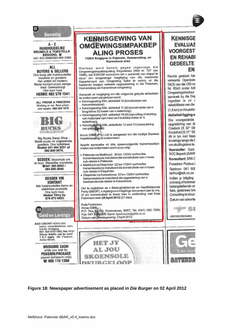
Melkhout- Patensie dBAR_v0.4_lowres.doc
Figure 18: Newspaper advertisement as placed in Die Burger on 02 April 2012

Melkhout- Patensie dBAR_v0.4_lowres.doc
Site notices
Site notices were printed onto A1 correx boards and displayed at two points along the proposed power line route at the following locations on 02 April 2012:
Location of the proposed Patensie substation (33°47’02.63” S, 24°50’21.76” E);
Along the route of the line on the R330 (33°54’42.23” S, 24°49’08.13” E);
An A3 poster was placed at the Spar in Hankey (33°49.954’ S, 24°52.991’ E).
See Addendum 3 for the details of the Site Notice. Photographic evidence of erection of the above site notices is provided below.
. Site notice at proposed Patensie substation Site notice along Melkhout to Patensie line
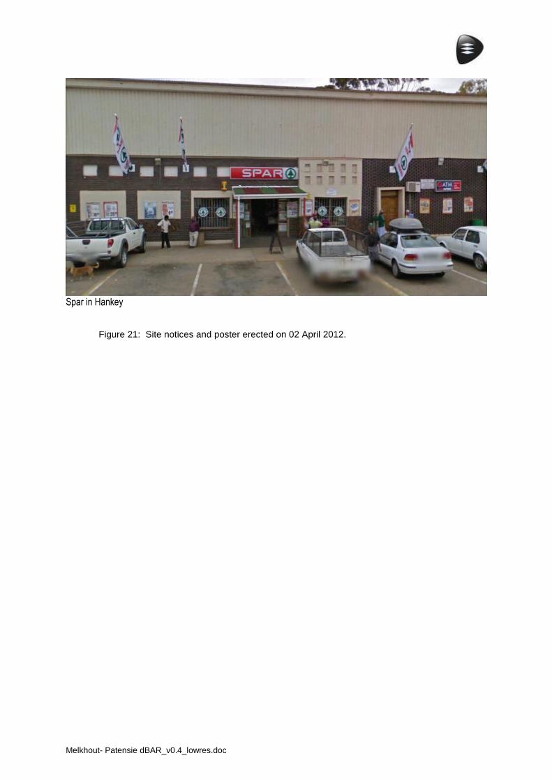
Melkhout- Patensie dBAR_v0.4_lowres.doc
Spar in Hankey
Figure 21: Site notices and poster erected on 02 April 2012.
Melkhout- Patensie dBAR_v0.4_lowres.doc
Background Information Documents
The background information document (BID) was distributed by e-mail to councillors, authorities and stakeholders on 04 April 2012. The BID is attached as Addendum 1.
Notification of Authorities
The applicant in this case is Eskom. Authorities were notified as follows: Cacadu District Municipality - A background information document was sent to Ms Lyn
Nance, Senior Administration Officer at the Cacadu office of the Executive Mayor and Municipal Manager from where it was sent to all nine local municipalities for distribution to the councillors.
Department of Environmental Affairs (DEA) - Mr Coenrad Agenbach, Assistant Director. South African Heritage Resource Agency - Ms Mariagrazia Galimeberti. Department of Economic Development and Environmental Affairs (DEDEA) - Mr Dayalan
Govender. Department of Roads, Eastern Cape - Ms Wilma Snyman. Kouga Municipality - Mr Aubrey Marais. Responses from all these authorities are presented in Addendum 5.
Public meeting
A public meeting will be held during the draft BAR review period.
I&AP Registration and Comments
Initial registration and comment period Landowners were automatically recognised as I&APs, letters notifying the landowners of the EIA process were delivered on 19 March 2012. Site notices were erected and two newspaper advertisements published on the 2nd April with a 21 day registration period for additional I&APs running until 25th April. BIDs were distributed to councillors, authorities and stakeholder with a 21 day registration period ending on 11th May.
Melkhout- Patensie dBAR_v0.4_lowres.doc
7 Rev 0 / Jan 2012
COMMENTS AND RESPONES
Introduction
The following sections present comments received during the initial public participation period (section 2.2) as well as comments received during the draft BAR review period (section 2.3).
Comments received subsequent to notifying landowners
Respondent & organisation
Issue/concern Date Means of communication
Comment/query Response
Mr P. Ferreira Power lines crossing property
28/03/2012 Fax I do not grant permission for the power line to cross my property, there are already 3 power lines across my property. There is enough space south or north of the existing power line or south of the tarred road available, north of the rail line
The construction of all proposed power lines will be subject to negotiations between Eskom and land owners. No work will commence on the power lines until the EIA process is complete.
Mrs N. Gouws. SANRAL
Placement of power lines in relation to roads. Vertical clearance of power lines
12/04/2012 E-mail For 22 kV overhead power lines no pole or stay shall be erected closer than 20 meters from the national road reserve fence For 40 kV and higher overhead power lines no pole or stay shall be erected closer than 60 meters from the national road reserve fence A vertical clearance of not less than 6,5 meters measured from the crown of the national road to the lowest wire shall be observed
Best practice standards as well as Eskom guidelines and standards will be strictly adhered to with regards to clearances. The clearances to be implemented are discussed in the Basic Assessment Report. No work will commence on the power lines until the EIA process is complete.
Mr K.Reichert Public participation for cultural issues
26/04/2012 E-mail Mr Reichert is concerned the public participation process is not adequate to deal with cultural issues. Mr Reichert also requested a copy of the Heritage Impact Assessment Report
A Heritage Impact Assessment (HIA) found that impacts on heritage along the route were of low significance provided that the mitigation measures proposed by the HIA practitioner are implemented. Heritage Impact Assessment Reports sent to Mr Reichert on 06/06/2012
Melkhout- Patensie dBAR_v0.4_lowres.doc
8 Rev 0 / Jan 2012
Comments received during initial I&AP registration period (21 days)
A number of I&APs registered during this process but no comments were received.
Comments received during draft BAR review period (40 days) and public meetings
The following table presents the comments received during the draft BAR review period and public meetings. Comments have been grouped according to topic, and summarised. The table also indicates the reference numbers for the different I&APs which raised particular issues. The draft BAR review and public meeting is yet to commence thus no comments can be presented here prior to the release of the dBAR for review.
Respondent & organisation
Issue/concern Date Means of communication
Comment/query Response
To be completed
CONCLUSIONS and WAY FORWARD
This draft IRR will be updated as the BAR undergoes various phases of review. These will include the following: Draft BAR: The draft BAR will be made available to the public for a review period of 40
days. Any comments on the report are to be forwarded to GIBB. Final BAR: The final BAR will be made available to the public for a review period of 21
days. Any comments on the report are to be forwarded to GIBB. Final submitted BAR: The final submitted BAR will be submitted to the DEA and made
available to the public for a review. The outcome of DEDEA’s decision will be communicated to all I&APs once it has been issued.
Addendum 1
Background Information Document

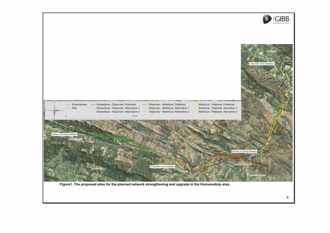
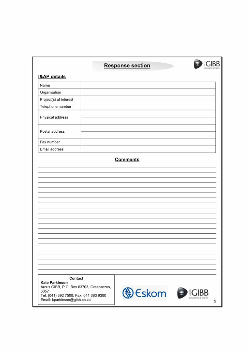
Addendum 2
Notification letters sent to landowners
Sit
e noti
ce a
s er
ecte
d a
t fo
ur
loca
tions
aro
und t
he
site
.

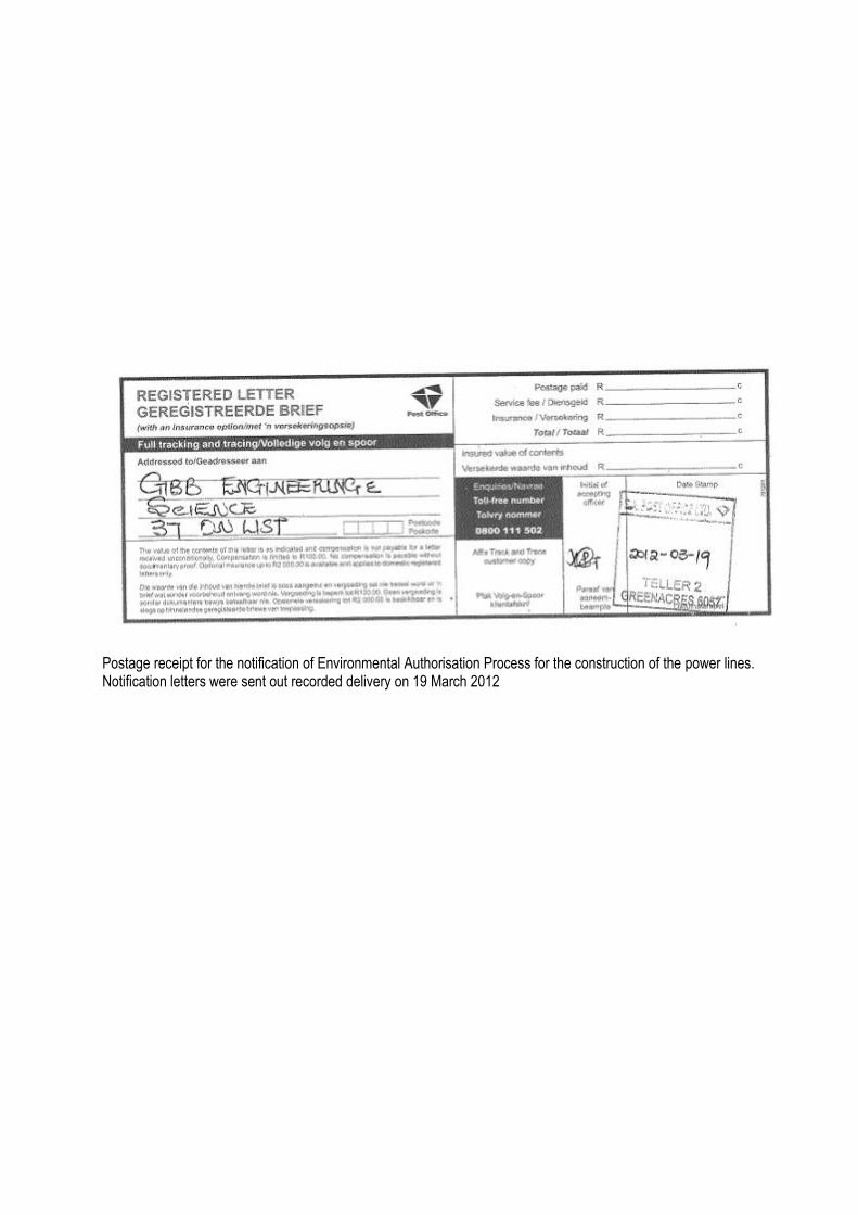
Postage receipt for the notification of Environmental Authorisation Process for the construction of the power lines. Notification letters were sent out recorded delivery on 19 March 2012
Addendum 3
Site notice
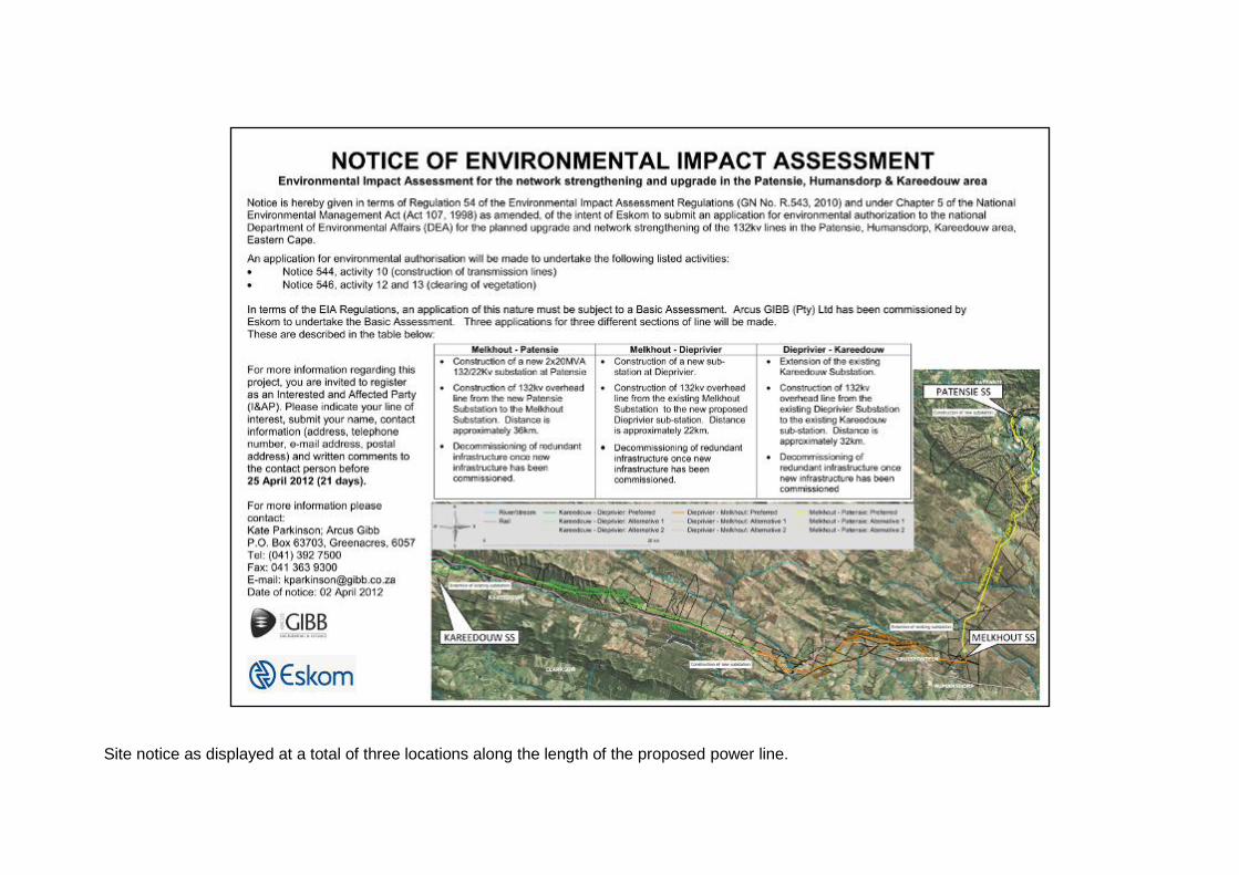
Site notice as displayed at a total of three locations along the length of the proposed power line.
Addendum 4
Comments Received from Authorities
Melkhout- Patensie dBAR_v0.4_lowres.doc
Addendum 5
Comments received on the draft BAR
Melkhout- Patensie dBAR_v0.4_lowres.doc
Addendum 6
I&AP Database
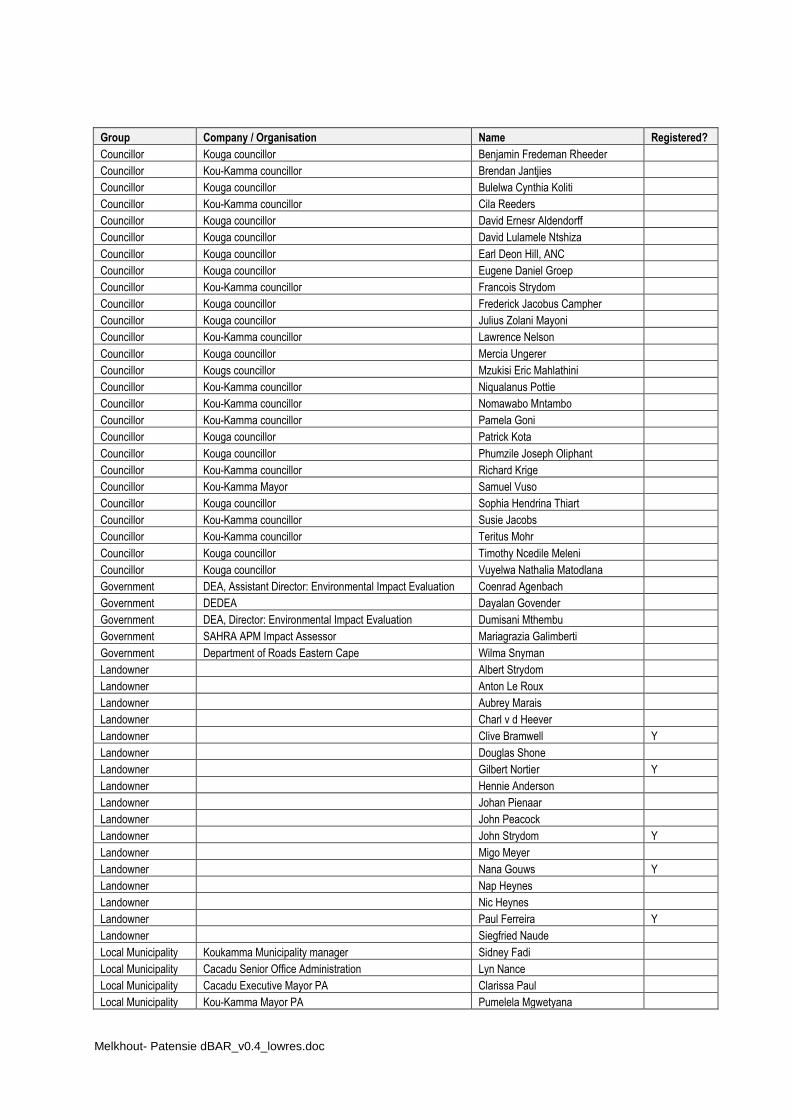
Melkhout- Patensie dBAR_v0.4_lowres.doc
Group Company / Organisation Name Registered?
Councillor Kouga councillor Benjamin Fredeman Rheeder
Councillor Kou-Kamma councillor Brendan Jantjies
Councillor Kouga councillor Bulelwa Cynthia Koliti
Councillor Kou-Kamma councillor Cila Reeders
Councillor Kouga councillor David Ernesr Aldendorff
Councillor Kouga councillor David Lulamele Ntshiza
Councillor Kouga councillor Earl Deon Hill, ANC
Councillor Kouga councillor Eugene Daniel Groep
Councillor Kou-Kamma councillor Francois Strydom
Councillor Kouga councillor Frederick Jacobus Campher
Councillor Kouga councillor Julius Zolani Mayoni
Councillor Kou-Kamma councillor Lawrence Nelson
Councillor Kouga councillor Mercia Ungerer
Councillor Kougs councillor Mzukisi Eric Mahlathini
Councillor Kou-Kamma councillor Niqualanus Pottie
Councillor Kou-Kamma councillor Nomawabo Mntambo
Councillor Kou-Kamma councillor Pamela Goni
Councillor Kouga councillor Patrick Kota
Councillor Kouga councillor Phumzile Joseph Oliphant
Councillor Kou-Kamma councillor Richard Krige
Councillor Kou-Kamma Mayor Samuel Vuso
Councillor Kouga councillor Sophia Hendrina Thiart
Councillor Kou-Kamma councillor Susie Jacobs
Councillor Kou-Kamma councillor Teritus Mohr
Councillor Kouga councillor Timothy Ncedile Meleni
Councillor Kouga councillor Vuyelwa Nathalia Matodlana
Government DEA, Assistant Director: Environmental Impact Evaluation Coenrad Agenbach
Government DEDEA Dayalan Govender
Government DEA, Director: Environmental Impact Evaluation Dumisani Mthembu
Government SAHRA APM Impact Assessor Mariagrazia Galimberti
Government Department of Roads Eastern Cape Wilma Snyman
Landowner Albert Strydom
Landowner Anton Le Roux
Landowner Aubrey Marais
Landowner Charl v d Heever
Landowner Clive Bramwell Y
Landowner Douglas Shone
Landowner Gilbert Nortier Y
Landowner Hennie Anderson
Landowner Johan Pienaar
Landowner John Peacock
Landowner John Strydom Y
Landowner Migo Meyer
Landowner Nana Gouws Y
Landowner Nap Heynes
Landowner Nic Heynes
Landowner Paul Ferreira Y
Landowner Siegfried Naude
Local Municipality Koukamma Municipality manager Sidney Fadi
Local Municipality Cacadu Senior Office Administration Lyn Nance
Local Municipality Cacadu Executive Mayor PA Clarissa Paul
Local Municipality Kou-Kamma Mayor PA Pumelela Mgwetyana
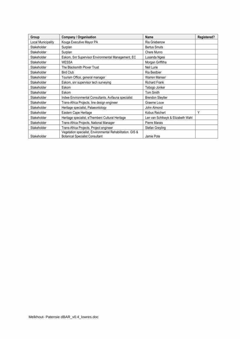
Melkhout- Patensie dBAR_v0.4_lowres.doc
Group Company / Organisation Name Registered?
Local Municipality Kouga Executive Mayor PA Ria Griebenow
Stakeholder Surplan Bertus Smuts
Stakeholder Surplan Chere Munro
Stakeholder Eskom, Snr Supervisor Environmental Management, EC Lusanda Ngesi
Stakeholder WESSA Morgan Griffitha
Stakeholder The Blacksmith Plover Trust Neil Lurie
Stakeholder Bird Club Ria Bestbier
Stakeholder Tourism Office, general manager Warren Manser
Stakeholder Eskom, snr supervisor tech surveying Richard Frank
Stakeholder Eskom Tebogo Jonker
Stakeholder Eskom Tom Smith
Stakeholder Indwe Environmental Consultants, Avifauna specialist Brendon Steytler
Stakeholder Trans-Africa Projects, line design engineer Graeme Louw
Stakeholder Heritage specialist, Palaeontology John Almond
Stakeholder Eastern Cape Heritage Kobus Reichert Y
Stakeholder Heritage specialist, eThembeni Cultural Heritage Len van Schlkwyk & Elizabeth Wahl
Stakeholder Trans-Africa Projects, National Manager Pierre Marais
Stakeholder Trans-Africa Projects, Project engineer Stefan Greyling
Stakeholder Vegetation specialist, Environmental Rehabilitation. GIS & Botanical Specialist Consultant Jamie Pote

Melkhout- Patensie dBAR_v0.4_lowres.doc
APPENDIX F
Environmental Management Programme

Melkhout- Patensie dBAR_v0.4_lowres.doc
APPENDIX G
Details of EAP and declaration of interest
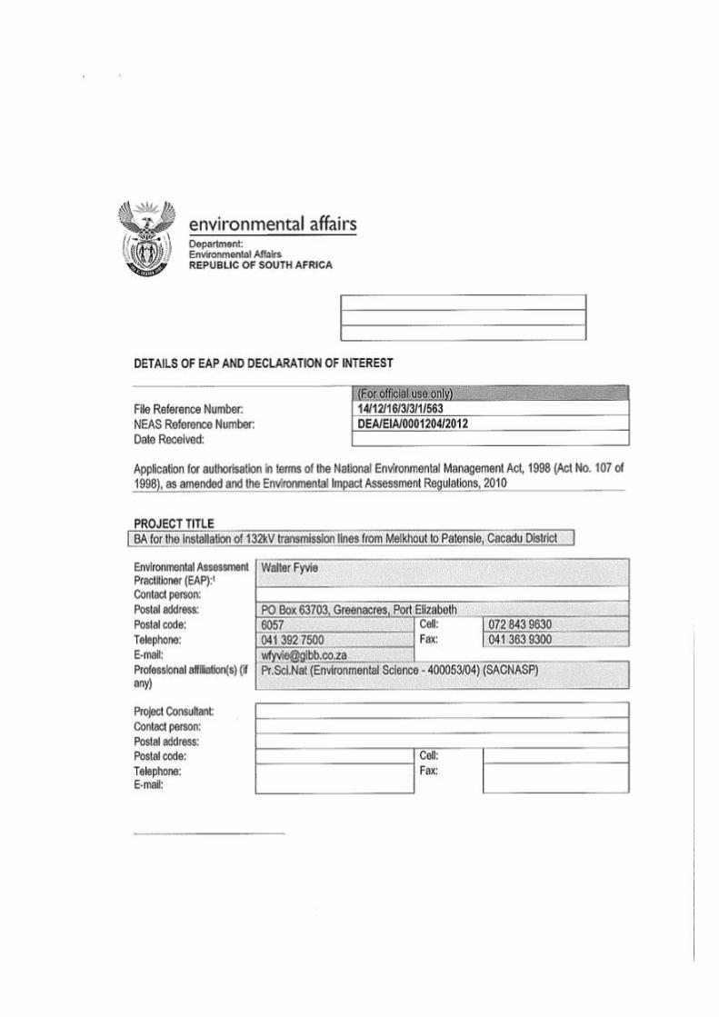
Melkhout- Patensie dBAR_v0.4_lowres.doc
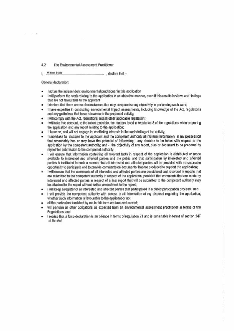
Melkhout- Patensie dBAR_v0.4_lowres.doc
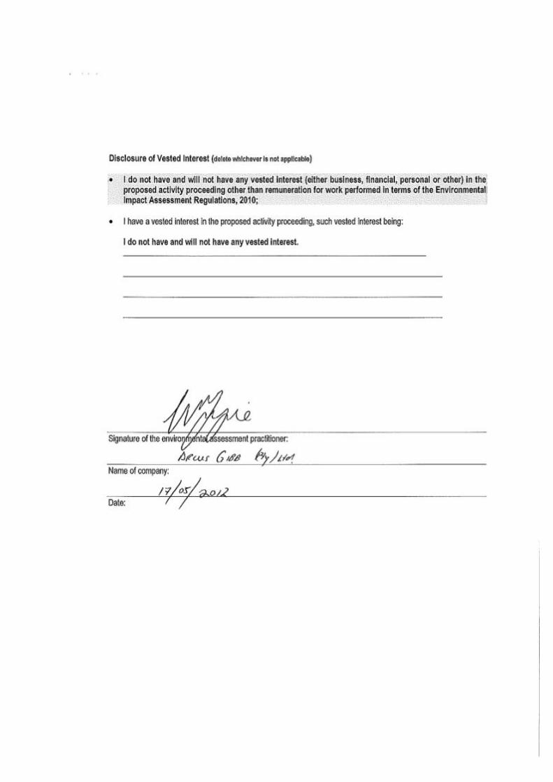
Melkhout- Patensie dBAR_v0.4_lowres.doc
Melkhout- Patensie dBAR_v0.4_lowres.doc
DOCUMENT CONTROL SHEET (FORM IP180/B)
CLIENT : ESKOM Distribution Division
PROJECT NAME : Melkhout to Patensie distribution line BA PROJECT No. : J29224
TITLE OF DOCUMENT : Basic Environmental Assessment for the installation of 132kV distribution lines from Melkhout to Patensie, Cacadu District (Draft)
ELECTRONIC LOCATION : P:\J29224_Eskom_Melkhout-Patensie_PPP (EL project)\3-Tasks\Reports\BAR\Melkhout- Patensie dBAR.docx
Approved By Reviewed By Prepared By
ORIGINAL NAME M Oliver
NAME W Fyvie
NAME M Vosloo
DATE 04/07/2012
SIGNATURE
SIGNATURE
SIGNATURE
Prepared by Prepared By Prepared By
ORIGINAL NAME
NAME
NAME
DATE
SIGNATURE
SIGNATURE
SIGNATURE
Approved By Reviewed By Prepared By
REVISION NAME
NAME
NAME
DATE
SIGNATURE
SIGNATURE
SIGNATURE
This report, and information or advice, which it contains, is provided by Arcus GIBB solely for internal use and reliance by its Client in performance of Arcus GIBB duties and liabilities under its contract with the Client. Any advice, opinions, or recommendations within this report should be read and relied upon only in the context of the report as a whole. The advice and opinions in this report are based upon the information made available to Arcus GIBB at the date of this report and on current SA standards, codes, technology and construction practices as at the date of this report. Following final delivery of this report to the Client, Arcus GIBB will have no further obligations or duty to advise the Client on any matters, including development affecting the information or advice provided in this report. This report has been prepared by Arcus GIBB in their professional capacity as Consulting Engineers. The contents of the report do not, in any way, purport to include any manner of legal advice or opinion. This report is prepared in accordance with the terms and conditions of the Arcus GIBB contract with the Client. Regard should be had to those terms and conditions when considering and/or placing any reliance on this report. Should the Client wish to release this report to a Third Party for that party's reliance, Arcus GIBB may, at its discretion, agree to such release provided that: (a) Arcus GIBB written agreement is obtained prior to such release, and (b) By release of the report to the Third Party, that Third Party does not acquire any rights, contractual or otherwise, whatsoever against Arcus GIBB and
Arcus GIBB, accordingly, assume no duties, liabilities or obligations to that Third Party, and (c) Arcus GIBB accepts no responsibility for any loss or damage incurred by the Client or for any conflict of Arcus GIBB interests arising out of the Client's
release of this report to the Third Party.
Arcus GIBB (Pty) Ltd Website : www.gibb.co.za
Postal Address : PO Box 63703, Greenacres, 6057 Physical Address : Greyville House 2nd Floor, Greyville Road, Greenacres, PE, 6045
Contact Person : W Fyvie Email Address : [email protected]
Telephone No. : 041 392 7500 Fax No. : 041 363 9300