eskom distribution division basic environmental assessment...
TRANSCRIPT

BASIC ASSESSMENT REPORT
1
ESKOM DISTRIBUTION DIVISION
Basic Environmental Assessment for the
construction of 132kV distribution lines from
Melkhout to Dieprivier, Cacadu District
FINAL
Report date: 19 November 2012
J29223
BASIC ASSESSMENT REPORT
2
Basic Environmental Assessment for the Construction of 132kV distribution lines from Melkhout to Dieprivier, Cacadu District
CONTENTS Chapter Description Page Section A: Activity Information 5 Section B: Site/Area/Property Description 29 Section C: Public Participation 41 Section D: Impact Assessment 45 Section E: Recommendations of Practitioner 51 References 52 Section F: Appendices 53 APPENDICES Appendix A: Site plans A1: Site map A2: Layout/route map A3: Sensitivity map A4: Route coordinates at 250 m intervals A5: Landowner details Appendix B: Photographs Appendix C: Illustrations of the proposed development site and infrastructure Appendix D: Specialist reports and declaration of interest D1: Avifauna Impact Assessment D2: Vegetation Impact Assessment D3: Heritage Impact Assessment D4: Wetland Impact Assessment Appendix E: PPP and Issues and Response Report Appendix F Impact Assessment Appendix G: Environmental Management Programme (EMPr) Appendix H: Details of EAP and Expertise Appendix I: Specialist Declaration of Interest Appendix J Additional Information NOTE: Additions are highlighted grey
BASIC ASSESSMENT REPORT
3
(For official use only)
File Reference Number:
Application Number:
Date Received:
Basic assessment report in terms of the Environmental Impact Assessment Regulations, 2010, promulgated in
terms of the National Environmental Management Act, 1998 (Act No. 107 of 1998), as amended.
Kindly note that:
1. This basic assessment report is a standard report that may be required by a competent authority in terms of the EIA Regulations, 2010 and is meant to streamline applications. Please make sure that it is the report used by the particular competent authority for the activity that is being applied for.
2. This report format is current as of 1 September 2012. It is the responsibility of the applicant to ascertain whether subsequent versions of the form have been published or produced by the competent authority
3. The report must be typed within the spaces provided in the form. The size of the spaces provided is not necessarily indicative of the amount of information to be provided. The report is in the form of a table that can extend itself as each space is filled with typing.
4. Where applicable tick the boxes that are applicable in the report.
5. An incomplete report may be returned to the applicant for revision.
6. The use of “not applicable” in the report must be done with circumspection because if it is used in respect of material information that is required by the competent authority for assessing the application, it may result in the rejection of the application as provided for in the regulations.
7. This report must be handed in at offices of the relevant competent authority as determined by each authority.
8. No faxed or e-mailed reports will be accepted.
9. The signature of the EAP on the report must be an original signature.
10. The report must be compiled by an independent environmental assessment practitioner.
11. Unless protected by law, all information in the report will become public information on receipt by the competent authority. Any interested and affected party should be provided with the information contained in this report on request, during any stage of the application process.
12. A competent authority may require that for specified types of activities in defined situations only parts of this report need to be completed.
BASIC ASSESSMENT REPORT
4
13. Should a specialist report or report on a specialised process be submitted at any stage for any part of this application, the terms of reference for such report must also be submitted.
14. Two (2) colour hard copies and one (1) electronic copy of the report must be submitted to the competent authority.
15. Shape files (.shp) for maps must be included on the electronic copy of the report submitted to the competent authority.
BASIC ASSESSMENT REPORT
5
SECTION A: ACTIVITY INFORMATION
Has a specialist been consulted to assist with the completion of this section? YES NO X
If YES, please complete the form entitled “Details of specialist and declaration of interest” for the specialist
appointed and attach in Appendix I.
1. PROJECT DESCRIPTION a) Describe the project associated with the listed activities applied for
BACKGROUND Eskom’s core business is in the generation, transmission and distribution of electricity. Eskom generates approximately 95% of the South African electricity in accordance with supply and demand requirements. Reliable provision of electricity by Eskom is critical for industrial and sustainable development in South Africa, which inevitably provides and sustains job opportunities for jobseekers. As electricity cannot be stored, power is generated and delivered over long distances as it is required. This is achieved through thousands of kilometres of high voltage transmission, and distribution lines which transmit this power from power stations located outside the Eastern Cape Province, to Eskom’s major substations. At these major substations, the voltage loading is reduced and distributed to smaller substations. From here the voltage is further reduced for distribution to industry, businesses, farms and homes. In order to maintain a reliable power supply within the entire network, the voltages at all substations are required to be within certain desired limits. If the network is operated at voltages below these limits, power outages may be experienced, which results in unreliable electricity supply. In order to avoid this, the distribution network must have the capacity to supply the electricity required by the customers at all times. The network must therefore be designed with reserve distribution capacity in order to ensure an uninterruptable supply of electricity. The electricity network in the Humansdorp area is already operating close to capacity, thus increasing the risk that the entire network could be interrupted. Furthermore, the Eskom Distribution network is increasing rapidly due to vigorous electrification plans. Eskom has identified the Patensie, Humansdorp and Kareedouw areas of the Eastern Cape as locations where strengthening of the network is required to meet current and future demands for electricity. Eskom proposes to construct infrastructure to strengthen and upgrade the network in the Patensie, Humansdorp and Kareedouw areas. The objective of the proposed installation of 132kV distribution lines is thus to increase the reserve capacity on the existing lines, while providing spare capacity for the future electricity needs of the growing local economy. GIBB (Pty) Ltd was appointed by ESKOM Distribution Division to undertake an environmental authorisation process in terms of Section 24 of the National Environmental Management Act, (Act 107 of 1998) for the construction of electrical distribution infrastructure, which will comprise a new 132 kV overhead distribution line and a new substation at Dieprivier. Several listed activities will be triggered PROPOSED ACTIVITIES Study area. The study area where the proposed activity is to take place is located in close proximity to the small town of Humansdorp in the Kouga Local Municipality (Cacadu District Municipality), Eastern Cape. The Cacadu District is the largest producer of agricultural goods in the Eastern Cape. Agriculture is centred on the citrus industry with a smaller scale production of other products including vegetables and flowers. The proposed line runs between the Kou-Kamma Local Municipality and the Kouga Local Municipality (LM),
BASIC ASSESSMENT REPORT
6
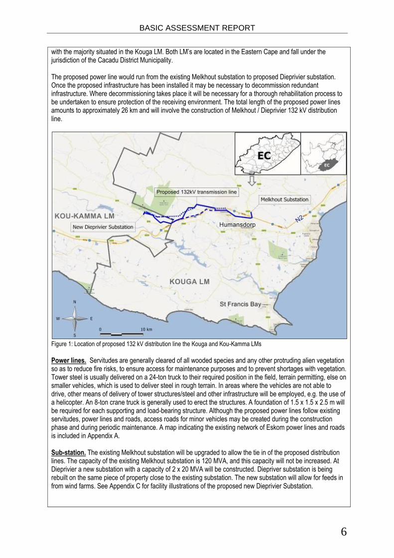
with the majority situated in the Kouga LM. Both LM’s are located in the Eastern Cape and fall under the jurisdiction of the Cacadu District Municipality. The proposed power line would run from the existing Melkhout substation to proposed Dieprivier substation. Once the proposed infrastructure has been installed it may be necessary to decommission redundant infrastructure. Where decommissioning takes place it will be necessary for a thorough rehabilitation process to be undertaken to ensure protection of the receiving environment. The total length of the proposed power lines amounts to approximately 26 km and will involve the construction of Melkhout / Dieprivier 132 kV distribution line.
Figure 1: Location of proposed 132 kV distribution line the Kouga and Kou-Kamma LMs
Power lines. Servitudes are generally cleared of all wooded species and any other protruding alien vegetation so as to reduce fire risks, to ensure access for maintenance purposes and to prevent shortages with vegetation. Tower steel is usually delivered on a 24-ton truck to their required position in the field, terrain permitting, else on smaller vehicles, which is used to deliver steel in rough terrain. In areas where the vehicles are not able to drive, other means of delivery of tower structures/steel and other infrastructure will be employed, e.g. the use of a helicopter. An 8-ton crane truck is generally used to erect the structures. A foundation of 1.5 x 1.5 x 2.5 m will be required for each supporting and load-bearing structure. Although the proposed power lines follow existing servitudes, power lines and roads, access roads for minor vehicles may be created during the construction phase and during periodic maintenance. A map indicating the existing network of Eskom power lines and roads is included in Appendix A. Sub-station. The existing Melkhout substation will be upgraded to allow the tie in of the proposed distribution lines. The capacity of the existing Melkhout substation is 120 MVA, and this capacity will not be increased. At Dieprivier a new substation with a capacity of 2 x 20 MVA will be constructed. Diepriver substation is being rebuilt on the same piece of property close to the existing substation. The new substation will allow for feeds in from wind farms. See Appendix C for facility illustrations of the proposed new Dieprivier Substation.
BASIC ASSESSMENT REPORT
7
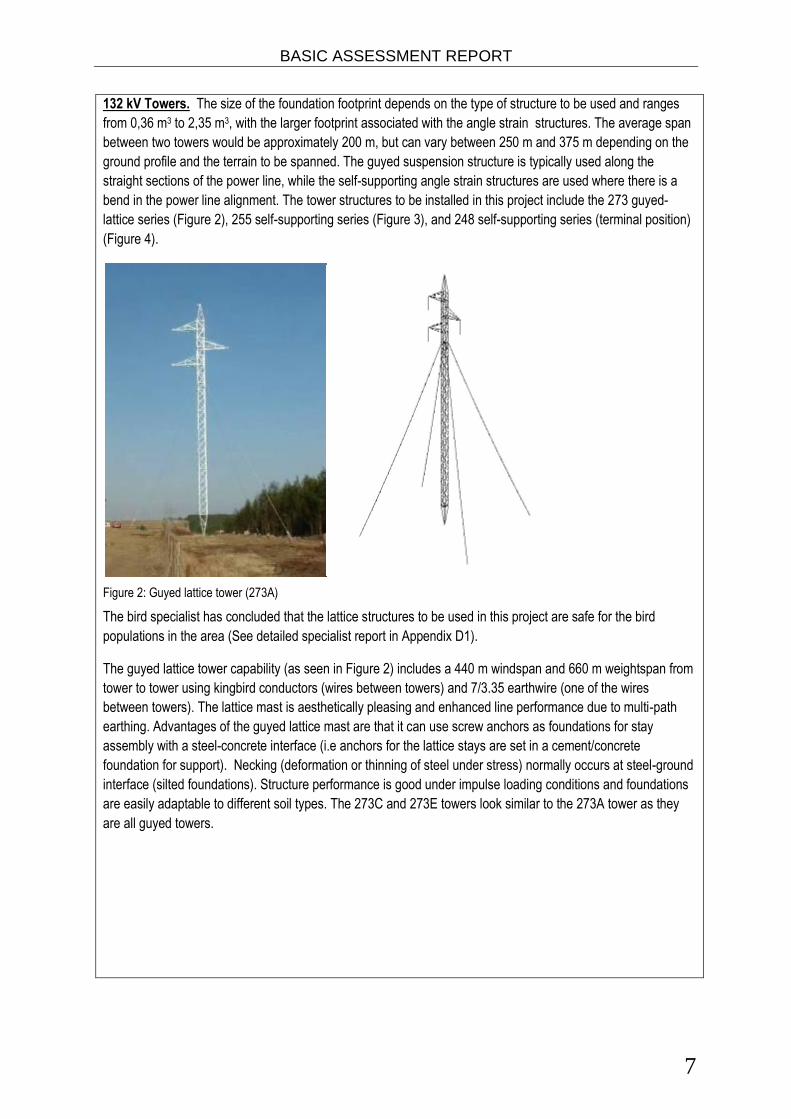
132 kV Towers. The size of the foundation footprint depends on the type of structure to be used and ranges
from 0,36 m3 to 2,35 m3, with the larger footprint associated with the angle strain structures. The average span
between two towers would be approximately 200 m, but can vary between 250 m and 375 m depending on the
ground profile and the terrain to be spanned. The guyed suspension structure is typically used along the
straight sections of the power line, while the self-supporting angle strain structures are used where there is a
bend in the power line alignment. The tower structures to be installed in this project include the 273 guyed-
lattice series (Figure 2), 255 self-supporting series (Figure 3), and 248 self-supporting series (terminal position)
(Figure 4).
Figure 2: Guyed lattice tower (273A)
The bird specialist has concluded that the lattice structures to be used in this project are safe for the bird
populations in the area (See detailed specialist report in Appendix D1).
The guyed lattice tower capability (as seen in Figure 2) includes a 440 m windspan and 660 m weightspan from
tower to tower using kingbird conductors (wires between towers) and 7/3.35 earthwire (one of the wires
between towers). The lattice mast is aesthetically pleasing and enhanced line performance due to multi-path
earthing. Advantages of the guyed lattice mast are that it can use screw anchors as foundations for stay
assembly with a steel-concrete interface (i.e anchors for the lattice stays are set in a cement/concrete
foundation for support). Necking (deformation or thinning of steel under stress) normally occurs at steel-ground
interface (silted foundations). Structure performance is good under impulse loading conditions and foundations
are easily adaptable to different soil types. The 273C and 273E towers look similar to the 273A tower as they
are all guyed towers.

BASIC ASSESSMENT REPORT
8
Figure 3: Self supporting strain tower (255D)
The rest of the 255 series structures are similar to the 255D structure in figure 3.
Figure 4: Self supporting terminal tower (248C)
Tower illustrations of the tower types to be used are provided in Appendix C. Servitude Requirements and Clearances. The servitude width for a 132 kV distribution line is 31 m (15.5 m on either side of the centre line of the power line). The minimum vertical clearance to buildings, poles and structures not forming part of the power line must be 3.8 m, while the minimum vertical clearance between the conductors and the ground is 6.7 m. The minimum distance of a 132 kV distribution line running parallel to proclaimed public roads is 95 m from the centreline of the distribution line servitude to the centreline of the road servitude. The minimum distance between any part of a tree or shrub and any bare phase conductor of a 132 kV distribution line must be 3.8 m to allow for the possible lateral movement of this vegetation that could be a potential hazard for distribution lines that are operational and energised. The Occupational Health and Safety Act, 1993 (Act No. 85 of 1993) provides for statutory clearances. Table 1 summarizes some of the key clearances relevant to the proposed 132 kV power line.

BASIC ASSESSMENT REPORT
9
Table 1. Clearance specifications (Eskom, 2007).
Clearances Minimum Clearance Distance (m)
Ground clearance 6.7
Building structures not part of power line 3.8
Above roads in townships, proclaimed roads 7.5
Telkom telephone lines 2.0
Spoornet tracks 10.9
Should the preferred distribution line corridor receive environmental authorization from DEA, and following on from successful negotiations with landowners, the final delineation of the centreline for the distribution line and co-ordinates of each bend in the line will be determined. Optimal tower sizes and positions will be identified and verified through comprehensive ground survey of the preferred route and these positions will be reflected, and appropriate management actions incorporated into the continuously and periodically updated Environmental Management Programme (EMPr). Trees and large shrubs that will cause clearance issues will be trimmed or cleared, while a narrow footpath for workers will be cleared down the centre of the distribution line servitude for stringing purposes. If any tree or shrub in other areas will interfere with the operation and/or reliability of the distribution line it will be trimmed or completely cleared. In areas where distribution lines cross existing orchards or agricultural lands in use the footprint of the structures will be minimised and full scale clearing of the servitude avoided to allow continued use of the arable land, unless otherwise negotiated with the affected farmer/s. The clearing of vegetation will take place, with the aid of a surveyor, along approved profiles and in accordance with the approved EMPr and minimum standards to be used for vegetation clearing for the construction of the proposed new 132 kV distribution lines as listed in Table 3 (Eskom, 2000). Access. Access is required during both the construction and operation/maintenance phases of lines life cycle. Where possible, existing access roads and tracks will be used to gain access to construction sites and the servitude. Where no access roads/tracks exist, the access points and roads will be negotiated with the relevant landowner, and are to be established during the construction phase. Access roads will enable the transportation of construction material as well as construction teams to the site and facilitate maintenance activities once the power line has been constructed. Foundations. The type of terrain encountered, as well as the underlying geotechnical conditions determines the choice of foundation. The actual size and type of foundation to be installed will depend on the soil bearing capacity (actual sub-soil conditions). Strain structures require more extensive foundations for support than in-line suspension structures, which contribute to the cost of the construction of the line. Foundations will be mechanically excavated where access to the site is readily available. The same applies to the pouring of concrete required for the setting of the foundations. In areas where access to the structure position prohibits the use of concrete mixing trucks, uphill pumping or gravity feeding of concrete up to distances of 200 m will be implemented. Prior to erecting the structures and infilling of the foundations, the excavated foundations will be covered/fenced-off in order to safeguard unsuspecting animals and people from injury. All foundations are back-filled, stabilised through compaction, and capped with concrete at ground level. Insulators. Composite insulators have a glass-fibre core with silicon sheds for insulation and are used to connect the conductors to the towers. Glass and porcelain have been used to connect the conductors for many years, and is the most common. These products are, however, heavy and susceptible to breakage by vandals, as well as contamination by pollution. Composite insulators are lightweight and resistant to both vandalism and pollution. Composite (Long rod type) insulators with silicone based weathershed material will be used. Ongoing Maintenance. During the life span of the power lines, which is approximately 25 years, ongoing maintenance is required to be performed from time to time. Eskom maintenance staff and contractors employed by Eskom will undertake the maintenance works as required.
BASIC ASSESSMENT REPORT
10
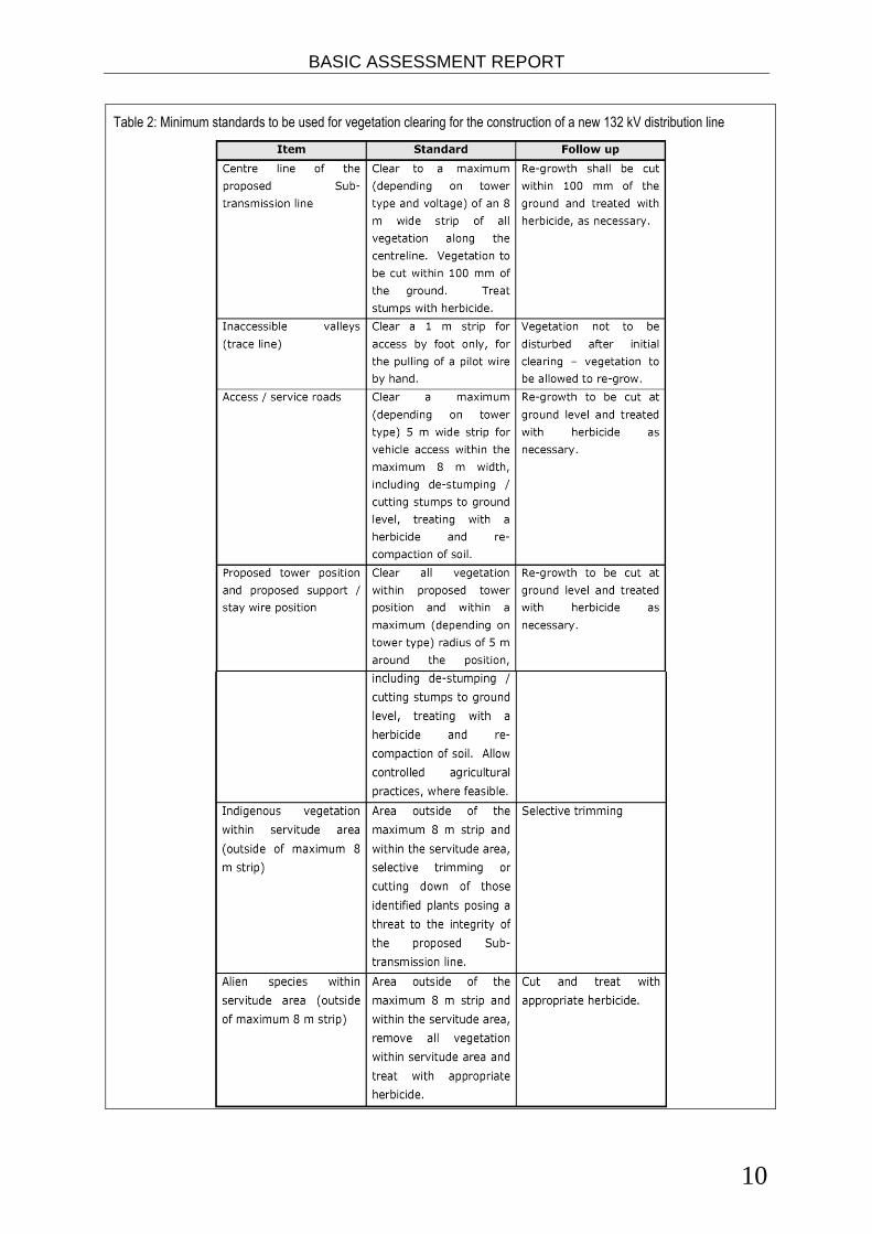
Table 2: Minimum standards to be used for vegetation clearing for the construction of a new 132 kV distribution line
BASIC ASSESSMENT REPORT
11
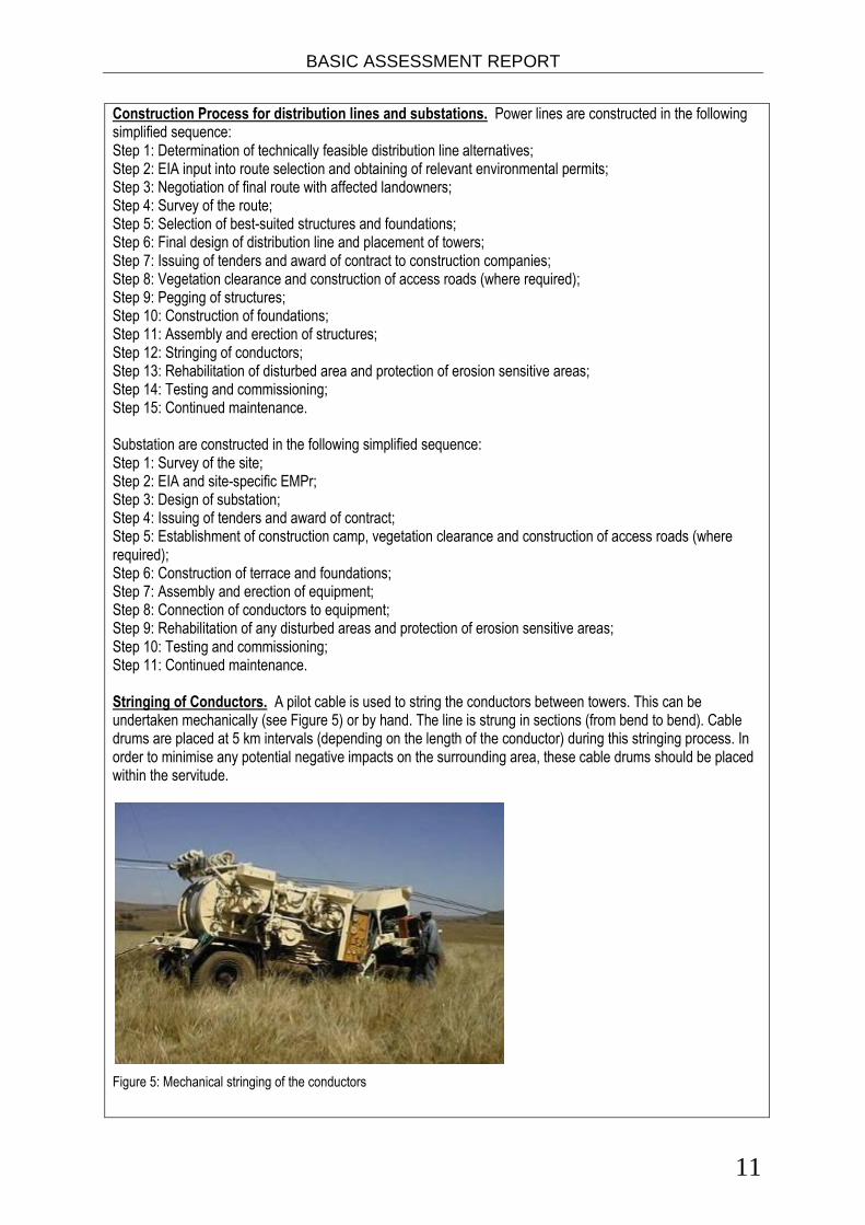
Construction Process for distribution lines and substations. Power lines are constructed in the following simplified sequence: Step 1: Determination of technically feasible distribution line alternatives; Step 2: EIA input into route selection and obtaining of relevant environmental permits; Step 3: Negotiation of final route with affected landowners; Step 4: Survey of the route; Step 5: Selection of best-suited structures and foundations; Step 6: Final design of distribution line and placement of towers; Step 7: Issuing of tenders and award of contract to construction companies; Step 8: Vegetation clearance and construction of access roads (where required); Step 9: Pegging of structures; Step 10: Construction of foundations; Step 11: Assembly and erection of structures; Step 12: Stringing of conductors; Step 13: Rehabilitation of disturbed area and protection of erosion sensitive areas; Step 14: Testing and commissioning; Step 15: Continued maintenance. Substation are constructed in the following simplified sequence: Step 1: Survey of the site; Step 2: EIA and site-specific EMPr; Step 3: Design of substation; Step 4: Issuing of tenders and award of contract; Step 5: Establishment of construction camp, vegetation clearance and construction of access roads (where required); Step 6: Construction of terrace and foundations; Step 7: Assembly and erection of equipment; Step 8: Connection of conductors to equipment; Step 9: Rehabilitation of any disturbed areas and protection of erosion sensitive areas; Step 10: Testing and commissioning; Step 11: Continued maintenance. Stringing of Conductors. A pilot cable is used to string the conductors between towers. This can be undertaken mechanically (see Figure 5) or by hand. The line is strung in sections (from bend to bend). Cable drums are placed at 5 km intervals (depending on the length of the conductor) during this stringing process. In order to minimise any potential negative impacts on the surrounding area, these cable drums should be placed within the servitude.
Figure 5: Mechanical stringing of the conductors
BASIC ASSESSMENT REPORT
12
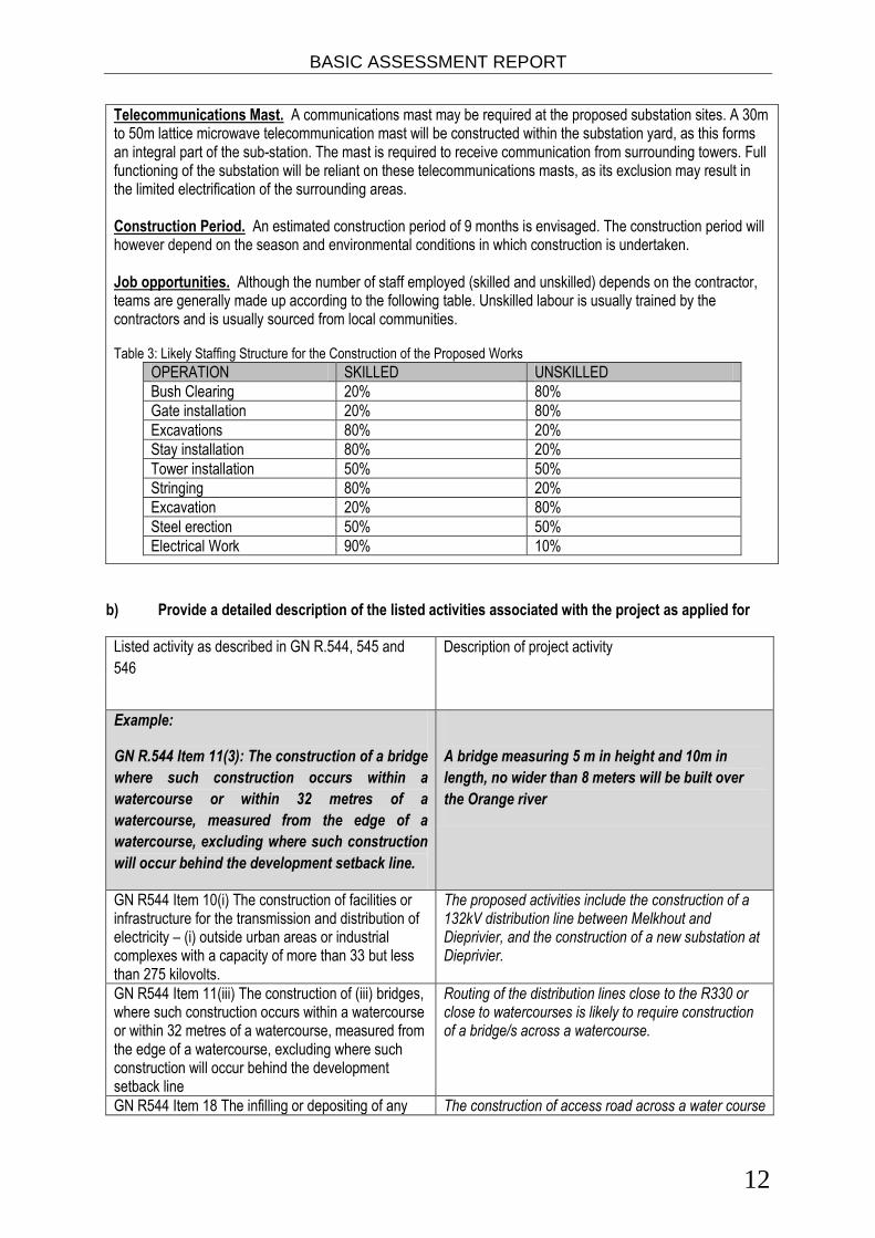
Telecommunications Mast. A communications mast may be required at the proposed substation sites. A 30m to 50m lattice microwave telecommunication mast will be constructed within the substation yard, as this forms an integral part of the sub-station. The mast is required to receive communication from surrounding towers. Full functioning of the substation will be reliant on these telecommunications masts, as its exclusion may result in the limited electrification of the surrounding areas. Construction Period. An estimated construction period of 9 months is envisaged. The construction period will however depend on the season and environmental conditions in which construction is undertaken. Job opportunities. Although the number of staff employed (skilled and unskilled) depends on the contractor, teams are generally made up according to the following table. Unskilled labour is usually trained by the contractors and is usually sourced from local communities. Table 3: Likely Staffing Structure for the Construction of the Proposed Works
OPERATION SKILLED UNSKILLED
Bush Clearing 20% 80%
Gate installation 20% 80%
Excavations 80% 20%
Stay installation 80% 20%
Tower installation 50% 50%
Stringing 80% 20%
Excavation 20% 80%
Steel erection 50% 50%
Electrical Work 90% 10%
b) Provide a detailed description of the listed activities associated with the project as applied for
Listed activity as described in GN R.544, 545 and
546
Description of project activity
Example:
GN R.544 Item 11(3): The construction of a bridge
where such construction occurs within a
watercourse or within 32 metres of a
watercourse, measured from the edge of a
watercourse, excluding where such construction
will occur behind the development setback line.
A bridge measuring 5 m in height and 10m in
length, no wider than 8 meters will be built over
the Orange river
GN R544 Item 10(i) The construction of facilities or infrastructure for the transmission and distribution of electricity – (i) outside urban areas or industrial complexes with a capacity of more than 33 but less than 275 kilovolts.
The proposed activities include the construction of a 132kV distribution line between Melkhout and Dieprivier, and the construction of a new substation at Dieprivier.
GN R544 Item 11(iii) The construction of (iii) bridges, where such construction occurs within a watercourse or within 32 metres of a watercourse, measured from the edge of a watercourse, excluding where such construction will occur behind the development setback line
Routing of the distribution lines close to the R330 or close to watercourses is likely to require construction of a bridge/s across a watercourse.
GN R544 Item 18 The infilling or depositing of any The construction of access road across a water course
BASIC ASSESSMENT REPORT
13
material of more than 5 cubic metres into, or the dredging, excavation, removal or moving of soil, sand, shells, shell grit, pebbles or rock from (i) a watercourse.
may be required where the access to a tower structure cannot be achieved by another means.
GN R546 Item 3(a), (b) (ii) The construction of masts
or towers of any material or type used for
telecommunication broadcasting or radio
transmission purposes where the mast (a) is to be
placed on a site not previously used for this purpose,
and (b) will exceed 15 metres in height, but excluding
attachments to existing buildings and masts on
rooftops. (a) In the Eastern Cape province (ii) outside
urban areas.
Masts for telecommunication purposes may be constructed at the existing or proposed sub-stations.
GN R546 Item 12 (b) The clearance of an area of 300 square metres or more of vegetation where 75% or more of the vegetative cover constitutes indigenous vegetation, (b) within critical biodiversity areas identified in bioregional plans.
Clearing of vegetation along each route within the servitude will likely occur, which will impact on some of the CBAs occurring along the route as identified in the Eastern Cape Biodiversity Conservation Plan (ECBCP)
GN R546 Item 13 (a), (c) ii The clearance of an area of 1 hectare or more of vegetation where 75% or more of the vegetative cover constitutes indigenous vegetation, (exclusion clauses not applicable): c) In the eastern Cape (ii) outside urban areas.
Clearing of vegetation along each route within the servitude will likely occur, which will impact on some of the CBAs occurring along the route as identified in the Eastern Cape Biodiversity Conservation Plan (ECBCP).
2. FEASIBLE AND REASONABLE ALTERNATIVES
“alternatives”, in relation to a proposed activity, means different means of meeting the general purpose and requirements of the activity, which may include alternatives to— (a) the property on which or location where it is proposed to undertake the activity; (b) the type of activity to be undertaken; (c) the design or layout of the activity; (d) the technology to be used in the activity; (e) the operational aspects of the activity; and (f) the option of not implementing the activity. Describe alternatives that are considered in this application as required by Regulation 22(2)(h) of GN R.543.
Alternatives should include a consideration of all possible means by which the purpose and need of the proposed
activity (NOT PROJECT) could be accomplished in the specific instance taking account of the interest of the
applicant in the activity. The no-go alternative must in all cases be included in the assessment phase as the
baseline against which the impacts of the other alternatives are assessed.
The determination of whether site or activity (including different processes, etc.) or both is appropriate needs to
be informed by the specific circumstances of the activity and its environment. After receipt of this report the,
competent authority may also request the applicant to assess additional alternatives that could possibly
accomplish the purpose and need of the proposed activity if it is clear that realistic alternatives have not been
considered to a reasonable extent.
BASIC ASSESSMENT REPORT
14
The identification of alternatives should be in line with the Integrated Environmental Assessment Guideline
Series 11, published by the DEA in 2004. Should the alternatives include different locations and lay-outs, the co-
ordinates of the different alternatives must be provided. The co-ordinates should be in degrees, minutes and
seconds. The projection that must be used in all cases is the WGS84 spheroid in a national or local projection.
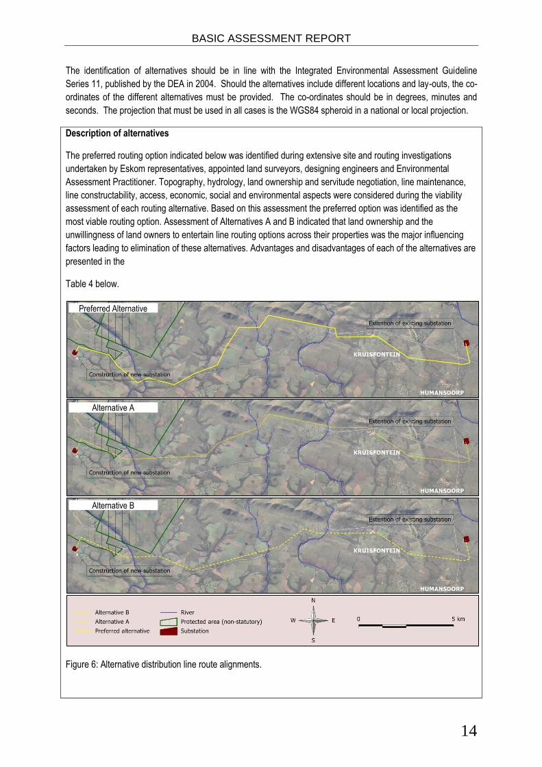
Description of alternatives
The preferred routing option indicated below was identified during extensive site and routing investigations
undertaken by Eskom representatives, appointed land surveyors, designing engineers and Environmental
Assessment Practitioner. Topography, hydrology, land ownership and servitude negotiation, line maintenance,
line constructability, access, economic, social and environmental aspects were considered during the viability
assessment of each routing alternative. Based on this assessment the preferred option was identified as the
most viable routing option. Assessment of Alternatives A and B indicated that land ownership and the
unwillingness of land owners to entertain line routing options across their properties was the major influencing
factors leading to elimination of these alternatives. Advantages and disadvantages of each of the alternatives are
presented in the
Table 4 below.
Figure 6: Alternative distribution line route alignments.
Preferred Alternative
Alternative A
Alternative B

BASIC ASSESSMENT REPORT
15
Table 4. Advantages and disadvantages of the identified routing options.
Preferred Alternative Alternative A Alternative B
All land owners has agreed to allow
construction of power lines across
their property.
Some land owners have refused to
allow construction of power lines
across their property.
Some land owners have refused to
allow construction of power lines
across their property.
This routing option will not cross any
statutory or non-statutory protected
area.
This alternative proposes to cross an
existing game farm (non-statutory
protected area), i.e. Jumanji Game
Farm.
This alternative proposes to cross an
existing game farm (non-statutory
protected area), i.e. Jumanji Game
Farm.
This routing option will be most
expensive to construct based on
construction cost per km (approx.
25.7km).
This alternative will be less expensive
compared to the preferred option to
construct based on construction cost
per km (approx. 24.2km).
This alternative will be least expensive
to construct based on construction
cost per km (approx. 23.7km).
This routing option will be most
expensive to construct based on the
need for more strain structures
(approx. 17 turn angles), and more
expensive foundations per structure.
This alternative will be less expensive
compared to the preferred option to
construct based on the need for less
strain structures (approx. 12 turn
angles).
This alternative will be least expensive
compared to the preferred option to
construct based on the need for strain
structures (approx. 11 turn angles).
Access and maintenance of this
routing option will be more difficult/
expensive as the routing is located
away from the main road for most of
the route.
Access and maintenance of this
alternative will be less difficult/
expensive as the routing is located
closer to the main road.
Access and maintenance of this
alternative will be the least difficult/
expensive as the routing is located in
close proximity to the main road for
the most part.
Visual impact of this routing option in
relation to proximity to the main road
and Kruisfontein / Humansdorp
communities will be less pronounced
than expected for Alternative B.
Visual impact of this alternative in
relation to proximity to the main road
and Kruisfontein / Humansdorp
communities will be least pronounced
than expected for Alternative B.
Visual impact of this alternative in
relation to proximity to the main road
and Kruisfontein / Humansdorp
communities will be most significant.
Conclusion:
The preferred option is clearly the
most expensive option to construct
and maintain, however this option
has a relatively low visual impact
and all land owners along the route
has agreed to allow erection of the
power lines across their properties.
Land owner requirements have
proven the most telling factor in
concluding that this option is the
preferred option.
Conclusion:
Alternative A is less expensive to
construct and maintain than the
preferred option. However, some
land owners, especially owners of
the game farms have rejected
Eskom’s proposal to cross their
property. Land owner requirements
have proven the most telling factor
in concluding that this option is
NOT preferred, and resultantly the
option has been eliminated.
Conclusion:
From a construction and
maintenance cost perspective, this
alternative proves to be favoured.
However, visual impacts may be
potentially significant and some
land owners, especially owners of
the game farms have rejected
Eskom’s proposal to cross their
property. Land owner requirements
have proven the most telling factor
in concluding that this option is
NOT preferred, and resultantly the
option has been eliminated.
BASIC ASSESSMENT REPORT
16
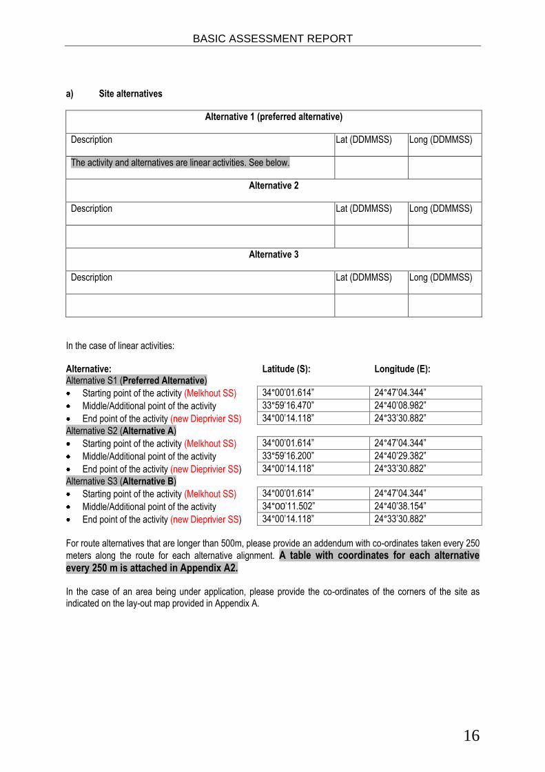
a) Site alternatives
Alternative 1 (preferred alternative)
Description Lat (DDMMSS) Long (DDMMSS)
The activity and alternatives are linear activities. See below.
Alternative 2
Description Lat (DDMMSS) Long (DDMMSS)
Alternative 3
Description Lat (DDMMSS) Long (DDMMSS)
In the case of linear activities: Alternative: Latitude (S): Longitude (E): Alternative S1 (Preferred Alternative)
Starting point of the activity (Melkhout SS) 34°00’01.614” 24°47’04.344”
Middle/Additional point of the activity 33°59’16.470” 24°40’08.982”
End point of the activity (new Dieprivier SS) 34°00’14.118” 24°33’30.882”
Alternative S2 (Alternative A)
Starting point of the activity (Melkhout SS) 34°00’01.614” 24°47’04.344”
Middle/Additional point of the activity 33°59’16.200” 24°40’29.382”
End point of the activity (new Dieprivier SS) 34°00’14.118” 24°33’30.882”
Alternative S3 (Alternative B)
Starting point of the activity (Melkhout SS) 34°00’01.614” 24°47’04.344”
Middle/Additional point of the activity 34°00’11.502” 24°40’38.154”
End point of the activity (new Dieprivier SS) 34°00’14.118” 24°33’30.882”
For route alternatives that are longer than 500m, please provide an addendum with co-ordinates taken every 250
meters along the route for each alternative alignment. A table with coordinates for each alternative every 250 m is attached in Appendix A2. In the case of an area being under application, please provide the co-ordinates of the corners of the site as indicated on the lay-out map provided in Appendix A.
BASIC ASSESSMENT REPORT
17
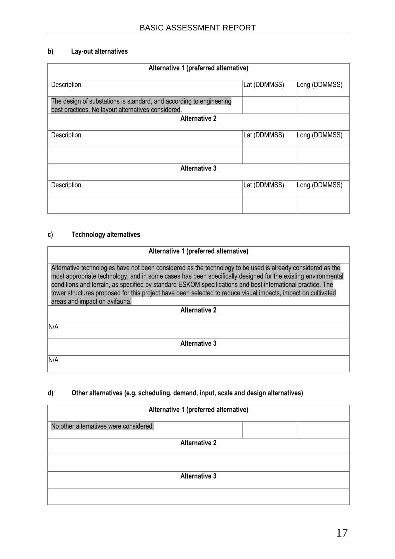
b) Lay-out alternatives
Alternative 1 (preferred alternative)
Description Lat (DDMMSS) Long (DDMMSS)
The design of substations is standard, and according to engineering best practices. No layout alternatives considered.
Alternative 2
Description Lat (DDMMSS) Long (DDMMSS)
Alternative 3
Description Lat (DDMMSS) Long (DDMMSS)
c) Technology alternatives
Alternative 1 (preferred alternative)
Alternative technologies have not been considered as the technology to be used is already considered as the most appropriate technology, and in some cases has been specifically designed for the existing environmental conditions and terrain, as specified by standard ESKOM specifications and best international practice. The tower structures proposed for this project have been selected to reduce visual impacts, impact on cultivated areas and impact on avifauna.
Alternative 2
N/A
Alternative 3
N/A
d) Other alternatives (e.g. scheduling, demand, input, scale and design alternatives)
Alternative 1 (preferred alternative)
No other alternatives were considered.
Alternative 2
Alternative 3
BASIC ASSESSMENT REPORT
18
e) No-go alternative
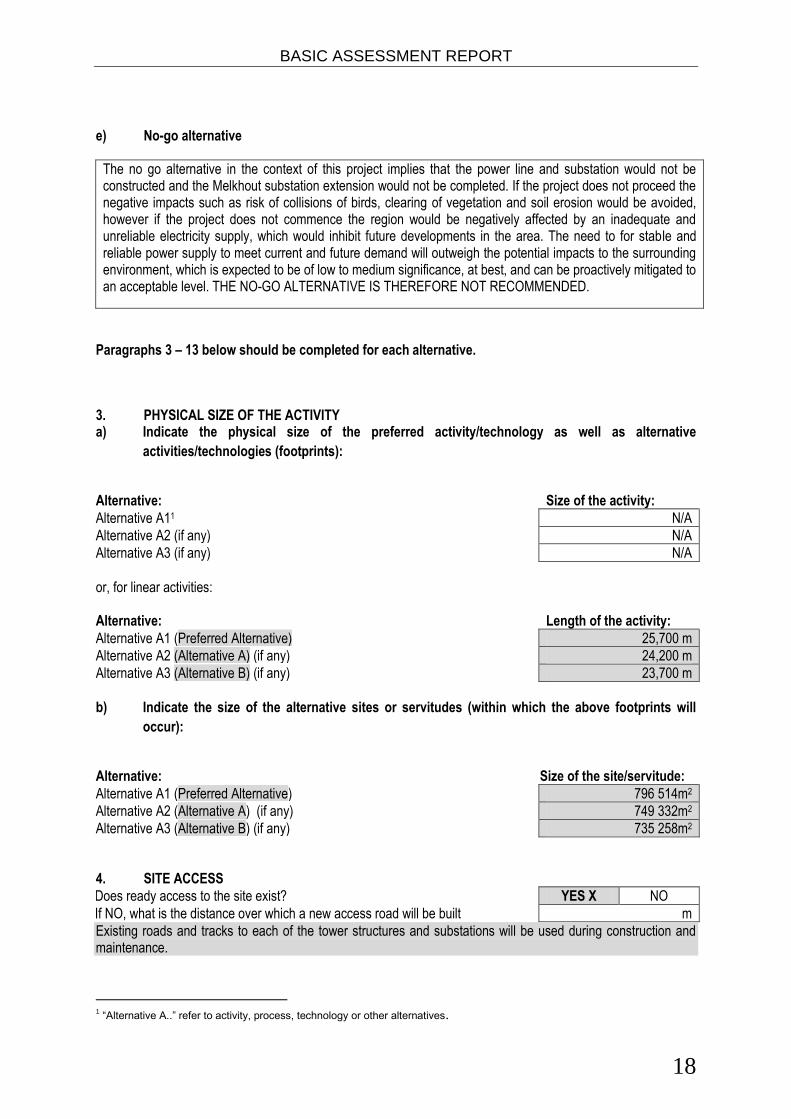
The no go alternative in the context of this project implies that the power line and substation would not be constructed and the Melkhout substation extension would not be completed. If the project does not proceed the negative impacts such as risk of collisions of birds, clearing of vegetation and soil erosion would be avoided, however if the project does not commence the region would be negatively affected by an inadequate and unreliable electricity supply, which would inhibit future developments in the area. The need to for stable and reliable power supply to meet current and future demand will outweigh the potential impacts to the surrounding environment, which is expected to be of low to medium significance, at best, and can be proactively mitigated to an acceptable level. THE NO-GO ALTERNATIVE IS THEREFORE NOT RECOMMENDED.
Paragraphs 3 – 13 below should be completed for each alternative.
3. PHYSICAL SIZE OF THE ACTIVITY a) Indicate the physical size of the preferred activity/technology as well as alternative
activities/technologies (footprints):
Alternative: Size of the activity:
Alternative A11 N/A
Alternative A2 (if any) N/A
Alternative A3 (if any) N/A
or, for linear activities: Alternative: Length of the activity:
Alternative A1 (Preferred Alternative) 25,700 m
Alternative A2 (Alternative A) (if any) 24,200 m
Alternative A3 (Alternative B) (if any) 23,700 m
b) Indicate the size of the alternative sites or servitudes (within which the above footprints will
occur):
Alternative: Size of the site/servitude:
Alternative A1 (Preferred Alternative) 796 514m2
Alternative A2 (Alternative A) (if any) 749 332m2
Alternative A3 (Alternative B) (if any) 735 258m2
4. SITE ACCESS
Does ready access to the site exist? YES X NO
If NO, what is the distance over which a new access road will be built m
Existing roads and tracks to each of the tower structures and substations will be used during construction and maintenance.
1 “Alternative A..” refer to activity, process, technology or other alternatives.

BASIC ASSESSMENT REPORT
19
Describe the type of access road planned:
Ready access to the Melkhout substation exists. Access to an existing small substation at Dieprivier exists. Existing track will need to be upgraded and a short section of new road will need to be constructed to allow access to the new substation. Access to the power line route will be from existing rural access roads and tracks where these exist. Where no access route exists in close proximity to the proposed power line route it will be necessary to construct access tracks. These tracks will as far as possible follow the power line servitude and not entail construction of a formal road/s. Detailed design of new tracks or roads have not yet been conducted.
Include the position of the access road on the site plan and required map, as well as an indication of the road in relation to the site. 5. LOCALITY MAP An A3 locality map must be attached to the back of this document, as Appendix A. The scale of the locality map must be relevant to the size of the development (at least 1:50 000. For linear activities of more than 25 kilometres, a smaller scale e.g. 1:250 000 can be used. The scale must be indicated on the map.). The map must indicate the following:
an accurate indication of the project site position as well as the positions of the alternative sites, if any;
indication of all the alternatives identified;
closest town(s;)
road access from all major roads in the area;
road names or numbers of all major roads as well as the roads that provide access to the site(s);
all roads within a 1km radius of the site or alternative sites; and
a north arrow;
a legend; and
locality GPS co-ordinates (Indicate the position of the activity using the latitude and longitude of the centre point of the site for each alternative site. The co-ordinates should be in degrees and decimal minutes. The minutes should have at least three decimals to ensure adequate accuracy. The projection that must be used in all cases is the WGS84 spheroid in a national or local projection).
6. LAYOUT/ROUTE PLAN A detailed site or route plan(s) must be prepared for each alternative site or alternative activity. It must be attached as Appendix A to this document. The site or route plans must indicate the following:
the property boundaries and numbers of all the properties within 50 metres of the site;
the current land use as well as the land use zoning of the site;
the current land use as well as the land use zoning each of the properties adjoining the site or sites;
the exact position of each listed activity applied for (including alternatives);
servitude(s) indicating the purpose of the servitude;
a legend; and
a north arrow.

BASIC ASSESSMENT REPORT
20
7. SENSITIVITY MAP
The layout/route plan as indicated above must be overlain with a sensitivity map that indicates all the sensitive areas associated with the site, including, but not limited to:
watercourses;
the 1:100 year flood line (where available or where it is required by DWA);
ridges;
cultural and historical features;
areas with indigenous vegetation (even if it is degraded or infested with alien species); and
critical biodiversity areas. The sensitivity map must also cover areas within 100m of the site and must be attached in Appendix A.
8. SITE PHOTOGRAPHS
Colour photographs from the centre of the site must be taken in at least the eight major compass directions with
a description of each photograph. Photographs must be attached under Appendix B to this report. It must be
supplemented with additional photographs of relevant features on the site, if applicable.
9. FACILITY ILLUSTRATION
A detailed illustration of the activity must be provided at a scale of at least 1:200 as Appendix C for activities that include structures. The illustrations must be to scale and must represent a realistic image of the planned activity. The illustration must give a representative view of the activity. 10. ACTIVITY MOTIVATION
Motivate and explain the need and desirability of the activity (including demand for the activity):
1. Is the activity permitted in terms of the property’s existing land use rights?
YES X NO Please explain
The power line and structures will be located in a servitude acquired by Eskom for the specific purpose.
2. Will the activity be in line with the following?
(a) Provincial Spatial Development Framework (PSDF) YES X NO Please explain
The Eastern Cape Provincial Spatial Development Plan recognises that the electricity supply is under stress in the province and large development projects are affected by the electricity limitations.
(b) Urban edge / Edge of Built environment for the area YES X NO Please explain
The powerline will span the urban and rural area within existing or acquired servitudes specifically for this purpose between the earmarked substations.

BASIC ASSESSMENT REPORT
21
(c) Integrated Development Plan (IDP) and Spatial Development Framework (SDF) of the Local Municipality (e.g. would the approval of this application compromise the integrity of the existing approved and credible municipal IDP and SDF? - No).
YES X NO Please explain
In the Kouga IDP one of the objectives addressing service delivery aims to ensure that the electricity service is maintained and improved to enhance the quality of life for all communities. The Koukamma IDP also identifies access to electricity as an issue to be addresses and recognises the need for effective delivery of basic services including electricity. The Cacadu District Municipality SDF states that approximately 4,000 households in the Kouga LM do not have access to electricity as the main source of energy. The SDP recognises that a significant capital outlay is required to upgrade both the urban and rural electricity network. The Koukamma Municipality further identifies electricity as an urgent matter to be attended to and recognises the need to provide bulk electricity supply to new housing development and install and maintain lighting in public areas.
(d) Approved Structure Plan of the Municipality YES X NO Please explain
The Kouga Coast Sub-Regional Structure Plan was replaced by the recommendations of the Greater St
Francis Bay Spatial Development Plan, which recognises the need for housing development in the region. This includes the provision of services such as electricity supply.
(e) An Environmental Management Framework (EMF) adopted by the Department (e.g. Would the approval of this application compromise the integrity of the existing environmental management priorities for the area and if so, can it be justified in terms of sustainability considerations?)
YES X NO Please explain
The proposed power lines will run through some CBA areas. The tower structures will however have a minimal impact on the vegetation and all impacts have been rated as low by a vegetation specialist given that the mitigation measures are implemented successfully.
(f) Any other Plans (e.g. Guide Plan) YES NO Please explain
No other plans applicable.
3. Is the land use (associated with the activity being applied for) considered within the timeframe intended by the existing approved SDF agreed to by the relevant environmental authority (i.e. is the proposed development in line with the projects and programmes identified as priorities within the credible IDP)?
YES NO Please explain
One of the projects in the Cacadu DM IDP is to finalise and implement a program to ensure universal access to electricity, water and sanitation by 2014. If this project commences it will increase the electricity capacity for the Humansdorp, Patensie and Kareedouw regions. In 2006 the Kouga Municipality set an objective to provide access to reliable electricity to 500 formal households annually (Kouga IDP). The Koukamma IDP recognises the provision of electricity to new housing projects as an urgent priority.
4. Does the community/area need the activity and the associated land use concerned (is it a societal priority)? (This refers to the strategic as well as local level (e.g. development is a national priority, but within a specific local context it could be inappropriate.)
YES X NO Please explain
Upgrade of electricity supply has been highlighted as a key issues in the Cacadu DM IDP and both Kouga and Koukamma’s IDPs. Increasing the capacity of the electrical infrastructure will provide a stable supply and encourage development in areas which have previously been limited due to the inadequate electricity supply.

BASIC ASSESSMENT REPORT
22
5. Are the necessary services with adequate capacity currently available (at the time of application), or must additional capacity be created to cater for the development? (Confirmation by the relevant Municipality in this regard must be attached to the final Basic Assessment Report as Appendix I.)
YES X NO Please explain
No additional services need to be created to cater for the new electricity infrastructure.
6. Is this development provided for in the infrastructure planning of the municipality, and if not what will the implication be on the infrastructure planning of the municipality (priority and placement of services and opportunity costs)? (Comment by the relevant Municipality in this regard must be attached to the final Basic Assessment Report as Appendix I.)
YES X NO Please explain
Upgrade of electricity supply has been highlighted as a key issues in the Cacadu DM IDP and both Kouga and Koukamma’s IDPs, therefore they are mandated to prioritise the upgrade of the electricity supply network. No additional comment is thus required.
7. Is this project part of a national programme to address an issue of national concern or importance?
YES X NO Please explain
The National Development Plan identifies electricity transmission and distribution to all as one of the seventeen SIPs, especially the provision and upgrade of electricity supply in the Eastern Cape.
8. Do location factors favour this land use (associated with the activity applied for) at this place? (This relates to the contextualisation of the proposed land use on this site within its broader context.)
YES X NO Please explain
There are already existing power lines along the proposed route connecting the towns of Patensie, Humansdorp and Kareedouw. New power lines will thus be erected in areas where power lines have already been integrated into the natural environment and structure design has been optimised to minimise visual intrusion and the cumulative effect of additional power lines.
9. Is the development the best practicable environmental option for this land/site?
YES X NO X Please explain
The proposed power lines runs mostly exclusively across non-arable farmland with minimal environmental impact. Given the national importance of strengthening the power supply grid in the Eastern Cape, the benefits of running the power lines over farm lands that is unsuitable for crop farming outweigh the potential loss of a minor amount of natural vegetation.
10. Will the benefits of the proposed land use/development outweigh the negative impacts of it?
YES X NO Please explain
The negative impacts for the development are all of low significance following mitigation measures, and the main benefit of the development, improved reliability of electricity supply and increase supply to region resulting in economic growth is of high significance. The development will also create temporary jobs during the construction period which is of low positive significance.
11. Will the proposed land use/development set a precedent for similar activities in the area (local municipality)?
YES NO X Please explain
The upgrade of the electricity grid is not driven by profit gains but to ensure service delivery to all communities in the region. Therefore it can will not set a precedent.
12. Will any person’s rights be negatively affected by the proposed activity/ies?
YES NO X Please explain
No juristic or natural person’s right will be adversely negatively affected.
BASIC ASSESSMENT REPORT
23
13. Will the proposed activity/ies compromise the “urban edge” as defined by the local municipality?
YES NO X Please explain
14. Will the proposed activity/ies contribute to any of the 17 Strategic Integrated Projects (SIPS)?
YES X NO Please explain
SIP 10. Electricity transmission and distribution to all
15. What will the benefits be to society in general and to the local communities? Please explain
The potential benefit of the proposed power line and substation to the Eastern Cape lies in the stimulation of the local economy through the supply of a reliable electricity supply, which will increasingly benefit the provision of services. Further, upgrade of the existing power supply will ensure provision of electricity to new commercial, housing and low-cost housing developments.
16. Any other need and desirability considerations related to the proposed activity? Please explain
Improving network reliability may furthermore decrease the number of residents within the Eastern Cape who are still reliant on domestic fires, which in turn negatively impact the environment through uncontrolled harvesting of woodlands and air quality, and will improve quality of line notably.
17. How does the project fit into the National Development Plan for 2030? Please explain
The National Development Plan for 2030 has a vision of by 2030 South Africa will have an energy sector that promotes economic growth and development through adequate investments in energy infrastructure and the provision of quality energy services.
18. Please describe how the general objectives of Integrated Environmental Management as set out in section 23 of NEMA have been taken into account.
The proposed development has been adequately considered by trained and competent Environmental Assessment Practitioners and identified specialist, and all potential impacts that may have a significant impact on the receiving environment have been considered and mitigated to acceptable levels as required by the NEMA 2010 EIA regulations. The conclusions of the environmental impact assessment have been concisely summarised to adequately inform decision-making by the competent authority. A comprehensive Public Participation Process was also undertaken, which conformed to requirements in Chapter 6 of the Environmental Impact Assessment Regulations. Further all Interested and Affected Parties were given ample time to review and comment on all documents and reports.
19. Please describe how the principles of environmental management as set out in section 2 of NEMA have been taken into account.
The primary objective of the project is to provide a stable electricity supply to the Humansdorp, Patensie and Kareedouw regions of the Eastern Cape. The provision of a stable electricity supply with spare capacity will encourage future development in the area and will potentially improve the economic situation through job creation. The social, economic and environmental impacts have been identified and rated by the EAP with the assistance of numerous specialists. The environmental impact of power lines is well understood and the tower structures selected for this development have been chosen to reduce visual impacts, impacts on cultivated land and impact on avifauna. A heritage survey was also undertaken as part of the basic assessment process and recommendations made by the heritage specialist have been included in the EMPr. The Environmental Basic Assessment was advertised and members of the public were given the opportunity to register as an I&AP as described in Section C: public participation and the issues and responses report (Appendix E). Most of the negative impacts associated with the project will occur during the construction phase. Where negative impacts are unavoidable they will be mitigate according to stipulations in the EMPr. Recommendations and mitigations presented in the EMPr will reduce the disturbance to ecosystems and the loss of biodiversity. Where negative impacts are unavoidable, strict management and rehabilitation is recommended to minimise the potential negative impacts. Certain activities such as the clearing of alien

BASIC ASSESSMENT REPORT
24
vegetation from the servitudes will improve the biodiversity of the site. The use of potentially polluting substances will be managed according to requirements in the EMPr. The EMPr will hold the developer responsible for any unnecessary negative impacts of the development on the environment. The impacts of the proposed powerline on wetlands will be reduced by micrositing of towers to avoid placing them in wetland areas. The workers will be given environmental health and safety training prior to commencing any work. Daily ‘tool box talks’ will be used to inform workers of any specific environmental issues or health and safety concerns relating to the activities or location. The cost to of rehabilitation required due to pollution or unnecessary environment degradation resulting from the activity will be the responsibility of the developer.
11. APPLICABLE LEGISLATION, POLICIES AND/OR GUIDELINES List all legislation, policies and/or guidelines of any sphere of government that are applicable to the application as contemplated in the EIA regulations, if applicable:
Title of legislation, policy or guideline
Applicability to the project Administering authority
Date
Constitution of the Republic of South Africa (Act 108 of 1996)
The Constitution paved the way for the protection of the natural environment and heritage resources through the recognition of the rights to a safe and healthy environment.
South African Government
1996
National Environmental Management Act (107 of 1998)
NEMA is the key environmental management legislation and states in s2(4)(k) that "the environment is held in public trust for the people, the beneficial use of resources must serve the public interest and the environment must be protected as the people’s common heritage” thereby paving the way for EIA process to assess developments that may have a harmful impact on the environment.
DEA 1998
Environmental Impact Assessment Regulations (Government Notice No. R. 543, 544 and 546)
The EIA regulations describe the EIA process to be followed including the public participation process, and the listed activities that may have a harmful impact on the environment and must be assessed.
DEA 2010
National Heritage Resources Act (25 of 1999)
Under section 38.(1) of the NHRA any person who intends to construct a powerline or other linear development exceeding 300m in length must notify the responsible heritage resources agency of its intention.
SAHRA 1999
National Water Act (36 of 1998) This Act provides for the protection and management water resources. A Water Use Licence Application is made to authorise water use activities pertaining to the altering of the bed and banks of a watercourse and diverting the flow of water in a watercourse. This WULA is made as the need for construction of a
DWA 1998

BASIC ASSESSMENT REPORT
25
bridge over a watercourse has been identified, and the construction of tower structures within 500m of a watercourse may result.
Conservation of Agricultural Resources Act (43 of 1983)
In terms of section 6 of the Act, the Minister may prescribe control measures with which all land users have to comply. The control measure may relate to the regulating of the flow pattern of run-off water, the control of weeds and invader plants, and the restoration or reclamation of eroded land or land which is otherwise disturbed or denuded. This act will regulate construction activities to prevent the spreading of invasive species and to ensure successful rehabilitation of the receiving environment.
DoA 1983
Occupational Health and Safety Act (85 of 1993)
The OHSA governs and ensures the protection of employees in the workplace. A number of permanent and contract skilled and semi-skilled workers will be involved in the construction of the different aspects of the project. Their appointment and work periods will be subject to the provisions of the OHSA.
Department of Labour
1993
National Environmental Management: Biodiversity Act (10 of 2004)
The Biodiversity Act provides for the management and protection of the country’s biodiversity within the framework established by NEMA. It provides for the protection of species and ecosystems in need of protection, sustainable use of indigenous biological resources, and equity in bio-prospecting. Some Critical Biodiversity Areas and vulnerable and endangered ecosystems have been identified by the vegetation specialist in the study site.
DEA 2004
National Environmental Management: Protected Areas Act (57 of 2003)
The Protected Areas Act provides for the protection and conservation of ecologically viable areas representative of the country’s biological diversity, its natural landscapes and seascapes. The proposed alternative routes runs through a non-statutory protected area.
DEA 2003
Electricity Regulations Act (4 of 2006)
This act establishes a national regulatory framework for the electricity supply industry; and provides for licences and registration as the manner in which generation, transmission, distribution, reticulation, trading and the import and export of electricity are regulated. The erection of new electricity distribution infrastructure is thus regulated in terms of this act.
NERSA 2006
BASIC ASSESSMENT REPORT
26
National Energy Act (34 of 2008) The Act allows for the regulation and maintenance of security of energy supply in South Africa. The act empowers the energy regulator to invest in the maintenance of energy infrastructure, which includes the installation of electrical infrastructure in area where the grids is operating at near maximum capacity such as in the Kareedouw-Humansdorp- Patensie area.
South African National Energy Development Institute.
2008
Kouga LM Integrated Development Plan
The IDP identifies the need to upgrade and increase the electricity grid in the local municipality, thus supports the proposed installation of distribution line.
Kouga LM 2007-2012
Kou-kamma LM Integrated Development Plan
The IDP identifies the need to upgrade and increase the electricity grid in the local municipality, thus supports the proposed installation of distribution line.
Koukamma LM 2007-2012
Cacadu DM Integrated Development Plan
The IDP identifies the need to upgrade and increase the electricity grid in the district municipality thus supports the proposed installation of distribution line.
Cacadu DM 2007-2012
Nature and Environmental Conservation Ordinance (No. 19 of 1974)
Regulates various nature and environmental conservation aspects such as control animals, game and pollution. This ordinance regulates and prohibits the removal or killing of animal or game on site and regulates pollution activities on site.
DEDEAT 1974
Eastern Cape Biodiversity Conservation Plan
This conservation plan provides the boundaries and areas where critical biodiversity zones and important support areas have been identified and accepted by the provincial authority. The .location of the CBAs in the ECBCP have been taken acknowledged and mitigation measures to minimise impacts on these CBAs have been proposed by the competent vegetation specialist.
DEA 2007
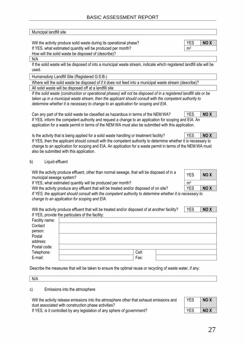
Waste, effluent, emission and noise management a) Solid waste management
Will the activity produce solid construction waste during the construction/initiation phase? YES X NO
If YES, what estimated quantity will be produced per month? Approx 5 m3
How will the construction solid waste be disposed of (describe)?
All solid waste which is not reusable will be collected at a central location and will be stored temporarily until removed to a recognised landfill site
Where will the construction solid waste be disposed of (describe)?
BASIC ASSESSMENT REPORT
27
Municipal landfill site
Will the activity produce solid waste during its operational phase? YES NO X
If YES, what estimated quantity will be produced per month? m3
How will the solid waste be disposed of (describe)?
N/A
If the solid waste will be disposed of into a municipal waste stream, indicate which registered landfill site will be used.
Humansdorp Landfill Site (Registered G:S:B-)
Where will the solid waste be disposed of if it does not feed into a municipal waste stream (describe)?
All solid waste will be disposed off at a landfill site
If the solid waste (construction or operational phases) will not be disposed of in a registered landfill site or be taken up in a municipal waste stream, then the applicant should consult with the competent authority to determine whether it is necessary to change to an application for scoping and EIA.
Can any part of the solid waste be classified as hazardous in terms of the NEM:WA? YES NO X
If YES, inform the competent authority and request a change to an application for scoping and EIA. An application for a waste permit in terms of the NEM:WA must also be submitted with this application.
Is the activity that is being applied for a solid waste handling or treatment facility? YES NO X
If YES, then the applicant should consult with the competent authority to determine whether it is necessary to change to an application for scoping and EIA. An application for a waste permit in terms of the NEM:WA must also be submitted with this application.
b) Liquid effluent
Will the activity produce effluent, other than normal sewage, that will be disposed of in a municipal sewage system?
YES NO X
If YES, what estimated quantity will be produced per month? m3
Will the activity produce any effluent that will be treated and/or disposed of on site? YES NO X
If YES, the applicant should consult with the competent authority to determine whether it is necessary to change to an application for scoping and EIA.
Will the activity produce effluent that will be treated and/or disposed of at another facility? YES NO X
If YES, provide the particulars of the facility:
Facility name:
Contact person:
Postal address:
Postal code:
Telephone: Cell:
E-mail: Fax:
Describe the measures that will be taken to ensure the optimal reuse or recycling of waste water, if any:
N/A
c) Emissions into the atmosphere
Will the activity release emissions into the atmosphere other that exhaust emissions and dust associated with construction phase activities?
YES NO X
If YES, is it controlled by any legislation of any sphere of government? YES NO X

BASIC ASSESSMENT REPORT
28
If YES, the applicant must consult with the competent authority to determine whether it is necessary to change to an application for scoping and EIA. If NO, describe the emissions in terms of type and concentration:
d) Waste permit
Will any aspect of the activity produce waste that will require a waste permit in terms of the NEM:WA?
YES NO X
If YES, please submit evidence that an application for a waste permit has been submitted to the competent authority e) Generation of noise
Will the activity generate noise? YES X NO
If YES, is it controlled by any legislation of any sphere of government? YES NO X
If YES, the applicant should consult with the competent authority to determine whether it is necessary to change to an application for scoping and EIA. If NO, describe the noise in terms of type and level:
Noise control regulations and SANS 10103: Short term noise impacts are anticipated during the construction phase of the project. It is however anticipated that the noise will be localised and contained within the construction site. The applicant must adhere to the relevant provincial noise control legislation (if any) as well as SANS 10103. Working hours should be restricted to 07h00 to 18h00 Monday to Friday excluding public holiday.
WATER USE Please indicate the source(s) of water that will be used for the activity by ticking the appropriate box(es):
Municipal X Water board Groundwater River, stream, dam or lake
Other: water tanker X
The activity will not use water
If water is to be extracted from groundwater, river, stream, dam, lake or any other natural feature, please indicate the volume that will be extracted per month:
litres
Does the activity require a water use authorisation (general authorisation or water use license) from the Department of Water Affairs?
YES NO
If YES, please provide proof that the application has been submitted to the Department of Water Affairs. ENERGY EFFICIENCY Describe the design measures, if any, that have been taken to ensure that the activity is energy efficient:
N/A
Describe how alternative energy sources have been taken into account or been built into the design of the activity, if any:
N/A

BASIC ASSESSMENT REPORT
29
Section B: SITE/area/PROPERTY description Important notes: For linear activities (pipelines, etc) as well as activities that cover very large sites, it may be necessary to complete this section for each part of the site that has a significantly different environment. In such cases please complete copies of Section B and indicate the area, which is covered by each copy No. on the Site Plan.
Section B Copy No. (e.g. A):
Paragraphs 1 - 6 below must be completed for each alternative.
Has a specialist been consulted to assist with the completion of this section? YES X NO
If YES, please complete the form entitled “Details of specialist and declaration of interest” for each specialist thus appointed and attach it in Appendix I. All specialist reports must be contained in Appendix D. Property description/physical address:
Province Eastern Cape
District Municipality Cacadu District Municipality
Local Municipality Kouga Local Municipality, Kou-Kamma Local Municipality
Ward Number(s)
Farm name and number
Refer to Appendix A3 for farm details
Portion number Refer to Appendix A3 for farm details
SG Code Refer to Appendix A3 for farm details
Where a large number of properties are involved (e.g. linear activities), please attach a full list to this application including the same information as indicated above. List attached in Appendix A3
Current land-use zoning as per local municipality IDP/records:
Agriculture
In instances where there is more than one current land-use zoning, please attach a list of current land use zonings that also indicate which portions each use pertains to, to this application.
Is a change of land-use or a consent use application required? YES NO X
GRADIENT OF THE SITE Indicate the general gradient of the site. Alternative S1 (Preferred Alternative):
Flat X 1:50 – 1:20 1:20 – 1:15 1:15 – 1:10 1:10 – 1:7,5 1:7,5 – 1:5 Steeper than 1:5
Alternative S2 (if any) (Alternative A)
Flat X 1:50 – 1:20 1:20 – 1:15 1:15 – 1:10 1:10 – 1:7,5 1:7,5 – 1:5 Steeper than 1:5
Alternative S3 (if any) (Alternative B):
Flat X 1:50 – 1:20 1:20 – 1:15 1:15 – 1:10 1:10 – 1:7,5 1:7,5 – 1:5 Steeper than 1:5
BASIC ASSESSMENT REPORT
30
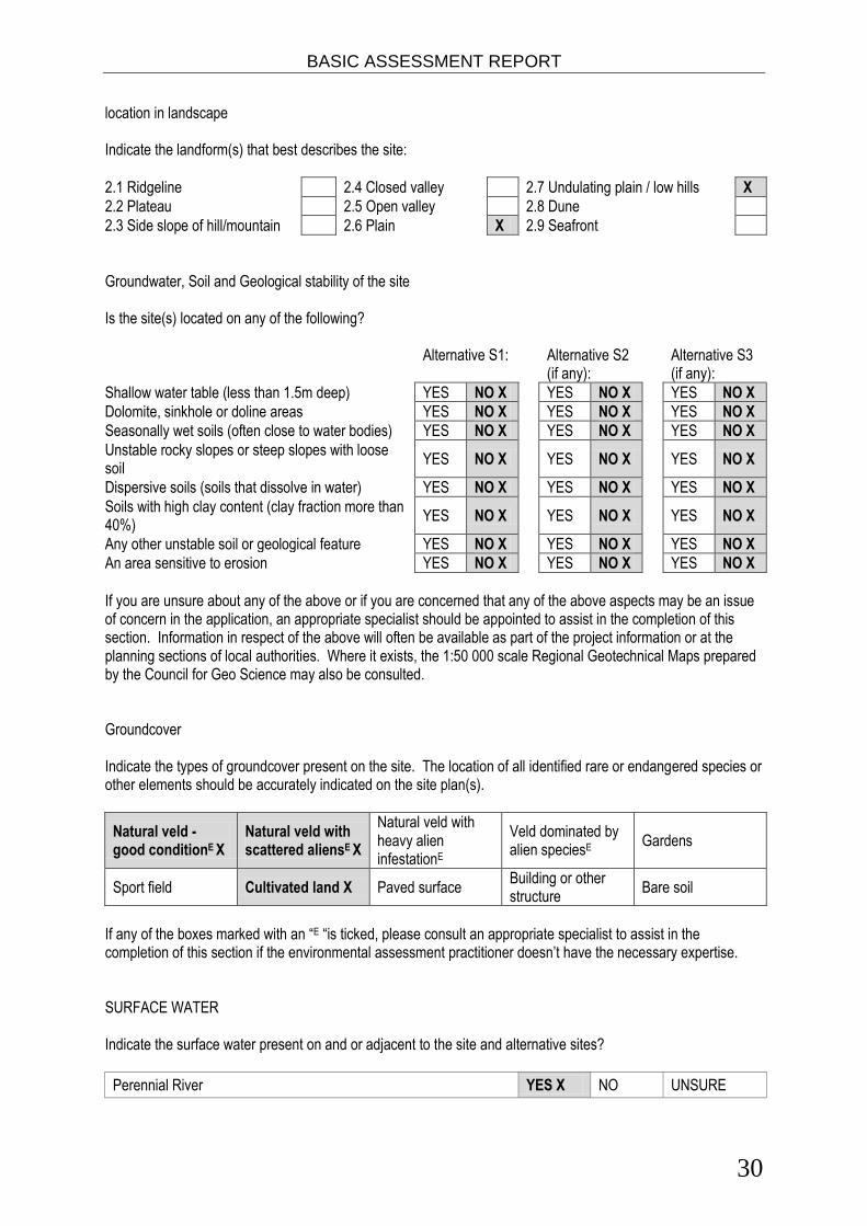
location in landscape Indicate the landform(s) that best describes the site:
2.1 Ridgeline 2.4 Closed valley 2.7 Undulating plain / low hills X
2.2 Plateau 2.5 Open valley 2.8 Dune
2.3 Side slope of hill/mountain 2.6 Plain X 2.9 Seafront
Groundwater, Soil and Geological stability of the site Is the site(s) located on any of the following? Alternative S1: Alternative S2
(if any): Alternative S3
(if any):
Shallow water table (less than 1.5m deep) YES NO X YES NO X YES NO X
Dolomite, sinkhole or doline areas YES NO X YES NO X YES NO X
Seasonally wet soils (often close to water bodies) YES NO X YES NO X YES NO X
Unstable rocky slopes or steep slopes with loose soil
YES NO X
YES NO X
YES NO X
Dispersive soils (soils that dissolve in water) YES NO X YES NO X YES NO X
Soils with high clay content (clay fraction more than 40%)
YES NO X
YES NO X
YES NO X
Any other unstable soil or geological feature YES NO X YES NO X YES NO X
An area sensitive to erosion YES NO X YES NO X YES NO X
If you are unsure about any of the above or if you are concerned that any of the above aspects may be an issue of concern in the application, an appropriate specialist should be appointed to assist in the completion of this section. Information in respect of the above will often be available as part of the project information or at the planning sections of local authorities. Where it exists, the 1:50 000 scale Regional Geotechnical Maps prepared by the Council for Geo Science may also be consulted. Groundcover Indicate the types of groundcover present on the site. The location of all identified rare or endangered species or other elements should be accurately indicated on the site plan(s).
Natural veld - good conditionE X
Natural veld with scattered aliensE X
Natural veld with heavy alien infestationE
Veld dominated by alien speciesE
Gardens
Sport field Cultivated land X Paved surface Building or other structure
Bare soil
If any of the boxes marked with an “E “is ticked, please consult an appropriate specialist to assist in the completion of this section if the environmental assessment practitioner doesn’t have the necessary expertise. SURFACE WATER Indicate the surface water present on and or adjacent to the site and alternative sites?
Perennial River YES X NO UNSURE
BASIC ASSESSMENT REPORT
31
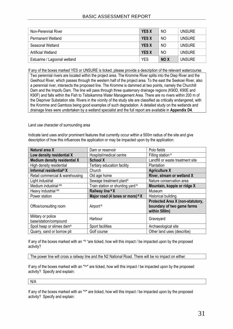
Non-Perennial River YES X NO UNSURE
Permanent Wetland YES X NO UNSURE
Seasonal Wetland YES X NO UNSURE
Artificial Wetland YES X NO UNSURE
Estuarine / Lagoonal wetland YES NO X UNSURE
If any of the boxes marked YES or UNSURE is ticked, please provide a description of the relevant watercourse.
Two perennial rivers are located within the project area. The Kromme River splits into the Diep River and the Geelhout River, which passes through the western half of the project area. To the east the Seekoei River, also a perennial river, intersects the proposed line. The Kromme is dammed at two points, namely the Churchill Dam and the Impofu Dam. The line will pass through three quaternary drainage regions (K90D, K90E and K90F) and falls within the Fish to Tsitsikamma Water Management Area. There are no rivers within 200 m of the Diepriver Substation site. Rivers in the vicinity of the study site are classified as critically endangered, with the Kromme and Gamtoos being good examples of such degradation. A detailed study on the wetlands and drainage lines were undertaken by a wetland specialist and the full report are available in Appendix D4.
Land use character of surrounding area Indicate land uses and/or prominent features that currently occur within a 500m radius of the site and give description of how this influences the application or may be impacted upon by the application:
Natural area X Dam or reservoir Polo fields
Low density residential X Hospital/medical centre Filling station H
Medium density residential X School X Landfill or waste treatment site
High density residential Tertiary education facility Plantation
Informal residentialA X Church Agriculture X
Retail commercial & warehousing Old age home River, stream or wetland X
Light industrial Sewage treatment plantA Nature conservation area
Medium industrial AN Train station or shunting yard N Mountain, koppie or ridge X
Heavy industrial AN Railway line N X Museum
Power station Major road (4 lanes or more) N X Historical building
Office/consulting room Airport N Protected Area X (non-statutory, boundary of two game farms within 500m)
Military or police base/station/compound
Harbour Graveyard
Spoil heap or slimes damA Sport facilities Archaeological site
Quarry, sand or borrow pit Golf course Other land uses (describe)
If any of the boxes marked with an “N “are ticked, how will this impact / be impacted upon by the proposed activity?
The power line will cross a railway line and the N2 National Road. There will be no impact on either.
If any of the boxes marked with an "An" are ticked, how will this impact / be impacted upon by the proposed activity? Specify and explain:
N/A
If any of the boxes marked with an "H" are ticked, how will this impact / be impacted upon by the proposed activity? Specify and explain:

BASIC ASSESSMENT REPORT
32
N/A
Does the proposed site (including any alternative sites) fall within any of the following:
Critical Biodiversity Area (as per provincial conservation plan) YES X NO
Core area of a protected area? YES NO X
Buffer area of a protected area? YES NO X
Planned expansion area of an existing protected area? YES NO X
Existing offset area associated with a previous Environmental Authorisation? YES NO X
Buffer area of the SKA? YES NO X
If the answer to any of these questions was YES, a map indicating the affected area must be included in Appendix A. Map included in Appendix A as requested. Cultural/Historical Features
Are there any signs of culturally or historically significant elements, as defined in section 2 of the National Heritage Resources Act, 1999, (Act No. 25 of 1999), including Archaeological or paleontological sites, on or close (within 20m) to the site? If YES, explain:
YES X NO
Uncertain
The Gamtoos Scenic Route, which has high local and regional significance for its aesthetic and economic (tourism) values.
If uncertain, conduct a specialist investigation by a recognised specialist in the field (archaeology or palaeontology) to establish whether there is such a feature(s) present on or close to the site. Briefly explain the findings of the specialist:
GIBB Engineering and Science appointed eThembeni Cultural Heritage to undertake a Phase 1 Heritage Impact Assessment of a proposed distribution power line and substation site in the Eastern Cape Province, in terms of the National Environmental Management Act 107 of 1998 as amended, in compliance with Section 38 of the National Heritage Resources Act 25 of 1999, as amended. eThembeni identified the Gamtoos Scenic Route and potential palaeontologcal finds as heritage resources of value. The proposed electrical infrastructure is located along the Gamtoos Scenic Route, which has high local and regional significance for its aesthetic and economic (tourism) values. The unmanaged potential impact on this landscape is medium. Geological formations in the Dieprivier – Melkhout sector might contain well-preserved plant material. The unmanaged potential impact on palaeontological remains is low to medium. As recommended mitigation towers should be located such that they do not interrupt skylines, and are not visible from scenic routes. A heritage practitioner should complete a ‘walk-through’ of the final selected power line route and all other activity areas (access roads, construction camps, materials’ storage areas, etc.) prior to the start of any construction activities and assess direct impacts on discrete resources such as traditional burial places, and archaeological and palaeontological sites. No monitoring was recommended. Conclusion: eThembeni recommend that the development proceed with the proposed heritage mitigation and have submitted this report to SAHRA in fulfilment of the requirements of the NHRA. Mitigation measures recommended by eThembeni have been incorporated into the EMPr and should be implemented. The complete HIA is included in Appendix D for reference.
Will any building or structure older than 60 years be affected in any way? YES NO X
Is it necessary to apply for a permit in terms of the National Heritage Resources Act, 1999 (Act 25 of 1999)?
YES NO X

BASIC ASSESSMENT REPORT
33
If YES, please provide proof that this permit application has been submitted to SAHRA or the relevant provincial authority.
SOCIO-ECONOMIC CHARACTER a) Local Municipality Please provide details on the socio-economic character of the local municipality in which the proposed site(s) are situated. Level of unemployment:
Kouga Local Municipality The unemployment rate for Kouga LM has risen from 21.6 % in 1996 to 29.8 % in 2007 (Kouga LM, 2012), the unemployment rate for the Cacadu District Municipality for 2007 is lower at 24.7 % (STATS SA 2009). The largest employment sectors for the Kouga LM are community, social and personal services (17.0 %), agriculture, forestry and fishing (13.5 %) and other government and social services (ECSECC). Kou-Kamma Local Municipality The unemployment rate for Koukamma LM is lower than the unemployment rate for Cacadu District Municipality 22.9 % and 24.7 % respectively (STATS SA, Koukamma, 2011). Agriculture, forestry and fisheries is the largest employment sector (29.0 %), followed by catering and accommodation (11.2 %), wholesale and retail trade (10.1 %) and community, social and other personal services (10.0 %).
Economic profile of local municipality:
The lack of energy resources within rural areas of South Africa is recognised as a major factor retarding socio-economic development. ECSECC (2009) states that approximately 72 % of households in the Kouga LM and 76 % of households in the Koukamma LM are electrified, however unreliable this supply may be. Kouga Local Municipality The 2008 Gross Value Added (GVA) figure for the Kouga LM was R3, 493 million. The largest contributors to the GVA for the Kouga Municipality are wholesale and retail trade (21.5 %), business services (15.6 %) and finance and insurance (11.4 %). The largest employment sectors for the Kouga LM are wholesale, retails and trade (16,3 %), business services (15.5 %) and food, beverage and tobacco (10.7 %) (ECSECC). KouKamma Local Municipality The 2008 Gross Value Added (GVA) figure for the Koukamma LM was R725 million. The largest contributors to the GVA for the Koukamma Municipality are agriculture, forestry and fishing (21.6 %), wholesale and retail trade (14.7 %) and general government (12.5 %). The sector with the largest total production output for the Kouga Local Municipality are The largest employment sectors for the Koukamma LM are agriculture, forestry and fisheries (21,3 %), wholesale and retail trade (11.8 %) and food, beverage and tobacco (10.5 %) (ECSECC).
Level of education:
A significant portion of the population of both Kouga and Koukamma have received no education, 10.1 % in both. A higher percentage of the population of the Kouga LM have an education compared to Koukamma LM. A total of 13.3 % of the population of Kouga LM have been educated up to grade 12 compared to 8.25 % in Koukamma LM. A higher percentage of the population of the Kouga LM have a diploma or degree 3.3 % compared to 1.8 % in the Koukamma LM.
b) Socio-economic value of the activity
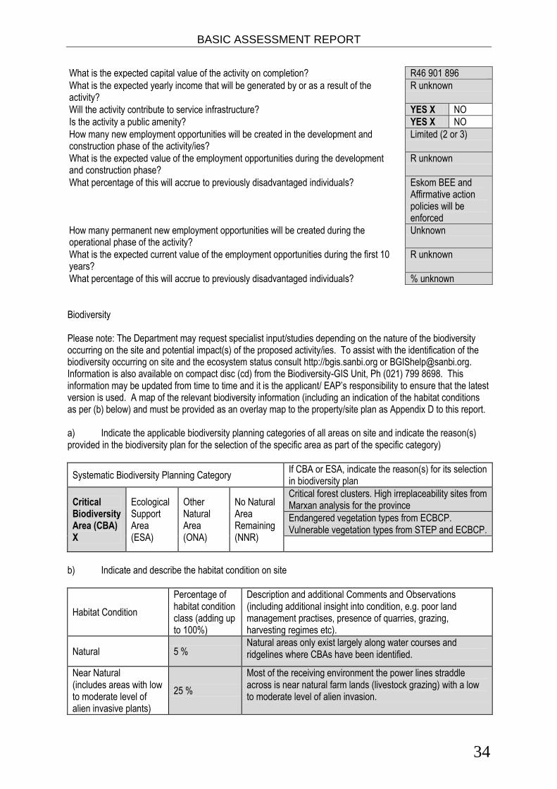
BASIC ASSESSMENT REPORT
34
What is the expected capital value of the activity on completion? R46 901 896
What is the expected yearly income that will be generated by or as a result of the activity?
R unknown
Will the activity contribute to service infrastructure? YES X NO
Is the activity a public amenity? YES X NO
How many new employment opportunities will be created in the development and construction phase of the activity/ies?
Limited (2 or 3)
What is the expected value of the employment opportunities during the development and construction phase?
R unknown
What percentage of this will accrue to previously disadvantaged individuals? Eskom BEE and Affirmative action policies will be enforced
How many permanent new employment opportunities will be created during the operational phase of the activity?
Unknown
What is the expected current value of the employment opportunities during the first 10 years?
R unknown
What percentage of this will accrue to previously disadvantaged individuals? % unknown
Biodiversity Please note: The Department may request specialist input/studies depending on the nature of the biodiversity occurring on the site and potential impact(s) of the proposed activity/ies. To assist with the identification of the biodiversity occurring on site and the ecosystem status consult http://bgis.sanbi.org or [email protected]. Information is also available on compact disc (cd) from the Biodiversity-GIS Unit, Ph (021) 799 8698. This information may be updated from time to time and it is the applicant/ EAP’s responsibility to ensure that the latest version is used. A map of the relevant biodiversity information (including an indication of the habitat conditions as per (b) below) and must be provided as an overlay map to the property/site plan as Appendix D to this report. a) Indicate the applicable biodiversity planning categories of all areas on site and indicate the reason(s) provided in the biodiversity plan for the selection of the specific area as part of the specific category)
Systematic Biodiversity Planning Category If CBA or ESA, indicate the reason(s) for its selection in biodiversity plan
Critical Biodiversity Area (CBA) X
Ecological Support Area (ESA)
Other Natural Area (ONA)
No Natural Area Remaining (NNR)
Critical forest clusters. High irreplaceability sites from Marxan analysis for the province
Endangered vegetation types from ECBCP. Vulnerable vegetation types from STEP and ECBCP.
b) Indicate and describe the habitat condition on site
Habitat Condition
Percentage of habitat condition class (adding up to 100%)
Description and additional Comments and Observations (including additional insight into condition, e.g. poor land management practises, presence of quarries, grazing, harvesting regimes etc).
Natural 5 % Natural areas only exist largely along water courses and ridgelines where CBAs have been identified.
Near Natural (includes areas with low to moderate level of alien invasive plants)
25 %
Most of the receiving environment the power lines straddle across is near natural farm lands (livestock grazing) with a low to moderate level of alien invasion.

BASIC ASSESSMENT REPORT
35
Degraded (includes areas heavily invaded by alien plants)
20 % Land degraded by access roads, overgrazing, impacts on fridge vegetation due to urban development – area close to Humansdorp.
Transformed (includes cultivation, dams, urban, plantation, roads, etc)
50 %
Cultivated land
c) Complete the table to indicate: (i) the type of vegetation, including its ecosystem status, present on the site; and (ii) whether an aquatic ecosystem is present on site.
Terrestrial Ecosystems Aquatic Ecosystems
Ecosystem threat status as per the National Environmental Management: Biodiversity Act (Act No. 10 of 2004)
Critical X Wetland (including rivers, depressions, channelled and unchanneled wetlands, flats, seeps pans, and artificial wetlands)
Estuary Coastline
Endangered X
Vulnerable X
Least Threatened X YES X NO UNSURE YES
NO X
YES NO X
d) Please provide a description of the vegetation type and/or aquatic ecosystem present on site, including any important biodiversity features/information identified on site (e.g. threatened species and special habitats)
Topography. The linear activity in the study area runs in a westerly to easterly direction. Because the
topography in the area steepens from south to north, the proposed line will not vary greatly with regards to
altitude.
Geology and soils. The proposed line is to be located upon the Cape Supergroup and is expected to pass
through the Sandstones and Shales of the Table Mountain Group. Because the dominant lithology is
comprised of Sandstones and Shales the soils are generally highly erodible. Mismanagement of rivers and
agricultural land can therefore expose the area to erosion degrade rivers to a moderate or high degree.
Local Climate. The Humansdorp area has a sub-tropical climate with rain falling throughout the year, with
peaks in autumn and spring. Mean Annual Precipitation is between 650 and 400 mm and varies seasonally,
annually and spatially. Dominant winds in the Humansdorp area are from the South West and can reach gale
force strengths, especially during the winter months.
Biodiversity. Critical Biodiversity Areas are terrestrial and aquatic features in the landscape which are
considered as critical in conserving biodiversity and maintaining ecosystem functioning. The proposed route
crosses a notable CBA 1 area (Figure 6). Areas classified as CBA 2 are considered as untransformed and
used for livestock grazing. These units are however of lower biodiversity value due to incorrect veld
management practices such as overstocking and continuous grazing.
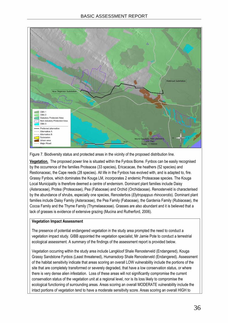
BASIC ASSESSMENT REPORT
36
Figure 7. Biodiversity status and protected areas in the vicinity of the proposed distribution line.
Vegetation. The proposed power line is situated within the Fynbos Biome. Fynbos can be easily recognised
by the occurrence of the families Proteacea (33 species), Ericacacae, the heathers (52 species) and
Restionaceac, the Cape reeds (28 species). All life in the Fynbos has evolved with, and is adapted to, fire.
Grassy Fynbos, which dominates the Kouga LM, incorporates 2 endemic Proteaceae species. The Kouga
Local Municipality is therefore deemed a centre of endemism. Dominant plant families include Daisy
(Asteraceae), Protea (Proteaceae), Pea (Fabaceae) and Orchid (Orchidaceae). Renosterveld is characterised
by the abundance of shrubs, especially one species, Renosterbos (Elytropappus rhinocerotis). Dominant plant
families include Daisy Family (Asteraceae), the Pea Family (Fabaceae), the Gardenia Family (Rubiaceae), the
Cocoa Family and the Thyme Family (Thymelaeaceae). Grasses are also abundant and it is believed that a
lack of grasses is evidence of extensive grazing (Mucina and Rutherford, 2006).
Vegetation Impact Assessment
The presence of potential endangered vegetation in the study area prompted the need to conduct a
vegetation impact study. GIBB appointed the vegetation specialist, Mr Jamie Pote to conduct a terrestrial
ecological assessment. A summary of the findings of the assessment report is provided below.
Vegetation occurring within the study area include Langkloof Shale Renosterveld (Endangered), Kouga
Grassy Sandstone Fynbos (Least threatened), Humansdorp Shale Renosterveld (Endangered). Assessment
of the habitat sensitivity indicate that areas scoring an overall LOW vulnerability include the portions of the
site that are completely transformed or severely degraded, that have a low conservation status, or where
there is very dense alien infestation. Loss of these areas will not significantly compromise the current
conservation status of the vegetation unit at a regional level, nor is its loss likely to compromise the
ecological functioning of surrounding areas. Areas scoring an overall MODERATE vulnerability include the
intact portions of vegetation tend to have a moderate sensitivity score. Areas scoring an overall HIGH to

BASIC ASSESSMENT REPORT
37
VERY HIGH vulnerability include areas having a Critically Endangered or Endangered conservation status,
or critical ecological process and critical biodiversity areas.
The proposed development is likely to have a number of impacts on the plants and plant communities within
the site. The three key impacts are: (a) loss of habitat; (b) loss of species of special concern or SSC habitat
and (c) reduction or changes to ecological processes/functioning. These can be further subdivided into sub-
impacts as follows:
A. Issue 1: Direct loss of natural vegetation habitat as a result of vegetation clearing:
1. Direct loss of habitat; 2. Direct loss of rocky refugia; 3. Direct loss of thicket or forest vegetation in drainage lines 4. Direct loss of riparian vegetation along drainage lines 5. Direct loss of seep/wetland/seasonal pan vegetation
B. Issue 2: Direct loss of Species of Special Concern and associated habitat:
6. Loss of habitat for species of special concern; 7. Loss of Species of Special Concern
C. Issue 3: Ecological process changes
8. Increased risk of alien invasion in drainage lines; 9. Clearing of alien invasives from within the servitude and drainage lines. 10. Disruptions to ecological processes as a result of habitat fragmentation
In summary, the overall the development of the project is predicted to result in a negative impact of VERY
LOW to MEDIUM significance.
The following key conclusions are reached regarding impacts on flora:
In general the servitude passes through degraded and transformed vegetation, with segments passing through areas of intact and near intact vegetation;
Only Langkloof Shale Renosterveld is present within the Power line servitude, which has a NBA (2011) conservation status of Critically Endangered;
The proposed activity will NOT result in the clearing of greater than 300 square meters of Critically Endangered Langkloof Shale Renosterveld and a permit in terms of section 57(1) of NEMBA is NOT required to carry out 'restricted activities' (including uprooting, damaging, destroying specimens) of listed threatened or protected species (as listed in terms of section 56 of NEMBA).
As part of the EMPr, a suitably experienced and qualified botanical expert should be appointed to manage the identification and relocation of Species of Special Concern and management of vegetation clearing and subsequent revegetation and rehabilitation. A detailed EMPr should be compiled to address these issues before construction commences.
It is recommended that individual screening and micro-siting are undertaken as part of the construction phase EMPr for the areas identified as having elevated sensitivities, including drainage lines and river crossings with intact Thicket and areas with intact Langkloof Shale Renosterveld to micro-site the pylons in order to minimise impact.
Some ephemeral/temporary wetlands, pans and dams occur within or adjacent to the power line servitude. Micro-siting is required to ensure no power line pylons are sited within wetlands, pans and dams and a 32 m exclusion buffer should be placed around these features.
Care should be taken that no power line pylons are sited in wetlands and temporary seasonal pans (32 m exclusion zone around these features). Should it be unavoidable, relevant permissions will need to be obtained from DWA.
Power lines passing through riverine thicket/forest patches should be sited such that impacts to this vegetation is minimised.

BASIC ASSESSMENT REPORT
38
The substations must avoid any wetland areas (including seasonal wetlands, pans and seeps), other sensitive vegetation (thicket and forest), drainage lines and riparian vegetation along river banks. Should it be unavoidable, relevant permissions will need to be obtained from DWA.
No power line pylons should be placed within the 1:50 year flood line (where known) or on flood plains that may be susceptible to future flooding.
Should the proposed development commence all recommendations from the Vegetation Impact Assessment should be followed. Wetland Impact Assessment Scherman Colloty & Associates (SC&A) was appointed to conduct an assessment of the potential impacts
on wetlands and waterbodies, posed by the construction of a 132kV transmission line between the Melkhout
and Dieprivier substations, in the Kouga area of the Eastern Cape. SC&A conducted a Present Ecological
State (PES) assessment of the aquatic systems within the alignment footprint as well as within a 500 m
radius of the site.
Various water bodies, ranging from endorheic pans, with localised catchments, to rivers and streams
dominated the regional and study area landscape. All of the observed aquatic features showed a degree of
impact due to the present land use practices or local road infrastructure. Thus the Present Ecological State
of the systems was considered to be moderate modified (C). The Ecological Importance and Sensitivity for
most of these systems were also rated Moderate (B/C) due to their importance in providing habitat to
various water fowl and amphibians in the region. It is important to note that all the wetland types found within
the study area form an important network of corridors, and as indicated in regional biodiversity assessments.
The river valleys and pans in particular are considered extremely valuable for bird and amphibian species,
within the study area.
Seven of the observed wetlands would have structures placed within 500 m of their boundaries and would
thus require WULA for approximately 23 structures (towers). Only three of these structures are within the 50
m wetland buffer, while none occur within in any wetlands areas. It should be noted that the structures
within the 50 and 500 would seem to have little to no direct effect on the wetland areas as most are located
within degraded or secondary terrestrial vegetation or alien invasive tree plantations. No structures are
located within streams, drainage lines or riparian zones or their required buffers (32 m).
The key potential impacts that was assessed in this report include:
1. The potential loss of wetland or riparian habitat (physical destruction) 2. Loss of wetland habitat function, ecosystem services and associated biodiversity 3. Potential loss of Species of Special Concern 4. Habitat fragmentation 5. Sedimentation and erosion The specialist has assessed and rated the significance of all identified impacts as LOW with and without
mitigation. Further details regarding these impacts, mitigation measures and recommendations proposed
can be viewed in the specialist’s assessment report included in Appendix D4.
Although the anticipated impacts would be low, it is recommended that the four towers be relocated outside
of the 50m wetland buffer, and that no roads servitude clearing occur within the water courses / riparian
areas shown in this study.

BASIC ASSESSMENT REPORT
39
Fauna. Caracal and leopard are the main predators in the area, although very rarely seen. Cape clawless
otter, bushpig, aardvark and a host of other smaller mammals are still reasonably common despite being
seldom seen. Four tortoise species, including the large leopard tortoise and tent tortoise, occur within the area.
Twenty four snake species found in the area with 4 of these being South African endemics. Common species
likely to be seen include Cape cobra, puffadder, boomslang, rhombic skaapsteker, Karoo and montane grass
snakes and the brown water snake. Two of the 28 lizard species present in the area are newly discovered
species (dwarf chameleon Bradypodion sp. and flat gecko Afroedura sp.). A further 7 species are Cape
endemics and 7 others are South African endemics. Most of these occur in the mountainous parts. In summer
the Nile monitor is commonly seen near water. The ubiquitous Southern rock agama is also common.
Avifauna. Species generally found in Fynbos and grassy plateaus includes Cape sugarbirds, Stone chats,
Orange-throated longclaw, Greyling francolin, Black harrier, and even Cape rockjumper. Pale chanting
goshawk, Karoo korhaan, Namaqua dove, Mountain chat, Pririt batis and Black-breasted snake eagle are also
present in the area. The area boasts 25 number of raptor species, including the Little Sparrowhawk, Martial
eagle, Crowned eagle and Black Sparrowhead. Eight sunbirds occur in the area. The Orange-breasted sunbird
is the characteristic species in the fynbos, while the Greater double-collard and Black sunbirds will usually be
found in the low-lying bushy parts. Some threatened and near-threatened species inhabit the area at certain
times of the year. These include Blue crane, African marsh harrier, Striped fluff tail, Stanley's bustard, Black
harrier, Protea canary, Black stork and Peregrine falcon.
Avifaunal Impact Assessment
The nature of the proposed activity, being distribution lines, prompted the need for an avifaunal specialist
study. GIBB appointed Mr. Jon Smallie of Indwe Environmental Consulting to conduct an avifaunal impact
assessment. A summary of their finding are provided below.
Up to approximately 220 bird species could be expected in the study area, based on what has been
recorded by the Southern African Bird Atlas Project 2 in the six relevant pentads. Across the six pentads (a
5’ × 5’ grid cell, i.e each 1:50 000 map which is 15’ × 15’ is made up of nine pentads) a total of 13 Red
Listed species were recorded, comprising 6 Vulnerable and 7 Near‐threatened. In addition, the White Stork
Ciconia ciconia is included in Table 1 as it is protected internationally under the Bonn Convention on
Migratory Species. The Hamerkop Scopus umbretta is also considered as important since recent atlas data
points to its range contracting significantly in recent times. The most important of these species for this study
are the Blue Crane Anthropoides paradiseus, Denham’s Bustard Neotis denhami, White‐bellied Korhaan
Eupodotis senegalensis, White Stork and Martial Eagle Polemaetus bellicosus. These species are all
relatively abundant in the area (except for the Martial Eagle which is probably an occasional visitor) and are
highly vulnerable to collision (and electrocution in the case of the eagle) with overhead power lines in South
Africa. These species are thus the main focus of most of this study.
The nearest Important Bird Area (IBA – Barnes 1998) IBA SA093‐Baviaanskloof, lies approximately 20km
north of the proposed power line route. This is sufficiently far from the site to have little effect. It is likely that
most large threatened raptors (such as Martial Eagle) in particular would use this area as their primary
range, perhaps venturing further south towards the site only occasionally.
The broader area within which this project is proposed is particularly well known as a stronghold of the
Denham’s Bustard and White‐bellied Korhaan. The habitats that these species favour are the mixture of
pastures, natural vegetation and dams and wetlands. All of these are present on the proposed route,
particularly in the areas close to Dieprivier Substation, and in the mid‐section of the route, just north of the
N2. The Denham’s Bustard has proven highly vulnerable to collision with overhead power lines throughout
BASIC ASSESSMENT REPORT
40
South Africa. Additional mortality due to this unnatural cause should be prevented where possible. Although
few records of collisions of White‐bellied Korhaan exist, other korhaan species have been recorded colliding
with power lines and it stands to reason that White‐bellied Korhaan would also be at risk. These are
probably then the two most important species for this study. Although not its core range, the Blue Crane is
also common in this area, and is probably the species recorded colliding with power lines most frequently in
South Africa. This national bird, also a near endemic to South Africa should also be protected from
additional mortality as far as possible.
In terms of large raptors in the area, Martial Eagle is probably the most likely Red Listed species to occur,
although it is certainly not abundant in the area. This species utilizes massive territories, and so it is possible
that just one pair exists in the broader area. This species will certainly utilise power line poles to perch on,
and will therefore be at risk of electrocution if incorrect pole structures are used. Although not Red Listed,
the Verreaux’s and African Fish Eagle are also large raptors likely to occur in the area. Verreaux’s Eagle
would be more towards the mountainous areas north of the proposed line, whilst African Fish Eagle would
frequent the Krom River and farm dams in the area. The presence of these three large eagles is sufficient
grounds to ensure that a bird friendly pole structure is used for the proposed power line.
The impacts of disturbance of birds, and destruction or alteration of habitat are determined to be of relatively
low significance for the proposed project, due to the already impacted nature of most of the study area. The
impact of collision of birds with certain sections of the proposed line is considered to be of moderate
significance and warrants extensive mitigation measures, which have been detailed in the report. This
includes the need for an avifaunal walk down to determine the exact spans of line requiring marking. Whilst
electrocution is possible on 132 kV lines, the proposed tower structures (lattice structure with phase‐phase
of 2000 mm and cross arm of 2550 mm) should be safe for the birds in area. Vultures do not occur in the
area, so the only species large enough to be at risk of electrocution on a 132 kV line are the eagles, which
are generally solitary. Three alternative routes have been proposed for the power line, the preferred option
and Alternatives A and B. The preferred route for avifauna is ‘Alternative B’. The preferred option, and
Alternative A are, however, not fatally flawed and would not result in unacceptably high levels of impacts on
birds.
BASIC ASSESSMENT REPORT
41
Section C: public participation ADVERTISEMENT and Notice
Publication name The Herald (English), Die Burger (Afrikaans)
Date published Both published on 2nd April 2012
Site notice position 3 site notices and one poster placed
Latitude (Existing Melkhout substation) Longitude
34°00.136’ S 24°46.755’ E
Latitude (R102 road) Longitude
34°01.992’ S 24°36.345’ E
Latitude (Proposed Dieprivier substation) Longitude
34°00.450’ S 24°33.390’ E
Latitude (Humansdorp library - poster) Longitude
34°01.645’ S 24°46.352’ E
Date placed 2nd April 2012
Include proof of the placement of the relevant advertisements and notices in Appendix E1. Determination of appropriate measures Provide details of the measures taken to include all potential I&APs as required by Regulation 54(2)(e) and 54(7) of GN R.543. Key stakeholders (other than organs of state) identified in terms of Regulation 54(2)(b) of GN R.543:
Title, Name and Surname Affiliation/ key stakeholder status Contact details (tel number or e-mail address)
Neil Lurie The Blacksmith Plover Trust [email protected]
Warren Manser Stakeholder [email protected], [email protected]
Maggie Langlands St Francis Kromme Trust [email protected]
Ria Bestbier Bird Club [email protected]
Morgan Griffiths WESSA [email protected]
Kobus Reichert Gamtkwa Khoisan Council [email protected]
Aubrey Marais Landowner [email protected]
Clive Bramwell Landowner [email protected]
Douglas Shone Landowner [email protected]
Cornel Heyns Landowner [email protected]
Nic Heynes Landowner [email protected]
Gilbert Nortier Landowner [email protected] .
Nana Gouws Landowner [email protected]
Hennie Anderson Landowner [email protected]
John Strydom Landowner [email protected]
Albert Strydom Landowner 042 295 1519
Anton le Roux Landowner 072 877 1799
Charl van den Heever Landowner 042 291 1028
Johan Pienaar Landowner 042 295 2821
John Peacock Landowner [email protected]
Dempers Meyer Landowner [email protected]
Migo Meyer Landowner 042 291 1399
Nap Heynes Landowner [email protected]
Paul Ferreira Landowner 042 295 2521
BASIC ASSESSMENT REPORT
42
Siegfried Naude Landowner [email protected]
Application for deviation from the EIA regulation to inform adjacent landowners was made to DEA, and was granted by DEA. See Appendix E for correspondence between GIBB and DEA in this regard. Include proof that the key stakeholder received written notification of the proposed activities as Appendix E2. This proof may include any of the following: e-mail delivery reports; registered mail receipts; courier waybills; signed acknowledgements of receipt; and/or or any other proof as agreed upon by the competent authority. Issues raised by interested and affected parties
Summary of main issues raised by I&APs Summary of response from EAP
Landowners not wanting the powerline to cross their property
The construction of all proposed power lines will be subject to negotiations between Eskom and landowners.
Placement of power lines in relation to roads, vertical clearance of power lines
The positions for erection of tower structures will comply with all Eskom and SANRAL standards and guidelines. No work will commence on the power lines until the EIA process is completed.
Public participation and cultural issues The public participation process has fully met all regulations in the NEMA EIA regulations 2010. The draft BAR including specialist reports was also made available to I&APs
Capacity of existing Melkhout substation The existing Melkhout substation has a capacity of 120 MVA, new transformers will be installed during the extension. A 132 kV line will link the Melkhout substation to a new substation at Patensie and an existing substation at Dieprivier. The Melkhout substation will be extended by an area of 95 x 66m in a northerly direction.
Comments and response report The practitioner must record all comments received from I&APs and respond to each comment before the Draft BAR is submitted. The comments and responses must be captured in a comments and response report as prescribed in the EIA regulations and be attached to the Final BAR as Appendix E3. AUTHORITY PARTICIPATION Authorities and organs of state identified as key stakeholders:
Authority/Organ of State
Contact person (Title, Name and Surname)
Tel No Fax No
e-mail Postal address
DEA Coenrad Agenbach
012 310 3911
[email protected] Private Bag X6041, Port
BASIC ASSESSMENT REPORT
43
Elizabeth, 6000
SAHRA Mariagrazia Galimberti
021 462 4502
[email protected] P.O. Box 4637, Cape Town, 8000
ECPHRA Sello Mokhanya 0436422811
[email protected] P.O. Box 16208, Amathole Valley, 5616
DEDEAT Alan Southwood 0415085800
Private Bag X5001, Greenacres, 6057
DWA Joseph Jacobs 041 586 4884
[email protected] Private Bag X6041, Port Elizabeth, 6000
DOT Marius Keyser 041 403 6001
[email protected] P.O. Box 11100 Algoa Park, Port Elizabeth, 6000
Transnet Gilbert Nortier 083 407 7924
[email protected] Corner Patterson & Broad Street, Port Elizabeth
SANRAL Nana Gouws 041 398 3214
[email protected] P.O. Box 27230, Greenacres, Port Elizabeth
DWAF Thabo Nokoyo 044 382 5460
DAFF Theo Stihle [email protected]
E.C. Department of Roads
Ms Wilma Snyman
Cacadu District Municipality
Lyn Nance (Office of Municipal Manager and Mayor)
Cacadu District Municipality
Howard Sikweza [email protected]
Cacadu District Municipality
Clarissa Paul – PA to Cacadu Mayor
Koukamma Local Municipality
Sabelo Nkhulu 042 288 0303
Koukamma Local Municipality
Sidney Fadi – Municipal Manager
Kouga Local Municipality
Aubrey Marais 042 200 2200
[email protected] P.O. Box 26 Humansdorp, 6304
Kouga LM Councillor
Benjamin Rheeder
042 298 0269
Koukamma Councillor
Cila Reeder 082 561 3105
BASIC ASSESSMENT REPORT
44
Kouga Councillor
David Alderhoff 042 296 1721
Koukamma Councillor
Eugene Groep 042 295 2091
Plot 465, Charlotte Street, Kruisfontein, Humansdorp, 6300
Kouga Councillor
Sophia Thiart [email protected]
Koukamma LM Councillor
Lawrence Nelson [email protected]
Councillor Mercia Ungerer [email protected]
Kouga LM Councillor
Frederick Campher
073 295 2091
1 Tobais Street, Kruisfontein, Humansdorp, 6300
Koukamma Councillor
Francois Strydom
082 825 6020
Kouga LM Councillor
David Ntshiza P.O. Box 3, Hankey, 6350
Include proof that the Authorities and Organs of State received written notification of the proposed activities as appendix E4. In the case of renewable energy projects, Eskom and the SKA Project Office must be included in the list of Organs of State. CONSULTATION WITH OTHER STAKEHOLDERS Note that, for any activities (linear or other) where deviation from the public participation requirements may be appropriate, the person conducting the public participation process may deviate from the requirements of that sub-regulation to the extent and in the manner as may be agreed to by the competent authority. Proof of any such agreement must be provided, where applicable. Application for any deviation from the regulations relating to the public participation process must be submitted prior to the commencement of the public participation process. Proof of application for deviation to DEA and subsequent correspondence is included in Appendix E4. A list of registered I&APs must be included as appendix E5. Copies of any correspondence and minutes of any meetings held must be included in Appendix E6.
BASIC ASSESSMENT REPORT
45
Section D: Impact Assessment The assessment of impacts must adhere to the minimum requirements in the EIA Regulations, 2010, and should take applicable official guidelines into account. The issues raised by interested and affected parties should also be addressed in the assessment of impacts. 1. IMPACTS THAT MAY RESULT FROM THE PLANNING AND DESIGN, CONSTRUCTION,
OPERATIONAL, DECOMMISSIONING AND CLOSURE PHASES AS WELL AS PROPOSED MANAGEMENT OF IDENTIFIED IMPACTS AND PROPOSED MITIGATION MEASURES
Provide a summary and anticipated significance of the potential direct, indirect and cumulative impacts that are likely to occur as a result of the planning and design phase, construction phase, operational phase, decommissioning and closure phase, including impacts relating to the choice of site/activity/technology alternatives as well as the mitigation measures that may eliminate or reduce the potential impacts listed. This impact assessment must be applied to all the identified alternatives to the activities identified in Section A(2) of this report. All three proposed powerline routes (Preferred Alternative, Alternative A and Alternative B) all follow a very similar route with the two alternatives only deviating slightly from the Preferred Alternative. All three alternatives have the same impacts and the significance of the impacts and proposed mitigation are all the same. The first impact summary table has been completed for all three alternatives. It is taken that the significance column in the table below assumes successful implementation of mitigation measures.
Activity Impact summary Significance Proposed mitigation
All proposed alternatives
Economic development
Direct impact: Improved reliability of electrical supply and increased supply to region and resulting economic growth
High positive No mitigation required
Direct impact: Creation of temporary jobs during construction
Low positive No mitigation required
Use of construction plant/ vehicles
Direct impacts: Damage to roads and access tracks from construction vehicles and vehicles used for site visits
Low negative Construction vehicles to be confined to existing access roads as far as possible, with access road to be upgraded located on flat areas where possible. Restrict vehicle speed on access roads to 20 km/h
Direct impacts: Establishment of side tracks
Low negative Vehicles to be confined to access roads to prevent vehicles using alternative routes
Direct impacts: Increase in traffic
Low negative Arrange road travel outside peak traffic periods.
Direct impacts: Noise pollution
Low negative Plant and vehicles must be in good working order and inspected daily. Use silencers on all equipment, were appropriate. Working hours must be restricted to 07h00 to 18h00 Monday to Friday excluding public holidays.
Direct impacts: Air (dust) pollution
Low negative Apply appropriate dust suppression methods. Water to be used sparingly, and only where no water restrictions are in effect. Water will be sourced from an approved supplier.
Direct impacts: Fire Low negative Employ a fire officer for onsite control. Fire fighting equipment to be kept on site and serviced regularly. No fires to be lit on site,
BASIC ASSESSMENT REPORT
46
Activity Impact summary Significance Proposed mitigation
and no smoking on site.
Direct impact: Inhibition of vegetation re-establishment
Low negative Soil should be deeply ripped to loosen compacted layers.
Vegetation clearing
Direct impacts: Increased stormwater run off
Low negative Undertake vegetation clearing during the dry season. Vegetation clearing must be weather dependent in short term. Stockpile areas will be decided and approved by the project manager and appointed ECO before construction commences on site.
Direct impacts: Loss of stockpiled topsoil
Low negative Cover stock piles with heavy duty shade cloth to prevent run off. Remove all stockpiles once construction is complete.
Direct impacts: Disturbance of flora and fauna
Low negative Vegetation clearance should be conducted systematically from the start to end of the route. Avoid strip clearing. A faunal expert should complete a walk through construction site prior to any work commencing to check for nesting birds and any subterranean species.
Construction site management
Direct impacts: Impacts of visual aesthetics
Low negative Follow requirements in EMPr to keep construction site presentable.
Direct impacts: Spillages of hazardous substances
Low negative Fuels and chemicals should not be stored on site or at the site camp. Where unavoidable, store fuels and chemicals in a bunded area. Provide staff with hazardous materials training. Chemical toilets to be used on site, grey water should be disposed off site at a licensed waste treatment works. No servicing or repair of vehicles on site. No concrete mixing on site. Water used for plant cleaning should be treated as grey water and disposed of at licensed water treatment works.
Direct impacts: Impacts from unmanaged non-hazardous solid waste
Low negative Keep waste in vermin proof bins with lids. Waste to be removed from site regularly.
Direct impacts: Fires Low negative Employ a fire officer for onsite control. Fire fighting equipment to be kept on site and serviced regularly.
Impacts on fauna
Direct impacts: Disturbance of avifauna
Low negative Strict control should be maintained over all activities during construction, in particular heavy machinery and vehicle movements, and staff. Construction to be done according to environmental best practice standards. If nests are discovered in areas to be disturbed, all efforts must be made to avoid disturbance of the nests or trees. If this is not possible, bird nests will be assessed by a avifauna specialist, whereupon actions will be based on the recommendations of the specialist.

BASIC ASSESSMENT REPORT
47
Activity Impact summary Significance Proposed mitigation
Direct impacts: Habitat destruction
Low negative Strict control should be maintained over all activities during construction, in particular heavy machinery and vehicle movements, and staff. Construction to be done according to environmental best practice standards.
Direct impacts: Loss of habitat for species of concern
Low negative Should species of special concern be identified, all reasonable measures should be implemented to minimise destruction. Relocate flora and fauna species of concern from site, apply for permits for those protected under legislation.
Direct impacts: Collisions Low negative An avifaunal specialist is to complete a walkthrough of the final powerline route to identify any high risk sections of line. Identified high risk sections of the power line to be installed with a suitable anti bird collision marking device approved by Eskom, and as per Eskom standards. Preliminary high risk sections for bird collisions have been identified in Table 4 of the avifauna specialist report attached as Appendix D1.
Direct impacts: Breeding habitat for birds
Low positive No mitigation required
Impacts on vegetation
Direct impacts: Loss of vegetation
Low negative Mitigation will not be possible for the loss of intact vegetation where pylon and access road construction footprints are required. Relocate species of concern from site. Apply for permits for those species protected under legislation.
Direct impacts: Loss of species of special concern
Low negative Search and Rescue to be implemented before any construction commences.
Direct impacts: Increased risk of alien invasion
Low negative An alien management plan must be implemented and long-term monitoring conducted.
Direct impacts: Clearing of alien invasion
Low negative An alien management plan must be implemented and long-term monitoring conducted
Impacts on heritage resources
Direct impact: Impact on Gamtoos Scenic Route
Low negative Towers should be located such that they do not interrupt skylines, and are not visible from scenic route
Direct impact: Impact on Paleontological Heritage Resources
Low negative A heritage practitioner should complete a ‘walk-through’ of the final selected power line route and all other activity areas prior to the start of any construction activities.
Farming potential
Direct impact: Impacts on agricultural potential and expansion
Low negative Use self-supporting monopole structures in farming areas to minimise loss or disruption of farming activities or production.
Direct impact: Loss of property value
Low negative No mitigation proposed
Crime Direct impact: Theft and vandalism
Low negative Install anti-climb wires, Erect warning signs, and restrict access to the servitude. Access control at substation
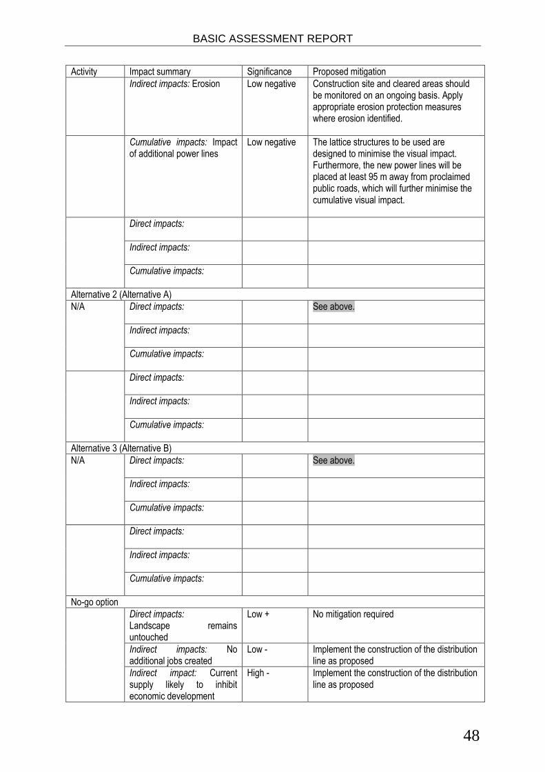
BASIC ASSESSMENT REPORT
48
Activity Impact summary Significance Proposed mitigation
Indirect impacts: Erosion
Low negative Construction site and cleared areas should be monitored on an ongoing basis. Apply appropriate erosion protection measures where erosion identified.
Cumulative impacts: Impact of additional power lines
Low negative The lattice structures to be used are designed to minimise the visual impact. Furthermore, the new power lines will be placed at least 95 m away from proclaimed public roads, which will further minimise the cumulative visual impact.
Direct impacts:
Indirect impacts:
Cumulative impacts:
Alternative 2 (Alternative A)
N/A Direct impacts:
See above.
Indirect impacts:
Cumulative impacts:
Direct impacts:
Indirect impacts:
Cumulative impacts:
Alternative 3 (Alternative B)
N/A Direct impacts:
See above.
Indirect impacts:
Cumulative impacts:
Direct impacts:
Indirect impacts:
Cumulative impacts:
No-go option
Direct impacts: Landscape remains untouched
Low + No mitigation required
Indirect impacts: No additional jobs created
Low - Implement the construction of the distribution line as proposed
Indirect impact: Current supply likely to inhibit economic development
High - Implement the construction of the distribution line as proposed

BASIC ASSESSMENT REPORT
49
Activity Impact summary Significance Proposed mitigation
Indirect impact: Access to non-serviced households will not be achieved
High - Implement the construction of the distribution line as proposed
Cumulative impacts:
A complete impact assessment in terms of Regulation 22(2)(i) of GN R.543 must be included as Appendix F. Environmental impact statement Taking the assessment of potential impacts into account, please provide an environmental impact statement that summarises the impact that the proposed activity and its alternatives may have on the environment after the management and mitigation of impacts have been taken into account, with specific reference to types of impact, duration of impacts, likelihood of potential impacts actually occurring and the significance of impacts.
Alternative A (Preferred Alternative)
The Preferred Alternative is expected to the most expensive option to construct and maintain. However, this option has a relatively low visual impact and environmental impacts associated with this preferred route can be successfully mitigated if the recommended mitigation measures in the EMPr are adhered to. Further, all land owners whose property the proposed route will cross have agreed to allow erection of the power lines across their properties. Therefore, although not the most cost-effective or maintenance-friendly line to construct, the route is preferred as all environmental impacts can be mitigated to acceptable levels and collective landowner consent has been obtained which will ensure construction of tower structures on the identified properties. Micro-siting of all tower structures will be discussed with landowners before installation of the structures commence. The main impacts of the proposed power lines occur during the construction phase. As part of the construction process vegetation clearance will be required in for the foundations of the towers and substation, access roads and the power lines servitude. The negative impacts associated with vegetation clearance are loss of species of concern, loss of habitat for fauna and increased run off and erosion. All these impacts can be mitigated and so are of low negative significance, further more the proposed powerline route crosses farming areas where the vegetation has been largely transformed. During the construction phase there is likely to be disturbance of fauna, this impact can be minimised through mitigation measures and so is of low negative significance.
Alternative B (Alternative A)
This alternative is less expensive to construct compared to the Preferred Alternative, however maintenance will prove more difficult. Further, some land owners, especially owners of the game farms in the Dieprivier area, have rejected Eskom’s proposal to cross their property. This route alternative was thus routed to bypass the property of objecting farmers routing the proposed line along the boundary of these properties. Environmental impacts associated with this route alternative can be successfully mitigated to acceptable levels if the recommended mitigation measures in the EMPr are adhered to. Land owner requirements have thus proven the most influential factor in concluding that this option cannot be implemented without consent of all affected farmers.
Alternative C (Alternative B)
From a construction and maintenance cost perspective, this alternative proves to be favoured. Environmental impacts associated with this route alternative can be successfully mitigated given mitigation measures in the EMPr are adhered to. Visual impacts may be potentially significant as the distribution line would run fairly close to the road for a notable distance. As in Alternative A some land owners, especially owners of the game farms, have rejected Eskom’s proposal to cross their property. Land owner requirements have thus proven the most influential factor in concluding that this option cannot be considered or further investigated.
No-go alternative (compulsory)
The no development alternative in the context of this project implies that the power line and substation would not be constructed and the Melkhout substation extension would not be upgraded. If the project does not

BASIC ASSESSMENT REPORT
50
proceed the negative impacts such as risk of collisions of birds, clearing of vegetation and soil erosion would be avoided, however if the project does not commence the region will continue to be negatively affected by an inadequate and unreliable electricity supply, which would inhibit future developments in the area. The need to for stable and reliable power supply to meet current and future demand outweighs the potential impacts to the surrounding environment, which is expected to be of low to medium significance, at best, and can be proactively mitigated to acceptable levels. The no-go alternative is therefore not recommended.

SECTION E. Recommendation of practitioner
Is the information contained in this report and the documentation attached hereto sufficient to make a decision in respect of the activity applied for (in the view of the environmental assessment practitioner)?
YES X NO
If “NO”, indicate the aspects that should be assessed further as part of a Scoping and EIA process before a decision can be made (list the aspects that require further assessment).
If “YES”, please list any recommended conditions, including mitigation measures that should be considered for inclusion in any authorisation that may be granted by the competent authority in respect of the application.
It is recommended that the proposed construction of the substation and distribution lines continue only if all recommendations and mitigation measures stipulated in the EMPr are followed and that an Environmental Control officer be employed throughout the duration of construction.
Is an EMPr attached? YES X NO
The EMPr must be attached as Appendix G. The details of the EAP who compiled the BAR and the expertise of the EAP to perform the Basic Assessment process must be included as Appendix H. If any specialist reports were used during the compilation of this BAR, please attach the declaration of interest for each specialist in Appendix I. Any other information relevant to this application and not previously included must be attached in Appendix J. ________________________________________ NAME OF EAP ________________________________________ _________________ SIGNATURE OF EAP DATE

BASIC ASSESSMENT REPORT
52
References
Cacadu District Municipality, 2011 Cacadu District Municipality Integrated Development Plan (IDP) 2007-2012 Review 2011 Cacadu District Municipality, 2009 Spatial Development Framework 2009 Eskom 2007 Building Line Restrictions, Servitude Widths, Line Separators and Clearances From Power lines. Eskom 2000 Standards for Bush Clearance and Maintenance Within Overhead Powerline Servitudes. Eastern Cape Socio Economic Consultative Council. Statistics At Your Fingertips Database. Mucina, l., & Rutherford, M. (2006). The vegetation of South Africa, Lesotho and Swaziland. Pretoria: South African Biodiversity Institute. Kouga Local Municipality, 2011, Kouga Municipality Integrated Development Plan Review 2011/12 Koukamma Local Municipality, 2011 Municipal Annual Report 2010/2011 Koukamma Local Municipality, 2011 Koukamma Municipality Integrated Development Plan 2010-2011 Presidential Infrastructure Coordinating Commission 2012, Provincial and Local Government Conference A Summary of the Infrastructure Plan Province of the Eastern Cape, 2010, Eastern Cape Provincial Spatial Development Plan Statistics South Africa (STATS SA), 2009 Community Survey 2007: Basic Results – Eastern Cape

BASIC ASSESSMENT REPORT
53
The following appendixes must be attached: Appendix A: Maps Appendix B: Photographs Appendix C: Facility illustration(s) Appendix D: Specialist reports (including terms of reference) Appendix E: Public Participation Appendix F: Impact Assessment Appendix G: Environmental Management Programme (EMPr) Appendix H: Details of EAP and expertise Appendix I: Specialist’s declaration of interest Appendix J: Additional Information